Backscattering and geophysical features of volcanic ridges offshore Santa Rosalia, Baja California...
18
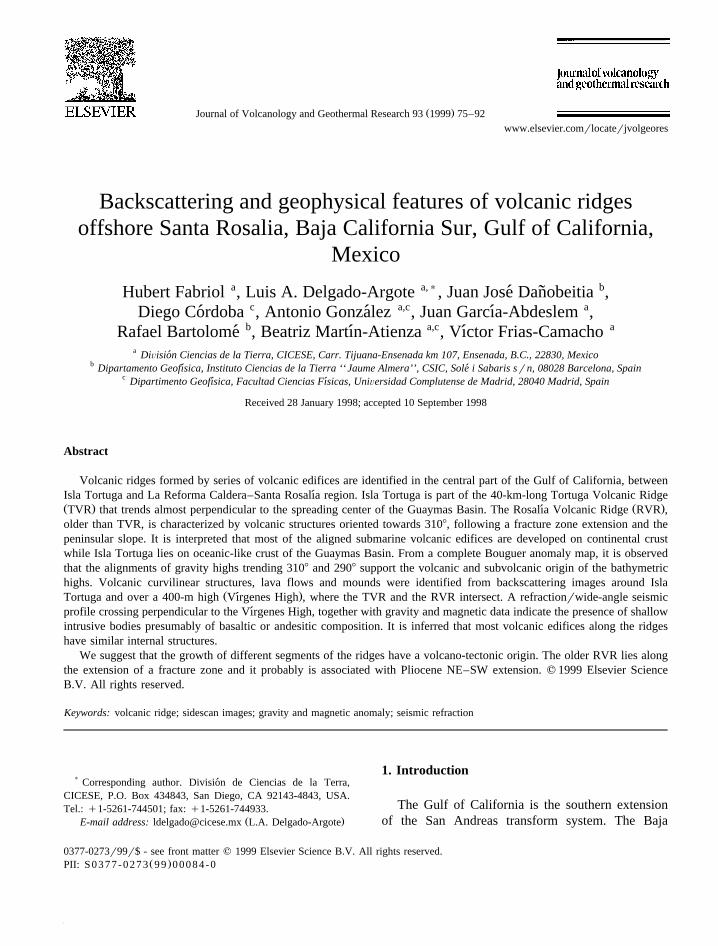
Ž . Journal of Volcanology and Geothermal Research 93 1999 75–92 www.elsevier.comrlocaterjvolgeores Backscattering and geophysical features of volcanic ridges offshore Santa Rosalia, Baja California Sur, Gulf of California, Mexico Hubert Fabriol a , Luis A. Delgado-Argote a, ) , Juan Jose Danobeitia b , ´ ˜ Diego Cordoba c , Antonio Gonzalez a,c , Juan Garcıa-Abdeslem a , ´ ´ ´ Rafael Bartolome b , Beatriz Martın-Atienza a,c , Vıctor Frias-Camacho a ´ ´ ´ a DiÕision Ciencias de la Tierra, CICESE, Carr. Tijuana-Ensenada km 107, Ensenada, B.C., 22830, Mexico ´ b Dipartamento Geofısica, Instituto Ciencias de la Tierra ‘‘ Jaume Almera’’, CSIC, Sole i Sabaris s r n, 08028 Barcelona, Spain ´ ´ c Dipartimento Geofısica, Facultad Ciencias Fısicas, UniÕersidad Complutense de Madrid, 28040 Madrid, Spain ´ ´ Received 28 January 1998; accepted 10 September 1998 Abstract Volcanic ridges formed by series of volcanic edifices are identified in the central part of the Gulf of California, between Isla Tortuga and La Reforma Caldera–Santa Rosalıa region. Isla Tortuga is part of the 40-km-long Tortuga Volcanic Ridge ´ Ž . Ž . TVR that trends almost perpendicular to the spreading center of the Guaymas Basin. The Rosalıa Volcanic Ridge RVR , ´ older than TVR, is characterized by volcanic structures oriented towards 3108, following a fracture zone extension and the peninsular slope. It is interpreted that most of the aligned submarine volcanic edifices are developed on continental crust while Isla Tortuga lies on oceanic-like crust of the Guaymas Basin. From a complete Bouguer anomaly map, it is observed that the alignments of gravity highs trending 3108 and 2908 support the volcanic and subvolcanic origin of the bathymetric highs. Volcanic curvilinear structures, lava flows and mounds were identified from backscattering images around Isla Ž . Tortuga and over a 400-m high Vırgenes High , where the TVR and the RVR intersect. A refractionrwide-angle seismic ´ profile crossing perpendicular to the Vırgenes High, together with gravity and magnetic data indicate the presence of shallow ´ intrusive bodies presumably of basaltic or andesitic composition. It is inferred that most volcanic edifices along the ridges have similar internal structures. We suggest that the growth of different segments of the ridges have a volcano-tectonic origin. The older RVR lies along the extension of a fracture zone and it probably is associated with Pliocene NE–SW extension. q 1999 Elsevier Science B.V. All rights reserved. Keywords: volcanic ridge; sidescan images; gravity and magnetic anomaly; seismic refraction ) Corresponding author. Division de Ciencias de la Terra, ´ CICESE, P.O. Box 434843, San Diego, CA 92143-4843, USA. Tel.: q1-5261-744501; fax: q1-5261-744933. Ž . E-mail address: [email protected] L.A. Delgado-Argote 1. Introduction The Gulf of California is the southern extension of the San Andreas transform system. The Baja 0377-0273r99r$ - see front matter q 1999 Elsevier Science B.V. All rights reserved. Ž . PII: S0377-0273 99 00084-0
Transcript of Backscattering and geophysical features of volcanic ridges offshore Santa Rosalia, Baja California...
Ž .Journal of Volcanology and Geothermal Research 93 1999 75–92www.elsevier.comrlocaterjvolgeores
Backscattering and geophysical features of volcanic ridgesoffshore Santa Rosalia, Baja California Sur, Gulf of California,
Mexico
Hubert Fabriol a, Luis A. Delgado-Argote a,), Juan Jose Danobeitia b,´ ˜Diego Cordoba c, Antonio Gonzalez a,c, Juan Garcıa-Abdeslem a,´ ´ ´
Rafael Bartolome b, Beatriz Martın-Atienza a,c, Vıctor Frias-Camacho a´ ´ ´a DiÕision Ciencias de la Tierra, CICESE, Carr. Tijuana-Ensenada km 107, Ensenada, B.C., 22830, Mexico´
b Dipartamento Geofısica, Instituto Ciencias de la Tierra ‘‘ Jaume Almera’’, CSIC, Sole i Sabaris srn, 08028 Barcelona, Spain´ ´c Dipartimento Geofısica, Facultad Ciencias Fısicas, UniÕersidad Complutense de Madrid, 28040 Madrid, Spain´ ´
Received 28 January 1998; accepted 10 September 1998
Abstract
Volcanic ridges formed by series of volcanic edifices are identified in the central part of the Gulf of California, betweenIsla Tortuga and La Reforma Caldera–Santa Rosalıa region. Isla Tortuga is part of the 40-km-long Tortuga Volcanic Ridge´Ž . Ž .TVR that trends almost perpendicular to the spreading center of the Guaymas Basin. The Rosalıa Volcanic Ridge RVR ,´older than TVR, is characterized by volcanic structures oriented towards 3108, following a fracture zone extension and thepeninsular slope. It is interpreted that most of the aligned submarine volcanic edifices are developed on continental crustwhile Isla Tortuga lies on oceanic-like crust of the Guaymas Basin. From a complete Bouguer anomaly map, it is observedthat the alignments of gravity highs trending 3108 and 2908 support the volcanic and subvolcanic origin of the bathymetrichighs. Volcanic curvilinear structures, lava flows and mounds were identified from backscattering images around Isla
Ž .Tortuga and over a 400-m high Vırgenes High , where the TVR and the RVR intersect. A refractionrwide-angle seismic´profile crossing perpendicular to the Vırgenes High, together with gravity and magnetic data indicate the presence of shallow´intrusive bodies presumably of basaltic or andesitic composition. It is inferred that most volcanic edifices along the ridgeshave similar internal structures.
We suggest that the growth of different segments of the ridges have a volcano-tectonic origin. The older RVR lies alongthe extension of a fracture zone and it probably is associated with Pliocene NE–SW extension. q 1999 Elsevier ScienceB.V. All rights reserved.
Keywords: volcanic ridge; sidescan images; gravity and magnetic anomaly; seismic refraction
) Corresponding author. Division de Ciencias de la Terra,´CICESE, P.O. Box 434843, San Diego, CA 92143-4843, USA.Tel.: q1-5261-744501; fax: q1-5261-744933.
Ž .E-mail address: [email protected] L.A. Delgado-Argote
1. Introduction
The Gulf of California is the southern extensionof the San Andreas transform system. The Baja
0377-0273r99r$ - see front matter q 1999 Elsevier Science B.V. All rights reserved.Ž .PII: S0377-0273 99 00084-0

( )H. Fabriol et al.rJournal of Volcanology and Geothermal Research 93 1999 75–9276
California peninsula is moving northwest relative tothe continent at a full spreading rate of about 5.6cmryr since about 6 Ma ago. The origin of thismarginal sea is related to the Neogene Basin and
Range disturbance. An oceanic-like crust has beenformed in spreading centers during the developmentof the transform system. Based on the tectonic map
Ž .of Lonsdale 1989 , it is observed that the eight
Ž .Fig. 1. Tectonic map of the Gulf of California region adapted from Lonsdale, 1989 . Approximate backscattering coverage from Hesperides´cruise CORTES-P96 is indicated with heavy line.
( )H. Fabriol et al.rJournal of Volcanology and Geothermal Research 93 1999 75–92 77
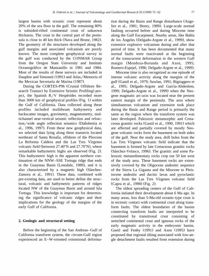
largest basins with oceanic crust represent about20% of the sea floor in the gulf. The remaining 80%is subsided-rifted continental crust of unknownthickness. The crust in the central part of the penin-
Ž .sula is close to 40 km thick Nava and Brune, 1982 .The geometry of the structures developed along thegulf margins and associated volcanism are poorlyknown. The most complete geophysical survey inthe gulf was conducted by the CONMAR Groupfrom the Oregon State University and InstitutoOceanografico de Manzanillo in 1981 and 1984.´Most of the results of these surveys are included in
Ž .Dauphin and Simoneit 1991 and AtlasrMemoria ofŽ .the Mexican Secretarıa de Marina 1987 .´
ŽDuring the CORTES-P96 Crustal Offshore Re-.search Transect by Extensive Seismic Profiling pro-
ject, the Spanish RrV Hesperides recorded more´Ž .than 3000 km of geophysical profiles Fig. 1 within
the Gulf of California. Data collected along theseprofiles included multibeam bathymetry andbackscatter images, gravimetry, magnetometry, mul-tichannel near-vertical seismic reflection and refrac-
Žtionrwide angle reflection seismics Danobeitia et˜.al., 1996, 1997 . From these new geophysical data,
we selected data lying along three transects locatednortheast of Santa Rosalıa, offshore of the Pliocene´La Reforma Caldera and the Las Tres Vırgenes´
Ž .volcanic field between 27.408N and 27.708N , whereŽ .remarkable bathymetric highs are observed Fig. 2 .
This bathymetric high is the apparent northern con-tinuation of the NNW–SSE Tortuga ridge that ends
Ž .in the Guaymas Basin Lonsdale, 1989 , and it isŽalso characterized by a magnetic high Sanchez-´
.Zamora et al., 1991 . These data, combined withpre-existing data, are used to better define the struc-tural, volcanic and bathymetric patterns of ridgeslocated NW of the Guaymas Basin and around IslaTortuga. This knowledge is important for determin-ing the significance of volcanic ridges and theirimplications for the geology of the margins of theearly Gulf of California.
2. Geologic and structural setting
Before the beginning of the San Andreas–Gulf ofCalifornia transform system, the circum-Gulf regionexperienced an E–W-oriented extensional deforma-
Žtion during the Basin and Range disturbance Ange-.lier et al., 1981; Henry, 1989 . Large-scale normal
faulting occurred before and during Miocene timealong the Gulf Escarpment. Nearby areas, like Bahıa´
Ž .de los Angeles Delgado-Argote et al., 1999 , showextensive explosive volcanism during and after thatperiod of time. It has been documented that manynormal faults were reactivated at the beginningof the transcurrent deformation in the western Gulf
Žmargin Mendoza-Borunda and Axen, 1995;.Romero-Espejel, 1996; Delgado-Argote et al., 1999 .
Miocene time is also recognized as one episode ofintense volcanic activity along the margins of the
Žgulf Gastil et al., 1979; Sawlan, 1991; Bigioggero etal., 1995; Delgado-Argote and Garcıa-Abdeslem,´
.1999; Delgado-Argote et al., 1999 when the Neo-gene magmatic arc-axis was located near the presenteastern margin of the peninsula. The area wheresimultaneous volcanism and extension took placeduring the Basin and Range period is primarily thesame as the region where the transform system waslater developed. Paleozoic metamorphic and Creta-
Ž .ceous granitic rocks Gastil et al., 1990, 1991 whichare affected and partially covered by mostly Neo-gene volcanic rocks form the basement on both sidesof the gulf. Near the study area, drill holes from theLas Tres Vırgenes volcanic field indicate that the´basement is formed by late Cretaceous granitic rocksŽ .Sanchez-Velasco, 1996 . The granitic and some Pa-´leozoic metasedimentary rocks crop out 50 km westof the study area. These basement rocks are exten-sively covered by the Oligocene andesitic sequenceof the Sierra La Giganta and the Miocene to Pleis-tocene andesitic and dacitic lavas and pyroclasticrocks from the Las Tres Vırgenes volcanic field´Ž . Ž .Capra et al., 1998 Fig. 2 .
The oldest spreading centers of the Gulf of Cali-fornia initiated their development about 6 Ma ago. Inmany areas, less than 5-Ma-old oceanic-type crust isin tectonic contact with continental crust along trans-form faults. The oldest boundaries of the basinsconnecting transform faults are interpreted to beconstituted by transitional crust consisting ofstretched continental crust and igneous rocks of theearly magmatic activity in the embryonic basins.
Ž . Ž .Gastil and Fenby 1991 and Axen 1995 haveproposed that regional tilting associated with low-an-gle detachment faults resulted from extension during

( )H. Fabriol et al.rJournal of Volcanology and Geothermal Research 93 1999 75–9278
the process of rifting of the Gulf of California. Inareas like Bahıa de los Angeles–Isla Angel de la´Guarda, no evidence has been found to interpretimportant degrees of tilting associated with detach-ment; instead, discrete blocks have distinct histories
Žof pre-Miocene extension Delgado-Argote and
Garcıa-Abdeslem, 1999; Delgado-Argote et al.,´.1999 .
It is observed in Fig. 2 that the peninsular marginsouth of Cabo Vırgenes is characterized by normal´faulting, probably associated with the fracture zonesthat limit the southern part of Guaymas Basin. Based
Ž .Fig. 2. Tectonic map of the central Gulf of California adapted from Lonsdale, 1989 and lithology of the Las Tres Vırgenes volcanic field´Ž . Ž . Ž . Žand La Reforma Caldera region INEGI, 1983, 1984 . Merged bathymetry adapted from INEGI 1:1,000,000 , Lonsdale 1989 Guaymas
.Basin and the CORTES-P96 cruise. Heavy dashed lines indicate the track of the RrV Hesperides, dots along the margins indicate´transform faults active before and during initial phase of the opening of the Gulf, and solid lines with ticks indicating relative movementalong the peninsular margin indicate fracture zone extension. 3V, Tres Vırgenes volcanic field; A, Aguajito caldera; R, Reforma Caldera;´
Ž .CV, Cabo Vırgenes; GB, Guaymas Basin; ISM, Isla San Marcos; IT, Isla Tortuga; SPMB, San Pedro Martir Basin. Lithology: 1´ ´Ž . Ž . Ž .Quaternary sediments, 2 Quaternary lava flows and tuffs, 3 late Tertiary basalt and basaltic breccia, 4 late Tertiary tuffs and
Ž . Ž . Ž . Ž .ignimbrites, 5 late Tertiary andesite, 6 late Tertiary sedimentary and volcano sedimentary units, 7 Miocene volcaniclastic rocks, 8Ž . Ž . Ž .Miocene sandstone, 9 undifferentiated volcanic rocks, 10 Cretaceous granitoids, 11 Paleozoic metamorphic rocks.

()
H.F
abrioletal.r
JournalofV
olcanologyand
Geotherm
alResearch
931999
75–
9279
Ž . Ž . Ž .Fig. 3. Bathymetric map showing the side scan images and the rose diagrams of structures interpreted in Figs. 4 segment A , 5 segment B and 6 segment C . VH, Vırgenes´high; CV, Cabo Vırgenes; IT, Isla Tortuga; TVR and RVR indicate the axis of the Tortuga Volcanic Ridge and the Rosalıa Volcanic Ridge, respectively.´ ´

( )H. Fabriol et al.rJournal of Volcanology and Geothermal Research 93 1999 75–9280

( )H. Fabriol et al.rJournal of Volcanology and Geothermal Research 93 1999 75–92 81
Ž .on the spreading rate estimates, Batiza 1978 sug-gested that Isla Tortuga was constructed on 1.7 Maold oceanic crust and that the island is the result of anorthward-migrating volcanic activity. However, the1000 bathymetric line suggests that the island is partof a WNW-oriented ridge. South of the island, theridge is oriented NW, and it narrows reaching the
Ž . ŽGuaymas Basin Fig. 2 . It has been reported Ba-.tiza, 1978 that the old volcanic series of the island
were subaerially extruded and it is inferred that it hasbeen tectonically submerged. The suite of basalts onIsla Tortuga is similar to ocean–ridge tholeiite suitesŽ .Batiza, 1978; Sawlan, 1991 . In the Guaymas Basin,an oceanic-like crust of about 125 km across hasbeen developed. The basin shows active tholeiiticvolcanism and, in its southern spreading center, thelava flows and dikes are interfingered with sedimentsŽ .Einsele et al., 1980; Curray et al., 1982 . SawlanŽ .1991 has classified the basaltic rocks of the Guay-mas Basin as transitional rift-tholeiites.
3. Bathymetry and sidescan images of the TortugaVolcanic Rift
In order to identify regional structures from themorphology, we merged the 1:1,000,000 bathymetricmap of INEGI for the whole region, the detailed
Ž .bathymetry of the Guaymas Basin Lonsdale, 1989 ,and the multibeam data collected by the RrVHesperides of four segments of tracks for the study´
Ž .area Fig. 2 . This last data set provides high-resolu-tion bathymetry down to 20 m in a swath of about3.5 times water depth. This new map shows a num-ber of hills and mounds interpreted to be volcanic inorigin, and linear features interpreted to be of tec-tonic origin. The most conspicuous structure is the
Ž .Rosalıa Volcanic Ridge RVR in Fig. 3 formed by a´series of volcanic edifices trending 3108, following
interpreted fracture-zone extensions of transformŽ .faults offshore the peninsula Lonsdale, 1989 . This
ridge is about 75 km long, from 27.98N to 27.48NŽ .Fig. 2 , and it is located west of Isla Tortuga. Theisland is located in another important morphologicfeature, named Tortuga Volcanic Ridge, which is
Ž .observed from the bathymetric map TVR in Fig. 3 .This about 7-km-wide and at least 40-km-long ridge,trending 2858 is well defined by the isobath of 1000m.
For clarity, Fig. 3 shows the backscatter imagesof Figs. 4–6 overlapped on the detailed bathymetric
Ž .map. The first section Fig. 4, named A in Fig. 3 islocated south of the Isla Tortuga in the NW limit ofthe Guaymas Basin, and east of the RVR. The
Ž .topographic and textural data Fig. 4 allowed theinterpretation of structural lineaments and the recog-nition of the distinctive signature of relatively inelas-tic sediments from relatively elastic volcanic rocks.It is observed from Figs. 3 and 4 that sedimentscover most of the area south of Isla Tortuga. Theimage shows poorly defined 0308, 2708 and 3108
Ž .trending lineaments inferred to be fractures Fig. 4 .The topography gently rises towards the coast from
Ž .1475 to 1200 m 2%-slope; Fig. 4d . A 2-km widebody of lava flows is interpreted in the southern partof Isla Tortuga that apparently flowed down about 6km from the island reaching a depth of more than1400 m. The lavas are intersected by NE and SWdipping lineaments trending towards 3208 in average.The wrinkled lava flows of the eastern side, inter-
Ž .preted to be pillow lavas PL in Fig. 4a , are about50 m high with respect to the surrounding floor. Incontrast, the smooth lavas of the western side are
Ž .interpreted as sheet-like lava flows SF in Fig. 4a .The area occupied by the last flows shows abundantmounds interpreted to be vents, while the pillowlavas show concave features indicating a southwardflow. Fractures in the pillow lavas are oriented to-wards 0358 and 0008 suggesting the presence of
Ž .Fig. 4. a Sidescan sonar image with bathymetric lines of the southern part of Isla Tortuga. Light areas are low backscatter; the dark areasŽ .are interpreted to be lava flows probably extruded from Isla Tortuga. b Structural interpretation of the image indicating the presence of
Ž .curvilinear lineaments associated with subvolcanic bodies. c Rose diagram of lineaments rotated in the sense of the ship-track; notice theŽ .strong tendency of the structures towards NW, parallel to the orientation of the regional fracture zones near Guaymas Basin. d Profile
along the track of the ship indicating the presence of interpreted subvolcanic bodies; dashed lines are the lava flows located in the right sideof the image.

( )H. Fabriol et al.rJournal of Volcanology and Geothermal Research 93 1999 75–9282

( )H. Fabriol et al.rJournal of Volcanology and Geothermal Research 93 1999 75–92 83
fissures. On the western side of this transect, about25 km offshore Santa Rosalıa, a third series of lava´flows is observed with mounds aligned towards 3108
Ž .Fig. 4a . A large canyon and other fractures that cutvolcanic structures are oriented in the same direction,suggesting that they are part of a fracture-zone ex-
Ž .tension Fig. 3 and that deformation and volcanicactivity occurred simultaneously.
Ž .The second section named B in Fig. 3 is ori-ented towards 3208 and lies between the RVR andLa Reforma caldera. The presence of a field of lavasin the southern half of the image is the most notable
Ž .feature Fig. 5 . Although it is presumable that thelavas flowed eastwards from vents related to the LaReforma volcanic field, it is also possible that theywere extruded from local fissures. The profile alongthe transect shows a domic shape cut in its southernpart by a narrow canyon bounded by normal faultsŽ .Fig. 5b . The northwestern half of the image ischaracterized by a relatively inelastic sedimentary
Žcover where nested mounds roughly oriented to-.wards N–S and 3208 and curvilinear features are
interpreted to have a volcanic association. The wholeimage shows an orthogonal arrangement of linea-
Ž .ments trending N–S and E–W Fig. 5b and c .Although this structural geometry is distinct fromthat reported onshore in the Las Tres Vırgenes vol-´canic field, where intense seismicity of tectonic ori-
Ž .gin has been reported Munguıa and Wong, 1995 , it´is similar to the regional structures reported by Gar-
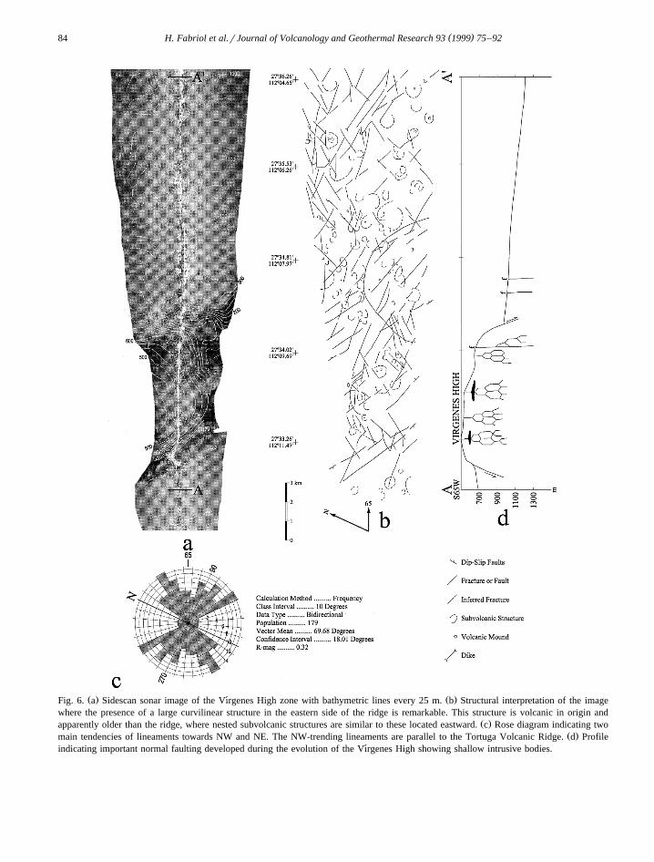
Ž .duno-Monroy et al. 1993 in El Aguajito Caldera.˜Ž .The section C Figs. 3 and 6 has an almost
perpendicular orientation with respect to the RVR,and the most conspicuous volcanic and structural
Ž .features are observed in this image Fig. 6 . TheVırgenes High is clearly defined in this section by a´3.5-km-wide bathymetric high where the westernside has a 25% slope, elevated about 200 m, and theabrupt eastern side has an elevation of 400 m with aslope of 50%. The morphology of this portion of the
ridge suggests the presence of a complex volcanicedifice bounded by normal faults forming a horst-likestructure. The high, oriented towards 3008 andslightly tilted eastward, shows a series of curvilinearvolcanic and subvolcanic lineaments on the top. Aseries of feeder dikes are interpreted in the section ofFig. 6d, which could explain the observed curvilinearfeatures. We also interpret the construction of thisportion of the ridge to result from the combination ofnormal faulting and uplifting during the emplace-ment of magma bodies. A remarkable 6-km diametercurvilinear structure similar to a plateau is located inthe eastern side of the ridge. This flat structure hassome mounds and its relatively inelastic sedimentcover suggests that the plateau is older than thehorst-like Vırgenes High. The most abundant and´continuous structural lineaments and alignments ofvolcanic mounds are oriented towards 3008 and 0308.In general, the main structure of the high is almostparallel to the TVR, and the NE-oriented lineamentslocated in the northeastern portion of the imagecould be older features belonging to the early Guay-mas Basin.
The three rose diagrams of structural and volcaniclineaments of the images show important differences
Ž .with respect each other Figs. 3, 4c, 5c and 6c . InŽ .the southern transect Fig. 4 , the dominant features
are oriented 3208, parallel to the coast and the penin-sular slope. They can be correlated with transcurrentfaults developed before and concurrently to the ini-tial phases of the opening of the gulf. From the samefigure, other not so well defined structures trend 0358
and 0808; the first group is more or less parallel tothe Guaymas Basin and the second group has nocorrelation with other regional features. The sectionŽ .B Fig. 5 shows N–S and E–W orthogonal features
Ž .Fig. 5c that apparently are unrelated to regionalŽ .structures. In the section C Fig. 6 , the main ten-
dency of structures towards 3008–3108 clearly corre-Ž .lates with the orientation of the RVR Fig. 5c .
Ž .Fig. 5. a Sidescan sonar image of the western part of Isla Tortuga. The dark areas are interpreted as fissure related lavas; notice the lack ofŽ .lavas in the northwestern part of the image. b Structural interpretation of the image where it is remarkable the absence of circular
Ž .structures in the southeast compared with the northwestern part. c Rose diagram of lineaments rotated in the sense of the ship-track; E–Woriented lineaments are related to fissures of the southeastern part of the image and the NNW lineaments are parallel to the peninsular slope
Ž . Ž .end the submarine canyon located to the west of Isla San Marcos Fig. 2 . d Profile indicating the subvolcanic structures below the lavaflows and normal faulting in the southeastern end of the image.
( )H. Fabriol et al.rJournal of Volcanology and Geothermal Research 93 1999 75–9284
Ž . Ž .Fig. 6. a Sidescan sonar image of the Vırgenes High zone with bathymetric lines every 25 m. b Structural interpretation of the image´where the presence of a large curvilinear structure in the eastern side of the ridge is remarkable. This structure is volcanic in origin and
Ž .apparently older than the ridge, where nested subvolcanic structures are similar to these located eastward. c Rose diagram indicating twoŽ .main tendencies of lineaments towards NW and NE. The NW-trending lineaments are parallel to the Tortuga Volcanic Ridge. d Profile
indicating important normal faulting developed during the evolution of the Vırgenes High showing shallow intrusive bodies.´

()
H.F
abrioletal.r
JournalofV
olcanologyand
Geotherm
alResearch
931999
75–
9285
Fig. 7. The complete Bouguer anomaly and bathymetry are shown with contours every 10 mgal and 100 m, respectively. Although the data distribution is sparse, as shown by theŽ . Ž .ship tracks from CONMAR continuous line and CORTES-P96 dashed line cruises, the gravity anomaly shows a direct correlation with the expected excess of mass at the
Ž . Ž .Guaymas Basin. Fifty kilometers long gravity highs 40–50 mgal aligned in a 2908 direction VH to B is interpreted to be produced by magma bodies, which define theTortuga Volcanic Ridge. Parallel to the peninsular slope, the gentle gravity gradient is interpreted to be associated with a tectonic structure where magma was emplaced
Ž .describing the 3108-trending Rosalıa Volcanic Ridge. Along the RVR axis, both aligned volcanic edifices and local gravity anomalies are observed VH to C .´

( )H. Fabriol et al.rJournal of Volcanology and Geothermal Research 93 1999 75–9286
Finally, it is important to mention that temporalseismological networks in the region of the La Re-forma caldera and the Las Tres Vırgenes volcanic´
field do not show any seismicity in the Gulf region.ŽActive faulting and volcanic seismicity Munguıa´
.and Wong, 1995 is concentrated onshore, which
Fig. 8. Geophysical modeling of the transect over the Vırgenes High of Fig. 6, indicating the record sections of the two land seismic´Ž . Ž .stations. Observed data in a and b has been band-pass filtered between 3 and 8 Hz. Times are reduced to 6 kmrs and amplitudes have
Ž . Ž . Ž .been normalized. Superposed lines in a and b indicate calculated travel times. c Velocity–depth model along a 60-km-long profileŽ .indicating the coast line with CT. For clarity, one of each five rays have been printed in the ray diagram. d Free-air anomaly data profile;
Ž .crosses represent the observed gravity data and the solid line indicates the calculated gravity values. e Residual magnetic anomaly dataŽ .profile. Crosses represent the observed magnetic data and the solid line indicates the calculated magnetic values. f Adjusted density and
Ž . Ž .susceptibility model used to produce the calculated gravity and magnetic data profiles shown in d and e ; vertical exaggeration is fivetimes and a 1:1 representation is also shown below.

( )H. Fabriol et al.rJournal of Volcanology and Geothermal Research 93 1999 75–92 87
Ž .Fig. 8 continued .
suggest that the largest structures in the study area,with the exception of the Guaymas Basin, are mostlyinactive.
4. Regional gravimetry
The large density contrast between the sea waterand the underlying rocks and sediments means that
the contours of the free-air gravity anomalies gener-ally follow bathymetric features. However, where thecontours do not follow bathymetric features, weexpect lateral changes in the structure of the base-ment andror the thickness of sediments. With thepurpose of suppressing such a well-known effect, wehave obtained a complete Bouguer anomaly map fora region that includes the Guaymas Basin and the

( )H. Fabriol et al.rJournal of Volcanology and Geothermal Research 93 1999 75–9288
RVR, over the western margin of the Gulf of Cali-Ž .fornia Fig. 7 .
The data used for this analysis include land topog-Žraphy data from the ETOPO-5 digital model NGDC,
. Ž .1988 , the coastline INEGI, 1983, 1984 and free-airgravity anomaly and bathymetric data collected dur-
Žing CONMAR-IOM cruises BAJA-76, MARSUR-78, GOLFO-81, GOLFO-84; Dauphin and Ness,
. Ž1991 , and the CORTES-P96 cruise Danobeitia et˜.al., 1996, 1997 . Bathymetric and topographic data
were merged and gridded by kriging to obtain aregular grid with nodes at every four kilometers. Arectangular prism was then placed at the center ofeach grid node, and their gravity effect was com-puted at underway free-air gravity stations position
Ž .by the method of Garcıa-Abdeslem 1996 . The com-´plete Bouguer correction was carried out up to 167km. Onshore, the gravity effect is caused by topogra-phy with a density of 2670 kgrm3. Offshore, waterwas replaced by sediments with a density of 2000kgrm3. By adding this correction to the free-airgravity anomalies, we have obtained the completeBouguer anomaly map shown in Fig. 7.
One remarkable feature in the Bouguer anomalyŽ .map Fig. 7 is a broad, up to 50 mgal, gravity high
located near the center of the Guaymas Basin, roughlyfollowing the Guaymas-North spreading centerŽ .Lonsdale, 1989 . The 40-mgal contour approachesthe geometry of the Guaymas Basin. Another featurethat emerges from this data is an elongated gravity
Žhigh reaching up to 40–50 mgal VH, A, IT, and B. Ž .in Fig. 7 that extends along the TVR Fig. 3 for
about 50 km, following a 2908 direction, perpendicu-lar to the Guaymas-North spreading center. Parallelto the peninsular slope, the gentle gravity gradientwith decreasing values towards the SW, observedfrom Cabo Vırgenes to the Guaymas Basin, is in-´ferred to be associated with the 3108-trending RVR.Along this ridge, aligned volcanic edifices and local
Ž .gravity anomalies are observed Fig. 7 . The ridge isparallel to the fault structures of the initial phase ofthe opening of the gulf shown in Fig. 2. The Tortugaand Rosalıa ridges are deviated about 308 from each´other, suggesting different periods of formation. Wesuggest that the RVR is older than the TVR, sincethe apparently most recent structures that follow the
Žorientation of the TVR in the Vırgenes High A in´.Fig. 7 cut older volcanic structures, and that re-
cently active volcanic activity has been reported inŽ .Isla Tortuga Batiza, 1978 .
5. Geophysical modeling
The geophysical data collected along the transectC of Fig. 3 consist of deep near-vertical seismicreflection, refractionrwide-angle seismic reflection,gravity and magnetic data. The energy of the 2850
3 Ž .in. 47 l air gun array used to obtain deep near-Ž .vertical seismic reflection data under process was
also recorded by two portable instruments on land,Žproviding a densely sampled a seismogram every 80
.m refractionrwide-angle reflection data set. Clearwide-angle seismic arrivals up to 100 km distancewere recorded. In order to model the uppermostcrustal structure in the Vırgenes High, seismograms´of the first 60 km were selected. The record sectionsof Fig. 8a and b, corresponding to the two seismicstations, show a neat first arrival identified as Pgphase. This phase shows an advance of 0.5 s reduced
Ž .time from 41 to 52 km epicentral station-shotdistance from the seismic station 1, and from 35 to46 km epicentral distance from the seismic station 2.
To obtain a good fit of the calculated travel timeswith the observed arrival times, a ray-tracing forwardmodeling of the seismic data has been iterativelyapplied, adjusting P-wave velocities and depths to
Ž .the discontinuities Fig. 8c . We have used theŽ .method proposed by Zelt 1989 and Zelt and Smith
Ž .1992 .Densely sampled potential field measurements
Ž .gravimetry and magnetometry were also collectedalong the transect. The residual magnetic anomalyprofile has been obtained by reducing the magneticdata, using the coefficients of the International Geo-magnetic Reference Field of 1995. To model thepotential field data, a 250-m sample spacing wasselected to further constrain the structural interpreta-tion. The Free Air gravity anomaly along the transectŽ .Fig. 8d shows a gravity high that reaches up to 25mgal and is located over the Vırgenes High. The´
Žmain feature in the residual magnetic anomaly Fig..8e is a large magnetic high of about 120 nT that is
slightly displaced towards NE of the Vırgenes High.´Both gravity and magnetic anomalies are located inthe same position of the travel time seismic anomaly
Ž .mentioned previously Fig. 8a and b .

( )H. Fabriol et al.rJournal of Volcanology and Geothermal Research 93 1999 75–92 89
Ž . ŽA Talwani et al. 1959 -type algorithm Cooper,.1991 was used to obtain both the 2D1r2 gravity
and magnetic models. The densities used in thismodel were obtained from the seismic velocities,employing the empirical relationship proposed by
Ž . Ž .Ludwig et al. 1971 and Zelt 1989 . Induced mag-netization was assumed for the magnetic model. Thevalues of magnetic susceptibility were obtained from
Ž .Carmichael 1989 .The results of the refractionrwide-angle reflec-
tion seismic ray-tracing modeling profile and the2D1r2 gravity and magnetic modeling are presentedin Fig. 8e and f. The sedimentary cover consists oftwo layers, where the uppermost sedimentary layerŽ .sand, marine sandstone and pyroclastic flows ischaracterized by a P-wave velocity of 2.0 kmrs, adensity of 1900 kgrm3 and a susceptibility of 25=
10y6 e.m.u. Based on a number of drill-holes in theLas Tres Vırgenes volcanic field, the next layer is´formed by about 1-km thick pile of volcanic rocks of
Žthe Comondu group and Santa Lucıa andesite Bal-´ ´.lina-Lopez, 1985 . This second sedimentary layer is´
characterized by a velocity of 3.3 kmrs, a density of2300 kgrm3 and a susceptibility of 120=10y6
e.m.u. These values are confirmed by previous re-sults obtained from the interpretation of seismic re-fraction, bore-holes and electric soundings carriedout in the volcanic area of Reforma–Tres Vırgenes´Ž .Ballina-Lopez, 1985 . Based on our seismic and´gravity data, it is observed that the sedimentarycover slightly thins until reaching the Vırgenes High,´where the basement crops out. The sedimentarythickness to the northeast of this structure appears tobe thinner than to the southwest. The sedimentary
Žlayer rests on a ca. 82 Ma granitic basement Vig-.giano-Guerra, 1992 , with a P-wave velocity of 6.1
kmrs, a vertical velocity gradient of 0.04 km sy1
kmy1, a density of 2700 kgrm3 and a susceptibilityof 500=10y6 e.m.u. The magnetic anomalies canbe explained by the presence of three bodies in theVırgenes High area, between 40 and 50 km from the´coast, extending from 0.8 to 1.8 km depth below sea
Ž .level Fig. 8f . These bodies are characterized by adensity of 2900 kgrm3 and a high susceptibilitycontrast of 10,000=10y6 e.m.u. In order to modelthe influence of these bodies in seismic data, avelocity of 6.6 kmrs has been assigned to thisportion of the Vırgenes High.´
6. Discussion and conclusions
We have defined volcanic ridges based on theintegration of magnetic, gravimetric and bathymetricdata, as well as structural features and alignments ofinterpreted volcanic edifices and associated lavaflows around the Isla Tortuga. The structural detailbased on the textural description of the sea floorshows a complex pattern of curvilinear fractures thatcan result from the emplacement of subvolcanicintrusive bodies. The largest structures are more
Žrectilinear, show well defined orientations Figs. 3–.6 , and their origin can be attributed to the Basin and
Range extensional disturbance, and the opening ofŽthe Gulf of California Henry, 1989; Lonsdale, 1991;
.Sawlan, 1991 .In the eastern margin of the Baja California
peninsula, along the Gulf Escarpment, the presenceof large volcanic rift systems where subcircular con-centric faults and joints are associated with NNW–SSE to NW–SE fracture systems has been docu-
Ž .mented Zanchi, 1994 . Uplifting is observed in thisarea where the fracture systems apparently coexistwith dike swarms and complex sets of fracturesshowing a radial pattern of magmatic origin. Asimilar association of Miocene extensional deforma-tion and development of basaltic volcanic rifts havebeen documented in the Bahıa de los Angeles basin,´about 150 km north of the Las Tres Vırgenes vol-´
Žcanic field Delgado-Argote and Garcıa-Abdeslem,´.1999 In this last area, normal faulting bounds elon-
gated hills where lava flows are connected withfeeder dike swarms. Both areas where extension andvolcanic activity are recognized to coexist indicatethat this association is a common phenomenon dur-ing Neogene time in several places of the westernmargin of the Gulf.
The extensions associated with the Basin andRange and the San Andreas–Gulf of California re-gional deformations have not been symmetric orcontemporaneous along the circum-gulf region. In a
Ž .recent synthesis, Lee et al. 1996 indicated thatextension could be as large as 35%–58% in the
Ž .Loreto Basin Pliocene or 10% in the northeasternpart of the peninsula since late Miocene time. In theSanta Rosalıa area, the same authors mentioned that´extension during late Miocene was oriented NE–SWand it changed to WNW–ESE and E–W during

( )H. Fabriol et al.rJournal of Volcanology and Geothermal Research 93 1999 75–9290
Pliocene time. Near this region, in the Las TresŽ .Vırgenes volcanic field, Angelier et al. 1981 docu-´
mented ENE–WSW followed by ESE–WNW exten-sional deformation, associated to NW–SE to NNW–SSE and N–S to NNE–SSW strike-slip faulting. In
Ž .addition, Sawlan and Smith 1984 and Stock andŽ .Hodges 1989 mentioned that the Gulf Escarpment,
near the volcanic field, is younger than the 10-Ma-oldtholeiitic Basalt of Esperanza and proposed that theNNW trending normal faults do not affect 3-Ma-oldunits. Since the orientation of the RVR is approxi-mately perpendicular to the direction of extensionduring Pliocene time and lies along a fracture-zoneextension, it is assumed here that it is about 5 Maold, similar to the age of the Guaymas Basin. In thatsense, the RVR is constituted by transitional crustconsisting of stretched continental crust and igneousrocks of the early magmatic activity in the embry-onic Guaymas Basin.
The Isla Tortuga is formed by tholeiitic basalticand andesitic flows younger than 1.7 Ma constructed
Ž .over a ‘‘leaky-fracture zone’’ Batiza, 1977 . Thisfracture zone is now interpreted as a volcanic ridgeŽ .Figs. 3 and 7 . It has been suggested that the oldestvolcanic activity on the island initiated in its south-eastern portion and later migrated NW to the presentposition and that normal faulting, perpendicular to
Žthe fracture zone is for tectonic submergence Batiza,.1978 . The normal faults oriented towards 0408 are
parallel to the trend of the Guaymas spreading centerand other volcanic and structural lineaments inter-preted from the backscattering images in the south-
Žern and northeastern sides of the island Figs. 4 and.6 . The alignment of gravity and bathymetry highs of
Figs. 3 and 7 indicates that the island is part of the2908 trending TVR, which intersects the RVR in theVırgenes High. In spite of the lack of detailed´bathymetry around the island, we assume that itsinternal structure is similar to that interpreted from
Žgeophysical data in the Vırgenes High Figs. 7 and´.8 . Because the Vırgenes High is located at the´
intersection of two regional volcanic ridges, it ischaracterized by the presence of 2808–3108-orientedconspicuous fractures and normal faults, which boundthis structural high.
Ž .The gravity high in the Vırgenes High Fig. 7´results from mass excess related to the accumulation
Ž 3.of basaltic magma bodies density of 2900 kgrm
in shallow intrusives enclosed in granitic countryrock. This interpretation is supported by the geophys-ical models presented in Fig. 8, where it is observedthat the tops of a dike and sill-like bodies are locatedat about 800 m below the surface extending down-ward to a depth of about 1800 m. Similar structureshave been documented from gravity and structuraldata in the Bahıa de los Angeles area, where Miocene´basaltic andesite flows are related to shallow magma
Žbodies enclosed by granitic country rocks Delgado-.Argote and Garcıa-Abdeslem, 1999 . We interpret´
most of the circular lineaments located on theVırgenes High to be fractures formed during the´emplacement of magma bodies as those interpretedin the magnetic model. Subvolcanic magma bodieswith characteristic velocities, densities and magneticsusceptibilities of basaltic to andesitic material there-fore makeup the Vırgenes High and, in consequence,´most prominent highs of the ridges. One to threekilometers deep sill-like reservoirs connected to sub-volcanic dikes have been documented in other locali-
Ž . Ž .ties Gudmundsson, 1995 . Ryan et al. 1983 haveremarked that such sill geometry can explain surfacedeformation, especially normal faulting. The last au-thors have shown that large-scale deformation pat-terns require large plan-view intrusives, such as thoseinterpreted from the backscatter images.
The Vırgenes High gives us a reference internal´structure for the individual volcanic edifices associ-ated with regional structures. The growth of differentsegments formed by two or more volcanic and sub-volcanic structures define a volcanic ridge that canbe related to regional tectonic structures, like thefracture zone extensions, which resulted from thetranstensive regime of the San Andreas–Gulf ofCalifornia system. We assume that magma emplace-ment is a passive phenomena, leading us to suggestthat the RVR developed perpendicular to a regionalE–W extension to which is also related the deforma-tion and volcanic activity in the volcanic fields ofLas Tres Vırgenes, El Aguajito and La Reforma´since Pliocene time. Since the early stages of the
Ždevelopment of the proto-Gulf of California Karig.and Jensky, 1972 the Gulf region has experienced
contemporaneous extension and volcanism. One ofthe main contributions of this study is the correlationof large-scale fracture zones with the emplacementof mafic magma defining volcanic ridges. Under-

( )H. Fabriol et al.rJournal of Volcanology and Geothermal Research 93 1999 75–92 91
standing the scale and internal geometry of volcanicridges and their association with tectonic events is animportant key to visualizing the evolution of a largepart of the circum-Gulf region during Neogene time.
Acknowledgements
We want to thank the Mexican authorities for allkind of facilities to work within the exclusive eco-nomic zone of Mexico. Our gratitude to the captains´and crews of the RrV’s Hesperides, Altair and´Humboldt for their support during the experiment.Also, we thank the many technicians and studentsfrom Spain and Mexico that participated in the dif-´ferent activities inland on the peninsula. This surveywas supported by the CICYT projects ANT94-0182-C02-01r02 and ANT94-0182-C02-02, the Secretarıa´
Ž .de Marina, CICESE 644107 and a cooperativesupport by CONACyT-CSIC. The Direccion General´de Investigacion Cientıfica y Ensenanza Superior´ ´ ˜EX96-0002876832, Ministerio de Educacion y Cul-´
Ž .tura Spain , supported A. Gonzalez in CICESE,´Ensenada.
We thank Rodey Batiza and an anonymous re-viewer for their constructive comments. Finally, wewant to thank Lance Forsythe for critic final revisionof the manuscript.
References
Angelier, J., Colletta, B., Chorowicz, J., Ortlieb, L., Rangin, C.,1981. Fault tectonics of the Baja California Peninsula and theopening of the Sea of Cortez, Mexico. J. Struct. Geol. 3,347–357.
Axen, G., 1995. Extensional segmentation of the main gulf es-carpment, Mexico and United States. Geology 3, 347–357.
Ballina-Lopez, H.R., 1985. Estudio geofısico en la zona geotermica´ ´ ´de Tres Vırgenes, B.C.S. Geoterm. Rev. Mex. Geoenerg. 1,´21–43.
Batiza, R., 1997. Oceanic crustal evolution: evidence from thepetrology and geochemistry of isolated oceanic central volca-noes. PhD Thesis, Univ. California, San Diego, 1977, 295 pp.Ž .unpublished .
Batiza, R., 1978. Geology, petrology, and geochemistry of IslaTortuga, a recently formed tholeiitic island in the Gulf ofCalifornia. Geol. Soc. Am. Bull. 89, 1309–1324.
Bigioggero, B., Chiesa, S., Zanchi, A., Montrasio, A., Vezzoli, L.,1995. The Cerro Mencenares volcanic center, Baja California
Sur: source and tectonic control on postsubduction magmatismwithin the Gulf Rift. Geol. Soc. Am. Bull. 107, 1108–1122.
Capra, L., Macıas, J.L., Espındola, J.M., Siebe, C., 1998. Holocene´ ´plinian eruption of La Virgen volcano, Baja California, Mex-ico. J. Volcanol. Geotherm. Res. 80, 239–266.
Carmichael, R.S., 1989. Magnetic properties of minerals andŽ .rocks. In: Carmichael, R.S. Ed. , Practical Handbook of
Physical Properties of Rocks and Minerals. CRC Press, FL,pp. 299–358.
Cooper, G.R.J., 1991. Geomodel. 2.5 Dimensional InteractiveMagnetic and Gravity Modelling v. 1.3. Dept. Geophysics,Univ. Witwatersrand, Johannesburg, South Africa.
Curray, J.R., Moore, D.G., Kelts, K., Einsele, G., 1982. Tectonicsand geological history of the passive continental margin at the
Ž .tip of Baja California. In: Curray, J.R., Moore, D.G. Eds. ,Init. Rep. D.S.D.P. 64. U.S. Gov. Print. Office, Washington,DC, pp. 1089–1121.
Dauphin, J.P., Ness, G.E., 1991. Bathymetry of the Gulf andPeninsular Province of the Californias. In: Dauphin, J.P.,
Ž .Simoneit, B.R. Eds. , The Gulf and Peninsular Province ofthe Californias. Am. Assoc. Pet. Geol. Mem. 47, 21–23.
Dauphin, J.P., Simoneit, B.R., 1991. The Gulf and PeninsularProvince of the Californias. In: Dauphin, J.P., Simoneit, B.R.Ž .Eds. , The Gulf and Peninsular Province of the Californias.Am. Assoc. Pet. Geol. Mem. 47, 793 pp.
Danobeitia, J.J., Delgado-Argote, L., Michaud, F., Carbonell, R.,˜Canales, J.P., Ayarza, P., Grupo Marino CORTES-P96, 1996.Informe de la Campana evolucion tectonica del margen conti-˜ ´ ´nental oeste de Mexico: fosa Mesoamericana y Golfo de´
Ž .California, 123 pp. unpublished .Danobeitia, J.J., Cordoba, D., Delgado-Argote, L.A., Michaud, F.,˜ ´
Bartolome, R., Farran, M., Carbonell, R., Nunez-Cornu, F.,´ ´ ´ ˜ ´CORTES-P96 Working Group, 1997. Expedition gathers newdata on crust beneath Mexican west coast. EOS 78, 565–572.
Delgado-Argote, L.A., Garcıa-Abdeslem, J., 1999. Shallow´Miocene basaltic magma reservoirs in the Bahia de los Ange-les Basin, Baja California, Mexico. J. Volcanol. Geotherm.Res. 88, 29–46.
Delgado-Argote, L.A., Lopez-Martınez, M., Perrilliat, M.C., 1999.´ ´Geologic reconnaissance and age of volcanism and associatedfauna from sediments of Bahia de los Angeles, Central Gulf of
Ž .California. In: Stock, J., Aguirre, G., Delgado, H. Eds. ,Cenozoic Tectonics and Volcanism of Mexico. Geol. Soc.
Ž .Am. Special Paper in press .Einsele, G., Gieskes, J.M., Curray, J., Moore, D.M., Aguayo, E.
et al., 1980. Intrusion of basaltic sills into highly poroussediments, and resulting hydrothermal activity. Nature 283,441–445.
Garcıa-Abdeslem, J., 1996. GL2D: a Fortran program to compute´the gravity anomaly of a 2-D prism where density varies as afunction of depth. Comput. Geosci. 22, 823–826.
Garduno-Monroy, V.H., Vargas-Ledezma, H., Campos-Enrıquez,˜ ´J.O., 1993. Preliminary geologic studies of Sierra El AguajitoŽ .Baja California, Mexico : a resurgent-type caldera. J. Vol-canol. Geotherm. Res. 59, 47–58.

( )H. Fabriol et al.rJournal of Volcanology and Geothermal Research 93 1999 75–9292
Gastil, R.G., Fenby, S.S., 1991. Detachment faulting as a mecha-nism for tectonically filling the Gulf of California during
Ž .dilatation. In: J.P., Simoneit, B.R. Eds. , The Gulf andPeninsular Province of the Californias. Am. Assoc. Pet. Geol.Mem. 47, pp. 371–375.
Gastil, R.G., Krummenacher, D., Minch, J., 1979. The record ofCenozoic volcanism around the Gulf of California. Geol. Soc.Am. Bull. 90, 839–857.
Gastil, R.G., Diamond, J., Knaack, Ch., Wallawander, M., Mar-shall, M., Boyles, C., Chadwick, B., Erskine, B., 1990. Theproblem of the magnetiterilmenite boundary in southern and
Ž .Baja California. In: Anderson, J.L. Ed. , The Nature andOrigin of Cordilleran Magmatism. Geol. Soc. Am. Mem. 174,pp. 19–32.
Gastil, R.G., Miller, R., Anderson, P., Crocker, J., Campbell, M.,Bunch, P., Lothringer, C., Leier-Engelhardt, P., Delattre, M.,Hobbs, J., Roldan-Quintana, J., 1991. The relation between the´Paleozoic strata on opposite sides of the Gulf of California. In:
Ž .Perez-Segura, E., Jacques-Ayala, C. Eds. , Studies of Sonoran´Geology. Geol. Soc. Am. Spec. Pap. 254, pp. 7–17.
Gudmundsson, A., 1995. Infrastructure and mechanics of volcanicsystems in Iceland. J. Volcanol. Geotherm. Res. 64, 1–22.
Henry, C.D., 1989. Late Cenozoic Basin and Range structure inwestern Mexico adjacent to the Gulf of California. Geol. Soc.Am. Bull. 101, 1147–1156.
INEGI, 1983. Carta Geologica 1:250,000, Isla Sn. Esteban H´12-10. Aguascalientes, Mexico.´
INEGI, 1984. Carta Geologica 1:250,000, Santa Rosalıa G12-1.´ ´Aguascalientes, Mexico.´
Karig, D.E., Jensky, W., 1972. The proto-Gulf of California. EarthPlanet. Sci. Lett. 17, 169–174.
Lee, J., Miller, M.M., Crippen, R., Hacker, B., Ledesma Vazquez,´J., 1996. Middle Miocene extension in the Gulf ExtensionalProvince, Baja California: Evidence from the southern SierraJuarez. Geol. Soc. Am. Bull. 108, 505–525.
Lonsdale, P., 1989. Geology and tectonic history of the Gulf ofCalifornia. In: Winterer, E.L., Hussong, D.M., Decker, R.W.Ž .Eds. , The Eastern Pacific Ocean and Hawaii. Geol. Soc.Am., The Geology of North America, N, pp. 499–521.
Lonsdale, P., 1991. Structural patterns of the Pacific floor offshoreof Peninsular California. In: Dauphin, J.P., Simoneit, B.R.Ž .Eds. , The Gulf and Peninsular Province of the Californias.Am. Assoc. Pet. Geol. Mem. 47, pp. 87–125.
Ludwig, W.J., Nafe, J.E., Drake, C.L., 1971. Seismic refraction.Ž .In: Maxwell, A.E. Ed. , The Sea. New Concepts of Sea Floor
Evolution 4 Wiley-Interscience, New York, pp. 53–84, Part 1.Mendoza-Borunda, R., Axen, G., 1995. Preliminary analysis of
the late Cenozoic structural history of the southeastern SierraJuarez fault zone in the vicinity of the main Gulf Escarpment.III Int. Meet. Geol. Baja California Peninsula, PeninsularGeol. Soc., pp. 126–127.
Munguıa, L.y., Wong, V., 1995, Estudio de la sismicidad en la´zona geotermica Las Tres Vırgenes, Baja California Sur. In:´ ´Medina-Martınez, F., Delgado-Argote, L.A., Suarez-Reynoso,´ ´
Ž .G. Eds. , La Sismologıa en Mexico: 10 anos despues del´ ´ ˜ ´Ž .temblor de Michoacan del 19 de septiembre de 1985 Ms8.1 ,´
Monografıa No. 2, Union Geofısica Mexicana, pp. 212–228.´ ´ ´Nava, A., Brune, J.N., 1982. Source mechanism and surface wave
excitation for two earthquakes in northern Baja California.Geophys. J. R. Astron. Soc. 73, 739–763.
Ž .NGDC National Geophysical Data Center, NOAA , 1988.ETOPO5 Digital relief of the Surface of the Earth, Boulder,CO.
Romero-Espejel, H., 1996. Estructura y petrologıa en el norte de´Sierra Juarez, Baja California. MS Thesis, CICESE, 155 pp.´Ž .unpublished .
Ryan, M.P., Blevins, J.Y.K., Okamura, A.T., Koyangi, R.Y.,1983. Magma reservoir subsidence mechanics: theoreticalsummary and application to Kilauea Volcano, Hawaii. J.Geophys. Res. 88, 4147–4181.
Sanchez-Velasco, R., 1996. Aspectos generales del proyecto´geotermico de Las Tres Vırgenes, B.C.S., Mexico. Geoterm.´ ´ ´Rev. Mex. Geoenerg. 12, 115–124.
Sanchez-Zamora, O., Doguin, P., Couch, R.W., Ness, G.E., 1991.´Magnetic anomalies of the northern Gulf of California: struc-tural and thermal interpretations. In: Dauphin, J.P., Simoneit,
Ž .B.R.T. Eds. , The Gulf and Peninsular Province of the Cali-fornias. Am. Assoc. Pet. Geol. Mem. 47, pp. 377–401.
Sawlan, M.G., 1991. Magmatic evolution of the Gulf of CaliforniaŽ .Rift. In: Dauphin, J.P., Simoneit, B.R.T. Eds. , The Gulf and
Peninsular Province of the Californias. Am. Assoc. Pet. Geol.Mem. 47, pp. 301–369.
Sawlan, M.G., Smith, J.G., 1984. Petrologic characteristics, ageand tectonic setting of Neogene volcanic rocks in northern
Ž .Baja California Sur, Mexico. In: Frizzell, V.A. Jr. Ed. ,Geology of the Baja California Peninsula. Soc. Econ. Paleon-tol. Mineral. Pac. Sec. 39, pp. 237–251.
Secretarıa de Marina, 1987. AtlasrMemoria del levantamiento´geofısico de la Zona Economica Exclusiva y margen continen-´ ´tal oeste de Mexico, SMPO8710, Mexico.´ ´
Stock, J., Hodges, K.V., 1989. Pre-Pliocene extension around theGulf of California and the transfer of Baja California to thePacific plate. Tectonics 8, 99–115.
Talwani, M., Worzel, J.L., Landesman, M., 1959. Rapid gravitycomputation for two-dimensional bodies with application tothe Mendocino submarine fracture zone. J. Geophys. Res. 64,49–59.
ŽViggiano-Guerra, J.C., 1992. El pozo desviado LV-2A Las Tres.Vırgenes, B.C.S. : petrologıa e interpretacion. Geoterm. Rev.´ ´ ´
Mex. Geoenerg. 8, 373–394.Zanchi, A., 1994. The opening of the Gulf of California near
Loreto, Baja California, Mexico: from basin and range exten-sion to transtensional tectonics. J. Struct. Geol. 16, 1619–1639.
Zelt, C.A., 1989. Seismic structure of the crust and upper mantlein the Peace River Arch region. PhD Thesis, Univ. B.C.,Vancouver.
Zelt, C.A., Smith, R.B., 1992. Seismic traveltime inversion for2-D crustal velocity structure. Geophys. J. Int. 108, 16–34.