Atlantic sources of the Arctic Ocean surface and halocline waters
28
181 Rudels et al. 2004: Polar Research 23(2), 181–208 Atlantic sources of the Arctic Ocean surface and halocline waters Bert Rudels, E. Peter Jones, Ursula Schauer & Patrick Eriksson Data obtained during the last 20 years from selected hydrographic sta- tions throughout the Arctic Ocean basins and at the continental slopes and northern parts of the surrounding shelf seas are examined to esti- mate the contribution of Atlantic water to the upper part of the Arctic Ocean water column, and to follow the circulation of the Atlantic derived halocline waters around the Arctic Ocean basins. A substantial frac- tion of the Atlantic water entering the Arctic Ocean in the two inflow branches, the Fram Strait branch and the Barents Sea branch, is trans- formed into less dense waters. The inflow through Fram Strait encounters and melts sea ice. Its upper part becomes less saline, and in winter, ice formation homogenizes this low salinity upper part into a winter mixed layer, which follows the boundary flow eastward. The inflow over the Barents Sea mainly becomes colder, less saline and denser due to cooling and net precipitation, but melting of sea ice also here creates a less dense upper layer, which is subsequently homogenized by haline convection. Both these components enter the Nansen Basin via the St. Anna Trough and flow eastward along the Siberian continental slope. A third compo- nent of the Barents Sea inflow, mainly comprising Norwegian Coastal Current water, remains on the shelf, where it absorbs the runoff from the large Siberian rivers and evolves into low salinity shelf water. This part continues as far east as the Laptev Sea before a major inflow to the deep Arctic Ocean basins occurs. Winter convection, which in most of the Nansen Basin extends to the Atlantic layer, then becomes limited to the injected low salinity shelf water, and the more saline upper layers of the Fram Strait and the Barents Sea branches are transformed into halo- cline waters. The Fram Strait branch supplies the halocline water of the Amundsen, Makarov and part of the Canada basins, while the upper part of the Barents Sea branch, initially confined to the Siberian continental slope, becomes the main source of the lower halocline below the Pacific water in the Canada Basin beyond the Chukchi Cap. Less dense Pacific water close to the North American continent prevents the Atlantic derived upper layers from flowing through the Canadian Arctic Archipelago and their main exit is Fram Strait. Only some of the Barents Sea branch halo- cline water passes through Nares Strait and may occasionally renew the deep and bottom waters of Baffin Bay. B. Rudels & P. Eriksson, Finnish Institute of Marine Research, PO PL33, FI-00931 Helsinki, Finland, Bert.Rudels@fimr.fi; E. P. Jones, Ocean Science Division, Bedford Institute of Oceanography, 1 Challenger Drive, PO Box 1006, Dartmouth NS, Canada B2Y 4A2; U. Schauer, Alfred Wegener Institute for Polar and Marine Research, PO Box 120161, D-27515 Bremerhaven, Germany.
-
Upload
khangminh22 -
Category
Documents
-
view
4 -
download
0
Transcript of Atlantic sources of the Arctic Ocean surface and halocline waters

181Rudels et al. 2004: Polar Research 23(2), 181–208
Atlantic sources of the Arctic Ocean surface and halocline waters
Bert Rudels, E. Peter Jones, Ursula Schauer & Patrick Eriksson
Data obtained during the last 20 years from selected hydrographic sta-tions throughout the Arctic Ocean basins and at the continental slopes and northern parts of the surrounding shelf seas are examined to esti-mate the contribution of Atlantic water to the upper part of the Arctic Ocean water column, and to follow the circulation of the Atlantic derived halocline waters around the Arctic Ocean basins. A substantial frac-tion of the Atlantic water entering the Arctic Ocean in the two infl ow branches, the Fram Strait branch and the Barents Sea branch, is trans-formed into less dense waters. The infl ow through Fram Strait encounters and melts sea ice. Its upper part becomes less saline, and in winter, ice formation homogenizes this low salinity upper part into a winter mixed layer, which follows the boundary fl ow eastward. The infl ow over the Barents Sea mainly becomes colder, less saline and denser due to cooling and net precipitation, but melting of sea ice also here creates a less dense upper layer, which is subsequently homogenized by haline convection. Both these components enter the Nansen Basin via the St. Anna Trough and fl ow eastward along the Siberian continental slope. A third compo-nent of the Barents Sea infl ow, mainly comprising Norwegian Coastal Current water, remains on the shelf, where it absorbs the runoff from the large Siberian rivers and evolves into low salinity shelf water. This part continues as far east as the Laptev Sea before a major infl ow to the deep Arctic Ocean basins occurs. Winter convection, which in most of the Nansen Basin extends to the Atlantic layer, then becomes limited to the injected low salinity shelf water, and the more saline upper layers of the Fram Strait and the Barents Sea branches are transformed into halo-cline waters. The Fram Strait branch supplies the halocline water of the Amundsen, Makarov and part of the Canada basins, while the upper part of the Barents Sea branch, initially confi ned to the Siberian continental slope, becomes the main source of the lower halocline below the Pacifi c water in the Canada Basin beyond the Chukchi Cap. Less dense Pacifi c water close to the North American continent prevents the Atlantic derived upper layers from fl owing through the Canadian Arctic Archipelago and their main exit is Fram Strait. Only some of the Barents Sea branch halo-cline water passes through Nares Strait and may occasionally renew the deep and bottom waters of Baffi n Bay.
B. Rudels & P. Eriksson, Finnish Institute of Marine Research, PO PL33, FI-00931 Helsinki, Finland, Bert.Rudels@fi mr.fi ; E. P. Jones, Ocean Science Division, Bedford Institute of Oceanography, 1 Challenger Drive, PO Box 1006, Dartmouth NS, Canada B2Y 4A2; U. Schauer, Alfred Wegener Institute for Polar and Marine Research, PO Box 120161, D-27515 Bremerhaven, Germany.

182 Sources of Arctic Ocean surface and halocline waters
The upper 500 m of the Arctic Ocean basins are strongly stratifi ed. A low salinity layer, the polar mixed layer (PML), overlies a salinity-stratifi ed pycnocline whose upper part has temperatures close to freezing. In the lower part of the pyc-nocline there is a destabilizing thermocline as the temperature rises to the subsurface temper-ature maximum of the Atlantic layer. In summer the PML becomes stratifi ed as the melting of sea ice creates a surface layer of still lower salinity. In winter this layer is removed by ice formation, brine release and subsequent haline convection. In summer the depth of the local winter convec-tion is approximately indicated by a temperature minimum (Fig. 1). The pycnocline between the PML and the Atlantic layer is commonly called the halocline (Coachman & Aagaard 1974). It is typically 150 m thick, about three times the thick-ness of the PML.
Profi les of salinity and potential tempera-ture, Θ, as well as ΘS curves, representative of each of the four major Arctic Ocean basins, are shown in Fig. 1. There are large differenc-es between the basins. In the Canada Basin the PML is less dense and the halocline much thicker, spanning a larger density range than in the other basins. This is caused by the infl ow of low salin-ity (S ∼ 32.5) Pacifi c water through the Bering Strait (Coachman & Barnes 1961), and to some degree by runoff from the Mackenzie River. The Pacifi c infl ow comprises the Bering Strait summer water and Alaskan coastal water, rec-ognized by temperature maxima, and the Bering Strait winter water, forming a temperature mini-mum at 150 - 200 m (Coachman & Barnes 1961; Coachman et al. 1975). In the same density range as the winter water, the Pacifi c water also sup-plies the upper halocline, characterized by salin-ity around 33.1 and a nutrient maximum (Jones & Anderson 1986). The nutrient maximum arises as a result of contact with sediments and the uptake of remineralized nutrients on the Chukchi Shelf, implying that the water has experienced a winter of ice formation and convection to the bottom before it enters the deep Canada Basin (Jones & Anderson 1986). Recent work on the Bering Strait infl ow and the distribution of Pacifi c water in the Canada Basin has revealed further details of the paths of the Pacifi c water across the Chuk-chi Shelf and in the Arctic Ocean (Jones, Ander-son et al. 1998; Shimada et al. 2001; Steele et al. 2004). The Pacifi c water mainly leaves the Arctic Ocean through the Canadian Arctic Archipelago,
but its movements across the Arctic Ocean appear to be determined by the meteorological forcing, such as the state of the Arctic Oscillation and the North Atlantic Oscillation and the two circulation modes (e.g. Proshutinsky & Johnson 1997) of the Arctic Ocean (Steele et al. 2004).
The Pacifi c infl ow rarely supplies water to the interior Arctic Ocean more saline than 33.5, even if water entering through western Bering Strait occasionally has salinities above 34 (Roach et al. 1995) and salinities above 36 have been observed in the Barrow Canyon (Aagaard et al. 1985). Instead, the part of the halocline underly-ing the upper halocline in the Canada Basin as well as the more saline upper layers in the other basins derive from the Norwegian Sea and ulti-mately from the North Atlantic. In the Amund-sen and Makarov basins a smooth, but distinct, halocline is encountered below the temperature minimum, while in the Nansen Basin the temper-ature and salinity stay almost constant until they both rapidly increase towards the temperature maximum of the Atlantic layer (Fig. 1). This sug-gests that no permanent halocline is present in the Nansen Basin, and, when the seasonal halocline is removed in winter, the upper layer is homoge-nized down to a pyc nocline with coinciding ther-mocline and halocline lying above the Atlantic water, forming a “winter mixed layer” (Rudels, Anderson et al. 1996).
The heat content in the Atlantic layer, defi ned as water with temperatures above 0 ºC, is large enough to melt several metres of ice, should it be entrained into the PML. The halocline prevents this from happening. In view of recent reports of the diminishing of the Arctic Ocean ice cover (McPhee et al. 1998; Rothrock et al. 1999; Winsor 2001; Holloway 2001), of increased temperature of the Atlantic layer (Quadfasel et al. 1991; Car-mack, MacDonald et al. 1995; Morison et al. 1998), and of a weakening of the two-layer struc-ture of the PML and the halocline, the so called “retreat of the cold halocline layer” (Steele & Boyd 1998; Martinson & Steele 2001), an under-standing of the formation and spreading of the Atlantic derived “lower” halocline waters is fun-damental in predicting how the Arctic Ocean may respond to climate change.
Because of its initially high salinity, Atlan-tic water must be diluted by ice melt and/or by net precipitation and river runoff before it can renew the upper waters of the Arctic Ocean. The present work describes the areas and the proc-

183Rudels et al. 2004: Polar Research 23(2), 181–208
Fig. 1: The characteristics of the upper layers in the differ-ent basins in the Arctic Ocean. The upper panel shows the potential temperature and salinity profi les and the lower panel the ΘS curves for the Nansen Basin (NB, Oden/5 yellow), Amundsen Basin (AB, Oden/18 green), Makarov Basin (MB, AOS/29 violet) and Canada Basin (CB, Jois/14 blue) (see insert map). The exact positions of the stations are given in Table 2. The broken line in the ΘS diagram indicates the salin-ity dependence of the freezing temperature, 1) the low salin-ity surface water deriving from seasonal ice melt, 2) the tem-perature maximum of the Bering Strait summer water, 3) the temperature minimum of the Bering Strait winter water and the range of the upper halocline, 4) the temperature minimum of the winter convection, 5) the depth of the winter mixed layer in the Nansen Basin, 6) the range of the halocline in the Amundsen and Makarov basins, and 7) the range of the lower halocline in the Canada Basin.

184 Sources of Arctic Ocean surface and halocline waters
Table 1. List of expeditions:
Year Expedition Symbol
1980 Ymer (HMS Ymer) 1984 ArkII (RV Polarstern) 1987 Baffi n Bay (CCGS Hudson) (BB)1991 Arctic Ocean (IB Oden) 1991 Barents Sea (RV Dalnye Zelitsi) (DZ)1993 ArkIX (RV Polarstern) 1993 Arctic Radiation Study (ArcRad)1994 Arctic Ocean Section
(CCG Louis S. St. Laurent) (AOS)1995 ArkXI (RV Polarstern) 1996 ArkXII (RV Polarstern)
1997 ArkXIII (RV Polarstern)
1997 Joint Ocean Ice Study (JOIS)
esses in the Arctic Ocean and in the Barents and Kara seas, where the infl ow from the Norwegian Sea becomes transformed into less dense water masses, and where waters in the density range of the halocline are created. We trace the paths of the upper layers of the two Atlantic infl ow branch-es—the Fram Strait branch and the Barents Sea branch—by following the temperature and salini-ty characteristics as these waters evolve and make their way throughout the Arctic Ocean basins before eventually exiting through the Canadian Arctic Archipelago and Fram Strait. We use data from several cruises (Fig. 2 and Tables 1 & 2) conducted during the last 20 years in the interior of the basins as well as on the continental slopes and northern parts of the shelves. The accuracy of the measurements has increased over the years and the early cruises show much larger error bars, perhaps as large as 0.02 in salinity and 0.02 ºC in temperature. This is suffi cient for a discussion of the evolution of the upper and halocline waters.
Table 2: The positions of the discussed stations.
Cruise Station Latitude Longitude
AOS 8 75.45 189.42AOS 11 76.62 186.68AOS 23 81.58 176.88AOS 26 84.06 175.06AOS 29 87.15 160.71ArcRad C01 73.90 -168.50ArcRad C05 74.79 -165.17ArcRad E06 73.09 -158.75ArkII 329 81.77 -10.64ArkII 330 81.84 -10.49ArkIX 19 82.76 40.21ArkIX 53 79.24 122.88ArkXI 27 81.22 106.58ArkXI 57 81.20 150.08ArkXI 63 79.92 149.79ArkXI 89 82.35 93.00ArkXI 91 82.07 90.98ArkXII 9 81.29 72.02ArkXII 13 81.44 74.22ArkXII 16 81.42 74.76ArkXII 37 82.52 92.30ArkXII 43 84.19 100.56ArkXII 50 85.17 109.29ArkXII 55 85.88 121.24ArkXII 57 86.30 130.63ArkXII 58 86.39 134.19ArkXII 82 82.53 132.90ArkXIII 68 81.42 -0.97
Cruise Station Latitude LongitudeArkXIII 69 81.49 -5.41ArkXIII 72 81.58 -8.19ArkXIII 73 81.58 -9.82ArkXIII 82 82.38 3.70ArkXIII 86 82.12 5.04ArkXIII 87 82.04 5.31BB 133 71.52 -62.56DZ 19 74.67 53.13Jois 4 70.56 -141.72Jois 5 70.70 -141.78Jois 7 71.03 -141.98Jois 12 73.74 -143.81Jois 14 75.20 -142.35Oden 5 83.56 27.63Oden 18 88.18 99.13Oden 31 88.28 9.34Ymer 59 80.81 41.34Ymer 90 79.35 39.86Ymer 91 79.32 41.99Ymer 94 79.55 46.18Ymer 104 82.35 24.20Ymer 162 81.72 -8.85Ymer 164 81.68 -9.10Ymer 166 82.02 -7.12Ymer 168 81.72 -3.52Ymer 170 81.67 -3.73Ymer 171 81.40 0.87Ymer 172 81.12 3.20

185Rudels et al. 2004: Polar Research 23(2), 181–208
Fig. 2: The Arctic Ocean and the positions of the stations from the different cruises. Symbols for expeditions are identi-fi ed in Table 1. The positions of the stations discussed explicitly in the text and presented in the different fi gures are shown on maps in the individual fi gures and listed in Table 2.
Formation and source areas of Atlantic derived halocline waters
The label “halocline”, as used in the Arctic Ocean, is misleading. “Cline” implies a transition zone between two water masses, as between the PML and the Atlantic layer, while in reality sever-
al water masses from different sources, all colder than 0 ºC, could be layered above each other with the least saline on top and the most saline at the bottom (see e.g. Carmack 1990). The halocline also occupies a much larger depth range, com-monly between 50 m and 250 m, than the upper 50 m of the PML. In this paper, the term halocline is retained for the depth interval between the

186 Sources of Arctic Ocean surface and halocline waters
PML and the Atlantic layer, but when different water masses within the halocline are discussed, these are referred to as “waters” and identifi ed by their origin, i.e., Barents Sea branch halocline water and Fram Strait branch halocline water. In the situation where the thermocline and halocline coincide, forming a pycnocline with destabiliz-ing temperature and stabilizing salinity stratifi -cation, the two-layer PML–halocline structure is not present and the term “winter mixed layer”, introduced above, is applied for the water mass above the pycnocline.
The bend in the ΘS curves at S ~ 34.2 and Θ ~ −1.2 to –1.8 (Fig. 1) indicates that the halocline does not form through direct mixing between the PML and the underlying Atlantic water. The halo-cline waters must be created elsewhere and be advected to different parts of the Arctic Ocean.
For the Atlantic derived halocline Coachman & Barnes (1963) suggested that Atlantic water is brought onto the shelves along deep troughs like the Victoria Channel and the St. Anna Trough, where it is cooled by heat exchange with the atmosphere and freshened by mixing with less saline shelf water. This colder, less saline and less dense water eventually returns to the deep basins, where it intrudes between the PML and the Atlan-tic layer.
Aagaard, Coachman et al. (1981) proposed another shelf process for creating halocline waters. If in some areas on the shelves sea ice is constantly removed by the winds, e.g., in polyn-yas leeward of coasts and islands, the ice produc-tion will remain high. The released brine convects and accumulates in the water column, eventually forming a bottom layer that becomes increasing-ly saline as the winter progresses. This bottom layer crosses the shelf break and fl ows into the basins, where it enters below the PML and creates the halocline. Such a process most likely creates the Pacifi c upper halocline water on the Chukchi shelf (Jones & Anderson 1986).
Rudels, Anderson et al. (1996) noted that accu-mulation of saline water on a shallow shelf is not really needed to create waters with halocline characteristics. What is needed is a fairly dense upper layer, where winter convection is limited by the stratifi cation of the water column and the water above the pycnocline is homogenized into a winter mixed layer, which is advected with the mean circulation and eventually becomes isolated from the sea surface by a less dense water mass and evolves into an halocline.
The Fram Strait branch and the Nansen BasinThe characteristics of halocline waters are already present in the winter mixed layer in the Nansen Basin. Rudels, Anderson et al. (1996) proposed that this winter mixed layer is initially formed as the Atlantic water entering the Arctic Ocean through Fram Strait encounters and melts sea ice north of Svalbard. This cooled and freshened sur-face water largely moves eastward with the under-lying warm Atlantic core, becomes homogenized in winter and covered by less saline meltwa-ter the following summer. This scenario repeats itself as the waters fl ow along the Nansen Basin as far east as the Laptev Sea, where commonly a large volume of less saline shelf water cross-es the shelf break and enters on top of the winter mixed layer. Subsequently, winter convection is limited to the low salinity surface water, which becomes the PML, while the winter mixed layer is submerged and evolves into a halocline water mass. Rudels, Anderson et al. (1996) considered this the main mechanism for creating the Atlantic derived, lower halocline of the Arctic Ocean.
Winter convection in the Nansen Basin reaches about 100 m and the salinity of the homogenized winter mixed layer is 34.2 - 34.4 (Fig. 3). The con-vection depth is less, 50 - 100 m, closer to the con-tinental slope (Fig. 3, red stations). Apart from the summer months, when the thin, low salinity meltwater layer is present at the surface, the com-munication between the sea (ice) surface and the Atlantic layer remains unbroken in most of the Nansen Basin. Only in the eastern part, close to the Laptev Sea, is a thicker, less saline surface layer present and only there has the almost con-stant salinity in the layer below evolved into a salinity gradient (Fig. 3, black station).
The Barents Sea branch and the Bar-ents and the Kara Seas
The shallow Barents and Kara seas have long been considered plausible source areas for the (lower) halocline water with salinity about 34.5. Suggested mechanisms include: cooling and freshening of Atlantic water brought onto the shelves along submarine canyons (Coachman & Barnes 1963); freezing and accumulation of brine enriched water at the shelf bottom throughout the winter (Aagaard, Coachman et al. 1981; Jones &

187Rudels et al. 2004: Polar Research 23(2), 181–208
Fig. 3: The properties of the upper part of the Nansen Basin water column. The upper panel shows potential temperature and salinity profi les and the lower panel the ΘS curves from Ymer/104, Oden/5 and ArkXII/43 (yellow) from the interior of the Nansen Basin and ArkIX/19 and ArkXII/37 (red) from the southern boundary (see insert map). The yellow and red vertical bars indicate the depth of the winter mixed layer on the different stations. ArkIX/53 (black) from north of the Laptev Sea shows a thicker low salinity upper layer and an isolated winter mixed layer gradually evolving into a halo-cline (black vertical bar). ArkXI/27 (blue) indicates Barents Sea branch halocline water injected into a Fram Strait branch water column (blue vertical bar).

188 Sources of Arctic Ocean surface and halocline waters
Anderson 1986; Woodgate et al. 2001); exchang-es of Atlantic water across the Polar fronts, where ice melt preconditions the upper layers for ice for-mation and homogenization by haline convection the following winter (Rudels, Larson et al. 1991); and ice melting in the marginal ice zone (Steele et al. 1995).
The salinity of the Atlantic water entering the Barents Sea from the Norwegian Sea is initial-ly high, and a substantial input of freshwater is needed for the surface water to attain the salini-ty of the halocline. This makes convection to and accumulation of brine enriched water at the shelf bottom a less likely formation process for halo-cline water in the Barents Sea. The density of the created bottom water would become too high and, as it continues into the Arctic Ocean, it would enter the Arctic Ocean water column at a much deeper level than the halocline. No large rivers enter the Barents Sea, and the main freshwa-ter sources are net precipitation, the low salinity water of the Norwegian Coastal Current, runoff from Ob and Yenisey entering the Barents Sea from the Kara Sea (either as ice or as low salin-ity surface water), and ice drifting into the Bar-ents Sea from the Arctic Ocean. In addition, the separator effect, i.e., ice formation over shallow areas and the accumulation of saline water at the bottom, together with export and melting of the sea ice elsewhere, also supplies freshwater to the upper part of the water column. The combined effects of all these sources and processes lead to the formation of a less saline upper layer in the northern and eastern Barents Sea.
In the northern Barents Sea a temperature min-imum (S ~ 34.45 - 34.5, Θ ~ −1.8°C) is located between 50 m and 75 m; this marks the limit of the local winter convection and defi nes the winter mixed layer in the Barents Sea (Fig. 4). The con-vection depth, as in the Nansen Basin, is deter-mined by the underlying stratifi cation, not by the depth of the shelf. The higher salinity makes the water exported from the Barents Sea dense enough to enter the pycnocline below the winter mixed layer of the Nansen Basin.
The higher salinities in the winter mixed layer could be caused by the lower temperature of the Atlantic water in the northern and eastern Barents Sea compared to north of Svalbard. During winter the air temperatures are below the freezing point of seawater, and when sea ice is present at the sur-face, the ocean loses sensible heat to the atmos-phere as well as to the melting of sea ice. Rudels,
Friedrich, Hainbucher et al. (1999) suggested that when a low salinity upper layer is formed through ice melt under such conditions, the partitioning of the oceanic sensible heat between the part going to the atmosphere and the part used for melting sea ice is such that the sea ice melt rate reach-es a minimum. This results in higher salinities in the winter mixed layer than if all oceanic sensible heat is used for ice melt as suggested by Moore & Wallace (1988) and applied by Steele et al. (1995).
The fraction, f, of heat going to ice melt is then given by:
(1)
where α is the coeffi cient of heat expansion and β = 8 × 10⁻⁴ is the coeffi cient of salt contrac-tion. L = 336 000 Jkg−1 is the latent heat of melt-ing, c = 4000 Jkg−1degree−1 is the heat capacity of sea water, SA is the salinity of the lower (Atlan-tic) layer, and ∆T is the temperature difference between the Atlantic and the upper layer. The salinity of sea ice is taken to be zero (for details see Rudels, Friedrich, Hainbucher et al. 1999).
The upper layer is a mixture of Atlantic water and ice melt and the amount of freshwater, F, added to the mass, M, of Atlantic water is:
(2)
Conservation of salt, M × SA = (M + F) × S1, gives the salinity S1 of the upper layer as:
(3)
which, using (1), gives:
(4)
α depends strongly upon temperature. The temperature, TA, and salinity, SA, of the Atlan-tic water north of Svalbard are around 2.5 ºC and 34.95, while in the northern Barents Sea TA is about 1 ºC and SA about 34.85. If the upper layer

189Rudels et al. 2004: Polar Research 23(2), 181–208
Fig. 4: The ΘS properties in the northern Barents Sea. The upper panel shows potential temperature and salinity pro-fi les and the lower panel ΘS curves from Ymer/90, Ymer/91 and Ymer/94 (blue) on the northern Barents Sea shelf, and Ymer/59 in the Victoria Channel (dark yellow) (see insert map). The temperature minimum is indicated by blue arrows and the thickness of the winter mixed layer by the vertical blue bar.

190 Sources of Arctic Ocean surface and halocline waters
is assumed to be at freezing temperature, α, taken for the mean temperature of the layers, becomes 0.56 × 10⁻⁴ north of Svalbard and 0.46 × 10⁻⁴ in the northern Barents Sea (Gill 1982, Table A3.1). This gives f ≈ 0.34 north of Svalbard and f ≈ 0.28 in the Barents Sea and leads to a salinity ∼ 34.34 for the winter mixed layer north of Svalbard, and ∼ 34.52 in the northern Barents Sea. This shows that lower temperature rather than higher salinity in the underlying (Atlantic) water leads to higher salinity in the upper layer. The computed values are close to those observed (Fig. 3 & Fig. 4). The salinity of the upper layer will be lower if an addi-tional freshwater source is available, e.g., precip-itation. It will be higher if the heat loss from the ocean is not enough to supply the heat demanded by the atmosphere, and new ice begins to form at the same time as existing ice is melting.
The water masses encountered in the east-ern part of the St. Anna Trough are similar to those found in the northern and eastern Barents Sea (Fig. 5). The temperature minimum, deriv-ing from winter homogenization of the upper layer, has somewhat higher salinity (34.5 - 34.6) than in the northern Barents Sea, but close to that observed west of Novaya Zemlya (Fig. 5, red sta-tion). On the eastern fl ank of the St. Anna Trough the temperature minimum is located between 50 m and 100 m. A slight temperature maximum is present above the minimum, while the sur-face water is colder and less saline. This struc-ture could be explained, if the winter mixed layer, after homogenization in the eastern Barents Sea, is advected towards St. Anna Trough. The upper part is warmed by summer heating during the fi rst part of the transit, but when it encounters the Arctic Ocean ice cover, its surface temper-ature and salinity decrease because of ice melt. We consider this winter mixed layer with salin-ity around 34.5 as the embryo of the Barents Sea branch halocline water.
Two other cold, but denser, water masses are present in the St. Anna Trough. The bottom layer in the deepest part is comparatively warm (–0.5 ºC) (Fig. 5, dark yellow station) and has characteristics similar to the densest water found in the Victoria Channel (Fig. 4, dark yellow sta-tion), where an outfl ow of dense bottom water from the Barents Sea also takes place (Rudels 1987). The water found in the St. Anna Trough is likely formed by convection to and accumu-lation of brine enriched water at the bottom in the eastern Barents Sea (Fig. 5, red station) and
then advected to the. St. Anna Trough (Schau-er, Loeng et al. 2002). At the eastern fl ank of the trough another, colder and less saline, water mass is present (Fig. 5, blue stations). Since this water mass is not found in the Victoria Channel, it probably derives from the shallow banks in the northern Kara Sea just east of the trough. These denser waters are discussed more fully elsewhere (Schauer, Rudels et al. 2002).
The Eurasian continental slope from St. Anna Trough to the East Siberian Sea
The outfl ow in the St. Anna Trough is much stronger than that in the Victoria Channel, and the Barents Sea branch waters enter the Nansen Basin as a stratifi ed water column, displacing the Fram Strait branch from the slope (Rudels, Jones et al. 1994; Schauer, Muench et al. 1997). The ΘS char-acteristics of the Barents Sea branch are initial-ly located within the envelope of the Fram Strait branch ΘS curves, its Atlantic and deeper layers being colder and less saline, while its temperature minimum (Θ ∼ −1.8 ºC, S ∼ 34.5) and thermocline are more saline than in the Fram Strait branch (Θ ∼ −1.8 ºC, S ∼ 34.2) (Fig. 6, blue and yellow sta-tions).
Mixing occurs between the two branches and is most strongly seen in the Atlantic layer. The mixing begins already in the St. Anna Trough (Fig. 5). North of Severnaya Zemlya the exchange between the two water columns is at its most intense, and parcels of cold (−1.8 ºC) Barents Sea branch halocline water are mixed into the Fram Strait branch thermocline (e.g., see the blue sta-tion in Fig. 3). The presence of water with salin-ity 34.4 - 34.5 and temperatures close to freezing this far to the east suggests either that the north-ern Kara Sea also contributes to the Barents Sea branch halocline water and/or that the Barents Sea branch, just as the Fram Strait branch, is ven-tilated in winter down to the pycnocline as it is advected eastward.
North of the Laptev Sea the salinity of the sur-face water diminishes in both branches, indicat-ing that shelf water with lower salinity enters the Eurasian Basin at this point, and the winter convection becomes limited to the injected, less saline, surface layer. The ultimate source of the low salinity shelf water is also the infl ow to the Barents Sea from the Norwegian Sea. One part,

191Rudels et al. 2004: Polar Research 23(2), 181–208
Fig. 5: The ΘS properties in the St. Anna Trough. The upper panel shows potential temperature and salinity profi les and lower panel ΘS curves from ArkXII/9 (dark yellow) and ArkXII/13 and ArkXII/16 (blue) from the St. Anna Trough and DZ/19 (red) from west of Novaya Zemlya (see insert map). The arrow indicates the temperature minimum on the ΘS curves, and the depth of the winter mixed layer west of Novaya Zemlya is shown by a red vertical bar. The blue verti-cal bars indicate the core of the Barents Sea branch at the east-ern fl ank of the St. Anna Trough. A dense, cold outfl ow mode is seen at the bottom on the eastern fl ank (blue stations), dif-ferent from the dense Barents Sea outfl ow found at the bottom in the deeper part of the trough (dark yellow station).

192 Sources of Arctic Ocean surface and halocline waters
Fig. 6: The evolution of the ΘS properties in the boundary current from the Kara sea slope to the East Siberian Sea slope. The upper panel shows potential temperature profi les and salinity profi les and the lower panel ΘS curves from the Bar-ents Sea branch (ArkXI/91, blue) and the Fram Strait branch (ArkXI/89) north of the eastern Kara Sea, and from Barents Sea branch (ArkXI/63, cyan), and the Fram strait branch (ArkXI/57, magenta) north of the western East Siberian Sea (see insert map). The vertical bars indicate the depth range of the halocline, defi ned as extending from the temperature minimum to the level of the maximum rate of temperature increase with depth. The Fram Strait branch halocline in Nansen Basin (yellow) is likely just seasonal. The arrow indi-cates the crossing of the two ΘS curves from the two branches north of the East Siberian Sea.
193Rudels et al. 2004: Polar Research 23(2), 181–208
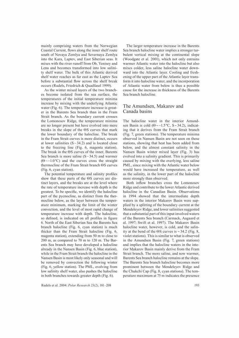
mainly comprising waters from the Norwegian Coastal Current, fl ows along the inner shelf route south of Novaya Zemlya and Severnaya Zemlya into the Kara, Laptev, and East Siberian seas. It mixes with the river runoff from Ob, Yenisey and Lena and becomes transformed into low salini-ty shelf water. The bulk of this Atlantic derived shelf water reaches as far east as the Laptev Sea before a substantial fl ow across the shelf break occurs (Rudels, Friedrich & Quadfasel 1999).
As the winter mixed layers of the two branch-es become isolated from the sea surface, the temperatures of the initial temperature minima increase by mixing with the underlying Atlantic water (Fig. 6). The temperature increase is great-er in the Barents Sea branch than in the Fram Strait branch. As the boundary current crosses the Lomonosov Ridge, the temperature minima are no longer present but have evolved into mere breaks in the slope of the ΘS curves that mark the lower boundary of the halocline. The break in the Fram Strait curves is more distinct, occurs at lower salinities (S ~ 34.2) and is located close to the freezing line (Fig. 6, magenta station). The break in the ΘS curves of the inner, Barents Sea branch is more saline (S ~ 34.5) and warmer (Θ ~ −1.0 ºC) and the curves cross the straight thermocline of the Fram Strait branch ΘS curves (Fig. 6, cyan station).
The potential temperature and salinity profi les show that these parts of the ΘS curves are dis-tinct layers, and the breaks are at the level where the rate of temperature increase with depth is the greatest. To be specifi c, we identify the halocline part of the pycnocline, as distinct from the ther-mocline below, as the layer between the temper-ature minimum, marking the limit of the winter convection, and the level of most rapid change of temperature increase with depth. The halocline, so defi ned, is indicated on all profi les in fi gure 6. North of the East Siberian Sea the Barents Sea branch halocline (Fig. 6, cyan station) is much thicker than the Fram Strait halocline (Fig. 6, magenta station), extending from 50 m to close to 200 m, as compared to 70 m to 120 m. The Bar-ents Sea branch may have developed a halocline already in the Nansen Basin (Fig. 6, blue station), while in the Fram Strait branch the halocline in the Nansen Basin is most likely only seasonal and will be removed by convection the following winter (Fig. 6, yellow station). The PML, evolving from low salinity shelf water, also pushes the halocline in both branches towards greater depth (Fig. 6).
The larger temperature increase in the Barents Sea branch halocline water implies a stronger tur-bulent vertical mixing at the continental slope (Woodgate et al. 2001), which not only entrains warmer Atlantic water into the halocline but also mixes colder, less saline halocline water down-ward into the Atlantic layer. Cooling and fresh-ening of the upper part of the Atlantic layer trans-form it into halocline water, and the incorporation of Atlantic water from below is thus a possible cause for the increase in thickness of the Barents Sea branch halocline.
The Amundsen, Makarov and Canada basins
The halocline water in the interior Amund-sen Basin is cold (Θ ∼ −1.5 ºC, S ∼ 34.2), indicat-ing that it derives from the Fram Strait branch (Fig. 7, green stations). The temperature minima observed in Nansen Basin are not seen on these stations, showing that heat has been added from below, and the almost constant salinity in the Nansen Basin winter mixed layer (Fig. 3) has evolved into a salinity gradient. This is primarily caused by mixing with the overlying, less saline PML, since mixing with the Atlantic water below would have increased the temperature, as well as the salinity, in the lower part of the halocline more strongly than observed.
Both infl ow branches cross the Lomonosov Ridge and contribute to the lower Atlantic derived halocline in the Canadian Basin. Observations in 1994 showed that the intermediate depth waters in the interior Makarov Basin were sup-plied by a splitting of the boundary current at the Mendeleyev Ridge, and lower salinities suggested that a substantial part of this input involved waters of the Barents Sea branch (Carmack, Aagaard et al. 1997; Swift et al. 1997). The Makarov Basin halocline water, however, is cold, and the salin-ity at the bend of the ΘS curves is ∼ 34.2 (Fig. 8, violet stations). This is similar to what is observed in the Amundsen Basin (Fig. 7, green stations) and implies that the halocline waters in the inte-rior Makarov Basin mainly derive from the Fram Strait branch. The more saline, and now warmer, Barents Sea branch halocline remains at the slope. The Barents Sea branch halocline becomes more prominent between the Mendeleyev Ridge and the Chukchi Cap (Fig. 8, cyan stations). The tem-perature maximum at 75 m indicates the presence

194 Sources of Arctic Ocean surface and halocline waters
Fig. 7: The properties of the upper layers in the Amundsen Basin. The upper panel shows potential temperature and salinity profi les and the lower panel ΘS curves from Oden/18 and Oden/31 (thick green) in the central and western part and ArkXII/58 and ArkXII/82 (thin green) in the eastern part of the basin (see insert map). The temperature in the Atlantic layer is different in the eastern and western Amundsen Basin because the 1991 (Oden) stations were taken before the anom-alously warm Atlantic water, fi rst reported by Quadfasel et al. (1991), had reached this position. The vertical bars indicate the depth range of the halocline. ArkXII/50, ArkXII/55 and ArkXII/57 (magenta) from the central Amundsen Basin and the Nansen-Gakkel Ridge show a homogeneous, saline winter mixed layer of varying depth (indicated by arrow) present in 1996.

195Rudels et al. 2004: Polar Research 23(2), 181–208
of the Pacifi c infl ow and the Bering Sea summer water, which depresses the Barents Sea branch “lower” halocline, reducing its thickness com-pared to north of the East Siberian Sea.
Beyond the Chukchi Cap no Fram Strait contri-butions can be clearly identifi ed either at the slope or in the interior of the Canada Basin (Fig. 9). A splitting of the boundary current at the Chuk-chi Cap has been suggested based on the char-acteristics of the Atlantic and intermediate layers (Rudels, Anderson et al. 1996; Smith et al. 1999; Smethie et al. 2000) as well as by the fl ow of near-surface Pacifi c waters (Shimada et al. 2001; Jones, Anderson et al. 1998). The fl ow around the Chukchi Cap has also been discussed in detail by McLaughlin, Carmack, MacDonald, Mel-ling et al. (2004). A disappearance of the Fram Strait branch halocline characteristics at the slope is consistent with a loss of the outer part of the boundary current to the interior basin. The Fram Strait branch would then mainly be confi ned to the part of the Canada Basin closest to the Men-deleyev and Alpha ridges, while the Barents Sea branch continues along the slope and supplies the southern Canada Basin beyond the Chukchi Cap. The ΘS curves in the Canada Basin are smooth and the bend between halocline and thermocline almost impossible to distinguish. The Barents Sea branch halocline will here be identifi ed as lying between the Pacifi c derived upper water and the Atlantic layer, having the potential temperature and salinity ranges Θ < 0 ºC and 33.6 < S < 34.6.
The Pacifi c water is initially less dense than the Atlantic derived lower halocline, and in the Arctic Ocean the Pacifi c source water is distinguished from water of Atlantic origin by nutrient concen-trations. Following earlier work (Jones, Anderson et al. 1998; Jones, Swift et al. 2003), we note that north of Alaska, nitrate–phosphate relationships show Pacifi c source water in the Canada Basin penetrating to depths of 250 m, where salinities exceed 34.3, well into the Atlantic derived Bar-ents Sea branch halocline (not shown). Salmon & McRoy (1994) observed an increase in silicate and temperature in the salinity range of the lower halocline in the Canada Basin as compared to the Amundsen and Makarov basins and argued that this is caused by the presence of Pacifi c water. The higher silicate concentrations are consist-ent with an input of Pacifi c water into the lower halocline, but the higher temperatures indicate rather the presence of the Barents Sea branch halocline water than shelf derived Pacifi c water,
which would be colder because of freezing and brine rejection. However, the temperatures in the 34 - 34.5 salinity range are lower at some stations, which again substantiates an input of Pacifi c water made more saline by brine rejection, in agree-ment with Salmon & McRoy (1994). Large verti-cal motions of the isopycnals have been observed on the continental slope in Beaufort Sea (Kulikov et al. 1998) and the possibility that Pacifi c water is mechanically mixed into the lower halocline by increased turbulence at the slope also exists.
The predominance of the Barents Sea branch halocline in the Canada Basin is consistent with the suggestion by Melling (1998), based on the time variability of the temperature of the lower halocline, defi ned as the 34.5 isohaline, in the Canada Basin, that the lower halocline is respond-ing to changes in the infl ow of the Barents Sea branch. The reported variability is rather small, even in the Atlantic layer—at least it appears so to workers who are used to changes of 1 ºC between successive CTD casts at the same station, which occur in the frontal zone between the two branch-es (see e.g. Rudels, Muench et al. 2000). A time variation of the relative contributions from the branches could have a similar effect.
Melling sees a Barents Sea origin of the lower halocline in the Canada Basin as an argument in favour of the source and the formation of the lower halocline proposed by Steele et al. (1995) as com-pared to that of Rudels, Anderson et al. (1996). As to the sources, the present work shows that the halocline waters from the different sources dom-inate in the different basins, and the presence of Barents Sea branch halocline in the Canada Basin is in agreement with Melling’s conclusions.
The difference in the proposed formation proc-esses is mainly that Steele et al. (1995) empha-size the melting of sea ice in the marginal ice zone, in the northern Barents Sea but also north of Svalbard, while Rudels, Larsson et al. (1991) and Rudels, Andersson et al. (1996) consider the melting of sea ice merely as a preconditioning of the upper part of the water column for ice forma-tion in winter and haline convection down to the thermocline. The winter homogenization leads to the formation of mode waters (McCartney 1977) that eventually evolve into the halocline, and the mode waters give the halocline its distinct, initial characteristics.

196 Sources of Arctic Ocean surface and halocline waters
Fig. 8: The properties of the upper layers of the Makarov Basin. The upper panel shows potential temperature and salinity profi les and the lower panel ΘS curves for AOS/23, AOS/26 and AOS/29 (violet) and AOS/8 and AOS/11 (cyan) from the Makarov Basin and from the Canada Basin west of the Chukchi Cap (see insert map). The violet stations from the interior indicate Fram Strait branch halocline water, while the cyan stations from the slope show Barents Sea branch halo-cline water. The upper temperature maximum is due to the presence of Bering Strait summer water (arrow) and the verti-cal bars show the depth range of the halocline.
197Rudels et al. 2004: Polar Research 23(2), 181–208
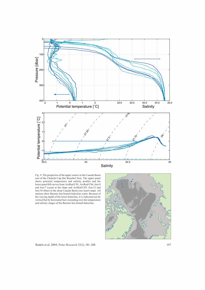
Fig. 9: The properties of the upper waters in the Canada Basin east of the Chukchi Cap (the Beaufort Sea). The upper panel shows potential temperature and salinity profi les and the lower panel ΘS curves from ArcRad/C01, ArcRad/C06, Jois/4 and Jois/7 (cyan) at the slope and ArcRad/C05, Jois/12 and Jois/14 (blue) in the deep Canada Basin (see insert map). All stations show Barents Sea branch halocline water. Because of the varying depth of the lower halocline, it is indicated not by vertical but by horizontal bars extending over the temperature and salinity ranges of the Barents Sea branch halocline.

198 Sources of Arctic Ocean surface and halocline waters
Time variabilityObservations of large changes in the Arctic Ocean water column have been reported during the last 15 years. The temperature of the Atlantic layer has increased (Quadfasel et al. 1991; Carmack, MacDonald et al. 1995) and its upper boundary has become shallower, at least in the Amundsen and Makarov Basins (Morison et al. 1998). These changes have been related to a shift in the distri-bution of the Pacifi c water in the Canadian Basin (Carmack, MacDonald et al. 1995; McLaughlin, Carmack, MacDonald & Bishop 1996). Obser-vations from the early ice stations in the 1960s indicated that nutrient rich Pacifi c water was present in the Makarov Basin up to the Lomono-sov Ridge (e.g. Kinney et al. 1970). By the mid 1990s Pacifi c water was not found on the Siberi-an side of the Makarov Basin (McLaughlin, Car-mack, MacDonald & Bishop 1996) and a shoaling of the boundary between the Pacifi c and Atlan-tic derived haloclines has been reported also from the western part of the Canada Basin (McLaugh-lin, Carmack, MacDonald, Weaver et al. 2002).
These changes are likely connected with the weakening, and occasionally even the disappear-ance, of the PML in these basins (Steele & Boyd 1998). Close to the North Pole, the low salinity PML (or shelf water) present in 1991 was report-ed absent in 1995 (Steele & Boyd 1998). In 1996 the two-layer PML−halocline structure was absent on stations over the Nansen-Gakkel Ridge and in the central Amundsen Basin, and a winter mixed layer reaching down to the pycnocline was observed (Fig. 7, magenta stations). Steele & Boyd (1998) attribute these changes to the diversion of the low salinity Laptev Sea shelf water from the Amundsen Basin into the East Siberian Sea. Such change in the shelf water distribution could be the result of the strong positive AO (Arctic Oscilla-tion) and NAO (North Atlantic Oscillation) states prevailing in the 1990s (Proshutinsky & Johnson 1997; Polyakov & Johnson 2000).
The depth of the pycnocline varied from more than 150 m over the Nansen-Gakkel Ridge to less than 60 m in the Amundsen Basin, indicat-ing that, besides convection, internal wave and eddy motions also infl uence the observed thick-ness of the winter mixed layer. In 1995 - 1996 the region with a winter homogenized upper layer thus extended from the Nansen Basin into the Amundsen Basin and up to the Lomonosov Ridge (Schauer, Rudels et al. 2002). It did not, however,
reach the eastern parts of the Eurasian Basin and the Eurasian continental slope, where a distinct PML–halocline structure was observed in 1993, 1995 and 1996. Recent observations have shown that low salinity shelf water again is present in the Amundsen Basin and at the Lomonosov Ridge (Björk et al. 2002; Boyd et al. 2002; Anderson et al. 2004).
Recently McLaughlin, Carmack, MacDonald, Melling et al. (2004) have reported observations of cold (close to freezing), saline (34.2) and oxy-genated water north of the Chukchi Cap: their Type I profi les. These characteristics are close to those of the Fram Strait branch halocline (see, e.g., Fig. 6, Fig. 7 & Fig. 8), and the location sug-gests a spreading of the Fram Strait halocline into the Canada Basin west and north of the Chukchi Cap. By contrast the Type II profi les (McLaugh-lin, Carmack, MacDonald, Melling et al. 2004) found east of the Chukchi Cap had a warmer and more saline break in the ΘS curves, which corre-sponds to the characteristics of the Barents Sea branch halocline moving eastward south of the Chukchi Cap (see, e.g., Fig. 6, Fig. 8 & Fig. 9).
McLaughlin, Carmack, MacDonald, Mel-ling et al. (2004) suggest the East Siberian Sea as the source for the cold Type I halocline water, which to us appears rather unlikely. The salin-ity of the waters on the East Siberian Sea shelf is low and more than four metres of ice must be formed before salinities above 33.5 are reached (Aagaard, Coachman et al. 1981). The recent redistribution of the low salinity shelf water from the Laptev Sea into the East Siberian Sea instead of the Amundsen Basin should lead to even lower salinities. The accumulation of brine-enriched water at the bottom is also likely to remineral-ize organic material, leading to high nutrient and lower oxygen concentrations.
Our interpretation of the cold and saline halo-cline found in the Type I profi les thus differs from that given by McLaughlin, Carmack, Mac-Donald, Melling et al. (2004). The cold, oxygen-ized halocline suggests a recently ventilated Fram Strait branch winter mixed layer. This could have been advected from the Amundsen Basin, where such layers have been observed (Fig. 7, magenta stations) or the low salinity surface water could have absent also in parts of the Makarov Basin, allowing for convection down to the thermocline at least in the southwestern Makarov Basin.
The absence of low salinity surface water implies the absence of a cold halocline, and verti-

199Rudels et al. 2004: Polar Research 23(2), 181–208
cal mixing and entrainment can add both salt and heat to the mixed layer. Such heat transport could reduce the ice formation in winter, since part of the heat given up to the atmosphere would be sen-sible heat, not just the latent heat released by freez-ing. However, the magnitude of the heat fl ux into the mixed layer depends upon the mixing mech-anism. If the entrainment is driven by mechani-cal stirring, the heat fl ux might be considerable, while stirring by convecting plumes and ther-mals is less effi cient (Solomon 1973). The plumes may overshoot into the thermocline and become heated there, causing only little heat transfer into the mixed layer. This would create a curved shape of the thermocline in the ΘS curves, as is observed at the stations in the interior Nansen and Amund-sen Basins, with a deep, saline mixed layer, in contrast to the straight thermocline found in the areas of more intense mechanical mixing at the continental slope (e.g. Fig. 3 & Fig. 7; see also Figure 10 in Rudels & Friedrich 2000). Plumes require freezing and brine rejection in order to develop, and if the upper layer is stirred by con-vecting plumes, a stronger entrainment of warm water would reduce the ice formation and weaken the convection, which in turn would reduce the entrainment (Martinson 1990; Martinson & Steele 2001). Furthermore, a deep winter mixed layer with no underlying halocline is the norm in the Nansen Basin. Its extension into the Amund-sen Basin and to the Lomonosov Ridge only makes a small contribution to the vertical heat fl ux normally present in the Arctic Ocean.
The area north of Greenland
The boundary current returns toward Fram Strait along the North American continental slope, crossing the Alpha and the Lomonosov ridges. The waters from the different loops of the dif-ferent basins eventually come together and join the boundary current (Rudels, Friedrich & Quad-fasel 1999). At the Greenland continental slope between the Morris Jesup Plateau and Fram Strait, the return fl ow from the Canada Basin is located closest to Greenland. The contributions from the other basins, upper waters as well as the Atlan-tic and intermediate layers, line up parallel to the slope from the rim into the basin. The less dense Pacifi c waters are mainly found close to the con-tinent, inshore of and above the Atlantic derived waters.
Observations from 1980 and 1997 extend-ing from the outfl ow region near Greenland to the infl ow region north of Svalbard are shown in Fig. 10. The surface layer in the infl ow area in the eastern Fram Strait had salinities similar to the Atlantic derived halocline waters, showing the fi rst developing stage of the winter mixed layer in the Nansen Basin (Fig. 10a & 10b, red stations). The depth of the temperature maximum in the Atlantic layer was considerably less in the infl owing than in the outfl owing water columns, consistent with the existence of sources other than the melting of sea ice north of Svalbard contributing to the polar surface water in the Arctic Ocean. The Barents Sea branch halocline water was more clearly dis-tinguished in 1980 (Fig. 10a) than in 1997, when it was interacting with the colder outfl ow from the Nansen and Amundsen Basins (Fig. 10b, blue stations). In 1980 the Fram Strait branch formed a proper halocline between the thermocline and the PML. In 1997 the PML was absent at some stations and a deep winter mixed layer with tem-peratures close to freezing was observed (Fig. 10b, black stations). This suggests that part of the deep winter mixed layer encountered in the Eura-sian Basin in 1995 and 1996, and discussed in the time variability section above, could be exiting the Arctic Ocean as early as 1997 (Rudels, Meyer et al. 2000). At one station the isothermal layer reached as deep as 240 m (Fig. 10b, black station). However, the salinity profi le showed a three-layer structure with a low-salinity surface layer. This implies that low salinity water, perhaps including Pacifi c water that is known to partly exit through Fram Strait (Jones, Swift et al. 2003), has been defl ected from its inshore path and moved on top of a stream of Fram Strait halocline water, forc-ing the denser Atlantic halocline and PML waters downward.
The outfl ow through the Canadian Arctic Archipelago
As the Barents Sea branch halocline water moves along the continental slope from the Canada Basin toward northern Greenland, it ascends in the water column from 250 - 300 m north of Alaska to about 150 - 200 m north of Greenland (Fig. 11). This rise is due to the gradual thinning of the, mostly Pacifi c, layers above. The thin-ning could be caused by the Pacifi c water either being confi ned to the Beaufort Sea gyre or drain-

200 Sources of Arctic Ocean surface and halocline waters
Fig. 10a: Properties of the upper layers north of Fram Strait in 1980. The upper panel shows potential temperature and salinity profi les and the lower panel shows ΘS curves from Ymer/171 and Ymer/172 (red), Ymer/166, Ymer/168 and Ymer/170 (black) and Ymer/162 and Ymer/164 (blue) (see insert map). Black stations show returning Fram Strait branch halocline water; blue station returning Barents Sea branch halocline water. The red stations are from the infl ow area at the Yermak Plateau.

201Rudels et al. 2004: Polar Research 23(2), 181–208
Fig. 10b: Properties of the upper layers north of Fram Strait in 1997. The upper panel shows potential temperature and salin-ity profi les and the lower panel ΘS curves from ArkXIII/86 and ArkXIII/87 (red), ArkXIII/68, ArkXIII/69 and ArkX-III/82 (black) and ArkXIII/72 and ArkXIII/73 (blue) (see insert map). Black stations show returning Fram Strait branch halocline water; blue stations returning Barents Sea branch halocline water. The red stations are from the infl ow area at the Yermak Plateau. The almost constant salinity below the seasonal melt layer and the curved thermocline in the black salinity profi les both suggest that part of the winter mixed layer observed in the Eurasian Basin in 1995 and 1996 (Steele & Boyd 1998) now is returning to Fram Strait. The deep, cold isothermal layer on one station (indicated by arrow) in reality comprises the winter mixed layer of the Eurasian Basin and PML deriving both from Eurasian and the Canadian basins.

202 Sources of Arctic Ocean surface and halocline waters
ing through the Canadian Arctic Archipelago and ultimately into Baffi n Bay. We favour the second interpretation. Jones, Swift et al. (2003) identifi ed Arctic water of Atlantic origin fl owing through Nares Strait, and suggest that the shallowing of the Barents Sea branch halocline water allows it to pass over the sill in Nares Strait (230 m), and enter Baffi n Bay. The other channels in the Cana-dian Arctic Archipelago are shallower and permit only the passage of Pacifi c water and other waters in the PML, e.g., river runoff and sea ice meltwa-ter (Jones, Swift et al. 2003).
Baffi n Bay bottom water
Bailey (1956) noted that the characteristics (Θ = −0.45 ºC, S = 34.45) of Baffi n Bay bottom water were similar to those found at 250 m in the Beaufort Sea and suggested the Arctic Ocean as the source of the Baffi n Bay deep and bottom waters. These are also the characteristics of the Barents Sea branch halocline water, and the fact that these water mass characteristics are found at comparatively shallow depths north of Greenland and close to Nares Strait supports Bailey’s sug-gestion. However, Bourke et al. (1989) and Bourke & Paquette (1991) did not observe any water with salinity and temperature matching those of the Baffi n Bay deep and bottom waters fl ow-ing through Nares Strait into Baffi n Bay in 1986. Instead they proposed that dense water formation and haline convection, mainly in the North Water polynya in the southern part of Nares Strait, con-tribute to the Baffi n Bay deep and bottom water. Such convection has, so far, not been observed.
The bottom water in Baffi n Bay is old. Its oxygen saturation is just over half that of sur-face waters, and the CFC concentrations are near detection limit (Wallace 1985). Wallace suggest-ed that the ventilation time could be as long as 1000 years, and thus any renewal, by infl ow or by convection, would be slow and intermittent. What may be concluded from the ΘS character-istics, however, is that no water denser than the Barents Sea branch halocline enters Baffi n Bay from the Arctic Ocean, and if the Barents Sea branch is an important source for the deep water in Baffi n Bay, the entrainment of ambient water into the infl owing and descending plumes must be small. In Baffi n Bay the intermediate waters are warmer and more saline than the bottom water. A contribution from the Arctic Ocean
dense enough to allow for a stronger entrainment of intermediate water and still reach the bottom would involve water with higher temperatures and salinities. Both stronger entrainment and a denser infl ow would together lead to higher tem-peratures and higher salinities in the Baffi n Bay deep and bottom water than those observed.
Estimate of fl ow through the Canadi-an Arctic Archipelago
That the Barents Sea branch, together with the Pacifi c infl ow through Bering Strait, supplies the outfl ow through the Canadian Arctic Archipel-ago also makes it possible to crudely assess the volume and freshwater transports through the archipelago. The existing estimates of the out-fl ow range from less than 1 Sv to above 2 Sv, with the higher end estimates commonly chosen (e.g., Aagaard & Carmack 1989).
Some Pacifi c water exits through Fram Strait (e.g., Jones, Swift et al. 2003) and perhaps 0.6 Sv, 75 % of the estimated 0.8 Sv (Roach et al. 1995) entering through the Bering Strait, passes through the Canadian Arctic Archipelago. We assume that the salinity of the Pacifi c derived water is 32.5, the same as in Bering Strait. This is likely an overes-timate because runoff is added from the Macken-zie and Siberian rivers as well as other freshwater sources. Following our defi nition of the Barents Sea branch halocline water in the Canada Basin we take the upper salinity limit of the Pacifi c water to be 33.6. In the Canadian Arctic Archi-pelago, only Nares Strait, with a sill depth of about 230 m, is deep enough to allow the passage of waters from the Barents Sea branch halocline. The salinity cannot be higher than ~ 34.45 of the Baffi n Bay bottom water, but it could be signifi -cantly lower, since the Atlantic infl ow to the Bar-ents Sea, together with the runoff, supplies the water on the Siberian shelves, which enters the deep Arctic Ocean above the Barents Sea branch halocline. We assume a salinity of 34.0 (mean of 33.6 and 34.45) for the Atlantic water passing through the Canadian Arctic Archipelago. This is probably high since less dense water more easily passes through the shallow straits.
We make tentative mass and freshwater budg-ets for outfl ows of 2, 1.5 and 1 Sv (Table 3). The infl ow from the Norwegian Sea to the Barents Sea is around 3 Sv, of which 0.7 Sv is Norwe-gian Coastal Current water with salinity ∼ 34.4.

203Rudels et al. 2004: Polar Research 23(2), 181–208
Fig. 11: A comparison between the characteristics of the upper layers in the Beaufort Sea and north of Fram Strait with the characteristics of the deep and bottom waters in Baffi n Bay, showing the similarities between the Baffi n Bay bottom water and the Barents Sea branch halocline. The upper panel shows potential temperature and salinity profi les and the lower panel ΘS curves from stations Jois/4 and Jois/5 (cyan) in the Beaufort Sea and ArkII/329 and ArkII/330 (blue) northeast of Greenland and BB/133 (dark yellow) in Baffi n Bay (see insert map).

204 Sources of Arctic Ocean surface and halocline waters
The rest is Atlantic water with salinity 35.05 (Blindheim 1989; Aagaard & Carmack 1989). The fl ow from the Barents Sea to the Norwegian Sea south of Bjørnøya is about 0.8 Sv (Blindheim 1989), and the remaining 2.2 Sv enter the Artic Ocean. With an outfl ow of 2 Sv through the Cana-dian Arctic Archipelago, more than half of this volume (i.e., 1.4 Sv) passes through the Canadi-an Arctic Archipelago, and all freshwater in the Norwegian Coastal Current as well as runoff cor-responding almost to two of the three large Sibe-rian rivers Ob, Yenisey and Lena are needed to close the freshwater balance. (Volumes are taken from Aagaard & Carmack 1989, and the freshwa-ter fl uxes are computed relative to 35.) An out-fl ow of 1.5 Sv requires almost one river in addi-tion to all of the Norwegian Coastal Current—its volume as well as its freshwater—while an out-fl ow of 1 Sv would demand slightly more than half the volume of the Norwegian Coastal Cur-rent (0.4 Sv) and all of its freshwater (Table 3). The freshwater fl uxes are large, 2 to 3 times the estimated liquid freshwater export through Fram Strait, and, in the case of 2 Sv, almost as large as the Fram Strait ice export and little less than twice the freshwater infl ow through Bering Strait (Aagaard & Carmack 1989). This means that the supply of freshwater to the Arctic Ocean is not enough to balance the export of ice and liquid freshwater through Fram Strait in the case of a large outfl ow through the Canadian Arctic Archipelago. Considering that at least 0.8 Sv of the Barents Sea branch water enters the Arctic Ocean deeper than the halocline (Loeng et al. 1997; Schauer, Loeng et al. 2002), and that some of the low salinity shelf water leaves the Arctic Ocean through Fram Strait, also the volume bal-ance suggests that the outfl ow through the Cana-dian Arctic Archipelago is at the lower end of the range given in Table 3.
Concluding remarks
The concept of two halocline sources derived from Atlantic water is not new. Steele & Boyd (1998) combined the shelf process (Aagaard, Coachman et al. 1981; Jones & Anderson 1986) with the interior basin formation scenario of Rudels, Anderson et al. (1996). They identifi ed two halocline water masses: a Barents–Kara sea shelf derived “advected” halocline and a Fram Strait winter mixed layer “convected” halocline. This distinction was taken up by Woodgate et al. (2001). They combined data obtained from cur-rent meters and Seacats moored over the slopes north of the Laptev and East Siberian seas with CTD data from the same region. They concluded that the advected halocline, identifi ed by higher temperature, dominated in the boundary cur-rent in the vicinity of the Lomonosov Ridge and that its likely origin was the infl ow to the Arctic Ocean over the Barents Sea. The presence of a convective halocline was held possible but less probable.
The choice of the “advective” and “convective” terminology may be inappropriate: it gives the impression that the permanent halocline could be formed locally by convection. This is not the case. If a two layer PML–halocline structure is present, the halocline is, in both scenarios, advected from a distant source: the “advected” halocline from a shallow shelf, the “convected” halocline from another part of the basin or from a deeper shelf. Both scenarios also involve ice formation, brine rejection and haline convection. For the shelf sce-nario, Aagaard, Coachman et al. (1981) proposed that higher salinities are reached by accumulation of saline water at the bottom of the shelves; in the basin scenario (Rudels, Anderson et al. 1996) the combined effects of ice melt and brine rejection determine the salinity of the winter mixed layer,
Table 3: The salinity of the outfl ow and the freshwater fl ux through the Canadian Arctic Archipelago for different total outfl ows. Freshwater fl uxes are computed relative to 35, roughly the salinity of the entering Atlantic water. The freshwater supplied by the 0.6 Sv Pacifi c water is 0.043 Sv (1353 km3y–1). PW = Pacifi c water, BSBW = Barents Sea branch water, FW = freshwater
Outfl owvSv
Outfl owPW Sv
SalinityPW
Outfl owBSBW
Sv
SalinityBSBW
SalinityOutfl ow
Outfl owFW Sv
Outfl owFW
km3y−1
2 0.6 32.5 1.4 34.0 33.55 0.083 26171.5 0.6 32.5 0.9 34.0 33.4 0.069 21761 0.6 32.5 0.4 34.0 33.1 0.054 1703

205Rudels et al. 2004: Polar Research 23(2), 181–208
and the convection does not extend to the bottom, only to the pycnocline above the Atlantic layer.
Aagaard & Woodgate (2001) and Woodgate et al. (2001) suggested that ice, advected from the Arctic Ocean and coming into contact with the Atlantic water entering the Barents Sea from the Norwegian Sea, would melt and create a less saline water mass, denser than the PML, which eventually enters the Arctic Ocean and supplies the halocline. Such a process is more akin to the one suggested by Steele et al. (1995) for the Bar-ents Sea polar front, and to the one discussed by Rudels, Anderson et al. (1996) for the Fram Strait infl ow, than it is to the shelf scenario proposed by Aagaard, Coachman et al. (1981).
In summary, the contributions from the North Atlantic to the upper layers of the Arctic Ocean have been examined. We conclude that the lower halocline waters in the Amundsen, Makarov and part of the Canada Basin derive from the Fram Strait infl ow branch and the winter mixed layer of the Nansen Basin, while the lower halocline water at the Eurasian continental slope, in the southern Canada Basin and along the North American con-tinental slope, originates from the upper part of the Barents Sea branch entering the Arctic Ocean through St. Anna Trough (Fig. 12).
A substantial part of the PML observed in the Amundsen and Makarov Basins is supplied from the Laptev and East Siberian seas, where Atlantic derived low salinity shelf water enters the Arctic Ocean after passing over the shelves of the Bar-ents, Kara and Laptev seas, incorporating the runoff of the Siberian rivers. In spite of the sub-stantial changes in the upper layers of the interior Arctic Ocean reported in recent years, the charac-teristics of the Atlantic derived halocline waters have been surprisingly stable, although their dis-tribution in the different basins has varied con-siderably.
The formation of the Barents Sea branch halo-cline water does not appear to involve either of the two earlier proposed shelf processes, cooling and freshening of Atlantic water brought along deeper canyons onto the shelves from the inte-rior of the Arctic Ocean (Coachman & Barnes 1963), or freezing and brine rejection leading to accumulation of saline water at the bottom of the shelves during winter (Aagaard, Coach-man et al. 1981). Both the Fram Strait branch and the Barents Sea branch contributions are creat-ed by winter homogenization of less saline, cold waters lying above warm Atlantic water. The Bar-
ents Sea branch halocline is distinguished from the Fram Strait branch halocline by higher salini-ties and higher temperatures that result from the stronger vertical mixing with warmer Atlantic water occurring at the continental slope. The Bar-ents Sea branch halocline thus becomes more like a salinity-stratifi ed thermocline, while the Fram Strait branch remains a halocline. The Barents Sea branch supplies the Atlantic derived water, contributing to the outfl ow through the Canadi-an Arctic Archipelago, where it passes through Nares Strait, and it could be a possible source for the deep and bottom waters in Baffi n Bay. Apart from this outfl ow to Baffi n Bay, the Barents Sea branch halocline water exits together with the Fram Strait branch halocline water through Fram Strait as a part of the polar surface water of the East Greenland Current.
Acknowledgements.—We wish to thank C. Ross at Bedford Institute of Oceanography, who kindly supplied unpublished data from Baffi n Bay, and B. Bye of the Norwegian Polar Institute for providing the maps used in the fi gures. Finan-cial support has been given by the Canadian Panel on Energy Research and Development (EPJ), European Commission programme ASOF-N, through contract EVK2-CT-2002-00139 (BR) and European Commission programme ASOF-W, through contract EVK2-CT-2002-00149 (PE).

206 Sources of Arctic Ocean surface and halocline waters
References:Aagaard, K. & Carmack, E. C. 1989: The role of sea ice and
other freshwater in the Arctic circulation. J. Geophys. Res. 93(C10), 14485–14498.
Aagaard, K., Coachman, L. K. & Carmack, E. C. 1981: On the halocline of the Arctic Ocean. Deep Sea Res. Part A 28, 529–545.
Aagaard, K., Swift, J. H. & Carmack, E. C. 1985: Thermoha-line circulation in the Arctic Mediterranean Seas. J. Geo-phys. Res. 90(C3), 4833–4846.
Aagaard, K. & Woodgate, R. A. 2001: Some thoughts on the freezing and melting of sea ice and their effects on the ocean. Ocean Model. 3, 127–135.
Anderson, L.G., Jutterström, S., Kaltin, S., Jones, E.P. & Björk, G. 2004: Variability in river runoff distribution in
Fig. 12: Schematics showing the infl ow of Atlantic Water (AW, red), river runoff (RR green), Pacifi c infl ow (PW, orange), the formation area (black diagonals) and the circulation (black arrows) of the Fram Strait branch halocline, and the formation area (blue diagonals) and circulation (blue arrows) of the Barents Sea branch halocline.

207Rudels et al. 2004: Polar Research 23(2), 181–208
the Eurasian Basin of the Arctic Ocean. J. Geophys. Res. 109(C01), C01016, doi:10.1029/2003JC00173.
Bailey, W. B. 1956: On the origin of Baffi n Bay Deep Water. J. Fish. Res. Board Can. 13(3), 303–308.
Björk, G., Söderqvist, J., Winsor, P., Nikolopoulos, A. & Steele, M. 2002: Return of the cold halocline to the Amund-sen Basin of the Arctic Ocean: Implication for the sea ice mass balance. Geophys. Res. Lett. 29(11), doi:10.1029/2001GL014157.
Blindheim, J. 1989: Cascading of Barents Sea bottom water into the Norwegian Sea. Rapp. Procéss-verbaux Réunion Cons. Int. Explor. Mer 188, 49–58.
Bourke, R. H., Addison, V. G. & Paquette, R. G. 1989: Ocea-nography of Nares Strait and Northern Baffi n Bay in 1986 with emphasis on deep and bottom water formation. J Geo-phys. Res. 94(C6), 8289–8302.
Bourke, R. H. & Paquette, R. G. 1991: Formation of Baffi n Bay bottom and deep waters. In P. C. Chu & J.-C. Gascard (eds.): Deep convection and deep water formation in the oceans. Pp. 135–155. Amsterdam: Elsevier.
Boyd, T. J. Steele, M., Muench, R. D. & Gunn, J. T. 2002: Par-tial recovery of the Arctic Ocean halocline. Geophys. Res. Lett. 29(14), doi:10.1029/2001GL014047.
Carmack, E. C. 1990: Large-scale physical oceanography of Polar oceans. In W. O. Smith Jr. (ed.): Polar Oceanography, Part A. Pp. 171–212. San Diego: Academic Press.
Carmack, E. C., Aagaard, K., Swift, J. H., MacDonald, R. W., McLaughlin, F. A., Jones, E. P., Perkin, R. G., Smith, J. N., Ellis, K. M. & Killius, L. R. 1997: Changes in temperature and tracer distributions within the Arctic Ocean: results from the 1994 Arctic Ocean section. Deep Sea Res. Part II 44, 1487–1502.
Carmack, E. C., MacDonald, R. W., Perkin, R. G., & McLaughlin, F. A. 1995: Evidence for warming of Atlantic water in the southern Canadian Basin. Geophys. Res. Lett. 22, 1961–1964.
Coachman, L. K., Aagaard, K. & Tripp, R. 1995: Bering Strait: the regional physical oceanography. Seattle: Uni-versity of Washington Press.
Coachman, L. K. & Aagaard, K. 1974: Physical oceanogra-phy of the Arctic and subarctic seas. In Y. Herman (ed.): Marine geology and oceanography of the Arctic seas. Pp. 1–72, New York: Springer Verlag.
Coachman, L. K. & Barnes, C. A. 1961: The contribution of Bering Sea water to the Arctic Ocean. Arctic 14, 147–161.
Coachman, L. K. & Barnes, C. A. 1963: Surface waters in the Eurasian Basin of the Arctic Ocean, Arctic 15, 251–277.
Gill, A. E. 1982: Atmosphere-ocean dynamics. New York: Academic Press.
Holloway, G. 2001: Is the Arctic sea ice rapidly thinning? Ice and climate news: the Arctic climate system study/climate and cryosphere project newsletter 1, 2–5.
Jones, E. P. & Anderson, L. G. 1986: On the origin of the chemical properties of the Arctic Ocean halocline. J. Geo-phys. Res. 91(C9), 10759–10767.
Jones, E. P., Anderson, L. G. & Swift, J. H. 1998: Distribution of Atlantic and Pacifi c waters in the upper Arctic Ocean: Implications for circulation. Geophys. Res. Lett. 25, 765–768.
Jones, E. P., Swift, J. H., Anderson, L. G., Lipizer, M., Civi-tarese, G., Falkner, K. K., Kattner, G. & McLaughlin, F. A. 2003: Tracing Pacifi c water in the North Atlantic Ocean. J. Geophys. Res. 108(C4), Art. no. 3116, doi:10.1029/2001JC001141.
Kinney, P., Arhelger, M. E. & Burell, D. C. 1970: Chemical characteristics of water masses in the Amerasian Basin of the Arctic Ocean. J. Geophys. Res. 75, 4097–4104.
Kulikov, E. A., Carmack, E. C. & MacDonald, R. W. 1998: Flow variability at the continental shelf break of the Mac-kenzie shelf in the Beaufort Sea. J. Geophys. Res. 103(C6), 12725–12741.
Loeng, H., Ozhigin, V. & Ådlandsvik, B. 1997: Water fl uxes through the Barents Sea. ICES J. Mar. Sci. 54, 310–317.
Martinson, D. G. 1990: Evolution of the southern Ocean winter mixed layer and sea ice: open ocean deep water formation and ventilation. J. Geophys. Res. 95(C7), 11641–11654.
Martinson, D. G. & Steele, M. 2001: Future of the Arctic Sea ice cover: implications of an Antarctic analog. Geophys. Res. Lett. 28, 307–310.
McCartney, M. S. 1977: Subantarctic mode water. In M. Angel (ed.): A voyage of discovery, Pp. 103–119, Oxford: Perga-mon Press.
McLaughlin, F. A., Carmack, E. C., MacDonald, R. W. & Bishop, J. K. B. 1996: Physical and geochemical properties across the Atlantic/Pacifi c water mass front in the southern Canadian Basin. J. Geophys. Res. 101(C1), 1183–1197.
McLaughlin, F. A., Carmack, E. C., MacDonald, R. W., Mel-ling, H., Swift, J. H., Wheeler, P. A., Sherr, B. F. & Sherr, E. B. 2004: The joint roles of Pacifi c and Atlantic-origin waters in the Canada Basin, 1997–1998: Deep Sea Res. Part I 51, 107–128.
McLaughlin, F. A., Carmack, E. C., MacDonald, R. W., Weaver, A. J. & Smith, J. 2002: The Canada Basin 1989–1995: upstream events and far-fi eld effects of the Barents Sea branch. J. Geophys. Res. 107(C1), 101029–101049.
McPhee, M. G., Stanton, T. P., Morison, J. H. & Martinson, D. G. 1998: Freshening of the upper ocean in the Arctic: Is the perennial sea ice disappearing? Geophys. Res. Lett. 25, 1729–1732.
Melling, H. 1998: Hydrographic changes in the Canada Basin of the Arctic Ocean, 1979–1996. J. Geophys. Res. 103(C4), 7637–7645.
Moore, R. M. & Wallace, D. W. R. 1988: A relationship between heat transfer to sea ice and temperature–salini-ty properties of the Arctic Ocean waters. J. Geophys. Res. 93(C1), 18381–18395.
Morison, J. H., Steele, M. & Anderson, R. 1998: Hydrography of the upper Arctic Ocean measured form the nuclear sub-marine USS Pargo. Deep Sea Res. Part I 45, 15–38.
Polyakov, I. V. & Johnson, M. A. 2000: Arctic decadal and interdecadal variability. Geophys. Res. Lett. 27, 4097–4100.
Proshutinsky, A. Y. & Johnson, M. A. 1997: Two circulation regimes of the wind-driven Arctic Ocean. J. Geophys. Res. 102(C6), 12493–12514.
Quadfasel, D., Sy, A., Wells, D. & Tunik, A. 1991: Warming in the Arctic. Nature 350, 385.
Roach, A. T., Aagaard, K., Pease, C. H., Salo, A., Weingartner, T., Pavlov, V. & Kulakov, M. 1995: Direct measurements of transport and water properties through the Bering Strait. J. Geophys. Res. 100(C9), 18443–18457.
Rothrock, D. A., Yu, Y. & Maykut, G. A. 1999: Thinning of the Arctic Sea-ice cover. Geophys. Res. Lett. 26, 3469–3472.
Rudels, B. 1987: On the mass balance of the Polar Ocean, with special emphasis on the Fram Strait. Nor. Polarinst. Skr. 188.
Rudels, B., Larsson, A.-M. & Sehlstedt, P.-I. 1991: Stratifi ca-tion and water mass formation in the Arctic Ocean: some

208 Sources of Arctic Ocean surface and halocline waters
implications for the nutrient distribution. Polar Res. 10, 19–31.
Rudels, B., Anderson, L. G. & Jones, E. P. 1996: Formation and evolution of the surface mixed layer and the halocline of the Arctic Ocean. J. Geophys. Res. 101(C4), 8807–8821.
Rudels, B. & Friedrich, H. J. 2000: The transformations of Atlantic water in the Arctic Ocean and their signifi cance for the freshwater budget. In E. L. Lewis et al. (eds.): The fresh-water budget of the Arctic Ocean, NATO Science Series, 2 Environmental Security – Volume 70. Pp. 503–532. Dord-recht: Kluwer Academic Publishers.
Rudels, B., Friedrich, H. J., Hainbucher, D. & Lohmann, G. 1999: On the parameterisation of oceanic sensible heat loss to the atmosphere and to ice in an ice-covered mixed layer in winter. Deep Sea Research Part II 46, 1385–1425.
Rudels, B., Friedrich, H. J. & Quadfasel, D. 1999: The Arctic circumpolar boundary current. Deep Sea Research Part II 46, 1023–1062.
Rudels, B., Jones, E. P., Anderson, L. G. & Kattner, G. 1994: On the intermediate depth waters of the Arctic Ocean. In O. M. Johannessen, R. D. Muench & J. E. Overland (eds.): The Polar oceans and their role in shaping the global envi-ronment, AGU Geophysical Monographs, 85. Pp. 33–46. Washington DC: American Geophysical Union.
Rudels, B., Meyer, R., Fahrbach, E., Ivanov, V. V., Østerhus, S., Quadfasel, D., Schauer, U., Tverberg, V. & Woodgate, R. A. 2000: Water mass distribution in Fram Strait and over the Yermak Plateau in summer 1997. Ann. Geophys. 18, 687–705.
Rudels, B., Muench, R. D., Gunn, J., Schauer, U. & Friedrich, H. J. 2000: Evolution of the Arctic Ocean Boundary Current north of the Siberian Shelves. J. Mar. Syst. 25, 77–99.
Salmon, D. K. & McRoy, C. P. 1994: Nutrient-based tracers in the western Arctic: a new lower halocline defi ned. In O. M. Johannessen, R. D. Muench & J. E. Overland (eds.): The Polar oceans and their role in shaping the global environ-ment, AGU Geophysical Monographs, 85. Pp. 47–61. Wash-ington DC: American Geophysical Union.
Schauer, U., Loeng, H., Rudels, B., Ozhigin, V. K. & Dieck, W. 2002: Atlantic Water fl ow through the Barents and Kara Seas. Deep Sea Res. Part I 49, 2281–2298.
Schauer, U., Muench, R. D. Rudels, B. & Timokhov, L. 1997: Impact of eastern Arctic Shelf water on the Nansen Basin intermediate layers. J. Geophys. Res. 102(C2), 3371–3382.
Schauer, U., Rudels, B., Jones, E. P., Anderson, L. G., Muench, R. D., Björk, G., Swift, J. H., Ivanov, V. & Larsson, A.-M. 2002: Confl uence and redistribution of Atlantic water in the Nansen, Amundsen and Makarov basins. Ann. Geophys. 20, 257–273.
Shimada, K., Carmack, E. C., Hatakeyama, K. & Takizawa, T. 2001: Varieties of shallow temperature maximum waters in the western Canadian Basin of the Arctic Ocean. Geophys. Res. Lett. 28, 3441–3444.
Smethie, W. M., Schlosser, P. & Bönisch, G. 2000: Renew-al and circulation of intermediate waters in the Canadian Basin observed on the SCICEX 96 cruise. J. Geophys. Res. 105(C1), 1105–1121.
Smith, J. N., Ellis, K. M. & Boyd, T. 1999: Circulation features in the central Arctic Ocean revealed by nuclear fuel reproc-essing tracers from scientifi c ice expeditions 1995 and 1996. J. Geophys. Res. 104(C12), 29663–29667.
Solomon, H. 1973: Wintertime surface layer convection in the Arctic Ocean. Deep Sea Res. 20, 269–283.
Steele, M. & Boyd, T. 1998: Retreat of the cold halocline layer in the Arctic Ocean. J. Geophys. Res. 103(C5), 10419–10435.
Steele, M., Morison, J. H., & Curtin, T. B. 1995: Halocline water formation in the Barents Sea. J. Geophys. Res. 100(C1), 881–894.
Steele, M., Morison, J., Ermold, W., Rigor, I., Ortmeyer, M. & Shimada, K. 2004: Circulation of summer Pacifi c halo-cline water in the Arctic Ocean. J. Geophys. Res. 109(C2), C02027, doi:10.1029/2003JC002009.
Swift, J. H., Jones, E. P., Carmack, E. C., Hingston, M., Mac-donald, R. W., McLaughlin, F. A. & Perkin. R. G. 1997: Waters of the Makarov and Canada Basins. Deep Sea Res. Part II 44, 1503–1529.
Wallace, D. W. R. 1985: A study of the ventilation of Arctic waters using chlorofl uoromethanes as tracers. PhD Thesis, Dalhousie University, Halifax, Nova Scotia, Canada.
Winsor, P. 2001: Arctic Sea ice thickness remained constant during the 1990s. Geophys. Res. Lett. 28, 1039–1041.
Woodgate, R. A., Aagaard, K., Muench, R. D., Gunn, J., Björk, G., Rudels, B., Roach, A. T. & Schauer, U. 2001: The Arctic Ocean boundary current along the Eurasian slope and the adjacent Lomonosov Ridge: Water mass properties, trans-ports and transformations from moored instruments. Deep Sea Res. Part I 48, 1757–1792.