Aspects of Geology of Ganawuri Area of North Central Nigeria: Evidence from Field, Petrographic and...
10
[Sabinus, 2(12): December, 2013] ISSN: 2277-9655 Impact Factor: 1.852 http: // www.ijesrt.com(C)International Journal of Engineering Sciences & Research Technology [3568-3577] IJESRT INTERNATIONAL JOURNAL OF ENGINEERING SCIENCES & RESEARCH TECHNOLOGY Aspects of Geology of Ganawuri Area of North Central Nigeria: Evidence from Field, Petrographic and Geotechnical Studies Ibeneme Sabinus I. *1 , Nwosu Chinedu O. 2 , Ibe Kalu K. 3 *1,2,3 Geosciences Department, Federal University of Technology Owerri, Imo State, Nigeria [email protected] Abstract Geological and geotechnical investigations involving detailed geologic mapping and composite soil sample laboratory tests respectively, have been carried out at Ganawuri, North Central Nigeria with a view to delineating the different rock units in the area and their Engineering significance. The area is underlain by the Crystalline Basement rocks composed of Granite Gneiss with late Diorite, Basalts and Pegmatite intrusions. The older units have been intruded by the Biotite Granite of the Younger Granite province, occurring as a ridge bordering the northeastern margin of the area. Structures observed in the area include fault/shear zones, pegmatite dykes, basaltic dykes and fractures. The dominant trend is in the NE-SW direction with local deviations in NNE-SSW, WNW-ESE, NW-SE and NNW–SSE. The joints are generally vertical with few dipping steeply to the SE or SW. Thus it is evident that the early NNW-SSE trending foliation in the granite gneiss guided the regional structural development in the area. This feature thus controlled all the other structures (anticline, shear zones, fractures and the river channel), all of which are oriented in the same direction. This dominant NE-SW trend may be associated with development of the Benue Valley of Nigeria. Composite soil samples were obtained at different points around the area and laboratory analysis carried out on them. Using the Unified soil classification system (USCS), soil sample I was classified as SM soils with zero plasticity, samples 2 and 3 soils were classified as SC, CL and SC, OH soils with medium and high plasticity respectively. Results also showed that while sample 1 soil has low potential expansiveness, samples 2 and 3 soils have medium and high potential expansiveness respectively. The Specific Gravity values range from 2.53 to 2.64 and decreases towards the Northeast. The Natural Moisture Content and Coefficient of Curvature variations in the area show similar trend. Both decrease towards the Southwest and have values ranging from 4 to 12.5% and 0.86 to 1.09 respectively. The Uniformity Coefficient increases towards the south and decreases towards the Northwest with values ranging from 11 to 19.5. The 3-D display of both the Maximum Dry Density (MDD) and Optimum Moisture Content (OMC) shows opposing trend in variations as MDD decreases towards the North while OMC increases towards the North. In both soil samples, the values of the Skewness lies between 0.5 to 1.0 and as such can be said to be positively Skewed (strongly fine Skewed). Moreover, the value of Kurtosis for the three samples lies between 1.11 to 1.66 and can be said to be Leptokurtic. They can be said to be well to moderately well sorted because of the range of values for sorting (Standard Deviation) lying between 0.35-0.71 indicating competence for engineering works. Based on the investigations carried out, it is suggested that further analysis through coring at the shear zones be carried out and consolidation grouting may be needed to reduce deformability and increase mechanical strength at these zones. Keywords: Biotite Granite, Foliation, Ganawuri, Geotechnics, Petrography, Shear zone. Introduction Many authors have studied extensively the Younger Granites of Nigeria. The most prominent of these authors was Falconer (1903) who made the distinction between the Younger and Older Granites. He opined that the Older Granite is supposed to be 550m years old (Pan–African), while the average age of the Younger Granite is 165 +5m years (Jurassic). Jacobson et al (1958) had a thorough study of the mode of emplacement of the Younger Granite taking Ririwai ring complex as case study and proposing two different cycles of emplacement (Volcanic and plutonic phases). The earliest geophysical work carried out on the Plateau area were for exploitation purposes and was said to cover an area of not more than 500km 2 (Ajakaiye, 1976). Electrical Resistivity and Magnetic methods were used to locate the channels of old rivers buried by volcanic/alluvial materials thus enabling a reduction in the amount and cost of exploitation and drilling in the
Transcript of Aspects of Geology of Ganawuri Area of North Central Nigeria: Evidence from Field, Petrographic and...
[Sabinus, 2(12): December, 2013] ISSN: 2277-9655
Impact Factor: 1.852
http: // www.ijesrt.com(C)International Journal of Engineering Sciences & Research Technology
[3568-3577]
IJESRT INTERNATIONAL JOURNAL OF ENGINEERING SCIENCES & RESEARCH
TECHNOLOGY
Aspects of Geology of Ganawuri Area of North Central Nigeria: Evidence from
Field, Petrographic and Geotechnical Studies Ibeneme Sabinus I.
*1, Nwosu Chinedu O.
2, Ibe Kalu K.
3
*1,2,3 Geosciences Department, Federal University of Technology Owerri, Imo State, Nigeria
Abstract Geological and geotechnical investigations involving detailed geologic mapping and composite soil sample
laboratory tests respectively, have been carried out at Ganawuri, North Central Nigeria with a view to delineating
the different rock units in the area and their Engineering significance. The area is underlain by the Crystalline
Basement rocks composed of Granite Gneiss with late Diorite, Basalts and Pegmatite intrusions. The older units
have been intruded by the Biotite Granite of the Younger Granite province, occurring as a ridge bordering the
northeastern margin of the area. Structures observed in the area include fault/shear zones, pegmatite dykes, basaltic
dykes and fractures. The dominant trend is in the NE-SW direction with local deviations in NNE-SSW, WNW-ESE,
NW-SE and NNW–SSE. The joints are generally vertical with few dipping steeply to the SE or SW. Thus it is
evident that the early NNW-SSE trending foliation in the granite gneiss guided the regional structural development
in the area. This feature thus controlled all the other structures (anticline, shear zones, fractures and the river
channel), all of which are oriented in the same direction. This dominant NE-SW trend may be associated with
development of the Benue Valley of Nigeria. Composite soil samples were obtained at different points around the
area and laboratory analysis carried out on them. Using the Unified soil classification system (USCS), soil sample I
was classified as SM soils with zero plasticity, samples 2 and 3 soils were classified as SC, CL and SC, OH soils
with medium and high plasticity respectively. Results also showed that while sample 1 soil has low potential
expansiveness, samples 2 and 3 soils have medium and high potential expansiveness respectively. The Specific
Gravity values range from 2.53 to 2.64 and decreases towards the Northeast. The Natural Moisture Content and
Coefficient of Curvature variations in the area show similar trend. Both decrease towards the Southwest and have
values ranging from 4 to 12.5% and 0.86 to 1.09 respectively. The Uniformity Coefficient increases towards the
south and decreases towards the Northwest with values ranging from 11 to 19.5. The 3-D display of both the
Maximum Dry Density (MDD) and Optimum Moisture Content (OMC) shows opposing trend in variations as MDD
decreases towards the North while OMC increases towards the North. In both soil samples, the values of the
Skewness lies between 0.5 to 1.0 and as such can be said to be positively Skewed (strongly fine Skewed). Moreover,
the value of Kurtosis for the three samples lies between 1.11 to 1.66 and can be said to be Leptokurtic. They can be
said to be well to moderately well sorted because of the range of values for sorting (Standard Deviation) lying
between 0.35-0.71 indicating competence for engineering works. Based on the investigations carried out, it is
suggested that further analysis through coring at the shear zones be carried out and consolidation grouting may be
needed to reduce deformability and increase mechanical strength at these zones.
Keywords: Biotite Granite, Foliation, Ganawuri, Geotechnics, Petrography, Shear zone.
Introduction Many authors have studied extensively the
Younger Granites of Nigeria. The most prominent of
these authors was Falconer (1903) who made the
distinction between the Younger and Older Granites. He
opined that the Older Granite is supposed to be 550m
years old (Pan–African), while the average age of the
Younger Granite is 165 +5m years (Jurassic). Jacobson
et al (1958) had a thorough study of the mode of
emplacement of the Younger Granite taking Ririwai ring
complex as case study and proposing two different cycles
of emplacement (Volcanic and plutonic phases). The
earliest geophysical work carried out on the Plateau area
were for exploitation purposes and was said to cover an
area of not more than 500km2 (Ajakaiye, 1976).
Electrical Resistivity and Magnetic methods were used to
locate the channels of old rivers buried by
volcanic/alluvial materials thus enabling a reduction in
the amount and cost of exploitation and drilling in the
[Sabinus, 2(12): December, 2013] ISSN: 2277-9655
Impact Factor: 1.852
http: // www.ijesrt.com(C)International Journal of Engineering Sciences & Research Technology
[3568-3577]
search of tin minerals (Shaw, 1951). An aeromagnetic
map (sheet 168, Naraguta, S.E.) covering a limited part
of the Younger Granite province has also been published
(Canadian Aero–Service Limited, 1963). Gravity,
Seismic, Resistivity and Magnetic techniques were used
in the study of sub-basalt deposits (Mason-Smith, 1965).
The results show that Gravity and Seismic methods were
equally useful. Detailed Gravity work on a 122m2 grid
was recommended in using both shallow (Shot holes and
hammer) test surveys were carried out with the main
purpose of finding the relative usefulness of these
methods in mapping the bedrock topography under the
hard basalt (Ajakaiye 1975). Ibe (1983) studied the
Zaranda Younger Granite and concluded an
emplacement through a pre-existing structure within the
Basements. Any construction work within a given area
normally requires adequate and thorough understanding
of the subsurface geology and engineering properties of
the materials occurring in the area (Ibe 1999). The
geological investigation involved detailed geological,
structural and petrographic studies. This was followed by
a geotechnical investigation which involved the
determination of engineering properties and
characteristics of the soils underlying the Ganawuri area.
Ejeh I.O and Ugbe C.F (2010) observed that the jointing
features on the younger granite rocks around Fobur,
northern Nigeria occurred in an anorogenic setting. They
stated that the joint structural trend in the Younger
Granite rocks replicated those found in the surrounding
orogenic basement rock exposures. This could reflect the
likely existence in the host Migmatite-gneiss-quartzite
complex imposed residual stresses of the Pan-African
event that were not fully relieved.
The Study Area The area of investigation is located within
latitudes 9o37.473’N and 9
o37.58’N and longitudes
8o38.763’E and 8
o39.072’E. It is covered by the Federal
surveys of Nigeria topographic map (Naraguta sheet
168SW) of scale 1:50,000. The area can be reached
through a motorable road that branches at the Riyom
town along the Jos – Kafanchan express way. It is
located at about 60km SW of Jos and 9km West of Hose
Railway crossing. The Ganawuri area is sparsely
populated and dominated by people of the Angas tribe.
They live in thatched houses which are mainly based on
topographic advantage as same are erected on the low
land areas. Their major activity is farming. Their major
cash crops are millet and Sorghum; these are favoured by
the presence of flood plain vegetative cover in the area.
There are also settled Fulani cattle men and some
Berom-speaking people. The study is aimed at mapping
the geologic units and associated structures underlying
the Ganawuri area and determining the geotechnical
properties of the soils in the area.
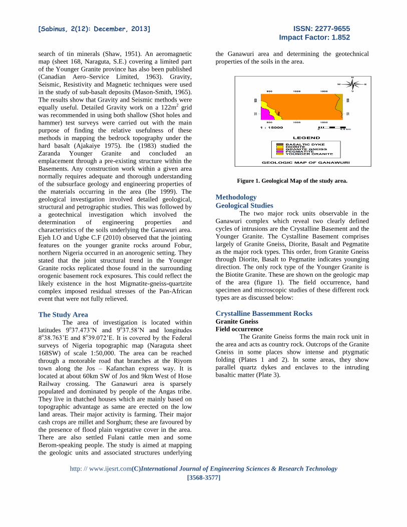
Figure 1. Geological Map of the study area.
Methodology
Geological Studies The two major rock units observable in the
Ganawuri complex which reveal two clearly defined
cycles of intrusions are the Crystalline Basement and the
Younger Granite. The Cystalline Basement comprises
largely of Granite Gneiss, Diorite, Basalt and Pegmatite
as the major rock types. This order, from Granite Gneiss
through Diorite, Basalt to Pegmatite indicates younging
direction. The only rock type of the Younger Granite is
the Biotite Granite. These are shown on the geologic map
of the area (figure 1). The field occurrence, hand
specimen and microscopic studies of these different rock
types are as discussed below:
Crystalline Bassemment Rocks Granite Gneiss
Field occurrence The Granite Gneiss forms the main rock unit in
the area and acts as country rock. Outcrops of the Granite
Gneiss in some places show intense and ptygmatic
folding (Plates 1 and 2). In some areas, they show
parallel quartz dykes and enclaves to the intruding
basaltic matter (Plate 3).

[Sabinus, 2(12): December, 2013] ISSN: 2277-9655
Impact Factor: 1.852
http: // www.ijesrt.com(C)International Journal of Engineering Sciences & Research Technology
[3568-3577]
Plate 1. Ptygmatic folding on the Granite Gneiss (Note both
structural control and NE Micro Faulting)
Plate 2. Intense folding on the Granite Gneiss indicates high
pressure in the NE-SW direction
Plate 3. Enclave of the older Granite Gneiss in the intruding
Basaltic matter
Hand Specimen Study
This rock unit is grey to dirty white in colour.
Texturally, it is medium grained with coarse
porphyroblastic feldspar grains seen as crystalline
patches on its surface. It is a mixed rock and as such
referred to by many authors as Migmatite.
Microscopic Study Under the plane light, biotite, ferromagnesian
minerals and hornblende are arranged in definite
directions and are alternate to the leucocratic minerals.
Biotite has relative higher relief with rounded pleochroic
halos typical of mica from basement areas (Plate 4).
Under crossed nicols, the banding between light and
coloured minerals is distinctively shown (Plate 5). In the
plate, the different extinction-angles for grain of quartz
signify not only metamorphic characteristics but of
possible straining occasionally of high pressure.
Mineralogical association is as follows: Quartz–Mica–
Hornblende–Feldspar. This is indicative of medium
grade metamorphism. Also with this association, the
original rock is probably Granite. The presence of late
Pegmatitic and basic intrusive bodies near this body
probably raised the grade of metamorphism from low to
medium.
Plate 4. Photomicrograph of the Granite Gneiss showing
mineral affiliation/orientation under PPL
[Sabinus, 2(12): December, 2013] ISSN: 2277-9655
Impact Factor: 1.852
http: // www.ijesrt.com(C)International Journal of Engineering Sciences & Research Technology
[3568-3577]
Plate 5. Photomicrograph of the Granite Gneiss showing
mineral affiliation/orientation under XPL
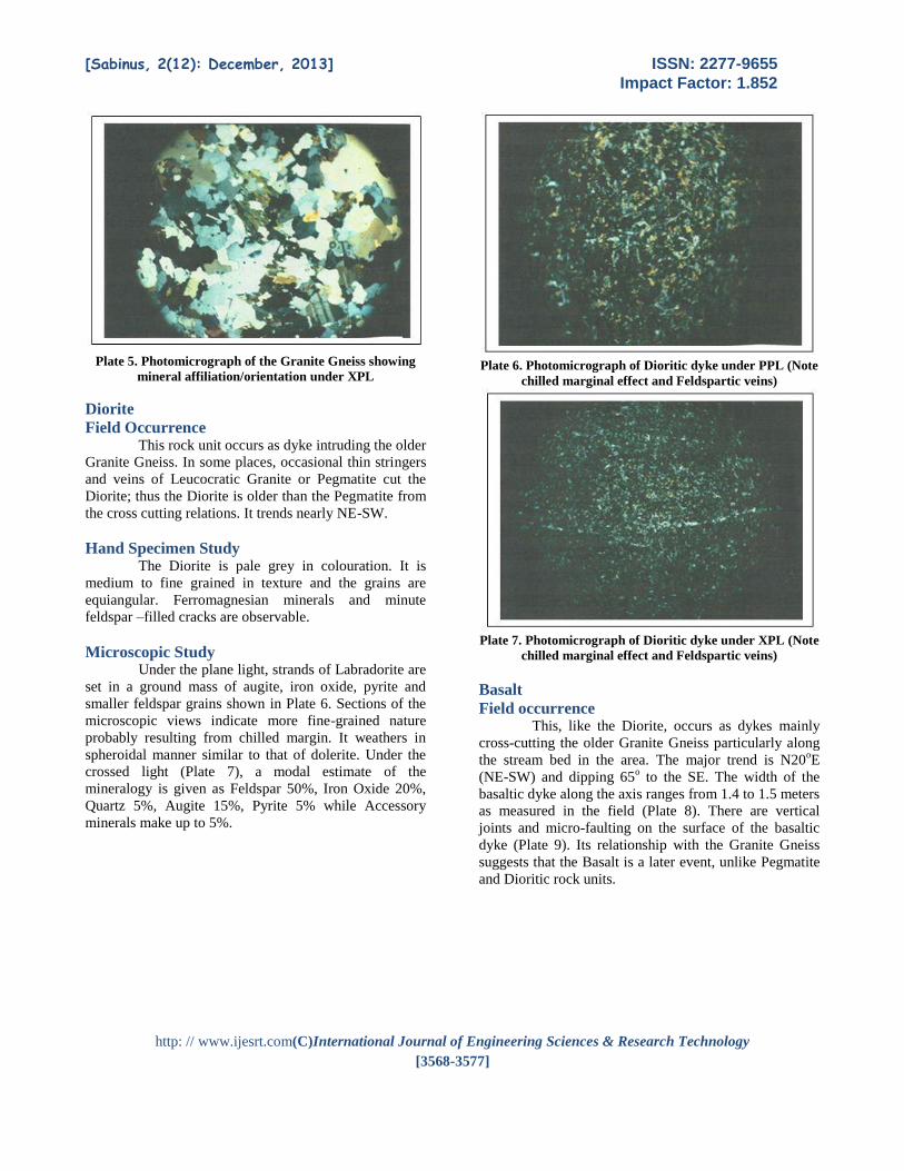
Diorite
Field Occurrence This rock unit occurs as dyke intruding the older
Granite Gneiss. In some places, occasional thin stringers
and veins of Leucocratic Granite or Pegmatite cut the
Diorite; thus the Diorite is older than the Pegmatite from
the cross cutting relations. It trends nearly NE-SW.
Hand Specimen Study The Diorite is pale grey in colouration. It is
medium to fine grained in texture and the grains are
equiangular. Ferromagnesian minerals and minute
feldspar –filled cracks are observable.
Microscopic Study Under the plane light, strands of Labradorite are
set in a ground mass of augite, iron oxide, pyrite and
smaller feldspar grains shown in Plate 6. Sections of the
microscopic views indicate more fine-grained nature
probably resulting from chilled margin. It weathers in
spheroidal manner similar to that of dolerite. Under the
crossed light (Plate 7), a modal estimate of the
mineralogy is given as Feldspar 50%, Iron Oxide 20%,
Quartz 5%, Augite 15%, Pyrite 5% while Accessory
minerals make up to 5%.
Plate 6. Photomicrograph of Dioritic dyke under PPL (Note
chilled marginal effect and Feldspartic veins)
Plate 7. Photomicrograph of Dioritic dyke under XPL (Note
chilled marginal effect and Feldspartic veins)
Basalt
Field occurrence This, like the Diorite, occurs as dykes mainly
cross-cutting the older Granite Gneiss particularly along
the stream bed in the area. The major trend is N20oE
(NE-SW) and dipping 65o to the SE. The width of the
basaltic dyke along the axis ranges from 1.4 to 1.5 meters
as measured in the field (Plate 8). There are vertical
joints and micro-faulting on the surface of the basaltic
dyke (Plate 9). Its relationship with the Granite Gneiss
suggests that the Basalt is a later event, unlike Pegmatite
and Dioritic rock units.
[Sabinus, 2(12): December, 2013] ISSN: 2277-9655
Impact Factor: 1.852
http: // www.ijesrt.com(C)International Journal of Engineering Sciences & Research Technology
[3568-3577]
Plate 8. Forceful injection of Basaltic matter into the pre-
existing Granite Gneiss
Plate 9. Joint pattern typical of the newer basalt that acts as
a dyke (Note the micro faulting)
Hand Specimen Study The Basalt is grey in colour. It has strands of
plagioclase minerals occupying a particular lineation on
the rock mass. Texturally, it is medium grained. Large
grains of Feldspar measuring up to 1.5cm are rimmed
with greenish minerals possibly Olivine.
Microscopic Study Under the microscope, strands of Labradorite
are set in a ground mass of smaller grains of augite, Iron
oxide, pyrite and accessory minerals (Plates 10 and 11).
The Ophitic texture is typical of Dolerite and has been
interpreted as having association with Younger Granite
that outcrop NE of the survey area. It is worthy of note
that the basic rocks are confined to the southern and
southeastern ends of the area. To the North and north
east, the terrain gives way to relatively high weathering.
Modal estimate for the dolerite is as follows: Feldspar
55%, Augite 5%, Iron Oxide 20%, Pyrite 5%, Olivine 2-
5% while others are less than 5%.
Plate 10. Photomicrograph of Basaltic dyke under PPL
(strands of Labradorite are seen in Augite and Pyrite
Ground mass)
Plate 11. Photomicrograph of Basaltic dyke under XPL
(strands of Labradorite are seen in Augite and Pyrite
Ground mass)
Pegmatite
Field occurrence This occurs as massive dykes mainly in the
western and central parts of the area. In some places, it
occurs as quartz-tourmaline pegmatite in association with
Granite Gneiss (Plate 12).
Hand Specimen Study The Pegmatite is creamy white in colour. It is
coarse grained and as such cannot be studied under
microscope. The pegmatites have zoned microcline,
quartz and muscovite as the major mineral components.
The marginal parts are aplitic and/or feldspathic while
the core contains mainly quartz, muscovite and black
tourmaline
[Sabinus, 2(12): December, 2013] ISSN: 2277-9655
Impact Factor: 1.852
http: // www.ijesrt.com(C)International Journal of Engineering Sciences & Research Technology
[3568-3577]
Plate 12. Quartz-Tourmaline Pegmatite associated with the
Granite Gneiss
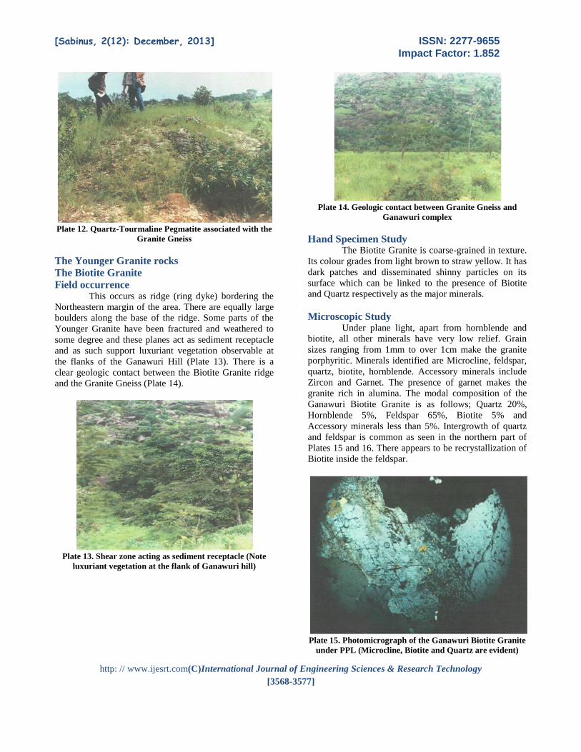
The Younger Granite rocks
The Biotite Granite
Field occurrence This occurs as ridge (ring dyke) bordering the
Northeastern margin of the area. There are equally large
boulders along the base of the ridge. Some parts of the
Younger Granite have been fractured and weathered to
some degree and these planes act as sediment receptacle
and as such support luxuriant vegetation observable at
the flanks of the Ganawuri Hill (Plate 13). There is a
clear geologic contact between the Biotite Granite ridge
and the Granite Gneiss (Plate 14).
Plate 13. Shear zone acting as sediment receptacle (Note
luxuriant vegetation at the flank of Ganawuri hill)
Plate 14. Geologic contact between Granite Gneiss and
Ganawuri complex
Hand Specimen Study The Biotite Granite is coarse-grained in texture.
Its colour grades from light brown to straw yellow. It has
dark patches and disseminated shinny particles on its
surface which can be linked to the presence of Biotite
and Quartz respectively as the major minerals.
Microscopic Study Under plane light, apart from hornblende and
biotite, all other minerals have very low relief. Grain
sizes ranging from 1mm to over 1cm make the granite
porphyritic. Minerals identified are Microcline, feldspar,
quartz, biotite, hornblende. Accessory minerals include
Zircon and Garnet. The presence of garnet makes the
granite rich in alumina. The modal composition of the
Ganawuri Biotite Granite is as follows; Quartz 20%,
Hornblende 5%, Feldspar 65%, Biotite 5% and
Accessory minerals less than 5%. Intergrowth of quartz
and feldspar is common as seen in the northern part of
Plates 15 and 16. There appears to be recrystallization of
Biotite inside the feldspar.
Plate 15. Photomicrograph of the Ganawuri Biotite Granite
under PPL (Microcline, Biotite and Quartz are evident)
[Sabinus, 2(12): December, 2013] ISSN: 2277-9655
Impact Factor: 1.852
http: // www.ijesrt.com(C)International Journal of Engineering Sciences & Research Technology
[3568-3577]
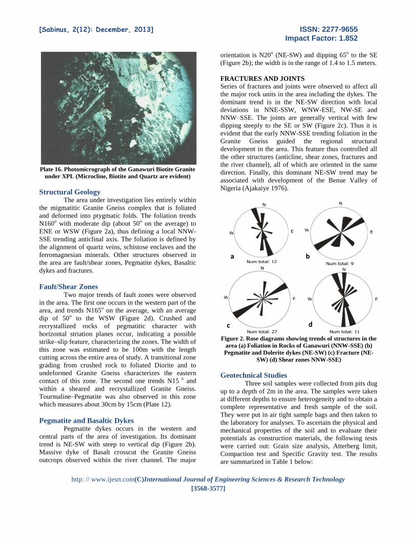
Plate 16. Photomicrograph of the Ganawuri Biotite Granite
under XPL (Microcline, Biotite and Quartz are evident)
Structural Geology The area under investigation lies entirely within
the migmatitic Granite Gneiss complex that is foliated
and deformed into ptygmatic folds. The foliation trends
N160o with moderate dip (about 50
o on the average) to
ENE or WSW (Figure 2a), thus defining a local NNW-
SSE trending anticlinal axis. The foliation is defined by
the alignment of quartz veins, schistose enclaves and the
ferromagnesian minerals. Other structures observed in
the area are fault/shear zones, Pegmatite dykes, Basaltic
dykes and fractures.
Fault/Shear Zones Two major trends of fault zones were observed
in the area. The first one occurs in the western part of the
area, and trends N165o on the average, with an average
dip of 50o to the WSW (Figure 2d). Crushed and
recrystallized rocks of pegmatitic character with
horizontal striation planes occur, indicating a possible
strike–slip feature, characterizing the zones. The width of
this zone was estimated to be 100m with the length
cutting across the entire area of study. A transitional zone
grading from crushed rock to foliated Diorite and to
undeformed Granite Gneiss characterizes the eastern
contact of this zone. The second one trends N15 o
and
within a sheared and recrystallized Granite Gneiss.
Tourmaline–Pegmatite was also observed in this zone
which measures about 30cm by 15cm (Plate 12).
Pegmatite and Basaltic Dykes Pegmatite dykes occurs in the western and
central parts of the area of investigation. Its dominant
trend is NE-SW with steep to vertical dip (Figure 2b).
Massive dyke of Basalt crosscut the Granite Gneiss
outcrops observed within the river channel. The major
orientation is N20o (NE-SW) and dipping 65
o to the SE
(Figure 2b); the width is in the range of 1.4 to 1.5 meters.
FRACTURES AND JOINTS
Series of fractures and joints were observed to affect all
the major rock units in the area including the dykes. The
dominant trend is in the NE-SW direction with local
deviations in NNE-SSW, WNW-ESE, NW-SE and
NNW–SSE. The joints are generally vertical with few
dipping steeply to the SE or SW (Figure 2c). Thus it is
evident that the early NNW-SSE trending foliation in the
Granite Gneiss guided the regional structural
development in the area. This feature thus controlled all
the other structures (anticline, shear zones, fractures and
the river channel), all of which are oriented in the same
direction. Finally, this dominant NE-SW trend may be
associated with development of the Benue Valley of
Nigeria (Ajakaiye 1976).
Figure 2. Rose diagrams showing trends of structures in the
area (a) Foliation in Rocks of Ganawuri (NNW-SSE) (b)
Pegmatite and Dolerite dykes (NE-SW) (c) Fracture (NE-
SW) (d) Shear zones NNW-SSE)
Geotechnical Studies Three soil samples were collected from pits dug
up to a depth of 2m in the area. The samples were taken
at different depths to ensure heterogeneity and to obtain a
complete representative and fresh sample of the soil.
They were put in air tight sample bags and then taken to
the laboratory for analyses. To ascertain the physical and
mechanical properties of the soil and to evaluate their
potentials as construction materials, the following tests
were carried out: Grain size analysis, Atterberg limit,
Compaction test and Specific Gravity test. The results
are summarized in Table 1 below:
N
Num total: 27
E W
N
Num total: 11
E W
N
Num total: 9
E W
N
Num total: 12
E W
a b
c d

[Sabinus, 2(12): December, 2013] ISSN: 2277-9655
Impact Factor: 1.852
http: // www.ijesrt.com(C)International Journal of Engineering Sciences & Research Technology
[3568-3577]
Figure 3. Plot of Plasticity index against Liquid Limit
(Casagrande Chart)
Figure 4. Variations of Specific Gravity in the area
Figure 5. Variations of Natural Moisture Content in the
area
Figure 6. Variations of Coefficient of Uniformity in the area
Figure 7. Variations of Coefficient of Curvature in the area
Figure 8. 3-D display of Maximum Dry Density variation in
the area
Table 1. Results of the Geotechnical Study
[Sabinus, 2(12): December, 2013] ISSN: 2277-9655
Impact Factor: 1.852
http: // www.ijesrt.com(C)International Journal of Engineering Sciences & Research Technology
[3568-3577]
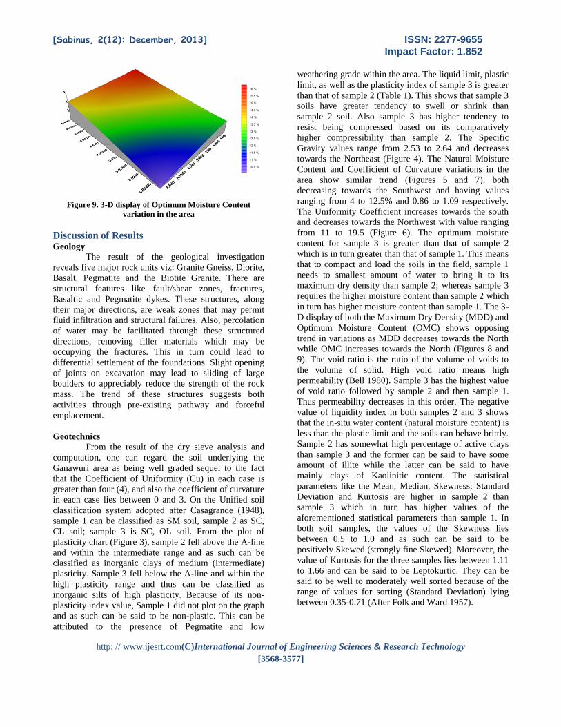
Figure 9. 3-D display of Optimum Moisture Content
variation in the area
Discussion of Results Geology
The result of the geological investigation
reveals five major rock units viz: Granite Gneiss, Diorite,
Basalt, Pegmatite and the Biotite Granite. There are
structural features like fault/shear zones, fractures,
Basaltic and Pegmatite dykes. These structures, along
their major directions, are weak zones that may permit
fluid infiltration and structural failures. Also, percolation
of water may be facilitated through these structured
directions, removing filler materials which may be
occupying the fractures. This in turn could lead to
differential settlement of the foundations. Slight opening
of joints on excavation may lead to sliding of large
boulders to appreciably reduce the strength of the rock
mass. The trend of these structures suggests both
activities through pre-existing pathway and forceful
emplacement.
Geotechnics
From the result of the dry sieve analysis and
computation, one can regard the soil underlying the
Ganawuri area as being well graded sequel to the fact
that the Coefficient of Uniformity (Cu) in each case is
greater than four (4), and also the coefficient of curvature
in each case lies between 0 and 3. On the Unified soil
classification system adopted after Casagrande (1948),
sample 1 can be classified as SM soil, sample 2 as SC,
CL soil; sample 3 is SC, OL soil. From the plot of
plasticity chart (Figure 3), sample 2 fell above the A-line
and within the intermediate range and as such can be
classified as inorganic clays of medium (intermediate)
plasticity. Sample 3 fell below the A-line and within the
high plasticity range and thus can be classified as
inorganic silts of high plasticity. Because of its non-
plasticity index value, Sample 1 did not plot on the graph
and as such can be said to be non-plastic. This can be
attributed to the presence of Pegmatite and low
weathering grade within the area. The liquid limit, plastic
limit, as well as the plasticity index of sample 3 is greater
than that of sample 2 (Table 1). This shows that sample 3
soils have greater tendency to swell or shrink than
sample 2 soil. Also sample 3 has higher tendency to
resist being compressed based on its comparatively
higher compressibility than sample 2. The Specific
Gravity values range from 2.53 to 2.64 and decreases
towards the Northeast (Figure 4). The Natural Moisture
Content and Coefficient of Curvature variations in the
area show similar trend (Figures 5 and 7), both
decreasing towards the Southwest and having values
ranging from 4 to 12.5% and 0.86 to 1.09 respectively.
The Uniformity Coefficient increases towards the south
and decreases towards the Northwest with value ranging
from 11 to 19.5 (Figure 6). The optimum moisture
content for sample 3 is greater than that of sample 2
which is in turn greater than that of sample 1. This means
that to compact and load the soils in the field, sample 1
needs to smallest amount of water to bring it to its
maximum dry density than sample 2; whereas sample 3
requires the higher moisture content than sample 2 which
in turn has higher moisture content than sample 1. The 3-
D display of both the Maximum Dry Density (MDD) and
Optimum Moisture Content (OMC) shows opposing
trend in variations as MDD decreases towards the North
while OMC increases towards the North (Figures 8 and
9). The void ratio is the ratio of the volume of voids to
the volume of solid. High void ratio means high
permeability (Bell 1980). Sample 3 has the highest value
of void ratio followed by sample 2 and then sample 1.
Thus permeability decreases in this order. The negative
value of liquidity index in both samples 2 and 3 shows
that the in-situ water content (natural moisture content) is
less than the plastic limit and the soils can behave brittly.
Sample 2 has somewhat high percentage of active clays
than sample 3 and the former can be said to have some
amount of illite while the latter can be said to have
mainly clays of Kaolinitic content. The statistical
parameters like the Mean, Median, Skewness; Standard
Deviation and Kurtosis are higher in sample 2 than
sample 3 which in turn has higher values of the
aforementioned statistical parameters than sample 1. In
both soil samples, the values of the Skewness lies
between 0.5 to 1.0 and as such can be said to be
positively Skewed (strongly fine Skewed). Moreover, the
value of Kurtosis for the three samples lies between 1.11
to 1.66 and can be said to be Leptokurtic. They can be
said to be well to moderately well sorted because of the
range of values for sorting (Standard Deviation) lying
between 0.35-0.71 (After Folk and Ward 1957).

[Sabinus, 2(12): December, 2013] ISSN: 2277-9655
Impact Factor: 1.852
http: // www.ijesrt.com(C)International Journal of Engineering Sciences & Research Technology
[3568-3577]
Conclusion and Suggestions Although the Ganawuri area is located on the
crystalline Basement (Migmatite–Gneiss), which is a
good foundation, foliation, fracturing, shearing,
pegmatization and jointing may reduce the bearing
capacity of the soil. These zones may become more
pervious to allow gradual build-up of water pressure,
which will in turn, lead to increased fissuration and
further weakening, and so may permit sliding of
structures constructed on them. It is recommended herein
that sealing mechanisms (grouting) be introduced to
control percolation of water through these structures.
Percolation of water along the major structures and
weathered zones should be assessed in detail in order to
design the appropriate grout curtains and drainage
system. And since most of the structures are vertical or
nearly so, it is also recommended that grout holes must
be appropriately inclined to intersect and seal the major
joints and other structures at depth. The fault zone that
trends NW/SE appears to dominate the area. Movement
along the fault plane may be possible if load is put on
this place. Coring may be necessary at these locations to
determine any possible mobile parameters. Again,
consolidation grouting may be needed to reduce
deformability and increase mechanical strength at these
zones.
Intensive weathering has provided possible
construction materials at the area. The engineering
properties have ascertained the suitability of these
materials (soils) as construction materials. The sandy
matter along the channel means possible greater seepage
and must be addressed.
Reference [1] Ajakaiye D.E. (1975). Application of
Geophysical Methods in Mapping Bedrock
Topography under the hard Basalt of Jos-
Plateau, Northern Nigeria. Journal of Mining
and Geology Vol. 16 p 20.
[2] Ajakaiye D. E. (1976). Geophysical Study of
the Benue Valley. Journal of Mining and
Geology Vol. 12 pp 4-6.
[3] Bell F. G. (1980). Engineeeing properties and
Geotechnics Newness-Butterworths.
[4] Casagrande A. (1948). Classification an
identification of Soils. American Society of
Civil Engineers Trans Vol. 113; pp 901-930.
[5] Ejeh I.O and Ugbe C.F (2010). Fracture systems
in the Younger Granite rocks around Fobur,
northern Nigeria: product of residual stress?
Global Journal of Geological Sciences Vol 8,
No 1 p26.
[6] Falconer A. M. (1903). Study on the Younger
Granites Prinvince Unpublished work
[7] Folk R.L. and Ward W.C. (1957). Brazors River
bar. A study on the significance of grain size
parameter. Journal sedimentary Petrology Vol
27, pp 3-6.
[8] Ibe K. K (1983). Geological and Gravity studies
of the Zaranda Younger Granite ring complex of
Northern Nigeria Unpublished M.Sc thesis.
Ahmadu Bello University Zaria.
[9] Ibe K.K. (1999) Geoeletrical studies in the
Bauchi Road Campus, University of Jos.
Journal of Environmental Science (3) 2. pp 140-
146.
[10] Jacobson A. (1958). Studies of the Ririwai
Younger Granite ring complex of Northern
Nigeria, Jounal of Mining and Geology Vol. 12
pp 7-10.
[11] Mason-smith R. (1965). Geophysical
investigation of Sub-basalt deposits around Jos
area. Northern Nigeria Journal of Mining and
Geology Vol. 28, pp 16-19.
[12] Shaw B. (1951). Geophysical Investigations of
the Jos tin Field. Journal of Mining and
Geology Vol. 17; pp 11-13.