Pedestrian and Bicycle Facilities - Transportation Research ...
Upload
khangminh22Category
view
7download
0
As of April 5, 2010 the BICYCLE AND PEDESTRIAN MASTER PLAN
is being revised. The REVISED report will be re-posted as soon as it
becomes available.
Agenda Item: 8.B Page 1
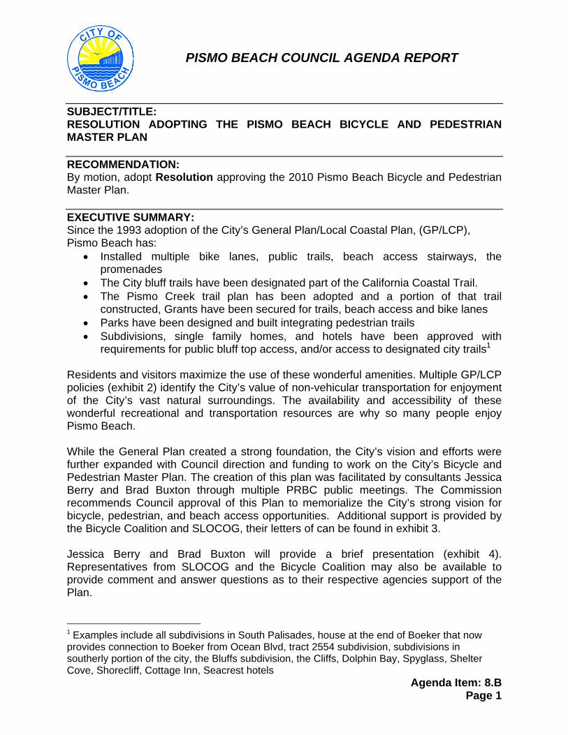
PISMO BEACH COUNCIL AGENDA REPORT
SUBJECT/TITLE: RESOLUTION ADOPTING THE PISMO BEACH BICYCLE AND PEDESTRIAN MASTER PLAN RECOMMENDATION: By motion, adopt Resolution approving the 2010 Pismo Beach Bicycle and Pedestrian Master Plan. EXECUTIVE SUMMARY: Since the 1993 adoption of the City’s General Plan/Local Coastal Plan, (GP/LCP), Pismo Beach has:
Installed multiple bike lanes, public trails, beach access stairways, the promenades
The City bluff trails have been designated part of the California Coastal Trail. The Pismo Creek trail plan has been adopted and a portion of that trail
constructed, Grants have been secured for trails, beach access and bike lanes Parks have been designed and built integrating pedestrian trails Subdivisions, single family homes, and hotels have been approved with
requirements for public bluff top access, and/or access to designated city trails1 Residents and visitors maximize the use of these wonderful amenities. Multiple GP/LCP policies (exhibit 2) identify the City’s value of non-vehicular transportation for enjoyment of the City’s vast natural surroundings. The availability and accessibility of these wonderful recreational and transportation resources are why so many people enjoy Pismo Beach. While the General Plan created a strong foundation, the City’s vision and efforts were further expanded with Council direction and funding to work on the City’s Bicycle and Pedestrian Master Plan. The creation of this plan was facilitated by consultants Jessica Berry and Brad Buxton through multiple PRBC public meetings. The Commission recommends Council approval of this Plan to memorialize the City’s strong vision for bicycle, pedestrian, and beach access opportunities. Additional support is provided by the Bicycle Coalition and SLOCOG, their letters of can be found in exhibit 3. Jessica Berry and Brad Buxton will provide a brief presentation (exhibit 4). Representatives from SLOCOG and the Bicycle Coalition may also be available to provide comment and answer questions as to their respective agencies support of the Plan.
1 Examples include all subdivisions in South Palisades, house at the end of Boeker that now provides connection to Boeker from Ocean Blvd, tract 2554 subdivision, subdivisions in southerly portion of the city, the Bluffs subdivision, the Cliffs, Dolphin Bay, Spyglass, Shelter Cove, Shorecliff, Cottage Inn, Seacrest hotels
Agenda Item: 8.B Page 2
FISCAL IMPACT: SLOCOG is currently working on the Regional Transportation Plan (RTP). The City’s Bicycle and Pedestrian Master Plan, if adopted, will be utilized by SLOCOG when preparing the RTP, the foundation for future SLOCOG funding consideration. SLOCOG staff may explain further as to the RTP’s use. The Bicycle and Pedestrian Master Plan will also be utilized for other grant funding opportunities. ATTACHMENTS:
1. Resolution 2. GP/LCP policies 3. Letters of support from SLOCOG and the Bicycle Coalition 4. Power point presentation 5. 2010 Bicycle and Pedestrian Master Plan
Prepared by: Carolyn Johnson, Planning Manager Meeting Date: April 6, 2010 Approved by: Randy Bloom, Community Development Director City Manager Approval:
Agenda Item: 8.B Page 3
Attachment 1
RESOLUTION NO. R-2010- A RESOLUTION OF THE CITY COUNCIL OF THE CITY OF PISMO BEACH
APPROVING THE 2010 BICYCLE AND PEDESTRIAN MASTER PLAN
WHEREAS, Since the 1993 adoption of the City’s General Plan/Local Coastal Plan, (GP/LCP), Pismo Beach has installed multiple bike lanes, public trails, beach access stairways and promenades, successfully had the City bluff top trails designated as a part of the California Coastal Trail, adopted the Pismo Creek trail plan and constructed a portion of the trail, successfully secured grants for trails, beach access and bike lanes, designed and built pedestrian trails and beach access structures in City parks, approved with requirements for trail opportunities subdivisions, single family homes, and hotels; and WHEREAS, Residents and visitors maximize the use of these wonderful amenities. Multiple GP/LCP policies identify the City’s value of non-vehicular transportation for enjoyment of the City’s vast natural surroundings. The availability and accessibility of these wonderful recreational and transportation resources are why so many people enjoy Pismo Beach; and WHEREAS, While the General Plan created a strong foundation, the City’s vision and efforts are further expanded with a Bicycle and Pedestrian Master Plan. The creation of this Plan is a result of multiple Parks, Recreation and Beautification Commission (PRBC) meetings; and WHEREAS, the PRBC recommends Council approval of the Plan to memorialize the City’s strong vision for bicycle, pedestrian, and beach access opportunities; and WHEREAS, the City’s Bicycle and Pedestrian Master Plan, will be utilized for future grant funding opportunities; and WHEREAS, the Bicycle and Pedestrian Master Plan is a planning study for possible future actions of the City Council, a statutory exemption under the California Environmental Quality Act applies to this project. NOW, THEREFORE, BE IT RESOLVED that the City Council of the City of Pismo Beach hereby approves the 2010 Pismo Beach Bicycle and Pedestrian Master Plan. UPON MOTION OF Councilmember seconded by Councilmember the foregoing resolution was passed, approved and adopted by the City Council of the City of Pismo Beach this 6th day of April 2010, by the following roll call vote: AYES: Councilmembers: NOES : Councilmembers: ABSENT: Councilmembers: ABSTAIN: Councilmembers: Approved: Attest: Mary Ann Reiss Emily Colborn, CMC Mayor City Clerk

Agenda Item: 8.B Page 4
ATTACHMENT 2 GENERAL PLAN/LOCAL COASTAL PLAN POLICIES
Circulation element - Background Bikeways
The primary bike route in the area is the Class II Pacific Coast Bike Route, which follows Shell Beach Road, Price Street and Dolliver Street for a distance of 7 miles. There are 25 miles of Class I~ bikeways including Mattie Road and James Way.
Principle P-1 Balanced Transportation
The quality of life and economic vitality of Pismo Beach is dependent upon a sate and efficiently operating circulation system providing for pedestrians, bicycles, trucks, automobiles and public transportation. Specific aspects of this system include: c. Pedestrian and Bicycle
Pedestrian walkways and bicycle paths are important elements of the circulation system and shall receive at least the same emphasis and attention in future planning as facilities designed for the automobile.
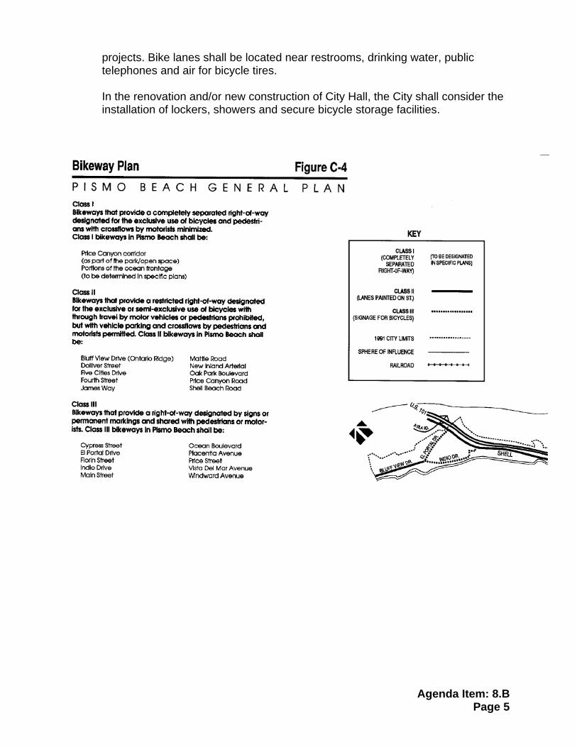
Policies C-ll Bikeways Plan
Bikeways Plan Bikeways shall be located and classified as shown in Figure C-4. To the extent possible, bikeways shall tie into state routes and routes of adjoining communities. Permitted land uses adjacent to bicycle routes are shown on Figure LU-2, land use map. Population density and settlement patterns adjacent to the bikeways are identified in the Land Use Element. Bicyclists may utilize other methods of transportation as identified in the other Circulation Element policies. Public review and comment on the City's bikeway plan occurred throughout the General Plan update process, in which a minimum of 4 public hearings were held.
C-12 Bikeways Encouraged Bikeways shall be encouraged within the City and adjoining jurisdictions as a complement to Pismo Beach's visitor and recreation emphasis, to reduce automobile trips and for the convenience of visitors and residents. The City's bikeway plan will be coordinated with the San Luis Obispo Area Coordinating Council and Regional Transportation Agency and the County of San Luis Obispo regional transportation plan.
The City shall install bicycle storage facilities in public areas such as the beach and in parks and in other public facilities to encourage bicycle use. Bicycle storage facilities shall be considered as a required condition of approval for new development applications for proposed commercial hotel and major residential
Agenda Item: 8.B Page 5
projects. Bike lanes shall be located near restrooms, drinking water, public telephones and air for bicycle tires.
In the renovation and/or new construction of City Hall, the City shall consider the installation of lockers, showers and secure bicycle storage facilities.
Agenda Item: 8.B Page 6
C-13 Pedestrian Circulation
Sidewalks shall be required for all new developments in residential and commercial areas. Normally the sidewalk shall be located so that a landscape strip or trees are located between the sidewalk and the vehicle travel way. Techniques shall be encouraged to create a pleasant walking experience including concern for views, paving materials, landscape, street furniture and pedestrian scaled lighting. All new sidewalk area shall be designed to accommodate the handicapped. The City and CALTRANS shall study the feasibility of adding a pedestrian crossing of US 101 between the Spyglass and Mattie Road interchanges. Also, the City shall install (or cause to be installed) sidewalks or footpaths along all collector or arterial streets that connect with commercial centers, public gathering areas and schools.
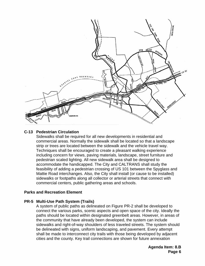
Parks and Recreation Element PR-5 Multi-Use Path System (Trails)
A system of public paths as delineated on Figure PR-2 shall be developed to connect the various parks, scenic aspects and open space of the city. Ideally the paths should be located within designated greenbelt areas. However, in areas of the community that have already been developed, the system can include sidewalks and right-of-way shoulders of less traveled streets. The system should be delineated with signs, uniform landscaping, and pavement. Every attempt shall be made to interconnect city trails with those being developed by adjacent cities and the county. Key trail connections are shown for future annexation
Agenda Item: 8.B Page 7
areas. Motorized vehicles shall not be permitted on trails, except as used by handicapped persons.
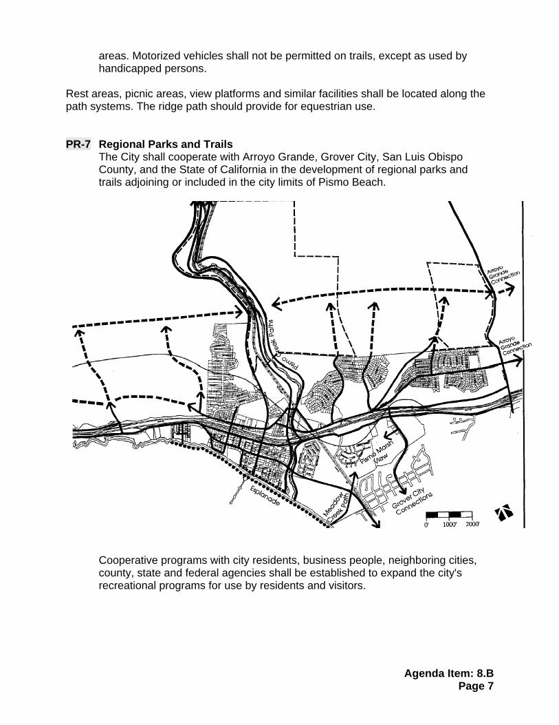
Rest areas, picnic areas, view platforms and similar facilities shall be located along the path systems. The ridge path should provide for equestrian use. PR-7 Regional Parks and Trails
The City shall cooperate with Arroyo Grande, Grover City, San Luis Obispo County, and the State of California in the development of regional parks and trails adjoining or included in the city limits of Pismo Beach.
Cooperative programs with city residents, business people, neighboring cities, county, state and federal agencies shall be established to expand the city's recreational programs for use by residents and visitors.
Agenda Item: 8.B Page 8
ATTACHMENT 3 SLOCOG AND BICYCLE COALITION LETTERS OF SUPPORT
Agenda Item: 8.B Page 9
Pismo Beach Bicycle and Pedestrian Master Plan
Agenda Item: 8.B Page: 10
What is a Bicycle and Pedestrian Master Plan?
Agenda Item: 8.B Page: 11
Progress
Agenda Item: 8.B Page: 12
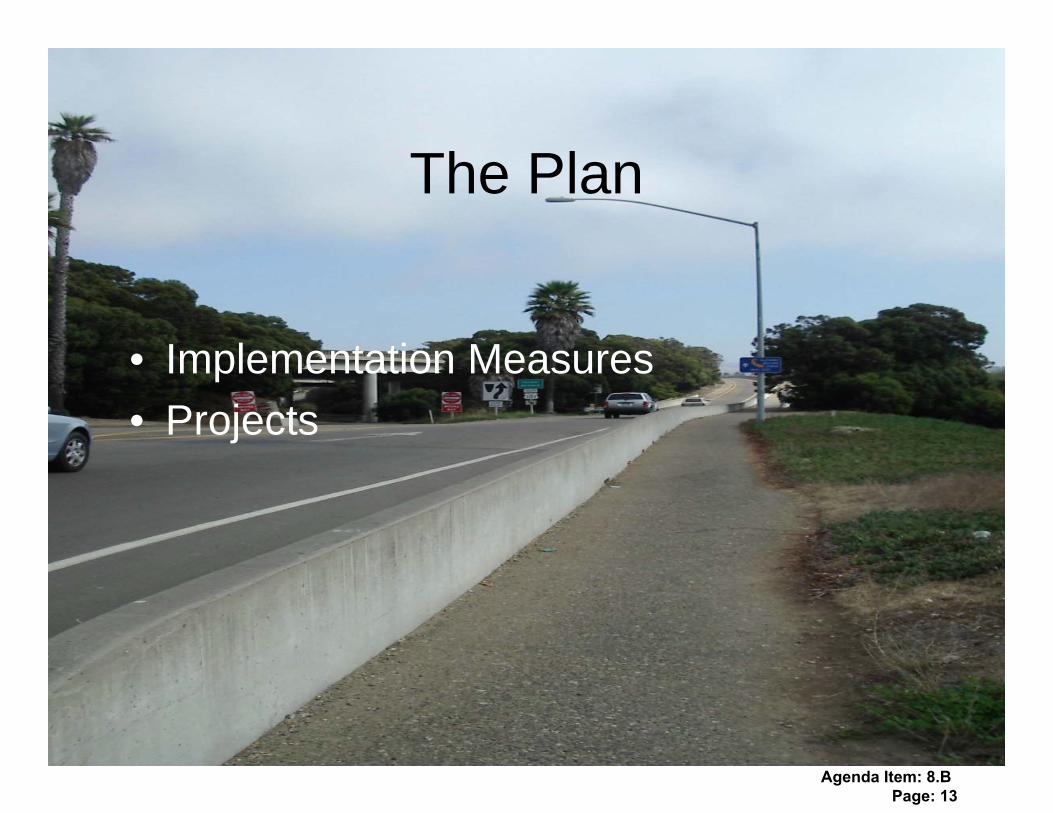
The Plan
• Implementation Measures
• Projects
Agenda Item: 8.B Page: 13
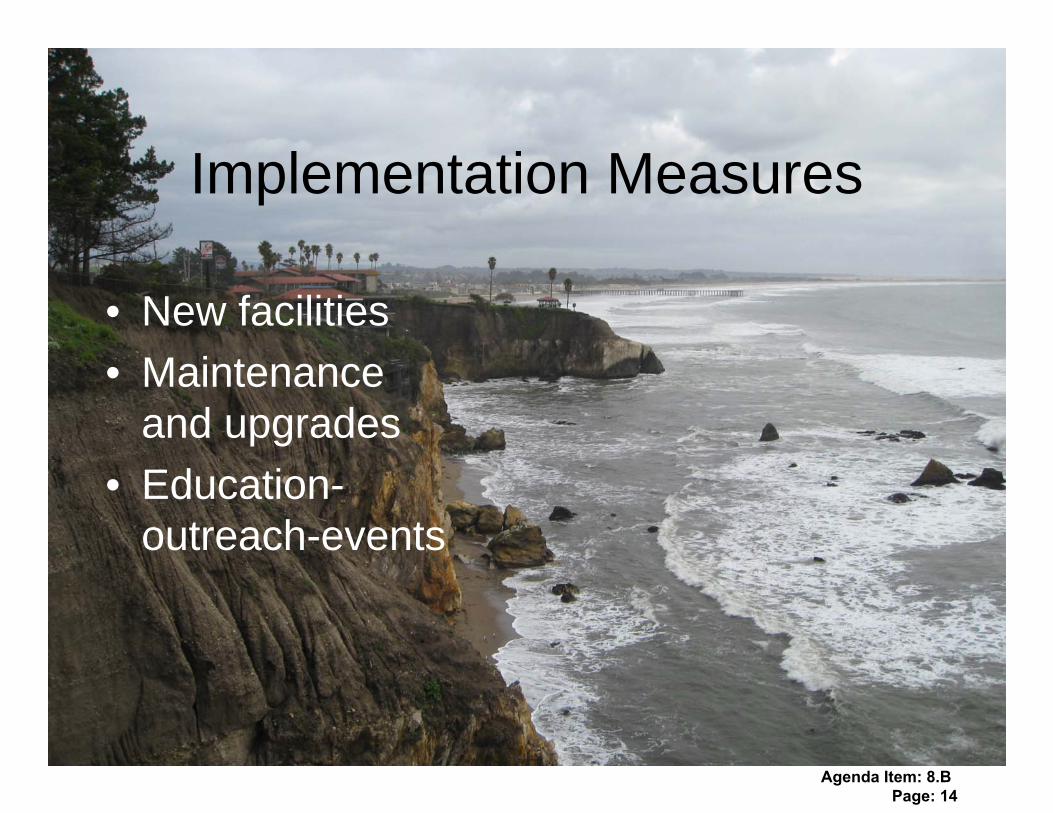
Implementation Measures
• New facilities
• Maintenance and upgrades
• Education-outreach-events
Agenda Item: 8.B Page: 14

Projects
• Bicycle projects
• Pedestrian projects
• Beach Access projects
Agenda Item: 8.B Page: 15
Agenda Item: 8.B Page: 16
Agenda Item: 8.B Page: 17
Agenda Item: 8.B Page: 18

Agenda Item: 8.B Page: 19

Agenda Item: 8.B Page: 20
Agenda Item: 8.B Page: 21
Agenda Item: 8.B Page: 22
Agenda Item: 8.B Page: 23
Agenda Item: 8.B Page: 24
Agenda Item: 8.B Page: 25

Steps for the Future…
Agenda Item: 8.B Page: 26

Questions/Comments
Brad Buxton [email protected]
Jessica Berry [email protected]
Agenda Item: 8.B Page: 27

1
Adopted by the Pismo Beach City Council
April 6, 2010
Agenda Item: 8.B Page: 28
2
Acknowledgements City Council Mayor Mary Ann Reiss Mayor Pro Tem Shelley Higginbotham Councilmember Ted Ehring Councilmember Ed Waage Councilmember Kris Vardas Parks, Recreation and Beautification Commission Chair Jim Thomas Commissioner Fred Gaalswyk Commissioner Marcia Guthrie Commissioner Andrew Jones Commissioner Alan Ormsby Staff Public Works Director Dwayne Chisam Consulting Planners Jessica Berry and Brad Buxton Planning Manager Carolyn Johnson Associate Engineer Ben Fine
Agenda Item: 8.B Page: 29
3
2010 Pismo Beach Bicycle/Pedestrian Plan
Table of Contents
1. Plan Purpose ...................................................................................1-1 2. Introduction and Background ........................................................2-1 Bicycling in Pismo Beach ........................................................................2-4 Walking/Hiking/Running/Beach Access...................................................2-7 Education and Outreach..........................................................................2-9 3. Plan Creation ...................................................................................3-1 Survey Results ........................................................................................3-1 Public Meetings.......................................................................................3-2 Relationships to other adopted plans ......................................................3-3 4. Policies .............................................................................................4-1 Implementation Measures .......................................................................4-1 New Facilities ..........................................................................................4-2 Maintenance/upgrades............................................................................4-2 Education/Outreach/Events.....................................................................4-3 5. Projects ............................................................................................5-1 Completed Projects/Expenditures ...........................................................5-1 Future Projects/Expenditures ..................................................................5-2 Proposed Bikeway Projects.....................................................................5-6 Pedestrian Facilities .............................................................................5-11 Bike Parking Facilities ..........................................................................5-13
Agenda Item: 8.B Page: 30
4
APPENDICIES Appendix 1: BTA requirements ............................................................ A-1 Appendix 2: Trails Brochure .................................................................. A-3 Appendix 3: Relationship to other plans ................................................ A-5
Policies ........................................................................................ A-5 Trail and Path Connections ......................................................... A-5
Appendix 4: Survey Results .................................................................. A -7 Survey Results: Employer Survey ............................................... A-7 Survey Results: Resident Survey ................................................ A-8
Appendix 5: Bicycle Facilities ................................................................. A-9 Appendix 6: Racks with Plaques program............................................ A-19 Appendix 7: Bike Valet Program .......................................................... A-20 Appendix 8: Bicycle Confidence Workshops ........................................ A-21 Appendix 9: Current and Future Commuters........................................ A-22 Commuters .......................................................................................... A-22 Future Commuters .............................................................................. A-23 Accidents ............................................................................................. A-23 Appendix 10: Bike Project Funding Sources ....................................... A-25 Appendix 11: Drainage Grates ........................................................... A -31 Appendix 12: Trails Plan from the General Plan/Local Coastal Plan Policy PR-2..................................................................... A-33 Appendix 13: Pismo Beach sections of the California Coastal Trail ..... A-34 Appendix 14: Letters of Support........................................................... A-35
TABLE OF FIGURES Figures: 1: Land Use ............................................................................................2-2 2: Public Destinations..............................................................................2-3 3: Existing Bikeways................................................................................2-5 4: Existing Bike Parking...........................................................................2-6 5: Existing Pedestrian Paths ..................................................................2-8 6: Bikeway connections into Pismo Beach ..............................................3-4 7: Proposed Bicycle Projects...................................................................5-4 8: Proposed Pedestrian and Beach Access projects...............................5-5 9: Proposed Bicycle Parking Facilities...................................................5-14 10: Full Bicycle Network .......................................................................5-15 11: Full Pedestrian Network ..................................................................5-16
Agenda Item: 8.B Page: 31
1-1
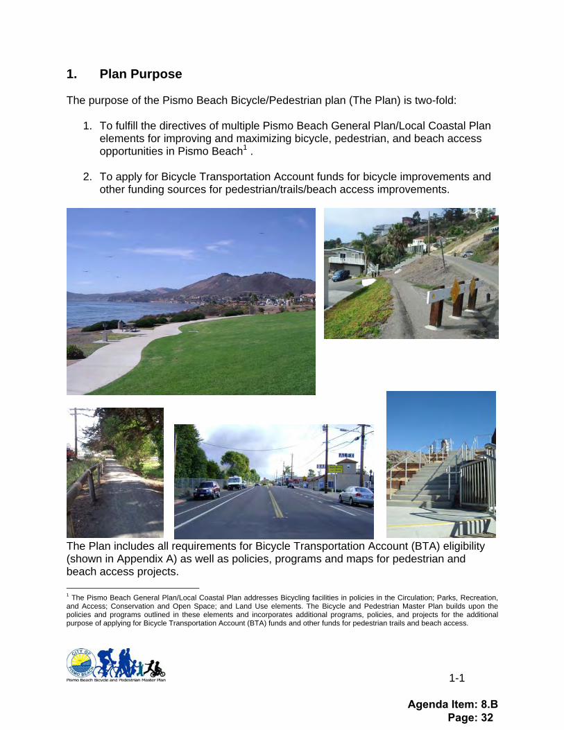
1. Plan Purpose The purpose of the Pismo Beach Bicycle/Pedestrian plan (The Plan) is two-fold:
1. To fulfill the directives of multiple Pismo Beach General Plan/Local Coastal Plan elements for improving and maximizing bicycle, pedestrian, and beach access opportunities in Pismo Beach1 .
2. To apply for Bicycle Transportation Account funds for bicycle improvements and
other funding sources for pedestrian/trails/beach access improvements.
The Plan includes all requirements for Bicycle Transportation Account (BTA) eligibility (shown in Appendix A) as well as policies, programs and maps for pedestrian and beach access projects.
1 The Pismo Beach General Plan/Local Coastal Plan addresses Bicycling facilities in policies in the Circulation; Parks, Recreation, and Access; Conservation and Open Space; and Land Use elements. The Bicycle and Pedestrian Master Plan builds upon the policies and programs outlined in these elements and incorporates additional programs, policies, and projects for the additional purpose of applying for Bicycle Transportation Account (BTA) funds and other funds for pedestrian trails and beach access.
Agenda Item: 8.B Page: 32
2-1
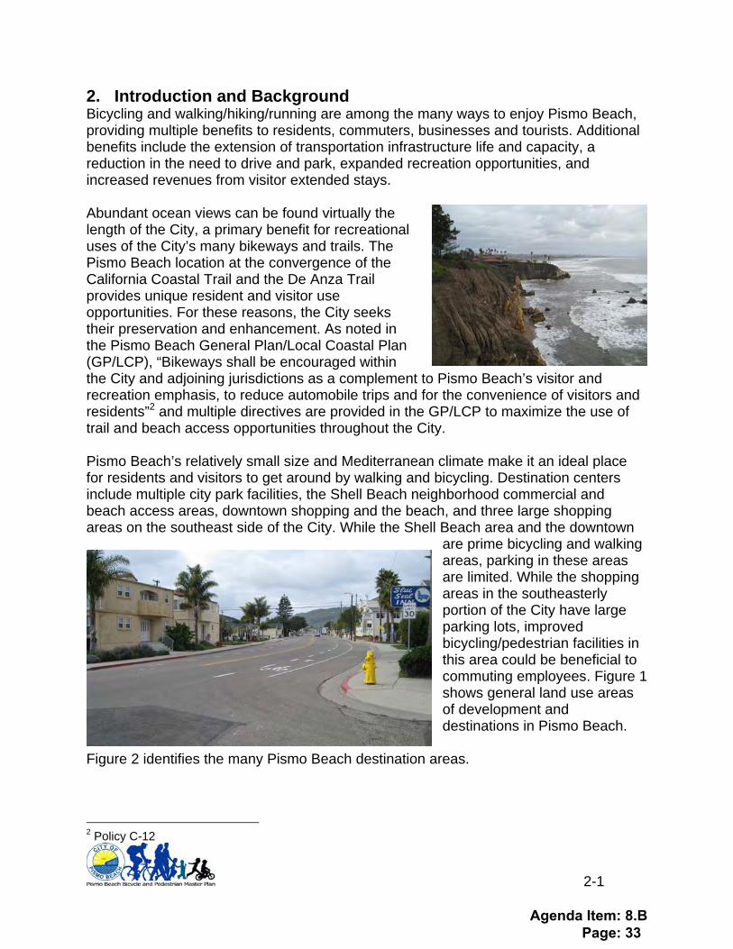
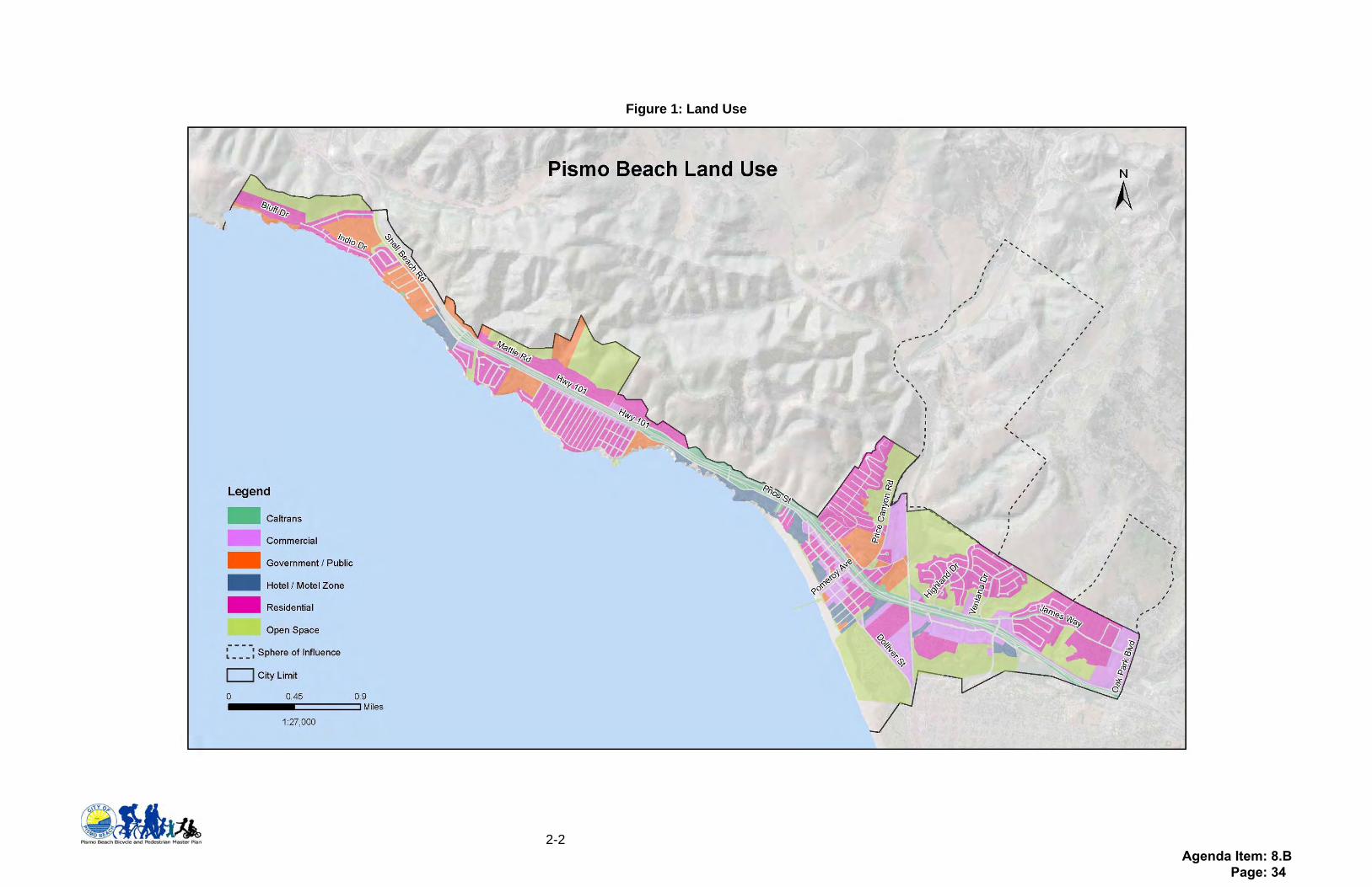
2. Introduction and Background Bicycling and walking/hiking/running are among the many ways to enjoy Pismo Beach, providing multiple benefits to residents, commuters, businesses and tourists. Additional benefits include the extension of transportation infrastructure life and capacity, a reduction in the need to drive and park, expanded recreation opportunities, and increased revenues from visitor extended stays. Abundant ocean views can be found virtually the length of the City, a primary benefit for recreational uses of the City’s many bikeways and trails. The Pismo Beach location at the convergence of the California Coastal Trail and the De Anza Trail provides unique resident and visitor use opportunities. For these reasons, the City seeks their preservation and enhancement. As noted in the Pismo Beach General Plan/Local Coastal Plan (GP/LCP), “Bikeways shall be encouraged within the City and adjoining jurisdictions as a complement to Pismo Beach’s visitor and recreation emphasis, to reduce automobile trips and for the convenience of visitors and residents”2 and multiple directives are provided in the GP/LCP to maximize the use of trail and beach access opportunities throughout the City. Pismo Beach’s relatively small size and Mediterranean climate make it an ideal place for residents and visitors to get around by walking and bicycling. Destination centers include multiple city park facilities, the Shell Beach neighborhood commercial and beach access areas, downtown shopping and the beach, and three large shopping areas on the southeast side of the City. While the Shell Beach area and the downtown
are prime bicycling and walking areas, parking in these areas are limited. While the shopping areas in the southeasterly portion of the City have large parking lots, improved bicycling/pedestrian facilities in this area could be beneficial to commuting employees. Figure 1 shows general land use areas of development and destinations in Pismo Beach.
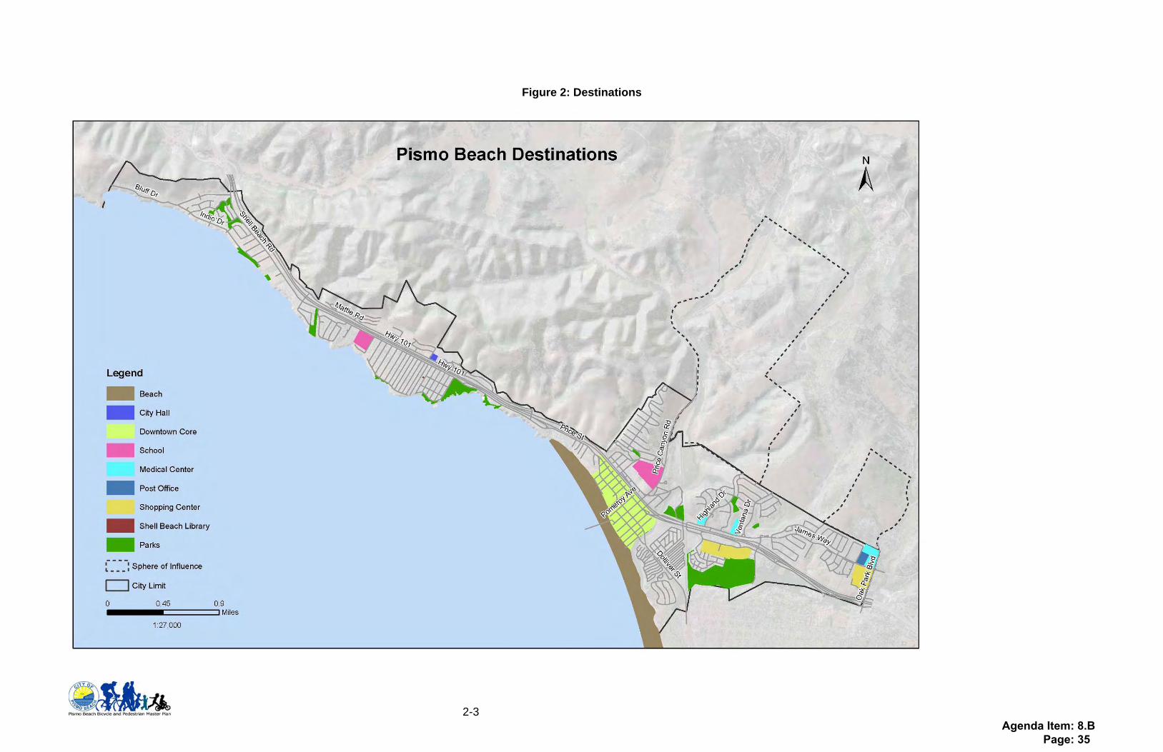
Figure 2 identifies the many Pismo Beach destination areas.
2 Policy C-12
Agenda Item: 8.B Page: 33
2-2
Figure 1: Land Use
Agenda Item: 8.B Page: 34
2-3
Figure 2: Destinations
Agenda Item: 8.B Page: 35
2-4
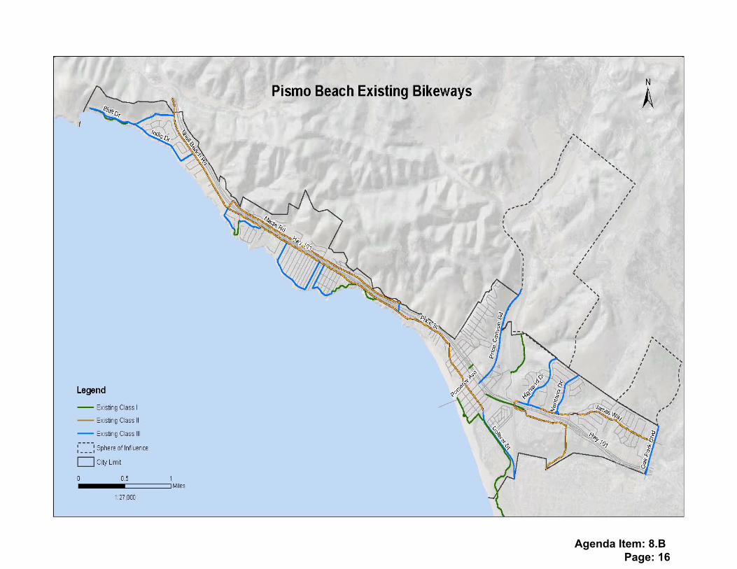
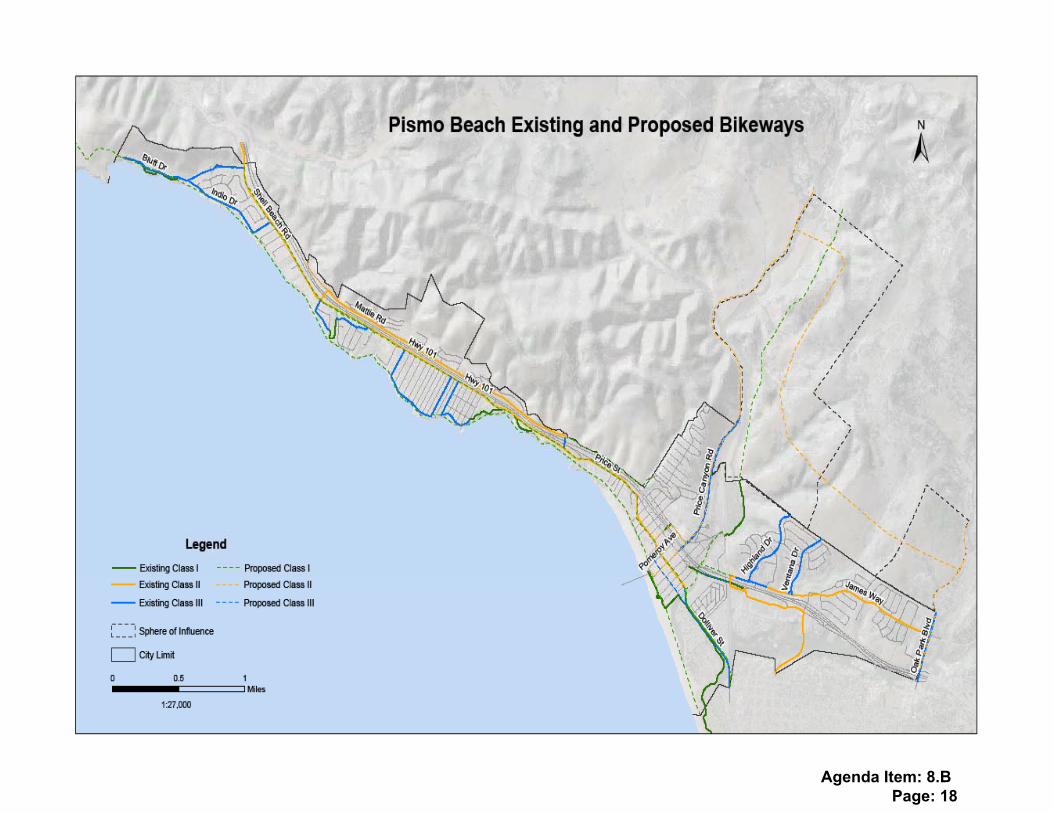
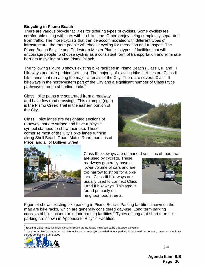
Bicycling in Pismo Beach There are various bicycle facilities for differing types of cyclists. Some cyclists feel comfortable riding with cars with no bike lane. Others enjoy being completely separated from traffic. The more cyclists that can be accommodated with different types of infrastructure, the more people will choose cycling for recreation and transport. The Pismo Beach Bicycle and Pedestrian Master Plan lists types of facilities that will encourage people to choose cycling as a consistent form of transportation and eliminate barriers to cycling around Pismo Beach. The following Figure 3 shows existing bike facilities in Pismo Beach (Class I, II, and III bikeways and bike parking facilities). The majority of existing bike facilities are Class II bike lanes that run along the major arterials of the City. There are several Class III bikeways in the northwestern part of the City and a significant number of Class I type pathways through shoreline parks3. Class I bike paths are separated from a roadway and have few road crossings. This example (right) is the Pismo Creek Trail in the eastern portion of the City. Class II bike lanes are designated sections of roadway that are striped and have a bicycle symbol stamped to show their use. These comprise most of the City’s bike lanes running along Shell Beach Road, Mattie Road, portions of Price, and all of Dolliver Street.
Class III bikeways are unmarked sections of road that are used by cyclists. These roadways generally have a lower volume of cars and are too narrow to stripe for a bike lane. Class III bikeways are usually used to connect Class I and II bikeways. This type is found primarily on neighborhood streets.
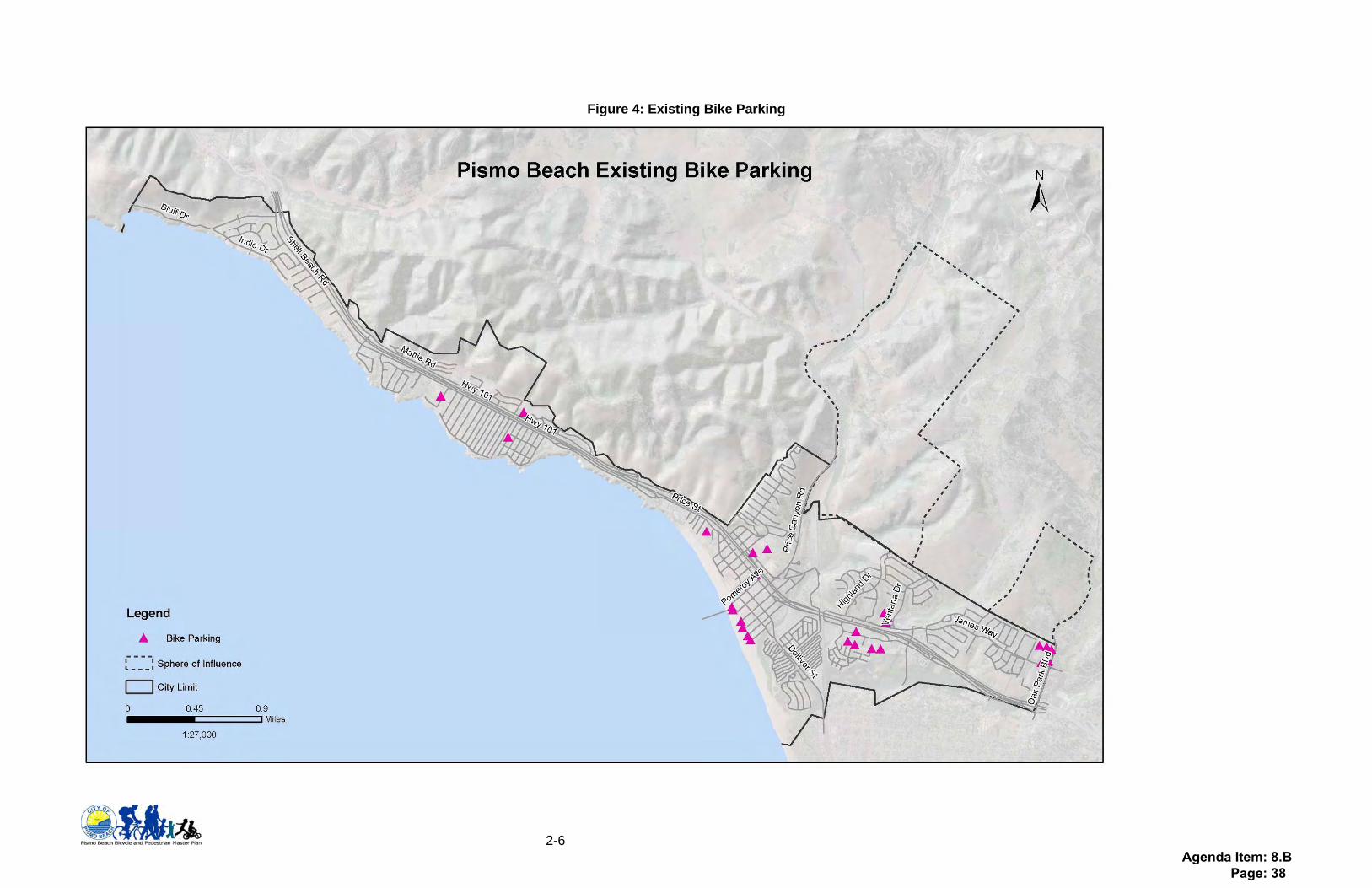
Figure 4 shows existing bike parking in Pismo Beach. Parking facilities shown on the map are bike racks, which are generally considered day-use. Long term parking consists of bike lockers or indoor parking facilities.4 Types of long and short term bike parking are shown in Appendix 5: Bicycle Facilities. 3 Existing Class I bike facilities in Pismo Beach are generally multi-use paths that allow bicyclists. 4 Long term bike parking such as bike lockers and employer-provided indoor parking is assumed not to exist, based on employer survey conducted Spring 2009.
Agenda Item: 8.B Page: 36
2-5
Figure 3: Existing Bikeways
Agenda Item: 8.B Page: 37
2-6
Figure 4: Existing Bike Parking
Agenda Item: 8.B Page: 38
2-7
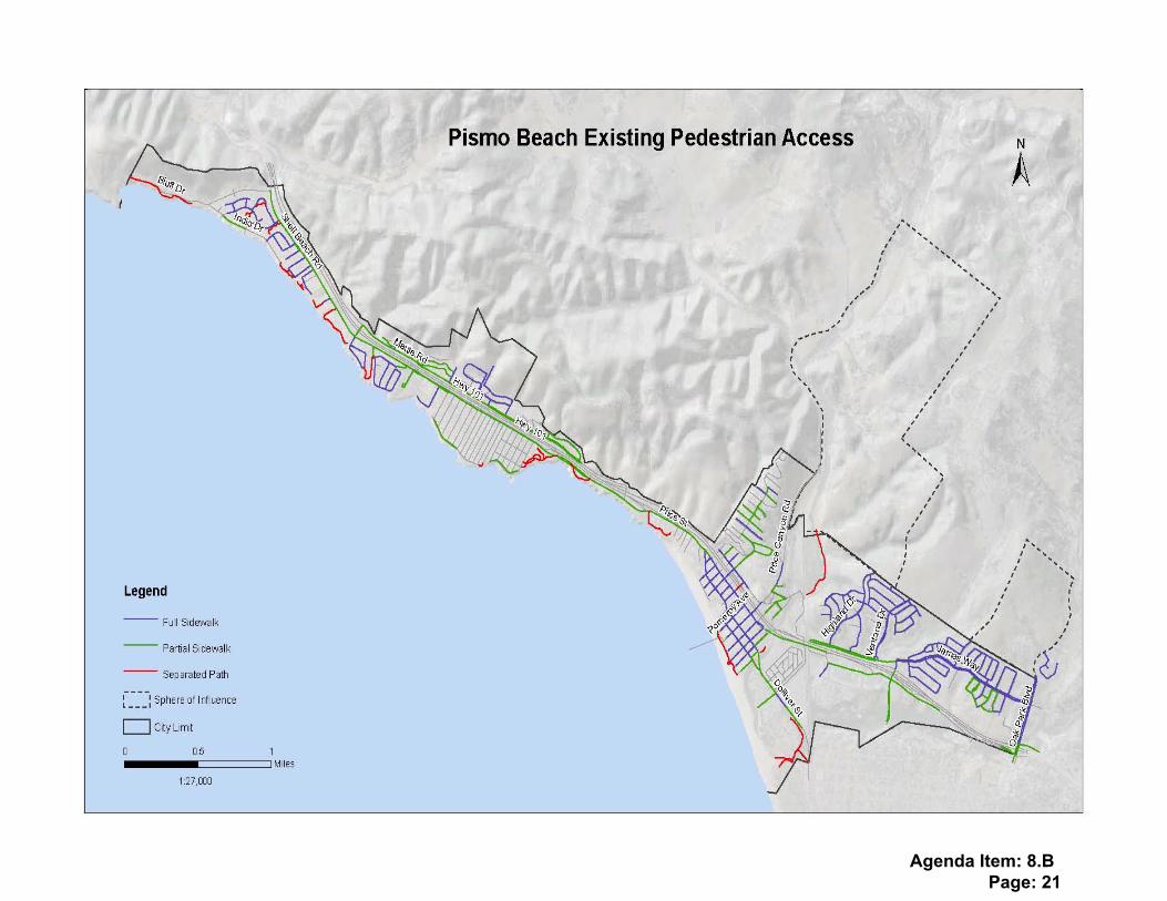
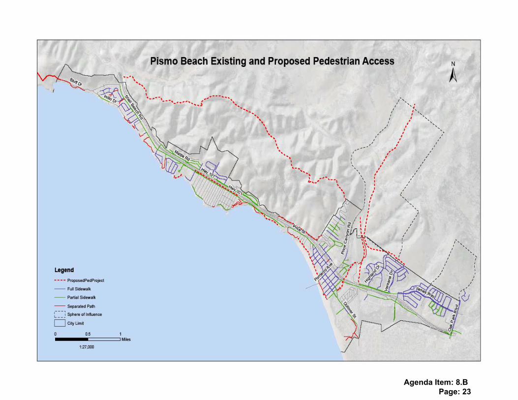
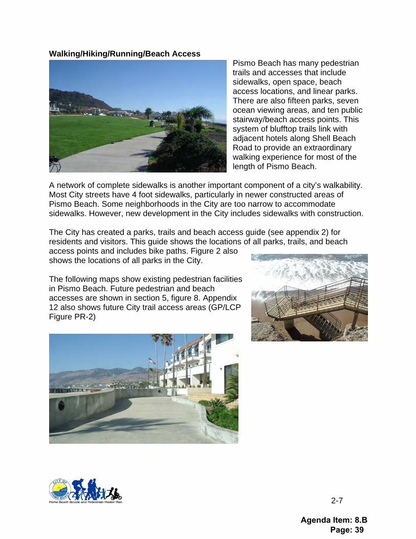
Walking/Hiking/Running/Beach Access Pismo Beach has many pedestrian trails and accesses that include sidewalks, open space, beach access locations, and linear parks. There are also fifteen parks, seven ocean viewing areas, and ten public stairway/beach access points. This system of blufftop trails link with adjacent hotels along Shell Beach Road to provide an extraordinary walking experience for most of the length of Pismo Beach.
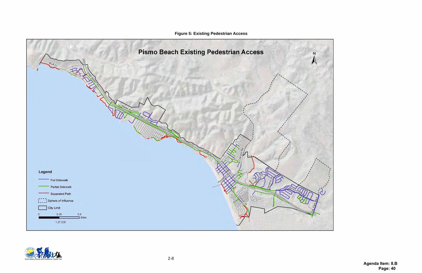
A network of complete sidewalks is another important component of a city’s walkability. Most City streets have 4 foot sidewalks, particularly in newer constructed areas of Pismo Beach. Some neighborhoods in the City are too narrow to accommodate sidewalks. However, new development in the City includes sidewalks with construction. The City has created a parks, trails and beach access guide (see appendix 2) for residents and visitors. This guide shows the locations of all parks, trails, and beach access points and includes bike paths. Figure 2 also shows the locations of all parks in the City. The following maps show existing pedestrian facilities in Pismo Beach. Future pedestrian and beach accesses are shown in section 5, figure 8. Appendix 12 also shows future City trail access areas (GP/LCP Figure PR-2)
Agenda Item: 8.B Page: 39
2-8
Figure 5: Existing Pedestrian Access
Agenda Item: 8.B Page: 40

2-9
Education and Outreach Educating visitors and residents can make the bicycling and pedestrian experience in Pismo Beach even more successful. Education programs can include elementary and middle school programs, employer based education programs, informational materials at hotels and tourist destinations, and “share-the-road” campaigns for reducing bike/ped-vehicle conflicts. SLO Regional Rideshare and the San Luis Obispo County Bicycle Coalition have several existing programs that could be incorporated into the City. Plan Section 3 provides multiple educational implementation measures.
Agenda Item: 8.B Page: 41
3-1
3. Plan Creation This Bicycle and Pedestrian Master Plan was initiated by the City in Fall 2008 and completed in Spring 2010. Creation of the plan included a website www.bikewalkpismo.org with online surveys for residents, visitors, and employers. The City also sent employer surveys to all businesses in the City. Employer and resident surveys were made available online and publicized through the SLOCBC and Rideshare websites and newsletters. Additionally, the resident survey was made available at a Shell Beach Improvement Group Meeting and the Employer Survey was mailed to all employers in the City. Copies of surveys and results are in Appendix 4. The plan was advertised and presented at the Pismo Beach Parks, Recreation, and Beautification Commission in March and June 2009 and March 2010, where much input was provided. City Public Works staff provided input on satisfaction with existing facilities, near-term capital improvements projects, and future projects. Survey results General results of the Employer Survey indicate that among the forty-seven (47) respondents to the survey (number of respondents is shown in parentheses):
• The majority of Pismo Beach Employees live in the Five Cities area • Over half of Pismo Beach employers offer some car parking spaces for
employees (27), several offer bike parking (12), and none of the employers surveyed offer showers or transportation choices incentive programs
• Most of the employers surveyed have sidewalks adjacent to their workplace (39), most are adjacent to public transportation (21), many have bike lanes (16), and few had a separated path for walking or biking (8)
• Half of the employers surveyed wanted additional bike and pedestrian activity around their workplace, half wanted additional car parking spaces
General results of the Resident Survey indicate the following (18 residents completed this survey):
• A majority of respondents said they usually or always spend time at the beach • Driving is the most common way that respondents get around Pismo (12),
followed by walking (8) and then bicycling (6) • Walkways and beach access points were the amenities that respondents used
most often (10, 10), followed by bike lanes (9) and trails (7) • Separated bike trails and walkways were the amenities that residents most want
to see more of (6,6) followed by bike lanes and sidewalks (5,5)
Agenda Item: 8.B Page: 42
3-2
Public Meetings
PRBC March 4th, 2008 The first meeting was held on March 4th, 2008. This first meeting was to introduce the planning process to the Parks Commission, including letting them know about the bike/ped plan, the website, future meetings and deadlines. In addition, this meeting served as an opportunity to receive direction from the commission on what they wanted to see in the plan. The meeting was attended by four of the five commissioners and three members of the community. Several commissioners expressed interest in having maps and other outreach materials; one commissioner was interested in having the plan address electric vehicles. One member of the public noted several locations where existing facilities could be improved. These comments, where appropriate, were incorporated into the plan. PRBC June 4th, 2009 The second meeting was held on June 4th, 2009. This meeting was a presentation of the plan with input from the prior meeting, survey, and website input. The meeting was attended by all five commissioners and several members of the public. Commissioners expressed interest in having the plan brought back for review prior to bringing to council. This meeting was also attended by members of the public who were concerned about a pending proposal for a modification to the Class II bike lanes on Shell Beach Road between Vista Del Mar and Cliff. It was determined the Bicycle and Pedestrian Master Plan be put on hold until the City Council made a decision as to whether a Class II bike lane in the Shell Beach village area would remain.
PRBC March 4th, 2010 The third meeting was held on March 4, 2010. Info will be included at that time. At this meeting, the Commission approved the Plan and recommended it go to City Council. The meeting was attended by two members of the public, both of whom spoke in favor of the plan.
City Council Meeting: April 6, 2010 To be completed after the final meeting with Council
Agenda Item: 8.B Page: 43
3-3
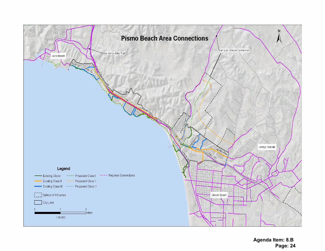
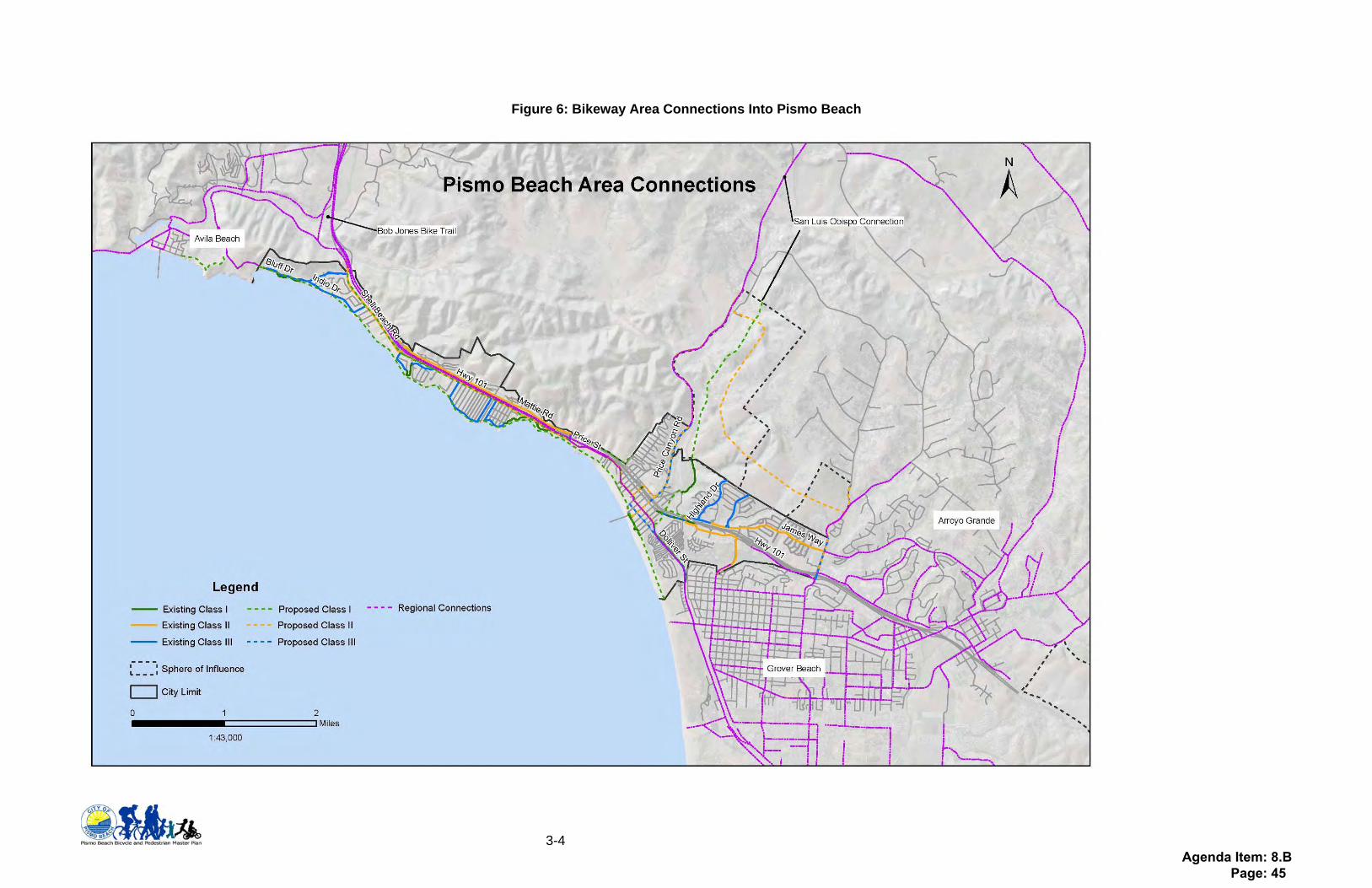
Relationship to Other Adopted Plans As required in Streets and Highways Code Section 891.2, The Pismo Beach Bicycle/Pedestrian must show the relationship to other adopted plans in the region, such as the Regional Transportation Plan, the Clean Air Plan, and other adopted plans. This information is listed in Appendix 3: Relationship to Other Adopted plans. The City of Pismo Beach is adjacent to both the City of Arroyo Grande to the southeast and the City of Grover Beach to the southwest. The community of Avila Beach is northeast of the City and the northern border of the city is unincorporated County. The plan maintains consistency with those jurisdictions’ bikeways at their juncture with the City. Figure 6, below, shows where Arroyo Grande, Grover Beach, Avila Beach and the County have bikeways that cross into the City. Future bike projects that may extend into other jurisdictions can be found in Section 5, Table 2 and Figure 6.
Agenda Item: 8.B Page: 44
3-4
Figure 6: Bikeway Area Connections Into Pismo Beach
Agenda Item: 8.B Page: 45
4-1
4. Policies Policies of the Bicycle Pedestrian Plan are based on the underlying goal of making Pismo Beach a city where residents and visitors of all ages can safely walk, bicycle, or reach the beach with:
• A well defined network of Class I, II, and III bike facilities including sufficient end-of-trip facilities
• A complete network of sidewalks and pedestrian walkways including frequent beach access points
• Residents and visitor access to information about bicycling and walking safely in the City
Implementation Measures
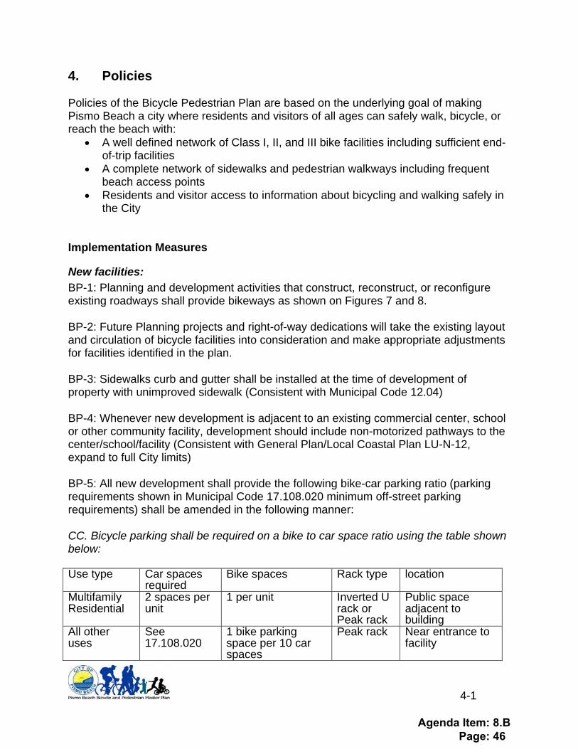
New facilities: BP-1: Planning and development activities that construct, reconstruct, or reconfigure existing roadways shall provide bikeways as shown on Figures 7 and 8. BP-2: Future Planning projects and right-of-way dedications will take the existing layout and circulation of bicycle facilities into consideration and make appropriate adjustments for facilities identified in the plan. BP-3: Sidewalks curb and gutter shall be installed at the time of development of property with unimproved sidewalk (Consistent with Municipal Code 12.04) BP-4: Whenever new development is adjacent to an existing commercial center, school or other community facility, development should include non-motorized pathways to the center/school/facility (Consistent with General Plan/Local Coastal Plan LU-N-12, expand to full City limits) BP-5: All new development shall provide the following bike-car parking ratio (parking requirements shown in Municipal Code 17.108.020 minimum off-street parking requirements) shall be amended in the following manner: CC. Bicycle parking shall be required on a bike to car space ratio using the table shown below: Use type Car spaces
required Bike spaces Rack type location
Multifamily Residential
2 spaces per unit
1 per unit Inverted U rack or Peak rack
Public space adjacent to building
All other uses
See 17.108.020
1 bike parking space per 10 car spaces
Peak rack Near entrance to facility
Agenda Item: 8.B Page: 46

4-2
BP-6: All new City parking lots shall provide bicycle parking which is not less than 10% of the number of planned parking spaces. BP-7: All future annexations will be consistent with this plan. Review of Bicycle/ Pedestrian opportunities will be included in City review of annexation areas. BP-8: The Bike Plan shall be consulted when assembling and updating the Capital Improvement program.
Maintenance/upgrades: BP-9: All Class I, II, and III bikeways shall be constructed in accordance with guides established in Figure C-4 in the Pismo Beach General Plan Circulation Element (shown in Appendix 5.) BP-10: Channelization should be provided at intersections that have left or right-turn lanes crossing Class II bikeways. City shall consider including bike boxes at intersections with high bicycle traffic volumes (shown in Appendix 5). BP-11: Video or in-pavement detection of bicycles shall be installed on roads with bikeways; symbols shall be painted on roadway after re-surfacing or repaving (shown in Appendix 5). BP-12: City shall replace existing drainage grates with new “bike friendly” grates, mounted flush with the street when maintenance is being performed on that street and when new streets are built. (See Appendix 11 for example). BP-13: City shall ensure street sweeping maintenance is extended to include bike lanes, such that bike facilities are maintained along with the travel lanes. Bicycle and pedestrian pathways should be maintained as part of the City row maintenance efforts. BP-14: City shall request Caltrans referral for City comment for all Caltrans Right-of-Way projects so the City may examine and advise on pedestrian and bicyclist access and safety pursuant to the City Bike Plan. BP-15: City will install directional signage for trail users at locations where there is a change in the type of facility (e.g.: where a Class I ends at an intersection and a Class II start on the other side, signage shall indicate to user, what courses of action are available to them). BP-16: Long and short-term bicycle parking shall be provided at all park and ride lots and transit centers (City shall work with SLOCOG and RTA to identify funds for bicycle parking). Potential future bike parking locations are shown in Figure 9.
Agenda Item: 8.B Page: 47
4-3
BP-17: City staff shall identify locations where additional long and short term bike parking may be necessary (e.g.: where bikes are locked to trees, street signs, blocking doorways, etc) and:
• May develop a “racks-with-plaques” program to provide for additional bike parking at those locations (SLO City Racks with Plaques program brochure shown in Appendix 6- as an example)
• Recommend long-term parking facilities including lockers and showers for new developments
Education/Outreach/Events: BP-18: The City of Pismo Beach shall work with SLO Regional Rideshare to provide Transportation Choices Program to City employees. BP-19: Bike valet is a service that is offered by the San Luis Obispo County Bicycle Coalition (SLOCBC) for $50 per hour with a 50% discount if volunteers are provided by event staff, with a $100 minimum. This service is usually for large city events to reduce car use and encourage bike travel. The City shall add the following text to Municipal Code 12.16.160 Content of Special Event form (see Appendix 7 for Bike Valet brochure): N. As a condition of the issuance of a Special Event permit, the applicant may be required to provide bicycle parking. Bicycle parking provision may include “Bike Valet” services provided by SLOCBC or by event volunteers. BP-20: Bicycle Confidence Workshop: Workshops are a series of classes offered by the SLO Bike Coalition to teach adults safe bicycle riding; a $35 deposit is required for the class. The City shall work with the bike coalition to advertise Bicycle Confidence Workshops in Pismo Beach. (Bicycle Confidence Brochure in Appendix 8). BP-21: The City shall encourage Lucia Mar School District to provide bike and pedestrian safety programs at schools within City limits. City shall participate in bike rodeos or assemblies and organized walk/bike to school day events. BP-22: The City shall participate in Bicycle Confidence Workshops (offered by SLOCBC) or another equivalent program, to individuals who are ticketed for bicycling illegally. BP-23: The City shall participate in education programs for motorists on rights/rules of pedestrians and bicyclists. BP-24: The City shall promote proper cycling to tourists by providing safe cycling information for the Conference and Visitors Bureau website and for display at the Chamber of Commerce Building downtown. BP-25: The City will continue its advertisement of walking and beach access options within the City.
Agenda Item: 8.B Page: 48

4-4
BP-26: The City Recreation Program will assist and provide support for organizations and individuals who wish to use pedestrian facilities for social activity and improvement. BP-27: The City will encourage school participation with the SLOCOG Safe Routes to School program. SLO Regional Rideshare (www.rideshare.org) works with schools to offer individualized programs including Parent Surveys; Mini Grants given to promote cycling in the community; Bike Assemblies, a ride of recreational cycling in large groups ending with a presentation of bicycle education; and, Bike Rodeo, a bicycle safety training and education for elementary school children. BP-28: The City will encourage Rideshare Employee Incentive Programs: Rideshare offers an employer Transportation Choices Program that helps employers promote bicycling, walking, carpooling, and riding the bus to work. This would reduce the employers’ need for car parking spaces. This program may provide financial incentives or only promotional materials. BP-29: The City may engage Cal Poly, SLO County Bicycle Coalition, or Regional Rideshare assistance to implement elements of this bike plan by doing the following:
• Seeking and writing grants for bicycle and pedestrian infrastructure • Monitoring success of the implementation procedures identified in this document • Developing a safety campaign to reduce car/bike conflicts • Liaising between local schools and Rideshare to provide bike education • Creating or working with the SLOCBC to provide bike valet at events • Starting a “racks with plaques” and other promotion programs
BP-30: The City may participate with others to address countywide issues related to bicycle and pedestrian access.
Agenda Item: 8.B Page: 49

5-1
5. Projects This section of the plan lists all previous expenditures on projects in Pismo Beach and identifies new projects that residents, elected officials, and staff would like to see built. The past expenditures are shown as a list along with the dollar amount spent on the project. These projects are included in Figures 3, 5, and 6 as part of the existing facilities discussion. Future projects are shown as a list with project title, time frame, user type, and a reference number. The number is associated with the map and description that follows the list. Completed Projects/ Expenditures The City of Pismo Beach has successfully developed a near complete network of pedestrian parks and walkways along the Pacific Ocean in both Shell Beach and downtown Pismo Beach. This has been done primarily through easements and developer fees. The City has also been successful in obtaining Transportation Enhancement and other grants from the Regional Transportation Planning Agency (SLOCOG). See Table 1 below – Completed projects costs. Table 1: Completed Projects Costs
Project Name Project Description Expenditure Beachcomber Stairs Installation of beach access stairway $ 442,158 Vista Del Mar Stairs Replacement of obsolete stairway to the beach $ 140,788 Pier Avenue Stairs Replacement of obsolete stairway to the beach $ 134,499 Wilmar Stairs Replacement of obsolete stairway to the beach $ 365,333 Dinosaur Caves/4th Street Improvements Sidewalks and stairways to the beach $ 561,276 Promenade I (end of Ocean View cul-de-sac) Sidewalks and stairways to the beach $ 427,051 Promenade II (Pier to Stimson)
Elevated pedestrian boardwalk along the ocean $ 575,357
Promenade III (Addie Street parking lot to the end of Grand Avenue)
Elevated pedestrian boardwalk along the ocean, walkway along South Dolliver, trail through State Beach area, elevated boardwalk through ocean dunes $1,589,725
Promenade IV Elevated pedestrian boardwalk along the ocean $2,088,115
Promenade IV B Elevated pedestrian boardwalk along the ocean $1,500,000
Shell Beach Road bike lanes Bike lanes on several block segment $ 59,248 Blufftop trails from Indio to end of Ebb Tide Pedestrian walkway and Class I bike lanes
Funded by development
Total $7,883,550 Future Projects/ Expenditures
Agenda Item: 8.B Page: 50
5-2
Future projects were identified through community surveys, fieldwork, and community meetings. These projects include gaps in existing infrastructure or new projects identified as areas of concern. Future projects are arranged into long and short-term sections, noted on Table 2 (below). Long-term projects reflect areas where the City will require bike or pedestrian facilities along with future development and/or changes to existing uses. Short-term projects are those that the City can pursue now (including those eligible for BTA and other grant funding). The final map in this section shows potential locations for bike parking.
Prioritizing for implementation As required by Streets and Highways Code Section 891.2, projects are ranked by City Public Works staff for readiness to build, importance to the City, fundability, etc. Prioritization is only required for Bike projects. However, for this Plan all projects have been ranked. Rank of project does not preclude other projects from being built first, it is simply a preference of the City, and some projects may score higher, even if they have a longer time frame to be built.
Agenda Item: 8.B Page: 51
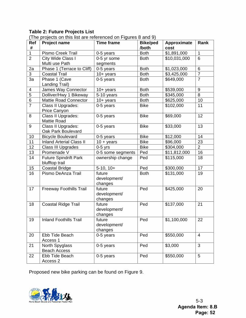
5-3
Table 2: Future Projects List (The projects on this list are referenced on Figures 8 and 9) Ref #
Project name Time frame Bike/ped /both
Approximate cost
Rank
1 Pismo Creek Trail 0-5 years Both $1,891,000 1 2 City Wide Class I
Multi use Path 0-5 yr some segments
Both $10,031,000 6
2a Phase 1 (Terrace to Cliff) 0-5 years Both $1,023,000 6 3 Coastal Trail 10+ years Both $3,425,000 7 3a Phase 1 (Cave
Landing Trail) 0-5 years Both $649,000 7
4 James Way Connector 10+ years Both $539,000 9 5 Dolliver/Hwy 1 Bikeway 5-10 years Both $345,000 8 6 Mattie Road Connector 10+ years Both $625,000 10 7 Class II Upgrades:
Price Canyon 0-5 years Bike $102,000 11
8 Class II Upgrades: Mattie Road
0-5 years Bike $69,000 12
9 Class II Upgrades: Oak Park Boulevard
0-5 years Bike $33,000 13
10 Bicycle Boulevard 0-5 years Bike $12,000 14 11 Inland Arterial Class II 10 + years Bike $96,000 23 12 Class III Upgrades 0-5 yrs Bike $304,000 2 13 Promenade V 0-5 some segments Ped $11,812,000 16 14 Future Spindrift Park
blufftop trail ownership change Ped $115,000 18
15 Coastal Bridge 5-10, 10+ Ped $300,000 17 16 Pismo DeAnza Trail future
development/ changes
Both $131,000 19
17 Freeway Foothills Trail future development/ changes
Ped $425,000 20
18 Coastal Ridge Trail future development/ changes
Ped $137,000 21
19 Inland Foothills Trail future development/ changes
Ped $1,100,000 22
20 Ebb Tide Beach Access 1
0-5 years Ped $550,000 4
21 North Spyglass Beach Access
0-5 years Ped $3,000 3
22 Ebb Tide Beach Access 2
0-5 years Ped $550,000 5
Proposed new bike parking can be found on Figure 9.
Agenda Item: 8.B Page: 52
5-4
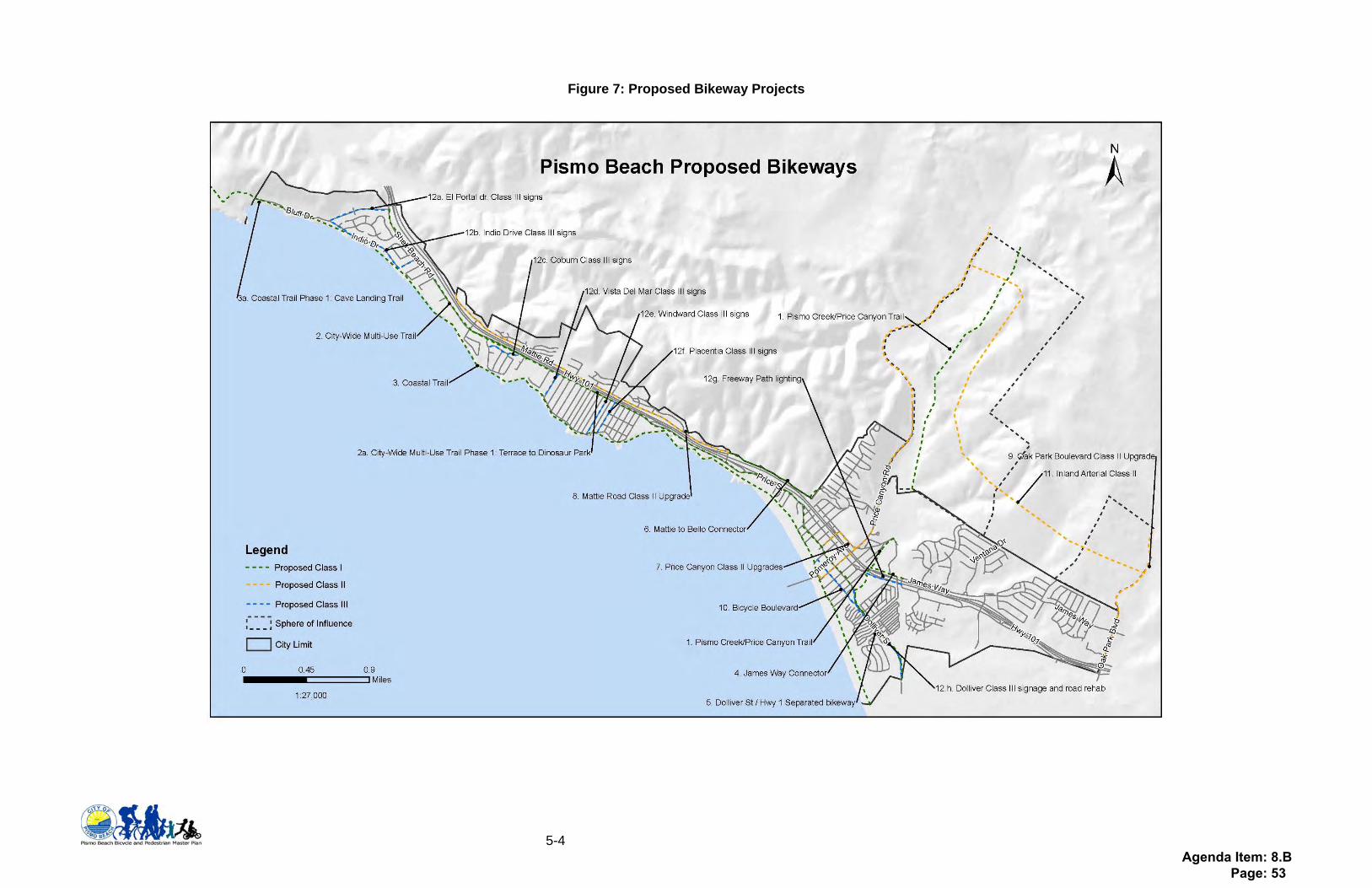
Figure 7: Proposed Bikeway Projects
Agenda Item: 8.B Page: 53
5-5
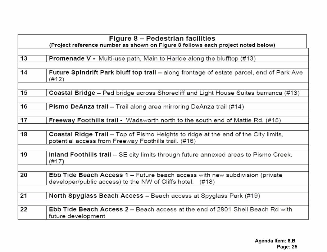
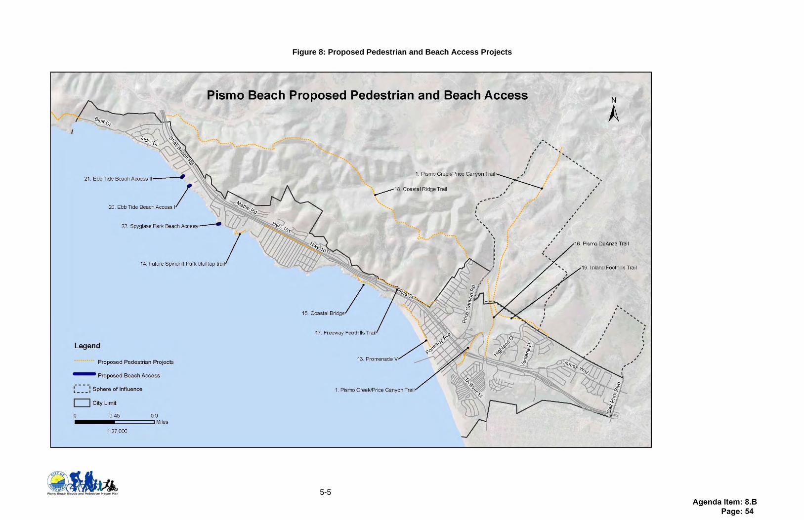
Figure 8: Proposed Pedestrian and Beach Access Projects
Agenda Item: 8.B Page: 54

5-6
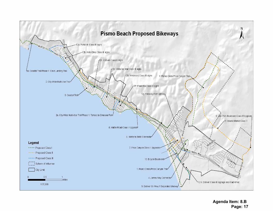
Proposed Bikeway Projects
1. Pismo Creek Trail/ Price Canyon Trail (See Figure 8, No. 1)The City has begun the Pismo Creek Trail Plan connecting the Pismo Promenade at Addie Street to Price Historic Park (where the Price Canyon trails will begin, as shown in the County Parks and Recreation Element). This pedestrian trail and Class I bike lane project is consistent with several policies in the Land Use, Conservation and Open Space, and Parks, Recreation and Access Elements. This project has the potential to dramatically increase recreational bicycle and pedestrian trips from the northern residential areas of Pismo Beach (Land Use areas N, O, and P from Pismo Beach General Plan Land Use Element). This trail could decrease car trips into the recreational core of Pismo Beach. Future implications: When future annexations into Price Canyon are considered and the County completes the Price Canyon Natural Area, this project will serve as a primary way for commuters to get into and through Pismo Beach. Primary User: Commuter and Recreational, Pedestrian and Bike, all ages. Funding Source: Transportation Enhancement funds, Bicycle Transportation Account funds, Urban and Regional SHA.
2. City-wide Multi-use trail (See Figure 8, Numbers 2 and 2a for Phase 1) This 6-10 foot multi-use trail for pedestrians and bicyclists would begin at the southwesterly city limits on South Dolliver adjacent to Grover Beach and could link with any future Grover Beach trail to the southwest. The trail would commence up the southeast side of Dolliver Street where it could traverse to the east onto the Pismo Creek Trail. At Ira Lease Park the trail may transition to a Class II bike trail up Dolliver to the Price/Dolliver intersection. At this point the multi-use trail could resume to the City limits at El Portal with potential for extension in the County to the Bob Jones Bike Trail. Currently, Class II bike lanes are striped on Shell Beach Road through the Shell Beach Planning area to the City limits; these would be modified or deleted and replaced by the multi-use trail. This project could include, where necessary, converting Class II lanes to a Class III configuration along Price Street and Shell Beach Road. Future implications: The project will increase recreational and vulnerable commuting cyclists traveling on Shell Beach Road. More serious cyclists will still be able to utilize the Class II bike lanes along Mattie Road. Upon leaving the City limits, with interagency cooperation, the trail can connect with the existing Bob Jones City to Sea trail at a terminus and parking lot on Ontario Road. This trail will draw families to the area for recreational rides on weekends. Primary User: Recreational and Commuter (school children), Pedestrian and Bike, all ages. Funding Source: Transportation Enhancement funds, Bicycle Transportation Account funds, Safe Routes to School grants, Urban and Regional SHA.
Agenda Item: 8.B Page: 55

5-7
3. Cave Landing Trail (See Figure 8, Numbers 3 and 3a for phase 1)This Class I trail that will be a continuation of Bluffs Drive Class III and continue past Pirates Cove and Cave Landing to Avila Beach. This project will provide a Coastal Trail connection to Avila Beach, which is the existing terminus of the Bob Jones City to Sea bike path. Future implications: The American Land Conservancy and the Land Conservancy of SLO County are steadily acquiring scenic property between Montana de Oro State Park and the San Luis Bay Drive in Avila. Eventually residents and visitors of San Luis Obispo County will have a connected network of trails from Los Osos to Avila Beach. The Cave Landing Trail will continue that connection south to Pismo Beach. Primary User: Recreational, Pedestrian, Mountain Bike, all ages Funding Source: Transportation Enhancement, State Parks, Coastal Conservancy
4. James Way to Frady Lane Class I (See Figure 8, No. 4) This Class I trail will connect the end of James Way or the neighborhood on the hillside above James Way to Frady Lane or the west side of the Pismo Creek. There are several potential trail alignments for this area and a feasibility study would probably need to be done to address an appropriate location. The project could run adjacent to the railroad until it reaches the Price Canyon Trail or it could cross the Railroad and the Pismo Creek and connect to the Pismo Creek Trail. Future implications: This recreational trail would serve as another way (aside from the freeway bike path) to travel between west and east sides of Pismo. Primary User: Recreational, Pedestrian, all ages Funding Source: Transportation Enhancement, State Parks
5. Dolliver Street/ Hwy 1 Separated Bikeway (See Figure 8, No. 5) Class I or II bikeway on the northeast side of Hwy 1/Dolliver Street which will connect the Grover Beach Class I along the railroad to the Ira Lease Park/entrance to the Pismo Creek Trail. Future Implications: This regionally significant trail would connect a Grover Beach Class I to the Pismo Creek Trail which will connect to the County Price Canyon trails. Primary User: Recreational cyclists, all ages Funding Source: Transportation Enhancement funds, Bicycle Transportation Account funds, Urban and Regional SHA
6. Mattie to Bello Class I Connector (See Figure 8, No. 6) Class I bikeway on the northeast side of Hwy 101 connecting Bello Road at its entrance to Hwy 101 to Mattie Road at the Mattie Road exit. Future Implications: This regional trail would connect cyclists traveling on Price Canyon Road directly to the Class II on Mattie Road, and would serve as a
Agenda Item: 8.B Page: 56
5-8
“frontage road” for cyclists. At a future date, when the Pismo Creek Trail is complete and/or the James Way connector is built, this throughway will link several Pismo Beach bike facilities. Primary User: Recreational cyclists, all ages Funding Source: Transportation Enhancement funds, Bicycle Transportation Account funds, Urban and Regional SHA
7. Class II Upgrades: Price Canyon (See Figure 8, No. 7) Class II bikeways on Price Canyon Road within Pismo Beach City limits. The Class II (striped, stamped, and signed) would create safety for cyclists entering the City by way of Price Canyon. Future Implications: This solution is available in the short term, could decrease bike/car conflicts on Price Canyon Road. Primary User: Commute and Recreational, Bike, confident cyclists Funding Source: Transportation Enhancement funds, Bicycle Transportation Account funds, Urban and Regional SHA 8. Class II Upgrades: Mattie Road, northeast side (Figure 8, No. 8) This upgrade would include adding a Class II bike lane to the northeast side of Mattie Road and improving the markings of the existing Class II lane on the southwest side of the road. Future implications: With the inclusion of a bike path and removal of bike lane on the parallel route (Shell Beach Road), higher speed cyclists will be encouraged to use Mattie Road and avoid the more impacted Shell Beach route. Striping and marking the bike lane on both sides of the road will make this route safer for cyclists. Primary user: Commute and recreational, confident cyclists Funding Source: Transportation Enhancement funds, Urban and Regional SHA, City General funds 9. Class II Upgrades: Oak Park Boulevard (Figure 8, No. 9)This upgrade would include adding a Class II bike lane to Oak Park Boulevard from the northeast City limits to the Grover Beach city limits at Hwy 101. Future implications: This solution is available in the short term, could decrease bike/car conflicts on Price Canyon Road. Primary user: Commute and recreational, confident cyclists Funding Source: Transportation Enhancement funds, Urban and Regional SHA, City General funds
10. Bicycle Boulevard (See Figure 8, No. 10) A bicycle boulevard along Cypress Street from Hwy 1/Dolliver to Hinds Avenue would offer an alternative to bicycle travel on Hwy 1/Dolliver Street. This route connects Promenade III along Highway 1 to the downtown core without requiring cyclists to ride bikes on the Promenade north of the Addie Street parking lot.
Agenda Item: 8.B Page: 57
5-9
Future Implications: Benefit to cyclists, increase safety to riders in downtown area. Primary User: Recreational and Commute, Bike Funding Source: Transportation Enhancement funds, Bicycle Transportation Account funds, Urban and Regional SHA
11. Inland Arterial Class II See Figure 8, No 11 Construct Class II along with future road connecting Oak Park Boulevard to Price Canyon, north of James Way Future Implications: Improved safety, create connectivity throughout northeastern side of Pismo Beach Primary User: Commute, Recreational, bike moderate to confident users Funding Source: Transportation enhancement, City General fund, Urban and Regional State Highway Account funds
12. Class III Upgrades See Figure 8, Nos. 12a-12h
• Sign existing Class III bikeways on El Portal Drive and Indio Drive (consistent with Circulation and Land Use Elements).
• Sign existing Class III on Windward Avenue and Placentia Avenue (consistent with Circulation Element).
• Create Class III on Vista Del Mar to maintain continuity of bikeways when path and/or road are unavailable along Pacific Ocean.
• Create connected Class III bikeway along Coburn, through Spyglass Park, onto Spyglass Drive. South Dolliver adjacent to Promenade III – upgrade paving to match the street.
• Bike/Pedestrian along Highway 101 – addition of lighting. • Wayfinding/directional signs at critical intersections indicating appropriate
cyclist/pedestrian action. Future Implications: Improved safety, create connectivity throughout Shell Beach along low volume roads Primary User: Commute, Recreational, bike moderate to confident users Funding Source: Transportation enhancement, City General fund, Urban and Regional State Highway Account funds
Connectors to Arroyo Grande, Grover Beach and San Luis Obispo County out Price Canyon Road and Oak Park (all are shown above, see reference number below).
Improve connections to areas outside the City by adjoining existing bikeways in San Luis Obispo County, Arroyo Grande, and Grover Beach. The following extensions/projects will provide connections to existing and/or proposed bikeways adjacent to the City.
• Cave Landing Trail (# 3): this trail is on County property and is proposed to be a hiking trail to be built in the near term. Long term solutions could
Agenda Item: 8.B Page: 58
5-10
include a Class I bikeway that would connect to the existing Class III on Indio Drive, which connects to the Class II on Shell Beach Road.
• Citywide Multiuse path connection to Bob Jones (# 2): the Citywide Multi-use path shown above could connect to the County’s Bob Jones trail at or near the Ontario Road staging area, in this scenario, the path would likely travel near the existing (privately owned) campground on Avila Road.
• Price Canyon Class II (#6): within City limits of Pismo Beach on Price Canyon Road. This will connect with the planned Class II bike lanes on Price Canyon Road in the County’s Bikeway plan.
• Price Canyon Trail/Pismo Creek Trail (ref #1): The City has built a portion of Class I bikeway near the Price House in the City Limits. If Pismo Beach expands, this trail will expand to connect with future trails in the Price Canyon Area (trails are identified in the County’s Parks and Recreation Element).
• Oak Park Boulevard Class II (ref #8): Bike lanes along Oak Park Boulevard within City limits to connect with Arroyo Grande’s planned Class II on Oak Park.
• Dolliver Street/Highway One bikeway (ref #5): Class II or Class I outside of right-of-way of highway connecting to Grover Beach’s future Class I adjacent to the railroad tracks.
Future implications: Connectivity to adjacent jurisdictions, and continuity of regional bikeways Primary User: Commute and Recreational, Bike, confident cyclists Funding sources: Urban and Regional State Highway Account, Transportation Enhancement, Recreational Trails Program (in Coastal or De Anza trail corridors)
Agenda Item: 8.B Page: 59

5-11
Pedestrian Facilities
13. Promenade V (See Figure 9, 11)This Multi-use path will connect Main Street to Harloe Street parallel to the Pacific Ocean along the bluffs and beach. This would be a continuation of the City’s Pismo Promenade I-IV, which is a very important regional pedestrian/recreational cyclist destination. This project could offer a convenient way to travel from the hotels in the northwest section of the City to the Downtown/Pier area and ultimately to Grover Beach. Future Implications: Continuation of existing regionally significant recreational facility Primary User: Recreational, Pedestrian, Bike Funding Source: Transportation Enhancement funds, Urban and Regional SHA
14. Future Spindrift Park blufftop trail (See Figure 9, #12) Blufftop park trail at APN 010-221-043 in the Spindrift Planning area; dedication by property owner upon development of property in the future. (See Figure 12). Future Implications: New beach blufftop trail as a part of the California Coastal Trail Primary User: Recreational Funding Source: future development requirement
15. Coastal Bridge (See Figure 9, #13) This project is a pedestrian bridge across the barranca between the Shorecliff Lodge and the Light House Suites. This bridge would link the public oceanfront pathways of the two hotels, which to the southwest, leads to a beach access stairway at the Seacrest Hotel. (See Figure 9). Future Implications: Continuation of the California Coastal Trail, a regionally significant recreational facility Primary User: Recreational, walking, beach access Funding Source: Transportation Enhancement funds, Urban and Regional SHA, Coastal Conservancy
16. Pismo DeAnza Trail (See Figure 9, #14)There is a trail easement that has been provided by the developer at the apex of James Way and the Railroad tracks. This easement wraps around the hillside to the northwest to ultimately link with the Class I bike trail in the Price Historic Park. The location of this trail area appears to mirror the DeAnza trail. The City shall take necessary steps to insure that any developments along Price Canyon, either in the city or in the County, shall include a continuous pedestrian and bicycle and equestrian public trail network along Pismo Creek and bordering Price Historical Park. This trail may be located on both or a single side, of Pismo Creek, as considered appropriate during specific plan and project reviews. Additionally, the City will explore
Agenda Item: 8.B Page: 60
5-12
implementation of a trail extending from James Way to Rancho Pismo Drive, paralleling the railroad right of way and Pismo Creek, in the existing public access easements dedicated by Tract 814 in 1982 and Tract 2554 in 2008. Future Implications: While easements are in place, improvement of this trail area has not been achieved. Funding would be required for an “El Camino Real” Historical Marker and an interpretive center about the trail history, to be located in Price Historic Park. Primary User: Recreational, Pedestrian, Mountain Bike Funding Source: Future development funded, Recreational Trails Program grant, Transportation Enhancement, Urban and Regional State Highway Account
17. Freeway Foothills Trail (See Figure 9, #15)This proposed trail will start at Wadsworth Avenue and continue north. It would provide connections at the south end of Mattie Road, continue north with several connections into the Pismo Heights area (consistent with the Conservation and Open Space Element), and reconnect with Mattie Road at its northern end. This project would be a Class I paved or decomposed granite trail. The exact location is yet to be determined. Future Implications: The City could work with SLO County to provide a connection between Mattie and Monte Roads and eventually connect to the future Bob Jones Trail that will travel the west side of Highway 101 to San Luis Bay Drive. Primary User: Recreational, Pedestrian, Mountain Bike Funding Source: Developer funding, expand, hopefully other funds available. Showing Nexus to require only development to fund could be difficult.
18. Coastal Ridge Trail (See Figure 9, #16)This proposed trail would begin at the top of Pismo Heights and continue at the top of the ridge to the end of the City limits adjoining San Luis Obispo County. Access could also be achieved from the future Foothills Trail to hillside pathways extending up the side of the foothills for any new development area that may be annexed into Pismo Beach from San Luis Obispo County. This project would be a decomposed granite trail; the exact location is yet to be determined. Future Implications: The City would require development of annexation areas between Mattie Road and Pismo Heights to provide by easement and improve these trail opportunities as a condition of annexation. Primary User: Recreational, Pedestrian, Mountain Bike Funding Source: State parks, annexation funds… (County property, county pursue trail)
19. Inland Foothills trail (See Figure 9, #17) This proposed trail would begin at the southeasterly city limits with future annexation of the Los Robles Del Mar planning area and continue to Pismo Creek through future areas to be annexed. Currently the property is in the County. The exact trail location would be determined with
Agenda Item: 8.B Page: 61
5-13
consideration to the hilly and biologically sensitive environment. Access could be achieved from the ends of Highland, Ventana and Ridge Road in the existing city limits. This project would be a decomposed granite trail and possibly a Class I bike trail, contingent upon the terrain and feasibility of construction. The exact location is yet to be determined. Future Implications: The City would require development of annexation areas between Oak Park Blvd. and Pismo Creek to provide by easement and improve these trail opportunities as a condition of annexation. Primary User: Recreational, Pedestrian, Mountain Bike Funding Source: State parks, annexation funds… (County property, county pursue trail)
20. Ebb Tide Beach Access 1 (See Figure 9, #18) Beach access at the parcel adjacent to the Cliffs Hotel to the north has been approved and will be constructed by 2012. Future Implications: New beach access and inclusion in California Coastal Trail Primary User: Recreational Funding Source: Property owner, stairway construction and public access easement dedication required.
21. North Spyglass Beach Access (See Figure 9, #19) Beach access at Spyglass Park Future Implications: New beach access and inclusion in California Coastal Trail Primary User: Recreational Funding Source: State grant funding, park development
22. Ebb Tide Beach Access 2 (See Figure 9, #20) Beach access at the end of 2801 Shell Beach Road if/when development occurs in the future. Private beach access currently located at the site. Future Implications: New beach access and inclusion in California Coastal Trail Primary User: Recreational Funding Source: State grants
Bike Parking Facilities
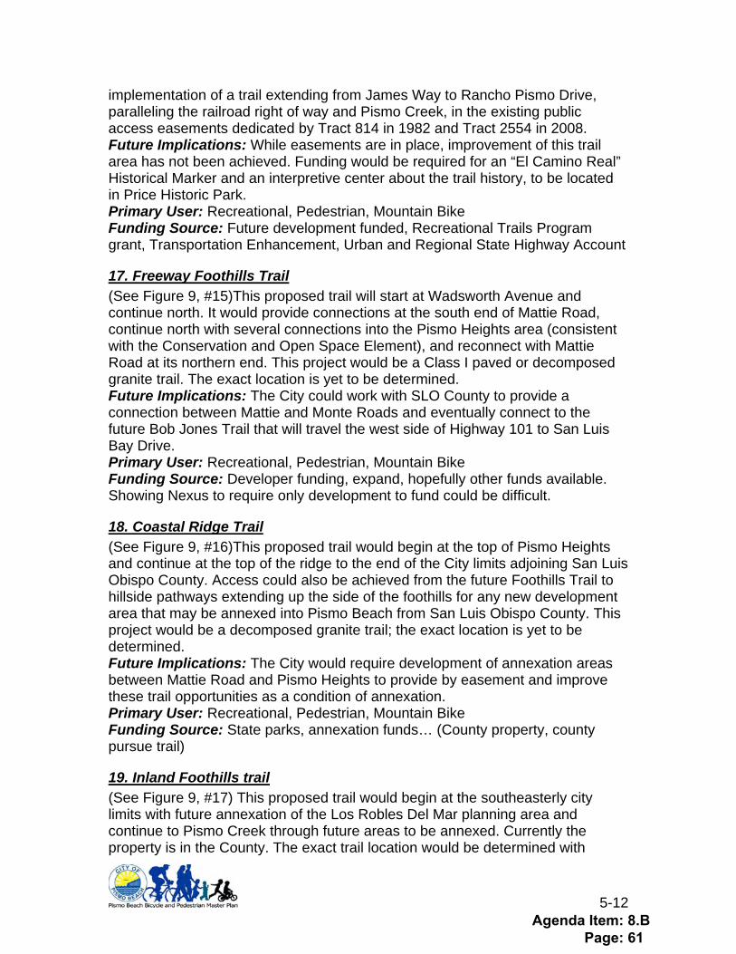
Figure 10 below shows where short-term bike parking could be located. Locations were chosen based on proximity to shops, availability (or lack of) car parking, and observed needs. In addition to the locations shown below, Policy BP-4 states that short-term bike parking will be included in new developments at 1 parking space per multifamily residential unit, and 1 bike parking space per 10 car spaces for all other uses. Additionally Policy BP-10 states that all Park and Ride and regional transit facilities will have both long and short term bike parking. Potential new parking locations include all parks, trailheads, commercial locations with limited car parking, and commercial locations with large car parking facilities and minimal to no bike parking.
Agenda Item: 8.B Page: 62
5-14
Figure 9: Proposed Bicycle Parking Facilities
Agenda Item: 8.B Page: 63

5-15
Figure 10: Full Bicycle Network
Agenda Item: 8.B Page: 64
5-16
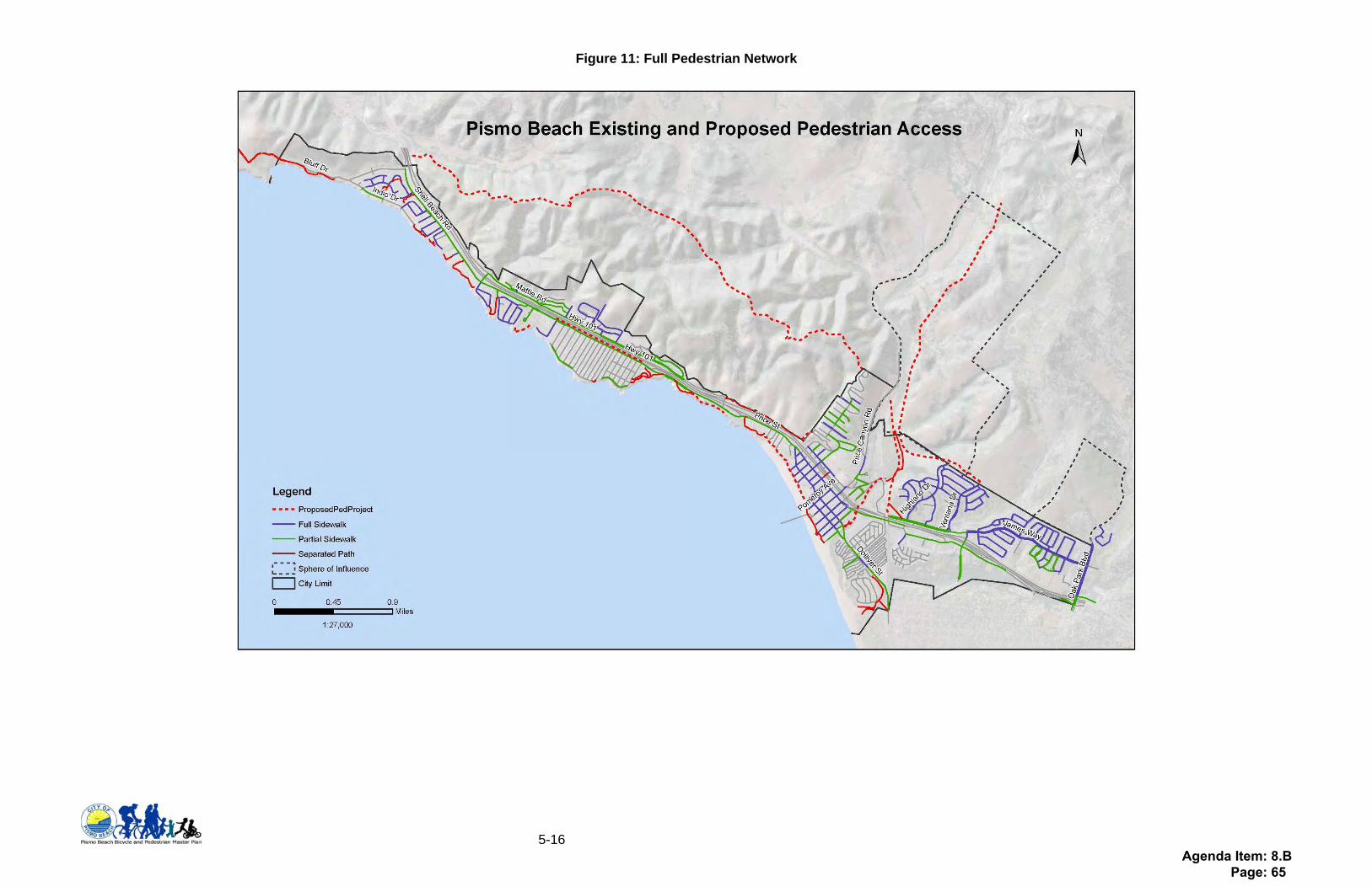
Figure 11: Full Pedestrian Network
Agenda Item: 8.B Page: 65
A-1
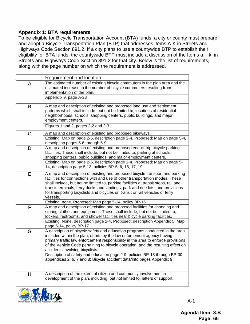
Appendix 1: BTA requirements To be eligible for Bicycle Transportation Account (BTA) funds, a city or county must prepare and adopt a Bicycle Transportation Plan (BTP) that addresses items A-K in Streets and Highways Code Section 891.2. If a city plans to use a countywide BTP to establish their eligibility for BTA funds, the countywide BTP must include a discussion of the Items a. - k. in Streets and Highways Code Section 891.2 for that city. Below is the list of requirements, along with the page number on which the requirement is addressed.
Requirement and location The estimated number of existing bicycle commuters in the plan area and the estimated increase in the number of bicycle commuters resulting from implementation of the plan.
A
Appendix 9, page A-23
A map and description of existing and proposed land use and settlement patterns which shall include, but not be limited to, locations of residential neighborhoods, schools, shopping centers, public buildings, and major employment centers.
B
Figures 1 and 2, pages 2-2 and 2-3
A map and description of existing and proposed bikeways. C Existing: Map on page 2-5, description page 2-4. Proposed: Map on page 5-4, description pages 5-6 through 5-9. A map and description of existing and proposed end-of-trip bicycle parking facilities. These shall include, but not be limited to, parking at schools, shopping centers, public buildings, and major employment centers.
D
Existing: Map on page 2-6, description page 2-4. Proposed: Map on page 5-14, description page 5-13, policies BP-5, 6, 16, 17, 19
A map and description of existing and proposed bicycle transport and parking facilities for connections with and use of other transportation modes. These shall include, but not be limited to, parking facilities at transit stops, rail and transit terminals, ferry docks and landings, park and ride lots, and provisions for transporting bicyclists and bicycles on transit or rail vehicles or ferry vessels.
E
Existing: none. Proposed: Map page 5-14, policy BP-16 A map and description of existing and proposed facilities for changing and storing clothes and equipment. These shall include, but not be limited to, lockers, restrooms, and shower facilities near bicycle parking facilities.
F
Existing: None, description page 2-4. Proposed: description Appendix 5, Map page 5-14, policy BP-17 A description of bicycle safety and education programs conducted in the area included within the plan, efforts by the law enforcement agency having primary traffic law enforcement responsibility in the area to enforce provisions of the Vehicle Code pertaining to bicycle operation, and the resulting effect on accidents involving bicyclists.
G
Description of safety and education page 2-9, policies BP-18 through BP-30, appendices 2, 6, 7 and 8; Bicycle accident data/info pages Appendix 9
H A description of the extent of citizen and community involvement in development of the plan, including, but not limited to, letters of support.
Agenda Item: 8.B Page: 66
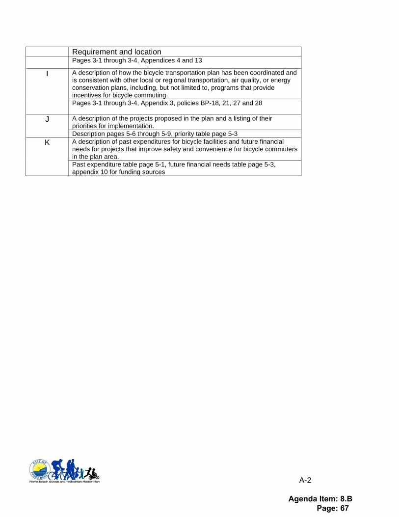
A-2
Requirement and location Pages 3-1 through 3-4, Appendices 4 and 13
A description of how the bicycle transportation plan has been coordinated and is consistent with other local or regional transportation, air quality, or energy conservation plans, including, but not limited to, programs that provide incentives for bicycle commuting.
I
Pages 3-1 through 3-4, Appendix 3, policies BP-18, 21, 27 and 28
A description of the projects proposed in the plan and a listing of their priorities for implementation.
J
Description pages 5-6 through 5-9, priority table page 5-3 A description of past expenditures for bicycle facilities and future financial needs for projects that improve safety and convenience for bicycle commuters in the plan area.
K
Past expenditure table page 5-1, future financial needs table page 5-3, appendix 10 for funding sources
Agenda Item: 8.B Page: 67
A-3
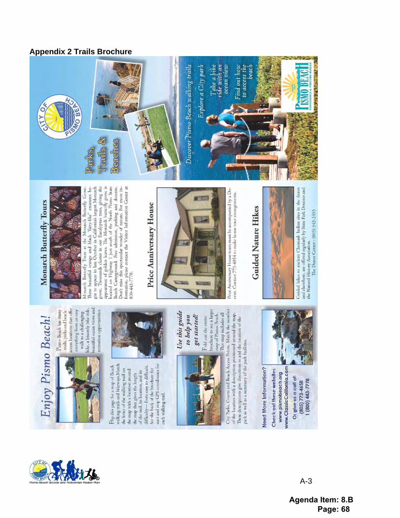
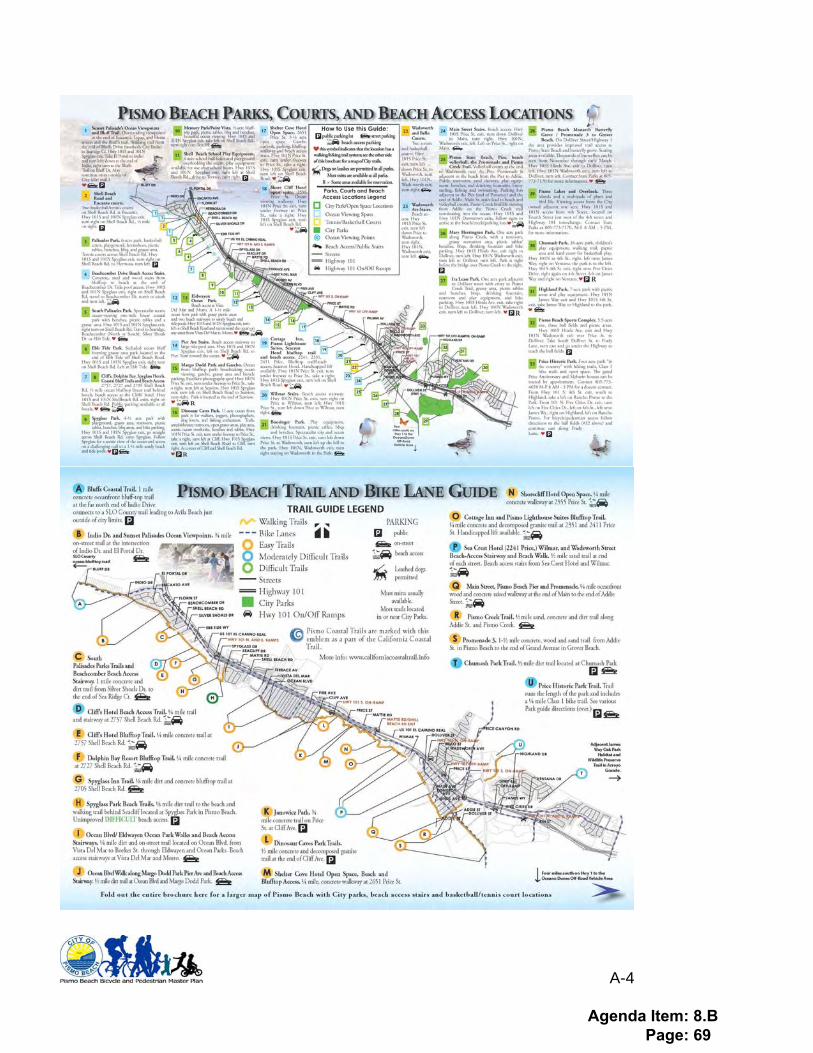
Appendix 2 Trails Brochure
Agenda Item: 8.B Page: 68
A-4
Agenda Item: 8.B Page: 69

A-5
Appendix 3 Relationship to Other Plans Policies This plan is concurrent with the goals and policies of other areas plans, including: 2005 San Luis Obispo County Regional Transportation Plan (Vision 2025)
• NM-1: Create and maintain a comprehensive interconnected, inter-county bikeway, trail and pedestrian system.
• NM-3: Pursue plans to develop multi-use and Class I bikeways along appropriate coastal frontages, and other major recreational areas using utility, rail, and roadway Rights-of-Way and abandoned railroad right-of-way throughout the region.
• NM-4: Encourage the development of Class I Bikeways that travel through or connect to scenic areas or other recreation destinations.
• NM-5: Encourage the development of boardwalks, recreation and multi use trails, which travel through or connect scenic areas or other destinations to promote walking and equestrian travel where appropriate.
• NM-7: Encourage new development proposals to include bike racks, lockers, showers, Bike and Ride stops and safe interconnected pedestrian paths.
2001 San Luis Obispo County Air Pollution Control District: Clean Air Plan recommends several methods to options to reduce air pollution associated with vehicular travel:
• T-1C: Voluntary Commute Options Program • T-2A: City Transit Improvements • T-2B: Regional Transit • T-3: Bicycling and Bikeway Enhancements • T-4: Park and Ride Lots
Trail and Path Connections This plan addresses connectivity with bicycle and pedestrian facilities in the following plans:
• San Luis Obispo County Regional Transportation Plan (Vision 2025) Chapter 5, Non-Motorized Transportation identifies regionally significant pedestrian and bikeways that have segments in the City of Pismo Beach:
o Railroad Class I Multi-Use Path from SLO City to Oceano o Pismo Creek Pedestrian and Bike Trail from Dolliver Street to Price House o Pismo Pedestrian Promenade from Pier to Main Street
• San Luis Obispo County Bikeway Plan identifies bikeways adjacent to Pismo in Avila
Beach o Class II on Avila Beach Drive from Avila Village to Ontario Road (North of
Pismo Beach) o Class II bikeways on Price Canyon Road, west of Pismo Beach
Agenda Item: 8.B Page: 70

A-6
• San Luis Obispo County Parks and Open Space Element identifies the following trails (with segments in or adjacent to Pismo Beach) within the “San Luis Bay Planning Area”:
o Price Canyon Natural Area o California Coastal Trail o De Anza Trail o Cave Landing Trail (In Avila Planning Area): connects to Pismo Beach Bluffs
Trail within Pismo Beach City Limits
• Arroyo Grande Bikeway Plan identifies the following bikeways that are adjacent to Pismo Beach:
o Class II Bikeways on James Way from Oak Park (Pismo Beach City limits) to Tally Ho Road
o Class II Bikeways on Oak Park Boulevard, adjacent to Pismo Beach.
• Grover Beach Circulation Element identifies the following bike/pedestrian facilities: o Class II Bikeways on North 4th Street from Pismo Beach City limits to Grand
Avenue o Class II Bikeways on Grand Avenue o Multi-use trail along Railroad from Pismo City limits to Oceano
Agenda Item: 8.B Page: 71
A-7
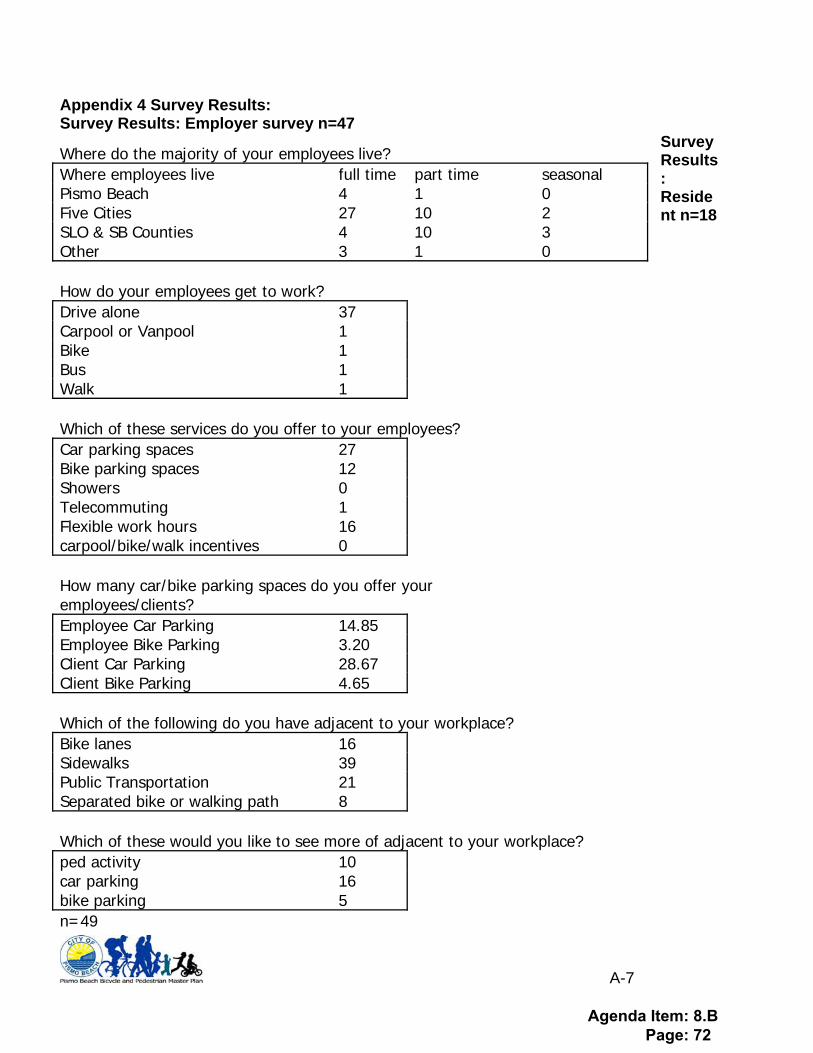
Appendix 4 Survey Results: Survey Results: Employer survey n=47
Survey Results: Resident n=18
Where do the majority of your employees live? Where employees live full time part time seasonal Pismo Beach 4 1 0 Five Cities 27 10 2 SLO & SB Counties 4 10 3 Other 3 1 0 How do your employees get to work? Drive alone 37 Carpool or Vanpool 1 Bike 1 Bus 1 Walk 1 Which of these services do you offer to your employees? Car parking spaces 27 Bike parking spaces 12 Showers 0 Telecommuting 1 Flexible work hours 16 carpool/bike/walk incentives 0 How many car/bike parking spaces do you offer your employees/clients? Employee Car Parking 14.85 Employee Bike Parking 3.20 Client Car Parking 28.67 Client Bike Parking 4.65 Which of the following do you have adjacent to your workplace? Bike lanes 16 Sidewalks 39 Public Transportation 21 Separated bike or walking path 8 Which of these would you like to see more of adjacent to your workplace? ped activity 10 car parking 16 bike parking 5 n=49
Agenda Item: 8.B Page: 72
A-8
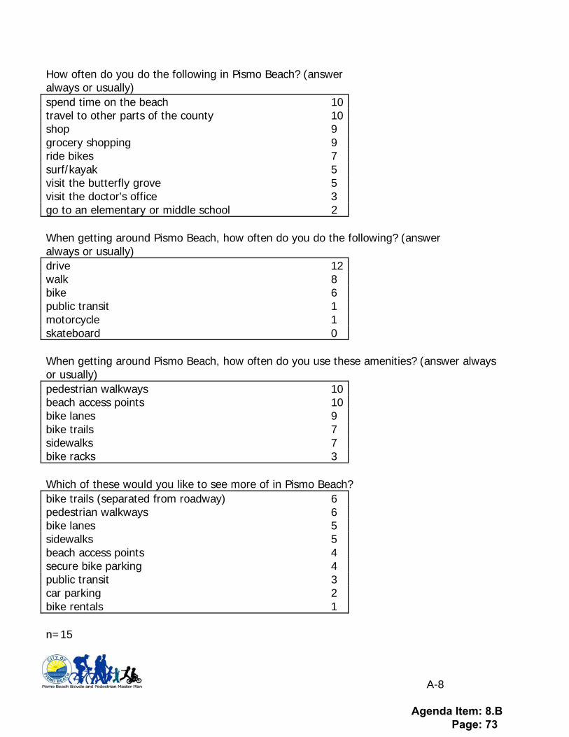
How often do you do the following in Pismo Beach? (answer always or usually) spend time on the beach 10 travel to other parts of the county 10 shop 9 grocery shopping 9 ride bikes 7 surf/kayak 5 visit the butterfly grove 5 visit the doctor's office 3 go to an elementary or middle school 2 When getting around Pismo Beach, how often do you do the following? (answer always or usually) drive 12 walk 8 bike 6 public transit 1 motorcycle 1 skateboard 0 When getting around Pismo Beach, how often do you use these amenities? (answer always or usually) pedestrian walkways 10 beach access points 10 bike lanes 9 bike trails 7 sidewalks 7 bike racks 3 Which of these would you like to see more of in Pismo Beach? bike trails (separated from roadway) 6 pedestrian walkways 6 bike lanes 5 sidewalks 5 beach access points 4 secure bike parking 4 public transit 3 car parking 2 bike rentals 1 n=15
Agenda Item: 8.B Page: 73
A-9
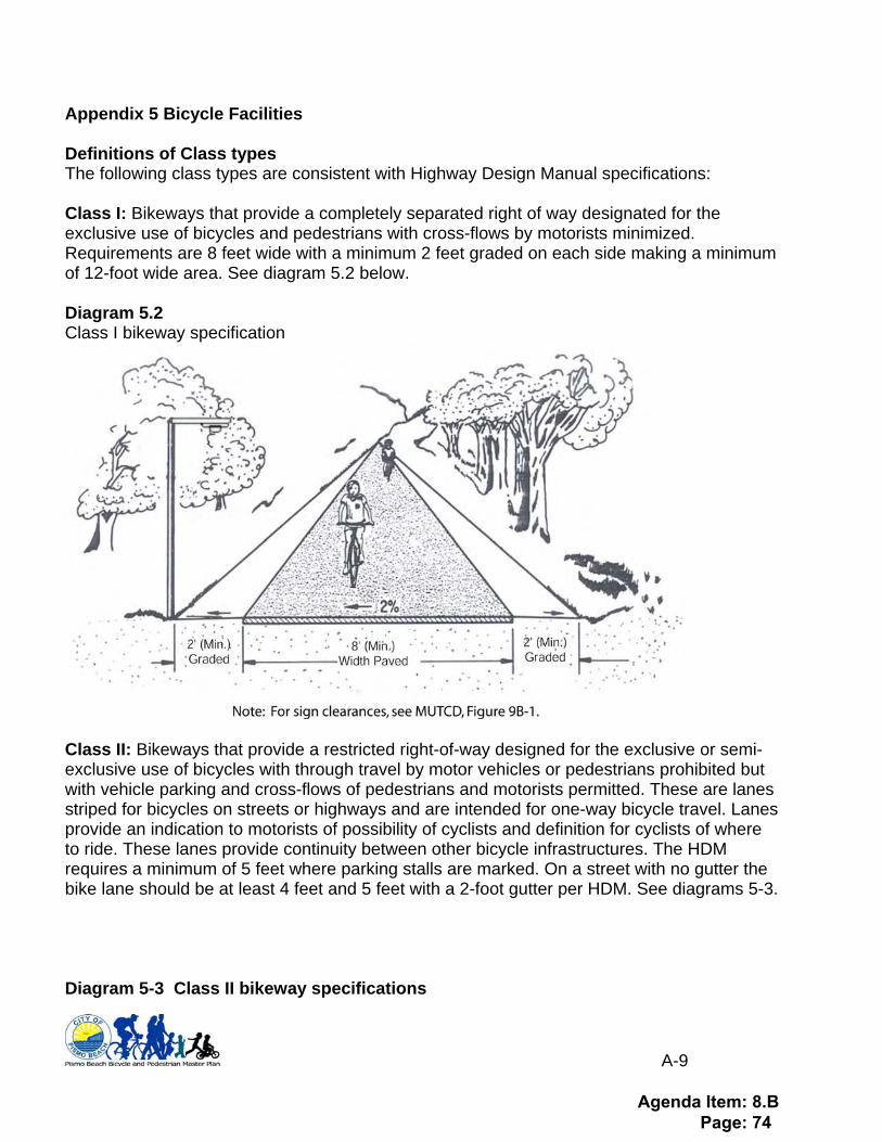
Appendix 5 Bicycle Facilities Definitions of Class types The following class types are consistent with Highway Design Manual specifications: Class I: Bikeways that provide a completely separated right of way designated for the exclusive use of bicycles and pedestrians with cross-flows by motorists minimized. Requirements are 8 feet wide with a minimum 2 feet graded on each side making a minimum of 12-foot wide area. See diagram 5.2 below. Diagram 5.2 Class I bikeway specification
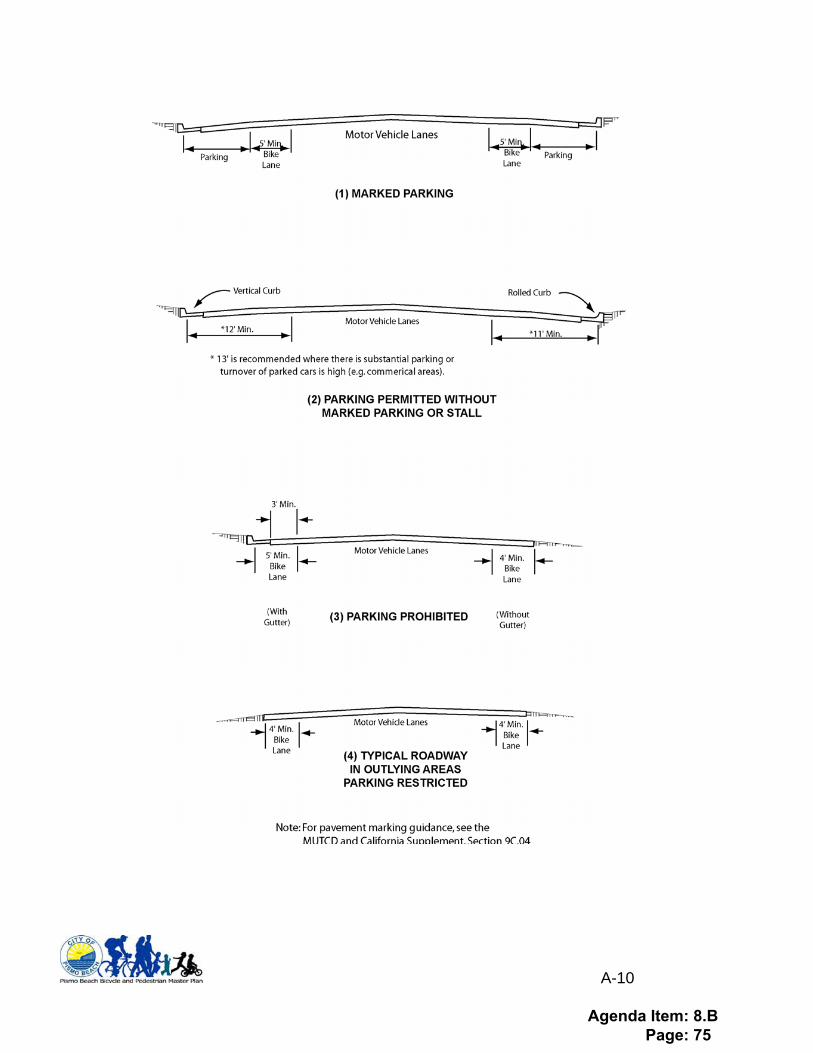
Class II: Bikeways that provide a restricted right-of-way designed for the exclusive or semi-exclusive use of bicycles with through travel by motor vehicles or pedestrians prohibited but with vehicle parking and cross-flows of pedestrians and motorists permitted. These are lanes striped for bicycles on streets or highways and are intended for one-way bicycle travel. Lanes provide an indication to motorists of possibility of cyclists and definition for cyclists of where to ride. These lanes provide continuity between other bicycle infrastructures. The HDM requires a minimum of 5 feet where parking stalls are marked. On a street with no gutter the bike lane should be at least 4 feet and 5 feet with a 2-foot gutter per HDM. See diagrams 5-3. Diagram 5-3 Class II bikeway specifications
Agenda Item: 8.B Page: 74
A-10
Agenda Item: 8.B Page: 75

A-11
Class III: Bikeways that provide a right-of-way designated by signs or permanent markings and shared with pedestrians or motorists. These are usually preferred routes due to advantages over other routes such as high traffic or poor road surface. Sidewalks are not recommended for Class III bikeways. Signage options shown in diagram 5-7 include: Diagram 5-7 Class III bikeway signage specifications
Bicycle Boulevard: A roadway shared with automobiles and bicycles similar to Class III although through traffic preference is given to bicyclists. Example might be pilings at cross streets that allow bicycle traffic to flow while automobile traffic is diverted.
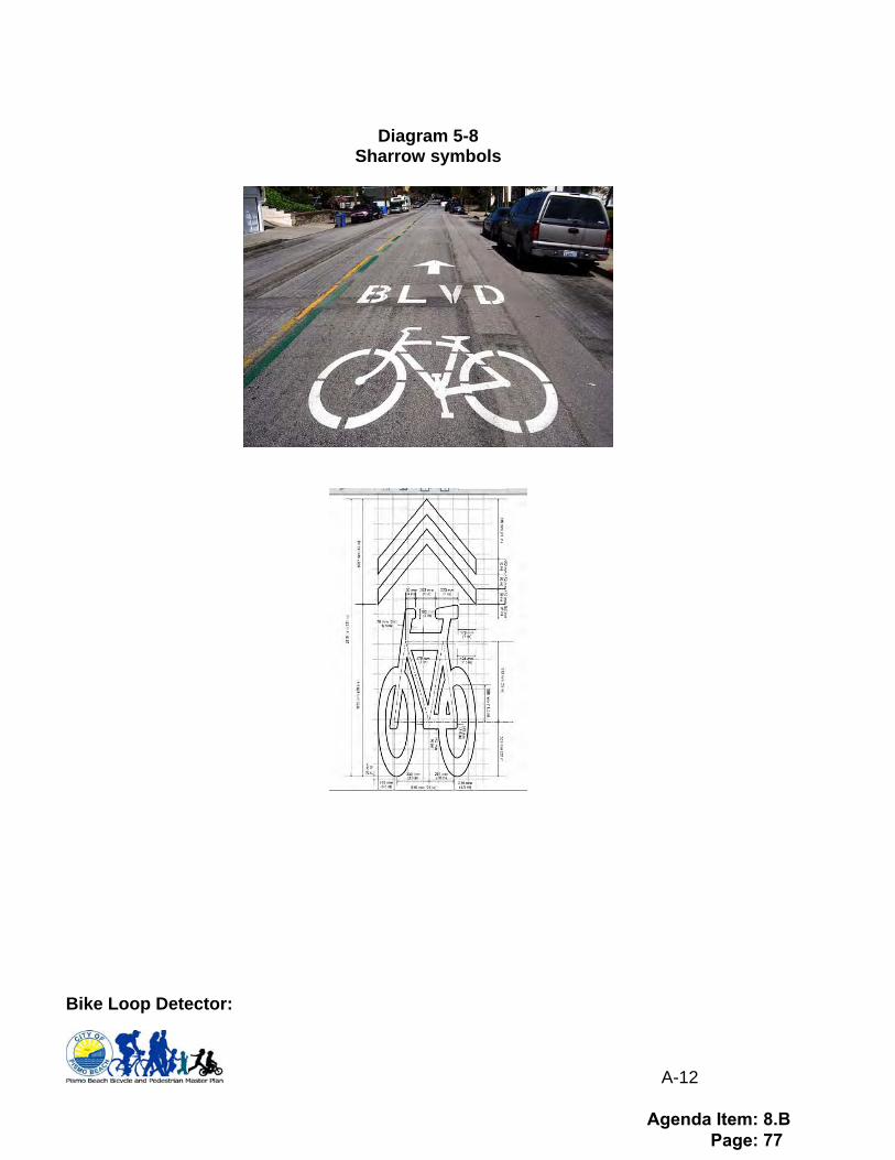
Sharrows: As noted in diagram 5-8 below, a Sharrow represents a roadway shared with automobiles where there is insufficient width for a striped bike lane. SHARROWS, also known as shared lane markings, are on-street legends that reinforce the existing rules of the road. They are not separate bike lanes: a motorist can still drive over the sharrows. Motorists should expect to see and share the lane with bicyclists. Sharrows indicate to bicyclists the best place to ride in the lane. Sharrows are typically used in locations where the roadway width is not adequate to provide dedicated bike facilities or on downhill lanes where bicyclists might travel similar speed as motor vehicles.
Agenda Item: 8.B Page: 76
A-12
Diagram 5-8
Sharrow symbols
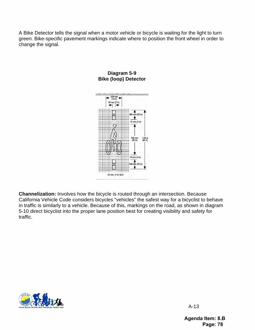
Bike Loop Detector:
Agenda Item: 8.B Page: 77
A-13
A Bike Detector tells the signal when a motor vehicle or bicycle is waiting for the light to turn green. Bike-specific pavement markings indicate where to position the front wheel in order to change the signal.
Diagram 5-9 Bike (loop) Detector
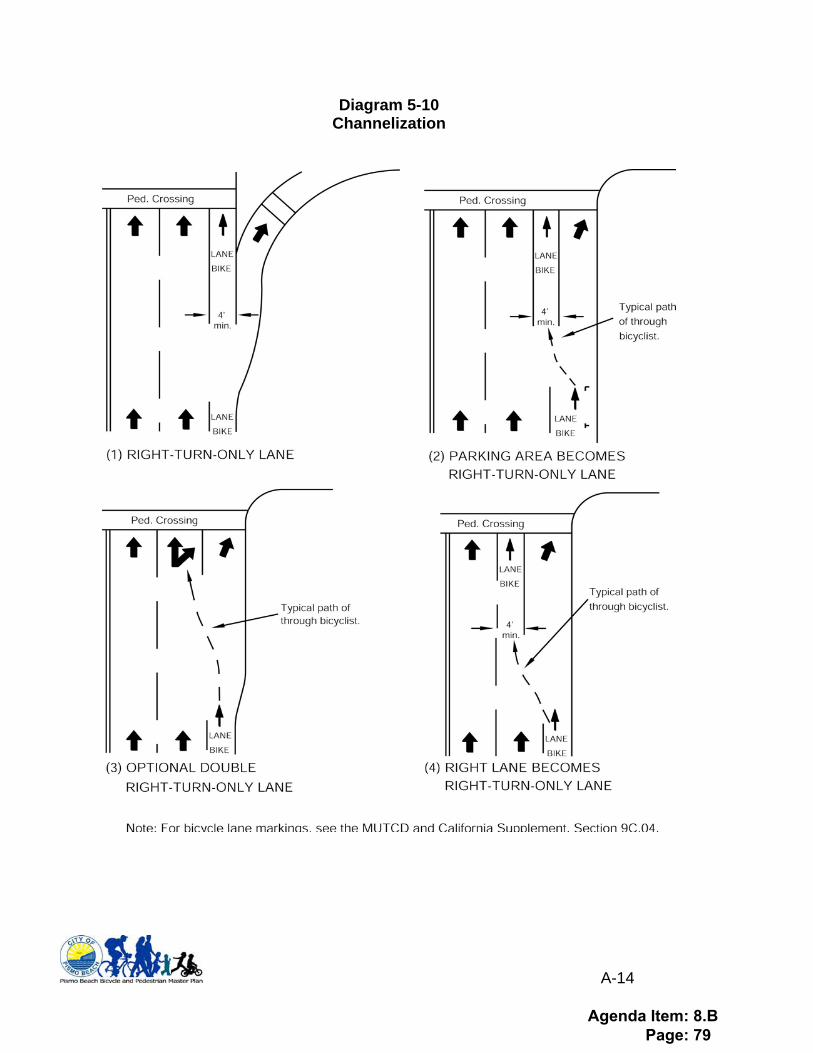
Channelization: Involves how the bicycle is routed through an intersection. Because California Vehicle Code considers bicycles “vehicles” the safest way for a bicyclist to behave in traffic is similarly to a vehicle. Because of this, markings on the road, as shown in diagram 5-10 direct bicyclist into the proper lane position best for creating visibility and safety for traffic.
Agenda Item: 8.B Page: 78
A-14
Diagram 5-10 Channelization
Agenda Item: 8.B Page: 79
A-15
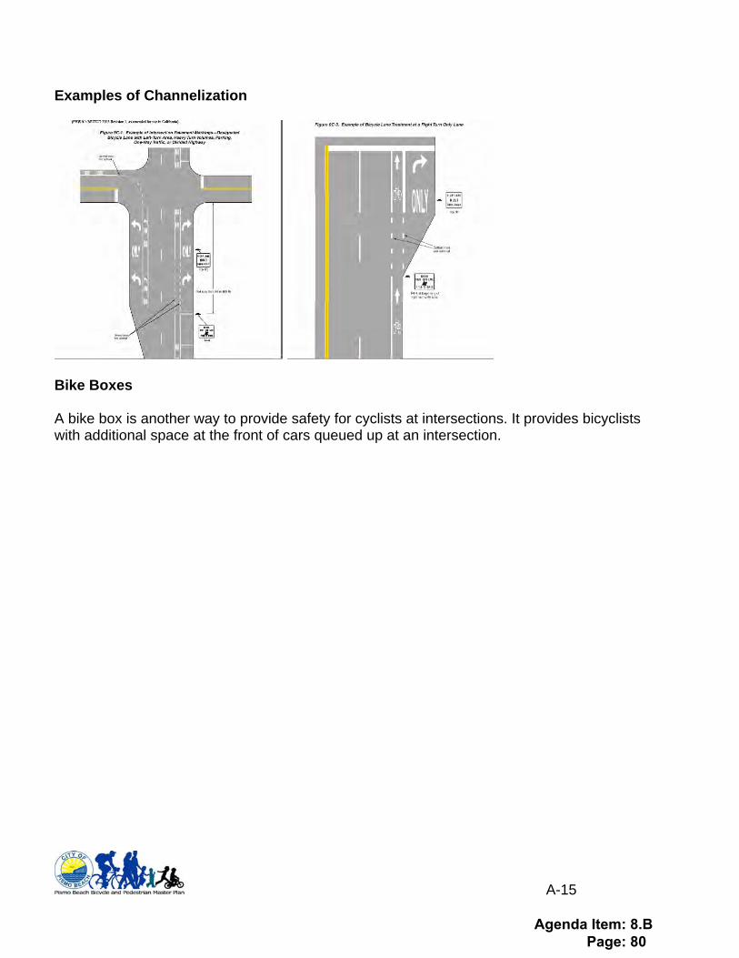
Examples of Channelization
Bike Boxes A bike box is another way to provide safety for cyclists at intersections. It provides bicyclists with additional space at the front of cars queued up at an intersection.
Agenda Item: 8.B Page: 80

A-16
Short Term Bike Parking: Short term parking includes racks on sidewalks, in parking lots, and at special events. Below in diagram 5-11 are examples of racks. Appendix 6 shows a “racks with plaques” program that can be used to increase public bike parking at minimal cost to the City. Bike valet (special event parking) is shown in Appendix 7.
Diagram/photo 5-11 Bike Rack
Inverted U-rack
This rack type is NOT recommended
Agenda Item: 8.B Page: 81
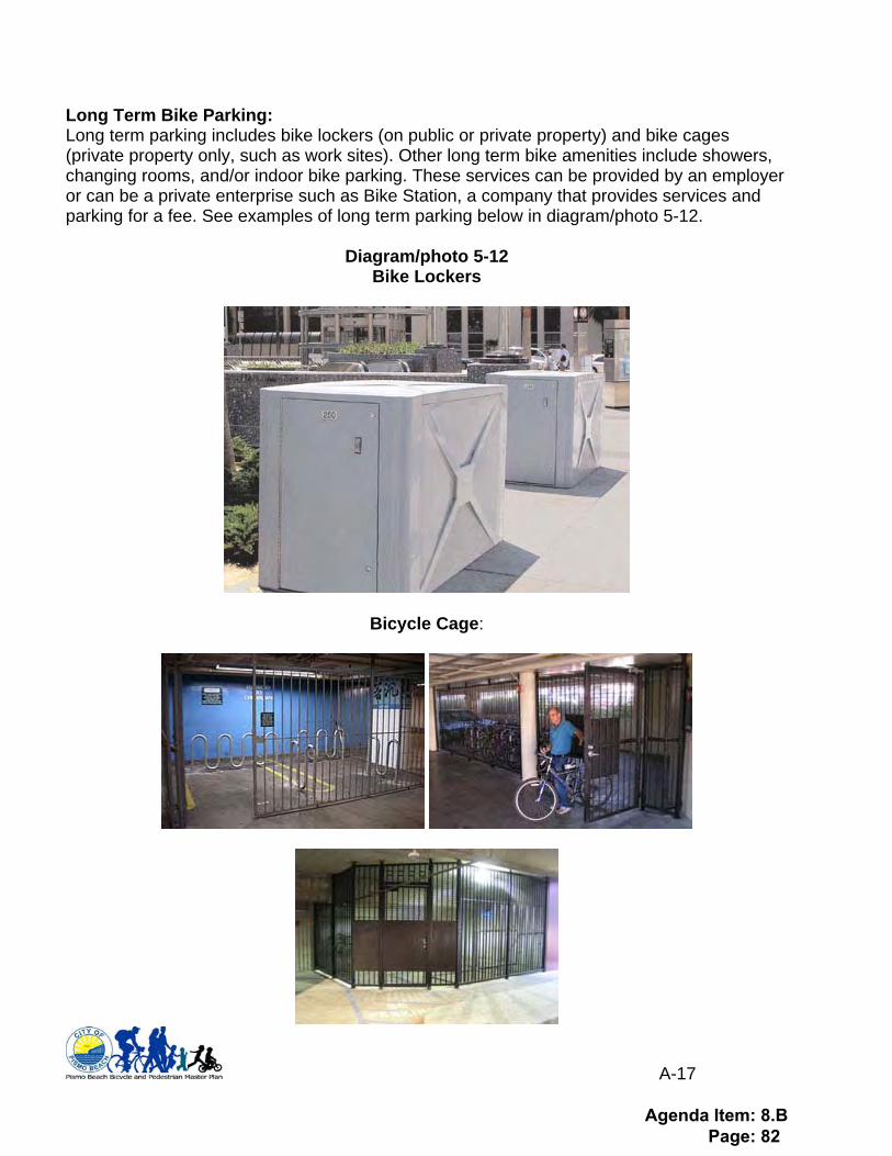
A-17
Long Term Bike Parking: Long term parking includes bike lockers (on public or private property) and bike cages (private property only, such as work sites). Other long term bike amenities include showers, changing rooms, and/or indoor bike parking. These services can be provided by an employer or can be a private enterprise such as Bike Station, a company that provides services and parking for a fee. See examples of long term parking below in diagram/photo 5-12.
Diagram/photo 5-12 Bike Lockers
Bicycle Cage:
Agenda Item: 8.B Page: 82
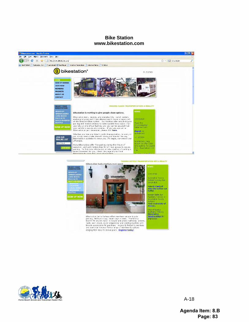
A-18
Bike Station
www.bikestation.com
Agenda Item: 8.B Page: 83
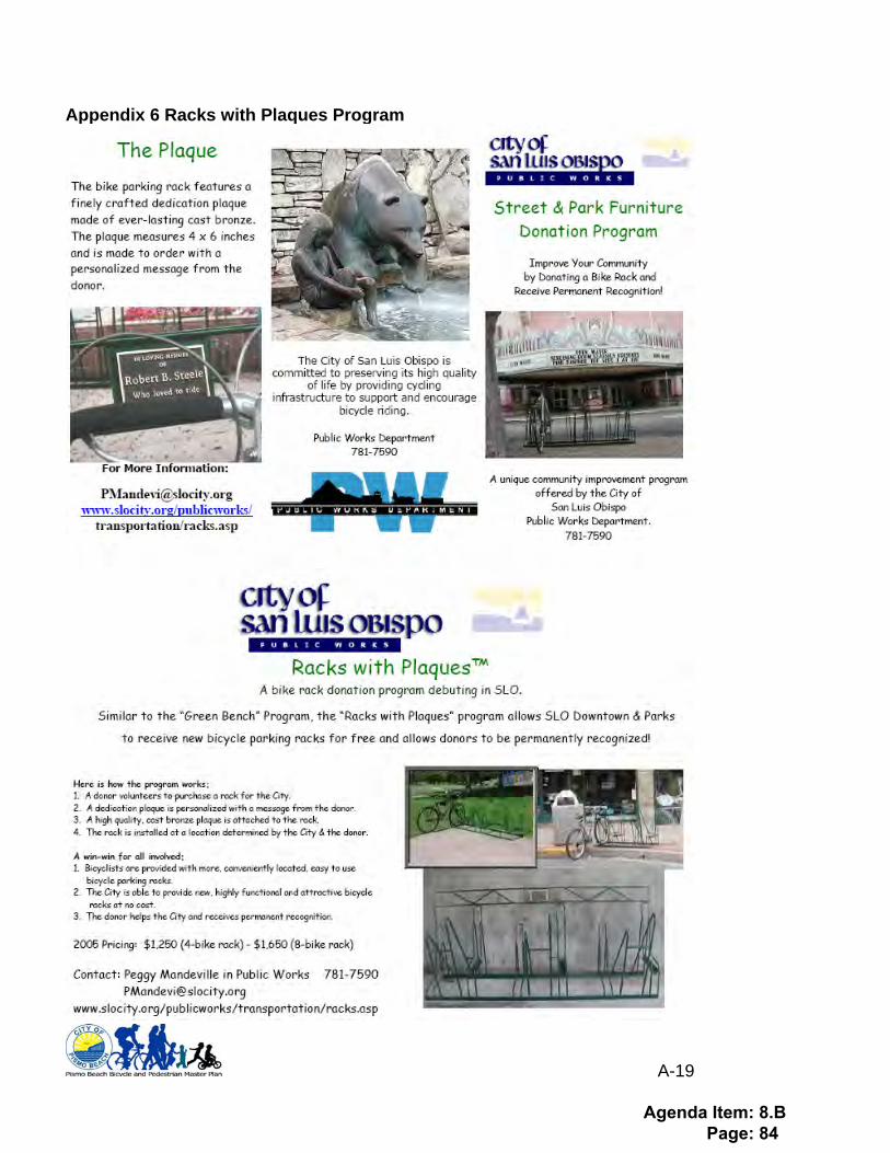
A-19
Appendix 6 Racks with Plaques Program
Agenda Item: 8.B Page: 84
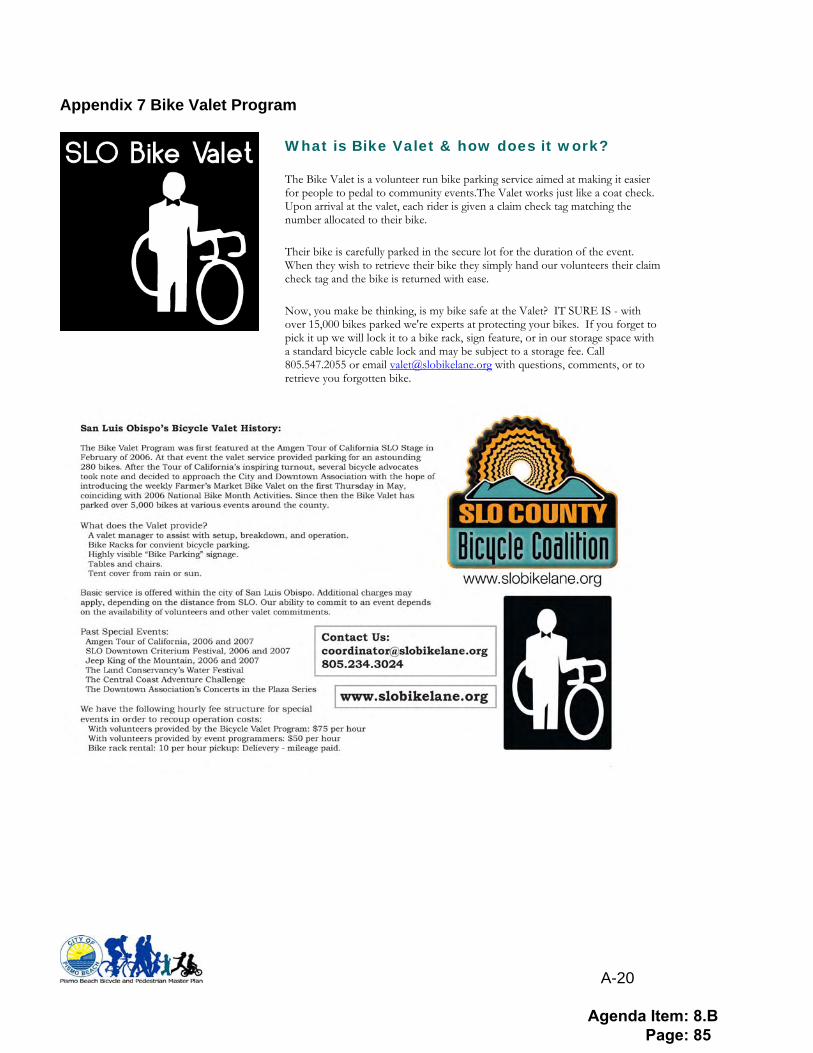
A-20
Appendix 7 Bike Valet Program
What is Bike Valet & how does it work?
The Bike Valet is a volunteer run bike parking service aimed at making it easier for people to pedal to community events.The Valet works just like a coat check. Upon arrival at the valet, each rider is given a claim check tag matching the number allocated to their bike.
Their bike is carefully parked in the secure lot for the duration of the event. When they wish to retrieve their bike they simply hand our volunteers their claim check tag and the bike is returned with ease.
Now, you make be thinking, is my bike safe at the Valet? IT SURE IS - with over 15,000 bikes parked we're experts at protecting your bikes. If you forget to pick it up we will lock it to a bike rack, sign feature, or in our storage space with a standard bicycle cable lock and may be subject to a storage fee. Call 805.547.2055 or email [email protected] with questions, comments, or to retrieve you forgotten bike.
Agenda Item: 8.B Page: 85
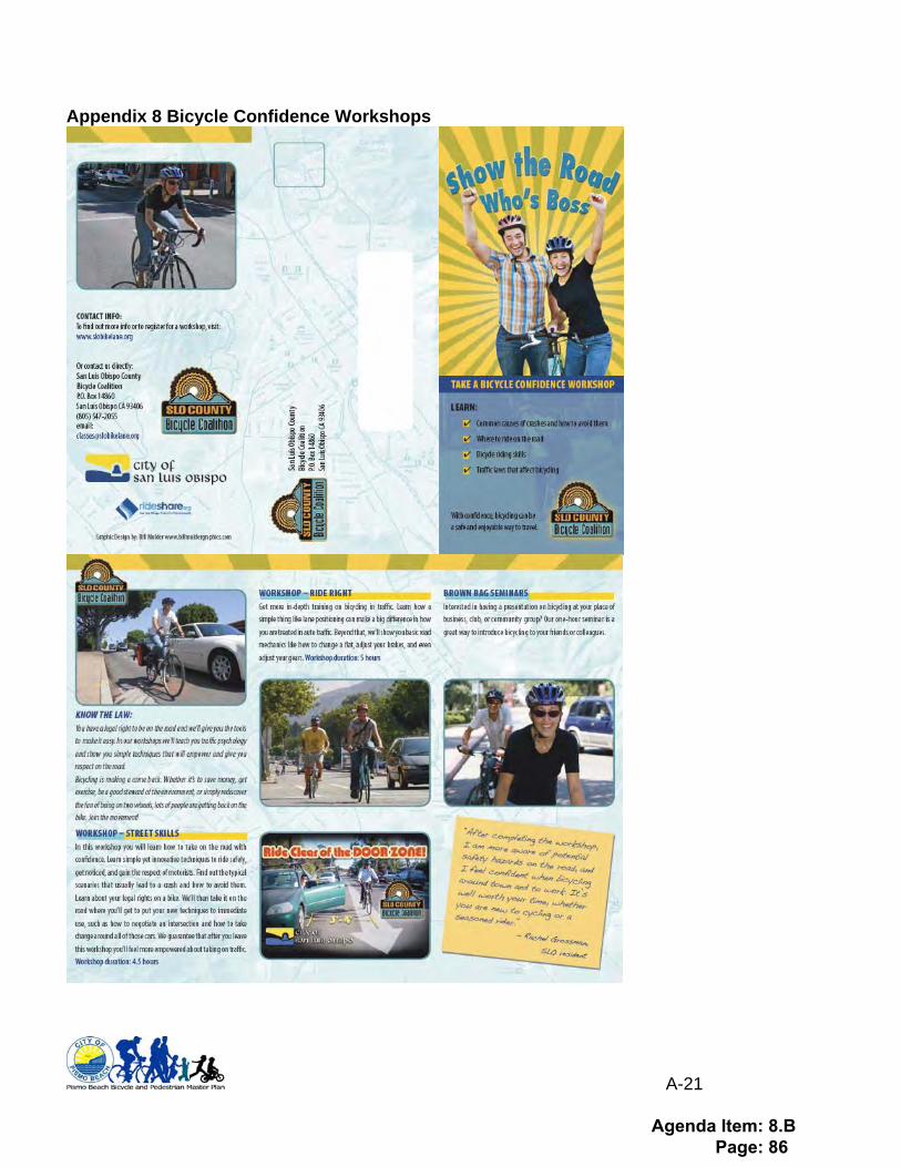
A-21
Appendix 8 Bicycle Confidence Workshops
Agenda Item: 8.B Page: 86
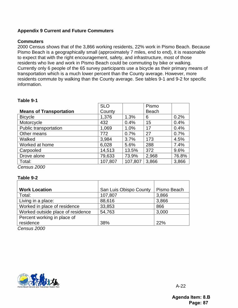
A-22
Appendix 9 Current and Future Commuters Commuters 2000 Census shows that of the 3,866 working residents, 22% work in Pismo Beach. Because Pismo Beach is a geographically small (approximately 7 miles, end to end), it is reasonable to expect that with the right encouragement, safety, and infrastructure, most of those residents who live and work in Pismo Beach could be commuting by bike or walking. Currently only 6 people of the 65 survey participants use a bicycle as their primary means of transportation which is a much lower percent than the County average. However, more residents commute by walking than the County average. See tables 9-1 and 9-2 for specific information. Table 9-1
Means of Transportation SLO County
Pismo Beach
Bicycle 1,376 1.3% 6 0.2% Motorcycle 432 0.4% 15 0.4% Public transportation 1,069 1.0% 17 0.4% Other means 772 0.7% 27 0.7% Walked 3,984 3.7% 173 4.5% Worked at home 6,028 5.6% 288 7.4% Carpooled 14,513 13.5% 372 9.6% Drove alone 79,633 73.9% 2,968 76.8% Total: 107,807 107,807 3,866 3,866
Census 2000 Table 9-2
Work Location San Luis Obispo County Pismo Beach Total: 107,807 3,866 Living in a place: 88,616 3,866 Worked in place of residence 33,853 866 Worked outside place of residence 54,763 3,000 Percent working in place of residence 38% 22%
Census 2000
Agenda Item: 8.B Page: 87
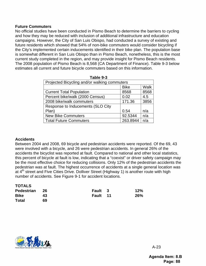
A-23
Future Commuters No official studies have been conducted in Pismo Beach to determine the barriers to cycling and how they may be reduced with inclusion of additional infrastructure and education campaigns. However, the City of San Luis Obispo, had conducted a survey of existing and future residents which showed that 54% of non-bike commuters would consider bicycling if the City’s implemented certain inducements identified in their bike plan. The population base is somewhat different in San Luis Obispo than in Pismo Beach, nonetheless, this is the most current study completed in the region, and may provide insight for Pismo Beach residents. The 2008 population of Pismo Beach is 8,568 (CA Department of Finance). Table 9-3 below estimates all current and future bicycle commuters based on this information.
Table 9-3 Projected Bicycling and/or walking commuters Bike Walk Current Total Population 8568 8568 Percent bike/walk (2000 Census) 0.02 4.5 2008 bike/walk commuters 171.36 3856 Response to Inducements (SLO City Plan) 0.54 n/a New Bike Commuters 92.5344 n/a Total Future Commuters 263.8944 n/a
Accidents Between 2004 and 2008, 69 bicycle and pedestrian accidents were reported. Of the 69, 43 were involved with a bicycle, and 26 were pedestrian accidents. In general 26% of the accidents the bicyclist was reported at fault. Compared to national and other local statistics, this percent of bicycle at fault is low, indicating that a “coexist” or driver safety campaign may be the most effective choice for reducing collisions. Only 12% of the pedestrian accidents the pedestrian was at fault. The highest occurrence of accidents at a single general location was at 4th street and Five Cities Drive. Dolliver Street (Highway 1) is another route with high number of accidents. See Figure 9-1 for accident locations. TOTALS Pedestrian 26 Fault 3 12% Bike 43 Fault 11 26% Total 69
Agenda Item: 8.B Page: 88
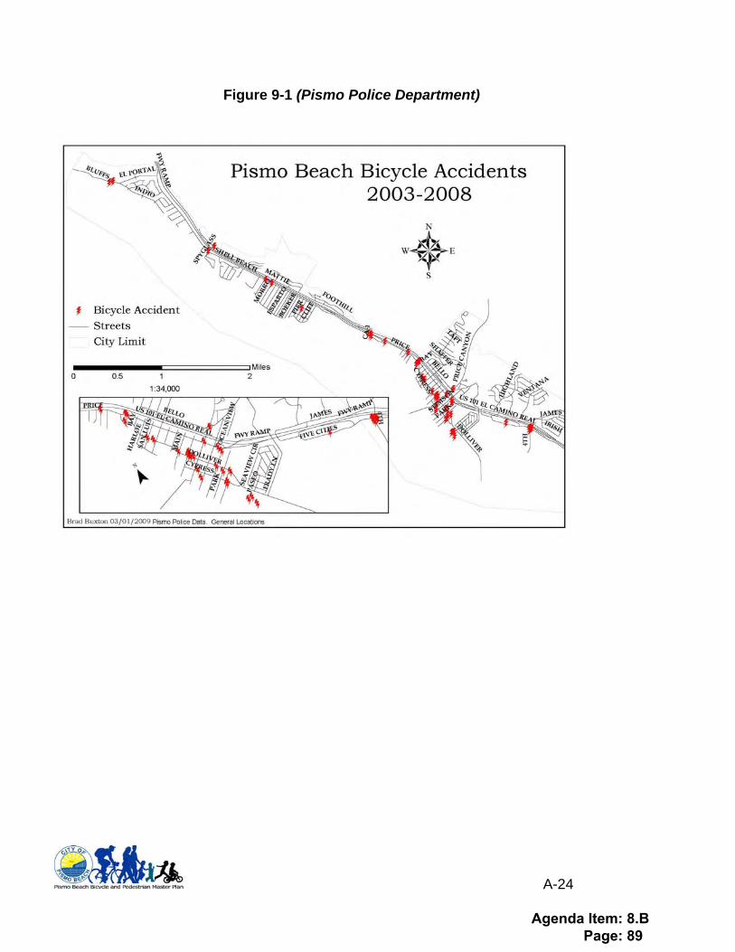
A-24
Figure 9-1 (Pismo Police Department)
Agenda Item: 8.B Page: 89

A-25
Appendix 10 Bike project funding sources Federal Transportation Enhancement Activities (TE)
• Interregional Transportation Improvement Program (ITIP-TE)5 • Regional Improvement Program (STIP-TE)
Transportation Enhancements (TE) activities are federally funded community-based projects that expand travel choices and enhance the transportation experience by improving the cultural, historic, aesthetic and environmental aspects of our transportation infrastructure. The Transportation Enhancements program was created in 1991 as Congress sought ways to offset negative effects of highway construction projects, such as fragmented communities and the loss of open space. SAFETEA-LU significantly increased the amount of money dedicated to the program through 2009. A negligible increase is assumed with the future reauthorization of SAFETEA-LU. The program is managed by state transportation agencies. Each state must set aside ten percent of its Surface Transportation Program funds for use on TE activities. SLOCOG has typically programmed 5%-10% of its regular STIP shares for transportation enhancement projects as well. TE projects are considered federal-aid reimbursement activities, which mean that sponsors receive funding after expenditures have been made. In most cases, the federal government pays 80% of the project cost, and the project sponsor is responsible for the remaining 20%. Current regulations permit other federal funds and in-kind contributions to be counted as match. The TE funding program is directed to community-based activities, such as bicycle facilities, historic preservation, land acquisition, environmental mitigation, corridor enhancements, and scenic protection. This revenue stream is allocated to the region on a formula basis. Project Eligibility: Federal Transportation Enhancement funds are to be used for transportation-related capital improvement projects that enhance quality-of-life, in or around transportation facilities. Projects must be over and above normal transportation projects and required mitigation, and the project must be directly related to the surface transportation system. The projects should have a quality-of-life benefit while providing the greatest benefit to the greatest number of people. Projects must be within the following twelve categories: 1. Provision of facilities for pedestrians and bicycles 2. Provision of safety and educational activities for pedestrians and bicyclists 3. Acquisition of scenic easements and scenic/historic sites 4. Scenic or historic highway programs (including the provisions of tourist and welcome
center facilities) 5. Landscaping and other scenic beautification 6. Historic preservation 7. Rehabilitation of historic transportation facilities (including historic railroad facilities and
canals)
5 Administered by Caltrans on State owned and operated facilities
Agenda Item: 8.B Page: 90
A-26
8. Preservation of abandoned railway corridor (including the conversion and use thereof for pedestrian or bicycle trails)
9. Control and removal of outdoor advertising 10. Archaeological planning and research 11. Environmental mitigation to address water pollution due to highway runoff and reduce
vehicle-caused wildlife mortality while maintaining habitat connectivity 12. Establishment of transportation museums The federal criteria have been used exclusively since the California Transportation Commission (CTC) abolished the State Transportation Enhancement Activities (TEA) Program in 2002. For the State’s share, districts are encouraged to add enhancements to regular transportation projects rather than create stand-alone transportation enhancement projects. Administered through SLOCOG, competitive funding is programmed during biannual STIP Programming. Safe Routes to School Program (SRTS) The Safe Routes To School Program (SRTS) is intended to increase the number of children in grades K-8 who walk or bicycle to school by removing the barriers that currently prevent them from doing so. Barriers include lack of infrastructure or inadequate infrastructure that poses a safety hazard, or lack of outreach programs that promote walking/bicycling through education and encouragement for children, parents, and the community. Project Eligibility: Eligible projects fall under the category of infrastructure (capital improvements), or non-infrastructure (education, encouragement, enforcement). Infrastructure projects must be located within a two mile radius of a grade school or middle school. Eligible applicants include state, local and regional agencies. Non-profit organizations, federally-recognized Native American Tribes, school districts, hospitals and public health departments can partner with state, local and regional agencies as their responsible applicants. Administered through Caltrans Local Assistance Competitive Federal funding cycle complete. Status of future funding cycle unknown. Additional information found at: http://www.dot.ca.gov/hq/LocalPrograms/saferoutes/saferoutes.htm Highway Safety Improvement Program (HSIP) This new Highway Safety Improvement Program (HSIP), under SAFETEA-LU, replaces the Hazard Elimination Safety Program (HES). The new program provides a transition period that allows states to fund projects that were eligible under the old HES Program until such time that an annual 5 Percent Report, describing no less than 5 percent of public roadway locations with the most severe safety needs, and a Strategic Highway Safety Plan (SHSP) have been developed and implemented by the State. The intent of HSIP is to significantly reduce public roadway fatalities and serious injuries. The emphasis will be at locations that are data and strategically driven.
Agenda Item: 8.B Page: 91
A-27
Project Eligibility: For a project to be eligible for HSIP funds, the project must be on any public road, publicly owned bicycle, pedestrian pathway, or trail. Projects must identify a specific safety problem that can be corrected or be improved substantially. Administered through Caltrans Local Assistance Competitive grant cycle for 2009 closed October 8, 2009. Additional information for future year applications found at: http://www.dot.ca.gov/hq/LocalPrograms/hsip.htm Recreational Trails The Recreational Trails Program (RTP) provides funds annually for recreational trails and trails-related projects. The RTP is administered at the federal level by the Federal Highway Administration (FHWA). It is administered at the state level by the California Department of Parks and Recreation (DPR). Non-motorized projects are administered by the Department’s Office of Grants and Local Services and motorized projects are administered by the Department’s Off-Highway Motor Vehicle Recreation Division. Competitive funding cycle announced, application deadline was October 1, 2009. Additional information for future applications can be found at: http://www.parks.ca.gov/default.asp?page_id=24324 State State Transportation Improvement Program (STIP) These funds are not historically used for Bicycle specific improvements, except in the case of STIP TE – regional & local projects only (see Fed TE information above) Interregional Transportation Improvement Program (ITIP) These funds are not historically used for bicycle specific improvements, except in the case of ITIP-TE projects. These funds are for Transportation Enhancements of Statewide significance such as the De Anza Trail, Atascadero-Templeton Connector, etc. Transportation Development Act (TDA) As approved by the Legislature in 1971, the Mills-Alquist-Deddeh Act or SB 325 created the Transportation Development Act (TDA). This law provides funding to be allocated to transit and non-transit purposes that comply with Regional Transportation Plans. TDA established two funding sources; the Local Transportation Fund (LTF), and the State Transit Assistance (STA) Fund. Providing certain conditions are met, counties with a population under 500,000 (according to the 1970 Federal census) may also use the LTF for local streets and roads, construction and maintenance. The STA funding can only be used for transportation planning and mass transportation purposes. Project Eligibility: TDA funds a wide variety of transportation programs, including planning and program activities, pedestrian and bicycle facilities, community transit services, public transportation, and bus and rail projects.
Agenda Item: 8.B Page: 92
A-28
State Gas Tax subventions Also known as Highway User Tax Act (HUTA) subventions, Counties currently receive 3.23-cents of the 18-cents gas tax, equal to approximately $500 million annually. These funds are used at the jurisdictions’ discretion for transportation projects, including bike facilities. Current state budget deliberations include proposals that eliminate the local share of Highway User Tax Act (HUTA, also known as Gas Tax) in FY 2009-10 and FY 2010-11. Bicycle Transportation Account (formerly BLA) The Bicycle Transportation Account Program (BTA) provides State funds for city and county projects that improve safety and convenience for bicycle commuters. The Bicycle Facilities Unit (BFU) in the Division of Local Assistance and the District Local Assistance Engineers (DLAE) administer the BTA Program. Program Eligibility: Cities and counties are eligible to apply for BTA funds. To be eligible for BTA funds, a city or county must prepare and adopt a Bicycle Transportation Plan that complies with Streets and Highways Code Section 891.2 and has been approved by the appropriate Regional Transportation Planning Agency and Caltrans. Project Categories BTA projects may include, but are not limited to, the following:
• New bikeways serving major transportation corridors • New bikeways removing travel barriers to potential bicycle commuting • Secure bicycle parking at employment centers, park-and-ride lots, rail and transit
terminals, and ferry docks and landings • Bicycle-carrying facilities on public transit vehicles • Installation of traffic control devices to improve the safety and efficiency of bicycle
travel • Elimination of hazardous conditions on existing bikeways • Planning • Improvement and maintenance of bikeways
Competitive funding Cycle announced in October. Additional information found at: http://www.dot.ca.gov/hq/LocalPrograms/bta/btawebPage.htm Environmental Enhancement and Mitigation Program (EEM) The Environmental Enhancement and Mitigation program was established by the Legislature in 1989. It offers a total of $10 million each year for grants to local, state, and federal governmental agencies and to nonprofit organizations for projects to mitigate the environmental impacts caused by new or modified state transportation facilities. Eligible projects must be directly or indirectly related to the environmental impact of the modification of an existing transportation facility or construction of a new transportation facility. Projects funded under this program must provide environmental enhancement and mitigation over and above that otherwise called for under the California Environmental Quality Act (CEQA). In funding the program, an attempt is made to maintain a 40/60 North/South split between California’s 45 northern and 13 southern counties. Caltrans administers the approved grant agreements, and grants are awarded in three categories:
• Highway Landscape and Urban Forestry -- Projects designed improve air quality through the planting of trees and other suitable plants.
Agenda Item: 8.B Page: 93

A-29
• Resource Lands -- Projects for the acquisition, restoration, or enhancement of watersheds, wildlife habitat, wetlands, forests, or other natural areas.
• Roadside Recreational -- Projects for the acquisition and/or development of roadside recreational opportunities.
Competitive application deadline December 2008, next cycle unknown. Additional information at: http://resources.ca.gov/eem/ Petroleum Violation Escrow Account Grant opportunities from this fund are available through the Bicycle Facilities Unit (BFU) of Caltrans in the form of BTA grants. See that section for greater detail. Office of Traffic Safety Grants (OTS) Competitive Grants issued by the Office of Traffic Safety on a regional/local level. Search for Local grant information on the website at: http://www.ots.ca.gov/Grants/default.asp Safe Routes to School Program (SR2S) Assembly Bill (AB) 1475 (Soto – 1999) called for Caltrans to establish and administer a program to fund bicycle and pedestrian infrastructure improvements for children in grades K-12 using federal transportation funds. Senate Bill (SB) 10 was later enacted to extend the sunset date of the program from January 1, 2002 to January 1, 2005. Subsequently SB1087 was signed by Governor Schwarzenegger to extend the program for three more years. In 2007, AB 57 was enacted which eliminated dedicated funding and required that funds compete against other safety programs in the annual State Budget process. Project Eligibility: To be eligible for SR2S funds, the project must be located on any state highway or on any local road. Projects must correct an identified safety hazard or problem on a route that students use for trips to and from school. Up to 10 percent of the project’s cost can fund a non-infrastructure component that supports the infrastructure project. Only cities and counties are eligible to compete for funds. Competitive funding cycle completed. Status of next funding cycle unknown. Additional information at: http://www.dot.ca.gov/hq/LocalPrograms/saferoutes/saferoutes.htm Local/Regional Traffic Mitigation/Impact Fees These one-time fees may be imposed on new development to pay for fair-share improvements and facilities required to serve it or otherwise reduce the impacts of new development on a community on a regional level. While a number of jurisdictions actively collect local impact fees, to date, regional traffic impact fees have not been pursued within the San Luis Obispo region. General Funds Jurisdictions can use General funds for bikeway improvements as outlined in their Capital Improvement Program.
Agenda Item: 8.B Page: 94
A-30
Sales Tax Increase Local Option Sales tax can be used to improve bikeways, this is up to the Jurisdiction to decide to do, promote, and prioritize funds from. San Luis Obispo, Pismo Beach, Grover Beach, and Morro Bay passed Local Option Sales tax measures in 2006. Regional Option Sales tax: Throughout California, more and more regions have turned to a more stable funding, locally-derived, source for transportation projects. Nineteen counties (representing 85% of the population) have passed voter measures to increase the local sales tax, most typically, by 0.5%. In 07/08, over $4.5B was generated for transportation purposes in these regions. Currently, these measures require a 2/3rd majority vote and the funding may only be used for projects and programs in the approved Expenditure Plan. A similar measure in the San Luis Obispo region would generate $20M-$25M per year. While many of the remaining counties continue to actively and aggressively pursue a regional option sales tax, the San Luis Obispo region has not yet made any progress. Fuel Tax Increase A Fuel Tax increase can be implemented at a regional level and provide local funding opportunities. Washoe County in Nevada recently approved a 2-3 Cent fuel tax increase to be implemented in January 2009. California Clean Air Act (CCAA)- Implementation Funds (AB2766) The San Luis Obispo County Air Pollution Control District (APCD) has implemented a vehicle registration surcharge to fund various programs necessary to implement the provisions of the California Clean Air Act of 1988. These funds may be used for the funding of transportation projects and planning activities with air quality benefits, such as travel demand management, transit, and land use planning. The San Luis Obispo County APCD directs the use of these funds according to its adopted Clean Air Plan.
Agenda Item: 8.B Page: 95
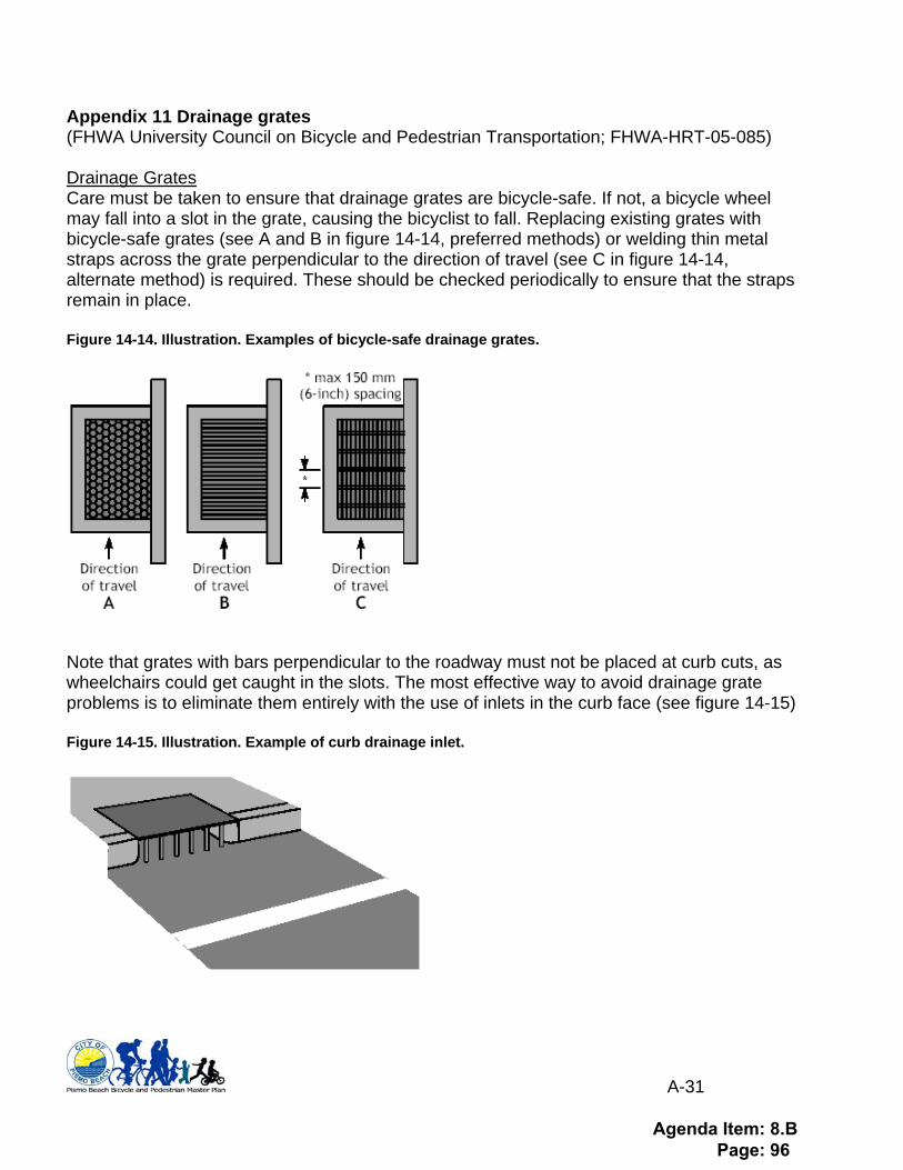
A-31
Appendix 11 Drainage grates (FHWA University Council on Bicycle and Pedestrian Transportation; FHWA-HRT-05-085) Drainage Grates Care must be taken to ensure that drainage grates are bicycle-safe. If not, a bicycle wheel may fall into a slot in the grate, causing the bicyclist to fall. Replacing existing grates with bicycle-safe grates (see A and B in figure 14-14, preferred methods) or welding thin metal straps across the grate perpendicular to the direction of travel (see C in figure 14-14, alternate method) is required. These should be checked periodically to ensure that the straps remain in place.
Figure 14-14. Illustration. Examples of bicycle-safe drainage grates.
Note that grates with bars perpendicular to the roadway must not be placed at curb cuts, as wheelchairs could get caught in the slots. The most effective way to avoid drainage grate problems is to eliminate them entirely with the use of inlets in the curb face (see figure 14-15)
Figure 14-15. Illustration. Example of curb drainage inlet.
Agenda Item: 8.B Page: 96
A-32
If a street-surface grate is required for drainage, care must be taken to ensure that the grate is flush with the road surface. Inlets should be raised after a pavement overlay to within 6 mm (0.25 in) of the new surface. If this is not possible or practical, the pavement must taper into drainage inlets so they do not cause an abrupt edge at the inlet.
Agenda Item: 8.B Page: 97
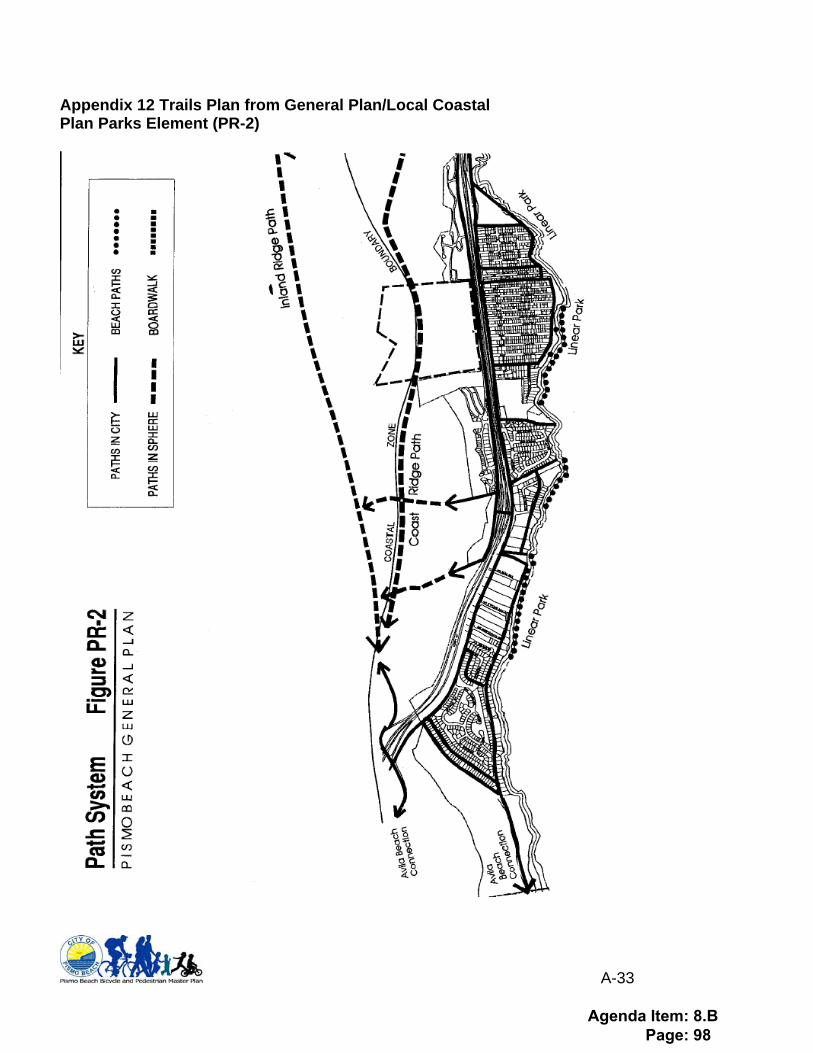
A-33
Appendix 12 Trails Plan from General Plan/Local Coastal Plan Parks Element (PR-2)
Agenda Item: 8.B Page: 98
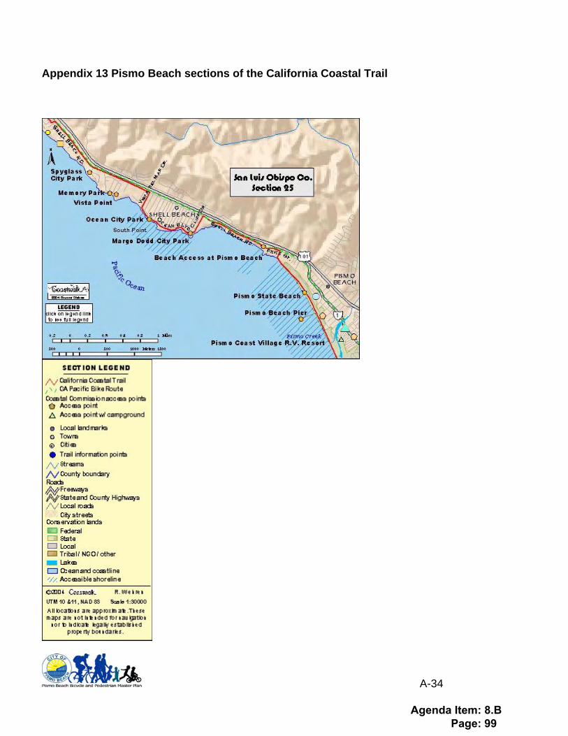
A-34
Appendix 13 Pismo Beach sections of the California Coastal Trail
Agenda Item: 8.B Page: 99
A-35
Appendix 14 Letters of Support
Agenda Item: 8.B Page: 100
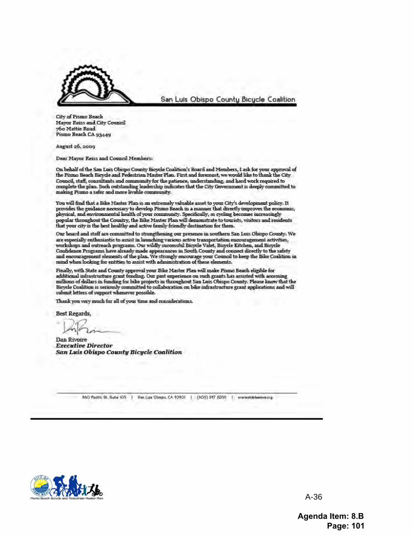
A-36
Agenda Item: 8.B Page: 101
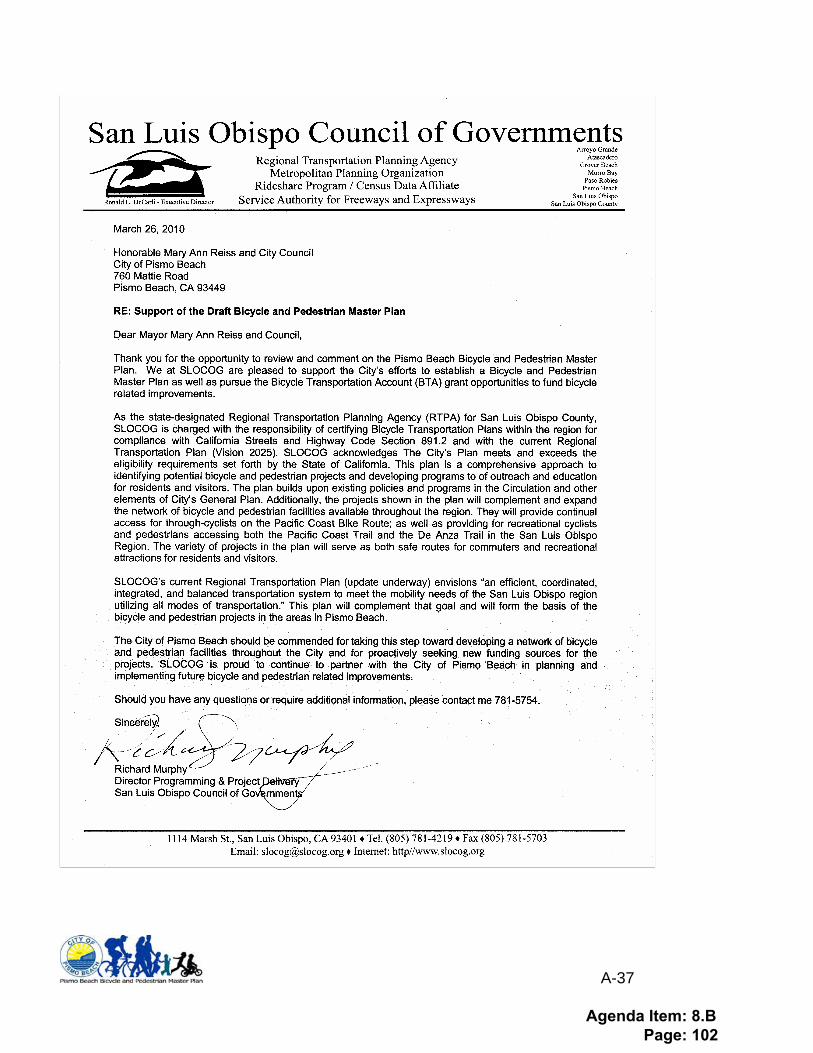
A-37
Agenda Item: 8.B Page: 102
Copyright © 2022 FDOKUMEN