Kandiyohi County Bicycle & Pedestrian Plan
112
Kandiyohi County Bicycle & Pedestrian Plan ~ A Plan to Guide Future Bicycle & Pedestrian Priorities in Kandiyohi County June 2017 Prepared by the Mid-Minnesota Development Commission
-
Upload
khangminh22 -
Category
Documents
-
view
3 -
download
0
Transcript of Kandiyohi County Bicycle & Pedestrian Plan
Kandiyohi County
Bicycle & Pedestrian Plan
~ A Plan to Guide Future Bicycle &
Pedestrian Priorities in Kandiyohi County
June 2017
Prepared by the Mid-Minnesota
Development Commission

Kandiyohi County Bicycle & Pedestrian Plan i
Kandiyohi County
Bicycle & Pedestrian Plan
Table of Contents
Chapter One: Introduction to the Kandiyohi County Bicycle & Pedestrian Plan
A. Purpose of the Plan ....................................................................................................... 1-1 B. Organization of the Plan ............................................................................................... 1-2 C. Location of Kandiyohi County ..................................................................................... 1-2 D. The Planning Process .................................................................................................... 1-4 E. Vision Statement ........................................................................................................... 1-5 F. The Benefits of Quality Trails ...................................................................................... 1-5 Recreational Opportunities and Healthy Lifestyles ................................................ 1-5 Tourism and Economic Benefits ............................................................................. 1-6 Transportation Options ........................................................................................... 1-7 Safety ...................................................................................................................... 1-7 Quality of Life......................................................................................................... 1-7 Shareholder Cooperation ........................................................................................ 1-8
Chapter Two: County Profile & Existing Trails
A. Chapter Highlights ........................................................................................................ 2-1 B. Demographics ............................................................................................................... 2-1 C. Existing Trails ............................................................................................................... 2-4 Glacial Lakes State Trail ......................................................................................... 2-4 Sibley State Park ..................................................................................................... 2-6 City of Willmar Trails ............................................................................................. 2-7 Green Lake Trail ..................................................................................................... 2-8 Eagle Lake Trail ...................................................................................................... 2-9 Norway/Games Lake Trail ...................................................................................... 2-9 Lake Koronis Trail (Stearns County) .................................................................... 2-10
Chapter Three: Public Outreach and Survey Results
A. Chapter Highlights ........................................................................................................ 3-1 B. The Kandiyohi County Trails Survey ........................................................................... 3-1
1. On average, how often do people in your household go for walks and/or ride bicycles?............................................................................................... 3-2

Kandiyohi County Bicycle & Pedestrian Plan ii
2. Where in the County do you normally walk or ride your bike? ........................ 3-3 3. Which factors would encourage you or someone in your household to walk or
ride a bicycle more often?................................................................................. 3-4 4. Where would you like to see new walking and bicycling trails developed? ..... 3-6 5. Where would you like to see bicycle or pedestrian improvements/new
amenities on existing trails? ............................................................................. 3-9 6. Do you have any additional comments regarding bicycle and/or
pedestrian concerns in Kandiyohi County? .................................................... 3-10 7. (Optional) Please enter your city or township of residence ........................... 3-11
C. Public Open Houses .................................................................................................... 3-12 Willmar Bicycle Open House Comments ....................................................... 3-12 New London Open House Comments ............................................................ 3-13
D. Summary of Common Themes ................................................................................... 3-15
Chapter Four: Priority Trail Projects
A. Chapter Highlights ........................................................................................................ 4-1 B. Priority Trail Projects .................................................................................................... 4-1
A. Sibley State Park to Games Lake ............................................................................ 4-3 B. 153rd Ave NE between CR 9 and the Glacial Lakes State Trail ............................. 4-4 C. County Roads 40 & 4: New London – Green Lake Loop ...................................... 4-5 D. County Road 5: Willmar – Games Lake Trail ........................................................ 4-6 E. County Roads 24, 25, 41: North Willmar Loops .................................................... 4-7 F. Eagle Lake Trail ...................................................................................................... 4-8 G. North Central Lakes: Eagle/Green Diamond Lake Loops ...................................... 4-9 H. Diamond Lake Trail .............................................................................................. 4-10 I. Lake Lillian – Big Kandiyohi Lake Trail ............................................................. 4-12
Chapter Five: Implementation & Potential Funding Sources
A. Chapter Highlights ........................................................................................................ 5-1 B. Implementation Steps.................................................................................................... 5-1 C. Potential Funding Sources ............................................................................................ 5-4 Donations (time and money) ................................................................................... 5-4 Local Government Match ....................................................................................... 5-4 Grants ...................................................................................................................... 5-5 Mini-Grants ........................................................................................................... 5-10 State Programs ...................................................................................................... 5-12

Kandiyohi County Bicycle & Pedestrian Plan iii
Appendices
Kandiyohi County Trails Survey Results ............................................................. Appendix A
News Releases and Public Open House Comments ............................................ Appendix B
List of Maps
Map 1A: Kandiyohi County’s Location in Minnesota ....................................................... 1-2
Map 1B: Kandiyohi County’s Neighboring Counties ........................................................ 1-2
Map 1C: Kandiyohi County, Minnesota ............................................................................. 1-3
Map 2A: Glacial Lakes State Trail ..................................................................................... 2-5
Map 2B: Sibley State Park (summer trails) ........................................................................ 2-6
Map 2C: City of Willmar Trails.......................................................................................... 2-7
Map 2D: Green Lake Trail .................................................................................................. 2-8
Map 2F: Eagle Lake Trail ................................................................................................... 2-9
Map 2G: Games Lake Trail ................................................................................................ 2-9
Map 2H: Lake Koronis Recreational Trail ....................................................................... 2-10
Map 3A: Suggested Bicycle & Pedestrian Trails (survey results) ...................................... 3-7
Map 4: Priority Trail Projects ............................................................................................. 4-2
Maps A1, A2, and A3: Sibley State Park to Games Lake .................................................. 4-3
Maps B1 and B2: 153rd Ave NE (between CR 9 and the Glacial Lakes State Trail) ......... 4-4
Maps C1 and C2: New London – Green Lake Loop (County Roads 40 & 4) .................... 4-5
Maps D1 and D2: Willmar to Games Lake Trail (County Road 5) .................................... 4-6
Maps E1 and E2: North Willmar Loops (County Roads 24, 25, & 41) .............................. 4-7
Maps F1 and F2: Eagle Lake Trail ..................................................................................... 4-8
Maps G1 and G2: North Central Lakes Eagle/Green/Diamond Loops .............................. 4-9
Map H1: Diamond Lake Trail ........................................................................................... 4-10
Map H2: Diamond Lake Trail Phase One & Phase Two .................................................. 4-11
Map I1: Lake Lillian – Big Kandiyohi Lake Trail ............................................................ 4-12
Kandiyohi County Bicycle & Pedestrian Plan 1-1
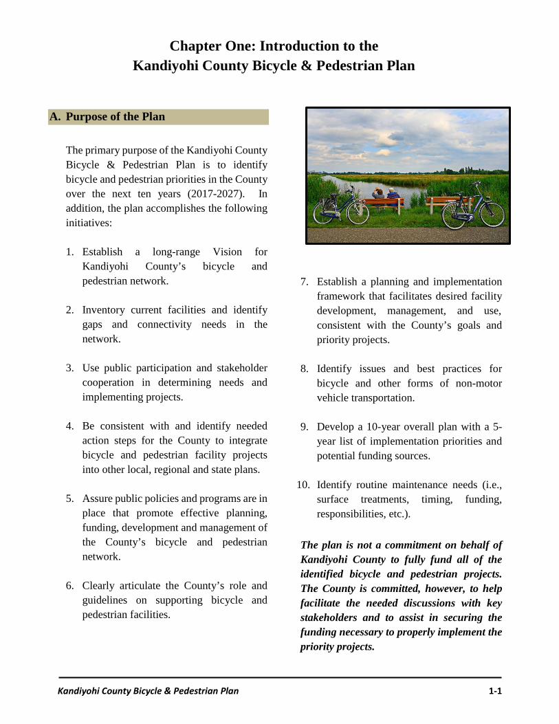
A. Purpose of the Plan
The primary purpose of the Kandiyohi County Bicycle & Pedestrian Plan is to identify bicycle and pedestrian priorities in the County over the next ten years (2017-2027). In addition, the plan accomplishes the following initiatives: 1. Establish a long-range Vision for
Kandiyohi County’s bicycle and pedestrian network.
2. Inventory current facilities and identify gaps and connectivity needs in the network.
3. Use public participation and stakeholder cooperation in determining needs and implementing projects.
4. Be consistent with and identify needed
action steps for the County to integrate bicycle and pedestrian facility projects into other local, regional and state plans.
5. Assure public policies and programs are in
place that promote effective planning, funding, development and management of the County’s bicycle and pedestrian network.
6. Clearly articulate the County’s role and
guidelines on supporting bicycle and pedestrian facilities.
7. Establish a planning and implementation framework that facilitates desired facility development, management, and use, consistent with the County’s goals and priority projects.
8. Identify issues and best practices for
bicycle and other forms of non-motor vehicle transportation.
9. Develop a 10-year overall plan with a 5-
year list of implementation priorities and potential funding sources.
10. Identify routine maintenance needs (i.e.,
surface treatments, timing, funding, responsibilities, etc.).
The plan is not a commitment on behalf of Kandiyohi County to fully fund all of the identified bicycle and pedestrian projects. The County is committed, however, to help facilitate the needed discussions with key stakeholders and to assist in securing the funding necessary to properly implement the priority projects.
Chapter One: Introduction to the Kandiyohi County Bicycle & Pedestrian Plan

Chapter One: Introduction
Kandiyohi County Bicycle & Pedestrian Plan 1-2
B. Organization of the Plan
The Kandiyohi County Bicycle & Pedestrian Plan is organized into the following five chapters: Chapter One provides an introduction to the plan, with sections on the purpose of the plan (Section A), a description of the planning process (Section D), the Plan’s Vision Statement (Section E), and a summary of the benefits of having quality trails (Section F). Chapter Two profiles Kandiyohi County, including demographic information (Section B) and a description of the existing bicycle and pedestrian trails in the area (Section C). Chapter Three provides an overview of the comments received during the Kandiyohi County Trails Survey (Section B). In addition, the information gathered at two public open houses is presented (Section C). The Chapter concludes by summarizing the common themes communicated during the open houses and from the survey results (Section D). Chapter Four includes a list, map and description of the county’s priority bicycle and pedestrian projects. The list and map can be updated in the future as projects are implemented and/or if priorities change. Chapter Five outlines a number of implementation steps the county will use over the next 10 years as trail projects are discussed and developed. In addition, potential trail funding sources are identified.
C. Location of Kandiyohi County
Kandiyohi County is located in central Minnesota, approximately 100 miles west of the Minneapolis-St. Paul Metropolitan Area and 60 miles southwest of the City of St. Cloud (refer to Map 1A).
Map 1A: Kandiyohi’s location in Minnesota The County shares borders with Stearns and Pope Counties to the north, Meeker County to the east, Renville County to the south, and Swift and Chippewa Counties to the west (refer to Map 1B).
Map 1B: Neighboring Counties
Map 1C shows the county has 12 cities and 24 townships. The county is characterized by numerous lakes, trees, rolling hills and vast agricultural land. Kandiyohi County’s motto is, “Where the Lakes Begin.”

Chapter One: Introduction
Kandiyohi County Bicycle & Pedestrian Plan 1-3
Map 1C: Kandiyohi County, Minnesota

Chapter One: Introduction
Kandiyohi County Bicycle & Pedestrian Plan 1-4
D. The Planning Process
The need for developing the Kandiyohi County Bicycle & Pedestrian Plan has been discussed among stakeholders periodically for a number of years. The county’s Engineer/Public Works Director expressed the need of knowing which county roads should have paved shoulders for bicycles and pedestrians as roadways are reconstructed. This ultimately led to the decision for the County Board to enter into a contract with the Mid-Minnesota Development Commission to assist with developing the County’s Bicycle & Pedestrian Plan. A task force of key stakeholders was assembled to assist with developing the plan. Members were asked to serve on the task force by the Kandiyohi County Public Works Director. The list of task force members appears in Table 1A. The task force met approximately once a month to help provide feedback on the contents of the plan. One of the first decisions the task force made was to narrow the focus of the plan to Bicycle and Pedestrian issues rather than on all ‘trail’ issues, such as ATV, cross-country skiing, horseback riding, etc. Furthermore, the primary emphasis of the plan is on Kandiyohi County level projects, versus bicycle and pedestrian projects at the city and/or state level. It is well understood, however, that a quality bicycle and pedestrian trail network needs the full cooperation of city, county and state level stakeholders in order to be successful.
Table 1A:
Kandiyohi County Bicycle & Pedestrian Plan Task Force
Mel Odens
Kandiyohi County Public Works Director
Lindsey Knutson ~ Minnesota Department of Transportation District 8 Planning Director
Hannah Dockendorf ~ Kandiyohi-Renville
County Statewide Health Improvement Program
Sean Christensen Willmar City Public Works Director
Bill Gossman
Mayor of New London
Steve Brisendine ~ Willmar Community Education & Recreation Director
Beth Fischer ~ Willmar Lakes Area Convention
& Visitors Bureau Executive Director
Casey Hagert ~ Willmar Community Education & Recreation Coordinator
Leah Schueler ~ Kandiyohi-Renville County
Statewide Health Improvement Program
David Moody ~ Johnson, Moody, Schmidt & Kleinhuizen Law Firm
Donn Winckler ~ Mid-Minnesota
Development Commission Executive Director
Matthew Johnson ~ Mid-Minnesota Development Commission Community Development Director

Chapter One: Introduction
Kandiyohi County Bicycle & Pedestrian Plan 1-5
E. Vision Statement
The Task Force created the following vision statement to help guide the development of the Bicycle & Pedestrian Plan:
“A county where people and places are
connected through a safe and convenient
bicycle and pedestrian network.”
F. The Benefits of Quality Trails
Trail development and use have become increasingly popular as communities embrace the numerous benefits of having a quality trail network. The following sections highlight some of the main benefits of having trails. Recreational Opportunities and Healthy Lifestyles Trails provide excellent opportunities for recreation and healthy lifestyles. Increased physical activity has long been associated with numerous health benefits, including preventing heart disease, diabetes, cancer and depression. Furthermore, overweight and obesity problems have many additional negative health impacts. A variety of sources indicate that approximately 35-40% of Americans are considered obese (World Health Organization, Global Status Report, 2014). Providing opportunities for individuals and families to use trails are cited as one part of the solution towards addressing this dilemma (refer to the text-box on the right).
Walking, Biking and National Security: America’s military needs heathier recruits
from Minnesota www.missionreadiness.org
Mission: Readiness is a nonprofit, nonpartisan national security organization of more than 500 retired generals, admirals and other senior retired military leaders who work to ensure continued American security and prosperity into the 21st century by calling for smart investments in the upcoming generation of American children. They have authored a number of publications, including three in Minnesota, targeting the need for children to tackle obesity through routine exercise. Following are some of their concerns and recommendations: The problem? 69% of Minnesota’s
young adults are unable to join the military, with being overweight the #1 reason. Obesity rates among children have more than tripled within three decades.
The Research? Sidewalks and safe street crossings, bike paths, traffic-calming devices, and similar infrastructure is linked to increased levels of walking and biking and greater overall physical activity.
The Solution? Increased funding for safe routes to schools; support testing the effectiveness of different walking/biking programs; and, use long-term community planning to engineer safe options for walking/biking.

Chapter One: Introduction
Kandiyohi County Bicycle & Pedestrian Plan 1-6
Tourism and Economic Benefits
A well-established trails network increases opportunities for residents and visitors to spend money locally while they are using the trails. During Minnesota’s warm weather months, nearly 1.5 million cyclists, inline skaters, and walkers use the State’s nationally recognized city, county, and regional trails (Parks & Trails Council of MN, www.parksandtrails.org). According to the organization American Trails (www.americantrails.org), 90% of trail users are local, spending approximately $17 per day per user on the local economy (i.e., gas, water, snacks, etc.). The remaining 10% of trail users are non-local, spending up to $104 a day. The additional expenditures can be accounted for with increased travel expenses (i.e., hotels, restaurants, etc.). Trails also feed the local economy by supporting the retail establishments who are targeted to trail users, such as those selling bicycles, snowmobiles, ATVs, and even hiking shoes. The rental of trail use equipment can also have a large economic impact to local retailers.
The Economic Impact of Recreational Trail Use in Different Regions of
Minnesota (2009)
In 2008, the Minnesota Recreational Trail Users Association (MRTUA) embarked on a survey of its members to create a profile of trail users, their expenditures and their economic impact on local economies. The results showed that Minnesotans spend approximately $2.5 billion annually on trail use (U of MN Tourism Center).
Consumer Spending at Minnesota Trails (2008)*
Walking/hiking $1,425,613,000 Bicycling $427,478,000 Snowmobiling $172,816,000 ATV/OHV $154,139,000 Running $120,745,000 Horseback riding $49,853,000 Cross-country skiing $41,083,000 In-line skating $30,115,000 Total $2,421,842,000
*Does not include equipment expenditures, which totaled an additional $839 million in 2008. Trail use and equipment expenditures generated approximately $206 million in state and local taxes. An estimated 42,906 full- and part-time jobs were supported by these trail use expenditures.

Chapter One: Introduction
Kandiyohi County Bicycle & Pedestrian Plan 1-7
Transportation Options
Access to trails can be a viable option for many people to use as a mode of transportation. Although walking, biking, or riding a snowmobile to or from work or school are not viable options for many people, the ones who want to do this simply need access to trails. Developing a ‘safe trails network’ is usually the key component when commuters make the decision to use it rather than driving. In addition, having adequate trail access offers an economical option for some low-income families. Safety Everyone has a vested interest in reducing the number of bicycle and pedestrian accidents, injuries and fatalities. Bicycle and pedestrian plans provide the opportunity to identify areas where pedestrians and bicyclists would benefit from having safety projects implemented. As a result, even people who rarely bicycle and/or walk benefit from having a safe trail network.
Quality of Life Investing in quality trails help residents take pride in their community. Regular trail users are often the people who are trying to resolve local trail issues. They also are the ones who help to form user-groups, not only for social reasons, but also to help establish a stronger collective voice. Business leaders have admitted that quality-of-life indicators have become increasingly important where businesses are located. The eBay Company “is very concerned with retention of its employees and wants them to have the quality of life that they want in terms of housing costs, educational opportunity, access to the environment - a space where they can live, work, and play" (Marty Weil, Area Development, Dec/Jan 09). The traditional model of locating businesses primarily examined access to transportation, skilled labor, and adequate housing. Although these considerations are still very important, increasingly businesses are examining quality-of-life indicators, such as having nice trail amenities, prior to making important business decisions.

Chapter One: Introduction
Kandiyohi County Bicycle & Pedestrian Plan 1-8
Stakeholder Cooperation
Trail plans are great opportunities for stakeholders to cooperate on identifying local trail needs and issues. Most importantly, trail plans help establish a guideline for how stakeholders can get involved in properly implementing the plan. These activities can include grant writing, raising funds for local match, finding sponsors for trail amenities, and assisting with trail maintenance. In addition, stakeholders can also play a large role in organizing and providing education on bicycle and pedestrian issues, including trail safety.
Citizens are the key stakeholders in all trail projects and issues.
Citizens
User Groups
Business Community
LocalGovernment
State Agencies
Non-Profits
Key Stakeholder Profile: Kandiyohi-Renville SHIP
The Statewide Health Improvement Partnership (SHIP) is working to create healthier communities across Minnesota by expanding opportunities for active living, healthy eating and tobacco-free living. The local program, Kandiyohi-Renville SHIP, is a key stakeholder helping promote the importance of walking and bicycling. They recently paid for roadway bicycle stencils that can be used by communities to identify bicycle lanes (shown below).

Kandiyohi County Bicycle & Pedestrian Plan 2-1
A. Chapter Highlights
Chapter Two provides an overview of Kandiyohi County, including information on demographics and the existing trails network. The demographic information is contained in Section B and includes both current and anticipated future population data. The area’s existing trails network is profiled in Section C and includes information on all types of trails (i.e., local, county and state) located in Kandiyohi County and the nearby surrounding areas.
B. Demographics
Kandiyohi County population is estimated annually by the Minnesota State Demographer’s Office (www.mn.gov/ admin/demography). For 2015, the State Demographer estimated that Kandiyohi County’s population was 41,449 people. Table 2A shows the County’s official population numbers as provided by the U.S. Census. Notice overall the county has kept pace with the state’s growth rate since 1970 (38% for the county compared to 39% for the state).
Area U.S. Census Year Change since 1970
1970 1980 1990 2000 2010 # % Atwater 956 1,128 1,053 1,079 1,133 177 12% Blomkest 172 200 183 186 157 -15 -9% Kandiyohi 295 447 506 555 491 196 66% Lake Lillian 316 329 229 257 238 -78 -25% New London 736 812 971 1,066 1,251 515 70% Pennock 255 410 476 504 508 253 99% Prinsburg 448 557 502 458 497 49 11% Raymond 589 723 668 803 764 175 30% Regal 44 70 51 40 34 -10 -23% Spicer 586 909 1,020 1,126 1,167 581 99% Sunburg 144 130 117 110 100 -44 -31% Willmar 12,869 15,895 17,531 18,351 19,582 6,713 52% All Townships 17,679 20,868 21,230 22,852 22,657 4,978 28% Kandiyohi Co. 30,548 36,763 38,761 41,203 42,239 11,691 38% State of Minnesota 3.8 M 4.1 M 4.4 M 4.9 M 5.3 M 1.5 M 39%
Chapter Two: County Profile & Existing Trails
Table 2A: Kandiyohi County’s Population since 1970 (U.S. Census)

Chapter Two: County Profile & Existing Trails
Kandiyohi County Bicycle & Pedestrian Plan 2-2
Kandiyohi County’s historic growth rates are used to help estimate the county’s future population. Table 2B provides population growth estimates for the years 2020, 2030, and 2040 (also shown in Figure 2A). The results indicate the county’s population could reach 46,249 by 2020, 49,032 by 2030, and 51,814 by the year 2040. Overall this would be an increase of 9,575 people over the next 20+ years. The table also shows how the majority of the communities would gain population, along with all of the townships collectively. Blomkest, Lake Lillian, Prinsburg and Sunburg are shown to stabilize near their current population levels. Any one of these communities, however, could also experience population growth due to a variety of unpredictable circumstances.
Figure 2A: Kandiyohi County’s Historic Population
and Future Growth Estimates
Note: population projections are merely estimates of an area’s potential growth based on historical growth levels. A number of variables could accelerate or impede the actual growth experienced.
Area U.S. Census Year Projected Change
2010 2020 2030 2040 # % Atwater 1,133 1,161 1,192 1,222 89 8% Blomkest 157 166 162 158 1 0% Kandiyohi 491 609 659 709 218 44% Lake Lillian 238 225 210 200 -38 -16% New London 1,251 1,352 1,481 1,609 358 29% Pennock 508 611 671 731 223 44% Prinsburg 497 492 492 492 -5 -1% Raymond 764 838 881 924 160 21% Regal 34 33 30 28 -6 -18% Spicer 1,167 1,375 1,513 1,651 484 41% Sunburg 100 88 80 75 -25 -25% Willmar 19,582 21,610 23,198 24,787 5,205 27% All Townships 22,657 24,639 25,833 27,027 4,370 19% Kandiyohi Co. 42,239 46,249 49,032 51,814 9,575 23%
Table 2B: Kandiyohi County’s 2020, 2030, and 2040 Population Projections (based upon growth since 1970)
30,000
35,000
40,000
45,000
50,000
55,000
1970 1980 1990 2000 2010 2020 2030 2040

Chapter Two: County Profile & Existing Trails
Kandiyohi County Bicycle & Pedestrian Plan 2-3
Age Categories Kandiyohi County’s population by age category for the year 2015 is shown in Table 2C (data provided by the Minnesota State Demographer’s Office).
Notice the County’s largest age category is people ages 45 to 64, followed by ages 25 to 44. These age groups typically contain people who are working and raising families.
42,542
7,525
11,405
9,813
3,592
7,361
2,846
21,318
3,398
5,663
5,068
1,924
3,830
1,435
21,224
4,127
5,742
4,745
1,668
3,531
1,411
0 5,000 10,000 15,000 20,000 25,000 30,000 35,000 40,000 45,000
Totals
65+
45 - 64
25-44
18 - 24
5 - 17
Under 5
Females Males Total
Table 2C: Kandiyohi County’s Population by Age Category in 2015

Chapter Two: County Profile & Existing Trails
Kandiyohi County Bicycle & Pedestrian Plan 2-4
C. Existing Trails
Section C profiles the existing bicycle and pedestrian trails located throughout Kandiyohi County. Although the focus of the county’s Bicycle & Pedestrian Plan is to help identify future county bicycle and pedestrian priorities, being familiar with the entire ‘trail network’ is an important step in helping to define the county’s priorities.
Glacial Lakes State Trail The most prominent and well used trail located in Kandiyohi County is the Glacial Lakes State Trail. The trail is located on a former Burlington Northern railroad grade, and is generally level and wheelchair accessible. The trail is paved for 22 miles between Willmar, Spicer, New London, Hawick, and the Kandiyohi/Stearns County line (refer to Map 2A). A five-mile stretch from Richmond to Roscoe in Stearns County is also paved. The many lakes make this area a popular tourist destination. The towns along the trail provide access points, rest stops, and other services to trail users. In the summer, the developed trail is popular for hiking, bicycling, horseback riding, and in-line skating. Winter uses include snowmobiling and cross-country skiing. Horseback riders enjoy the ten mile stretch of parallel grass treadway from Willmar to New London. From New London to the Kandiyohi/Stearns County line there are grass shoulders for horseback riding.
Riders participate in a fundraising event for the Glacial Lakes State Trail.
Photo Credit: West Central Tribune The Glacial Lakes State Trail connects with many miles of groomed snowmobile trails in the Kandiyohi County grant-in-aid trail system. The trail also connects to Sibley State Park via three miles of paved shoulder along County Road 148 north of New London. The Minnesota Department of Natural Resources (DNR) is currently working with landowners and the New London-Spicer School District on developing an off-road trail extension between the trail and Sibley State Park (refer to the text box below).
A May 2014 bonding bill passed by the Minnesota State Legislature and signed by Governor Mark Dayton included $1.3 million to develop a five-mile extension between the Glacial Lakes State Trail and Sibley State Park. The DNR is responsible for establishing the route and working with landowners on purchasing easements. The proposed course includes a segment through the New London-Spicer school’s property, with a tunnel under Kandiyohi County Road 9. In addition, the project will also tunnel under U.S. Highway 71. The exact route and details have not been agreed upon by the various stakeholders.

Chapter Two: County Profile & Existing Trails
Kandiyohi County Bicycle & Pedestrian Plan 2-5
Chapter Two: County Profile & Existing Trails
Kandiyohi County Bicycle & Pedestrian Plan 2-6
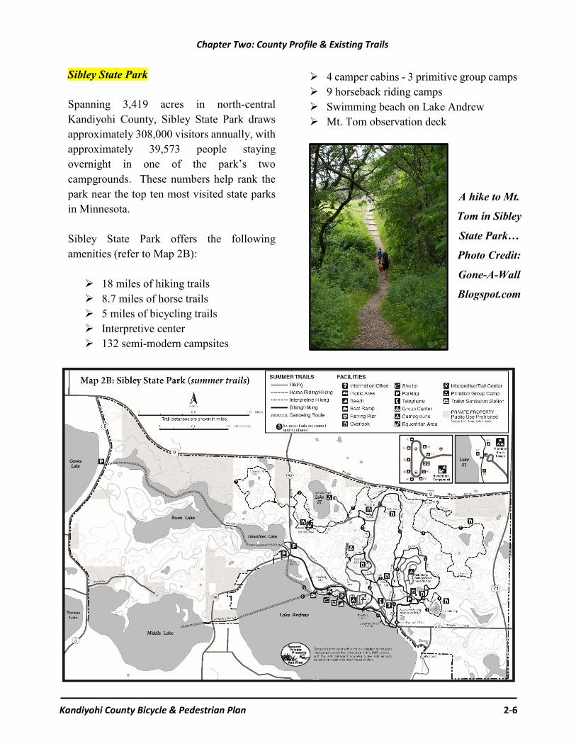
Sibley State Park Spanning 3,419 acres in north-central Kandiyohi County, Sibley State Park draws approximately 308,000 visitors annually, with approximately 39,573 people staying overnight in one of the park’s two campgrounds. These numbers help rank the park near the top ten most visited state parks in Minnesota. Sibley State Park offers the following amenities (refer to Map 2B):
18 miles of hiking trails 8.7 miles of horse trails 5 miles of bicycling trails Interpretive center 132 semi-modern campsites
4 camper cabins - 3 primitive group camps 9 horseback riding camps Swimming beach on Lake Andrew Mt. Tom observation deck
A hike to Mt.
Tom in Sibley
State Park…
Photo Credit:
Gone-A-Wall
Blogspot.com

Chapter Two: County Profile & Existing Trails
Kandiyohi County Bicycle & Pedestrian Plan 2-7
Map 2C: City of Willmar Trails
City of Willmar Trails The City of Willmar has an extensive trail network, including both on-road bicycle routes and off-road trails (refer to Map 2C). In 2015, the community created a Parks & Recreation Master Plan, while in 2011 the city
adopted its first Trails and Pedestrian Plan. Working with the City of Willmar to make connections to the existing trails network will continue to be one of Kandiyohi County’s main implementation priorities.
Chapter Two: County Profile & Existing Trails
Kandiyohi County Bicycle & Pedestrian Plan 2-8
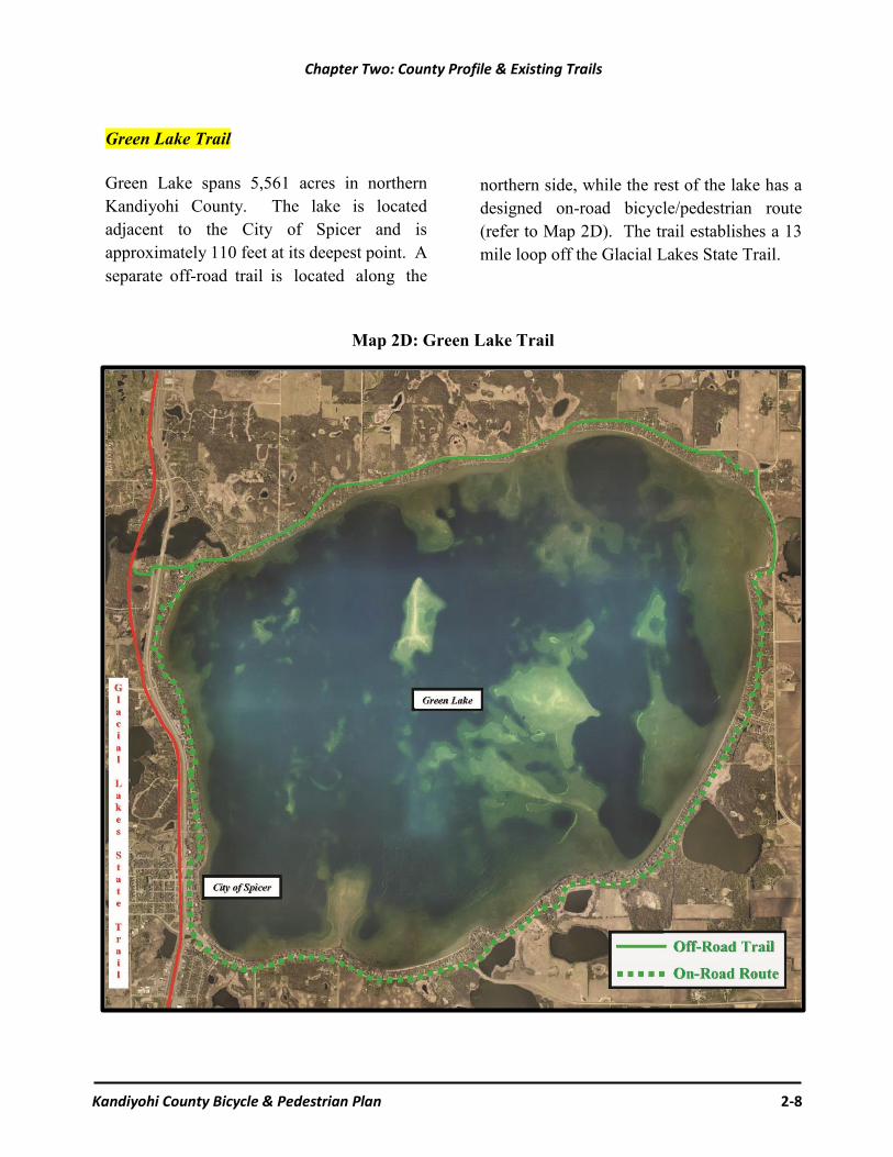
Map 2D: Green Lake Trail
Green Lake Trail Green Lake spans 5,561 acres in northern Kandiyohi County. The lake is located adjacent to the City of Spicer and is approximately 110 feet at its deepest point. A separate off-road trail is located along the
northern side, while the rest of the lake has a designed on-road bicycle/pedestrian route (refer to Map 2D). The trail establishes a 13 mile loop off the Glacial Lakes State Trail.

Chapter Two: County Profile & Existing Trails
Kandiyohi County Bicycle & Pedestrian Plan 2-9
Eagle Lake Trail The Eagle Lake Trail creates a loop connecting the Willmar High School, Civic Center, the Eagle Lake area and the Glacial Lakes State Trail. The 2.5 mile long 10-foot wide bituminous off-road trail loop was completed in 2015. The project involved numerous stakeholders and funding sources, including Kandiyohi County ($45,000), the City of Willmar ($13,000), the Department of Natural Resources ($114,00), Dovre Township ($13,000), Green Lake Township ($13,000), and $300,000 in Federal Transportation Alternatives Program (TAP) funding.
Map 2E: Eagle Lake Trail
Norway/Games Lake Trail In 2017, a new trail will be graded along County Road 5 adjacent to Games and Norway Lakes. The project consists of a 2.57 mile long 10-foot wide bituminous off-road trail, which will be surfaced in 2018. The county secured $345,762 in Federal funds for the project by applying to the Transportation Alternative Program (TAP). The trail will reduce pedestrian, bicycle and vehicle congestion along the roadway, especially near Games Lake Park (56 campsites).
Map 2F: Games Lake Trail

Chapter Two: County Profile & Existing Trails
Kandiyohi County Bicycle & Pedestrian Plan 2-10
Lake Koronis Trail
One of the more popular trails located adjacent to Kandiyohi County is the 25-mile Lake Koronis Recreational Trail. Completing the trail was divided into eight phases, which began with developing an on-road trail along Old Lake Road in 2002 (refer to Map 2G). The final leg was completed in 2012. Map 2G shows how the trail can be accessed off the Glacial Lake State Trail.
Lake Koronis Trail consists of both on and
off-road trail segments around Lake Koronis in Paynesville, Minnesota, just
north of Kandiyohi County.
www.paynesvillearea.com/lktrail/koronistrail.htm
Map 2G: Lake Koronis Recreational Trail

Kandiyohi County Bicycle & Pedestrian Plan 3-1
A. Chapter Highlights
Chapter Three provides a summary of the public input received throughout the planning process. Section B highlights the information collected from the Kandiyohi County Trail Survey, which was administered online and had 393 participants. Section C summarizes the comments received during two public open houses. Section D provides a summary of the common themes people expressed.
B. Kandiyohi County Trails Survey
The Kandiyohi County Trails Plan Task Force decided early in the planning process that it would be a good idea to generate feedback from the public through the use of a trails survey. As a result, an online survey was designed and administered through Survey Monkey. In order to entice a good response rate, the survey only included seven questions that were designed to take approximately five minutes in total. All of the responses were anonymous and only one survey response was allowed per Internet Protocol (IP) address.
Refer to Appendix A for a full copy of the Kandiyohi County Trails Survey results.
The survey was officially called the “Kandiyohi County Bicycle and Pedestrian Survey,” but was referred to as the “Trails Survey” for marketing purposes. A press release was used in the local media, including newspapers and radio stations in the Kandiyohi County and surrounding areas. The survey was open from March 28 through May 25, 2016, online at the following link: www.surveymonkey.com/r/kandiyohitrails
393 people completed the online survey. The highlights of the survey results are summarized on the following pages and are contained in full in Appendix A.
Chapter Three: Public Outreach and Survey Results
Based upon the information gathered in the survey, the two public open houses, and feedback from the Trails Plan Task Force, the list of potential trail projects identified in this Chapter are narrowed down to Kandiyohi County’s priority trail projects identified in Chapter Five.

Chapter Three: Public Outreach & Survey Results
Kandiyohi County Bicycle & Pedestrian Plan 3-2
Three hundred ninety people provided an answer to question 1. The aggregate responses are shown in Figure 3A, while Table 3A shows each category’s response rate (percentage of the total) and actual number of responses (count).
Figure 3A: How often do People in your household go for walks
and/or ride bicycles?
The survey results revealed that approximately 59% of the respondents used trails almost daily (26%) or several times a week (33%). Conversely, only ten percent (10%) of the respondents indicated they ‘never or rarely’ go for walks and/or ride bicycles. Question 1 also asked people to elaborate on their response if they selected the ‘never or
Table 3A: How often do
People in your household go for walks and/or ride bicycles?
Response Percent Count Almost daily 26% 102 Several times a week 33% 129 Several times a month 22% 87 Several times a year 9% 33 Never or rarely 10% 39
Total Responses 390
rarely’ category by explaining ‘why not?’ Thirty-five (35) people provided an explanation that can be summarized into the following categories.
“If never or rarely, why not?”
Poor access to trails (11 responses) Not safe/safety concerns (8 responses) Age or poor health (4 responses) Too busy (3 responses) Not interested (2 responses) Other reason (7 response)
It should be noted that many of the responses overlapped into two or more of the categories. All of the written responses can be found in Appendix A, however, a few of the highlights are shown below: “We do not have walking paths close to our
home, so have to use busy streets or highways.”
“Trails need repairs in areas.”
“Dangerous biking on roads with cars.”
“Because there is not a safe place to do it. Trails are not close by to enjoy.”
26%33%
22%
9% 10%
0%
10%
20%
30%
40%
Daily Weekly Monthly Yearly Rarely
SURVEY QUESTION 1
On average, how often do people in your household go for walks and/or ride
bicycles (weather permitting)? Please select your best answer…

Chapter Three: Public Outreach & Survey Results
Kandiyohi County Bicycle & Pedestrian Plan 3-3
Three hundred sixty-seven people provided an answer to question 2. The aggregate responses are summarized below: Number of survey respondents that said
they travel on Glacial Lakes Trail: 153
The Glacial Lakes State Trail ranked the highest use among the survey participants (153 responses.
Photo by Wilderness Press
Green Lake Area/Green Lake Trails – 23
In or near the City of Willmar – 64
In or near the City of New London – 36
In or near the City of Spicer – 23
In or near the City of Atwater – 8
In or near the City of Pennock – 3
In or near the City of Prinsburg – 1
In or near the City of Lake Lillian – 1
People indicated they walk and/or ride their bikes on city streets, neighborhoods, etc., but did not mention which community – 34
Eagle Lake Area/Eagle Lake Trail – 8
Around Lake Andrew – 5
Around Diamond Lake – 3
Several other lakes were mentioned once.
Sibley State Park – 18
Prairie Woods Environmental Learning Center – 7
Comments that were not specific to a particular road, but included words such as: roads, county roads, in the country – 13
Comments that were not specific to a particular road, but included words such as: township roads, gravel roads, local roads, or a township neighborhood – 14
Road cyclists ideally use paved roadways and/or shoulders rather than trails…
SURVEY QUESTION 2
Where in the County do you normally walk or ride your bike?
Please provide a brief answer…
Chapter Three: Public Outreach & Survey Results
Kandiyohi County Bicycle & Pedestrian Plan 3-4
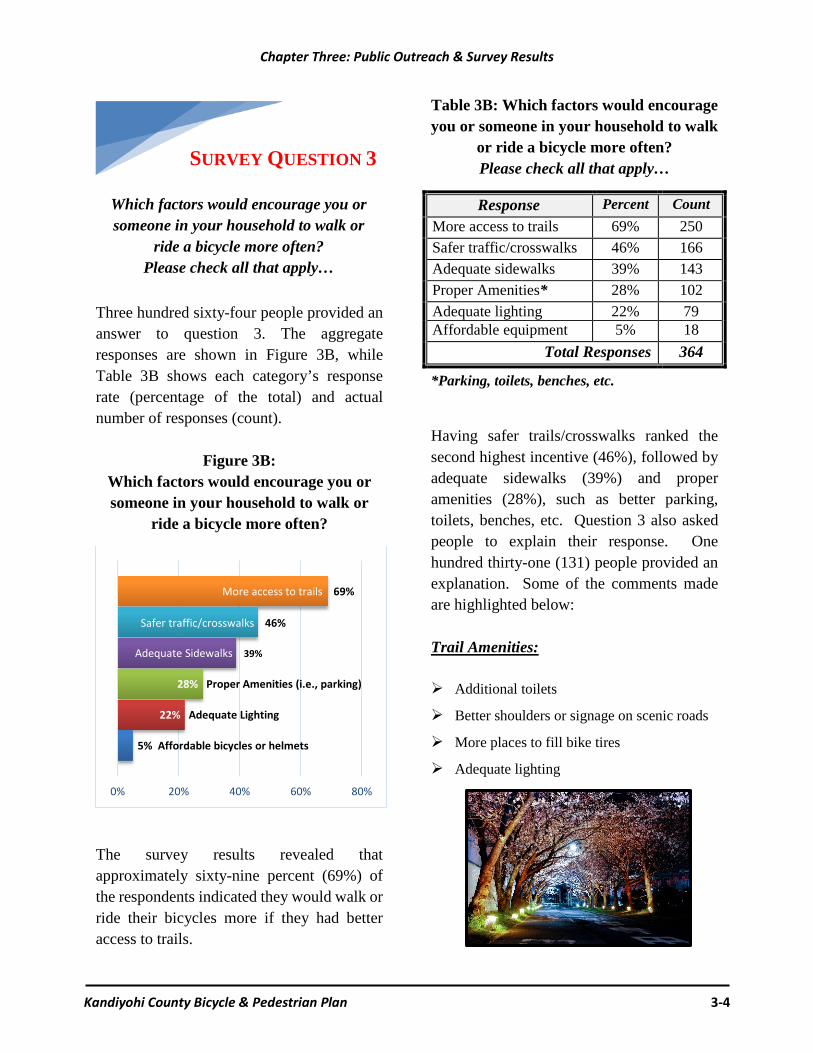
Three hundred sixty-four people provided an answer to question 3. The aggregate responses are shown in Figure 3B, while Table 3B shows each category’s response rate (percentage of the total) and actual number of responses (count).
Figure 3B: Which factors would encourage you or someone in your household to walk or
ride a bicycle more often?
The survey results revealed that approximately sixty-nine percent (69%) of the respondents indicated they would walk or ride their bicycles more if they had better access to trails.
Table 3B: Which factors would encourage you or someone in your household to walk
or ride a bicycle more often? Please check all that apply…
Response Percent Count More access to trails 69% 250 Safer traffic/crosswalks 46% 166 Adequate sidewalks 39% 143 Proper Amenities* 28% 102 Adequate lighting 22% 79 Affordable equipment 5% 18
Total Responses 364
*Parking, toilets, benches, etc. Having safer trails/crosswalks ranked the second highest incentive (46%), followed by adequate sidewalks (39%) and proper amenities (28%), such as better parking, toilets, benches, etc. Question 3 also asked people to explain their response. One hundred thirty-one (131) people provided an explanation. Some of the comments made are highlighted below: Trail Amenities: Additional toilets
Better shoulders or signage on scenic roads
More places to fill bike tires
Adequate lighting 5% Affordable bicycles or helmets
22% Adequate Lighting
28% Proper Amenities (i.e., parking)
Adequate Sidewalks 39%
Safer traffic/crosswalks 46%
More access to trails 69%
0% 20% 40% 60% 80%
SURVEY QUESTION 3
Which factors would encourage you or someone in your household to walk or
ride a bicycle more often? Please check all that apply…

Chapter Three: Public Outreach & Survey Results
Kandiyohi County Bicycle & Pedestrian Plan 3-5
Clearing trails in the winter
Education, Safety & Enforcement Needs:
Better awareness while driving near cyclists
Ensuring dogs are properly restrained
Better enforcement of traffic violations
Trail etiquette (i.e., walkers/bikers) Distracted driving campaign
3,179 people were killed in 2014 and 431,000 were injured due to distracted
drivers (Source: distraction.gov)
Distracted driving… not the only distracted epidemic!
According to the PEW Research Center, more than half of all adult cell phone owners have been on the giving or receiving end of a distracted walking encounter. The encounters are highest in the 18-24 age group, and then taper off as people get older (refer to the table on the right). As a result, communities and businesses are beginning to address distracted walking.
Source: www.pewresearch.org

Chapter Three: Public Outreach & Survey Results
Kandiyohi County Bicycle & Pedestrian Plan 3-6
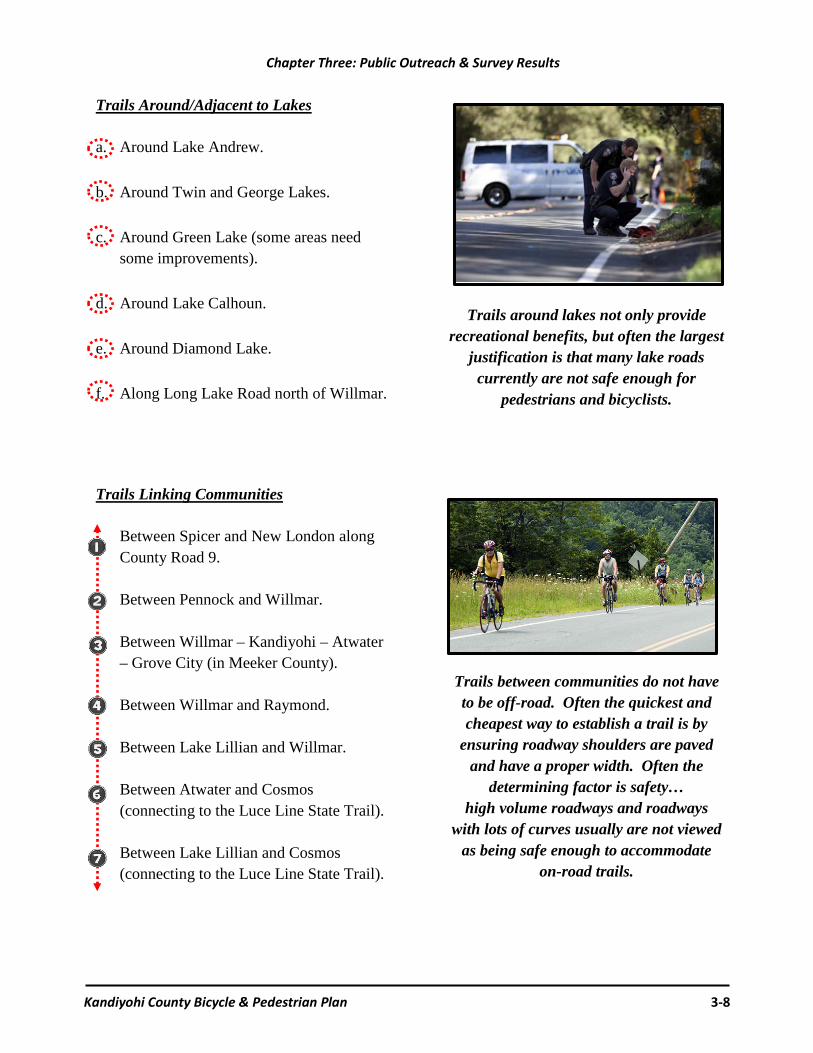
Two hundred eighty-five people provided an answer to question 4. The aggregate responses can be divided into three categories: trails connecting assets; trails linking communities; and trails around lakes. The results are shown on Map 3A. Please keep in mind the map is only intended to show where the survey respondents suggested trails should be developed and that some projects have already started.
Trails Connecting Assets
Connect Norway and Games Lakes. Create a trail between Sibley State Park and Games Lake. Between Sibley State Park and the Prairie Woods Environmental Learning Center.
Connect New London and Sibley State Park. Create a Mill Pond Loop in New London off the Glacial Lakes State Trail. Along Irving Road (CR 40) and connect to Green Lake (CR 4). Connect the Glacial Lakes State Trail with the Lake Koronis Trail. Trail along County Road 5 between Sibley State Park and the City of Willmar. Connect the Glacial Lakes State Trail to the Prairie Woods Environmental Learning Center. Along 153rd Avenue North East south of New London between County Road 9 and the Glacial Lakes State Trail. Along County Roads 25 and 41 north of Willmar. Between Eagle Lake - Glacial Lakes State Trail - Diamond Lake. Between Diamond Lake and Green Lake. Connection between Eagle Creek Golf Course in Willmar and the Glacial Lakes State Trail. Between Atwater and Diamond Lake. Between Lake Lillian and Big Kandiyohi Lake (County Park 1).
Trail ideas continued on page 3-8…
Note: all the comments can be found in Appendix A. Although there is some overlap, the following potential trail projects predominantly include the comments made regarding county-level projects rather than city or state level projects. The following suggested trail projects are not ranked in order of priority! The letters listed correspond with Map 3A.
SURVEY QUESTION 4
Where would you like to see new walking and bicycling trails developed? Please provide a brief answer…
Please check all that apply…

Chapter Three: Public Outreach & Survey Results
Kandiyohi County Bicycle & Pedestrian Plan 3-7
Map 3A: Suggested Bicycle & Pedestrian Trails (survey results)
a
b c
d
e
f
Chapter Three: Public Outreach & Survey Results
Kandiyohi County Bicycle & Pedestrian Plan 3-8
Trails Around/Adjacent to Lakes a. Around Lake Andrew.
b. Around Twin and George Lakes.
c. Around Green Lake (some areas need some improvements).
d. Around Lake Calhoun.
e. Around Diamond Lake.
f. Along Long Lake Road north of Willmar.
Trails Linking Communities
Between Spicer and New London along County Road 9. Between Pennock and Willmar. Between Willmar – Kandiyohi – Atwater – Grove City (in Meeker County). Between Willmar and Raymond. Between Lake Lillian and Willmar. Between Atwater and Cosmos (connecting to the Luce Line State Trail). Between Lake Lillian and Cosmos (connecting to the Luce Line State Trail).
Trails around lakes not only provide recreational benefits, but often the largest
justification is that many lake roads currently are not safe enough for
pedestrians and bicyclists.
Trails between communities do not have to be off-road. Often the quickest and cheapest way to establish a trail is by
ensuring roadway shoulders are paved and have a proper width. Often the
determining factor is safety… high volume roadways and roadways
with lots of curves usually are not viewed as being safe enough to accommodate
on-road trails.

Chapter Three: Public Outreach & Survey Results
Kandiyohi County Bicycle & Pedestrian Plan 3-9
Two hundred fifteen people provided an answer to question 5. Table 3C shows which words were used the most in the survey results. Figure 3C provides the same information in the form of a Word Cloud (the larger words were repeated the most).
Table 3C: Where would you like to see bicycle or pedestrian improvements/new
amenities on existing trails?
Response Percent Count Crossing 20% 43 Parking 15% 32 Willmar 13% 29 New London 13% 28 Lake 10% 22 Bathrooms/Toilets 8% 18 Benches 5% 11 Access 4% 9 Trail Head 4% 8 Robbins Island 3% 7 Porta Potties 2% 4 Wider Shoulders 1% 3 Garbage Cans 1% 2 Picnic Areas 1% 2
Total Responses 215
Figure 3C: Where would you like to see bicycle or pedestrian improvements/new
amenities on existing trails?
Appendix A contains the full list of comments made regarding Question 5 on the survey. Although the survey respondents made a lot of specific requests, some of the major themes are summarized below: Make safety at all types of trail crossings a
high priority.
I would like to see better signs for oncoming traffic.
Safer crossings and bathrooms.
Water access would be awesome! A spigot with drinkable water.
More rest stops with benches and toilets.
Spurs taking you into a commercial area (restaurants).
We need additional parking areas to access the current trails.
Better maintenance.
Signage on trails: miles, [connections], etc.
More lighting.
Wider shoulders.
Visitor information.
SURVEY QUESTION 5
Where would you like to see bicycle or pedestrian improvements/new amenities
on existing trails? Examples include additional parking areas, toilets, safer
trail crossings, etc. Please provide a brief answer…
Chapter Three: Public Outreach & Survey Results
Kandiyohi County Bicycle & Pedestrian Plan 3-10
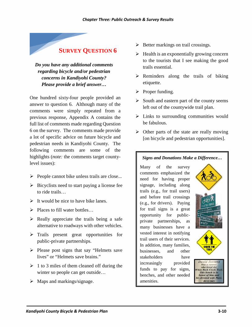
One hundred sixty-four people provided an answer to question 6. Although many of the comments were simply repeated from a previous response, Appendix A contains the full list of comments made regarding Question 6 on the survey. The comments made provide a lot of specific advice on future bicycle and pedestrian needs in Kandiyohi County. The following comments are some of the highlights (note: the comments target county-level issues): People cannot bike unless trails are close...
Bicyclists need to start paying a license fee to ride trails…
It would be nice to have bike lanes.
Places to fill water bottles…
Really appreciate the trails being a safe alternative to roadways with other vehicles.
Trails present great opportunities for public-private partnerships.
Please post signs that say “Helmets save lives” or “Helmets save brains.”
1 to 3 miles of them cleaned off during the winter so people can get outside…
Maps and markings/signage.
Better markings on trail crossings.
Health is an exponentially growing concern to the tourists that I see making the good trails essential.
Reminders along the trails of biking etiquette.
Proper funding.
South and eastern part of the county seems left out of the countywide trail plan.
Links to surrounding communities would be fabulous.
Other parts of the state are really moving [on bicycle and pedestrian opportunities].
Signs and Donations Make a Difference…
Many of the survey comments emphasized the need for having proper signage, including along trails (e.g., for trail users) and before trail crossings (e.g., for drivers). Paying for trail signs is a great opportunity for public-private partnerships, as many businesses have a vested interest in notifying trail users of their services. In addition, many families, businesses, and other stakeholders have increasingly provided funds to pay for signs, benches, and other needed amenities.
SURVEY QUESTION 6
Do you have any additional comments regarding bicycle and/or pedestrian
concerns in Kandiyohi County? Please provide a brief answer…

Chapter Three: Public Outreach & Survey Results
Kandiyohi County Bicycle & Pedestrian Plan 3-11
Three hundred one people provided an answer to question 7. The results are summarized in Table 3D. Some of the responses, such as “Willmar, New London, and Kandiyohi,” may refer to either the city or township. In either case, it is helpful to understand generally where the survey respondents live. Based upon the results, it appears the areas already served by access to trails were the most interested in participating in the online survey.
Table 3D: Please enter your city or township of residence
* Could refer to city or township.
Response Percent Count Willmar* 32% 95 New London* 27% 80 Township (not specific) 22% 67 Lake (not specific) 9% 26 Spicer 9% 26 Atwater 5% 16 Dovre Township 4% 12 Kandiyohi* 3% 8 County (not specific) 2% 7 Paynesville 1% 3 Burbank Township 1% 3 Irving Township 1% 3
Total Responses 301
SURVEY QUESTION 7
(Optional) Please enter your city or township of residence. Thank you for
your participation!

Chapter Three: Public Outreach & Survey Results
Kandiyohi County Bicycle & Pedestrian Plan 3-12
C. Public Open Houses
To help gather additional comments regarding bicycle and pedestrian issues in Kandiyohi County, members from the Bicycle & Pedestrian Plan Task Force attended two separate open houses. The first was at Willmar’s Bicycle Open House, which took place on April 7, 2016, at the Willmar Auditorium. The event had numerous booths and activities, all with bicycling as the common theme. The second open house took place at the Senior Center in New London on May 11, 2016. Staff from Kandiyohi County Public Works and the Mid-Minnesota Development Commission facilitated the open house. Participants were provided the opportunity to explain their views on important bicycle and pedestrian issues. The following lists summarize the comments made at both public events (refer to Appendix B).
Willmar Bicycle Open House Comments 1. Would like to see a paved trail connecting
CSAH 5 to Sibley State Park. 2. It is very important to have a trail on
CSAH 5 by Games Lake. 3. I would like to see that the new planned
trail on CSAH 5 is placed on only one side of the road, so there is no danger of crossing the highway.
4. The designated bike route on County Road
148 is currently a very bad road for bicyclists.
5. I would like to see a bicycle lane on CSAH
40. Comments continued on page 3-13…
Photos from the Willmar Bicycle Open House (April 7, 2016)

Chapter Three: Public Outreach & Survey Results
Kandiyohi County Bicycle & Pedestrian Plan 3-13
6. I would like to see a CSAH 5 trail loop –
Willmar to Sibley State Park 7. CSAH 5 should be a main bike route. 8. The Prairie Woods Environmental
Learning Center needs to be linked to other destinations with off road trails.
9. I would like to see marked bicycle lanes on
CSAH 25.
10. There is a gap – no trail at parking lot south of road (the comment tab had an arrow and was moved – it was around the Willmar Trailhead to the State Trail. There is a short gap from the City trail to /and through the state trailhead parking lot.
11. There is no shoulder on CSAH 8 between
the cities of Kandiyohi and Spicer.
12. Make a path on the south side of Diamond Lake, and make a loop around the entire lake if possible.
13. Bring the Luce Line Trail to Willmar.
14. There is a need for more signage on bike
routes/trails. New London Open House Comments
15. Connect the State Parks. (Sibley and Monson Lake).
16. Connect CSAH 5 to State Park.
Mel Odens, Kandiyohi County Public Works Director, and Amy Denz talk trails [May 11, 2016] at an open house at the New London
Senior Center. Source Gary Miller www.2wheeler.areavoices.com
17. Within Sibley State Park, construct a bike/hike trail through existing State Park land to County Park 7.
18. Connect Games Lake Park to Sibley State Park.
19. Existing trail from New London (Co. Rd. 31) to Willmar continues to deteriorate with numerous sections that have many cracks. The parallel ones can be dangerous. This section should be given priority before the extension to Sibley State Park is built! #1 should be New London - Spicer as that has the most traffic all summer!
20. Safer bike/pedestrian crossings of CSAH 40 between Main Street and CSAH 9 in and west out from New London. (Safe crossings to the school property.)
21. Separated/protected bike/pedestrian trail on Birch Street, New London.

Chapter Three: Public Outreach & Survey Results
Kandiyohi County Bicycle & Pedestrian Plan 3-14
22. Loving all the plans so far – and anything that connects to the Glacial Lakes/state trails and the Sibley State Park connector will be a big plus.
23. I would like a trail along CSAH 40 and CSAH 4 to Green Lake.
24. Trail from CSAH 40 to Prairie Woods Elementary on East Side of CSAH 9.
25. At Willmar State Trailhead – Need to pave by the parking lot (gap).
26. Widen the shoulders of CSAH 9 from CSAH 10 to CSAH 40, to accommodate bikes.
27. Lake Calhoun Association – Trail by Lake Calhoun around to connect Co. Rd. 98 to CSAH 4.
28. Widen the shoulders from CSAH 10 to CSAH 40, to accommodate bikes.
29. Resurfacing the existing trail (New London to Willmar) more needed than new trails.
30. The branch off the trail up to the NL-S High School needs to be widened.
31. When the trail is re-surfaced through the “tunnel” under State Highway #9, it needs to be elevated so there is drainage out of the tunnel. There is lots of ponding there and ice in winter. Also – better drainage in the tunnel south of Spicer?
Press Release for the Kandiyohi County Trails Survey and the
New London Open House (refer to Appendix B)

Chapter Three: Public Outreach & Survey Results
Kandiyohi County Bicycle & Pedestrian Plan 3-15
D. Summary of Common Themes
The comments collected through the trails survey and received during the two open houses can be categorized into the following common themes and/or priorities:
1. Safety should be a main priority. This
includes safe trail crossings, adequately paved shoulders between key destinations, adequate lighting (where needed), and proper maintenance.
2. Establishing Loops stemming from the Glacial Lakes State Trail, around lakes and from communities should be a priority.
3. Trail Amenities should be provided, such
as parking, toilets, benches, garbage cans, bike racks, shade, water fountains and proper signage.
4. Establishing Connections between key destinations, such as between communities, parks and existing trails.
5. Promote Kandiyohi County as a great
place to use trails!

Kandiyohi County Bicycle & Pedestrian Plan 4-1
A. Chapter Highlights
Chapter Four identifies the Kandiyohi County’s priority bicycle and pedestrian trail projects. The list includes trail segments that could be implemented in Kandiyohi County over the next 5 to 10 years. Each trail segments is profiled in Section B. Potential funding sources are described in Chapter Five along with a list of action steps that should be followed in order to properly implement the projects identified in this Chapter.
B. Priority Trail Projects
A number of potential trail projects were identified from a variety of sources throughout the planning process. The sources include comments received from the Kandiyohi County Trails Survey, comments made at open houses, and projects discussed during the various Bicycle & Pedestrian Plan Task Force meetings (note: refer to Chapter Three for more information on the survey and the open houses). The list of Kandiyohi County’s priority projects is found in Table 4 and displayed on Map 4. Please keep in mind this is not a list of projects Kandiyohi County is committing to pay for, but rather a list of potential projects the county is likely to support as the various stakeholders work out the project details (i.e., financing, maintenance, etc.). Due to the unknown timing of the projects, cost estimates are not provided.
Table 4: Kandiyohi County’s Priority Bicycle & Pedestrian Projects*
Please refer to Map 4 and the corresponding text. The order is not meant to indicate priority ranking.
A. Sibley State Park to Games Lake
B. 153rd Ave NE between CR 9 and the Glacial Lakes State Trail (New London Township Project)
C. New London – Green Lake Loop: County Roads 40 and 4
D. Willmar – Games Lake Trail: County Road 5
E. North Willmar Trail Loops: County Roads 24, 25 & 41
F. Eagle Lake Trail
G. North Central Lakes Eagle/Green/Diamond Loops
H. Diamond Lake Trail
I. Lake Lillian – Big Kandiyohi Lake Trail
*Note: the list of priority projects does not include the various safety and amenity needs identified throughout the planning process. Please refer to Chapter Five.
Chapter Four: Priority Trail Projects

Chapter Four: Priority Trail Projects
Kandiyohi County Bicycle & Pedestrian Plan 4-2
Map 4: Priority Trail Projects ~ Not ranked in order of priority. Please refer to the text for additional information ~
Chapter Four: Priority Trail Projects
Kandiyohi County Bicycle & Pedestrian Plan 4-3
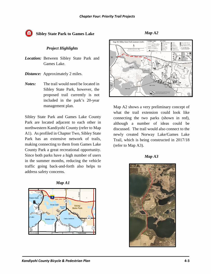
Sibley State Park to Games Lake
Project Highlights Location: Between Sibley State Park and
Games Lake. Distance: Approximately 2 miles. Notes: The trail would need be located in
Sibley State Park, however, the proposed trail currently is not included in the park’s 20-year management plan.
Sibley State Park and Games Lake County Park are located adjacent to each other in northwestern Kandiyohi County (refer to Map A1). As profiled in Chapter Two, Sibley State Park has an extensive network of trails, making connecting to them from Games Lake County Park a great recreational opportunity. Since both parks have a high number of users in the summer months, reducing the vehicle traffic going back-and-forth also helps to address safety concerns.
Map A1
Map A2
Map A2 shows a very preliminary concept of what the trail extension could look like connecting the two parks (shown in red), although a number of ideas could be discussed. The trail would also connect to the newly created Norway Lake/Games Lake Trail, which is being constructed in 2017/18 (refer to Map A3).
Map A3

Chapter Four: Priority Trail Projects
Kandiyohi County Bicycle & Pedestrian Plan 4-4
153rd Ave NE between CR 9 and the Glacial Lakes State Trail (New London Township Project)
Project Highlights Location: Along 153rd Avenue NE between
County Road 9 and the Glacial Lakes State Trail.
Distance: Approximately 1.25 miles.
Notes: The trail project consists of
creating a safe on-road trail by having minimum 5-foot paved shoulders on both sides of 153rd Avenue and proper signage (refer to Maps B1 and B2. The trail would provide safer access to/from the Glacial Lakes State Trail.
Map B1
Map B2

Chapter Four: Priority Trail Projects
Kandiyohi County Bicycle & Pedestrian Plan 4-5
New London – Green Lake Loop: County Roads 40 & 4
Project Highlights
Location: Along County Roads 40 & 4,
creating a New London - Green Lake Loop off the Glacial Lakes State Trail (refer to Maps C1 & C2).
Distance: Approximately 5 miles.
Notes: CR 40 is currently being
reconstructed and will be completed in 2017: proper signage is all that will be required. 5-foot paved shoulders will need to be added to CR 4.
Map C1
Map C2
Chapter Four: Priority Trail Projects
Kandiyohi County Bicycle & Pedestrian Plan 4-6
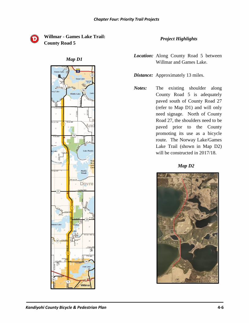
Willmar - Games Lake Trail: County Road 5
Map D1
Project Highlights
Location: Along County Road 5 between
Willmar and Games Lake. Distance: Approximately 13 miles. Notes: The existing shoulder along
County Road 5 is adequately paved south of County Road 27 (refer to Map D1) and will only need signage. North of County Road 27, the shoulders need to be paved prior to the County promoting its use as a bicycle route. The Norway Lake/Games Lake Trail (shown in Map D2) will be constructed in 2017/18.
Map D2

Chapter Four: Priority Trail Projects
Kandiyohi County Bicycle & Pedestrian Plan 4-7
North Willmar Trail Loops: County Roads 24, 25 & 41
Project Highlights Location: County Roads 24, 25 and 41. Distance: Approximately 8 miles.
Notes: These trail segments would create
loops north of Willmar in combination with County Road 5 and the existing Willmar trails network. County Roads 25, 41, and 24 (West) only require signage. The County Road 24 (East) project would require some off-road segments (refer to Maps E1 and E2).
Map E1
Map E2

Chapter Four: Priority Trail Projects
Kandiyohi County Bicycle & Pedestrian Plan 4-8
Eagle Lake Trail
Project Highlights
Location: The trail would create a loop around Eagle Lake (refer to Map F1).
Distance: Approximately 3 miles.
Notes: A culvert over the Hawk Creek Outlet
was removed and is being replaced by a bike and pedestrian bridge by the Eagle Lake Improvement Association in conjunction with Kandiyohi County, Dovre Township, Green Lake Township, and the Department of Natural Resources. Signage will be needed to properly identify the Eagle Lake Trail.
Map F1

Chapter Four: Priority Trail Projects
Kandiyohi County Bicycle & Pedestrian Plan 4-9
North Central Lakes Eagle/Green/Diamond Loops
Project Highlights
Location: Bicycle trail loops between Eagle, Green, and Diamond Lakes in north central Kandiyohi County (refer to Map G1).
Distance: County Road 4 – 3 miles. County Road 8 – 3 miles. County Road 9 – 3 miles. County Road 10 – 6 miles. County Road 26 – 5 miles.
Notes: For some of the county road segments, only signage is needed for the bicycle route to be established. The remaining routes will need the shoulders paved. A few spot areas will need the shoulders widened.
Map G1

Chapter Four: Priority Trail Projects
Kandiyohi County Bicycle & Pedestrian Plan 4-10
Diamond Lake Trail
Project Highlights
Location: Around Diamond Lake (refer to Maps H1 and H2).
Distance: Phase One – 2.4 miles. Phase Two – 5 miles.
Notes: The proposed project consists of two
phases. Phase One consists of a 2.4 mile long, 10-foot wide, multi-purpose off-road trail that runs along the southwest and west shores of Diamond Lake. The trail would be adjacent to County Road 4, from 49th Avenue NE to Diamond Shores Road. Phase Two consists of establishing a trail around the rest of the lake.
Map H1: Phase One

Chapter Four: Priority Trail Projects
Kandiyohi County Bicycle & Pedestrian Plan 4-11
Map H2: Diamond Lake Trail Phase One & Phase Two

Chapter Four: Priority Trail Projects
Kandiyohi County Bicycle & Pedestrian Plan 4-12
Note About Paved Shoulder Funding
Many of the identified bicycle routes in this chapter rely to a great extent on paved
shoulders on county roads. One objective of this plan is to identify which county road
segments are best suited to be upgraded to a 5-foot paved shoulder at the time when
the road has major reconstruction work completed. The Kandiyohi County Public
Works Department intends to include these paved shoulders in their road program
budgets and use state-aid dollars on County State-Aid Highways whenever possible.
Lake Lillian – Big Kandiyohi Lake Trail
Project Highlights
Location: Along County Road 8 between Lake Lillian and Big Kandiyohi Lake (refer to Map I1).
Distance: Approximately 6 miles. Notes: County Road 8 is proposed to be
improved in 2019 and could include the construction of a new off-road trail base within the road right-of-way. The new trail would begin in the City of Lake Lillian and run north and west along County Road 8 until County Road 132. County Road 132 is a rural paved road that runs to Big Kandiyohi Lake, where a county park is located. The City of Lake Lillian is currently creating a land use plan which includes the new trail through Main Street.
Map I1
Kandiyohi County Bicycle & Pedestrian Plan 5-1
A. Chapter Highlights
Chapter Five presents information on implementation and potential funding sources. Section B outlines the key action steps that will be implemented by Kandiyohi County and the various trail stakeholders. Potential funding sources are described in Section C. It should be noted that not all of the priority projects identified in Chapter Four are likely to be implemented over the next 10 years. It is the intent of this plan, however, to be ready to proceed when the timing is right.
B. Implementation Steps
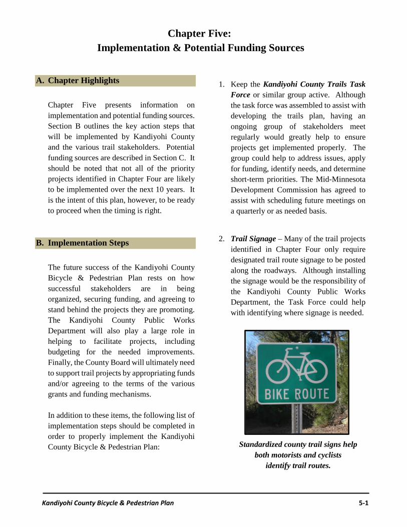
The future success of the Kandiyohi County Bicycle & Pedestrian Plan rests on how successful stakeholders are in being organized, securing funding, and agreeing to stand behind the projects they are promoting. The Kandiyohi County Public Works Department will also play a large role in helping to facilitate projects, including budgeting for the needed improvements. Finally, the County Board will ultimately need to support trail projects by appropriating funds and/or agreeing to the terms of the various grants and funding mechanisms. In addition to these items, the following list of implementation steps should be completed in order to properly implement the Kandiyohi County Bicycle & Pedestrian Plan:
1. Keep the Kandiyohi County Trails Task
Force or similar group active. Although the task force was assembled to assist with developing the trails plan, having an ongoing group of stakeholders meet regularly would greatly help to ensure projects get implemented properly. The group could help to address issues, apply for funding, identify needs, and determine short-term priorities. The Mid-Minnesota Development Commission has agreed to assist with scheduling future meetings on a quarterly or as needed basis.
2. Trail Signage – Many of the trail projects
identified in Chapter Four only require designated trail route signage to be posted along the roadways. Although installing the signage would be the responsibility of the Kandiyohi County Public Works Department, the Task Force could help with identifying where signage is needed.
Standardized county trail signs help both motorists and cyclists
identify trail routes.
Chapter Five: Implementation & Potential Funding Sources

Chapter Five: Implementation & Potential Funding Sources
Kandiyohi County Bicycle & Pedestrian Plan 5-2
In addition to ensuring that trail routes have the proper signage, this implementation step also refers to ensuring that directional and other bicycle-friendly signs are posted where needed. Examples include mile markers along trails, business directional markers, mileage to restrooms, etc. The goal is to help make trails user-friendly.
Proper trail signage examples.
3. Develop an Adopt-A-Trail Program –
These types of programs are similar to Minnesota’s Adopt-A-Highway Program. This would allow volunteers and/or sponsors to actively participate in performing maintenance on a specific trail segment. The highway program focuses entirely on picking up litter, however, a customized local trails program could also cover items such as mowing, tree trimming, replacing signage, and ensuring the trail has the proper amenities.
4. Trail Amenities – One of the main messages conveyed by the public throughout the planning process was the need to make it a priority to ensure that all trails have the proper amenities. Examples include signage, mile markers, trailheads, parking, bike racks, lighting, benches, and toilets. Many of the amenities could be donated through an Adopt-A-Trail program (refer to #3 above) and/or through a dedicated Trails Fund (refer to #5 below).
5. Establish a Trails Fund – The County
should explore the possibility of establishing a ‘trails fund’ that would receive an annual allocation in the county

Chapter Five: Implementation & Potential Funding Sources
Kandiyohi County Bicycle & Pedestrian Plan 5-3
budget. With funds collected over time, a trails fund could provide the local match for grants and help fund new trail development, maintenance needs and/or the purchase of trail amenities. The fund could also serve as a collection place for donations and/or funds raised through trails events. Donations could be targeted for a specific project or be available for general trail needs.
Rochester resident Gelene Pigott recently donated a bench for the
Letica Road Trailhead
6. Trail Condition Report – Related to maintenance, the county should work with stakeholders to develop a Trails Condition Report. These reports could be completed by stakeholders and/or volunteers and collected by whoever is responsible for each trail segment. The completed reports could then be submitted to the Kandiyohi County Public Works Department. A small sign posted periodically along the routes asking for the public to report problems to the department is also needed.
7. Trail Use & Enforcement – Trail users
should be informed of rules and regulations in a variety of ways. Kiosks and signs should be strategically located to provide specific information about allowable trail uses, permitted and prohibited activities, directions, and required fees or permits. Printed and web based materials and maps could also provide similar information. The Kandiyohi County Sheriff’s Office would also be responsible for enforcement, responding to emergencies, and dealing with criminal activities.
8. Make Safety a Priority – As future trail
decisions are made, ensure that safety remains at the forefront of the discussion. This includes ensuring that trails have the proper width depending on where they are located, and that trail crossings have both the proper lighting and signage notifying motorists.
9. Keep Table 4 and Map 4 Current – This Plan was created with the intent of being able to periodically update the implementation priorities identified in Chapter Four (refer to Table 4 and Map 4). Future updates could be reviewed by the Trails Task Force and/or county staff prior to be voted on by the County Board. This will allow the map to be updated periodically without having to revise the entire Kandiyohi County Bicycle & Pedestrian Plan.

Chapter Five: Implementation & Potential Funding Sources
Kandiyohi County Bicycle & Pedestrian Plan 5-4
C. Potential Funding Sources
In order to be properly implemented, trail projects in Kandiyohi County will ultimately need to rely on a variety of stakeholders and funding sources. From securing grants, to developing maintenance agreements, the success of projects will be an ongoing effort. This section of the plan identifies some potential funding sources for trail projects. Donations (time and money) Individuals, families, businesses and user groups have increasingly been willing to donate time and/or money towards trail projects. From paying for trail benches and volunteering to pick up garbage, to sponsoring rest areas and raising money to build trail segments, volunteers have made a number of trail projects become a reality. One way to help offset some of the ongoing expense of maintaining trails is to develop a Kandiyohi County Adopt-A-Trail Program. This would allow volunteers, families, businesses and user groups to assist with a variety of trail needs, including picking up garbage and reporting back to the county when trail signs need to be replaced. Another way to help reduce costs would be to develop a Kandiyohi County Trails Fund where interested parties could provide donations. The donations could be trail and/or project specific or could simply help with ongoing trail expenses.
Adopt-A-Trail Programs are helping to lower the cost of maintaining trials
Local Government Match Most trail projects are not completely covered by grants. To be competitive on securing grant assistance, local governmental units commonly are required to match grant dollars, usually ranging from 25% to 50% of the total project costs. In addition, having a long-term maintenance plan is normally a funding prerequisite. Identifying stakeholders who are willing to share costs and/or perform maintenance responsibilities has become an increasingly popular way for local governmental units to justify funding and their overall commitment to trail projects. Fortunately user groups who are promoting local projects usually have the capacity to help out when and where it is needed.

Chapter Five: Implementation & Potential Funding Sources
Kandiyohi County Bicycle & Pedestrian Plan 5-5
Grants According to the Parks and Trails Council of Minnesota, over $7 million was granted to communities and organizations across Minnesota in 2014 to acquire, develop, construct, and renovate parks and trails (2015 Resource Guide: Grants for your Park or Trail). Although securing grant money has become increasingly competitive, one of the main benefits of developing the Kandiyohi County Trails Plan was because many funding sources require projects to be identified in a locally adopted plan. Furthermore, having a project identified in an official plan usually allows the project to objectively score higher in the grant review process. This section of the plan highlights some of the main sources of grants that fund trail projects. It should be noted that grant funding details periodically change, and that new funding sources occasionally become available.
Federal Recreational Trail Program
www.fhwa.dot.gov/environment/ recreational_trails
Program Goals & Priorities? To provide funds for trail activities and facilities that support a wide variety of motorized and non-motorized trail activities. Special consideration is given to projects involving urban youth worker programs, such as the Minnesota Conservation Corp. Who can apply? All projects must be sponsored by a unit of government. Preference is given to projects that have a local trail partner organization.
Eligible projects? Acquisition and development for new trails; contracted maintenance on existing trails; development of permanent trailside facilities; and purchases of equipment. Priority projects for 2015 included trail linkages, trail rehabilitation, trail signs to increase safety, trail grooming equipment, and single-track mountain biking trails. Level of assistance? The maximum grant is $150,000, with the average grant ranging from $30,000 to $85,000. Costs must be incurred and paid for before reimbursement. The grantee must cover at least 25% of the total project cost (50% for equipment purchases over $75,000). Funding for 2015 was approximately $1.7 million. Source of funds? Grants are funded by a portion of federal excise taxes on off-highway recreation fuel, which is deposited into the Federal Highway Trust Fund and appropriated to each state. States are required to use 40% for diverse recreational trail use, 30% for motorized use, and 30% for non-motorized use. The review process? The Minnesota Recreation Trail Users Association reviews grant priorities, applications, and recommends projects to be funded. Selected projects are then reviewed and approved by the Minnesota Department of Natural Resources.
Chapter Five: Implementation & Potential Funding Sources
Kandiyohi County Bicycle & Pedestrian Plan 5-6
Local Trails Connection Program www.dnr.state.mn.us/grants/recreation/
trails_local.html Program Goals & Priorities? To accelerate the acquisition and development of local trail connections between where people live and significant public resources (e.g., historical areas, parks, other trails). This program is not intended to create significant new trails. Who can apply? All local units of government. Trail organizations and/or user groups may apply, but only in coordination with a local unit of government. Eligible projects? Land acquisition from willing sellers; trail construction and/or restoration; permanent trailside improvements (e.g., drainage, parking, bathrooms); ADA compliance projects; contracted maintenance; bridge construction and restoration. Projects within state park boundaries or wilderness areas are not eligible for funding. Level of assistance? Grants range from $5,000 to $150,000. Costs must be incurred and paid for before reimbursement. The grantee must cover at least 25% of the total project cost. Source of funds? Grants are funded primarily by the Minnesota State Lottery. Every year, the State Lottery returns 6.5% of gross sales to the state as a payment “in lieu of” sales tax. From these proceeds, state law dictates 2.2% is spent on local trail grants. These dollars are divided between the Local Trails Connection Program and the Regional Trail Program. In recent years, state bond sales and the
Environment and Natural Resources Trust Fund have also been used to fund local trail grant programs. The review process? The Minnesota Department of Natural Resources reviews all applications and makes final funding decisions. Priority is given to projects that provide significant connectivity, with consideration also given to trail length, amount of use, and quality of natural and cultural resources.
Regional Trail Grant Program
www.dnr.state.mn.us/grants/recreation/ trails_regional.html
Program Goals & Priorities? To accelerate the acquisition and development of long-distance, regionally significant trails outside of the seven-county metropolitan area (Anoka, Carver, Dakota, Hennepin, Ramsey, Scott, and Washington). Who can apply? All local units of government (e.g., cities, counties, townships) outside of the seven-county metropolitan area are eligible to apply. Trail organizations and/or user groups may apply, but only in coordination with a local unit of government. Eligible projects? Land acquisition from willing sellers; trail construction and/or restoration; permanent trailside improvements (e.g., drainage, parking, bathrooms); ADA compliance projects; contracted maintenance; bridge construction and restoration. Projects within state park boundaries or in state trail corridors are not eligible for funding.

Chapter Five: Implementation & Potential Funding Sources
Kandiyohi County Bicycle & Pedestrian Plan 5-7
Level of assistance? Grants range from $5,000 to $250,000, with the average grant ranging from $100,000 to $170,000. Costs must be incurred and paid for before reimbursement. The grantee must cover at least 25% of the total project cost. Source of funds? Grants are funded primarily by the Minnesota State Lottery. Every year, the State Lottery returns 6.5% of gross sales to the state as a payment “in lieu of” sales tax. From these proceeds, state law dictates 2.2% is spent on local trail grants. These dollars are divided between the Local Trails Connection Program and the Regional Trail Program. In some past years, state bond sales and the Environment and Natural Resources Trust Fund have also been used to fund local trail grant programs. The review process? The Minnesota Department of Natural Resources reviews all applications and makes final funding decisions. Priority is given to projects that develop trails of significant length, projects that are expected to have high usage, and projects that provide a unique and interesting connection to the outdoors.
Outdoor Recreational Grant Program www.dnr.state.mn.us/grants/recreation/
outdoor_rec.html
Program Goals & Priorities? To provide funds to local governments for acquiring parkland and developing, or redeveloping, outdoor recreation facilities.
Who can apply? All cities, counties, townships, and recognized tribal governments are eligible. The applicant must be the current or intended owner and manager of the property to be acquired and/or developed. Eligible projects? Acquisition, development, redevelopment, and/or rehabilitation of outdoor recreation facilities, including but not limited to: boat/canoe access sites, campgrounds, fishing areas, skating rinks, nature areas, picnic shelters, playgrounds, sports fields and courts, swimming areas, splash parks, and non-motorized trails within a park boundary. Level of assistance? Grants range from $5,000 to $100,000, with the average ranging from $35,000 to $65,000. Costs must be incurred and paid for before reimbursement. The grantee must cover at least 50% of the total project cost. Source of funds? Grants are funded with federal dollars from the Land and Water Conservation Fund (LAWCON). Since 1965, LAWCON has provided matching grants to federal, state, and local governments for outdoor recreation projects. Income for LAWCON is primarily from fees paid by companies drilling for oil and gas in the Outer Continental Shelf. The review process? The Minnesota Department of Natural Resources reviews all applications and, if necessary, conducts site visits. Applications are judged based upon consistency with the strategic directions identified in the 2014-2018 State

Chapter Five: Implementation & Potential Funding Sources
Kandiyohi County Bicycle & Pedestrian Plan 5-8
Comprehensive Outdoor Recreation Plan, including connecting people to the outdoors, acquiring land, taking care of what we have, and coordinating among partners. Additionally, proposed projects are judged based upon the local match, project readiness, site quality, and facility design.
Greater Minnesota Legacy Grants www.legacy.leg.mn/funds/parks-trails-fund
Program Goals & Priorities? To assist in the acquisition, development, improvement, or restoration of regionally significant parks and trails outside the seven-county metropolitan area. Who can apply? All local units of government outside the seven-county metropolitan area are eligible to apply. Eligible projects? Land acquisition for development of trails or outdoor recreation facilities; development, redevelopment or rehabilitation of existing trails or outdoor recreation facilities; and protection or restoration of natural resources within parks and trails. Projects must be within a designated regional park or trail in Greater Minnesota. Level of assistance? There is no minimum or maximum request. Applicants are not required to provide a match, but projects with non-state cash contributions will receive additional consideration. Past grants have ranged from $20,000 to $1.5 million.
Source of funds? Grants are funded by the Clean Water, Land, and Legacy Amendment, which was passed by voters in 2008. The Legacy Amendment increased the state sales tax 3/8 of one percent and dedicated 14% of new revenues to a Parks & Trails Fund. A portion of the Parks & Trails Legacy Fund supports regional parks and trails in Greater Minnesota. The review process? The Greater Minnesota Regional Parks & Trails Commission receives, reviews, and evaluates all applications. Projects are selected based upon criteria in the Parks & Trails Legacy Plan, the Greater Minnesota Regional Parks & Trails Strategic Plan and Funding Program, the availability of a non-state cash match, and the project’s overall quality, readiness, and design.
Transportation Alternatives (TA) Funding
www.t4america.org Program Goals & Priorities? To support alternatives to automobile transit, including pedestrian and bicycle facilities, access to public transportation and enhanced mobility, community improvement activities, environmental mitigation, and safe routes to schools. Who can apply? Local governments; regional transportation authorities; transit agencies; natural resource and public land agencies; school districts, local education agencies, or schools; and tribal governments are all eligible to apply.

Chapter Five: Implementation & Potential Funding Sources
Kandiyohi County Bicycle & Pedestrian Plan 5-9
Eligible projects? Construction, planning, and design of on-road and off-road trail facilities for non-motorized forms of transportation, including: sidewalks, bicycle infrastructure, pedestrian and bicycle signals, traffic calming techniques, light and other safety-related infrastructure, ADA compliance, and conversion of abandoned railroad corridors into trails. Per Minnesota rules, engineering activities and the purchase of right-of-ways are not eligible. Level of assistance? Grants are recommended to range from $100,000 to $1 million. The grantee must cover at least 20% of the projects total cost. Source of funds? Grants are funded by the Highway Account of the Highway Trust Fund for Federal-Aid highways, of which 2% is reserved for transportation alternatives and appropriated to each state. The Minnesota Department of Transportation allocates Minnesota’s share of these federal funds to each of the eight Area Transportation Partnerships based upon population. The review process? Applicants must first submit a Letter of Intent to their regional Area Transportation Partnership. For Kandiyohi County, interested parties should contact the Mid-Minnesota Development Commission (www.mmrdc.org). The letter of intent process coaches the applicant through the grant process, helps the applicant balance effort with the likelihood of receiving funds, and ensures the full requirements of federal funding are understood. Following the Letter of Intent, full applications are received, evaluated, and selected by each Area
Transportation Partnership’s committee. Projects are evaluated on their connection to statewide and regional plans, their connection to safe routes to school, their transportation purpose, and the feasibility of being completed on schedule.
State Park Road Account Program www.dnr.state.mn.us/grants/recreation/
parkroads.html Program Goals & Priorities? This program exists to help local governments improve access to public recreation facilities. It provides financial assistance to improve county state-aid, county, township, and city roads which provide access to state parks and other outdoor recreation. Who can apply? County, Township, and City Governments. Eligible projects? The establishment, location, relocation, construction, reconstruction, and improvement of County State Aid Highways that provide access to state parks, state trails, state scientific and natural areas, state wilderness areas, state forests, state wildlife management areas and state water access sites. The reconstruction, improvement, repair and maintenance of county, township and city roads provide access to public lakes, rivers, state parks and state campgrounds. Level of assistance? Costs for construction and right-of-way acquisition are reimbursable for up to 100% of eligible costs. Preliminary and construction engineering costs are not reimbursable and are the responsibility of the

Chapter Five: Implementation & Potential Funding Sources
Kandiyohi County Bicycle & Pedestrian Plan 5-10
local unit of government. Requests are not subject to a minimum or maximum amount of dollars. Approximately $4,000,000 will be available statewide for calendar year 2018. The review process? For 2018 funds, the application deadline is November 1, 2017. The DNR will review and rank applications. Mini-Grants There are a number of smaller grants regularly offered through various stakeholders, each with a unique focus. The following ‘mini-grants’ could assist with implementing the Kandiyohi County Trails Plan:
MRPF New Initiative Grant Program www.mnrpa.org/mrpf
Synopsis: Up to $2,000 is awarded to spur innovation in parks and recreation services at a local, regional, or state-wide level that ultimately could have statewide impact. The program is intended to allow agencies to try new programs and services that demonstrate innovation in parks and recreation services and have future applicability for other agencies at a local, regional, or statewide level. Ineligible projects include capital improvements, funding for existing programs and services, full-time personnel, and on-going expenses. Grants are funded by charitable contributions to the Minnesota Recreation and Park Foundation.
Explore Minnesota Grants www.exploreminnesota.com/industry-minnesota/ways-to-get-involved/grants
Synopsis: Grants are offered to Minnesota non-profit organizations formed for the primary purpose of tourism promotion and to scenic byway groups incorporated as a non-profit organization. Grants are to be used for marketing and promotional projects or to conduct research to help in this endeavor. Grants range from $250 to $8,000. Applicants with organizational budgets less than $100,000 are required to match grant funds 1:1 or 2:1 if greater.
Minnesota Historical and Cultural Heritage Grants
http://legacy.mnhs.org/grants
The program supports history programs and projects to preserve significant historic and cultural resources. While not specifically intended for park and trail projects, the Minnesota Historical & Cultural Heritage Grants Program is applicable to parks and trails that preserve and/or promote historic and cultural resources. The average grant ranges from $5,000 to $30,000 with no local match.

Chapter Five: Implementation & Potential Funding Sources
Kandiyohi County Bicycle & Pedestrian Plan 5-11
PeopleForBikes Community Grants www.peopleforbikes.org/pages/community
-grants
The PeopleForBikes Community Grant Program provides funding for important and influential projects that leverage federal funding and build momentum for bicycling in communities across the U.S. These projects include bike paths and rail trails, as well as mountain bike trails, bike parks, BMX facilities, and large-scale bicycle advocacy initiatives. Average grants range from $4,500 to $8,000 with 50% local match required.
National Trails Fund www.americanhiking.org/national-trails-
fund
American Hiking Society’s National Trails Fund (NTF) offers “hiking trail improvement” grants to active member organizations of our Hiking Alliance. Once a year, Alliance Members have the opportunity to apply for a grant (value between $500 and $5,000) in order to improve hiking access or hiker safety on a particular trail. No local match is required.
Advocacy Advance Grants www.advocacyadvance.org/grants
Advocacy Advance is a dynamic partnership of the Alliance for Biking & Walking and the League of American Bicyclists
to boost local and state bicycle and pedestrian advocacy efforts. Rapid Response Grants help state and local organizations take advantage of unexpected opportunities to win, increase, or preserve funding for biking and walking. Thanks to support from REI, these grants are for short-term campaigns that will increase or preserve investments in active transportation in communities where program choices are being made on how to spend federal, state, and local funding. Average grants range from $1,000 to $10,000 with no local match required.
Rails-to-Trails www.railstotrails.org
Since 1986, Rails-to-Trails (RTC) has helped communities across the country convert abandoned railroads to multi-use trails. In 2015, RTC launched a new grant program to support organizations and local governments implement trail projects. They are currently offering $85,000 per year for five years to qualifying projects.

Chapter Five: Implementation & Potential Funding Sources
Kandiyohi County Bicycle & Pedestrian Plan 5-12
State Programs There are a couple of key programs in Minnesota that have been successful in working with local groups to make trail and pedestrian improvements. Trail advocate groups should determine if local projects can benefit from these programs.
Minnesota Statewide Health Improvement Partnership (SHIP)
In 2008, Minnesota lawmakers recognized that controlling health care costs would require more than just changes in medical care - additional investments in prevention were needed. With bipartisan support in the legislature, Minnesota passed a groundbreaking health reform law. A key component of that reform was to create SHIP. SHIP is designed to improve health by reducing risk factors that contribute to chronic disease, resulting in reduced health care costs. To help achieve this, SHIP has paid for the development of Active Living Transportation (ALT) plans for communities. These plans help identify needed improvements to community’s bicycle and pedestrian network. For more information on SHIP, visit:
www.health.state.mn.us/ship
Minnesota Safe Routes to School (SRTS)
Safe Routes to School is a comprehensive program to help children safely walk and bicycle to school through infrastructure improvements, education and promotional activities. The program follows the 5 “E’s” of active transportation planning, which includes the following:
Evaluation
Engineering
Education
Encouragement
Enforcement
Since 2005, MnDOT has awarded more than $22 million to Minnesota communities for SRTS projects. The SRTS projects have included infrastructure improvements (i.e., redesigned roads, crosswalks, and access points); mini-grants to help fund miscellaneous school equipment (i.e., bike racks, bicycle fleets, crossing guard equipment, etc.); and funds to create SRTS plans. To help promote SRTS activities, Minnesota developed an online Minnesota Safe Routes to School Resource Center, which can be accessed at:
www.dot.state.mn.us/mnsaferoutes
Appendix A: Kandiyohi County
Trails Survey Results

Please answer the following seven questions. Your answers will remain confidential and will aid inthe development of the Kandiyohi County Bicycle and Pedestrian Plan.
Bicycle and Pedestrian Use
Kandiyohi County Bicycle and Pedestrian Survey
If never or rarely, why not?
1. On average, how often do people in your household go for walks and/or ride bicycles (weatherpermitting)? Please select the best answer ...
Almost daily
Several times a week
Several times a month
Several times a year
Never or rarely
2. Where in the County do you normally walk or ride your bike? Please provide a brief answer ...
1

Incentives
Kandiyohi County Bicycle and Pedestrian Survey
3. Which factors would encourage you or someone in your household to walk or ride a bicycle more often?Please check all that apply...
Adequate sidewalks
More access to trails
Proper Amenities (parking, toilets, benches, etc.)
Safer traffic/crosswalks
Adequate lighting
Affordable bicycles or helmets
Please explain...
2

Future Projects
Kandiyohi County Bicycle and Pedestrian Survey
4. Where would you like to see new walking and bicycling trails developed in Kandiyohi County?Please provide a brief answer...
5. Where would you like to see bicycle or pedestrian improvements/new amenities on existing trails? Examples include additional parking areas, toilets, safer trail crossings, etc.Please provide a brief answer ...
3
Future Projects
Kandiyohi County Bicycle and Pedestrian Survey
6. Do you have any additional comments regarding bicycle and/or pedestrian concerns in KandiyohiCounty? Please provide a brief answer ...
7. (Optional) Please enter your city or township of residence. Thank you for your participation!
4

Kandiyohi County Bicycle and Pedestrian Survey Results i
Kandiyohi County Bicycle and Pedestrian Survey Question #1:
“On average, how often do people in your household go for walks and/or ride
Bicycles?” Please select the best answer...
Figure A:
Table A:
Answer Options Response Percent
Response Count
Almost daily 26.2% 102 Several times a week 33.1% 129 Several times a month 22.3% 87 Several times a year 8.5% 33 Never or rarely 10.0% 39 If never or rarely, why not? 35
answered question 390 skipped question 3

Kandiyohi County Bicycle and Pedestrian Survey Results ii
Kandiyohi County Bicycle and Pedestrian Survey Question #2:
“On average, how often do people in your household go for walks and/or ride
Bicycles?” Please select the best answer...
1 State Trail and City of Willmar 2 CR 86 3 Within the city of Willmar 4 Glacial Lakes Trail 5 at home 6 Near my home on the trail, I have a Spicer address. 7 The stretch between the Little Crow Golf Course and north along New London for about 4 miles. 8 Between New London to Willmar or New London to Paynesville 9 Around town in New London or on the Glacial Lakes Trail
10 Spicer Lake area
11 Trail between New London and Willmar, or around Green Lake, or on our gravel road that goes by our house.
12 I live between New London and Spicer. I usually bike or jog on the 153rd Ave NE, Spicer, then get on the trail and head toward either town. Also bike or jog along the lake.
13 Around Eagle Lake and two the trails on the side into Spicer 14 Dnr trail south of Spicer 15 City streets, trails, around lakes and ponds.
16 Usually local city streets, MN 9, CSAH 9 and 31 near my home in New London; sometimes on CSAH 40 and Glacial Ridge Trail.
17 Bike trail Spicer 18 Glacial Lakes Trail and city of New London streets. Never on the county roads. 19 Bike trails near Spicer. 20 Lake Andrew to New London 21 Lake Andrew to New London 22 Around Green Lake and the biking path. 23 on the bike trail in New London & Spicer 24 In and around New London and Spicer as well as the Glacial Lakes Trail 25 Sidewalks in new London /street side as we live on north main(hwy 9) 26 N/A 27 New London trail 28 Around Green Lake 29 DNR trail by Spicer 30 Trails between New London to Spicer
31 We transport bicycles to the DNR trail in New London and ride the trail. Transport is required because st hwy 9 is too narrow and dangerous to bicycle on. Occasionally we also transport to Sibley. We also transport to other trail systems outside the county.
32 We use the trail

Kandiyohi County Bicycle and Pedestrian Survey Results iii
33 From Golf View Road to the trail. Many children also go this way. 34 side of roads 35 Bike trail through New London. 36 Trail from Spicer to New London 37 Bike Trails, around town. 38 We walked on our treadmill most of the winter, and warm weather we walk around our area 39 town 40 Ramblewood park / trail area in Willmar 41 in the neighborhood 42 Trails mostly or streets 43 In the country 44 In New London 45 not in Kandiyohi county 46 On the trails between Willmar and Spicer. 47 Same answer as above - I walk or ride on the gravel roads in the country 48 In my neighborhood.
49 Used to ride the trails when I lived closer, should get a bike rack so I can do this again. I worry too much on the roads I need to take to get there.
50 pheasant run trail in Willmar
51 Around my neighborhood, over by the YMCA. I get my regular exercise at Snap fitness in the early morning as I feel more safe there.
52 CR 86 & CR 23 53 by my house or on the path
54 Neighborhood (Dovre Township), Sibley SP, as well as State Trail from the Civic Center to New London
55 Kandiyohi Co. Road 8 north of Kandiyohi 56 In our neighborhood on the SW part of Willmar 57 In the town of Pennock or at the YMCA 58 I velo commute from Spicer to Willmar several times a week and run daily in NE Willmar area 59 Driveway 60 On the road near our home. 61 Neighborhood / Parks 62 Glacial Ridge Bike Trail 63 Not applicable now, but when I did ride bike I went to the trail between NL and Willmar 64 Walk On Roadway Bike on the Trail 65 Roads 66 In Willmar by the Holiday Inn 67 I do not live in this county 68 Long Lake road, Decathelon Drive 69 n/a 70 Spicer area 71 Atwater area where there are no bike trails that connect to the other County trails. 72 On the circular road 73 City streets of Prinsburg and public wildlife areas

Kandiyohi County Bicycle and Pedestrian Survey Results iv
74 Kandiyohi county 75 Sidewalks or on the street for a bike 76 In city of Willmar 77 Walk on the county roads (Ct 33) bike usually on the trail that is between Hawick and Willmar. 78 Gennessee township, rural county road. Walks - on our property 79 Bike - trail around Green Lake area 80 Neighborhood, Robbins Island, Sibley State Park, Willmar to Spicer bike trial 81 Sibley Park, Spicer, New London
82 Walks near house-live in country-gravel road. Bike around Green Lake
83 At the YMCA 84 Our neighborhood by Eagles Landing 85 don't walk/ride much 86 Bike path in Spicer, or near eagle lake access
At the Health & Human services building roadway, it would be nice to have a sidewalk to walk on instead of the road.
88 by the aquatic center
89
Just in our driveway or around the block. If able, will load the bikes up and go to the trail by the high school, really wish it was more easily accessible without all the terrible highway traffic though. Getting young children through town is a NIGHTMARE!
90 In our neighborhood just north of Willmar. 91 Willmar, DNR trail, Roads in the North part of the County. 92 County Road 9 NE
93 Streets and walking path in pheasant run neighborhood, Glacial Lakes Trail, PWELC and Sibley State Park.
94 Spicer to New London to Paynesville 95 County Road #4 96 New London Pond Area 97 city streets - different town 98 in town 99 city streets
100 Township roads 101 SW side of Willmar or out by Long Lake Willmar
102 We usually walk on the bike trail that goes from Willmar to Paynesville. We also will walk in the development where my in-laws live.
103 Private drive and township road 104 sometimes the trail by the school however many times the sidewalks in town or Robins Island 105 on the trail or around by the YMCA 106 On the trail going from New London to Spicer or from New London to Hawick. 107 in our neighborhood 108 city roads and/or bike/pedestrian path 109 Bike/walk path on Gorton Avenue, Sibley State Park, Glacial lakes State Trail

Kandiyohi County Bicycle and Pedestrian Survey Results v
110 In the town of New London, to the park and back to our house. Sometimes, we walk trail in New London. We do not walk or ride bike anywhere else and haven't in five years.
111 Robbins park area. 112 Eagle Lake Trail
113 Southwest and southeast
114 city of Willmar 115 Bike path 116 Willmar to Paynesville 117 On the Glacial Ridge Trail in New London. And hike at Sibley State Park. 118 Out by Norway Lake, down County Rd 40, then County Rd 5 119 The trail by the high school 120 Walk daily and bike 5x/week 121 Willmar 122 Our neighborhood, Glacial Bike Trail, Sibley State Park 123 around our neighborhood or at our gym 124 Sidewalks or trails 125 downtown 126 I don't 127 Willmar se side and state trail 128 Co 23/Co 9 129 Spicer 130 Northern parts
131 Bike trail from willmar to spicer or around willmar itself (but don't like that when riding with my 7 year old, feel it is dangerous)
132 I live in Paynesville, but when in Willmar I walk within town, on the West side of town towards Tatum Stadium or downtown.
133 City of Willnar and the bike trails to Spicer 134 My neighborhood 135 Pennock 136 old railroad tracks between in Spicer, either direction (Willmar or Paynesville) 137 In my neighborhood 138 Glacial Lakes State Trail
139 Sibley State Park is where I walk every day, and ride my bike the most often. The Glacial Lake State Trail is where I try to ride bike, if not at Sibley.
140 Between Spicer & New London 141 Glacial Ridge trail 142 from Willmar to spicer 143 Sibley state park 144 Immediate neighborhood - near Willmar Lake. 145 City sidewalks and park paths. 146 In our neighborhood around the fairgrounds and on the Foot Lake bike path. 147 CO 40 to Hwy 9 to the bike trail 148 New London & Spicer

Kandiyohi County Bicycle and Pedestrian Survey Results vi
149 county roads - Northern and Western Kandiyohi County 150 my dreams
151 walking dog around the neighborhood, plus I ride my bike to work...northwest willmar to Lakeland broadcasting, and ride the glacial lakes trail as well as nearly every highway and county road in any direction.
152 Glacial Ridge Trail 153 Around the YMCA; glacial lakes state trail 154 Trail North of New London along hwy 23 155 South west Willmar out to trail at high school. 156 DNR Trail or around Green Lake 157 Glacial Lakes Trail near North Long Lake 158 Sibley park. Bike trails in Willmar. Robbins Island.
159 Walk in the town I live in, Atwater, that has horrible roads. Bike on trail from Willmar to New London
160 Willmar 161 the gravel road that we live on 162 bike trail starting at Willmar 163 Trail or new path behind HS, Robbins Is. Also, in my own neighborhood.
164 I ride my road bike on the Glacial Lakes Trail and along roadsides. CR9, CR8, CR10, CR5, around Green Lake, CR40, CR48
165 Trail 166 Lake Andrew 167 Lake Andrew, sibley state park area 168 City of Willmar and Glacial Lakes Trail 169 Paths north of Willmar Eagle Lake area to Spicer 170 By green lake 171 Willmar area and Willmar to Spicer and Spicer area 172 New London-Spicer area 173 new london area 174 Walk on the roads near my house or ride bike on the bike trail. 175 green lake area 176 Around Eagle Lake and Bike Trail between Willmar and Spicer 177 PWELC to Spicer.
We walk at Prairie Woods Env. Learning Center & Sibley State Park & bike on the Glacial Lakes Trail
179 On state trails 180 New London, Spicer, Sibley State Park 181 With in Willmar and path from Willmar to Spicer 182 The trail heading out to Green Lake. Spicer to New London. 183 Around Green Lake 184 Bike trail. 185 NW Willmar 186 Green lake 187 Glacial Lakes State Trail, Willmar trails and sidewalks, Robbins Island Park
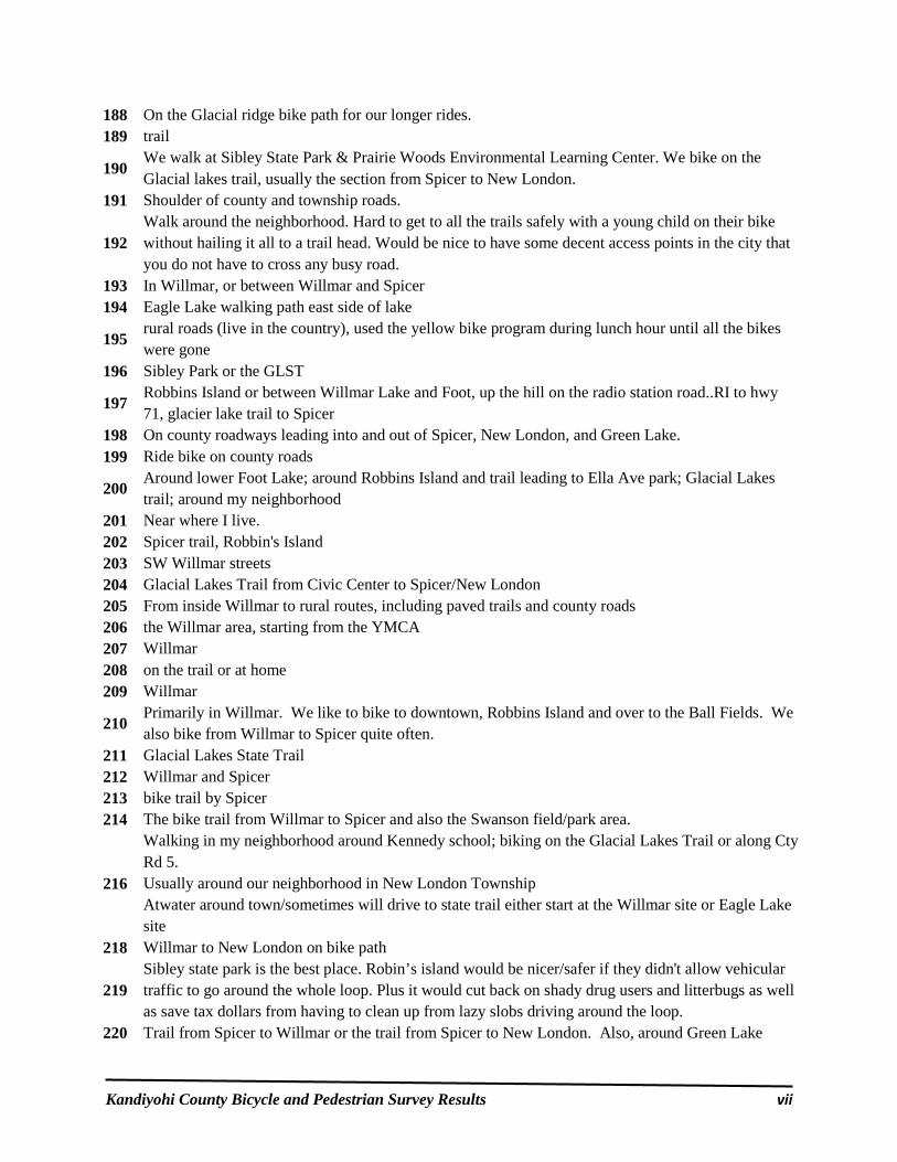
Kandiyohi County Bicycle and Pedestrian Survey Results vii
188 On the Glacial ridge bike path for our longer rides. 189 trail
190 We walk at Sibley State Park & Prairie Woods Environmental Learning Center. We bike on the Glacial lakes trail, usually the section from Spicer to New London.
191 Shoulder of county and township roads.
192 Walk around the neighborhood. Hard to get to all the trails safely with a young child on their bike without hailing it all to a trail head. Would be nice to have some decent access points in the city that you do not have to cross any busy road.
193 In Willmar, or between Willmar and Spicer 194 Eagle Lake walking path east side of lake
195 rural roads (live in the country), used the yellow bike program during lunch hour until all the bikes were gone
196 Sibley Park or the GLST
197 Robbins Island or between Willmar Lake and Foot, up the hill on the radio station road..RI to hwy 71, glacier lake trail to Spicer
198 On county roadways leading into and out of Spicer, New London, and Green Lake. 199 Ride bike on county roads
200 Around lower Foot Lake; around Robbins Island and trail leading to Ella Ave park; Glacial Lakes trail; around my neighborhood
201 Near where I live. 202 Spicer trail, Robbin's Island 203 SW Willmar streets 204 Glacial Lakes Trail from Civic Center to Spicer/New London 205 From inside Willmar to rural routes, including paved trails and county roads 206 the Willmar area, starting from the YMCA 207 Willmar 208 on the trail or at home 209 Willmar
210 Primarily in Willmar. We like to bike to downtown, Robbins Island and over to the Ball Fields. We also bike from Willmar to Spicer quite often.
211 Glacial Lakes State Trail 212 Willmar and Spicer 213 bike trail by Spicer 214 The bike trail from Willmar to Spicer and also the Swanson field/park area.
Walking in my neighborhood around Kennedy school; biking on the Glacial Lakes Trail or along Cty Rd 5.
216 Usually around our neighborhood in New London Township
Atwater around town/sometimes will drive to state trail either start at the Willmar site or Eagle Lake site
218 Willmar to New London on bike path
219 Sibley state park is the best place. Robin’s island would be nicer/safer if they didn't allow vehicular traffic to go around the whole loop. Plus it would cut back on shady drug users and litterbugs as well as save tax dollars from having to clean up from lazy slobs driving around the loop.
220 Trail from Spicer to Willmar or the trail from Spicer to New London. Also, around Green Lake

Kandiyohi County Bicycle and Pedestrian Survey Results viii
221 City Streets 222 Around Willmar or Willmar to New London 223 Ramblewood Area, 19th Ave., Willmar Ave. 224 County Roads & Bike Trail 225 Neiborhood 226 We live out in the country. So country, gravel roads
227 FROM THE COLLEGE AREA, OSLO HEIGHT ADDITION TO JUNCTION OF ROBINS ISLAND AND RADIO STATION .
228 Atwater Area 229 by civic center to eagle lake 230 bike trail from county rd 32 to boat access 231 Neighborhood streets, county roads, private lands (hiking), PWELC, bike trails. 232 near Ridgewater College, around Foot Lake, North out of Willmar 233 Around Diamond Lake 234 Lake Lillian and Lake Kandiyohi area. 235 hwy 5 by Games lake.
236 Around Willmar, especially downtown on weekends. then the trail to and from spicer
237 Long lake road 238 Willmar area; Robins Island; State trail
239 The bike path between Willmar and Spicer. Occasionally around town (near Jefferson School neighborhood).
240 by civic center to eagle lake or spicer 241 Willmar and the bike trail 242 North of Willmar on a dirt country road.
243 Bike on shoulder of Hwy 71 south of Willmar, Hwy 12 Willmar to Pennock, or Glacial Lakes Trail Willmar to New London.
244 Near new london and spicer 245 Stearns 246 Starting out by civic center to new London. Also starting out at Old Wagon on 23. 247 Bike trail from Sr. High to New London 248 Bike trail from Sr. High to New London
249 1. Glacial Trail from New London to Willmar and back. 2. Around Green Lake.
250 Everywhere! I bike and walk so much I get bored with the areas around here, and I often go to other towns for a different view.
251 The trail over by Bill Tauton Stadium 252 Downtown and in Dovre Township, also Glacier Ridge Trail from Willmar to Spicer. 253 around the neighborhood 254 New London Spicer area on rural roads or sometimes state trail
255 City streets, quieter ones with less traffic, usually on our way to a destination like a park or grandma's house.
256 Long Lake Road area 257 Willmar trail head to Hawick

Kandiyohi County Bicycle and Pedestrian Survey Results ix
258 Southwest of Willmar
259 Willmar to Glacial lakes trail
260 Between New London and Spicer.
261 The Glacial Lakes Trail. It would be tremendous however if that could be connected to Sibley State Park and Prairie Woods. I think it may help bring in more tourists potentially.
262 A couple times of year we use the trails north of Willmar. On a regular basis we walk and run in Atwater and on the roads outside of Atwater.
263 In and near Atwater, where we live. 264 Between Willmar and Spicer. 265 New London to Spicer or Hawick 266 new London area / golf course 267 Around Atwater
268 We walk on our dirt road in the country. When we bike, we ride on the bike trail between eagle lake and Spicer.
269 Streets of Atwater
270 Kandiyohi and Meeker. We live close to the county line wish the lakes trail that runs from Paynesville to Willmar was closer.
271 Robins Island, Glacial Lakes Trail, Prairie Woods 272 Walk... But would ride more if we had trails 273 Gravel roads in the country 274 Near George Lake 275 New London
276 We mix it up. We may start at Civic Center Dr if we are biking or walking, but if we want to Rollerblade we start across from Mel's in Spicer. There are less cracks and filler on the stretch North of Spicer.
277 Just around town or the Lake in town (Atwater) 278 Swift
279 Country road near Diamond Lake. Glacial Ridge Trail
280 On the trail between Willmar and Spicer. It is in desperate need of repair! 281 Streets and sidewalks 282 Around New London 283 Streets, Highways, sidewalks 284 New London 285 Diamond Lake, south side (County #4)
286 Around town The trail /walking path around the ponds in Atwater The trail to Spicer
287 HWY 9 West of HWY 71 and it is very dangerous. We have witnessed many individuals nearly hit by vehicles. Most of the highway has only gravel shoulders. Lots of trucks use this highway and
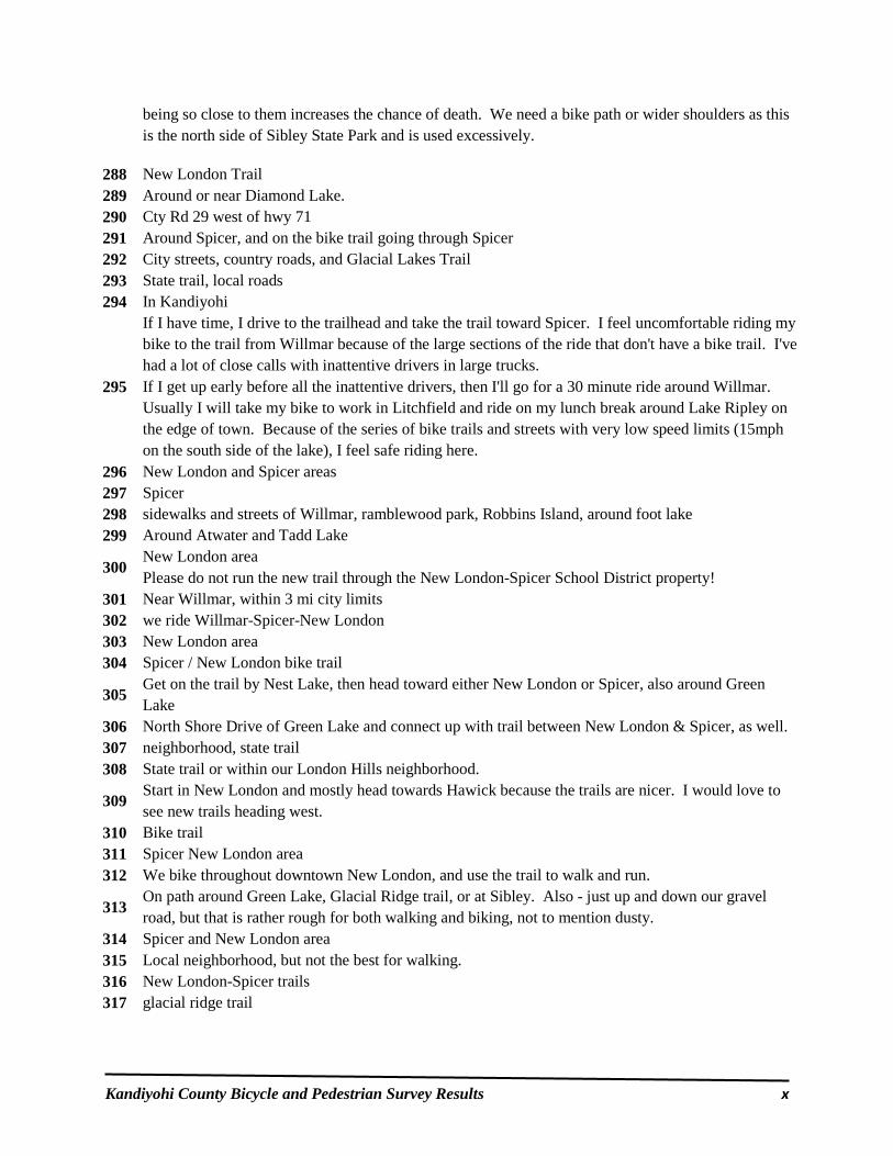
Kandiyohi County Bicycle and Pedestrian Survey Results x
being so close to them increases the chance of death. We need a bike path or wider shoulders as this is the north side of Sibley State Park and is used excessively.
288 New London Trail 289 Around or near Diamond Lake. 290 Cty Rd 29 west of hwy 71 291 Around Spicer, and on the bike trail going through Spicer 292 City streets, country roads, and Glacial Lakes Trail 293 State trail, local roads 294 In Kandiyohi
295
If I have time, I drive to the trailhead and take the trail toward Spicer. I feel uncomfortable riding my bike to the trail from Willmar because of the large sections of the ride that don't have a bike trail. I've had a lot of close calls with inattentive drivers in large trucks. If I get up early before all the inattentive drivers, then I'll go for a 30 minute ride around Willmar. Usually I will take my bike to work in Litchfield and ride on my lunch break around Lake Ripley on the edge of town. Because of the series of bike trails and streets with very low speed limits (15mph on the south side of the lake), I feel safe riding here.
296 New London and Spicer areas 297 Spicer 298 sidewalks and streets of Willmar, ramblewood park, Robbins Island, around foot lake 299 Around Atwater and Tadd Lake
300 New London area Please do not run the new trail through the New London-Spicer School District property!
301 Near Willmar, within 3 mi city limits 302 we ride Willmar-Spicer-New London 303 New London area 304 Spicer / New London bike trail
305 Get on the trail by Nest Lake, then head toward either New London or Spicer, also around Green Lake
306 North Shore Drive of Green Lake and connect up with trail between New London & Spicer, as well. 307 neighborhood, state trail 308 State trail or within our London Hills neighborhood.
309 Start in New London and mostly head towards Hawick because the trails are nicer. I would love to see new trails heading west.
310 Bike trail 311 Spicer New London area 312 We bike throughout downtown New London, and use the trail to walk and run.
313 On path around Green Lake, Glacial Ridge trail, or at Sibley. Also - just up and down our gravel road, but that is rather rough for both walking and biking, not to mention dusty.
314 Spicer and New London area 315 Local neighborhood, but not the best for walking. 316 New London-Spicer trails 317 glacial ridge trail

Kandiyohi County Bicycle and Pedestrian Survey Results xi
318 City of Willmar; Ramblewood area, swansson/Baker field area, north side out to fairgrounds/Rau park to Robbins Island. Also trail from Willmar to Spicer and New London and around green lake.
319 Spicer area 320 AROUND TOWN IN NEW LONDON - TRAIL ALONG 23 321 Trails, Roads throughout county 322 Golf View Road and 153 323 Around Green Lake, New London, or the Glacial Lakes trail (old railway) 324 We ride bicycles along the Glacial Lake State trail. 325 beginning of trail to Paynesville
326 I like the DNR trail to Middle Lake or 189th Ave., lakefront road...I have Sunset Shores Resort on Cty. Rd. 5 NW; our guests love the beauty of the lake country and so do I.
327 We walk: 1) on our street, 2) PWELC, 3) Sibley State Park 4) on the Kandiyohi Trails in Spicer/New London
328 we have to walk on city streets until we get to a trail (about 5 blocks) 329 New London trail to Willmar for biking and walking local gravel roads 330 between Willmar and Paynesville 331 Eagle Lake area 332 State trail, local highways, Green Lake 333 Glacial Ridge trail and along co. 32. 334 Glacial Trail, Spicer, New London, Lake Calhoun 335 City streets in and near New London, Glacial Lakes Trail, sometimes Sibley 336 City streets in and near New London, Glacial Lakes Trail, sometimes Sibley 337 Glacial Lakes Trails starting at the Willmar Senior High School. 338 In Willmar unless camping at a county park or Sibley. 339 City of new london. Glacial lakes bike trail. Sibly state park 340 Around the Lake Andrew area
341 Walks - Neighborhood - London Hills. Would like walk out towards Sibley, but Cty 148 is not safe for walking. Biking - State Trail. Would LOVE the trail to go out Cty Sibley.
342 Highways around the lakes, Sibley 343 On the trails or on the side streets 344 New london 345 Spicer, New London 346 State parks, neighborhood roads 347 West side Green Lk bike trail 348 We walk on Highway 9 north of New London and we ride bikes from NL to Spicer on the trail.
349 Around city of New London, from New London to Paynesville and around Lake Koronis, from New London to Spicer and Willmar to shop, drink and eat. We bike to Sibley State Park and hike around. I bike around the local lakes, including Green Lake and Lake Andrew.
350 We walk on highway 9 N of New London and bike in the trail from NL to Spicer. 351 Glacial trail, around New London, btwn New London and Spicer, Cty Rd 9 to Hwy 71 --scariest ride! 352 Willmar mostly. 353 Between New London and Spicer or around Green Lake. 354 New London, trails and roads.

Kandiyohi County Bicycle and Pedestrian Survey Results xii
355 In New London along the streets, parks, and bike trails. 356 The city of Willmar. 357 Environmental learning center & Sibly Park 358 Our neighborhood- Westland Estate in New London. 359 Westland Estate
360 along the road in front of my home, which is in the country, although I have used the Glacial Lakes Trail from the trailhead once in a while.
361 Ramblewood park 362 Biking path from Eagle Lake to Spicer 363 Robbins Island, bike paths, streets
364 Usually from New London to Hawick . Because lot less traffic of people compared to going towards Spicer lot more peaceful
365 along the road on county road 5 366 Near Home on county and township roads!
367 New London around the Mill Pond. Glacial Lakes Trail. Sibley State Park. Lake George in St. Cloud.

Kandiyohi County Bicycle and Pedestrian Survey Results xiii
Kandiyohi County Bicycle and Pedestrian Survey Question #3:
“Which factors would encourage you or someone in your household to walk
or ride a bicycle more often?” Please check all that apply...
Figure B:
Table B:
Answer Options Response Percent
Response Count
Adequate sidewalks 39.3% 143 More access to trails 68.7% 250 Proper Amenities (parking, toilets, benches, etc.) 28.0% 102 Safer traffic/crosswalks 45.6% 166 Adequate lighting 21.7% 79 Affordable bicycles or helmets 4.9% 18 Please explain... 36.0% 131
answered question 364 skipped question 29

Kandiyohi County Bicycle and Pedestrian Survey Results xiv
Please explain your responses…
1 Traffic calming around pedestrian areas.
2 My grandchildren ride their bikes into Willmar on County 23, which makes me nervous. A bike lane would be helpful.
3 Safe access to trail along county road 40 is key to usage of trail
4
We live in the New London city limits (Westland Estate) and within a mile of the NLS schools, but will not allow our 7th and 5th graders to bike or walk to school because of heavy and fast traffic on County Road 40. The proposed expansion of the trail would really help our neighbors and family have a safe route to schools, downtown New London and the bike train.
5 more time//we have plenty of parks and enough trails
6 A lot of the trails by New London cross busy streets which have lots of blind spots which it is hard to see oncoming traffic.
7 I have been to places where the bike trails are separated from cars and walking baths with either separate paths or barriers. Anything to keep the crazy cars from hitting you is good. Drivers don't care if you paint a line or a bike on the road. They still could hit you.
8 Hwy 9 north through New London needs to be widened to accommodate bicycle traffic. Road is too heavily traveled by semis and fast traffic.
9 Highway 9 is dangerous! The curve before the city limits is too sharp and cars drive on the shoulder going both directions.
10 Hard to cross highway 23 in Spicer 11 More awareness about driving when bikers are on the road, 12 ease of getting out and doing it...roads by use have narrow roadways
13 A bike / walking trail from Games Lake County Park to Sibley State Park Lakeview Campground would be great.
14 City streets in New London need more sidewalks and better connections among existing sidewalks. Crossings need to be safer, especially along Main Street and near the school in New London.
15 More in-town streets need sidewalks. Trails could be better linked and connected to make loops. Crossings can be tricky, especially with kids and especially at the busy intersections with Main Street and County Roads in New London.
16 More access to trails as not many in our area from home 17 Improved surface of the state trail near my house: Willmar north to Spicer.
18 the trail from Willmar high school to cty rod 26 is terrible and poorly maintained. Also by the New London golf Course needs some work.
19 Having the trails (or even 1 - 3 miles of them) shoveled off during the winter.
20
The paved bike trail between Paynesville, to New London, to Willmar is nice, but riding bike on Hwy. 40 to New London is definitely not safe for most families. A bike trail joining the already good existing trail and also adjoining the trails in Sibley State Park would bring increasingly more "green" guests resulting in more tourism $ in the county.
21 establish maintenance plan as old portion of trail is extremely rough
22 PLEASE fill in the cracks along the Glacial Lake State Trail!!! It is very hard on the body to endure the deepening cracks on bicycles with narrow tires.

Kandiyohi County Bicycle and Pedestrian Survey Results xv
23 We need a trail on 153 24 TIME 25 We would probably have to drive to get to walking paths, so having the above are important. 26 Existing trail system is adequate. we just don't have a lot of extra time
27 I live in Kandiyohi , there is no safe way to bike to the trail .a route to Willmar or Spicer would be very nice. Hauling the bikes seems counterproductive and takes time that we could be riding.
28 I thought riding on sidewalks was illegal? drawing a line on a road and calling it a bike lane does not motivate me at all
29 It is difficult to access the trail at Robbins Island from town because of the train crossing at 7th St. The trail around Foot Lake also crosses the road or does not have a continuous trail.
30 A trail along Hwy 12 from Atwater to Willmar would be nice!
31
Better sidewalks would help my 5-year-old ride better, and she would be more willing to ride her bike when we go places. Trail access is the big thing for my whole family. We have to ride on streets with little or no shoulder to get to the bike trails that do exist. Some of the existing trails (especially the one south of Foot Lake between 7th Street and 1st Street) are in such bad shape that I have to avoid the trail altogether and ride in the street. I hate having a truck whip past me three feet from my elbow because I can't use the crappy bike path, especially when I have my toddler twins in a bike trailer behind me. As for safer traffic, I am seriously concerned with the lack of courtesy for cyclists shown by drivers in Kandiyohi County. Last year I had a week-long training for work in a very crowded section of Minneapolis. I took my bike and used it to get around town. Even though there were many more cars, I felt safer riding around the crowded streets of Mpls than I do on the wide open streets of Willmar. Most drivers in Kandiyohi County insist on staying solely in their lane and driving just a few feet from a cyclist rather than moving over and straddling the center line. I understand this when there is oncoming traffic, but otherwise it makes no sense, it is rude, and it is dangerous. I don't know how they made drivers pay attention and be courteous to cyclists in Minneapolis, but whatever they did should be considered here.
32 No sidewalks in Kandiyohi. Almost run over often. Would LOVE access to bike trails.
33 Wider shoulders and/or a bike path along Highway 9 west of Highway 71
34 We enjoy the trail to Spicer, but have to put our bikes on a trailer to get to it. 35 we don't need a trail per se, just a safe bike path on the side of the road so we don't get killed 36 toilets
37 Safety is the primary source for encouragement. Riding on streets and sidewalks must be coordinated with traffic volumes (off peak hours)
38 Many people walk, bicycle, push strollers, walk dogs on #4 at Diamond Lake....however it is VERY unsafe with lots of fast moving traffic!! Something needs to be done about that nearby resource.
39 I would like to see more trails connecting the Cities in Kandiyohi County. We can bike on the roads and highways, but would feel safer if there were trails.
40 Most of the sidewalks in willmar are not wide enough or in good condition. You end up walking, biking or rollerblading in the roadway. That is why we choose the trail.
41 Designated bike trails would make longer distances possible and safer!

Kandiyohi County Bicycle and Pedestrian Survey Results xvi
42 none of the above reflect my ability to go walking 43 Wed love to see the trails expanded to connect Green Lake and Diamond lake...and Atwater. 45 Safer corridor along highway 23
46 Some street don't allow enough room for parked cars and bikes and it isn't as safe for kiddos to ride with us.
47 Love to ride bike but they are so expensive for a good quality comfortable riding one 48 doesn't have much to do with amenities
49
Access to some trails in this county are very dangerous. Also, It would be nice to not have to drive your car to get to some of the trails because access to them is so dangerous to bike there. For example, the trail by eagle lake or the Civic Center that takes you to Spicer is a great trail but to get to it from Willmar can be tricky.
50 The trail from Willmar to New London needs resurfacing. 51 Need more toilet stops. Lighting would be great so we can use them agree sunset! 52 Better maintenance of existing trails. Glacial Lakes is very craked in places. 53 toliets 54 Educating the community, both bicyclists and drivers, about how to safely share the road.
55 Concerned about distracted drivers. Have used county roads a lot but would rather see more separated trails.
56 Rumble strips and especially shrinking shoulders have reduced the places where I can safely ride.
57 Tough to want to return some places due to cracked asphalt on trails, and huge divots. Troublesome trying to avoid ground disturbances along with other bikers/walkers. Also some parts have little to no lighting to help guide our way after sundown.
58 self motivation 59 Build a trail to the Atwater area to Willmar, I would love to bike to Willmar.
60
There is no existing SAFE bicycle path or walk way connecting from the college to the 1st street north bicycle/ walking path which also connects to robins island path. 2 there is no Lighting along 15th ave from college to 1st street north. It is extremely dangerous early morning and evening thru the curves on 15thav. Many college and home owners with children bike and walk this road.
61 Maybe would ride bike to town if we had a trail 62 I would rather walk/bike outside of the city or in a park setting
63 If we had better and safe place to walk or ride our bikes. Atwater maybe small town, but people drive extremely fast and when your out walking and you have a 3 year old riding bike, it's just not safe.
64 It would be nice to see more designated lanes or routes for biking. I generally feel safer on trails but having designated lanes on roads connecting different parts of the county would be nice to have.
65
We live north of the tracks near tenth street. The railroad crossings are unpleasant even when they aren't blocked by trains and can be deadly when wet. The path along Ella to the east is unusable due to pavement quality (which could be fixed) and walkers and animals (dogs and geese) so I stay on Ella and brave revving engines, horns, and yells. Radio station road is a little better but the path along it is unusable for similar reasons.
66 Getting from in Willmar to the trails generally involves dealing with traffic and roads in poor condition. If the main trail in the country wasn't located 4 miles from town it would see much

Kandiyohi County Bicycle and Pedestrian Survey Results xvii
more cycle/pedestrian - ROLLERBLADE!! traffic. The local trails and streets are very hazardous to using rollerblades. Excess trash and branches/grass clippings can cause falls.
67 Resurfacing of some portions of the Glacial Lakes Trail should be looked at. There are some very deep and numerous cracks that have formed on the trail.
68 Some paths are quite worn down 69 Better shoulders or signage on scenic roads 70 designated bike routes and lanes
71 Some times its difficult to cross some roads because of traffic. Toilets by the GLT would be nice :-)
72
I'd like more land available for less developed trails, specifically near the crowded lakes like Green, where pedestrians and cyclists are forced to walk amongst loud motorcycles and speeding cars. Buy up the the land on the SE end of Green Lake, connect it to the lake path, and give something back to the lakes that bring in so much money please.
73 Currently we drive from Atwater to use the trail. 74 Trail gap connections
75 Get rid of all the dogs running at large in Atwater. I always carry a baseball bat when we walk. My wife is scared to walk alone.
76 People who want more trails, more safety, more of the amenities need to get some skin in the game vis licenses, fees or some other means of paying their way in usage, and maintenance.
77 A loop between NL-Sibley-PWELC-Spicer 78 Beautiful weather. 79 the roads we have work well for that sort of thing if a person is just a little careful . 80 why should I be pushed? leave me alone! 81 We have to change our behavior.
82
Safer traffic/crosswalks: Most of the county roads provide ample shoulder room for cyclists though not all. Improvements/widening of inadequate shoulders should should be pursued on all paved roads/highways. More access to trails: Connecting the Glacial Lakes Trail with the Rocori Trail between Roscoe and Paynesville would promote bicycle tourism between Kandiyohi and Sterns counties. This section of paved trial would be entirely located in Sterns County, but it would be in the best interest of Kandiyohi County to assist in the paving of said trail. There is currently no safe connection between Roscoe and Paynesville for bikes.
83 Used to use trail daily for roller blading but the trail got so bad that I had to quit. The cracks and holes just got too big- it has been years since then and it has only gotten worse. Not safe for bikes- kids or adults.
84 Not being attacked by geese. 85 Having more free time to go! 86 more energy 87 Someone to pay me to do it. 88 County Rd 40 from my Subdivision across from Rambow is very dangerous due to heavy traffic.
89 Crossing 1st Street in Willmar is very difficult. It is not safe and limits our biking and walking opportunities.

Kandiyohi County Bicycle and Pedestrian Survey Results xviii
90 Very difficult from any area NW of Willmar to Hwy 71 to get to trail safely without going miles into town then back out to hit trail. The bridge missing at the start of Hawk Creek/Eagle Lake was used a lot to make for safer travels by adults and especially kids
91 links to other trails 92 I have no complaints about the trails.
93 I am not entirely comfortable riding bike on highways or road shoulders. Off road trails are very important to me in regard to riding safely.
94 Proper enforcement of vehicle traffic 95 Connected complete trails
96 I sometimes run on the sidewalk and there are dogs that bark and sometimes have run out at me- very scary!! I try to find routes that I don't think have houses with dogs that might not be locked up
97 We live by Highway 12 and to cross isn't always safe/easy. To get to the trails is a bit complicated because of this and the railroad
98
Trails do not go all the way through - ie at the college it ends before the softball field and then starts up again by the lake. Unsafe 1.5 miles of a curvy road with no trail connection. Crosswalks in some places are not safe, such as on Cty Rd 5 by Sunray gas station. Rarely does anyone stop so people can cross there.
99 Walking would mean more access to trails, although I think our current access is excellent (please connect to Sibley). For biking, safer roads. Bike lanes. 1st street is just too crazy for bikes and many streets are the same way.
100
**Problem: There few gas stations, etc. where you can fill your bike tires with air. Most don't have air hoses or keep their compressors turned on. The only one we could find last year was Casey's on 19th Ave, and occasionally the Holiday Station - their compressor was turned off most the of the time.
101 Shoulders on county road are very narrow 102 Maybe a little more access but we have no complaints on existing trails
103
Definitely need more crosswalks and safer bike bridges, protection from busy roadways. This town is TERRIBLE for people not paying attention to crosswalks/right of ways when in vehicles. It is NOT AT ALL family friendly to travel on bike to trails, this is VERY SAD! Many of us would love safe access to a nice country trail!
104 Bathrooms!!!!! 105 If access to trails were more convenient and closer to my home I would enjoy using them.
106
Sidewalks in Spicer area are often either non-existent or in poor repair, making the street a more attractive place to walk. In winter, the sidewalks that do exist are not always cleared, and the trail is icy and/or snow-covered. Lighting on city streets is adequate; the trail is dark and secluded in many places, and I would not feel safe walking/riding by myself at certain times.
107 No external motivation is likely to make any difference as opportunities abound 108 Walking trail 109 Three are no trails that connect or even come close to the city of Atwater. 110 Wider shoulders on road. 111 Cleaner parks for my son to play in
112 I ride the road shoulders a lot and edge rumble strip make that very difficult. I try not to ride the trails much because the walkers don't believe they need to share space with a cyclist
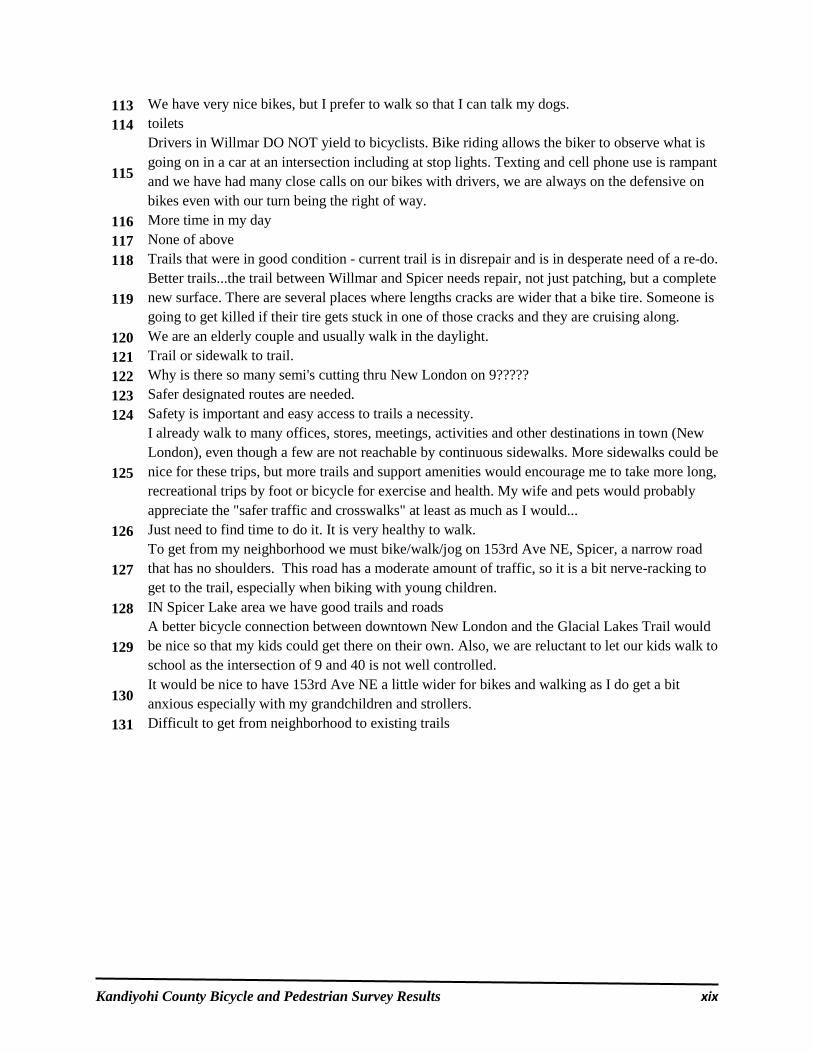
Kandiyohi County Bicycle and Pedestrian Survey Results xix
113 We have very nice bikes, but I prefer to walk so that I can talk my dogs. 114 toilets
115
Drivers in Willmar DO NOT yield to bicyclists. Bike riding allows the biker to observe what is going on in a car at an intersection including at stop lights. Texting and cell phone use is rampant and we have had many close calls on our bikes with drivers, we are always on the defensive on bikes even with our turn being the right of way.
116 More time in my day 117 None of above 118 Trails that were in good condition - current trail is in disrepair and is in desperate need of a re-do.
119 Better trails...the trail between Willmar and Spicer needs repair, not just patching, but a complete new surface. There are several places where lengths cracks are wider that a bike tire. Someone is going to get killed if their tire gets stuck in one of those cracks and they are cruising along.
120 We are an elderly couple and usually walk in the daylight. 121 Trail or sidewalk to trail. 122 Why is there so many semi's cutting thru New London on 9????? 123 Safer designated routes are needed. 124 Safety is important and easy access to trails a necessity.
125
I already walk to many offices, stores, meetings, activities and other destinations in town (New London), even though a few are not reachable by continuous sidewalks. More sidewalks could be nice for these trips, but more trails and support amenities would encourage me to take more long, recreational trips by foot or bicycle for exercise and health. My wife and pets would probably appreciate the "safer traffic and crosswalks" at least as much as I would...
126 Just need to find time to do it. It is very healthy to walk.
127 To get from my neighborhood we must bike/walk/jog on 153rd Ave NE, Spicer, a narrow road that has no shoulders. This road has a moderate amount of traffic, so it is a bit nerve-racking to get to the trail, especially when biking with young children.
128 IN Spicer Lake area we have good trails and roads
129 A better bicycle connection between downtown New London and the Glacial Lakes Trail would be nice so that my kids could get there on their own. Also, we are reluctant to let our kids walk to school as the intersection of 9 and 40 is not well controlled.
130 It would be nice to have 153rd Ave NE a little wider for bikes and walking as I do get a bit anxious especially with my grandchildren and strollers.
131 Difficult to get from neighborhood to existing trails

Kandiyohi County Bicycle and Pedestrian Survey Results xx
Kandiyohi County Bicycle and Pedestrian Survey Question #4:
“Where would you like to see new walking and bicycling
trails developed in Kandiyohi County?”
1 Safer streets in Willmar 2 Northern Kandiyohi County 3 Between New London and Sibley State Park. 4 153rd to the current trail 5 Out to Sibley State Park 6 A connection between New London and Sibley State Park would be wonderful. 7 Willmar and surrounding area 8 All over! 9 I would like shoulders or path along side 153rd Ave NE, Spicer 10 From Eagle Lake to Willmar 11 Willmar area, to the state park, by some of the lakes.
12 - Waiting as patiently as possible for the Glacial Ridge Trail extension to Sibley State Park... - A marked, safe trail leading out of New London on CSAH 9 to Rodvik Park would be awesome! - Assistance with New London's local efforts to establish a walkin
13 County road 9 between NL and Spicer. From Glacial Lakes trail to Sibley. 14 around lakes, near parks. 15 safer walking at games Lake and lake Andrew 16 being able to connect to one going towards Sibley State Park 17 New London to Sibley State Park.
18
Around Green Lake there are many areas where there is no sidewalk or path. On Lake Avenue South in Spicer, there is a sidewalk east of the Charlie Arne road, but there is not a sidewalk going west towards Spicer. From morning until night there are walkers, runners, and bikers along this stretch of Lake Avenue South having to go out into street to get around cars parked along the shoulder. There is large need for a sidewalk on this stretch of road.
19 A trail from new London to Sibley would be amazing 20 Finish the trail to Sibley Park and beyond. 21 Spicer 22 Willmar to Kandiyohi
23 Along County 5 and St 9. Trails should be designed to separate motorized and non motorized users and not simply be an extra wide shoulder unless there are no alternatives. There should also be a connection from Sibley to games lake.
24 Sibley Park to New London 25 From 23 to Catholic Church road 26 around lakes 27 We have a beautiful town...about anywhere, really. 28 From New London to Sibley Park 29 Through town. 30 More in city of Willmar so people aren't walking on streets. 31 I live outside Kandiyohi County

Kandiyohi County Bicycle and Pedestrian Survey Results xxi
32 On 153rd St. 33 More connected to the bike paths north of town or off of Robbins Island 34 In the city of New London 35 In scenic areas, near lakes, near nature...away from roads.
36 Think about access to schools, parks, connecting what we have. I haven't been on the trails recently but fully support more development. I would go on them more if I felt safer getting to them.
37 Yes, It is fun to see families out and about! 38 should keep current ones in better condition before spending money on new ones
39 Better connections to the state trail at the Civic Center from many directions (W. Eagle Lake, Eagles Landing, MinnWest, to/from downtown, etc)
40 Small towns in the county 41 Unsure, current and new trails are great! 42 Through out town, maybe a trail out to join the trail at the civic center. 43 I don't know. It would be nice to have a trails map included with the survey. 44 Through town 45 More on the southwest side of Willmar or more in smaller towns in the county. 46 Sibley area, New London, Spicer. Maybe a trail to get towards Litchfield 47 I think the trail system is good enough 48 A sidewalk around the HHSB 50 have no desire to see new trails 51 Connection to Sibley State park 52 Around Games Lake - along county road 5 53 From Spicer, west toward Sibley Park
54 more rural access. I see a trail on hwy 12 near Cokato as I drive to the cities. I always take note of that.
55 We need to take care of roads before moving forward with more biking trails 56 This should be a no brainer, Connect existing trails to the City of Atwater through the lakes area. 57 between Games/Norway Lake area and Sibley State Park would be great! 58 North of Atwater, connection to Diamond Lake
59 Along County Road 10 from Indian Beach Circle to Diamond Lake County Park on County Road 4
60 Think we have enough 61 at the health and human services building 62 From *28th Ave SW and 1st street make a bike trail that connects to High school
63 We need safe access to country trails like the one by the high school. Unfortunately, there is no safe way to get there, the roadways are too busy and there are not bike bridges to protect us. Traffic is HORRIBLE!
64 Along Long Lake Road. Walking or biking on Long Lake road is beautiful, but you literally share the road with vehicles (no shoulder) that drive too fast. More times than I can count we've had to jump into the ditch to avoid being hit.
65 In areas where they will be used by more then just a few people. I feel some trails have already been built that don't get much use.
66 Complete trail from New London to Sibley State Park

Kandiyohi County Bicycle and Pedestrian Survey Results xxii
67 County Roads 9 & 10 NE Spicer
68 Would be nice if there was a wide path for walking and biking along 19th Ave starting at Roosevelt all the way around to the YMCA and north up Lakeland Dr.
69 A trail out to Sibley State Park would be great. One to PWELC would be WONDERFUL 70 Green Lake to Diamond Lake 71 the south & west corridor of the county. Raymond/Prinsburg areas 72 lakes/parks 73 West of Willmar off Hwy 12
74 Would like to see the Willmar thru Hawick trail come all the way into Willmar instead of starting at Co Rd 9.
75 I think it would be great to have more trails all over the county. Maybe do like a County history trail that explains some interesting and fun facts about Kandiyohi County.
76 Connecting existing trails, parks, communities and points of interest.
77 something that would connect Willmar downtown area to the trails by Robins Island, or something by the YMCA to connect to.
78 Along County Road 9, New London. Specifically, connecting CR 40 with CR 10. 79 around lakes
80 Everywhere. connect Robbins Island with Ridgewater College. need to ride on the highway and it's dangerous, roadway is full of gravel and the cars are traveling at a high speed.
81 I would like to see a connection from the HHS Bldg. to the trail by the Willmar High School. 82 Along lakes away from highway noise and traffic. 83 Around Green lake 84 I think we have adequate walking and biking trails
85 Connect Glacial Ridge to Sibley (I know its in the works). Keep working and expand the current plan with more streets with sidewalks and more space for bike lanes.
86
Finish the route around the lake (from the college softball field to the corner. Possibly a trail going out toward Horizon Hills and Solomon Lake. Would be great to have a bike/walking trail on the stretch of road by Games Lake as very unsafe when the campground is full and kids wanting to go to the spillway to fish.
87 On the Southwest side of Willmar 88 From Highway 12 east of Lakeland Drive to the lakes
89 Connecting downtown with Robbins Island Near parks On the SE side of town, safer to cross railroad tracks
90 Pennock, Sunburg, outlying towns 91 around lakes and to schools and recreational areas for youth, adults and seniors 92 Lakeland drive Something toward rice park 93 Diamond lake norway and games lake connecting into sibley
94 some sort of trail that connects YMCA to the bike trail by the high school or just right in the city of Willmar having more trails for bikers and walkers.
95 Outer edge of the entire town. A nice ride around Willmar with access into town on every side. 96 Pennock to Willmar
97 YES! a real bike trail around Green Lake would be awesome, the stretch on some parts are dangerous due to sharing with cars and cars parked on the street
98 Sibley State Park to Games Lake

Kandiyohi County Bicycle and Pedestrian Survey Results xxiii
99 A trail from New London to Sibley State Park would be great.
100
Trails that link important destinations should be a priority. Willmar to Prairie Woods ELC, for example, would be a great connection. A link between Prairie Woods ELC and Sibley State Park would be awesome! The Kandiyohi County parks are all great destinations, and connections from them to cities and towns is needed. The Glacial Lake State Trail should be the backbone of a county wide network.
101 connected to Prairie Lakes ELC 102 Games lake area
103 The Business 71 & Co Rd 24 intersection is crazy! How do walkers, bikers get from north side of Willmar Lake / along golf course to the other side of Hwy, to connect to trail back by H.S.? IF follow west side of Hwy to stoplight @ Civic Center Drive, there is no trail.
104 I would like safe protected paths/lanes through downtown and shopping areas so that it is safe to bike to work and to stores.
105 New London along Co 40 to Hwy 71/ Sibley State Park 106 Trail connecting Sibley State Park and New London State trail- 107 Northern - Northwestern county. 108 in the bar or bistro
109
I am all for the glacial lakes trail extension to sibley state park. I would love to see the shoulder of county road 5 paved further north of where it currently terminates. I also would like to have a safer route to bike on highway 12 in willmar...once you get beyond county road 9 and/or the bypass, it's fine, but getting there is dicey. and the north part of the intersection of highway 12 and county road 5 is also dicey for bikers.
110 where connections are missing. some stretches between awesome trails require walking/biking on roadways
111 South west willmar connecting to existing trails 112 Don't see a need for more, seems like we have plenty. 113 New London to Sibley State Park 114 Rural areas with scenery. Railway grades are not very scenic, challenging. 115 East side of county 116 Depends at what costs. 117 between County Parks 1 and 2 - Big Kandiyohi East and West 118 connecting bike trail in willmar to sibley state park and connecting to other bike trails 119 Would be happy with just fixing the existing trail by HS. Any other site would be great, too! 120 Please refer to Question 3's answer. 121 nowhere. don't waste the money! 122 I would like to see more trails in the South side of Willmar
123 All the way around Eagle Lake....it's getting close but on the north side to connect up to the new one on the East side
124 Around willmar 125 More lakes ,country side , different towns
126 I would think if you want to spend the money on trails it should be spent around the high population areas were the most people would have access to them. spend ing alot of monies out and away from populated areas for a short seaseonal period for just afew people who if they are

Kandiyohi County Bicycle and Pedestrian Survey Results xxiv
walking in the country you would think would want to walk on a nature trail rather than a "paved walk" theres miles of them in town.
127 Sibley-PWELC-Ringo lake
128 The Willmar end of the Glacial Lakes Trail going to Foot Lake & on to downtown. Having Sibley State Park connect to the trail.
129 Sibley State Park: to and from 130 From Kandiyohi to Willmar or existing bike trail. Please connect Kandiyohi to bike system. 131 Atwater 132 The planned connection of the State Trail to Sibley State Park. 133 Outside Willmar to connect to the trailhead in willmar.
134 Have a spur of the bike trail go from New London to Sibley & Have the Willmar end continue to Robbins Island Park. There's an old rail bed that would be easy to convert (relatively).
135 Around more of the lakes.
136 I like what we have out of Willmar. Just sucks getting to them from in town without hauling it all.
137 From Robbins Island path into downtown and into neighborhoods
139 SE side of Green Lake. Land is already up for sale in parts. Wetland prairie woods area with active eagle nest. Less developed hiking and biking trails would be awesome. Help take some pressure off the lake?
140 Connect a trail from RI to tech center to HS trail. 141 North of Willmar and west of New London 142 Outside of city limits throughout the county along major roads and highways. 143 Everywhere 144 Sibley State Park with connections to bike trails near Willmar. 145 One that would connect the spicer trail further into Willmar proper 146 SW corner of Willmar
147 Target destinations are nice, Possibly from Willmar to Sibley State Park or Willmar to Park 1 or 2 (Big Kandiyohi Lake)
148 To the south and east there is nothing, but but primarily extending the trail into Willmar so riding through industrial and retail areas with road hazards (garbage, parked cars, stoplights, cracks in pavement) would be the biggest improvement
149 Any where that nature can be park of the path. 150 Nowhere; focus on making roads more usable. 151 in between Sibley park and County park #7 152 connecting to 19th street south west of town.
153 I would like to see bike lanes on city streets in Willmar. I would also like to see a safe route developed to connect Willmar to New London other than the state trail. The variety of options would be nice. The trail gets very busy so additional routes would be nice.
154 I would like to see the County Parks connected throughout Kandiyohi County. 155 Maybe a bike path that encompasses the city like New Ulm has? 156 Connection from Glacial Lakes Trail to Sibley Park
157 It would be nice to see something closer to Atwater, a trail out to Diamond Lake, and then maybe up to Spicer.
158 Sibley state park

Kandiyohi County Bicycle and Pedestrian Survey Results xxv
159 Scenic routes would be nice, not parallel to a road. Spicer to Sibley, New London to Sibley Park 161 North and East sides of Foot Lake To Sibley State Park
162 In town if possible...hard riding bike with young kids when you get yelled at by walkers that you shouldn't be on sidewalk. Yet you fear for your life/kids lives when you ride in the street!
163 All the way into neiborhoods in Willmar
164 Along 15th av from 1st st north to the college . Also connect a walk/bicycle path from the golf course to the bike path at Midwest technology campus with a safe crossing.
165 Atwater to Willmar 166 yes for the tourist trade
167 county road shoulders- wide enough for safe biking connections to and expansion of existing trail systems
168 West or East out of Willmar, would be great for other options. 169 Around Diamomd Lake
170 Luce line from Hutchinson to Lake Lillian would be great if PAVED. Then I could bike to Zella's for lunch and return. :-)
171 along hwy 5 by games and Norway lake, connect to state park along hwy 9 172 complete around Willmar 173 cty rd 25, cty rd 41
174 The planned trail on the east of Games and Norway Lakes will be nice. It would be great if it continued to Sibley State Park.
175 Near town, potentially expanding the trail from Robin's Island. Or creating a path from somewhere in town to a new destination, so it is easily accessible for a large population.
177 Bike trail in New London to Sibley State Park The trails in Sibley are in horrible condition 178 out towards the trail to Spicer from the west side of town.
179 Lakeside to Hwy 12 on East side of Willmar. Hwy 19 to Hwy 12, Co Rd 5 on west side of Willmar (I believe that is in the plan).
180 A way to safely get to sibley and games lake County park safely 181 Headed out to Sibley. Around willmar without all the intersections waiting for traffic. 182 North of Willmar area connecting with Sibley Park.
183
County Road 5 NW has beautiful views, but to be safer it needs shoulders all along and drivers being more aware of bikers/walkers. Also, from county road 5 to Eagle/Long lakes would be beautiful rides, but not currently safe. This is beautiful hilly areas that are great for biking, but the roads in a lot of the area are narrow with no shoulder or too narrow shoulders.
184 If the glacial lake trail could come into town more 185 Widen road in Robbins Island so you feel safe walking through the park. 186 around lakes
187 around the rural Willmar area. Maybe more in the Spicer New London area around the lakes (green lake's trail around it is fantastic!)
188 Yes, more short trails to get around town or for people who don't want to bike for miles and miles.
189 Highway 23 corridor 190 Glacial lakes to Sibley County 10 South of green lake Willmar to pwelc 191 On 148 in New London from Hwy 9 to Sibley State Park. 192 Connect the Glacial Lakes trail to PWELC and Sibley state park.

Kandiyohi County Bicycle and Pedestrian Survey Results xxvi
193 A connecting trail between diamond lake and green lake. And one connecting Atwater to diamond lake.
194 Diamond Lake area. Connected to Green Lake or Atwater. 195 Between Atwater and Diamond Lake then to Spicer 196 Atwater to diamond lake 197 Trails around diamond lake would be great - and possibly a connection to green lake 198 Connecting Atwater to Diamond Lake and then from County Park #3 to Highway 10 into Spicer.
199 Yes, my daughter goes to ACGC elementary and having trails would give us a safe opportunity to walk/ bike that is close by
200 Green Lake to Diamond Lake, Willmar to Kandiyohi, Willmar to Svea 201 Atwater out to the area around diamond lake and beyond. 202 Atwater to diamond lake. 203 Sibley area
204 This would be a joint project but, getting a trail between Atwater and Grove City would bet great, Kids could bike to school rather than always having to ride the bus or get rides.
205 Along County Road 5 is a nice stretch with different scenery and elevations. Rest stops could be at the Weber outlook area.
206 From Atwater to Grove City, for school children and others. From Atwater to Diamond lake to Green Lake.
207 I would like to see a trail on County Rd 40 to Sibley park. 208 Trails should be linked to parks, lakes, restaurants, playgrounds, swimming pools. 209 Anywhere from Atwater to Willmar
210 Along county roads...so we do not have to worry about getting hit...so many inattentive drivers out there. It is not safe to even ride your bike to the trails
211 south side of Diamond Lake to Count #26 and there to the Glacial Lakes trail
212 Atwater to diamond lake Diamond lake to green lake From Atwater to grove city (I know that's meeker, but it would be useful) Atwater to cosmos Our schools are combined, I think students would use these trails
213 Along highway 9 west of highway 71. This is along Sibley State park and used by many, 214 Sibley 215 A path around Diamond Lake
216 West of hwy 71 on cty Rd 29. Busy road. People drive very fast on it around the curves. Not enough tarred shoulder.
217 By Eagle Lake Connecting the trail to get into the city of New London
218 Connecting trails to Sibley Park, Lake Koronis, Pennock (and west), City of Kandiyohi, Atwater (and east). Glacial Lakes trail needs to be completed from Paynesville to Roscoe and connected to Lake Wobegon Trail.
219 187th ave in New London from town to the trail. It's a busy road, but people love it for recreation. It just isn't very safe to use.
220 Link Kandiyohi to the system. That would be awesome. 221 Hwy 12 Atwater to Willmar
222 More loops around lakes. In most other places I've lived there have been rivers, so there was a natural path for a riverside biking trail. It's really nice to bike by the water. I haven't lived here

Kandiyohi County Bicycle and Pedestrian Survey Results xxvii
long enough to know which lakes aren't already crowded with houses. I'd also like trails going in different directions from Willmar. Spicer is great and all, but I have that trail memorized.
223 A continuous trail around Foot Lake or Willmar Lake. Better access from town to the Robbins Island trails.
224 Eastern part of Kandiyohi County Atwater to Diamond Lake - Diamond Lake to Green Lake
225 Most lakes are surrounded with mansions/cabins... That would be the ideal location to show off the beauty of the county. Make robins island loop not accessible to vehicles and open to bike/walk. Save the city on garbage clean up, graffiti cleanup and place for drug users!
226 yes (see above ) 227 New London to Sibley - need a safer trail than 148
228 County Road #40 east of New London to Co Rd #4 and then south to the trail that wraps around Green Lake. It is a beautiful area.
229 I would like a shoulder/path/trail from Our Lady of the Lakes up to the main trail to provide safer access to the main trail.
230 trails heading towards Sibley 231 From New London west toward Sibley State Park. 232 From Sibley into New London 233 Around Twin and George Lake 234 New London area 235 Sibley State Park to New London from U.S. Highway 71 following State Highway 9. 236 northwest part of the county
237 More trails within the city of Willmar; perhaps out by the dog park/swansson field area or more trails through Ramblewood by the playground. It'd be nice to see some at Prairie woods as well.
238 none needed!!!! 239 around the lakes. 240 Have the trail connect with Sibley Parksafer 241 Near Sibley State Park, around New London/Millpond 242 Instead of building new trails, please repair current trails!!! 243 New London to Sibley State Park 244 From Sibley State Park along Hwy 5 to New London 245 I believe there are enough trails.
246 From Sibley through the lake eight / 148 corridor to new london - perhaps nearby the fisheries? also will county road 40 have adequate walking and biking lanes with the expansion and straightening project?
247 Throughout the county - we have many lakes with parks. Just connect the dots 248 Trail that goes into Northern Kandiyohi or one that connects to Cold Spring trails 249 northern KC by Norway Lake 250 I would like to see more dedicated mountain bike trails in the area 251 Willmar 252 Glacial ridge trail to Sibley park. 253 County 4 & 40. Around Lake Calhoun with access to Green Lake or Glacial Ridge by Hawick
254 Clear connection between the Glacial Lakes trail and the center of New London. Separated bike lane along Birch Street and along Main Street in New London. Bike/walk loops in towns that include a mix of sidewalks and trails, and connect with each other. Complete walk/bike routes

Kandiyohi County Bicycle and Pedestrian Survey Results xxviii
that connect residential neighborhoods with NLS school, including crossing safely onto the school property and safely navigating on the school property (not having to walk/bike through parking lots).
255 More access from Eagle Lake to the Glacial Lakes Trails. There is currently only two ways being one from County Road 26 and going all the way around the Willmar Senior High School.
256 From Games Lake County Park to Sibley State Park Lakeview Campground. Also from Southwest Willmar (19th Ave SW to the trail on Ella Ave NW.
257 Links from glacial lakes trail to sibley state park. Link paths in new london and around mill pond 258 Games Lake, Norway Lake and Lake Andrew 259 Cty 148 from New London to Sibley.
260 Highway 40 east of new London because it is do scenic and it is a bit hilly, providing a challenge (variety) vs other trails locally. It would be awesome if it would connect to the north east side of green lake
261 Near spicer new London 262 From spicer/new London to parks 263 South of Willmar 264 Towards Sibley St park
265 Out to Sibley State Park and all the way around Lake Andrew. There should be something from Luther Bible Camp to get across. Right now there is a fence in the way. A trail out to Prairie Woods Environmental Learning Lab, and a better route into downtown Willmar.
266 A sidewalk on highway 9 north of New London would be awesome. 267 Hwy 9 north of New London. Cty Rd 148 to Sibley
268 All over. But mostly down towns. It is nice to be able to go around a town on a bike. It is a good value because you get a workout and get reliable transportation at the same time!
269 More in town bike lanes to encourage people to ride instead of drive to school, work, shopping 270 Spicer by the lake 271 Yes, I believe this benefits all societies. 272 From Willmar to Lake Lillian 273 NL to Sibley. And Spicer to Sibley.
274 we have enough trails/we do need to resurface a lot of roads/sounds like there's money so fix the roads
275 County Road 40 --New London to 71 276 County road 40 out to sibley park 277 Bike lane along County 23. Bike lane along County 9. 278 Connect Ramblewood park to the area near Swanson and the other systems in the area. 279 I would like bike trails in Willmar to be linked. 280 along the Irving road and connect to north side of Green lake 281 trail between sibley park & games lake park
282 New London to Sibley State Park. Becker Avenue to Glacial Lakes State Trail. Glacial lakes state trail to Lake Koronis trail.

Kandiyohi County Bicycle and Pedestrian Survey Results xxix
Kandiyohi County Bicycle and Pedestrian Survey Question #5:
“Where would you like to see bicycle or pedestrian improvements/new
amenities on existing trails? Examples include additional parking
areas, toilets, safer trail crossings, etc.”
1 Make safety at all types of trail crossing a high priority. Get the police involved in enforcement. Better signage, better lighting, better markings.
2 trail along county road 5 by Norway Lake & games lake 3 by the New London Spicer schools were the depot use to sit
4 Path from 7th St Nw to 1st street needs work as does the path along what is commonly known as "radio station road".
5 North side of Eagle Lake 6 Lighting in Ramblewood park 7 County 9 from Hwy 12 to the trailhead would be a good place for a bike lane. 8 Access to trail and avoiding high speed intersections key
10 Outdoor Bathroom at Environmental Learning center by parking lot 11 Toilets on the New London / Paynesville side of the bike trail. 12 I would like to see better signs for oncoming traffic around New London. 13 New London 14 Safer crossing between trail and Spicer. 15 Safer trail crossings of highways and fast roads would be nice. 16 Toilets on glacial bike trail north along 23.
17 There are some gravel roads between Spicer and Willmar that a rider has to cross on the trail and the gravel is washed out or too deep in spots.
18 Spicer/ New London trails 19 Garbage cans along state trail 20 Same 21 Safer crossing and bathrooms 22 Water access would be awesome! A spigot with drinkable water.
23 Can't ride a bike down the Main Street in New London. NOT safe with the narrow road. Would love a bike path along the river, behind the stores, by Goat Ridge.
24 Better crossings are needed along Hwy 9 / Main Street and along CR 40 by the school property in New London. A developed trail head with toilets would be nice somewhere in NL.
25 More rest stops with benches and toilets. Porta potties available letter into fall.
26 Willmar Civic Center trailhead parking lot - a stretch of gravel linking paved trail on both sides of the parking lot.
28 smoother transition from trail to gravel when crossing gravel roads. too loose of sand can cause wipe outs.
29 Additional parking in New London safer crossings in Spicer 30 toliets, spurs taking you into a commercial area (resturaunts)
31 We need additional parking areas to access the current trails. That is the only problem I see. The trails are not used that much but I think it's because there is not that many places to jump on them.
32 Durable, large, accessible garbage cans and benches every so often are always a great idea. I think there are enough towns on the trail to provide bathrooms and food break stations.
33 better maintenance. parts are very rough

Kandiyohi County Bicycle and Pedestrian Survey Results xxx
34 More toilets along the Glacial State Trail. Perhaps close to the high school and beyond New London would be places to put port-potties.Fill crackes!!!
35 Safer trail crossings. More mowing at crossings 36 More bathroom Facilities 37 repairs where needed
38 more rest spots with benches or "destination" points on Willmar to Spicer/New London trails; a place to picnic, etc.
39 city of new london 40 Not a huge biker, but would do more if other options to ride. 41 Same 42 Parking areas, toilets
43 If there is a trail established between New London & Hwy 71......Have a parking lot, toilets, and tunnel crossing at Hwy 71 and Co Rd 40
44 Toilets and safe crossings 45 More toilets, trash containers more parking Eagle Lake access 46 robins island extension from new London to sibley( not on shoulder of road)
47 resurfacing the trail because the snowmobiles have ruined the trails so it is hard to rollerblade on the trails
48 Additional Parking area on the northwest area of Robbins Island. Repave the trail that connects the north end of the first street bridge and Bria's playground. It is so bumpy I cannot take my children in the bike trailer and we end up on the street anyway.
49 I don't really have any interest in these. I'd prefer more trails in better repair than to have a toilet every 2 miles.
50 Any bike trail is a great bike trail. Lots of places to stop and use amenities along the way... local businesses and such.
51 Safer crossing in spicer across the highway 52 Trails and access more needed 53 We're lucky b/c we live in Spicer and it's easy to hop on the trail. 54 Around Diamond Lake. 55 I love the existing trail system 56 one at the parking area on #26 near Eagle Lake 57 undecided..
58
Safer trail crossing. Why is there not pedestrian/bike over pass in Spicer to cross HWY 23?? This should be the highest priority! I understand you have a light - but crossing that road at the intersection requires crossing 6 lanes (6 x 12' = 72') plus a median. You also have to watch for right hand turning vehicle - requiring you to watch 8 lanes of traffic....
59 Mainly on the trail between Willmar and Spicer. The trail is in very poor condition and should be re-surfaced. It would also be nice to see the trail paved across the gravel road crossings (like they have in Alexandria).
60 As mentioned earlier the filler used to fill cracks gets too soft in the summer heat, you sink into it. Easier trail crossings would be a plus, the trail is asphalt and you cross on gravel roads. Have toilets available at the parking areas.
61 Is there any way to move trails? The Hwy 23 project is most likely going to negatively impact existing residence. Can't a trail be relocated? It would be more attractive than six miles in a straight line. And safer if away from a four-lane.
62 Nothing to add. 63 Restoroims 64 Safer crosswalks around our schools, playgrounds, and parks. 66 Just more connection of trails! 67 Highway 12 safer crossings in towns 68 Safer crossings new London. To spicer
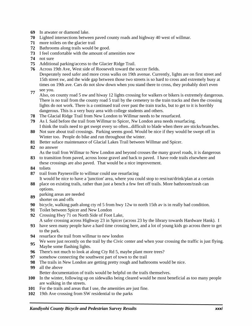
Kandiyohi County Bicycle and Pedestrian Survey Results xxxi
69 In atwater or diamond lake. 70 Lighted intersections between paved county roads and highway 40 west of willmar. 71 more toilets on the glacier trail 72 Bathrooms along trails would be good. 73 I feel comfortable with the amount of amenities now 74 not sure 75 Additional parking/access to the Glacier Ridge Trail. 76 Across 19th Ave, West side of Roosevelt toward the soccer fields.
77
Desperately need safer and more cross walks on 19th avenue. Currently, lights are on first street and 15th street sw, and the wide gap between those two streets is so hard to cross and extremely busy at times on 19th ave. Cars do not slow down when you stand there to cross, they probably don't even see you. Also, on county road 5 nw and hiway 12 lights crossing for walkers or bikers is extremely dangerous. There is no trail from the county road 5 trail by the cemetery to the train tracks and then the crossing lights do not work. There is a continued trail over past the train tracks, but to get to it is horribly dangerous. This is a very busy area with college students and others.
78 The Glacial Ridge Trail from New London to Willmar needs to be resurfaced. 79 As I. Said before the trail from Willmar to Spicer, Nw London area needs resurfacing.
80 I think the trails need to get swept every so often...difficult to blade when there are sticks/branches. Not sure about trail crossings. Parking seems good. Would be nice if they would be swept off in Winter too. People do bike and run throughout the winter.
81 Better suface maintenance of Glacial Lakes Trail between Willmar and Spicer. 82 no answer
83 As the trail fron Willmar to New London and beyond crosses the many gravel roads, it is dangerous to transition from paved, across loose gravel and back to paved. I have rode trails elsewhere and these crossings are also paved. That would be a nice improvement.
84 toliets 87 trail from Paynesville to willmar could use resurfacing
88 It would be nice to have a 'junction' area, where you could stop to rest/eat/drink/plan at a certain place on existing trails, rather than just a bench a few feet off trails. More bathroom/trash can options.
89 parking areas are needed shorter on and offs
90 bicycle, walking path along cty rd 5 from hwy 12w to north 15th av is in really bad condition. 91 Toilet between Spicer and New London 92 Crossing Hwy 71 on North Side of Foot Lake,
93 A safer crossing across Highway 23 in Spicer (across 23 by the library towards Hardware Hank). I have seen many people have a hard time crossing here, and a lot of young kids go across there to get to the park.
94 resurface the trail from willmar to new london
95 We were just recently on the trail by the Civic center and when your crossing the traffic is just flying. Maybe some flashing lights.
96 There's not much to look at along Cty Rd 5, maybe plant more trees? 97 somehow connecting the southwest part of town to the trail 98 The trails in New London are getting pretty rough and bathrooms would be nice. 99 all the above
100 Better documentation of trails would be helpful on the trails themselves. In the winter, following up on sidewalks being cleared would be most beneficial as too many people are walking in the streets.
101 For the trails and areas that I use, the amenities are just fine. 102 19th Ave crossing from SW residential to the parks
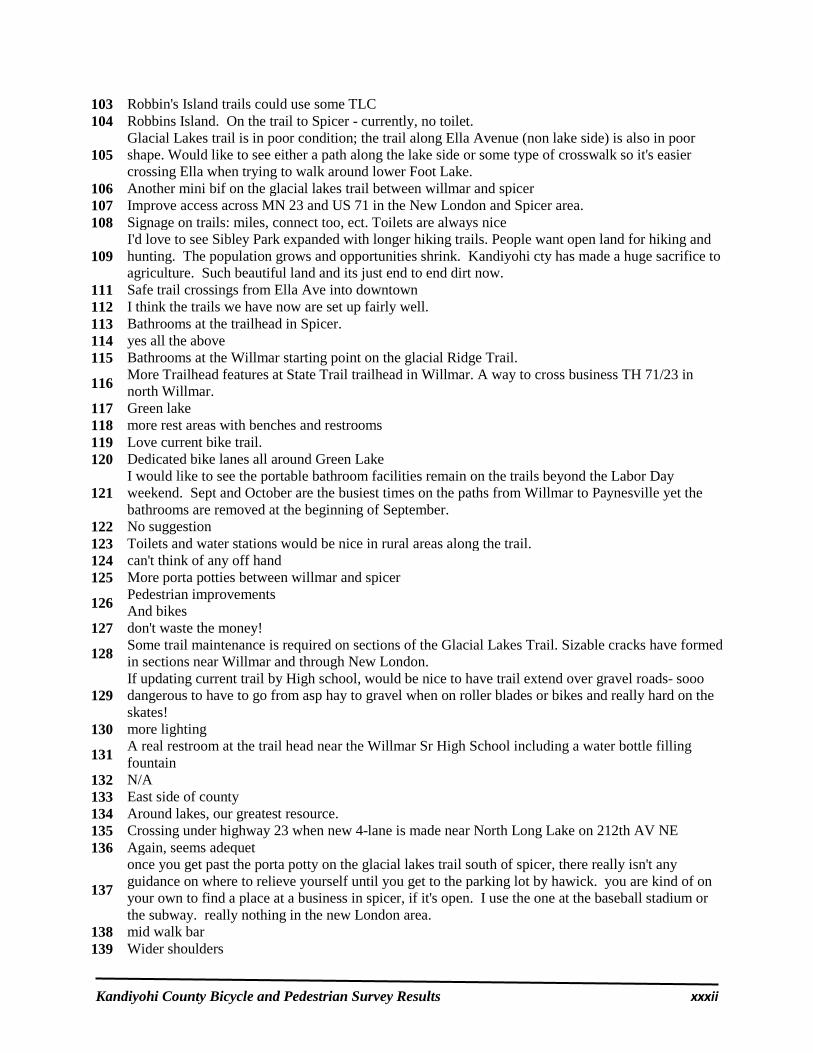
Kandiyohi County Bicycle and Pedestrian Survey Results xxxii
103 Robbin's Island trails could use some TLC 104 Robbins Island. On the trail to Spicer - currently, no toilet.
105 Glacial Lakes trail is in poor condition; the trail along Ella Avenue (non lake side) is also in poor shape. Would like to see either a path along the lake side or some type of crosswalk so it's easier crossing Ella when trying to walk around lower Foot Lake.
106 Another mini bif on the glacial lakes trail between willmar and spicer 107 Improve access across MN 23 and US 71 in the New London and Spicer area. 108 Signage on trails: miles, connect too, ect. Toilets are always nice
109 I'd love to see Sibley Park expanded with longer hiking trails. People want open land for hiking and hunting. The population grows and opportunities shrink. Kandiyohi cty has made a huge sacrifice to agriculture. Such beautiful land and its just end to end dirt now.
111 Safe trail crossings from Ella Ave into downtown 112 I think the trails we have now are set up fairly well. 113 Bathrooms at the trailhead in Spicer. 114 yes all the above 115 Bathrooms at the Willmar starting point on the glacial Ridge Trail.
116 More Trailhead features at State Trail trailhead in Willmar. A way to cross business TH 71/23 in north Willmar.
117 Green lake 118 more rest areas with benches and restrooms 119 Love current bike trail. 120 Dedicated bike lanes all around Green Lake
121 I would like to see the portable bathroom facilities remain on the trails beyond the Labor Day weekend. Sept and October are the busiest times on the paths from Willmar to Paynesville yet the bathrooms are removed at the beginning of September.
122 No suggestion 123 Toilets and water stations would be nice in rural areas along the trail. 124 can't think of any off hand 125 More porta potties between willmar and spicer
126 Pedestrian improvements And bikes
127 don't waste the money!
128 Some trail maintenance is required on sections of the Glacial Lakes Trail. Sizable cracks have formed in sections near Willmar and through New London.
129 If updating current trail by High school, would be nice to have trail extend over gravel roads- sooo dangerous to have to go from asp hay to gravel when on roller blades or bikes and really hard on the skates!
130 more lighting
131 A real restroom at the trail head near the Willmar Sr High School including a water bottle filling fountain
132 N/A 133 East side of county 134 Around lakes, our greatest resource. 135 Crossing under highway 23 when new 4-lane is made near North Long Lake on 212th AV NE 136 Again, seems adequet
137
once you get past the porta potty on the glacial lakes trail south of spicer, there really isn't any guidance on where to relieve yourself until you get to the parking lot by hawick. you are kind of on your own to find a place at a business in spicer, if it's open. I use the one at the baseball stadium or the subway. really nothing in the new London area.
138 mid walk bar 139 Wider shoulders
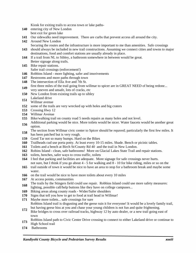
Kandiyohi County Bicycle and Pedestrian Survey Results xxxiii
140 Kiosk for exiting trails to access town or lake paths- entering city of New London best exit for green lake
141 Our sidewalks need improvement. There are curbs that prevent access all around the city. 142 Around New London
143 Securing the routes and the infrastructure is more important to me than amenities. Safe crossings should always be included in new trail constructions. Assuming we connect cities and towns to major destinations, food and comfort stations are usually already in place.
144 If a trail from NL to Sibley, a bathroom somewhere in between would be great.
145 Better signage along trails. Bike repair stations. Safer trail crossings (enforcement!)
146 Robbins Island - more lighting, safer and imorivements 147 Restrooms and more paths through town 148 The intersection of Ella Ave and 7th St.
149 first three miles of the trail going from willmar to spicer are in GREAT NEED of being redone... very uneven and unsafe, lots of cracks, etc
150 New London from existing trails up to sibley
151 Lakeland drive Willmar avenue
152 some of the trails are very wrecked up with holes and big craters 153 Crossing Hwy 12 154 Willmar Avenue 155 Bike/walking trail on county road 5 needs repairs as many holes and not level.
156 Additional parking would be nice. More toilets would be nicer. Water faucets would be another great option.
158 The section from Willmar civic center to Spicer should be repaved; particularly the first few miles. It has been patched but is very rough.
159 Good Tar not so many bumps. Hard on the Bikes 160 Trailheads cud use porta potty. At least every 10-15 miles. Shade. Bench or picinic tables. 161 Toilets and a bench at Birch St/County Rd 40 and the trail in New London. 162 Robins Island - clean, safe bathrooms! More on Glacial Lakes State Trail and repair stations. 163 toilets, benches, safer ways to cross traffic, toilets 164 I feel that parking and facilities are adequate. More signage for safe crossings never hurts.
165 not sure, but I think if you go about 4 - 5 for walking and 8 - 10 for bike riding, miles or so on the trail outside of town it would be nice to have an area to stop for a bathroom break and maybe some water.
166 on the trail would be nice to have more toilets about every 10 miles 167 At access points, communities
168 The trails by the Stingers field could use repair. Robbins Island could use more safety measures: lighting, possible call/help buttons like they have on college campuses...
169 Biking areas along county roads - Wider/Safer shoulders 170 Signs that tell you how to get to food at trail head in Willmar! 171 Maybe more toilets... safe crossings for sure
172
Robbins Island trail is disgusting and the geese ruin it for everyone! It would be a lovely family trail, but having geese hiss at you and chase your young children is not fun and quite frightening. Bike bridges to cross over railroad tracks, highway 12 by auto dealer, or a new trail going east of town
173 Robbins Island path to Civic Center Drive crossing to connect to either Lakeland drive or continue to High School trail
174 Bathrooms

Kandiyohi County Bicycle and Pedestrian Survey Results xxxiv
175 Additional parking areas, toilets, safer crossings 176 Benches are great for both bikers and pedestrians. 177 safer crossing 178 along major roads. County roads and Highways. 179 Toilets at all the parking areas and lighting would be nice. Sometimes ride bike in early am on trail. 180 More work on horse trails 181 have no desire for more amenities 182 existing parking areas 183 Wider shoulders on Long Lake Road. 184 Toilets somewhere on east side of green lake 185 N/A never used the trails in the area. 186 Parks for my son to play at 187 Ample parking and toilets a necessity. Can electric wheelchairs use bike trails? 188 At all of the major intersections for safer crossing.
189 Is it possible to provide a lock bod of some kind at trail heads? I am a runner and have to carry keys with me to lock my car. A storage place for small items woulld be nice.
190 unknown since there are none in my town. 191 no opinion
192 The parking area north of New London is awesome. would like to see more like that, not sure where that is possible. Wouldn't need to be that big even, but a space for even 5 vehicles would be great.
193 Better surface on trail between Willmar and Spicer, maybe better/more parking at the roads that intersect the trail.
194 Unsure
195 Some toilets on the trail from Willmar to Spicer would be great! Robbins Island would feel safer with more foot paths restricted to motorized vehicles. Cars are moving slowly but there is no room for a vehicle and a person on the roads through the park.
196 Safer trail crossings 197 toilets, lighting in Ramblewood Park area in Willmar 198 More benches. 199 New London - North 200 More benches
201 The county should consider enhancing opportunities in the outermost reaches 7n the county. Most activity seems to be limited to the Willmar area and be sponsored by the city. DevelopING a county plan is good first step.
202 Picnic areas 203 Cross walk by the city park of Spicer 204 The older trails need repair and widening. 205 See previous 206 games Lake and Lake Andrew area 207 current bike trails have none that I know of. Should have them every few miles.
208 Toilets and other amenities would make the Glacial Ridge Trail much more attractive to me. I know it's a state trail, but their personnel aren't in the local area every day to maintain facilities--maybe a cooperative plan could be developed?
209 Safer crossing on Glacial Lake trail, more lighting for a route to Willmar. Trail to the state park.
211 From Spicer to Willmar there are crossings that are gravel, I do a lot of rollerbladding but won't go that way because of the gravel.
212 More signage approaching trail both ways on 153rd and also on the trail. 213 Lighting through New London 214 Visitor information and rest rooms at trail head in Spicer and New London 215 Lakeland Drive

Kandiyohi County Bicycle and Pedestrian Survey Results xxxv
Kandiyohi County Bicycle and Pedestrian Survey Question #6:
“Do you have any additional comments regarding bicycle and/or pedestrian
concerns in Kandiyohi County?”
1
The City of Willmar needs to address pedestrian crossings along 1st, Willmar Ave, 19th, etc. People are running for their lives. I realize this isn't the focus of your trails plan...but this needs to be a priority in the city on county roads. 5' minimum paved shoulders on the majority of roads used as connectors.
2 people cannot bike unless the trails are close by. County road 5 by Norway & games lake always have people walking & biking in the summer on road- not safe with all the curves in road
3 they need to pratice more safety. Even in town people don't stop to look before crossing the street.
4 Bicyclist need to start paying a license fees to ride trails just like snowmobile and cross country skiers
5 It would be nice to have bike lanes. 6 More sidewalks in the city streets would be nice in New London. 7 Places to fill water bottles could be very useful.
8 Google the most liveable cities in the world and copy what they are doing for biking and walking. Don't think Minneapolis painting on a line on a street makes a safe bike path. It does not.
9 Maps and markings/signage. And availability of those everywhere! 10 Really appreciate the trails being a safe alternative to roadways with motor vehicles 13 Smooth, cleanly paved trails make a huge difference.
14 The trail intersection near the Country Stop in New London should have a sign pointing to downtown New London businesses.
15 Trails present great opportunities for public-private partnerships. It would be great to see the county and city governments take the lead in organizing, and help facilitate partnerships with community organizations to fund and execute projects.
16 Bike access trail on Co 98 past GLSewer plant
17
The trail between Willmar and Co Rd 26 is in terrible condition. It needs to be rebuilt because it is dangerous. It makes me choose the highway instead. One additional idea: I see many children riding without helmets. Please post signs that say "Helmets save lives." or "Helmets save brains."
18 resurface from Willmar to Hawick
19 there should be an over pass on Highway 23 in Spicer. Trail on one side of the highway and another bike trail going around Green lake - but no path connecting them
20
I honestly think that the need is to keep a very small portion - like I said ... 1 to 3 miles of them CLEANED off during the winter so people can get outside and use them! That would be wonderful. I don't think we need more of them, just need to maintain the ones we have (fix any surface issues like broken pavement, etc)
21 We have run this resort for 11 seasons now, and more and more people are finding the economy and beauty of the lakeside country as an affordable and beneficial vacation. Health is an exponentially growing concern to the tourists that I see making the good trails essential.
22 I am not a bicyclist but am concerned near Sibley Park. I am a horseback rider, having bicyclist's that don't slow down, don't have the knowledge of how dangerous this can be for a horseback rider. Please consider keeping the walking & bike riding trail separate.

Kandiyohi County Bicycle and Pedestrian Survey Results xxxvi
24 The Glacial Lake Trail is an incredible jewel with exceptional scenery. Please keep it in usable condition by repairing the cracks!!!
25 Have better markings on trail crossings 26 existing trails not used enough to justify building more.
27 Maybe reminders along the trails of biking etiquette; like letting someone know you're passing them ... "passing on the left", etc.
28 proper funding
29 Please develop a northern loop which would connect to the planned trail to the State Park. The northern loop would follow State Highway 9 back to New London. State Highway 9 from Highway 71 is very picturesque as it winds it way back into town.
30 No. The county does a good job 31 We LOVE riding and biking
32 The aging "Baby Boomer" generation will continue to increase the usage of bicycle and pedestrian trails in Kandiyohi Co.!! Its a reality..!!
33 need safe lane on high way and county roads cty 8 has no paved shoulder to ride safely 34 Please do not put the new trail through the NLS school district property! 35 South and Eastern part of the county seems left out of the "countywide" trail plan.
36
I have lived in Minneapolis, Rochester, and Austin, MN and they all have wonderful bike trails! It has been so disappointing to live here where the trails are disconnected and in disrepair. Thank you for working to improve our existing trails and expand our options! I look forward to the improvements!
37
I often hesitate to take my children in the bike trailer on the trail from Willmar to Spicer because it is in such disrepair. It's too bumpy, and jostles their little heads around too much. This is the seventh place I've lived since I started cycling 15 years ago, and it has the least options for safe cycling of anywhere I've lived. I don't if many people care about it, but a greater network of bike trails and trails in better repair would go a long way toward attracting younger, college-educated people to Kandiyohi County. I know that it would be a deal-breaker for several of my friends from law school.
38
Links to surrounding communities would be fabulous. My husband had a heart attack and is an avid walker (as am I). I'm dealing with cancer and need to exercise. It's dangerous in Kandiyohi and not very varied. We walk along the train tracks for variety, but that's not optimal with... well... trains. Hooking trail to Kandiyohi would be incredible.
39
Slow down the speed on cty Rd 29 from hwy 71 past the environmental learning center. We live right on the curve before PWELC and our children get on and off the bus. I fear for their safety. I know of several times that a vehicle hasn't stopped for the bus with its lights on. The bus company doesn't report it because they say it happens too fast. It is a tough road to cross for us when we go walking or biking also, even though we stop and listen for vehicles before we cross. I know it's expensive, but maybe change the curve in the road so it's more gradual by using PWELC land.
40 It would be helpful to educate the public on bike hand signs. I can never remember what I'm supposed to do when I want to signal stop/left/right. I think if bike riders and car drivers knew the signals people would feel more safe at busy intersections.
41 Diamond Lake is in much need of a path. There is a very small shoulder to walk/ride on. Very dangerous with little kids!!!
44 Atwater needs safer crosswalks on highway 12.
45 I encourage any additional trails. restricting one side of street parking and striping the other side of street for bike path gets my vote.
46 Bicycle and Pedestrian opportunities are hugely important, other parts of the state are Really moving in this regard.
47 Please add to the length of bike trails to extend between communities 48 I don't use them because they are not close by

Kandiyohi County Bicycle and Pedestrian Survey Results xxxvii
49 Just not only to look at the Willmar-New London Corridor.
50 where is the money coming from ?? What revenue does this bring to each community? trail fees? walking fees? or just higher taxes ??
51 Dogs frequently chase me on my bicycle. Usually farm dogs who are not confined.
52 glacial trail needs updated asphalt on the first 5 miles starting at the high school. very rough for biking.
54 I am not sure you understood the areas I am talking about, so if you have questions, you can reach me at 320-220-2316.
55 I really appreciate the trails. Good to see families biking together.
56
I lIke the trails and use them often! Love Robbins Island and Sibley. Love starting in willmar and heading north. Maybe expanding trails around lakes. Excellent new trail by Eagle Lake! But I can't run around the lake anymore due to the culvert being taken out....get a bridge on the south west side to connect it.
57 I appreciate the wide, smooth shoulders on Hwy 12 that resulted from 2015 roadwork Willmar going west. The shoulder west of Pennock was very rough. Now it's great for cycling.
59
In riding my bike from mid Willmar to reach the bike trail head near the high school, the best route is to ride the sidewalk on the West side of Civic Center Drive, the sidewalk ends about a block before you arrive at the trail head parking lot. It would be good to connect that or else you are forced to ride the last 200 or so yards against traffic or you have to cross the road twice. Also should pave the trail head parking lot. It is a mess after a rain.
61
Just to ensure that the improvements or potential additions are easily accessible to a large population. Not everyone has the ability to hop in a car and drive bicycles out to a trail to park and go for a ride. I think it would be beneficial to encourage people from inside the city to leave on their bikes, and the trails would get much more use.
62 I am most concerned about distracted drivers. 63 do more in the area as has been started.
64 hwy 5 by games lake park needs bike path, a lot of people are using the road. very dangerous area.
65 Dedicated bike trails in Willmar city and around the city would be great. See Brookings, South Dakota, for an example.
66 When riding on roads, sometimes you come across a gravel road that is unsteady for my bike tires. It would be nice to have paved trails and not have to worry about gravel.
67 just to help drivers to remember to share the road, and stop signs are for everyone! Bicycles included.
68 Promoting awareness of biking safety for bikers, pedestrians and motorized vehicle operators is important.
69 the trail is used quite often by our customers during the summer
70 Continue to encourage improvements each year. This is a system of exercise that costs little money for the people of Willmar and th county and we need to encourage this and also reduce obesity.
71 It would be so nice to see some type of crosswalk in the 19th Ave SW/9th Street SW area. It is insane trying to get across that road and your only other option is going down to 15th street and then coming back or going to 1st street
73 Yellow bike program was a great idea but won't work in this town, don't waste money on it. I don't call a bike trail the shoulder of a road, a trail solely for walk/bike/rollerblading/XC skiing should not allow motor vehicles or snowmobiles.
74 It would just be nice to have trails that are more closer. Without having to figure out how to load all the bikes up for family to ride bike together.
75 I am pleased the county is working on safe routes for bicycle and pedestrians. It will be nice to connect communities in the county.

Kandiyohi County Bicycle and Pedestrian Survey Results xxxviii
76 i wish there was more room for bicycles on the roads. also the connection of sidewalks to be more consistent. Like it seems that one block has sidewalks then the next doesn't.
77 There are many walkers/bikers on Co Rd 5 by Park #7 which is pretty dangerous as cars move quite fast. It would be a great asset along there.
78 I am a runner and we have a good size running community in our county, having safe path with access to bathrooms would be awesome.
79
The bicycle specific lanes around Green lake are generally coated with gravel and trash, and service vehicles parking in and across them. I used to ride that route but find rural roads generally better maintained and more bicycle friendly than the designated areas. Posting information on who to notify when maintenance is needed would be helpful as it is frustrating to have these pathways established, but not in good usable condition. Also, driving to ride or walk is nonsense. Connect the trails to town, not just the city limits.
80 I like seeing all the new trails coming along. However, I personally would rather see maintenance of existing trails take precedence over new trails.
81 Safety is a huge issue. I see that someone "took out" the push button crossing light near the 1st Street bridge (after over pass)
82 More bike lanes; more sidewalks need to be fixed. Some sidewalks in the part of town I live (southwest) are buckled up with tree roots, are in very poor shape, have tree branches hanging over them, etc.
83 Seen the increase in marked trails around willmar, great job !!!!! 84 Continue to pave shoulders on County highways
85 Teaching people, bikers and walkers to announce their coming/passing. "passing on the left" Cars, bikes and walkers on RI ring road.
86 Impossible for bikes or pedestrians to safely share the road with vehicles. Accidents happen.
88 The bike path from Willmar senior high to East Eagle lake road is a wonderful addition Already this early spring I see bikes, walkers and baby carriages on it
89 County has done a good job putting trails in, expanding them out to other lake areas would be great. I know there is a cost to this!
90 Animal control is needed 91 Connect more cities. Biking on county roads is treacherous. 92 Improved surface on bike path from Willmar to New London
94 I love the wide shoulders on county rd 10 connecting hwy 71 to Spicer. That's how we get to the Glacial Lakes Trailhead in Spicer. Connecting Prairie Woods ELC to everything would be great too!
95 the paths between towns are nice think for people who want to ride there bikes or walk to work. 96 All updates and what we currently have is so much appreciated 97 I would like to see the Ella Avenue trial resurfaced. 98 stop wasting money!
99
I would like to see continued public education efforts towards safe cycling in traffic and motorist awareness of cyclists. The scourge of texting while driving and inattentive driving kills/injures cyclists every year in Minnesota. Ordinances banning inattentive driving and enforcement of said ordinances would lower the number of cyclist deaths/injuries on roadsides.
100 A trail from County Park 2 - Big Kandiyohi West to Lake Lillian would be great 102 Just to keep expanding in general
103 Trails away from traffic would be great. Places along the trail to stop, scenery, other people, somewhere to purchase a snack or water.
104 Do not need a trail on 153rd Ave NE to service Golf View. 105 Been on a few of the trails and think they are GREAT!
106 thinks are getting better here in willmar. riding on south first street is a nightmare, with danger comparable to celebrating Christmas with ISIS. keep up the good work!
107 please do something

Kandiyohi County Bicycle and Pedestrian Survey Results xxxix
108 Please continue to work on this - Thank You for doing this so we can encourage safe, healthy behavior for all ages, abilities.
109 I believe more people will hike and bike, if we provide more ways to do these activities. Safety is a critical component of this.
110 I'm happy with the system and enjoy a great place to walk.
111 We have a great network started. Trails are very important to our quality of lives. They provide a great opportunity to be outside and stay active.
113 Need more community education on biking
114 I don't know if the trail in Robbins Island after the bridge heading towards Co Rd 41 was redone yet, but there were a lot of holes and dips in it.
115 Don't put bike equipment at swansson because people don't live over there. Put main equipment at rice.
116 wish we could offer a free bike program so more people could have their own bike to ride 117 The trails need lighting as it gets dusk it is very much needed
118 Don't a great job working towards making this better. Moving the plan faster would be better but thanks for having one.
120 Would be nice if a trail could be extended to the SW side of town inorder to avoid traffic and have access to the glacial lakes trail without having to haul bikes to the trail head.
121 Love the Bike Trails Need to be Monitored for crakes. 122 continue to implement safety awareness & measures 123 Highway traffic is dangerous. Paths away from highways wud be a blessing.
124 I believe there is a need for more, but it won't affect my family due to the current dynamics and factors. Young babies and children do not mesh very easy with biking, nor do we have the time.
125 Keep the progress going forward. 126 There are not a lot of "safe" place to ride in the city limits without riding on the sidewalk 127 Bicycle routes are a draw to this area both for visitors and potential residents.
128 the yellow bike program was a good thought, it's just that there are seldom if ever, bikes at the bike racks. !!
129 any new trail improvements should link to larger County/State trail system
130 Too many new drivers that are not aware of driving practices lead to huge concerns for those on foot and bicycle. They do not know right of ways and yielding to pedestrians. It is DANGEROUS to be on ANY street in this town. Too many people are too distracted!
131 I like the County's proposal of the underpass by YMCA and new School
132 Connect more than Just Willmar, Spicer and New London. 2040 is a County wide initiative, but seems to be focusing on these 3 communities.
133 This is a positive thing for safety 134 Sidewalk repair in the city of Willmar 135 The trails have lots of use, they are a good thing
136 If possible to have them tar so people can rollerblade or use some other form of transportation, the trails around St. Cloud are very well kept and nice for whatever activity you choose to do.
137 What about a few garbage cans on the trails if there is a lot of trash thrown by people. What about dogs and poop? Should people clean up their dog poop? Or could you get service groups to occasionally clean garbage/poop if it is a problem. Maybe it isn't.
138
My husband rides bike to work during the summer months and many days he will have a story about a driver almost running him over if he is crossing a street. Maybe an article in the paper and radio if a driver hits a biker when the biker has the right of way what are the penalties. Everyone needs to observant of what the other person is doing, shut the cell phones off.
139 You never see the yellow bikes that were placed around Willmar. That’s too bad it really seemed like a good idea.
141 The new trail north of the high school in Willmar (just that section) is a perfect example of how additional new trails should be located. Close to nature and away from the busy roads.

Kandiyohi County Bicycle and Pedestrian Survey Results xl
143 too much money is being wasted on new stuff and not maintaining the current ones
144
any work on tar roads should include at least an adequate shoulder for biking/walking, enforce speed limits, examine speed limits for appropriateness for the area with a lot of entrances, ped/bike traffic. Around the lakes it can get a little dicey...I am not referring to Green Lake. Encourage Green Lake folks to use what they have and not be on the road when they have a trail or lane....I don't understand that but see it a lot.
145 Driver awareness - mostly good interactions between drivers and pedestrians but education is always good.
146 Safety! 149 We need to realize the economic value of trails.
150 I am glad to see that you are willing to consider the trail system. Keep the process moving forward.
153 I enjoy what we have and hope the new County Road 40 road is adequate for safe biking. 155 I think we have a good trail system. 156 along with walking path there should be equestrian paths right alongside 157 Hard to get across Hwy. 23 near Spicer as a pedestrian
158 Whenever First Street South in Willmar is reconstructed, it should definitely be widened to include a bicycle lane. Sidewalks are not the right place to bicycle for many reasons, but I sure wouldn't want to ride on that street!
159 We need to continue to make the area bike and pedestrian friendly. We have long, beautiful summers and many, many places to see. The trails help us enjoy both.
160 Big part of quality of life - especially healthy activities that are fun, and the chance to enjoy the outdoors.
161 My relatives from out of town are so envious of our trails and having more of them going different directions from Spicer or New London will draw in more visitors.
163 Encourage local units of government to participate in trail development

Appendix B:
News Releases &
Public Open House
Comments

April 1, 2016 From the Office of: Mid-Minnesota Development Commission 333 West Sixth Street Willmar, MN 56201
* * * * * * * * * * * * * * * * * * * * * *
NEWS RELEASE
Kandiyohi County Trails Survey
Kandiyohi County is currently developing a Bicycle and Pedestrian Plan. As part of the
planning process, the committee working on the plan has developed an online survey. The
purpose of the survey is to solicit comments on future bicycle and pedestrian needs, including
new trails and amenities (i.e., parking, rest areas, adequate lighting, safer crossings, etc.). Please
visit the following website if you would like to share your thoughts:
https://www.surveymonkey.com/r/Kandiyohitrails
If you do not own a computer, you may take the survey online at the Willmar Bikes Open
House event, held from 5:00 to 7:00 on April 7, 2016, at the City Auditorium (adjacent to
Willmar’s City Hall). Public libraries also have computers you can use.
If you have any comments or questions on the Kandiyohi County Bicycle and Pedestrian
Plan, please email the Kandiyohi County Public Works Director, Mel Odens, at
If you have any comments or questions regarding the Kandiyohi County Bicycle and
Pedestrian Survey, please contact the Mid-Minnesota Development Commission Community
Development Director, Matthew Johnson, at [email protected].
-END-

Kandiyohi Bicycle and Pedestrian Plan Booth at Willmar Bicycle Open House (April 7, 2016) Comments Placed on County Map on Bicycle and Pedestrian Needs/Desires:
Would like to see a paved trail connecting CSAH 5 to Sibley State Park.
It is very important to have a trail on CSAH 5 by Games Lake.
I would like to see that the new planned trail on CSAH 5 is placed on only one side of the road, so there is no danger of crossing the highway.
The designated bike route on County Road 148 is currently a very bad road for bicyclists.
I would like to see a bicycle lane on CSAH 40.
I would like to see a CSAH 5 trail loop – Willmar to Sibley State Park
CSAH 5 should be a main bike route.
The Prairie Woods Environmental Learning Center needs to be linked to other destinations with off road trails.
I would like to see marked bicycle lanes on CSAH 25
There is a gap – no trail at parking lot south of road (the comment tab had an arrow and was moved – it was around the Willmar Trailhead to the State Trail. There is a short gap from the City trail to /and through the state trailhead parking lot.
There is no shoulder on CSAH 8 between the cities of Kandiyohi and Spicer.
Make a path on the south side of Diamond Lake, and make a loop around the entire lake if possible.
Bring the Luce Line Trail to Willmar.
There is a need for more signage on bike routes/trails.

April 27, 2016 From the Office of: Mid-Minnesota Development Commission 333 West Sixth Street Willmar, MN 56201
* * * * * * * * * * * * * * * * * * * * * *
NEWS RELEASE
Kandiyohi County Trails Survey and New London Open House
Kandiyohi County is currently developing a Bicycle and Pedestrian Plan. As part of the
planning process, the committee working on the plan has developed an online survey. The
purpose of the survey is to solicit comments on future bicycle and pedestrian needs, including
new trails and amenities (i.e., parking, rest areas, adequate lighting, safer crossings, etc.). Please
visit the following website if you would like to share your thoughts:
https://www.surveymonkey.com/r/Kandiyohitrails
The survey will be available online until May 27, 2016. The public is also welcome to
attend an open house on May 11, 2016, from 3:00-4:30 p.m., at the New London Senior Center
(2nd Avenue SW near the Mill Pond in New London). Maps will be available to discuss existing
and potential new bicycle and pedestrian trails.
If you have any comments or questions on the Kandiyohi County Bicycle and Pedestrian
Plan, please email the Kandiyohi County Public Works Director, Mel Odens, at
If you have any comments or questions regarding the Kandiyohi County Bicycle and
Pedestrian Survey and/or the open house, please contact the Mid-Minnesota Development
Commission Community Development Director, Matthew Johnson, at
-END-

KANDIYOHI COUNTY BICYCLE AND PEDESTRIAN PLAN WRITTEN PUBLIC MEETING COMMENTS
Kandiyohi Bicycle and Pedestrian Plan Booth at New London Bicycle Open House (May 11, 2016) Comments Placed on County Map on Bicycle and Pedestrian Needs/Desires: Connect the State Parks. (Sibley and Monson Lake) Connect CSAH 5 to State Park Within Sibley State Park, construct a bike/hike trail through existing State Park land to
County Park 7. Connect Games Lake Park to Sibley State Park. Existing trail from New London (Co. Rd. 31) to Willmar continues to deteriorate with
numerous sections that have many cracks. The parallel ones can be dangerous. This section should be given priority before the extension to Sibley State Park is built! #1 should be New London - Spicer as that has the most traffic all summer!
Safer bike/pedestrian crossings of CSAH 40 between Main Street and CSAH 9 in and west out from New London. (Safe crossings to the school property.)
Separated/protected bike/pedestrian trail on Birch Street, New London. Loving all the plans so far – and anything that connects to the Glacial Lakes/state trails
and the Sibley State Park connector will be a big plus. I would like a trail along CSAH 40 and CSAH 4 to Green Lake. Trail from CSAH 40 to Prairie Woods Elementary on East Side of CSAH 9. Widen the shoulders of CSAH 9 from CSAH 10 to CSAH 40, to accommodate bikes. ? Lake Calhoun Association – Trail by Lake Calhoun. ? Around to connect Co. Rd. 98 to
CSAH 4. (Dave & Jan Schmidt 320-979-5960. Widen the shoulders from CSAH 10 to CSAH 40, to accommodate bikes. Resurfacing the existing trail (New London to Willmar) more needed than new trails. III The branch off the trail up to the NL-S high School needs to be widened. When the trail is re-surfaced through the “tunnel” under State Highway #9, it needs to
be elevated so there is drainage out of the tunnel. There is lots of ponding there and ice in winter. Also – better drainage in the tunnel south of Spicer?
At Willmar State Trailhead – Need to pave by the parking lot (gap). Kandiyohi Bicycle and Pedestrian Plan Booth at Willmar Bicycle Open House (April 7, 2016) Comments Placed on County Map on Bicycle and Pedestrian Needs/Desires:
Would like to see a paved trail connecting CSAH 5 to Sibley State Park. It is very important to have a trail on CSAH 5 by Games Lake. I would like to see that the new planned trail on CSAH 5 is placed on only one side of the
road, so there is no danger of crossing the highway.

The designated bike route on County Road 148 is currently a very bad road for bicyclists. I would like to see a bicycle lane on CSAH 40. I would like to see a CSAH 5 trail loop – Willmar to Sibley State Park CSAH 5 should be a main bike route. The Prairie Woods Environmental Learning Center needs to be linked to other
destinations with off road trails. I would like to see marked bicycle lanes on CSAH 25 There is a gap – no trail at parking lot south of road (the comment tab had an arrow and
was moved – it was around the Willmar Trailhead to the State Trail. There is a short gap from the City trail to /and through the state trailhead parking lot.
There is no shoulder on CSAH 8 between the cities of Kandiyohi and Spicer. Make a path on the south side of Diamond Lake, and make a loop around the entire lake
if possible. Bring the Luce Line Trail to Willmar. There is a need for more signage on bike routes/trails.