South Temiskaming Bicycle Routes
49
South Temiskaming Bicycle Routes
-
Upload
khangminh22 -
Category
Documents
-
view
4 -
download
0
Transcript of South Temiskaming Bicycle Routes

South Temiskaming Bicycle Routes

Historic R/W Bridges
Highway(White dashed line = Paved)
Regional Road
Road Other
Resource Road
Railway
Abandoned Rwy
Trans-Canada Highway
Lake
River/Creek
Wetland
Mountain Contour
Wooded Area
Built Up Area
Power Transmission
Gas Pipeline
Township Border
Distance markers
567
11Cycling
Picnic Area
Golf
Baseball Diamond
Walking
Nordic Skiing
Hiking
Childrens Playground
Swimming
Marina
Boat Launch
Fishing
Trailers Camping
Tent camping
Store
Hotel / Motel
Restaurant
Washrooms
School
Gas Station
Hospital
Ontario Provincial Police
Cemetery
Library
Information
Museum
View location
Parking
Historic bridge(s)Agriculture
Amish farmers
Amish buggies
Mine headframe
Abandoned mine
Hydro dam
Ontario Provincial ParkTrue North arrow
Maps for the CyclistThe maps presented here have been de-signed with the cyclist in mind. You can ride in a group or alone.A summary table of all routes including se-lected ones in Quebec is provided.Road categories are shown as paved and gravel on the maps. The white dashed line in the road indicates pavement. Town streets are paved. A perfect introduction ride is the STATO trail which is a designated bikeway running along Lakeshore Road from New Liskeard to Haileybury (Temiskaming Shores) for 19.4 km.There are touring routes radiating into the countryside. A favourite one is Twin Lakes, No. 9. There are optional starting points.Cobalt is internationally famous as the birthplace of hard rock mining and was the leading mining camp for silver. It spawned a whole mining industry. There are many mining features to explore. The under-ground mining tour should be on your list. The routes radiate outward from the town, even out to the summer trails at the Nordic Ski Club. A great autumn leaf experience.
Information & Help
The City of Temiskaming Shores has spon-sored all our information on its website. The maps are online for downloading at:
temiskamingshores.ca705-672-3363
Waterfront Pool & Fitness Centre705-647-5709
Our Chamber of Commerce is known for helping first time visitors. They are famil-iar with the region and can offer advice on where to go. tsacc.ca • 705-647-5771
BICYCLE REPAIRS / SALESHowey Bros - experienced bicycle mechanic57a Whitewood AveNew Liskeard, ON,1-705 647-9444.website: howey-bros.com
SALES & PARTS Canadian Tire - Hwy 11Walmart - Hwy 11
Free handbook of safety standards for any rider. Cycling Skills: Ontario’s Guide to Safe Cycling (PDF - 9 MB)
http://www.mto.gov.on.ca/english/safety/bicycle-safety.shtml
orRe�ective tapeon front forks
Cycling GlassesHelmetKnapsack (optional)Re�ectiveVest
Bike Lock
Rear LightRedRe�ector
Lateral Re�ectors
Pedal Re�ectors
Rear View Mirror
Bell
White Re�ector
Front Light
These maps are graphic representations of data derived from information provided by multiple independent sources. Heritage Technics will not be responsible for, or be held liable for, any errors or omissions therein. Any conclusions based on information provided in these maps or graphics are solely the responsibility of the persons making them and information contained herein should be verified independently when necessary.
MAP LEGEND
2
SOUTH TEMISKAMING BICYCLE ROUTES

ROUTE No, DESTINATION SURFACE DISTANCE DETAILS DIFFICULTY
1 STATO Trail Paved 19.4 km 1 way Moderate (some hills)
2 Countryside East Mix of Paved/Gravel 19.5 km loop Moderate (some hills)
3 Dawson Pt. Road Paved 10 km 1 way Moderate (some hills)
4 Uno Park Gravel 22.5 km loop Moderate (some hills)
5 School Connector Paved 0.7 km 1 way Easy
6 Whitewood Connector (New Liskeard) Paved 1.9 km 1 way Easy
7 New Liskeard to Elk Lake (James Twp) Paved 65.9 km 1 way Moderate (some hills)
8 Historic Pete’s Dam Park Gravel 4 km loop Moderate (one steep hill)
9 Twin Lakes (Option A) Paved 50 km return Advanced
9 Twin Lakes (Option B) Paved 30 km return Moderate (some hills)
9 Twin Lakes (Option C) Gravel 30 km return Moderate
10 Clover Valley / Sunnyside Road Mix of Paved & Gravel 14.3 km loop Advanced (some hills)
11 Mowat Landing Paved 22.2 km 1 way Moderate / Advanced (hills)
13 Quarry Road Connector Gravel 5.6 km 1 way Easy
14 Northern College Connector Paved 2.8 km 1 way Easy
15 Farr Cemetery / Mill Creek Gravel 1.8 km 1 way Easy
16 Bucke Park / Devil’s Rock / Lorrain Valley (Option A) Paved / Hard Packed 25 km return Moderate (some hills)
16 Bucke Park / Devil’s Rock / Lorrain Valley (Option B) Paved / Hard Packed 43.7 km 1 way Moderate (some hills)
17 Coleman Township Paved 28 km loop Advanced (some hills)
18 Nordic Ski Club Gravel 20 km loops Moderate (some hills)
19 Cobalt / Coleman Heritage Silver Trail Mix of Paved/Gravel 5 km loop Moderate (some hills)
21 New Liskeard / Thornloe via Uno Park (Option A) Mix of Paved/Gravel 23.8 km return Moderate (some hills)
21 New Liskeard / Thornloe via Uno Park (Option B) Mix of Paved/Gravel 20.5 km loop Moderate (some hills)
22 Casey Mountain Countryside Gravel 37 km loop Moderate (some hills)
24 Hilliardton / Tomstown Mix of Paved/Gravel 24 km 1 way Easy
25 Elk Lake to Matachewan Paved 37.4 km 1 way Advanced
26 Matachewan to Kenogami Paved 44.5 km 1 way Advanced
27 Elk Lake to Charlton (Hwy 560) Paved 30.7 km 1 way Advanced
28 Charlton / Englehart Area Mix of Paved/Gravel 26.9 km loop Easy
29 Englehart Mix of Paved/Gravel 28.6 km loop Moderate (some hills)
30 Hwy 624 to Larder Lake Paved 41 km 1 way Moderate (some hills)
31&32 Notre-Dame-du-Nord (Option A) Paved 15 km return Easy
31&32 Notre-Dame-du-Nord (Option B) Paved 50 km loop Moderate (some hills)
33 Angliers Paved 11 km 1 way Moderate (some hills)
33B. Témiscamingue Linear Park, The Mocassin Line Stone dust 43 km 1 way Easy
34 Hwy 101 - Québec Paved 32 km return Moderate (some hills)
35 Ville Marie - Île du Collège / La Bannick Paved 20 km return Moderate (some hills)
36 Témiscamingue Paved 38 km return Advanced
CONTENTSSouth Temiskaming Bicycle Routes Summary
3
SOUTH TEMISKAMING BICYCLE ROUTES

KEY PLAN OF BICYCLE ROUTES
© Base Map: Heritage Technics, 2021© Bicycle Routes: South Temiskaming Active Travel Organization (STATO), 2021WEBSITE: stato.ca
Lac Opasatica, Proposed
Biodiversity Reserve
Parc national Opémican
Hilliardton MarshResearch & EducationCentre
ON
TARI
OQ
UEB
EC
ON
R
ONR
ONRONR
Matachewan First Nation
TimiskamingFirst Nation
Lady Evelyn-SmoothwaterProvincial Park
566
560
560
11266
66
65
65
65
65
650
568
573
569
624
571
562
11
11B
558
567
672
11
101
101
117
KirklandLake
Matachewan
Elk Lake
Englehart
Earlton
Charlton
Latchford
TemiskamingShores
Temagami
Larder Lake
CobaltColeman Ville-Marie
Guigues
Notre-Dame-du-Nord
Angliers
7
9
11
16
18
2122
1
23
24
25
26
27
2829
30
3132 33
34
35
36
STATOTRAIL
LakeTemiskaming
Tour
Km0 10
Lake TemiskamingTour
Drive aroundLake Temiskaming inOntario & Quebec.
Stop and ride your bicycle atselected locations.
laketemiskamingtour.com
The District of Temiskaming and in particular, South Temiskaming, is where the Little Claybelt lies. The glacial lakes retreated eventually, leaving a rich clay soil that is now the basis for a successful northern agricultural area. The bicycle routes take advantage of the flat and undulating landscape. The numbers shown on the key map indicate a single route and the box is the area covered. Each route has its own descriptive content.
4
SOUTH TEMISKAMING BICYCLE ROUTES

FormerlyBucke Twp.
Historic
1.8 km
2.8
km
5.6
km
5 km
2.3 km
1.6
km
5.4 km
3.3
km
5 km
2 km
1.9 km
2.3 km
1.9 km
2.3
km
2 km
1.7 km
4.8 km
1.6 km
1.6 km
2.6 km
1.3 km
2.8 km
1.5 km
2.8 km3.6 km
2.4 km
1km
2.4
km
1.3 km
3.4 km
4.6
km
15
14
13
13
11
11
11
10
10
10
7
6
5
4
3
2
2
1
1
STATO TRAIL
STATO TRAIL
STAT
O TR
AIL
STAT
O TR
AIL
Power Transmisson Line
Powe
r Tra
nsmi
sson L
ine
Pipeline
Dawson Point
Hughes Lookout
White Cli
ffs
of Daw
son
ONR
FarrPark
Lake
Temiskaming
Wabi Bay
Moore’s CoveMoore Ck
Wabi Ck
Dickson Ck
Farr IConstance L
Wabi Ck
Pete’sDam Pk
SolarFarm
SolarFarm
SolarFarm
TemiskamingShores
New Liskeard(Historic)
Haileybury(Historic)
CIT
Y O
F TE
MIS
KAM
ING
SH
ORE
S
Cemeteries
11
1165
65
Arms
trong
St
N
Dawson
Rockley Rd
Golf Course Rd
Lakeshore Rd S
West Rd
Jelly
Rd S
Jelly
Rd S
Tucker Rd
Heards Hill Rd
Flemi
ng R
d
Sunnyside Rd
Pete’s Dam Rd
Ball’s Rd
Quar
ry R
d
Rive
r Rd
Peter
s Rd
Clove
r Vall
ey R
d
Conc. Harris ARadley Hill Rd
Seed
s Rd
Beda
rd R
d
Sales
barn
Rd
Rams
ey R
d
Point Rd
Drive In Theatre Rd
Gran
t Dr
Dawson Point
Rd
Mclea
n Rd
Hessle Ave
May
St
Laur
ette
St
Arm
stron
g St
S
Whitewood Ave
Wel
lingt
on S
t
Beac
h Blv
d
Shep
herd
son
Rd
High St
Lake
shor
e Rd
N
Morissette Dr
Elliot St
Farr Dr
RORK
E AV
E
LATCHFORD ST
3H Three H FurnitureSystems Ltd
KenworthTrucks
See mapROUTE 6
See mapROUTE 14
MAP 8Chamber
Little Claybelt Homesteaders
Museum
Mall
WalmartCdn Tire
Waterfront Pool & Fitness Centre
École St. MichelDymond BallPark
© Base Topo Map: Heritage Technics, 2021© Bicycle Routes: South Temiskaming Active Travel Organization (STATO), 2021, WEBSITE: stato.ca
KmDashed White Line = Paved
0 1
Proposed futureMulti-use trail system with subdivsion development
ProposedSTATO TRAILBridge
ProposedSTATO TRAILExtension
Northern CollegeHaileybury Campus
EDWARD ST
The South Temiskaming Active Travel Organiza-tion (STATO) was the first ambitious start in estab-lishing a separate urban trail system connecting historic Dymond, New Liskeard and Haileybury.The New Liskeard node is an excellent starting point for riding south along the STATO trail and also for countryside journeys north of New Liskeard. The Waterfront Pool & Fitness Centre has a few tricycles for rent – ideal for seniors. This stretch of trail along the waterfront is particularly suited to family cycling. A separate path will appeal to walk-ers and joggers.The STATO trail contin-ues south and meets up with the road with a sep-arate path on Lakeshore Rd. It arrives at the Hai-leybury waterfront and continues onward to Farr Park.You can also get all the way to Dymond taking the newest section of the STATO trail behind the mall leading to Grant Drive.
1. STATO TrailDifficulty: moderate (some hills) • Distance: 19.4 km (1 way) • Surface: paved • Start: Farr Park or Dymond Ball Park
5
SOUTH TEMISKAMING BICYCLE ROUTES

Haileybury Beach
Waterfront Pool & Fitness Centre, New Liskeard
SOUTH TEMISKAMING BICYCLE ROUTES
STATO Trail observation platform
STATO trail & Boardwalk - New Liskeard
v
Temiskaming shores CiTy hallaT haileybury waTerfronT
Start: Waterfront Pool & Fitness Centre, New Liskeard
Haileybury Waterfront
Bronze sculpture representing a real life event - mother in Lake Temiskaming lifting her baby to safety in 1922 fire
6

2. Countryside EastDifficulty: moderate (some hills) • Distance: 19.5 km (loop) • Surface: mix of paved & gravel • Start: Waterfront Pool & Fitness Centre • Caution: crossing Hwy 65 East • Suggestion: ride clockwise
The area north of Wabi Bay provides a good cross section of Claybelt agriculture and when rounding the lake, Dawson Rd. once again, is a relaxing ride on good pavement. Harris Twp. has its share of forested land to the east.Half the route lies in Temiskaming Shores and the other is in Harris Twp. which is an incorporated municipality.
Heards Hill Road, looking towards Lake Temiskaming
Agricultural Farm in distance, north of New Liskeard
FormerlyDymond Twp.
Historic
HARRIS TWP.
4.8 km
1.6 km 1.6 km
2.6 km
3.3
km
1.3 km
2.8 km
1.5 km
4.6
km
2
2
2
1ST
ATO
STAT
O
Wabi Bay
CalamityGulch
New Liskeard
CIT
Y O
F TE
MIS
KAM
ING
SH
ORE
S
11
65
65
Arms
trong
St
N
Dawson
Toblers Rd
Jelly
Rd S
Sutto
n Ba
y Rd
Tucker Rd
Heards Hill Rd
Ball’s Rd
Peter
s Rd
Peter
s Rd
Sales
barn
Rd
Point Rd
Drive In Theatre Rd
Hessle Ave
May
St
Arm
stron
g St
SCHAMBER
Mall
WalmartCdn Tire
Waterfront Pool & Fitness Centre
Park
© Base Topo Map: Heritage Technics, 2021© Bicycle Routes: South Temiskaming Active Travel Organization (STATO), 2021, WEBSITE: stato.ca
Dashed White Line = Paved Km0 1
Take your tirerepair kit for longcountry trips
7
SOUTH TEMISKAMING BICYCLE ROUTES

3. Dawson Pt. RoadDifficulty: moderate (some hills) • Distance: 10 km (1 way) • Surface: paved • Start: Waterfront Pool & Fitness CentreThe complete route starts at the Waterfront Pool & Fitness Centre and connects to Dawson Pt. Rd.You will encounter beautiful views along the countryside on these quiet roads. Cottages are located along the shoreline. The view from the dock at the end of the road provides a delightful view of Lake Temiskaming. Look down by the dock and you can find yourself a fossil or two.
2 km
1.7 km
2.6 km
1.5 km
3.4 km
3
2
1Dawson Point
White Cli
ffs of D
awson
Lake Temiskaming
Wabi Bay
New Liskeard(Historic)
Dawson
Lakeshore Rd S
Jelly
Rd S
Jelly
Rd S
Heards Hill Rd
Concession Harris A
Point RdDawson
Point
Rd
Hessle Ave
May
St
Arm
stron
g St
SW
ellin
gton
St
Beac
h Blv
d
Waterfront Pool & Fitness Centre
© Base Topo Map: Heritage Technics, 2021© Bicycle Routes: South Temiskaming Active Travel Organization (STATO), 2021, WEBSITE: stato.ca
Km0 1Dashed White Line = Paved
Dawson Point Road dock
8
SOUTH TEMISKAMING BICYCLE ROUTES

4. Uno ParkDifficulty: moderate (some hills) • Distance: 22.5 km (loop) • Surface: gravel • Start: Waterfront Pool & Fitness CentreThe Uno Park route is an-other popular route close to New Liskeard. Take the STA-TO trail up to Drive-In The-atre Rd., right then left on Peter’s Road all the way to Uno Park Road. Safely cross the road and come back via River Road and Golf Course Road.In Uno Park, there is still an old schoolhouse standing.Be sure to view the historic steel railway bridge as you ride under it. It is over a cen-tury old.
Welcome to theHamlet ofUno Park !
FormerlyDymond Twp.
Historic
2.8 km3.6 km
6 km
6.9 km
3.2
km
4
4
4
4
1
STAT
OST
ATO
Powe
r Tra
nsmi
sson
Line
Ontario N
orthland Railway
Pete’s DamPark
Park
Wabi Ck
Calamity Ck
CalamityGulch
South
Wabi Ck
Wabi Ck
CITY OF TEMISKAMING SHORES
FormerBaptistChurch
FormerUno Park
School
11
11
65
65
Golf Course Rd Laur
ette
St
Youngs Rd
Dales Rd
Heroux RdToblers Rd
River Rd
Lafo
rest
Rd
Uno Park RdUno Park
New Liskeard
Rive
r Rd
Peter
s Rd
Peter
s Rd
Mclea
n Rd
Drive In Theatre Rd
Gran
t Dr
HistoricR/W Bridge
CHAMBER
Mall
WalmartCdn Tire
École St. Michel
© B
ase T
opo M
ap: H
erita
ge Te
chnic
s, 20
21©
Bicy
cle R
outes
: Sou
th Te
misk
aming
Acti
ve Tr
avel
Orga
nizat
ion (S
TATO
), 20
21, W
EBSIT
E: sta
to.ca
KmDashed White Line = Paved
0 1
Rd name
Former school house – still standing
9
SOUTH TEMISKAMING BICYCLE ROUTES

5. School ConnectorThis is a short extension (0.7 km) of the STA-TO trail that services students cycling to École secondaire catholique Sainte-Marie as well as École publique des Navigateurs (a French public school). The bicycle route is separated by a pavement white line.Hessle St. can be used if you are coming from the north on the STATO trail and makes a short cut to the Dawson Pt. Rd. route. Turn south on McKelvie St. and then down to Dawson Pt. Rd.Cyclists can ride from schools all the way to the mall using the STATO trail.
STATO trail east side of Armstrong St. N. leading to mall
Shortcut
5
2
STAT
O TR
AIL
STAT
O TR
AIL
STAT
O TR
AIL
1
65
Hessle Ave
May
St
Arm
stron
g St
S
Arm
stron
g St
N
Whitewood Ave
Elm Ave
Dawson Point Rd
Mck
elvi
e St
Mall
Lake Temiskaming
Wabi Bay
Ecole Secondaire CatholiqueSaint-Marie
École publique des Navigateurs
MetresDashed White Line = Paved
0 500
© Base Topo Map: Heritage Technics, 2021© Bicycle Routes: South Temiskaming Active Travel Organization (STATO), 2021, WEBSITE: stato.ca
View of Lake Temiskaming
STATO trail passes by Écolepublique des Navigateurs
10
SOUTH TEMISKAMING BICYCLE ROUTES

6. Whitewood Connector (New Liskeard)
MTO Lookout & Rest Station
HISTORIC Carnegie Library, now under other use
DYMOND AVE
LAKE
SHO
RE R
D N
DYMOND C
RES
BIRCH DR
HALIBURTON AVE WEST
MELVILLE ST
SCO
TT S
T
FARAH AVE
MARKET
ST
BEACH BL
VD
PINE ST WEST
HART
MAN
ST
CHERRY RD
LAN
E ST
WEDGEW
OOD AVE
MA
RY S
T
ROC
KEBY
ST
MONTGOMERY AVE
GO
LDIN
G S
T
COSM
AN
CRES
GLEN RD
NIV
EN S
T N
AGNES AVE
WHITEWOOD AVE
HEAR
D ST
COSMAN CRES
BROADWOOD AVE
BROADWOOD AVE
REG
INA
ST
REG
INA
ST
MCCAMUS AVE
MCCAMUS AVE
FARAH AVE
SPRUCE ST
MA
PLE
ST N
SPRUCE ST
EDIT
H S
T
JAFF
ARY
STJA
FFA
RY S
T
HESSLE AVE
JOH
N S
T
KENNEDY ST
GRILLS ST
SPION KOP ST
NIP
ISSI
NG
AV
EBAY ST
DAV
IDSO
N S
T
LAN
DRY
DR
BRDWOOD AVE
DOUGLAS ST
AGNES AVE
CRAVEN DR
ROC
KLEY
RD
BED
ARD
DR
TAYL
OR
ST
NIXO
N CRES
WHITEWOOD AVE
BOLGER AVE
HELMER PEDERSON DR
SHEP
HER
DSO
N R
D
DIX
ON
ST
HIGH ST
HAW
N D
R
HAWN DR
MAY
ST
S
ELM AVE
WEL
LING
TON
ST
SHARPE ST
CHURCH ST
ARM
STRO
NG
ST
S
CEDAR AVE
BEAVIS TERRACE
FLEMING DR
PAG
ET S
TPA
GET
ST
MURRAY ST
OAK AVE
HESSLE AVE
MAY
ST
HALIBURTON AVE EAST
PINE AVE EPINE AVE W
KATH
ERIN
E ST G
RAN
T ST
RIV
ERSI
DE
DR
REBE
CC
A S
T
KEN
DA
LL S
T ROBE
RT S
T
1.9 km
7
6
5
2
ONR
Lake Temiskaming
Wabi Bay
1
11
11
65
Hessle Ave
May
St
May
St
Arm
stron
g St
S
Whitewood Ave
Edith
St
Farah Ave
Wel
lingt
on S
t
High St
Shep
herd
son
St
Lake
shor
e Rd
N
Cedar Ave
WaterfrontPool & Fitness Centre
STAT
O TR
AIL
STAT
O TR
AIL
STATO
TRAIL
Marina
Timiskaming District Secondary School
Lookout PostOf�ce
New LiskeardPublic School
RONA
English CatholicCentral School
OPTION
© Base Topo Map: Heritage Technics, 2021© Bicycle Routes: South Temiskaming Active Travel Organization (STATO), 2021, WEBSITE: stato.ca
Wabi IronFactory
Arena
New LiskeardAgricultural Research Station
Boardwalk
École publique desNavigateurs
New LiskeardAgricultural
ResearchStation
Metres0 500Dashed White Line = Paved
New Liskeard waterfront marina & boardwalk
Whitewood Ave lookingtoward lake & historic hotel
Whitewood Ave. (1.9 km) is one of two main roads that cross each other in the centre of town. The other is Armstrong Street.This is the business hub of his-toric New Liskeard. You may want to visit the interesting stores along this stretch. Traffic moves slowly. If you are leaving the Waterfront Pool & Fitness Centre, you can also use Farah Ave. – a pleasant residential Street takes you to Edith St. At the lights, you are on Whitewood.There is another shortcut off Shepherdson St. that offers ac-cess to the Lookout on Hwy 11. It is a snowmobile & ATV trail. The view provides a good idea of how the Little Claybelt fans out from the head of the lake at New Liskeard as shown in the photo.
11
SOUTH TEMISKAMING BICYCLE ROUTES

7. New Liskeard to Elk Lake (James Twp)Difficulty: moderate (some hills) • Distance: 65.9 km (1 way) • Surface: paved • Start: Waterfront Pool and Fitness CentreThe Elk Lake route is one of our lon-ger routes that takes you through 6 townships – the last being the Mu-nicipality of James that embraces the town of Elk Lake.Hwy. 65 W has long stretches of flat roadway. Good to make time on.Scenery is generally agricultural and forests. Land clearing is still going on in this area as you are at the edge of the Little Claybelt.The Montreal River is actually a geo-logical fault line.Well maintained washrooms are lo-cated at the bend in Barber Twp.
HU
DSO
N
JAM
ES
LUN
DY
KER
NS
BEA
UCH
AM
P
HA
RLE
Y
HIL
LIA
RD
WIL
LET
BA
NK
S
Form
erly
Dym
ond T
wp
CA
NE
BA
RBER
SPEI
GH
TA
ULD
TUD
HO
PE
HEN
WO
OD
ARM
STRO
NG
BRY
CE
8.2
km14
km
15.7 km
16.7 km
6.3
km
3.1 km
(see M
ap 1)
7
7
Men
delss
ohn
L
Wabi Ck
Mon
treal
R
Skul
l LD
acy
L
Bouc
her L
McL
eod
L
Leph
a L
Big Spri
ng L
Dacy Ck
Twin
Fairy L
Barber
Ck
McK
enzie
L
Mountain L
Philb
rick
L
Jamtam
a L
Echo
L
Dog
gett
L
Thin L
Tud L
Hop
eL
Dev
in L
Alm
a L
Littl
eSp
ring
L
Read
L
Calli
cut
LLo
stL
Balle
yL
Gill
es L
Hill
’s L
Sund
ay
Ck
Wabi Ck
Fred
eric
k L
Moo
se C
k
Cooke L
Lund
y LSt.
Jean
Bap
tiste
Ck
Lepha Ck
Leacock Ck
Hill
’s La
keFi
sh H
atch
ery
Henw
ood T
wp. F
ores
t &
Wetla
nd Co
ns. R
es.
Bryc
e & Ca
ne Tw
p.We
tland
La
custr
ineCo
ns. R
es.
India
n Ba
y Sou
th
Cons
. Res
.
Big S
pring
Lake
Bed
rock
Co
ns R
eser
ve
Hillia
rdto
n Ma
rsh
Cons
erva
tion Re
serv
e
Mako
be-G
rays
Rive
rPr
ov P
ark
Hillia
rdton
Mars
hRe
search
& Ed
ucati
onCe
ntre
ONR
ONR
Milb
erta Uno
Par
k
Kena
beek
Hill
iard
ton
Elk
Lake
Thor
nloe
Earlt
on
New
Liskeard
Pipeline
Pipeline
Twin
Lake
sRe
siden
tial &
Cotta
ges
Hoop
er’s
Rock
Huds
on
Rock
Fishe
r’s
Rock
Moun
t M
acDo
nald
Con 2
Arms
trong
Uno P
ark R
d
Herou
x Rd
Cane 2 Rd
Cane 1 Rd
10th
St W
est
Con 6
Bryc
e
Barber Cane Twp Rd
Con 4
& 5
Hilli
ard
Cattle
Rd
Henwood 2 Rd Henwood 2 Rd
Armstr
ong E
vantu
rel Tw
p Rd
Barber 2 Rd
Crick
Rd
Con 2
Arms
trong
Hanb
ury Rd McLean Rder
Pete’
s Dam
Rd
Cane 5 Rd
Connors Rd
Beauchamp Henwood Twp Rd
Mountai
n Chu
tes Rd
Con 6
Hilli
ard
Mayb
rook R
d
Mayb
rook R
d
Indian Bay R
d
Con 3
Arms
trong
Stickney Rd
Con 3
Bea
ucha
mp
Con 4 Hilliard
Con 4
Bea
ucha
mp
Barbe
r Tud
hope
Rd
Henwood 1 Rd
Con 6
Arms
trong
Garden Rd
Pipeline Rd
Mini
Farm
Rd
Kirby
son R
d
Sawm
ill Rd
Laforest Rd
Highla
nd R
d
Coutsville Rd
Con 6
Bea
ucha
mp
Con 2
Hilli
ard
Con 4
Arms
trong
Con 3
Arms
trong
Attwater Rd
Con 4
Hen
wood
Beau
cham
p Hen
wood
Twp R
d
Laure
tte S
t
Con 5
Arms
trong
Foley Rd
Henwood 3 Rd
Lunday Rd
Milberta Rd Milberta Rd
6th S
treet
McCo
ol Rd
Con 6
Hen
wood
Con 1
Dac
k
Toble
rs Rd
Rock
ley Rd
Garden RdGarden Rd
Cane Henwood Township Rd
Cane 4 Rd
Con 5
Bryc
e
Armstrong 2 Line Lillie St
Con 4
Arms
trong
Coun
try B
ridge
Rd
Con 1
Rob
illard
Young St
Cleave Rd
Wabi Pit Line
Henwood 4 Rd
Hillview Rd
Uno P
ark R
d
Deve
lopme
nt Rd
Wool
Mill R
d
Hydro Line Rd
Poupore Rd
Armstrong Hilliard Township Rd
8th Avenue
Con 3
Hilli
ard
Con 5 Hillia
rd
Morro
w Rd
North
Qua
rry R
dNo
rth Q
uarry
Rd
Paynes Rd
Twin
Bear Rd.
River Rd
Golf
Cou
rse Rd
.
Wabi Line
A
BC
Aban
done
d R/
W(w
inte
r = sn
owm
obile
trai
l)
Kena
beek
Co
m, C
entr
e &
Post
o�
ce
Kern
s Pu
blic
Scho
ol
Aban
done
d R/
W(p
arre
llas r
oad
hwy)
Thornloe
Cheese
Facto
ry
Lookout
65
65
65
6511
11
560
569
571
562
His
toric
R/W
Brid
ge
Lake
s
Km0
5D
ashe
d W
hite
Lin
e =
Pave
d
© B
ase T
opo M
ap: H
erita
ge Te
chnic
s, 20
21©
Bicy
cle R
outes
: Sou
th Te
misk
aming
Acti
ve Tr
avel
Orga
nizat
ion (S
TATO
), 20
21, W
EBSIT
E: sta
to.ca
Historic Bridge on Montreal River
Historic trestle bridge on Montrel River
12
SOUTH TEMISKAMING BICYCLE ROUTES

Twp Of�ce
NaturalSpringWater
7
25
27
65
65
560
560
Montreal R
Montreal R
Mak
obe R
Moosehorn CkELK LAKE TENT& TRAILER PARK
PARK
Makobe-Grays River
Provincial Park
Abandoned Rwy
EACOM Timber Mill
Elk LakePoplar Grove
Cemetery
NativeCemetery
Dock
Trans
mission
Line
Tower
Elk Lake Air�eld
(Privately Owned)
Elk Lake(James Twp)
Elk LakeEco Resource
Centre
To Bridge
Cook
e Lak
e Rd
15.5
Km
Matachewan
Gowganda
CharltonNew Liskeard
OPTION
OPTION
OPTION
Rose
dale
Ave
Ontario St
Pearl St
Lepa
ge
West St
Munroe Cr
Elk
St
4th St
2nd St
Spru
ce S
t
Mai
n St
1st St
Pine
St
Pine St
James St
6th St
5th St
Gre
y St
Smyth St
Front St
King St
Lake St
3rd St
Industrial Park Rd
© Base Topo Map: Heritage Technics, 2021© Bicycle Routes: South Temiskaming Active Travel Organization (STATO), 2021, WEBSITE: stato.ca Km0 1Dashed White Line = Paved
Elk Lake EcoResource Centre
Public Dock
Boat Launch
Beach
Makobe River
Excellent General Store
Post Office
Library
Hwy 65 W
ParketteParkette
13
SOUTH TEMISKAMING BICYCLE ROUTES

8. Historic Pete’s Dam ParkDifficulty: moderate (one steep hill) • Distance: 4 km (loop) • Surface: gravel • Start: Pete’s Dam parking lot
A Short HistoryIn the spring of 1906, Kalil (Big Pete) Farah embarked upon a proj-ect to build a steam power plant that would supply the Town of New Liskeard. Big Pete bought the power site at Chester Falls from Tom Chester and a dam was built above these falls on the south branch of the Wabi River. In 1910, Farah sold Pete's Dam and its assets to the Northern On-tario Light and Power Company. New Liskeard then received its power from the line that linked them to Cobalt, its neighbour to the south. The exact date the power plant went out of service is un-known, but it is believed that it was in the 1920's.The Northern Ontario Power Company sold its assets to the Hydro Electric Power Commission of Ontario which included Pete's Dam.In 1981, Dymond Township (now Temiskaming Shores) bought the property and it is now known as Pete's Dam Park. The little electric plant no longer exists but the beauty of the waterfall and rapids draws many locals and visitors for picnicking and hiking.
One of the best little parks in the rural area of Temiskaming Shores. It offers a winding picturesque walking trail to the down-stream location of a historical feature. The running water over the rapids make for a pleasant backdrop. It is a popular place to cool off on a hot summer’s day.This is more of a technical mountain biking experience with some single and double tracks. You can do multiple loops within the park if you are on a bike or venture off from there on the country gravel roads to Rockley or Twin Lake (See Map 9).Note: Along the main trail, you will encounter the Miller Group Bridge – you will have to walk your bike up and down the steps.
Sheltered Picnic Tables
View from bridge, looking south
Drink your water regularly !
14
SOUTH TEMISKAMING BICYCLE ROUTES

15
SOUTH TEMISKAMING BICYCLE ROUTES
Flat Rapids at Wabi River north of road bridge

9. Twin LakesOption A: Difficulty: advanced • Distance: 50km (return) • Start: Waterfront Pool & Fitness Centre; see Whitewood Connector (Map 6); Surface: pavedOption B: Difficulty: moderate (some hills) • Distance: 30km (Road A, B & C) (return) • Start: Hudson Hall (Hwy 65 W) • Sur-face: pavedOption C: Difficulty: moderate • Distance: 30km (return) • Start: Pete’s Dam • Surface: gravelYou can get to Twin Lakes from New Liskeard if you are up for a longer ride, or from the Hudson Hall if you want to keep in under 30km.Alternatively, you could also use the gravel roads shown as Route 9 below for a more rugged experience. A meandering
portion of the road will have a short rock patch, but the ‘trail’ brings you to Pike Lake Lions Park (Rd. C). Continue your exploration of the Twin Lakes community by riding Roads A, B, and C.
Riding down to Spring Lake
Twin Lakes sign at juncture of A, B & C roads
16
SOUTH TEMISKAMING BICYCLE ROUTES
HUDSON
FIRSTBROOKBARR
LUNDY
2.5km
6.5 km
4.7km
3.8km
6.3 km
2.9
km
3.8 km
13.9
km
OPTI
ON 3
9
9
Le Moyne L Pike L
BartleL
Spring L
Twin
FairyL
Lakes
Twin LakesResidents &Cottages
Hooper’s Rock
Hudson Rock
Fisher’s Rock
ONR
HudsonHall
Pete’sDam Pk
Heroux Rd
Pete’s Dam Rd
Pipeli
ne R
d
Sawmill Rd
Sawm
ill Rd
Lafor
est R
d
Foley
Milbe
rta Rd
Rockley Rd
Radley
Hillv
iew
Rd
Twin
Lak
es R
d
1 Hudson
Wilson Rd
Bartle
Lake
Acce
ss Rd
River
Rd
Golf Course Rd.
Road A
Road B
Raod
C
Shep
herd
son
Rd
3H11
65
65
Pike LakeLions Park
Historic R/WBridge
Legend rdJuncture A/B/CCemeteryBulls Eye Ri�e Club
Km0 2Dashed White Line = Paved
© Base Topo Map: Heritage Technics, 2021© Bicycle Routes: South Temiskaming Active Travel Organization (STATO), 2021, WEBSITE: stato.ca

10. Clover Valley / Sunnyside Road Difficulty: advanced (some hills) • Distance: 14.3 km (loop) • Surface: mix of paved & gravel • Start: Haileybury Waterfront
When riding on the STATO (1) trail, you might want to make a longer loop version.From Haileybury, take the steep climb from Main Street to West Road, past the Haileybury Heri-tage Museum, and then level off to reach Clover Valley Road. The descent into Clover Valley is hobby farm country. Ride past horses in their paddocks. There is a bit of an incline in the road until you turn on Sunnyside Road. Then, a love-ly tree lined downhill ride from this point.Cross over Lakeshore Drive to the STATO Trail again. From there, come back to Haileybury, or go left to finish at New Liskeard’s Waterfront.
Pastoral scene along Clover Valley Road
Looking south on Clover Valley Road
17
SOUTH TEMISKAMING BICYCLE ROUTES
5.6
km
3.3
km
5 km
2.3 km
2.4 km
1km
1.3 km
13
10
1010
10
1STATO TRAIL
Power Transmisson Line
Pipeline
Hughes Lookout
ONR
Lake TemiskamingMoore’s Cove
Moore Ck
Dickson Ck
Haileybury
West Rd
Sunnyside Rd
Quar
ry R
d
Clove
r Vall
ey R
d
Rams
ey R
d
Elliot St
Farr Dr
RORK
E AV
E
LATC
HFO
RD S
T
© Base Topo Map: Heritage Technics, 2021© Bicycle Routes: South Temiskaming Active Travel Organization (STATO), 2021. (WEBSITE: stato.ca)
KmDashedWhite Line = Paved
0 1

11. Mowat LandingDifficulty: moderate / advanced (some hills) • Distance: 22.2 km (1 way) from Hwy. 11 • Surface: paved. Last 11.6 km gravel • Start: Kenworth parking lot on Radley if taking Clover Valley to get to Road 558, or start from the junction of Road 558 and Hwy 11Riding Regional Rd. 558 is a getaway with minimal traffic. The map shows where the pavement ends and gravel begins.From Hwy 11, you will soon be passing through a rock cut. Then you dip down in to a little valley with farm fields on your left.Continue past Bartle Lake Access Rd. that turns into the Twin Lakes area.
Mowat Landing was a strategic point during the fur trade era. When you are standing on the dock you can see the original Mowat house across the water. There is a public boat launch with parking.Mowat Landing Cottages has boat rental ser-vices. You can buy a few snacks at the lodge house before you make your return trip.
HUDSON
BARR
LUNDY
FIRSTBROOK
11.6 km 10.6 km
PavedGravel
(see Map 1)
3H
Kenworth
Le Moyne LPike L
BartleL
Spring LBlancheL
Twin
FairyL
Pike Ck
Pike
Ck
Montreal R
MooseL
No BridgeCrossing
Steep Hill &RWY / HWY Crossing
CAUTION !
MowatLanding
Pipeline
Pike LakeLions Park
Mowat LandingCottages
Flemi
ng R
d
Clove
r Vall
ey Rd
Rams
ey Rd
West Rd
Lafor
est R
d
Lundy
Rd
Rockley Rd
Radley Hill
Hillv
iew
Rd
1 Hudson
Wilson Rd
Bartle
Lake
Acce
ss Rd
BC
558558558
65
11
LakesKm
© Base Topo Map: Heritage Technics, 2021© Bicycle Routes: South Temiskaming Active Travel Organization (STATO), 2021, WEBSITE: stato.ca
0 2Dashed White Line = Paved
18
SOUTH TEMISKAMING BICYCLE ROUTES
The Mowat family of Mowat’s Landing, which is located eighteen miles west of Haileybury on the banks of the Montreal River, watched the arriv-al of the loggers and settlers and the building of such famous towns as
Cobalt, Haileybury, New Liskeard, Silver Centre, Gowganda and Kirkland Lake
By Edward F. Mantle
Original Mowat familyhouse as seen from
across the river
Rock outcrop along Hwy 558Rock outcrop along Hwy 558
Dock - Mowat Landing Cottages

13. Quarry Road ConnectorDifficulty: easy • Distance: 5.6 km (1 way) • Surface: gravel • Connector route
The quarry was owned by C. C. Farr, the founder and first mayor of Haileybury. Remnants of the historic quarry still ex-ist. Limestone for the first cathedral in Haileybury came from this quarry. The 1922 Fire destroyed this church.Long distance riders familiar with local routes, may want to
come off the STATO trail, cycle up the short incline and con-tinue along the quiet road to meet route 16, or travel south to Cobalt on Route 17.The reverse, from the south, provides a quick access to the STATO trail for a complete loop.
TEMISKAMING ST
ARTHUR ST
GEORGINA AVE
RORK
E AV
E
CO
OKE
ST
RUSSEL ST
BREW
STER
ST
CECIL ST
RORK
E AV
E`
ARTHUR ST
PROBYN ST
RORK
E AV
E
MORISSETTE DR
BROADWAY ST
BRU
CE
ST
FARR
DR
MAIN ST
HARDY ST
FOSTER ST
BROWNING ST
ALBERT ST
LATC
HFO
RD S
T FLORENCE ST GEO
RGIN
A AV
E
MAIN ST
MARCELLA ST
PROBYN ST
VIEW ST
BUFFAM DR
MER
IDIA
N A
VE
MARCELLA ST
LESL
IE M
CFA
RLA
NE
WAY
BROWNING ST
SUTH
ERLA
ND
WAY
ELLIOT ST
ARNOLD DR
NIV
EN S
T S
GEO
RGIN
A A
VE
JOYAL DRBR
AD
LEY
ST
LITTLE ST
BLACKWALL ST
ALGONQUIN DR
ETHEL ST
LOW
RY S
T
LAWLOR ST LAWLOR ST
AMWELL ST
GEO
RGIN
A A
VE
CH
AM
PLA
IN S
T
ELLIOT STELLIOT ST
FERL
AN
D S
T
WEN
DIG
O S
T
GORDAN DR
AMWELL ST
MC
KAY
CLE
MEN
TS D
R
SPRI
NG
ST
ALBERT ST
VIEW ST
FLORENCE ST
CH
RIST
IAN
AV
E
YON
GE
ST
NIV
EN S
T S
WIN
ON
A S
T
NIV
EN S
T S
SETON ST
BIRC
H S
T
KIN
G S
T
MA
PLE
ST S
LAKEVIEW DRLAKEVIEW DR
CA
RTER
BLV
DC
ART
ER B
LVD
CRO
SS L
AKE
RD
GROOM DR
GROOM DR
SILVER LANE
STAT
ION
ST
STAT
ION
ST
KIN
G S
T
KIN
G S
T
STEWART AVE
FIX QU
EEN
ST
BIRC
H S
T
STEWART AVEQUARRY RD
KING EDWARD ST
QU
ARR
Y RD
COBALT AVE
COBALT AVE
HER
MIS
TON
ST
GROOM DR
FIX 0.9
km0.
3 km
3 km
1.8 km
2.8
km
5.6
km
1km
2.4
km
1.3 km
15
13
13
1716
14
10
STATO TRAIL
STAT
O TR
AIL
1
Pipeline
Transmission Line
Hughes Lookout
ONR
Farr Park
Lake Temiskaming
Moore’s CoveMoore Ck
Haileybury
North Cobalt
Cemeteries
West Rd
Quar
ry R
dQu
arry
Rd
Morissette Dr
Elliot St
Farr Dr
King
St
Lakeview Dr
Rork
e A
ve
Mer
idia
n A
ve
Latc
hfor
d St
Quarry startedby C.C. Farrfounder of Haileybury
Residential Estates
EDWARD ST
DUTTON ST
HaileyburyHeritageMuseum
CityHall
© Base Topo Map: Heritage Technics, 2021© Bicycle Routes: South Temiskaming Active Travel Organization (STATO), 2021, WEBSITE: stato.ca
Km
Dashed White Line = Paved 0 1
The Church of Jesus Christof Latter-day Saints
C. C. Farr, founder of Haileybury & land
developer
Farr Quarry
Haileybury Heritage Museum
The Church of Jesus Christ of Latter-day Saints on left
19
SOUTH TEMISKAMING BICYCLE ROUTES

14. Northern College ConnectorDifficulty: easy • Distance: 2.8 km • Surface: paved • Connector route
Northern College’s origins lie in the first mining industry faculty. It has grown since the early days with a varied curriculum. Visitors are welcome to come in for a self-tour.Next door is the Rock Walk – a phenomenal collection of boul-der sized specimens from mine sites in N. E. Ontario. Meander around and learn in a few minutes a bit about how rich in minerals this section of the province is. This is an educational visit that can prepare you for your journey down to Cobalt, the town built on the world famous silver mining boom of the early 1900s.
Rock Walk exhibit at Northern College 2.8
km
2.4
km
1.3 km
14
14
STAT
O TR
IAL
STATO TRAIL
1
1
Hughes Lookout
ONR
Farr Park
Lake Temiskaming
Haileybury(historic)
Cemeteries
Morissette Dr
Elliot St
Farr Dr
Rork
e A
ve
Latc
hfor
d St
Main St10
City Hall
Northern CollegeHaileybury Campus
© Base Topo Map: Heritage Technics, 2021© Bicycle Routes: South Temiskaming Active Travel Organization (STATO), 2021, WEBSITE: stato.ca
Metres0 500Dashed White Line = Paved
20
SOUTH TEMISKAMING BICYCLE ROUTES

15. Farr Cemetery / Mill CreekDifficulty: easy • Distance: 1.8 km (1 way) • Surface: gravel to cemetery • Start: Farr Park
Farr Cemetery, named after C. C. Farr, has a special place in the history of the area. It was the first cemetery established when this area was beginning to be settled. A circular layout is the focus. It has a convenient sheltered bench for visitors.There is a dirt trail following Mill Creek – nice for technical riding.Another gem is the trail leading down from the cemetery to the mouth of Mill Ck. An archaeological site was investigated a few years ago demonstrating use, first by First Nations and then by others.An ancient portage route followed the creek.There is a natural falls half way along the creek that was the site of Piche flour and sawmill built in the late 1890s.Logs were floated down Mill Creek from Cobalt Lake. A wooden raceway was built to get the logs down to the mouth of creek. Here they were collected (boomed) for their jour-ney down Lake Temiskaming (Ottawa River) and onto the big Ottawa mills.This area is dog friendly as the City allows your dog to run freely.There are two natural locations along the creek – one is the falls where the first grist mill was built and a second is the bend where you can relax and be at peace with nature.
Aerial view of Farr Cemetery, circular lay-out completed in 1970s
Creek
MillFalls
gravel road
Dirt Road
sidew
alk
King S
t
Mouth of creekArchaeologicalsite (protected)
FarrCemetery
River valley
Cemetery
Cemetery
Morissette Dr.
FARRPARK
Bend
LakeTemiskaming
STATO
21
SOUTH TEMISKAMING BICYCLE ROUTES

Bend in Mill Creek - a place to sit and contemplate
First Nation people have been
using Mill Creek for hundreds of
years. During the fur trade period,
they would often use the creek
and portage route to reach the
Montreal River.
There is a protected archaeologi-
cal site at the mouth of the creek.
Later, during the timbering era, a
wooden raceway was built to float
the cut logs over the dam to the
mouth where they were gathered
or ‘boomed up’ for their trip down
Lake Temiskaming.
22
SOUTH TEMISKAMING BICYCLE ROUTES
Aerial view of Farr Cemetery and Lake Temiskaming
Mill Ck
Haileybury
At the mouth of Mill Creek,
looking north & where the
old portage begins

16. Bucke Park / Devil’s Rock / Lorrain Valley
OPTION A: Difficulty: moderate (some hills) • Distance: 25km (return) • Start: Farr Park parking lot • Surface:pavedMake your way through North Cobalt. Hang left (east) on Silver Centre Road. Regional Rd. 567 running down the westside of Lake Temiskaming is a popular scenic road in all seasons. Cyclists will not see heavy traffic. Along the way, youcan hike a trail over to the iconic Devil’s Rock with its 300-foot cliff. Just spectacular! It is respected by locals and FirstNations people. There are some old farmsteads along the paved highway.
OPTION B: Difficulty: moderate (some hills) • Distance: 43.7 km (1 way) • Start: Farr Park parking lot • Surface:paved & gravelYou will proceed, per option A, along the gravel section of the highway. Eventually, you will cross the huge Montreal Riverhydro dam and the Matabitchuan River. Another highlight along the way is the historic Old Mission Site which is on LakeTemiskaming opposite the Fort Temiscamingue National Historic Site. It is a very nice ride if you feel like doing a longergravel ride from North Cobalt (90km return).
Bucke Park Campground Aerial photo of Bucke Park Campground
23
SOUTH TEMISKAMING BICYCLE ROUTES
Devil’s Rock on right. Notice faint face profile

Lorrain Valley Regional Road 567
SOUTH LORRAIN
LORRAINLATCHFORD
CASSELS
COLEMAN
Silver Centre Rd
10 km
7.9 km
3 km
3.7 km
21.6 km
16
Latour L
Baie l' Africain
Pine L
Baie desPères
Friday L
Baie Faure
Montreal R
Baie Joanne
Baie Trépanier
FourbassL
Lake Temiskaming
Cross L
Île du Collège
Île Mann
Ontario PowerGeneration
Dam
Cliff Lake Conservation
Reserve
FortTémiscamingue
National Historic Site
Cobalt Mining District National Historic Site
of Canada
OldMission Site
Old MissionResort
BuckePark
ON
TARIO
QUEBEC
Baie Laperrière
MaidensBay Camp
MartineauBay
Bigelow
Ville-Marie
Haileybury
Transmission Line
Beaver Mtn
Devil’s Rock
Chem
in du
1 R
ang
Barry Rd
Chem
in du
4e R
ang S
ud
Rang
2e N
ord
Route de l'Île
Ran g 2e No
rd
Route à Cotnoir
King S
t
567
567
567
101
Km
© Base Topo Map: Heritage Technics, 2021© Bicycle Routes: South Temiskaming Active Travel Organization (STATO), 2021, WEBSITE: stato.ca
0 5Dashed White Line = Paved
2.3
km
3 km
1.5 km
Hiking Trail toDevils Rock = 3 kmGenerally, a hilly climb
16
16
16
Transmisson Line
Devil’sRock
BuckeParkCampground
Lake Temiskaming
Fraleck'sPond
LORRAIN TOWNSHIP
North Cobalt
567
Proctors Rd
Trailentrance
Cobe
tec R
d
Silver Centre Rd
King
St
Lakeview Dr
© Base Topo Map: Heritage Technics, 2021© Bicycle Routes: South Temiskaming Active Travel Organization (STATO), 2021, WEBSITE: stato.ca
KmDashed White Line = Paved
0 1
Hydro dam on Montreal River at Lake TemiskamingCross on bridge to Matabitchuan River dam
The Historic Montreal River ‘NOTCH’ before the dam diversion.
Aerial photo: North Country Aerial Ltd.
24
SOUTH TEMISKAMING BICYCLE ROUTES

17. Coleman TownshipDifficulty: advanced (some hills) • Distance: 28 km • Surface: paved (except for Sharpe Lake) • Start: Cobalt train
Follow Highway 11 B which provides access to Bass Lake and Coleman’s Bass Lake Resort Trailer Park & Camp-ground. Full park amenities here include a trailer park, chil-
dren’s play area, beach and picnic areas.Explore Marsh Bay and return to 11B, cross over to Portage Bay Road. Return to Cobalt along the West Cobalt Rd.
FormerlyBucke Twp.
Historic
COLEMAN TWP.
1.7
km
1.7 km
3.8
km
1.2
km1.
4 km
5 km
4.5 km
3.2 km
1.3 km
1.3
km
2.7 km
1.8 km
2.3
km
1.9 km
See mapROUTE 19
19
17
17
17
17
17
Pipeli
nePip
eline
DiabaseMountainON
R
Farr Park
Cross L
Cobalt
Lake
WarnerPond
Sasaginaga Ck
NorthBeaver L
Short L
Le Heup L
SouthBeaverL
Gillies L
Gillies L
BriefL
Starr'sPond
HermannPond
Kerr L
SouthPickerel L
Graham L
SasaginagaL
Wilgar L
Loon L
Fraleck'sPond
ProfessorPond
BradyL
CartL
Tailings
Columbus L
Peter
son
L
NorthPickerel L
Green L
Clear L
SharpL
Bass L
Giroux L
Reid L
MoffatL
Cyril L
Ibsen Pond
Pretty L
Loon Ck
Constance L
Montreal River
CobaltMining District
National HistoricSite of Canada
Cobalt
Temiskaming Shores
CITY OF TEMISKAMING SHORES
CO
LEM
AN
TO
WN
SHIP
COLEMAN TOWNSHIP
LORR
AIN
TO
WN
SHIP
NorthCobalt
11
11
11B
Airport Rd
Bass Lake Rd
Gillies Depot Rd
Portage Bay Rd
Beaver
Cobalt Rd
Marsh
Bay
Rd
Quar
ry R
d
Con 2 Firstbrook
Carriere
Shar
pe La
ke R
d
Dump Rd
Gillies Lake
Houn
d Chu
tes R
d
Access Rd
Pollard Dr
Rd Silve
r�eld
Rd
Temisk Rd
NordicSki Club
Bass LakePark
Marsh BayResort
West
Lander
s Ln
Moose L Rd
ColemanO�ce
OPTION
King
St
King
St
Lakeview Dr
To Portage Bay
Lodge
© B
ase T
opo M
ap: H
erita
ge Te
chnic
s, 20
21©
Bicy
cle R
outes
: Sou
th Te
misk
aming
Acti
ve Tr
avel
Orga
nizat
ion (S
TATO
), 20
21, W
EBSIT
E: sta
to.ca
Dashed White Line = Paved 0 2Km
HistoricTrain
Station
Coleman municipal office - information & parking
Headframe across from Coleman office
25
SOUTH TEMISKAMING BICYCLE ROUTES

Bass Lake Resort Trailer Park & Campground
Aerial view of Bass Lake ResortTrailer Park & Campground
Bass Lake playground
Bass Lake beach
Bass Lake trailer area
Bass Lake facilities
26
SOUTH TEMISKAMING BICYCLE ROUTES

18. Nordic Ski Club Difficulty: moderate (some hills) • Distance: 20km trail loops, well-marked • Surface: trails • Start: Temiskaming Nordic Ski Club parking lot (https://www.temiskamingnordic.ca/)The ski club has 20 km of well-marked, groomed trails. The three beautiful trails offer varying levels of difficulty and length, making them enjoyable for the beginner, intermediate and advanced level cyclists. The combination of rolling esker terrain, unique trail system design would give any cyclist a great experi-ence, especially in the fall.You can reach the trails by taking Hwy 11 B from Co-balt. Turn off at Portage Bay Road. Alternatively, you can start right from the trail parking lot at the Chalet. Trails in the fall
Pipeline
Loon L
COLEMAN TOWNSHIP
1817
11
Portage
Portage
Bay Rd
RdBay
Access Rd
Barr (Forest)Moose L
Rd
NordicSki ClubChalet(parking)
Loon LakeTrailer Pk
2.3 km
1.4
kmOPTION
To Porta
ge Bay
Lodge
CarouselLoop
MiddleLoop
ConroyLoops
Blue Trails
Whispering PinesLoop
Basic Green
Basic Green + ScenicRidge
Seed OrchardLoop
Trails Other (typ.)
Metres0 500Dashed White Line = Paved
© Base Topo Map: Heritage Technics, 2021© Bicycle Routes: South Temiskaming Active Travel Organization (STATO), 2021, WEBSITE: stato.ca
Nordic Ski trails in the Fall
27
SOUTH TEMISKAMING BICYCLE ROUTES

19. Cobalt / Coleman Heritage Silver Trail Difficulty: moderate (some hills) • Distance: 5 km loop • Surface: mix of paved & gravel • Start: Cobalt train stationWhether you are a first-time visitor to Cobalt or a local resi-dent, there is plenty to experience in this world famous silver mining town. That’s one reason the Cobalt Mining District National Historic Site was established. The area is a favou-rite outdoor laboratory for geology students from many uni-versities and numerous rock hounds.The town has a distinct geographic flavour to it. On the west side, small houses are perched on the sloped rock. It sprang up almost overnight after silver veins were found in 1903 as the railroad was being constructed. It was a rough and ready place.The historic Right-of-Way Headframe is one of the remaining headframes that links one to the mining past. The name orig-inates because the mining tunnels (drifts) actually ran under the railway – and they are still there, although all flooded in now. The headframe has been restored by the Historical Society of Cobalt.A headframe is a mining building with a hoist and cage sys-
tem that operates vertically. The hoist machinery was located separately back from the main shaft building with cables run-ning at an angle, thus giving the unique headframe shape.Cobalt’s mining history is reflected in a few standing head-frames and mill ruins. For 2021, the Larose Bridge will be closed for reconstruction. Begin your tour at Hwy 11B Cole-man Rd. as shown on the map.On your route, you will see the great Nipissing hill, panoram-ic views across the lake, deep rock cuts that followed the original silver veins discovered in 1903. You can also access Nipissing Hill lookout platform by walking to it.Look for the lake monster at Cart Lake.There is plenty more to see and do in Cobalt such as the Mining Museum. It has a special treat in its guided under-ground mining tour. Touch the walls that old miners made. Feel the cool temperature in the workings.There is also a gem of a military museum called the Bunker.
Tour through the Colonial Mine Site
Cobalt /Coleman - Historic Right-Of- Way Mine
Historic Cobalt Train Station
28
SOUTH TEMISKAMING BICYCLE ROUTES

Corkill I
Marr I
EvansIsland
St. Anthony I
Open Cuts
Open Cuts
Little SilverVein
(walk in adit)
TownsiteHeadframe
& Glory Hole
Fence
Fence
FenceFence
Fence
1919
17
17
Cobalt Public Library &Dr. Willam Drummond Memorial Garden
Water Tower
Com Tower
Cobalt Mining DistrictNational Historic Site
of Canada
National Historic Site BoundaryN
atio
nal H
isto
ric S
ite B
ound
ary
Town of Cobalt
NipissingHill
Keevil Walking Trail & Teck Prospect Park
Cart LakeTailings
Mileage104
TOWNSHIP OFCOLEMAN
Trans
missi
on Li
ne
Constructed WetlandSewage TreatmentArea
Nipissing MinesLow Grade MillFoundations &Lookout Platform
Right-of-WayHeadframeTRAIN
STATION
Le Heup L
Old R
ailwa
y Righ
t-of-W
ay
ONR
ONR
Creig
hton D
r
Jam
ieso
n St
Prospect Ave
Greenstone Ave
Buffalo Rd
Laird
C
res
N P
ump
Hous
e Rd
Statio
n Rd
Larose Ave
Toro nto St
Lower
O'b
rien
Rd
Glenn Lake Rd
Galbra
ith S
t
Ferland Ave
Bake
r StCambrian Ave
Coniagas Rd
Cobalt Tr ai ler P
ark
Rd
Pres
ley
St
Earle
St
Wat
son
Pl
Dun
ning
Dr
Gal
ena
St
Low
er H
elen
St
Mar
tin D
r
North Ave
Silv
er S
t
Russ
ell S
t
Park
Pl
Grandview
Pyrit
e St
S
Arg
entit
e St
Upper
O'b
rien
Rd
3rd
St
Commission St
Short
St
Ruby
St
Earle
Cre
s
Cob
alt S
t
2nd
St1s
t St
Nic
kle
St
Pyrit
e S t
N
Upp
er H
elen
St
Nip
issin
g Rd
Coleman Rd
Nipissing Rd
Kerr Lake Rd
Miller Ave
Lang St
Silv
er S
t
Cob
alt S
t
West Cobalt Rd
StartHere
LaRose Bridge closed forreconstruction 2021
CobaltLake
CobaltLake
ShortLake
BriefLake
CartLake
PetersonLake
PikeLake
SasaginagaLake
11B
11B
KmDashed White Line = Paved
0 500
© Base Topo Map: Heritage Technics, 2021© Bicycle Routes: South Temiskaming Active Travel Organization (STATO), 2021, WEBSITE: stato.ca
2
3
4
5
Group of
Seven
painting
signs
29
SOUTH TEMISKAMING BICYCLE ROUTES

21. New Liskeard / Thornloe via Uno ParkOPTION 1Difficulty: moderate (some hills) • Distance: 23.8 km (re-turn) • Surface: mix of paved & gravel • Start: Waterfront Pool and Fitness Centre or New Liskeard Golf Course parking lotNice scenery and quiet roads. Follow the STATO trail north up to Drive-in Theatre Road, then turn left and carefully cross Highway 11 to Golf Course Road which will lead to River Road and under a 114-year-old rail-way bridge. Continue to Thorn-loe through Uno Park. This route cuts through agricultural land. Thornloe is a small village on the ONR line. Don’t miss the side trip to the Thornloe Cheese Factory for a quick snack.
OPTION 2Difficulty: moderate (some hills) • Distance: 20.5 km (loop) • Surface: mix of paved & gravel • Start: Waterfront Pool and Fitness Centre or New Liskeard Golf Course parking lotRather than going straight into Thornloe, turn east onto May-brook, carefully cross Highway 11 and come back via Sales Barn Road to Tobler Road and Peter’s Road. You can try this clockwise and counter-clock-wise for different views.
OPTION 3Nice side trip to Earlton for gour-met dining on the patio. Return to New Liskeard.
WELCOME toUno Park
Historic Uno Park School (still standing)
30
SOUTH TEMISKAMING BICYCLE ROUTESSOUTH TEMISKAMING BICYCLE ROUTES
HUDSON
CA
SEY
HA
RRIS
KERNS
BRET
HO
UR
HARLEY
HILLIARD
FormerlyDymond Twp
OPTI
ON 1
OPTI
ON 1
3.5 km
6.4
km
3.3 km
3.2
km
5 km
7.4 km
13.1
km
1.6 km
2.8
km
5.6 km to TCF
21
21
21
21
8 km
4.8 km
4.8
km
OPTION 2
OPTI
ON 2
OPTION 3
FairyL
Wabi Ck
Moose Ck
Hilliardton Marsh
ReserveConservation
Milberta
Uno Park
Thornloe
Earlton
Transmission Line
Pipeline
Hooper’s Rock
Hudson Rock
Fisher’s Rock
Con 2 Armstrong
Uno Park Rd
Con 4 Harris
Belle Vallée Rd
Heroux Rd
10th St West
Con 4 & 5 Hilliard
Harris
5 R
d
Con 2 Armstrong
Hanbury Rd
McLe
an Rd
er
Pete’s Dam Rd
Dales Rd
Con 1 & 2 Hilliard
Maybrook RdMaybrook Rd
Con 4
Hilli
ard
Garde
n Rd
Pipeli
ne R
d
Sawmill Rd
Highland Rd
Couts
ville
Rd
Sales
barn
RdSa
lesba
rn Rd
Peter
s Rd
Con 2 Hilliard
Con 3 Armstrong
Hillsid
e Rd
Casey Harris Twp Rd
Laurette St
Daisy
Link
Foley
Rd
Milbe
rta Rd
Milbe
rta Rd
McCool Rd
Toblers Rd
Garde
n Rd
Garde
n Rd
Greenwood Bridge Rd
Armstr
ong 2
Line
Lillie
St
Con 4 Armstrong
Country Bridge Rd Youn
g St
Jelly
Rd N
Hillv
iew
Rd
Uno Park Rd
Prome
nade
Rd
Conc 3 Harris
Development Rd
Hydro
Line
Rd
Poup
ore Rd
Con 3 Hilliard
Morrow Rd
North Quarry RdNorth Quarry Rd
Drive-In-Theatre Rd
River
Rd
Golf Course Rd.
Wabi
Line
A
ThornloeCheeseFactory
Lookout
STATO65
65
11
11
569
571
562
Historic R/W Bridge
© B
ase T
opo M
ap: H
erita
ge Te
chnic
s, 20
21©
Bicy
cle R
outes
: Sou
th Te
misk
aming
Acti
ve Tr
avel
Orga
nizat
ion (S
TATO
), 20
21, W
EBSIT
E: sta
to.ca
Km0 2
Dashed White Line = Paved

Thornloe Cheese - a definite favourite destination or rest stop for hungry cyclists
The Great Fire of 1922“On October 4, 1922, scattered bush fires which had been burning for some days
north of Haileybury were united by strong winds into a holocaust which spread over
most of 18 townships and took an estimated 43 lives. Burning out of control between
the Englehart and Cobalt areas, it destroyed the communities of North Cobalt, Charl-
ton, Thornloe and Heaslip, while Englehart and New Liskeard were partly consumed.
The thriving town of Haileybury was razed except for a few buildings on the shore of
Lake Timiskaming. On the night of October 5 the wind dropped and snow and rain
helped extinguish the fire.
A massive emergency relief programme helped to restore the economy of the area.”
(text direct copy from monument)
RegionalRd. 562Garden
Rd.
Hwy 11
Janey’s Junction Gas and General Store at Hwy 11 & Regional Rd. 562
31
SOUTH TEMISKAMING BICYCLE ROUTESSOUTH TEMISKAMING BICYCLE ROUTES

22. Casey Mountain CountrysideDifficulty: moderate (some hills) • Distance: 37 km (loop) • Surface: gravel • Start: Zante’s Bar & Grill parking lot• Suggestion: ride clockwise • Caution: crossing Hwy 65 East twiceThe trip to Casey Mountain takes you through agricultural lands and open space. Casey Mountain is still an active area of interest for mineral development companies. You can take
a panoramic picture from the top of an old Langis mine ruins. You will enjoy the twisting and hilly but quiet gravel roads on this route.
Original Langis Silver Mine(foundations remain)
View from Langis Silver Mine Ruins
Lakeview CemeteryTe
mis
kam
ing
Shor
es CASEY
HARRIS
HARLEY
FormerlyDYMONDTWP
4.8
km1.6 km
2.8
km
3.1
km3.2 km
4.5
km
4.8
km3.2 km
3.3 km
3.2 km
22
22
22
22
22
22
22
Sutton Bay
Blanche R
PearsonTransmission Line
CaseyMtn
Con 6 Harris
Con 4 Harris
Harri
s 5 R
d
Dales Rd
Penna Shaft Rd
Maybrook Rd
Case
y Mine
Rd
Sales
barn
Rd
Wrigh
t Ck
Rd
Hills
ide R
d
Case
y Mine
Rd
Casey Harris Twp Rd
Harri
s 4 R
d
Toblers RdJe
lly R
d N
Moos
e Ck
Rd
Prom
enad
e Rd
Drive-In-Theatre Rd
Zantes Rest.
Marsh Rd
Peter
s Rd
STATO
LakeviewCemetery
Sutton Bay Park
AbandonedFarmhouse
65
65
65
11
11
KmDashed White Line = Paved
© Base Topo Map: Heritage Technics, 2021© Bicycle Routes: South Temiskaming Active Travel Organization (STATO), 2021, WEBSITE: stato.ca
0 2
OriginalLangis
Silver Mine(foundations
remain)
32
SOUTH TEMISKAMING BICYCLE ROUTES

Blanche River from Ontario side looking at typical Quebec farmhouse
Abandoned farmhouse at Casey Mine Road and Marsh Road
33
SOUTH TEMISKAMING BICYCLE ROUTES

PENSE
HARLEY
HILLIARD
BRETHOUR
INGRAM
4.8 km1 km
12.9
km
3.4
km
6.9 km
24
24
Little O
tterskin Ck Pontleroy Ck
Grah
ams
Moose Ck
Ck
Blanche R
Blanche R
Hilliardton Marsh
Reserve
Conservation
Hilliardton MarshResearch & Education
Centre
ONR
Belle Valleé
Pearson
Tomstown
Hilliardton
Thornloe
Transmission Line
Con 2 Armstrong
Con 6 Brethour
Con 3 Ingram
Belle Vallée Rd
Con 4 & 5 HilliardCon 4 & 5 Hilliard
Penc
e 4 Rd
Crick Rd
Con1 1 Pence
Con 6 Hilliard
Con 5 Brethour
Con 1 & 2 Hilliard
Evan
turel
Ingram
Twp R
d
Beach Rd
Con 4
Hilli
ardCon 3 Brethour
Conc 2 Brethour
Garde
n Rd
Pears
on D
r
Couts
ville
Rd
Con 2 Hilliard
Con 4 BrethourCe
meter
y Rd
Daisy
Link
Con 2 Ingram
Garde
n Rd
Omer
Stree
tGreenwood Bridge Rd
Armstr
ong 2
Line
Lillie
St
Country Bridge RdYoun
g St
Prome
nade
Rd
Development Rd
Wool Mill Rd
Armstr
ong H
illiard
Town
ship
Rd
Con 3 HilliardCo
n 5 Hi
lliard
Wend
igoLa
ke R
d
ThornloeCheeseFactory
HilliardtonMunicipalPark
11
569
562
569
Dashed White Line = Paved
© Base Topo Map: Heritage Technics, 2021© Bicycle Routes: South Temiskaming Active Travel Organization (STATO), 2021, WEBSITE: stato.ca
0 2 Km
24. Hilliardton / TomstownDifficulty: easy • Distance: 24 km (1 way) • Surface: mix of paved & gravel • Start: Thornloe Cheese Factory
Route 24 option extends your ride up to Tomstown along Regional Rd. 569 – a quiet almost pastoral setting all the way. Hilliardton was once a pio-neer village at the Blanche River. A steel bridge is at this point. You will see the river’s clay colour that comes from the ‘Claybelt’ soil – hence the French name for white.The Hilliardton Marsh Research & Education Centre is a destination in itself during the spring and summer.
The Hilliardton Marsh Research & Education Centre
Thornloe Cheese
Hilliardton Municipal Park on Hwy 569
34
SOUTH TEMISKAMING BICYCLE ROUTES

25. Elk Lake to MatachewanDifficulty: advanced • Distance: 37.4 km (1 way) • Surface: paved • Start: Elk Lake general store
This route really gets you out in the Boreal forest country and offers more of a remote feeling. Hwy 65 W is paved all the way with enough paved width to make this a navigable journey. Traffic is usually low. There will be some commuter traffic when the shift changes at the gold mine in Matache-wan. A clean rest stop with washrooms is on the west side of the highway.An optional side trip halfway along the route will take you to a major hydro dam on the Montreal River. It’s worth seeing if you have the time.
Matachewan’s origins were its strategic position on the Mon-treal River portage. You can cross the bridge and turn right and take a break at the water’s edge where you can imagine the native canoe travel from thousands of years ago and up to the 19th century fur trade.Continue past the bridge along Regional Rd. 566 and get a glimpse of the gold mine which is in full production. On the way back, take a photo at the small turn off to see the town. There is a waterfront park you can also visit and a well-stocked gas & general store in town.
Dashed White Line = Paved
JAMES
FARR
FLAVELLE
MICKLE
DAVIDSON
CHOWN
WILLISON
CAIRO GROSS
SMYTHSHILLINGTON
KIMBERLEY
16.7 km
6.7 km
10.3 km
3.8 km
25
Hilda L
Dead
moo
se C
k
Moses L
Swampy L
Planty L
Sydney L
Montreal R
Montreal R
Sisseney L
Shillington L
Council
CkSydney Ck
Mon
treal
R
Twitchgrass L
Moosecall L
Bloom L
Kushog L
Hubert L
DAM
Young-Davidsonmine
Englehart River Fine Sand Plain and Waterway Provincial Park
W Mo
ntrea
l Rive
r Pro
vincia
l Par
k
Makobe-Grays RiverProv Park
Matachewan
Elk Lake65
6566
560
566
Km0 5
© Base Topo Map: Heritage Technics, 2021© Bicycle Routes: South Temiskaming Active Travel Organization (STATO), 2021, WEBSITE: stato.ca
Golden EagleCamp
MTO rest station & washrooms
35
SOUTH TEMISKAMING BICYCLE ROUTES

Historic Wooden Bridge at Golden Eagle Camp
Golden Eagle Camp Office
Hydro Dam
Downstream from Hydro Dam
36
SOUTH TEMISKAMING BICYCLE ROUTES

26. Matachewan to KenogamiDifficulty: advanced • Distance: 44.5 km (1 way) • Elevation: 716 metres • Surface: paved • Start: general store /restaurant on corner of Hwy 11/66 in Kenogami or Matachewan
Some might say, Regional Rd. 66 is the loneliest highway in South Temiskaming because you can ride for long stretches without seeing any vehicles. Whether you start at Matache-wan or Kenogami, the experience along the ride is the same.
This road slices through pure Boreal forest. Midway you will intersect with the Englehart Fine Sand Plain & Waterway Provincial Park. There are no facilities within the park.
Matachewan
Young-Davidson Gold Mine
EBY
HOLMES
FLAVELLE
DUNMORE
DAVIDSONSHARPE
WILLISON
ALMA
CAIRO
BURT
GROSS BLAIN
SHEBA BOMPASGRENFELL
KIMBERLEY
3.8 km
17.9
km
22.8 km
26
Kenogami L
Montreal R
BaptisteL
Turtle L
HawleyL
Beaver L
Middleton Ck
Separation L
HolmesL
Steve L
West Montreal R
Chief L
Middleton L
Kenaja Ck
Bompas L
Lower MatachewanL
Burt L
Englehart R
Kushog L
Crooked Ck
Dunmore Twp Balsam Fir Outwash Deposit Cons Res
Englehart River Fine Sand Plain and Waterway Provincial Park
Non-operating parkNo user facilitieswaterway for canoeing
To Kirkland Lake
Matachewan
Matachewan First Nation
Trans
missi
on Li
ne
Young-Davidsonmine
South Grenfell Rd
West Rd
Pot H
ole Rd
Marquis Rd
Matachewan 72 Reserve Rd
Boland Rd
T V Rd
Swastika Tree Nursery Rd
65
66
66
66
11
566
568
Km0 5Dashed White Line = Paved
© Base Topo Map: Heritage Technics, 2021© Bicycle Routes: South Temiskaming Active Travel Organization (STATO), 2021, WEBSITE: stato.ca
37
SOUTH TEMISKAMING BICYCLE ROUTES
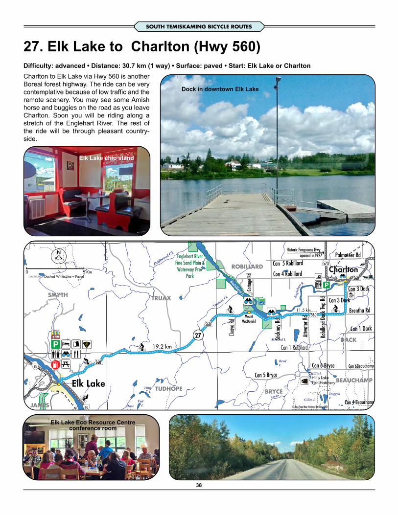
27. Elk Lake to Charlton (Hwy 560)Difficulty: advanced • Distance: 30.7 km (1 way) • Surface: paved • Start: Elk Lake or CharltonCharlton to Elk Lake via Hwy 560 is another Boreal forest highway. The ride can be very contemplative because of low traffic and the remote scenery. You may see some Amish horse and buggies on the road as you leave Charlton. Soon you will be riding along a stretch of the Englehart River. The rest of the ride will be through pleasant country-side.
Dock in downtown Elk Lake
Elk Lake Eco Resource Centreconference room
Elk Lake chip stand
ROBILLARD
JAMES
BEAUCHAMP
DACK
SMYTH TRUAX
TUDHOPE BRYCE
19.2 km
11.5 km
27
Robillard L
Tamarac Ck
McLeod L
Driftwood Ck
DoggettL
ThinL
TudLHope
L
ReadL
Gilles L
Hill’s L
Sunday
Ck
Engl
ehar
t R
Hill’s LakeFish Hatchery
Englehart RiverFine Sand Plain &Waterway Prov
Park
Elk Lake
Charlton
MountMacDonald
Brentha Rd
Con 6 Bryce
Con 4 RobillardSti
ckne
y Rd
Con 4 Beauchamp
Con 6Beauchamp
Attw
ater
Rd
Robil
lard D
ack
Twp R
d
Con 3 Dack
Con 1 Dack
Con 3 Dack
Con 5 Bryce
Con 1 Robillard
Cleav
e Rd
Con 5 Robillard
Cotta
ge R
dHistoric Fergusons Hwy.
opened in1927 Palmateer Rd
65
65
560
560
560
560
573
KmDashed White Line = Paved
© Base Topo Map: Heritage Technics, 2021© Bicycle Routes: South Temiskaming Active Travel Organization (STATO), 2021, WEBSITE: stato.ca
0 5
38
SOUTH TEMISKAMING BICYCLE ROUTES

Robilla
rdCh
arlto
n-Dack
560
573
Charlton
Engleha
rt Ri
ver
PARK
Jamieson Cottages& Camping
Rose Point Lodgeand Trailer Park
His
toric
Fer
guso
n H
wy
HistoricHydro Power
House
Dam
Dam
Charlton & DistrictPublic Cemetery
Charlton-DackHeritage Centre
Abando
ned Rw
y
Abandoned Rwy
27
28
28Englehart
Elk La
ke
Wid
eman
Ave
Rob
ert S
t
Church St
Grant Rd
Rich
ard
St
Bay St
Linton St
Lakeshore Ave
Amy St
Mai
n St
Mai
n St
Smyth
St
Nelson St
Ryan
St
Eple
tt St
Han
suld
Ave
Nelson St
Howie St
Concession StConcession St
Newton St
Cem
eter
y Rd
Km0 1© B
ase T
opo M
ap: H
erita
ge Te
chnic
s, 20
21©
Bicy
cle R
outes
: Sou
th Te
misk
aming
Acti
ve Tr
avel
Orga
nizat
ion (S
TATO
), 20
21, W
EBSIT
E: sta
to.ca
Dashed White Line = Paved
Dam in Charlton
Aerial view of Charlton
Swimming in Charlton
39
SOUTH TEMISKAMING BICYCLE ROUTES

28. Charlton / Englehart AreaDifficulty: easy • Distance: 26.9 km (loop) • Surface: mix of paved & gravel • Start: Englehart or Charlton Water-front ParkCharlton is a charming small village on the Englehart River. The historic hydro dam is perched on a rock cliff. Viewing walkways guarantee great photos. The public park has a beach area and swimming facilities. You will encounter a steep incline on Hwy 560 a bit west of Englehart. After that the ride is pleasant on a level terrain.The Englehart area has some very scenic landscapes such as the Englehart and Larder Rivers. The ONR railway bridge is over 100 years old. The wafer board plant domi-nates the town. Kap-Kig-lwan Provincial Park is directly ac-cessible from the town. It has gorgeous waterfalls, picnic areas, camping facilities and hiking trails.
Grain stooking by the Amish in Charlton
MARTER
CHAMBERLAIN
DACK
INGRAM
EVANTUREL
BAYLY
3.2 km
6.5
Km
5.2
Km
6.5 km
5 km
4.8
km
5.6 km
3.7
km
4.8 km3.2 km
1.7 km
2.2
km
28
28
Larder
R
Engl
ehar
t R
Englehart R
Crocodile
Larder R
Ck
Larder River Waterway Provincial Park
(Waterway Class)
Kap-Kig-IwanProv Pk
ONR
Abandoned R/W line
Tomstown
Charlton Englehart
Pipeline
Brentha Rd
Con 3 Cham
berla
in
Mar
ter R
d
Allen
Rd
Con 3 Savard Con 2 Chamberlain
Willow Dr
Wend
igo La
ke Rd
Wendigo Rd
Cham
berla
in 4
Rd
Sutto
n Rd
Daym
ar Rd
Kerrs Rd
Brya
ns R
dConc 1 Marter
Evan
turel
Ingram
Twp R
d
Marte
r 3 Rd
Con R
d Evanturel
Harmens Rd
Beav
er Rd
Wawb
ewaw
a Rd
Con 4 Ingram
Robil
lard D
ack T
wp Rd Con 3 Dack
Con 3 Chamberlain
Evanturel Marter Boundary Rd
Knigh
ts Rd
Con 3 Dack
Con 2 Ingram
Con 1 Chamberlain
Con 4 Dack
McBrides RdSw
amp R
d
Roze
l Rd
Jame
s Rd
Histor
ic Fe
rguso
ns H
wy. s
ection
c192
7
Palmateer Rd
Stoney Lonesome Rd
West Rd
Cedar Dr
Con 3 & 4 Marter
11
11
560
573
560
569
624Historic R/W Bridge
Km0 2Dashed White Line = Paved
© Base Topo Map: Heritage Technics, 2021© Bicycle Routes: South Temiskaming Active Travel Organization (STATO), 2021, WEBSITE: stato.ca
The High Bridge at Englehart c1907 (still in use 2021)
40
SOUTH TEMISKAMING BICYCLE ROUTES

29. EnglehartDifficulty: moderate (some hills) • Distance: 28.6 km (loop) • Surface: mix of paved & gravel • Start: Town of En-glehart. Ride to the dam - for mountain biking only
Dam at Blanche River above Englehart
Access to the dam
Pioneer farming in 1915, Englehart areaMr. A. W. Skinner cutting oats
5.3 km2.2
km7.
4 km
Gravel road, some stones.Balance to dam rough stoney road, mountain bikes only.
11.5
km
29
Lard
erR
Engl
ehar
t RM
isem a R
Kap-Kig-IwanProv Pk
ONR
Englehart
Mar
ter R
d
Willow Dr
Wendigo Rd
Daym
ar Rd
Kerrs RdBr
yans
Rd
Conc 1 Marter
Marte
r 3 Rd
Harmens Rd
Wawb
ewaw
a Rd
Evanturel Marter Boundary Rd
Con 4 Dack
Roze
l Rd
Cedar Dr
Con 3 & 4 Marter
11
11
560
624
Historic R/W Bridge
Km
© Base Topo Map: Heritage Technics, 2021© Bicycle Routes: South Temiskaming Active Travel Organization (STATO), 2021, WEBSITE: stato.ca
0 2Dashed White Line = Paved
The area north of Englehart has a variety of land-scapes with large forest tracks mixed in with agri-cultural fields.Marter Rd. brings you straight north. Cedar Dr. is a gravel road with undulating hills. Residential hous-es are sprinkled along this section. Regional Rd. 624 is a paved smooth ride back to Englehart.Riding to the dam offers a unique scene with cas-cading water over worn rocks. Getting there is a challenge since a section of road is rocky. If you have the stamina, it can be worth the effort. Picnic on the flat rocks.
41
SOUTH TEMISKAMING BICYCLE ROUTES

Englehart
Englehart
Evanturel Twp
Evanturel Twp
Char
lton-
Dac
k
560
11
Pipeline
Errettsville
Englehart
Englehart R
ONR
Georgia-Paci�c Mill
EnglehartCemetery
PARK
PARK
TreatmentPonds
High Level Bridge
28
28
28
28
29
Historic R/W Bridge
7th Ave
Kap-
Kig-
Iwan
Rd
Prince St
2nd
St
4th Ave
7th
St
6th
St
3rd
St
5th
St
1st S
t
1st S
t
5th Ave
Christopher StKing St W
6th Ave
2nd Ave E
8th Ave
Mic
hael
St
King St
Rive
r Rd
2nd Ave W3rd Ave
Railroad St
Queen St
4th
St
Lagoon Rd
Harmans Road
Kirkland Lake
Charlton
EarltonHi
gh Fa
lls
Kap-
Kig-
Iwan
Pro
vincia
l Par
k
TimHortons
© Base Topo Map: Heritage Technics, 2021© Bicycle Routes: South Temiskaming Active Travel Organization (STATO), 2021, WEBSITE: stato.ca
Km0 1Dashed White Line = Paved
Park near train station
42
SOUTH TEMISKAMING BICYCLE ROUTES

30. Hwy 624 to Larder LakeDifficulty: moderate (some hills) • Distance: 41 km (1 way) • Surface: paved • Start: Town of Englehart
Regional Rd. 624 is a smooth ride to the small mining town of Larder Lake.This ride would appeal to those who like long distance rides. Traffic is gen-erally light.Larder Lake sits on Spoon Bay and local food establishments promise good northern fare.
Pavillion at beach - Lakeshore Road
MARTER
BOSTON
CH
AM
BER
LAIN
CATHARINE
INGRAM
PACAUD
SKEAD
MCELROY HEARST
BAYLY
5.6 km
35.4 km
30
Lard
erR
Engl
ehar
t R
Englehart R
Benson Ck
Larder R Wendigo L
Margaret L
Grassy L
St. Anthony L
Crystal L
Marion L
Mallard L
Mousseau L
Skeleton L
Benson L
Larder L
Mise
ma
R
Sharp Ck
Mousseau
Lard
er R
Sout
hwes
t Arm
Grace L
Spoon Bay
Ck
Ck
Estrangement
East Larder River Bedrock Conifer
Cons Reserve
South Grassy Lake Outwash Cons Res
Larder River Waterway Provincial Park
(Waterway Class)
ONR
ONR
Abandoned R/W line
LarderLake
Englehart
see Englehart Map
Marter
Pipeline
Con 5 Chamberlain
Con 3 Ch ambe
rlain
Mar
ter R
d
Allen
Rd
Shep
pard Lake Rd
Willow Dr
Wend
igo La
ke Rd
Wendigo RdSutto
n Rd
Daym
ar Rd
Kerrs Rd
Brya
ns R
d
Conc 1 Marter
Evan
turel
Ingram
Twp R
d
Marte
r 3 R
d
Con 5 Ingram
Wawb
ewaw
a Rd
Con 4 Ingram
Evanturel Marter Boundary Rd
Con 4 Dack
Swam
p Rd
Roze
l Rd
Yost R
d
Pac aud 2
Rd
Cedar Dr
Con 3 & 4 Marter
66
11
11
560
624
624
Historic Bridge
0 5 KmDashed White Line = Paved
© Base Topo Map: Heritage Technics, 2021© Bicycle Routes: South Temiskaming Active Travel Organization (STATO), 2021, WEBSITE: stato.ca
43
SOUTH TEMISKAMING BICYCLE ROUTES

31 & 32. Notre-Dame-du-NordOption A (31): Difficulty: easy • Distance: 15km (return) • Start: Fossilarium • Surface: pavedOption B (32): Difficulty: moderate (some hills) • Distance: 50km (loop) • Start: Fossilarium • Surface: paved
If you want to avoid riding the big Hwy 101, just ride the paved roads within the Récré-Eaux des Quinzes system and come back the same way. Cross the huge dam for exciting river views. The northern section winds past a scenic dam at the Riviere des Outaouais (Ottawa River). Riding the full loop requires riding on Hwy. 391 which is generally quiet as well as Hwy. 101 for 5 or 6km. For extra mileage, you could venture on the twisty beautiful ride into Angliers.You will soon experience the French culture as a visitor to Quebec. The First Nation community is prominent. Visit the dock area for a scenic view of the lake. Another big hit is the local Poutine at the Roi de la Patate.
Récré-Eaux des Quinzes
Hwy. 391 to Angliers
12.4 km
13 km
9 km
6 km
11 km loop
3232
32
32
32
31
31
Blan
che
R
Rivière des Outaouais
Baie Paulson
Ruisseau Bry so
n
ONTA
RIO
QUEB
EC
Paquin
Angliers
Notre-Dame-du-Nord
TimiskamingFirst Nation
Transmission Line
Chemin Géovani
Traverse du Lac Cloutier
Chem
in St
ange
r’s
Chem
in de
s 8e e
t 9e R
angs
Touzin RdRa
ng 3
e et 4
e Sud
Chemin de la Ferme Klock
Chem
in du
Petit
Nédé
lec N
ord
Rang
1e e
t 2e S
ud
Rang de la Rivière des Quinze
Chemin King
Chemin
du Po
uvoir
Rue R
ichard
Chemin du Lac Pigeon3e Rang E
6e Rang
Montée Gamache
Head of Lake picnicrest station
Dam / Barrage de la Chute
FossilariumofNotre-Dame-du-Nord
65
101
101
391
391
Km0 2Dashed White Line = Paved
© Base Topo Map: Heritage Technics, 2021© Bicycle Routes: South Temiskaming Active Travel Organization (STATO), 2021, WEBSITE: stato.ca
Dam / Barrage de la Première Chute
44
SOUTH TEMISKAMING BICYCLE

33. AngliersDifficulty: moderate (some hills) • Distance: 22.2 km (loop) • Surface: mix of paved & gravel • Start: T. E. Draper Museum
The T. E. Draper Museum display at Angliers
Vers/ToVille Marie
13 km
5.6 km1.6
km
HydroDam
32
32
33
33 33Rivières des Quinze Dam
Angliers
Transmission Line
Rang
5e e
t 6e
Chemin Géovani
Chemin
du Po
uvoir
Chemin du Lac Pigeon
391
391
KmDashed White Line = Paved
© Base Topo Map: Heritage Technics, 2021© Bicycle Routes: South Temiskaming Active Travel Organization (STATO), 2021, WEBSITE: stato.ca
0 1
The T. E. Drapper Museum interior display at Angliers
“We have space to accommodate groups of up to a maximum of 50 visitors. We offer a specific formula for school groups, as well as for the family. Picnic tables are available outside the museum. A rest area is newly set up in the hangar to take a little break during your visit.”
“Close to the museum there is a municipal amusement park with a covered shelter and bathrooms, as well as a municipal unserviced stopover for RVs and tents.”
Rivière des Quinze Dam
Angliers boasts a well presented museum focusing on the lumbering trade. Their tug boat can even be toured inside.Route 33 can be ridden in a loop from Angliers or a shorter trip to the smaller dam. Return the same way.You can also leave Angliers by riding across the dam and on to the small hydro dam as shown.
45
SOUTH TEMISKAMING BICYCLE ROUTES

Baie desPères
Baie Faure
L Baby
Lac Témiscamingue
Lac des Quinze
Rivière la Loutre
Lac Témiscamingue
DAM
OldMission
FortTémiscamingue
National Historic Site Baie Laperrière
Geoffroy
Laverlochère
Saint Brunode Guigues
Angliers
Saint-Eugène-de-Guigues
Lorrainville
Béarn
Ville-Marie
Rang
5e e
t 6e
Chemin des Quinze
Route de l’Hydro
Chem
in de
s 2e e
t 3e R
angs
Chem
in de
s 2e e
t 3e R
angs
Chem
in de
s 2e e
t 3e R
angs
3e et
4e r
ang d
e Lav
erloc
hère
Route des 3e et 4e Rangs
Route à Tanguay
Route du 5e Rang
Chemin Comtois
Chemin de la Petite Rivière
Chem
in de
s 8e e
t 9e R
angs
Chem
in de
s 5e e
t 6e R
angs
Chemin du Lac des Seize
Chem
in du
1 Ra
ng
1e et
2e r
ang d
e Bab
y
Route à Bédard
Chem
in du
4e R
ang S
ud
Chemin de la Mine
Route Lefort
Chemin du P e tit Six
Route de l'Île
Chemin du 6e RangRoute du 3e Rang
Route à Cotnoir
Rue A
lphon
se
Chem
in du
Carre
four
Route
du Petit Rang Trois
Route à Lessard
Montée Gauthier
Chemin
du Po
uvoir
Chem
in La
freniè
re
Chem
in du
Cime
tière
Chemin McGuire
Chemin du Lac Cameron
Montée Gamache
101
101
391
391
391
391
382
382
Dashed White Line = Paved
© Bicycle Route: Tourisme Abitibi-Témiscamingue
Km0 2
33B. Témiscamingue Linear Park, The Mocassin Line Difficulty: easy • Distance: 45km (one way) • Surface: stonedust • Start: Ville-Marie, Duhamel Ouest, Lorrainville Laverlochère or Angliers
PLEASE consult details on the following website.
https://accespleinair.org/cyclotourisme/pistes-cycla-bles-la-ligne-du-mocassin
The Mocassin Line cycling trail is truly a unique experience in north-west Quebec. It utilizes an old rail-way bed made of stone dust.You will cycle through forests, pass farm lands, picnic shelters, rock out-crops and varied wildlife.You can customize your ride by starting at Angliers, Laverlochère, Lorrainville and Ville-Marie.The trail is very family friendly.
46
SOUTH TEMISKAMING BICYCLE ROUTES

34. Hwy 101 – QuebecDifficulty: moderate (some hills) • Distance: 32 km (one way) • Surface: paved • Start: Notre-Dame-du-Nord • Guigues to Ville-Marie
Notre-Dame-du-Nord is a unique village that sits adjacent to theTemiskaming First Nation reserve. A highlight is the FossilariumMuseum. It has amazing exhibits with interpretive content.This ride will appeal to those who like to reach their long-distanceskills. The highway has generous shoulders for the cyclist. Thereis occasional roughness on some sections of the road, south ofNotre-Dame-du-NordThere are other places to visit along the way, such as the ‘Head of Lake’ rest station just outside of Notre-Dame-du Nord, L’ÉdenRouge in Saint Bruno de Guigues, as well as Île du Collège nearVille-Marie.Ville-Marie, conveniently located on the shores of Lac Témis-camingue, near the border between Quebec and Ontario, is the oldest city in Abitibi-Témiscamingue.A true architectural wonder of Ville-Marie, is Fort Témiscaminguewhich is a National Historic Site of Canada.
17.2
km
14.9
km
34
34
34
34
Blan
che
R
Baie desPères
Rivière des Outaouais
Baie Faure
Baie Joanne
Baie Trépanier
Lake Temiskaming
Baie Paulson
Lac Témiscamingue
Rivière la Loutre
Île du Collège
Île du Chef
Vers/ToParc national d’Opémican
ON
TARI
O
QU
EBEC
Saint Brunode Guigues
Notre-Dame-du-Nord
Ville-Marie
Chem
in de
s 2e e
t 3e R
angs
Chem
in de
s 2e e
t 3e R
angs
Route des 3e et 4e Rangs
Route à Tanguay
Route du5e Rang
Chem
in du
1 Ra
ng
Route à Bédard
Chem
in du
4e R
ang S
ud
Route Lefort
Chemin d u Petit Six
Route de l'Île
Chemin du 6e Rang
Route du 3e Rang
Route à Cotnoir
Route du Quai
Route du Petit Rang Trois
Montée Gauthier
Rue R
ichard
Chemin McGuire
3e Rang E
6e Rang
Montée Gamache
Head of Lake picnicrest station
65
101
101
101
Km0 2Dashed White Line = Paved
© Base Topo Map: Heritage Technics, 2021© Bicycle Routes: South Temiskaming Active Travel Organization (STATO), 2021, WEBSITE: stato.ca
Fossilarium
L'Éden RougeRestaurant
See RouteRoute 35
Historic BreenHouse
Highway 101
Sentier de l’Eau-De-Là
Head of Lake Rest Station
47
SOUTH TEMISKAMING BICYCLE ROUTESSOUTH TEMISKAMING BICYCLE ROUTES

35. Ville Marie / Île du Collège / La BannikDifficulty: moderate (some hills) • Surface: paved • Start: Provigo parking Lot
SOUTH TEMISKAMING BICYCLE ROUTES
Another gorgeous ride on Île du Collège. You will see some vine-yards and gorgeous almost Euro-pean scenery.There are plenty of hills on this route. You will have a nice wide cycle lane on Highway 101.You can stop for a quick swim on Île du Collège or near Fort Té-miscamingue or go for lunch at La Bannick.Ville-Marie, conveniently locat-ed on the shores of Lac Témis-camingue, near the border be-tween Quebec and Ontario, is the oldest city in Abitibi-Témis-camingue.A true architectural wonder of Ville-Marie, is Fort Témis-camingue which is declared a National Historic Site of Canada.
5.6
km
4.3 km
3.5
km
6.3
km6.
8 km
OPTI
ON
LeisureRecreational ridefrom town1 way / return
35
35
35
Baie des Pères
Baie FaureLake Temiskaming
Île du Collège
Vers/ToParc national d’Opémican
FortTémiscamingue
National Historic Site
OldMission
BaieLaperrière
Bigelow
Ville-Marie
Chemin de la Petite Rivière
Chem
in de
s 5e e
t 6e R
angs
Chem
in du
1 Ra
ng
Chem
in du
4e R
ang S
ud
Route Lefort
Route de l'Île
La Bannik
101
101
382
101
Dashed White Line = Paved
© Base Topo Map: Heritage Technics, 2021© Bicycle Routes: South Temiskaming Active Travel Organization (STATO), 2021, WEBSITE: stato.ca
Km0 2
A deserved rest
The famous La Bannik restaurant’s patio
Fort Témiscamingue / Obadjiwan48

36. TémiscamingueDifficulty: advanced • Distance: 38 km loop • Surface: paved • Start: Provigo parking lot, Ville-Marie • Suggestion: counterclockwise
Route 36 is a beautiful ride in Québec through small villages.The first long hill just outside of Ville-Marie towards Lorrainville will sure warm up your muscles right from the start. You will share the road on usually quiet roads from there all the way back to Hwy 101.A number of rolling hills through farmlands will be sure to give you a good ride. Once you get back to Highway 101, you will have a nice wide cycle lane all the way to Ville-Marie.
8.5 km
13.2
km
10.6
km
6.5 km
36
36
36
36
36
36
Baie desPères
Baie Faure
Laverlochère
Saint BrunodeGuigues
Lorrainville
Ville-MarieSee Map 35
Chemin des Quinze
Route de l’Hydro
Chem
in de
s 2e e
t 3e R
angs
Chem
in de
s 2e e
t 3e R
angs
Route du 5e Rang
Chem
in de
s 5e e
t 6e R
angs
Chemin du Lac des Seize
Chem
in du
1 Ra
ng
Chem
in du
4e R
ang S
ud
Chemin de la Mine
Route LefortRoute de l'Île
Chemin du 6
e RangRoute du 3e Rang
Route à Cotnoir
Rue A
lphon
se
Route du Petit Rang Trois
Route à Lessard
Montée Gauthier
Chemin McGuire
391
101
101
391
382
382
Dashed White Line = Paved
© Base Topo Map: Heritage Technics, 2021© Bicycle Routes: South Temiskaming Active Travel Organization (STATO), 2021, WEBSITE: stato.ca
Km0 2
Le Cru du Clocher“Our classic! A ched-
dar cheese made from raw milk and aged six months. The milk used comes from four neigh-bouring herds selected according to the feed given to cows and the
milk’s microbial quality”
View at Montée Gauthier on Route 36
49
SOUTH TEMISKAMING BICYCLE ROUTES