Architecture et remplissage sédimentaire du bassin profond ...
122
HAL Id: tel-00435120 https://tel.archives-ouvertes.fr/tel-00435120 Submitted on 23 Nov 2009 HAL is a multi-disciplinary open access archive for the deposit and dissemination of sci- entific research documents, whether they are pub- lished or not. The documents may come from teaching and research institutions in France or abroad, or from public or private research centers. L’archive ouverte pluridisciplinaire HAL, est destinée au dépôt et à la diffusion de documents scientifiques de niveau recherche, publiés ou non, émanant des établissements d’enseignement et de recherche français ou étrangers, des laboratoires publics ou privés. Architecture et remplissage sédimentaire du bassin profond du Golfe du Mexique: Modélisation stratigraphique et structurale du transect de Tuxpan Humberto Alzaga To cite this version: Humberto Alzaga. Architecture et remplissage sédimentaire du bassin profond du Golfe du Mex- ique: Modélisation stratigraphique et structurale du transect de Tuxpan. Minéralogie. Université de Montpellier 2, 2008. Français. tel-00435120
-
Upload
khangminh22 -
Category
Documents
-
view
1 -
download
0
Transcript of Architecture et remplissage sédimentaire du bassin profond ...
HAL Id: tel-00435120https://tel.archives-ouvertes.fr/tel-00435120
Submitted on 23 Nov 2009
HAL is a multi-disciplinary open accessarchive for the deposit and dissemination of sci-entific research documents, whether they are pub-lished or not. The documents may come fromteaching and research institutions in France orabroad, or from public or private research centers.
L’archive ouverte pluridisciplinaire HAL, estdestinée au dépôt et à la diffusion de documentsscientifiques de niveau recherche, publiés ou non,émanant des établissements d’enseignement et derecherche français ou étrangers, des laboratoirespublics ou privés.
Architecture et remplissage sédimentaire du bassinprofond du Golfe du Mexique: Modélisation
stratigraphique et structurale du transect de TuxpanHumberto Alzaga
To cite this version:Humberto Alzaga. Architecture et remplissage sédimentaire du bassin profond du Golfe du Mex-ique: Modélisation stratigraphique et structurale du transect de Tuxpan. Minéralogie. Université deMontpellier 2, 2008. Français. �tel-00435120�

UNIVERSITÉ de MONTPELLIER IISCIENCES ET TECHNIQUES DU LANGUEDOC
THESE
pour obtenir le grade de
Docteur de l'Université de Montpellier II
Discipline: GéosciencesEcole Doctorale: SIBAGHE
Présentée et soutenue publiquement par
Humberto ALZAGA RUIZ
le 4 Juin 2008
Architecture et remplissage sédimentaire du bassin profond du Golfe du Mexique:
Modélisation stratigraphique et structuraledu transect de Tuxpan
JURY
M. Christian RAVENNE RapporteurM. Claude RANGIN RapporteurM. Michel LOPEZ ExaminateurM. Mario GUZMAN ExaminateurM. François ROURE ExaminateurM. Michel SERANNE Directeur de thèse


UNIVERSITÉ de MONTPELLIER II
SCIENCES ET TECHNIQUES DU LANGUEDOC
THESE
pour obtenir le grade de
Docteur de l'Université de Montpellier II
Discipline: Géosciences Ecole Doctorale: SIBAGHE
Présentée et soutenue publiquement par
Humberto ALZAGA RUIZ
le 4 Juin 2008
Architecture et remplissage sédimentaire du bassin profond du Golfe du Mexique:
Modélisation stratigraphique et structurale du transect de Tuxpan
JURY M. Christian RAVENNE Rapporteur M. Claude RANGIN Rapporteur M. Michel LOPEZ Examinateur M. Mario GUZMAN Examinateur M. François ROURE Examinateur M. Michel SERANNE Directeur de thèse


Avant-propos Avant de présenter les résultats de mes études, je tiens à exprimer mes remerciements à tous ceux qui par leur soutien, leurs conseils et leurs encouragements, ont contribué à l'élaboration de ce mémoire. Merci...... A l'Institut Mexicain du Pétrole qui, à travers Mario A. Guzman Vega, a donné tout le soutien personnel pour réaliser ce doctorat; Aux collègues de Pemex Exploration, secteur de Poza Rica, et particulièrement à Mario Aranda qui m'a confié les données nécessaires à la réalisation de cette étude; A l'Institut Français du Pétrole pour m'avoir accueilli sur son site et vivre cette expérience enrichissante. Je remercie Jean Letouzey pour son invitation à réaliser ces études de doctorat à l'IFP. Je remercie particulièrement François Roure, qui m'a soutenu pour réaliser ce travail, pour son aide, ses avis pendant mon stage à l'IFP et la relecture de cette thèse; Je remercie Michel Lopez et Michel Séranne pour m'avoir pris en charge à l'Université de Montpellier II. Merci aussi A Jean-Claude Lecomte pour son aide et ses conseils; A Didier Granjeon pour me guider dans Dionisos, Nicolaas Hardebol et William Sassi qui m'ont montré comme fonctionnait le logiciel Thrustpack; A Christian Ravenne et Claude Rangin pour avoir accepté d'être mes rapporteurs. A mes collègues de l'IMP et à l'équipe géoscience pour son aide, ses avis et ses blagues à distance. L'arrière-plan illustre l'endroit qui m'a inspiré pour la rédaction de ce travail, merci.....merci beaucoup à tous.......


RÉSUMÉ
Le bassin profond du Golfe du Mexique (BPMG) est localisé à l'est du Mexique, au sud-est des États-Unis et à l'ouest de l'Océan Atlantique. Cette étude de la partie profonde du Golfe du Mexique est basée sur l'intégration de données de sismique, de forages pétroliers et d'études de terrain; elle comprend toute la pente continentale et la plaine abyssale, avec une bathymétrie qui varie de 200 à 3750 m. La première partie de cette thèse est consacrée à la description du remplissage sédimentaire de la bordure occidentale du Golfe du Mexique, dans le secteur de Veracruz, en liaison avec son évolution géodynamique. L'évolution géodynamique du BPMG commence au Trias-Jurassique avec la rupture et la propagation d'un rift continental, dans le secteur sud de la plaque nord américaine. Cette ouverture et le déplacement relatif vers le sud-est du bloc crustal du Yucatan sont à l'origine du BPGM. Cette géodynamique de rift continental est suivie d'une étape post-rift accompagnée de l'océanisation du bassin. Les bassins de la marge passive ont poursuivi leur évolution sous l'effet de la subsidence thermique à l'ouest du Golfe du Mexique, tandis que de la croûte océanique se formait dans le BPGM. Cette subsidence thermique de la marge a ensuite été perturbée par l'orogénèse Laramienne, qui a remodelé l'architecture stratigraphique silico-clastique des dépôts du Tertiaire entre les éléments morphotectoniques suivants: le front tectonique de la Sierra Madre Orientale (SMO), le bassin d'avant-pays Chicontepec, la Plateforme de Tuxpan-Faja de Oro, la pente continentale et la plaine abyssale, ces deux dernières provinces morphotectoniques appartenant au BPGM. Pendant le Paléogène inférieur, les effets de la subsidence thermique de la marge passive ont été accentués par la charge tectonique de l'orogénèse laramienne (SMO), permettant ainsi le développement d'un bassin flexural d'avant-pays. Au cours de cette étape, les principaux transferts sédimentaires se sont effectués du front tectonique "SMO" vers le BPGM. La source principale de sédiments clastiques est liée à l'érosion de la chaîne de montagnes "SMO". Pendant le Paléocène et l'Éocène inférieur, l'architecture des premiers sédiments silico-clastiques syn-tectoniques déposés dans des éventails sous-marins sont caractérisés par des figures de glissement, des faciès turbiditiques A et B de Bouma, des chenaux-levées. Après l'arrêt de la subsidence flexurale, la subsidence thermique de la marge passive s'est poursuivie pendant l'Éocène supérieur, l'Oligocène et le Néogène, permettant le développement d'un nouveau prisme sédimentaire progradant. Les remplissages sédimentaires sont encore constitués de chenaux et de levées, avec des barres de sable associées à des systèmes deltaïques sur la plateforme. Pendant le Néogène, un système de failles listriques s'est développé sur la pente du BPGM, au-dessus d'une surface de décollement située, dans la région d'étude, dans les argiles de l'Éocène-Oligocène. Ce système de failles de croissance a piégé plus de 60% des sédiments silico-clastiques du Miocène. Ce remplissage sédimentaire évolue latéralement de faciès fluviaux deltaïques vers des faciès de pente affectés de glissements gravitaires et associés à des turbidites. La deuxième partie de cette thèse est consacrée à une approche quantitative basée sur des modélisations structurales (coupes équilibrées et modélisations cinématiques directes avec Thrustpack, couplant décollement gravitaire, flexure lithosphérique, érosion et sédimentation), puis sédimentaires (prise en compte des transferts de matériel clastique depuis la partie émergée de la chaîne jusqu'au bassin profond, à l'aide du logiciel Dionisos, afin de mieux comprendre les processus de piégeage des sédiments grossiers dans les structures de croissance et les bassins perchés de la marge.


ABSTRACT The Deep Basin of the Gulf of Mexico (DBGM) extends over eastern Mexico, the southeastern part of the United States, west of the Atlantic Ocean. This study, based on the interpretation and integration of seismic profiles, exploration wells and outcrop studies, focus on the deep part of the Gulf of Mexico, where bathymetry varies from 200 to 3750 m, thus comprising both the continental slope and the abyssal plain. The first part of this thesis focus on the description of the sedimentary infill of the western part of the Gulf of Mexico, in the Veracruz State, and to its geodynamic controls. The geodynamic evolution of the Deep Basin of the Gulf of Mexico (DBGM) begins during the Triassic-Jurassic with the break-up and the opening of a continental rift, in the southern part of the North American lithospheric plate. This opening induced a relative movement of the Yucatan Block towards the southeast. This intra-continental rifting episode was followed by a stage of post-rift thermal subsidence in the basins of the continental margin in the west, coeval with oceanic accretion in the DBGM. The thermal subsidence of the margin was subsequently modified by the Laramian orogeny, which impacted strongly the overall architecture of the margin as well as its litho-stratigraphic evolution, inducing the deposition of siliciclastic deposits in various morphotectonic provinces: i.e., near the tectonic front of the Sierra Madre Oriental (SMO), within the adjacent Chicontepec foreland basin, over the Tuxpan Platform (Golden Lane), across the continental slope and up to the deep abyssal plain, these two last morphotectonic provinces belonging to the DBGM. During the Early Paleogene, the effects of the thermal subsidence of the passive margin were stressed by the tectonic load of the Laramian orogen (i.e., the Sierra Madre Oriental, SMO), thus allowing the development of a foreland basin flexural. In this geodynamic framework, the main sedimentary transfers developed from the tectonic front "SMO" in the west, towards the DBGM in the east, the main source for clastic sediments being linked to the erosion of the "SMO" mountains. During the Paleocene and the Early Eocene, the architecture of the silici-clastic syn-tectonic sediments deposited in submarine fans was characterized by sliding, turbidites with A and B Bouma facies, as well as levees and channels. After the stop of the flexural subsidence, the thermal subsidence of the passive margin resumed during the Late Eocene, the Oligocene and the Neogene, allowing the development of a new sedimentary prism, prograding eastwards toward the DBGM. This sedimentary infill was again made up of levees-channels, sand bars and delta systems. During the Neogene, an extensional system with listric faults and roll-over features developed across the slope of the DBGM, due to an active detachment developing within overpressured Eocene-Oligocene clays. This gravitational gliding of Neogene series accounted also for the development of compressional features at the toe of the slope. Approximately 60% of the Miocene siliciclastic sediments have been trapped in growth strata and slope basins associated with this complex gravitational system, ranging from river-delta features towards gravity slides associated with slump facies. The second part of this thesis aims at a quantification of these various processes, including the construction of balanced cross sections, forward Thrustpack kinematic modelling coupling the development of a basal detachment, lithospheric flexure, erosion and sedimentation, as well as subsequent stratigraphic modelling with the Dionisos software, the later aiming at predicting the sand versus clay ratios in Neogene siliciclastic deposits of the DBGM and its surroundings. ii

RESUMEN La Cuenca Profunda del Golfo de México (CPGM) se localiza al oriente de la Republica Mexicana, suroriente de los Estados Unidos de Norte America y al occidente del Oceano Atlantico. El obejetivo de este estudi es primordialmente el Gofo Profundo que va de los 200 m alo 3750 m de profundidad, esta batimetria comprende el talud continetal y la planicie abisal. La geodinamica de la CPGM inicia en el Triasico-Jurasico con una etapa de ruptura (rift continental), de la placa tectonica de norteamerica en su parte sur, esta ruptura dara lugar a varios bloques corticales y uno de ellos que sera el bloque Yucatan (Terreno Maya), con un movimiento relativo al sureste dara lugar a la CPGM (workshop, Tectonics Analysis et al., 2002). Posterior al rift continental continuara una la etapa de post-rift y oceanizacion o desarrollo de la corteza oceanica, al occidente de esta margen se han instalado las cuencas de Margen Pasiva Continetal como Sabina, Tampico Mizantla, Veracruz etc., la formacion de corteza oceanica al oriente de la margen origina la CPGM. Asi las cuencas de la Margen Pasiva inician una evolucion regional termotectonica, en este periodo del Mesozoico se instalan las grandes plataformas carbonatdas bajo una tectonica de subsidencia termica en el oriente del actual territorio mexicano. La subsidencia termica en las cuencas marginales sera interrumpida por la orogenia Laramide, esta geodinamica originara una estratigrafia diferente a la de las grandes plataformas carbonatadas, tendra lugar un deposito siliciclastico terciario configurando una arquitectura entre los elementos morfotectonicos frente tectonico (Sierra Madre Oriental SMO), cuenca de ante pais (Chicontepec), la Plataforma de Tuxpan (Faja de Oro), talud y la planicie abisal, los dos ultimos elementos morfotectonicos comprenden a la CPGM. Durante el Paleogeno Inferior la subidencia de la margen pasiva se incremente considerablemente a causa del levantamiento orogenico originando una carga tectonica (SMO) y desarrollando una cuenca flexural de ante-pais. Dentro de este marco geodinamico se realiza una transferencia de sedimentos siliciclasticos del frente tectonico (SMO) a la CPGM (erosion-transporte-deposito). Durante el Maestrichtiano Paleoceno y Eoceno Inferior, la arquitectura de los depositos sedimentarios presenta una forma de cuna tectonica, esta sedimentacion origina abanicos submarinos por deslizamiento y facies turbiditas A y B de Bouman y levee-chanel. Cuando la subsidencia flexural se detiene en la margen pasiva la subsidencia termica continua durante el Eoceno Superior, Oligoceno y Neogeno, estas caracteristicas geodinamicas nuevamente van a cambiar la arquitectura estratigrafica, desarrollando clinoformas progradantes, el deposito sedimentario sera de sistema deltaico, brarras de arena de en plataforma y levee chenal. Para el Neogeno un sistema de fallas de crecimiento sobre el talud de la CPGM tendra lugar, este sistema de fallas suprayace a una superficie de despegue constituida de arcilla del Eoceno-Oligoceno en la region de estudio.
iii


RÉSUMÉ ABSTRACT RESUMEN SOMMAIRE I- INTRODUCTION............................................................................................................... 1.1- Localisation........................................................................................................................1.2- Travaux antérieurs..............................................................................................................1.3- Objectifs de la thèse...........................................................................................................1.4- Motivations - Problématique.............................................................................................1.5- Méthodologie..................................................................................................................... II- EVOLUTION GEODYNAMIQUE du GOLFE du MEXIQUE .................................. 2.1- La période pré-rift..............................................................................................................2.2- La période syn-rift..............................................................................................................2.3- La période post-rift.............................................................................................................2.4- Orogenèse laramienne........................................................................................................2.5- Néogène………………………………………………………………………………….2.6- Géomorphologie du Golfe du Mexique............................................................................. III- (article publié à Marine and Petroleum Geology) INTERACTIONS between the LARAMIAN FORELAND and the PASSIVE MARGIN of the GULF of MEXICO: TECTONICS and SEDIMENTATION in the GOLDEN LANE AREA, VERACRUZ STATE, MEXICO............................................... 3.1- Introduction........................................................................................................................
3.1.1- Aims.......................................................................................................................3.1.2- Data base and methodology...................................................................................
3.2- Geological background......................................................................................................3.2.1- Location.................................................................................................................3.2.2- Geodynamic evolution...........................................................................................3.2.3- Sedimentary infill of the basin..............................................................................
Permian-Triassic? pre-rift basement....................................................................Triassic?-Jurassic synrift.....................................................................................Post-Rift Late Jurassic-Cretaceous......................................................................
3.3- Stratigraphic description....................................................................................................3.3.1- Pre-rift basement................................................................................................... The crystalline basement and the pre-rift............................................................... Onshore seismic section AA'................................................................................. Littoral plain and wells.......................................................................................... Offshore seismic section BB'.................................................................................3.3.2- Syn-rift and post-rift (Mesozoic)...........................................................................
iv
1
22455
13
131419232426
27
2929303030313333333333333333353535

3.3.2.1- Onshore seismic section AA'..............................................................................3.3.2.2- Littoral plain and wells.......................................................................................3.3.2.3- Offshore seismic section BB'..............................................................................3.3.3- Synorogenic (Laramian) depositional system (Late Cretaceous-Paleocene)........3.3.3.1- Cordilleran Orogen.............................................................................................3.3.3.2- Syn-orogenic units..............................................................................................3.3.3.3- Post-orogenic units.............................................................................................
3.4- Analysis of subsidence curves and depth convertion.........................................................3.5- Geodynamic and tectonic controls on sedimentation.........................................................
3.5.1- The syn-orogenic units (Paleocene and Campeche sequences).............................3.5.2- Post-orogenic units (Eocene-Arcillosa and Oligocene sequences).......................
3.6- Conclusions........................................................................................................................3.7- Acknowledgements............................................................................................................3.8- References.......................................................................................................................... IV- (article publié à Tectonophysics) GRAVITATIONAL COLLAPSE and NEOGENE SEDIMENT TRANSFER across the WESTERN MARGIN of the GULF of MEXICO: INSIGHTS from NUMERICAL MODELS ................................................................................................................................ 4.1- Introduction........................................................................................................................4.2- Geodynamic evolution of the western margin of the Gulf of Mexico...............................
4.2.1- Jurassic rifting and Lower Cretaceous carbonate sedimentation of the passive margin..............................................................................................................................4.2.2- Late Cretaceous to Eocene interactions between the passive margin and the Cordilleran orogen...........................................................................................................4.2.3- Oligocene to Present unroofing of the foothills and development of the offshoresiliclastic wedge...............................................................................................................
4.3- Location and Present architecture of the studied transects................................................4.3.1- Location and interpretation of the time sections....................................................4.3.2- Depth conversion of the seismic profiles...............................................................4.3.3- Overall structural style and decollement levels.....................................................4.3.4- Restoration of the section into its pre-extensional geometry.................................
4.4- Forward kinematics modelling and timing of the deformation..........................................4.5- Stratigraphic modelling and Neogene sediment transfer across the margin......................
4.5.1- Stratigraphic description........................................................................................4.5.2- Sedimentary model of the Neogene.......................................................................4.5.3- Stratigraphic modelling.........................................................................................
4.6- Discussion and perspectives...............................................................................................4.7- Acknowledgements............................................................................................................4.8- References.......................................................................................................................... V- INTEGRATION et DISCUSSION................................................................................... VI- CONCLUTIONS et PERSPECTIVES........................................................................... REFERENCES BIBLIOGRAPHIQUES......................................................................
3535353838384447474849505050
53
5555
58
58
5858585861616166667171737373
77
93
95
I- INTRODUCTION Ce travail a été mené en collaboration avec l'Université de Montpellier-II, l'Institut Français du Pétrole (IFP) et l'Institut Mexicain du Pétrole (IMP). Le bassin profond du Golfe du Mexique (BPGM) constitue un nouveau domaine d'exploration potentiel pour les hydrocarbures avec une surface patrimoniale proche de 500 000 km². En l'absence de forages, il est nécessaire de proposer des attributions lithologiques et chronostratigraphiques pour les différents horizons pointés ou surfaces identifiées sur les profils de sismique réflexion. Le problème limitant l'exploration du pétrole est en effet la bathymétrie importante, qui augmente de fait considérablement les risques (coûts) pour des puits d'exploration. Mes premières motivations pour ce travail remontent aux années 1998, époque où j'ai commencé à travailler dans un groupe de travail de l'Institut Mexicain du Pétrole (IMP), impliqué sur l'étude du bassin profond du Golfe du Mexique. A cette époque, les données disponibles étaient limitées à huit transects sismiques. Le but était de connaître l'architecture régionale et les grandes caractéristiques stratigraphiques et structurales, et faire l'inventaire des secteurs où la résolution sismique était encore insuffisante. Il s'agissait là de la première étude du bassin profond du Golfe du Mexique. Dès cette époque, je me questionnais sur les détails de la stratigraphie et de la sédimentologie du remplissage sédimentaire du bassin et sur les principaux processus sédimentaires qui y ont opéré. L'état des connaissances était à ce moment très limité: ce n'est qu'en 1998 qu'ont été entrepris les premiers travaux dans la partie mexicaine du bassin profond, qu'on a commencé à y différencier les principales unités sismo-stratigraphiques et qu'on y a identifié les zones avec une tectonique salifère ou de l'argilocinèse. Ayant été désigné par l'IMP pour guider une excursion géologique de terrain pour les sédimentologistes de l'IFP et de Total sur les affleurements crétacés de la Sierra Madre Oriental et de son avant-pays en 2002, j'ai eu alors l'occasion de discuter avec eux des différents outils de géologie quantitative en cours de développement en France, qui devraient permettre de mener une étude couplée d'analyse sismique et de modélisation numérique. J'ai alors pu convaincre ma hiérarchie IMP de l'intérêt de poursuivre ce travail dans le cadre d'une thèse de doctorat. Aujourd'hui, le bassin profond du Golfe du Mexique commence seulement à révéler ses richesses en termes de potentiel pétrolier, du moins dans sa partie US, et beaucoup de choses restent à faire au Mexique. A l'intérêt économique et pétrolier s'ajoute un attrait scientifique important, puisque l'on dispose ici d'un laboratoire unique pour l'étude des processus de glissements gravitaires, d'halocinèse et d'argilocinèse, et leurs couplages avec la sédimentation. La société pétrolière Pemex et l'IMP ont depuis entrepris plusieurs études de détail dans ce bassin. Une bonne partie de ces études vise un objectif stratigraphique, qui est d'abord d'étudier les processus et de définir un modèle sédimentaire de remplissage. Un tel modèle permettrait de fait de comprendre, voire de prédire la distribution des principaux lithofaciès d'intérêt pétrolier (i.e., les réservoirs, couvertures et roches mères), et serait donc fort utile pour réduire les risques d'échec dans tout projet d'implantation des puits d'exploration.
1

Ce travail s'est déroulé grâce à un financement de l'IMP, et a été mené en collaboration avec l'Université de Montpellier-II et l'Institut Français du Pétrole (IFP). Cette collaboration entre Montpellier, l'IFP et l'IMP a été un succès parce que je suis arrivé à une modélisation couplée cinématique et sédimentaire, et obtenu une distribution simulée des lithofaciès qui est au moins calibrée sur forage dans la partie haute de la marge. La base de donnée mise à disposition par Pemex m'a aussi permis de tester et de valider le logiciel IFP Dionisos sur un cas réel. A partir d'une synthèse des données régionales existantes (sismique, forages, affleurements), exploitées lors de mon séjour à l'université de Montpellier, mon objectif a été dans un premier temps de préciser l'architecture sédimentaire des séries silicoclastiques paléocènes et néogènes proches de la plaine côtière, en la calibrant sur les forages disponibles. J'ai ensuite replacé mes interprétations sismiques régionales (terre/mer) dans un modèle sédimentologique intégré permettant, pour chaque épisode majeur de l'évolution géologique, une extrapolation/prédiction des lithofaciès jusque dans la partie profonde (offshore) du bassin du Golfe du Mexique. La partie quantitative de ma thèse s'est déroulée à l'IFP, mettant en oeuvre une méthodologie (work-flow) associant des modélisations structurales (coupes équilibrées, modélisations cinématiques directes avec le logiciel Thrustpack, couplant la mise en place d'un décollement gravitaire à la flexuration de la marge et aux processus d'érosion et sédimentation), et des modélisations stratigraphiques (logiciel Dionisos), l'objectif final étant de mieux comprendre les processus contrôlant la distribution des sédiments clastiques (pourcentage de sable versus fines) et des réservoirs potentiels tout au long d'un transect allant de la plaine côtière à l'offshore profond. 1.1- Localisation Le Bassin Profond du Golfe du Mexique (BPGM) est localisé à l'est du Mexique, au sud-est d'États-Unis et à l'ouest de l'Océan Atlantique. La zone d'intérêt principal de cette étude de la partie profonde du Golfe du Mexique a une bathymétrie qui varie de 200 à 3750 m; elle comprend toute la pente continentale et la plaine abyssale. Géographiquement, ce bassin est limitée par les méridiens 88°00' et 97°00' de longitude ouest et par les parallèles 19°00 et 26°00' de latitude nord. Ce bassin a une forme elliptique avec un grand axe N-S. Il est situé entre les péninsules de Floride et le Yucatan et communique à l'est avec l'Océan Atlantique (Fig. 1.1). 1.2- Les travaux antérieurs L'exploration pétrolière de la partie mexicaine du BPGM a vraiment commencé dans les années 90 avec un programme d'acquisition sismique au delà des bathymétries de 1000 m. En 1997, la division "analyse des bassins" de l'Institut Mexicain du Pétrole (IMP) a commencé une étude d'interprétation sismique d'une portion du BPGM (sud-sud-ouest du secteur patrimonial), localisée en face des états de Veracruz, Tabasco et Campeche. L'objectif de cette première étude était de réaliser une interprétation régionale basée sur 7 grands transects, de définir le cadre chronostratigraphique avec le support des puits d'exploration et d'études biostratigraphiques, et de préciser les principales caractéristiques de l'architecture lithostratigraphique et structurale depuis le haut de la marge jusqu'à la mer profonde.
2

Figure 1.1: Localisation du Golfe du Mexique. Le Golfe du Mexique a une surface
approximative de 1.5 millions de km², dont 563.050 km² font partie du territoire mexicain.
3

De 2000 à 2004, l'IMP a réalisé un projet d'application géophysique et géologique portant sur les systèmes pétroliers du BPGM. Il s'agissait d'une étudie multidisciplinaire dont l'objectif était de relier les unités lithostratigraphiques et le remplissage sédimentaire du Golfe du Mexique à son évolution géodynamique. Cette étude était basée sur des données sismiques (lignes temps, parfois converties en profondeur), avec quelques puits, intégrant aussi des méthodes potentielles comme la gravimétrie et la magnétométrie. Ces divers travaux ont permis de différencier un socle magnétique des unités sédimentaires, de définir et différencier les principales unités stratigraphiques, ainsi que le style structural régional (Fig. 1.2).
Figure 1.2: Carte montrant la localisation des profils sismiques régionaux utilisés lors des
études IMP antérieures. 1.3- Objectifs de la thèse Faisant suite à ces synthèses régionales réalisées à l'IMP, ma thèse a porté sur l'étude du remplissage sédimentaire miocène du Bassin Profond du Golfe du Mexique (BPGM). Mon objectif principal a été de décrire en détail l'architecture sédimentaire et les processus de remplissage du BPGM, le long d'un transect régional allant du front de déformation laramien et de la plaine côtière à l'ouest, jusqu'à la plaine abyssale à l'est, recoupant ainsi tout le système de failles listriques, glissements et plis gravitaires qui s'est mis en place au Néogène sur la marge.
4

1.4- Motivations - Problématique Ayant participé aux études d'interprétation sismique et stratigraphique des projets antérieurs, j'ai souhaité savoir comment s'était effectué le remplissage sédimentaire dans la partie profonde du bassin. Quels sont les processus qui ont contribué à alimenter le bassin en sédiments clastiques, et ont contrôlé in fine la distribution spatio-temporelle des réservoirs potentiels? En l'absence de données directes comme des puits d'exploration, les seules données disponibles pour l'offshore profond mexicain étant constituées par des profils sismique, j'ai du élargir mon domaine d'étude à l'ensemble de la marge, utilisant les données d'affleurement et les puits de la zone côtière, mais aussi quelques puits ODP disponibles ça et là dans d'autres secteurs du Golfe du Mexique. J'ai ainsi comparé mes données aux travaux des chercheurs US qui ont aussi travaillé plus au nord sur la partie profonde du Golfe du Mexique, notamment Ladd et al. (1976), Buffler (1980), Buffler et Sawyer (1985), Feng et Buffler (1991), et Galloway et al. (2000), et avaient ainsi déjà élaboré des colonnes stratigraphiques synthétiques allant du Mésozoïque jusqu'au récent. Mon travail, limité à la partie mexicaine, a permis de proposer un schéma d'ensemble cohérent, prenant en compte des corrélations argumentées entre les séries reconnues par forage à terre ou sur le haut de la marge, avec les réflecteurs sismiques imagés dans l'offshore profond. 1.5- Méthodologie (work-flow) La première partie de mon travail, réalisée à l'université de Montpellier, a porté sur le pointé et l'interprétation sismique en terme de séquences et de faciès sédimentaires. J'ai travaillé sur les profils de la plaine côtière et de la zone littorale, bien calibrés par forages, mais aussi sur les profils de la pente et de la partie profonde de la marge, où il n'existe pas encore de puits de calage. En l'absence de station de travail, ce premier travail a surtout porté sur l'interprétation de tirages papier des profils. Arrivé à l'IFP, mon premier travail a consisté à charger les profils sur une station de travail, et à réaliser une cartographie détaillée des principaux horizons sismiques avec le logiciel Charisma. J'ai ensuite converti en profondeur les profils sismiques sélectionnés pour la construction de mon modèle géologique, avant d'en entreprendre la restauration structurale (coupe équilibrée de la marge). J'ai ensuite réalisé une modélisation cinématique avec le logiciel "Thrustpack", intégrant le glissement progressif des séries néogènes, la flexure lithosphérique et la subsidence de la marge, ainsi que les processus d'érosion et de sédimentation. Enfin, j'ai pu réaliser une modélisation stratigraphique avec le logiciel Dionisos, prenant en compte l'activité des failles listriques, la croissance d'un roll-over et la mise en place des plis gravitaires de pied de marge dans la prédiction de la distribution spatio-temporelle des sédiments clastiques dans les bassins perchés et la plaine abyssale. Les quatre étapes principales de ce work-flow sont décrites plus en détail ci-dessous: a- Interprétation sismique (calages lithostratigraphiques et sismofaciès) L'interprétation stratigraphique des profils sismiques, les calages au puits et les observations de terrain m'ont permis de contraindre le modèle sédimentologique et stratigraphique, et de compiler des cartes isochrones des principaux horizons chronostratigraphiques. J'ai effectué l'interprétation sismostratigraphique de tous les profils sismiques 2D mis à ma disposition par PEMEX, le maillage sismique incluant diverses campagnes marines et
5

terrestres. Les profiles sismique proches du littoral ont été enregistrés à six secondes temps-doubles, tandis que les profils sismiques du bassin profond du Golfe du Mexique l'ont été jusqu'à 10 secondes. Dans un premier temps, j'ai reporté sur papier les principales corrélations chronostratigraphiques en extrapolant sur l'ensemble de mes profils les horizons sismiques définis lors des travaux antérieurs (IMP, 1997, 2003). J'ai ensuite choisi quelques profils sismiques en fonction de leur position par rapport aux puits de la plaine côtière et du littoral, et travaillé sur une station de travail avec le logiciel "Charisma Copyright Schlumberger GeoQuest version 5.2", obtenant ainsi un nouveau maillage chronostratigraphique en version digitale cette fois. Le maillage sismique utilisé en mer comprend des profils perpendiculaires à la côte, BPOL-1110, A-20 G93-37, D91-01, G93-41, BPOL-11032, et NTE-222, et des profils parallèles à la côte, G93-86, NTE-107, ar-05, ar-03, d91-6a, et d91-6. Six puits d'exploration, quatre à terre et deux en mer, ont été utilisés pour calibrer les profils. Pour des raisons de confidentialité, nous les avons rebaptisés 1, 2, 3, 4, 5 et 6. Le puits 6, seul puits marin, se trouve sur le coupe sismique BB’. Sur la plaine côtière, j'ai utilisé les profils sismiques 13 - BJ, IIBTAN, IIATAN, REM35 et BPOL-11038. Ces profils sismiques constituent le transect AA', sur lequel se trouvent les puits d'exploration 1, 2, 3 4. Ces puits ont été bien décrits d'un point de vue lithostratigraphique, et possèdent des diagraphies gamma-ray (GR). J'ai également construit un second transect BB' allant de la plaine côtière au bassin profond, en utilisant les profils bpol-11010, A-20, agi93-37 pour le bassin profond, et les profils 13-BJ, IIBTAN, IIATAN, REM35 et BPOL-11038 pour la plaine côtière. L'interprétation des horizons sismiques a permis de suivre plusieurs horizons-repère depuis la plaine côtière ou le littoral jusqu'au BPGM, bien que leurs dénominations et caractéristiques (lithofaciès) puissent changer latéralemment. Il s'agit notamment du Socle acoustique, du Crétacé moyen, du Paleocene (aussi appelé horizon Campeche), de l'Eocène (aussi appelé Cordilleras Mexicanas Inferiores), de l'Oligocène (aussi appelé Codilleras Mexicanas Medias), et du Miocène supérieur. Ces horizons sismiques peuvent être caractérisés par des attributs sismiques spécifiques, et séparent des domaines présentant une configuration de réflexion différente. Grâce à l'information des puits, j'ai pu proposer une interprétation chronostratigraphique précise pour chacun de ces horizons sismiques depuis le littoral jusqu'au BPGM, notamment grâce aux puits situés sur les transects AA' (plaine littorale) et BB' (bassin profond). Lorsque tous les horizons sismiques ont été pointés, j'ai construit pour chacun d'entre eux des cartes isochrones, directement sur le logiciel "Charisma", en utilisant l'option "Grille" qui permet une interpolation automatique entre les profils, mais aussi en lissant à la main certains secteurs périphériques afin d'éviter les effets de bords et rester cohérent avec le grain structural de la marge. Les cartes produites correspondent aux différentes sismoséquences qui comprennent, du plus ancien au plus récent, le Socle accoustique, le Crétacé moyen, l'horizon Campeche ou Paleocene, les Cordilleras Mexicanas Inferiores ou Eocène, les Cordilleras Mexicanas Medias ou Oligocène, et le Miocène supérieur.
6

b- Études de terrain J'ai pu effectuer une campagne sur le terrain avec les Drs. Michel Séranne et Michel Lopez, afin d'identifier et proposer des analogues-terrain pour les principaux faciès sismiques observés sous la plaine côtière, et de contrôler directement la nature des sédiments (lithologies, paléo-environnement, paléo-bathymétrie, modes de dépôt) constituant les principales unités stratigraphiques, ainsi que leur architecture sédimentaire (géométries à l'échelle sub-sismique, métrique à hectométrique), l'objectif étant ici de comprendre les mécanismes de transfert sédimentaire entre le littoral et le BPGM. Cette campagne de terrain s'est focalisée sur les séries du Paléocène (séries synflexurales et syntectoniques) et du Miocène (remplissages post-laramiens). Après un premier repérage des meilleurs affleurements, j'ai relevé quelques coupes stratigraphiques détaillées dans le Paléocène et le Miocène, en décrivant les structures sédimentaires et leurs relations stratigraphiques. c- Conversions temps-profondeur et modélisations cinématiques directes avec Thrustpack La conversion des profils de sismique enregistrés en temps et leur passage en profondeur étaient indispensables pour effectuer leur équilibrage (restauration à un stade anté-déformation), et procéder ensuite à une modélisation cinématique numérique d'une coupe géologique allant de la plaine jusqu'au bassin profond du Golfe de Mexique. Pour ce faire, j'ai repris les pointés des deux transects géologiques (en temps twt), le profil composite AA' traversant la plaine littorale et le profil marin BB'. Pour leur conversion en profondeur, j'ai utilisé les courbes temps-profondeur (T-Z) disponibles pour les différents puits d'exploration, obtenant ainsi une loi de vitesse par intervalle entre les divers horizons sismostratigraphiques, calibrée sur la profondeur de ces horizons au niveau des puits. Une fois réalisée la conversion en profondeur des transects AA' et BB', j'en ai entrepris la restauration (dépliage manuel), puis la modélisation cinématique directe avec le logiciel "Thrustpack" version 7.31 (Sassi et Rudkiewicz, 1999). Cette étape de modélisation structurale m'a permis de mieux comprendre l'évolution architecturale de la marge, et de proposer des vitesses de déplacement bien contraintes pour l'ensemble de la couverture glissée. La modélisation numérique stratigraphique pour simuler l'architecture stratigraphique et la distribution du lithofacies s'accorde aux objectifs. d- Modélisation numérique stratigraphique (DIONISOS) La dernière partie de mon travail consistait à mettre en oeuvre une modélisation numérique stratigraphique avec le logiciel "Dionisos", afin de reconstruire l'architecture sédimentaire en prenant en compte l'activité des failles listriques et des plis gravitaires, proposer des schémas réalistes de distribution spatio-temporelle des principaux litho-faciès (pourcentage de sable versus fines), et contribuer ainsi à l'évaluation du risque "réservoir" lors de l'exploration future des zones frontières du BPGM.
7
Dionisos est un logiciel de modélisation stratigraphique utilisant des équations déterministes (Granjeon, 1997), développé à l'IFP depuis 1992 et destiné à simuler l'évolution du remplissage sédimentaire d'un bassin au cours des temps géologiques en prenant en compte l'évolution de l'espace d'accommodation disponible pour les sédiments (subsidence de la lithosphère, bathymétrie et eustatisme), ainsi que des termes sources (lois d'érosion et de transport pour les sédiments clastiques, productivité pour les carbonates), et les modes de dépôt (lois spécifiques adaptées pour gérer les principaux lithofaciès et environnements, du fluvio-deltaïque aux turbidites). Ce type de modélisation peut se faire à différents stades d'intégration et de compréhension du bassin: - à une échelle très régionale, avec une approche statique permettant de suivre l'évolution stratigraphique du bassin en 4D (espace disponible et remplissage au cours des temps géologiques). Cette modélisation nécessite alors de nombreuses données géologiques telles que les paléobathymétries/ paléophysiographies successives du bassin. - pour une période de temps impliquant des processus sédimentaires et un environnement de dépôt spécifiques, il est préférable de réaliser une modélisation dynamique, les données devant alors surtout concerner l'épisode de temps considéré. L'intérêt principal de telles modélisations est d'aider à prédire la distribution des faciès stratigraphiques dans des secteurs mal connus, où l'on ne connaît parfois que l'épaisseur des différentes séries (données sismiques), en se callant sur des puits ou zones plus ou moins éloignées où l'on contrôle aussi les lithologies, la granulométrie, etc. Dans ce travail, j'ai utilisé Dionisos pour simuler les épisodes de sédimentation néogènes sur la partie offshore de la coupe régionale, pour laquelle je disposais d'un bon contrôle des épaisseurs des différentes séquences sédimentaires, dans un secteur où je ne disposais que des faciès sismiques, hormis les quelques puits de calages, tous situés sur la partie haute de la marge, l'idée étant de réaliser une étude de sensibilité des principaux paramètres contrôlant la distribution des sédiments clastiques (pourcentage de sable versus fines), en fonction de la position structurale: Existe-t-il des réservoirs potentiels et des pièges stratigraphiques sur les flancs du roll-over ou dans les bassins perchés sur la pente? Quelle fraction de clastiques est transférée jusqu'à la plaine abyssale? Quelle fraction est à l'inverse piégée sur la pente? Pour préciser cette distribution des lithofaciès et diminuer le risque d'exploration, j'ai ainsi réalisé plusieurs simulations avec Dionisos en faisant varier différents paramètres et en comparant les résultats de chacun des tests avec les géométries et l'architecture sédimentaire des profils sismiques (transect BB'). Plusieurs paramètres indépendants ont été testés lors de ces simulations du remplissage sédimentaire du BPGM à l'est de Veracruz: - 1) La configuration et la subsidence du bassin, ainsi que la déformation des failles et l'eustatisme, tous ces facteurs contribuant à créer/maintenir un espace disponible pour les sédiments (Fig.1.3). Le polygone de base du modèle peut être régulier ou irrégulier, mais doit être conforme aux dimensions et à la morphologie du bassin. On peut utiliser ici comme donnée d'entrée des cartes isobathes, des profils topographiques ou bathymétriques. Tout le maillage de cette surface de base doit être parfaitement repérée en x, y et z (coordonnées géographiques et paléo-bathymétrie du bassin; cf. Fig. 1.4).
8

Figure 1.3: Tableau d'entrée des paramètres du socle (base du modèle) et du remplissage
sédimentaire (longueurs, largeurs et pente régionale définies par leurs coordonnées UTM et les valeurs angulaires du pendage).
Figure 1.4: Exemple de surface de base du modèle, montrant la morphologie initiale (anté-
miocène) de la base du bassin. Chaque point de cette surface est repérée par ses coordonnées x, y et z (paléobathymétrie). Diverses couleurs ont été utilisées pour caractériser des bathymétries différentes.
9

- 2) Les apports sédimentaires permettant de remplir le bassin. Selon les besoins de l'étude, il peut s'agir d'une sédimentation chimique (carbonate et/ou évaporite), ou d'un système de dépôt mécanique (séries silicoclastiques), ou d'un mélange entre différents pôles. Les données d'entrée requises pour simuler le remplissage sédimentaire sont présentées dans le tableau de la Figure 1.5, l'exemple sélectionné concernant des sédiments clastiques avec différentes classes granulométriques, 0.004 mm pour les argiles, 0.02 mm pour les pélites, 0.2 mm pour le sable, et > 2 mm pour les particules grossières. Il est également nécessaire d'intégrer des informations sur les volumes sédimentaires (données fournies par les puits, les colonnes lithostratigraphiques ou la sismique), et préciser la localisation de la source de sédiments par rapport au bassin (orientation de la source et direction des transferts).
Figure 1.5: Tableau d'entrée des données dans Dionisos pour des sédiments clastiques.
L'utilisateur doit préciser les volumes sédimentaires pour chaque incrément de temps (âge versus volume de sédiments) (moyen, 1, 2, 3....). La partie inférieure doit préciser le pourcentage des différentes classes granulométriques (sable, argile, etc...), mais aussi la localisation de la source sédimentaire (ouest) et la pente sédimentaire (ici 10 m pour 5000 m). Les colonnes vertes à droite du tableau montrent les volumes sédimentaires déposés pendant chaque période.
- 3) Le mode de transport sédimentaire. Dionisos utilise des lois de l'hydraulique (physique des liquides) pour simuler le transport diffusif et le dépôt des sédiments, en conservant leur masse (volume) depuis l'entrée dans le modèle jusqu'au dépôt (Fig. 1.6).
10

Figure 1.6: Tableau d'entrée dans Dionisos pour les données du transport. Parmi les entrées, il
faut préciser le pendange de la pente continentale (onshore) et marine (offshore), et les relations entre ces deux domaines. Il est également nécessaire de fournir une estimation de la vitesse de diffusion des sédiments (km²/103 an).
Une fois ces différents tableaux d'entrée remplis (sélection des valeurs des principaux paramètres concernant les sources sédimentaires et les lois de transport du modèle), on peut lancer le calcul, le logiciel fournissant alors des résultats sur l'architecture 3D des principaux dépôts sédimentaires, interprétables soit en terme de lithofaciès ou de paléoenvironnement, ou en termes de réservoirs et couvertures.
11

12

2- EVOLUTION GEODYNAMIQUE du GOLFE du MEXIQUE L'ouverture du Golfe du Mexique est contemporaine de celle de l'Atlantique central, de la partie occidentale de la Téthys (chaînes alpines péri-méditerranéennes), des bassins jurassiques du Venezuela et de Colombie (aujourd'hui inversés dans la Cordillère orientale et les Andes de Mérida, ou encore préservés sous les remplissages plus récents du bassin de Maracaibo et de Guarico), mais aussi synchrone de l'ouverture d'autres bassins situés sur la marge et à terre dans la portion orientale du territoire mexicain, comme par exemple les bassins de Sabinas, de Burgos et de Tampico Misantla, etc. De nombreux chercheurs (Tardy, 1980; Buffler et Sawyer, 1985; Dercourt et al. 1986; Pindell, 1985; Amos, 1987; Ross et Scotese, 1988) ont donné proposé des scénarios pour expliquer ces ouvertures, et plus particulièrement celle du Golfe du Mexique et ses relations avec les Caraïbes et l'Amérique du Sud. La plupart de ces auteurs considèrent que le rifting s'est développé du Trias supérieur au Jurassique. L'évolution géodynamique du Bassin Profond du Golfe du Mexique (BPGM) aurait ainsi commencé au Trias-Jurassique par la rupture et l'ouverture d'un rift continental, dans le secteur sud de la plaque nord américaine. Cette ouverture et le déplacement relatif vers le sud-est du bloc crustal du Yucatan sont à l'origine du BPGM (Wokshop Tectonics Analysis, Pemex et IMP, 2002). Cette géodynamique de rift continental est suivie d'une étape de post-rift et d'océanisation. Les bassins de la marge continentale se sont développés à l'ouest du Golfe du Mexique, tandis que de la croûte océanique se formait dans le BPGM. Les bassins de la marge passive ont alors évolué sous l'effet d’une subsidence thermique. 2.1- La période pré-rift (Trias-Lias) Sur la bordure occidentale du BPGM, encore située sur croûte continentale, le substratum anté-rift est constitué par un socle hétérogène comportant des roches ignées et métamorphiques. Il est fragmenté en différents blocs avec des géométries et profondeurs variables. Ce substratum affleure localement dans le sud et l'est du Mexique. A l'affleurement et dans les carottes, le substratum de la Sierra Madre orientale et de la plaine côtière est composé de roches ignées et métamorphiques dont les âges varient du Permien au Jurassique inférieur. Vers le sud-ouest se trouve le bassin du Chiapas, dont le substratum comprend des dépôts marins du Permien (Quezada, 1983), ainsi qu'un massif plutonique, "La Mixtequita", aussi d'âge permien (Murillo, 1989). Ce substratum anté-Mésozoïque y est surmonté par les dépôts continentaux, grès rouges, de la Formation "Todos Santos", qui passent progressivement aux sédiments marins du Jurassique (Oxfordien; Alzaga, 1994). La période anté-rift s'est achevé il y a 210 M.a., lors de la rupture et du déplacement de blocs de socle affectés par le système de failles transformantes Texas-San Marcos, permettant alors de définir de nouveaux éléments structuraux, i.e., les blocs de Coahuila, Tamaulipas, San Luis Potosí, Tuxpan, Santa Ana et le Massif de Chiapas.
13

2.2- La période syn-rift (Jurassique inférieur et moyen) L'analyse et la modélisation des données potentielles a permis l'identification de deux grands linéaments, celui de San Marcos-Texas et celui de l'axe néo-volcanique, qui ont une importance régionale et une orientation NO-SE et sont interprétés comme des failles transformantes sénestres responsables de l'ouverture du proto-golfe (Figs. 2.1 et 2.2). Ces failles seraient ainsi responsables de l'ouverture en trans-tension des bassins de Sabina, de Parras, d'Huizachal et d'Huayacocotla, et de la rotation des microplaques de Coahuila, de Tuxpan, ainsi que des massifs des Chiapas et de San Andrés. Cet processus aurait commencé il y a 210 Ma (Jurassique inférieur), et se serait achevé il y a 154 Ma, par blocage du décrochement de l'axe néo-volcanique. De façon synchrone à l'activité du système de failles transformantes, la croûte continentale s'est amincie, induisant localement la mise en place de croûte océanique dans la partie axiale du Golfe du Mexique. Une importante anomalie magnétique est observable sous la côte de l'ouest du Golfe du Mexique, et est interprétée comme le résultat de cet amincissement crustal, associé à une remontée de l'asthénosphère Figure. 2.2, carte d'anomalie magnétique. Plusieurs modèles d'évolution ont été publiés, proposant des reconstructions hypothétiques d'un transect SO-NE à travers les 2 marges du Golfe du Mexique (Fig. 2.3). Ce coupe synthétique montrent plusieurs blocs basculés entre la microplaque du Yucatán (compartiment oriental), et le Massif des Chiapas (compartiment central) (Wokshop Tectonics Analysis, Pemex et IMP, 2002), avec une subsidence différentielle plus forte sur la marge occidentale du bassin, compatible avec les grands volumes de sédiments piégés dans les bassins de Tampico-Mizantla et de Veracruz (les forages dans le bassin de Veracruz n'ont pas encore pu atteindre les sédiments du Mésozoïque qui sont actuellement enfouis à une profondeurs de 12 000 m (Prost et Aranda, 2001). Le rifting triasico-jurassique a déterminé une paléogéographie en horts et grabens, avec un premier remplissage de sédiments qui correspond à des évaporites et des couches continentales rouges dans les divers bassins du Mexique affectés par cet épisode. Il s'agit, du nord au sud, des formations Nazas, Cahuasas, Rosario, Huyacocotla, Todos Santos, etc. Les dépôts évaporitiques sont bien documentés au nord du BPGM (sel allochtone de Sigsbee), mais aussi au sud, avec le sel allochtone du bassin de Campeche et les évaporites du bassin de Chiapas (Rowan, 2004), les provinces salifères du nord et du sud du Golfe du Mexique étant aujourd'hui séparées par un domaine océanique. De 190 à 158 M.a., le bloc Yucatán s'est déplacé de 200 km vers le SE. Ce second épisode géodynamique s'est poursuivi, à partir de 154 M.a., par l'accrétion de croûte océanique dans le Golfe du Mexique. L'extension crustale s'est alors achevée dans des bassins périphériques et sur la marge continentale, tandis que le Massif du Chiapas poursuivait son déplacement (Fig. 2.4).
14

Figure 2.1: Paléogéographie hypothétique de l'étape de rifting (Jurassique inférieur).
Figure 2.2: Carte d'anomalie magnétique du Golfe du Mexique et des secteurs environnants,
avec la limite probable entre les croûtes continentale et océanique.
workshop Tectonics et al. 2002
workshop Tectonics et al. 2002
15

Figure 2.3: Reconstruction hypothétique des 2 marges conjuguées du Golfe du Mexique au
Jurassique.
tectonics Analysis et .al 2002
workshop Tectonics et al. 2002
coupe géologique
16

Figure 2.4: Reconstructions palinspastiques du Golfe du Mexique au Jurassique supérieur. a) Reconstruction à la fin du rifting, montrant la distribution des dépôts évaporitiques (en
jaune); b) Carte montrant la progression du déplacement du Massif du Chiapas (bleu ) et de l'océanisation (rouge).
L'évolution du proto-océan et la génération de croûte océanique dans Golfe du Mexique y ont induit une subsidence thermique du bassin (Fig. 2.5a), entraînant un approfondissement progressif de sa bathymétrie, ainsi qu'une augmentation de l'espace disponible pour les sédiments lors de la période de transgression qui marque le sommet du Tithonien Berriasien, Fig. 2.5b.
b)
workshop Tectonics et al 2002a)
17

Figure 2.5: a) Graphe montrant l'évolution du flux de chaleur sur un transect NS à travers le
Golfe du Mexique; b) Carte palinspastique au Tithonien Berriasien, au début de l'accrétion de croûte océanique, le bloc du Yucatan ayant presque atteint sa position actuelle mais le Massif du Chiapas (en bleu) poursuivant encore sa dérive.
Les données biostratigraphiques indiquent que les premier dépôts marins des bassins du Chiapas et de Sabinas sont jurassiques (Callovien-Bathonien), quasiment synchrones du début
b)
Jarvis et McKenzie 1980 a)
18
de la période d'expansion océanique (période allant 154 à 147 M.a). Le déplacement vers le sud-est du Massif du Chiapas s'est poursuivi pendant cette période. Les séries sédimentaires du Jurassique moyen qui affleurent dans le Chiapas et la Sierra Madre orientale (Quezada, 1983; Alzaga, 1994) comprennent des dépôts continentaux, principalement des dépôts gréso-pélitiques rouges (formations Todos Santos, Huizachal, Cahuasas, Tepexi, etc...), et des dépôts sédimentaires évaporitiques. Ces évaporites sont situées au dessous des dépôts marins de l'Oxfordien. Dans le bassin du Chiapas, elles sont interstratifiées avec des pélites qui ont donné un âge Callovien grâce à des pollens et des spores (Herrera, 1991). Bien qu'il n'existe pas de données de forages profonds sur la marge, il est probable que ces séries synrifts se soient également déposées sur sa partie distale. Cette étape d'ouverture du proto-golfe s'achève par l'océanisation du BPGM (Fig. 2.2; carte magnétique). 2.3- La période post-rift (Jurassique supérieur-Néocomien) Pendant le Néocomien, l'Amérique du Sud a continué sa dérive vers le sud-est par rapport à l'Amérique du Nord, induisant la séparation des blocs d'Oaxaca et de Chortis (workshop TAI- Pemex- IMP, 2002; Fig. 2.5b. Le développement progressif de bassins pull-apart a dissocié divers fragments continentaux de la marge mexicaine, et induit l'individualisation progressive des bassins de Veracruz, Zongolica et des Chiapas, le Massif du Chiapas s'écartant progressivement vers le sud-est au cours du Tithonien-Berriasien (147-138 M.a.) à la faveur d'une de zone de coulissage dextre. Pendant le Néocomien (134 M.a.), le bloc du Yucatán se trouvait dans une position relativement stable par rapport à l'Amérique du Nord, voisine de sa situation actuelle (Fig. 2.6a). La première séquence de dépôt identifiée dans le BPGM est le Jurassique, qui est surmonté par une série crétacée complète dans l'offshore profond, mais présente de nombreuses lacunes sur les plates-formes périphériques. Au cours de cette époque, l'Amérique du Sud a poursuivi sa dérive vers le sud-est par rapport à l'Amérique du Nord, permettant l'ouverture du domaine océanique caraïbe (Fig. 2.6 b). A partir de cette époque, la croûte océanique du BPGM est progressivement recouverte par des dépôts sédimentaires progradants, avec des terminaison en "downlap" au-dessus de la croûte océanique, et mise en place gravitaire, localement, de radeaux de sel allochtone, même au delà de la transition continent-océan (Fig. 2.6b).
19

Figure 2.6: Reconstructions palinspastiques du Golfe du Mexique au Crétacé inférieur: a) Etape berriasienne, pendant laquelle le déplacement du Massif du Chiapas (flèche bleu) se poursuit;
Etape néocomienne, au cours de laquelle le bloc Yucatan atteint sa position actuelle par rapport à l'Amérique du Nord (fin de l'océanisation du Golfe du Mexique). Cette étape est caractérisée par l'installation de toutes les plateformes carbonatées périphériques b) Coupes est-ouest à travers la partie méridionale du Golfe du Mexique, montrant la morphologie du socle acoustique et la nature des premiers dépôts sédimentaires au dessus de la croûte océanique.
a)
b)
20

Le Crétacé inférieur est marqué par l'extension progressive des plateforme carbonatées sur la partie haute de la marge continentale (Tuxpan, Cordoba, Yucatan et Chiapas). Même s'ils n'ont jamais été atteints par forage, les dépôts sédimentaires pélagiques du BPGM sont l'équivalent chronostratigraphique des séries pélagiques bien connues à terre dans les unités charriées du bassin de Zongolica, et ont sans doute aussi beaucoup d'affinités avec celles des bassins de Veracruz et de Tampico Mizantla, qui sont toutes caractérisées par l'existence d'excellentes roches mères du Jurassique supérieur. La colonne sédimentaire post-rift ce ces bassins est représentée par des argiles calcaires, des dolomies, des calcaires argileux et finalement par des apports silicoclastiques. Néanmoins, le remplissage sédimentaire n'est sans doute pas tout à fait le même pour ces bassins avec une croûte continentale et ceux situés sur croûte océanique (paléo-bathymétries différentes, avec évolutions thermiques ultérieures également distinctes). Au dessus des premiers dépôts continentaux et littoraux du bassin de Tampico-Misantla, la sédimentation s'y est poursuivi avec des dépôts marins constitués de couches de calcaire ou dolomite, avec pour le Jurassique les formations Zuluaga, San Andres et Casita, surmontées par une unité calcaire et dolomitique ("calizas y dolomias") du Crétacé inférieur et les formations Abra et Tamabra du Crétacé moyen de la Plateforme de Tuxpan. Sur la plateforme de Cordoba, à l'ouest du bassin du Veracruz, le Jurassique est représenté par la Formation Tepexilotla, surmontée par une unité de calcaire et d'évaporites du Crétacé inférieur, puis par les dépôts récifaux de la Formation Orizaba. Des faciès de plateforme identiques se retrouvent plus au sud dans le bassin du Chiapas, où ils constituent la Formation Cantelha, ainsi qu'au nord du Mexique, avec les formations Cupido et Aurora. Il existe localement des faciès de plateforme externe et de bassin pendant le Jurassique, avec les formations Santiago, Taman et Pimienta, et pendant le Crétacé inférieur et moyen, avec la formation Tamaulipas inférieure et supérieure, caractérisée par des intercalations fines d'argiles et de calcaire argileux dans le bassin Tampico Misantla et les bassins du nord du Mexique. Par contre, on ne se connaît pas la nature des sédiments du Jurassique et du Crétacé inférieur dans le bassin de Veracruz. Au Crétacé moyen, les faciès sédimentaires des vastes et épaisses plateformes carbonatées, déposés de façon concomitante à la subsidence thermique de la marge passive du Golfe du Mexique, sont progressivement remplacés par un remplissage sédimentaire silicoclastique, traduisant le passage à une subsidence d'origine flexurale de l'avant-pays cordillérain. Sur la plateforme externe et vers le bassin, les dépôts du Crétacé supérieur sont alors constitués par un mélange de termes silico-clastiques et carbonatés (formations Agua Nueva San Felipe et Mendez), notamment dans le bassin de Tampico-Misantla. Vers le sud et le sud-ouest, les bassins de Veracruz et de Zongolica contiennent le même type de sédiments (avec de légers changements de faciès), avec les formations Maltrata, Tecamalucan, Guzmantla Pelagic, Velasco et Necoxtla. Sur certaines plates-formes, les faciès de plates-formes interne, subrécifaux ou récifaux, se maintiennent parfois jusque dans le Crétacé supérieur, par exemple sur la Plateforme du Cordoba, avec les formations Guzmantla et Atoyac. Dans le bassin de Tampico, la Plate-forme du Tuxpan est surmontée en discordance par les sédiments du Paléogène. Selon la bathymétrie du BPGM à cette époque, les dépôts devraient y être carbonatés, avec des calcaires pélagiques ou des pélites calcaires, à moins qu'ils ne soient constitués de sédiments siliceux (jaspes) et hémipélagiques (argiles) (Fig. 2.7, colonnes stratigraphiques).
21

Plusieurs niveaux de roches mères potentielles pour les hydrocarbures existent dans les séries du Jurassique (Tithonien), et du Crétacé (Turonien).
Figure 2.7: Colonne stratigraphique hypothétique du BPGM, et sa corrélation avec le bassin
Tampico Mizantla (shoreface, offshore).
22
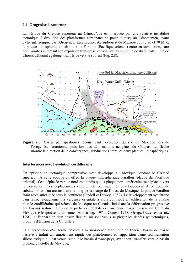
2.4- Orogenèse laramienne La période du Crétacé supérieur au Cénozoïque est marquée par une relative instabilité tectonique. L'évolution des plateformes carbonates se poursuit jusqu'au Cénomanien, avant d'être interrompue par l'Orogenèse Laramienne. Au sud-ouest du Mexique, entre 80 et 70 M.a., la plaque lithosphérique océanique de Farallon (Pacifique oriental) entre en subduction, l'arc des Caraïbes entamant son expulsion transpressive vers l'est au sud du bloc du Yucatan, le bloc Chortis débutant également sa dérive vers le sud-est (Fig. 2.8).
Figure 2.8: Cartes palinspastiques reconstituant l'évolution du sud du Mexique lors de
l'orogenèse laramienne, puis lors des déformations néogènes du Chiapas. La flèche montre la direction de la convergence (subduction) entre les deux plaques lithosphèriques.
Interférences avec l'évolution cordilléraine Un épisode de tectonique compressive s'est développé au Mexique pendant le Crétacé supérieur. A cette époque en effet, la plaque lithosphérique Farallon (plaque du Pacifique oriental), s’est déplacée vers le nord-est, tandis que la plaque nord-américaine se déplaçait vers le nord-ouest. Ces déplacements différentiels ont induit le développement d'une zone de subduction et d'un arc insulaire le long de la marge de l'ouest du Mexique, la plaque Farallon étant alors subductée sous le continent (Pindell et Dewey, 1982). Le développement synchrone d'un rétrochevauchement à vergence orientale a alors contribué à l'édification de la chaîne plissée cordilléraine qui s'étend du Mexique au Canada, induisant la déformation progressive des bassins sédimentaires de la partie occidentale de l'ancienne marge passive du Golfe du Mexique (Orogénèse laramienne; Armstrong, 1974; Coney, 1978; Ortega-Gutierrez et al., 1990), et l'apparition d'un bassin flexural où sont venus se piéger les dépôts syntectoniques, produits d'érosion de la Cordillère. La superposition d'un terme flexural à la subsidence thermique de l'ancien bassin de marge passive a induit un ennoiement rapide des plateformes, et l'apparition d'une sédimentation silicoclastique qui est venue remplir le bassin d'avant-pays, avant son transfert vers le bassin profond du Golfe de Mexique.
workshop Tectonics et al. 2002
23

Sur la marge ouest du BPGM, la colonne sédimentaire comprend ainsi des séries clastiques cénozoïques, qui surmontent les épaisses séries de calcaire de plateforme qui s'y étaient déposées au Crétacé inférieur et moyen, époque pendant laquelle les effets de la subsidence étaient constamment compensés par la production carbonatée (Fig. 2.5a, graphique évolution thermique). Le Crétacé supérieur et le Paléogène constituent une période de transition, marquée par des discontinuités majeures entre les unités lithostratigraphiques. Dans la Cordillère, les séries du Crétacé supérieur et du Paléocène sont plissées de façon synchrone au dépôt de séries syntectoniques dans le bassin d'avant-pays. Au cours du Turonien, la sédimentation change brutalement dans les bassins, les dépôts calcaires y étant progressivement contaminés par des apports détritiques. Dès le Maastrichtien, le système sédimentaire est devenu complément silicoclastique. Les sismoséquences du BPGM, constituées par les unités Campeche, Arcillosa et Cordilleras Mexicanas, n'ont pas encore été reconnues par forage. Elles constituent cependant des équivalents chronostratigraphiques directs de séries reconnues par forage ou directement observables dans les affleurements des foothills à proximité des bassins de Veracruz et de Chicontepec (les formations du Paleocene, Velazco Basal et Chicontepec, ont été localement remobilisées par la tectonique tangentielle, et peuvent s'observer en zone de piémont, même si elles s'étaient pour l'essentiel déposées dans le bassin flexural induit par la charge tectonique de la Cordillère). A cette époque, la plate-forme de Tuxpan constitue un seuil émergé (paléo-bulge) entre le bassin flexural à l'ouest et le BPGM à l'est. 2.5- Néogène Dès le Paléogène supérieur et au début du Néogène, la géodynamique de la marge passive et son architecture stratigraphique ont à nouveau changé. Un changement relatif de la subsidence de la marge passive du Golfe du Mexique conduit à une surrection progressive de la chaîne et au basculement de l'ancien bassin flexural laramien, la plateforme de Tuxpan reprenant alors sa subsidence. Il en résulte alors un transfert rapide et direct des produits d'érosion de la chaîne vers le bassin profond, la partie proximale de la marge étant recouverte par des dépôts progradants silicoclastiques néogènes. La nouvelle charge sédimentaire aidant, les argiles sous-compactées des séries éocène-oligocène de la pente sont alors remobilisées dans un vaste glissement gravitaire, caractérisé par le développement de grandes failles listriques et de roll-overs en haut de pente, et de plis gravitaires (Cordillères Mexicaines du Golfe profond) à la base de la pente continentale. Après les dernières déformations laramiennes, le remplissage silicoclastique du bassin d'avant-pays, s'accompagnant de l'enfouissement de la Platforme Tuxpan s'est poursuivi à l'est du front de la déformation, avec une progradation des dépôts vers l'offshore profond. Les produits d'érosion de la chaîne ont depuis lors alimenté en permanence la sédimentation silicoclastique du BPGM. Dans la partie profonde du Golfe, la colonne sédimentaire néogène a été traversée par les forages 538 A, 90 et 91 du Deep Sea Drilling Project, et y est constituée par une séquence purement silicoclastique (forage DSDP).
24

Toujours au cours du Miocène, la plaque lithosphérique Farallon s'est rompue, donnant naissance aux plaques de Coco et de Nazca., la subduction oblique de la plaque de Cocos induisant l'orogenèse Chiapaneca (alias des Chiapas, 16 M.a.), localisée à proximité du point triple de l'Isthme de Tehuantepec, et responsable de la surrection du Massif du Chiapas (Granite de la Mixtequita), et du plissement de la Sierra de Chiapas (Fig. 2.9).
Figure 2.9: Cartes palinspastiques reconstituant l'architecture du sud du Mexique lors de l'orogenèse Chiapaneca.
Dietmar, et al. 2001
workshop Tectonics et al. 2002
25

2.6- Géomorphologie du Golfe du Mexique Suite à son évolution géodynamique, la géomorphologie du fond marin du BPGM présente une série de reliefs allongés de direction nord-sud parallèles à la côte, qui résultent d'une activité tectonique associée à de l'érosion sous-marine dans le golfe. Cette chaîne de montagnes sous-marines constitue les "Cordilleras Mexicanas". À l'ouest des "Cordilleras Mexicanas", la pente et la plateforme continentales sont affectées par un système gravitaire avec des failles de croissance décollées dans les argiles sous-compactées de l'Eocène-Oligocène, tandis que plus au nord, c'est une nappe de sel allochtone (sel de Perdido) qui contrôle l'essentiel de la tectonique gravitaire, de même que plus au sud, la nappe gravitaire allochtone du bassin de "Campeche" est aussi décollée au niveau du sel jurassique. Il n'y a aucune évidence de sel jurassique sur la marge au niveau du transect de Veracruz sur lequel a porté mon travail, toute la tectonique gravitaire y étant contrôlée par des niveaux argileux, à l'inverses de ce qui a été largement publié dans la littérature internationale, et concernant surtout la partie texanne (marge nord) du Golfe. À l'est et au nord, la plaine abyssale constitue un monoclinal, permettant au BPGM de communiquer avec l'Océan Atlantique (Fig. 2.10).
Figure 2.10: Carte géomorphologique du fond du Golfe du Mexique.
N Sigsbee
Plaine abyssale
Plateforme continentale
Cordilleras Mexicanas
200 Km
N Campeche
26


III- INTERACTIONS entre l'AVANT-PAYS LARAMIEN et la MARGE PASSIVE du GOLFE du MEXIQUE: TECTONIQUE et SEDIMENTATION dans le SECTEUR de la GOLDEN LANE, ETAT de VERACRUZ, MEXIQUE
(Article publié à Marine and Petroleum Geology)
27

28

Interactions between the Laramide Foreland and the passive marginof the Gulf of Mexico: Tectonics and sedimentation in the Golden Lane area,Veracruz State, Mexico
Humberto Alzaga-Ruiz a,b,c, Michel Lopez b, François Roure c,d,*, Michel Seranne b
a IMP, Instituto Mexicano del Petroleo, Eje Central Lazaro Cardenas, Colo. San Bartolo Atepehuacan, Apartado postal 14-805, 07730 Mexico DF, MexicobGeosciences Montpellier, Universite Montpellier 2, CNRS, Place Eugene Bataillon, 34095 Montpellier Cedex, Francec Institut Français du Petrole, 1–4 Avenue de Bois-Preau, 92852 Rueil-Malmaison, FrancedDepartment of Earth Sciences, Free University, de Boelelaan 1085, 1081 HV Amsterdam, The Netherlands
a r t i c l e i n f o
Article history:Received 5 August 2007Received in revised form 26 March 2008Accepted 31 March 2008Available online xxx
Keywords:Gulf of MexicoGravity collapseChicontepec BasinLaramide foreland Basin
a b s t r a c t
This paper focuses on the analyses of the clastic sedimentary infill of the Coastal Plain of Eastern Mexico,which initiated synchronously with the Laramide orogeny in the vicinity of the Golden Lane. Results ofthese analyses are used as boundary conditions for calibrating/interpreting seismic profiles across moredistal depocenters in the offshore of the Gulf of Mexico, from the sea shore and continental slope in thewest to the abyssal plain in the east. The objective of the study is to better predict the reservoirdistribution in the Deep offshore Basin of the Gulf of Mexico (DBGM), in order to explore for petroleum.The Coastal Plain is underlain by three morpho-tectonic domains: the tectonic front of the Sierra MadreOrientale (SMO), the Chicontepec deep water flexural basin, and the Tuxpan Platform (also known as theGolden Lane). Each domain is characterized by a distinct, dominantly siliciclastic Cenozoiclithostratigraphy.After a Jurassic rifting episode, followed by thermal subsidence, the oceanic basin and its western passivemargin were deformed during the Upper Cretaceous and Paleogene, by far field stresses associated withthe Cordilleran-Laramide Orogeny.Starting in the Late Cretaceous-Early Paleogene and during the Early Eocene, the tectonic load associatedwith the Laramide Orogen (Sierra Madre Oriental, SMO) caused flexural subsidence of the forelandlocated under the Coastal Plain. During this period, a massive transfer of siliciclastic sediments occurredfrom the Laramide foothills into the adjacent foreland. Sediments were eroded of the Sierra Madretectonic wedge. Loading by these sediments pushed source units associated with the former passivemargin downward. The first syn-tectonic sediments of the Laramide orogeny were turbiditic silt layers insubmarine fans which record also numerous collapse episodes and gravity slides.During the Late Eocene and Oligocene, the flexural subsidence stopped in the hinterland, whereas thesubsidence of the passive margin resumed. This resulted in a change in the overall sedimentaryarchitecture of the basin. Paleo-highs and reefs facies of the Golden Lane were flooded. Clastics by-passedthe reefs and progradational clastic stratification formed as sediment moved towards the DBGM in theeast. The final depositional environment of the continental platform/Coastal Plain became deltaic,marked by a succession of sand bars, levees and channels systems.From Miocene times onward, a system of gravitational listric faults developed near the platform to slopetransition, resulting in a coeval compressional system at the transition between the slope and the abyssalplain. This system is driven by sediments charge. Because the sedimentation rate is larger than thesubsidence, a large amount of clastics and slumped sediments are deposited in hangingwall basins.
� 2008 Elsevier Ltd. All rights reserved.
1. Introduction
1.1. Aims
In the early 20th century, onshore petroleum exploration inMexico resulted in the discovery of giant accumulations in the
* Corresponding author. Institut Français du Petrole, 1–4 Avenue de Bois-Preau,92852 Rueil-Malmaison, France. Tel.: þ33 1 4752 7362; fax: þ33 1 4752 7067.
E-mail addresses: [email protected] (H. Alzaga-Ruiz), [email protected](F. Roure).
Contents lists available at ScienceDirect
Marine and Petroleum Geology
journal homepage: www.elsevier .com/locate/marpetgeo
ARTICLE IN PRESS
0264-8172/$ – see front matter � 2008 Elsevier Ltd. All rights reserved.doi:10.1016/j.marpetgeo.2008.03.009
Marine and Petroleum Geology xxx (2008) 1–23
Please cite this article in press as: Alzaga-Ruiz, H., et al., Interactions between the Laramide Foreland and the passive margin of the Gulf ofMexico: Tectonics and sedimentation in the Golden Lane..., Marine and Petroleum Geology (2008), doi:10.1016/j.marpetgeo.2008.03.009
29

Golden Lane (also called Faja de Oro) in Mesozoic platform car-bonates, along thewestern shore of theGulf ofMexico (Viniegra andCastillo-Tejero,1970; Coogan et al., 1972;Watkins and Buffler, 1996;Watkins et al., 1978; Galicia, 2001). In the 1980s, a second giant fieldwas discovered in K-T boundary carbonate breccias in shallowwaterprospects of the Yucatan coast in Cantarell, located along the easternmargin of theGulf ofMexico (Acevedo,1980;GuzmanandMarquez-Dominguez, 2001; Aquino et al., 2003; Mitra et al., 2005; Standing,2006; Fig. 1). In between these two fields (on opposite conjugatemargins), the Deep Basin of the Gulf of Mexico (DBGM) remainslargely unexplored, although hydrocarbon discoveries (e.g. GreatWhite and Jack 2 discoveries; Chapin et al., 2004; Durham, 2006;Fig. 1) have been made in the northern margin in Lower Tertiarydeep water clastic reservoirs of the US.
In an effort to identify potential clastic reservoirs in the Mexicanpart of the DBGM, this study investigated (1) the interrelationsbetween tectonics and sedimentation, and (2) how the sedimentwas transferred between the onshore and offshore domains of thewestern passive margin of the Gulf of Mexico, from the onset of theCordilleran Orogeny to the Present.
1.2. Data base and methodology
This study integrates seismic sections information, wells logs,outcrop data and published work. The 2D seismic data (provided byPemex) used for this study, is located off the coast in the Deep Basinof the Gulf of Mexico and in the Coastal Plain (Fig. 2). Well log
information with litho- and biostratigraphic descriptions were alsoused for wells 1, 2, 3, 4 and 6 (Fig. 2), including gamma ray curves toidentify the clay packages.
Outcropswere also used to compile a stratigraphic section in thePaleogene series.
Stratigraphic information and well picks were tied to the entireseismic database, in the Coastal Plain and Golden Lane area, and inthe DBGM. Various seismic sequences were also defined within thischronostratigraphic framework. Finally, well logs were used todefine the parasequences and eustatic curves (Haq et al., 1987).Both surface and subsurface data were ultimately integrated toprecise a coherent sedimentary model.
The most representative regional transect was selected to es-tablish the structural/kinematic evolution of the area. The transectwas converted from the time domain to the depth domain, and wasrestored. By comparing the present and restored sections, it waspossible to (1) understand the tectonic controls on sedimentationand (2) better interpret the subsidence curves derived from thewells.
2. Geological background
2.1. Location
The Deep Basin of the Gulf of Mexico (DBGM) extends be-tween the northeastern Mexican offshore, the south and
Fig. 1. Simplified tectonic map of the Gulf of Mexico: tfsmo, tectonic front of the Sierra Madre Oriental; fsm, San Marcos fault system; fsv, Victoria fault system; fi, reverse faults; TxP,Tuxpan Platform; sam, Santa Anna Massif; oc, oceanic crust; mb, Maya block; smp, Motagua-Polochic system; atm, active tectonic margin; etmnv, trans-Mexican volcanic axis; fsmand fsv from Velez (1990); tma, mb and smp from Campa and Coney (1983), Coney (1983). This corresponds to the coordinates 20�0000000 and 22�000000000 North of latitude, and96�000000000 and 98�000000000 West of longitude. See also location of DSDP wells 90–91 and 538A near the Mexican coast (Worzel et al., 1973a,b; Buffler et al., 1984), and recentGreat White and Jack-2 discoveries in the US part of the Gulf. The yellow box outlines the location of the studied area (see Fig. 2).
H. Alzaga-Ruiz et al. / Marine and Petroleum Geology xxx (2008) 1–232
ARTICLE IN PRESS
Please cite this article in press as: Alzaga-Ruiz, H., et al., Interactions between the Laramide Foreland and the passive margin of the Gulf ofMexico: Tectonics and sedimentation in the Golden Lane..., Marine and Petroleum Geology (2008), doi:10.1016/j.marpetgeo.2008.03.009
30

southeast US margins and western Cuba (Fig. 1). Its depth rangesfrom 200 m down to 3750 m, from the continental slope to theabyssal plain.
The Coastal Plain extends from the thrust front of the SierraMadre Oriental (SMO) in the west to the coast line of the Gulf ofMexico in the east (Figs. 1 and 2). Nearshore, Cenozoic clasticsediments of the Coastal Plain are underlain by Cretaceouscarbonates of the Tuxpan Platform (also referred to as the ‘‘Faja deOro’’ or ‘‘Golden Lane’’ because of large petroleum discoveriesmade in the early 20th century; Viniegra and Castillo-Tejero, 1970;Coogan et al., 1972; Halbouty, 1977–1988). Elsewhere, the pre-Cenozoic substratum of the Coastal Plain is made up of dominantlyMesozoic basinal sediments. The Coastal Plain is limited towardsthe south by the Santa Ana Massif (SAM; Fig. 1).
The crust of Gulf of Mexico beneath the DBGM is oceanic(Ewing, 1991; Salvador, 1991; Sawyer et al., 1991; Nagihara et al.,1996; Fig. 1). Mid Jurassic rifting between North America and theYucatan block led to a continental break-up and the formation ofyoung oceanic crust in the deep basin. Drifting is thought to haveoccurred during the Late Jurassic (Buffler and Sawyer, 1985), andwas followed during the Cretaceous by long-term thermal sub-sidence and sedimentary loading along the adjacent continentalpassive margins (Feng and Buffler, 1991, 1996; Figs. 1 and 3).
The study area is located in the southern part of the Tampico-Mizantla Basin, in the Coastal Plain and current platform domain of
the Veracruz State, and extends offshore eastward in the orientalportion of the Golden Lane (Fig. 1).
2.2. Geodynamic evolution
Many authors (i.e., Tardy, 1980; Coney, 1983; Buffler andSawyer, 1985; Pindell, 1985, 1993, 1994, 2002; Ross and Scotese,1988; Amos, 1987; Ortega-Gutierrez et al., 1994; Alaniz-Alvarezet al., 1996; Pindell and Kennan, 2001) have discussed the re-lationship of the Gulf of Mexico with the Caribbean and SouthAmerica. The geodynamic evolution of the DBGM began in theLate Triassic–Jurassic with the break-up of the American cratonand progressive southeastward escape of the Maya block, thusleading to the development of an intervening oceanic domain inthe Late Jurassic. Apart from the DBGM, other Eastern Mexicanbasins result from the same rifting phase, although theyremained intracontinental: i.e., the Sabinas, Burgos, and Tampico-Misantla basins (Fig. 1; Jarvis and McKenzie, 1980; Horbury et al.,2003).
During the Lower Cretaceous, the sedimentation rates andarchitecture of post-rift series deposited in the passive marginssurrounding the DBGM were mainly controlled by the progressivecooling and thermal subsidence of the lithosphere (Pindell, 1985;Ross and Scotese, 1988).
Fig. 2. Seismic database and wells used for the study; the black lines are seismic lines, whereas numbers refer to wells logs.
H. Alzaga-Ruiz et al. / Marine and Petroleum Geology xxx (2008) 1–23 3
ARTICLE IN PRESS
Please cite this article in press as: Alzaga-Ruiz, H., et al., Interactions between the Laramide Foreland and the passive margin of the Gulf ofMexico: Tectonics and sedimentation in the Golden Lane..., Marine and Petroleum Geology (2008), doi:10.1016/j.marpetgeo.2008.03.009
31

From Late Cretaceous to Eocene time, the topographic loadapplied by the Sierra Madre Oriental resulted in the deformation ofits eastern foreland lithosphere, with the development of a flexuralbulge and emersion at the current location of the Golden Lane,between the flexural basin developing near the thrust front in thewest, and the still subsiding oceanic domain of the DBGM in the east(Jarvis and McKenzie, 1980; Feng et al., 1994; Horbury et al., 2003).
From Oligocene time onward, the evolution of the westernpassive margin of the Gulf of Mexico was again mostly controlledby long lasting thermal subsidence processes, with gravitationalprocesses accounting for the development of a major upper-slopelistric fault system coeval with a lower-slope compressional systemat the junction between the slope and the abyssal plain (Buffleret al., 1979; Buffler, 1983; Aranda-Garcia, 1999).
66.5
60.2
25.230 Oprs
Oligocene MCM
LCM
Camp
Eocene
Paleocene
Jurassic Jurassic
Basement
Basement
argillaceouslimestone
sandstoneand shale
shale andsandstone
shale andsiltstone
MCM Middle Cordilleras Mexicanas
LCM Lower Cordilleras Mexicanas
Camp Campeche
MCSB Middle Cretaceous Seq. Boundary
sandstoneand shale
sandstoneand shaleinterbedded
limestonemarl shale
limestonereef, breccias
limestoneexternal facies
shale andsiltstone
red beds
batholithicmetamorphicrocks
MiddleCretaceous
MiddleCretaceous
LateCretaceous
Campe-che
MCSB
Chal-lenger
Opr
Eg
Pchs
PchmPchiPvbKm
Ksf
Kn
KKtKts
Kto
Kti
Jp
Jt
36
49
92
21 my
58
94
134
49
108
134
152
179
210
250
295
54
39.4
0 my
P A
L
E
O
G
E
N
E
Low
erC
ordi
llera
sM
exic
anas
Upl
iftgr
avita
tiona
lco
llaps
eLa
ram
ide
Oro
geny
Post
- R
iftSy
n - R
iftPr
e - R
ift
C R
E
T
A
C
E
O
U
S
J U
R
A
S
S
I C
PE
RM
.-T
RIA
S
COASTAL PLAIN
AND WELLS AA TxP BB
GM
GEODYNAMIC
PALE
O.
EOCE
NEO
LIG
O.
Low.
Up.
Up.
ULo
w.Lo
w.Mi
ddle
Pvb Velazco Basal; Pchi Lower Chicontepec; Pchm Middle Chicontepec; Pchs Upper Chicontepec;Eg Guayabal; Et Tantoyunca; Ech Chapopote; Opri Lower Palma Real; Oprs Upper Palma Real
Jc Cahuasas; Jtx Tepexi; Jt Taman; Jp Pimienta; Kti Lower Tamaulipas; Kto Otates;Kts Upper Tamaulipas; Kt Tamabra; Ksf San Felipe; Kan Agua Nueva; Km Mendez
Fig. 3. Synthetic litho-chronostratigraphic columns representative of the wells from the Coastal plain (left), coeval colour chart used for seismic sections AA0 and BB0 (center), andtime equivalent sequences defined in the deep offshore (right, after Shaub et al., 1984).
H. Alzaga-Ruiz et al. / Marine and Petroleum Geology xxx (2008) 1–234
ARTICLE IN PRESS
Please cite this article in press as: Alzaga-Ruiz, H., et al., Interactions between the Laramide Foreland and the passive margin of the Gulf ofMexico: Tectonics and sedimentation in the Golden Lane..., Marine and Petroleum Geology (2008), doi:10.1016/j.marpetgeo.2008.03.009
32

2.3. Sedimentary infill of the Gulf of Mexico basin
2.3.1. Pre-rift basement (Permian–Triassic?)The pre-Jurassic basement of Eastern Mexico is cut in numerous
tilted blocks, horsts and grabens which are made up of heteroge-neous igneous and metamorphic rocks. Along the western marginof DBGM, this basement is sometimes referred to as the MayaTerrane (Campa and Coney, 1983).
2.3.2. Synrift (Triassic?–Jurassic)Synrift continental red beds and evaporite, i.e., the Todos Santos,
Huizachal, Cahuasas and Tepexi formations, were deposited duringthe Lower and Middle Jurassic, before the onset of drifting in theGulf of Mexico (Tardy, 1980; Coney, 1983; Herrera and Estavillo,1991; Fig. 3).
2.3.3. Post-rift (Late Jurassic–Cretaceous)Ladd,Watkins and others (Watkins et al., 1975; Ladd et al., 1976),
proposed the first regional interpretation/correlation of the seismichorizons and stratigraphic units in the DBGM (see Chart 1). Theaverage thickness of Mesozoic to Recent sediments in the DBGM is10 km. Sediments consist of limestone and clastic units, withdepositional environments ranging from continental to bathyal.The DBGM is still receiving silts and sands from the rivers of theNorth America.
During the early stages of thermal subsidence in the LateJurassic to Lower Cretaceous times, the sediments entering theDBGM were calcareous silts, derived from the surrounding car-bonate platforms.
During Late Cretaceous–Early Paleogene times, sedimentationchanged to siliciclastic, as a result of the Laramide Orogen (Horburyet al., 2003). As in the Basin and Range Province and other segmentsof the North American Cordillera, uplift and erosion characterizedthe Mexican onshore domain during the Neogene (Pottorf et al.,1996; Yurewicz et al., 1997; Gray et al., 2001), accounting forcontinuously prograding siliciclastic sedimentation towards theDBGM (Galloway et al., 1991, 2000; Piggott and Pulham, 1993;Wawrzyniec et al., 2004; Roure, in press; Roure et al., in press).
3. Stratigraphic description
The lithostratigraphy and corresponding seismic sequencesidentified in the Coastal Plain and the DBGM, are described below(see also Figs. 3, 8 and 10).
Ladd, Watkins and others (Watkins et al., 1975; Ladd et al., 1976)identified six main seismic horizons in the DBGM, comprising (1)the top Basement, (2) the top Jurassic, (3) the top Middle Creta-ceous, (4) the Campeche (top Paleocene), and (5) the CordillerasMexicanas (CM, top Oligocene) horizons. These horizons define
various seismic sequences, which can be compared to coeval for-mations outcropping in the foothills of the SierraMadre Oriental, orwhich have been drilled both onshore in the Coastal Plain andoffshore on the continental platform.
The names of Viejo (infra-Jurassic), Challenger (Jurassic),Campeche (Paleocene), Cinco-de-Mayo and Sigsbee units wereassigned to the intervening sequences by Watkins et al. (1975)(Chart 1). Ladd et al. (1976) renamed the Viejo seismic horizon asthe Basement, and added the Cordilleras Mexicanas between theCampeche and Cinco-de-Mayo horizons. Finally, Shaub et al. (1984)subdivided the Cordilleras Mexicanas into the Lower CordillerasMexicanas and Upper Cordilleras Mexicanas.
The present study has used almost the same units or seismicsequences, i.e., the acoustic Basement, Jurassic, Campeche (Paleo-cene), ‘‘Arcillosa’’ and Cordilleras Mexicanas (Oligocene sequence).However, correlation with the well dated stratigraphic units of theCoastal Plain provides a better resolution.
The ‘‘Arcillosa’’ seismic sequence used here is recognized asa specific interval between the Campeche horizon (below) and theCordillerasMexicanas (above). It has a thickness ranging from 1 s to250 ms (twt) and a chaotic reflection pattern. This sequence isinterpreted as being made up of ductile shales and to behave asa major decoupling or detachment horizon, thus accounting for thefolding of the overlying Cordilleras Mexicanas unit.
Fig. 3 summarizes the main litho-stratigraphic divisions of thesyn-tectonic sedimentary infill of the Coastal Plain, defined byborehole and outcrop studies. Fig. 3 also suggests lateral correla-tions with the well-known sequences of the DBGM (Chart 1). Cor-relations were made by using the pattern of the seismic reflectionsurfaces and character of seismic sequences on the interveningseismic sections AA0 and BB0.
3.1. Pre-rift substratum
Cores and outcrops in the frontal units and the hinterlandindicate that the pre-rift substratum of the SierraMadre is made upof igneous andmetamorphic rocks ranging from the Permian to theEarly Jurassic, including plutonic rocks (179 Ma), igneous batho-lithic rocks (187 Ma), igneous and metamorphic rocks (276–223 Ma), which are referred to as the western stocks and meta-morphics (Jacobo, 1986).
3.1.1. Onshore seismic section AA (Fig. 4, section AA0)The Basement sequence displays a broadly rugose reflection
configuration. Its top reflection deepens toward the east, and isoverlain by a younger sequence which displays a subparallelreflection pattern. The top of the acoustic basement can be corre-lated with core samples from the Sabaneta and Comalteco wells,where it is made up of metamorphic igneous rocks.
This study Watkins, 1975 Ladd et al., 1976 Shaub et al., 1984Neogene unit Sigsbee Sigsbee Sigsbee
Cinco de Mayo Cinco de Mayo Cinco de MayoOligocene unit Cordilleras Mexicanas Upper Cordilleras Mexicanas
MCMMiddle Cordilleras Mexicanas
Eocene unit
LCM LCMArcillosa Lower Cordilleras Mexicanas
Paleocene unit
Campeche Campeche Campeche CampecheChallenger Challenger Challenger Challenger
acoustic Basement Basement Viejo acoustic Basement
Chart 1. Major seismic sequence boundaries of the DBGM used in the literature and tectono-stratigraphic units discussed in this study.
H. Alzaga-Ruiz et al. / Marine and Petroleum Geology xxx (2008) 1–23 5
ARTICLE IN PRESS
Please cite this article in press as: Alzaga-Ruiz, H., et al., Interactions between the Laramide Foreland and the passive margin of the Gulf ofMexico: Tectonics and sedimentation in the Golden Lane..., Marine and Petroleum Geology (2008), doi:10.1016/j.marpetgeo.2008.03.009
33

Reflection surface Intensity strength Reflection continuity AmplitudeOligocene medium discontinuous weak
Middle Cordilleras MexicanasEocene medium discontinuous weak
Lower Cordilleras MexicanasPaleocene medium continuous goodCampeche
Middle Cretaceous strong continuous highJurassic strong continuous high-good
Basement weak-medium disconti.-continuous weak
Seismic sequence Reflection patterns Reflection continuity Amplitude Frequency Extern formOligocene oblique-subparallel discontinuous medium sheet drape
moundedhummocky
Eocene oblique-subparallel discontinuous weak weak wedge sheetchaotic continuous
Paleocene chaotic wedgetransparent
Middle Cretaceous subparallel continuous good-strong weak sheetmounded
Jurassic subparallel continuous good weak drapeBasement broadly rugose
hyperbolic
Chart 2. Seismic section AA0 . Top, descriptive of the bounding-summit and base-reflections; bottom, descriptive of the intervening sequence.
Fig. 4. Seismic reflection profile (time) and line drawing of onshore section AA0 with calibration wells 1, 2, 3 and 4, (see location in Fig. 2).
H. Alzaga-Ruiz et al. / Marine and Petroleum Geology xxx (2008) 1–236
ARTICLE IN PRESS
Please cite this article in press as: Alzaga-Ruiz, H., et al., Interactions between the Laramide Foreland and the passive margin of the Gulf ofMexico: Tectonics and sedimentation in the Golden Lane..., Marine and Petroleum Geology (2008), doi:10.1016/j.marpetgeo.2008.03.009
34

3.1.2. Coastal Plain wellsWells 1 and 2 reached the basement at the depths of 1786 and
1903 m, respectively. Twenty-five metres of dioritic plutonic rockswere penetrated in well 1, and 2.5 m of metamorphic schists weredrilled at TD in well 2.
3.1.3. Offshore seismic section BB (Figs. 5 and 6, section BB0)The acoustic Basement sequence is the oldest unit. It displays
a rugose to subparallel reflection configuration with diffractions inthe form of hyperbolas.
The basement surface is overlain by well stratified down-lapping horizons between shot points 2800 and 3300 (or at 50 km).
Although not calibrated by wells, this basement could be madeup either of (1) metamorphic and intrusive igneous rocks ofPermian-Triassic age, coeval to the Chiapas batholith (Carfantan,1981; Ruiz, 1988), (2) Jurassic synrift submarine lavas (Tuzo, 1969,1972; Menard, 1967; Bullard and Feden, 1970), or (3) youngersyndrift submarine basalts (Pindell, 1985).
3.2. Syn-rift and post-rift (Mesozoic)
Syn-rift sediments are dominantly made up of Lower to MiddleJurassic red alluvial fluvial deposits, i.e., the so-called Rosario andCahuasas formations.
Subsequently, the post-rift carbonate platform developed dur-ing the Late Jurassic and the Middle Cretaceous in the west (at thecurrent location of the Sierra Madre Oriental) and in the centralpart of the study area (in the Golden Lane/Faja de Oro area), with anintervening basin domain in between, i.e., the Tampico-MisantlaBasin. This eastern platform domain (i.e., the Tuxpan Platform orFaja de Oro) is bordered to the east by the distal portions of thecontinental margin, grading into the oceanic domain of the Gulf ofMexico.
During the post-rift thermal subsidence of the passive margin,i.e. in Late Jurassic–Lower Cretaceous times, carbonates weredeposited across the entire transect, with external platform andbasinal facies developing away from former horsts, whereas reefand subreef facies were strictly localized above former horsts (as inthe Golden Lane).
3.2.1. Onshore seismic section AA0
The syn- and post-rift series of the former passive margin arecomprised between the deeper seismic horizon referred to as theacoustic Basement, and the Middle Cretaceous horizon, which is
well calibrated in the wells 1 and 2 (Charts 1 and 2). Thesesequences display a subparallel reflection configuration with wideamplitude and strong reflection intensity (Fig. 4).
3.2.1.1. Jurassic seismic sequence. The Jurassic series rest un-conformably on top of the basement. The top of the Jurassicsequence is made up of subparallel reflectors with a continuousreflection surface, whereas its base is dissected by normal faults,thus delineating grabens with divergent (wedge forms), moundedand chaotic geometries. The Jurassic reflectors have onlap termi-nations over the underlying basement surface.
3.2.1.2. Lower Cretaceous seismic sequence. The base of the Creta-ceous sequence rests conformably on top of the Jurassic sequencein the west and central part of the section as well as on the TuxpanPlatform (TxP). Its top is a reflection surface referred to as theMiddle Cretaceous according to wells.
In the western part of section AA0 , this seismic sequence hasa chaotic reflection configuration, due to tectonic deformation nearthe Cordilleran thrust front. Towards the east, it is continuous untilthe western border of TxP, where the reflection configurationdisplays a local mound and becomes again flat over the platform(TxP).
3.2.2. Coastal Plain wells3.2.2.1. Jurassic seismic sequence. Wells 1, 2 and 3 penetrateKimmeridgian–Tithonian carbonates, coeval with the San Andres,Taman and Pimienta formations which outcrop in the fold andthrust belt of the Sierra Madre Oriental (SMO). The Jurassic inthese wells amounts to 335, 224 and 311 m in thickness,respectively.
It is notable that well 4 cuts 26 m of syn-rift red beds beneaththe marine carbonate deposits.
3.2.2.2. Cretaceous seismic sequence. Wells 1 and 2 also penetrateMiddle Cretaceous carbonates, whereas lateral facies change fromexternal platform to pre-reef facies is evidenced in Cretaceouscarbonates found in the well 4. In the field, these series corre-spond to the Tamaulipas Superior and Tamabra formations,respectively.
3.2.3. Offshore seismic section BB0
3.2.3.1. Jurassic seismic sequence. The Jurassic sequence overliesthe acoustic Basement sequence. Its top is defined as a strongly
Reflection surface Intensity strenght Reflection continuity AmplitudeMiddle Cordilleras Mexicanas strong continuous medium highLower Cordilleras Mexicanas strong continuous medium high
Campeche medium semi-continuous weakMiddle Cretaceous strong continuous medium
Jurassic strong continuous highBasement weak semi-continuous weak
Seismic sequence Reflection patterns Reflection continuity Amplitude Frequency Extern formMCM subparallel-shingle continuous high low bank-sheet
Arcillosa wavy-hummocky continuous medium-high low wedgebroadly rugose discontinuous
Campeche subparallel continuous medium-low medium sheet-wedgecontorted semicontinuous
Middle Cretaceous subparallel continuous low-medium medium sheetJurassic subparallel continuous medium-high low drape
convergent semicontinuousBasement broadly rugose
Chart 3. Seismic section BB0 . Top, descriptive of the bounding-summit and base-reflections; bottom, descriptive of the intervening sequence.
H. Alzaga-Ruiz et al. / Marine and Petroleum Geology xxx (2008) 1–23 7
ARTICLE IN PRESS
Please cite this article in press as: Alzaga-Ruiz, H., et al., Interactions between the Laramide Foreland and the passive margin of the Gulf ofMexico: Tectonics and sedimentation in the Golden Lane..., Marine and Petroleum Geology (2008), doi:10.1016/j.marpetgeo.2008.03.009
35

Fig. 6. Seismic reflection section BB0 (time) from shore line to DBGM. The green refers to the syn-rift and post-rift sequences; brown relates to the syn-orogenic sequence; orangeand yellow relate to the post-orogenic sequence.
Fig. 5. Seismic reflection profile (time) and line drawing of offshore section BB0 with calibration well 6 (see location in Fig. 2).
H. Alzaga-Ruiz et al. / Marine and Petroleum Geology xxx (2008) 1–238
ARTICLE IN PRESS
Please cite this article in press as: Alzaga-Ruiz, H., et al., Interactions between the Laramide Foreland and the passive margin of the Gulf ofMexico: Tectonics and sedimentation in the Golden Lane..., Marine and Petroleum Geology (2008), doi:10.1016/j.marpetgeo.2008.03.009
36

reflecting horizon of wide extent (see Chart 3), with a half cycle ofwave of 125 ms (wide), and of very good continuity and reflectionintensity. West of TxP, the Jurassic reflection surface covers thegrabens evidenced in the basement, with an overall draping pat-tern. This sequence displays a dominantly subparallel reflectionconfiguration, with onlap onto the basement as observed at 15 and50 km. According to Garrison (1973), the coeval reflector that limitsthe top of the Challenger unit over the entire DBGM is a strongreflector (strong reflection intensity and width).
The Jurassic (Challenger) marker is located at 9–9.5 s twt fromthe base of the slope towards the abyssal plain, and becomesshallower beneath the slope (ranging from 7 s twt at the base ofthe slope to 4 s twt near the shore line).
3.2.3.2. Cretaceous seismic sequence. The Early Cretaceoussequence lies between theMiddle Cretaceous reflection surface andthe Jurassic marker. It overlays the Jurassic sequence in apparentconformity, and displays also a subparallel reflection configurationwith good intensity and continuity.
Over the TxP, the Cretaceous sequence presents a subparallelreflection configuration, with an abrupt top. It is locally down-lapped by Late Cretaceous syn-orogenic series (i.e., at 8 km).
Toward the eastern platform margin of the TxP, the Cretaceousinterval presents a mounded reflection configuration, with onlap ofyounger units. It becomes difficult to trace beneath the slope whereit has been considerably thinned, either by erosion or by tectonicdenudation (between 20 and 45 km).
Fig. 7. (a) Surface exposure (20�1005800 ’ N and 97�3405300 W) of the Late Cretaceous Agua Nueva Formation (deep water flexural sequence). The beds are dipping S54�W/38� . (b)Surface exposure (24�1400200 N and 97�4101000 W) of the Early Paleocene Velasco Basal Formation. The shale beds are dipping S52�W/48� .
H. Alzaga-Ruiz et al. / Marine and Petroleum Geology xxx (2008) 1–23 9
ARTICLE IN PRESS
Please cite this article in press as: Alzaga-Ruiz, H., et al., Interactions between the Laramide Foreland and the passive margin of the Gulf ofMexico: Tectonics and sedimentation in the Golden Lane..., Marine and Petroleum Geology (2008), doi:10.1016/j.marpetgeo.2008.03.009
37

The Triton well is the last well that penetrates the Jurassic andMiddle Cretaceous seismic horizons, reaching the Cretaceous car-bonates (Tamabra Formation) at 5.200 mand the Jurassic at 5.400 m.
3.3. Syn-orogenic (Laramide) depositional system (LateCretaceous–Paleocene)
3.3.1. Cordilleran OrogenDuring the Late Cretaceous, compressional tectonics developed
in Mexico as a result of the convergence between the Farallon(Pacific) plate, which was moving north-eastward, and the NorthAmerican plate, which was moving northwestwards. This differ-ential motion resulted also in the development of subduction-island arc complexes along the western margin of Mexico (Pindelland Dewey, 1982; Pindell, 1993; Pindell and Kennan, 2001).
During the latest Cretaceous and Early Tertiary, the Farallonplate continued to move north-eastward, being partly consumedalong the subduction zone.
This convergence between the two plates resulted in thedeformation of the former passive margin of the Gulf of Mexico,during the so-called Cordilleran (Laramide) Orogeny (Coney, 1976;Aguayo and Marin, 1987; Ortega-Gutierrez et al., 1990). The Me-sozoic sedimentary layers were progressively accreted and upliftedin the tectonic prism of the Sierra Madre Oriental during LateCretaceous to Early Eocene times, forming in a fold and thrust beltaccompanied by syn-tectonic sedimentation, the latter sediments
infilling the foreland flexural basin developing east of the thrustfront.
3.3.2. Syn-orogenic units3.3.2.1. Onshore seismic section AA0 (Fig. 4)
3.3.2.1.1. Late Cretaceous sequence. The base of the forelandbasin sequence is a Late Cretaceous reflection surface, whichpresents downlap terminations and forms a clastic sedimentarywedge deposited over Middle Cretaceous carbonates (Fig. 3). ThisLate Cretaceous sequence is chaotic toward the west due to itsinvolvement in the deformation near the Laramide tectonic front.Towards the east, the Late Cretaceous reflection configuration ischaotic and mounded (i.e., at 40 km), (see Figs. 4 and 12).
3.3.2.1.2. Paleocene seismic sequence. The Paleocene seismicsequence overlies the Cretaceous sequence in apparent conformity.Its top is made up of a Paleocene reflection surface. As for the LateCretaceous, the Paleocene sequence displays downlap terminationsover theMiddle Cretaceous reflection surface (i.e., inwell 4, 43 km).This sequence extends from 1.3 to 1.6 s twt, from the west to theeast.
The Paleocene seismic sequence is characterized by the occur-rence of lenses with moderate reflection and sub-horizontalpatterns. InDBGM, it corresponds to the upper part of the Campecheseismic sequence and its top reflection surface (see Figs 4 and 13).
3.3.2.1.3. Eocene seismic sequence. This unit overlies thePaleocene seismic sequence. Its top reflects the Eocene surface and
Fig. 8. Log (Gr) across the Albian-Maastrichtian series of well 1, and coeval interval imaged on the seismic section. The same units have also been studied during field work inadjacent foothills (see location of the well in Fig. 2).
H. Alzaga-Ruiz et al. / Marine and Petroleum Geology xxx (2008) 1–2310
ARTICLE IN PRESS
Please cite this article in press as: Alzaga-Ruiz, H., et al., Interactions between the Laramide Foreland and the passive margin of the Gulf ofMexico: Tectonics and sedimentation in the Golden Lane..., Marine and Petroleum Geology (2008), doi:10.1016/j.marpetgeo.2008.03.009
38

displays toplap terminations beneath the Plio-Quaternary deposits.In the DBGM, its top corresponds to the base of the CordillerasMexicanas (LCM).
The seismic pattern of the Eocene sequence presents wavy andchaotic reflections with downlap terminations over the underlyingPaleocene and Cretaceous seismic surfaces. Towards well 3, its topbecomes abrupt (due to erosion), and terminates in downlap overthe mounded surface of the Cretaceous sequence (TxP westernmargin).
The Eocene sequence overlies unconformably the Cretaceoussequence of the TxP, with a subparallel and wavy reflection pattern.
The Eocene seismic sequence constitutes a sedimentary wedge,thinning toward the east (Tuxpan Platform). The reflecting surfacethat defines the Eocene is smouth and locally broken, with averageto weak amplitude. Internally, it displays a mounted pattern ofreflections, these internal forms being characterized by moderateto weak amplitude with good continuity. This seismic unit extendsfrom 0.5 to 1.5 s twt.
3.3.2.2. Coastal Plain and wells3.3.2.2.1. Late Cretaceous to Paleocene seismic sequence. The Late
Cretaceous and Tertiary siliciclastic sedimentary infill of the
Fig. 9. (a) Surface exposures (20�1305500 N and 97�3103200 W) of the Paleocene deep water Lower Chicontepec Formation. The sandstone beds are dipping N50�W/40� . (b) Surfaceexposures (20�1105100 N and 97�4202400 W) of the Paleocene deep water turbidite of the Lower Chicontepec Formation. The sandstone, sand and shale beds are dipping N10�W/19� .
H. Alzaga-Ruiz et al. / Marine and Petroleum Geology xxx (2008) 1–23 11
ARTICLE IN PRESS
Please cite this article in press as: Alzaga-Ruiz, H., et al., Interactions between the Laramide Foreland and the passive margin of the Gulf ofMexico: Tectonics and sedimentation in the Golden Lane..., Marine and Petroleum Geology (2008), doi:10.1016/j.marpetgeo.2008.03.009
39
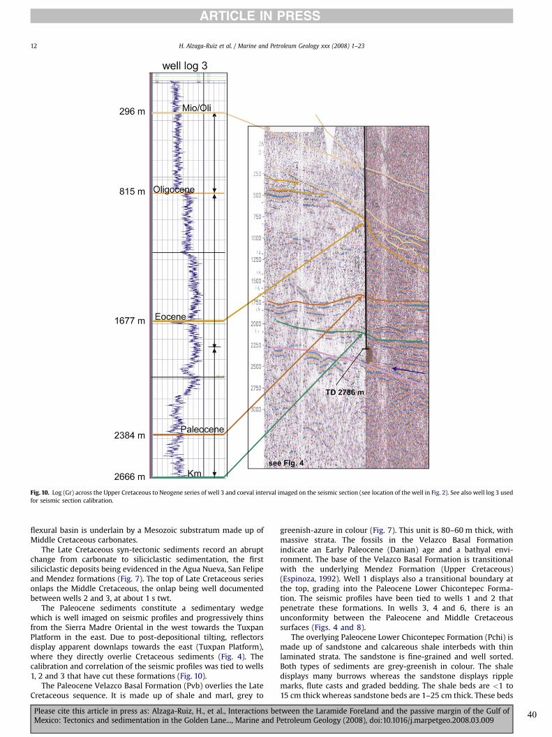
flexural basin is underlain by a Mesozoic substratum made up ofMiddle Cretaceous carbonates.
The Late Cretaceous syn-tectonic sediments record an abruptchange from carbonate to siliciclastic sedimentation, the firstsiliciclastic deposits being evidenced in the Agua Nueva, San Felipeand Mendez formations (Fig. 7). The top of Late Cretaceous seriesonlaps the Middle Cretaceous, the onlap being well documentedbetween wells 2 and 3, at about 1 s twt.
The Paleocene sediments constitute a sedimentary wedgewhich is well imaged on seismic profiles and progressively thinsfrom the Sierra Madre Oriental in the west towards the TuxpanPlatform in the east. Due to post-depositional tilting, reflectorsdisplay apparent downlaps towards the east (Tuxpan Platform),where they directly overlie Cretaceous sediments (Fig. 4). Thecalibration and correlation of the seismic profiles was tied to wells1, 2 and 3 that have cut these formations (Fig. 10).
The Paleocene Velazco Basal Formation (Pvb) overlies the LateCretaceous sequence. It is made up of shale and marl, grey to
greenish-azure in colour (Fig. 7). This unit is 80–60 m thick, withmassive strata. The fossils in the Velazco Basal Formationindicate an Early Paleocene (Danian) age and a bathyal envi-ronment. The base of the Velazco Basal Formation is transitionalwith the underlying Mendez Formation (Upper Cretaceous)(Espinoza, 1992). Well 1 displays also a transitional boundary atthe top, grading into the Paleocene Lower Chicontepec Forma-tion. The seismic profiles have been tied to wells 1 and 2 thatpenetrate these formations. In wells 3, 4 and 6, there is anunconformity between the Paleocene and Middle Cretaceoussurfaces (Figs. 4 and 8).
The overlying Paleocene Lower Chicontepec Formation (Pchi) ismade up of sandstone and calcareous shale interbeds with thinlaminated strata. The sandstone is fine-grained and well sorted.Both types of sediments are grey-greenish in colour. The shaledisplays many burrows whereas the sandstone displays ripplemarks, flute casts and graded bedding. The shale beds are <1 to15 cm thick whereas sandstone beds are 1–25 cm thick. These beds
Fig. 10. Log (Gr) across the Upper Cretaceous to Neogene series of well 3 and coeval interval imaged on the seismic section (see location of the well in Fig. 2). See also well log 3 usedfor seismic section calibration.
H. Alzaga-Ruiz et al. / Marine and Petroleum Geology xxx (2008) 1–2312
ARTICLE IN PRESS
Please cite this article in press as: Alzaga-Ruiz, H., et al., Interactions between the Laramide Foreland and the passive margin of the Gulf ofMexico: Tectonics and sedimentation in the Golden Lane..., Marine and Petroleum Geology (2008), doi:10.1016/j.marpetgeo.2008.03.009
40

0100200
0
1
2
3
4km
0100200
0
1
2
3
4
5
6km
010020001002000100200M.a. M.a. M.a. M.a. M.a.
W E
0
1
2
3
4km
0
1
2
3km
0
1
2
3km
1 2 3 4 6
Backstripping 1D
Fig. 11. Subsidence curves of the studied wells. The black curves relate to the decompacted (backstripped) litho-stratigraphic units and the red curves refer to the tectonicsubsidence.
Fig. 12. Structure and depth converted map at the top Late Cretaceous sequence with onlaps over TxP (arrows). The numbers (0.235, 1.15, 1.9, etc.) are the depth in kilometers.
H. Alzaga-Ruiz et al. / Marine and Petroleum Geology xxx (2008) 1–23 13
ARTICLE IN PRESS
Please cite this article in press as: Alzaga-Ruiz, H., et al., Interactions between the Laramide Foreland and the passive margin of the Gulf ofMexico: Tectonics and sedimentation in the Golden Lane..., Marine and Petroleum Geology (2008), doi:10.1016/j.marpetgeo.2008.03.009
41

are locally involved in slumps (Fig. 9a and b). The Lower Chic-ontepec Formation reaches a thickness of 150–550 m, becomingthicker toward the west. The planktonic fossils give a Late Paleo-cene age. In the outcrops of the Cordilleran foothills and in wells 2and 4, the top and bottom contacts of the Lower Chicontepec For-mation are transitional with the Middle Chicontepec and Mendezformations, respectively.
The Middle Chicontepec Formation (Pchm) is Late Paleocene toEarly Eocene in age and contains fossils (planktonic and benthonic)which indicate upper bathyal and neritic paleo-environments. Thebase of the Middle Chicontepec Formation is transitional with theLower Chicontepec Formation. Its top is characterized by anunconformity with Eocene sediments. The Middle ChicontepecFormation ismade up of sandstone, shale and sandy shale interbedsof grey colour and with brown yellowish colour. The sandstone ismedium-grained and sometimes conglomeratic (pebble). Shalebeds are 8–15 cm thick whereas the sandstones are 15 cm, up to80 cm thick. This formation also displays flute casts and cross bedlaminae, as well as conglomerate beds, which are up to 40 cm thick.Pebbles (B, 5 to >20 cm) are made up of quartz sandstones, lime-stone, with a gravel-sand matrix. Toward the top of the MiddleChicontepec Formation, a Lower Eocene conglomerate series isreferred to as ‘‘wildflysch’’. The thickness of theMiddle ChicontepecFormation reaches 228 m in well 2, compared to only 38 m in well4. At outcrops, it is 500 m thick, but its thickness decreases towardthe east (Espinoza, 1992).
3.3.2.2.2. Eocene sequence. The Upper Chicontepec Formation(Pchs) is made up of Early Eocene sandstone and shale interbeds.It is made up of reworked sediments, indicating erosion andre-deposition. These reworked sediments lie on an erosionalsurface, accounting for the action of submarine currents (Bushand Govela, 1978). The base of Pchs rests unconformably on topof the Middle Chicontepec Formation, whereas its top conform-ably grades up to the overlying Guayabal Formation. Wells 2, 3and 4 have cut 292 m, 1814 and 474 m of Eocene sediments,respectively.
3.3.2.3. Offshore seismic section BB0 (Fig. 5)3.3.2.3.1. Campeche seismic sequence. The base of the Campeche
sequence is the ‘‘Late Cretaceous’’ reflection surface (horizon), ex-cept in the vicinity of the TxP, where it is the Middle Cretaceoushorizon. The top of the Campeche seismic sequence is the Cam-peche reflection surface (see Chart 3). The Campeche sequence isconcordant with the overlying sequence, with subparallelreflectors. However, its base is outlined by an impedance contrastwith the Middle Cretaceous series, and a coeval change seismicfacies accounting for a major lithologic variation. This seismicsequence onlaps onto the underlying Lower Cretaceous seismicsequence in the vicinity of the TxP and slope.
The Campeche sequence has a configuration of subparallelreflections with average intensity and good reflection continuity atthe base. In the slope area, it has a chaotic reflection configuration
Fig. 13. Depth converted map at the top Paleocene–Campeche sequence with onlap over TxP (arrows). The numbers (0.317, 2.3, 2.6, etc.) are the depth in kilometers.
H. Alzaga-Ruiz et al. / Marine and Petroleum Geology xxx (2008) 1–2314
ARTICLE IN PRESS
Please cite this article in press as: Alzaga-Ruiz, H., et al., Interactions between the Laramide Foreland and the passive margin of the Gulf ofMexico: Tectonics and sedimentation in the Golden Lane..., Marine and Petroleum Geology (2008), doi:10.1016/j.marpetgeo.2008.03.009
42

Fig.14
.Dep
thco
nvertedcrosssectionacross
theLaramideforelandba
sin,from
theSierra
Mad
reOrien
talthrust
fron
tin
thewest,up
totheDee
pBa
sinof
theGulfof
Mex
icoin
theea
st,e
vide
ncingtheov
eralla
rchitecture
ofthesilic
iclastic
sedimen
tary
infillan
dpa
tternof
grav
itational
faultsystem
(pleasenoticethelis
tric
grow
thfaults
inthevicinityof
well6,
androll-ov
eran
dco
mpressional
features
whichde
velopfarther
east).
H. Alzaga-Ruiz et al. / Marine and Petroleum Geology xxx (2008) 1–23 15
ARTICLE IN PRESS
Please cite this article in press as: Alzaga-Ruiz, H., et al., Interactions between the Laramide Foreland and the passive margin of the Gulf ofMexico: Tectonics and sedimentation in the Golden Lane..., Marine and Petroleum Geology (2008), doi:10.1016/j.marpetgeo.2008.03.009
43

that changes again to subparallel reflections towards the east. Theupper half of this seismic sequence displays mound geometries.This unit extends from 8 to 9 s twt in the east up to 4–5.5 s twt inthe west.
The stratigraphic age and lithologies of the Campeche se-quence still remain uncertain. Assuming continuous sedimenta-tion in the deep offshore, the Campeche sequence should recordthe entire Late Cretaceous and Paleocene stages. However,a sedimentary hiatus could occur between the Paleocene and theMiddle Cretaceous in the slope area, either due to early in-version processes and erosion, or to tectonic denudation. Fengand Buffler (1996) assign an age of 55 Ma to the top Campechehorizon, that would correspond the top of the Paleocene.Trudgill et al. (1999) date the same horizon at 58.5 Ma, whichwould be in the Paleocene. It is assumed to comprise domi-nantly shale and sandstones.
3.3.3. Post-Laramide units3.3.3.1. Onshore seismic section AA0 (Fig. 4)
3.3.3.1.1. Oligocene seismic sequence. This unit overlies theEocene sequence. Its top is the Oligocene reflection surface withtoplap terminations against the Quaternary deposits. In theoffshore and DBGM, this reflection surface is overlain by Neogeneseries and called Middle Cordilleras Mexicanas. The reflection is ofaverage intensity, broken and sometimes has decreasing averageamplitude. In the east, this sequence onlaps the western border ofTxP, where it displays a limited thickness. East of TxP, Oligocenethickens again into DBGM.
The Oligocene seismic sequence constitutes a basin scaleblanket, filling the entire volume of the basin between the top ofthe Eocene and Quaternary deposits. It extends also over the paleo-highmade up of the Tuxpan Platform. At the base, its internal formsand reflection patterns are subparallel, with downlaps towards theeast. Near the top, its reflection patterns are either rugose-contorted or display mounded geometries.
This seismic sequence extends from 0.25 to 1 s twt (Fig. 4).
3.3.3.2. Coastall Plain wells. The Eocene Guayabal Formation (Eg) ismade up of a sequence of calcareous and sandy shale of greygreenish colour with calcareous sandstone interbeds of browngreenish colour. The shale is laminated with massive banks. Thesandstone beds are 3–15 cm thick. Gilsonite locally covers beddingor fracture planes. The Guayabal Formation is 213, 896 and 153 mthick in the wells 2, 3 and 4, respectively. Fossils fromwells cuttingof the Guayabal Formation indicate a Middle Eocene age andbathyal to neritic depositional environments.
Locally, this formation is transitional at its base with thePalaeocene Upper Chicontepec Formation. Elsewhere, its restsuncomfortably above the Middle Chicontepec Formation (Espi-noza, 1992; and well 3). It is overlain by the unconformableTantoyunca Formation, made up of conglomerate, sandy lime-stone and shale series, and by Miocene basaltic layers (Espinoza,1992).
The Upper Eocene Tantoyunca Formation (Et) is made up ofpolygenetic conglomerate and coarse sandstone beds. Thecon-glomerate is made up of fragments of limestone, chert and marl,
Fig. 15. Geological section outlining the Late Cretaceous and Paleocene syn-tectonic sedimentary infill. The flexural sequence (brown arrow), was induced by the tectonic load of theSierra Madre Oriental, and is made up of the Cretaceous to Paleocene syn-tectonic sediments (kan, Ksf, Km; Pvb, Pch units). The flexural subsidence rate was larger than thesedimentation rate (fs> sr). East of the tectonic load (SMO), the TxP was uplifted and mostly emerged during this period, with paleokarst development, and lateral onlaps.
H. Alzaga-Ruiz et al. / Marine and Petroleum Geology xxx (2008) 1–2316
ARTICLE IN PRESS
Please cite this article in press as: Alzaga-Ruiz, H., et al., Interactions between the Laramide Foreland and the passive margin of the Gulf ofMexico: Tectonics and sedimentation in the Golden Lane..., Marine and Petroleum Geology (2008), doi:10.1016/j.marpetgeo.2008.03.009
44

interbedded with coarse sandstone and shale. The TantoyuncaFormation displays burrows, worm bores, sandy-clay lenses, andcross-beds. This unit contains also many benthic fossils, sometimereworked, which indicates a Late Eocene age.
The Tantoyunca Formation unconformably overlies the Guaya-bal Formation and is unconformably overlain by basaltic flows andthe basal unconformity of the Lower Palma Real Formation. Itaccounts also for lateral facies changes with the ChapopoteFormation, which is also Late Eocene in age.
The Upper Eocene Chapopote Formation (ECh) is made up ofa sequence of calcareous shale, sandy shale of grey greenish colour.Conglomeratic sandstones are sometimes present.
Inwell 3 this unit is dated as Late Eocene in age. The bottom andtop of the Chapopote Formation are conformablewith the Guayabaland Lower Palma Real formations, respectively.
In seismic sections, the Eocene series display subparallel tohummocky reflections, thinning towards the Tuxpan Platform. Dueto post-depositional tilting, it also displays reflection surfaces withapparent downlaps towards the Tuxpan Platform.
The Lower Palma Real (Pri) and Upper Palma Real formations(Prs) are made up of shale and sand interbeds with grey greenishcolour, and local conglomerates. Toward the top, they containmedium-thick reef Oligocene interbeds, from 450 up to 1300 mthick.
Fig. 16. (a) Lithostratigraphy and outcrop pictures of the Paleocene series of the Lower Chicontepec Formation, documenting the sedimentary facies in the reference stratigraphicsection of Filomeno Mata (20�1202000N and 97�4200300 W). Total measured section: 23 m; turbidites (ft), debris flow sandstone (fds) and debris flow (fd). The beds are dippingS60�W/45� (the black bar corresponds to 1 m, see Fig. 2, Pchi Fm). (b) Lithostratigraphy and outcrop pictures of the Paleocene sediments of the Lower Chicontepec Formation,documenting the sedimentary facies in the reference stratigraphic section Agua Azul (20�1305500 N and 97�31033200 ’ W). Total measured section: 16 m; debris flow facies (fd); slidefacies (fs), and turbidite facies (ft). The beds are dipping N50�E/40� (the black bar corresponds to 1 m, see Fig. 2, ocPAz).
H. Alzaga-Ruiz et al. / Marine and Petroleum Geology xxx (2008) 1–23 17
ARTICLE IN PRESS
Please cite this article in press as: Alzaga-Ruiz, H., et al., Interactions between the Laramide Foreland and the passive margin of the Gulf ofMexico: Tectonics and sedimentation in the Golden Lane..., Marine and Petroleum Geology (2008), doi:10.1016/j.marpetgeo.2008.03.009
45

Wells 3 and 4 indicate that the Lower and Upper Palma Realformations are Early Oligocene and Late Oligocene in age,respectively. Their sediments are bathyal to neritic (indicative ofshallow water paleo-environments). The Lower Palma RealFormation overlies conformably the Tantoyunca and Chapopoteformations. The Upper Palma Real Formation underlies conform-ably the Coatzintla Formation. There is no unconformity betweenthe Lower and Upper Palma Real formations.
3.3.3.3. Offshore seismic section BB0 (Fig. 5)3.3.3.3.1. The ‘‘Arcillosa’’ seismic sequence. The Arcillosa seismic
sequence is defined here as the unit overlying the Campecheseismic sequence. The base of the sequence is the Campechereflector, which has a ‘‘rippled’’ geometry. Characteristic imbri-cates truncate against the Campeche reflector, making it a dis-continuity. The top of the Arcillosa sequence is made up of thereflecting surface LCM (Lower Cordilleras Mexicanas), which
displays an impedance contrast. This Arcillosa seismic sequencepresents two reflection configurations; the lower presents animbricate wavy pattern and mounds, whereas in the upper, re-flections are subparallel and of higher frequency that in the lower(Fig. 5). In both configurations, chaotic and transparent intervalsoccur.
Near the slope of the Tuxpan Platform, the Arcillosa sequencedisplays apparent onlap terminations over a border fault which cutsthrough this sequence. Above the TxP itself, the configuration ofArcillosa reflections is wavy and mounded with wedge geometry.Towards the east, its reflection configuration changes to chaotic-mounded, with onlap terminations. On both sides of TxP, andespecially towards the abyssal plain, the Arcillosa reflectionsbecome subparallel. This seismic sequence extends from5 to6 s twt.
The lithology and age of the Arcillosa sequence are unknown inthe DBGM. However, well 6 (western margin of TxP) has cutPaleocene and Eocene sediments at 280 m. Because the ‘‘Arcillosa’’
Fig. 16. Continued
H. Alzaga-Ruiz et al. / Marine and Petroleum Geology xxx (2008) 1–2318
ARTICLE IN PRESS
Please cite this article in press as: Alzaga-Ruiz, H., et al., Interactions between the Laramide Foreland and the passive margin of the Gulf ofMexico: Tectonics and sedimentation in the Golden Lane..., Marine and Petroleum Geology (2008), doi:10.1016/j.marpetgeo.2008.03.009
46

seismic sequence lies between the Campeche unit and the Cordil-leras Mexicanas, this sequence is assumed to be Paleocene toEocene in age.
According to the characteristics of its seismic reflection andoverall configuration pattern, it is probably made up of sands andclays. The best data for this stratigraphic level comes from the DSDPsite 538A and EXXONwell 3, both ofwhich indicate evidence of clay,silts and calcareous muds (Buffler et al., 1984; Halley et al., 1984).
3.3.3.3.2. Middle Cordilleras Mexicanas seismic sequence. Thisunit overlies the Arcillosa seismic sequence. Its top is the reflectionsurface of the Middle Cordilleras Mexicanas. It constitutes theOligocene seismic sequence in the TxP (eastern side), with apparentonlap termination on the main regional listric fault. This sequenceis characterized by clinoform progradation and oblique subparalleldownlap terminations over the mounded Middle Cretaceousseismic sequence. On the slope, the geometries are chaotic withlateral changes towards the bottom slope (to the east), where theMiddle Cordilleras Mexicanas sequence displays a subparallelreflection configuration and locally shingled-facies (i.e., at 60 and70 km).
In the seismic section BB0, well 6 cuts Oligocene sandstones andlimestone at 300 m.
4. Analysis of subsidence curves and depth convertion
The seismic horizons in the two regional sections AA0 and BB0
have been converted from time to depth, in order to address 2Dstructural modeling (unfolding and restoration of the section to itspre-gravitational architecture, and subsequent forward kinematicsmodeling).
In contrast, the study of the subsidence curves (geohistory) wasmade only in 1D, using the stratigraphic columns of wells 1, 2, 3, 4and 6 which are located on seismic sections AA0 and BB0.
The burial (total subsidence) curves show two periods ofincreased subsidence rates: one in the Jurassic and the other oneduring the Paleocene. Between these two periods, the curves havea more constant slope.
The acceleration of tectonic subsidence curve (1D backstrippingof the top basement burial) during the Paleocene (flexuralsubsidence resulting from the load of the Sierra Madre) is biggerthan the synrift subsidence observed in the Jurassic (Fig. 11). Theperiod of post-rift thermal subsidence (represented in green)shows an exponentially decreasing curve. From the Late Cretaceousonward, a sharp acceleration of the tectonic subsidence (in brown)occurred in the west, accounting for the onset of Cordillerandeformation. However, the flexural subsidence migrates eastward,as a result of the progressive eastward motion of the thrust front(tectonic load) applied to the foreland flexure.
The last stage of subsidence (in orange) corresponds to thedecrease in subsidence rate and subsequent uplift west of theTuxpan Platform. One can interpret this as the end of the flexuralsubsidence of the foreland. East of the Tuxpan Platform, this periodaccounts for an acceleration of the tectonic subsidence, either dueto change in the thermal balance and rise of the asthenosphere, ortectonic buckling.
5. Geodynamic and tectonic controls on sedimentation
Integration of the seismic information with well log data andoutcrops has provided reliable constrains on the composition and
Fig. 17. Geological section in the Early Eocene and Oligocene post-tectonic sedimentary infill. The flexural subsidence speed was decreasing, whereas the sedimentation speedbecame faster than the subsidence (fs< ss), with progressive onlaps over TxP margin, which became draped by Oligocene sediments.
H. Alzaga-Ruiz et al. / Marine and Petroleum Geology xxx (2008) 1–23 19
ARTICLE IN PRESS
Please cite this article in press as: Alzaga-Ruiz, H., et al., Interactions between the Laramide Foreland and the passive margin of the Gulf ofMexico: Tectonics and sedimentation in the Golden Lane..., Marine and Petroleum Geology (2008), doi:10.1016/j.marpetgeo.2008.03.009
47

age of the sedimentary deposits of the DBGM. It will now providealso the required regional geometric boundary conditions toestimate the mass balance between erosion in the foothills andsedimentation in the deep offshore from the onset of the Cordil-leran Orogeny until the Neogene episodes of gravitational collapseof the western slope of the DBGM, during episodes of interferencebetween the foreland and the passive margin. This new tectono-stratigraphic framework has also been used as input data forcoupled forward kinematic and stratigraphic modeling which isdescribed elsewhere (Alzaga-Ruiz, 2008; Alzaga-Ruiz et al., inpress).
During the Mesozoic, the rifting stage of passive continentalmargin formation in the west of the Gulf of Mexico took place inshallow continental environments. During the thermal subsidenceperiod, large carbonate platforms developed, including shallowzones occupied by reef formations (Tuxpan Platform).
The sedimentary deposits changed from carbonates to silici-clastic in the Late Cretaceous, this change resulting from theerosion of the orogenic zone, where Mesozoic platform sedimentswere progressively inverted and uplifted. Compressional tectonicsinduced the development of the Sierra Madre thrust-and-fold belt,the erosion of which accounting for syn-tectonic sedimentation inthe adjacent foreland basin (Figs. 7 and 8). This geodynamicepisode corresponds to the Laramide Orogeny that affected theentire eastern Mexico.
The post-rift subsidence of the passive margin was stronglyaffected by the Laramide Orogeny at the place of the flexural bulge.Large erosion may have occurred in this emerged domain beforethe Eocene, as attested by the occurrence of meteoric karst (Enos,1977, 1985, 1988; Ambrose et al., 2005; Fig. 12). Ultimately, paleo-
highs in the foreland were progressively by-passed by siliciclasticsduring the Eocene or Oligocene, the load of Neogene sediments andincreasing subsidence of the DBGM resulting in a regional gravi-tational collapse and Present architecture of the slope of the Gulf ofMexico.
5.1. The syn-orogenic units (Paleocene and Campeche sequences)
The seismic information and outcrops studies in the Paleoceneseries outline the occurrence of slump-turbidite sedimentaryfacies, which are the evidence of a deep water environment, whichis also attested by the biostratigraphic study of the well cores. Forinstance, the seismic facies of the Paleocene sequence (section AA0)and Campeche sequence (section BB0) shows chaotic, contorted andsubparallel reflection patterns (Figs. 4 and 5) that correspond toslump-turbidites. The discontinuity of some reflection surfaces canalso account for erosional/gravitational ‘‘scars’’, due to land slidesand slumps (section AA0 , detail in seismic).
The seismic sections display also the overall wedge shape of thePaleocene sequence with apparent downlap terminations of thePaleocene reflectors over the Middle Cretaceous carbonates (sec-tion AA0), which is consistent with the data from wells 2, 3 and 4,where the Paleocene thickness decreases eastward, from 835 m inthe west to 384 m in the center, and 99 m in the east, respectively(Fig. 13). Paleocene subsidence increased a lot more toward thefront of the thrust belt fold and less towards the Tuxpan Platform inthe Paleocene (Fig. 14). However, post Eocene unflexing and upliftof the hinterland and resuming subsidence in the east resulted ina regional tilt of the basement, so that the top of Paleocenesequences is no longer horizontal but tilted toward the east. When
Fig. 18. Seismic section CC0 (see location in Fig. 2). Green colour comprises the Jurassic syn-rift and Lower Cretaceous post-rift carbonate units of the former passive margin. Orangecolour comprises the Paleocene flexural sequence of the foreland. Light orange comprises mainly post-orogenic Oligocene sediments. Top white series relate to Neogene syn-gravitational series which are in part coeval with the motion of the listric fault and roll-over developing above the post-Laramide unconformity.
H. Alzaga-Ruiz et al. / Marine and Petroleum Geology xxx (2008) 1–2320
ARTICLE IN PRESS
Please cite this article in press as: Alzaga-Ruiz, H., et al., Interactions between the Laramide Foreland and the passive margin of the Gulf ofMexico: Tectonics and sedimentation in the Golden Lane..., Marine and Petroleum Geology (2008), doi:10.1016/j.marpetgeo.2008.03.009
48

restoring the top surface of the Paleocene sedimentary wedge tothe horizontal (Fig. 15), the initial west-dipping monocline attitudeof the foreland substratum can be reconstructed, accounting alsofor a more realistic interpretation of the Tuxpan Platform, locatednear the Laramide fore-bulge, at the eastern tip of the foredeepbasin.
The attitude of the Paleocene sequence, with a wedge form andonlap terminations (section AA0), as well as the architecture of theCampeche sequence (section BB0) with respect to the TuxpanPlatform (TxP), show that these sediments were deposited aroundTxP when this platform domain was emerged. Increase ofsubsidence is also recorded during the Late-Cretaceous/Paleocenein subsidence curves computed for the different wells studied thewell’s stratigraphic column, and is clearly associated with a flexuralsubsidence. This flexural subsidence probably interfered with thelong-term, thermally-driven, passive margin subsidence (Fig. 11).
This interference of thermal and flexural subsidence createda faster subsidence rate than the sedimentation rate (accom-odation[ sedimentation rate), dragging sediments towards thedeep basin. It also accounts for slope instabilities, inducing frequentgravitational sliding of sediments (land slides and slumps, but alsoturbidites). Such gravitational sediments are represented in the
Chicontepec Formation, with a dominant turbidite facies (ft), debrisflow facies (df), slide and slump facies (fs, fsp) (Figs. 15, 16a and b).
With this accelerated flexural subsidence model in mind, it canbe concluded that the sedimentary facies observed in the field, suchas slides, slumps and turbidites, are fully consistent with thechaotic, contoured and subparallel pattern reflections, scars andsedimentary infill pattern observed in the seismic horizons.
5.2. Post-Laramide units (Eocene–Arcillosa and Oligocenesequences)
During the Eocene, the rate of flexural subsidence was slow,whereas the rate of sedimentation exceeded that of the subsidence(sedimentation rate� accommodation). The biostratigraphic studyon sedimentary deposits indicates a reduction of the bathymetry,implying that the available accommodation space in the basin wasreduced.
The seismic facies of the Eocene sequences (section AA0) andArcillosa sequence (section BB0) show chaotic, contorted, obliquesubparallel reflection patterns and wavy-hummocky-chaoticdeposits of levee-channel systems. The Arcillosa sequence showscomplex seismic facies such as lenses and lobule forms which are
Fig. 19. Cartoon summarizing the main topographic features, vertical motion of the substratum and deformation features during the Laramide orogeny (bottom) and post-LaramideNeogene gravitational collapse of the margin (top). Laramide stage: notice the positive vertical motion of the fore-bulge which developed in the vicinity of the Golden Lane, whereshallow water carbonate reefs were still deposited, synchronously with the development of the foredeep basin in the west (Chicontepec turbidites). The syn-orogenic flexuralsequence (brown arrow, induced by the tectonic load of the Sierra Madre Oriental) is made up of Late Cretaceous to Paleocene sediments (kan, Ksf, Km; Pvb, Pch unites). The flexuralsubsidence rate was larger than the sedimentation rate (fs> sr). East of the tectonic load (SMO), the TxP was uplifted and partially emerged and eroded. Post-orogenic stage: noticethe regional change in relative motion of the substratum, with assumption of thermal subsidence in the Golden Lane area and adjacent offshore, and instead, vertical uplift of theformer foredeep basin and adjacent foothills. Because of this drastic change in vertical motion, the sediments are onlaping over the TxP margin, in areas where former MiddleCretaceous paleokarst occurred. During this period, the flexural subsidence was decreasing, whereas the sedimentation speed became faster than the subsidence (fs< ss), withonlaps over TxP margin. The TxP became draped with Oligocene sediments. Today, the Neogene sediments are by-passing the TxP margin, with a gravitational and roll-over systemdeveloping along its eastern border, with a huge differential subsidence between the tectonic front in the west (area of positive uplift) and the TxP (area with strong subsidence, seethe black arrow).
H. Alzaga-Ruiz et al. / Marine and Petroleum Geology xxx (2008) 1–23 21
ARTICLE IN PRESS
Please cite this article in press as: Alzaga-Ruiz, H., et al., Interactions between the Laramide Foreland and the passive margin of the Gulf ofMexico: Tectonics and sedimentation in the Golden Lane..., Marine and Petroleum Geology (2008), doi:10.1016/j.marpetgeo.2008.03.009
49

internally chaotic. Coeval outcrops of the Oligocene formationsshow a very shaley lithology (Fig. 17 and 18).
The Oligocene sequence displays a progradational characterbetween the tectonic front (SMO) in the west and the TxP in theeast. The TxP itself is draped by prograding Oligocene sediments(Figs. 14, 17 and 18).
This sedimentary progadation and draping of the TxP is due todeceleration of the flexural subsidence as shown in the subsidencecurves (Fig. 11), the depositional rate being faster than the flexuralsubsidence speed.
The sedimentary load applied to the sedimentary cover of theTuxpan Platform and adjacent slope (Fig. 14) induced slopeinstabilities and a regional collapse of the Neogene sedimentsoverlying the Tuxpan Platform. These sediments were not onlyredeposited toward the distal portion of the slope, but also inhangingwall basins located between the main listric faults in thewest and the compressional features developing at the toe of theslope in the east.
The seismic profile perpendicular to sections BB0 shows that theArcillosa sequence presents an irregular roll-over pattern towardthe top, with a chaotic and mounded seismic facies, which couldcorrespond also to land slides and slumps (Fig. 18).
The Oligocene sequence (Middle Cordilleras Mexicanas)displays a major change in reflection pattern (subparallel withshingle seismic facies), evidencing that the sedimentary infill of theupper-slope became dominated by a levee-channel facies.
The change of subsidence rate between the basin (west) and TxP(east) accounts also for the development of deep erosional incisionswhich have been subsequently filled by deep water syn-orogenicturbidites (Velasco Basal and Chicontepec formations) (Fig. 19).
6. Conclusions
The Chicontepec Basin develops between the tectonic front(SMO) and the Tuxpan Platform (TxP). It constitutes a segment ofthe former passive margin of the Gulf of Mexico where a Paleo-cene–Early Eocene foreland basin developed atop the former syn-and post-rift carbonate sequences.
The supply of syn-orogenic sediments progressively filled theforeland basin (accommodation space induced by the Cordilleranflexural subsidence). This siliciclastic supply was derived from theuplift and erosion of the adjacent thrust-fold belt. The rate offlexural subsidence was faster than the sedimentation rate. In thisgeodynamic framework, slope instabilities occurred, and gravita-tional deposit such as land slides, slumps and turbidites wereinduced.
Land slides, slumps and turbidites are well documented inoutcrops, and provide direct analogues for the main seismic faciesobserved in the subsurface, i.e., slide-scars, rugose and subparallelseismic facies. These deposits may have both reservoir and sourcerock potential, because they are made up of clastic and hemi-pelagic material.
The sediment supply increased when the flexural subsidencedecreased, due to post-Laramide uplift and erosion in the hinter-land. When the flexural subsidence rate became less than thesedimentation rate (fs< sr). Clastics were transported from theCoastal Plain into the deep offshore during the Neogene, thus by-passing the former intervening paleo-high (i.e., TxP fore-bulge andplatform). This accounts for the regional progradation of sedimentsobserved in the seismic profiles, and also for offshore levee-channelsystems.
This rapid post-Laramide Oligocene and Neogene sedimentationin the offshore induced the development of overpressures inunderlying Eocene shales, resulting in a down-slope gravitationalcollapse of the margin, and development of the Mexican Ridges.
Acknowledgements
Petroleos Mexicanos Exploracion & Produccion (Poza Rica dis-trict) provided the seismic sections and well logs. IMP provided thelogistics and support for the field work. Their contribution is greatlyappreciated, as without it, this work would not have been possible.
References
Acevedo, J.S., 1980. Giant fields of the southern zone – Mexico. In: Halbouty, M.T.(Ed.), Giant Oil and Gas Fields of the Decade 1968–1978. AAPG Memoir, vol. 30,pp. 339–385.
Aguayo, C.J.E., Marin, C.S., 1987. Evolution and origin of the post-Cretaceous mor-photectonic characteristics of Mexico. Bol. Soc. Geo. Mex. 48 (2), 15–39 (inSpanish).
Alaniz-Alvarez, S., Nieto-Samaniego, A., van der Hyden, P., Ortega-Gutierrez, 1996.Radiometric and kinematic evidence for Middle Jurassic strike slip faultingrelated to the opening of the Gulf of Mexico. Geology 24, 443–446.
Alzaga-Ruiz, H., 2008. Architecture et remplissage sedimentaire du bassin profonddu Golfe du Mexique. Doctorat. Univ. Montpellier II, 130 pp.
Alzaga-Ruiz, H., Granjeon, D., Lopez, M., Seranne, M., and Roure, F., Gravitationalcollapse and Neogene sediment transfer across the western margin of the Gulfof Mexico: insights from numerical models. Tectonophysics, in press.
Ambrose, W.A., Wawrzyniec, T.F., Fouad, K., Sakurai, S., Jennette, D.C., Brown, L.L.,Guevara, E.H., Dunlap, D.B., Talukdar, S.C., Aranda-Garcia, M., Hernandez-Romano, U., Alvarado-Vega, J., Macas-Zamora, E., Ruiz-Ruiz, H., Cardenas-Hernandez, R., 2005. Neogene tectonics, stratigraphy and play framework of thesouthern Laguna Madre, Tuxpan continental shelf, Gulf of Mexico. AAPG Bull.89 (6), 725–751.
Amos, S., 1987. Late Triassic - Jurassic paleogeography and origin of Gulf of MexicoBasin. AAPG Bull. 71 (4), 419–451.
Aquino, J.A., Ruiz, J.M., Flores, M.A., Garcia, J.H., 2003. The Sihil field: another giantbelow Cantarell, offshore Campeche, Mexico. In: Halbouty, M.T. (Ed.), Giant Oiland Gas Fields of the Decade 1990–1999. AAPG Memoir, vol. 78, pp. 141–150.
Aranda-Garcia, M., 1999. Evolution of Neogene contractional growth structures,Southern Gulf of Mexico. Master Thesis, University of Texas at Austin, 169 pp.
Buffler, R.T., 1983. Structure of the Mexican Ridges foldbelt, southwest Gulf ofMexico. In: Bally, A.W. (Ed.), Seismic Expression of Structural Styles: a PictureAnd Work Atlas. AAPG, pp. 16–21.
Buffler, R.T., Sawyer, D.S., 1985. Distribution of crust and early history, Gulf ofMexico Basin. Gulf Coast Assoc. Geol. Soc. Trans. 35, 333–344.
Buffler, R.T., Schlager, W., et al., 1984. Site 538. Initial Reports. Deep Sea Drilling Proj.77, 279–286.
Buffler, R.T., Shaub, F.J., Watkins, J.S., Worzel, J.L., 1979. Anatomy of the MexicanRidges, south-western Gulf of Mexico. In: Watkins, J.S., Montadert, L.,Dickerson, P.W. (Eds.), Geological and Geophysical Investigations of ContinentalMargins. AAPG Memoir, vol. 29, pp. 319–327.
Bullard, J.A., Feden, R.H., 1970. Diapiric structures on the Campeche shelf and slope,western Gulf of Mexico. Geo. Soc. Am. Bull. 81, 505–512.
Bush, A.D., Govela, S., 1978. Stratigraphy and structure of Chicontepec turbidites,Southeastern Tampico-Misantla, Basin, Mexico. AAPG Bull. 62 (2), 235–246.
Campa, M.F., Coney, P.J., 1983. Tectonostratigraphic terrane and mineral resourcesdistribution in Mexico. Can. J. Earth Sci. 13, 1040–1051.
Carfantan, J.C., 1981. Structural evolution of the south-east of Mexico; paleogeog-raphy and tectonic history of the internal zones Mesozoic. Revista de la Uni-versidad Nacional Autonoma de Mexico, Instituto de Geologıa 5 (2), 207–216 (inSpanish).
Chapin, M.A., Davies, T., Keller, J., Peacock, T., Mahaffie, M., Tegelaar, E., October 24–27, 2004. Great White discovery and appraisal challenges. AAPG InternationalConference, Cancun, Mexico (Abstract).
Coney, P.J., 1976. Plate tectonics and the Laramide Orogeny. In: New MexicoGeological Society Special Publication, vol. 6 5–10.
Coney, P.J., 1983. Tectonic model of Mexico and its relations with North America.South America and Caribbean. Rev. IMP 15, 6–15. in Spanish.
Coogan, A.H., Bedout, D.G., Maggio, C., 1972. Depositional environments and geo-logic history of Golden Lane and Poza Rica trend, Mexico; an alternative view.AAPG Bull. 56, 1419–1447.
Durham, L.S., November 2006. Jack 2 success proves theory. Deep Lower TertiaryPlaying Well. AAPG Explorer.
Enos, P., 1977. Tamabra Limestone of the Poza Rica trend, Cretaceous, Mexico. In:SEPM Special Publication, vol. 25 273–314.
Enos, P., 1985. Cretaceous debris reservoirs, Poza Rica field, Veracruz, Mexico. In:Roehl, P.O., Choquette, P.W. (Eds.), Carbonate Petroleum Reservoirs. Springer-Verlag, New York, pp. 457–469.
Enos, P., 1988. Evolution of pore space in the Poza Rica trend (mid-Cretaceous),Mexico. Sedimentology 35, 287–325.
Espinoza, N.M., 1992. Las Pilas project. I.G.P.R. 002. Pemex report, PetroleosMexicanos.
Ewing, T.E., 1991. Structural framework. In: The Geology of North America, vol. J.Gelogical Society of America, The Gulf of Mexico Basin (Centennial volumes).
Feng, J., Buffler, T.R., 1991. Preliminary age determinations for new deep Gulf ofMexico Basin seismic sequences. Gulf Coast Assoc. Geol. Soc. Trans. 41, 283–289.
H. Alzaga-Ruiz et al. / Marine and Petroleum Geology xxx (2008) 1–2322
ARTICLE IN PRESS
Please cite this article in press as: Alzaga-Ruiz, H., et al., Interactions between the Laramide Foreland and the passive margin of the Gulf ofMexico: Tectonics and sedimentation in the Golden Lane..., Marine and Petroleum Geology (2008), doi:10.1016/j.marpetgeo.2008.03.009
50

Feng, J., Buffler, T.R., 1996. Post Mid-Cretaceous depositional history, Gulf of Mexicobasin. Gulf Coast Assoc. Geol. Soc. Trans., 9–25.
Feng, J., Buffler, R.T., Kominz, M.A., 1994. Laramide orogenic influence on lateMesozoic-Cenozoic subsidence history, western deep Gulf of Mexico Basin.Geology 22 (4), 359–362.
Galicia, J.G., 2001. The Offshore Golden Lane: New Outline of Opportunities from theIntegration of Geologic and Geophysical Data. The Leading Edge.
Galloway, W.E., Bebout, D.G., Fisher, W.L., Dunlap, J.B., Cabera-Castro, R., Lugo-Rivera, J.E., Scott, T.M., 1991. Cenozoic. In: Salvador, A. (Ed.), The Gulf of MexicoBasin. The Geology of North America, vol. J. Geological Society of America, pp.245–324.
Galloway, W.E., Ganey-Curry, P.E., Li, X., Buffler, R.T., 2000. Cenozoic depositionalhistory of the Gulf of Mexico Basin. AAPG Bull. 84 (11), 1743–1774.
Garrison, L.E., 1973. Geologic structure in the Gulf of Mexico Basin. USGS Prof. Paper,PP773, 85 pp.
Gray, G.G., Pottorf, R.J., Yurewicz, D.A., Mahon, K.I., Pevear, D.R., Chuchla, R.J., 2001.Thermal and chronological record of syn- and post-Laramide burial andexhumation, Sierra Madre Oriental, Mexico. In: Bartolini, C., Buffler, R.T., Cantu-Chapa, A. (Eds.), The Western Gulf of Mexico Basin: Tectonics, SedimentaryBasins and Petroleum Systems. AAPG Memoir, vol. 75, pp. 159–181.
Guzman, A.E., Marquez-Dominguez, B., 2001. The Gulf of Mexico Basin south ofthe border. In: Downey, M.W., Threet, J.C., Morgan, W.A. (Eds.), The PetroleumProvinces of the Twenty-first Century. AAPG Memoir, vol. 74, pp. 337–351.
Halbouty, M.T. (Ed.), 1978–1988. Giant Oil and Gas Fields. AAPG Memoir, vol. 54, pp.309–325.
Halley, R.B., Pierson, B.J., and Schlager, W., 1984. Alternative diagenetic models ofCretaceous talus deposits: deep sea drilling project site 536, Gulf of Mexico(doi: 10.2973/dsdp.proc.77.108.1984).
Haq, B.U., Hardenbol, J., Vail, P.R., 1987. Chronology of fluctuating sea levels since theTriassic. Science 235, 1156–1167.
Horbury, A.D., Hall, S., Gonzalez, P.F., Rodriguez, F.D., Reyes, F.A., Ortiz, G.P.,Martinez, M.M., Quintanilla, R.G., 2003. Tectonic sequence stratigraphy of thewestern margin of the Gulf of Mexico in the late Mesozoic and Cenozoic: lesspassive than previously imagined. In: Bartolini, C., Buffler, R.T., Blickwede, J.F.(Eds.), The Circum-Gulf of Mexico and the Caribbean, Hydrocarbon Habitats,Basin Formation and Plate Tectonics. AAPG Memoir, vol. 79 (Chapter 8).
Herrera, S.M., Estavillo, G.C., 1991. Stratigraphic analysis and model of sedimenta-tion of the Todos Santos formation in the area of Alto Uzpanapa-Matias Romero,Oaxaca. Rev. IMP 23 (1), 5–41 (in Spanish).
Jacobo, A.J., 1986. The basement of the district of Poza Rich and its implication in thegeneration of hydrocarbons. Rev. IMP 18 (1), 5–24 (in Spanish).
Jarvis, G.T., McKenzie, O., 1980. Sedimentary basin formation with finite extensionrates. Earth Planet. Sci. Lett. 48, 42–52.
Ladd, J.W., Buffler, R.T., Watkins, J.S., Worzel, J.L., Carranza, A., 1976. Deep seismicreflection results from the Gulf of Mexico. Geology 4, 365–368.
Menard, H.W., 1967. Transitional types of crust under small ocean basins. J. Geo-phys. Res. 72, 3061–3073.
Mitra, S., Correa-Figueroa, G., Hernandez-Garcia, J., Murillo-Alvarado, A., 2005.Three dimensional structural model of the Cantarell and Sihill structures,Campeche Bay. AAPG Bull. 89, 1–26.
Nagihara, S., Sclater, J.G., Phillips, J.D., Behrens, E.W., Lewis, T., Lawver, L.A.,Nakamura, Y., Garcia-Abdeslem, J., Maxwell, A.E., 1996. Heat flow in the westernabyssal plain of the Gulf of Mexico: implications for thermal evolution of theold oceanic lithosphere. J. Geophys. Res. 101, 2895–2913.
Ortega-Gutierrez, F., Mitre-Salazar, L.M., Roldan-Quintana, J., Sanchez-Rubio, G., deLa Fuente, M., 1990. H3- Acapulco Trench to the Gulf of Mexico Across SouthernMexico. In: DNAG, vol. 13. Geological Society of America (Centennial volumes).
Ortega-Gutierrez, F., Sedlock, R.L., Speed, R.C., 1994. Phanerozoic tectonic evolutionof Mexico. In: Speed, R.C. (Ed.), Phanerozoic Evolution of North AmericanContinent – Ocean Transitions, Geology, Continent–Ocean Transitions: Geology,pp. 265–306 (Continent–Ocean Transect Volume).
Piggott, N., Pulham, A.J., 1993. Sedimentation rate as the control on hydrocarbonsourcing, generation and migration in the deepwater Gulf of Mexico. Four-teenth Annual Research Conference. SEPM Foundation, Gulf Coast Section. 179–191.
Pindell, J.L., 1985. Alleghanian reconstruction and subsequent evolution of the Gulfof Mexico. Bahamas, and Proto-Caribbean. Tectonics 4 (1), 1–39.
Pindell, J.L., 1993. Regional synopsis of Gulf of Mexico and Caribbean evolution. In:Pindell, J.L., Perkins, B.F. (Eds.), Selected Papers Presented at the GCS-SEPMFoundation, Thirteenth Annual Research Conference, Mesozoic and Early Ce-nozoic Development of the Gulf of Mexico and Caribbean region: a Context forHydrocarbon Exploration, pp. 251–274.
Pindell, J.L., 1994. Evolution of the Gulf of Mexico and Caribbean Region. In:Donovan, S.K., Jackson, T.A. (Eds.), Caribbean Geology, an Introduction. UWIPublisher’s Association, Kingston, pp. 13–40.
Pindell, J.L., 2002. How deep was the Late Jurassic Gulf of Mexico? OffshoreMagazine 62, 60–63. 100.
Pindell, J.L., Dewey, J.F., 1982. Permo-Triassic reconstruction of western Pangea andthe Gulf of Mexico/Caribbean region. Tectonics 1, 179–212.
Pindell, J.L., Kennan, L., 2001. Kinematic evolution of the Gulf of Mexico and Ca-ribbean. In: Fillon, R. (Ed.), Transactions, 21st GCS-SEPM Research Conference.
Pottorf, R., Gray, G.G., Kozar, M.G., Fitchen, W.M., Richardson, M., Chuchla, R.J.,Yurewicz, D.A., 1996. Hydrocarbon generation and migration in the Tampicosegment of the Sierra Madre Oriental fold-thrust belt: evidence from anexhumed oil field in the Sierra de El Abra. Mem. del V Congresso Latin-oamericano de Geoquimica Organica, pp. 100–1001.
Roure, F., Foreland and hinterland basins: what is controlling their evolution? SwissJournal of Geosciences, Special ‘‘Alpine workshop’’ issue, in press.
Roure, F., Alzaga, H., Callot, J.P., Ferket, H., Granjeon, D., Gonzales, E., Guilhaumou, N.,Lopez, M., Mougin, P., Ortuno, S. and Serrane, M., Long lasting interactionsbetween tectonic loading, unroofing, post-rift thermal subsidence and sedi-mentary transfer along the Western margin of the Gulf of Mexico: someinsights from integrated quantitative studies. In Frizon de Lamotte, D., Bertotti,G., Teixell, A. (Eds.), The Geology Of Vertical Movements: Uplift and Subsidence,Mountains and Basins, Tectonophysics, in press.
Ross, M.I., ScoteseCh, R., 1988. A hierarchical tectonic model of the Gulf of Mexicoand Caribbean region. Tectonophysics 155, 139–168.
Ruiz, J., 1988. Proterozoic and Phanerozoic basement terranes of Mexico from Ndisotopic studies. Geol. Soc. Am. Bull. 100, 274–281.
Salvador, A., 1991. Origin and development of the Gulf of Mexico Basin. In:Salvador, A. (Ed.), The Gulf of Mexico Basin. The Geology of North America, vol.J. Geological Society of America, Boulder, Colrado (Centennial volumes).
Sawyer, D.S., Buffler, R.T., Pilger Jr., R.H., 1991. In: Salvador, A. (Ed.), The Crust Underthe Gulf of Mexico Basin. The Gulf of Mexico Basin, vol. J. Geological Society ofAmerica (Centennial volumes).
Shaub, F.J., Buffler, R.T., Parson, J.G., 1984. Seismic stratigraphic framework of thecentral Gulf of Mexico Basin. AAPG Bull. 18, 1790–1802.
Standing, T., 2006. Mexico’s Cantarell field: how long will it last? Energy Bull..Tardy, M., 1980. Contribution a l’etude de la Sierra Madre Oriental du Mexico:
stratigraphie, evolution paleogeographique et evolution tectonique sur un profildu secteur transverse de Parras. Organisation et geodynamique de la SierraMadre Oriental au passage domaine Alpin-Caraibe-Cordillere ouest-Amer-icaine. Ph.D. thesis, Univ. Paris VI, 459 pp.
Trudgill, B.D., Rowan, M.G., Fiduk, J.C., Weimer, P., Gale, P.E., Korn, B.E., Phair, R.L.,Gafford, W.T., Roberts, G.R., Dobbs, S.W., 1999. The Perdido Fold Belt, north-western deep Gulf of Mexico, Part 1: structural geometry, evolution andregional implications. AAPG Bull. 83 (1), 88–113.
Tuzo, W.J., 1969. Aspects of the different mechanisms of ocean floors and conti-nents. Tectonophysics 8, 281–284.
Tuzo, W.J., 1972. Continents Adrift. W.H. Freeman and Co., 172 ppVelez, S.D., 1990. Transcurrent model in the tectonic-sedimentary evolution of
Mexico. AMGP 40 (2), 1–35 (in Spanish).Viniegra, O.F., Castillo-Tejero, C., 1970. Golden Lane fields, Veracruz, Mexico. AAPG
Mem. 14, 309–325.Watkins, S.T., Buffler, T.R., 1996. Gulf of Mexico deepwater frontier exploration
potential. Gulf Coast Assoc. Geol. Soc. Trans., 79–92.Watkins, J.S., Ladd, W.J., Buffler, T.R., Shaub, F., Houston, H., Worzel, L.J., 1978.
Occurrence and evolution of salt in deep Gulf of Mexico. AAPG Bull., 43–65.Watkins, J.S., Worzel, J.L., Houston, M.H., Ewing, M., Sonton, J.B., 1975. Deep seismic
reflection results from the Gulf of Mexico, part 1. Science 187, 834–837.Wawrzyniec, T.F., Ambrose, W., Aranda-Garcia, M., Romano, U.H., 2004. Tectonic
forcing of the shelf-ramp depositional architecture, Laguna Madre-TuxpanShelf, western Gulf of Mexico. Geophys. Res. Lett. 31, L13614, doi:10.1029/2004GLO20018.
Worzel, L., Bryant, W., et al., 1973a. Site 90. Initial Reports of the Deep Sea DrillingProgram, vol. 10, Chapter 7, pp. 89–116.
Worzel, L., Bryant, W., et al., 1973b. Site 91. Initial Reports of the Deep Sea DrillingProgram, vol. 10, Chapter 8, pp. 117–166.
Yurewicz, D.A., Chuchla, R.J., Richardson, M., Pottorf, R.J., Gray, G.G., Kozar, M.G.,Fitchen, W.M., 1997. Hydrocarbon generation and migration in the Tampico-Mislanta basin and Sierra Madre Oriental, east-central Mexico: evidence froman exhumed oil field in the Sierra de el Abra. In: Enos, P., Minero, C.J., Aracen, R.R., Yurewicz, D.A. (Eds.), Sedimentation and Diagenesis of Middle CretaceousPlatform Margins, East Central Mexico. SEPM Field Trip Guidebook 4. DallasGeological Society, Dallas, pp. 1–24.
H. Alzaga-Ruiz et al. / Marine and Petroleum Geology xxx (2008) 1–23 23
ARTICLE IN PRESS
Please cite this article in press as: Alzaga-Ruiz, H., et al., Interactions between the Laramide Foreland and the passive margin of the Gulf ofMexico: Tectonics and sedimentation in the Golden Lane..., Marine and Petroleum Geology (2008), doi:10.1016/j.marpetgeo.2008.03.009
51


IV- GLISSEMENTS GRAVITAIRES et TRANSFERTS SEDIMENTAIRES NEAGENES à travers la MARGE OCCIDENTALE du GOLFE du MEXIQUE: APPORT des MODELISATIONS NUMERIQUES
(article publié à Tectonophysics)
53

Comme exposé précédemment, la sédimentation du Paléogène a été contrôlée par les processus de l'orogenèse laramienne, qui ont induit le soulèvement tectonique (accrétion) et le plissement du prisme sédimentaire du Crétacé. La formation de la Sierra Madre Oriental (SMO) a contrôlé la transition d’un système de dépôts calcaires à silicoclastiques, et est venue perturber la subsidence thermique de la marge passive du Golfe de Mexique en augmentant les dimensions du bassin par les effets de charge tectonique de l'orogénèse, responsables d’un épisode de subsidence flexurale. Cette subsidence flexurale a ainsi causé une accélération brutale de la subsidence totale et des vitesses de sédimentation pendant la période orogénique. Les dépôts silicoclastiques du Paléogène ont ainsi contribué au développement d’une architecture stratigraphique en forme de prisme sédimentaire ("wedge"), venant ennoyer la morphologie antérieure des plateformes existantes. Pendant le Néogène, les processus géodynamiques ont changé, mais la source de dépôts silicoclastiques, constituée par la surrection et l’érosion de la chaîne montagneuse de la SMO, a perduré, contribuant ainsi au dépôt continu de sédiments par un système fluvial-deltaïque et marin progradants vers l’offshore profond. .
54

Gravitational collapse and Neogene sediment transfer across the western margin ofthe Gulf of Mexico: Insights from numerical models
Humberto Alzaga-Ruiz a,b,c,⁎, Didier Granjeon b, Michel Lopez c, Michel Seranne c, François Roure b,d
a Instituto Mexicano del Petroleo, Eje Central Lazaro Cardenas 152, Col. San Bartolo Atepehuacan, Apartado postal 07730 Mexico, D.F., Mexicob Institut Français du Pétrole, 1-4 Avenue de Bois-Préau, 92852 Rueil-Malmaison Cedex, Francec Laboratoire Dynamique de la Lithosphère, Université Montpellier-II, Place Eugène Bataillon, 34095 Montpellier Cedex 5, Franced Department of Tectonics, Free University, de Boelelaan 1085, HV 1081 Amsterdam, the Netherlands
A B S T R A C TA R T I C L E I N F O
Article history:Received 11 September 2007Received in revised form 4 March 2008Accepted 5 June 2008Available online xxxx
Keywords:DSDP, Deep Sea Drilling ProjectJOIDES, 1968Deep Sea Drilling ProjectJoint Oceanographic Institutionfor Deep Earth Sampling
The western margin of the Gulf of Mexico (Veracruz State, Mexico) displays an extensive Neogenegravitational system, whereby the Neogene siliciclastic sediments are detached from underlying Mesozoiccarbonates along decollement surface in Oligocene underpressured clays. Rapidly subsiding half-grabensdevelop above the footwall associated with major listric faults, whereas mini-basins develop in the deepestparts of the slope, in conjunction with the growth of west-verging compressional features. Between the high-angle normal faults in the west and the thrust anticlines in the east, a wide roll-over structure has grownprogressively, resulting in a major topographic break in the morphology of the slope profile.Coupled forward kinematic modelling (Thrustpack) and stratigraphic modelling (Dionisos), calibrated againstseismic profiles and two key nearshore wells, have been applied to representative regional transects acrossthe margin, in order to quantify the vertical (subsidence) and horizontal (gravitational) deformations, and todiscuss the impact of various key parameters on the distribution of debris flow depositions. Thesesimulations are compared with data from distant ODP wells and discussed in the scope of current explorationstrategies in both the US and Mexican portions of the Gulf of Mexico basin.
© 2008 Elsevier B.V. All rights reserved.
1. Introduction
Passive margins constitute one of the main geodynamic environ-ments in which thick sedimentary wedges can accumulate. Theyprovide natural laboratories where source to sink processes and thewhole sedimentary budget (i.e., erosion, transport, sedimentation)can be documented. Due to rapid sedimentation and slope instabil-ities, passive margins are also commonly the site of gravitationalprocesses that produce deep water compressional systems at the toeof the slope, i.e., in the Niger Delta and Campos basin in the Africanand Brazilian conjugate Atlantic margins (Damuth, 1994; Cobboldet al., 1995; Rouby and Cobbold,1996), and in the Perdido fold belt andMexican Ridges in the deep Gulf of Mexico basin (van Mount et al.,1990; Weimer and Buffler, 1992; Bally et al., 1995; Aranda-Garcia,1999; Fiduk et al., 1999; Rowan et al., 1999a,b; Trudgill et al., 1999;Wawrzyniec et al., 2003; Ruiz et al., 2004; Camerlo and Benson, 2006).
The objective of this paper is to consider the western margin of theGulf of Mexico (Veracruz State, Mexico), as a well-documented casestudy to identify and characterize Neogene sediment transfer
processes operating between the Cordilleran foothills in the west,and the deep abyssal plain in the east.
An investigation of this setting can address several questions.Whichfraction of the clastics is trapped within the continental platform andslope, andwhich fraction is instead transported down slope as far as theabyssal plain? What is the incidence of listric normal faults and deepwater compressional features developing at the toe of the gravitationalsystem? How do these tectonic features contribute in localizing thedeposition of coarse-grained (sandy) material? Which control isultimately operated by other forcing forces such as the climate, thethermal subsidence of the margin and the topography of the hinterlandin the overall sedimentary architecture and budget of the margin?
All these questions have major implications for the petroleumexploration and prediction of reservoir distribution in this yetunderexplored frontier area. A quantitative approach combiningforward kinematic modelling (Thrustpack) and stratigraphic model-ling (Dionisos) is described below, the results of which being discussedat a local scale, as well as with a wider, more global perspective.
2. Geodynamic evolution of the western margin of the Gulfof Mexico
This study focuses on the segment of the Gulf of Mexico basinlocated offshore of the Veracruz State, Mexico (Fig. 1). The central part
Tectonophysics xxx (2008) xxx-xxx
⁎ Corresponding author. Institut Français du Pétrole,1-4 Avenue de Bois-Préau, 92852Rueil-Malmaison Cedex, France.
E-mail address: [email protected] (H. Alzaga-Ruiz).
TECTO-124246; No of Pages 21
0040-1951/$ – see front matter © 2008 Elsevier B.V. All rights reserved.doi:10.1016/j.tecto.2008.06.017
Contents lists available at ScienceDirect
Tectonophysics
j ourna l homepage: www.e lsev ie r.com/ locate / tecto
ARTICLE IN PRESS
Please cite this article as: Alzaga-Ruiz, H., et al., Gravitational collapse and Neogene sediment transfer across the western margin of the Gulfof Mexico: Insights from numerical models, Tectonophysics (2008), doi:10.1016/j.tecto.2008.06.017 55

of the basin is made up of Late Jurassic oceanic crust, whereas itswestern margin is composed of continental crust and is sub-parallelto the Late Cretaceous to Eocene east-verging Laramide thrust frontof the north-trending Cordilleran orogen that extends from Canada tothe Central American Isthmus. A huge volume of literature deals withthe crustal architecture and paleogeographic evolution of the Gulf of
Mexico basin and its surroundings (Moore and del Castillo, 1974;Pilger, 1981; Ortega-Gutierrez et al., 1990; Ewing, 1991; Salvador,1991a,b; Pindell, 1994; Reed, 1994). We have summarized below thethreemain evolutionary stages responsible for the overall architectureof the studied transects, including its (1) pre-orogenic, (2) syn-orogenic and (3) post-orogenic stages.
Fig. 1. Generalized map of the Gulf of Mexico. Physiographic-bathymetric map of southeastern Mexico with location study area (yellows colour). Regional structural sketch andlocation of the seismic profiles (AA′, BB′) and calibration wells (1, 2, 3, 4, 5, 6) with location of DSDP well (site 89), and stratigraphic section (ss), used for this study. Notice thecurrently onshore location of the Sierra Madre Oriental thrust front (red colour), the subsurface extent of the Golden Lane, in the nearshore area (green colour Tuxpan Platform), andthe approximate extent of extensional faults and compressional folds of the gravitational system in the offshore (red colour). (For interpretation of the references to colour in thisfigure legend, the reader is referred to the web version of this article.)
2 H. Alzaga-Ruiz et al. / Tectonophysics xxx (2008) xxx-xxx
ARTICLE IN PRESS
Please cite this article as: Alzaga-Ruiz, H., et al., Gravitational collapse and Neogene sediment transfer across the western margin of the Gulfof Mexico: Insights from numerical models, Tectonophysics (2008), doi:10.1016/j.tecto.2008.06.017 56

Fig. 2. Synthetic lithostratigraphic columns and tentative correlations between the onshore (littoral and wells; AA section) and deep offshore domains (BB section).
3H. Alzaga-Ruiz et al. / Tectonophysics xxx (2008) xxx-xxx
ARTICLE IN PRESS
Please cite this article as: Alzaga-Ruiz, H., et al., Gravitational collapse and Neogene sediment transfer across the western margin of the Gulfof Mexico: Insights from numerical models, Tectonophysics (2008), doi:10.1016/j.tecto.2008.06.017 57

2.1. Jurassic rifting and Lower Cretaceous carbonate sedimentation of thepassive margin
South-eastward escape of the Yucatan block accounts for theopening of the Gulf of Mexico in the Jurassic. After deposition ofTriassic–Middle Jurassic synrift red beds of the Todos SantosFormation in localized grabens, oceanic accretion and thermalsubsidence of the margin resulted in a change from continental tomarine sedimentation in the Upper Jurassic. Organic-rich black shaleswere then deposited in the main depocenters, with extensive saltdeposits in the northern — US — and south-eastern — Mexican —
portions of the Gulf of Mexico (Viniegra, 1971; Peel et al., 1995; Melloet al., 1996; Guzman-Vega and Mello, 1999; Rowan et al., 1999a,b;Gonzalez and Holguin, 2001; Guzman-Vega et al., 2001).
During the Cretaceous, thick shallow water carbonates weredeposited in prograding platforms bordering the Gulf of Mexico, i.e., inthe presently allochthonous Cordoba Platform, which crops out in theCordilleran foothills west of the Veracruz Basin. Also in the LaramideChicontepec foreland basin west to the Golden Lane area (Faja de Oro),near the current shore line, Cretaceous reefal carbonates account for thehuge petroleum reserves of the Faja deOro (Viniegra and Castillo-Tejero,1970; Coogan et al.,1972;Magoon et al., 2001). Deeperwater carbonateswere also deposited during the Lower Cretaceous in the interveningbasins extending between the afore mentioned platforms, i.e., in theTampicoMizantla Basin located between theGolden Lane and ZongolicaBasin, which is located west of the Cordoba Platform, as well as in thedistal portions of the passive margin (deep offshore), where thestratigraphic unit remains unknown (Fig. 2).
2.2. Late Cretaceous to Eocene interactions between the passive marginand the Cordilleran orogen
From Campanian onward, the Sierra Madre Oriental in the north,and Tuxpan and Cordoba platforms in the south were progressivelyaccreted into the tectonic wedge of the Cordilleran orogen, resulting inthe development of a Late Cretaceous to Eocene flexural basinextending east of the eastward migrating thrust front (Feng et al.,1994; Tardy, 1980; Carfantan, 1985; Suter, 1987; Ferket et al., 2003;Ortuño et al., 2003; Ferket et al., 2004; Alzaga-Ruiz et al., 2007).
Along the studied transect, the Laramide flexure accounted forrapid subsidence and deposition of siliciclastic turbidites of theChicontepec Formation in the foredeep basin developing west of theGolden Lane area, whereas the later, located in the vicinity of the forebulge, became emerged and partially eroded during the LateCretaceous and Paleocene (Figs. 2 and 3; Alzaga-Ruiz et al., 2007).For a long time, the topographic high of the Golden Lane accounted foran efficient barrier, preventing the clastics sourced by tectonic upliftand erosion of the Cordilleran foothills from reaching the deep abyssalplain of the Gulf of Mexico.
2.3. Oligocene to Present unroofing of the foothills and development ofthe offshore siliclastic wedge
Thermal subsidence of the passive margin resumed during theOligocene, after the end of the Laramide orogeny, resulting in theprogressive subsidence of the Golden Lane paleohigh. Upper mantledelamination and asthenospheric rise induced by corner mantle flowabove the east-dipping subducted oceanic slab is thought to haveoccurred beneath the formerly thickened continental crust of theCordilleran orogen, which accounts for both progressive unflexing ofthe foreland basement, and rapid uplift and unroofing of the Laramidefoothills.
This uplift of the Cordilleran and foreland basement allowedsiliciclastic sediment to bypass the former paleohigh of the GoldenLane and cause rapid progradation of the Neogene sedimentarywedgetoward the deepest parts of the Gulf of Mexico (Galloway et al., 2000;
Ambrose et al., 2003; Wawrzyniec et al., 2004; Ambrose et al., 2005;Alzaga-Ruiz et al., 2007; Figs. 2 and 3).
3. Location and present architecture of the studied transects
Numerous studies have been recently published on the gravita-tional system developing in the offshore of Veracruz State (Aranda-Garcia, 1999; Wawrzyniec et al., 2003; Ambrose et al., 2005; Le Royet al., 2005). In another paper (Alzaga-Ruiz et al., 2007), we describedin detail the Cenozoic sedimentary infill of the basin, in termof lithostratigraphy, seismic stratigraphic, paleoenvironment andreservoir/seal potential. We shall summarize below the variousgeological and geophysical data used for the construction of thepresent day architecture of the sections, prior to detail the modellingpart of the study, which constitutes the main focus of this paper.
3.1. Location and interpretation of the time sections
Both onshore and offshore seismic profiles have been used toconstrain the overall architecture of the regional transects (Fig. 1).Four onshore wells and two offshore wells penetrating the entireCenozoic stratigraphic column have also been used for constrainingthe stratigraphic age of units producing the main reflectors, as well asfor the lithostratigraphic interpretation of the sections (Fig. 1).
Because no well is yet available in the deep offshore, long regionalseismic profiles have also been used for tying the sequence boundariesobserved in the offshore of Veracruz State with DSDP wells (site 88down to the Pliocene, site 89 down to the Upper Miocene, sites 90 and91 down to Middle Miocene, Ewing et al., 1969; Worzel et al., 1973;Buffler,1983; Buffler et al., 1984; Bouma,1982; Bouma et al., 1986), andcoeval well identified series of the deepest parts of the Gulf of Mexico(Ladd et al., 1976; Watkins et al., 1978; Shaub et al., 1984; Buffler, 1985,1991; Feng, 1995; Feng and Buffler, 1996; Dohmen, 2002).
Current knowledge of the lithostratigraphy of the basin andtentative correlations between onshore and nearshore series withdeep offshore series are documented in Fig. 2.
Although the stratigraphic columns are continuous in the formerLaramide foredeep in thewest and in the deep offshore in the east, theGolden Lane area and adjacent nearshore domain are characterized byamajor gap in the stratigraphic record. This is primarily due to the LateCretaceous emergence of the Laramide forebulge and progressiveonlaping of Cenozoic series on top of Lower Cretaceous carbonates.Alternatively, listric normal faults of the gravitational system couldalso cause direct juxtaposition of Miocene series on top of pre-Oligocene series (Lower Cretaceous and/or Paleocene–Eocene?), witha complete lack of Oligocene in the footwall of the main Neogene dragsyncline (Figs. 3 and 4).
3.2. Depth conversion of the seismic profiles
We performed a depth conversion of the seismic interpretationsbefore to address the forward kinematic modelling.
Interval velocities of themain lithostratigraphic intervals have beendetermined from direct calibration against the four onshore wells # 1,2, 3, 4, and the two offshorewells # 5 and 6 (Fig.1). These values,whichare summarized inTable 1, have been subsequently used to convert theline-drawings of the time sections into the depth domain.
Velocity analyses in the wells show locally anomalous lowvelocities at the top of the Lower Cretaceous carbonates, in therange of 2900 to 3200 m/s, instead of 5000 m/s values that would beexpected for carbonates. Because thesewells are located in the vicinityof the former bulge, where the Mesozoic platform was emergentduring the Laramide orogeny, we have assumed that these lowvelocity values could be due to the development of karstification andbrecciation. Ultimately, velocity calibrations are only available for thefew tens of meters of the Mesozoic carbonates, and we have used a
4 H. Alzaga-Ruiz et al. / Tectonophysics xxx (2008) xxx-xxx
ARTICLE IN PRESS
Please cite this article as: Alzaga-Ruiz, H., et al., Gravitational collapse and Neogene sediment transfer across the western margin of the Gulfof Mexico: Insights from numerical models, Tectonophysics (2008), doi:10.1016/j.tecto.2008.06.017 58

Fig.
3.Sche
matic
evolutiona
rydiag
ram
ofaregion
altran
sect
across
thewestern
marginof
theGulfo
fMex
ico,
from
theLaramidethrust
fron
tto
thede
epab
yssalp
lain.N
oticetheLate
Cretaceo
usde
velopm
ento
faforede
epba
sinwesto
fthe
Golde
nLane
(green
clea
rco
lour),co
eval
withem
ersion
anderosionat
thecu
rren
tlocation
ofthesh
ore.
Subs
eque
ntsink
ingof
this
paleoh
ighdu
ring
theOlig
ocen
eacco
unts
foradrasticch
ange
inthesedimen
tary
supp
lyof
clastics
inthe
offsho
re.(Fo
rinterpretation
ofthereferenc
esto
colour
inthis
figu
relege
nd,the
read
eris
referred
totheweb
versionof
this
article.)
5H. Alzaga-Ruiz et al. / Tectonophysics xxx (2008) xxx-xxx
ARTICLE IN PRESS
Please cite this article as: Alzaga-Ruiz, H., et al., Gravitational collapse and Neogene sediment transfer across the western margin of the Gulfof Mexico: Insights from numerical models, Tectonophysics (2008), doi:10.1016/j.tecto.2008.06.017 59

Fig.
4.Se
ismic
profi
leAA′(twt)
withtecton
icwed
ge.
6 H. Alzaga-Ruiz et al. / Tectonophysics xxx (2008) xxx-xxx
ARTICLE IN PRESS
Please cite this article as: Alzaga-Ruiz, H., et al., Gravitational collapse and Neogene sediment transfer across the western margin of the Gulfof Mexico: Insights from numerical models, Tectonophysics (2008), doi:10.1016/j.tecto.2008.06.017 60

uniform average velocity of 5000 m/s for the Cretaceous strata whenperforming the depth conversion and compiling the geometry of thebasement.
3.3. Overall structural style and decollement levels
The top of the Mesozoic carbonates can be traced accurately alongthe entire profiles. In contrast, the precise location of the top of theinfra-Jurassic basement remains more conjectural. Only at a discretenumber of locations, it is possible to identify unambiguously synriftJurassic faults controlling thickness variations in the synrift sedimen-tary sequence. The Lower Cretaceous build-ups of the Golden Lanecontrol the main thickness variations in the post-rift sequences of thepassive margin.
Above the post-Laramide unconformity, the overall architecture ofthe Cenozoic siliciclastic wedge of the Veracruz margin is dominatedby a Neogene gravitational system developing between proximallistric normal faults and the outboard compressional system of theMexican Ridges, at the toe of the slope (Figs. 5 and 6). The mainNeogene depocenter is located in a drag syncline or half-grabenlocated beneath the current transition between the continentalplatform and the slope, which is controlled by a major east-dippinglistric normal fault. Farther east, a major break occurs in the slopeprofile at the eastern end of a coeval mega-roll-over feature, at a placewhere a reverse fault accommodates part of the down-slope gliding ofthe sedimentary sequence. In the deeper water parts of the profile,other antithetic, west-verging reverse faults account also for thelocalisation localization of growth anticlines, with the development ofintervening mini-basins (Figs. 5 and 6).
Unlike in the northern and south-eastern parts of the Gulf ofMexico basin, where mobilization of Jurassic salt and related canopiesaccounts for the gravitational gliding of both Mesozoic and Cenozoicseries, the Veracruz margin has not been shown to contain significantsalt deposits (Tampico Mizantla basin). As in the Amazon fan delta,this gravitational thin-skinned detachment develops entirely withinan overpressured siliciclastic wedge (Cobbold et al., 2004), which ishere made up of the post-orogenic series. Although part of the basaldecollement may locally reactivate the post-Laramide unconformity,especially in the vicinity of the former bulge, we assume here thatoverpressured Oligocene clays account for the regional decouplingobserved between post- and pre-orogenic series. Poor reflectivity inthe core of the growth anticlines associated with pull-down deflectionof underlying reflectors is further evidence of a ductile flow of theOligocene clays producing localized mud diapirism.
An extensive literature based on natural case studies, sand boxexperiments and analogue modelling has already documented theevolution of listric faults and thin-skinned detachments operating ingravitational systems, in either salt- or clay-dominated margins(Chapman, 1974; Dailly, 1976; Crans et al., 1980; Vendeville et al.,1987; Nelson, 1991; Cobbold et al., 1995; Rowan et al., 1999a,b; Hudecand Jackson, 2006; Mourgues and Cobbold, 2006). The objective of themodelling attempts described below is not to duplicate the ductiledeformation operating along the basal decollement, but rather toexplore the interactions between (1) a mobile topography of the slopeinduced by a coupled extensional–compressional system, and (2)
lateral transport and deposition of clastics in coeval depocentersdeveloping within the slope, piggyback of the thin-skin allochthon, inorder to predict which fraction of the clastics could ultimately escapethe continental platform and slope and contribute to potentialreservoirs in the deep offshore.
3.4. Restoration of the section into its pre-extensional geometry
Another pre-requisite before initiating the Thrustpack forwardmodelling was to restore the depth section to its pre-deformational,Oligocene stage (Fig. 7). This restoration was performed manually, bypalinspastically restoring the top Oligocene horizon. We took intoaccount the lateral motion along the listric and reverse fault systemsto restore the geometry of the Oligocene series, and the assumedpaleobathymetry during Oligocene sedimentation, in order to proposea realistic attitude of the Cretaceous carbonate series and underlyingbasement prior to the deposition and onset of the gravitational glidingof the Neogene series.
We preserved the overall thickness of Oligocene series during therestoration, because they are still clearly overpressured and were thusprobably affected by sedimentary burial but limited compactionduring the Neogene. The restored geometry (Oligocene stage) wasthen used as the initial geometry for subsequent Thrustpack forwardkinematic modelling, whereas the Present structural sectionwas usedas a template for quality control of the final modelling stage (Presentgeometry computed by Thrustpack).
4. Forward kinematic modelling and timing of the deformation
Numerous kinematic scenarios were addressed during Thrustpackmodelling, using a trial-and-error process, until the final geometry ofthe model could be ultimately validated against the template of thedepth converted geological profile (Fig. 8). Apart from the presentlocation of the faults, the depth to the basement and the overallthickness of Neogene strata, we paid a special attention to fit theactual configuration of the drag syncline, onlaps and roll-overstructure associated with the main listric fault developing near theplatform to slope transition.
Other details, such as the dipping attitude of antithetic reversefaults and accurate shape of west-verging growth anticlines develop-ing down slope of the first, major east-verging reverse fault, were onlygrossly simulated.
Thirteen individual tectono-stratigraphic modules were firstselected in the initial section, each of them being defined by itssurface topography, the basal detachment and either listric or re-verse border faults, before to be displaced/deformed by incrementaldeformation.
Accommodation space for the deposition of synkinematic sedi-ments was continuously controlled by combining the constraints ofthe paleobathymetry with the subsidence of the basement of themodel. No erosion was applied to the model.
Table 2 summarizes the values selected for the main modellingparameters, including (1) the lateral displacement of the mainallochthonous unit (i.e., the module limited in the west by the majorlistric fault and to the east by the roll-over and associated reversefault), (2) the instant velocity of this module during its displacementalong the basal décollement, and (3) the vertical subsidence ofthe basement), and thus, for each of the successive stages of themodelling.
Four stages of deformation/sedimentation were simulatedbetween the initial Oligocene stage and present in order to fit themain sequence boundaries interpreted on the seismic profiles. Theycomprise the Lower Miocene (lasting 2 Ma), the Upper Miocene(lasting 8 Ma), and the Holocene (lasting 1.62 Ma).
Intermediate geometries derived from this forward kinematicmodelling were subsequently used as quality control for intermediate
Table 1Interval velocities used for the time to depth conversion of the regional transects
Onshore profiles Offshore profiles
Water 1500 m/s Water 1500 m/sMiocene 3100 m/s Miocene 2500 m/sOligocene 3000 m/s Upper Oligocene (MCM) 2900 to 3000 m/s
Lower Oligocene (LCM) 3000 m/sEocene 3000 m/s Campeche 3000 m/sLower Cretaceous 3200? to 5000 m/s Lower Cretaceous 2900? to 5000 m/s
7H. Alzaga-Ruiz et al. / Tectonophysics xxx (2008) xxx-xxx
ARTICLE IN PRESS
Please cite this article as: Alzaga-Ruiz, H., et al., Gravitational collapse and Neogene sediment transfer across the western margin of the Gulfof Mexico: Insights from numerical models, Tectonophysics (2008), doi:10.1016/j.tecto.2008.06.017 61

Fig.
5.Non
-interpreted
and
interpreted
seismic
profi
leBB
′,(twt)
outliningthegrav
itationa
lsystem
deve
loping
intheoffsho
re.Noticethelis
tric
norm
alfaults,grow
thstrata
and
roll-ov
erfeatures
inthene
arsh
oredo
main,
and
the
compression
alstructures
inthede
epoffsho
re.
8 H. Alzaga-Ruiz et al. / Tectonophysics xxx (2008) xxx-xxx
ARTICLE IN PRESS
Please cite this article as: Alzaga-Ruiz, H., et al., Gravitational collapse and Neogene sediment transfer across the western margin of the Gulfof Mexico: Insights from numerical models, Tectonophysics (2008), doi:10.1016/j.tecto.2008.06.017 62

Fig.
6.Detailinterpreted
seismic
profi
leBB
′of
listric
norm
alfaults.
9H. Alzaga-Ruiz et al. / Tectonophysics xxx (2008) xxx-xxx
ARTICLE IN PRESS
Please cite this article as: Alzaga-Ruiz, H., et al., Gravitational collapse and Neogene sediment transfer across the western margin of the Gulfof Mexico: Insights from numerical models, Tectonophysics (2008), doi:10.1016/j.tecto.2008.06.017 63

Fig.
7.Re
gion
alba
lanc
edcross-sections
:a)
Dep
thco
nvertedarch
itecture
oftheprofi
le(Present
structural
section);b)
Pre-grav
itationa
larchitectureof
thesectionin
Olig
ocen
etime.
10 H. Alzaga-Ruiz et al. / Tectonophysics xxx (2008) xxx-xxx
ARTICLE IN PRESS
Please cite this article as: Alzaga-Ruiz, H., et al., Gravitational collapse and Neogene sediment transfer across the western margin of the Gulfof Mexico: Insights from numerical models, Tectonophysics (2008), doi:10.1016/j.tecto.2008.06.017 64

Fig.
8.Fina
lresults
oftheforw
ardkine
matic
mod
ellin
g(Thr
ustpack)
alon
gthesameregion
altran
sect.
11H. Alzaga-Ruiz et al. / Tectonophysics xxx (2008) xxx-xxx
ARTICLE IN PRESS
Please cite this article as: Alzaga-Ruiz, H., et al., Gravitational collapse and Neogene sediment transfer across the western margin of the Gulfof Mexico: Insights from numerical models, Tectonophysics (2008), doi:10.1016/j.tecto.2008.06.017 65

stages computed with the Dionisos stratigraphic modelling describedbelow.
5. Stratigraphic modelling and Neogene sediment transfer acrossthe margin
Stratigraphic modelling is a powerful tool to create a 3D numericalmodel of a sedimentary basin. Such a modelling allows us to test andquantify the role and interaction of different sedimentary processes,and to better analyse a geological model or a seismic interpretation. Inthis paper, a 2D stratigraphic modelling along a 140 km long section(with a grid point spacing of 250 m), was performed to simulate thesediment transfer, from the littoral plain to the Deep Basin of the Gulfof Mexico (DBGM). Although the simulation started during the UpperEocene at 38Ma, the numerical studywas focused on theMiocene andPliocene, from 23.5 Ma up to today (with a time step of 0.5 Ma).
In the section below, we shall first describe the overall lithostrati-graphy of the simulated section, then the sedimentary model deducedfrom outcrop studies and seismic interpretation, and finally the strati-graphic modelling.
5.1. Stratigraphic description
Seismic profiles, wells and outcrop data have been studied jointlyand combined to derive a realistic sedimentary model of the Neogeneseries for the entire onshore-offshore transect. The seismic horizonscorrelated across DBGM comprise the top Basement, the top Jurassic,the top Cretaceous, the Campeche horizon, the Lower and the MiddleCordilleras Mexicans horizons, which represent the bottom and thetop of the Oligocene series, respectively, and the top Miocene. Thesehorizons or seismic surfaces limit several seismic sequences that arecoeval to stratigraphic units cropping out in the foothills of the SierraMadre Oriental. Given our main objective here as the study of theNeogene sediment transfer and coeval development of a roll-oversystem, we shall focus below on the description of the lithostrati-graphy of the Oligocene to Miocene series.
5.1.1. Oligocene and Neogene seismic sequencesTables 3 and 4 show the seismic attributes or characters of the
seismic reflection surfaces and seismic sequences used for seismicsections AA′ and BB′.
5.1.1.1. Seismic sequences of section AA′ (Fig. 4)5.1.1.1.1. Oligocene seismic sequence. Onshore, the Oligocene seismic
sequence extends from 0.25 to 1 s TWT. It constitutes a basin scaleblanket, extending across the entire basin, covering the Eocene strataand underlying Quaternary deposits, even extending over the TuxpanPlatform (TxP) paleohigh. At the base, its internal forms and reflectionpatterns are subparallel, with downlaps towards the east. Near thetop, its reflection patterns are either chaotic-contorted or hummocky.In the offshore and DBGM, the Oligocene sequence is referred to as theMiddle Cordilleras Mexicanas sequence (MCM, Shaub et al., 1984).MCM rests on top of the Campeche horizon and is overlain byNeogeneseries. Oligocene reflectors display an average reflection intensity.They are broken, with lateral changes in average amplitude.
5.1.1.1.2. Miocene seismic sequence. This unit rests in obviousconcordance on the Oligocene seismic sequence. Its top displaysdownlap terminations with the older layers. Onshore, this unit ischaracterized by a horizontal reflection configuration. Farther east, theMiocene seismic sequence has an oblique reflection configurationwith an eastward progradation, whereas its base displays a moundedreflection pattern. The Miocene seismic sequence is only documentedin the central part of the seismic profile, east of the TxP.
5.1.1.2. Seismic sequences of section BB′ (Fig. 6)5.1.1.2.1. Oligocene seismic sequence (Middle Cordilleras Mexicanas,
MCM). The Oligocene seismic sequence (MCM) has been calibrated inthe seismic section BB′, using the well # 6, which cuts 300 m ofOligocene sandstone and limestone. The MCM sequence showsapparent onlap termination on the main regional listric fault. Thissequence displays clinoform progradation and oblique subparalleldownlap terminations over the mounded Middle Cretaceous seismicsequence. On the slope the geometries are chaotic with lateralchanges towards the bottom slope (to the east), where the MCMsequence displays subparallel reflection configuration and locallyshingled-facies (i.e., at km 60 and 70).
5.1.1.2.2. Miocene and and Pliocene seismic sequence (Fig. 6). Thewell # 6 cuts through 3500 m of Neogene neritic sand clay anddisplays an aggradational–progradational stacking pattern, with anupward increase of sand (Fig. 11). DSDP site 89 wells in the deep basinalso contain Pliocene and upper Miocene siliciclastic sediments.
The offshoreNeogene sequence (see seismic sectionAA′) overlies theTxP and also extends laterally eastward. The Miocene seismic horizonshave a strong intensity and continuity of reflection. The reflectionconfigurations are oblique fromwest to east, progradational, subparallel,convergent and divergent in the roll-over system, and finally displaysubparallel scours. The top of this seismic sequence exhibits downlapterminations over the roll-over anticline. Distinct seismic facies occurlocally, including lenses with downlap terminations on both sides,
Table 2Definition of variables used in Thrustpack modelling
Stage Age Ma. Displacement km Fault velocity mm/yr Subsidence m
Holocene 8–0 (1.62) 2.2 0.35 200/100Upper Miocene 16–8 1.9 0.26 200/100Lower Miocene 23–16 0.15 0.07 100
This table summarizes, for each deformation stage, the total horizontal displacementand average velocity of the fault system, as well as the value of vertical subsidenceapplied to the model.
Table 3Seismic attributes of section AA′ (Fig. 4)
Reflection surface Intensity strength Reflection continuity Amplitude
Oligocene Medium Discontinuous WeakMiocene Strong Continuous–discontinuous Medium
Seismicsequence
Reflectionpatterns
Continuous Amplitude Frequency Externalform
Oligocene(MiddleCordillerasMexicanas)
Oblique–subparallelmoundedhummocky
Discontinuous Medium Sheetdrape
Miocene Oblique Continuous Medium High Bank
Table 4Seismic attributes of section BB′ (Fig. 6)
Reflection surface Intensity strength Reflection continuity Amplitude
Oligocene(MiddleCordillerasMexicanas)
Strong Continuous Medium high
Miocene Strong Continuous Medium
Seismicsequence
Reflectionpatterns
Continuous Amplitude Frequency Externalform
Oligocene(MiddleCordillerasMexicanas)
Subparallel-shingle
Continuous High Low Bank-sheet
Miocene Obliqueprogradational,subparallel
Continuous Medium High Sheet
12 H. Alzaga-Ruiz et al. / Tectonophysics xxx (2008) xxx-xxx
ARTICLE IN PRESS
Please cite this article as: Alzaga-Ruiz, H., et al., Gravitational collapse and Neogene sediment transfer across the western margin of the Gulfof Mexico: Insights from numerical models, Tectonophysics (2008), doi:10.1016/j.tecto.2008.06.017 66

Fig. 9. Stratigraphic section cropping out close from seismic section AA′, with schematic description of its sediments facies (see location Fig. 1).
13H. Alzaga-Ruiz et al. / Tectonophysics xxx (2008) xxx-xxx
ARTICLE IN PRESS
Please cite this article as: Alzaga-Ruiz, H., et al., Gravitational collapse and Neogene sediment transfer across the western margin of the Gulfof Mexico: Insights from numerical models, Tectonophysics (2008), doi:10.1016/j.tecto.2008.06.017 67

Fig. 10. Detail of the roll-over system and the types of clinoform, sedimentary load with arrows.
14 H. Alzaga-Ruiz et al. / Tectonophysics xxx (2008) xxx-xxx
ARTICLE IN PRESS
Please cite this article as: Alzaga-Ruiz, H., et al., Gravitational collapse and Neogene sediment transfer across the western margin of the Gulfof Mexico: Insights from numerical models, Tectonophysics (2008), doi:10.1016/j.tecto.2008.06.017 68

slumps, scours, channels, as well as hummocky seismic facies. Theoverall subparallel reflection configuration is therefore locally changedtoward a shingle seismic sequence, characterizing a chaotic seismicfacies.
5.1.2. Sedimentology based on outcrops and bore hole cores
5.1.2.1. Oligocene series5.1.2.1.1. Lower Palma Real and Upper Palma Real formations. The
Lower Palma Real Formation (Pri) overlies conformably the Tan-toyunca and Chapopote formations. The Upper Palma Real Formation(Prs) underlies conformably the Coatzintla Formation. There is nounconformity between the Lower and Upper Palma Real formations.
Both formations aremade up of shale and sand interbeds with greygreenish colour, and local conglomerates. Toward the top, it contains450 up to 1300 m thick Oligocene reefal interbeds.
Biostratigraphic data from wells # 3 and 4 indicate that the Lowerand Upper Palma Real formations are Early Oligocene and LateOligocene in age, respectively. Their sediments are bathyal to neritic.
5.1.2.2. Miocene series5.1.2.2.1. Coatzintla Formation. The Coatzintla Formation is an
upward-coarsening succession of sandstone, siltstone and claystone.These sediments were deposited in a shallow water paleoenvironmentandconstitute a transgression–regressioncycle. TheCoatzintla Formationhas an average thickness of 350 m in the wells # 3 and 4. The age of theCoatzintla Formation is Late Oligocene to Early Miocene (Carreño, 1986).
5.1.2.2.2. Escolin and Tuxpan formations. The Escolin and Tuxpanformations have an average thickness of 100 to 200 m (Hernandezet al., 2004). In the well # 4, these formations are 225 m thick. TheEscolin Formation is Lower Miocene in age (Espinoza, 1992). The baseof the Escolin Formation is concordant with the Coatzintla Formation;its top is disconformable with the Tuxpan Formation. Outcrop studiesof the Escolin and Tuxpan formations focused on the description ofsome reference stratigraphic sections.
The Escolin Formation has been studied in detail in the Papantlasection. This formation is composed of sandy siltstone of medium-coarse-grained sandstone, and calcareous sandstone. The sandysiltstone layers are 1 to 4 m thick, while the sand layers are 15 to70 cm thick. The siltstone layers display oblique stratifications. In themore massive strata, pebbles occur locally. Conglomeratic siltstoneunits show structures indicative of gravity flow, and also contain levelsof shells (mollusks). The chalky sands are middle grain with bioclastsand mollusks shells. Some sandstone layers are discontinuous anddisplay U-shape structures or lenses. From bottom to top, the Papantlasection (Fig. 9) comprises:
– 11 m of sandy siltstone. Thickness of individual beds ranges from1.70 to 2.0 m. These layers sometimes show oblique stratification.Pebbles horizons contain also shells (Turritella) and otherbioclasts, which occur also locally in 15 to 40 cm-thick sandylimestone beds. Sometime these layers are discontinuous and fol-ded and display sedimentary figures indicative of gliding (facies 1).Conglomerates have a siltstone matrix and contain limestone,
Fig. 11. Well log # 6 (Gr), outlining the Miocene prograding section.
15H. Alzaga-Ruiz et al. / Tectonophysics xxx (2008) xxx-xxx
ARTICLE IN PRESS
Please cite this article as: Alzaga-Ruiz, H., et al., Gravitational collapse and Neogene sediment transfer across the western margin of the Gulfof Mexico: Insights from numerical models, Tectonophysics (2008), doi:10.1016/j.tecto.2008.06.017 69

Fig.12. Evolution through time of the roll-over system, showing an extensive domain in thewest and a compressive domain in the east (see seismic section BB′, Fig. 6), simulatedwithDionisos (forward stratigraphic model).
16 H. Alzaga-Ruiz et al. / Tectonophysics xxx (2008) xxx-xxx
ARTICLE IN PRESS
Please cite this article as: Alzaga-Ruiz, H., et al., Gravitational collapse and Neogene sediment transfer across the western margin of the Gulfof Mexico: Insights from numerical models, Tectonophysics (2008), doi:10.1016/j.tecto.2008.06.017 70

chert pebbles, and bioclasts, the size of which ranging from 2 or 5up to 15 cm (facies 3).
– 3.4 m of sandstones, locally poorly consolidated. Beds are 0.80 to1 m-tick. These sandstones contain shells and small limestonepebbles. Sometime the beds show a coarse grading (facies 2).
– 19.6 m of siltstone and conglomerate with coarse graded andpebbles layers with an oblique pattern. Sometimes the clayeysiltstone beds display fossil roots prints (facies 4). Conglomeratesare dominantly made up of chert pebbles, the size of which beingcomprised between 5 and 10 cm.
The Tuxpan Formation is made up of 20 to 50 cm-thick beds of greylaminated clayey siltstone, and 5 to 10 cm-tick sandstone beds withoblique stratification. Sandstone beds are overlain by discontinuouspolygenetic conglomerates, with pebbles composed of limestone, andfragments of reef and volcanics.
5.2. Sedimentary model of the Neogene
During the Eocene–Oligocene the flexural subsidencewas less thanthe sedimentation rate (sfbrs). The resulting decrease of thebathymetry was recorded by a progressive change from levee-channeldeposits towards shelf edge and near-shore deposits and finally fluvialdeposits in the Miocene. A generalized oblique progradation towardsthe east can be observed along the seismic sections AA′ and BB′. Oncethe foreland basin became filled in the west, oblique progradationalclinoforms draped over the TxP, and sediment transport continueddownslope. Thus the sedimentary load applied on top of under-compacted Oligocene shales increased and gravity collapse of theslope toward the BPGM initiated (Fig. 10).
The well # 6 displays progradational sedimentary cycles in thelower to middle part of the well, characterized by gradual changesfrom sand to silt, consistent with upper slope deposits (Fig. 11). The
upper part of the well log records the change from deltaic bars tomarine depositional environments. In the outcrops to the west,characteristic deltaic features are exposed, the facies f3 and f4 beingfluvial–deltaic. In contrast, the facies f1 and f2 are shoreface deposits.Toward the top of the Escolin Formation the beds display obliquestructures (facies f1, Fig. 9). Also in the seismic section, the shorelineresults from a regression or sea level fall, after the Upper Miocenetransgression cycle (the base is a conglomerate, i.e., the TuxpanFormation). Upper Miocene sediments increased the load applied overthe Lower and Middle Miocene series, the facies f1 accounting forsedimentary features which are characteristic for gravity gliding andductile flow of the beds (Coleman et al., 1983).
Apart of this transfer of Neogene sediments towards the DBGM, theentire slope is dissected by an extensional fault system (roll-over),developing over the Eocene sediments (slide or decollement surface).
This roll-over system accounts also for a progradation of fluvial–deltaic sands and offshore bars. East of the roll-over, reflections in theMiocene series are subparallel, but still sometimes display channels,scours and slide facies. These facies probably relate to marine currentsthat circulated in the lower parts of growth anticlines, whichdeveloped synchronously with the roll-over systems.
5.3. Sensitivity of parameters by stratigraphic modelling
The stratigraphic modelling of these sediments requires numerousinput data. Among the keyparameters,we had to secure the calibrationagainst wells and seismic data, the main output result being thepresent stratigraphic architecture of the margin. We have alsoperformed a number of sensitivity tests of the stratigraphic modellingto specific parameters, in particular we have tested two basin models,the first one assuming a basin closure west of the deep water thrustdomain (model focusing on the effect of the roll-over system), theother, wider regional model involving also the deep offshore.
Fig. 13. Sensitivity tests of the facies distribution along the roll-over system, extensive and compressive domains (see Fig. 6), to key parameters of the sediment sources: the sandfraction and the water discharge. Notice (1) the increase of the depositional slope due to the increase of sand or decrease of the water discharge, enhancing the progradation ofclinoforms, and (2) the relation between the debris flows (red facies) and the relative location of the shelf edge and the roll-over system.
17H. Alzaga-Ruiz et al. / Tectonophysics xxx (2008) xxx-xxx
ARTICLE IN PRESS
Please cite this article as: Alzaga-Ruiz, H., et al., Gravitational collapse and Neogene sediment transfer across the western margin of the Gulfof Mexico: Insights from numerical models, Tectonophysics (2008), doi:10.1016/j.tecto.2008.06.017 71

5.3.1. Work flowBased on the above seismic interpretation and sedimentary model,
we used Dionisos, a numerical forward stratigraphic model, to simulatethe evolution of the Gulf ofMexico during theNeogene (Granjeon,1997;Granjeon and Joseph,1999; Granjeon andWolf, 2007). This simulation isperformed from the top Eocene (38Ma) up to the present in a sequenceof time steps. At each time step, three main actions are performed:
The first action relates to the computation of the basin deforma-tion: (1) the sedimentary depocenter is divided in two parts due to thedecollement surface, i.e. a growth fault system in the west side(extensive part of the basin), and a reverse fault or diapirs domain inthe east side (compressive domain), then (2) the sedimentary unitsabove the decollement surface are moved eastward to take intoaccount the horizontal gravitational deformation of the basin,assuming a vertical shear deformation, and finally (3) tectonicsubsidence, flexure and compaction are simulated. The eustaticchart constructed by Pemex, and Hernandez et al. (2004) for theTampico Mizantla basin, which outlines the sea level changes of thebasin, is used to describe the eustatic variations.
The second action relates to the definition of sedimentary supplycoming from the hinterland: (1) three lithologies, or grain classes, aredefined, corresponding to sand (mean grain size=0.2 mm), silt (meangrain size=0.02 mm), and shale (mean grain size=0.002 mm). (2)Sedimentary supply at each time step is defined as a water discharge(m3/s), containing a given concentration of each lithology. Due to the
large-scale progradation of themargin, the sand fraction introduced inthe basin progressively increased from the Lower Miocene up to thepresent. Although the sand fraction coming from the hinterlandmighthave been constant, the sand fraction introduced at the boundary ofthe simulated area should be increased, as sand that was trappedalong the slope margin, outside of the simulated area, was laterreleased into the study area, where it created the observed prograda-tional clinoform deposits. In order to represent in a simple way theseasonal evolution of the water discharge, we assumed that there aretwo extreme seasons operating each year: a relatively dry period and awetter period. In this paper, we assumed that the wet period is over3 months per year (rain gauge chart of Veracruz, Mexico), the waterdischarge is multiplied by 10, accounting for 80% of the wholesedimentary supply being introduced in the basin during this period.
The third and last action relates to the simulation of the sedimenttransport using deterministic laws and the mass balance principles: (1)the overall physiography of the basin is first checked. If in some part ofthe basin, the basin slope is higher than a critical angle (assumedconstant in this paper, andequal to100m/km,or 5.7°), thenall sedimentsabove this critical slope are assumed to be unstable, transformed in adebris flow, andmoved downward. (2) Long-term sediment transport isthen simulated assuming a low-concentration hyperpycnal flow trans-port regime, and thus using a water-driven diffusion equation, in whichthe volume of each lithology transported along the basin floor isproportional to the water discharge and basin slope.
Fig. 14. Sensitivity of volume and net to gross ratio in debris flow as compared to sand ratio in the sediments supply and to water discharge.
18 H. Alzaga-Ruiz et al. / Tectonophysics xxx (2008) xxx-xxx
ARTICLE IN PRESS
Please cite this article as: Alzaga-Ruiz, H., et al., Gravitational collapse and Neogene sediment transfer across the western margin of the Gulfof Mexico: Insights from numerical models, Tectonophysics (2008), doi:10.1016/j.tecto.2008.06.017 72

5.3.2. Results of the stratigraphic modellingDionisos simulations provide two sets of results: (1) the stratigraphic
architecture that represents the seismic reflection configuration and (2)the lithology fraction inside the sediments (sand versus silt versus shale)which accounts also for the seismic facies evidenced on the seismicsection BB′.
The objective of stratigraphicmodelling is to fit the final architectureof themodelwith the overall configuration of the intra-Miocene seismicreflectors of seismic section BB′. Subsequently, a predictive interpreta-tion of the lithofacies can be proposed for distal portions of the transectwhere no calibration well is yet available (Fig. 12).
We have tested here the sensitivity of the model to two majorparameters: the sand fraction inside the sedimentary supply and therelative water discharge, and their impact on the basin stratigraphyand in particular on the volume and net-to-gross ratio of the debrisflows. Although all simulations (Fig. 13) gave more or less the sameoverall geometries, and the same distribution of debris flows, adetailed analysis of these debris flows and their lithological char-acteristics displays interesting results (Fig. 14).
5.3.2.1. Sensitivity to the sand fraction. Based on our referencesimulation (Fig. 12), we modified the sand fraction in the sedimentarysupply, removing or adding 15% of sand. The average sand fractionvaries then from 7% to 37%, with an average of 22%. As it is harder totransport sandy than shaly sediments, taking all other parametersconstant, an increase of the sand fraction induces a steeper deposi-tional profile and less sediments are transported basinward, and thus amore important progradation of the basin shelf and a more sand morestarved basin. As the sand fraction in the sedimentary supply increases,the sand fraction of the shelf edge increases, and as the debris flow ismainly associated with shelf edge unstability in our case, the overallnet-to-gross ratio in the debrisflows increases. However, the volumeofdebris flows observed during the Upper Miocene and the Pliocenedecreases. Due to the steeped profile, the shelf edge has indeedprograded farther inside the basin, and is now located quite far eastfrom the growth fault, in a more stable part of the basin.
5.3.2.2. Sensitivity to water discharge. Also based on our referencesimulation (Fig. 12), we subsequently modified the water discharge andmultiplied it by a ratio from 0.5 to 2.0. The result of this sensitivity test isquite similar to the previous one on the sand fraction (Fig.12), but in theoppositeway. Ifwe reduce thewaterdischarge, it becomesharder for thewater flow to transport sediment, thus resulting in a steeper profile.Therefore a decrease of thewater supply ismore or less equivalent to anincrease of the sand fraction for the steep edge, but also for the volumeand net-to-gross ratio of the debris flows (Fig. 13).
6. Discussion and perspectives
The main processes controlling the Neogene sedimentary depositsare:
- The sediment supply which drives large volumes of clastics in theoffshore and slope (such large sedimentary influx is responsible fora sedimentary load that induces the roll-over system);
- The roll-over system itself, which creates available space for thesediments and adjacent shortening and folding in the sedimentarywedge east of the roll-over system. This large sedimentary volumeis produced by rapid sedimentation-rates or at least a sedimenta-tion rate greater than rate of basin subsidence.
Rapid sedimentation of Neogene clastic and coeval development ofa prograding sedimentary wedge are sufficient to account for thedevelopment of overpressured conditions in underlying Oligoceneclays, resulting in ductile behaviour that causes the development of adecollement for the roll-over system and coeval compressional system
developing at the toe of the wedge, as well as to further transfer ofsediments toward DBGM.
The present stratigraphic modelling was focused on the architec-ture and sand/clay ratio of Neogene siliciclastic deposits of an offshoresegment of thewesternmargin of the Gulf of Mexico, namely the shelfand slope of the Veracruz State. Further studies will be required toprovide a more comprehensive mass balance at the scale of the entirepassive margin and adjacent part of the abyssal plain.
At this stage (Late Paleogene and Neogene), paleothermometers(Ro, Tmax, Th of fluid inclusions) already provide information on thepaleoburial of Mesozoic carbonates of the Cordoba Platform prior toits tectonic accretion in the Cordilleran foothills, thus accounting forup to 4 km of erosion of synflexural Late Cretaceous to Eocenesiliciclastic flexural sequences near the current location of the Laramiethrust front (Ortuño et al., 2003; Ferket et al., 2003, 2004), which is ingood agreement with the erosional profiles observed in the seismicsections west of the Golden Lane (Alzaga-Ruiz et al., 2007; Fig. 4).
However, only a fraction of the sedimentary pile of the deepoffshore is likely to come from the eastward lateral transfer ofsediments from adjacent onshore area in the Tamaulipas State, the seacurrents reported in the Gulf of Mexico basin during the Neogenebeing dominated by a north-to-south flow direction (Araujo, 2004).The overall physiography of the Gulf of Mexico accounts for twomajorfan deltas sourced by the Rio Bravo and Mississippi in the north, butalso for potential sedimentary influx from the south, i.e. Rio Grijalvaand Usumacinta, from the Chiapas foothills, at a place where theoceanic basin narrows. Alternatively, pelagic sedimentation is alsolikely to contribute to part of the sedimentary thickness beneath theabyssal plain, and we are clearly missing deep wells in this domain todescribe properly the respective contribution of redeposited con-tinental material from local marine production in the final sedimen-tary budget. As it stands, our model probably still underestimates theamount of coarse grain (sandy) clastics likely to be trapped in thenumerous mini-basins which have developed between the mainlistric fault and associated roll-over in the west, and the abyssal plainin the east. Further 3D structural and stratigraphic forward modellingwill be required to better handle the interactions between thedifferent tectonostratigraphic blocks, sediment sources and sedimentpathways.
Acknowledgements
IMP and PEMEX provided continuous support and access to thesubsurface data. William Sassi and Nicolaas Hardebol providedvaluable recommendations for the kinematic modelling. Tworeviewers contributed in improving/clarifying the initial manuscript.
References
Alzaga-Ruiz, H., Lopez, M., Roure, F., Séranne, M., 2007. Interactions between theLaramian foreland and the passive margin of the Gulf of Mexico: Tectonics andsedimentation in the Golden Lane area, Veracruz State, Mexico. Marine Petroleumand Geology. Accepted 31 March 2008.
Ambrose, W.A., et al., 2003. Miocene valley-fill, slope and submarine-canyon systems inthe Laguna Madre-Tuxpan area. Gulf Coast Assoc. Geol. Soc. Trans. 53, 11–18.
Ambrose, W.A., Wawrzyniec, T.F., Fouad, K., Sakurai, S., Jennette, D.C., Brown, L.F.,Guevara, E.H., Dunlap, D.B., Talukdar, S.C., Aranda-Garcia, M., Hernandez-Romano,U., Alvarado-Vega, J., Macas-Zamora, E., Ruiz-Ruiz, H., Cardenas-Hernandez, R.,2005. Neogene tectonics, stratigraphy and play framework of the southern LagunaMadre, Tuxpan continental shelf, Gulf of Mexico. AAPG Bull. 89 (6), 725–751.
Aranda-Garcia, M., 1999. Evolution of Neogene contractional growth structures,southern Gulf of Mexico. Master's Thesis, Univ. of Texas at Austin, 169 pp.
Araujo, M.J., 2004. Evolution tectonic-sedimentary recent and stratigraphic sequence ofthe Neogene of the SE of the Gulf of Mexico. PhD. Univ. Nacional Autonoma deMexico (in spanish).
Bally, A., Garcia-Molina, G., Perez-Cruz, G., 1995. Folded Belt of the Western Gulf ofMexico. AAPG, Nice. Abs.
Bouma, A.H., 1982. Intraslope basins of the northwest Gulf of Mexico: a key to ancientsubmarine canyons and fans. In: Watkins, J.S., Drake, C.L. (Eds.), Continental margingeology. AAPG Mem., vol. 34, pp. 567–581.
19H. Alzaga-Ruiz et al. / Tectonophysics xxx (2008) xxx-xxx
ARTICLE IN PRESS
Please cite this article as: Alzaga-Ruiz, H., et al., Gravitational collapse and Neogene sediment transfer across the western margin of the Gulfof Mexico: Insights from numerical models, Tectonophysics (2008), doi:10.1016/j.tecto.2008.06.017 73

Bouma, A.H., Coleman, J.M., et al., 1986. Initial Reports of the Deep Sea Drilling Project.NSF, Leg 96, Fort-Lauderdale, Florida, to Galveston, Texas, 9–11/1983. 824 pp.
Buffler, R.T., 1983. Structure of the Mexican Ridges fold belt, southwest Gulf of Mexico.In: Bally, A.W. (Ed.), Seismic expression of structural styles: a picture andwork atlas,vol. 2. AAPG, pp. 16–21.
Buffler, R.T., 1985. Geologic history of deep Gulf of Mexico Basin. Association RoundTable, Univ. Texas Marine Science Inst., Galveston, Texas.
Buffler, R.T., 1991. Seismic stratigraphy of the deep Gulf of Mexico Basin and adjacentmargins. In: Salvador, A. (Ed.), The Gulf of Mexico Basin, GSA, The Geology of NorthAmerica, J, pp. 353–387.
Buffler, R.T., Schlager, W., et al., 1984. Initial reports of the Deep Sea Drilling Project. NSF,Leg 77, Fort Lauderdale, Florida, to San Juan, Puerto Rico, 12/1980–2/1981. 750 pp.
Camerlo, R.H., Benson, E.F., 2006. Geometric and seismic interpretation of the Perdidofold belt: Nortwestern deep-water Gulf of Mexico. AAPG Bull. 90 (3), 363–386.
Carfantan, J.C., 1985. Du système cordillérain nord-américain au domaine caraïbe: étudegéologique du Mexique méridional. Thèse d'Etat, Univ. of Chambéry, 2 volumes.
Carreño, A. L. 1986. Los ostracodos de edad oligo-miocenica de la subprovincia deTampico Mizantla, área centro oriental de México. Pater II. Mioceno: FormacionesMesón y Tuxpan. Revista, Instituto de Geología, UNAM. V6. p. 178–192.
Chapman, R.E., 1974. Clay diapirism and overthrust faulting. Geol. Soc. Amer. Bull. 85,1597–1602.
Cobbold, P.R., Szatmari, P., Demercian, L.S., Coelho, D., Rossello, E.A., 1995. Seismic andexperimental evidence for thin-skinned horizontal shortening by convergent radialgliding on evaporites, deep water Santos Basin, Brazil. AAPG Mem. 65, 305–321.
Cobbold, P.R., Mourgues, R., Boyd, K., 2004. Mechanism of thin-skinned detachment inthe Amazon fan: assessing the importance of fluid overpressures and hydrocarbongeneration. Mar. Pet. Geol. 21 (8), 1013–1025.
Coleman, J.M., Prior, D.B., Lindsay, J.F., 1983. Deltaic influences on shelf edge instabilityprocesses. In: Stanley, D.J., Moore, G.T. (Eds.), The shelf break: Critical interface oncontinental margins. Spec. Publ. Soc. Econ. Paleontol. Miner., vol. 33, pp. 121–137.
Coogan, A.H., Bedout, D.G., Maggio, C., 1972. Depositional environments and geologichistory of Golden Lane and Poza Rica trend, Mexico; an alternative view. AAPG Bull.56, 1419–1447.
Crans, W., Mandl, G., Haremboure, J., 1980. On the theory of growth faulting: ageomechanical delta model based on gravity sliding. J. Pet. Geol. 2, 265–307.
Dailly, G.C., 1976. A possible mechanism relating progradation, growth faulting, claydiapirism and overthrusting in a regressive sequence of sediments. Bull. Can. Pet.Geol. 24, 92–116.
Damuth, J.E., 1994. Neogene gravity tectonics and depositional processes on the deepNiger Delta continental margin. Mar. Pet. Geol. 11, 320–346.
Dohmen, T.E., 2002. Age dating of expected MCSB seismic event suggests that it is theK–T boundary. Gulf Coast Assoc. Geol. Soc. Trans. 52, 177–180.
Espinoza, N.M., 1992. Informe Geológico Final “Estudio las Pilas” I.G.P.R. 002. PetróleosMexicanos. (inedito).
Ewing, T.E., 1991. Structural framework. In: Salvador, A. (Ed.), The Gulf of Mexico basin,GSA, The geology of North America, J, pp. 31–52.
Ewing, M., Worzel, J.L., et al., 1969. Initial Reports of the Deep Sea Drilling Project. NSF,Leg 1, Orange, Texas, to Hoboken, New-Jersey, 8–9/1968. . 672 pp.
Feng, J., 1995. Post mid-Cretaceous seismic stratigraphy and depositional history, deepGulf of Mexico. PhD Thesis, Univ. of Texas at Austin, 253 pp.
Feng, J., Buffler, R.T., 1996. Post mid-Cretaceous depositional history, Gulf of MexicoBasin. In: Jones, J.O., Freed, R.L. (Eds.), Structural framework of the northernGulf of Mexico, Gulf Coast Association of Geological Sciences. Special Publ., vol. 46,pp. 9–25.
Feng, J., Buffler, R.T., Kominz, M.A., 1994. Laramide orogenic influence on LateMesozoic–Cenozoic subsidence history, western deep Gulf of Mexico basin. Geology 22 (4),359–362.
Ferket, H., Ortuño, S., Swennen, R., Roure, F., 2003. Diagenesis and fluid flow history inreservoir carbonates of the Cordilleran fold- and thrust-belt: the Cordoba Platform.In: Bartolini, C., Burke, K., Buffler, R., Blickwede, J., Burkart, B. (Eds.), Mexico and theCaribbean region: plate tectonics, basin formation and hydrocarbon habitats. AAPGMemoir, vol. 79, pp. 283–304. Ch. 10.
Ferket, H., Swennen, R., Ortuño-Arzate, S., Cacas, M.C., Roure, F., 2004. Hydrofracturingin the Laramide foreland fold-and-thrust belt of Eastern Mexico. In: Swennen, R.,Roure, F., Granath, J. (Eds.), Deformation, fluid flow and reservoir appraisal inforeland fold-and-thrust belts. AAPG Hedberg Series, Memoir, vol. 1, pp. 133–156.
Fiduk, J.C., Weimer, P., Trudgill, B.D., Rowan, M.G., Gale, P.E., Phair, R.L., Korn, B.E.,Roberts, G.R., Gafford, W.T., Lowe, R.S., Queffelec, T.A., 1999. The Perdido fold belt,northwestern deep Gulf of Mexico. Part 2: seismic stratigraphy and petroleumsystems. AAPG Bull. 83 (4), 578–612.
Galloway, W.E., Ganey-Curry, P.E., Li, X., Buffler, R.T., 2000. Cenozoic depositional historyof the Gulf of Mexico basin. AAPG Bull. 84 (11), 1743–1774.
Gonzalez, R., Holguin, N., 2001. Las rocas generadoras de Mexico. Associacion Mexicanade Geologos Petroleros, vol. 49, 1–2, pp. 16–30.
Granjeon, D., 1997. Modélisation stratigraphique déterministe: Conception et applica-tion d'un modèle diffusif 3D multilithologique. Mémoires Géosciences Rennes, PhDDissertation, Univ. of Rennes, 189 pp.
Granjeon, D., Joseph, P., 1999. Concepts and applications of a 3D multiple lithology,diffusivemodel in stratigraphic modelling. In: Harbaugh, J.W., et al. (Ed.), Numericalexperiments in stratigraphy. SEPM Spec. Publ., vol. 62.
Granjeon, D., Wolf, S., 2007. 3D stratigraphic modelling in complex tectonic area. AAPGAnnual Convention, Long Beach, Abs.
Guzman-Vega, M.A., Mello, M.R., 1999. Origin of oil in the Sureste basin, Mexico. AAPGBull. 83 (7), 1068–1095.
Guzman-Vega, M.A., Costro-Ortiz, L., Roman-Ramos, J.R., Medrano-Morales, L., Valdez, L.C.,Vaquez-Covarrubias, E., Ziga-Rodriguez, G., 2001. Classification and origin
of petroleum in the Mexican Gulf Coast basin: an overview. In: Bartolini, C., Buffler,R.T., Cantu-Chapa, A. (Eds.), TheWestern Gulf ofMexico basin: Tectonics, sedimentarybasins and petroleum systems. AAPG Mem., vol. 75, pp. 127–142.
Hernandez, R.U., Vélez, S.D., Ruiz, R.H., Martinez, G.J., Ghosh, K.S.Y., Jacobo, A. J., 2004.Oligocene-Miocene Sedimentation along the Western Gulf Coast: Insights fromOutcrops and Subsurface Data, Onshore–Offshore Northern Veracruz, México. FieldGuide for. AAPG International Conference and Exhibition.
Hudec, M.R., Jackson, M.P.A., 2006. Advance of allochthonous salt sheets in passivemargins and orogens. AAPG Bull. 90 (10), 1535–1564.
Ladd, J.W., et al., 1976. Deep seismic reflection results from the Gulf of Mexico. Geology4, 365–368.
Le Roy, C., Rangin, C., Aranda, M., Le Pichon, X., 2005. Crustal shortening and gravitysliding processes along the western margin of the Gulf of Mexico. Thrust belts andforeland basins, First workshop of ILP task Force on Sedimentary Basins, SGF-SGE,Rueil-Malmaison, December 2005, Abs., vol. 231.
Magoon, L.B., Hudson, T.L., Cook, H.E., 2001. Pimienta-Tamabra, a giant superchargedpetroleum system in the southern Gulf of Mexico, onshore and offshore Mexico. In:Bartolini, C., Buffler, R.T., Cantu-Chapa, A. (Eds.), The Western Gulf of Mexico basin:Tectonics, sedimentarybasins andpetroleumsystems.AAPGMemoir, vol. 75, pp. 83–125.
Mello, M.R., et al., 1996. Geochemical characterization of oils from the Gulf of Mexicoand southeastern Mexican basins: a petroleum system approach to predict deepwater probes. In: Gomez-Luna, E., Cortez, A.M. (Eds.), 5th Latin American congressof organic geochemistry, Cancun, Mexico, Memoir, Abs. , pp. 106–109.
Moore, G.W., del Castillo, L., 1974. Tectonic evolution of the southern Gulf of Mexico.Geol. Soc. Amer. Bull. 85, 607–618.
Mourgues, R., Cobbold, P.R., 2006. Sandbox experiments on gravitational spreading andgliding in the presence of fluid overpressures. J. Struct. Geol. 28 (5), 887–901.
Nelson, T.H., 1991. Salt tectonics and listric normal faults. In: Salvador, A. (Ed.), The Gulfof Mexico basin, GSA, The geology of North America, J, pp. 73–90.
Ortega-Gutierrez, F., Mitre-Salazar, L.M., Roldan-Quintana, J., Sanchez-Rubio, G. and DeLa Fuente, M., 1990. North American continent–ocean transect program, TransectH3-Acalpuco Trench to the Gulf of Mexico across southern Mexico. Geol. Soc. ofAmerica, Decade of North American Geology Program, map and sections, scale1:500,000, 9 pp.
Ortuño, S., Ferket, H., Cacas, M.-C., Swennen, R., Roure, F., 2003. Late Cretaceouscarbonate reservoirs in the Cordoba Platform and Veracruz Basin (Eastern Mexico).In: Bartolini, C., Burke, K., Buffler, R., Blickwede, J., Burkart, B. (Eds.), Mexico and theCaribbean region: plate tectonics, basin formation and hydrocarbon habitats. AAPGMemoir, vol. 79, pp. 476–514. Ch. 22.
Peel, F.J., Travis, C.J., Hossack, J.R., 1995. Genetic structural provinces and salt tectonics ofthe Cenozoic offshore US Gulf of Mexico: a preliminary analysis. In: Jackson, M.P.A.,Roberts, D.G., Snelson, S. (Eds.), Salt tectonics: a global perspective. AAPG Memoir,vol. 65, pp. 109–151.
Pilger, R.H., 1981. The opening of the Gulf of Mexico; implications for the northern GulfCoast. Gulf Coast Ass. Geol. Soc. Transact. 3, 377–381.
Pindell, J.L., 1994. Evolution of the Gulf of Mexico and the Caribbean. In: SKD, T.A.,Jackson (Eds.), Caribbean geology: an introduction. Univ. of the West-Indies Press,Kingston, Jamaica, pp. 13–39.
Reed, J.M., 1994. Probable Cretaceous-to-Recent rifting in the Gulf of Mexico basin. PartI. J. Pet. Geol. 17 (4), 629–666.
Rouby, D., Cobbold, P.R., 1996. Kinematic analysis of a growth fault system in the NigerDelta from restoration in map view. Mar. Pet. Geol. 13 (5), 565–580.
Rowan, M.G., Jackson, M.P.A., Trudgill, B.D., 1999a. Salt-related fault families and faultwelds in the Northern Gulf of Mexico. AAPG Bull. 83, 1454–1484.
Rowan, M.G., Trudgill, B.D., Weimer, P., Fiduk, J.C., 1999b. Comparison of the Mississippifan and Perdido deep water, salt-cored fold belt, northern Gulf of Mexico. AAPGBull. 83 (8), 1296–1346.
Ruiz, J.P., Salomon, L.E., Aranda-Garcia, M., 2004. Structural Styles of the Perdido andMexican Ridges Fold-belts. AAPG. Abs.
Salvador, A. (Ed.), 1991a. The Gulf of Mexico. GSA, The geology of North America, J.Salvador, A., 1991b. Origin and development of the Gulf of Mexico basin. In: Salvador, A.
(Ed.), The Gulf of Mexico basin, GSA, The geology of North America, J, pp. 389–444.Shaub, F.J., Buffler, R.T., Parsons, J.G., 1984. Seismic stratigraphic framework of the deep
central Gulf of Mexico Basin. AAPG Bull. 68, 1790–1802.Suter, M., 1987. Structural traverse across the Sierra Madre Oriental fold-and-thrust belt
in east-central Mexico. GSA Bull. 98, 249–264.Tardy, M., 1980. Contribution à l'étude géologique de la Sierra Madre Orientale du
Mexique. Thèse d'Etat, Univ. UPMC, Paris VI, 459 pp.Trudgill, B.D., Rowan, M.G., Fiduk, J.C., Weimer, P., Gale, P.E., Korn, B.E., Phair, R.L.,
Gafford, W.T., Roberts, G.R., Dobbs, S.W., 1999. The Perdido fold belt, northwesterndeep Gulf of Mexico. Part I: structural geometry, evolution and regional impli-cations. AAPG Bull. 83 (1), 88–113.
van Mount, S., Suppe, J., Hook, S.C., 1990. A forward modeling strategy for balancingcross-sections. AAPG Bull. 74 (5), 521–531.
Vendeville, B.C., Cobbold, P.R., Davy, P., Brun, J.P., Choukroune, P., 1987. Physical models ofextensional tectonics at various scales. In: Coward,M.P.,Dewey, J.F.,Hancock, P.L. (Eds.),Continental extensional tectonics, London. Geol. Soc. Spec. Publ., vol. 28, pp. 95–107.
Viniegra, O.F., 1971. Age and evolution of salt basins of southeastern Mexico. AAPG Bull.55, 478–494.
Viniegra, O.F., Castillo-Tejero, C., 1970. Golden Lane fields, Veracruz, Mexico. In:Halbouty,M.T. (Ed.), Geology of giant petroleum fields. AAPGMem.,14, pp. 309–325.
Watkins, J., Ladd, J.W., Buffler, R.T., Shaub, F.J., Houston, M.H., Worzel, J.L., 1978.Occurrence and evolution of salt in Deep Gulf of Mexico. AAPG Bull. 43–65.
Wawrzyniec, T.F., Fouad, K., Schutz-Ela, D.a.n., Ambrose, W., A.A., Jennette, C.D., Sakurai,S., Guevara, H.E., Aranda, G.M., Alvarado, V.J., Hernandez, R.U., Macias, Z.E., Roman,J., Rosas, C., Rosas, K., Salomon, E.L., 2003. Cenozoic deformation styles of the
20 H. Alzaga-Ruiz et al. / Tectonophysics xxx (2008) xxx-xxx
ARTICLE IN PRESS
Please cite this article as: Alzaga-Ruiz, H., et al., Gravitational collapse and Neogene sediment transfer across the western margin of the Gulfof Mexico: Insights from numerical models, Tectonophysics (2008), doi:10.1016/j.tecto.2008.06.017 74

Laguna Madre–Tuxpan shelf and Mexican Ridges fold belt, Mexico. Gulf CoastAssoc. Geol. Soc. 54, 843–855.
Wawrzyniec, T.F., Ambrose, W., Aranda-Garcia, M., Romano, U.H., 2004. Tectonic forcingof the shelf-ramp depositional architecture, Laguna Madre–Tuxpan Shelf, westernGulf of Mexico. Geophys. Res. Lett. 31, L13614. doi:10.1029/2004GLO20018.
Weimer, P., Buffler, R.T., 1992. Structural geology and evolution of the Mississippian foldbelt, deep Gulf of Mexico. AAPG Bull. 76, 225–251.
Worzel, J.L., Bryant, W., et al., 1973. Initial Reports of the Deep Sea Drilling Project. NSF,Leg 10, Galveston, Texas, to Miami, Florida, 2–4/1970. 750 pp.
21H. Alzaga-Ruiz et al. / Tectonophysics xxx (2008) xxx-xxx
ARTICLE IN PRESS
Please cite this article as: Alzaga-Ruiz, H., et al., Gravitational collapse and Neogene sediment transfer across the western margin of the Gulfof Mexico: Insights from numerical models, Tectonophysics (2008), doi:10.1016/j.tecto.2008.06.017 75


77

78

79

80

81

82

83

84

85

86

87

88

89

90

91

92

VI- CONCLUSIONS et PERSPECTIVES
L'évolution du bassin du Golfe du Mexique (BGM) est caractérisée par plusieurs épisodes tectono-sédimentaires distincts. L'étape de rifting a permis d'individualiser des bassins intracontinentaux jurassiques comme ceux de Tampico-Mizantla et Veracruz, ainsi que des "horts" et des grabens remplis par les premiers dépôts continentaux. Pendant l'étape post-rift se développeront les plate-formes crétacées et début du BGM. L'accrétion de la croûte océanique du Golfe du Mexique s'est effectuée au Crétacé inférieur, de façon synchrone avec la subsidence thermique de la marge passive adjacente. Le domaine de la Plate-forme du Tuxpan et la pente continentale, faisant la jonction avec le bassin océanique, ont été influencés de façon continue par la subsidence de la marge.
Ultérieurement, la subsidence thermique de la marge passive sera perturbée par l'orogénèse laramienne (Turonien à Eocène). Celle-ci débute par une étape de sédimentation syntectonique, avec une transition de dépôts carbonatés à silico-clastiques, mais aussi, au cours du Crétacé supérieur et du Paléogène, par les effets parfois antithétiques de la flexuration d'avant-pays initiée par la charge tectonique de la Sierra Madre Orientale.
Enfin, les remplissages sdimentaires post-laramiens sont caractérisés par des progradations vers l'Est. Au cours du Néogène, la remontée asthénosphérique associée à l'effet de coin de la subduction du Pacifique a entraîné un basculement progressif du substratum de l'ancien bassin flexural, et une accélération du soulèvement et de l'érosion de la chaîne. Il en est résulté un accroissement considérable du transfert du volume des sédiments clastiques du continent vers l'océan (vers l'est), d'autant plus que cette érosion du socle et le recyclage des anciennes séries flexurales cordilléraines se sont accompagnées de la mise en place d'édifices volcaniques, qui ont eux même contribué à alimenter le bassin en produits détritiques.
Avant le début de l'orogenèse cordilléraine, l'évolution sédimentaire syn- et post-rift de la marge passive a été caractérisée par une subsidence relativement faible, l'espace disponible étant constamment comblé par la production carbonatée des plates-formes. A l'inverse, l'évolution syn-orogénique est d'abord marquée par un accroissement brutal de l'espace disponible au niveau du bassin flexural, rapidement comblé par les produits détritiques silico-clastiques, i.e., turbidites, slumps et glissements du Paléocène et de l'Eocène. A cette époque, la Plateforme de Tuxpan était émergée (fore-bulge), et soumise à l'érosion, avec développement de paléo-karsts, augmentant ainsi ses caractéristiques de réservoir.
Après avoir développé un modèle sédimentaire qualitatif, j'ai pu quantifier les déformations et les transferts sédimentaires grâce à des modélisations numériques cinématiques et stratigraphiques des dépôts sédimentaires du Miocène à l'Actuel, et prédire les lithofaciès des eaux profondes.
L'architecture sédimentaire de l'étape post-orogénique est caractérisée par la mise en place d'un prisme sédimentaire néogène progradant dont l'effet de charge est venu déstabiliser les niveaux d'argiles éocènes sous-compactées de la pente continentale, induisant la mise en place d'un glissement gravitaire généralisé. Mes reconstructions palinspastiques et la modélisation cinématique directe de ce glissement, réalisée au moyen du logiciel Thrustpack, m'ont permis de préciser la dynamique du processus gravitaire, avec une vitesse de déplacement 35 mm/an.
93

Après avoir décrit les remplissages sédimentaires associés au système de failles listriques, de roll-over et de plis gravitaires du bas de la marge, essentiellement à partir des faciès sismiques (puisqu'il n'y a pas de forages disponibles dans le secteur, hormis sur la portion très occidentale du transect), j'en ai entrepris la simulation stratigraphique de ce domaine à partir de modélisation avec Dionisos.
De fait, l'intérêt principal de ce travail pour l'industrie pétrolière mexicaine est de montrer que l'on doit pouvoir réduire à moyen terme les incertitudes sur la distribution des réservoirs et des couvertures potentielles. Les tests de faisabilité réalisés ici ont en effet montré la sensibilité des résultats de la modélisation à certains paramètres majeurs comme l'angle de la pente continentale, le pourcentage de sable dans les sédiments et le volume ou décharge de l'eau. Ces scénarios ont été traités par une approche essai-erreurs corrigées, en s'attachant à faire varier tel ou tel paramètre jusqu'à ce que la géométrie des dépôts obtenue par calcul (onlaps, progradations, etc...) soit conforme à l'architecture des séquences sismiques observée. Seule la partie haute de la marge a pour l'instant bénéficié d'un calage au puits, mais l'on perçoit bien, par ces premiers résultats, l'impact que cette méthodologie intégrée (work-flow) pourra avoir dans le futur.De fait, même si nous sommes ici encore peu contraints, une partie de mes simulations a porté aussi sur le devenir des sédiments clastiques au delà du roll-over ce qui m'a permis de discuter quelles étaient les conditions requises pour exporter des sédiments clastiques jusque dans les bassins perchés situés entre les plis gravitaires; voire même au delà vers l'est dans la plaine abyssale.
A ce stade cependant, mes modèles ne prennent pas encore en compte certains paramètres, comme par exemple le remplissage sédimentaire dans les bassins perchés et la plaine abyssale par l'apport sédimentaire des systèmes de levées-chenaux, mais aussi les dépôts pélagiques. L'existence probable de sources latérales pour les sédiments clastiques déposés dans la partie profonde de la marge (transferts possibles de fines depuis le nord à partir des cônes du Rio Grande ou du Mississippi, associés aux courants nord-sud de la bordure occidentale du Golfe du Mexique), ainsi que l'existence de dépôts pélagiques synchrones de la mise en place des turbidites et des slumps.
In fine, les couplages cinématique/dépôt réalisés ici avec Thrustpack et Dionisos devraient servir de données d'entrée pour de futurs modèles de bassin visant à calculer les pressions de pore (surpressions) et dater les périodes d'expulsion et de génération des hydrocarbures. Les outils nécessaires à ce type de modélisation existent déjà en 2D (Ceres). Leur mise en oeuvre sur ce transect pourrait de fait permettre de mieux apprécier l'impact possible de la sous-compaction des argiles et de l'augmentation de pression de pore liée à la genèse de pétrole dans les processus déclenchants des glissements; notamment en vérifiant que leur âge d'apparition est compatible avec le calendrier des glissements tel qu'il a pu être enregistré par les dépôts syncinématiques.
94

REFERENCES BIBLIOGRAPHIQUES
Aguayo C. J. E. et Marin C. S., 1987. Origine et évolution des ensembles morphotectoniques post-crétacés du Mexique. Bol. Soc. Geo. Mex., vol. XLVIII, 2, 15-39 (en Espagnol).
Ambrose T.F., Wawrzyniec T.F., Sakurai S., Jennette D., Guevara E., Talukdar S., Aranda M., Alvarado J. Hernandez U., Macias E, Velez D., Sanchez F., Lopez G. et Flores J.C., 2004. Stratigraphic architecture of Lower Miocene deepwater slope-channel and levee systems, Tuxpan Platform and adjacent area, offshore continental shelf, Gulf of Mexico. Gulf Coast Assoc. of Geol. Soc. Transactions, vol. 54.
Alaniz-Alvarez S., Nieto-Samaniego A., van der Hyden P. et Ortega-Gutiérrez, 1996, Radiometric and kinematic evidence for Middle Jurassic strike slip faulting related to the opening of the Gulf of Mexico. Geology, vol. 24, 443-446
Allen R.J., 1994. Depositional rythms and cyclic sequences. Analysis of basins. Library London 271-310.
Allen R.J., 1991. The Bouman division a and the possible duration of turbidity currents. Journal of Sedimentary Petrology, vol. 61, 2, 291- 295.
Alzaga R. H., 1991. Stratigraphie et paléogéographie du Jurassique supérieur-Crétacé inférieur dans le secteur de Tomellin-Santiago Nacaltepec, Oaxaca, Mexique. Subdirección de Tecnología de Exploración del IMP, vol. 22, 2, 17-27 (en Espagnol).
Alzaga R. H., 1997. 1997, Prismas sedimentarios de la Sierra de Chiapas (HST, TST y LST) en función de las Velocidades de Subsidencia y Sedimentación y Ambientes Sedimentarios: Boletín de la Asociación Mexicana de Geólogos Petroleros, Vol. XLVI, Núm. 2, 1-33.
Amos S., 1987. Late Triassic - Jurassic paleogeography and origin of the Gulf of Mexico Basin. Am. Assoc. of Petrol. Geol. Bull., vol. 71, 4, 419-451.
Aranda G. M., 1999. Evolution of Neogene contractional growth structures, Southern Gulf of Mexico. Master Thesis, University of Texas at Austin, 169 pp.
Araujo M.J., 2004. Evolution tectono-sédimentaire récente et stratigraphie séquentielle du Néogène du SE du golfe du Mexique. PhD. Univ. Nacional Autonoma de Mexico (en Espagnol).
Babonneau N., 2002. Mode de fonctionnement d’un chenal turbiditique méandriforme: Cas du système turbiditique actuel du Zaïre. Thèse de l’Université Bordeaux 1.
Bahorich M. et Farmer S., 1995. 3-D Seismic discontinuity for faults and stratigraphic features: The coherence cube. The Leading Edge, 1053- 1057.
Bohannon R. G. and Eittreim S. L., 1991. Tectonic development of passive continental margins of the southern central Red Sea with a comparison to Wilkes Land, Antarctica. Tectonophysics, 198, 129-154.
Boillot G., 1984. Géologie des marges continentales. Masson, S.A. Bott W. F., Smith B. A., Oakes G., Sikander A. H. et Ibraham A. I., 1992. The tectonic
framework and regional hydrocarbon prospectivity of the Gulf of Aden. Journal of Petroleum Geology, vol. 15, (2), 221-243.
Bouman A. H., 1962. Sedimentology of some flysch deposits: a graphic approach to facies interpretation. Amsterdam, Elsevier
Brian E. T., 1981. Geological significance of seismic reflectors in the Deep Western Atlantic Basin. Society of Economic Paleontologists and Mineralogists, Bull., no. 32, pp. 23- 37.
Brown F. L., Loucks G. R., Trevino H. R. et Hammes U., 2004. Understanding growth-faulted, intraslope subbasin by applying sequence-stratigraphic principles: Examples from the south Texas Oligocene Frio Formation. Am. Assoc. of Petrol. Geol. Bull., vol. 88, 11, 1501-1522.
95

Buffler R. T. et Sawyer D. S., 1985. Distribution of crust and early history, Gulf of Mexico Basin. Gulf Coast Assoc. of Geol. Soc. Transactions, vol. 35, 333-344.
Buffler R. T., 1980. Geologic history of Deep Gulf of Mexico Basin. Association Round Table, Univ. Texas Marine Science Inst., Galveston, Texas.
Bush A. D. et Govela S., 1978. Stratigraphy and structure of Chicontepec Turbidites, Southeastern Tampico - Misantla, Basin, Mexico. Am. Assoc. of Petrol. Geol. Bull., vol. 62, 2, 235-246.
Campa M.F. and Coney P.J., 1983. Tectonostratigraphic terrane and mineral resources distribution in Mexico. Canadian Journal Earth Sciences, vol. 13, 1040-1051.
Campa U.M.F., 1985. Métalogénie et tectonique des plaques. Inf. Cient. y Tec., CONACYT, vol. 7, 25-56
Cantu Ch. A., 2003. México as the Western Margin of Pangea, based on biogeographic evidence from the Permian to the Lower Jurassic. In (Claudio Bartolini, Richard T. Buffler, and Abelardo Cantu-Chapa; The Western Gulf of Mexico Basin Tectonics, Sedimentary Basins, and Petroleum Systems), Am. Assoc. of Petrol. Geol., Memoir 75, 1-27.
Carfantan J. C., 1981. Evolution structurale su Sud-Est du Mexique: Paléogéographie et histoire tectonique des zones internes mésozoïques. Revista de la Universidad Nacional Autónoma de México, Instituto de Geología, vol. 5, 2, 207-216 (en Espagnol).
Carreño A. L., 1986. Les Ostracodes oligo-miocènes de la province de Tampico-Mizantla, centre-est du Mexique. Partie II. Miocène: Formations Mesón et Tuxpan. Revista, Instituto de Geología, UNAM, vol. 6, 178-192.
Chereé S.S., Shemin G., Weimer P. et Barry C. M., 2001. The effects of salt evolution, structural development and fault propagation on Late Mesozoic- Cenozoic oil migration: A two-dimensional fluid-flow along a megaregional profile in the northern Gulf of Mexico Basin. Am. Assoc. of Petrol. Geol Bull., vol. 85, 11,1945- 1996
Clark J.D. et Pickering T.K., 1996. Architectural elements and grow patterns of submarine channels: Application to hydrocarbon exploration. Am. Assoc. Petrol. Geol. Bull., vol. 80, 2, 194- 221.
Cloetingh S. et Kooi H., 1992. Intraplate stresses and dynamical aspects of rifted basins. Tectonophysics 215,167-185
Contreras J. et Scholz Ch. H., 2001. Evolution of stratigraphic sequences in multisegmented continental rift basin: Comparison of computer models with the basin of the East African rift system. Am. Assoc. of Petrol. Geol. Bull., vol. 85, 9, 1565-1581.
Coney P.J., 1976. Plate tectonics and the Laramide orogeny. New Mexico Geological Society, Special Pub., 6, 5-10
Coney P.J., 1983. Modèle tectonique du Mexique et ses relations avec l'Amérique du Nord, l'Amérique du Sud et les Caraïbes. Rev. IMP, vol. 15, 6-15 (en Espagnol).
Colletta B. et Ortlieb L., 1979. Activité tectonique quaternaire à l'extrémité méridionale du système de San Andréas. Instituto Regional de Tijuana, Tijuana B. C., México, 75-89 (en Espagnol).
Crossley R., Watkins C., Raven M., Cripps D., Carnell A. et Williams D., 1992. The sedimentary evolution of the Red Sea and Gulf of Aden. Journal of Petroleum Geology, vol. 15, (2), 157-172.
Dibble T. W., 1984. Stratigraphy and tectonics of the San Felipe Hills, Borrego Badlands, Superstition Hills, and vicinity. In (Rigsby, C.A.; The Imperial Basin-Tectonics, sedimentation, and thermal aspects, Pacific Section) Soc. Eco. Paleon. Mine., 31-44.
96

Dietmar, M. R., Royer, J. Y., Cande, S., Roest, W. et Maschenkov, S., 2001. New Constraints on Carribean Plate Tectonic Evolution Caribbean Basins included in the series Sedimentary Basins of the World, 4. Elservier Science, Edited by P. Mann, UT Institute for Geophysics, 4412 Spicewood Springs Road, Building 600, Austin, TX 78759, USA.
Dohmen T. E., 2002. Age dating of expected MCSB seismic event suggests that it is the K/T boundary. Gulf Coast Assoc. Geol. Soc. Transactions, vol. 52, 177-180.
Dolan P., 1986. Deep water (200-1800 m) hydrocarbon potential of the U.S. Gulf of Mexico. In (Michel T. Halbouty, Future Petroleum Provinces of World), Am. Assoc. of Petrol. Geol., Memoir 40, 243-268.
Eschard R., 2000. Geological factors controlling sediment transport from platform to deep basin: a review. Marine and Petroleum Geology, 18, 487- 490
Espinoza N. M., 1992. Rapport géologique final: Etude Las Pilas. I.G.P.R. 002, Petróleos Mexicanos, (en Espagnol).
Ekdale, 1974. Geological history of the abyssal benthos: Evidence from trace fossil in Deep Sea Drilling. Rice University, PhD thesis, book 18501.
Emery D. et Myers K., 1977. Sequence stratigraphy. Exploration, Stockley Park Uxbridge, London, Blackwell Science.
Facultad de Ingeniería, 2002. Etude géologique Barra de Nautla. FIES UNAM. Reporte MGM-0074, Petróleos Mexicanos (en Espagnol).
Feng J. et Buffler R., 1996. Post Mid-Cretaceous depositional history, Gulf of Mexico basin. Gulf Coast Assoc. of Geol. Soc., 9-25.
Feng J., 1995. Post Mid-Cretaceous seismic stratigraphy and depositional history, Deep Gulf of Mexico. PhD Thesis.
Feng J. et Buffler T.R., 1991. Preliminary age determinations for new Deep Gulf of Mexico Basin seismic sequences. Gulf Coast Assoc. of Geol. Soc., vol. XLI, 283- 289
Fort X., Brun J. P. et Chauvel F., 2004. Salt tectonics on the Angola margin, syn-sedimentary deformation processes. Am. Assoc. of Petrol. Geol. Bull., vol. 88, 11, 1523-1544.
Fuis G. S. et Kohler W. M., 1984. Crustal structure and tectonics of the Imperial Valley region, California. In (Rigsby, C.A.; The Imperial Basin-Tectonics, sedimentation, and thermal aspects, Pacific Section) Soc. Eco. Paleon. Mine., 1-13.
Galloway W. E., Ganey-Curry E.P., Xiang Li et Buffler T.R., 2000. Cenozoic depositional history of the Gulf of Mexico Basin. Am. Assoc. of Petrol. Geol. Bull., vol. 84, 11, 1743- 1774.
Galloway W. E., 1989. Genetic stratigraphic sequences in basin analysis: Application to Northwest Gulf of Mexico Cenozoic Basin. Am. Assoc. of Petrol. Geol. Bull., vol. 73,143-154.
Gary G., Pottorf J. R., Yurewicz A. D., Mahon I. K., Pever R. D. et Chuchla J. R., 2003. Thermal and chronological record of syn- to- post- Laramide burial and exhumation, Sierra Madre Orintal, Mexico. In (Claudio Bartolini, Richard T. Buffler, and Abelardo Cantu-Chapa; The Western Gulf of Mexico Basin Tectonics, Sedimentary Basins, and Petroleum Systems), Am. Assoc. of Petrol. Geol., Memoir 75, 159-181.
Gibson L. M., Malinconico L. L., Downs T. et Johnson N. M., 1984. Structural implications of gravity data from the Vallecito-Fish Creek Basin, Western Imperial Valley, California. In (Rigsby, C.A.; The Imperial Basin-Tectonics, sedimentation, and thermal aspects, Pacific Section) Soc. Eco. Paleon. Mine., 15-29.
Goldhammer K. R. et Johnson A. C., 2003. Middle Jurassic-Upper Cretaceous paleogeographic evolution and sequence-stratigraphic framework of the Northwest Gulf of Mexico Rim. In (Claudio Bartolini, Richard T. Buffler, and Abelardo Cantu-Chapa; The Western Gulf of Mexico Basin Tectonics, Sedimentary Basins, and Petroleum Systems), Am. Assoc. of Petrol. Geol., Memoir 75, 45-81.
97

Gonzàlez, M. G. E., 2005. Le volcanisme monogénétique de la région de Xalapa, Veracruz. Géomorphologie, pétrologie et génèse. Thèse de mestre, Institut du Géologie – UNAM, 1-133 (en Espagnol).
Granjeon, D., 1997. Modélisation Stratigraphique Déterministe: Institut Français du Pétrole. Hall S., 1999. A structural model for the belt in NW Gulf of Mexico. Mexico. StrucOil Ltd.
(confidentiel).Haq B. U., Hardenbol J. et Vail P. R., 1987. Mesozoic - Cenozoic Cycle chart. Haq B. U., Hardenbol J. et Vail P. R., 1987. Chronology of fluctuating sea levels since the
Triassic. Science, vol. 235, 1156-1166.Hernández F. E. R., 2001. Delta del Bravo: Tectonique salifère ou argileuse? Asociación
Mexicana de Geofísicos de Exploración Boletín, vol. 41, 3, 3-33 (en Espagnol). Hernández M., J., Eguizabal M., F. J. et Valencia I. J. J., 1990. Evolution structurale et
tectonique de la plateforme Valles-San Luis Potosí. (Partie I). Proyjet C-4028, Instituto Mexicano. del Petróleo, (en Espagnol, inédit).
Hernandez R. U., Vélez S. D., Ruiz R. H., Martinez G. J., Ghosh K. S. et Jacobo A. J., 2004. Oligocene-Miocene sedimentation along the Western Gulf Coast: Insights from outcrops and subsurface data, Onshore-offshore Northern Veracruz, México. Field Guide for. Am. Assoc. of Petrol. Geol., International Conference and Exhibition.
Herrera S. M. et Estavillo G. C., 1991. Analyse stratigraphique et modéle sédimentologique de la Formation Todos los Santos dans le secteur de Uzpanapa-Matias Romero, Oaxaca. Instituto Mexicano del Petróleo, vol. 23, 1, 5-41 (en Espagnol).
Hughes, G. W. et Beydoun, Z. R., 1992. The Read Sea - Gulf of Aden: Biostratigraphy, lithostratigraphy and palaeoenviroments. Journal of Petroleum Geology, vol. 15, 2, 135-156.
Humphris Jr. C.C., 1978. Salt movement on slope, Northern Gulf of Mexico. Am. Assoc. of Petrol. Geol. Bull., 69- 85.
Ibrahim W.A. et Kelleir V.G., 1981. Seismic velocites and electrical resistivity of Recent volcanics and their dependence on porosity, temperature and water Saturation. Society of Exploration Geophysics, vol. 46,10,1415- 1422.
Jacobo A.J., 1986. Le socle du district de Poza Rica et son contrôle sur la génération d'hydrocarbures. Rev. IMP, vol. XVIII, 1, 5-24 (en Espagnol).
Jarvis, G.T. et Mckenzie, O., 1980. Sedimentary basin formation with finite extension rates. Earth and Planetary Science Leuers 48, 42-52.
JOIDES, 1968. Deep Sea Drilling Project. Joint Oceanographic Institution for Deep Earth Sampling.
Kenneth J.H., 1987. The geology of ocean floor. American Geophysical Union, 291- 300. Ladd J. W. et al., 1976. Deep seismic reflection results from the Gulf of Mexico. Geology,
vol. 4, 365-368 Lezzar E. K., Tiercelin J. J., Turdu L. C., Cohen S. A., Reynolds J. D., Gall L. B. et Scholz,
A. Ch., 2002. Control of normal fault interaction on the distribution of major Neogene sedimentary depocenters, Lake Tanganyika, East African Rift. Am. Assoc. of Petrol. Geol. Bull., vol. 86, 6, 1027-1059.
Lincoln F., Prastson et William R., 1994. Pliocene to Recent infilling and subsidence of intraslope basins offshore Louisiana. Am. Assoc. of Petrol. Geol. Bull., 1483-1506.
Lopez M., 2001. Architecture and depositional pattern on the Quaternary deep-sea fan of Amazon. Marine and Petroleum Geology, vol. 18, 4, 479- 486.
Magoon B. L., Hudson L. T. et Cook E., H., 2003. Pimienta-Tamabra (!)-A giant supercharged petroleum system in the Southern part of Gulf of Mexico, onshore and offshore Mexico. In (Claudio Bartolini, Richard T. Buffler, and Abelardo Cantu-Chapa;
98

The Western Gulf of Mexico Basin Tectonics, Sedimentary Basins, and Petroleum Systems), Am. Assoc. of Petrol. Geol., Memoir 75, 83-125.
Martín B. A., Stock J. M., Layer P., Hausback B., Renne P. et López M. M., 1995. Arc-rift transition volcanism in the Puertecitos volcanic province, Northeastern Baja California, Mexico. Geol. Soc. of Am. Bull., vol. 107, 4, 407-424.
Martín B. A., Téllez D. M. et Stock J. M., 1997. Pliocene Volcanogenic Sedimentation Along an Accommodation Zone in Northeastern Baja California: The Puertecitos Formation. Geol. Soc. of Am., Special Paper 318, 1-24.
Martín B. A., 2000. Volcanisme et extension dans le Golfe de Californie. Boletín de la Sociedad Geológica Mexicana, vol. 58, 72-82 (en Espagnol).
Martín B. A., 2001. Late Neogene stratigraphy and tectonic control on facies evolution in the Laguna Salada Basin, Northern Baja California, Mexico. Sedimentary Geology, 144, 5-35.
McClay R. K., Dooley T., Whitehouse et Mills M., 2002. 4-D evolution of rift systems: Insights from scaled physical models. Am. Assoc. of Petrol. Geol. Bull., vol. 86, 6, 935-959.
McLeod E. A., Underhill R. J., Davies J. S. et Dawers H. N., 2002. The influence of fault array evolution on synrift sedimentation patterns: Controls on deposition in the stratigraphic-Brent-Satafjord Half Graben, Northern North Sea. Am. Assoc. of Petrol. Geol. Bull., vol. 86, 6, 1061-1093.
Meneses R.J., Lugo J., Aguilera L., Berlanga J., Miranda L., Ruiz M.J., Rojas R. et Solis, H., 2003. Geologic framework of Upper Miocene and Pliocene gas plays of the Macuspana Southeastern Mexico. Am. Assoc. of Petrol. Geol.Bull. vol. 87, 9, 1411- 1435.
Montgomery S. L., Barret F., Vickery K., Natali S., Roux R. et Dea P., 2001. Cave Gulch Field, Natrona County, Wyoming: Large gas discovery in the Rocky Mountain Foreland, Wind River Basin. Am. Assoc. of Petrol. Geol. Bull., vol. 85, 9, 1543-1564.
Moore J. C. et Lundberg N., 1986. Tectonic overview of Deep Sea Drilling project transects of forearcs. Geol. Soc. of Am., Memoir 166, 1-12.
Morley K. Ch., 2002. Evolution of large normal faults: Evidence from seismic reflection data. Am. Assoc. of Petrol. Geol. Bull., vol. 86, 6, 961-978.
Moustafa R. A., 2002. Controls on the geometry of transfer zones in the Suez Rift and Northwest Red Sea: Implications for the structural geometry of rift systems. Am. Assoc. of Petrol. Geol. Bull., vol. 86, 6, 979-1002.
Mushin I. A., Makarov V. V., Kozlov E. A. et Lowrie A., 2000. Structural-formational interpretation tools for seismic stratigraphy. European Assoc. of Geoscientists & Engineers, 953-981.
Ornelas S.M. et Alzaga R.H., 1994. Triplorella carrascoi, nouvelle espèce d'algue Dacicladacea du Crétacé supérieur du Chiapas. Revista del Instituto Mexicano del Petróleo, vol. 26, 1 (en Espagnol).
Ortega G. F., Sedlock R. L. et Speed R. C., 1994. Phanerozoic tectonic evolution of Mexico. In Speed R. C., ed., Phanerozoic evolution of North American continent-ocean transitions, 265-306.
Ortuño A. S., Xavier J. P. et Delfauld J., 1992. Analyse tectonique et structurale du bassin de Zongolica à partir d'images du satellite Landsat MSS. Subdirección de Tecnología de Exploración del IMP, vol.24, 1, 11-45 (en Espagnol).
Ozdogan Yilmaz, 1987. Seismic data processing. Society of Exploration Geophysicists, Tulsa, Oklahoma, U.S.A.
Passerat J., 1986. Seismic stratigraphic investigation of the deep Eastern Gulf of Mexico. Rice University.
PEMEX, 1967. Expediente del Pozo # 1. Petróleos Mexicanos. Poza Rica, Veracruz, México.
99

PEMEX, 1975. Expediente del Pozo # 2. Petróleos Mexicanos. Poza Rica, Veracruz, México. PEMEX, 1954. Expediente del Pozo# 3. Petróleos Mexicanos. Poza Rica, Veracruz, México. PEMEX, 1967. Expediente del Pozo# 4. Petróleos Mexicanos. Poza Rica, Veracruz, México. PEMEX, 1962. Expediente del Pozo # 7. Petróleos Mexicanos. Poza Rica, Veracruz, México. PEMEX, 1961. Expediente del Pozo# 8. Petróleos Mexicanos. Poza Rica, Veracruz, México. PEMEX et IMP, 2002. Tectonics and Analysis: Taller de Tectonica del Golfo de Mexico. Pickering T.K. et Hilton C.V., 1997. Turbidite systems of Southeast France, Application to
hydrocarbon prospectivity. Vallis Press, London. Pindell J. L. et Dewey J. F., 1982. Permo-Triassic reconstruction of western Pangea and the
Gulf of Mexico / Caribbean Region. Tectonics, vol. 1,179-212.Pindell J. L., 1985. Alleghenian reconstruction and subsequent evolution of the Gulf of
Mexico, Bahamas, and Proto-Caribbean. Tectonics, vol. 4, 1, 1-39. Poch S., Castelltort J., Van den Driessche J., Besnard K. et Gumiaux C., 2004. A simple
method of determining sand/shale ratios from seismic analysis of growth faults: An example from upper Oligocene to lower Miocene Niger Delta deposits. Am. Assoc. of Petrol. Geol. Bull., vol. 88,10,1357- 1367.
Pollack N. H. et Chapman F. L., 1977. Flux de chaleur terrestre. Extraits du Scientific American,13, 38-51 (en Espagnol).
Posamentier W.H. et James P.D., 1993. An overview of sequence- stratigraphic concepts: Uses and abuses. Spec. Publ. Int. Ass. Sediment., 3- 18.
Posamentier W.H. et Erskine D.H., 1991. Seismic expression and recognition criteria of ancient submarine fans. Springer- Verlag New York, Inc.
Prather E.B., Booth R.J., Steffens S.G. et Craig A.P., 1999. Classification, lithologic calibration, and stratigraphic succession of seismic facies of intraslope basin, deep-water Gulf of Mexico. Am. Assoc. of Petrol. Geol. Bull., vol. 82, 5A, 701- 728.
Pratson L. et Gouveia W., 2002. Seismic simulations of experimental strata. Am. Assoc. of Petrol. Geol. Bull., vol. 86, 1, 129-144.
Pratson L., 2001. A perspective on what is know and not know about seafloor instability in the context of continental margin evolution. Marine and Petroleum Geology, 18, 499- 501.
Prost, G. et Aranda, M., 2001. Tectonics and Hydrocarbon Systems of the Basin, Mexico. In (Claudio Bartolini, Richard T. Buffler, and Abelardo Cantu-Chapa; The Western Gulf of Mexico Basin Tectonics, Sedimentary Basins, and Petroleum Systems), Am. Assoc. of Petrol. Geol., Memoir 75, 271-291.
Quezada, M. J., 1983. Las Formaciones San Ricardo y Jericó del Jurasico Medio-Cretácico Inferior en el SE de México, Boletín de la Asociación Mexicana de Geólogos Petroleros, Vol. XXXV, Núm. 1, p. 37-64.
Ray G.M. et Bouman H.A., 1977. Physiography of Gulf of Mexico. Am. Assoc. of Petrol. Geol. Bull., 3- 19.
Ray G.M., 1977. Northern and eastern of Mexico continental margin: Stratigraphic and structural framework. Am. Assoc. of Petrol. Geol. Bull., 21- 42.
Razin P., Mulder T. et Gérard J., 2003. Processus gravitaires et évolution de bassin: le Crétacé et le Tertiaire du Pays Basque. Association des Sédimentologistes Français, 1-89.
Richter H., Makris J. et Rihm R., 1991. Geophysical observation offshore Saudi Arabia: Seismic and magnetic measurements. Tectonophysics, 198, 297-310.
Rion H. C. et Benson E.F., 2006. Geometric and seismic interpretation of the Perdido fold belt: Northwestern deep-water Gulf of Mexico. Am. Assoc. of Petrol. Geol. Bull., vol. 90, 3, 363-386.
100

Rodríguez F. D., Alvarado V. J., Pérez B. C., Zambrano A. M., González P. J. et Macias Z. E., 2001. Exploration gazière en zones frontières: Projet Lamprea, Mexique. Asociación Mexicana de Geofísicos de Exploración Boletín, vol. 41, 3. 34-43 (en Espagnol).
Rosenfeld J. et Pindell J., 2003. Early Paleogene isolation of the Gulf of México from the World’s Oceans? Implications for hydrocarbon exploration and eustasy. In (Claudio Bartolini, Richard T. Buffler, and Jon F. Blickwede, The Circum- Gulf of Mexico and the Cribbean Hydrocarbon Habitats, Basin Formation, and Plate Tectonics), Am. Assoc. of Petrol. Geol., Memoir 79, 89-103.
Ross M. I. et Scotese Ch. R., 1988. A hierarchical tectonic model of the Gulf of Mexico and Caribbean Region. Tectonophysics, 155, 139-168.
Roth P. H. et Bowdler J. L., 1981. Middle Cretaceous calcareous nannoplankton biogeography and oceanography of the Atlantic Ocean. Soc. of Economic Paleontol. and Mineral., Special Pub., 32, 517-546.
Rown G. M., Peel J. F. et Vendeville C. B., 2004. Gravity-driven fold belts on passive margins. In (K.R. McClay, Thrust Tectonics and Hydrocarbon Systems), Am. Assoc. of Petrol. Geol., Memoir 82,157-182.
Salazar G. M., 2003. Tertiary zonation based on planktonic Foraminifera from the marine region of Campeche, Mexico. In (Claudio Bartolini, Richard T. Buffler, and Abelardo Cantu-Chapa; The Western Gulf of Mexico Basin Tectonics, Sedimentary Basins, and Petroleum Systems), Am. Assoc. of Petrol. Geol., Memoir 75, 397- 419.
Saller H.A., Noah T.J., Prama R.A. et Schneider R., 2004. Linked lowstand delta to basin- floor fan deposition, offshore Indonesia: An analog for deep- water reservoir systems. Am. Assoc. of Petrol. Geol. Bull., vol. 88, 1, 21- 46.
Sangree B.J., Waylett D.E., Frazier G.B., Amery G.B. et Fennessy W.J., 1978. Recognition of continental-slope seismic facies, offshore Texas-Louisiana. Am. Assoc. of Petrol. Geol. Bull., 87- 116.
Sassi, W. et Rudkiewicz, J. L., 1999. Thrustpack version 6.2:-2-D integrated maturity studies in thrust areas. Institut Français du Pétrole Report, 45372.
Savoyat E., Shiferaw A. et Balcha T., 1989. Petroleum exploration in the Ethiopian Red Sea. Journal of Petroleum Geology, vol. 12, 2, 187-204.
Shaub F.J., Buffler R.T. et Parson J.G., 1984. Seismic stratigraphic framework of the central Gulf of Mexico Basin. Am. Assoc. of Petrol. Geol. Bull., vol. 18, 802-1790.
Schumm A.S., 1977. The fluvial system. Department of Earth Resources Colorado State University, A Wiley- Interscience Publication.
Shunmagam G. et al., 1995. Basin-floor fans in the North Sea: Sequence stratigraphic model vs. sedimentary facies. Am. Assoc. of Petrol. Geol. Bull., 79, (4), 477-512.
Sheriff R. E. et Geldart P.L., 1991. Sismique d'exploration. Volumes I et II. Edt. Limusa (en Espagnol).
Sheriff R. E., 1978. A first course in geophysical exploration and interpretation. International Human Resources Development Corporation, Boston Massachusetts, U.S.A.
Sherlock D. H. et Evans B. J., 2001. The development of seismic reflection sandbox modeling. Am. Assoc. of Petrol. Geol. Bull., vol. 85, 9, 1645-1659.
Silva R. G., 2002. Etude géologique Barra de Nautla. Facultad de Igenieria Universidad Nacional Autonoma de México. Convenio PEP-UNAM SRN N° 01/2002 (en Espagnol).
Silva R. G., 2003. Etude géologique Barra de Cazones. Facultad de Igenieria Universisdad Nacional Autonoma de México. Convenio PEP-UNAM SRN N° 414103890 (en Espagnol).
Steve H. 1999. A structural model for belt in NW Gulf of Mexico, Mexico. INO Strucoil LTD (confidentiel).
101

Stock J. M. et Hodges K. V., 1989. Pre-Pliocene extension around the Gulf of California to the Pacific Plate. Tectonics, vol. 8, 1, 99-115.
Stover S. Ch., Ge S., Weimer P. et McBride B. C., 2001. The effects of salt, structural development, and fault propagation on Late Mesozoic-Cenozoic oil migration: A two-dimensional fluid-flow study along a megaregional profile in the Northern Gulf of Mexico Basin. Am. Assoc. of Petrol. Geol. Bull., vol. 85, 11, 1945-1966.
Sumner J. R., 1972. Tectonic significance of gravity and aeromagnetic investigations at the head of the Gulf of California. Geol. Soc. of Am. Bull., vol. 83, 3103-3120.
Tardy M., 1980. Contribution à l'étude de la Sierra Madre Oriental du Mexico: stratigraphie, évolution paléogéographique et évolution tectonique sur un profil du secteur transverse de Parras. Organisation et géodynamique de la Sierra Madre Oriental au passage domaine Alpin-Caraibe-Cordillère ouest-américaine. PhD Thesis, Univ. Paris VI, 459 p.
Tesson M., Posamentier W.H. et Gensous B., 2000. Stratigraphic organization of Late Pleistocene deposits of the western part of the Gulf of Lion Shelf (Languedoc Shelf), Western Mediterranean Sea, using high-resolution seismic and core data. Am. Assoc. of Petrol. Geol. Bull., vol. 84, 1,119- 150.
Thied J., Strand J. A. et Agdestein T., 1981. The distribution of major pelagic sediment components in the Mesozoic and Cenozoic North Atlantic Ocean. Soc. of Econ. Paleont. and Mineral., 67-90.
Torres V.R., Gallo I.P., Hernandez R. et Cruz C., 2001. Etude intégrée de sédimentologie, diagenèse, sismique et pétrophysique du secteur de Vernet, bassin de Macuspana. Rapport IMP, F00774 (inédit, en Espagnol).
Torres V.R., 2000. Etude générale sur la provenance des sédiments tertiaires. Rapport IMP, P031 (inédit, en Espagnol).
Trudgill B.D. et Underhill R.J., 2002. Introduction to the structure and stratigraphy of rift systems. Am. Assoc. of Petrol. Geol. Bull., vol. 86, 6, 931- 933.
Trudgill D.B., 2002. Structural controls on drainage development in the Canyon Lands grabens of Southeast Utah. Am. Assoc. of Petrol. Geol. Bull., vol. 86, 6, 1095- 1112.
Trudgill B. D., Rowan M. G., Fiduk J. C., Weimer P., Gale P. E., Korn B. E., Phair R. L., Gafford W. T., Roberts G. R. et Dobbs S. W., 1999. The Perdido Fold Belt, northwestern Deep Gulf of Mexico, Part 1: Structural geometry, evolution and regional implications. Am. Assoc. of Petrol. Geol. Bull., vol. 83, 1, 88-113.
Tucholke B. E., 1981. Geologic significance of seismic reflectors in the Deep Western North Atlantic Basin. Soc. of Econ. Paleont. and Mineral., Special Pub., 32, 23-37.
Tye S.R., Hewlett S.J., Thompson R.P. et Goodman K.D., 1993. Integrated stratigraphic and depositional-facies analysis of parasequences in a transgressive systems tract, San Joaquin Basin, California. In (Weimer, P., Posamentier, W.; Siliciclastic Sequence Stratigraphy: Recent Developments and Applications) Am. Assoc. of Petrol. Geol. Memoir 58, 99-133.
Vakarcs G., Vail P., Tari G., Pogacssas G., Mattick R. et Szabo A., 1994. Third-order Middle Miocene-Early Pliocene depositional sequences in the prograding delta complex of the Pannonian Basin. Tectonophysics, 240, 81-106.
Valencia I. J. et Fortune J. P., 1994. Nouvelles considérations sur la Formation Guaxcama et implications paléogéographiques. Revista del Instituto Mexicano del Petróleo, vol. 26, 1, 5-15 (en Espagnol).
Valencia I. J. et Fortune J. P., 1992. Relations entre diagenèse minérale et organique dans le Jurassique supérieur du centre du Mexique. Revista del Instituto Mexicano del Petróleo, vol. 24, 3, 5-11 (en Espagnol).
Van Wagoner C.J., Mitchum M.K., Campion M.K. et Rahmanian D.V., 1990. Siliciclastic sequence stratigraphy in well logs, cores, and outcrops: Concepts for high- resolution
102

correlation of time and facies. Am. Assoc. of Petrol. Geol., Methods in Exploration Series, 7, 1 - 55.
Vargas M.L. et Megchun R.J., 2003. Estimation des propriétés pétrophysiques du sous-sol par inversion sismique et analyse des attributs sismiques. Thèse, Facultad de Ingenieria de UNAM (en Espagnol).
Vázquez M. M. E. et Villaseñor R. P. E., 1991. Intégration tectonique et structurale du prospect “Sierra de Chiapas”. Projet CAO-4505. Rapport Instituto Mexicano del Petróleo (inédit, en Espagnol).
Velez S.D., 1990. Modèle décrochant de l'évolution tectono-sédimentaire du Mexique. Assoc. Mex. Geol. Petrol., vol. 40, 2, 1- 35
Villagran Y.R., 1999. Sédimentologie et diagenèse du bassin turbiditique de La Ceiba, Puebla. Mémoire de licence, Instituto Politecnico Nacional (en Espagnol).
Walker G.R. et James P.N, 1992. Facies Model Response to Sea Level Change. Geological Association of Canada, 1-409.
Watkins S.T. et Buffer T.R., 1996. Gulf of Mexico deepwater frontier exploration potential. Gulf Coast Assoc. of Geol. Soc., 79- 92.
Watkins J.S., Ladd W.J., Buffler T.R. Shaub F., Houston H. et Worzel L.J., 1978. Occurrence and evolution of salt in deep Gulf of Mexico. Am. Assoc. of Petrol. Geol., 43- 65.
Watkins J.S. et al., 1975a. Deep seismic reflection results from the Gulf of Mexico, part 1. Science, vol. 187, 834-837.
Wehr, L.F., 1993. Effects of variations in subsidence and sediment supply on parasequence stacking patterns. In (Weimer, P., Posamentier, W.; Siliciclastic Sequence Stratigraphy: Recent Developments and Applications) Am. Assoc. of Petrol. Geol. Memoir 58, 369-380.
Wawrzyniec F.T., Fouad K., Schutz-Ela D., Ambrose W. A. A., Jennette C.D., Sakurai S., Guevara H.E., Aranda G.M., Alvarado V.J., Hernandez R.U., Macias Z.E., Roman J., Rosas C., Rosas K. et Salomon E. L., 2003. Neogene tectonic, stratigraphic and play framework of the southern Laguna Madre-Tuxpan continental shelf, Gulf of Mexico. Am. Assoc. of Petrol. Geol. Bull., vol. 89, 6, 725 - 751.
Woodbury, H.O., Spotts J.H. et Akers W.H., 1978. Gulf of Mexico continental - slope sediments and sedimentation. Am. Assoc. of Petrol. Geol. Bull., 117- 137.
Younes I. A. et MaClay K., 2002. Development of accommodation zones in the Gulf of Suez - Red Sea Rift, Egypt. Am. Assoc. of Petrol. Geol. Bull., vol. 86, 6, 1003-1026.
Zeng H. et Kerans Ch., 2003. Seismic frequency control on carbonate seismic stratigraphy: A case study of the Kingdom Abo Sequence, West Texas. Am. Assoc. of Petrol. Geol. Bull., vol. 87, 2, 273- 293.
103

104


![PERSPECTIVES D’ÉVOLUTION DU BASSIN DE VIE DE ROUEN [Outlook for the catchment area of Rouen]](https://static.fdokumen.com/doc/165x107/631c2157a906b217b906cd77/perspectives-devolution-du-bassin-de-vie-de-rouen-outlook-for-the-catchment.jpg)