Archaeological Inventory Survey of the Mauna Kea Ice Age ...

FINAL —Archaeological Inventory Survey for a Proposed Fenceline within the Mo‘omomi Preserve, Kaluako‘i Ahupua‘a, Kona District, Island of Moloka‘i, Hawai‘i
TMK: (2) 5-1-002:037 (por.)
Prepared For: The Nature Conservancy Moloka‘i Program PO Box 220 Kualapu‘u, HI 96757
August 2014
Keala Pono Archaeological Consulting, LLC ● 47-724D Ahuimanu Loop, Kaneohe, HI 96744 ● Phone 808.381.2361


FINAL —Archaeological Inventory Survey for a Proposed Fenceline within the Mo‘omomi Preserve, Kaluako‘i
Ahupua‘a, Kona District, Island of Moloka‘i, Hawai‘i
TMK: (2) 5-1-002:037 (por.)
Prepared For:
The Nature Conservancy Moloka‘i Program
PO Box 220 Kualapu‘u, HI 96757
Prepared By:
Steven Eminger and
Windy McElroy, PhD
August 2014
Keala Pono Archaeological Consulting, LLC ● 47-724D Ahuimanu Loop, Kaneohe, HI 96744 ● Phone 808.381.2361

Cover Photo by Steven Eminger

i
MANAGEMENT SUMMARY
Archaeological inventory survey was conducted on a portion of TMK: (2) 5-1-002:037 in the Mo‘omomi Preserve in Kaluako‘i Ahupua‘a, Kona District, on the Island of Moloka‘i, Hawai‘i. This was done in preparation for ground disturbance associated with construction of a predator control fence to keep axis deer, cats, dogs, and other predators away from wedgetailed shearwater nesting colonies along the coastal dune strand of the preserve. The archaeological work included pedestrian survey that covered 100% of the proposed fenceline, as well as test excavations consisting of 13 shovel test pits. A portion of a previously recorded archaeological site was found on the surface on the east end of the project corridor. Excavation of the 13 test pits did not yield any evidence of cultural deposits or features; only a few isolated artifacts, possible midden, land snail, and charcoal were recovered. Archaeological monitoring is recommended because of the occurrence of significant archaeological sites nearby.

ii
iii
CONTENTS
MANAGEMENT SUMMARY .................................................................................................................. i
FIGURES ............................................................................................................................................ iv
TABLES .............................................................................................................................................. v
INTRODUCTION .................................................................................................................................. 1 Project Location and the Undertaking ........................................................................................... 1
BACKGROUND ................................................................................................................................... 4 The Natural Environment .............................................................................................................. 4
Geology, Rainfall, and Soils ...................................................................................................... 4 Flora and Fauna of the Preserve .............................................................................................. 12
Traditional Cultural Background ................................................................................................. 13 Mo‘omomi Place Names ......................................................................................................... 13 Wind Names ............................................................................................................................ 18 Subsistence .............................................................................................................................. 19 Nā Mo‘olelo ............................................................................................................................. 20 Mele and Oli ............................................................................................................................ 24 ‘┖lelo No‘eau .......................................................................................................................... 28
Historical Background ................................................................................................................. 28 Historic Accounts from Early Visitors .................................................................................... 28 Māhele Land Tenure and Land Ownership ............................................................................. 36 Historic Maps .......................................................................................................................... 37 Historic Newspaper Articles .................................................................................................... 38 The Introduction of Deer ......................................................................................................... 62
Review of Archaeological Studies of Moʻomomi ....................................................................... 64 Archaeological Sites in the Vicinity of the Project Corridor ................................................... 73
Summary and Settlement Patterns ............................................................................................... 75 Anticipated Finds and Research Questions ................................................................................. 76
METHODS ........................................................................................................................................ 77
RESULTS .......................................................................................................................................... 80 Pedestrian Survey ........................................................................................................................ 80 Subsurface Testing ...................................................................................................................... 85 Laboratory Analysis .................................................................................................................... 90 Community Consultation ............................................................................................................ 97 Summary of Findings .................................................................................................................. 97
SUMMARY AND RECOMMENDATIONS .............................................................................................. 98 Significance Determinations ....................................................................................................... 98
GLOSSARY ..................................................................................................................................... 100
REFERENCES .................................................................................................................................. 102
APPENDIX A: HAWAIIAN LANGUAGE NEWSPAPER ARTICLES ....................................................... 112

iv
FIGURES
Figure 1. Project area on a 7.5 minute USGS Molokai Airport quadrangle map. ............................. 2 Figure 2. Project corridor (in red) on TMK plat map. ....................................................................... 3 Figure 3. The younger lava flows of East Molokai meet the older basalts of West Molokai ............ 5 Figure 4. Topography of Moloka‘i, illustrating the easy access to the beach at Mo‘omomi ............ 5 Figure 5. Soils in the vicinity of the project area (data from Foote et al. 1972). ............................... 8 Figure 6. The natural communities of plants within the Moʻomomi Preserve ................................ 14 Figure 7. Fossil bird bone sites, archaeological sites identified with letters ................................... 14 Figure 8. Rockshelter at Mo‘omomi and fossil root casts (Bryan 1915:147). ................................. 33 Figure 9. Mo‘omomi landscape (top center and top right) (Bryan 1915:149)................................. 34 Figure 10. The Meyer family at Mo‘omomi (Meyer 1982:151) ..................................................... 35 Figure 11. Albert A. Meyer at Mo‘omomi (Meyer 1982:187) ........................................................ 35 Figure 12. The boundary of the Nature Conservancy’s Moʻomomi Preserve ................................. 38 Figure 13. Portion of Hawaiian Government Survey Map of Moloka‘i (Monsarrat 1886). ............ 39 Figure 14. Portion of water resource map of Moloka‘i (Lindgren ca. 1900). ................................. 40 Figure 15. Portion of Mahana Quadrangle (USGS 1922). .............................................................. 41 Figure 16. Portion of Molokai Airport Quadrangle (USGS 1952). ................................................. 42 Figure 17. Portion of Molokai Airport Quadrangle (USGS 1968). ................................................. 43 Figure 18. Portion of Molokai Airport Quadrangle (USGS 1983). ................................................. 44 Figure 19. Marshall Weisler at Mo‘omomi (after Cluett 2013). ..................................................... 65 Figure 20. Location of archaeological sites and previous studies ................................................... 67 Figure 21. The Keonelele footprints (after Stokes 1910:64–65). .................................................... 68 Figure 22. The Keonelele footprints, photographed by Cooke (Cooke 1949:107). ........................ 69 Figure 23. Location of the Kipu adze preform cache in relation to Mo‘omomi (Weisler 1987). .... 71 Figure 24. Location of coral samples dated by Weisler et al. (2009:957). ...................................... 74 Figure 25. Pedestrian survey in grass and kiawe, showing an area of heavy vegetation ................. 78 Figure 26. Pedestrian survey on open terrain. ................................................................................. 78 Figure 27. Subsurface testing at Test Pit 8. ..................................................................................... 79 Figure 28. Pedestrian survey on lithified sand dune, west end of the project corridor .................... 81 Figure 29. Location of TP 1–13 on USGS Molokai Airport quad .................................................. 82 Figure 30. Plan of Feature 21m showing locations of Weisler’s auger transects ............................ 83 Figure 31. Midden and lithic surface scatter of Site 21, plan view. ................................................ 84 Figure 32. Midden and lithic surface scatter, west side of the project corridor ............................... 84 Figure 33. TP 1 north face profile drawing (left) and photo (right). ............................................... 87 Figure 34. TP 2 north face profile drawing (left) and photo (right). ............................................... 88 Figure 35. TP 3 east face profile drawing (left) and photo (right)................................................... 88 Figure 36. TP 4 west face profile drawing (left) and photo (right). ................................................ 88 Figure 37. TP 5 west face profile drawing (left) and photo (right). ................................................ 89 Figure 38. TP 6 east face profile drawing (left) and photo (right)................................................... 89 Figure 39. TP 7 west face profile drawing (left) and photo (right). ................................................ 91 Figure 40. TP 8 west face profile drawing (left) and photo (right). ................................................ 91 Figure 41. TP 9 west face profile drawing (left) and photo (right). ................................................ 91 Figure 42. TP 10 north face profile drawing (left) and photo (right). ............................................. 92 Figure 43. TP 11 north face profile drawing (left) and photo (right). ............................................. 92

v
Figure 44. TP 12 southwest face profile drawing (left) and photo (right). ...................................... 92 Figure 45. TP 13 northeast face profile drawing (left) and photo (right). ....................................... 93 Figure 46. Hammerstone from the surface of TP 13. ...................................................................... 95 Figure 47. Basalt flakes from Site 21 surface. Left to right: Flake A, Flake B, Flake C. ................ 96 Figure 48. Basalt flake from TP 1, Layer I. .................................................................................... 96 Figure 49. Bone from TP 1, Layer I (left) and TP 11, Layer I (right, two pieces). ......................... 96
TABLES
Table 1. Mo‘omomi Plants ca. 1893 (after Remy 1893) ................................................................. 30 Table 2. Archaeological Studies of Moʻomomi .............................................................................. 66 Table 3. Sediment Descriptions ...................................................................................................... 86 Table 4. Catalog of Collected Material ........................................................................................... 94 Table 5. Significance Determination ............................................................................................... 99


1
INTRODUCTION
At the request of The Nature Conservancy, Keala Pono Archaeological Consulting conducted an archaeological inventory survey of TMK: (2) 5-1-002:037 (por.) in the Mo‘omomi Preserve in Kaluako‘i Ahupua‘a, Kona District, on the island of Moloka‘i. The Nature Conservancy is planning to build a predator control fence within the preserve. The archaeological inventory survey was designed to identify any historic properties that may be located along the fence route, in anticipation of the proposed construction.
The archaeological inventory was requested by the State Historic Preservation Division (SHPD) in a letter dated January 16, 2014 (Log No. 2013.7123, Doc No. 1401MD02) in response to a Special Management Area (SMA) Assessment application for Maui County. This report is drafted to meet the requirements and standards of federal and state historic preservation law, as set out in Section 106 of the National Historic Preservation Act, Chapter 6e of the Hawai‘i Revised Statues and the State Historic Preservation Division’s draft Rules Governing Standards for Archaeological Inventory Surveys and Reports, §13–276.
The report begins with a description of the project area and an historical overview of land use and archaeology in the area. The next section delineates methods used in the fieldwork, followed by the results of the archaeological inventory survey. Project results are summarized and recommendations are made in the final section. Hawaiian words, flora and fauna, and technical terms are defined in a glossary at the end of the document.
Project Location and the Undertaking
The project area is located in Kaluako‘i Ahupua‘a on the northwest shore of Moloka‘i. The Area of Potential Effect is a 2.46 km (1.53 mi.) long; 3.05 m (10 ft.) wide corridor that covers .739 ha (1.825 ac.) of TMK: (2) 5-1-002:037 in the Mo‘omomi Preserve (Figures 1 and 2). The east and west ends of the project corridor are on cliffs at the coastline, while the central portion of the corridor extends as far as 525 m (1,722 ft.) inland.
TMK: (2) 5-1-002:037 is a 921.339-acre parcel, owned and managed by The Nature Conservancy, who plan to construct a predator control fence across a portion of the parcel. The fence will be approximately 2.1 m (7 ft.) high and is intended to keep predators such as dogs, cats, and axis deer out of a 74.87 ha (185 ac.) area of native coastal vegetation and wedgetail shearwater nesting grounds.
The project corridor extends from 10–40 m in elevation and topography consists of rolling sand dunes, a relatively flat back dune area, and clifftops of lithified dunes. The property is currently undeveloped and utilized occasionally by fishermen and beachgoers. Vegetation within the project corridor consists mainly of kiawe and grass.

2
Figure 1. Project area on a 7.5 minute USGS Molokai Airport quadrangle map with TMK overlay.

3
Figure 2. Project corridor (in red) on TMK plat map.

4
BACKGROUND
This chapter presents information on the Mo‘omomi region to provide context for the archaeological inventory survey. Topics of interest include the natural environment, traditional cultural background, historical background, and previous archaeological research.
The Natural Environment
The Mo‘omomi landscape is unique on the island of Moloka‘i and supports a variety of plants, sea birds, and marine life. This section presents information on the geology, rainfall soils, flora, and fauna of the region.
Geology, Rainfall, and Soils
The Hawaiian Islands comprise one of the most isolated landmasses on the planet, situated roughly 2,500 miles from North America, the nearest continent. This extreme isolation has resulted in a very high rate of endemism among the plant and animal colonizers that successfully reached these islands and reproduced.
Over the eons, in a benign, ocean-tempered climate, these islands were slowly colonized by life. The colonizers then evolved into uniquely Hawaiian species, often many of them from a single ancestral type…adapting to the great variety of island habitats. (Culliney 1988:ix)
Centrally located within the chain, Moloka‘i is the fifth largest of the Hawaiian Islands. The bulk of Moloka‘i was formed by two large shield volcanoes, today called West Molokai and East Molokai. The West Molokai volcano is the older of the two. It is low and flat, only reaching an elevation of 421 m (1,381 ft.) at its highest point. At some point late in its history the northeast section of West Molokai broke off, fell into the ocean, and left slide scarps a few miles inland from Moʻomomi. These are seen as the steep slopes west of the Hoʻolehua plain. One of the pali, or cliffsthere is called the Hauakea Pali.
During or shortly after the late stage of alkalic volcanism, the summit and northeastern flank of West Moloka̒i collapsed into the ocean. Their departure left a set of large slide scarps across the sundered top of the mountain. Flows from neighboring East Molokaʻi built up against these scarps, showing that it is a much younger volcano. (Hazlet and Hyndman 1996:192)
The younger East Molokai volcano may have stood as high as 3,353 m (11,000 ft.) in the past, but has since subsided and weathered to its present 1,512 m (4,961 ft.) elevation. As the East Molokai volcano grew, it flowed out, met, and overlapped the older, dormant West Molokai volcano. Moʻomomi is a coastal region along the north shore of Moloka‘i where the flows from the East Molokai volcano met the older West Molokai volcano (Figure 3). The East Molokai lavas built up against the faulted edge of West Molokai, though they never attained much height and this remained the lowest spot along that coastline. Thus, the sea cliffs that extend almost the entire length of this shoreline drop to sea level at Moʻomomi, providing convenient access to the ocean (Figure 4). This easy access to the ocean and its resources at Moʻomomi has been an important factor in the human history in this area of Moloka‘i.
Catherine Summers gave a useful, though unattributed, definition for the Moʻomomi area in her review of Moloka‘i sites:

5
Figure 3. The younger lava flows of East Molokai (striped) meet the older basalts of West Molokai (stippled) at Moʻomomi (after Macdonald et al. 1983:411).
Figure 4. Topography of Moloka‘i, illustrating th e easy access to the beach at Mo‘omomi (after Keesing 1936:26).
Moʻomomi is an area of land which extends about 2 miles along the seashore from a little E of Na̒aukahihi in Pala̒au 2 to Kalani in Kaluako̒i, and inland a mile or two. The area is mostly sand and sand dunes. (1971:40)
Pala̒au 2 and Kaluako̒i, mentioned in Summers’ description of the boundaries of Moʻomomi, are ahupua̒a along the northwest Moloka‘i coastline. Ahupua̒a are the traditional land divisions in the

6
Hawaiian Islands that, according to archaeologist Patrick Kirch, were established between A.D. 1450–1650 (1985:303–306).
The major traditional land division in Hawai‘i is the ahupua‘a, an ancient political land management division. The ahupua‘a is generally based on topographic features… This land division remains an important cultural feature on the land and is the basis for most land surveys and divisions that have happened since the time of the mahele. (Wingert et al. 2002)
Kaluako̒ i is the largest ahupua̒a, or land division, on the island. With regard to ahupua̒a, Lyons asserts that, “in populous portions the sub-division was very minute” (1875). Consequently, the size of the Kaluako̒i Ahupua̒a would suggest a small population for this part of Moloka‘i, a situation borne out by the archaeological record.
Fresh water is scarce in the preserve, with the nearest major water source being Ka‘awaloa Stream, a non-perennial watercourse, which exits at the coast approximately 240 m (787 ft.) east of the east end of the project corridor. Rainfall is sparse, averaging 0–38 cm (0–15 in.) per year (Juvik and Juvik 1998). The following passages explain the rainfall patterns in Mo‘omomi:
Much of the precipitable moisture in the trade wind flow falls as orographic rain on the relatively high East Molokai mountains, resulting in a drier air mass by the time it reaches West Molokai. Thus, West Molokai is in the “rain shadow” of East Molokai. The low elevation of West Molokai prevents much of what moisture remains from being condensed out of the trade winds with the effect that West Molokai is dry. At Mo̒omomi precipitation averages only about 22” a year with most of the rain falling between October and March (Giambelluca et al. 2011).
Large-scale storm systems are the source of most of the rainfall over drier areas of Hawaiʻi such as at West Molokai (Sanderson 1993).
The orientation of the East Molokai mountain lying in-line with, and splitting, the trade wind flow causes a cloud band to develop over West Molokai where the winds come back together. Although this line of clouds, and related rain showers miss the Moʻomomi coastline, it can be clearly seen from there when it forms.
A convergence of trades diverted around the eastern mountain mass creates a cloud band which lies over the southern leeward coast and extends hundreds of kilometers downwind. This cloud band sometimes produces intense showers, called nāulu by the Hawaiians. These showers are noted for falling just offshore during the summer drought. (Sanderson 1993:34)
This regularly occuring cloud band with its associated showers was recognized by the Hawaiians and a poetical saying is recorded for this phenonmena.
Kaumaha i ka naulu Kaluakoi. Laden with the summer showers is Kaluakoi. Kaluakoi gets rain only in the summer time. (Judd 1988:56)
The two prominent geologic features that dominate the western landscape on Moloka‘i are the West Molokai volcano and the Desert Strip. West Molokai is roughly two million years old and its long dormancy has allowed a deep lateritic soil to develop that covers most of the region. “The Desert Strip,” was coined by Chester Wentworth, who described this extensive dune system as a “barren windswept country in which eolian features are developed with exceptional clarity and vigor” (1925:41). The dominant northeast trade winds have blown sand from Moʻomomi almost completely across the northwest corner of the island creating an expansive stretch of sand dunes, both

7
consolidated and unconsolidated (Stearns 1985; Macdonald et al. 1983). The Hawaiians called this same area Keonelele, or “the flying sand” (Pukui et al. 1976).
The main part of the Moʻomomi Dunes probably was formed during the latest ice age, when sea level was low and the reefs now submerged offshore were dry and feeding sand into the wind. Since then, slightly acidic rain has cemented some of the sand into hard limestone. (Hazlett and Hyndman 1996:203)
A soil survey was conducted in the islands, including Moloka‘i, in 1965 to “learn what kinds of soil are on the islands, where they are located, and how they can be used” (Foote et al. 1972:2). Among the observations made were slope characteristics, stream qualities, the kinds of plants growing in the soil, rock types and qualities, as well as specific details about the soils. The survey included excavations to record soil profiles.
A soil series is a group of soils with very similar profiles including such qualities as thickness, arrangement, and other characteristics and is named for a town or geographic location close to where that particular series was first identified and described. An example from Moʻomomi is the “Hoolehua Series.” These series are subdivided into phases. Different phases represent varieties in soil surface texture, slope, amount of stone, as well as other characteristics and are named for a feature of that phase. For example, a phase of the Hoolehua Series found within Moʻomomi is the “Hoolehua silty clay loam, 3 to 10% slopes, severely eroded” (HyB3).
Generally, soils in the project area are of the Very stony land-Rock land Association, described as “gently sloping to very steep, rocky and stony land types; on uplands and in gulches and valleys” (Foote et al. 1972). The following listing of soil phases can be found in the Moʻomomi region. Specifically, soils within the project corridor consist of Jaucas sand, 0–15% slopes (JaC) on the east side and Jaucas-Blown-out land complex (JL) on the west side (Figure 5). Mala silty clay, 3–7% slopes (MmB) makes up a small portion near the center of the fence route, while rock outcrop (rRO) is found at the very end of the corridor on the west side.
BS Beaches
Beaches (BS) occur as sandy, gravelly, or cobble areas on all the islands in the survey area. They are washed and rewashed by ocean waves. The beaches consist mostly of light-colored sands derived from coral and seashells.
GL Gullied land
Gullied land (GL) occurs on the island of Molokai. It is so cut by recent gullies that it is non arable and the soil profile has been largely destroyed. Erosion is very active, and the soil is bare in many places. Kiawe, ilima, uhaloa, and piligrass provide some protection. Elevations range from nearly sea level to 1,200 feet. The annual rainfall amounts to 20 to 25 inches.
Gullied land occurs in the heads of drainage ways and in alluvial terraces along streams. Near the upper margins of the drainage ways, almost vertical-sided gullies have cut back the undisturbed soil areas, leaving remnants of deep soil between gullies. Farther down the slopes, these little spurs are also eroded to varying degrees; at still lower elevations, stones and bedrock are left in the gullies. Slopes on these gulches range from 25 to 70 percent.
Hoolehua Series
This series consists of well-drained soils in depressions and in drainage ways on the island of Molokai. These soils developed in old alluvium. The slope is generally 15 percent or less; locally, however, the slope may be as much as 35 percent. Elevations range from 400 to 1,300 feet. The annual rainfall amounts to 20 to 35 inches. Most of the rainfall occurs from November to April; the summers are hot and dry.

8
Figure 5. Soils in the vicinity of the project area (data from Foote et al. 1972).

9
HyB3 Hoolehua silty clay loam, 3 to 10% slopes, severely eroded
This soil occurs in the dry, windswept northwestern part of Molokai. The annual rainfall amounts to about 20 inches. Wind has caused much of the erosion, as evidenced by blown-out areas and areas of deposition. Most of the topsoil and, in some places, part of the subsoil have been removed; some lag gravel and stones remain on the surface. There are small dunes or hummocks in the most severely eroded areas. Runoff is rapid, and the erosion hazard is severe. Many of the blown-out areas are barren, but other areas are protected by uhaloa, lima, and finger grass. Revegetation of bare areas is difficult because of the drying winds and low rainfall.
Jaucas Series
This series consists of excessive drained, calcareous soils that occur as narrow strips on coastal plains, adjacent to the ocean. …They developed in wind- and water-deposited sand from coral and seashells. They are nearly level to strongly sloping. Elevations range from sea level to 100 feet; but locally on West Molokai, the elevation is as high as 650 feet. The annual rainfall amounts to 10 to 40 inches.
JaC Jaucas sand, 0-15% slopes
The slope range of this soil is 0 to 15 percent, but in most places the slope does not exceed 7 percent.
In a representative profile the soil is single grain, pale brown to very pale brown, sandy and more than 60 inches deep. In many places the surface layer is dark brown as result of the accumulation of organic matter and alluvium. The soil is neutral to moderately alkaline throughout the profile.
Permeability is rapid, and runoff is very slow to slow. The hazard of water erosion is slight, but wind erosion is a severe hazard where vegetation has been removed. …In places the roots penetrate to a depth of 5 feet or more.
JL Jaucas Blown-out land complex
This complex occurs as a long, nearly level to moderately sloping strip in the northwestern part of the island of Molokai. It is inland where strong prevailing winds have lifted and carried coral sand from sea level to elevations of about 650 feet. The Jaucas soil, which makes up about 25 to 70 percent of the acreage, occurs as small dunes. In many places it is mixed with fine material from Blown-out land, and the texture is loamy sand. Blown-out land consists of an exposed compact subsoil and substratum similar to those of Molokai soils. Included in mapping were a few limestone outcrops.
…Kiawe trees are scrubby and scattered because they cannot obtain moisture from the water table. …Much of the area is barren. Strong winds are prevalent, and wind and water erosion is active.
Mala Series
The Mala series consists of well-drained soils on bottoms of drainage ways and alluvial fans on the coastal plains. They formed in recent alluvium. Elevations range from nearly sea level to 100 feet. The annual rainfall amounts to 10 to 25 inches. Most of it occurs between November and April. The summers are hot and dry; there is very little rain.
MmB Mala silty clay, 3 to 7% slopes
On this soil, runoff is slow and erosion hazard is slight to moderate. In many areas the soil is slightly to moderately eroded. There are a few gullies formed by intermittent streams. In some places there are a few stones on the surface.

10
Pamoa Series
This series consists of well-drained soils on uplands on the islands of Molokai, Lanai and Oahu. These soils formed in fine-textured old alluvium. They are gently sloping to moderately steep. Elevations range from 100 to 1,500 feet. The annual rainfall amounts to 15 to 30 inches, most of which occurs from November to April.
PID Pamoa silty clay, 5 to 20% slopes
This soil is gently sloping to moderately steep. Included in mapping were small, eroded areas and small, stony areas.
In a representative profile the surface layer, about 7 inches thick, is dark reddish-brown silty clay that has sub angular blocky structure. The subsoil, about 55 inches thick, is dark reddish-brown clay that has sub angular blocky structure. The clay is very sticky and very pastil when wet but friable when moist. The substratum is soft, weathered rock. The soil is neutral in the surface layer and in the upper part of the subsoil and slightly acid to very strongly acid in the lower part.
Permeability is moderately slow. Runoff is medium and the erosion hazard is moderate to severe. This soil is susceptible to gullying and piping. …In places roots penetrate to a depth of 5 feet or more.
PID2 Pamoa silty clay, 5 to 20% slopes, eroded
On this soil, runoff is medium and the erosion hazard is severe. Both sheet and gully erosion are active. In most places about 75 percent of the surface layer has been removed. There are common shallow and moderately deep gullies that have cut into and channeled away part of the subsoil. …Included in mapping were a few small, stony areas.
PJD2 Pamoa stony silty clay, 5 to 20% slopes, eroded
This soil has a profile like that of Pamoa silty clay, 5 to 20 percent slopes, except for erosion and stoniness. Runoff is medium, and the erosion hazard is severe. Both sheet and gully erosion are active. Most of the surface layer has been removed, and gullies are common. The gullies are steep-sided, and many extend to the bedrock.
rRK Rock land
Rock land (rRK) is made up of areas where exposed rock covers 25 to 90 percent of the surface. It occurs on all five islands. The rock outcrops and very shallow soils are the main characteristics. The rock outcrops are mainly basalt and andesite. This land type is nearly level to very steep. Elevations range from nearly sea level to more than 6,000 feet. The annual rainfall amounts to 15 to 60 inches.
rRO Rock outcrop
Rock outcrop (rRO) consists of areas where exposed bedrock covers more than 90 percent of the surface. It occurs on all five islands. The rock outcrops are mainly basalt and andesite. This land type is gently sloping to precipitous. Elevations range from nearly sea level to 10,000 feet. Included in mapping were a small area of lithified coral sand on Molokai…
Very Stony Land
This land type consist of areas where 50 to 90 percent of the surface is covered with stones and boulders. It is mapped on the islands of Maui, Molokai, and Lanai.
rVS Very stony land
This land type occurs on Maui, Molokai, and Lanai. The slope ranges from 7 to 30 percent. Included in mapping were very steep gulches.

11
On Molokai and Lanai, this land type consists of stones and boulders underlain by soft, weathered rock and bedrock. In a few places there is a shallow, clayey soil among the stones and boulders. Elevations range from sea level to 1,500 feet. The annual rainfall amounts to 10 to 25 inches. The natural vegetation consists of kiawe, klu, piligrass, and Japanese tea.
rVT2 Very stony land, eroded
This land type consists of large areas of severely eroded soils on Molokai and Lanai. About 50 to 75 percent of the surface is covered with stones and boulders. There are common shallow gullies and a few deep gullies. The soil material is like that of the Holomua, Molokai, Pamoa, and Waikapu soils. In most places it is less than 24 inches deep to bedrock, but it is deeper in a few low-lying areas. Slopes are mainly 7 to 30 percent, but they range from 3 to 40 percent.
This land type occurs in the same general area as Very stony land, but it is mostly upslope form these areas. Elevations range from sea level to 1,000 feet. The annual rainfall amounts to 10 to25 inches. This land type supports a thicker stand of vegetation than Very stony land because it has more soil material. The dominant vegetation is kiawe, lima, piligrass, and fingergrass.
Waikapu Series
This series consists of well-drained soils on uplands on the islands of Lanai and Molokai. These soils formed in fine-textured old alluvium. They are nearly level to moderately sloping. Elevations range from 100 to 1,250 feet. The annual rainfall amounts to 15 to 25 inches, most of which occurs from November to April.
WrA Waikapu silty clay loam, 0 to 3% slopes
This soil is on uplands in depressions on old alluvial fans. There are a few stones on the surface and a few shallow gullies.
In a representative profile the surface layer and the subsoil are dark reddish-brown, friable silty clay loam. The surface layer is about 12 ices thick. The subsoil, about 48 inches thick, has sub angular and angular blocky structure. The soil is typically slightly acid to neutral…
Permeability is moderate. Runoff is slow, and the erosion hazard is slight. …In places roots penetrate to a depth of 5 feet or more.
WrB Waikapu silty clay loam, 3 to 7% slopes
This soil is on smooth alluvial fans on Molokai. Runoff is slow, and the erosion hazard is slight to moderate. Included in mapping were small areas where the slope is 7 to 15 percent.
WrB3 Waikapu silty clay loam, 3 to 7% slopes, severely eroded
This soil occurs as two areas in the northwestern part of the Hoolehua Plains on Molokai. It is similar to Waikapu silty clay loam, 0 to 3 percent slopes, except that it is severely eroded. Most of the soil surface layer and, in many places, part of the subsoil have been removed by erosion. The erosion is caused by strong winds, as well as by water. There are a few bare blown-out spots. Runoff is medium, and the hazard of wind and water erosion is severe.
WrC3 Waikapu silty clay loam, 7 to 15% slopes, severely eroded
This soil is similar to Waikapu silty clay loam, 0 to 3 percent slopes, except that it is severely eroded. Runoff is medium, and the hazard of wind and water erosion is severe. Most of the topsoil and, in most places, part of the subsoil have been removed by erosion. Moderately deep gullies occur in many areas. (Foote et al 1972)

12
Flora and Fauna of the Preserve
While the Mo̒omomi area has been described as the “desert strip,” the coastal sand dune ecosystem at Mo̒ omomi boasts an astounding diversity of plants and animals, both extinct and alive today (Figure 6).
Coastal plants and Plant Molds
The plant communities of this ecosystem are described in the Nature Conservancy’s Draft Long-Range Management Plan.
Moʻomomi Preserve’s rich coastal dune ecosystem contains seven native-dominated natural communities. The vegetation on the sea cliffs is primarily comprised of nehe (Melanthera integrifolia) and hinahina (Heliotropium spp.) coastal dry dwarf-shrublands. The area just inland of the beach contains communities dominated by the native grass ʻaki̒ aki (Sporobolus virginicus), and the native shrubs naupaka (Scaevola sericea), ̒ ilima (Sida fallax), and nehe. Non-native species, especially kiawe, become dominant immediately behind the native vegetation band, extending upslope. Some native communities persist inland, including the rare Tetramolopium rockii and ʻakoko (Chamaesyce skottsbergii var. skottsbergii) coastal dry dwarf-shrublands. (2011:5)
Wentworth observed that “in places which have been recently abandoned by the sand formations there are abundant moulds of plant stems and roots” (1925:49). Wentworth goes on to explain the formation of these root molds.
It appears that the cementing was achieved by waters carrying calcium bicarbonate which passes downward through the sand formations s they become stabilized and found the most favorable routes along the stems of plants. It is possible also that some chemical reaction between the decaying stems and the groundwater solutions favored deposition of calcium bicarbonate. (Wentworth 1925:49)
Olson and James thought that these molds “bear a strong resemblance in size and habitus to the thick, procumbent stems of the naupaka (Scaevola sericea)” (1982).
Sea Birds and Marine Life
The first wedge-tailed shearwater nest was seen in Moʻomomi in September of 1999. The Nature Conservancy then developed a protection plan and by 2010 the number of active wedge-tailed shearwater nests in the Preserve had increased to about 400.
Moʻomomi is a nesting location for wedge-tailed shearwater seabirds, or ʻua̒ u kani in Hawaiian. The Nature Conservancy is taking an active role in protecting these ground-nesting birds from feral cats and dogs, as well as promoting scientific study.
Moʻomomi is a breeding and nesting area for the Hawaiian green sea turtle (Chelonia mydas), or honu in Hawaiian, and they are actively monitored by Nature Conservancy staff and volunteers. It is believed that the females return to lay eggs on the same beach where she was hatched. Green turtles weight up to 400 pounds and may live as long as 100 years, though its life span is not known for sure. Honu are listed as “threatened” under the United States Endangered Species Act.
The endangered Hawaiian monk seal is also a known visitor to the Moʻomomi area and the Nature Conservancy informs the State Division of Aquaric Resources of any sightings.

13
Fossils
The Mo̒omomi dunes are one of the “four major [bird] fossil localities thus far discovered in the Hawaiian Islands” (Olsen James 1982) (Figure 7). The first fossil bird bones found at Moʻomomi were discovered by Joan Aidem, an amateur naturalist, in 1971 and were from a flightless goose-like duck (Thambetochen chauliodous). This first skeleton was exceptional in that it was “preserved as a nearly complete articulated skeleton in a weakly cemented dune, rather than as scattered bones in unconsolidated sand, as is the case for the majority of bird remains recovered here” (Olsen James 1982). Since then fossils have been discovered representing 21 extinct species of endemic land birds on Molokai including a flightless ibis (Apteribis glenos), a long-legged Molokai owl (Grallistrix geleches), the world’s smallest extinct flightless rail (Porzana menehune), a small harrier (Circus dossenusi), an eagle (Haliaeetus sp.), and a slender-billed crow (Corvus viriosus), among others (Olson and James 1984:771-772).
Fossil land snail shells are found in abundance at Moʻomomi and represent three different groups: right-handed Amastra, the fat left-handed Partulina, and the thin left-handed Newcombia (Johnstone 1997:17). Some land snails found in association with fossil bones from the flightless goose at Moʻomomi dated to about 25,000 years old (Stearns 1973).
Traditional Cultural Background
This section of the report presents background information as a means to provide a context through which one can examine the cultural and historical significance of Kaluako‘i Ahupua‘a and Mo‘omomi. In the attempt to record and preserve both the tangible (i.e., traditional and historic archaeological sites) and intangible (i.e., mo‘olelo, mele, place names) culture, this research assists in the discussion of anticipated finds. Research was conducted at the Hawaii State Library, the University of Hawai‘i Hamilton Library, the Bernice P. Bishop Museum, the State Historic Preservation Division, as well as online databases such as Papakilo. Historical maps, archaeological reports, and historical reference books were among the materials examined.
Information obtained for the traditional Hawaiian period includes place names and wind names, information on subsistence activities, mo‘olelo, mele and oli, and ‘┗lelo no‘eau. Throughout this report, “traditional” refers to the period before 1778 Western contact, and “historic” denotes the time after 1778.
Mo‘omomi Place Names
Within various accounts, place names can contain significant information which further reveal traditional beliefs and practices associated with an area. The following compilation includes place names within the Mo‘omomi area along with any translation and lexicology information that could be obtained for each place. Information is quoted from Soehren (2010) unless otherwise attributed. Soehren (2010) used UL as an abbreviation for Emerson (1965) and PEM for Pukui et al. (1976).
Anahaki Gulch
Ahupuaa: Palaau 2 Lexicology: ana-haki. PEM: broken cave.

14
Figure 6. The natural communities of plants within the Nature Conservancy’s Mo̒omomi Preserve (The Nature Conservancy 2011).
Figure 7. Fossil bird bone sites, archaeological sites identified with letters (Olsen and James 1982:16).

15
Hauakea
Ahupuaa: Palaau 2 Feature: pu̒ u
This hill is called Waihuna (q.v) on USGS maps. Lexicology: hau-ākea. PEM: not translated.
Hauakea Pali
Ahupuaa: Kaluakoi Feature: pali Bounds the western side of upper Kakaaukuu Gulch, rises from about 400 ft. to summit of Puu Pili at 902 ft. Lexicology: hau-ākea. PEM: not translated.
Kahinaakalani
Kahinaokalani
Ahupuaa: Palaau 2 Feature: point Also written Kahinaokalani. (Coulter 1935:145) Lexicology: ka-hina-a-ka-lani. PEM: the grayness of the sky, heaven.
Kahuwai Gulch
Ahupuaa: Kaluakoi Feature: stream Rises at 600 ft. elev. under Waihuna, enters Kakaaukuu Gulch at 45 ft. Misspelt “Kahuuwai” on USGS 1952. Lexicology: kahu-wai. PEM: water tender.
Kahuuwai Gulch
Ahupuaa: Kaluakoi Feature: stream Misspelt. See Kahuwai.
Kaiehu (Point)
Ahupuaa: Kaluakoi Feature: point Lexicology: kai-ehu. PEM: sea spray.
Kaiolohia
Kaiolohia “the kula from Palaau to Moomomi.” (Fornander n.d.:2) Bay, north Lā-na̒ i. Plain east of Mo̒omomi, Moloka̒i. Lit., tranquil sea. (Pukui et al. 1976) Kaiolohia (kā'i-olo'-hi'ă): choppy sea. Bay, Lanai. (Andrews 1922) kai.olo.hia n. Calm, tranquil sea. (UL 207.) Fig., peace of mind. (Pukui and Elbert 1986)

16
Kakaaukuu Gulch
Ahupuaa: Kaluakoi Feature: stream Rises at 1100 ft. elev. under Puu Nana, flows north to Kaawaloa Bay. In PEM this is rendered Kaka̒ a-̒ uʻuku (the small rolling), perhaps a misreading. Perhaps Kākā-ʻauku̒u?
Kalani
Kahalelani
Ahupuaa: Kaluakoi Feature: point Lexicology: ka-lani. PEM: the sky or the royal chief. Kahalekalani is now known as Kalani beach. (Kaimikaua 1991:141)
Kaluakoi
ahupua̒a
ka-lua-ko̒i. PEM: the adze pit. Kaluakoi (kă-lu'ă-ko'i): the stone adz quarry. Land section, Molokai. (Andrews 1922)
Kapalauoa
Palauoa
Ahupuaa: Kaluakoi Feature: point Lexicology: ka-pā-lau-o̒ a. PEM: not translated.
Kawaaloa (Bay)
Ahupuaa: Kaluakoi Feature: bay “According to Coulter, this is Ka-wai-loa (the long stream)” (Pukui et al. 1976). However, Coulter is referring to a different place on the south shore. Coordinates approximate. Lexicology: ka-wa̒a-loa. PEM: the long canoe.
Kawahuna
Feature: place Perhaps the ridge above Moʻomomi Bay. Elev. about 80 ft. Cf. Waihuna. Lexicology: kawahuna. PEM: pronunciation and meaning uncertain. [Perhaps this should be Kawaihuna.] Land section, Airport qd., north Molokaʻi. Many burials are located here. (Pukui et al. 1976)
Keonelele
Ke One Lele

17
Onelele, One Lele
Ahupuaa: Kaluakoi Feature: place Summers (1971): “Site 30. Burials at Keonelele... ‘the flying sand’ is a desert strip of land beginning at Mo̒omomi and extending W to Kakaʻako Gulch near Okoli (ʻOkole?) Hill.” Lexicology: ke-one-lele. PEM: the flying sand. Ke-one-lele, Desert area, ʻĪlio Pt. qd., north Moloka̒i, said to have been a burial site. Lit., the flying sand. (Pukui et al 1976) Keonelele Sand dunes, Moʻomomi, Moloka̒i. Extensive, active belt of largely unconsolidated dunes that extends from Moʻo-momi Beach almost completely across the western corner of West Moloka̒ i. The belt was formed by the trade winds blowing sand inland from the beach. Some of the older dunes have lithified to form calcareous sandstone. Also known as the Desert Strip. Lit., the flying sand. (Clark 2002)
Manalo Gulch
Ahupuaa: Kaluakoi Feature: stream Rises at 1240 ft. elev., joins Kakaaukuu Gulch behind the Moomomi dunes. Lexicology: mānalo. PEM: potable.
Maohelaia
Moohelaia
Moohelaia Ahupuaa: Kaluakoi Feature: wahi pana
An unlocated place on Mauna Loa associated with the hula, named after a female deity who resided there. See PEM. Lexicology: mo̒o-helāia. PEM: not translated.
Moomomi (place and bay)
Puumomi
Maomomi
Ahupuaa: Kaluakoi Feature: place A region of fossil sand dunes along the shore of Kaawaloa and Moomomi Bays. See Summers 1971:40–41 for stories. Lexicology: mo̒omomi. PEM: not translated. Moʻomomi. 1. Bay, beach, dive site, recreation center, surf site, Moʻomomi, Moloka̒i. Narrow calcareous sand beach at the head of Moʻomomi Bay fronting the Hawaiian Home Lands recreation center. The dive site and surf site are off the pavilion. 2. Coast, Moʻomomi, Moloka̒i. General name for the 3 miles of calcareous sand beaches from the Hawaiian Home Lands recreation center to the sea cliffs at Keonelele. 3. Conservation area. Established in 1993 by Hui Malama o

18
Moʻomomi, a group of Moloka̒i residents who were concerned over the serious depletion of the ocean resources at Moʻomomi, especially fish, lobster, and ʻopihi. The conservation area is not a Department of Land and Natural Resources’ Natural Area Reserve or Marine Life Conservation District. Mo̒ omomi Bay is in the center of the area that extends east to Nihoa near the base of the Kalaupapa Trail and west to ʻĪlio Point. (Clark 2002:253)
Naaukahihi
Nininiwai
Ahupuaa: Naiwa 1 Feature: kūʻula “When one stands on Puʻu Kape̒elua and faces toward Kualapuʻu, the area seen is the kula of Nininiwai, ̒ pour water,’ which is mentioned in old chants (Pukui, personal communication).” The plain apparently spans Hoolehua 2, Palaau 2 and Naiwa 1. Lexicology: ninini-wai. PEM: pour water.
Palaau
Ahupuaa: Palaau 1,2,3 Feature: ahupua̒a
Returned by Kealiiahonui at the Mahele, retained by the Crown. Palaau is in three noncontiguous apana. Apana 1 contains Pohoʻele fishpond (q.v.), apana 2 is in the Hoolehua-Palaau Homesteads, Apana 3 contains Kauleonanahoa and other sites (Summers Sites 1–4). Coordinates are for Apana 3. Lexicology: pā-lāʻau. PEM: wooden fence or enclosure.
Paulaia
Puu Pili
Ahupuaa: Kaluakoi Feature: pu̒ u Elev. 902 ft. Lexicology: pu̒u pili. PEM: pili grass hill.
Waihuna
Ahupuaa: Palaau 2 Feature: pu̒ u
“Waihuna hill, on the east side of Mahana Valley, is a small double fault block.” (SM 1947 Plate II #18) Elev. 750 ft. Called Hauakea (q.v.) on 1897 map of Molokai. Lexicology: wai-huna. PEM: hidden water.
Wind Names
A general wind name for Kaluako‘i is Kumuma‘oma‘o, an easterly wind (Nakuina 2005). In addition, the winds of Moloka‘i were recited by Kuapakaʻa at the urging of his father, Pakaʻa, and a wind specific to Mo‘omomi was noted:

19
He kuapa ko Moomomi…
The kuapa is of Moomomi…
(Fornander 1918–1919:100–101)
Ma ke kuapa maluna mai o Moomomi…
(Ka Hae Hawaii 1861)
Subsistence
The ahupua̒a of Kaluako̒i literally means, the “the adze pit.” In this ahupua̒a, high quality basalt was used to make adzes and other tools. It is well known that lithic quarries occurred on select sites in the area, notably on the summit of Maunaloa at ʻAmikopala, and on northwest Molokaʻi at Moʻomomi and ̒Īlio Point. Evidence of lithic tool production at Kaluakoʻi was summarized by Dixon et al. (1994) as quarry and workshop areas, habitation compounds, and possible agricultural terracing for dryland agriculture.
Paradoxically, Dixon et al. (1994) propose the possibility of agricultural intensification in the Kaluako̒ i area, a place lacking adequate rainfall and a place far away from the better-known taro-rich windward valleys of east Molokaʻi, which were well known for their intense agricultural production. It has been presumed that the adze quarries of Kaluakoʻi were for manufacturing tools to be exported and used in taro production in the east valleys of Pelekunu, Wailau, and Hālawa. The unexpected discovery of a cluster of workshop/habitation compounds with possible agriculture terracing may suggest a more concentrated exploitation of lithic resources and dryland crops than was previously hypothesized. In other words, lithic tools were being produced not only for the wet windward valleys but also for use right in the Kaluakoʻi area itself. This revised interpretation, suggests that long standing models that postulate cultural marginality in southwest Molokaʻi may need refinement (Dixon et al. 1994).
Jennie Wilson lived in Pelekunu Valley from 1902 to 1914 (Krauss 1994), and according to Cooke, said that the people of that windward valley would travel to Moʻomomi every year to exploit the ocean resources that were so abundant at Moʻomomi.
Mrs. Jennie Wilson, wife of J. H. Wilson, present Mayor of Honolulu, was born in Pelekunu valley. She told me that the inhabitants of Pelekunu would leave the valley at certain seasons of the year when schools of fish came to Moomomi. They would paddle by canoe to Kalawao and carry their paiai (semi-hard poi) and other belongings up the pali and overland down the long western slope to Moomomi. Here they caught and dried fish to be carried back to their valley homes at Pelekunu. The name given to the district through which they traveled overland to Moomomi was called Kaiolohia (big ocean swells). The fact of this migration of the inhabitants of Pelekunu explains their need for ti leaf and its protection. Ti leaf was important in their cooking, for bundling preserved fish and for the hukilau (community fishing). (Cooke 1949:106)
In a 1996 interview with Kepa Maly and Scott Adams, Daniel Kekahuna describes the people from the windward north shore valleys of Waikolu and Pelekunu coming to Moʻomomi to collect salt.
KM: ‘Ae… …All of these areas along the ocean here, were old fishing ground too?
DK: Yes.
KM: Did people live out here then?
DK: Yes, they were living at Mo‘omomi, outside Mo‘omomi has a pen, down there.
SA: How about the guys from… [thinking]

20
DK: Waikolu, Pelekunu.
SA: Yes. They came down to make salt like that.
DK: Yes, they came down here for salt.
KM: Oh, where did you folks make salt?
DK: They pick up all the way from Mo‘omomi down to ‘Ilio.
KM: Ah, so there were areas for that? How did they make their pa‘akai? Natural poho, along the shore?
DK: Yes. When high tide, the waves come up. The water goes in the kaheka. Okay, then when hot, they pick up the salt. Like down at Kalaeoka‘ilio, Waihau bay, my wife has a couple of ponds down there, about four feet deep. (Maly and Maly 2003, v. 2:1092-1094)
Handy et al. (1991) make no mention of Mo‘omomi, because the area was probably not suitable for cultivation of crops. However, they do relate that “Kaluako‘i folk were sweet-potato planters and deep-sea fishers” (Handy et al. 1991:514). They go on to describe the traditional infrastructure of the ahupua‘a:
There were many fishermen’s shrines (ko‘a), and many temple sites (heiau) in Kaluako‘i, and holua slides, bowling places, and a “quarry for konani” (checkers-stones). The people lived on the shores, and paved trails led to their potato patches in the uplands. One such trail nearly a mile long led to the ‘uala plantation of Paka‘a… (Handy et al. 1991:514)
Pāka̒ a and his son, Kūapāka̒ a established remarkable sweet potato fields during the reign of Hawai‘i Island chief Kewaenuiaumi (15th–16th centuries). The father and son planted six fields of sweet potato to honor and represent the six districts of their home island, Hawaiʻi. The fields were said to have been shaped like each of the districts of Hawai‘i Island (Handy et al. 1991).
Nā Mo‘olelo
Several mo‘olelo were found that pertain to the project lands. These include the legend of Umi-a-Maka who was victorious because he heeded his kahuna; reports of how the Kalaina Wawae footprints came to be; the story of Maohelaia, a place for the spirits; and accounts of a major battle in which Mo‘omomi played a part.
Umi-a-Maka
In the story of Umi-a-Maka, there was a boy who was skilled in mokomoko, boxing, living near Naaukahihi at “the flying sands” (ke one lele) of Kawahuna. This boy challenged the champion Umiamaka to his choice of game. The game of ‘ulu maika was chosen by him and the time set for the play. Umiamaka was not as strong as the boy from Naaukahihi, but he followed the advice of his kahuna. The boy from the north shore paid no heed to his kahuna knowing that he was the stronger of the two. When it came time for the contest Umiamaka hid with a black pig on the route his opponent would take to the game. When Umiamaka heard the joyful noises of his opponent’s people he pinched the black pig he was holding and made it squeal. At the noise, the god’s deserted the people of Mo̒omomi and they turned into kauila trees there at the gulch below Kukui on Maunaloa. The next day no people from the north showed up and Umiamaka was declared the victor.
Ia makou e kaalo nei mawaho pono o Punakou, kuhikuhi aku la au ia Maunaloa, kahi o na kanaka o Palaau huli makani (ma ka aoao akau o Molokai) i hooliloia ai i poe laau kauila. Wahi a ka moolelo a kekahi poe kahiko no keia wahi: I kekahi wa loihi i kaahope aku, aia hoi, e noho ana ma Kawailoa, maluna aku o Puu Iloli, he opio maamaa i na ike mokomoko,

21
a o ke pookela o kana mau ike, o ia no ka ulumaika. O Umi-a-maka ka inoa o keia opio. E noho ana no hoi oia me kana wahine, i kulike no ke ano me kona. Ka uʻi nohenohea i na maka onaona ume lilo ka manao o ke kanaka puni ai pua-kihei lehua makanonou.
Aia hoi, ma ia manawa no, e noho ana ma Palaau huli makani, kokoke i kahi kai kuono o Naaukahihi i ke one lele o Kawahuna, he kanaka opio kelakela no hoi ma na ike mokomoko o kela me keia ano, elike no hoi me Umiamaka. Oia nei hoi, he oi ae ka ikaika me ko keia kaaka. Kakaikahi ka poe o ko Umiamaka wahi i ike i keia mea. No laila, i ka wawa ana o ko Umiamaka piha ike mokomoko, au hoounaia mai la i ona la he elele, e hoike mai ana no ka makemake o ke ahikanana o kela kaha a hoopapa ai laua, a na ia nei no hoi e koho ka alaua paani e hookuku ai. Ua hoko no hoi keia i ka ulumaika, a ua hooholoia ka manawa no ka hakoko ana.
Oiai ua mau ahikanana nei i hoomaamaa mau ana, elike no hoi me ke ano o ko ke au kahiko poe malama kapu akua, me ka hilinai paulele nui maluna o ka mana o na akua, pela no keia mau opio i ui aku ai i ko laua mau kahuna. Ua aʻo ai i ko Umiamaka kahuna iaia, e malama loa i kana mau kuhikuhi, oiai, “ke hoike nei ke akua iaia, aole i lihi launa aku kona ikaika i ko kona hoa mokomoko; aka, ke hooko oia i na kuhikuhi apau, e loaa no ka lanakila maluna o ka hoa paio.
Ia wa hookahi no, ke hoike la no hoi ke kahuna o kona hoa paio, he oi ae kona ikaika i ko Umiamaka, nolaila, aohe kahalua ana. He hooluhi makehewa wale wale iho no ka hoopapau ana ma na mea like ole no ka hoomakaukau ana no ka mokomoko. Nolaila, ua hoopalaleha oia, a ua noho palaka.
No Umiamaka hoi, ua hoolohe oia i ka kona kahuna. Ua huli oia a loaa kana wahi puaa hiwa paa, a i ka hiki ana i ka wa o ka hookuku ua pii aku la o Umiamaka a i ke poo o kahi owawa malalo aku o ka puu o Kukui, e kokoke la i ka piko o Maunaloa, pee. Maluna pono o ua wahi owawa nei ke ala e pii mai ai o ko kela aoao a iho ma ka aoao malalo nei.
Hoomanawanui o Umiamaka ahiki no hoi i ka hapalua po, o ua po pouli haalele loa no hoi. Lohe koliuliu aku nei keia i ka hauwawa mai o ka leo kanaka. O ka poe keia o ua hoa paio nei ona. Lilo ke kapu o ka huakai hana i mea ole ia lakou. O ka hula me ka uwauwa haakei wale iho la no ka hana. Ia lakou i hooko mai ai, ke hoomanawanui nei hoi keia i ke kalokalo i kona mau akua, me ka paa puliki malie no i kahi puaa ana. I ko ia nei ike ana ike aku i ka enemi ona, upiki iki iho nei keia i kahi puaa ana. O ko ia la alala ae la no hoi ia. Ia wa koke no, i puhee ai na akua o ua hoa paio nei ona, a lilo ana lakou apau i poe kumulaau kauila. O ko ia nei pea iho la no hoi ia a hoi ana i kauhale, me ka ike ole o kahi poe o kona wahi. O ke kahuna wale no ka mea i ike. I ke ao ana ae, kakali aku nei ka lehulehu, a o ka hoea ole mai o ka hoa hookuku ona, a hala loa ka manawa, hooho ae ae nei no hoi ka poe, ua lilo ke eo iaia.
He nui wale aku na mea e pili ana ia Maunaloa me ka ululaau kauila. Eia i ka poe ike lapaau o ke au kahiko ka oi aku o ka paanaau. (Coelho 1922 09/14)
Kalaina Wawae
Stokes related the story he heard on Moloka‘i regarding the origin of the footprint petroglyphs at Keonelele.
…Kalaina, a prophetess (or as the narrator quaintly expressed it, a crazy woman) lived at Moomomi nearby. One day she went to the trail and made two box-like hollows in its surface. The next day she called the people to the place and showed them her work. “See what I have done. Bye and bye people will come from the sea with feet like these.” It is said that this announcement was a prophecy of the arrival of the boot-wearing Caucasian. On this account the place has since been known as Kalaina wawae, Kalaina’s feet.
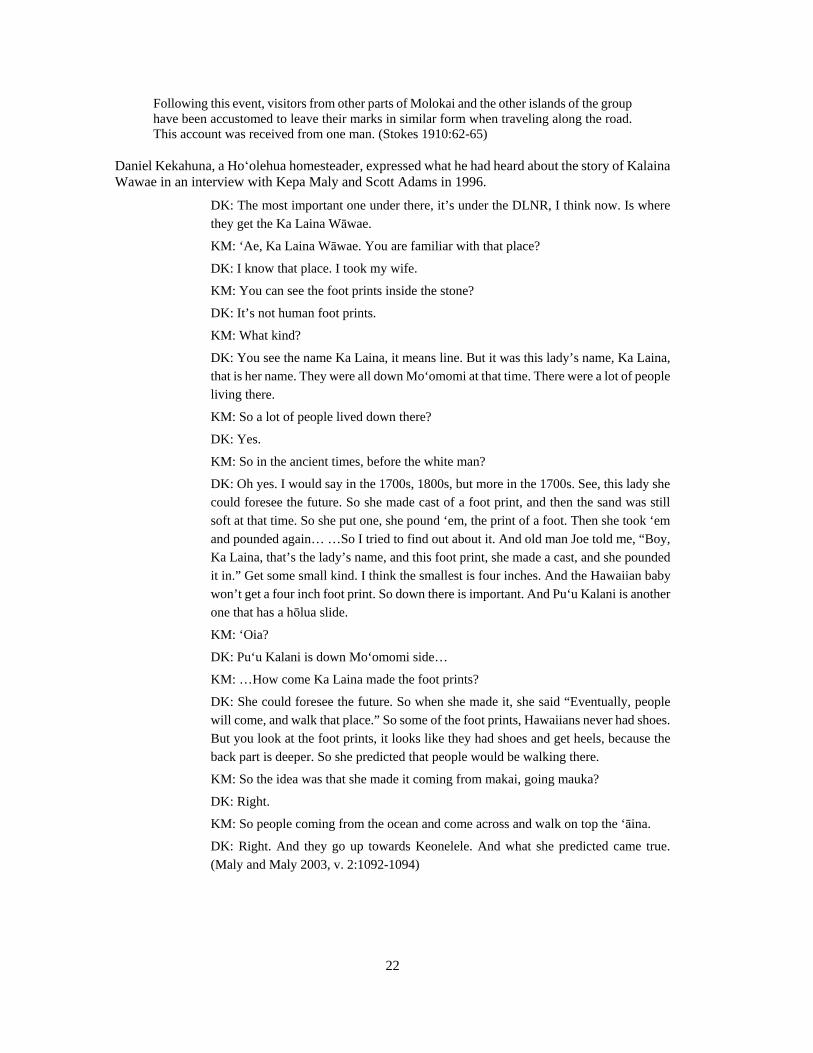
22
Following this event, visitors from other parts of Molokai and the other islands of the group have been accustomed to leave their marks in similar form when traveling along the road. This account was received from one man. (Stokes 1910:62-65)
Daniel Kekahuna, a Hoʻolehua homesteader, expressed what he had heard about the story of Kalaina Wawae in an interview with Kepa Maly and Scott Adams in 1996.
DK: The most important one under there, it’s under the DLNR, I think now. Is where they get the Ka Laina Wāwae.
KM: ‘Ae, Ka Laina Wāwae. You are familiar with that place?
DK: I know that place. I took my wife.
KM: You can see the foot prints inside the stone?
DK: It’s not human foot prints.
KM: What kind?
DK: You see the name Ka Laina, it means line. But it was this lady’s name, Ka Laina, that is her name. They were all down Mo‘omomi at that time. There were a lot of people living there.
KM: So a lot of people lived down there?
DK: Yes.
KM: So in the ancient times, before the white man?
DK: Oh yes. I would say in the 1700s, 1800s, but more in the 1700s. See, this lady she could foresee the future. So she made cast of a foot print, and then the sand was still soft at that time. So she put one, she pound ‘em, the print of a foot. Then she took ‘em and pounded again… …So I tried to find out about it. And old man Joe told me, “Boy, Ka Laina, that’s the lady’s name, and this foot print, she made a cast, and she pounded it in.” Get some small kind. I think the smallest is four inches. And the Hawaiian baby won’t get a four inch foot print. So down there is important. And Pu‘u Kalani is another one that has a hōlua slide.
KM: ‘Oia?
DK: Pu‘u Kalani is down Mo‘omomi side…
KM: …How come Ka Laina made the foot prints?
DK: She could foresee the future. So when she made it, she said “Eventually, people will come, and walk that place.” So some of the foot prints, Hawaiians never had shoes. But you look at the foot prints, it looks like they had shoes and get heels, because the back part is deeper. So she predicted that people would be walking there.
KM: So the idea was that she made it coming from makai, going mauka?
DK: Right.
KM: So people coming from the ocean and come across and walk on top the ‘āina.
DK: Right. And they go up towards Keonelele. And what she predicted came true. (Maly and Maly 2003, v. 2:1092-1094)

23
Maohelaia
According to Martha Beckwith, Maohelaia was a plain on Moloka‘i where the friendless spirits are said to dwell. These spirits enjoy causing trouble so people would have avoided this plain. She refers to the newspaper article by Samuel Kamakau that appeared in Ke Au Okoa October 6, 1870.
The worst fate that can befall a soul is to be abandoned by its aumakua and left to stray, a wandering spirit (kuewa) in some barren and desolate place, feeding upon spiders and night moths. Such spirits are believed to be malicious and to take delight in leading travelers astray; hence the wild places which they haunt on each island are feared and avoided. Such are the plains of Kamaʻoma̒o on the island of Maui, the rough country of Kaupea at Pu̒ uloa on Oahu, Uhana on Lanai, Maohelaia on Molokai, Mana on Kauai, Halaliʻi on Niʻihau. In these desolate places lost spirits wander until some friendly aumakua takes pity upon them. (Beckwith 1970:154)
(Kamakau 1870 10/06)

24
Battle with O‘ahu
Kuali‘i, the king of O‘ahu was living at Hilo when he learned of the trouble on Moloka‘i. Several battles had been fought and there was continual conflict between the chiefs of the windward side and the chiefs of the leeward side.
The cause of all the trouble was this: The chiefs on the Koolau side of Molokai were anxious to get possession of Kekaha, a stretch of country from Kawela to Maamomi [sic]; and the reason why these chiefs were so desirous of getting possession of this section of country was on account of the fishing. But the chiefs of Kekaha, knowing the value of these fishing grounds, were determined to hold on to them; so this determination on their part caused a general internal conflict at this time. (Fornander 1916-1917:416+)
Kualii left Hilo and ultimately arrived at Kamalo with his canoes and men. Paepae, a chief of Kekaha, landed at Kamalo at the same time and sought the help of Kualii.
I have come to entreat you to come to our rescue. The chiefs of Koolau have taken up arms against us with the intention of taking away from us our lands from Kawela to Maamomi. Because of this desire on their part we have had several disputes and a battle is about to commence. A minor engagement has already taken place, however, in which we were beaten. The majority of the chiefs are encamped on the top of Maunaloa. (Fornander 1916-1917)
Kuali‘i agreed to help the chiefs of Kekaha and the canoes proceeded to Kaunakakai. The chiefs met there in Kaunakakai before leaving for Moʻomomi. The men sailed the canoes around West Moloka‘i, while Kuali‘i and the Moloka‘i chiefs walked over the land to Moʻomomi. At Mo̒omomi the chiefs boarded the canoes and set sail for Kalaupapa where Kuali‘i and his men defeated the Kalaupapa chiefs.
The battle continued when the other chiefs of Koʻolau arrived with their men. Following these battles, Kuali‘i “made a new division of the lands” and left Paepae and his wife Manau in charge of Moloka‘i before going live at Kailua on O‘ahu (Fornander 1916).
Mele and Oli
A mele found in an early Hawaiian newspaper references Maohelaia, a place in the Moʻomomi area.
“He Mele no Kawaikini.” [excerpt]
Kiekie Haupu, ke poo o na mauna, Nani ka lala pali o Kaunuohua, Ke kui ia mai la e Honokikiopua,
Hono na umauma pali o Malelewaa,
Ka oiwi hemolele o ke alo o ka pali,
Pahee ke alo pali o Haihala i ka makani,
Kupu no a kiekie iluna o Mauna Loa,
Ka akelakela o na lehua o Kaana,
I ku ia mai ke iu me Papalauahi,
He like wale no ka hono o na kuahiwi, Ke nana iho ia Maohelaia,
He nani ke kula pili o Kalaeloa, Ka molalelale i apua Kalamaula,
I ka hoomea e ke kiu alani makani o Lehua, (Lohiau 1861)
25
An 1862 mele inoa, or name chant, for Kauikeaouli includes references to both Maohelaia (moohelaia in the mele) and Kaiolohia.
“Eia Hou Keia Inoa no Kauikeaouli.” Kuu la i moohelaia,
O na mauna o Maunaloa,
O ka lipo ko Kaiolohia,
He anoano ia i ka la,
O a'u lehua i wini wai e,
O kai peleiliahi,
Kai ilikia e Kaikioe,
O ke kaeleloli o Punalau,
Kolohe wale ia ia'u e,
Eia oe, —O-o-e, —Ie.
O ka lai a ka manu ke aloha,
Ua powa ia e ka makani,
Na ka welelau kumu maomao,
Nana i hoohaoe kekai,
Ino ai hilia i hoohilia e,
Eia oe, —O-o-e, —Ie.
O oe no ka mea manao a loko,
O ko lua leo i waiho mai,
Malama no wau pulama,
Ina iho na loko ka ole,
Ua ikea i ka ohe-nana e-a.
Na KAULUHAIMALAMA.
(Kalanimoku 1862)
Kaialohia is referenced in the book titled Dynastic Chants, Ancestral Chants, and Personal Chants of King Kalākaua I.

26
(Hawaiian Historical Society 2001:137)
Another mele found in the same book mentions both “Kaialohia,” thought to be Kaiolohia, and Maohelaia.
Lei Maunaloa kilohi i ka maikai,
Hanohano Kaialohia i ka makani,
Ke iki aku i ka lawelawe malie,
Waiho malie ka ia o Hilia i ka makani e—ilaila,
A malie kaao lai ke kioea,
Maikai ka nana a ka la i ke kula,
I uliuli e mapu i ka lau laau,
Enaena i ke alo o Maohelaia,
Hihina kauwahi noe i ke pili,
I walea i ka makani haunailoli,
Hoi ka manu noho i Palaau e—ilaila,
Lalaau ke kanaka ke kuleana o ka moe,
Owau nae kai ola i kou aloha,
Oe anei—e.
Malama na lima o ka malu kauwa,
E malama ana i ke kula o Kalae.
Kaili ala i Mapuakekua,
I mapu i ka la ke ala a ka maikai e—ilaila,
He maikai i ke kula na lehua o Kaana,
E hoopiha ana i piha ke alo pali,
Na kumu pali o Nihoa,

27
Ua maikai i ka hana ia e ke hukai e—ilaila,
Koi mai ana ke kulia moe ia nei,
Lohea ana kona inoa he kulia,
Oe anei—e. NA HOAAI
(Hawaiian Historical Society 2001:172–173)
In Fornander’s “Story of Lonoikamakahiki,” the “barren coast of Puumomi” at Kaluakoʻi is mentioned in a chant.
Ka uala o Puukamaele,
O Kipapai o Honokaupu.
O ka Oopu o Waikolu,
E hoi ana wau e ai,
He kala kuu ia e ai ai
A maona.
He ia pa ia na kuu akua;
Hookomokomo ka waa
O Kaluakoi,
Ke kaha wale i Puumomi,
Hoomo Wailau
O Umipiilani.
The potatoes of Puukamaele,
Of Kipapai, of Honokaupu,
Of the Oopu of Waikolu.
I am going home to partake of some food.
The kala shall be my fish
Until satisfied.
It is a fish sacred to my god.
Let the canoe enter
At Kaluakoi,
The barren coast of Puumomi,
At the entrance of Wailau,
Of Umipiilani.
(Fornander v4:304)
Mary Kawena Pukui translated the following chant with reference to Kaiolohia, said to call one back to Kāʻana.
ʻUla Kala̒ eloa i ka lepo a ka makani
Kai ho̒ onu̒ anu̒a ̒ ia ̒ āpua Kalama̒ula
ʻIkea ku̒u mana̒o i a̒ u kula
Hea mai Kaiolohia
ʻEu ho̒i māua i Kāʻana ē Aloha ia̒ u ke kula o Niniwai
Oʻu hoa i Kala̒iakamanu ē

28
Manu a hoa laukona i ke keʻe lau
Auʻa ̒ ia e ka moe inā ke loha lā he ̒ai lili kā Aia ua ̒ ike au
Red is Kala̒eloa with Dust
Red is Kala̒eloa with dust raised by the wind,
The dust concentrates at Kalamaʻula as though it were a basket.
At the sight of it I thought of my plain.
Kaiolohia calls to me
To return to Kāʻana
In love am I with the plain of Niniwai,
With my companions at Kalaʻiakamanu (haunt of birds),
Bird companions that shy away among the leaves.
Love that is dreamt of is held back by jealousy,
This is known.
(Pukui 1995)
‘┖lelo No‘eau
A few ‘┗lelo no‘eau were found that refer to places near Mo‘omomi, although none could be found for Mo‘omomi specifically. The following Hawaiian proverbs and poetical sayings provide further insight to traditional beliefs and practices of these lands.
Keala pūpū i Molokaʻi. The path of seashells of Molokaʻi. Among the noted things made by Kihaapiʻilani, ruler of Maui, was a paved road lined with seashells at Kaluakoʻi, Moloka̒ i. (Pukui 1983:181)
Ke one lele o Mo̒ohelaia. The flying sands of Moʻohelaia.
When the sands of Moʻohelaia, Moloka̒i, were blown about by the wind, it was believed that ghosts were present. (Pukui 1983:191)
Waiho akāka ke kula o Kaiolohia. The plain of Kaiolohia lies in full view.
Said of something obvious. (Pukui 1983:318)
Historical Background
This section presents information on Māhele-era land tenure, descriptions and maps from early visitors to Hawai‘i, and the history of deer on the island. Together, this information helps to paint a picture of what Mo‘omomi was like in the 18th to 20th centuries and gives us a better understanding of the region today.
Historic Accounts from Early Visitors
In the summer of 1854, French naturalist Jules Remy traveled to the island of Moloka‘i. During his time on the island he made a number of excursions to study the plants of the island. Even though

29
people tried to discourage him from traveling to the west end of the island, Remy went anyway. He describes the ride on horseback from Waialala, above Kalae, to Moʻomomi.
June 22, 1854 - Thursday
Kalae to Kaluakoi
The western end of Molokai comprises a sort of district called Kaluakoi, of relatively considerable extent, easily accessible and easy to travel over, but the soil of which is too poor to attract people to live on it; and they also told me it was like a desert, and advised me not to visit it. All the more reason for me to judge it with my own eyes.
I separated myself from my personnel [at Waialala], whom I sent on to follow the abbe and to await me on the shore of Kaunakahakai, and at 9 o’clock I mounted my horse, accompanied by the three best riders in the country. The rain which fell gently since the morning gradually stopped and the sun shined forth with as fine effect as one could wish. We descended from the plateau by a gently inclined slope, leaning a little to the right, to the northwest. Out of one house situated at the edge of a winding ravine came a good man carrying a present for me of small dried fish. The pili grass which we trampled was bedecked with blue convolvulvus. In the middle of a watermelon patch young people were playing noisily; at my approach the girls fled or hid in the shrubbery, while the boys gazed at me fixedly, gaping. Soon we reached the height of the escarpments which I had seen from Kalaupapa; here we rode for some time through stretches of bushes and scrub land: woody violets of the same species as that found on Niihau, called here pamakani, several comositae looking the same as those found on Niihau; wild celery (makou) which is very abundant; a Portulacaceae, etc., etc. (Remy 1893)
Remy goes on to discuss all the plants he saw as he rode through the Moʻomomi sand dunes and then up the Keonelele slope.
Farther on we galloped over a sandy soil, where grew side by side a heliotrope (hinahina), a gnaphalium (enaena) which is tomentose in nature, a scaevola with yellowish flowers. On the same kind of soil I saw vast spaces entirely covered with frutescent, shrubby, leguminosae (ohai), spreading over the ground, with flowers of a superb red color; these were without a doubt, a kind of agati but differing from species seen on Kauai and on Niihau, which grows up to form large bushes and even small trees, instead of the one here which forms branches which are literally apliqueed on the sand as if buried in the sod.
We galloped without slackening our pace between the sea, which we saw on our right, and the rounded hillock called Maunaloa, which was on our left. We ascended a long hill with whitish compact terrain, on which grew frutescent solanaceae, three species of euphorbia, a crawling chenopodium, a labinate with linear leaves, and lichens in profusion. At the bottom of the hill were traces of former cultivation and of huts in ruins. Next was the great sandy plain covered with turf and thinly scattered plants: a hydrophyllaceae, a gentian, and a lepidium. (Remy 1893)
The plants that Jules Remy mentions in his travels over Moʻomomi are included in his listing reproduced in Table 1.
Archaeologists, as well as other historians, have consistently referred to the West end of Moloka‘i as a wasteland, described as “a desert strip” (Wentworth 1925), “dreary and barren” (Vancouver 1798 in Bonk 1954), and a “naked dreary barren waste” (Menzies 1920). Kamakau called Kaluakoʻi “a desolate land, a land of famine” (1961). It seems, however, that not everyone shared these opinions and some people were very happy to live in such conditions. When Remy visited the west end of the island in 1854 he found two very content couples living there.

30
Table 1. Mo‘omomi Plants ca. 1893 (after Remy 1893)
Remy Family Genus Species Variety St. John Page #
1 pili Gramineae Heteropogon contortus p. 31
2 convolvus Convolvulaceae Ipomoea Sp. p. 284
3 watermelon Cucubitaceae Citrullus lanatus p. 334
4 pamakani Violaceae Viola robusta p. 238
5 compositae Compositae p. 348
6 makou Cornaceae Peucedanum sandwicense
p. 265
7 portulacaceae Portulacaceae Portulaca Sp. p. 156
8 hinahina Boraginaceae Heliotropium anomalum
p. 288
9 enaena Compositae Gnaphalium sandwicensium
p. 358
10 scaevola Goodeniaceae Scaevola Taccada serica naupaka p. 347
11 ohai Leguminosae Sesbania tomentosa p. 193
12 solanaceae Solanaceae Solanum nelsoni p. 301
13 euphorbia Euphorbiaceae Euphorbia Spp. p. 210
14 chenopodium Hydrophyllaceae Chenopodium pekeloi p. 150
15 hydrophyllaceae Hydrophyllaceae Nama sandwicensis p. 287
16 gentian Gentianaceae Centaurium sebaeoides
p. 278
17 lepidium Cruciferae Lepidium o-waihiense p. 166
All page numbers refer to Harold St. John’s List and Summary of the Flowering Plants in the Hawaiian Islands, Pacific Tropical Botanical Garden. Memoir No. 1 Lawai. 515 pp
The Shore of Kaluakoi
At 3 o’clock, after having for a long time leaned steadily to the left, we arrived at the edge of the sea, facing the island of Oahu, from which we could make out in the west-northwest a small hilly area. As far as the eye could see on the flat shore where we were, there were only three small isolated huts. We went towards the least shabby of these, with the intention of spending the night. It was occupied by two fishermen and their wives, two couples who were very simple and good-hearted. All that they had in the way of provisions, - some poi, sweet potatoes, and salted fish - they placed before us. Seeing that I was unable to drink the brackish water, which they were accustomed to drink, one of the women ran to fetch from the sand of a hillock a reddish liquid which I found more potable, but it, nevertheless, made me nauseated. Almost at once I felt sick at my stomach which filled me with disgust for the hospitable hut, also infested and infected with cockroaches, not to speak of other vermin. At the risk of sleeping under the stars, I decided to push on farther. In taking leave of my hosts, whose lot seemed to me much to be pitied, I advised them to start removing their penates to some more habitable place. Ah! How far from the mark we were! They replied to me with a sort of animosity, as if they doubted my good sense: “Why should we think of changing the place of our abode? What place could be better than right here, where the sky almost never sends us rain, and where the sea gives us fish in abundance?” [emphasis added]

31
South to Papohaku
At 4:30 p.m. I took leave of these happy mortals to travel to the south… (Remy 1893)
George Cooke settled on Moloka‘i in 1908 with his family. He soon moved into the position of manager for the Molokai Ranch after his father bought up the stock in the company. In his book, he recounts early life on the ranch and how they would “break” new mules at Moʻomomi.
At the beginning of our agricultural experiments, we had work mules available. Some of these had already been sold to the sugar plantations. Later, the light weight mares, unsuited for raising riding stock, were bred to a small jack. The light weight mules were much in demand by the sugar plantations for use as pack mules along the Hamakua coast of Hawaii.
The method of training these mules as pack animals was to drive them to Moomomi. Here they were blindfolded and, after the pack saddles were cinched, a bag of sand was loaded on each side. The blindfolds were removed and, after a few cavortings, the mules were tamed down enough to be led back to Kualapuu, where our main camp was located. Their loads of sand were used for concrete. By this method ‘two mynahs were killed with one pohaku (stone).’ (Cooke 1949:55–56)
Cooke also wrote about burials at Keonelele being from a shipwreck on the western shore of the island. He wrote that John Puaa told him they were Chinese “coolies.”
In the middle of what is now Keonelele pasture, there are many skeletons buried in a sandhill about a quarter of a mile from where the road to Ka Lae o ka Ilio crosses the drifting sands. These are the remains of Chinese coolies who were being transported by sailing vessel from China to the west coast of South America. Their ship was wrecked near Kamakaipo. Those who escaped inland died of hunger and thirst. Their bodies were collected by the Hawaiians and buried in the sandhills. This was told to me by John Puaa, a former luna (foreman) of our ranch. (Cooke 1949:106–107)
Daniel Kekahuna also discussed the Keonelele burials in an interview with Kepa Maly and Scott Adams in 1996. His details are very similar to those in Cooke’s book cited above.
KM: And then below, that’s Keonelele where the sand is pushed up?
DK: Yes.
KM: Keonelele is an important place?
SA: Today, the whole area they call Keonoelele, eh?
DK: Yes, but it’s not.
KM: So just the low side?
DK: Yes.
SA: Where are the skeletons?
DK: Down there. See where those white dunes are?
KM: Yes.
DK: All inside there, that’s burial grounds. They say it’s all Hawaiians, but I believe some were the Chinese coolies. Because they were bringing the Pākes to Hawai‘i. They came as far as Kepuhi, I think it was, then they had a ship wreck. So they tried to walk, but they couldn’t find water. But get water down there. The old Hawaiians, they knew where the water was. The Pākes didn’t know, so they died inside there. (Maly and Maly 2003, v. 2:1092–1094)

32
In Kepa Maly’s interview with Lawrence Joao, Sr. in 1996, “Braddah” Joao provides interesting details regarding the burials in the Moʻomomi area.
KM: Yes, let's talk about that. [referencing point on map of Molokaʻi] …In your youth, Māhana like this had old Hawaiian places too?
LJ: Oh yes, yes. But you can hardly see that already, because how many years cattle have been moving on top of that land.
KM: So the land is all…?
LJ: Everything is smashed down. And the closer you go down to the beach now; you go down to Mo̒omomi side, so places over grown with kiawe, you can't see anything inside there.
KM: But underneath still has sites, yet?
LJ: Oh yes. Even get the heads over there with the round hole inside the skull, and with the lead… Hawaiians had no more lead before. Somebody must have slaughtered them. But I never heard my father them, or any body say that somebody murdered these people.
KM: So that's Hawaiian graves?
LJ: Yes…
KM: …So this Keonelele, Mo̒omomi, was a known burial area?
LJ: Sure! That's all sacred. (Maly and Maly 2003, v. 2:1102)
William Alanson Bryan visited Mo‘omomi in the early 20th century during the research for his book, Natural History of Hawaii: Being an Account of the Hawaiian People. He published several photos of Mo‘omomi, one of a rockshelter, labeled as “Abandoned cave dwelling in sandstone cliff at Moomomi” and another of fossil root casts, captioned “Exposed fossil root casts, in dunes on Molokai” (Figure 8). Anther series of photos show the Mo‘omomi landscape, one captioned “General view of the dune area at Moomomi” and another “Erosion of a solidified dune, Moomomi” (Figure 9).
Henry Rudolph Meyer was born in 1855 and was the third child of R.W. Meyer. By trade he was a farmer, but through the years he was also a mail carrier and a police officer. Of all the Meyer boys, Henry was the first to build his own home in Kalae. At some point, Henry Meyer “built a small house at Mo‘omomi Beach for family use and later for others who would go to the beach” (Figures 10 and 11) (Meyer 1982:151). Charles Meyer writes about fishing excursions to Moʻomomi.
Fishing for ulua was a great sport for the Meyers. Around 1915 all of the Meyer brothers were able to purchase Model T Fords and on Sundays they would take their families to Moomomi beach to swim and to fish for uluas. (Meyer 1982:152)
It was not until around 1915 when the Meyers were able to relax from ranch operation that they began to go to Moomomi and other beaches to fish. The third generation of Meyers did much more fishing than did their forebears.
A good fishing partner of the author's was Albert Inaba, Principal of the Molokai High School for over 30 years. I recall one occasion in which we went to Hinanaulua (Honey Bee) and hooked over 125 enenui. On another trip to Paulaia beach (Moomomi large sand beach) we hooked 140 papiopio (pompano) or young ulua ranging in size from one to five pounds in less than five hours. (Meyer 1982:247)

33
Figure 8. Rockshelter at Mo‘omomi (center) and fossil root casts (bottom left) (Bryan 1915:147).
When the homesteads were established in Hoʻolehua, the settlers would go fishing at Moʻomomi. One of these early homesteaders was Mary Lee who came to Moloka‘i as a child with her family in 1925. As an adult she recounted memories of this time.
…the Waikapuu people knew how to fish so they went down to Moomomi (beach on Moloka̒ i) to fish for turtle. Turtle meat, fishing and torching and daytime working on the land. What you have you share, if you had plenty fish you share with others. (Dooley and Mowat 1979:22)
Keesing, in discussing issues involving the Hawaiian Homesteaders on Moloka‘i, refers to a proposal to develop facilities at Mo̒omomi Beach as a way for the upland Hawaiians to access the ocean resources.
Above all, some worthwhile activities for adolescents and young men and women who have finished school seem to be needed. …A suggestion which would be of benefit to the homesteaders as a whole is that a community rest-house and camping place, with shade
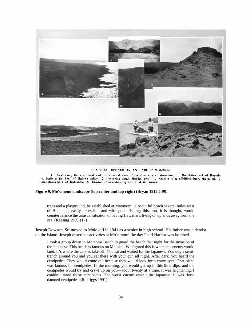
34
Figure 9. Mo‘omomi landscape (top center and top right) (Bryan 1915:149).
trees and a playground, be established at Moomomi, a beautiful beach several miles west of Hoolehua, easily accessible and with good fishing; this, too, it is thought, would counterbalance the unusual situation of having Hawaiians living on uplands away from the sea. (Keesing 1936:117)
Joseph Dowson, Sr. moved to Moloka‘i in 1941 as a senior in high school. His father was a dentist on the island. Joseph describes activities at Moʻomomi the day Pearl Harbor was bombed.
I took a group down to Momomi Beach to guard the beach that night for the invasion of the Japanese. This beach is famous on Molokai. We figured this is where the enemy would land. It’s where the canoes take off. You sat and waited for the Japanese. You dug a semi-trench around you and you sat there with your gun all night. After dark, you heard the centipedes. They would come out because they would look for a warm spot. That place was famous for centipedes. In the morning, you would get up in this little dips, and the centipedes would try and crawl up on you—about twenty at a time. It was frightening. I couldn’t stand those centipedes. The worst enemy wasn’t the Japanese. It was those damned centipedes. (Rodriggs 1991)

35
Figure 10. The Meyer family at Mo‘omomi (Meyer 1982:151)
Figure 11. Albert A. Meyer at Mo‘omomi (Meyer 1982:187)

36
Māhele Land Tenure and Land Ownership
The change in the traditional land tenure system in Hawaiʻi began with the appointment of the Board of Commissioners to Quiet Land Titles by Kamehameha III in 1845. The Great Māhele took place during the first few months of 1848 when Kamehameha III and more than 240 of his chiefs worked out their interests in the lands of the Kingdom. This division of land was recorded in the Māhele Book. The King retained roughly a million acres as his own as Crown Lands, while approximately a million and a half acres were designated as Government Lands. The Konohiki Awards amounted to about a million and a half acres, however title was not awarded until the konohiki presented the claim before the Land Commission.
In the fall of 1850 legislation was passed allowing citizens to present claims before the Land Commission for lands that they were cultivating within the Crown, Government, or Konohiki lands. By 1855 the Land Commission had made visits to all of the islands and had received testimony for about 12,000 land claims. This testimony is recorded in 50 volumes that have since been rendered on microfilm. Ultimately between 9,000 and 11,000 kuleana land claims were awarded to kama̒āina totaling only about 30,000 acres and recorded in ten large volumes.
Today, Kaluako̒i is a single ahupua̒a land division, but it seems that Kaluakoʻi was previously considered a kalana. According to Robert King, at the time of the Mahele, “…the ahupuaas of Kaluakoi 1, Kaluakoi 2 and the ili of Punakou, in the west end of the island were said to be in the kalana of Kaluakoi” (1935). Chinen informs us that a kalana land division was simply a geographic subdivision, while ahupua̒a were land divisions that were personally administered by individuals.
“The largest unit or division of land was, naturally, the island. Each island was then divided into a number of districts called “mokus.” These districts or mokus were geographical subdivisions only, and no administrators were assigned to them. …The unit next smaller to the district was the kalana. This, too, was a geographical subdivision only, and is not of much importance today.
A moku was divided for landholding purposes into units called “ahupuaas,” each of which was ruled by either a chief or a konohiki. The ideal ahupuaa extended from the sea to the mountains, enabling the chief of the ahupuaa and his followers to obtain fish and seaweeds at the seashore, taro, bananas, and sweet potatoes form the lowlands, and forest products from the mountains.” (Chinen 1958)
Within the kalana of Kaluako̒i, the ahupua̒a of Kaluako̒i 1 and 2 were held by Kupa and J. Stevenson, respectively. Both individuals returned their ahupua̒a to the Hawaiian Government at some point during the Māhele (Soehren 2010).
Five kuleana claims were presented to the Land Commission by residents of Kaluako̒i during the Māhele, all of them living along the southern coastline and not near the project area. None of these claims were awarded by the Land Commission and the entire kalana of Kaluako̒i remained with the Hawaiian Government (Hawaiian Kingdom 1846–1848, pp. 274–275, 313–314).
Charles Meyer described the succession of ownership of Kaluakoʻi between the Māhele and its acquisition by Charles Reed Bishop in 1875, however he may be mistakenly attributing ownership to the aliʻi personally rather than to the Hawaiian Government.
This section of Molokai belonged to the Kamehamehas following the Great Mahele (land tenure revision by Kamehameha III) in 1848. This land was owned by Kamehameha IV and later by his brother, Kamehameha V. When Kamehameha V died in 1872 this land was willed to High Chieftess, Princess Ruth Keelikolani, a half sister of Kamehameha IV and V and a cousin of Bernice Pauahi Bishop. The West Molokai Section is known today as

37
the Kaluakoi lands and these lands were given to Mr. Charles R. Bishop in 1875 as he was the husband of Bernice Pauahi Bishop, the daughter of Paki and Konia, and the last descendant of the Kamehameha dynasty. (1982:6)
In 1875, Charles Reed Bishop obtained a Land Grant from the Hawaiian Government (L.G. Number 3146) and purchased the entire 46,500 acre ahupua̒a of Kaluako̒i. Difficulties with the ranch eventually prompted Bishop to sell the property.
When the ranch seemed greatly burdened by problems such as frequent droughts, and loss of cattle and sheep due to sickness and poor reproductive performance, Mr. Bishop decided to have the Trustees of the Bishop Estate sell the Kaluakoi lands and reinvest the proceeds. (Meyer 1982:106)
On February 2, 1898, the Bishop Estate ranch lands, totaling over 60,000 acres by then, were sold at public auction for $251,000 to Arthur Daggett McClellan. McClellan purchased the property for the Hartwell Company (Hawaiian Star, February 2, 1898). The new Molokai Ranch Company was then incorporated on February 5, 1898 with Alfred S. Hartwell as president. The other members were Arthur D. McClellan, Alfred W. Carter, W. R. Castle and Olaf Sorenson. No stock in the company was offered for sale (Hawaiian Star, February 5, 1898).
The project area lands were later purchased by The Nature Conservancy, who established the Moʻomomi Preserve in June of 1988. The purpose of the preserve is “to protect the most intact coastal sand dune ecosystem in the main Hawaiian Islands” (The Nature Conservancy 2011). The preserve includes 921 acres from sea level up to about the 210 m (690 ft.) elevation (Figure 12). The landscape “is characterized by sea cliffs…windswept sand beaches, a prominent foredune, and rows of unconsolidated upper sand dunes just inland of the beach” (The Nature Conservancy 2011).
Historic Maps
Historic maps and photos help to paint a picture of Mo‘omomi in years past and illustrate the changes or lack of change that has taken place in the region. The earliest map found for the study area is a Hawaiian Government Survey map (Figure 13). It shows place names along the coast, as well as topographic features like beach and cliff zones, and the extent of sand deposition inland. A well and a house are depicted near Mo‘omomi Bay, and a windmill and possible water trough are illustrated inland.
A map from the same era depicts the water resources on the island of Moloka‘i (Figure 14). Like the former map, this one shows place names along the coast and the extent of the sand zone. An “Old Well” is labeled near the coast, and what possibly says “house” is written near the well. What appears to read “Mo‘omomi Well and Wind Mill” is shown in the vicinity of the windmill, suggesting the possible trough in the former map symbolized a well. A dashed line that skirts the coast and heads inland after the windmill probably represents a road or trail.
A 1922 USGS quadrangle shows the area in further detail (Figure 15). The region appears a bit more modernized, with Kawakiu Road and Kualapuu Road shown. A storage tank is illustrated at the end of Kawakiu Road, and the windmill is still depicted. The house and well at Mo‘omomi can no longer be seen, however. A 1952 USGS quad shows even further development of the roads in the vicinity of Mo‘omomi, and the windmill is still labeled (Figure 16).
On a 1968 USGS quad, an alternate route to Kaiehu Point was added on the west (Figure 17). The coastal road at Mo‘omomi Bay now continues past Naaukahihi, but the east-west connector road inland of Kawahuna is missing. The windmill is still shown but is now labeld at “WT.”

38
Figure 12. The boundary of the Nature Conservancy’s Mo̒omomi Preserve (after The Nature Conservancy 2011).
The final map presented dates to 1983 (Figure 18). On this map there is a distinction between roads and 4WD trails, so the network of thoroughfares in the region can be seen in more detail. Two radio towers are depicted inland of Kapalauoa, and the windmill is replaced by a corral.
Historic Newspaper Articles
A search was conducted for newspaper articles containing references to Moʻomomi, including the various place names and features of the area. For the English language newspapers, excerpts are taken from the longer articles, as the reader is referred to the original source for the full text. A long list of Hawaiian language newspaper articles pertaining to Mo‘omomi was compiled. It is beyond the scope of this project, however, to translate them all. The list is provided in Appendix A for future research, and a selection of key articles are each summarized in the section below.

39
Figure 13. Portion of Hawaiian Government Survey Map of Moloka‘i (Monsarrat 1886).

40
Figure 14. Portion of water resource map of Moloka‘i (Lindgren ca. 1900).

41
Figure 15. Portion of Mahana Quadrangle (USGS 1922).

42
Figure 16. Portion of Molokai Airport Quadrangle (USGS 1952).

43
Figure 17. Portion of Molokai Airport Quadrangle (USGS 1968).

44
Figure 18. Portion of Molokai Airport Quadrangle (USGS 1983).

45
English Language Newspapers
1859 The bark Jacob B. Lancaster sank off of Mo̒omomi in July of 1859. A series of stories appeared in the local papers, primarily The Polynesian, detailing the accident and subsequent attempts at salvaging her cargo.

46
(Pacific Commercial Advertiser 1859 07/14)
1895 C. M. Hyde relates that the “natives fish with a net” at Moʻomomi, but that it is a dangerous occupation as evidenced by the numerous skeletal remains exposed by the wind in the sand.
(Hyde 1895 09/17)
Hyde, in his “Rambling Notes on Molokai,” describes an underwater spring at Moʻomomi Bay where “the natives get their drinking water…when occupying the spot temporarily as a fishing station.”
(Hyde 1895 09/17)

47
In his paragraph on Keonelele, Hyde gives a very poetic description of seeing the sands blown in the wind saying that “the clouds of sand, as the sun strikes them, have the appearance of flames of fire.”
(Hyde 1895 09/17)
Hyde speculates that the footprints at Kalaina Wawae, or as he wrote “Ka laina wawae,” were formed when the sand was soft and subsequently hardened, preserving the footprints in sandstone. He offered the alternative possibility that they were natural formations simply having the appearance of human “foot-steps.”
(Hyde 1895 09/17)
1897 One of the earlier articles discussing the potential sale of the Molokai Ranch appeared in the Hawaiian Star on December 21, 1897. The plan to start a sugar plantation was even proposed at that time.

48
(Hawaiian Star 1897 12/21)
1898 The Pacific Commercial Advertiser ran an article in the January 7, 1898 issue, describing the announced sale of Molokai Ranch. It is interesting to see the detailed listing of lands, including the 46,500 acre Kaluakoʻi parcel (Royal Patent 3146) which had been purchased from the Hawaiian Government by Charles Reed Bishop in 1875.

49
(Pacific Commercial Adveriser 1898 01/07)
The auction for Molokai Ranch was held on February 2, 1898 and reported in both The Evening Bulletin and The Hawaiian Star the same day. The Pacific Commercial Advertiser ran the story the following day. The “lively bidding” is described and the property was ultimately sold with a winning bid of $251,000 going to Arthur D. McClellan, a wealthy capitalist from Boston.

50
(Evening Bulletin 1898 02/02)

51
(Hawaiian Star 1898 02/02)

52
(Pacific Commercial Advertiser 1898 02/03)

53
1922 Kenneth Emory wrote an article on the footprints made in the lava on the slopes of Kahikinui in Maui. In that article he states that the footprints at Moʻomomi were chipped out of the coral “within the last hundred years.”
(Emory 1922 06/02)
Hawaiian Language Newspapers
Note: Articles appearing in the Hawaiian newspapers generally did not contain diacritical marks (ʻokina and kahak┗), and are presented here as found. Only excerpts are listed for longer articles and the reader is referred to the original sources for the complete text.
1861 In this article regarding cattle rustling on Moloka‘i, the thief claims it is turtle meat from Moʻomomi. Upon further examination the thief admits that it is stolen beef.
“No ka Aihue.”
E ka Hae Hawaii e---Aloha oe:
Ke hai aku nei au ia oe, i kekahi hihia nui i hookolokoloia, ma ka aha apana o Molokai no ka aihue bipi. He kanaono ka nui o ka poe i hoopai ia, a he poe hoahanau kekahi oia poe aihue, a he mau Luna Ekalesia kekahi oia poe; ua hui pu a hana i kela hewa aihue; a ma ka

54
hookolokolo aha, ua hookuu ia kekahi poe, a ua hoopaa ia kekahi poe; o kekahi luna o ka ekalesia kekahi i hoopaa pu ia e ua aha la.
Eia ke kumu o ka ike ia ana o keia poe aihue. Ua haohao nui na haole mea bipi i ka nalowale o na bipi, e holo ana ma Kalae ma ka puai komohana o Molokai. A i na la hope iho nei o kela makahiki i hala iho nei, a malaila wau, a ua nalowale kekahi o ka'u mau bipi, a ia'u malaila, e nene ia ana ka aihue bipi, a he olelo ano e ke olelo ia ana. He io honu no Moomomi, a ua niele aku au, a ua hu mai ka haina he io bipi aihue, nolaila, ua hoopii ia keia poe imua o ka ahahookolokolo no ka aihue. (Ka Hae Hawaii 1861 02/06)
1870 Maohelaia on Moloka‘i is said to be a place of wandering spirits, of friendless spirits.
(Kamakau 1870 10/06)
1875 The “spring of Mo̒omomi” is mentioned in this article by Paheeikauai published in 1875. This spring can be seen from Maunaloa.
(Paheeikauai 1875 08/07)
No Maunaloa.
O ka alua keia o na mahele aina nei o Molokai nei, oia kahi e nana pono aku ai ia Oahu, malaila ka lae o Kalaau a me Kaluakoi, a malaila no na lehua o Kaana a me ka punawai o

55
Moomomi, aia no malaila kahi o Kalaipahoa i hooipo [?] ai me Kapo mai lele, i olelo ia ma na kaao Hawaii e ka poe malihini i ano ike ole ia Molokai nei, e hoomanao iki i keia mau kuhikuhi, ka oukou kauwa haahaa.
R K PAHEEIKAUAI.
Kaunakakai, Molokai, Iulai 29 1875.
(Paheeikauai 1875 08/07)
In an article describing a tour over Moloka‘i, the commanding view from Maunaloa is described. The party left there for Mo̒omomi at 12 o’clock, riding on horseback on the plain of Maohelaia. From there they saw the plains of Kaiolohia and Ulaokalaeloaikalepoakamakani, as well as Keonelele spread out on the plain of Papohaku. They arrived at Moʻomomi at 12:30 before setting out for Puupaneenee [a place along the pali in Kalae by the Kalaupapa Lookout], arriving there at 3 p.m.
(Ka Nupepa Kuokoa 1875 08/21)
1876 The places along the north shore of Moloka‘i are noted as the Kilauea passes by, Mo̒omomi among them, before Kalaupapa came into view.
Ua ike pono aku la makou i ka aina e waiho mamao mai ana, a e kamoe loihi ana i ka hema maluna ae o ka iliwai, a e nihi kololio mai ana na kehau kakahiaka e hui me ka noe anu hoopulu lelehua o na pali. Ke au ae la ka Lae o Kalaau ma ko makou welau hema, a e oni ae ana hoi ka Lae o ka Ilio mamua pono o makou, a ia makou i kaa pono ae ai maluna o

56
Moomomi, ike pono aku la makou ia Kalaupapa e waiho ponaha ana ma kealo pali; ma keia wahi ua ano ike koliuliu ia aku la o Lae Kapuupoi e honi ana i na ea kai ma ka hikina loa o Halawa, a pela mai me na makalae o Wailau, na pali o Pelekunu, a me na olaelae o Kalawao, a me na Hui o Haupu, [he mau moku iloko o ke kai.] Aia hoi ka Lae o Kahio ke inu la i ke kai me he kamelo kuapuu la i ke anu. Ma ko'u hoomaopopo iho, ua kupono kamoku o Hoina i ke kulana i lia ia'i, a puana'e la i keia mau lalani:
“E Hina! nou ko‘u ilihia,
A lia e kuluma ilaila,
O kou mau pali launahele,
I ipo lauahi kamahele,
A o ke ahe lau olu kehau,
I iniki hooipo a mau.”
(Ka Lahui Hawaii 1876 06/29)
1877 The large plain of Kaiolohia to Moʻomomi is mentioned in this article on geography. The plain runs to Mo̒omomi, to Pala̒au, Iloli, Ho̒ olehua, Punakou, etc. to the sea at Kaunakakai, etc.
(Kanepuu 1877 08/30)
1884 Kihapiilani is instructed to go to Moloka‘i and make a road on the isthmus of Kaluakoʻi. The road is to run from Kaha [the leeward side of the island] at ‘Īloli and turning at the sand of Moʻomomi. White shells were to be placed on both sides of the road and between the rocks. If people were to travel over the road at night the way would be seen because of the whiteness of the shells.

57
(Ka Nupepa Kuokoa 1884 07/12)

58
1893 This excerpt describes spirits, or ghosts, and their mischievious doings. Wooden pieces are thrown in the air by them, coffins, rocks, doors and windows of houses, etc. All these things may be seen in the burial places. These things are frequently seen at Keonelele, Maohelaia, and Kualapuu at Kaiolohia.
Aka, he poe kino wailua, he aka hoi o ke kino maoli o ke kanaka i make aku, a ua kapa ia paha e kakou ma keia moolelo he lapu. Ma na kakahiaka nui lailai e ike ia ana kekahi mau hana a keia poe. Oia hoi, e hoolei ia ae ana i ka lewa he mau apana laau, na pahu kupapau, na pohaku, na ano puka hale, a pela aku. E ike mau ia ana keia mau mea a pau ma na wahi kanu kupapau a pau, a i kapa ia e kekahi poe he ilina. A pela no me na wahi i kapaia o Leinakauhane. He ike pinepine ia no hoi keia mea ma ko Molokai mau waihona kanaka nui, e like me ke one lele, Maohelaia a me Kualapuu ma Kaiolohia. (Hawaii Holomua 1893 01/24)
1896 While passing Moloka‘i, the sights along the coast are described. At 4 o’clock in the early morning the group passed outside of the kaikūʻono, or guards, of Mo̒omomi and the dark lavas were the only things seen.
Hora 2 a.m. a ʻoi, kāʻalo a̒ela mākou ma ka Lae-o-ka ʻĪlio, a nānā wale akula nō nā po̒ e o ka moku i kahi o ka moku kālepa Wilikoki e moe lōli ʻi ana i ka hohonu ma lalo iho o ka pali kūhōhō.
Hora 4 wana̒ao, kāʻalo a̒ela mākou ma waho o ke kaikūʻono o Mo̒omomi, a ̒o ke ̒ a̒ ā hāuliuli wale nō ke ̒ ike ̒ ia aku me nā hu̒ akai e kuakea mai ana i nā lae pōhaku.
Hora 5, kawewe aku la ke kaulahao me ka anaka o ka Iwalani i ke awa o Kalaupapa, (Ringer 1896 12/07)
*kai.k ū.ʻono n. Guards posted at the entrance to the hale nauā enclosure (Malo 191.) Emerson (Malo 200) lists this as kaikuone. (Pukui and Elbert 1986)
nau.ā n. A secret society formed or revived by King Ka-lā-kaua for the study of the ancient Hawaiian religion and manner of living. Hale nauā, a place where genealogy was scanned to see whether applicants were related to the high chief and therefore eligible to become members of the royal household. Emerson says nauā was the word of challenge addressed to those applying for admission. (Malo 191–2, Emerson note 199–200.) (Pukui and Elbert 1986)
1921 This article published by Geo. Pooloa discusses the different types of rocks and uses. Mentioned in the article is a white rock with sand that comes from the underwater cave of Moʻomomi. The underwater cave is guarded by a great large eel. The rock was used to help children with certain types of sickness, along with a prayer.

59
(Pooloa 1921)

60
In this mo̒ olelo, or story, it is said that Kalae was a kapu land from ancient times, that bodies were not buried there. The place for the bodies of that land was near the sea at Moʻomomi.
(Ka Nupepa Ku̒oko̒ a, December 23, 1921)
He Akua e ke Kane, He Ike Ole a ka Wahine e! [excerpt]
Nolaila e waiho kaua e ka mea heluhelu i ke Keiki hookama a kaua, e hoomaha ana i ka maopaopa, a e aui ae hoi kaua i ka mea nana ka puolo haule wale i ke alanui, ame ka noho ana o keia aina o Kalae.
“He aina kapu keia mai kahiko mai, aole e kanuia i ke kupapau, aia ka ilina kupapau o keia aina i kai o Moomomi, a no ia kapu, ke kumu o ka loaa o keia opeope ia Kalimahopu. (Ka Nupepa Ku̒oko̒ a, December 23, 1921)
1932 A bottle was found by Kauila Sylva while fishing at Moʻomomi. The bottle had been floating for four years and had a book inside. The bottle had been thrown from an oil-carrying steamship on February 16, 1928, 16 days out of San Francisco, bound for Sanahai [Shanghai?].
(Ke Alakai o Hawaii 1932 01/14)

61
This is an obituary including the places that the deceased had traveled in life. The seashore at Moʻomomi is addressed, the long sands of Kaawaloa [probably Kawa‘aloa], and the point of Mokio.
(Mahiai 1932 02/23)
This obituary is for the same person, Mary Kapo Sylva, as the February 23, 1932 one previously. In it, Mo̒omomi is addressed as the place that their loved mother traveled to, the long sand of Kawaʻaloa, and the point jutting out into the sea at Mokio.
(Mahiai 1932 02/25)

62
The Introduction of Deer
The story of deer on Moloka‘i is not easy to establish since different sources report conflicting “facts,” but it seems likely that they arrived on Moloka‘i in 1867. They were placed under the King’s protection and by the turn of the century had become so numerous as to warrant an eradication attempt in the mountains.
Hunting for deer and feral goats and pigs on Meyer lands and in the Forest Reserve on Moloka‘i dates back to around 1867 when axis deer (Axis axis) were first imported from India as a gift from the Hawaiian Consul in Hong Kong to Kamehameha V. A Hawaiian Gazette article of December 17, 1867 notes that Kamehameha V was very interested in obtaining these speckled Indian deer. Dr. William Hillebrand, a doctor and botanist who traveled to Calcutta, arranged for shipment of eight deer from the upper Ganges. Of these, three bucks and four does survived the voyage.
An article from the Pacific Commercial Advertiser dated December 21, 1867 reports on the spectacle:
“These really beautiful animals, the spotted Indian deer brought by the Lock Na Garr, which lies at market wharf, have been visited by many of our residents the past week. On Wednesday one of the hinds gave birth to a fine kid, as healthy and frisky as if born in his own mountain home. It is a male, and the officers of the ship have named him Kamehameha VI. As this ship goes to sea tomorrow, the deer will be transferred to the King’s yacht, and taken to Molokai, where we hope they will rapidly increase and stock the whole island.” (Meyer 1982:241)
Several other sources describe the arrival of the animals and how they quickly spread:
Wild deer are abundant here despite long killing of them by hired hunters because they were formerly a threat to crops and even to general vegetation. The animals are descended from some spotted Indian deer shipped to Kamehameha V from Hong Kong in 1867. Seven does and a buck were put aboard the British vessel "Loch-Na-Garr" and dispatched to Honolulu, but one doe died, perhaps of seasickness, on the long voyage. The remaining six, with their lordly buck, were sent on the king's yacht "Kamaile" to the royal estate on Molokai. One of the does gave birth, on this inter-island passage, to a fine kid whom the facetious officers of the yacht promptly nicknamed Kamehameha VI. (Clark 1953:256–257)
As the property on Molokai belonged to King Kamehameha V, he placed a kapu (prohibition) on the deer. The deer increased under this protection. They sought the mountain areas as their habitat because they were crowded out by the large herds of cattle that ranged on the low lands. In this highland area in thirty years the deer increased to a great number. The American Sugar Co., Ltd. engaged Theodore Meyer to build a forest fence to keep the cattle from entering the forest. This however did not keep out the deer. (Cooke 1949:68)
Island sportsmen are familiar with the deer hunting on the west end of Molokai. These shy, spotted animals have their origin in Japan. On a tour through the Orient in 1869 the Duke of Edinburgh was presented with a herd of deer by the Mikado. The surplus, six does and one buck--part of a sizeable herd intended for the London zoo--were set free on Molokai by King Kamehameha V. Living under the rigid protection of a strict "kapu" they flourished in the mountain areas just above Kalae. As an indication of their great fertility, just 30 years later the American Sugar Company hired two professional hunters to thin their numbers. Nearly 4000 animals were killed in the forest reserve. (Judd 1936:6)

63
Sometime around the turn of the 20th century, maybe 1898 or 1900, two professional hunters from the mainland were employed by Moloka‘i Ranch (then ASCo) to eradicate the deer from their lands in the mountain. The number of deer reportedly killed ranges from 1,000 to 4,000, 8,000, to as high as 10,000. The following accounts inform on the deer situation on Moloka‘i during the historic period:
…in 1898 deer on Molokai became so prolific that hunters from the Mainland were employed to reduce the deer population in order to protect the forests.
…According to George P. Cooke, A.W. Carter was authorized in 1898 by the Directors of the American Sugar Company, Ltd. to hire two professional hunters from California to shoot off the deer. These men were paid forty dollars per month and were allowed to sell the skins. Approximately 10,000 deer were killed in a two-year period.
Henry Pendergast Meyer, youngest son of R.W. Meyer and an excellent marksman, was asked by the two mainland hunters to help rid the forests of the deer. Because the islands of Kauai, Maui and Hawaii were the main sugar plantation areas, deer were not shipped to these islands for fear that they would decimate the sugar crops.
After 1915 the deer migrated to the west end of Molokai to the drier section, reducing the herd in the forest lands. This migration was probably due to the unlimited hunting with hunting dogs in the forest lands. The west end of Molokai was owned by Molokai Ranch, Ltd., and hunting was restricted.” (Meyer 1982:241)
When I [George C. Munro] took over the management of the Molokai ranch in 1899 two hunters with hounds were engaged in killing the deer on the borders of the rain forest. We could not hope to exterminate the deer on Molokai as there were other landowners there who wished to perpetuate them - the deer on Molokai - for a food supply and later for hunting concessions. (Elepaio 1970:14)
Deerslayer Bill Has Real Record
Maui was amazed at word coming from Molokai early in 1900 of the activities of one “Deerslayer Bill” and his partner. “Deerslayer Bill” was no fictionary hero of dime store novel fame but a real hunter, who with his partner had been employed for the past two years by the American Sugar Company.
For their services in killing off the deer that overran the island they received $60.00 a month and the skins of all the animals they killed, and by the early months of 1900 they had more than 8000 skins to show for their labors. They had been offered $1.25 apiece or $10,000 for the lot, but were holding out for $1.50 apiece for the skins. (Maui News 1928:4)
In November 1898, A.W. Carter was authorized by the Directors of ASCO to obtain the services of two professional hunters from California to shoot off the deer. These men were engaged at forty dollars per month with perquisites and were allowed to sell the skins. It is commonly reported that these two men, in the year in which they operated, killed between three thousand, five hundred and four thousand deer. (Cooke 1949:68)
Three bucks and four does (hinds) were in the original band of deer, and these were released on Molokai, where they readily took to the mountains. They increased so rapidly that, in 1898, the American Sugar Co. imported two professional hunters from California to try to reduce their numbers. It is said the California hunters shot twenty-five deer a day and used only the skins, discarding the meat. The hunters’ cabin is still standing at Maunahui, although almost falling apart. (Cooke 1964:72)

64
(Austin’s Hawaiian Weekly 1900:10)
(The Independent 1901)
Review of Archaeological Studies of Mo̒omomi
Among the pioneering archaeological work in Hawaiʻi were the excavations carried out in the Moʻomomi area by William Bonk in the 1950s (Bonk 1954). Since then there have been a number of archaeological surveys and studies that document the prehistory of this relatively harsh, but resourceful landscape. Marshall Weisler (Figure 19) has been responsible for much of the recent work in the region (Weisler 1987, 1989, 1991; 2011; Weisler and Gargett 1993; Weisler et al. 2006; Weisler et al. 2009; Khaweerat et al. 2010). The following project summaries provide information on archaeological investigations relevant to the project area (Table 2). Where enough information was provided, archaeological sites and project locations are illustrated in Figure 20.
Heiau of Molokai (Stokes 1909)
The only site near the project area that J.F.G. Stokes recorded during his survey on Moloka‘i was the ko̒ a on Na̒aukahihi Point on the east side of Moʻomomi Bay. He recorded the dimensions and condition of the site as well as his interpretation of the surface remains that were there. Stokes noted the following:
…bones of ulua, uhu, aholehole and other fish, turtle and dog, in addition to sea-shells, pieces of coral and driftwood. These were remains, apparently, of offerings which had been swept off or fallen from the altar - a flat stone built into the western wall… (Stokes 1909)
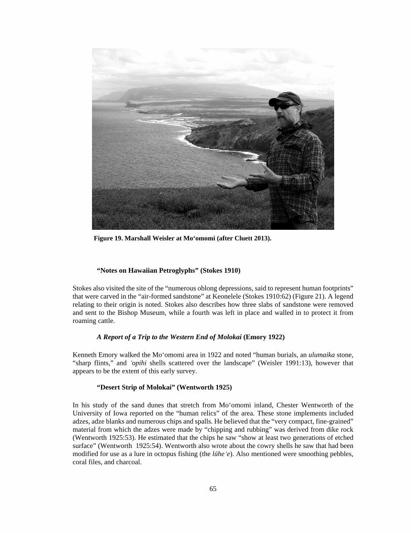
65
Figure 19. Marshall Weisler at Mo‘omomi (after Cluett 2013).
“Notes on Hawaiian Petroglyphs” (Stokes 1910)
Stokes also visited the site of the “numerous oblong depressions, said to represent human footprints” that were carved in the “air-formed sandstone” at Keonelele (Stokes 1910:62) (Figure 21). A legend relating to their origin is noted. Stokes also describes how three slabs of sandstone were removed and sent to the Bishop Museum, while a fourth was left in place and walled in to protect it from roaming cattle.
A Report of a Trip to the Western End of Molokai (Emory 1922)
Kenneth Emory walked the Moʻomomi area in 1922 and noted “human burials, an ulumaika stone, “sharp flints,” and ̒opihi shells scattered over the landscape” (Weisler 1991:13), however that appears to be the extent of this early survey.
“Desert Strip of Molokai” (Wentworth 1925)
In his study of the sand dunes that stretch from Moʻomomi inland, Chester Wentworth of the University of Iowa reported on the “human relics” of the area. These stone implements included adzes, adze blanks and numerous chips and spalls. He believed that the “very compact, fine-grained” material from which the adzes were made by “chipping and rubbing” was derived from dike rock (Wentworth 1925:53). He estimated that the chips he saw “show at least two generations of etched surface” (Wentworth 1925:54). Wentworth also wrote about the cowry shells he saw that had been modified for use as a lure in octopus fishing (the lūhe̒ e). Also mentioned were smoothing pebbles, coral files, and charcoal.

66
Table 2. Archaeological Studies of Mo̒omomi
Author & Year Location Work Completed Findings
Stokes 1909 Pala‘au 2 Survey of heiau Koʻa at Na̒aukahihi Point
Stokes 1910 Keonelele, Kaluako‘i Site visit Kalaina Wawae petroglyphs
Emory 1922 West Moloka‘i Survey Burials, artifact, lithics & midden
Wentworth 1925 West & Central Moloka‘i
Survey “Human relics” (lithics)
Phelps 1937 Island-wide Survey Two burial areas, ko̒ a
Cooke 1949 Island-wide Informal interest and documentation
Enclosures, caves, burials, petroglyphs, artifacts
Bonk 1954 West Moloka‘i Survey & excavation mapped and excavated 9 sites, 6 of these in the Mo̒omomi area
Summers 1971 Island-wide Compilation Koʻa, probable house site, campsite, 3 bluff shelters, a burial, a heiau, a rock shelter, petroglyphs, a quarry, and a burial area
Schilt & Shun 1981 50-Mo-B6-80 Reconnaissance survey Marine shell remains, lithics, an adze preform, ash lenses, fish bones, extinct bird bones
Collins 1983 50-Mo-B6-80 Mapping, stratigraphic recording
Marine shell remains, lithics, 2 hearths, avifaunal remains
Dye et al. 1985 Mo‘omomi Quarry Complex 50-Mo-B6-101
Mapping, photos, rock type analysis, dating, artifact analysis
Lithic collection and analysis
Weisler 1987 Kipu Artifact analysis Adzes probably from Mo‘omomi Quarry
Weisler 1989 Mo‘omomi area Radiocarbon dating Review/list of dates
Weisler 1991 Mo‘omomi Preserve Intensive survey & archaeological study
6 rockshelters, 3 coastal middens, 2 lithic sources, 1 petroglyph locale, and 1 religious site (possible heiau)
Weisler and Gargett 1993
Sites excavated by Bonk (1954)
Examination of avian bones
Looked at archaeological evidence for habitat alteration
Weisler et al. 2006 Mo‘omomi ko‘a U-Series dating Sample dates
McCoy 2007 Island-Wide Radiocarbon review Review/list of dates
Weisler et al. 2009 West Moloka‘i U-Series dating Sample dates
Khaweerat et al. 2010 Mo‘omomi Bay Stratigraphic analysis, U-Series dating
Sample dates
Weisler 2011 West Moloka‘i Site comparison/analysis Use chronology

67
Figure 20. Location of archaeological sites and previous studies in relation to the project corridor. Site numbers are State Inventory of Historic Places (SIHP) numbers, prefixed by 50-60-02-, except for those designated with B6, which are Bishop Museum sites for which SIHP numbers could not be found.

68
Figure 21. The Keonelele footprints (after Stokes 1910:64–65).
A Regional Study of Molokai, Hawaii (Phelps 1937)
With the encouragement of Dr. Edward S.C. Handy and endorsed by the Bishop Museum, Southwick Phelps spent four months on Moloka‘i conducting a regional study of the material culture and two months “in an examination of the literature pertaining to the island’s history” (Phelps 1937:2). Phelps divided the island into three regions based on three geographic features: topography, the water supply, and the nature of the coastline. Moʻomomi was categorized as Region IIIB: fairly level, no constant streams and little rain and subdivided as “B” due to the generally steep coastline, deep offshore waters and strong tradewinds. Phelps recorded three archaeological sites in the Moʻomomi area. Site 10 is an “area of burials in sands,” Site 14 also is an “area of burials in sands,” and Site 18 is a ko̒ a, presumably the ko̒ a at Na̒aukahihi Point.
Moolelo o Molokai (Cooke 1949)
George Cooke moved to Moloka‘i in 1908 to work as assistant manager of the American Sugar Company (later renamed back to Molokai Ranch). Later that year Cooke’s father bought up the interest in the ranch and George Cooke became manager, a position he held for the next 40 years. During his years on the ranch Cooke collected lore and became familiar with many of the archaeological sites on Moloka‘i. In the Moʻomomi lands he discusses rock enclosures with ti plants growing within them on the leeward side of gulches, the “remnants of Ka Laina Wawae” (Figure 22), two caves a fisherman found in ridges containing burials and lauhala baskets of salt, as well as the Keonelele burial area (Cooke 1949:106). Cooke was also an avid collector of artifacts that he found while in the field, though he kept no records. He states, “from the top of Mauna Loa to Moomomi, many Hawaiian curios have been found in windswept and eroded areas, among these, adzes, mirrors, lehu stones and sling stones” (Cooke 1949:121).
Archaeological Excavations on West Molokai (Bonk 1954)
In the summer of 1952 William Bonk and Ronald Brown surveyed West Moloka‘i and recorded and mapped a number of shelters and house sites. While camping at Moʻomomi, Bonk’s team under the direction of Kenneth Emory of the Bishop Museum, mapped and excavated nine sites, six of which were in the Mo̒omomi area. All excavations produced charcoal, kukui nut fragments and abundant marine remains. Bonk estimated the older sites, as indicated by deeper stratification, to be seven to nine hundred years old. Seven of the sites dated into the modern period.
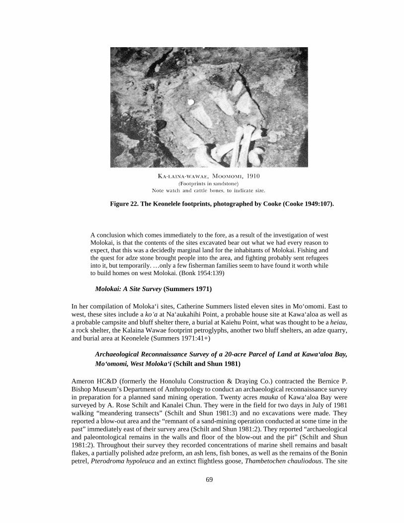
69
Figure 22. The Keonelele footprints, photographed by Cooke (Cooke 1949:107).
A conclusion which comes immediately to the fore, as a result of the investigation of west Molokai, is that the contents of the sites excavated bear out what we had every reason to expect, that this was a decidedly marginal land for the inhabitants of Molokai. Fishing and the quest for adze stone brought people into the area, and fighting probably sent refugees into it, but temporarily. …only a few fisherman families seem to have found it worth while to build homes on west Molokai. (Bonk 1954:139)
Molokai: A Site Survey (Summers 1971)
In her compilation of Moloka‘i sites, Catherine Summers listed eleven sites in Moʻomomi. East to west, these sites include a ko̒ a at Na̒aukahihi Point, a probable house site at Kawaʻaloa as well as a probable campsite and bluff shelter there, a burial at Kaiehu Point, what was thought to be a heiau, a rock shelter, the Kalaina Wawae footprint petroglyphs, another two bluff shelters, an adze quarry, and burial area at Keonelele (Summers 1971:41+)
Archaeological Reconnaissance Survey of a 20-acre Parcel of Land at Kawaʻaloa Bay, Moʻomomi, West Moloka̒i (Schilt and Shun 1981)
Ameron HC&D (formerly the Honolulu Construction & Draying Co.) contracted the Bernice P. Bishop Museum’s Department of Anthropology to conduct an archaeological reconnaissance survey in preparation for a planned sand mining operation. Twenty acres mauka of Kawa̒aloa Bay were surveyed by A. Rose Schilt and Kanalei Chun. They were in the field for two days in July of 1981 walking “meandering transects” (Schilt and Shun 1981:3) and no excavations were made. They reported a blow-out area and the “remnant of a sand-mining operation conducted at some time in the past” immediately east of their survey area (Schilt and Shun 1981:2). They reported “archaeological and paleontological remains in the walls and floor of the blow-out and the pit” (Schilt and Shun 1981:2). Throughout their survey they recorded concentrations of marine shell remains and basalt flakes, a partially polished adze preform, an ash lens, fish bones, as well as the remains of the Bonin petrel, Pterodroma hypoleuca and an extinct flightless goose, Thambetochen chauliodous. The site
70
of these cultural remains has been designated 50-Mo-B6-80 and was interpreted as a “probable habitation or camping site for marine exploitation” as well as adze manufacture and finishing (Schilt and Shun 1981:9). They summarized their report by saying that “all of our researches indicate that the project parcel and the access road area lie within a zone of combined archaeological, paleontological and botanical significance (Schilt and Shun 1981:10).”
Archaeological Investigations of Site 50-Mo-B6-80, Molokaʻi Island (Collins 1983)
Molokai Ranch, Ltd. contracted the Bernice P. Bishop Museum’s Department of Anthropology to conduct fieldwork at Site 50-Mo-B6-80 (previously surveyed by Schilt and Shun, 1981), as well as an additional four acres surrounding the site. This is just southeast of Kawaʻaloa Bay and is the site of a planned sand mining operation anticipated to last 20 years. Assisted by Marshall Weisler, Sara Collins “mapped the site area, recorded stratigraphy, and collected artifactual, faunal, and carbon samples” (Collins 1983). Their fieldwork agreed with the interpretation by Schilt and Shun (1981) and she wrote that site B6-80 was “used intermittently over a considerable span of time” (Collins 1983:25). In addition to confirming Schilt and Shun’s earlier assertion that this site is “archaeologically and paleontologically significant,” she went on to admonish that “the site should not be disturbed until more archaeological investigation is conducted” (Collins 1983:26).
Adz Quarries on Moloka̒i and O̒ ahu, Hawaiian Islands (Dye et al. 1985)
Three quarry complexes were studied including the Moʻomomi Quarry Complex, site 50-Mo-B6-101. Fieldwork at the Mo̒omomi complex was conducted in June of 1985 under the direction of Tom Dye. A plane-table map was produced at a scale of 1:400, photographs were taken, and 30 random 1 m2 sampling units were set up and collections made. Subsequently, all collections were cataloged and analyzed. Additionally, some of Bonk’s 1952 charcoal samples were radiocarbon dated. In summary, they wrote that the situation of the Moʻomomi Quarry Complex in this area is “surrounded by lands that offer no possibilities for prospective farmers. Thus, the Complex most likely lacked a permanent local community, and was worked by craftsmen who made their homes and distributed their products elsewhere” (Dye et al. 1985:91).
Observations and Regional Significance of an Adze Preform Cache from Kipu, Moloka̒i, Hawaiian Islands (Weisler 1987)
Eleven quadrangular adze preforms, complete but without final polishing, were found by Dr. Richard Langer in Kipu, Moloka‘i, while he was working in his yard. This location has been designated as Site 50-60-03-884 (Figure 23). This is the “largest collection of adze preforms found in a non-quarry context in Hawai̒i” (Weisler 1987). Weisler’s analysis of the collection was limited to measurement and direct examination only since the preforms could not be removed for thin-section analysis. After examining the material, Weisler wrote that the “Kipu adze preforms appear to be from the Moʻomomi quarry” (Weisler 1987). This was determined by comparing the Kipu preform collection material with the “texture, colour, flow structure, and presence/absence of vesicles” of specimens from the eight known quarries on West Molokai (Weisler 1987).
“Chronometric Dating and Late Holocene Prehistory in the Hawaiian Islands: A Critical Review of Radiocarbon Dates from Moloka̒i Island” (Weisler 1989)
In his critical review of radiocarbon dates, Weisler presented six dates from the Moʻomomi coastline that included one date from a geologic sample. Two charcoal samples and a fish bone were dated from Kawa̒aloa Bay (AD 1176–1296, 1673–1943, and 1229–1952 respectively), a charcoal sample

71
Figure 23. Location of the Kipu adze preform cache in relation to Mo‘omomi (Weisler 1987).

72
from a rock shelter at Moʻomomi (AD 1445–1635) and a charcoal sample from the Kalani rockshelter (AD 1330–1640). The geologic sample consisted of fossil land snail shells that dated to 27,000 years before present.
The Archaeology of a Hawaiian Dune System: The Nature Conservancy’s Moʻomomi Preserve, Moloka̒i (Weisler 1991)
Marshall Weisler was contracted by The Nature Conservancy in 1991 to conduct archaeological work within the Conservancy’s 920-acre Moʻomomi Preserve. Archaeological work included survey and mapping, as well as excavations and analysis of select sites. Fieldwork was conducted in June of 1989 with a small crew. His study within the Preserve included a “total of 13 archaeological sites…including 6 rockshelters, 3 coastal middens, 2 lithic sources, 1 petroglyph locale, and 1 religious site, a possible heiau” (Weisler 1991).
Site 50-60-02-21 is the only site in the immediate vicinity of the current project corridor. The site has also been designated 50-Mo-B6-3 by the Bishop Museum and Mo.1 by Bonk (1954). It includes Features 21c, a pit, 21m, a midden scatter, and 21r, a rockshelter.
Feature 21m is the only feature that extends into the project corridor. It is a major midden site, consisting of a scatter of artifacts and midden that has eroded from an extensive cultural deposit, 90 m x 20 m in area. The deposit is approximately .5 m thick and includes scoop hearths, midden, and oven stones. From a mere 1.22 m3 excavation unit, 6,287 artifacts were collected, most of which were basalt flakes.
“Pacific Island Avian Extinc tions: The Taphonomy of Human Predation” (Weisler and Gargett 1993)
Weisler and Gargett looked at archaeological evidence indicating the possible effects that humans had on endemic bird species. The human impacts that leave evidence in the archaeological record include habitat alteration and human predation. The sample bird bone used in this analysis came from nine West Moloka‘i archaeological sites, all excavated by Bonk in 1952.
“Thorium-230 Coral Chronology of a Late Prehistoric Hawaiian Chiefdom” (Weisler et al 2006)
Five “high-precision 230Th” dates are presented in this study by Marshall Weisler for the ko̒ a located at Na̒aukahihi Point at Mo̒omomi Bay (Site 50-60-02-0018). Other sites along this leeward Moloka‘i coastline were also dated with this same technology and, taken as a whole, suggest that “expansion to leeward Moloka‘i began a century or two later than the radiocarbon chronology suggests.” The following table displays the very precise coral dates for the Naʻaukahihi ko̒ a:
sample# Site Corrected Age I Corrected Age II
14 18A 1416+/-3 1417+/-3
15 18A 1709+/-2 1709+/-2
16 18A 1419+/-4 1420+/-4
17 18A 1427+/-3 1428+/-3
18 18A 1432+/-3 1434+/-3
(Weisler et al. 2006)

73
“Revised Late Holocene Culture History for Moloka‘i Island, Hawai‘i” (McCoy 2007)
Mark McCoy reviewed 175 radiocarbon dates from Moloka‘i and adds to Marshall Weisler’s 1989 summary of 45 radiocarbon dates. All of the Moʻomomi sites listed in this study are taken from Weisler’s previous paper and no new dates are reported for this area.
“Late Holocene 14C Marine Reservoir Corrections for Hawai̒i Derived from U-Series Dated Archaeological Coral” (Weisler et al. 2009)
Twelve corals from archaeological contexts were analyzed and dated. Only one of the samples was from Moʻomomi (Figure 24):
OZJ968 Mo̒omomi
Pocillopora sp. branch coral (114.3 g) from archaeological site 01-242, a coastal midden with buried shrine. The dedicatory coral (field object 4) was collected form excavation unit N26W6, layer IIIB, spit 6, 50 cm below surface (Weisler et al. 2006: Figure 2). Collected on 28 January 1999 by MIW and submitted by MIW on 9 May 2007.
Comment: cal AD 1476-1697, 100% probability; cal AD 1536-1657, 100 % probability. (Weisler et al. 2009:966)
“Human-Caused Stratigraphic Mixing of a Coastal Hawaiian Midden During Prehistory: Implications for Interpreting Cultural Deposits” (Khaweerat et al. 2010)
Fifteen corals that were excavated at a site fronting Moʻomomi Bay were analyzed contextually to study the effects of stratigraphic mixing. This study is possible because of the high precision of U-Series dating of coral. Corrected dates of these samples ranged from AD 1516 to 1621.
“A Quarried Landscape in the Hawaiian Islands” (Weisler 2011)
Utilizing 64 dates obtained from archaeological contexts, Weisler determined a “temporal sequence of use beginning in the Late Expansion Period (AD 1400–1650)” (Weisler 2011). That is, he asserts that the West Moloka‘i stone quarries began being visited and exploited by the Hawaiians sometime between about AD 1400 and 1650. The Moʻomomi Quarry was described as being the largest quarry in the northern region of the ahupua̒a of Kaluako̒i. This is actually a complex of quarry sites, each being distinct flows with differing geochemistry. While there are “no habitation sites directly associated with this source,” almost all of the sites showing evidence of habitation contain lithics from this quarry (Weisler 2011).
Archaeological Sites in the Vicinity of the Project Corridor
There are five archaeological sites located in the immediate vicinity of the project corridor (see Figure 29). These include Sites 50-60-02-21, -26, -891, -892, and -893.
Site 21 consists of three components: Features 21c, a pit, 21m, a midden scatter, and 21r, a rockshelter (Weisler 1991). The site has also been designated 50-Mo-B6-3 by the Bishop Museum and Mo.1 by Bonk (1954).
Located approximately 125 m to the southeast of the proposed fenceline, Feature 21c is the farthest away from the project corridor. It consists of a 39 cm-diameter circular pit located within cemented

74
Figure 24. Location of coral samples dated by Weisler et al. (2009:957).
sand at Kawa‘aloa Bay. It was filled with turtle, fish, and bird bone but severely eroded when described by Weisler, who collected the faunal remains and radiocarbon dated fish scales to AD 1255 (1989:81). Weisler states that the feature represented “the best evidence, to date, of the association of cultural remains and extirpated avian fauna; in this example, dating to the mid-13th century” (1991:81).
Located just northwest of the project corridor, Feature 21m of Site 21 has been described as “one of the largest known middens along the north coast of Moloka‘i” (Weisler 1991:66). It consists of a scatter of artifacts and midden that has eroded from an extensive cultural deposit, 90 m x 20 m in area. The east end of the cultural layer is where the erosion is taking place, and the deposit is approximately .5 m thick and includes scoop hearths, midden, and oven stones (Weisler 1991:26). A total of 6,287 artifacts were collected from the 1.22 m3 excavation, which consisted of only one test pit. Of these, 6,138, or 97% were unworked basalt flakes. Other items included adze blanks and preforms, polished flakes, volcanic glass, worked bone, fishhooks, worked shell, and coral and sea urchin spine files. Two radiocarbon samples were obtained from hearth features near the base of the cultural layer, returning age determinations that calibrated to AD 1660–1955 and AD 1520–1955 (Weisler 1990:75).
Feature 21r is a rockshelter situated along the cliff on the west side of Kawa‘aloa Bay, approximately 5 m to the east of the project corridor. It has been posited that “the use of this rockshelter was probably contemporaneous with the large midden above and small refuse pit to the south” (Weisler 1991:77). It is a large rockshelter, measuring 18 m wide, 1.2 m high, and has a 6.7 m-wide level floor. The site was extensively excavated by Bonk, who recovered items such as fishhooks, shell and dog tooth ornaments, volcanic glass, and evidence of adze manufacture and use (1954). In some areas, midden was found as deep as 70 inches (177.8 cm) below the surface (Bonk 1954:29). Bonk suggests three periods of use for the shelter: 1) an initial use as a camp or fishing station; 2) a period of fishing and manufacturing fishhooks; and 3) a later use again as only a fishing station (1954:138).
Site 26, also known as 50-Mo-B6-10 (Bishop Museum site number) and Mo. 2 (Bonk 1954), is the Kalani Rockshelter. Located 100 m east of the project corridor on the cliff overlooking Kalani Beach, the shelter measures 9 m wide and 3 m deep, and exhibits a large boulder that shields the living area from the elements. The shelter was excavated extensively by Bonk (1954). Although the surface within the shelter was covered in midden and stained with charcoal and ash, only 34 artifacts were recovered. These included evidence of adze manufacture, a basalt knife, a basalt awl, fishhooks and fishhook manufacturing material, and two shell beads.

75
Site 891 is situated approximately 90 m west of the west end of the project corridor, on the lithified dune cliff overlooking Kapalauoua. The site is listed as a small midden in The Nature Conservancy’s GIS database, but no other information could be found.
Site 892 is a surface midden scatter located just east of the project corridor, near the west end of the corridor, on the slope of a sand dune. The site is situated just above the Kalani Rockshelter (Site 26), implying an association with the shelter. Although outside the project boundaries, a dense concentration of marine shell and lithic material was noted in this area during the current survey.
Site 893 is located 10 m north of the project corridor, within the western half of the corridor. This is 100 m south of the Site 892 midden in an area of rolling sand dunes 200 m inland. The site was listed as “other site” in The Nature Conservancy’s GIS database, and no other information could be found.
Summary and Settlement Patterns
Located on the northwest coast of Moloka‘i, Mo‘omomi’s unique landscape supports a variety of plant and animal life and also contains fossilized plant and animal remains. The well-watered windward areas of Moloka‘i were the first places settled on the island by humans. Much later, by what is termed the Late Expansion Period (AD 1450–1600), people began to venture into the dry leeward areas of the island. While it is not possible to account for the intangible qualities of human nature in the archaeological record, such as simple curiosity or the desire for adventure, what is reflected is the quest for quality stone for tools and the exploitation of the rich fisheries at Moʻomomi. These were the resources that probably motivated much of the activity along the Mo‘omomi coast.
There is no evidence that Moʻomomi ever supported a large population. Habitation sites consist of shelter caves, sandstone overhangs and scattered “camp sites” along the coast. There is a formal ko̒ a, or fishing shrine, at Mo̒omomi Bay and a larger heiau farther east. Located nearby are high quality rock exposures known as the Moʻomomi Quarry Complex. These were utilized as a source of raw materials for tools, evidence of which occurs throughout the region.
The sea fishery would have been exploited during the calm summer months but impossible to access during the winter when the high surf is relentless. There is growing evidence that the birds of the area were a source of food, perhaps an important one if settlement persisted into the winter months.
Burials are found throughout the sand dunes of Moʻomomi. There are historic-era accounts relating that the Mo̒omomi area was a “place for the dead.” While there is no empirical evidence to suggest that bodies were brought to Moʻomomi from elsewhere to be buried, that remains a possibility.
An important cultural site of Mo‘omomi is the Kalaina Wawae footprints. Opinions are varying on how the footprints were formed, and mo‘olelo tell us that they were part of a prophecy that foretold the coming of Westerners.
In the early 1800s there began a long-term population decline on Moloka‘i that continued until the pineapple plantations started and the Hawaiian Homesteading began in the 1920s. What little population Mo̒omomi might have supported probably declined with the larger trend, with the result that Mo̒omomi was abandoned in the 19th century. Further evidence from the Māhele supports this idea. There were no kuleana land claims submitted to the Land Commission from Moʻomomi in the Māhele. For the whole of the Kaluakoʻi district only five claims were submitted, but all of these were located along the south shore on the opposite side of the mountain, and none were awarded. Moʻomomi, and all of Kaluako̒i, became Government land at that time and remained so until it was sold to Charles Reed Bishop in 1875.

76
The first documented use of Moʻomomi in the historic-era appears to be as a fishing destination for the Meyer family about 1915. Later, sometime after 1920, the Hawaiian Homesteaders frequented Moʻomomi for its fishing resources. Del Monte, one of the past pineapple companies on the island, built a beach house at Kawaʻaloa Bay for the use of its employees. This beach house has since fallen into disrepair. Today, families continue to camp and fish at Moʻomomi during the summer months.
Anticipated Finds and Research Questions
Kaluako‘i was known as an area for the manufacture of adzes and supports several basalt quarries and lithic scatters. These have been found within the Mo‘omomi region, along with the material remains of adze making and camps associated with that activity. Adze manufacturing remains that might be encountered within the project area include surface scatters of lithic material, such as basalt flakes, cores, and shatter, as well as artifacts such as adzes, adze preforms, and hammerstones. Surface scatters of midden or subsurface cultural layers and firepits in association with these items might indicate encampments that were utilized for tool making.
Mo‘omomi is also renowned for its fisheries, and was known as a region of marine resource exploitation in the past. Fishing related items might be found within the project corridor. These might take the form of fishhooks or fishhook manufacturing debris, tools for making fishhooks such as coral and sea urchin spine files, sinkers, and marine shell and bone midden. Subsurface firepits and cultural layers might also be found along with these remains, and these may represent marine resource exploitation camps.
Several rockshelters are located in the vicinity of the project corridor, and this is a site type that may be found during survey. Rockshelters are likely to be found in the cliff areas on the east and west ends of the fenceline corridor and could take the form of modified or unmodified caves or overhangs. Religious features such as ko‘a might also be found, as these are common in the region as well. Mo‘omomi is also known as a place for human burial, and these may be encountered, particularly in areas of Jaucas sand, where burials commonly occur.
A basic research question for the archaeological inventory survey is to determine the presence or absence of cultural remains within the project corridor. If remains are identified, additional research questions will be formulated, depending on the findings. They may address issues such as the history of settlement in the area, the nature of resource exploitation, or patterns of trade and exchange.
Features 21m and 21r, a miden scatter/cultural layer and rockshelter, are located in proximity to the east end of the project corridor. Another research question will be to determine if either of these features extend into the project area, both on the surface and below it. Subsurface testing within the project corridor may help to delineate the boundaries of the cultural layer.

77
METHODS
Pedestrian survey and subsurface testing were conducted on April 28 and 29, 2014 by Windy McElroy, PhD, Steven Eminger, and Kālenalani McElroy, BA. McElroy served as Principal Investigator, overseeing all aspects of the project.
For the pedestrian survey, the ground surface was visually inspected for surface archaeological remains, with a single transect walked for the entire length of the 1.53 mile (2.46 km) long fenceline corridor. The center line of the corridor was marked with flagging tape and documented with GPS by The Nature Conservancy personnel before the survey began. Five feet (1.52 m) on either side of the center line were inspected for surface archaeological remains. Of the 1.847-acre (.748 ha) survey area, 100% was covered on foot.
Vegetation was heavy in parts of the corridor, consisting of kiawe and grass that obscured the ground surface and impaired visibility (Figure 25), while other parts of the corridor were relatively free of vegetation (Figure 26). The spacing between archaeologists was very narrow, with archaeologists spread approximately 1 m apart, to be sure that nothing was missed.
Archaeological sites and their boundaries were identified visually, with any feature possibly made or used by humans and more than 50 years old considered a site. One previously recorded archaeological site was found. It was digitally photographed and its boundaries within the project corridor were documented with a 3 m-accurate Garmin GPSmap 62st. A representative sample of cultural material was collected from the surface of the site. Whereas a plan view map of the site had been previously drawn (Weisler 1991:67, see Figure 30) and there is no surface architecture present within the project corridor, the site was not re-mapped.
Shovel test excavations were conducted in 13 locations throughout the survey area. These test pits were excavated by hand, with shovel and trowel, within natural stratigraphic layers (Figure 27). Vertical provenience was measured from the surface and all sediment was dry screened through 1/8 inch mesh. Profiles were drawn and photographed, and sediments were described using Munsell soil color charts and a sediment texture flowchart (Thien 1979). All test pits were backfilled after excavation. Test pit locations were recorded with a 3 m-accurate Garmin GPSmap 62st.
The scale in all field photographs is marked in 10 cm increments. The north arrow on all maps points to magnetic north. Throughout this report rock sizes follow the conventions outlined in Field Book for Describing and Sampling Soils: Gravel <7 cm; Cobble 7–25 cm; Stone 25–60 cm; Boulder >60 cm (Schoeneberger 2002:2–35). All collected material is being temporarily curated at the Keala Pono office in Kāne‘ohe, Hawai‘i. It will be returned to The Nature Conservancy once the project is complete.

78
Figure 25. Pedestrian survey in grass and kiawe, showing an area of heavy vegetation. The center of the fenceline corridor is marked in pink and blue flagging tape.
Figure 26. Pedestrian survey on open terrain.

79
Figure 27. Subsurface testing at Test Pit 8.

80
RESULTS
Pedestrian survey and subsurface testing were conducted in the 1.847-acre project area. A portion of a previously recorded archaeological site was found on the surface on the east end of the project corridor. The site consists of a surface midden scatter, and a representative sample of material was collected for analysis. Excavation of 13 shovel test pits (TP) did not yield any evidence of cultural deposits or features; only two isolated artifacts, midden, land snail, and charcoal were recovered from the excavations.
Pedestrian Survey
The survey area consisted of a 3.05 m (10 foot) wide corridor that stretched 2.46 km (1.53 miles) near the coastline to 525 m (1,722 ft.) inland, and back to the coast. The east and west ends of the corridor are situated atop lithified sand dunes with none to very little sand deposition (Figure 28). The rest of the project corridor runs through undulating sand dunes, aside from the central portion, which is relatively flat.
A portion of Site 50-60-02-21, a previously identified archaeological site (Weisler 1991), was found on the east end of the project corridor (Figure 29). The site has also been designated 50-Mo-B6-3 by the Bishop Museum and Mo.1 by Bonk (1954). The site includes Features 21c, a pit, 21m, a midden scatter, and 21r, a rockshelter (Weisler 1991), although only Feature 21m extends into the project corridor.
Feature 21m was described as “one of the major midden sites along the north coast of Moloka‘i” (Weisler 1991:26). It consists of a scatter of artifacts and midden that has eroded from an extensive cultural deposit, 90 m x 20 m in area. The east end of the cultural layer is where the erosion is taking place, and the deposit is approximately .5 m thick and includes scoop hearths, midden, and oven stones (Weisler 1991:26).
The dune upon which the cultural layer is deposited was previously mapped and excavated with auger transects to determine its boundaries (Weisler 1991) (Figure 30). One test pit was also excavated at that time, and stratigraphy consisted of six layers of calcareous sand deposited atop lithified sand bedrock (Weisler 1991:69). Within the cultural deposit were scoop hearths, ovens, post molds, basalt debitage and other artifacts, bone, marine shell, and charcoal. A total of 6,287 artifacts were collected from the 1.22 m3 excavation. Of these, 6,138, or 97% were unworked basalt flakes. Other items included adze blanks and preforms, polished flakes, volcanic glass, worked bone, fishhooks, worked shell, and coral and sea urchin spine files. Weisler states that “this is one of the highest artifact concentrations of any coastal midden from Polynesia” (1991:75).
Also recovered during Weisler’s excavations were a wooden post later identified as mountain apple (Syzygium malaccense) and 6.5 kg of marine invertebrate midden (1991:75). Fish remains consisted of 17 taxa, and bird remains included an extinct moorhen (Gallinula chloropus), among other more common species. Two radiocarbon samples were obtained from hearth features near the base of the cultural layer, returning age determinations that calibrated to AD 1660–1955 and AD 1520–1955 (Weisler 1990:75).
The current project corridor runs between the edge of the dune and the edge of the cliff, avoiding the intact portion of the Feature 21m cultural layer. Feature 21r, the rockshelter excavated by Bonk (1954) lies approximately 5 m to the east. Feature 21c, a circular pit within the cemented sand, was not observed and lies far beyond the project corridor, approximately 125 m to the southeast. Only secondarily deposited remnants of the Feature 21m cultural layer are present within the project area,

81
and no evidence of surface architecture was observed within or nearby the corridor. No subsurface deposits were identified within the project corridor (see Subsurface Testing section).
Surface remains of Feature 21m are most dense to the north and west of the project corridor and can be seen eroding from the cultural layer to the west. Within the project corridor, lithic material and a variety of shell and faunal midden were observed, although not as densely distributed as the material outside the project boundaries (Figure 31). They are scattered directly atop the lithified sand bedrock which is exposed in this portion of the corridor. A representative sample of the surface scatter was collected for analysis. Material included basalt flakes and shatter, marine shell, and a fragment of unburned kukui nutshell (see Laboratory Analysis section).
The portion of Site 50-60-02-21 that occurs within the project corridor is in fair to poor condition. Materials are not in primary context, as they have eroded from a nearby cultural layer. The materials themselves, however appear mostly intact and may have the potential for further study. The midden scatter was probably associated and contemporaneous with the Feature 21r rockshelter below it, as suggested by Weisler (1991:77), and the area was likely used for habitation and marine resource exploitation. Bonk elaborates further on the nature of use of the Feature 21r rockshelter, suggesting three periods of use: 1) an initial use as a camp or fishing station; 2) a period of fishing and manufacturing fishhooks; and 3) a later use again as only a fishing station (1954:138).
Other finds during pedestrian survey included sparse scattered midden and lithic material on the west end of the project corridor (Figure 32). A few pieces of basalt and scattered marine shell were observed on the surface, but the density of material was nowhere near that of the Site 21 area, and most material occurs outside the project corridor. Test excavatons were placed in areas where possible midden and cultural material were observed nearby (see TP 7–11, below).
Figure 28. Pedestrian survey on lithified sand dune, west end of the project corridor. The centerline of the corridor is marked in pink and blue flagging tape. View is to the northwest.

82
Figure 29. Location of TP 1–13 on USGS Molokai Airport quad. The extent of Site 21 along the project corridor is shown in red.

83
Figure 30. Plan of Feature 21m showing locations of Weisler’s auger transects (adopted from Weisler 1991:67). The current project corridor runs between the edge of the dune and the edge of the cliff, and ends approximately 10 m northeast of the rockshelter, avoiding the rockshelter and the cultural layer.

84
Figure 31. Midden and lithic surface scatter of Site 21, east end of the project corridor, plan view.
Figure 32. Midden and lithic surface scatter, west side of the project corridor, just south of survey boundaries. View is to the south.

85
Subsurface Testing
A total of 13 shovel test pits were excavated throughout the project corridor, to determine the presence or absence of subsurface cultural deposits or material (Table 3, see Figure 29).
TP 1 was excavated on the east end of the project corridor to determine if Site 50-60-02-21 has a subsurface component within the project corridor. Site 21 is a large midden visible on the surface within and outside the project corridor on the east end. The east end of the corridor is very close to the cliff, however, and lacks any soil development or substantial sand accumulation on the eastern 45 m of the corridor. TP 1 was therefore placed 47 m from the east end of the corridor near the edge of the intact dune. The pit measured 43 cm long and 39 cm wide. It was excavated to 66 cm below surface (cmbs), where a hard lithified sand dune was encountered. A single eroded sand dune deposit was found (Figure 33). Cultural material was only found on the surface and within the upper 10 cm of the deposit. This took the form of scattered isolated marine shell, sea urchin, a small fragment of animal bone, sparse charcoal, and sparse lithic material, none of which was associated with a cultural layer or feature. This material is thought to have originated from the Site 21 cultural layer, which is visible to the west of the project corridor, eroding from the dune. Naturally-deposited land snail shell was recovered as well. No cultural deposits or features were identified.
TP 2 was placed 12 m southwest of TP 1, also on the east side of the project corridor. This pit was excavated here to determine if the Site 21 midden scatter extends farther south than what is visible on the surface. The pit measured 41 cm long and 38 cm wide. It was excavated to 85 cmbs, to a sterile aeolian deposit. Stratigraphy consisted of three layers of the natural sand dune with a basal deposit of sterile silt loam (Figure 34). Sparse marine shell and land snail were found within the upper two layers, although they were likely deposited naturally. No cultural material or deposits were found.
TP 3 was located 51 m southwest of TP 2 to determine the presence or absence of buried cultural material or deposits on the dune. The test pit measured 29 x 26 cm. It was excavated to 100 cmbs, to a sterile sand dune deposit. Stratigraphy consisted of three layers of the sterile sand dune with a thin charcoal lens below the first layer (Figure 35). Sparse scattered charcoal, marine shell, and sea urchin were recovered from the upper two layers. They were not associated with a cultural deposit or feature.
TP 4 was placed 120 m southwest of TP 3 to determine the presence or absence of buried cultural material or deposits. The pit measured 36 cm in diameter and was excavated to 49 cmbs, to a sterile layer that contained sparse land snail shells. Stratigraphy consisted of two layers of the natural sand dune, the upper layer exhibiting mottling (Figure 36). No cultural material or deposits were identified.
TP 5 was placed 290 m southwest of TP 4 to determine the presence or absence of buried cultural material or deposits. The pit measured 36 cm in diameter and was excavated to 43 cmbs, where the sand was hardened and tightly compacted. Stratigraphy consisted of three layers of the natural sand dune and a thin aeolian deposit, with some evidence of disturbance in the uppermost layer (Figure 37). The aeolian deposit (Layer III) was sandwiched between two of the dune layers and contained land snail shells. No cultural materials or deposits were found.
TP 6 was located 265 m southwest of TP 5 to determine the presence or absence of buried cultural material or deposits. The test pit measured 36 x 33 cm. It was excavated to 63 cmbs, to a natural sand dune deposit rich with land snails. Stratigraphy consisted of three layers of the sand dune and a sterile aeolian deposit (Figure 38). Sparse isolated scattered charcoal was found within the upper layer, and land snail shells were abundant in the lower two layers. No cultural deposits or features were identified, and the charcoal may be of recent origin, as it occurred near the surface.

86
Table 3. Sediment Descriptions
TP Layer Depth (cmbs)
Color Description Interpretation
1 I 0-66+ 10YR 6/6 Medium sand; basalt, marine shell, invertebrate, animal bone, land snail, charcoal; base of excavation.
Calcareous Sand Dune
2 I 0-26 10YR 6/6 Medium sand; 1% fine roots; marine shell, land snail; smooth, gradual boundary.
Calcareous Sand Dune
II 26-40 10YR 5/6 Medium-coarse sand; 1% fine roots; marine shell, land snail; smooth, clear boundary.
Calcareous Sand Dune
III 40-73 10YR 7/4 Medium-coarse sand; smooth, abrupt boundary.
Calcareous Sand Dune
IV 73-85+ 7.5 YR 4/4 Silt loam; base of excavation. Aeolian Deposit
3 I 0-10 10YR 4/4 Medium sand; 2% fine roots; marine shell, invertebrate, charcoal; broken, abrupt boundary.
Calcareous Sand Dune
II 10-13 10YR 3/2 Medium sand; 2% fine roots; marine shell, invertebrate, charcoal; broken, abrupt boundary.
Charcoal Lens
III 13-51 10YR 5/6 Medium sand; smooth, abrupt boundary. Calcareous Sand Dune
IV 51-100 10YR 7/6 Coarse sand; base of excavation. Calcareous Sand Dune
4 I 0-37 10YR 6/4, mottled
Medium-fine sand; 5% fine roots; smooth, very abrupt boundary.
Calcareous Sand Dune
II 37-49 10YR 4/6 Silt loam; 1% fine roots; land snail, base of excavation.
Calcareous Sand Dune
5 I 0-20 10YR 4/4 Fine sand; 1% fine roots; irregular, very abrupt boundary.
Calcareous Sand Dune
II 20-28 10YR 6/4 Fine-medium sand; broken, very abrupt boundary.
Calcareous Sand Dune
III 26-31 10YR 5/2 Silt loam; land snail; smooth, abrupt boundary Aeolian Deposit
IV 31-43 10YR 7/6 Fine-medium sand; base of excavation. Calcareous Sand Dune
6 I 0-15 10YR 5/6 Medium sand; 2% medium roots; charcoal; smooth, gradual boundary.
Calcareous Sand Dune
II 15-32 10YR 4/6 Silt loam; smooth, gradual boundary. Aeolian Deposit
III 32-54 10YR 6/4 Fine sand; land snail; smooth, gradual boundary.
Calcareous Sand Dune
IV 54-63 10YR 7/3 Fine sand; land snail; base of excavation. Calcareous Sand Dune
7 I 0-51 10YR 4/6 Medium-coarse sand; 2% medium roots; land snail; smooth, gradual boundary.
Calcareous Sand Dune
II 51-100 10YR 5/6 Medium-coarse sand; 2% basalt gravel; land snail; base of excavation.
Calcareous Sand Dune

87
Table 1. (Continued)
TP Layer Depth (cmbs)
Color Description Interpretation
8 I 0-24 10YR 5/4 Medium sand; 15% medium roots; linvertebrate; land snail; smooth, abrupt boundary.
Calcareous Sand Dune
II 24-43 10YR 5/3 Fine-medium sand; 5% fine roots; smooth, abrupt boundary.
Calcareous Sand Dune
III 43-108 10YR 5/4 Medium sand; 2% fine roots; base of excavation
Calcareous Sand Dune
9 I 0-78 10YR 6/6 Medium sand; 2% fine roots; invertebrate; base of excavation.
Calcareous Sand Dune
10 I 0-68 10YR 5/6 Fine-medium sand; 2% fine roots; land snail smooth, diffuse boundary.
Calcareous Sand Dune
II 68-88 10YR 6/6 Fine-medium sand; base of excavation. Calcareous Sand Dune
11 I 0-89 10YR 6/6 Fine-medium sand, 2% medium roots in upper 30cm; invertebrate, animal bone, land snail; base of excavation.
Calcareous Sand Dune
12 I 0-20 7.5YR 4/4, mottled
Sandy loam; 30% fine roots; land snail; smooth, abrupt boundary.
Aeolian Deposit
II 20-52 10YR 6/3 Fine-medium sand; 30% fine roots; land snail; smooth, abrupt boundary.
Calcareous Sand Dune
III 52-84 10YR 7/4 Fine-medium sand; 30% fine roots; base of excavation.
Calcareous Sand Dune
13 I 0-24 10YR 4/4 Sandy loam; 10% fine-large roots; land snail; smooth, gradual boundary.
Aeolian Deposit
II 24-30 10YR 5/4 Sandy loam; 10% fine-large roots; land snail; smooth, gradual boundary.
Aeolian Deposit
III 50-52 10YR 5/6 Sandy loam; land snail; base of excavation. Aeolian Deposit
Figure 33. TP 1 north face profile drawing (left) and photo (right).

88
Figure 34. TP 2 north face profile drawing (left) and photo (right).
Figure 35. TP 3 east face profile drawing (left) and photo (right).
Figure 36. TP 4 west face profile drawing (left) and photo (right).

89
Figure 37. TP 5 west face profile drawing (left) and photo (right).
Figure 38. TP 6 east face profile drawing (left) and photo (right).
TP 7 was placed 25 m southeast of the west end of the fenceline corridor. The west end of the corridor is on a high bluff that lacks any soil development or substantial sand accumulation on the western portion. TP 7 was excavated 25 m from the west end of the corridor, where a sand deposit occurs. Very sparse lithic material and midden were observed on the bluff, and TP 7 was excavated to determine if subsurface cultural deposits or features are located within the fenceline corridor or if the scattered cultural material occurs beneath the surface. The test pit measured 38 x 33 cm and was excavated to 100 cmbs, to a sterile dune deposit. Stratigraphy consisted of two layers of the natural sand dune (Figure 39). Only naturally deposited land snails were found.
TP 8 was also placed on the west end of the corridor, 105 m southeast of TP 7. The test pit was excavated in a natural gulch set between two lithified dunes. Site 892, a dense scatter of lithics and midden was observed downslope (north) of the project corridor, although no cultural material was found in this area within the corridor itself. TP 8 was excavated to determine if any subsurface vestiges of the artifact scatter are located within the corridor or if any other cultural features or deposits occur there. The pit measured 48 x 36 cm and was excavated to 100 cmbs, to a sterile dune

90
deposit. Stratigraphy consisted of three layers of natural sand dune deposits, with land snail shells and a fragment of naturally deposited crab claw in the uppermost layer (Figure 40). No cultural material or deposits were found.
TP 9 was located 125 m south of TP 8. The test pit was excavated in a sandy swale between two sand dunes. Lithic material was scattered on the surface in the vicinity, mostly upslope (south) of the project corridor. TP 9 was excavated to determine if any subsurface remnants of the artifact scatter are located within the corridor or if any other cultural features or deposits occur there. The test pit measured 37 x 36 cm and was excavated to 78 cmbs. Stratigraphy consisted of a single sterile sand dune deposit with sparse naturally deposited crab shell (Figure 41). No cultural material or deposits were identified.
TP 10 was located 200 m southeast of TP 9. The test pit was placed in a sandy swale between two dunes. Sparse lithic material was observed on the surface in the vicinity, although none was found within the project corridor. The pit was excavated to determine if any subsurface remnants of the artifact scatter are located within the corridor or if any other cultural features or deposits occur there. The pit measured 27 x 25 cm and was excavated to 88 cmbs, to a brittle, cemented sand layer. Stratigraphy consisted of two layers of the sand dune, with sparse naturally deposited land snail shells found within the upper layer (Figure 42). No cultural deposits or features were identified.
TP 11 was placed 250 m southeast of TP 10. The test pit was excavated on the slope of a sandy swale. Sparse lithic material was observed on the surface in the vicinity, although none was found within the project corridor. The pit was excavated to determine if any subsurface remnants of the artifact scatter are located within the corridor or if any other cultural features or deposits occur there. The pit measured 33 cm in diameter and was excavated to 89 cmbs. Stratigraphy consisted of a single sand dune deposit containing sparse naturally deposited crab, animal bone, and land snail shells (Figure 43). No cultural material or deposits were identified.
TP 12 was located 178 m southeast of TP 11 on top of an accumulation of rock that resembles a stone mound. The pit was placed there to determine if the rock accumulation was natural or cultural in origin. The pit measured 36 x 32 cm and was excavated to 84 cmbs, to a natural sterile layer. Stratigraphy consisted of two layers of the natural sand dune with an aeolian deposit on the surface (Figure 44). The upper layer contained land snail shell and charcoal fragments, although the charcoal was not collected because burned tree stumps atop the mound suggested a recent natural fire. No cultural material or deposits were found, and the excavation provided no evidence to determine that the mound was built by humans.
TP 13 was placed 348 m southeast of TP 12 and 271 m west of TP 6, where a possible hammerstone was found on the surface. The pit was excavated here to determine the presence or absence of subsurface cultural material and deposits, possibly associated with the hammerstone. The pit measured 34 x 30 cm and was excavated to 52 cmbs. Stratigraphy consisted of three layers of sterile aeolian deposits containing naturally deposited land snail shells, which increased in abundance with depth (Figure 45). No subsurface cultural material or deposits were identified.
Laboratory Analysis
Material was collected from the surface at Site 21 and from all 13 test pits. This consisted of artifacts, faunal remains, marine shell, invertebrate, land snail, and charcoal (Table 4). The faunal material, land snail, and most of the marine shell are thought to have been deposited naturally.

91
Figure 39. TP 7 west face profile drawing (left) and photo (right).
Figure 40. TP 8 west face profile drawing (left) and photo (right).
Figure 41. TP 9 west face profile drawing (left) and photo (right).

92
Figure 42. TP 10 north face profile drawing (left) and photo (right).
Figure 43. TP 11 north face profile drawing (left) and photo (right).
Figure 44. TP 12 southwest face profile drawing (left) and photo (right).

93
Figure 45. TP 13 northeast face profile drawing (left) and photo (right).
Artifacts consist of a possible hammerstone, basalt flakes, and basalt debitage. The possible hammerstone was recovered from the surface at TP 13, near the center of the project area. It measures 8.5 cm long, 6.3 cm wide, and 3.5 cm thick. It is composed of dense basalt, weighing 275.8 g and exhibits possible battering on both ends (Figure 46). The basalt flakes were collected from the surface of Site 21 and from Layer I of TP 1, at the western periphery of Site 21. The three basalt flakes from Site 21 were labeled A, B, and C (Figure 47). Flake A is a complete, unworked flake that measures 5.7 cm long, 4.3 cm wide, and 1.0 cm thick. Flake B is a broken, unworked flake that measures 3.0 cm long, 3.2 cm wide, and .9 cm thick. Flake C is a complete, unworked flake that measures 3.4 cm long, 3.9 cm wide, and .5 cm thick.
The one basalt flake found during excavation measured 3 cm long, 3.5 cm wide, and .4 cm thick. It appears to be a complete, unworked flake (Figure 48). The basalt debitage consisted of seven pieces of shatter, together weighing 13.7 g. It was collected from the surface of Site 21.
The faunal remains consist of three tiny unidentified non-human bone fragments (Figure 49). The first came from Layer I of TP 1, while the other two were recovered from Layer I of TP 11.
Marine shell was the most abundant material recovered. Cellana was the most commonly occurring marine shell, with 20.5 g collected. Of the other collected marine shell, 14.3 g of Cypraea, 6.3 g of Drupa, 3.9 g of Nerita, .9 g of Littorina, and 1.7 g of unidentified specimens were found. Of these taxa, Cellana and Nerita were most commonly eaten traditionally, and these may represent midden remains or may have been deposited naturally. None of the shell exhibited modification or use wear; thus they were not used as tools or ornaments.
Invertebrates consisted of sea urchin (1.7 g) and crab (.9 g). Sea urchin included spine, test, and mouth parts, and was found in Layer I of TP 1 and Layers I and II of TP 3. Crab consisted mostly of claw pieces, and these were recovered from Layer I of TP 8, 9, and 11. None of the invertebrate remains exhibited modification or use wear and appear to have been naturally deposited.
Land snail was prevalent throughout the excavations, with 72.6 g recovered. These were found in every test pit except TP 3 and TP 9. A cursory identification of 13.7 g of land snail from TP 6 was done by malacologist Carl Christensen of the Bernice P. Bishop Museum in Honolulu (Pers. Comm. 2014). Two genera were represented in this sample: Amastra and Leptachatina, both endemic to the

94
Table 4. Catalog of Collected Material
Bag Location Depth Contents Count Weight (g)
1 Site 21 Surface Basalt Debitage 7 13.7
1 Site 21 Surface Basalt Flake A 1 25.9
1 Site 21 Surface Basalt Flake B 1 12.5
1 Site 21 Surface Basalt Flake C 1 7.0
1 Site 21 Surface Cellana 2 3.8
1 Site 21 Surface Cypraea 2 13.7
1 Site 21 Surface Kukui Nutshell, Unburned 1 1.0
1 Site 21 Surface Littorina 1 0.5
1 Site 21 Surface Nerita 5 2.8
1 Site 21 Surface Sea Urchin 1 0.4
2 TP 1 LI Faunal Remains, Unidentified 1 0.3
2 TP 1 LI Basalt Flake 1 5
2 TP 1 LI Cellana 8 2.1
2 TP 1 LI Charcoal 2 0.2
2 TP 1 LI Cypraea 1 0.6
2 TP 1 LI Drupa 2 6.3
2 TP 1 LI Land Snail 1 0.3
2 TP 1 LI Nerita 2 0.5
2 TP 1 LI Sea Urchin 6 0.7
2 TP 1 LI Unidentified 4 0.4
3 TP 2 LI & II Cellana 26 14
3 TP 2 LI & II Land Snail 7 0.2
3 TP 2 LI & II Littorina 1 0.3
3 TP 2 LI & II Nerita 1 0.1
3 TP 2 LI & II Unidentified 5 1.1
4 TP 3 LI & II Charcoal 27 0.5
5 TP 3 LI & II Cellana 5 0.6
5 TP 3 LI & II Littorina 6 0.1
5 TP 3 LI & II Nerita 1 0.5
5 TP 3 LI & II Sea Urchin 11 0.6
5 TP 3 LI & II Unidentified 4 0.2
6 TP 4 LII Land Snail 1 0.1
7 TP 5 L III Land Snail 1 0.2
8 TP 6 LI Charcoal 3 0.1
9 TP 6 LIII Land Snail 87 13.7

95
Table 2. (Continued)
Bag Location Depth Contents Count Weight (g)
10 TP 6 LIV Land Snail 130 33
11 TP 7 LI & II Land Snail 8 0.3
12 TP 8 LI Crab 1 0.1
12 TP 8 LI Land Snail 10 0.3
13 TP 9 LI Crab 6 0.7
14 TP 10 LI Land Snail 3 0.1
15 TP 11 LI Faunal Remains, Unidentified 2 0.1
15 TP 11 LI Crab 1 0.1
15 TP 11 LI Land Snail 9 0.9
16 TP 12 LI & II Land Snail 13 0.5
17 TP 13 LII & III Land Snail 108 23
18 TP 13 Surface Possible Hammerstone 1 275.8
Figure 46. Hammerstone from the surface of TP 13.

96
Figure 47. Basalt flakes from Site 21 surface. Left to right: Flake A, Flake B, Flake C.
Figure 48. Basalt flake from TP 1, Layer I.
Figure 49. Bone from TP 1, Layer I (left) and TP 11, Layer I (right, two pieces).

97
Hawaiian Islands. Some species of these snails are extant today but are very rare, particularly at elevations below 300 m (Gagne and Christensen 1985:114).
Small amounts of charcoal (.8 g) were collected from Layer I of TP 1 and 6, as well as Layers I and II of TP 3. Charcoal was also observed on and near the surface of TP 12, but was not collected because the occurrence of burned tree stumps in the vicinity suggested a natural fire. The collected charcoal was not submitted for wood taxa identification or radiocarbon dating because it was not found within a cultural layer or feature and is therefore not suitable for dating (cf. Dye 2000). In addition, 1 g of unburned kukui nutshell was collected from the surface of Site 21.
Community Consultation
Community consultation was conducted in person by Keala Pono Ethnographer, Pūlama Lima, BA on the island of Moloka‘i between May 19 and 22, 2014 (Lima et al. 2014). Knowledgeable people were identified by The Nature Coservancy or Keala Pono, or were recommended by another interviewee. Ethnographic interviews were conducted with seven individuals: Godfrey Akaka, Kamakea Han, Yama Kaholoa‘a, Sam Makaiwi, Joesph Mawae, Kamalu Poepoe, and Mac Poepoe. These individuals are homesteaders, fishermen, gatherers, cultural practitioners, and/or kūpuna. In addition, Kamalu Poepoe is the Moloka‘i representative for the statewide Aha Moku, and Mac Poepoe heads Hui Mālama o Mo‘omomi, a nonprofit organization that protects the area.
The interviewees did not have information on specific archaeological sites within the project corridor. They all feel that the area is rich in cultural history and is a special place that should be cared for properly. It was stated that Mo‘omomi is a known burial area and an important place where subsistence activities were carried out in the past and are still being carried out. One consultant noted that the whole area should be considered an archaeological site.
Summary of Findings
Pedestrian survey identified remnants of one previously recorded archaeological site on the east end of the project corridor. Site 50-60-02-21 is a scatter of lithics and midden eroding from a subsurface cultural layer within the dunes to the west of the project boundaries. The scatter is most dense to the north and west of the project area and the site may be associated with the Mo‘omomi Rockshelter, Site Mo1 (Bonk 1954) or Feature 21r (Weisler 1991), that is situated along the cliff just below the project area to the east. There is no surface architectural component to Site 21, and excavation revealed that there is no subsurface cultural layer within the project boundaries. The material within the corridor is scattered on the surface and in secondary context.
Very sparsely scattered lithics and midden were also observed throughout much of the western side of the project corridor. The density of material was nowhere near that of the Site 21 area, however, and most material occurs outside the boundaries of this study. Another surface find was a possible hammerstone, collected from the middle portion of the corridor. It was not associated with surface architecture, a subsurface cultural deposit, or other cultural material.
Subsurface testing was conducted in 13 locations throughout the proposed fenceline route to determine the presence or absence of subsurface cultural material or deposits. Stratigraphy consists of sand dune and aeolian deposits, and exposed lithified dune bedrock is on either end of the corridor. Scant remains of the Site 21 lithic and midden scatter were found in excavation nearby, yet the material was only found near the surface and was not associated with a cultural feature or deposit. Finds in other areas of the corridor included faunal remains, marine shell, invertebrate, land snail, and charcoal. The faunal material, land snail, and most of the marine shell are thought to have been deposited naturally. The charcoal was all found near the surface in the form of isolated, scattered fragments not suitable for radiocarbon dating.

98
SUMMARY AND RECOMMENDATIONS
Archaeological inventory survey was conducted on a portion of TMK: (2) 5-1-002:037 in the Mo‘omomi Preserve in Kaluako‘i Ahupua‘a, Kona District, on the Island of Moloka‘i. This was done in preparation for ground disturbance associated with construction of a predator control fence to keep axis deer, cats, dogs, and other predators away from wedge-tailed shearwater nesting colonies and native vegetation along the coastal dune strand of the preserve. The archaeological inventory survey included pedestrian survey that covered 100% of the proposed fenceline, as well as test excavations consisting of 13 shovel test pits.
A portion of a previously recorded archaeological site was found on the surface on the east end of the project corridor. Site 50-60-02-21 includes a pit, a midden scatter, and a rockshelter, though only the midden scatter extends into the project corridor. The midden has eroded from an extensive cultural deposit that lies to the west of the project boundaries. Only secondarily deposited material is present within the project area, and no evidence of surface architecture was observed within or nearby the corridor. Very sparsely scattered lithics and midden were also observed throughout much of the western side of the project corridor, most material occurs outside the boundaries of this study.
No cultural features or deposits were identified within the project corridor during subsurface testing. Only a few isolated artifacts, possible midden, land snail, and charcoal were recovered. Much of the material is thought to have been deposited naturally. Stratigraphy consists of sand dune and aeolian deposits, and exposed lithified dune bedrock makes up the two ends of the corridor.
Significance Determinations
To determine if a historic property is significant under Hawaii Administrative Rules (HAR) for historic preservation, or is eligible for NRHP listing, it must be assessed for significance according to HAR §13-284-6(b) and National Register Bulletin 15, respectively. According to Bulletin 15:
The quality of significance in American history, architecture, archaeology, and culture is present in districts, sites, buildings, structures, and objects that possess integrity of location, design, setting, materials, workmanship, feeling, and association, and:
A. That are associated with events that have made a significant contribution to the broad patterns of our history; or
B. That are associated with the lives of persons significant in our past; or
C. That embody the distinctive characteristics of a type, period, or method of construction or that represent the work of a master, or that possess high artistic values, or that represent a significant and distinguishable entity whose components may lack individual distinction; or
D. That has yielded, or may be likely to yield, information important in prehistory or history.
(National Park Service 1990:2)
To this set of criteria, HAR §13-284-6(b) adds Criterion E, which states that a property may be significant if it has:
an important value to the native Hawaiian people or to another ethnic group of the state due to associations with cultural practices once carried out, or still carried out, at the

99
property or due to associations with traditional beliefs, events, or oral accounts – these associations being important to the groups history and cultural identity.
Site 50-60-02-21 is significant under Criterion D, as further study may yield more information on the road (Table 5). Full time archaeological monitoring is recommended because of the occurrence of significant archaeological sites nearby.
Table 5. Significance Determination
Site Description Criterion Justification Recommendation
21 Midden Scatter D May yield information on history and prehistory.
Archaeological Monitoring
In sum, a portion of one previously recorded archaeological site was found within the proposed fenceline corridor. The corridor avoids the major parts of the site and will only affect a secondarily deposited midden scatter. Archaeological monitoring is recommended.
It should be noted that isolated human burial remains may be discovered during construction activities, even though no evidence of human burials was found during the survey. Should human burial remains be discovered during construction activities, work in the vicinity of the remains should cease and the SHPD should be contacted.

100
GLOSSARY
ahupua‘a Traditional Hawaiian land division usually extending from the uplands to the sea.
ali‘i Chief, chiefess, monarch.
boulder Rock 60 cm and greater.
Cellana ‘Opihi, or limpets, four types of which are endemic to Hawai‘i: Cellana exarata (‘opihi makaiauli), C. sandwicensis (‘opihi alinalina), C. talcosa (‘opihi ko‘ele), and C. melanostoma (no Hawaiian name). ‘Opihi are a prized food in Hawai‘i and considered a rare treat today.
cobble Rock fragment ranging from 7 cm to less than 25 cm.
Cypraea Mollusks of the Family Cypraeidae, prized for their shells. Thirty-four species are known in Hawai‘i, five of which are endemic to the Hawaiian Islands. They are commonly known as cowrie shells.
gravel Rock fragment less than 7 cm.
heiau Place of worship and ritual in traditional Hawai‘i.
‘ili Traditional land division, usually a subdivision of an ahupua‘a.
kahak┗ Macron.
kahuna An expert in any profession, often referring to a priest, sorcerer, or magician.
kapu Taboo, prohibited, forbidden.
kauila The name for two types of buckthorn trees native to Hawai‘i (Alphitonia ponderosa and Colubrina oppositifola). Produced a hard wood prized for spear and a variety of other tool making.
ko‘a Fishing shrine.
kuleana Right, title, property, portion, responsibility, jurisdiction, authority, interest, claim, ownership.
kukui The candlenut tree, or Aleurites moluccana, the nuts of which were eaten as a relish and used for lamp fuel in traditional times.
lauhala Leaf of the hala, or pandanus tree (Pandanus odoratissimus), used for matting and basketry.
Littorina The periwinkle, a small edible marine snail.
lūhe‘e Octopus lure.
Māhele The 1848 division of land.
makai Toward the sea.

101
mauka Inland, upland, toward the mountain.
mele Song, chant, or poem.
mo‘olelo A story, myth, history, tradition, legend, or record.
moorhen The bird Gallinula chloropus, also known as the swamp chicken. The cry of one species, the ‘alae ula, G. chloropus sandvicensis, is believed to be a bad omen.
mountain apple The ‘┗hi‘a ‘ai , or Eugenia malaccensis, a forest tree that grows to 50 ft.high.
Nerita A marine shell, pipipi, common in the intertidal zone and often eaten in traditional Hawai‘i.
‘okina Glottal stop.
‘┗lelo no‘eau Proverb, wise saying, traditional saying.
oli Chant.
stone Rock fragment ranging from 25 cm to less than 60 cm.
‘ulu maika Stone used in the maika game, similar to bowling.

102
REFERENCES
Alexander, W.D. (compiler) 1903 “Hawaiian Geographic Names.” U.S. Coast and Geodetic Survey Report, 1902, Appendix
7. Government Printing Office, Washington D.C.
Andrews, L. 1922 A Dictionary of the Hawaiian Language. Rev. by H. H. Parker. Published by the Board,
Honolulu.
Beckwith, M 1970 Hawaiian Mythology. University of Hawai̒i Press, Honolulu.
Bonk, W.J. 1954 Archaeological Investigations on West Molokai. Unpublished master’s thesis, University
of Hawai‘i at Mānoa, Department of Anthropology, Honolulu.
Bryan, W.A. 1915 Natural History of Hawaii: Being An Account of the Hawaiian People, The Geology and
Geography of the Islands, And the Native and Introduced Plants and Animals of the Group. [Printed for the author by] the Hawaiian Gazette Co., Honolulu.
Chinen, J.J. 1958 The Great Mahele: Hawaii’s Land Division of 1848. The University of Hawaii Press,
Honolulu.
Christensen, C.C. 2014 Personal communication with Windy McElroy in person at the B.P. Bishop Museum and
by email. May 7 and 9, 2014.
Clark, J.R. 2002 Hawai̒ i Place Names: Shores, Beaches, and Surf Sites. University of Hawai̒i Press,
Honolulu.
Cleghorn, P.L., M. Weisler, T. Dye and J. Sinton 1985 “A Preliminary Petrographic Study of Hawaiian Stone Adze Quarries.” Journal of the
Polynesian Society 94(3):235–252.
Cluett, Catherine 2013 “Stones with Stories: Archeologist Tells Molokai’s History Through Rocks.” The
Molokai Dispatch, November 27, 2013, p. 1–2.
n.d. “Marshall Weisler at Ka`a [photo caption].” Photo by Catherine Cluett.
Coelho, W. J. 1922 “Ike Hou Ia Molokai Nui a Hina.” Ka Nupepa Kuokoa, September 14, 1922, p. 4.
Collins, S. 1983 Archaeological Investigations of Site 50-Mo-B6-80, Molokaʻi Island. Ms. 101383.
Prepared for Molokai Ranch Ltd. by the Department of Anthropology, Bernice P. Bishop Museum, Honolulu.

103
Cooke, G.P. 1949 Moolelo o Molokai: A Ranch Story of Molokai. Honolulu Star-Bulletin Press, Honolulu.
Coulter, J.W. (compiler) 1935 A Gazetteer of the Territory of Hawaii. Research Publications (University of Hawaii) No.
11. University of Hawaii, Honolulu.
Daws, G. 1992 “The Islands of Life.” A World Between Waves, Frank Stewart (editor), pp. 27-55. Island
Press, Washington, D.C. and Covelo, California.
Dixon, B., M.P. Major, A. Carpenter, C. Stine, and B. Longton 1994 Lithic Tool Production and Dryland Planting Adaptations to Regional Agricultural
Intensification: Preliminary Evidence from Leeward Molokai Hawaii. Bishop Museum Occasional Papers, Honolulu.
Dooley, M.D. and H.J. Mowat 1979Na Manao o na Kupuna : An Oral History of Hawaii. Puu-O-Hoku Media Service,
Kaunakakai, Hawaii.
Dye, T.S. 2000 Effects of 14C Sample Selection in Archaeology: An Example from Hawai‘i.
Radiocarbon 42(2): 203–217.
Dye, T.S., M. Weisler and M. Riford 1985 Adz Quarries on Molokaʻi and ̒ Oahu [sic], Hawaiian Islands. Project 344, Ms 093085.
Prepared for Historic Sites Section, Department of Land and Natural Resources, State of Hawaii. Department of Anthropology, Bernice P. Bishop Museum, Honolulu.
Emory, K. 1922 “Foot Prints in Maui Lava Flows.” Maui News, June 2, 1922, p. 5.
Evening Bulletin 1898 “Molokai Ranch is Sold.” Evening Bulletin, February 2, 1898, p. 1.
Foote, D., E. Hill, S. Nakamura, and F. Stephens 1972 Soil Survey of the Islands of Kauai, Oahu, Maui, Molokai, and Lanai, State of Hawaii.
United States Department of Agriculture, Soil Conservation Service. Published in cooperation with the University of Hawaii Agricultural Experiment Station, Washington, D.C.
Fornander, A. 1916–1917 Fornander Collection of Hawaiian Antiquities and Folklore. Volume IV. Bishop
Museum Press, Honolulu.
1918–1919 Fornander Collection of Hawaiian Antiquities and Folk-Lore. Volume V. Bishop Museum Press, Honolulu.
1919–1920 Fornander Collection of Hawaiian Antiquities and Folk-Lore. Memoirs of the Bernice Pauahi Bishop Museum, Volume VI. Bishop Museum Press, Honolulu.
n.d. Place Names, Molokai. Manuscript, B. P. Bishop Museum call number HI.H.91.
104
Fowke, G. 1922 “Archaeology Work in Hawaii.” Archaeological Investigations. Chapter V, pp.175–182.
Government Printing Office, Washington.
Gagne, W.C. and C.C. Christensen 1985 Conservation Status of Native Terrestrial Invertebrates in Hawai‘i. In Hawai‘i’s
Terrestrial Ecosystems: Preservation and Management. P. 105–126. Edited by C.P. Stone and J.M. Scott. University of Hawai‘i Cooperative National Park Resources Studies Unit. University of Hawai‘i Press, Honolulu.
Giambelluca, T. W., Q. Chen, A. G. Frazier, J. P. Price, Y. L. Chen, P. S. Chu, J. K. Eischeid, and D. M. Delparte.
2011 Rainfall Atlas of Hawai‘i. http://rainfall.geography.hawaii.edu.
Handy, E.S.C. 1940 The Hawaiian Planter: His Plants, Methods and Areas of Cultivation. Bishop Museum
Bulletin, 161. Bishop Museum, Honolulu.
Handy, E.S., E.G. Handy, and M.K. Pukui 1972 Native Planters in Old Hawaii; Their Life, Lore, and Environment. Bernice P. Bishop
Museum Bulletin 23, Bishop Museum Press, Honolulu.
Hawaii Holomua 1893a “Ka Ike Ana i na Tausani Lapu No Hookahi Po i Leilono.” Hawaii Holomua, January
24, 1893, p. 2.
1893b “Ka Ike Ana i na Tausani Lapu No Hookahi Po i Leilono.” Hawaii Holomua, January 25, 1893, p. 2.
1893c “Ka Ike Ana i na Tausani Lapu No Hookahi Po i Leilono.” Hawaii Holomua, January 26, 1893, p. 2.
1893d “Ka Ike Ana i na Tausani Lapu No Hookahi Po i Leilono.” Hawaii Holomua, January 30, 1893, p. 2.
Hawaii (Kingdom) [1846–1848] Native Register. 9 v. in Hawaiian. Feb. 1846 - Mar. 1848. Hawaii, Land
Commission.
Hawaiian Star 1897 “Want to Buy the Ranch.” Hawaiian Star, December 21, 1897, p.1
1898 “The Bidding Was Lively.” Hawaiian Star, February 2, 1898, p. 1.
Hyde, C. M. 1895 “Rambling Notes on Molokai.” Hawaiian Gazette, September 17, 1895, p. 5.
Johnstone, HW. 1997 Moʻomomi, West Molokaʻi: A Coastal Treasure. University of Hawai̒i at Manoa, Sea
Grant Extension Service, Honolulu, Hawaiʻi.
Judd, H.P. 1988 Hawaiian Proverbs and Riddles. Bernice P. Bishop Museum, Bulletin 77. Originally
published by The Museum in Honolulu, Hawaii, 1930. Kraus Reprint, Millwood, New York.
Juvik, S.P. and J.O. Juvik, eds. 1998 Atlas of Hawai̒i. University of Hawai̒i Press, Honolulu.

105
Ka Elele 1886 “Ke Komite a ka Ahaolelo no Kalawao” Ka Elele, Volume VIII, Number 4, July 24,
1886, p. 1.
Ka Hae Hawaii 1861 “No ka Aihue.” Ka Hae Hawaii, February 6, 1861, p. 184.
“He wahi Moolelo : Helu 5.” Ka Hae Hawaii, May 15, 1861, p. 25.
Ka Lahui Hawaii 1876 “Ka Huakai a ke ‘Kilauea,’ Me ke Komite He 13 o ka Ahaolelo, no ke Kahua Aina Home
o ka Lahui Lepera…” Ka Lahui Hawaii, Buke 2, Helu 27, June 29, 1876, p. 2.
Ka Leo o ka Lahui 1896 “He Moolelo Kaao Hawaii no ka Puhi o Laumeki.” Ka Leo o ka Lahui, Volume II,
Number 1379, January 17, 1896, p. 1.
Ka Makaainana 1896 “Huakai No Molokai.” Ka Makaainana, December 7, 1896, p. 7.
Ka Nupepa Kuokoa 1875 “Palapala Ano Nui Mai Molokai : Ka Haiolelo a ke Keiki Alii.” Ka Nupepa Kuokoa,
August 21, 1875, p2.
1884 “Ka Moolelo o Kihaapiilani.” Ka Nupepa Kuokoa, Volume XXIII, Number 28, July 12, 1884, p. 1.
1913 “He Nane.” Ka Nupepa Kuokoa, Volume LI, Number 13, April 4, 1913, p. 7.
1919 “He Mele Hooaeae.” Ka Nupepa Kuokoa, Volume LVII, Number 23, June 6, 1919, p. 3.
1920 “He Hoomanao Poina Ole i ka Lei Momi o Kuu A-i.” Ka Nupepa Kuokoa, Volume LVIII, Number 29, July 16, 1920, p. 3.
1921a “Ke Hoaloha No Mrs. Wahineaea.” Ka Nupepa Kuokoa, Volume LIX, Number 10, March 11, 1921, p. 8.
1921b “He Akua E Ke Kane, He Ike Ole E Ka Wahine E!” Ka Nupepa Kuokoa, November 4, 1921, Vol. 59, No. 44.
1921c “He Akua E Ke Kane, He Ike Ole E Ka Wahine E!” Ka Nupepa Kuokoa, December 23, 1921, Vol. 59, No. 51.
1924 “Moolelo No Lonokamakahiki ke Alii Kaeʻae̒a Aohe Lua ma ka Hoopapa, Am eke Kaua.” Ka Nupepa Kuokoa, June 12, 1924, p. 5.
Kahn, J.G., P. Mills, S. Lundblad, J. Holson, and P.V. Kirch 2008 “Tool Production at the Nu‘u Quarry, Maui, Hawaiian Islands: Manufacturing Sequences
and Energy-Dispersive X-Ray Fluorescence Analyses.” New Zealand Journal of Archaeology, Vol. 30, pp. 135–165.
Kakelamaluikaleo, J. W. K. 1913 “He Haina Nane.” Ka Nupepa Kuokoa, Volume LI, Number 43, October 31, 1913, p. 2.
Kamakau, S. 1867 “Na Palapala : He Wahi Manao Paipai.” Ka Nupepa Kuokoa, January 5, 1867, p. 3.
1868 “He Mau Mele Koihonua a me Na Mele no Kauilanuimakehaikalani Kamalii.” Ka Nupepa Kuokoa, October 31, 1868, p. 1.

106
1870 “Ka Moolelo Hawaii, Helu 48 [43?].” Ke Au Okoa, October 6, 1870, p. 1.
1961 Ruling chiefs of Hawaii. Kamehameha Schools Press, Honolulu.
1964 Ka Po̒e Kahiko. (Mary Kawena Pukui, trans.; Dorothy B. Barrere, ed.). B.P. Bishop Mus. Spec. Pub. 51. Honolulu.
1992 Ruling chiefs of Hawaii. Kamehameha Schools Press, Honolulu.
Kanepuu, J.H. 1867a “Kaahele Ma Molokai.” Ke Au Okoa, September 5, 1867, p. 3.
1867b “Traveling about on Molokai.” Ke Au Okoa, September 5, 1867, p. 3. (Ms. Tr. by M.K. Pukui, BPBM).
1867c “Kaahele Ma Molokai.” Ke Au Okoa, September 26, 1867, p. 2.
1867d “Traveling about on Molokai.” Ke Au Okoa, September 26, 1867, p. 2. (Ms. Tr. by M.K. Pukui, BPBM).
1867e “Kaahele Ma Molokai.” Ke Au Okoa, October 17, 1867, p. 4.
1867f “Traveling about on Molokai.” Ke Au Okoa, October 17, 1867, p. 4. (Ms. Tr. by M.K. Pukui, BPBM).
1877 “Ka Honua Nei.” Ka Lahui Hawaii, August 30, 1877 p. 1.
Ke Alakai o Hawaii 1932 “Loaa Aku He Omole Mahope o Kona Lana Hele Ana No 4 Makahiki.” Ke Alakai o
Hawaii, January 14, 1932, p. 3.
1936 “Moolelo o Kualii.” Ke Alakai o Hawaii, Volume IX, Number 11, June 25, 1936, p. 3.
1992 Ka Poe Kahiko: The People of Old. Translated from the newspaper Ke Au ʻOko̒ a by Mary Kawena Pukui; arranged and edited by Dorothy B. Barrère; illustrated by Joseph Feher. Paperback ed. 1992. Bishop Museum Press, Honolulu.
Keesing, F.M. 1936 Hawaiian Homesteading on Molokai. University of Hawaii Research Publications
Number 12. Vol. I [crossed out, changed to XV], no. 3, January 1936. University of Hawaii, Honolulu.
Khaweerat, S., M. Weisler, J. Zhao, Y. Feng, and K. Yu 2010 “Human-Caused Stratigraphic Mixing of a Coastal Hawaiian Midden During Prehistory:
Implications for Interpreting Cultural Deposits.” Geoarchaeology: An International Journal. 25(5):527–540.
King, R.D. 1935 “Districts in the Hawaiian Islands.” A Gazetteer of the Territory of Hawaii. John Wesley
Coulter (compiler). Research Publications (University of Hawaii) No. 11, pp. 214-230. University of Hawaii, Honolulu.
Ko Hawaii Ponoi 1873a “He Lei No W. C. Lunalilo.” Ko Hawaii Ponoi, Volume I, Number 8, August 6, 1873,
p. 1.
1873b “He Mele Halelu No Ka Lani Wm. C. Lunalilo.” Ko Hawaii Ponoi, Volume I, Number 10, August 20, 1873, p. 1.

107
Krauss, B. 1994 Johnny Wilson: First Hawaiian Democrat. University of Hawaii Press, Honolulu.
Lima, P., S. Eminger, and W. McElroy 2014 DRAFT—Cultural Impact Assessment for a Proposed Fenceline within the Mo‘omomi
Preserve, Kaluako‘i Ahupua‘a, Kona District, Island of Moloka‘i, Hawai‘i. Prepared for The Nature Conservancy by Keala Pono Archaeological Consulting, Kāne‘ohe, Hawai‘i.
Lindgren, W. c.1900 Map of Molokai: Territory of Hawaii : Showing Property of the American Sugar Co.
and Water Resources of the Island. [map]. Scale on the map.
Lohiau, S. 1861 “He Mele no Kawaikini.” Ka Hoku o ka Pakipika. October 17, 1861, Vol. 1, No. 4, p. 1.
Macdonald, G.A., A.T. Abbott and F.L. Peterson 1983 Volcanoes in the Sea. University of Hawaii Press, Honolulu.
Mahiai, E.K. 1932a “Kanikau No Mrs. Mary K. Silva.” Ka Hoku o Hawaii, Volume XXV, Number 37,
February 23, 1932, p. 4.
1932b “He Manao Hooalohaloha No Ko Makou Mama Mary Kapo Silva.” Ke Alakai o Hawaii, February 25, 1932, p. 3.
Malihinihele, S.P.K. 1876a “I ka Aina Makani a Hina.” Ka Lahui Hawaii, August 31, 1876.
1876b “Hina’s Windy Island.” Ka Lahui Hawaii, August 31, 1876. (Ms. Tr. by M.K. Pukui, BPBM).
Maly, K. and O. Maly 2003 Ka Hana Lawai̒a a me Nā Koʻa o na Kai ̒Ewalu: A History of Fishing Practices and
Marine Fisheries of the Hawaiian Islands. Vol. 1 compiled from Native Hawaiian traditions, historical accounts, government communications, kamaʻāina testimony and ethnography. August 1, 2003; Vol. 2 compiled from oral history interviews with kūpuna and kamaʻāina. December 10, 2003. Prepared for The Nature Conservancy. Kumu Pono Associates, Hilo, Hawaii.
Manu, M. 1884a “Mo̒olelo o Kihapi̒ilani.” Ka Nupepa Ku̒oko̒ a, January 12, 1884. (Ms. Tr. by E.P.
Sterling).*
1884b “Mo̒olelo o Kihapi̒ilani.” Ka Nupepa Ku̒oko̒ a, August 23, 1884. (Ms. Tr. by E.P. Sterling).*
1894a “He Moolelo Kaao Hawaii no Laukaieie.” Ka Leo o ka Lahui, Volume II, Number 858, January 19, 1894 p. 3.
1894b “He Moolelo Kaao Hawaii no Laukaieie.” Ka Oiaio, January 19, 1894, p. 1.

108
1894c “He Moolelo Kaao Hawaii no Laukaieie.” Ka Oiaio, Volume VI, Number 4, January 26, 1894, p. 4.
1894d “He Moolelo Kaao Hawaii no Laukaieie.” Ka Oiaio, Volume VII, Number 5, April 5, 1895, p. 4.
1894e “He Moolelo Kaao Hawaii no Laukaieie.” Ka Leo o ka Lahui, Volume II, Number 925, April 23, 1894, p. 1.
Maui County 2014 Maui County, Real Property Assessment Division [web].
McCoy, M.D. 2007 “Revised Late Holocene Culture History for Moloka‘i Island, Hawai‘i.” Radiocarbon
49(3), pp. 1273-1322.
Menzies, A. 1920 Hawaii Nei, 128 Years Ago. The New freedom, Honolulu, T.H.
Meyer, C.S. 1982 Meyer and Molokai. Graphic-Agri Business, Alden, Iowa.
Monsarrat, M. D. 1886 Molokai: Middle & West Section. [map]. 1:24,000. Hawaiian Government Survey.
Registered map 1288, on file at the State of Hawaii, Department of Accounting and General Services, Survey Office, Honolulu.
The Nature Conservancy 2000 Final Environmental Assessment for Moʻomomi Preserve Natural Area Partnership.
February 5, 2000. Publisher not identified, place of publication not identified.
Office of Hawaiian Affairs (OHA) n.d. Kipuka [website]. http://kipukadatabase.com.
n.d. Papakilo Database [website]. http://papakilodatabase.com
Olson, S.L. and H.F. James 1982 Prodromus of the Fossil Avifauna of the Hawaiian Islands. Smithsonian Contributions to
Zoology, No. 365. Smithsonian Institution Press, City of Washington.
Olson, S.L. and A. Wetmore 1976 “Preliminary Diagnosis of Two Extraordinary New Genera of Birds from Pleistocene
Deposits in the Hawaiian Islands.” Proceedings of the Biological Society of Washington, Vol. 89, No. 18, October 12, 1976, pp. 247-257.
Pacific Commercial Advertiser 1859 “Loss of the Bark Jacob Lancaster.” Pacific Commercial Advertiser, July 14, 1859, p. 7.
1898a “Molokai Ranch.” Pacific Commercial Advertiser, January 7, 1898, p. 6.
1898b “The Ranch is Sold.” Pacific Commercial Advertiser, February 3, 1898, p. 5.
109
Paheeikauai, R. K. 1875 “Na Mea Hou o Molokai.” Ka Nupepa Kuokoa, August 7, 1875, p. 1.
Pau, J. 1924 “Ka Huakai Makaikai i ka Aina Hoopulapula o Molokai.” Ka Nupepa Kuokoa, Volume
LXIII, Number 12, March 20, 1924, p. 2.
Phelps, S. 1938 A Regional Study of Molokai, Hawaii. Publisher not identified, place of publication not
identified.
Pooloa, G. 1921 “Heoahi Ua Pohaku Ana Nei.” Ka Nupepa Kuokoa, August 19, 1921, p. 2.
Pukui, M.K. 1983 ̒┖lelo No̒eau : Hawaiian Proverbs and Poetical Sayings. Bishop Museum Press,
Honolulu.
1995 Nā Mele Welo : Songs of Our Heritage. Translated from the Hawaiian by Mary Kawena Pukui, arranged and edited by Pat Namaka Bacon and Nathan Napoka. Bishop Museum Special Publication 88. Bishop Museum Press, Honolulu.
Pukui, M.K. and S.H. Elbert 1986 Hawaiian Dictionary : Hawaiian-English, English-Hawaiian. Rev. and enl. ed. University
of Hawaii Press, Honolulu.
Pukui, M.K., S.H. Elbert, and E.T. Mookini. 1976 Place Names of Hawaii. University Press of Hawaii, Honolulu.
Remy, J. 1893 L’Ile de Molokai avant la léproserie; journal. Arcis-sur-Aube, L. Frémont.
n.d. The Island of Molokai Before Leprosy. Translated by Mildred M. Knowlton for C.C. Summers, Oct. 1975. Copy in Bishop Museum Library.
Ringer, W. 1896 “Huakai No Molokai : Ka Ike Ana i Na Maka o Kuu Aloha.” Ka Makaainana, Volume
VI, Number 23, December 7, 1896, p. 7.
Rodriggs, L.W. 1991 We Remember Pearl Harbor : Honolulu Civilians Recall the War Years 1941–1945.
Communications Concepts, Newark, California.
Sanderson, M. 1993 Prevailing Trade Winds : Weather and Climate in Hawaii. University of Hawaii Press,
Honolulu.
Schilt, R. and K. Shun 1981 Archaeological Reconnaissance Survey of a 20-acre Parcel of Land at Kawaʻaloa Bay,
Moʻomomi, West Molokaʻi. August 1981. Ms. 082081. “Prepared for Ameron HC&D.” Department of Anthropology, Bernice P. Bishop Museum, Honolulu.

110
Schoeneberger, P.J., D.A. Wysocki, E.C. Benham, and W.D. Broderson (editors) 2002 Field Book for Describing and Sampling Soils, Version 2.0. Natural Resources
Conservation Service, National Soil Survey Center, Lincoln, Nebraska.
Sherrod, D.R., J.M. Sinton, S.E. Watkins and K.M. Brunt 2007 Geologic Map of the State of Hawai‘i : U.S. Geological Survey Open-File Report 2007-
1089 [map]. 1:100,000. U.S. Geological Survey, Reston, Virginia.
Soehren, J.J. 2010 A Catalog of Hawaiian Place Names. Lloyd J. Soehren, Honokaa, Hawaii.
Stearns, H.T. 1985 Geology of the State of Hawaii. Pacific Books, Palo Alto, Calif.
Stewart, F.(editor) 1992 A World Between Waves. Island Press, Washington, D.C. and Covelo, California.
Stokes, J.F.G. 1909 Heiau of Molokai. Unpublished manuscript. Bernice P. Bishop Museum, Honolulu.
1910 “Notes on Hawaiian Petroglyphs-I.” Director’s Annual Report, pp. 33-71 [257-295].
Summers, C. 1971 Molokai: A Site Survey. Pacific Anthropological Records, No. 14. Dept. of Anthropology,
Bernice P. Bishop Museum, Honolulu.
Thien, S. 1979 A Flow Diagram for Teaching Texture-By-Feel Analysis. Journal of Agronomic
Education 8:54–55.
United States Geological Survey (USGS) 1922 Mahana Quadrangle, Hawaii [map]. 1:31680. U.S.G.S., Washington D.C.
1952 Molokai Airport Quadrangle, Hawaii [map]. 1:24000. 7.5 minute series. U.S.G.S., Washington D.C.
1968 Molokai Airport Quadrangle, Hawaii [map]. 1:24000. 7.5 minute series. U.S.G.S., Washington D.C.
1983 Molokai West, Hawaii [map]. 1:25000. 11x18 minute series. U.S.G.S., Washington D.C.
Weisler, M. 1991 The Archaeology of a Hawaiian Dune System: The Nature Conservancy’s Moʻomomi
Preserve, Moloka̒i. Prepared for The Nature Conservancy of Hawaiʻi by Archaeological Research and Consulting Services, Oakland, California.
2011 “A Quarried Landscape in the Hawaiian Islands.” World Archaeology 43(2):298–317.
Weisler MI, K. Collerson, Y-X Feng, J-X Zhao and K-F Yu 2006 “Thorium-230 Coral Chronology of a Late Prehistoric Hawaiian Chiefdom.” Journal of
Archaeological Science, 33(2) 2006, pp. 273-282.
Weisler, M.I. and R.H. Gargett 1993 “Pacific Island Avian Extinctions: The Taphonomy of Human Predation.” Archaeology in
Oceania, Vol. 28, No. 2 (Jul., 1993), pp. 85-93.

111
Weisler, M.I. and M. Haslam 2005 “Determining the Function of Polynesian Volcanic Glass Artifacts: Preliminary Results
of a Residue Analysis.” Hawaiian Archaeology 10:1–17.
Weisler, M.I. and G.M. Murakami 1991 “The Use of Mountain-Apple (Syzygium malaccense) in a Prehistoric Hawaiian
Domestic Structure.” Economic Botany, Vol. 45, No. 2 (Apr. - Jun., 1991), pp. 282-285.
Wentworth, C. K. 1925 “The Desert Strip of West Molokai.” University of Iowa Studies in Natural History, n.s.,
11(89), pp. 41-56.
Wianecki, S. 2007 “Mo‘omomi: Place of Mystery.” Maui No Ka ‘Oi Magazine. January/February 2007.
Wingert. E., A.L. Roberts, C. Chen, R. Louis, D. Olsen, L. Funk and P. Bell 2002 Hawai̒ i Framework Demonstration Project: “The Moloka̒i Project.” May 1, 2002.
Department of Business, Economic Development and Tourism, contract 43670. University of Hawai̒ i at Mānoa, Dept. of Geography, Honolulu, Hawaiʻi.

112
APPENDIX A: HAWAIIAN LANGUAGE NEWSPAPER ARTICLES
113
The following list of Hawaiian language newspaper articles is organized by place name. Note: that articles appearing in the Hawaiian newspapers generally did not contain diacritical marks (ʻokina
and kahak┗), and are presented here as found. Only the briefest of excerpts is presented here as a very general guideline for further research. These excerpts are derived by “optical character recognition” (OCR) and are imperfect. The reader is therefore cautioned and referred to the original article as cited for the complete text. KAIOLOHIA Ka Hoku o ka Pakipika, Volume 1, Issue 3, 10 October 1861, Page 1 e lono?e, o lonokaiolohia, ua nui no ko leimakani mele ana i keia mau mele, me ka uwe, no ke keiki Ka Hoku o ka Pakipika, Volume 1, Issue 21, 13 February 1862, Page 4 o ka lipo ko kaiolohia, he anoano ia i ka la, o a'u lehua i wini wai e, o kai peleiliahi, kai ilikia He Kanikau aloha no Kaneeleele a me Kahololio. Ka Hoku o ka Pakipika, Volume 1, Issue 32, 1 May 1862 ka lehua popohe la i kaana, o'u kaikaina mai na kalo o waikane, aloha ke kula o kaiolohia me ke one o He kanikau aloha no Nuholani. Ka Nupepa Kuokoa, Volume 1, Issue 49, 1 November 1862 ka la ike kula o kaiolohia. he lai aloha i luahine haele, i hele ka iki oe makani o hoolehua, | waiho Ka Nupepa Kuokoa, Volume 1, Issue 49, 1 November 1862, Page 1 kukalia, alia oe e ke aloha e hana nei, hana ka la i ke kula o kaiolohia. he lai aloha i luahine haele He [Illegible] Kakala. Ka Hoku o ka Pakipika, Volume 2, Issue 16, 29 January 1863 iima ia e kaiolohia, maemae ke kino o ke hoa ke ike aku, 1 ke koia hele ia e ka noe makooi, mohala ka Ka Nupepa Kuokoa, Volume 2, Issue 24, 13 June 1863, Page 3 waa @ 1 kaa @ hanau. mei 28, ma waikane, oahu, hanau o kaanaana k. na kaiolohia me l He inoa no Samuela Kalili. Ka Nupepa Kuokoa, Volume 2, Issue 26, 27 June 1863 nani kaiolohia wawalo ke kula, af ªf na pua, palupalu i ka ua ia e ka im, lie ua ko waho nei. he uwe i Ka Nupepa Kuokoa, Volume 2, Issue 44, 31 October 1863, Page 3 ke ala o ke kupukupu, hihiu kaiolohia ka papa o malama, malama ka puulena i ka nani o wahinekapu

114
He Inoa no H. W. Auld. Ka Nupepa Kuokoa, Volume 3, Issue 36, 3 September 1864 maunaloa, ke kuahiwi o molokai, ke nana iho i na lehua o kukalia, e kaunu ana me ke kai o kaiolohia, e a-o Ka Nupepa Kuokoa, Volume 3, Issue 36, 3 September 1864, Page 4 na lehua o kukalia e kaunu ana me ke kai o kaiolohia, e a-o-a-o ana me ke kai o kaiehu, i hoa ka-a-na Kanikau Aloha no M. J. Nowlien. Ka Nupepa Kuokoa, Volume 3, Issue 52, 24 December 1864 la e kaiolohia, mai ka i-a opu lepolae palaau, mai ka imakani kuehu kai jah#kaeleioli, : aloha ke Ka Nupepa Kuokoa, Volume 3, Issue 52, 24 December 1864, Page 4 mai ke onelele la o moohalaia, mai ke kula wela la e kaiolohia, mai ka i-a opu lepo la e palaau, mai He Kanikau no ka Moi Iolani Kamehameha IV. Ka Nupepa Kuokoa, Volume 4, Issue 13, 30 March 1865 lepo aka makam, honumua i apuakalamauia, ikea'ku inanao ia ukulelua, hea mai kaiolohia e hoi maua, oia Ka Nupepa Kuokoa, Volume 4, Issue 13, 30 March 1865, Page 4 ka lai ka lepo a ka makani, honumua i apuakalamaula, ikea'ku manao ia ukulelua, hea mai kaiolohia e Ka Nupepa Kuokoa, Volume 4, Issue 13, 30 March 1865, Page 3 makolea na kuaaina me kahinalo. feb. 15, ma waikane, oahu, hanau o kuia w, na kaiolohia me luika. ian. 27 He kanikau aloha no J. Paulo. Ka Nupepa Kuokoa, Volume 4, Issue 15, 13 April 1865 mai la i ke kula o kalae, hai wawa iho la ka nahele o kamaomao, waiho la ke kula o kaiolohia i ka la Ka Nupepa Kuokoa, Volume 4, Issue 15, 13 April 1865, Page 3 kuehu mai la i ke kula o kalae, hai wawa iho la ka nahele o kamaomao, waiho la ke kula o kaiolohia i ka Ka Nupepa Kuokoa, Volume 4, Issue 46, 18 November 1865, Page 2 manao ia'u ku elua, ea mai kaiolohia, e hoi maua, uwe aku o'u hoa i ka ana, he ane aloha ka uka o

115
Ka Nupepa Kuokoa, Volume 5, Issue 12, 24 March 1866, Page 4 Kanikau aloha no Kahananui. Ke Au Okoa, Volume 2, Issue 35, 17 December 1866 kaiolohia ho la, kona hnle ko hno la i ka makani he kaelololi waiho walo kn koa ahu o mamala e, 1 ka miilama HE WAHI MANAO PAIPAI Ka Nupepa Kuokoa, Volume 6, Issue 1, 5 January 1867, Page 3 manua. kahehuna, dekemaba 26, 1866. "aloha maunaloa he ano na ka la, he weliweli ke kula o kaiolohia, he Kaahele ma Molokai. Ke Au Okoa, Volume 3, Issue 26, 17 October 1867 HE MAU MELE KOIHONUA A ME NA HELE NO KAUILANUIMAKEHAIKALANI KAMAIALII. Na S. M. Kamakau. Mokuna VIII. Ka Nupepa Kuokoa, Volume 7, Issue 44, 31 October 1868 kaiolohia, he anoano ke kula o mnohelai;ª, i noho aloha i ka mnlu o ka laau, 0 lakou no ka poe i luahinehale Ka Nupepa Kuokoa, Volume 7, Issue 44, 31 October 1868, Page 1 1. aloha maunaloa he ano na ka la, he weliweli ke kula o kaiolohia, he anoano ke kula o maohelaia, i KA MOOLELO NO KA MAKAIKAI ANA A PUNI KA HONUA. I KAKAUIA E WILLIAM HOAPILI KAAUWAI. Ka Nupepa Kuokoa, Volume 7, Issue 45, 7 November 1868 ia lakou, me ka oielo aku, j ike a kuu manao ia uku-le-lua, s hea mai kaiolohia e hoi maaa uwe aku o AHA MELE NUI! Ke Au Okoa, Volume 4, Issue 32, 26 November 1868 “…E hea mai ana o Hakekoa ia kaiolohia." KA MOOLELO NO KA MAKAIKAI ANA A PUNI KA HONUA. I KAKAUIA E WILLIAM HOAPILI KAAUWAI. Ka Nupepa Kuokoa, Volume 7, Issue 49, 5 December 1868. i o oukou nei. oka mea paha ika paiiia noi. ina la ua > a like a like me kaiolohia, i ka hapala o Ka Nupepa Kuokoa, Volume 7, Issue 49, 5 December 1868, Page 1 ka pa hia nei, in a la ua a like a like me kaiolohia, ka hapala o ke kea na ka ele ka ai Page 3 Advertisements Column 1

116
Ke Au Okoa, Volume 4, Issue 37, 31 December 1868 i ka malu, e hea mai ana o hakekoa ia kaiolohia." ilaila e ike maka ai oakou i ka nani o aipo, e ii Make i Aloha nui ia. Ka Nupepa Kuokoa, Volume 8, Issue 16, 17 April 1869 aloha, aloha o kukaiia me kaana, aloha o kaiolohia me niniwai. i 0 ka waiwai nui no iu o ka waimaka o ke Make i aloha nui ia. Ka Nupepa Kuokoa, Volume 9, Issue 19, 7 May 1870 o ke kuia o kaiolohia, oia kuia e hele ai, mea ole ia kula i ka ihu o na lio, auwe! kuu kaikuahine KA MOOLELO O KAMAAKAMAHIAI, KA NIUHI AI HUMUHUMU O KAHULUI I MAUI, KE PUHI NAU OKAOKA HOI O KONA MAU LAKOA. KAHILUHILU HOI O KONA WA UI. Ka Nupepa Kuokoa, Volume 9, Issue 46, 12 November 1870 ke ao makani, | ke ao opua Mahele ana, j ke lualai la me kaiolohia, j eia au la ua kupanaha, ua Ka Nupepa Kuokoa, Volume 9, Issue 46, 12 November 1870, Page 1 ao makani, ke ao opua i mahele ana, ke lualai la me kaiolohia, eia au la ua kupanaha, ua lawe aku ka Heaha ka waiwai o ka huaolelo HooPIOPIO, A ME KA PAHIUHIU? HE LIKE ANEI LAUA ME KA ANAANA? Ka Nupepa Kuokoa, Volume 10, Issue 40, 7 October 1871 kaiolohia, e hoi maua, uwe aku o na lehua i kanna, &c." aole no he wahi mohai e pili ana ina ke pahiuhiu HEAHA KA WAIWAI O KA HUAOLELO HOOPIOPIO, A ME KA PAHIUHIU? Ka Nupepa Kuokoa, Volume 10, Issue 40, 7 October 1871, Page 2 Olelo Pane ia Z. Kalai o Kohala. Ka Nupepa Kuokoa, Volume 10, Issue 40, 7 October 1871 kaiolohia ina paha kela ua olelo mai. "a like a like me kaioi lohia." i ka wa hea la ka baibala i ao mni No Makela. Ka Nupepa Kuokoa, Volume 11, Issue 4, 27 January 1872 makani, hoonuanoa i apua ka laenaula, ike aku kuu manao ia'u kuu eioa, hea mai kaiolohia e hoi maua, uwe Ka Nupepa Kuokoa, Volume 11, Issue 38, 21 September 1872, Page 2 o kaiolohia, ma keia hele ana, aole nui na hale oia wahi, o kahaulehale, hookahi hale, o kahue elua

117
Make i Alohaia. Ka Nupepa Kuokoa, Volume 12, Issue 21, 24 May 1873 kanaha e waiho nei, aloha ke kula o kaiolohia, i ka hulili no- i pu wela i ka la, a'"htª na lai eloa a ka He Lei no W. C. Lunalilo. Ko Hawaii Ponoi, Volume 1, Issue 8, 6 August 1873 komo'kuau i kapolii kahimehana, oeaónei e,~ ¶ kaiªei.; lei maunnioa kiiohi i ka waikai, hanohano kaiolohia i He Mele Halelu no ka Lani W m. C. Lunalilo. Ko Hawaii Ponoi, Volume 1, Issue 10, 20 August 1873 kaiolohia ; haaluln na lehua o nininiwai eó j 0 ka mapu ieo a ka mann. * ke oe 'la ike kaele loli; ' j hoene Ka Nupepa Kuokoa, Volume 14, Issue 32, 7 August 1875, Page 1 o ka uka waokele, ke huli pono aku e nana i ke kula o kaiolohia a me puukapele, he nani okoa no laua Ka Nupepa Kuokoa, Volume 14, Issue 34, 21 August 1875, Page 2 waiho kahela mai a ke kula o kaiolohia a me ke kula o kaiolohia a me ke kula o ula Ka Haiolelo a ke Keiki Alii. Palapala ano nui mai Molokai. Ka Nupepa Kuokoa, Volume 14, Issue 34, 21 August 1875 i na lio i lum o ke kula o moohalaia e nana auu hoi i ka waiho kuhela mai a ke kula o kaiolohia a me Ka Nupepa Kuokoa, Volume 16, Issue 13, 31 March 1877, Page 2 kuai mau apana helu i me 1@ ma kuluaopalena, $150 no kaiolohia. kuai elua mau apana ma Ka Nupepa Kuokoa, Volume 16, Issue 18, 5 May 1877, Page 2 ma kaluaopalena, $71, no s. paaiuhi. kuai mau apana helu 4 me 16 ma kuluaopalena, $150 no kaiolohia Ka Lahui Hawaii, Volume 3, Issue 35, 30 August 1877, Page 1 me ko pelekunu ma molokai, e hookahe ma kalae, kela kula nui a hiki i moomomi, ke kula o kaiolohia a He makua i aloha nuiia. Ka Nupepa Kuokoa, Volume 16, Issue 36, 8 September 1877 lehua o kaiaa, he aoa liae uuh me kaiolohia, £ bo >h h> aua i ke oue hanau, 1 kn i'lu o kª eoakaoi Ka Nupepa Kuokoa, Volume 16, Issue 36, 8 September 1877, Page 1 laua me kaiolohia, e h@ h@ ana i ke one hanau, i ka @l@ o ka makani he lawelawe malie, o ko aloha ka'u

118
Ka Nupepa Kuokoa, Volume 16, Issue 38, 22 September 1877, Page 4 na lehua o kahana, he ana like laua me kaiolohia, e hoohihi ana i ke one hanau, i ka olu o ka makani He makua i aloha nuiia. Ka Nupepa Kuokoa, Volume 16, Issue 38, 22 September 1877 kahiko mai la i oa lehua o kaiiaaa, he aoa like laua me kaiolohia, e hoohi l ji ana i ke one hanau, 1 ka HUAKAI A KA MOIWAHINE KAPIOLANI Ka Nupepa Kuokoa, Volume 16, Issue 47, 24 November 1877, Page 4 apua a kalamaula. ike aku mananao ia, u kula elua. hea mai kaiolohia e hoi maua. & c." Ke Melo Kanikau no David Kaha lepouli Piikoi. Ko Hawaii Pae Aina, Volume 1, Issue 51, 21 December 1878 puahiehie ia uo nininiwai, poliee ka haiuª o kaiolohia i ka makani, i lupea e ka la ke kuha o iloli, j\le ka [Illegible] ke Aloha. Ko Hawaii Pae Aina, Volume 2, Issue 17, 26 April 1879 o kaiolohia kuu keiki mai ka makani lawe kapa o : nihoa wehe inai nei oe ia i ka pili'la kanwele HE INOA NO KAONOHIULAOKALANI. Ka Nupepa Kuokoa, Volume 20, Issue 6, 5 February 1881 ili laau ke kuka olelo a ka la i ke kula wa olelo iho la lohe makou lono ha ka kini o kaiolohia cja KUU LEI ONAONA MAE OLE, UA HALA. Ko Hawaii Pae Aina, Volume 4, Issue 14, 2 April 1881 maunaloa he ano na kn la he weliweli ke kula o kaiolohia he anoano ke kula o maoliclaifi 1 np|]|o aloha i KUU LEI PIKAKE UA MAE. Ko Hawaii Pae Aina, Volume 4, Issue 16, 16 April 1881 [ne l'opohe aku la ka maka o kuu kuikamahii kaiolohia o noho ai kuu kaikamahine e kaena ana paha mo KUU LEI ROSE, UA HALA. Ko Hawaii Pae Aina, Volume 4, Issue 23, 4 June 1881 malie molale ke kula 0 mooholaia 1 ka hooholuia e kaikioe hoolana hoomahui ia kaiolohia i ka paia mai e Ka Nupepa Kuokoa, Volume 21, Issue 40, 7 October 1882, Page 1 kupunakane, wahi a leimakani, niau hou mai la o lono kaiolohia penei, ka ke lohe nei au i ko'u kupuna wahie

119
Ka Nupepa Kuokoa, Volume 24, Issue 16, 18 April 1885, Page 3 o halehaku, --a kuu aloha ia oe e--. kuu hoa hele i ke kula o kaiolohia ia ka la;-- mai ke kuahiwi o HE MOOLELO KAAO NO LEINAALA, KA IPO HOOMAHIE A NA UI EKOLU, KA NANI E HINA AI KA MANAOIO: KA UI E HAULE AI KE KUPAA O KE Kihapaipua o Elenale KA MAHINAAI I PIHA I KE ALOHA. Ko Hawaii Pae Aina, Volume 9, Issue 33, 14 August 1886 kuahiwi, ka waiho uiahe a ke kula o kaiolohia, ka lele maopu ika wai aka niuilu." eka mea heluheiu, ma kok HE MOOLELO KAAO NO KE Kaikamahine Al ii LEINAALA, Ka ipohoomahie a na Ui Ekolu KA NANI E HINA AI KA MANAOIO KA UI E HAULE AI KE KUPAA, O KE KIHAPAI PUA O ELENALE, Ka Mahinaai i piha i ke aloha KE ANIANI LIILII O TUBERINA. Ka Nupepa Elele, Volume 8, Issue 8, 21 August 1886 kula o kaiolohia, lva lele maopu i ka nanla." e ka mea heluhela, ma keia wahi e w´jho iha kana i oa ui HE MOOLELO NO Lonoikamakahiki KA Pua Alii Kiekie na Kalani. Ke Alii Nui o Hawaii. Ka Nupepa Kuokoa, Volume 26, Issue 16, 16 April 1887 kahelaheia i ka lai na kaha[wai, waiho kaka ke kula o kaiolohia, i ka lele maopu i ka wai a ka na[ulu, i ka Ka Nupepa Kuokoa, Volume 26, Issue 31, 30 July 1887, Page 4 me keia a'u e hooheno ae nei: hea mai kaiolohia e hoi maua, uwe aku o'u hoa i kaana, he aneane aloha HE MOOLELO NO Lonoikamakahiki KA Pua Alii Kiekie na Kalani. Ke Alii Nui o Hawaii. Ka Nupepa Kuokoa, Volume 26, Issue 36, 3 September 1887 na i.'hua puakea o kaaiu, a o keli wahi ae e waih ) palahalaha mai la, o ke kuh no hoi ia o kaiolohia Ka Nupepa Kuokoa, Volume 26, Issue 36, 3 September 1887, Page 4 -loa ke lele `la ke one lele i moohelaia inoino wale no ka hoi kaiolohia i ka makani o na hoe-waa o ke HE MOOLELO NO WALAKA RARE, KA IL IO AHIU O NA KUALONO, A I OLE KA HIENA OPIO O NA HILANA. Ka Nupepa Kuokoa, Volume 30, Issue 21, 23 May 1891 nui, a ma ka olelo pokole ana ae no kaua e ka makamaka heluhelu, Hea kaiolohia hoolale kaana, He ane aloha iaʻu ke kula o Niniwai Ka Nupepa Kuokoa, Volume 30, Issue 21, 23 May 1891, Page 1

120
ma ka olelo pokole ana ae no kaua e ka makamaka heluhelu, hea kaiolohia hoolale kaana he ane aloha Page 3 Advertisements Column 2 Ka Leo o ka Lahui, Volume 2, Issue 701, 9 May 1893 kaiolohia walu kekahuna mahe ' noa. : ..¶ mana. luhai; 4 ' e. kanaaka. manamana. haliaka 2 * m. k HE LETA MAI NA ALE HALILUA MAI O PAILOLO. Ka Nupepa Kuokoa, Volume 32, Issue 37, 16 September 1893, Page 3 kuu manao ia u kula elua. e hea mai kaiolohia e u hoi maua, uwe aku o u hoa i kaana. he ana aloha ia HE MOOLELO KAAO HAWAII NO LAUKAIEIE. Ke Kino Kamahao Iloko O KA Punohu Ua-koko. Ke Kahulileole'a o ke Kuluaumoe o na Pali o Waipio Hawaii. Ka Leo o ka Lahui, Volume 2, Issue 856, 17 January 1894 mai o ka leo oii o maohelaia me kaiolohia' o na lehua wale i kaana ke luia ala ua lawa he lei no ka HE MOOLELO KAAO HAWAII NO LAUKAIEIE. Ke Kino Kamahao Iloko O KA Punohu Ua-koko. Ke Kahulileole'a o ke Kuluaumoe o na Pali o Waipio Hawaii. Ka Leo o ka Lahui, Volume 2, Issue 857, 18 January 1894 kaiolohia 1 hooneno ae ai ia mafeaniketªe: pehea hoi oe ke lawe aku i kekahi o maua i hoa kaana nou no keia HE MOOLELO KAAO HAWAII NO LAUKAIEIE. Ke Kino Kamahao Iloko O KA Punohu Ua-koko. Ke Kahulileole'a o ke Kuluaumoe o na Pali o Waipio Hawaii. Ka Oiaio, Volume 6, Issue 3, 19 January 1894 liuliu mahope iho, ua lohe ia aku la ke poha ana mai o ka leo oli 0 maohelaia me kaiolohia--0 na lehua HE MOOLELO KAAO HAWAII NO LAUKAIEIE. Ke Kino Kamahao-Hoko o KA Punohu Ua-koko. Ke Kahulileole'a o ke Kuluaumoe o na Pali o Waipio Hawaii. Ka Oiaio, Volume 6, Issue 4, 26 January 1894 iioho niai au i, a "ia hoi ka kaiolohia. 1 iio-mk-ho ao ft ia makamke ªe: no hoi ke lawe aku i kekahi o Ka Oiaio, Volume 6, Issue 4, 26 January 1894, Page 4 kahi poe e noho @ ana, a oia hoi ka kaiolohia i hooheno ae a ia makanikeoe: pehea no hoi oe HE MOOLELO KAAO HAWAII NO LAUKAIEIE.

121
Ke Kino Kamahao Iloko O KA Punohu Ua-koko. Ke Kahulileole'a o ke Kuluaumoe o na Pali o Waipio Hawaii. Ka Leo o ka Lahui, Volume 2, Issue 878, 16 February 1894 maalo ae la o makanimamua o ko maohelaia ma mau inaka a nalowale aku la, a oia ka kaiolohia ma i hoouo HE MOOLELO KAAO HAWAII NO LAUKAIEIE. Ke Kino Kamahao Iloko O KA Punohu Ua-koko. Ke Kahulileol'a o ke Kuluaumoe o na Pali o Wapio Hawaii. Ka Oiaio, Volume 6, Issue 8, 23 February 1894 inanlua o ko maohelaia ma man maka a nalowale aku la, a ota j ka kaiolohia ma i hooho 'leo nui ae > ai HE MOOLELO KAAO HAWAII NO LAUKAIEIE. Ke Kino Kamahao Iloko O KA Punohu Ua-koko. Ke Kahulileole'a o ke Kuluaumoe o na Pali o Waipio Hawaii. Ka Leo o ka Lahui, Volume 2, Issue 886, 27 February 1894 mai ai o makanikeoe ma ma maunaloa, a no ka iiio afria ia kaiolohia nia ka hula ana, a oia ka ua mªu Ka Oiaio, Volume 6, Issue 9, 2 March 1894, Page 4 helu mua ae nei, i ka manawa i hiki mai ai o makanikeoe ma ma maunaloa, a no ka lilo ana ia kaiolohia Ka Nupepa Kuokoa, Volume 33, Issue 12, 24 March 1894, Page 5 663 kama, est of j p 6 00 664 kaiolohia, est of 11 50 665 kauai, est of HE MOOLELO KAAO HAWAII NO LAUKAIEIE. Ke Kino Kamahao Iloko O KA Punohu Ua-koko. Ke Kahulileole'a o ke Kuluaumoe o na Pali o Waipio Hawaii. Ka Leo o ka Lahui, Volume 2, Issue 925, 23 April 1894 Ke Kino Kamahao Iloko O KA Puno ... huaelelo ua hoonoho mai la oi´ ia maohelaia me kaiolohia a me kaulaaihawane ma kahi hookahi, a o lihau rue HE MOOLELO KAAO HAWAII NO LAUKAIEIE. Ke Kino Kamahao Iloko O KA Punohu Ua-koko. Ke Kahulileole'a o ke Kuluaumoe o na Pali o Waipio Hawaii. Ka Oiaio, Volume 6, Issue 17, 27 April 1894 o ua lioonoho mai la oia ia mao- ! helaia me kaiolohia a me kau'a- ' nihawane ma kahi i ookahi. a o HE MOOLELO KAAO HAWAII NO LAUKAIEIE. Ke Kino Kamahao Iloko O KA Punohu Ua-koko. Ke Kahulilelole'a o ke Kuluaumoe o na Pali o Waipio Hawaii. Ka Leo o ka Lahui, Volume 2, Issue 974, 2 July 1894

122
kalkamahine mahoe o maohelaia me kaiolohia na ahlkanana o maunaloa, ua mea mea iluna e ha-a ai, a o kaohaiula Ka Oiaio, Volume 6, Issue 27, 6 July 1894, Page 4 mea kani, e like me ka mea i maa ia lakou, a o na kaikamahine mahoe o maoheiaia me kaiolohia na HE MOOLELO KAAO HAWAII NO LAUKAIEIE. Ke Kino Kamahao Iloko O KA Punohu Ua-koko. Ke Kahulileole'a o ke Kuluaumoe o na Pali o Waipio Hawaii. Ka Oiaio, Volume 6, Issue 28, 13 July 1894 helaia ine kaiolohia na eueu o m ¶' kuahiwi. j ¶ aia i keia wa o ua fo nei, ua ike ' u ua paihi katl a Ka Oiaio, Volume 6, Issue 28, 13 July 1894, Page 1 kaikamahine o maunaloa molokai no ka mea ua lilo na lealea mua o ka po ia laua o maohelaia me kaiolohia na HE HOOMANAO KANIKAU NO MRS. AKIU. M. KEALAKAI I HALA. Ka Leo o ka Lahui, Volume 2, Issue 1016, 30 August 1894 ke hea mai nei kaiolohia iau eia aku ko lei ke kaili mai la a kalae .au i ka lepo a ka makani HE HOOMANAO KANIKAU NO MRS AKIU M. KEALAKAI I HALA. Ka Oiaio, Volume 6, Issue 35, 31 August 1894 ike ia oe ke hea mai nei kaiolohia iau eia aku ko lei ke kaili mai la a kalae au i ka lepo a ka makaoi Ka Oiaio, Volume 6, Issue 35, 31 August 1894, Page 2 Ka Oiaio, Volume 6, Issue 36, 7 September 1894, Page 1 hoomaka ana e lealea hula, aia o maohelaia me kaiolohia i kahi i haai, oia no ka mao ana'e o ka noe e uhi Ka Oiaio, Volume 6, Issue 51, 21 December 1894, Page 2 luna kiekie o maunaloa a he loa ke kula o kaiolohia a e pili nei me maohelaia ai ae ko lei alii kaimana Ka Nupepa Kuokoa, Volume 36, Issue 18, 30 April 1897, Page 3 UA IKEMAKA IA "MAUNA LOA." Ka Nupepa Kuokoa, Volume 36, Issue 18, 30 April 1897 manao ia'u kuaiua hea mai kaiolohia ea hoi maua uwe akn o na hoa i kaana he aneane nloha ia'u ke kulª o KA MOOLELO O NA KEIKI ALII AUWANA Elua. Ka Lei Rose o Hawaii, Volume 1, Issue 7, 15 May 1898 o ka ana i i ka ]eo tc hanehane o ka ïwai o kaiolohiaóe-ae-a/' oªai ua keiki alii nei h huli aiia i
123
ALO! F. S. MANOKALANIPO! Ka Nupepa Kuokoa, Volume 38, Issue 7, 17 February 1899 ka:io. kuhila ua hala na kahawai, waiho kaka ko luna o kaiolohia i ka lele maopu i ka wai a ka naulu HE KAAO HAWAII NO HAINAKOLO Ka Ui Nohea o Waipio. Ke Kai kamahine Nana i Wawahi i na Pani Paa o Kuaihelani a Haule Kona Kapu Ihiihi. Ke Aloha Aina, Volume 6, Issue 29, 21 July 1900 like me knna 1 kuena ai. ma keia kaua ana ua unakila o lom kaiolohia, aka, aole pae oia 1 hoopoino ia HE KAAO HAWAII NO HAINAKOLO Ka Ui Nohea o Waipio. Ke Kai kamahine Nana i Wawahi i na Pani Paa o Kuaihelani a Haule Kona Kapu Ihiihi. Ke Aloha Aina, Volume 6, Issue 35, 1 September 1900 koe na kuu akua e hooko aku in [ mea. o'ia hoi # kuu moopuna o lonoi kaiolohia. no ka mea, he kobna ko HE KAAO HAWAII NO HAINAKOLO Ka Ui Nohea o Waipio. Ke Kai kamahine Nana i Wawahi i na Pani Paa o Kuaihelani a Haule Kona Kapu Ihiihi. Ke Aloha Aina, Volume 6, Issue 41, 13 October 1900 moopuna no ko laua aopuni. | a he mau la mahope iho o ke ] kaawale ada o kuahailo a me lono- i kaiolohia HE KAAO HAWAII NO HAINAKOLO Ka Ui Nohea o Waipio. Ke Kai kamahine Nana i Wawahi i na Pani Paa o Kuaihelani a Haule Kona Kapu Ihiihi. Ke Aloha Aina, Volume 6, Issue 43, 27 October 1900 no laua. . | a ma keia kaawale ana o lono- j | kaiolohia, ua pane hope aku ke | kaikuahine imua o l
Ka Nupepa Kuokoa, Volume 40, Issue 15, 11 April 1902, Page 4 e ku'u kane mai ke kula o kaiolohia, mai ke kai leo nui o puhi kani. mai ka la wela o maohelala Page 4 Advertisements Column 4 Ka Nupepa Kuokoa, Volume 41, Issue 40, 2 October 1903 home mau. [ ma ka hora 4o ka wanaao poak-ªhª nel i pauaho mai ai i kela ola ana o , mr*. kina kaiolohia PERSONAL NAME Ka Nupepa Kuokoa, Volume 41, Issue 40, 2 October 1903, Page 4 kina kaiolohia o waialua, oahu. ua hanauia oia ma waimea, oahu a ua piha na makahi he @ i kona Manawa PERSONAL NAME HE HOOMANAO ALOHA NO BENJ. NAUKANA. Ka Nupepa Kuokoa, Volume 42, Issue 33, 16 August 1907

124
makuakane. ua mare hou oia ia miss loheakawai uilama kaiolohia, aole nae he keiki, aka he hanai, oia ame ka Ka Moolelo Kaao o Hiiaka-i-ka-Poli-o-Pele. Kuokoa Home Rula, Volume 6, Issue 13, 27 March 1908 maunaloa kilo.hi i ka maikai, hanohano kaiolohia ka makani, ke ike aku i ka lawelawe malie, waiho malie He Hoomaikai. Kuokoa Home Rula, Volume 6, Issue 23, 5 June 1908 la--1 ma nla. 'ua ikoa kuu manao; ia'n 1 ky lehuu, hea mui kaiolohia e hoi 5 maua. uwe nku o na 'hoa HAINA NANE. Ka Nupepa Kuokoa, Volume 46, Issue 42, 21 October 1910 lepo a ka makani, i s . - ikea kuu inaaao ia uku lehua, hea mai kaiolohia e hoi maoa me knu kane, uwe MOOLELO HOONAUE PUUWAI NO KAMA. A KA MAHIAI. KA HI'APA'IOLE O KA IKAIKA O KE Kai Huki Hee Nehu o Ka hului. Ke Aloha Aina, Volume 16, Issue 31, 5 August 1911 hoolailai ana ke ao makani, ke ao opua 1 m&heleana, ke lual&i la me kaiolohia, eia au la KA HUAKAI A NA SULONA KAUKANAWAI NO MOLOKAI. Ka Nupepa Kuokoa, Volume 51, Issue 12, 28 March 1913 panoa laula o kaiolohia ame ka iepo ula o kalae, a e waiho kaheia mai ana hoi ke kula uliuli o kalaupapa HE NANE. Ka Nupepa Kuokoa, Volume 51, Issue 13, 4 April 1913 lei lau onaona: lau onaona iluna o luaohelaia, maikai i ka la kaiolohia. pua na lehua o kaona i kala e IKE HOU I KA LULU O MOIKEHA I KA LAULA O KAPAA. Ka Nupepa Kuokoa, Volume 51, Issue 17, 2 May 1913 ropohe nka la ka maka o ka ukiuki kaiolohia, koae a kan iluna o ka pali elua ia, | loaa aku olua ia'u i – [KAUAI?] HE MOOLELO NO ELA WEINE Ka Opio i Opea Waleia a i Pii Aku ma ke Kulana Kiekie. Ka Nupepa Kuokoa, Volume 52, Issue 31, 31 July 1914 poe haku mele. "'maemae kaiolohia he hiwahiwa na ka lai luahine, a pela aku' óe oluolu oe mai hookahua

125
HE HAINA NANE. Ka Nupepa Kuokoa, Volume 54, Issue 2, 14 January 1916 paha ka maka o ka ukiuki. kaiolohia ia ahelahama. <) kou 7, he huaolelo hawaii no oe, u ua maa i 'o HE LEI NO LILIUOKALANI. Ka Nupepa Kuokoa, Volume 55, Issue 47, 23 November 1917 ka luna kiekie o maunaloa; a he loa ke kula o kaiolohia, a e pili ana i maohelaia. eia ae ko lei alii KUU AIKANE ALOHA MRS. HOKELA HOLT, UA HALA. Ka Nupepa Kuokoa, Volume 56, Issue 49, 6 December 1918 kuu hoa hele hoi o ke kula loa maopu wela i ka la o kaiolohia. aloha wale i'a walii a kaua i alo ai, u HE MELE HOOAEAE. Ka Nupepa Kuokoa, Volume 57, Issue 23, 6 June 1919 nianao ia ukulelua, hea mai kaiolohia ia'u e u hoi maua. l.'we ako o'u hoa i kaane, t ka aneane aloha Ka Nupepa Kuokoa, Volume 57, Issue 23, 6 June 1919, Page 3 ukulelua, hea mai kaiolohia iaíu e u hoi maua. ume aku oíu hoa i kaane, i ka aneane aloha iaíu keí kula o Ka Nupepa Kuokoa, Volume 58, Issue 10, 5 March 1920, Page 3 he elua puaa, hookahi pipi, iía no hoi kekahi, opihi. limu lipoa aala o kaiolohia. na waimomona HE KANIKANIAULA NO MRS. JULIAN KANUIOKALANI NAKI. Ka Nupepa Kuokoa, Volume 58, Issue 18, 7 May 1920 kalaeloa; ke (kueihu mai la i ko kapa ula a ka lepo i kaiolohia, xojnomoe pu aiku la 110 uie kuu lei i ke Ka Nupepa Kuokoa, Volume 58, Issue 18, 7 May 1920, Page 2 a ka lepo i kaiolohia, momomoe pu aku la no me kuu lei i ke kai o kiliaa; aloko i ke ahi kuni a ke KE HOALOHALOHA NO MRS. WAHINEAEA. Ka Nupepa Kuokoa, Volume 59, Issue 10, 11 March 1921 lanaula i ke kula o kaiolohia. l>utilca wale hoi au i ko aloha e, l ua i kanwiki ka ua paiolopaoa. hf Ka Nupepa Kuokoa, Volume 59, Issue 10, 11 March 1921, Page 8 kuia. i pua iamaula i ke kula o kaiolohia. luuuluu wale hoi au i ko aloha e, pua i kanwiki ka ua AEKAI O WAIKIKI. Ka Nupepa Kuokoa, Volume 59, Issue 26, 1 July 1921 ia'u kulehua, , hea mai kaiolohia e hoi maua, i t we aku o'u hoa i kan.na, ane nloha ke kula o

126
Ka Nupepa Kuokoa, Volume 59, Issue 26, 1 July 1921, Page 2 hoomanua i apua kalamaula, ike aku manao iau kulehua, hea mai kaiolohia e hoi maua HE AKUA E KE KANE E, HE IKEOLE E KA WAHINE E! Ka Nupepa Kuokoa, Volume 59, Issue 40, 7 October 1921 na olelo, hu no hoi, i ke kula o kaiolohia ka le'ale'a o ke alo o na alii o kalae, ka hele ia o
Ka Nupepa Kuokoa, Volume 59, Issue 40, 7 October 1921, Page 2 ko lakou wahi, me ka haanou ana o na olelo, hu no hoi i ke kula o kaiolohia ka le'ale'a o ke alo'o na
HE KANIKANIAULA EHINA I KA MANAWA, HE MANEWANEWA WAIMAKA OPUA NO KA ONOHILANI A HAWAII I NEWA AKU LA KUANALIPO, NO KALANIANAOLE. Ka Nupepa Kuokoa, Volume 61, Issue 4, 27 January 1922 kaiolohia, hoopapa i uh' hulu o maoholaia, ï <kui e-e i k´ polf o kaikioe; hfe pahu kalele ia na Ka Nupepa Kuokoa, Volume 61, Issue 4, 27 January 1922, Page 2 he waimaka uwe no kalanianaole, no kalani hele loa a hawaii e! hele hehi ka la i ke kula o kaiolohia KA AINA HOOPULAPULA MA MOLOKAI. (Kakau ia no ka Hoku o Hawaii e ka Rev W. E. Edmonds.) Ka Hoku o Hawaii, Volume 16, Issue 12, 17 August 1922 he panlo ka -aloanq´i o a o bof t hoi aku la ua ll ula o kaiolohia, o kabi keªa au e fke Ka Nupepa Kuokoa, Volume 61, Issue 45, 9 November 1922, Page 7 ke kula o kaiolohia i ka la i luahine, a ike aku la oia i keia keiki hapa kaleponi e moe ana ma ka NA AINA HOOPULAPULA O MOLOKAI. Ka Nupepa Kuokoa, Volume 63, Issue 19, 8 May 1924 kalaupapa ika waiho kahela ae i kumupali. he u'i okoa 110 hoi ke kula paheehee o kaiolohia, 1 ke kamoe a NANI KA AINA HOOPULAPULA O MOLOKAI. Ka Nupepa Kuokoa, Volume 63, Issue 24, 12 June 1924 kaiolohia, a kiei iho nei i kahi ki'o ikl laia nei e walea ana i ka nani palena ole o ia wahi ki'o, leie mai KUU WAHINE ALOHA UA HALA. Ka Nupepa Kuokoa, Volume 63, Issue 42, 16 October 1924 O waialala, ia wai nuu pu .me ka lepo wai akika moomoni ame kaiolohia, pau ko olua, ike hou ana iaia, mrs

127
Ka Nupepa Kuokoa, Volume 63, Issue 42, 16 October 1924, Page 5 nuu pu me ka lepo wai akika moomoni ame kaiolohia, pau ko olua ike hou ana iaia, mrs. hattie k. ni HE MOOLELO KAAO NO HIIAKA-I-KA-POLI-O-PELE KA WAHINE I KA HIKINA A KA LA, AO KA U'I PALEKOKI UWILA O HALEMAUMAU. Ka Hoku o Hawaii, Volume 18, Issue 22, 23 October 1924 lalani mele kahiko o hawaii nei. lei maunaloa kilohi i ka maió kai, _ hanohano kaiolohia i ka m£ó kani HOOLAA LUAKINI MA HOOLEHUA. Ka Hoku o Hawaii, Volume 21, Issue 25, 22 November 1927. pulapula o hoolehub, ai o!e ia q "kaiolohia pnha ka pololei loa.** na ka oia baca 0 kela la i na hana mna KALUAKOI No ka poe Lawaia. Ka Nupepa Kuokoa, Volume 1, Issue 1, 1 October 1861 hoopiha pono i na lumi o uiakoheo, aka, i keia manawa, o kaluakoi ka mea nana e !awe mai nea i ka uhu, i KAWAALOA Make i Alohaia. Ka Nupepa Kuokoa, Volume 12, Issue 21, 24 May 1873 lauawa o ka nahele, k»u wihine mai i molokai, ke kai hawanaw ni o kapalaoa, mai ke one poho o kawaaloa MAOHELAIA He mele no Kawaikini. Ka Hoku o ka Pakipika, Volume 1, Issue 4, 17 October 1861 kuahiwi, ke nana iho ia maohelaia, he nani ke kula pili o kalaeloa, ka moialelaie i apua kalamaula, 1 ka Ka Hoku o ka Pakipika, Volume 1, Issue 4, 17 October 1861, Page 1 iho ia maohelaia, he nani ke kula pili o kalaeloa, ka molalelale i apua kalamaula, i ka hoomea e ke Ka Nupepa Kuokoa, Volume 6, Issue 1, 5 January 1867, Page 3 anoano ke kula o maohelaia, i noho aloha i ka malu o ka laau, o lakou no ka poe i luahinehaele&mdash Ka Nupepa Kuokoa, Volume 7, Issue 44, 31 October 1868, Page 1 aloha maunaloa he ano na ka la, he weliweli ke kula o kaiolohia, he anoano ke kula o maohelaia, i

128
KA MOOLELO HAWAII. NA S. M. KAMAKAU. Ke Au Okoa, Volume 6, Issue 25, 6 October 1870 pao ole. he wahi i oleloia ko na uhane auwana, o kamaomao ko maui, o lanai, o maohelaia ko molokai, o He Lei no W. C. Lunalilo. Ko Hawaii Ponoi, Volume 1, Issue 8, 6 August 1873 kioea, ku ka peai holoa ka la i kc kula, l ulili e mapu i kataujaau, enaena ke alo o maohelaia, hihina Untitled. Ko Hawaii Ponoi, Volume 1, Issue 22, 12 November 1873 nolaila ua hookaulua ta ka holo ana o ï' lele anoanoiluna o maohelaia óï haalolo na lehua o niolniwai e HEMOOLELO KAAO NO KEANINIULAOKALANI! KA NANI LUA OLE MOKU O KUAIHELANI Ka mea naaa I Hoonaueue KUKULU O KAHIKI A O Ke Pukonakona O NA LA I AU WALE AKU LA. Ka Nupepa Kuokoa, Volume 21, Issue 48, 2 December 1882 ana i maohelaia ohai ku i maunaloa aloha mai kaulanaula eia ka ub !eo he waimaka he mohai na'u ia oe Ka Nupepa Kuokoa, Volume 21, Issue 48, 2 December 1882, Page 1 ka uluwehiwehi ku ana i maohelaia ohai ku i maunaloa aloha mai kaulanaula eia ka ula leo he HE MOOLELO KAAO NO KEAOMELEMELE. Ka Nupepa Kuokoa, Volume 24, Issue 3, 17 January 1885 ana kapo i ka uluwehiwehl ku ana iluna o maohelaia. ohia ku i maunaloa, alohamai kaulanau laª eia mai Ka Nupepa Kuokoa, Volume 24, Issue 3, 17 January 1885, Page 1 maohelaia, ohia ku i maunaloa, aloha mai kaulanau---la, eia mai ka ula la---he ula leo, he waimaka---he Ka Nupepa Kuokoa, Volume 24, Issue 16, 18 April 1885, Page 3 maunaloa ke hele;-- o ke ola, a no kanaka ole o kealaakahewahewa, o ia kuala one lele o maohelaia i ka Ka Nupepa Kuokoa, Volume 32, Issue 34, 26 August 1893, Page 1 he like no nae na moolelo. o ko maui ao auwana, o kamaomao, o uehana ko lanai, o maohelaia ko HE MOOLELO KAAO HAWAII NO LAUKAIEIE. Ke Kino Kamahao Iloko O KA Punohu Ua-koko.

129
Ke Kahulilelole'a o ke Kuluaumoe o na Pali o Waipio Hawaii. Ka Leo o ka Lahui, Volume 2, Issue 855, 16 January 1894 na hoohiehie ] a maohelaia i me kaiolohia aia i k´ªia wa a iakou e haupa nei, aia ke keiki kamaaina HE MOOLELO KAAO HAWAII NO LAUKAIEIE. Ke Kino Kamahao Iloko O KA Punohu Ua-koko. Ke Kahulileole'a o ke Kuluaumoe o na Pali o Waipio Hawaii. Ka Leo o ka Lahui, Volume 2, Issue 856, 17 January 1894 ono o kuu pwu la i ka ulmi naalo i kuu maka la. ikeiamaoawa a lamnr kukai aia no o maohelaia ma ke HE MOOLELO KAAO HAWAII NO LAUKAIEIE. Ke Kino Kamahao Iloko O KA Punohu Ua-koko. Ke Kahulileole'a o ke Kuluaumoe o na Pali o Waipio Hawaii. Ka Leo o ka Lahui, Volume 2, Issue 857, 18 January 1894 ahiahi, jia hlo ia * ie mea nune nui ia} e maohelaia ma me kahi poe e noho mai ana, a oia hoi ka Ka Oiaio, Volume 6, Issue 3, 19 January 1894, Page 1 leo oli o maohelaia me kaiolohia: o na lehua wale i kaana ke kuia ala ua lawa he lei no ka wahine o HE MOOLELO KAAO HAWAII NO LAUKAIEIE. Ke Kino Kamahao Iloko O KA Punohu Ua-koko. Ke Kahulileole'a o ke Kuluaumoe o na Pali o Waipio Hawaii. Ka Oiaio, Volume 6, Issue 3, 19 January 1894 liuliu mahope iho, ua lohe ia aku la ke poha ana mai o ka leo oli o maohelaia me kaiolohia--0 na lehua Ka Oiaio, Volume 6, Issue 4, 26 January 1894, Page 4 mamuli o ka hiu ana aku la o na manu o kaula ua ahiahi, ua lilo @ he mea @une nui ia e maohelaia ma me HE MOOLELO KAAO HAWAII NO LAUKAIEIE. Ke Kino Kamahao Iloko O KA Punohu Ua-koko. Ke Kahulileole'a o ke Kuluaumoe o na Pali o Waipio Hawaii. Ka Oiaio, Volume 6, Issue 4, 26 January 1894 manawa a e kukai olelu nei. aia no o maohelaia ma ke kikaha ala k.i iwa i na i>ah. 1 ka hlki ana ae o HE MOOLELO KAAO HAWAII NO LAUKAIEIE. Ke Kino Kamahao Iloko O KA Punohu Ua-koko. Ke Kahulileole'a o ke Kuluaumoe o na Pali o Waipio Hawaii. Ka Leo o ka Lahui, Volume 2, Issue 878, 16 February 1894 maalo ae la o makanimamua o ko maohelaia ma mau inaka a nalowale aku la, a oia ka kaiolohia ma i hoouo

130
HE MOOLELO KAAO HAWAII NO LAUKAIEIE. Ke Kino Kamahao Iloko O KA Punohu Ua-koko. Ke Kahulileole'a o ke Kuluaumoe o na Pali o Waipio Hawaii. Ka Leo o ka Lahui, Volume 2, Issue 881, 21 February 1894 maohelaia ma, ´ ke kokolo iho la ke a-i o ko laua mau lae me ka hookuekue makanui ana iho a ke hoanp iho la HE MOOLELO KAAO HAWAII NO LAUKAIEIE. Ke Kino Kamahao Iloko O KA Punohu Ua-koko. Ke Kahulileol'a o ke Kuluaumoe o na Pali o Wapio Hawaii. Ka Oiaio, Volume 6, Issue 8, 23 February 1894 inanlua o ko maohelaia ma man maka a nalowale aku la, a ota j ka kaiolohia ma i hooho 'leo nui ae > ai HE MOOLELO KAAO HAWAII NO LAUKAIEIE. Ke Kino Kamahao Iloko O KA Punohu Ua-koko. Ke Kahulileole'a o ke Kuluaumoe o na Pali o Waipio Hawaii. Ka Leo o ka Lahui, Volume 2, Issue 887, 28 February 1894 hula a maohelaia ma, a luana iho la no ka papaaina hope lea me na; kuka olelo ana, a pau ko lakou pa HE MOOLELO KAAO HAWAII NO LAUKAIEIE. Ke Kino Kamahao Iloko O KA Punohu Ua-koko. Ke Kahulileol'a o ke Kuluaumoe o na Pali o Wapio Hawaii. Ka Oiaio, Volume 6, Issue 9, 2 March 1894 noho moana. 'ua ku mai la o maohelaia ma iluna me na oiwi o ke kulana ano hula. a oia hoi ka kaana i ku Ka Oiaio, Volume 6, Issue 9, 2 March 1894, Page 4 pupukanioe ma puhi lai ana, ua lilo ae la ka lealea hope ia maohelaia ma. i ka meha ana iho o ke anaina noho HE MOOLELO KAAO HAWAII NO LAUKAIEIE. Ke Kino Kamahao Iloko O KA Punohu Ua-koko. Ke Kahulileole'a o ke Kuluaumoe o na Pali o Waipio Hawaii. Ka Leo o ka Lahui, Volume 2, Issue 913, 5 April 1894 maohelaia me kaiolohia i ko iaua mau ko me iie la ka hololiolo i ka i<te kahakai'ó ó ;\¶ 11 :u;n:i o HE MOOLELO KAAO HAWAII NO LAUKAIEIE. Ke Kino Kamahao Iloko O KA Punohu Ua-koko. Ke Kahulieole'a o ke Kuluaumoe o na Pali o Waipio Hawaii. Ka Oiaio, Volume 6, Issue 15, 13 April 1894

131
ana iho o keia uiau leo j ! oli a maohelaia ma; ! he manawa j ole, ku ana ka moku laau lehua mahope Ka Oiaio, Volume 6, Issue 15, 13 April 1894, Page 1 maohelaia ma; he manawa ole, ke ana ka moku laau lehua mahope o laua, a hooinaka mai la e haa, me ka oni ana HE MOOLELO KAAO HAWAII NO LAUKAIEIE. Ke Kino Kamahao Iloko O KA Punohu Ua-koko. Ke Kahulileole'a o ke Kuluaumoe o [Illegible] Pali. Ka Leo o ka Lahui, Volume 2, Issue 925, 23 April 1894 inoa. lihau maohelaia, kaiolohia: koiahi, kaulaaihawae, ku oukou a ) hele mai maanei nei. i ua HE MOOLELO KAAO HAWAII NO LAUKAIEIE. Ke Kino Kamahao Iloko O KA Punohu Ua-koko. Ke Kahulileole'a o ke Kuluaumoe o na Pali o Waipio Hawaii. Ka Leo o ka Lahui, Volume 2, Issue 928, 26 April 1894 kaulaihawaue uiau makua kekahi me kona ohana, a pela pu no hoi me kooahu nei puukani keka-Ñ hi, ano maohelaia HE MOOLELO KAAO HAWAII NO LAUKAIEIE. Ke Kino Kamahao Iloko O KA Punohu Ua-koko. Ke Kahulileole'a o ke Kuluaumoe o na Pali o Waipio Hawaii. Ka Oiaio, Volume 6, Issue 17, 27 April 1894 oukou mau !noa. lihau, maohelaia. kaiolohia: koiahi, ka.ulanihawiie, ku oukou a,) hele mai mannei nei Ka Oiaio, Volume 6, Issue 23, 8 June 1894, Page 4 lawelawe ana a maohelaia me kai lohia na hueu o maunaloa. mahope iho o ka ai ana, ua onioni ae HE MOOLELO KAAO HAWAII NO LAUKAIEIE. Ke Kino Kamahao Iloko O KA Punohu Ua-koko. Ke Kahulilelole'a o ke Kuluaumoe o na Pali o Waipio Hawaii. Ka Leo o ka Lahui, Volume 2, Issue 974, 2 July 1894 kalkamahine mahoe o maohelaia me kaiolohia na ahlkanana o maunaba, ua mea mea iluna e ha-a ai, a o kaohaiula HE MOOLELO KAAO HAWAII NO LAUKAIEIE. Ke Kino Kamahao Iloko O KA Punohu Ua-koko. Ke Kahulileole'a o ke Kuluaumoe o na Pali o Waipio Hawaii. Ka Leo o ka Lahui, Volume 2, Issue 977, 6 July 1894 noho ana oke anaina holoo-' koa a pau v ua iilo ua lealea mua o ka po ia maohelaia me kaialohia u´ eneu

132
HE MOOLELO KAAO HAWAII NO LAUKAIEIE. Ke Kino Kamahao Iloko O KA Punohu Ua-koko. Ke Kahulileole'a o ke Kuluaumoe o na Pali o Waipio Hawaii. Ka Oiaio, Volume 6, Issue 27, 6 July 1894 mahoe 0 maohelaia tne aa ahikaiuna 0 maunaioa,-; o laua. , aa mea niea iluiu e ha-a 'ai, a o j kaohaiula Ka Oiaio, Volume 6, Issue 28, 13 July 1894, Page 1 pau, ua lilo ua lealea mua o ua po ia maohelaia me kaialohia ku eueu o maunaloa molokai, o keia ka po i HE MOOLELO KAAO HAWAII NO LAUKAIEIE. Ke Kino Kamahao Iloko O KA Punohu Ua-koko. Ke Kahulileol'a o ke Kuluaumoe o na Pali o Waipio Hawaii. Ka Leo o ka Lahui, Volume 2, Issue 1015, 29 August 1894 iar 1* ud.ukan*o"(9'* ke alukai ana i ke mele, aia ma keia hoomaka ana e leaiea hula, aia o' maohelaia HE MOOLELO KAAO HAWAII NO LAUKAIEIE. Ke Kino Kamahao Iloko O KA Punohu Ua-koko. Ke Kahulileol'a o ke Kuluaumoe o na Pali o Wapio Hawaii. Ka Oiaio, Volume 6, Issue 36, 7 September 1894 aia pupukanioe a' me maohelaia ka ho<>paft o lalo ma ka hula i maa ovai ko laua aina mai o kauai Ka Oiaio, Volume 6, Issue 36, 7 September 1894, Page 1 me maohelaia ka hoopaa o lalo ma ka hula i maa mai ko laua aina mai o kauai. he mau kaeaea wale no He Lei No Liliuokalani. Ka Leo o ka Lahui, Volume 2, Issue 1079, 17 December 1894 o k&iolohia a e pili nei me maohelaia ai ae ko lei alii kaimana 1 kuia mai e loko o kahiki He Lei No Liliuokalani. Ka Oiaio, Volume 6, Issue 51, 21 December 1894 alii . . ka luna kiekie o maunalo* a he ioa ke kula o kaiplohi* a e pili nei me maohelaia .. ai ae ko Ka Oiaio, Volume 6, Issue 51, 21 December 1894, Page 2 luna kiekie o maunaloa a he loa ke kula o kaiolohia a e pili nei me maohelaia ai ae ko lei alii kaimana KA MOOLELO O Hiiaka-i-ka-poli-o-Pele. Ka Nai Aupuni, Volume 2, Issue 10, 13 June 1906
133
maikai ka nana akala i ke kula, . 1 uliuli e mapa i ka lau laau, enaena i ke alo o maohelaia, hihina ka Ka Nai Aupuni, Volume 2, Issue 10, 13 June 1906, Page 3 uliuli e mapa i ka laa laan, enaena i ke alo o maohelaia, hihina ka uwahi moe i ke pili, i walea i Ka Moolelo Kaao o Hiiaka-i-ka-Poli-o-Pele. Kuokoa Home Rula, Volume 6, Issue 13, 27 March 1908 uliiali e mapu i ka lau laau, enaena i ke alo o maohelaia, hihina ka uwahi noe i ka pi]i ; i Ka Moolelo Kaao o Hiiaka-i-ka-Poli-o-Pele. Kuokoa Home Rula, Volume 7, Issue 7, 12 February 1909 kapoulakinau, ke alu, 30. he mea-e ua kapo o oukou, 31. noho ana kapo i ka uluwehiwehi 32. ku ana i maohelaia Ka Moolelo Kaao o Hiiaka-i-ka-Poli-o-Pele. Kuokoa Home Rula, Volume 7, Issue 22, 28 May 1909 mea aloha-e, 7 noho ana kapo ika ulu wehiwehi, 8 ku ana i luna o maohelaia, 9 ka ohai i maunaloa, 10 HE LEI NO LILIUOKALANI. Ka Nupepa Kuokoa, Volume 55, Issue 47, 23 November 1917 ka luna kiekie o maunaloa; a he loa ke kula o kaiolohia, a e pili ana i maohelaia. eia ae ko lei alii Ka Nupepa Kuokoa, Volume 57, Issue 50, 12 December 1919, Page 3 ke homo nei e hopu i ke kai o hilia, ke hilikau mai nei na lima o maohelaia. ke olezzo nei no kuu MOOHELAIA Eia kou Keia Inoa o Kauikeaouii. Ka Hoku o ka Pakipika, Volume 1, Issue 21, 13 February 1862 kakou, na kianuiiuft* 1. kuu la i moohelaia, 0 na mauna o maunaloa, 0 ka lipo ko kaioiohia, he anoano ia Ka Hoku o ka Pakipika, Volume 1, Issue 21, 13 February 1862, Page 4 milimili, o ka hulu auanei o ka mea nani a kakou. na kaahumanu i. kuu la i moohelaia, o na mauna o maunaloa KA MOOLELO O KAMAAKAMAHIAI, O KAHULUI I MAUI, KE PUHI NAU OKAOKA HOI O KONA MAU LAKOA. KAHILUHILU HOI O KONA WAUI. Ka Nupepa Kuokoa, Volume 9, Issue 33, 13 August 1870 iki, ke kuuna aku no, ka, " oahu ku ke kai o moohelaia i ka iuku a ka makani kaeieioii, moe waie iho

134
He Lei no W.C. Lunalilo. Ko Hawaii Ponoi, Volume 1, Issue 5, 16 July 1873 aaa, ia e na lehua » kaana. £ ke ano wale o moohelaia, ua noho iu ke kula o kaialohia, kapa mai ia i HE MOOLELO NO Lonoikamakahiki KA Pua Alii Kiekie na Kalani. Ke Alii Nui o Hawaii. Ka Nupepa Kuokoa, Volume 26, Issue 36, 3 September 1887, Page 4 loa ke lele `la ke one lele i moohelaia inoino wale no ka hoi kaiolohia i ka makani o na hoe-waa o ke HE HOOMANAO POINA OLE I KA LEI MOMI O KUU A-I. Ka Nupepa Kuokoa, Volume 58, Issue 29, 16 July 1920 maikai luna o kalae me ke onelele, aloha kaana me moohelaia. aloha ke kula o kalae wela i ka la, wela ke MOOMOMI Ka Hae Hawaii. Buke 3, Ano Hou.---Helu 28, Aoao 109. Okatoba 13, 1858. aoʻao 111 Waialua, Oahu, make o Moomomi. Ka Hae Hawaii. Buke 5, Ano Hou.--Helu 45, Aoao 185. Feberuari 6, 1861. ʻao̒ ao 184 He io honu no Moomomi, a ua niele aku au, a ua hu mai ka haina he io bipi Ka Hae Hawaii. Buke 6, Ano Hou.--Helu 7, Aoao 25. Mei 15, 1861. ʻao̒ ao 25 Hoolehua,Ma ke kuapa maluna mai o Moomomi,Kamakani kiola Ka Lahui Hawaii. Buke 2, Helu 27, Aoao 1. Iune 29, 1876. ʻao̒ ao 2 a ia makou i kaa pono ae ai maluna o Moomomi, ike pono aku la makou ia Ka Lahui Hawaii. Buke 3, Helu 35, Aoao 1. Augate 30, 1877. ʻao̒ ao 1 Kalae, kela kula nui a hiki i Moomomi, ke kula o Kaiolohia a hiki i Palaau, Ka Makaainana. 6, Helu 23, Aoao 1, Dekemaba 7, 1896. ʻao̒ ao 7 ae la makou mawaho o ke kaikuono o Moomomi, a o ke aa hauliuli wale no ke ikeia NININIWAI He mele no Kawaikini. Ka Hoku o ka Pakipika, Volume 1, Issue 4, 17 October 1861 aohe nana wale iho ia luahinehaele, i ka pau o ka manao ia nininiwai, owai la kona kuleana o laila, e i Ka Hoku o ka Pakipika, Volume 1, Issue 4, 17 October 1861, Page 1 luahinehaele, i ka pau o ka manao ia nininiwai, owai la kona kuleana o laila, e i aku o makuaakaahewahewa Ka Nupepa Kuokoa, Volume 11, Issue 38, 21 September 1872, Page 2 ai mai palawai mai, kealii a me pulehuloa, kihamanienie, kiekie, nininiwai, a oia ko lakou wai auau

135
He Mele Halelu no ka Lani W m. C. Lunalilo. Ko Hawaii Ponoi, Volume 1, Issue 10, 20 August 1873 kaiolohia ; haaluln na lehua o nininiwai eó j 0 ka mapu ieo a ka mann. * ke oe 'la ike kaele loli; ' j hoene Ke Melo Kanikau no David Kaha lepouli Piikoi. Ko Hawaii Pae Aina, Volume 1, Issue 51, 21 December 1878 puahiehie ia uo nininiwai, poliee ka haiuª u kaiolohia i kn makani, i lupea e ka la ke kuha o iloli, j\le ka HE MOOLELO NO EMALAINA MOATANA A I OLE Ke Kaikamahine i Hoehaehaia. Ka Nupepa Kuokoa, Volume 52, Issue 14, 3 April 1914 aloha ia'u ke kula o nininiwai, o'u hoa i ka lai a ka manu, manu-a wale i ka hoa lau kona 1 ke kee lau NINIWAI Ka Hoomana Kahiko. Ka Nupepa Kuokoa, Volume 4, Issue 46, 18 November 1865, Page 1-2 ane aloha ka uka o niniwai, o'u hoa i ka iai a ka manu e. \lanu-n wale i ka hoa lati-kanaka, i k< 4 Ka Nupepa Kuokoa, Volume 4, Issue 46, 18 November 1865, Page 2 niniwai, o'u hoa i ka lai a ka manu e. manu-a wale i ka hoa lau-kanaka, i ke ke lau awa ia e ka moe, e Make i Aloha nui ia. Ka Nupepa Kuokoa, Volume 8, Issue 16, 17 April 1869 aloha, aloha o kukaiia me kaana, aioha o kaiolohia me niniwai. i 0 ka waiwai nui no iu o ka waimaka o ke Ka Nupepa Kuokoa, Volume 14, Issue 21, 22 May 1875, Page 3 hanau o ema w., na puhi a me aweka. apr--6 ma niniwai, lanai, hanau he keikikane, na j Ka Nupepa Kuokoa, Volume 26, Issue 31, 30 July 1887, Page 4 ia'u ke kula o niniwai, o'u hoa no ia i ka lai a ka manu, a manuwa wale i ka hoa laukona, i ke kee Ka Nupepa Kuokoa, Volume 30, Issue 21, 23 May 1891, Page 1 ia'u ke kula o niniwai o keia manawa a ke keikialii walaka e hoomano nei me na olelo hoolana o ka wiwo He Leta mai na Ale Hulilua Kai o Pailolo. Ka Nupepa Kuokoa, Volume 32, Issue 37, 16 September 1893, Page 3 u ke kula o niniwai, o u hoa i ka lai a ka manu-a, manu-a wale i ke hoa lau kena, i ke kelau-a-ua HE MOOLELO KAAO HAWAII NO LAUKAIEIE. Ke Kino Kamahao Iloko O KA Punohu Ua-koko. Ke Kahulileole'a o ke Kuluaumoe o na Pali o Waipio Hawaii. Ka Leo o ka Lahui, Volume 2, Issue 854, 15 January 1894 e hoi maua uwe aku o na hoa i kaana he ane aloha ia'u ke kula o niniwai o'u hoa 'ni a ka manu a 1 Ka Oiaio, Volume 6, Issue 3, 19 January 1894, Page 1 iaíu ke kula o niniwai oíu hoa ika lai a ka manu a i ka manawa a na kamahele e @ana ana maluna o

136
Ka Nupepa Kuokoa, Volume 36, Issue 18, 30 April 1897, Page 3 iau ke kula o niniwai oíu hoa i ka lai a ka manu ua manu@@ waie i ko hoa lau ko@na i ke kela u-an-a ia AEKAI O WAIKIKI. Ka Nupepa Kuokoa, Volume 59, Issue 26, 1 July 1921 niniwai, o'u hoa ia ika la'i aka nianu e! ! i ke ke laau ana ia e ka iioe, "e kuhi ana ia'u he .kanaka e Ka Nupepa Kuokoa, Volume 59, Issue 26, 1 July 1921, Page 2 uwe aku ou hoa i kaana,ane aloha ke kula o niniwai, ou hoa ia i ka lai a ka
Copyright © 2022 FDOKUMEN