Topsail Hill Preserve State Park - Florida Department of ...
218
Topsail Hill Preserve State Park Advisory Group Draft Unit Management Plan STATE OF FLORIDA DEPARTMENT OF ENVIRONMENTAL PROTECTION Division of Recreation and Parks August 2019
-
Upload
khangminh22 -
Category
Documents
-
view
0 -
download
0
Transcript of Topsail Hill Preserve State Park - Florida Department of ...
Topsail Hill Preserve State Park
Advisory Group Draft Unit Management Plan
STATE OF FLORIDA DEPARTMENT OF ENVIRONMENTAL PROTECTION
Division of Recreation and Parks August 2019


i
TABLE OF CONTENTS
INTRODUCTION ................................................................................... 1 PURPOSE AND SIGNIFICANCE OF THE PARK ....................................... 1 Park Significance ................................................................................ 1 PURPOSE AND SCOPE OF THE PLAN..................................................... 2 MANAGEMENT PROGRAM OVERVIEW ................................................... 8 Management Authority and Responsibility .............................................. 8 Park Management Goals ...................................................................... 9 Management Coordination ................................................................... 9 Public Participation .............................................................................. 9 Other Designations ........................................................................... 10
RESOURCE MANAGEMENT COMPONENT
INTRODUCTION ................................................................................. 11 RESOURCE DESCRIPTION AND ASSESSMENT..................................... 12 Natural Resources ............................................................................. 12 Topography .................................................................................. 12 Geology ....................................................................................... 17 Soils ............................................................................................ 18 Minerals ....................................................................................... 21 Hydrology .................................................................................... 21 Natural Communities (FNAI) ........................................................... 22 Imperiled Species ......................................................................... 45 Exotic and Nuisance Species ........................................................... 55 Special Natural Features ................................................................ 58 Cultural Resources ............................................................................ 59 Condition Assessment .................................................................... 59 Level of Significance ...................................................................... 59 Prehistoric and Historic Archaeological Sites ..................................... 60 Historic Structures ........................................................................ 65 Collections ................................................................................... 66 RESOURCE MANAGEMENT PROGRAM ................................................. 69 Management Goals, Objectives and Actions .......................................... 69 Natural Resource Management ........................................................... 69 Hydrological Management .............................................................. 69 Natural Communities Management .................................................. 72 Imperiled Species Management ...................................................... 77 Exotic Species Management ........................................................... 81 Cultural Resource Management .......................................................... 83 Special Management Considerations .................................................... 85 Timber Management Analysis ......................................................... 85 Coastal/Beach Management ........................................................... 85

ii
Arthropod Control Plan ................................................................... 86 Sea Level Rise .............................................................................. 87 Resource Management Schedule ......................................................... 87 Land Management Review ................................................................. 87
LAND USE COMPONENT
INTRODUCTION ................................................................................. 89 EXTERNAL CONDITIONS .................................................................... 89 Existing Use of Adjacent Lands ........................................................... 92 Planned Use of Adjacent Lands ........................................................... 92 Florida Greenways and Trails System (FGTS) ....................................... 95 PROPERTY ANALYSIS ........................................................................ 96 Recreation Resource Elements ............................................................ 96 Land Area .................................................................................... 96 Water Area ................................................................................... 97 Shoreline ..................................................................................... 97 Natural Scenery ............................................................................ 97 Significant Habitat ......................................................................... 97 Natural Features ........................................................................... 98 Archaeological and Historic Features ................................................ 98 Assessment of Use ............................................................................ 98 Past Uses ..................................................................................... 98 Future Land Use and Zoning ........................................................... 98 Current Recreation Use and Visitor Programs .................................... 99 Protected Zones .......................................................................... 102 Existing Facilities ............................................................................ 102 Recreation Facilities ..................................................................... 103 Support Facilities ........................................................................ 103 CONCEPTUAL LAND USE PLAN ......................................................... 103 Potential Uses ................................................................................ 104 Public Access and Recreational Opportunities .................................. 104 Proposed Facilities .......................................................................... 109 Capital Facilities and Infrastructure ............................................... 109 Facilities Development ..................................................................... 112 Existing Use and Optimum Carrying Capacity ..................................... 112 Optimum Boundary ......................................................................... 113
IMPLEMENTATION COMPONENT
MANAGEMENT PROGRESS ................................................................ 117 Park Administration and Operations .................................................. 117 Resource Management .................................................................... 117 Natural Resources ....................................................................... 117 Cultural Resources ...................................................................... 118 Recreation and Visitor Services ......................................................... 118

iii
Park Facilities ................................................................................. 119 MANAGEMENT PLAN IMPLEMENTATION .......................................... 119
TABLES
TABLE 1 – Topsail Hill Preserve State Park Management Zones ................. 12 TABLE 2 – Water Quality Parameters for Campbell Lake ........................... 42 TABLE 3 – Water Quality Parameters for Morris Lake ............................... 42 TABLE 4 – Water Quality Parameters for Stalworth Lake .......................... 43 TABLE 5 – Imperiled Species Inventory .................................................. 51 TABLE 6 – Inventory of FLEPPC Category I and II Exotic Plant Species ....... 58 TABLE 7 – Cultural Sites Listed in the Florida Master Site File ................... 67 TABLE 8 – Prescribed Fire Management .................................................. 72 TABLE 9 – Walton, Bay, and Okaloosa County Population Projections ......... 90 TABLE 10 – Resource-Based Recreational Opportunities within 15 miles of Topsail Hill Preserve State Park .............................................................. 90 TABLE 11 – Zoning and Future Land Use Designations for Adjacent Parcels 93 TABLE 12 – Visitors to South Walton County........................................... 95 TABLE 13 – Regional Park Annual Attendance ....................................... 101 TABLE 14 – Economic Impact of Topsail Hill Preserve State Park ............. 102 TABLE 15 – Existing Use and Recreational Carrying Capacity .................. 113 TABLE 16 – Implementation Schedule and Cost Estimates ...................... 121
MAPS
Vicinity Map ........................................................................................... 3 Reference Map ....................................................................................... 5 Management Zones Map........................................................................ 13 Topographic Map .................................................................................. 15 Soils Map ............................................................................................ 19 Natural Communities Map ...................................................................... 25 Base Map .......................................................................................... 105 Conceptual Land Use Plan .................................................................... 107 Optimum Boundary Map ...................................................................... 115
LIST OF ADDENDA
ADDENDUM 1 Acquisition History ....................................................................... A 1 - 1 ADDENDUM 2 Advisory Group Members and Report ............................................. A 2 - 1 ADDENDUM 3 References Cited ......................................................................... A 3 - 1 ADDENDUM 4 Soil Descriptions ......................................................................... A 4 - 1 ADDENDUM 5 Plant and Animal List ................................................................... A 5 - 1

iv
ADDENDUM 6 Imperiled Species Ranking Definitions ........................................... A 6 - 1 ADDENDUM 7 Cultural Information .................................................................... A 7 - 1 ADDENDUM 8 Timber Management Analysis ........................................................ A 8 - 1 ADDENDUM 9 Land Management Review ............................................................ A 9 - 1
1
INTRODUCTION
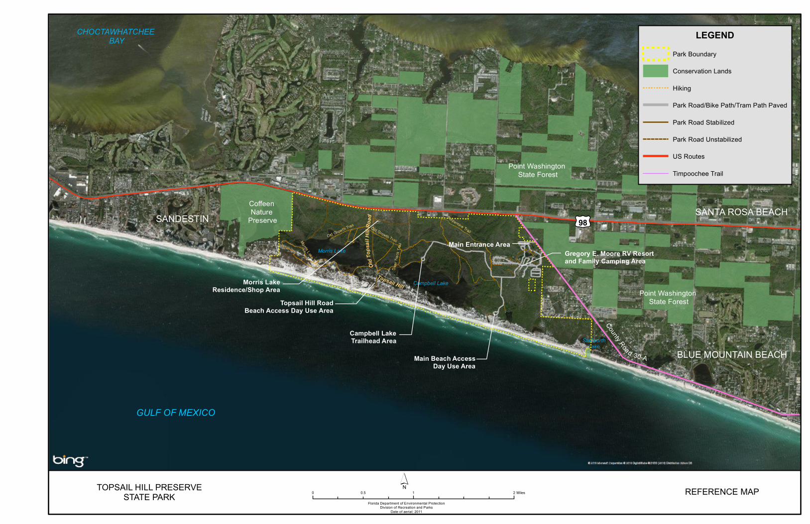
Topsail Hill Preserve State Park is located in Walton County (see Vicinity Map). Access to the park is from U.S. Highway 98 to County Road 30-A (see Reference Map). The Vicinity Map also reflects significant land and water resources existing near the park. Topsail Hill Preserve State Park was initially acquired on June 8, 1992 with funds from the Conservation and Recreation Lands (CARL) and Preservation 2000 (P2000) programs. Currently, the park comprises 1,648.48 acres. The Board of Trustees of the Internal Improvement Trust Fund (Trustees) hold fee simple title to the park and on October 9, 1992 the Trustees leased (Lease Number 3967) the property to DRP under a 50-year lease. The current lease will expire on October 9, 2042. Topsail Hill Preserve State Park is designated single-use to provide public outdoor recreation and conservation. There are no legislative or executive directives that constrain the use of this property (see Addendum 1).
Purpose and Significance of the Park
Topsail Hill Preserve State Park was established to protect perhaps the most outstanding assemblage of natural communities on the coast of the Florida panhandle. The park provides for the perpetual conservation and enjoyment of these important natural communities for Florida residents and visitors for generations to come. Park Significance
• The park protects numerous outstanding natural communities that serve as an important representative sample of the coastal environment of the Florida panhandle.
• The park protects several rare coastal dune lakes, the watershed of the largest, Campbell Lake, is the only protected entirely by state conservation lands, showcasing a uniquely pristine coastal dune lake ecosystem.
• The park is home to one of the largest campgrounds in the Florida State Park System and provides extensive recreational access along 3 miles of white sand beach in a fast-growing area.
• The park protects habitat for numerous imperiled animal species including the Choctawhatchee beach mouse (Peromyscus polionotus allophrys) as well as habitat for several pitcher plant species.
Topsail Hill Preserve State Park is classified as a State Preserve in the DRP’s unit classification system. In the management of a State Preserve preservation and enhancement of natural conditions is all important. Resource considerations are given priority over user considerations and development is restricted to the minimum necessary for ensuring its protection and maintenance, limited access, user safety and convenience, and appropriate interpretation. Permitted uses are
2
primarily of a passive nature, related to the aesthetic, educational and recreational enjoyment of the preserve, although other compatible uses are permitted in limited amounts. Program emphasis is placed on interpretation of the natural and cultural attributes of the preserve.
Purpose and Scope of the Plan
This plan serves as the basic statement of policy and direction for the management of Topsail Hill Preserve State Park as a unit of Florida's state park system. It identifies the goals, objectives, actions and criteria or standards that guide each aspect of park administration and sets forth the specific measures that will be implemented to meet management objectives and provide balanced public utilization. The plan is intended to meet the requirements of Sections 253.034 and 259.032, Florida Statutes, Chapter 18-2, Florida Administrative Code, and is intended to be consistent with the State Lands Management Plan. With approval, this management plan will replace the 2007 approved plan. The plan consists of three interrelated components: the Resource Management Component, the Land Use Component and the Implementation Component. The Resource Management Component provides a detailed inventory and assessment of the natural and cultural resources of the park. Resource management needs and issues are identified, and measurable management objectives are established for each of the park’s management goals and resource types. This component provides guidance on the application of such measures as prescribed burning, exotic species removal, imperiled species management, cultural resource management and restoration of natural conditions. The Land Use Component is the recreational resource allocation plan for the park. Based on considerations such as access, population, adjacent land uses, the natural and cultural resources of the park, and current public uses and existing development, measurable objectives are set to achieve the desired allocation of the physical space of the park. These objectives identify use areas and propose the types of facilities and programs as well as the volume of public use to be provided. The Implementation Component consolidates the measurable objectives and actions for each of the park’s management goals. An implementation schedule and cost estimates are included for each objective and action. Included in this table are (1) measures that will be used to evaluate the DRP’s implementation progress, (2) timeframes for completing actions and objectives and (3) estimated costs to complete each action and objective.

§̈¦10
G U L F o f
M E X I C O
Eglin Air Force Base
Niceville
Destin
Topsail Hill Preserve State Park
Point Washington State Forest
£¤331 Choctawhatchee River Delta Preserve
Choctawhatchee River Water
Management Area
Fred Gannon Rocky Bayou State Park
Henderson Beach State Park
ChoctawhatcheeRiver Water
Management Area
Nokuse Plantation Conservation
Easements
Grayton BeachState Park
Choctawhatchee River Water Management Area
SR 2
93
SR 20
SR 28
5
Rock Hill Rd
Rocky BayouAquatic Preserve
Deer Lake State Park
Seven Runs Conservation Easement
CHOCTAWHATCHEE BAY
Emerald Coast Pkwy Coffeen Nature Preserve
Hogtown BayouSanta Rosa
Beach
Grayton DunesPark
Stallworth LakePreserve Point Washington
State Forest
TOPSAIL HILL PRESERVE STATE PARK
Florida Department of Environmental ProtectionDivision of Recreation and Parks
VICINITYMAP
´
_̂
0 2.5 51.25 Miles
Sources:Florida Natural Areas Inventory, 2015 Florida Land Use Covers and Forms Classification System, 2004
LegendPark Boundary
Land Use
Conservation and Recreation Lands
InterstatesFDOT US RoutesFDOT State RoutesFDOT Local Roads
Federal Managed LandsState Managed LandsLocal Managed LandsPrivate Managed LandsAquatic Preserves
UndevelopedDeveloped

TOPSAIL HILL PRESERVESTATE PARK
Florida Department of Environmental ProtectionDivision of Recreation and Parks
Date of aerial; 2011
´ REFERENCE MAP
LEGENDPark Boundary
Conservation Lands
Hiking
Park Road/Bike Path/Tram Path Paved
Park Road Stabilized
Park Road Unstabilized
US Routes
Timpoochee Trail
0 1 20.5 Miles
£¤98
CHOCTAWHATCHEE BAY
GULF OF MEXICO
SANDESTIN
Topsail Hill RoadBeach Access Day Use Area
Coffeen Nature
Preserve
Main Beach AccessDay Use Area
Campbell LakeTrailhead Area
Gregory E. Moore RV Resortand Family Camping Area
Morris LakeResidence/Shop Area
Main Entrance Area
Point Washington State Forest
Point Washington State Forest
SANTA ROSA BEACH
BLUE MOUNTAIN BEACH
Morris Lake
Campbell Lake
StallworthLake
Topsail Hill
OldT
opsa
il Hi ll
Road
County Road 30-A

7
All development and resource alteration proposed in this plan is subject to the granting of appropriate permits, easements, licenses, and other required legal instruments. Approval of the management plan does not constitute an exemption from complying with the appropriate local, state or federal agencies. This plan is also intended to meet the requirements for beach and shore preservation, as defined in Chapter 161, Florida Statutes, and Chapters 62B-33, 62B-36 and 62R-49, Florida Administrative Code. DRP has determined that uses such as, water resource development projects, water supply projects, stormwater management projects, linear facilities and sustainable agriculture and forestry (other than those forest management activities specifically identified in this plan) would not be consistent with this plan or the management purposes of the park. DRP may provide the services and facilities outlined in this plan either with its own funds and staff or through an outsourcing contract. Private contractors may provide assistance with natural resource management and restoration activities or a concessionaire may provide services to park visitors in order to enhance the visitor experience. For example, a concessionaire could be authorized to sell merchandise and food and to rent recreational equipment for use in the park. A concessionaire may also be authorized to provide specialized services, such as interpretive tours, or overnight accommodations when the required capital investment exceeds that which DRP can elect to incur. Decisions regarding outsourcing, contracting with the private sector, the use of concessionaires, etc. are made on a case-by-case basis in accordance with the policies set forth in DRP’s Operations Manual (OM).
Management Program Overview
Management Authority and Responsibility
In accordance with Chapter 258, Florida Statutes and Chapter 62D-2, Florida Administrative Code, the Division of Recreation and Parks (DRP) is charged with the responsibility of developing and operating Florida's recreation and parks system. These are administered in accordance with the following policy: It shall be the policy of the Division of Recreation and Parks to promote the state park system for the use, enjoyment, and benefit of the people of Florida and visitors; to acquire typical portions of the original domain of the state which will be accessible to all of the people, and of such character as to emblemize the state's natural values; conserve these natural values for all time; administer the development, use and maintenance of these lands and render such public service in so doing, in such a manner as to enable the people of Florida and visitors to enjoy these values without depleting them; to contribute materially to the development of a strong mental, moral, and physical fiber in the people; to provide for perpetual preservation of historic sites and memorials of statewide significance and
8
interpretation of their history to the people; to contribute to the tourist appeal of Florida. The Board of Trustees of the Internal Improvement Trust Fund (Trustees) has granted management authority of certain sovereign submerged lands to the DRP under Management Agreement MA 68-086 (as amended January 19, 1988). The management area includes a 400-foot zone from the edge of mean high water where a park boundary borders sovereign submerged lands fronting beaches, bays, estuarine areas, rivers or streams. Where emergent wetland vegetation exists, the zone extends waterward 400 feet beyond the vegetation. The agreement is intended to provide additional protection to resources of the park and nearshore areas and to provide authority to manage activities that could adversely affect public recreational uses. Management efforts within the 400-foot zone are explained in the Coastal/Beach Management section of the Resource Management Component of this plan. Many operating procedures are standardized system-wide and are set by internal direction. These procedures are outlined in the OM that covers such areas as personnel management, uniforms and personal appearance, training, signs, communications, fiscal procedures, interpretation, concessions, public use regulations, resource management, law enforcement, protection, safety and maintenance. Park Management Goals
The following park goals express DRP’s long-term intent in managing the state park: • Provide administrative support for all park functions. • Protect water quality and quantity in the park, restore hydrology to the extent
feasible and maintain the restored condition. • Restore and maintain the natural communities/habitats of the park. • Maintain, improve or restore imperiled species populations and habitats in the
park. • Remove exotic and invasive plants and animals from the park and conduct
needed maintenance-control. • Protect, preserve and maintain the cultural resources of the park. • Provide public access and recreational opportunities in the park. • Develop and maintain the capital facilities and infrastructure necessary to meet
the goals and objectives of this management plan. Management Coordination The park is managed in accordance with all applicable laws and administrative rules. Agencies having a major or direct role in the management of the park are discussed in this plan.
9
The Florida Department of Agriculture and Consumer Services (FDACS), Florida Forest Service (FFS), assists DRP staff in the development of wildfire emergency plans and provides the authorization required for prescribed burning. The Florida Fish and Wildlife Conservation Commission (FWC) assists staff in the enforcement of state laws pertaining to wildlife, freshwater fish and other aquatic life existing within the park. In addition, the FWC aids DRP with wildlife management programs, including imperiled species management. The Florida Department of State (FDOS), Division of Historical Resources (DHR) assists staff to ensure protection of archaeological and historical sites. The Florida Department of Environmental Protection (DEP), Florida Coastal Office (FCO) aids staff in aquatic preserves management programs. The DEP, Bureau of Beaches and Coastal Systems aids staff in planning and construction activities seaward of the Coastal Construction Control Line (CCCL). In addition, the Bureau of Beaches and Coastal Systems aid the staff in the development of erosion control projects. Public Participation
DRP provided an opportunity for public input by conducting a preliminary public workshop, public workshop, and an Advisory Group meeting to present the draft management plan to the public. These meetings were held on September 21, 2017, [INSERT Dates], respectively. Meeting notices were published in the Florida Administrative Register, [INSERT publication date, VOL/ISSUE], included on the Department Internet Calendar, posted in clear view at the park, and promoted locally. The purpose of the Advisory Group meeting is to provide the Advisory Group members an opportunity to discuss the draft management plan (see Addendum 2). Other Designations
Topsail Hill Preserve State Park is not within an Area of Critical State Concern as defined in Section 380.05, Florida Statutes, and is not presently under study for such designation. The park is a component of the Florida Greenways and Trails System, administered by the Department’s Office of Greenways and Trails. All waters within the park have been designated as Outstanding Florida Waters, pursuant to Chapter 62-302, Florida Administrative Code. Surface waters in this park are also classified as Class III waters by the Department. This park is not within or adjacent to an aquatic preserve as designated under the Florida Aquatic Preserve Act of 1975 (Section 258.35, Florida Statutes).

10
11
RESOURCE MANAGEMENT COMPONENT
Introduction
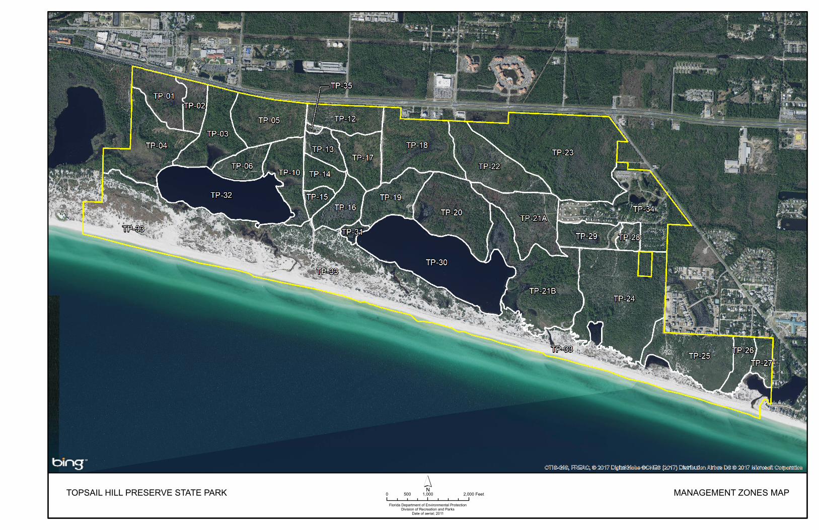
The Florida Department of Environmental Protection (DEP), Division of Recreation and Parks (DRP) in accordance with Chapter 258, Florida Statutes, has implemented resource management programs for preserving for all time the representative examples of natural and cultural resources of statewide significance under its administration. This component of the unit plan describes the natural and cultural resources of the park and identifies the methods that will be used to manage them. Management measures expressed in this plan are consistent with the DRP’s overall mission in natural systems management. Cited references are contained in Addendum 3. The DRP’s philosophy of resource management is natural systems management. Primary emphasis is placed on restoring and maintaining, to the degree possible, the natural processes that shaped the structure, function and species composition of Florida’s diverse natural communities as they occurred in the original domain. Single species management for imperiled species is appropriate in state parks when the maintenance, recovery or restoration of a species or population is complicated due to constraints associated with long-term restoration efforts, unnaturally high mortality or insufficient habitat. Single species management should be compatible with the maintenance and restoration of natural processes and should not imperil other native species or seriously compromise the park values. The DRP’s management goal for cultural resources is to preserve sites and objects that represent Florida’s cultural periods, significant historic events or persons. This goal often entails active measures to stabilize, reconstruct or restore resources, or to rehabilitate them for appropriate public use. Because park units are often components of larger ecosystems, their proper management can be affected by conditions and events that occur beyond park boundaries. Ecosystem management is implemented through a resource management evaluation program that assesses resource conditions, evaluates management activities and refines management actions, and reviews local comprehensive plans and development permit applications for park/ecosystem impacts. The entire park is divided into management zones that delineate areas on the ground that are used to reference management activities (see Management Zones Map). The shape and size of each zone may be based on natural community type, burn zone, and the location of existing roads and natural fire breaks. It is important to note that all burn zones are management zones; however, not all management zones include fire-dependent natural communities. Table 1 reflects the management zones with the acres of each zone.

12
Table 1. Topsail Hill Preserve State Park Management Zones
Management Zone Acreage Managed with
Prescribed Fire
Contains Known Cultural Resources
TP-01 28.33 Y N TP-02 15.52 Y N TP-03 41.14 Y N TP-04 55.82 Y Y TP-05 42.63 Y Y TP-06 18.50 Y Y TP-10 32.56 Y Y TP-12 26.72 Y N TP-13 15.08 Y N TP-14 15.15 Y Y TP-15 8.42 Y Y TP-16 22.88 Y N TP-17 27.53 Y N TP-18 58.22 Y N TP-19 31.28 Y N TP-20 59.45 Y Y TP-21A 45.46 Y N TP-21B 88.34 Y Y TP-22 47.48 Y N TP-23 122.53 N Y TP-24 102.42 N N TP-25 50.96 N N TP-26 14.78 N N TP-27 10.83 N Y TP-28 8.21 N N TP-29 21.42 N N TP-30 100.28 N N TP-31 4.73 Y N TP-32 70.18 N N TP-33 386.92 Y Y TP-34 68.45 N N TP-35 1.75 N N
Resource Description and Assessment
Natural Resources
Topography
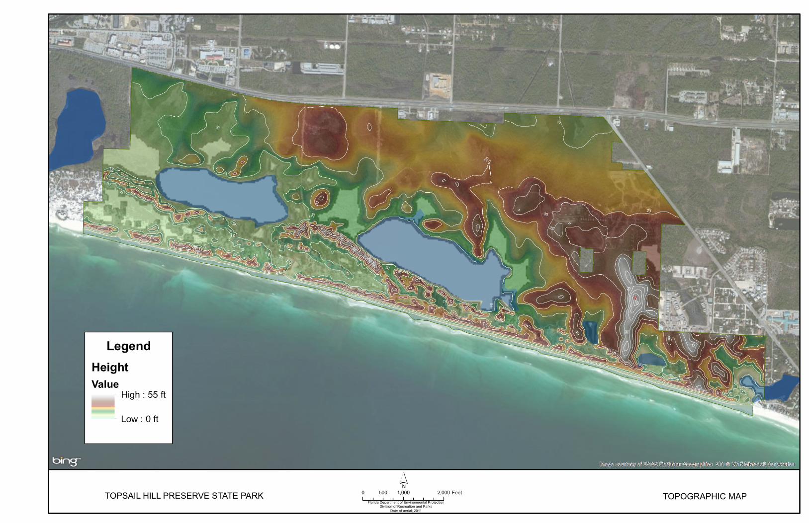
At Topsail Hill Preserve State Park, the major topographic features (see Topographic Map) are the coastal dunes located adjacent to the Gulf of Mexico. The coastal area here has historically been shaped by changes in global sea levels, and by the erosional forces of wind and waves over the past two million years. A portion
TOPSAIL HILL PRESERVE STATE PARKFlorida Department of Environmental Protection
Division of Recreation and ParksDate of aerial; 2011
0 1,000 2,000500 Feet MANAGEMENT ZONES MAP

TOPSAIL HILL PRESERVE STATE PARKFlorida Department of Environmental Protection
Division of Recreation and ParksDate of aerial; 2011
´TOPOGRAPHIC MAP 0 1,000 2,000500 Feet
LegendHeight Value
High : 55 ft
Low : 0 ft

17
of the eastern end of the property lies on an ancient marine terrace, defined by a distinct escarpment at 25 feet above mean sea level (Schmidt 1984). Throughout the property are relict marine dunes and beach ridges punctuated by intervening swales. In the past, the primary dunes of the state park have attained elevations approaching 32 feet above mean sea level. Significant changes to this dune system occurred when Hurricane Opal impacted the San Destin coast in 1995. The highest dune at Topsail Hill Preserve State Park was eroded, and washovers of the dunes from the gulf to the coastal dune lakes occurred. Hurricanes in 2004 and 2005 have also significantly reduced the height and mass of the primary dunes at this park. In contrast to the dunes, the more sheltered interior flatwoods of the park are of minimal relief, except for slight interior sand ridges. The highest point in the park is at 55 feet above mean sea level, and occurs on a north-south oriented ridge lying about halfway between Campbell and Stallworth Lakes. Geology
The entire southern area of Walton County lies within the Gulf Coastal Lowlands. (Puri and Vernon 1964). Pleistocene to recent quartz sands covers the lower part of the county (Schmidt and Clark 1980). A quartz sand veneer is found above a wedge of the Intracoastal Formation at 50 feet (Schmidt 1984). That latter strata which is described as a soft, sandy limestone of Pliocene age with abundant microfossils (Schmidt and Clark 1980), overlies Bruce Creek Limestone at approximately 100 feet (Schmidt 1984). Although limestone is present at approximately 50 feet below the land’s surface, Topsail Hill contains few obvious karst features. The dominant influence on the development of the landscape over time is changes in sea level, storms and hurricane impacts. Coastlines along the Gulf of Mexico need a continual natural supply of sand due to constant erosion from the longshore current. Sand supply within these coastal communities is limited throughout Florida’s panhandle, therefore some portions of the park’s beaches and dunes are eroding, while other areas are accreting (Campbell 1984). Fluctuations in shoreline shape and slope is a natural process that accompanies the movement of these dynamic communities. Some of the most interesting geological features at Topsail are the dune ridges formed in the late Holocene, adjacent to multiple coastal dune lakes. The park contains some portion of five coastal dunes lakes, with all of Campbell Lake being contained within the park boundaries. Coastal dune lakes are freshwater lakes that vary in their level of salinity depending on the frequency and duration that they purge and are open to the Gulf of Mexico. Coastal dune lakes are oligotrophic low-nutrient lakes fed, in this park, by seepage slopes and flatwoods. The coastal ecosystems, which includes beach dunes and coastal scrub, act as a barrier for the inland communities protecting the coastal dunes and flatwoods found farther inland from tropical storm events.
18
Soils
According to the National Resources Conservation Service, 15 soil types are found at Topsail Hill Preserve State Park (see Soils Map). A detailed description of these soil types is contained in Addendum 4. Soils at Topsail are interrelated with topography and climate regimes. Four soil families are currently found at the park: entisols, spodosols, histosols and inceptisols (U.S.D.A. 1989). Soils of the dunes and interior sandy ridges are excessively drained entisols, in which available water capacity and nutrients are low. This includes soils such as Beaches, Newhan-Corolla Sands, Resota Sand, Foxworth Sand, Kureb Sand and Lakeland Sand. The natural communities commonly found on these entisol soils include beach dune, scrub, maritime hammock and scrubby flatwoods. Common species found growing within entisol soils include sand pine (Pinus clausa), Florida rosemary (Ceratiola ericoides), turkey oak (Quercus laevis), and sand live oak (Quercus geminata). Entisol soils are commonly deposited during historical changes in sea levels associated with the melting and freezing of glaciers. Spodosol soils are commonly associated with flatwoods, and includes Mandarin Sand, Hurricane Sand, and Leon Sand at Topsail Hill. These soils are generally level, poorly draining, and are associated with mesic flatwoods, wet flatwoods and wet prairies. Natural vegetation includes longleaf pine (Pinus palustris), slash pine (Pinus elliottii), saw palmetto (Serenoa repens), wiregrass (Aristida stricta var. beyrichiana) and gallberry (Ilex glabra). Of all the soils found at Topsail, these historically would have been the only areas conducive for growing timber due to a slightly higher organic content. Dorovan-Pamlico association, Pamlico muck, and Duckston muck are in the histosols family, and can be found where basin swamps and basin marshes fringe the coastal dune lakes. This mucky soil is high in organic nutrients, poorly draining, and is inundated with water anywhere from two to six months per year. Common vegetation includes smooth cordgrass (Spartina alterniflora), bald cypress (Taxodium distichum) and sweetbay (Magnolia viginiana). The last soil family, inceptisols, includes Rutlege Fine Sand and Pickney Sand. These soils are found in the dome swamps and shallow basin depressions on the northeast section of the park. This soil is very poorly draining and nearly level, allowing plants such as cypress (Taxodium spp.), swamp tupelo (Nyssa sylvatica var. biflora), dahoon (Ilex cassine), and titi (Cliftonia monophylla, Cyrilla racemiflora) to grow. Limited soil erosion has occurred from unimproved roads and off road vehicle (ORV) impacts before the land was acquired by the State. These areas have since been closed to vehicular access, and are now recovering naturally as soils decompress and native vegetation begins to grow in. The development of future trails and the maintenance of existing park roads will implement best management practices as outlined by the Florida Forest Service 2008 Silviculture Best Management Practices. This includes maintaining native vegetation within 50 feet of any waterbody,

TOPSAIL HILL PRESERVE STATE PARKFlorida Department of Environmental Protection
Division of Recreation and ParksDate of aerial; 2011
0 1,000 2,000500 Feet´
SOILS MAP
LegendSoils
12 - Foxworth sand, 0 to 5 percent slopes
16 - Kureb sand, 0 to 8 percent slopes
17 - Lakeland sand, 0 to 5 percent slopes
21 - Leon sand
27 - Rutlege fine sand
50 - Mandarin sand
54 - Newhan-Corolla sands, rolling
55 - Beaches
56 - Kureb sand, hilly
57 - Hurricane sand, 0 to 5 percent slopes
58 - Duckston muck, frequently flooded
62 - Resota sand, 0 to 5 percent slopes
63 - Pickney sand, depressional
64 - Pamlico muck
69 - Florala loamy fine sand, 2 to 5 percent slopes
8 - Dorovan-Pamlico association, frequently flooded
99 - Water

21
avoiding the use of heavy machinery during wet conditions, and the placement of trails and fire lines that will not impede sheet flow or cause any dome or basin swamps to become artificially drained. With a multitude of trails and fire lines already in place at Topsail, it is in the park’s best interest to maintain the existing trails, and not to create anymore new firebreaks. Due to a multitude of wetlands throughout the park, low water crossings should be installed along trails in commonly flooded areas. It’s vital that these low water crossings use the correct rock size at an appropriate depth to ensure the smallest amount of disturbance possible to the watershed. Erosion from hurricanes and tropical storms to the beach dunes and coastal scrub is part of a natural process that shapes these communities. Hurricanes in 2004 and 2005 severely eroded the frontal dunes at the park, but these areas are recovering well. While sea oat plantings seem like an attractive way to quickly build beach dunes, they have the ability to impact vital nesting grounds for beach nesting shorebirds. The beaches at Topsail should fluctuate in size and depth in accordance with large tropical storm events, and sea oats and sand dune fencing is not always recommended. Beach sediment will be conserved at the park by avoiding the use of hard shoreline stabilizations. Structures such as seawalls, bulkheads and groins can expedite erosion by trapping sand in one area, while starving others. By maintaining an undisturbed beach without manipulation, the natural communities at the park will weather out any large storm events and recover naturally. Beach nourishment projects should be avoided at Topsail Hill Preserve State Park in order to protect and preserve the natural sediment arrangement. If an adjacent beach is to receive dredged sediment to augment beach width, the sand should be fanned/tapered into the park to avoid abrupt changes in beach size, and to avoid rapid erosion of the recently placed sand. Minerals
Heavy minerals such as ilmenite, rutite, kyanite, zircon, garnet, staurolite and leucoxene are found in neighboring beaches (Yon and Hendry 1969). There appear to be no known deposits of commercially valuable minerals within the park. Hydrology
Topsail Hill Preserve State Park is bordered on the south by the Gulf of Mexico, and is within the Choctawhatchee Bay watershed, which encompasses 6,000 square miles (NWFWMD 1978). This basin begins in southeast Alabama and flows through Alabama and northeast Florida for a distance of 175 miles (U.S. Corps of Engineers 1980). The flow discharges into Choctawhatchee Bay, and then into the Gulf of Mexico (Esry 1987). According to Pascale (1974), two major aquifers are found in Walton County: the sand and gravel aquifer and the Floridan aquifer. The latter is the primary source of drinking water for Walton County.

22
The hydrology at the park is divided into two layers, the surficial aquifer and the Floridan aquifer. The surficial aquifer is water that is found on or right below the soil surface and is not confined. It is recharged by rainfall and moves topographically downhill into basins, swales, and eventually into the Gulf of Mexico. It is important for supplying streams, lakes, and wetlands with adequate water flow. This water is vital to the existence and maintenance of natural communities such as wet flatwoods, wet prairies, and seepage slopes. Disruption to the surficial aquifer due to ground disturbance negatively impacts communities that need constant ground and surface water to allow imperiled plant species to persist. Changes in the amount or quality of this water allows a different suite of species to move in, and out compete the delicate and imperiled prairie and seepage slope plants. Many wetland communities exist within the park, including basin marshes, basin swamps, interdunal swales, and dome swamps. All of these communities require a specific amount of water from the surficial aquifer to maintain their associated species in balance. Other hydrological issues at the park are due to developments that cause local flooding. The location of the campground adjacent to a seepage slope and basin swamp means that the historic water flow has been significantly altered. Raised land and a series of canals try to drain water away from the campground and parking lots, but dilapidated culverts and an abundance of beaver dams cause water to pool within developed areas. The removal of beavers has not been successful at limiting flooding. Park staff have attempted to dig ditches to reroute water in the past. New culverts bypassing the beaver dams would potentially ameliorate some of this flooding issue. One other hydrological issue deals with the path of water from US HWY 98 to Morris Lake through Management Zone TP-06. This fireline is the path of least resistance for water flow to the lake, and regularly gets washed out. Not only does this pose a hazard to vehicles, but it increases the amount of sediment and nutrients entering Morris Lake. The last hydrological issue to mention deals with an abundance of torpedo grass (Panicum repens) along the shorelines of the lakes and between Morris and Fuller Lake. It is thought that treating and removing torpedo grass from Morris Lake would help Fuller Lake to drain more proficiently, preventing the outfall from needing to be opened. Also, a small causeway in Morris Lake is now covered in torpedo grass, choking the water flow from Morris Lake out to the Gulf through the outfall. Treating these areas and removing the causeway would ameliorate these hydrological issues. A detailed description of the hydrology of the park’s coastal dune lakes can be found in the natural community description on page 41. Natural Communities
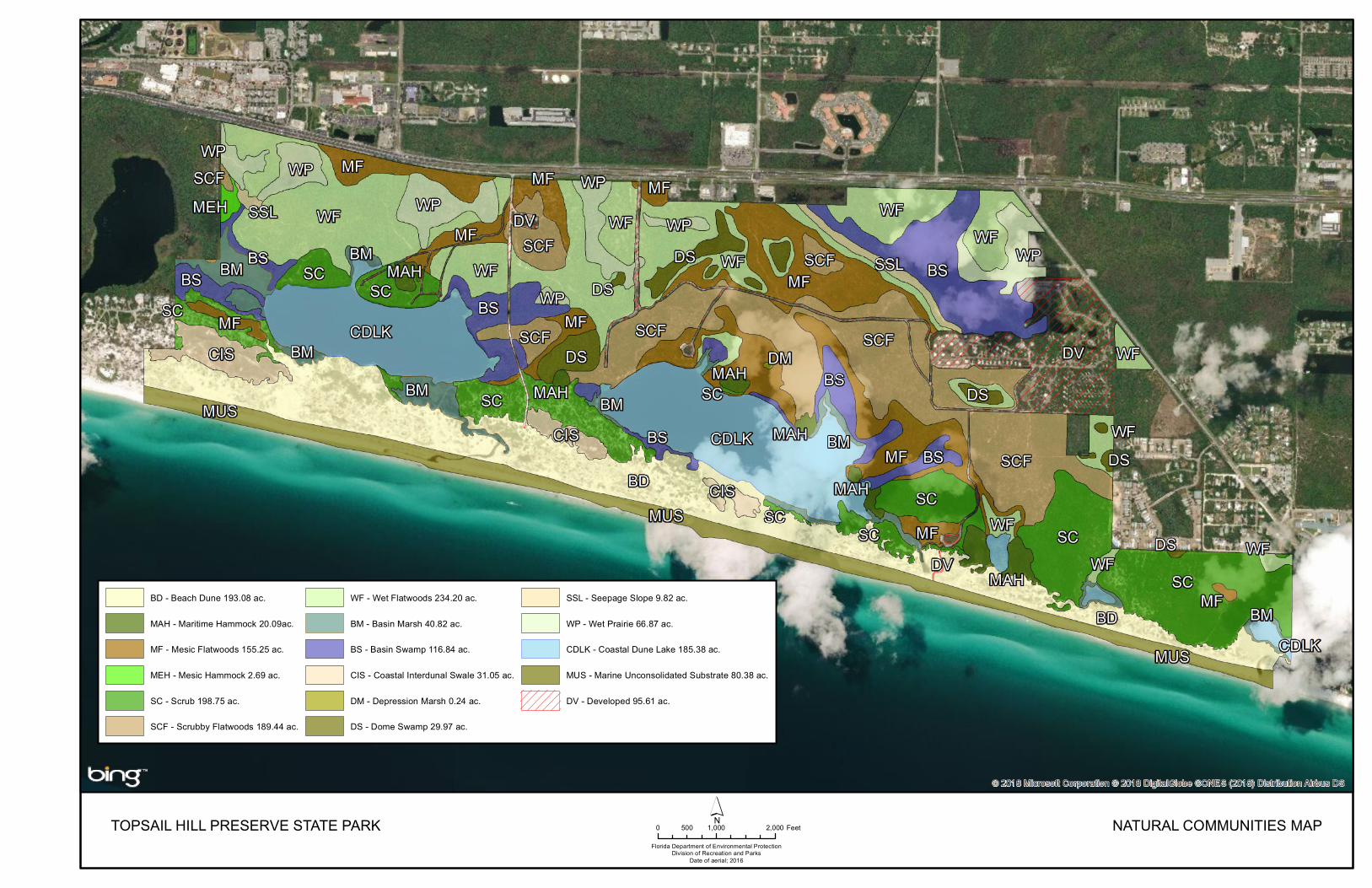
This section of the management plan describes and assesses each of the natural communities found in the state park. It also describes of the desired future
23
condition (DFC) of each natural community and identifies the actions that will be required to bring the community to its desired future condition. Specific management objectives and actions for natural community management, exotic species management, imperiled species management [and population restoration] are discussed in the Resource Management Program section of this component. The system of classifying natural communities employed in this plan was developed by the Florida Natural Areas Inventory (FNAI). The premise of this system is that physical factors such as climate, geology, soil, hydrology, and fire frequency generally determine the species composition of an area, and that areas that are similar with respect to those factors will tend to have natural communities with similar species compositions. Obvious differences in species composition can occur, however, despite similar physical conditions. In other instances, physical factors are substantially different, yet the species compositions are quite similar. For example, coastal strand and scrub--two communities with similar species compositions--generally have quite different climatic environments, and these necessitate different management programs. Some physical influences, such as fire frequency, may vary from FNAI’s descriptions for certain natural communities in this plan. When a natural community within a park reaches the desired future condition, it is considered to be in a “maintenance condition.” Required actions for sustaining a community’s maintenance condition may include; maintaining optimal fire return intervals for fire dependent communities, ongoing control of non-native plant and animal species, maintaining natural hydrological functions (including historic water flows and water quality), preserving a community’s biodiversity and vegetative structure, protecting viable populations of plant and animal species (including those that are imperiled or endemic), and preserving intact ecotones that link natural communities across the landscape. The park contains 17 distinct natural communities as well as altered landcover types (see Natural Communities Map). A list of known plants and animals occurring in the park is contained in Addendum 5. Beach Dune Desired future condition: Beach dune is a coastal mound or ridge of unconsolidated sediments found along shorelines with high energy waves such as the Gulf of Mexico. Vegetation consists of herbaceous dune forming grass species like sea oats (Uniola paniculata) and bitter panicgrass (Panicum amarum). Other typical species include seacoast marshelder (Iva imbricata), beach pennywort (Hydrocotyle bonariensis), camphorweed (Heterotheca subaxillaris), beach morning glory (Ipomea imperati), and sea purselane (Sesuvium portulacastrum). Occasionally salt-pruned sand live oaks are scattered in areas sheltered from the harsh conditions by sand dunes. Rare plants such as the Gulf Coast lupine (Lupinus westianus) and Godfrey’s goldenaster (Chrysopsis godfreyi) are locally abundant in pristine beach dune conditions. The main disturbance factor for this natural community is tropical storm events. Fire may have historically reached beach dunes on rare occasions, but was not the dominant natural force shaping this community and its vegetative structure.
24
A self-sustaining population of Choctawhatchee beach mice (Peromyscus polionotus allophrys), a federally-listed endangered species, should occupy all available beach dune habitats. Nesting shorebirds including least terns (Sternula antillarum) and snowy plovers (Charadrius nivosus) should successfully nest along the dune front and in dune blowout areas. Shorebirds should have connectivity between the beach dune community to various foraging habitats (such as the shoreline and/or the coastal dune lakes). In particular, corridors should be free from human disturbance and vehicle rutting during the breeding season to allow shorebirds (and their flightless young) to make the journey from the nest to available foraging habitats. Sea turtles should nest along a dark beach, and hatchlings should be able to crawl to the water on a beach that is free of vehicle ruts and artificial light. The gulf coast solitary bee (Hesperapis oraria) should occupy the backside of the dunes, primarily where yellow buttons (Balduina angustifolia) are found. No exotic plants or animals should be present. Description and assessment: The beach dune natural community can be found along the southern boundary of the park, adjacent to marine unconsolidated sediment and the Gulf of Mexico. This natural community is currently in good condition with little development and limited beach driving. A wire mesh road was placed over the sand in the past, as this community was used for transporting heavy machinery and rockets during WWII. This cultural site is now mostly buried and does not greatly impact any native flora or fauna. Storm surges from Hurricane Opal in 1995 washed through the primary dune line at the park, creating large open blowouts. These blowouts were recovering and foredunes were forming when the hurricanes of 2004 and 2005 washed though this area again, further eroding the dune system. Both the height and depth of the dune system at Topsail have been decreased by these direct hurricane hits. Some of the resulting disturbed areas provided nesting habitat for shorebirds, specifically least terns and snowy plovers, but decreased dune habitat for the endangered beach mice. Now, ten years post major storm, the dunes are again forming, and the once open sandy blowouts are becoming vegetated. Many imperiled animal species utilize this community for foraging and nesting, including sea turtles and shorebirds. Sea turtles that have nested at Topsail within the beach dune community include loggerheads (Caretta caretta), greens (Chelonia mydas), Kemp’s Ridley (Lepidochelys kempii), and leatherback (Dermochelys coriacea). While nesting density is never high (approximately 2 nests per mile), maintaining the genetic diversity of the panhandle nesting sea turtles is crucial to the recovery of the species. A multitude of imperiled shorebirds including snowy plovers, Wilson’s plovers (Charadrius wilsonia), least terns, and black skimmers (Rynchops niger) have been documented resting and foraging at the park. A few of these species, including snowy plovers and least terns, have nested within this community at Topsail. The Choctawhatchee Beach mouse is also prevalent in this community, and its occurrence rate is documented through the use of 32 tracking tube stations. As of January 2015, 63% of the beach dune community at Topsail provided evidence that
TOPSAIL HILL PRESERVE STATE PARKFlorida Department of Environmental Protection
Division of Recreation and ParksDate of aerial; 2016
0 1,000 2,000500 Feet´ NATURAL COMMUNITIES MAP
BD - Beach Dune 193.08 ac.
MAH - Maritime Hammock 20.09ac.
MF - Mesic Flatwoods 155.25 ac.
MEH - Mesic Hammock 2.69 ac.
SC - Scrub 198.75 ac.
SCF - Scrubby Flatwoods 189.44 ac.
WF - Wet Flatwoods 234.20 ac.
BM - Basin Marsh 40.82 ac.
BS - Basin Swamp 116.84 ac.
CIS - Coastal Interdunal Swale 31.05 ac.
DM - Depression Marsh 0.24 ac.
DS - Dome Swamp 29.97 ac.
SSL - Seepage Slope 9.82 ac.
WP - Wet Prairie 66.87 ac.
CDLK - Coastal Dune Lake 185.38 ac.
MUS - Marine Unconsolidated Substrate 80.38 ac.
DV - Developed 95.61 ac.

27
beach mice were present. These tracking tubes are checked monthly, and all data is kept with FWC personnel. General management measures: Park visitor access into and through beach dune areas should be controlled as much as possible to prevent degradation of this dune community. Dune walkover areas should be designated and protected with boardwalks in day use areas. Unauthorized trails in dunes should be actively discouraged with interpretive signs, ranger interpretation, post and rope, dune plantings and other natural barriers. Driving on or near established dunes will be prohibited except for certain official uses. Driving in the Beach Dune habitat will be conducted in concert with the FWC Best Management Practices for Operating Vehicles on the Beach in order to minimize the detrimental impacts such as vehicular rutting. After tropical storms, impacts to dunes should be assessed. Plantings and other dune restoration techniques should be considered when and where necessary to prevent further dune erosion. A plan should be developed prior to any planting to address dune restoration, while maintaining non-vegetated dune blowouts for nesting shorebirds. Exotic and nuisance predators should be controlled to prevent negative impacts to rare faunal populations, such as Choctawhatchee beach mice and snowy plovers. A tracking assessment of predators should be conducted prior to the start of the shorebird nesting season and during beach mice and shorebird monitoring to establish predator control needs. Efforts to avoid and/or minimize disturbance, including the impacts associated with the presence of humans and dogs around nesting shorebirds, are critical to nesting success. Artificial lighting or sky glow should not be present on the beach dune. Artificial lights disorient sea turtles and can affect their ability to successfully enter the marine environment. A nighttime assessment of lighting should be conducted annually before sea turtle monitoring commences to anticipate and prevent sea turtle hatchling disorientations. Maritime Hammock Desired future condition: Maritime hammock is a coastal evergreen hardwood forest occurring in narrow bands along stabilized coastal and historic dunes. This community grows in areas protected from fire, sea breezes, and severe storms, allowing them to develop complete canopies. Canopy species will typically consist of sand live oak, live oak (Quercus virginiana), southern magnolia (Magnolia grandiflora), and sand pine. This canopy is densely packed, and often salt-spray pruned wherever leaves are exposed to wind. Understory species consist of coralbean (Erythrina herbacea), sassafras (Sassafras albidum), yaupon holly (Ilex vomitoria), saw palmetto, and wax myrtle (Myrica cerifera). Herbaceous groundcover is limited to the occasional Smilax spp. vine. Description and assessment: Eight distinct patches of maritime hammock exist within the park, and all are considered to be in good condition. Each has developed in locations where some protection is afforded from fire, sea breezes and severe

28
storms blowing in from the Gulf. All of these high and dry hammock patches formed adjacent to permanent bodies of fresh water, making them ideal locations for historic and prehistoric camp sites. The maritime hammocks at Topsail differ significantly in quality, with canopy heights ranging from roughly 15 to 30 feet. Dominant canopy species include southern magnolia, live oak and sand-live oak. The highest quality hammock, those that have not been drastically damaged by tropical storms, supports species that have not been observed elsewhere in the park, including pignut hickory (Carya galbra), and yellow foxglove (Aureolaria flava). Typical understory species include small-flowered pawpaw (Asimina parviflora), yaupon holly, wild olive (Cartrema americana), saw Palmetto, beautyberry (Callicarpa americana), and coral bean. The biological significance of these sites is far greater than their small size might otherwise indicate. They not only enhance the biological diversity of the park, but they are also highly important stopover sites for migrating neotropical birds. This is due to their location on the coast, protection from the elements and abundance of food and fresh water. Many of these bird species are on their way to cross the Gulf of Mexico to winter in South America, therefore these hammock areas adjacent to the Gulf are vital for stocking up on water, nutrients, and fats before the long flight south. General management measures: Management of the maritime hammocks should include protection from disturbance. This community developed due to a lack of fire and storm damage, therefore no prescription fire or mechanical treatment should be done. Maintaining a closed canopy with a diverse and sometimes dense understory is important for many migratory bird species. In some areas of maritime hammock, large old growth sand pines can be found. These trees should not be included in any restoration timber removal operation. They are a natural component of these communities. Mesic Flatwoods Desired future condition: Mesic flatwoods occur in a mosaic landscape interspersed with wet and scrubby flatwoods, along with a variety of wet prairies and domes. This community is characterized by an open canopy of tall longleaf and south Florida slash pine, along with a dense, low ground layer of shrubs, grasses and forbes. Saw palmetto is present but not overly dominant. Other shrub species include gallberry, fetterbush (Lyonia lucida), shiny blueberry (Vaccinium myrsinites), vanillaleaf (Carphephorus odoratissimus) and dwarf huckleberry (Gaylussacia dumosa). The herbaceous layer is primarily grasses, including wiregrass and broomsedge (Andropogon virginicus). This community has minimal topographic relief and the soils contain a hardpan layer within a few feet of the surface which impedes percolation. Due to these factors, water can saturate the sandy surface soils for extended periods during the wet season but lengthy droughts also commonly occur during the dry season. The Optimal Fire Return Interval for this community is 2-5 years.

29
Description and assessment: The mesic flatwoods at Topsail is located throughout, but the majority of it occurs in the northern half of the park. As mentioned before, this community is interspersed within a diverse matrix with wet flatwoods, wet prairie, dome swamps, basin swamps, scrub, and scrubby flatwoods. A small change in topography, wetness and soil leads to major changes in vegetative community. Currently this community is in good condition. Areas on the western half of the park are in excellent condition and have been burned approximately every 4 years for some time. Other areas on the eastern side of the park have more duff buildup from a long history of no burning. While these areas are still in much better shape than the previous plan, they require a few more burn rotations before becoming excellent. Mesic flatwoods here are dominated by a mix of slash and longleaf pine, a shrub layer of dwarf live oak (Quercus minima), fetterbush and gallberry, and an herbaceous layer dominated by wire grass. The mesic and wet flatwoods communities at Topsail contain stands of uneven age longleaf pine, including ages that qualify many of these trees to be considered old-growth (128 years old). Over 1000 old-growth longleaf pine trees were counted during a 2007 inventory. The longleaf pines in these communities are relatively short in stature (30–40 ft.) and many show cat-faces. There are a few disjunct patches of mesic flatwoods located within non-pyric communities of coastal scrub. These communities can become extremely overgrown in times without tropical storms, almost to the point of becoming mesic hammocks. These small areas should not be included in the burn plan, as maintaining them with fire would cause more damage to the surrounding scrub communities. They should be allowed to fluctuate in duff and tree cover, with large hurricane events being the main disturbance factor. General management measures: Prescribed fire is important to this community and should continue to be implemented on a 2-4 year interval. In areas where fire has been suppressed for many years, reintroduction of fire in these communities must be undertaken sensitively to prevent tree crown consumption and duff smoldering that can lead to tree mortality in older trees (Varner 2005). Once fire has been reintroduced, it will take many years of careful burning before this community will return to good condition. Burns during the recovery period should take into account the duff moisture prior to burning. If sufficient duff moisture exists then prescribed burns should be conducted with ignition techniques tailored accordingly to reduce the likelihood of old growth mortality. In this natural community as well as other pyric communities, it is understood that in most cases growing season burns may be the most advantageous for natural community health. However, in this park, there are smoke management and safety considerations due to the wildland urban interface which limits the number of opportunities that prescribed fire can be introduced during a season. The park should continue to strive to schedule prescribed burns so that variability in the seasonality of burns between zones exists, and that growing season opportunities are maximized.
30
The park should continue to maintain the original hydrology and prevent future hydrological alteration. Care must be taken to prevent any further disruption to hydrology. Careful consideration should be given to the type, location, creation and maintenance of fire lines. Mesic Hammock Desired future condition: Mesic hammock is a well-developed evergreen hardwood forest which occurs at the park in association with a cultural site. The dense canopy is dominated by live oak with southern magnolia and pignut hickory (Carya glabra) common components in the subcanopy. The shrubby understory is open, and composed of saw palmetto, beautyberry, coralbean, American holly (Ilex opaca), gallberry and sparkleberry (Vaccinium arboreum). The groundcover is sparse, but generally contains a variety of grasses, sedges, ferns, and forbs. Abundant vines and epiphytes such as resurrection fern (Pleopeltis polypodioides var. michauxiana), muscadine (Vitis rotundifolia) and Spanish moss (Tillandsia usneoides) occur on live oaks and other subcanopy trees. Mesic hammock contains sandy soils with organic materials, plus a thick layer of leaf litter at the surface. This community is rarely inundated, and is not considered to be fire-adapted. It’s location on a high ridge adjacent to a basin swamp near Morris Lake helps shield this community from fire disturbances. Description and assessment: There is one area of mesic hammock located at Topsail on the very west boundary of the park. Similar to the maritime hammock found at the park, this site is also associated with a historical camping site. Currently, this community is in excellent condition, and is dominated by live oak, magnolia and pignut hickory with a sparse understory of beautyberry. This hammock grades into a basin swamp, which serves as a natural firebreak for the hammock. Being a high and dry shaded hammock, this community houses a large diversity of animal species. Eastern glass lizards (Ophisaurus ventralis), broadhead skinks (Eumeces laticpes), pileated woodpeckers (Dryocopus pileatus), green anoles (Anolis carolinensis), white-tailed deer (Odocoileus virginianus), and gray squirrels (Sciurus carolinensis) can all be found at this site throughout the year. General management measures: The main form of management for mesic hammock is protection from fire. The communities to the north of this hammock include scrubby flatwoods, seepage slope, and wet prairie, all of which are pyric to some degree. Care should be taken to avoid fire from entering the hammock, especially on winter burns with a low relative humidity. New developments, including new trails, should be avoided in this community due to the sensitivity of natural and cultural resources. Scrub Desired future condition: Within scrub habitats, the dominant plant species include sand live oak, myrtle oak (Quercus myrtifolia), Chapman’s oak (Quercus chapmanii), saw palmetto, and rusty staggerbush (Lyonia ferruginea). There will be
31
scattered openings in the canopy with bare patches of sand that support many imperiled and/or endemic plant species such as large-leaved joint weed (Polygonella macrophylla). Frequently occurring groundcover species include reindeer moss (Cladonia spp.), bush goldenrod (Chrysoma pauciflosculosa), false rosemary (Conradina canescens), and Florida rosemary. Sand pine is also present but due to its lower tolerance of salt spray, it gradually losses its dominance in the canopy closer towards the Gulf. Some areas of mature sand pine scrub occur along protected areas of the coastal dune lakes. Like all coastal scrubs in the Florida panhandle, the variety of sand pine is (Pinus clausa var. immuginata) Choctawhatchee sand pine. Unlike Ocala sand pine (Pinus clausa var. clausa), which is dominated by trees with serotinous cones, the Choctawhatchee sand pines at Topsail have cones that routinely open on sunny days each fall and drop seeds to the ground. The abundance of seedlings along with gap dynamics associated with tropical storm events are the primary drivers that influence and shape these coastal scrub communities. Scrub found within these coastal systems is not maintained by fire, and therefore should not be intentionally burned at any interval. The intermediate disturbance shaping this ecosystem is tropical storm systems on an approximate 10 year cycle. Description and assessment: The coastal scrub found at Topsail is in excellent condition. A large swath of scrub on the east end of the park is a great example of healthy scrub maintained by tropical storm disturbances. This section of scrub along with others, are found directly adjacent to the beach dunes with low stature salt spray pruned oaks. Scrub is found at the park landward of established beach dunes, as well as along the northern boundary of Morris Lake. This community contains sandy soils atop historical sand dunes, allowing for quick percolation of water to coastal dune lakes and to the Gulf of Mexico. As with beach dune, the soils and vegetation are highly sensitive to off road vehicle use and foot traffic. Many imperiled species occur within this community. Where scrub occurs adjacent to the beach dune community, it is vital to the survival of the Choctawhatchee beach mouse. This community serves as a reservoir for food and cover for the mice during and after catastrophic storms that may damage or destroy the primary dune systems. In general, the larger the contiguous area of habitat, the better survivability for beach mice. Along with beach mice, gopher tortoises (Gopherus polyphemus) and their burrows are found in the scrub, as well as the southern hognose snake (Heterodon simus). Coastal scrub is also home to listed plant species, such as gulf coast lupine and largeleaf jointweed. The park has a healthy population of these species because of the good condition of scrub habitat. General management measures: Visitor and management access to coastal scrub should be controlled through designated at-grade footpaths. Paths or walkways through this community should be minimized as these paths serve as corridors that allow coastal winds and salt spray to penetrate the scrub creating soil erosion and mortality of trees, thus further fragmenting this community. Additional accesses or development should avoid coastal scrub where possible to prevent impacts to this fragile community. Motor vehicle use in this area should continue to be limited or
32
eliminated. Exotic animals and plants should be controlled, including feral cats, coyotes (Canis latrans), red foxes (Vulpes vulpes) and armadillos (Dasypus novemcinctus), to protect the population of beach mice. The use of ignition techniques to mimic stand replacing or catastrophic canopy fires should not be applied to coastal scrub in the park since researchers (Drewa et al. 2008; Parker et al. 2001) have concluded that stand replacing fire was not the natural process driving the structure and health of these coastal panhandle scrub communities. Use of stand replacing fire would not mimic a normal natural process in these communities and would alter the natural uneven age stand structure of sand pine. It would also expose the oak refugia that beach mice and other species use following tropical storms to abnormally high wind and water erosion, and create larger gaps between fragmented coastal scrub along the well-developed coast. Prescribed fire in adjacent fire type natural communities should be allowed to burn across ecotones into the scrub when burning under typical growing season weather conditions. It should be noted, however, that under these natural conditions, the coastal scrub will not readily carry fire. The salt pruned, low oak scrub would have historically had the least exposure to naturally occurring fires, as a flame front would have to move from the flatwoods or sandhill through sand pine scrub before reaching the oak scrub. The fires would have occurred during periods with regular afternoon sea breeze with high humidity. It is wind, erosion and salt spray that create obvious effects on coastal scrub. Wind throws create gaps, and salt spray kills apical meristems, keeping the canopy low. After tropical storms, many scrub plants are defoliated and killed from salt spray only to re-sprout from the base. Scrubby Flatwoods Desired future condition: Typically, in the Panhandle, scrub and scrubby flatwoods are very similar in composition and appearance. The dominant tree species of the interior of scrubby flatwoods is longleaf and slash pine. Mature sand pines are occasionally seen in areas protected from fire over 40 years. There is a diverse shrubby understory often with patches of bare white sand. A low scrub-type oak canopy contains a variety of oak age classes/heights across the landscape. Dominant shrubs will include sand live oak, myrtle oak, Chapman’s oak, saw palmetto, rusty staggerbush, and coastal plain honeycomb-head (Balduina angustifolia). Cover by herbaceous species is often low to moderately dense, but includes grasses such as wiregrass and broomsedge (Andropogon virginicus). The Optimal Fire Return Interval for this community is variable and can be dependent on impacts from large tropical storms, but will average approximately 15 years when aiming to achieve a mosaic of burned and unburned areas. Description and assessment: Currently, scrubby flatwoods at the park are in good condition. Some areas adjacent to the campsites and cabins have not been burned in many years, causing fuel build up in potentially dangerous areas. Other areas adjacent to the residences have artificially become scrubby due to raised soils from an old dump site. The addition of garbage and sediment dumping has created a small patch of scrubby flatwoods surrounded by wet flatwoods.
33
Scrubby flatwoods are found over the distinctly thick hardpan soils, called haplohumods. In this community, the water table is about 40 inches below the surface of the soil during the summer. Indicator species of this community found at the park include rusty staggerbush, scattered scrub oaks (Quercus spp.) and saw palmetto with an overstory of longleaf pine, or occasionally slash pine. Scrubby flatwoods at this unit grade primarily into scrub and mesic flatwoods. Fire-excluded flatwoods areas have usually been invaded by sand pine, further blurring community distinctions. Recent prescribed burns in addition to recent hurricanes have opened the canopy in some scrubby flatwoods in the park, making this community more closely match the desired future condition. General management measures: This community should be burned every 15-20 years. This is due to limited duff buildup, plus the likely occurrence of other types of disturbances such as tropical storms. Prescription burns in surrounding natural communities should be allowed to burn through the ecotone and through the scrubby flatwoods if fuels allow it. If fire does not carry through the scrubby flatwoods while burning adjacent communities, the area should not be forced to burn. In potentially dangerous areas near park infrastructure, mechanical treatment prior to fire might alleviate some of the potential for an escape. Removing excess sand pines might also help with controlling a burn in areas that have not seen fire in 40+ years. Wet Flatwoods Desired future condition: Dominant pines are longleaf and slash pine, with the occasional pond cypress (Taxodium ascendens) reaching the canopy in some of the wetter locations. The canopy is open, with pines being widely scattered and of variable age classes. Native herbaceous cover is dense, and includes pitcherplants (Sarracenia spp.) and butterworts (Pinguicula spp.), along with other plants such as terrestrial orchids and wiregrass. Common shrubs include sweetpepperbush (Clethra alnifolia), fetterbush, large gallberry (Ilex coriacea), titi (Cyrilla racemiflora), and wax myrtle. The Optimal Fire Return Interval for this community is 2-4 years. Description and assessment: Due to past-prolonged fire exclusion, it has been difficult to map the original extent of wet flatwoods at the park. This is largely due to encroachment by woody species, including pines. The slash pines in the northeast section of the park are even age and dense. This area which is now mapped as wet flatwoods, was most likely wet prairie in the past, and will be restored to match its historical context (See Natural Communities Management). Aerial photographs from 1941 show much less tree cover in these areas than now, likely due to more regular fires during the growing season. Most of the wet flatwoods at Topsail are in fair ecological condition. Some older slash pines are still found in these communities on the park. Some minor hydrological alterations, such as plow scars through the flatwoods from fire suppression, have altered the community somewhat. In most cases, all the
34
components of this community are intact and, with the continued use of prescribed fire, the community should return to good condition. Some older slash and longleaf pine tree mortality has occurred due to the reintroduction of prescribed fire after the consumption of duff that has built up due to fire exclusion. In areas where fire has been suppressed for many years, reintroduction of fire in these communities must be undertaken sensitively to prevent tree crown consumption and duff smoldering that can lead to tree mortality in older trees (Varner 2005). Once fire has been reintroduced, it will take many years of careful burning before this community will return to good condition. Burns during the recovery period should take into account the duff moisture. Core areas of true wet flatwoods do still occur, mostly in the northwestern section of the park. In such areas, the dominant vegetation is longleaf pine/wiregrass. The community shares much floristically with wet prairie (see below). The wet flatwoods communities at Topsail contain uneven age stands of longleaf pine including old-growth trees, some as old as 140 years of age. Wet flatwoods are important to the hydrology of the park. They connect many of the parks wetland communities, and eventually drain into the coastal dune lakes. Keeping sheet flow intact in these wet flatwoods is vital to the health of the interlinked wetlands at Topsail and its coastal dune lakes. General management measures: Prescribed fire should be used to maintain this community. The fire return interval should range from two to four years. As previously mentioned, older trees have large amounts of duff accumulation around their bases. Duff should be assessed prior to burning, and duff moisture parameters and appropriate ignition techniques should be included in prescriptions to prevent mortality of trees and other species. Hydrological disruptions or alterations should be avoided. Historic fire plow scars should be mapped and assessed for restoration needs. Basin Marsh Desired future condition: Basin marshes include emergent herbaceous and low shrub species dominating most of the area with an open vista. Trees are few and occur primarily in the deeper portions of the community. There is little accumulation of dead grassy fuels due to frequent burning, allowing visibility to the soil surface through the vegetation when the community is not inundated. Dominant vegetation in basin marsh includes maidencane (Panicum hemitomon), marshhay (Spartina patens), pickerelweed (Pontederia cordata), sawgrass (Cladium jamaicense), arrowhead (Sagittaria lancifolia), buttonbush (Cephalanthus occidentalis), and coastal plain willow (Salix caroliniana). Rare species such as the panhandle meadowbeatuy (Rhexia salicifolia) are also found in this natural community. The Optimal Fire Return Interval for this community is 2-10 years depending on the fire frequency of adjacent communities. Another natural disturbance for this community is a change in water level. Very high water levels will kill off the existing vegetation, allowing for new growth to develop when water levels recede.
35
Description and assessment: The basin marshes at the park are in poor to excellent condition. The hydrology of the majority of the marshes remains unaltered, and burning has kept these communities in excellent condition. Other basin marshes, specifically ones associated with Morris Lake, are overgrown with woody and/or invasive species, causing hydrological impacts. The large basin marsh to the west of Morris Lake has not been burned in many years due to the fact that only a portion of the marsh is on park property. With no way to create and control a fire line, it’s impossible for park personnel to keep a fire only within the park’s boundary. It’s possible that we could work with adjacent land owners in the future, but as of now this community is not safe to burn. Due to a lack of burning, this marsh has an increased load of both herbaceous and woody vegetation which causes flooding issues to occur within the adjacent coastal dune lakes. This overgrown marsh impedes the flow and drainage of Fuller Lake, sometimes causing developments on the lake shoreline to flood. Other basin marshes within the park are currently experiencing high amounts of torpedo grass growth. Staff has treated these areas with herbicide, but the large areas and access difficulties make this exotic grass hard to eradicate. As grass and thatch builds up, other imperiled species such as the panhandle meadowbeauty become smothered out, and hydrology becomes impacted. General management measures: Intact hydrology should be maintained even when installing or preparing fire lines. Fire lines should not ring these marshes to allow both fire and water into the basin marsh. Fire is important to burn dead thatch and prevents duff accumulation. Fires should burn at the interval of the surrounding natural community. In the areas where prescribed burning is conducted, the fire return interval should mirror that of neighboring flatwoods natural communities. Exotic plants, specifically torpedo grass and Chinese tallow tree (Triadica sebifera) should be treated in this natural community. Burning, hand removal, herbicide, or combinations of actions can be used to eradicate exotics in these wetlands. Care should be used when applying herbicides as ferns and amphibians found in this community may be sensitive to pollutants. Spraying for nuisance invertebrates, such as mosquitoes, should only be carried out as described in the arthropod control plan, which under most conditions does not include natural areas of the park. Mosquitoes and other arthropods are important for many species dependent on these freshwater marshes at the park, including bats and frogs. Herpetofauna also depend on these marshes and are sensitive to pesticides and other pollutants. Basin Swamp Desired future condition: Basin swamps are forested basin wetlands that are highly variable in size, shape and species composition, and will hold water most days of the year. While mixed species canopies are common, the dominant trees are pond cypress and swamp tupelo. Other canopy species can include slash pine, red maple (Acer rubrum), dahoon holly, sweetbay, loblolly bay (Gordonia lasianthus), and sweetgum (Liquidambar styraciflua). Depending upon fire history and hydroperiod

36
within the park, the understory shrub component can be throughout the feature or concentrated around the perimeter. Shrub species include a variety of plants including Virginia willow (Itea virginica), wax myrtle, and titi. The herbaceous component is also variable and may include a wide variety of species such as maidencane, ferns, arrowhead, lizard’s tail (Saururus cernuus), false nettle (Boehmeria cylindrica), and sphagnum moss (Sphagnum spp.). Soils will be typically acidic, nutrient poor peat, overlying a clay lens or other impervious layer. Description and assessment: There are multiple basin swamps found within the park, and they range in condition from fair to excellent. These swamps are found in the areas of wet sandy to mucky soils that, and are typically found in enclosed basins. They are often dominated by blackgum (Nyssa sylvatica), pond cypress, slash pine, and evergreen shrubs such as fetterbush, large-leafed gallberry, and titi (Cliftonia monophylla and Cyrilla racemiflora). Several areas have been designated as basin swamp in the park that share vegetative characteristics of the community, but do not quite fit the FNAI description (i.e., they are at the edges of the large lakes rather than being self-contained in basins, or they run slowly into permanent water bodies). A good example of basin swamp occurs in association with the seepage slope in the northeast corner of the park. The interior of this swamp contains numerous pond cypress and blackgum approaching 18 inches diameter at breast height (dbh). Fuel loading is heavy around the ecotone of all the basin swamps found on the park, as no burning by the park service has been conducted in the surrounding zones. General management measures: The hydrology of the basin swamp on the park should not be altered. Installation of fire lines or trails near or in the swamp must take care not to disrupt hydrology. When burning zones adjacent to basin swamps, the burn boss should take soil moisture into account to prevent duff smoldering fires in these wetlands. It is standard to use herbicides to control any observed exotic plant species. Care should be used when applying herbicides as ferns and amphibians found in this community may be sensitive to pollutants. Coastal Interdunal Swale Desired future condition: Coastal interdunal swales are a variable community which occur as marshes, moist grasslands, dense shrublands, or damp flats in strips between successive dune ridges. These coastal wetlands develop as accretion occurs along the Gulf of Mexico, which extends the beach seaward. Dominant plant species are variable and a function of local hydrology, salt water occurrence, and the age of the swale. Wetter areas include sawgrass, or needle rush (Juncus roemerianus), while shallower areas may have a diverse mixture of herbs, including southern umbrellasedge (Fuirena scirpoidea), Carolina redroot (Lachnanthes carolina), spadeleaf (Centella asiatica), pennywort, and broomsedge. Shrubby areas may contain wax myrtle and coastalplain willow mixed in with marshhay. Hurricanes and tropical storms can flood the swales with salt water after which this community is recolonized with salt-tolerant species like needle rush and seashore dropseed (Sporobolus virginicus). Description and assessment: The interdunal swales at Topsail are in excellent to fair condition. Swales on the west end of the park are extremely healthy, and were
37
even used by FNAI to describe the community. These swales typically have cordgrass, pennywort (Hydrocoytle spp.), sedges (Caryx spp.), and redroot (Lachnanthes caroliana). The vegetation in these swales was overwashed with saltwater during the 2004-2005 hurricanes, but have fully recovered in the past 10+ years without any major storm impacts. The swales will continue to be vulnerable to overwash as the primary dunes that protected them have been reduced by previous hurricanes. Swales on the eastern side of the property have been infiltrated by torpedo grass. One swale in particular contains only torpedo grass, with all other native species smothered out. This happens after an over wash event kills off the freshwater species, then torpedo grass is incidentally introduced and takes over the area before native halophytic species move in. General management measures: Exotic plants found in interdunal swales should be treated with herbicide and mechanical removal. After large storm events and wash overs on the beach, staff should survey swales to assess damage. If torpedo grass begins showing up, treatment should begin before the entire swale is covered. Depression Marsh Desired future condition: Depression marshes are characterized as containing low emergent herbaceous and shrub species that are dominant over most of the area, including open vistas. Trees are not present within this community. There is little accumulation of dead grassy fuels due to frequent burning, and the soil surface is visible through the vegetation when the community is not inundated. Dominant vegetation in this community includes maidencane, pickerelweed, arrowheads, buttonbush, and coastal plain willow. The Optimal Fire Return Interval for this community is 2-4 years depending on fire frequency of adjacent communities. Description and assessment: There is only one depression marsh identified at Topsail State Park, which is located in Management Zone TP-20. This marsh is in good condition, as the surrounding mesic flatwoods has been burned regularly on a 2-4 year interval. Most of the other wetland depressions throughout the park are more permanent, allowing for cypress and swamp tupelo to grow in the deeper water. This depression marsh holds water for some of the year, but because of how shallow it is, it usually dries up during periods with little rain. This small marsh is also surrounded by Curtiss sandglass, signaling a transition to an ephemeral wetland. General management measures: The fire regime of this community should mirror that of the natural community where it occurs. Fire is important for keeping this community herbaceous. The park should avoid altering the hydrology of depression marshes especially when planning new fire lines or development. Herbicide use should be limited in these marshes as the amphibians that depend on them may be sensitive to pollutants.
38
Dome Swamp Desired future condition: Dome swamp is an isolated, forested, depression wetland occurring within a fire maintained matrix such as mesic or wet flatwoods. The characteristic dome appearance is created by smaller trees that grow on the outer edge (shallower water and less peat) and larger trees that grow in the interior. Pond cypress dominates, but bald cypress is also normally found within the canopy. Other subcanopy species include red maple, dahoon holly, swamp bay (Persea palustris), sweetbay, and loblolly bay. Shrubs are present depending on fire frequency, and include Virginia willow, fetterbush, buttonbush, wax myrtle, and titi. An herbaceous component may range from absent to dense and include ferns, maidencane, sawgrass, lizard’s tail, and sphagnum moss (Sphagnum spp.). Vines and epiphytes are also commonly found. Maintaining the appropriate hydrology and fire frequency is critical for preserving the structure and species composition of this community. Dome swamps should be allowed to burn on the same frequency as the adjacent fire type community, allowing fires to naturally burn across ecotones. Fires should be appropriately planned to avoid high severity fuel consumption within the dome swamp. Description and assessment: The dome swamps at the park are in good condition, and are found within the flatwoods, wet prairie natural community matrix. They are composed mainly of pond cypress, blackgum and myrtle-leaved holly. Many dome swamps are choked along the ecotones by overgrown titi due to past fire exclusion, but others have a more herbaceous ecotone. Some excellent examples of this community with characteristic dome profiles occur in the park despite past absence of fire in adjacent communities. Some of these domes have a seasonal hydroperiod, fluctuating from flooded to very dry. In others, water remains throughout the year, and they occasionally serve as rookeries for little blue herons (Egretta caerulea), great blue herons (Ardea herodias), tricolor herons (Egretta tricolor), great egrets (Ardea alba) and snowy egrets (Egretta thula). Milkworts (Polygala spp), and tall beakrushes (Rhynchospora spp.) are common sights in these isolated domes in the spring. Other wetlands labeled as dome swamps in the park do not fit the description of dome but there is no other FNAI category appropriate for these wetlands. They are wetlands dominated by cypress, myrtle holly, and slash pine. They are similar to depression marshes where different rings of vegetation exist comprised of cypress in the center, then a ring of myrtle holly then an herbaceous layer and then a band of pine followed by saw palmetto or Curtiss’s sand grass (Calamovilfa curtissii). These wetlands are not round but usually elongated and irregularly shaped. Their hydrology is linked to neighboring wetland communities such as wet flatwoods and wet prairies and they eventually drain into the coastal dune lakes. General management measures: Dome swamps should be allowed to burn when the adjacent communities burn. The fire regime therefore will mimic the neighboring wet flatwoods, mesic flatwoods or scrubby flatwoods. Hydrological disruptions to these wetlands should be avoided, especially when designing and installing fire lines, trails, or park roads. Mosquitoes and other arthropods
39
associated with this community are important for many species at the park, including bats and frogs. Herpetofauna and avian species depend on these domes, and are sensitive to pesticides and herbicides, which should never be used in this wetland type without prior approval from the district office. Seepage Slope Desired future condition: Seepage slopes are an open, grass-sedge dominated community kept continuously moist by groundwater seepage. At Topsail, it occurs as an ecotonal community where surface and near surface waters flow from pinelands into ephemeral streams. Within this community, trees are few or absent when proper fire regimes are maintained. Groundcover is dense and is exceptionally species-rich, with dominant species being wiregrass, pitcherplants, sundews (Drosera) and butterworts. Also found in this community is toothache grass (Ctenium aromaticum), meadow beauties (Rhexia spp.), clubmoss (Lycopodiella spp.), beaksedges (Rhynchospora spp.) and terrestrial orchids. The Optimal Fire Return Interval for this community is 2-4 years. Description and assessment: The majority of the seepage slope community at the park is in poor condition. Past fire exclusion has allowed shrubs to invade and completely shade out all herbaceous species. Tree-like titi (Cyrilla racemiflora and Cliftonia monophylla) of up to 14-inch diameter at breast height (DBH) and up to 30 feet in height dominates the light regime and litters the ground with rich organic matter. This organic matter has built a deep layer of duff that is foreign to this community. Few herbaceous species can be found persisting in this altered condition. The rich diversity of species characteristic of this natural community, including carnivorous plants, has been almost eliminated in most areas. . The park has been introducing fire into parts of these communities for ten years, but progress is slow by using fire alone. Overgrown titi is very resistant to prescribed fire under permitted conditions. Even if fire is able to penetrate the stand of titi, it leaves an excessive and unnatural amount of standing and downed dead fuel with subsequent vigorous re-sprouting from roots. Exacerbating the situation is the nutrient loading in these degraded sites where many decades of biomass is stored. Nutrient stored in the woody biomass of overgrown shrubs becomes available for woody re-growth both through slow decomposition and when fire transfers nutrients and minerals from standing live shrubs, and dead, standing and downed tree-form shrubs and redistributes them to the soil in the form of ash. Roots of woody shrubs absorb this pulse of nutrients and minerals, resulting in a surge of growth by shrubs and reinforcing their dominance in these communities. General management measures: Frequent fire and proper hydrological regime management are important processes to this diverse herbaceous natural community. Decades of fire exclusion in the seepage slope communities of the park has changed the dynamics of the community. Most of the seepage slope in the park needs restoration. Restoration of seepage slope should focus on titi removal, restoring hydrological seepage from upslope and impoverishment of the soil. In order to prevent the nutrients stored in the build-up of woody biomass on-site from being recycled, mature stands of shrubs as titi should be cleared and removed from
40
site to begin re-establishing the proper plant structure and nutrient levels.. Once the restoration process has started and the heavy stand of titi is removed, then prescribed fire from the adjacent community will be able to better burn into the seepage slope. Seepage slopes with soft saturated soil are sensitive to soil disturbance from vehicles. Roads and firebreaks as well as equipment use and activities related to restoration should be designed to prevent hydrological disruption. Some roads in the park are already disrupting waterflow and causing erosion of the roads. These should be addressed and proper crossings that allow hydrological connections, such as low water crossings, should be installed. Seepage slopes should not be isolated from neighboring natural communities on which they depend for headwaters for seepage. Firebreaks should not be installed along the ecotones between seepage slopes and their neighboring communities to allow fire to spread through both communities. Herbicide use should be avoided in these natural communities. If necessary, herbicides should only be used with extreme caution in these natural communities, as many of the plant species are sensitive to overspray, drift, and root transfer. Additionally, amphibian species are generally highly-sensitive to any herbicide use. Wet Prairie Desired future condition: This community is entirely herbaceous, and can be found on continuously wet, but not inundated soils. Only a few stunted slash pines and pond cypress are found intermixed. This groundcover is dense, and exceptionally species-rich with potentially over 100 different species in one prairie. Dominant species will be wiregrass, foxtail club-moss (Lycopodiella alopecuroides), yellow butterwort (Pinguicula lutea), and savannah meadow beauty (Rhexia alifanus). Pitcherplants and other carnivorous plant species, and terrestrial orchids are present and abundant in some areas as well. Description and assessment: The wet prairie at the park contains a diversity of herbaceous bog species, including yellow-eyed grass, candy root (Polygala nana), bladderworts (Utricularia spp.), pitcher plants, sundews and rose pogonia orchid (Pogonia ophigolossoides). The wet prairies are in fair condition due to past fire exclusion. A high density of titi and other shrubs dominates the light regime and litters the ground with rich organic matter in some locations. Few herbaceous species can be found persisting in this altered condition. The rich diversity of species characteristic of this natural community, including carnivorous plants, has been almost eliminated in theses shaded areas. The park has been introducing fire into these communities for ten years, but progress is slow by using fire alone. Overgrown titi is very resistant to prescribed fire under permitted conditions. Even if fire is able to penetrate the stand of titi it leaves an excessive and unnatural amount of standing and downed dead fuel with subsequent vigorous re-sprouting from roots. Exacerbating the situation is the soil nutrient in these degraded sites where many decades of biomass is stored. Nutrient stored in the woody biomass of overgrown shrubs becomes available for woody re-growth both through slow decomposition
41
and when fire transfers nutrients and minerals from standing live shrubs, dead, standing and downed tree-form shrubs and redistributes them to the soil in the form of ash. Roots of woody shrubs take up this pulse of nutrients and minerals resulting in a surge of growth by shrubs reinforcing their dominance in these communities. General management measures: Frequent fire and proper hydrological regime are important processes to this diverse herbaceous natural community. Restoration of wet prairie should focus on titi removal and continuation of fire. Wet prairies with soft saturated soil are sensitive to soil disturbance from vehicles and equipment used in restoration. Roads and firebreaks should be designed to prevent hydrological disruption. Some roads on the park are already disrupting water flow and causing erosion of the roads. These should be addressed and proper crossings that allow hydrological connections, such as low water crossings, should be installed. Wet prairies should not be isolated from neighboring natural communities on which they depend for headwaters of seepage. Fire lines should not be installed along the ecotones between wet prairies and their neighboring communities to allow fire spread into both communities. Herbicide use should be avoided in these natural communities. If needed herbicides should only be used with extreme caution in these natural communities as many of the plant species are sensitive to overspray, drift and root transfer. Coastal Dune Lake Desired future condition: Coastal dune lakes are shallow, elliptic, or irregularly shaped depressions occurring in coastal communities. They are generally permanent water bodies, although water levels fluctuate substantially. These lakes are lentic water bodies without significant surface inflows or outflows. Instead, water is largely derived from lateral ground water seepage through the surrounding well-drained coastal sands. Storms occasionally provide large inputs of salt water, causing salinities to vary dramatically over the long term. The substrate of coastal dune lakes is primarily composed of sands with organic deposits increasing with water depth. They characteristically have slightly acidic, hard water with high mineral content. They are also generally oligotrophic with low nutrient levels. Description and assessment: As mentioned previously in the hydrology section, three major coastal dune lakes are located within the boundaries of Topsail: Morris Lake, Campbell Lake, and Stallworth Lake. Two other smaller lakes are also within the park’s boundary; Owl Head Lake (Previously No Name Lake), and Florida Lake. These two smaller lakes are not currently identified by the Choctawhatchee Basin Alliance or the Florida Atlas of Lakes, but both can hold water year-round and are characteristically identical to their larger coastal dune lake counterparts. All of these lakes are considered to be in good condition. The largest coastal dune lake is Campbell Lake, which covers 96.9 acres within the park. This lake is the only coastal dune lake in south Walton County where the entire system is on protected state property. Everything from the immediate watershed, lake body, and outfall is within the boundary of the state park. Campbell Lake is generally described as oligotrophic with a coarse sand bottom and sparse
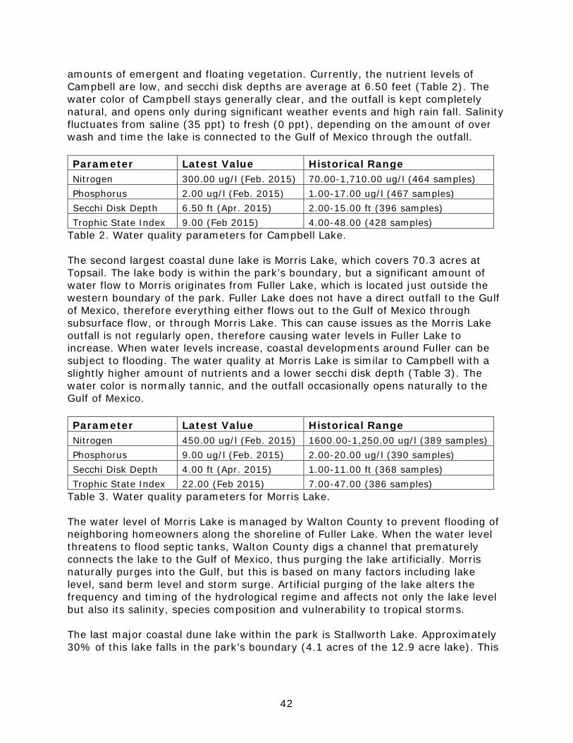
42
amounts of emergent and floating vegetation. Currently, the nutrient levels of Campbell are low, and secchi disk depths are average at 6.50 feet (Table 2). The water color of Campbell stays generally clear, and the outfall is kept completely natural, and opens only during significant weather events and high rain fall. Salinity fluctuates from saline (35 ppt) to fresh (0 ppt), depending on the amount of over wash and time the lake is connected to the Gulf of Mexico through the outfall. Parameter Latest Value Historical Range Nitrogen 300.00 ug/l (Feb. 2015) 70.00-1,710.00 ug/l (464 samples) Phosphorus 2.00 ug/l (Feb. 2015) 1.00-17.00 ug/l (467 samples) Secchi Disk Depth 6.50 ft (Apr. 2015) 2.00-15.00 ft (396 samples) Trophic State Index 9.00 (Feb 2015) 4.00-48.00 (428 samples)
Table 2. Water quality parameters for Campbell Lake. The second largest coastal dune lake is Morris Lake, which covers 70.3 acres at Topsail. The lake body is within the park’s boundary, but a significant amount of water flow to Morris originates from Fuller Lake, which is located just outside the western boundary of the park. Fuller Lake does not have a direct outfall to the Gulf of Mexico, therefore everything either flows out to the Gulf of Mexico through subsurface flow, or through Morris Lake. This can cause issues as the Morris Lake outfall is not regularly open, therefore causing water levels in Fuller Lake to increase. When water levels increase, coastal developments around Fuller can be subject to flooding. The water quality at Morris Lake is similar to Campbell with a slightly higher amount of nutrients and a lower secchi disk depth (Table 3). The water color is normally tannic, and the outfall occasionally opens naturally to the Gulf of Mexico. Parameter Latest Value Historical Range Nitrogen 450.00 ug/l (Feb. 2015) 1600.00-1,250.00 ug/l (389 samples) Phosphorus 9.00 ug/l (Feb. 2015) 2.00-20.00 ug/l (390 samples) Secchi Disk Depth 4.00 ft (Apr. 2015) 1.00-11.00 ft (368 samples) Trophic State Index 22.00 (Feb 2015) 7.00-47.00 (386 samples)
Table 3. Water quality parameters for Morris Lake. The water level of Morris Lake is managed by Walton County to prevent flooding of neighboring homeowners along the shoreline of Fuller Lake. When the water level threatens to flood septic tanks, Walton County digs a channel that prematurely connects the lake to the Gulf of Mexico, thus purging the lake artificially. Morris naturally purges into the Gulf, but this is based on many factors including lake level, sand berm level and storm surge. Artificial purging of the lake alters the frequency and timing of the hydrological regime and affects not only the lake level but also its salinity, species composition and vulnerability to tropical storms. The last major coastal dune lake within the park is Stallworth Lake. Approximately 30% of this lake falls in the park’s boundary (4.1 acres of the 12.9 acre lake). This

43
lake is similar in water quality to Morris Lake (Table 4), and the outfall frequently opens through the state park. Parameter Latest Value Historical Range Nitrogen 280.00 ug/l (Feb. 2015) 110.00-2,740.00 ug/l (557 samples) Phosphorus 6.00 ug/l (Feb. 2015) 3.00-67.00 ug/l (557 samples) Secchi Disk Depth 3.80 ft (Apr. 2015) 1.30-9.00 ft (368 samples) Trophic State Index 17.00 (Feb 2015) 9.00-68.00 (386 samples)
Table 4. Water quality parameters for Stallworth Lake. Two small coastal dune lakes to the east of Campbell Lake are now known as Owl Head Lake and Florida Lake. These lakes connect to the Gulf intermittently during tropical storms and heavy rain events. The last time Florida and Owl Head Lake opened was April 2014 during a flooding event in the panhandle. On occasion, Florida Lake will dry up due to its shallow bathymetry. While the description of coastal dune lake includes a passage about water remaining year-round, this lake is more closely related to a dune lake than any other described natural community. Torpedo grass is found growing along the lakeshores and in the outfalls. Torpedo grass may not only be altering the lakeshore riparian zone, but may also be impacting the frequency and levels at which the lakes purge into the Gulf by stabilizing the impounding berm. The coastal dune lakes were threatened when oil from the Mississippi Canyon block 252 oil well blowout lapped up on the beaches of Walton County. The county blocked the entrance to the coastal dune lakes by placing a berm of sand between the Gulf and the lakes and imbedding a one-way culvert drain. These berms and culverts have since been removed. Due to these measures, oil has not been found in the coastal dune lakes. General management measures: Coastal dunes lakes in the park should be managed to improve and maintain good water quality and restore and maintain historic hydrological regimes. Native shoreline vegetation should remain intact and buffers should be set to prevent development along the shoreline. The park should work with the county to improve stormwater runoff into the lakes, convert neighboring homeowners from using septic tanks to municipal sewer and advocate for the fewest artificial openings to the coastal dune lakes. The park should continue to work with CBA and Florida Lakewatch to monitor the water quality and character of the coastal dune lakes. Because the coastal dune lakes are an important component for nesting, foraging, migrating, and wintering of shorebirds, steps to provide access to the lake edge for shorebirds is necessary. During artificial lake openings, a plan should be in place to ensure that the channel does not become steep walls inaccessible to shorebirds. In addition, the lake outfalls are very desirable to the public. Protecting portions of the outfall edge with symbolic fencing for shorebirds may be necessary during the busy months of the year.

44
Torpedo grass should also be controlled around the lakeshore without impacting native interspersed vegetation. A restoration plan should be in place to ensure that control methods do not denude the lakeshore, allowing torpedo grass to become more vigorous and dense. Spraying for nuisance invertebrates, such as mosquitoes, should only be carried out after the development of an arthropod control plan. Management efforts to better delineate the parks eastern boundary along Stallworth Lake to discourage unauthorized access and mitigate negative impacts to the parks natural resources should be pursued. Marine Unconsolidated Substrate Desired future condition: Marine unconsolidated substrate consists of expansive unvegetated, open areas of mineral based substrate composed of shell and sand (sand beaches). The presence of natural marine debris, or wrack, is considered desirable as it greatly enhances nutrient cycling and the food web. Desired conditions include preventing soil compaction, dredging activities, and disturbances such as the accumulation of pollutants. The majority of the biotic components are plankton and other invertebrates. Many fish species use the area as a prime feeding ground. Nesting shorebirds should nest in the upper portion of the beach without disturbance. Foraging shorebird broods (i.e., flightless chicks) and migratory shorebird species should forage on the wet sand without disturbance. Sea turtles should use the gulf-side beach for nesting. Non-native predators should be absent. Sparse vegetation may be colonizing on the upper beach depending on the amount of time since the last tropical storm. Description and assessment: This natural community is the beach proper adjacent to the Gulf of Mexico. This community is extremely important to many designated species such as nesting sea turtles and shorebirds. Shorebirds use these areas for foraging, loafing, and resting. This is a dynamic system; movement of sand changes the community constantly. This community is in good condition. Erosion is the biggest factor affecting the shoreline. General management measures: Management measures will focus on habitat protection such as limiting vehicular driving to official purposes, and preserving natural processes such as retaining naturally deposited organic wrack while removing manmade non-organic, non-biodegradable debris. Exotic and nuisance predators should be controlled to prevent negative impacts to rare faunal populations, such as Choctawhatchee beach mice and snowy plovers. A tracking assessment of exotic predators should be conducted prior to the start of the shorebird nesting season and during beach mice and shorebird monitoring to establish predator control needs. Efforts to avoid and/or minimize disturbance, including the impacts associated with the presence of humans and dogs around nesting shorebirds, is critical to nesting success. Artificial lighting or glow should not be present on the beach. Artificial lights disorient sea turtles and can affect their ability to successfully enter the marine environment. A nighttime assessment of lighting should be conducted

45
annually before sea turtle monitoring commences to anticipate and prevent sea turtle hatchling disorientations. Developed Desired future condition: The developed areas within the park will be managed to minimize the effect of the developed areas on adjacent natural areas. Priority invasive plant species (FLEPPC Category I and II species) will be removed from all developed areas. Other management measures include proper stormwater management and development guidelines that are compatible with prescribed fire management in adjacent natural areas. Description and assessment: Parking areas, buildings, campgrounds and other facilities as well as maintained rights-of-way and roadsides are included. The park was once a private RV resort, therefore a large section of the park is dedicated to RV parking, camping, and cabin rentals. The developed sections of the park are in good condition. General management measures: Staff will continue to control invasive exotic plant species in developed areas of the park. Defensible space will be maintained around all structures in areas managed with prescribed fire or at risk of wildfires. Exotic species should continue to be controlled. Imperiled Species
Imperiled species are those that are (1) tracked by FNAI as critically imperiled (G1, S1) or imperiled (G2, S2); or (2) listed by the U.S. Fish and Wildlife Service (USFWS), Florida Fish and Wildlife Conservation Commission (FWC) or the Florida Department of Agriculture and Consumer Services (FDACS) as endangered, threatened or of special concern. This park contains a significant number of both federal and state listed species. Probably the most significant of these imperiled species is the Choctawhatchee beach mouse. Critical habitat has been designated by the U. S. Fish and Wildlife Service for the beach mouse, and is defined as 500 feet inland from the mean high tide line throughout the entire park. Topsail Hill Preserve State Park serves as one of the few remaining relatively stable populations of this extremely vulnerable subspecies. Ongoing research by multiple agencies is improving our understanding of the habitat requirements for this vulnerable subspecies. The Choctawhatchee Beach mouse is prevalent in both the beach dune and scrub communities at Topsail, and its occurrence rate is documented through the use of 32 tracking tube stations. As of January 2015, 63% of the beach dune community at Topsail provided evidence that beach mice were present. These tracking tubes are checked monthly, and all data is kept with FWC personnel. A population estimate through trapping mice has not been conducted recently at the park. If occurrence rates decline at Topsail in the future, a population estimate may be needed. Due to the stable population of mice at Topsail, these mice have been used to augment populations at a neighboring park (Grayton Beach State Park). Habitat loss all along its former range is the major contributing factor to the decline of the
46
sub-species. Other threats include further development, hurricanes, introduction of competitors such as house mice, and exotic predators such as coyotes and feral cats. The DRP will continue to work with the USFWS and the FWC on conservation efforts regarding this critically imperiled species. If populations at Topsail begin to decline, the appropriate agencies will look to augment this population to ensure mice remain at the park in perpetuity. Manatees are commonly seen near the shorelines of Topsail. These mammals have not been spotted inside the coastal dune lakes, but if they somehow found their way through an outfall, FWC would need to be notified. The park’s management efforts for this species consist of ensuring it is not harassed by beach visitors. Four species of sea turtles are known to nest at this unit. The majority of nests are from loggerhead turtles, but green turtles also nest on the park annually. Kemp’s will occasionally nest at the park, and 2015 was the first year that a leatherback sea turtle nest was documented at Topsail. Nesting season takes place from May 1st –Oct 31st. Looking at nesting data from 1996 through 2015, there are an average of seven sea turtle nests (all species) in a season at Topsail. Although few sea turtles nest at Topsail each year, turtles that nest in the Panhandle are genetically distinct from those that nest in the rest of the peninsula. The park conducts nest surveys daily according to FWC Marine Turtle Conservation Guidelines (2007). Coyotes, storm surge, and artificial lighting are the main threats to sea turtle nests and hatchlings at the park. Sky glow can be seen from the park but disorientation events are rare. The DRP will coordinate with the USFWS to educate property owners outside of the park on lighting issues and the detrimental impacts they can have on sea turtles nesting within the park. Predator control is also very important to prevent nest depredation. Currently, park staff does not use flat screens to protect sea turtle nests from predators like coyotes. If nest predation becomes an issue, park staff will be informed on how to properly screen nests, and how to properly identify predator tracks. The park’s sea turtle permit already allows staff to use self-releasing screens at Topsail. Eastern diamondback rattlesnakes (Crotalus adamanteus) and hognose snakes (Heterodon simus) are found within the park, and use gopher tortoise burrows to help regulate their body temperatures. The low number of gopher tortoise burrows within the park is a threat to both of these snakes, along with a suite of other species that depend on tortoise burrows. Negative public perception is another threat to all snakes and reptiles found at the park. The park should educate the public about the importance of snakes, including venomous snakes, to reverse negative public perception. Alligators (Alligator mississippiensis) are commonly found within the coastal dune lake natural communities. The biggest threats to alligators at the park are from interactions with visitors. Visitors should be educated on the dangers of feeding or molesting alligators both in terms of harm to the alligator, and the visitor. Alligators that are fed begin to associate people as a food source, causing some animals to behave aggressively. The best way to prevent human harm is to prevent the
47
feeding of these wild reptiles. If alligators do become habituated to humans and act aggressively, park staff will work with FWC personnel to have the animals removed. Before state acquisition, red cockaded woodpeckers (RCW, Picoides borealis) historically occurred on the park and abandoned cavity trees can still be found. Although there is currently no known nesting or resident RCW’s on the property, there was an active colony documented to the north of the park. Due to the fragmented habitat, surrounding the park there is no plan to re-introduce RCW’s, but it is possible that birds will migrate back to the park in the future. Although small, a multitude of old-growth longleaf potentially could provide habitat for this bird in the future. It is believed that flatwoods salamanders (Ambystoma cingulatum) were historically found in the upland landscape at Topsail Hill. While never documented at the park, the location and community assemblages are ideal for this amphibian. A survey of the wetland communities was conducted at Topsail in 2015, and eight dome swamps were located that could potentially support flatwoods salamanders, and one swamp was found to be historically suitable (Himes 2015). These eight potential dome swamps need only minimal natural community restoration before being ideal locations for species reintroduction. The USFWS is currently drafting a recovery plan that will include reintroductions of this salamander into protected areas such as Topsail. The Park Service will coordinate with USFWS and FWC to ensure that future reintroduction is successful, and well documented. More information can be found in the Management Objectives. Topsail Hill Preserve State Park has not supported a large nesting shorebird population; however, several state and federally-listed species of shorebirds use the park (Himes et al. 2006). Snowy plovers and least terns will typically attempt to nest here. The earliest reliable survey took place in 1989, where eight pairs of snowy plovers were documented at the park (Chase and Gore 1989). Nesting was documented, but the high human impact may have impacted the fledging rate. Reliable surveys began again in 2002, and a total of eight snowy plover nests have been documented at Topsail. Nesting of shorebirds at the park has historically been relatively low, with a documented maximum of 8 snowy plover pairs in a year and a handful of least tern nests. The nesting seasons between 2006 and 2014 have been much lower, with 0-1 nesting pairs of snowy plovers on the beaches. Productivity is also very poor, most likely due to disturbance from human visitors and the presence of multiple predator types. In 2013, two least terns hatched, but they never made it to become fledglings. 2014 was the first documented successful snowy plover fledgling to be hatched at Topsail. 2015 was a much better year for Topsail plovers, with six pairs present and four nests. While there were two successful hatches, none of the chicks were successfully fledged. Least terns have set up small colonies at the park since 2002, with a peak nesting season in 2012 with 90 individual nests. Overall, a total of 300 least tern nests have been documented at the park. Least terns were present and scraping in 2015,

48
but no active nesting was ever confirmed. It’s possible that least tern decoys are needed to draw in nesting pairs of birds to the available habitat. American oystercatchers and black skimmers are occasionally observed with courtship behavior, but no nests have ever documented. Wilson’s plovers are also occasionally observed at the park, but no nesting has been documented. Gull-billed terns (Gelochelidon nilotica) occasionally use the park for roosting and foraging, but again, no nesting is documented to date. Shorebird nesting surveys are conducted weekly throughout the nesting season by Audubon staff and district biologists. As habitat management and predator removal efforts continue, Topsail should see more successful shorebird nesting and higher fledgling success rates. The main threats to snowy plovers, least terns and other potentially nesting shorebird species include vehicle rutting, predation, disturbance, presence of feral cats and the presence of domestic dogs on the beach. It’s also been documented that large amounts of human trash washes up to the beaches, drawing in many types of shorebird predators to the beach dunes. Park staff will work with volunteers to continually remove trash as it becomes trapped on the beaches. Management for these threats should continue to support the shorebird nesting efforts at Topsail. The federally-listed piping plover (Charadrius melodus) and newly listed red knot (Calidris canutus rufa) use the park during migration for overwintering, loafing, and feeding (U.S. Fish and Wildlife Service 2014). The main use areas for these threatened birds includes the coastal dune lake outfalls and the Gulf facing shorelines. Surveys and management for piping plover and red knot should follow the Comprehensive Conservation Strategy (U.S. Fish and Wildlife Service 2013). Regular surveys are conducted year-round for non-breeding shorebirds to determine use areas, count all birds utilizing the park, and to provide protective measures from humans or predators if needed. All information on federally protected shorebirds, including band re-sights, is documented and communicated to the appropriate federal agencies and research facilities. Sandwich terns (Thalasseus sandvicensis) also use the park as a roosting and feeding site for much of the year. They are also frequently documented at the park during their migration south. During the seasonal migrations, numerous other listed bird species use this park as an important stopover point for the trans-gulf flight. American kestrels (Falco sparverius) and merlin (Falco columbarius) are observed in significant numbers during migratory periods. Appropriate management actions for this species include conserving and maintaining suitable natural area with little to no human disruption or alteration. This is considered Management Action 14 (Other) in the table below. Southern bald eagles (Haliaeetus leucocephalus) and ospreys (Pandion haliaetus) are resident in the area and use the coastal dune lakes as important feeding areas. Ospreys need snags for nesting and perching. When possible, snags should be left in place for osprey management. Swallow-tailed kites typically use the park for foraging; they tend to forage for insects over wet open areas. It is uncertain
49
whether they nest at the park due to a lack of detailed surveys for this species. Wading birds, such as little blue heron, snowy egret and tricolor heron, reddish egret and white ibis are found in the freshwater swales, coastal dune lakes and basin marshes. Good quality wetlands are important for their foraging and nesting. Hydrology should be maintained in these wetlands, and spraying of insecticide should be minimized as much as possible. Although all of these species except for the reddish egret are in the process of delisting by FWC, it is still important to maintain quality wetlands for these birds. Florida black bears are occasionally observed at the park. Dumpsters and garbage cans should be animal resistant to prevent attracting and habituating nuisance and exotic animals. The park staff should be trained in nuisance bear prevention and harassment measures. Recently, bears have been getting trapped in the dumpsters near the residences in management zone TP-35. These dumpsters should be removed from the park to prevent bears, especially cubs, from getting trapped and killed. The Gulf coast solitary bee is typically present in patches of yellow buttons located on the backside of the primary dunes from August to October, depending on the bloom cycle of its host plant. Although not much is known about this bee species, like all bees it is likely sensitive to arthropod control measures with the use of insecticides. Insecticides should not be used during the period of time when the solitary bee is present (August to October) in locations where either yellow buttons are present or where the bee has been previously documented. Gopher tortoises are found in the park’s scrub and scrubby flatwoods communities. Although the population is unknown, it is assumed low due to the lack of an abundance of burrows. With continuation of burning and reduction of overgrown fuel, populations should increase as available habitat increases. Most of the imperiled plant species are associated with either the dune and scrub systems or the seepage slope wet prairie systems. The listed species found in the dunes include Cruise’s golden aster (Chrysopsis gossypina ssp cruisiana), Godfrey’s golden aster, gulf coast lupine and largeleaved jointweed. Both of the golden aster species and the gulf coast lupine are vulnerable to storm surge, dune erosion and salt spray from tropical storms. Populations were observed to decrease after the tropical storms of 2004 and 2005. They appear to be more plentiful in the dunes now after a decade without storms. Large leaved jointweed is found in coastal scrub and scrubby flatwoods. Not much is known about its response to fire but it appears to prosper in open to partially open scrubby communities with sandy soils. Protection of dunes from visitors, protection from development impacts, and preventing soil disturbances are crucial for managing these species. Curtiss’ sandgrass (Calamovilfa curtissii) is found in the ecotones between flatwoods and basin marshes, basin swamps, seepage slopes and wet prairie. It is endemic to the Florida panhandle and responds well to fire. Currently, the park has a healthy population of Curtiss’ sandgrass. The park also supports populations of southern milkweed (Asclepias viridula), spoon-leaved sundew (Drosera intermedia),

50
rose pogonia (Pogonia ophioglossoides), Fernald’s pogonia (Pogonia bifaria), pine lily (Lilium catesbaei), yellow butterwort (Pinguicula lutea), Chapman’s butterwort (Pinguicula planifolia), white-top pitcher plant (Sarracenia leucophylla), parrot pitcher plant (Sarracenia psitticina), and purple pitcher plant (Sarracenia purpurea), all of which are found in the wetter upland communities. All these species have been in decline at the park due to the invasion of titi and fire suppression (Johnson 2001). Reintroduction of prescribed burning has been effective in some areas of the park, but not in others. The seepage slope on the northeast corner of the park cannot be burned safely at its current state, therefore an active restoration project is needed to reduce the canopy-sized titi shading out the wetland species. Titi will need to be removed, chipped, and transported off-site. It’s possible that some existing species will respond well to this treatment. In other cases, these targeted species need to be reintroduced. The park will be working with the Atlanta Botanical Garden to propagate and reintroduce these species in certain areas as appropriate. There is a record of the shell-mound prickly pear (Opuntia stricta) occurring within the park. While a specimen was collected and transferred to the USF plant atlas herbarium, the exact location was never documented. It’s possible that this cactus still exists within the park, but it was not found during the preparation for this management plan. All prickly pear cactuses found at the park should be managed as the imperiled species. This entails checking with district biologists prior to any land clearing or new developments. The panhandle meadow beauty (Rhexia salicifolia) is found in basin marshes skirting the coastal dune lakes at Topsail. This tiny flower is easily outcompeted by torpedo grass, which commonly takes over the lake shorelines. This meadowbeauty flourishes when lake levels are high, then drop, exposing open sandy areas without competing vegetation. Care should be taken when treating torpedo grass along the lake shorelines to prevent killing this imperiled plant. Table 5 contains a list of all known imperiled species within the park and identifies their status as defined by various entities. It also identifies the types of management actions that are currently being taken by DRP staff or others, and identifies the current level of monitoring effort. The codes used under the column headings for management actions and monitoring level are defined following the table. Explanations for federal and state status as well as FNAI global and state rank are provided in Addendum 6.

51
Table 5: Imperiled Species Inventory
Common and Scientific Name
Imperiled Species Status
Man
agem
ent
Act
ion
s
Mon
itor
ing
Lev
el
FWC USFWS FDACS FNAI PLANTS Southern milkweed Asclepias viridula LT G2,S2 1,4,7,10 Tier 1
Curtiss’ sandgrass Calamovilfa curtissii LT G3,S3 1,4,7,10 Tier 1
Godfrey’s goldenaster Chrysopsis godfreyi
LE G2,S2 9,10 Tier 1
Cruise’s goldenaster Chrysopsis gossypina ssp. cruiseana
LE G5T2, S2 9,10 Tier 1
Spoon-leaved sundew Drosera intermedia
LT G5,S3 1,4,7,10 Tier 1
Pine lily Lilium catesbaei LT 1,4 Tier 3
Gulf coast lupine Lupinus westianus LT G3,S3 9,10 Tier 1
Erect pricklypear Opuntia stricta LT 9,10 Tier 1
Yellow butterwort Pinguicula lutea LT 1,4,10 Tier 1
Chapman’s butterwort Pinguicula planifolia
LT 1,4,10 Tier 1
Fernald’s pogonia Pogonia bifaria LE 1,4,10 Tier 1
Rose pogonia Pogonia ophioglossoides
LT 1,4,10 Tier 1
Large-leaved jointweed Polygonella macrophylla
LT G3,S3 9,10 Tier 1
Panhandle meadow beauty Rhexia salicifolia
LT G2,S2 2,4,10 Tier 2
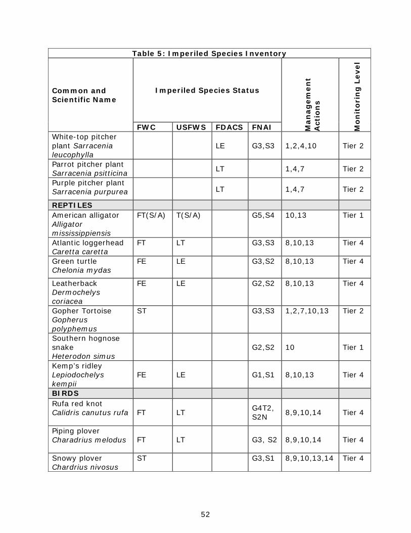
52
Table 5: Imperiled Species Inventory
Common and Scientific Name
Imperiled Species Status
Man
agem
ent
Act
ion
s
Mon
itor
ing
Lev
el
FWC USFWS FDACS FNAI White-top pitcher plant Sarracenia leucophylla
LE G3,S3 1,2,4,10 Tier 2
Parrot pitcher plant Sarracenia psitticina LT 1,4,7 Tier 2
Purple pitcher plant Sarracenia purpurea LT 1,4,7 Tier 2
REPTILES American alligator Alligator mississippiensis
FT(S/A) T(S/A) G5,S4 10,13 Tier 1
Atlantic loggerhead Caretta caretta
FT LT G3,S3 8,10,13 Tier 4
Green turtle Chelonia mydas
FE LE G3,S2 8,10,13 Tier 4
Leatherback Dermochelys coriacea
FE LE G2,S2 8,10,13 Tier 4
Gopher Tortoise Gopherus polyphemus
ST G3,S3 1,2,7,10,13 Tier 2
Southern hognose snake Heterodon simus
G2,S2 10 Tier 1
Kemp’s ridley Lepiodochelys kempii
FE LE G1,S1 8,10,13 Tier 4
BIRDS Rufa red knot Calidris canutus rufa FT LT G4T2,
S2N 8,9,10,14 Tier 4
Piping plover Charadrius melodus FT LT G3, S2 8,9,10,14 Tier 4
Snowy plover Chardrius nivosus
ST G3,S1 8,9,10,13,14 Tier 4
53
Table 5: Imperiled Species Inventory
Common and Scientific Name
Imperiled Species Status
Man
agem
ent
Act
ion
s
Mon
itor
ing
Lev
el
FWC USFWS FDACS FNAI Wilson’s plover Charadrius wilsonia
G5,S2 8,9,10,13,14 Tier 4
Little blue heron Egretta caerulea
SSC G5,S4 4 Tier 1
Snowy egret Egretta thula
SSC G5,S3 4 Tier 1
Tri-colored heron Egretta tricolor
SSC G5,S4 4 Tier 1
Reddish egret Egretta rufescens
SSC
G4,S2 4 Tier 1
White ibis Eudocimus albus
SSC G5,S4 4 Tier 1
Merlin Falco columbarius
G5,S2 2 Tier 1
Peregrine falcon Falco peregrinus
G4,S2 2 Tier 1
Gull-billed tern Gelochelidon nilotica
G5,S2 9,10,14 Tier 1
American oystercatcher Haematopus palliatus
SSC G5, S2
8,9,10,13,14 Tier 4
Red-cockaded woodpecker Picoides borealis
FE LE G3,S2 1,6,7 Tier 1
Black skimmer Rynchops niger
SSC G5,S3 8,9,10,14 Tier 4
Least tern Sterna altillarum
ST G4,S3 8,9,10,13,14 Tier 4
Sandwich tern Thalasseus sandvicensis
G5,S2 9,10,14 Tier 1
MAMMALS Choctawhatchee beach mouse Peromyscus polionotus allophrys
FE LE G5T1, S1 3,8,10,12,14 Tier 4

54
Table 5: Imperiled Species Inventory
Common and Scientific Name
Imperiled Species Status
Man
agem
ent
Act
ion
s
Mon
itor
ing
Lev
el
FWC USFWS FDACS FNAI Manatee Trichechus manatus FE LE G2,S2 4,10 Tier 2
INVERTEBRATES Gulf coast solitary bee Hesperapis oraria
G1G2, S1S2 10 Tier 3
Management Actions: 1. Prescribed Fire 2. Exotic Plant Removal 3. Population Translocation/Augmentation/Restocking 4. Hydrological Maintenance/Restoration 5. Nest Boxes/Artificial Cavities 6. Hardwood Removal 7. Mechanical Treatment 8. Predator Control 9. Erosion Control 10. Protection from visitor impacts (establish buffers)/law enforcement 11. Decoys (shorebirds) 12. Vegetation planting 13. Outreach and Education 14. Other
Monitoring Level: Tier 1. Non-Targeted Observation/Documentation: includes documentation of species presence through casual/passive observation during routine park activities (i.e. not conducting species-specific searches). Documentation may be in the form of Wildlife Observation Forms, or other district specific methods used to communicate observations. Tier 2. Targeted Presence/Absence: includes monitoring methods/activities that are specifically intended to document presence/absence of a particular species or suite of species. Tier 3. Population Estimate/Index: an approximation of the true population size or population index based on a widely accepted method of sampling. Tier 4. Population Census: A complete count of an entire population with demographic analysis, including mortality, reproduction, emigration, and immigration. Tier 5. Other: may include habitat assessments for a particular species or suite of species or any other specific methods used as indicators to gather information about a particular species.
Detailed management goals, objectives and actions for imperiled species in this park are discussed in the Resource Management Program section of this component and the Implementation Component of this plan.
55
Exotic and Nuisance Species
Exotic species are plants or animals not native to Florida. Invasive exotic species are able to out-compete, displace or destroy native species and their habitats, often because they have been released from the natural controls of their native range, such as diseases, predatory insects, etc. If left unchecked, invasive exotic plants and animals alter the character, productivity and conservation values of the natural areas they invade. Exotic animal species include non-native wildlife species, free ranging domesticated pets or livestock, and feral animals. Because of the negative impacts to natural systems attributed to exotic animals, the DRP actively removes exotic animals from state parks, with priority being given to those species causing the greatest ecological damage. In some cases, native wildlife may also pose management problems or nuisances within state parks. A nuisance animal is an individual native animal whose presence or activities create special management problems. Examples of animal species from which nuisance cases may arise include venomous snakes or raccoons and alligators that are in public areas. Nuisance animals are dealt with on a case-by-case basis in accordance with the DRP’s Nuisance and Exotic Animal Removal Standard. Detailed management goals, objectives and actions for management of invasive exotic plants and exotic and nuisance animals are discussed in the Resource Management Program section of this component. Although the park only has a few invasive exotic species, they need continual treatment and monitoring to prevent the existing infestations from enlarging. The most prevalent exotic plant at the park is torpedo grass, with Chinese tallow trees running a close second. Torpedo grass is by far the most widespread and most difficult invasive exotic plant species on the park to control. The issue with torpedo grass is its resilience, quick spreading nature, and ability to grow over water. Torpedo grass is especially problematic where established along the shorelines of the coastal dune lakes and in the outfalls. The network of rhizomes may be stabilizing the berms that keep the lakes from connecting to the Gulf. This exotic has spread over multiple coastal dune lake shorelines, and completely covered a few interdunal swales. Since it is also intermixed with native species, it is difficult to target the exotic without impacting non-target native species. Also, after treating torpedo grass with herbicide, it can quickly reestablish itself if no other native vegetation is present. Chinese tallow tree is another exotic that is found in multiple zones within the park. One location, at management zone TP-04 in the large basin marsh, contains many seed producing adults. Due to its wet location, the trees are extremely difficult to access and treat with herbicide. Park staff should monitor when lake levels are low, and treat the trees as soon as possible to prevent seeds from reaching the rest of the shoreline. Most of the large trees at the park have been treated. At this point,
56
the goal should be to remove all the smaller trees before they become seed bearing adults. There is one main location of cogon grass on the park in management zone TP-18. This location has been treated in past years, and is continually monitored and re-treated when necessary. Cogon grass is difficult to eradicate, so tenacity and repeated treatments are needed. Roads are efficient corridors for cogon grass to spread, especially if the road shoulders are mowed. The park boundary along SR 98 may have cogon grass appear, especially if the county is not careful to wash off mowing equipment. If cogon grass is to be mowed anywhere at the park, the mower should be completely washed clean of seeds and plant particles at that location to prevent spreading. Japanese climbing fern (Lygodium japonicum) is occasionally found in the wetter upland communities such as basin swamp and dome swamp. Although the population is currently small, the spores of this exotic can remain in the soil for many years (FLEPPC 2015). Therefore, park staff will have to continuously treat the few areas this climbing fern is currently found in order to truly eradicate it. New locations along SR 98 pop up from time to time, and staff should be actively patrolling the road corridors specifically for this species. It can quickly get out of control without management. Mimosa and Lantana are two exotic species left over from when the park was an RV Resort with landscaping. These plants are normally seen around developed areas, and their numbers are relatively low. Park staff should hand pull the lantana and mimosa whenever it is seen, and treat the larger individuals with basal garlon. The park needs to continue monitoring for these species and treating them as they appear in order to prevent larger infestations from establishing. Although not an exotic species, the two species of titi are managed at Topsail. In wet prairie, dome swamps, wet flatwoods, and seepage slopes, titi can become a dominant canopy species when fire is excluded from the natural system. In areas where this has occurred, titi is removed as if it were an exotic species. Although titi is a natural part of many wetland communities, the amount of these plants and large stature is not a natural aspect of these wetland communities. Common reed (Phragmites australis) occurs naturally along the margins of coastal dune lakes in south Walton County. In some cases, it can form dense stands that displace other natives and disrupt species proportions. Park Service staff should periodically monitor for the presence of Phragmites along the coastal dune lakes and consider control measures if it should become problematic. The park has treated 89.85 gross acres of exotic plant species between 2005 and 2015. This equates to 26.31 infested acres over 10 years. All of the treatments were conducted by park staff, and a majority of the treatment was focused on torpedo grass and Chinese tallow trees.
57
Coyotes have been documented harassing nesting sea turtles, depredating sea turtle and shorebird nests, and feeding on flightless chicks. They also flush nesting shorebirds at the park, preventing birds from settling within the habitat for nesting, and causing nest abandonment. In addition, the presence of coyotes and foxes can flush nesting shorebirds, leaving eggs and chicks vulnerable to predation by other species including ghost crabs, herons, crows and snakes. Predator control was initiated in 1997 and continues when funded. Following a year of heavy removal, productivity for nesting shorebirds greatly increases. The presence of coyotes and other mammalian predators should be documented while monitoring for shorebirds, sea turtle nests, and beach mice. Any observations of known predation to nests should be recorded and reported. Park staff should work with district biologist to assess the threat and work with trappers to decide the best method to achieve predator control. The screening of sea turtle nests in order to prevent successful nest depredation from coyotes should occur when needed. Trapping coyotes in winter prior to shorebird and sea turtle nesting season is recommended as the most effective method of control due to cooler temperatures, and to minimize disturbance to shorebird nests during the trapping process. Raccoons can be a nuisance by raiding campsite dumpsters and stealing food from campers. Once raccoons become habituated, they can become a danger to visitors. After habituation, the threat of diseases such as rabies becomes a concern to public health. In addition to harming park visitors, raccoons can be effective predators of sea turtle and shorebird nests. If raccoons are documented as an issue at Topsail, live traps will be used to remove the nuisance animals. Nonindigenous predators such as coyotes, feral cats and red foxes can be detrimental to populations of beach mice and shorebirds. Feral cats are very effective at hunting small mammals, including beach mice. A well-fed cat can range away from home and into the beach dune system where beach mice are found. Control of feral cats is a necessary management measure at the park. Control measuresshould be initiated when cat tracks are found or when beach mice presence declines. Laurel wilt, caused by the non-native fungus Raffaelea lauricola, can spread to new trees by the nonnative redbay ambrosia beetle (Xyleborus glabratus). This fungus kills trees in the Laurel (Lauraceae) family, including redbay (Persea borbonia), swamp red bay (Persea palustris) and sassafras. In 2010, laurel wilt was documented in neighboring Bay County. Park staff will monitor for signs of laurel wilt and will notify county agricultural extension agents and district biologists if spotted. The best way to prevent this fungus from entering the park is to make sure wood from outside the park is not brought in for campfire fuel. By providing commercial firewood to campers, the park can limit the chance of accidentally introducing laurel wilt. Once trees are infected, there is no cost-effective treatment for saving them.
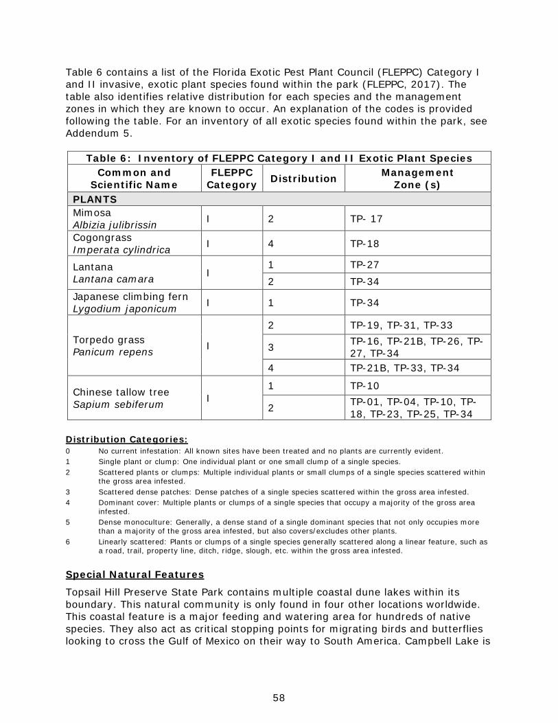
58
Table 6 contains a list of the Florida Exotic Pest Plant Council (FLEPPC) Category I and II invasive, exotic plant species found within the park (FLEPPC, 2017). The table also identifies relative distribution for each species and the management zones in which they are known to occur. An explanation of the codes is provided following the table. For an inventory of all exotic species found within the park, see Addendum 5.
Table 6: Inventory of FLEPPC Category I and II Exotic Plant Species Common and
Scientific Name FLEPPC
Category Distribution Management Zone (s)
PLANTS Mimosa Albizia julibrissin I 2 TP- 17
Cogongrass Imperata cylindrica I 4 TP-18
Lantana Lantana camara I
1 TP-27 2 TP-34
Japanese climbing fern Lygodium japonicum I 1 TP-34
Torpedo grass Panicum repens I
2 TP-19, TP-31, TP-33
3 TP-16, TP-21B, TP-26, TP-27, TP-34
4 TP-21B, TP-33, TP-34
Chinese tallow tree Sapium sebiferum I
1 TP-10
2 TP-01, TP-04, TP-10, TP-18, TP-23, TP-25, TP-34
Distribution Categories: 0 No current infestation: All known sites have been treated and no plants are currently evident. 1 Single plant or clump: One individual plant or one small clump of a single species. 2 Scattered plants or clumps: Multiple individual plants or small clumps of a single species scattered within the gross area infested. 3 Scattered dense patches: Dense patches of a single species scattered within the gross area infested. 4 Dominant cover: Multiple plants or clumps of a single species that occupy a majority of the gross area infested. 5 Dense monoculture: Generally, a dense stand of a single dominant species that not only occupies more than a majority of the gross area infested, but also covers/excludes other plants. 6 Linearly scattered: Plants or clumps of a single species generally scattered along a linear feature, such as a road, trail, property line, ditch, ridge, slough, etc. within the gross area infested.
Special Natural Features
Topsail Hill Preserve State Park contains multiple coastal dune lakes within its boundary. This natural community is only found in four other locations worldwide. This coastal feature is a major feeding and watering area for hundreds of native species. They also act as critical stopping points for migrating birds and butterflies looking to cross the Gulf of Mexico on their way to South America. Campbell Lake is
59
the only coastal dune lake in Walton County where the entire watershed and all outfalls are protected within state property. All of the remaining dune lakes within Walton County have some portion of the watershed or lake shoreline owned by private entities. Cultural Resources
This section addresses the cultural resources present in the park that may include archaeological sites, historic buildings and structures, cultural landscapes and collections. The Florida Department of State (FDOS) maintains the master inventory of such resources through the Florida Master Site File (FMSF). State law requires that all state agencies locate, inventory and evaluate cultural resources that appear to be eligible for listing in the National Register of Historic Places. Addendum 7 contains the FDOS, Division of Historical Resources (DHR) management procedures for archaeological and historical sites and properties on state-owned or controlled properties; the criteria used for evaluating eligibility for listing in the National Register of Historic Places, and the Secretary of Interior’s definitions for the various preservation treatments (restoration, rehabilitation, stabilization and preservation). For the purposes of this plan, significant archaeological site, significant structure and significant landscape means those cultural resources listed or eligible for listing in the National Register of Historic Places. The terms archaeological site, historic structure or historic landscape refer to all resources that will become 50 years old during the term of this plan. Condition Assessment
Evaluating the condition of cultural resources is accomplished using a three-part evaluation scale, expressed as good, fair and poor. These terms describe the present condition, rather than comparing what exists to the ideal condition. Good describes a condition of structural stability and physical wholeness, where no obvious deterioration other than normal occurs. Fair describes a condition in which there is a discernible decline in condition between inspections, and the wholeness or physical integrity is and continues to be threatened by factors other than normal wear. A fair assessment is usually a cause for concern. Poor describes an unstable condition where there is palpable, accelerating decline, and physical integrity is being compromised quickly. A resource in poor condition suffers obvious declines in physical integrity from year to year. A poor condition suggests immediate action is needed to reestablish physical stability. Level of Significance
Applying the criteria for listing in the National Register of Historic Places involves the use of contexts as well as an evaluation of integrity of the site. A cultural resource’s significance derives from its historical, architectural, ethnographic or archaeological context. Evaluation of cultural resources will result in a designation of NRL (National Register or National Landmark Listed or located in an NR district), NR (National Register eligible), NE (not evaluated) or NS (not significant) as indicated in the table at the end of this section.

60
There are no criteria for determining the significance of collections or archival material. Usually, significance of a collection is based on what or whom it may represent. For instance, a collection of furniture from a single family and a particular era in connection with a significant historic site would be considered highly significant. In the same way, a high-quality collection of artifacts from a significant archaeological site would be of important significance. A large herbarium collected from a specific park over many decades could be valuable to resource management efforts. Archival records are most significant as a research source. Any records depicting critical events in the park’s history, including construction and resource management efforts, would all be significant. The following is a summary of the FMSF inventory. In addition, this inventory contains the evaluation of significance. Prehistoric and Historic Archaeological Sites
Desired future condition: All significant archaeological sites within the park that represent Florida’s cultural periods or significant historic events or persons are preserved in good condition in perpetuity, protected from physical threats and interpreted to the public. Description: The Florida Master Site File (FMSF) currently lists 16 sites within the boundaries of Topsail Hill Preserve State Park. The cultural sites documented at Topsail depict a long and diverse history of land uses starting with Native American shell mounds, and ending with metal mesh roads used during the WWII era. Multiple camping sites from prehistoric and historic settlers are located throughout the park, along with evidence of the turpentine industry. The diversity of sites found at this park adds to the overall conservation value of Topsail Hill Preserve State Park, all of which represents the rich past of North Florida. Below are all of the existing cultural sites that have been located and documented with the FMSF. WL64- Stallworth Lake This site is a Fort Walton shell midden. About a third of the mound is protected by the park, while the other two thirds have been developed with private homes. The original FMSF form (1960) indicates that sherds and soapstone (steatite) lithics were found. The 1998 FMSF update confirmed that a shell midden was located at this site. The site was visited in 2006 by park staff after a mowed fire line (no disking was allowed) was installed, and shells were visible on the mound’s surface. This site was visited again in 2011 during the ground truthing for the district wide predictive model, but incredibly thick vegetation and dense cover of leaf litter and pine needles made identifying artifacts on the ground surface difficult for the researchers. The site was more recently visited by district staff in 2015, but no artifacts or shell were evident on the shell midden’s surface. Because this midden is located in such a spot that a fire line is required, park staff have to be concerned with erosion if vegetation is lost. Also, this midden is a popular site for nearby homeowners to hop the fence into the park and access the coastal dune lake (Stallworth Lake), which could eventually lead to vegetative loss and erosion to this cultural site.
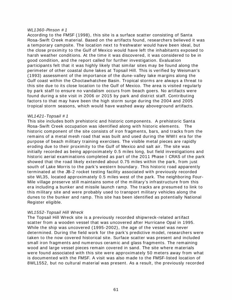
61
WL1360-Pinson #1 According to the FMSF (1998), this site is a surface scatter consisting of Santa Rosa-Swift Creek material. Based on the artifacts found, researchers believed it was a temporary campsite. The location next to freshwater would have been ideal, but the close proximity to the Gulf of Mexico would have left the inhabitants exposed to harsh weather conditions. At the time it was discovered, it was considered to be in good condition, and the report called for further investigation. Evaluation participants felt that it was highly likely that similar sites may be found along the perimeter of other coastal dune lakes at Topsail Hill. This is verified by Weisman’s (1993) assessment of the importance of the dune-valley lake margins along the Gulf coast within the Choctawhatchee Basin. Tropical storms are always a threat to this site due to its close location to the Gulf of Mexico. The area is visited regularly by park staff to ensure no vandalism occurs from beach goers. No artifacts were found during a site visit in 2006 or 2015 by park and district staff. Contributing factors to that may have been the high storm surge during the 2004 and 2005 tropical storm seasons, which would have washed away aboveground artifacts. WL1421-Topsail #1 This site includes both prehistoric and historic components. A prehistoric Santa Rosa-Swift Creek occupation was identified along with historic elements. The historic component of the site consists of iron fragments, bars, and tracks from the remains of a metal mesh road that was built and used during the WWII era for the purpose of beach military training exercises. The visible metal pieces are rapidly eroding due to their proximity to the Gulf of Mexico and salt air. The site was initially recorded as being approximately 0.5 miles long, but field investigations and historic aerial examinations completed as part of the 2011 Phase I CRAS of the park showed that the road likely extended about 0.75 miles within the park, from just south of Lake Morris to the park’s western boundary. This historic road apparently terminated at the JB-2 rocket testing facility associated with previously recorded site WL35, located approximately 0.5 miles west of the park. The neighboring Four-Mile village preserve still maintains some of the military’s infrastructure from this era including a bunker and missile launch ramp. The tracks are presumed to link to this military site and were probably used to transport military vehicles along the dunes to the bunker and ramp. This site has been identified as potentially National Register eligible. WL1552-Topsail Hill Wreck The Topsail Hill Wreck site is a previously recorded shipwreck-related artifact scatter from a wooden vessel that was uncovered after Hurricane Opal in 1995. While the ship was uncovered (1995-2002), the age of the vessel was never determined. During the field work for the park’s predictive model, researchers were taken to the now covered historical site. Surface scatter was present and included small iron fragments and numerous ceramic and glass fragments. The remaining wood and large vessel pieces remain covered in sand. The site where materials were found associated with this site were approximately 50 meters away from what is documented with the FMSF. A visit was also made to the FMSF-listed location of 8WL1552, but no cultural material was present. As a result, the previously recorded
62
site location was corrected, and an updated FMSF site form indicating the actual location shipwreck-related artifact scatter was submitted to the FMSF. WL1794-North Campbell Lake This site is believed to be another prehistoric campsite, and was found by a park visitor who identified a surface scatter artifact and directed staff to the site. A single shovel test revealed two Weeden Island pottery body sherds in the location. No other artifacts or surface scatter have been reported at this site. WL1974-Topsail Hill Preserve State Park This site is believed to be a prehistoric campsite, and was discovered during a shovel test in 2003 for a new beach restroom. Due to the positive shovel test, this area was documented as a cultural site with FMSF. Because only two Santa Rosa-Swift Creek chert lithics were found, the construction of the bathroom and bike rack was allowed. Like all of the other sites close to the Gulf of Mexico, these cultural areas are prone to damage from tropical storm events. Also, surface scatter has been observed at this site near the boardwalk, therefore the probability of vandalism is much higher than other more secluded sites. WL1998-Hewett Bayou Canal East This American 20th century cultural site is a drainage canal built in the early 1900s. The canal was presumably developed to drain the seepage slope and basin swamp that exist on the northeast section of the park. By draining off excess water, the surrounding flatwoods would have been more favorable for planting harvestable pine trees. Currently, this canal drains water from the park to the north, ultimately ending up in the Choctawhatchee Bay. Although a cultural site, this drainage ditch impacts the basin swamp at the park, altering the hydrology of the natural system. WL2021-Topsail Hill State Preserve This American 20th century site was found after a prescribed burn in 2000, and consists mainly of brick and metal pieces. Found within the brick pile was a ceramic light socket, along with insulation material. Due to what was found plus the location, it is suspected to be an old camp site or pump house. It’s possible that the prior land owners (St. Joe Company) created this now dilapidated building. WL2022-Topsail Hill State Preserve This American 20th century site is related to the turpentine industry that was prevalent in southern Walton County. After a prescribed burn, turpentine cups were found beneath the duff layer. The cups are scattered throughout a 20 acre zone in the northwestern section of the park. After this burn in the spring of 2000, at least 15 cups were found. Some of these were located next to large holes where pines once stood, while others were adjacent to living trees. Many of the trees have cat-faced scars and metal gutters still attached. These artifacts are most likely left from the Bullard-Stallworth Turpentine Company that operated the turpentine business on the property that is now Topsail Hill Preserve State Park.
63
WL2129-Shell Midden #1 This site is a shell midden and prehistoric campsite. Diagnostic material including fiber-tempered, Swift Creek, and Weeden Island ceramics have been recovered from the site as well as an abundance of freshwater mussel shells, turtle and mammal bone. The primary component appears to be early Middle Woodland, Weeden Island. There is a fireline on this site, but it does not need to be mowed due to the absence of a grassy groundcover. The natural community that has developed over this midden best resembles mesic hammock, which includes a complete canopy and thick leaf litter. This site has been identified as National Register eligible. WL2564-Pinson #2 This site is considered to be an archaeological camp site, possibly from the late archaic period. A stemmed projectile point knife made from heat-treated chert was found at this site, along with chert flakes and Tallahatta quartzite. All artifacts were found as surface scatter, and a shovel test of the area turned out negative. Again, being so close to the Gulf of Mexico, it’s likely that this site has been impacted by tropical storm events in the past. WL2565-Ammo Site This American 20th century site was created in the 1940’s, and consists of a low-density surface scatter of artifacts. Some of the artifacts documented include a 50 caliber shell casing, five 50 caliber ammo belt link fragments, and two 30-06 shell casing. As tropical storms hit this coastline, park staff should monitor this site for more uncovered ammo artifacts. WL2566-Deer Point This site is believed to be a prehistoric campsite at the park. Sand-tempered plain sherds were found on the surface of this area. Being near freshwater, and located within a shaded maritime hammock, there is reason to believe this site would have been ideal for inhabiting temporarily. WL2567-Gator Hammock This is a prehistoric campsite located on the park’s property. Much like Deer Point, this site is located adjacent to a coastal dune lake, and is protected by a maritime hammock community. Artifacts found here include one acute distal end of a projectile point knife, chert, and two Tallahatta quartzite retouch flakes. All of these artifacts point to the possibility of a camp located at this site. WL2568-Historic Picnic This site is exactly what it sounds like, remnants from what appears to be a picnic by the lake. The artifacts contained in this American 20th century site include multiple whiteware plates and bowl sherds, glass vessel fragments, parts of ceramic pitchers, and a mason jar lid from a milk glass. Being in such a confined space with no building material, archaeologist believe this is a picnic site, and not a homestead of any kind.
64
WL2569-Fire Truck Crossing This site is a prehistoric habitation site that contains fiber-tempered, sand-tempered, and check-stamped sherds, but no shell material. Subsurface ceramic included one partial articulated vessel and other baked clay objects that are indicative of Elliot’s Point Complex. It has also been identified as potentially from the St. Augustine period. A large list of artifacts indicates that this was a more longterm habitation site versus the other campsites identified at the park. This site has been identified as National Register eligible. An archaeological predictive model has been completed for all state parks, including Topsail Hill Preserve State Park. Researchers from the University of South Florida visited the park in November of 2011 to ground truth existing sites, and to confirm/update site boundaries. For the probability matrix, areas for high probability included those areas with sufficient elevations for well drained soils and within 150 meters of potable water sources. Areas of medium probability were defined as locations within 150 meters from potable water sources with uplands gradually transitioning to wetlands. Areas of low probability were identified as all wetlands and wet pine flatwoods environments, areas in high energy environments with limited shelter from storms, and areas over 150 meters from potable water sources (Collins et. al 2013). The archaeological sensitivity model development for the park included factors that took in a variety of environmental and cultural variables that account for the presence of sites through time and space. The model also had to account for the variability of site types known to occur within the park as demonstrated through previous surveys or recordation of sites within the park’s vicinity. Matrix variables used in the evaluation for this park model included factors relating to: lakes and ponds, coastal communities, wetlands, topography (relative elevation), soils, and negative factors that are associated with drainage. Cultural factors included the presence of NRHP eligible sites, mound and midden locations, and travel corridor considerations. The model revealed that 14 of the 15 previously recorded archaeological site extents as listed with the FMSF are captured in the high and medium sensitivity areas of this park’s model, totaling 69.29%. This leaves 30.71% of the documented site area within areas predicted to be of low sensitivity. This could be due to the location of the turpentine site WL2022 in the wet flatwoods community, which is rated to be of low sensitivity for cultural sites. Overall, about half of the park is considered to be of low archaeological sensitivity (49.65%), 16.01% is considered medium sensitivity, and 34.34% is considered high sensitivity. Condition Assessment: All cultural sites are currently in good condition, with no looting from the public, no major disturbances, and no foreseeable natural threats. The only issues include impacts from storm surge and flooding associated with tropical storms and hurricanes. It is important for staff to document the conditions after these storms to document the impact, and to potentially identify new artifacts that become exposed.

65
The only other potential issue for these sites deals with root intrusion. For some sites, such as the shell midden and Fire Truck Crossing, the long term habitation means there is a thick layer of artifacts underground. As the roots from mature trees penetrates these sites, they have the potential to damage them. This happens either through direct contact, or if the trees become uprooted. Currently, there are some large growth trees at both of these sites, but their location is extremely protected from storm events. If trees are identified as potentially toppling over, the park staff will work with DHR on cutting the tree down.
Level of Significance: The park’s cultural resources represent both prehistoric and historic periods. Two prehistoric sites, WL2129 and WL2569 are considered eligible for NRHP nomination. Based on the recovery of Swift Creek and Weeden Island diagnostic material as well as an abundance of freshwater mussel shells, and animal bones, a more in-depth archaeological investigation would likely yield significant information. One historic site, WL1421, is considered eligible for NRHP nomination. The iron fragments, bars, and tracks are the remains of a metal mesh road that was built and used during WWII to access a JB-2 rocket testing facility which was located just west of the park. Further investigation of this linear site would likely yield additional information from this historically significant time period. General Management Measures: Even though preservation is the treatment selected for all the sites in the park, some of the sites, especially those on the beach and dunes are difficult to protect from damage from natural causes such as tropical storms and associated storm surge. The park will protect these sites from damage during resource management or development activities and potential visitor collection of exposed surface artifacts. The park will prevent impacts from human disturbance by posting and roping sensitive dune areas where necessary. Signage should be placed at the park entrance and public use areas interpreting the rules and regulations related to the collection of artifacts at the park. Historic Structures
Desired future condition: All significant historic structures and landscapes that represent Florida’s cultural periods or significant historic events or persons are preserved in good condition in perpetuity, protected from physical threats and interpreted to the public. Description: Currently, there are zero historic structures located at the park. This area of South Walton County was historically used for turpentine production, but no structures associated with this practice remain intact at the park. All of the existing park structures, including the ranger station, pavilions, and residences were constructed when the park was acquired in 1992. Some younger buildings associated with the existing RV park are now owned by the state, but will not be 50 years old before this management plan is renewed. As these structures age, they will eventually be included in this section in subsequent updates to the unit management plan.
66
It is possible that historic structures were once found at the park, but due to its location on the coast, these structures would have been lost during large hurricane events. If evidence of previous structures are found at the park, they will be documented with the Florida Master Site Files. Collections
Desired future condition: All historic, natural history and archaeological objects within the park that represent Florida’s cultural periods, significant historic events or persons, or natural history specimens are preserved in good condition in perpetuity, protected from physical threats and interpreted to the public. Description: Topsail Hill Preserve State Park has a limited number of collections. Currently, the park has a few items associated with the turpentine industry, and a few biological collections. All collection items were found at the park by park service personnel, or were provided by St. Andrews State Park. In terms of historical context, the collections from the turpentine industry are extremely relevant to the park. These turpentine items include two bark scraping tools, 25 turpentine cups, 1 square clay pot and one square tin. These items are used as interpretive tools to explain the history of the park’s natural areas, and to describe how and why the cat-faced pine trees at the park were created. Also located in the park’s collection is a bottle of gum spirits, created from turpentine. All of the turpentine collections are kept in a historic box, one that would’ve been used to hold turpentine cups and scraping tools while collecting pine sap. Also at Topsail are a few biological collections which were collected from the park’s property. These include skulls from a loggerhead sea turtle, coyote, and bear. Also included with this collection are the shells of a loggerhead sea turtle and gopher tortoise, along with a few loggerhead hatchlings and eggs in formaldehyde. Again, these items are used for interpretation of the resources found at the park to visitors. All of the biological collections are used to explain the importance of preserving natural areas, while letting visitors have a hands-on approach with imperiled species. The approximate size of the collection material is 16 cubic yards. No informal collections are found at the park. Condition Assessment: All of the collection items at Topsail are in good condition. Currently, there are no threats related to the collections that require any management actions. All items are stored in the park’s office, and brought out to be displayed only during ranger led interpretive talks. All items are kept in this air-conditioned building that is locked when no park personnel are present. Pest control for this building is completed quarterly. If a large tropical event is predicted to impact the park, all collection items will be locked in the park office building, and inventoried after the event. Level of Significance: The turpentine items at Topsail are directly related to the park’s history. One of the cultural sites at the park WL2022 (Topsail Hill State
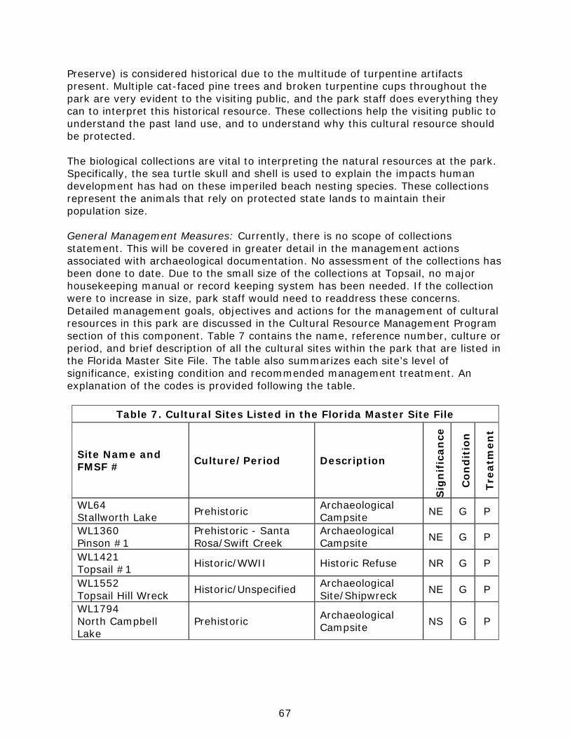
67
Preserve) is considered historical due to the multitude of turpentine artifacts present. Multiple cat-faced pine trees and broken turpentine cups throughout the park are very evident to the visiting public, and the park staff does everything they can to interpret this historical resource. These collections help the visiting public to understand the past land use, and to understand why this cultural resource should be protected. The biological collections are vital to interpreting the natural resources at the park. Specifically, the sea turtle skull and shell is used to explain the impacts human development has had on these imperiled beach nesting species. These collections represent the animals that rely on protected state lands to maintain their population size. General Management Measures: Currently, there is no scope of collections statement. This will be covered in greater detail in the management actions associated with archaeological documentation. No assessment of the collections has been done to date. Due to the small size of the collections at Topsail, no major housekeeping manual or record keeping system has been needed. If the collection were to increase in size, park staff would need to readdress these concerns. Detailed management goals, objectives and actions for the management of cultural resources in this park are discussed in the Cultural Resource Management Program section of this component. Table 7 contains the name, reference number, culture or period, and brief description of all the cultural sites within the park that are listed in the Florida Master Site File. The table also summarizes each site’s level of significance, existing condition and recommended management treatment. An explanation of the codes is provided following the table.
Table 7. Cultural Sites Listed in the Florida Master Site File
Site Name and FMSF # Culture/Period Description
Sig
nif
ican
ce
Con
dit
ion
Trea
tmen
t WL64 Stallworth Lake Prehistoric Archaeological
Campsite NE G P
WL1360 Pinson #1
Prehistoric - Santa Rosa/Swift Creek
Archaeological Campsite NE G P
WL1421 Topsail #1 Historic/WWII Historic Refuse NR G P
WL1552 Topsail Hill Wreck Historic/Unspecified Archaeological
Site/Shipwreck NE G P
WL1794 North Campbell Lake
Prehistoric Archaeological Campsite NS G P

68
Significance: Condition: Recommended Treatment: NRL National Register listed G Good RS Restoration NR National Register eligible F Fair RH Rehabilitation NE Not Evaluated P Poor ST Stabilization NS Not Significant NA Not Accessible P Preservation NE Not Evaluated R Removal N/A Not Applicable
Table 7. Cultural Sites Listed in the Florida Master Site File (Cont.)
Site Name and FMSF # Culture/Period Description
Sig
nif
ican
ce
Con
dit
ion
Trea
tmen
t
WL1974 Topsail Hill Preserve State Park
Prehistoric Archaeological Campsite NS G P
WL1998 Hewett Bayou Canal East
American 20th Century
Historic Canal/Drainage Ditch
NS G P
WL2021 Topsail Hill State Preserve
Historic/Unspecified Archaeological Site NS G P
WL2022 Topsail Hill State Preserve
Historic/Unspecified Archaeological Site NS G P
WL2129 Shell Midden #1
Prehistoric/Swift Creek, Weeden Island
Archaeological Campsite NR G P
WL2564 Pinson #2 Prehistoric Archaeological
Campsite NE G P
WL2565 Ammo Site Historic/Unspecified Historic Refuse NE G P
WL2566 Deer Point Prehistoric Archaeological
Campsite NS G P
WL2567 Gator Hammock Prehistoric Archaeological
Campsite NS G P
WL2568 Historic Picnic Prehistoric Archaeological
Campsite NS G P
WL2569 Fire Truck Crossing
Prehistoric/Swift Creek, Weeden Island
Archaeological Campsite NR G P
69
Resource Management Program
Management Goals, Objectives and Actions
Measurable objectives and actions have been identified for each of the DRP’s management goals for Topsail Hill Preserve State Park. Please refer to the Implementation Schedule and Cost Estimates in the Implementation Component of this plan for a consolidated spreadsheet of the recommended actions, measures of progress, target year for completion and estimated costs to fulfill the management goals and objectives of this park. While the DRP utilizes the ten-year management plan to serve as the basic statement of policy and future direction for each park, a number of annual work plans provide more specific guidance for DRP staff to accomplish many of the resource management goals and objectives of the park. Where such detailed planning is appropriate to the character and scale of the park’s natural resources, annual work plans are developed for prescribed fire management, exotic plant management and imperiled species management. Annual or longer- term work plans are developed for natural community restoration and hydrological restoration. The work plans provide the DRP with crucial flexibility in its efforts to generate and implement adaptive resource management practices in the state park system. The work plans are reviewed and updated annually. Through this process, the DRP’s resource management strategies are systematically evaluated to determine their effectiveness. The process and the information collected is used to refine techniques, methodologies and strategies, and ensures that each park’s prescribed management actions are monitored and reported as required by Sections 253.034 and 259.037, Florida Statutes. The goals, objectives and actions identified in this management plan will serve as the basis for developing annual work plans for the park. The ten-year management plan is based on conditions that exist at the time the plan is developed. The annual work plans provide the flexibility needed to adapt to future conditions as they change during the ten-year management planning cycle. As the park’s annual work plans are implemented through the ten-year cycle, it may become necessary to adjust the management plan’s priority schedules and cost estimates to reflect these changing conditions.
Natural Resource Management Hydrological Management
Goal: Protect water quality and quantity in the park, restore hydrology to the extent feasible and maintain the restored condition.
The natural hydrology of most state parks has been impaired prior to acquisition to one degree or another. Florida’s native habitats are precisely adapted to natural drainage patterns and seasonal water level fluctuations, and variations in these factors frequently determine the types of natural communities that occur on a particular site. Even minor changes to natural hydrology can result in the loss of plant and animal species from a landscape. Restoring state park lands to original
70
natural conditions often depends on returning natural hydrological processes and conditions to the park. This is done primarily by filling or plugging ditches, removing obstructions to surface water “sheet flow,” installing culverts or low-water crossings on roads, and installing water control structures to manage water levels. Objective A: Conduct/obtain an assessment of the park’s hydrological restoration needs.
Action 1 Assess surface hydrology associated with wet prairie and seepage slope systems at the park, and how they interact with the coastal dune lakes.
Action 2 Map where low water crossings are needed on all fire lines at the park.
Action 3 Map all plow scars currently within the park. Action 4 Determine how to prevent flooding of the campground and RV
park.
Hydrology is vital to the preservation of the natural communities and multiple imperiled species found at Topsail Hill Preserve State Park. The interaction of slope, soil, and rainfall create a complex matrix of vegetative communities that rely on specific amounts of water to persist. Understanding the complexities of the hydrology at Topsail would help park and district staff to better manage and preserve fragile ecosystems such as the coastal dune lakes, seepage slopes, and wet prairies. Also, by better understanding the surface and subsurface flow of water, staff can better restore disturbed areas from historical vehicular traffic and plow scars. This hydrological assessment would also benefit with the mapping of where low water crossings are needed, and where the existing soil damage and plow scars are located. Identifying areas, and calculating project costs for this will help improve restoration efforts. The park needs low water crossings at a variety of locations in order to provide sufficient access for resource management activities, especially prescribed burning. The low water crossings will help stabilize the firelines through wetland soils without disrupting the hydrological regime. It’s vital that the low water crossings are designed to be at grade with the existing sediment, and do not impound surface flow. The drainage canals adjacent to the newly built ranger station are favorite areas for beavers to dam at the park. During the wet season, beavers will block the flow of water north away from the campground, causing local flooding. Because of this, water pools at the campgrounds, RV areas, and cabin sites. To prevent this flooding, the park will evaluate a variety of methods to facilitate drainage away from developed park facilities.
71
Objective B: Restore natural hydrological conditions and functions to approximately 167 acres of coastal dune lakes natural community.
Action 1 Remove the causeway in Morris Lake. Action 2 Limit the number of artificial coastal dune lake openings. Action 3 Install a predetermined number of low-water crossings.
Currently, there is an old causeway and associated boardwalk at Morris Lake. This causeway was created by dredging lake bottom sediment adjacent to the path to build up the boardwalk area. This causeway has not only disrupted the hydrological flow of this lake, it has also created access for torpedo grass to cover more areas of the lake, therefore disrupting more of the flow. With issues surrounding Fuller Lake not draining enough and causing flooding on shoreline developments, it’s imperative to take every step possible to reduce holding excess water in Morris Lake. On an environmental side, the additional disturbed land allows torpedo grass to grow uninhibited. This stagnant water also has the potential to have decreased dissolved oxygen contents, and trap a higher amount of nutrients due to limited circulation. In order to completely restore the historical hydrology to this lake, the causeway should be removed, and the torpedo grass treated with herbicide. The next action goes hand in hand with the previous one. The park should limit the amount of artificial dune lake openings as much as possible. The water level of Morris Lake is currently managed by Walton County to prevent flooding of neighboring homeowners along the shoreline of Fuller Lake. When the water level threatens to flood septic tanks, Walton County digs a channel that prematurely connects Morris Lake to the Gulf of Mexico, thus purging the lake artificially. Morris naturally purges into the Gulf, but this is based on many factors including lake level, sand berm level and storm surge. Artificial purging of the lake alters the frequency and timing of the hydrological regime and affects not only the lake level but also its salinity, species composition, and vulnerability to tropical storms. Low water crossings not only need to be installed, they need to be properly maintained. Currently, the need for these crossings has partially documented. All areas needing this action need to be mapped, and discussed with district staff to ensure a low water crossing is appropriate. While determining how many new crossings are needed, the existing crossings should be assessed to determine what type of maintenance is needed. Objective C: Continue collecting monthly water quality data through Lake Watch.
Action 1 Collect water samples monthly at Morris and Campbell Lake.
Currently, park staff takes water samples from Campbell and Morris Lake to be tested for nutrient load, dissolved oxygen, salinity, and other water quality indicators. It’s vital to the health of the lake to continue this sampling process, and to make sure the water samples are brought to the appropriate locations and processed. Without the park’s help, these samples along with the long-term data associated with them would not be possible.
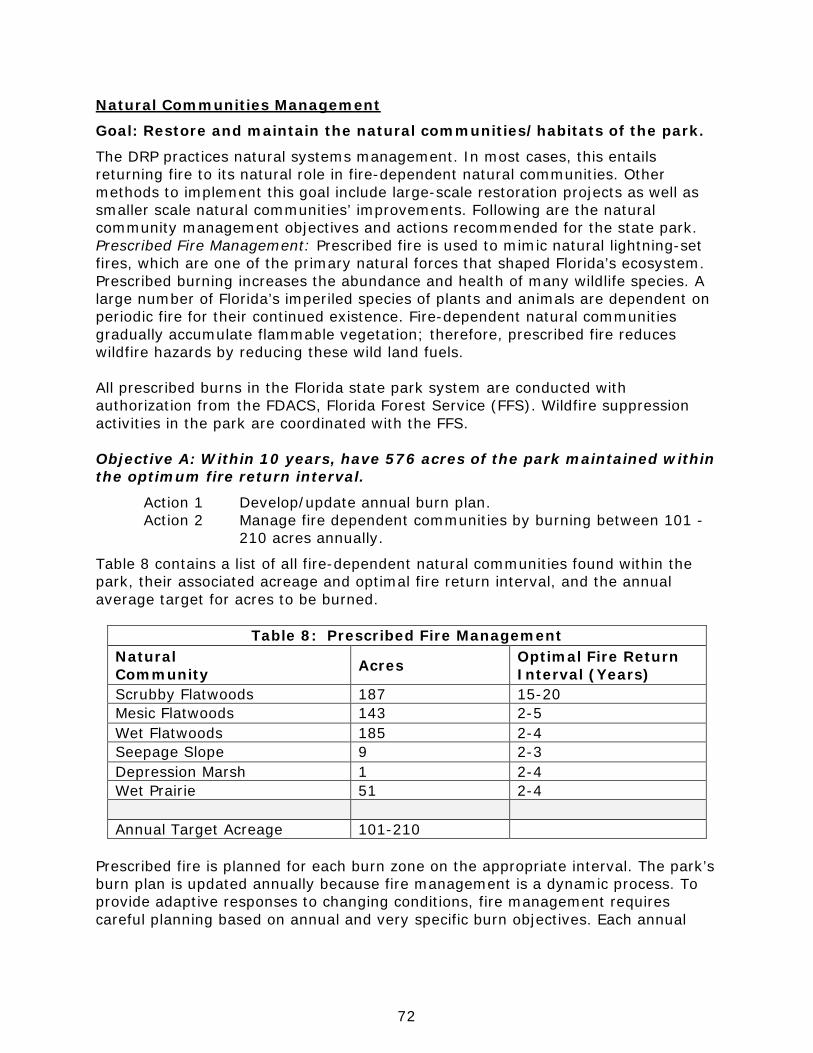
72
Natural Communities Management
Goal: Restore and maintain the natural communities/habitats of the park.
The DRP practices natural systems management. In most cases, this entails returning fire to its natural role in fire-dependent natural communities. Other methods to implement this goal include large-scale restoration projects as well as smaller scale natural communities’ improvements. Following are the natural community management objectives and actions recommended for the state park. Prescribed Fire Management: Prescribed fire is used to mimic natural lightning-set fires, which are one of the primary natural forces that shaped Florida’s ecosystem. Prescribed burning increases the abundance and health of many wildlife species. A large number of Florida’s imperiled species of plants and animals are dependent on periodic fire for their continued existence. Fire-dependent natural communities gradually accumulate flammable vegetation; therefore, prescribed fire reduces wildfire hazards by reducing these wild land fuels. All prescribed burns in the Florida state park system are conducted with authorization from the FDACS, Florida Forest Service (FFS). Wildfire suppression activities in the park are coordinated with the FFS. Objective A: Within 10 years, have 576 acres of the park maintained within the optimum fire return interval.
Action 1 Develop/update annual burn plan. Action 2 Manage fire dependent communities by burning between 101 - 210 acres annually.
Table 8 contains a list of all fire-dependent natural communities found within the park, their associated acreage and optimal fire return interval, and the annual average target for acres to be burned.
Table 8: Prescribed Fire Management Natural Community Acres Optimal Fire Return
Interval (Years) Scrubby Flatwoods 187 15-20 Mesic Flatwoods 143 2-5 Wet Flatwoods 185 2-4 Seepage Slope 9 2-3 Depression Marsh 1 2-4 Wet Prairie 51 2-4 Annual Target Acreage 101-210
Prescribed fire is planned for each burn zone on the appropriate interval. The park’s burn plan is updated annually because fire management is a dynamic process. To provide adaptive responses to changing conditions, fire management requires careful planning based on annual and very specific burn objectives. Each annual
73
burn plan is developed to support and implement the broader objectives and actions outlined in this ten-year management plan. Fire-dependent natural communities at the park include mesic flatwoods, wet flatwoods, wet prairie, seepage slope, depression marsh and scrubby flatwoods. Local wildlife populations that depend on or benefit from well-maintained fire adapted natural communities include ornate chorus frog, pygmy rattlesnake, coachwhip, six-lined racerunner, bobcat, southeastern kestrel, loggerhead shrike, brown-headed nuthatch and pine warbler. Imperiled species, such as white-top pitcher plant, yellow pitcher plant, parrot pitcher plant, purple pitcher plant and rose pogonia will benefit from regular prescribed fire as well. Prescribed burning is the primary management tool for mimicking natural processes and improving/maintaining quality habitats for a multitude of wildlife species. Any prescribed burn program in natural communities adjacent to coastal scrub must take into account the needs of the Choctawhatchee beach mouse. Coastal scrub is very important refugia for these mice after hurricanes when dune vegetation, cover, and forage are minimal. It is important to ensure that a significant amount of coastal scrub remains at a successional stage that will be sufficient to provide cover and food for beach mice at all times. Since research has shown that natural fire is not the process that shapes and maintains scrub communities in the panhandle of Florida (Drewa et al. 2008; Parker et al. 2001), prescribed fire should not be planned in these natural communities. Prescribed fire that is introduced to natural communities adjacent to scrub, during growing season when natural lightning fires would have occurred, should be given the opportunity to spread across the ecotone into scrub. Panhandle scrub communities within the park should not be mechanically reduced and ignited in a manner that would mimic a stand replacement fire. Any plan to introduce prescribed fire directly into these natural communities would require consultation with USFWS and FWC concerning the effect on Choctawhatchee beach mice. It should be noted that for fire to have occurred naturally in salt pruned, coastal oak scrub it would have spread from flatwoods, through sand pine scrub into the salt pruned coastal scrub. Burn zone descriptions, management objectives, GIS generated maps, and current burn prescriptions are reviewed annually and updated as necessary as part of the District 1 annual prescribed fire planning process. Specific management zone information, such as burn histories, natural community configurations, backlog status, as well as staff training, crew qualification status, and burn experience, is maintained in the DRP’s statewide Natural Resource Tracking System (NRTS). Park staff will coordinate with the district burn coordinator to identify yearly burn objectives. Once zones have been selected, burn prescriptions will be completed and reviewed by the end of the calendar year. All primary and secondary (contingency) fire lines for the planned burn zones will be completed by the end of the calendar year as well. At a minimum, fire lines will be cleared of all significant vegetation and fine dead fuels up to twice the width of the adjacent live understory fuels. In most cases, resource management roads are used as primary firebreaks, and provide for a mineral soil fire line component without the need for disking.
74
Segments of existing well established fire lines that require light disking shall be prepared well prior to burning. If disking is required, it is recommended that only the outer edge of the fire line be disked, in order to preserve vehicular access along the remaining majority of the fire line. Prior planning for any new fire lines must be coordinated through the BNCR and the DHR. While the body of knowledge that supports prescribed fire supports fires that occur in growing (lightning) season, not all prescribed fires at this park can be conducted during that season. Urban development adjacent to the park, and resulting smoke management and safety concerns place limitations on the opportunities that are available in any given time period. Prescribed burn efforts should be managed so that the seasonality of prescribed burns is rotated throughout zones that are in maintenance stage management so that each zone will have exposure to lightning season fire. Park staff will communicate with the district burn coordinator, and regional fire managers, in order to gather additional burn crew and equipment needed to safely conduct burns. Park staff will be responsible for tracking weather conditions throughout the burn season, and identifying potential burn windows based on weather forecasts. All fire suppression equipment will be routinely inspected and operationally tested. Any necessary maintenance and repairs will be accomplished or facilitated by park staff, or if necessary, coordinated with the district burn coordinator. Accurate and complete rainfall data will be maintained on-site, in order to effectively track the local drought index and plan prescribed fire activities. In the case of management zone TP-23, the high fuel loading prevents a prescribed fire program until certain conditions, such as wider fire lines, mechanical fuel reduction, low water crossing and/or restoration, are met. The total area of this zone is 123 acres, which has been subtracted from the total acreage of natural communities targeted for management with prescribed fire. Once this zone can be brought into the prescribed fire program, the targets will be increased to include this area. In addition, all other zones with an urban interface will receive mechanical fuel reduction if needed prior to any prescribed fire treatments to reduce fire intensity. There are also additional pockets of pyric communities such as mesic flatwoods intermixed with non-pyric communities like coastal scrub. These areas are not included with the burn plan, as the main disturbance for them will be tropical storms. In order to track fire management activities, the DRP maintains a statewide burn database through NRTS. The database allows staff to track various aspects of each park’s fire management program including individual burn zone histories and fire return intervals, staff training and experience, backlog, etc. The database is also used for annual burn planning which allows the DRP to document fire management goals and objectives on an annual basis. Each quarter the database is updated and reports are produced that track progress towards meeting annual burn objectives.
75
Natural Community Restoration: In some cases, the reintroduction and maintenance of natural processes is not enough to reach the desired future conditions for natural communities in the park, and active restoration programs are required. Restoration of altered natural communities to healthy, fully functioning natural landscapes often requires substantial efforts that may include mechanical treatment of vegetation or soils and reintroduction or augmentation of native plants and animals. For the purposes of this management plan, restoration is defined as the process of assisting the recovery and natural functioning of degraded natural communities to desired future condition, including the re-establishment of biodiversity, ecological processes, vegetation structure and physical characters. Examples that would qualify as natural community restoration, requiring annual restoration plans, include large mitigation projects, large-scale hardwood removal and timbering activities, roller-chopping and other large-scale vegetative modifications. The key concept is that restoration projects will go beyond management activities routinely done as standard operating procedures such as routine mowing, the reintroduction of fire as a natural process, spot treatments of exotic plants, and small-scale vegetation management. Following are the natural community/habitat restoration and maintenance actions recommended to create the desired future conditions in the wet flatwoods community. Objective B: Conduct habitat/natural community restoration activities on 13 acres of wet flatwoods natural community.
Action 1 Develop/update site specific restoration plan. Action 2 Implement restoration plan.
The area slated for natural community restoration is in management zone TP-23, in the northeastern corner of the park. This area is currently mapped as wet flatwoods, but historical photography clearly shows that this parcel was wet prairie prior to changes in the hydrology, and before the encroachment of pines from the nearby basin swamp. Also, all of the pines currently located in this area are of small stature, meaning none of them were around prior to road construction and shifts in water due to development. Ideally, the 13 acres would be logged of almost all pines. Two or three pines per acre could be left and the area would still be considered wet prairie. Due to the wet nature of this community, this project may need to be completed by hand, as many imperiled plant species could potentially be disturbed with heavy equipment. On top of the pine removal, there are areas with thick mid-story trees shading out wet prairie species. These would need to be mowed after the trees were removed, and the larger sections of wood removed from the site. After the removal of excess pine trees and large mid-story trees, the area would need to be put on a burn interval of 2-4 years to maintain a low grassy community. With a basin swamp to the west and large paved roads on all other sides, burning this section would become much easier with a decrease in the fuel load. It also would make this section of the park much safer to burn in the future.
76
This restoration is a high priority for the park. As more time passes, even less remnant wet prairie species will be able to survive in the seed bank. The wet prairie surrounding this area is constantly growing smaller as pines and understory creeps in and out-shades the imperiled prairie species. Natural Community Improvement: Improvements are similar to restoration but on a smaller, less intense scale. This typically includes small-scale vegetative management activities or minor habitat manipulation. Following are the natural community/habitat improvement actions recommended at the park. Objective C: Conduct natural community/habitat improvement activities on 20 acres of seepage slope and wet prairie natural communities.
Action 1 Burn and mow designated habitat improvement sites in TP-12, TP-17, TP-5, TP-1 and TP-4.
Action 2 Monitor results of habitat improvement by documenting species diversity and by taking photo points.
Certain seepage slope and wet prairie communities at the park are not in need of full-scale restoration, but simple distinct management actions to bring them back to their desired future condition. This includes mechanically lowering the shade producing vegetation (gallberry, titi), and burning regularly. The timing of this mowing is extremely important, and should be done in the growing season prior to flowering. Also, the timing of this mowing should fluctuate throughout the growing seasons over the years in order to allow all of the existing species to flower and seed. If the areas have been overgrown for such a long period of time that no relict seepage slope or wet prairie species return, the park service will work with Atlanta Botanical Gardens (ABG) to reintroduce plants. District 1 has a good relationship with this organization, and they have already worked on reintroducing other pitcher plant species at the park. Topsail Hill Preserve State Park currently has a restoration plan written for the zones needing habitat improvement. It’s vital that park staff continue to mow and burn the documented improvement zones, and document the results. Objective D: Conduct natural community/habitat improvement activities on 6.5 acres of wet flatwoods and dome swamp natural communities.
Action 1 Remove large titi growth in the wet flatwoods and dome swamp in TP-29.
Action 2 Introduce prescribed burns to the area after titi biomass has been removed.
Action 3 Introduce imperiled species such as pitcher plants and flatwoods salamanders after improvements are complete.
Habitat improvement in management zone TP-29 has already begun with the help of volunteers and District AmeriCorps members. The work so far has consisted of manually cutting down large stature titi trees, and removing the biomass from the
77
site. Staff has focused on areas where Curtiss’ sandgrass is found, in order to allow more sunlight to these plants. After the area is cleared of the titi, staff is hoping to allow some small prescribed fires in this zone in order to maintain the correct species diversity. Being in an area surrounded by scrubby flatwoods and extremely close to the campgrounds and cabins, it may not be possible to introduce fire on a regular interval. Hopefully after the area is cleared and more closely resembles wet flatwoods and dome swamp, fire will be safer to introduce. Even if fire is never able to return to this improved zone, the exposure to sunlight and lack of nutrient buildup will still be beneficial to these communities. When the defined areas of wet flatwoods and dome swamp communities have been improved, park staff should work with ABG on reintroducing imperiled species. Many plant species such as butterworts, pitcher plants, and sundews were lost due to extensive shading and nutrient loading. As the habitat is improved, bringing these species back can help to return these areas to their natural condition. The same goes for imperiled animals, such as the flatwoods salamander. As these areas are improved, they can once again be utilized by native fauna. This not only improves the existing natural community, it increases the amount of viable habitat for these imperiled species. Imperiled Species Management
Goal: Maintain, improve or restore imperiled species populations and habitats in the park.
The DRP strives to maintain and restore viable populations of imperiled plant and animal species primarily by implementing effective management of natural systems. Single species management is appropriate in state parks when the maintenance, recovery or restoration of a species or population is complicated due to constraints associated with long-term restoration efforts, unnaturally high mortality or insufficient habitat. Single species management should be compatible with the maintenance and restoration of natural processes, and should not imperil other native species or seriously compromise park values. In the preparation of this management plan, DRP staff consulted with staff of the FWC’s Imperiled Species Management or that agency’s Regional Biologist and other appropriate federal, state and local agencies for assistance in developing imperiled animal species management objectives and actions. Likewise, for imperiled plant species, DRP staff consulted with FDACS. Data collected by the USFWS, FWC, FDACS and FNAI as part of their ongoing research and monitoring programs will be reviewed by park staff periodically to inform management of decisions that may have an impact on imperiled species at the park. Ongoing inventory and monitoring of imperiled species in the state park system is necessary to meet the DRP’s mission. Long-term monitoring is also essential to ensure the effectiveness of resource management programs. Monitoring efforts must be prioritized so that the data collected provides information that can be used

78
to improve or confirm the effectiveness of management actions on conservation priorities. Monitoring intensity must at least be at a level that provides the minimum data needed to make informed decisions to meet conservation goals. Not all imperiled species require intensive monitoring efforts on a regular interval. Priority must be given to those species that can provide valuable data to guide adaptive management practices. Those species selected for specific management action and those that will provide management guidance through regular monitoring are addressed in the objectives below. Objective A: Update baseline imperiled species occurrence inventory lists for plants and animals.
Objective B: Monitor and document 14 selected imperiled animal species in the park.
Action 1 Develop monitoring protocols for 1 selected imperiled animal species, the gopher tortoise.
Action 2 Implement monitoring protocols for the gopher tortoise along with the already in place protocols for beach mice, shorebirds, and sea turtles.
Park staff need to develop and implement a monitoring protocol for the gopher tortoises found at the park. Ideally, staff will conduct surveys of gopher tortoise burrows after each burn to determine the number of occupied and potentially occupied burrows in the park. This should allow the park to have a rolling population estimate of gopher tortoises within each zone. Areas that do not get burned, such as the coastal scrub, should also be surveyed every 3 years to get an estimate of how many burrows are at the park. The park should monitor all management zones with suitable habitat every five years. Sea turtle nests, including loggerhead, green, Kemp’s ridley, and leatherback are monitored by staff using strict methods and protocols developed by the FWC that fully census the population of nesting sea turtles and hatchlings, as well as hatchling success rates. Monitoring methods and protocols included nest surveys, nest inventories, and survey of disorientations and strandings (FWC Conservation Guidelines for Marine Turtles 2007). If any issues arise regarding sea turtle nesting, hatching or stranding, district staff along with FWC personnel should be notified. Snowy plover, Wilson’s plover, American oystercatcher, least tern, black skimmer, and gull-bill terns nesting is monitored to determine the number of nesting attempts, the number of nesting adults, nest fate, sources of predation, and annual productivity. Snowy plovers, Wilson’s plovers, and American oystercatchers are banded with individual color combinations to help biologists determine productivity as well as juvenile survival, adult survival, natal dispersal, and between-season and in-season dispersal. These efforts will help determine the level of connectivity for these species from Topsail Hill Preserve State Park to other beaches throughout Florida. These monitoring protocols are also vital in the long-term sense, in order to determine population growth in response to management actions. Shorebird nest monitoring is currently conducted by Audubon staff through a district wide grant to monitor all beach nesting birds at all beach parks. Audubon and park service staff
79
work hand in hand to collect and interpret the shorebird nesting data as thoroughly as possible. Other shorebirds, including federally-listed piping plovers and red knots will be monitored for presence at the park, habitat use, and dispersal. These two species are regularly banded with individual color combinations on their breeding grounds and collection of band re-sights allow for determining dispersal from breeding to wintering grounds. Audubon and park service staff monitor all shorebird, seabird, raptor, or wading bird species observed during surveys conducted twice a month during the winter months (September to February) and weekly during the breeding season (February to August). Choctawhatchee beach mice are monitored for presence or absence and relative distribution through tube tracking surveys. FWC has helped the park set-up tracking tubes to replace the sand tracking method. These tubes determine presence, absence, and relative distribution but have an advantage of not being dependent on sand tracking conditions. The park will continue to work with FWC to monitor these tubes on a monthly basis. Research of the beach dune community and its response after tropical storms is important for understanding baseline conditions and succession of dune community after storms. Objective C: Monitor and document 5 selected imperiled plant species in the park.
Action 1 Develop monitoring protocols for 5 selected imperiled plant species including pine lily, panhandle meadow beauty, parrot, white-top, and purple pitcher plants.
Action 2 Implement monitoring protocols for the 5 imperiled plant species included in Action 1.
Wet prairie and seepage slope species including the pine lily, white-top pitcher plant, parrot pitcher plant and purple pitcher plants, will be monitored annually for presence or absence. Along with annual checks, every three years park and district staff will complete a population assessment that will give an estimate of how many individuals are at the park. This will include a map of the park that includes polygons of population locations. These species have been in continual decline, and need the attention of park staff to maintain viable populations (Johnson 2001). Monitoring of these wetland species is important in determining how restoration efforts and burning cycles are affecting these populations. Another imperiled plant species to be monitored is the panhandle meadow beauty. This flower is commonly found along the shoreline of the coastal dune lakes, but is easily smothered out by torpedo grass. Its sporadic nature and reliance on open, sandy basin swamp areas makes this plant vulnerable to being lost at the park without exotic plant management. This flower should be monitored in the same way as the other wetland species. The only difference will be that surveys will depend on low lake levels.
80
Currently, there are no monitoring protocols for any imperiled plants at Topsail. Creating monitoring protocols for these few wetland species may eventually enable staff to monitor other species at the park as well. Partnerships that can be utilized for monitoring plants includes ABG, USFWS, FWC, and partnering universities. Objective D: Enhance beach nesting habitat for beach mice, sea turtles, and shorebirds.
Action 1 Reduce beach lighting and sky glow observed at the park. Action 2 Reduce beach driving. Action 3 Prevent disturbance to nesting shorebirds and sea turtles.
In the few areas of the park with lighting needs, the park will utilize “wildlife-friendly” lighting as recommended by the FWC Marine Turtle Lighting guidelines. In addition, during the marine turtle nesting season (May 1- October 31), special events to be located on the beach will be scheduled during daylight hours. The impacts of beach lighting have not been documented in other beach nesting species, but it is assumed that an increase in lighting makes it easier for predators to locate these species. Driving on the beach should be limited as much as possible. Vehicular rutting associated with beach driving impacts shorebird and sea turtle hatchling nest success and recruitment. Beach drivers should follow the guidelines in the FWC Best Management Practices for Operating Vehicles on the Beach (FWC BMPs) and try to keep from disturbing the wrack line. Symbolic fencing (i.e., posts, signs and rope) should be used to protect the beach dune habitat from potential detrimental impacts associated with beach driving. Moreover, efforts to protect the beach habitat should focus on protecting shorebird nesting habitat and beach mice dune areas while creating a corridor for driving access as close to the wet sand as possible. Park and Audubon staff should post and rope suitable shorebird areas annually prior to nesting season to prevent visitor disturbance to shorebird nesting. Posting should follow the guidelines established by FWC (Avissar et al. 2012). Protection of nesting habitat with symbolic fencing results in an increase of nesting events, a greater number of nesting shorebirds, and increased productivity (Pruner 2010). The outfalls of the coastal dune lakes are popular with visitors but are also good quality foraging habitat for nesting shorebirds, shorebird broods, and foraging shorebirds during migration and winter. Protection of brood foraging area with symbolic fencing also increases fledge rates. In fact, Pruner et al. (2011) observed that twice as many chicks fledged in protected areas compared to areas that were not. Staff or district biologists should post and protect the freshwater inlets and outfalls year-round because they are important foraging shorebird areas. Clear guidance to visitors of the location of sensitive areas and posting may help to reduce this conflict. Presence of law enforcement and/or interpretive programs during high visitor use periods (particularly holidays) is recommended to help protect shorebird nests. The DRP will coordinate with the USWFS, FWC, Audubon of Florida, and other agencies on interpretive programs aimed at educating and informing park visitors
81
about shorebirds and the potential impacts recreation can have on nesting activities. Objective E: Reintroduce flatwoods salamanders to the park after habitat improvement and restoration.
Action 1 Work to restore/improve existing dome swamps and wet flatwoods for flatwoods salamanders.
Action 2 Coordinate with USFWS and FWC to develop a reintroduction/preservation plan for salamanders.
Reintroducing flatwoods salamanders to Topsail Hill Preserve State Park should be a priority for the imperiled species management at the park. With relatively good habitat needing only minimal improvements, the park could be an ideal location for this amphibian. With a shrinking range, and extremely little success crossing major highways, it’s almost impossible for this salamander to naturally re-inhabit this park on its own. Minimal habitat improvement, such as removal of woody shrubs along ecotones, would make these habitats ideal relocation sites. Park Service staff should coordinate with USFWS and FWC on moving reintroduction efforts forward. Exotic Species Management
Goal: Remove exotic and invasive plants and animals from the park and conduct needed maintenance control.
The DRP actively removes invasive exotic species from state parks, with priority being given to those causing the ecological damage. Removal techniques may include mechanical treatment, herbicides, or biocontrol agents. Objective A: Annually treat 2 infested acres of exotic plant species in the park.
Action 1 Annually update exotic plant management work plan. Action 2 Implement annual work plan by treating 2 infested (10 gross)
acres in park, annually, and continuing maintenance and follow-up treatments, as needed.
Annually, 2 infested acres or 10 gross acres of exotics should be treated at Topsail Hill. Infested areas of torpedo grass and Japanese climbing fern will be checked annually and treated with herbicides as necessary until the areas are in maintenance condition. Spot checks for individual Chinese tallow trees, lantana shrubs and cogon grass will be conducted annually. Maintenance condition describes a formerly active infestation that has been treated to the extent that any plants remaining are manageable with existing staff and resources, total area is stable or declining, mature reproducing individuals are absent, and the species poses no significant threat to listed plants or animals. Thus, the actual treated zone may reduce in area over time though the entire extent would need to be inspected indefinitely. An important exception is an instance where the exotic plants are well mixed with native vegetation, which an accompanying restoration plan would be needed to

82
plant natives in the formerly infested area. The reason for this caveat is that in this situation herbicide application would likely result in significant non-target damage; the resulting area would be denuded of live vegetation and highly vulnerable to re-infestation by exotic plant species. Such removal of native vegetation may lead to the necessity of perpetual treatment and subsequent loss of native plant species from that area. A restoration effort to replant the area with native vegetation appropriate for that habitat following treatment would be intended to preempt potential exotic growth into the open space. Objective B: Implement control measures on 6 exotic and nuisance animal species in the park.
Action 1 Remove large predators and mesopredators from the beach dune system to improve populations of imperiled species.
Action 2 Remove animals posing a threat to visitor safety.
The park should continue a program of controlling coyotes, raccoons, red foxes, gray foxes, feral cats, and Virginia opossums on the park. All of these species are threats to imperiled coastal species. In fact, Pruner et al. (2011) found that the more coyotes removed, the higher the probability of hatching success for shorebird nests. A tracking assessment of exotic animal predator species should be conducted prior to the start of the shorebird nesting season and during beach mice, shorebird and sea turtle monitoring to establish predator control needs. In addition, any documented predation event (e.g., shorebird nest, sea turtle nest) should be reported to the district office to coordinate predator removal efforts with the USDA. Coordinated efforts between the FWC, USFWS, and the DRP as part of the State Wildlife Grant program and funding associated with the BP oil spill will adequately fund the predator removal program with the USDA at this park until 2017. The park staff will work closely with the USDA on trapping efforts to increase the number of feral cats removed at Topsail Hill Preserve State Park. The park will follow the DRP’s Resource Management Standard for Nuisance and Exotic Animal Removal. Research is needed on effective methods for trapping feral cats. Spector (2009) found that traditional cat trapping with live traps using food as bait was not effective for controlling cats even when conducted daily. The DRP will coordinate with the USFWS and FWC on an education and outreach program aimed at the public (park visitors and neighboring communities) on the impacts feral cats have on wildlife. Currently as of 2015, the District 1 office was awarded a NFWF grant from money provided by the oil spill cleanup. The section of this grant dealing with Topsail Hill Preserve State Park is related to limiting the amount of beach predators on Walton County state park beaches, along with limiting beach driving. Because of this, the park will be regularly visited by a state park staff trapper out of the district office. This program is intended to increase nesting success of beach nesting shorebirds, and sea turtles by removing beach predators.
83
Cultural Resource Management
Cultural resources are individually unique, and collectively, very challenging for the public land manager whose goal is to preserve and protect them in perpetuity. The DRP will implement the following goals, objectives and actions, as funding becomes available, to preserve the cultural resources found in Topsail Hill Preserve State Park. Goal: Protect, preserve and maintain the cultural resources of the park.
The management of cultural resources is often complicated because these resources are irreplaceable and extremely vulnerable to disturbances. The advice of historical and archaeological experts is required in this effort. All activities related to land clearing, ground disturbing activities, major repairs or additions to historic structures listed or eligible for listing in the National Register of Historic Places must be submitted to the FDOS, Division of Historical Resources (DHR) for review and comment prior to undertaking the proposed project. Recommendations may include, but are not limited to concurrence with the project as submitted, pre-testing of the project site by a certified archaeological monitor, cultural resource assessment survey by a qualified professional archaeologist, modifications to the proposed project to avoid or mitigate potential adverse effect. In addition, any demolition or substantial alteration to any historic structure or resource must be submitted to the DHR for consultation and the DRP must demonstrate that there is no feasible alternative to removal and must provide a strategy for documentation or salvage of the resource. Florida law further requires that DRP consider the reuse of historic buildings in the park in lieu of new construction and must undertake a cost comparison of new development versus rehabilitation of a building before electing to construct a new or replacement building. This comparison must be accomplished with the assistance of the DHR. Objective A: Assess and evaluate all recorded cultural resources in the park.
Action 1 Complete 16 assessments/evaluations of archaeological sites.
The park will assess all of the known sites within the park every year. The site condition will be evaluated and any threats examined. The park will set up and use photo points at each site to evaluate changes of the site from previous assessment periods. Management measures will be prioritized after assessments to determine management needs for each site. Sites located in the dunes faced with erosion, and the potential for overlap in exposed artifacts and human recreation should be monitored more frequently. Natural erosion due to tropical storm events at the park is inevitable. The Gulf of Mexico shoreline is a dynamic ecosystem, and cultural sites in the beach dune natural community are exposed to extreme weather events. Park staff will document these exposed sites, as well as record any major changes to the structure of these sites over time. The only site that has a trail directly over it is WL1974, which was found during the construction of a beach restroom. This surface
84
scatter is the only area directly in the public view where looting could occur. Staff will need to routinely patrol this area to avoid losses to this site. No new firebreaks should be needed at the park, therefore none of the sites should be impacted from line prep. The existing firelines over cultural sites WL64 and WL2129 were not disked to a mineral line in order to protect the ground from disturbance. If new firelines are needed in the future, they would be created the same way to protect the site’s integrity. Future plans will need to assess existing park structures as historic. No restoration and rehabilitation projects have been identified for any sites at this park. The only other type of ground disturbance that could potentially impact sites at this park deals with root intrusion from large trees. Sites with older trees, specifically the shell midden WL2129 on the western boundary of the park, are susceptible to this type of damage. Large trees have been identified at this site, and will be monitored prior to hurricane season to ensure roots do not pull up large sections of this site. If needed, threatening trees will be cut down after consultation with DHR and district biologists. Objective B: Compile reliable documentation for all recorded historic and archaeological resources.
Action 1 Ensure all known sites are recorded or updated in the Florida Master Site File. Action 2 Develop and adopt a Scope of Collections Statement.
Currently, all known sites are recorded and updated in FMSF. It’s highly probable that more cultural sites exist at the park, but have not been located yet. As tropical storms push through this area, staff should be diligent to survey potential zones such as coastlines along the coastal dune lakes. As new sites are found, they will be recorded and documented with FMSF. A predictive model for the park was completed in 2011, documenting areas of high, medium and low probability of locating archaeological sites. With this information, two areas at the park would benefit from a Level 1 archaeological survey. Both of these areas are adjacent to the coastal dune lakes on the northern shorelines, and would have been ideal camping/homestead sites. A Scope of Collections Statement has not been created for this park yet. Creating one now while the current collection is small will help ensure an accurate and organized record. All items in the collection should be related to the biological or cultural history of the park. While all the items currently in the collections have been inventoried, they have not yet been entered into the PastPerfect collections software maintained by DRP. A park administrative history would be easy to create due to the young age of the park. Starting a history document now would allow all managers to add their names as they come to the park, thereby keeping an accurate administrative history.
85
Objective C: Maintain 16 of 16 recorded cultural resources in good condition.
Action 1 Continue to implement regular monitoring programs for 16 cultural sites. Since all of the recorded 16 cultural sites are in good condition, the park should monitor each site annually to determine if maintenance or management measures are needed in the future. As other sites are discovered, especially after large tropical storms, they should be recorded with the FMSF and added to the monitoring and management program. Photo points will be set up at each site and taken every other year for monitoring purposes. If management measures are needed the park should implement those measures to preserve the sites. No preservation projects are presently needed at the park. Special Management Considerations
Timber Management Analysis If the DRP determines that timber management does not conflict with the primary management objectives of the land, on all parcels larger than 1,000 acres, Florida Statutes - Chapters 253 and 259 require:
1) An analysis of the multiple-use potential of the parcel. Such analysis shall include the potential of the parcel to generate revenues to enhance the management of the parcel.
2) An assessment of the feasibility of managing timber resources for conservation and revenue generation purposes through a stewardship ethic that embraces sustainable forest management practices in land management plans.
Topsail Hill Preserve State Park is designated as a single-use park. The feasibility of harvesting timber at Topsail Hill Preserve State Park during the period covered by the UMP was considered pursuant to the DRP statutory responsibilities to analyze the park’s resource needs and values. The long-term management goal for forest communities in the state park system is to maintain or re-establish old-growth characteristics to the degree practicable, except in those forest communities specifically managed as early successional. Timber management is utilized for the purpose of helping restore or improve current habitat conditions and enhancing the overall integrity of the natural community. Revenue generation from timber management is not the goal but rather, a by-product of taking such actions to help restore/improve target conditions of specific natural communities. In all situations, forest/stand/timber management activities undertaken will adhere to the current Florida Silvicultural Best Management Practices and Florida Forestry Wildlife Best Management Practices for State Imperiled Species. Most of the natural communities evaluated at Topsail Hill Preserve State Park had pine overstory stocking levels within and hardwood overstory stocking levels above the ranges identified per corresponding Florida Natural Areas Inventory (FNAI)
86
Reference Sites. The majority of areas not in compliance have overstocked conditions in the non-pine components. Overstory thinning is a management tool that may be utilized in areas which have overstocked conditions. Activities related to stand improvement, including palmetto and midstory reduction, are ongoing and still needed in many areas. The Timber Management Analysis found in Addendum 8 provides additional details. This analysis has been evaluated and found to be consistent with the recommendations found in the subject RMC. Coastal/Beach Management The DRP manages over 100 miles of sandy beach, which represents one-eighth of Florida’s total sandy beach shoreline. Approximately one-quarter of Florida’s state parks are beach-oriented parks and account for more than 60 percent of statewide park visitation. The management and maintenance of beaches and their associated systems and processes is complicated by the presence of inlets and various structures (jetties, groins, breakwaters) all along the coast. As a result, beach restoration and nourishment have become increasingly necessary and costly procedures for protecting valuable infrastructure. Beach and inlet management practices affect beaches for long distances on either side of a particular project. DRP staff needs to be aware of and participate in the planning, design and implementation of these projects to ensure that park resources and recreational use are adequately considered and protected. Topsail Hill Preserve State Park encompasses 3.25 miles of beach. The beach habitat at the park is protected under the Coastal Barrier Resources Act (CBRA). The CBRA helps ensure that the coastal habitat remains intact by minimizing the likelihood of development on this sensitive and dynamic habitat. None of the beach is considered critically eroding by DEP’s Bureau of Beaches and Coastal Systems (FDEP 2015). As identified in the Resource Management Program, dune restoration may be needed after tropical storms, and dunes should be assessed after each large storm to determine the need. The Trustees have granted management authority of certain sovereign submerged lands to the DRP under Management Agreement MA 68-086 (as amended January 19, 1988). Management of Topsail Hill Preserve State Park includes certain management activities within the buffer zone of sovereign submerged land along the entire beach, beginning at the mean high water or ordinary high-water line, or from the edge of emergent vegetation and extending waterward for 400 feet. This area comprises the marine unconsolidated substrates of the park. The submerged resources within the buffer zone significantly increase the species diversity within the park and offers additional recreational opportunities for park visitors. Visitors are able to access this community either from the beach or from a boat. Management actions occurring within the buffer zone include patrolling for boats and watercraft too close to the park’s beaches, removal of trash, litter, and other debris, public safety activities, and resource inventories and monitoring. Extension of the park’s boundary into sovereign submerged land, 150 feet beyond the Gulf of
87
Mexico shoreline is needed to manage and protect the park’s coastal communities, including the listed species that occur there (including but not limited to rare plants, sea turtles, shorebirds, and beach mice). These lakes are considered by FNAI to be globally rare and imperiled. Walton County is permitted to artificially open the lakes to the Gulf at a set lake level. The artificial openings encourage vegetation to establish lower on the shoreline and the lake to become more saline over time shifting the lake to a more estuarine character. The park should work with the county and DEP Beaches and Coastal Systems to reduce the number of artificial openings and allow the coastal dune lakes to open naturally. Arthropod Control Plan All DRP lands are designated as “environmentally sensitive and biologically highly productive” in accordance with Ch. 388 and Ch. 388.4111 Florida Statutes. If a local mosquito control district proposes a treatment plan, the DRP works with the local mosquito control district to achieve consensus. By policy of DEP since 1987, aerial adulticiding is not allowed, but larviciding and ground adulticiding (truck spraying in public use areas) is typically allowed. The DRP does not authorize new physical alterations of marshes through ditching or water control structures. Mosquito control plans temporarily may be set aside under declared threats to public or animal health, or during a Governor’s Emergency Proclamation. Currently, Topsail Hill Preserve State Park has an Arthropod Management Plan which was enacted in August of 2010. This plan allows the South Walton County Mosquito Control District to treat ditches and wetlands immediately surrounding the RV Park and 30A roadside ditches for mosquito larvae with Bacillus thuringiensis subspecies israelensis strain EG2215 (Bti). This larvacide is to be used from the ground at a rate of 1 briquet per 100 sq ft. Adult mosquito control is achieved with ground adulticiding from a truck with Evoleur 4-4 ULV at 0.0024 lb ai/acre. These application methods may change due to a threat to public or animal health declared by a State Health Officer or the Commissioner of Agriculture. The park manager must be notified if the mosquito management is to deviate from the existing Arthropod Management Plan. Sea Level Rise Potential sea level rise is now under study and will be addressed by Florida’s residents and governments in the future. The DRP will stay current on existing research and predictive models, in coordination with other DEP programs and federal, state, and local agencies. The DRP will continue to observe and document the changes that occur to the park’s shorelines, natural features, imperiled species populations, and cultural resources. This ongoing data collection and analysis will inform the Division’s adaptive management response to future conditions, including the effects of sea level rise, as they develop. Resource Management Schedule A priority schedule for conducting all management activities that is based on the purposes for which these lands were acquired, and to enhance the resource values, is located in the Implementation Component of this management plan.
88
Land Management Review Section 259.036, Florida Statutes, established land management review teams to determine whether conservation, preservation and recreation lands titled in the name of the Board of Trustees are being managed for the purposes for which they were acquired and in accordance with their approved land management plans. The considered recommendations of the land management review team and updated this plan accordingly. Topsail Hill Preserve State Park was subject to a land management review on April 26, 2016. The review team made the following determinations: • The land is being managed for the purpose for which it was acquired. • The actual management practices, including public access, complied with the
management plan for this site.

89
LAND USE COMPONENT
Introduction
Land use planning and park development decisions for the state park system are based on the dual responsibilities of the Florida Department of Environmental Protection (DEP), Division of Recreation and Parks (DRP). These responsibilities are to preserve representative examples of original natural Florida and its cultural resources, and to provide outdoor recreation opportunities for Florida's citizens and visitors. The general planning and design process begins with an analysis of the natural and cultural resources of the unit, and then proceeds through the creation of a conceptual land use plan that culminates in the actual design and construction of park facilities. Input to the plan is provided by experts in environmental sciences, cultural resources, park operation and management. Additional input is received through public workshops, and through environmental and recreational-user groups. With this approach, the DRP objective is to provide quality development for resource-based recreation throughout the state with a high level of sensitivity to the natural and cultural resources at each park. This component of the unit plan includes a brief inventory of the external conditions and the recreational potential of the unit. Existing uses, facilities, special conditions on use, and specific areas within the park that will be given special protection, are identified. The land use component then summarizes the current conceptual land use plan for the park, identifying the existing or proposed activities suited to the resource base of the park. Any new facilities needed to support the proposed activities are expressed in general terms.
External Conditions
An assessment of the conditions that exist beyond the boundaries of the unit can identify any special development problems or opportunities that exist because of the unit's unique setting or environment. This also provides an opportunity to deal systematically with various planning issues such as location, regional demographics, adjacent land uses and park interaction with other facilities. Topsail Hill Preserve State Park is located within Walton County, adjacent to Miramar Beach in the Florida panhandle. Approximately 250,000 people live within 30 miles of the park (U.S. Department of Commerce, 2010). The working age, under 18, and senior populations make up about 60%, 20%, and 20% respectively. Around 13% of the population of Walton County identify as minority while 87% identify as white. Walton County ranks 22nd statewide in per capita personal income at $37,976 (below the statewide average of $41,497) (U.S. Bureau of Economic Analysis, 2014). Table 9 below identifies significant resource-based recreation opportunities within 15 miles of Topsail Hill Preserve State Park.

90
Above: Figure 1. Walton, Bay, and Okaloosa County Population Projections. census.gov.
Table 9. Resource-Based Recreational Opportunities Near Topsail Hill Preserve State Park
Name
Bik
ing
Hik
ing
Sw
im/
Bea
ch A
cces
s
Boa
tin
g/
Pad
dlin
g
Fish
ing
Wild
life
Vie
win
g
Ove
rnig
ht
Sta
y
Hu
nti
ng
Equ
estr
ian
Fa
cilit
ies
Gulf Islands National Seashore (USDOI)
Eglin Air Force Base (FWC/USDOD)
Henderson Beach State Park (DRP)
Coffeen Nature Preserve (Private)
Fred Gannon Rocky Bayou State Park (DRP)
Choctawhatchee River Delta Preserve (Private)
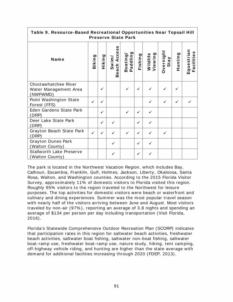
91
Table 9. Resource-Based Recreational Opportunities Near Topsail Hill Preserve State Park
Name
Bik
ing
Hik
ing
Sw
im/
Bea
ch A
cces
s
Boa
tin
g/
Pad
dlin
g
Fish
ing
Wild
life
Vie
win
g
Ove
rnig
ht
Sta
y
Hu
nti
ng
Equ
estr
ian
Fa
cilit
ies
Choctawhatchee River Water Management Area (NWFWMD)
Point Washington State Forest (FFS)
Eden Gardens State Park (DRP)
Deer Lake State Park (DRP)
Grayton Beach State Park (DRP)
Grayton Dunes Park (Walton County)
Stallworth Lake Preserve (Walton County)
The park is located in the Northwest Vacation Region, which includes Bay, Calhoun, Escambia, Franklin, Gulf, Holmes, Jackson, Liberty, Okaloosa, Santa Rosa, Walton, and Washington counties. According to the 2015 Florida Visitor Survey, approximately 11% of domestic visitors to Florida visited this region. Roughly 95% visitors to the region traveled to the Northwest for leisure purposes. The top activities for domestic visitors were beach or waterfront and culinary and dining experiences. Summer was the most popular travel season with nearly half of the visitors arriving between June and August. Most visitors traveled by non-air (97%), reporting an average of 3.8 nights and spending an average of $134 per person per day including transportation (Visit Florida, 2016). Florida’s Statewide Comprehensive Outdoor Recreation Plan (SCORP) indicates that participation rates in this region for saltwater beach activities, freshwater beach activities, saltwater boat fishing, saltwater non-boat fishing, saltwater boat-ramp use, freshwater boat-ramp use, nature study, hiking, tent camping, off-highway vehicle riding, and hunting are higher than the state average with demand for additional facilities increasing through 2020 (FDEP, 2013).
92
Existing Use of Adjacent Lands
The northern border of Topsail Hill Preserve State Park is U.S. Highway 98 (State Road 30), a large arterial highway, and bordered to the south by the Gulf of Mexico. Immediately west of the state property is the privately managed Coffeen Nature Preserve that provides a buffer between the park property and the more intensive land uses of the Sandestin development to the west. The lower-density Four Mile Village, which consists of large single-family residences built immediately adjacent to the beach, is also located between Sandestin and the park. Development along U.S. Highway 98 west of the park, extending from the Gulf of Mexico to Choctawhatchee Bay, include auto-oriented, high-rise resorts such as Sandestin, Hidden Dunes, and Tops'l, along with commercial strip developments. The Walton/Okaloosa County line and the city of Destin lie to the west of the Sandestin Resort. To the north of the park and U.S. Highway 98 are expansive auto-oriented developments including the Grand Boulevard commercial strip and Sandestin expansion along with a checkerboard pattern of small subdivisions and property managed by the Florida Forest Service as Point Washington State Forest. The Sandestin resort includes a large golf course that has the potential to negatively impact the coastal dune lakes within the preserve. In addition to the Grand Boulevard development, the St. Joe Topsail West planned unit development is taking shape. Topsail West is the Town Center 2 designated PUD that will consist of over 1,000,000 square feet of retail and housing units which will include several stores, restaurants, pharmacies, banks, and an assisted living facility. An existing retail store, apartment complex, and regional hospital that serves Northwest Florida are also located on the northern side of U.S. Highway 98. South of U.S. Highway 98, a string of auto-oriented developments includes a restaurant, gas station, and commercial office space. To the east of the park is County Road 30-A and several subdivisions of beach destination/vacation-oriented residential single-family homes and condos, including Cypress Dunes and Cypress Lakes. Along County Road 30-A to the east lie an elementary school and additional coastal resort communities such as Beach Highlands, Dune Allen Beach, and Blue Mountain Beach. U.S. Highway 98 along the northern park boundary is a six-lane divided urban section from the western park boundary to County Road 457, and a four-lane divided rural section from County Road 457 to County Road 30-A and eastward towards the Santa Rosa Beach community. Bicycle and pedestrian facilities are planned in the reconstruction of the state road. The Timpoochee Trail is a shared use path that runs parallel to County Road 30-A. Planned Use of Adjacent Lands
The table below identifies the zoning and future land use designations for parcels in Walton County that are adjacent to Topsail Hill Preserve State Park.
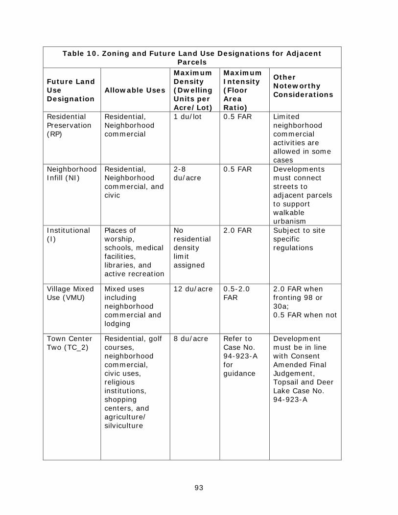
93
Table 10. Zoning and Future Land Use Designations for Adjacent Parcels
Future Land Use Designation
Allowable Uses
Maximum Density (Dwelling Units per Acre/Lot)
Maximum Intensity (Floor Area Ratio)
Other Noteworthy Considerations
Residential Preservation (RP)
Residential, Neighborhood commercial
1 du/lot 0.5 FAR Limited neighborhood commercial activities are allowed in some cases
Neighborhood Infill (NI)
Residential, Neighborhood commercial, and civic
2-8 du/acre
0.5 FAR Developments must connect streets to adjacent parcels to support walkable urbanism
Institutional (I)
Places of worship, schools, medical facilities, libraries, and active recreation
No residential density limit assigned
2.0 FAR Subject to site specific regulations
Village Mixed Use (VMU)
Mixed uses including neighborhood commercial and lodging
12 du/acre 0.5-2.0 FAR
2.0 FAR when fronting 98 or 30a; 0.5 FAR when not
Town Center Two (TC_2)
Residential, golf courses, neighborhood commercial, civic uses, religious institutions, shopping centers, and agriculture/ silviculture
8 du/acre Refer to Case No. 94-923-A for guidance
Development must be in line with Consent Amended Final Judgement, Topsail and Deer Lake Case No. 94-923-A
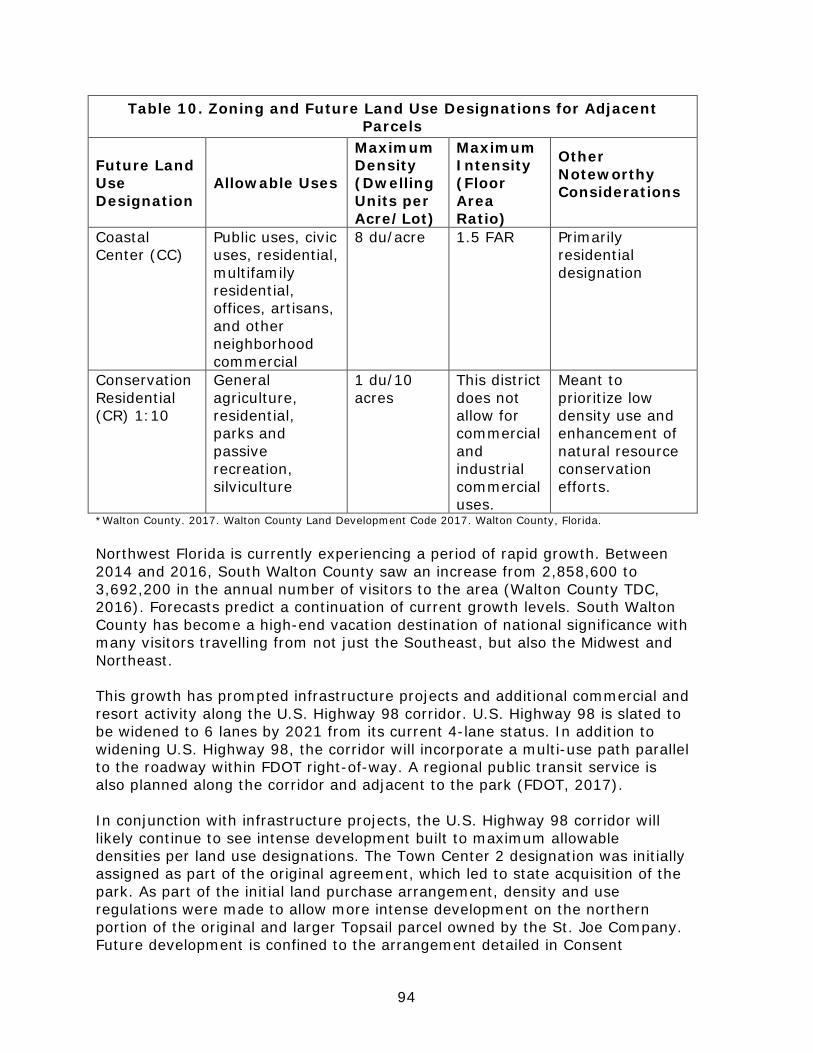
94
Table 10. Zoning and Future Land Use Designations for Adjacent Parcels
Future Land Use Designation
Allowable Uses
Maximum Density (Dwelling Units per Acre/Lot)
Maximum Intensity (Floor Area Ratio)
Other Noteworthy Considerations
Coastal Center (CC)
Public uses, civic uses, residential, multifamily residential, offices, artisans, and other neighborhood commercial
8 du/acre
1.5 FAR Primarily residential designation
Conservation Residential (CR) 1:10
General agriculture, residential, parks and passive recreation, silviculture
1 du/10 acres
This district does not allow for commercial and industrial commercial uses.
Meant to prioritize low density use and enhancement of natural resource conservation efforts.
*Walton County. 2017. Walton County Land Development Code 2017. Walton County, Florida. Northwest Florida is currently experiencing a period of rapid growth. Between 2014 and 2016, South Walton County saw an increase from 2,858,600 to 3,692,200 in the annual number of visitors to the area (Walton County TDC, 2016). Forecasts predict a continuation of current growth levels. South Walton County has become a high-end vacation destination of national significance with many visitors travelling from not just the Southeast, but also the Midwest and Northeast. This growth has prompted infrastructure projects and additional commercial and resort activity along the U.S. Highway 98 corridor. U.S. Highway 98 is slated to be widened to 6 lanes by 2021 from its current 4-lane status. In addition to widening U.S. Highway 98, the corridor will incorporate a multi-use path parallel to the roadway within FDOT right-of-way. A regional public transit service is also planned along the corridor and adjacent to the park (FDOT, 2017). In conjunction with infrastructure projects, the U.S. Highway 98 corridor will likely continue to see intense development built to maximum allowable densities per land use designations. The Town Center 2 designation was initially assigned as part of the original agreement, which led to state acquisition of the park. As part of the initial land purchase arrangement, density and use regulations were made to allow more intense development on the northern portion of the original and larger Topsail parcel owned by the St. Joe Company. Future development is confined to the arrangement detailed in Consent

95
Amended Final Judgement, Topsail and Deer Lake Case No. 94-923-A. (Walton County, 2017). Beach destination/vacation-oriented developments adjacent to the park boundary to the east on County Road 30-A will continue to grow into the future. The most recent development proposal for the Boys and Girls Club parcel immediately north of the Cypress Dunes development might resemble the form and density of Cypress Dunes. The proposal would require a large-scale amendment of the existing Future Land Use category from Neighborhood Infill to Traditional Neighborhood Development and would include 105 luxury vacation home sites, 32,500 square feet of single-story restaurant and retail space, and 273 parking spaces. This proposal is not the final proposal for the site but is indicative of what type of development is most likely to occur. Park staff will continue to maintain dialogue with developers to advocate for environmentally-sensitive development (Menadier, 2017).
Above: Figure 2. Visitors to South Walton County. Walton County Tourist Development Council. Florida Greenways and Trails System (FGTS)
The Florida Greenways and Trails System (FGTS) is made up of existing, planned and conceptual non-motorized trails and ecological greenways that form a connected, integrated statewide network. The FGTS serves as a green infrastructure plan for Florida, tying together the greenways and trails plans and planning activities of communities, agencies and non-profit organizations throughout Florida. Trails include paddling, hiking, biking, multi-use and equestrian trails. The Office of Greenways and Trails maintains a priority trails
96
map and gap analysis for the FGTS to focus attention and resources on closing key gaps in the system. In some cases, existing or planned priority trails run through or are adjacent to state parks, or they may be in close proximity and can be connected by spur trails. State parks can often serve as trailheads, points-of-interest, and offer amenities such as camping, showers, and laundry, providing valuable services for trail users while increasing state park visitation. The Florida Circumnavigational Saltwater Paddling Trail, or the CT, spans 1,515 miles along Florida’s coast, from Pensacola to Fort Clinch. Segment 2, a 46-mile link from Navarre Beach Park to Grayton Beach State Park, runs along the beach at Topsail Hill Preserve State Park. The park can be accessed from the paddling trail and serves as a trailhead offering paddlers camping, water, restrooms, and showers (Office of Greenways and Trails, 2017). The Great Northwest Coastal Trail Corridor will connect Pensacola to Panama City and includes the Timpoochee Trail which runs adjacent to the eastern portion of the park along County Road 30-A. This trail will eventually run parallel to U.S. Highway 98 along the park’s northern boundary.
Property Analysis
Effective planning requires a thorough understanding of the unit's natural and cultural resources. This section describes the resource characteristics and existing uses of the property. The unit's recreation resource elements are examined to identify the opportunities and constraints they present for recreational development. Past and present uses are assessed for their effects on the property, compatibility with the site, and relation to the unit's classification. Recreational Resource Elements
This section assesses the park’s recreational resource elements, those physical qualities that, either singly or in certain combinations, can support various resource-based recreation activities. Breaking down the property into such elements provides a means for measuring the property's capability to support potential recreational activities. This process also analyzes the existing spatial factors that either favor or limit the provision of each activity. Land Area
Topsail Hill Preserve State Park contains over 1,600 acres of land. The upland natural communities on the property include pine flatwoods, scrub, beach dunes, and small maritime hammocks. Nearly 600 acres of the preserve are classified as wetlands, including basin swamps, depression marshes, cypress domes, wet prairies, and the unique coastal dune lakes. The beach dune community of the park is designated as critical habitat for the endangered Choctawhatchee Beach mouse, and numerous other designated plants and animal species have been recorded here.

97
Water Area The coastal dune lakes of the park are pristine examples of the regions coastal dune lake ecosystems and provide an outstanding protected paddling experience for park visitors. Shoreline
Topsail Hill Preserve State Park provides about three miles of beach frontage on the Gulf of Mexico. The white sand and clear water of Northwest Florida are prominent at the park and provide a unique natural beach setting for park visitors. The park's five coastal dune lakes, Campbell Lake, Morris Lake, two unnamed lakes located east of Campbell Lake, and Stallworth Lake (which is bisected by the eastern preserve boundary) provides additional water area and shoreline. The total lake shoreline is approximately 4.25 miles. Campbell Lake covers approximately 97.5 acres, and Morris Lake is about 67.8 acres in area. Most of the shoreline of the coastal dune lakes consist of wetlands and are, for the most part, inaccessible to the public outside of the designated canoe launch facility on Campbell Lake and the outfall canals along the beach. Natural Scenery
The aesthetic quality of the property exceeds that of many other units of the Florida state park system. Views of massive sand dunes, a 3-mile stretch of undeveloped beach, and spectacular views available from the shorelines of the lakes and the fringes of other wetland communities are some of the outstanding visual resources of the preserve. Careful consideration must be given to the preservation of these visual resources in all planning, design and management decisions at the preserve. Significant Habitat
The coastal dune lake community is classified by the Florida Natural Areas Inventory as globally imperiled and critically imperiled within the State of Florida. Restoration and protection of shoreline vegetation, protection of water quality and exclusion of invasive aquatic plants are priority measures for the preservation of these lakes. Restrictions on watercraft access to the lakes, and measures to restore shoreline vegetation are discussed in the resource management component of this plan. The beach dune community of the park is designated as critical habitat for the endangered Choctawhatchee Beach mouse, and numerous other designated plants and animal species have been recorded here. Coordination with the United States Fish and Wildlife Service (USFWS) on impacts to federally endangered species is necessary for expansion of recreation facilities in designated areas. Natural Features
The combination of pristine beaches, freshwater coastal dune lakes, old-growth longleaf pine forests, and extensive wetlands at the park allow for world class opportunities for passive recreation in a fast-growing region.
98
Archaeological and Historic Features
Evidence from middens (discarded debris from Native American communities) and a large mound adjacent to the park, indicate that Native Americans used this area for fishing, hunting and camping. The variety of food and natural resources found in the freshwater coastal dune lakes, Choctawhatchee Bay and the Gulf of Mexico allowed Native Americans to camp on this coast for extended periods of time. From the late 1800s to the mid-1900s, workers from the Quarters Turpentine Village turpentined old-growth longleaf pines in forests now part of Topsail Hill. Turpentine was important for maintaining the wooden ships used to transport goods and people. Chippers carved cat-face patterns into the trees and inserted a metal strip to allow the sap to flow into clay pots. Cat-face scars can still be seen in many living trees in the park. During World War II, the western portion of the preserve was used as a munitions testing range for developing the first missiles in the United States. Iron and rebar tracks were laid down to allow trucks to travel across the soft sand. Visitors can see these tracks, especially along the hiking trail south of Morris Lake. Assessment of Use
All legal boundaries, significant natural features, structures, facilities, roads and trails existing in the unit are delineated on the base map (see Base Map). Specific uses made of the unit are briefly described in the following sections. Past Uses
Silviculture was the primary land use on the property prior to state acquisition. As a result, a network of logging roads and numerous cat-faced longleaf pines remain. Uncontrolled public access to the land before management authority was assigned to the Florida Park Service resulted in extensive off-road vehicle damage to the beach dune zone. Unauthorized dumping occurred at several locations in the park, and one area, now the site of Florida Park Service support facilities, was operated in the past as a household garbage landfill. Since management as a state park was established, these activities have been curtailed. Future Land Use and Zoning
The DRP works with local governments to establish designations that provide both consistency between comprehensive plans and zoning codes and permit typical state park uses and facilities necessary for the provision of resource-based recreation. Park uses and planning efforts currently align with County land use regulations. The designated future land use category for the park is Conservation (CON) which restricts use of park lands for passive recreation and resource management efforts. According to the Future Land Use Element of the Walton County 2011 Comprehensive Plan, no density restrictions are assigned for this
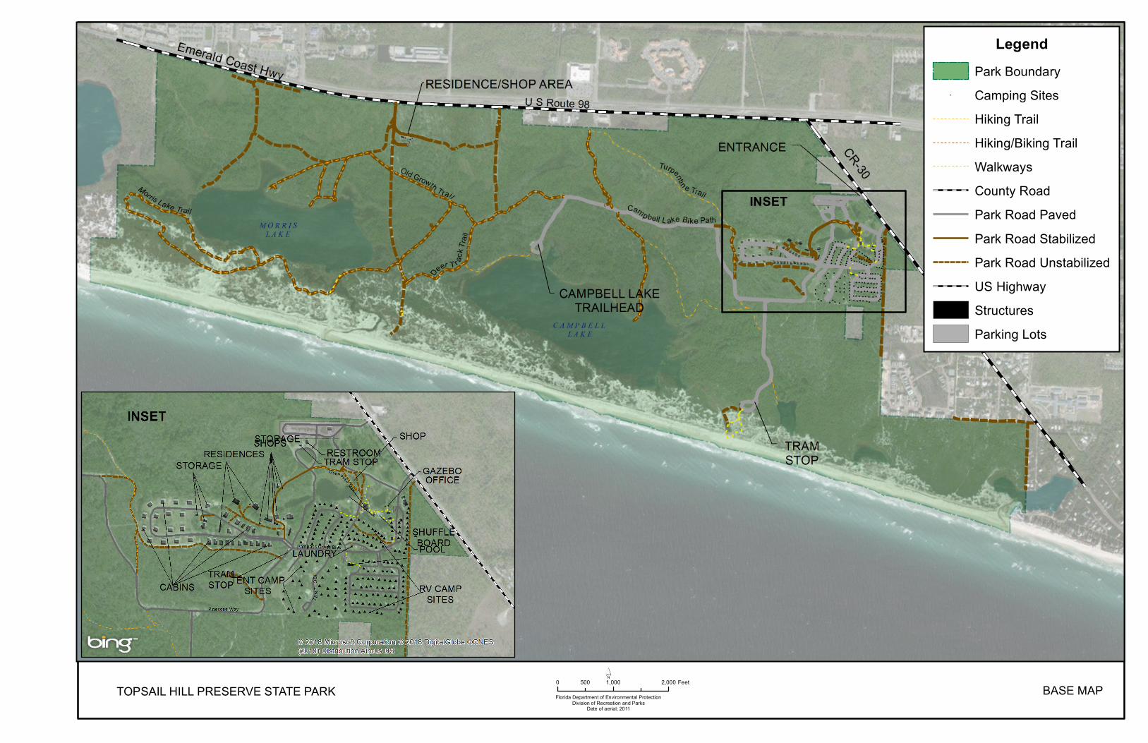
TOPSAIL HILL PRESERVE STATE PARK Florida Department of Environmental ProtectionDivision of Recreation and Parks
Date of aerial; 2011
0 1,000 2,000500 Feet´
BASE MAP
LegendPark Boundary
# Camping SitesHiking TrailHiking/Biking TrailWalkwaysCounty RoadPark Road PavedPark Road StabilizedPark Road UnstabilizedUS HighwayStructuresParking Lots
INSET

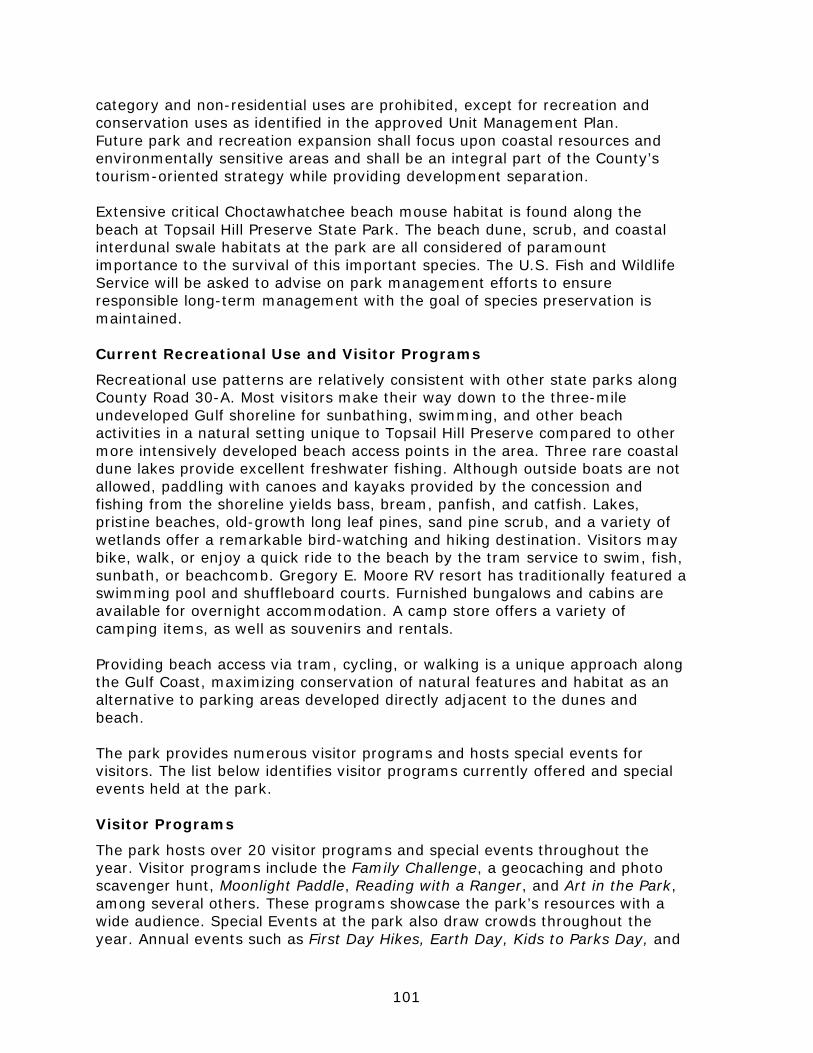
101
category and non-residential uses are prohibited, except for recreation and conservation uses as identified in the approved Unit Management Plan. Future park and recreation expansion shall focus upon coastal resources and environmentally sensitive areas and shall be an integral part of the County’s tourism-oriented strategy while providing development separation. Extensive critical Choctawhatchee beach mouse habitat is found along the beach at Topsail Hill Preserve State Park. The beach dune, scrub, and coastal interdunal swale habitats at the park are all considered of paramount importance to the survival of this important species. The U.S. Fish and Wildlife Service will be asked to advise on park management efforts to ensure responsible long-term management with the goal of species preservation is maintained. Current Recreational Use and Visitor Programs
Recreational use patterns are relatively consistent with other state parks along County Road 30-A. Most visitors make their way down to the three-mile undeveloped Gulf shoreline for sunbathing, swimming, and other beach activities in a natural setting unique to Topsail Hill Preserve compared to other more intensively developed beach access points in the area. Three rare coastal dune lakes provide excellent freshwater fishing. Although outside boats are not allowed, paddling with canoes and kayaks provided by the concession and fishing from the shoreline yields bass, bream, panfish, and catfish. Lakes, pristine beaches, old-growth long leaf pines, sand pine scrub, and a variety of wetlands offer a remarkable bird-watching and hiking destination. Visitors may bike, walk, or enjoy a quick ride to the beach by the tram service to swim, fish, sunbath, or beachcomb. Gregory E. Moore RV resort has traditionally featured a swimming pool and shuffleboard courts. Furnished bungalows and cabins are available for overnight accommodation. A camp store offers a variety of camping items, as well as souvenirs and rentals. Providing beach access via tram, cycling, or walking is a unique approach along the Gulf Coast, maximizing conservation of natural features and habitat as an alternative to parking areas developed directly adjacent to the dunes and beach. The park provides numerous visitor programs and hosts special events for visitors. The list below identifies visitor programs currently offered and special events held at the park. Visitor Programs
The park hosts over 20 visitor programs and special events throughout the year. Visitor programs include the Family Challenge, a geocaching and photo scavenger hunt, Moonlight Paddle, Reading with a Ranger, and Art in the Park, among several others. These programs showcase the park’s resources with a wide audience. Special Events at the park also draw crowds throughout the year. Annual events such as First Day Hikes, Earth Day, Kids to Parks Day, and
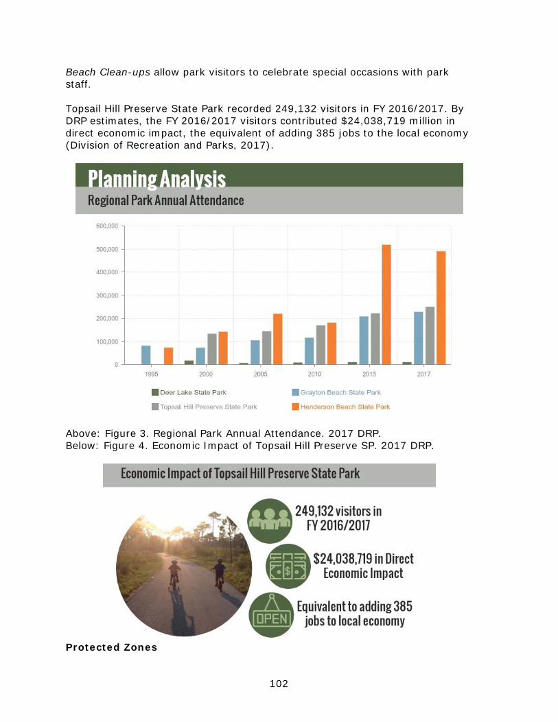
102
Beach Clean-ups allow park visitors to celebrate special occasions with park staff. Topsail Hill Preserve State Park recorded 249,132 visitors in FY 2016/2017. By DRP estimates, the FY 2016/2017 visitors contributed $24,038,719 million in direct economic impact, the equivalent of adding 385 jobs to the local economy (Division of Recreation and Parks, 2017).
Above: Figure 3. Regional Park Annual Attendance. 2017 DRP. Below: Figure 4. Economic Impact of Topsail Hill Preserve SP. 2017 DRP.
Protected Zones
103
A protected zone is an area of high sensitivity or outstanding character from which most types of development are excluded as a protective measure. Generally, facilities requiring extensive land alteration or resulting in intensive resource use, such as parking lots, camping areas, shops or maintenance areas, are not permitted in protected zones. Facilities with minimal resource impacts, such as trails, interpretive signs and boardwalks are generally allowed. All decisions involving the use of protected zones are made on a case-by-case basis after careful site planning and analysis. At Topsail Hill Preserve State Park, all wetlands and floodplain as well as beach dune, maritime hammock, and known imperiled species habitat have been designated as protected zones. The park’s current protected zone is delineated on the Conceptual Land Use Plan. Existing Facilities
In 1998, the 150-acre Emerald Coast RV resort was acquired by the State of Florida and added to the Division's management lease for the preserve. The RV resort provides 156 developed campsites with water, electric and sewer hookups, and 18 modular cabins, a resort office, a recreation building, swimming pool, and two campers’ bathhouses. Since 2000, the initial phase of development at the state preserve has been completed. New facilities include an entrance road and parking for 100 vehicles, a restroom, and a tram station, located at the northeastern corner of the property. A 16-foot wide paved tram road approximately one mile long provides access via park-operated shuttle to the beach access facilities located east of Campbell Lake. The beach facilities include a tram station, restroom and universally-accessible boardwalk to the beach. A third tram station is located within the developed area of the RV resort to provide access for the large number of camping visitors seeking access to the beach. A small composting restroom and shelter are located at the beach access point where the old Topsail Road terminated near the center of the property. Beach access has been provided at this point since the creation of the state park. An interpretive boardwalk has been constructed west of "Topsail Road" to provide access to an overlook on the southern edge of Morris Lake (see Base Map). Recreation Facilities Topsail Hill Beach Access Day Use Area Gregory Moore RV Park Composting Toilet 32 Cabins Small Shelter 156 RV Camping Sites Boardwalk (550 Feet) 22 Tent Only Sites Small Shelter (Tram Stop) Campbell Lake Day Use Area Medium Bathhouse Canoe/Kayak Launch Small Bathhouse Small Restroom Laundry Facility Campbell Lake Day Use Area (cont.) Gregory Moore RV Park (cont.) 2 Small Shelters (Tram Stop) Swimming Pool
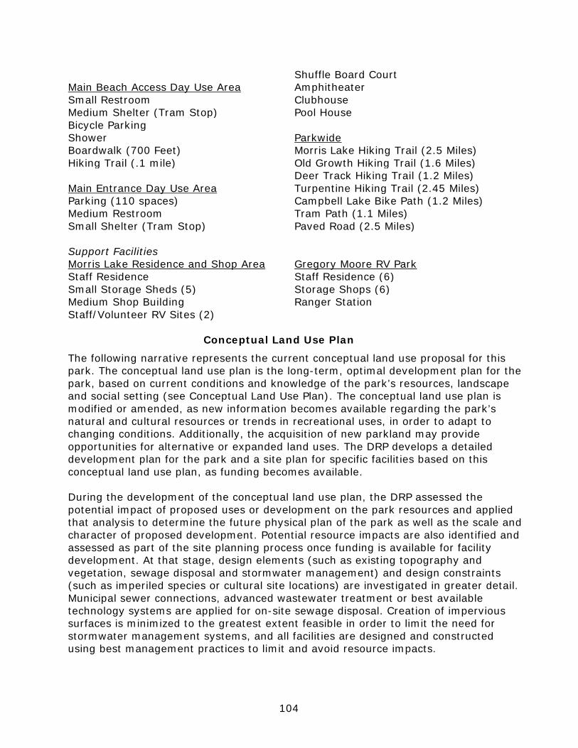
104
Shuffle Board Court Main Beach Access Day Use Area Amphitheater Small Restroom Clubhouse Medium Shelter (Tram Stop) Pool House Bicycle Parking Shower Parkwide Boardwalk (700 Feet) Morris Lake Hiking Trail (2.5 Miles) Hiking Trail (.1 mile) Old Growth Hiking Trail (1.6 Miles) Deer Track Hiking Trail (1.2 Miles) Main Entrance Day Use Area Turpentine Hiking Trail (2.45 Miles) Parking (110 spaces) Campbell Lake Bike Path (1.2 Miles) Medium Restroom Tram Path (1.1 Miles) Small Shelter (Tram Stop) Paved Road (2.5 Miles) Support Facilities Morris Lake Residence and Shop Area Gregory Moore RV Park Staff Residence Staff Residence (6) Small Storage Sheds (5) Storage Shops (6) Medium Shop Building Ranger Station Staff/Volunteer RV Sites (2)
Conceptual Land Use Plan
The following narrative represents the current conceptual land use proposal for this park. The conceptual land use plan is the long-term, optimal development plan for the park, based on current conditions and knowledge of the park’s resources, landscape and social setting (see Conceptual Land Use Plan). The conceptual land use plan is modified or amended, as new information becomes available regarding the park’s natural and cultural resources or trends in recreational uses, in order to adapt to changing conditions. Additionally, the acquisition of new parkland may provide opportunities for alternative or expanded land uses. The DRP develops a detailed development plan for the park and a site plan for specific facilities based on this conceptual land use plan, as funding becomes available. During the development of the conceptual land use plan, the DRP assessed the potential impact of proposed uses or development on the park resources and applied that analysis to determine the future physical plan of the park as well as the scale and character of proposed development. Potential resource impacts are also identified and assessed as part of the site planning process once funding is available for facility development. At that stage, design elements (such as existing topography and vegetation, sewage disposal and stormwater management) and design constraints (such as imperiled species or cultural site locations) are investigated in greater detail. Municipal sewer connections, advanced wastewater treatment or best available technology systems are applied for on-site sewage disposal. Creation of impervious surfaces is minimized to the greatest extent feasible in order to limit the need for stormwater management systems, and all facilities are designed and constructed using best management practices to limit and avoid resource impacts.
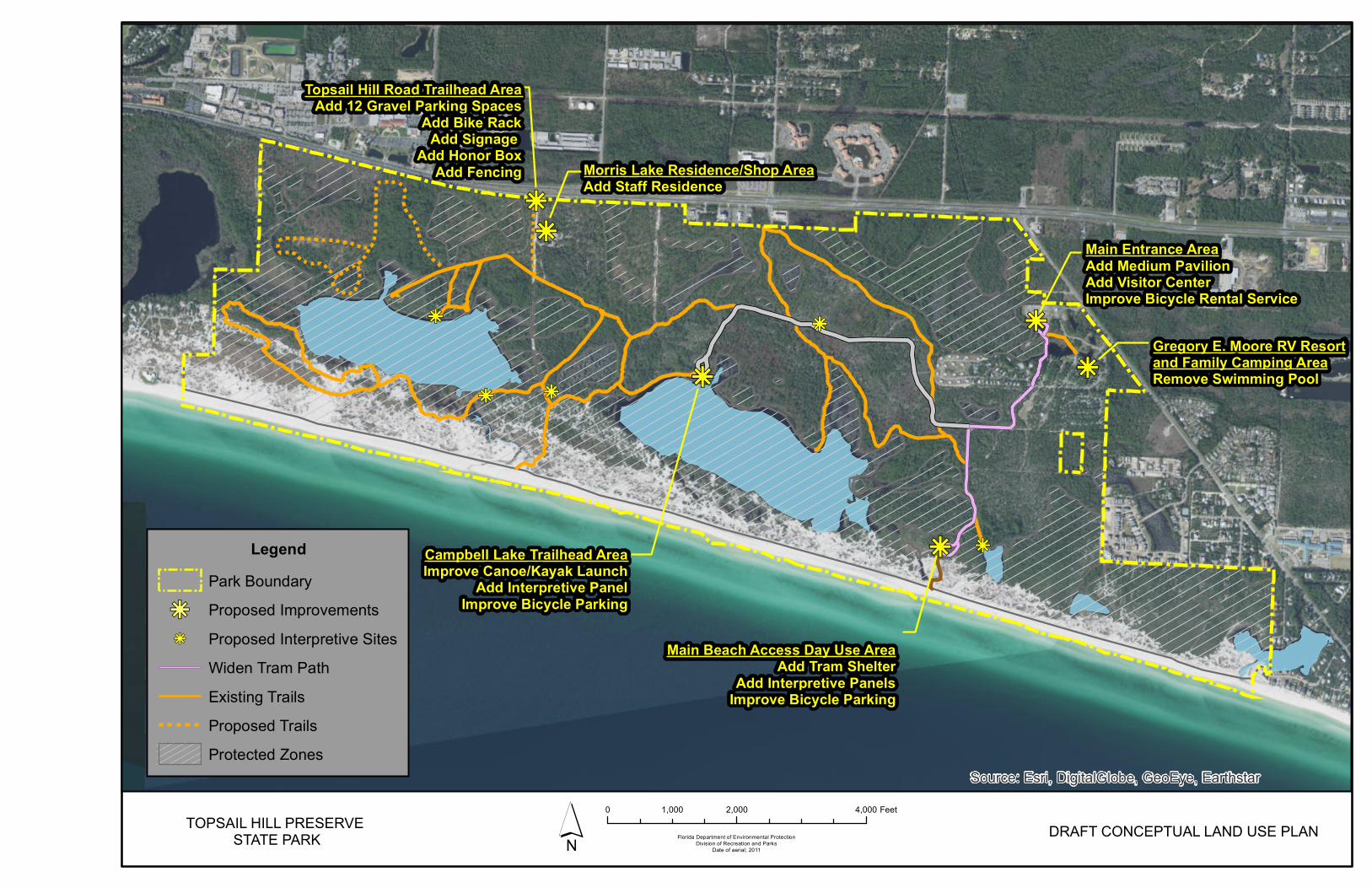
kj
kj
kj
kj
Morris Lake Residence/Shop AreaAdd Staff Residence
kj
kj
Main Entrance AreaAdd Medium PavilionAdd Visitor CenterImprove Bicycle Rental Service
Gregory E. Moore RV Resortand Family Camping AreaRemove Swimming Pool
Main Beach Access Day Use AreaAdd Tram Shelter
Add Interpretive PanelsImprove Bicycle Parking
Campbell Lake Trailhead AreaImprove Canoe/Kayak Launch
Add Interpretive PanelImprove Bicycle Parking
kjkj
kj
kjkj
Topsail Hill Road Trailhead AreaAdd 12 Gravel Parking Spaces
Add Bike RackAdd Signage
Add Honor BoxAdd Fencing
Source: Esri, DigitalGlobe, GeoEye, Earthstar
TOPSAIL HILL PRESERVE STATE PARK Florida Department of Environmental Protection
Division of Recreation and ParksDate of aerial; 2011´ DRAFT CONCEPTUAL LAND USE PLAN
0 2,000 4,0001,000 Feet
LegendPark Boundary
kj Proposed Improvementskj Proposed Interpretive Sites
Widen Tram PathExisting TrailsProposed TrailsProtected Zones


107
Federal, state and local permit and regulatory requirements are addressed during facility development. This includes the design of all new park facilities consistent with the universal access requirements of the Americans with Disabilities Act (ADA). After new facilities are constructed, park staff monitors conditions to ensure that impacts remain within acceptable levels. Potential Uses
Public Access and Recreational Opportunities
Goal: Provide public access and recreational opportunities in the park.
The existing recreational activities and programs of this state park are appropriate to the natural and cultural resources contained in the park and should be continued. New and improved activities and programs are also recommended and discussed below. Objective A: Maintain the park’s current recreational carrying capacity of 6,699 users per day.
The park will continue to provide opportunities for beach access, shoreline fishing, paddling, camping, picnicking, hiking, and nature observation. Interpretive exhibits and programs will continue to be offered at the park. The park’s ability to accommodate current visitation levels will be enhanced. Objective B: Expand the park’s recreational carrying capacity by 63 users per day.
Existing fire breaks and management roads in the western portion of the preserve adjacent to the boundary with the Coffeen Nature Preserve will be formalized for hiking. This limited expansion of the trail system will allow for more people to enjoy a natural and primitive outdoor experience at the park. Objective C: Continue to provide the current repertoire of 8 interpretive, educational, and recreational programs on a regular basis.
Park staff will continue to provide the interpretive, educational and recreational programs listed on page 101. Objective D: Develop 15 new interpretive, educational, and recreational programs.
Park staff regularly develop new interpretive, educational, and recreational programs based on input from visitors, park staff, District staff, and other Division of Recreation and Parks staff. Although no specific programs are identified at this time, around 15 programs are expected to be developed over the next 10 years based on visitor interest trends.
108
Proposed Facilities
Capital Facilities and Infrastructure
Goal: Develop and maintain the capital facilities and infrastructure necessary to implement the recommendations of the management plan.
Topsail Hill Preserve State Park protects the largest stretch of natural beach between Panama City and Destin, one of the fastest growing areas of the state. Topsail Hill was designated a Preserve by the State of Florida which prioritizes the preservation of natural resources over user considerations. Therefore, access to the beach at the park is provided via tram service between a parking area adjacent to the main entrance and the beach itself. This allows for more intensive visitor facilities such as large parking lots, restrooms, visitor centers, etc. to be provided to visitors away from sensitive habitats. Improvement of the RV Resort portion of the park is needed to maintain levels of service to meet the demands of this popular tourism resource. Infrastructural development and access amenities are primarily located in the easternmost portion of the park, while the remainder of the park to the west is managed for its character and integrity as a preserve. Existing facilities of this state park are appropriate to the natural and cultural resources contained in the park and should be maintained. New construction, as discussed further below, is recommended to improve the quality and safety of the recreational opportunities, to improve the protection of park resources, and to streamline the efficiency of park operations. The following is a summary of improved or renovated and new facilities needed to implement the conceptual land use plan for Topsail Hill Preserve State Park. Objective A: Maintain all public and support facilities in the park.
All capital facilities, trails, and roads, within the park will be kept in proper condition through the daily or regular work of park staff and/or contracted help. Objective B: Improve/repair 6 existing facilities and 1.1 miles of tram path.
Major repair projects for park facilities may be accomplished within the ten-year term of this management plan, if funding is made available. These include the modification of existing park facilities to bring them into compliance with the Americans with Disabilities Act (a top priority for all facilities maintained by DRP). The following discussion of other recommended improvements and repairs are organized by use area within the park. Main Entrance Day Use Area Within the main entrance area, improvements will be made to enhance the visitor experience for those boarding the tram heading for the Main Beach Access Day Use Area or the Campbell Lake Day Use Area. A medium pavilion is proposed to provide shelter from the elements for visitors waiting on tram service in addition to a small open-air interpretive pavilion. The purposes of the two separate proposed tram and interpretive pavilions may also be unified into
109
a single pavilion structure. Interpretive programming in this area will focus on the unique ecological values and sensitivities of beach dune and scrub habitats along with imperiled species identification. Such interpretive programming may further convey the reasons for the provision of tram service within the park in lieu of more direct beach access with beachside parking and shorter boardwalks. Bicycle rental or bikeshare services will be expanded to provide an increased presence at the main parking area. Clearly visible and easily interpreted directional signage will ensure that beach access for park visitors is conveniently and efficiently navigated. Gregory Moore RV Resort Family Camping Area The campground swimming pool that was part of the RV Park prior to state acquisition, is slated to be removed due to its old age and related maintenance difficulties. In addition to ongoing maintenance concerns, this removal will achieve optimal alignment with the Florida Park Service Mission to provide passive resource-based recreation in natural settings. The park will continue to prioritize the Gulf beach for swimming and the dune lakes for other passive aquatic environmental experiences. Main Beach Access Day Use Area Expanding the availability of shelter at this location is important to provide additional cover during summer thunderstorms to guests and their families. A small pavilion will be added at this location, either to the west and adjacent to the existing boardwalk or to the north of the restroom depending on siting constraints and to facilitate pedestrian flow. Bicycle parking will be expanded next to the existing parking area and additional interpretive signage should be placed along the boardwalk. Campbell Lake Day Use Area Low impact improvements are proposed for the paddling launch to improve accessibility. Directional signage will provide information on how to hike to the old Topsail Hill Road Beach Access Day Use Area from Campbell Lake as well as showcase the unique coastal dune lakes at the park. Improved bicycle parking will facilitate visitor movement between the Main Entrance Day Use Area and Campbell Lake. Morris Lake Residence and Shop Area An on-grade staff residence is proposed near the existing residences. Landscape improvements will also be made, including fencing, along the border between the Residence and Shop Area, and the old Topsail Hill Road roadbed. Parkwide Across the park there are several interpretive sites that are proposed to inform park visitors of the unique habitat found throughout the park and its role as a representative sample of the coast before the region saw rapid development. Directional signage will be improved throughout the park’s trail system to guide park visitors along certain trails and help them distinguish between dedicated hiking trails and management roads that have not been marked for hiking. The
110
tram path between the Main Entrance Day Use Area and the Main Beach Access Day Use Area will be widened just enough to allow the passing of trams during times of peak visitation. The widening of the path would be limited to permeable pavement to reduce hydrological impacts. The old Topsail Hill Road roadbed between the Old Growth Trail and Deer Track Trail will continue to be restored to its surrounding natural community type to reduce, as much feasible, negative impacts to east-west sheet flow. Objective C: Construct 1 new facility and 1.5 miles of trail.
Topsail Hill Road Trailhead Day Use Area With the planned improvements to U.S. Highway 98, which include widening the roadway and adding a parallel shared-use path, pedestrian traffic is expected to increase along the U.S. Highway 98 corridor. In order to accommodate the increased demand for additional access to the park from the west, a trailhead is proposed to be established at the original (now defunct) day use entrance to the park at Topsail Hill Road. The design and layout of the trailhead will be similar to the Grayton Beach State Park trailhead located on County Road 30-A. The low-impact trailhead would include gravel parking for 12 vehicles, a bicycle rack, interpretive signage, honor box, and fencing to reduce impacts to surrounding habitat from visitor activity. The site’s location adjacent to an existing support area will allow for staff presence to help manage impacts and safety. Visitors will be able to hike or bike from U.S. Highway 98 to the Topsail Hill Road Beach Access Day Use Area via the Old Growth and Deer Track trails. Wayfinding signage will be incorporated along the path to the beach. This access point, alongside the Campbell Lake Day Use Area, will help increase public access to passive, outdoor-recreation activities while ensuring that sensitive natural resources are protected. Parkwide In the far northwest corner of the park, 1.5 miles of existing management roads and firebreaks will be adapted to accommodate hiking. Emphasis will be placed on creating as much of a natural experience as possible while still meeting management access needs. The old Topsail Hill Road roadbed between its intersection with the Old Growth Trail and the Morris Lake Residence and Shop Area will be restored to a narrow-gauge hiking path along a natural surface to allow visitors a more aesthetically appealing connection between the Old Growth Trail and the proposed trailhead on County Highway 30-A.

111
Facilities Development Preliminary cost estimates for these recommended facilities and improvements are provided in the Ten-Year Implementation Schedule and Cost Estimates (Table 12) located in the Implementation Component of this plan. These cost estimates are based on the most cost-effective construction standards available at this time. The preliminary estimates are provided to assist DRP in budgeting future park improvements and may be revised as more information is collected through the planning and design processes. New facilities and improvements to existing facilities recommended by the plan include: Main Entrance Day Use Area Morris Lake Residence/Shop Area Add Medium Pavilion Add Staff Residence Add Visitor Center Improve Bicycle Rental Service Topsail Hill Road Trailhead Day Use Area Gregory Moore RV Resort Add 12 Gravel Parking Spaces Family Camping Area Add Bike Rack Remove Swimming Pool Add Signage Add Honor Box Main Beach Access Day Use Area Add Fencing Add Tram Shelter Add Interpretive Panels Parkwide Improve Bicycle Parking Add 1.5 Miles of Hiking Trail Add Interpretive Sites (5) Campbell Lake Day Use Area Improve Trail Directional Signage Improve Canoe/Kayak Launch Widen Existing Tram Path with Add Interpretive Panel Permeable Materials (1.1 Miles) Improve Bicycle Parking Recreational Carrying Capacity
Carrying capacity is an estimate of the number of users a recreation resource or facility can accommodate and still provide a high quality recreational experience and preserve the natural values of the site. The carrying capacity of a unit is determined by identifying the land and water requirements for each recreation activity at the unit, and then applying these requirements to the unit's land and water base. Next, guidelines are applied which estimate the physical capacity of the unit's natural communities to withstand recreational uses without significant degradation. This analysis identifies a range within which the carrying capacity most appropriate to the specific activity, the activity site and the unit's classification is selected (see Table 11). The recreational carrying capacity for this park is a preliminary estimate of the number of users the unit could accommodate after the current conceptual development program has been implemented. When developed, the proposed new facilities would approximately increase the unit's carrying capacity as shown in Table 11.
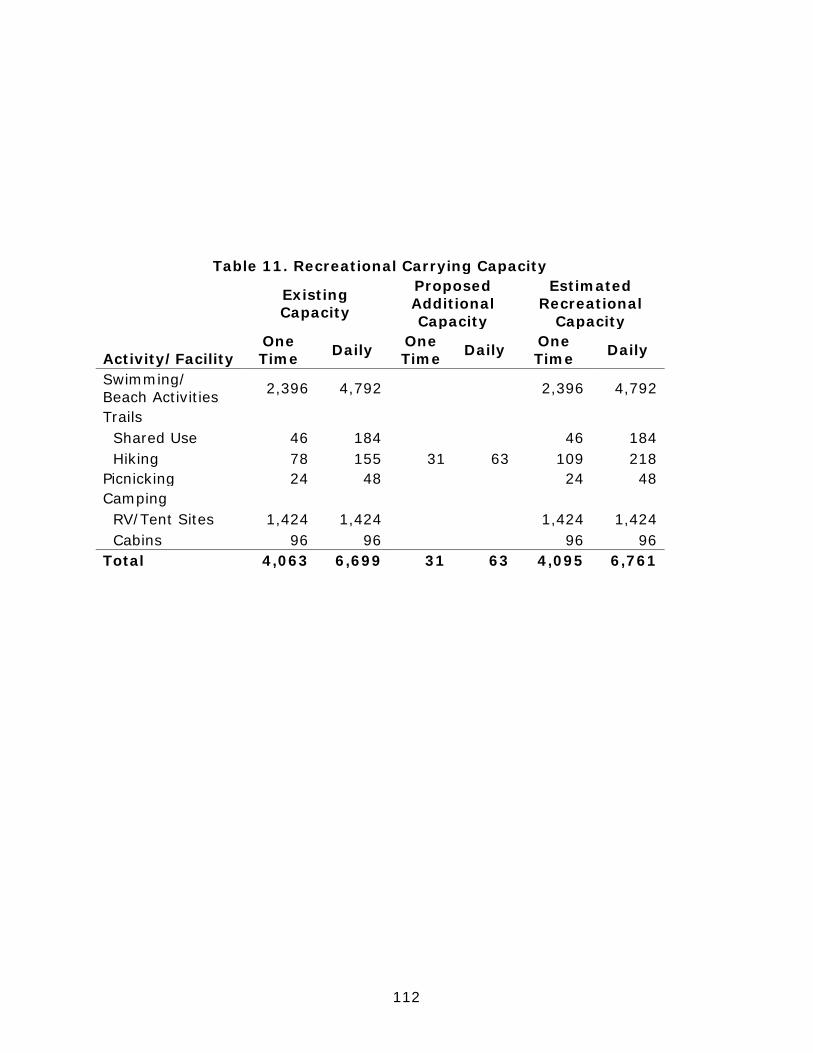
112
Table 11. Recreational Carrying Capacity
Existing Capacity
Proposed Additional Capacity
Estimated Recreational
Capacity
Activity/Facility One Time Daily One
Time Daily One Time Daily
Swimming/ Beach Activities 2,396 4,792 2,396 4,792
Trails
Shared Use 46 184
46 184 Hiking 78 155 31 63 109 218 Picnicking 24 48
24 48
Camping
RV/Tent Sites 1,424 1,424
1,424 1,424 Cabins 96 96
96 96
Total 4,063 6,699 31 63 4,095 6,761
113
Optimum Boundary The optimum boundary map reflects lands considered desirable for direct management by the DRP as part of the state park. These parcels may include public or privately-owned land that would improve the continuity of existing parklands, provide the most efficient boundary configuration, improve access to the park, provide additional natural and cultural resource protection or allow for future expansion of recreational activities. Parklands that are potentially surplus to the management needs of DRP are also identified. As additional needs are identified through park use, development, and research, and as land use changes on adjacent property, modification of the park’s optimum boundary may be necessary. Identification of parcels on the optimum boundary map is intended solely for planning purposes. It is not to be used in connection with any regulatory purposes. Any party or governmental entity should not use a property’s identification on the optimum boundary map to reduce or restrict the lawful rights of private landowners. Identification on the map does not empower or suggest that any government entity should impose additional or more restrictive environmental land use or zoning regulations. Identification should not be used as the basis for permit denial or the imposition of permit conditions. Properties identified within the Optimum Boundary include undeveloped parcels to the southwest of County Highway 30-A and south of U.S. Highway 98. A 5.5-acre undeveloped inholding is the only remaining boundary gap within the interior of the park. Acquisition of these identified parcels would form a more contiguous park boundary and reduce potential encroachment and conflicts between adjacent development and conservation efforts into the future. Additionally, acquisition would maximize the quality of the immersive park experience, particularly in the park entrance area and for the park’s overnight accommodations, which are situated in the vicinity of the identified parcels.

114
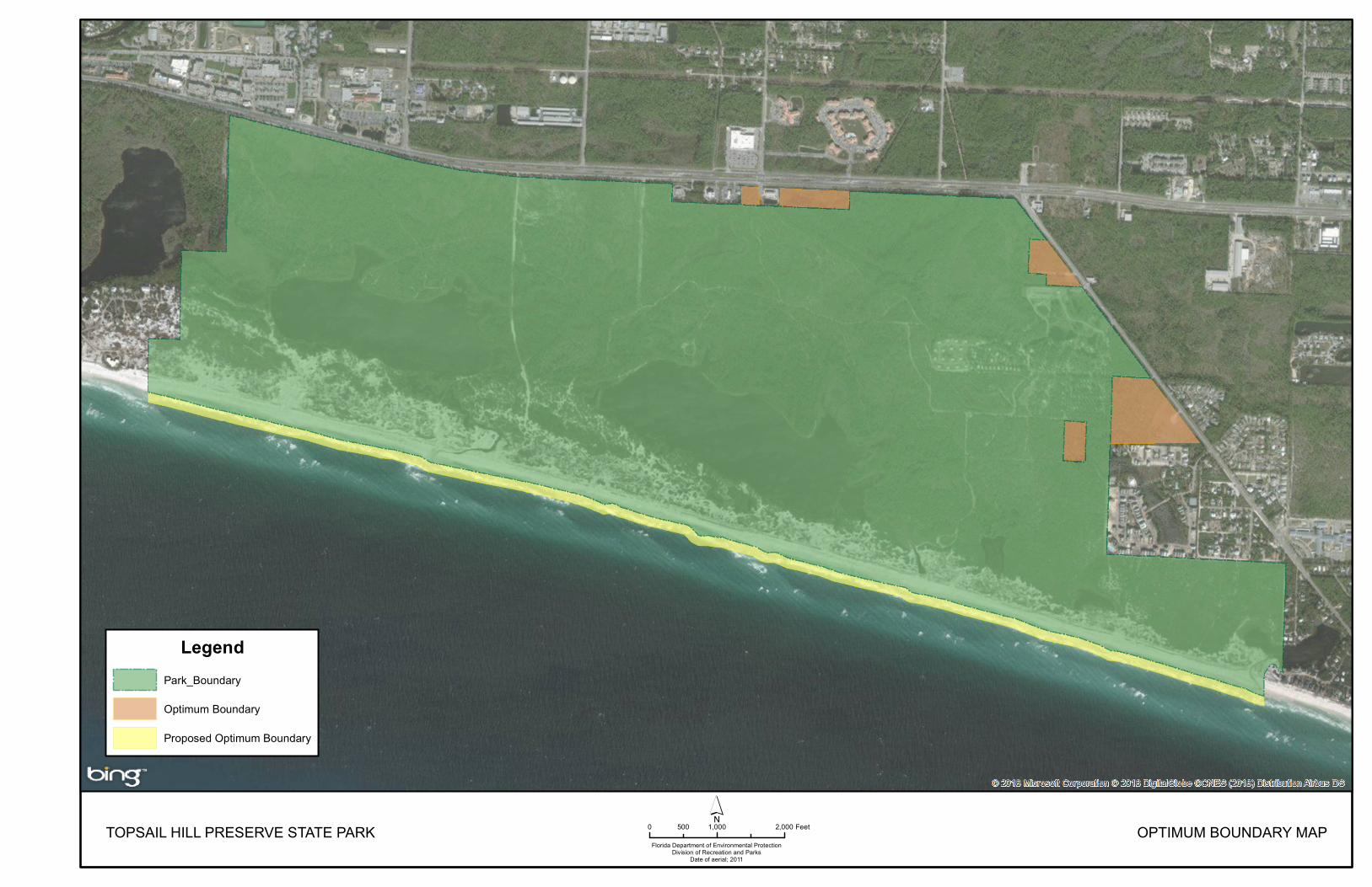
TOPSAIL HILL PRESERVE STATE PARKFlorida Department of Environmental Protection
Division of Recreation and ParksDate of aerial; 2011
0 1,000 2,000500 Feet OPTIMUM BOUNDARY MAP
LegendPark_Boundary
Optimum Boundary
Proposed Optimum Boundary


117
IMPLEMENTATION COMPONENT
The resource management and land use components of this management plan provide a thorough inventory of the park’s natural, cultural, and recreational resources. They outline the park’s management needs and problems, and recommend both short and long-term objectives and actions to meet those needs. The implementation component addresses the administrative goal for the park and reports on the Division of Recreation and Parks (DRP) progress toward achieving resource management, operational, and capital improvement goals and objectives since approval of the previous management plan for this park. This component also compiles the management goals, objectives, and actions expressed in the separate parts of this management plan for easy review. Estimated costs for the ten-year period of this plan are provided for each action and objective, and the costs are summarized under standard categories of land management activities.
MANAGEMENT PROGRESS
Since the approval of the last management plan for Topsail Hill Preserve State Park in 2007, significant work has been accomplished and progress made towards meeting the DRP’s management objectives for the park. These accomplishments fall within three of the five general categories that encompass the mission of the park and the DRP.
Park Administration and Operations
• Volunteer base has increased significantly over the past 10 years, providing an increase in assistance for the park operations.
• Staff conducts safety inspections of all park facilities. • Established and maintained good working relationships with other state,
federal and local agencies as well as environmental organizations.
Resource Management
Natural Resources
• Project T.R.E.C. and park staff moved Campbell Lake Trail to protect the shore line after catastrophic damage from weather events that threaten Costal Dune Lake habitat.
• The division has restored many of the old service roads that bisect wetland communities as well as reconfigured some low water crossings so that historical sheet flow and hydrological connections are restored.
• Coastal Dune Lakes continue to be monitored and protected. A natural hydrological connection between the Gulf of Mexico and the Coastal Dune Lakes has been restored.
• Zones TP-31, TP-23, TP-22, and TP-01 were not subject to burning prior to 2007. All four zones have since been successfully burned and placed in fire rotation.
• A summer mowing plan has been put in place to help reduce woody plant growth due to limited burn windows because of urban interface.

118
• Mechanical fuel reduction is underway in zone twenty-three due to the fuel load and wetland conditions throughout the zone.
• Removal of sand pine stands in zones TP-21A, TP-13, and reduction of pines in zone TP-25 are underway.
• Fire lines have been updated, widened, and established throughout the Preserve.
• Wet prairies in Zones TP-1, TP-5, and TP-17 are being restored using fire and mechanical intervals.
• Exotic plant treatment program has been updated and expanded to control exotics throughout the park. This is an ongoing monitoring and treatment cycle completed year-round.
• Exotic animals are monitored and removed as necessary for the protection of the ecological balance of the park and continues year-round.
• Choctawhatchee beach mouse habit continues to be monitored and protected every month.
• Sea Turtle nesting continues to be successful and will continue to be monitored and protected.
• Shore birds continue to be monitored and protected. The park had its first Snow plover nest the last two years and the least tern population is increasing on the beach.
• Gopher Tortoise burrow tracking and mapping is underway. • Gulfarium and the park hosted a Sea Turtle Release of three turtles that
brought in over 700 visitors.
Cultural Resources
• An archeological sensitivity model was completed for the park in 2011. • The nine sites that were originally documented are continuing to be
monitored and protected. • Six more sites have been added since the last unit management plan,
WL02564, WL02565, WL02566, WL02567, WL02568, and WL02569. These sites are subject to regular monitoring and protection as well.
• Mapping of the Turpentine stands is ongoing to facilitate formal site documentation.
• The monitoring of costal sites for new materials after significant weather events is ongoing.
Recreation and Visitor Services
• A Ranger Station, 22 site tent camping area, and 16 site-built 2-bedroom/2-bathroom rental cabins (2 of which are ADA accessible) have been added to the Main Entrance Area and the Gregory R. Moore RV Resort and Family Camping Area.
• A roof has been added to the existing amphitheater stage and an accessible fishing dock has been constructed on the clubhouse pond.
• A 1.2-mile Tram Path extension has been constructed to Campbell Lake, the path is functioning as a multi-use path currently but will provide tram
119
services in the future to park visitors from the Main Entrance Area to the Campbell Lake Trailhead Area.
• Approximately 3 miles of nature trails have been added throughout the park. • A canoe/kayak launch and two picnic pavilions have been built at the
Campbell Lake Trailhead Area. • The Friends of Topsail have assumed the overall park store operations,
including the rental of canoes/kayaks/stand up paddle boards and bicycles. In addition, the CSO has supported the installation of two Wi-Fi hot spots in the Gregory R. Moore RV Resort.
Park Facilities
• A .02-mile paved park drive connection from the Ranger Station to the camping area has been added along with a tent camping parking area for 45 vehicles, a tent camping bathhouse, a 10-vehicle parking area for the Family Camping Area Tram Stop, a playground, 1 site-built cabin support building, a paved parking area for the clubhouse and Large RV bathhouse, and 4 resident volunteer sites on the cabin loop road have all been constructed in the Gregory R. Moore RV Resort and Family Camping Area.
• At the Campbell Lake Trailhead Area, a restroom with a propane powered lift station and a rental canoe/kayak storage rack have been installed.
MANAGEMENT PLAN IMPLEMENTATION
This management plan is written for a timeframe of ten years, as required by Section 253.034 Florida Statutes. The Ten-Year Implementation Schedule and Cost Estimates (Table 16) summarizes the management goals, objectives, and actions that are recommended for implementation over this period, and beyond. Measures are identified for assessing progress toward completing each objective and action. A time frame for completing each objective and action is provided. Preliminary cost estimates for each action are provided and the estimated total costs to complete each objective are computed. Finally, all costs are consolidated under the following five standard land management categories: Resource Management, Administration and Support, Capital Improvements, Recreation Visitor Services and Law Enforcement. Many of the actions identified in the plan can be implemented using existing staff and funding. However, several continuing activities and new activities with measurable quantity targets and projected completion dates are identified that cannot be completed during the life of this plan unless additional resources for these purposes are provided. The plan’s recommended actions, timeframes and cost estimates will guide the DRP’s planning and budgeting activities over the period of this plan. It must be noted that these recommendations are based on the information that exists at the time the plan was prepared. A high degree of adaptability and flexibility must be built into this process to ensure that the DRP can adjust to changes in the availability of funds, improved understanding of the park’s natural and cultural resources, and changes in statewide land management issues, priorities, and policies.
120
Statewide priorities for all aspects of land management are evaluated each year as part of the process for developing the DRP’s annual legislative budget requests. When preparing these annual requests, the DRP considers the needs and priorities of the entire state park system and the projected availability of funding from all sources during the upcoming fiscal year. In addition to annual legislative appropriations, the DRP pursues supplemental sources of funds and staff resources wherever possible, including grants, volunteers and partnerships with other entities. The DRP’s ability to accomplish the specific actions identified in the plan will be determined largely by the availability of funds and staff for these purposes, which may vary from year to year. Consequently, the target schedules and estimated costs identified in Table 12 may need to be adjusted during the ten-year management planning cycle.

Table 12Topsail Hill Preserve State Park Ten-Year Implementation Schedule and Cost Estimates
Sheet 1 of 3DIVISION REVIEW DRAFT
Measure Planning Period
Estimated Manpower and Expense Cost* (10-years)
Objective: Continue day-to-day administrative support at current levels. Administrative support ongoing C $1,620,000
Objective: Expand administrative support as new lands are acquired, new facilities are developed, or as other needs arise.
Administrative support expanded C $15,000
Measure Planning Period
Estimated Manpower and Expense Cost* (10-years)
Objective: Conduct/obtain an assessment of the park's hydrological needs. Assessment conducted ST/LT $60,500
Objective: Restore natural hydrological conditions and functions to approximately 167 acres of coastal dune lakes natural community.
# Acres restored or with restoration underway LT $80,000
Objective: Continue collecting monthly water quality data through Lake Watch. Lake Watch samples collected/analyzed C $28,000
Measure Planning Period
Estimated Manpower and Expense Cost* (10-years)
Objective: Within 10 years, have 576 acres of the park maintained within the optimum fire return interval. # Acres within fire return interval target LT $136,000
Objective: Conduct habitat/natural community restoration activities on 13 acres of wet flatwoods natural community.
# Acres restored or with restoration underway ST/LT $52,000
Objective: Conduct natural community/habitat improvement activities on 20 acres of seepage slope and wet prairie natural communities.
# Acres improved or with improvements underway ST/LT $41,000
Objective: Conduct natural community/habitat improvement activities on 6.5 acres of wet flatwoods and dome swamp natural communities.
# Acres improved or with improvements underway LT $12,400
Goal II: Protect water quality and quantity in the park, restore hydrology to the extent feasible, and maintain the restored condition.
Goal III: Restore and maintain the natural communities/habitats of the park.
Goal I: Provide administrative support for all park functions.
NOTE: THE DIVISION'S ABILITY TO COMPLETE THE OBJECTIVES OUTLINED BY THE MANAGEMENT PLAN IS CONTINGENT ON THE AVAILABILITY OF FUNDING AND OTHER RESOURCES FOR THESE PURPOSES.
* 2015 DollarsST = actions within 2 years
LT = actions within 10 yearsC = long term or short term actions that are continuous or cyclical
UFN = currently unfunded need

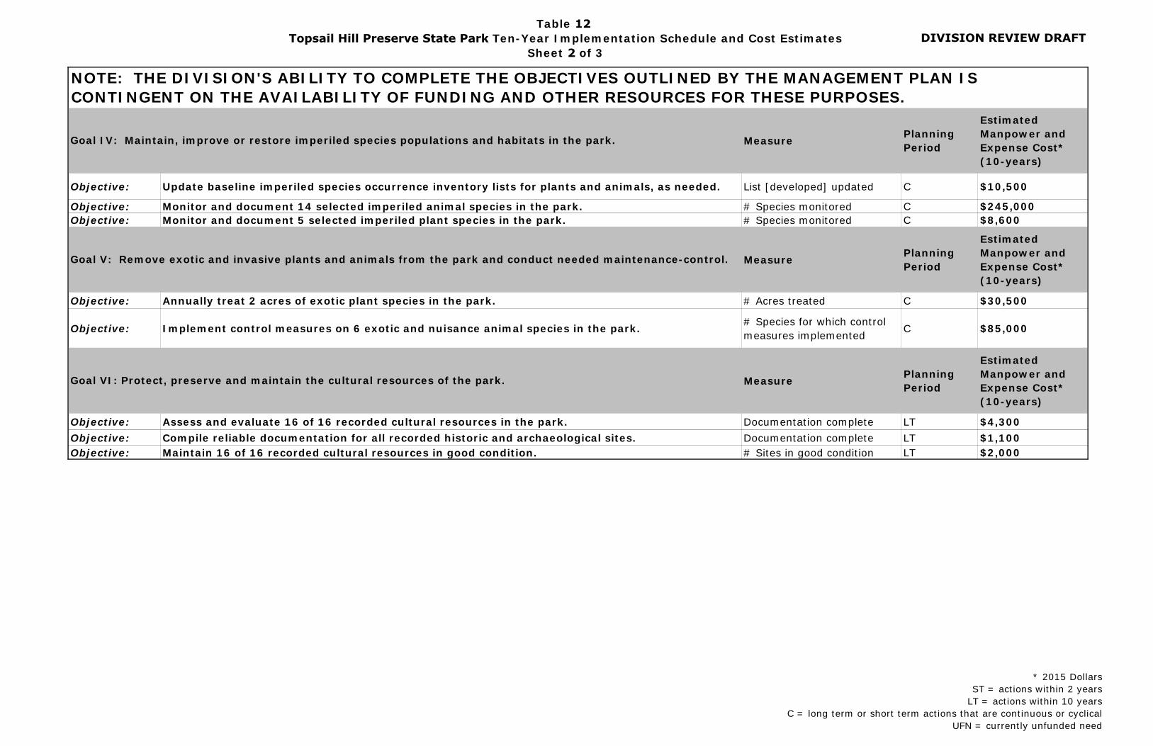
DIVISION REVIEW DRAFT
NOTE: THE DIVISION'S ABILITY TO COMPLETE THE OBJECTIVES OUTLINED BY THE MANAGEMENT PLAN IS CONTINGENT ON THE AVAILABILITY OF FUNDING AND OTHER RESOURCES FOR THESE PURPOSES.
Measure Planning Period
Estimated Manpower and Expense Cost* (10-years)
Objective: Update baseline imperiled species occurrence inventory lists for plants and animals, as needed. List [developed] updated C $10,500
Objective: Monitor and document 14 selected imperiled animal species in the park. # Species monitored C $245,000Objective: Monitor and document 5 selected imperiled plant species in the park. # Species monitored C $8,600
Measure Planning Period
Estimated Manpower and Expense Cost* (10-years)
Objective: Annually treat 2 acres of exotic plant species in the park. # Acres treated C $30,500
Objective: Implement control measures on 6 exotic and nuisance animal species in the park. # Species for which control measures implemented C $85,000
Measure Planning Period
Estimated Manpower and Expense Cost* (10-years)
Objective: Assess and evaluate 16 of 16 recorded cultural resources in the park. Documentation complete LT $4,300Objective: Compile reliable documentation for all recorded historic and archaeological sites. Documentation complete LT $1,100Objective: Maintain 16 of 16 recorded cultural resources in good condition. # Sites in good condition LT $2,000
Goal IV: Maintain, improve or restore imperiled species populations and habitats in the park.
Goal V: Remove exotic and invasive plants and animals from the park and conduct needed maintenance-control.
Goal VI: Protect, preserve and maintain the cultural resources of the park.
* 2015 DollarsST = actions within 2 years
LT = actions within 10 yearsC = long term or short term actions that are continuous or cyclical
UFN = currently unfunded need
Table 12Topsail Hill Preserve State Park Ten-Year Implementation Schedule and Cost Estimates
Sheet 2 of 3

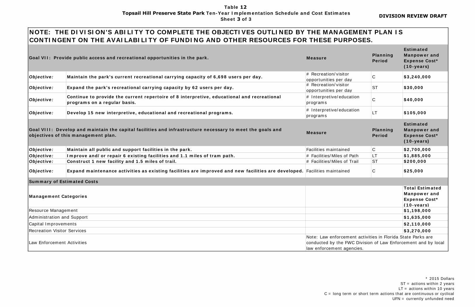
DIVISION REVIEW DRAFT
NOTE: THE DIVISION'S ABILITY TO COMPLETE THE OBJECTIVES OUTLINED BY THE MANAGEMENT PLAN IS CONTINGENT ON THE AVAILABILITY OF FUNDING AND OTHER RESOURCES FOR THESE PURPOSES.
Measure Planning Period
Estimated Manpower and Expense Cost* (10-years)
Objective: Maintain the park's current recreational carrying capacity of 6,698 users per day. # Recreation/visitor opportunities per day C $3,240,000
Objective: Expand the park's recreational carrying capacity by 62 users per day. # Recreation/visitor opportunities per day ST $30,000
Objective: Continue to provide the current repertoire of 8 interpretive, educational and recreational programs on a regular basis.
# Interpretive/education programs C $40,000
Objective: Develop 15 new interpretive, educational and recreational programs. # Interpretive/education programs LT $105,000
Measure Planning Period
Estimated Manpower and Expense Cost* (10-years)
Objective: Maintain all public and support facilities in the park. Facilities maintained C $2,700,000Objective: Improve and/or repair 6 existing facilities and 1.1 miles of tram path. # Facilities/Miles of Path LT $1,885,000Objective: Construct 1 new facility and 1.5 miles of trail. # Facilities/Miles of Trail ST $200,000
Objective: Expand maintenance activities as existing facilities are improved and new facilities are developed. Facilities maintained C $25,000
Total Estimated Manpower and Expense Cost* (10-years)$1,198,000$1,635,000$2,110,000$3,270,000
Management Categories
Law Enforcement ActivitiesNote: Law enforcement activities in Florida State Parks are conducted by the FWC Division of Law Enforcement and by local law enforcement agencies.
Resource Management
Goal VII: Provide public access and recreational opportunities in the park.
Goal VIII: Develop and maintain the capital facilities and infrastructure necessary to meet the goals and objectives of this management plan.
Capital ImprovementsRecreation Visitor Services
Summary of Estimated Costs
Administration and Support
* 2015 DollarsST = actions within 2 years
LT = actions within 10 yearsC = long term or short term actions that are continuous or cyclical
UFN = currently unfunded need
Table 12Topsail Hill Preserve State Park Ten-Year Implementation Schedule and Cost Estimates
Sheet 3 of 3


Addendum 1—Acquisition History

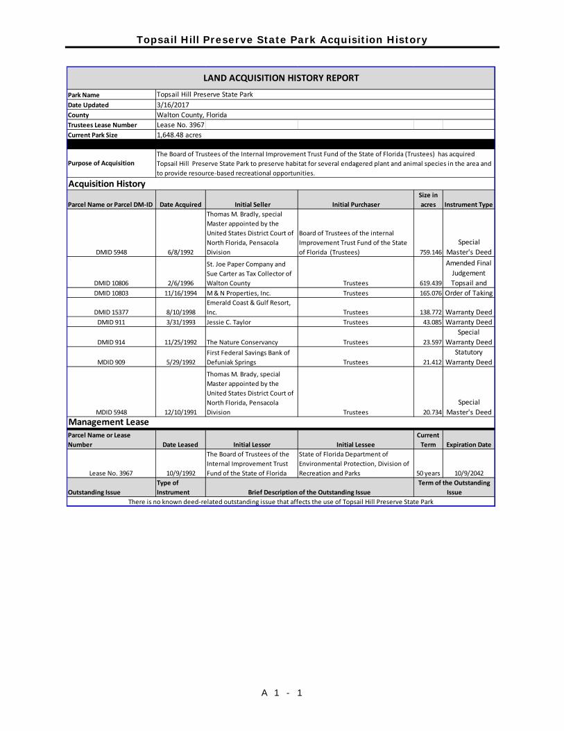
Topsail Hill Preserve State Park Acquisition History
A 1 - 1
Park NameDate UpdatedCountyTrustees Lease Number Lease No. 3967Current Park Size
Parcel Name or Parcel DM-ID Date Acquired Initial Seller Initial PurchaserSize in acres Instrument Type
DMID 5948 6/8/1992
Thomas M. Bradly, special Master appointed by the United States District Court of North Florida, Pensacola Division
Board of Trustees of the internal Improvement Trust Fund of the State of Florida (Trustees) 759.146
Special Master's Deed
DMID 10806 2/6/1996
St. Joe Paper Company and Sue Carter as Tax Collector of Walton County Trustees 619.439
Amended Final
Judgement Topsail and
DMID 10803 11/16/1994 M & N Properties, Inc. Trustees 165.076 Order of Taking
DMID 15377 8/10/1998Emerald Coast & Gulf Resort, Inc. Trustees 138.772 Warranty Deed
DMID 911 3/31/1993 Jessie C. Taylor Trustees 43.085 Warranty Deed
DMID 914 11/25/1992 The Nature Conservancy Trustees 23.597Special
Warranty Deed
MDID 909 5/29/1992First Federal Savings Bank of Defuniak Springs Trustees 21.412
Statutory Warranty Deed
MDID 5948 12/10/1991
Thomas M. Brady, special Master appointed by the United States District Court of North Florida, Pensacola Division Trustees 20.734
Special Master's Deed
Parcel Name or Lease Number Date Leased Initial Lessor Initial Lessee
Current Term Expiration Date
Lease No. 3967 10/9/1992
The Board of Trustees of the Internal Improvement Trust Fund of the State of Florida
State of Florida Department of Environmental Protection, Division of Recreation and Parks 50 years 10/9/2042
Outstanding IssueType of Instrument Brief Description of the Outstanding Issue
Term of the Outstanding Issue
There is no known deed-related outstanding issue that affects the use of Topsail Hill Preserve State Park
LAND ACQUISITION HISTORY REPORT
3/16/2017
The Board of Trustees of the Internal Improvement Trust Fund of the State of Florida (Trustees) has acquired Topsail Hill Preserve State Park to preserve habitat for several endagered plant and animal species in the area and to provide resource-based recreational opportunities.
1,648.48 acres
Walton County, Florida
Purpose of Acquisition
Topsail Hill Preserve State Park
Acquisition History
Management Lease

Addendum 2—Advisory Group Members and Report


Topsail Hill Preserve State Park Advisory Group Members and Report
A 2 - 1
List

Topsail Hill Preserve State Park Advisory Group Members and Report
A 2 - 2
Report
Addendum 3—References Cited

Topsail Hill Preserve State Park References Cited
A 3 - 3
Avissar, A., C. Burney, and N. Douglass. 2012. Guidelines for posting shorebird and
seabird sites in Florida. Florida Shorebird Aliance, 21pp. Campbell, K.M., 1984. A Geologic Guide to the State Parks of the Florida Panhandle
Coast, St. George Island, St. Joseph Peninsula, St. Andrews and Grayton Beach Parks and Recreation Areas. Leaflet No. 13. 23pp.
Collins, L.D., Fernandez, S., DuVerbay, J., Driscoll, K. and T. Doering. 2013.
Archaeological Resource Sensitivity Modeling in Florida State Parks District 1: the Northwest Florida Region. University of South Florida Alliance for Integrated Spatial Technologies, pp 312-317.
Menadier, William. P.E. 2017. Dewberry/Preble-Rish. Letter to Board of Trustees of
the Internal Improvement Trust Fund 28 June 2017. Received by the Division of Recreation and Parks, 6 July 2017.
Division of Recreation and Parks. 2017. Florida State Park System Economic Impact
Assessment for Fiscal Year 2016/2017. Florida Department of Environmental Protection. Tallahassee, Florida.
Drewa, P.B., W.J. Platt, C. Kwit and T.W. Doyle, 2008. Stand structure and
dynamics of sand pine differ between the Florida panhandle and peninsula. Plant Ecology 196: 15-25.
Esry, D.H. 1987. Monitoring of Choctawhatchee River and Tributary Black Creek in Southern Walton and Washington Counties, Northwest Florida Water Management District, Tech. File Report 87-3, Tallahassee.
FLEPPC. 2015. List of Invasive Plant Species. Florida Exotic Pest Council. http://www.fleppc.org/list/2015FLEPPCLIST-LARGEFORMAT-FINAL.pdf Florida Department of Environmental Protection (FDEP). 2015. Critically Eroded
Beaches in Florida. https://www.dep.state.fl.us/beaches/publications/pdf/CriticalErosionReport.pdf
Office of Greenways and Trails. 2017. Florida Greenways and Trails System Plan
and Maps. Florida Department of Environmental Protection. https://floridadep.gov/parks/ogt/content/florida-greenways-and-trails-system-plan-and-maps. Date accessed 27 December 2017.
Florida Department of Environmental Protection. Division of Recreation and Parks. Office of Park Planning 2013. Statewide Comprehensive Outdoor Recreation Plan 2013. Tallahassee, Florida.
Topsail Hill Preserve State Park References Cited
A 3 - 4
Florida Department of Transportation. 2017. Northwest Florida Roads. Current Projects. US 98 from Emerald Bay Drive to Tang-O-Mar Drive. https://nwflroads.com/projects/414132-4.
Florida Fish and Wildlife Conservation Commission (FWC). 2007. Marine Turtle
Conservation Guidelines. Fish and Wildlife Research Institute, St Petersburg, Florida.
Florida Fish and Wildlife Conservation Commission (FWC). 2010. Best Management Practices for Operating Vehicles on the Beach.
http://myfwc.com/docs/Conservation/beach_drive_flyer_clr.pdf
Florida Forest Service. 2008. Silviculture Best Management Practices. file:///C:/Users/manis_j/Desktop/Downloads/Media-Files-Florida-Forest-Service-Files-silvicultural_bmp_manual.pdf
Florida Natural Areas Inventory (FNAI), 2010. Guide to the Natural Communities of Florida. Tallahassee, FL.
Himes, J. G., N. J. Douglass, R. A. Pruner, A. M. Croft, and E. M. Seckinger. 2006.
Status and Distribution of the Snowy Plover in Florida. 2006 study final report. Florida Fish and Wildlife Conservation Commission (FFWCC), Tallahassee, Florida, 27 pp.
Johnson, E.D. 2001. Pitcherplants and their habitats in the Florida State Park system. Resource Management Evaluation. Division of Recreation and Parks, Florida Department of Environmental Protection. 111 pp.
Northwest Florida Water Management District (NWFWMD). 1978. Choctawhatchee River Flood Reconnaissance Report, Washington County and Holmes County
Florida, Tallahassee. Parker, A.J., K.C. Parker and D.H. McCay, 2001. Disturbance-mediated variation in
stand structure between varieties of Pinus clausa (Sand pine). Annals of the Association of American Geographers. 91(1); 28-47.
Pascale, C.A. 1974. Water Resources of Walton County, Florida. Report of
Investigations No. 76. Prepared by the U.S.G.S. in cooperation with the Bureau of Geology, Florida Department of Natural Resources and Walton County Board of County Commissioners.
Pruner, R.A. 2010. Conservation and management of the Snowy Plover along the
Florida Gulf Coast: Habitat selection, reproductive performance, and the effects of anthropogenic disturbance [thesis]. The University of Florida, Gainesville, FL,103p.
Pruner, R.A, M.J. Friel, and J.A. Zimmerman. 2011. Interpreting the influence of
habitat management actions on shorebird nesting activity at coastal state
Topsail Hill Preserve State Park References Cited
A 3 - 5
parks in the Florida panhandle. 2010-11 Study Final Report. Department of Environmental Protection, Florida Park Service, Panama City, Florida.
Puri, H. and Vernon, R.O. 1964. Geology of Florida and a guidebook to classic
exposures. Florida Geological Survey, Spec. Pub. 5 (revised). Tallahassee, FL.
Schmidt, W. 1984. Notes on the Geology of Walton County, Open File report 3.
Florida Geological Survey, Tallahassee, Florida. Schmidt, W. and M.W. Clark. 1980. Geology of Bay County. Bulletin No. 57. State
of Florida Department of Natural Resources, Bureau of Geology, Division of Resource Management, Florida Department of Natural Resources, Tallahassee, FL.
Spector, T. 2009. Summary of Perdido Key Beach Mice (Peromyscus polionotus
peninsularis) sand tracking data from 2000-2004. Florida Park Service, District 1, Department of Environmental Protection. Jan 2010. 6 pp
U.S. Army Corps of Engineers. 1980. Special Flood Hazard Information Report,
Choctawhatchee River, Holmes Co., Florida, Mobile District Corps., Mobile, Alabama.
U.S. Department of Commerce, Bureau of the Census. 2010. U. S. Census
2010. U.S. Department of Commerce, Bureau of Economic Analysis. 2014. 2013
Personal Income Summary/Per Capital Personal Income. http://www.bea.gov/itable/.
U.S.D.A.- SCS. 1989. Soil Survey of Walton County, Florida. In cooperation with the
University of Florida Institute of Food and Agricultural Sciences, Agricultural Experiment Stations and Soil Science Department, and the Walton County Board of County Commissioners.
U.S. Fish and Wildlife Service. 2013. Draft Comprehensive Conservation Strategy
for the Piping Plover (Charadrius melodus) in its Coastal Migration and Wintering Range in the Continental United States. East Lansing, Michigan.
U.S. Fish and Wildlife Service. 2014. Endangered and Threatened Wildlife and Plants; Threatened Species Status for the Rufa Red Knot; Final Rule. Department of the Interior. Vol 79. No. 238.
Visit Florida. Research Department. 2015 Florida Visitor Study. 2015.
Tallahassee, Florida. Varner, J.M., D.R. Gordon, F.E. Putz, and J.K. Hiers, 2005. Restoring fire to long

Topsail Hill Preserve State Park References Cited
A 3 - 6
unburned Pinus Palustris ecosystems: Novel fire effects and consequences for long-unburned ecosystems. Restoration Ecology 13 (3) 536-544.
Walton County Tourist Development Council. 2016. 2016 Annual Report.
Visitsouthwalton.com/industry. Walton County. 2017. Walton County Land Development Code 2017. Walton
County, Florida. Yon, Jr. J.W. and C.W. Hendry, Jr. 1969. Mineral Resource Study of Holmes,
Walton and Washington Counties. Geological Bulletin 50. Bureau of Geology, Tallahassee, State of Florida, Department of Natural Resources Bureau of Geology, Tallahassee, FL.

Addendum 4—Soil Descriptions

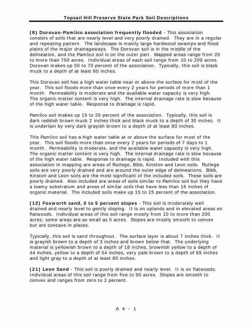
Topsail Hill Preserve State Park Soil Descriptions
A 4 - 1
(8) Dorovan-Pamlico association frequently flooded - This association consists of soils that are nearly level and very poorly drained. They are in a regular and repeating pattern. The landscape is mainly large hardwood swamps and flood plains of the major drainageways. The Dorovan soil is in the middle of the delineation, and the Pamlico soil is on the outer part. Mapped areas range from 20 to more than 750 acres. Individual areas of each soil range from 10 to 200 acres. Dorovan makes up 50 to 70 percent of the association. Typically, this soil is black muck to a depth of at least 60 inches. This Dorovan soil has a high water table near or above the surface for most of the year. This soil floods more than once every 2 years for periods of more than 1 month. Permeability is moderate and the available water capacity is very high. The organic matter content is very high. The internal drainage rate is slow because of the high water table. Response to drainage is rapid. Pamlico soil makes up 15 to 25 percent of the association. Typically, this soil is dark reddish brown muck 2 inches thick and black muck to a depth of 30 inches. It is underlain by very dark grayish brown to a depth of at least 80 inches. This Pamlico soil has a high water table at or above the surface for most of the year. This soil floods more than once every 2 years for periods of 7 days to 1 month. Permeability is moderate, and the available water capacity is very high. The organic matter content is very high. The internal drainage rate is slow because of the high water table. Response to drainage is rapid. Included with this association in mapping are areas of Rutlege, Bibb, Kinston and Leon soils. Rutlege soils are very poorly drained and are around the outer edge of delineations. Bibb, Kinston and Leon soils are the most significant of the included soils. These soils are poorly drained. Also included are areas of soils similar to Pamlico soil but they have a loamy substratum and areas of similar soils that have less than 16 inches of organic material. The included soils make up 15 to 25 percent of the association. (12) Foxworth sand, 0 to 5 percent slopes - This soil is moderately well drained and nearly level to gently sloping. It is on uplands and in elevated areas on flatwoods. Individual areas of this soil range mostly from 10 to more than 200 acres; some areas are as small as 5 acres. Slopes are mostly smooth to convex but are concave in places. Typically, this soil is sand throughout. The surface layer is about 7 inches thick. It is grayish brown to a depth of 3 inches and brown below that. The underlying material is yellowish brown to a depth of 18 inches, brownish yellow to a depth of 44 inches, yellow to a depth of 54 inches, very pale brown to a depth of 69 inches and light gray to a depth of at least 80 inches. (21) Leon Sand - This soil is poorly drained and nearly level. It is on flatwoods. Individual areas of this soil range from five to 90 acres. Slopes are smooth to convex and ranges from zero to 2 percent.

Topsail Hill Preserve State Park Soil Descriptions
A 4 - 2
Typically, the surface layer is very dark gray sand 9 inches thick. The subsurface layer is gray sand to a depth of 18 inches. The subsoil is dark reddish brown sand to a depth of 22 inches, black loamy sand to a depth of 27 inches and yellowish brown sand to a depth of 31. Below that is white sand to a depth of 67 inches and very dark gray sand to a depth of at least 80 inches. Included with this soil in mapping are small areas of Chipley, Hurricane, Mandarin and Rutlege soils. Rutelege soils are the most common inclusion. Also included are a few areas of soils similar to Leon soil except they have a surface layer that is thicker, have a Bh horizon that is more than 30 inches below the surface, or more than half of the dark color subsoil is weakly cemented. The included soils make up less than 15 percent of the map unit. This Leon soil has a high water table at a depth of 10 to 40 inches for periods of more than 9 months during most years. The high water table is at a depth of less than 10 inches for 1 to 4 months during periods of high rainfall and recedes to a depth of more than 40 inches during very dry seasons. The available water capacity is very low in the surface and subsurface layers, and low in the subsoil. Permeability is rapid in the surface and subsurface layers, moderate to moderately rapid in the subsoil and very rapid below that. The organic matter content is low to moderate. (16) Kureb sand, 0 to 8 percent slopes - This excessively drained, nearly level to sloping soil is on broad, undulating ridges and short side slopes on upland sand hills and dune-like ridges. Individual areas of this soil range from 50 to 800 acres. Slopes are smooth to convex and concave. Typically, the surface layer is gray sand 4 inches thick. The subsurface layer is white sand to a depth of 17 inches. The subsoil is sand to a depth of 68 inches. To a depth of 28 inches, it is brownish yellow with white tongues. It is yellowish brown to a depth of 37 inches, brownish yellow to a depth of 47 inches and yellow below that. The substratum is very pale brown sand that extends to a depth of at least 80 inches. Included with this Kureb soil in mapping are small areas of Corolla, Mandarin, Newhan and Resota soils. Also included are some areas of Kureb soil mainly along bays and beaches that have an abrupt drop off. This soil is designated by the short, steep slope symbol. Included soils make up less than 20 percent of the map unit. This Kerub soil has a loose, well-aerated root zone to a depth of more than 72 inches. This soil has very low available water capacity and permeability is very rapid. Organic matter content is low, and fertilizers are rapidly leached from the soil. Rainfall is rapidly absorbed in protected areas, and there is little runoff. This soil does not have a high water table within a depth of 6 feet. (17) Lakeland sand, 0 to 5 percent slopes - This soil is excessively drained and nearly level to gently sloping. It is on broad ridgetops and on uplands. Individual
Topsail Hill Preserve State Park Soil Descriptions
A 4 - 3
areas of this soil range mostly from 40 to more than 300 acres; some areas are as large as 1,000 acres and others are as small as 5 acres. Slopes are mostly smooth to concave but are convex in places. Typically, the surface layer is dark grayish brown sand 4 inches thick. The underlying material is sand. It is yellowish brown to a depth of 7 inches, brownish yellow to a depth of 60 inches and light yellowish brown to a depth of at least 80 inches. Included with this soil in mapping are small areas of Bonifay, Chipley, Dorovan, Eglin, Foxworth, Kenansville, Pamlico and Troup soils. Also included are areas of soils that have slopes of more than 5 percent but are otherwise similar to Lakeland soils and soils that are similar but have a few thin lamellae below a depth of 65 inches. The lamellae have cumulative thickness of less than 1 centimeter. The soils containing lamellae are generally along areas near the Choctawhatchee River and are near delineations of Troup soils. A few small wet areas are shown by wet spot symbols. The included soils make up less than 15 percent of the map unit. This Lakeland soil has low available water capacity. Permeability is rapid. The organic matter content is very low or low. Rainfall is rapidly absorbed in protected areas and there is little runoff. This soil does not have a high water table within a depth of 6 feet. (18) Lakeland sand, 5 to 12 percent slopes - This excessively drained, strongly sloping soil occurs mainly on upland side slopes leading to drainageways and around depressions. Individual areas of this soil range mostly from 30 to more than 100 acres; some areas are as small as 5 acres. Slopes are smooth to convex. Typically, the surface layer is dark grayish brown sand 3 inches thick. The underlying layer is sand. The upper 37 inches is yellowish brown and yellowish brown over brownish yellow to a depth of at least 80 inches. Included with this soil in mapping are small areas of Bonifay, Chipley, Foxworth and Troup soils. Also included are some areas of Lakeland soil that have abrupt drop off. This soil is designated by the short, steep slope symbol. Areas of soils that have slopes of less than 5 percent and soils that have slopes of more than 12 percent are also included. Small areas of poorly drained soils are at seepage spots in and along stream bottoms and drainageways. Included soils make up less than 20 percent of the map unit. This Lakeland soil has a low available water capacity, and low or very low organic matter content. Permeability is rapid. Rainfall is absorbed in protected areas, and there is little runoff. This soil does not have a seasonal high water table within a depth of 6 feet. (27) Rutlege fine sand - This very poorly drained soil is nearly level. It is in shallow depressions (sometimes called ponds, bays or sinks) and on stream or creek floodplains and upland flats. Individual areas of this soil range from five to 80 acres. Slopes are smooth to concave and range from zero to 2 percent.

Topsail Hill Preserve State Park Soil Descriptions
A 4 - 4
Typically, the surface layer is black fine sand 17 inches thick. The underlying material is fine sand to a depth of at least 80 inches. It is grayish brown to a depth of 22 inches, light brownish gray to a depth of 60 inches and light gray below that. Included with this soil in mapping are small areas of Chipley, Hurricane, Leon, Pamlico and Pickney soils. Also commonly included are soils similar to this Rutlege soil except they have a dark color surface layer less than 10 inches thick, have dark color subsoil below a depth of 50 inches, have loamy subsoil that is mixed or stratified below a depth of 60 inches or have a loamy sand surface layer. Included soils make up less than 30 percent of the map unit. This Rutlege soil has a high water table at or near the surface for long periods of the year. Shallow ponding is common. Brief flooding is common in areas adjacent to creeks and streams. Available water capacity is high in the surface layer and low in the underlying material. Permeability is rapid throughout. However, internal drainage is slow, when impeded by the high water table. Response to artificial drainage is rapid. The organic matter content is high or very high. (50) Mandarin sand - This soil is somewhat poorly drained and nearly level. It is in slightly elevated areas on flatwoods. Individual areas of this soil range from three to 50 acres. Slopes are smooth to concave.Typically, the surface layer is gray sand about 8 inches thick. The subsurface layer is light gray sand to a depth of about 21 inches. The subsoil extends to a depth of 60 inches. It is black sand to a depth of 23 inches, very dark gray fine sand to a depth of 25 inches and dark reddish brown sand to a depth of 38 inches and yellowish brown sand below that. The substratum is white sand to a depth of at least 80 inches. Included with this soil in mapping are small areas of Chipley, Foxworth, Hurricane, Leon, Resota and Rutlege soils. Also included are small areas of soils similar to Mandarin soil except they have dark color subsoil that is lighter in color than is typical for the Mandarin series. Small areas of similar soils that have dark color subsoil at a depth of more than 30 inches are also included. The included soils make up less than 20 percent of the map unit. This Mandarin soil has a high water table at a depth of 20 to 40 inches for 4 to 6 months during most years and below a depth of 40 inches for 6 to 8 months. The high water table is at a depth of 10 to 20 inches for up to 2 weeks after periods of heavy rainfall in some years. The available water capacity is very low or low in the surface and subsurface layers, and moderate or low in the subsoil. Permeability is rapid in the surface and subsurface layers, moderate in the upper part of the subsoil and rapid in the lower part. The organic matter content is very low to moderate. (54) Newhan-Corolla sands, rolling - This map unit consists of Newhan and Corolla soils in undulating dune like areas adjacent to the Gulf of Mexico. These soils are gently sloping to steep. Newhan soil is excessively drained and Corolla soil is moderately well drained or somewhat poorly drained. Areas of these soils are too
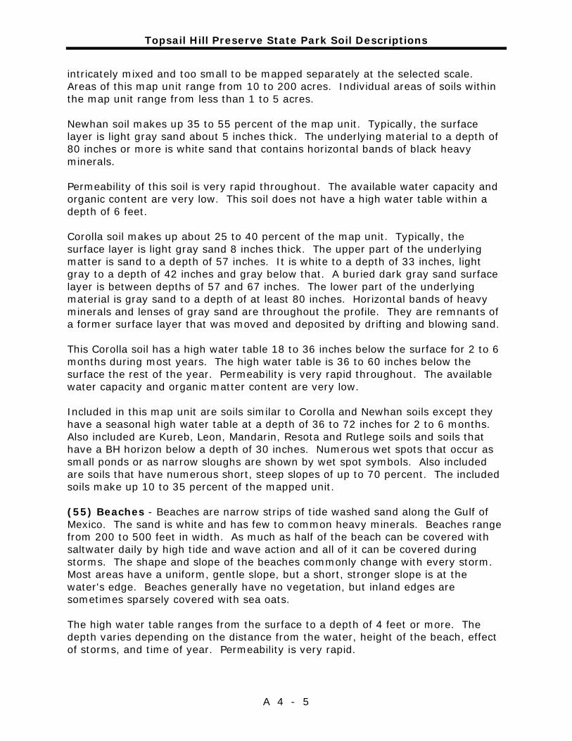
Topsail Hill Preserve State Park Soil Descriptions
A 4 - 5
intricately mixed and too small to be mapped separately at the selected scale. Areas of this map unit range from 10 to 200 acres. Individual areas of soils within the map unit range from less than 1 to 5 acres. Newhan soil makes up 35 to 55 percent of the map unit. Typically, the surface layer is light gray sand about 5 inches thick. The underlying material to a depth of 80 inches or more is white sand that contains horizontal bands of black heavy minerals. Permeability of this soil is very rapid throughout. The available water capacity and organic content are very low. This soil does not have a high water table within a depth of 6 feet. Corolla soil makes up about 25 to 40 percent of the map unit. Typically, the surface layer is light gray sand 8 inches thick. The upper part of the underlying matter is sand to a depth of 57 inches. It is white to a depth of 33 inches, light gray to a depth of 42 inches and gray below that. A buried dark gray sand surface layer is between depths of 57 and 67 inches. The lower part of the underlying material is gray sand to a depth of at least 80 inches. Horizontal bands of heavy minerals and lenses of gray sand are throughout the profile. They are remnants of a former surface layer that was moved and deposited by drifting and blowing sand. This Corolla soil has a high water table 18 to 36 inches below the surface for 2 to 6 months during most years. The high water table is 36 to 60 inches below the surface the rest of the year. Permeability is very rapid throughout. The available water capacity and organic matter content are very low. Included in this map unit are soils similar to Corolla and Newhan soils except they have a seasonal high water table at a depth of 36 to 72 inches for 2 to 6 months. Also included are Kureb, Leon, Mandarin, Resota and Rutlege soils and soils that have a BH horizon below a depth of 30 inches. Numerous wet spots that occur as small ponds or as narrow sloughs are shown by wet spot symbols. Also included are soils that have numerous short, steep slopes of up to 70 percent. The included soils make up 10 to 35 percent of the mapped unit. (55) Beaches - Beaches are narrow strips of tide washed sand along the Gulf of Mexico. The sand is white and has few to common heavy minerals. Beaches range from 200 to 500 feet in width. As much as half of the beach can be covered with saltwater daily by high tide and wave action and all of it can be covered during storms. The shape and slope of the beaches commonly change with every storm. Most areas have a uniform, gentle slope, but a short, stronger slope is at the water's edge. Beaches generally have no vegetation, but inland edges are sometimes sparsely covered with sea oats. The high water table ranges from the surface to a depth of 4 feet or more. The depth varies depending on the distance from the water, height of the beach, effect of storms, and time of year. Permeability is very rapid.
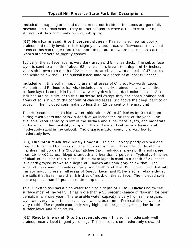
Topsail Hill Preserve State Park Soil Descriptions
A 4 - 6
Included in mapping are sand dunes on the north side. The dunes are generally Newhan and Corolla soils. They are not subject to wave action except during storms, but they commonly receive salt spray. (57) Hurricane sand, 0 to 5 percent slopes - This soil is somewhat poorly drained and nearly level. It is in slightly elevated areas on flatwoods. Individual areas of this soil range from 10 to more than 100; a few are as small as 3 acres. Slopes are smooth to slightly convex. Typically, the surface layer is very dark gray sand 5 inches thick. The subsurface layer is sand to a depth of about 63 inches. It is brown to a depth of 14 inches, yellowish brown to a depth of 22 inches, brownish yellow to a depth of 47 inches and white below that. The subsoil black sand to a depth of at least 80 inches. Included with this soil in mapping are small areas of Chipley, Foxworth, Leon, Mandarin and Rutlege soils. Also included are poorly drained soils in which the surface layer is underlain by shallow, weakly developed, dark color subsoil. Also included are soils similar to this Hurricane soil except they are poorly drained and areas of soils in which the content of clay increases just above the deep, dark color subsoil. The included soils make up less than 15 percent of the map unit. This Hurricane soil has a high water table within 20 to 40 inches for 3 to 6 months during most years and below a depth of 40 inches for the rest of the year. The available water capacity is low in the surface and subsurface layers, and moderate in the subsoil. Permeability is rapid in the surface and subsurface layers, and moderately rapid in the subsoil. The organic matter content is very low to moderately low. (58) Duckston Muck frequently flooded - This soil is very poorly drained and frequently flooded by heavy rains or high storm tides. It is on broad, level tidal marshes that border the Choctawhatchee Bay. Individual areas of this soil range from 10 to 400 acres. Slope is smooth and less than 1 percent. Typically, 4 inches of black muck is on the surface. The surface layer is sand to a depth of 21 inches. It is dark grayish brown to a depth of 6 inches and dark gray below that. The substratum is sand in shades of gray to a depth of at least 80 inches. Included with this soil mapping are small areas of Dirego, Leon, and Rutlege soils. Also included are soils that have more than 8 inches of muck on the surface. The included soils make up less than 20 percent of the map unit. This Duckston soil has a high water table at a depth of 10 to 20 inches below the surface most of the year. It has more than a 50 percent chance of flooding for brief periods in any one-year. The available water capacity is very high in the organic layer and very low in the surface layer and substratum. Permeability is rapid or very rapid. The organic content is very high in the organic layer and low in the surface layer and substratum. (62) Resota fine sand, 0 to 5 percent slopes - This soil is moderately well drained, nearly level to gently sloping. This soil occurs on moderately elevated
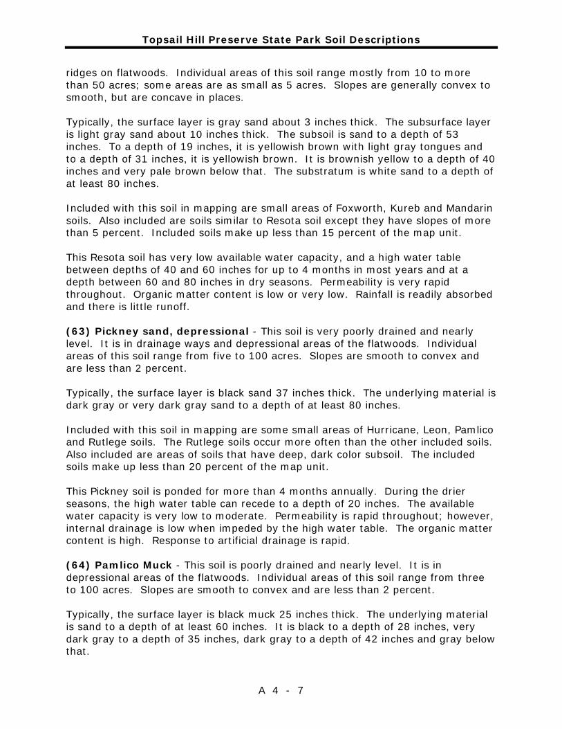
Topsail Hill Preserve State Park Soil Descriptions
A 4 - 7
ridges on flatwoods. Individual areas of this soil range mostly from 10 to more than 50 acres; some areas are as small as 5 acres. Slopes are generally convex to smooth, but are concave in places. Typically, the surface layer is gray sand about 3 inches thick. The subsurface layer is light gray sand about 10 inches thick. The subsoil is sand to a depth of 53 inches. To a depth of 19 inches, it is yellowish brown with light gray tongues and to a depth of 31 inches, it is yellowish brown. It is brownish yellow to a depth of 40 inches and very pale brown below that. The substratum is white sand to a depth of at least 80 inches. Included with this soil in mapping are small areas of Foxworth, Kureb and Mandarin soils. Also included are soils similar to Resota soil except they have slopes of more than 5 percent. Included soils make up less than 15 percent of the map unit. This Resota soil has very low available water capacity, and a high water table between depths of 40 and 60 inches for up to 4 months in most years and at a depth between 60 and 80 inches in dry seasons. Permeability is very rapid throughout. Organic matter content is low or very low. Rainfall is readily absorbed and there is little runoff. (63) Pickney sand, depressional - This soil is very poorly drained and nearly level. It is in drainage ways and depressional areas of the flatwoods. Individual areas of this soil range from five to 100 acres. Slopes are smooth to convex and are less than 2 percent. Typically, the surface layer is black sand 37 inches thick. The underlying material is dark gray or very dark gray sand to a depth of at least 80 inches. Included with this soil in mapping are some small areas of Hurricane, Leon, Pamlico and Rutlege soils. The Rutlege soils occur more often than the other included soils. Also included are areas of soils that have deep, dark color subsoil. The included soils make up less than 20 percent of the map unit. This Pickney soil is ponded for more than 4 months annually. During the drier seasons, the high water table can recede to a depth of 20 inches. The available water capacity is very low to moderate. Permeability is rapid throughout; however, internal drainage is low when impeded by the high water table. The organic matter content is high. Response to artificial drainage is rapid. (64) Pamlico Muck - This soil is poorly drained and nearly level. It is in depressional areas of the flatwoods. Individual areas of this soil range from three to 100 acres. Slopes are smooth to convex and are less than 2 percent. Typically, the surface layer is black muck 25 inches thick. The underlying material is sand to a depth of at least 60 inches. It is black to a depth of 28 inches, very dark gray to a depth of 35 inches, dark gray to a depth of 42 inches and gray below that.

Topsail Hill Preserve State Park Soil Descriptions
A 4 - 8
Included with this soil in mapping are small areas of Dorovan, Leon, Pickney and Rutlege soils. The included soils make up less than 20 percent of the map unit. This Palmico soil has a water table of up to 2 feet above the surface for 6 months in most years. Permeability is moderate or moderately rapid, and the available water capacity is very high. The organic matter content is very high. The internal drainage is slow because of the high water table.
Addendum 5—Plant and Animal List

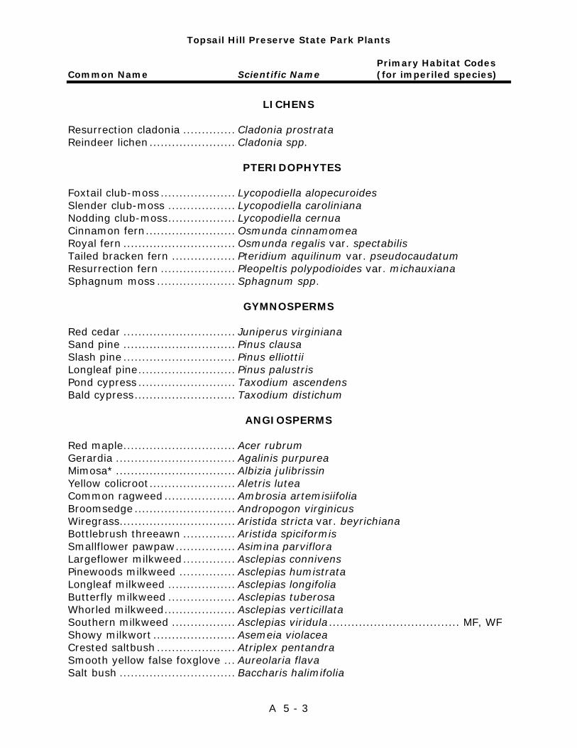
Topsail Hill Preserve State Park Plants
Primary Habitat Codes Common Name Scientific Name (for imperiled species)
A 5 - 3
LICHENS
Resurrection cladonia .............. Cladonia prostrata Reindeer lichen ....................... Cladonia spp.
PTERIDOPHYTES
Foxtail club-moss .................... Lycopodiella alopecuroides Slender club-moss .................. Lycopodiella caroliniana Nodding club-moss .................. Lycopodiella cernua Cinnamon fern ........................ Osmunda cinnamomea Royal fern .............................. Osmunda regalis var. spectabilis Tailed bracken fern ................. Pteridium aquilinum var. pseudocaudatum Resurrection fern .................... Pleopeltis polypodioides var. michauxiana Sphagnum moss ..................... Sphagnum spp.
GYMNOSPERMS Red cedar .............................. Juniperus virginiana Sand pine .............................. Pinus clausa Slash pine .............................. Pinus elliottii Longleaf pine .......................... Pinus palustris Pond cypress .......................... Taxodium ascendens Bald cypress ........................... Taxodium distichum
ANGIOSPERMS
Red maple.............................. Acer rubrum Gerardia ................................ Agalinis purpurea Mimosa* ................................ Albizia julibrissin Yellow colicroot ....................... Aletris lutea Common ragweed ................... Ambrosia artemisiifolia Broomsedge ........................... Andropogon virginicus Wiregrass............................... Aristida stricta var. beyrichiana Bottlebrush threeawn .............. Aristida spiciformis Smallflower pawpaw ................ Asimina parviflora Largeflower milkweed .............. Asclepias connivens Pinewoods milkweed ............... Asclepias humistrata Longleaf milkweed .................. Asclepias longifolia Butterfly milkweed .................. Asclepias tuberosa Whorled milkweed ................... Asclepias verticillata Southern milkweed ................. Asclepias viridula ................................... MF, WF Showy milkwort ...................... Asemeia violacea Crested saltbush ..................... Atriplex pentandra Smooth yellow false foxglove ... Aureolaria flava Salt bush ............................... Baccharis halimifolia
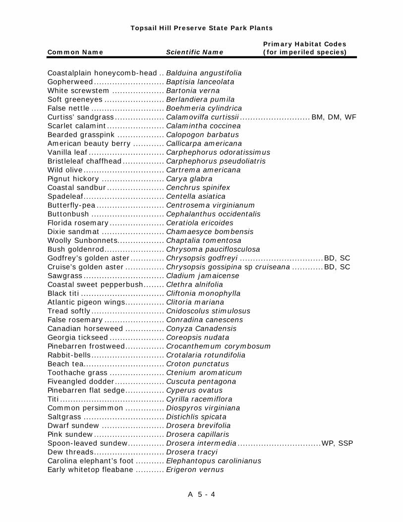
Topsail Hill Preserve State Park Plants
Primary Habitat Codes Common Name Scientific Name (for imperiled species)
A 5 - 4
Coastalplain honeycomb-head .. Balduina angustifolia Gopherweed ........................... Baptisia lanceolata White screwstem .................... Bartonia verna Soft greeneyes ....................... Berlandiera pumila False nettle ............................ Boehmeria cylindrica Curtiss’ sandgrass ................... Calamovilfa curtissii ........................... BM, DM, WF Scarlet calamint ...................... Calamintha coccinea Bearded grasspink .................. Calopogon barbatus American beauty berry ............ Callicarpa americana Vanilla leaf ............................. Carphephorus odoratissimus Bristleleaf chaffhead ................ Carphephorus pseudoliatris Wild olive ............................... Cartrema americana Pignut hickory ........................ Carya glabra Coastal sandbur ...................... Cenchrus spinifex Spadeleaf ............................... Centella asiatica Butterfly-pea .......................... Centrosema virginianum Buttonbush ............................ Cephalanthus occidentalis Florida rosemary ..................... Ceratiola ericoides Dixie sandmat ........................ Chamaesyce bombensis Woolly Sunbonnets.................. Chaptalia tomentosa Bush goldenrod ....................... Chrysoma pauciflosculosa Godfrey’s golden aster ............. Chrysopsis godfreyi ................................ BD, SC Cruise’s golden aster ............... Chrysopsis gossipina sp cruiseana ............ BD, SC Sawgrass ............................... Cladium jamaicense Coastal sweet pepperbush ........ Clethra alnifolia Black titi ................................ Cliftonia monophylla Atlantic pigeon wings ............... Clitoria mariana Tread softly ............................ Cnidoscolus stimulosus False rosemary ....................... Conradina canescens Canadian horseweed ............... Conyza Canadensis Georgia tickseed ..................... Coreopsis nudata Pinebarren frostweed ............... Crocanthemum corymbosum Rabbit-bells ............................ Crotalaria rotundifolia Beach tea............................... Croton punctatus Toothache grass ..................... Ctenium aromaticum Fiveangled dodder ................... Cuscuta pentagona Pinebarren flat sedge ............... Cyperus ovatus Titi ........................................ Cyrilla racemiflora Common persimmon ............... Diospyros virginiana Saltgrass ............................... Distichlis spicata Dwarf sundew ........................ Drosera brevifolia Pink sundew ........................... Drosera capillaris Spoon-leaved sundew .............. Drosera intermedia ................................ WP, SSP Dew threads ........................... Drosera tracyi Carolina elephant’s foot ........... Elephantopus carolinianus Early whitetop fleabane ........... Erigeron vernus

Topsail Hill Preserve State Park Plants
Primary Habitat Codes Common Name Scientific Name (for imperiled species)
A 5 - 5
Flattened pipewort .................. Eriocaulon compressum Tenangle pipewort ................... Eriocaulon decangulare Dogtongue wild buckwheat ....... Eriogonum tomentosum Button rattlesnake master ........ Eryngium yuccifolium Coralbean .............................. Erythrina herbacea Dog fennel ............................. Eupatorium capillifolium False fennel ............................ Eupatorium leptophyllum Thistleleaf aster ...................... Eurybia eryngiifolia Slender flattop goldenrod ......... Euthamia caroliniana Cottonweed ............................ Froelichia floridana Southern umbrella sedge ......... Fuirena scirpoidea Lanceleaf blanketflower ........... Gaillardia aestivalis Eastern milkpea ...................... Galactia volubilis Hairy bedstraw ....................... Galium pilosum Dwarf huckleberry ................... Gaylussacia dumosa Woolly huckleberry .................. Gaylussacia mosieri Loblolly bay ............................ Gordonia lasianthus Stiff sunflower ........................ Helianthus radula Camphor weed ....................... Heterotheca subaxillaris Beach pennywort .................... Hydrocotyle bonariensis Roundpod st. John’s wort ......... Hypericum cistifolium St. Peter’s wort ....................... Hypericum crux-andreae Atlantic st. John’s wort ............ Hypericum tenuifolium Sand holly .............................. Ilex ambigua Dahoon .................................. Ilex cassine Myrtle dahoon ........................ Ilex cassine var. myrtifolia Large gallberry ....................... Ilex coriacea Gallberry ................................ Ilex glabra American holly ........................ Ilex opaca Yaupon ................................. Ilex vomitoria Beach morning-glory ............... Ipomoea imperati Saltmarsh morning-glory ......... Ipomoea sagittata Marsh elder ............................ Iva frutescens Seacoast marshelder ............... Iva imbricata Needle rush ............................ Juncus roemerianus Virginia willow ........................ Liquidambar styraciflua Wicky .................................... Kalmia hirsuta Saltmarsh mallow ................... Kosteletzkya virginica Carolina redroot ...................... Lachnanthes caroliana Lantana* ............................... Lantana camara Virginia pepperweed ................ Lepidium virginicum Shortleaf gayfeather ................ Liatris tenuifolia Gopher apple .......................... Licania michauxii Pine lily .................................. Lilium catesbaei .................................... MF, WF Apalachicola toadflax ............... Linaria floridana Florida yellow flax ................... Linum floridanum
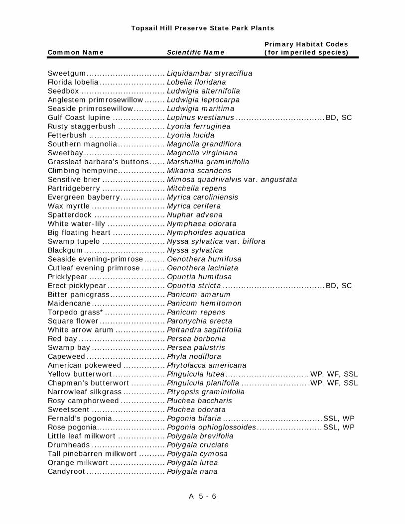
Topsail Hill Preserve State Park Plants
Primary Habitat Codes Common Name Scientific Name (for imperiled species)
A 5 - 6
Sweetgum .............................. Liquidambar styraciflua Florida lobelia ......................... Lobelia floridana Seedbox ................................ Ludwigia alternifolia Anglestem primrosewillow ........ Ludwigia leptocarpa Seaside primrosewillow ............ Ludwigia maritima Gulf Coast lupine .................... Lupinus westianus .................................. BD, SC Rusty staggerbush .................. Lyonia ferruginea Fetterbush ............................. Lyonia lucida Southern magnolia .................. Magnolia grandiflora Sweetbay ............................... Magnolia virginiana Grassleaf barbara’s buttons ...... Marshallia graminifolia Climbing hempvine .................. Mikania scandens Sensitive brier ........................ Mimosa quadrivalvis var. angustata Partridgeberry ........................ Mitchella repens Evergreen bayberry ................. Myrica caroliniensis Wax myrtle ............................ Myrica cerifera Spatterdock ........................... Nuphar advena White water-lily ...................... Nymphaea odorata Big floating heart .................... Nymphoides aquatica Swamp tupelo ........................ Nyssa sylvatica var. biflora Blackgum ............................... Nyssa sylvatica Seaside evening-primrose ........ Oenothera humifusa Cutleaf evening primrose ......... Oenothera laciniata Pricklypear ............................. Opuntia humifusa Erect picklypear ...................... Opuntia stricta ....................................... BD, SC Bitter panicgrass ..................... Panicum amarum Maidencane ............................ Panicum hemitomon Torpedo grass* ....................... Panicum repens Square flower ......................... Paronychia erecta White arrow arum ................... Peltandra sagittifolia Red bay ................................. Persea borbonia Swamp bay ............................ Persea palustris Capeweed .............................. Phyla nodiflora American pokeweed ................ Phytolacca americana Yellow butterwort .................... Pinguicula lutea ................................ WP, WF, SSL Chapman’s butterwort ............. Pinguicula planifolia .......................... WP, WF, SSL Narrowleaf silkgrass ................ Pityopsis graminifolia Rosy camphorweed ................. Pluchea baccharis Sweetscent ............................ Pluchea odorata Fernald’s pogonia .................... Pogonia bifaria ...................................... SSL, WP Rose pogonia .......................... Pogonia ophioglossoides ......................... SSL, WP Little leaf milkwort .................. Polygala brevifolia Drumheads ............................ Polygala cruciate Tall pinebarren milkwort .......... Polygala cymosa Orange milkwort ..................... Polygala lutea Candyroot .............................. Polygala nana
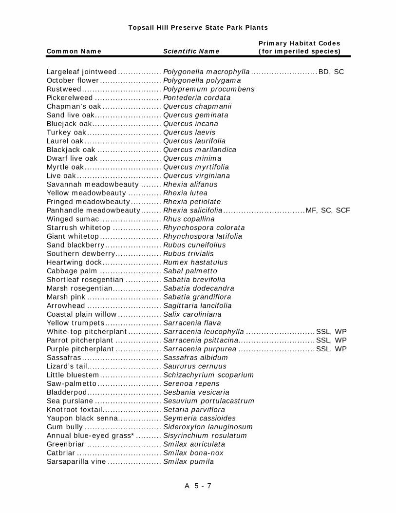
Topsail Hill Preserve State Park Plants
Primary Habitat Codes Common Name Scientific Name (for imperiled species)
A 5 - 7
Largeleaf jointweed ................. Polygonella macrophylla .......................... BD, SC October flower ........................ Polygonella polygama Rustweed ............................... Polypremum procumbens Pickerelweed .......................... Pontederia cordata Chapman’s oak ....................... Quercus chapmanii Sand live oak.......................... Quercus geminata Bluejack oak ........................... Quercus incana Turkey oak ............................. Quercus laevis Laurel oak .............................. Quercus laurifolia Blackjack oak ......................... Quercus marilandica Dwarf live oak ........................ Quercus minima Myrtle oak .............................. Quercus myrtifolia Live oak ................................. Quercus virginiana Savannah meadowbeauty ........ Rhexia alifanus Yellow meadowbeauty ............. Rhexia lutea Fringed meadowbeauty ............ Rhexia petiolate Panhandle meadowbeauty ........ Rhexia salicifolia ................................ MF, SC, SCF Winged sumac ........................ Rhus copallina Starrush whitetop ................... Rhynchospora colorata Giant whitetop ........................ Rhynchospora latifolia Sand blackberry ...................... Rubus cuneifolius Southern dewberry.................. Rubus trivialis Heartwing dock ....................... Rumex hastatulus Cabbage palm ........................ Sabal palmetto Shortleaf rosegentian .............. Sabatia brevifolia Marsh rosegentian ................... Sabatia dodecandra Marsh pink ............................. Sabatia grandiflora Arrowhead ............................. Sagittaria lancifolia Coastal plain willow ................. Salix caroliniana Yellow trumpets ...................... Sarracenia flava White-top pitcherplant ............. Sarracenia leucophylla ........................... SSL, WP Parrot pitcherplant .................. Sarracenia psittacina .............................. SSL, WP Purple pitcherplant .................. Sarracenia purpurea .............................. SSL, WP Sassafras ............................... Sassafras albidum Lizard’s tail............................. Saururus cernuus Little bluestem ........................ Schizachyrium scoparium Saw-palmetto ......................... Serenoa repens Bladderpod ............................. Sesbania vesicaria Sea purslane .......................... Sesuvium portulacastrum Knotroot foxtail ....................... Setaria parviflora Yaupon black senna ................. Seymeria cassioides Gum bully .............................. Sideroxylon lanuginosum Annual blue-eyed grass* .......... Sisyrinchium rosulatum Greenbriar ............................. Smilax auriculata Catbriar ................................. Smilax bona-nox Sarsaparilla vine ..................... Smilax pumila
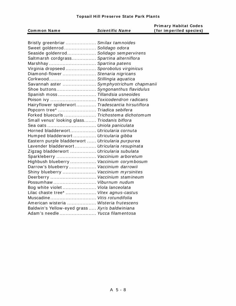
Topsail Hill Preserve State Park Plants
Primary Habitat Codes Common Name Scientific Name (for imperiled species)
A 5 - 8
Bristly greenbriar .................... Smilax tamnoides Sweet goldenrod ..................... Solidago odora Seaside goldenrod ................... Solidago sempervirens Saltmarsh cordgrass ................ Spartina alterniflora Marshhay ............................... Spartina patens Virginia dropseed .................... Sporobolus virginicus Diamond-flower ...................... Stenaria nigricans Corkwood............................... Stillingia aquatica Savannah aster ...................... Symphyotrichum chapmanii Shoe buttons .......................... Syngonanthus flavidulus Spanish moss ......................... Tillandsia usneoides Poison ivy .............................. Toxicodendron radicans Hairyflower spiderwort ............. Tradescantia hirsutiflora Popcorn tree* ......................... Triadica sebifera Forked bluecurls ..................... Trichostema dichotomum Small venus’ looking glass........ Triodanis biflora Sea oats ................................ Uniola paniculata Horned bladderwort ................. Utricularia cornuta Humped bladderwort ............... Utricularia gibba Eastern purple bladderwort ...... Utricularia purpurea Lavender bladderwort .............. Utricularia resupinata Zigzag bladderwort ................. Utricularia subulata Sparkleberry .......................... Vaccinium arboretum Highbush blueberry ................. Vaccinium corymbosum Darrow’s blueberry .................. Vaccinium darrowii Shiny blueberry ...................... Vaccinium myrsinites Deerberry .............................. Vaccinium stamineum Possumhaw ............................ Viburnum nudum Bog white violet ...................... Viola lanceolata Lilac chaste tree* .................... Vitex agnus-castus Muscadine .............................. Vitis rotundifolia American wisteria ................... Wisteria frutescens Baldwin’s Yellow-eyed grass ..... Xyris baldwiniana Adam’s needle ........................ Yucca filamentosa
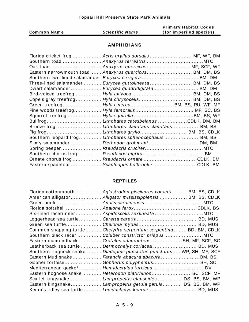
Topsail Hill Preserve State Park Animals
Primary Habitat Codes Common Name Scientific Name (for imperiled species)
A 5 - 9
AMPHIBIANS
Florida cricket frog .................. Acris gryllus dorsalis .......................... MF, WF, BM Southern toad ........................ Anaxyrus terrestris ................................... MTC Oak toad ................................ Anaxyrus quercicus ........................... MF, SCF, WF Eastern narrowmouth toad ....... Anaxyrus quercicus ............................ BM, DM, BS Southern two-lined salamander Eurycea cirrigera ................................... BM, DM Three-lined salamander ........... Eurycea guttolineata .......................... BM, DM, BS Dwarf salamander ................... Eurycea quadridigitata ........................... BM, DM Bird-voiced treefrog ................ Hyla avivoca ..................................... BM, DM, BS Cope’s gray treefrog ................ Hyla chrysocelis................................. BM, DM, BS Green treefrog ........................ Hyla cinerea ........................... BM, BS, RU, WF, MF Pine woods treefrog ................. Hyla femoralis .................................... MF, SC, BS Squirrel treefrog ..................... Hyla squirella .....................................BM, BS, WF Bullfrog .................................. Lithobates catesbeianus .................. CDLK, DM, BM Bronze frog ............................ Lithobates clamitans clamitans ................. BM, BS Pig frog .................................. Lithobates grylio ............................. BM, BS, CDLK Southern leopard frog .............. Lithobates sphenocephalus ...................... BM, BS Slimy salamander ................... Plethodon grobmani ............................... DM, BM Spring peeper ......................... Pseudacris crucifer .................................... MTC Southern chorus frog ............... Pseudacris nigrita ..................................... BM Ornate chorus frog .................. Pseudacris ornate ................................. CDLK, BM Eastern spadefoot ................... Scaphiopus holbrookii ........................... CDLK, BM
REPTILES Florida cottonmouth ................ Agkistrodon piscivorus conanti ......... BM, BS, CDLK American alligator ................... Alligator mississippiensis ................. BM, BS, CDLK Green anole ........................... Anolis carolinensis .................................... MTC Florida softshell ...................... Apalone ferox ....................................... CDLK, BS Six-lined racerunner ................ Aspidoscelis sexlineata .............................. MTC Loggerhead sea turtle .............. Caretta caretta ..................................... BD, MUS Green sea turtle ...................... Chelonia mydas .................................... BD, MUS Common snapping turtle .......... Chelydra serpentina serpentina ........ BD, BM, CDLK Southern black racer ............... Coluber constrictor priapus ........................ MTC Eastern diamondback .............. Crotalus adamanteus ................... SH, MF, SCF, SC Leatherback sea turtle ............. Dermochelys coriacea ........................... BD, MUS Southern ringneck snake ......... Diadophis punctatus punctatus ..... WP, SH, MF, SCF Eastern Mud snake .................. Farancia abacura abacura ........................ BM, BS Gopher tortoise ....................... Gopherus polyphemus ............................. SH, SC Mediterranean gecko* ............. Hemidactylus turcicus ................................ DV Eastern hognose snake ............ Heterodon platirhinos ......................... SC, SCF, MF Scarlet kingsnake .................... Lampropeltis elapsoides ............... DS, BS, BM, WP Eastern kingsnake ................... Lampropeltis getula getula ............ DS, BS, BM, WP Kemp’s ridley sea turtle ........... Lepidochelys kempii .............................. BD, MUS
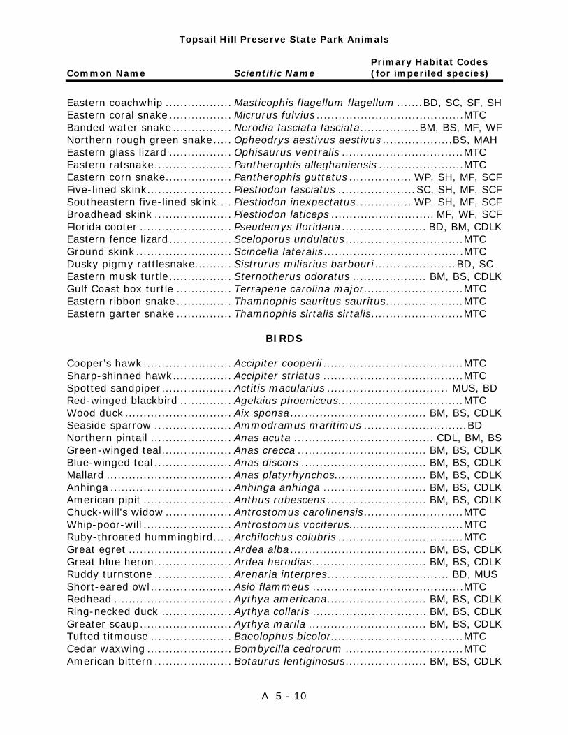
Topsail Hill Preserve State Park Animals
Primary Habitat Codes Common Name Scientific Name (for imperiled species)
A 5 - 10
Eastern coachwhip .................. Masticophis flagellum flagellum ....... BD, SC, SF, SH Eastern coral snake ................. Micrurus fulvius ........................................ MTC Banded water snake ................ Nerodia fasciata fasciata ................ BM, BS, MF, WF Northern rough green snake ..... Opheodrys aestivus aestivus ................... BS, MAH Eastern glass lizard ................. Ophisaurus ventralis ................................. MTC Eastern ratsnake ..................... Pantherophis alleghaniensis ....................... MTC Eastern corn snake .................. Pantherophis guttatus ................. WP, SH, MF, SCF Five-lined skink....................... Plestiodon fasciatus ..................... SC, SH, MF, SCF Southeastern five-lined skink ... Plestiodon inexpectatus ............... WP, SH, MF, SCF Broadhead skink ..................... Plestiodon laticeps ............................ MF, WF, SCF Florida cooter ......................... Pseudemys floridana ....................... BD, BM, CDLK Eastern fence lizard ................. Sceloporus undulatus ................................ MTC Ground skink .......................... Scincella lateralis ...................................... MTC Dusky pigmy rattlesnake .......... Sistrurus miliarius barbouri ...................... BD, SC Eastern musk turtle ................. Sternotherus odoratus .................... BM, BS, CDLK Gulf Coast box turtle ............... Terrapene carolina major ........................... MTC Eastern ribbon snake ............... Thamnophis sauritus sauritus ..................... MTC Eastern garter snake ............... Thamnophis sirtalis sirtalis ......................... MTC
BIRDS Cooper’s hawk ........................ Accipiter cooperii ...................................... MTC Sharp-shinned hawk ................ Accipiter striatus ...................................... MTC Spotted sandpiper ................... Actitis macularius ................................. MUS, BD Red-winged blackbird .............. Agelaius phoeniceus .................................. MTC Wood duck ............................. Aix sponsa ..................................... BM, BS, CDLK Seaside sparrow ..................... Ammodramus maritimus ............................ BD Northern pintail ...................... Anas acuta ...................................... CDL, BM, BS Green-winged teal ................... Anas crecca ................................... BM, BS, CDLK Blue-winged teal ..................... Anas discors .................................. BM, BS, CDLK Mallard .................................. Anas platyrhynchos ......................... BM, BS, CDLK Anhinga ................................. Anhinga anhinga ............................ BM, BS, CDLK American pipit ........................ Anthus rubescens ........................... BM, BS, CDLK Chuck-will’s widow .................. Antrostomus carolinensis ........................... MTC Whip-poor-will ........................ Antrostomus vociferus ............................... MTC Ruby-throated hummingbird ..... Archilochus colubris .................................. MTC Great egret ............................ Ardea alba ..................................... BM, BS, CDLK Great blue heron ..................... Ardea herodias ............................... BM, BS, CDLK Ruddy turnstone ..................... Arenaria interpres ................................. BD, MUS Short-eared owl ...................... Asio flammeus ......................................... MTC Redhead ................................ Aythya americana ........................... BM, BS, CDLK Ring-necked duck ................... Aythya collaris ............................... BM, BS, CDLK Greater scaup ......................... Aythya marila ................................ BM, BS, CDLK Tufted titmouse ...................... Baeolophus bicolor .................................... MTC Cedar waxwing ....................... Bombycilla cedrorum ................................ MTC American bittern ..................... Botaurus lentiginosus ...................... BM, BS, CDLK
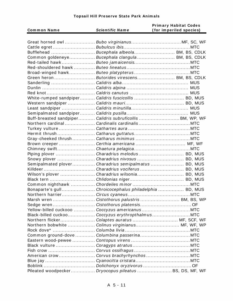
Topsail Hill Preserve State Park Animals
Primary Habitat Codes Common Name Scientific Name (for imperiled species)
A 5 - 11
Great horned owl .................... Bubo virginianus ................................. MF, SC, WF Cattle egret ............................ Bubulcus ibis ............................................ MTC Bufflehead ............................. Bucephala albeola ........................... BM, BS, CDLK Common goldeneye ................. Bucephala clangula ......................... BM, BS, CDLK Red-tailed hawk ...................... Buteo jamaicensis..................................... MTC Red-shouldered hawk .............. Buteo lineatus .......................................... MTC Broad-winged hawk ................. Buteo platypterus ..................................... MTC Green heron ........................... Butorides virescens ......................... BM, BS, CDLK Sanderling ............................. Calidris alba ............................................ MUS Dunlin ................................... Calidris alpina ......................................... MUS Red knot ................................ Caldris canutus ....................................... MUS White-rumped sandpiper .......... Calidris fuscicollis ................................. BD, MUS Western sandpiper .................. Calidris mauri ....................................... BD, MUS Least sandpiper ...................... Calidris minutilla ...................................... MUS Semipalmated sandpiper .......... Calidris pusilla ......................................... MUS Buff-breasted sandpiper ........... Calidris subruficollis ........................... BM, WP, WF Northern cardinal .................... Cardinalis cardinalis .................................. MTC Turkey vulture ........................ Cathartes aura ......................................... MTC Hermit thrush ......................... Catharus guttatus ..................................... MTC Gray-cheeked thrush ............... Catharus minimus .................................... MTC Brown creeper ........................ Certhia americana ................................. MF, WF Chimney swift ......................... Chaetura pelagica ..................................... MTC Piping plover .......................... Charadrius melodus .............................. BD, MUS Snowy plover ......................... Charadrius nivosus ............................... BD, MUS Semipalmated plover ............... Charadrius semipalmatus ...................... BD, MUS Killdeer .................................. Charadrius vociferus ............................. BD, MUS Wilson’s plover ....................... Charadrius wilsonia ............................... BD, MUS Black tern .............................. Chlidonias niger .................................... BD, MUS Common nighthawk ................ Chordeiles minor ...................................... MTC Bonaparte’s gull ...................... Chroicocephalus philadelphia ................. BD, MUS Northern harrier ...................... Circus cyaneus ......................................... MTC Marsh wren ............................ Cistothorus palustris .......................... BM, BS, WP Sedge wren ............................ Cistothorus platensis .................................. OF Yellow-billed cuckooo .............. Coccyzus americanus ................................ MTC Black-billed cuckoo .................. Coccyzus erythropthalmus ......................... MTC Northern flicker....................... Colaptes auratus .............................. MF, SCF, WF Northern bobwhite .................. Colinus virginianus ............................. MF, WF, WP Rock dove* ............................ Columba livia ........................................... MTC Common ground-dove ............. Columbina passerina ................................. MTC Eastern wood-pewee ............... Contopus virens ....................................... MTC Black vulture .......................... Coragyps atratus ...................................... MTC Fish crow ............................... Corvus ossifragus ..................................... MTC American crow ........................ Corvus brachyrhynchos ............................. MTC Blue jay ................................. Cyanocitta cristata .................................... MTC Boblink .................................. Dolichonyx oryzivorus ................................ OF Pileated woodpecker ................ Dryocopus pileatus ....................... BS, DS, MF, WF
Topsail Hill Preserve State Park Animals
Primary Habitat Codes Common Name Scientific Name (for imperiled species)
A 5 - 12
Gray catbird ........................... Dumetella carolinensis .............................. MTC Little blue heron...................... Egretta caerulea ............................. BM, BS, CDLK Reddish egret ......................... Egretta rufescens ........................... BM, BS, CDLK Snowy egret ........................... Egretta thula .................................. BM, BS, CDLK Tricolored heron...................... Egretta tricolor ............................... BM, BS, CDLK Swallow tailed kite .................. Elanoides forficatus ................................... MTC Acadian flycatcher ................... Empidonax virescens ......................... SC, SCF, BS White ibis ............................... Eudocimus albus ...................................... MTC Merlin .................................... Falco columbarius ..................................... MTC Peregrine falcon ...................... Falco peregrinus ....................................... MTC Southeastern kestrel ............... Falco sparverius ....................................... MTC American coot ........................ Fulica americana ............................ BM, BS, CDLK Wilson’s snipe ......................... Gallinago delicata ........................... DM, BM, CDLK Common loon ......................... Gavia immer .................................. BM, BS, CDLK Gull-billed tern ........................ Gelochelidon nilotica ............................. MUS, BD Common yellowthroat .............. Geothlypis trichas ................................. BM, CDLK Sandhill crane ......................... Grus Canadensis........................................ OF American oystercatcher ........... Haematopus palliates ............................... MUS House finch* .......................... Haemorhous mexicanus .................. BD, RUD, DEV Purple finch ............................ Haemorhous purpureus .............................. OF Bald eagle .............................. Haliaeetus leucocephalus ........................... MTC Barn swallow .......................... Hirundo rustica ......................................... MTC Wood thrush........................... Hylocichla mustelina ................................. MTC Mississippi kite ........................ Ictinia mississippiensis .............................. MTC Orchard oriole ........................ Icterus spurius ......................................... MTC Least bittern ........................... Ixobrychus exilis ............................ BM, BS, CDLK Loggerhead strike ................... Lanius ludovicianus ................................... MTC Herring gull ............................ Larus argentatus .................................. BD, MUS Ring-billed gull ....................... Larus delawarensis ............................... BD, MUS Laughing gull .......................... Leucophaeus atricilla ............................. BD, MUS Short-billed dowitcher ............. Limnodromus griseus ............................ BD, MUS Hooded merganser .................. Lophodytes cucullatus .............................. MUS Belted kingfisher ..................... Megaceryle alcyon .......................... BM, BS, CDLK Eastern screech owl ................ Megascops asio ........................................ MTC Red-bellied woodpecker ........... Melanerpes carolinus ................................. MTC Red-headed woodpecker .......... Melanerpes erythrocephalus ....................... MTC Wild turkey ............................ Meleagris gallopavo ............................... MF, WF Song sparrow ......................... Melospiza melodia .................................... MTC Red-breasted merganser .......... Mergus serrator .............................. BM, BS, CDLK Northern mockingbird .............. Mimus polyglottos ..................................... MTC Black-and-white warbler .......... Mniotilta varia .......................................... MTC Brown-headed cowbird ............ Molothrus ater .......................................... MTC Northern gannet ..................... Morus bassanus ......................................... OF Great crested flycatcher ........... Myiarchus crinitus ..................................... MTC Whimbrel ............................... Numenius phaeopus ................................. MUS Yellow-crowned night heron ..... Nyctanassa violacea ........................ BM, BS, CDLK

Topsail Hill Preserve State Park Animals
Primary Habitat Codes Common Name Scientific Name (for imperiled species)
A 5 - 13
Black-crowned night heron ....... Nycticorax nycticorax ...................... BM, BS, CDLK Osprey .................................. Pandion haliaetus ........................... BM, BS, CDLK House sparrow* ...................... Passer domesticus ..................................... OF Savannah sparrow .................. Passerculus sandwichensis .......................... OF Indigo bunting ........................ Passerina cyanea ...................................... MTC American white pelican ............ Pelecanus erythrorhynchos ......................... OF Brown pelican ......................... Pelecanus occidentalis ................................ OF Double crested cormorant ........ Phalacrocorax auritus .......................... MUS, CDLK Rose-breasted grosbeak .......... Pheucticus ludovicianus ............................. MTC Red-cockaded woodpecker ....... Picoides borealis .................................... MF, WF Downy woodpecker ................. Picoides pubescens ................................... MTC Hairy woodpecker ................... Picoides villosus ....................................... MTC Eastern towhee ....................... Pipilo erythrophthalmus ............................. MTC Scarlet tanager ....................... Piranga olivacea ....................................... MTC Summer tanager ..................... Piranga rubra ........................................... MTC American golden plover ........... Pluvialis dominica .................................... MUS Black-bellied plover ................. Pluvialis squatarola ............................... BD, MUS Horned grebe ......................... Podiceps auritus ...................................... CDLK Pied-billed grebe ..................... Podilymbus podiceps ................................ CDLK Carolina chickadee .................. Poecile carolinensis ................................... MTC Blue-gray gnatcatcher ............. Polioptila caerulea..................................... MTC Purple gallinule ....................... Porphyrio martinicus ................................ CDLK Sora ...................................... Porzana carolina ...................................... CDLK Purple martin ......................... Progne subis ............................................. OF Prothonotary warbler ............... Protonotaria citrea ............................. MF, SC, SCF Boat-tailed grackle .................. Quiscalus major ................................... WF, MUS Common grackle ..................... Quiscalus quiscula .................................... MTC American avocet ..................... Recurvirostra americana ........................ CDLK, BM Ruby-crowned kinglet .............. Regulus calendula ..................................... MTC Black-legged kittiwake ............. Rissa tridactyla ........................................ MUS Black skimmer ........................ Rynchops niger .................................... BD, MUS Eastern phoebe ....................... Sayornis phoebe ....................................... MTC American woodcock ................. Scolopax minor ................................. MF, SCF, SH Northern parula ...................... Setophaga americana ............................... MTC Hooded warbler ...................... Setophaga citrina ...................................... OF Yellow-rumped warbler ............ Setophaga coronata .................................. MTC Prairie warbler ........................ Setophaga discolor ................................... MTC Yellow-throated warbler ........... Setophaga dominica ................................. MTC Palm warbler .......................... Setophaga palmarum ................................ MTC Yellow warbler ........................ Setophaga petechia .................................. MTC Pine warbler ........................... Setophaga pinus ......................... MF, SCF, WF, SH American redstart ................... Setophaga ruticilla ............................. MF, SC, SCF Eastern bluebird ..................... Sialia sialis............................................... MTC Red-breasted nuthatch ............ Sitta canadensis .................................... MF, SCF Brown-headed nuthatch ........... Sitta pusilla ............................................. MTC Yellow-bellied sapsucker .......... Sphyrapicus varius ................................ MF, SCF
Topsail Hill Preserve State Park Animals
Primary Habitat Codes Common Name Scientific Name (for imperiled species)
A 5 - 14
Pine siskin .............................. Spinus pinus ............................................. OF American goldfinch .................. Spinus tristis ............................................. OF Chipping sparrow .................... Spizella passerina ..................................... MTC Field sparrow .......................... Spizella pusilla ......................................... MTC Northern rough-winged swallow Stelgidopteryx serripennis ......................... MTC Forster’s tern .......................... Sterna forsteri ...................................... BD, MUS Common tern ......................... Sterna hirundo ..................................... BD, MUS Least tern .............................. Sternula antillarum ............................... BD, MUS Eurasian collared-dove ............ Streptopelia decaocto ................................. DV Eastern meadowlark ................ Sturnella magna ....................................... MTC European starling* .................. Sturnus vulgaris ........................................ DV Tree swallow .......................... Tachycineta bicolor ................................... MTC Royal tern .............................. Thalasseus maximus ............................. BD, MUS Sandwich tern ........................ Thalasseus sandvicensis ........................ BD, MUS Carolina wren ......................... Thryothorus ludovicianus ........................... MTC Brown thrasher ....................... Toxostoma rufum ..................................... MTC Lesser yellowlegs .................... Tringa flavipes ..................................... BD, MUS Greater yellowlegs .................. Tringa melanoleuca ............................... BD, MUS Willet ..................................... Tringa semipalmata ................................. MUS Solitary sandpiper ................... Tringa solitaria ............................. CDLK, BM, MUS House wren ............................ Troglodytes aedon ..................................... DV Winter wren ........................... Troglodytes hiemalis ................................. MTC American robin ....................... Turdus migratorius ................................... MTC Eastern kingbird ..................... Tyrannus tyrannus .................................... MTC Orange-crowned warbler .......... Vermivora celata ...................................... MTC Yellow-throated vireo .............. Vireo flavifrons ......................................... MTC White-eyed vireo .................... Vireo griseus ............................................ MTC Red-eyed vireo ....................... Vireo olivaceus ......................................... MTC Blue-headed vireo ................... Vireo solitarius ......................................... MTC Mourning dove ........................ Zenaida macroura .................................... MTC White-throated sparrow ........... Zonotrichia albicollis .................................. OF
MAMMALS Coyote* ................................. Canis latrans ............................................ MTC Beaver ................................... Castor canadensis ........................... BM, BS, CDLK Nine-banded armadillo* ........... Dasypus novemcinctus .............................. MTC Virginia opossum .................... Didelphis marsupialis ................................ MTC River otter ............................. Lontra canadensis .................................... CDLK Bobcat ................................... Lynx rufus ............................................... MTC Striped skunk ......................... Mephitis mephitis ..................................... MTC Eastern woodrat ..................... Neotoma floridana .................................... MTC White-tailed deer .................... Odocoileus virginianus ............................... MTC Cotton mouse ......................... Peromyscus gossypinus ............................. MTC Choctawhatchee beach mouse .. Peromyscus polionotus allophrys .............. BD, SC Raccoon ................................. Procyon lotor ........................................... MTC
Topsail Hill Preserve State Park Animals
Primary Habitat Codes Common Name Scientific Name (for imperiled species)
A 5 - 15
Eastern mole .......................... Scalopus aquaticus ................................ MF, SCF Eastern gray squirrel ............... Sciurus carolinensis .................................. MTC Fox squirrel ............................ Sciurus niger ......................................... MF, WF Hispid cotton rat ..................... Sigmodon hispidus .................................... MTC Eastern cottontail .................... Sylvilagus floridanus ................................. MTC Marsh rabbit ........................... Sylvilagus palustris ............................. BS, BS, WF West Indian manatee .............. Trichechus manatus ............................ MUS, CDLK Gray fox ................................ Urocyon cinereoargenteus ............. MF, WF, SH, SC Florida black bear ................... Ursus americanus floridanus ...................... MTC Red fox* ................................ Vulpes vulpes ..................................... BD, MF, SC
Topsail Hill Preserve State Park Animals
Primary Habitat Codes Common Name Scientific Name (for imperiled species)
A 5 - 16
TERRESTRIAL Beach Dune ........................................................................................ BD Coastal Berm ...................................................................................... CB Coastal Grassland ............................................................................... CG Coastal Strand .................................................................................... CS Dry Prairie ......................................................................................... DP Keys Cactus Barren ........................................................................... KCB Limestone Outcrop .............................................................................. LO Maritime Hammock .......................................................................... MAH Mesic Flatwoods .................................................................................. MF Mesic Hammock ................................................................................ MEH Pine Rockland ..................................................................................... PR Rockland Hammock ............................................................................. RH Sandhill ............................................................................................. SH Scrub ................................................................................................ SC Scrubby Flatwoods ............................................................................ SCF Shell Mound .................................................................................... SHM Sinkhole ............................................................................................ SK Slope Forest ..................................................................................... SPF Upland Glade ...................................................................................... UG Upland Hardwood Forest .................................................................... UHF Upland Mixed Woodland .................................................................... UMW Upland Pine ........................................................................................ UP Wet Flatwoods ................................................................................... WF Xeric Hammock .................................................................................. XH PALUSTRINE Alluvial Forest ..................................................................................... AF Basin Marsh ....................................................................................... BM Basin Swamp ...................................................................................... BS Baygall .............................................................................................. BG Bottomland Forest ............................................................................... BF Coastal Interdunal Swale .................................................................... CIS Depression Marsh .............................................................................. DM Dome Swamp ..................................................................................... DS Floodplain Marsh ................................................................................. FM Floodplain Swamp ............................................................................... FS Glades Marsh ..................................................................................... GM Hydric Hammock ................................................................................. HH Keys Tidal Rock Barren .................................................................... KTRB Mangrove Swamp ............................................................................... MS Marl Prairie......................................................................................... MP Salt Marsh ........................................................................................ SAM Seepage Slope .................................................................................. SSL Shrub Bog ........................................................................................ SHB Slough ............................................................................................. SLO
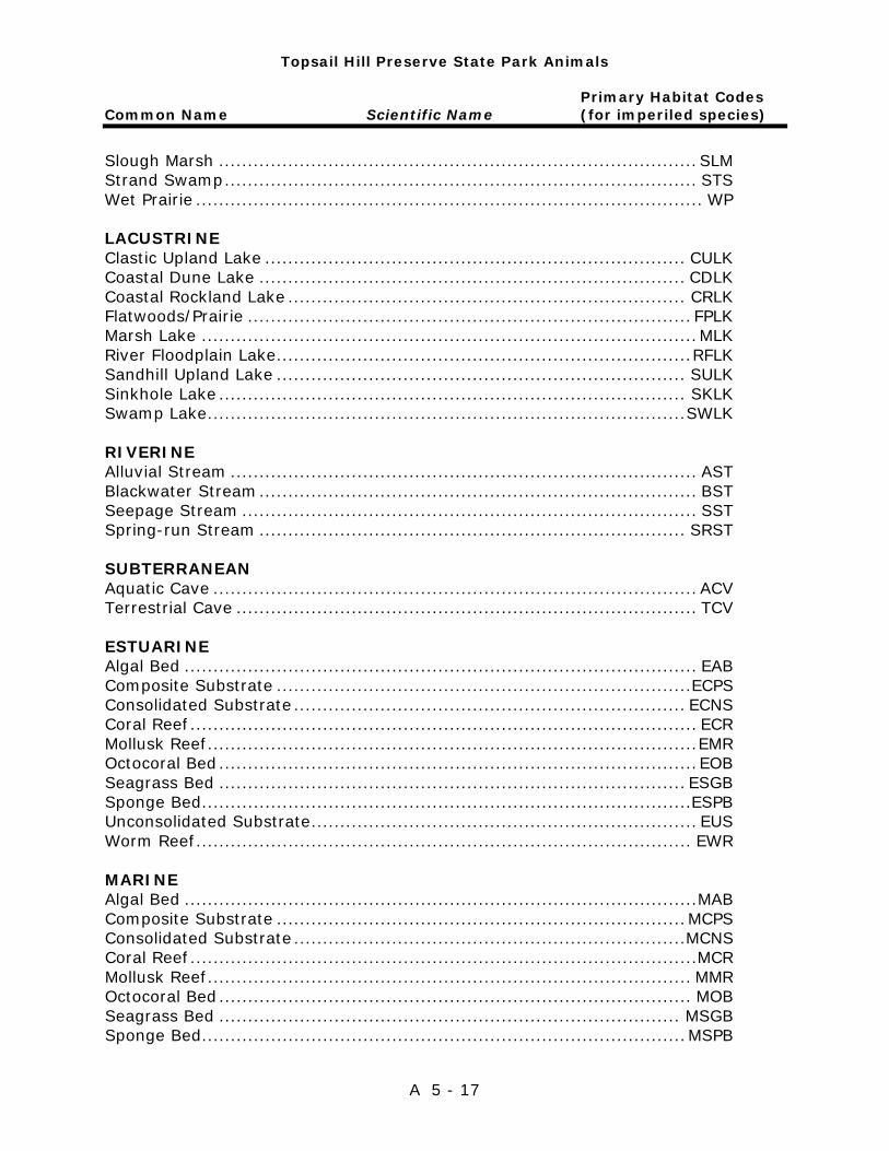
Topsail Hill Preserve State Park Animals
Primary Habitat Codes Common Name Scientific Name (for imperiled species)
A 5 - 17
Slough Marsh ................................................................................... SLM Strand Swamp .................................................................................. STS Wet Prairie ........................................................................................ WP LACUSTRINE Clastic Upland Lake ......................................................................... CULK Coastal Dune Lake .......................................................................... CDLK Coastal Rockland Lake ..................................................................... CRLK Flatwoods/Prairie ............................................................................. FPLK Marsh Lake ...................................................................................... MLK River Floodplain Lake ........................................................................ RFLK Sandhill Upland Lake ....................................................................... SULK Sinkhole Lake ................................................................................. SKLK Swamp Lake ................................................................................... SWLK RIVERINE Alluvial Stream ................................................................................. AST Blackwater Stream ............................................................................ BST Seepage Stream ............................................................................... SST Spring-run Stream .......................................................................... SRST SUBTERRANEAN Aquatic Cave .................................................................................... ACV Terrestrial Cave ................................................................................ TCV ESTUARINE Algal Bed ......................................................................................... EAB Composite Substrate ........................................................................ECPS Consolidated Substrate .................................................................... ECNS Coral Reef ........................................................................................ ECR Mollusk Reef ..................................................................................... EMR Octocoral Bed ................................................................................... EOB Seagrass Bed ................................................................................. ESGB Sponge Bed ..................................................................................... ESPB Unconsolidated Substrate ................................................................... EUS Worm Reef ...................................................................................... EWR MARINE Algal Bed ......................................................................................... MAB Composite Substrate ....................................................................... MCPS Consolidated Substrate ....................................................................MCNS Coral Reef ........................................................................................ MCR Mollusk Reef .................................................................................... MMR Octocoral Bed .................................................................................. MOB Seagrass Bed ................................................................................ MSGB Sponge Bed .................................................................................... MSPB
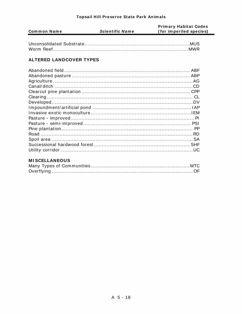
Topsail Hill Preserve State Park Animals
Primary Habitat Codes Common Name Scientific Name (for imperiled species)
A 5 - 18
Unconsolidated Substrate ...................................................................MUS Worm Reef ...................................................................................... MWR ALTERED LANDCOVER TYPES Abandoned field ................................................................................ ABF Abandoned pasture ........................................................................... ABP Agriculture ......................................................................................... AG Canal/ditch ........................................................................................ CD Clearcut pine plantation ..................................................................... CPP Clearing ............................................................................................. CL Developed .......................................................................................... DV Impoundment/artificial pond ............................................................... IAP Invasive exotic monoculture ................................................................IEM Pasture - improved ............................................................................... PI Pasture - semi-improved ..................................................................... PSI Pine plantation.................................................................................... PP Road ................................................................................................. RD Spoil area .......................................................................................... SA Successional hardwood forest ............................................................. SHF Utility corridor .................................................................................... UC MISCELLANEOUS Many Types of Communities ............................................................... MTC Overflying .......................................................................................... OF

Addendum 6—Imperiled Species Ranking Definitions


Imperiled Species Ranking Definitions
A 6 - 1
The Nature Conservancy and the Natural Heritage Program Network (of which FNAI is a part) define an element as any exemplary or rare component of the natural environment, such as a species, natural community, bird rookery, spring, sinkhole, cave or other ecological feature. An element occurrence (EO) is a single extant habitat that sustains or otherwise contributes to the survival of a population or a distinct, self-sustaining example of a particular element. Using a ranking system developed by The Nature Conservancy and the Natural Heritage Program Network, the Florida Natural Areas Inventory assigns two ranks to each element. The global rank is based on an element's worldwide status; the state rank is based on the status of the element in Florida. Element ranks are based on many factors, the most important ones being estimated number of Element occurrences, estimated abundance (number of individuals for species; area for natural communities), range, estimated adequately protected EOs, relative threat of destruction, and ecological fragility. Federal and State status information is from the U.S. Fish and Wildlife Service; and the Florida Fish and Wildlife Conservation Commission (animals), and the Florida Department of Agriculture and Consumer Services (plants), respectively.
FNAI GLOBAL RANK DEFINITIONS
G1 ............. Critically imperiled globally because of extreme rarity (5 or fewer
occurrences or less than 1000 individuals) or because of extreme vulnerability to extinction due to some natural or fabricated factor.
G2 ............. Imperiled globally because of rarity (6 to 20 occurrences or less than 3000 individuals) or because of vulnerability to extinction due to some natural or man-made factor.
G3 ............. Either very rare or local throughout its range (21-100 occurrences or less than 10,000 individuals) or found locally in a restricted range or vulnerable to extinction of other factors.
G4 ............. apparently secure globally (may be rare in parts of range) G5 ............. demonstrably secure globally GH ............. of historical occurrence throughout its range may be rediscovered
(e.g., ivory-billed woodpecker) GX ............. believed to be extinct throughout range GXC ........... extirpated from the wild but still known from captivity or cultivation G#? ........... Tentative rank (e.g.,G2?) G#G# ........ range of rank; insufficient data to assign specific global rank (e.g.,
G2G3) G#T# ......... rank of a taxonomic subgroup such as a subspecies or variety; the G
portion of the rank refers to the entire species and the T portion refers to the specific subgroup; numbers have same definition as above (e.g., G3T1)

Imperiled Species Ranking Definitions
A 6 - 2
G#Q ........... rank of questionable species - ranked as species but questionable whether it is species or subspecies; numbers have same definition as above (e.g., G2Q)
G#T#Q ....... same as above, but validity as subspecies or variety is questioned. GU ............. due to lack of information, no rank or range can be assigned (e.g.,
GUT2). G? .............. Not yet ranked (temporary) S1 .............. Critically imperiled in Florida because of extreme rarity (5 or fewer
occurrences or less than 1000 individuals) or because of extreme vulnerability to extinction due to some natural or man-made factor.
S2 .............. Imperiled in Florida because of rarity (6 to 20 occurrences or less than 3000 individuals) or because of vulnerability to extinction due to some natural or man-made factor.
S3 .............. Either very rare or local throughout its range (21-100 occurrences or less than 10,000 individuals) or found locally in a restricted range or vulnerable to extinction of other factors.
S4 .............. apparently secure in Florida (may be rare in parts of range) S5 .............. demonstrably secure in Florida SH ............. of historical occurrence throughout its range, may be rediscovered
(e.g., ivory-billed woodpecker) SX.............. believed to be extinct throughout range SA.............. accidental in Florida, i.e., not part of the established biota SE .............. an exotic species established in Florida may be native elsewhere in
North America SN ............. regularly occurring but widely and unreliably distributed; sites for
conservation hard to determine SU ............. due to lack of information, no rank or range can be assigned (e.g.,
SUT2). S? .............. Not yet ranked (temporary) N .............. Not currently listed, nor currently being considered for listing, by state
or federal agencies.

Imperiled Species Ranking Definitions
A 6 - 3
LEGAL STATUS
FEDERAL
(Listed by the U. S. Fish and Wildlife Service - USFWS) LE .............. Listed as Endangered Species in the List of Endangered and
Threatened Wildlife and Plants under the provisions of the Endangered Species Act. Defined as any species that is in danger of extinction throughout all or a significant portion of its range.
PE .............. Proposed for addition to the List of Endangered and Threatened Wildlife and Plants as Endangered Species.
LT .............. Listed as Threatened Species. Defined as any species that is likely to become an endangered species within the near future throughout all or a significant portion of its range.
PT .............. Proposed for listing as Threatened Species. C ............. Candidate Species for addition to the list of Endangered and
Threatened Wildlife and Plants. Defined as those species for which the USFWS currently has on file sufficient information on biological vulnerability and threats to support proposing to list the species as endangered or threatened.
E(S/A) ........ Endangered due to similarity of appearance. T(S/A) ........ Threatened due to similarity of appearance. EXPE, XE ..... Experimental essential population. A species listed as experimental and essential. EXPN, XN .... Experimental non-essential population. A species listed as experimental and non-essential. Experimental, nonessential populations of endangered species are treated as threatened species on public land, for consultation purposes.
STATE
ANIMALS .. (Listed by the Florida Fish and Wildlife Conservation
Commission - FWC) FE .............. Federally-designated Endangered FT .............. Federally-designated Threatened FXN ............ Federally-designated Threatened Nonessential Experimental Population FT(S/A) ...... Federally-designated Threatened species due to similarity of
appearance

Imperiled Species Ranking Definitions
A 6 - 4
ST .............. Listed as Threatened Species by the FWC. Defined as a species,
subspecies, or isolated population, which is acutely vulnerable to environmental alteration, declining in number at a rapid rate, or whose range or habitat, is decreasing in area at a rapid rate and therefore is destined or very likely to become an endangered species within the near future.
SSC ............ Listed as Species of Special Concern by the FWC. Defined as a population which warrants special protection, recognition or consideration because it has an inherent significant vulnerability to habitat modification, environmental alteration, human disturbance or substantial human exploitation that, in the near future, may result in its becoming a threatened species.
PLANTS .... (Listed by the Florida Department of Agriculture and Consumer
Services - FDACS) LE .............. Listed as Endangered Plants in the Preservation of Native Flora of
Florida Act. Defined as species of plants native to the state that are in imminent danger of extinction within the state, the survival of which is unlikely if the causes of a decline in the number of plants continue, and includes all species determined to be endangered or threatened pursuant to the Federal Endangered Species Act of 1973,as amended.
LT .............. Listed as Threatened Plants in the Preservation of Native Flora of Florida Act. Defined as species native to the state that are in rapid decline in the number of plants within the state, but which have not so decreased in such number as to cause them to be endangered.

Addendum 7—Cultural Information

Management Procedures for Archaeological and Historical Sites and Properties on State-Owned or Controlled Properties (revised March 2013)
A 7 - 1
These procedures apply to state agencies, local governments, and non-profits that manage state-owned properties. A. General Discussion Historic resources are both archaeological sites and historic structures. Per Chapter 267, Florida Statutes, ‘Historic property’ or ‘historic resource’ means any prehistoric district, site, building, object, or other real or personal property of historical, architectural, or archaeological value, and folklife resources. These properties or resources may include, but are not limited to, monuments, memorials, Indian habitations, ceremonial sites, abandoned settlements, sunken or abandoned ships, engineering works, treasure trove, artifacts, or other objects with intrinsic historical or archaeological value, or any part thereof, relating to the history, government, and culture of the state.” B. Agency Responsibilities Per State Policy relative to historic properties, state agencies of the executive branch must allow the Division of Historical Resources (Division) the opportunity to comment on any undertakings, whether these undertakings directly involve the state agency, i.e., land management responsibilities, or the state agency has indirect jurisdiction, i.e. permitting authority, grants, etc. No state funds should be expended on the undertaking until the Division has the opportunity to review and comment on the project, permit, grant, etc. State agencies shall preserve the historic resources which are owned or controlled by the agency. Regarding proposed demolition or substantial alterations of historic properties, consultation with the Division must occur, and alternatives to demolition must be considered. State agencies must consult with Division to establish a program to location, inventory and evaluate all historic properties under ownership or controlled by the agency. C. Statutory Authority Statutory Authority and more in depth information can be found at: http://www.flheritage.com/preservation/compliance/guidelines.cfm D. Management Implementation Even though the Division sits on the Acquisition and Restoration Council and approves land management plans, these plans are conceptual. Specific information regarding individual projects must be submitted to the Division for review and recommendations.

Management Procedures for Archaeological and Historical Sites and Properties on State-Owned or Controlled Properties (revised March 2013)
A 7 - 2
Managers of state lands must coordinate any land clearing or ground disturbing activities with the Division to allow for review and comment on the proposed project. Recommendations may include, but are not limited to: approval of the project as submitted, cultural resource assessment survey by a qualified professional archaeologist, modifications to the proposed project to avoid or mitigate potential adverse effects. Projects such as additions, exterior alteration, or related new construction regarding historic structures must also be submitted to the Division of Historical Resources for review and comment by the Division’s architects. Projects involving structures fifty years of age or older, must be submitted to this agency for a significance determination. In rare cases, structures under fifty years of age may be deemed historically significant. These must be evaluated on a case by case basis. Adverse impacts to significant sites, either archaeological sites or historic buildings, must be avoided. Furthermore, managers of state property should make preparations for locating and evaluating historic resources, both archaeological sites and historic structures. E. Minimum Review Documentation Requirements In order to have a proposed project reviewed by the Division, certain information must be submitted for comments and recommendations. The minimum review documentation requirements can be found at: http://www.flheritage.com/preservation/compliance/docs/minimum_review_documentation_requirements.pdf .
* * * Questions relating to the treatment of archaeological and historic resources on state lands should be directed to: Deena S. Woodward Division of Historical Resources Bureau of Historic Preservation Compliance and Review Section R. A. Gray Building 500 South Bronough Street Tallahassee, FL 32399-0250 Phone: (850) 245-6425 Toll Free: (800) 847-7278 Fax: (850) 245-6435
http://www.flheritage.com/preservation/compliance/docs/minimum_review_documentation_requirements.pdf
http://www.flheritage.com/preservation/compliance/docs/minimum_review_documentation_requirements.pdf
Eligibility Criteria for National Register of Historic Places
A 7 - 3
The criteria to be used for evaluating eligibility for listing in the National Register of Historic Places are as follows: 1) Districts, sites, buildings, structures, and objects may be considered to have
significance in American history, architecture, archaeology, engineering, and/or culture if they possess integrity of location, design, setting, materials, workmanship, feeling, and association, and:
a) are associated with events that have made a significant contribution to
the broad patterns of our history; and/or b) are associated with the lives of persons significant in our past; and/or c) embody the distinctive characteristics of type, period, or method of
construction, or that represent the work of a master, or that possess high artistic values, or that represent a significant and distinguishable entity whose components may lack individual distinction; and/or
d) have yielded, or may be likely to yield, information important in prehistory or history.
2) Ordinarily cemeteries, birthplaces, or graves of historical figures; properties
owned by religious institutions or used for religious purposes; structures that have been moved from their original locations; reconstructed historic buildings; properties primarily commemorative in nature; and properties that have achieved significance within the past 50 years shall not be considered eligible for the National Register. However, such properties will qualify if they are integral parts of districts that do meet the criteria or if they fall within the following categories:
a) a religious property deriving its primary significance from architectural
or artistic distinction or historical importance; or b) a building or structure removed from its original location but which is
significant primarily for architectural value, or which is the surviving structure most importantly associated with a historic person or event; or
c) a birthplace or grave of an historical figure of outstanding importance if there is no appropriate site or building directly associated with his productive life; or
d) a cemetery which derives its primary significance from graves of persons of transcendent importance, from age, distinctive design features, or association with historic events; ora reconstructed building, when it is accurately executed in a suitable environment and presented in a dignified manner as part of a restoration master plan, and no other building or structure with the same association has survived; or a property primarily commemorative in intent, if design, age, tradition, or symbolic value has invested it with its own exceptional significance; or
e) a property achieving significance within the past 50 years, if it is of exceptional importance.

Preservation Treatments as Defined by Secretary of Interior’s Standards and Guidelines
A 7 - 4
Restoration is defined as the act or process of accurately depicting the form, features, and character of a property as it appeared at a particular period of time by means of the removal of features from other periods in its history and reconstruction of missing features from the restoration period. The limited and sensitive upgrading of mechanical, electrical and plumbing systems and other code-required work to make properties functional is appropriate within a restoration project. Rehabilitation is defined as the act or process of making possible a compatible use for a property through repair, alterations and additions while preserving those portions or features that convey its historical, cultural or architectural values. Stabilization is defined as the act or process of applying measures designed to reestablish a weather resistant enclosure and the structural stability of an unsafe or deteriorated property while maintaining the essential form as it exists at present. Preservation is defined as the act or process of applying measures necessary to sustain the existing form, integrity and materials of an historic property. Work, including preliminary measures to protect and stabilize the property, generally focuses upon the ongoing maintenance and repair of historic materials and features rather than extensive replacement and new construction. New exterior additions are not within the scope of this treatment; however, the limited and sensitive upgrading of mechanical, electrical and plumbing systems and other code-required work to make properties functional is appropriate within a preservation project.

Addendum 8—Timber Management Analysis

Timber Management Analysis
A 8 - 1
1. Management Context and Best Management Practices Timber management prescriptions and actions at Topsail Hill Preserve State Park are based on the desired future condition (DFC) of a stand or natural community (NatCom) as determined by guidelines established by the DRP. In most cases, the DFC will be closely related to the historic NatCom. However, it is important to note, that in areas where the historic community has been severely altered by past land use practices, the DFC may not always be the same as the historic NatCom. All forest/stand/timber management activities undertaken will adhere to the current Florida Silvicultural Best Management Practices and Florida Forestry Wildlife Best Management Practices for State Imperiled Species. DRP is responsible for managing timber resources within corresponding management zones. This timber assessment was conducted by F4 Tech on behalf of DRP. 2. Purpose of Timber Management Activities Timber management activities will be conducted to help restore and/or improve current conditions so that the associated DFC (typically an historic condition) can be achieved or maintained. Timber management will primarily be conducted in pine-dominated NatComs. Upland communities typically include mesic flatwoods, sandhill, upland pine, upland mixed woodland and altered landcover areas such as successional hardwood forest and pine plantations. Other historically hardwood-dominated NatComs will likely have little to no scheduled timber management activities. In some circumstances, actions may be conducted to remove overstory invasive/exotic trees such as Chinese tallow to help restore or maintain natural communities. 3. Potential Silvicultural Treatments Several silvicultural treatments may be considered and utilized over the next ten years to achieve the long-term DFC for candidate NatCom types at Topsail Hill Preserve State Park. These treatments include timber harvests, timber stand improvement, and reforestation. The various types of timber harvests may include pine thinning, targeted hardwood removal, and clearcutting. Silvicultural treatments should be implemented to minimize disturbance to non-target vegetation, soil, and wildlife. Thinning is conducted to reduce the basal area (BA) or density of trees/stems in a stand to improve forest health and growth conditions for residual trees. The “opening up” of high density forest stands increases tree and stand vigor, which helps mitigate the potential for damaging insect outbreaks. Thinning also increases sunlight reaching the forest floor, which when combined with routine prescribed fire, can increase groundcover vegetation abundance, species richness, and overall ecological diversity. The disruption of a historic natural fire regime and/or fire return interval can often result in the need to remove undesirable or overstocked hardwood stems that currently occupy growing space in the canopy and sub-canopy. Tree removal/harvest also increases groundcover vegetation, ecological diversity, and fine fuels that facilitate consistent fire return intervals and responses.
Timber Management Analysis
A 8 - 2
Clearcutting supports restoration goals by removing offsite pine or hardwood species and is a precursor to establishing site-appropriate species. It is also used to control insect infestations that are damaging or threatening forest resources and ecosystem conditions on or off site. A tangible by-product of conducting timber harvests for restoring or improving forested communities is the generation of revenue. Stand or NatCom improvement activities are often conducted to reduce unwanted hardwood, palm, or palmetto competition. Stand improvement treatments reduce fuel or fuel height, which can improve groundcover conditions and aid in maintaining proper prescribed burning return intervals. The two main stand improvement activities used on park property are herbicide treatments and mechanically cutting vegetation. Herbicide may be applied aerially, by mechanized ground-based equipment, or via backpack sprayers. Herbicides are used to reduce the amount of hardwood competition in areas that are unable to carry sufficient prescribed fire due to shading and lack of adequate groundcover fuels. Mechanical cutting is used to reduce the height of smaller shrub and hardwood competition, allowing for the establishment of fire-dependent herbs and grasses. Decreasing fuel loadings and enhancing groundcover allows prescribed fire to be reintroduced safely into a stand that has been unable to carry fire adequately. In select areas, mechanical or chemical control is also used to control excessive palm density promoted by past disturbance or fire exclusion to the same ends described above. Unlike hardwoods, these areas can burn with too much intensity under certain conditions. Reforestation is used to establish the appropriate southern pine species in areas that have been harvested and lack sufficient natural regeneration in terms of abundance (seedlings/acre) and/or species composition. Reforestation candidate areas can also include those that are fire suppressed or have been recently impacted by natural events such as windthrow, bark beetle attack, or wildfire. The two methods used to reestablish the overstory will be natural and artificial regeneration. Both methods may require site preparation to facilitate survival of the desired species. Site preparation activities may include the use of prescribed fire, herbicides, and/or mechanical treatments such as roller chopping. Site preparation technique(s) will be selected that address the current vegetative cover type and condition, and the need to minimize seedling competition while avoiding/minimizing any long-term impacts to native groundcover species and native wildlife. Natural generation may be used in areas where artificial regeneration is not needed, such as areas that have an adequate seed source of the desired tree species located on site or in the immediate vicinity. Artificial regeneration may include machine or hand planting. Hand planting is preferred on wetter sites, rougher sites, and/or sites where groundcover protection is a concern and a more natural appearance of randomly spaced trees is desired. Machine planting generally allows for more consistent planting and often allows higher survival rates if the site is properly prepared.

Timber Management Analysis
A 8 - 3
4. Inventory Data and Potential Actions per Area of Interest or Management Zone
Topsail Hill Preserve State Park comprises 1,643 acres in Walton County. A total of 780 acres are associated with five (5) upland NatCom types that are potential candidates for timber management. In August 2017, an inventory based on field plots was conducted across and within these areas to quantify overstory, midstory and understory conditions. Table 1 below provides general statistics generated by the inventory at Topsail Hill Preserve State Park. Table 2 below provides current stocking levels and potential management activities of candidate management zones and NatCom types.
This timber assessment was based on GIS data (management zone and NatCom boundary data) provided by DRP in December 2017. This assessment identifies opportunities for potential actions over the next 10-year UMP planning horizon based on current conditions compared against desired future conditions. It is not intended to be prescriptive. State park staff responsible for developing operational plans should view this timber assessment and all supporting data as a guide for potential actions to consider. Given the dynamic nature of property ownership and land management activities at Topsail Hill Preserve State Park, together with the timeframe required to create or update a UMP, it is possible that some tabular data may be dated. Therefore, NatCom acreages and recent treatments that occurred after the December 2017 period may not be reflected in the tables herein.
A review and analysis of this data suggests that current ecological conditions for multiple management zones and associated forested communities could benefit from vegetation treatments. This assessment was based on a comparison of current conditions and the corresponding NatCom analog or target conditions as defined per FNAI Reference Site descriptions. In general, inventory data indicates that upland habitats in some management zones have a non-pine component which is outside the acceptable range for the DFC of the NatCom types. Some NatComs considered may require midstory and overstory control to become, or remain, in compliance with FNAI defined ranges for palmetto and non-pine midstory. Many of the management zones in the northern half of the park associated with mesic and wet flatwoods contain stands of scattered, short (30-40’ tall), “flat-topped” longleaf pine trees (some 128 years old). Many of these old trees were used for turpentine production and should be retained and conserved to the greatest extent practicable. Stands with low stocking levels or a complete lack of preferred tree species would likely benefit from midstory control and artificial regeneration. In areas where planting is deemed necessary, the site should be assessed for site preparation needs including midstory/understory reduction.
The following section contains a general description of each management zone within Topsail Hill Preserve State Park that contains upland NatCom types as well as their general condition and need for restoration and/or improvement actions via timber management.
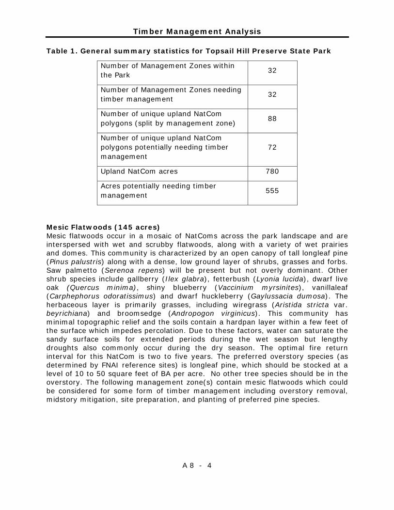
Timber Management Analysis
A 8 - 4
Table 1. General summary statistics for Topsail Hill Preserve State Park
Number of Management Zones within the Park 32
Number of Management Zones needing timber management 32
Number of unique upland NatCom polygons (split by management zone) 88
Number of unique upland NatCom polygons potentially needing timber management
72
Upland NatCom acres 780
Acres potentially needing timber management 555
Mesic Flatwoods (145 acres) Mesic flatwoods occur in a mosaic of NatComs across the park landscape and are interspersed with wet and scrubby flatwoods, along with a variety of wet prairies and domes. This community is characterized by an open canopy of tall longleaf pine (Pinus palustris) along with a dense, low ground layer of shrubs, grasses and forbs. Saw palmetto (Serenoa repens) will be present but not overly dominant. Other shrub species include gallberry (Ilex glabra), fetterbush (Lyonia lucida), dwarf live oak (Quercus minima), shiny blueberry (Vaccinium myrsinites), vanillaleaf (Carphephorus odoratissimus) and dwarf huckleberry (Gaylussacia dumosa). The herbaceous layer is primarily grasses, including wiregrass (Aristida stricta var. beyrichiana) and broomsedge (Andropogon virginicus). This community has minimal topographic relief and the soils contain a hardpan layer within a few feet of the surface which impedes percolation. Due to these factors, water can saturate the sandy surface soils for extended periods during the wet season but lengthy droughts also commonly occur during the dry season. The optimal fire return interval for this NatCom is two to five years. The preferred overstory species (as determined by FNAI reference sites) is longleaf pine, which should be stocked at a level of 10 to 50 square feet of BA per acre. No other tree species should be in the overstory. The following management zone(s) contain mesic flatwoods which could be considered for some form of timber management including overstory removal, midstory mitigation, site preparation, and planting of preferred pine species.

Timber Management Analysis
A 8 - 5
Management Zone(s)
Mesic Flatwoods
(Acres)
Basal Area
(ft2/acre)
Basal Area
Preferred Species
Basal Area Non-
Preferred Species
Average Diameter at breast
height (inches)
TP-02 2 64 45 19 6.7 TP-03 5 121 40 81 12.6 TP-05 12 43 40 3 7.6 TP-06 1 32 20 11 3 TP-10* 1 -- -- -- -- TP-12 7 25 25 -- 4.5 TP-13* <1 -- -- -- -- TP-14 1 90 -- 90 11.1 TP-15* <1 -- -- -- -- TP-16 4 56 -- 56 8.5 TP-17* <1 -- -- -- -- TP-18 13 31 20 11 5.4 TP-19 5 51 2 49 9.5 TP-20 19 80 40 40 6.7 TP-21A* 6 -- -- -- -- TP-21B 29 100 0 99 8.7 TP-22 28 53 34 19 8.2 TP-23* 4 -- -- -- -- TP-24* 3 -- -- -- -- TP-25* <1 -- -- -- -- TP-26* <1 -- -- -- -- TP-30* <1 -- -- -- -- TP-33* 5 -- -- -- -- TP-34* <1 -- -- -- -- *Un-sampled upland areas are present in this analysis and could require vegetation management in the future. Scrubby Flatwoods (183 acres) The dominant tree species in scrubby flatwoods will usually be longleaf pine (Pinus palustris) and slash pine (P. elliottii). Mature sand pines (P. clausa) will typically not be present. There will be a diverse shrubby understory often with patches of bare white sand. A scrub-type oak “canopy” will contain a variety of oak age classes/heights across the landscape. Dominant shrubs include sand live oak (Quercus geminata), myrtle oak (Q. myrtifolia), Chapman’s oak (Q. chapmanii), saw palmetto (Serenoa repens), rusty staggerbush (Lyonia ferruginea), and tarflower (Bejaria racemosa). Cover by herbaceous species will often be low to moderately dense. The optimal fire return interval for this NatCom will be regionally variable and is typically 5-15 years when aiming to achieve a mosaic of burned and
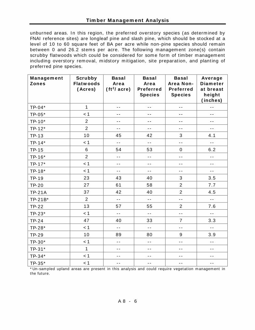
Timber Management Analysis
A 8 - 6
unburned areas. In this region, the preferred overstory species (as determined by FNAI reference sites) are longleaf pine and slash pine, which should be stocked at a level of 10 to 60 square feet of BA per acre while non-pine species should remain between 0 and 26.2 stems per acre. The following management zone(s) contain scrubby flatwoods which could be considered for some form of timber management including overstory removal, midstory mitigation, site preparation, and planting of preferred pine species. Management Zones
Scrubby Flatwoods
(Acres)
Basal Area
(ft2/acre)
Basal Area
Preferred Species
Basal Area Non-Preferred Species
Average Diameter at breast
height (inches)
TP-04* 1 -- -- -- -- TP-05* <1 -- -- -- -- TP-10* 2 -- -- -- -- TP-12* 2 -- -- -- -- TP-13 10 45 42 3 4.1 TP-14* <1 -- -- -- -- TP-15 6 54 53 0 6.2 TP-16* 2 -- -- -- -- TP-17* <1 -- -- -- -- TP-18* <1 -- -- -- -- TP-19 23 43 40 3 3.5 TP-20 27 61 58 2 7.7 TP-21A 37 42 40 2 4.5 TP-21B* 2 -- -- -- -- TP-22 13 57 55 2 7.6 TP-23* <1 -- -- -- -- TP-24 47 40 33 7 3.3 TP-28* <1 -- -- -- -- TP-29 10 89 80 9 3.9 TP-30* <1 -- -- -- -- TP-31* 1 -- -- -- -- TP-34* <1 -- -- -- -- TP-35* <1 -- -- -- -- *Un-sampled upland areas are present in this analysis and could require vegetation management in the future.
Timber Management Analysis
A 8 - 7
Wet Flatwoods (225 acres) Dominant pines are usually longleaf pine (Pinus palustris), slash pine (P. elliottii), pond pine (P. serotina) and/or loblolly pine (P. taeda). Pond cypress (Taxodium ascendens) may reach canopy stature in some locations. The canopy will be open, with pines being widely scattered and of variable age classes. Native herbaceous cover is dense and includes pitcher plants (Nepenthes attenboroughii) and other plants such as terrestrial orchids may be present and abundant in some areas. Common shrubs will include sweet pepperbush (Clethra alnifolia), fetterbush (Lyonia lucida), gallberry (Ilex glabra), and wax myrtle (Myrica cerifera). The optimal fire return interval for this NatCom is two to four years. In this region, the preferred overstory species (as determined by FNAI reference sites) are longleaf pine and slash pine, which should be stocked at a level of 10 to 50 square feet of BA per acre. No other tree species should be in the overstory. The following management zone(s) contain wet flatwoods which could be considered for some form of timber management including overstory removal, midstory mitigation, site preparation, and planting of preferred pine species. Management Zones
Wet Flatwoods
(Acres)
Basal Area
(ft2/acre)
Basal Area
Preferred Species
Basal Area Non-Preferred Species
Average Diameter at breast
height (inches)
TP-01 17 43 33 9 6 TP-02 10 95 86 8 8.8 TP-03 23 117 100 17 10.2 TP-04 17 88 62 25 8 TP-05 10 187 172 15 12.6 TP-06 2 83 83 -- 5.3 TP-10 13 126 106 20 10.3 TP-12 10 40 40 -- 7.2 TP-13 4 55 40 15 6.5 TP-14* 4 -- -- -- -- TP-16 3 100 100 -- 12.3 TP-17 18 47 44 2 8 TP-18 28 57 55 2 8 TP-20 3 14 10 3 2.8 TP-22* 2 -- -- -- -- TP-23 42 117 102 15 9.1 TP-24 9 114 42 72 7.9 TP-25* 2 -- -- -- -- TP-26* <1 -- -- -- -- TP-27* 1 -- -- -- --

Timber Management Analysis
A 8 - 8
Management Zones
Wet Flatwoods
(Acres)
Basal Area
(ft2/acre)
Basal Area
Preferred Species
Basal Area Non-Preferred Species
Average Diameter at breast
height (inches)
TP-29 3 45 -- 45 2.5 TP-32* <1 -- -- -- -- TP-33* <1 -- -- -- -- TP-34* 4 -- -- -- -- *Un-sampled upland areas are present in this analysis and could require vegetation management in the future.
Timber Management Analysis
A 8 - 9
Timber Management Analysis
A 8 - 10

Timber Management Analysis
A 8 - 11
Timber Management Analysis
A 8 - 12

Timber Management Analysis
A 8 - 13


Addendum 9 —Land Management Review

Land Management Review
A 9 - 1
Land Management Review
A 9 - 2
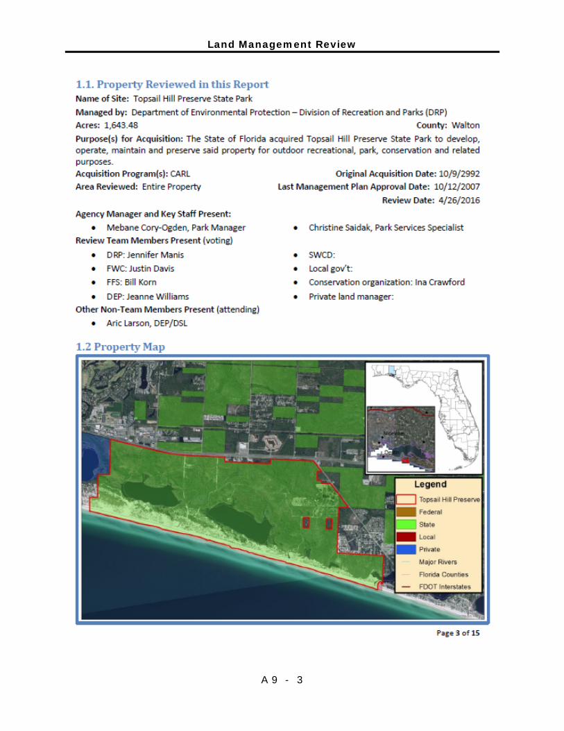
Land Management Review
A 9 - 3
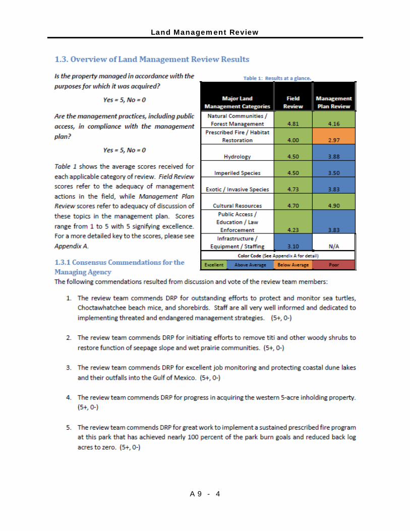
Land Management Review
A 9 - 4
Land Management Review
A 9 - 5
Land Management Review
A 9 - 6
Land Management Review
A 9 - 7
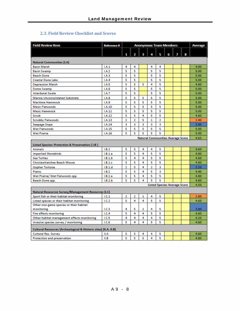
Land Management Review
A 9 - 8
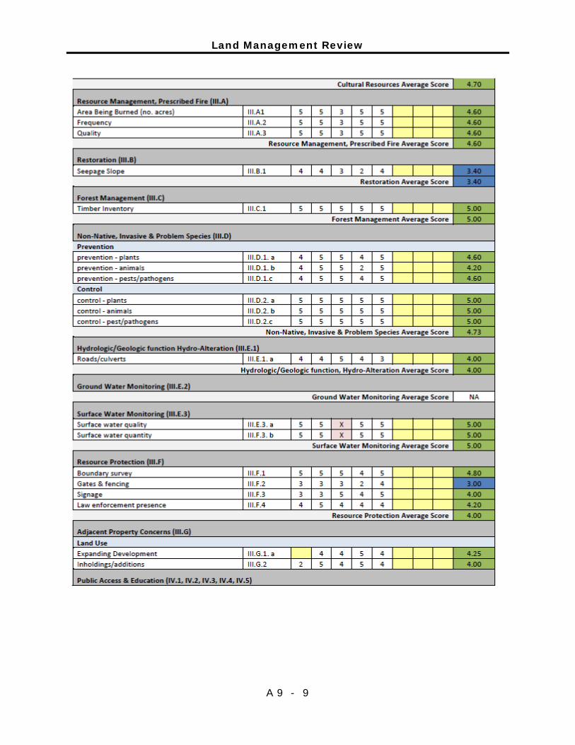
Land Management Review
A 9 - 9

Land Management Review
A 9 - 10
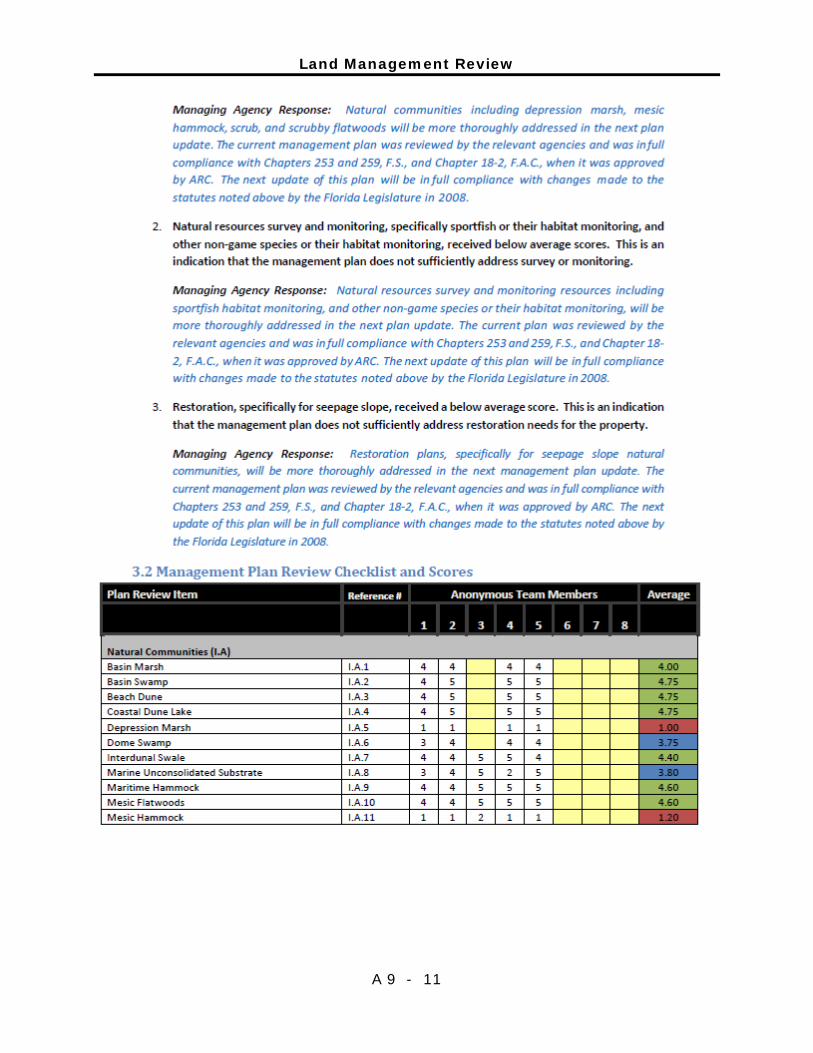
Land Management Review
A 9 - 11

Land Management Review
A 9 - 12
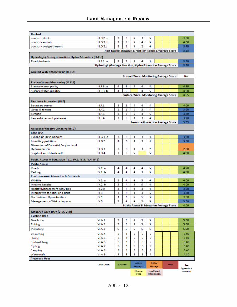
Land Management Review
A 9 - 13
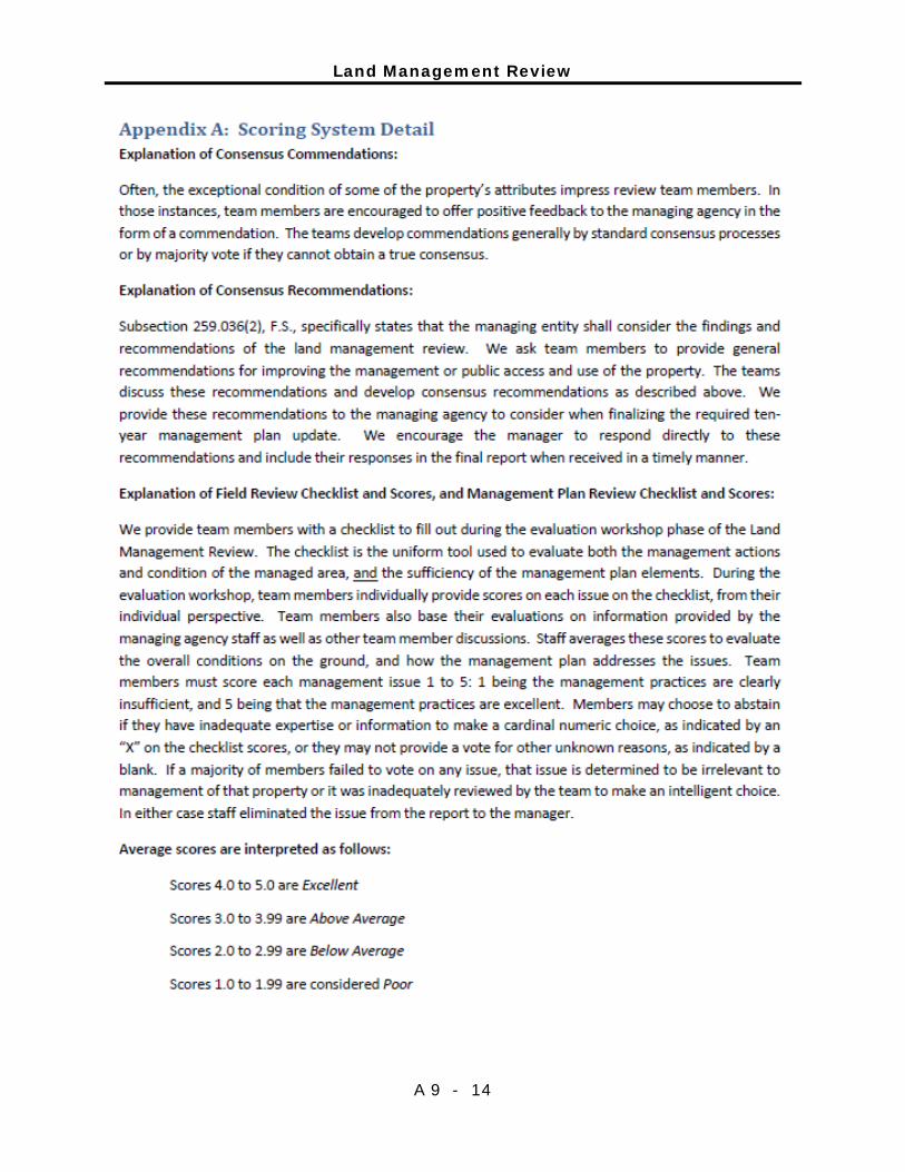
Land Management Review
A 9 - 14