WHITEWATER PRESERVE LEVEE REPLACEMENT PROJECT
191
WHITEWATER PRESERVE LEVEE REPLACEMENT PROJECT Riverside County, California Habitat Assessment and Coachella Valley Multiple Species Habitat Conservation Plan Consistency Analysis Prepared For: Coachella Valley Mountains Conservancy 73-710 Fred Waring Drive, Suite 112 Palm Desert, California 92260 Contact: Jim Karpiak Prepared By: ELMT Consulting, Inc. 2201 N. Grand Avenue #10098 Santa Ana, California 92711 Contact: Thomas J. McGill, Ph.D. 951.285.6014 July 2020
-
Upload
khangminh22 -
Category
Documents
-
view
1 -
download
0
Transcript of WHITEWATER PRESERVE LEVEE REPLACEMENT PROJECT

WHITEWATER PRESERVE LEVEE
REPLACEMENT PROJECT
Riverside County, California
Habitat Assessment and Coachella Valley Multiple Species Habitat Conservation Plan Consistency Analysis
Prepared For:
Coachella Valley Mountains Conservancy73-710 Fred Waring Drive, Suite 112
Palm Desert, California 92260Contact: Jim Karpiak
Prepared By:
ELMT Consulting, Inc. 2201 N. Grand Avenue #10098
Santa Ana, California 92711Contact: Thomas J. McGill, Ph.D.
951.285.6014
July 2020

WHITEWATER PRESERVE LEVEE
REPLACEMENT PROJECT
Riverside County, California
Habitat Assessment and Coachella Valley Multiple Species Habitat Conservation Plan Consistency Analysis
The undersigned certify that the statements furnished in this report and exhibits present data and information required for this biological evaluation, and the facts, statements, and information presented is a complete and accurate account of the findings and conclusions to the best of our knowledge and beliefs.
Travis J. McGillDirector/Biologist
Thomas J. McGill, Ph.D.Managing Director
July 2020

Whitewater Preserve Levee Replacement ProjectHabitat Assessment and CVMSHCP Consistency Analysis i
Table of ContentsSection 1 Introduction......................................................................................................................... 1
1.1 Project Location ............................................................................................................................ 11.2 Project Description........................................................................................................................ 1
Section 2 Methodology ........................................................................................................................ 5
2.1 Coachella Valley MSHCP Consistency Analysis ......................................................................... 52.2 Literature Review.......................................................................................................................... 52.3 Field investigation......................................................................................................................... 62.4 Soil Series Assessment.................................................................................................................. 62.5 Plant Communities........................................................................................................................ 72.6 Plants............................................................................................................................................. 72.7 Wildlife ......................................................................................................................................... 72.8 Jurisdictional Drainages and Wetlands ......................................................................................... 7
Section 3 Existing Conditions ............................................................................................................. 8
3.1 Local Climate................................................................................................................................ 83.2 Topography and Soils ................................................................................................................... 83.3 Surrounding Land Uses................................................................................................................. 8
Section 4 Discussion .......................................................................................................................... 10
4.1 Site Conditions............................................................................................................................ 104.2 Vegetation ................................................................................................................................... 104.2.1Alluvial Scrub............................................................................................................................. 104.2.2Sonoran Cottonwood Willow Riparian Forest............................................................................ 104.2.3Sonoran Creosote Bush Scrub .................................................................................................... 124.2.4Grassland .................................................................................................................................... 124.2.5Disturbed .................................................................................................................................... 124.2.6Developed................................................................................................................................... 12
4.3 Wildlife ....................................................................................................................................... 124.3.1Fish ............................................................................................................................................. 124.3.2Amphibians................................................................................................................................. 134.3.3Reptiles ....................................................................................................................................... 134.3.4Avian .......................................................................................................................................... 134.3.5Mammals .................................................................................................................................... 13
4.4 Nesting Birds .............................................................................................................................. 134.5 Migratory Corridors and Linkages.............................................................................................. 144.6 Jurisdictional Areas..................................................................................................................... 14

Table of Contents
Whitewater Preserve Levee Replacement ProjectHabitat Assessment and CVMSHCP Consistency Analysis ii
4.7 Special-Status Biological Resources........................................................................................... 154.7.1Special-Status Plant Species ....................................................................................................... 154.7.2Special-Status Wildlife Species .................................................................................................. 184.7.3Special-Status Plant Communities.............................................................................................. 21
4.8 Critical Habitat............................................................................................................................ 21
Section 5 CVMSHCP Consistency Analysis.................................................................................... 23
5.1 Activities within Conservation Areas ......................................................................................... 235.2 Joint Project Review ................................................................................................................... 255.3 Habitat Assessment Results and Focused Surveys ..................................................................... 255.4 Land Use Adjacency Guidelines................................................................................................. 275.5 Fluvial Sand Transport................................................................................................................ 29
Section 6 Conclusion and Recommendations.................................................................................. 31
Section 7 References .......................................................................................................................... 34

Table of Contents
Whitewater Preserve Levee Replacement ProjectHabitat Assessment and CVMSHCP Consistency Analysis iii
EXHIBITS
Exhibit 1: Regional Vicinity................................................................................................................ 2
Exhibit 2: Site Vicinity ........................................................................................................................ 3
Exhibit 3: Project Site.......................................................................................................................... 4
Exhibit 4: Vegetation......................................................................................................................... 11
Exhibit 5: Critical Habitat.................................................................................................................. 22
Exhibit 6: CVMSHCP Conservation Areas....................................................................................... 24
APPENDIX
Appendix A Site Photographs
Appendix B Potentially Occurring Special-Status Biological Resources
Appendix C CVMSHCP Avoidance, Minimization, and Mitigation Measures
Appendix D Regulations
Appendix E Special-Status Plant Survey Report
Appendix F LBVI/SWWF Survey Results

Whitewater Preserve Levee Replacement ProjectHabitat Assessment and CVMSHCP Consistency Analysis 1
Section 1 IntroductionThis report contains the findings of ELMT Consulting’s (ELMT) Habitat Assessment and Coachella Valley Multiple Species Habitat Conservation Plan (CVMSHCP) Consistency Analysis for the Whitewater Preserve Levee Replacement Project located in Riverside County, California. ELMT biologists Thomas J. McGill, Ph.D., Travis J. McGill, and Jacob H. Lloyd Davies inventoried and evaluated the condition of the habitat within the project site on January 7, and April 2, 2020.
The habitat assessment was conducted to characterize existing site conditions and assess the potential for the occurrence of special-status1 plant and wildlife species that could pose a constraint to project implementation. Special attention was given to the suitability of the on-site habitat to support arroyo toad (Anaxyrus californicus), riparian bird species [i.e., least Bell’s vireo (Vireo bellii pusillus), southwestern willow flycatcher (Empidonax traillii extimus)], Coachella Valley milk-vetch (Astragalus lentiginosus var.coachellae), triple-ribbed milk-vetch (Astragalus tricarinatus), little San Bernardino Mountains linanthus (Linanthus maculatus), Parry’s spineflower (Chorizanthe parryi var. parryi) and white-bracted spineflower (Chorizanthe xanti var. leucotheca), as well as other special-status species identified by the California Natural Diversity Database (CNDDB) and other electronic databases as potentially occurring on or within the general vicinity of the project site were.
1.1 PROJECT LOCATION
The project site is located on the Whitewater River, north of Interstate 10, west of State Route 62, east of Kitching Peak, and southwest of Morongo Valley in Whitewater, Riverside County, California (Exhibit 1, Regional Vicinity). The project site is depicted on the White Water quadrangle of the United States Geological Survey (USGS) 7.5-minute topographic map series in Sections 15 and 22 of Township 2 South, Range 3 East (Exhibit 2, Site Vicinity). Specifically, the project site is located along the Whitewater River, adjacent to the Whitewater Preserve located at 9160 Whitewater Canyon Road. (Exhibit 3, Project Site).
1.2 PROJECT DESCRIPTION
The project proposes to build a permanent flood control structure to protect the Whitewater Preserve infrastructure and wetland habitats. Further, building a permanent flood control structure will protect the existing riparian forest within the preserve and downstream of the preserve from major flood events.
1 As used in this report, “special-status” refers to plant and wildlife species that are federally or State listed, proposed, or candidates; plant species that have been designated a California Native Plant Society (CNPS) Rare Plant Rank; and wildlife species that are designated by the California Department of Fish and Wildlife (CDFW) as fully protected, species of special concern or watch list species.

?Ù
?±
?±
?¹
?¡
?±
SAN BERNARDINO COUNTY
?a
Palm Springs
Banning
aumont
Palm DeRancho Mirage
Desert Hot Springs
WHITEWATER PRESERVE HABITAT ASSESSMENT AND CVMSHCP CONSISTENCY ANALYSIS
Regional VicinityExhibit 1
° 0 2.5 5Miles
Source: ESRI Relief Map, National Highway Planning Network
Project Location
)
)ProjectLocation
RIVERSIDE COUNTY
!"̀$
?å
AÐ

Site VicinityWHITEWATER PRESERVE LEVEE REPLACEMENT PROJECT
HABITAT ASSESSMENT AND CVMSHCP CONSISTENCY ANALYSIS
Exhibit 2O
Source: USA Topographic Map, Riverside County
0 2,000 4,0001,000Feet
Legend
Survey Area

Project SiteWHITEWATER PRESERVE LEVEE REPLACEMENT PROJECT
HABITAT ASSESSMENT AND CVMSHCP CONSISTENCY ANALYSIS
Exhibit 3O
Source: ESRI Aerial Imagery, Riverside County
0 500 1,000250Feet
Legend
Survey Area

Whitewater Preserve Levee Replacement ProjectHabitat Assessment and CVMSHCP Consistency Analysis 5
Section 2 MethodologyA thorough literature review and records search was conducted to determine which special-status biological resources have the potential to occur on or within the general vicinity of the project site. In addition, a general habitat assessment and field investigation of the project site was conducted and provided information about the existing conditions on the project site and the potential for special-status biological resources to occur.
2.1 COACHELLA VALLEY MSHCP CONSISTENCY ANALYSIS
The Coachella Valley Mountains Conservancy is a permittee under the CVMSHCP. The proposed project is not listed as a planned “Covered Activity” under the published CVMSHCP but is still considered to be a current Covered Activity pursuant to Section 7.3 of the CVMSHCP. According to Section 7.3 of the CVMSHCP, implementation of the Plan will provide permits for covered species for Covered Activities within conservation areas if: “Development and the associated ground disturbance, consistent with the Conservation Goals and Conservation Objectives within Conservation Areas and Species Conservation Goals and Objectives; and including the construction, operation, and maintenance of new flood control facilities and local roadways which are either: (1) approved as part of a development proposal or (2) dedicated, or offered for dedication, for public use, are Covered Activities.”
As a Covered Activity located within a designated conservation area, construction of the proposed project is subject to the applicable avoidance, minimization, and mitigation measures as described in Section 4.4 of the CVMSHCP. In accordance with the CVMSHCP required measures for the Whitewater Canyon Conservation Area, activities and projects involving water diversions in modeled arroyo toad habitat are not considered Covered Activities if arroyo toad is present. If arroyo toad is present, take authorization for such activities will requires a Minor Amendment to the CVMSHCP with Wildlife Agency concurrence. It should be noted that the 2013 article, Correction of Locality Records for the Endangered Arroyo Toad (Anaxyrus californicus) from the Desert Region of Southern California, refuted the previous identificationsof arroyo toad within the Sonoran Desert portions of Riverside County and stated that there are no longer any valid records of the arroyo toad within the Sonoran Desert bioregion, including the Whitewater River and the project site. Therefore, a Minor Amendment to the CVMSHCP is not anticipated.
The project was reviewed to determine consistency with the CVMSHCP. Geographic Information System (GIS) software was utilized to map the project site in relation to the CVMSHCP areas, including conservation areas, corridors and linkages, species habitat and sand transport areas. The CVMSHCP requires that permittees comply with various protective measures for covered species, communities, essential ecological processes, and biological corridors. In addition, certain projects may be subject to local development mitigation fees, a Joint Project Review Process, or other conservation or implementation measures. These requirements are discussed in greater detail in this report.
2.2 LITERATURE REVIEW
Prior to conducting the habitat assessment, a literature review and records search was conducted for special-status biological resources potentially occurring on or within the vicinity of the project site. Previously

Methodology
Whitewater Preserve Levee Replacement ProjectHabitat Assessment and CVMSHCP Consistency Analysis 6
recorded occurrences of special-status plant and wildlife species and their proximity to the project site were determined through a query of the CDFW QuickView Tool in the Biogeographic Information and Observation System (BIOS), CNDDB Rarefind 5, the California Native Plant Society (CNPS) Electronic Inventory of Rare and Endangered Vascular Plants of California, Calflora Database, compendia of special-status species published by CDFW, the U.S. Fish and Wildlife Service (USFWS) species listings, and the CVMSHCP and associated technical documents.
All available reports, survey results, and literature detailing the biological resources previously observed on or within the vicinity of the project site were reviewed to understand existing site conditions and note the extent of any disturbances that have occurred on the project site that would otherwise limit the distribution of special-status biological resources. Standard field guides and texts were reviewed for specific habitat requirements of special-status and non-special-status biological resources, as well as the following resources:
Google Earth Pro historic aerial imagery (1996 – 2020); Coachella Valley Multiple Species Habitat Conservation Plan: United States Department of Agriculture (USDA) Natural Resource Conservation Service (NRCS) Web Soil Survey;USFWS Critical Habitat designations for Threatened and Endangered Species; Primary Constituent Elements (PCEs) for arroyo toad, southwestern willow flycatcher, desert tortoise, least Bell’s vireo, and Coachella Valley milk-vetch.
2.3 FIELD INVESTIGATION
ELMT biologists Thomas J. McGill, Ph.D, Travis J. McGill, and Jacob H. Lloyd inventoried and evaluated the extent and conditions of the plant communities found within the boundaries of the project site between 0700 and 1400 hours on January 7, and April 2, 2020. Plant communities identified on aerial photographs during the literature review were verified in the field by walking meandering transects throughout the plant communities and along boundaries between plant communities. In addition, aerial photography was reviewed prior to the site investigation to locate potential natural wildlife corridors and linkages that may support the movement of wildlife through the area. These areas were then walked during the habitat assessment.
All plant and wildlife species observed, as well as dominant plant species within each plant community, were recorded. Wildlife detections were made through observation of scat, trails, tracks, burrows, nests, and/or visual and aural observation. In addition, site characteristics such as soil condition, topography, hydrology, anthropogenic disturbances, indicator species, condition of on-site plant communities, and presence of potential jurisdictional drainage and/or wetland features were noted.
2.4 SOIL SERIES ASSESSMENT
On-site and adjoining soils were researched prior to the field visit using the USDA NRCS Custom Soil Resource Report for Riverside County, Coachella Valley Area, California. In addition, a review of the local

Methodology
Whitewater Preserve Levee Replacement ProjectHabitat Assessment and CVMSHCP Consistency Analysis 7
geological conditions and historical aerial photographs was conducted to assess the ecological changes and disturbances that have occurred on the project site.
2.5 PLANT COMMUNITIES
Plant communities were mapped using USGS 7.5-minute topographic base maps and aerial photography. The plant communities were classified in accordance with the CVMSHCP, were referenced with Sawyer, Keeler-Wolf and Evens (2009), CDFW (2010) and Holland (1986), delineated on an aerial photographs,and then digitized into ArcGIS. The ArcGIS application was used to compute the area of each plant community in acres.
2.6 PLANTS
Common plant species observed during the field survey were identified by visual characteristics and morphology in the field and recorded in a field notebook. Unusual and less familiar plants were photographed in the field and identified in the laboratory using taxonomic guides. Taxonomic nomenclature used in this study follows the 2012 Jepson Manual (Hickman 2012). In this report, scientific names are provided immediately following common names of plant species (first reference only).
2.7 WILDLIFE
Wildlife species detected during field surveys by sight, calls, tracks, scat, or other sign were recorded during surveys in a field notebook. Field guides were used to assist with identification of wildlife species duringthe survey included The Sibley Field Guide to the Birds of Western North America (Sibley 2003), A Field Guide to Western Reptiles and Amphibians (Stebbins 2003), and A Field Guide to Mammals of North America (Reid 2006). Although common names of wildlife species are fairly well standardized, scientific names are provided immediately following common names in this report (first reference only).
2.8 JURISDICTIONAL DRAINAGES AND WETLANDS
Aerial photography was reviewed prior to conducting a field investigation in order to locate and inspectpotential natural drainage features, ponded areas, or water bodies that may be considered riparian/riverine habitat and/or fall under the jurisdiction of the United State Army Corps of Engineers (Corps), Regional Water Quality Control Board (Regional Board), or CDFW. In general, surface drainage features indicated as blue-line streams on USGS maps that are observed or expected to exhibit evidence of flow are considered potential riparian/riverine habitat and are also subject to state and federal regulatory jurisdiction.

Whitewater Preserve Levee Replacement ProjectHabitat Assessment and CVMSHCP Consistency Analysis 8
Section 3 Existing Conditions
3.1 LOCAL CLIMATE
Riverside County is characterized by cool winter temperatures and warm summer temperatures, with its rainfall occurring almost entirely in the winter. Relative to other areas in Southern California, winters are colder with chilly to cold morning temperatures common. Climatological data was not available for the City of Whitewater. Data was instead obtained for the nearest city, the City of Palm Springs, which indicates the average annual precipitation is 4.85 inches per year. Almost all of the precipitation occurs in the months between December and February, with hardly any occurring between the months of April and June. The wettest month is January, with a monthly average total precipitation of 1.14 inches. The average maximum and minimum temperatures for the City of Palm Springs are 89 and 60 degrees Fahrenheit (F) respectively with July being the hottest month (monthly average 108.0° F) and December being the coldest (monthly average 44.0° F). Temperatures during the site visits were in the mid- to high 60s to 70s (degrees Fahrenheit) with infrequent, light winds and little to no cloud cover.
3.2 TOPOGRAPHY AND SOILS
On-site surface elevation ranges from approximately 2,150 to 2,300 feet above mean sea level and generally slopes from north to south. The project site is located at the bottom of the Whitewater Canyon within the Whitewater River. The slopes of the canyon above the Whitewater River are steep, vertical walls while the bottom of the canyon is relatively flat and slopes from north to south. Generally, the Whitewater River, within the survey area, is composed of cobble and boulders with patches of loose sand and gravel. The NRCS USDA Web Soil Survey has not mapped the soils within the boundaries of the project site. Instead, data from the U.S. General Soil Map was acquired for the project site. Per the U.S. General Soil Map data, the project site is underlain by the following soil units: Urban Land – Tujunga – Soboba – Hanford and Tecopa – Rock Outcrop – Lithic Torriorthents.
3.3 SURROUNDING LAND USES
Land uses in the vicinity of the project site mostly consists of vacant, undeveloped land consisting of natural habitats associated with Whitewater Canyon. The Whitewater River traverses the central portion of the project site from north to south. The unincorporated community of Bonnie Bell is located south of the Whitewater Preserve, which is approximately 9.5 miles northwest of Palm Springs. Areas to the east and west consist of vacant, undeveloped land within the San Bernardino Mountains
The project site occurs within Whitewater Canyon along the eastern bank of the Whitewater River. The site is undeveloped, composed of natural habitats, and is surrounded by the following land uses:
North: The area to the north of the site is composed almost entirely of undeveloped, vacant land within the San Bernardino Mountains. Several developed structures associated with historical and ongoing operations of the Whitewater Preserve Ranger Station and former Whitewater Trout Farm are supported in the immediate 600 feet.

Existing Conditions
Whitewater Preserve Levee Replacement ProjectHabitat Assessment and CVMSHCP Consistency Analysis 9
East: Immediately to the east of the site are the Whitewater Preserve Ranger Station and Visitors’ Center, trout ponds associated with the former Whitewater Trout Farm, paved parking areas, and Whitewater Canyon Road. Undeveloped, vacant land occurs beyond these structures within the San Bernardino Mountains.
South: The area to the south of the site is composed almost entirely of undeveloped, vacant land within the San Bernardino Mountains. The Whitewater River occurs immediately south of the project site and Whitewater Canyon Road occurs approximately 1,400 feet to the southeast.
West: The area to the west of the site is composed entirely of undeveloped, vacant land within the San Bernardino Mountains. Immediately to the west of the site is the Whitewater River.

Whitewater Preserve Levee Replacement ProjectHabitat Assessment and CVMSHCP Consistency Analysis 10
Section 4 Discussion
4.1 SITE CONDITIONS
The Whitewater Preserve is owned by the Wildlands Conservancy and operates as a non-profit nature preserve. It offers free access to the public for outdoor recreation, includes a visitor center located in the former Whitewater Trout Farm, and serves as an access point into the Sand to Snow National Monument. With the exception of the infrastructure associate with the historic trout farm, the project site is relatively undeveloped and supports native habitats.
4.2 VEGETATION
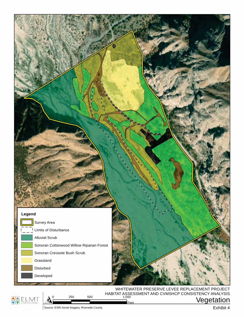
Four (4) plant communities were observed within the boundaries of the survey area during the survey:alluvial scrub, Sonoran cottonwood willow riparian forest, Sonoran creosote bush scrub, and grassland(Exhibit 4, Vegetation). In addition, the survey area contains two land cover types that would be classified as disturbed and developed. These plant communities and land cover types are described in further detail below.
4.2.1 Alluvial Scrub
The alluvial scrub plant community is found on the western portion of the survey area in association with the active channel of the Whitewater River. The active channel of the Whitewater River flows through this plant community, and this plant community is subject to flooding events following significant storm events. This plant community is characterized by braided channels of intermittent streams and rivers. Substrates consist of open cobble with sandy soil deposits. Plant species observed within this plant community include scalebroom (Lepidospartum squamatum), yerba santa (Eriodictyon trichocalyx), mulefat (Baccharis salicifolia), California buckwheat (Eriogonum fasciculatum), beavertail cactus (Opuntia basilaris), deerweed (Acmispon glaber), cheesebush (Ambrosia salsola), sweetbush (Bebbia juncea), California croton (Croton californicus), Wiggins’ cholla (Condea emoryi), hairy parish viguiera (Bahiopsis parishii), and brittlebush (Encelia farinosa).
4.2.2 Sonoran Cottonwood Willow Riparian Forest
The Sonoran cottonwood willow riparian forest plant community was observed on the eastern and northwestern portions of the survey area. Dominant trees within this plant community include narrowleaf willow (Salix exigua), red willow (Salix laevigata), and mulefat. In addition, western sycamore (Platanus racemosa) and Fremont cottonwood (Populus fremontii) are found within this plant community. Low growing plant species found within the understory of this plant community includes California mugwort (Artemisia douglasiana), yellow sweetclover (Melilotus indicus), yellow monkey flower (Mimulus guttatus), rabbits foot grass (Polypogon monspeliensis), and stinging nettle (Urtica dioica).
VegetationWHITEWATER PRESERVE LEVEE REPLACEMENT PROJECT
HABITAT ASSESSMENT AND CVMSHCP CONSISTENCY ANALYSIS
Exhibit 4O
Source: ESRI Aerial Imagery, Riverside County
0 500 1,000250Feet
Legend
Survey Area
Limits of Disturbance
Alluvial Scrub
Sonoran Cottonwood Willow Riparian Forest
Sonoran Creosote Bush Scrub
Grassland
Disturbed
Developed

Discussion
Whitewater Preserve Levee Replacement ProjectHabitat Assessment and CVMSHCP Consistency Analysis 12
4.2.3 Sonoran Creosote Bush Scrub
The top of the existing earthen levee and northeastern poriton fo the site supports a Sonoran creosote scrub plant community. Plant species observed within this plant community include cheesebush, sweetbush, brittlebush, and desert mallow (Sphaeralcea ambigua). Other low growing plant species found within this plant community include California buckwheat, California croton, yellow turbans (Eriogonum pusillum), desert trumpet (Eriogonum inflatum), and desert chicory (Rafinesquia neomexicana).
4.2.4 Grassland
The grassland plant community can be found within the northeast portion of the survey area, within the existing Whitewater Preserve. This plant community is dominated by non-native plant species: wild oat (Avena fatua), ripgut brome (Bromus diandrus), foxtail brome (Bromus madritensis ssp. rubens), downy brome grass (Bromus tectorum), fountain grass (Pennisetum setaceum), and Mediterranean grass (Schismus barbatus).
4.2.5 Disturbed
Disturbed areas primarily occur in the middle of the survey area in association with the existing earthen levee and dirt access roads/trails. These areas are routinely exposed to anthropogenic disturbances associated with vehicle traffic and recreational activities. Surface soils within these areas are generally devoid of vegetation and when vegetation is present, these areas can support early successional and non-native weedy plant species.
4.2.6 Developed
Developed areas encompass all paved impervious services and includes all buildings associated with the Whitewater Preserve in the middle of the eastern boundary of the survey area.
4.3 WILDLIFE
Plant communities provide foraging habitat, nesting/denning sites, and shelter from adverse weather or predation. This section provides a discussion of those wildlife species that were observed or are expected to occur within the project site. The discussion is to be used a general reference and is limited by the season, time of day, and weather conditions in which the field survey was conducted. Wildlife detections were based on calls, songs, scat, tracks, burrows, and direct observation.
4.3.1 Fish
No fish were observed within the survey area, in particular within the flowing water along the westernboundary of the survey area within the Whitewater River during the field investigation. The Whitewater River provides a source of water and habitat sufficient to support populations of fish known to occur within the vicinity of the project site. Fish species that could occur within the Whitewater River include largemouth bass (Micropterus salmoides), green sunfish (Lepomis cyanellus), bluegill (Lepomis macrochirus), and coastal rainbow trout (Oncorhynchus mykiss irideus).

Discussion
Whitewater Preserve Levee Replacement ProjectHabitat Assessment and CVMSHCP Consistency Analysis 13
4.3.2 Amphibians
The Whitewater River also provides a source of water and habitat for populations of amphibians known to occur within the project site. Two amphibian species were observed during the field investigations: Baja California treefrog (Pseudacris hypochondriaca hypochondriaca) and western toad (Anaxyrus boreas).Other amphibians that have the potential to occur within the boundaries of the project site include red-spotted toad (Anaxyrus punctatus) and California tree frog (Pseudacris cadaverina).
4.3.3 Reptiles
Western side-blotched lizard (Uta stansburiana elegans), desert iguana (Dipsosaurus dorsalis), and two-stripped garter snake (Thamnophis hammondii) were the only reptilian species observed during the habitat assessment. Although diversity was low during the habitat assessment, habitat on the project site is suitable for a number of reptilian species such as western zebra-tailed lizard (Callisaurus draconoides rhodostictus), Great Basin whiptail (Aspidoscelis tigris tigris), and red racer (Coluber flagellum piceus).
4.3.4 Avian
The project site provides suitable foraging, nesting, and cover habitat for a variety of resident and migrant bird species. Avian species identified during the habitat assessment included red-tailed hawk (Buteo jamaicensis), mourning dove (Zenaida macroura), greater roadrunner (Geococcyx californianus), Anna’shummingbird (Calypte anna), black phoebe (Sayornis nigricans), Say’s phoebe (Sayronis saya), vermillion flycatcher (Pyrocephalus rubinus), ash-throated flycatcher (Myiarchus cinerascens), spotted towhee (Pipilo maculatus), California towhee (Melozone crissalis), blue grosebeak (Passerina caerulea) California quail (Callipepla californica), American crow (Corvus brachyrhynchos), common yellowthroat(Geothlypis trichas), house finch (Haemorhous mexicanus), painopepla (Phainopepla nitens), lesser goldfinch (Spinus psaltria), northern rough-winged swallow (Stelgidopteryx serripennis), and least Bell’s Vireo (Vireo bellii pusillus).
4.3.5 Mammals
No mammalian species were observed during the habitat assessment. However, the project site and surrounding areas have the potential to support a limited variety of mammalian species including coyote (Canis latrans), white-tailed antelope squirrel (Ammospermophilus leucurus), black-tailed jackrabbit (Lepus californicus), and Merriam’s kangaroo rat (Dipodomys merriami). Soils within the limits of disturbance are generally rocky and do not support loose friable soils for burrowing.
4.4 NESTING BIRDS
On-site plant communities provide suitable foraging and cover habitat for year-round/seasonal avian residents, migrating songbirds, and raptors that occur in the area. Vegetation within and adjacent to the project site has the potential to provide suitable nesting opportunities for a number of avian species. The habitat assessment was conducted in the beginning of September, outside of the breeding season, but no actively breeding bird species or birds displaying nesting behaviors were observed.

Discussion
Whitewater Preserve Levee Replacement ProjectHabitat Assessment and CVMSHCP Consistency Analysis 14
4.5 MIGRATORY CORRIDORS AND LINKAGES
Habitat linkages provide links between larger habitat areas that are separated by development. Wildlife corridors are similar to linkages, but provide specific opportunities for animals to disperse or migrate between areas. A corridor can be defined as a linear landscape feature of sufficient width to allow animal movement between two comparatively undisturbed habitat fragments. Adequate cover is essential for a corridor to function as a wildlife movement area. It is possible for a habitat corridor to be adequate for one species yet, inadequate for others. Wildlife corridors are significant features for dispersal, seasonal migration, breeding, and foraging. Additionally, open space can provide a buffer against both human disturbance and natural fluctuations in resources.
The project site is located within the Whitewater Canyon Conservation Area of the CVMSHCP. The area along the Whitewater River provides a Linkage and wildlife corridor between the Snow Creek/Windy Point Conservation Area and the Core Habitat portion of the Whitewater Floodplain Conservation area, as well as with the Whitewater Canyon Conservation Area. The survey area generally consists of vacant, undeveloped land that is dominated by natural habitats throughout. These natural areas allow wildlife to move through the region in search of food, shelter, or nesting habitat. Additionally, the project site could be used as a wildlife movement corridor between the Coachella Valley and Little San Bernardino Mountain to the east and the San Bernardino Mountains to the west. Although the development of the proposed permanent flood control structure may result in the loss of natural habitats, project activities are not expected to eliminate wildlife movement opportunities or prevent the surrounding habitat from continuing to function as a wildlife corridor. Further, the replacement of the levee will protect riparian habitats withinthe Whitewater River during large storm events. Although the proposed project may result in a temporal loss of wildlife movement opportunities during construction, the completion of the project will provide long-term protection of wildlife movement opportunities along the Whitewater River
4.6 JURISDICTIONAL AREAS
There are three key agencies that regulate activities within inland streams, wetlands, and riparian areas in California. The U.S. Army Corps of Engineers (Corps) Regulatory Branch regulates discharge of dredge and/or fill materials into “waters of the United States” pursuant to Section 404 of the Federal Clean Water Act (CWA) and Section 10 of the Rivers and Harbors Act. Of the State agencies, the CDFW regulates alterations to streambed and associated plant communities pursuant to Section 1602 of the Fish and Game Code, and the Regional Water Quality Control Board (Regional Board) regulates discharges into surface waters pursuant to Section 401 of the CWA and the California Porter-Cologne Water Quality Control Act.
One drainage feature, Whitewater River, and its associated floodplain were observed within the survey area. Whitewater River conveys flows in a north to south direction through the western portion of the survey area. Surface flows within the Whitewater River are provided by direct precipitation, and runoff from the adjacent mountains. Within the survey area, the Whitewater River is an earthen feature characterized by rocky substrate with a regular distribution of gravel and cobble. Four (4) plant communities were observed within the boundaries of the survey area during the survey: alluvial scrub, Sonoran cottonwood willow riparian forest, Sonoran creosote bush scrub, and grassland. The Ordinary High Water Mark (OHWM) ranged from 6 to 20 feet in width, and was delineated using the following indicators: flow patterns; scour;

Discussion
Whitewater Preserve Levee Replacement ProjectHabitat Assessment and CVMSHCP Consistency Analysis 15
and substrate characteristics. During the field investigation surface water was present that ranged in depth from 6 to 24 inches.
A total of 25.69 acre (2,827 linear feet) of Corps and Regional Board jurisdictional waters are located within the survey area. Based on the proposed project design, a total of 0.42 acre (614 linear feet) of permanent impacts and 0.56 acre (818 linear feet) of temporary impacts to Corps and Regional Board jurisdictional waters will be impacted from project implementation. All temporary impacts will be restored to existing site conditions.
The on-site drainage feature also exhibited characteristics consistent with CDFW’s methodology and would be considered CDFW streambed. Approximately 46.38 acre (2,827 linear feet) of CDFW jurisdiction are located within boundaries of the survey area. Based on the proposed project design, a total of 1.01 acre (1,517 linear feet) of permanent impacts and 1.33 acre (1,888 linear feet) of temporary impacts to CDFW jurisdictional waters will be impacted from project implementation. All temporary impacts will be restored to existing site conditions.
Based on current site conditions and design plans, impacts to the Whitewater River will occur from project implementation. As a result, the project applicant must obtain the following regulatory approvals prior to impacts occurring within the identified jurisdictional areas: Corps CWA Section 404 Permit; Regional Board CWA Section 401 Water Quality Certification; and CDFW Section 1602 Streambed Alteration Agreement (SAA).
4.7 SPECIAL-STATUS BIOLOGICAL RESOURCES
The CNDDB Rarefind 5, CNDDB Quickview Tool in BIOS, and the CNPS Electronic Inventory of Rare and Endangered Vascular Plants of California was queried for reported locations of special-status plant and wildlife species as well as special-status plant communities in the White Water, Desert Hot Springs, Morongo Valley, and Catclaw Flat USGS 7.5-minute quadrangles. The habitat assessment evaluated the conditions of the habitat(s) within the boundaries of the project site to determine if the existing plant communities, at the time of the survey, have the potential to provide suitable habitat(s) for special-status plant and wildlife species.
The literature search identified thirty-five (35) special-status plant species, ninety-two (92) special-statuswildlife species, and three (3) special-status plant communities as having potential to occur within the White Water, Desert Hot Springs, Morongo Valley, and Catclaw Flat USGS 7.5-minute quadrangles. Special-status plant and wildlife species were evaluated for their potential to occur within the project site based on habitat requirements, availability and quality of suitable habitat, and known distributions. Species determined to have the potential to occur within the general vicinity of the project site are presented in Table B-1: Potentially Occurring Special-Status Biological Resources, provided in Appendix B.
4.7.1 Special-Status Plant Species
Thirty-five (35) special-status plant species have been recorded in the CNDDB and CNPS in the White Water, Desert Hot Springs, Morongo Valley, and Catclaw Flat USGS 7.5-minute quadrangles (refer to Appendix B). No special-status plant species were observed on-site during the habitat assessment or during
Discussion
Whitewater Preserve Levee Replacement ProjectHabitat Assessment and CVMSHCP Consistency Analysis 16
the 2020 focused special-status plant survey (refer to Appendix E). Based on habitat requirements for specific special-status plant species and the availability and quality of habitats needed by each species, the undeveloped portions of the project site were determined to have a high potential to provide suitable habitat for Coachella Valley milk-vetch, and a moderate potential to support triple-rubbed milk-vetch, Parry’s spineflower, white-bracted spineflower, and little San Bernardino mountains linanthus. All other special-status species documented as occurring within the vicinity of the project site were determined to have a low potential to occur or were presumed absent.
Please refer to the following sections for a detailed assessment of the potential occurrence of the aforementioned special-status plant species and results from the 2020 focused survey.
Coachella Valley Milk-vetch
Coachella Valley milk-vetch is an erect winter annual or a short-lived perennial that blooms between February and May, producing pink to deep-magenta colored flowers. It is federally listed as endangered and is designated by the CNPS with the Rare Plant Rank 1B.2, indicating that it is rare, threatened, or endangered in California and elsewhere, and is considered fairly threatened in California, with 20-80% of its known occurrences threatened. It is endemic to California and is only known from Riverside County and occurs in dunes and sandy flats, along the disturbed margins of sandy washes, and in sandy soils along roadsides where they occur adjacent to existing sand dunes. Coachella Valley milk-vetch occurs in the coarser sands at the margins of dunes and is strongly affiliated with sandy substrates. This species may also occur in sandy substrates in creosote bush scrub not associated with sand dune habitats and in localized pockets where sand has been deposited by wind or by active washes.
It should be noted that the northern portion of the project site is located within designated Critical Habitat for this species (78 Federal Register [FR] 10449 10497). The project site supports the fluvial sand transport processes that provides suitable habitat favored by this species. It was determined that Coachella Valley milk-vetch has a high potential to occur within the boundaries of the survey area. This species was not observed within the project footprint during a 2020 focused special-status plant survey.
Triple-ribbed Milk-vetch
Triple-ribbed milk-vetch is short-lived erect perennial (2 to 10 inches in height) in the Fabacae (pea) family that blooms from February to May, producing white or pale cream-colored flowers. It is federally listed as endangered and is designated by the CNPS with the Rare Plant Rank 1B.2, indicating that it is rare, threatened, or endangered in California and elsewhere, and is considered fairly threatened in California, with 20-80% of its known occurrences threatened. Triple-ribbed milk-vetch is found in a narrow range primarily from the northwestern portion of the Coachella Valley, from the vicinity of Whitewater Canyon, in Mission Creek Canyon across Highway 62 to Dry Morongo Wash and Big Morongo Canyon. Preferred habitat for triple-ribbed milk-vetch has been characterized as sandy and gravelly soils of dry washes or on decomposed granite or gravelly soils at the base of canyon slopes. However, most observations of this species have been in natural or man-made disturbed areas. For example observations have been made along washes, on canyon bottoms where slides or flooding occurs.
Further the project site provides the suitable habitat for this species; sandy and gravelly soils along a wash that is at the base of a canyon slope. In 2010, an unknown number of triple-ribbed milk-vetch was recorded

Discussion
Whitewater Preserve Levee Replacement ProjectHabitat Assessment and CVMSHCP Consistency Analysis 17
in the northern portion of the project site (CNDDB 2010). It was determined that triple-ribbed milk-vetch has a moderate potential to occur within the boundaries of the survey area. This species was not observed within the project footprint during a 2020 focused special-status plant survey.
Little San Bernardino Mountains Liananthus
Little San Bernardino Mountains linanthus is an annual herb in the Phlox family. It is designated by the CNPS with the Rare Plant Rank 1B.2, that it is rare, threatened, or endangered in California and elsewhere, and is considered fairly threatened in California, with 20-80% of its known occurrences threatened. The preferred Habitat of Little San Bernardino Mountains linanthus is in loose soft sandy soils on low benches along washes, generally where the substrate shows some evidence of water flow. It seems to occur in areas where few or no competing species are found, with little shrub or tree cover in the immediate vicinity. The sand is loose and well-aerated, soft and unconsolidated. This species typically occurs on the margins of washes on shallow sandy benches, not on areas where a hard surface layer occurs, and not on loose blowsand away from washes. It is associated with creosote bush scrub, but avoids growing in the shadow of other plants.
The project site provides the suitable habitat for this species, sandy or rocky openings within Sonoran Desert scrub plant community. An unknown number of little San Bernardino Mountains linanthus was observed just south of the survey area. It was determined little San Bernardino Mountains linanthus has a moderate potential to occur within the boundaries of the survey area. This species was not observed within the project footprint during a 2020 focused special-status plant survey.
Parry’s Spineflower
Parry’s spineflower is an annual species in the buckwheat family. It blooms from April to June and comprised of white flowers with brown achenes 2.5 to 3mm long. It is designated by the CNPS with the Rare Plant Rank 1B.1, indicating that it is rare, threatened, or endangered in California and elsewhere, and is considered seriously endangered in California. Parry’s spineflower is knowm from the flats and foothills of the San Gabriel, San Bernardino and San Jacinto Mountains within Los Angeles, San Bernardino and Riverside Counties of southern California. Preferred habitat for Parry’s spineflower has been characterized as alluvial chaparral and scrub of the San Bernardino and San Jacinto Mountains.
The project site provides the suitable habitat for this species; sandy or rocky openings within chaparral plant community. In 2003, an unknown number of Parry’s spineflower was observed just west of the survey area about midway between Bonnie Bell and Whitewater Preserve (CNDDB 2003). It was determined Parry’s spineflower has a moderate potential to occur within the boundaries of the survey area. This species was not observed within the project footprint during a 2020 focused special-status plant survey.
White-bracted Spineflower
White-bracted spineflower is an annual species in the buckwheat family. It blooms from April to June and comprised of pink to red flowers. It is designated by the CNPS with the Rare Plant Rank 1B.2, indicating that it is rare, threatened, or endangered in California and elsewhere, and is considered fairly threatened in California, with 20-80% of its known occurrences threatened. White-bracted spineflower is endemic to

Discussion
Whitewater Preserve Levee Replacement ProjectHabitat Assessment and CVMSHCP Consistency Analysis 18
California and is only known from San Jacinto and San Bernardino Mountains. Preferred habitat for this species has been characterized as sandy or gravelly soils within alluvial fans.
The project site provides the suitable habitat for this species, sandy or rocky soils within alluvial fans. In 2003, an unknown number of white-bracted spineflower was observed just west of the survey area about midway between Bonnie Bell and Whitewater Preserve (CNDDB 2003). It was determined white-bractedspineflower has a moderate potential to occur within the boundaries of the survey area. This species was not observed within the project footprint during a 2020 focused special-status plant survey.
4.7.2 Special-Status Wildlife Species
Ninety-two (92) special-status wildlife species have been reported by the CNDDB in the White Water, Desert Hot Springs, Morongo Valley, and Catclaw Flat USGS 7.5-minute quadrangles (refer to Appendix B). Cooper’s hawk (Accipiter cooperii), southwestern willow flycatcher, American peregrine falcon (Falco peregrinus anatum), yellow-breasted chat (Icteria virens), summer tanager (Piranga rubra), black-tailed gnatcatcher (Polioptila melanura), vermillion flycatcher (Pyrocephalus rubinus), yellow warbler (Setophaga petechia), two-stripped garter snake (Thamnophis hammondii), and least Bell’s vireo were the only special-status wildlife species observed within the project site during the field investigations.
Based on habitat requirements for specific special-status wildlife species and the availability and quality of habitats needed by each species, the undeveloped portions of the project site were determined to have a high potential to provide suitable habitat for great blue heron (Ardea herodias), Costa’s hummingbird (Calypte costae), little willow flycatcher (Empidonax traillii brewsteri), loggerhead shrike (Lanius ludovicianus); and a moderate potential to provide suitable habitat for sharp-shinned hawk (Accipiter striatuserii), California glossy snake (Arizona elegans occidentalis), snowy egret (Egretta thula), prairie falcon (Falco mexicanus), San Diego black-tailed jackrabbit (Lepus californicus bennettii). All remaining special-status wildlife species have a low potential to occur or are presumed to be absent from the project site based on habitat requirements, availability/quality of habitat needed by each species, and known distributions. Please refer to the following sections for a detailed assessment of the potential occurrence of arroyo toad, southwestern willow flycatcher, and least Bell’s vireo.
Arroyo Toad
The arroyo toad inhabits rivers and streams of coastal southern California, from Monterey County southward into northern Baja California, Mexico. In the United States, the arroyo toad was listed as an endangered species on December 16, 1994 (59 Federal Register 64859). In California, the arroyo toad is federally endangered and is considered a California Species of Concern. This species is also fully covered under the CVMSHCP. The arroyo toad is about 2 to 3 inches in length with light olive green, gray, or light brown skin color with a light-colored stripe shaped “V” across the head and eyelids. Arroyo toads are found in low gradient, medium-to-large streams and rivers with intermittent and perennial flow in coastal and desert drainages in central and southern California, and Baja California, Mexico. Arroyo toads occupy aquatic, riparian, and upland habitats within its range and require slow-moving steams that are composed of sandy soils with sandy streamside terraces. Suitable habitat is created and maintained by periodic flooding and scouring that modify stream channels, redistribute channel sediments, and alter pool location and form.

Discussion
Whitewater Preserve Levee Replacement ProjectHabitat Assessment and CVMSHCP Consistency Analysis 19
The most important factors in determining habitat suitability for arroyo toads are stream order, elevation, and floodplain width. Stream order ranks the size and potential power of streams. The smallest channels in a watershed with no tributaries are referred to as first-order streams. When two first-order streams unite, they form a second-order stream; when two second-order streams unite, they form a third-order stream, and so on. Fifth- and sixth-order streams are usually larger rivers, while first- and second-order streams are often small, steep, or intermittent. Arroyo toads are found at the lower end of the third to sixth order stream segments where the coarsest sediments are lacking and flow rates are great enough to keep silt and clay suspended. Arroyo toads breed and deposit egg masses in shallow, sandy pools bordered by sand and gravel flood terraces. Outside of the breeding season, arroyo toads are terrestrial utilizing riparian habitats with low to moderate vegetative cover for foraging and burrowing. Adult and sub-adult arroyo toads seek shelter during the day and other periods of inactivity by burrowing into upland terraces, along flood channels, and often in the soils below the canopy edge of willows or cottonwoods.
The substrate in habitats preferred by arroyo toads consists of sand, fine gravel, or friable soil, with varyingamounts of large gravel, cobble, and boulders. Areas utilized by juveniles consists of sand or fine gravel bars adjacent to stabilized sandy terraces and oak flats. Habitats used outside of the breeding season for foraging and burrowing include riparian habitats such as sand bars, alluvial terraces, and streamside benches with no vegetation or have low to moderate cover composed of California sycamore, coast live oak (Quercus agrifolia), mulefat, cottonwoods, and willows. The types of uplands habitats include alluvial scrub, coastal sage scrub, chaparral, grassland, and oak woodland. Studies have shown that arroyo toads are known to utilize upland habitats up to 1,063 feet from the active channel.
Arroyo toad was not observed within the boundaries of the project site during the field investigations. Per the CVMSHCP, a population of arroyo toads was observed in Whitewater Canyon in 1992. In 1994, thisWhitewater River population was included in the species account update as one of the six known desert populations. However, following this update, numerous surveys of the area have not identified arroyo toad. In 2001 and 2003, U.S. Geological Survey (USGS) conducted detailed inventories, but did not detect this species within Whitewater Canyon (Ervin, Beaman, and Fisher 2013). Further, the initial reports contained photo documentation that was later examined and determined to be an adult red-spotted toad (Bufo punctatus), not a juvenile arroyo toad (Ervin, Beaman, and Fisher 2013). Based on USGS surveys and the reevaluation of photographic evidence taken from the Whitewater River, the original records of arroyo toads occurring in within Whitewater Canyon is considered an error. Further, there is no other evidence of this species occurring within the Coachella Valley. USFWS has reconsidered the critical habitat determination of arroyo toad for the Whitewater River area stating that area does not meet the criteria for critical habitat of the species (USFWS 2011). Arroyo toads are presumed absent within the boundaries of the project site.
Southwestern Willow Flycatcher
The willow flycatcher is a nearly transcontinental species which breeds widely across temperate North America and migrates to Middle and northwestern South America for the winter. It consists of the following four subspecies, all of which are migratory. The species as a whole winters from southern Mexico south through Central America to Panama and western Venezuela. Subspecies extimus has been collected in winter in Guatemala, El Salvador, Honduras, and Costa Rica (Unitt, 1997). Migrants of the more northernsubspecies occur commonly in the breeding range of extimus. Because southern California lies across the
Discussion
Whitewater Preserve Levee Replacement ProjectHabitat Assessment and CVMSHCP Consistency Analysis 20
main migration route of brewsteri, and specimens of brewsteri outnumber specimens of extimus in its own range. In fact, with the population crash of extimus, almost all Willow Flycatchers seen in southern California are brewsteri. Extimus is encountered only at the few sites where it breeds. In southern California the subspecies extimus arrives in spring, usually in early May.
The southwestern willow flycatcher is a federally and state endangered species that usually arrives in southern California in early May, but rarely as early as the last two or three days of April. This species is also fully covered under the CVMSHCP. In fall, adults depart mainly during the last half of August, but rarely can remain as late as September 4th. Juveniles remain until later in September but all have departed by October 1st. The southwestern willow flycatcher breeds only in riparian habitats, typically along a dynamic river or lakeside. Surface water or saturated soil is usually present in or adjacent to nesting sites during at least the initial portion of the nesting period (Muiznieks et al., 1994; Tibbits et al., 1994). Riparian habitats used by southwestern willow flycatchers typically have a dense thicket of trees and shrubs that can range in height from about 2 to 30 meters. Preferred nesting sites usually contain riparian foliage from the ground level up to a dense (about 50 to 100 percent) tree or shrub canopy.
Southwestern willow flycatcher was detected within the riparian habitats adjacent to the project site, outside of the proposed limits of disturbance during the 2020 focused surveys (refer to Appendix F). However, these individuals were observed during the beginning of their migration period and are assuming to be migratory individuals that are not nesting onsite.
Least Bell’s Vireo
Least Bell’s vireo is a federally and state endangered subspecies of the Bell’s vireo. Least Bell’s vireo is also covered under the CVMSHCP. It is a summer migrant to California and is the only regularly-occurringsubspecies of Bell’s vireo in San Bernardino County. Its nesting habitat typically consists of a well-developed over-story and understory, along with low densities of aquatic and herbaceous plant cover. The understory frequently contains dense sub-shrub or shrub thickets that are often dominated by plants such as willow, mulefat, and one or more herbaceous species. Least Bell’s vireos begin to arrive at their breeding grounds in southern California riparian areas from mid-March to early April. Upon arrival, males establish breeding territories that range in size from 0.5 to 7.4 acres, with an average size of approximately two acres. In California, females begin laying eggs in April, fledging birds until the end of July (Kus et al. 2010). The fledglings will remain in the parental territory for up to a month. Bell’s vireos leave the breeding grounds and migrate south mid- to late September. Although not common, a few have been found wintering in southern California (Hamilton and Willick 1996).
Least Bell’s vireo was detected during 2020 focused surveys within the riparian habitats adjacent to the project site, outside of the proposed limits of disturbance. This plant community provides the preferred plant species composition, density, and structure needed to provide suitable nesting habitat for least Bell’s vireo. Since least Bell’s vireo is a CVMSHCP covered species, although the project development will not directly impact least Bell’s vireo habitat, adherence to the avoidance and minimization measures from the CVMSHCP should be followed in order to ensure no impacts to least Bell’s vireo.

Discussion
Whitewater Preserve Levee Replacement ProjectHabitat Assessment and CVMSHCP Consistency Analysis 21
4.7.3 Special-Status Plant Communities
According to the CNDDB, three (3) special-status plant community have been in the White Water, Desert Hot Springs, Morongo Valley, and Catclaw Flat USGS 7.5-minute quadrangles: Desert Fan Palm Oasis Woodland, Mesquite Bosque, and Mojave Riparian Forest. Based on the results of the habitat assessment, no special-status plant communities are present within the project site.
4.8 CRITICAL HABITAT
Under the federal Endangered Species Act, “Critical Habitat” is designated at the time of listing of a species or within one year of listing. Critical Habitat refers to specific areas within the geographical range of a species at the time it is listed that include the physical or biological features that are essential to the survival and eventual recovery of that species. Maintenance of these physical and biological features requires special management considerations or protection, regardless of whether individuals or the species are present or not. All federal agencies are required to consult with the United States Fish and Wildlife Service (USFWS) regarding activities they authorize, fund, or permit which may affect a federally listed species or its designated Critical Habitat. The purpose of the consultation is to ensure that projects will not jeopardize the continued existence of the listed species or adversely modify or destroy its designated Critical Habitat. The designation of Critical Habitat does not affect private landowners, unless a project they are proposing is on federal lands, uses federal funds, or requires federal authorization or permits (e.g., funding from the Federal Highways Administration or a CWA Permit from the Corps). If a there is a federal nexus, then the federal agency that is responsible for providing the funding or permit would consult with the USFWS.
The northern boundary of the project footprint is located within designated Critical Habitat for Coachella Valley milk-vetch (Exhibit 5, Critical Habitat). The issuance of a CWA Section 404 permit for impacts to the Whitewater River will trigger the need for the Corps to consult with the USFWS under Section 7 of the FESA for loss or adverse modification to Critical Habitat. However, consistency with the CVMSHCP will streamline the Section 7 process.

Critical HabitatWHITEWATER PRESERVE LEVEE REPLACEMENT PROJECT
HABITAT ASSESSMENT AND CVMSHCP CONSISTENCY ANALYSIS
Exhibit 5O
Source: ESRI Aerial Imagery, Riverside County
0 750 1,500375Feet
Legend
Survey Area
Limits of Disturbance
Coachella Valley milk-vetch

Whitewater Preserve Levee Replacement ProjectHabitat Assessment and CVMSHCP Consistency Analysis 23
Section 5 CVMSHCP Consistency AnalysisThe project site is located within the boundaries of the CVMSHCP Area, specifically within the Whitewater Canyon Conservation Area (Exhibit 6, CVMSHCP Conservation Areas).
5.1 ACTIVITIES WITHIN CONSERVATION AREAS
The proposed project is not listed as a planned “Covered Activity” under the published CVMSHCP, but is still considered to be a current Covered Activity pursuant to Section 7.3 of the CVMSHCP. According to Section 7.3 of the CVMSHCP, implementation of the Plan will provide permits for covered species for Covered Activities within conservation areas if: “Development and the associated ground disturbance, consistent with the Conservation Goals and Conservation Objectives within Conservation Areas and Species Conservation Goals and Objectives; and including the construction, operation, and maintenance of new flood control facilities and local roadways which are either: (1) approved as part of a development proposal or (2) dedicated, or offered for dedication, for public use, are Covered Activities.”
As a Covered Activity located within a designated conservation area, construction of the proposed project is subject to the applicable avoidance, minimization, and mitigation measures as described in Section 4.4 of the CVMSHCP (refer to Appendix C). In accordance with the CVMSHCP, the conservation objectives for this Conservation Area are:
In total, 1,440 acres of the Whitewater Canyon Conservation Area shall be conserved. (This may be less than the sum of acres indicated in the following objectives because there can be overlap among areas covered by the objectives. For example, Core Habitat for two or more species may overlap, or Core Habitat and an Essential Ecological Process area may overlap. The individual acreage figures will be used in compliance monitoring.) Conserve at least 1,084 acres of Core Habitat for desert tortoise in the unincorporated portion of the area, allowing evolutionary processes and natural population fluctuations to occur. Minimize fragmentation, human-caused disturbance, and edge effects to Core Habitat by conserving contiguous Habitat and effective Linkages between patches of Core Habitat. Protect individual tortoises within the area if allowed Development does occur. Conserve at least 850 acres of the sand source area in the San Bernardino Mountains in the unincorporated portion of the area to maintain the natural erosion processes that provide sediment for the blowsand ecosystem. Conserve at least 435 acres in the fluvial (water-borne) sand transport area in the Riverside County portion of the area. Maintain the current capacity for fluvial sand transport in the Whitewater River.Conserve at least 348 acres of Other Conserved Habitat for the Little San Bernardino Mountains linanthus in the Riverside County portion of the area. Conserve at least 368 acres of Core Habitat for the triple-ribbed milkvetch in the Riverside County portion of the area. Conserve at least 706 acres of modeled Habitat for the arroyo toad in the Riverside County portion of the area.

CVMSHCP Conservation AreasWHITEWATER PRESERVE LEVEE REPLACEMENT PROJECT
HABITAT ASSESSMENT AND CVMSHCP CONSISTENCY ANALYSIS
Exhibit 6O
Source: ESRI Aerial Imagery, Riverside County
0 2,500 5,0001,250Feet
Legend
Survey Area
Limits of Disturbance
CVMSHCP Conservation Areas
Stubbe and Cottonwood Canyons Conservation Area
Upper Mission Creek/Big Morongo Canyon Conservation Area
Whitewater Canyon Conservation Area
Sand Source
Sand Transport

CVMSHCP Consistency Analysis
Whitewater Preserve Levee Replacement ProjectHabitat Assessment and CVMSHCP Consistency Analysis 25
In the Riverside County portion of the area, conserve at least 107 acres of existing Sonoran cottonwood-willow riparian forest natural community, which provides Habitat for riparian birds and other Covered Species. For the remaining acreage of this natural community where disturbance is authorized by the Plan, ensure no net loss. In the Riverside County portion of the area, maintain functional Biological Corridors under I-10 by conserving at least 201 acres in the Whitewater River Biological Corridor north of the freeway to maintain potential Habitat connectivity for desert tortoise, Coachella Valley round-tailed ground squirrel, and Palm Springs pocket mouse, and to maintain ecosystem function for Covered Species. Aside from the freeway bridge and any Existing Use areas, which are unavoidably narrow segments, the Biological Corridor shall expand to one mile wide to minimize edge effects.
5.2 JOINT PROJECT REVIEW
All projects implemented under local permittees’ jurisdiction in a conservation area that would result in disturbance to habitat, natural communities, biological corridors, or essential ecological processes are subject to a Joint Project Review Process. The purpose of the review is to allow the Coachella Valley Conservation Commission (CVCC) to facilitate and monitor the implementation of the CVMSHCP within the Plan Area. The proposed project is located within the Whitewater Canyon Conservation Area and would result in both positive and negative impacts to habitat, natural communities, biological corridors, and essential ecological processes (i.e. sand transport), and thus is subject to the Joint Project Review Process.
5.3 HABITAT ASSESSMENT RESULTS AND FOCUSED SURVEYS
This section describes surveys that may be required by the CVMSHCP for covered species that are known to occur within the Whitewater Canyon Conservation Area, as well as a review of their potential to occur within the project site based on the field investigations. Mitigation text is taken directly from Section 4.4 of the MSHCP, but only those parts that are relevant to the project site are included.
Coachella Valley Milk-vetch
It should be noted that the northern portion of the project site is located within designated Critical Habitat for this species (78 Federal Register [FR] 10449 10497). The project site supports the fluvial sand transport processes that provides suitable habitat favored by this species. It was determined that Coachella Valley milk-vetch has a high potential to occur within the boundaries of the survey area. This species was not observed within the project footprint during a 2020 focused special-status plant survey. The CVMSHCP does not require any surveys or additional measures for this species to remain in compliance.
Triple-ribbed Milk-vetch
The project site provides the suitable habitat for this species; sandy and gravelly soils along a wash that is at the base of a canyon slope. In 2010, an unknown number of triple-ribbed milk-vetch was recorded in thenorthern portion of the project site (CNDDB 2010). It was determined that triple-ribbed milk-vetch has a moderate potential to occur within the boundaries of the survey area. This species was not observed within the project footprint during a 2020 focused special-status plant survey.

CVMSHCP Consistency Analysis
Whitewater Preserve Levee Replacement ProjectHabitat Assessment and CVMSHCP Consistency Analysis 26
Per the CVMSHCP, for covered activities within modeled triple-ribbed milk-vetch habitat, surveys by an acceptable biologist will be required for activities during the growing and flowering period from February 1 – May 15. Any occurrence of the species will be flagged and public infrastructure projects shall avoid impacts to the plants to the maximum extent feasible.
Arroyo Toad
Arroyo toad was not detected within the project site during the field investigations. Based the reevaluation of previous survey data and the lack of arroyo toad within the boundaries of the project site during past surveys, it was determined this species is presumed absent within the boundaries of the project site. Presence/absence surveys for arroyo toad are not recommended.
Little San Bernardino Mountains Linanthus
The project site provides the suitable habitat for this species, sandy or rocky openings within Sonoran Desert scrub plant community. An unknown number of little San Bernardino Mountains linanthus was observed just south of the survey area. It was determined little San Bernardino Mountains linanthus has a moderate potential to occur within the boundaries of the survey area. This species was not observed within the project footprint during a 2020 focused special-status plant survey.
Southwestern Willow Flycatcher
Southwestern willow flycatcher was detected within the riparian habitats adjacent to the project site, outside of the proposed limits of disturbance during the 2020 focused surveys. However, these individuals were observed during the beginning of their migration period and are assuming to be migratory individuals that are not nesting onsite.
Per the CVMSHCP, Covered activities, including Operation and Maintenance Activities (O&M) of facilities and construction of permitted new projects, in riparian habitats will be conducted to the maximum extent feasible outside of the May 1 – September 15 nesting season for southwestern willow flycatcher. If Covered Activities must occur during the nesting season, surveys shall be conducted to determine if any active nests area present. If active nests are identified, the Covered Activity shall not be conducted within 200 feet of an active nest. If surveys conducted during the nesting season document that Covered nesting riparian bird species are not present, the Covered Activity may proceed.
Least Bell’s Vireo
Least Bell’s vireo was detected during 2020 focused surveys within the riparian habitats adjacent to the project site, outside of the proposed limits of disturbance. This plant community provides the preferred plant species composition, density, and structure needed to provide suitable nesting habitat for least Bell’s vireo. Since least Bell’s vireo is a CVMSHCP covered species, although the project development will not directly impact least Bell’s vireo habitat, adherence to the avoidance and minimization measures from the CVMSHCP should be followed in order to ensure no impacts to least Bell’s vireo.
Per the CVMSHCP, Covered activities, including Operation and Maintenance Activities (O&M) of facilities and construction of permitted new projects, in riparian habitats will be conducted to the maximum extent feasible outside of the March – September 15 nesting season for least Bell’s vireo. If Covered

CVMSHCP Consistency Analysis
Whitewater Preserve Levee Replacement ProjectHabitat Assessment and CVMSHCP Consistency Analysis 27
Activities must occur during the nesting season, surveys shall be conducted to determine if any active nests area present. If active nests are identified, the Covered Activity shall not be conducted within 200 feet of an active nest. If surveys conducted during the nesting season document that Covered nesting riparian bird species are not present, the Covered Activity may proceed.
5.4 LAND USE ADJACENCY GUIDELINES
The purpose of Land Use Adjacency Guidelines (Section 4.5 of the CVMSHCP) is to avoid or minimize indirect effects from development adjacent to or within the Conservation Areas. Adjacent means sharing a common boundary with any parcel in a Conservation Area. Such indirect effects are commonly referred to as edge effects, and may include noise, lighting, drainage, intrusion of people, and the introduction of non-native plants and non-native predators such as dogs and cats. The project site is located within the Whitewater Canyon Conservation Area, and as such the following Land Use Adjacency Guidelines shall be considered and implemented where applicable.
Drainage
Proposed Development adjacent to or within a Conservation Area shall incorporate plans to ensure that the quantity and quality of runoff discharged to the adjacent Conservation Area is not altered in an adverse way when compared with existing conditions. Stormwater systems shall be designed to prevent the release of toxins, chemicals, petroleum products, exotic plant materials or other elements that might degrade or harm biological resources or ecosystem processes within the adjacent Conservation Area.
The proposed project would minimally alter the flow direction of water within the Whitewater River, but all existing and future flows are still located within the Whitewater River Conservation Area. The proposedlevee will generally be located within the existing footprint of the existing earthen levee.
Toxics
Land uses proposed adjacent to or within a Conservation Area that use chemicals or generate bioproducts such as manure that are potentially toxic or may adversely affect wildlife and plant species, Habitat, or water quality shall incorporate measures to ensure that application of such chemicals does not result in any discharge to the adjacent Conservation Area.
The proposed project would not generate toxic bioproducts or use toxic chemicals. Any spills of hazardous materials from project vehicles or equipment would be contained, cleaned up, and disposed of immediately.
Lighting
For proposed Development adjacent to or within a Conservation Area, lighting shall be shielded and directed toward the developed area. Landscape shielding or other appropriate methods shall be incorporated in project designs to minimize the effects of lighting adjacent to or within the adjacent Conservation Area in accordance with the guidelines to be included in the Implementation Manual.
The proposed project would not require any additional lighting.

CVMSHCP Consistency Analysis
Whitewater Preserve Levee Replacement ProjectHabitat Assessment and CVMSHCP Consistency Analysis 28
Noise
Proposed Development adjacent to or within a Conservation Area that generates noise in excess of 75 dBA Leq hourly shall incorporate setbacks, berms, or walls, as appropriate, to minimize the effects of noise on the adjacent Conservation Area in accordance with the guidelines to be included in the Implementation Manual.
The project site should have a physical separation or barrier included in its design between the proposed development and the Sonoran cottonwood-willow riparian forest plant community, east of the projectfootprint. A barrier would significantly lessen any noise exposure to any CVMSHCP-covered species. Construction-related noise will be mitigated to be consistent with the City of Riverside’s Noise Ordinances by limiting construction activities to daytime hours and requiring construction equipment to be tuned and equipped with mufflers. Under the CVMSHCP, wildlife within the CVMSHCP Conservation Area should not be subject to noise that would exceed 75dBA Leg.
Invasives
Invasive, non-native plant species shall not be incorporated in the landscape for land uses adjacent to or within a Conservation Area. Landscape treatments within or adjacent to a Conservation Area shall incorporate native plant materials to the maximum extent Feasible; recommended native species are listed in Table 4-112. The plants listed in Table 4-113 shall not be used within or adjacent to a Conservation Area. This list may be amended from time to time through a Minor Amendment with Wildlife Agency Concurrence.
The proposed project will not require any landscaping or planting.
Barriers
Land uses adjacent to or within a Conservation Area shall incorporate barriers in individual project designs to minimize unauthorized public access, domestic animal predation, illegal trespass, or dumping in a Conservation Area. Such barriers may include native landscaping, rocks/boulders, fencing, walls and/or signage.
The proposed project would not change any land uses in the area other than to replace an earthen levee with a permanent structure along the eastern bank of the Whitewater River.
Grading/Land Development
Manufactured slopes associated with site Development shall not extend into adjacent land in a Conservation Area.
The proposed project footprint will be limited to the eastern bank of the Whitewater River and will generally follow the existing earthern levee that is failing. The footprint has been minimized to the maximum extent possible to allow for the protection of the Preserve while satisfying the regulations of the CVMSHCP.

CVMSHCP Consistency Analysis
Whitewater Preserve Levee Replacement ProjectHabitat Assessment and CVMSHCP Consistency Analysis 29
5.5 FLUVIAL SAND TRANSPORT
“Fluvial sand transport” refers to the process by which sand and sediment particles are pushed downstream along a floodplain by the movement of water. In the Coachella Valley, fluvial sand transport begins in the mountains, where streams and rivers push sediment down into the valley. On the valley floor, continued occasional water flow will maintain fluvial transport, but high winds will also pick up sediment and carry it (Aeolian transport) (Exhibit 8, CVMSHCP Sand Transport Area). In accordance with Section 4.4 of the MSHCP, the following additional measure would be required for the proposed project to remain in compliance with the MSHCP. The following text is taken directly from Section 4.4:
Activities, including O&M of facilities and construction of permitted new projects, in fluvial sand transport areas in the Cabazon, Stubbe and Cottonwood Canyons, Snow Creek/Windy Point, Whitewater Canyon, Whitewater Floodplain, Upper Mission Creek/Big Morongo Canyon, Mission Creek/Morongo Wash, Willow Hole, Long Canyon, Edom Hill, Thousand Palms, West Deception Canyon, and Indio Hills/Joshua Tree National Park Linkage Conservation Areas will be conducted in a manner to maintain the fluvial sand transport capacity of the system.
A sediment transport study was conducted to verify if the loss of the current levee system would change the current pattern of sand transport associated with the Whitewater River. The current sand dune habitats in the Coachella Valley are adapted to the current pattern of sand transport along the Whitewater River. Modification of this pattern could also affect downstream areas in the Whitewater River floodplain that provides core habitat for many species associated with sand dune habitats.
The hydrologic analysis performed was intended to serve as the hydrologic basis to be used in the planning and design of the proposed flood protection improvements, including the determination of impacts, mitigation requirements, and engineering constraints. The hydrologic basis supports the analysis of debris yield, hydraulics, sediment transport, and scour through model development and simulation as well as the use of spreadsheet calculations. This analysis was performed by Q3 Consulting in June 2020.
The hydrologic basis was formulated being mindful of the following goals:Conveyance of floodwaters along the edge conditions and near vicinity of the proposed improvements as it relates to stream stability, flood and erosion protection, and consequences to adjacent properties and existing infrastructure Increased runoff volume and/or flow redistribution attributed to the improvements
The hydrologic objectives focused on the determination of the following for the portion of the Whitewater River watershed that is relevant to the Whitewater Preserve Area:
Regional flood frequency curves. A regional flood frequency analysis was performed based on most current available streamflow data to determine peak flow rates using stochastic methods based on recorded observations to provide a metric for evaluating the reasonableness of peak flow ratescomputed based on deterministic methodsRegional peak flow rates and flood hydrographs. Peak flow rates and flood hydrographs were determined for selected combinations of frequencies and durations to support the development, simulation, and analysis of steady- and unsteady-flow hydraulic models and supplementary

CVMSHCP Consistency Analysis
Whitewater Preserve Levee Replacement ProjectHabitat Assessment and CVMSHCP Consistency Analysis 30
calculations, which contribute to the basis of design formulated for the proposed levee improvements.
The following general approach and assumptions were employed: Flood frequency analysis were performed based on the method of L-moments (Hosking and Wallis, 1997)The Riverside County Hydrology Manual (RCHM; RCFCWCD, 1978) Synthetic Unit Hydrograph Method (SUHM) was used as the framework for the deterministic computation of peak flow rates and flood hydrographsThe relevant Whitewater River watershed was identified as the area tributary to the historic USGS streamflow gage site at Whitewater (USGS ID 10256000), located between Interstate 10 and the Whitewater Preserve AreaThe 50-, 20-, 10-, 2-, 1-, 0.5, and 0.2-percent annual chance storm events were evaluatedParameter development was performed using a combination of GIS and spreadsheet applications
The project is a flood control levee that would be constructed for the specific purpose of protecting Whitewater Preserve from future flood flows. Levees, by definition, alter the course of water flows for the purpose of protecting natural or manmade resources such as the preserve. However, the project is a replacement levee that would not change future water flows but rather improve upon the protection provided by the existing levee at the site. In addition, there is not potential for substantial erosion or siltation on- or off-site due to the fact that a levee currently exists on the site. The project will not obstruct fluvial sand transport or obstruct natural watercourses, and the rate of flow and sediment transport will not be impeded.

Whitewater Preserve Levee Replacement ProjectHabitat Assessment and CVMSHCP Consistency Analysis 31
Section 6 Conclusion and RecommendationsThe project site occurs within Whitewater Canyon along the eastern bank of the Whitewater River. The Whitewater Preserve is owned by the Wildlands Conservancy and operates as a non-profit nature preserve. It offers free access to the public for outdoor recreation, includes a visitor center located in the former Whitewater Trout Farm, and serves as an access point into the Sand to Snow National Monument. With the exception of the infrastructure associate with the historic trout farm, the project site is relatively undeveloped and supports native habitats. Four (4) plant communities were observed within the boundaries of the survey area during the survey: alluvial scrub, Sonoran cottonwood willow riparian forest, Sonoran creosote bush scrub, and grassland. In addition, the survey area contains two land cover types that would be classified as disturbed and developed.
Special-Status Plant Species
No special-status plant species are expected to be impacted from project implementation.
Special-Status Wildlife Species
Per the CVMSHCP, Covered activities, including O&M of facilities and construction of permitted new projects, in riparian habitats will be conducted to the maximum extent feasible outside of the March – September 15 nesting season for least Bell’s vireo, and other migratory birds. If Covered Activities must occur during the nesting season, surveys shall be conducted to determine if any active nests area present. If active nests are identified, the Covered Activity shall not be conducted within 200 feet of an active nest. If surveys conducted during the nesting season document that Covered nesting riparian bird species are not present, the Covered Activity may proceed.
Pre-Construction Nesting Bird Clearance Survey
If ground disturbance and vegetation removal cannot occur outside of the nesting season, normally between February 1 through August 31, but can vary each year based on seasonal weather conditions, a pre-construction clearance survey for nesting birds should be conducted within three (3) days of the start of any ground disturbing activities to ensure that no nesting birds will be disturbed during construction. This survey will ensure no impacts to the special-status avian species determined to have the potential to occur on-site would occur from site development. The proposed limits of disturbance and adjacent areas within 500 feet of the project footprint will be surveyed by a qualified biologist. The biologist conducting the clearance survey should document a negative survey with a brief letter report indicating that no impacts to active avian nests will occur
Biological Monitoring
If the Biologist finds an active nest on the project site and determines that the nest may be impacted, the Biologist shall delineate an appropriate buffer zone around the nest. The size of the buffer shall be determined by the Biologist and shall be based on the nesting species, its sensitivity to disturbance, expected types of disturbance, and location in relation to the construction activities. These buffers are typically 300 feet from the nests of non-listed species and 500 feet from the nests of raptors and listed species. Any activenests observed during the survey shall be mapped on an aerial photograph. Only construction activities (if

Conclusion and Recommendations
Whitewater Preserve Levee Replacement ProjectHabitat Assessment and CVMSHCP Consistency Analysis 32
any) that have been approved by a Biological Monitor shall take place within the buffer zone until the nest is vacated. The Biologist shall serve as a Construction Monitor when construction activities take place near active nest areas to ensure that no inadvertent impacts on these nests occur. Results of the pre-construction survey and any subsequent monitoring shall be provided to the Property Owner/Developer and the City. The monitoring report shall summarize the results of the nest monitoring, describe construction restrictions currently in place, and confirm that construction activities can proceed within the buffer area without jeopardizing the survival of the young birds.
Jurisdictional Drainages
One drainage feature, the Whitewater River runs north to south through the project site. The on-site drainage feature possesses a surface hydrologic connection downstream to the Salton Sea, a waters of the U.S., and will be subject to Corps jurisdiction under Section 404 of the CWA. The on-site drainage feature also qualifies as “waters of the State” and would fall under the regulatory authority of the Regional Board and CDFW. Impacts to the Whitewater River will require the following regulatory approvals: 1) Corps CWA Section 404 Permit; 2) Regional Board Report of CWA Section 401 Water Quality Certification; and 3) CDFW Section 1602 Streambed Alteration Agreement.
Wildlife Corridors
The proposed project is not expected to compromise wildlife movement opportunities associated with the Whitewater River, or prevent the surrounding habitat in the foothills from continuing to function as wildlife movement corridors. Therefore, implementation of the proposed project is not expected to have any adverse impacts to wildlife movement.
Critical Habitat
The project site is located within designated Critical Habitat for Coachella Valley milk-vetch. The issuance of a CWA Section 404 permit for impacts to the Whitewater River will trigger the need for the Corps to consult with the USFWS under Section 7 of the FESA for loss or adverse modification to Critical Habitat. However, consistency with the CVMSHCP will help streamline the Section 7 process.
Local and Regional Plans
The project site is located within the boundaries of the CVMSHCP, specifically within the Whitewater Canyon Conservation Area. The proposed project is not specifically designated as a planned Covered Activity under the published CVMSHCP, but is still considered to be a Covered Activity pursuant to Section 7.3 of the CVMSHCP. With implementation of the applicable avoidance and minimization measures, as well as payment of the CVMSHCP local development mitigation fee, the proposed project would be fully consistent with the biological goals and objectives of the CVMSHCP.
Per the CVMSHCP, Covered activities, including O&M of facilities and construction of permitted new projects, in riparian habitats will be conducted to the maximum extent feasible outside of the May 1 – September 15 nesting season for southwestern willow flycatcher. If Covered Activities must occur during the nesting season, surveys shall be conducted to determine if any active nests area present. If active nests are identified, the Covered Activity shall not be conducted within 200 feet of an active nest. If surveys conducted during the nesting season document that Covered nesting riparian bird species are not present,

Conclusion and Recommendations
Whitewater Preserve Levee Replacement ProjectHabitat Assessment and CVMSHCP Consistency Analysis 33
the Covered Activity may proceed. Southwestern willow flycatcher surveys will be conducted on accordance with the updated 2010 survey guidelines.

Whitewater Preserve Levee Replacement ProjectHabitat Assessment and CVMSHCP Consistency Analysis 34
Section 7 ReferencesCalifornia Department of Fish and Wildlife (CDFW). 2020. RareFind 5, California Natural Diversity Data
Base, California. Data Base report on threatened, endangered, rare or otherwise sensitive species and communities for the White Water, Desert Hot Springs, Morongo Valley, and Catclaw FlatUSGS 7.5-minute quadrangles.
California Native Plant Society (CNPS). 2019. Inventory of Rare and Endangered Plants of California. Rare Plant Scientific Advisory Committee, David P. Tibor, Convening Editor. California Native Plant Society. Sacramento, California. Available at: http://www.cnps.org/inventory.
Coachella Valley Association of Governments. 2007. Final Recirculated Coachella Valley Multiple Species Habitat Conservation Plan. September 2007.
Hickman, J.C., ed. 2012. The Jepson Manual: Higher Plants of California. University of California Press.
Holland, R. F. 1986. Preliminary descriptions of the Terrestrial Natural Communities of California. California Department of Fish and Game, Sacramento, CA.
James W. Cornett Ecological Consultants. 2009. Biological Assessment and Impact Analysis of the proposed Simon Quarry Expansion. May 2009.
Jones, L.L.C. and R.E. Lovich, eds. 2009. Lizards of the American Southwest. Rio Nuevo Publishers: Tucson, AZ.
Munz, P.A. 1974. A Flora of Southern California. University of California Press, Berkeley, California.
Reid, F.A. 2006. A Field Guide to Mammals of North America, Fourth Edition. Houghton Mifflin Company, New York, New York.
Sibley, D.A. 2003. The Sibley Field Guide to Birds of Western North America. Alfred A. Knopf, Inc., New York, New York.
Stebbins, R.C. 2003. A Field Guide to Western Reptiles and Amphibians, Third Edition. Houghton Mifflin Company, New York, New York.
U.S. Climate Data. 2019. Climate Averages for the City of Palm Springs. Available online at http://www.usclimatedata.com/climate/palm-springs/california/united-states/usca0828.
U.S. Department of Agriculture, Natural Resources Conservation Service (NRCS). 2019. Web Soil Survey.Available online at http://websoilsurvey.nrcs.usda.gov/app/.

Appendix A Site Photographs

Appendix A – Site Photographs
Whitewater Preserve Levee Replacement ProjectHabitat Assessment and CVMSHCP Consistency Analysis
Photograph 1: View of the Whitewater Preserve visitor facility located within the northeast portion of the survey area.
Photograph 2: Standing within the northern portion of the survey area looking south.

Appendix A – Site Photographs
Whitewater Preserve Levee Replacement ProjectHabitat Assessment and CVMSHCP Consistency Analysis
Photograph 3: Standing within the northwest portion of the survey area looking north across the semi-desert chaparral plant community.
Photograph 4: Standing on Whitewater Canyon Road looking north at the Whitewater River and survey area.
Appendix A – Site Photographs
Whitewater Preserve Levee Replacement ProjectHabitat Assessment and CVMSHCP Consistency Analysis
Photograph 5: Standing on Whitewater Canyon Road looking south across the survey area.
Photograph 6: Standing within the chamise chaparral plant community looking west.

Appendix A – Site Photographs
Whitewater Preserve Levee Replacement ProjectHabitat Assessment and CVMSHCP Consistency Analysis
Photograph 7: Standing within the central portion of the survey area looking north across the semi-desert chaparral plant community.
Photograph 8: Standing within the southern portion of the survey area looking north across the Whitewater River.

Appendix A – Site Photographs
Whitewater Preserve Levee Replacement ProjectHabitat Assessment and CVMSHCP Consistency Analysis
Photograph 9: Standing within the southwest portion of the survey area looking northeast.
Photograph 10: Standing within the southwest portion of the survey area looking south. The Sonoran cottonwood-willow riparian forest plant community can be seen in the distance.

Appendix B Potentially Occurring Special-StatusBiological Resources

Appe
ndix
– P
oten
tially
cc
rrin
g Se
nsiti
ve
iolo
gica
l Res
orc
es W
hite
water
Pre
serv
eLev
ee R
epla
cem
ent P
rojec
tHa
bita
t Ass
essm
ent a
nd C
VMSH
CP C
onsis
tenc
y Ana
lysis
a
1: P
otta
rr
g t
o
oga
o
r Sc
ientif
ic N
ame
Com
mon
am
eta
ta
tat
r tPo
tta
to
r
P
P
Acci
pite
r coo
perii
Coop
ers h
awk
SW
S
CW
CV
SCP
one
Wot
Cov
ered
ener
ally
foun
d in
fore
sted
area
s up
to
feet
in el
evat
ion
es
peci
ally
nea
r edg
es an
d riv
ers.
Pre
fers
har
dwoo
d sta
nds a
nd
mat
ure
fore
sts b
ut c
an b
e fo
und
in u
rban
and
subu
rban
are
as
wher
e th
ere
are
tall
trees
for n
estin
g.Co
mm
on in
ope
n ar
eas
durin
g ne
sting
seas
on.
es
Prt
Was
obs
erve
d fo
ragi
ng o
nsite
du
ring
the
VSW
W
focu
sed
surv
yes.
.
Acci
pite
r stri
atus
shar
p-sh
inne
d ha
wkS
WS
C
W
CVS
CP
one
Wot
Cov
ered
Prim
arily
occ
urs
in c
onife
rous
for
ests
but
is
also
fou
nd i
n bo
real
mi
ed c
onife
r-birc
h-as
pen
fore
sts.
ess
com
mon
in
othe
r woo
dlan
d typ
es e
cept
in m
ount
aino
us ar
eas.
pen a
reas
ar
e use
d fo
r for
agin
g b
ut n
ot fo
r nes
ting.
o
ora
tTh
ere i
s sui
tabl
e hab
itat w
ithin
an
d ad
acen
t to
the p
roec
t site
.Th
is sp
ecie
s doe
s not
nes
t in
this
regi
on.
Aim
ophi
la ru
ficep
s can
esce
nsso
uthe
rn C
alifo
rnia
rufo
us-c
row
ned
spar
row
SW
S
CW
CV
SCP
one
Wot
Cov
ered
Typi
cally
fou
nd b
etw
een
and
f
eet i
n ele
vatio
n.
reed
in
spar
sely
veg
etat
ed s
hrub
land
s on
hill
sides
and
ca
nyon
s. P
refe
rs c
oasta
l sag
e sc
rub
dom
inat
ed b
y Ca
lifor
nia
sage
brus
h Ar
temi
sia c
alio
rnic
a b
ut c
an a
lso b
e fo
und
bree
ding
in
co
asta
l bl
uff
scru
b
low
-gro
win
g se
rpen
tine
chap
arra
l an
d al
ong
the e
dges
of t
all c
hapa
rral h
abita
ts.
o Pr
t
The p
roec
t site
and
impa
ct ar
ea
areo
ut o
f the
elev
atio
n ra
nge f
or
this
spec
ies.
Anax
yrus
calif
orni
cus
arro
yo to
adS
WS
C
W
CVS
CP
SS
C Co
vere
d
ccur
s in
was
hes
and
inte
rmitt
ent s
tream
s wi
th a
mi
ture
of
grav
el a
nd s
andy
sub
strat
e. Re
uire
s a
mod
erat
e co
ver
of
willo
ws co
ttonw
oods
mul
efat
and
syca
mor
e to
prov
ide s
hade
ov
er th
e wat
er an
d oa
ks in
the u
plan
d ar
ea to
fora
ge fo
r ant
s.o
Pr
tRe
cent
dat
a sug
gest
that
this
spec
ies w
as m
iside
ntifi
ed an
d do
es n
ot o
ccur
in th
e Son
oran
es
ert b
iore
gion
.
Anni
ella
steb
bins
iSo
uthe
rn C
alifo
rnia
legl
ess l
iard
SW
S
CW
CV
SCP
one
SSC
ot C
over
ed
ccur
s in
spa
rsel
y ve
geta
ted
habi
tat t
ypes
incl
udin
g co
asta
l sa
nd d
unes
cha
parra
l pi
ne-o
ak w
oodl
and
des
ert s
crub
ope
n gr
assla
nd a
nd ri
paria
n ar
eas.
Reui
res
sand
y or
loos
e lo
amy
subs
trate
s con
duciv
e to
burro
win
g.o
Pr
tTh
e pro
ect s
ite an
d im
pact
area
ar
e out
of t
he el
evat
ion
rang
e for
th
is sp
ecie
s.
Antro
zous
pal
lidus
palli
d ba
tS
WS
C
W
CVS
CP
one
SSC
ot C
over
ed
ocal
ly co
mm
on sp
ecie
s of l
ow el
evat
ion i
n Cal
iforn
ia.
ccur
s in
gra
ssla
nds
shru
blan
ds w
oodl
ands
and
for
ests
from
sea
le
vel u
p th
roug
h m
ied
coni
fer f
ores
ts.
ost c
omm
on in
ope
n
dry
habi
tats
with
rock
y ar
eas f
or ro
ostin
g.o
oTh
ere i
s mar
gina
l for
agin
g ha
bita
t with
in an
d ad
acen
t to
the p
roec
t site
.
Aqui
la ch
rysa
etos
gold
en ea
gle
SW
S
CW
CV
SCP
one
P W
ot C
over
ed
ccup
ies
near
ly a
ll te
rrestr
ial
habi
tats
of th
e w
este
rn s
tate
s e
cept
den
sely
for
este
d ar
eas.
av
ors
secl
uded
clif
fs w
ith
over
hang
ing
ledg
es an
d la
rge t
rees
for n
estin
g an
d co
ver.
illy
or
mou
ntai
nous
co
untry
w
here
ta
keof
f an
d so
arin
g ar
e su
ppor
ted
by u
pdra
fts is
gen
eral
ly p
refe
rred
to f
lat h
abita
ts.
eepl
y cu
t can
yons
risin
g to
ope
n m
ount
ain
slope
s and
cra
gs
are i
deal
hab
itat.
o o
Ther
e is m
argi
nal f
orag
ing
and
nesti
ng h
abita
t with
in an
d ad
acen
t to
the p
roec
t site
.
Arde
a he
rodi
asgr
eat b
lue h
eron
SW
S
CW
CV
SCP
one
one
ot C
over
ed
airly
com
mon
all
year
thr
ough
out
mos
t of
Cal
iforn
ia i
n sh
allo
w es
tuar
ies a
nd fr
esh
and
salin
e em
erge
nt w
etlan
ds.
ess
com
mon
alon
g riv
erin
e and
rock
y m
arin
e sho
res
in cr
opla
nds
pastu
res
and
in m
ount
ains
abou
t foo
thill
s.o
ghTh
ere i
s sui
tabl
e hab
itat w
ithin
an
d ad
acen
t to
the p
roec
t site
.
Arizo
na el
egan
s occ
iden
talis
Calif
orni
a glo
ssy
snak
eS
WS
CW
CV
SCP
one
SSC
ot C
over
ednh
abits
arid
scr
ub r
ocky
was
hes
gras
sland
s an
d ch
apar
ral
habi
tats.
o
ora
tTh
ere i
s sui
tabl
e hab
itat w
ithin
an
d ad
acen
t to
the p
roec
t site
.

Appe
ndix
– P
oten
tially
cc
rrin
g Se
nsiti
ve
iolo
gica
l Res
orc
es W
hite
water
Pre
serv
eLev
ee R
epla
cem
ent P
rojec
tHa
bita
t Ass
essm
ent a
nd C
VMSH
CP C
onsis
tenc
y Ana
lysis
Scien
tific
Nam
eCo
mm
on
ame
tat
ata
t r t
Pot
ta to
r
Asio
flam
meu
ssh
ort-e
ared
owl
SW
S
CW
CV
SCP
one
SSC
ot C
over
ed
Suita
ble h
abita
ts in
clud
e sal
t-an
d fre
shwa
ter m
arsh
es ir
rigate
d al
falfa
or
grai
n fie
lds
and
ungr
aed
gra
ssla
nds
and
old
pastu
res.
Tule
mar
sh o
r tal
l gra
ssla
nds w
ith co
ver
to
cm
in h
eigh
t can
supp
ort n
estin
g pa
irs.
o Pr
t
Ther
e is n
o su
itabl
e hab
itat
with
in o
r ad
acen
t to
the p
roec
t sit
e.
Asio
otu
slo
ng-e
ared
ow
lS
WS
C
W
CVS
CP
one
SSC
ot C
over
ed
ncom
mon
yea
rlong
resid
ent t
hrou
ghou
t the
sta
te e
cept
the
Cent
ral V
alle
y an
d So
uthe
rn C
alifo
rnia
des
erts
wher
e it
is an
un
com
mon
win
ter v
isito
r. Re
uire
s rip
aria
n ha
bita
t and
use
s liv
e oak
thic
kets
and
othe
r den
se st
ands
of t
rees
.o
oTh
ere i
s mar
gina
l hab
itat w
ithin
an
d ad
acen
t to
the p
roec
t site
.
Aspi
dosc
elis
hype
ryth
raor
ange
-thro
ated
whi
ptai
lS
WS
C
W
CVS
CP
one
Wot
Cov
ered
nhab
its
low
-ele
vatio
ns
coas
tal
scru
b
cham
ise-re
dsha
nk
chap
arra
l m
ied
cha
parra
l an
d va
lley-
foot
hill
hard
woo
d ha
bita
ts. S
emi-a
rid b
rush
y ar
eas
typi
cally
with
loos
e so
il an
d ro
cks
incl
udin
g w
ashe
s str
eam
sides
roc
ky h
illsid
es a
n d
coas
tal c
hapa
rral.
o o
Ther
e is m
argi
nal h
abita
t with
in
and
adac
ent t
o th
e pro
ect s
ite.
Aspi
dosc
elis
tigris
stej
nege
rico
asta
l whi
ptai
lS
WS
CW
CV
SCP
one
SSC
ot C
over
ed
ound
in a
var
iety
of e
cosy
stem
s pr
imar
ily h
ot a
nd d
ry o
pen
area
s wi
th s
parse
folia
ge -
chap
arra
l w
oodl
and
and
ripa
rian
area
s.o
oTh
ere i
s mar
gina
l hab
itat w
ithin
an
d ad
acen
t to
the p
roec
t site
.
Athe
ne cu
nicu
laria
burro
win
g ow
lS
WS
C
W
CVS
CP
one
SSC
Cove
red
Prim
arily
a gr
assla
nd sp
ecie
s bu
t it p
ersis
ts an
d ev
en th
rives
in
som
e la
ndsc
apes
hig
hly
alte
red
by h
uman
act
ivity
. cc
urs
in
open
ann
ual o
r per
enni
al g
rass
land
s de
serts
and
scr
ubla
nds
char
acte
ried
by
low
- gro
win
g ve
geta
tion.
The
ove
rridi
ng
char
acte
ristic
s of
sui
tabl
e ha
bita
t ap
pear
to
be b
urro
ws f
or
roos
ting
and
nesti
ng a
nd re
lativ
ely
shor
t veg
etat
ion
with
onl
y sp
arse
shru
bs an
d ta
ller v
eget
atio
n.
o Pr
t
Ther
e is n
o su
itabl
e hab
itat
with
in o
r ad
acen
t to
the p
roec
t sit
e.
Ayth
ya a
mer
ican
are
dhea
d S
WS
C
W
CVS
CP
one
SSC
ot C
over
ed
ccur
s ye
ar
roun
d in
Ca
lifor
nia
thou
gh
statu
s va
ries
regi
onal
ly.
est i
n fre
shwa
ter e
mer
gent
wet
land
s whe
re d
ense
sta
nds o
f cat
tails
and
tule
s are
inte
rspe
rsed
with
area
s of d
eep
op
en w
ater
.o
oTh
e pon
ds lo
cate
d w
ithin
the
pres
erve
area
pro
vide
mar
gina
l fo
ragi
ng h
abita
t.
Ayth
ya va
lisin
eria
canv
asba
ck
SW
S
CW
CV
SCP
one
one
ot C
over
ed
ound
in m
arsh
es p
onds
lake
s riv
ers
and
bays
. Win
ters
in
deep
fres
hwat
er la
kes a
nd ri
vers
as w
ell a
s on
shel
tere
d ba
ys
and
estu
arie
s. o
oTh
e pon
ds lo
cate
d w
ithin
the
pres
erve
area
pro
vide
mar
gina
l fo
ragi
ng h
abita
t.
Baeo
loph
us in
orna
tus
oak
titm
ouse
S
WS
C
W
CVS
CP
one
one
ot C
over
ed
Com
mon
res
iden
t in
a v
arie
ty o
f ha
bita
ts b
ut p
rimar
ily
asso
ciat
ed w
ith o
aks.
ccur
s in
mon
tane
har
dwoo
d-co
nife
r m
onta
ne h
ardw
ood
blu
e va
lley
and
coa
stal o
ak w
oodl
ands
an
d m
onta
ne an
d va
lley
foot
hill
ripar
ian
habi
tats
in ci
smon
tane
Ca
lifor
nia
from
the
eic
an b
orde
r to
umbo
ldt C
o. R
ange
en
circ
les
San
oaui
n Va
lley
ete
ndin
g ea
st fro
m th
e co
ast
thro
ugh
ern
Co. o
nto
the
wes
tern
slop
e of
the
Sier
ra
evad
a no
rth to
Sha
sta C
o.
o Pr
t
Ther
e is n
o su
itabl
e hab
itat
with
in o
r ad
acen
t to
the p
roec
t sit
e.
Bom
bus c
rotc
hii
Crot
ch b
umbl
e bee
SW
S
CW
CV
SCP
one
Cot
Cov
ered
clus
ive t
o coa
stal C
alifo
rnia
east
towa
rds t
he S
ierra
-Cas
cade
Cr
est
less
com
mon
in w
este
rn
evad
a. o
Pr
tTh
ere i
s no
suita
ble h
abita
t wi
thin
or a
dac
ent t
o th
e pro
ect
site.
Bota
urus
lent
igin
osus
mer
ican
bitte
rnS
WS
C
W
CVS
CP
one
one
ot C
over
ed
ften
bree
d in
sha
llow
wet
land
s do
min
ated
by
tall
emer
gent
ve
geta
tion
incl
udin
g ca
ttail
mar
shes
wet
mea
dow
s bo
gs an
d sh
rubb
y m
arsh
es an
d oc
casio
nally
hay
field
s.o
Pr
tTh
ere i
s no
suita
ble h
abita
t wi
thin
or a
dac
ent t
o th
e pro
ect
site.
Appe
ndix
– P
oten
tially
cc
rrin
g Se
nsiti
ve
iolo
gica
l Res
orc
es W
hite
water
Pre
serv
eLev
ee R
epla
cem
ent P
rojec
tHa
bita
t Ass
essm
ent a
nd C
VMSH
CP C
onsis
tenc
y Ana
lysis
Scien
tific
Nam
eCo
mm
on
ame
tat
ata
t r t
Pot
ta to
r
Bute
o re
galis
ferru
gino
us h
awk
SW
S
CW
CV
SCP
one
Wot
Cov
ered
Com
mon
win
ter r
esid
ent o
f gra
ssla
nds a
nd ag
ricul
tura
l are
as in
so
uthw
este
rn C
alifo
rnia
. re
uent
s ope
n gr
assla
nds
sage
brus
h fla
ts d
eser
t sc
rub
low
foo
thill
s su
rroun
ding
val
leys
and
fri
nges
of pi
nyon
-uni
per h
abita
ts.
oes n
ot br
eed i
n Cal
iforn
ia.
o Pr
t
Ther
e is n
o su
itabl
e hab
itat
with
in o
r ad
acen
t to
the p
roec
t sit
e.
Bute
o sw
ains
oni
Swai
nson
s haw
kS
WS
C
W
CVS
CP
one
ot C
over
ed
Typi
cal h
abita
t is o
pen d
eser
t gra
ssla
nd or
crop
land
cont
aini
ng
scatt
ered
larg
e tre
es or
small
grov
es.
reed
s in s
tand
s with
few
tre
es in
uni
per-s
age
flats
ripa
rian
area
s an
d in
oak
sava
nnah
in
the C
entra
l Val
ley.
or
ages
in ad
acen
t gra
ssla
nd o
r sui
tabl
e gr
ain
or al
falfa
fiel
ds o
r liv
esto
ck p
astu
res.
o Pr
at
o su
itabl
e ha
bita
t is p
rese
nt o
n-sit
e.
Caly
pte c
osta
eCo
stas h
umm
ingb
irdS
WS
C
W
CVS
CP
one
one
ot C
over
ed
eser
t and
sem
i-des
ert
arid
bru
shy
foot
hills
and
cha
parra
l.
dese
rt hu
mm
ingb
ird th
at b
reed
s in
the
Sono
ran
and
oav
e es
erts.
ep
arts
dese
rt he
at m
ovin
g in
to c
hapa
rral
scru
b a
nd
woo
dlan
d ha
bita
ts.o
ghTh
e des
ert s
crub
hab
itats
prov
ide s
uita
ble h
abita
t.
Chae
todi
pus f
alla
x fa
llax
north
wes
tern
San
ie
go p
ocke
t mou
seS
WS
C
W
CVS
CP
one
SSC
ot C
over
ed
ccur
s in
des
ert a
nd c
oasta
l hab
itats
in s
outh
ern
Calif
orni
a e
ico
and
north
ern
aa C
alifo
rnia
from
sea l
evel
to at
leas
t m
eter
s f
tab
ove
msl.
ou
nd i
n a
varie
ty o
f te
mpe
rate
hab
itats
rang
ing
from
cha
parra
l and
gra
ssla
nds
to
scru
b fo
rests
and
dese
rts.
Reui
res l
ow g
row
ing
vege
tatio
n or
ro
cky
outc
ropp
ings
as w
ell a
s san
dy so
ils fo
r bur
row
ing.
o o
Ther
e is m
argi
nal h
abita
t with
in
and
adac
ent t
o th
e pro
ect s
ite.
Chae
todi
pus f
alla
x pa
llidu
spa
llid
San
iego
poc
ket m
ouse
SW
S
CW
CV
SCP
one
SSC
ot C
over
ed
Com
mon
res
iden
t of
san
dy h
erba
ceou
s ar
eas
usua
lly i
n as
soci
atio
n w
ith r
ocks
or
cour
se g
rave
l in
sou
thwe
stern
Ca
lifor
nia.
ccur
s m
ainl
y in
arid
coa
stal
and
dese
rt bo
rder
ar
eas.
abita
ts in
clud
e co
astal
sc
rub
ch
amise
-reds
hank
ch
apar
ral
mi
ed c
hapa
rral
sage
brus
h d
eser
t wa
sh d
eser
t sc
rub
des
ert
succ
ulen
t sh
rub
pin
yon-
unip
er a
nd a
nnua
l gr
assla
nd.
o o
Ther
e is m
argi
nal h
abita
t with
in
and
adac
ent t
o th
e pro
ect s
ite.
Chae
tura
vaux
iVa
us s
wift
SW
S
CW
CV
SCP
one
SSC
ot C
over
edPr
efer
s re
dwoo
d an
d ou
glas
-fir
habi
tats
with
nes
t-site
s in
la
rge h
ollo
w tr
ees a
nd sn
ags
espe
cial
ly ta
ll b
urne
d-ou
t stu
bs.
o Pr
t
Ther
e is n
o su
itabl
e hab
itat
with
in o
r ad
acen
t to
the p
roec
t sit
e.
Circ
us h
udso
nius
no
rther
n ha
rrier
SW
S
CW
CV
SCP
one
SSC
ot C
over
ed
reue
nts m
eado
ws
gras
sland
s op
en ra
ngel
ands
des
ert s
inks
fre
sh a
nd s
altw
ater
em
erge
nt w
etla
nds
seld
om f
ound
in
woo
ded
area
s. os
tly fo
und
in fl
at o
r hum
moc
ky o
pen
area
s of
tall
dens
e gra
sses
moi
st or
dry s
hrub
s an
d edg
es fo
r nes
ting
co
ver
and
feed
ing.
o Pr
t
Ther
e is n
o su
itabl
e hab
itat
with
in o
r ad
acen
t to
the p
roec
t sit
e.
Cocc
yzus
am
eric
anus
occ
iden
talis
wes
tern
yel
low
-bill
ed cu
ckoo
SW
S
CW
CV
SCP
ot C
over
ed
n Ca
lifor
nia
the
bree
ding
dist
rutio
n is
now
tho
ught
to
be
restr
icte
d to
iso
late
d sit
es i
n Sa
cram
ento
m
argo
sa
ern
Sa
nta
na a
nd C
olor
ado
Rive
r va
lleys
. bl
igat
e rip
aria n
sp
ecie
s wi
th
a pr
imar
y ha
bita
t as
soci
atio
n of
wi
llow-
cotto
nwoo
d rip
aria
n fo
rest.
o Pr
t
Ther
e is n
o su
itabl
e hab
itat
with
in o
r ad
acen
t to
the p
roec
t sit
e.
Cole
onyx
varie
gatu
s abb
otti
San
iego
ban
ded
geck
oS
WS
C
W
CVS
CP
one
SSC
ot C
over
ed
Pref
ers r
ocky
area
s in
coas
tal s
age a
nd ch
apar
ral w
ithin
gra
nite
or
rock
y ou
tcro
ps.
ccur
s in
coas
tal a
nd c
ismon
tane
sout
hern
Ca
lifor
nia f
rom
inte
rior V
entu
ra C
o. so
uth.
o Pr
t
Ther
e is n
o su
itabl
e hab
itat
with
in o
r ad
acen
t to
the p
roec
t sit
e.

Appe
ndix
– P
oten
tially
cc
rrin
g Se
nsiti
ve
iolo
gica
l Res
orc
es W
hite
water
Pre
serv
eLev
ee R
epla
cem
ent P
rojec
tHa
bita
t Ass
essm
ent a
nd C
VMSH
CP C
onsis
tenc
y Ana
lysis
Scien
tific
Nam
eCo
mm
on
ame
tat
ata
t r t
Pot
ta to
r
Cont
opus
coop
eri
oliv
e-sid
ed fl
ycat
cher
SW
S
CW
CV
SCP
one
SSC
ot C
over
ed
ncom
mon
to c
omm
on su
mm
er re
siden
t in
a wi
de v
arie
ty o
f fo
rest
and
wood
land
hab
itats
belo
w
ft.
thro
ugho
ut
Calif
orni
a e
clus
ive
of t
he d
eser
ts t
he C
entra
l Va
lley
and
ot
her
low
land
val
leys
and
bas
ins.
Pref
erre
d ne
sting
hab
itats
inclu
de m
ied
con
ifer
mon
tane
hard
woo
d-co
nife
r ou
glas
-fir
redw
ood
red
fir an
d lo
dgep
ole p
ine.
o Pr
t
Ther
e is n
o su
itabl
e hab
itat
with
in o
r ad
acen
t to
the p
roec
t sit
e.
Cory
norh
inus
town
send
iiTo
wns
ends
big
-ear
ed b
atS
WS
C
W
CVS
CP
one
SSC
ot C
over
ed
ow c
onsid
ered
unc
omm
on i
n Ca
lifor
nia.
etails
of
it s
distr
ibut
ion
are n
ot w
ell k
now
n. T
his s
peci
es is
foun
d in
all b
ut
suba
lpin
e and
alpi
ne h
abita
ts an
d m
ay b
e fou
nd at
any
seas
on
thro
ugho
ut it
s ran
ge.
ost a
bund
ant i
n m
esic
hab
itats.
o Pr
t
Ther
e is n
o su
itabl
e hab
itat
with
in o
r ad
acen
t to
the p
roec
t sit
e.
Crot
alus
rube
rre
d-di
amon
d ra
ttles
nake
SW
S
CW
CV
SCP
one
SSC
ot C
over
ed
t can
be f
ound
from
the d
eser
t th
roug
h de
nse c
hapa
rral i
n th
e fo
othi
lls i
t avo
ids t
he m
ount
ains
abo
ve a
roun
d fe
et to
w
arm
inla
nd m
esas
and
val
leys
all
the
way
to th
e co
ol o
cean
sh
ore.
t is
mos
t com
mon
ly a
ssoc
iate
d w
ith h
eavy
bru
sh w
ith
larg
e roc
ks o
r bou
lder
s. en
se ch
apar
ral i
n th
e foo
thill
s ca
ctus
or
bou
lder
ass
ocia
ted
coas
tal
sage
scr
ub o
ak a
nd p
ine
woo
dlan
ds a
nd d
eser
t slo
pe s
crub
ass
ocia
tions
are
kno
wn
to
carry
pop
ulat
ions
of
the
north
ern
red-
diam
ond
rattl
esna
ke
how
ever
cha
mise
and
red
shan
k as
soci
atio
ns m
ay o
ffer b
ette
r str
uctu
ral h
abita
t for
refu
ges a
nd fo
od re
sour
ces f
or th
is sp
ecie
s th
an o
ther
hab
itats.
o Pr
t
Ther
e is n
o su
itabl
e hab
itat
with
in o
r ad
acen
t to
the p
roec
t sit
e.
Dina
com
a ca
seyi
Case
ys u
ne b
eetle
SW
S
CW
CV
SCP
on
eot
Cov
ered
llin
acom
a po
pula
tions
ar
e as
soci
ated
w
ith
allu
vial
se
dim
ents
occu
rring
in
or c
ontig
uous
with
bas
es o
f de
sert
allu
vial
fan
s an
d th
e br
oad
gen
tly s
lopi
ng d
epos
ition
a l su
rface
s at t
he b
ase
of th
e Sa
nta
Rosa
mou
ntai
n ra
nges
in th
e dr
y Co
ache
lla v
alle
y re
gion
. os
t com
mon
ly a
ssoc
iate
d wi
th
the C
arsit
as se
ries s
oil.
o Pr
t
Ther
e is n
o su
itabl
e hab
itat
with
in o
r ad
acen
t to
the p
roec
t sit
e.
Dipo
dom
ys m
erria
mi p
arvu
sSa
n er
nard
ino
kang
aroo
rat
SW
S
CW
CV
SCP
C
SSC
ot
Cov
ered
Prim
arily
foun
d in a
lluvi
al fa
n sag
e scr
ub an
d san
dy lo
am so
ils
allu
vial
fans
and
floo
d pl
ains
and
alo
ng w
ashe
s w
ith n
earb
y sa
ge sc
rub.
ay
occ
ur at
low
er d
ensit
ies i
n up
land
sage
scru
b
chap
arra
l and
gra
ssla
nd in
upl
ands
and
tribu
tarie
s in
pro
imity
to
allu
vial
fan
sag
e sc
rub
habi
tats.
Ten
d to
avo
id r
ocky
su
bstra
tes
and
pref
er s
andy
loa
m s
ubstr
ates
for
digg
ing
of
shal
low
bur
row
s.
o Pr
t
Ther
e is n
o su
itabl
e hab
itat
with
in o
r ad
acen
t to
the p
roec
t sit
e.
Egre
tta th
ula
snow
y eg
ret
SW
S
CW
CV
SCP
one
one
ot C
over
ed
Wid
espr
ead
in C
alifo
rnia
alo
ng s
hore
s of
coa
stal
estu
aries
fre
sh an
d sal
ine e
mer
gent
wet
land
s po
nds
slow
-mov
ing r
iver
s irr
igat
ion
ditc
hes
and
wet
field
s. n
sout
hern
Cal
iforn
ia
com
mon
yea
rlong
in
the
mpe
rial
Val
ley
and
alon
g th
e Co
lora
do R
iver
.
o o
rat
Th
ere i
s sui
tabl
e hab
itat w
ithin
an
d ad
acen
t to
the p
roec
t site
.
Elan
us le
ucur
uswh
ite-ta
iled
kite
SW
S
CW
CV
SCP
one P
ot C
over
ed
ccur
s in
low
ele
vatio
n o
pen
gras
sland
s sa
vann
ah-li
ke
habi
tats
agric
ultu
ral a
reas
wet
land
s an
d oa
k w
oodl
ands
. se
s tre
es w
ith d
ense
cano
pies
for c
over
. m
porta
nt p
rey
item
is th
e Ca
lifor
nia v
ole.
o Pr
t
Ther
e is n
o su
itabl
e hab
itat
with
in o
r ad
acen
t to
the p
roec
t sit
e.

Appe
ndix
– P
oten
tially
cc
rrin
g Se
nsiti
ve
iolo
gica
l Res
orc
es W
hite
water
Pre
serv
eLev
ee R
epla
cem
ent P
rojec
tHa
bita
t Ass
essm
ent a
nd C
VMSH
CP C
onsis
tenc
y Ana
lysis
Scien
tific
Nam
eCo
mm
on
ame
tat
ata
t r t
Pot
ta to
r
Empi
dona
x tra
illii
brew
steri
little
will
ow fl
ycat
cher
SW
S
CW
CV
SCP
one
ot C
over
ed
reed
s in
the P
acifi
c nor
thwe
st an
d so
uth
in th
e Sie
rra
evad
a in
cen
tral
Calif
orni
a. re
eds
only
in
ripar
ian
woo
dlan
d
typi
cally
adac
ent t
o or
even
ove
r wat
er.
o
ghTh
ere i
s sui
tabl
e hab
itat w
ithin
th
e will
ow sc
rub
plan
t co
mm
unity
. Thi
s spe
cies
is n
ot
epe
cted
to n
est o
nsite
.
Empi
dona
x tra
illii
extim
usso
uthw
este
rn w
illow
flyc
atch
erS
WS
C
W
CVS
CP
Co
vere
d
ccur
s in
ripar
ian
woo
dlan
ds in
sout
hern
Cal
iforn
ia. T
ypic
ally
re
uire
s lar
ge ar
eas o
f will
ow th
icke
ts in
bro
ad v
alle
ys ca
nyon
bo
ttom
s or
arou
nd p
onds
and
lake
s. Th
ese a
reas
typi
cally
hav
e sta
ndin
g or
runn
ing
wate
r or
are a
t lea
st m
oist.
es
Prt
bser
ved
durin
g th
e
VSW
W fo
cuse
d su
rvey
s.Th
is sp
ecie
s is a
ssum
ed to
be
mig
ratin
g th
roug
h th
e are
a and
w
as n
ot o
bser
ved
nesti
ng o
nsite
.
Erem
ario
nta
mor
ongo
ana
oron
go
Colo
rado
des
ertsn
ail
SW
S
CW
CV
SCP
one
one
ot C
over
ed
nly
know
n to
occ
ur in
a g
ulch
on
the
north
side
of
oron
go
Pass
nea
r the
Riv
ersid
e Co
unty
line
whe
re it
is fo
und
unde
r ro
cks i
n So
nora
n de
sert
scru
b.o
Pr
tTh
ere i
s no
suita
ble h
abita
t wi
thin
or a
dac
ent t
o th
e pro
ect
site.
Erem
ophi
la a
lpes
tris a
ctia
Calif
orni
a hor
ned
lark
SW
S
CW
CV
SCP
one
Wot
Cov
ered
ccur
s in
mea
dow
s gr
assla
nds
open
fiel
ds p
rairi
e an
d al
kali
flats.
Thi
s sub
spec
ies i
s typ
ical
ly fo
und
in co
asta
l reg
ions
.o
Pr
tTh
ere i
s no
suita
ble h
abita
t wi
thin
or a
dac
ent t
o th
e pro
ect
site.
Euph
ydry
as ed
itha
quin
oui
no ch
ecke
rspo
t but
terfl
yS
WS
C
W
CVS
CP
on
eot
Cov
ered
Rang
e is n
ow li
mite
d to a
few
popu
latio
ns in
Riv
ersid
e and
San
ie
go c
ount
ies.
Com
mon
in
mea
dow
s an
d up
land
sag
e sc
rub
chap
para
l hab
itat.
o Pr
t
Ther
e is n
o su
itabl
e hab
itat
with
in o
r ad
acen
t to
the p
roec
t sit
e.
Falc
o co
lum
bariu
sm
erlin
S
WS
C
W
CVS
CP
one
Wot
Cov
ered
Nes
t in
for
este
d op
enin
gs,
edge
s, a
nd a
long
riv
ers
acro
ss
nort
hern
Nor
th A
mer
ica.
Fou
nd in
ope
n fo
rest
s, g
rass
land
s,
and
espe
cial
ly c
oast
al a
reas
with
flo
cks
of s
mal
l so
ngbi
rds
or s
hore
bird
s.
o Pr
t
Ther
e is n
o su
itabl
e hab
itat
with
in o
r ad
acen
t to
the p
roec
t sit
e.
Falc
o m
exic
anus
pr
airie
falco
nS
WS
C
W
CVS
CP
one
Wot
Cov
ered
Com
mon
ly o
ccur
in ar
id an
d se
mia
rid sh
rubl
and
and
gras
sland
co
mm
unity
type
s. lso
occ
asio
nally
foun
d in
ope
n pa
rkla
nds
with
in co
nife
rous
fore
sts.
urin
g th
e bre
edin
g se
ason
they
are
foun
d co
mm
only
in
foot
hills
and
mou
ntai
ns w
hich
pro
vide
cl
iffs a
nd es
carp
men
ts su
itabl
e for
nes
t site
s.
o o
rat
Th
ere i
s sui
tabl
e hab
itat w
ithin
an
d ad
acen
t to
the p
roec
t site
.
Falc
o pe
regr
inus
ana
tum
mer
ican
pere
grin
e falc
onS
WS
C
W
CVS
CP
elist
ed
Pot
Cov
ered
Ver
y un
com
mon
bre
edin
g re
siden
t an
d un
com
mon
as
a m
igra
nt.
ctiv
e ne
sting
site
s are
kno
wn
alon
g th
e co
ast n
orth
of
San
ta ar
bara
in th
e Sier
ra
evad
a an
d in
oth
er m
ount
ains
of
nor
ther
n Ca
lifor
nia.
reed
s mos
tly in
woo
dlan
d fo
rest
and
coas
tal h
abita
ts. R
ipar
ian a
reas
and c
oasta
l and
inla
nd w
etla
nds
are
impo
rtant
hab
itats
year
long
esp
ecia
lly i
n no
nbre
edin
g se
ason
s.
es
Prt
bser
ved
durin
g th
e
VSW
W fo
cuse
d su
rvey
s
Gavi
a im
mer
com
mon
loon
SW
S
CW
CV
SCP
one
SSC
ot C
over
ed
akes
with
cov
es a
nd i
sland
s ar
e pr
efer
red
habi
tat
as t
hey
prov
ide
cove
r fro
m p
reda
tors
. n
thei
r win
ter r
ange
alo
ng th
e co
asts
they
occ
ur f
airly
clo
se to
the
shor
e an
d in
bay
s an
d es
tuar
ies.
o Pr
t
Ther
e is n
o su
itabl
e hab
itat
with
in o
r ad
acen
t to
the p
roec
t sit
e.

Appe
ndix
– P
oten
tially
cc
rrin
g Se
nsiti
ve
iolo
gica
l Res
orc
es W
hite
water
Pre
serv
eLev
ee R
epla
cem
ent P
rojec
tHa
bita
t Ass
essm
ent a
nd C
VMSH
CP C
onsis
tenc
y Ana
lysis
Scien
tific
Nam
eCo
mm
on
ame
tat
ata
t r t
Pot
ta to
r
Gop
heru
s aga
ssizi
ide
sert
torto
iseS
WS
C
W
CVS
CP
Cove
red
Wid
ely
distr
ibut
ed i
n th
e o
ave
Sono
ran
and
Col
orad
o de
serts
from
belo
w se
a lev
el to
fe
et.
ost c
omm
on in
de
sert
scru
b d
eser
t was
h a
nd o
shua
tree
hab
itats
but
occ
urs
in a
lmos
t ev
ery
dese
rt ha
bita
t e
cept
tho
se o
n th
e m
ost
prec
ipito
us sl
opes
.
o
Pr
to
dese
rt to
rtoise
s sig
n o
r bu
rrow
s wer
e obs
erve
d du
ring
the h
abita
t ass
essm
ent.
The
habi
tat w
ithin
the p
roec
t site
is
gene
rally
too
rock
y fo
r des
ert
torto
ise.
Gym
nogy
ps ca
lifor
nian
usCa
lifor
nia c
ondo
rS
WS
C
W
CVS
CP
P ot
Cov
ered
Perm
anen
t res
iden
t of t
he s
emi-a
rid ru
gged
mou
ntai
n ra
nges
su
rroun
ding
the
sout
hern
San
oa
uin
Val
ley
incl
udin
g th
e Co
ast R
ange
s fro
m S
anta
Cla
ra C
o. so
uth
to
os
ngel
es C
o.
the
Tran
sver
se R
ange
s Te
hach
api
ts. a
nd s
outh
ern
Sier
ra
evad
a. or
ages
ove
r wid
e are
as o
f ope
n ra
ngel
ands
root
s on
cliff
s and
in la
rge t
rees
and
snag
s.
o Pr
t
Ther
e is n
o su
itabl
e hab
itat
with
in o
r ad
acen
t to
the p
roec
t sit
e.
Hab
ropo
da p
allid
awh
ite-fa
ced
bee
SW
S
CW
CV
SCP
one
one
ot C
over
ed
uild
s ne
sts in
clay
-rich
san
dy s
lope
s al
ong
wat
er c
ours
es in
th
e o
ave
eser
t. n
Calif
orni
a it
occu
rs fr
om n
to C
ount
y so
uth
to m
peria
l Cou
nty
and
east
to th
e ev
ada
and
rion
a bo
rder
s. Pr
efer
s are
as w
ith a
high
dens
ity of
creo
sote
and d
une-
restr
icte
d en
dem
ic p
lant
s.
o Pr
t
Ther
e is n
o su
itabl
e hab
itat
with
in o
r ad
acen
t to
the p
roec
t sit
e.
Hal
iaee
tus l
euco
ceph
alus
bald
eagl
eS
WS
C
W
CVS
CP
elist
ed
P
ot C
over
ed
ccur
prim
arily
at o
r nea
r sea
coas
ts ri
vers
swam
ps an
d lar
ge
lake
s. ee
d am
ple f
orag
ing o
ppor
tuni
ties
typi
cally
near
a la
rge
water
sour
ce.
o Pr
t
Ther
e is n
o su
itabl
e hab
itat
with
in o
r ad
acen
t to
the p
roec
t sit
e.
Icter
ia vi
rens
yello
w-br
easte
d ch
atS
WS
C
W
CVS
CP
one
SSC
Cove
red
Prim
arily
fo
und
in
tall
de
nse
rela
tivel
y wi
de
ripar
ian
woo
dlan
ds a
nd th
icke
ts of
will
ows
vine
tang
les
and
dens
e br
ush
with
wel
l-dev
elop
ed u
nder
storie
s. es
ting
area
s ar
e as
soci
ated
with
stre
ams
swam
py g
roun
d a
nd th
e bo
rder
s of
sm
all p
onds
. re
edin
g ha
bita
t mus
t be d
ense
to p
rovi
de sh
ade
and
conc
ealm
ent.
t win
ters
sout
h th
e Cen
tral
mer
ica.
es
Prt
bser
ved
durin
g th
e
VSW
W fo
cuse
d su
rvey
s
Lani
us lu
dovi
cian
uslo
gger
head
shrik
eS
WS
CW
CV
SCP
one
SSC
ot C
over
ed
ften
foun
d in
bro
ken
woo
dlan
ds s
hrub
land
s an
d ot
her
habi
tats.
Pr
efer
s op
en c
ount
ry w
ith s
catte
red
perc
hes
for
hunt
ing
and
fairl
y de
nse b
rush
for n
estin
g.o
ghTh
ere i
s sui
tabl
e hab
itat w
ithin
an
d ad
acen
t to
the p
roec
t site
.
Laru
s cal
iforn
icus
Calif
orni
a gul
lS
WS
C
W
CVS
CP
one
Wot
Cov
ered
Reui
re is
olat
ed is
land
s in
river
s re
serv
oirs
and
nat
ural
lake
s fo
r ne
sting
wh
ere
pred
atio
ns
pres
sure
s fro
m
terre
stria
l m
amm
als
are
dim
inish
ed.
ses
both
fres
h an
d sa
line
aua
tic
habi
tats
at va
riabl
e ele
vatio
ns an
d deg
rees
ofar
idity
for n
estin
g an
d fo
r opp
ortu
nisti
c for
agin
g.
o Pr
t
Ther
e is n
o su
itabl
e hab
itat
with
in o
r ad
acen
t to
the p
roec
t sit
e.
Lepu
s cal
iforn
icus
ben
netti
iSa
n ie
go b
lack
-taile
d ac
krab
bit
SW
SC
W
CVS
CP
one
SSC
ot C
over
ed
ound
in d
iver
se ha
bita
ts b
ut p
rimar
ily is
foun
d in
arid
regi
ons
supp
ortin
g sh
ortg
rass
hab
itats.
pe
nnes
s of o
pen
scru
b ha
bita
t is
pref
erre
d ov
er d
ense
chap
arra
l.o
ora
tTh
ere i
s sui
tabl
e hab
itat w
ithin
an
d ad
acen
t to
the p
roec
t site
.
Mac
roba
enet
es va
lgum
Coac
hella
gia
nt sa
nd tr
eade
r cric
ket
SW
S
CW
CV
SCP
one
one
Cove
red
octu
rnal
and
moi
sture
sen
sitiv
e in
sects
. m
erge
nce
occu
rs
with
win
ter r
ains
and
appe
ar at
ma
imum
den
sities
in a
nuar
y-eb
ruar
y. C
an b
e de
tect
ed v
ia th
eir c
hara
cter
istic
del
ta-s
hape
d bu
rrow
eca
vatio
ns.
o o
Ther
e is m
argi
nal h
abita
t with
in
and
adac
ent t
o th
e pro
ect s
ite.
Mel
aner
pes l
ewis
ewis
woo
dpec
ker
SW
S
CW
CV
SCP
one
one
ot C
over
ed
nhab
it op
en fo
rests
and
gra
ssla
nds w
ith a
few
scat
tere
d tre
es.
ptim
al h
abita
t co
nsist
s of
tre
es o
r sn
ags
for
nesti
ng a
nd
perc
hing
nea
rby
open
site
s for
fora
ging
and
a sh
rub
laye
r for
in
sect
cove
r and
frui
tber
ry p
rodu
ctio
n.
o Pr
t
Ther
e is n
o su
itabl
e hab
itat
with
in o
r ad
acen
t to
the p
roec
t sit
e.

Appe
ndix
– P
oten
tially
cc
rrin
g Se
nsiti
ve
iolo
gica
l Res
orc
es W
hite
water
Pre
serv
eLev
ee R
epla
cem
ent P
rojec
tHa
bita
t Ass
essm
ent a
nd C
VMSH
CP C
onsis
tenc
y Ana
lysis
Scien
tific
Nam
eCo
mm
on
ame
tat
ata
t r t
Pot
ta to
r
Myia
rchu
s tyr
annu
lus
brow
n-cr
este
d fly
catc
her
SW
S
CW
CV
SCP
one
Wot
Cov
ered
Sum
mer
res
iden
t of
dese
rt rip
aria
n th
icke
ts in
clud
ing
trees
sn
ags
and
shru
bs t
hat
it us
es f
or f
orag
ing
perc
hes
nesti
ng
cavi
ties
and
cove
r. Pa
rticu
larly
favo
rs m
esui
te w
illow
and
co
ttonw
ood
vege
tatio
n. T
ypic
ally
fou
nd a
long
the
Colo
rado
Ri
ver b
ut so
met
imes
ven
ture
s as f
ar w
est a
s Vic
torv
ille.
o o
Ther
e is m
argi
nal h
abita
t with
in
the S
onor
an co
ttonw
ood-
will
ow
ripar
ian sc
rub
fore
st.
Neot
oma
lepi
da in
term
edia
San
iego
des
ert w
oodr
atS
WS
C
W
CVS
CP
one
SSC
ot C
over
ed
ccur
s in
coas
tal s
crub
com
mun
ities
bet
wee
n Sa
n ui
s bi
spo
and
San
iego
Cou
ntie
s. Pr
efer
s mod
erat
e to
den
se c
anop
ies
and
espe
cial
ly ro
cky
outc
rops
.o
oTh
ere i
s no
mar
gina
l hab
itat
with
in o
r ad
acen
t to
the p
roec
t sit
e.
Nyc
ticor
ax n
yctic
orax
blac
k-cr
owne
d ni
ght h
eron
SW
S
CW
CV
SCP
one
one
ot C
over
ed
Com
mon
in
w
etla
nds
acro
ss
orth
m
eric
a in
clud
ing
saltm
arsh
es f
resh
water
mar
shes
swa
mps
stre
ams
river
s la
kes
pond
s la
goon
s tid
al m
udfla
ts a
nd w
et a
gric
ultu
ral
field
s. Th
ey re
uire
aua
tic h
abita
t for
fora
ging
and
terre
stria
l ve
geta
tion
for c
over
.
o Pr
t
Ther
e is n
o su
itabl
e hab
itat
with
in o
r ad
acen
t to
the p
roec
t sit
e.
Oreo
thly
pis l
ucia
euc
ys w
arbl
erS
WS
C
W
CVS
CP
one
SSC
ot C
over
ed
ound
in d
eser
t and
ripa
rian
area
s of t
he so
uthw
este
rn
S an
d no
rthw
este
rn
eic
o.
ften
foun
d in
mes
uite
woo
dlan
ds.
lso
bree
d in
co
ttonw
ood-
will
ow
ripar
ian
woo
dlan
ds
syca
mor
e-oa
k w
oods
and
salt
ceda
r sta
nds.
o o
Ther
e is s
uita
ble h
abita
t with
in
the w
illow
scru
b ha
bita
t.
Ovis
cana
dens
is ne
lsoni
dese
rt bi
ghor
n sh
eep
SW
S
CW
CV
SCP
one P
ot C
over
ed
Pref
erre
d ha
bitat
is n
ear m
ount
ainou
s ter
rain
abo
ve th
e de
sert
floor
that
is v
isual
ly o
pen
as
wel
l as
steep
and
rock
y.
ost
oav
e es
ert
mou
ntai
n ra
nges
sat
isfy
thes
e re
uire
men
ts we
ll. S
urfa
ce w
ater
is
anot
her
elem
ent
that
is
cons
ider
ed
impo
rtant
to p
opul
atio
n he
alth
.
o
Pr
tTh
ere i
s no
suita
ble h
abita
t wi
thin
the p
roec
t site
and
impa
ct ar
ea.
owev
er th
ere i
s su
itabl
e hab
itat o
utsid
e the
bo
unda
ries o
f the
pro
ect s
ite.
with
in th
e sur
roun
ding
m
ount
aino
us te
rrain
.
Ovis
cana
dens
is ne
lsoni
pop
2Pe
nins
ular
big
horn
shee
p PS
SW
S
CW
CV
SCP
P
Cove
red
Pref
erre
d ha
bitat
is n
ear m
ount
ainou
s ter
rain
abo
ve th
e de
sert
floor
that
is v
isual
ly o
pen
as
wel
l as
steep
and
rock
y.
ost
oav
e es
ert
mou
ntai
n ra
nges
sat
isfy
thes
e re
uire
men
ts we
ll. S
urfa
ce w
ater
is
anot
her
elem
ent
that
is
cons
ider
ed
impo
rtant
to po
pula
tion h
ealth
. ou
nd m
ainl
y in t
he P
enin
sula
r Ra
nges
.
o
Pr
tTh
ere i
s no
suita
ble h
abita
t wi
thin
the p
roec
t site
and
impa
ct ar
ea. T
he p
roec
t site
isou
tside
of t
he sp
ecie
s kno
wn
rang
e. es
ert b
igho
rn sh
eep
occu
r in
this
area
.
Pand
ion
halia
etus
ospr
eyS
WS
C
W
CVS
CP
one
Wot
Cov
ered
ccur
s in
a v
arie
ty o
f pla
nt c
omm
uniti
es in
ass
ocia
tion
with
rip
aria
n hab
itats
incl
udin
g shr
ublan
ds gr
assla
nds
swam
ps an
d co
nife
rous
and
dec
iduo
us f
ores
ts.
n Ca
lifor
nia
ospr
eys
are
prim
arily
asso
ciat
ed w
ith po
nder
osa p
ine
Pine
pond
eros
a an
d m
ied
-con
ifer t
ypes
.
o Pr
t
Ther
e is n
o su
itabl
e hab
itat
with
in o
r ad
acen
t to
the p
roec
t sit
e.
Parn
opes
bor
rego
ensis
orre
go p
arno
pes c
ucko
o w
asp
SW
S
CW
CV
SCP
one
one
ot C
over
edPa
rasit
ies
bem
bici
ne s
and
was
ps w
hich
are
dep
ende
nt o
n he
alth
y fly
pop
ulati
ons.
o Pr
t
Ther
e is n
o su
itabl
e hab
itat
with
in o
r ad
acen
t to
the p
roec
t sit
e.

Appe
ndix
– P
oten
tially
cc
rrin
g Se
nsiti
ve
iolo
gica
l Res
orc
es W
hite
water
Pre
serv
eLev
ee R
epla
cem
ent P
rojec
tHa
bita
t Ass
essm
ent a
nd C
VMSH
CP C
onsis
tenc
y Ana
lysis
Scien
tific
Nam
eCo
mm
on
ame
tat
ata
t r t
Pot
ta to
r
Pass
ercu
lus s
andw
iche
nsis
rostr
atus
larg
e-bi
lled
sava
nnah
spar
row
SW
S
CW
CV
SCP
one
SSC
ot C
over
ed
reed
ing
habi
tats
of th
is sp
ecie
s is s
pecia
lied
. t i
s lim
ited
to
open
low
sal
t mar
sh v
eget
atio
n in
clud
ing
gras
ses
Spar
tina
ist
ichl
is p
ickl
ewee
d Sa
licor
nia
spp.
and
iod
ine
bush
Al
lenr
olea
spp.
arou
nd th
e mou
th o
f the
Col
orad
o Ri
ver a
nd
adac
ent
coas
tline
s of
the
upp
erm
ost
ulf
of C
alifo
rnia
. Re
stric
ted
alm
ost
entir
ely
restr
icte
d to
sho
relin
es w
ithin
its
Calif
orni
a non
bree
ding
rang
e.
o Pr
t
Ther
e is n
o su
itabl
e hab
itat
with
in o
r ad
acen
t to
the p
roec
t sit
e.
Pele
canu
s ery
thro
rhyn
chos
mer
ican
white
peli
can
SW
S
CW
CV
SCP
one
SSC
ot C
over
ed
imite
d by
the
avail
abili
ty o
f re
mot
e ne
sting
site
s an
d ric
h fo
ragi
ng h
abita
ts. n
Cal
iforn
ia n
estin
g oc
curs
on th
e gr
ound
on
earth
en sa
ndy
and
rock
y isl
ands
or
rare
ly p
enin
sula
s and
lo
cally
on fl
oatin
g tul
emat
isla
nds
parti
cular
ly in
the
lamat
h as
in.
ests
may
be in
the o
pen i
n the
sand
or in
ters
pers
ed w
ith
or ad
acen
t to
tall
weed
s and
ope
n lo
w-sta
ture
shru
bs.
o Pr
t
Ther
e is n
o su
itabl
e hab
itat
with
in o
r ad
acen
t to
the p
roec
t sit
e.
Pero
gnat
hus l
ongi
mem
bris
bang
siPa
lm S
prin
gs p
ocke
t mou
seS
WS
C
W
CVS
CP
one
SSC
Cove
red
nhab
its a
reas
hav
ing
flat t
o ge
ntly
slop
ing
topo
grap
hy sp
arse
to
mod
erat
e veg
etat
ive c
over
and l
oose
ly pa
cked
or sa
ndy s
oils
on sl
opes
rang
ing
from
to
app
roim
atel
y . R
emai
ning
ha
bita
t in
the
Coac
hella
Val
ley
and
envi
rons
is a
bout
acre
s.
o Pr
t
Ther
e is n
o su
itabl
e hab
itat
with
in o
r ad
acen
t to
the p
roec
t sit
e.
Pero
gnat
hus l
ongi
mem
bris
brev
inas
usos
ng
eles
poc
ket m
ouse
SW
S
CW
CV
SCP
one
SSC
ot C
over
ed
ccur
s in
low
er e
leva
tion
gras
sland
s an
d co
asta
l sag
e sc
rub
com
mun
ities
in a
nd a
roun
d th
e os
ng
eles
as
in.
Pref
ers
open
gro
und
with
fin
e sa
ndy
soils
. ay
not
dig
ete
nsiv
e bu
rrows
but
inste
ad w
ill s
eek
refu
ge u
nder
wee
ds a
nd d
ead
leav
es in
stead
.
o Pr
t
Ther
e is n
o su
itabl
e hab
itat
with
in o
r ad
acen
t to
the p
roec
t sit
e.
Phal
acro
cora
x au
ritus
doub
le-cr
este
d co
rmor
ant
SW
S
CW
CV
SCP
one
Wot
Cov
ered
earlo
ng re
siden
t alo
ng th
e en
tire
coas
t of C
alifo
rnia
and
on
inla
nd la
kes
in fr
esh
salt
and
estu
arin
e wat
ers.
ugus
t to
ay
fairl
y co
mm
on to
loca
lly v
ery
com
mon
alo
ng th
e co
ast a
nd in
es
tuar
ies a
nd sa
lt po
nds.
ncom
mon
in m
arin
e sub
tidal
habi
tats
from
San
ui
s bi
spo
Co. s
outh
and
very
rare
to th
e nor
th.
o Pr
t
Ther
e is n
o su
itabl
e hab
itat
with
in o
r ad
acen
t to
the p
roec
t sit
e.
Phry
noso
ma
blai
nvill
iico
ast h
orne
d li
ard
SW
S
CW
CV
SCP
one
SSC
ot C
over
ed
ccur
s in
a w
ide
varie
ty o
f veg
etat
ion
type
s inc
ludi
ng c
oasta
l sa
ge sc
rub
annu
al gr
assla
nd ch
apar
ral
oak w
oodl
and
ripa
rian
woo
dlan
d an
d co
nife
rous
fore
st. n
inla
nd ar
eas
this
spec
ies i
s re
stric
ted
to a
reas
with
poc
kets
of o
pen
micr
ohab
itat
crea
ted
by d
istur
banc
e i.e
. fire
flo
ods
road
s gr
ain
g f
ire b
reak
s.
The
key
elem
ents
of su
ch h
abita
ts ar
e lo
ose
fine
soils
with
a
high
sand
frac
tion
an ab
unda
nce o
f nati
ve an
ts or
othe
r ins
ects
an
d op
en ar
eas w
ith li
mite
d ov
ersto
ry fo
r bas
king
and
low
but
re
lativ
ely
dens
e shr
ubs f
or re
fuge
.
o Pr
t
Ther
e is n
o su
itabl
e hab
itat
with
in o
r ad
acen
t to
the p
roec
t sit
e.
Phry
noso
ma
mca
llii
flat-t
ailed
hor
ned
liar
dS
WS
C
W
CVS
CP
one
SSC
Cove
red
Typi
cal h
abita
t is
sand
y de
sert
hard
pan
or g
rave
l fla
ts w
ith
scat
tere
d sp
arse
veg
etat
ion
of l
ow s
peci
es d
iver
sity.
os
t co
mm
on in
are
as w
ith h
igh
dens
ity o
f har
veste
r ant
s and
fine
w
indb
low
n sa
nd b
ut ra
rely
occ
urs o
n du
nes.
o Pr
t
Ther
e is n
o su
itabl
e hab
itat
with
in o
r ad
acen
t to
the p
roec
t sit
e.
Pira
nga
rubr
asu
mm
er ta
nage
rS
WS
C
W
CVS
CP
one
SSC
Cove
red
reed
in g
aps a
nd ed
ges o
f ope
n de
ciduo
us o
r pin
e-oa
k fo
rests
ac
ross
th
e so
uthe
rn
and
mid
-tla
ntic
.S.
ncom
mon
fo
rmer
ly c
omm
on s
umm
er r
esid
ent
and
bree
der
in d
eser
t rip
aria
n ha
bita
t alo
ng lo
wer C
olor
ado
Rive
r. re
eds i
n m
ature
de
sert
ripar
ian
habi
tat d
omin
ated
by
cotto
nwoo
ds an
d w
illow
s.
es
Prt
bser
ved
durin
g th
e
VSW
W fo
cuse
d su
rvey
s

Appe
ndix
– P
oten
tially
cc
rrin
g Se
nsiti
ve
iolo
gica
l Res
orc
es W
hite
water
Pre
serv
eLev
ee R
epla
cem
ent P
rojec
tHa
bita
t Ass
essm
ent a
nd C
VMSH
CP C
onsis
tenc
y Ana
lysis
Scien
tific
Nam
eCo
mm
on
ame
tat
ata
t r t
Pot
ta to
r
Polio
ptila
calif
orni
ca ca
lifor
nica
coas
tal C
alifo
rnia
gna
tcat
cher
SW
S
CW
CV
SCP
SS
C ot
Cov
ered
blig
ate
resid
ent o
f sag
e sc
rub
habi
tats
that
are
dom
inat
ed b
y Ca
lifor
nia
sage
brus
h rte
misi
a ca
lifor
nica
. Th
is sp
ecie
s ge
nera
lly oc
curs
belo
w fe
et el
evat
ion i
n coa
stal r
egio
ns an
d be
low
f
eet
inla
nd. R
ange
s fro
m t
he V
entu
ra C
ount
y
sout
h to
San
iego
Cou
nty
and
north
ern
aa C
alifo
rnia
and
it is
less
com
mon
in s
age
scru
b wi
th a
hig
h pe
rcen
tage
of
tall
shru
bs.
Pref
ers h
abita
t with
mor
e low
-gro
win
g ve
geta
tion.
o Pr
t
Ther
e is n
o su
itabl
e hab
itat
with
in o
r ad
acen
t to
the p
roec
t sit
e.
Polio
ptila
mel
anur
abl
ack-
taile
d gn
atca
tche
rS
WS
C
W
CVS
CP
one
Wot
Cov
ered
n o
ave
reat
as
in
Colo
rado
an
d So
nora
n de
sert
com
mun
ities
pre
fers
nes
ting
and
fora
ging
in
dens
ely
lined
ar
royo
s and
was
hes d
omin
ated
by
creo
sote
bus
h an
d sa
lt bu
sh
with
sca
ttere
d bu
rsag
e bu
rrowe
d o
cotil
lo s
agua
ro b
arre
l ca
ctus
nip
ple c
actu
s an
d pr
ickl
y pe
ar an
d ch
olla
.
es
Prt
bser
ved
durin
g th
e
VSW
W fo
cuse
d su
rvey
s
Pyro
ceph
alus
rubi
nus
verm
ilion
flyc
atche
rS
WS
C
W
CVS
CP
one
SSC
ot C
over
ed
ccup
ies
dese
rt rip
aria
n ha
bita
t pa
rticu
larly
cot
tonw
oods
wi
llows
mes
uite
and
oth
er l
arge
des
ert
ripar
ian
trees
in
habi
tat a
dac
ent t
o irr
igat
ed fi
elds
irrig
atio
n di
tche
s pa
sture
s an
d ot
her o
pen
mes
ic ar
eas w
here
it ca
n fo
rage
. es
Pr
tTh
is sp
ecie
s was
obs
erve
d on
site d
urin
g th
e fie
ld
inve
stiga
tions
.
Rana
dra
yton
iiCa
lifor
nia r
ed-le
gged
frog
SW
S
CW
CV
SCP
SS
C ot
Cov
ered
ound
mai
nly
near
pon
ds i
n hu
mid
for
ests
woo
dlan
ds
gras
sland
s co
asta
l sc
rub
and
stre
amsid
es w
ith p
lant
cov
er.
ost c
omm
on in
low
land
s or
foo
thill
s. re
uent
ly f
ound
in
wood
s ad
acen
t to
strea
ms.
ccur
s alo
ng th
e coa
st ra
nges
from
en
doci
no C
ount
y so
uth
and
in p
ortio
ns o
f the
Sie
rra
evad
a an
d Ca
scad
es ra
nges
.
o
Pr
tTh
ere i
s no
suita
ble h
abita
t wi
thin
or a
dac
ent t
o th
e pr
opos
ed li
mits
of d
istur
banc
e. t s
houl
d be
not
ed th
at a
popu
latio
n w
as in
trodu
ced
by
the
SS
into
the t
rout
pon
ds
outsi
de o
f the
lim
its o
f di
sturb
ance
.
Rana
mus
cosa
sout
hern
mou
ntai
n ye
llow-
legg
ed fr
ogS
WS
C
W
CVS
CP
W
ot C
over
ed
nhab
its la
kes
pond
s m
eado
w st
ream
s iso
late
d po
ols
sunn
y riv
erba
nks
in th
e so
uthe
rn S
ierra
ev
ada
ount
ains
. n
the
mou
ntai
ns o
f so
uthe
rn C
alifo
rnia
inha
bits
rock
y str
eam
s in
na
rrow
cany
ons a
nd in
the c
hapa
rral b
elt.
o Pr
t
Ther
e is n
o su
itabl
e hab
itat
with
in o
r ad
acen
t to
the p
roec
t sit
e.
Sela
spho
rus r
ufus
rufo
us h
umm
ingb
irdS
WS
C
W
CVS
CP
one
one
ot C
over
ed
urin
g br
eedi
ng th
ey ar
e fou
nd in
fore
sts o
n se
ed-tr
ee h
arve
st un
its ri
paria
n sh
rub
and s
pruc
e-fir
habi
tats.
ur
ing t
he w
inte
r it
mig
rate
s to
low
land
stre
am b
otto
ms
foot
hill
brus
h la
nd
seac
oast
and
high
mou
ntai
n m
eado
ws.
o o
Ther
e is m
argi
nal h
abita
t with
in
the w
illow
scru
b pl
ant
com
mun
ity.
Seto
phag
a pe
tech
iaye
llow
warb
ler
SW
S
CW
CV
SCP
one
SSC
Cove
red
ests
over
all
of C
alifo
rnia
ece
pt t
he C
entra
l Va
lley
the
o
ave
eser
t reg
ion
and
hig
h al
titud
es a
nd th
e ea
stern
side
of
the S
ierra
ev
ada.
Win
ters
alon
g th
e Col
orad
o Ri
ver a
nd in
pa
rts of
mpe
rial a
nd R
iver
side C
ount
ies.
ests
in ri
paria
n are
as
dom
inat
ed b
y w
illow
s co
ttonw
oods
syca
mor
es o
r ald
ers o
r in
mat
ure c
hapa
rral.
ay al
so u
se o
aks
coni
fers
and
urba
n ar
eas
near
stre
am co
urse
s.
es
Prt
bser
ved
durin
g th
e
VSW
W fo
cuse
d su
rvey
s
Spin
us la
wren
cei
awre
nces
gol
dfin
chS
WS
C
W
CVS
CP
one
one
ot C
over
ed
Typi
cal
habi
tats
incl
ude
valle
y fo
othi
ll ha
rdwo
od v
alle
y fo
othi
ll ha
rdw
ood-
coni
fer
and
in s
outh
ern
Calif
orni
a de
sert
ripar
ian
pal
m o
asis
pin
yon-
unip
er a
nd l
ower
mon
tane
ha
bita
ts.
earb
y he
rbac
eous
hab
itats
ofte
n us
ed f
or f
eedi
ng.
pen
woo
dlan
ds
chap
arra
l an
d w
eedy
fie
lds.
Clos
el y
asso
ciat
ed w
ith o
aks.
ests
in o
pen
oak
or o
ther
arid
woo
dlan
d an
d ch
apar
ral n
ear w
ater
.
o o
Ther
e is s
uita
ble h
abita
t with
in
the w
illow
scru
b.

Appe
ndix
– P
oten
tially
cc
rrin
g Se
nsiti
ve
iolo
gica
l Res
orc
es W
hite
water
Pre
serv
eLev
ee R
epla
cem
ent P
rojec
tHa
bita
t Ass
essm
ent a
nd C
VMSH
CP C
onsis
tenc
y Ana
lysis
Scien
tific
Nam
eCo
mm
on
ame
tat
ata
t r t
Pot
ta to
r
Spize
lla b
rewe
rire
wers
spar
row
SW
S
CW
CV
SCP
one
one
ot C
over
edab
itats
incl
ude s
ageb
rush
and
brus
hy p
lain
s.o
Pr
tTh
ere i
s no
suita
ble h
abita
t wi
thin
or a
dac
ent t
o th
e pro
ect
site.
Sten
opelm
atus
cahu
ilaen
sisCo
ache
lla V
alle
y er
usal
em cr
icke
tS
WS
C
W
CVS
CP
one
one
Cove
red
Restr
icte
d to
des
ert d
unes
.o
Pr
tTh
ere i
s no
suita
ble h
abita
t wi
thin
or a
dac
ent t
o th
e pro
ect
site.
Strix
occ
iden
talis
occ
iden
talis
Calif
orni
a spo
tted
owl
SW
S
CW
CV
SCP
one
SSC
ot C
over
ed
Prim
arily
asso
ciat
ed w
ith oa
k and
oak-
coni
fer h
abita
ts an
d use
s de
nse
mul
ti-la
yere
d can
opy c
over
for r
oost
secl
usio
n. R
eui
res
mat
ure
fore
st w
ith p
erm
anen
t wat
er a
nd su
itabl
e ne
sting
tree
s an
d sn
ags.
o Pr
t
Ther
e is n
o su
itabl
e hab
itat
with
in o
r ad
acen
t to
the p
roec
t sit
e.
Taxi
dea
taxu
sm
erica
n ba
dger
SW
S
CW
CV
SCP
one
SSC
ot C
over
ed
Prim
arily
occ
upy
gras
sland
s pa
rkla
nds
farm
s ta
llgra
ss a
nd
shor
tgra
ss p
rairi
es m
eado
ws s
hrub
-ste
ppe
com
mun
ities
and
ot
her t
reel
ess a
reas
with
sand
y loa
m so
ils w
here
it ca
n dig
mor
e ea
sily
for i
ts pr
ey.
ccas
iona
lly fo
und
in o
pen
chap
arra
l w
ith
less
than
p
lant
cove
r an
d rip
aria
n on
es.
o Pr
t
Ther
e is n
o su
itabl
e hab
itat
with
in o
r ad
acen
t to
the p
roec
t sit
e.
Tham
noph
is ha
mm
ondi
itw
o-str
iped
gar
ter s
nake
SW
SC
W
CVS
CP
one
SSC
ot C
over
ed
ener
ally
foun
d ar
ound
poo
ls c
reek
s ca
ttle
tank
s an
d ot
her
wat
er so
urce
s of
ten i
n roc
ky ar
eas
in oa
k woo
dlan
d ch
apar
ral
brus
hlan
d an
d co
nife
rous
fore
st.
es
Prt
This
spec
ies w
as d
etecte
d du
ring
the f
ield
inve
stiga
tion.
Toxo
stom
a be
ndire
ien
dire
s thr
ashe
rS
WS
C
W
CVS
CP
one
SSC
ot C
over
ed
ener
ally
they
are a
ssoc
iate
d wi
th
cca
and
pnt
iaas
wel
l as
firm
ly pa
cked
dirt
with
less
rock
s sa
nd an
d des
ert p
avem
ent
than
oth
er
oav
e so
il ty
pes.
This
spec
ies
avoi
ds a
reas
with
ste
ep sl
opes
and
rock
y te
rrain
.o
Pr
tTh
ere i
s no
suita
ble h
abita
t wi
thin
or a
dac
ent t
o th
e pro
ect
site.
Toxo
stom
a cr
issal
eCr
issal
thra
sher
SW
S
CW
CV
SCP
one
SSC
Cove
red
ear r
ound
resid
ent i
n Ca
lifor
nia.
ccup
ies a
rela
tivel
y la
rge
varie
ty o
f de
sert
ripar
ian
and
scru
b ha
bita
ts fro
m b
elow
sea
le
vel t
o ove
r fe
et.
ccur
s in a
reas
dom
inat
ed by
mes
uite
hu
mm
ocks
and
thick
ets
with
aca
cias
arro
wwee
d a
nd d
eser
t sa
ltbus
h sc
rub.
o Pr
t
Ther
e is n
o su
itabl
e hab
itat
with
in o
r ad
acen
t to
the p
roec
t sit
e.
Toxo
stom
a le
cont
eie C
onte
s thr
ashe
rS
WS
C
W
CVS
CP
one
SSC
Cove
red
n un
com
mon
to r
are
loca
l res
iden
t in
sout
hern
Cal
iforn
ia
dese
rts fr
om so
uthe
rn
ono
Co. s
outh
to th
e e
ican
bor
der
and
in w
este
rn a
nd s
outh
ern
San
oaui
n V
alle
y.
ccur
s pr
imar
ily in
ope
n de
sert
wash
des
ert s
crub
alka
li de
sert
scru
b
and
dese
rt su
ccul
ent s
hrub
hab
itats
also
occ
urs i
n os
hua
tree
habi
tat w
ith sc
atte
red
shru
bs.
o Pr
t
Ther
e is n
o su
itabl
e hab
itat
with
in o
r ad
acen
t to
the p
roec
t sit
e.
Um
a in
orna
taCo
ache
lla V
alle
y fri
nge-
toed
liar
dS
WS
C
W
CVS
CP
Co
vere
d
Spar
sely
-veg
etat
ed a
rid a
reas
with
fin
e wi
nd-b
lown
san
d
incl
udin
g du
nes
was
hes
and
flats
with
san
dy h
umm
ocks
fo
rmed
aro
und
the
base
s of v
eget
atio
n.
eeds
fine
loos
e sa
nd
for b
urro
wing
.o
Pr
tTh
ere i
s no
suita
ble h
abita
t wi
thin
or a
dac
ent t
o th
e pro
ect
site.
Um
a no
tata
Colo
rado
es
ert f
ringe
-toed
liar
dS
WS
C
W
CVS
CP
one
SSC
ot C
over
ed
unes
flat
s with
sand
y hu
mm
ocks
surro
undi
ng v
eget
atio
n o
r riv
ersid
e ban
ks. R
eui
res s
oft
loos
e san
d in
to w
hich
they
can
easil
y bu
rrow
. iv
es p
rimar
ily o
n w
ind-
blow
n sa
nd d
epos
its
char
acte
ried
by
spar
sely
veg
etat
ed ar
eas.
o Pr
t
Ther
e is n
o su
itabl
e hab
itat
with
in o
r ad
acen
t to
the p
roec
t sit
e.

Appe
ndix
– P
oten
tially
cc
rrin
g Se
nsiti
ve
iolo
gica
l Res
orc
es W
hite
water
Pre
serv
eLev
ee R
epla
cem
ent P
rojec
tHa
bita
t Ass
essm
ent a
nd C
VMSH
CP C
onsis
tenc
y Ana
lysis
Scien
tific
Nam
eCo
mm
on
ame
tat
ata
t r t
Pot
ta to
r
Vire
o be
llii p
usill
usle
ast
ells
vire
oS
WS
C
W
CVS
CP
Co
vere
d
Prim
arily
occu
py R
iver
ine r
ipar
ian h
abita
t tha
t typ
ical
ly fe
atur
e de
nse
cove
r w
ithin
-
met
ers
of th
e gr
ound
and
a d
ense
str
atifi
ed c
anop
y. T
ypic
ally
it
is as
soci
ated
with
sou
ther
n w
illow
scr
ub c
otto
nwoo
d-w
illow
for
est
mul
e fa
t sc
rub
sy
cam
ore
allu
vial
woo
dlan
ds c
oast
live
oak
ripar
ian
fore
st
arro
yo w
illow
ripa
rian
fore
st o
r mes
uite
in d
eser
t loc
aliti
es.
t use
s ha
bita
t whi
ch is
lim
ited
to th
e im
med
iate
vic
inity
of
wate
r cou
rses
feet
elev
atio
n in
the i
nter
ior.
es
Prt
This
spec
ies w
as d
etecte
d du
ring
the f
ield
inve
stiga
tions
in
the r
ipar
ian
habi
tat o
utsid
e of
the p
roec
t foo
tprin
t bu
t with
in
feet
of th
e lim
its o
f di
sturb
ance
.
Vire
o vi
cini
orgr
ay v
ireo
SW
S
CW
CV
SCP
one
SSC
Cove
red
com
mon
fact
or to
the
habi
tat t
ype
is sh
rub
cove
r tha
t for
ms
aco
ntin
uous
on
e of
twig
gro
wth
from
one
to fi
ve fe
et a
bove
th
e gro
und.
Shr
ubbe
ry m
ay ei
ther
be c
lose
d as
in ch
apar
ral
or
partl
y op
en as
in th
e und
ersto
ry o
f pin
yon-
unip
er w
oodl
and.
o Pr
t
Ther
e is n
o su
itabl
e hab
itat
with
in o
r ad
acen
t to
the p
roec
t sit
e.
Xant
hoce
phal
us x
anth
ocep
halu
s ye
llow-
head
ed b
lack
bird
SW
S
CW
CV
SCP
one
SSC
ot C
over
ed
ccur
s in
fresh
wate
r em
erge
nt w
etla
nds
and
moi
st o
pen
area
s al
ong
crop
land
s and
mud
flat
s of l
acus
trine
hab
itats.
Pre
fers
to
nest
in de
nse w
etla
nd ve
geta
tion c
hara
cter
ied b
y tul
es ca
ttails
or
oth
er s
imila
r pl
ant s
peci
es a
long
the
bord
er o
f la
kes
and
pond
s.
o o
Ther
e is m
argi
nal h
abita
t with
in
the w
illow
scru
b ha
bita
t.
Xero
sper
mop
hilu
s ter
etic
audu
s ch
loru
s Pa
lm S
prin
gs ro
und-
taile
d gr
ound
s
uirre
l
SW
S
CW
CV
SCP
one
SSC
Cove
red
nhab
its s
andy
arid
regi
ons
of
ower
Son
oran
ife
on
e. ts
scru
b an
d w
ash
habi
tats
incl
ude
mes
uite
and
cre
osot
e do
min
ated
sand
dune
s cr
eoso
te bu
sh sc
rub
creo
sote
palo
verd
e an
d sa
ltbus
hal
kali
scru
b.o
oTh
ere i
s mar
gina
l hab
itat w
ithin
th
e scr
ub h
abita
ts on
-site
.
P
P
P
Abro
nia
villo
sa
ar a
urita
ch
apar
ral s
and-
verb
ena
ed
C
CPS
CV
SCP
one
one .
ot C
over
ed
ound
on
the c
oasta
l sid
e of t
he so
uthe
rn C
alifo
rnia
mou
ntain
s in
chap
arra
l and
coas
tal s
age s
crub
pla
nt co
mm
uniti
es in
area
s of
full
sun
and
sand
y so
ils.
ound
at e
leva
tions
rang
ing
from
t
o f
eet.
loom
ing
perio
d is
from
an
uary
to
Sept
embe
r.
o Pr
t
Ther
e is n
o su
itabl
e hab
itat
with
in o
r ad
acen
t to
the p
roec
t sit
e.
Aloy
sia w
right
iiW
right
s bee
brus
h
ed C
CPS
CV
SCP
one
one
.ot
Cov
ered
Pref
ers r
ocky
and
carb
onat
e soi
ls w
ithin
osh
ua tr
ee w
oodl
and
pi
nyon
and
unip
er w
oodl
and.
ou
nd at
elev
atio
ns ra
ngin
g fro
m
to
feet
. lo
omin
g pe
riod
is fro
m
pril
to
ctob
er.
o Pr
t
Ther
e is n
o su
itabl
e hab
itat
with
in o
r ad
acen
t to
the p
roec
t sit
e.
Astra
galu
s len
tigin
osus
ar
coac
hella
e Co
ache
lla V
alley
milk
-vetc
h
ed C
CPS
CV
SCP
on
e .Co
vere
d
Pref
erre
d ha
bita
t in
clud
es d
eser
t du
nes
and
sand
y So
nora
n de
sert
scru
b.
ound
at el
evat
ions
rang
ing f
rom
to
fe
et
in el
evat
ion.
lo
omin
g pe
riod
is fro
m
ebru
ary
to
ay.
o gh
Ther
e is s
uita
ble h
abita
t with
in
and
adac
ent t
o th
e pro
ect s
ite.
Astra
galu
s tric
arin
atus
tripl
e-rib
bed
milk
-vet
ch
ed C
CPS
CV
SCP
on
e .Co
vere
d
ound
in sa
ndy
or g
rave
lly so
ils w
ithin
osh
ua tr
ee w
oodl
and
and
Sono
ran
dese
rt sc
rub
habi
tats.
ou
nd at
elev
atio
ns ra
ngin
g fro
m
to
feet
. lo
omin
g pe
riod
is fro
m
ebru
ary
to
ay.
o o
rat
Th
ere i
s mar
gina
l hab
itat w
ithin
an
d ad
acen
t to
thep
roec
t site
.
Boec
hera
linc
olne
nsis
inco
ln ro
ckcr
ess
ed C
CPS
CV
SCP
one
one .
ot C
over
ed
Typi
cally
foun
d in
chen
opod
scru
b an
d o
avea
n de
sert
scru
b on
lim
esto
ne so
ils.
ound
at e
leva
tions
rang
ing
from
to
fe
et.
loom
ing
perio
d is
from
ar
ch to
ay
.o
Pr
tTh
e pro
ect s
ite is
out
of t
he
elev
atio
n ra
nge f
or th
is sp
ecie
s.

Appe
ndix
– P
oten
tially
cc
rrin
g Se
nsiti
ve
iolo
gica
l Res
orc
es W
hite
water
Pre
serv
eLev
ee R
epla
cem
ent P
rojec
tHa
bita
t Ass
essm
ent a
nd C
VMSH
CP C
onsis
tenc
y Ana
lysis
Scien
tific
Nam
eCo
mm
on
ame
tat
ata
t r t
Pot
ta to
r
Boec
hera
par
ishii
Paris
hs r
ockc
ress
ed
C
CPS
CV
SCP
one
one .
ot C
over
ed
row
s on
peb
ble
plai
n p
inyo
n an
d un
iper
woo
dlan
d a
nd
uppe
r mon
tane
con
ifero
us fo
rest
vege
tatio
n ty
pes
typi
cally
in
rock
y or
ua
rtite
are
as o
n cl
ay
som
etim
es o
n ca
rbon
ate
. ou
nd at
elev
atio
ns ra
ngin
g fro
m
to
feet
. lo
omin
g pe
riod
is fro
m
pril
to
ay.
o Pr
t
The p
roec
t site
is o
ut o
f the
el
evat
ion
rang
e for
this
spec
ies.
Calo
chor
tus p
alm
eri
ar p
alm
eri
Palm
ers m
arip
osa-
lily
ed
C
CPS
CV
SCP
one
one .
ot C
over
ed
ccur
s in
mea
dows
and
see
ps c
hapa
rral
and
lowe
r mon
tane
co
nife
rous
fore
st in
ver
nally
moi
st pl
aces
. ro
m
to
fe
et in
elev
atio
n.
loom
ing
perio
d is
from
pr
il to
uly
. o
Pr
tTh
e pro
ect s
ite is
out
of t
he
elev
atio
n ra
nge f
or th
is sp
ecie
s.
Chor
izant
he p
arry
i ar
. par
ryi
Parry
s spi
neflo
wer
ed C
CPS
CV
SCP
one
one .
ot C
over
ed
ccur
s on
sand
y an
dor
rock
y so
ils in
cha
parra
l co
asta
l sag
e sc
rub
and
sand
y op
enin
gs w
ithin
allu
vial
was
hes a
nd m
argi
ns.
ound
at e
leva
tions
rang
ing
from
to
fe
et.
loom
ing
perio
d is
from
pr
il to
une
.o
ora
t
Ther
e is m
oder
ate h
abita
t with
in
and
adac
ent t
o th
e pro
ect s
ite.
Chor
izant
he x
anti
ar le
ucot
heca
wh
ite-b
racte
d sp
inef
lowe
r
ed C
CPS
CV
SCP
one
one .
ot C
over
ed
row
s on
sand
y or
gra
velly
soils
with
in co
asta
l scr
ub a
lluvi
al
fans
o
avea
n de
sert
scru
b p
inyo
n an
d un
iper
woo
dlan
d ha
bita
ts.
ound
at e
leva
tions
rang
ing
from
to
fe
et.
loom
ing
perio
d is
from
pr
il to
une
. o
ora
t
Ther
e is m
oder
ate h
abita
t with
in
and
adac
ent t
o th
e pro
ect s
ite.
Dipl
acus
john
stoni
ioh
nsto
ns m
onke
yflo
wer
ed C
CPS
CV
SCP
one
one
.ot
Cov
ered
ound
in
low
er m
onta
ne c
onife
rous
for
est
scre
e di
sturb
ed
area
s ro
cky
or g
rave
lly ro
adsid
e.
ound
at el
evat
ions
rang
ing
from
to
f
eet.
loom
ing
perio
d is
from
ay
to
ugus
t. o
Pr
tTh
e pro
ect s
ite is
out
of t
he
elev
atio
n ra
nge f
or th
is sp
ecie
s.
Dod
ecah
ema
lept
ocer
assle
nder
-hor
ned
spin
eflo
wer
ed C
CPS
CV
SCP
.
ot C
over
ed
Chap
arra
l co
asta
l sc
rub
allu
vial
fan
sag
e sc
rub
.
lood
de
posit
ed t
erra
ces
and
was
hes.
ound
at
elev
atio
ns r
angi
ng
from
to
f
eet.
loom
ing
perio
d is
from
pr
il to
un
e.o
Pr
tTh
ere i
s no
suita
ble h
abita
t wi
thin
or a
dac
ent t
o th
e pro
ect
site.
Eria
strum
har
wood
iiar
woo
ds e
riastr
um
ed C
CPS
CV
SCP
one
one .
ot C
over
ed
ound
in de
sert
dune
habi
tats.
ou
nd at
elev
atio
ns ra
ngin
g fro
m
to
feet
. lo
omin
g pe
riod
is fro
m
arch
to u
ne.
o Pr
t
Ther
e is n
o su
itabl
e hab
itat
with
in o
r ad
acen
t to
the p
roec
t sit
e.
Erig
eron
bre
weri
ar ja
cinteu
s Sa
n ac
into
ou
ntai
ns d
aisy
ed C
CPS
CV
SCP
one
one
.ot
Cov
ered
row
s in
roc
ky s
oils
with
in s
ubal
pine
con
ifero
us f
ores
t and
up
per m
onta
ne c
onife
rous
fore
st.
ound
at e
leva
tions
rang
ing
from
to
f
eet.
loom
ing
perio
d is
from
un
e to
Se
ptem
ber.
o
Pr
tTh
e pro
ect s
ite is
out
of t
he
elev
atio
n ra
nge f
or th
is sp
ecie
s.
Esch
scho
lzia
andr
ouxi
ios
hua T
ree p
oppy
ed C
CPS
CV
SCP
one
one
.ot
Cov
ered
ccur
s on
san
dy g
rave
lly a
ndor
rock
y de
sert
wash
es fl
ats
and s
lope
s in
oshu
a tre
e woo
dlan
d and
o
avea
n des
ert s
crub
. ou
nd at
elev
atio
ns ra
ngin
g fro
m
to
feet
abov
e msl.
lo
omin
g pe
riod
is eb
ruar
y to
une
.o
Pr
tTh
e pro
ect s
ite is
out
of t
he
elev
atio
n ra
nge f
or th
is sp
ecie
s.
Euph
orbi
a m
isera
cliff
spur
ge
ed C
CPS
CV
SCP
one
one .
ot C
over
ed
ound
on
rock
y so
ils w
ithin
coa
stal b
luff
scru
b c
oasta
l scr
ub
and
oav
ean d
eser
t scr
ub ha
bita
t. ou
nd at
elev
atio
ns ra
ngin
g fro
m
to
feet
. lo
omin
g pe
riod
is fro
m
ecem
ber t
o ct
ober
. o
Pr
tTh
ere i
s no
suita
ble h
abita
t wi
thin
or a
dac
ent t
o th
e pro
ect
site.

Appe
ndix
– P
oten
tially
cc
rrin
g Se
nsiti
ve
iolo
gica
l Res
orc
es W
hite
water
Pre
serv
eLev
ee R
epla
cem
ent P
rojec
tHa
bita
t Ass
essm
ent a
nd C
VMSH
CP C
onsis
tenc
y Ana
lysis
Scien
tific
Nam
eCo
mm
on
ame
tat
ata
t r t
Pot
ta to
r
Galiu
m a
ngus
tifol
ium
p
gab
riele
nse
San
nton
io C
anyo
n be
dstra
w
ed C
CPS
CV
SCP
one
one
.ot
Cov
ered
rows
in g
rani
tic s
andy
or r
ocky
soi
ls w
ithin
cha
parra
l and
lo
wer m
onta
ne c
onife
rous
fore
st.
ound
at e
leva
tions
rang
ing
from
to
f
eet.
loom
ing
perio
d is
from
pr
il to
ug
ust.
o Pr
t
The p
roec
t site
is o
ut o
f the
el
evat
ion
rang
efor
this
spec
ies.
Galiu
m a
ngus
tifol
ium
p
grac
illim
um
slend
er b
edstr
aw
ed C
CPS
CV
SCP
one
one
.ot
Cov
ered
row
s on r
ocky
gran
itic s
oils
with
in o
shua
tree
woo
dlan
d and
So
nora
n des
ert s
crub
habi
tats.
ou
nd at
elev
atio
ns ra
ngin
g fro
m
to
feet
. lo
omin
g pe
riod
is fro
m
pril
to u
ne.
o Pr
t
Ther
e is n
o su
itabl
e hab
itat
with
in o
r ad
acen
t to
the p
roec
t sit
e.
Galiu
m je
pson
iiep
sons
bed
straw
ed C
CPS
CV
SCP
one
one
.ot
Cov
ered
ound
in gr
aniti
c ro
cky
or gr
avel
ly so
ils w
ithin
low
er m
onta
ne
coni
fero
us fo
rest
and
uppe
r mon
tane
con
ifero
us fo
rest.
ou
nd
at el
evat
ions
rang
ing f
rom
to
fe
et.
loom
ing p
erio
d is
from
uly
to
ugus
t.
o Pr
t
The p
roec
t site
is o
ut o
f the
el
evat
ion
rang
e for
this
spec
ies.
Galiu
m jo
hnsto
nii
ohns
tons
bed
straw
ed C
CPS
CV
SCP
one
one
.ot
Cov
ered
Pref
erre
d ha
bita
ts in
clud
e ch
apar
ral
ripar
ian
wood
land
lowe
r m
onta
ne c
onife
rous
for
est
piny
on a
nd
unip
er w
oodl
and.
ou
nd at
elev
atio
ns ra
ngin
g fro
m
to
feet
. lo
omin
g pe
riod
is fro
m u
ne to
uly
.o
Pr
tTh
e pro
ect s
ite is
out
of t
he
elev
atio
n ra
nge f
or th
is sp
ecie
s.
Heu
cher
a pa
rishi
iPa
rish
s alu
mro
ot
ed C
CPS
CV
SCP
one
one .
ot C
over
ed
row
s in
alp
ine
boul
der
and
rock
fie
lds
lowe
r an
d up
per
mon
tane
con
ifero
us f
ores
t an
d su
balp
ine
coni
fero
us f
ores
t. ou
nd a
t el
evat
ions
ran
ging
fro
m
to
fee
t. lo
omin
g pe
riod
is fro
m u
ne to
ug
ust.
o Pr
t
The p
roec
t site
is o
ut o
f the
el
evat
ion
rang
e for
this
spec
ies.
Hul
sea
vesti
ta
ppa
rryi
Parry
s hul
sea
ed
C
CPS
CV
SCP
one
one
.ot
Cov
ered
ccur
s in
gran
itic a
nd g
rave
lly so
ils w
ithin
alpi
ne b
ould
er an
d ro
ck fi
eld
and
suba
lpin
e con
ifero
us fo
rest.
ou
nd at
elev
atio
ns
rang
ing
from
to
fe
et.
loom
ing
perio
d is
from
un
e to
ctob
er.
o Pr
t
The p
roec
t site
is o
ut o
f the
el
evat
ion
rang
e for
this
spec
ies.
Impe
rata
bre
vifo
liaCa
lifor
nia s
atin
tail
ed C
CPS
CV
SCP
one
one .
ot C
over
ed
ound
in
chap
arra
l co
asta
l sc
rub
o
avea
n de
sert
scru
b
ripar
ian s
crub
mea
dow
s and
seep
s hab
itats.
ou
nd at
elev
atio
ns
rang
ing
from
t
o f
eet.
loom
ing
perio
d is
from
Se
ptem
ber t
o ay
. o
oTh
ere i
s min
imal
habi
tat w
ithin
an
d ad
acen
t to
the p
roec
t site
.
Ives
ia a
rgyr
ocom
a ar
arg
yroc
oma
silve
r-hai
red
ives
ia
ed C
CPS
CV
SCP
one
one .
ot C
over
ed
ound
in al
kalin
e mea
dow
s and
seep
s pe
bble
pla
in an
d up
per
mon
tane
con
ifero
us fo
rest.
ou
nd a
t ele
vatio
ns ra
ngin
g fro
m
to
feet
. lo
omin
g pe
riod
is fro
m u
ne to
ug
ust.
o Pr
t
The p
roec
t site
is o
ut o
f the
el
evat
ion
rang
e for
this
spec
ies.
Lina
nthu
s mac
ulat
us
p m
acul
atus
itt
le S
an
erna
rdin
o tn
s. lin
anth
us
ed C
CPS
CV
SCP
one
one .
Cove
red
Pref
erre
d ha
bita
ts in
clud
e de
sert
dune
s os
hua
tree
woo
dlan
d
oav
ean
dese
rt sc
rub
and
Son
oran
es
ert
scru
b in
san
dy
soils
. ou
nd a
t el
evat
ions
ran
ging
fro
m
to
fee
t. lo
omin
g pe
riod
is fro
m
arch
to
ay.
o o
rat
Th
ere i
s mod
erat
e hab
itat w
ithin
an
d ad
acen
t to
the p
roec
t site
.
Lyciu
m to
rrey
iTo
rreys
bo
-thor
n
ed C
CPS
CV
SCP
one
one
.ot
Cov
ered
row
s in
san
dy r
ocky
was
hes
strea
mba
nks
dese
rt va
lleys
w
ithin
o
avea
n de
sert
scru
b an
d So
nora
n de
sert
scru
b ha
bita
ts.
ound
at e
leva
tions
rang
ing
from
to
fe
et.
loom
ing
perio
d is
from
ar
ch to
une
. o
oTh
ere i
s min
imal
habi
tat w
ithin
an
d ad
acen
t to
the p
roec
t site
.

Appe
ndix
– P
oten
tially
cc
rrin
g Se
nsiti
ve
iolo
gica
l Res
orc
es W
hite
water
Pre
serv
eLev
ee R
epla
cem
ent P
rojec
tHa
bita
t Ass
essm
ent a
nd C
VMSH
CP C
onsis
tenc
y Ana
lysis
Scien
tific
Nam
eCo
mm
on
ame
tat
ata
t r t
Pot
ta to
r
Men
tzelia
tric
uspi
ssp
iny-
hair
bla
ing
star
ed C
CPS
CV
SCP
one
one .
ot C
over
ed
abita
ts in
clud
e o
avea
n de
sert
scru
b.
Pref
ers
sand
y
grav
elly
slop
es an
d w
ashe
s. ou
nd at
elev
atio
ns ra
ngin
g fro
m
to
feet
. lo
omin
g pe
riod
is fro
m
arch
to
ay.
o o
Ther
e is m
inim
al ha
bitat
with
in
and
adac
ent t
o th
e pro
ect s
ite.
Mon
arde
lla ro
biso
nii
Robi
son
s mon
arde
lla
ed C
CPS
CV
SCP
one
one .
ot C
over
ed
ccur
s in
pin
yon
and
unip
er w
oodl
and.
ou
nd a
t ele
vatio
ns
rang
ing
from
to
f
eet.
loom
ing
perio
d is
from
eb
ruar
y to
ct
ober
.o
Pr
tTh
ere i
s no
suita
ble h
abita
t wi
thin
or a
dac
ent t
o th
e pro
ect
site.
Muh
lenb
ergi
a ca
lifor
nica
Calif
orni
a muh
ly
ed C
CPS
CV
SCP
one
one
.ot
Cov
ered
ound
in
mes
ic s
eeps
and
stre
amba
nks
with
in c
hapa
rral
coas
tal sc
rub
low
er m
onta
ne c
onife
rous
fore
st a
nd m
eado
ws
and
seep
s. ou
nd at
elev
atio
ns ra
ngin
g fro
m
to
feet
. lo
omin
g pe
riod
is fro
m u
ne to
Sep
tem
ber.
o o
Ther
e is m
inim
al ha
bitat
with
in
and
adac
ent t
o th
e pro
ect s
ite.
Nem
acau
lis d
enud
ata
ar g
raci
lis
slend
er co
ttonh
eads
ed C
CPS
CV
SCP
one
one .
ot C
over
ed
ccur
s in c
oasta
l dun
es de
sert
dune
s an
d Son
oran
dese
rt sc
rub
habi
tats.
ou
nd a
t ele
vatio
ns ra
ngin
g fro
m
to
feet
. lo
omin
g pe
riod
is fro
m
arch
to
ay.
o Pr
t
The p
roec
t site
is o
ut o
f the
el
evat
ion
rang
e for
this
spec
ies.
Pens
tem
on p
seud
ospe
ctab
ilis
p
pseu
dosp
ecta
bilis
de
sert
bear
dton
gue
ed C
CPS
CV
SCP
one
one .
ot C
over
ed
ccur
s in
o
avea
n de
sert
scru
b an
d So
nora
nes
ert s
crub
ty
pica
lly i
n sa
ndy
was
hes
and
som
etim
es i
n ro
cky
was
hes.
ound
at e
leva
tions
rang
ing
from
to
fe
et.
loom
ing
perio
d is
from
anu
ary
to
ay.
o o
Ther
e is m
inim
al ha
bitat
with
in
and
adac
ent t
o th
e pro
ect s
ite.
Peta
lony
x lin
earis
narro
w-le
af sa
ndpa
per-p
lant
ed
C
CPS
CV
SCP
one
one .
ot C
over
ed
ccur
s in
sand
y or
rock
y ca
nyon
s in
oav
ean
dese
rt sc
rub
or
Sono
ran
eser
t scr
ub.
ound
at el
evati
ons r
angi
ng fr
om -
to
feet
. lo
omin
g per
iod r
ange
s fro
m a
nuar
y to
ecem
ber.
o Pr
t
Ther
e is n
o su
itabl
e hab
itat
with
in o
r ad
acen
t to
the p
roec
t sit
e.
Saltu
gilia
latim
eri
atim
ers w
oodl
and-
gilia
ed C
CPS
CV
SCP
one
one .
ot C
over
ed
abita
ts in
clud
e cha
parra
l o
avea
n de
sert
scru
b p
inyo
n an
d un
iper
woo
dlan
d. P
refe
rs ro
cky
or sa
ndy
ofte
n gr
aniti
c so
ils.
ound
at el
evat
ions
rang
ing f
rom
to
fe
et.
loom
ing
perio
d is
from
ar
ch to
une
. o
oTh
ere i
s min
imal
hab
itat w
ithin
an
d ad
acen
t to
the p
roec
t site
.
Sedu
m n
iveu
mav
idso
ns st
onec
rop
ed C
CPS
CV
SCP
one
one
.ot
Cov
ered
row
s in
rock
y so
ils w
ithin
low
er m
onta
ne c
onife
rous
fore
st
suba
lpin
e co
nife
rous
for
est
and
uppe
r m
onta
ne c
onife
rous
fo
rest.
ou
nd a
t ele
vatio
ns ra
ngin
g fro
m
to
feet
. lo
omin
g pe
riod
is fro
m u
ne to
ug
ust.
o Pr
t
The p
roec
t site
is o
ut o
f the
el
evat
ion
rang
e for
this
spec
ies.
Sela
gine
lla er
emop
hila
dese
rt sp
ike-
mos
s
ed C
CPS
CV
SCP
one
one .
ot C
over
ed
ound
in c
hapa
rral a
nd S
onor
an d
eser
t scr
ub h
abita
ts w
ithin
gr
avel
ly o
r roc
ky so
il.
ound
at el
evat
ions
rang
ing
from
to
fe
et.
loom
ing
perio
d is
from
ay
to u
ly.
o Pr
t
Ther
e is n
o su
itabl
e hab
itat
with
in o
r ad
acen
t to
the p
roec
t sit
e.
Synt
richo
papp
us le
mm
onii
emm
ons s
yntri
chop
appu
s
ed C
CPS
CV
SCP
one
one
.ot
Cov
ered
row
s in
sand
y or
gra
velly
soils
with
in c
hapa
rral
oshu
a tre
e w
oodl
and
and
pin
yon
and
unip
er w
oodl
and.
ou
nd a
t el
evat
ions
rang
ing
from
to
fe
et.
loom
ing
perio
d is
from
pr
il to
ay
.o
Pr
tTh
ere i
s no
suita
ble h
abita
t wi
thin
or a
dac
ent t
o th
e pro
ect
site.
P
P

Appe
ndix
– P
oten
tially
cc
rrin
g Se
nsiti
ve
iolo
gica
l Res
orc
es W
hite
water
Pre
serv
eLev
ee R
epla
cem
ent P
rojec
tHa
bita
t Ass
essm
ent a
nd C
VMSH
CP C
onsis
tenc
y Ana
lysis
Scien
tific
Nam
eCo
mm
on
ame
tat
ata
t r t
Pot
ta to
r
eser
t an
Pal
m
asis
Woo
dlan
dC
W S
ensit
ive
abita
t
Rare
plan
t com
mun
ity th
at is
one o
f the
mos
t unu
sual
biol
ogic
al
reso
urce
s lo
cate
d wi
thin
the
Coac
hella
Val
ley.
ou
nd w
ithin
ca
nyon
s an
d al
ong
the
San
ndre
as
ault
one
wher
e wa
ter
occu
rs n
atur
ally
. en
eral
ly c
hara
cter
ied
by o
pen
to d
ense
gr
oves
of n
ativ
e de
sert
fan
palm
s w
hich
are t
he m
ost m
assiv
e na
tive p
alm in
or
th
mer
ica g
rowi
ng m
ore t
han
feet.
o t.
esui
te
osue
CW
Sen
sitiv
e ab
itat
esui
te b
osue
s or
woo
dlan
ds o
ccur
in th
e So
nora
n es
ert
and
othe
r pa
rts o
f th
e ar
id s
outh
wes
t. Co
nsist
prim
arily
of
mes
uite
tree
s an
d di
vers
e un
ders
tory
of v
eget
atio
n th
at m
ay
prov
ide h
abita
t for
a wi
de-v
arie
ty o
f spe
cies
.o
t.
oav
e Rip
aria
n or
est
CW
Sen
sitiv
e ab
itat
n op
en
broa
d-le
afed
w
inte
r-dec
iduo
us
com
mun
ity
dom
inat
ed b
y re
mon
t co
ttonw
ood
bla
ck w
illow
and
red
wi
llow.
The
und
ersto
ry i
s ty
pica
lly c
ompo
sed
of T
orre
ys
saltb
ush
rubb
er ra
bbitb
rush
Woo
ds ro
se an
d san
dbar
will
ow.
Typi
cally
bel
ow
feet
in el
evat
ion.
o t
h
a
r
ra
- ed
eral
ndan
gere
d
T
R -
eder
al T
hrea
tene
d
aor
a pa
rtt o
h
a
aor
a
-
Calif
orni
a nd
ange
red
TR
- Cali
forn
ia T
hrea
tened
SS
C - C
alifo
rnia
Spec
ies o
f Con
cern
W
- W
atch
ist
P - C
alifo
rnia
ul
ly P
rote
cted
aor
a at
Pa
t o
t
PCa
lifor
nia
Rare
Pla
nt R
ank
- Pl
ants
Pres
umed
tir
pate
d in
Cal
iforn
ia an
d
ither
Rar
e or
tinct
lse
wher
e -
Plan
ts Ra
re T
hrea
tene
d o
r nd
ange
red
in
Calif
orni
a and
lse
wher
e -
Plan
ts Ra
re T
hrea
tene
d o
r nd
ange
red
in
Calif
orni
a bu
t or
e Com
mon
lse
whe
re -
Plan
ts of
im
ited
istrib
utio
n
Wat
ch
ist
Thre
at R
anks
. -
Serio
usly
thre
atene
d in
Cal
iforn
ia
. -
oder
ately
thre
atene
d in
Cali
forn
ia .
- ot
ver
y th
reat
ened
in C
alifo
rnia

Appendix C CVMSHCP Avoidance, Minimization, and Mitigation Measures
Final Recirculated Coachella

Final Recirculated Coachella

Final Recirculated Coachella

Final Recirculated Coachella
Permit Statement Pertaining to High Temperatures for Handling Desert TortoisesGuidelines for Handling Desert Tortoises During Construction Projects
Inactive Season Protocol

Final Recirculated Coachella

Final Recirculated Coachella

Final Recirculated Coachella

Final Recirculated Coachella
Active Season Protocol
Disposition of Sick, Injured, or Dead Specimens

Final Recirculated Coachella

Final Recirculated Coachella
.

Final Recirculated Coachella

Appendix D Regulations

Appendix – Reg lations
Whitewater Preserve Levee Replacement ProjectHabitat Assessment and CVMSHCP Consistency Analysis
Special stat s species are native species that have been a orded special legal or management protection beca se o concern or their contin ed existence here are several categories o protection at both ederal and state levels depending on the magnit de o threat to contin ed existence and existing nowledge o pop lation levels
ra g at oEndangered Species Act of
ederally listed threatened and endangered species and their habitats are protected under provisions of the ederal ndangered Species ct S . Section of the S prohibits take of threatened or endangered
species. Take under the S is defined as to harass harm pursue hunt shoot wound kill trap capture or collect or to attempt to engage in any of the specifically enumerated conduct. The presence of any federally threatened or endangered species that are in a pro ect area generally imposes severe constraints on development particularly if development would result in take of the species or its habitat. nder the regulations of the S the nited States ish and Wildlife Service S WS may authori e take when it is incidental to but not the purpose of an otherwise lawful act.
Critical abitat is designated for the survival and recovery of species listed as threatened or endangered under the S . Critical abitat includes those areas occupied by the species in which are found physical and biological features that are essential to the conservation of an S listed species and which may re uire special management considerations or protection. Critical abitat may also include unoccupied habitat if it is determined that the unoccupied habitat is essential for the conservation of the species.
Whenever federal agencies authori e fund or carry out actions that may adversely modify or destroy Critical abitat they must consult with S WS under Section of the S . The designation of Critical
abitat does not affect private landowners unless a pro ect they are proposing uses federal funds or re uires federal authori ation or permits e.g. funding from the ederal ighway dministration or a permit from the .S. rmy Corps of ngineers Corps .
f S WS determines that Critical abitat will be adversely modified or destroyed from a proposed action the S WS will develop reasonable and prudent alternatives in cooperation with the federal institution to ensure the purpose of the proposed action can be achieved without loss of Critical abitat. f the action is not likely to adversely modify or destroy Critical abitat S WS will include a statement in its biological opinion concerning any incidental take that may be authori ed and specify terms and conditions to ensure the agency is in compliance with the opinion.
Migratory Bird Treaty Act
The igratory ird Treaty ct T .S. overnment Code SC makes it unlawful to pursue capture kill possess or attempt to do the same to any migratory bird or part nest or egg of any such bird listed in wildlife protection treaties between the nited States reat ritain e ico apan and the countries of the former Soviet nion and authori es the .S. Secretary of the nterior to protect and regulate the taking of migratory birds. t establishes seasons and bag limits for hunted species and protects migratory birds their occupied nests and their eggs SC C R .

Appendix – Reg lations
Whitewater Preserve Levee Replacement ProjectHabitat Assessment and CVMSHCP Consistency Analysis
The T covers the taking of any nests or eggs of migratory birds e cept as allowed by permit pursuant to C R Part . isturbances causing nest abandonment and or loss of reproductive effort i.e. killing or abandonment of eggs or young may also be considered take. This regulation seeks to protect migratory birds and active nests.
n the T was amended to include protection for migratory birds of prey e.g. raptors . Si families of raptors occurring in orth merica were included in the amendment ccipitridae kites hawks and eagles Cathartidae ew World vultures alconidae falcons and caracaras Pandionidae ospreys Strigidae typical owls and Tytonidae barn owls . The provisions of the amendment to the T protects all species and subspecies of the families listed above. The T protects over species including geese ducks shorebirds raptors songbirds and many relatively common species.
tat g at oCalifornia Environmental uality Act CE A
The California nvironmental uality ct C provides for the protection of the environment within the State of California by establishing State policy to prevent significant avoidable damage to the environment through the use of alternatives or mitigation measures for pro ects. t applies to actions directly undertaken financed or permitted by State lead agencies. f a pro ect is determined to be sub ect to C the lead agency will be re uired to conduct an nitial Study S if the S determines that the pro ect may have significant impacts on the environment the lead agency will subse uently be re uired to write an
nvironmental mpact Report R . finding of non-significant effects will re uire either a egative eclaration or a itigated egative eclaration instead of an R. Section of the C uidelines
independently defines endangered and rare species separately from the definitions of the California ndangered Species ct C S . nder C endangered species of plants or animals are defined as
those whose survival and reproduction in the wild are in immediate eopardy while rare species are defined as those who are in such low numbers that they could become endangered if their environment worsens.
California Endangered Species Act CESA
n addition to federal laws the state of California implements the C S which is enforced by C W. The C S program maintains a separate listing of species beyond the S although the provisions of each act are similar.
State-listed threatened and endangered species are protected under provisions of the C S . ctivities that may result in take of individuals defined in C S as hunt pursue catch capture or kill or attempt to hunt pursue catch capture or kill are regulated by C W. abitat degradation or modification is not included in the definition of take under C S . onetheless C W has interpreted take to include the destruction of nesting denning or foraging habitat necessary to maintain a viable breeding population of protected species.
The State of California considers an endangered species as one whose prospects of survival and reproduction are in immediate eopardy. threatened species is considered as one present in such small numbers throughout its range that it is likely to become an endangered species in the near future in the

Appendix – Reg lations
Whitewater Preserve Levee Replacement ProjectHabitat Assessment and CVMSHCP Consistency Analysis
absence of special protection or management. rare species is one that is considered present in such small numbers throughout its range that it may become endangered if its present environment worsens. State threatened and endangered species are fully protected against take as defined above.
The C W has also produced a species of special concern list to serve as a species watch list. Species on this list are either of limited distribution or their habitats have been reduced substantially such that a threat to their populations may be imminent. Species of special concern may receive special attention during environmental review but they do not have formal statutory protection. t the federal level S WS also uses the label species of concern as an informal term that refers to species which might be in need of concentrated conservation actions. s the Species of Concern designated by S WS do not receive formal legal protection the use of the term does not necessarily ensure that the species will be proposed for listing as a threatened or endangered species.
Fish and Game Code
ish and ame Code Sections . and are applicable to natural resource management. or e ample Section of the Code makes it unlawful to destroy any birds nest or any birds eggs that
are protected under the T . urther any birds in the orders alconiformes or Strigiformes irds of Prey such as hawks eagles and owls are protected under Section . of the ish and ame Code which makes it unlawful to take possess or destroy their nest or eggs. consultation with C W may be re uired prior to the removal of any bird of prey nest that may occur on a pro ect site. Section of the
ish and ame Code lists fully protected bird species where the C W is unable to authori e the issuance of permits or licenses to take these species. Pertinent species that are State fully protected by the State include golden eagle A ila chrysaetos and white-tailed kite lan s le c r s . Section of the ish and ame Code makes it unlawful to take or possess any migratory nongame bird as designated in the
T or any part of such migratory nongame bird e cept as provided by rules and regulations adopted by the Secretary of the nterior under provisions of the T .
Native Plant Protection Act
Sections of the ish and ame Code were developed to preserve protect and enhance Rare and ndangered plants in the state of California. The act re uires all state agencies to use their authority to carry out programs to conserve ndangered and Rare native plants. Provisions of the ative Plant Protection ct prohibit the taking of listed plants from the wild and re uire notification of the C W at least ten days in advance of any change in land use which would adversely impact listed plants. This allows the C W to salvage listed plant species that would otherwise be destroyed.
California Native Plant Society Rare and Endangered Plant Species
Vascular plants listed as rare or endangered by the C PS but which have no designated status under Sor C S are defined as follows
California Rare Plant Rank - Plants Presumed tirpated in California and either Rare or tinct lsewhere
- Plants Rare Threatened or ndangered in California and lsewhere

Appendix – Reg lations
Whitewater Preserve Levee Replacement ProjectHabitat Assessment and CVMSHCP Consistency Analysis
- Plants Presumed tirpated in California ut ore Common lsewhere
- Plants Rare Threatened or ndangered in California ut ore Common lsewhere
- Plants about Which ore nformation is eeded - Review ist
- Plants of imited istribution - Watch ist
Threat Ranks
. - Seriously threatened in California over of occurrences threatened high degree and immediacy of threat
. - oderately threatened in California - occurrences threatened moderate degree and immediacy of threat
. - ot very threatened in California of occurrences threatened low degree and immediacy of threat or no current threats known .
o a Po
Coachella Valley MSHCP ultiple Species abitat Conservation Plan Plan was prepared for the entire Coachella Valley and
surrounding mountains to address current and potential future state and federal ndangered Species ct issues in the Plan rea. emorandum of nderstanding Planning greement was developed to govern the preparation of the Plan. n late and early under the auspices of CV the cities of Cathedral City Coachella esert ot Springs ndian Wells ndio a uinta Palm esert Palm Springs and Rancho irage County of Riverside County .S. ish and Wildlife Service S WS California
epartment of ish and ame C ureau of and anagement .S. orest Service S S and ational Park Service PS signed the Planning greement to initiate the planning effort. Subse uently Caltrans Coachella Valley Water istrict CVW mperial rrigation istrict Riverside County lood Control and Water Conservation istrict County lood Control Riverside County Regional Park and pen Space istrict County Parks Riverside County Waste Resources
anagement istrict County Waste California epartment of Parks and Recreation State Parks and CV C decided to participate in the Plan.
The Plan balances environmental protection and economic development ob ectives in the Plan rea and simplifies compliance with endangered species related laws. The Plan is intended to satisfy the legal re uirements for the issuance of Permits that will allow the Take of species covered by the Plan in the course of otherwise lawful activities. The Plan will to the ma imum e tent practicable minimi e and mitigate the impacts of the Taking and provide for Conservation of the Covered Species.
The Conservation Plan includes the establishment of an S CP Reserve System setting Conservation b ectives to ensure the Conservation of the Covered Species and conserved natural communities in the S CP Reserve System provisions for management of the S CP Reserve System and a onitoring
Program and daptive anagement. The S CP Reserve System will be established from lands within
Appendix – Reg lations
Whitewater Preserve Levee Replacement ProjectHabitat Assessment and CVMSHCP Consistency Analysis
Conservation reas. ecause some Take uthori ation is provided under the Plan for evelopment in Conservation reas the actual S CP Reserve System will be somewhat smaller than the total acres in the Conservation reas. When assembled the Reserve System will provide for the Conservation of the Covered Species in the Plan rea.

Appendix – Reg lations
Whitewater Preserve Levee Replacement ProjectHabitat Assessment and CVMSHCP Consistency Analysis
here are three ey agencies that reg late activities within inland streams wetlands and riparian areas in Cali ornia he Corps Reg latory ranch reg lates activities p rs ant to Section o the ederal Clean Water Act CWA and Section o the Rivers and Harbors Act the State agencies the C reg lates activities nder the ish and ame Code Section and the Regional oard reg lates activities p rs ant to Section o the CWA and the Cali ornia Porter Cologne Water ality Control Act
ra g at o Section of the Clean ater Act
Since the Corps and P have ointly regulated the filling of waters of the nited States including wetlands pursuant to Section of the CW . The Corps has regulatory authority over the discharge of dredged or fill material into the waters of the nited States under Section of the CW . The Corps and
P define fill material to include any material placed in waters of the nited States where the material has the effect of i replacing any portion of a water of the nited States with dry land or ii changing the bottom elevation of any portion of the waters of the nited States. amples include but are not limited to the placement of sand rock clay construction debris wood chips and materials used to create any structure or infrastructure in the waters of the nited States.
n pril of the Corps and the P provided a new definition for waters o the nited States ederal Register Vol. o. pril which encompass
The territorial seas and traditional navigable waters Perennial and intermittent tributaries that contribute surface water flow to such waters Certain lakes ponds and impoundments of urisdictional waters and Wetlands ad acent to other urisdictional waters.
dditionally the new definition identifies categories of those waters and features that are e cluded from the definition of waters of the nited State such as features that only contain water in direct response to rainfall e.g. ephemeral features groundwater many ditches prior converted cropland and waste treatment systems. The final rule e cludes from the definition of waters of the nited States all waters or features not mentioned above. n addition to this general e clusion the final rule specifically clarifies that waters of the nited States do not include the following
roundwater including groundwater drained through subsurface drainage systemsphemeral features that flow only indirect response to precipitation including ephemeral streams
swales gullies rills and poolsiffuse stormwater runoff and directional sheet flow over uplanditches that are not traditional navigable waters tributaries or that are not constructed in ad acent
wetlands sub ect to certain limitationsPrior converted cropland
rtificially irrigated areas that would revert to upland if artificial irrigation ceasesrtificial lakes and ponds that are not urisdictional impoundments and that are constructed or
e cavated in upland or non- urisdictional waters

Appendix – Reg lations
Whitewater Preserve Levee Replacement ProjectHabitat Assessment and CVMSHCP Consistency Analysis
Water-filled depressions constructed or e cavated in upland or in non- urisdictional waters incidental to mining or construction activity and pits e cavated in upland or in non urisdictional waters for the purpose of obtaining fill sand or gravelStormwater control features constructed or e cavated in upland or in non- urisdictional waters to convey treat infiltrate or store stormwater runoff
roundwater recharge water reuse and wastewater recycling structures constructed or e cavated in upland or in non- urisdictional waters andWaste treatment systems.
Section of the Clean ater Act
Pursuant to Section of the CW any applicant for a federal license or permit to conduct any activity which may result in any discharge to waters of the nited States must provide certification from the State or ndian tribe in which the discharge originates. This certification provides for the protection of the physical chemical and biological integrity of waters addresses impacts to water uality that may result from issuance of federal permits and helps insure that federal actions will not violate water uality standards of the State or ndian tribe. n California there are nine Regional Water uality Control oards Regional oard that issue or deny certification for discharges to waters of the nited States and waters of
the State including wetlands within their geographical urisdiction. The State Water Resources Control oard assumed this responsibility when a pro ect has the potential to result in the discharge to waters within
multiple Regional oards.
tat g at o Fish and Game Code
ish and ame Code Sections et. se . establishes a fee-based process to ensure that pro ects conducted in and around lakes rivers or streams do not adversely impact fish and wildlife resources or when adverse impacts cannot be avoided ensures that ade uate mitigation and or compensation is provided.
ish and ame Code Section re uires any person state or local governmental agency or public utility to notify the C W before beginning any activity that will do one or more of the following
substantially obstruct or divert the natural flow of a river stream or lake substantially change or use any material from the bed channel or bank of a river stream or lake or deposit or dispose of debris waste or other material containing crumbled flaked or ground pavement where it can pass into a river stream or lake.
ish and ame Code Section applies to all perennial intermittent and ephemeral rivers streams and lakes in the State. C W s regulatory authority e tends to include riparian habitat including wetlands supported by a river stream or lake regardless of the presence or absence of hydric soils and saturated soil conditions. enerally the C W takes urisdiction to the top of bank of the stream or to the outer limit of the ad acent riparian vegetation outer drip line whichever is greater. otification is generally re uired for any pro ect that will take place in or in the vicinity of a river stream lake or their tributaries. This includes rivers or streams that flow at least periodically or permanently through a bed or channel with banks

Appendix – Reg lations
Whitewater Preserve Levee Replacement ProjectHabitat Assessment and CVMSHCP Consistency Analysis
that support fish or other a uatic life and watercourses having a surface or subsurface flow that support or have supported riparian vegetation. Section Streambed lteration greement would be re uired if impacts to identified C W urisdictional areas occur.
Porter Cologne Act
The California Porter Cologne Water ality Control Act gives the State very broad authority to regulate waters of the State which are defined as any surface water or groundwater including saline waters. The Porter-Cologne ct has become an important tool in the post SW CC and Rapanos regulatory environment with respect to the state s authority over isolated and insignificant waters. enerally any person proposing to discharge waste into a water body that could affect its water uality must file a Report of Waste ischarge in the event that there is no Section ne us. lthough waste is partially defined as any waste substance associated with human habitation the Regional oard also interprets this to include fill discharged into water bodies.

Appendix E Special-Status Plant Survey Report

WHITEWATER PRESERVE LEVEE
REPLACEMENT PROJECT
Riverside County, California
Special-Status Plant Focused Survey Report
Prepared For:
Coachella Valley Mountains Conservancy73-710 Fred Waring Drive, Suite 112
Palm Desert, California 92260Contact: Jim Karpiak
Prepared By:
ELMT Consulting2201 N. Grand Avenue #10098
Santa Ana, California 2711Contact: Thomas J. McGill, Ph.D.
714.716.5050
May 2020

WHITEWATER PRESERVE LEVEE
REPLACEMENT PROJECT
Riverside County, California
Special-Status Plant Focused Survey Report
The undersigned certify that the statements furnished in this report and exhibits present data and information required for this biological evaluation, and the facts, statements, and information presented is a complete and accurate account of the findings and conclusions to the best of our knowledge and beliefs.
Travis J. McGillDirector
Thomas J. McGill, Ph.D.Managing Director
May 2020

Whitewater Preserve Levee Replacement ProjectSpecial-Status Plant Focused Survey Report iii
Table of Contents
Section 1 Introduction.................................................................................................................. 1
1.1 Project Location ............................................................................................................. 1
1.2 Project Description......................................................................................................... 1
Section 2 Methodology ................................................................................................................. 5
2.1 Literature review............................................................................................................ 5
2.2 California department of fish and wildlife 2009 protocol.............................................. 5
2.3 Survey Objectives .......................................................................................................... 6
2.4 Focused plant surveys .................................................................................................... 6
2.5 regulatory background ................................................................................................... 7
Section 3 Existing Conditions...................................................................................................... 8
3.1 Topography and Soils .................................................................................................... 8
3.2 Surrounding Land Uses.................................................................................................. 8
3.3 Site Conditions............................................................................................................... 8
3.3.1 Alluvial Scrub ................................................................................................................ 9
3.3.2 Sonoran Cottonwood Willow Riparian Forest............................................................... 9
3.3.3 Sonoran Creosote Bush Scrub........................................................................................ 9
3.3.4 Grassland...................................................................................................................... 10
3.3.5 Disturbed...................................................................................................................... 10
3.3.6 Developed .................................................................................................................... 10
Section 4 Results ......................................................................................................................... 12
4.1 Special-Status Plant Species ........................................................................................ 12
Section 5 Conclusion and Recommendations........................................................................... 16
Section 6 References................................................................................................................... 17

Whitewater Preserve Levee Replacement ProjectSpecial-Status Plant Focused Survey Report iv
EXHIBITS
Exhibit 1: Regional Vicinity ......................................................................................................... 2
Exhibit 2: Site Vicinity.................................................................................................................. 3
Exhibit 3: Project Site ................................................................................................................... 4
Exhibit 4: Vegetation .................................................................................................................. 11
Exhibit 5: CNDDB Special-Status Plant Observations............................................................... 15
APPENDIX
Appendix A Potentially Occurring Special-Status Plant Species
Appendix B Site Photographs
Appendix C Floral Compendium

Whitewater Preserve Levee Replacement ProjectSpecial-Status Plant Focused Survey Report 1
Section 1 Introduction
ELMT Consulting (ELMT) conducted a focused special-status plant survey for the Whitewater Preserve Levee Replacement Project (project or project site) located in Riverside County, California.ELMT conducted three (3) separate focused plant surveys to coincide with the flowering periods of those special-status1 plant species known to occur within the general vicinity of the project site. The special-status plant surveys were conducted on March 18, April 8, and May 1, 2020 to coincide with known flowering periods of special-status plant species known to occur in the vicinity of the project site that were determined to have a potential to occur with the project site. The surveys were conducted in accordance with the California Department of Fish and Wildlife (CDFW) Guidelines for Assessing the Effects of Proposed Developments on Rare and Endangered Plants and Plant Communities (CDFW 2009) as well as the United States Fish and Wildlife Service (USFWS) Guidelines for Conducting and Reporting Botanical Inventories for Federally Listed, Proposed and Candidate Plants (USFWS 1996). The findings of the surveys will be used to establish constraints, if any, to project implementationincluding measures to avoid impacts to any federally and State listed plant species and California Native Plant Society (CNPS) California Rare Plant Rank plant species.
Site visits were spaced throughout the growing season to capture the floristic diversity on-site to determine if special status plants are present. Based on the results of the literature search and original habitat assessment the surveys focused on the presence/absence of Coachella Valley milk-vetch (Astragalus lentiginosus var. coachellae), triple-ribbed milk-vetch (Astragalus tricarinatus), little San Bernardino Mountains linanthus (Linanthus maculatus), Parry’s spineflower (Chorizanthe parryi var.parryi) and white-bracted spineflower (Chorizanthe xanti var. leucotheca).
1.1 PROJECT LOCATION
The project site is located on the Whitewater River, north of Interstate 10, west of State Route 62, east of Kitching Peak, and southwest of Morongo Valley in Whitewater, Riverside County, California (Exhibit 1, Regional Vicinity). The project site is depicted on the White Water quadrangle of the United States Geological Survey (USGS) 7.5-minute topographic map series in Sections 15 and 22 of Township 2 South, Range 3 East (Exhibit 2, Site Vicinity). Specifically, the project site is located along the Whitewater River, adjacent to the Whitewater Preserve located at 9160 Whitewater Canyon Road. (Exhibit 3, Project Site).
1.2 PROJECT DESCRIPTION
The project proposes to build a permanent flood control structure to protect the Whitewater Preserve infrastructure and wetland habitats. Further, building a permanent flood control structure will protect the existing riparian forest within the preserve and downstream of the preserve from major flood events.
1 As used in this report, “special-status” refers to plant species that are federally or State listed, proposed, or candidates; and plant species that have been designated a California Native Plant Society (CNPS) Rare Plant Rank.

?Ù
?±
?±
?¹
?¡
?±
SAN BERNARDINO COUNTY
?a
Palm Springs
Banning
aumont
Palm DeRancho Mirage
Desert Hot Springs
WHITEWATER PRESERVE
Regional VicinityExhibit 1
° 0 2.5 5Miles
Source: ESRI Relief Map, National Highway Planning Network
Project Location
)
)ProjectLocation
RIVERSIDE COUNTY
!"̀$
?å
AÐ

Site VicinityWHITEWATER PRESERVE LEVEE REPLACEMENT PROJECT
SPECIAL-STATUS PLANT FOCUSED SURVEY REPORT
Exhibit 2
OSource: USA Topographic Map, Riverside County
0 2,000 4,0001,000
Feet
Legend
Survey Area

Project SiteWHITEWATER PRESERVE LEVEE REPLACEMENT PROJECT
SPECIAL-STATUS PLANT FOCUSED SURVEY REPORT
Exhibit 3O
Source: ESRI Aerial Imagery, Riverside County
0 500 1,000250
Feet
Legend
Survey Area

Whitewater Preserve Levee Replacement ProjectSpecial-Status Plant Focused Survey Report 5
Section 2 Methodology
ELMT conducted a thorough literature review and records search to determine which special-statusplant species have the potential to occur on or within the general vicinity of the project site. In addition to the literature review, three (3) focused surveys were conducted to coincide with the flowering periods of special-status plant species known to occur within the general vicinity, focusing on the presence/absence of Coachella Valley milk-vetch, triple-ribbed milk-vetch, little San Bernardino Mountains linanthus, Parry’s spineflower, and white-bracted spineflower.
2.1 LITERATURE REVIEW
Prior to conducting the field visit, a literature review and records search was conducted for federally and State listed plant species, and CNPS California Rare Plant Rank listed plant species having the potential to occur within the general vicinity of the project site. Previously recorded occurrences of special-status plant species and their proximity to the project site were determined through a query of CDFWs California Natural Diversity Database (CNDDB) Rarefind 5 and CNDDB BIOS, the CNPS’s Electronic Inventory of Rare and Endangered Vascular Plants of California, Calflora Database, Consortium of California Herbaria (CCH), compendia of special-status species published by CDFW, and USFWS species listings, as well as the following resources:
Google Earth Pro historic and current aerial imagery (1996 - 2020); CDFW Protocols for Surveying and Evaluating Impacts to Special Status Native Plant Populations and Natural Communities (2009);CNPS Botanical Survey Guidelines (2001);USFWS Guidelines for Conducting and Reporting Botanical Inventories for Federally Listed, Proposed and Candidate Plants (1996);United States Department of Agriculture (USDA) Natural Resource Conservation Service (NRCS), Soil Survey; andUSFWS Critical Habitat designations for Threatened and Endangered Plant Species.
Based on the results of the database search, a list of special-status plant species having the potential to occur within the general vicinity of the project site was compiled and is provided in Appendix A.
2.2 CALIFORNIA DEPARTMENT OF FISH AND WILDLIFE 2009 PROTOCOL
Prior to the commencement of any activities that may modify natural vegetation (i.e., clearing, mowing, or ground-breaking activities) CDFW deems it necessary to conduct botanical surveys for special-status plant species based on the suitability of the habitat. CDFW recognized that it is appropriate to conduct a botanical field survey when:

Methodology
Whitewater Preserve Levee Replacement ProjectSpecial-Status Plant Focused Survey Report 6
Natural (or naturalized) vegetation occurs on the site, and it is unknown if special status plant species or natural communities occur on the site, and the project has the potential for direct or indirect effects on vegetation; orSpecial status plants or natural communities have historically been identified on the project site; or Special status plants or natural communities occur on sites with similar physical and biological properties as the project site.
The 2009 protocol states that surveys need to be conducted using systematic field techniques in all habitats of a site to ensure thorough coverage of potential impact areas. The level of effort required per given area and habitat is dependent upon the vegetation and its overall diversity and structural complexity, which determines the distance at which plants can be identified. Conduct surveys by walking over the entire site to ensure thorough coverage, noting all plant taxa observed. The level of effort should be sufficient to provide comprehensive reporting.
2.3 SURVEY OBJECTIVES
Field surveys were conducted in a manner that maximizes the likelihood of locating special-status plant species that may be present. Plant taxon identified on site was identified to the taxonomic level necessary to determine its rarity and listing status. Surveys were conducted at the time of year when species are both evident and identifiable. Site visits were spaced throughout the growing season to accurately determine what plant species exist on-site. Multiple surveys were conducted to capture the floristic diversity at a level necessary to determine if special status plants are present. The timing and number of surveys was determined by geographic location, the natural communities present, and the weather patterns.
Table 1: Survey Dates and Personnel
Survey No.
Survey Date
SurveyorSpecial-Status Plant
Species Detected
1 3/18Thomas McGill,Ph.D. and Travis
McGillNo
2 4/8 Thomas McGill,Ph.D. and Travis
McGillNo
3 5/1 Thomas McGill,Ph.D. and Travis
McGillNo
2.4 FOCUSED PLANT SURVEYS
All areas that may be directly and indirectly impacted by the proposed project were extensively surveyed on foot. Linear transects were walked throughout the limits of disturbance and spaced at 10-meter intervals, where accessible, to ensure maximum visual coverage and increase the likelihood of
Methodology
Whitewater Preserve Levee Replacement ProjectSpecial-Status Plant Focused Survey Report 7
detecting special-status plant species known to occur within the general vicinity of the project site. All plant species observed during the surveys were identified by visual characteristics and morphology in the field and recorded in a field notebook/iPad. Unusual and less familiar plants were photographed on-site and identified in the laboratory using taxonomical guides. A handheld geographic positioning systems (GPS) device and standard field data sheets were used to record all populations of special-status plant species, if observed.
Based on the plant species known to occur within the general vicinity and the suitability of the on-site plant communities to support those plant species, three site visits were conducted on March 18, April 8, and May 1, 2020. These visits were spaced throughout the growing season to capture the appropriate phenotypic stage for proper identification of all sensitive plant species determined to have a potential to occur on the project site.
2.5 REGULATORY BACKGROUND
Federally listed species are protected under the Federal Endangered Species Act (FESA) and regulations related to the FESA are enforced by the USFWS. State-listed species are protected under the California Endangered Species Act (CESA) and these regulations are enforced by the CDFW. CDFW may also designate a species as a Species of Special Concern because of local and/or statewide population declines. California’s Native Plant Protection Act (NPPA), requires all state agencies to use their authority to carry out programs to conserve endangered and rare native plants under Fish and Wildlife Code Sections 1900-1913. Provisions of the NPPA prohibit the taking of listed plants from the wild and require notification of the CDFW at least 10 days in advance of any change in land use that would adversely impact listed plants. This requirement allows CDFW to salvage listed plant species that would otherwise be destroyed. Additionally, local government agencies or watch groups may provide a list of species considered to be locally-important. The CNPS maintains a list of plants considered to be sensitive which are generally considered during the environmental review process. Guidelines for the implementation of the California Environmental Quality Act (CEQA) provide that a species can be considered endangered or “rare” regardless of appearance on a formal list. Any significant impact identified during the CEQA review process requires that the impact be mitigated to less than significant.

Whitewater Preserve Levee Replacement ProjectSpecial-Status Plant Focused Survey Report 8
Section 3 Existing Conditions
3.1 TOPOGRAPHY AND SOILS
On-site surface elevation ranges from approximately 2,150 to 2,300 feet above mean sea level and generally slopes from north to south. The project site is located at the bottom of the Whitewater Canyon within the Whitewater River. The slopes of the canyon above the Whitewater River are steep, vertical walls while the bottom of the canyon is relatively flat and slopes from north to south. Generally, the Whitewater River, within the survey area, is composed of cobble and boulders with patches of loose sand and gravel. The NRCS USDA Web Soil Survey has not mapped the soils within the boundaries of the project site. Instead, data from the U.S. General Soil Map was acquired for the project site. Per the U.S. General Soil Map data, the project site is underlain by the following soil units: Urban Land – Tujunga – Soboba – Hanford and Tecopa – Rock Outcrop – Lithic Torriorthents.
3.2 SURROUNDING LAND USES
The project site occurs within Whitewater Canyon along the eastern bank of the Whitewater River. The site is undeveloped, composed of natural habitats, and is surrounded by the following land uses:
North: The area to the north of the site is composed almost entirely of undeveloped, vacant land within the San Bernardino Mountains. Several developed structures associatedwith historical and ongoing operations of the Whitewater Preserve Ranger Station and former Whitewater Trout Farm are supported in the immediate 600 feet.
East: Immediately to the east of the site are the Whitewater Preserve Ranger Station and Visitors’ Center, trout ponds associated with the former Whitewater Trout Farm, paved parking areas, and Whitewater Canyon Road. Undeveloped, vacant land occurs beyond these structures within the San Bernardino Mountains.
South: The area to the south of the site is composed almost entirely of undeveloped, vacant land within the San Bernardino Mountains. The Whitewater River occurs immediatelysouth of the project site and Whitewater Canyon Road occurs approximately 1,400 feet to the southeast.
West: The area to the west of the site is composed entirely of undeveloped, vacant land within the San Bernardino Mountains. Immediately to the west of the site is the Whitewater River.
3.3 SITE CONDITIONS
The Whitewater Preserve is owned by the Wildlands Conservancy and operates as a non-profit nature preserve. It offers free access to the public for outdoor recreation, includes a visitor center located in the former Whitewater Trout Farm, and serves as an access point into the Sand to Snow National

Existing Conditions
Whitewater Preserve Levee Replacement ProjectSpecial-Status Plant Focused Survey Report 9
Monument. With the exception of the infrastructure associate with the historic trout farm, the project site is relatively undeveloped and supports native habitats and disturbed trails.
Four (4) plant communities were observed within the boundaries of the survey area during the survey:alluvial scrub, Sonoran cottonwood willow riparian forest, Sonoran creosote bush scrub, and grassland(Exhibit 4, Vegetation). In addition, the survey area contains two land cover types that would be classified as disturbed and developed. These plant communities and land cover types are described in further detail below.
3.3.1 Alluvial Scrub
The alluvial scrub plant community is found on the western portion of the survey area in association with the active channel of the Whitewater River. The active channel of the Whitewater River flows through this plant community, and this plant community is subject to flooding events following significant storm events. This plant community is characterized by braided channels of intermittent streams and rivers. Substrates consist of open cobble with sandy soil deposits. Plant species observed within this plant community include scalebroom (Lepidospartum squamatum), yerba santa (Eriodictyon trichocalyx), mulefat (Baccharis salicifolia), California buckwheat (Eriogonum fasciculatum), beavertail cactus (Opuntia basilaris), deerweed (Acmispon glaber), cheesebush (Ambrosia salsola), sweetbush (Bebbia juncea), California croton (Croton californicus), Wiggins’ cholla (Condea emoryi), hairy parish viguiera (Bahiopsis parishii), and brittlebush (Encelia farinosa).
3.3.2 Sonoran Cottonwood Willow Riparian Forest
The Sonoran cottonwood willow riparian forest plant community was observed on the eastern and northwestern portions of the survey area. Dominant trees within this plant community include narrowleaf willow (Salix exigua), red willow (Salix laevigata), and mulefat. In addition, western sycamore (Platanus racemosa) and Fremont cottonwood (Populus fremontii) are found within this plant community. Low growing plant species found within the understory of this plant community includes California mugwort (Artemisia douglasiana), yellow sweetclover (Melilotus indicus), yellow monkey flower (Mimulus guttatus), rabbits foot grass (Polypogon monspeliensis), and stinging nettle (Urtica dioica).
3.3.3 Sonoran Creosote Bush Scrub
The top of the existing earthen levee and northeastern poriton fo the site supports a Sonoran creosotescrub plant community. Plant species observed within this plant community include cheesebush, sweetbush, brittlebush, and desert mallow (Sphaeralcea ambigua). Other low growing plant species found within this plant community include California buckwheat, California croton, yellow turbans (Eriogonum pusillum), desert trumpet (Eriogonum inflatum), and desert chicory (Rafinesquia neomexicana).

Existing Conditions
Whitewater Preserve Levee Replacement ProjectSpecial-Status Plant Focused Survey Report 10
3.3.4 Grassland
The grassland plant community can be found within the northeast portion of the survey area, within the existing Whitewater Preserve. This plant community is dominated by non-native plant species: wild oat (Avena fatua), ripgut brome (Bromus diandrus), foxtail brome (Bromus madritensis ssp. rubens), downy brome grass (Bromus tectorum), fountain grass (Pennisetum setaceum), and Mediterranean grass (Schismus barbatus).
3.3.5 Disturbed
Disturbed areas primarily occur in the middle of the survey area in association with the existing earthen levee and dirt access roads/trails. These areas are routinely exposed to anthropogenic disturbances associated with vehicle traffic and recreational activities. Surface soils within these areas are generally devoid of vegetation and when vegetation is present, these areas can support early successional and non-native weedy plant species.
3.3.6 Developed
Developed areas encompass all paved impervious services and includes all buildings associated with the Whitewater Preserve in the middle of the eastern boundary of the survey area.

VegetationWHITEWATER PRESERVE LEVEE REPLACEMENT PROJECT
SPECIAL-STATUS PLANT FOCUSED SURVEY REPORT
Exhibit 4O
Source: ESRI Aerial Imagery, Riverside County
0 500 1,000250
Feet
Legend
Survey Area
Limits of Disturbance
Alluvial Scrub
Sonoran Cottonwood Willow Riparian Forest
Sonoran Creosote Bush Scrub
Grassland
Disturbed
Developed

Whitewater Preserve Levee Replacement ProjectSpecial-Status Plant Focused Survey Report 12
Section 4 Results
4.1 SPECIAL-STATUS PLANT SPECIES
The CNDDB Rarefind 5, the Quickview Tool in BIOS, the CNPS Electronic Inventory of Rare and Endangered Vascular Plants of California, and CCH was queried for reported locations of special-status plant species in the White Water, Desert Hot Springs, Morongo Valley, and Catclaw Flat USGS 7.5-minute quadrangles The literature search identified thirty-five (35) special-status plant species as having the potential to occur within these quadrangles. Special-status plant species identified during the literature review are presented in Table A-1: Potentially Occurring Special-Status Plant Species,provided in Appendix A. The following sections provide a detailed assessment of the plant species that were determined to have a moderate or higher potential to occur within the survey area, and the results of the focused survey. In addition, refer to Exhibit 5, CNDDB Special-Status Plant Observations, for a depiction of the special-status plant locations within the general vicinity of the project site.
Coachella Valley Milk-vetch (Astragalus lentiginosus var. coachellae)
Coachella Valley milk-vetch is an erect winter annual or a short-lived perennial that blooms between February and May, producing pink to deep-magenta colored flowers. It is federally listed as endangered and is designated by the CNPS with the Rare Plant Rank 1B.2, indicating that it is rare, threatened, or endangered in California and elsewhere, and is considered fairly threatened in California, with 20-80% of its known occurrences threatened. It is endemic to California and is only known from Riverside County and occurs in dunes and sandy flats, along the disturbed margins of sandy washes, and in sandy soils along roadsides where they occur adjacent to existing sand dunes. Coachella Valley milk-vetch occurs in the coarser sands at the margins of dunes and is strongly affiliated with sandy substrates. This species may also occur in sandy substrates in creosote bush scrub not associated with sand dune habitatsand in localized pockets where sand has been deposited by wind or by active washes.
It should be noted that the northern portion of the project site is located within designated Critical Habitat for this species (78 Federal Register [FR] 10449 10497). The project site supports the fluvialsand transport processes that provides suitable habitat favored by this species. It was determined that Coachella Valley milk-vetch has a high potential to occur within the boundaries of the survey area. This species was not observed within the project footprint during a 2020 focused special-status plant survey.
Triple-ribbed Milk-vetch (Astragalus tricarinatus)
Triple-ribbed milk-vetch is short-lived erect perennial (2 to 10 inches in height) in the Fabacae (pea)family that blooms from February to May, producing white or pale cream-colored flowers. It is federally listed as endangered and is designated by the CNPS with the Rare Plant Rank 1B.2, indicating that it is rare, threatened, or endangered in California and elsewhere, and is considered fairly threatened in California, with 20-80% of its known occurrences threatened. Triple-ribbed milk-vetch is found in a narrow range primarily from the northwestern portion of the Coachella Valley, from the vicinity of Whitewater Canyon, in Mission Creek Canyon across Highway 62 to Dry Morongo Wash and Big Morongo Canyon. Preferred habitat for triple-ribbed milk-vetch has been characterized as sandy and

Results
Whitewater Preserve Levee Replacement ProjectSpecial-Status Plant Focused Survey Report 13
gravelly soils of dry washes or on decomposed granite or gravelly soils at the base of canyon slopes.However, most observations of this species have been in natural or man-made disturbed areas. For example observations have been made along washes, on canyon bottoms where slides or flooding occurs.
Further the project site provides the suitable habitat for this species; sandy and gravelly soils along a wash that is at the base of a canyon slope. In 2010, an unknown number of triple-ribbed milk-vetch was recorded in the northern portion of the project site (CNDDB 2010). It was determined that triple-ribbed milk-vetch has a moderate potential to occur within the boundaries of the survey area. This species was not observed within the project footprint during a 2020 focused special-status plant survey.
Little San Bernardino Mountains Linanthus (Linanthus maculatus)
Little San Bernardino Mountains linanthus is an annual herb in the Phlox family. It is designated by the CNPS with the Rare Plant Rank 1B.2, that it is rare, threatened, or endangered in California and elsewhere, and is considered fairly threatened in California, with 20-80% of its known occurrences threatened. The preferred Habitat of Little San Bernardino Mountains linanthus is in loose soft sandy soils on low benches along washes, generally where the substrate shows some evidence of water flow. It seems to occur in areas where few or no competing species are found, with little shrub or tree cover in the immediate vicinity. The sand is loose and well-aerated, soft and unconsolidated. This species typically occurs on the margins of washes on shallow sandy benches, not on areas where a hard surface layer occurs, and not on loose blowsand away from washes. It is associated with creosote bush scrub, but avoids growing in the shadow of other plants.
The project site provides the suitable habitat for this species, sandy or rocky openings within Sonoran Desert scrub plant community. An unknown number of little San Bernardino Mountains linanthus wasobserved just south of the survey area. It was determined little San Bernardino Mountains linanthus has a moderate potential to occur within the boundaries of the survey area. This species was not observed within the project footprint during a 2020 focused special-status plant survey.
Parry’s Spineflower (Chorizanthe parryi var. parryi)
Parry’s spineflower is an annual species in the buckwheat family. It blooms from April to June and comprised of white flowers with brown achenes 2.5 to 3mm long. It is designated by the CNPS with the Rare Plant Rank 1B.1, indicating that it is rare, threatened, or endangered in California and elsewhere, and is considered seriously endangered in California. Parry’s spineflower is knowm from the flats and foothills of the San Gabriel, San Bernardino and San Jacinto Mountains within Los Angeles, San Bernardino and Riverside Counties of southern California. Preferred habitat for Parry’s spineflower has been characterized as alluvial chaparral and scrub of the San Bernardino and San Jacinto Mountains.
The project site provides the suitable habitat for this species; sandy or rocky openings within chaparral plant community. In 2003, an unknown number of Parry’s spineflower was observed just west of the survey area about midway between Bonnie Bell and Whitewater Preserve (CNDDB 2003). It was determined Parry’s spineflower has a moderate potential to occur within the boundaries of the survey

Results
Whitewater Preserve Levee Replacement ProjectSpecial-Status Plant Focused Survey Report 14
area. This species was not observed within the project footprint during a 2020 focused special-status plant survey.
White-bracted Spineflower (Chorizanthe xanti var. leucotheca)
White-bracted spineflower is an annual species in the buckwheat family. It blooms from April to June and comprised of pink to red flowers. It is designated by the CNPS with the Rare Plant Rank 1B.2,indicating that it is rare, threatened, or endangered in California and elsewhere, and is considered fairly threatened in California, with 20-80% of its known occurrences threatened. White-bracted spinefloweris endemic to California and is only known from San Jacinto and San Bernardino Mountains. Preferredhabitat for this species has been characterized as sandy or gravelly soils within alluvial fans.
The project site provides the suitable habitat for this species, sandy or rocky soils within alluvial fans.In 2003, an unknown number of white-bracted spineflower was observed just west of the survey area about midway between Bonnie Bell and Whitewater Preserve (CNDDB 2003). It was determined white-bracted spineflower has a moderate potential to occur within the boundaries of the survey area. This species was not observed within the project footprint during a 2020 focused special-status plant survey.

CNDDB Special-Status Plant Species Observations
WHITEWATER PRESERVE LEVEE REPLACEMENT PROJECTSPECIAL-STATUS PLANT FOCUSED SURVEY REPORT
Exhibit 5OSource: ESRI Aerial Imagery, Riverside County
0 0.5 10.25
Miles
Legend
Survey Area
2 Mile Buffer
!( Little San Bernardino Mtns. linanthus
!( Parry's spineflower
!( triple-ribbed milk-vetch
!( white-bracted spineflower

Whitewater Preserve Levee Replacement ProjectSpecial-Status Plant Focused Survey Report 16
Section 5 Conclusion and Recommendations
Despite a systematic inventory of all areas that may be directly and indirectly impacted by the proposed project, no special-status plant species were observed during the 2020 focused plant surveys. The timing of these visits encompassed the recorded blooming times of all of the potentially occurring special-status plant species known to occur in the general vicinity. Therefore, special-status plant species know to occur in the vicinity of the project site are presumed absent. Implementation of the proposed project is not expected to result in impacts to special-status plant species and no additional focused plant surveys are recommended.

Whitewater Preserve Levee Replacement ProjectSpecial-Status Plant Focused Survey Report 17
Section 6 References
Bruce G. Baldwin, et. all 2012. Vascular Plants of California. University of California Press, Berkley and Los Angeles, California,
California Department of Fish and Wildlife, 2009. Protocols for Surveying and Evaluating Impacts to Special Status Native Plant Populations and Natural Communities. State of California,California Natural Resources Agency.http://www.dfg.ca.gov/biogeodata/cnddb/plants_and_animals.asp
California Department of Fish and Wildlife, 2020. Rare Find 5, California Natural Diversity Data Base, California.
California Department of Fish and Wildlife. 2020. RareFind 5, California Natural Diversity Data Base, California. Data Base report on threatened, endangered, rare or otherwise sensitive species and communities for the White Water, Desert Hot Springs, Morongo Valley, and Catclaw Flat h7.5-minute USGS quadrangles.
California Invasive Plant Council (Cal-IPC). 2006. California Invasive Plant Inventory. Cal-IPC Publication 2006-02. California Invasive Plant Council, Berkeley. Available at: www.cal-ipc.org
California Native Plant Society, 2009. Inventory of Rare and Endangered Plants (online edition, v6-05c). California Native Plant Society. Sacramento, CA. Accessed June, 2014. http://www.cnps.org/cnps/inventory/index.html
California Native Plant Society, 2019. Inventory of Rare and Endangered Plants of California. Rare Plant Scientific Advisory Committee, David P. Tibor, Convening Editor. California Native Plant Society. Sacramento, California. Available at: http://www.cnps.org/inventory.
Holland, R. F., 1986. Preliminary descriptions of the Terrestrial Natural Communities of California. Calif. Dept. of Fish and Game, Sacramento, CA.
Jepson Online Interchange. 2013. Consortium of California Herbaria on-line database. Accessed at: http://ucjeps.berkeley.edu/interchange.html
Munz, P.A., 1974. A Flora of Southern California. University of California Press, Berkeley, California.
Skinner, M.W. and B.M. Pavlik, 1994. Inventory of Rare and Endangered Vascular Plants of California. California Native Plant Society, Spec. Pub. No. 1 (5th edition), Berkeley, California.
University of California Press, 2012. The Jepson Manual: Vascular Plants of California

References
Whitewater Preserve Levee Replacement ProjectSpecial-Status Plant Focused Survey Report 18
U.S. Fish and Wildlife Service, 1996. Review of plant and animal taxa for listing as endangered or threatened species; notice of review. Federal Register Vol. 61, No. 40.
U.S. Fish and Wildlife Service. 1996. Guidelines for Conducting and Reporting Botanical Inventories for Federally Listed, Proposed and Candidate Plants. Available: http://www.fws.gov/sacramento/es/documents/Listed_plant_survey_guidelines.PDF
U.S. Fish and Wildlife Service. 1996c. Endangered and Threatened Wildlife and Plants; Review of Plant and Animal Taxa that are Candidates for Listing as Endangered or Threatened Species; Notice of Review; Proposed Rule. Federal Register 61(40): 7596-7613.
U.S. Fish and Wildlife Service. 2006. List of federal candidates for listing, available at:http://ecos.fws.gov/endangered/candidates/index.html

Appendix A Potentially Occurring Special-Status Plant Species

Appe
ndix
A –
Pot
entia
lly O
ccur
ring
Spe
cial
-Sta
tsu
Plan
t Spe
ceis
Whi
tew
ater
Pre
serv
eLe
vee
Repl
acem
ent P
roje
ctSp
ecia
l-Sta
tus P
lant
Foc
used
Sur
vey
Repo
rt
Tab
le A
-1: P
oten
tially
Occ
urri
ng S
peci
al-S
tatu
s Pla
nt S
peci
es Sc
ient
ific
Nam
eC
omm
on N
ame
Stat
usH
abita
t O
bser
ved
On-
site
Pote
ntia
l to
Occ
ur
SPE
CIA
L –
STA
TU
S PL
AN
T S
PEC
IES
Abr
onia
vill
osa
var.
aur
ita
chap
arra
l san
d-ve
rben
a
Fed:
C
A:
CN
PS:
CV
MSH
CP:
Non
eN
one
1B.1
Not
Cov
ered
Foun
d on
the
coas
tal s
ide
of th
e so
uthe
rn C
alifo
rnia
mou
ntai
ns
in c
hapa
rral
and
coa
stal
sag
e sc
rub
plan
t com
mun
ities
in a
reas
of
full
sun
and
sand
y so
ils.
Foun
d at
ele
vatio
ns ra
ngin
g fr
om
262
to 5
,249
fee
t. B
loom
ing
perio
d is
fro
m J
anua
ry t
o Se
ptem
ber.
No
Pres
umed
Abs
ent
Ther
e is
no
suita
ble
habi
tat
with
in o
r adj
acen
t to
the
proj
ect
site
.
Alo
ysia
wri
ghtii
Wrig
ht's
beeb
rush
Fed:
C
A:
CN
PS:
CV
MSH
CP:
Non
eN
one
4.3
Not
Cov
ered
Pref
ers r
ocky
and
car
bona
te so
ils w
ithin
Josh
ua tr
ee w
oodl
and,
pi
nyon
and
juni
per w
oodl
and.
Fou
nd at
elev
atio
ns ra
ngin
g fr
om
2,95
3 to
5,2
49 fe
et. B
loom
ing
perio
d is
from
Apr
il to
Oct
ober
.N
o
Pres
umed
Abs
ent
Ther
e is
no
suita
ble
habi
tat
with
in o
r adj
acen
t to
the
proj
ect
site
.
Ast
raga
lus l
entig
inos
us v
ar.
coac
hella
e C
oach
ella
Val
ley
milk
-vet
ch
Fed:
CA
: C
NPS
: C
VM
SHC
P:
EN
D
Non
e1B
.2C
over
ed
Pref
erre
d ha
bita
t in
clud
es d
eser
t du
nes
and
sand
y So
nora
n de
sert
scru
b. F
ound
at el
evat
ions
rang
ing
from
131
to 2
,149
feet
in
ele
vatio
n. B
loom
ing
perio
d is
from
Feb
ruar
y to
May
.N
o H
igh
Ther
e is
suita
ble
habi
tat w
ithin
an
d ad
jace
nt to
the
proj
ect s
ite.
Ast
raga
lus t
rica
rina
tus
tripl
e-rib
bed
milk
-vet
ch
Fed:
CA
: C
NPS
: C
VM
SHC
P:
EN
D
Non
e1B
.2C
over
ed
Foun
d in
san
dy o
r gra
velly
soi
ls w
ithin
Jos
hua
tree
woo
dlan
d an
d So
nora
n de
sert
scru
b ha
bita
ts. F
ound
at e
leva
tions
rang
ing
from
1,4
76 to
3,9
04 fe
et. B
loom
ing
perio
d is
from
Feb
ruar
y to
M
ay.
No
Mod
erat
e Th
ere
is m
argi
nal h
abita
t with
in
and
adja
cent
to th
e pr
ojec
t site
.
Boe
cher
a lin
coln
ensi
sLi
ncol
n ro
ckcr
ess
Fed:
CA
: C
NPS
: C
VM
SHC
P:
Non
eN
one
2B.3
Not
Cov
ered
Typi
cally
foun
d in
che
nopo
d sc
rub
and
Moj
avea
n de
sert
scru
b on
lim
esto
ne s
oils
. Fou
nd a
t ele
vatio
ns ra
ngin
g fr
om 3
,609
to
8,87
5 fe
et. B
loom
ing
perio
d is
from
Mar
ch to
May
.N
o Pr
esum
ed A
bsen
tTh
e pr
ojec
t site
is o
ut o
f the
el
evat
ion
rang
e fo
r thi
s spe
cies
.
Boe
cher
a pa
rish
iiPa
rish’
s roc
kcre
ss
Fed:
C
A:
CN
PS:
CV
MSH
CP:
Non
eN
one
1B.2
Not
Cov
ered
Gro
ws
on p
ebbl
e pl
ain,
pin
yon
and
juni
per
woo
dlan
d, a
nd
uppe
r mon
tane
con
ifero
us fo
rest
veg
etat
ion
type
s, ty
pica
lly in
ro
cky
or q
uartz
ite a
reas
on
clay
(so
met
imes
on
carb
onat
e).
Foun
d at
elev
atio
ns ra
ngin
g fr
om 5
,807
to 9
,810
feet
. Blo
omin
g pe
riod
is fr
om A
pril
to M
ay.
No
Pres
umed
Abs
ent
The
proj
ect s
ite is
out
of t
he
elev
atio
n ra
nge
for t
his s
peci
es.
Cal
ocho
rtus
pal
mer
i var
. pal
mer
i Pa
lmer
’s m
arip
osa-
lily
Fed:
CA
: C
NPS
: C
VM
SHC
P:
Non
eN
one
1B.2
Not
Cov
ered
Occ
urs
in m
eado
ws
and
seep
s, ch
apar
ral,
and
low
er m
onta
ne
coni
fero
us fo
rest
in v
erna
lly m
oist
pla
ces.
From
3,2
81 to
7,8
41
feet
in e
leva
tion.
Blo
omin
g pe
riod
is fr
om A
pril
to Ju
ly.
No
Pres
umed
Abs
ent
The
proj
ect s
ite is
out
of t
he
elev
atio
n ra
nge
for t
his s
peci
es.
Cho
riza
nthe
par
ryi v
ar. p
arry
iPa
rry'
s spi
neflo
wer
Fed:
C
A:
CN
PS:
CV
MSH
CP:
Non
eN
one
1B.1
Not
Cov
ered
Occ
urs
on s
andy
and
/or
rock
y so
ils in
cha
parr
al, c
oast
al s
age
scru
b, a
nd sa
ndy
open
ings
with
in a
lluvi
al w
ashe
s and
mar
gins
. Fo
und
at e
leva
tions
rang
ing
from
951
to 3
,773
feet
. Blo
omin
g pe
riod
is fr
om A
pril
to Ju
ne.
No
Mod
erat
e Th
ere
is m
oder
ate
habi
tat w
ithin
an
d ad
jace
nt to
the
proj
ect s
ite.
Cho
riza
nthe
xan
ti va
r. le
ucot
heca
w
hite
-bra
cted
spin
eflo
wer
Fed:
CA
: C
NPS
: C
VM
SHC
P:
Non
eN
one
1B.2
Not
Cov
ered
Gro
ws o
n sa
ndy
or g
rave
lly so
ils w
ithin
coa
stal
scru
b (a
lluvi
al
fans
), M
ojav
ean
dese
rt sc
rub,
pin
yon
and
juni
per
woo
dlan
d ha
bita
ts. F
ound
at e
leva
tions
ran
ging
fro
m 9
84 to
3,9
37 f
eet.
Blo
omin
g pe
riod
is fr
om A
pril
to Ju
ne.
No
Mod
erat
e Th
ere
is m
oder
ate
habi
tat w
ithin
an
d ad
jace
nt to
the
proj
ect s
ite.

Appe
ndix
A –
Pot
entia
lly O
ccur
ring
Spe
cial
-Sta
tsu
Plan
t Spe
ceis
Whi
tew
ater
Pre
serv
eLe
vee
Repl
acem
ent P
roje
ctSp
ecia
l-Sta
tus P
lant
Foc
used
Sur
vey
Repo
rt
Scie
ntifi
c N
ame
Com
mon
Nam
eSt
atus
Hab
itat
Obs
erve
dO
n-si
tePo
tent
ial t
o O
ccur
Dip
lacu
s joh
nsto
nii
John
ston
's m
onke
yflo
wer
Fed:
CA
: C
NPS
: C
VM
SHC
P:
Non
eN
one
4.3
Not
Cov
ered
Foun
d in
low
er m
onta
ne c
onife
rous
for
est
(scr
ee,
dist
urbe
d ar
eas,
rock
y or
gra
velly
, roa
dsid
e). F
ound
at e
leva
tions
rang
ing
from
3,1
99 t
o 9,
580
feet
. B
loom
ing
perio
d is
fro
m M
ay t
o A
ugus
t.
No
Pres
umed
Abs
ent
The
proj
ect s
ite is
out
of t
he
elev
atio
n ra
nge
for t
his s
peci
es.
Dod
ecah
ema
lept
ocer
assl
ende
r-ho
rned
spin
eflo
wer
Fed:
CA
: C
NPS
: C
VM
SHC
P:
EN
D
EN
D
1B.1
Not
Cov
ered
Cha
parr
al,
coas
tal
scru
b (a
lluvi
al f
an s
age
scru
b).
Flo
od
depo
site
d te
rrac
es a
nd w
ashe
s. Fo
und
at e
leva
tions
ran
ging
fr
om 1
,181
to
2,69
0 fe
et. B
loom
ing
perio
d is
fro
m A
pril
to
June
.
No
Pres
umed
Abs
ent
Ther
e is
no
suita
ble
habi
tat
with
in o
r adj
acen
t to
the
proj
ect
site
.
Eri
astr
um h
arw
oodi
iH
arw
ood’
s eria
stru
m
Fed:
CA
: C
NPS
: C
VM
SHC
P:
Non
eN
one
1B.2
Not
Cov
ered
Foun
d in
des
ert d
une h
abita
ts. F
ound
at el
evat
ions
rang
ing
from
41
1 to
3,0
02 fe
et. B
loom
ing
perio
d is
from
Mar
ch to
June
. N
o
Pres
umed
Abs
ent
Ther
e is
no
suita
ble
habi
tat
with
in o
r adj
acen
t to
the
proj
ect
site
.
Eri
gero
n br
ewer
i var
. jac
inte
us
San
Jaci
nto
Mou
ntai
ns d
aisy
Fed:
CA
: C
NPS
: C
VM
SHC
P:
Non
eN
one
4.3
Not
Cov
ered
Gro
ws
in r
ocky
soi
ls w
ithin
sub
alpi
ne c
onife
rous
for
est
and
uppe
r mon
tane
con
ifero
us fo
rest
. Fou
nd a
t ele
vatio
ns ra
ngin
g fr
om 8
,858
to
9,51
4 fe
et.
Blo
omin
g pe
riod
is f
rom
Jun
e to
Se
ptem
ber.
No
Pres
umed
Abs
ent
The
proj
ect s
ite is
out
of t
he
elev
atio
n ra
nge
for t
his s
peci
es.
Esc
hsch
olzi
a an
drou
xii
Josh
ua T
ree
popp
y
Fed:
CA
: C
NPS
: C
VM
SHC
P:
Non
eN
one
4.3
Not
Cov
ered
Occ
urs
on s
andy
, gra
velly
, and
/or
rock
y de
sert
was
hes,
flats
, an
d sl
opes
in Jo
shua
tree
woo
dlan
d an
d M
ojav
ean
dese
rt sc
rub.
Fo
und
at el
evat
ions
rang
ing
from
1,9
00 to
5,5
30 fe
et ab
ove m
sl.
Blo
omin
g pe
riod
is F
ebru
ary
to Ju
ne.
No
Pres
umed
Abs
ent
The
proj
ect s
ite is
out
of t
he
elev
atio
n ra
nge
for t
his s
peci
es.
Eup
horb
ia m
iser
acl
iff sp
urge
Fed:
C
A:
CN
PS:
CV
MSH
CP:
Non
eN
one
2B.2
Not
Cov
ered
Foun
d on
rock
y so
ils w
ithin
coa
stal
blu
ff s
crub
, coa
stal
scr
ub,
and
Moj
avea
n de
sert
scru
b ha
bita
t. Fo
und
at e
leva
tions
rang
ing
from
33
to 1
,640
fee
t. B
loom
ing
perio
d is
fro
m D
ecem
ber
to
Oct
ober
.
No
Pres
umed
Abs
ent
Ther
e is
no
suita
ble
habi
tat
with
in o
r adj
acen
t to
the
proj
ect
site
.
Gal
ium
ang
ustif
oliu
m ss
p. g
abri
elen
se
San
Ant
onio
Can
yon
beds
traw
Fed:
CA
: C
NPS
: C
VM
SHC
P:
Non
eN
one
4.3
Not
Cov
ered
Gro
ws
in g
rani
tic, s
andy
, or
rock
y so
ils w
ithin
cha
parr
al a
nd
low
er m
onta
ne c
onife
rous
fore
st. F
ound
at e
leva
tions
rang
ing
from
3,9
37 t
o 8,
694
feet
. Blo
omin
g pe
riod
is f
rom
Apr
il to
A
ugus
t.
No
Pres
umed
Abs
ent
The
proj
ect s
ite is
out
of t
he
elev
atio
n ra
nge
for t
his s
peci
es.
Gal
ium
ang
ustif
oliu
m ss
p.gr
acill
imum
sl
ende
r bed
stra
w
Fed:
CA
: C
NPS
: C
VM
SHC
P:
Non
eN
one
4.2
Not
Cov
ered
Gro
ws o
n ro
cky,
gra
nitic
soils
with
in Jo
shua
tree
woo
dlan
d an
d So
nora
n de
sert
scru
b ha
bita
ts. F
ound
at el
evat
ions
rang
ing
from
42
7 to
5,0
85 fe
et. B
loom
ing
perio
d is
from
Apr
il to
June
.N
o
Pres
umed
Abs
ent
Ther
e is
no
suita
ble
habi
tat
with
in o
r adj
acen
t to
the
proj
ect
site
.
Gal
ium
jeps
onii
Jeps
on's
beds
traw
Fed:
CA
: C
NPS
: C
VM
SHC
P:
Non
eN
one
4.3
Not
Cov
ered
Foun
d in
gra
nitic
, roc
ky, o
r gra
velly
soils
with
in lo
wer
mon
tane
co
nife
rous
fore
st a
nd u
pper
mon
tane
con
ifero
us fo
rest
. Fou
nd
at el
evat
ions
rang
ing
from
5,0
53 to
8,2
02 fe
et. B
loom
ing
perio
d is
from
July
to A
ugus
t.
No
Pres
umed
Abs
ent
The
proj
ect s
ite is
out
of t
he
elev
atio
n ra
nge
for t
his s
peci
es.
Gal
ium
john
ston
iiJo
hnst
on's
beds
traw
Fed:
CA
: C
NPS
: C
VM
SHC
P:
Non
eN
one
4.3
Not
Cov
ered
Pref
erre
d ha
bita
ts in
clud
e ch
apar
ral,
ripar
ian
woo
dlan
d, lo
wer
m
onta
ne c
onife
rous
for
est,
piny
on a
nd j
unip
er w
oodl
and.
Fo
und
at el
evat
ions
rang
ing
from
4,0
03 to
7,5
46 fe
et. B
loom
ing
perio
d is
from
June
to Ju
ly.
No
Pres
umed
Abs
ent
The
proj
ect s
ite is
out
of t
he
elev
atio
n ra
nge
for t
his s
peci
es.

Appe
ndix
A –
Pot
entia
lly O
ccur
ring
Spe
cial
-Sta
tsu
Plan
t Spe
ceis
Whi
tew
ater
Pre
serv
eLe
vee
Repl
acem
ent P
roje
ctSp
ecia
l-Sta
tus P
lant
Foc
used
Sur
vey
Repo
rt
Scie
ntifi
c N
ame
Com
mon
Nam
eSt
atus
Hab
itat
Obs
erve
dO
n-si
tePo
tent
ial t
o O
ccur
Heu
cher
a pa
rish
iiPa
rish’
s alu
mro
ot
Fed:
CA
: C
NPS
: C
VM
SHC
P:
Non
eN
one
1B.3
Not
Cov
ered
Gro
ws
in a
lpin
e bo
ulde
r an
d ro
ck f
ield
s, lo
wer
and
upp
er
mon
tane
con
ifero
us f
ores
t, an
d su
balp
ine
coni
fero
us f
ores
t. Fo
und
at e
leva
tions
ran
ging
fro
m 4
,921
to
12,4
67 f
eet.
Blo
omin
g pe
riod
is fr
om Ju
ne to
Aug
ust.
No
Pres
umed
Abs
ent
The
proj
ect s
ite is
out
of t
he
elev
atio
n ra
nge
for t
his s
peci
es.
Hul
sea
vest
ita ss
p.pa
rryi
Parr
y's h
ulse
a
Fed:
CA
: C
NPS
: C
VM
SHC
P:
Non
eN
one
4.3
Not
Cov
ered
Occ
urs i
n gr
aniti
c an
d gr
avel
ly so
ils w
ithin
alp
ine
boul
der a
nd
rock
fiel
d, a
nd su
balp
ine
coni
fero
us fo
rest
. Fou
nd a
t ele
vatio
ns
rang
ing
from
9,3
01 to
12,
795
feet
. Blo
omin
g pe
riod
is f
rom
Ju
ne to
Oct
ober
.
No
Pres
umed
Abs
ent
The
proj
ect s
ite is
out
of t
he
elev
atio
n ra
nge
for t
his s
peci
es.
Impe
rata
bre
vifo
liaC
alifo
rnia
satin
tail
Fed:
CA
: C
NPS
: C
VM
SHC
P:
Non
eN
one
2B.1
Not
Cov
ered
Foun
d in
cha
parr
al,
coas
tal
scru
b, M
ojav
ean
dese
rt sc
rub,
rip
aria
n sc
rub,
mea
dow
sand
seep
s hab
itats
. Fou
nd at
elev
atio
ns
rang
ing
from
0 t
o 3,
986
feet
. B
loom
ing
perio
d is
fro
m
Sept
embe
r to
May
.
No
Low
Ther
e is
min
imal
hab
itat w
ithin
an
d ad
jace
nt to
the
proj
ect s
ite.
Ives
ia a
rgyr
ocom
a va
r. a
rgyr
ocom
asi
lver
-hai
red
ives
ia
Fed:
CA
: C
NPS
: C
VM
SHC
P:
Non
eN
one
1B.2
Not
Cov
ered
Foun
d in
alk
alin
e m
eado
ws a
nd se
eps,
pebb
le p
lain
, and
upp
er
mon
tane
con
ifero
us f
ores
t. Fo
und
at e
leva
tions
ran
ging
fro
m
5,00
0 to
9,7
11 fe
et. B
loom
ing
perio
d is
from
June
to A
ugus
t.N
o Pr
esum
ed A
bsen
tTh
e pr
ojec
t site
is o
ut o
f the
el
evat
ion
rang
e fo
r thi
s spe
cies
.
Lina
nthu
s mac
ulat
us ss
p. m
acul
atus
Li
ttle
San
Ber
nard
ino
Mtn
s. lin
anth
us
Fed:
CA
: C
NPS
: C
VM
SHC
P:
Non
eN
one
1B.2
Cov
ered
Pref
erre
d ha
bita
ts in
clud
e de
sert
dune
s, Jo
shua
tree
woo
dlan
d,
Moj
avea
n de
sert
scru
b, a
nd S
onor
an D
eser
t sc
rub
in s
andy
so
ils.
Foun
d at
ele
vatio
ns r
angi
ng f
rom
640
to
6,80
8 fe
et.
Blo
omin
g pe
riod
is fr
om M
arch
to M
ay.
No
Mod
erat
e Th
ere
is m
oder
ate
habi
tat w
ithin
an
d ad
jace
nt to
the
proj
ect s
ite.
Lyci
um to
rrey
iTo
rrey
's bo
x-th
orn
Fed:
C
A:
CN
PS:
CV
MSH
CP:
Non
eN
one
4.2
Not
Cov
ered
Gro
ws
in s
andy
, ro
cky,
was
hes,
stre
amba
nks,
dese
rt va
lleys
w
ithin
M
ojav
ean
dese
rt sc
rub
and
Sono
ran
dese
rt sc
rub
habi
tats
. Fou
nd a
t ele
vatio
ns r
angi
ng f
rom
164
to 4
,003
fee
t. B
loom
ing
perio
d is
from
Mar
ch to
June
.
No
Low
Ther
e is
min
imal
hab
itat w
ithin
an
d ad
jace
nt to
the
proj
ect s
ite.
Men
tzel
ia tr
icus
pis
spin
y-ha
ir bl
azin
g st
ar
Fed:
CA
: C
NPS
: C
VM
SHC
P:
Non
eN
one
2B.1
Not
Cov
ered
Hab
itats
in
clud
e M
ojav
ean
dese
rt sc
rub.
Pr
efer
s sa
ndy,
gr
avel
ly, s
lope
s an
d w
ashe
s. Fo
und
at e
leva
tions
rang
ing
from
49
2 to
4,1
99 fe
et. B
loom
ing
perio
d is
from
Mar
ch to
May
. N
o L
owTh
ere
is m
inim
al h
abita
t with
in
and
adja
cent
to th
e pr
ojec
t site
.
Mon
arde
lla ro
biso
nii
Rob
ison
’s m
onar
della
Fed:
CA
: C
NPS
: C
VM
SHC
P:
Non
eN
one
1B.3
Not
Cov
ered
Occ
urs
in p
inyo
n an
d ju
nipe
r w
oodl
and.
Fou
nd a
t ele
vatio
ns
rang
ing
from
2,0
01 t
o 4,
921
feet
. B
loom
ing
perio
d is
fro
m
Febr
uary
to O
ctob
er.
No
Pres
umed
Abs
ent
Ther
e is
no
suita
ble
habi
tat
with
in o
r adj
acen
t to
the
proj
ect
site
.
Muh
lenb
ergi
a ca
lifor
nica
Cal
iforn
ia m
uhly
Fed:
CA
: C
NPS
: C
VM
SHC
P:
Non
eN
one
4.3
Not
Cov
ered
Foun
d in
mes
ic,
seep
s, an
d st
ream
bank
s w
ithin
cha
parr
al,
coas
tal s
crub
, low
er m
onta
ne c
onife
rous
fore
st, a
nd m
eado
ws
and
seep
s. Fo
und
at e
leva
tions
rang
ing
from
328
to 6
,562
feet
. B
loom
ing
perio
d is
from
June
to S
epte
mbe
r.
No
Low
Ther
e is
min
imal
hab
itat w
ithin
an
d ad
jace
nt to
the
proj
ect s
ite.
Nem
acau
lis d
enud
ata
var.
gra
cilis
sl
ende
r cot
tonh
eads
Fed:
CA
: C
NPS
: C
VM
SHC
P:
Non
eN
one
2B.2
Not
Cov
ered
Occ
urs i
n co
asta
l dun
es, d
eser
t dun
es, a
nd S
onor
an d
eser
tscr
ub
habi
tats
. Fou
nd a
t ele
vatio
ns r
angi
ng f
rom
164
to 1
,312
fee
t. B
loom
ing
perio
d is
from
Mar
ch to
May
. N
o Pr
esum
ed A
bsen
tTh
e pr
ojec
t site
is o
ut o
f the
el
evat
ion
rang
e fo
r thi
s spe
cies
.

Appe
ndix
A –
Pot
entia
lly O
ccur
ring
Spe
cial
-Sta
tsu
Plan
t Spe
ceis
Whi
tew
ater
Pre
serv
eLe
vee
Repl
acem
ent P
roje
ctSp
ecia
l-Sta
tus P
lant
Foc
used
Sur
vey
Repo
rt
Scie
ntifi
c N
ame
Com
mon
Nam
eSt
atus
Hab
itat
Obs
erve
dO
n-si
tePo
tent
ial t
o O
ccur
Pens
tem
on p
seud
ospe
ctab
ilis s
sp.
pseu
dosp
ecta
bilis
de
sert
bear
dton
gue
Fed:
CA
: C
NPS
: C
VM
SHC
P:
Non
eN
one
2B.2
Not
Cov
ered
Occ
urs
in M
ojav
ean
dese
rt sc
rub
and
Sono
ran
Des
ert
scru
b,
typi
cally
in
sand
y w
ashe
s an
d so
met
imes
in
rock
y w
ashe
s. Fo
und
at e
leva
tions
rang
ing
from
262
to 6
,348
feet
. Blo
omin
g pe
riod
is fr
om Ja
nuar
y to
May
.
No
Low
Ther
e is
min
imal
hab
itat w
ithin
an
d ad
jace
nt to
the
proj
ect s
ite.
Peta
lony
x lin
eari
sna
rrow
-leaf
sand
pape
r-pl
ant
Fed:
CA
: C
NPS
: C
VM
SHC
P:
Non
eN
one
2B.3
N
ot C
over
ed
Occ
urs i
n sa
ndy
or ro
cky
cany
ons i
n M
ojav
ean
dese
rt sc
rub
or
Sono
ran
Des
ert s
crub
. Fou
nd a
t ele
vatio
ns ra
ngin
g fr
om -8
2 to
3,
658
feet
. Blo
omin
g pe
riod
rang
es fr
om Ja
nuar
y to
Dec
embe
r.N
o
Pres
umed
Abs
ent
Ther
e is
no
suita
ble
habi
tat
with
in o
r adj
acen
t to
the
proj
ect
site
.
Saltu
gilia
latim
eri
Latim
er's
woo
dlan
d-gi
lia
Fed:
C
A:
CN
PS:
CV
MSH
CP:
Non
eN
one
1B.2
Not
Cov
ered
Hab
itats
incl
ude
chap
arra
l, M
ojav
ean
dese
rt sc
rub,
pin
yon
and
juni
per w
oodl
and.
Pre
fers
rock
y or
sand
y, o
ften
gran
itic,
soils
. Fo
und
at el
evat
ions
rang
ing
from
1,3
12 to
6,2
34 fe
et. B
loom
ing
perio
d is
from
Mar
ch to
June
.
No
Low
Ther
e is
min
imal
hab
itat w
ithin
an
d ad
jace
nt to
the
proj
ect s
ite.
Sedu
m n
iveu
mD
avid
son'
s sto
necr
op
Fed:
CA
: C
NPS
: C
VM
SHC
P:
Non
eN
one
4.2
Not
Cov
ered
Gro
ws
in ro
cky
soils
with
in lo
wer
mon
tane
con
ifero
us fo
rest
, su
balp
ine
coni
fero
us f
ores
t, an
d up
per
mon
tane
con
ifero
us
fore
st. F
ound
at e
leva
tions
ran
ging
fro
m 6
,808
to 9
,843
fee
t. B
loom
ing
perio
d is
from
June
to A
ugus
t.
No
Pres
umed
Abs
ent
The
proj
ect s
ite is
out
of t
he
elev
atio
n ra
nge
for t
his s
peci
es.
Sela
gine
lla e
rem
ophi
lade
sert
spik
e-m
oss
Fed:
CA
: C
NPS
: C
VM
SHC
P:
Non
eN
one
2B.2
Not
Cov
ered
Foun
d in
cha
parr
al a
nd S
onor
an d
eser
tscr
ub h
abita
ts w
ithin
gr
avel
ly o
r roc
ky so
il. F
ound
at e
leva
tions
rang
ing
from
656
to
2,95
3 fe
et. B
loom
ing
perio
d is
from
May
to Ju
ly.
No
Pres
umed
Abs
ent
Ther
e is
no
suita
ble
habi
tat
with
in o
r adj
acen
t to
the
proj
ect
site
.
Synt
rich
opap
pus l
emm
onii
Lem
mon
's sy
ntric
hopa
ppus
Fed:
C
A:
CN
PS:
CV
MSH
CP:
Non
eN
one
4.3
Not
Cov
ered
Gro
ws
in s
andy
or g
rave
lly s
oils
with
in c
hapa
rral
, Jos
hua
tree
woo
dlan
d,
and
piny
on
and
juni
per
woo
dlan
d.
Foun
d at
el
evat
ions
rang
ing
from
1,6
40 to
6,0
04 fe
et. B
loom
ing
perio
d is
from
Apr
il to
May
.
No
Pres
umed
Abs
ent
Ther
e is
no
suita
ble
habi
tat
with
in o
r adj
acen
t to
the
proj
ect
site
. U
.S. F
ish
and
Wild
life
Serv
ice
(USF
WS)
-Fe
dera
l
EN
D -
Fede
ral E
ndan
gere
d
THR
- Fe
dera
l Thr
eate
ned
Cal
iforn
ia D
epar
tmen
t of F
ish
and
Wild
life
(CD
FW) -
Cal
iforn
ia
EN
D -
Cal
iforn
ia E
ndan
gere
dTH
R -
Cal
iforn
ia T
hrea
tene
d
SS
C -
Cal
iforn
ia S
peci
es o
f Con
cern
W
L - W
atch
Lis
tFP
- C
alifo
rnia
Ful
ly P
rote
cted
Cal
iforn
ia N
ativ
e Pl
ant S
ocie
ty (C
NPS
)C
alifo
rnia
Rar
e Pl
ant R
ank
1A -
Plan
ts P
resu
med
Ext
irpat
ed in
Cal
iforn
ia a
nd
Eith
er R
are
or E
xtin
ct E
lsew
here
1B -
Plan
ts R
are,
Thr
eate
ned,
or E
ndan
gere
d in
C
alifo
rnia
and
Els
ewhe
re2B
- Pl
ants
Rar
e, T
hrea
tene
d, o
r End
ange
red
in
Cal
iforn
ia, b
ut M
ore
Com
mon
Els
ewhe
re4
- Pl
ants
of L
imite
d D
istri
butio
n –
A W
atch
Li
st
Thre
at R
anks
0.1
- Ser
ious
ly th
reat
ened
in C
alifo
rnia
0.
2 - M
oder
atel
y th
reat
ened
in C
alifo
rnia
0.
3 - N
ot v
ery
thre
aten
ed in
Cal
iforn
ia

Appendix B Site Photographs

Appendix B – Site Photographs
Whitewater Preserve Levee Replacement ProjectSpecial-Status Plant Focused Survey Report
Photograph 1: Looking north from the southern portion of the levee replacement footprint.
Photograph 2: From the southern portion of the levee replacement footprint looking south along the existing earthenr levee.

Appendix B – Site Photographs
Whitewater Preserve Levee Replacement ProjectSpecial-Status Plant Focused Survey Report
Photograph 3: Looking north along the eroded earthern levee that will be replaced.
Photograph 4: Looking south along the existing earthern levee, where the new levee will be installed.

Appendix B – Site Photographs
Whitewater Preserve Levee Replacement ProjectSpecial-Status Plant Focused Survey Report
Photograph 5: View of the levee footprint.
Photograph 6: Looking south along the existing earthen levee on the eastern bank of the Whitewater Riverthat will be replaced.

Appendix B – Site Photographs
Whitewater Preserve Levee Replacement ProjectSpecial-Status Plant Focused Survey Report
Photograph 7: View of the northern portion of the levee footprint.
Photograph 8: Looking south along the dirt access road along the existing earthen levee that will be replaced.

Appendix B – Site Photographs
Whitewater Preserve Levee Replacement ProjectSpecial-Status Plant Focused Survey Report
Photograph 9: Looking south at the northern extent of the levee footprint.
Photograph 10: View of the northern end of the levee footprint.

Appendix C Floral Compendium

Appendix C – Floral Compendium
Whitewater Preserve Levee Replacement ProjectSpecial-Status Plant Focused Survey Report
Table C - 1: Floral Compendium
PLANT SPECIESScientific Name Common NameAgavaceae Agave Family Hesperoyucca whipplei chaparral yuccaAnacardiaceae Cashew FamilyRhus ovata sugar bushAsteraceae Sunflower FamilyAmbrosia salsola cheesebushArtemisia californica California sagebrushArtemisia douglasiana mugwortArtemisia dracunculus tarragonBaccharis salicifolia mulefatBahiopsis parishii parish viguieraBebbia juncea sweetbushChaenactis fremontii Fremont pincushionEncelia farinosa brittlebushEriophyllum wallacei Wallace’s woolly daisyLepidospartum squamatum scalebroomMalacothrix glabrata desert dandelionRafinesquia neomexicana desert chicoryAsparagaceae Asparagus FamilyDichelostemma capitatum blue dicksBetulaceae Birch FamilyAlnus rhombifolia white alderBoraginaceae Borage FamilyAmsinckia intermedia common fiddleneckCryptantha sp. popcorn flowerEriodictyon trichocalyx hairy yerba santaNama demissum purple matPhacelia campanularia California bluebellsPhacelia distans common phaceliaBrassicaceae Mustard FamilyHirschfeldia incana* short podded mustardNasturtium officinale watercressCactaceae Cactus FamilyCylindropuntia echinocarpa Wiggins' chollaOpuntia basilaris beavertail cactus

Appendix C – Floral Compendium
Whitewater Preserve Levee Replacement ProjectSpecial-Status Plant Focused Survey Report
Crassulaceae Stonecrop FamilyDudleya saxosa ssp. aloides desert dudleyaCucurbitaceae Gourd FamilyMarah macrocarpa wild cucumberEuphorbiaceae Spurge FamilyCroton californicus California crotonFabaceae Pea FamilyAcmispon argophyllus silver birds foot trefoilAcmispon glaber deerweedAcmispon strigosus strigose lotusAstragalus douglasii Douglas’s milkvetch Lupinus bicolor annual lupineLupinus hirsutissimus stinging lupineMelilotus indicus* annual yellow sweetcloverGeraniaceae Geranium FamilyErodium cicutarium red-stemmed filareeLamiaceae Mint FamilySalvia columbariae chiaMalvaceae Mallow FamilySphaeralcea ambigua desert mallowMontiaceae Miner's Lettuce FamilyCalyptridium monandrum common pussypawsNyctaginaceae Four O'clock FamilyMirabilis laevis wishbone bushOnagraceae Evening Primrose FamilyCamissonia sp. suncupOrobanchaceae Broomrape FamilyCastilleja exserta owl’s cloverPhrymaceae Lopseed FamilyMimulus guttatus yellow monkey flowerPlantaginaceae Plantain FamilyPenstemon centranthifolius scarlet buglerPenstemon grinnellii var. grinnellii Grinnell’s beardtongueVeronica anagallis-aquatica* water speedwellPlatanaceae Sycamore FamilyPlatanus racemosa western sycamorePoaeceae Grass FamilyAvena fatua* wild oatBromus diandrus ripgut brome

Appendix C – Floral Compendium
Whitewater Preserve Levee Replacement ProjectSpecial-Status Plant Focused Survey Report
Bromus madritensis ssp. rubens* foxtail bromeBromus tectorum* downy brome grassEhrharta erecta* panic veldtgrassPennisetum setaceum* fountain grassPolypogon monspeliensis rabbitsfoot grassSchismus barbatus Mediterranean grassPolemoniaceae Phlox FamilyGilia angelensis chaparral giliaLinanthus dianthiflorus Fringed lianthusLeptosiphon lemmonii Lemmon’s linanthusPolygonaceae Buckwheat FamilyEriogonum fasciculatum California buckwheatEriogonum inflatum desert trumpetEriogonum pusillum yellow turbansRosaceae Rose FamilyAdenostoma fasciculatum chamiseSalicaceae Willow FamilyPopulus fremontii Fremont cottonwoodSalix exigua narrowleaf willowSalix laevigata red willowSolanaceae Nightshade FamilyDatura stramonium* JimsonweedThemidaceae Brodiaea FamilyDichelostemma capitatum blue dicksTyphaceae Cattail FamilyTypha latifolia broadleaf cattailUrticaceae Nettle FamilyUrtica dioica stinging nettleZygophyllaceae Caltrop FamilyLarrea tridentata creosote bush

Appendix F LBVI/SWWF Survey Results

PREPARED FOR:
ELMT CONSULTING
2201 N. Grande Ave #10098
Santa Ana, CA 92711
Contact: Travis McGill
(714) 716-5050
PREPARED BY:
KIDD BIOLOGICAL, INC.
23046 Ave de la Carlota, Suite 600
Laguna Hills, CA 92653
Contact: Angela Johnson (TE-59592B-2)
(970)412-4777
August 2020

Sensitive Riparian Bird Surveys for Whitewater Preserve, Whitewater 2020
Kidd Biological, Inc. 2 August 2020
Introduction ..................................................................................................................................... 3Project Description .......................................................................................................................... 3
Survey Location ............................................................................................................................... 3
Habitat Description.......................................................................................................................... 3Species Description, Distribution, and Status ................................................................................. 4
Least Bell’s Vireo .......................................................................................................................... 4
Southwestern Willow Flycatcher ................................................................................................. 6
Results ............................................................................................................................................. 7
Other Sensitive Species Observed ............................................................................................... 9
Brown-Headed Cowbirds and Invasive Species ......................................................................... 10
Conclusion ..................................................................................................................................... 11References ..................................................................................................................................... 11 List of Tables
Table 1. Survey Conditions .............................................................................................................. 8
Table 2. LBVI and SWFL Locations (UTM- Zone 11S) ....................................................................... 8
Table 3. Other Sensitive Species Observed ................................................................................... 10
List of Appendices APPENDIX A- FIGURES APPENDIX B- AVIAN COMPENDIUM APPENDIX C- SWFL SURVEY DATA FORMS APPENDIX D- SITE PHOTOS

Sensitive Riparian Bird Surveys for Whitewater Preserve, Whitewater 2020
Kidd Biological, Inc. 3 August 2020
Kidd Biological, Inc. (KBI) was contracted by The Wildlands Conservancy (TWC) to conduct protocol breeding season surveys for the least Bell’s vireo (Vireo bellii pusillus), (LBVI) and southwestern willow flycatcher (Empidonax traillii extimus), (SWFL) on approximately 25 acres of suitable habitat at the Whitewater Preserve in Whitewater, California. The surveys followed protocol established for these species by the U.S. Fish and Wildlife Service (USFWS). Biologist Angela Johnson (TE-59592B-2) conducted all eight LBVI surveys concurrently with the five protocol SWFL surveys; however, the species were surveyed at different times of the morning on each pass.
The Wildlands Conservancy’s Whitewater Preserve is located along the banks of the Whitewater River north of the I-10 Freeway crossing in the County of Riverside. Currently, an older earthen levee system protects Whitewater Preserves’ sensitive habitat, campgrounds, and facilities from potentially damaging flows from the Whitewater River. The existing levee system was built by the Whitewater Trout Company, which were the previous owners of the TWC property. After inspection of the existing system, it was found to have several issues including erosion and bank failures, which has been determined would not provide adequate flood protection if a 100-year storm event were to occur in the area.
TWC would like to evaluate flood control alternatives for the development and implementation for a replacement levee system and for facility improvements that can provide up to 500-years of protection for the habitat and facilities of Whitewater Preserve. The design of the levee is currently in its preliminary stages, but the current proposal includes a levee which will be 3.5-5-feet above the water surface, and a 16-ft wide road on top for access and maintenance.
The site is located in northern Riverside County within the Whitewater River 4 miles north of Interstate 10. The site is west of the City of Desert Hot Springs, northeast of the City of Banning, northwest of the City of Palm Springs, and southwest of the City of Morongo Valley. It can further be described as being located within the Section 15 & 22 of Township 2 South, Range 3 East of the Whitewater, California U.S. Geological Survey (USGS) 7.5-minute quadrangle map (See Figures 1 and 2).

Sensitive Riparian Bird Surveys for Whitewater Preserve, Whitewater 2020
Kidd Biological, Inc. 4 August 2020
The approximately 25-acre survey area is located within Whitewater Canyon surrounded by San Gorgonio Wilderness and is an important corridor between the San Jacinto and San Bernardino Mountains. The closest community is Bonnie Bell, 2.5 miles to the south. Further to the south of Bonnie Bell is the San Gorgonio Pass Wind Farm. The survey area hosts a variety of native canopy and understory vegetation, with about half of the survey area with canopy cover present, mainly around the visitor’s center and the southeast border of the survey area. The canopy throughout consists largely of Fremont cottonwood (Populus fremontii), and California sycamore (Platanus racemosa) with an understory of sandbar willow (Salix exigua), red/arroyo willow (Salix, spp.), mulefat (Baccharis salicifolia), grapevine (Vitis spp.), and patches of desert willow (Chilopsis linearis) throughout the sandy washes. The largest patch of riparian habitat was located to the north and south of the visitor’s center and main entrance to the preserve, with a smaller patch to the southwest of Whitewater river, and little pockets of habitat throughout the survey area. The presence of healthy riparian vegetation and a nearby permanent water supply suggests that this habitat has a very high potential to support both sensitive riparian bird species.
The LBVI is a small greenish-gray songbird with a white underbelly, two white wingbars, and white spectacles across the lores. The LBVI was once widespread throughout the Central Valley and other low elevation river valleys of California. Historically, the LBVI’s breeding range extended from the interior of northern California to northwestern Baja California (Grinnell and Miller 1944). The LBVI typically prefers riparian areas dominated by willows of mixed age composition. These areas frequently include other trees such as western cottonwood and California sycamore, with a. It has been noted that the most critical structural component of LBVI’s habitat in California was the presence of a dense understory of young willows, mulefat, California wild rose (Rosa californica), and a variety of other shrubby species (Goldwasser 1981, Franzreb 1989). Territory sizes of LBVI in California have been reported to range from 0.3-1.3 hectares (0.75-3.2 acres) (Kus, et al. 2010). It was noted by Newman (1992) that “variability in territory size was unrelated to vegetation structure, and did not influence reproductive success of pairs in Southern California.”
Loss and degradation of breeding habitat has been the greatest contributor to the decline of the LBVI and SWFL. Habitat conversion for agricultural purposes has removed much of the original

Sensitive Riparian Bird Surveys for Whitewater Preserve, Whitewater 2020
Kidd Biological, Inc. 5 August 2020
riparian woodland, and flood control measures and channelization have further depleted the riparian habitats used by the LBVI and SWFL as well as other riparian birds. Another major contributing factor to the decline of the LBVI and SWFL was the introduction of the brown-headed cowbird (Malothrus ater) to California around 1890. Estimates from a 1989 study concluded that anywhere from 47% to 100% of all LBVI nests contained cowbird eggs (Franzreb 1989). The significant reduction in the population size and range of the vireo resulted in it being listed as a state endangered species in June 1980, and federally listed as endangered in May 1986. Critical Habitat for this species was designated in 1994 and this site falls within the designated critical habitat for the LBVI.
According to the Coachella Valley MSCHP “the least Bell’s vireo is known to occur as a breeding bird in Chino Canyon and in Andreas Canyon. Other suitable breeding habitat may occur in Millard Canyon, Whitewater Canyon, Mission Creek, Palm Canyon, Murray Canyon, at Oasis de los Osos, at the Willow Hole-Edom Hill Preserve/ACEC, along the Whitewater River near the Salton Sea, and at Dos Palmas (CVAG 2016).
Presence/absence surveys were conducted according to the USFWS Least Bell’s Vireo Survey Guidelines (2001). All potentially suitable LBVI habitat within the survey areas were surveyed eight (8) times between April 10 and July 31, 2020 with at least 10 days between survey visits for each site. The surveys were conducted during the morning hours during appropriate weather conditions. Some survey days continued into the early afternoon if weather conditions and bird activity remained conducive for bird detection. Less than three linear kilometers (km) (1.9 miles) of habitat were surveyed per day. LBVI surveys were conducted passively, listening for vireo songs, calls, whisper songs, scolds and visually looking for adults and juveniles. Any nesting behavior was also noted.
LBVI observations were recorded in a field notebook application on a smart phone device, and GPS readings of the locations were taken during the surveys. If an exact point could not be taken, estimated points were determined post-survey. Numbers and locations of paired or unpaired territorial males, and the ages and sexes of encountered vireos (when discernible) were noted. Individual LBVI were also checked for colored leg bands.

Sensitive Riparian Bird Surveys for Whitewater Preserve, Whitewater 2020
Kidd Biological, Inc. 6 August 2020
The SWFL is a small, insectivorous passerine that migrates north in the spring from South America, Mexico, and Central America, to breed in the southwestern desert riparian habitats of California, Arizona, New Mexico, and Texas. Within western Riverside County there are very few reported occurrences with the majority occurring within the Prado Basin. The most current estimated number of range-wide flycatcher territories is 1,299 (288 breeding pairs) (USFWS 2014, Durst et al. 2008). Based on the USFWS’ 5-year review of this species, it is reported that there are several factors that may contribute to the species decline within its range. The most concerning is the spread of the tamarisk leaf beetle. Although tamarisk is a non-native species, it provides habitat for the SWFL and seems to be more tolerant of human disturbances than native riparian species such as willows and cottonwoods (USGS 2014). The loss of tamarisk without conserving and/or restoring native riparian habitats could cause large areas of currently suitable habitat to be lost.
Like the LBVI, the SWFL occurs in riparian woodland habitat that is characterized by a dense growth of willows, mulefat, arrowweed (Pluchea sp.), cottonwood, sycamore (Platanus sp.), and tamarisk. In addition to willow riparian woodland, the SWFL also nests in coast live oak woodland on the upper San Luis Rey River, San Diego County, California, in dense stands of tamarisk on the lower Colorado River, Imperial and Riverside Counties, California. Surface water or saturated soils are usually present in or adjacent to nesting thickets. Like the LBVI, the loss of habitat and parasitism by cowbirds are thought to be the major reasons for the declining numbers of SWFL (Pike et al, 2004, Kus 2002). The southwestern subspecies of willow flycatcher was federally listed as endangered in February 1995 (USFWS 1995). Critical habitat was established in 2005, and then revised in 2013. California Department of Fish and Wildlife (CDFW) determined that all subspecies in California are endangered under the California Endangered Species Act. Determining subspecies is based on the region the flycatcher is found breeding as they are nearly indistinguishable by site or call Within the desert region of Riverside County there are very few documented breeding pairs of SWFL, but the area is used for migrating stop overs. One breeding pair was observed in Mission Creek, and one possible pair was observed in Thousand Palms Oasis. According to the Coachella Valley MSHCP “suitable breeding habitat is present in a number of locations where riparian habitat exists, in Chino, Andreas, Murray, Palm, Millard, and Whitewater Canyons, and possibly in Stubbe and Cottonwood Canyons. Suitable breeding habitat may also occur at Oasis de los Osos, along the Whitewater River near the Salton Sea, at the Thousand Palms Preserve, and at Dos Palmas Preserve” (CVAG 2016).”

Sensitive Riparian Bird Surveys for Whitewater Preserve, Whitewater 2020
Kidd Biological, Inc. 7 August 2020
Declines in this species are mostly contributed to a loss of riparian habitat throughout the southwest. It is estimated that as much as 90% of riparian habitat has been lost in this region, and the remaining habitats have been degraded due to flood control and dam construction (Busch and Smith 1995).
Presence/absence surveys were conducted according to the revised protocol for project-related surveys and the general guidelines described by Sogge et al. (2010). All potential SWFL habitat and riparian areas within the survey area were surveyed five (5) times: one (1) visit during the 1st Survey Period (May 15 to May 31), two (2) visits during the 2nd Survey Period (June 1 to June 24), and two (2) visits during the 3rd Survey Period (June 25 to July 17). Each visit was at least five (5) days apart. Surveys of the sites were conducted during morning hours and when the temperature exceeded 13°C (55°f). Less than 1.9 miles (3 km) of habitat were surveyed per day. Surveys for the SWFL were conducted concurrently with those for the LBVI, however the survey for each species was done on separate passes (e.g. LBVI was surveyed from south to north transect, while SWFL were surveyed for during the north to south transects).
Surveys were conducted within all potential habitat patches. If a singing SWFL was not heard in an area after one to two minutes, the permitted biologist played a taped vocalization for 15 to 30 seconds and observed the area for responding SWFLs. This was repeated every 20 to 30 meters. If a SWFL was detected, tape playing was discontinued.
Any SWFL observations would be recorded in a field data form (found in Appendix C), and GPS readings of the locations were taken during the surveys. If this species were observed, their behavior, numbers, and locations of paired or unpaired birds; ages; and sexes of encountered SWFL would be noted. The biologist also checked for leg bands.
Surveys for LBVI and SWFL were conducted in all suitable habitat by permitted biologist Angela Johnson between April 20 and July 29, 2020. A total of thirteen (13) pairs of LBVI and twelve (12) individual SWFL were detected during the 2020 season (Figure 3).
A brief description of LBVI and SWFL survey results for each of the survey area is provided below. Data sheets for each of the surveys can be found in Appendix E.

Sensitive Riparian Bird Surveys for Whitewater Preserve, Whitewater 2020
Kidd Biological, Inc. 8 August 2020
TABLE 1. SURVEY CONDITIONS Survey #
Date Surveyor Start
Time Stop Time
Weather Temp. Range
(°f)
# LBVI Detected
# SWFL Detected
1 4/20/20 AJ 0600 1055 0-30% CC, wind 3-4 mph 50-67 7 N/A
2 5/6/20 AJ 0545 1018 0% CC, wind 1-7 mph 69-89 15 N/A
3 5/20/20 AJ 0535 1043 0% CC, wind 3-6 mph 54-70 13 12
4 6/3/20 AJ 0515 0937 20-100% CC,
wind 1 mph
77-94 17 None
5 6/17/20 AJ 0517 0930 0% CC, wind 3-14 mph 64-86 18 None
6 7/1/20 AJ 0518 0946 0% CC, wind 7-8 mph 67-76 9 None
7 7/15/20 AJ 0520 0940 0% CC, wind 6-14 mph 67-85 13 None
8 7/29/20 AJ 0530 1010 0% CC, wind 5-8 mph 69-92 14 N/A
TABLE 2. LBVI AND SWFL LOCATIONS (UTM- ZONE 11S)
LBVI Detection Easting Northing
SWFL Detection Easting Northing
LBVI Territory 1 531793 m E 3760787 m N SWFL 1 531787 m E 3760876 m N
LBVI Territory 2 531845 m E 3760782 m N SWFL 2 531781 m E 3760833 m N
LBVI Territory 3 531863 m E 3760724 m N SWFL 3 531854 m E 3760770 m N
LBVI Territory 4 531926 m E 3760721 m N SWFL 4 531888 m E 3760689 m N
LBVI Territory 5 531867 m E 3760651 m N SWFL 5 531946 m E 3760620 m N

Sensitive Riparian Bird Surveys for Whitewater Preserve, Whitewater 2020
Kidd Biological, Inc. 9 August 2020
LBVI Detection Easting Northing
SWFL Detection Easting Northing
LBVI Territory 6 531977 m E 3760624 m N SWFL 6 531977 m E 3760583 m N
LBVI Territory 7 531927 m E 3760561 m N SWFL 7 531665 m E 3760977 m N
LBVI Territory 8 531858 m E 3760386 m N SWFL 8 531674 m E 3761142 m N
LBVI Territory 9 531752 m E 3760424 m N SWFL 9 531680 m E 3761230 m N
LBVI Territory 10 531446 m E 3761090 m N SWFL 10 531411 m E 3761116 m N
LBVI Territory 11 531552 m E 3761077 m N SWFL 11 531637 m E 3760464 m N
LBVI Territory 12 531640 m E 3761007 m N SWFL 12 531821 m E 3760377 m N
LBVI Territory 13 531733 m E 3761072 m N
When LBVI were detected in numerous locations, only the central point of the polygon is given.
This survey focused on two species, LBVI and SWFL; however, incidental observation(s) of all sensitive species were documented. There are various definitions of “sensitive” in accordance with State and Federal Agencies. The following is a brief summary of the status of the species that were observed on site (all definitions were taken directly from the CDFW Biogeographic Data Branch’s Special Animals list [July 2020] unless otherwise indicated):
CDFW California Species of Special Concern (SSC): The Department has designated certain vertebrate species as “Species of Special Concern” because declining population levels, limited ranges, and/or continuing threats have made them vulnerable to extinction. The goal of designating species as “SSC” is to halt or reverse their decline early enough to secure their long-term viability.
CDFW: Watch List (WL): The birds on this Watch List are 1) not on the current Special Concern list but were on previous lists and they have not been state listed under CESA; 2) were previously

Sensitive Riparian Bird Surveys for Whitewater Preserve, Whitewater 2020
Kidd Biological, Inc. 10 August 2020
state or federally listed and now are on neither list; or 3) are on the list of “Fully Protected” species.
USFWS Bird of Conservation Concern (BCC): The goal of the Birds of Conservation Concern 2008 report is to accurately identify the migratory and non-migratory bird species (beyond those already designated as federally threatened or endangered) that represent our highest conservation priorities and draw attention to species in need of conservation action.
Sensitive species observed included:
TABLE 3. OTHER SENSITIVE SPECIES OBSERVED
Common Name Scientific Name Status
Peregrine Falcon Falco peregrinus BCC
Cooper’s hawk Accipiter cooperi WL
Yellow warbler Setophaga petechial BCC, SSC
Yellow-breasted Chat Icteria virens SSC
Brown-headed cowbirds (Molothrus ater) (BHCB) were not detected (seen or heard) during any of the surveys in 2020. No cowbird traps were noted at any of the survey locations.
No non-native wildlife species were detected within the survey areas. However, Whitewater Preserve has a known feral cow population although none were seen by the biologist, feces were observed throughout the survey area.
Invasive plant species observed were low within the preserve. The only invasive plants present were ornamental palms located around the ponds near the visitor center.

Sensitive Riparian Bird Surveys for Whitewater Preserve, Whitewater 2020
Kidd Biological, Inc. 11 August 2020
A total of thirteen (13) Least Bell’s Vireo territories and twelve (12) Southwestern Willow Flycatcher individuals were detected during the 2020 surveys. Due to SWFL being detected on just the first survey, it is likely that the birds detected were migrant Willow Flycatchers, and not the Southwestern subspecies.
Other sensitive species detected included the Peregrine falcon, Cooper’s hawk, yellow warbler, and yellow-breasted chat.
I certify that the information in this survey report and attached exhibits, fully and accurately represent my work.
Date: August 18, 2020 Signed:
Angela Johnson TE 59592B-2

Sensitive Riparian Bird Surveys for Whitewater Preserve, Whitewater 2020
Kidd Biological, Inc. 12 August 2020
Baily, J.K., J.A. Schweitzer, T.G. Whitman. 2001. Note- Salt Cedar Negatively Affects Biodiversity of Aquatic Macroinvertebrates. Wetlands (Society of Wetland Scientists) Vol. 21, No. 3. Pp 442-447
Browning, M.R. 1993. Comments on the taxonomy of Empidonax traillii (Willow Flycatcher). Western Birds 24: 241-257
Busch, D.E. and S.D. Smith. 1995. Mechanisms associated with decline of woody species in riparian ecosystems of the southwestern US. Journal of Ecological Monigraphs Vol. 65, No. 3. Pp 347-370
California Department of Fish and Game- Habitat Conservation Branch. Special Animals List July 2020.
Coachella Valley Associated Governments (CVAG). 2016. Final Major Amendment to he CVMSHCP- August 2016.
Dudley, A.M and T.L. Dudley. 2003. Reduction of riparian arthropod abundance and diversity as a consequence of giant reed (Arundo donax) invasion. Biological Invasions, Ch 5, pp 167-177. Published by Kluwer Academic Publishers, Netherlands.
Durst, S.L., M.K. Sogge, H.C. English, H.A. Walker, B.E. Kus, and S.J. Sferra. 2008. Southwestern willow flycatcher breeding site and territory summary – 2007. U.S. Geological Survey, Colorado Plateau Research Station, Flagstaff, AZ.
Franzreb, K.E. 1989. Ecology and conservation of the endangered least Bell’s vireo. U.S. Fish and Wildlife Service, Biol. Rep. 89(1). 17 pp.
Goldwasser, S. 1981. Habitat requirements of the Least Bell's Vireo. Final Rep., California Dept. of Fish and Game, Sacramento, CA.
Grinnell, J., and Miller, A. H. 1944. The Distribution of the Birds of California. Pacific Coast Avifauna No. 27. Cooper Ornithological Club. Berkeley, CA
Holland, R.F. 1986. Preliminary Descriptions of the Terrestrial Natural Communities of California. Nongame- Heritage Program. California Department of Fish and Game, Sacramento, California.
Kus, B. 2002. Least Bell’s Vireo (Vireo bellii pusillus). In The Riparian Bird Conservation Plan: a strategy for reversing the decline of riparian-associated birds in California. California Partners in Flight.
Kus, Barbara, Steven L. Hopp, R. Roy Johnson and Bryan T. Brown. 2010. Bell's Vireo (Vireo bellii), The Birds of North America Online (A. Poole, Ed.). Ithaca: Cornell Lab of Ornithology; Retrieved from the Birds of North America Online: http://bna.birds.cornell.edu/bna/species/035

Sensitive Riparian Bird Surveys for Whitewater Preserve, Whitewater 2020
Kidd Biological, Inc. 13 August 2020
Newman, J. 1992. Relationships between territory size, habitat structure and reproductive success in the Least Bell's Vireo, Vireo bellii pusillus. Unpubl. M.S. thesis. San Diego State University, San Diego, CA.
Paxton, E.H. 2000. Molecular Genetic Structuring and Demographic History of the Willow Flycatcher. Master’s Thesis, Northern Arizona University.
Pike, J.E., D. Pellegrini, L. Hays and R. Zembal. 2004. Least Bell's Vireos and Southwestern Willow Flycatchers in Prado Basin of the Santa Ana River Watershed, CA. (130 kb). This document was produced by the Orange County Water District and U.S. Fish and Wildlife Service
Riverside County (Calif.). Transportation and Land Management Agency, Dudek & Associates. 2003. Final MSHCP: Western Riverside County Multi Species Habitat Conservation Plan (MSHCP).
Sogge, M.K., Ahlers, Darrell, and S.J. Sferra. 2010. A natural history summary and survey protocol for the southwestern willow flycatcher. U.S. Geological Survey Techniques and Methods 2A-10.
Sogge, M.K., Tibbitts, T.J., van Riper, C., and May, T., 1995, Status of the Southwestern Willow Flycatcher along the Colorado River in Grand Canyon National Park—1995, Summary report: National Biological Service Colorado Plateau Research Station/Northern Arizona University, 26 p.
Unitt, P. 1987. Empidonax traillii extimus: an endangered subspecies. Western Birds 18: 137-162
U. S. Fish and Wildlife Service (FWS). 2001. Least Bell’s Vireo Survey Guidelines. (as amended 19 January 2001).
U.S. Fish and Wildlife Service. 1998. Draft Recovery Plan for the least Bell’s vireo. USFWS Portland OR. 139pp
U.S. Fish and Wildlife Service. 1995. Final Rule Determining Endangered Status for the Southwestern Willow Flycatcher: Federal Register 60:10694 (February 27, 1995).
U.S. Fish and Wildlife Service. 2002. Southwestern Willow Flycatcher Recovery Plan, Region 2, Albuquerque, NM.
U.S. Fish and Wildlife Service. 2014. Endangered Species Glossary Accessed August 25, 2015. http://www.fws.gov/Midwest/Endangered/glossary/index.html
U.S. Geological Survey (USGS). 2014. Southwestern willow flycatcher web site. Http://sbsc.wr.usgs/cprs/research/projects/SWFL/cprsmain.asp. U.S. Geological Survey, Colorado Plateau Research Station, Flagstaff, AZ.
Zembal, R. 2015. Personal communication between R. Zembal, Natural Resources Director of the Orange County Water District regarding 2014 and 2015 observations of SWFL at Prado Basin. Email dated September 1, 2015

Sensitive Riparian Bird Surveys for Whitewater Preserve, Whitewater 2020
Kidd Biological, Inc. 14 August 2020

F
IGU
RE 1
. SU
RVEY
ARE
A M
AP

Sens
itive
Rip
aria
n Bi
rd S
urve
ys fo
r Whi
tew
ater
Pre
serv
e, W
hite
wat
er
2020
Kidd
Bio
logi
cal,
Inc.
16
Au
gust
202
0
FIG
URE
2. V
ICIN
ITY
MAP

Sens
itive
Rip
aria
n Bi
rd S
urve
ys fo
r Whi
tew
ater
Pre
serv
e, W
hite
wat
er
2020
Kidd
Bio
logi
cal,
Inc.
17
Au
gust
202
0
FIG
URE
3. L
BVI T
ERRI
TORI
ES A
ND
SW
FL D
ETEC
TIO
NS

Galliformes Turkey, Grouse, Chicken, and New World Quail
Odontophoridae New World Quail
Callipepla gambelii)
Pelicaniformes Pelicans, Boobies, Frigatebirds, Cormorants, and Wading Birds
Ardeidae Herons
Green Heron (Butorides virescens)
Accipitriformes Hawks, Kites, Eagles, and Allies
Accipitridae Hawks, Kites, Eagles, and Allies
Cooper's Hawk (Accipiter cooperii)
Red-tailed Hawk (Buteo jamaicensis)
Gruiformes Rails, Coots, Cranes, and Limpkin
Rallidae Crakes, Coots, and Gallinules
American Coot (Fulica americana)
Columbiformes - Pigeons, and Doves
Columbidae - Pigeons and Doves
Mourning Dove (Zenaida macroura)
Cuculiformes Cuckoos and Allies
Cuculidae Cuckoos and Allies

Sensitive Riparian Bird Surveys for Whitewater Preserve, Whitewater 2020
Kidd Biological, Inc. 19 August 2020
Greater Roadrunner (Geococcyx californianus)
Strigiformes Owls
Tytonidae Barn Owls
Barn Owl (Tyto alba)
Apodiformes Swifts and Hummingbirds
Apodidae Swifts
White-throated Swift (Aeronautes saxatalis)
Trochilidae Hummingbirds
Black-chinned Hummingbird (Archilochus alexandri)
Anna's Hummingbird (Calypte anna)
Hummingbird (Selasphorus sasin)
Piciformes Woodpeckers and Allies
Picidae Woodpeckers and Allies
Nuttall's Woodpecker (Picoides nuttallii)
Falconiformes Falcons and Caracara
Falconidae Falcons
American Kestrel (Falco sparverius)
Peregrine Falcon (Falco peregrinus)
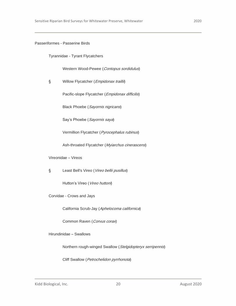
Sensitive Riparian Bird Surveys for Whitewater Preserve, Whitewater 2020
Kidd Biological, Inc. 20 August 2020
Passeriformes - Passerine Birds
Tyrannidae - Tyrant Flycatchers
Western Wood-Pewee (Contopus sordidulus)
Willow Flycatcher (Empidonax traillii)
Pacific-slope Flycatcher (Empidonax difficilis)
Black Phoebe (Sayornis nigricans)
Sayornis saya)
Vermillion Flycatcher (Pyrocephalus rubinus)
Ash-throated Flycatcher (Myiarchus cinerascens)
Vireonidae Vireos
Least Bell's Vireo (Vireo bellii pusillus)
Vireo huttoni)
Corvidae - Crows and Jays
California Scrub-Jay (Aphelocoma californica)
Common Raven (Corvus corax)
Hirundinidae Swallows
Northern rough-winged Swallow (Stelgidopteryx serripennis)
Cliff Swallow (Petrochelidon pyrrhonota)

Sensitive Riparian Bird Surveys for Whitewater Preserve, Whitewater 2020
Kidd Biological, Inc. 21 August 2020
Aegithalidae - Long-tailed Tits and Bushtits
Bushtit (Psaltriparus minimus)
Sittidae Nuthatches
Red-breasted Nuthatch (Sitta canadensis)
White-breasted Nuthatch (Sitta carolinensis)
Troglodytidae Wrens
Rock Wren (Salpinctes obsoletus)
Canyon Wren (Catherpes mexicanus)
House Wren (Troglodytes aedon)
Bewick's Wren (Thryomanes bewickii)
Polioptilidae Gnatcatchers
Black-tailed Gnatcatcher (Polioptila melanura)
Turdidae Thrushes
Western Bluebird (Sialia mexicana)
Mimidae - Mockingbirds and Thrashers
California Thrasher (Toxostoma redivivum)
Ptiliogonatidae Silky Flycatchers
Phainopepla (Phainopepla nitens)

Sensitive Riparian Bird Surveys for Whitewater Preserve, Whitewater 2020
Kidd Biological, Inc. 22 August 2020
Parulidae - Wood-Warblers
Orange-crowned Warbler (Oreothlypis celata)
Nashville Warbler (Oreothlypis ruficapilla)
Common Yellowthroat (Geothlypis trichas)
Yellow Warbler (Setophaga petechia)
Setophaga townsendi)
Wilson's Warbler (Cardellina pusilla)
Icteriidae Chats
Yellow-breasted Chat (Icteria virens)
Passerellidae New World Sparrows
Song Sparrow (Melospiza melodia)
California Towhee (Melozone crissalis)
Spotted Towhee (Pipilo maculatus)
Cardinalidae Cardinals, Grosbeaks, and Allies
Summer Tanager (Piranga rubra)
Western tanager (Piranga ludoviciana)
Black-headed Grosbeak (Pheucticus melanocephalus)
Blue Grosbeak (Passerina caerulea)

Sensitive Riparian Bird Surveys for Whitewater Preserve, Whitewater 2020
Kidd Biological, Inc. 23 August 2020
Icteridae Blackbirds, Orioles, and Allies
Hooded Oriole (Icterus cucullatus)
Fringillidae - Fringilline and Cardueline Finches and Allies
House Finch (Haemorhous mexicanus)
Lesser Goldfinch (Spinus psaltria)
Lawrence’s Goldfinch (Spinus lawrencei)
§ Indicates Sensitive Species

Sensitive Riparian Bird Surveys for Whitewater Preserve, Whitewater 2020
Kidd Biological, Inc. 24 August 2020
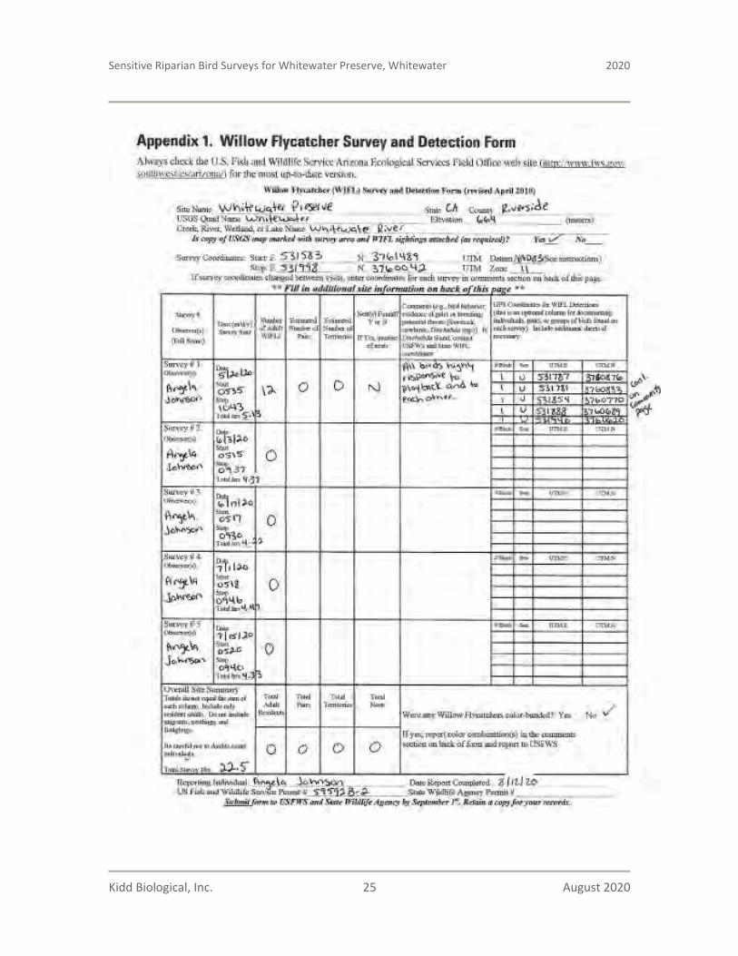
Sensitive Riparian Bird Surveys for Whitewater Preserve, Whitewater 2020
Kidd Biological, Inc. 25 August 2020

Sensitive Riparian Bird Surveys for Whitewater Preserve, Whitewater 2020
Kidd Biological, Inc. 26 August 2020

Sensitive Riparian Bird Surveys for Whitewater Preserve, Whitewater 2020
Kidd Biological, Inc. 27 August 2020
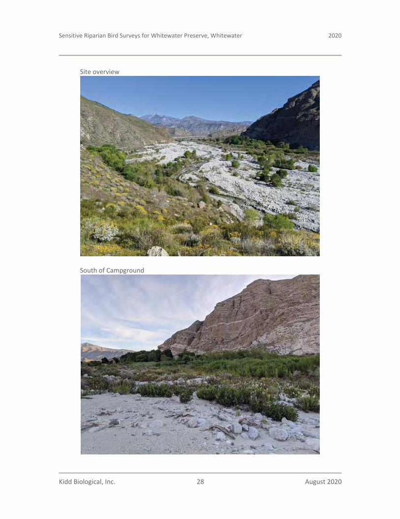
Sensitive Riparian Bird Surveys for Whitewater Preserve, Whitewater 2020
Kidd Biological, Inc. 28 August 2020
Site overview
South of Campground

Sensitive Riparian Bird Surveys for Whitewater Preserve, Whitewater 2020
Kidd Biological, Inc. 29 August 2020
Trail South of Campground
Southeast of River

Sensitive Riparian Bird Surveys for Whitewater Preserve, Whitewater 2020
Kidd Biological, Inc. 30 August 2020
North of Visitor’s Center
Habitat around pond near Visitor’s Center

WHITEWATER PRESERVE LEVEE
REPLACEMENT PROJECT
Riverside County, California
Delineation of State and Federal Jurisdictional Waters
Prepared For:
Coachella Valley Mountains Conservancy73-710 Fred Waring Drive, Suite 112
Palm Desert, California 92260Contact: Jim Karpiak
Prepared By:
ELMT Consulting, Inc. 2201 N. Grand Avenue #10098
Santa Ana, California 92711Contact: Thomas J. McGill, Ph.D.
951.285.6014
July 2020

WHITEWATER PRESERVE LEVEE
REPLACEMENT PROJECT
Riverside County, California
Delineation of State and Federal Jurisdictional Waters
The undersigned certify that the statements furnished in this report and exhibits present data and information required for this biological evaluation, and the facts, statements, and information presented is a complete and accurate account of the findings and conclusions to the best of our knowledge and beliefs.
Travis J. McGillDirector
Thomas J. McGill, Ph.D.Managing Director
July 2020

Whitewater Preserve Levee Replacement ProjectDelineation of State and Federal Jurisdictional Waters ES-1
Executive Summary
ELMT Consulting (ELMT) has prepared this Delineation of State and Federal Jurisdictional Waters Report for the Approximately 160-Acre Property Project Site (project site or site) located in the City of Jurupa Valley, Riverside County, California. The jurisdictional delineation documents the regulatory authority of the U.S. Army Corps of Engineers (Corps), the Regional Water Quality Control Board (Regional Board), and the California Department of Fish and Wildlife (CDFW) pursuant to Section 401 and 404 of the Federal Clean Water Act (CWA), the California Porter-Cologne Water Quality Control Act, and Sections 1600 et. seq. of the California Fish and Game Code.1
One (1) perennial drainage feature, Whitewater River was observed within the boundary of the survey area.Whitewater River (Relatively Permanent Water) is tributary to the Salton Sea (Traditional Navigable Water). Therefore, the Whitewater River would qualify as waters of the United States and fall under the regulatory authority of the Corps, Regional Board, and CDFW. The acreage and liner footage of the drainage features within the survey area are provided in Table ES-1 below:
Table ES-1: On-Site Jurisdictional Areas and Impacts
Jurisdictional Feature
Corps/Regional BoardNon-Wetland Waters
CDFW Streambed
On-Site Jurisdiction
acreage (linear feet)
Jurisdictional Impacts
(permanent)acreage (linear feet)
Jurisdictional Impacts
(temporary) acreage (linear feet)
On-Site Jurisdiction
acreage (linear feet)
Jurisdictional Impacts
(permanent)acreage (linear feet)
Jurisdictional Impacts
(temporary) acreage (linear feet)
Whitewater River 25.69 (2,827) 0.42 (614) 0.56 (818) 46.38 (2,827) 1.01 (1,517) 1.33 (1,888)
TOTALS 25.69 (2,827) 0.42 (614) 0.56 (818) 46.38 (2,827) 1.01 (1,517) 1.33 (1,888)
Based on current site conditions and design plans, impacts to the Whitewater River will occur from project implementation. As a result, the project applicant must obtain the following regulatory approvals prior to impacts occurring within the identified jurisdictional areas: Corps CWA Section 404 Permit; Regional Board CWA Section 401 Water Quality Certification; and CDFW Section 1602 Streambed Alteration Agreement (SAA). Refer to Sections 1-7 for a detailed analysis of site conditions and regulatory requirements.
1 The field surveys for this jurisdictional delineation were conducted on September 7, 2018 pursuant to the Regional Supplement to the Corps of Engineers Wetland Delineation Manual: Arid West Region, Version 2.0 (Corps 2008); and Minimum Standards for Acceptance of Aquatic Resources Delineation Reports (Corps 2017); The MESA Field Guide: Mapping Episodic Stream Activity (CDFW 2014); and a Review of Stream Processes and Forms in Dryland Watersheds (CDFW 2010).

Whitewater Preserve Flood Control ProjectDelineation of State and Federal Jurisdictional Waters i
Table of ContentsSection 1 Introduction......................................................................................................................... 1
1.1 Project Location ............................................................................................................................ 1 1.2 Project Description........................................................................................................................ 1
Section 2 Regulations .......................................................................................................................... 5
2.1 U.S. Army Corps of Engineers ..................................................................................................... 5 2.2 Regional Water Quality Control Board......................................................................................... 5 2.3 California Department of Fish and Wildlife ................................................................................. 6
Section 3 Methodology ........................................................................................................................ 7
3.1 Waters of the UnIted States .......................................................................................................... 7 3.2 Waters of the State ........................................................................................................................ 8 3.2.1 Regional Water Quality Control Board......................................................................................... 8 3.2.2 California Department of Fish and Wildlife ................................................................................. 8
Section 4 Literature Review ............................................................................................................... 9
4.1 Watershed Review ........................................................................................................................ 9 4.2 Local Climate................................................................................................................................ 9 4.3 USGS Topographic Quadrangle ................................................................................................. 10 4.4 Aerial Photographs...................................................................................................................... 104.4 Soils............................................................................................................................................. 10 4.6 Hydric Soils List of California.................................................................................................... 11 4.7 National Wetlands Inventory ...................................................................................................... 11 4.8 Flood Zone .................................................................................................................................. 11
Section 5 Site Conditions .................................................................................................................. 12
5.1 On-Site Features.......................................................................................................................... 12 5.1.1 Drainage Features ....................................................................................................................... 12 5.1.2 Wetland Features......................................................................................................................... 12
Section 6 Findings.............................................................................................................................. 13
6.1 U.S. Army Corps of Engineers Determination ........................................................................... 13 6.1.1 Waters of the United States Determination................................................................................. 13 6.2 Regional Water Quality Control Board....................................................................................... 13 6.3 California Department of Fish and Wildlife ............................................................................... 14
Section 7 Regulatory Approval Process .......................................................................................... 17
7.1 U.S. Army Corps of Engineers ................................................................................................... 17 7.2 Regional Water Quality Control Board....................................................................................... 17 7.3 California Department of Fish and Wildlife ............................................................................... 17 7.4 Recommendations....................................................................................................................... 18

Table of Contents
Whitewater Preserve Levee Replacement ProjectDelineation of State and Federal Jurisdictional Waters ii
Section 8 References .......................................................................................................................... 19
EXHIBITS
Exhibit 1: Regional Vicinity................................................................................................................ 2
Exhibit 2: Site Vicinity ........................................................................................................................ 3
Exhibit 3: Project Site.......................................................................................................................... 4
Exhibit 4: Jurisdictional Areas........................................................................................................... 15
Exhibit 5: Jurisdictional Impacts ....................................................................................................... 16
APPENDIX
Appendix A Documentation
Appendix B Site Photographs
Appendix C Methodology
Whitewater Preserve Levee Replacement ProjectDelineation of State and Federal Jurisdictional Waters 1
Section 1 Introduction
This delineation has been prepared for the for the Whitewater Preserve Levee Replacement Project (project site or site) in order to document the jurisdictional authority of the U.S. Army Corps of Engineers’ (Corps), the Regional Water Quality Control Board (Regional Board), and the California Department of Fish and Wildlife (CDFW) pursuant to Section 401 and 404 of the Federal Clean Water Act (CWA), the California Porter-Cologne Water Quality Control Act, and Sections 1600 et seq. of the California Fish and Game Code. The analysis presented in this report is supported by field surveys and verification of site conditions conducted on January 7, and April 2, 2020.
This jurisdictional delineation explains the methodology undertaken by ELMT Consulting (ELMT) to define the regulatory authority of the aforementioned regulatory agencies and documents the findings made by ELMT. This report presents our best effort at documenting the jurisdictional boundaries using the most up-to-date regulations, written policy, and guidance from the regulatory agencies. Ultimately the regulatory agencies make the final determination of jurisdictional boundaries.
1.1 PROJECT LOCATION
The project site is located on the Whitewater River, north of Interstate 10, west of State Route 62, east of Kitching Peak, and southwest of Morongo Valley in Whitewater, Riverside County, California (Exhibit 1, Regional Vicinity). The project site is depicted on the White Water quadrangle of the United States Geological Survey (USGS) 7.5-minute topographic map series in Sections 15 and 22 of Township 2 South, Range 3 East (Exhibit 2, Site Vicinity). Specifically, the project site is located along the Whitewater River, adjacent to the Whitewater Preserve located at 9160 Whitewater Canyon Road. (Exhibit 3, Project Site).
1.2 PROJECT DESCRIPTION
The project proposes to build a permanent flood control structure to protect the Whitewater Preserve infrastructure and wetland habitats. Further, building a permanent flood control structure will protect the existing riparian forest within the preserve and downstream of the preserve from major flood events.
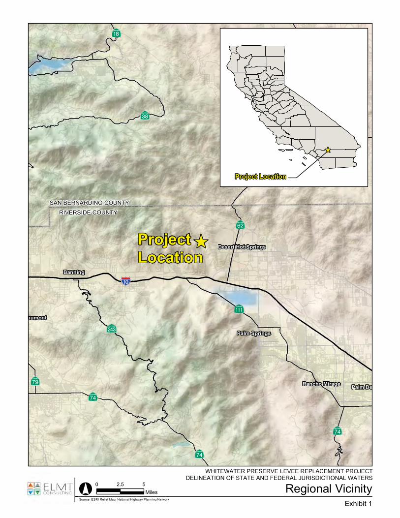
?Ù
?±
?±
?¹
?¡
?±
SAN BERNARDINO COUNTY
?a
Palm Springs
Banning
aumont
Palm DeRancho Mirage
Desert Hot Springs
WHITEWATER PRESERVE
Regional VicinityExhibit 1
° 0 2.5 5Miles
Source: ESRI Relief Map, National Highway Planning Network
Project Location
)
)ProjectLocation
RIVERSIDE COUNTY
!"̀$
?å
AÐ

Site VicinityWHITEWATER PRESERVE LEVEE REPLACEMENT PROJECT
DELINEATION OF STATE AND FEDERAL JURISDICTIONAL WATERS
Exhibit 2O
Source: USA Topographic Map, Riverside County
0 2,000 4,0001,000
Feet
Legend
Survey Area

Project SiteWHITEWATER PRESERVE LEVEE REPLACEMENT PROJECT
DELINEATION OF STATE AND FEDERAL JURISDICTIONAL WATERS
Exhibit 3O
Source: ESRI Aerial Imagery, Riverside County
0 500 1,000250
Feet
Legend
Survey Area

Whitewater Preserve Levee Replacement ProjectDelineation of State and Federal Jurisdictional Waters 5
Section 2 Regulations
There are three key agencies that regulate activities within inland streams, wetlands, and riparian areas in California. The Corps Regulatory Division regulates activities pursuant to Section 404 of the CWA, Section 10 of the Rivers and Harbors Act, and Section 103 of the Marine Protection, Research, and Sanctuaries Act. The Regional Board regulates activities pursuant to Section 401 of the CWA and the California Porter-Cologne Water Quality Control Act and the CDFW regulates activities under Sections 1600 et seq. of the California Fish and Game Code.
2.1 U.S. ARMY CORPS OF ENGINEERS
Since 1972, the Corps and U.S. Environmental Protection Agency (EPA) have jointly regulated the discharge of dredged or fill material into waters of the United States, including wetlands, pursuant to Section 404 of the CWA. The Corps and EPA define “fill material” to include any “material placed in waters of the United States where the material has the effect of: (i) replacing any portion of a water of the United States with dry land; or (ii) changing the bottom elevation of any portion of the waters of the United States.” Examples include, but are not limited to, sand, rock, clay, construction debris, wood chips, and “materials used to create any structure or infrastructure in the waters of the United States.” In April of 2020, the Corps and the EPA provided a new definition for waters of the United States [Federal Register, Vol. 85, No. 77 (April 21, 2020)] which encompass: the territorial seas and traditional navigable waters; perennial and intermittent tributaries that contribute surface water flow to such waters; certain lakes, ponds, and impoundments of jurisdictional waters; and wetlands adjacent to other jurisdictional waters. Additionally, the new definition identifies 12 categories of those waters and features that are excluded from the definition of ‘‘waters of the United State, such as features that only contain water in direct response to rainfall (e.g., ephemeral features), groundwater, many ditches, prior converted cropland, and waste treatment systems.
2.2 REGIONAL WATER QUALITY CONTROL BOARD
Pursuant to Section 401 of the CWA, any applicant for a federal license or permit to conduct any activity which may result in any discharge to waters of the United States must provide certification from the State or Indian tribe in which the discharge originates. This certification provides for the protection of the physical, chemical, and biological integrity of waters, addresses impacts to water quality that may result from issuance of federal permits and helps insure that federal actions will not violate water quality standards of the State or Indian tribe. In California, there are nine Regional Boards that issue or deny certification for discharges to waters of the United States and waters of the State, including wetlands, within their geographical jurisdiction. The State Water Resources Control Board (SWRCB) assumes this responsibility when a project has the potential to result in the discharge to waters within multiple Regional Boards.
Additionally, the California Porter-Cologne Water Quality Control Act gives the State very broad authority to regulate waters of the State, which are defined as any surface water or groundwater, including saline waters. The Porter-Cologne Water Quality Control Act has become an important tool post Solid Waste

Regulations
Whitewater Preserve Levee Replacement ProjectDelineation of State and Federal Jurisdictional Waters 6
Agency of Northern Cook County vs. United States Corps of Engineers2 (SWANCC) and Rapanos v. United States3 (Rapanos) court cases with respect to the State’s regulatory authority over isolated and insignificant waters. Generally, any applicant proposing to discharge waste into a water body must file a Report of Waste Discharge in the event that there is no Section 404/401 nexus. Although “waste” is partially defined as any waste substance associated with human habitation, the Regional Board also interprets this to include discharge of dredged and fill material into water bodies.
2.3 CALIFORNIA DEPARTMENT OF FISH AND WILDLIFE
Sections 1600 et seq. of the California Fish and Game Code establishes a fee-based process to ensure that projects conducted in and around lakes, rivers, or streams do not adversely impact fish and wildlife resources, or, when adverse impacts cannot be avoided, ensures that adequate mitigation and/or compensation is provided. Pursuant to Section 1602 of the California Fish and Game Code, a notification must be submitted to the CDFW for any activity that will divert or obstruct the natural flow or alter the bed, channel, or bank (which may include associated biological resources) of a river or stream or use material from a streambed. This includes activities taking place within rivers or streams that flow perennially or episodically and that are defined by the area in which surface water currently flows, or has flowed, over a given course during the historic hydrologic regime, and where the width of its course can reasonably be identified by physical and biological indicators.
2 Solid Waste Agency of Northern Cook County v. U.S. Army Corps of Engineers, 531 U.S. 159 (2001)3 Rapanos v. United States, 547 U.S. 715 (2006)

Whitewater Preserve Levee Replacement ProjectDelineation of State and Federal Jurisdictional Waters 7
Section 3 Methodology
The analysis presented in this report is supported by field surveys and verification of site conditions conducted on January 7, and April 2, 2020. ELMT conducted a field delineation to determine the jurisdictional limits of “waters of the United States” and “waters of the State” (including potential wetlands), located within the boundaries of the survey area.
Aerial photography was reviewed prior to conducting a field investigation in order to locate and inspect any potential natural drainage features, ponded areas, or water bodies that may fall under the jurisdiction of the Corps. In general, surface drainage features indicated as blue-line streams on USGS maps that are observed or expected to exhibit evidence of flow are considered potential jurisdictional areas and are also subject to federal regulatory jurisdiction. In addition, ELMT reviewed jurisdictional waters information through examining historical aerial photographs to gain an understanding of the impact of land-use on natural drainage patterns in the area. The United States Fish and Wildlife Service (USFWS) National Wetland Inventory (NWI) and Environmental Protection Agency (EPA) Water Program “My Waters” data layers were also reviewed to determine whether any hydrologic features and wetland areas have been documented on or within the vicinity of the survey area (i.e., project site and immediately surrounding area).
Following the literature review, biologists Thomas J. McGill, Ph.D., Travis J. McGill and Jacob H. Lloyd Davies conducted a site reconnaissance to determine jurisdictional limits of “waters of the United States”within the Whitewater River located within the boundaries of the survey area. While in the field, jurisdictional features were recorded onto a base map at a scale of 1" = 50' using topographic contours and visible landmarks as guidelines. Data points were obtained with a Garmin 62 Global Positioning System Map62 in order to record and identify specific widths for ordinary high water mark (OHWM) indicators, soil pits, photograph locations, and pertinent jurisdictional features. This data was then transferred via USB port as a .shp file and added to the project's jurisdictional map. The jurisdictional map was prepared in ESRI ArcInfo Version 10. Refer to Appendix E for a detailed summary of methodology utilized throughout the course of this delineation.
3.1 WATERS OF THE UNITED STATES
In the absence of adjacent wetlands, the limits of the Corps jurisdiction in non-tidal waters extend to the OHWM, which is defined as “ . . . that line on the shore established by the fluctuations of water and indicated by physical characteristics such as a clear, natural line impressed on the bank, shelving, changes in the character of soil, destruction of terrestrial vegetation, the presence of litter and debris, or other appropriate means that consider the characteristics of the surrounding areas.”4 Indicators of an OHWM are defined in A Field Guide to the Identification of the Ordinary High Water Mark (OHWM) in the Arid West Region of the Western United States (Corps 2008). An OHWM can be determined by the observation of a natural line impressed on the bank; shelving; changes in the character of the soil; destruction of terrestrial vegetation; presence of litter and debris; wracking; vegetation matted down, bent, or absent;
4 CWA regulations 33 CFR §328.3(e).

Methodology
Whitewater Preserve Levee Replacement ProjectDelineation of State and Federal Jurisdictional Waters 8
sediment sorting; leaf litter disturbed or washed away; scour; deposition; multiple observed flow events; bed and banks; water staining; and/or change in plant community. The Regional Board shares the Corps’ jurisdictional methodology, unless SWANCC or Rapanos conditions are present. In the latter case, the Regional Board considers such drainage features to be jurisdictional waters of the State.
Pursuant to the Corps Wetland Delineation Manual (Corps 1987), the identification of wetlands is based on a three-parameter approach involving indicators of hydrophytic vegetation, hydric soils, and wetland hydrology. In order to qualify as a wetland, a feature must exhibit at least minimal characteristics within each of these three parameters. It should also be noted that both the Regional Board and CDFW follow the methods utilized by the Corps to identify wetlands. For this project location, Corps jurisdictional wetlands are delineated using the methods outlined in the Regional Supplement to the Corps of Engineers Wetland Delineation Manual: Arid West Region, Version 2.0 (Corps 2008).
3.2 WATERS OF THE STATE
3.2.1 REGIONAL WATER QUALITY CONTROL BOARD
The California Porter-Cologne Water Quality Control Act gives the Regional Board very broad authority to regulate waters of the State, which are defined as any surface water or groundwater, including saline waters. The Regional Board shares the Corps’ methodology for delineating the limits of jurisdiction based on the identification of OHWM indicators and utilizing the three parameter approach for wetlands.
3.2.2 CALIFORNIA DEPARTMENT OF FISH AND WILDLIFE
Sections 1600 et seq. of the California Fish and Game Code applies to all perennial, intermittent, and ephemeral rivers, streams, and lakes in the State. Generally, the CDFW’s jurisdictional limit is not defined by a specific flow event, nor by the presence of OHWM indicators or the path of surface water as this path might vary seasonally. Instead, CDFW’s jurisdictional limit is based on the topography or elevation of land that confines surface water to a definite course when the surface water rises to its highest point. Further, the CDFW’s jurisdictional limit extends to include any habitat (e.g. riparian), including wetlands and vernal pools, supported by a river, stream, or lake regardless of the presence or absence of hydric soils and saturated soil conditions. For this project location, CDFW jurisdictional limits were delineated using the methods outlined in the MESA Field Guide (Brady, III and Vyverberg 2013) and A Review of Stream Processes and Forms in Dryland Watersheds (Vyverberg 2010), which were developed to provide guidance on the methods utilized to describe and delineate episodic streams within the inland deserts region of southern California.

Whitewater Preserve Levee Replacement ProjectDelineation of State and Federal Jurisdictional Waters 9
Section 4 Literature Review
ELMT conducted a thorough review of relevant literature and materials to preliminarily identify areas that may fall under the jurisdiction of the regulatory agencies. A summary of materials utilized during ELMT’sliterature review is provided below and in Appendix A. In addition, refer to Section 8 for a complete list of references used throughout the course of this delineation.
4.1 WATERSHED REVIEW
The project site is located within the Whitewater River Watershed (HUC 18100201). The Whitewater River Watershed drains into the Whitewater River, which begins in the San Bernardino Mountains and moves southeast to the Salton Sea and Sonoran Desert. The Whitewater River is tributary to the Salton Sea.
The Whitewater River Watershed covers 1,920 square miles and includes the majority of Riverside County and a small portion of southern San Bernardino County. The watershed consists mainly of sparsely populated mountains, desert, and agricultural lands. The watershed is bounded on the south by the San Jacinto and Santa Rosa Mountains, on the west by the Santa Ana Watershed, on the east by the Salton Sea, the Hexie and Cottonwood Mountains, and Southern Mojave Watershed, and on the north east by the little San Bernardino Mountains and Southern Mojave Watershed. The highest elevation (upper reaches) of the watershed occur in the San Jacinto Mountains at 10,000 feet above mean sea level, while the Salton Sea at 230 feet below mean sea level forms the lowest elevation of the watershed.
The Whitewater River, a channelized river, is the major surface drainage watercourse in the Coachella Valley. The Whitewater River also has a constructed downstream extension known as the Coachella Valley Stormwater Channel, which serves as a drainage way for irrigation return flows, treated community wastewater, and storm runoff. The Whitewater River is typically a desert dry wash at its lower reaches, flowing only in periods of intense rain, but is an intermittent stream in its upper reaches.
4.2 LOCAL CLIMATE
Riverside County is characterized by cool winter temperatures and warm summer temperatures, with its rainfall occurring almost entirely in the winter. Relative to other areas in Southern California, winters are colder with chilly to cold morning temperatures common. Climatological data was not available for the City of Whitewater. Data was instead obtained for the nearest city, the City of Palm Springs, which indicates the average annual precipitation is 4.85 inches per year. Almost all of the precipitation occurs in the months between December and February, with hardly any occurring between the months of April and June. The wettest month is January, with a monthly average total precipitation of 1.14 inches. The average maximum and minimum temperatures for the City of Palm Springs are 89 and 60 degrees Fahrenheit (F) respectively with July being the hottest month (monthly average 108.0° F) and December being the coldest (monthly average 44.0° F). Temperatures during the site visits were in the mid- to high 60s to 70s (degrees Fahrenheit) with infrequent, light winds and little to no cloud cover.

Literature Review
Whitewater Preserve Levee Replacement ProjectDelineation of State and Federal Jurisdictional Waters 10
4.3 USGS TOPOGRAPHIC QUADRANGLE
The USGS 7.5 Minute Series Topographic Quadrangle maps show geological formations and their characteristics, describing the physical setting of an area through contour lines and major surface features including lakes, rivers, streams, buildings, landmarks, and other factors that may fall under an agency’s jurisdiction. Additionally, the maps depict topography through color and contour lines, which are helpful in determining elevations and latitude and longitude within the project site.
The project site is located within the White Water quadrangle of the United States Geological Survey’s (USGS) 7.5-minute topographic map series in Sections 15 and 22 of Township 2 South, Range 3 East. According to the topographic map, the project site occurs at the bottom of Whitewater Canyon within the Whitewater River. On-site surface elevation ranges from approximately 2,150 to 2,300 feet above mean sea level and generally slopes from north to south. The project site is located at the bottom of the Whitewater Canyon within the Whitewater River. The slopes of the canyon above the Whitewater River are steep, vertical walls while the bottom of the canyon is relatively flat and slopes from north to south.
4.4 AERIAL PHOTOGRAPHS
Prior to conducting the field delineation, ELMT reviewed current and historical aerial photographs (1994-2020) of the project as available from Google Earth Pro Imaging. Aerial photographs can be useful during the delineation process, as they often indicate the presence of drainage features and riparian/riverine habitat within the boundaries of the project site, if any.
Land uses in the vicinity of the project site mostly consists of vacant, undeveloped land consisting of natural habitats associated with Whitewater Canyon. The Whitewater River traverses the central portion of the project site from north to south. The unincorporated community of Bonnie Bell is located south of the Whitewater Preserve, which is approximately 9.5 miles northwest of Palm Springs. Areas to the east and west consist of vacant, undeveloped land within the San Bernardino Mountains
The project site occurs within Whitewater Canyon along the eastern bank of the Whitewater River. The site is undeveloped, composed of natural habitats, and is surrounded by the following land uses:
North: The area to the north of the site is composed almost entirely of undeveloped, vacant land within the San Bernardino Mountains. Several developed structures associated with historical and ongoing operations of the Whitewater Preserve Ranger Station and former Whitewater Trout Farm are supported in the immediate 600 feet.
East: Immediately to the east of the site are the Whitewater Preserve Ranger Station and Visitors’ Center, trout ponds associated with the former Whitewater Trout Farm, paved parking areas, and Whitewater Canyon Road. Undeveloped, vacant land occurs beyond these structures within the San Bernardino Mountains.
South: The area to the south of the site is composed almost entirely of undeveloped, vacant land within the San Bernardino Mountains. The Whitewater River occurs immediately south of

Literature Review
Whitewater Preserve Levee Replacement ProjectDelineation of State and Federal Jurisdictional Waters 11
the project site and Whitewater Canyon Road occurs approximately 1,400 feet to the southeast.
West: The area to the west of the site is composed entirely of undeveloped, vacant land within the San Bernardino Mountains. Immediately to the west of the site is the Whitewater River.
4.5 SOILS
The project site is located at the bottom of the Whitewater Canyon within the Whitewater River. The slopes of the canyon above the Whitewater River are steep, vertical walls while the bottom of the canyon is relatively flat and slopes from north to south. Generally, the Whitewater River, within the survey area, is composed of cobble and boulders with patches of loose sand and gravel. The U.S. Department of Agriculture (USDA) Natural Resources Conservation Service (NRCS) Web Soil Survey has not mapped the soils within the boundaries of the project site. Instead, data from the U.S. General Soil Map was acquired for the project site. Per the U.S. General Soil Map data, the project site is underlain by the following soil units: Urban Land – Tujunga – Soboba – Hanford and Tecopa – Rock Outcrop – Lithic Torriorthents.
4.6 HYDRIC SOILS LIST OF CALIFORNIA
ELMT reviewed the USDA NRCS Hydric Soils List of California in an effort to verify whether on-site soils are considered to be hydric5. It should be noted that lists of hydric soils along with soil survey maps provide off-site ancillary tools to assist in wetland determinations, but they are not a substitute for field investigations. The presence of hydric soils is initially investigated by comparing the mapped soil series for the site to the County list of hydric soils. According to the hydric soils list, Tujunga, Soboba, and Rock Outcrop have been listed as hydric in the Coachella Valley area.
4.7 NATIONAL WETLANDS INVENTORY
ELMT reviewed the U.S. Fish and Wildlife Service’s (USFWS) National Wetland Inventory maps. The NWI maps riverine resources associated with the Whitewater River and tributaries, two (2) freshwater ponds associated with the existing preserve, and Freshwater Forested/Shrub Wetland resources associated with the Sonoran cottonwood willow riparian forest within the survey area. Refer to Appendix A, Documentation.
4.8 FLOOD ZONE
ELMT searched the Federal Emergency Management Act website for flood data for the project site. Based on Flood Insurance Rate Map No. 06065C0860G the project site is located within Zone X – areas determined to be outside the 0.2% annual chance floodplain. Refer to Appendix A, Documentation.
5 A hydric soil is a soil that formed under conditions of saturation, flooding or ponding long enough during the growing season to develop anaerobic conditions in the upper part.

Whitewater Preserve Levee Replacement ProjectDelineation of State and Federal Jurisdictional Waters 12
Section 5 Site Conditions
ELMT biologist Thomas J. McGill, Ph.D., Travis J. McGill, and Jacob H. Lloyd Davies conducted a field delineation on January 7, and April 2, 2020 to verify existing site conditions and document the extent of potential jurisdictional areas within the boundaries of the project site. The temperature during the site visit was in the 60 and 80s ° F with no cloud cover overhead. ELMT field staff encountered no limitations during the field delineation. Refer to Appendix B for representative photographs taken throughout the project site.
5.1 ON-SITE FEATURES
5.1.1 DRAINAGE FEATURES
One drainage feature, Whitewater River, and its associated floodplain were observed within the survey area. Whitewater River conveys flows in a north to south direction through the western portion of the survey area. Surface flows within the Whitewater River are provided by direct precipitation, and runoff from the adjacent mountains. Within the survey area, the Whitewater River is an earthen feature characterized byrocky substrate with a regular distribution of gravel and cobble. Four (4) plant communities were observedwithin the boundaries of the survey area during the survey: alluvial scrub, Sonoran cottonwood willow riparian forest, Sonoran creosote bush scrub, and grassland. The OHWM ranged from 6 to 20 feet in width, and was delineated using the following indicators: flow patterns; scour; and substrate characteristics.During the field investigation surface water was present that ranged in depth from 6 to 24 inches.
Within the survey area, the Whitewater River and its floodplain primarily support an alluvial scrub plantcommunity with Sonoran cottonwood willow scrub on its banks. Plant species observed within this plantcommunity include scalebroom (Lepidospartum squamatum), yerba santa (Eriodictyon trichocalyx), mulefat (Baccharis salicifolia), California buckwheat (Eriogonum fasciculatum), beavertail cactus (Opuntia basilaris), deerweed (Acmispon glaber), cheesebush (Ambrosia salsola), sweetbush (Bebbia juncea), California croton (Croton californicus), Wiggins’ cholla (Condea emoryi), hairy parish viguiera (Bahiopsis parishii), brittlebush (Encelia farinosa), narrowleaf willow (Salix exigua), red willow (Salix laevigata), western sycamore (Platanus racemosa) and Fremont cottonwood (Populus fremontii).
5.1.2 WETLAND FEATURES
In order to qualify as a wetland, a feature must exhibit all three wetland parameters (i.e., vegetation, soils, and hydrology) described in the Corps Arid West Regional Supplement. Although evidence of hydrology (i.e., surface water) and hydric vegetation were present within the Whitewater River within the limits of disturbance, soils support big rocks/cobble, and no soil pits were able to be dug. No hydric soils are anticipated to occur. Therefore, no wetland features are anticipated to occur on the project site. Within the project site, water does not persist long enough to create anaerobic conditions within the soil.

Whitewater Preserve Levee Replacement ProjectDelineation of State and Federal Jurisdictional Waters 13
Section 6 Findings
This report presents ELMT’s best effort at determining the extent of jurisdictional features using the most up-to-date regulations, written policy, and guidance from the regulatory agencies. Please refer to the following sections for a summary of jurisdictional areas within the project site.
6.1 U.S. ARMY CORPS OF ENGINEERS DETERMINATION
6.1.1 WATERS OF THE UNITED STATES DETERMINATION
A total of 25.69 acre (2,827 linear feet) of Corps jurisdiction waters are located within the survey area.Refer to Table 1 for a summary of on-site jurisdictional areas, and Exhibit 4, Jurisdictional Areas. for an illustration of on-site Corps jurisdictional areas. Based on the proposed project design, a total of 0.42 acre (614 linear feet) of permanent impacts and 0.56 acre (818 linear feet) of temporary impacts to Corps jurisdictional waters will be impacted from project implementation. The acreage and liner footage of the on-site drainage features and anticipated impacts are provided in Table 1 and Exhibit 5, Jurisdictional Impacts. All temporary impacts will be restored to existing site conditions.
Table 1: Jurisdictional Areas and Impacts
Jurisdictional Feature
Corps/Regional BoardNon-Wetland Waters
CDFW Streambed
On-Site Jurisdiction
acreage (linear feet)
Jurisdictional Impacts
(permanent)acreage (linear feet)
Jurisdictional Impacts
(temporary) acreage (linear feet)
On-Site Jurisdiction
acreage (linear feet)
Jurisdictional Impacts
(permanent)acreage (linear feet)
Jurisdictional Impacts
(temporary) acreage (linear feet)
Whitewater River 25.69 (2,827) 0.42 (614) 0.56 (818) 46.38 (2,827) 1.01 (1,517) 1.33 (1,888)
TOTALS 25.69 (2,827) 0.42 (614) 0.56 (818) 46.38 (2,827) 1.01 (1,517) 1.33 (1,888)
6.2 REGIONAL WATER QUALITY CONTROL BOARD
No isolated or Rapanos conditions were observed within the boundaries of the survey area. Therefore, the Regional Board jurisdictional limit follows that of the Corps. A total of 25.69 acre (2,827 linear feet) of Regional Board jurisdiction waters are located within the survey area. Refer to Table 1 for a summary of on-site jurisdictional areas, and Exhibit 4, Jurisdictional Areas. for an illustration of on-site Regional Board jurisdictional areas. Based on the proposed project design, a total of 0.42 acre (614 linear feet) of permanent impacts and 0.56 acre (818 linear feet) of temporary impacts to Regional Board jurisdictional waters will be impacted from project implementation. The acreage and liner footage of the on-site drainage featuresand anticipated impacts are provided in Table 1 and Exhibit 5, Jurisdictional Impacts. All temporaryimpacts will be restored to existing site conditions.

Findings
Whitewater Preserve Levee Replacement ProjectDelineation of State and Federal Jurisdictional Waters 14
6.3 CALIFORNIA DEPARTMENT OF FISH AND WILDLIFE
The on-site drainage features exhibit characteristics consistent with CDFW’s methodology and would be considered CDFW streambed. Therefore, approximately 46.38 acre (2,827 linear feet) of CDFW jurisdiction are located within boundaries of the survey area. Refer to Exhibit 4, Jurisdictional Areas, for an illustration of CDFW jurisdictional areas and anticipated impacts. Based on the proposed project design, a total of 1.01 acre (1,517 linear feet) of permanent impacts and 1.33 acre (1,888 linear feet) of temporary impacts to CDFW jurisdictional waters will be impacted from project implementation. The acreage and liner footage of the on-site drainage features and anticipated impacts are provided in Table 1 and Exhibit 5,Jurisdictional Impacts. All temporary impacts will be restored to existing site conditions.

Jurisdictional Areas
WHITEWATER PRESERVE LEVEE REPLACEMENT PROJECTDELINEATION OF STATE AND FEDERAL JURISDICTIONAL WATERS
Exhibit 4O
Source: ESRI Aerial Imagery, Riverside County
0 500 1,000250
Feet
Legend
Survey Area
Limits of Disturbance
Corps/Regional Board/CDFWJurisdictioanl Waters (25.69 acres)CDFW Associated Riparian Vegetation (20.69 acre)

Jurisdictional Impacts
WHITEWATER PRESERVE LEVEE REPLACEMENT PROJECTDELINEATION OF STATE AND FEDERAL JURISDICTIONAL WATERS
Exhibit 5O
Source: ESRI Aerial Imagery, Riverside County
0 500 1,000250
Feet
Legend
Survey Area
Limits of Disturbance
Corps/Regional Board/CDFWJurisdictioanl Waters (25.69 acres)Corps/Regional Board/CDFWPermanent Impacts (0.42 acre)Corps/Regional Board/CDFWTemporary Impacts (0.56 acre)CDFW Associated Riparian Vegetation (20.69 acre)CDFW Associated Riparian VegetationPermanent Impacts (0.59 acre)CDFW Associated Riparian VegetationTemporary Impacts (0.77 acre)

Whitewater Preserve Levee Replacement ProjectDelineation of State and Federal Jurisdictional Waters 17
Section 7 Regulatory Approval Process
The following is a summary of the various permits, certifications, and agreements that may be necessary prior to construction and/or alteration within jurisdictional areas. Ultimately the regulatory agencies make the final determination of jurisdictional boundaries and permitting requirements.
7.1 U.S. ARMY CORPS OF ENGINEERS
The Corps regulates discharges of dredged or fill materials into waters of the United States, including wetlands, pursuant to Section 404 of the CWA. Therefore, any impacts to on-site jurisdictional areas will require a CWA Section 404 permit prior to project implementation. In order to qualify for the Corps Nationwide Permit (NWP) program, project impacts to “waters of the United States” typically need to be under a designated acre threshold (typically 0.5 acre). If project impacts exceed the acreage threshold then a Standard Individual Permit (IP) with the Corps would need to be processed. The NWPs are a streamlined process that already have supporting National Environmental Protection Agency (NEPA) compliance completed. If a project does not meet the requirements of the NWPs then IP will need to be processed, which requires its own NEPA compliance document.
Any impacts to the Whitewater River associated with the proposed project will likely qualify for NWP No. 31, Maintenance of Existing Flood Control Facility.
7.2 REGIONAL WATER QUALITY CONTROL BOARD
The Regional Board regulates discharges to surface waters pursuant to Section 401 of the CWA and the California Porter-Cologne Water Quality Control Act. Therefore, any impacts to on-site jurisdictional areas will require a CWA Section 401 Water Quality Certification from the San Diego Regional Board prior to project implementation. The application will require a processing fee which is based on the extent of project impacts. and the final CWA Section 401 Water Quality Certification will not be issued until all fees are paid to the Regional Board. It should also be noted that the Regional Board requires that California Environmental Quality Act (CEQA) compliance be obtained prior to issuance of the Section 401 Water Quality Certification.
7.3 CALIFORNIA DEPARTMENT OF FISH AND WILDLIFE
Pursuant to Section 1602 of the California Fish and Game Code, the CDFW regulates any activity that will divert or obstruct the natural flow or alter the bed, channel, or bank (which may include associated biological resources) of a river or stream. Therefore, any impacts to the on-site jurisdictional areas will require a Section 1602 Streambed Alteration Agreement from the CDFW prior to project implementation. The notification will require a processing fee which is based on the term and cost of the proposed project. It should also be noted that the CDFW requires that the payment of the process fee be paid and CEQA compliance be obtained prior to the issuance of the final Section 1602 Streambed Alteration Agreement.

Regulatory Approval Process
Whitewater Preserve Levee Replacement ProjectDelineation of State and Federal Jurisdictional Waters 18
7.4 RECOMMENDATIONS
It is recommended that this delineation be forwarded to the regulatory agencies for their review and concurrence. The concurrence/receipt would solidify findings noted within this report.

Whitewater Preserve Levee Replacement ProjectDelineation of State and Federal Jurisdictional Waters 19
Section 8 References
Brady, III, Roland H. and Kris Vyverberg. 2013. Methods to Describe and Delineate Episodic Stream Processes on Arid Landscapes for Permitting Utility-Scale Solar Power Plants. California Energy Commission, Publication Number: CEC-500-2014-013.
Environmental Laboratory. 1987. Corps of Engineers Wetland Delineation Manual. Technical Report Y-87-1. Vicksburg, MS: U.S. Army Engineer Waterways Experiment Station, 1987.
Google, Inc. 2013. Google Earth Pro Imagery version 7.3.3.7786, build date 7/21/2020. Historical Aerial Imagery from 1996 to 2020.
Munsell. 2009. Soil Color Charts, Year Revised/2009 Production. Lichvar, R.W., M. Butterwick, N.C. Melvin, and W.N. Kirchner. 2014.
U.S. Army Corps of Engineers (Corps). 2006. Distribution of Ordinary High Water Mark Indicators and their Reliability in Identifying the Limits of “Waters of the United States” in the Arid Southwestern Channels. February 2006.
Corps. 2008. A Field Guide to the Identification of the Ordinary High Water Mark in the Arid West Region of the Western United States. August 2008.
Corps. 2008. Regional Supplement to the Corps of Engineers Wetland Delineation Manual: Arid West Region (Version 2.0), ed. J.S. Wakeley, R. W. Lichvar, and C. V. Nobel. ERDC/EL TR-08-28. Vicksburg, MS: U.S. Army Engineer Research and Development Center.
Corps. 2016. Arid West 2016 Regional Wetland Plant List. 2016 NWPL v3.3. Accessed online at http://wetland-plants.usace.army.mil/nwpl_static/index.html.
Corps. 2016. Updated Map and Drawing Standards for the South Pacific Regulatory Division Regulatory Program. February 2016.
Corps. 2017. Los Angeles District Regulatory Program (www.spl.usace.army.mil/).
Corps. 2017. Minimum Standards for Acceptance of Aquatic Resources Delineation Reports. March 2017.
Corps. 2017. Reissuance of the Nationwide Permits and Issuance of Final Regional Conditions for the Los Angeles District. March 2017.
U.S. Department of Agriculture, Natural Resources Conservation Service (USDA NRCS). List of Hydric Soils. Accessed online at https://www.nrcs.usda.gov/wps/portal/nrcs/main/soils/use/hydric/.
USDA NRCS. 2017. Field Indicators of Hydric Soils in the United States: A Guide to Identifying and Delineating Hydric Soils, Version 8.1. 2017.

References
Whitewater Preserve Levee Replacement ProjectDelineation of State and Federal Jurisdictional Waters 20
U.S. Department of Homeland Security, Federal Emergency Management Agency, National Flood Insurance Program, Flood Insurance Rate Map Nos. 06065C0036G, and 06065C0038G, effective date August 28, 2008.
U.S. Fish and Wildlife Service, Department of Habitat and Resource Conservation. 2019. Wetland Geodatabase. Accessed online at https://www.fws.gov/wetlands/data/Mapper.html.
U.S. Geological Survey. 1980. Fontana, California 7.5-Minute Series Topographic Quadrangle. 1967,photorevised 1980.
Vyverberg, Kris. 2010. A Review of Stream Processes and Forms in Dryland Watersheds. California Department of Fish and Game. December 2010.

Appendix A Documentation

NW
I Map
U.S
. Fis
h an
d W
ildlif
e Se
rvic
e, N
atio
nal S
tand
ards
and
Sup
port
Team
,w
etla
nds_
team
@fw
s.go
v
Wet
land
s Estu
arin
e an
d M
arin
e D
eepw
ater
Estu
arin
e an
d M
arin
e W
etla
nd
Fres
hwat
er E
mer
gent
Wet
land
Fres
hwat
er F
ores
ted/
Shr
ub W
etla
nd
Fres
hwat
er P
ond
Lake
Oth
er
Riv
erin
e
Dec
embe
r 31,
201
9
00.
250.
50.
125
mi
00.
350.
70.
175
km
1:14
,435
This
pag
e w
as p
rodu
ced
by th
e N
WI m
appe
rN
atio
nal W
etla
nds
Inve
ntor
y (N
WI)
This
map
is fo
r gen
eral
refe
renc
e on
ly. T
he U
S F
ish
and
Wild
life
Serv
ice
is n
ot re
spon
sibl
e fo
r the
acc
urac
y or
cur
rent
ness
of t
he
base
dat
a sh
own
on th
is m
ap. A
ll w
etla
nds
rela
ted
data
sho
uld
be u
sed
in a
ccor
danc
e w
ith th
e la
yer m
etad
ata
foun
d on
the
Wet
land
s M
appe
r web
site
.

USG
S Th
e N
atio
nal M
ap: O
rthoi
mag
ery.
Dat
a re
fresh
ed A
pril,
201
9.
Nat
iona
l Flo
od H
azar
d La
yer F
IRM
ette
050
01,
000
1,50
02,
000
250
Feet
Ü
116°39'38.24"W 33°5
9'26
.29"
N
116°39'0.78"W
33°5
8'56
.46"
N
SEE
FIS
REP
OR
T FO
R D
ETA
ILED
LEG
END
AN
D IN
DEX
MA
P F
OR
FIR
M P
AN
EL L
AYO
UT
SPEC
IAL
FLO
OD
HA
ZAR
D A
REA
S
Wit
hout
Bas
e Fl
ood
Elev
atio
n (B
FE)
Zone
A, V
, A99
Wit
h B
FE o
r D
epth
Zone
AE,
AO
, AH
, VE,
AR
Reg
ulat
ory
Floo
dway
0.2
% A
nnua
l Cha
nce
Floo
d H
azar
d, A
reas
of 1
% a
nnua
l cha
nce
floo
d w
ith a
vera
gede
pth
less
tha
n on
e fo
ot o
r w
ith
drai
nage
area
s of
less
than
one
squ
are
mile
Zon
e X
Futu
re C
ondi
tions
1%
Ann
ual
Chan
ce F
lood
Haz
ard
Zone
X
Are
a w
ith R
educ
ed F
lood
Ris
k du
e to
Leve
e. S
ee N
otes
.Zon
e X
Are
a w
ith F
lood
Ris
k du
e to
Lev
eeZo
ne D
NO
SC
REE
NA
rea
of M
inim
al F
lood
Haz
ard
Zone
X
Are
a of
Und
eter
min
ed F
lood
Haz
ard
Zone
D
Chan
nel,
Culv
ert,
or S
torm
Sew
er
Leve
e, D
ike,
or
Floo
dwal
l
Cros
s S
ectio
ns w
ith 1
% A
nnua
l Cha
nce
17.5
Wat
er S
urfa
ce E
leva
tion
Coas
tal T
rans
ect
Coas
tal T
rans
ect B
asel
ine
Pro
file
Bas
elin
eH
ydro
grap
hic
Feat
ure
Bas
e Fl
ood
Elev
atio
n Li
ne (B
FE)
Effe
ctiv
e LO
MR
s
Lim
it of
Stu
dyJu
risd
ictio
n B
ound
ary
Dig
ital D
ata
Ava
ilabl
e
No
Dig
ital D
ata
Ava
ilabl
e
Unm
appe
d
This
map
com
plie
s w
ith
FEM
A's
sta
ndar
ds fo
r th
e us
e of
di
gita
l flo
od m
aps
if it
is n
ot v
oid
as d
escr
ibed
bel
ow.
The
base
map
sho
wn
com
plie
s w
ith
FEM
A's
bas
emap
ac
cura
cy s
tand
ards
The
flood
haz
ard
info
rmat
ion
is d
eriv
ed d
irect
ly fr
om th
eau
thor
itat
ive
NFH
L w
eb s
ervi
ces
prov
ided
by
FEM
A. T
his
map
was
exp
orte
d on
12
/31
/201
9 a
t 2
:56
:50
PM
and
doe
s no
tre
flect
cha
nges
or
amen
dmen
ts s
ubse
quen
t to
thi
s da
te a
ndtim
e. T
he N
FHL
and
effe
ctiv
e in
form
atio
n m
ay c
hang
e or
beco
me
supe
rsed
ed b
y ne
w d
ata
over
tim
e.
This
map
imag
e is
voi
d if
the
one
or m
ore
of t
he f
ollo
win
g m
apel
emen
ts d
o no
t ap
pear
: bas
emap
imag
ery,
floo
d zo
ne la
bels
,le
gend
, sca
le b
ar, m
ap c
reat
ion
date
, com
mun
ity id
entif
iers
,FI
RM
pan
el n
umbe
r, an
d FI
RM
eff
ectiv
e da
te. M
ap im
ages
for
unm
appe
d an
d un
mod
erni
zed
area
s ca
nnot
be
used
for
regu
lato
ry p
urpo
ses.
Lege
nd
OTH
ER A
REA
S O
FFL
OO
D H
AZA
RD
OTH
ER A
REA
S
GEN
ERA
LST
RU
CTU
RES
OTH
ERFE
ATU
RES
MA
P P
AN
ELS
8
1:6,
000
B20
.2
The
pin
disp
laye
d on
the
map
is a
n ap
prox
imat
e po
int s
elec
ted
by th
e us
er a
nd d
oes
not
repr
esen
t an
aut
hori
tativ
e pr
oper
ty lo
cati
on.

Appendix B Site Photographs

Appendix B – Site Photographs
Whitewater Preserve Levee Replacement ProjectDelineation of State and Federal Jurisdictional Waters
Photograph 1: Looking north from the southern portion of the levee replacement footprint.
Photograph 2: From the southern portion of the levee replacement footprint looking south along the existing earthenr levee.

Appendix B – Site Photographs
Whitewater Preserve Levee Replacement ProjectDelineation of State and Federal Jurisdictional Waters
Photograph 3: Looking north along the eroded earthern levee that will be replaced.
Photograph 4: Looking south along the existing earthern levee, where the new levee will be installed.

Appendix B – Site Photographs
Whitewater Preserve Levee Replacement ProjectDelineation of State and Federal Jurisdictional Waters
Photograph 5: View of the levee footprint.
Photograph 6: Looking south along the existing earthen levee on the eastern bank of the Whitewater River that will be replaced.

Appendix B – Site Photographs
Whitewater Preserve Levee Replacement ProjectDelineation of State and Federal Jurisdictional Waters
Photograph 7: View of the northern portion of the levee footprint.
Photograph 8: Looking south along the dirt access road along the existing earthen levee that will be replaced.

Appendix B – Site Photographs
Whitewater Preserve Levee Replacement ProjectDelineation of State and Federal Jurisdictional Waters
Photograph 9: Looking south at the northern extent of the levee footprint.
Photograph 10: View of the northern end of the levee footprint.

Appendix C Methodology

Appendix C – Methodology
Whitewater Preserve Levee Replacement Project Delineation of State and Federal Jurisdictional Waters
WATERS OF THE UNITED STATES
Since 1972, the Corps and EPA have jointly regulated the filling of waters of the United States, including wetlands, pursuant to Section 404 of the CWA. The Corps has regulatory authority over the discharge of dredged or fill material into the waters of the United States under Section 404 of the CWA. The Corps and EPA define “fill material” to include any “material placed in waters of the United States where the material has the effect of: (i) replacing any portion of a water of the United States with dry land; or (ii) changing the bottom elevation of any portion of the waters of the United States.” Examples include, but are not limited to, the placement of sand, rock, clay, construction debris, wood chips, and “materials used to create any structure or infrastructure in the waters of the United States.”
In April of 2020, the Corps and the EPA provided a new definition for waters of the United States[Federal Register, Vol. 85, No. 77 (April 21, 2020)] which encompass:
The territorial seas and traditional navigable waters;
Perennial and intermittent tributaries that contribute surface water flow to such waters;
Certain lakes, ponds, and impoundments of jurisdictional waters; and
Wetlands adjacent to other jurisdictional waters.
Additionally, the new definition identifies 12 categories of those waters and features that are excluded from the definition of ‘‘waters of the United State, such as features that only contain water in direct response to rainfall (e.g., ephemeral features), groundwater, many ditches, prior converted cropland, and waste treatment systems. The final rule excludes from the definition of ‘‘waters of the United States’’ all waters or features not mentioned above. In addition to this general exclusion, the final rule specifically clarifies that waters of the United States do not include the following:
Groundwater, including groundwater drained through subsurface drainage systems;
Ephemeral features that flow only indirect response to precipitation, including ephemeral streams, swales, gullies, rills, and pools;
Diffuse stormwater runoff and directional sheet flow over upland;
Ditches that are not traditional navigable waters, tributaries, or that are not constructed in adjacent wetlands, subject to certain limitations;
Prior converted cropland;
Artificially irrigated areas that would revert to upland if artificial irrigation ceases;
Artificial lakes and ponds that are not jurisdictional impoundments and that are constructed or excavated in upland or non-jurisdictional waters;

Appendix C – Methodology
Whitewater Preserve Levee Replacement Project Delineation of State and Federal Jurisdictional Waters
Water-filled depressions constructed or excavated in upland or in non-jurisdictional waters incidental to mining or construction activity, and pits excavated in upland or in non jurisdictional waters for the purpose of obtaining fill, sand, or gravel;
Stormwater control features constructed or excavated in upland or in non-jurisdictional waters to convey, treat, infiltrate, or store stormwater runoff;
Groundwater recharge, water reuse, and wastewater recycling structures constructed or excavated in upland or in non-jurisdictional waters; and
Waste treatment systems.
WETLANDS
For this project location, Corps jurisdictional wetlands are delineated using the methods outlined in the Regional Supplement to the Corps of Engineers Wetland Delineation Manual: Arid West Region, Version 2.0 (Corps 2008). This document is one of a series of Regional Supplements to the Corps Wetland Delineation Manual (Corps 1987). The identification of wetlands is based on a three-parameter approach involving indicators of hydrophytic vegetation, hydric soil, and wetland hydrology. In order to be considered a wetland, an area must exhibit at least minimal characteristics within these three (3) parameters. The Regional Supplement presents wetland indicators, delineation guidance, and other information that is specific to the Arid West Region. In the field, vegetation, soils, and evidence ofhydrology are examined using the methodology listed below and documented on Corps wetland data sheets, when applicable. It should be noted that both the Regional Board and the CDFW jurisdictional wetlands encompass those of the Corps.
Vegetation
Nearly 5,000 plant types in the United States may occur in wetlands. These plants, often referred to as hydrophytic vegetation, are listed in regional publications by the U.S. Fish and Wildlife Service (USFWS). In general, hydrophytic vegetation is present when the plant community is dominated by species that can tolerate prolonged inundation or soil saturation during growing season. Hydrophytic vegetation decisions are based on the assemblage of plant species growing on a site, rather than the presence or absence of particular indicator species. Vegetation strata are sampled separately when evaluating indicators of hydrophytic vegetation. A stratum for sampling purposes is defined as having 5 percent or more total plant cover. The following vegetation strata are recommended for use across the Arid West:
Tree Stratum: Consists of woody plants 3 inches or more in diameter at breast height (DBH), regardless of height;
Sapling/shrub stratum: Consists of woody plants less than 3 inches DBH, regardless of height;
Herb stratum: Consists of all herbaceous (non-woody) plants, including herbaceous vines, regardless of size; and,

Appendix C – Methodology
Whitewater Preserve Levee Replacement Project Delineation of State and Federal Jurisdictional Waters
Woody vines: Consists of all woody vines, regardless of size.
The following indicator is applied per the test method below.1 Hydrophytic vegetation is present if any of the indicators are satisfied.
Indicator 1 – Dominance Test
Cover of vegetation is estimated and is ranked according to their dominance. Species that contribute to a cumulative total of 50% of the total dominant coverage, plus any species that comprise at least 20% (also known as the “50/20 rule”) of the total dominant coverage, are recorded on a wetland data sheet. Wetland indicator status in California (Region 0) is assigned to each species using the National Wetland Plant List, version 2.4.0 (Corps 2012). If greater than 50% of the dominant species from all strata were Obligate, Facultative-wetland, or Facultative species, the criteria for wetland vegetation is considered to be met.Plant indicator status categories are described below:
Obligate Wetland (OBL): Plants that almost always occur in wetlands;
Facultative Wetland (FACW): Plants that usually occur in wetlands, but may occur in non-wetlands;
Facultative (FAC): Plants that occur in wetlands and non-wetlands;
Facultative Upland (FACU): Plants that usually occur in non-wetlands, but may occur in wetlands; and,
Obligate Upland (UPL): Plants that almost never occur in wetlands.
Hydrology
Wetland hydrology indicators are presented in four (4) groups, which include:
Group A – Observation of Surface Water or Saturated Soils
Group A is based on the direct observation of surface water or groundwater during the site visit.
Group B – Evidence of Recent Inundation
Group B consists of evidence that the site is subject to flooding or ponding, although it may not be inundated currently. These indicators include water marks, drift deposits, sediment deposits, and similar features.
Group C – Evidence of Recent Soil Saturation
1 Although the Dominance Test is utilized in the majority of wetland delineations, other indicator tests may be employed. If one indicator of hydric soil and one primary or two secondary indicators of wetland hydrology are present, then the Prevalence Test (Indicator 2) may be performed. If the plant community satisfies the Prevalence Test, then the vegetation is hydric. If the Prevalence Test fails, then the Morphological Adaptation Test may be performed, where the delineator analyzes the vegetation for potential morphological features.

Appendix C – Methodology
Whitewater Preserve Levee Replacement Project Delineation of State and Federal Jurisdictional Waters
Group C consists of indirect evidence that the soil was saturated recently. Some of these indicators, such as oxidized rhizospheres surrounding living roots and the presence of reduced iron or sulfur in the soil profile, indicate that the soil has been saturated for an extended period.
Group D – Evidence from Other Site Conditions or Data
Group D consists of vegetation and soil features that indicate contemporary rather than historical wet conditions, and include shallow aquitard and the FAC-neutral test.
If wetland vegetation criteria is met, the presence of wetland hydrology is evaluated at each transect by recording the extent of observed surface flows, depth of inundation, depth to saturated soils, and depth to free water in the soil test pits. The lateral extent of the hydrology indicators are used as a guide for locating soil pits for evaluation of hydric soils and jurisdictional areas. In portions of the stream where the flow is divided by multiple channels with intermediate sand bars, the entire area between the channels is considered within the OHWM and the wetland hydrology indicator is considered met for the entire area.
Soils
A hydric soil is a soil that formed under conditions of saturation, flooding, or ponding long enough during the growing season to develop anaerobic conditions in the upper 16-20 inches.2 The concept of hydric soils includes soils developed under sufficiently wet conditions to support the growth and regeneration of hydrophytic vegetation. Soils that are sufficiently wet because of artificial measures are included in the concept of hydric soils. It should also be noted that the limits of wetland hydrology indicators are used as a guide for locating soil pits. If any hydric soil features are located, progressive pits are dug moving laterally away from the active channel until hydric features are no longer present within the top 20 inches of the soil profile.
Once in the field, soil characteristics are verified by digging soil pits along each transect to an excavation depth of 20 inches; in areas of high sediment deposition, soil pit depth may be increased. Soil pit locations are usually placed within the drainage invert or within adjoining vegetation. At each soil pit, the soil texture and color are recorded by comparison with standard plates within a Munsell Soil Chart(2009). Munsell Soil Charts aid in designating color labels to soils, based by degrees of three simple variables – hue, value, and chroma. Any indicators of hydric soils, such as organic accumulation, iron reduction, translocation, and accumulation, and sulfate reduction, are also recorded.
Hydric soil indicators are present in three groups, which include:
All Soils
“All soils” refers to soils with any United States Department of Agriculture (USDA) soil texture. Hydric soil indicators within this group include histosol, histic epipedon, black histic, hydrogen sulfide, stratified layers, 1 cm muck, depleted below dark surface, and thick dark surface.
2 According to the Regional Supplement to the Corps of Engineers Wetland Delineation Manual: Arid West Region, Version
2.0 (Corps 2008), growing season dates are determined through on-site observations of the following indicators of biological activity in a given year: (1) above-ground growth and development of vascular plants, and/or (2) soil temperature.

Appendix C – Methodology
Whitewater Preserve Levee Replacement Project Delineation of State and Federal Jurisdictional Waters
Sandy Soils
“Sandy soils” refers to soil materials with a USDA soil texture of loamy fine sand and coarser. Hydric soil indicators within this group include sandy mucky mineral, sandy gleyed matrix, sandy redox, and stripped matrix.
Loamy and Clayey Soils
“Loamy and clayey soils” refers to soil materials with a USDA soil texture of loamy very fine sand and finer. Hydric soil indicators within this group include loamy mucky mineral, loamy gleyed matrix, depleted matrix, redox dark surface, depleted dark surface, redox depressions, and vernal pools.
SWANCC WATERS
The term “isolated waters” is generally applied to waters/wetlands that are not connected by surface water to a river, lake, ocean, or other body of water. In the presence of isolated conditions, the Regional Board and CDFW take jurisdiction through the application of the OHWM/streambed and/or the 3 parameter wetland methodology utilized by the Corps.
RAPANOS WATERS
The Corps will assert jurisdiction over non-navigable, not relatively permanent tributaries and their adjacent wetlands where such tributaries and wetlands have a significant nexus to a Traditional Navigable Water (TNW). The flow characteristics and functions of the tributary itself, in combination with the functions performed by any wetlands adjacent to the tributary, determine if these waters/wetlands significantly affect the chemical, physical, and biological integrity of the TNWs. Factors considered in the significant nexus evaluation include:
(1) The consideration of hydrologic factors including, but not limited to, the following:
volume, duration, and frequency of flow, including consideration of certain physical characteristics of the tributaryproximity to the TNWsize of the watershed average annual rainfallaverage annual winter snow pack
(2) The consideration of ecologic factors including, but not limited to, the following:
the ability for tributaries to carry pollutants and flood waters to TNWsthe ability of a tributary to provide aquatic habitat that supports a TNWthe ability of wetlands to trap and filter pollutants or store flood watersmaintenance of water quality