Wenatchee River Whitewater Park Feasibility Study Chelan ...
32
PREPARED FOR: Chelan County Natural Resource Department 411 Washington St. Suite 201, Wenatchee, WA 98801 Wenatchee River Whitewater Park Feasibility Study Chelan County, Washington PREPARED BY: Mason Lacy, PE and Mike Harvey Recreation Engineering & Planning Inc. 485 Arapahoe Ave, Boulder, CO 80302 Randy Goetz Parr Excellence 302 W. Steuben Street, #7, Bingen, WA 98605 DATE: August 3, 2021
-
Upload
khangminh22 -
Category
Documents
-
view
1 -
download
0
Transcript of Wenatchee River Whitewater Park Feasibility Study Chelan ...

PREPARED FOR: Chelan County Natural Resource Department 411 Washington St. Suite 201, Wenatchee, WA 98801
Wenatchee River Whitewater Park Feasibility Study Chelan County, Washington
PREPARED BY: Mason Lacy, PE and Mike Harvey Recreation Engineering & Planning Inc. 485 Arapahoe Ave, Boulder, CO 80302
Randy Goetz Parr Excellence 302 W. Steuben Street, #7, Bingen, WA 98605 DATE: August 3, 2021

Wenatchee River Whitewater Park Feasibility Study
Recreation Engineering and Planning | 485 Arapahoe Ave | Boulder, CO, 80302
www.boaterparks.com | [email protected] | (303) 545-5883
1
Table of Contents Introduction ......................................................................................................................... 2
What is a whitewater park? ................................................................................................. 3
Hydrology ........................................................................................................................... 5
Site Assessments ................................................................................................................. 9
Tumwater Dam ............................................................................................................. 10
Historic mill dam in Leavenworth ................................................................................ 12
Dryden Dam .................................................................................................................. 15
Cashmere Riverfront Park............................................................................................. 20
Wenatchee River County Park ...................................................................................... 22
Walla Walla Point Park ................................................................................................. 24
Prioritization Matrix.......................................................................................................... 26
Recommendations and Next Steps.................................................................................... 27
Attachments:
American Whitewater Accident Description

Wenatchee River Whitewater Park Feasibility Study
Recreation Engineering and Planning | 485 Arapahoe Ave | Boulder, CO, 80302
www.boaterparks.com | [email protected] | (303) 545-5883
2
Introduction Chelan County boasts some of the most spectacular landscape in the country, including the alpine wonderland of the Cascade Mountains, expansive forests, orchards and foothills continuing from the crest of the Cascades east to the Columbia River. The Wenatchee River runs through the heart of this landscape, and is home to some of the best whitewater in Washington. Tumwater Canyon is famous for its big water Class V in the early summer attracting some of the best paddlers in the world, and mellows to more accessible Class IV as the water drops. Downstream of Leavenworth the river has some of the best playboating in the state during high water, and is one of the most popular commercial rafting runs in the Northwest.
A whitewater park feasibility study was included in the 2017-2037 Chelan County Comprehensive Plan, and was ranked as a Tier 1 project. Chelan County staff worked
with the non-profit Wenatchee River Alliance to identify potential sites for a whitewater park in the Wenatchee basin. Chelan County contracted Recreation Engineering & Planning (REP) and Parr Excellence to provide feasibility and concept design services for the whitewater park. This report describes the feasibility assessments performed at six potential sites in the basin, and discusses the opportunities and challenges for recreational improvements at each site. Following this report, a concept design will be developed for one or more of the sites evaluated.
An overarching goal of the project is to provide a net ecological uplift at the project site, and at a minimum not degrade any existing habitat. Parr Excellence provides local fish habitat expertise, and evaluated the sites for habitat enhancement opportunities. The Lower Wenatchee Reach Assessment (LWRA) (Tetra Tech, 2017) is used as
the primary reference for putting site scale habitat conditions, concerns, and opportunities into reach-scale context and ensure that habitat considerations reflect existing planning.
Figure 2. The Wenatchee River flows from Lake Wenatchee downstream to its confluence with the Columbia River 53 miles downstream. Image source: Wikipedia
Figure 1. Rodeo hole is a popular freestyle feature on the Wenatchee. Image source: American Whitewater

Wenatchee River Whitewater Park Feasibility Study
Recreation Engineering and Planning | 485 Arapahoe Ave | Boulder, CO, 80302
www.boaterparks.com | [email protected] | (303) 545-5883
3
What is a whitewater park? “Whitewater park” is a general term used to describe an area where improvements have been made to facilitate and enhance river recreation, varying from minor manipulation of boulders in a natural streambed, to large pumped courses located in artificial channels off-river. No two whitewater parks are alike, and each is designed for the unique needs of the river system and community they are located in. The most successful whitewater parks create a blend of bank access and whitewater features that support the widest possible cross-section of users, and restoration that helps turn neglected river corridors into vibrant people-places.
Whitewater parks generally include a variety of hydraulic features including eddies, pools, waves, holes and other features to enhance the river experience for kayaking, surfing, swimming/wading, rafting, standup paddleboarding, and more. Whitewater parks can include just a single whitewater feature, or many. REP designed features are constructed primarily with local materials including natural boulders and streambed material. In select areas with high use and high velocities, some concrete or grout may be required for safety and to minimize maintenance. In these locations the grout or concrete is kept subsurface and not visible. Enhanced bank access, riparian vegetation, and riverside trails are all elements that are commonly included in whitewater park projects.
Figure 3. Canoeing at the whitewater park in Siloam Springs, AR
Figure 4. Surfing, river access, and riparian vegetation all coexist at the Montrose, CO whitewater park.

Wenatchee River Whitewater Park Feasibility Study
Recreation Engineering and Planning | 485 Arapahoe Ave | Boulder, CO, 80302
www.boaterparks.com | [email protected] | (303) 545-5883
4
A whitewater park on the Wenatchee River would be designed to combine diverse riverside recreation and fish habitat restoration using natural and aesthetically appealing engineering solutions. The river is home to several endangered anadromous fish species, and any project must provide a net benefit to these species. Most whitewater parks are located at existing dam locations or reaches degraded in other ways, and a primary project goal is to improve ecosystem function including improved fish passage and habitat.
Whitewater parks have proven to provide powerful and lasting economic benefit to their communities. Examples include Reno, Nevada’s Wingfield Park which transformed a neglected corner of downtown into a hub of year-round activity and created an estimated $18 million impact to the local economy in the first 5 years. Or Dayton, Ohio where the downtown whitewater park (opened in May 2017) replaced a dangerous low head dam and is part of that community’s effort at standing out to new economy employers and employees. In Manchester and Charles City, Iowa the whitewater parks have become regional attractions, bringing people to the downtown business districts in these agricultural communities.
Figure 5. Eric Jackson at Kelly's Whitewater Park in Cascade, ID
Figure 6. Before and after photos of the whitewater park in Reno, NV
Before
After

Wenatchee River Whitewater Park Feasibility Study
Recreation Engineering and Planning | 485 Arapahoe Ave | Boulder, CO, 80302
www.boaterparks.com | [email protected] | (303) 545-5883
5
Hydrology The availability and timing of flow is one of the most important factors in the performance of a whitewater park, and a key factor in design. The Wenatchee River has several flow gages in the project area with long periods of continuous data collection. Major tributaries to the Wenatchee are also gaged.
Figure 7. Map of flow gage locations along the Wenatchee and major tributaries
Wenatchee River gages located in the project vicinity:
USGS gage 12457000 Wenatchee River at Plain, WA has daily discharge data from 1910 until present. It is the most downstream gage located upstream of the Icicle Creek confluence making it the best proxy for flow at the Tumwater Dam site.
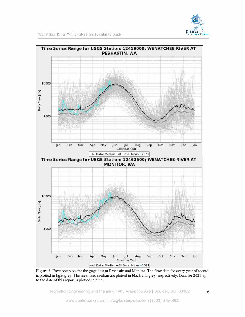
USGS gage 1245900 Wenatchee River at Peshastin, WA has daily discharge data from 1929 until present, and is located downstream of the Icicle Creek confluence.
USGS gage 12461000 Wenatchee River at Dryden, WA has daily discharge data from 1907 to 1917, but does not contain data beyond 1917.
USGS gage 12462500 Wenatchee River at Monitor, WA has daily discharge data from 1962 to present. It is the most downstream gage on the Wenatchee River, located downstream of Peshastin Creek, several minor tributaries including Mission Creek, and irrigation diversions.
Wenatchee River Whitewater Park Feasibility Study
Recreation Engineering and Planning | 485 Arapahoe Ave | Boulder, CO, 80302
www.boaterparks.com | [email protected] | (303) 545-5883
6
Figure 8. Envelope plots for the gage data at Peshastin and Monitor. The flow data for every year of record is plotted in light grey. The mean and median are plotted in black and grey, respectively. Data for 2021 up to the date of this report is plotted in blue.

Wenatchee River Whitewater Park Feasibility Study
Recreation Engineering and Planning | 485 Arapahoe Ave | Boulder, CO, 80302
www.boaterparks.com | [email protected] | (303) 545-5883
7
Figure 9. Monthly mean flows at the Peshastin and Monitor gages. The monthly means are connected by the bold black line. A box plot is shown for each month, with the blue bar representing the interquartile range. The monthly means for each individual month of record are shown in light grey.

Wenatchee River Whitewater Park Feasibility Study
Recreation Engineering and Planning | 485 Arapahoe Ave | Boulder, CO, 80302
www.boaterparks.com | [email protected] | (303) 545-5883
8
Table 1. Monthly mean flows at the USGS gages at Peshastin and Monitor
Monthly Mean Flow (cfs)
Calendar Month Peshastin Gage Monitor Gage
Difference (Monitor - Pesh)
January 1568 1846 278 February 1637 2009 372 March 1891 2367 476 April 3770 4046 276 May 7913 8159 245 June 8382 8540 158 July 4248 4185 -63 August 1410 1369 -41 September 796 767 -28 October 1145 1142 -4 November 2033 2305 272 December 1788 1961 172
The mean daily flow for each month at the USGS gages at Peshastin and Monitor are compared in the table above. Monitor, located downstream of Peshastin and a number of tributaries, has a greater flow for most months of the year. However, during the irrigation season this difference decreases as irrigation withdrawals divert water from the river, and during the late summer and fall months the Monitor gage location actually has less flow than the Peshastin gage location.
As can be seen in the proceeding plots, the Wenatchee River follows a similar pattern each spring, with flows increasing as temperatures warm and runoff occurs. Flows typically peak in June, then steadily decrease throughout the summer with the diminishing snowpack. The lowest flows occur in September. The winter has relatively low average flows, though as can be seen in the envelope plots the highest flows ever recorded at the gages have occurred during the winter.
Given the existing freestyle opportunities at high water, there is a desire for a whitewater feature that will function during the majority of the year when flows on the Wenatchee drop and the high-water playboating and surfing features are gone. The lowest average monthly flow (September) is still nearly 800cfs at the Peshastin gage, which is similar to the design flow at several whitewater parks. However, depending on the site constraints and optimizing for fish habitat / passage, the total flow may not be available for the whitewater improvements. The design phase will include a detailed investigation into optimizing the design for the full range of flow rates.

Wenatchee River Whitewater Park Feasibility Study
Recreation Engineering and Planning | 485 Arapahoe Ave | Boulder, CO, 80302
www.boaterparks.com | [email protected] | (303) 545-5883
9
Site Assessments
Figure 10. Location map of the six sites investigated, numbered from upstream to downstream.
The selected sites were identified by Chelan County staff with input from the Wenatchee River Alliance and REP. Existing dams were included since they generally provide the best opportunity for whitewater parks. The river at a dam is heavily impacted, making it easier to provide ecological uplift at the site, and there is hydraulic drop necessary for whitewater features. Usually there are safety concerns and/or fish passage/habitat issues, increasing the likelihood of getting additional stakeholders on board if these issues can be addressed with the project. This can lead to additional funding sources. The majority of whitewater parks are constructed at old dam sites or as a modification of a functioning dam.
Additional sites were chosen at publicly owned property with river frontage, existing park facilities, and hydraulic gradient. Existing freestyle features were not included as potential sites for a whitewater park, since in general they are not located adjacent to public property, and as designers we generally take the “don’t fix what ain’t broke” approach to existing features that are well loved. However, public access and bank improvements at these locations could provide a large benefit, but that is beyond the scope of this report.
REP engineers Mason Lacy and Mike Harvey, and Randy Goetz with Parr Excellence, conducted site visits April 7 – 9, 2021. The Wenatchee River flow during the site visits ranged from 2,350cfs to 2,450cfs at the Peshastin gage. Staff from Chelan County and Washington Department of Fish & Wildlife (WDFW) attended all site visits, and Chelan County Public Utility District (PUD) staff attended site visits to their facilities (Dryden Dam and Tumwater Dam). Site field investigations included a visual assessment of the

Wenatchee River Whitewater Park Feasibility Study
Recreation Engineering and Planning | 485 Arapahoe Ave | Boulder, CO, 80302
www.boaterparks.com | [email protected] | (303) 545-5883
10
necessary variables relevant to the feasibility of the project, including a review of hydraulic gradient, geomorphology, site access, staging, constructability, bed / bank material, infrastructure, wetlands / sensitive areas, and existing habitat. Additional factors considered in the site assessments include land ownership, existing uses at the site, proximity to communities, and parking. Aerial imagery of the sites were collected with a DJI Mavic Air 2 drone. Bathymetric LiDAR data that was collected as part of the LWRA was reviewed for all sites in the coverage area and used to estimate drop in the riverbed. Six sites were assessed, with additional sites visited near Cashmere.
Tumwater Dam Tumwater dam is the most upstream site investigated. The dam is located upstream of Leavenworth in Tumwater Canyon. The Wenatchee River is constrained within the canyon, with Class V rapids located upstream and downstream of the site. Hwy 2 runs alongside the river through Tumwater Canyon. The river at the site is heavily impacted by the dam and highway.
There is over 30ft of hydraulic head at the dam. The dam was originally constructed from 1907 to 1909 to produce power for electric locomotives. Hydroelectric power has not been produced at the site since 1956, and the dam is currently owned by Chelan County PUD. Fish passage facilities at the site allow upstream passage and enable broodstock collection and other hatchery related activities.
The existing public facilities are minimal, with minimal parking and no restrooms, and the site provides very little space for additional upland facilities. With the amount of hydraulic drop at the dam, it would be very expensive and challenging to convert the dam into a series of drops and whitewater features. At high flows, any improvements would be for experts only. Previous discussions of dam removal have been stalled due the importance of the dam for fish management activities in the basin.
Due to its height, location in Class V Tumwater canyon, constrained site, and importance in fish management, Tumwater Dam is not a great site for a whitewater park. However, if dam removal is considered in the future, recreational use of the river by whitewater paddlers should be considered in the design.
Figure 11. Tumwater Dam, looking upstream. The fish passage facilities are on the right of the photo.

Wenatchee River Whitewater Park Feasibility Study
Recreation Engineering and Planning | 485 Arapahoe Ave | Boulder, CO, 80302
www.boaterparks.com | [email protected] | (303) 545-5883
11
Habitat Conditions, Concerns, and Improvement Potential
Aquatic habitat conditions are naturally limited around the Tumwater Dam site. Tumwater Canyon is a narrowly confined canyon with steep hillslopes directly adjacent to the channel on both sides. Highway 2 further constricts the channel on river left. The gradient is consistently steep, velocity is high, and the bed material is large. This is primarily a migratory corridor for salmonids with little spawning or rearing habitat. There is some limited floodplain development and high flow refugia on river right downstream of the dam. Upstream of the dam, the impoundment creates a slow-moving section of river for several hundred feet.
In the potential development of a whitewater park at this location, the primary habitat concern would be in the maintenance of fish passage. Currently, the dam itself is a barrier and passage is mainly facilitated by the fish ladder. Any park design would need to account for passage as a main habitat concern. Concerns from a habitat enhancement design perspective are primarily in relation to the hydraulic conditions in the reach which can be extreme in high flow conditions.
Habitat improvement potential is naturally limited due to the character of the river at this location. The main opportunities would involve habitat feature incorporation into channel re-configuration during installation of recreational features. There would be the potential to include step-pool features that would ease fish passage and provide increased pool and holding habitat important to migratory reaches. Channel hydraulics including high velocity precludes the placement of other habitat features such as large wood. Upstream of the existing dam, there would be additional opportunity to place cover habitat in the form of large wood structures along the channel margin, or as mid-channel log jams. Hydraulic forces are reduced in this low velocity area and could support habitat enhancement.
Figure 12. High velocity channel downstream of the dam (left). The impoundment upstream of the dam creates a low velocity area (right).

Wenatchee River Whitewater Park Feasibility Study
Recreation Engineering and Planning | 485 Arapahoe Ave | Boulder, CO, 80302
www.boaterparks.com | [email protected] | (303) 545-5883
12
Historic mill dam in Leavenworth The site assessed in Leavenworth is located at a historic mill dam site, at Barn Beach just downstream of a popular tuber takeout. In the warm late summer months with low water, the reach immediately upstream of the site is extremely popular with tubers and casual river users. The site is downstream of Icicle Creek’s confluence with the Wenatchee.
The dam was built by 1905 to create a mill pond for the Lamb-Davis Lumber Company’s sawmill in Leavenworth. The sawmill closed permanently by 1927, and the dam no longer served a useful purpose. In 1932, the dam’s superstructure “mysteriously” burned to the waterline. Soon after, the Game Department dynamited openings in the remaining rock structure.1
Today, remnants of the original dam can still be seen. Rock riprap, concrete, and timber cribbing (likely creosote-treated) are all still located at the dam site and immediately downstream. This reach of the Wenatchee is heavily impacted from the historic mill operations, with timber piles and remnant fill obvious in many areas. Upstream of the dam site is a calm section of river. Downstream there are minor rapids as the river picks up leading into Boulder Bend Rapid. Most tubers take out just upstream of the dam site to avoid the rapids downstream.
The bed and banks of the river primarily consists of larger rock, with sand deposition in the eddies creating beaches. There are no signs of lateral channel migration, and the channel appears stable, partially due to the remnants of the historic dam.
Figure 14. Timber cribbing (left) and chunks of concrete (right) remain today at the dam site 1Information from interpretive sign located at the site
Figure 13. The original Lamb-Davis mill dam. Image source: Upper Valley Museum at Leavenworth

Wenatchee River Whitewater Park Feasibility Study
Recreation Engineering and Planning | 485 Arapahoe Ave | Boulder, CO, 80302
www.boaterparks.com | [email protected] | (303) 545-5883
13
Figure 15. The remaining riprap dam can be clearly seen today on the river left bank (right photo). A historic photo of the dam from the same vantage point is shown in the left photo. Left image source: Wenatchee National Forest
The river left bank is owned by the City of Leavenworth, and inland from the riverbank is property held by the Barn Beach Trust. The majority of the river right bank is privately owned, though less than 1,000ft upstream of the site is a large parking lot and boat launch owned by the City of Leavenworth. The are some existing facilities at the site, including a small dirt parking lot, and it is located a short walk from downtown Leavenworth. The existing site is heavily used during warm summer months with low water, and there have been parking and other issues associated with the high river use.
REP engineers measured approximately 2ft of hydraulic drop across the dam structure during the site visit (flow of 2,400cfs at the Peshastin gage). This was estimated from upstream of the dam to the pool downstream of Barn Beach using a hand level. The amount of hydraulic drop at a site is affected by constrictions upstream and downstream, and will change with the amount of flow in the river. From the LWRA bathymetric LiDAR data, it was estimated the riverbed drops between 2ft to 4ft from upstream of the dam to the downstream controlling section.
Most high-performance whitewater features require 1.5 to 2ft of drop. Possible in-stream improvements could include deflectors, boulders and other elements to create eddies and more hydraulic complexity. Based on our field measurements, we estimate up to one high-performance feature could be created, with possibly an additional beginner feature that could also provide downstream tailwater control. Additional hydraulic measurements and modeling would be necessary during the design phase to confirm the amount of drop available at a variety of flows.
Figure 16. An aerial view of the site.

Wenatchee River Whitewater Park Feasibility Study
Recreation Engineering and Planning | 485 Arapahoe Ave | Boulder, CO, 80302
www.boaterparks.com | [email protected] | (303) 545-5883
14
Any improvements proposed would need to be developed in close coordination with the City of Leavenworth. The City is currently working on a river recreation plan to manage the high amount of river use, and a project here could be designed to complement that plan and help address some of the high use issues. Barn Beach Trust and private landowners on river right would need to be included as well. As with all projects in this river corridor, early communication and coordination with WDFW and U.S. Fish and Wildlife (USFW) is necessary for a successful project.
Habitat Conditions, Concerns, and Improvement Potential
The site is located at a geomorphic transition between a meandering, alluvial reach upstream, and a steeper and more confined reach downstream. These are designated as Reaches 8 and 9 in the LWRA. Upstream Reach 9 has a relatively wide and well-connected floodplain with active secondary channels, ponds, and wetlands. There is a significant amount of documented spawning upstream of the site. Downstream in Reach 8, the floodplain narrows, the grade increases, bed material size increases, and there is a reduction in floodplain habitat as well as diversity of in-stream habitat. There is very little instream habitat directly adjacent to the site though there is some margin pool habitat in the tail out of the riffle, though there is a lack of cover. The remnant of the dam blocks the channel’s connectivity to potential river left off-channel habitat.
In the potential development of a recreational whitewater feature at this site, the primary concern would be to at least maintain existing habitat and fish passage. The pool habitat features would need to be maintained, or an analog replacement would need to be included in design. Recreational feature design will also need to take spawning areas into account and ensure that altered hydraulics and planned user traffic avoids impacts to spawning gravels upstream of the site.
There are several habitat improvement possibilities at this location that could be included in park design. At the upstream end of the site, there are river-left floodplain habitat features with compromised connectivity due to the rip rap in the old mill dam. Reconnection of these features could be explored during park design. In-channel habitat work is also possible. There are potential locations for large wood features along river right that would provide cover and improved pool habitat. Improvements to current river usage could reduce damage to spawning gravels; the design may need to directly address tube, SUP, etc traffic during periods of high use in the summer.

Wenatchee River Whitewater Park Feasibility Study
Recreation Engineering and Planning | 485 Arapahoe Ave | Boulder, CO, 80302
www.boaterparks.com | [email protected] | (303) 545-5883
15
Dryden Dam Dryden Dam is located downstream of the town of Peshastin, immediately downstream of Peshastin Creek’s confluence with the Wenatchee River. The dam was originally constructed in 1908, and continues to divert water for irrigation. The dam was reconstructed in 1986 with concrete to replace the original deteriorating timber structure. The dam currently has two fish passage and trapping facilities, one on each bank. The facilities are used for broodstock collection and fishery-resource monitoring by several groups, including WDFW, USFWS, and Yakama Nation Fisheries. The dam is owned by Chelan County PUD.
The portion of the dam in the center of the river runs parallel to the direction of flow, with the river right (west) end of the dam located about 700ft upstream of the river left (east) end of the dam.
The hydraulic roller formed by the upstream-most section of dam presents an extreme public safety hazard. Hydraulic rollers located at low head dams such as this one are effective at trapping objects (including humans) in a dangerous recirculating pattern, whether the victims are wearing a personal floatation device (PFD) or not. With their low height and calm water upstream, low head dams can look innocuous to an inexperienced river user, when in fact they are extremely dangerous due to their man-made uniformity that is not found in nature.
Figure 17. Dryden Dam looking upstream
Figure 18. The formation of a hydraulic "drowning machine" at a low head dam. Source: Wright Water Engineers

Wenatchee River Whitewater Park Feasibility Study
Recreation Engineering and Planning | 485 Arapahoe Ave | Boulder, CO, 80302
www.boaterparks.com | [email protected] | (303) 545-5883
16
The hydraulic formed at the Dryden Dam is a classic low-head dam hydraulic scenario. The American Whitewater description of the run calls the hydraulic “a guaranteed drowning machine”. There has been at least one documented drowning at the site, and unfortunately it is rarely documented whether a drowning was associated with a dam. The documented case occurred in 2016, and the American Whitewater accident description is attached to this report. The victim was on a commercial raft trip and wearing a PFD.
During the dam reconstruction in 1986, the concrete weir was designed to create a hydraulic to attract upstream migrating fish to the fishway entrance located at the right bank. The design appears to have been effective in attracting fish, but also created the extreme public safety hazard. REP has designed many fish passage facilities, and optimizing attraction flow for upstream passage is an important component of the design, but can be designed to avoid creating an extreme public safety hazard. We are confident the weir could be reconfigured to still provide effective attraction flow for the fish passage facility while mitigating the safety hazard.
The REP team has been involved in multiple expert testimony cases related to low head dam drownings and river safety incidents. We regularly provide support, guidance, and safety consulting related to river projects across the country. Based on our experience, more drownings at the site in its current configuration are inevitable, and safety modifications at the dam should be collaboratively pursued to avoid potential for future accidents at the site.
Figure 19. A life ring located at the dangerous hydraulic.
Figure 20. The location of the most dangerous portion of the weir.

Wenatchee River Whitewater Park Feasibility Study
Recreation Engineering and Planning | 485 Arapahoe Ave | Boulder, CO, 80302
www.boaterparks.com | [email protected] | (303) 545-5883
17
WDFW owns the river right property extending from just below the west side of the dam to upstream of Peshastin Creek. There is a large gravel lot that is used for parking and portaging around the dam. The site is currently used for fishing and river access. Chelan County PUD owns a strip of land at the fish passage and trapping facility. Downstream the river right bank is private property.
A railroad runs along the river left bank, and there is no public access. Chelan County PUD owns the property at the intake works on river left and the canal running downstream.
The only public access at the site is on the property owned by WDFW. Any improvements designed with bank access in mind, such as “park and play” whitewater features, would need to extend upstream from the existing dam to avoid access issues on the private land immediately downstream. Alternatively, if a portion of the riverside private property could be purchased or a public access easement obtained, some improvements could extend downstream.
Figure 21. Land ownership at the Dryden Dam site.

Wenatchee River Whitewater Park Feasibility Study
Recreation Engineering and Planning | 485 Arapahoe Ave | Boulder, CO, 80302
www.boaterparks.com | [email protected] | (303) 545-5883
18
There is sufficient hydraulic drop at the dam for a whitewater park, and the gradient picks up downstream of the dam. The channel is locked in by the dam and railroad, without signs of significant recent deposition or erosion.
From the LWRA bathymetric LiDAR data, the dam crest at the dangerous portion of the weir is 2ft-3ft above the crest of the riffle downstream. A 10ft deep scour hole has formed immediately below the dam in this location. There is another 7ft-10ft of drop in the riverbed in the riffle downstream of the dam.
Any improvements proposed at the site will need to be developed in close
coordination with Chelan County PUD, WDFW, and all entities that use the existing facilities for broodstock collection and fishery-resource monitoring including Yakama Nation Fisheries and USFWS. Yakama Nation also has tribal fishing rights at the dam.
One of the primary obstacles with developing a typical whitewater park with river access from the bank at this site is the broodstock collection facility on river right. The area is surrounded by chain link fence and located squarely where bank improvements would be located. The facility plays an important role in efforts at fisheries recovery in the basin, and significant resources have been invested in it.
Without a change in the right bank broodstock collection facility, recreational improvements can still be made to the weir. At a minimum, safety improvements should be considered to address the public safety hazard. REP has designed many similar dam safety retrofits, and are confident that the weir could be modified to allow safe downstream passage by rafts and other river users, while still maintaining at the existing uses of the dam including attraction flow for the fishway, diversion of water for irrigation, fish passage and broodstock collection. Any project would be developed through close collaboration with Chelan County PUD, and could address other possible maintenance needs on the dam infrastructure. As part of the design process, an in-depth hydraulic
Figure 23. Fishing platforms used by the Yakama Nation at Dryden Dam.
Figure 22. Dryden Dam and Peshastin Creek upstream can be seen in the hillshade from the LWRA LiDAR data.

Wenatchee River Whitewater Park Feasibility Study
Recreation Engineering and Planning | 485 Arapahoe Ave | Boulder, CO, 80302
www.boaterparks.com | [email protected] | (303) 545-5883
19
assessment (two-dimensional hydraulic modeling or CFD modeling) would be performed to ensure current uses and fish-attraction hydraulics would not be compromised. Habitat Conditions, Concerns, and Improvement Potential The site is located near a geomorphic transition between LWRA Reaches 7 and 6. The confluence of Peshastin Creek, which is just upstream of the site on river right, marks the reach break. Upstream in Reach 7, the channel is relatively confined with hillslopes and glacial terraces directly adjacent to the channel. Channel planform complexity and floodplain width is naturally limited. Downstream in Reach 6 floodplain and channel migration zone width both increase, the channel becomes more sinuous with more frequent bars, islands, and secondary channels. However, most floodplain areas are disconnected from the channel through agricultural and infrastructure development. The Dryden Dam site is situated at an area with high potential habitat complexity relative to the remainder of the reach due to the confluence of Peshastin Creek just upstream.
The primary habitat related concerns in the development of a whitewater park at this site is maintaining current fish passage as well as fish collection conditions. There are observed spawning redds upstream of the site where current conditions would need to be at least maintained. Consideration would also need to be made for the ongoing restoration work at the mouth of Peshastin Creek and the maintenance of fish access to Peshastin Creek.
The site offers significant potential for habitat improvement. Recreational improvements at the Dryden Dam site have the potential to compliment the proposed habitat improvement work being done by WDFW which includes in-channel and floodplain elements at the Peshastin Creek confluence. The work at Peshastin Creek is identified in the LWRA as Tier 1 restoration activity. Restoration opportunities at this
scale, and that address primary limiting factors are rare in reaches 6 and 7. Actions at the dam site that could integrate with Peshastin Creek work include riparian corridor restoration, instream habitat in the form of large wood along the channel margin, and pool habitat enhancement. If the potential existed for reconfiguring or relocating broodstock capture facilities, a more extensive treatment of instream and floodplain habitat would be possible.
Figure 24. Meeting on site with staff from Chelan County PUD, WDFW, Chelan County Natural Resources Department, REP, Parr Excellence, and members of the Wenatchee River Alliance.

Wenatchee River Whitewater Park Feasibility Study
Recreation Engineering and Planning | 485 Arapahoe Ave | Boulder, CO, 80302
www.boaterparks.com | [email protected] | (303) 545-5883
20
Cashmere Riverfront Park Cashmere Riverfront Park is located on the river right bank of the Wenatchee in the community of Cashmere. There is an existing boat ramp at the site which is a common takeout used by the majority of commercial rafting groups. The park is owned and maintained by the City of Cashmere.
Figure 25. An aerial view of Cashmere Riverfront Park and the Wenatchee River. Image source: Google Earth, image date 7/1/2017
There is hydraulic gradient at the site, extensive public property bounding the river right bank, and developed park infrastructure including parking, restrooms, and a boat ramp. The site is located adjacent to downtown Cashmere, making this site intriguing for locals as well as for drawing more visitors into the downtown community. Estimated from the LWRA bathymetric LiDAR, the riverbed drops between 3ft-5ft across the length of the park.
However, the location of the site on a large bend in the river makes a whitewater park located along the right bank of the river nearly impossible. The thalweg is located along the left bank as the current flows around the outside of the bend, and significant deposition occurs at a large point bar adjacent to the park. This has caused issues with use of the boat ramp at low flows, as access to the ramp dries up with the water concentrated along the left bank. The area has been dredged previously to help mitigate the issue, but sediment deposits again along the right bank during high flows.

Wenatchee River Whitewater Park Feasibility Study
Recreation Engineering and Planning | 485 Arapahoe Ave | Boulder, CO, 80302
www.boaterparks.com | [email protected] | (303) 545-5883
21
Figure 26. In this image from the end of July, there is barely any water reaching the boat ramp on river right. Image source: Google Earth, image date 7/31/2005
If the sediment was dredged and a whitewater park constructed along the right bank, the features would likely function for a season before being filled in with sediment during runoff.
Along the left bank, Hwy 2 hugs the river leaving no space to develop improvements outside of the river. However, in-river features could be constructed on the left bank, but without bank access the users would likely be limited to more advanced kayakers and surfers. Additionally, since there is no existing dam structure at the site, demonstrating that the project would improve aquatic habitat would be a challenge.
While in Cashmere, three additional sites were visited. These three sites were located on undeveloped properties adjacent to the river owned by the City of Cashmere. One site is located off Hagman Rd and is currently used for composting, one at the confluence of Mission Creek with the Wenatchee (just above Granny’s), and one at the previous wastewater lagoons at the wastewater treatment plant. None of the sites made obvious sites for a whitewater park and would require significant investment to improve. Possible recreational improvements were discussed at each site, and as these sites are developed incorporating river access and river recreation would provide a benefit to the community. Habitat Conditions, Concerns, and Improvement Potential
The site is in Reach 6 of the LWRA. Overall, Reach 6 was noted to have a broad floodplain valley, but the majority of floodplain area is disconnected. The Cashmere riverfront site is located at the margin of a large, disconnected floodplain noted in the LWRA as a potential project area. However, the assessment notes the difficulties in carrying out this work due to the development of that floodplain by the City of Cashmere. In the channel itself, there is little available habitat near the site. Flow splits

Wenatchee River Whitewater Park Feasibility Study
Recreation Engineering and Planning | 485 Arapahoe Ave | Boulder, CO, 80302
www.boaterparks.com | [email protected] | (303) 545-5883
22
around a mid-channel bar providing some side-channel habitat downstream of the site on river right, but with a lack of significant cover.
In the potential development of a whitewater park at this location, care would need to be taken to do no damage to the limited habitat that is currently available. If there were to be work in the main channel, maintenance of fish passage would be an important consideration. Work in the river right side channel would need to at least maintain available off-channel habitat if not improving it.
The nature of the channel near the site, and the constraints created by flood protection for the City of Cashmere on river right and by Highway 2 on river left, result in limited habitat improvement opportunities. Work in the river right side channel could provide improved off-channel habitat and increased cover, but would need to be balanced with swimming and other recreational uses at the site. Margin habitat to improve cover and drive pool scour could be placed at several potential locations on river right downstream of the site, or river left at several up and downstream locations.
Wenatchee River County Park Located off of Hwy 2 just downstream of Monitor, Wenatchee River County Park is an existing park and campground on the river left bank of the Wenatchee owned by Chelan County. There is an existing riffle at the site.
Figure 27. The existing riffle at Wenatchee River County Park, looking upstream. The river right bank is privately owned, and the main flow of the river is concentrated along the right bank. Similar to the site at Cashmere Riverfront Park, it is a challenge

Wenatchee River Whitewater Park Feasibility Study
Recreation Engineering and Planning | 485 Arapahoe Ave | Boulder, CO, 80302
www.boaterparks.com | [email protected] | (303) 545-5883
23
when the thalweg is located along the opposite bank as the public property, though the deposition seems less extreme at Wenatchee River County Park
REP engineers measured 3.8ft of hydraulic drop over the existing riffle during the site visit. This estimate was made using a hand level, with a flow of 2,400cfs at the Peshastin gage. From the LWRA bathymetric LiDAR data, there is 6ft-7ft of dry drop in the riverbed from the riffle crest to the downstream controlling.
Based on the field hydraulic drop estimate, the site could provide enough drop for two freestyle features. Since there is no existing dam structure at the site, making the case that the project is a benefit to fish habitat would be difficult, and anchoring the structures in the alluvium would be a challenge. Habitat Conditions, Concerns, and Improvement Potential
The site is located within Reach 4 of the LWRA. Habitat in this reach is described as limited in the LWRA due to extensive bank armoring and development of the floodplain. These conditions are consistent with habitat observed near the site. The channel is simplified with plane bed or riffle morphology and no significant pools nearby. The floodplain is developed, and banks are hardened on both sides of the river. The point bar on river left provides off-channel habitat when the high flow channel is activated, though there is very little complexity.
The main habitat concern in the potential development of a whitewater park at this location is in maintaining fish passage through the site. Aside from this consideration, there is little habitat that would be affected.
The LWRA identified potential projects up and downstream of the site. At some locations, suggestions include using large wood to enhance artificially hardened banks, and at other locations project opportunities are identified as adding boulder clusters to the channel to increase complexity. Either of these approaches could be employed in the vicinity of the site as well. There is also opportunity to explore options on river left to enhance the high-flow channel.
Figure 28. Bank armoring and entrance to high flow channel on river left.

Wenatchee River Whitewater Park Feasibility Study
Recreation Engineering and Planning | 485 Arapahoe Ave | Boulder, CO, 80302
www.boaterparks.com | [email protected] | (303) 545-5883
24
Walla Walla Point Park The final site investigated is located on the Columbia River, just downstream of the confluence of the Wenatchee River with the Columbia. Walla Walla Point Park is owned and operated by Chelan County PUD.
Due to its large size (70 acres) and location in Wenatchee, the site was originally considered for the possibility of developing a pumped whitewater park (completely separate from the Wenatchee or Columbia Rivers, using water recirculated using large pumps). However, after discussion of the cost associated with developing and running a pumped facility, the concept of an off-river facility was not investigated further.
The site’s location on the Columbia River was intriguing and based on satellite imagery it appeared there was significant downstream velocity at the site during certain times of the year depending on the operation of Rock Island Dam (downstream) and Rocky Reach Dam (upstream). With enough water, there are examples of wave features forming with little to no bed drop. Examples include Big Sur on the Colorado River, and Skookumchuck on BC’s Sunshine Coast (a tidal rapids formed by a massive tidal exchange). However, during the site visit there was no hint of downstream current, and it appeared extremely unlikely there is ever enough velocity to support a wave. Based on our observations, developing an instream whitewater park is not feasible at this location without a major change in the operation of the Columbia River dams.
Figure 29. The Columbia River flowing by Walla Walla Point Park, with what appears to be some eddie patterns and velocity. Image source: Google Earth, image date 7/20/2012
Wenatchee River Whitewater Park Feasibility Study
Recreation Engineering and Planning | 485 Arapahoe Ave | Boulder, CO, 80302
www.boaterparks.com | [email protected] | (303) 545-5883
25
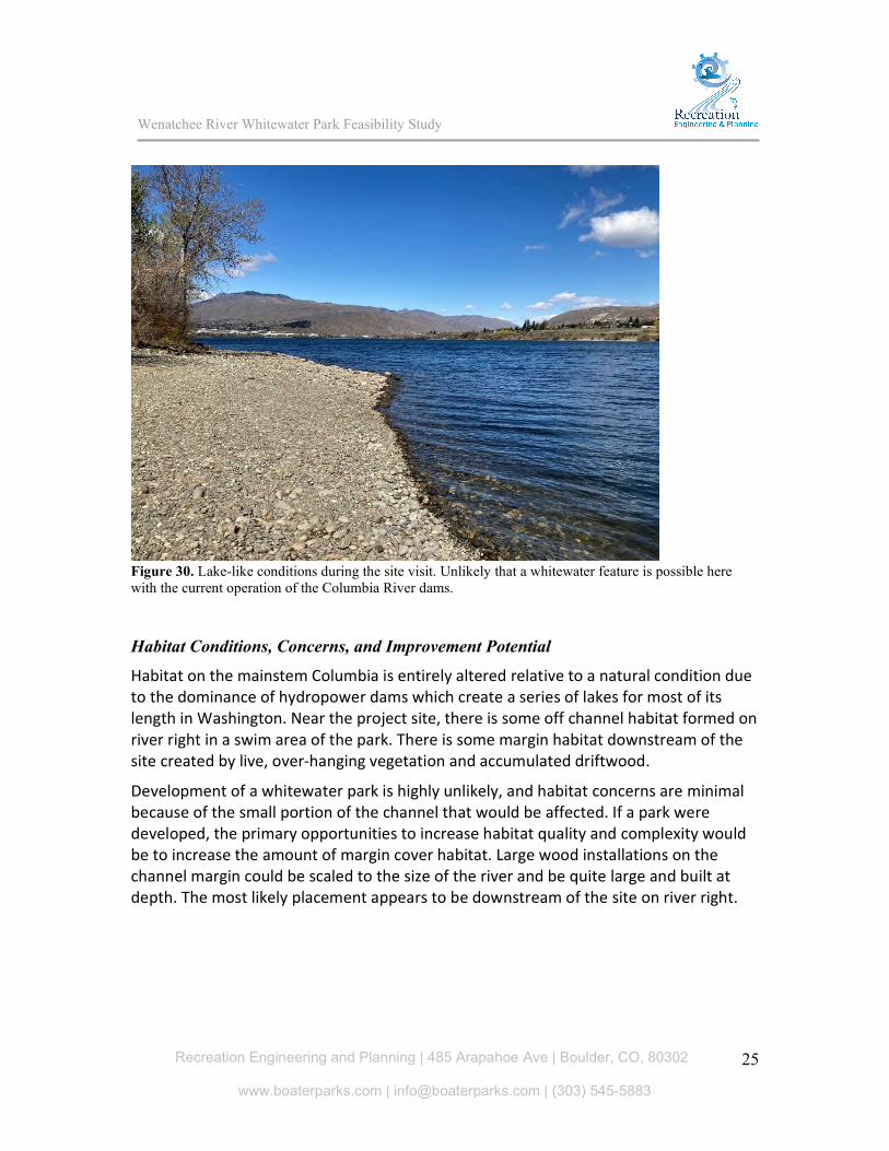
Figure 30. Lake-like conditions during the site visit. Unlikely that a whitewater feature is possible here with the current operation of the Columbia River dams. Habitat Conditions, Concerns, and Improvement Potential
Habitat on the mainstem Columbia is entirely altered relative to a natural condition due to the dominance of hydropower dams which create a series of lakes for most of its length in Washington. Near the project site, there is some off channel habitat formed on river right in a swim area of the park. There is some margin habitat downstream of the site created by live, over-hanging vegetation and accumulated driftwood.
Development of a whitewater park is highly unlikely, and habitat concerns are minimal because of the small portion of the channel that would be affected. If a park were developed, the primary opportunities to increase habitat quality and complexity would be to increase the amount of margin cover habitat. Large wood installations on the channel margin could be scaled to the size of the river and be quite large and built at depth. The most likely placement appears to be downstream of the site on river right.

Wenatchee River Whitewater Park Feasibility Study
Recreation Engineering and Planning | 485 Arapahoe Ave | Boulder, CO, 80302
www.boaterparks.com | [email protected] | (303) 545-5883
26
Prioritization Matrix To directly compare the suitability of the assessed sites, a matrix was developed with relevant criteria. Each site was scored on a scale from 0 to 5 for each category. The following criteria was used:
Adequate hydraulic drop: Some sites investigated did not have enough hydraulic drop for a whitewater park (Walla Walla Point Park), while Tumwater Dam had more hydraulic drop than desired. Both would score low in this category.
Adjacent public property: This scores the size and location of the public property adjacent to the site.
Geomorphic suitability: River reaches vary in how sustainable fixed features would be over many years. Alluvial reaches with high likelihood of channel migration and significant erosion or deposition are not suitable.
Constructability: Scores ease of construction, including how structures will be anchored, dewatering, etc.
Existing park infrastructure: Includes parking areas, restrooms, etc. River reach degraded: A high score in this category means the existing river is
heavily degraded at the site, and a well designed project would not degrade existing habitat. A low score in this category means the river is relatively undisturbed and any intervention in the riverbed would likely degrade habitat.
Habitat improvement potential: Opportunity at the site to improve aquatic habitat at the site with the project.
Safety improvement potential: Opportunity at the site to mitigate a public safety hazard.
Site Prioritization Matrix

Wenatchee River Whitewater Park Feasibility Study
Recreation Engineering and Planning | 485 Arapahoe Ave | Boulder, CO, 80302
www.boaterparks.com | [email protected] | (303) 545-5883
27
Recommendations and Next Steps Based on the assessment described in this report, the two sites that we recommend prioritizing are the Dryden Dam and the historic mill dam in Leavenworth. Both sites present exciting opportunities for river recreation and habitat improvement.
Next steps include the development of concept designs and stakeholder engagement. Input from critical stakeholders and the public will be important in shaping the designs proposed. For the Dryden Dam site, with several entities using the site for critical activities in the watershed, we recommend developing two alternative concept designs for the site. One alternative could include development of instream recreation features, habitat improvements, improved bank access, and other improvements typically included in a whitewater park project. The other alternative could be focused solely on minimizing the extreme safety hazard at the site, without negatively impacting the existing fish passage facilities, attraction flow, or any existing uses of the site. As described previously, it is our strong recommendation to address the public safety hazard present at the Dryden Dam as soon as possible to prevent further loss of life.
After completion of the concept designs, one or more projects can be selected to proceed towards construction. Community decisions will guide how the project progresses. Throughout the process, there will need to be continued engagement with the public and stakeholders, including regulatory agencies. Below is a summary of the typical technical steps required to bring the design through construction:
Site Survey: A survey of the existing project area by a PLS, including bathymetry.
Preliminary Design: The preliminary design phase includes compiling technical data about the site and developing a preliminary design based on existing elevations and site features. The preliminary design can also be referred to as the 30% design.
Hydraulic Modeling: Hydraulic modeling of the proposed design is performed during the development of the preliminary and 60% designs. Modeling is required to evaluate the design for no-rise conditions in the regulatory floodway, as well as inform design elements such as fish passage, scour protection, hydraulic drop, etc.
60% Design: The design is refined based on feedback on the preliminary design, and many of the technical details related to the design are developed. 60% design plans contain sufficient detail for permit applications.
Regulatory Permitting: Once the 60% design is developed, the regulatory permitting phase can be initiated. Required permits include, but are not limited to, US Army Corps of Engineers 404 permit, WDFW Hydraulic Project Approval (HPA), Local (County/City) Permits and Floodplain Permitting. Early coordination and communication with regulatory agencies will be important to the success of the project, including US Fish & Wildlife to ensure the design will meet the requirements for listed species.

Wenatchee River Whitewater Park Feasibility Study
Recreation Engineering and Planning | 485 Arapahoe Ave | Boulder, CO, 80302
www.boaterparks.com | [email protected] | (303) 545-5883
28
Final Design: The final design phase takes inputs from the permitting phase and refines the design to the construction and bidding level.
Construction Phase Services: Bidding assistance and letting of a contract for construction, contractor construction of the project. Engineering oversight during construction will be required.

Attachments: American Whitewater Accident Description

Accident Description
https://www.americanwhitewater.org/content/Accident/detail/accidentid/4019
May 4, 2016 5:17 PM
Man dies after raft flips on Wenatchee River
The Associated Press
DRYDEN, WA: Authorities say a man in his 50s died while rafting on the Wenatchee River.
The Chelan County Sheriff's Office said in a news release that a commercial raft with the
man, a teenage girl and raft operator flipped Wednesday afternoon. The sheriff's office says
both the man and the girl were thrown from the raft and that the girl climbed back on but
the man could not.
A kayaker traveling with the raft assisted the man to shore where authorities say CPR was
performed to no avail. The man and girl were wearing wet suits and life jackets.
Shelton man dies in rafting accident on Wenatchee River
By KOMO News
Thursday, May 5th 2016
DRYDEN, Wash. - A man who died Wednesday in a rafting accident on the Wenatchee River
has been identified as a Mason County resident. Keith M. Thomas, 53, of Shelton died after a
commercial raft operated by Orion River Rafting of Leavenworth flipped over, ejecting him
and two others into the cold waters of the river, said Chief Dave Helvey of the Chelan
County Sheriff's Office. The two others - a teenage girl and the raft operator - were able to
climb back into the raft, but Thomas could not.
A safety kayaker accompanying the raft attempted to assist Thomas back to shore.
Rescuers arrived on the scene and performed CPR on Thomas for more than 30 minutes
but were unable to revive him. Both Thomas and the girl were wearing wet suits and life
vests. An autopsy is planned to officially confirm Thomas' cause and manner of death. On the afternoon of May 4, 2016 the Wenatchee River was flowing at 10,900 cfs, a high flow but typical for spring trips on one of Washington State’s most popular whitewater rivers. The victim, Keith M. Thomas, 53, was on a guided commercial raft trip with his 15-year-old daughter when their raft flipped in Rock and Roll in the large hole known as Satan’s Eyeball. The guide and both passengers were thrown into the water. The guide was able to flip the raft back over but both the victim and his daughter had become separated from the boat. With the assistance of a rescue kayaker traveling with the raft, the guide was able to get the daughter back in the raft. The rescue kayaker was then able to reach the victim and instructed him to hang on to the back deck of her kayak as she pulled him to shore.

A swift and efficient rescue below Rock and Roll is important at higher flows because the
Dryden Dam, a lowhead dam with a dangerous hydraulic that is typically portaged, is located
just over 1/2 mile downstream. As the rescue kayaker passed the mouth of Peshastin Creek, a tributary entering from river right immediately upstream of the dam, she instructed the victim to swim to shore shortly before reaching the portage trail for the dam. This can be a challenging move for inexperienced swimmers because the current of the creek entering the river tends to make it difficult to reach shore especially at higher flows. The victim was unable to reach the river right shore and was swept over the Dryden Dam. A Washington Department of Fish and Wildlife employee was at the dam on river right and realized the victim was in distress and had a throw bag but felt the victim was out of range. After the victim floated over the dam, the WDFW employee observed the victim recirculate twice in the hydraulic at the base of the dam. The victim then moved further out of throw bag range along the boil line toward the center of the river, ultimately floating free of the hydraulic, and continued downstream at which point he still appeared to be conscious. The victim continued on for another 3/4 mile of class II/III wave trains below the dam. The rescue kayaker was eventually able to reach the victim below Shark’s Tooth, approximately 1.6 miles downstream of the original incident site at Satan’s Eyeball, and immediately began CPR. Search and rescue were on site within 30 minutes of the 911 call that was placed shortly after the victim passed over the Dryden Dam. After approximately 55 minutes of CPR, the victim was pronounced dead by medics. The weight and fitness level of the victim, along with the fact that he was a non-swimmer, were likely contributing factors. While the victim was wearing a drysuit and PFD, he was not wearing a helmet. Thomas O’Keefe, PhD Pacific Northwest Stewardship Director American Whitewater 3537 NE 87th St. Seattle, WA 98115 425-417-9012 [email protected] @AmerWhitewater