Hunters Hill Bike Plan
87
Prepared by: GTA Consultants (NSW) Pty Ltd for Municipality of Hunters Hill on 24/11/2020 Reference: N189290 Issue #: B Hunters Hill Bike Plan Municipality of Hunters Hill Final Report
-
Upload
khangminh22 -
Category
Documents
-
view
4 -
download
0
Transcript of Hunters Hill Bike Plan

Prepared by: GTA Consultants (NSW) Pty Ltd for Municipality of Hunters Hill
on 24/11/2020
Reference: N189290
Issue #: B
Hunters Hill Bike Plan Municipality of Hunters Hill
Final Report

© GTA Consultants (NSW) Pty Ltd [ABN 31 131 369 376] 2020
The information contained in this document is confidential and
intended solely for the use of the client for the purpose for which it
has been prepared and no representation is made or is to be implied
as being made to any third party. Use or copying of this document in
whole or in part without the written permission of GTA Consultants
constitutes an infringement of copyright. The intellectual property
contained in this document remains the property of GTA Consultants.
GT
A R
ep
ort
Melbourne | Sydney | Brisbane
Adelaide | Perth
Hunters Hill Bike Plan Municipality of Hunters Hill
Final Report
Client: Municipality of Hunters Hill
on 24/11/2020
Reference: N189290
Issue #: B
Quality Record
Issue Date Description Prepared By Checked By Approved By Signed
A 25/08/2020 Final Liam Clark Volker Buhl Volker Buhl
B 24/11/2020 Final Liam Clark Volker Buhl Volker Buhl

N189290 // 24/11/2020
Final Report // Issue: B
Hunters Hill Bike Plan, Municipality of Hunters Hill
CONTENTS 1. Introduction 1
1.1. Introduction 1
2. Background Review 2
2.1. Regional Context 2
2.2. Hunters Hill 6
3. Existing Conditions 9
3.1. Key Land Use and Locations 9
3.2. Travel Patterns and Journey to Work 11
3.3. Safety 13
3.4. Topography 14
3.5. Existing Cycling Facilities 16
4. Stakeholder Engagement 25
4.1. Community Consultation 25
4.2. Engagement with Adjoining Councils 27
5. Strategic Route Network 28
5.1. Introduction 28
5.2. Principles for Cycling Routes and Facilities in Hunter’s Hill 29
5.3. Proposed Strategic Routes 30
5.4. Future Route Network 58
6. Action Plan 60
6.1. Work Program 60
6.2. Standard Cycleway Treatments 71
6.3. Wayfinding Strategy 73

N189290 // 24/11/2020
Final Report // Issue: B
Hunters Hill Bike Plan, Municipality of Hunters Hill
Figures
Figure 2.1: 2018 Principal Bicycle Network 3
Figure 2.2: 2056 Principal Bicycle Network 4
Figure 2.3: City of Ryde Proposed Cycle Network 5
Figure 2.4: 2004 Bike Plan – Proposed Routes 7
Figure 2.5: Hunters Hill Bike Route 8
Figure 3.1: Key Destinations Map 10
Figure 3.2: Method of Travel to Work 12
Figure 3.3: Bicycle Mode Share Across Time 13
Figure 3.4: Bicycle Crashes in Hunters Hill 13
Figure 3.5: Hunters Hill Topography 14
Figure 3.6: Mount Street 15
Figure 3.7: Existing Cycling Facilities (2020) 16
Figure 3.8: Shared Path at Tarban Creek 17
Figure 3.9: Cracked Shared Path at Hunters Hill High School 17
Figure 3.10: Satisfactory Linemarking at Alexandra Street 18
Figure 3.11: Unsatisfactory Linemarking at Waruda Place 18
Figure 3.12: Wayfinding at Tarban Creek 19
Figure 3.13: Wayfinding at Rose Street 19
Figure 3.14: Bike racks at ferry wharves 20
Figure 3.15: Burns Bay Road crossings 21
Figure 3.16: Fig Tree Bridge shared path 21
Figure 3.17: Gladesville Bridge tunnel 22
Figure 3.18: Bicycle route to and from Gladesville Bridge 22
Figure 3.19: Gladesville Bridge shared path 23
Figure 3.20: Wayfinding at Ashburn Place 23
Figure 3.21: PS-2 Bicycle Symbols at Ryde Road 24
Figure 4.1: Response Categories 25
Figure 5.1: Key Destinations 28
Figure 5.2: Proposed Strategic Route Network 31
Figure 5.3: Route HH1 33
Figure 5.4: HH1 Section 1 – Hunters Hill Village to Mount Street 33
Figure 5.5: Street objects at Ryde Road 34
Figure 5.6: Removal of Burns Bay Road slip lanes 35
Figure 5.7: Alexandra Street – Mount Street – The Avenue Concept Intersection Layout 36
Figure 5.8: HH1 Section 2 – Mount Street to Toocooya Road 37
Figure 5.9: HH1 Section 3 – Toocooya Road to Vernon Street 38
Figure 5.10: HH1 Section 4 – Vernon Street to Marist Sisters’ College 39

N189290 // 24/11/2020
Final Report // Issue: B
Hunters Hill Bike Plan, Municipality of Hunters Hill
Figure 5.11: HH1 Section 5 – Marist Sisters’ College to Woolwich Wharf 40
Figure 5.12: Route HH2 41
Figure 5.13: HH2 Section 1 – Buffalo Creek Reserve Playground to Pains Road 42
Figure 5.14: Completed shared path at Pittwater Road 42
Figure 5.15: Construction of a shared path at Pittwater Road (June 2020) 43
Figure 5.16: HH2 Section 2 – Pains Road to Princes Road 43
Figure 5.17: HH2 Section 3 – Pittwater Road to Ryde Road 44
Figure 5.18: Slow point at Farnell Street 45
Figure 5.19: HH2 Section 4 – Farnell Street to Milling Street 45
Figure 5.20: HH2 Section 5 – Augustine Street to Gladesville Road 46
Figure 5.21: HH2 Section 6 – Rocher Avenue to Ryde Road 46
Figure 5.22: Route HH3 47
Figure 5.23: HH3 Section 1 – Victoria Road to Makinson Street 48
Figure 5.24: Speed hump at Makinson Street 49
Figure 5.25: Example of contra-flow bicycle lane designated by signs only 49
Figure 5.26: Refuge island at Massey Street 50
Figure 5.27: HH3 Section 2 – Makinson Street to Tarban Creek Reserve 50
Figure 5.28: HH3 Section 3 – Tarban Creek Reserve to Waruda Place 51
Figure 5.29: HH3 Section 4 – Waruda Place to Huntleys Point Wharf 51
Figure 5.30: HH3 Section 4 52
Figure 5.31: Regional Route Interchange 53
Figure 5.32: RR Interchange Visionary Option - Satellite 54
Figure 5.33: RR Interchange Visionary Option - Panorama 54
Figure 5.34: Route RR1 Section 1 55
Figure 5.35: Route RR1 Section 2 55
Figure 5.36: Shared path on Victoria Road, Rozelle 56
Figure 5.37: Route RR2 Section 1 57
Figure 5.38: Burns Bay Road (South) – Space for Off-Road Path 57
Figure 5.39: Burns Bay Road (North) – Space for Off-Road Path 58
Figure 5.40: Future Cycling Network 59
Figure 6.1: Example of Road Hump Cycle Bypass (no zebra crossing) 62
Figure 6.2: Example of Road Hump Cycle Bypass (with zebra crossing) 62
Figure 6.3: Example of Raised Mid-Block Pavement 63
Figure 6.4: Proposed Bicycle Lanterns 65
Figure 6.5: Mary Street and Gladesville Road intersection – concept 66
Figure 6.6: Example of a separated bike lane at Wilson Street, Newtown 68
Figure 6.7: Massey Street and Venus Street intersection – concept 68
Figure 6.8: Shared Path at Kelso Park North, Panania 71

N189290 // 24/11/2020
Final Report // Issue: B
Hunters Hill Bike Plan, Municipality of Hunters Hill
Figure 6.9: Separated Bi-Directional Cycleway Cross Section 72
Figure 6.10: Separated Bi-Directional Cycleway at Kent Street, Sydney 72
Figure 6.11: Bicycle Regulatory Signage 73
Figure 6.12: Example of Bicycle Wayfinding Signage 75
Figure 6.13: Sign Types 77
Figure 6.14: Hunters Hill Route Junctions 78
Figure 6.15: Route HH3 Key Wayfinding Points 79
Figure 6.16: Route HH3 Fingerboard Signage Example 80
Tables
Table 2.1: North District Plan – Cycling-related Actions 2
Table 2.2: Sydney Green Grid – Hunters Hill-related Opportunities 4
Table 2.3: City of Ryde Bicycle Strategy Routes 5
Table 3.1: Description of Key Destinations 10
Table 4.1: Consultation Responses 26
Table 5.1: Strategic Routes 32
Table 6.1: Route HH1 Works 60
Table 6.2: Route HH2 Works 63
Table 6.3: Route HH3 Works 67
Table 6.4: Loop and Loop Connection Works 69
Table 6.5: Regional Route Interchange Works 70
Table 6.6: Summary of Works 70
Table 6.7: Cycle Routes and Sign Types Used on Each Route Type 76
Table 6.8: Route HH3 Wayfinding Sign Schedule 79

INTRODUCTION
N189290 // 24/11/2020
Final Report // Issue: B
Hunters Hill Bike Plan, Municipality of Hunters Hill 1
1. INTRODUCTION
1.1. Introduction
GTA Consultants (GTA) has been commissioned by the Municipality of Hunters Hill to prepare a Bike Plan for
the Hunters Hill Local Government Area. As a result of extensive consultation with stakeholders in the early
2000s, a strategic Bike Plan was published in 2004. As this document is now sixteen years’ old, a review is
required to ensure that Council’s efforts are appropriate to the current planning and cycling infrastructure
context. Beyond this review, the key objects of this commission are to:
• Develop the updated Bike Plan, taking into account Council’s priorities, stakeholder input and the
auditing of the existing cycleway network with reference to Council’s renewable roads program.
• Develop a network of bicycle routes to meet the current and future community’s needs including route
maps, concepts etc.
• Identify any pinch points, intersection design issues or other site specific items and provide sketch plans
of potential remedies.
• Develop a cohesive bike network complementing existing facilities and providing consistent, logical links
to regional routes and local destinations.
• Align the Bike Plan and actions with NSW Government plans and strategies
• Align the Bike Plan with NSROC Transport Strategies and neighbouring Councils’ Bike Plans
• Align with Council’s Local Strategic Planning Statement (LSPS)
• Provide an understanding of the cycling context in Hunters Hill and the connecting area
• Prepare a priority list of works, including indicative costings; and
• Audit the current condition and compliance with standards and guidelines of Council’s existing bicycle
network.
BACKGROUND REVIEW
N189290 // 24/11/2020
Final Report // Issue: B
Hunters Hill Bike Plan, Municipality of Hunters Hill 2
2. BACKGROUND REVIEW
2.1. Regional Context
2.1.1. The Greater Sydney Region Plan (2018) and North District Plan (2018)
A Metropolis of Three Cities -The Greater Sydney Region Plan by the Greater Sydney Commission
establishes a 40-year strategic land use plan for Sydney. The plan was developed concurrently with Future
Transport Strategy 2056 prepared by Transport for NSW, which aims to deliver better connectivity and
accessibility for the residents of Greater Sydney. The land use vision for Greater Sydney is a metropolis of
three cities; the Eastern Harbour City (Sydney CBD), the Central River City (Greater Parramatta) and the
Western Parkland City (around the new Western Sydney Airport).
Sitting underneath the Greater Sydney Region Plan is the North District Plan. It presents a 20-year plan to
manage growth in the context of economic, social and environmental matters to achieve the 40-year vision
for Greater Sydney. It contains the planning priorities and actions for implementing the Greater Sydney
Region Plan at a district level and is a bridge between regional and local planning.
The North District Plan classifies the urban environment into three categories: Metropolitan City Centre,
Strategic Centre and Local Centre. Here, the Harbour CBD is the metropolitan city centre for the entire
Eastern Harbour City. Chatswood, St Leonards and Macquarie Park are the North District’s strategic centres
nearest to Hunters Hill, while Rhodes and Burwood are also strategic centres in the adjoining Eastern City
District. Lane Cove, Ryde, North Ryde and Drummoyne are nearby local centres, and Gladesville and
Boronia Park are the two local centres within the Hunters Hill Local Government Area.
Consistent with Future Transport Strategy 2056, one of the key elements of the Greater Sydney Region Plan
and North District Plan is the vision of a 30-minute city which aims to provide transport infrastructure and
services that enable people to reach their nearest Metropolitan City Centre within 30 minutes, seven days a
week.
The plan identifies several actions relevant to the Hunters Hill Bike Plan, listed in Table 2.1.
Table 2.1: North District Plan – Cycling-related Actions
No. Action
11b Deliver healthy, safe and inclusive places for people of all ages and abilities that support active, resilient and
socially connected communities by prioritising opportunities for people to walk, cycle and use public transport.
25c Prioritise infrastructure investments, particularly those focused on access to the transport network which enhance
cycling connectivity within 5 kilometres of strategic centres or 10 kilometres of the Harbour CBD.
72c Progressively refine the detailed design and delivery of walking and cycling links for transport as well as leisure and
recreational trips.
73g Maximise the use of existing open space and protect, enhance and expand public open space by providing
walking and cycling links for transport as well as leisure and recreational trips.

BACKGROUND REVIEW
N189290 // 24/11/2020
Final Report // Issue: B
Hunters Hill Bike Plan, Municipality of Hunters Hill 3
2.1.2. Future Transport Strategy 2056 (2018)
The Future Transport Strategy 2056 (Future Transport) is a 40-year strategy for Sydney and regional NSW
prepared by Transport for NSW. Apart from Victoria Road public transport improvements within the 0-10 year
timeframe, the plan does not include any other specific initiatives located within the Hunters Hill LGA.
However, the Future Transport Strategy 2056 introduces the Principal Bicycle Network (PBN) for Greater
Sydney, recognising that a comprehensive Sydney-wide cycling network will be critical in delivering 30-
minute cities. The 2018 map in Figure 2.1 shows that the current extent of the Principal Bicycle Network does
not involve any links to, from or within the Hunters Hill LGA.
Figure 2.1: 2018 Principal Bicycle Network
Source: Future Transport Strategy 2056
The 2056 Principal Bicycle Network envisages Tier 1 routes on Victoria Road, Ryde Road and a dog-leg
towards East Ryde on Farnell Street, Princes Street and Pittwater Road. The PBN also includes a Tier 1 route
on the western side of Burns Bay Road towards Lane Cove West and a Tier 2 link on the eastern side of
Burns Bay Road towards Riverview. The 2056 PBN routes within the Hunters Hill LGA are shown in Figure
2.2.

BACKGROUND REVIEW
N189290 // 24/11/2020
Final Report // Issue: B
Hunters Hill Bike Plan, Municipality of Hunters Hill 4
Figure 2.2: 2056 Principal Bicycle Network
2.1.3. Sydney Green Grid – North District Spatial Framework (2017)
“The Greater Sydney Green Grid is a multi-layered map of Sydney’s urban green infrastructure network,
including recreational, ecological and hydrological elements. Having established the existing infrastructure,
the Government Architect’s North District Spatial Framework articulates a series of future projects and
priorities for the North District. Involving Hunters Hill, the plan highlights the following active transport-related
opportunities.”
Table 2.2: Sydney Green Grid – Hunters Hill-related Opportunities
Opportunity Project Type Description
Lane Cove River and Lane Cove
National Park Ecological Lands
Enhance key open spaces along the Lane Cove
River foreshores to create a range of unique
recreational experiences.
Parramatta River and Sydney
Harbour Foreshore Waterway Corridor
Complete the missing links along the northern
Parramatta River foreshore.
Lane Cove and Artarmon Green
Street Links Urban Centre Street Links
Provide walking, cycling and urban greening to
link the urban centres of Gladesville, Boronia
Park, Lane Cove and Artarmon.

BACKGROUND REVIEW
N189290 // 24/11/2020
Final Report // Issue: B
Hunters Hill Bike Plan, Municipality of Hunters Hill 5
2.1.4. City of Ryde
The City of Ryde is important for cycleway development in Hunters Hill, as it shares an immediately adjoining
land border with the Municipality of Hunters Hill. The City of Ryde Bicycle Strategy (2014) identifies three
regional routes and two local routes that directly interface with Hunters Hill:
Table 2.3: City of Ryde Bicycle Strategy Routes
Route name Hierarchy Description
North Ryde to Gladesville Regional route Via Pittwater Road.
Epping to Hunters Hill Regional route Via Corunna Road, North Road, Eulo Parade, Kuppa Road, Buffalo
Road and Ryde Road.
Parramatta Valley Cycleway Regional route
Via Wharf Road, Lancaster Avenue, Parramatta Valley Cycleway,
Waterview Street, Delange Street, Pelliser Road, Jetty Road,
Morrison Road, Meriton Street and Ashburn Place.
West Ryde to Gladesville Local route
Via Bowden Street, Squire Street, Sutherland Avenue, Yerong
Street, Morrison Road, Bremner Park/Mallee Reserve paths,
Warner Street, Osgathorpe Road, Victoria Road and Westminster
Road.
Tennyson to Gladesville Local route Via Mallee Reserve path, Tyagarah Street, Potts Street, Victoria
Road, Cressy Road, Higginbotham Road and Thompson Street.
The proposed Ryde cycle network, in relation to the existing facilities in Hunters Hill, is shown in Figure 2.3.
Figure 2.3: City of Ryde Proposed Cycle Network

BACKGROUND REVIEW
N189290 // 24/11/2020
Final Report // Issue: B
Hunters Hill Bike Plan, Municipality of Hunters Hill 6
Additionally, public domain priority areas for bicycle parking are identified along Victoria Road towards the
Gladesville town centre, as well as Pittwater Road in the Boronia Park centre.
2.1.5. City of Canada Bay
The Strategic Review of the Canada Bay Bike Plan (2014) identifies the Victoria Road off-road shared path on
the Gladesville Bridge as an existing route. It connects into two other main routes – the Bay Run towards
Rodd Point and the incomplete River Run towards Chiswick. Gladesville Bridge is the only link between the
Municipality of Hunters Hill and City of Canada Bay. While a cycling facility already exists on that link, further
work is required within Hunters Hill to connect the two local government areas.
2.1.6. Lane Cove Council
Similar to the City of Canada Bay, Lane Cove Council is only accessible via Hunters Hill from one entry point
– Burns Bay Road on Fig Tree Bridge, across the Lane Cove River. While there is an existing off-road shared
path on the eastern side of Fig Tree Bridge, facilities on Burns Bay Road to the north are incomplete. The
Lane Cove Bike Plan (2019) identifies the extension of this facility as a short-term priority (1-5 years),
proposing a 1.5km 3.0m wide off-road shared path. Similar to the conditions at the Gladesville Bridge, cycling
access in Hunters Hill to the Fig Tree Bridge connection can be improved.
2.2. Hunters Hill
2.2.1. Local Strategic Planning Statement (2020)
Recent amendments to the Environmental Planning and Assessment Act 1979 (the Act) require the
Municipality of Hunters Hill to review its current Local Environmental Plan (LEP) and prepare a revised LEP in
the near future, to address the requirements in the North District Plan. The Act also requires Council to
undertake the review in a strategic manner, by developing a Local Strategic Planning Statement (LSPS) that
sets out the community’s 20-year vision for land-use in the local area and how change will be managed into
the future.
The Municipality of Hunters Hill’s Draft LSPS includes multiple objectives concerning the future of cycling in
the LGA. Action 7.2 states that Council will “Investigate the provision of active transport options
(bicycles/walking), to support improved connections to local centres and public transport nodes (ferries and
buses) and throughout Hunters Hill for recreation, health and wellbeing.”
2.2.2. Community Strategic Plan (2018)
The Hunters Hill Community Strategic Plan (CSP) – Your Vision for Our Future 2018-2028 – identifies the
themes, goals and strategies that will provide direction for the delivery of outcomes to 2028 based on
community engagement. The CSP notes that well designed, safe, convenient and regularly maintained paths
are critical to promote cycling as a viable alternate transport option. To translate the community’s concern for
well-maintained active transport facilities into an accountable target, the CSP designates the ‘increase in
satisfaction with footpath/cycle paths’ and ‘increase in satisfaction with local roads and cycleways’ as key
performance indicators.

BACKGROUND REVIEW
N189290 // 24/11/2020
Final Report // Issue: B
Hunters Hill Bike Plan, Municipality of Hunters Hill 7
2.2.3. Hunters Hill Bike Plan (2004)
The preceding Hunters Hill Bike Plan, issued in 2004, proposed a series of works to further encourage
cycling across all user groups, including commuters, school children, recreational riders and tourists.
Separated into five stages across an implementation period of seven years, both off-road shared paths and
on-road facilities were proposed to create a comprehensive cycling network. However, in the sixteen years
since the Plan, only a small proportion of the proposed works have been delivered.
Figure 2.4 shows the entirety of the proposed network, highlighting the sections that have been delivered.
The completed works, combined with pre-existing facilities, formed the Hunters Hill Bike Route. Depicted in
Figure 2.5, this circular route provides a six kilometre ride mainly for recreational riders. It should also be
noted, that due to steep gradients across the Local Government Area, the Hunters Hill Bike Route is
suggested to be conducted in an anti-clockwise direction.
Figure 2.4: 2004 Bike Plan – Proposed Routes

BACKGROUND REVIEW
N189290 // 24/11/2020
Final Report // Issue: B
Hunters Hill Bike Plan, Municipality of Hunters Hill 8
Figure 2.5: Hunters Hill Bike Route
Source: Hunter’s Hill Council

EXISTING CONDITIONS
N189290 // 24/11/2020
Final Report // Issue: B
Hunters Hill Bike Plan, Municipality of Hunters Hill 9
3. EXISTING CONDITIONS
3.1. Key Land Use and Locations
3.1.1. Overview
The Municipality of Hunters Hill is in the inner north west of Sydney and extends up to 8 km from the Sydney
CBD. It is bounded by the City of Ryde to the north and west, Lane Cove River in the east, and Parramatta
River in the south. The Municipality of Hunters Hill includes the suburbs of Hunters Hill, Huntleys Point,
Huntleys Cove, Woolwich, Henley and Gladesville (part).
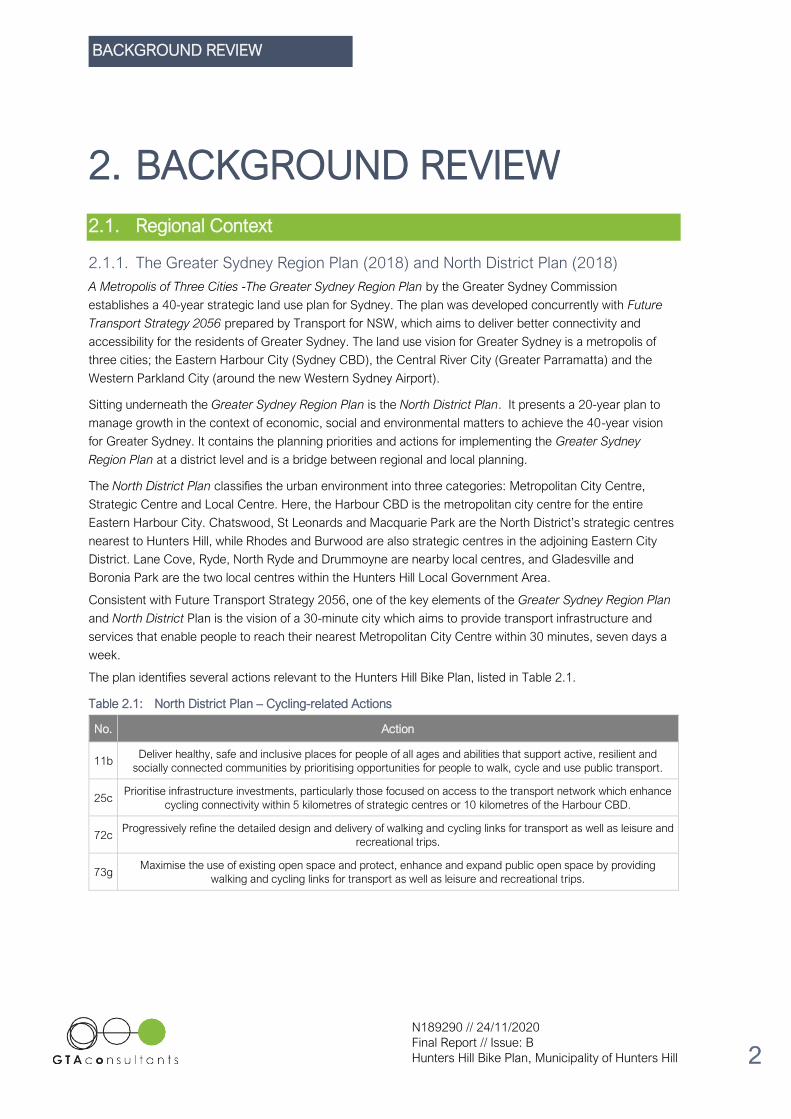
3.1.2. Key Destinations
For the purpose of this bike plan, twelve main points of interest as potential cycling destinations within the
Municipality of Hunters Hill have been identified. This includes the Gladesville town centre, the Gladesville
Hospital precinct, as well as the Boronia Park, Hunters Hill, Garibaldi and Woolwich (shopping) villages as the
key precincts listed in the Local Strategic Planning Statement. The Local Government Area also contains four
high schools – St. Joseph’s College, Hunters Hill High School, Riverside Girls High School and Marist Sisters’
College. A number of primary schools are also located in the LGA and while older primary school students
(year 5 and 6) are certainly able and encouraged to use cycling as to get to school, primary schools have not
been identified as key destinations in this version of the bike plan. Finally, the Huntleys Point Wharf and
Woolwich Wharf are important nodes for commuter and recreational cyclists accessing the Sydney Ferries
network.
It is acknowledged that other points of interest exist within the Municipality of Hunters Hill, such as the
Woolwich Baths and Hunters Hill Town Hall. However, as they do not attract the same volume of visitors
throughout the week they are not included in the list of key destinations for the purpose of this Bike Plan. The
key destinations are shown in Figure 3.1 with a brief description of each area provided in Table 3.1.
EXISTING CONDITIONS
N189290 // 24/11/2020
Final Report // Issue: B
Hunters Hill Bike Plan, Municipality of Hunters Hill 10
Figure 3.1: Key Destinations Map
Table 3.1: Description of Key Destinations
Key Location Description
A Boronia Park Village
Classified as a local centre in the North District Plan, the Boronia Park Village is
a small centre located on the border of the Municipality of Hunters Hill and City
of Ryde. Urban renewal towards a low-rise, high amenity neighbourhood centre
has begun as some key properties are in the process of redevelopment.
B Gladesville Town Centre
The Gladesville Town Centre is the LGA’s primary commercial centre,
containing both the Gladesville Shopping Village and retail along Victoria Road’s
active street frontage. It is envisaged that the shopping centre will be
redeveloped as a mixed-use urban centre, providing higher density residential
apartments along with renewed retail spaces. In addition to Boronia Park Village,
it is designated a local centre in the North District Plan.
C Gladesville Hospital Precinct
The former Gladesville Hospital is currently the site of the Giant Steps
educational centre for children with autism, as well as several other minor
health-related land uses. The Municipality of Hunters Hill intends see the site
evolve through adaptive re-use into an innovation precinct with renewed public
spaces, but this will require coordination with the NSW State Government.
D Riverside Girls High School A secondary, public day school for girls. Its enrolment is approximately 1,000
students (2020).
E Huntleys Point Wharf
Huntleys Point Ferry Wharf is located on the northern side of Parramatta River in
the suburb of Huntleys Point. It services the F3 Line between Circular Quay and
Parramatta.

EXISTING CONDITIONS
N189290 // 24/11/2020
Final Report // Issue: B
Hunters Hill Bike Plan, Municipality of Hunters Hill 11
Key Location Description
F St. Joseph’s College An independent Roman Catholic single-sex secondary day and boarding school
for boys. It currently caters for approximately 1,100 students (2020).
G Hunters Hill Village
Hunters Hill Village is a local centre within the centre of the LGA, containing
retail, restaurants and cafés, health-related services, and a concentration of
aged housing facilities. Already in the process of urban renewal, this process is
expected to continue as further buildings are redeveloped into 2-3 storey mixed-
use.
H Hunters Hill High School A public, secondary, co-educational day school. It caters for up to 600 students
(2020).
I Garibaldi Village Square
Along with Woolwich Corner Village, Garibaldi Village Square is one of two
‘corner shops’ in the LGA. With significant heritage, it is planned that the site
retains its low-scale setting and further consolidates itself as a boutique
restaurant, café and shopping village.
J Marist Sisters’ College An independent Roman Catholic single-sex secondary day school for girls,
catering approximately 1,000 students (2020).
K Woolwich Corner Village
The Woolwich Corner Village is home to the Woolwich Pier Hotel and a number
of other restaurants. It is part of the recreational precinct that includes the
Harbour Trust Lands - Woolwich Dock and Parklands.
L Woolwich Wharf
Also known as Valentia Street Ferry Wharf, Woolwich Wharf services the F8 Line
to Cockatoo Island and Circular Quay. Two bus routes also service the wharf:
the 505 to Circular Quay and the 538 to Gladesville.
3.2. Travel Patterns and Journey to Work
Figure 3.2 shows the Journey to Work mode share for residents who went to work and had to leave their
home for work in the Municipality of Hunters Hill in 2016. As evident in this figure, 72.2% of trips were
undertaken by private vehicle (car – as driver / car – as passenger / taxi / truck / motorcycle), 18.0% by
public transport (train / bus) and only 0.8% by bicycle.

EXISTING CONDITIONS
N189290 // 24/11/2020
Final Report // Issue: B
Hunters Hill Bike Plan, Municipality of Hunters Hill 12
Figure 3.2: Method of Travel to Work
Source: https://profile.id.com.au/hunters-hill/travel-to-work
Of particular note is that cycling trips to work increased sharply as a percentage of employed persons’
journey to work between 2006 and 2011, but then declined, both as a percentage and in absolute numbers
from 2011 to 2016. While there was a 6.2% growth in the number of Hunters Hill residents travelling to work,
a 17.6% decrease in the number of people travelling to work by bicycle resulted in a decrease in the bicycle
mode share of -0.2% to 0.8%. This very low mode share is in stark contrast to the Greater Sydney share of
4.7%. As will be extrapolated in Section 0, this data highlights the limitations of the existing Hunters Hill
cycling network. These historical trends are illustrated in Figure 3.3 below.
Car (as driver)66.4%
Bus15.1%
Ferry4.0%
Car (as passenger)3.8%
Train2.9%
Walked only2.9% Other
2.1%
Motorbike0.9%
Bicycle0.8%
Truck0.6%
Taxi0.5%
Car (as driver)
Bus
Ferry
Car (as passenger)
Train
Walked only
Other
Motorbike
Bicycle
Truck
Taxi

EXISTING CONDITIONS
N189290 // 24/11/2020
Final Report // Issue: B
Hunters Hill Bike Plan, Municipality of Hunters Hill 13
Figure 3.3: Bicycle Mode Share Across Time
Source: https://profile.id.com.au/hunters-hill/travel-to-work
3.3. Safety
In the reporting years of 2014, 2015 and 2018, there were a total of 6 crashes involving cyclists, for which
two involved serious injuries. Figure 3.5 shows that five of the crashes are located on main roads, particularly
Victoria Road and the Ryde Road – Gladesville Road – Church Street – Alexandra Street spine.
Figure 3.4: Bicycle Crashes in Hunters Hill
Source: Transport for NSW – Centre for Road Safety

EXISTING CONDITIONS
N189290 // 24/11/2020
Final Report // Issue: B
Hunters Hill Bike Plan, Municipality of Hunters Hill 14
3.4. Topography
Topography presents a key challenge for cycling in Hunter’s Hill with significant height differences and steep
climbs across the LGA. Figure 3.5 depicts the topography of the Municipality of Hunters Hill. The thicker 10-
metre contour lines and thinner 2-metre contour lines represent the three-dimensional elevation and shape of
the land on a one-dimensional plane. The most salient feature is the Woolwich peninsula, jutting out from
Hunters Hill. Here, the ridge falls away sharply, to Lane Cove River in the north and Parramatta River in the
south. From this topography, early roads in the Hunters Hill area generally followed the ridge lines, ensuring
that travel could occur on a smaller gradient. These roads include Ryde Road, Alexandra Street, Woolwich
Road and Victoria Road. As Figure 3.5 shows, the roads with the grades most suitable for cycling are also
busy private vehicle and public bus thoroughfares.
Figure 3.5: Hunters Hill Topography
The challenge of climbing up the ridges is best demonstrated by Mount Street, Hunters Hill in Figure 3.6. Part
of the Hunters Hill Bike Route, but intended to be traversed downslope, Mount Street is representative of
steep gradients across the Municipality of Hunters Hill.

EXISTING CONDITIONS
N189290 // 24/11/2020
Final Report // Issue: B
Hunters Hill Bike Plan, Municipality of Hunters Hill 15
Figure 3.6: Mount Street
Source: Google Street View

EXISTING CONDITIONS
N189290 // 24/11/2020
Final Report // Issue: B
Hunters Hill Bike Plan, Municipality of Hunters Hill 16
3.5. Existing Cycling Facilities
3.5.1. Overview
Figure 3.7 depicts the existing cycling network across the Municipality of Hunters Hill, differentiating the
facilities into off-road shared paths and on-road mixed. On-road shoulder lane, off-road dedicated path and
on-road separated cycleway are not included in the legend as there are no facilities of that type in the
Municipality of Hunters Hill.
Figure 3.7: Existing Cycling Facilities (2020)
As is shown in the above map, the majority of facilities are off-road shared paths, with a few on-road mixed
facilities linking them to create the ‘Hunters Hill Bike Route’. Having conducted a site audit (bicycle ride) of
both formal cycling facilities and informal routes in the Local Government Area, the following issues were
identified:
• Cracked shared path surfaces
• Faded linemarking
• Poor wayfinding
• Insufficient end-of-trip facilities
• Burns Bay Road as a connectivity barrier
• Limited or challenging links to neighbouring Local Government Areas.

EXISTING CONDITIONS
N189290 // 24/11/2020
Final Report // Issue: B
Hunters Hill Bike Plan, Municipality of Hunters Hill 17
3.5.2. Shared Paths
Shared paths are of mixed quality in the Municipality of Hunters Hill. Some off-road shared paths, including
the facility at Tarban Creek in Figure 3.8, are well-maintained whereas other parts of the official Hunters Hill
Bike Route have not been well maintained. As such, much of the shared path at the Lane Cove River
foreshore next to Hunters Hill High School is cracked, limiting the space for pedestrians and cyclists to travel
on the shared path safely and comfortably. In addition, shared paths across the Local Government Area are
not sufficiently wide, meaning that pedestrian and cyclists travelling in opposite directions are more likely to
come into conflict. Shared paths should be at 2.5 metres wide at a minimum, yet the shared path at Tarban
Creek, despite its effective maintenance, appears to be only 2.0 metres wide.
Figure 3.8: Shared Path at Tarban Creek
Figure 3.9: Cracked Shared Path at Hunters Hill High School
EXISTING CONDITIONS
N189290 // 24/11/2020
Final Report // Issue: B
Hunters Hill Bike Plan, Municipality of Hunters Hill 18
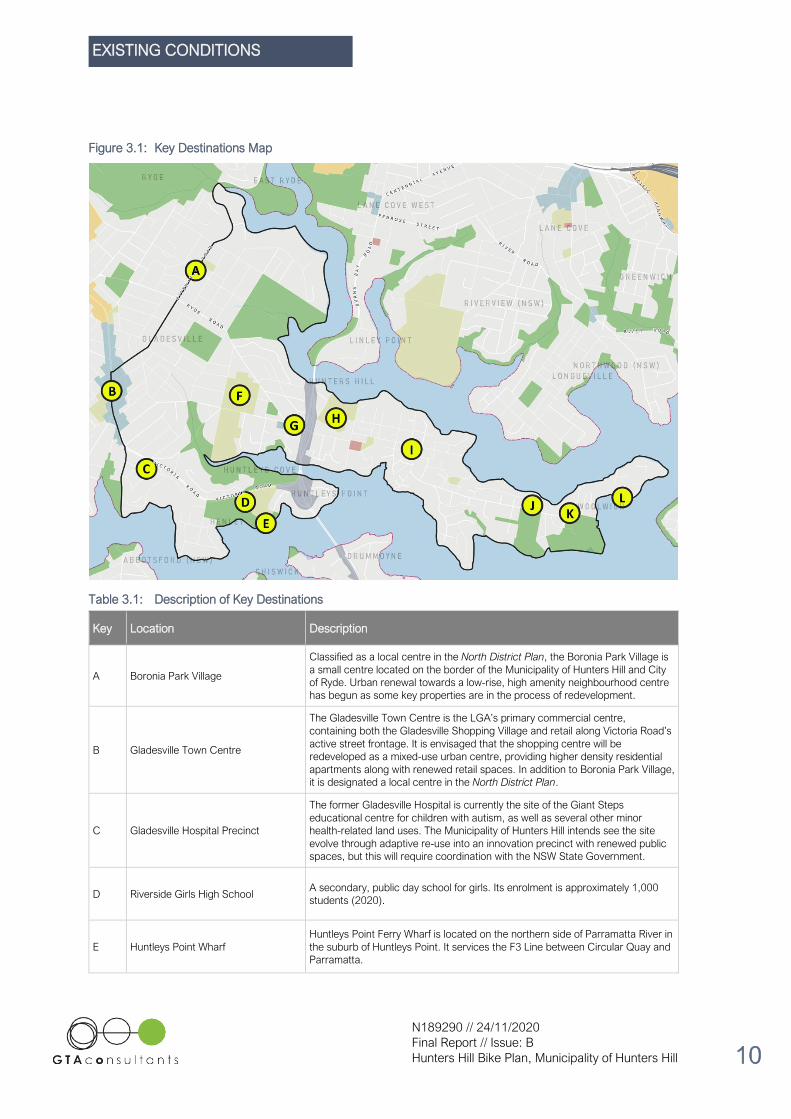
3.5.3. Linemarking
Similar to the quality of footpaths, the linemarking in the Municipality of Hunters Hill is inconsistent. In some
cases, the linemarking has been applied recently, providing clear information that the footpath is a
designated shared path. Yet for the most part, the linemarking has been completed long ago without
refreshing. It is often not obvious that the faded white marks on the pavement are in fact shared path
linemarkings, severely hindering the legibility of the existing Hunters Hill Bike Route.
Figure 3.10: Satisfactory Linemarking at Alexandra Street
Figure 3.11: Unsatisfactory Linemarking at Waruda Place

EXISTING CONDITIONS
N189290 // 24/11/2020
Final Report // Issue: B
Hunters Hill Bike Plan, Municipality of Hunters Hill 19
3.5.4. Wayfinding
The wayfinding across the Municipality of Hunters Hill is generally poor. Individual signs indicating that a
cyclist is on the Hunters Hill Bike Route are located across the LGA. In some instances, the direction the
cyclist must travel to follow the Hunter’s Hill Bike Route is clear, as shown Figure 3.12. Here, fencing and
additional directional arrow signage point the rider toward Tarban Creek.
Figure 3.12: Wayfinding at Tarban Creek
However, Hunters Hill is missing an overall wayfinding concept that allows riders to understand their location,
which destinations are accessible and how to reach them. Most of the wayfinding is limited to a plaque
reading ‘Hunters Hill Bike Route’ without further information, context or map. Other instances in which a
directional arrow is present are often unclear and can further complicate the wayfinding process. The typical
quality of wayfinding is exemplified in Figure 3.13.
Figure 3.13: Wayfinding at Rose Street

EXISTING CONDITIONS
N189290 // 24/11/2020
Final Report // Issue: B
Hunters Hill Bike Plan, Municipality of Hunters Hill 20
3.5.5. End-of-trip facilities
End-of-trip facilities in the Municipality of Hunters Hill are limited to only three of the identified key destinations
– Huntleys Point Wharf, Woolwich Wharf and Hunters Hill Village. Providing commuters and recreational
riders the option of changing modes for their journey, the bike racks at these ferry wharfs are proportionate to
the existing level of cycling demand in the Municipality of Hunters Hill. There is a bike rack at Hunters Hill
Council Chambers and it is expected that some end-of-trip facilities are provided within the grounds of local
schools, however, it is a significant gap in the network that bike racks and other end-of-trip facilities are not
provided at any of the other key destinations. Figure 3.14 shows the existing bike racks at the two ferry
wharves.
Figure 3.14: Bike racks at ferry wharves
Huntleys Point Wharf Woolwich Wharf
3.5.6. Burns Bay Road
Burns Bay Road, linking motorists to Lane Cove in the north and Gladesville Bridge in the south, acts as a
significant barrier for riders in the Municipality of Hunters Hill. Spanning 700-metres across the peninsula,
only two crossing points are available, effectively dividing the LGA into an east half and a west side. Figure
3.15 illustrates these two crossing opportunities and their respective facilities, highlighting the disconnect
between the peninsula and the mainland. The Church Street crossing is direct and convenient, connecting
riders to the Hunters Hill Village. However, it is not safe and should only be used by experienced riders.
Riders are required to cross four times – two signalised, one zebra and one informal crossing – in a heavy
traffic environment.
Alternatively, the Burns Bay Road crossing underneath Fig Tree Bridge is safe, however, it is inconvenient.
Instead of a 150-metre crossing journey, the alternative length is more than 900-metres and requires a steep
33-metre climb across 300-metres back up to the top of the ridge line.

EXISTING CONDITIONS
N189290 // 24/11/2020
Final Report // Issue: B
Hunters Hill Bike Plan, Municipality of Hunters Hill 21
Figure 3.15: Burns Bay Road crossings
3.5.7. Links to Neighbouring LGAs
As Hunters Hill is a relatively smaller Local Government Area, the links to neighbouring Local Government
Areas are especially important for commuting, shopping and longer recreational riding.
Lane Cove
The sole existing facility connecting the Municipality of Hunters Hill to Lane Cove Council is an off-shared
path on the eastern side of Fig Tree Bridge. Access is via Reiby Road to the immediate east of Burns Bay
Road. This link is shown in Figure 3.16.
Figure 3.16: Fig Tree Bridge shared path
Source: Google Street View

EXISTING CONDITIONS
N189290 // 24/11/2020
Final Report // Issue: B
Hunters Hill Bike Plan, Municipality of Hunters Hill 22
Canada Bay
Access to the City of Canada Bay by bicycle is complex. The spaghetti junction interchange between Victoria
Road and Burns Bay Road necessitates riders to take an indirect route simply to get onto or off the
Gladesville Bridge. This adds 300 metres to the journey and includes a steep descent, two flights of stairs
and a steep ascent. Consequently, many cyclists shun this deviation and instead use the one-way slip lane to
travel in both directions. Access to and from the bridge is further challenged by a lack of a ramp in the
Gladesville Bridge underpass tunnel, as well as poor wayfinding at key decision points. The Gladesville
Bridge itself provides a narrow, sub-standard shared path on the eastern side that does not allow enough
width for two riders to pass each other.
Figure 3.17: Gladesville Bridge tunnel
Source: Google Street View
Figure 3.18: Bicycle route to and from Gladesville Bridge

EXISTING CONDITIONS
N189290 // 24/11/2020
Final Report // Issue: B
Hunters Hill Bike Plan, Municipality of Hunters Hill 23
Figure 3.19: Gladesville Bridge shared path
Source: Google Street View
City of Ryde
As the City of Ryde shares a border with the Municipality of Hunters Hill at Pittwater Road and Victoria Road,
there are a few instances whereby formal cycling facilities (including wayfinding and road markings) are
present. Figure 3.20 shows wayfinding signage at Ashburn Place and Figure 3.21 depicts the on-road PS-2
bike symbols indicating that Ryde Road (within the City of Ryde) is an on-road mixed cycling facility. In this
instance, there is no formal cycling facility or wayfinding immediately opposite in the Municipality of Hunters
Hill, creating a disconnect between the two Local Government Areas.
Figure 3.20: Wayfinding at Ashburn Place
Source: Google Street View

EXISTING CONDITIONS
N189290 // 24/11/2020
Final Report // Issue: B
Hunters Hill Bike Plan, Municipality of Hunters Hill 24
Figure 3.21: PS-2 Bicycle Symbols at Ryde Road
Source: Google Street View

STAKEHOLDER ENGAGEMENT
N189290 // 24/11/2020
Final Report // Issue: B
Hunters Hill Bike Plan, Municipality of Hunters Hill 25
4. STAKEHOLDER
ENGAGEMENT
4.1. Community Consultation
4.1.1. Approach
Community consultation was undertaken by way of online ‘Have Your Say’ responses by Hunters Hill Council
for a period of two weeks in late-May to June 2020.
4.1.2. Community Consultation Findings
The online ‘Have Your Say’ consultation received almost 3,000 views from 700 unique users and received a
total of 192 comments. A few major statistics are summarised below:
• 42 per cent of responses were of neutral sentiment
• Equal positive and negative sentiments to the development of a new bike plan of 26 per cent each
• 5 per cent was of mixed feedbacks.
On the same basis, online responses were captured in the form of a Social Pinpoint map with comments
grouped into three categories and marked on a map to understand the general community’s perspective
towards the development of the new Hunters Hill Bike Plan and their key locations of concern within the
Hunters Hill LGA. A snapshot of the Social Pinpoint map and comments received is shown in Figure 4.1.
Figure 4.1: Response Categories
Source: Social Pinpoint, Hunters Hill Council, June 2020
STAKEHOLDER ENGAGEMENT
N189290 // 24/11/2020
Final Report // Issue: B
Hunters Hill Bike Plan, Municipality of Hunters Hill 26
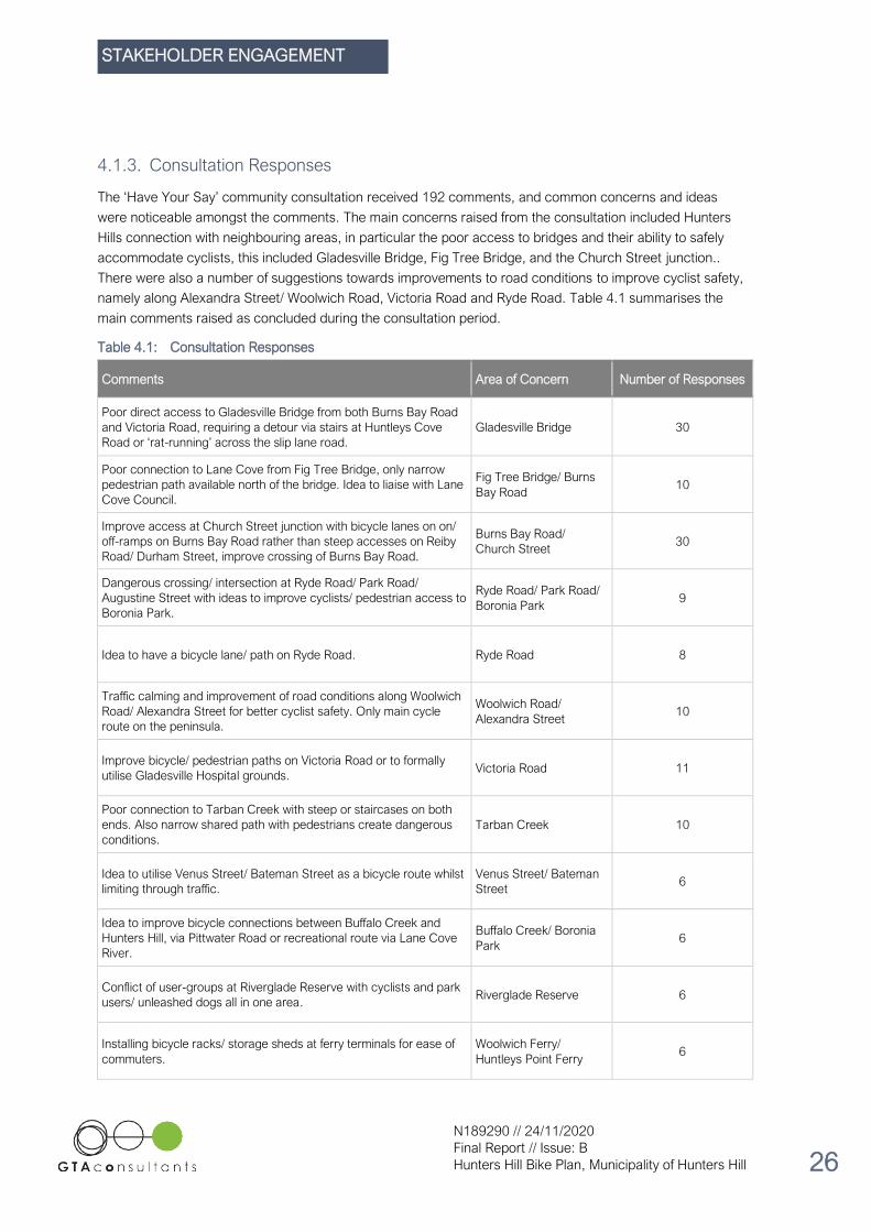
4.1.3. Consultation Responses
The ‘Have Your Say’ community consultation received 192 comments, and common concerns and ideas
were noticeable amongst the comments. The main concerns raised from the consultation included Hunters
Hills connection with neighbouring areas, in particular the poor access to bridges and their ability to safely
accommodate cyclists, this included Gladesville Bridge, Fig Tree Bridge, and the Church Street junction..
There were also a number of suggestions towards improvements to road conditions to improve cyclist safety,
namely along Alexandra Street/ Woolwich Road, Victoria Road and Ryde Road. Table 4.1 summarises the
main comments raised as concluded during the consultation period.
Table 4.1: Consultation Responses
Comments Area of Concern Number of Responses
Poor direct access to Gladesville Bridge from both Burns Bay Road
and Victoria Road, requiring a detour via stairs at Huntleys Cove
Road or ‘rat-running’ across the slip lane road.
Gladesville Bridge 30
Poor connection to Lane Cove from Fig Tree Bridge, only narrow
pedestrian path available north of the bridge. Idea to liaise with Lane
Cove Council.
Fig Tree Bridge/ Burns
Bay Road 10
Improve access at Church Street junction with bicycle lanes on on/
off-ramps on Burns Bay Road rather than steep accesses on Reiby
Road/ Durham Street, improve crossing of Burns Bay Road.
Burns Bay Road/
Church Street 30
Dangerous crossing/ intersection at Ryde Road/ Park Road/
Augustine Street with ideas to improve cyclists/ pedestrian access to
Boronia Park.
Ryde Road/ Park Road/
Boronia Park 9
Idea to have a bicycle lane/ path on Ryde Road. Ryde Road 8
Traffic calming and improvement of road conditions along Woolwich
Road/ Alexandra Street for better cyclist safety. Only main cycle
route on the peninsula.
Woolwich Road/
Alexandra Street 10
Improve bicycle/ pedestrian paths on Victoria Road or to formally
utilise Gladesville Hospital grounds. Victoria Road 11
Poor connection to Tarban Creek with steep or staircases on both
ends. Also narrow shared path with pedestrians create dangerous
conditions.
Tarban Creek 10
Idea to utilise Venus Street/ Bateman Street as a bicycle route whilst
limiting through traffic.
Venus Street/ Bateman
Street 6
Idea to improve bicycle connections between Buffalo Creek and
Hunters Hill, via Pittwater Road or recreational route via Lane Cove
River.
Buffalo Creek/ Boronia
Park 6
Conflict of user-groups at Riverglade Reserve with cyclists and park
users/ unleashed dogs all in one area. Riverglade Reserve 6
Installing bicycle racks/ storage sheds at ferry terminals for ease of
commuters.
Woolwich Ferry/
Huntleys Point Ferry 6

STAKEHOLDER ENGAGEMENT
N189290 // 24/11/2020
Final Report // Issue: B
Hunters Hill Bike Plan, Municipality of Hunters Hill 27
4.2. Engagement with Adjoining Councils
4.2.1. Summary
The Municipality of Hunters Hill arranged a stakeholder meeting with the adjoining councils – City of Ryde,
City of Canada Bay and Lane Cove Council. Discussed at the meeting were the cycling connections between
Hunters Hill and the neighbouring LGAs, particularly the Gladesville Bridge connection to Canada Bay and
the Fig Tree Bridge to Lane Cove. Recognising that the bridges are vital regional links, but that they are both
owned by Transport for NSW, it was agreed that the councils would co-operate in their advocacy to
Transport for NSW for improvements.
For the links into the City of Ryde, it was agreed that it was important to work together in coordinating the
delivery of cycling infrastructure at the connection points to enable both local links and regional routes. The
interface between the future Hunters Hill cycling network and the Pittwater Road shared path in the City of
Ryde was recognised as an especially important matter for co-operation.
STRATEGIC ROUTE NETWORK
N189290 // 24/11/2020
Final Report // Issue: B
Hunters Hill Bike Plan, Municipality of Hunters Hill 28
5. STRATEGIC ROUTE
NETWORK
5.1. Introduction
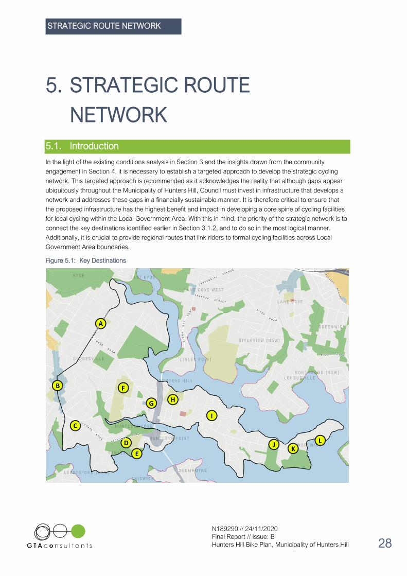
In the light of the existing conditions analysis in Section 3 and the insights drawn from the community
engagement in Section 4, it is necessary to establish a targeted approach to develop the strategic cycling
network. This targeted approach is recommended as it acknowledges the reality that although gaps appear
ubiquitously throughout the Municipality of Hunters Hill, Council must invest in infrastructure that develops a
network and addresses these gaps in a financially sustainable manner. It is therefore critical to ensure that
the proposed infrastructure has the highest benefit and impact in developing a core spine of cycling facilities
for local cycling within the Local Government Area. With this in mind, the priority of the strategic network is to
connect the key destinations identified earlier in Section 3.1.2, and to do so in the most logical manner.
Additionally, it is crucial to provide regional routes that link riders to formal cycling facilities across Local
Government Area boundaries.
Figure 5.1: Key Destinations

STRATEGIC ROUTE NETWORK
N189290 // 24/11/2020
Final Report // Issue: B
Hunters Hill Bike Plan, Municipality of Hunters Hill 29
5.2. Principles for Cycling Routes and Facilities in Hunter’s Hill
5.2.1. Principles
To inform the development of a strategic cycling network – for both local and regional routes - it is proposed
that a series of principles be applied to the process of identifying these routes. Outlined below, these
principles are not set in a priority order. An explanation of each of the principles is provided beneath each
principle’s heading.
A. Develop a local route network that is suitable for riders of all ages, experience and abilities.
The proposed local route network must be appropriate for the broader set of potential riders, including
children, seniors and people with disabilities and suitable for riders with all degrees of experience.
B. Develop regional routes suitable for commuter and experienced riders.
The proposed facilities on regional routes – those routes connecting Hunters Hill to other Local Government
Areas – may not be suitable for riders of all ages, experience and abilities, due to their increased interface
with major State roads. As such, commuter and other experienced riders are the primary target user group
for these routes.
C. Minimise the loss of on-street parking.
As many houses across Hunters Hill have limited off-street parking, on-street parking is a particularly
important need for many residents. Accordingly, the proposed strategic network will avoid the loss of on-
street parking or keep the potential loss of on-street parking to a minimum.
D. Ensure that there is no loss of trees.
Hunters Hill is Australia’s oldest surviving garden suburb, meaning that the presence of trees is critical to the
area’s ongoing character. Therefore, no trees will be removed as part of any of the proposed cycling works.
E. Cycling infrastructure to have a consideration of heritage constraints where applicable.
It is an aim of the Hunters Hill Local Environmental Plan 2012 to conserve heritage that influences the
character and identity of the municipality. Proposed interventions should not involve the removal, damage or
alteration of any heritage aspects, e.g. sandstone kerbs.
F. Despite Hunters Hill’s topography, avoid steep gradients as much as possible.
Due to Hunters Hill’s topography and steep gradients, it is important to prioritise options that are on a gentler
grade, but also highlight steep sections when no alternatives are available. The increased use of e-bikes
might help with overcoming some of Hunter’s Hill’s gradients.
G. Recommended infrastructure to be economical and considerate of industry best practice.
Recommended infrastructure and the according work program need to ensure that Council can deliver the
infrastructure in a financially sustainable manner within annual and longer-term budgets set out in their
Operational Plan and Delivery Program. Proposed infrastructure must align with industry standards and best
practice where practically feasible.
H. Utilise simple interventions where appropriate.
With an awareness of the challenges for shared facilities, proposed interventions will aim to use simple Local
Area Traffic Management (LATM) upgrades for mixed traffic environments as well as linemarking and
delineation for shared paths.
I. Ensure that road crossings along the cycling routes are safe.
Safe crossing facilities are to be provided where necessary to ensure that all in-route crossings are safe for
riders of all ages and abilities.
STRATEGIC ROUTE NETWORK
N189290 // 24/11/2020
Final Report // Issue: B
Hunters Hill Bike Plan, Municipality of Hunters Hill 30
5.3. Proposed Strategic Routes
5.3.1. Proposed Strategic Route Network
With consideration of the principles outlined in Section 5.2, Figure 5.2 depicts the proposed strategic route
network for Hunter’s Hill. Table 5.1 provides further information, describing the origin, terminus and key
destinations along the way of each route. It is important to note that the proposed strategic route network
shown here is to be implemented over the next four years. The delivery of these routes is the initial step in
formalising cycling across the Local Government Area and providing safe access to key destinations. It is
acknowledged that riders will also ride outside of these identified routes, and that facilities that provide further
connections to this strategic spine can be delivered in the medium-to-long term (5-10 years). At this point it
is crucial to introduce a network of key routes that become established, supported by information and
continuous maintenance. Once the initial route network is established, extensions to the network can be
implemented.

STRATEGIC ROUTE NETWORK
N189290 // 24/11/2020
Final Report // Issue: B
Hunters Hill Bike Plan, Municipality of Hunters Hill 31
Figure 5.2: Proposed Strategic Route Network

STRATEGIC ROUTE NETWORK
N189290 // 24/11/2020
Final Report // Issue: B
Hunters Hill Bike Plan, Municipality of Hunters Hill 32
Table 5.1: Strategic Routes
Name Classification Location
HH1 Local
Hunters Hill Village to Woolwich Wharf, via Hunters Hill High
School, Garibaldi Village Square Marist Sisters’ College and
Woolwich Corner Village.
HH2 Local Buffalo Creek Reserve Playground to Hunters Hill Village, via
Boronia Park Village and St. Joseph’s College.
HH3 Local Gladesville Town Centre to Huntleys Point Wharf via Riverside
Girls High School.
Loop Local Existing Hunters Hill Bike Route via St. Joseph’s College,
Hunters Hill Village and Hunters Hill High School.
Loop Connection Local Linking the Hunters Hill Bike Route parallel to Burns Bay Road.
RR1 Regional Victoria Road from Gladesville Bridge to City of Ryde.
RR2 Regional Burns Bay Road from Gladesville Bridge to Fig Tree Bridge.
5.3.2. Strategic Route Analysis
Sections 5.3.3 through to 5.3.5 analyse the opportunities, constraints and gaps of the existing conditions for
each route corridor. Following the route analysis, the various infrastructure intervention options are also
discussed and evaluated.
Note that the legends for each corridor section map detail the existing conditions and issues only. On-road
and off-road cycling facilities illustrated on the map are those that are already existing, rather than the
proposed interventions.
The route analysis will look into the feasibility of implementing the individual routes and make
recommendations for some suitable treatments and interventions. However, this is not meant to be a route
concept design that can be used for consultation and a basis for a detailed design. All routes will require
separate concept designs in the future.
STRATEGIC ROUTE NETWORK
N189290 // 24/11/2020
Final Report // Issue: B
Hunters Hill Bike Plan, Municipality of Hunters Hill 33
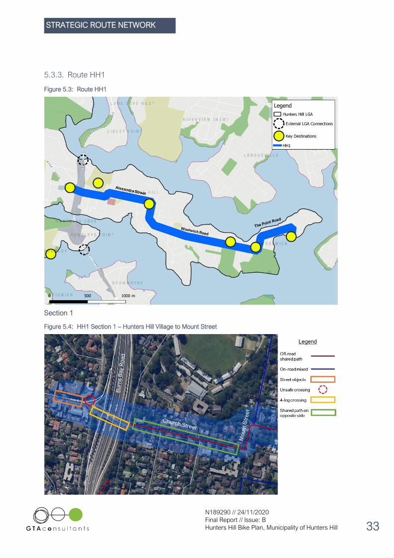
5.3.3. Route HH1
Figure 5.3: Route HH1
Section 1
Figure 5.4: HH1 Section 1 – Hunters Hill Village to Mount Street

STRATEGIC ROUTE NETWORK
N189290 // 24/11/2020
Final Report // Issue: B
Hunters Hill Bike Plan, Municipality of Hunters Hill 34
Route HH1 Section 1 – from the Hunters Hill Village shops to Mount Street – presents several issues for the
implementation of cycling infrastructure. Firstly, multiple street objects occupy footpath space on both sides
of Ryde Road at the Hunters Hill Village shops. Many of these objects contribute to a high amenity sense of
Place in the Village, including outdoor furniture, plants and garden beds. Other objects are more functional,
such as street signs, rubbish bins and bus stops. These objects both limit the available space on the footpath
and incentivise people to spend time staying at the place. Combined, this means the off-road footpath
environment is not ideal for riders.
Alternatively, the section of Gladesville Road between Ryde Road and Burns Bay Road is a high traffic arterial
road through Hunters Hill. Concerning safety, it is also not ideal for riders to share the road with cars and
buses at this location. As an aspirational intervention, a 150-metre on-road bi-directional separated cycleway
on the southern side of Gladesville Road would be the safest and most convenient option for riders navigating
this part of Gladesville Road. Without this infrastructure, riders that are confident riding on Gladesville Road
may do so, but for less confident riders it would be safer to dismount and walk their bicycle through this busy
section of Hunters Hill Village.
Figure 5.5: Street objects at Ryde Road
Source: Google Street View
The other issues impacting Route HH1 Section 1 are inter-related. The southern crossing of Burns Bay Road,
from Hunters Hill Village to Church Street, provides the safest option. Involving two signalised crossings, one
zebra crossing and one unsignalised crossing (across the quiet Durham Street), it is in stark contrast to the
northern crossing of Burns Bay Road. Here, two signalised crossings and two unsignalised crossings (at
Joubert Street and Reiby Road) exist, but also two unsignalised crossings of the Burns Bay Road northbound
slip lanes. Identified as an unsafe crossing in the Hunters Hill Village Pedestrian Access & Mobility Plan
(PAMP) in 2014, there is a high risk of conflict between riders and moving vehicles at these two slip lane
crossings.
As a result, riders are most likely to use the southern crossing of Burns Bay Road. This decision, however,
means that riders arrive at Church Street on the opposite side to the shared path. Prior to Durham Street,
they must make another two crossings (one signalised and one unsignalised) before getting to the northern
side of Church Street. While this is the safest existing option, an extra signalised crossing is added to the
journey, increasing the inconvenience and time waiting for the signals to allow safe crossing.
To make the Joubert Street and Burns Bay Road slip road crossings safer for pedestrians (and cyclists), the
PAMP presents five options for change. These include the introduction of zebra crossings, introduction of a
signalised crossing and kerb build-outs. The most complex option involves the removal of the two slip lanes, a
kerb build-out and a change to turning options at Joubert Street as shown in Figure 5.6.

STRATEGIC ROUTE NETWORK
N189290 // 24/11/2020
Final Report // Issue: B
Hunters Hill Bike Plan, Municipality of Hunters Hill 35
This option would mean that crossing the northern side of Burns Bay Road would involve two signalised
crossings, a zebra crossing and an unsignalised crossing across Reiby Road.
Figure 5.6: Removal of Burns Bay Road slip lanes
Source: Hunters Hill Village PAMP (2014)
Despite the added safety, convenience and direction connection to the shared path on the northern side of
Church Street, this option is too expensive, complex and would require Transport for NSW (TfNSW)
involvement. It is noted that following discussions with the Hunters Hill Local Traffic Committee, a safer way of
crossing on the northern side is under investigation by TfNSW. With confirmed design or delivery commitment
from the State Government, the southern crossing is the most feasible option for the short-to-medium term
Bike Plan.
Looking to the eastern part of HH1 Section 1, there are proposed changes to the Alexandra Street – Mount
Street – The Avenue intersection. Part of the proposed ‘channelisation’ of motor vehicles and buses at the
intersection, the Alexandra Street Traffic Study by Transport & Urban Planning Pty Ltd recommends the
removal of the existing bicycle crossing linemarking across The Avenue. To be replaced by a raised concrete
refuge island, the proposal better serves both pedestrians and cyclists. These works are illustrated in Figure
5.7.

STRATEGIC ROUTE NETWORK
N189290 // 24/11/2020
Final Report // Issue: B
Hunters Hill Bike Plan, Municipality of Hunters Hill 36
Figure 5.7: Alexandra Street – Mount Street – The Avenue Concept Intersection Layout
Source: Alexandra Street Traffic Study
STRATEGIC ROUTE NETWORK
N189290 // 24/11/2020
Final Report // Issue: B
Hunters Hill Bike Plan, Municipality of Hunters Hill 37
Section 2
Figure 5.8: HH1 Section 2 – Mount Street to Toocooya Road
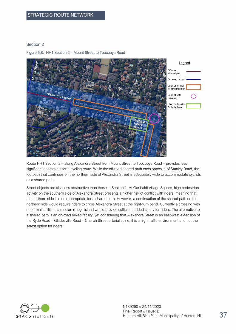
Route HH1 Section 2 – along Alexandra Street from Mount Street to Toocooya Road – provides less
significant constraints for a cycling route. While the off-road shared path ends opposite of Stanley Road, the
footpath that continues on the northern side of Alexandra Street is adequately wide to accommodate cyclists
as a shared path.
Street objects are also less obstructive than those in Section 1. At Garibaldi Village Square, high pedestrian
activity on the southern side of Alexandra Street presents a higher risk of conflict with riders, meaning that
the northern side is more appropriate for a shared path. However, a continuation of the shared path on the
northern side would require riders to cross Alexandra Street at the right-turn bend. Currently a crossing with
no formal facilities, a median refuge island would provide sufficient added safety for riders. The alternative to
a shared path is an on-road mixed facility, yet considering that Alexandra Street is an east-west extension of
the Ryde Road – Gladesville Road – Church Street arterial spine, it is a high traffic environment and not the
safest option for riders.

STRATEGIC ROUTE NETWORK
N189290 // 24/11/2020
Final Report // Issue: B
Hunters Hill Bike Plan, Municipality of Hunters Hill 38
Section 3
Figure 5.9: HH1 Section 3 – Toocooya Road to Vernon Street
HH1 Section 3 on Ferry Street and Woolwich Road provides two options for cycling infrastructure: on-road
mixed traffic environment or an off-road shared path. Option 1 – cycling in mixed traffic along Woolwich Road
– is not congruent with Principle 1 (“Develop a local route network that is suitable for riders of all ages and
abilities”). As it exists now, Woolwich Road, as a continuation of Alexandra Street and Ferry Street,
experiences high motor vehicle traffic volumes and is not safe for riders of all ages, experience and abilities.
On the other hand, an off-road shared path presents the challenge of creating a path with sufficient width to
accommodate both pedestrians and cyclists. While the combined footpath and grass verge often exceeds a
5-metre width, the verge is lined large mature trees with trunks and exposed roots. Principle 4 is to “Ensure
that there is no loss of trees”, meaning that there are very limited opportunities to widen the existing footpath
in this section.
Therefore, the remaining option is to explore potential Local Area Traffic Management (LATM) interventions.
Concerned with managing the road space to both slow down vehicle traffic and increase safety for riders, an
on-road mixed cycling facility after LATM interventions would be the most satisfactory option.

STRATEGIC ROUTE NETWORK
N189290 // 24/11/2020
Final Report // Issue: B
Hunters Hill Bike Plan, Municipality of Hunters Hill 39
Section 4
Figure 5.10: HH1 Section 4 – Vernon Street to Marist Sisters’ College
Similar to HH1 Section 3, trees lining both sides of Woolwich Road mean that a widening of the footpath to
create a high-quality shared path is not feasible. As with other sections of Route HH1, Woolwich Road has
high traffic volumes and is not safe for all riders in its existing condition. The simple option of using the
existing footpath on the northern side as a shared path is also hindered by the high pedestrian activity outside
Marist Sisters’ College. The footpath on the southern side of Woolwich Road is too narrow to function as a
shared path and has limited capacity for widening. Similar to Section 3, LATM interventions will not create the
best cycling environment on-road, but it is the most feasible considering the physical constraints and
established principles.

STRATEGIC ROUTE NETWORK
N189290 // 24/11/2020
Final Report // Issue: B
Hunters Hill Bike Plan, Municipality of Hunters Hill 40
Section 5
Figure 5.11: HH1 Section 5 – Marist Sisters’ College to Woolwich Wharf
Route HH1 Section 5 comprises the same issues as Section 4 – limited verge space for path widening due to
street trees, a high pedestrian activity area at Woolwich Corner Village, and high vehicle volumes and speeds
along Woolwich Road, Gale Street and The Point Road. Like Sections 3 and 4, LATM interventions provide
the most feasible option. Existing bicycle parking at Woolwich Wharf currently caters for six bicycles, which
should be increased to cater for the increased demand generated by the improved infrastructure provided for
in this Bike Plan.

STRATEGIC ROUTE NETWORK
N189290 // 24/11/2020
Final Report // Issue: B
Hunters Hill Bike Plan, Municipality of Hunters Hill 41
5.3.4. Route HH2
Figure 5.12: Route HH2

STRATEGIC ROUTE NETWORK
N189290 // 24/11/2020
Final Report // Issue: B
Hunters Hill Bike Plan, Municipality of Hunters Hill 42
Section 1
Figure 5.13: HH2 Section 1 – Buffalo Creek Reserve Playground to Pains Road
Route HH2 Section 1 on Pittwater Road is straightforward in its opportunities and constraints. The eastern
side of the road is within the Municipality of Hunters Hill boundary, whereas the western side is in the City of
Ryde. As the road has a high volume of vehicle traffic at high speeds, an on-road mixed cycling facility is not
appropriate. Due to road guard rails on the eastern side of Pittwater Road, there is no opportunity for a
shared path on the Hunters Hill side of the road. However, a shared path on the western side of the road is
currently in development, led by the City of Ryde. Some sections are already completed, while others are in
construction (at the time of writing in 2020).
Figure 5.14: Completed shared path at Pittwater Road
Source: Google Street View

STRATEGIC ROUTE NETWORK
N189290 // 24/11/2020
Final Report // Issue: B
Hunters Hill Bike Plan, Municipality of Hunters Hill 43
Figure 5.15: Construction of a shared path at Pittwater Road (June 2020)
Source: Nearmap
Section 2
Figure 5.16: HH2 Section 2 – Pains Road to Princes Road

STRATEGIC ROUTE NETWORK
N189290 // 24/11/2020
Final Report // Issue: B
Hunters Hill Bike Plan, Municipality of Hunters Hill 44
For Route HH2 Section 2, like Section 1, it is not appropriate for the Municipality of Hunters Hill to duplicate
infrastructure already planned by the City of Ryde. A shared path on Pittwater Road from Pains Road to High
Street is already under construction, and an extension of that shared path from High Street towards the
Gladesville Town Centre at Victoria Road is currently in the technical design stage.
The intersection of Pittwater Road/ High Street has the potential for a formal crossing of Pittwater Road into
High Street (East) to connect the residential area with Route HH2. The Pittwater Road/ Princes Road
intersection has signalised pedestrian crossings which would require bike lanterns to make it suitable for
riders to cycle across the intersection.
Section 3
Figure 5.17: HH2 Section 3 – Pittwater Road to Ryde Road
Route HH2 Section 3, overlapping with the Principal Bicycle Network, contains three roundabouts on Princes
Road. Roundabouts are generally viewed as unsafe for cycling in that vehicle approach speeds are often high
and the riders’ right of way can be missed. With these concerns in mind, the three roundabouts on Princes
Road are an average 125-metre distance apart. This means that vehicles cannot gain high speeds before
having to slow down at the approach of the next roundabout. Additionally, Earl Street, Blaxland Street and
Farnell Street are quieter residential streets, and so traffic conditions at these roundabouts are manageable
for riders.
The issue for riders in Section 3 is the two slow points (with speed humps) on Farnell Street. Part of LATM,
their aim is to restrict the width of the carriageway in order to reduce the speed of motor vehicles, however
they can also create a squeeze point for riders, bringing them into closer conflict with motor vehicles. Often, a
bypass treatment or shared path section off-road is provided at slow points on cycle routes. In this instance,
the kerb extension is not long enough to allow for a bypass, and the construction of multiple kerb ramps and
segments of shared path be costly in proportion to the risk. Here, it is important to note this safety issue for
riders, but also recognise that the existing condition is the most feasible option.

STRATEGIC ROUTE NETWORK
N189290 // 24/11/2020
Final Report // Issue: B
Hunters Hill Bike Plan, Municipality of Hunters Hill 45
Figure 5.18: Slow point at Farnell Street
Source: Google Street View
Section 4
Figure 5.19: HH2 Section 4 – Farnell Street to Milling Street
The key issue for Route HH2 Section 4 is the crossing of Ryde Road, for which the existing median refuge
island at Park Street would require an upgrade (rails and wider waiting space). Due to high vehicle volumes
on Ryde Road, and only 100 metres between Farnell Street and the crossing, use of the footpath on the
northern side of Ryde Road is more appropriate than putting riders into mixed traffic. The existing location of
the school bus stop can be reviewed with relocation a consideration to overcome the limited path width and
the prohibited option of widening due to street trees.
Following the Ryde Road crossing, the footpaths on Augustine Street are too narrow and again, cannot be
widened due to continuous trees in the verge space. While Augustine Street is an important road in the local
network, traffic volumes and speeds are not high enough as to exclude it from being a mixed traffic cycling
facility. LATM interventions, however, may still be appropriate to greater ensure cycling safety. It should also
be noted that because of the adjacent St. Joseph’s College sportsground, traffic volumes can increase on
Saturday sport matchdays. Generally, volumes are so high that the traffic congestion significantly slows down
speed, minimising the risk of a serious crash injury with a cyclist on the route.

STRATEGIC ROUTE NETWORK
N189290 // 24/11/2020
Final Report // Issue: B
Hunters Hill Bike Plan, Municipality of Hunters Hill 46
Section 5
Figure 5.20: HH2 Section 5 – Augustine Street to Gladesville Road
Route HH2 Section 5 leverages the existing on-road facility on Mark Street to connect Augustine Street, Mary
Street and Gladesville Road. There is limited verge space on Mary Street for an off-road shared path, while
the roundabout at the Gladesville Road – Mary Street intersection is not adequately safe for on-road cyclists
making the turn into or out of Mary Street.
Section 6
Figure 5.21: HH2 Section 6 – Rocher Avenue to Ryde Road

STRATEGIC ROUTE NETWORK
N189290 // 24/11/2020
Final Report // Issue: B
Hunters Hill Bike Plan, Municipality of Hunters Hill 47
Route HH2 Section 6 – along Gladesville Road from Rocher Avenue to the Hunters Hill Village –
demonstrates constraints similar to previous sections. Existing footpaths are too narrow, yet there is no
capacity to widen them due to street trees along Gladesville Road. This section of Gladesville Road between
Rocher Parade and Ryde Road is a 50km/hr local traffic area, while the section to the immediate west is a
40km/hr school zone. For this reason, an on-road mixed facility is most feasible for Section 6, however, some
LATM interventions may be appropriate to further slow motor vehicle speeds.
5.3.5. Route HH3
Figure 5.22: Route HH3

STRATEGIC ROUTE NETWORK
N189290 // 24/11/2020
Final Report // Issue: B
Hunters Hill Bike Plan, Municipality of Hunters Hill 48
Section 1
Figure 5.23: HH3 Section 1 – Victoria Road to Makinson Street
Route HH3 Section 1 provides a route from the Gladesville Town Centre to the Tarban Creek off-road shared
path. Massey Lane, while used by trucks to service the retail fronting Victoria Road, is adequately quiet to
support an on-road connection to the Pittwater Road – Victoria Road intersection and the future Pittwater
Road shared path in the City of Ryde. Massey Street provides a suitable option for on-road cycling, as it is
restricted to one-way vehicle traffic, meaning that traffic volumes are not too high. For cyclists travelling
north-east on Massey Street, there is sufficient road space for a separated on-road contra-flow bike lane
without any loss of car parking.
Makinson Street, designated a local traffic zone, contains six speed humps with an average distance of 80
metres between them. This one-way low-speed environment is appropriate for on-road cycling; however, the
road currently has a ‘no access’ restriction for approaches from the west and an exemption would need to be
made to allow for contra-flow cyclist access. This is in alignment the Transport for NSW Traffic Management
and Road Safety Practice Technical Direction TTD 2014/002, in which it states that “a contra-flow bicycle
facility may take the form of a marked lane or as a movement designated by signs only. Both facilities require
combinations of regulatory and supplementary signage.”

STRATEGIC ROUTE NETWORK
N189290 // 24/11/2020
Final Report // Issue: B
Hunters Hill Bike Plan, Municipality of Hunters Hill 49
Figure 5.24: Speed hump at Makinson Street
Source: Google Street View
Figure 5.25: Example of contra-flow bicycle lane designated by signs only
Source: Transport for NSW Traffic Management and Road Safety Practice Technical Direction TTD 2014/002
Furthermore, there is no clear, safe crossing for cyclists coming from Massey Street to Makinson Street. If the
existing refuge island were reconstructed to provide waiting space for cyclists, a two-stage crossing into
Makinson Street would be adequately safe.

STRATEGIC ROUTE NETWORK
N189290 // 24/11/2020
Final Report // Issue: B
Hunters Hill Bike Plan, Municipality of Hunters Hill 50
Figure 5.26: Refuge island at Massey Street
Finally, Mars Street could be converted to an on-road mixed facility, providing formal access to the
origin/terminus of the Tarban Creek off-road shared path.
Section 2
Figure 5.27: HH3 Section 2 – Makinson Street to Tarban Creek Reserve
Following on from HH3 Section 1, Section 2 also involves the use of Makinson Street as an on-road mixed
cycling facility, due to its existing speed humps creating a low-speed environment. Next, an off-road shared
path from the Makinson Street – Batemans Road intersection to the ramp onto the Tarban Creek off-road
shared path at Gladesville Road would provide safe and convenient access to the existing shared path.

STRATEGIC ROUTE NETWORK
N189290 // 24/11/2020
Final Report // Issue: B
Hunters Hill Bike Plan, Municipality of Hunters Hill 51
Section 3
Figure 5.28: HH3 Section 3 – Tarban Creek Reserve to Waruda Place
No interventions are required for Route HH3 Section 3 as the off-road shared path at Tarban Creek is an
adequate facility for this location.
Section 4
Figure 5.29: HH3 Section 4 – Waruda Place to Huntleys Point Wharf

STRATEGIC ROUTE NETWORK
N189290 // 24/11/2020
Final Report // Issue: B
Hunters Hill Bike Plan, Municipality of Hunters Hill 52
Route HH3 Section 4 is already mostly provided for by existing facilities connecting Riverglade Reserve to
Victoria Road. Huntleys Point Road is a high pedestrian activity area, as it is adjacent to Riverside Girls High
School. As such, an off-road shared path is not appropriate on the eastern side, and it is neither appropriate
on the western side as the footpath ends before a 170-metre segment of 90-degree car parking spaces.
An on-road mixed facility on Huntleys Point Road is challenged by the slow point (and zebra crossing) at
Riverside Girls High School. Similar to Route HH2 Section 3, a bypass for riders is not feasible on the eastern
kerb extension, nor is it a cost-efficient intervention on the western kerb extension. While the squeeze point is
not ideal, it is the most feasible option here.
Figure 5.30: HH3 Section 4
Source: Google Street View

STRATEGIC ROUTE NETWORK
N189290 // 24/11/2020
Final Report // Issue: B
Hunters Hill Bike Plan, Municipality of Hunters Hill 53
5.3.6. Regional Routes
Regional Route Interchange
Improving the interchange of Route RR1 and RR2 at the Gladesville Bridge is a challenge, as the bridge’s
ownership and the jurisdiction to make changes sits with Transport for NSW. Additionally, the bridge is listed
on the New South Wales State Heritage Register, further compounding the likelihood of significant works
being carried out. Nonetheless, a visionary option for the interchange is proposed. An extension of the off-
road shared path on the eastern side of Gladesville Bridge, as well as an active transport bridge over the
Burns Bay Road loop lane to connect to both the Tarban Creek Bridge off-road shared path and the path
heading westbound towards Gladesville. It should be noted that a feasibility study would be required in order
to understand if the environmental and topographical constraints can allow for an active transport bridge. As
this proposal has significant regional value, it is recommended that the Municipality of Hunters Hill, in
conjunction with the City of Canada Bay and Lane Cove Council, collectively pursue this option through
advocacy to Transport for NSW.
Figure 5.31: Regional Route Interchange
.
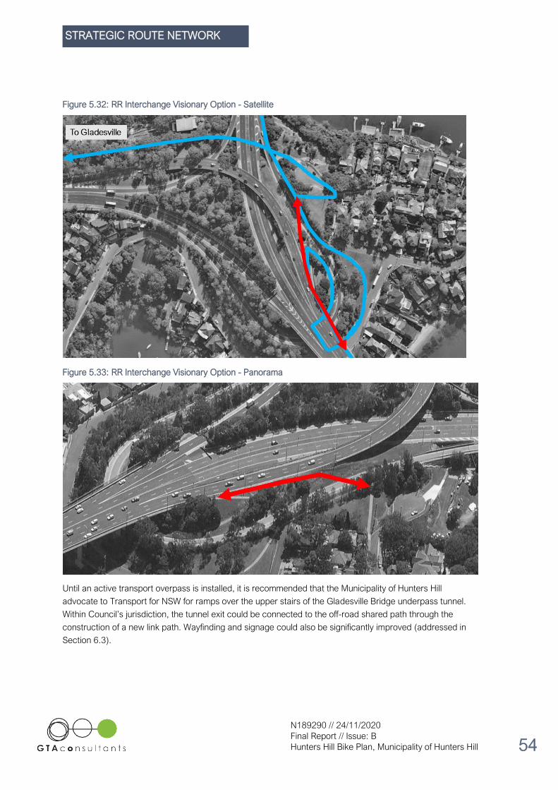
STRATEGIC ROUTE NETWORK
N189290 // 24/11/2020
Final Report // Issue: B
Hunters Hill Bike Plan, Municipality of Hunters Hill 54
Figure 5.32: RR Interchange Visionary Option - Satellite
Figure 5.33: RR Interchange Visionary Option - Panorama
Until an active transport overpass is installed, it is recommended that the Municipality of Hunters Hill
advocate to Transport for NSW for ramps over the upper stairs of the Gladesville Bridge underpass tunnel.
Within Council’s jurisdiction, the tunnel exit could be connected to the off-road shared path through the
construction of a new link path. Wayfinding and signage could also be significantly improved (addressed in
Section 6.3).

STRATEGIC ROUTE NETWORK
N189290 // 24/11/2020
Final Report // Issue: B
Hunters Hill Bike Plan, Municipality of Hunters Hill 55
Route RR1 – Section 1
Figure 5.34: Route RR1 Section 1
Route RR1 Section 1 is mostly serviced by the existing off-road shared path on the southern side of Victoria
Road. The gap between the Gladesville Reserve off-road shared path and the facility at the Victoria Road –
Huntleys Point Road intersection is to be addressed by interventions for Route HH3.
Route RR1 – Section 2
Figure 5.35: Route RR1 Section 2

STRATEGIC ROUTE NETWORK
N189290 // 24/11/2020
Final Report // Issue: B
Hunters Hill Bike Plan, Municipality of Hunters Hill 56
Route RR1 Section 2, while part of Transport for NSW’s Principal Bicycle Network, presents the opportunity
for Council to implement a formal cycling facility. Victoria Road is a State Road with traffic volumes over
40,000 vehicles per day1, meaning that it is not appropriate for on-road mixed traffic cycling. However, an off-
road shared path is not ideal either, as the active frontage of the Gladesville Town Centre generates high
pedestrian activity and increases the risk of user conflict. Here, it is recommended that the Municipality of
Hunters Hill advocate to Transport for NSW to explore an option similar to the off-road shared path in Rozelle.
Figure 5.36: Shared path on Victoria Road, Rozelle
Source: Google Street View
1 Transport for NSW – Traffic Volume Viewer

STRATEGIC ROUTE NETWORK
N189290 // 24/11/2020
Final Report // Issue: B
Hunters Hill Bike Plan, Municipality of Hunters Hill 57
Route RR2 – Section 1
Figure 5.37: Route RR2 Section 1
Route RR2 Section 1, like Route RR1, is complicated by Burns Bay Road being a State Road under Transport
for NSW’s jurisdiction. There is potentially enough space adjacent to the road carriageway to accommodate a
dedicated off-road cycle path, however, other capital works would be required before construction of the
pavement path. Figure 5.38 and Figure 5.39 show the site that may be appropriate for a cycle path. In the
instance that these works are not carried out by Transport for NSW, it is recommended that Council expedite
delivery of the Loop Connection via Durham Street and Reiby Road.
Figure 5.38: Burns Bay Road (South) – Space for Off-Road Path
Source: Google Street View
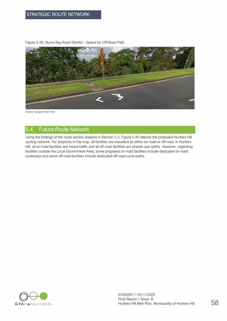
STRATEGIC ROUTE NETWORK
N189290 // 24/11/2020
Final Report // Issue: B
Hunters Hill Bike Plan, Municipality of Hunters Hill 58
Figure 5.39: Burns Bay Road (North) – Space for Off-Road Path
Source: Google Street View
5.4. Future Route Network
Using the findings of the route section analysis in Section 5.3, Figure 5.40 depicts the proposed Hunters Hill
cycling network. For simplicity in the map, all facilities are classified as either on-road or off-road. In Hunters
Hill, all on-road facilities are mixed traffic and all off-road facilities are shared user paths. However, regarding
facilities outside the Local Government Area, some proposed on-road facilities include dedicated on-road
cycleways and some off-road facilities include dedicated off-road cycle paths.

STRATEGIC ROUTE NETWORK
N189290 // 24/11/2020
Final Report // Issue: B
Hunters Hill Bike Plan, Municipality of Hunters Hill 59
Figure 5.40: Future Cycling Network
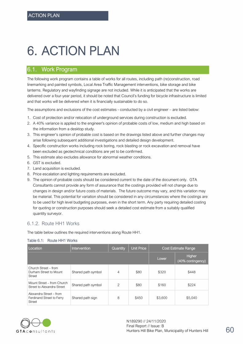
ACTION PLAN
N189290 // 24/11/2020
Final Report // Issue: B
Hunters Hill Bike Plan, Municipality of Hunters Hill 60
6. ACTION PLAN
6.1. Work Program
The following work program contains a table of works for all routes, including path (re)construction, road
linemarking and painted symbols, Local Area Traffic Management interventions, bike storage and bike
lanterns. Regulatory and wayfinding signage are not included. While it is anticipated that the works are
delivered over a four-year period, it should be noted that Council’s funding for bicycle infrastructure is limited
and that works will be delivered when it is financially sustainable to do so.
The assumptions and exclusions of the cost estimates - conducted by a civil engineer – are listed below:
1. Cost of protection and/or relocation of underground services during construction is excluded.
2. A 40% variance is applied to the engineer's opinion of probable costs of low, medium and high based on
the information from a desktop study.
3. This engineer’s opinion of probable cost is based on the drawings listed above and further changes may
arise following subsequent additional investigations and detailed design development.
4. Specific construction works including rock boring, rock blasting or rock excavation and removal have
been excluded as geotechnical conditions are yet to be confirmed.
5. This estimate also excludes allowance for abnormal weather conditions.
6. GST is excluded.
7. Land acquisition is excluded.
8. Price escalation and lighting requirements are excluded.
9. The opinion of probable costs should be considered current to the date of the document only. GTA
Consultants cannot provide any form of assurance that the costings provided will not change due to
changes in design and/or future costs of materials. The future outcome may vary, and this variation may
be material. This potential for variation should be considered in any circumstances where the costings are
to be used for high level budgeting purposes, even in the short term. Any party requiring detailed costing
for quoting or construction purposes should seek a detailed cost estimate from a suitably qualified
quantity surveyor.
6.1.2. Route HH1 Works
The table below outlines the required interventions along Route HH1.
Table 6.1: Route HH1 Works
Location Intervention Quantity Unit Price Cost Estimate Range
Lower Higher
(40% contingency)
Church Street – from
Durham Street to Mount
Street Shared path symbol 4 $80 $320 $448
Mount Street – from Church
Street to Alexandra Street Shared path symbol 2 $80 $160 $224
Alexandra Street – from
Ferdinand Street to Ferry
Street Shared path sign 8 $450 $3,600 $5,040

ACTION PLAN
N189290 // 24/11/2020
Final Report // Issue: B
Hunters Hill Bike Plan, Municipality of Hunters Hill 61
Location Intervention Quantity Unit Price Cost Estimate Range
Lower Higher
(40% contingency)
Alexandra Street – Mount
Street – The Avenue
Intersection Refuge island 1 $20,000 $20,000 $28,000
Alexandra Street and Ferry
Street intersection Refuge island 1 $8,000 $8,000 $11,200
Garibaldi Village Square Bicycle loop rack 4 $650 $2,600 $3,640
Ferry Street – from
Alexandra Street to Passy
Avenue Shared path symbol 6 $80 $480 $672
Woolwich Road – from Passy
Avenue to Gale Street PS-2 Bicycle symbol 24 $80 $1,920 $2,688
Woolwich Road – Passy
Avenue to Wybalena Road
Mid-Block
Road hump with cycle
bypass (no zebra
crossing)
1 $10,000 $10,000 $14,000
Woolwich Road – Futuna
Lane to Glenview Road Mid-
Block
Road hump with cycle
bypass (no zebra
crossing)
1 $10,000 $10,000 $14,000
Gale Street – from Woolwich
Road to The Point Road PS-2 Bicycle symbol 6 $80 $480 $672
The Point Road – from Gale
Street to Valentia Street PS-2 Bicycle symbol 12 $80 $960 $1,344
The Point Road – Mayfield
Avenue to Angelo Street
Mid-Block
Raised mid-block
pavement 1 $15,000 $15,000 $21,000
Valentia Street – from The
Point Road to Ferry Wharf PS-2 Bicycle symbol 12 $80 $960 $1,344
Woolwich Ferry Wharf Bike locker 1 $5,000 $5,000 $7,000
TOTAL $79,480 $111,272
The proposed road humps with cycle bypasses on Woolwich Road are costed without a zebra crossing for
pedestrians, as shown in Figure 2.1. However, at Council’s discretion, there is the option to also deliver a
zebra crossing as part of the works, if meeting RMS warrants.
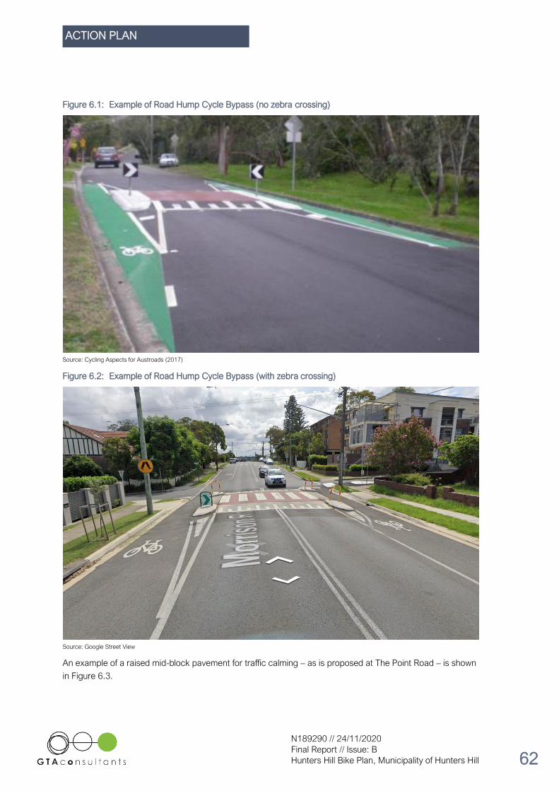
ACTION PLAN
N189290 // 24/11/2020
Final Report // Issue: B
Hunters Hill Bike Plan, Municipality of Hunters Hill 62
Figure 6.1: Example of Road Hump Cycle Bypass (no zebra crossing)
Source: Cycling Aspects for Austroads (2017)
Figure 6.2: Example of Road Hump Cycle Bypass (with zebra crossing)
Source: Google Street View
An example of a raised mid-block pavement for traffic calming – as is proposed at The Point Road – is shown
in Figure 6.3.

ACTION PLAN
N189290 // 24/11/2020
Final Report // Issue: B
Hunters Hill Bike Plan, Municipality of Hunters Hill 63
Figure 6.3: Example of Raised Mid-Block Pavement
Source: Austroads Guide to Traffic Management Part 8 (2020)
6.1.3. Route HH2 Works
The table below outlines the required interventions along Route HH2.
Table 6.2: Route HH2 Works
Location Intervention Quantity Unit Price Cost Estimate
Lower Higher
(40% contingency)
Pittwater Road – High Street
intersection
Refuge island
reconstruction (with
sufficient space for
cyclists)
1 $15,000 $15,000 $21,000
Bicycle Lanterns at Pittwater
Road – Princes Street
intersection
Upgrade to combined
pedestrian and bicycle
lanterns
2 $4,000 $8,000 $11,200
Boronia Park Village Bicycle loop rack 4 $650 $2,600 $3,640
Princes Road – from
Pittwater Road to Farnell
Street PS-2 Bicycle symbol 12 $80 $960 $1,344
Farnell Street – from Princes
Road to Ryde Road PS-2 Bicycle symbol 6 $80 $480 $672
Ryde Road – from Farnell
Street to Park Road Shared path symbol 6 $80 $480 $672

ACTION PLAN
N189290 // 24/11/2020
Final Report // Issue: B
Hunters Hill Bike Plan, Municipality of Hunters Hill 64
Location Intervention Quantity Unit Price Cost Estimate
Ryde Road – Park Street
intersection
Refuge island
reconstruction and safety
rails
1 $8,500 $8,500 $11,900
Mary Street – from Mark
Street to Gladesville Road PS-2 Bicycle symbol 6 $80 $480 $672
Mary Street and Gladesville
Road intersection Refuge island 2 $8,000 $16,000 $22,400
Mary Street and Gladesville
Road intersection Shared path symbol 2 $80 $160 $224
Mary Street and Gladesville
Road intersection
1.8m-wide bicycle lane
(green coloured
pavement)
40
metres $120 $4,800 $6,720
Augustine Street – from Ryde
Road to Gladesville Road PS-2 Bicycle symbol 10 $80 $800 $1,792
Gladesville Road – from Mary
Street to Ryde Road PS-2 Bicycle symbol 10 $80 $800 $1,120
TOTAL $59,060 $82,684
Combined pedestrian and cyclist bicycle lanterns will need to be provided for two of the four signalised
crossings at the Pittwater Road – Princes Street – Thompson Street intersection. A total of four lantern sets,
only two are in the Municipality of Hunters Hill.
Coordination with the City of Ryde will be required regarding their delivery of the Pittwater Road off-road
shared path, as well as Hunters Hill’s delivery of an on-road facility on Princes Street.

ACTION PLAN
N189290 // 24/11/2020
Final Report // Issue: B
Hunters Hill Bike Plan, Municipality of Hunters Hill 65
Figure 6.4: Proposed Bicycle Lanterns
Source: Nearmap
Figure 6.11 below depicts the proposed concept for the Mary Street – Gladesville Road intersection.

ACTION PLAN
N189290 // 24/11/2020
Final Report // Issue: B
Hunters Hill Bike Plan, Municipality of Hunters Hill 66
Figure 6.5: Mary Street and Gladesville Road intersection – concept

ACTION PLAN
N189290 // 24/11/2020
Final Report // Issue: B
Hunters Hill Bike Plan, Municipality of Hunters Hill 67
6.1.4. Route HH3 Works
The table below outlines the required interventions along Route HH3.
Table 6.3: Route HH3 Works
Location Intervention Quantity Unit Price Cost Estimate
Lower Higher
(40% contingency)
Massey Lane – from Pittwater
Road to Massey Street PS-2 Bicycle symbol 4 $80 $320 $448
Gladesville Town Centre Bicycle loop rack 4 $650 $2,600 $3,640
Massey Street – from Victoria
Road to Venus Street
1.8m-wide contra-
flow lane (green
coloured pavement)
270
metres $80 $21,600 $30,240
Massey Street – from Victoria
Road to Venus Street PS-2 Bicycle symbol 4 $80 $320 $448
Massey Street – Venus Street –
Makinson Street Intersection
Refuge island
reconstruction 1 $6,000 $6,000 $8,400
Makinson Street – from Massey
Street to Batemans Road PS-2 Bicycle symbol 8 $80 $640 $896
Batemans Road – Makinson
Street to Augustine Street Shared path symbol 2 $80 $160 $224
Pathway between Tarban Creek
Shared Path and Waruda Place Shared path symbol 4 $80 $320 $448
Shared path between Waruda
Place and Victoria Road Shared path symbol 4 $80 $320 $448
Victoria Road – from the
footbridge to Huntleys Point
Road (West) Shared path symbol 6 $80 $480 $672
Huntleys Point Road – Victoria
Road to Ferry Wharf PS-2 Bicycle symbol 10 $80 $800 $1,120
TOTAL $33,560 $46,984
Regarding the Massey Street contra-flow cycling lane, there is sufficient road carriageway space to construct
the cycling facility and maintain parking on both sides of Massey Street. While the example in Figure 6.6
shows a uni-directional lane not adjacent to a parking lane, it demonstrates how a cycling lane can be safely
separated from the adjacent road space through a raised painted separator.

ACTION PLAN
N189290 // 24/11/2020
Final Report // Issue: B
Hunters Hill Bike Plan, Municipality of Hunters Hill 68
Figure 6.6: Example of a separated bike lane at Wilson Street, Newtown
Source: Google Street View
Figure 6.7 shows the concept for this contra-flow lane on Massey Street and the works required at the
crossing into Makinson Street.
Figure 6.7: Massey Street and Venus Street intersection – concept

ACTION PLAN
N189290 // 24/11/2020
Final Report // Issue: B
Hunters Hill Bike Plan, Municipality of Hunters Hill 69
6.1.5. Loop and Loop Connection Works
The table below outlines the required interventions on the Loop and Loop Connection.
Table 6.4: Loop and Loop Connection Works
Location Intervention Quantity Unit Price Cost Estimate
Lower
Higher
(40%
contingency)
Mark Street – from Augustine
Street to Ryde Road PS-2 Bicycle symbol 8 $80 $640 $896
Martin Street – from Ryde Road
to Joubert Street PS-2 Bicycle symbol 10 $80 $800 $1,120
Joubert Street – from Martin
Street to Rose Street
3m-wide shared path
construction 50 metres $500 $25,000 $35,000
Reiby Road – from Burns Bay
Road underpass to Lane Cove
River foreshore shared path PS-2 Bicycle symbol 4 $80 $320 $448
Mount Street – Lane Cove River
foreshore shared path to
Alexandra Street PS-2 Bicycle symbol 8 $80 $640 $896
Stanley Road – Alexandra
Street to Mount Street PS-2 Bicycle symbol 8 $80 $640 $896
Mount Street – from Stanley
Road to Kareelah Road Link
Lane PS-2 Bicycle symbol 4 $80 $320 $448
Kareelah Road – Link Lane to
Moorefield Avenue PS-2 Bicycle symbol 4 $80 $320 $448
Moorfield Avenue – Kareelah
Road to Wandella Avenue PS-2 Bicycle symbol 6 $80 $480 $672
Wandella Avenue PS-2 Bicycle symbol 2 $80 $160 $224
Durham Street – Wandella
Avenue to Church Street PS-2 Bicycle symbol 6 $80 $480 $672
Reiby Road – Church Street to
Burns Bay Road underpass PS-2 Bicycle symbol 6 $80 $480 $672
TOTAL $30,280 $42,392

ACTION PLAN
N189290 // 24/11/2020
Final Report // Issue: B
Hunters Hill Bike Plan, Municipality of Hunters Hill 70
6.1.6. Regional Route Interchange Works
Table 6.5: Regional Route Interchange Works
Location Intervention Quantity Unit Price Cost Estimate
Lower Higher
(40% contingency)
Huntleys Point Road –
Gladesville Bridge Tunnel to
shared path
3m-wide shared path
construction 40 metres $500 $20,000 $28,000
Shared path between
Gladesville Bridge Tunnel and
Tarban Creek Bridge stairs Shared path symbol 6 $80 $480 $672
Huntleys Point Road – Huntleys
Point Wharf to Gladesville
Bridge tunnel PS-2 Bicycle symbol 8 $80 $640 $896
Shared path between Victoria
Road footbridge to Huntleys
Point Road (East) Shared path symbol 6 $80 $480 $672
TOTAL $21,600 $30,240
6.1.7. Summary of Works
Table 6.6 shows a summary of works, listed according to their proposed year of delivery, subject to Council’s
available funds.
Table 6.6: Summary of Works
Financial Year Route Lower Cost Estimate Higher Cost Estimate
(40% contingency)
2020/21 Loop & Loop Connection $30,280 $42,392
2021/22 Route HH2 $59,060 $82,684
2022/23 Route HH1 $79,480 $111,272
2023/24
Route HH3 $33,560 $46,984
Regional Route Interchange $21,600 $30,240
2024/25+ Ongoing advocacy for
identified ‘visionary’ works N/A N/A
TOTAL $223,980 $313,572

ACTION PLAN
N189290 // 24/11/2020
Final Report // Issue: B
Hunters Hill Bike Plan, Municipality of Hunters Hill 71
6.2. Standard Cycleway Treatments
6.2.1. Introduction
The City of Sydney’s Standard Cycleway Treatments Overview effectively outlines the industry’s best practice
objectives and elements of various cycleway typologies. A distillation of the key information and typology
cross sections is included, enabling the Municipality of Hunters Hill to deliver the Action Plan’s proposed
works in the most appropriate way.
6.2.2. Standard Cycleway Treatments
Mixed Traffic
In an on-road mixed traffic facility, cyclists travel in the main road carriageway with all other road users. Here,
bike symbols are painted on the road consistently across the cycling route, ensuring that both cyclists and
other road users are aware that they are sharing the travel lane together.
Contraflow
Contraflow cycleways provide a one-way separated lane for cyclists in the opposite direction of a one-way
street for vehicles. A median separator may be included when feasible, or a required inclusion following a risk
assessment. Clear regulatory signage is required, and green paint may be used to contrast the cycle lane
from general traffic. Refer to Figure 6.6 in Section 0 for an example of a contraflow cycling facility.
Shared Path
Shared paths provide bi-directional travel for pedestrians and cyclists. They are an appropriate intervention
when the volumes of both pedestrians and cyclists are not so intense as to create a high risk of conflict on the
path. Shared paths should be
Figure 6.8: Shared Path at Kelso Park North, Panania

ACTION PLAN
N189290 // 24/11/2020
Final Report // Issue: B
Hunters Hill Bike Plan, Municipality of Hunters Hill 72
Separated Bi-Directional Cycleway
Separated bi-directional cycleways are designed to physically separate cyclists from both vehicle traffic and
pedestrians. Located between the road carriageway and the footpath, a separated bi-directional provides for
two directions of movement by use of a centre line, as well as a physical barrier from vehicles and
pedestrians through the use of a median, kerb, buffer planting etc.
To avoid the loss of parking, the road width should generally be 12.8 metres or greater. For roads that are
designated for buses or other heavy vehicles, the road width should be 13.5m or greater to ensure that there
is enough space for these vehicles’ wider travel lanes. Figure 6.9 depicts the ideal cross section for a bi-
directional separated cycleway.
Figure 6.9: Separated Bi-Directional Cycleway Cross Section
Source: Standard Cycleway Treatments Overview (City of Sydney)
Figure 6.10: Separated Bi-Directional Cycleway at Kent Street, Sydney

ACTION PLAN
N189290 // 24/11/2020
Final Report // Issue: B
Hunters Hill Bike Plan, Municipality of Hunters Hill 73
6.3. Wayfinding Strategy
6.3.1. Overview
Wayfinding and directional signage are an integral component of a transport system. These elements help
users negotiate the network, easily and efficiently. Directional signage also reinforces system connectivity
and coherence and gives high visibility and recognition to the collection of routes which make up the network.
When people understand where they are, and where they are going, they feel safer and more comfortable. A
successful wayfinding system instils confidence in a wide variety of users and encourages walking and
cycling for transport and recreation. An effective wayfinding strategy creates clear paths by using visual,
verbal and/or auditory clues such as materials, patterns, signs, maps, landmarks and other signals.
While each mode has different needs in terms of the information required from signage, they also have
common needs, principally the need for a consistent and coherent approach to sign design, sign placement
and sign convention. Progressive disclosure and consistent, regular information presentation should
underpin any successful wayfinding system.
Bicycle routes should be clearly identified for the public as a legitimate transport facility. Where off-road
shared cyclist and pedestrian paths exist, they must be signposted with the appropriate R8-2 regulatory sign
as shown in Figure 6.11.
Figure 6.11: Bicycle Regulatory Signage
Source: NSW Bicycle Guidelines, Figure 3.5, pg. 14 (RMS, 2003)
The wayfinding and signage component of the strategy will assist cyclists with individual travel choices
without littering the network with more sign posts and visual clutter. The strategy would serve as the
functional framework for cyclist and pedestrian wayfinding signage and line-marking in the Municipality of
Hunters Hill and would include the following:
• Identifying and adapting intuitive wayfinding and linemarking elements from contemporary guidelines for
use in Hunters Hill, including but not limited to:
o NSW Bicycle Guidelines
o City of Sydney Bicycle Network Directional Signage Design Guidelines
o City of Sydney Shared Pathways Pavement Markings.
o Austroads Research Report AP-R492-15 Bicycle Wayfinding.
• Providing generic principles for an overall wayfinding and identification signage system.

ACTION PLAN
N189290 // 24/11/2020
Final Report // Issue: B
Hunters Hill Bike Plan, Municipality of Hunters Hill 74
• Identifying principles to plan a logical sequence of directional signs and information – recognising and
planning decision points and the hierarchy of messages.
• Preparing a standard signage template for bicycle directional signage in the LGA.
• Providing clear guidelines and criteria for placing signs at key decision points.
• Graphic design - use of type, colour and other graphics that assist wayfinding.
• Identifying distances on signs enables the user to plan their journey with confidence.
6.3.2. Signage General Principles
Directional signs are required to transmit information quickly to cyclists. This is achieved by keeping signage
simple, easy to identify and consistent throughout the cycling network. Good signage makes use of graphics
and symbols to achieve this and convey messages to cyclists.
It is important that directional signage be consistent throughout the bicycle network and be located at all
relevant intersections to direct cyclists. Care should be taken during signage placement to avoid bicycle
directional signage becoming lost in the clutter of other signs, or confusing motorised traffic, particularly when
used for on-road routes.
GTA recommend that the Municipality of Hunters Hill deviate from using the RMS standard signage and that
they instead adopt the signage specifications outlined in Appendix A-C of Austroads Research Report AP-
R492-15 until such a time that they are replaced or introduced as a new standard. The RMS signage does
not include the ability to display travel times, distances to the nearest hundred metres and points of interest.
The signs included in the Austroads Research Report have been specifically designed to be friendly to cyclist
(rather than based on a highway design as in the case of the RMS signage). They include a clearer typeface
for lower speed cyclists and a retro-reflective lettering which is clearer in low light conditions.
Examples of bicycle network route directional signage are shown in Figure 6.2.
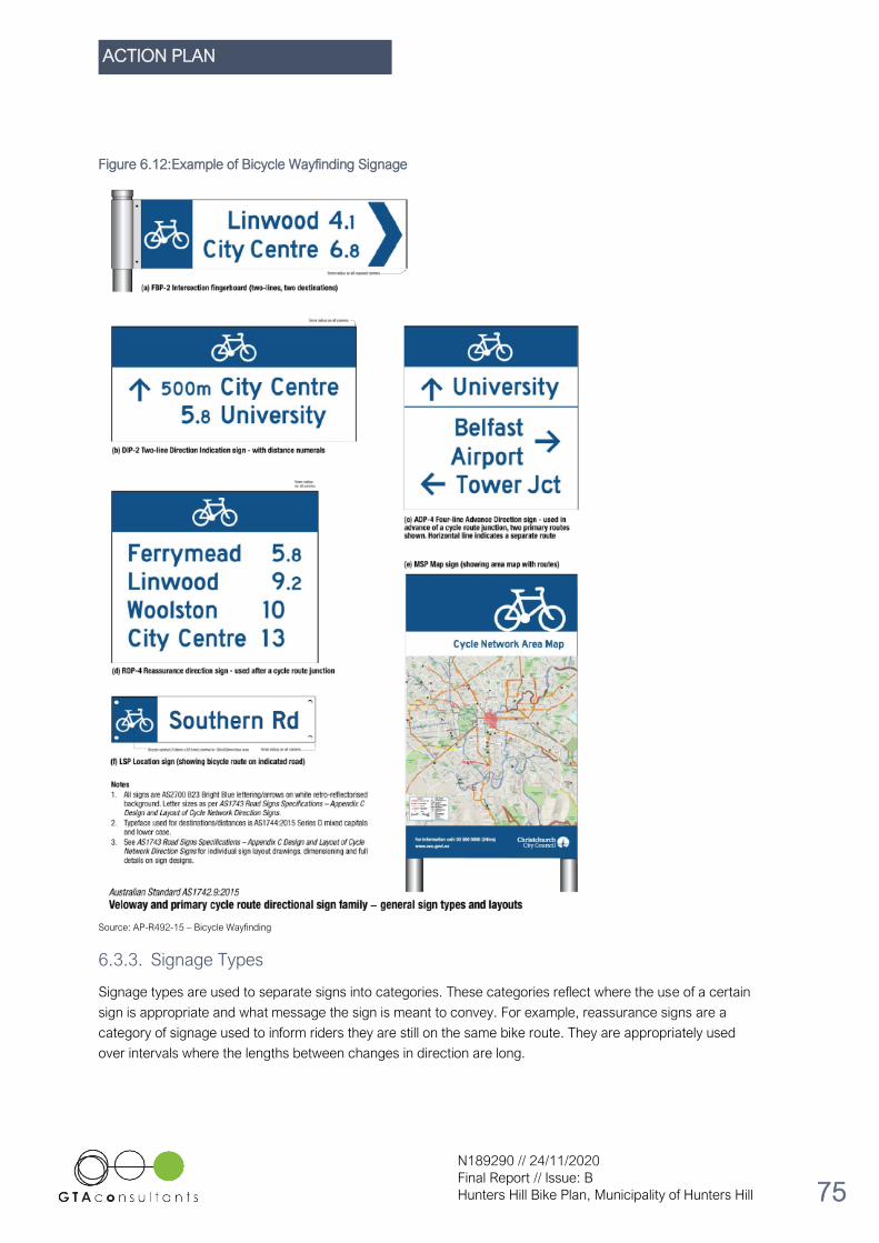
ACTION PLAN
N189290 // 24/11/2020
Final Report // Issue: B
Hunters Hill Bike Plan, Municipality of Hunters Hill 75
Figure 6.12: Example of Bicycle Wayfinding Signage
Source: AP-R492-15 – Bicycle Wayfinding
6.3.3. Signage Types
Signage types are used to separate signs into categories. These categories reflect where the use of a certain
sign is appropriate and what message the sign is meant to convey. For example, reassurance signs are a
category of signage used to inform riders they are still on the same bike route. They are appropriately used
over intervals where the lengths between changes in direction are long.

ACTION PLAN
N189290 // 24/11/2020
Final Report // Issue: B
Hunters Hill Bike Plan, Municipality of Hunters Hill 76
To reduce clutter along the cycling network it is recommended that they are only used on recognised
strategic routes or regional routes (e.g. Victoria Road). Austroads has categorised different types of signs
and commented on their appropriateness in different situations. These comments can be seen in Table 6.7.
Table 6.7: Cycle Routes and Sign Types Used on Each Route Type
Source: AP-R492-15 – Bicycle Wayfinding
RR1 and RR2 on Victoria Road and Burns Bay Road, respectively, are classified under the ‘primary’ route
type in the Austroads guidelines, whereas HH1, HH2, HH3 and the Loop function are categorised as ‘local’
routes. Concerning the Municipality of Hunters Hill’s implementation of these local routes, directional
fingerboards should be integrated with street signs.
An illustration of the different signs and appropriate uses for them is shown in Figure 6.13.

ACTION PLAN
N189290 // 24/11/2020
Final Report // Issue: B
Hunters Hill Bike Plan, Municipality of Hunters Hill 77
Figure 6.13: Sign Types
Source: AP-R492-15 – Bicycle Wayfinding
6.3.4. Wayfinding Methodology
The wayfinding methodology shown below is designed to produce a directional signage plan for the future
Hunters Hill cycling network. Strategic routes are identified, labelled and numbered. Junctions within the
routes are then identified and an appropriate sign schedule is created for each route. The combined sign
schedules form the overall directional sign plan.
Below is the methodology used to start the development of a wayfinding strategy for the Municipality of
Hunters Hill.
1. Identify Cycle Routes
2. Create Route Numbering System
3. Provide Branding for Routes (e.g. names, colours)
4. Identify and Document all route junctions
5. Create a Sign Schedule for each Route
6. Prepare Sign Artwork for Sign Manufacturer
Identify Cycle Routes
The cycle routes for the Municipality of Hunters Hill were defined as a strategic route network in Section 5.3.
Create Route Numbering System and Branding for Routes
While the Austroads guidelines state that ‘local’ routes do not have route numbering or branding, it is
recommended that the Municipality of Hunters Hill improve the strategic network’s legibility by utilising
branding for all its routes. Assigning a name and colour, the linear routes have been named HH1, HH2 and
HH3, while the circular route that was known as the ‘Hunters Hill Bike Route’ has been renamed ‘The Loop’.
The colours of the routes have the purpose of visually describing the fastest path through different sections of
the cycling network. On the street level the colours would be used to quickly inform cyclists that they are on a
strategic route.

ACTION PLAN
N189290 // 24/11/2020
Final Report // Issue: B
Hunters Hill Bike Plan, Municipality of Hunters Hill 78
The strategic routes identified were numbered, named and branded as follows:
7. HH1 – Hunters Hill Village to Woolwich Wharf, blue
8. HH2 – Hunters Hill Village to Buffalo Creek Reserve, purple
9. HH3 – Gladesville Town Centre to Huntleys Point Wharf, green
10. The Loop, pink
Identify and Document All Route Junctions
Route junctions are key decision points for cyclists. As cyclists will generally utilise more than one strategic
route for most of their trips it is important that junctions between the routes be identified and appropriately
signed.
Figure 6.14: Hunters Hill Route Junctions
Create a Sign Schedule for Each Route
A sign schedule details the location, type and displayed content of each sign along a strategic route. For the
proposed strategic routes in Hunters Hill, it is proposed that that a sign be placed at each junction and each
turning decision point along the route. As an example, Figure 6.15 depicts the key wayfinding points along
Route HH3.

ACTION PLAN
N189290 // 24/11/2020
Final Report // Issue: B
Hunters Hill Bike Plan, Municipality of Hunters Hill 79
Figure 6.15: Route HH3 Key Wayfinding Points
Table 6.8: Route HH3 Wayfinding Sign Schedule
Point Type of Sign Content
A Map Sign Route HH3: Gladesville Town Centre to Huntleys Point Wharf
Huntleys Point Wharf: 3.1km
B Direction Indication Sign Gladesville Town Centre: 0.1km Huntleys Point Wharf: 3.0km
C Direction Indication Sign Gladesville Town Centre: 0.4km Huntleys Point Wharf: 2.7km
D Direction Indication Sign Gladesville Town Centre: 0.6km Huntleys Point Wharf: 2.5km
E Direction Indication Sign Gladesville Town Centre: 0.8km Huntleys Point Wharf: 2.3km
F Direction Indication Sign Gladesville Town Centre: 0.9km Huntleys Point Wharf: 2.2km
G Direction Indication Sign Gladesville Town Centre: 1.0km Huntleys Point Wharf: 2.1km
H Direction Indication Sign Gladesville Town Centre: 2.1km Huntleys Point Wharf: 1.0km
I Direction Indication Sign Gladesville Town Centre: 2.2km Huntleys Point Wharf: 0.9km

ACTION PLAN
N189290 // 24/11/2020
Final Report // Issue: B
Hunters Hill Bike Plan, Municipality of Hunters Hill 80
Point Type of Sign Content
J Direction Indication Sign Gladesville Town Centre: 2.3km Huntleys Point Wharf: 0.8km
K Direction Indication Sign Gladesville Town Centre: 2.3km Huntleys Point Wharf: 0.8km
L Direction Indication Sign Gladesville Town Centre: 2.5km Huntleys Point Wharf: 0.6km
M Direction Indication Sign Gladesville Town Centre: 2.6km Huntleys Point Wharf: 0.5km
N Direction Indication Sign Gladesville Town Centre: 2.8km Huntleys Point Wharf: 0.3km
O Direction Indication Sign Gladesville Town Centre: 3.0km Huntleys Point Wharf: 0.1km
P Map Sign Route HH3: Huntleys Point Wharf to Gladesville Town Centre
Gladesville Town Centre: 3.1km
Prepare Sign Artwork for Sign Manufacturer
A preliminary example of a fingerboard sign has been prepared for Route HH3 – Gladesville Town Centre to
Huntleys Point Wharf. The purpose of the sign is to convey to the following information:
• The route the rider is on
• Distance to the route destinations
• The estimated travel time to the route destinations
The designs achieve this through incorporating the brand / colour of the route and very simply identifying the
route destinations along with its distance and estimated travel time.
Figure 6.16: Route HH3 Fingerboard Signage Example

www.gta.com.au


![Capitulo1 HILL[1]](https://static.fdokumen.com/doc/165x107/6316ac67d16b3722ff0cffbf/capitulo1-hill1.jpg)