Application of UAV in maritime search and rescue activities
54
World Maritime University World Maritime University The Maritime Commons: Digital Repository of the World Maritime The Maritime Commons: Digital Repository of the World Maritime University University Maritime Safety & Environment Management Dissertations Maritime Safety & Environment Management 8-24-2014 Application of UAV in maritime search and rescue activities Application of UAV in maritime search and rescue activities Xiaojie Wang Follow this and additional works at: https://commons.wmu.se/msem_dissertations Part of the Navigation, Guidance, Control, and Dynamics Commons, and the Transportation Engineering Commons Recommended Citation Recommended Citation Wang, Xiaojie, "Application of UAV in maritime search and rescue activities" (2014). Maritime Safety & Environment Management Dissertations. 172. https://commons.wmu.se/msem_dissertations/172 This Dissertation is brought to you courtesy of Maritime Commons. Open Access items may be downloaded for non-commercial, fair use academic purposes. No items may be hosted on another server or web site without express written permission from the World Maritime University. For more information, please contact [email protected].
-
Upload
khangminh22 -
Category
Documents
-
view
1 -
download
0
Transcript of Application of UAV in maritime search and rescue activities

World Maritime University World Maritime University
The Maritime Commons: Digital Repository of the World Maritime The Maritime Commons: Digital Repository of the World Maritime
University University
Maritime Safety & Environment Management Dissertations Maritime Safety & Environment Management
8-24-2014
Application of UAV in maritime search and rescue activities Application of UAV in maritime search and rescue activities
Xiaojie Wang
Follow this and additional works at: https://commons.wmu.se/msem_dissertations
Part of the Navigation, Guidance, Control, and Dynamics Commons, and the Transportation
Engineering Commons
Recommended Citation Recommended Citation Wang, Xiaojie, "Application of UAV in maritime search and rescue activities" (2014). Maritime Safety & Environment Management Dissertations. 172. https://commons.wmu.se/msem_dissertations/172
This Dissertation is brought to you courtesy of Maritime Commons. Open Access items may be downloaded for non-commercial, fair use academic purposes. No items may be hosted on another server or web site without express written permission from the World Maritime University. For more information, please contact [email protected].

i
WORLD MARITIME UNIVERSITY
Dalian, China
APPLICATION OF UAV IN MARITIME SEARCH
AND RESCUE ACTIVITIES
By
WANG XIAOJIE
The People’s Republic of China
A research paper submitted to the World Maritime University in partial
fulfillment of the requirements for the award of the degree of
MASTER OF SCIENCE
(MARITIME SAFETY AND ENVIRONMENTAL MANAGEMENT)
2014
© Copyright Wang Xiaojie, 2014

ii
DECLARATION
I certify that all the materials in this research paper that are not my own work have
been identified, and that no material is included for which a degree has previously
been conferred on me.
The contents of this research paper reflect my own personal views, and are not
necessarily endorsed by the University.
(Signature): Wang Xiaojie
(Date): July 10, 2014
Supervised by:
Dr. Zhu Yuzhu
Professor
Dalian Maritime University
Assessor:
Co-assessor:

iii
ACKNOWLEDGEMENTS
This research paper was developed as an important part of my studies to apply for the
master degree in Maritime Safety and Environmental Management (MSEM), World
Maritime University (WMU) and Dalian Maritime University (DMU). This research
work would not have been successfully accomplished without the generous support
and help of a number of people and organizations to which I am very grateful.
First and foremost, I would like to express my most sincere gratitude to my
supervisor Professor Zhu Yuzhu for his patience and encouragement and for guiding
me through the process of this project. His help is indeed valuable.
I must give my heartfelt thanks to all professors attending the MSEM 2014 program.
Their professional knowledge broadened my eyesight and instilled in me new ideas.
My gratitude also goes to the administrative staff at the International Convention
Research Center of DMU for providing me with support during my study.
I would like to deliver my thanks to Nanhai Rescue Bureau of the Ministry of
Transport of PRC for providing me the great opportunity to attend the program of
MSEM. I also wish to convey my profound gratitude to my leaders and colleagues in
Nanhai Rescue Bureau who gave me a great of support and encouragement during
the period of studying here.
Also, I remain very grateful to all classmates of MSEM 2014. I thank them for their
company and for sharing their views and experiences with me. Together we
experienced a nice time of life in DMU.

iv
Last but not the least, my deepest gratitude goes to my parents for their
encouragement and support throughout the study.

v
ABSTRACT
Title of Research Paper: Application of UAV in Maritime Search and
Rescue Activities
Degree: Msc
The continuous development of global economy offers new opportunities for
industries of marine fishing, ocean shipping, offshore oil and gas, ocean engineering
construction, coastal tourism and so on. Meanwhile, the growing number of ships
increases the likelihood of marine accidents. As the last line of defense at sea,
maritime search and rescue system plays an important role in protecting people and
property. Marine safety is the eternal topic on increasing the possibility of finding
targets and the success rate of rescue.
Search and rescue operation is complex since the systematic process contains two
parts: the first step is search, the second one is rescue. In order to send targets to a
safety zone successfully, both of these factors are indispensable. Compared with the
rescue part, the searching process is the foundation of the whole operation. Once the
target is found, the battle is half done. If the target can not be found, the rescue work
could not start.
As important developing platforms, UAVs can be used widely in maritime search and
rescue activities. With the rapid development of computer and communication
technology, the performance of UAVs has been improved. Their application field
expands fast. At the same time, with the development and application of remote
sensing technology, the applied range of UAVs keeps broading. They have become
the most important supplement of satellite and aircraft remote sensing.
In this research paper, the composition and working procedures of UAV and their
vi
remote sensing system are described, and the benefits of UAVs are analyzed.
Synchronously, this research paper analyzes the feasibility of the UAVs in search and
rescue activities, and forecasts the UAVs’ application prospect.
Keywords: UAVs, Remote Sensing System, Maritime Search and Rescue
Activities, Application

vii
TABLE OF CONTENTS
DECLARATION ......................................................................................................... ii
ACKNOWLEDGEMENTS ........................................................................................ iii
ABSTRACT ................................................................................................................. v
TABLE OF CONTENTS ........................................................................................... vii
LIST OF FIGURES .................................................................................................... ix
LIST OF TABLES ...................................................................................................... ix
LIST OF ABBREVIATIONS ...................................................................................... x
Chapter 1 Introduction ................................................................................................. 1
1.1 Backgrounds and significance ...................................................................................................... 1
1.2 Development and current situation of UAVs both domestic and abroad ...................................... 3
1.3 Text organization .......................................................................................................................... 6
Chapter 2 Brief introductions of UAVs and their remote sensing system ................... 7
2.1 Overview of UAVs ....................................................................................................................... 7
2.2 Overview of UAV remote sensing system .................................................................................. 10
2.3 Operating principles of UAVs and their remote sensing system ................................................. 12
Chapter 3 Feasibility analysis of application of UAVs in maritime rescue activities
(eapecially in Nanhai area) ........................................................................................ 15
3.1 Current situation of the development of UAVs and remote sensing system ............................... 15
3.2 SWOT analysis of UAVs in maritime search and rescue industry .............................................. 17
Chapter 4 Applications of civil UAVs ....................................................................... 29
4.1. Application abroad ..................................................................................................................... 29
4.2. Application in China .................................................................................................................. 32
Chapter 5 Targets of UAVs in maritime search and rescue activities ........................ 35
5.1 Collecting field data .................................................................................................................... 35
5.2 Airlifting small necessaries ......................................................................................................... 36

viii
5.3 Detecting accidents and monitoring pollution ............................................................................ 36
Chapter 6 Design scheme of UAVs and their system in maritime rescue activities .. 37
6.1 Detailed working procedures ...................................................................................................... 37
6.2 Inherent requirements of UAV platforms.................................................................................... 38
6.3 Arrangement of the control system ............................................................................................. 39
6.4 Storage of UAVs ......................................................................................................................... 40
Chapter 7 Conclusion ................................................................................................. 41
References .................................................................................................................. 42

ix
LIST OF FIGURES
Figure 1.1 DoD Annual funding profile for UAVs. 4
Figure 1.2 Estimated European UAV market. 5
Figure 2.1 Structure of UAV remote sensing system. 10
Figure 2.2 Remote sensing facilities and the control system. 11
Figure 2.3 The flow chart of remote sensing data acquisition. 13
Figure 2.4 The flow chart of remote sensing data processing. 14
Figure 4.1 UAV Ikhana of NASA. 29
Figure 4.2 A Global Hawk turns hurricane hunter. 30
Figure 4.3 A set of monitors for UAVs in the control center. 31
Figure 4.4 Equipments for Deepwater Program. 32
Figure 4.5 The UAV using in Tianjin MSA. 33
Figure 4.6 The control center of UAV in Tianjin MSA. 34
Figure 6.1 Working procedures of UAVs using in maritime search and rescue. 37
LIST OF TABLES
Table 3.1 General cost comparison between the watercraft and aircraft. 20
Table 3.2 Respond time comparison between the watercraft and aircraft. 22
Table 3.3 Data of search and rescue operations from 2003 to 2013. 25
Table 6.1 Equipments on UAV and their contribution 39

x
LIST OF ABBREVIATIONS
AIS Automatic Identification System
ASI Air Speed Indicator
DARPA Defense Advanced Research Projects Agency
DARO Defense Airborne Reconnaissance Office
DoD Department of Defense of the United States
ECIDS Electronic Chart Display System
EOTS Electro Optical Targeting System
FLIR Forward Looking Infrared
GPS Global Position System
IMU Inertial Measurement Unit
MSA Maritime Safety Administration
NASA National Aeronautics and Space Administration
SWOT Strength Weakness Opportunity Threats
TTL Transistor-Transistor Logic
UAV Unmanned Aerial Vehicle
USA the United States of America
USCG United States Coast Guard
VTOL Vertical Take-off and Landing
VHF Very High Frequency

1
Chapter 1 Introduction
1.1 Backgrounds and significance
The world’s development is to an ever increasing extent depending on the
transportation of persons and goods. Being as a great and powerful shipping country,
China enjoys 18,000 km of coastline, 120,000 km of inland waterway as well as
abundant marine resources. By the end of 2009, China has 20 ports with 100 million
tons and 8 of them are among the top ten in the world. There are 1,769,000 merchant
ships in China for transporting 93% of the foreign goods, 95% of imported crude oil
and 95% of imported iron ore. These data shows that the waterborne economy takes
quite a large proportion in Chinese national economy with the rapid development of
waterway transportation.
Due to the wide application of modern science and technology, the ship construction
level, the reliability of marine equipments as well as the scientificity of maritime
communications have been improved. As the result, there is a corresponding
improvement in navigation safety conditions. But apart from factors of ships
themselves, marine traffic safety is influenced by many factors such as natural
condition, navigation condition, management of ships and ports, shipmen and so on.
It is difficult to avoid marine accidents completely. According to relevant data, the
percentage of major accidents in all marine accidents raised from 48.3% in 1995 to
76.1% in 2000, the number of persons and ships in distress at sea has increased by

2
about 2.6 times and 1.3 times respectively from 2000 to 2005. These data show an
upward trend in the number of marine accidents. It is very important to enhance our
ability of maritime search and rescue and the respond to emergencies in order to
protect the life and property of people.
Marine accident is an accident which happens suddenly in bad weather. The key to
success in search and rescue work is to find out the targets at the first time, to collect
relevant information in a short time, to make a reasonable and effective rescue plan
and set out the rescue resources as soon as possible. In recent years, China has
increasingly stepped up the investments in constructing new model of rescue vessel
and maritime rescue helicopter, and has greatly enhanced its rescue ability. China
Rescue and Salvage of Ministry of Transport of the People's Republic of China
website states that:
By the end of 2010, this force had:
(1) Rescued and salvaged 3,942 distressed vessels, 833 of which are foreign
ships;
(2) Removed 1,740 ship wrecks, among which 98 are foreign ones;
(3) Saved 55,266 people in distress at sea, with 11,641 of them are foreigners;
(4) Recoverd 61,990 million RMB (9,537 million dollars) property since the
year of 2002.
Even so, there are still some shortcomings in this area. Sometimes rescue members
only focus on the rescue work whereas overlook the earlier stage of searching.
What’s more, some rescue equipments have their inherent disadvantages. Rescue
vessels have the disadvantages of slow response, short visual range. Rescue
helicopters have the advantage of speed and vision, they can easily obtain the whole
condition and understand disaster scene. They also have the advantages over rescue
vessels in terms of searching special targets and pollution prevention monitoring. But

3
they can not carry out the rescue tasks at night as well as in the bad weather like
typhoon because these environmental conditions are dangerous for pilots in the
planes. Being one kind of aircrafts, unmanned aerial vehicles (UAVs) have all the
advantage of a plane to overcome the above deficiencies. With the advantages of
flexible, convenient and efficient, UAVs can fly to the incident area with a high
speed and start the search working at anytime. Also, they have the ability to work all
the time, taking images which are useful for the rescue work. With these advantages,
UAVs have the chance to be the new professional equipments for maritime search
and rescue activities.
1.2 Development and current situation of UAVs both domestic and abroad
As stated in the Unmanned Aerial Vehicles Roadmap 2002-2027[6]
(2002, p. iii),
there is a long and continuous history of involvement with UAVs. Stretching back to
1917, UAVs are mainly used as target for military purposes. With the improvement
of technology, today’s UAVs are more sophisticated and capable than ever. Not only
used for military, UAVs have expanded into civil areas. Since the 1980s, with the
rapid development of computer communication technology, many kinds of sensors
with the features of digital, light weight, small size and high precision have appeared.
As the result, there is a rapid expansion in terms of UAVs’ scope and application. The
endurance extends to dozens of hours from about one hour, the weight of payload
increases from several kilograms to hundreds of kilograms. These changes have
created favorable conditions for UAVs with multipurpose.
At present, UAVs are hot applications in the field of military. Many countries put lots
of work on the research and application of UAVs. Figure 1.1 shows the growth trend
of investment for UAVs in the United States of America (U.S.A.). As shows in the
chart, the Department of Defense of the United States (DoD) annual funding for
UAVs has increased dramatically from 106 million in 1988 to 3,460 million in 2010.

4
Even though the funding is for military purposes, it is also meaningful for UAVs
changes from military purposes into civil purpose.
Figure 1.1 - DoD Annual funding profile for UAVs.
Source: Office of the Secretary of Defense (2002). Unmanned aerial vehicles roadmap 2002-2007.
Washington: Author.
Represented by the U.S.A., many developed countries are using the latest UAVs in
every field in daily life, such as in weather field, business field, geography field and
other civilian areas. In Europe, UAVs are widely used in earth observation,
coastguard and telcoms.

5
Earth Observation
Coastguard
Borders
Forest Fire
Telcoms
Law Enforcement
Powerline
Pipeline
Figure 1.2 – Estimated European UAV market.
Source: Liu, Z. (2012). The Research of applications and industrial design in police UAV.
Unpublished master’s research paper, Donghua University, Shanghai, China.
China has worked in the research and development of UAV remote sensing
monitoring technology for more than 10 years. Chinese Research Institute of
Surveying and Mapping invented UAVRS2ⅠUAV remote sensing monitoring
system which focused on remote control. In its research on 2003, it upgraded the old
system, the methods of unmanned remote control, semi-autonomous control as well
as autonomous control are implemented in its UAVRS2Ⅱsystem. Its new UAV with
the weight of 50 kg has the ability to take-off with the help of cars.
On August 8, 2005, the UAV, which is made by Peking University and Aviation
Industry Corporation of Chian, finished its first flight successfully at Anshun
Huangguoshu Airport. In this UAV, the advanced high resolution digital camera
system made by The Institute of Remote Sensing and Digital Earth of China was
used.
In 2006, Qingdao Marine Engineering Prospecting and Design Institute developed
the TJ21 which was the first UAV with two engines. At the same time, the first UAV

6
remote sensing system for civil use was developed, too. It can be used in the
maritime environment.
1.3 Text organization
This paper gives a brief introduction of UAVs as well as the UAV’s remote sensing
system and analyzes the feasibility of UAVs in maritime search and rescue activities.
Also, it gives advices about the plan of using UAVs in maritime search and rescue
activities.
(1) Brief introduction of UAVs and UAVs’ remote sensing system including the
concept, components and working principles.
(2) Strength Weakness Opportunity Threats (SWOT) Analysis for UAVs in maritime
search and rescue activities.
(3) Cases of the application about UAV using for civil purpose in China and aboard.
(4) Application targets of UAV in maritime search and rescue activities.
(5) Design scheme of UAVs and their remote sensing system in terms of the working
process, some essential performance, the arrangement of the whole system and the
storage of UAVs.

7
Chapter 2 Brief introductions of UAVs and their remote sensing system
2.1 Overview of UAVs
2.1.1 Concept of UAV
Commonly known as drones, UAVs are aircrafts without pilots aboard. As stated in
the Unmanned Aerial Vehicles Roadmap 2002-2027[6]
(2002, p. 2), the definition of a
UAV is “a powered, aerial vehicle that does not carry a human operator, uses
aerodynamic forces to provide vehicle lift, can fly autonomously or be piloted
remotely, can be expendable or recoverable, and can carry a lethal or non-lethal
payload”. Their flights are controlled by onboard computers or pilots on the ground.
UAVs do not have cockpits inside but they usually equipped with some special
devices such as high-definition cameras, differential Global Position System (GPS),
Automatic Identification System (AIS), electronic autopilot, program control unit
and so on for military and special operation applications. For UAVs, they do not need
aviators, but controllers. Workers on the ground, on rescue vessels or in the remote
control station can quickly and accurately detect, locate, identify, track, designate
targets by UAV’s baseline payload of radar, Electronic Chart Display System (ECDIS)
and a laser range finder–designator. Under the wireless remote control, UAVs can
take off in the same way as a conventional plane or use booster rocket to launch.
Besides, they can start their flights by carried by other planes. When talking about
the kinds of recovery, UAVs can land automatically like an airplane, or go back by
using parachute or block. They can be used repeatedly. They are widely used in the

8
fields of maritime search, aerial reconnaissance, electronic interference and so on.
2.1.2 Types of UAVs
According to the endurance and the length of flight, UAVs can mainly be classified
into four kinds: long enduration UAVs, medium range UAVs, short range UAVs and
very short range UAVs (Wang, 2010, 115).
(1) Long enduration UAVs
They are high-altitude drones with the feature of long flight. They can fly day and
night with a fight time of 12 hours at least.
For instance, Xianglong is a high-altitude long-endurance UAV in China with a
wingspan of 24.86 m, a takeoff weight of 6,800 kg, a payload capacity of 600 kg, a
speed of 700 km/h and a endurance of 10 hours.
(2) Medium range UAVs
With the action radius of 700-1,000 km, medium range UAVs can conduct
surveillance by using infrared ray and cameras and transfer images and videos in
real-time. They have two launching modes, one is air delivery, and the other is
ground launch. For the task of recovery, medium range UAVs can go back into the
ground by parachute, or be received by the large aircraft in the air.
Designed as an unmanned platform for battle reconnaissance, data relay and
electronic warfare, CH-3 is a Chinese medium range UAV which can be configured
with different payloads. It can fly up to 5,000 m and remain airborne for more than
12 hours.

9
(3) Short-range UAVs
Short-range UAVs are unmanned aircrafts which operate in the 150-350 km radius.
The majority are mini UAV with the fuselage of 3-5 m and a weight of 200 kg or less.
They can furnish with television cameras, Forward Looking Infrared (FLIR) system,
infrared scanner as well as laser range-finder. Their launch and recovery methods are
almost the same as the medium range UAVs.
(4) Very short-range UAVs
These UAVs are micro UAVs which can fly up to a point 10 km away with a weight
less than 10 kg. They have the advantages of simple structure and convenient to carry.
They can carry payloads like optical camera and infrared camera.
From the perspective of structure and airfoil, UVAs can be grouped into two
categories: fixed-wing UAVs and rotary-wing UAVs (Wang, 2010, 115).
Fixed-wing UAVs are usually deployed for military in various countries. They have
the traits of high security and high mobility. Their launch methods are classified into
land-based and carrier-based.
Rotary-wing UAVs include subdivisions like traditional type helicopter, tilt rotor and
coaxial rotor aircraft. These UAVs with simple structure and low cost have the
abilities of vertical take-off and landing and free hovering in the air. They completely
solve the problems relevant to recovery on carriers. They are featured by high
flexibility for flying in all kinds of routes of flight at any speed. Besides, they are
characterized by small flutter, low noise and high reliability.
10
2.2 Overview of UAV remote sensing system
2.2.1 Concept of UAV remote sensing system
UAV remote sensing system is a system designed for low-altitude surveillance and
photo taking by using UAVs as platforms. Dedicated to obtain low-level remote
sensing data of high resolution in low-altitude, it combines with high-technology
about UAVs, remote sensing and GPS guidance. For its technology advantages of
low cost, miniaturization, customization, UVA remote sensing system becomes an
effective complement for airborne remote sensing technical system to get remote
sensing data.
2.2.2 Components of UAV remote sensing system
Equipments of UAV remote sensing system include UAV platforms, a navigation and
flight management system, a remote sensing sensor and its control system, a
communication system and a ground recording and monitoring system.

11
Figure 2.1 – Structure of UAV remote sensing system.
Source: Lang, C. (2010). Application of Unmanned Aerail Vehicle (UAV) in the dynamic monitoring of
regional land use. Unpublished master’s research paper, Xi'an University of Technology, Xi’an, China
(1) Navigation and flight management system
Major components of navigation and flight management system include attitude
gyroscope, atmospheric pressure altimeter, magnetic heading sensor, GPS navigation
and positioning device, flight control computer, actuator, power management system
and so on. With the purpose of navigation and position, this system is mainly used to
guide the aircraft flying at predetermined route, to control UAVs’ flight attitude and
flight path, to control the tasks system to complete the plan of aerial photography and
to help the aircrafts to land safely.
(2) Remote sensing sensor and its control system
For capturing remote sensing images, the airborne remote sensing device and its
control system are the main devices of UAV remote sensing system. This suit of
armor includes airborne remote sensing facilities, the stabilized platform, the mission
equipment control system etc.
Figure 2.2 – Remote sensing facilities and the control system.
Source: Bing, Y. Y. (2008). UAV remote sensing in a mine iron resources monitoring. Unpublished
master’s research paper, Liaoning Technical University, Fuxin, China

12
(3) Communication system
In this system, a data transceiver and a Transistor-Transistor Logic (TTL)
communication port of navigation processor are connected with RS-232 port of data
radio by signal connectors, while RS-232 port of the data transceiver in the ground
station is linked with the same port of laptops in the same way. By this means, UAVs
send their real time flight data which are in the form of the curve to the ground
station by using digital radio and receive instructions from the ground station.
Similarly, the ground station sends telecontrol messages to UAVs to set up or change
the flight route, flight altitude and course in this way.
(4) Ground recording and monitoring system
Based on the information sent back from remote sensing system and its control
system, the ground recording and monitoring system which consists of laptops,
ground control softwares, telecommunication cables and data radio shows the UAVs’
location, flight line and flight path on an electronic map which has the ability of
moving and zooming. During a flight, this system can monitor the plane's flight,
modify the task and flight parameters in real time. Through ground control station
software, controllers can input destinations directly by using a keyboard or a mouse,
search and modify the old task files, as well as point out the destinations on the
electronic map in order to enhanced performance of real-time control.
2.3 Operating principles of UAVs and their remote sensing system
(1) Data acquisition
In order to ensure UAVs and their system working around the clock, it is very
important to reliably handle and send down the high resolution satellite data and
information from the other sensors. Under the different circumstances, satellite
transmission, stadia microwave transmission and out-of-sight transmission can be

13
used to send the data. In order to meet the requirement of processing synchronously
and submiting the result in a short time, data should be coded and compressed before
the transmission. The process of data acquisition is shown in Figure 2.3.
Figure 2.3 – The flow chart of remote sensing data acquisition.
Source: Compiled by the author on June, 6, 2014.
(2) Data processing
The data processing of remote sensing images covers the processes of geometrical
rectification, mosaicing, and special analysis. For this process, nonlinear geometry
distortion, image rotation and projection distortion are the primary obstacles.
Nonlinear geometry distortion is a general problem in digital camera design because
of arts and crafts of optical lens. Image rotation is a natural phenomena dues to the
aircraft's attitude variation. In the complicated data disposal course, projection
deformation is ineluctability to take place. The geometric rectification phase is a
complicated process to solve these imaging problems.
Usually, UAVs carry miniature digital cameras or scanners to take pictures and film

14
the event. Affected by the air flow, the aircraft makes great tilt angles. As the result,
image rotation and projection deformation of each images are different. Every picture
needs to be corrected. This problem increases the difficulty of data processing. In
general, navigation data and attitude data are used to check the image quality and
flying quality rapidly. The lidar data and microwave remote sensing data can use
GPS data and Inertial Measurement Unit (IMU) data to calculate point clouds and
amend the geometry distorted. As the consequence, the corresponding digital
elevation model and digital orthophoto map are available.
Figure 2.4 – The flow chart of remote sensing data processing.
Source: Compiled by the author on June, 6, 2014.

15
Chapter 3 Feasibility analysis of application of UAVs in maritime rescue
activities (eapecially in Nanhai area)
Feasibility of application of UAVs and their remote sensing system in maritime
rescue activities is evaluated from two aspects. One is whether the developing level
of UAVs and the remote sensing system can be apply to the special maritime
environment and meet the demands from search and rescue service. The other one is
whether UAVs and the system have advantages in maritime rescue activities.
3.1 Current situation of the development of UAVs and remote sensing system
UAV remote sensing technology is an integrated system which involves in a variety
of fields such as aviation, microelectronics, automation control, computer
communication, navigation positioning etc. At present, most of the key technologies
are still controlled in military. In terms of research and application of UAVs, the
developed countries such as U.S.A. have taken the forefront in the world. A
well-known product is a high-altitude and long-endurance Global Hawk which has
its origins in the 1994 High-Altitude Endurance Unmanned Aerial Vehicle Advanced
Concept Technology Demonstrator program initiated by the Defense Advanced
Research Projects Agency (DARPA) and Defense Airborne Reconnaissance Office
(DARO). Based on the RQ-4 Global Hawk, Europe produced its first high-altitude,
long-endurance, signals intelligence UAV called EURO HAWK. In the current
situation, it is a general trend to develop the UAV system for civil and commercial
use. The growing need coming from marine safety, marine scientific research as well

16
as environmental monitoring and protection will be a further acceleration of this
momentum.
In China, the research of UAVs and the remote sensing system has a history of more
than 40 years. Since the first Chinese UAV Chang Kong-1 made a successful maiden
flight On December 6, 1966, more UAVs such as Chang Hong which is a
high-altitude, high-speed unmanned drone as well as T-6 which is a universal UAV
etc. have developed. With the constant widening application of UAVs, China has
made progress in terms of the development of the aircraft itself, the flight control
system which is suitable for the aerial remote sensing and the UAV aerial remote
sensing system. In the civilian field, there are several research institutions and
enterprises, like Chinese Research Institute of Surveying and Mapping, China
University of Geosciences and Beijing University, have put efforts into technology
research about civil remote sensing based on UAVs and generate a series of remote
sensing system for certain mini-UAVs. In addition, China has successfully launched
seven orbiters for Beidou navigation system. The successful launch of satellites
marks the favorable conditions for civil applications and development to the UAVs.
There are more than 300 kinds of UAVs with different property indexes for various
purposes in the world by far. The fixed-wing UAV has a fast speed and large service
radius, but it has high requirements for the landing zone because it can not take off
and land vertically. Take these factors into consideration, the fixed-wing UAVs are
appropriate for routine monitoring in terms of mineral resource, forestry and marine
environment. For the rotary-wing UAV, it can easily take off and land in narrow
space (like ship deck) and hover over the special targets for a long time. But it has
drawbacks of low speed and small range. It is more suitable for dealing with
unexpected incidents like maritime search and rescue as well as the surveillance of
oil spill.
17
3.2 SWOT analysis of UAVs in maritime search and rescue industry
A SWOT analysis is a method used to evaluate the strengths, weaknesses,
opportunities, and threats involved in a project or in a business venture. It can be
carried out for a product, place, industry or person. Here it can identify the internal
and external factors that are favorable and unfavorable to analyze whether UAVs are
suitable for maritime search and rescue activities.
3.2.1 Strengths of UAVs in maritime search and rescue activities
As new equipments for search and rescue at sea, UAVs have the ability to fly over
the obstacles on the ground. Compared with the army and modern weaponry by land
and sea, UAVs can gather comprehensive information in a shorter time. Also, they
have their own unique advantages over manned aircrafts and satellite platforms.
(1) UAVs have high mobility but low requirements for ground support
The accident at sea is a sudden event without omen. It needs rapid response from
search and rescue department. The maritime rescue teams should get the picture clear
in a very short time in order to handle the emergency rescue. UAVs have low
requirements of environmental condition during take-off and landing as well as the
maintenance supply because they do not need a specialized runway and ground
maintenance. They have the ability to take-off and withdraw on a relatively small site,
ships or oil platform. Because of the characteristics of small volume, light weight,
convenient to transport, low demands on take-off and landing etc., UAVs can be sent
to the site of the accident for rapid response to emergencies.
(2) UAVs can fly for a long time and carry out the task sequentially
First of all, UAVs do not have problems about pilot fatigue. They have the ability to
18
execute tasks continuously after being properly maintained and repaired. The time
they stay at the air only affected by their own performance indexes. Compared with
satellite remote sensing, UAVs’ system breaks the limits of revisit period and
response time. They are particularly well-suited for searching in solution spaces for a
long time at the scene of the accident because of their characteristics of high
efficiency.
In the second place, UAVs can be controlled to fly at a low altitude under the cloud.
As is known to all, it is quite normal that optical remote sensing and aerial
photography can not get pictures when they are blocked by clouds. UAVs can
remedy these fatal flaws by their low-altitude flight and increase the utilization of
images. Designed for multitasking, UAVs can carry different modules and finish the
corresponding task according to the actual needs. With the combination of airborne
radar, high-performance photoelectric or infrared sensor and multispectral or
hyperspectral scanner, UAVs can achieve the goal of all-weather surveillance with
high resolution.
(3) UAVs can be designed in a task-focused way with strong purposiveness
Because there is no pilot in the aircraft, when designing the UAVs in terms of safety
factor, flight time, structure and so on, physical and psychological factors can be
ignored. In other words, UAVs have the ability to fly for a long time according to
task demand. For example, the famous UAV Global Hawk has the endurance of 41
hours. With the help of tanker aircraft, its endurance can extend to 160 hours. But in
contrast, the EC225 helicopter which is a manned aircraft using in Donghai, Beihai
and Nanhai Rescue Flying Service, only can fly for no more than 4.26 hours.
(4) The safety risk of UAVs is very low

19
The advantages offered by UAVs are numerous, most notably in the dull, the dirty,
and the dangerous mission areas. UAVs can get to the areas that manned aircrafts can
not get to. The safety risk reduces significantly. Even there is an air crash, it will not
lead to the loss of human life because there is no man in the drone.
(5) The cost of UAVs is much lower than the planes and rescue vessels in use
currently
In the first place, UAVs have the advantages of simple structure and small size, their
development costs and erection costs are much lower than manned aircrafts which
have the same function and rescue vessels. For example, the building cost of
Nanhaijiu 101 which is one of the biggest rescue vessels in China is 260,000,000
yuan. However, the FQM-151 Pointer which is a very small hand-launched
mini-UAV made by U.S.A. only costs 5,000 dollars (about 31,111 yuan today). The
CL-227 Sentinel which is a remote-controlled UAV made by Canada costs 45,000
dollars (about 279,999 yuan today). There is a big gap in terms of building cost
between rescue vessel and UAV. What’s more, UAVs can be made from old airplanes.
In this way, the production cost of UAVs is reduced greatly.
In the second place, UAVs with low weight use less oil than the classical airplanes
and rescue ships, their running cost are greatly reduced.
Based on the different characteristics (including speed, service life) they have, it is
supposed that, a big-size rescue vessel need 750 hours/year to complete the rescue
task in a certain area and the time that aircraft needs is 200 hours/year. Also, we
suppose that the service life of a ship is 25 years and the life for aircraft is 20 years.
According to these basic data, we make the comprehensive cost and expenses
comparison between aircrafts and watercraft which is shown in table 3.1.
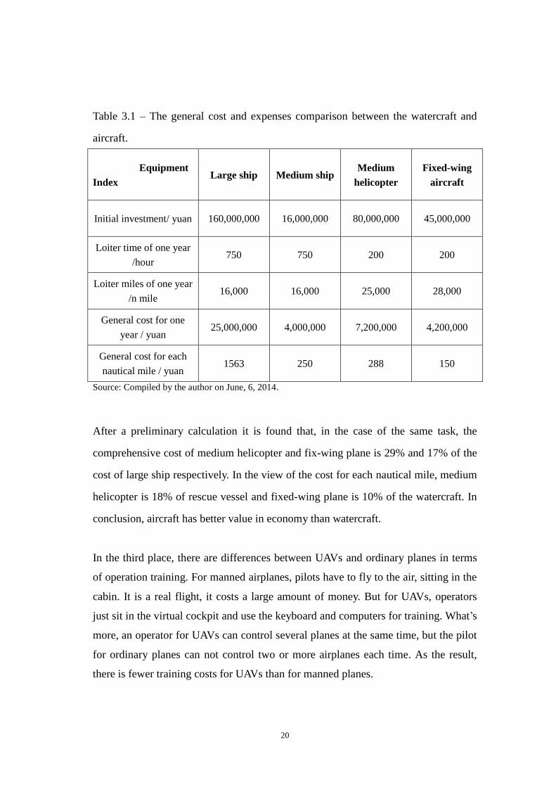
20
Table 3.1 – The general cost and expenses comparison between the watercraft and
aircraft.
Equipment
Index Large ship Medium ship
Medium
helicopter
Fixed-wing
aircraft
Initial investment/ yuan 160,000,000 16,000,000 80,000,000 45,000,000
Loiter time of one year
/hour 750 750 200 200
Loiter miles of one year
/n mile 16,000 16,000 25,000 28,000
General cost for one
year / yuan 25,000,000 4,000,000 7,200,000 4,200,000
General cost for each
nautical mile / yuan 1563 250 288 150
Source: Compiled by the author on June, 6, 2014.
After a preliminary calculation it is found that, in the case of the same task, the
comprehensive cost of medium helicopter and fix-wing plane is 29% and 17% of the
cost of large ship respectively. In the view of the cost for each nautical mile, medium
helicopter is 18% of rescue vessel and fixed-wing plane is 10% of the watercraft. In
conclusion, aircraft has better value in economy than watercraft.
In the third place, there are differences between UAVs and ordinary planes in terms
of operation training. For manned airplanes, pilots have to fly to the air, sitting in the
cabin. It is a real flight, it costs a large amount of money. But for UAVs, operators
just sit in the virtual cockpit and use the keyboard and computers for training. What’s
more, an operator for UAVs can control several planes at the same time, but the pilot
for ordinary planes can not control two or more airplanes each time. As the result,
there is fewer training costs for UAVs than for manned planes.
21
Last but not least, UAVs can be kept in the depot because of the small size. Unlike
the airplanes which are parked outside, UAVs do not need the periodic maintenance.
Their maintenance charge can be reduced as much as 80% compared with that of
fixed-wing aircraft.
(6) The performance of UAVs is much better than the planes and rescue vessels
in use currently
For maritime search and rescue, time equals to life. Whether the rescue process will
be success is directly related to the time that rescue members arrive at the scene of
the accident. For the rescue vessel, the speed is quite slow and the vision field is
quite small. What’s more, it is influenced by natural conditions to a great extent. For
the aircraft, the speed will be at least 7 to 10 times as much as that of rescue vessel.
The fast response time of vessel and plane are shown in table 3.2. In this table, the
prepared time for rescue vessel is calculated as 10 minutes, for helicopter and
fixed-wing plane is 30 minutes each. The speed is about 22 n mile/h, 250 km/h and
340 km/h for rescue ship, helicopter and fixed-wing plane respectively. From table
3.2, it can be described that the reaction capability of planes is inherently better than
that of rescue ships, and the gap between these two equipments gets wide with the
increasing of distance.
According to the established functional relation between vision observation radius
and the height of the eye, the search range of airplane is about 12 times as much as
that of ship for the same long-distance voyage. In addition, UAVs have the abilities
to take off in a short time, fly at low speed at low altitudes and hover in the air. For
the oil spill accidents, UAVs can get the information which can not be acquired
directly by rescue vessel. Compared with watercraft, UAVs have irreplaceable
advantages in terms of the emergency respond time and effects of search.

22
Table 3.2 – The emergency respond time comparison between the watercraft and
aircraft.
Voyage/ n mile 25 50 100 200 300
Respond time of rescue
ship /min 78 146 282 554 826
Respond time of
helicopters /min 41 52 74 119 163
Respond time of
fixed-wing plane /min 41 51 72 115 158
Source: Compiled by the author on June, 6, 2014.
In conclusion, the advantages of UAVs are shown as follows:
(1) UAVs have better value in economy than watercrafts.
(2) While using UAVs for search and rescue activities, rescue members can obtain
the relevant information at the first time, hence eliminating the blind spot and
making right decisions. As the result, the loss of life and property caused by missing
the best rescue opportunities can be avoided.
(3) UAVs can promote the development of maritime search and rescue activities, and
enhance the science level of search and rescue. These images coming from UAVs can
be used to set up databases in order to increase the accuracy of disaster risk
reduction.
(4) UAVs are more environmentally friendly and cost-effective than rescue ships.
3.2.2 Weaknesses of UAVs in maritime search and rescue activities
23
Although the basic technology of UAVs brings confidence to the world, its weakness
can not be neglected as well.
In the respect of the rescue capacity, UAVs can not carry persons in accident out of
the scene of the accident directly. However a rescue vessel can easily bring the ship
in danger or the people on board to safety.
In the respect of the performance, UAVs would be affected by the wind greatly for
they are usually used in bad weather. In the case of a powerful typhoon, the images
taken by UAVs may be vague.
Concerning about the operation, UAVs need a long time to train the operators. For
traditional search and rescue mode using dedicated maritime rescue vessels and
helicopters, there are about 3000 technical staff to ensure the safety of life and
property at sea and maintain a clean marine environment. But for UAVs, there are not
any professional operators who can control this complicated system for maritime
search and rescue activities at this moment, even there are some cases of using UAVs
in different fields such as public safety, flood control and drought relief, wildlife
monitoring and so on. That means UAVs can not be used for searching targets even if
we have a complete set of equipment. The operators should be trained and gain
experience from simulated training at first.
3.2.3 Opportunities for UAVs in maritime search and rescue activities
(1) Objective factors
Take the responsibility area of Nanhai Rescue Bureau which covers all the South Sea
of China for example. The climatic and economic characteristics of this area bring
opportunities to the UAVs and their system.

24
The Chinese south coast area is a foggy region. Cold currents in winter and typhoons
in summer are the main extreme weather which affects the South Sea. The number of
tropical cyclones is decreasing, whereas the intensity of the cyclones is enhancing.
Every year, there are 8-9 tropical cyclones pose a direct threat to the South Sea
among the 12-14 tropical cyclones with influence.
The density of ships in the South Sea is increasing. The South Sea is one of the sea
areas with large traffic density. The domestic and foreign merchant ships go through
the sea frequently. The number of ships going through Taiwan Strait is 70,000 port
calls per year and the number for Qiongzhou Strait and Pearl River Estuary is 11,000
port calls per year and 1,500,000 port calls per year respectively.
There are about 1,700 islands in this sea area, and there are more than 100,000
fishing boats which have registered and the number of fishmen reachs 1,700,000.
The oil and gas resources are very rich in this area. At present, there are 18 oil and
gas fields which are developing with 91 platforms and facilities.
Tourism industry of South Sea is thriving. With the improved living standards, the
demands for maritime transport and marine tourism keep growing. The passenger
flow volume of Pearl River Estuary and Qiongzhou Strait is about 20,000 and 30,000
persons per day respectively. What’s more, the marine amusements such as tours
throughout the coastal, sea fishing, sailing and surfing are drawing more and more
attention.
As the features shown above, this sea area is a developing area. The development of
marine economy increases the possibility of maritime accident and heats up the

25
attention that the government and people pay to the marine safety. As the result, the
government and relevant departments need to enhance searching techniques and
equipments in order to meet the increasing demand for maritime security. Besides,
the hydrologic and weather conditions which are constantly changing will cause
more accident at sea and increased the difficulty of the search and rescue. These
objective factors provide opportunities for UAVs using in maritime search and rescue
activities. With the help of UAVs, the specific information which holds great
significance for assisting rescue crew in risk assessment and plan making can be get
to improve the initiative, reliability and pertinence of rescue plan. As the result, the
rescue success rate will be improved. That means the ships or persons in danger will
be rescued in a shorter time while the rescue crew will confront less danger.
(2) Subjective factors
The search and rescue force plays a vital role in the development of shipping industry.
Table 3.3 shows the data of search and rescue operations from 2003 to 2013. It is
found that the rescue success rate maintains at a certain level even the number of
rescued persons increases. There is a certain gap compared with developed countries
such as U.S.A. In order to improve the rescue effect, the requirement of adapting the
environment of maritime search and rescue should be taken into account when
allocating the search and rescue forces. Fortunately, UAVs can meet the above needs.
Table 3.3 – The data of search and rescue operations from 2003 to 2013.
Year
Number of
maritime
accident
Number of
persons in
danger at sea
Number of
rescued
persons
Rescue success
rate
2003 1889 14912 14243 95.50%
2004 1492 16491 15597 94.60%
2005 1582 17806 16969 95.30%
2006 1620 17498 16753 95.70%

26
2007 1861 25087 24227 96.60%
2008 1784 20280 19565 96.50%
2009 1964 19128 18397 96.20%
2010 2218 24513 23555 96.10%
2011 2177 19352 18712 96.70%
2012 1954 16952 16392 96.70%
2013 2169 21399 20712 96.79%
Source: Compiled by the author on June, 6, 2014.
Maritime search and rescue work is the final and key line of the maritime traffic
safety guarantee system. It is the most direct way to avoid or lighten perils of the
marine accidents. It contains 5 stages: discover the maritime issues, take an initial
operation (information collection and rescue risk assessment), set an action plan,
carry out the rescue plan, and complete the rescue operation. As can be seen from the
process, after the SOS messages are received, information collecting and risk
assessment are the priority for all. They relate to the rescue plan and the success of
the rescue action. Only under the guidance of a comprehensive plan which is based
on timely and clear information, every rescue force can work cooperatively with each
other and maximize their potential to fulfil the rescue task.
As a general rule, a ship would send out its location by satellite or its panalarm when
it gets into trouble. The rescue department can find the ship's position when rescue
members receive the information. But actually, some information sent by the ship in
distress is not coincident with actual facts. Some people even exaggerate the risks
dues to their lack of ability to correctly assess risk. Facing with these problems,
UAVs are good problem solvers.
In this case, UAVs can be sent to the targeted location with the aim to see the matter
clearly, get detail information about the location and nature of distress, the traffic

27
density of the specified waters, the meteorological hydrological conditions of the
scene, the description, loading condition, the equipment status of the ship in danger,
as well as the number and the state of the persons in danger. These data make
significant contributions to rescue risk assessment and operation plan.
What’s more, UAVs can pay sustained attention to the issue with the aim to complete
the rescue plan which should change with time and environmental condition. The
work environment is dynamic for the ships at sea are moving and the marine risk is
constantly changing. As the plan unfolds, the condition of weather, the visibility, the
latest information of the target ship is likely to change. These call for the
improvement of the rescue plan. UAVs can help to perfect the design scheme in a
certain extent. They can focus on the targets and follow up the drifting direction of
the targets as well as the vital signs of the person in distress. They have great effects
on the implementation of the rescue work.
The experience of development in advanced countries shows four development
trends of maritime search and rescue: equipments are more and more modern, work
pattern is more and more stereoscopic, response is more and more rapid, information
is more and more integrated. But there are some defects in current search and rescue
system. These offer opportunities for UAVs to carry on forerunner and the explorer
role in maritime search and rescue activities. Using UAVs can increase the accuracy,
reliability and efficiency of the basic information and provide technical support for
rescue work.
3.2.4 Threats to UAVs in maritime search and rescue activities
From the perspective of external threats, there are about 10 dedicated maritime

28
rescue vessels stand by at the South China Sea. With the increased emphasis on
traffic safety at sea, more and more professional equipments (such the rescue ships)
will put into the maritime search and rescue activities. What’s more, with the help
comes from other departments, for example, Maritime Safety Administration of
Guangzhou and Hong Kong Government Flying Service, the search and rescue work
will be shared.
From the perspective of internal threats, there are 7 key technologies for the
development of UAVs and their remote sensing system.
(1) Aerodynamic problems about low Reynolds number;
(2) Micro power systems high thrust-weight ratio;
(3) Structured design technique of large bulk;
(4) Stability and operability of flight and the control technology;
(5) Information-passing techniques with weak power signal;
(6) Multidisciplinary design optimization for UAV system;
(7) Processing and manufacturing technology based on micro electro mechanical
system.
For UAVs, these techniques are the main issues that have to be solved. In other
words, these are the treats to UAVs.

29
Chapter 4 Applications of civil UAVs
4.1. Application abroad
National Aeronautics and Space Administration (NASA) has set up a UAV
Applications Center with the aim to carry out research for different civilian purposes.
Work with National Oceanic and Atmospheric Administration, this center makes
scientific researches on weather forecast, global warming, glacial ablation and so on.
During the 2007 wildfire season, NASA used Ikhana for assessing the severity of the
fire and damage from the forest fire. Ikhana is a modification of Predator B. It is used
for civil and environmental monitoring purposes.
Figure 4.1 – UAV Ikhana of NASA.
Source: The website of National Geographic.
(http://news.nationalgeographic.com/news/2012/09/pictures/120921-hurricane-drones-nasa-usgs-envir
onment-science/#/news-drones-ikhana-flight_59339_600x450.jpg)

30
By reconstructing the UAVs which used to be used for military affairs, NASA
launched its own drone mission to understand and predict storms on September 19,
2012. The UAV launched by NASA is called Global Hawk. It can travel up to 17,700
km as well as stay in the air for up to 30 hours.
Figure 4.2 – A Global Hawk turns hurricane hunter.
Source: The website of National Geographic.
(http://news.nationalgeographic.com/news/2012/09/pictures/120921-hurricane-drones-nasa-usgs-envir
onment-science/#/news-drones-global-hawk_59341_600x450.jpg)

31
Figure 4.3 – A set of monitors for UAVs in the control center.
Source: The website of National Geographic.
(http://news.nationalgeographic.com/news/2012/09/pictures/120921-hurricane-drones-nasa-usgs-envir
onment-science/#/news-drones-control-station_59342_600x450.jpg)
Not only NASA, but also United States Coast Guard (USCG) wants to improve itself
and enhance the comprehensive strength by using UAVs.
USCG is one of the oldest coast guards in the world. Some of its equipments have
past or near their original retirement ages. To fill the gap, USCG set up the Integrated
Deepwater System Program whose missions are to protect maritime safety. In this
program, USCG planned to purchase 76 UAVs. The news on December 18, 2013
said that USCG would accept about 20 micro UAVs (Wasp III) given by Marine
Corps.

32
Figure 4.4 – Equipments for Deepwater Program.
Source: Tao, R. (2003). Deepwater programme of USCG. Modern Ships, China.
For a wide range of monitoring at sea which is one of most important part of
Deepwater Program, UAVs, such as high altitude endurance UAV and Vertical
Take-off and Landing (VTOL) UAV, are the important components of aviation
division. In other words, UAVs can cover the shortages of patroling the coast in the
air. UAVs and their systems are useful for maritime safety.
4.2. Application in China
Since 2013, UAVs have been used in marine environmental monitoring in Liaoning
Province. It is the first application in maritime management in China. The images of
island area and its adjacent sea area taken by UAVs provide accurate information for
the divisions of the sea and marine protection.
Tianjin Maritime Safety Administration (MSA) is the first MSA which uses UAVs as

33
the assistant of cruise control in order to enhance the emergency command ability
and the capacity for emergency management of oil spilling.
The UAV in Tianjin MSA is HSE-LY-001 of Longyan. Its flight altitude is 1,000 m.
Equipped with digital cameras, Longyan takes on the work of surveillance on water
pollution as well as maritime search and rescue. According to Tianjin MSA, Longyan
works 2-3 times a week. It is on call for 24 hours and takes off at any time if there is
an accident happened in the area under the administration of Tianjin MSA. By
January 4, 2013, Longyag has flown 76 sorties safely. Its work efficiency exceeded
expectations.
Figure 4.5 – The UAV using in Tianjin MSA.
Source: Compiled by the author on June, 6, 2014.

34
Figure 4.6 – The control center of UAV in Tianjin MSA.
Source: Compiled by the author on June, 6, 2014.
Even though there is no precedence for UAV using in the real maritime search and
rescue activities, from the SWOT analysis and the use cases in other areas in and out
of China, the conclusion can be get that using UAV in maritime search and rescue
activities is feasible.

35
Chapter 5 Targets of UAVs in maritime search and rescue activities
Based on the present development situation of search and rescue, UAVs are suited for
targets searching, locale information transporting and pollution monitoring because
they have the certain advantages over manned planes and vessels.
5.1 Collecting field data
When a marine accident happened, the rescue at scene is the most critical aspect of
the whole work. Often triggered by complex sea environment and extreme weather,
manned vehicle are not convenient to use. In this case, UAVs can utilize their skills.
UAVs can hover in the specified airspaces for a long time without rest. Also, their air
routes can be constantly adjusted in order to fulfill temporary tasks. The staff on land
can get the real time images with high quality from the emergency scene and order
the rescue vessels to rush to the right location. Using UVAs instead of manned
aircrafts can greatly reduce the risk caused by harsh conditions, being complement in
superiority for rescue vessel. Accordingly, the success rate of search and rescue will
be vastly improved.
For some special cases, like oil spill accidents and ship-collision, command center
makes the most accurate rescue plan only after evaluating the level of the accident. In
that case, UAVs can fast react and arrive at the certain place required by the
command center in the shortest time, taking pictures of sea condition, sending the
real-time information back to control center by teletransmission. On the other hand,

36
the staff working at the center can make the UAV hovering over the sea surface in
order to collect accurate and detail information which is the basis of emergency
plans.
5.2 Airlifting small necessaries
When accidents happened at sea, it is very important for people in danger to have
enough fresh water and food to sustain life. As is known to all, seawater is
undrinkable, and the persons who are trapped in an island or at sea may not have
enough food to eat. In that case, UAVs can give necessary assistance to those people.
Before taking-off, operators can equip the UAVs with a small amount of necessary
supplies such as bottles of fresh water, compressed biscuits, and even some drugs.
After UAVs arrive at the scene of the accident and find the targets, they can airlift the
supplies which are attached to a parachute at the right time, helping the people to
keep themselves in a relatively good condition before they are rescued.
5.3 Detecting accidents and monitoring pollution
Marine accidents are often unpredictable and may produce a chain reaction. The
situations of the disaster and pollution change at every moment so that the true and
reliable information is needed. UAVs have different characteristics of quick speed,
low energy consumption, zero casualt and real-time, they can be used to monitor and
detect key areas and key targets to ensure the emergency decision is fast and
effective.
37
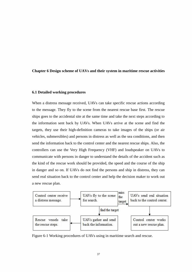
Chapter 6 Design scheme of UAVs and their system in maritime rescue activities
6.1 Detailed working procedures
When a distress message received, UAVs can take specific rescue actions according
to the message. They fly to the scene from the nearest rescue base first. The rescue
ships goes to the accidental site at the same time and take the next steps according to
the information sent back by UAVs. When UAVs arrive at the scene and find the
targets, they use their high-definition cameras to take images of the ships (or air
vehicles, submersibles) and persons in distress as well as the sea conditions, and then
send the information back to the control center and the nearest rescue ships. Also, the
controllers can use the Very High Frequency (VHF) and loudspeaker on UAVs to
communicate with persons in danger to understand the details of the accident such as
the kind of the rescue work should be provided, the speed and the course of the ship
in danger and so on. If UAVs do not find the persons and ship in distress, they can
send real situation back to the control center and help the decision maker to work out
a new rescue plan.
Figure 6-1 Working procedures of UAVs using in maritime search and rescue.

38
Source: Compiled by the author.
6.2 Inherent requirements of UAV platforms
In order to meet demand comeimg from the marine safety, the selection of UAVs
using in search and rescue activities should consider the following factors:
(1) Performance of wind resistance
The external meteorological environment such as wind, cloud, rain etc. has a great
influence on UAVs’ flight paths and flying qualities. As new equipments in maritime
search and rescue activities, UAVs are applied to abominable environments such as a
hurricane. The wind-resistance design is especially important for UAVs because it
determines whether UAVs can arrive the site of accident smoothly and quickly. More
than that, the wind-resistant performance is bound up with the stability of aircraft and
the definition of the images. The stronger wind resistance UAVs have, the higher
stability they have, the clearer images they take. In conclusion, UAVs using in
maritime search and rescue work should possess certain anti wind capacity and be
equipped with shock absorber to ensure the images are available and useful.
(2) Endurance
From the practical work it is found that the radius of search and rescue service should
be no less than 200 km, the loiter time of UAVs should be more than 1 hour. That
means the endurance of UAVs using in rescue work should be more than 3 hours.
The endurance of Eagle Eye and Fire Scout which are two types of UAV purchased
by USCG are 5 hours and 6 hours respectively.
(3) Flexibility
As mentioned before, fixed-wing UAVs need a special runway for both take-off and
landing. This is a problem for fixed-wing UAV using on rescue vessels. By contrast,
rotary-wing UAVs have their unique advantages in using on rescue ships for it can

39
take off and landing without runways. In addition, the rotary-wing UAVs can hang
steady in the air, fly close to the rescue area which other platforms are difficult to
reach as well as follow and monitor the targeted ships closely. In the grand scheme,
rotary-wing UAVs are ideal options to the existing rescue force.
(4) Instruments onboard
Besides the basic equipments such as remote control apparatus, radar, differential
GPS, high definition cameras of 360 degrees, autopilot and so on, UAVs should carry
on some rescue equipments that match with the rescue vessels, for example,
ECDIS, Air Speed Indicator (ASI), VHF, anemograph, night vision instrument,
Electro Optical Targeting System (EOTS) and so on. With the help of these devices,
UAVs can transmit the maritime search and rescue information around the clock and
render timely help to the ships and persons in distress.
Table 6.1 - Equipments on UAV and their contribution.
Name Contribution
GPS Locating the target's positions quickly and save the rescue time.
AIS
Cameras Shooting pictures of the scene.
Anemomete Gathering information about the direction and speed of wind.
Radar Searching the persons in distress automatically.
Autopilot
Night vision Accomplishing the search task at night and auto-follow-up the
target. EOTS
VHF Communicating with the person on ship, helping them to prepare
for the rescue work. Source: Compiled by the author on June, 6 2014.
6.3 Arrangement of the control system
Besides the UAVs themselves, the control system about the equipments of

40
monitoring and command should be taken into consideration. At present, Nanhai
Rescue Bureau has a master-control centre in Guangzhou and 8 sub-control
departments in the rescue bases in Haikou, Guangzhou, Yangjiang, Shenzhen,
Zhanjiang, Shantou, Sanya and Beihai. All of the existing systems are connected with
each other as well as the ships on call. The control system of UAVs can be integrated
into existing systems, setting an operation room in the master-control center. When
the master-control center receives a distress signal, the professional rescue staff will
give commands and instructions to the relevant rescue base to fly UAVs control by
the operator working in the main center. The images gathered by UAVs are sent back
to the master-control center, sub-control center and the rescue ships at the same time,
helping the rescue staff to have a clear understanding of the accident and make a
right decision. During the whole process of search and rescue, UAVs are always
controled by the operators in the master-control center.
6.4 Storage of UAVs
Rotary-wing UAVs are the best choice for maritime search and rescue activities, they
can land on the rescue vessels and parking there in a short term. For the long term,
they must be placed into storages. The UAVs with small bodies can be parked in the
modified area in the existing garage and equipment stores. For the aircrafts which are
relatively larger, they could be stored in the rescue flying bases of Nanhai NO.1
Flying Rescue Service which is a professional team carrying out air rescue missions
in China.

41
Chapter 7 Conclusion
The development of UAVs has a long history for nearly a hundred years. The
technology of UAV is relatively mature. The result of SWOT analysis shows that
using UAVs in maritime search and rescue activities is feasible. It is necessary for the
professional rescue team to use UAVs and the remote sensing system as a new rescue
force for they can arrive at the scene in a short time, collect the in-time data, search
the targets as soon as possible, keep track of an event in real-time and airdrop aid to
the persons in danger.
At present, the application of civil UAVs is in the practical period. It still has some
important things to perfect. From the perspective of working time, the application of
UAV is bound by air traffic control. This is the biggest problem that UVAs are facing
at present. The rescue force should communication with relevant departments in
order to save the rescue time. From the perspective of design, UAVs using for marine
safety should follow the regulations of aircraft provided by International
Aeronautical and Maritime Search and Rescue Manual. The airline should be
designed and controlled according to the requirements in the manual. From the
perspective of allocation, since the application of UAVs in maritime activities is in
the early phases of development, rescue department had better choose one or some
rescue bases as pilot and use a few UAVs for experiment before the widespread
application. The development experience of UAVs should be learned from advanced
countries and a comprehensive strategy should be outlined in order to make full use
of domestic technical conditions and material foundation to develop the UAV system.
UAVs will play an important role in maritime search and rescue activities in future.

42
References
Bing, Y. Y. (2008). UAV remote sensing in a mine iron resources monitoring.
Unpublished master’s research paper, Liaoning Technical University, Fuxin, China
Dai, W. W. (2006). Research on flight control technology of the new unmanned
helicopter. Unpublished master’s research paper, Nanjing University of Aeronautics
and Astronautics, Nanjing, China.
Huang, P. F. & Zhou, J. W. (2010) Feasibility analysis of UAV in maritime control.
Chian Water Transport, 10, 46-4
Lang, C. (2010). Application of Unmanned Aerail Vehicle (UAV) in the dynamic
monitoring of regional land use. Unpublished master’s research paper, Xi'an
University of Technology, Xi’an, China
Liu, Z. (2012). The Research of applications and industrial design in police UAV.
Unpublished master’s research paper, Donghua University, Shanghai, China
Office of the Secretary of Defense. Unmanned Aerial Vehicles Roadmap 2002-2027.
Technical Report. Department of Defense, Washington DC, 2002
Shi, G. P. & Liu, Y. (2010). The application of UAV remote sensing system in
maritime control activities. China MSA, 4, 29-32
Tao, R. (2003). Deepwater programme of USCG. Modern Ships, 3, 39-40.
The website of China Rescue and Salvage of Ministry of Transport of the People's
Republic of China gives further information on the rescue data
(http://eng.crs.gov.cn/AboutUs_CRS/Today_About/)
The website of National Geographic gives further information on UAS for
environment.
(http://news.nationalgeographic.com/news/2012/09/pictures/120921-hurricane-drone
s-nasa-usgs-environment-science/)
The website of The UAV gives further information on UAV’s types.
(http://www.theuav.com/index.html#)

43
The website of Wikipedia gives further information on UAV definition and history.
(http://en.wikipedia.org/wiki/Miniature_UAV)
Wang, F. & Wu, Y. D. (2010). Research and application of UAV borne remote
sensing. Remote Densing Information, 114-118.
Xu, S. & Li, J. Y. (2010). The present situation and analysis of rescue helicopter in
China. Helicopter Technique, 161 (1), 68-71.
Yang, L. B. & Wang, W. & Liu, S. L. (2006). Aircraft type selection and base
equipment for marine patrol and rescue. Journal of Shanghai Maritime University. 27,
50-53, 69.