
Tables of molecular vibrational frequencies, consolidated ...
Upload
khangminh22Category
view
0download
0
Journal of Basrah Researches ((Sciences)) Vol. (45). No. 1 (2019)
85
ISSN 1817 ــ 2695 ــ
Received 27-1-2019, Accepted 28-2-2019
Application of two frequencies sub-bottom profiler technique for mapping
the bottom of Shatt Al-Arab River
Muter M.A.; Al-Mayahi A.Z1 and Al-Mosawi W.M
2
1College of Sciences-Geology Department;
2Marine sciences center
Abstract
Shatt Al-Arab River is one of the most important Iraqi waterways. It has suffered from
different types of natural and man-made variations, specifically the past 40 years such as
dramatic declination in water discharges due to recent hydraulic constructions. These changes
affected the bottom, sub bottom, and geomorphologic features of the river bed. To images these
changes, a marine geophysical survey represented by high-resolution Sub–Bottom Profiler was
carried out to describe the morphology, structure, and sub-bottom layers of Shatt Al-Arab river.
Four sub-bottom transverse profilers were carried out by Strata Box transducers, 10 kHz at Al-
Sendebad Island, Al-Ashaar, Um Al-Rasas Island and Sihan meandering areas.
The results of the sub-bottom profilers showed that the used technique is an essential tool to
map sub-marine geological features and locate the buried structures in the river bottom.
Specifically, at Al-Sendebad Island, there is a depositional process have increased about 5 m,
the recorded depth was 18 m, but it was about (24-22 m) in previous studies. In Al-Ashaar site
section, many types of sub bottom layers formed by recent and old deposits were correlated with
well-log data, the bearing strata is located at 20 m under the bottom of the river. At Um Al-Resas
Island, there is no indication of tectonic activity which may form the Island. The highest depth of
the river bottom recorded at Sihan meandering is about 22 m. These changes may due to the
changes in the hydrological and depositional systems of the river. At Sihan meandering, there are
many prominent features like large depths, river meander, buried channels of ancient streams and
a possible trace of fault which may be an indication of neotectonic activity. Key wards: Shatt Al-Arab River; Sub–Bottom Profiler (SBP); Bottom morphology
Available online at: http://brsj.cepsbasra.edu.iq
Journal of Basrah Researches ((Sciences)) Vol. (45). No. 1 (2019)
86
1.Introduction:
Rivers are the most prominent of the
natural morphological features that have
impact on the earth`s shape through
deposition and erosion processes. Rivers are
sensitive to any development and variations
which caused by many reasons, such as
morphological processes, tectonic
activations and man-made affection.
Tectonic activations are closely associated
with active structures [1], which in turn are
responsible for changings in channel
morphology, hydrological characteristics
and fluvial processes of the river system.
There are two main rivers flow through
Iraq, Euphrates and Tigris. The two rivers
confluence at Qurna city in Basra
Governorate to form Shatt Al-Arab river.
Specifically, during the last 40 years, Shatt
Al-Arab river exposed for many natural and
man-made affection, such as declination of
water discharges dramatically due to modern
hydraulic constructions, and subsequently
occurred many changes in geomorphologic
setting of the river, these changes includes:
river bottom, deposition and erosion issue,
river sinuosity, existing the sunken wrecks
and debris, the delta area, as well as changes
in geomorphologic units such as islands,
bars and point bars[2] and [3].
Marine geophysical observations by
underwater acoustics such as high-resolution
mapping Sub Bottom Profiler (SPB) is now
essential for subsurface mapping to obtain
information about the sediment deposits,
morphological features and structures of the
rivers and coastal bottoms. Also, this
method is used to determine physical
properties of the rivers, identify geological
acoustic reflectors below the seafloor
designed to acquire information about
geological boundaries well below the
seafloor, and information relating to
surficial and near-surficial sedimentary
environments [4] and [5].
The present study attempts to image the
morphological features, bottom structures
and to identify geological acoustic reflectors
below Shatt Al-Arab river bottom using SPB
technique.
2.The study area:
Shatt Al-Arab river is about 200 km
length and runs through Basra city/ southern
Iraq. Part of it, about 70 km, represents the
Iraqi-Iranian borders at the south-western
side of Iran. This study focused on part of
Shatt Al-Arab from Basra city center down
to Fao town southernmost Iraq (Figure-1),
with the total targeted distance is
approximately 60 km. The northern part of
Shatt Al-Arab is bordered by the marshland
area (e.g., Qurna northward, Al-Hammar
lake northwest, and Al-Haweizeh marsh at
the northeast). Shatt Al-Arab ends at the
Arabian gulf.

Journal of Basrah Researches ((Sciences)) Vol. (45). No. 1 (2019)
87
.
Figure (1) Map of the studied part of Shatt Al-Arab River.
Geologically, the study area lies within
the Mesopotamian plain which is mainly
covered entirely by the Quaternary deposits.
The thickness of the Quaternary deposits
varies from site to site and averaged about
100 m. Both Pleistocene and Holocene
deposits are existed in the area [6]. The
sediments of the Mesopotamian plain are
represented by gravel and sand [7]. The
upper part of the sequence is usually
lithologically very monotonous composed of
fluviatile flood silt with strong aeolian
admixture [8].
The Pleistocene fluvial deposits consist
mainly of an lithified sediments. These
sediments may be classified into fine
medium sand grain sizes, sand mixed
with clay and silt. Normally, facial changes
and vertical lithological variation are quite
frequent in fluvial deposits. The origin of
these deposits is the Tigris and Euphrates
flood plain system. The upper contact with
the Holocene deposits was taken at the top
of yellowish to brown clay in a silty clay
bed. The clay bed contains large gypsum
crystals which has often abrupt contact with
the overlying deposits. The Holocene
deposits mainly consist of fluviatile,
lacustrine, sabkhas and marine [9].
Tectonically, the study area is part of the
shallow basin of the Mesopotamian zone,
that is a part of the Arabian plate foreland
[10]. The Mesopotamian basin is located in
the northwest of the Arabian gulf, which is
remnants of the Neo-Tethys sea, that
represents an old oceanic basin [11]. Neo-
Tethys sea has closed at the Late Cretaceous
as a result of the collision occurred between
the Arabian and Iranian plates [12]. Shatt
Al-Arab river and the surrounding area are
located in the Zubair subzone, the

Journal of Basrah Researches ((Sciences)) Vol. (45). No. 1 (2019)
88
southernmost of Mesopotamian. The
Mesopotamian zone is characterized by the
existence of many gently plunging
subsurface structures of different sizes, these
structures are surface and subsurface faults
and salt plugs.
The river is formed by the confluence of
the Tigris and Euphrates Rivers, which
flows through Mesopotamian plain, central
and eastern Iraq. A third river, the Karun
River, which rises in west-central Iran and
drains the Zagros mountains meets Shatt Al-
Arab just north of the modern delta, [13]
concluded that Shatt Al-Arab river probably
have been formed during ( 2000- 1600)
years ago. The Tigris and Euphrates Basin
and their extensions, Arabian Gulf, occupy a
zone of subsidence flanked by mountains
and/or desert. This elongated depression was
formed during mountain building movement
initiated in the Early Tertiary that continues
with the movement of Arabian plate against
the stable landmass of the Iranian Plate.
3. Methodology:
To identify small scale sedimentary
structures and processes, the sub-bottom
profiling systems can be used by high spatial
resolution. The marine geophysical acoustic
sub bottom profilers technique have been
used in this study.
The SBP is an acoustic investigation
technique that maps the sub-bottom by
attaching the probe to a boat and dragging it
through the water. The acoustic pulses
generated may be described as a single-
beam, the acoustic pulse travels through the
water column at a rate determined by water
temperature, salinity and suspended material
concentration, and penetrates the sea-floor.
SBP is used to acquire penetration of sub-
bottom sedimentary beds with high imagine
resolution depend on the use of low
frequency echo-sounders (1 kHz and 50
kHz). The SBP survey has been carried out
by using the Strata Box™ marine
geophysical Instrument which produced by
SyQwest, Inc., USA.
The Strata Box is a portable high-
resolution marine geophysical instrument. It
is capable to detect 6 cm of sub-bottom
marine sediment strata resolution underneath
the sea-floors and rivers with penetration of
up to 40 m by low power using frequency of
10 kHz [14], therefore it is water-resistant
marine sediment imaging device. Generally,
it is designed for inshore and coastal marine
geophysical survey with depth of water up
to 150 m, for getting high penetration of up
to 80 m, it can be applied with frequency of
3.5 kHz. The aims of SBP survey is to carry
out a sequence of measurements along a
measuring line to obtain detailed
information concerning the composition of
the sub-bottom, describes the morphology,
structure and sub bottom layers of the study
area.
Four of SBP transverse profilers were
carried out by Strata Box transducer 10 kHz.
in four stations over the study area, with
lengths ranged between 170 m in station-3
to 442 m in station-1(Figure-2). Table (1)
illustrates the numbers and coordinates of
the station with the lengths of the SPB
profilers.

Journal of Basrah Researches ((Sciences)) Vol. (45). No. 1 (2019)
89
Figure(2) Map of the study area with SBP survey stations.
Table (1) The stations, lengths and their coordinates that are done by SBP survey.
St. Site Length(m) Coordinates
1 Sindebad
Island 442 30°34'47.44"N 47°46’23.91”E
2 Al-
Ashaar 273 30°30'37.80"N 47°51'5.21"E
3
Um Al-
Resas
Island
170 30°25'36.71"N 48°9'35.30"E
4 Sihan
meander 280 30°18'53.95"N 48°12'45.00"E

Journal of Basrah Researches ((Sciences)) Vol. (45). No. 1 (2019)
90
4.Results and Discussion:
Generally, the results showed that
the depth of the river bottom is different at
each site and even in the same section
sometime. The highest depths are about 18
m at st.1 and 22 m at st.4. The penetration
of the acoustic waves was 20 m under River
bottom due to the existence of medium-
coarse sand and some material which tend to
absorb these waves. The first strata is
appeared as a thin bed having thicknesses
ranging between 10-30 cm for the river
bottom that are distributed with a uniform
pattern in all sections. The shallow water
exacerbated the problem of multiples in the
sonar data. Multiples are generated by sound
energy reverberatoin in the water column as
opposed to penetrating into the sub-bottom.
In the sub-bottom profiles, the presence of
multiples, which are essentially parallel to
the river bottom, mask the presence of
possible deeper reflection events. SBP
sections provide important information
about submerged landscapes, as they can
survey large areas relatively quickly and are
non-destructive. In particular, when used in
combination with core data, they can
provide valuable data for the reconstruction
of past environments. In this study, the
information and results of the subsurface
bed for two sides of the river which
mentioned in [15] that have been used for
matching SBP data and borehole data to
detect of sub bottom strata (Figures-3).
Figure (3) Log data on the Shatt Al-Arab left bank (Al-Ashar District) at 3.06 elevation of sea level [15].

Journal of Basrah Researches ((Sciences)) Vol. (45). No. 1 (2019)
91
In St.1, the length of this section is about
442 m, from the right bank (Basra city side)
to the left bank. The SBP cross section
showed there is an irregularity of the river
bottom shape, and the depths ranged
between 2 m near the two banks to 18 m in
the distance with 100 m of the section
toward the left bank. Particularly, the depth
at this site changes rapidly, and we can see
a decreasing in the depths at the middle of
the river course, this shallow area may be an
extension of Al-Sendebad Island ( Figure -
4). Previous studies revealed that this
section have the deeper point at the river
bottom, which ranged between 24-22 m
[16]. In the present study, the high
recording depth was about 18 m, that means
there is a depositional process has been
accrued in this deep site, the sediment
column reached 5 m ( Figure -5).
The variation in bottom depths during
these years is due to reducing the discharge
of the river, then the River energy for
erosion increased, therefore the river
became unable to carry the sediments for
far distances. The river discharge decreased
from 300 m3/ses in the 1990s[17]; [16] to 50
m3/sec at the present time. The decreasing
discharge resulted by decreasing the current
tides as well as decreasing the branches
rivers discharge, this led to reduce the effect
of these branches for increasing the depths
of the Shatt Al-Arab River in the connection
sites, thus that the mouths of these branches
became a perfect sites for deposition in the
present time. Therefore, the depositional and
post-depositional processes play a major
role in determining the nature and spatial
distribution of rivers sediments, integrating
factors such as discharge, sediment supply,
geological setting, as well as anthropogenic
effecting.
Figure (4) SBP of station-1, the variation in
depths and sub-bottom beds.

Journal of Basrah Researches ((Sciences)) Vol. (45). No. 1 (2019)
92
St.2, this section acquired in Al-Ashaar
area with distance about 273 m, from the
right bank to the left bank, northern Al-
Salhia Island along Al-Tanuma Bridge
(Figure -6).
The profiler acquired at this site to identify
the lithological sequence under the bottom,
and then detect the depth of bearing strata
which appropriate for engineering
constructions (e.g., bridges, dams, etc). By
correlation the SBP results with log data,
many types of sub bottom layers (recent and
old deposits) have been identified to
recognize the lithological succession
conditions the results of borehole data
were mentioned in [19] as well as[15].
Figure (6) SBP of station-2 the variation in depths and sub-bottom beds.
Figure (5) The depositional in eroded
channel for many years, A- in 2006 [16];
B- in 2012 [18]; C- in the present study.
Journal of Basrah Researches ((Sciences)) Vol. (45). No. 1 (2019)
93
Five sub bottom beds identified in
addition to the river bed. The first strata SB1
(layer1) is soft silty clay, many studies
mentioned that most of Shatt Al-Arab River
sediments are clay and silt [17]; [20]; [21]
and [16].The second strata SB2 is medium
stiff clayey silt, the third strata SB3 is stiff
clayey silt, the fourth strata SB4 is stiff clay-
silt- sand mixture and the fifth strata is
SB1dense and very dense silty. The layers
SB1, SB2 , and SB3 are of 5m to 10 m
depth under the water level, and belong to
Hammar Formation, Pleistocene age [22]
and [23]. From 10 m to the lower section
(SB4 and SB5), the sediments of these sub
bottom layers were reworked from Dibdibba
deposits (upper Miocene-Pleistocene)
[24]. SB5 is considered as beginning of a
bearing strata.
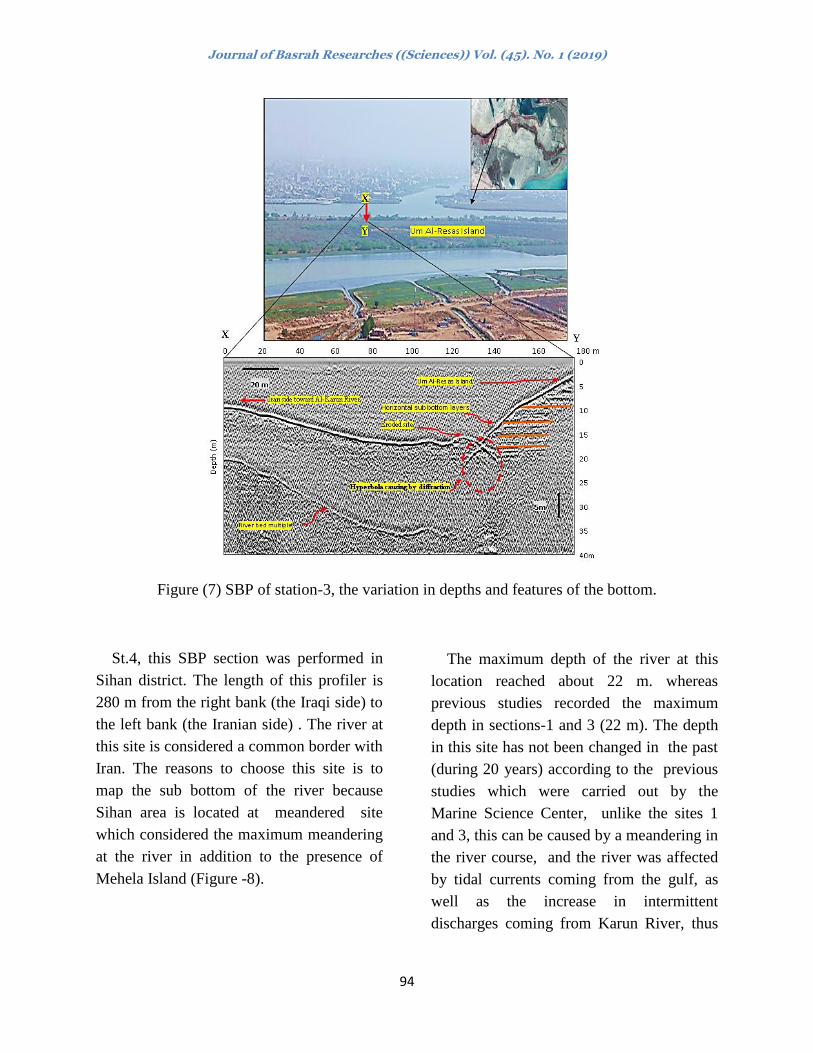
St.3, the length of this section is about
170 m from the left bank to the right (Figure
-7). It is considered the shortest section
because the site represents an international
border with Iran which is impossible to
collect complete transvers profiler to the
river cross section. This site was chosen for
several reasons: First, having Um Al-Resas
Island on the Iraqi side, the second having
the Karun River on the Iranian side, the third
reason is that the site is one of the sites that
have high depths of the river relative to the
other sites.
The previous studies [18] pointed that
Um Al-Resas Island resulted by tectonic
activity. However, this hypothesis does not
match our observation from several points.
The small size of this Hyperbola on the
section in comparison to the size of the
Island and it may not be related to uplifted;
the structure have not only 25 m, as well as,
the section illustrates the layers beneath
bottom on the near side of the island are
almost horizontal. Therefore, this present
study inference that Um Al-Resas Island
may be a result of Al-Karun River
sedimentation and reworked by tidal
currents.
The previous studies indicated that Al-
Karun river was isolated from Shatt Al-
Arab, despite the possibility of small
streams which connect between them or
their branches and each river has its own
estuary into Arabian Gulf. For this reason,
the commander of Alexander’s fleet
(Niarkus) which came from India seal
wrongly for a far distance in Bahmsheer
river until he discovered that he was taken
the wrong route into his final destination
(Missan city). About 364 H (989 AD) the
Buwaihiʼs ruler Adhud Al- Dawla created a
canal joining between Karun and Shatt Al-
Arab rivers, which named by his name Al-
Adhudi river and now known as Al-Hafar
canal, this connection between Karun and
Shatt Al-Arab rivers during the fourth Hijri
century (tenth Christian century) had a
major impact on the expanding of coastal
shoreline southward to Arabian Gulf and
retreating of the sea water shore line [25].
Journal of Basrah Researches ((Sciences)) Vol. (45). No. 1 (2019)
94
Figure (7) SBP of station-3, the variation in depths and features of the bottom.
St.4, this SBP section was performed in
Sihan district. The length of this profiler is
280 m from the right bank (the Iraqi side) to
the left bank (the Iranian side) . The river at
this site is considered a common border with
Iran. The reasons to choose this site is to
map the sub bottom of the river because
Sihan area is located at meandered site
which considered the maximum meandering
at the river in addition to the presence of
Mehela Island (Figure -8).
The maximum depth of the river at this
location reached about 22 m. whereas
previous studies recorded the maximum
depth in sections-1 and 3 (22 m). The depth
in this site has not been changed in the past
(during 20 years) according to the previous
studies which were carried out by the
Marine Science Center, unlike the sites 1
and 3, this can be caused by a meandering in
the river course, and the river was affected
by tidal currents coming from the gulf, as
well as the increase in intermittent
discharges coming from Karun River, thus

Journal of Basrah Researches ((Sciences)) Vol. (45). No. 1 (2019)
95
the river energy to stay (within a certain
level) capable of erosion in this site.
Also, the section shows that the maximum
depths is at the Iraqi side as a result of high
erosion rate associated with meandering. In
contrast, the Iranian side shows the
minimum depth due to deposition.
Consequently, the erosion and deposition
system on both banks may lead to lose
more land from the Iraqi side are create
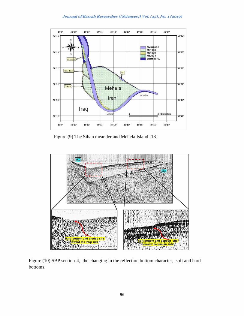
more dry are to the Iranian side. [2]
indicated that the area of Mehela Island
increased about 280m2 during 30 years in
average about 9.5 m2/ year (Figure -9). It
means that this nature process causes
increase in Iranian territorial land and
decrease the Iraqi territorial land, this
process needs manmade interference to
protect banks in such cases.
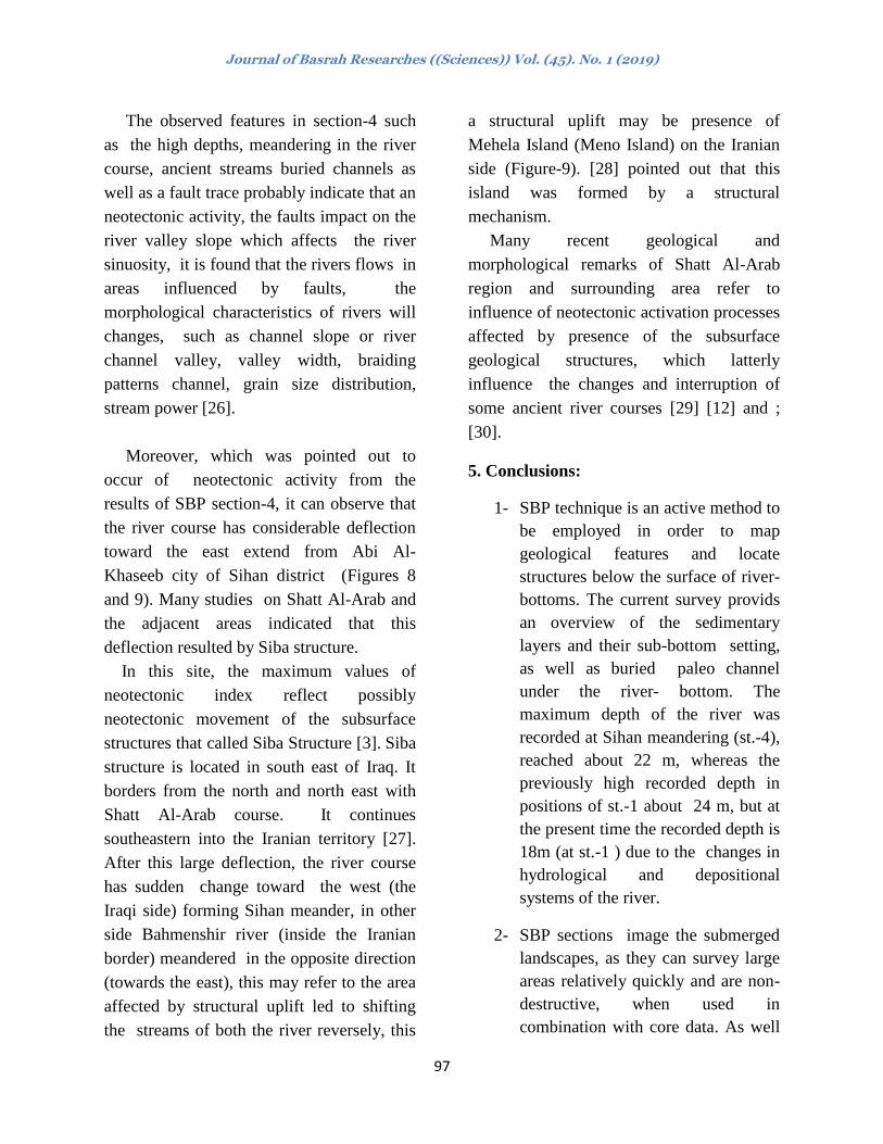
Two type of bottom sediments may be
concluded (echo-types). The top soft bottom
represented by silt and clay deposits towards
the Iranian side, and the base hard bottom
composed of sand deposits towards the Iraqi
side (Figure-10). Also, section-5A shows a
buried paleo-channel beneath the river
bottom at the depth of 30 m from water
surface.
This channel may represents an old course
of the river. This buried channel in section-5
B exists at the same depth but close to the
Iranian side. Another feature showed on
section-5B illustrated a convex shape toward
the Iranian side; it may point to a trace of a
fault which suggests a structural uplift at
this site.
Figure (8): SBP of station-4, the variation in depths and features of the bottom.
Journal of Basrah Researches ((Sciences)) Vol. (45). No. 1 (2019)
96
Figure (9) The Sihan meander and Mehela Island [18]
Figure (10) SBP section-4, the changing in the reflection bottom character, soft and hard
bottoms.
Journal of Basrah Researches ((Sciences)) Vol. (45). No. 1 (2019)
97
The observed features in section-4 such
as the high depths, meandering in the river
course, ancient streams buried channels as
well as a fault trace probably indicate that an
neotectonic activity, the faults impact on the
river valley slope which affects the river
sinuosity, it is found that the rivers flows in
areas influenced by faults, the
morphological characteristics of rivers will
changes, such as channel slope or river
channel valley, valley width, braiding
patterns channel, grain size distribution,
stream power [26].
Moreover, which was pointed out to
occur of neotectonic activity from the
results of SBP section-4, it can observe that
the river course has considerable deflection
toward the east extend from Abi Al-
Khaseeb city of Sihan district (Figures 8
and 9). Many studies on Shatt Al-Arab and
the adjacent areas indicated that this
deflection resulted by Siba structure.
In this site, the maximum values of
neotectonic index reflect possibly
neotectonic movement of the subsurface
structures that called Siba Structure [3]. Siba
structure is located in south east of Iraq. It
borders from the north and north east with
Shatt Al-Arab course. It continues
southeastern into the Iranian territory [27].
After this large deflection, the river course
has sudden change toward the west (the
Iraqi side) forming Sihan meander, in other
side Bahmenshir river (inside the Iranian
border) meandered in the opposite direction
(towards the east), this may refer to the area
affected by structural uplift led to shifting
the streams of both the river reversely, this
a structural uplift may be presence of
Mehela Island (Meno Island) on the Iranian
side (Figure-9). [28] pointed out that this
island was formed by a structural
mechanism.
Many recent geological and
morphological remarks of Shatt Al-Arab
region and surrounding area refer to
influence of neotectonic activation processes
affected by presence of the subsurface
geological structures, which latterly
influence the changes and interruption of
some ancient river courses [29] [12] and ;
[30].
5. Conclusions:
1- SBP technique is an active method to
be employed in order to map
geological features and locate
structures below the surface of river-
bottoms. The current survey provids
an overview of the sedimentary
layers and their sub-bottom setting,
as well as buried paleo channel
under the river- bottom. The
maximum depth of the river was
recorded at Sihan meandering (st.-4),
reached about 22 m, whereas the
previously high recorded depth in
positions of st.-1 about 24 m, but at
the present time the recorded depth is
18m (at st.-1 ) due to the changes in
hydrological and depositional
systems of the river.
2- SBP sections image the submerged
landscapes, as they can survey large
areas relatively quickly and are non-
destructive, when used in
combination with core data. As well

Journal of Basrah Researches ((Sciences)) Vol. (45). No. 1 (2019)
98
as SBP technique is suitable for
determination of dredging and
depositional sites as well as
determining the sediment thickness
and correlated with the times.
Additionally, SBP is an active
technique to distinguish between the
soft and hard bottoms through the
observation in the acoustic wave
reflection on both bottoms, such as
in Al-Sendibad site (st.-1).
3- Many factors influence the shape of
Shatt Al-Arab sub bottom course,
such as tectonic activity,
hydrological and sedimentological
situations as well as the man-made
influencing. Um Al-Resas Island
might not has a tectonic origin, due
to the lack of distinctive features
indicate to exist a structural uplift
under the bottom vicinity the island.
Adding to the layers underneath the
bottom of the island near the bank
river almost horizontal, the origin of
the island may be caused by Karun
river sediments.
6.References:
[1] Holbrook, J. and Schumm, S. A., 1999.
Geomorphic and sedimentary response of
rivers to tectonic deformation: a brief review
and critique of a tool for recognizing subtle
epeirogenic deformation in modern and
ancient settings. Tectonophysics, V305, pp:
287–306. http://www.sciencedirect.com.
[2] Al-Whaely, U. Q., 2009.
Sedimentological and Geomorphological of
the Shatt al-Arab Islands between Basrah
and Siba Towns. Unpublished M.Sc.,
Thesis, College of Science, Univ., of Basra,
68p, (in Arabic).
[3] Al-Kubaisi, M. and Hussein, M., 2014.
Morphotectonic of Shatt Al-Arab River
Southern Iraq. Iraqi Journal of Science. 55.
(3A): 1051-1060.
[4] Davis, A., Haynes, R., Bennell, J., and
Huws, D., 2002. Surficial seabed sediment
properties derived from seismic profiler
responses, Marine Geology, 182:209-223.
[5] McQuillin, R., Bacon, M., and Barclay,
W., 1984. An Introduction to Seismic
Interpretation Reflection Seismics in
Petroleum Exploration, 2nd
Ed. Graham and
Trotman Ltd., London.
[6] Hussain, N. A.; Karim; H. H.; Al-Saad,
H. T.; Yousif, O.H.; and Al- Saboonchi,
A.A., 1990. Shatt Al-Arab fundamental
scientific studies. Marine science center, Dar
Al-Hekma Publishing House, Univ. of
Basra, Iraq. 391p.
[7] Buday, T. and Tyracek J., 1980. The
Quaternary. In The regional geology of Iraq,
Vol. I Stratigraphy and Paleogeography, Dar
Al Kutub Publishing House, Univ. of Mosul,
448 p.
[8] Kukal, Z. and Saadallah, A., 1970.
Composition and rate of deposition of recent
dust storm sediment in Iraq. Casopic pro
Minerologiageologi, Roc, Prague, pp: 227-
234.
[9] Ya'acoub, S.Y., Purser, B.H., Al-Hassni,
N.H., Al-Azzawi, M., Orzag Sperber, F.,
Hassan, K.M., Plaziat, J.C., Younis, W.R.,
1981. Preliminary study of the Quaternary
sediments of SE Iraq. Jointproject between
the Geological Survey of Iraq and Univ. of
Paris XI Orsay. Unpublished report.

Journal of Basrah Researches ((Sciences)) Vol. (45). No. 1 (2019)
99
[10] Numan, N.M.S., 1997. A Plate Tectonic
Scenario For The Phanerozoic Succession In
Iraq. Jour. Geol. Soc. Iraq, 30, 2, pp: 85-110.
SyQwest,. 2006. Manual of strata Box Strata
box marine geophysical instrument. 40p.
http://www.syqwestinc.com/
[11] Buday, T. and Jassim, S.Z., 1987. The
Regional Geology of Iraq, Vol.2, Tectonism,
Magmatism and Metamorphism.,
S.E.Geological Survey and Mineral
Investigation, Baghdad, Iraq, 352 p.
[12] Jassim, Z., S., and Goff, C., J., 2006.
Geology of Iraq, First Edition, Heritage Oil
Corporation.
[13] Al-Hamad S. S., Albadran B. N., and
Pournelle J. R., 2017. Geological History of
Shatt Al-Arab River, South of Iraq.
International Jour., of Science and Research
(IJSR), 6 (1): 2029-2039.
[14] SyQwest,. 2006. Manual of strata Box
Strata box marine geophysical instrument.
40p. http://www.syqwestinc.com/
[15] Muttashar, W.R.,Al-Mosawi, W.M.,
and Al-Aesawi, Q.M., 2012. Detection of
subsurface layers by sub bottom profiling of
cross section of Shatt Al-Arab River at Al-
Rebat branch, Basrah, southern Iraq,
Mesopot. J. Mar. Sci. Cen., 27 (1):49 – 58.
[16] Al-Mahdi A., and Al-Saadi, S., 2006.
Some of the geomorphological features of
Shatt Al-Arab River. Basra Jour. of Scienec
( B ) 32(1):88-106.
[17] Al-Manssory, F. Y., 1996. Sediment
transport in the lower reach of Shatt Al-
Arab. Unpublished M.Sc. Thesis, College of
Agriculture, Univ., of Basra, 119p, (in
Arabic).
[18] Khaleefa, U. Q., 2014. Origin and
evolution Of The Islands Of The Shatt al-
Arab River southern Iraq. Ph.D. Thesis,
College of Science, Univ. of Basrah, 143p,
(in Arabic).
[19] Albadran B. N., and Mahmood R. A.,
2006. Geotechnical properties and
distribution of bearing strata along the Shatt
Al-Arab River bank from Qurna to Fao.
Marina mesopotamica jour., 21(1): 45-56.
[20] Karim, H.H., and Salman, H.H., 1987.
Geology of the Arabian Gulf, Univ. of
Basra, Marine Science Center publ.,
330p.(In Arabic).
[21] Albadran, B. and Al-Bahily, N., 1999.
Some aspects of geotechnical properties of
the Shatt Al-Arab River sediments
nearBasrah city, south Iraq. Marina
Mesopotamica, 14(1): 109-118.
[22] Bellen van R. C., Dunnington H. V.,
Wetzel R., and Morton D., 1959. Lexique
stratigraphique international, Asia Fascicule
10a, Iraq. Paris, Centre National de al
Researche Scientifique.
[23] Aqrawi A., 1994. Implication of sea-
level fiuctuation, sedimentation and
neotectonic for the evolution of the
marshland (Ahwar) of sou thern
Mesopotamia. Quaternary Proceedings
No.3: 17-26.
[24] Albadran, B. N. Albadran A.A., 1997.
Distribution of bearingstrata and their
engineering properties in Basrah region,
South of Iraq. Basrah J. Science, 15(1): 95-
104.
[25] Al-Katib, M.T., 1971.Shatt Al-Arab
and Shatt Al-Basra and the history. Iraqi
ports company printing House- Basra, 190
p., (in Arabic).
[26] Jack, P., 2010. Alluvial river response
to active tectonics in the Dehradun region,

Journal of Basrah Researches ((Sciences)) Vol. (45). No. 1 (2019)
100
Northwest India: A case study of the Ganga
and Yamuna rivers. M.Sc., Thesis, Durham
Univ., 89p.
[27] Alwan, J.F., 2009. Study re-
interpretation of seismic information in Siba
Oilfield. Oil Exploration Company,
Baghdad. O.S.C., Lib. report No. 153Z, (in
Arabic
[28] Al-Mulla S. T., 2005. Geomorphology
of Shatt Al-Arab valley by remote sensing
techniques. Unpublished Ph.D., Thesis,
College of Art, Univ., of Basra, 200p, (in
Arabic).
[29] Al- Sakini, J, 1993. New window on
the Mesopotamian history in the light of
geological evidences and archaeology. Dar
Al-Shuaon Al- Thakafiya Al-Aamah,
Baghdad, 93p, (in Arabic).
[30]Al-Hawi, N. A., 2014.
Geoarchaeological and Morphotectonic
study of Al-Hammar marsh area and
surrounding. Un publ. M.Sc. Thesis, Univ.
of Basra, 135 p.

Journal of Basrah Researches ((Sciences)) Vol. (45). No. 1 (2019)
101
لرسن هعالن قاع شط العرب تردديي باستخذامللقيعاى تطبيق تقنية الوقاطع العرضية
الواح, عل ستار ;هطز, هوي عثد الكزن 1الوس, الء هجد ;
2
لسن الجلجا الثحزح/ هزكش علم الثحار/ جاهعح الثظزج 2لسن علن االرع/ كلح العلم / جاهعح الثظزج, 1
لولخص أ
خيل الرغيازاخ هيي العديد هيي اليز عيا الحيال الليد في, العزاق ف الزح الوجار أن هي العزب شظ عرثز
مظياى الرغيازاخ ذلي أين, االسياى ذيدخلخ هيي الاذجيح أ الطثعيح سياء الويثشزاخ هيي عيد رجيح السياتمح سيح االرتعي
الريؤشز حري تل, ذحر ها الماع شكل ف ذحالخ حدز الز طثعح عل هلوسا ذؤشزا سثة الرظزف مظاى. الرظزف
الحالح, اجشخ هسحاخ جفشائيح تاسيرادام ذمياخ الوجياخ الظيذح هروصليح ف الدراسح .الز هجز هرفلجح عل
لزسين زذشكلي 10تاسيرادام ذيز ( Sub Bottom Profiler (SBP)ترمح الوماطع العزضيح للمعياى تاخ الدليح العاليح
همياطع عزضيح ارتعحهعالن لاع الز ذحدد الرزاكة ذحد الماع فضل عي اعطاء ذظر عل هكاخ ذحد الماع. ذن اجاس
تيد الدراسيح الحاليح اى .ام الزطاص سحاى توسافاخ هارلفح هيي عيزع اليز العشار, ,السدتا ف هاطكللز هسعح
ح كثزج في رسين الوهياز الجلجيح ذحديد الرزاكية طثمياخ ذحيد المياع الرويش تيي المياع الرمح الوسرادهح ذورل فعال
الظلة الش, فضل عي هاطك الرعزح الرزسة ف الماع.
ذعرثز كاد الر الوالع الحد حدشد لد ذزسة عولح ال اى السدتا جشزج هي تالمزب األ للولع الرائج أظزخ
م. 11 الي لظل الماع عوك ذالض م 5 تحد حالحدص الزاسة سو تلغ حس, الز لاع ف الماط أعوك هي لزة للد
ف الولع الصا ف العشار ذن ذحدد عد هيي الطثمياخ ذحيد المياع فضيل عيي ذحديد عويك الطثميح الرحوليح الظيلثح الولئويح
تالرحديد تيالمزب هيي جشيزج ام الزطياص الصاليسفي الوليع . م 20د لياع اليز كايد تحيد إللاهح الوشآخ الدسيح ذحي
أضحد الرائج ا ال ذجد اح شاد وكي اى ذشز ال كى ذ الجشزج لد رجد تفعل ذكر تحسة ها أشز ف عيد هيي
يذا الوليع االكثيز زم, عرثي 22الوروصل تاعطاف سيحاى تليغ الزاتعالدراساخ الساتمح. لمد سجلد أكثز االعواق ف الولع
ف هلع اعطاف سحاى, كشفد الدراسح عي هجوعيح هيي الوهياز الوروصليح تعيدم ارهيام شيكل عوما للز ف اللد الحال.
أشز لفالك وكي اى ذشز الي الماع الرغاز الكثز ف االعواق ج هجار لدوح للز هدفح ذحد الماع فضل عي ج
الولع ال ذؤشز ذكر حدس. اذ فذؤشز همطع الز
Copyright © 2022 FDOKUMEN