APPENDIX - City of Brampton
434
APPENDIX B CONSULTATION - CORRESPONDENCES
-
Upload
khangminh22 -
Category
Documents
-
view
3 -
download
0
Transcript of APPENDIX - City of Brampton

APPENDIX
B CONSULTATION -
CORRESPONDENCES

APPENDIX
B1 AGENCIES
MEETINGS MINUTES

MEETING NOTES
100 Commerce Valley Drive West Thornhill, ON, Canada L3T 0A1 Tel.: +1 905 882-1100 Fax: +1 905 882-0055 www.wsp.com
JOB TITLE East-West Connection, Mount Pleasant GO Station to West of Mississauga Road Municipal Class EA
PROJECT NUMBER 141-15409-00
DATE 10 August 2017
TIME 2:00 PM to 4:00 PM
VENUE 1975 Williams Parkway, Boardroom 2G, City of Brampton
SUBJECT MNRF and CVC Meeting #9
CLIENT City of Brampton
PRESENT Attendees
Andria Oliveira City of Brampton (COB) [email protected]
Mario Goolsarran COB [email protected]
Jakub Kilis Credit Valley Conservation (CVC)
Liam Marray CVC [email protected]
Mark Heaton Ministry of Natural Resources and Forestry (MNRF)
Melanie Shapiera MNRF [email protected]
Mehemed Delibasic WSP [email protected]
Bob Koziol WSP [email protected]
Alex Stettler WSP [email protected]
Andrew Roberts WSP [email protected]
NOT PRESENT Bishnu Parajuli COB [email protected]
DISTRIBUTION As above plus: Dan Bennington, Region of Peel

MEETING NOTES
Page 2
MATTERS ARISING ACTION
1.0 PROJECT UPDATE
1.1 Circulation of minutes from meeting with MNRF and CVC on July 13, 2017. Information
1.2 Outstanding items and project update — The objective of meeting was to discuss identified alternative design concepts for
preferred solution, including structural options and to present evaluation of alternative designs in order to identify recommended design.
— As part of PPT presentation (ATTACHED) project needs and justification was presented to underline the City-wide significance of the east-west connector road as a city-wide people-mover, south of the CN rail line, linking Heritage Heights to the Mount Pleasant GO Station and Mobility Hub. The key initiatives/projects are: — Number of Planning documentation/completed studies shows E-W connector road — Bovaird Drive development activities are leading to urbanization of the area — Official Plan Amendment 101 for the Osmington Regional Retail Centre,
— Alternative Solutions-Evaluation Framework and Criteria were discussed as two alternative solutions were carried forward from previous project phase including: — ALTERNATIVE SOLUTION 4: Extend road west of Mississauga Road only — ALTERNATIVE SOLUTION 5: Extend Mount Pleasant GO Station access road to west of
Mississauga Road — It was concluded that both the Alternative Solution 4 and Alternative Solution 5 will be
carried forward to evaluation and assessment process of the Alternative Design Concepts of the Preferred Solutions, as the next phase of the project.
— Based on the evaluation and completed studies on the project the Alternative Solution 5 (Extend Mount Pleasant GO Station access road (Lagerfeld Road) to west of Mississauga Road) is recommended as preferred solution.
— The ESR will need to provide closure with regards to planning solutions. It will require qualitative and conceptual assessment.
Information
2.0 PROJECT DISCUSSION
2.1 Alternative Design Concepts of the Preferred Solution, Assessment and Evaluation, Discussion and Input: Alignments and Evaluation Matrix — A series of initial design concepts were developed for the preferred solution at a
preliminary level of detail to properly assess the potential impacts and benefits associated with each alternative.
— A detailed assessment of each alternative was completed based on described evaluation components and evaluated against the criteria described and presented: — a descriptive or qualitative evaluation was used to consider the suitability and
feasibility of alternative solutions and design concepts — in this respect, trade-offs considering the advantages or disadvantages of each
alternative to address the problem and opportunity statement with the least environmental effects and the most technical benefits will result in a higher priority and forms the rationale for the identification of the preferred solution
— evaluation material were provided to CVC and MNRF prior to this meeting — Five alignments presented and reviewed. The Project has carried forward four alignments
that cross Huttonville creek (with two sets of structural options for the crossings) and one alignment that connects west of Mississauga Road only (Alternative Solution 5).
— The alignments have been scored both qualitatively, and where possible quantitatively in terms of flood level impacts and redside dace habitat.
— The alignment scoring has been done with a sensitivity analysis using different category weighting criteria.
— Based on evaluation and assessment completed Design Alternative 1B was presented as recommended.
— The Design Alternative 1B is continuation of the existing Mount Pleasant GO Station access road to lands west of Mississauga Road. Alignment past through Mississauga Road at 419m
Information

MEETING NOTES
Page 3
offset from Bovaird Drive centreline. (Crossing abutments within 30m redside dace habitat buffer zone).
2.2 Discussion Comments: CVC — CVC comments that the Study has high focus on redside dace issues — Other provincial regulations and acts need to be addressed. — CVC needs to see preliminary quantitative-technical analysis and details in order to
comment on an alignment preference. — Roads need demonstration that they are flood-free. — CVC asked for the analysis to include offsite impacts. High level statements regarding the
degree to which flooding impacts are contained on-site versus off-site must be captures in the assessment. This may change to scoring and the outcome of the assessment.
— The importance of both the degree and the location of the flooding impacts should be captured in the assessment.
— Details on the 100 year flood versus the regional flood must be addressed. — Technical documentation will be needed where the assessment provides quantitative
information for relative impact and to provide guidance.
Information
2.3 Discussion Comments: MNRF — The negotiated size of the natural heritage system around Huttonville Creek is 100 m. — The impacts of shading on vegetation under crossings must be considered. — The purpose of spanning a valley with a structure is to maintain vegetation underneath
them. The 2 m clearance shown is too low. WSP to review elevations with bridge engineer. As an example, review crossing of Churchill tributary. This is a 2 lane alignment with a 4 m high bridge that maintains vegetation underneath.
— Site alteration within endangered species habitat is prohibited unless a permit can be issued. There are a number of other permits already issued or under review in the site vicinity — Widening of Mississauga Road — New structure under Bovaird — Huttonville crossing tied to CN overpass.
— Add additional examination of provincial policies and agreements. Evaluate the options with regard to consistency with policy/agreement/plans including 2013 draft plan of subdivision under a mitigation report (Mattamy).
— Interim solutions — Alignment 1B (presented as preferred alignment) does not meet provincial policy. — Alignment 1A might be able to receive ESA permit if the alignment cross section is
reduced, and the structure height increased to maintain vegetation underneath. Therefore, Alignment 1A with a higher vertical clearance would be most appropriate to MNRF interests and requirements for minimal impact.
— The Project should consider alignments that can be implemented. — Project may consider a phased scenario where the alignment west of Mississauga Road
is constructed, traffic monitored to determine if a link is truly required, and an agreement in principle agreed to for the east portion. This would protect an envelope for the development of watercourse crossings and provide information as input into evolving development applications decisions, identify property impacts, phase construction, and determine triggers for a full connection.
Information
3.0 NEXT STEPS
3.1 Provide additional details and information as per MNRF and CVC request regarding presented and discussed assessment and evaluation of Alternative Design Concepts of the Preferred Solution
3.2 Meeting with landowners and developers 3.3 Meeting with Region of Peel 3.4 Confirm preferred alternative design concept 3.5 Public meeting 2 (PIC 2)
WSP/City Information
These minutes are considered to be accurate recording of all items discussed. Written notice of discrepancies, errors or omission must be given within seven (7) days, otherwise the minutes will be accepted as written.

MEETING NOTES
Page 4
NEXT MEETING
An invitation will be issued for the next meeting.

MEETING SUMMARY
MARKHAM 600 Cochrane Drive, Floor 5, Markham, Ontario L3R 5K3 Tel.: 905.475.7270 Fax: 905.475.5994
141-15409min15-12-10-Peel Meeting 3
Enrironmental Assessment Study, East-West Connection, Mount Pleasant GO Station to West of Mississauga Road - Region of Peel Meeting #3 Date: Thursday, December 10, 2015 Project: 141-15409
Time: 02:30 PM-3:30 PM Location: City of Brampton City Hall, 3rd Floor, Boardroom 3C
Attendees: Andria Oliveira City of Brampton
Scott McIntyre City of Brampton
Compton Bobb City of Brampton
Scott McIntyre City of Brampton
Michelle Gervais City of Brampton
Madhuparua Debnalth City of Brampton
Rahul Vargas City of Brampton
Susan Jorgenson City of Brampton
Neal Smith Peel Region
Dan Bennington Peel Region
Bruce Grundon WSP
Mehemed Delibasic WSP
Distribution: List
Prepared By: Andria Oliveira and Mehemed Delibasic
Item Details and discussion Action
1. Introduction and meeting objective
1.1 The purpose of this meeting was to go through the four conceptual design alternatives prepared by WSP as well as review the evaluation criteria for the EA. Also, objective was to receive input from the Region of Peel on their ongoing detailed design of the Mississauga Road project and coordination / timing with east-west connection EA.
Info

Enrironmental Assessment Study, East-West Connection, Mount Pleasant GO Station to West of Mississauga Road - Region of Peel Meeting #3
Meeting Summary − Thursday, December 10, 2015 Page 2
C:\Users\CABB064890\Desktop\New folder\141-15409min15-12-10-Peel Meeting 3.docx 141-15409
2. Project Understanding and Approach
2.1 It was noted that in 2009, the City of Brampton (City) completed the Mount Pleasant Secondary Plan Transportation Master Plan (TMP), which established the needs and justification for proposed arterial and collector roads in compliance with the Phases 1 and 2 of the Municipal Class EA. Among the proposed road improvements in TMP it was identified an east-west collector road connection from Mount Pleasant GO Station to lands west of Mississauga Road
2.2 Objective of the our EA study is to complete Phase 3 and 4 of the Municipal Class EA process (schedule "C" Class EA and Preliminary Design (30%)) for the east-west collector road from Mount Pleasant GO Station / future Creditview Road (James Potter Road) to west of Mississauga Road including multiple crossings of Huttonville Creek
2.3 The East-West EA study will not contradict the Bovaird Drive and Mississauga Road EAs
2.4 The study will coordinate with the ongoing Heritage Heights Transportation Master Plan (HHTMP), to ensure the road does not preclude the opportunity for an extension west to Heritage Road from its terminus at Mississauga Road/Huttonville Creek
2.5 Region of Peel is working on detail design for widening and improvements of Mississauga Road in the study area, therefore preferred alternative for a crossing / intersection location emerging through the subject EA (east--west collector road connection) will be integrated with the Mississauga Road improvements
2.6 Other relevant studies in the study area are:
• Heritage Heights Secondary Planning (waiting on Michelle Gervais report)
• Heritage Heights Subwatershed Study in Phase 2 with first impact assessment (Andria to confirm with Susan)
• GTA West Transportation Corridor has been suspended for the time being (Andria to ask Michelle for overall status of the Secondary Planning Process)
• Shale Study – Andria to confirm the status of this study
• Mississauga Road (Region of Peel) is being taken to detailed design, and the Mississauga Road Consultant cannot move forward until we know where the crossing is. Ideal construction time for the Mississauga Road widening is 2019.
• Osmington development, Heathwood development, etc. OPA’s (request in with NG and MG)
• Neil Smith noted that the East-West Connector road was not identified in the schedules for Mount Pleasant TMP, which has been an ongoing point of contention from the beginning.
• However, the City of Brampton made a protection for this policy in the Retail Policies section of this plan noting, that if there was a higher density, commercial development, it would be prudent to have a transit and active transportation link, connecting the GO stations with the commercial development. The East-West connector will provide needed roadway connectivity, and
multi-modal capacity Facilitate direct travel for all modes, and reduce the reliance/pressure
placed on intersections at Bovaird Drive and Mississauga Road
Info Info Info Info Info Info Andria (City of Brampton) Andria (City of Brampton) Andria (City of Brampton) Info Info Info Info

Enrironmental Assessment Study, East-West Connection, Mount Pleasant GO Station to West of Mississauga Road - Region of Peel Meeting #3
Meeting Summary − Thursday, December 10, 2015 Page 3
C:\Users\CABB064890\Desktop\New folder\141-15409min15-12-10-Peel Meeting 3.docx 141-15409
Support the City’s endorsed Community Design Principles that include Transit-Oriented Development in an Urban Core around Mount Pleasant GO Station
Provide a mid-block crossing and pedestrian-friendly community collector that can attract an array of multi-modal transportation users (pedestrians, cyclists, local and regional transit users)

Enrironmental Assessment Study, East-West Connection, Mount Pleasant GO Station to West of Mississauga Road - Region of Peel Meeting #3
Meeting Summary − Thursday, December 10, 2015 Page 4
C:\Users\CABB064890\Desktop\New folder\141-15409min15-12-10-Peel Meeting 3.docx 141-15409
3. Study Overview and Study Status
3.1 Project Initiation Spring 2014 - COB staff Technical Advisory Committee (TAC) Meeting #1
• WSP has completed several background and existing conditions reporting including:
Built Heritage and Cultural Landscape Report (Jun 2014)
Socio-Economic Report (Aug 2014)
Preliminary Archaeological Assessment (Jan 2015)
Natural Heritage Existing Conditions Report (Feb 2015)
Fluvial Geomorphological Assessment (Mar 2015)
Background Traffic Report (Jun 2015)
• COB staff are engaging agency partners including Peel Region, CVC, MNRF and other agencies/stakeholders
• Public Information Centre #1 (Jun 2015)
Info Info Info

Enrironmental Assessment Study, East-West Connection, Mount Pleasant GO Station to West of Mississauga Road - Region of Peel Meeting #3
Meeting Summary − Thursday, December 10, 2015 Page 5
C:\Users\CABB064890\Desktop\New folder\141-15409min15-12-10-Peel Meeting 3.docx 141-15409
4. Design Alternative Solutions
4.1 Design Alternative Solutions/ Discussion and Input. Four (4) alternatives were presented by WSP project team (as attached). A conceptual layout is provided at this phase for discussion and input purposes only.
4.2 Alignment # 1: Alignment intersects Mississauga Road at 400m offset from Bovaird Drive centerline
• Geometrically addressed all requirements
• Creates 2 new creek crossings
• Meets minimum distance between signalized intersections
• No impact on woodlots
• Meets sight lines requirements
• Dos not impact structure proposed in Misssissauga Road EA
• Minimum impact on Osmington development
The Mississauga Road EA suggests that a service connection will still be maintained to the two hold out properties on the east side of Mississauga Road, north of the Mississauga Road Creek crossing.
What are the options to achieve access for these properties? These need to be explored for this Alternative 1.
Neil to send alternatives/ options for crossings/ intersection location that were developed during Mississauga Road EA.
4.3 Alignment # 2: Alignment intersects Mississauga Road at approximately 240m offset from Bovaird Drive centreline
• Only one creek crossing
• Does not meet minimum standard distance between signalized intersections
• Cuts the woodlot
• Provides access to Osmington
• Require to realign the roadway to the south in the proximity of the cul-de-sac east of Mississauga Road, cutting into Mattamy’s property
• Does not impact structure proposed in the Mississauga Road EA
Roadway cut the northeast corner of woodlot at west of Mississauga Road, within the Osmington property. This alternative has impact on habitat only on one (east) side of Mississauga Road. This Alternative does not meet the minimum intersection offset from Bovaird Drive intersection as specified in City’s standards (300m) for the crossing at Mississauga Road. May have queuing issue for left turning vehicles at Bovaird Drive with reduced intersections distance between Bovaird Drive and the new connection.
4.4 Alignment # 3: Alignment intersects Mississauga Road at the existing location of the Huttonville Creek culvert, at an 70° angle, approximately 475m offset from Bovaird Drive centreline
Info Info Info WSP Neil/Region of Peel Info Info Info

Enrironmental Assessment Study, East-West Connection, Mount Pleasant GO Station to West of Mississauga Road - Region of Peel Meeting #3
Meeting Summary − Thursday, December 10, 2015 Page 6
C:\Users\CABB064890\Desktop\New folder\141-15409min15-12-10-Peel Meeting 3.docx 141-15409
• Meet the minimum intersection offset from Bovaird Drive intersection as specified in City’s standards (300m) for the crossing at Mississauga Road.
• Combining the connection access with Huttonville Creek Bridge at Mississauga Road, reduce sight distance issues that may arise from the bridge’s parapet walls.
• Passing Mississauga Road at approximately the midpoint between Bovaird Drive and CN Rail, evenly splitting the areas.
• Crossing Huttonville Creek at one (1) new location near the SWM Pond.
• Second (2nd) Huttonville Creek crossing requires modification of structure proposed in Mississauga Rd EA (WSP and City team to confirm if this requires an addendum or changes to the Mississauga Road EA).
• Impact on property belonging to Joyce & Keith Martin, just north of the Mississauga Rd EA proposed structure.
• May have insufficient sight distance along Mississauga Road.
4.5 Alignment # 4: Alignment does not intersect with Mississauga Road but utilizes proposed slip road north of Huttonville Creek crossing, just south of CN Rail.
• Since not intersecting with Mississauga Road, cannot alleviate traffic congestion at intersection of Mississauga Road and Bovaird Drive
• Do not passed through the major developments, therefore reduced the function of the East-West Connection
• Do not provide a mid-block crossing and pedestrian-friendly community collector that can attract an array of multi-modal transportation users (pedestrians, cyclists, local and regional transit users)
• Crossing Huttonville Creek at two (2) new locations; one east of Mississauga Road near the SWM Pond and one west of TransCanada Pipeline, close to the CN Rail track
• Does not impact structure proposed in Mississauga Road EA
4.6 Alternative Evaluation Criteria Review:
The following assessment factors will be used to evaluate alternative designs in the next phase of the study:
• Transportation/Technical
• Natural Environment
• Social-Cultural Environment
• Cost
Suggestions for consideration:
Endangered species should be its own category
Water quality should be a distinct category
Noise under natural environment
Include lighting/illumination
Pollution for NHS
WSP/City of Brampton Info Info Info WSP

Enrironmental Assessment Study, East-West Connection, Mount Pleasant GO Station to West of Mississauga Road - Region of Peel Meeting #3
Meeting Summary − Thursday, December 10, 2015 Page 7
C:\Users\CABB064890\Desktop\New folder\141-15409min15-12-10-Peel Meeting 3.docx 141-15409
Habitat for water and terrestrial
Hydrology considerations will be important, for example- how will 3 culverts work together
Net loss of habitat vs. net improvements
How does the meander belt plus 30 m factor in
We cannot have two crossings within 1 km, how does that impact the design, or how can that mediated/off-set
It was mentioned that as part of others studies, consultants have had to explore other, future crossings, as part of a bigger picture understanding (Andria to get clarity from Susan about where this took place)
Assess impact of each Alternative, rank the impacts on redside dace, and how this impacts evaluation of each
Andria/ City of Brampton
5. Discussion and Next Steps
5.1 Need to confirm alignment with plans for North America. H0w does this development go forward without knowing the alignment of the road?
5.2 Confirm if North American developer representatives were involved in the landowner meetings. Confirm if they have any updated plan-alignments.
5.3 Consider potential impacts on GO, GO parking, costs to transit service, city building, etc, walkability, transit spine, community permeability, smart growth.
5.4 Need more detailed analysis, understanding of each alternative.
5.5 Need to consider constructability of this road as well, as well impacts to Region of Peel Mississauga Road design. Reducing all impact to Regional structure and work/ cost needs to be an important element.
5.6 Next steps:
• as part of the next phase of the EA study, we will continue developing alternative design concepts for the East-West Connection Road
• these alternative design concept will be further investigated and evaluated in the next phase of this EA study
• evaluate alternatives and identify recommended solutions
• meet agency partners including CVC, MNRF, Peel Region, and other agencies/stakeholders
• present recommended solutions at PIC No. 2
• Public Information Centre #2 will be scheduled to discuss the recommended alignments, as well as any issues and concerns prior to the finalization of the preliminary Preferred Design
WSP/City WSP/City WSP/City WSP/City WSP/City WSP WSP WSP/City WSP/City WSP/City WSP/City
End of Meeting Summary

East-West Connection Road Environmental Assessment
Mount Pleasant GO Station to west of Mississauga Road
December 10, 2015
1

Agenda
Introduction
Project understanding and approach
Study overview and study status
Design Alternative Solutions
discussion and input
alternative evaluation criteria
Next steps
evaluate alternatives and identify recommended solutions
present recommended solutions at PIC No. 2
2

Project understanding and approach In 2009, the City of Brampton (City) completed the Mount Pleasant
Secondary Plan Transportation Master Plan (TMP):
established the needs and justification for proposed arterial and collector roads in compliance with the Phases 1 and 2 of the Municipal Class EA
among the proposed road improvements identified an east-west collector road connection from Mount Pleasant GO Station to lands west of Mississauga Road
Objective: complete Phase 3 and 4 of the Municipal Class EA process (schedule "C" Class EA and Preliminary Design (30%)) for the east-west collector road from Mount Pleasant GO Station / future Creditview Road (James Potter Road) to west of Mississauga Road including multiple crossings of Huttonville Creek
Three mandatory points of contact with the public and relevant review agencies and the preparation and filing of an Environmental Study Report (ESR) to document the EA process
3

Project understanding and approach 2 Key projects / studies in the area:
1) The study will coordinate with the ongoing Heritage Heights
Transportation Master Plan (HHTMP), to ensure the road does
not preclude the opportunity for an extension west to Heritage
Road from its terminus at Mississauga Road/Huttonville Creek
2) Region of Peel is planning widening and improvements of
Mississauga Road in the study area:
preferred alternative for a crossing / intersection location
emerging through the subject EA (east-west collector road
connection) will be integrated with the Mississauga Road
improvements
detailed design in the vicinity of Huttonville Creek will be
finalized following completion
4

Study overview and status Project Initiation Spring 2014 - COB staff Technical Advisory Committee
(TAC) Meeting #1;
WSP has completed several background and existing conditions reporting including:
o Built Heritage and Cultural Landscape Report (Jun 2014)
o Socio-Economic Report (Aug 2014)
o Preliminary Archaeological Assessment (Jan 2015)
o Natural Heritage Existing Conditions Report (Feb 2015)
o Fluvial Geomorphological Assessment (Mar 2015)
o Background Traffic Report (Jun 2015)
COB staff are engaging agency partners including Peel Region, CVC, MNRF and other agencies/stakeholders
Public Information Centre #1 (Jun 2015)
5

Study Area
6

The need for East-West connection The east-west connector will:
Provide needed roadway connectivity, and multi-modal capacity
Facilitate direct travel for all modes, and reduce the reliance/pressure placed on intersections at Bovaird Drive and Mississauga Road
Support the City’s endorsed Community Design Principles that include Transit-Oriented Development in an Urban Core around Mount Pleasant GO Station
Provide a mid-block crossing and pedestrian-friendly community collector that can attract an array of multi-modal transportation users (pedestrians, cyclists, local and regional transit users)
Opportunities and Constraints:
An opportunity to provide community connectivity, logical infrastructure delivery while dove-tailing two projects for lowest environmental impact
Crossing of the Huttonville Creek
Anticipated financial constraints
The coordination of infrastructure for environmental mitigation and areas of mutual interest
Osmington OPA

Planning for North-West Brampton: Policy Context
City of Brampton Transportation Master Plan Update (2015)
Heritage Heights Secondary Plan/TMP
Mount Pleasant Secondary Plan/TMP
Region of Peel Mississauga Road Municipal Class Environmental Assessment
ESR – filed 2013
Project is moving forward to Detailed Design for Capital Construction, where timing is critical
8

Transportation Master Plan Update (2015)
North West Brampton is rapidly growing community.
City of Brampton population and employment will increased by 43% and 73% respectively between 2021, 2031 and 2041.
City of Brampton
2021 2031 2041
Population 0.687 Million
0.837 Million
0.889 Million
Employment 0.244 Million
0.292 Million
0.322 Million

HERITAGE HEIGHTS (HH) PROPOSED NETWORKS
Proposed Transit Strategy Proposed Active Transportation Strategy
HH Secondary Plan development in process
Draft HH TMP recommends a Preferred Network
E-W connection is a key transit and active transportation spine to achieve community connectivity and foster sustainable modes of travel
Walkable Main Street and Complete Street to complement Transit-Oriented Development
GO Transit two-way, all-day service improvements

Mount Pleasant Mobility Hub, Transit-Oriented Development, mixed uses, tighter grid networks, protection of environmental systems functions through protection and enhancement of a Natural Heritage System
Mount Pleasant Secondary Plan OPA Policy 5.3.2.5 Road network and access required to accommodate travel demand in and associated with the “District Retail” designation shall be explored and confirmed, with respect to demonstrating and not precluding the ability of achieving future road network connectivity
Mount Pleasant Secondary Plan, 2011

Heritage Heights and Mount Pleasant Secondary Plan
Through the Mount Pleasant Secondary Plan and the Heritage Heights Secondary Plan and its TMP, a preferred road network was identified which includes a grid of collector roads and the continuation of the existing Mount Pleasant GO Station access road to lands west of Mississauga Road (area knows as Heritage Heights Secondary Plan). This East West Connection Road EA deals with the mentioned connection.
13

Region of Peel
Mississauga Road ESR 300m north of Bovaird Dr. to Mayfield Rd.
Timing for Mississauga Road Detailed Design for Capital Construction
o Mississauga Road (Bovaird Dr. to Sandalwood Pkwy.)
o Mississauga Road (Sandalwood Pkwy. to Mayfield Rd.)
o Mississauga Road structures (CN overpass and Huttonville Creek bridge) design timing is dependent on east-west connection road EA (detail design on-going now)
13

Design Alternative Solutions Discussion and Input
14

15
Possible Location of Brampton East West Connection crossover at Mississauga Road – Alignment 1
Mis
siss
auga
R
oad
Cre
dit
view
R
oad

16
Possible Location of Brampton East West Connection crossover at Mississauga Road – Alignment 2
Mis
siss
auga
R
oad
Cre
dit
view
R
oad

17
Possible Location of Brampton East West Connection crossover at Mississauga Road – Alignment 3
Mis
siss
auga
R
oad
Cre
dit
view
R
oad

18
Possible Location of Brampton East West Connection crossover at Mississauga Road – Alignment 4 M
issi
ssau
ga
Ro
ad
Ro
ad
Her
itag
e
Win
sto
n
Ch
urc
hill
B
lvd
Prop. Creek Crossing
Prop. Creek Crossing
Mississauga Rd EA Creek Crossing

500m Buffer
EA Study Area
Preliminary Concept Plan Alignment (Heritage Heights Secondary Plan)
19

20
Possible Location of Brampton East West Connection crossover at Mississauga Road

Assessment Factors/ Alternative Evaluation Criteria The following assessment factors will be used to evaluate alternative designs in the next phase of the study:
Transportation/Technical
Ability to Improve East-West Capacity
Effects on Access & Circulation
Effects on Safety / Traffic Operations
Support for Transit / Non-Auto Modes
Ability to Improve Drainage System
Emergency Services Impacts
Utilities Impacts
Natural Environment
Effects on Existing Environmentally Sensitive Areas
Effects on Vegetation
Effects on Habitat Areas
Effects on Existing Watercourses, Water Quality / Quantity
Effects on Air Quality

Alternative Evaluation Criteria (Cont.) Social-Cultural Environment Support for Future Designated Growth Areas
Effects on Adjacent Land-uses/Properties
Effect on Noise Levels
Short Term Construction Related Impacts
Traffic Infiltration Effects
Potential Impact on Heritage Resources & Archaeological Features
Cost Effects on Travel Time
Effect on Road Operation and Maintenance Costs
Capital Costs

Next Steps
as part of the next phase of the EA study, we will continue developing alternative design concepts for the East-West Connection Road
a conceptual layout is provided at this phase for discussion and input purposes only
these alternative design concept will be further investigated and evaluated in the next phase of this EA study
evaluate alternatives and identify recommended solutions
present recommended solutions at PIC No. 2
Public Information Centre #2 will be scheduled to discuss the recommended alignments, as well as any issues and concerns prior to the finalization of the preliminary Preferred Design
23

THANK YOU
Consultant for the Class EA:
Mehemed Delibasic, M.Sc., P.Eng.
Consultant Project Manager
WSP Canada Inc.
600 Cochrane Drive, 5th Floor
Markham, Ontario L3R 5K3
Email: [email protected]
Phone: (905) 475-8727 ext. 18329
City of Brampton Project Manager:
Andria Oliveira, M.E.S., Pl.
Project Manager - City of Brampton
2 Wellington Street West
Brampton, Ontario L6Y 4R2
Email: [email protected]
Phone: (905) 874-2410

Key issues, objectives, and opportunities
One of the key objectives of this project is to reflect the current planned network and future development potential along the study area corridor
Study area west of Mississauga Road includes lands within Secondary Plan Area 52 Huttonville North (no current secondary plan)
Region of Peel and City of Brampton Official Plan policies are in effect to protect for a North-South Transportation Corridor (recommended in the Halton-Peel Boundary Area Transportation Study (HPBATS)) facility
Proposed provincial GTA West Corridor coincides with the North-South Transportation Corridor, both west of Mississauga Road - will be consulted and referenced (as available) during this EA study

Key issues, objectives, and opportunities Referencing, consultation, and coordination with the Huttonville and
Fletcher’s Creek Subwatershed Study and Heritage Heights Subwatershed Study will be integral part for the selection of the preferred alternative and preparation of the ESR
Study Area - within the Huttonville Creek subwatershed of the Credit River, which is within the jurisdiction of the Credit Valley Conservation Authority (CVC)
Within the study area, Huttonville Creek and East and West Huttonville Creeks provide habitat for Redside Dace (classified as a “Species at Risk” (SAR) and protected under the Endangered Species Act)
Consultation with the Ministry of Natural Resources and Forestry (MNRF) in the preparation of alternative design, selection of preferred alternative, and identification of permits as required

MEETING NOTES
100 Commerce Valley Drive West Thornhill, ON, Canada L3T 0A1 Tel.: +1 905 882-1100 Fax: +1 905 882-0055 www.wsp.com
JOB TITLE East-West Connection, Mount Pleasant GO Station to West of Mississauga Road Municipal Class EA
PROJECT NUMBER 141-15409-00
DATE 11 December 2017
TIME 10:00 AM to 12:00 PM
VENUE 1975 Williams Parkway, Boardroom 2G, City of Brampton
SUBJECT MNRF and CVC Meeting #11
CLIENT City of Brampton
PRESENT Attendees
Mario Goolsarran City of Brampton (COB) [email protected]
Bishnu Parajuli COB [email protected]
Jakub Kilis Credit Valley Conservation (CVC)
Liam Marray CVC [email protected]
Rebecca Stewart CVC [email protected]
Kaitlyn McGlade CVC [email protected]
Rizwan Haq CVC [email protected]
Mark Heaton Ministry of Natural Resources and Forestry (MNRF)
Dan Bennington Region of Peel (ROP) [email protected]
Mehemed Delibasic WSP [email protected]
Bob Koziol WSP [email protected]
Andrew Roberts WSP [email protected]
Mahdi Esmaeili WSP [email protected]
Sherif Iskandar WSP [email protected]

MEETING NOTES
Page 2
NOT PRESENT Melanie Shapiera MNRF [email protected]
Bob Nieuwenhuysen ROP [email protected]
DISTRIBUTION As above
MATTERS ARISING ACTION
1.0 APPROVAL OF PREVIOUS MEETING MINUTES — Minutes from September 8, 2017 – meeting with MNRF, CVC, and Region of Peel
Information
2.0 PROJECT UPDATE Information
2.1 Outstanding items and project update — The objective of todays' meeting is to present flooding assessment, obtain input and
discuss identified alternative design concepts presented at previous meetings, including structural options, and evaluation of alternative designs concepts in order to confirm preliminary preferred road alignment.
— As presented in previous meetings the project team developed, studied, and assessed five alternative solutions. Two alternative solutions carried forward, including: ALTERNATIVE SOLUTION 4: Extend road west of Mississauga Road only ALTERNATIVE SOLUTION 5: Extend Mount Pleasant GO Station access road to west of
Mississauga Road — As part of alternative design concepts of the Preferred Solution, Assessment and
Evaluation, five initial design concepts were developed for the preferred solution at a preliminary level of detail to assess the potential impacts and benefits associated with each alternative.
— Since last meeting in September 2017, WSP completed a flood assessment for Alternative Alignments 1, 2, and 3 (completed HEC RAS hydraulic analysis and floodplain assessment for a full range of road alternatives for the East-West Connection (Lagerfeld Road)
— The updated alternative design concepts of the Preferred Solution Assessment and Evaluation matrix was presented. The matrix addressed comments received regarding the categorization of erosion and sedimentation impacts as environmental to engineering/technical, and the inclusion of provincial policy (e.g. Endangered Species Act) and previously negotiated agreements with MNRF.
— At previous meetings five alignments were presented and reviewed including four alignments that cross Huttonville Creek (with two sets of structural options for the crossings) and one alignment that connects west of Mississauga Road only (Alternative Solution 5).
— The updated Alternative Alignments matrix was updated to include the flooding assessment information.
— Based on the evaluation and completed studies on the project, design Alternative 1 is recommended as preferred.
This Alternative 1 is continuation of the existing Mount Pleasant GO Station access road to lands west of Mississauga Road.
Alignment past through Mississauga Road at 419m offset from Bovaird Drive centreline.
Alignment cross Huttonville Creek (with two sets of structural options for the crossings)
Alignment 1A crossing abutments beyond 30m redside dace habitat buffer zone Alignment 1B crossing abutments within 30m redside dace habitat buffer zone
— Alignment 1B or 1A can be moved forward as preferred and implementation will be phased.
— The Environmental Study Report (ESR) will need to provide closure with regards to planning solutions. It will require qualitative and conceptual assessment.
Information Information Information Information Information Information
3.0 PROJECT DISCUSSION

MEETING NOTES
Page 3
3.1 Flooding Assessment Review — As part of evaluation of alternative design concepts, WSP team completed HEC RAS
hydraulic analysis and floodplain assessment for a full range of road alternatives for the East-West Connection (Lagerfeld) Road. As per CVC request, the objective of the hydraulic analyses is for flood free Lagerfeld Drive during regulatory storm that is greater of 100-year and regional storm to the extent feasible. Also proposed, Lagerfeld Drive and associated works must not increase flooding hazard upstream or downstream of Lagerfeld Drive.
— Details of the assessment have been carried in the evaluation matrix. — CVC will provide written comments on the model. — WSP to update “Fluvial and meander belt width assessment (October 2017)” to be in line
with Design Alignment 1B showing that proposed crossing structures (bridges) will have their abutments outside of the 30 metre Redside Dace setback (this therefore includes spanning the meander belt widths of their respective crossings as required by the guidelines). However, the bridges will require the use of piers placed within the 30 m setback but outside of the meander belt, which is acceptable, and generally occurs for confined systems.
— WSP to provide justification for model parameters used, which are different from CVC standard parameters.
— Flooding comparative analysis to existing conditions (as established in the model) is an acceptable approach.
— Overall, Alignment 1B has significant flood impacts. — Flood impacts to be confirmed isolated to publically owned lands (owned by COB or ROP).
If ROP lands are affected, COB must receive confirmation that ROP can accept this. — Flooding impacts will be refined in the detailed design phase based on work by both COB
and ROP in the area. — ROP will require a formal submission regarding flood impacts for review.
Information CVC WSP WSP Information Information
3.2 Alignment Option Review CVC Comments — CVC recommended that erosion and sedimentation impacts should be removed from the
environmental criteria and be added to the engineering criteria, as was done for the assessment of Planning Options.
— Confirm the design options in the assessment (e.g. abutments are no longer shown outside of the meander belt).
— Note the difference between areas of interest between CVC and MNRF. CVC is interested in the erosion hazard area, while MNRF is interested in the meander belt plus 30 m for redside dace habitat.
— ROP requires a formal submission of the evaluation matrix. Dan Bennington to provide the appropriate contact for this submission at the Region.
— CVC comments that their concerns regarding aquatic habitat, fish and wildlife crossings, offset/mitigation plans and related should be addressed as commitments in the ESR document.
— CVC comments that they are working towards providing a “qualified acceptance” of the preferred alignment based on the proposed alignment meeting CVC technical requirements.
— CVC to provide comments on other technical submissions including Natural Environment Existing Conditions, Fluvial Geomorphology and Needs and Justification.
Information Information Information
3.3 Alignment Option Review: Region of Peel Comments — ROP requires a formal submission of the evaluation matrix. — Dan Bennington (Region) to provide the appropriate contact for this submission at the
Region.
Information Dan/Region
3.4 Alignment Option Review: MNRF Comments — MNRF can support Alignment 1 Alternative Design Concept defining the Right-of-Way east
of Mississauga Road to allow adjacent landowners the ability to develop their draft plans or site plans. MNRF can support Alignment 1 Alternative Design Concept west of Mississauga Road. East of Mississauga Road is not supported due to existing negotiated agreements, approvals, provincial policies and legislation.
Information

MEETING NOTES
Page 4
— MNRF Suggested approach: 1. Secure location and width of ROW east of Mississauga Road in the EA 2. Region of Peel to continue their detailed design of for the Mississauga Road 4 lane
project; 3. Region of Peel to apply for an ESA permit for item 2 4. City of Brampton to monitor traffic patterns and volumes post ultimate
construction of Bovaird Drive (6 lanes) and Mississauga Road (6 lanes). If ultimate build out of Regional roads cannot address traffic demands, reassess need for linkage to Mount Pleasant Station. Engage MNRF and DFO in consultation.
Information
4.0 NEXT STEPS
4.1 Meeting with landowners and developers group 4.2 Public meeting 2 (PIC 2) 4.3 Proceed with other technical studies as part of this EA project-study including geotechnical
and phase 1 environmental site assessment 4.4 Development of ESR for Agency Review
Information
These minutes are considered to be accurate recording of all items discussed. Written notice of discrepancies, errors or omission must be given within seven (7) days, otherwise the minutes will be accepted as written.
NEXT MEETING
An invitation will be issued for the next meeting.

MEETING SUMMARY
MARKHAM 600 Cochrane Drive, Floor 5, Markham, Ontario L3R 5K3 Tel.: 905.475.7270 Fax: 905.475.5994
141-15409min16-12-12-ROPMeeting
Enrironmental Assessment Study, East-West Connection, Mount Pleasant GO Station to West of Mississauga Road - Region of Peel Meeting Date: Monday, December 12, 2016 Project: 141-15409
Time: 1:00 PM – 3:00 PM Location: Flower City Community Campus, Unit 1, Training Boardroom, Brampton
Attendees: Angela Stockman Region of Peel
Damian Jamvoz Region of Peel
Sean Carrick Region of Peel
Bob Nieuwenhuysen Region of Peel
Dan Bennington Region of Peel
Dan Bennington Region of Peel
Anthony Lois Region of Peel
Bob Lipka Region of Peel
Bob Koziol WSP
Michael Yap Region of Peel
Mehemed Delibasic WSP
Distribution: List
Prepared By: Andria Oliveira and Mehemed Delibasic

Enrironmental Assessment Study, East-West Connection, Mount Pleasant GO Station to West of Mississauga Road - Region of Peel Meeting
Meeting Summary − Monday, December 12, 2016 Page 2
\\DCCAN100ARC02\StubShare\V2\0\6\1\9\102342296_060180aa-05c4-3533-b1df-1005eba7a51f\141-15409min16-12-12-ROPMeeting.docx 141-15409
Item Details and discussion Action
1. Project Update
1.1 Should follow-up with Trans Canada Pipeline as a stakeholder, see if they have any input on the alignments
1.2 The Region wants confirmation on what is being used as an assumption for Mississauga Road, whether it is the EA drawings, or most recent detailed drawings. Appears some land may be required from Mattamy Homes.
1.3 Recent ownership changes (no longer the Martin’s), therefore stakeholders need to be confirmed.
Info

Enrironmental Assessment Study, East-West Connection, Mount Pleasant GO Station to West of Mississauga Road - Region of Peel Meeting
Meeting Summary − Monday, December 12, 2016 Page 3
\\DCCAN100ARC02\StubShare\V2\0\6\1\9\102342296_060180aa-05c4-3533-b1df-1005eba7a51f\141-15409min16-12-12-ROPMeeting.docx 141-15409
2. Alternative Design Concepts - Evaluation
2.1 Changing the skew may alter the foundation of the structure
2.2 Need to set up a meeting with Dan B. to go over how any proposed changes to alignment might impact the structure. Dan will forward and vet through R.V Anderson doing the detailed design.
2.3 Need to confirm the width of the cross section that is being proposing so it can be shared with the Region and evaluate the alignments appropriately
2.4 Need to obtain geometric design of everything that is required
2.5 Tying in Alignment #3 should be investigated to confirm if it could be carried out. Bob Koziol suggested a structure specialist is brought on to inform exactly how wide the structure is going to be.
2.6 Dan B asked how an alignment tie in to Mississauga road might impact the slip road proposed in the Mississauga Road EA. This means the conditions at Heathwood need to be understood and how they might impact development at the site.
2.7 Send note to Heathwood stating ...
2.8 R.V. Anderson intends to have a 60% submission in May.
2.9 Important to note that the new design does not comply with original agreement with MNRF and going back to them will be a challenge
2.10 Alternative 2 will absolutely need another crossing so that lands are not land locked, perhaps include a dashed line crossing so that it is visible on the alignment that this not a viable option. From an emergency perspective may not be able to get a single access.
2.11 Suggestion was made to perhaps include a range of options, from the study end point, tapering into a range of options.
2.12 Bob N asked how Mattamy is going to get serviced, do we need a discussion to flush out some of these discussions?
2.13 In Alternative #1 is access required for Mattamy?
2.14 Bob K suggested putting together a plan view of all updated infrastructure, roads, development, accesses.
2.15 It was stated that details need an updated vision of how everything fits, to better understand the vertical growth that will be happening.
2.16 The Region continues to push the alignment of Lagerfeld being an overpass over Mississauga road, to stream line access to Mississauga road. While there was much discussion around not entraining this option, Bob. K suggested adding some text as to why this is not an option being carried forward to more detailed evaluation. The overpass idea does not meet the intent of the EA. Approximately three (3) robust options will be brought to the public with a recommendation on a preferred alignment.
Info Info Info Info

Enrironmental Assessment Study, East-West Connection, Mount Pleasant GO Station to West of Mississauga Road - Region of Peel Meeting
Meeting Summary − Monday, December 12, 2016 Page 4
\\DCCAN100ARC02\StubShare\V2\0\6\1\9\102342296_060180aa-05c4-3533-b1df-1005eba7a51f\141-15409min16-12-12-ROPMeeting.docx 141-15409
3. Next Steps
3.1 Need an MNRF workshop with the Region, City, and landowners, so that we can take a land use concept and bring everyone in to play, need to build buy in for all stakeholders here as well as decide which landowners should be involved.
3.2 Half day workshop in the week of the 23rd (feb?) to get stakeholders together to discuss. Need to frame this as a consolidated effort going forward.
End of Meeting Summary

East-West Connection RoadSchedule “C” Municipal Class
Environmental Assessment Study
Mount Pleasant GO Station to west of Mississauga Road
Meeting with Region of Peel
December 12, 2016

East-West Connection RoadSchedule “C” Municipal Class
Environmental Assessment Study
Mount Pleasant GO Station to west of Mississauga Road
Meeting with City of Brampton
December 12, 2016

Agenda Introduction
Study overview and study status
Alternative Design Concepts alternative evaluation criteria and process alternatives comments received discussion and input
Next steps evaluate alternatives and identify preferred alternative
design concept present alternatives at PIC No. 2 (early 2017)
3

Study area
4

This Study is following the Municipal Class Environmental Assessment (EA) planning process
WE ARE HERE
THE STUDY EA PHASES
5

Study Objective and Problem / Opportunity StatementObjective: complete Phase 3 and 4 of the Municipal Class EA
process (schedule "C" Class EA and Preliminary Design (30%)) for the east-west collector road from Mount Pleasant GO Station / future Creditview Road (James Potter Road) to west of Mississauga Road including multiple crossings of HuttonvilleCreek
Problem / opportunity statement: With planned roadway improvements and without the future east-west connection, the roadway network in the immediate area will not be able to accommodate the east-west travel demand growth anticipated to 2031.
6

7
Need for East-West connectionThe east-west connector will:
Provide needed roadway connectivity, and multi-modal capacity
Facilitate direct travel for all modes, and reduce the reliance/pressure placed on intersections at Bovaird Drive and Mississauga Road
Support the City’s endorsed Community Design Principles that include Transit-Oriented Development in an Urban Core around Mount Pleasant GO Station
Provide a mid-block crossing and pedestrian-friendly community collector that can attract an array of multi-modal transportation users (pedestrians, cyclists, local and regional transit users)

Planning for North-West Brampton:Policy Context
City of Brampton Transportation Master Plan Update (2015)
Heritage Heights Secondary Plan/TMP (2016)
Mount Pleasant Secondary Plan/TMP (2011)
Region of Peel Mississauga Road Municipal Class Environmental Assessment
ESR – filed 2013
Project is moving forward to Detailed Design for Capital Construction, where timing is critical
8

Transportation Master Plan Update (2015) North West
Brampton is rapidly growing community.
City of Brampton population and employment will increased by 43% and 73% respectively between 2021, 2031 and 2041.
City of Brampton
2021 2031 2041
Population 0.687 Million
0.837 Million
0.889 Million
Employment 0.244 Million
0.292 Million
0.322 Million
9

HERITAGE HEIGHTS (HH) PROPOSED NETWORKS
Proposed Transit Strategy Proposed Active Transportation Strategy
HH Secondary Plan development in process
Draft HH TMPrecommends a Preferred Network
E-W connection is a key transit and active transportation spine to achieve community connectivity and foster sustainable modes of travel
Walkable Main Street and Complete Street to complement Transit-Oriented Development
GO Transit two-way, all-day service improvements
10

Mount Pleasant Secondary Plan, 2011
11
Mount Pleasant Mobility Hub
Transit-Oriented Development
mixed uses
tighter grid networks
protection of environmental systems functions through protection and enhancement of a Natural Heritage System
Mount Pleasant Secondary Plan OPA Policy 5.3.2.5 Road network and access required to accommodate travel demand in and associated with the “District Retail” designation shall be explored and confirmed, with respect to demonstrating and not precluding the ability of achieving future road network connectivity

12
Design Alternative ConceptsAssessment Factors/ Alternative
Evaluation CriteriaDiscussion and Input

13
- Automobile- Transit- Pedestrians- Cycling- Safety- Construction Impacts
Transportation and Infrastructure
- Planning- Public Realm- Built Form
Urban Planning
Environment Economics/ Cost
- Social and Health- Natural Environment- Cultural
- Local Economics- Regional Economics- Fiscal Net Benefits
General (Alternatives) Evaluation Criteria

Assessment Factors/ Alternative Evaluation Criteria
Transportation/Technical Ability to Improve East-West
Capacity
Access & Circulation
Safety / Traffic Operations
Support for Transit / Non-AutoModes
Ability to Improve DrainageSystem
Emergency Services
Utilities
The following assessment factors will be used to evaluatealternative designs:
Natural Environment Existing Environmentally
Sensitive Areas
Vegetation
Habitat Areas (Terrestrial)
Endangered Species
Existing Watercourses
Water Quality / Quantity
Effects on Air Quality
14

Alternative Evaluation Criteria (Cont.)
Social-Cultural Environment Support for Future Designated Growth Areas
Adjacent Land-uses/Properties
Noise Levels
Short Term Construction Related Impacts
Traffic Infiltration Effects
Heritage Resources & Archaeological Features
Cost Travel Time
Road Operation and Maintenance Costs
Capital Costs
15

Possible Location of Brampton East West Connection crossover at Mississauga Road
16

17
Alternative 1 - Alignment past through Mississauga Road at 400m offset from Bovaird Drive centreline

Alternative 1• Facilitate direct travel for all modes, and reduce the reliance/pressure placed on
intersections at Bovaird Drive and Mississauga Road• Meet the minimum intersection offset from Bovaird Drive intersection as
specified in Region’s standards (300m) for the crossing at Mississauga Road• Passing Mississauga Road at approximately the midpoint between Bovaird Drive
and CN Rail, evenly splitting the areas. It provides consistency between traffic demand and road function, which will result in more balanced flows within road network and area.
• Crossing Huttonville Creek at two (2) new locations, east of Mississauga Road; crossings less than 1km apart
• Should not impact structure proposed in Mississauga Road EA• No impact on the woodlot west of Mississauga Road, within the Osmington
property• Provides better accessibility and connectivity through local roads for pedestrians
and cyclists• No impact on Joyce & Keith Martin’s property at east of Mississauga Road• Minimum impact on Osmington development
18

19
Alternative 2 - Alignment past through Mississauga Road at approximately 240m offset from Bovaird Drive centreline

Alternative 2• Does not meet the minimum intersection offset from Bovaird Drive
intersection as specified in Region’s standards (300m) for the crossing at Mississauga Road
• May have queuing issue for left turning vehicles at Bovaird Drive with reduced intersections distance between Bovaird Drive and the new connection
• Crossing Huttonville Creek at one new location, at close proximity to Mississauga Road
• Does not impact structure proposed in Mississauga Road EA• Require realignment of cul-de-sac.• Impact on Osmington development• Reduced the function of the connection as an alternative to
connect between Mount Pleasant GO Station and Heritage Road and to alleviate traffics along Bovaird Drive
20

21
Alternative 3 - Alignment past through Mississauga Road at the proposed Huttonville Creek bridge location, at an 70° angle, approximately 473m offset from Bovaird Drive centreline

Alternative 3
• Meet the minimum intersection offset from Bovaird Drive intersection as specified in Region’s standards (300m) for the crossing at Mississauga Road
• Combining the connection access with Huttonville Creek Bridge at Mississauga Road, reduce sight distance issues that may arise from the bridge’s parapet walls
• Passing Mississauga Road at approximately the midpoint between Bovaird Drive and CN Rail, evenly splitting the areas
• Crossing Huttonville Creek at one (1) new location near the SWM Pond• Second (2nd) Huttonville Creek crossing requires modification of
structure proposed in Mississauga Rd EA• Impact on property belonging to Joyce & Keith Martin, just north of the
Mississauga Rd EA proposed structure• May have insufficient sight distance along Mississauga Road
22

23
Alternative 4 - Alignment does not intersect with Mississauga Road but utilize proposed slip road north of Huttonville Creek crossing, just south of CN Rail

Alternative 4
• Does address some future travel demands, but doesn’t accommodate travel to southern portions of the study area as a result of the lack of east-west connections north of Bovaird Drive
• Since not intersecting with Mississauga Road, cannot alleviate traffic congestion at intersection of Mississauga Road and Bovaird Drive
• Do not passed through the major developments, reduced the function of the East-West Connection
• Do not provide a mid-block crossing and pedestrian-friendly community collector that can attract an array of multi-modal transportation users (pedestrians, cyclists, local and regional transit users)
• Limited opportunities for enhanced transit services• Limited opportunities for future active transportation network (walking
and cycling) and accessibility and connectivity through local roads for pedestrians and cyclists.
• Crossing Huttonville Creek at two (2) new locations24

25
Alternative 5 - Not connecting Mississauga Road with Mount Pleasant GO Station. Road will start at Mississauga Road, extending to the west, at 400m offset from Bovaird Drive centreline

Alternative 5
• Does not provide direct access from the Mount Pleasant GO Station, which needed as an important alternative route for bus transit vehicles and GO patrons accessing the station
• It will require additional travel time by transit and active transportation, which may reduce use of transit and cycling modes of transportation
• Increase operational pressure on intersection at Bovaird Drive and Mississauga Road will impact Level of Services on other major intersections in the area, which will generate additional congestion, and increase travel time.Crossing Huttonville Creek at two (2) new locations
• In general, this design concept will not address the Problem/Opportunity statement and provide a wider benefit to the future developments and community by providing a full direct E-W link to the transportation hub
26

Alignment 1 (LC):
Facilitates good access from Mississauga Rd and connect to Mt Pleasant GO Station Length of frontage (+/140m) along Lagerfeld Dr between Mississauga Rd & Huttonville Creek may
not allow for an all moves intersection to serve the lands north of Lagerfeld The Lagerfeld/Mississauga intersection spacing to Bovaird is within Peel Region guidelines and
should allow sufficient space for queuing and turning lanes on Mississauga Rd One of the two landowner preferred options
Alignment 2 (LC):
Does not provide access to Mattamy property and would preclude another all moves access/public road to Mattamy property due to intersection spacing & constraints on crossing Huttonville Creek
There is a sanitary trunk sewer that runs easterly from Mississauga Rd through the North American lands which poses development constraints on that site
Severing the north half of the lands west of Creditview Road to allow for a realignment of Lagerfeld Dr. This portion of the North American property has been earmarked for District Retail uses under the Mt Pleasant Secondary Plan. The alternative reduces the depth of the property and creates significant physical challenges for site organization and orientation, while also adversely affecting site operations and the ability to provide adequate parking on the property.
The intersection spacing to Bovaird Dr is less than Peel Region standards
27

Alignment 3 (LC):
Facilitates good access from Mississauga Rd and connect to Mt Pleasant GO Station Length of frontage (+/240m) along Lagerfeld Dr between Mississauga Rd & Huttonville Creek will
allow for an all moves intersection to serve the lands north of Lagerfeld The area of land south of Lagerfeld and in between the branches of the Huttonville Creek could
likely only be used as storm water facilities due to their location on the inside of the horizontal curve
The 70° intersection with Mississauga Rd tends to push Lagerfeld Rd northerly into Mattamy lands One of the two landowner most preferred options
Alignment 4 (LC) :
Does not provide a connection to Mississauga Rd Splits the Mattamy site into two pieces which severely impacts development potential Not supportive of this option
Alignment 5 (LC):
Lack of a connection to the Mt Pleasant GO Station and transportation hub Preclude another all moves access/public road to Mattamy property Not supportive of this option
28

Least preferred environmentally as it requires two new road crossings over Huttonville Creek Preferred from a stop spacing, service design & route coverage perspective. Would allow for re-
alignment of Züm Service, including potential Züm Stations at Mississauga Rd and Lagerfeld Dr Effective in providing a direct connection for local transit & active transportation to the GO Station Possible sight line concerns due to significant vertical curvature of proposed roadway at
Mississauga Rd Straddles Osmington property. Lagerfeld might functions as an access only road for vehicular
traffic. To achieve its planned function, Lagerfeld needs to be central to Osmington development
Environmentally preferred route if east connection is required as route alignment only requires 1 new road crossing over Huttonville Creek. But cuts into woodland increasing environmental impact
Somewhat impacts stop spacing and route coverage, but would still allow for realignment of Züm Service and stations
Effective in providing a direct connection for local transit & active transportation to the GO Station Proposed road intersects with Mississauga Rd roughly 240m north of Bovaird Dr. The intersections would
be too close together potentially causing gridlock Will divide the Osmington lands into two parcels. This could be ideal condition in terms of site access,
opportunity to propose a transit supportive land use and increasing public realm impact. However, this can only be achieved if the ROW design complements the built form. Wider sidewalks, retail at base, active frontages, a full tree canopy, bike lanes and a complete street approach is imperative to this vision
29
Alignment 1:
Alignment 2:

Requires one new road crossing over Huttonville Creek and thus will incur less environmental resistance
Not desirable by transit. Would still allow for realignment of Züm Service and stations. Potential for geometrics to negatively impact operations and location of Züm stations
Profile and grade challenges with respect to CNR Overpass and Huttonville Creek. Concern that there may be excessive curves in the road alignment
Maximized spacing between signalized intersections on Mississauga Rd Effective in providing a direct connection for local transit & active transportation to the GO
Station Bridge structure at Mississauga Rd will have to be resized to accommodate a full intersection Need to identify stormwater drainage impacts Alignment may require an intersection east of Mississauga Rd for Mattamy to access both
parcels of land. Will Mattamy access to the road at a high % grade due to Mississauga Road profile, resulting in significant grading on Mattamy lands?
Skewed intersection when crossing Mississauga Rd, is a safety and operational concern Would have a substantial impact on Mattamy land and will create a parcel of land which might
not be deep enough for any substantial development Like Alignment 1, this option will straddle Osmington property – Lagerfeld might functions as an
access only road for vehicular traffic, cannot support multiple users and modes with the ability to provide a transit and active transportation supportive connection to Mt Pleasant GO station
30
Alignment 3:

Alignment 4:
Requires two new road crossings over Huttonville Creek Not supported by transit. Significantly reduces overall route coverage. Züm Service would
not be extended further north on Mississauga Rd Lack of access from Mississauga Road May be problematic given its proximity to the rail corridor and conflict with the proposed
new layover facility at Heritage Road on the south side of the corridor Potential impacts to the rail corridor from any adverse impacts on the TransCanada Pipeline
or the new creek crossings should be confirmed Will have significant costs impact to the Region’s structure (i.e. 30m clearance vs. minimal
driveway clearance requirements) Slip road and Mattamy access to Mississauga Rd cannot be provided Fails to serve Osmington lands and defeats the purpose of linking this development to the GO
station
31

Alignment 5:
Environmentally preferred route as there is no Huttonville Creek crossing Not supported by transit. Reduces overall route coverage and efficiency of service delivery.
Züm Service would not be extended further north on Mississauga Rd Future mall and alignment will generate a very heavy right turn traffic movement at
Mississauga Rd. May have sight line concerns due to the CNR Overpass With east part of Lagerfeld missing, not a favourable design since connectivity to GO station
is missing. This option would create the max. negative impact on the ongoing development of Mt Pleasant Village, mobility hub and surrounding lands. It woresents ‘last-mile/first mile’ connection to the mobility hub and would increase the mode share of private vehicular use creating substantial pressure to provide surface and structured parking with the mobility hub area. With this alignment Lagerfeld will effectively become a loading and access alley where substantial opportunity to create an active, vibrant public realm will be lost.
32

General Comments:
33
Timing of Lagerfeld Dr EA is critical in order to complete the detailed design and start construction of Mississauga Rd
Access to the Heathwood Home should be taken into consideration (provide access to Mississauga Rd)
Prefers grade separate accesses to the Osmington site to/form Mississauga Rd and Bovaird Dr
Traffic impact analysis for each alignment (include future Osmington traffic) to support the preferred opt.
There are plans for a 675mm sanitary sewer along Heritage Rd which will cross Bovaird Drand a 375mm sewer, within the study area. These projects have been scheduled to be constructed in 2021 and 2027
375mm and 450mm diameter sanitary sewers were constructed as part of Mattamydevelopment east of Mississauga Rd. City should be aware of these sewers while selecting preferred road alignment
Due to the environmental constraints/requirements faced with the culvert creek crossing(s), has there been any consideration for grade separating the EW roadway? A clear span may not be as impactful as a culvert crossing and would still provide an EW link to the GO station

EW Connector: A Contextual Solution
What are we trying to achieve?
Balance of Land use and Transportation needs
Mount Pleasant Secondary Plan
Metrolinx Mobility Hub Guiding Principles
Multimodal Major Collector – Traffic Conditions
34

Mobility Hub Integration
35
Potential to develop an urban street system within 800m of mobility hub.
Provides transit oriented development opportunities

East-West Collector Road and Road Function Classification Design urban transportation infrastructure that accommodate all
citizens (8 to 80)
Offer alternative modes of transportation to the automobile
Create complete streets designed to enable safe access for all users
(pedestrians, bicyclists, motorists, and transit riders) to contribute to
sustainable and livable communities
Promote Active Transportation (AT) oriented development and
alternatives to the automobile
Provide a rational road classification to guide future planning and
capital works
There is a basic relationship between functionally classified roadway
systems in serving traffic mobility and land access, as illustrated in Figure:
Arterials higher mobilitylow degree of access
Collectors balance between mobility and access
Localslower mobilityhigh degree of access
Functional System
Services Provided
Arterial • provides the highest level of service at the greatest speed for the longest uninterrupted distance, with some degree of access control (Peel Regional Roads)
• provides route for through traffic
Collector • serve to collect traffic from local streets and provide access to arterial roads
• not designed for through traffic
Local • serve primarily to provide property access
36

Brampton Streets: What can they be?
A Working Vision:
Better neighbourhoods
Complete communities
Sense of Place
Inclusive + Accessible
Increase in sustainable modal share
Safer streets
Healthier residents
Tourism and Culture
Economic Development
37

Complete StreetsDesigned for all ages, abilities, and modes of travel
Safe and comfortable access for pedestrians, cyclists, transit users, and people with disabilities is not an afterthought but an integral planning feature
Design and operate the entire street network for all road users, not only motorists
Complete Streets For Canada
38

Complete Streets Provide a range of mobility choices for users
(widened sidewalks, cycling lanes, transit facilities, and traffic lanes)
Context sensitive design
Benefits enhanced public realm, transportation choices, and decreased congestion
39

40

41

42

Next Steps
a conceptual layout is provided at this phase for discussion and input purposes only
these alternative design concept will be further investigated and evaluated in the next phase of this EA study
evaluate alternatives and identify recommended solutions
present recommended solutions at PIC No. 2
Public Information Centre #2 will be scheduled to discuss the recommended alignments, as well as any issues and concerns prior to the finalization of the preliminary Preferred Design
43

THANK YOU
Consultant for the Class EA:
Mehemed Delibasic, M.Sc., P.Eng.
100 Commerce Valley Drive West
Thornhill, Ontario L3T 0A1
Email: [email protected]
Phone: (905) 882-1100 Ext. 6967
City of Brampton Project Manager:
Andria Oliveira, M.E.S., Pl.
Project Manager - City of Brampton
2 Wellington Street West
Brampton, Ontario L6Y 4R2
Email: [email protected]
Phone: (905) 874-2410
44

500m Buffer
EA Study Area
Preliminary Concept Plan Alignment (Heritage Heights Secondary Plan)
45

MEETING SUMMARY
MARKHAM 600 Cochrane Drive, Floor 5, Markham, Ontario L3R 5K3 Tel.: 905.475.7270 Fax: 905.475.5994
141-15409min16-02-11-MNR_CVC Meeting 3 (002)
Enrironmental Assessment Study, East-West Connection, Mount Pleasant GO Station to West of Mississauga Road - MNRF and CVC Meeting #2 Date: Thursday, February 11, 2016 Project: 141-15409
Time: 10:30 AM Location: Flower City Community Campus, Unit 1, Training Boardroom, Brampton
Attendees: Rebecca Stewart CVC
Jakub Kilis CVC
Mark Heaton OMNRF
Emily Funnel OMNRF
Liam Marray City of Brampton
Dan Bennington Peel Region
Compton Bobb City of Brampton
Maggie Liu City of Brampton
Michael Hoy Peel Region
Ed Gazendam Water’s Edge
Bruce Grundon WSP
Mehemed Delibasic WSP
Distribution: List
Prepared By: Andria Oliveira and Mehemed Delibasic
Item Details and discussion Action
1. Introduction
1.1 The purpose of this meeting was to go through the overview of the project’s four conceptual design alternatives prepared by WSP as well as review the evaluation criteria and alignment options for the EA. The objective was also to receive input from the MNR and CVC.
Info

Enrironmental Assessment Study, East-West Connection, Mount Pleasant GO Station to West of Mississauga Road - MNRF and CVC Meeting #2
Meeting Summary − Thursday, February 11, 2016 Page 2
\\DCCAN100ARC02\StubShare\V2\0\2\4\4\38068736_8467abc8-d851-0011-fa73-f7f988c01297\141-15409min16-02-11-MNR_CVC Meeting 3 (002).docx 141-15409
2. Project Understanding and Approach
2.1 Presentation started with a brief look at the EA study area as well as the location of the Preliminary Concept Plan Alignment (Heritage Heights Secondary Plan).
2.2 It was noted that in 2009, the City of Brampton (City) completed the Mount Pleasant Secondary Plan Transportation Master Plan (TMP), which established the needs and justification for proposed arterial and collector roads in compliance with the Phases 1 and 2 of the Municipal Class EA. Among the proposed road improvements in TMP it was identified an east-west collector road connection from Mount Pleasant GO Station to lands west of Mississauga Road
2.3 Objective of the EA study is to complete Phase 3 and 4 of the Municipal Class EA process (schedule "C" Class EA and Preliminary Design (30%)) for the east-west collector road from Mount Pleasant GO Station / future Creditview Road (James Potter Road) to west of Mississauga Road including multiple crossings of Huttonville Creek
2.4 Three mandatory points of contact with the public and relevant review agencies and the preparation and filing of an Environmental Study Report.
2.5 Region of Peel is working on detail design for widening and improvements of Mississauga Road in the study area, therefore preferred alternative for a crossing / intersection location emerging through the subject EA (east--west collector road connection) will be integrated with the Mississauga Road improvements
2.6 Problem/opportunities include:
Approved and planned growth in the study area will contribute to an increase in traffic congestion over the next 10-25 years.
Alternative solutions to address capacity will consider opportunities to enhance the future community and facilitate sustainable modes of transportation
Address transportation/access needs while respecting unique environmental features and functions, including the habitat of Species at Risk, to develop a complete and sustainable community
Needs to support the City’s endorsed Community Design Principles that include transit Oriented Development in an Urban Core around Mount Pleasant GO Station. Currently there is no direct access from the Mount Pleasant GO Station, which can provide an important alternative route for bus transit vehicles and GO patron accessing the station
Needs for east-west active transportation facilities to connect with the north-south trails that follow watershed tributaries.
If improvements do not occur, the roadway capacity and intersections will deteriorate and with planned roadway improvements and no east-west connection, the roadway network in the immediate area will not be able to accommodate the east-west demand growth anticipated in 2031.
2.7 The need for east –west connection was explained through the following:
Info Info Info Info Info Info Info Info Info Info Info Info Info

Enrironmental Assessment Study, East-West Connection, Mount Pleasant GO Station to West of Mississauga Road - MNRF and CVC Meeting #2
Meeting Summary − Thursday, February 11, 2016 Page 3
\\DCCAN100ARC02\StubShare\V2\0\2\4\4\38068736_8467abc8-d851-0011-fa73-f7f988c01297\141-15409min16-02-11-MNR_CVC Meeting 3 (002).docx 141-15409
The East-West connector will provide:
needed roadway connectivity, and multi-modal capacity
Facilitate direct travel for all modes, and reduce the reliance/pressure placed on intersections at Bovaird Drive and Mississauga Road
Support the City’s endorsed Community Design Principles that include Transit-Oriented Development in an Urban Core around Mount Pleasant GO Station
Provide a mid-block crossing and pedestrian-friendly community collector that can attract an array of multi-modal transportation users (pedestrians, cyclists, local and regional transit users)
2.8 The opportunities and constraints of the project include:
An opportunity to provide community connectivity, logical infrastructure delivery while dove-tailing two projects for lowest environmental impact.
City building to create value around Mount Pleasant GO commuter train station, which acts as a Mobility Hub connecting inter-regional GO service (rails and bus-connecting Toronto with Georgetown, Guelph and Kitchener) with Brampton local transit
Crossing at of Huttonville Creek
Anticipated financial constraints
The coordination of infrastructure for environmental mitigation and areas of mutual interest
Osmington PA
2.9 Policy Context
City of Brampton
• Transportation Master Plan Update – North West Brampton is a rapidly growing community and the city of Brampton population and employment will increase by 43% and 73% respectively between 2021, 2031 and 2041.
• Heritage Height Secondary Plan (in process)/ Draft RTMP (2015)
• Mount Pleasant Secondary Plan/TMP (2011)
Region of Peel
• Mississauga Road Municipal Class Environmental Assessment ESR – filed 2013
• Mississauga Road EA, 300 m north of Bovaird Drive to Mayfield Road
• Bovaird Drive EA, Lake Louise Drive/Worthington Avenue to 1.45km west of Heritage Road
• Project is moving forward to Detailed Design for Capital Construction, where timing is critical
• Timing for Mississauga Road Detailed Design for Capital Construction
o Mississauga Road (Bovaird Drive to Sandalwood Parkway)
o Mississauga Road (Sandalwood Parkway to Mayfield Road)
Info Info Info Info Info Info Info Info Info Info

Enrironmental Assessment Study, East-West Connection, Mount Pleasant GO Station to West of Mississauga Road - MNRF and CVC Meeting #2
Meeting Summary − Thursday, February 11, 2016 Page 4
\\DCCAN100ARC02\StubShare\V2\0\2\4\4\38068736_8467abc8-d851-0011-fa73-f7f988c01297\141-15409min16-02-11-MNR_CVC Meeting 3 (002).docx 141-15409
o Mississauga Road structures (CN overpass and Huttonville Creek Bridge) design timing is dependent on East-West connection road EA (detail design on-going now)
Heritage Heights (HH) and Mount Pleasant (MP) Secondary Plan
• Through the Mount Pleasant Secondary Plan and the Heritage Heights Secondary Plan and its TMP, a preferred network was identified which includes a grid of collector roads and the continuation of the existing Mount Pleasant GO Station access roads to land west of Mississauga Road (area known as Heritage Secondary Plan).
• This East-West Connection Road EA deals with the mentioned connection.
• HH Secondary Plan development in process
• Draft HH TMP recommends a Preferred Network
• East-West connection is a key transit and active transportation spine to achieve community connectivity and foster sustainable modes of travel
• Walkable Main Street and Complete Street to complement Transit-Oriented Development
• GO Transit two-way, all day service improvements
• MP Secondary Plan 2011 outlines the Mount Pleasant Mobility Hub, Transit Oriented Development, mixed uses, tighter grid networks, protection of environmental systems functions through protection and enhancement of a Natural Heritage System
• MP Secondary Plan OPA Policy 5.3.25 Road Network and access required to accommodate travel demand in and associated with the ‘District Retail” designation shall be explored and confirmed, with respect to demonstrating and not preluding the ability of achieving future road network connectivity
Info Info Info Info Info Info Info Info Info Info

Enrironmental Assessment Study, East-West Connection, Mount Pleasant GO Station to West of Mississauga Road - MNRF and CVC Meeting #2
Meeting Summary − Thursday, February 11, 2016 Page 5
\\DCCAN100ARC02\StubShare\V2\0\2\4\4\38068736_8467abc8-d851-0011-fa73-f7f988c01297\141-15409min16-02-11-MNR_CVC Meeting 3 (002).docx 141-15409
3. Study Overview and Study Status
3.1 Project Initiation Spring 2014 - COB staff Technical Advisory Committee (TAC) Meeting #1
• WSP has completed several background and existing conditions reporting including:
Built Heritage and Cultural Landscape Report (Jun 2014)
Socio-Economic Report (Aug 2014)
Preliminary Archaeological Assessment (Jan 2015)
Natural Heritage Existing Conditions Report (Feb 2015)
Fluvial Geomorphological Assessment (Mar 2015)
Background Traffic Report (Jun 2015)
• COB staff are engaging agency partners including Peel Region, CVC, MNRF and other agencies/stakeholders
• Public Information Centre #1 (Jun 2015)
Info Info Info

Enrironmental Assessment Study, East-West Connection, Mount Pleasant GO Station to West of Mississauga Road - MNRF and CVC Meeting #2
Meeting Summary − Thursday, February 11, 2016 Page 6
\\DCCAN100ARC02\StubShare\V2\0\2\4\4\38068736_8467abc8-d851-0011-fa73-f7f988c01297\141-15409min16-02-11-MNR_CVC Meeting 3 (002).docx 141-15409
4. Design Alternative Solutions
4.1 Design Alternative Solutions/ Discussion and Input. General (alternatives) evaluation Criteria were presented:
Transportation and Infrastructure – automobile, transit, pedestrians, cycling, safety and construction impacts.
Urban Planning – planning, public realm, built form
Environment – social and health, natural environment, cultural
Economics/Cost – local economics, regional economics, fiscal net benefits
4.2 Existing natural heritage features were discussed. This included any endangered species within the study area, breeding evidence, habitats and the presence of greenlands and wetlands. The study area was found to have two watercourses both considered fish habitat and more specifically habitat of the Redside Dace which is an endangered species, 36 species of breeding birds and wooded areas.
4.3 Four (4) alternatives were presented by WSP project team (as attached). A conceptual layout is provided at this phase for discussion and input purposes only.
4.4 Alignment # 1: Alignment intersects Mississauga Road at 400m offset from Bovaird Drive centerline
• Geometrically addressed all requirements
• Creates 2 new creek crossings
• Meets minimum distance between signalized intersections
• No impact on woodlots
• Meets sight lines requirements
• Dos not impact structure proposed in Misssissauga Road EA
• Minimum impact on Osmington Development
• No impact on Joyce and Keith Martin’s property at east of Mississauga Road
This alternative meets the minimum intersection offset form Bovaird Drive intersection as specified in City’s standards (300m) for the crossing at Mississauga Road. Provides better accessibility and connectivity through local roads for pedestrians and cyclists. Crossing Huttonville Creek at two (2) new location, east of Mississauga Road with crossings less than 1km apart. Passing Mississauga Road at approximately the midpoint between Bovaird Drive and CN Rail, evenly splitting the area. It provides consistency between traffic demand and road function which will result in more balanced flows within road network and area. Facilitates direct travel for all modes, and reduce the reliance/pressure placed on intersections at Bovaird Drive and Mississauga Road.
4.5 Alignment # 2: Alignment intersects Mississauga Road at approximately 240m offset from Bovaird Drive centreline
• Only one creek crossing
Info Info Info Info Info Info Info Info Info Info

Enrironmental Assessment Study, East-West Connection, Mount Pleasant GO Station to West of Mississauga Road - MNRF and CVC Meeting #2
Meeting Summary − Thursday, February 11, 2016 Page 7
\\DCCAN100ARC02\StubShare\V2\0\2\4\4\38068736_8467abc8-d851-0011-fa73-f7f988c01297\141-15409min16-02-11-MNR_CVC Meeting 3 (002).docx 141-15409
• Does not meet minimum standard distance between signalized intersections
• Cuts the woodlot
• Provides access to Osmington
• Require to realign the roadway to the south in the proximity of the cul-de-sac east of Mississauga Road, cutting into Mattamy’s property
• Impact on Osmington Development
• Does not impact structure proposed in the Mississauga Road EA
This Alternative does not meet the minimum intersection offset from Bovaird Drive intersection as specified in City’s standards (300m) for the crossing at Mississauga Road. May have queuing issue for left turning vehicles at Bovaird Drive with reduced intersections distance between Bovaird Drive and the new connection. Crossing Huttonville Creek at one new location, at close proximity to Mississauga Road. Reduced the function of the connection as an alternative to connect between Mount Pleasant GO Station and Heritage Road and to alleviate traffic along Bovaird Drive.
4.6 Alignment # 3: Alignment intersects Mississauga Road at the existing location of the Huttonville Creek culvert, at an 70° angle, approximately 475m offset from Bovaird Drive centerline
• Meet the minimum intersection offset from Bovaird Drive intersection as specified in City’s standards (300m) for the crossing at Mississauga Road.
• Combining the connection access with Huttonville Creek Bridge at Mississauga Road, reduce sight distance issues that may arise from the bridge’s parapet walls.
• Passing Mississauga Road at approximately the midpoint between Bovaird Drive and CN Rail, evenly splitting the areas.
• Crossing Huttonville Creek at one (1) new location near the SWM Pond.
• Second (2nd) Huttonville Creek crossing requires modification of structure proposed in Mississauga Rd EA (WSP and City team to confirm if this requires an addendum or changes to the Mississauga Road EA).
• Impact on property belonging to Joyce & Keith Martin, just north of the Mississauga Rd EA proposed structure.
• May have insufficient sight distance along Mississauga Road.
4.7 Alignment # 4: Alignment does not intersect with Mississauga Road but utilizes proposed slip road north of Huttonville Creek crossing, just south of CN Rail.
• Since not intersecting with Mississauga Road, cannot alleviate traffic congestion at intersection of Mississauga Road and Bovaird Drive
• Does address some future travel demands but doen bit accommodate travel to southern portions of the study area as a result of the lack of the East-West connections north of Bovaird Drive.
• Does not pass through the major developments, therefore reduced the function of the East-West Connection
WSP/City of Brampton Info Info Info WSP

Enrironmental Assessment Study, East-West Connection, Mount Pleasant GO Station to West of Mississauga Road - MNRF and CVC Meeting #2
Meeting Summary − Thursday, February 11, 2016 Page 8
\\DCCAN100ARC02\StubShare\V2\0\2\4\4\38068736_8467abc8-d851-0011-fa73-f7f988c01297\141-15409min16-02-11-MNR_CVC Meeting 3 (002).docx 141-15409
• Do not provide a mid-block crossing and pedestrian-friendly community collector that can attract an array of multi-modal transportation users (pedestrians, cyclists, local and regional transit users)
• Crossing Huttonville Creek at two (2) new locations; one east of Mississauga Road near the SWM Pond and one west of TransCanada Pipeline, close to the CN Rail track
• Limited opportunities for enhanced transit services
• Limited opportunities for future active transportation network (walking and cycling) and accessibility and connectivity through local roads for pedestrians and cyclists.
• Does not impact structure proposed in Mississauga Road EA
4.8 Alternative Evaluation Criteria Review:
The following assessment factors will be used to evaluate alternative designs in the next phase of the study:
• Transportation/Technical
• Natural Environment
• Social-Cultural Environment
• Cost
Andria/ City of Brampton

Enrironmental Assessment Study, East-West Connection, Mount Pleasant GO Station to West of Mississauga Road - MNRF and CVC Meeting #2
Meeting Summary − Thursday, February 11, 2016 Page 9
\\DCCAN100ARC02\StubShare\V2\0\2\4\4\38068736_8467abc8-d851-0011-fa73-f7f988c01297\141-15409min16-02-11-MNR_CVC Meeting 3 (002).docx 141-15409
5. Discussion and Next Steps
5.1 Most notable comment received is that CVC and MNR want more work to be documented around the needs and justification of this road i.e. addressing factors around place-making, walkability, complete streets, synergies between transportation planning and land use planning, planning for mobility hubs etc. These considerations are inherently more difficult to quantify than traffic capacities but will do our best to communicate this and weave this policy language into the evaluation in a way that CVC and MNR staff can relate to.
5.2 CVC and MNR staff felt it was too early to be discussing alignment options.
5.3 With that we have agreed to send them a revised version of our Evaluation table of the Alternative Solutions (i.e. 1) Do Nothing, 2) Implement TDM Measures, 3) Improve Transportation Operations, 4) Extend the road only east of Mississauga Road (no ‘connector’), 5) East-West Connector Road from Mount Pleasant GO Station), receive CVC and MNR comments suggested the potential need to explore an additional option - only an active transportation link.
5.4 Then we could circulate the Alternatives. MNR has stated that they would want an impact analysis on each alternative to understand what the risks/imoacts are for each alternative. He insists on a ‘0’ impact on habitat and contributing to habitat. AN additional meeting would be required to consult on the alternatives.
5.5 Next steps:
• as part of the next phase of the EA study, we will continue developing alternative design concepts for the East-West Connection Road
• a conceptual layout is provided at this phase for discussion and input purposes only
• these alternative design concepts will be further investigated and evaluated in the next phase of this EA study.
• evaluate alternatives and identify recommended solutions
• present recommended solutions at PIC No. 2
• Public Information Centre #2 will be scheduled to discuss the recommended alignments, as well as any issues and concerns prior to the finalization of the preliminary Preferred Design
WSP/City WSP/City WSP/City WSP/City WSP/City WSP WSP WSP/City WSP/City WSP/City WSP/City
End of Meeting Summary

East-West Connection Road Environmental Assessment
Mount Pleasant GO Station to west of Mississauga Road
MNRF and CVC Meeting # 2
February 11, 2016
1

Agenda
Introduction
Project understanding and approach
Study overview and study status
Design Alternative Solutions
discussion and input
alternative evaluation criteria
Next steps
evaluate alternatives and identify recommended solutions
present recommended solutions at PIC No. 2 (April/May 2016)
2

Study area
3

Project understanding and approach In 2009, the City of Brampton (City) completed the Mount Pleasant
Secondary Plan Transportation Master Plan (TMP):
established the needs and justification for proposed arterial and collector roads in compliance with the Phases 1 and 2 of the Municipal Class EA
among the proposed road improvements identified an east-west collector road connection from Mount Pleasant GO Station to lands west of Mississauga Road
Objective: complete Phase 3 and 4 of the Municipal Class EA process (schedule "C" Class EA and Preliminary Design (30%)) for the east-west collector road from Mount Pleasant GO Station / future Creditview Road (James Potter Road) to west of Mississauga Road including multiple crossings of Huttonville Creek
Three mandatory points of contact with the public and relevant review agencies and the preparation and filing of an Environmental Study Report (ESR) to document the EA process
4

Project understanding and approach 2 Key projects / studies in the area:
1) The study will coordinate with the ongoing Heritage Heights
Transportation Master Plan (HHTMP), to ensure the road does
not preclude the opportunity for an extension west to Heritage
Road from its terminus at Mississauga Road/Huttonville Creek
2) Region of Peel is planning widening and improvements of
Mississauga Road in the study area:
preferred alternative for a crossing / intersection location
emerging through the subject EA (east-west collector road
connection) will be integrated with the Mississauga Road
improvements
detailed design in the vicinity of Huttonville Creek will be
finalized following completion
5

Problem / opportunity statement Approved and planned growth in the study area will contribute to an increase in traffic
congestion over the next 10-25 years
Alternative solutions to address capacity will consider opportunities to enhance the future community, and facilitate sustainable modes of transportation
Address transportation/access needs while respecting unique environmental features and functions, including the habitat of Species at Risk, to develop a complete and sustainable community
Needs to support the City’s endorsed Community Design Principles that include Transit Oriented Development in an Urban Core around Mount Pleasant GO Station. Currently there is no direct access from the Mount Pleasant GO Station, which can provide an important alternative route for bus transit vehicles and GO patrons accessing the station.
Needs for east-west active transportation facilities to connect with the north-south trails that follow watershed tributaries
Roadway capacity and intersection operations will deteriorate without improvements therefore:
With planned roadway improvements and without the future east-west connection, the roadway network in the immediate area will not be able to accommodate the east-west travel demand growth anticipated to 2031.

Need for East-West connection - EA goals
The east-west connector will:
Provide needed roadway connectivity, and multi-modal capacity
Facilitate direct travel for all modes, and reduce the reliance/pressure placed on intersections at Bovaird Drive and Mississauga Road
Support the City’s endorsed Community Design Principles that include Transit-Oriented Development in an Urban Core around Mount Pleasant GO Station
Provide a mid-block crossing and pedestrian-friendly community collector that can attract an array of multi-modal transportation users (pedestrians, cyclists, local and regional transit users)

Opportunities and constraints An opportunity to provide community connectivity, logical
infrastructure delivery while dove-tailing two projects for lowest environmental impact
Create Value around Mount Pleasant GO commuter train station, which acts as a MOBILITY HUB connecting inter-regional GO service (rail and bus-connecting Toronto with Georgetown, Guelph and Kitchener) with Brampton local transit.
Crossing of the Huttonville Creek
Anticipated financial constraints
The coordination of infrastructure for environmental mitigation and areas of mutual interest
Osmington OPA

Study overview and status Project Initiation Spring 2014 - COB staff Technical Advisory Committee (TAC)
Meeting #1;
WSP has completed several background and existing conditions reporting including:
o Built Heritage and Cultural Landscape Report (June 2014)
o Socio-Economic Report (August 2014)
o Preliminary Archaeological Assessment (January 2015)
o Natural Heritage Existing Conditions Report (February 2015)
o Fluvial Geomorphological Assessment (March 2015)
o Background Traffic Report (June 2015)
COB staff are engaging agency partners including Peel Region, CVC, MNRF and other agencies/stakeholders
Public Information Centre #1 (June 2015)
9

Planning for North-West Brampton: Policy Context
City of Brampton Transportation Master Plan Update (2015)
Heritage Heights Secondary Plan/TMP (2016)
Mount Pleasant Secondary Plan/TMP (2011)
Region of Peel Mississauga Road Municipal Class Environmental Assessment
ESR – filed 2013
Project is moving forward to Detailed Design for Capital Construction, where timing is critical
10

Heritage Heights and Mount Pleasant Secondary Plan
Through the Mount Pleasant Secondary Plan and the Heritage Heights Secondary Plan and its TMP, a preferred road network was identified which includes a grid of collector roads and the continuation of the existing Mount Pleasant GO Station access road to lands west of Mississauga Road (area knows as Heritage Heights Secondary Plan).
This East West Connection Road EA deals with the mentioned connection.
13

Transportation Master Plan Update (2015)
North West Brampton is rapidly growing community.
City of Brampton population and employment will increased by 43% and 73% respectively between 2021, 2031 and 2041.
City of Brampton
2021 2031 2041
Population 0.687 Million
0.837 Million
0.889 Million
Employment 0.244 Million
0.292 Million
0.322 Million

HERITAGE HEIGHTS (HH) PROPOSED NETWORKS
Proposed Transit Strategy Proposed Active Transportation Strategy
HH Secondary Plan development in process
Draft HH TMP recommends a Preferred Network
E-W connection is a key transit and active transportation spine to achieve community connectivity and foster sustainable modes of travel
Walkable Main Street and Complete Street to complement Transit-Oriented Development
GO Transit two-way, all-day service improvements

Mount Pleasant Mobility Hub, Transit-Oriented Development, mixed uses, tighter grid networks, protection of environmental systems functions through protection and enhancement of a Natural Heritage System
Mount Pleasant Secondary Plan OPA Policy 5.3.2.5 Road network and access required to accommodate travel demand in and associated with the “District Retail” designation shall be explored and confirmed, with respect to demonstrating and not precluding the ability of achieving future road network connectivity
Mount Pleasant Secondary Plan, 2011

Region of Peel
Mississauga Road EA, 300m north of Bovaird Drive to Mayfield Road
Bovaird Drive EA, Lake Louise Drive/Worthington Avenue to to 1.45km west of Heritage Road
Timing for Mississauga Road Detailed Design for Capital Construction
o Mississauga Road (Bovaird Dr. to Sandalwood Pkwy.)
o Mississauga Road (Sandalwood Pkwy. to Mayfield Rd.)
o Mississauga Road structures (CN overpass and Huttonville Creek bridge) design timing is dependent on east-west connection road EA (detail design on-going now)
15

Design Alternative Solutions Assessment Factors/ Alternative
Evaluation Criteria Discussion and Input
16

- Automobile - Transit - Pedestrians - Cycling - Safety - Construction Impacts
17
Transportation and Infrastructure
- Planning - Public Realm - Built Form
Urban Planning
Environment Economics/ Cost
- Social and Health - Natural Environment - Cultural
- Local Economics - Regional Economics - Fiscal Net Benefits
General (Alternatives) Evaluation Criteria

18
ALTERNATIVE SOLUTIONS Alternative Solution
Criteria
Alternative Solution #1
Do Nothing
Alternative Solution #2
Implement TDM Measures
Alternative Solution #3
Improve Transportation
Operations along other
Parallel Roadways
Alternative Solution #4
Extend road west of
Mississauga Road only
Alternative Solution #5
Eeast-west collector road
connection from Mount Pleasant
GO Station to lands west of
Mississauga Road
Technical Criteria
Natural Environment
Criteria
Socio-Cultural
Environment
Cost Criteria Overall
Rating
Summary: Level of
response to the
Problem Statement
• Results in delays and
safety concerns
associated with increased
traffic along other east-
west and north-south
roadways in the study
area.
• Does not support the land
use policies and future
development plans.
• Does not address existing
and future problems.
This alternative cannot
address the problem
statement on its own.
Not recommended.
• Adds partial transportation
capacity but insufficient for
future growth when
considered as a stand-alone
strategy.
• No environmental impacts
are expected as a result of
this alternative.
• It responds rather weakly
against the social- cultural
criteria as on its own, it does
not support future
development plans.
• As far as cost criteria this
option is expected to involve
average costs compared to
other alternative.
This alternative cannot
address the problem
statement on its own.
Not recommended.
• Provides minimal additional
transportation capacity but
the projected capacity
problem would still exist
with local improvements
only.
• Minimal environmental
impacts are expected as a
result of this alternative.
• It responds weakly against
the social- cultural criteria
as on its own, it does not
support future development
plans.
• As far as cost criteria this
option is expected to
involve average costs
compared to other
alternative.
This alternative cannot
address the problem
statement on its own.
Not recommended.
• Provides modest additional
transportation capacity and
access.
• This option rates poorly
against environments
criteria.
• It poorly responses against
the social-cultural criteria as
it can highly impact area
businesses and properties.
• This option is expected to
involve higher capital costs.
Although Alternative # 4 may
provide some relief to the
east-west traffic future
connections but it does not
fully support the land use
policies and future
development plans. It does
not fully address the problem
statement.
Not recommended.
• Provides additional transportation
capacity and access.
• Although this option rate poorly
against environments criteria, the
level of environmental impact is not
expected to be significant and can
be mitigated through standard
practices.
• It best responses against the
social- cultural criteria as it best
supports the land use policies and
future development plan.
• Provide a mid-block crossing and
pedestrian-friendly community
collector that can attract an array
of multi-modal transportation users
(pedestrians, cyclists, local and
regional transit users)
• This option is expected to involve
higher capital costs.
Despite higher capital costs this
option best addresses the problem
statement.
Technically preferred alternative
Overall Rating
Poor Good

Assessment Factors/ Alternative Evaluation Criteria
Transportation/Technical
Ability to Improve East-West Capacity
Access & Circulation
Safety / Traffic Operations
Support for Transit / Non-Auto Modes
Ability to Improve Drainage System
Emergency Services
Utilities
The following assessment factors will be used to evaluate alternative designs in the next phase of the study:
Natural Environment Existing Environmentally Sensitive
Areas
Vegetation
Habitat Areas (Terrestrial)
Endangered Species
Existing Watercourses
Water Quality / Quantity
Effects on Air Quality

Alternative Evaluation Criteria (Cont.) Social-Cultural Environment Support for Future Designated Growth Areas
Adjacent Land-uses/Properties
Noise Levels
Short Term Construction Related Impacts
Traffic Infiltration Effects
Heritage Resources & Archaeological Features
Cost Travel Time
Road Operation and Maintenance Costs
Capital Costs

Existing natural heritage features Two watercourses are located within the study area – the east and west branches of Huttonville
Creek, a tributary of the Credit River. Both watercourses are considered to be fish habitat.
Huttonville Creek is a designated coldwater fish habitat and provides habitat for the Redside Dace, an Endangered species.
36 species of breeding birds were observed on or within 120m of the site over the two survey periods, between May 24 and July 10, 2014. Breeding evidence was noted for 35 out of 36 total species observed in the study area.
Historical observations in the vicinity of the Study Area were noted for the Threatened Bobolink and Eastern Meadowlark. These species were not observed during the surveys conducted between May 24 and July 10, 2014.
Barn Swallow, a provincially listed Species at Risk, was observed on site. However, there was no breeding evidence, and suitable nesting structures were not identified within the Study Area.
No other species at risk were observed within the Study Area.
Wooded areas within the Study Area have been identified as a Core Area of the Greenlands System. Vegetation communities observed within the Study Area are common within southern Ontario.
There are no Provincially Significant Wetlands within the Study Area. The Springbrook Wetland Complex is located south of Bovaird Drive and approaches to within 300m of the study area.

22
Possible Location of Brampton East West Connection crossover at Mississauga Road – Alignment 1
Mis
siss
auga
R
oad
Cre
dit
view
R
oad

Alternative 1 - Alignment intersects Mississauga Road at 400m offset from Bovaird Drive centreline • Facilitate direct travel for all modes, and reduce the reliance/pressure placed on
intersections at Bovaird Drive and Mississauga Road • Meet the minimum intersection offset from Bovaird Drive intersection as specified in
City’s standards (300m) for the crossing at Mississauga Road • Passing Mississauga Road at approximately the midpoint between Bovaird Drive and
CN Rail, evenly splitting the areas. It provides consistency between traffic demand and road function, which will result in more balanced flows within road network and area.
• Crossing Huttonville Creek at two (2) new locations, east of Mississauga Road; crossings less than 1km apart
• Should not impact structure proposed in Mississauga Road EA • No impact on the woodlot west of Mississauga Road, within the Osmington property • Provides better accessibility and connectivity through local roads for pedestrians and
cyclists • No impact on Joyce & Keith Martin’s property at east of Mississauga Road • Minimum impact on Osmington development

24
Possible Location of Brampton East West Connection crossover at Mississauga Road – Alignment 2
Mis
siss
auga
R
oad
Cre
dit
view
R
oad

Alternative 2 - Alignment intersects Mississauga Road at approximately 240m offset from Bovaird Drive centreline
• Does not meet the minimum intersection offset from Bovaird Drive intersection as specified in City’s standards (300m) for the crossing at Mississauga Road
• May have queuing issue for left turning vehicles at Bovaird Drive with reduced intersections distance between Bovaird Drive and the new connection
• Crossing Huttonville Creek at one new location, at close proximity to Mississauga Road
• Does not impact structure proposed in Mississauga Road EA • Require realignment of cul-de-sac. • Impact on Osmington development • Reduced the function of the connection as an alternative to connect between
Mount Pleasant GO Station and Heritage Road and to alleviate traffics along Bovaird Drive

26
Possible Location of Brampton East West Connection crossover at Mississauga Road – Alignment 3
Mis
siss
auga
R
oad
Cre
dit
view
R
oad

Alternative 3 - Alignment intersects Mississauga Road at the existing location of the Huttonville Creek culvert, at an 70° angle, approximately 475m offset from Bovaird Drive centreline
• Meet the minimum intersection offset from Bovaird Drive intersection as specified in City’s standards (300m) for the crossing at Mississauga Road
• Combining the connection access with Huttonville Creek Bridge at Mississauga Road, reduce sight distance issues that may arise from the bridge’s parapet walls
• Passing Mississauga Road at approximately the midpoint between Bovaird Drive and CN Rail, evenly splitting the areas
• Crossing Huttonville Creek at one (1) new location near the SWM Pond • Second (2nd) Huttonville Creek crossing requires modification of structure
proposed in Mississauga Rd EA • Impact on property belonging to Joyce & Keith Martin, just north of the
Mississauga Rd EA proposed structure • May have insufficient sight distance along Mississauga Road

28
Possible Location of Brampton East West Connection crossover at Mississauga Road – Alignment 4 M
issi
ssau
ga
Ro
ad
Ro
ad
Her
itag
e
Win
sto
n
Ch
urc
hill
B
lvd
Prop. Creek Crossing
Prop. Creek Crossing
Mississauga Rd EA Creek Crossing

Alternative 2 - Alignment does not intersect with Mississauga Road but utilizes proposed slip road north of Huttonville Creek crossing, just south of CN Rail • Does address some future travel demands, but doesn’t accommodate travel to
southern portions of the study area as a result of the lack of east-west connections north of Bovaird Drive
• Since not intersecting with Mississauga Road, cannot alleviate traffic congestion at intersection of Mississauga Road and Bovaird Drive
• Do not passed through the major developments, reduced the function of the East-West Connection
• Do not provide a mid-block crossing and pedestrian-friendly community collector that can attract an array of multi-modal transportation users (pedestrians, cyclists, local and regional transit users)
• Limited opportunities for enhanced transit services • Limited opportunities for future active transportation network (walking and
cycling) and accessibility and connectivity through local roads for pedestrians and cyclists.
• Crossing Huttonville Creek at two (2) new locations

500m Buffer
EA Study Area
Preliminary Concept Plan Alignment (Heritage Heights Secondary Plan)
30

31
Possible Location of Brampton East West Connection crossover at Mississauga Road

Next Steps
as part of the next phase of the EA study, we will continue developing alternative design concepts for the East-West Connection Road
a conceptual layout is provided at this phase for discussion and input purposes only
these alternative design concept will be further investigated and evaluated in the next phase of this EA study
evaluate alternatives and identify recommended solutions
present recommended solutions at PIC No. 2
Public Information Centre #2 will be scheduled to discuss the recommended alignments, as well as any issues and concerns prior to the finalization of the preliminary Preferred Design
32

THANK YOU
Consultant for the Class EA:
Mehemed Delibasic, M.Sc., P.Eng.
Consultant Project Manager
WSP Canada Inc.
600 Cochrane Drive, 5th Floor
Markham, Ontario L3R 5K3
Email: [email protected]
Phone: (905) 475-8727 ext. 18329
City of Brampton Project Manager:
Andria Oliveira, M.E.S., Pl.
Project Manager - City of Brampton
2 Wellington Street West
Brampton, Ontario L6Y 4R2
Email: [email protected]
Phone: (905) 874-2410

EAST-WEST CONNECTION RD (LAGERFELD ROAD)MOUNT PLEASANT GO STATION TOWEST OF MISSISSAUGA ROAD EA
City of Brampton Meeting
February 21, 2018
2/21/2018
1

Agenda1. Introduction
2. Project background and update
3. Project status – assignments completed to date
4. Preliminary preferred alternative design concept alignment and cross sections
• Discussion and input
5. Ongoing assignments-tasks (geotechnical)
6. Next Steps and draft PIC 2 boards
2

Meeting Objective
The objective of todays' meeting is to obtain input and discuss on preliminary preferred alternative design concept, including structural options, cross sections, and next project steps including PIC 2 draft boards.3

4
STUDY AREA AND OVERVIEW� The City of Brampton is conducting a Schedule ‘C’ Municipal Class Environmental
Assessment (EA) for a East-West Connection Road between Mount Pleasant GO
Station and approximately 680m west of Mississauga Road.
� Approved and planned growth in the study
area will contribute to an increase in traffic
congestion over the next 10-25 years.
� As part of a strategic future road network
assessment, extension of Lagerfeld Drive to
the west of Mississauga Road is considered to
address these problems and provide
opportunities to enhance the future
community, and facilitate sustainable modes of
transportation.
� This EA is being conducted to assess the
opportunity to pursue this road link.
� The boundaries of the immediate study area are Mississauga Road to the west, Bovaird
Drive West to the south and CN Railway to the north.

5
MUNICIPAL CLASS EA STUDY PHASES
PHASE 1
PROBLEM OR OPPORTUNITY
Public Information Centre #1June 2015
PHASE 2
ALTERNATIVE SOLUTIONS
Notice of Study Commencement
April 2014
PHASE 3
ALTERNATIVE DESIGNS
PHASE 4
ENVIRONMENTAL STUDY REPORT (ESR)
PHASE 5
IMPLEMENTATION
Public Information Centre #2
TBD
30 Day Review Period
We are HereWe are Here
This study is following the
process of Schedule ‘C’
requirements of the
Municipal Class EA (2015),
which will complete Phases
1 to 4.

6
PROJECT STATUS – ASSIGNMENTS COMPLETED TO DATE
� Studies completed:
• Traffic Study – June 2015
• Fluvial Geomorphological and Meander Beltwidth Assessment - October
2017
• Floodplain Assessment under Different Alignments – December 2017

7
ALTERNATIVE SOLUTIONS-EVALUATION
FRAMEWORK AND CRITERIA � An evaluation framework was developed as presented, including technical considerations
and environmental components that address the broad definition of the environment as
described in the EA Act and those based on comments received from relevant agencies.
ALTERNATIVE
SOLUTION 1:
Do Nothing
ALTERNATIVE
SOLUTION 2:
Transportation Demand
Management (TDM)
ALTERNATIVE
SOLUTION 3:
Improve Transportation
Operations along other
Roads in the Network
ALTERNATIVE
SOLUTION 4:
Extend road west of
Mississauga Road
only
ALTERNATIVE
SOLUTION 5:
Extend Mount
Pleasant GO Station
access road (Lagerfeld
Road) to west of
Mississauga Road
No changes
made within the
Study Area
(status quo )
Introduce TDM strategies
to reduce demands on
Mississauga Road &
Bovaird Drive (i.e. shift
demand to time periods
outside of the congestion
periods)
Introduce additional
operational improvements
such as restricting turning
movements, localized
widening to accommodate
dedicated turn lanes,
intersection improvements,
continuous left turn lanes,
and/or signal timings, etc.
Not connecting
Mississauga Road with
Mount Pleasant GO
Station. East-west
connection will start at
Mississauga Road,
extending to the west.
Continuation of the
existing Mount Pleasant
GO Station access road
to lands west of
Mississauga Road

8
ALTERNATIVE SOLUTIONS-EVALUATION
FRAMEWORK AND CRITERIA � The Class EA process recognizes that there are many ways of solving a particular problem
and requires various alternative solutions to be considered. The five alternative solutions
for consideration in this study are described in the following Table:
COMPONENT DESCRIPTION
Technical Considerations • Component that evaluates the technical suitability and other
engineering aspects of the road network system.
Natural Environmental • Component that evaluates the potential effects on the natural
and physical aspects of the environment (e.g., air, land, water
and biota) including natural heritage/ environmentally sensitive
areas.
Social/Economic
Environment
• Component that evaluates the potential effects on residents,
neighbourhoods, businesses, community character, social
cohesion and community features, in addition to municipal
development objectives.
Cultural Environment • Component that evaluates the potential effects on
historical/archaeological and built heritage resources.
Cost • Relative cost in terms of capital costs, property costs and
maintenance costs

TWO ALTERNATIVE SOLUTIONS - CARRIED FORWARD
• Five alternative solutions studied and assessed – two alternative solutions carried forward:
� ALTERNATIVE SOLUTION 4: Extend road west of Mississauga Road only
� PREFERRED - ALTERNATIVE SOLUTION 5: Extend Mount Pleasant GO Station access road to west of Mississauga Road
9

10
FIVE initial design concepts were developed for the preferred solution at a preliminary level of detail to assess the potential associated with each alternative.
ALTERNATIVE DESIGN CONCEPTS

ALTERNATIVE DESIGN CONCEPTS OF THE PREFERRED SOLUTION, ASSESSMENT AND EVALUATION
11
FIVE initial design concepts were developed for the preferred solution at a preliminary level of detail to assess the potential impacts and benefits associated with each alternative.
DESIGN ALTERNATIVE
1A
DESIGN ALTERNATIVE
1B
DESIGN ALTERNATIVE 2 DESIGN ALTERNATIVE
3A
DESIGN ALTERNATIVE
3B
Continuation of the
existing Mount Pleasant
GO Station access road
to lands west of
Mississauga Road.
Alignment past through
Mississauga Road at
419m offset from Bovaird
Drive centreline.
(Crossing abutments
beyond 30m redside
dace habitat buffer
zone)
Continuation of the
existing Mount Pleasant
GO Station access road
to lands west of
Mississauga Road.
Alignment past through
Mississauga Road at
419m offset from Bovaird
Drive centreline.
(Crossing abutments
within 30m redside dace
habitat buffer zone)
Continuation of the
existing Mount Pleasant
GO Station access road
to lands west of
Mississauga Road.
Alignment past through
Mississauga Road at
approximately 240m
offset from Bovaird Drive
centreline.
Continuation of the
existing Mount Pleasant
GO Station access road
to lands west of
Mississauga Road.
Alignment past through
Mississauga Road at the
proposed Huttonville
Creek bridge location, at
an 70° angle,
approximately 473m
offset from Bovaird Drive
centreline.
(Crossing abutments
beyond 30m redside
dace habitat buffer
zone)
Continuation of the
existing Mount Pleasant
GO Station access road
to lands west of
Mississauga Road.
Alignment past through
Mississauga Road at the
proposed Huttonville
Creek bridge location, at
an 70° angle,
approximately 473m
offset from Bovaird Drive
centreline.
(Crossing abutments
within 30m redside dace
habitat buffer zone)

ALTERNATIVE DESIGN CONCEPTS OF THE PREFERRED SOLUTION, ASSESSMENT AND EVALUATION
12
DESIGN ALTERNATIVE 4A DESIGN ALTERNATIVE 4B DESIGN ALTERNATIVE 5
Continuation of the existing Mount
Pleasant GO Station access road to
lands west of Mississauga Road.
Alignment does not intersect with
Mississauga Road but utilize proposed
slip road north of Huttonville Creek
crossing, just south of CN Rail.
(Crossing abutments beyond 30m
redside dace habitat buffer zone)
Continuation of the existing Mount
Pleasant GO Station access road to
lands west of Mississauga Road.
Alignment does not intersect with
Mississauga Road but utilize
proposed slip road north of
Huttonville Creek crossing, just south
of CN Rail.
(Crossing abutments within 30m
redside dace habitat buffer zone)
Not connecting Mississauga Road
with Mount Pleasant GO Station.
East-west connection will start at
Mississauga Road, extending to the
west, at 419m offset from Bovaird
Drive centreline.

PREFERRED PRELIMINARY ALTERNATIVE DESIGN CONCEPT
DESIGN ALTERNATIVE 1B 13

14
PREFERRED ALTERNATIVE DESIGN CONCEPTS – ALIGNMENT 1

15
ALTERNATIVE DESIGN CONCEPTS – ALIGNMENT 1 EAST CROSSING, OPTION B

16
ALTERNATIVE DESIGN CONCEPTS – ALIGNMENT 1 – EAST CROSSING TYPICAL CROSS SECTION FOR 20.5M WIDTH
Sun Ray

17
ALTERNATIVE DESIGN CONCEPTS – ALIGNMENT 1CROSSING AT MISSISSAUGA ROAD – WEST CROSSING

18
ALTERNATIVE DESIGN CONCEPTS – ALIGNMENT 1 – EAST CROSSING OPTION A

This design alternative is recommended to carry forward for the following reasons:
• Meets minimum intersection offset from Bovaird Drive intersection as specified in City’s
standards (300m) for the crossing at Mississauga Road.
• Will not have queuing issue (southbound queues along Mississauga Road) as there is
sufficient storage distance between Bovaird Drive and the new connection for left turning
vehicles onto Bovaird Drive.
• Passes Mississauga Road at approximately the midpoint between Bovaird Drive and CN Rail,
evenly splitting the areas, as required for Collector Roads.
• Provides access to Mount Pleasant GO Station and east-west connectivity.
• Continuing existing GO Station access road to west of Mississauga Road which improve
traffic operations in the area.
• Connects major destinations with multi-modal access (transit, active transportation and
auto). enhancing the connectedness, and provide opportunity for successful development of
Mount Pleasant Village.
• This option is expected to involve much lower structural capital costs than Design
Alternative 1A.
• This option best addresses the problem statement.
19
DESIGN ALTERNATIVE 1B – Recommended
Continuation of the existing Mount Pleasant GO Station access road to lands west of Mississauga Road.
Alignment past through Mississauga Road at 419m north of Bovaird Drive centreline. (Crossing
abutments within 30m redside dace habitat buffer zone)

20
EAST-WEST CONNECTION ROAD
MOUNT PLEASANT GO STATION TO WEST OF MISSISSAUGA ROAD MUNICIPAL CLASS
EA
PROPOSED TYPICAL CROSS SECTION

21
EAST-WEST CONNECTION ROAD
MOUNT PLEASANT GO STATION TO WEST OF MISSISSAUGA ROAD MUNICIPAL CLASS
EA
PROPOSED TYPICAL CROSS SECTION

22
EAST-WEST CONNECTION ROAD
MOUNT PLEASANT GO STATION TO WEST OF MISSISSAUGA ROAD MUNICIPAL CLASS
EAEAST-WEST CONNECTION ROAD
MOUNT PLEASANT GO STATION TO WEST OF MISSISSAUGA ROAD MUNICIPAL CLASS
EA
ONGOING ASSIGNMENTS – TASKS AND STUDIES
� Ongoing studies:
• Geotechnical Assessment
• Phase I ESA
• Next Steps and draft PIC 2 boards

23
EAST-WEST CONNECTION ROAD
MOUNT PLEASANT GO STATION TO WEST OF MISSISSAUGA ROAD MUNICIPAL CLASS
EAEAST-WEST CONNECTION ROAD
MOUNT PLEASANT GO STATION TO WEST OF MISSISSAUGA ROAD MUNICIPAL CLASS
EA
NEXT STEPS AND DRAFT PIC 2 BOARDS

Thank you!
wsp.com
2/21/2018
24

MEETING NOTES
100 Commerce Valley Drive West Thornhill, ON, Canada L3T 0A1 Tel.: +1 905 882-1100 Fax: +1 905 882-0055 www.wsp.com
JOB TITLE East-West Connection, Mount Pleasant GO Station to West of Mississauga Road Municipal Class EA
PROJECT NUMBER 141-15409
DATE 13 July 2017
TIME 2:00 PM to 3:00 PM
VENUE 1975 Williams Parkway, Boardroom 2H, City of Brampton
SUBJECT MNRF and CVC Meeting #7
CLIENT City of Brampton
PRESENT Attendees
Andria Oliveira City of Brampton (COB) [email protected]
Mario Goolsarran COB [email protected]
Bishnu Parajuli COB [email protected]
Liam Marray Credit Valley Conservation (CVC)
Rebecca Stewart CVC [email protected]
Kaitlyn McGlade CVC [email protected]
Mark Heaton Ministry of Natural Resources and Forestry (MNRF)
Mehemed Delibasic WSP [email protected]
Bob Koziol WSP [email protected]
Alex Stettler WSP [email protected]
Andrew Roberts WSP [email protected]
NOT PRESENT Jakub Kilis CVC [email protected]
DISTRIBUTION As above plus: Dan Bennington, Region of Peel

MEETING NOTES
Page 2
MATTERS ARISING ACTION
1.0 PROJECT UPDATE
1.1 Circulation of Minutes from Meeting with MNRF on May 18, 2017 and Meeting with CVC on June 1, 2017 will be done by email. Minutes from May 18, 2017 meeting with MNRF has been updated per MNRF comments regarding three tests for consideration for ESA/Redside Dace.
Information
1.2 Outstanding Items — Next meeting will be used to address and close the evaluation of alternative planning
solutions. Two planning solutions will be carried forward, and east-west connection and a connection west of Mississauga Road only.
— As per Meeting on June 1, 2017 from review of CVC comments and the Project Response on the evaluation of alternative planning solutions-CVC will provide written comments.
Information CVC
2.0 PROJECT DISCUSSION
2.1 Alignments and Evaluation Matrix — WSP presented a set of Draft, typical evaluation criteria to be used to score each of the
alignment options. — WSP presented 5 alignment options to carry through to study in the evaluation. — Alignments have been shown with structure options (bridges) to evaluate redside dace
habitat impact at each of the crossings of Huttonville Creek. — WSP will make corrections to the structural evaluation matrix.
Information WSP
2.2 Alignment 1. Two structure options presented for the east crossing. Option A has less direct impact, while Option B has larger impact. — CVC/LM comments that while this analysis addresses redside dace habitat, other factors
such as wildlife passage, erosion, flood concerns should be part of the analysis. Concerns that cost/constructability is not being captured in the analysis as presented.
— Alignment 1 has the lowest flood impact per the 100 year flood. Regulatory/regional flood needs to be addressed.
— Mississauga Road crossing details were presented. There is only one structure presented. — Based on the completed assessment, , this alignment best responds to strategic multi-
modal connections linking future planned destinations including higher density land uses, employment lands and higher order transit corridors. This option best addresses the problem statement and provides opportunities to fulfill objectives for complete, compact communities and economic growth due to supporting a grid-like road network (proposed as part of Heritage Heights TMP) with intercommunity connections and better direct link to Mount Pleasant GO Station.
Information
2.3 Alignment 2. This alignment shows only one crossing of Huttonville Creek — Development approvals have not been granted around alignment 2, therefore the roadway
can be routed differently. — Osmington tributary is running parallel to the road. Ecological impacts could be reduced
if there were no encroachment into the woodlot. CVC prefers double loaded roads to buffer the woodlot.
— Alignment 2 is currently not in compliance with standards for required minimum spacing between intersections, which will figure into the evaluation and scoring.
Information
2.4 Alignment 3. Two crossings shown. The east crossing is now shown to be more perpendicular. Two structural solutions shown. Option A performs better than Option B from a redside dace habitat perspective. — Mississauga Road crossing intersects with Region of Peel Bridge over Huttonville creek.
This may impact what is already approved and under detail design for the Region and presents a challenging structural solution.
Information
2.5 Alignment 4. A high level assessment of impacts was presented. — This Alignment is likely to be screened out.
Information

MEETING NOTES
Page 3
— MNRF requested additional detail, on par with what was presented previously for Alignments 1-3 for comparison.
2.6 Alignment 5. No east crossing of Huttonville Creek — CVC/MNRF comment that based on the criteria presented (e.g. cost, redside dace habitat
impacts) that this appears to be the best design solution. — WSP will provide an overall assessment of the solutions next.
Information
2.7 MNRF Presentation on Policy regarding Endangered Species, redside dace guidelines, previous studies and agreements. — The extent that alternative designs comply with these policies, guidelines and agreements
will be added to the evaluation matrix. — The City reiterated that the need and justification for the road link is based on the updated
TTMP, transit connectivity and land use planning, while recognizing the need to address the environmental impacts. A comprehensive needs and justification section will be included as part of the Environmental Study Report (ESR).
Information WSP
These minutes are considered to be accurate recording of all items discussed. Written notice of discrepancies, errors or omission must be given within seven (7) days, otherwise the minutes will be accepted as written.
NEXT MEETING
An invitation will be issued for the next meeting.

MEETING NOTES
100 Commerce Valley Drive West
Thornhill, ON, Canada L3T 0A1
Tel.: +1 905 882-1100
Fax: +1 905 882-0055
www.wsp.com
JOB TITLE East-West Connection, Mount Pleasant GO Station to West of Mississauga Road Municipal Class EA
PROJECT NUMBER 141-15409
DATE 01 June 2017
TIME 2:00 PM to 4:00 PM
VENUE Brampton City Hall, Boardroom CH 2F
SUBJECT MNRF and CVC Meeting #6b
CLIENT City of Brampton
PRESENT Attendees
Andria Oliveira City of Brampton (COB) [email protected]
Mario Goolsarran COB [email protected]
Bishnu Parajuli COB [email protected]
Henrik Zbogar COB [email protected]
Jakub Kilis Credit Valley Conservation Authority (CVC)
Liam Marray CVC [email protected]
Rebecca Stewart CVC [email protected]
Kaitlyn McGlade CVC [email protected]
Mehemed Delibasic WSP [email protected]
Bob Koziol WSP
Andrew Roberts WSP [email protected]
NOT PRESENT Mark Heaton Ministry of Natural Resources and Forestry (MNRF)
Melanie Shapiera MNRF [email protected]
DISTRIBUTION As above plus:

MEETING NOTES
Page 2
Corp. Email
MATTERS ARISING ACTION
1.0 PROJECT UPDATE
1.1 Circulation of March 2017 and November 2016 minutes from join MNRF/ CVC meetings Information
1.2 Introductions Information
1.3 Andria will be transitioning from the Project Management role for COB. Mario Goolsarran will be the point of contact.
Information
1.4 Background on last meeting with MNRF — Evaluation of planning solutions 4 (link west of Mississauga road only) and 5 (E-W link to
mobility hub) are to be carried forward. MNRF needs to understand redside dace habitat impact for alternative designs (alignments) between these planning solutions in order to move from the evaluation of solutions phase.
Information
1.5 Review of CVC comments and the Project Response on the evaluation of alternative planning solutions. CVC will provide written comments — Timing of the need for the link needs to be explained in the ESR. OPA for Osmington
complete, North American is coming online as well. Project needs to justify the timing and provide an argument/rationale for why it’s needed now. Agreed that timing is understood and justified but the ESR must be updated.
—
JK/CVC
Information
2.0 PROJECT DISCUSSION
2.1 Review of the scoring and sensitivity analysis if the Alternative Planning Solutions (Update) — Sensitivity analysis explained as a tool to evaluate the alternative planning solutions
under a variety of weighting scenarios. — WSP to review criteria each category as it appears that some categories may have criteria
that belong under different headings (i.e. flooding issues belong under the engineering segment rather than natural environment, stormwater management, etc.) — Under “Natural Environment,: “Vegetation and Wildlife” a terrestrial component
should be added and evaluated — Under “Water Resources and Fisheries” consider a separate fisheries component. Re-
evaluate the language used and adjust assessment values accordingly. — WSP to review the scoring of some criteria as the difference between them may not be
representative of the relative impacts. For example, Page 10/11 does not read objectively and language should be adjusted accordingly
— Confirm that Solutions 4 and 5 are carried forward. — In general CVC understood analysis and scoring provided for Alternative Planning
Solutions
WSP
2.2 Hydrological mapping model - Huttonville Creek HEC-RAS model — WSP and City confirmed that received the model that cover east branch of Huttonville
Creek and the model is sufficient to be used for analysis required for this EA study. — CVC asked for clarification on the model if it is based on existing or future conditions — Post meeting note: WSP cannot tell from the hydraulic model if it is based on existing or
future conditions. This should be confirmed by COB with the consultant who developed/updated the hydrologic and hydraulic models for this area.
Information
Information
COB
These minutes are considered to be accurate recording of all items discussed. Written notice of discrepancies, errors or omission must be given within seven (7) days, otherwise the minutes will be accepted as written.

MEETING NOTES
Page 3
NEXT MEETING
An invitation will be issued for the next meeting.

MEETING SUMMARY
MARKHAM 600 Cochrane Drive, Floor 5, Markham, Ontario L3R 5K3 Tel.: 905.475.7270 Fax: 905.475.5994
141-15409min16-06-09-MNR_CVC Meeting
Environmental Assessment Study, East-West Connection, Mount Pleasant GO Station to West of Mississauga Road - MNRF and CVC Meeting #3 Date: Thursday, February June 9, 2016 Project: 141-15409
Time: 3:00 PM Location: Flower City Community Campus, Unit 1, Training Boardroom, Brampton
Attendees: Henrik Zbogar City of Brampton
Andria Oliveira City of Brampton
Micheal Won City of Brampton
Andrew Roberts WSP
Kaitlyn McGlade CVC
Jakub Killis CVC
Liam Murray CVC
Laurian Farrel City of Brampton
Emily Funnel MNRF
Mark Heaton MNRF
Mehemed Delibasic WSP
Distribution: List
Prepared By: Andrew Roberts and Mehemed Delibasic
Item Details and discussion Action
1. MNRF Comments
1.1 Urban expansion involvement since 2005
1.2 With CVC/DFO/City – Fetcher’s Creek Subwatershed study (AMEC). Transportation Network/Natural Heritage System.
1.3 Reference was made to agreement negotiated for the transportation network in November 2009. Basis id land for Mount Pleasant (natural heritage system, stream crossings, wetlands lost, restored).
1.4 South of CN track crossing, March 2008. Asked city to remove connector as it’s too many crossings (1 per km of stream). Moving into proclamation of ESA. Recovery strategy/regulated habitat (2011); drafted a set of guidelines to be used for proponents in EA studies.
1.5 Preferred alternative has highest amount of impact from solutions presented.
1.6 MOU 2009, fish compensation plan etc.
1.7 Look at the regulated habitat description and the March 2016 Guidance for Development Activities in Redside Dace Protected Habitat (Mark provided this Guide in his comments. With that, along with changing planning assumptions from the City’s end, we need to understand and address the implications here).
Info

Environmental Assessment Study, East-West Connection, Mount Pleasant GO Station to West of Mississauga Road - MNRF and CVC Meeting #3
Meeting Summary − Thursday, February June 9, 2016 Page 2
C:\Users\CABB064890\Desktop\New folder\141-15409min16-06-09-MNR_CVC Meeting.docx 141-15409
1.8 Need to understand the permitting process, i.e avoidance, mitigation. Need to understand the infrastructure requirements for each of the alternatives, to understand and evaluate the costing of each alternative and the realistic implementation consideration to evaluate accordingly
1.9 MNRF suggested thinking about creative solutions, to address all the needs…what about a pedestrian crossing/active transportation link to the mobility hub?
2. CVC Comments
2.1 Justification provided in document was sufficient or correct in determining preferred alternative.
2.2 Review the comments based on the suggested changes to the criteria.
2.3 CVC found flaws in selection process. Redo assessment. Traffic numbers are assumed to be correct. Closer look at criteria to bring these in agreement with the CVCA. Methodology in question.
2.4 General opinion was that the alternative solutions would need to be re-evaluated based on CVC and MBRF comments. In the opinion of CVC, if we revisited the solutions with a more environmental focus, then the outcome would be different
2.5 Flooding and erosion should be added to natural criteria and also have rankings which compare solutions to each other.
2.6 Drainage SWM/May not be ranked the same (more pavement vs. less pavement)
2.7 Weights/ranking/ratings should be different from the criteria.
2.8 Change circles. Weigh them? Criteria/circles did not seem appropriate based on interests of the agency.
2.9 Pedestrian bridge versus road. This option would have much less impact. Does this work to put a parking lot etc. on the west side of the Mississauga road for commuters that want to go that way? For commuters that go other directions, should they use the existing roadways? Avoid to the greatest extent possible.
2.10 The CVC believe that since there was no road connection in the Mount Pleasant Secondary Plan, a rationale, with supporting technical information to move away from this approved plan is required at the EA stage.
2.11 Is the need balanced with all the other concerns?
3. 100m corridor width. Meander belt +30 to show area of impact. No culvert. Open span structures to span valley.
4. GO station west of Brampton?
5. Brampton
5.1 What is the problem statement? Planning alternatives, not alignment.

Environmental Assessment Study, East-West Connection, Mount Pleasant GO Station to West of Mississauga Road - MNRF and CVC Meeting #3
Meeting Summary − Thursday, February June 9, 2016 Page 3
C:\Users\CABB064890\Desktop\New folder\141-15409min16-06-09-MNR_CVC Meeting.docx 141-15409
5.2 Context has changed since 2009.
5.3 Basis for work of WSP: verified from a transportation point of view.
5.4 Identified a planning need for the connection.
5.5 Planning for 511 – road network needed to service Mt. Pleasant.
5.6 OPA for Osmington tied to 511. New, was not being contemplated before
6. General
6.1 Chances of getting ESA permit are low. MH. Development in endangered species habitat is against provincial policy.
6.2 Alt 4 gets 75% of the way there?
6.3 Better network, not specifically just in the area.
6.4 Two solutions in an expanded area? Does 4 address the problem statement?
6.5 The CVC and MNR would like to carry forward and 5th alignment to the evaluation of alternative alignments. This additional alignment would study the impacts of no link east of Mississauga Road to the mobility hub, where Lagerfeld/EW Connector Road would not have a direct link to the mobility hub, where traffic would need to make a right at Mississauga road and make a quick left to move easterly on Bovaird, and then make a left at Creditview Rd to access the mobility hub.
End of Meeting Summary

MEETING SUMMARY
THORNHILL 100 Commerce Valley Drive West, Ontario L3T 0A1 Tel.: 905.882.1100
141-15409min-MNRFCVC Meeting 5-20170327.docx
Environmental Assessment Study, East-West Connection, Mount Pleasant GO Station to West of Mississauga Road - MNRF and CVC Meeting #5 Date: Thursday, March 9, 2017 Project: 141-15409
Time: 02:00 PM Location: Flower City Community Campus, Unit 1, Training Boardroom, Brampton
Attendees: Maggie Liu City of Brampton
Andria Olivera City of Brampton
Michael Won City of Brampton
Jakub Kilis CVC
Liam Marray CVC
Jamelia Williams MOECC
Mark Heaton MNRF
Melanie Shapiera MNRF
Dan Bennington Peel Region
David O’Sullivan R.V. Andersen Associated (Peel Region)
Mehemed Delibasic WSP
Bob Koziol WSP
Andrew Roberts WSP
Distribution: List
Prepared By: Andrew Roberts and Andria Oliveira

Environmental Assessment Study, East-West Connection, Mount Pleasant GO Station to West of Mississauga Road - MNRF and CVC Meeting #5
Meeting Summary − Thursday, March 9, 2017 Page 2
\\Sv034data01\Entra\Current Files\Active Projects\2014 Projects\141-15409 BramptonEastWestConnectionMountPleasantEA\141-15409 Meetings\MNR\March 9 2017\141-15409min-MNRFCVC Meeting 5-20170327.docx 141-15409
Item Details and discussion Action
1. Project Update
1.1 Mehmed and Andria provided an overview and overall update of the project including addressing comments from both MNRF and CVC on the alternative planning solutions.
1.2 Landowner / Stakeholder meeting was held in December 2016.
1.3 O.P. amendment for Osmington development (northwest corner of Mississauga Road and Bovaird) was passed and these lands are now incorporated into the Mount Pleasant Secondary Plan.
1.4 North American development in the eastern part of the study area has a hearing with the OMB for a new development concept. The vision is being developed be for higher density residential and a mix of uses.
1.5 City of Brampton is requesting a Stakeholder Session/Workshop in Spring2017 to review the project in detail with all interested parties, before moving forward to PIC #2.
1.6 In regard to alternative design concepts a review of all the criteria to address comments is being completed as part of the evaluation. Detail on the expected areas of impact will be provided. Detail will be provided at the next meeting.
1.7 Project team is working with the Region on designs for the relationship of this EA and the approved Mississauga Road EA, which is in detailed design phase.
1.8 Alternative design concepts (Alignments) presented last time are similar, but some adjustments have been made on some alignments to make the angle of crossing Huttonville Creek closer to 90 degrees.
1.9 Developers have concerns about certain alignments that affect their developable area.
1.10 Work is ongoing for the evaluation of alternative alignments.
1.11 WSP will provide reporting for natural heritage (evaluation of alternative design concepts) similar to the example provided by MNRF (LGL example).
Info Info Info Info Info WSP Info Info Info Info WSP

Environmental Assessment Study, East-West Connection, Mount Pleasant GO Station to West of Mississauga Road - MNRF and CVC Meeting #5
Meeting Summary − Thursday, March 9, 2017 Page 3
\\Sv034data01\Entra\Current Files\Active Projects\2014 Projects\141-15409 BramptonEastWestConnectionMountPleasantEA\141-15409 Meetings\MNR\March 9 2017\141-15409min-MNRFCVC Meeting 5-20170327.docx 141-15409
2. Review of November 2016 Meeting Minutes
2.1 Mark Heaton/MNRF noted that meeting minutes should be prepared and distributed much sooner after having a meeting. Mark requested that minutes from November 2016 meeting should be reviewed.
2.2 November 2016 minute item 2.1: Andria/COB to provide the response to the written comments submitted by MNRF. MNRF needs to see these before reviewing the alignments.
2.3 November 2016 minute item 2.2: Andria/COB to provide response to the written comments submitted by CVC. CVC needs to see these before reviewing the alignments.
2.4 Mark Heaton /MNRF brought up new a item. How does the shale preserve study being undertaken by the Region impact the EA study? There is a moratorium on developing lands over shale reserves.
2.5 November 2016 minute item 2.3 and 2.4: Discussion of three tests for Overall benefit for permitting. Mark Heaton/MNRF to provide guidance documentation to COB.
2.6 Mark Heaton/MNRF indicated that redside dace would be uplisted federally, and habitat will be protected federally. Proposal published in the Canadian Gazeteer in November 2016. COB should receive a notification from DFO.
2.7 Novmeber 2016 on minute items 2.5 to 2.9 Jakub Kilis /CVC. No hydrological mapping model is approved for the area. The model used has not been accepted by CVC until they receive as-built drawings from the developer. Therefore the model is not approved and cannot be distributed for use by Others. Mississauga Road EA was completed using agreed upon flows. This method may be used by COB for this EA. CVC will go back to senior staff to confirm an approach moving forward.
Info Andria/COB Andria/COB Discussion Mark Heaton/MNRF Info City of Brampton/CVC
3. Summary of Actions/ Next Steps
3.1 Detail on the expected areas of impact will be provided.
3.2 Provide reporting for natural heritage (evaluation of alternative design concepts) similar to the example provided by MNRF (LGL example).
3.3 Andria/COB to provide the response to the written comments submitted by MNRF. MNRF needs to see these before reviewing the alignments.
3.4 Andria/COB to provide response to the written comments submitted by CVC. CVC needs to see these before reviewing the alignments
3.5 Discussion of three tests for Overall benefit for permitting. Mark Heaton/MNRF to provide guidance documentation to COB.
3.6 Confirm that for hydrology that agreed upon flows can be used for the Study
3.7 Recirculation of November Minutes
3.8 Circulation of November Minutes
WSP WSP Andria/COB Andria/COB Mark Heaton/MNRF City of Brampton/CVC Andria/COB Andria/COB

Environmental Assessment Study, East-West Connection, Mount Pleasant GO Station to West of Mississauga Road - MNRF and CVC Meeting #5
Meeting Summary − Thursday, March 9, 2017 Page 4
\\Sv034data01\Entra\Current Files\Active Projects\2014 Projects\141-15409 BramptonEastWestConnectionMountPleasantEA\141-15409 Meetings\MNR\March 9 2017\141-15409min-MNRFCVC Meeting 5-20170327.docx 141-15409
3.9 Assessment of Alternative 1 & 3, table with details.
WSP
End of Meeting Summary

MEETING SUMMARY - DRAFT
MARKHAM 600 Cochrane Drive, Floor 5, Markham, Ontario L3R 5K3 Tel.: 905.475.7270 Fax: 905.475.5994
141-15409min14-03-28ProjInit
Enrironmental Assessment Study, East-West Connection, Mount Pleasant GO Station to West of Mississauga Road Date: March 19, 2014 Project: 141-15409
Time: 1:30pm to 4:00pm Location: Boardroom CH – 4A, Brampton City Hall
Attendees: Hamid Hanami CoB, Environmental Engineering Scott McIntyre CoB, Transportation Kirby Childerhose CoB, GIS Janice Given CoB, Growth Management Linda Wu CoB, Transportation Brad Hale CoB, Transportation Marta Roias CoB, GIS Rick Barreiro CoB, Transportation Andria Oliveria CoB, Transportation Bruce Grundon WSP Mehemed Delibasic WSP Andrew Roberts WSP
Regrets: Chris Duyvestyn CoB, Capital Works Susan Jorgenson CoB, Environmental Planning Neil Grady CoB, Planning Tim Kocialek CoB, Capital Works Michael Won CoB, Development Engineering Klaus Stolch CoB, Capital Works Kelly Brooks CoB, Corporate Communications Mark Heaton MNR
Distribution: List
Prepared By: Andrew Roberts, Scott McIntyre Mehemed Delibasic

Enrironmental Assessment Study, East-West Connection, Mount Pleasant GO Station to West of Mississauga Road
Meeting Summary − March 19, 2014 Page 2
\\DCCAN100ARC02\StubShare\V2\0\0\C\7\13090972_ac7b5542-27bf-7e68-17a5-db072a1ecb90\141-15409min14-03-28ProjInit.docx 141-15409
Item Details and discussion Action
1. Welcome and Introductions
1.1 Hamid started the meeting and welcomed everybody. He mentioned that the current group is representing the Steering Committee (SC) or the internal stakeholders with the function of providing feedbacks/comments and advice during the course of the study.
1.2 Hamid provided a brief background and the main objective of the study, including:
Through the Mount Pleasant secondary plan exercise and its TMP, a preferred road network was identified which includes a grid of collector roads and the continuation of the existing Mount Pleasant GO Station access road to lands west of Mississauga Road (area knows as Heritage Heights Secondary Plan).
The Heritage Heights Secondary plan has gone through the process and the Phase 1 or the characterization is complete; therefore there may be a conceptual road network available.
This Road EA deals with the mentioned connection.
The project area is bounded by Mount Pleasant GO Station to East, Bovaird Drive to South, and CN Railway to North. The westerly limit is approximately at mid-block between Mississauga Road and Heritage Road.
One of the challenges for this study is the stream crossing at East Huttonville Creek, which is within the Credit Valley Watershed and also it has been identified as a sensitive area regarding the Redside Dace habitat. Because of this, Mark Heaton from MNR will be part of the SC from the beginning. He couldn’t attend this meeting, but will attend next meetings.
This EA is conducted as a Schedule “C”, following the Municipal Class Environmental Assessment. The anticipated duration to complete this study is about 16 months (to Filing ESR).
2. Project Understanding and Approach / Required Background Information
2.1 Mehemed Delibasic, Project Manager from WSP on this project, walked the SC members through a presentation about the WSP Proposal, including the project understanding, project team, work plan, and the consultant’s approach.
2.2 Discussion and questions:
One of the questions was the status of Heritage Heights secondary plan. Marta Roias provided some information and mentioned that the TMP for Heritage Heights is underway and the second PIC has been conducted. Hamid mentioned that he will contact Jill Hogan to get the most updated information on the secondary plan process, including the Environmental and Transportation studies.
WSP primary contact is Mehemed Delibasic.
WSP agreed to provide Hamid and Scott with a list of the required Data, Documents, and reports.
City of Brampton- Hamid WSP

Enrironmental Assessment Study, East-West Connection, Mount Pleasant GO Station to West of Mississauga Road
Meeting Summary − March 19, 2014 Page 3
\\DCCAN100ARC02\StubShare\V2\0\0\C\7\13090972_ac7b5542-27bf-7e68-17a5-db072a1ecb90\141-15409min14-03-28ProjInit.docx 141-15409
It was suggested that WSP set up an FTP site to receive the Data. Mehemed Agreed to set up the site and provide the members with the access information.
Mehemed asked about the Corporate Communications required review time for public documents (newspaper ads, PIC materials, etc.). Hamid and Scott will check with Corporate Communications.
EMME - WSP requires EMME model plots (horizon years of 2016, 2021, and 2031) and they will do screen-line analyses. Linda Wu will provide plots upon the request from WSP and after the FTP site is set up.
It was also agreed that the Heritage Heights Traffic forecast is required. Lind Wu will provide the Data.
WSP requested for TIS reports within the study area. Scott to provide them-upload on the FTP site.
Brad Hale asked for the EA to ensure thought given to the area west of the study area boundary.
Hamid asked to ensure to define environmentally sensitive areas.
MNR Data Required – flood studies, Redside Dace data, regulatory lines around water courses & wetlands.
WSP City of Brampton- Hamid WSP/ City of Brampton-Linda City of Brampton-Linda City of Brampton-Scott
3. Project and Cost Schedules
3.1 Discussion on the project schedule. WSP agree to update the project schedule using MS Project, break down the cost and allocate it to each major task. The update project schedule needs to be reviewed by SC members.
3.2 Since Purchase Order is not provide by the City, WSP and City confirmed/agreed that Official Date for Project Start is March 19, 2014. The PO will be provided in day or two. Post-mitting Note: PO was received on March 20, 2014.
WSP City of Brampton-purchasing
4. Transportation and traffic analysis
4.1 Linda informed that the City has recently updated EMME model, therefore WSP is Not Required to run EMME model for Subarea Transportation Analysis for this assignment.
4.2 The City will provide subarea EMME plots (horizon years of 2016, 2021, and 2031) for use in screenline analysis, which will be used to complete traffic operations study to confirm the need for the east-west collector road connection. The EMME subarea files are not required to be provided to WSP
4.3 The City will provide available traffic data, background reports including latest information about Heritage Heights secondary plan, as well as available Traffic Impact Studies.
4.4 EMME - WSP requires EMME model plots (horizon years of 2016, 2021, and 2031) and they will do screen-line analyses. Linda Wu will provide plots upon the request from WSP and after the FTP site is set up.
4.5 WSP to provide the list of traffic data required (intersection turning movement counts, traffic signal timing, ect) to Hamid.
4.6 Some information/data will be requested, through the City, from Region of Peel or Agencies (MNR, CVC, etc).
City of Brampton-Linda City of Brampton--Hamid City of Brampton--Hamid City of Brampton-Linda WSP

Enrironmental Assessment Study, East-West Connection, Mount Pleasant GO Station to West of Mississauga Road
Meeting Summary − March 19, 2014 Page 4
\\DCCAN100ARC02\StubShare\V2\0\0\C\7\13090972_ac7b5542-27bf-7e68-17a5-db072a1ecb90\141-15409min14-03-28ProjInit.docx 141-15409
5. Communications
5.1 Kelly Brooks from the Corporate Communications will be attending next meetings.
5.2 Technical Advisory Committee (TAC) members: In addition to the representatives from Peel Region, MOE, MNR, MTO, CVC, and Metrolinx add a representative from Transit and a representative from CNR. Hamid and Scott to provide the contact names.
5.3 City to provide WSP a list of the utilities contact. Existing list from other projects in the area can be used to start the utility contacts list.
5.4 First Nations and consultation: Marta suggested that she can provide the First Nations contacts list that was used in the TTMP.
5.5 WSP will contact the Ministry of Aboriginal Affairs (MAA) and Aboriginal Affairs and Northern Development Canada (AANDC) to help identify which First Nation and Metis communities may be impacted by the Project. Existing list from other projects in the area can be used to start the list.
5.6 Hamid will contact City IT to inquire if public input via website possible.
5.7 Rick Barreiro will provide mailing addresses within 500-1000 m radius from the study area.
5.8 Notice of Study Commencement: WSP to prepare the draft of the Notice; it will be reviewed by the Corporate Communications.
City of Brampton- Hamid City of Brampton- Hamid City of Brampton- Martha WSP City of Brampton-Hamid City of Brampton-Rick WSP
6. Next Steps
6.1 Update and review project schedule
6.2 Setup FTP Site
6.3 Obtain background information (data, reports/documents, etc)
6.4 Prepare project contact (stakeholders, agencies, utilities) list
6.5 Prepare and issue Notice of Study Commencement
6.6 Next Meeting:Next meeting date to be decided after the project schedule is updated. The date and time will then be communicated to SC members.
6.7 Meeting with agencies (MNR, CVC, Region of Peel, etc)
WSP/City of Brampton WSP WSP/City of Brampton WSP/City of Brampton WSP WSP/City of Brampton WSP/City of Brampton
End of Meeting Summary

MEETING NOTES
100 Commerce Valley Drive West Thornhill, ON, Canada L3T 0A1 Tel.: +1 905 882-1100 Fax: +1 905 882-0055 www.wsp.com
JOB TITLE East-West Connection Mount Pleasant GO Station to West of Mississauga Road, Municipal Class Environmental Assessment Study
PROJECT NUMBER 141-15409
DATE 18 May 2017
TIME 2:00 PM to 4:00 PM
VENUE Flower City Community Campus, 8850 McLaughlin Road, Unit 1, Boardroom 1A, City of Brampton
SUBJECT PROGRESS Meeting with MNRF (Meeting #7)
CLIENT City of Brampton
PRESENT Attendees
Andria Oliveira City of Brampton (COB) [email protected]
Mario Goolsarran COB [email protected]
Bishnu Panajuli COB [email protected]
Mark Heaton Ministry of Natural Resources and Forestry (MNRF)
Melanie Shapiera MNRF [email protected]
Mehemed Delibasic WSP [email protected]
Andrew Roberts WSP [email protected]
NOT PRESENT Kakub Kilis Credit Valley Conservation Authority (CVC)
Rebecca Stewart CVC [email protected]
DISTRIBUTION As above plus:
Corp. Email

MEETING NOTES
Page 2
MATTERS ARISING ACTION
1.0 PROJECT UPDATE
1.1 Introductions Information
1.2 Andria will be transitioning from the Project Management role for COB. Mario Goolsarran will be the point of contact.
Information
1.3 Review of minutes from Meeting #4 (November 10, 2016) and Meeting #5 (March 9, 2017). There was very short meeting between Mark (MNRF), Andria, and Mehemed in April 2017 and major discussion was regarding timing and duration of future project (2h) meetings. No meeting minutes will be prepared from that meeting.
Information
1.4 Review of MNRF comments from May 30, 2016 and the project team responses provided to MNRF on May 3, 2017 on the evaluation of alternative planning solutions. CVC comments/responses were not reviewed at this meeting.
Information
2.0 PROJECT DISCUSSION
2.1 A history of the project was discussed to understand the motivation for the EA. EA process for Projects in this area have been ongoing since earlier than 2011 including Mississauga Road and work on the Mount Pleasant Secondary Plan. MNRF presented a history of the negotiated crossings. This Project proposes additional crossings over and above those negotiated in 2009. Mark referred to a workshop in 2011 (meeting minutes attached, courtesy of the Region of Peel), in which it was agreed upon by MNRF, Region of Peel and City of Brampton, that the City would begin an EA for “Station Rd”/ East-West Connector. The purpose was to evaluate the project across a range of criteria, to understand the multi-disciplinary needs and also impacts.
Information
2.2 Mark highlighted the following three tests for a 17 2(c) permit under Endangered Species Act: 1. An overall benefit to the species will be achieved within a reasonable time through
requirements imposed by conditions of the permit 2. The Minister is of the opinion that reasonable alternatives have been considered, including
alternatives that would not adversely affect the species, and the best alternative has been adopted.
3. The Minister is of the opinion that reasonable steps to minimize adverse effects on members of the species are required by conditions of the permit.
Information
2.3 MNRF asks that would be good to know how much traffic (number or trips by mode) are planned to be accommodated on the proposed east-west connector road crossing of Huttonville Creek. This will indicate the number of uses expected to be impacted if the link/crossing proposal will not work from an endangered species point of view.
Information
2.4 In assessing alternatives solution 4 (Extend road west of Mississauga Road only) and alternative solution 5 (Extend Mount Pleasant GO Station access road to west of Mississauga Road) details should be documented about advantages and disadvantages in regard to travel time, connectivity, bus-transit access to GO station, level of services and operational impact on major intersections in the area, and how that address problems and opportunities statement for the project (need for the link).
Information
2.5 Pedestrian/active transportation access only, is this an option? WSP replies that this option does not address the problem statement of the project.
Information
2.6 In assessing alternatives consideration should be given for type and size of proposed structures (e.g. large span bridges) in order to avoid some impacts to endangered species habitat.
Information
2.7 Since last meeting the project team obtained hydrological mapping model for the area and WSP confirmed that it provides required area coverage required for this EA project and assessing proposed alternatives/road alignments. WSP team to confirm if the model is based on existing or future conditions.
Information/WSP
2.8 Discussion on change in legislative context (especially with respect to the Endangered Species Act) as well as the planning context in the City of Brampton.
Information

MEETING NOTES
Page 3
2.9 Review of the scoring and sensitivity analysis if the Alternative Planning Solutions — WSP to review scoring in each category as it appears that some categories may be double
weighted. — MNRF is satisfied with project team responses to comments and there is no need to discuss
it further. However, in order to complete the review and comment on the Alternative Planning Solutions, MNRF requests that the area of expected impact be calculated and shown per the examples provided. This should include sub-alternative alignments/structures for each of the Alternative Planning Solutions (e.g. Solution 5, a, b c etc.). This will be addressed in more details going forward in assessing alternative design concepts (5 alignment presented previously). The area of impact will be assessed during evaluation of alternative design concepts for each proposed road alignment.
WSP
3.0 NEXT STEPS — Meeting with CVC, Region of Peel and stakeholders
Information
These minutes are considered to be accurate recording of all items discussed. Written notice of discrepancies, errors or omission must be given within seven (7) days, otherwise the minutes will be accepted as written.
NEXT MEETING
The next meeting is planned for June 8, 2017. An invitation will be issued.

MEETING NOTES
100 Commerce Valley Drive West
Thornhill, ON
Canada L3T 0A1
T: +1 905 882-1100
F: +1 905 882-0055
wsp.com
JOB TITLE Lagerfeld Drive Extension Municipal Class EA, Schedule C
PROJECT NUMBER 141-15409-00 DATE 22 May 2018
TIME 1:00 PM to 2:00 PM VENUE 1975 Williams Parkway, City of
Brampton, Boardroom WPOC
Admin – 2F
SUBJECT Agency Meeting, May 22 2018
CLIENT City of Brampton
ATTENDEES
Name Company Phone Email
Mario Goolsarran City of Brampton(COB) [email protected]
Bishnu Parajuli COB [email protected]
Jakub Kilis Credit Valley
Conservation (CVC)
Liam Marray CVC [email protected]
Rebecca Stewart CVC [email protected]
Mark Heaton Ministry of Natural
Resources and Forestry
(MNRF)
Nathan Sinka Region of Peel (ROP) [email protected]
Rosalie Shan ROP [email protected]
Sherif Iskandar WSP [email protected]
Vivian Mak WSP [email protected]
Daniel Nalliah WSP [email protected]
Andrew Roberts WSP [email protected]
ADDITIONAL DISTRIBUTION
Name Company Phone Email
MATTERS ARISING ACTION
1.0 INTRODUCTIONS
1.1 Study Status — Update on progress to date.
Information

MEETING NOTES
Page 2
— Technical documents will form part of the appendices of the ESR and are required for
agency review. Flooding impacts need to be confirmed with Region of Peel.
— Agency meeting to be scheduled following a two-week review of a pre-release Draft ESR,
prior to release for public review.
2.0 PIC DISPLAY BOARD REVIEW
2.1 Comments on slide edits. — Air quality assessment criteria to be added to alternatives evaluation matrix.
— The following items should be removed from the base map
— Osmington lands background.
— Woodlot at east side in subdivision (it has been removed).
— Truncate the highway west of the TransCanada Pipeline.
— Remove side roads connecting to the new Lagerfeld Extension.
— Update the colour scheme to it is consistent for vegetation, watercourses, waterbodies.
— Use the updated secondary plan image for the background on the basemap to show what has
been approved in the study area.
— Repopulate/simplify the assessment matrix to show preferences based on a pie chart
indication. The ESR will retain the detailed assessment information.
— Add a conceptual Right-of-Way in the combined alternative figure.
— Show a close up of ROW and relationship to woodlot and PSW.
— CVC to comment on the appropriateness of a woodlot buffer of 10m.
— Woodlot staking information to be provided to WSP for the mapping.
— Add PSW in woodlot to mapping
— Ensure features west of Mississauga Road are incorporated into the base plan.
Information
3.0 NEXT STEPS
3.1 Landowner/developer meeting scheduled for June 12, 2018. Agencies have been invited to participate.
Information
3.2 PIC #2 to be scheduled for autumn 2018. Information
These minutes are considered to be accurate recording of all items discussed. Written notice of discrepancies, errors or omission must
be given within seven (7) days, otherwise the minutes will be accepted as written.
NEXT MEETING
An invitation will be issued if an additional meeting is required.

MEETING SUMMARY
THORNHILL 100 Commerce Valley Drive West, Ontario L3T 0A1 Tel.: 905.882.1100
141-15409min16-11-10-MNR&CVC Meeting 4-Updated-20170407.docx
Environmental Assessment Study, East-West Connection, Mount Pleasant GO Station to West of Mississauga Road - MNRF and CVC Meeting #4 Date: Thursday, November 10, 2016 Project: 141-15409
Time: 3:00 PM Location: Flower City Community Campus, Unit 1, Training Boardroom, Brampton
Attendees: Daniel Waters City of Brampton (COB)
Henrik Zbogar City of Brampton
Kaitlyn McGlade CVC
Jakub Killis CVC
Liam Murray CVC
Laurian Farrel City of Brampton
Andria Oliveira City of Brampton
Rebecca Stewart CVC
Mark Heaton MNRF
Andrew Roberts WSP
Bruce Grundon WSP
Mehemed Delibasic WSP
Distribution: List and Dan Bennington
Prepared By: Andrew Roberts and Andria Oliveira
Item Details and discussion Action
1. Project Update
1.1 Mehmed and Andria provided an overview and overall update of the project including addressing comments from both MNRF and CVC on the alternative planning solutions.
Info
2. Alternative planning solutions - evaluation
2.1 MNRF Comments:
WSP provided an update to “Section 5, Alternative Planning Solutions” that had been marked-up by MNRF
WSP provided a point by point response to each of the MNRF general comments received on the evaluation matrix and accompanying Section 5 text
Two preferred planning solutions were proposed to be carried forward and evaluated at the Alternative Alignments phase
ALTERNATIVE SOLUTION 5: Extend Mount Pleasant GO Station access road to west of Mississauga Road
ALTERNATIVE SOLUTION 4: Extend road west of Mississauga Road only
Info Info Info

Environmental Assessment Study, East-West Connection, Mount Pleasant GO Station to West of Mississauga Road - MNRF and CVC Meeting #4
Meeting Summary Thursday, November 10, 2016 Page 2
Z:\Current Files\Active Projects\2014 Projects\141-15409 BramptonEastWestConnectionMountPleasantEA\141-15409 Meetings\Minutes\Nov 10 2016 MNR&CVC\141-15409min16-11-10-MNR&CVC Meeting 4-Updated-20170407.docx 141-15409
Redside dace habitat impacts were noted specifically in the evaluation of solutions, as well as the compatibility with agreements already negotiated with MNRF
2.2 CVC Comments:
WSP provided a point by point response to each of the CVC general comments. Highlights include:
Clarifications to the weighting of evaluation criteria Confirmation of the Problem Statement Comments noted on CVC preference of solutions based on
stormwater management Adjustment of natural heritage impacts and preferences based on
CVC interests
Info Info
3. Alternative Design Concepts
3.1 WSP provided an updated set of proposed design options for the preferred Planning Solutions, with a focus on permanent disturbance to Redside Dace habitat and project costs:
Alignment 1: Meander belt impacts 27 m², Buffer impact 47 m²
Alignment 2: Meander belt impacts 48m², Buffer impact 0 m²
Alignment 3: Meander belt impacts 5 m², Buffer impact 24 m²
The above high level area impact estimates will be updated at the next stage of this project when more information is available and preliminary alignments assessed in more details.
Info Info Info
4. General discussion
4.1 MNRF noted that the alignments need to be evaluated in more detail, analyzing habitat loss with each alignment, the type of structure required for each alignment and the impact to red-side dace habitat. Mehemed suggested the consultant team has started that work for some proposed alignments.
4.2 Mark suggested to look at regulatory environment/policy framework, to understand what constitutes not getting a permit. Need to know what can be feasibly implemented for the design. There are 3 tests for permission which need to be passed. So in the planning stage, need to demonstrate that reasonable alternatives were assessed and look at mitigation, etc. These evaluations should be considered as part of the broader evaluation criteria.
4.3 It was discussed if hydrology impact evaluations should be added to the evaluation table.
4.4 WSP and City require a hydrological model from CVC, which is to be provided by them.
4.5 Obtain flood mapping as part of the Mississauga Road EA project, and would Region of Peel have the updated information for going north of Bovaird?
4.6 Are there models that City has with regards to Heritage Heights?
4.7 With regards to the “Osmington Tributary” (assuming this in the watercourse on the Osmington lands), is more info required on this? Will it be moving? This will also impact alignments therefore additional information is needed. City to provide info about completed models in the area.
Info Info Info Info COB COB COB

Environmental Assessment Study, East-West Connection, Mount Pleasant GO Station to West of Mississauga Road - MNRF and CVC Meeting #4
Meeting Summary Thursday, November 10, 2016 Page 3
Z:\Current Files\Active Projects\2014 Projects\141-15409 BramptonEastWestConnectionMountPleasantEA\141-15409 Meetings\Minutes\Nov 10 2016 MNR&CVC\141-15409min16-11-10-MNR&CVC Meeting 4-Updated-20170407.docx 141-15409
4.8 Mehemed noted that Region of Peel is working on the Mississauga Road detailed design, and some of the proposed east-west road alignments that this study is considering will try to match the structure that the Region of Peel will be constructing as part of their project.
4.9 Bramwest Parkway project should be referred to as it is a good example of how to mitigate impacts.
4.10 The CVC would like to see minimal impact to the woodlot (s).
Info Info Info
5. Next Steps
5.1 Follow up in January 2017
5.2 Next meeting with MNRF and CVC if possible on January 12, 2017
Info
End of Meeting Summary

AGENDA
AGENDA
MARKHAM 600 Cochrane Drive, Floor 5, Markham, Ontario L3R 5K3 Tel.: 905.475.7270 Fax: 905.475.5994
141-15409Agenda_Peel Region_20140905.docx
Project: East-West Connection Mount Pleasant GO Station to West of Mississauga
Road Municipal Class Environmental Assessment Study
Project #: 141-15409-00
Client: City of Brampton
Meeting Location: 10 Peel, Suite B, 4th Floor, Room 911
Time: Friday, September 05, 2014, 01:00 PM - 02:30 PM
ATTENDEES:
Gary Kocialek – Peel Region Marta Roias – City of Brampton
Steve Ganesh – Peel Region Andria Oliveira – City of Brampton
Bob Nieuwenhuysen – Peel Region Henrik Zbogar – City of Brampton
Dan Bennington – Peel Region Mehemed Delibasic – WSP
Alex Sales – Peel Region Bruce Grundon – WSP
Liz Brock – Peel Region
Andrea Warren – Peel Region
AGENDA ITEMS:
1. Introductions
1.1 Project team and roles (City of Brampton, WSP)
2. Study background and project details
2.1 Project work plan and Municipal Class EA process
2.2 Other projects: Peel Region - Mississauga Road (EA) - status, updates, and plans
3. Study schedule
4. Other items/open discussion
5. Next steps

MEETING NOTES
100 Commerce Valley Drive West
Thornhill, ON, Canada L3T 0A1
Tel.: +1 905 882-1100
Fax: +1 905 882-0055
www.wsp.com
JOB TITLE East-West Connection (Lagerfeld Drive), Mount Pleasant GO Station to West of Mississauga Road,
Schedule “C” Municipal Class EA
PROJECT NUMBER 141-15409-00
DATE 08 September 2017
TIME 2:00 PM to 4:00 PM
VENUE CVC office, Room A1, 1255 Old Derry Road, Mississauga
SUBJECT Progress meeting with MNRF and CVC (Meeting #10)
CLIENT City of Brampton
PRESENT Attendees
Andria Oliveira City of Brampton (COB) [email protected]
Mario Goolsarran COB [email protected]
Jakub Kilis Credit Valley Conservation (CVC) [email protected]
Liam Marray CVC [email protected]
Rebecca Stewart CVC [email protected]
Bishnu Parajuli COB [email protected]
Mark Heaton Ministry of Natural Resources and
Forestry (MNRF)
Dan Bennington Region of Peel [email protected]
Bob Nieuwenhuysen Region of Peel [email protected]
Mehemed Delibasic WSP [email protected]
Bob Koziol WSP [email protected]
Andrew Roberts WSP [email protected]
Maged Ibrahim WSP [email protected]
NOT PRESENT
DISTRIBUTION As above plus:
MATTERS ARISING ACTION

MEETING NOTES
Page 2
1.0 PROJECT UPDATE
1.1 Minutes from meeting #9 with MNRF and CVC (August 10, 2017) were circulated via email and
comments from CVC received (will be discussed in Section 2.4 of this minutes).
Information
1.2 Objective of the meeting
— The objective of meeting was to discuss identified alternative design concepts for preferred
solution, including structural options and to present evaluation of alternative designs in order
to identify recommended design.
— The objective was also to obtain MNRF and CVC’s additional feedback and input on the
alignments in order to move to the next phase of the project, which includes the detailed
technical studies and meetings with other stakeholders/ landowners/ agencies.
— This staged engagement with MNRF and CVC allows for significant input for each phase of
the study and will feed into the technical studies and ultimately the ESR.
Information
1.3 Municipal Class EA planning process and current status
— Overview of the EA process were provided as relates to the tasks completed and where
currently is the study.
— Currently the study is in Phase 3 of the Municipal Class EA process undertaking evaluation
of alternative designs and identifying recommended design.
Information
2.0 PROJECT DISCUSSION
2.1 Alternative Solutions- two alternative solutions were carried forward from previous project phase
including:
ALTERNATIVE SOLUTION 4: Extend road west of Mississauga Road only
ALTERNATIVE SOLUTION 5: Extend Mount Pleasant GO Station access road to west of
Mississauga Road
— As per previous meeting, completed evaluation, and input received it was concluded that
both the Alternative Solution 4 and Alternative Solution 5 will be carried forward to
evaluation and assessment process of the Alternative Design Concepts of the Preferred
Solutions, as the next phase of the project.
2.2 Alternative Design Concepts – Evaluation Framework and Criteria
— It was noted that consistent with the approach to evaluate and select the preferred alternative
solution, the alternative design concepts were evaluated against the general standard criteria
including Technical Considerations, Natural Environment, Social/Economic Environment,
Cultural Environment, and Cost.
2.3 Alternative Design Concepts of the Preferred Solution, Assessment and Evaluation, Discussion
and Input: Alignments and Evaluation Matrix
— Further to MNRF request project team will further update evaluation matrix to evaluate it in
regard to provincial policies and agreements, include the following:
Endangered Species Act
Guidance for Development Activities in Redside Dace Protected Habitat
Block 51-1
a) Secondary Plan Implementation Principles 2009
b) Comprehensive Fish Compensation Plan 2012
c) Environnemental Implémentation Report (EIR)
Draft Plan of Subdivision 21T-10022B
Conservation Authority regulations and guidelines.
Provincial Policy Statement (PPS).
— As presented and discussed at Meeting#9, a series of initial design concepts were developed
for the preferred solution(s) at a preliminary level of detail to properly assess the potential
impacts and benefits associated with each alternative.
— A detailed assessment of each alternative was completed based on described evaluation
components and evaluated against the criteria described and presented.
— Based on CVC request, WSP team is undertaking flooding impacts assessment for proposed
alignment concepts to present importance of both the degree and the location of the flooding
impacts.
Information
Information
WSP/City
Information
Information
WSP
Information

MEETING NOTES
Page 3
— Five alignments presented and reviewed. The Project has carried forward four alignments
that cross Huttonville Creek (with two sets of structural options for the crossings) and one
alignment that connects west of Mississauga Road only (Alternative Solution 5).
— The alignments have been scored both qualitatively, and where possible quantitatively in
terms of flood level impacts and redside dace habitat.
— The alignment scoring has been done with a sensitivity analysis using different category
weighting criteria.
— It should be noted that since meeting #9 additional investigation was completed for Design
Alternative 1A in regard to raising road profile (grade) at Huttonville Creek east crossing
and crossing at Mississauga Road. It was concluded that based on the road elevation
constrain about 200m west of the crossing, we are not able to raise the grade much so to get
enough vertical clearance under the bridge in order to any type of vegetation can survive
underside the bridge. Therefore, higher vertical clearance was not achieved.
— WSP team presented completed to date ongoing flooding impacts assessment for proposed
alignment concepts.
— As per CVC request, objective of the hydraulic analyses is flood free Lagerfeld Drive during
Regulatory storm that is greater of 100-year and Regional Storm to the extent feasible. Also
proposed Lagerfeld Drive and associated works must not increase flooding hazard upstream
or downstream of Lagerfeld Drive.
— Based on evaluation and to date assessment completed Design Alternative 1B was presented
as a preliminary preferred recommended.
— The Design Alternative 1B is continuation of the existing Mount Pleasant GO Station access
road to lands west of Mississauga Road. Alignment past through Mississauga Road at 419m
offset from Bovaird Drive centreline. (Crossing abutments within 30m redside dace habitat
buffer zone).
Information
Information
Information
Information
Information
2.4 Discussion Comments: CVC
— References were made to CVC email/comments (attached) provided on September 8, 2017
just before this meeting #10.
— Some comments were already addressed or WSP already started to work on assessment of
potential impact to flooding and erosion.
— CVC asked that project team update the decision matrix/ EA to ensure wildlife crossing and
mitigation is considered within the EA and can be further discussed at later stages of the
planning process (i.e. design). Refer to CVC Fish and Wildlife Crossing Guidelines for
more information on mitigation measures and best management practices.
— Project team (WSP) will prepare response to CVC email comments and provide with
meeting minutes (respond to CVC comments attached).
Information
Information
WSP/City
WSP/City
2.5 Discussion Comments: All
— Mark mentioned that at the end of day Ministry will consider permit against criteria listed on
PPT slide 11 (provincial policies and agreements listed above in Section 2.3 of this minutes).
— Mark also mentioned that only Alignment 5 meets these criteria.
— Mark highlighted interim solutions:
— Alignment 1B or 1A can be moved forward as preferred and that can be implemented if
implementation is phased.
— At a moment MNRF could support Design Alternative 1 with Structure 1A as presented
— Project may consider a phased scenario where the alignment west of Mississauga Road
is constructed, traffic monitored to determine if a link is truly required, and an
agreement in principle agreed to for the east portion. This would protect an envelope
for the development of watercourse crossings and provide information as input into
evolving development applications decisions, identify property impacts, phase
construction, and determine triggers for a full connection.
— Andria noted that need and justification for full east-west road or Lagerfeld Drive extension
west of Mississauga was confirmed in number of other planning studies like latest City’s
Transportation Master Plan, Heritage Heights Secondary Plan, as well as this ongoing EA
study.
— Andria also asked is there possible to have new City/MNRF agreement about this road
extension.
Information
Information
Information

MEETING NOTES
Page 4
— Mehemed also mentioned that City Transportation Model and other planning studies
included Lagerfeld Drive extension west of Mississauga Road and extension is planed
westerly up to Winston Churchill Boulevard by 2031.
— Mehemed added:
no continuous mid-block east-west link is present in the study area and an East-West
Connection from Mount Pleasant GO Station extending westward into Heritage Heights
will be necessary.
East-West Connection will provide needed roadway capacity and multi-modal
connectivity to enhance the grid network and provide transit/active transportation
oriented development near Mount Pleasant GO Station facilitate direct travel for all
modes and reduce the reliance/pressure placed on intersections at Bovaird Drive.
— It was concluded that Design Alternative 1 can be used to define corridor to complete this
EA study, and develop a set of principles that can be implemented. It will also allow the
Region of Peel to move forward and complete with ongoing Detail Design and undertake
construction of Mississauga Road within the study area.
— CVC team added that they will need to confirm if Design Alternative 1can be supported as
preferred once the ongoing flooding and other technical assignments are completed.
— It was also discussed that phasing of Design Alternative 1 will not require new EA study in
case one section is constructed first.
— CVC added that some of Provincial initiatives are beneficial for need of this east west
connection (Lagerfeld Drive) including Metrolinx electrification of GO Transit corridors
Information
Information
Information
Information
3.0 NEXT STEPS
3.1 Complete ongoing floodplain assessment under different alignments as per CVC request to
support evaluation process
3.2 Confirm to Region of Peel that Design Alternative 1 is recommended and will be supported as
preferred in order that Region of Peel move forward and complete ongoing Detail Design of
Mississauga Road
3.3 Meeting with landowners and developers
3.4 Confirm preferred alternative design concept
3.5 Public meeting 2 (PIC 2)
WSP/City
Information
These minutes are considered to be accurate recording of all items discussed. Written notice of discrepancies, errors or omission must
be given within seven (7) days, otherwise the minutes will be accepted as written.
NEXT MEETING
An invitation will be issued for the next meeting.

MEETING SUMMARY
MARKHAM 600 Cochrane Drive, Floor 5, Markham, Ontario L3R 5K3 Tel.: 905.475.7270 Fax: 905.475.5994
141-15409min15-09-11-Peel Meeting 2
Enrironmental Assessment Study, East-West Connection, Mount Pleasant GO Station to West of Mississauga Road - Region of Peel Meeting #2 Date: Friday, September 11, 2015 Project: 141-15409
Time: 09:30 AM-11:00 AM Location: City of Brampton City Hall, 3rd Floor, Boardroom 3C
Attendees: Andria Oliveria City of Brampton
Scott McIntyre City of Brampton
Compton Bobb City of Brampton
Neal Smith Peel Region
Dan Bennington Peel Region
Eisa H. Eisa Peel Region
Sean Carrick Peel Region
Lori-Ann Thomsen Peel Region
David O’ Sullivan R.V. Anderson Associates Ltd.
John Does R.V. Anderson Associates Ltd.
Bruce Grundon WSP
Mehemed Delibasic WSP
Distribution: List
Prepared By: Andria Oliveria and Mehemed Delibasic
Item Details and discussion Action
1. Welcome and Introductions
1.1 Andria Oliveria, Project Manager from the City started the meeting and welcomed everybody. Andria indicated that this will be two parts meeting, from 9:30 am – 10:30 am meeting with Region and City regarding Final Traffic Report (June 2015), and 10:30 am – 11:30 am meeting with Region and City and their consultant regarding conceptual alignments for the east-west road crossing Mississauga Road.
1.2 The purpose of this meeting was to discuss WSP’s traffic report and address Regional and City comments, and secondly to meet the Region’s consultant (R.V. Anderson Associates Ltd.) recently appointed for Mississauga Road detail design, and discusses opportunities for cooperation for this 2 ongoing projects including WSP’s conceptual alignments for east-west road crossing Mississauga Road.
Info Info

Enrironmental Assessment Study, East-West Connection, Mount Pleasant GO Station to West of Mississauga Road - Region of Peel Meeting #2
Meeting Summary − Friday, September 11, 2015 Page 2
\\DCCAN100ARC02\StubShare\V2\0\2\4\4\38068727_6e052155-7797-5a39-91c2-83c9100657ee\141-15409min15-09-11-Peel Meeting 2.docx 141-15409
2. Final Traffic Report
2.1 Mehemed Delibasic, Project Manager from WSP on this project, highlighted that Draft Traffic Report was provided to the City in January 2015 and both the City and Region of Peel staff provided comments.
2.2 Updated Traffic Report with addressed City and Region of Peel Comments including the comments-table indicating (providing details) where and how comments were addressed, were submitted to the City of Brampton on June 15, 2015.
2.3 It was noted that Region of Peel staff have nor received Final Traffic Report, therefore Andria will send updated Traffic Report (June 2015) with addressed City and Region of Peel Comments to the Region of Peel staff for their review and comments.
2.4 Since the Region of Peel staff has not seen the updated June 2015 Traffic Report their discussion and questions at this meeting mostly are based on Draft Traffic Report (January 2015).
2.5 Staff suggested having operational review /traffic analysis of the preferred alternative. Mehemed confirmed that traffic analysis report included potential east-west connection road and operations of the key intersections including at Mississauga Road.
2.6 Mehemed mentioned that the scope of the traffic report is to highlight capacity issues and justify the need for the link.
2.7 WSP to verify if Bovaird Drive will be at capacity Bovaird between Creditview and Mississauga Road by 2021 and widened to 6 lanes in 2029. WSP also to confirm that the widening was considered and included as assumption during traffic analysis.
2.8 Improvement to Mississauga Road were assumed, as well as both Mississauga Road EA and Bovaird Drive EA studies and traffic analysis of both studies were referenced. Other traffic studies were also referenced and considered including number of studies from developments in the immediate study area.
2.9 One of key background documents was traffic model from current Heritage Heights Secondary Plan/TMP, as well as traffic counts data received from Region of Peel in 2014.
2.10 Future traffic volumes in the traffic study are based on the traffic model (Heritage Heights TMP) as well as other studies including Mississauga and Bovaird EA studies. The City Traffic Model used includes improvements to Mississauga Road, Bovaird Drive, and other roads in the Heritage Haight Secondary plan area and behind.
Info Info Info Info Info Info WSP Info Info Info
3. Conceptual alignments for the east-west road crossing Mississauga Road
3.1 Three (3) were alternatives were presented and discussed. Discussion was based on criteria geometric criteria including:
Geometric and sightline requirements
Creek crossings
Info

Enrironmental Assessment Study, East-West Connection, Mount Pleasant GO Station to West of Mississauga Road - Region of Peel Meeting #2
Meeting Summary − Friday, September 11, 2015 Page 3
\\DCCAN100ARC02\StubShare\V2\0\2\4\4\38068727_6e052155-7797-5a39-91c2-83c9100657ee\141-15409min15-09-11-Peel Meeting 2.docx 141-15409
Intersection spacing
Impact on woodlots
Impact on proposed structure on Mississauga Road
Impact on Osmington development
3.2 A conceptual layout is provided at this phase for discussion and input purposes only.
3.3 The EA for Mississauga Rad suggests that we need to maintain access for the two hold out properties and accommodate suite issues (i.e. steep road), which will depend on the outcomes of the east-west connection road EA.
3.4 Region of Peel is planning widening and improvements of Mississauga Road in the study area:
preferred alternative for a crossing / intersection location emerging through the subject EA (east--west collector road connection) will be integrated with the Mississauga Road improvements
Mississauga road needs to have an approved access, because they need to begin designing the structure
3.5 Conceptual alignment options will be further refined while geometric standards maintained. It was noted that different road alignment as required will be considered and evaluated through the study process.
3.6 Provide conceptual alignment options to the Region of Peel staff for review and comments.
Info Info Info Info Info WSP and City
4. Next Steps
4.1 As part of the next phase of the EA study, we will continue developing alternative design concepts for the East-West Connection Road
4.2 These alternative design concept will be further investigated and evaluated in the next phase of this EA study
4.3 Meet with of the Credit Valley Conservation Authority (CVC) and Ministry of Natural Resources and Forestry (MNRF)
4.4 Evaluate alternatives and identify recommended solutions
4.5 Meet with landowners and developers/other stakeholders
4.6 Present recommended solutions at PIC No. 2
WSP/City WSP WSP/City WSP/City WSP/City WSP/City
End of Meeting Summary

APPENDIX
B2 EMAIL
CORRESPONDENCE
SUMMARY

Consultation Summary
Comment ID Date Received Comment Final Response/Action
Agency Comments
1 Jackie Burkart District Planner Ministry of Natural Resources
Comment received via email on May 9, 2014 Good afternoon Folks, MNR Aurora does have an interest in the subject EA as there are species at risk within the study area (at a minimum, Redside Dace and Bobolink). Please note that Mark Heaton is the contact person at MNR for this EA. Sincerely, Jackie Burkart District Planner Ministry of Natural Resources
Thank you, Jackie! We appreciate your response and will include Mark Heaton in the study contact list for future MNR contacts. Thank you. Regards, Mehemed Delibasic, M.Sc., P. Eng. Manager | Transportation Planning
2 Amanda Graham Environmental Resource Planner and Environmental Assessment Coordinator Central Region, Technical Support Ministry of the Environment and Climate Change Tel: 416-326-5745
Comment received via email on June 11, 2015 Hello, I received a Notice of Public Information Centre No. 1 for the East-West Connection Mount Pleasant GO Station to West of Mississauga Road MEA Class EA. I am unclear as to whether this notice doubles as a Notice of Commencement, or if a separate Notice of Commencement was sent out. If so, can you please send me a copy? Thanks very much, Amanda Graham Environmental Resource Planner and Environmental Assessment Coordinator Central Region, Technical Support Ministry of the Environment and Climate Change Tel: 416-326-5745
Amanda, Thank you for contacting us and please note that the attached Notice of Study Commencements and letter (general to all agencies) was mailed to all agencies on May 06, 2014. It was mailed to the following 2 MOECC offices:
EA Coordina
tor
The Ministry of the Environment
and Climate Change
(MOECC)
Central Region Office 8th Floor,
5775 Yonge Street
North
York ON
M2M 4J1
416-326-6700
EA Coordina
tor
The Ministry of the Environment
and Climate Change
(MOECC)
Halton-Peel District Office
300-4145 North
Service Rd
Burlingto
n ON
L7L
6A3
905-319-3847
We will add you on the communication/distribution list, however if an update in our mailing list is required, please let us know and provide with the updated contact information. Thank you. Regards, Mehemed Delibasic, M.Sc., P. Eng. Manager | Transportation Planning
3 Rosi Zirger Heritage Planner Ministry of Tourism, Culture & Sport Culture Division | Programs & Services Branch | Culture Services Unit
Comment received via email on July 15, 2015 The Ministry of Tourism, Culture and Sport (MTCS) received a Notice of Public Information Centre #1 for the project mentioned above. Attached please find MTCS comments and recommendations for this project. Would you please send me the PIC boards for review.
Hi Rosi, We apologize for delay, however as requested the attached is the copy of PIC 1 boards (June 16, 2015) for the subject EA study. We will also add you on our communication/mailing list for future notices on this project.

401 Bay Street, Suite 1700 Toronto, Ontario M7A 0A7 Tel. 416.314.7159 | Fax 416.314.7175| E-mail: [email protected]
Meanwhile, MTCS would be interested in remaining on the circulation list and being informed of the project as it proceeds through the EA process. Please continue to send future notices to Rosi Zirger Heritage Planner at [email protected]. Sincerely Rosi Zirger Heritage Planner Ministry of Tourism, Culture & Sport Culture Division | Programs & Services Branch | Culture Services Unit 401 Bay Street, Suite 1700 Toronto, Ontario M7A 0A7 Tel. 416.314.7159 | Fax 416.314.7175| E-mail: [email protected]
Please let me know if you have any questions. Thank you. Regards, Mehemed Delibasic, M.Sc., P. Eng. Manager | Transportation Planning
4 DARLENE PRESLEY | Planning Co-ordinator MHBC Planning, Urban Design & Landscape Architecture On behalf of TransCanada PipeLines Limited 442 Brant Street, Suite 204 | Burlington | ON | L7R 2G4 | T 905 639 8686 x 229 | F 905 761 5589 | C 705 627 2302 | [email protected] |
Comment received via email on June 08, 2018 Good Afternoon Andrew, I spoke with crossings in Calgary earlier this week and they will be providing comments soon. Following are some standard crossing standards and attached is TransCanada’s Work Safely booklet for additional information. Design characteristics of a crossing The following provides design guidance for crossings. While exceptions might be made once an assessment has been completed, adhering to the guidance will assist in efforts to process applications expeditiously. General Requirements
• The crossing shall occur as close as possible to 90 degrees.
• The crossing shall not occur at a bend in a TransCanada pipeline.
General Conditions for Crossings of TransCanada Pipelines by Highways, Private Roads, and Railways
• A highway or private road shall be constructed so that the travelled surface is no less than
1.5 meters above the top of the pipeline.
• The bottom of the ditches adjacent to roads should not be less than 1.4 meters above the
top of the pipeline.
• Minimum cover for railway crossings (below base of rail) is 3.05 meters for uncased pipe.
General Conditions for Crossings of TransCanada’s Pipelines by Utilities
• TransCanada shall retain the upper position in the crossing area.
• Minimum separation between buried facilities shall be 600mm for open cut excavations and
1000mm for horizontal directional drill installation methods.
• The utility depth shall be maintained for the entire width of the right-of-way.
• The utility shall have no bends within the pipeline right-of-way
• The utility shall have no joints, splices or other connections within the TransCanada pipeline
right-of-way.
• Pipeline crossings should not be placed within 7m of a TransCanada pipeline bend.
Additional information and application for crossing approval can be found at the third party crossings tool at: https://www.transcanada.com/en/commitment/safety/working-safely-around-pipelines. If you have any questions please let me know. Thank you, DARLENE PRESLEY | Planning Co-ordinator MHBC Planning, Urban Design & Landscape Architecture
Thanks for the information, Darlene. Best regards, Andrew Roberts, M.A.Sc. Team Leader – Approvals and Permitting Environment
T+ 1 905-882-4211 #6152 M+ 1 647-821-2734 100 Commerce Valley Drive West Thornhill, Ontario L3T 0A7 Canada wsp.com

On behalf of TransCanada PipeLines Limited 442 Brant Street, Suite 204 | Burlington | ON | L7R 2G4 | T 905 639 8686 x 229 | F 905 761 5589 | C 705 627 2302 | [email protected] |
5 Geoffrey R. Kneller CD P.Eng MBA Integrated Land-use Management Right-of-way Management Canada Gas Engineering, Canada Gas Operations [email protected] desk: 587-933-3882 450 - 1 Street S.W. Calgary, AB Canada, T2P 5H1
Thank-you for meeting with us regarding your Environmental Assessment for the proposed Lagerfeld Drive extension. I have attached a letter outlining our feedback for the assessment. Geoffrey R. Kneller CD P.Eng MBA Integrated Land-use Management
Thanks for the information, Geoff. Best regards, Andrew Roberts, M.A.Sc. Team Leader – Approvals and Permitting Environment
T+ 1 905-882-4211 #6152 M+ 1 647-821-2734 100 Commerce Valley Drive West Thornhill, Ontario L3T 0A7 Canada wsp.com
6 Mario Goolsarran, P. Eng., PMP Senior Project Engineer, Infrastructure Planning
Public Works & Engineering, City of Brampton
1975 Williams Parkway, Brampton, ON, L6S 6E5
Tel: 905-874-5164
Email: [email protected]
August 12, 2019 Hi Aurora, Following our July 19, 2019 meeting at your Aurora office, it was agreed that the City would provide you a draft commitment to be included in the Environmental Study Report (ESR) as it relates to future permitting requirements associated with the construction of East-West Connector Road (Lagerfeld Drive) EA. The City proposes to include the following under the Permits and Approvals Section of the ESR. “In December of 2017, a preliminary preferred alignment for the road was recommended and presented to commenting agencies. Ministry of Natural Resources and Forestry (MNRF) supported the alignment in principal but suggested a phased approached. MNRF email dated December 11, 2017 is reproduced below. MNRF can support defining the Right-of-Way east of Mississauga Road to allow adjacent landowners the ability to develop their draft plans or site plans. MNRF can support road alignment west of Mississauga Road. East of Mississauga Road is subjected to further negotiations and conditions below due to existing negotiated agreements, approvals, provincial policies and legislation.” MNRF Suggested approach for the Right-of Way east of Mississauga Road: 1. Secure location and width of ROW east of Mississauga Road in the EA 2. Region of Peel to continue their detailed design of for the Mississauga Road 4 lane project; 3. Region of Peel to apply for an ESA permit for item 2 4. City of Brampton to monitor traffic patterns and volumes post ultimate construction of Bovaird Drive (6 lanes) and Mississauga Road (6 lanes), in the immediate vicinity of the East to West Connector. If ultimate build out of Regional roads cannot address traffic demands, reassess need for linkage to Mount Pleasant Station. Engage MNRF and DFO in consultation. MNRF suggested phased approach for development of the road link west of Mississauga Road first, is in contradiction with the City’s current development plans and build out which is progressing from east to west in the western part of the City. There are a number of development projects in progress east of Mississauga Road that need access from the proposed East-West Connector sooner that the construction of Mississauga Road and Bovaird Drive. Therefore, the road link east of Mississauga Road takes priority over the west portion.
Hi Mario, I can confirm the statements below. The Ministry will be expecting that the overall benefit requirements for Redside Dace associated with this project will be more than what is normally approved as the Ministry is accepting a scenario that is would not normally supported (i.e. more than one stream crossing within 1km on an occupied reach of stream). Regards, Aurora Aurora McAllister | Management Biologist | Permissions and Compliance | Species at Risk Branch | Ontario Ministry of Environment, Conservation and Parks | 50 Bloomington Road, Aurora, Ontario, L4G 0L8 | Email: [email protected]

With the administration of the endangered species being transferred to the Ministry of the Environment, Conservation and Parks (MECP) in early 2019, the City met with MECP on July 19, 2019 to further discuss the initial MNRF suggested approach and to determine appropriate mitigation measures, recognizing that there cannot be complete avoidance of potential impacts to Redside Dace habitat. During the alternative assessment, reasonable alternatives were considered. Based on the preliminary preferred design, some impacts to Redside Dace habitat are unavoidable. Subject to provincial policies including Guidance for development activities in Redside Dace protected habitat (MNRF, 2016), an Overall Benefit Permit per the Endangered Species Act will be required at the detailed design phase of the project. Based on discussions between MECP and the City at the July 19, 2019 meeting, the following was determined:
- During the detailed design phase of the project, the City will apply for an Overall Benefit Permit that is expected to be above and beyond the normal requirements. Details of the Permit will be subject to additional discussions with MECP.
- The requirement for this Overall Benefit permit supersedes the previous MNRF suggested phased approach (item#4 above). MECP agrees in principle for the City to proceed with the project implementation as per the preliminary preferred design and based on its current development and transportation needs.
- Other standard permitting requirements still apply.
Please confirm your agreement on the above wording.
Thank you,
Mario Goolsarran, P. Eng., PMP Senior Project Engineer, Infrastructure Planning
Public Works & Engineering, City of Brampton
1975 Williams Parkway, Brampton, ON, L6S 6E5
Tel: 905-874-5164
Email: [email protected]
7 Dan Minkin Heritage Planner [email protected] Ministry of Heritage, Sport, Tourism and Culture Industries (MHSTCI)
Comment received via mail on November 26, 2019 Dear Mr. Goolsarran: Thank you for providing the Ministry of Heritage, Sport, Tourism and Culture Industries (MHSTCI) with the Notice of Public Information Centre for the above-referenced project. MHSTCI’s interest in this Environmental Assessment (EA) project relates to its mandate of conserving Ontario’s cultural heritage, which includes: • Archaeological resources, including land and marine; • Built heritage resources, including bridges and monuments; and, • Cultural heritage landscapes. MHSTCI is aware that, as indicated in the PIC display materials, archaeological work for the project is underway, with a Stage 1 Archaeological Assessment Report having been completed under PIF # P365-0020-2014. We would recommend that remaining stages of archaeological assessment work be carried out early enough in the planning process to allow for design flexibility based on their outcomes.
I refer to your letter of November 26, 2019 attached, and thank you for your comments. The City’s consultant WSP have completed the Stage 1 of the Archeological Assessment and a review of previously-completed built heritage assessments. The requirement for the remaining Archaeology Stages 2 to 4 if required is to undertake them in advance of construction in order to avoid disturbance to any potential archaeological resources. Given the amount of deep land disturbance, the assumed archaeological work still required is considered minimal. We currently have a preferred preliminary design as part of the EA Study and this will be developed as part of a separate detailed design assignment. The City will undertake the remaining Archeological studies as part of the detail design phase and is fully committed to the completion of this work in advance of construction. Heritage elements, as identified in the study, must be considered in the planned undertaking and will form part of the decision-making process in advance of construction. If you have any further questions or comments, please reach out to us. Mario Goolsarran - Email dated March 4, 2020

It is not clear from the display materials what approach this project is taking with respect to potential impacts to built heritage resources and cultural heritage landscapes. The MHSTCI Criteria for Evaluating Potential for Built Heritage Resources and Cultural Heritage Landscapes is normally used to determine whether a cultural heritage assessment report and/or a heritage impact assessment is necessary for the project. Finally, please note that the undersigned is now the MHSTCI (formerly MTCS) contact for this project, replacing Rosi Zirger. Thank you for consulting MHSTCI on this project and please continue to do so throughout the EA process. If you have any questions or require clarification, do not hesitate to contact me. Sincerely, Dan Minkin Heritage Planner [email protected] Ministry of Heritage, Sport, Tourism and Culture Industries (MHSTCI)
8 Joseph Milos Advisor – RER Project Planning Metrolinx 97 Front Street West | Toronto | Ontario | M5J1E6 T: 416.202.7397 C: 647.632.6815
Comment received via email on June 12, 2018 Mario:
Following-up from our phone conversation last week, please find attached to this email Metrolinx’s Station Access Plan (SAP) document as it applies to Mount Pleasant Village. The SAP sets Metrolinx’s strategy for achieving the Regional Express Rail (RER)/GO Expansion project without substantially increasing the number of parking spaces at GO stations. As you will read, this generally requires the modal split for access to the station to be rebalanced away from park-and-ride and towards other modes (walking, active-transit, micro-transit, etc.). Much of the information that we spoke about on the phone is included in the SAP as is Metrolinx’s wants for the future east-west connector at Lagerfeld Drive. Generally:
1. The SAP views the new pedestrian and cycling infrastructure proposed in the future east-west connector as an important feature for station access – it will be important for this infrastructure to continue along Lagerfeld Drive and integrate it into the station area and any future TOD seamlessly.
2. The SAP also supposes the future east-west connector as important to creating better bus service connections to link with new urban area development to the west.
In terms of forecast ridership at the station, the SAP also outlines Metrolinx’s 2031 forecast for passenger boardings and alightings.
a. Current riders’ home station: 2,575 b. Future: Very High (8,001 or more)* c. Current riders’ destination station: 0 d. Future: Average (251-1,000)*
*Note: these ridership figures do not anticipate frequent 2-way service as RER enhanced service is not yet planned for this station. If that changes the forecast ridership may also change. If it should prove helpful I can speak with you about the specific forecast levels of peak and off-peak boardings and alightings at Mount Pleasant GO station. Generally, Metrolinx Project Planning is supportive of the EA if it can help to increase alternative modes of access to the station, and help support/unlock more TOD/TAD in the surrounding area. Please do not hesitate to be in touch if you have any further questions. Best,
Hi Everyone, FYI, please see attached, Metrolinx’s recommendations and support for Lagerfeld Drive which should be referenced in the ESR 3.1.4. I will add a note to confirm the email document was provided. Thanks. _________________________________________ Mario Goolsarran, P. Eng., PMP Senior Project Engineer, Infrastructure Planning Public Works & Engineering, City of Brampton 1975 Williams Parkway, Brampton, ON, L6S 6E5 Tel: 905-874-5164 Email: [email protected]

Joseph Milos Advisor – RER Project Planning Metrolinx 97 Front Street West | Toronto | Ontario | M5J1E6 T: 416.202.7397 C: 647.632.6815
Indigenous Communities
9 Megan DeVries, M.A. Archaeological Coordinator Department of Consultation and Accommodation Mississaugas of the New Credit First Nation Phone: (905) 768-4260 Cell: (289) 527-2763 Email: [email protected]
Comment received via email on July 06, 2015 Hello Mr. Delibasic, Thank you for the notification sent to Mississaugas of the New Credit First Nation [MNCFN] regarding the proposed East-West Connection from Mount Pleasant GO Station to West of Mississauga Road. We have reviewed the document you have provided and determined that, at this time, MNCFN has a low level of concern about the project. Please see the attached letter for more information. Respectfully, we ask that you immediately notify MNCFN if there are any changes to the project which may impact MNCFN’s interests. Additionally, MNCFN requests a copy of all associated environmental and/or archaeological reports. These can be electronic copies, if you prefer. Furthermore, MNCFN employs Field Liaison Representatives who must be on location whenever any fieldwork for environmental and/or archaeological assessments is undertaken. If additional work is scheduled, please notify us as soon as possible so that we may work together to discuss and arrange for MNCFN’s participation. Sincerely, Megan DeVries, M.A. Archaeological Coordinator Department of Consultation and Accommodation Mississaugas of the New Credit First Nation Phone: (905) 768-4260 Cell: (289) 527-2763 Email: [email protected]
Thank you, Megan, for your response, we really appreciate that. For your references-record, attached please find "Stage 1 Archaeological Assessment East-West Connection, Mount Pleasant Go Station to West of Mississauga Road", Filed with MTCS Toronto Office on Feb 20, 2015, MTCS Project Information Form Number P365-0020-2014. The report received MTCS concurrence (entered into the Ontario Public Register of Archaeological Reports without technical review) (see attached). Please note that our report was a review and acknowledgement of previously undertaken studies and not a new Stage 1 for the entire area. Please let us know if you have any questions. Thank you. Regards, Mehemed Delibasic, M.Sc., P. Eng. Manager | Transportation Planning
10 Karen Derocher President Credit River Metis Council Cell: 905-330-8959 Email: [email protected]
Comment received via email on August 10, 2015 Aida, Thank you for sending the Notice of Public information. I apologize for taking so long to reply; there have been several recent changes on our Council. We will review your documents and have also forwarded it to the Metis nation of Ontario - Consultations branch. Please update the mailing address and contact information. Regards, Karen Derocher President Credit River Metis Council Cell: 905-330-8959
Thank you for your response & the mailing update is noted. Aida

Email: [email protected]
Stakeholders/ Public Comments 11 Chair of the Brampton
Bicycle Advisory Committee David [email protected]
Comment received via email on April 18, 2014 Hello Dr. Hatami, I am the chair of the Brampton Bicycle Advisory Committee. I would like to be added to the contact list for the East-West Connection Mount Pleasant GO Station to West of Mississauga Road Municipal Class Environmental Study. Many thanks, David [email protected]
Good Morning David: Thank you for your email and your interest in this study. We will definitely add your name to our contact list. Regards, Hamid -------------------------------------------------------------------------------------------- --------------------- David, Please find attached the copy of notice of Public Information Centre No. 1 for East-West Connection from Mount Pleasant GO Station to West of Mississauga Road, City of Brampton, Municipal Class Environmental Assessment (EA) Study. The notice was published in Local Newspaper on June 4 and 11, 2015. The PIC 1 is scheduled at:
• Date: Tuesday, June 16, 2015
• Location: Peel Regional Police Association Banquet Hall 10675 Mississauga Road Brampton, ON
• Time: 6:00 pm – 8:00 pm Please let us know if you have any questions. Thank you. Regards, Mehemed Delibasic, M.Sc., P. Eng. Manager | Transportation Planning
12 Janet Kuzniar 10,333 Winston Churchill Blvd., Brampton ON, L7A0A4 [email protected]
Comment received via email on April 18, 2014 Dear Traffic Planners, Re. East-West Connection to Mount Pleasant GO The East -west connection to Mount Pleasant GO Stn is very important, especially for pedistrains and cyclists in the future Brampton West development, and for residents in the existing residential area in the Greenbelt in Brampton (along Winston Churchill Blvd, north of Norval). The need for east-west active transportation trails to connect with the north-south trails that follow watershed tributaries has been identified for a long time. The east-west connection to the GO Stn should extend all the way to Winston Churchill Blvd, and should consider future, inter-regional needs. This could include a possible University campus in N.W.Brampton, nursing homes & day cares centres on the Nirankiri property and an additional GO train station on Winston Churchill (there was a Norval Station a long lime ago). One logical route for a bike & pedestrian path is through the old Currie farm, though the prosed
Good Morning Dear Ms. Janet Kuzniar: Thank you for your email and your interest in East—West Connection EA study. We will definitely add your name to our contact list and seek your comments. Best Regards, Hamid Hatami, Ph.D., P.Eng, PMP Manager, Environmental Engineering Services

Norval Quarry currently acts as a barrier to public access to this lovely natural heritage feature. Please include me on the study mailing list, I would like to comment some more after seeing the ESR. Janet Kuzniar 10,333 Winston Churchill Blvd., Brampton ON, L7A0A4 [email protected]
13 Glenn J. Wellings, MCIP, RPP Wellings Planning Consultants Inc. 513 Locust, Unit B Burlington, ON L7S 1V3 p. 905.681.1769, ext. 1 c. 416.988.0310 w. www.wellingsplanning.ca
Comment received via email on December 23, 2016 Andria, please find attached letter. I will mail an original copy. Also, please ensure I am added to the mailing list. Thanks. Glenn Glenn J. Wellings, MCIP, RPP Wellings Planning Consultants Inc. 513 Locust, Unit B Burlington, ON L7S 1V3 p. 905.681.1769, ext. 1 c. 416.988.0310 w. www.wellingsplanning.ca Attached file available
We will definitely add your name to our contact list and seek your comments.

14 Jonathan Cheng
Tel: (416) 869-6807 [email protected]
Comment received via email on Sep 16, 2016 Hi Andria, Can you please also add the following email addresses to the Lagerfeld Drive Environmental Assessment contact list: [email protected]<mailto:[email protected]> [email protected]<mailto:[email protected]> [email protected]<mailto:[email protected]>
We will definitely add your name to our contact list and seek your comments.

As I mentioned on the phone, Oz continues to be North American's primary contact for this matter, but it would be great if you could also add us to the list to receive updates, timelines, design concepts, etc. Thanks! Jonathan Jonathan Cheng Tel : (416) 869-6807 [email protected]
15 Erin Raymond Office Administrator GHD T: +1 905 752 4359 | F: +1 905 752 4301 | V: 884359| E: [email protected] 11 Allstate Parkway Suite 310 Markham Ontario L3R 9T8 Canada | www.ghd.com
Comment received via email on May 14, 2014 Please find attached a letter sent on behalf of Shawn Huynh. Original to follow via mail. Thank you Erin Raymond Office Administrator GHD T: +1 905 752 4359 | F: +1 905 752 4301 | V: 884359| E: [email protected] 11 Allstate Parkway Suite 310 Markham Ontario L3R 9T8 Canada | www.ghd.com
May 15, 2014 We have already added your representative to our contact List. Hamid hatami
16 Nate Pace Sales Representative | Land Services Group CBRE Limited, Real Estate Brokerage Advisory and Transaction Services 2005 Sheppard Avenue East, Suite 800 | Toronto, ON M2J 5B4 T 416 495 6246 | C 647 468 8215
Comment received via email on March 1, 2018 Mario, Thank you again for the information. Further to our discussion, please add me to the mailing list for updates on this project. Thank you,
Hi Mario, Done. I included it under others because not sure if relevant to any agency or developers. Regards, Mehemed Delibasic, M.Sc., P. Eng. Manager, Transportation Planning Planning and Advisory Services
17 Hilary Vaillancourt T: 416.306.3073 C: 416.262.0354 E:[email protected] Development Manager 141 Adelaide Street West, Suite 601 Osmington Inc. Toronto, ON M5H 3L5
Comment received via email on June 10, 2015 Andria and Mehemed; I am emailing you today to request to be notified of all matters related to the above, per the attached. Please kindly confirm receipt at your earliest convenience. Thank-you, Hilary Hilary Vaillancourt T: 416.306.3073 C: 416.262.0354 E: [email protected] Development Manager 141 Adelaide Street West, Suite 601 Osmington Inc. Toronto, ON M5H 3L5
Hi Hillary, Further to our phone discussion today, please note that based on the attached email-letter GHD Inc. was representing Osmington and Reg Webster and Shawn Huynh from GHD Inc. were invited at Landowners meeting in March 2015. Reg and Shawn did not attend the March meeting, however meeting minutes and presentation (including PIC 1 boards) were provided to both, as well as you. Also, Michael Gagnon from Gagnon & Law Urban Planners Ltd. was at the meeting and representing Heritage Heights Landowners Group (Osmington is part of Heritage Heights Landowners Group). Based on our discussion, going forward we will contact you as Osmington’s representative regarding any landowners meeting/ matter and you may decide which consultant to send to represent Osmington if required.

------------------------------------------------------------------------------------------- Comment received via email on July 22, 2015 Hello; Can someone please advise if there was a stakeholder meeting regarding the above held recently? Thanks, Hilary Hilary Vaillancourt T: 416.306.3073 C: 416.262.0354 E: [email protected] Development Manager 141 Adelaide Street West, Suite 601 Osmington Inc. Toronto, ON M5H 3L5
In addition, as I mentioned, the last week Landowner meeting was generally more scoped with Grant Simpson who requested to meet since he could not attend landowners meeting in March 2015. Marly Levene from Mattamy and Scott Gibons from BA Group attended as well. We also invited Michael Gagnon (Gagnon & Law Urban Planners Ltd.) however based on his OMB related matter he could not attend. Presentation from the last week meeting is attached and will be circulated to all developers/landowners as soon as the meeting minutes are ready. It should be also noted that in June 2014 we met with Andrew Walker from Gagnon & Law Urban Planners Ltd. (representing Osmington/ Heritage Heights Landowners Group) and Grant Simpson from Heathwood Homes. As I said, we are in the second phase of the project when evaluating preliminary road alignment solutions (crossings) and planning to have next meeting with Landowners/Developers in Fall 2015. We will invite you (Osmington) to attend the meeting. Please contact me or Andria (Project Manager from City of Brampton on this project) if you have any additional questions. We always appreciate your input. Thank you. Regards, Mehemed Delibasic, M.Sc., P. Eng. Manager | Transportation Planning
18 OZ KEMAL MHBC Planning, Urban Design & Landscape Architecture 7050 Weston Road, Suite 230 | Woodbridge | ON | L4L 8G7 | T 905 761 5588 x 225 | F 905 761 5589 | C 519 498 8819| [email protected]| www.mhbcplan.com
Comment received via email on October 22, 2014 Hi Neal, Hope all is well. Thanks for re-scheduling that meeting. I’m wondering if you could provide some information - I’m looking online for anything related to the Lagerfeld EA (to extend Lagerfeld Drive to Mississauga Road) but can’t seem to find anything. Has this EA not been initiated? In our previous meetings, the extension of Lagerfeld had been brought up several times, so I concluded that there was already an EA in process. If you could clarify for me, it would be greatly appreciated.
Thanks, OZ KEMAL, BES, MCIP, RPP | Partner ----------------------------------------------------------------------------------------------------------------
Hi Oz, To follow up on your request, yes, the Lagerfeld Road EA is currently underway. Below is a summary of the status of the EA for the East-West Connector Road (“Lagerfeld Rd”), Mount Pleasant GO Station to West of Mississauga Road:
- Project Initiation was in Spring 2014, marked by the staff Technical Advisory Committee (TAC) Meeting #1;
- Our consultant, WSP, has completed several of the background and existing conditions reporting;
- Brampton Staff are currently planning for an upcoming Local/Regional Agencies Meeting and simultaneously planning for PIC #1 targeted for Q4 2014/ Q1 2015.
If you require any additional information or would like to discuss further, please feel free to give me a call. Thanks very much, Andria Andria Oliveira Policy Planner, Transportation & Infrastructure Long Range Transportation Planning Planning & Infrastructure Services City of Brampton 2 Wellington Street West Brampton, ON L6Y 4RT Tel: (905) 874-2410 Email: [email protected] -----------------------------------------------------------------------------------------------------------------------------

Comment received via email on October 22, 2014 Hi Andria, Thanks for replying. Can you add me on the list to be notified of any reports, public meetings, Council meetings, etc related to the Lagerfeld EA. We represent North American who is the major landowner immediately south of Lagerfeld owning the Blocks, east of Mississauga Road to the GO station, so we need to make sure we’re looped into this process. Is there a website link that I can go to review anything? If you need a formal letter from me to get the notification list, please let me know and I will draft something up right away. Thanks, OZ KEMAL, BES, MCIP, RPP | Partner MHBC Planning, Urban Design & Landscape Architecture 7050 Weston Road, Suite 230 | Woodbridge | ON | L4L 8G7 | T 905 761 5588 x 225 | F 905 761 5589 | C 519 498 8819| [email protected]
October 22, 2014 Mehemed, As indicated below, can you please add Mehmed to your stakeholder communication list. Thanks very much, Andria
19 AMANDA WYSZYNSKI MHBC Planning, Urban Design & Landscape Architecture 442 Brant Street, Suite 204 | Burlington | ON | L7R 2G4 | T 905 639 8686 x 228 | F 905 761 5589 | [email protected]
Comment received via email on July 12, 2016 Hi Andria, I’ve been informed you are the project manager for the Lagerfeld EA and I have a few questions I would like to bounce off of you.
1) What is the current status of the EA 2) Where can I access route plans 3) How do I or my boss get on the notification list?
Thanks. Amanda AMANDA WYSZYNSKI MHBC Planning, Urban Design & Landscape Architecture ----------------------------------------------------------------------------------------------------------------------------- --- Comment received via email on July 12, 2016 Hi Andria, Thank you for the fast response. In addition to adding my name to the list, can you add Oz Kemal (contact information below)? In regards to our interest in the project, our client (North American Development Group) owns the properties just south of the existing Lagerfeld Drive, East of Mississauga Road. I believe our company has been in contact with you in mid February regarding the status of the EA.
Hi Amanda, We are just in the process of refining conceptual alignments to initial consultations with our stakeholders. I will add you to our stakeholder. We will be sending out the alignments in the next week or so. We are planning for PIC #2, with a preferred alignment in Q4 2016. I have copied Mehemed, the consultant project lead here, he will add you to our consultation list. Can we have any more names you would like to add? What is your interest in the project? Thanks very much, Andria Andria Oliveira Project Manager, Transportation Policy Transportation Planning Planning & Infrastructure Services City of Brampton 2 Wellington Street West Brampton, ON L6Y 4RT Tel: (905) 874-2410 Email: [email protected] ----------------------------------------------------------------------------------------------------------------------------- --- Hi Amanda, We would appreciate if you could provide contact name and email address from North American Development Group to include in our response to you with copy of the PIC 1 boards. As soon as you provide I will send you copy of the boards. Thank you. Regards, Mehemed Delibasic, M.Sc., P. Eng.

Can you advise where I can find information on where I can find information on PIC #1 as we cannot find it online. We have had active applications since early 2012, if we could get copies of the potential route plans so we can review and determine how it affects our client it would be greatly appreciated. Oz Kemal [email protected] 905-639-8686 x 225 Thanks. Amanda AMANDA WYSZYNSKI, BAtech, MES (Pl) | Planner
Manager | Transportation Planning
20 Aaron Wisson Vice-president GTA Land Development Mattamy Homes
Dear Mr. Goolsarran, we are the primary landowner within the Lagerfeld Environmental Assessment Study area and as such, are one of the most impacted by the unusual approach being proposed in your latest update provided by email on January 17, 2018. Simply put, we are disappointed that after almost 4 years of study by WSP and the City, the current proposal is to proceed only with the portion of Lagerfeld Drive west of Mississauga Road, whereas the eastern leg is subject to "further studies and consultations with MNRF and CVCA after the widening of Bovaird Drive and Mississauga Road are complete" which delays the decision to sometime after 2021! I would respectfully suggest that the intent of performing the Environmental Assessment was to determine all components of Lagerfeld Drive, especially in the immediate vicinity of the Mt. Pleasant GO Station and Mobility Hub. 1. The City and WSP have acknowledged previously that the east-west collector is required to ensure an adequate transportation network is in place, otherwise adjacent roads and intersections will exceed their future capacities based on 2031 population projections. Traffic studies have demonstrated that the east-west collector will alleviate this and return V/C ratios to functional levels. 2. if the reference to "further studies and consultation" tie back to traffic analysis and needs assessment, based on the above, we strongly disagree with this suggestion. 3. if the reference to "further studies and consultation" refers to other technical and environmental issues, we would suggest these should have been reviewed and resolved by WSP over the past 4 years. 4. This east-west collector is critical to the proper development of the Mt. Pleasant Mobility Hub by supporting the City of Brampton and Region on Peel's Official Plan policies that have been put in place to get people out of cars and on to alternative modes of transportation (transit, cycling, walking) as the City expands. this goes further to support future higher densities proposed in the Mobility Hub area which will not yet be developed when the future widenings are complete, thus any future traffic analysis will not be indicative of the ultimate Build-out. 5. one of the main drivers to initiate this EA process was to have the east-west collector alignment determined prior to the Region's design of Mississauga Road and the associated CNR overpass. without a resolution to this EA in the Spring of 2018, the opportunity for a coordinated design will be lost. In conclusion, we respectfully request that the City's EA team provide better clarification to the technical issues which they have determined cannot be resolved without further study in the future so that the EA process is conducted in an open and transparent manner. considering that the lands to the west of Mississauga Road have yet to Secondary Plan approved and there are at least 4 active planning applications and a registered plan to the east that are reliant on the outcome of this EA, it is our belief that these issues should be discussed and resolved in a cooperative approach that involves All stakeholders. we look forward to more fulsome information and discussions with your team in the near future. Sincerely, Aaron Wisson
Dear Mr. Wisson, Thank you for your response regarding the East-West Connector Rd (Lagerfeld Drive) Environmental Assessment (EA), City of Brampton. During Public Information Centre # 2 which was held on November 5, 2019, an evaluation framework including technical considerations, environmental components and relevant agency comments was developed for the preferred solution at the preliminary level of detail to assess the potential impacts associated with each alternative. The preferred alternative solution was for the continuation of the existing Mount Pleasant GO Station access road (Lagerfeld Drive) to lands west of Mississauga Road. Throughout the course of this study, the City undertook extensive consultation with the Ministry of Natural Resources and Forestry (MNRF) and subsequently The Ministry of Environment, Conservation and Parks (MECP), given the sensitive natural habitats located within the eastern portion of the study area. In mid 2019, MECP provided approval in principle to the following; - An Overall Benefit Permit as per the Endangered Species Act is expected to be above and beyond the normal requirements. Details of the Permit will be subject to additional discussions with MECP at the detailed design phase of the project. - The requirement for this Overall Benefit permit supersedes the previous MNRF suggested phased approach to project implementation. The City may proceed with the project implementation as per the preliminary preferred design based on its current development and transportation needs, subject to approval of the Environmental Study Report The Environmental Study Report (ESR) is currently being prepared and will be placed in public record for review by the public and agencies. If there are no outstanding concerns, then the City may proceed for implementation. We have confirmed that the Land Development, Mattamy Homes is on the study mailing-list and will ensure you are notified of the filing of the ESR for public review. Should you have any further questions or comments, please contact the undersigned at 905-874-5164 or [email protected] yours Truly, Mario Goolsarran, P. Eng., PMP cc: Daniel Nalliah Andrew Roberts

21 Andrew Walker Principal Planner GWD Gagnon Walker Domes
Comment received on November 21, 2019 Dear Mario and Daniel: Gagnon Walker Domes Ltd. (GWD) acts as the Planning Consultant to Heathwood Homes (Brampton) Inc. (Heathwood). Heathwood owns approximately 19.4 hectares (48 acres) on the west side of Mississauga Road, north of Bovaird Drive West, south of the CNR, and are located within the Mount Pleasant Secondary Plan (Area 51). we attended at the November 5, 2019 Second Public Information Centre (PIC#2) in connection with the East-West Connection Road (Lagerfeld Drive Extension) Municipal Class Environmental Assessment Study. We have had a chance to review the Preliminary Preferred Plan that was presented at the PIC#2 and wish to advise that we generally support the preferred alignment, except for a minor adjustment to the location of the road north of the woodlot. the alignment shown on the Preliminary Preferred Plan is creating an area of unstable land between the road ROW and the woodlot. the road should be aligned 10 m from the dripline of the trees as outlined in our previous March 1, 2018 and May 25, 2018 submissions (see attached). we look forward to hearing back from you regarding this submission and our ongoing participation in the Lagerfeld Drive Environmental Assessment Study process. thank you, Andrew Walker
Dear Mr. Gagnon and Mr. Walker, Thank you for your correspondences dated, May 25, 2018 and Nov 21, 2019 and attendance at the PIC #2 in connection with the East-West Connector Rd (Lagerfeld Drive Extension) Municipal Class Environmental Assessment (EA) Study, City of Brampton. In response to your letter dated May 25, 2018, the project team has noted GWD's concerns in regard to aligning 10 metre buffer from the dripline of Provincial Significant woodlot. The Credit Valley Conservation Authority (CVC) Authority requires the minimum setback of the proposed right of way to the wetland to be 30m and the minimum setback to the woodlot is 10m with the intent that the buffer area between the future right of way and the existing wetland and woodlot would be restored to a natural condition. CVC has further confirmed that setback requirements are established from the feature/hazard in question. In response to your letter dated November 21, 2019, we thank you for supporting the preferred alignment and your comment regarding a minor adjustment to the location of the road on the north side of the woodlot was noted, and further consultation with CVC was undertaken. CVC has confirmed that future technical studies related to development of the Heritage Heights block may result in changes to the minimum setback requirements. CVC would be supportive to adjusting the setback of the future right of way once those setback requirements are refined and agreed to by CVC. A note will be added to the preliminary preferred plan, north of the woodlot to allow design flexibility based on future discussion with the CVC. The current preliminary design shows 30m setback, as required for wetland. The Environmental Study Report (ESR) is currently being prepared and will be placed in public record for review by the public and agencies. If there are no outstanding concerns, then the City may proceed to implementation. We have confirmed that Gagnon Walker Domes Ltd. (GWD) is on the study mailing-list and will ensure you are notified of filing of the ESR for public review. Should you have any further questions or comments, please contact the undersigned at 905-874-5164 or [email protected] Mario Goolsarran, P. Eng., PMP cc: Daniel Nalliah Andrew Roberts"
Michael Gagnon Managing Principal Planner GWD Gagnon Walker Domes
Comment received on May 25, 2018 Dear Mario and Mehmet: Gagnon Walker Domes Ltd. (GWD) acts as the Planning Consultant to Heathwood Homes (Brampton) Inc. (Heathwood), and MCN (Heritage) Inc. (Cortel). Heathwood and Cortel own approximately 19.4 hectares (48 acres) and 8.1 hectares (20 acres) respectively, on the west side of Mississauga Road, north of Bovaird Drive west, south of the CNR, and are located within the Mount Pleasant Secondary Plan (Area 51). Further to our attendance at the October 24, 2017 City of Brampton/Developers Status Update meeting, written comments, observations and recommendations on the preferred alignment dated March 1, 2018 were provided to the City. we are in receipt of the City's response dated April 19, 2018 and the updated conceptual alignment drawing under consideration for the Lagerfeld Drive EA. we have had a chance to review the April 19, 2018 response and updated conceptual alignment and wish to advise that we generally support the revised alignment, and have the following additional comment: 1. Clarification that the 10 Metre buffer is to be taken from the dripline of the woodlot, and not a combination of the dripline and property line. we look forward to hearing back from you regarding this submission and our ongoing participation in the Lagerfeld Drive Environmental Assessment Study process. thank you, Michael Gagnon, Managing Principal Planner & Andrew walker Principal Planner
22 Michael Gagnon, Managing Principal Planner GWD Gagnon Walker Domes
Comment received on March 1, 2018 Dear Mario and Mehmet: Gagnon Walker Domes Ltd. (GWD) acts as the Planning Consultant to Heathwood Homes (Brampton) Inc. (Heathwood), and MCN (Heritage) Inc. (Cortel). Heathwood and Cortel own approximately 19.4 hectares (48 acres) and 8.1 hectares (20 acres) respectively, on the west side of Mississauga Road, north of Bovaird Drive west, south of the CNR, and are located within the Mount Pleasant Secondary Plan (Area 51). We attended the October 24, 2017 City of Brampton/Developers Status Update meeting. Further to this meeting, a copy of the preferred alignment drawing was circulated so that those in attendance could examine and fully understand
Dear Michael and Andrew, We refer to your letter dated March 1, 2018 and provide the following comments in response to your comments, observations and recommendations: 1. The preliminary alignment shown in the May 2017 Tertiary Plan crosses Mississauga Road where a new structure is proposed according to the Region of Peel’s approved Environmental Assessment (EA) Study for Mississauga Road. It is not feasible for Lagerfeld Drive to cross at the same crossing location, based on the following:

the impact of the preferred alignment to their landholdings. In this regard, we have had an opportunity to review the preferred alignment with our draft Concept Plan/Tertiary Plan, and have concerns as the specific alignment being advanced as the 'preferred alignment' has a very significant impact on the Heathwood lands. we wish to take this opportunity to provide the following comments, observations and recommendations. in addition, attached is a copy of the Heathwood Concept Plan/ Tertiary Plan with the 'preferred' alignment shown and the impacts to the Heathwood lands; the numbering of the comments below are cross-referenced to the numbering on the plan. Comments, Observations, and Recommendations: 1. the location of the preliminary preferred alignment will reduce the size and area of the available stormwater management pond (SWM Pond). the original size of the SWM Pond was approximately sized for accepting the stormwater flow from the Heathwood and MCN developments; 2. Results in an inefficient development pattern resulting in a remnant, unusable parcel of land on the south side of the Lagerfeld Drive alignment, east of the TCPL easement. 3. West of the TCPL easement is a marginal residual block. The residual block results in an inefficient single loaded road, and leaves only a narrow, unusable block next to the woodlot. In closing, we respectfully request that the preferred alignment be adjusted to reflect the original alignment where the road is located immediately adjacent to the woodlot, as reflected in our original comments and draft Tertiary Plan. The attached Concept Plan shows the location of the original alignment overlaid thereon. A copy of the original May 2017 Concept Plan/Tertiary Plan is also attached. In addition to the efficient development pattern for the Heathwood lands, this alignment provides a large window, or view corridor to the woodlot for the public. we look forward to hearing from you regarding this submission and our ongoing participation in the Lagerfeld Drive Environmental Assessment Stud process. Thank you, Michael Gagnon, managing Principal Planner
(a) The bridge structure will becomes very complicated with an intersection on the structure itself and constructability becomes an issue. (b) Significant impacts, including direct channel impacts to Huttonville Creek. This is a significant issue with Credit Valley Conservation (CVC) and the Ministry of Natural Resources and Forestry (MNRF) in particular, from the perspective of Species-at-Risk protection. Therefore, an alignment further south is proposed to mitigate the above-mentioned issues. Based on what is shown in Heathwood’s markup at area #1, the preliminary preferred alignment being considered is further away from the SWM pond than the May 2017 proposed alignment. Further, from comparing the alignment shown in Heathwood’s Tertiary Plan to that of the most recent EA preliminary preferred alignment, there is reduced impact to the SWM pond. 2. At the request of CVC, a 10m buffer is required between the woodlot (drip line) and the property line or Right-of-Way. The alignment discussed on October 24, 2017 has been further revised in consultation with CVC and MNRF. This alignment will minimize the impact on developable land. 3. At the request of CVC, a 10m buffer is required between the woodlot and the property line or Right-of-Way. The preliminary preferred alignment cannot be set closer than the 10 m buffer. The alignment beyond the west study limit is subject to future discussion/consideration. The alignment of the road has been further refined such that the setback of Right-of -Way is 10 m from the woodlot (dripline), as required by CVC. The revised alignment being considered is attached herewith for your reference. Please do not hesitate to contact me if you have any further questions or concerns regarding this EA. In addition, a stakeholder meeting is being planned, and there will be further opportunities to comment on the preliminary preferred alignment.

1
Bakhit, Behnaz
From: CAU-UCA <[email protected]>
Sent: August 14, 2014 10:16 AM
To: [email protected]; Delibasic, Mehemed
Subject: Mount Pleasant GO Station to West to Mississauga Road Municipal Class Environmental
Assessment Study - Ontario
The Aboriginal and Treaty Rights Information System (ATRIS) and the
Consultation Information Service of
Aboriginal Affairs and Northern Development Canada (AANDC)
The Consultation Information Service of Aboriginal Affairs and Northern Development Canada (AANDC) has recently received communication regarding your project. Please note that AANDC officials do not participate in environmental assessments that pertain to projects off-reserve, nor does the department track how other parties carry out their EAs. Only when a project intersects with reserve land, should the Environmental Unit of AANDC be contacted. Therefore, I ask that you omit AANDC officials from your contact list for this project and any future projects.
AANDC has launched the Aboriginal and Treaty Rights Information System (ATRIS) which has become the main platform for Canada to disseminate its real or constructive knowledge of section 35 rights. This Web-based system uses a mapping interface to provide information to federal officials and other interested parties on the location and nature of established and potential Aboriginal and Treaty rights. With ATRIS bringing together information regarding Aboriginal groups such as their exact location, their established rights (through treaties and other agreements) and their asserted rights through claim processes it enables users to relate many types of AANDC corporate data within a geographical and consultation context.
You can go directly to http://sidait-atris.aadnc-aandc.gc.ca/atris_online/ and begin research in ATRIS. At the ATRIS “Help” button, there are answers to frequently asked questions, a glossary, and instructions on how to navigate the system. Please familiarize yourself with the information available there so you can carry out your research using ATRIS.
Public webinar training will be held on August 26, 2014: French: 11:00 am – 12:00 English: 1:00 pm-2:00
Please keep in mind that some of the information provided by ATRIS will be contextual. Depending on your project, the information that comes up in a search may or may not pertain to Aboriginal or treaty rights in your particular project area. In most cases, therefore, the Aboriginal communities identified by ATRIS are best placed to explain their traditional use of land, their practices, or their claims that may fall under section 35 of the Constitution Act, 1982.
If you have specific questions on how to conduct research using ATRIS, we will endeavour to assist you if you contact the Consultation Information Service (CIS) through the e-mail address: [email protected]. Should you have comments regarding the contents in ATRIS, please complete the “Provide Feedback” form available in the “Help” or provide them through e-mail. Your input is valuable as ATRIS is continually evolving through the addition of new information and the observations and contributions of users.

2
If you do not have the latest version of Adobe Flash Player this may affect the performance of your webinar. You can download the latest version of Adobe Flash Player here: https://conference.aadnc-aandc.gc.ca/common/help/en/support/downloads.htm
To participate in a Training Session, please follow these instructions a few minutes before the session:
1. Click this link: https://conference.aadnc-aandc.gc.ca/r8qrq5u7yvj/
2. Log in: Select ‘Enter as a Guest’ and then enter your first and last name. Then click on 'Enter' to access the Webinar.
3. Phone in: • To hear the instructor's voice during the conference dial 1-866-885-0884. • Select 2 for English then Select 1 to participate in the audio conference • Enter the 4 digit conference pass code: 4326#
To contact ATRIS, please send email to: [email protected].
ATRIS is an evolving and dynamic tool and the information housed in it changes and evolves frequently. Should you have any comments on the information presented in ATRIS or wish to share additional information on your community or organization please complete the “Provide Feedback” form available in the “Help File” of ATRIS, or contact us at [email protected]
Sincerely, Consultation and Accommodation Unit Aboriginal Affairs and Northern Development Canada 10 Wellington St. Gatineau QC, K1A 0H4 [email protected]

1
Bakhit, Behnaz
From: Delibasic, Mehemed
Sent: June 11, 2015 4:57 PM
Cc: Oliveira, Andria ([email protected]); Rifdi, Aida ([email protected]);
Mak, Vivian
Subject: Notice of Public Information Centre 1: East-West Connection, Mt. Pleasant GO Station
to West of Mississauga Road EA Study
Attachments: 141-15409_Notice_Letter_Agenices_FINAL-20150603.pdf
David, Please find attached the copy of notice of Public Information Centre No. 1 for East-West Connection from Mount Pleasant GO Station to West of Mississauga Road, City of Brampton, Municipal Class Environmental Assessment (EA) Study. The notice was published in Local Newspaper on June 4 and 11, 2015. The PIC 1 is scheduled at:
• Date: Tuesday, June 16, 2015
• Location: Peel Regional Police Association Banquet Hall 10675 Mississauga Road Brampton, ON
• Time: 6:00 pm – 8:00 pm
Please let us know if you have any questions. Thank you. Regards,
Mehemed Delibasic, M.Sc., P. Eng. Manager | Transportation Planning WSP Canada Inc. 600 Cochrane Drive, 5th Floor Markham, Ontario L3R 5K3 Canada T +1 905-475-8727 #18329 F +1 905-475-5994 C +1 416-318-6801 [email protected] www.wspgroup.com Please consider the environment before printing... This message, including any document or file attached, is intended only for the addressee and may contain privileged and/or confidential information. Any other person is strictly prohibited from reading, using, disclosing or copying this message. If you have received this message in error, please notify the sender and delete the message. Thank you.
-----Original Message----- From: Hatami, Hamid [mailto:[email protected]]

2
Sent: Tuesday, April 22, 2014 6:46 AM To: [email protected] Cc: Kevin Montgomery; David Laing; Delibasic, Mehemed; McIntyre, Scott Subject: RE: Mount Pleasant GO EA Good Morning David: Thank you for your email and your interest in this study. We will definitely add your name to our contact list. Regards, Hamid -----Original Message----- From: [email protected] [mailto:[email protected]] Sent: 2014/04/18 8:27 AM To: Hatami, Hamid Cc: Kevin Montgomery; David Laing Subject: Mount Pleasant GO EA Hello Dr. Hatami, I am the chair of the Brampton Bicycle Advisory Committee. I would like to be added to the contact list for the East-West Connection Mount Pleasant GO Station to West of Mississauga Road Municipal Class Environmental Study. Many thanks, David Sent wirelessly from my BlackBerry device on the Bell network. Envoyé sans fil par mon terminal mobile BlackBerry sur le réseau de Bell. Please review the City of Brampton e-mail disclaimer statement at: www.brampton.ca/en/Info-Centre/Pages/Privacy-Statement.aspx

1
Bakhit, Behnaz
From: Delibasic, Mehemed
Sent: March 1, 2018 3:30 PM
To: 'Goolsarran, Mario'
Subject: CBRE Ltd Real Estate Brokerage - RE: Mount Pleasant East-West Connector/Lagerfield
Drive EA
Hi Mario, Done. I included it under others because not sure if relevant to any agency or developers. Regards, Mehemed Delibasic, M.Sc., P. Eng. Manager, Transportation Planning Planning and Advisory Services
T+ 1 905-882-4211 Ext. 6967 M+ 1 416-318-6801 100 Commerce Valley Drive West Thornhill, Ontario L3T 0A1 Canada wsp.com
From: Goolsarran, Mario [mailto:[email protected]]
Sent: Thursday, March 01, 2018 10:17 AM
To: Delibasic, Mehemed <[email protected]>
Subject: FW: Mount Pleasant East-West Connector/Lagerfield Drive EA
Hi Mehemed,
Please add this individual to the stakeholder mailing list.
Regards,
____________________________________________ Mario Goolsarran, P. Eng., PMP Senior Project Engineer, Infrastructure Planning Public Works & Engineering, City of Brampton 1975 Williams Parkway, Brampton, ON, L6S 6E5 Tel: 905-874-5164 Email: [email protected]
2
From: Pace, Nate @ Toronto North [mailto:[email protected]]
Sent: 2018/03/01 10:15 AM
To: Goolsarran, Mario <[email protected]>
Subject: Mount Pleasant East-West Connector/Lagerfield Drive EA
Mario,
Thank you again for the information. Further to our discussion, please add me to the mailing list for updates on this
project.
Thank you,
Nate Pace | Sales Representative | Land Services Group CBRE Limited, Real Estate Brokerage Advisory and Transaction Services 2005 Sheppard Avenue East, Suite 800 | Toronto, ON M2J 5B4 T 416 495 6246 | C 647 468 8215 [email protected] | www.cbre.ca/mclsg | Transactions 2016 | Team Profile 2017
Follow CBRE Land Services Group: @cbreLSG | LinkedIn Please consider the environment before printing this email. CBRE Limited, Real Estate Brokerage. This email may contain information that is confidential or attorney-client privileged and may constitute inside information. The contents of this email are intended only for the recipient(s) listed above. If you are not the intended recipient, you are directed not to read, disclose, distribute or otherwise use this transmission. If you have received this email in error, please notify the sender immediately and delete the transmission. Delivery of this message is not intended to waive any applicable privileges.
Please review the City of Brampton e-mail disclaimer statement at:
www.brampton.ca/en/Info-Centre/Pages/Privacy-Statement.aspx

1
Rifdi, Aida
From: Rifdi, Aida
Sent: Tuesday, August 11, 2015 8:57 AM
To: 'karen derocher'
Cc: [email protected]; Delibasic, Mehemed
Subject: RE: Fw: Notice of Public Information Centre 1: East-West Connection, Mt. Pleasant GO
Station to West of Mississauga Road EA Study
Thank you for your response & the mailing update is noted.
Aida
From: karen derocher [mailto:[email protected]] Sent: Monday, August 10, 2015 10:10 PM
To: Rifdi, Aida Cc: [email protected]
Subject: Re: Fw: Notice of Public Information Centre 1: East-West Connection, Mt. Pleasant GO Station to West of Mississauga Road EA Study
Aida,
Thank you for sending the Notice of Public information.
I apologize for taking so long to reply; there have been several recent changes on our Council.
We will review your documents and have also forwarded it to the Metis nation of Ontario - Consultations
branch.
Please update the mailing address and contact information.
Regards, Karen Derocher
President
Credit River Metis Council
Cell: 905-330-8959
Email: [email protected]
CRMC Office:
10 A Bram Court, Unit 4
Brampton, Ontario L6W 3R6
T: 905-450-0550
CRMC Outreach <[email protected]
Please visit our new website!!!
www.creditrivermetiscouncil.ca

2
This email is intended only for the named recipient(s) and may contain information
that is CONFIDENTIAL. No waiver of privilege, confidence or otherwise is intended
by virtue of this email. Any unauthorized copying is strictly prohibited. If you have received
this email in error, or are not the named recipient, please immediately notify
the sender and destroy all copies of this email. Thank you.
Please consider the environment before printing this email.
On Mon, Jun 8, 2015 at 8:42 PM, debbie alves <[email protected]> wrote:
Hi Karen - I received this email today. I told them I am no longer the President and said I would be forwarding
the email to the current President. Hope you are keeping well.
Debbie
Sent from Windows Mail
From: Rifdi, Aida
Sent: Monday , June 08 , 2015 3 : 30 PM
To: Debbie Alves
Good afternoon,
To:
Ms. Debbie Alves
President
Credit River Metis Council
Please find attached the notice of Public Information Centre No. 1 for East-West Connection from Mount
Pleasant GO Station to West of Mississauga Road, City of Brampton, Municipal Class Environmental
Assessment (EA) Study.
If an update in our mailing list is required, please get back to us with the updated contact information and your
mailing address.
Kindly acknowledge receipt of this notice.

3
Thank you.
Aida Rifdi Administrative Assistant
WSP Canada Inc. 600 Cochrane Drive, 5th Floor
Markham, ON L3R 5K3
T: (905) 475-7270 Ext. 18213
F: (905) 475-5994
www.wspgroup.com
Please consider the environment before printing...
You are receiving this communication because you are listed as a current WSP contact. Should you have any questions regarding WSP’s electronic communications policy, please consult our Anti-Spam Commitment www.wspgroup.com/casl or contact us at [email protected]. CONFIDENTIALITY WARNING This message is intended only for the use of the individual or entity to which it is addressed, and may contain information which is privileged, confidential, proprietary or exempt from disclosure under applicable law. If you are not the intended recipient or the person responsible for delivering the message to the intended recipient, you are strictly prohibited from disclosing, distributing, copying or in any way using this message. If you have received this communication in error, please notify the sender, and destroy and delete any copies you may have received. Vous recevez cette communication car vous faites partis des contacts de WSP. Si vous avez des questions concernant la politique de communications électroniques de WSP, veuillez consulter notre Engagement anti-pourriel www.wspgroup.com/lcap ou contactez-nous au [email protected]. AVERTISSEMENT Ce message est destiné uniquement à la personne ou à l’organisation à laquelle il est adressé et il peut contenir des informations privilégiées, confidentielles ou non divulgables en vertu de la loi. Si vous n’êtes pas le destinataire du présent message ni la personne chargée de remettre le présent message à son destinataire, il vous est strictement interdit de le divulguer, de le distribuer, de le copier ou de l’utiliser de quelque façon que ce soit. Si vous avez reçu la présente communication par erreur, veuillez en aviser l’expéditeur et détruire ou effacer tous les exemplaires que vous avez reçus.


1
Bakhit, Behnaz
Subject: RE: Lagerfeld Drive EA Study - Response to GWD Letters
From: Goolsarran, Mario <[email protected]>
Sent: Tuesday, May 26, 2020 8:49 AM
To: Andrew Walker <[email protected]>; Michael Gagnon <[email protected]>
Cc: Nalliah, Daniel <[email protected]>; Roberts, Andrew <[email protected]>
Subject: Lagerfeld Drive EA Study - Response to GWD Letters
Good Morning Andrew and Michael, Please find attached the response to your comments received for the East-West Collector (Lagerfeld Drive) Environmental Assessment Study. My apologies for the delay in sending this to you. If you have any further comments, please contact myself or those CC’d on this email. Regards, _________________________________________ Mario Goolsarran, P. Eng., PMP Senior Project Engineer, Infrastructure Planning Public Works & Engineering, City of Brampton 1975 Williams Parkway, Brampton, ON, L6S 6E5 Tel: 905-874-5164 Email: [email protected]
From: Goolsarran, Mario
Sent: 2020/05/07 8:29 AM
To: Andrew Walker <[email protected]>
Cc: Michael Gagnon <[email protected]>; Marilyn Mascarenhas <[email protected]>; Michelle
Harris <[email protected]>
Subject: RE: [EXTERNAL]Lagerfeld Drive EA Study - Status Update; GWD File PN 1668 Lagerfeld Dr EA
Hi Andrew, Work on the Lagerfeld EA is continuing, a few outstanding technical studies are close to completion and the draft ESR is also being prepared. Response to your written comments are currently being prepared by the Consultant, as some of the comments required further consultation and input from the Conservation Authority, which was completed earlier this year. I hope to have a written response sent out within the next week or two. Regards, _________________________________________

2
Mario Goolsarran, P. Eng., PMP Senior Project Engineer, Infrastructure Planning Public Works & Engineering, City of Brampton 1975 Williams Parkway, Brampton, ON, L6S 6E5 Tel: 905-874-5164 Email: [email protected]
From: Andrew Walker <[email protected]>
Sent: 2020/05/06 8:42 PM
To: Goolsarran, Mario <[email protected]>
Cc: Michael Gagnon <[email protected]>; Marilyn Mascarenhas <[email protected]>; Michelle
Harris <[email protected]>
Subject: [EXTERNAL]Lagerfeld Drive EA Study - Status Update; GWD File PN 1668 Lagerfeld Dr EA
Mario, hope all is well and that you and your family are healthy and safe during this unprecedented time. I was wondering if you can provide me with a status update on the Lagerfeld Drive EA Study and advise where the process stands since the PIC #2 held in November 2019, as well as a response to written comments provided following thereafter. Thanks, Andrew Walker, B.E.S., M.C.I.P., R.P.P
Principal Planner
Brampton Office: 21 Queen Street East, Suite 500, Brampton ON L6W 3P1 P: 905-796-5790 ext. 230
Markham Office: 3601 Highway 7 East, Suite 310, Markham, ON L3R 0M3 P: 905-477-6556
E: [email protected] W: www.gwdplanners.com TF: 1-855-771-7266
Note: The content of this e-mail message should be treated as confidential and is the property of Gagnon Walker Domes Ltd. (GWD) This e-mail message is for the
sole use of the intended recipient and may not be copied, modified, distributed, or used without the express permission of GWD. If you are not the intended
recipient, please destroy all copies of this e-mail and notify GWD immediately. Information related to this e-mail is automatically monitored and recorded and the
content may be required to be disclosed by GWD to a third party in certain circumstances.
Please review the City of Brampton e-mail disclaimer statement at: http://www.brampton.ca/EN/Online-
Services/Pages/Privacy-Statement.aspx

May 26, 2020
GWD Professional Planners 21 Queen Street East, Suite 500 Brampton, ON L6W 3P1
Dear Mr. Gagnon and Mr. Walker;
RE: Schedule C Municipal Class Environmental Assessment Study for East to West Connector Road (Lagerfeld Drive) Extension, Brampton
Thank you for your correspondences dated, May 25, 2018 and Nov 21, 2019 and attendance at the PIC #2 in connection with the East-West Connector Rd (Lagerfeld Drive Extension) Municipal Class Environmental Assessment (EA) Study, City of Brampton.
In response to your letter dated May 25, 2018, the project team has noted GWD's concerns in regards to aligning 10 metre buffer from the dripline of Provincial Significant woodlot. The Credit Valley Conservation Authority (CVC) Authority requires the minimum setback of the proposed right of way to the wetland to be 30m and the minimum setback to the woodlot is 10m with the intent that the buffer area between the future right of way and the existing wetland and woodlot would be restored to a natural condition. CVC has further confirmed that setback requirements are established from the feature/hazard in question.
In response to your letter dated November 21, 2019, we thank you for supporting the preferred alignment and your comment regarding a minor adjustment to the location of the road on the north side of the woodlot was noted, and further consultation with CVC was undertaken. CVC has confirmed that future technical studies related to development of the Heritage Heights block may result in changes to the minimum setback requirements. CVC would be supportive to adjusting the setback of the future right of way once those setback requirements are refined and agreed to by CVC. A note will be added to the preliminary preferred plan, north of the woodlot to allow design flexibility based on future discussion with the CVC. The current preliminary design shows 30m setback, as required for wetland.
The Environmental Study Report (ESR) is currently being prepared and will be placed in public record for review by the public and agencies. If there are no outstanding concerns, then the City may proceed to implementation. We have confirmed that Gagnon Walker Domes Ltd. (GWD) is on the study mailing-list and will ensure you are notified of filing of the ESR for public review. Should you have any further questions or comments, please contact the undersigned at 905-874-5164 or [email protected]

Thank you.
Mario Goolsarran, P. Eng., Senior Project Engineer, Infrastructure Planning Public Works and Engineering City of Brampton
cc: Daniel Nalliah P. Eng., - WSP Project Manager

1
Bakhit, Behnaz
Subject: RE: East-West Collector (Lagerfeld) EA
From: Goolsarran, Mario <[email protected]>
Sent: Thursday, May 21, 2020 4:07 PM
To: Aaron Wisson <[email protected]>
Cc: Frank Bon <[email protected]>; Lindsey Baskerville <[email protected]>; Nalliah,
Daniel <[email protected]>; Roberts, Andrew <[email protected]>
Subject: RE: East-West Collector (Lagerfeld) EA
Good Afternoon Aaron, Please find attached the response to your comments received for the East-West Collector (Lagerfeld Drive) Environmental Assessment Study. Apologies for the delay in sending this to you. If you have any further comments, please contact myself or those CC’d on this email. Kind Regards, ________________________________________ Mario Goolsarran, P. Eng., PMP Senior Project Engineer, Infrastructure Planning Public Works & Engineering, City of Brampton 1975 Williams Parkway, Brampton, ON, L6S 6E5 Tel: 905-874-5164 Email: [email protected]
From: Aaron Wisson <[email protected]>
Sent: 2018/02/02 3:45 PM
To: Goolsarran, Mario <[email protected]>
Cc: Zbogar, Henrik <[email protected]>; Pitushka, Joe <[email protected]>; Frank Bon
<[email protected]>; Lindsey Baskerville <[email protected]>
Subject: East-West Collector (Lagerfeld) EA
Good afternoon Mr. Goolsarran,
Please find attached our letter in response to recent information regarding the ongoing Environmental Assessment for
the East-West Collector in Mt. Pleasant. We are always available to discuss the matter further at your convenience or at
the next stakeholder meeting.
Thank you,

2
Aaron Wisson Vice President, GTA Division T (905) 907-8363 C (416) 991-5988 F (905) 907-8300 [email protected] GTA Division Office: 7880 Keele Street, Vaughan, ON L4K 4G7
Notice: This email is intended for use of the party to whom it is addressed and may contain confidential information. If you have received this email in error, please inform me and delete it. Thank you.
Please review the City of Brampton e-mail disclaimer statement at: http://www.brampton.ca/EN/Online-
Services/Pages/Privacy-Statement.aspx

May 21, 2020
Aaron Wisson Vice President GTA Land Development, Mattamy Homes 7880 Keele Street, Unit 3, Suite 500 Vaughan, ON L4K 4G7
Dear Mr. Wisson,
RE: Schedule C Municipal Class Environmental Assessment Study for East to West Connector Road (Lagerfeld Drive) Extension, Brampton
Thank you for your response regarding the East-West Connector Rd (Lagerfeld Drive) Environmental Assessment (EA), City of Brampton.
During Public Information Centre # 2 which was held on November 5, 2019, an evaluation framework including technical considerations, environmental components and relevant agency comments was developed for the preferred solution at the preliminary level of detail to assess the potential impacts associated with each alternative. The preferred alternative solution was for the continuation of the existing Mount Pleasant GO Station access road (Lagerfeld Drive) to lands west of Mississauga Road.
Throughout the course of this study, the City undertook extensive consultation with the Ministry of Natural Resources and Forestry (MNRF) and subsequently The Ministry of Environment, Conservation and Parks (MECP), given the sensitive natural habitats located within the eastern portion of the study area. In mid 2019, MECP provided approval in principle to the following;
An Overall Benefit Permit as per the Endangered Species Act is expected to be above and beyond the normal requirements. Details of the Permit will be subject to additional discussions with MECP at the detailed design phase of the project.
The requirement for this Overall Benefit permit supersedes the previous MNRF suggested phased approach to project implementation. The City may proceed with the project implementation as per the preliminary preferred design based on its current development and transportation needs, subject to approval of the Environmental Study Report
The Environmental Study Report (ESR) is currently being prepared and will be placed in public record for review by the public and agencies. If there are no outstanding concerns, then the City may proceed for implementation. We have confirmed that the Land Development,

Mattamy Homes is on the study mailing-list and will ensure you are notified of the filing of the ESR for public review. Should you have any further questions or comments, please contact the undersigned at 905-874-5164 or [email protected] Thank you.
Mario Goolsarran, P. Eng., Senior Project Engineer, Infrastructure Planning Public Works and Engineering City of Brampton
cc: Daniel Nalliah P. Eng., - WSP Project Manager

1
Bakhit, Behnaz
Subject: RE: City of Brampton - East to West Connector (Lagerfeld Drive) Municipal Class
Environmental Assessment
From: McAllister, Aurora (MECP) <[email protected]>
Sent: 2019/08/28 2:25 PM
To: Goolsarran, Mario <[email protected]>
Cc: Parajuli, Bishnu <[email protected]>
Subject: RE: City of Brampton - East to West Connector (Lagerfeld Drive) Municipal Class Environmental Assessment
Hi Mario, I can confirm the statements below. The Ministry will be expecting that the overall benefit requirements for Redside Dace associated with this project will be more than what is normally approved as the Ministry is accepting a scenario that is would not normally supported (i.e. more than one stream crossing within 1km on an occupied reach of stream). Regards, Aurora Aurora McAllister | Management Biologist | Permissions and Compliance | Species at Risk Branch | Ontario Ministry of Environment, Conservation and Parks | 50 Bloomington Road, Aurora, Ontario, L4G 0L8 | Email: [email protected]
From: Goolsarran, Mario <[email protected]>
Sent: August 12, 2019 9:59 AM
To: McAllister, Aurora (MECP) <[email protected]>
Cc: Parajuli, Bishnu <[email protected]>
Subject: City of Brampton - East to West Connector (Lagerfeld Drive) Municipal Class Environmental Assessment
Importance: High
Hi Aurora, Following our July 19, 2019 meeting at your Aurora office, it was agreed that the City would provide you a draft commitment to be included in the Environmental Study Report (ESR) as it relates to future permitting requirements associated with the construction of East-West Connector Road (Lagerfeld Drive) EA. The City proposes to include the following under the Permits and Approvals Section of the ESR. “In December of 2017, a preliminary preferred alignment for the road was recommended and presented to commenting agencies. Ministry of Natural Resources and Forestry (MNRF) supported the alignment in principal but suggested a phased approached. MNRF email dated December 11, 2017 is reproduced below. MNRF can support defining the Right-of-Way east of Mississauga Road to allow adjacent landowners the ability to
develop their draft plans or site plans. MNRF can support road alignment west of Mississauga Road. East of
Mississauga Road is subjected to further negotiations and conditions below due to existing negotiated agreements,
approvals, provincial policies and legislation.”

2
MNRF Suggested approach for the Right-of Way east of Mississauga Road: 1. Secure location and width of ROW east of Mississauga Road in the EA 2. Region of Peel to continue their detailed design of for the Mississauga Road 4 lane project; 3. Region of Peel to apply for an ESA permit for item 2 4. City of Brampton to monitor traffic patterns and volumes post ultimate construction of Bovaird Drive (6 lanes) and Mississauga Road (6 lanes), in the immediate vicinity of the East to West Connector. If ultimate build out of Regional roads cannot address traffic demands, reassess need for linkage to Mount Pleasant Station. Engage MNRF and DFO in consultation. MNRF suggested phased approach for development of the road link west of Mississauga Road first, is in contradiction with the City’s current development plans and build out which is progressing from east to west in the western part of the City. There are a number of development projects in progress east of Mississauga Road that need access from the proposed East-West Connector sooner that the construction of Mississauga Road and Bovaird Drive. Therefore, the road link east of Mississauga Road takes priority over the west portion. With the administration of the endangered species being transferred to the Ministry of the Environment, Conservation and Parks (MECP) in early 2019, the City met with MECP on July 19, 2019 to further discuss the initial MNRF suggested approach and to determine appropriate mitigation measures, recognizing that there cannot be complete avoidance of potential impacts to Redside Dace habitat. During the alternative assessment, reasonable alternatives were considered. Based on the preliminary preferred design, some impacts to Redside Dace habitat are unavoidable. Subject to provincial policies including Guidance for development activities in Redside Dace protected habitat (MNRF, 2016), an Overall Benefit Permit per the Endangered Species Act will be required at the detailed design phase of the project. Based on discussions between MECP and the City at the July 19, 2019 meeting, the following was determined:
- During the detailed design phase of the project, the City will apply for an Overall Benefit Permit that is expected to be above and beyond the normal requirements. Details of the Permit will be subject to additional discussions with MECP.
- The requirement for this Overall Benefit permit supersedes the previous MNRF suggested phased approach (item#4 above). MECP agrees in principle for the City to proceed with the project implementation as per the preliminary preferred design and based on its current development and transportation needs.
- Other standard permitting requirements still apply.
Please confirm your agreement on the above wording.
Thank you,
_________________________________________ Mario Goolsarran, P. Eng., PMP Senior Project Engineer, Infrastructure Planning Public Works & Engineering, City of Brampton 1975 Williams Parkway, Brampton, ON, L6S 6E5 Tel: 905-874-5164 Email: [email protected]

1
Bakhit, Behnaz
Subject: RE: Mount Pleasant East-West Connector/Lagerfield Drive
From: Joseph Milos [mailto:[email protected]]
Sent: 2018/06/12 2:42 PM
To: Goolsarran, Mario <[email protected]>
Subject: RE: Mount Pleasant East-West Connector/Lagerfield Drive
Mario:
Following-up from our phone conversation last week, please find attached to this email Metrolinx’s Station Access Plan
(SAP) document as it applies to Mount Pleasant Village. The SAP sets Metrolinx’s strategy for achieving the Regional
Express Rail (RER)/GO Expansion project without substantially increasing the number of parking spaces at GO stations.
As you will read, this generally requires the modal split for access to the station to be rebalanced away from park-and-
ride and towards other modes (walking, active-transit, micro-transit, etc.). Much of the information that we spoke about
on the phone is included in the SAP as is Metrolinx’s wants for the future east-west connector at Lagerfeld Drive.
Generally:
1. The SAP views the new pedestrian and cycling infrastructure proposed in the future east-west connector as an
important feature for station access – it will be important for this infrastructure to continue along Lagerfeld
Drive and integrate it into the station area and any future TOD seamlessly.
2. The SAP also supposes the future east-west connector as important to creating better bus service connections
to link with new urban area development to the west.
In terms of forecast ridership at the station, the SAP also outlines Metrolinx’s 2031 forecast for passenger boardings and
alightings.
a. Current riders’ home station: 2,575
b. Future: Very High (8,001 or more)*
c. Current riders’ destination station: 0
d. Future: Average (251-1,000)*
*Note: these ridership figures do not anticipate frequent 2-way service as RER enhanced service is not yet planned for
this station. If that changes the forecast ridership may also change. If it should prove helpful I can speak with you about
the specific forecast levels of peak and off-peak boardings and alightings at Mount Pleasant GO station.
Generally, Metrolinx Project Planning is supportive of the EA if it can help to increase alternative modes of access to the
station, and help support/unlock more TOD/TAD in the surrounding area.
Please do not hesitate to be in touch if you have any further questions.
Best,
Joseph Milos Advisor – RER Project Planning Metrolinx 97 Front Street West | Toronto | Ontario | M5J1E6 T: 416.202.7397 C: 647.632.6815

GO Rail Station Access Plan 95
KitchenerLine
MountPleasantGO
StationAreaCharacteristicsDevelopmentPotential Moderate
GORailRidership Current(2016) Forecast(2031)
DailyRiders’HomeStation 2,575 VeryHigh(8,001ormore)
DailyRiders’DestinationStation
0 Average(251-1,000)
FacilityTypeandCapacity Current(2016) RecommendedTarget(2031)
BusFacilities North:9baybusloopwithsharedaccessonCommuterDr.South:9baybusloopwithdedicatedaccesstoLagerfeldDr.
(CONDITIONAL)North:Add16on-streetvehiclewaitingareaspacestothenorthforpotentialon-demandmicro-transitservice.
BikeParking South:16coveredspaces. North:Add64coveredand24securespaces.South:Add48coveredspaces.Total:152spaces.
Pickup/dropoffFacilities South-east:24vehiclewaitingareain8laneswith4vehiclepassengerloadingarea.South-west:46vehiclewaitingareain12laneswith7vehiclepassengerloadingarea.
North:Add6vehicleon-streetwaitingarea.
VehicularParking North:222surfacespaces.South:1,265surfacespaces.Total:1,497spaceswitha71-80%utilization.
South:Add400surfaceparkingspaces.(CONDITIONAL)South:Add950spacesviaalternativeparkingsolutionsorastructure.Total:1,897-2,847spaces.
StationAccessMode CurrentModalSplit(2015)%
TargetModalSplit(2031)%
RecommendedImprovements
Walking
15 16-18 • Short-term:EncouragetheRegionofPeelandtheCityofBramptontoconsiderdesigningtheintersectionbetweentheproposedEast-WestConnectorandMississaugaRd.tosupportpedestriansandcyclistsfromfuturedevelopmenttothesouthwestoftherailcorridorconnectingtotheGOstationsiteviaLagerfeldDr.
• Short-term:EncouragetheCityofBramptontoidentifyimprovementstowayfindingandsignagealongAshbyFieldRd.tobetterconnectpedestriansandcycliststotheGOstationsite.
• Medium-term:ConsiderimprovingpedestrianandcyclingconnectionbetweenLagerfeldDr.andtheGOstationplatformthatreducesconflictswithvehiculartraffic.
• Medium-term:EncourageCityofBramptontoexplorethefeasibilityofprovidingapedestrianandcyclinglinkbetweentheintersectionofSalvationRd.andCommuterDr.,andRowlandSt.tothenorth.Additionally,considerasimilarlink

GO Rail Station Access Plan96
KitchenerLine
betweenthenorthendofLeagroveSt.andSalvationRd.tothewest.Theselinkageswillprovidequickerconnectionsforpedestriansandcyclistsfromnortheastofthestation.
• Long-term:EncouragetheRegionofPeelandtheCityofBramptontoconsideroptionstoenhancethepedestrianenvironmentattheintersectionofAshbyFieldRd.andBovairDr.Thiscouldincludetheuseoflandscapingtoenhancethepedestrianenvironmentandnarrowingofthepedestriancrossingdistancebyremoving/revisingrightturnChannelIslands.
LocalTransit
4 14-16 • Medium-term:EncourageBramptonTransittoexploreoptionstodelivermicro-transitserviceinthe4-5kmradiusofthestation.Whenconsideringmicro-transitoptionsevaluatemodificationstoconventionaltransitroutestoensurethatfixedanddynamicserviceoptionsaredeliveredinanintegratedmanner.Additionally,workwiththeCityofBramptontoassessthefeasibilityofusingon-streetparkingspacesalongCommuterDr.andSalvationRd.tosupportthedeliveryofmicro-transit.
• Medium-term:EncourageBramptonTransittoconsidermodifyingtheserviceloopofthebusrouteservicingtheElbernMarkellDr.communitytoincludethecommunitynorthofQueenStreetW.
• Medium-term:EncourageBramptonTransittoconsidermodifyingthebusrouteservicingtheEdenbrookHillDr.andQueenMaryDr.communitiestoconnecttotheMountPleasantGOstation.Thiswillprovideadirecttransitconnectiontotheresidentialareasnorth-eastoftheGOstationthathaveahighconcentrationofGOrailcustomers.
• Medium-term:EncourageBramptonTransittoenhancethefrequenciesonbusroutesservicingthecommunitiesofMountPleasant,andtheElbernMarkellDr./BonnieBraesDr.andMississaugaRd.corridorstoalignwithfutureGOrailservicelevels.
• Long-term:EncourageBramptonTransittodeveloplocaltransitserviceexpansionroutesneededtolinkthenewurbanareastothewestofthestation.
Micro-Transit
NotApplicable 10-12
Cycling
1 2-4 • Short-term:Considerinstallingadditionalbikesheltersandsecurebikeparkingadjacenttothenorthandsouthstationentrance.
• Short-term:EncouragetheCityofBramptontoconsiderincorporatingcyclinginfrastructureandboulevardseparatedsidewalksfromHeritageRd.tothewesttothestationsitetotheeastdesignoftheEast-WestConnectorroad.

GO Rail Station Access Plan 97
KitchenerLine
• Medium-term:EncouragetheCityofBramptontoenhancethewayfindingandsignagealongthemulti-usepathalongBovairdDr.WtoChinguacousyRd.
• Medium-term:EncouragetheCityofBramptontoconsiderimplementingplannedcyclinginfrastructurealongCreditviewRd.andJamesPotterRd.westoftheGOstationareconnectedtothestationsiteviacyclinginfrastructurealongLagerfeldDr.Additionally,considerextendingsuchinfrastructurewestintandemwithfuturedevelopmentoftheseareas.
• Medium-term:EncouragetheCityofBramptontoprioritizethefeasibilityreviewandimplementationofplannedcyclinginfrastructurealongGantonHeights,fromCreditviewRd.tothewesttoCommuterDr.totheeastandfurtheralongCommuterDr.toSalvationRd.totheeast.
• Medium-term:EncouragetheCityofBramptontoconsiderprioritizingthefeasibilityreviewandimplementationofplannedcyclinginfrastructurealongBrisdaleDr.WanlessDr.tothenorthtoGroverwoodDr.tothesouthandfurtherwestalongGroverwoodDr.toSalvationRd.TheseimprovementswillprovideenhancedcyclingconnectionsforthehighconcentrationofGOrailcustomersthatresideinthisarea.
Pickup/dropoff 14 20-22 • Medium-term:Considerrestrictingaccessfromthesouthwestpickup/dropoffareatotheparkingtothewesttoprovidededicatedaccesstoLagerfeldDr.
• Medium-term:WorkwithCityofBramptontoexplorethefeasibilityofdevelopinganon-streetvehiclewaitingareaalongCommuterDr.
Drive&Park 63 34-36 • Short-term:Considerimplementingthemodifiedreserved,carpool,andEVparkingprogramontheeasternhalfofthesouthsurfaceparkinglot(appx.550spaces).
• Medium-term:Considerexpandingsurfaceparkingby400spacesadjacenttothesouthparkinglot.
• (CONDITIONAL)Medium-term:Iffrequenttwo-wayrailservicelevelsareconfirmedatthisstation,consideropportunitiestoexpandparkingby950spacesusingalternativeparkingsolutions(e.g.modularparkingspacesonthesouthparkinglot).Ifalternativeparkingsolutionsaredeemedunfeasible,considerdevelopingaparkingstructureonthesouthparkinglot.
CarpoolPassengers 2 4-6
Updates

1
Bakhit, Behnaz
From: Oliveira, Andria <[email protected]>
Sent: October 22, 2014 4:44 PM
To: Delibasic, Mehemed
Cc: Oz Kemal; Grady, Neal
Subject: RE: Lagerfeld EA
*My apologies, please add Oz. Thanks!
Andria
Andria Oliveira Policy Planner, Transportation & Infrastructure Long Range Transportation Planning Planning & Infrastructure Services City of Brampton 2 Wellington Street West Brampton, ON L6Y 4RT Tel: (905) 874-2410 Email: [email protected] www.brampton.ca
From: Oliveira, Andria
Sent: 2014/10/22 4:42 PM
To: 'Delibasic, Mehemed' Cc: 'Oz Kemal'; Grady, Neal
Subject: FW: Lagerfeld EA
Mehemed,
As indicated below, can you please add Mehmed to your stakeholder communication list.
Thanks very much,
Andria
Andria Oliveira Policy Planner, Transportation & Infrastructure Long Range Transportation Planning Planning & Infrastructure Services City of Brampton 2 Wellington Street West Brampton, ON L6Y 4RT Tel: (905) 874-2410 Email: [email protected] www.brampton.ca
From: Oz Kemal [mailto:[email protected]] Sent: 2014/10/22 4:29 PM
To: Oliveira, Andria; Grady, Neal
Subject: RE: Lagerfeld EA

2
Hi Andria,
Thanks for replying. Can you add me on the list to be notified of any reports, public meetings, Council meetings, etc
related to the Lagerfeld EA. We represent North American who is the major landowner immediately south of Lagerfeld
owning the Blocks, east of Mississauga Road to the GO station, so we need to make sure we’re looped into this process.
Is there a website link that I can go to review anything? If you need a formal letter from me to get the notification list,
please let me know and I will draft something up right away.
Thanks,
OZ KEMAL, BES, MCIP, RPP | Partner
MHBC Planning, Urban Design & Landscape Architecture 7050 Weston Road, Suite 230 | Woodbridge | ON | L4L 8G7 | T 905 761 5588 x 225 | F 905 761 5589 | C 519 498 8819| [email protected]| www.mhbcplan.com
This communication is intended solely for the named addressee(s) and may contain information that is privileged, confidential, protected or otherwise exempt from disclosure. No waiver of confidence, privilege, protection or otherwise is made. If you are not the intended recipient of this communication, please advise us immediately and delete this email without reading, copying or forwarding it to anyone.
From: Oliveira, Andria [mailto:[email protected]] Sent: October-22-14 10:54 AM
To: Oz Kemal; Grady, Neal Subject: RE: Lagerfeld EA
Hi Oz,
To follow up on your request, yes, the Lagerfeld Road EA is currently underway. Below is a summary of the status of the
EA for the East-West Connector Road (“Lagerfeld Rd”), Mount Pleasant GO Station to West of Mississauga Road:
- Project Initiation was in Spring 2014, marked by the staff Technical Advisory Committee (TAC) Meeting #1;
- Our consultant, WSP, has completed several of the background and existing conditions reporting;
- Brampton Staff are currently planning for an upcoming Local/Regional Agencies Meeting and simultaneously
planning for PIC #1 targeted for Q4 2014/ Q1 2015.
If you require any additional information or would like to discuss further, please feel free to give me a call.
Thanks very much,
Andria
Andria Oliveira Policy Planner, Transportation & Infrastructure Long Range Transportation Planning Planning & Infrastructure Services

3
City of Brampton 2 Wellington Street West Brampton, ON L6Y 4RT Tel: (905) 874-2410 Email: [email protected] www.brampton.ca
From: Oz Kemal [mailto:[email protected]] Sent: 2014/10/22 9:42 AM
To: Grady, Neal; Oliveira, Andria Subject: RE: Lagerfeld EA
Thanks Neal.
Hi Andria – can you direct me to where I can obtain information on the EA?
Much appreciated.
OZ KEMAL, BES, MCIP, RPP | Partner
MHBC Planning, Urban Design & Landscape Architecture 7050 Weston Road, Suite 230 | Woodbridge | ON | L4L 8G7 | T 905 761 5588 x 225 | F 905 761 5589 | C 519 498 8819| [email protected]| www.mhbcplan.com
This communication is intended solely for the named addressee(s) and may contain information that is privileged, confidential, protected or otherwise exempt from disclosure. No waiver of confidence, privilege, protection or otherwise is made. If you are not the intended recipient of this communication, please advise us immediately and delete this email without reading, copying or forwarding it to anyone.
From: Grady, Neal [mailto:[email protected]] Sent: October-22-14 9:40 AM
To: Oz Kemal; Oliveira, Andria Subject: FW: Lagerfeld EA
Good Morning Oz. Hope you are well. It is my understanding that the Lagerfeld Drive EA is underway. Andria is spearheading this initiative and she will be able to assist. Cheers Neal Neal Grady, MCIP, RPP Development Planner 2 Wellington Street West Brampton, ON

4
L6Y 4R2 Phone- 905-874-2064 [email protected]
From: Oz Kemal [mailto:[email protected]]
Sent: 2014/10/22 7:59 AM To: Grady, Neal
Subject: Lagerfeld EA
Hi Neal,
Hope all is well. Thanks for re-scheduling that meeting.
I’m wondering if you could provide some information - I’m looking online for anything related to the Lagerfeld EA (to
extend Lagerfeld Drive to Mississauga Road) but can’t seem to find anything.
Has this EA not been initiated? In our previous meetings, the extension of Lagerfeld had been brought up several times,
so I concluded that there was already an EA in process.
If you could clarify for me, it would be greatly appreciated.
Thanks,
OZ KEMAL, BES, MCIP, RPP | Partner
MHBC Planning, Urban Design & Landscape Architecture 7050 Weston Road, Suite 230 | Woodbridge | ON | L4L 8G7 | T 905 761 5588 x 225 | F 905 761 5589 | C 519 498 8819| [email protected]| www.mhbcplan.com
This communication is intended solely for the named addressee(s) and may contain information that is privileged, confidential, protected or otherwise exempt from disclosure. No waiver of confidence, privilege, protection or otherwise is made. If you are not the intended recipient of this communication, please advise us immediately and delete this email without reading, copying or forwarding it to anyone.
Please review the City of Brampton e-mail disclaimer statement at:
www.brampton.ca/en/Info-Centre/Pages/Privacy-Statement.aspx

1
Bakhit, Behnaz
From: Delibasic, Mehemed
Sent: July 18, 2016 5:53 PM
To: 'Oz Kemal'; Amanda Wyszynski
Cc: Oliveira, Andria; Steve Bishop
Subject: RE: East West Connection Mount Pleasant GO to Mississauga Road EA-RE: Lagerfeld EA
Attachments: Brampton E-W EA PIC 1 -20150616_revised v2_opt.pdf
Thank you Oz, As requested, attached is the copy of PIC 1 boards (June 16, 2015) for the subject EA study. Please let me know if you have any questions. Thank you. Regards,
Mehemed Delibasic, M.Sc., P. Eng. Manager | Transportation Planning WSP Canada Inc. 600 Cochrane Drive, 5th Floor Markham, Ontario L3R 5K3 Canada T +1 905-475-8727 #18329 F +1 905-475-5994 C +1 416-318-6801 [email protected] www.wspgroup.com Please consider the environment before printing... This message, including any document or file attached, is intended only for the addressee and may contain privileged and/or confidential information. Any other person is strictly prohibited from reading, using, disclosing or copying this message. If you have received this message in error, please notify the sender and delete the message. Thank you.
From: Oz Kemal [mailto:[email protected]] Sent: Monday, July 18, 2016 5:45 PM
To: Delibasic, Mehemed; Amanda Wyszynski Cc: Oliveira, Andria; Steve Bishop
Subject: RE: Lagerfeld EA
Hi Mehemed,
The contact is Steve Bishop. I’ve cc’d him here so you have him in the email.
Thanks,
Please note my new address and contact information below.

2
OZ KEMAL, BES, MCIP, RPP | Partner
MHBC Planning, Urban Design & Landscape Architecture
442 Brant Street, Suite 204 | Burlington | ON | L7R 2G4 | T 905 639 8686 x 225 | F 905 761 5589 | C 519 498 8819 | [email protected] |
Follow us: Webpage | Linkedin | Facebook | Twitter | Vimeo
This communication is intended solely for the named addressee(s) and may contain information that is privileged, confidential, protected or otherwise exempt from disclosure. No waiver of confidence, privilege, protection or otherwise is made. If you are not the intended recipient of this communication, please advise us immediately and delete this email without reading, copying or forwarding it to anyone.
From: Delibasic, Mehemed [mailto:[email protected]] Sent: July-18-16 5:43 PM
To: Amanda Wyszynski Cc: Oz Kemal; Oliveira, Andria
Subject: RE: Lagerfeld EA
Hi Amanda, We would appreciate if you could provide contact name and email address from North American Development Group to include in our response to you with copy of the PIC 1 boards. As soon as you provide I will send you copy of the boards. Thank you. Regards,
Mehemed Delibasic, M.Sc., P. Eng. Manager | Transportation Planning WSP Canada Inc. 600 Cochrane Drive, 5th Floor Markham, Ontario L3R 5K3 Canada T +1 905-475-8727 #18329 F +1 905-475-5994 C +1 416-318-6801 [email protected] www.wspgroup.com Please consider the environment before printing... This message, including any document or file attached, is intended only for the addressee and may contain privileged and/or confidential information. Any other person is strictly prohibited from reading, using, disclosing or copying this message. If you have received this message in error, please notify the sender and delete the message. Thank you.

3
From: Amanda Wyszynski [mailto:[email protected]]
Sent: Tuesday, July 12, 2016 9:40 AM To: Oliveira, Andria
Cc: Delibasic, Mehemed; Oz Kemal Subject: RE: Lagerfeld EA
Hi Andria,
Thank you for the fast response. In addition to adding my name to the list, can you add Oz Kemal (contact information
below)? In regards to our interest in the project, our client (North American Development Group) owns the properties
just south of the existing Lagerfeld Drive, East of Mississauga Road. I believe our company has been in contact with you
in mid February regarding the status of the EA.
Can you advise where I can find information on where I can find information on PIC #1 as we cannot find it online. We
have had active applications since early 2012, if we could get copies of the potential route plans so we can review and
determine how it affects our client it would be greatly appreciated.
Oz Kemal
905-639-8686 x 225
Thanks.
Amanda
AMANDA WYSZYNSKI, BAtech, MES (Pl) | Planner
MHBC Planning, Urban Design & Landscape Architecture
442 Brant Street, Suite 204 | Burlington | ON | L7R 2G4 | T 905 639 8686 x 228 | F 905 761 5589 | [email protected]
Follow us: Webpage | Linkedin | Facebook | Twitter | Vimeo
This communication is intended solely for the named addressee(s) and may contain information that is privileged, confidential, protected or otherwise exempt from disclosure. No waiver of confidence, privilege, protection or otherwise is made. If you are not the intended recipient of this communication, please advise us immediately and delete this email without reading, copying or forwarding it to anyone.
From: Oliveira, Andria [mailto:[email protected]] Sent: July-12-16 9:27 AM
To: Amanda Wyszynski
Cc: 'Mehemed Delibasic ([email protected])' Subject: RE: Lagerfeld EA
Hi Amanda,
We are just in the process of refining conceptual alignments to initial consultations with our stakeholders. I will add you
to our stakeholder. We will be sending out the alignments in the next week or so. We are planning for PIC #2, with a
preferred alignment in Q4 2016.

4
I have copied Mehemed, the consultant project lead here, he will add you to our consultation list. Can we have any
more names you would like to add? What is your interest in the project?
Thanks very much,
Andria
Andria Oliveira Project Manager, Transportation Policy Transportation Planning Planning & Infrastructure Services City of Brampton 2 Wellington Street West Brampton, ON L6Y 4RT Tel: (905) 874-2410 Email: [email protected] www.brampton.ca
From: Amanda Wyszynski [mailto:[email protected]] Sent: 2016/07/12 8:43 AM
To: Oliveira, Andria Subject: Lagerfeld EA
Hi Andria,
I’ve been informed you are the project manager for the Lagerfeld EA and I have a few questions I would like to bounce
off of you.
1) What is the current status of the EA
2) Where can I access route plans
3) How do I or my boss get on the notification list?
Thanks.
Amanda
AMANDA WYSZYNSKI, BAtech, MES (Pl) | Planner
MHBC Planning, Urban Design & Landscape Architecture
442 Brant Street, Suite 204 | Burlington | ON | L7R 2G4 | T 905 639 8686 x 228 | F 905 761 5589 | [email protected]
Follow us: Webpage | Linkedin | Facebook | Twitter | Vimeo

5
This communication is intended solely for the named addressee(s) and may contain information that is privileged, confidential, protected or otherwise exempt from disclosure. No waiver of confidence, privilege, protection or otherwise is made. If you are not the intended recipient of this communication, please advise us immediately and delete this email without reading, copying or forwarding it to anyone.
Please review the City of Brampton e-mail disclaimer statement at:
www.brampton.ca/en/Info-Centre/Pages/Privacy-Statement.aspx
You are receiving this communication because you are listed as a current WSP contact. Should you have any questions regarding WSP’s electronic communications policy, please consult our Anti-Spam Commitment www.wspgroup.com/casl. For any concern or if you believe you should not be receiving this message, please forward this message to [email protected] so that we can promptly address your request. This message is intended only for the addressee and may contain information which is privileged, confidential, proprietary, or exempt from disclosure under applicable law. If you are not the intended recipient, you are strictly prohibited from disclosing, distributing, copying, or in any way using this message. If you have received this communication in error, please notify the sender and delete any copies you may have received. ---------------------------------------------------------------------------------------------------------------------------------------- Vous recevez cette communication car vous faites partie des contacts de WSP. Si vous avez des questions concernant la politique de communications électroniques de WSP, veuillez consulter notre Engagement anti-pourriel www.wspgroup.com/lcap. Pour toute question ou si vous croyez que vous ne devriez pas recevoir ce message, prière de le transférer au [email protected] afin que nous puissions rapidement traiter votre demande. Ce message est destiné uniquement au destinataire et il peut contenir des informations privilégiées, confidentielles ou non divulgables en vertu de la loi. Si vous n’êtes pas le destinataire du présent message, il vous est strictement interdit de le divulguer, de le distribuer, de le copier ou de l’utiliser de quelque façon que ce soit. Si vous avez reçu la présente communication par erreur, veuillez en aviser l’expéditeur et supprimer le message.

1
Bakhit, Behnaz
From: Roberts, Andrew
Sent: June 8, 2018 3:51 PM
To: Darlene Presley
Cc: Nalliah, Daniel; Mak, Vivian; Iskandar, Sherif
Subject: RE: City of Brampton East West Connection Mount Pleasant GO Station to West of
Mississauga Road, Municipal Class Environmental Assessment
Thanks for the information, Darlene.
Best regards,
Andrew Roberts, M.A.Sc. Team Leader – Approvals and Permitting
Environment
T+ 1 905-882-4211 #6152
M+ 1 647-821-2734
100 Commerce Valley Drive West Thornhill, Ontario L3T 0A7 Canada
wsp.com
From: Darlene Presley [mailto:[email protected]]
Sent: Friday, June 08, 2018 3:46 PM
To: Roberts, Andrew <[email protected]>
Cc: Nalliah, Daniel <[email protected]>; Mak, Vivian <[email protected]>; Iskandar, Sherif
Subject: RE: City of Brampton East West Connection Mount Pleasant GO Station to West of Mississauga Road, Municipal
Class Environmental Assessment
Good Afternoon Andrew,
I spoke with crossings in Calgary earlier this week and they will be providing comments soon. Following are some
standard crossing standards and attached is TransCanada’s Work Safely booklet for additional information.
Design characteristics of a crossing
The following provides design guidance for crossings. While exceptions might be made once an assessment has been
completed, adhering to the guidance will assist in efforts to process applications expeditiously.
General Requirements
• The crossing shall occur as close as possible to 90 degrees.
• The crossing shall not occur at a bend in a TransCanada pipeline.
General Conditions for Crossings of TransCanada Pipelines by Highways, Private Roads, and Railways
• A highway or private road shall be constructed so that the travelled surface is no less than 1.5 meters above the
top of the pipeline.
• The bottom of the ditches adjacent to roads should not be less than 1.4 meters above the top of the pipeline.
• Minimum cover for railway crossings (below base of rail) is 3.05 meters for uncased pipe.
General Conditions for Crossings of TransCanada’s Pipelines by Utilities
• TransCanada shall retain the upper position in the crossing area.
• Minimum separation between buried facilities shall be 600mm for open cut excavations and 1000mm for
horizontal directional drill installation methods.
• The utility depth shall be maintained for the entire width of the right-of-way.

2
• The utility shall have no bends within the pipeline right-of-way
• The utility shall have no joints, splices or other connections within the TransCanada pipeline right-of-way.
• Pipeline crossings should not be placed within 7m of a TransCanada pipeline bend.
Additional information and application for crossing approval can be found at the third party crossings tool at:
https://www.transcanada.com/en/commitment/safety/working-safely-around-pipelines.
If you have any questions please let me know.
Thank you,
DARLENE PRESLEY | Planning Co-ordinator
MHBC Planning, Urban Design & Landscape Architecture
On behalf of TransCanada PipeLines Limited 442 Brant Street, Suite 204 | Burlington | ON | L7R 2G4 | T 905 639 8686 x 229 | F 905 761 5589 | C 705 627 2302 | [email protected] | Follow us: Webpage | Linkedin | Facebook | Twitter | Vimeo
This communication is intended solely for the named addressee(s) and may contain information that is privileged, confidential, protected or otherwise exempt from disclosure. No waiver of confidence, privilege, protection or otherwise is made. If you are not the intended recipient of this communication, please advise us immediately and delete this email without reading, copying or forwarding it to anyone.
From: Roberts, Andrew [mailto:[email protected]]
Sent: June 05, 2018 2:49 PM To: Darlene Presley
Cc: Nalliah, Daniel; Mak, Vivian; Iskandar, Sherif Subject: RE: City of Brampton East West Connection Mount Pleasant GO Station to West of Mississauga Road, Municipal
Class Environmental Assessment
Hello Darlene. The City of Brampton is planning a public information centre for the project in late June. We’d appreciate
your comments by then.
In the interim, can you please direct me to the standards for the pipeline in this area? Our design team is interested in
the depth of burial for the line.
Many thanks,
Andrew
Andrew Roberts, M.A.Sc. Team Leader – Approvals and Permitting
Environment
T+ 1 905-882-4211 #6152
M+ 1 647-821-2734
100 Commerce Valley Drive West Thornhill, Ontario L3T 0A7 Canada
wsp.com
From: Darlene Presley [mailto:[email protected]]
Sent: Monday, April 30, 2018 2:35 PM
To: Roberts, Andrew <[email protected]>
Cc: Goolsarran, Mario <[email protected]>; Nalliah, Daniel <[email protected]>; Mak, Vivian
Subject: RE: City of Brampton East West Connection Mount Pleasant GO Station to West of Mississauga Road, Municipal
Class Environmental Assessment

3
Good Afternoon Andrew,
I will circulate these plans internally and provide you with comments, crossing requirements etc. What is your timeline
for receiving a response?
Thank you,
DARLENE PRESLEY | Planning Co-ordinator
MHBC Planning, Urban Design & Landscape Architecture
On behalf of TransCanada PipeLines Limited 442 Brant Street, Suite 204 | Burlington | ON | L7R 2G4 | T 905 639 8686 x 229 | F 905 761 5589 | C 705 627 2302 | [email protected] | Follow us: Webpage | Linkedin | Facebook | Twitter | Vimeo
This communication is intended solely for the named addressee(s) and may contain information that is privileged, confidential, protected or otherwise exempt from disclosure. No waiver of confidence, privilege, protection or otherwise is made. If you are not the intended recipient of this communication, please advise us immediately and delete this email without reading, copying or forwarding it to anyone.
From: Roberts, Andrew [mailto:[email protected]]
Sent: April 30, 2018 2:11 PM To: Darlene Presley
Cc: Goolsarran, Mario; Nalliah, Daniel; Mak, Vivian
Subject: City of Brampton East West Connection Mount Pleasant GO Station to West of Mississauga Road, Municipal Class Environmental Assessment
Good afternoon, Darlene. Please see the attached communication regarding an environmental assessment study in the
City of Brampton.
Should you have any questions or comments, please contact me at your convenience.
Best regards,
Andrew Roberts, M.A.Sc. Team Leader – Approvals and Permitting
Environment
T+ 1 905-882-4211 #6152
M+ 1 647-821-2734
100 Commerce Valley Drive West Thornhill, Ontario L3T 0A7 Canada
wsp.com
NOTICE: This communication and any attachments ("this message") may contain information which is privileged, confidential, proprietary or otherwise subject to restricted disclosure under applicable law. This message is for the sole use of the intended recipient(s). Any unauthorized use, disclosure, viewing, copying, alteration, dissemination or distribution of, or reliance on, this message is strictly prohibited. If you have received this message in error, or you are not an authorized or intended recipient, please notify the sender immediately by replying to this message, delete this message and all copies from your e-mail system and destroy any printed copies. You are receiving this communication because you are listed as a current WSP contact. Should you have any questions regarding WSP's electronic communications policy, please consult our Anti-Spam Commitment at www.wsp.com/casl. For any concern or if you believe you should not be receiving this message, please forward this message to [email protected] so that we can promptly address your request. Note that not all messages sent by WSP qualify as commercial electronic messages. AVIS : Ce message, incluant tout fichier l'accompagnant (« le message »), peut contenir des renseignements ou de l'information privilégiés, confidentiels, propriétaires ou à divulgation restreinte en vertu de la loi. Ce message est destiné à l'usage exclusif du/des destinataire(s) voulu(s). Toute utilisation non permise, divulgation, lecture, reproduction, modification, diffusion ou distribution est interdite. Si vous avez reçu ce message par erreur, ou que vous n'êtes pas un destinataire autorisé ou voulu, veuillez en aviser l'expéditeur immédiatement et détruire le message et toute copie électronique ou imprimée. Vous recevez cette communication car vous faites partie des contacts de WSP. Si vous avez des questions concernant la politique de communications électroniques de WSP, veuillez consulter notre Engagement anti-pourriel au www.wsp.com/lcap. Pour toute question ou si vous croyez que vous ne devriez pas recevoir ce message, prière de le transférer au [email protected] afin que nous puissions rapidement traiter votre demande. Notez que ce ne sont pas tous les messages transmis par WSP qui constituent des messages electroniques commerciaux.


Ministry of Heritage, Sport, Tourism, and Culture Industries Programs and Services Branch 401 Bay Street, Suite 1700 Toronto, ON M7A 0A7 Tel: 416.314.7147
Ministère des Industries du Patrimoine, du Sport, du Tourisme et de la Culture Direction des programmes et des services 401, rue Bay, Bureau 1700 Toronto, ON M7A 0A7 Tél: 416.314.7147
November 26, 2019 EMAIL ONLY
Mario Goolsarran, P.Eng., PMP Senior Project Engineer City of Brampton 1975 Williams Parkway Brampton, ON L6S 6E5 [email protected]
MHSTCI File : 0003006 Proponent : City of Brampton Subject : Notice of Public Information Centre Project : East-West Connection Road (Lagerfeld Drive Extension) from Mount
Pleasant GO Station to West of Mississauga Road Location : Brampton, Ontario
Dear Mr. Goolsarran:
Thank you for providing the Ministry of Heritage, Sport, Tourism and Culture Industries (MHSTCI) with the Notice of Public Information Centre for the above-referenced project. MHSTCI’s interest in this Environmental Assessment (EA) project relates to its mandate of conserving Ontario’s cultural heritage, which includes:
· Archaeological resources, including land and marine;
· Built heritage resources, including bridges and monuments; and,
· Cultural heritage landscapes.
MHSTCI is aware that, as indicated in the PIC display materials, archaeological work for the project is underway, with a Stage 1 Archaeological Assessment Report having been completed under PIF # P365-0020-2014. We would recommend that remaining stages of archaeological assessment work be carried out early enough in the planning process to allow for design flexibility based on their outcomes.
It is not clear from the display materials what approach this project is taking with respect to potential impacts to built heritage resources and cultural heritage landscapes. The MHSTCI Criteria for Evaluating Potential for Built Heritage Resources and Cultural Heritage Landscapes is normally used to determine whether a cultural heritage assessment report and/or a heritage impact assessment is necessary for the project.
Finally, please note that the undersigned is now the MHSTCI (formerly MTCS) contact for this project, replacing Rosi Zirger.
Thank you for consulting MHSTCI on this project and please continue to do so throughout the EA process. If you have any questions or require clarification, do not hesitate to contact me.
Sincerely,
Dan Minkin Heritage Planner [email protected]
Copied to: Daniel Nalliah, WSP Canada Inc.
Karla Barboza, MHSTCI


1
Bakhit, Behnaz
From: Delibasic, Mehemed
Sent: August 7, 2015 8:36 AM
To: 'Megan DeVries'
Cc: Fawn Sault; [email protected]; Yahn, Douglas; Roberts, Andrew
Subject: Previous archaeological reports-RE: MNCFN Response re: East-West Connection from
Mount Pleasant GO Station
Hi Megan, Further to your request, all previous archaeological reports (for immediate study area), prepared by others and available to us, are uploaded to the FTP site for your references:
Your credentials:
Username: ZJTRYCDRWI
Password: rA1ktZ71
Download URL: https://file-ca.wspgroup.com:444 ftp://file-ca.wspgroup.com please note that SFTP is available on port 22 The login above will expire on 9/6/2015 12:00:00 AM Please let us know if you have any questions. Thank you. Regards,
Mehemed Delibasic, M.Sc., P. Eng. Manager | Transportation Planning WSP Canada Inc. 600 Cochrane Drive, 5th Floor Markham, Ontario L3R 5K3 Canada T +1 905-475-8727 #18329 F +1 905-475-5994 C +1 416-318-6801 [email protected] www.wspgroup.com Please consider the environment before printing... This message, including any document or file attached, is intended only for the addressee and may contain privileged and/or confidential information. Any other person is strictly prohibited from reading, using, disclosing or copying this message. If you have received this message in error, please notify the sender and delete the message. Thank you.

2
From: Megan DeVries [mailto:[email protected]]
Sent: Wednesday, July 15, 2015 2:54 PM To: Delibasic, Mehemed
Cc: Fawn Sault; [email protected]; Yahn, Douglas; Roberts, Andrew Subject: RE: MNCFN Response re: East-West Connection from Mount Pleasant GO Station
Good afternoon,
Thank you for your response. From the report, I can see that most of the study area has been previously assessed. Do
you have copies of these previous archaeological reports for our reference? These include AMICK 2010 (Stage 1 and 2),
ASI 2007 (Stage 1), and Archaeologix 2007 (Stage 4).
For the unassessed and undisturbed portions of the project area, it appears a Stage 2 archaeological assessment will be
necessary. As mentioned previously, MNCFN employs Field Liaison Representatives who must participate in all
archaeological fieldwork. Please let us know if and when the Stage 2 is scheduled to take place.
Thanks again for your time.
Sincerely,
Megan DeVries, M.A.
Archaeological Coordinator
Department of Consultation and Accommodation
Mississaugas of the New Credit First Nation
Phone: (905) 768-4260
Cell: (289) 527-2763
Email: [email protected]
This e-mail and any files transmitted with it are confidential and intended solely for the use of the individual or entity to
whom they are addressed. If you are not the intended recipient, you are notified that disclosing, copying, distributing or
taking any action in reliance on the contents of this information is strictly prohibited. Please note that any views or
opinions presented in this e-mail are solely those of the author and do not necessarily represent those of the
Mississaugas of the New Credit First Nation.
From: Delibasic, Mehemed [mailto:[email protected]]
Sent: Friday, July 10, 2015 6:34 PM To: Megan DeVries
Cc: Fawn Sault; [email protected]; Yahn, Douglas; Roberts, Andrew Subject: RE: MNCFN Response re: East-West Connection from Mount Pleasant GO Station
Thank you Megan for your response, we really appreciate that. For your references-record, attached please find "Stage 1 Archaeological Assessment East-West Connection, Mount Pleasant Go Station to West of Mississauga Road", Filed with MTCS Toronto Office on Feb 20, 2015, MTCS Project Information Form Number P365-0020-2014. The report received MTCS concurrence (entered into the Ontario Public Register of Archaeological Reports without technical review) (see attached). Please note that our report was a review and acknowledgement of previously undertaken studies and not a new Stage 1 for the entire area.

3
Please let us know if you have any questions. Thank you. Regards,
Mehemed Delibasic, M.Sc., P. Eng. Manager | Transportation Planning WSP Canada Inc. 600 Cochrane Drive, 5th Floor Markham, Ontario L3R 5K3 Canada T +1 905-475-8727 #18329 F +1 905-475-5994 C +1 416-318-6801 [email protected] www.wspgroup.com Please consider the environment before printing... This message, including any document or file attached, is intended only for the addressee and may contain privileged and/or confidential information. Any other person is strictly prohibited from reading, using, disclosing or copying this message. If you have received this message in error, please notify the sender and delete the message. Thank you.
From: Megan DeVries [mailto:[email protected]]
Sent: Monday, July 06, 2015 10:45 AM
To: Delibasic, Mehemed Cc: Fawn Sault; [email protected]
Subject: MNCFN Response re: East-West Connection from Mount Pleasant GO Station
Hello Mr. Delibasic,
Thank you for the notification sent to Mississaugas of the New Credit First Nation [MNCFN] regarding the proposed
East-West Connection from Mount Pleasant GO Station to West of Mississauga Road. We have reviewed the document
you have provided and determined that, at this time, MNCFN has a low level of concern about the project. Please see
the attached letter for more information.
Respectfully, we ask that you immediately notify MNCFN if there are any changes to the project which may impact
MNCFN’s interests. Additionally, MNCFN requests a copy of all associated environmental and/or archaeological
reports. These can be electronic copies, if you prefer. Furthermore, MNCFN employs Field Liaison Representatives who
must be on location whenever any fieldwork for environmental and/or archaeological assessments is undertaken. If
additional work is scheduled, please notify us as soon as possible so that we may work together to discuss and arrange
for MNCFN’s participation.
Sincerely,
Megan DeVries, M.A.
Archaeological Coordinator
Department of Consultation and Accommodation
Mississaugas of the New Credit First Nation
Phone: (905) 768-4260

4
Cell: (289) 527-2763
Email: [email protected]
This e-mail and any files transmitted with it are confidential and intended solely for the use of the individual or entity to
whom they are addressed. If you are not the intended recipient, you are notified that disclosing, copying, distributing or
taking any action in reliance on the contents of this information is strictly prohibited. Please note that any views or
opinions presented in this e-mail are solely those of the author and do not necessarily represent those of the
Mississaugas of the New Credit First Nation.
You are receiving this communication because you are listed as a current WSP contact. Should you have any questions regarding WSP’s electronic communications policy, please consult our Anti-Spam Commitment www.wspgroup.com/casl or contact us at [email protected]. CONFIDENTIALITY WARNING This message is intended only for the use of the individual or entity to which it is addressed, and may contain information which is privileged, confidential, proprietary or exempt from disclosure under applicable law. If you are not the intended recipient or the person responsible for delivering the message to the intended recipient, you are strictly prohibited from disclosing, distributing, copying or in any way using this message. If you have received this communication in error, please notify the sender, and destroy and delete any copies you may have received. Vous recevez cette communication car vous faites partis des contacts de WSP. Si vous avez des questions concernant la politique de communications électroniques de WSP, veuillez consulter notre Engagement anti-pourriel www.wspgroup.com/lcap ou contactez-nous au [email protected]. AVERTISSEMENT Ce message est destiné uniquement à la personne ou à l’organisation à laquelle il est adressé et il peut contenir des informations privilégiées, confidentielles ou non divulgables en vertu de la loi. Si vous n’êtes pas le destinataire du présent message ni la personne chargée de remettre le présent message à son destinataire, il vous est strictement interdit de le divulguer, de le distribuer, de le copier ou de l’utiliser de quelque façon que ce soit. Si vous avez reçu la présente communication par erreur, veuillez en aviser l’expéditeur et détruire ou effacer tous les exemplaires que vous avez reçus.

Apr 1, 2015 Douglas Yahn (P365) WSP Canada 1269 Premier Thunder Bay ON P7B 0A3
Dear Mr Yahn: The above-mentioned report, which has been submitted to this ministry as a condition of licensing inaccordance with Part VI of the Ontario Heritage Act, R.S.O. 1990, c 0.18 has been entered into the OntarioPublic Register of Archaeological Reports without technical review.1 Please note that the ministry makes no representation or warranty as to the completeness, accuracy orquality of reports in the register. Should you require further information, please do not hesitate to send your inquiry to [email protected].
1In no way will the ministry be liable for any harm, damages, costs, expenses, losses, claims or actions that may result: (a) if the Report(s) or itsrecommendations are discovered to be inaccurate, incomplete, misleading or fraudulent; or (b) from the issuance of this letter. Further measuresmay need to be taken in the event that additional artifacts or archaeological sites are identified or the Report(s) is otherwise found to be inaccurate,incomplete, misleading or fraudulent.
Ministry of Tourism, Culture and Sport
Culture Programs UnitPrograms and Services BranchCulture Division401 Bay Street, Suite 1700Toronto ON M7A [email protected]
Ministère du Tourisme, de la Culture et du Sport
Unité des programmes culturelsDirection des programmes et des servicesDivision de culture401, rue Bay, bureau 1700Toronto ON M7A [email protected]
RE: RE: Entry into the Ontario Public Register of Archaeological Reports:Archaeological Assessment Report Entitled, "Stage 1 Archaeological AssessmentEast-West Connection, Mount Pleasant Go Station to West Of Mississauga Road",Dated Feb 4, 2015, Filed with MTCS Toronto Office on Feb 20, 2015, MTCS ProjectInformation Form Number P365-0020-2014
cc. Archaeology Licensing OfficerAndria Oliveira,City of BramptonAndria Oliveira,City of Brampton
Page 1 of 1

July 6th
, 2015
Mehemed Delibasic, M.Sc., P.Eng.
Consultant – Project Manager
WSP Canada Inc.
600 Cochrane Drive, 5th
Floor, Markham ON, L3R 5K3
Dear Mr. Delibasic,
Thank you for your notification on the proposed East-West Connection from Mount Pleasant GO
Station to West of Mississauga Road dated June 3rd, 2015. Mississauga of the New Credit First
Nation has various treaty rights across its traditional territory, including the area contemplated by
your project. For further information, please see our website,
http://www.newcreditfirstnation.com/ . MNCFN continues to exercise treaty rights which
include, but are not limited to, rights to harvest, fish, trap and gather species of plants, animals
and insects for any purpose including for food, social, ceremonial, trade and exchange purposes.
The MNCFN also has the right to use the water and resources from the rivers, creeks and lands
across the MCNFN traditional territory.
At this time, MNCFN does not have a high level of concern regarding the proposed project.
However, MNCFN requests that you continue to notify us about the status of the project. In
addition, we respectfully ask you to immediately notify us if there are any changes to the
project which may impact MNCFN’s interests and that you please provide us with a copy
of all associated environmental and archaeology reports. This includes, but is not limited to
changes related to the scope of work and expected archaeological and environmental impacts.
Additionally, MNCFN employs Field Liaison Representatives (“FLRs”) to act as official
representatives of the community and who are answerable to MNCFN Chief and Council
through the Department of Consultation and Accommodation. The FLRs’ mandate is to ensure
that MNCFN’s perspectives and priorities are considered in the field and to enable MNCFN to
provide timely, relevant, and meaningful comment on the Project. Therefore, it is MNCFN
policy that FLRs are on location whenever any fieldwork for environmental and/or

archaeological assessments is undertaken. It is expected that the proponent will cover the
costs of this FLR participation in the fieldwork. Please also provide the contact information of
the person, or consultant, in charge of organizing this work so they may facilitate the
participation of the MNCFN FLRs.
Nothing in this letter, pursuant to section 25 of the Charter of Rights and Freedoms, shall be
construed so as to abrogate or derogate from the protection provided for MNCFN’s existing
Aboriginal or Treaty rights as recognized by section 35 of the Constitution Act 1982, the Royal
Proclamation of October 7, 1763, and any rights or freedoms that now exist by way of land claim
settlement agreements or may be so acquired.
Nothing in this letter shall be construed as to affect the Aboriginal or Treaty rights and hence
shall not limit any consultation and accommodation owed to MNCFN by the Crown or any
proponent, as recognized by section 35 of the Constitution Act, 1982, of any other First Nation.
MNCFN reserves the right in relation to any development project or decision, to decide whether
it supports a project and to: comment to regulators, participate in regulatory processes and
hearings, seek intervener funding or status, or to challenge and seek remedies through the courts.
MNCFN expects all proponents to act according to the following best practices:
Engage early in the planning process, before decisions are made
Provide information in meaningful and understandable formats.
Convey willingness to transparently describe the project and consider any MNCFN
concerns.
Recognize the significance of cultural activities and traditional practices of the MNCFN
Demonstrate a respect for MNCFN knowledge and uses of land and resources.
Understand the importance of youth and elders in First Nation communities.
Act with honour, openness, transparency and respect.
Be prepared to listen and allow time for meaningful discussion.
Sincerely,
Fawn D. Sault
Consultation Manager
MNCFN Department of Consultation and Accommodation

1
Bakhit, Behnaz
From: Delibasic, Mehemed
Sent: May 9, 2014 2:44 PM
To: 'Burkart, Jackie (MNR)'; '[email protected]'
Cc: Hatami, Hamid ([email protected]); Reeves, Dan; Roberts, Andrew; Tsui,
Elizabeth
Subject: MNR-RE: Notice of Commencement East-West Connection, Mount Pleasant GO Station
to West of Mississauga Road
Thank you Jackie,
We appreciate your response and will include Mark Heaton in the study contact list for future MNR contacts.
Thank you.
Regards,
Mehemed Delibasic, M.Sc., P. Eng. Manager | Transportation Planning WSP Canada Inc. 600 Cochrane Drive, 5th Floor Markham, Ontario L3R 5K3 Canada T +1 905-475-8727 #18329 F +1 905-475-5994 C +1 416-318-6801 www.wspgroup.com We were GENIVAR. We are now WSP.
Please consider the environment before printing... This message, including any document or file attached, is intended only for the addressee and may contain privileged and/or confidential information. Any other person is strictly prohibited from reading, using, disclosing or copying this message. If you have received this message in error, please notify the sender and delete the message. Thank you.
From: Burkart, Jackie (MNR) [mailto:[email protected]] Sent: Friday, May 09, 2014 2:35 PM
To: Delibasic, Mehemed
Subject: FW: Notice of Commencement East-West Connection, Mount Pleasant GO Station to West of Mississauga Road
Sorry, I spelled your name incorrectly in the first attempt.
From: Burkart, Jackie (MNR)
Sent: May 9, 2014 2:34 PM To: '[email protected]'; '[email protected]'
Cc: Heaton, Mark (MNR)
Subject: Notice of Commencement East-West Connection, Mount Pleasant GO Station to West of Mississauga Road

2
Good afternoon Folks,
MNR Aurora does have an interest in the subject EA as there are species at risk within the study area (at a minimum,
Redside Dace and Bobolink). Please note that Mark Heaton is the contact person at MNR for this EA.
Sincerely,
_____________________ Jackie Burkart District Planner Ministry of Natural Resources | 50 Bloomington Road, Aurora, ON L4G 0L8 | Phone: 905-713-7368 | Fax: 905-713-7360 | Email: [email protected] |

1
Bakhit, Behnaz
From: Delibasic, Mehemed
Sent: June 11, 2015 6:56 PM
To: '[email protected]'
Cc: 'Oliveira, Andria'; Rifdi, Aida ([email protected]); Mak, Vivian
Subject: RE: Notice of PIC 1 for East-West Connection EA
Attachments: MSPR0012656246_ COB Scott - Notice for Brampton Guardian.pdf; 141-15409
_Notice_Letter_Agenices_final-14-05-05.pdf
Amanda, Thank you for contacting us and please note that the attached Notice of Study Commencements and letter (general to all agencies) was mailed to all agencies on May 06, 2014. It was mailed to the following 2 MOECC offices:
EA Coordinator
The Ministry of the Environment
and Climate Change (MOECC) Central Region Office 8th Floor,
5775 Yonge
Street
EA Coordinator
The Ministry of the Environment
and Climate Change (MOECC)
Halton-Peel District
Office
300-4145 North Service
Rd
We will add you on the communication/distribution list, however if an update in our mailing list is required, please let us know and provide with the updated contact information. Thank you. Regards,
Mehemed Delibasic, M.Sc., P. Eng. Manager | Transportation Planning WSP Canada Inc. 600 Cochrane Drive, 5th Floor Markham, Ontario L3R 5K3 Canada T +1 905-475-8727 #18329 F +1 905-475-5994 C +1 416-318-6801 [email protected] www.wspgroup.com Please consider the environment before printing... This message, including any document or file attached, is intended only for the addressee and may contain privileged and/or confidential information. Any other person is strictly prohibited from reading, using, disclosing or copying this message. If you have received this message in error, please notify the sender and delete the message. Thank you.
From: Graham, Amanda (MOECC) [mailto:[email protected]]
Sent: 2015/06/11 10:26 AM

2
To: Oliveira, Andria Subject: Notice of PIC 1 for East-West Connection EA
Hello,
I received a Notice of Public Information Centre No. 1 for the East-West Connection Mount Pleasant GO Station to West
of Mississauga Road MEA Class EA. I am unclear as to whether this notice doubles as a Notice of Commencement, or if a
separate Notice of Commencement was sent out. If so, can you please send me a copy?
Thanks very much,
Amanda Graham
Environmental Resource Planner and
Environmental Assessment Coordinator
Central Region, Technical Support
Ministry of the Environment and Climate Change
Tel: 416-326-5745

1
Bakhit, Behnaz
From: Zirger, Rosi (MTCS) <[email protected]>
Sent: July 15, 2015 3:15 PM
To: Delibasic, Mehemed
Subject: East West Connection Mount Pleasant GO to Mississauga Road EA
Attachments: East-West Connection Mt Pleasant GO to Mississauga Rd EA- MTCS inital letter-July
2015.pdf
The Ministry of Tourism, Culture and Sport (MTCS) received a Notice of Public Information Centre #1 for the project mentioned above. Attached please find MTCS comments and recommendations for this project. Would you please send me the PIC boards for review. Meanwhile, MTCS would be interested in remaining on the circulation list and being informed of the project as it proceeds through the EA process. Please continue to send future notices to Rosi Zirger Heritage Planner at [email protected].
Sincerely
Rosi Zirger
Heritage Planner Ministry of Tourism, Culture & Sport
Culture Division | Programs & Services Branch | Culture Services Unit
401 Bay Street, Suite 1700 Toronto, Ontario M7A 0A7
Tel. 416.314.7159 | Fax 416.314.7175| E-mail: [email protected]

Ministry of Tourism, Culture and Sport
Culture Services Unit Programs and Services Branch 401 Bay Street, Suite 1700 Toronto ON M7A 0A7 Tel: 416 314-7159 Fax: 416 212 1802
Ministère du Tourisme, de la Culture et du Sport
Unité des services culturels Direction des programmes et des services 401, rue Bay, Bureau 1700 Toronto ON M7A 0A7 Tél: 416 314-7159 Téléc: 416 212 1802
July 15, 2015 (EMAIL ONLY) Mr. Mehemed Delibasic Consultant- Project Manager WSP Canada Inc. 600 Cochrane Drive, 5
th floor
Markham, ON L3R 5K3 E: [email protected]
RE: MTCS file #: 0003006 Proponent: City of Brampton Subject: Notice of Public Information Centre No. 1 East West Connection, Mount Pleasant GO to west of Mississauga Rd Location: City of Brampton, Ontario
Dear Mr. Delibasic
Thank you for providing the Ministry of Tourism, Culture and Sport (MTCS) with the Notice of Public Information Centre for the EA project named above. MTCS’s interest in this EA project relates to its mandate of conserving Ontario’s cultural heritage, which includes:
archaeological resources, including land-based and marine
built heritage resources, including bridges and monuments, and,
cultural heritage landscapes. Project Summary The purpose of this EA project is to examine potential alignments for an east-west collector road extending the existing Mount Pleasant Go access road to Mississauga Road. This EA follows a Schedule C Municipal Class EA process. Cultural Heritage Resources Considerations
Under the EA process, the proponent is required to determine a project’s potential impact on cultural heritage resources. While some cultural heritage resources may have already been formally identified, others may be identified through screening and evaluation. Aboriginal communities may have knowledge that can contribute to the identification of cultural heritage resources, and we suggest that any engagement with Aboriginal communities includes a discussion about known or potential cultural heritage resources that are of value to these communities. Municipal Heritage Committees, historical societies and other local heritage organizations may also have knowledge that contributes to the identification of cultural heritage resources. Archaeological Resources
This EA project may impact archaeological resources and you should screen the project with the MTCS Criteria for Evaluating Archaeological Potential to determine if an archaeological assessment is needed. MTCS archaeological sites data are available at [email protected]. If this EA project area

It is the sole responsibility of proponents to ensure that any information and documentation submitted as part of their EA report or file is accurate. MTCS makes no representation or warranty as to the completeness, accuracy or quality of the any checklists, reports or supporting documentation submitted as part of the EA process, and in no way shall MTCS be liable for any harm, damages, costs, expenses, losses, claims or actions that may result if any checklists, reports or supporting documents are discovered to be inaccurate, incomplete, misleading or fraudulent. Please notify MTCS if archaeological resources are impacted by EA project work. All activities impacting archaeological resources must cease immediately, and a licensed archaeologist is required to carry out an archaeological assessment in accordance with the Ontario Heritage Act and the Standards and Guidelines for Consultant Archaeologists. If human remains are encountered, all activities must cease immediately and the local police as well as the Cemeteries Regulation Unit of the Ministry of Consumer Services must be contacted. In situations where human remains are associated with archaeological resources, MTCS should also be notified to ensure that the site is not subject to unlicensed alterations which would be a contravention of the Ontario Heritage Act.
exhibits archaeological potential, then an archaeological assessment (AA) should be undertaken by an archaeologist licenced under the OHA, who is responsible for submitting the report directly to MTCS for review. Built Heritage and Cultural Heritage Landscapes
The MTCS Criteria for Evaluating Potential for Built Heritage Resources and Cultural Heritage Landscapes should be completed to help determine whether this EA project may impact cultural heritage resources. The Clerk for the City of Brampton can provide information on property designated or listed under the Ontario Heritage Act. Municipal Heritage Planners can also provide information that will assist you in completing the checklist. If potential or known heritage resources exist, MTCS recommends that a Heritage Impact Assessment (HIA), prepared by a qualified consultant, should be completed to assess potential project impacts. Our Ministry’s Info Sheet #5: Heritage Impact Assessments and Conservation Plans outlines the scope of HIAs. Please send the HIA to MTCS and to heritage planning staff at the City of Brampton for review, and make it available to local organizations or individuals who have expressed interest in heritage. Environmental Assessment Reporting
All technical heritage studies and their recommendations are to be addressed and incorporated into EA projects. Please advise MTCS whether any technical heritage studies will be completed for your EA project, and provide them to MTCS before issuing a Notice of Completion. If your screening has identified no known or potential cultural heritage resources, or no impacts to these resources, please include the completed checklists and supporting documentation in the EA report or file. Thank-you for consulting with MTCS on this project. Please continue to do so through the EA process, and contact me for any questions or clarification. Sincerely,
Rosi Zirger Heritage Planner [email protected] Copied to: Andria Oliveira, Project Manager, City of Brampton

1
Bakhit, Behnaz
From: Oliveira, Andria <[email protected]>
Sent: September 26, 2016 9:31 AM
To: Delibasic, Mehemed
Subject: RE: Lagerfeld Drive EA Contact List
North American
-----Original Message-----
From: Delibasic, Mehemed [mailto:[email protected]]
Sent: 2016/09/26 9:25 AM
To: Oliveira, Andria
Subject: Re: Lagerfeld Drive EA Contact List
Hi Andria
Please let me know what developer requested or Jonathan represent?
Thank you
Mehemed
Sent from my iPhone
> On Sep 26, 2016, at 9:21 AM, Oliveira, Andria <[email protected]> wrote:
>
>
>
> -----Original Message-----
> From: Jonathan Cheng [mailto:[email protected]]
> Sent: 2016/09/25 10:04 AM
> To: Oliveira, Andria
> Subject: Re: Lagerfeld Drive EA Contact List
>
> Hi Andria,
>
> Just following up to confirm we have been added to the mailing list.
>
> Thanks,
>
> Jonathan
>
> Jonathan Cheng
> Tel : (416) 869-6807
> [email protected]<mailto:[email protected]>
>
>
>
> STIKEMAN ELLIOTT LLP Barristers & Solicitors
> 5300 Commerce Court West, 199 Bay Street, Toronto, ON, Canada M5L 1B9
www.stikeman.com<http://www.stikeman.com/>
>

2
> TORONTO MONTREAL OTTAWA CALGARY VANCOUVER NEW YORK LONDON SYDNEY
>
>
> This e-mail is confidential and may contain privileged information. If you are not an intended recipient, please delete
this e-mail and notify us immediately. Any unauthorized use or disclosure is prohibited.
>
>
> On Sep 16, 2016, at 10:22 AM, Jonathan Cheng <[email protected]<mailto:[email protected]>> wrote:
>
> Hi Andria,
>
> Can you please also add the following email addresses to the Lagerfeld Drive Environmental Assessment contact list:
>
> [email protected]<mailto:[email protected]>
> [email protected]<mailto:[email protected]>
> [email protected]<mailto:[email protected]>
>
> As I mentioned on the phone, Oz continues to be North American's primary contact for this matter, but it would be
great if you could also add us to the list to receive updates, timelines, design concepts, etc.
>
> Thanks!
>
> Jonathan
>
>
> Jonathan Cheng
> Tel : (416) 869-6807
> [email protected]<mailto:[email protected]>
>
>
> Please review the City of Brampton e-mail disclaimer statement at:
> http://www.brampton.ca/EN/Online-Services/Pages/Privacy-Statement.aspx
________________________________
You are receiving this communication because you are listed as a current WSP contact. Should you have any questions
regarding WSP’s electronic communications policy, please consult our Anti-Spam Commitment
www.wspgroup.com/casl. For any concern or if you believe you should not be receiving this message, please forward
this message to [email protected] so that we can promptly address your request. This message is
intended only for the addressee and may contain information which is privileged, confidential, proprietary, or exempt
from disclosure under applicable law. If you are not the intended recipient, you are strictly prohibited from disclosing,
distributing, copying, or in any way using this message. If you have received this communication in error, please notify
the sender and delete any copies you may have received.
----------------------------------------------------------------------------------------------------------------------------------------
Vous recevez cette communication car vous faites partie des contacts de WSP. Si vous avez des questions concernant la
politique de communications électroniques de WSP, veuillez consulter notre Engagement anti-pourriel
www.wspgroup.com/lcap. Pour toute question ou si vous croyez que vous ne devriez pas recevoir ce message, prière de
le transférer au [email protected] afin que nous puissions rapidement traiter votre demande. Ce message
est destiné uniquement au destinataire et il peut contenir des informations privilégiées, confidentielles ou non

3
divulgables en vertu de la loi. Si vous n’êtes pas le destinataire du présent message, il vous est strictement interdit de le
divulguer, de le distribuer, de le copier ou de l’utiliser de quelque façon que ce soit. Si vous avez reçu la présente
communication par erreur, veuillez en aviser l’expéditeur et supprimer le message.

1
Bakhit, Behnaz
From: Hatami, Hamid <[email protected]>
Sent: May 15, 2014 6:49 AM
To: Delibasic, Mehemed
Cc: McIntyre, Scott
Subject: FW: E-W Connection - Mt Pleasant GO Stn to W of Miss Rd - Let
Attachments: 09164(2820495)SHMay1414LetBrampton.pdf
Hi Mehemed:
Please add these guys to the public contact list.
Thanks,
HH
From: Erin Raymond [mailto:[email protected]]
Sent: 2014/05/14 2:37 PM To: Hatami, Hamid
Cc: [email protected]; Reg Webster Subject: E-W Connection - Mt Pleasant GO Stn to W of Miss Rd - Let
Please find attached a letter sent on behalf of Shawn Huynh. Original to follow via mail. Thank you Erin Raymond
Office Administrator
GHD T: +1 905 752 4359 | F: +1 905 752 4301 | V: 884359| E: [email protected]
11 Allstate Parkway Suite 310 Markham Ontario L3R 9T8 Canada | www.ghd.com
WATER | ENERGY & RESOURCES | ENVIRONMENT | PROPERTY & BUILDINGS | TRANSPORTATION
Please consider our environment before printing this email
_____________________
This email and all attachments are confidential. For further important information about emails sent to or from
GHD or if you have received this email in error, please refer to http://www.ghd.com/emaildisclaimer.html
_____________________
This e-mail has been scanned for viruses
Please review the City of Brampton e-mail disclaimer statement at:
www.brampton.ca/en/Info-Centre/Pages/Privacy-Statement.aspx


1
Bakhit, Behnaz
From: Delibasic, Mehemed
Sent: July 22, 2015 4:23 PM
To: 'Hilary Vaillancourt'
Cc: Oliveira, Andria ([email protected]); Mak, Vivian; Roberts, Andrew
Subject: RE: East-West Connection Mt. Pleasant GO Station to West of Mississauga Rd EA Study
Attachments: Landowners E_W Connection Rd Discussion-20150715.pdf; FW: E-W Connection - Mt
Pleasant GO Stn to W of Miss Rd - Let
Hi Hillary, Further to our phone discussion today, please note that based on the attached email-letter GHD Inc. was representing Osmington and Reg Webster and Shawn Huynh from GHD Inc. were invited at Landowners meeting in March 2015. Reg and Shawn did not attend the March meeting, however meeting minutes and presentation (including PIC 1 boards) were provided to both, as well as you. Also, Michael Gagnon from Gagnon & Law Urban Planners Ltd. was at the meeting and representing Heritage Heights Landowners Group (Osmington is part of Heritage Heights Landowners Group). Based on our discussion, going forward we will contact you as Osmington’s representative regarding any landowners meeting/ matter and you may decide which consultant to send to represent Osmington if required. In addition, as I mentioned, the last week Landowner meeting was generally more scoped with Grant Simpson who requested to meet since he could not attend landowners meeting in March 2015. Marly Levene from Mattamy and Scott Gibons from BA Group attended as well. We also invited Michael Gagnon (Gagnon & Law Urban Planners Ltd.) however based on his OMB related matter he could not attend. Presentation from the last week meeting is attached and will be circulated to all developers/landowners as soon as the meeting minutes are ready. It should be also noted that in June 2014 we met with Andrew Walker from Gagnon & Law Urban Planners Ltd. (representing Osmington/ Heritage Heights Landowners Group) and Grant Simpson from Heathwood Homes. As I said, we are in the second phase of the project when evaluating preliminary road alignment solutions (crossings) and planning to have next meeting with Landowners/Developers in Fall 2015. We will invite you (Osmington) to attend the meeting. Please contact me or Andria (Project Manager from City of Brampton on this project) if you have any additional questions. We always appreciate your input. Thank you. Regards,
Mehemed Delibasic, M.Sc., P. Eng. Manager | Transportation Planning WSP Canada Inc. 600 Cochrane Drive, 5th Floor

2
Markham, Ontario L3R 5K3 Canada T +1 905-475-8727 #18329 F +1 905-475-5994 C +1 416-318-6801 [email protected] www.wspgroup.com Please consider the environment before printing... This message, including any document or file attached, is intended only for the addressee and may contain privileged and/or confidential information. Any other person is strictly prohibited from reading, using, disclosing or copying this message. If you have received this message in error, please notify the sender and delete the message. Thank you.
From: Hilary Vaillancourt [mailto:[email protected]] Sent: Wednesday, July 22, 2015 2:15 PM
To: Delibasic, Mehemed Cc: Oliveira, Andria ([email protected]); Mak, Vivian; Roberts, Andrew
Subject: East-West Connection Mt. Pleasant GO Station to West of Mississauga Rd EA Study
Hello; Can someone please advise if there was a stakeholder meeting regarding the above held recently?
Thanks, Hilary Hilary Vaillancourt T: 416.306.3073 C: 416.262.0354 E: [email protected] Development Manager 141 Adelaide Street West, Suite 601 Osmington Inc. Toronto, ON M5H 3L5
Coming together is a beginning. Keeping together is progress. Working together is success. This message is intended only for the named recipients. This message may contain information that is privileged, confidential or exempt from disclosure under applicable law. Any dissemination or copying of this message by anyone other than a named recipient is strictly prohibited. If you are not a named recipient or an employee or agent responsible for delivering this message to a named recipient, please notify us immediately, and permanently destroy this message and any copies you may have. Warning: Email may not be secure unless properly encrypted.
From: Delibasic, Mehemed [mailto:[email protected]] Sent: June-19-15 6:24 PM
To: Hilary Vaillancourt
Cc: Oliveira, Andria ([email protected]); Mak, Vivian; Roberts, Andrew Subject: PIC 1 Boards-RE: Public Information Centre 1: East-West Connection Mt. Pleasant GO Station to West of
Mississauga Rd EA Study Hilary, The copy of boards presented at June 16, 2015, PIC 1 can be downloaded from the FTP site: Your credentials: Username: JTIRBLQBLV Password: cCBvw9zT

3
Download URL: https://file-ca.wspgroup.com:444 ftp://file-ca.wspgroup.com The login above will expire on 7/15/2015 12:00:00 AM Please let me know if you have any questions. Thank you. Regards,
Mehemed Delibasic, M.Sc., P. Eng. Manager | Transportation Planning WSP Canada Inc. 600 Cochrane Drive, 5th Floor Markham, Ontario L3R 5K3 Canada T +1 905-475-8727 #18329 F +1 905-475-5994 C +1 416-318-6801 [email protected] www.wspgroup.com Please consider the environment before printing... This message, including any document or file attached, is intended only for the addressee and may contain privileged and/or confidential information. Any other person is strictly prohibited from reading, using, disclosing or copying this message. If you have received this message in error, please notify the sender and delete the message. Thank you.
You are receiving this communication because you are listed as a current WSP contact. Should you have any questions regarding WSP’s electronic communications policy, please consult our Anti-Spam Commitment www.wspgroup.com/casl or contact us at [email protected]. CONFIDENTIALITY WARNING This message is intended only for the use of the individual or entity to which it is addressed, and may contain information which is privileged, confidential, proprietary or exempt from disclosure under applicable law. If you are not the intended recipient or the person responsible for delivering the message to the intended recipient, you are strictly prohibited from disclosing, distributing, copying or in any way using this message. If you have received this communication in error, please notify the sender, and destroy and delete any copies you may have received. Vous recevez cette communication car vous faites partis des contacts de WSP. Si vous avez des questions concernant la politique de communications électroniques de WSP, veuillez consulter notre Engagement anti-pourriel www.wspgroup.com/lcap ou contactez-nous au [email protected]. AVERTISSEMENT Ce message est destiné uniquement à la personne ou à l’organisation à laquelle il est adressé et il peut contenir des informations privilégiées, confidentielles ou non divulgables en vertu de la loi. Si vous n’êtes pas le destinataire du présent message ni la personne chargée de remettre le présent message à son destinataire, il vous est strictement interdit de le divulguer, de le distribuer, de le copier ou de l’utiliser de quelque façon que ce soit. Si vous avez reçu la présente communication par erreur, veuillez en aviser l’expéditeur et détruire ou effacer tous les exemplaires que vous avez reçus.

East-West Connection Road Environmental Assessment
Mount Pleasant GO Station to west of Mississauga Road
July 15, 2015
1

Agenda
Introduction
Study overview and Study status
Discussion and input
Next steps
2

Study overview and status Project Initiation Spring 2014 - COB staff Technical Advisory Committee
(TAC) Meeting #1;
WSP has completed several background and existing conditions reporting including:
o Built Heritage and Cultural Landscape Report (Jun 2014)
o Socio-Economic Report (Aug 2014)
o Preliminary Archaeological Assessment (Jan 2015)
o Natural Heritage Existing Conditions Report (Feb 2015)
o Fluvial Geomorphological Assessment (Mar 2015)
o Background Traffic Report (Jun 2015)
COB staff are engaging agency partners including Peel Region, CVC, MNRF and other agencies/stakeholders
Public Information Centre #1 (Jun 2015)
3

Study Area
4

The need for East-West connection The east-west connector will:
Provide needed roadway connectivity, and multi-modal capacity
Facilitate direct travel for all modes, and reduce the reliance/pressure placed on intersections at Bovaird Drive and Mississauga Road
Support the City’s endorsed Community Design Principles that include Transit-Oriented Development in an Urban Core around Mount Pleasant GO Station
Provide a mid-block crossing and pedestrian-friendly community collector that can attract an array of multi-modal transportation users (pedestrians, cyclists, local and regional transit users)
Opportunities and Constraints:
An opportunity to provide community connectivity, logical infrastructure delivery while dove-tailing two projects for lowest environmental impact
Crossing of the Huttonville Creek
Anticipated financial constraints
The coordination of infrastructure for environmental mitigation and areas of mutual interest
Osmington OPA

Planning for North-West Brampton: Policy Context
City of Brampton Transportation Master Plan Update (2014/2015)
Heritage Heights Secondary Plan/TMP
Mount Pleasant Secondary Plan/TMP
Region of Peel Mississauga Road Municipal Class Environmental Assessment
ESR – filed 2013
Project is moving forward to Detailed Design for Capital Construction, where timing is critical
6

Transportation Master Plan Update (2014/2015)
North West Brampton is rapidly growing community.
City of Brampton population and employment will increased by 43% and 73% respectively between 2021, 2031 and 2041.
City of Brampton
2021 2031 2041
Population 0.687 Million
0.837 Million 0.889 Million
Employment 0.244 Million
0.292 Million 0.322 Million

HERITAGE HEIGHTS (HH) PROPOSED NETWORKS
Proposed Transit Strategy Proposed Active Transportation Strategy
HH Secondary Plan development in process
Draft HH TMP recommends a Preferred Network
E-W connection is a key transit and active transportation spine to achieve community connectivity and foster sustainable modes of travel
Walkable Main Street and Complete Street to complement Transit-Oriented Development
GO Transit two-way, all-day service improvements

Mount Pleasant Mobility Hub, Transit-Oriented Development, mixed uses, tighter grid networks, protection of environmental systems functions through protection and enhancement of a Natural Heritage System
Mount Pleasant Secondary Plan OPA Policy 5.3.2.5 Road network and access required to accommodate travel demand in and associated with the “District Retail” designation shall be explored and confirmed, with respect to demonstrating and not precluding the ability of achieving future road network connectivity
Mount Pleasant Secondary Plan, 2011

Region of Peel
Mississauga Road ESR 300m north of Bovaird Dr. to Mayfield Rd.
Timing for Mississauga Road Detailed Design for Capital Construction
o Mississauga Road (Bovaird Dr. to Sandalwood Pkwy.)
o Mississauga Road (Sandalwood Pkwy. to Mayfield Rd.)
o Mississauga Road structures (CN overpass and Huttonville Creek bridge) design timing is dependent on east-west connection road EA
Cost sharing of structures may be required on approval of final design
10

Discussion and input
11

500m Buffer
EA Study Area
Preliminary Concept Plan Alignment (Heritage Heights Secondary Plan)
12

13
Possible Location of Brampton East West Connection crossover at Mississauga Road

Next Steps
Public Information Centre #2 will be scheduled for Fall 2015, to discuss the recommended alignment, as well as any issues and concerns prior to the finalization of the preliminary Preferred Design.
14

Alternative Evaluation Criteria Transportation/Technical Ability to Improve East-West Capacity
Effects on Access & Circulation
Effects on Safety / Traffic Operations
Support for Transit / Non-Auto Modes
Ability to Improve Drainage System
Emergency Services Impacts
Utilities Impacts
Natural Environment Effects on Existing Environmentally Sensitive Areas
Effects on Vegetation
Effects on Habitat Areas
Effects on Existing Watercourses, Water Quality / Quantity
Effects on Air Quality

Alternative Evaluation Criteria (Cont.) Social-Cultural Environment Support for Future Designated Growth Areas
Effects on Adjacent Land-uses/Properties
Effect on Noise Levels
Short Term Construction Related Impacts
Traffic Infiltration Effects
Potential Impact on Heritage Resources & Archaeological Features
Cost Effects on Travel Time
Effect on Road Operation and Maintenance Costs
Capital Costs

THANK YOU
Consultant for the Class EA:
Mehemed Delibasic, M.Sc., P.Eng.
Consultant Project Manager
WSP Canada Inc.
600 Cochrane Drive, 5th Floor
Markham, Ontario L3R 5K3
Email: [email protected]
Phone: (905) 475-8727 ext. 18329
City of Brampton Staff:
Andria Oliveira, M.E.S., Pl.
Project Manager - City of Brampton
2 Wellington Street West
Brampton, Ontario L6Y 4R2
Email: [email protected]
Phone: (905) 874-2410

1
Bakhit, Behnaz
From: Hilary Vaillancourt <[email protected]>
Sent: June 10, 2015 11:34 AM
To: [email protected]; Delibasic, Mehemed
Cc: Brad Keast
Subject: PIC for the East-West Connection from Mount Pleasant GO Station to West of
Mississauga Rd
Attachments: 2015.06.03 - PIC Notice for June 16th, 2015.pdf
Andria and Mehemed;
I am emailing you today to request to be notified of all matters related to the above, per the attached.
Please kindly confirm receipt at your earliest convenience.
Thank-you,
Hilary
Hilary Vaillancourt T: 416.306.3073 C: 416.262.0354 E: [email protected] Development Manager 141 Adelaide Street West, Suite 601 Osmington Inc. Toronto, ON M5H 3L5
Coming together is a beginning. Keeping together is progress. Working together is success.
This message is intended only for the named recipients. This message may contain information that is privileged, confidential or exempt from disclosure under applicable law. Any dissemination or copying of this message by anyone other than a named recipient is strictly prohibited. If you are not a named recipient or an employee or agent responsible for delivering this message to a named recipient, please notify us immediately, and permanently destroy this message and any copies you may have. Warning: Email may not be secure unless properly encrypted.

1
Bakhit, Behnaz
From: Hatami, Hamid <[email protected]>
Sent: April 22, 2014 6:50 AM
To: janet kuzniar
Cc: Delibasic, Mehemed; McIntyre, Scott
Subject: RE: east-west connection
Good Morning Dear Ms. Janet Kuzniar: Thank you for your email and your interest in East—West Connection EA study. We will definitely add your name to our contact list and seek your comments. Best Regards,
Hamid Hatami, Ph.D., P.Eng, PMP Manager, Environmental Engineering Services Development Engineering Services Planning, Design, and Development Tel.: 905-874-2269 Fax: 905-874-3369 E-Mail: [email protected]
From: janet kuzniar [mailto:[email protected]]
Sent: 2014/04/18 3:28 PM
To: Hatami, Hamid Subject: east-west connection
Dear Traffic Planners,
Re. East-West Connection to Mount Pleasant GO
The East -west connection to Mount Pleasant GO Stn is very important, especially for pedistrains and cyclists
in the future Brampton West development, and for residents in the existing residential area in the Greenbelt
in Brampton (along Winston Churchill Blvd, north of Norval).
The need for east-west active transportation trails to connect with the north-south trails that follow
watershed tributaries has been identified for a long time. The east-west connection to the GO Stn should
extend all the way to Winston Churchill Blvd, and should consider future, inter-regional needs. This could
include a possible University campus in N.W.Brampton, nursing homes & day cares centres on the Nirankiri
property and an additional GO train station on Winston Churchill (there was a Norval Station a long lime ago).
One logical route for a bike & pedestrian path is through the old Currie farm, though the prosed Norval Quarry
currently acts as a barrier to public access to this lovely natural heritage feature.
Please include me on the study mailing list, I would like to comment some more after seeing the ESR.
Janet Kuzniar
10,333 Winston Churchill Blvd., Brampton ON, L7A0A4

2
Please review the City of Brampton e-mail disclaimer statement at:
www.brampton.ca/en/Info-Centre/Pages/Privacy-Statement.aspx

1
Bakhit, Behnaz
From: Oliveira, Andria <[email protected]>
Sent: October 21, 2015 11:25 AM
To: Delibasic, Mehemed
Cc: Grady, Neal; Mitch Taleski ([email protected]); Mark Jepp
Subject: FW: EW Connector EA
Hi Mehemed,
Can you please include Mitch and Mark on our Stakeholder list for EW Connector EA?
Thanks so much!
Andria
Andria Oliveira
Policy Planner, Transportation & Infrastructure Long Range Transportation Planning Planning & Infrastructure Services City of Brampton 2 Wellington Street West Brampton, ON L6Y 4RT Tel: (905) 874-2410 Email: [email protected] www.brampton.ca
From: Grady, Neal
Sent: 2015/10/21 11:02 AM To: Oliveira, Andria; Mitch Taleski ([email protected]); Mark Jepp ([email protected])
Subject: FW: EW Connector EA
Thanks indeed Andria. Attaching the slides for you too Mitch and Mark with respect to our meeting this afternoon involving the two existing lots of record south of the CN Rail. If after meeting with me you want to be notified of the second PIC whereby various Lagerfeld Drive extension alternatives are provided please notify Andria. Yesterday Andria advised me that the second PIC is targeted for the end of this year or the early part of 2016. Best Regards Neal Neal Grady, MCIP, RPP Development Planner 2 Wellington Street West

2
Brampton, ON L6Y 4R2 Phone- 905-874-2064 [email protected]
From: Oliveira, Andria Sent: 2015/10/21 10:04 AM
To: Grady, Neal
Subject: RE: EW Connector EA
Hi Neal,
Please find the slides from PIC 1 (June 2015) attached. We are working on alternative alignments and planning for a PIC
in December or January.
Please let me know if you need anything else!
Thank!
Andria
Andria Oliveira
Policy Planner, Transportation & Infrastructure Long Range Transportation Planning Planning & Infrastructure Services City of Brampton 2 Wellington Street West Brampton, ON L6Y 4RT Tel: (905) 874-2410 Email: [email protected] www.brampton.ca
From: Grady, Neal
Sent: 2015/10/21 8:42 AM To: Oliveira, Andria
Subject: RE: EW Connector EA
Thanks Andria. Cheers Neal

3
From: Oliveira, Andria
Sent: 2015/10/20 4:32 PM To: Grady, Neal
Cc: Zbogar, Henrik Subject: EW Connector EA
Hi Neal – I have a request in with our consultant, I will have something for you to share at your meeting tomorrow
Ill follow up with you tomorrow!
Have a great evening
Andria
Andria Oliveira
Policy Planner, Transportation & Infrastructure Long Range Transportation Planning Planning & Infrastructure Services City of Brampton 2 Wellington Street West Brampton, ON L6Y 4RT Tel: (905) 874-2410 Email: [email protected] www.brampton.ca
Please review the City of Brampton e-mail disclaimer statement at:
www.brampton.ca/en/Info-Centre/Pages/Privacy-Statement.aspx

1
Bakhit, Behnaz
From: Colin Chung <[email protected]>
Sent: February 9, 2015 7:39 PM
To: Delibasic, Mehemed
Cc: Jill Hogan; Michael Gagnon; Andrew Walker; James Reed; Bruce Reed
Subject: Fwd: LAGERFELD DRIVE EA - Landowner Consultation - prior to PIC 1
Hi Mehemed, further to Jill's email below, Michael Gagnon and I are co-consultants for the Heritage Heights
Landowners Group and both James and Bruce Reed act as the owner representatives.
We understand that you wish to meet with us to discuss the Lagerfeld Drive EA process prior to the first PIC.
Please provide us with 3 dates and times that you and your team are available and we would be pleased to confirm a
meeting date. Thanks kindly.
Colin Chung
Partner
Glen Schnarr & Associates Inc.
10 Kingsbridge Garden Circle
Suite 700
Mississauga, Ontario L5R3K6
1(905) 568-8888 x224
www.gsai.ca
Begin forwarded message:
From: "Hogan, Jill" <[email protected]>
Date: February 9, 2015 at 4:29:27 PM EST
To: Michael Gagnon <[email protected]>, Colin Chung <[email protected]>,
Andrew Walker <[email protected]>
Cc: "Oliveira, Andria" <[email protected]>
Subject: LAGERFELD DRIVE EA - Landowner Consultation - prior to PIC 1
Hello Michael/Colin/Andrea:
WSP, the consultant undertaking the EA for Lagerfeld Drive would like to consult with the Heritage
Heights Landowner Group prior to PIC #1. This is the group’s opportunity to comment. I am acting as a
conduit, passing on this information. I suggest that you contact Mehemed Delibasic of WSP to set up a
meeting or to pass on the contact details of the group members. His contact details are below.
Mehemed Delibasic, M.Sc., P. Eng. Manager | Transportation Planning WSP Canada Inc. 600 Cochrane Drive, 5th Floor Markham, Ontario L3R 5K3 Canada T +1 905-475-8727 #18329 F +1 905-475-5994 C +1 416-318-6801 [email protected] www.wspgroup.com

2
Please feel free to contact me with any questions.
Many thanks,
Jill
Jill Hogan, MCIP, RPP
Manager, Development Services
Planning and Infrastructure Services Department City of Brampton | 2 Wellington Street W | Brampton ON L6Y 4R2 T 905.874.3450 | E [email protected]
Please review the City of Brampton e-mail disclaimer statement at:
www.brampton.ca/en/Info-Centre/Pages/Privacy-Statement.aspx

1
Bakhit, Behnaz
From: Geoff Kneller <[email protected]>
Sent: November 5, 2020 8:11 PM
To: [email protected]; Bakhit, Behnaz; Goolsarran, Mario
Cc: Nalliah, Daniel; Shah, Ahmad; Stephen Viola; Jacques Poulin
Subject: Lagerfeld Drive Extension EA
Attachments: Lagerfield Drive EA Response Letter.pdf
Thank-you for meeting with us regarding your Environmental Assessment for the proposed Lagerfeld Drive extension. I
have attached a letter outlining our feedback for the assessment.
Geoffrey R. Kneller CD P.Eng MBA
Integrated Land-use Management
Right-of-way Management
Canada Gas Engineering, Canada Gas Operations
desk: 587-933-3882
450 - 1 Street S.W. Calgary, AB
Canada, T2P 5H1
TCEnergy.com
LinkedIn | Twitter | Facebook | Blog | YouTube
We respect your right to choose which electronic messages you receive. To stop receiving this and similar communications from TC Energy please Click here to unsubscribe. If you are unable to click the request link, please reply to this email and change subject line to "UNSUBSCRIBE". This electronic message and any attached documents are intended only for the named addressee(s). This communication from TC Energy may contain information that is privileged, confidential or otherwise protected from disclosure and it must not be disclosed, copied, forwarded or distributed without authorization. If you have received this message in error, please notify the sender immediately and delete the original message. Thank you


1
Bakhit, Behnaz
From: Glenn Wellings <[email protected]>
Sent: December 23, 2016 4:42 PM
To: [email protected]; Delibasic, Mehemed
Cc: Picard Jim; [email protected]; Michael Gagnon
([email protected]); Colin Chung ([email protected])
Subject: The Apple Factory - Lagerfeld Drive/Mount Pleasant Go Station EA
Attachments: Letter.Andria Oliveira.Lagerfeld Drive EA.December 23 2016.pdf
Andria, please find attached letter. I will mail an original copy. Also, please ensure I am added to the mailing list. Thanks.
Glenn
Glenn J. Wellings, MCIP, RPP Wellings Planning Consultants Inc. 513 Locust, Unit B Burlington, ON L7S 1V3
p. 905.681.1769, ext. 1
c. 416.988.0310 w. www.wellingsplanning.ca
We’ve Moved! We are now located in Downtown Burlington behind the Different Drummer Bookstore.


APPENDIX
B3 LANDOWNERS &
DEVELOPERS

APPENDIX
B CONSULTATION -
CORRESPONDENCES

APPENDIX
B3 LANDOWNERS &
DEVELOPERS


May 26, 2020
GWD Professional Planners 21 Queen Street East, Suite 500 Brampton, ON L6W 3P1
Dear Mr. Gagnon and Mr. Walker;
RE: Schedule C Municipal Class Environmental Assessment Study for East to West Connector Road (Lagerfeld Drive) Extension, Brampton
Thank you for your correspondences dated, May 25, 2018 and Nov 21, 2019 and attendance at the PIC #2 in connection with the East-West Connector Rd (Lagerfeld Drive Extension) Municipal Class Environmental Assessment (EA) Study, City of Brampton.
In response to your letter dated May 25, 2018, the project team has noted GWD's concerns in regards to aligning 10 metre buffer from the dripline of Provincial Significant woodlot. The Credit Valley Conservation Authority (CVC) Authority requires the minimum setback of the proposed right of way to the wetland to be 30m and the minimum setback to the woodlot is 10m with the intent that the buffer area between the future right of way and the existing wetland and woodlot would be restored to a natural condition. CVC has further confirmed that setback requirements are established from the feature/hazard in question.
In response to your letter dated November 21, 2019, we thank you for supporting the preferred alignment and your comment regarding a minor adjustment to the location of the road on the north side of the woodlot was noted, and further consultation with CVC was undertaken. CVC has confirmed that future technical studies related to development of the Heritage Heights block may result in changes to the minimum setback requirements. CVC would be supportive to adjusting the setback of the future right of way once those setback requirements are refined and agreed to by CVC. A note will be added to the preliminary preferred plan, north of the woodlot to allow design flexibility based on future discussion with the CVC. The current preliminary design shows 30m setback, as required for wetland.
The Environmental Study Report (ESR) is currently being prepared and will be placed in public record for review by the public and agencies. If there are no outstanding concerns, then the City may proceed to implementation. We have confirmed that Gagnon Walker Domes Ltd. (GWD) is on the study mailing-list and will ensure you are notified of filing of the ESR for public review. Should you have any further questions or comments, please contact the undersigned at 905-874-5164 or [email protected]

Thank you.
Mario Goolsarran, P. Eng., Senior Project Engineer, Infrastructure Planning Public Works and Engineering City of Brampton
cc: Daniel Nalliah P. Eng., - WSP Project Manager

May 21, 2020
Aaron Wisson Vice President GTA Land Development, Mattamy Homes 7880 Keele Street, Unit 3, Suite 500 Vaughan, ON L4K 4G7
Dear Mr. Wisson,
RE: Schedule C Municipal Class Environmental Assessment Study for East to West Connector Road (Lagerfeld Drive) Extension, Brampton
Thank you for your response regarding the East-West Connector Rd (Lagerfeld Drive) Environmental Assessment (EA), City of Brampton.
During Public Information Centre # 2 which was held on November 5, 2019, an evaluation framework including technical considerations, environmental components and relevant agency comments was developed for the preferred solution at the preliminary level of detail to assess the potential impacts associated with each alternative. The preferred alternative solution was for the continuation of the existing Mount Pleasant GO Station access road (Lagerfeld Drive) to lands west of Mississauga Road.
Throughout the course of this study, the City undertook extensive consultation with the Ministry of Natural Resources and Forestry (MNRF) and subsequently The Ministry of Environment, Conservation and Parks (MECP), given the sensitive natural habitats located within the eastern portion of the study area. In mid 2019, MECP provided approval in principle to the following;
An Overall Benefit Permit as per the Endangered Species Act is expected to be above and beyond the normal requirements. Details of the Permit will be subject to additional discussions with MECP at the detailed design phase of the project.
The requirement for this Overall Benefit permit supersedes the previous MNRF suggested phased approach to project implementation. The City may proceed with the project implementation as per the preliminary preferred design based on its current development and transportation needs, subject to approval of the Environmental Study Report
The Environmental Study Report (ESR) is currently being prepared and will be placed in public record for review by the public and agencies. If there are no outstanding concerns, then the City may proceed for implementation. We have confirmed that the Land Development,

Mattamy Homes is on the study mailing-list and will ensure you are notified of the filing of the ESR for public review. Should you have any further questions or comments, please contact the undersigned at 905-874-5164 or [email protected] Thank you.
Mario Goolsarran, P. Eng., Senior Project Engineer, Infrastructure Planning Public Works and Engineering City of Brampton
cc: Daniel Nalliah P. Eng., - WSP Project Manager


East-West Connection Road Environmental Assessment
Mount Pleasant GO Station to west of Mississauga Road
1

Agenda
Introduction
Study status
Study overview
Relevant city and regional projects in study area
Discussion and input
Next steps
2

Study Status
Project Initiation Spring 2014 - COB staff Technical Advisory Committee (TAC) Meeting #1;
WSP has completed several background and existing conditions reporting including:
o Preliminary Archaeological Assessment
o Socio-Economic Report
o Background Traffic Report being finalized
o Fluvial Geomorphological Assessment
COB staff are engaging agency partners including Peel Region, CVC, MNR and GO/Metrolinx…
3

Study Area
4

Problem Statement
Approved and planned growth in the study area will contribute to an increase in traffic capacity over the next 10-25 years
Alternative solutions to address capacity will consider opportunities to enhance the future community, and facilitate sustainable modes of transportation
Address transportation/access needs while respecting unique environmental features and functions, including the habitat of Species at Risk, to develop a complete and sustainable community
5

Planning for North-West Brampton: Policy Context
City of Brampton Transportation Master Plan Update
Mount Pleasant Secondary Plan/TMP
Heritage Heights Secondary Plan/TMP
Region of Peel Mississauga Road Municipal Class Environmental Assessment
ESR – filed 2013
Project is moving forward to Detailed Design for Capital Construction, where timing is critical
6

City of Brampton: Mount Pleasant
Mount Pleasant Secondary Plan, 2011
Mount Pleasant Mobility Hub, Transit-Oriented Development, mixed uses, tighter grid networks, protection of environmental systems functions through protection and enhancement of a Natural Heritage System
Mount Pleasant Secondary Plan OPA Policy 5.3.2.5 Road network and access required to accommodate travel demand in and associated with the “District Retail” designation shall be explored and confirmed, with respect to demonstrating and not precluding the ability of achieving future road network connectivity
7

City of Brampton: Heritage Heights
HH Secondary Plan development in process
HH TMP recommends a Preferred Network
E-W connection is a key transit and active transportation spine to achieve community connections and sustainable modes of travel
Walkable Main Street and Complete Street to complement Transit-Oriented Development
GO Transit two-way, all-day service improvements
8

Region of Peel
Mississauga Road ESR 300m north of Bovaird Dr. to Mayfield Rd.
Timing for Mississauga Road Detailed Design for Capital Construction
o Mississauga Road (Bovaird Dr. to Sandalwood Pkwy.)
o Mississauga Road (Sandalwood Pkwy. to Mayfield Rd.)
o Mississauga Road structures (CN overpass and Huttonville Creek bridge) design timing is dependent on east-west connection road EA
Cost sharing of structures may be required on approval of final design
9

Need and Justification Roadway capacity and intersection operations will deteriorate
without improvements o With planned roadway improvements and without the future east-
west connection, the roadway network in the immediate area will not be able to accommodate the east-west travel demand growth anticipated to 2031.
The east-west connector will: o Provide needed roadway capacity, and both multi-modal and
connectivity; o Facilitate direct travel for all modes, and reduce the
reliance/pressure placed on intersections at Bovaird Drive; o Support the City’s endorsed Community Design Principles that
include Transit-Oriented Development in an Urban Core around Mount Pleasant GO Station;
o Provide a mid-block, pedestrian-friendly community collector that can attract an array of multi-modal transportation users (pedestrians, cyclists, local and regional transit users).
10

Opportunities and Constraints
An opportunity to provide community connectivity, logical infrastructure delivery while dove-tailing two projects for lowest environmental impact
Crossing of the Huttonville Creek
Anticipated financial constraints
The coordination of infrastructure for environmental mitigation and areas of mututal interest
Osmington OPA
11

500m Buffer
EA Study Area
Preliminary Concept Plan Alignment (Heritage Heights Secondary Plan)
12

Discussion and input
13

Next Steps
Public Information Centre #1 will be scheduled for Spring 2015, to discuss the alternative solutions, as well as any issues and concerns prior to the finalization of the preferred alignment
14

MEETING SUMMARY
MARKHAM 600 Cochrane Drive, Floor 5, Markham, Ontario L3R 5K3 Tel.: 905.475.7270 Fax: 905.475.5994
141-15409min15-07-02 Developers 1.docx
Enrironmental Assessment Study, East-West Connection, Mount Pleasant GO Station to West of Mississauga Road - Landowner & Developer Meeting #1 Date: Monday, March 23, 2015 Project: 141-15409
Time: 02:00 PM-04:00 PM Location: City of Brampton City Hall, 3rd Floor, Boardroom 3C
Attendees: Andria Oliveria CoB, Transportation
Michael Won CoB, Development Engineering
Compton Bobb CoB
Michael Gagnon Gagnon & Law Urban Planners for Heritage Heights Landowners Group
Aaron Wisson Mattamy (Credit River) Ltd
Scott Gibbons BA Group
Ashley Curtis SDG (transportation consultant) for 1168802 Ontario Ltd.
Nick Gougoulias Nideva Property Inc. for 1168802 Ontario Ltd.
Kelly Sandhu Tricholchan Singh Sandhu - daughter
Tricholchan Singh Sandhu
Rick Tranquada GHD
Bruce Grundon WSP
Mehemed Delibasic WSP
Distribution: List
Prepared By: Andria Oliveria and Mehemed Delibasic

Enrironmental Assessment Study, East-West Connection, Mount Pleasant GO Station to West of Mississauga Road - Landowner & Developer Meeting #1
Meeting Summary Monday, March 23, 2015 Page 2
Z:\Current Files\Active Projects\2014 Projects\141-15409 BramptonEastWestConnectionMountPleasantEA\141-15409 Meetings\Minutes\141-15409min15-07-02 Developers 1.docx141-15409
Item Details and discussion Action
1. Welcome and Introductions
1.1 Andria Oliveria, Project Manager from the City started the meeting and welcomed everybody. Andria indicated that the current group is representing the Landowners and Developers within the immediate study area with the function of providing input/comments during the course of the study.
1.2 It was recognized that not all developers from the study area are present and the second meeting will be organized shortly.
Info Info
2. Study background and status
2.1 Mehemed Delibasic, Project Manager from WSP on this project, through the PPT presentation (attached) provided a brief background and the main objective of the study, including current project status/progress:
Project Initiation Spring 2014 - COB staff Technical Advisory Committee (TAC) Meeting #1;
WSP has completed several background and existing conditions reporting including:
Preliminary Archaeological Assessment
Socio-Economic Report
Background Traffic Report being finalized
Fluvial Geomorphological Assessment
engaging agency partners including Peel Region, CVC, MNR and GO/Metrolinx
2.2 Through the Mount Pleasant Secondary Plan and the Heritage Heights Secondary Plan and its TMP, a preferred road network was identified which includes a grid of collector roads and the continuation of the existing Mount Pleasant GO Station access road to lands west of Mississauga Road (area knows as Heritage Heights Secondary Plan). This East West Connection Road EA deals with the mentioned connection.
Info Info
3. Project overview and relevant City and Regional projects in study area
3.1 There is a number of City of Brampton and Region of Peel recently completed and ongoing, relevant projects including:
City of Brampton:
Transportation Master Plan Update (ongoing)
Mount Pleasant Secondary Plan/TMP (completed)
Heights Secondary Plan/TMP (ongoing)
Region of Peel:
Mississauga Road Municipal Class Environmental Assessment ESR – filed 2013
3.2 The following Study Opportunities and Constraints were noted:
Info

Enrironmental Assessment Study, East-West Connection, Mount Pleasant GO Station to West of Mississauga Road - Landowner & Developer Meeting #1
Meeting Summary Monday, March 23, 2015 Page 3
Z:\Current Files\Active Projects\2014 Projects\141-15409 BramptonEastWestConnectionMountPleasantEA\141-15409 Meetings\Minutes\141-15409min15-07-02 Developers 1.docx141-15409
An opportunity to provide community connectivity, logical infrastructure delivery while dove-tailing two projects for lowest environmental impact
Crossing of the Huttonville Creek
Anticipated financial constraints
The coordination of infrastructure for environmental mitigation and areas of mutual interest
Osmington OPA
Info
4. Discussion and input
Each developer/landowner had opportunity to provide current status of their plans and potential impact of east-west (EW) connector road
Michael Gagnon – To send a plan highlighting work that Mattamy has done how this shows EW Connector potential in a practical capacity
Scott Gibbons mentioned that the Region’s Mississauga Road work explored what an intersection with an EW connector road might look like. Grade and elevation of a structure over the CNR rail play an important factor. Obtain (from the Region or BA) that drawing produced by BA.
Heritage Heights Subwatershed Study is advanced and WSP need to obtain it.
The design for EW connector should consider the work done by the Region in accommodating some of the outlier properties (i.e. on land owner map, 2 white properties in ‘8’)
It was noted that some conceptual design work with barriers around these properties has been done. Contact and meet with Grant Simpson from Heathwood (include City staff, WSP staff, Grant, Michael G, Aaron, Scott).
It was also noted that there should be another, more scoped meeting with Heathwood to discuss further.
WSP should review the drawings for the slip road for property access, within the Mississauga Road EA project.
Kelly Sandhu, Tricholchan Singh Sandhu daughter asked question regarding what is typical expropriation process in case the EW connector road goes through their property/land
It was noted that different road alignment as required will be considered and evaluated through the study process. Different alignment options will be available in late Summer/Fall 2015
Discussion was also about benefits of the future EW connector road, which will address transportation/access needs while respecting unique environmental features and functions (carbon footprint saved/environmental savings), including the habitat of Species at Risk, and to develop a complete and sustainable community and facilitate transit, active transportation and sustainable modes of transportation
Info Michael Gagnon Scott Gibbons/WSP/City WSP Info/WSP/City WSP/City WSP/City WSP Info Info Info

Enrironmental Assessment Study, East-West Connection, Mount Pleasant GO Station to West of Mississauga Road - Landowner & Developer Meeting #1
Meeting Summary Monday, March 23, 2015 Page 4
Z:\Current Files\Active Projects\2014 Projects\141-15409 BramptonEastWestConnectionMountPleasantEA\141-15409 Meetings\Minutes\141-15409min15-07-02 Developers 1.docx141-15409
5. Next Steps
5.1 Set up scoped landowners meeting as described above
5.2 Traffic Study will be released once finalized
5.3 Public Information Centre (PIC) #1 being planned for June 2015
5.4 Notice of PIC to be circulated
WSP/City WSP WSP/City WSP/City
End of Meeting Summary

East-West Connection Road Environmental Assessment
Mount Pleasant GO Station to west of Mississauga Road
July 15, 2015
1

Agenda
Introduction
Study overview and Study status
Discussion and input
Next steps
2

Study overview and status Project Initiation Spring 2014 - COB staff Technical Advisory Committee
(TAC) Meeting #1;
WSP has completed several background and existing conditions reporting including:
o Built Heritage and Cultural Landscape Report (Jun 2014)
o Socio-Economic Report (Aug 2014)
o Preliminary Archaeological Assessment (Jan 2015)
o Natural Heritage Existing Conditions Report (Feb 2015)
o Fluvial Geomorphological Assessment (Mar 2015)
o Background Traffic Report (Jun 2015)
COB staff are engaging agency partners including Peel Region, CVC, MNRF and other agencies/stakeholders
Public Information Centre #1 (Jun 2015)
3

Study Area
4

The need for East-West connection The east-west connector will:
Provide needed roadway connectivity, and multi-modal capacity
Facilitate direct travel for all modes, and reduce the reliance/pressure placed on intersections at Bovaird Drive and Mississauga Road
Support the City’s endorsed Community Design Principles that include Transit-Oriented Development in an Urban Core around Mount Pleasant GO Station
Provide a mid-block crossing and pedestrian-friendly community collector that can attract an array of multi-modal transportation users (pedestrians, cyclists, local and regional transit users)
Opportunities and Constraints:
An opportunity to provide community connectivity, logical infrastructure delivery while dove-tailing two projects for lowest environmental impact
Crossing of the Huttonville Creek
Anticipated financial constraints
The coordination of infrastructure for environmental mitigation and areas of mutual interest
Osmington OPA

Planning for North-West Brampton: Policy Context
City of Brampton Transportation Master Plan Update (2014/2015)
Heritage Heights Secondary Plan/TMP
Mount Pleasant Secondary Plan/TMP
Region of Peel Mississauga Road Municipal Class Environmental Assessment
ESR – filed 2013
Project is moving forward to Detailed Design for Capital Construction, where timing is critical
6

Transportation Master Plan Update (2014/2015)
North West Brampton is rapidly growing community.
City of Brampton population and employment will increased by 43% and 73% respectively between 2021, 2031 and 2041.
City of Brampton
2021 2031 2041
Population 0.687 Million
0.837 Million 0.889 Million
Employment 0.244 Million
0.292 Million 0.322 Million

HERITAGE HEIGHTS (HH) PROPOSED NETWORKS
Proposed Transit Strategy Proposed Active Transportation Strategy
HH Secondary Plan development in process
Draft HH TMP recommends a Preferred Network
E-W connection is a key transit and active transportation spine to achieve community connectivity and foster sustainable modes of travel
Walkable Main Street and Complete Street to complement Transit-Oriented Development
GO Transit two-way, all-day service improvements

Mount Pleasant Mobility Hub, Transit-Oriented Development, mixed uses, tighter grid networks, protection of environmental systems functions through protection and enhancement of a Natural Heritage System
Mount Pleasant Secondary Plan OPA Policy 5.3.2.5 Road network and access required to accommodate travel demand in and associated with the “District Retail” designation shall be explored and confirmed, with respect to demonstrating and not precluding the ability of achieving future road network connectivity
Mount Pleasant Secondary Plan, 2011

Region of Peel
Mississauga Road ESR 300m north of Bovaird Dr. to Mayfield Rd.
Timing for Mississauga Road Detailed Design for Capital Construction
o Mississauga Road (Bovaird Dr. to Sandalwood Pkwy.)
o Mississauga Road (Sandalwood Pkwy. to Mayfield Rd.)
o Mississauga Road structures (CN overpass and Huttonville Creek bridge) design timing is dependent on east-west connection road EA
Cost sharing of structures may be required on approval of final design
10

Discussion and input
11

500m Buffer
EA Study Area
Preliminary Concept Plan Alignment (Heritage Heights Secondary Plan)
12

13
Possible Location of Brampton East West Connection crossover at Mississauga Road

Next Steps
Public Information Centre #2 will be scheduled for Fall 2015, to discuss the recommended alignment, as well as any issues and concerns prior to the finalization of the preliminary Preferred Design.
14

Alternative Evaluation Criteria Transportation/Technical Ability to Improve East-West Capacity
Effects on Access & Circulation
Effects on Safety / Traffic Operations
Support for Transit / Non-Auto Modes
Ability to Improve Drainage System
Emergency Services Impacts
Utilities Impacts
Natural Environment Effects on Existing Environmentally Sensitive Areas
Effects on Vegetation
Effects on Habitat Areas
Effects on Existing Watercourses, Water Quality / Quantity
Effects on Air Quality

Alternative Evaluation Criteria (Cont.) Social-Cultural Environment Support for Future Designated Growth Areas
Effects on Adjacent Land-uses/Properties
Effect on Noise Levels
Short Term Construction Related Impacts
Traffic Infiltration Effects
Potential Impact on Heritage Resources & Archaeological Features
Cost Effects on Travel Time
Effect on Road Operation and Maintenance Costs
Capital Costs
THANK YOU
Consultant for the Class EA:
Mehemed Delibasic, M.Sc., P.Eng.
Consultant Project Manager
WSP Canada Inc.
600 Cochrane Drive, 5th Floor
Markham, Ontario L3R 5K3
Email: [email protected]
Phone: (905) 475-8727 ext. 18329
City of Brampton Staff:
Andria Oliveira, M.E.S., Pl.
Project Manager - City of Brampton
2 Wellington Street West
Brampton, Ontario L6Y 4R2
Email: [email protected]
Phone: (905) 874-2410

MEETING SUMMARY
MARKHAM 600 Cochrane Drive, Floor 5, Markham, Ontario L3R 5K3 Tel.: 905.475.7270 Fax: 905.475.5994
141-15409min16-06-22-Osmgtn&BA Meeting
Enrironmental Assessment Study, East-West Connection, Mount Pleasant GO Station to West of Mississauga Road - Osmington and BA Meeting #1 Date: Wednesday, June 22, 2016 Project: 141-15409
Time: 3:00 PM Location: Flower City Community Campus, Unit 1, Training Boardroom, Brampton
Attendees: Paul Sarjeant BA
Brad Keast Osmington
Hillary Vaillancourt Osmington
Henrik Zbogar City of Brampton
Andria Oliveria City of Brampton
Mehemed Delibasic WSP
Distribution: List
Prepared By: Andria Oliveira and Mehemed Delibasic
Item Details and discussion Action
1. Do we need to look at the phasing of implementation? And if so, how will this be
studied?
2. Looking at Conceptual alignment #3, why can it be a straighter curve between creek and
Mississauga Road and then again west of Mississauga road?
3. So is it ok that the BA report uses EW Connector number before the study is complete?
4. We should likely include Metrolinx as a stakeholder so that we can have some good input
into the study.
5. Meeting with the Region of Peel in July/August to discuss the BA traffic report
6. WSP will Update conceptual proposed alignments to begin sharing for stakeholders
comments, adding the additional MNRF/CVC request of just west of Mississauga Road
7. Osmington will be circulated alignments when they are ready and a landowner meeting
will be planned targeting Fall 2016
End of Meeting Summary

Agenda Date of Meeting: August 16th, 2016
Time: 10am
Location: 10 Peel Centre Drive, Suite A, 6th Floor Conference Room.
Region/City File Number: Region file: OZ-10-5W11.4B; City file: C05W11.004
Re: Osmington Transportation Study, dated Aug 2015, prepared by BA Group
The objective of this meeting is to establish an approach and/or assumptions to address
comments received on the above noted study. Loading locations, pedestrian
connectivity, parking aisles alignment, sight lines and urban design, internal traffic
circulation, etc. will be contemplated through the site plan approval process.
1. GTA West and Hydro Corridor
a. Study Status
b. Impact on Osmington Application
c. “Go Forward” assumptions
2. Heritage Heights Transportation Master Plan Study
a. Study Status
b. Impact on Osmington Application
c. “Go Forward” assumptions
3. Lagerfeld Drive Environmental Assessment Study (Brampton)
a. Study Status
b. Impact on Osmington Application
c. “Go Forward” assumptions
4. Potential Addendum to the Mount Pleasant (Block 51-1) Transportation Study
a. “Go Forward” alternative
5. Proposed Access Spacing on Mississauga Road and Bovaird Drive
a. “Go Forward” alternative

East-West Connection RoadSchedule “C” Municipal Class
Environmental Assessment Study
Mount Pleasant GO Station to west of Mississauga Road
Meeting with Landowners and Developers
December 12, 2016

Agenda Introduction
Study overview and study status
Alternative Design Concepts alternative evaluation criteria and process alternatives comments received discussion and input
Next steps evaluate alternatives and identify preferred alternative
design concept present alternatives at PIC No. 2 (early 2017)
2

Study area
3

This Study is following the Municipal Class Environmental Assessment (EA) planning process
WE ARE HERE
THE STUDY EA PHASES
4

Study Objective and Problem / Opportunity StatementObjective: complete Phase 3 and 4 of the Municipal Class EA
process (schedule "C" Class EA and Preliminary Design (30%)) for the east-west collector road from Mount Pleasant GO Station / future Creditview Road (James Potter Road) to west of Mississauga Road including multiple crossings of HuttonvilleCreek
Problem / opportunity statement: With planned roadway improvements and without the future east-west connection, the roadway network in the immediate area will not be able to accommodate the east-west travel demand growth anticipated to 2031.
5

6
Need for East-West connectionThe east-west connector will:
Provide needed roadway connectivity, and multi-modal capacity
Facilitate direct travel for all modes, and reduce the reliance/pressure placed on intersections at Bovaird Drive and Mississauga Road
Support the City’s endorsed Community Design Principles that include Transit-Oriented Development in an Urban Core around Mount Pleasant GO Station
Provide a mid-block crossing and pedestrian-friendly community collector that can attract an array of multi-modal transportation users (pedestrians, cyclists, local and regional transit users)

Planning for North-West Brampton:Policy Context
City of Brampton Transportation Master Plan Update (2015)
Heritage Heights Secondary Plan/TMP (2016)
Mount Pleasant Secondary Plan/TMP (2011)
Region of Peel Mississauga Road Municipal Class Environmental Assessment
ESR – filed 2013
Project is moving forward to Detailed Design for Capital Construction, where timing is critical
7

Transportation Master Plan Update (2015) North West
Brampton is rapidly growing community.
City of Brampton population and employment will increased by 43% and 73% respectively between 2021, 2031 and 2041.
City of Brampton
2021 2031 2041
Population 0.687 Million
0.837 Million
0.889 Million
Employment 0.244 Million
0.292 Million
0.322 Million
8

HERITAGE HEIGHTS (HH) PROPOSED NETWORKS
Proposed Transit Strategy Proposed Active Transportation Strategy
HH Secondary Plan development in process
Draft HH TMPrecommends a Preferred Network
E-W connection is a key transit and active transportation spine to achieve community connectivity and foster sustainable modes of travel
Walkable Main Street and Complete Street to complement Transit-Oriented Development
GO Transit two-way, all-day service improvements
9

Mount Pleasant Secondary Plan, 2011
10
Mount Pleasant Mobility Hub
Transit-Oriented Development
mixed uses
tighter grid networks
protection of environmental systems functions through protection and enhancement of a Natural Heritage System
Mount Pleasant Secondary Plan OPA Policy 5.3.2.5 Road network and access required to accommodate travel demand in and associated with the “District Retail” designation shall be explored and confirmed, with respect to demonstrating and not precluding the ability of achieving future road network connectivity

11
Design Alternative ConceptsAssessment Factors/ Alternative
Evaluation CriteriaDiscussion and Input

12
- Automobile- Transit- Pedestrians- Cycling- Safety- Construction Impacts
Transportation and Infrastructure
- Planning- Public Realm- Built Form
Urban Planning
Environment Economics/ Cost
- Social and Health- Natural Environment- Cultural
- Local Economics- Regional Economics- Fiscal Net Benefits
General (Alternatives) Evaluation Criteria

Assessment Factors/ Alternative Evaluation Criteria
Transportation/Technical Ability to Improve East-West
Capacity
Access & Circulation
Safety / Traffic Operations
Support for Transit / Non-AutoModes
Ability to Improve DrainageSystem
Emergency Services
Utilities
The following assessment factors will be used to evaluatealternative designs:
Natural Environment Existing Environmentally
Sensitive Areas
Vegetation
Habitat Areas (Terrestrial)
Endangered Species
Existing Watercourses
Water Quality / Quantity
Effects on Air Quality
13

Alternative Evaluation Criteria (Cont.)
Social-Cultural Environment Support for Future Designated Growth Areas
Adjacent Land-uses/Properties
Noise Levels
Short Term Construction Related Impacts
Traffic Infiltration Effects
Heritage Resources & Archaeological Features
Cost Travel Time
Road Operation and Maintenance Costs
Capital Costs
14

Possible Location of Brampton East West Connection crossover at Mississauga Road
15

16
Alternative 1 - Alignment past through Mississauga Road at 400m offset from Bovaird Drive centreline

Alternative 1• Facilitate direct travel for all modes, and reduce the reliance/pressure placed on
intersections at Bovaird Drive and Mississauga Road• Meet the minimum intersection offset from Bovaird Drive intersection as
specified in Region’s standards (300m) for the crossing at Mississauga Road• Passing Mississauga Road at approximately the midpoint between Bovaird Drive
and CN Rail, evenly splitting the areas. It provides consistency between traffic demand and road function, which will result in more balanced flows within road network and area.
• Crossing Huttonville Creek at two (2) new locations, east of Mississauga Road; crossings less than 1km apart
• Should not impact structure proposed in Mississauga Road EA• No impact on the woodlot west of Mississauga Road, within the Osmington
property• Provides better accessibility and connectivity through local roads for pedestrians
and cyclists• No impact on Joyce & Keith Martin’s property at east of Mississauga Road• Minimum impact on Osmington development
17

18
Alternative 2 - Alignment past through Mississauga Road at approximately 240m offset from Bovaird Drive centreline

Alternative 2• Does not meet the minimum intersection offset from Bovaird Drive
intersection as specified in Region’s standards (300m) for the crossing at Mississauga Road
• May have queuing issue for left turning vehicles at Bovaird Drive with reduced intersections distance between Bovaird Drive and the new connection
• Crossing Huttonville Creek at one new location, at close proximity to Mississauga Road
• Does not impact structure proposed in Mississauga Road EA• Require realignment of cul-de-sac.• Impact on Osmington development• Reduced the function of the connection as an alternative to
connect between Mount Pleasant GO Station and Heritage Road and to alleviate traffics along Bovaird Drive
19

20
Alternative 3 - Alignment past through Mississauga Road at the proposed Huttonville Creek bridge location, at an 70° angle, approximately 473m offset from Bovaird Drive centreline

Alternative 3
• Meet the minimum intersection offset from Bovaird Drive intersection as specified in Region’s standards (300m) for the crossing at Mississauga Road
• Combining the connection access with Huttonville Creek Bridge at Mississauga Road, reduce sight distance issues that may arise from the bridge’s parapet walls
• Passing Mississauga Road at approximately the midpoint between Bovaird Drive and CN Rail, evenly splitting the areas
• Crossing Huttonville Creek at one (1) new location near the SWM Pond• Second (2nd) Huttonville Creek crossing requires modification of
structure proposed in Mississauga Rd EA• Impact on property belonging to Joyce & Keith Martin, just north of the
Mississauga Rd EA proposed structure• May have insufficient sight distance along Mississauga Road
21

22
Alternative 4 - Alignment does not intersect with Mississauga Road but utilize proposed slip road north of Huttonville Creek crossing, just south of CN Rail

Alternative 4
• Does address some future travel demands, but doesn’t accommodate travel to southern portions of the study area as a result of the lack of east-west connections north of Bovaird Drive
• Since not intersecting with Mississauga Road, cannot alleviate traffic congestion at intersection of Mississauga Road and Bovaird Drive
• Do not passed through the major developments, reduced the function of the East-West Connection
• Do not provide a mid-block crossing and pedestrian-friendly community collector that can attract an array of multi-modal transportation users (pedestrians, cyclists, local and regional transit users)
• Limited opportunities for enhanced transit services• Limited opportunities for future active transportation network (walking
and cycling) and accessibility and connectivity through local roads for pedestrians and cyclists.
• Crossing Huttonville Creek at two (2) new locations23
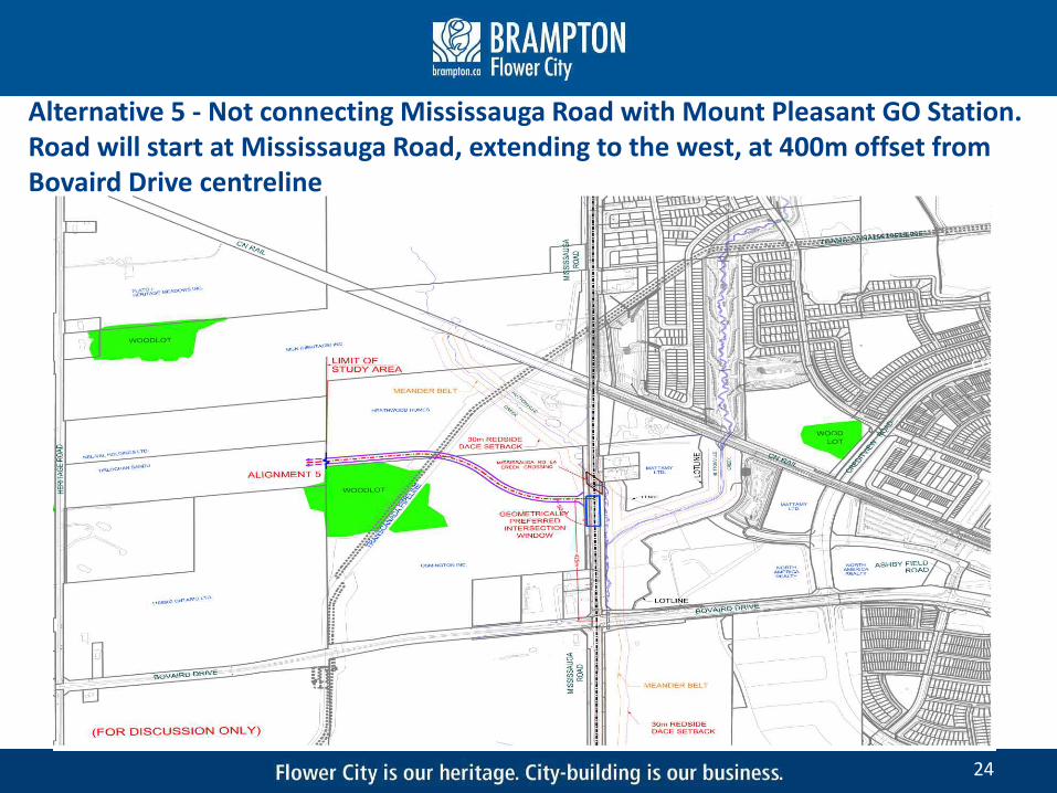
24
Alternative 5 - Not connecting Mississauga Road with Mount Pleasant GO Station. Road will start at Mississauga Road, extending to the west, at 400m offset from Bovaird Drive centreline

Alternative 5
• Does not provide direct access from the Mount Pleasant GO Station, which needed as an important alternative route for bus transit vehicles and GO patrons accessing the station
• It will require additional travel time by transit and active transportation, which may reduce use of transit and cycling modes of transportation
• Increase operational pressure on intersection at Bovaird Drive and Mississauga Road will impact Level of Services on other major intersections in the area, which will generate additional congestion, and increase travel time. Crossing Huttonville Creek at two (2) new locations
• In general, this design concept will not address the Problem/Opportunity statement and provide a wider benefit to the future developments and community by providing a full direct E-W link to the transportation hub
25

Alignment 1 (LC):
Facilitates good access from Mississauga Rd and connect to Mt Pleasant GO Station Length of frontage (+/140m) along Lagerfeld Dr between Mississauga Rd & Huttonville Creek may
not allow for an all moves intersection to serve the lands north of Lagerfeld The Lagerfeld/Mississauga intersection spacing to Bovaird is within Peel Region guidelines and
should allow sufficient space for queuing and turning lanes on Mississauga Rd One of the two landowner preferred options
Alignment 2 (LC):
Does not provide access to Mattamy property and would preclude another all moves access/public road to Mattamy property due to intersection spacing & constraints on crossing Huttonville Creek
There is a sanitary trunk sewer that runs easterly from Mississauga Rd through the North American lands which poses development constraints on that site
Severing the north half of the lands west of Creditview Road to allow for a realignment of Lagerfeld Dr. This portion of the North American property has been earmarked for District Retail uses under the Mt Pleasant Secondary Plan. The alternative reduces the depth of the property and creates significant physical challenges for site organization and orientation, while also adversely affecting site operations and the ability to provide adequate parking on the property.
The intersection spacing to Bovaird Dr is less than Peel Region standards
26

Alignment 3 (LC):
Facilitates good access from Mississauga Rd and connect to Mt Pleasant GO Station Length of frontage (+/240m) along Lagerfeld Dr between Mississauga Rd & Huttonville Creek will
allow for an all moves intersection to serve the lands north of Lagerfeld The area of land south of Lagerfeld and in between the branches of the Huttonville Creek could
likely only be used as storm water facilities due to their location on the inside of the horizontal curve
The 70° intersection with Mississauga Rd tends to push Lagerfeld Rd northerly into Mattamy lands One of the two landowner most preferred options
Alignment 4 (LC) :
Does not provide a connection to Mississauga Rd Splits the Mattamy site into two pieces which severely impacts development potential Not supportive of this option
Alignment 5 (LC):
Lack of a connection to the Mt Pleasant GO Station and transportation hub Preclude another all moves access/public road to Mattamy property Not supportive of this option
27

Least preferred environmentally as it requires two new road crossings over Huttonville Creek Preferred from a stop spacing, service design & route coverage perspective. Would allow for re-
alignment of Züm Service, including potential Züm Stations at Mississauga Rd and Lagerfeld Dr Effective in providing a direct connection for local transit & active transportation to the GO Station Possible sight line concerns due to significant vertical curvature of proposed roadway at
Mississauga Rd Straddles Osmington property. Lagerfeld might functions as an access only road for vehicular
traffic. To achieve its planned function, Lagerfeld needs to be central to Osmington development
Environmentally preferred route if east connection is required as route alignment only requires 1 new road crossing over Huttonville Creek. But cuts into woodland increasing environmental impact
Somewhat impacts stop spacing and route coverage, but would still allow for realignment of Züm Service and stations
Effective in providing a direct connection for local transit & active transportation to the GO Station Proposed road intersects with Mississauga Rd roughly 240m north of Bovaird Dr. The intersections would
be too close together potentially causing gridlock Will divide the Osmington lands into two parcels. This could be ideal condition in terms of site access,
opportunity to propose a transit supportive land use and increasing public realm impact. However, this can only be achieved if the ROW design complements the built form. Wider sidewalks, retail at base, active frontages, a full tree canopy, bike lanes and a complete street approach is imperative to this vision
28
Alignment 1:
Alignment 2:

Requires one new road crossing over Huttonville Creek and thus will incur less environmental resistance
Not desirable by transit. Would still allow for realignment of Züm Service and stations. Potential for geometrics to negatively impact operations and location of Züm stations
Profile and grade challenges with respect to CNR Overpass and Huttonville Creek. Concern that there may be excessive curves in the road alignment
Maximized spacing between signalized intersections on Mississauga Rd Effective in providing a direct connection for local transit & active transportation to the GO
Station Bridge structure at Mississauga Rd will have to be resized to accommodate a full intersection Need to identify stormwater drainage impacts Alignment may require an intersection east of Mississauga Rd for Mattamy to access both
parcels of land. Will Mattamy access to the road at a high % grade due to Mississauga Road profile, resulting in significant grading on Mattamy lands?
Skewed intersection when crossing Mississauga Rd, is a safety and operational concern Would have a substantial impact on Mattamy land and will create a parcel of land which might
not be deep enough for any substantial development Like Alignment 1, this option will straddle Osmington property – Lagerfeld might functions as an
access only road for vehicular traffic, cannot support multiple users and modes with the ability to provide a transit and active transportation supportive connection to Mt Pleasant GO station
29
Alignment 3:

Alignment 4:
Requires two new road crossings over Huttonville Creek Not supported by transit. Significantly reduces overall route coverage. Züm Service would
not be extended further north on Mississauga Rd Lack of access from Mississauga Road May be problematic given its proximity to the rail corridor and conflict with the proposed
new layover facility at Heritage Road on the south side of the corridor Potential impacts to the rail corridor from any adverse impacts on the TransCanada Pipeline
or the new creek crossings should be confirmed Will have significant costs impact to the Region’s structure (i.e. 30m clearance vs. minimal
driveway clearance requirements) Slip road and Mattamy access to Mississauga Rd cannot be provided Fails to serve Osmington lands and defeats the purpose of linking this development to the GO
station
30

Alignment 5:
Environmentally preferred route as there is no Huttonville Creek crossing Not supported by transit. Reduces overall route coverage and efficiency of service delivery.
Züm Service would not be extended further north on Mississauga Rd Future mall and alignment will generate a very heavy right turn traffic movement at
Mississauga Rd. May have sight line concerns due to the CNR Overpass With east part of Lagerfeld missing, not a favourable design since connectivity to GO station
is missing. This option would create the max. negative impact on the ongoing development of Mt Pleasant Village, mobility hub and surrounding lands. It woresents ‘last-mile/first mile’ connection to the mobility hub and would increase the mode share of private vehicular use creating substantial pressure to provide surface and structured parking with the mobility hub area. With this alignment Lagerfeld will effectively become a loading and access alley where substantial opportunity to create an active, vibrant public realm will be lost.
31

General Comments:
32
Timing of Lagerfeld Dr EA is critical in order to complete the detailed design and start construction of Mississauga Rd
Access to the Heathwood Home should be taken into consideration (provide access to Mississauga Rd)
Prefers grade separate accesses to the Osmington site to/form Mississauga Rd and Bovaird Dr
Traffic impact analysis for each alignment (include future Osmington traffic) to support the preferred opt.
There are plans for a 675mm sanitary sewer along Heritage Rd which will cross Bovaird Drand a 375mm sewer, within the study area. These projects have been scheduled to be constructed in 2021 and 2027
375mm and 450mm diameter sanitary sewers were constructed as part of Mattamydevelopment east of Mississauga Rd. City should be aware of these sewers while selecting preferred road alignment
Due to the environmental constraints/requirements faced with the culvert creek crossing(s), has there been any consideration for grade separating the EW roadway? A clear span may not be as impactful as a culvert crossing and would still provide an EW link to the GO station

Next Steps
a conceptual layout is provided at this phase for discussion and input purposes only
these alternative design concept will be further investigated and evaluated in the next phase of this EA study
evaluate alternatives and identify recommended solutions
present recommended solutions at PIC No. 2
Public Information Centre #2 will be scheduled to discuss the recommended alignments, as well as any issues and concerns prior to the finalization of the preliminary Preferred Design
33

THANK YOU
Consultant for the Class EA:
Mehemed Delibasic, M.Sc., P.Eng.
100 Commerce Valley Drive West
Thornhill, Ontario L3T 0A1
Email: [email protected]
Phone: (905) 882-1100 Ext. 6967
City of Brampton Project Manager:
Andria Oliveira, M.E.S., Pl.
Project Manager - City of Brampton
2 Wellington Street West
Brampton, Ontario L6Y 4R2
Email: [email protected]
Phone: (905) 874-2410
34

MEETING SUMMARY
MARKHAM 600 Cochrane Drive, Floor 5, Markham, Ontario L3R 5K3 Tel.: 905.475.7270 Fax: 905.475.5994
141-15409min16-12-10-Landowners-Meeting Minutes
Enrironmental Assessment Study, East-West Connection, Mount Pleasant GO Station to West of Mississauga Road - Meeting with Landowners and Developers Date: Monday, December 12, 2016 Project: 141-15409
Time: 10:00 AM – 12:00 PM Location: Flower City Community Campus, 8850 McLaughlin Road, Unit 1, Training Boardroom
Attendees: Paul Sarjeant BA Group
Scott Gibbons BA Group
Michael Gagnon GUD Urban Planner Ltd.
Colin Chung Glen Shnarr & Associate Inc.
Henrik Zbogar City of Brampton
Grant Simpson Heathwood
Glen Wellings Wellings Planning
Oz Kemal MHBC
Frank Boh Mattamy Homes
Lindsey Baskerville Mattamy Homes
Bob Koziol WSP
Mehemed Delibasic WSP
Distribution: List
Prepared By: Andria Oliveira and Mehemed Delibasic

Enrironmental Assessment Study, East-West Connection, Mount Pleasant GO Station to West of Mississauga Road - Meeting with Landowners and Developers
Meeting Summary − Monday, December 12, 2016 Page 2
\\DCCAN100ARC02\StubShare\V2\0\6\1\9\102342295_9eb273d7-370e-50f4-0c1e-434011873690\141-15409min16-12-10-Landowners-Meeting Minutes.docx 141-15409
Item Details and discussion Action
1. Project Update
1.1 Mehemed provided an overview of where we are in the study and the need to revisit the needs and justification for this link as requested by MNRF and CVC (slide6)
1.2 Mehemed provided the next steps in the process, establishing a preliminary, preferred design to take to PIC in the spring (slide 7)
1.3 Mehemed provided an overview and background of the project and the evaluation criteria were also introduced (Slides 8-12). Colin Chung inquired if the evaluation criteria will be weighted.
Info Info Info

Enrironmental Assessment Study, East-West Connection, Mount Pleasant GO Station to West of Mississauga Road - Meeting with Landowners and Developers
Meeting Summary − Monday, December 12, 2016 Page 3
\\DCCAN100ARC02\StubShare\V2\0\6\1\9\102342295_9eb273d7-370e-50f4-0c1e-434011873690\141-15409min16-12-10-Landowners-Meeting Minutes.docx 141-15409
2. Alternative Design Concepts - Evaluation
2.1 Mehemed provided an overview of all the components that make the crossing window a “sweet spot” for an intersection i.e. grade separated structure for Mississauga Road, Mississauga road infrastructure and intersection spacing with Bovaird Drive (page 17).
2.2 The alternatives were individually addressed and discussions had about each alternative:
• Alignment #1
o This alignment has the largest impact to the natural environment
o Need to discuss structure mitigations
o Access needed to be provided to Heatherwood
o Need alignment that does not preclude future access
o Important to develop map that outlines all of the future land use concepts, as we know them to be on each of these roads so that we understand how the design best integrates parcel development with street design and alignment. This map should also overlay the alternative alignments with the most recent version of what the region of Peel is doing on Mississauga Road
o Need a consolidated map showing all the most recent plans.
o If Alternative #1 is chosen, there will be more crossings once Mattamy Homes chooses to develop, for example another crossing will be requested at Huttonville. All participants agreed this is very problematic.
• Alignment #2 o Questions arose about what are the implications to Apple
Factory with access so close. o What are the impacts to the hold out properties (for all
alternatives, needs to be considered) o Region of Peel states that culvert for Mississauga Road is
being constructed in spring of 2017.
• Alignment #3 o Seems to be the best fit for accommodating future
development needs o Need better understanding of what the intersections ends will
be, for example, will this intersection with Mississauga Road be raised? If this is the case is, will there be a loss of the City/Community building vision?
o Can alignment 3 be altered and if yes what are the associated costs.
o Does the function of the intersection work?
o Can alignment 3 cross Mississauga Road at 90º? Osmington Group is in
favour with this adjustment. .
Info Info

Enrironmental Assessment Study, East-West Connection, Mount Pleasant GO Station to West of Mississauga Road - Meeting with Landowners and Developers
Meeting Summary − Monday, December 12, 2016 Page 4
\\DCCAN100ARC02\StubShare\V2\0\6\1\9\102342295_9eb273d7-370e-50f4-0c1e-434011873690\141-15409min16-12-10-Landowners-Meeting Minutes.docx 141-15409
3. Next Steps
3.1 Need to engage MNRF and CVC on where we are going to go. Alignment 3 works best for all landowners and we need to understand the environmental impacts in order to make this work
3.2 Send out a copy of minutes and presentation for comment
3.3 Request a call for most current drawings for an updated study area, to understand constraints and develop an up to date land use concept for the area.
End of Meeting Summary

East-West Connection Mount Pleasant GO Station to
West of Mississauga Road (Lagerfeld Road)
Municipal Class EA Schedule “C”
Stakeholder Meeting June 12, 2018
6:30-7:00 Review of Displays7:00-7:30 Study Update Presentation
7:30-8:30 Q&A

2
EAST-WEST CONNECTION ROADMOUNT PLEASANT GO STATION TO WEST OF MISSISSAUGA ROAD
MUNICIPAL CLASS EA
Meeting Agenda
1. Project Background and Update
2. Alternative Design Concepts and Preliminary Preferred Alternative
3. Next Steps for the Project
4. Comments and Discussion
Please sign-in and submit your comments using the comment forms provided.

3
EAST-WEST CONNECTION ROADMOUNT PLEASANT GO STATION TO WEST OF MISSISSAUGA ROAD
MUNICIPAL CLASS EA
STUDY AREA AND OVERVIEW The City of Brampton is conducting a Schedule ‘C’ Municipal Class Environmental
Assessment (EA) for a East-West Connection Road between Mount Pleasant GO Station and approximately 680m west of Mississauga Road.
The boundaries of the immediate study area are Mississauga Road to the west, Bovaird Drive West to the south and CN Railway to the north.
As part of a strategic future road network assessment, extension of Lagerfeld Drive is considered to address these problems and provide opportunities to enhance the future community, and facilitate sustainable modes of transportation, to northwest Brampton.
Approved and planned growth in the study area will contribute to an increase in traffic congestion over the next 10-25 years.
Brampton Vision 2040 identifies this area as a future town centre.

4
EAST-WEST CONNECTION ROADMOUNT PLEASANT GO STATION TO WEST OF MISSISSAUGA ROAD
MUNICIPAL CLASS EA
EAST-WEST CONNECTION ROADMOUNT PLEASANT GO STATION TO WEST OF MISSISSAUGA ROAD
MUNICIPAL CLASS EA
MUNICIPAL CLASS EA STUDY PHASES
PHASE 1
PROBLEM OR OPPORTUNITY
Public Information Centre #1June 2015
PHASE 2
ALTERNATIVE SOLUTIONS
Notice of Study Commencement
April 2014
PHASE 3
ALTERNATIVE DESIGNS
PHASE 4
ENVIRONMENTAL STUDY REPORT (ESR)
PHASE 5
IMPLEMENTATION
Public Information Centre #2
TBD
30 Day Review Period
We are HereWe are Here
This study is following the process of Schedule ‘C’
requirements of the
Municipal Class EA (2015), which will complete Phases
1 to 4.

5
EAST-WEST CONNECTION ROADMOUNT PLEASANT GO STATION TO WEST OF MISSISSAUGA ROAD
MUNICIPAL CLASS EA
EAST-WEST CONNECTION ROADMOUNT PLEASANT GO STATION TO WEST OF MISSISSAUGA ROAD
MUNICIPAL CLASS EA
ProponentCity of Brampton
Technical Advisors City of Brampton
MNRF/CVCRegion of Peel
Project TeamCity of BramptonWSP - Consultant
Public
IndigenousCommunity
External AgenciesProvincial
FederalPublic Authorities
StakeholdersProperty
Owners/UsersResidents
Business Community
Satisfy Environmental Assessment (EA) requirements:
Provide clear justification of the need for this connection
Investigate a range of alternative alignments and designs
Develop criteria and measures against which alternatives/designs can be evaluated
Recommend a preferred design solution through the overall evaluation of alternatives
STUDY OBJECTIVES AND ORGANIZATION

6
EAST-WEST CONNECTION ROADMOUNT PLEASANT GO STATION TO WEST OF MISSISSAUGA ROAD
MUNICIPAL CLASS EA
POLICY CONTEXT - TRANSPORTATION MASTER PLAN UPDATE (2015)
The study area land-use consists of a mixture of agricultural, residential, commercial, and industrial.
North West Brampton is rapidly growing community.
City of Brampton population and employment will increased by 43% and 73% respectively between 2021 and 2041.
City of Brampton
2021 2031 2041
Population 687,000 837,000 889,000
Employment 244,000 292,000 322,000
Study Area

7
EAST-WEST CONNECTION ROADMOUNT PLEASANT GO STATION TO WEST OF MISSISSAUGA ROAD
MUNICIPAL CLASS EA
TRANSPORTATION MASTER PLAN UPDATE (2015)DRAFT RECOMMENDED ROAD NETWORK NEEDS BY 2041

8
EAST-WEST CONNECTION ROADMOUNT PLEASANT GO STATION TO WEST OF MISSISSAUGA ROAD
MUNICIPAL CLASS EA
BRAMPTON VISION 2040 PLAN

9
EAST-WEST CONNECTION ROADMOUNT PLEASANT GO STATION TO WEST OF MISSISSAUGA ROAD
MUNICIPAL CLASS EA
ALTERNATIVE SOLUTIONS
An evaluation framework was developed as presented, including technical considerations and environmental components that address the broad definition of the environment as described in the EA Act and those based on comments received from relevant agencies.
ALTERNATIVE
SOLUTION 1:
Do Nothing
ALTERNATIVE
SOLUTION 2:
Transportation Demand
Management (TDM)
ALTERNATIVE
SOLUTION 3:
Improve Transportation
Operations along other
Roads in the Network
ALTERNATIVE
SOLUTION 4:
Extend road west of
Mississauga Road only
ALTERNATIVE
SOLUTION 5:
Extend Mount Pleasant
GO Station access
road (Lagerfeld Road)
to west of Mississauga
Road
No changes made
within the Study
Area (status quo )
Introduce TDM strategies to
reduce demands on
Mississauga Road &
Bovaird Drive (i.e. shift
demand to time periods
outside of the congestion
periods)
Introduce additional
operational improvements
such as restricting turning
movements, localized
widening to accommodate
dedicated turn lanes,
intersection improvements,
continuous left turn lanes,
and/or signal timings, etc.
East-west connection
will start at Mississauga
Road, extending to the
west.
Continuation of the
existing Mount Pleasant
GO Station access road
to lands west of
Mississauga Road
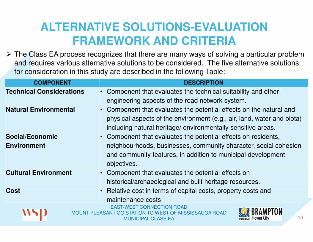
10
EAST-WEST CONNECTION ROADMOUNT PLEASANT GO STATION TO WEST OF MISSISSAUGA ROAD
MUNICIPAL CLASS EA
ALTERNATIVE SOLUTIONS-EVALUATION
FRAMEWORK AND CRITERIA The Class EA process recognizes that there are many ways of solving a particular problem
and requires various alternative solutions to be considered. The five alternative solutions for consideration in this study are described in the following Table:
COMPONENT DESCRIPTION
Technical Considerations • Component that evaluates the technical suitability and other
engineering aspects of the road network system.
Natural Environmental • Component that evaluates the potential effects on the natural and
physical aspects of the environment (e.g., air, land, water and biota)
including natural heritage/ environmentally sensitive areas.
Social/Economic
Environment
• Component that evaluates the potential effects on residents,
neighbourhoods, businesses, community character, social cohesion
and community features, in addition to municipal development
objectives.
Cultural Environment • Component that evaluates the potential effects on
historical/archaeological and built heritage resources.
Cost • Relative cost in terms of capital costs, property costs and
maintenance costs

11
EAST-WEST CONNECTION ROADMOUNT PLEASANT GO STATION TO WEST OF MISSISSAUGA ROAD
MUNICIPAL CLASS EA
EVALUATION OF ALTERNATIVE SOLUTIONS SUMMARYALTERNATIVE SOLUTION 1:
Do Nothing
ALTERNATIVE
SOLUTION 2:
Transportation Demand Management (TDM)
ALTERNATIVE
SOLUTION 3:
Improve Transportation Operations along
other Roads in the Network
ALTERNATIVE SOLUTION 4:
Extend road west of Mississauga Road only
ALTERNATIVE SOLUTION 5:
Extend Mount Pleasant GO Station access
(Lagerfeld Road) to west of Mississauga
Road
This alternative solution is not recommended for the following reasons:
• Does not address current and future traffic operations issues and multi-modal transportation needs.
• Results in delays and safety concerns associated with increased traffic along other east-west and north-south roadways in the study area in the longer term.
• Does not support the land use policies and future development plans for Mobility Hub which in order to create Value around Mount Pleasant GO commuter train station, which acts as a MOBILITY HUB connecting inter-regional GO service (rail and bus-connecting Toronto with Georgetown, Guelph and Kitchener) with Brampton local transit
• Does not provide connectivity for multi modal transportation options that include Transit Oriented Development in an Urban Core around Mount Pleasant GO Station. (Currently there is no direct access from the Mount Pleasant GO Station, which can provide an important alternative route for bus transit vehicles and GO patrons accessing the station).
This alternative solution does not address problems and opportunities for the project and therefore is not recommended.
Roadway capacity and intersection operations will deteriorate without improvements therefore:With planned roadway improvements and without the future east-west connection, the roadway network in the immediate area will not be able to accommodate the east-west travel demand growth anticipated to 2031 and beyond.
This alternative solution is not recommended for
the following reasons:
• Adds partial transportation capacity but
insufficient for future growth when considered
as a stand-alone strategy.
• No environmental impacts are expected as a
result of this alternative.
• It responds rather weakly against the social-
cultural criteria as on its own, it does not
support future development plans.
• As far as cost criteria this option is expected
to involve average costs compared to other
alternative.
This alternative solution does not address
problems and opportunities for the project and
therefore is not recommended.
Roadway capacity and intersection operations
will deteriorate without improvements therefore:
With planned roadway improvements and
without the future east-west connection, the
roadway network in the immediate area will not
be able to accommodate the east-west travel
demand growth anticipated to 2031 and
beyond.
This alternative solution is not recommended for
the following reasons:
• Provides minimal additional transportation
capacity but the projected capacity problem
would still exist with local improvements only.
• Minimal environmental impacts are expected
as a result of this alternative.
• It responds weakly against the social- cultural
criteria as on its own, it does not support
future development plans.
• As far as cost criteria this option is expected
to involve average costs compared to other
alternative.
This alternative solution does not address
problems and opportunities for the project and
therefore is not recommended.
Roadway capacity and intersection operations
will deteriorate without improvements therefore:
With planned roadway improvements and
without the future east-west connection, the
roadway network in the immediate area will not
be able to accommodate the east-west travel
demand growth anticipated to 2031 and
beyond.
This alternative solution is not recommended for
the following reasons:
• Provides modest additional transportation
capacity and access.
• It poorly responses against the social-cultural
criteria as it can highly impact area
businesses and properties.
• This option is expected to involve higher
capital costs.
Although Alternative # 4 may provide some
relief to the east-west traffic future connections
but it does not fully support the land use policies
and future development plans. It does not fully
address the problem statement.
Roadway capacity and intersection operations
will deteriorate without improvements therefore:
With planned roadway improvements and
without the future east-west connection, the
roadway network in the immediate area will not
be able to accommodate the east-west travel
demand growth anticipated to 2031 and
beyond.
Although this alterative solution is not
recommended but it is carried forward to design
alternative evaluation for further analysis.
This alternative solution is recommended for the
following reasons:
• Improves current and future traffic conditions.
• Provides additional transportation capacity
and access.
• Facilitate direct travel for all modes of travel
including transit, walking and cycling, and
reduce the reliance on vehicles and the
associated congestion/pressure placed on
Bovaird Drive and Mississauga Road and
their intersection.
• Provides connectivity to support more
sustainable transportation options/trips and to
integrate local neighborhoods creating
compact development and active uses along
complete streets in the neighbourhood.
• It best responds to the social- cultural criteria
as it supports the land use policies and future
development plan of the Mount Pleasant and
Heritage Heights Community, and supports
potential commuters from communities north
and/or west of Brampton.
• Provides strategic multi-modal connections
linking future planned destinations including
higher density land uses, employment lands
and higher order transit corridors.
• Highest natural environment impacts to
Redside dace, natural heritage system.
• Increased opportunities to fulfill objectives for
complete, compact communities and
economic growth due to supporting a grid-like
road network with intercommunity
connections and better direct link to Mount
Pleasant GO Station
Despite highest capital costs this option best
addresses the problem statement and is the
Technically preferred alternative solution.

12
EAST-WEST CONNECTION ROADMOUNT PLEASANT GO STATION TO WEST OF MISSISSAUGA ROAD
MUNICIPAL CLASS EA
EVALUATION OF ALTERNATIVE SOLUTIONS
• ALTERNATIVE SOLUTION 4: Extend road west of Mississauga Road only
• ALTERNATIVE SOLUTION 5: Extend Mount Pleasant GO Station access road to west of Mississauga Road through a Phased Approach.
• They key constraint is the established Natural Heritage System and endangered species habitat in Huttonville Creek.
• Establish an alignment to west of Mississauga Road.
• Through the EA, establish a Right-of-way and preliminary design for planning purposes.
Five alternative solutions studied and assessed – two alternative solutions carried forward:

13
EAST-WEST CONNECTION ROADMOUNT PLEASANT GO STATION TO WEST OF MISSISSAUGA ROAD
MUNICIPAL CLASS EA
EVALUATION CRITERIA FOR ALTERNATIVE DESIGNS
Technical Ability to Improve East-West
Capacity
Safety / Traffic Operations
Support for Transit Connectivity to Mobility Hub
Ability to address Flood Risks
Ability to Improve Drainage System
Emergency Services
Utilities
The following assessment factors were used to evaluate alternativedesigns:
Natural Environment Existing Environmentally
Sensitive Areas
Vegetation
Habitat Areas (Terrestrial)
Species at Risk
Existing Watercourses
Water Quality / Quantity
Effects on Air Quality

14
EAST-WEST CONNECTION ROADMOUNT PLEASANT GO STATION TO WEST OF MISSISSAUGA ROAD
MUNICIPAL CLASS EA
EVALUATION CRITERIA FOR ALTERNATIVE DESIGNS(CONT.)
Social-economic /Cultural Environment Support for Future Designated Growth Areas
Adjacent Land-uses/Properties
Noise Levels
Access & Circulation
Traffic Infiltration Effects
Heritage Resources & Archaeological Features
Short Term Construction Related Impacts
Cost Capital Costs
Road Operation and Maintenance Costs

15
EAST-WEST CONNECTION ROADMOUNT PLEASANT GO STATION TO WEST OF MISSISSAUGA ROAD
MUNICIPAL CLASS EA
15
ALTERNATIVE DESIGN CONCEPTS
FIVE initial design concepts were developed for the preferred solution at a preliminary level of detail to assess the potential associated with each alternative.

16
EAST-WEST CONNECTION ROADMOUNT PLEASANT GO STATION TO WEST OF MISSISSAUGA ROAD
MUNICIPAL CLASS EA
ALTERNATIVE DESIGN CONCEPTS A series of alternative design were developed for the preferred solution at a preliminary level of detail
to properly assess the potential impacts and benefits associated with each alternative.
DESIGN ALT. 1A DESIGN ALT. 1B DESIGN ALT. 2 DESIGN ALT. 3A DESIGN ALT. 3B DESIGN ALT. 4A DESIGN ALT. 4B DESIGN ALT. 5
• Continuation of
the existing
Mount Pleasant
GO Station
access road to
lands west of
Mississauga
Road.
• Alignment past
Mississauga
Road at 419m
north of Bovaird
Drive centreline.
(Crossing
abutments
beyond 30m
regulated habitat
buffer zone)
• Continuation of
the existing
Mount Pleasant
GO Station
access road to
lands west of
Mississauga
Road.
• Alignment past
Mississauga
Road at 419m
north of Bovaird
Drive centreline.
(Crossing
abutments
within 30m
regulated habitat
buffer zone)
• Continuation of
the existing
Mount Pleasant
GO Station
access road to
lands west of
Mississauga
Road.
• Alignment
through
Mississauga
Road at
approximately
240m north of
Bovaird Drive
centreline.
• Continuation of
the existing
Mount Pleasant
GO Station
access road to
lands west of
Mississauga
Road.
• Alignment
through
Mississauga
Road at the
proposed
Huttonville
Creek bridge
location, at an
70° angle,
approximately
473m north of
Bovaird Drive
centreline.
(Crossing
abutments beyond
30m regulated
habitat buffer)
• Continuation of
the existing
Mount Pleasant
GO Station
access road to
lands west of
Mississauga
Road.
• Alignment past
through
Mississauga
Road at the
proposed
Huttonville
Creek bridge
location, at an
70° angle,
approximately
473m north of
Bovaird Drive
centreline.
(Crossing
abutments within
30m regulated
habitat buffer)
• Continuation of
the existing
Mount Pleasant
GO Station
access road to
lands west of
Mississauga
Road.
• Alignment does
not intersect
with
Mississauga
Road but utilize
proposed slip
road north of
Huttonville
Creek crossing,
just south of CN
Rail.
(Crossing
abutments beyond
30m regulated
habitat buffer)
• Continuation of
the existing
Mount Pleasant
GO Station
access road to
lands west of
Mississauga
Road.
• Alignment does
not intersect
with
Mississauga
Road but utilize
proposed slip
road north of
Huttonville
Creek crossing,
just south of CN
Rail.
(Crossing
abutments within
30m regulated
habitat buffer)
• Not connecting
Mississauga
Road with
Mount Pleasant
GO Station.
• East-west
connection will
start at
Mississauga
Road, extending
to the west, at
419m offset
from Bovaird
Drive centreline.

17
EAST-WEST CONNECTION ROADMOUNT PLEASANT GO STATION TO WEST OF MISSISSAUGA ROAD
MUNICIPAL CLASS EA
EVALUATION OF PREFERRED PRELIMINARY ALTERNATIVE DESIGN CONCEPT
DESIGN ALT. 1A “Longer Bridges” DESIGN ALT. 1B “Shorter Bridges”
This design alternative is not recommended for the
following reasons:
• Evaluation for Design Alternative 1A is similar to
Alternative 1B.
• The difference in proposed structures for East
Huttonville Creek crossing differentiate the two
options.
• For design alternative 1A, abutments for East
Huttonville Creek crossing are beyond the 30m
regulated habitat buffer zone.
• For design alternative 1A, abutments for East
Huttonville Creek crossing are beyond the 30m
regulated habitat buffer zone.
• Less impact on floodplain and velocity levels.
• Smaller direct impact footprint in regulated habitat.
• This option has less natural impacts but the structural
Capital costs are higher than design alternative 1B.
This design alternative is recommended for the following
reasons:
• Meets minimum intersection offset from Bovaird Drive
intersection for the crossing at Mississauga Road.
• Will not have queuing issue (southbound queues
along Mississauga Road) as there is sufficient storage
distance between Bovaird Drive and the new
connection for left turning vehicles onto Bovaird Drive.
• Passing Mississauga Road at approximately the
midpoint between Bovaird Drive and CN Rail, evenly
splitting the development areas.
• Continuing existing GO Station access road to west of
Mississauga Road which improve traffic operations in
the area.
• Connects major destinations with multi-modal access
• This option is expected to involve much lower
structural capital costs than Design Alternative 1A.

18
EAST-WEST CONNECTION ROADMOUNT PLEASANT GO STATION TO WEST OF MISSISSAUGA ROAD
MUNICIPAL CLASS EA
EVALUATION OF PREFERRED PRELIMINARY ALTERNATIVE DESIGN CONCEPT
DESIGN ALT. 2
This design alternative is not recommended for the
following reasons:
• Does not meet the minimum intersection offset from the
Bovaird Drive intersection
• Will have queuing issue for southbound left turning
vehicles along Mississauga Road at Bovaird Drive with
the reduced intersection distance between Bovaird
Drive and the east-west connection.
• Not consistent with the planned function of the corridor
identified in the City’s TMP, Heritage Heights TMP, and
the identified east-west connection needs.
• Will not fully addresses anticipated capacity
deficiencies.

19
EAST-WEST CONNECTION ROADMOUNT PLEASANT GO STATION TO WEST OF MISSISSAUGA ROAD
MUNICIPAL CLASS EA
EVALUATION OF PREFERRED PRELIMINARY ALTERNATIVE DESIGN CONCEPT
DESIGN ALT. 3A DESIGN ALT. 3B
This design alternative is not recommended for the
following reasons:
• Technically challenging to remove existing culvert at
Mississauga Road Huttonville Creek crossing and
realign creek without interrupting existing traffic
operations.
• High maintenance cost for bridge at Mississauga
Road intersection
• Major changes to the Huttonville Creek crossing
bridge at Mississauga Road intersection are
proposed in design alternative 3. As the project for
Mississauga Road roadway improvements is already
at the later stage of detailed design, Peel Region
does not desire any alterations to the Huttonville
Creek crossing bridge proposed at EA as it will delay
the progress.
This design alternative is not recommended for the
following reasons:
• Technically challenging to remove existing culvert at
Mississauga Road Huttonville Creek crossing and
realign creek without interrupting existing traffic
operations.
• High maintenance cost for bridge at Mississauga
Road intersection
• Major changes to the Huttonville Creek crossing
bridge at Mississauga Road intersection are
proposed in design alternative 3. As the project for
Mississauga Road roadway improvements is
already at the later stage of detailed design, Peel
Region does not desire any alterations to the
Huttonville Creek crossing bridge proposed at EA
as it will delay the progress.
• With proposed crossing structures, major increase
in flood elevations expected.
• Abutments of the crossing structures are on the
floodplain.

20
EAST-WEST CONNECTION ROADMOUNT PLEASANT GO STATION TO WEST OF MISSISSAUGA ROAD
MUNICIPAL CLASS EA
EVALUATION OF PREFERRED PRELIMINARY ALTERNATIVE DESIGN CONCEPTDESIGN ALT. 4A DESIGN ALT. 4B
This design alternative is not recommended for the following
reasons:
• This design alternative will not address the Problem/
Opportunity statement and provide a wider benefit to the
future developments and community by providing a
reasonably spaced direct E-W link to the transportation
hub.
• With no intersection with Mississauga Road, cannot
alleviate traffic congestion at intersection of Mississauga
Road and Bovaird Drive.
• May be problematic given its proximity to the rail corridor
and conflict with the proposed new layover facility at
Heritage Road on the south side of the corridor.
• Does not support the City’s endorsed Community Design
Principles that include Transit Oriented Development in an
Urban Core around Mount Pleasant GO Station.
• Not consistent with the planned function of the corridor
identified in the City’s TMP, Heritage Heights TMP, and the
identified east-west connection needs.
• Zum service would not be extended further north on
Mississauga Road.
This design alternative is not recommended for the following
reasons:
• This design alternative will not address the
Problem/Opportunity statement and provide a wider benefit
to the future developments and community by providing a
reasonable spaced direct E-W link to the transportation
hub.
• With no intersection with Mississauga Road, cannot
alleviate traffic congestion at intersection of Mississauga
Road and Bovaird Drive.
• May be problematic given its proximity to the rail corridor
and conflict with the proposed new layover facility at
Heritage Road on the south side of the corridor.
• Does not support the City’s endorsed Community Design
Principles that include Transit Oriented Development in an
Urban Core around Mount Pleasant GO Station.
• Not consistent with the planned function of the corridor
identified in the City’s TMP, Heritage Heights TMP, and the
identified east-west connection needs.
• Zum service would not be extended further north on
Mississauga Road.
• With proposed crossing structures, major increase in flood
elevations expected.
• Abutments of the crossing structures are on the floodplain.

21
EAST-WEST CONNECTION ROADMOUNT PLEASANT GO STATION TO WEST OF MISSISSAUGA ROAD
MUNICIPAL CLASS EA
EVALUATION OF PREFERRED PRELIMINARY ALTERNATIVE DESIGN CONCEPT
DESIGN ALT. 5
As a standalone design, this alternative is not
recommended for the following reasons:
•This design alternative will not fully address the
Problem/Opportunity statement and provide a wider
benefit to the future developments and community by
providing a direct E-W link to the transportation hub.
•Although design alternative 5 may provide some relief
to the east-west traffic future connections it does not
fully support the land use policies and future
development plans.
•With planned roadway improvements and without the
full east-west connection, the roadway network in the
immediate area may not be able to accommodate the
east-west travel demand growth anticipated to 2031
and beyond.

22
EAST-WEST CONNECTION ROADMOUNT PLEASANT GO STATION TO WEST OF MISSISSAUGA ROAD
MUNICIPAL CLASS EA
ALTERNATIVE DESIGN CONCEPTS – ALIGNMENT 1

23
EAST-WEST CONNECTION ROADMOUNT PLEASANT GO STATION TO WEST OF MISSISSAUGA ROAD
MUNICIPAL CLASS EA
ALTERNATIVE DESIGN CONCEPTS – ALIGNMENT 1CROSSING AT MISSISSAUGA ROAD – WEST CROSSING
NOTE:- West side of creek already disturbed with Mississauga Road
Improvements. Impacts will not be included in the assessment.
Advantages:- Abutments to be outside of redside dace buffer zone- 30m buffer zone only impacted by piers- Stayed out of 100 years flood level span- Does not impact original design for Huttonville Creek Bridge at
Mississauga Road
Disadvantages:- Limited vertical clearance, creating excessive shaded area. Vegetation
will not sustain under the structure.- Need to cooperate with Mississauga Road Improvement Design.
Sheet pilings needed to connect EW Connector to Mississauga Road- Moderate structural cost.

24
EAST-WEST CONNECTION ROADMOUNT PLEASANT GO STATION TO WEST OF MISSISSAUGA ROAD
MUNICIPAL CLASS EA
ALTERNATIVE DESIGN CONCEPTS – ALIGNMENT 1 EAST CROSSING, OPTION A
NOTE:- Longer bridge length
Advantages:- Abutments to be outside of redside dace buffer zone- 30m buffer zone only impacted by piers
Disadvantages:- 3-span bridge, with piers onto 30m buffer zone- Limited vertical clearance, creating excessive shaded area.
Vegetation will not sustain under the structure.- Bridge length is excessive for the crossing- High structural cost

25
EAST-WEST CONNECTION ROADMOUNT PLEASANT GO STATION TO WEST OF MISSISSAUGA ROAD
MUNICIPAL CLASS EA
ALTERNATIVE DESIGN CONCEPTS – ALIGNMENT 1 EAST CROSSING, OPTION B
NOTE:- Shorter bridge length
Advantages:- More reasonable fit, with abutment centrelines outside of
meander belt- Lower structural cost
Disadvantages:- Abutments on redside dace buffer zone- Fills in redside dace buffer zone for roadway- low vertical clearance at abutments

26
EAST-WEST CONNECTION ROADMOUNT PLEASANT GO STATION TO WEST OF MISSISSAUGA ROAD
MUNICIPAL CLASS EA
FLOODLINES – EXISTING VS PROPOSEDALIGNMENT 1 EAST CROSSING, OPTION B

27
EAST-WEST CONNECTION ROADMOUNT PLEASANT GO STATION TO WEST OF MISSISSAUGA ROAD
MUNICIPAL CLASS EA
PROPOSED TYPICAL CROSS SECTION
- INTERSECTION

28
EAST-WEST CONNECTION ROADMOUNT PLEASANT GO STATION TO WEST OF MISSISSAUGA ROAD
MUNICIPAL CLASS EA
PROPOSED TYPICAL CROSS SECTION
- MID BLOCK

29
EAST-WEST CONNECTION ROADMOUNT PLEASANT GO STATION TO WEST OF MISSISSAUGA ROAD
MUNICIPAL CLASS EA
PROPOSED TYPICAL CROSS SECTION
- EAST CROSSING STRUCTURE

30
EAST-WEST CONNECTION ROADMOUNT PLEASANT GO STATION TO WEST OF MISSISSAUGA ROAD
MUNICIPAL CLASS EA
PROPOSED TYPICAL CROSS SECTION
- MISSISSAUGA RD CROSSING STRUCTURE

31
EAST-WEST CONNECTION ROADMOUNT PLEASANT GO STATION TO WEST OF MISSISSAUGA ROAD
MUNICIPAL CLASS EA
This design alternative is recommended to carry forward for the following reasons:
• Meets minimum intersection offset from Bovaird Drive intersection as specified in City’s standards
(300m) for the crossing at Mississauga Road.
• Will not have queuing issue (southbound queues along Mississauga Road) as there is sufficient storage
distance between Bovaird Drive and the new connection for left turning vehicles onto Bovaird Drive.
• Passes Mississauga Road at approximately the midpoint between Bovaird Drive and CN Rail, evenly
splitting the areas, as required for Collector Roads.
• Provides access to Mount Pleasant GO Station and east-west connectivity.
• Continuing existing GO Station access road to west of Mississauga Road which improve traffic
operations in the area.
• Connects major destinations with multi-modal access (transit, active transportation and auto). enhancing
the connectedness, and provide opportunity for successful development of Mount Pleasant Village.
• This option is expected to involve lower structural capital costs than Design Alternative 1A.
• This option best addresses the problem statement.
DESIGN ALTERNATIVE 1B
Continuation of the existing Mount Pleasant GO Station access road to lands west of Mississauga
Road. Alignment past through Mississauga Road at 419m north of Bovaird Drive centreline.
(Crossing abutments within 30m regulated habitat buffer zone)
PRELIMINARY PREFERRED ALTERNATIVE DESIGN

32
EAST-WEST CONNECTION ROADMOUNT PLEASANT GO STATION TO WEST OF MISSISSAUGA ROAD
MUNICIPAL CLASS EA
EAST-WEST CONNECTION ROADMOUNT PLEASANT GO STATION TO WEST OF MISSISSAUGA ROAD
MUNICIPAL CLASS EA
NEXT STEPS AND STUDY CONTACTS
Following this Meeting the City of Brampton will:
Receive your comments and address them.
Hold PIC #2, scheduled for fall 2018.
Confirm the preliminary preferred design and finalize the preliminary design.
Document the study findings, decision making process and incorporate them along with the preliminary preferred design into an Environmental Study Report (ESR)
File the ESR for public review for a period of 30 days.
Notify stakeholders of the filing of ESR.
Publish a notice of completion in the Brampton Guardian Newspaper
For more information, please contact:
Consultant for the Class EA:
Andrew Roberts
Consultant Project Coordinator
WSP Canada Inc.
100 Commerce Valley Drive West
Thornhill, Ontario L3T 0A1
Email: [email protected]
Phone: (905) 882-4211 ext. 6152
City of Brampton Staff:
Mario Goolsarran, P. Eng., PMP
Project Manager – City of Brampton
Public Works & Engineering, City of Brampton
1975 Williams Parkway, Brampton, Ontario L6S 6E5
Email: [email protected]
Phone: (905) 874-5164