
Appendix 1 - Manchester City Council
103
Manchester City Council Strategic Housing Land Availability Assessment 2010 Appendix 1. New Build Residential Completions 2009/10 No of bedrooms - houses No of bedrooms - flats Site No. Ward Location Application No. Units No. Houses No. Flats No. Private RSL/LA Brown field Green field Developer 1 2 3 4+ 1 2 3 4+ SRF Area 1934 Ancoats & Clayton Stuart Place Astan Avenue 074171 1 1 1 1 Mr & Mrs Scott 1 E 3696 Ancoats & Clayton Flint Glass Wharf, 35 Radium Street 080807 136 136 136 136 64a Jersey Street 47 89 E 4176 Ancoats & Clayton 95 Spear Street 069755 28 28 28 28 Riverside Housing 8 20 CC 4575 Ancoats & Clayton Stuart Street/Archer Street 079448/085305/ 087220 23 23 23 23 Countryside 4 7 12 E 801 Ardwick Dryden Street/Plymouth View 082877 12 12 12 12 Caspian Construction 10 2 C 2486 Ardwick Naburn Street/Welby Street 081535 8 8 8 8 Mcr Contractors 8 C 3452 Ardwick Plymouth Grove 26 Devonshire St South/Hatchley Street 075881 1 1 1 1 Gleeson 1 C 3452 Ardwick Barbara Castle Square Plymouth Grove 085068 9 9 9 9 Harvest Housing Group 9 C 3502 Ardwick Devell House, 11 Rusholme Place 081558 51 51 51 51 Opal Property Group 6 39 6 C 4499 Ardwick 44 Hathersage Road 082442 194 194 194 194 United Utilities Property Solutions 78 116 C 4326 Baguley 1 Pocklington Drive 073222 40 40 40 40 Mi7 Developments 40 Wy
-
Upload
khangminh22 -
Category
Documents
-
view
7 -
download
0
Transcript of Appendix 1 - Manchester City Council

Manchester City Council Strategic Housing Land Availability Assessment 2010
Appendix 1. New Build Residential Completions 2009/10
No of bedrooms - houses No of bedrooms - flats
Site No. Ward Location Application
No. Units
No. Houses
No. Flats No. Private RSL/LA Brown
field Green field Developer
1 2 3 4+ 1 2 3 4+ SRF Area
1934 Ancoats & Clayton
Stuart Place Astan Avenue 074171 1 1 1 1 Mr & Mrs Scott 1 E
3696 Ancoats & Clayton
Flint Glass Wharf, 35 Radium Street 080807 136 136 136 136 64a Jersey Street 47 89 E
4176 Ancoats & Clayton 95 Spear Street 069755 28 28 28 28 Riverside Housing 8 20 CC
4575 Ancoats & Clayton
Stuart Street/Archer Street
079448/085305/087220 23 23 23 23 Countryside 4 7 12 E
801 Ardwick Dryden Street/Plymouth View 082877 12 12 12 12 Caspian
Construction 10 2 C
2486 Ardwick Naburn Street/Welby Street 081535 8 8 8 8 Mcr Contractors 8 C
3452 Ardwick Plymouth Grove 26 Devonshire St South/Hatchley Street
075881 1 1 1 1 Gleeson 1 C
3452 Ardwick Barbara Castle Square Plymouth Grove 085068 9 9 9 9 Harvest Housing
Group 9 C
3502 Ardwick Devell House, 11 Rusholme Place 081558 51 51 51 51 Opal Property
Group 6 39 6 C
4499 Ardwick 44 Hathersage Road 082442 194 194 194 194 United Utilities Property Solutions 78 116 C
4326 Baguley 1 Pocklington Drive 073222 40 40 40 40 Mi7 Developments 40 Wy

Manchester City Council Strategic Housing Land Availability Assessment 2010
Appendix 1. New Build Residential Completions 2009/10
No of bedrooms - houses No of bedrooms - flats
Site No. Ward Location Application
No. Units
No. Houses
No. Flats No. Private RSL/LA Brown
field Green field Developer
1 2 3 4+ 1 2 3 4+ SRF Area
1546 Bradford Bosworth Street 067602/083293 23 12 11 23 23 Gleeson 8 4 9 2 E
3270 Bradford 2 Munday Street - Milliners Wharf 075171 261 261 261 261 New East Village 87 159 15 E
4106 Bradford Lower Beswick Phase 1 067649/085613 12 12 12 12 Lovell 12 E
4381 Bradford Holly Street/Rylance Street 083319 20 20 20 20 Lovell
Partnerships 20 E
4399 Bradford 1026 Ashton Old Road 075068 1 1 1 1 Mr L Boulton 1 E
4433 Bradford Phase 1 Toxteth Street 082389 12 12 12 12 Adactus/Lovell 12 E
4433 Bradford Phase 1 Toxteth Street 082389 47 47 47 47 Adactus/Lovell 1 45 1 E
4562 Bradford 30 Harley Street 078696 1 1 1 1 Mosscare 1 E
4725 Bradford 14a Gurney Street 083675 1 1 1 1 W Wan 1 E
3795 Brooklands Moor Road 064268/064267 16 12 4 16 8 8 Persimmon 12 4 Wy
3795 Brooklands Moor Road 064268/064267/074298/083239 39 10 29 39 23 16 Morris Homes 10 6 23 Wy
4190 Brooklands 7 Verdure Ave 071044 1 1 1 1 T Cummins 1 Wy
4455 Brooklands 484 Wythenshawe Road 085184 1 1 1 1 Mr A Jenkinson 1 Wy

Manchester City Council Strategic Housing Land Availability Assessment 2010
Appendix 1. New Build Residential Completions 2009/10
No of bedrooms - houses No of bedrooms - flats
Site No. Ward Location Application
No. Units
No. Houses
No. Flats No. Private RSL/LA Brown
field Green field Developer
1 2 3 4+ 1 2 3 4+ SRF Area
4683 Burnage Lane End Road 082492 40 40 40 40 Woodthorpe Homes 12 28 S
173b Charlestown
261 Victoria Avenue East 080267 25 25 25 25 Morris Homes 4 20 1 N
2496 Charlestown Blandford Drive 072085/
081614/082356 4 4 4 4 Cambrian Homes 4 N
2914 Cheetham Hazelbottom Road 080388/084899 27 12 15 27 27 Taylor Woodrow/Barratts 5 7 15 N
3625 Cheetham Cardinal Street 080900 15 9 6 15 15 George Wimpey 4 5 6 N
2123 Chorlton 220 Ryebank Road 072480 1 1 1 1 M Dunne 1 S
4245 Chorlton 27 Albermarle Road 072990 3 3 3 3 A Sumner 3 S
4251 Chorlton 25-41 Brookburn Road 086313 9 9 9 9 Seddon Homes 9 S
4670 Chorlton 4 Buckingham Road 082139 1 1 1 1 Tony Clarke 1 S
2322 Chorlton Park Derwent Avenue 071249 14 14 14 14 Elan Homes 14 S
3422a Chorlton Park
M20 Withington Hospital 080297 23 14 9 23 23 George Wimpey 2 12 0 9 S
3422a Chorlton Park Withington Hospital 080297 29 29 29 29 David Wilson 12 17 S
1275b City Centre Ward Potato Wharf 082244 111 111 111 111 Crosby Lend
Lease 79 32 CC
2933 City Centre Ward
Pall Mall House, 3 Joiner Street 072298 44 44 44 44 Capital Climb 10 32 2 CC

Manchester City Council Strategic Housing Land Availability Assessment 2010
Appendix 1. New Build Residential Completions 2009/10
No of bedrooms - houses No of bedrooms - flats
Site No. Ward Location Application
No. Units
No. Houses
No. Flats No. Private RSL/LA Brown
field Green field Developer
1 2 3 4+ 1 2 3 4+ SRF Area
3617 City Centre Ward 1 Jordan Street 085177 1 1 1 1
Island Property Trading Partnership
1 CC
4092 City centre Ward 40 Laystall Street 078448 84 84 84 84 Richmode Ltd 32 52 CC
1570 Crumpsall French Barn Lane 081124 1 1 1 1 Chelmere Homes 1 N
2775 Crumpsall 152 Bury Old Road 077214 5 5 5 5 Mr J Davies 5 N
4165 Crumpsall 23/5 Rectory Road 071946 9 9 9 9 Adactus HA 2 7 N
208f Crumpsall Avecia, Old Market Street 084312 5 5 5 5 Taylor Woodrow
Developments 5 N
3459 Didsbury East
Between 33 & 35 Beaver Road 082042 1 1 1 1 English Homes Ltd 1 S
4300 Didsbury East 19 Broadoak Lane 085245 6 6 6 6 N Ford 2 4 S
3786 Didsbury West
Needham Halls, 18 Spath Road 082214 13 13 13 13 P J Livesey 13 S
4239 Didsbury West 1 Osborne Street 084195 1 1 1 1 M Pickles 1 S
4534 Didsbury West 22-24 Lapwing Lane 078168
Nursing Home
Clyde Court Residential Homes S
4542 Didsbury West 634 Wilmslow Road 082022 10 10 10 10 Tim Co Ltd 10 S

Manchester City Council Strategic Housing Land Availability Assessment 2010
Appendix 1. New Build Residential Completions 2009/10
No of bedrooms - houses No of bedrooms - flats
Site No. Ward Location Application
No. Units
No. Houses
No. Flats No. Private RSL/LA Brown
field Green field Developer
1 2 3 4+ 1 2 3 4+ SRF Area
4600 Didsbury West
Linden Court, 10 The Beeches 080215 11 11 11 11 Key Estate
Management 11 S
4859 Fallowfield 295 Withington Road 086827 1 1 1 1 Zahir Azia 1 S
2601 Gorton South
Wayland Road South 2601b 079575/088046 44 44 44 44 J S Bloor 2 42 E
4268 Gorton South Ruth Street 079808/088209 8 8 8 8 William Sutton
Housing Trust 8 E
4697 Gorton South 46 Westbourne Range 083048 1 1 1 1 C Hassall 1 E
208 Harpurhey Waterloo Road 082412 22 6 16 22 22 Wimpey 2 4 16 N
4514 Harpurhey 833/843 Rochdale Road 082481 39 10 29 39 39 Classic Homes 10 3 24 2 N
4684 Harpurhey Beech Mount 081536 7 7 7 7 Mcr Contractors 7 N
1256 Hulme Lawrence House, City Road 080003 139 139 139 139 JCS 2 137 C
4768 Levenshulme Hardicker Street 085360 3 3 3 3 Harvest Housing
Group 3 S
4574 Longsight 659 Stockport Road 079223 1 1 1 1 Aziz Rehman 1 C
2557
Miles Platting & Newton Heath
Ceylon Street/Warden Street 081913 43 31 12 43 43 Bellway 11 16 4 12 E

Manchester City Council Strategic Housing Land Availability Assessment 2010
Appendix 1. New Build Residential Completions 2009/10
No of bedrooms - houses No of bedrooms - flats
Site No. Ward Location Application
No. Units
No. Houses
No. Flats No. Private RSL/LA Brown
field Green field Developer
1 2 3 4+ 1 2 3 4+ SRF Area
3912
Miles Platting & Newton Heath
Dean Lane/Oldham Road 083536 23 23 23 23 McInerney Homes 23 E
4583
Miles Platting & Newton Heath
Butler Court Extension Miles Platting 080520 20 0 20 20 20
Lovell Partnerships - for Renaissance PFI
7 13 E
2269 Moss Side 422 Moss Lane East 058168 28 28 28 28 Financial Links 5 23 C
2840 Moss Side Maine Road Phases 1 & 2 076455 20 20 20 20 Lowry Homes plc 19 1 C
2770 Moston St Mary's Road 064313/ 068176 13 13 13 13 PE Jones 4 4 5 N
4846 Moston 90a Broadway 086590 60 bed care home
Orchard Care Homes N
4753 Northenden The Pines, Wythenshawe Road 084622 6 6 6 6 Arley Homes 2 4 Wy
2493 Old Moat The Stable Yard 3 Cape Street 072233 6 6 6 6 Hillcrest Homes 1 1 4 S
423a Rusholme 400 Great Western St 084574 14 14 14 14 Manchester Methodist HA 14 C
4762 Rusholme 3a Eileen Grove 085011 1 1 1 1 Feltham Management 1 C

Manchester City Council Strategic Housing Land Availability Assessment 2010
Appendix 1. New Build Residential Completions 2009/10
No of bedrooms - houses No of bedrooms - flats
Site No. Ward Location Application
No. Units
No. Houses
No. Flats No. Private RSL/LA Brown
field Green field Developer
1 2 3 4+ 1 2 3 4+ SRF Area
4714 Sharston Norwell Road 083075 1 1 1 1 Willow Park Trust 1 Wy
4717 Sharston Musgrave Road 083086 4 4 4 4 Willow Park Trust 4 Wy
4900 Sharston Carrick Gardens 087559 2 2 2 2 Willow Park Housing Trust 2 Wy
3414 Sharston 11-13 Woodend Road 087560 8 8 8 8 Willow Park 8 Wy
2554 Whalley Range
48-50 Alexandra Road South 082691 24 24 24 24 Crosby Lend
Lease 24 S
4720 Whalley Range 459 Wilbraham Road, 083038 1 1 1 1 Realty
Management 1 S
1411 Woodhouse Park Styal Road 076630 2 2 2 2 Countryside
Properties 2 Wy
3514 Woodhouse Park
Ravenscar Cres/ Carsdale Rd/ 064088 12 12 12 12 Jones Homes 7 5 Wy
4700 Woodhouse Park Portway 083079 3 3 3 3 Willow Park Trust 3 Wy
4879 Woodhouse Park Cornish Close 087353 2 2 2 2 Great Places
Housing Group 2 Wy
Totals 1929 494 1435 1805 124 1732 197 0 56 281 157 406 974 31 24

Manchester City Council Strategic Housing Land Availability Assessment 2010
Appendix 2a. Conversions - Non Residential to Residential
No of bedrooms - houses No of bedrooms - flats
Site No. Ward Location Application No.
Completed Units No.
Houses No.
Flats No. Private RSL/
LA Brown Field Developer
1 2 3 4+ 1 2 3 4+
SRF area
2901 Ancoats & Clayton Newton Ho Newton St 068244 3 3 3 3 F Sayed 3 CC
3190 Ancoats & Clayton 9 Oak Street 081693 4 4 4 4 G Haider 1 3 CC
4937 Ancoats & Clayton 38 Stanton Street 088392 1 1 1 1 Mr S McIntosh 1 E
3925 Ancoats & Clayton 119 Oldham Street 067121 1 1 1 1 Oakglade Property
Development 1 CC
4955 Ardwick 17 Cotter Street 089252 1 1 1 1 G Deen 1 C
2731 Ardwick Wilmslow Park, Wilmslow Road 089358 9 9 9 9 Opal Property
Group 9 C
4855 Cheetham 63 Bellott Street 088144 1 1 1 1 S Nawaz 1 N
3422a Chorlton Park Withington Hospital 080297 16 16 16 16 PJ Livesey 3 11 2 S
3243 City centre Ward Piccadilly Lofts 70-72 Dale Street 079971 1 1 1 1 R Bower 1 CC
3847 City centre Ward 58 High Street 065727 19 19 19 19 RCCS Group 5 14 CC
4729 Didsbury West The Stables, Davenfield Road 083611 1 1 1 1 D Judge 1 S
Harpurhey 180 Church Lane 077789 2 2 2 2 C Cooke 1 1 N
Higher Blackley 4a Victoria Avenue 1 1 1 1 Private 1 N
Higher Blackley Flat 21 Sandyhill Court 1 1 1 1 Northwards Housing 1 N

Manchester City Council Strategic Housing Land Availability Assessment 2010
4180 Hulme 50 Ellesmere St 069462 2 2 2 2 Urban Splash 1 1 CC
Hulme 299 Chester Road 070282 2 2 2 2 M Matoug 2 C
Moston 12 Moston Lane 085678 1 1 1 1 Q Ansari 1 N
Moston 432 Moston Lane 090949 1 1 1 1 A Kamara 1 N
Northenden 25 Allanson Road 087152 1 1 1 1 Mr Clarke 1 Wy
Northenden 414a &416a Palatine Road 079271 2 2 2 2 M Bafekr 2 Wy
Totals 70 6 64 69 1 70 0 2 3 10 19 34 2 0
Appendix 2b Conversions - Residential to Residential
No of bedrooms - houses No of bedrooms - flats
Site No Ward Address Application Number
Completed Units Houses Flats Private RSL Brown
field Developer
1 2 3 4+ 1 2 3 4+
SRF area
Cheetham 3 Geneva Walk 2 2 2 2 Private 2 N
243 Cheetham 23 Smedley Lane 079616 36 36 36 36 Northern Counties 36 N
Chorlton 32a Manchester Road 080938 3 3 3 3 Y Roberts 1 2 S
4919 Chorlton 72-74 Manchester Rd 084538 7 7 7 7 Britannia Property Group 7 S
Chorlton Park 286 Burton Road 075273 3 3 3 3 Mayfair Developments 3 S
1982 Crumpsall 58A Ashtree Road 091084 3 3 3 3 BM & HP Parker 2 1 N
Crumpsall 3C Lansdowne Road 092926/092939 2 2 2 2 K Basool 2 N
Didsbury West Holt House, Dene Road - flats 11& 12 084322 2 2 2 2 Edward Holt Trust 2 S

Manchester City Council Strategic Housing Land Availability Assessment 2010
Didsbury West 2a Old Lansdowne Road 4 4 4 4 Private 4 S
Gorton South Polygon Hotel 293 Barlow Road 13 13 13 13 Private 13 E
Levenshulme 33 Park Grove 066836 2 2 2 2 Private 2 S
Longsight 339 Dickenson Road 2 2 2 2 Private 2 C
Miles Platting & Newton Heath 1 Windsor Road 10 10 10 10 Private 10 E
Northenden 373 Palatine Road 083432 2 2 2 2 D Khan 2 Wy
Old Moat 15b Goulden Road 081638 1 1 1 1 J Henry 1 S
Old Moat 65 Wellington Road 083939 3 3 3 3 Mr Hamburger 3 S
Old Moat 26 Chatham Grove 090837 2 2 2 2 Jane Bonshek 1 1 S
Whalley Range 34 Demesne Road 082145 1 1 1 1 J Taylor 1 S
3918 Whalley Range 12 Deerpark Road 067115 2 2 2 2 B Munro 2 S
4930 Whalley Range 26 Wellington Road 088422 4 4 4 4 ISRAA Investments 4 S
Whalley Range 68 Demesne Road 4 4 4 4 Private 4 S
Totals 108 0 108 72 36 108 0 0 0 0 81 25 2 0

Manchester City Council Strategic Housing Land Availability Assessment 2010
Appendix 3. Residential Sites Under Construction at March 31 2010
No of bedrooms - houses
No of bedrooms - flats Estimated Completions
Site No. Ward Location Applicati
on No. Unit No.
House No.
Flat No.
Private
RSL/ LA
Brown field
Green field
Developer
1 2 3 4+ 1 2 3 4+
SRF Area
2010-11
2011-12
2012-13
2013-14
2014-15
2015-16
2016-17
2017-18
2018-19
2019-20
2020-21
205b Ancoats & Clayton Chapeltown Street 070325 114 114 114 114
Pinetree Developments
18 96 CC 114
1595 Ancoats & Clayton 16 Saxon Street 085008 1 1 1 1 Mr J
Mbachu 1 E 1
2353 Ancoats & Clayton
Ingenta 2 Poland Street 071653 30 30 30 30
DKNP Developments
E 30
2508 Ancoats & Clayton
Phase 2 Royal Mill, Henry Street
065195/ 078181 128 128 128 128 ING 33 91 4 E 85 43
2943 Ancoats & Clayton
Sarah Point, Jersey St/Gt Ancoats St 068631 139 139 139 139 BSC Group 50 70 19 E 80 59
3204 Ancoats & Clayton 102-104 Tib Street 075238 12 12 12 12
Arcades Property Devt
12 CC 12
3211 Ancoats & Clayton 13/15 Oak Street 053846 7 7 7 7 Mumtaz CC 7
3849 Ancoats & Clayton
29-33 Blossom Street
071014/084911 82 82 82 82 Lever Street
Properties 25 52 5 E 82
4439 Ancoats & Clayton 93/5 Shudehill 075256 10 10 10 10 D Cronin 5 5 CC 10
4575 Ancoats & Clayton
Stuart Street/Archer Street
079448/085305/087220
16 1 15 16 16 Countryside 1 7 8 E 16
4941 Ancoats & Clayton 271 Briscoe Lane 083821 1 1 1 1 R
Watterson 1 E 1

Manchester City Council Strategic Housing Land Availability Assessment 2010
Appendix 3. Residential Sites Under Construction at March 31 2010 No of bedrooms - houses
No of bedrooms - flats Estimated Completions
Site No. Ward Location Applicati
on No. Unit No.
House No.
Flat No.
Private
RSL/ LA
Brown field
Green field
Developer
1 2 3 4+ 1 2 3 4+
SRF Area
2010-11
2011-12
2012-13
2013-14
2014-15
2015-16
2016-17
2017-18
2018-19
2019-20
2020-21
2724 Ardwick 50-64 Grafton Street 080451 55 55 55 55 Costdesign 20 35 C 55
3452 Ardwick
Phase 10,14,17,19, Plymouth Grove- Bushmoor, Denewell, Fernbrook, Flixton
075255 19 19 19 19 Gleeson E 19
3452 Ardwick
Plymouth Grove 26 Devonshire Street South/Hatchley Street/Sparrow Street
075881 35 24 11 35 35 Gleeson 4 11 9 E 5 15 15
3452 Ardwick
Plymouth Grove 24, 25, 27, 30, 31, Devonshire Street South
075881 88 59 29 88 88 Gleeson E 44 44
3452 Ardwick Plymouth Grove 12,16, 22, 23 076886 137 87 50 137 137 Gleeson 23 64 6 44 C 34 34 34 35
4356 Ardwick 1 Hathersage Road 080542 2 2 2 2 B Patel 2 C 2
4741 Ardwick 84-106 Daisy Bank Road 083507 9 9 9 9 MCR
Property Ltd 9 C 9
3252 Baguley Amberley Drive 078415 67 21 46 13 54 67
Frontis Homes/Harvest Housing Group
8 13 6 40 Wy 21 23 23
361a Bradford Harrison Street 087851 4 4 4 4 Edward Mayes Trust
4 E 4
361b Bradford Lower Eastside Phase 5 080462 108 29 79 108 108
Artisan Ship Canal Developme
22 7 22 57 E 108

Manchester City Council Strategic Housing Land Availability Assessment 2010
Appendix 3. Residential Sites Under Construction at March 31 2010 No of bedrooms - houses
No of bedrooms - flats Estimated Completions
Site No. Ward Location Applicati
on No. Unit No.
House No.
Flat No.
Private
RSL/ LA
Brown field
Green field
Developer
1 2 3 4+ 1 2 3 4+
SRF Area
2010-11
2011-12
2012-13
2013-14
2014-15
2015-16
2016-17
2017-18
2018-19
2019-20
2020-21
nts
749 Bradford Alan Turing Way 085205 29 14 15 29 29 Mosscare 14 15 E 29
1546 Bradford Bosworth Street 067602/083293 27 26 1 27 27 Gleeson 12 12 2 1 E 7 20
3001 Bradford 436 Mill Street (Wade Walk) 087830 30 30 30 30 Northern
Counties 30 E 30
3270 Bradford 2 Munday Street - Milliners Wharf 075171 168 168 168 168 New East
Village 57 108 3 E 168
3962 Bradford Ancoats Hospital, Old Mill Street 067655 197 197 197 197 Urban
Splash E 57 50 45 45
4106 Bradford Lower Beswick Phase 1
067649/085613 5 5 5 5 Lovell 5 E 5
4344 Bradford Vulcan Works Pollard Street - new build
073705 101 101 101 101 Artisan Regeneration
34 67 E 50 51
4376 Bradford Ogden Lane 073676/ 076341 36 36 36 36 Persimmon 28 8 E 18 18
4381 Bradford Zone 10 Plot 2 Holly Street 083342 10 10 10 10 Lovell 10 E 10
4381 Bradford Holly Street/Rylance Street
083319 101 101 101 101 Lovell Partnerships
101 E 10 30 40 21
4433 Bradford Phase 1 Toxteth Street 082389 40 34 6 28 12 40 0 Adactus/Lo
vell 2 26 6 6 E 20 20
4663 Bradford Mill St/Ashton Old Road 081589 4 4 4 4 Rowlinson 4 E 4

Manchester City Council Strategic Housing Land Availability Assessment 2010
Appendix 3. Residential Sites Under Construction at March 31 2010 No of bedrooms - houses
No of bedrooms - flats Estimated Completions
Site No. Ward Location Applicati
on No. Unit No.
House No.
Flat No.
Private
RSL/ LA
Brown field
Green field
Developer
1 2 3 4+ 1 2 3 4+
SRF Area
2010-11
2011-12
2012-13
2013-14
2014-15
2015-16
2016-17
2017-18
2018-19
2019-20
2020-21
4747 Bradford 19-21 Greenside Street/Craydon Street
084658 3 3 3 3
Gateclay Property Development
3 E 3
3795 Brooklands City College, Moor Road - persimmon
064268/064267 40 13 27 40 20 20 Persimmon 13 27 Wy 40
4678 Brooklands 83-95 Wendover Road 081364 10 10 10 10 Rockchoice
Ltd 10 Wy 10
173b Charlestown
261 Victoria Avenue East 080267 25 25 25 25 Morris
Homes 4 20 1 N 25
2496 Charlestown Blandford Drive
072085/ 081614/082356
19 6 13 19 19 Cambrian Homes 6 1 12 N 19
4987 Charlestown
56-60 Benmore Road 091661 3 3 3 3 Manchester
City Council 3 N 3
4988 Charlestown Northwold Avenue 091662 2 2 2 2 Manchester
City Council 2 N 2
4989 Charlestown
1-7 Fulwood Avenue 091663 4 4 4 4 Manchester
City Council 4 N 4
2594 Cheetham 9 New Century Park (Cypress Place)
077806 215 215 215 215 Crosby Homes 69 146 N 100 115
2914 Cheetham Hazelbottom Road 080388/084899 25 12 13 25 25
Taylor Woodrow/Barratts
8 4 13 N 19 6
3625 Cheetham Cardinal Street 080900/090609 6 6 6 6 George
Wimpey 2 4 N 6
3890 Cheetham 330 Cheetham Hill Road 075476 1 1 1 1 K Hussain 1 N 1

Manchester City Council Strategic Housing Land Availability Assessment 2010
Appendix 3. Residential Sites Under Construction at March 31 2010 No of bedrooms - houses
No of bedrooms - flats Estimated Completions
Site No. Ward Location Applicati
on No. Unit No.
House No.
Flat No.
Private
RSL/ LA
Brown field
Green field
Developer
1 2 3 4+ 1 2 3 4+
SRF Area
2010-11
2011-12
2012-13
2013-14
2014-15
2015-16
2016-17
2017-18
2018-19
2019-20
2020-21
4475 Cheetham Cardinal Street 081915/091335 23 11 12 23 23 Wimpey 2 9 12 N 23
4560 Cheetham St Marks Lane 078799 26 16 10 26 26 Cheshire Homes 7 9 3 7 N 26
4628 Cheetham 9/11 Smedley Lane 081138 8 8 8 8 Ideal Locations 8 N 8
4929 Cheetham Wordsworth Avenue 089232 1 1 1 1 J Aslam 1 N 1
4967 Cheetham 23 Deerhurst Drive 090295 1 1 1 1 Northwards Housing 1 N 1
4248 Chorlton 477 Barlow Moor Road 081268 10 10 10 10 R Khan 1 9 S 10
4372 Chorlton 62 Beech Road 079735/091102 9 5 4 9 9 Martin
Rawlings 5 4 S 9
2322 Chorlton Park Derwent Avenue 071249 13 13 13 13 Elan Homes 13 S 13
3422a Chorlton Park
M20 Withington Hospital 080297 64 37 27 64 64 George
Wimpey 14 23 2 25 S 32 32
3422a Chorlton Park Withington Hospital 080297 68 12 56 68 68 David
Wilson 12 9 47 S 40 28
3422a Chorlton Park Withington Hospital
080297/ 090283/ 089218/ 090685
167 24 143 167 167 PJ Livesey 5 5 50 44 3 S 82 85
220 City Centre Ward
Issa Quay 9 Ducie Street 068410 83 83 83 83
Land and City Properties
CC 83
221 City centre Ward
Inacity Tower, Ducie Street 221a 074143 697 697 697 697 Inacity 182 248 CC 232 233 232

Manchester City Council Strategic Housing Land Availability Assessment 2010
Appendix 3. Residential Sites Under Construction at March 31 2010 No of bedrooms - houses
No of bedrooms - flats Estimated Completions
Site No. Ward Location Applicati
on No. Unit No.
House No.
Flat No.
Private
RSL/ LA
Brown field
Green field
Developer
1 2 3 4+ 1 2 3 4+
SRF Area
2010-11
2011-12
2012-13
2013-14
2014-15
2015-16
2016-17
2017-18
2018-19
2019-20
2020-21
696 City centre Ward
Whitworth Street/Venice Street
081209 180 180 180 180 Mimas Properties 114 66 CC 180
1275b City Centre Ward Potato Wharf 082244 102 102 102 102 Crosby
Lend Lease 30 72 CC 102
2991 City centre Ward
Etre, 40 Chorlton Street 078639 14 14 14 14 Shenton
Homes 3 11 CC 14
3440 City Centre Ward
Sarah Tower, 4 Lena Street 070257 130 130 130 130
SAS Property Management
CC 80 50
3709 City Centre Ward
Wilmott Street/Newcastle Street
Student
Downing Developments
CC
4093 City Centre Ward
58-60 Chapeltown St 068270 2 2 2 2 H Riaz 2 CC 2
4496 City centre Ward
Chester Rd, Owen Street 077114 210 210 210 210 City Loft
Devts 70 140 CC 50 60 100
4544 City centre Ward 54-56 Bridge Street 077293 2 2 2 2 R Parkinson 2 CC 2
208F Crumpsall Old Market Street 081760/091147 195 135 60 195 195 Taylor
Woodrow 79 56 60 N 21 40 40 52 42
1570 Crumpsall French Barn Lane 081124 18 16 2 18 18 Chelmere Homes 16 1 1 N 12 6
4149 Crumpsall 117-9 Slack Road 069405 2 2 2 2 I Shah N 2
4191 Crumpsall Charminster Drive - Springfield Ave 069020 99 99 99 99 Redrow
Homes 91 8 N 25 25 49

Manchester City Council Strategic Housing Land Availability Assessment 2010
Appendix 3. Residential Sites Under Construction at March 31 2010 No of bedrooms - houses
No of bedrooms - flats Estimated Completions
Site No. Ward Location Applicati
on No. Unit No.
House No.
Flat No.
Private
RSL/ LA
Brown field
Green field
Developer
1 2 3 4+ 1 2 3 4+
SRF Area
2010-11
2011-12
2012-13
2013-14
2014-15
2015-16
2016-17
2017-18
2018-19
2019-20
2020-21
3786 Didsbury West
Needham Halls, 18 Spath Road
082214/091196 24 8 16 24 24 P J Livesey 8 16 S 4 20
4478 Didsbury West 22-24 Oak Road 083934 13 13 13 13 S
Coverdale 3 10 S 13
4695 Didsbury West
8 Barlow Moor Road 082790 2 2 2 2 K M Yeung 2 S 2
Didsbury West 96 Clyde Road 086373 1 1 1 1 B Finn 1 S 1
Didsbury West
700 Wilmslow Road 091245 4 4 4 4 Whittaker
Horton 4 S 4
2866a Fallowfield Grangethorpe Road 090112 2 2 2 2
Manchester High School For Girls
2 S 2
3653 Fallowfield Rear 16-18 Wilbraham Rd 061821 23 23 23 23 Malory
Enterprises 17 6 S 23
4517 Fallowfield 7 Rostherne Avenue 080757 2 2 2 2 Constable
House Ltd 2 S 2
4859 Fallowfield 297 Withington Road 086827 1 1 1 1 Zahir Azia 1 S 1
843 Gorton North
Jubilee Works, Constable Street 087972/3 62 62 0 62 62 Countryside
Properties 10 52 E 6 36 20
4289 Gorton South 1a-c Barlow Road 072417 3 3 3 3 Mr
Menshah C 3
4614 Gorton South
United Reform Church Stockport Road
080661/090520 14 14 14 14
Manchester Methodist HA
4 10 C 14
2601b Gorton South
Wayland Road South
079575/088046 174 174 174 174 J S Bloor 6 136 32 E 76 68 30

Manchester City Council Strategic Housing Land Availability Assessment 2010
Appendix 3. Residential Sites Under Construction at March 31 2010 No of bedrooms - houses
No of bedrooms - flats Estimated Completions
Site No. Ward Location Applicati
on No. Unit No.
House No.
Flat No.
Private
RSL/ LA
Brown field
Green field
Developer
1 2 3 4+ 1 2 3 4+
SRF Area
2010-11
2011-12
2012-13
2013-14
2014-15
2015-16
2016-17
2017-18
2018-19
2019-20
2020-21
2348 Harpurhey Russet Road 080814 1 1 1 1 J P Construction
1 N 1
3533 Higher Blackley 3 Nutbank Lane 072444 1 1 1 1 Mr & Mrs
Williams N 1
4990 Higher Blackley
120-124 Plant House Road 091664 4 4 4 4 Manchester
City Council 4 N 4
4991 Higher Blackley Sherwell Road 091665 6 6 6 6 Manchester
City Council 6 N 6
4995 Higher Blackley Jurby Avenue 091770 13 13 13 13 Manchester
City Council 13 N 13
3330 Hulme St Mary's Church St Mary's St
056377/ 075119 1 1 1 1 Vibe S 1
4180 Hulme 50 Ellesmere St 069462 17 17 17 17 Urban Splash CC 5 5 7
4959 Levenshulme
1, 3, 3a Windsor Road 089532 3 3 3 3 Great
Places HA 3 S 3
1558 Longsight 14-22 Dobcross Close 081833 5 5 5 5 Haroon
Rashid 2 2 1 C 5
672
Miles Platting & Newton Heath
Side 29 Berry Brow 073993 1 1 1 1 W Pagett E 1
3912
Miles Platting & Newton Heath
Dean Lane/Oldham Road 083536 103 57 46 103 103 McInerney
Homes 57 36 8 2 E 23 40 40

Manchester City Council Strategic Housing Land Availability Assessment 2010
Appendix 3. Residential Sites Under Construction at March 31 2010 No of bedrooms - houses
No of bedrooms - flats Estimated Completions
Site No. Ward Location Applicati
on No. Unit No.
House No.
Flat No.
Private
RSL/ LA
Brown field
Green field
Developer
1 2 3 4+ 1 2 3 4+
SRF Area
2010-11
2011-12
2012-13
2013-14
2014-15
2015-16
2016-17
2017-18
2018-19
2019-20
2020-21
2840 Moss Side Maine Road Phases 1 & 2 076455 45 45 45 45 Lowry
Homes plc 32 13 S 45
2840b Moss Side Maine Road Phase 9 085362 46 3 43 46 46 Lowry
Homes plc 3 8 23 12 C 10 36
4513 Moss Side Adj 41 Chilworth Street 079232 2 2 2 2 So Shokoya 2 S 2
4588 Moss Side 75 Heald Grove 079363 17 17 17 17 V, G, JE & J Clarke 2 15 C 17
4630 Moss Side 297-339 Claremont Road 080958 34 9 25 34 34
Caspian Construction
9 C 34
107 Moston Off Belgrave Road 090811 23 23 23 23 George Wimpey 8 10 5 N 23
1894 Moston Belgrave Road 088567 3 3 3 3 Whelan Homes 3 N 3
2770 Moston St Mary's Road 064313/ 068176 133 133 133 133 PE Jones 57 34 42 N 10 20 34 34 35
4236 Moston 141 Kenyon Lane 084337 22 22 22 22 Newbury Homes 22 N 22
4464 Moston Adj 133 Belgrave Road 081856 1 1 1 1 John Regan 1 N 1
4846 Moston 147 Nuthurst Road 86590 Nursing Home
Orchard Care Homes
N
Moston 49 Eastwood Road 090342 1 1 1 1 J Shickle 1 N 1
1625 Northenden Royle Green Road 083019 10 4 6 10 10 OSPS (Manchester)
4 6 Wy 10
4750 Northenden 9A Queenhill Road 084471 1 1 1 1 John Clarke 1 Wy 1
4881 Northenden 122-4 Sale Road 082676 4 4 4 4 A Hejazi 4 Wy 4
2493 Old Moat 3 Cape Street 072233 1 1 1 1 J Hill 1 S 1

Manchester City Council Strategic Housing Land Availability Assessment 2010
Appendix 3. Residential Sites Under Construction at March 31 2010 No of bedrooms - houses
No of bedrooms - flats Estimated Completions
Site No. Ward Location Applicati
on No. Unit No.
House No.
Flat No.
Private
RSL/ LA
Brown field
Green field
Developer
1 2 3 4+ 1 2 3 4+
SRF Area
2010-11
2011-12
2012-13
2013-14
2014-15
2015-16
2016-17
2017-18
2018-19
2019-20
2020-21
4117 Rusholme 49 Brighton Grove 068092 10 10 10 10 Monatana Macon Ltd C 10
4472 Rusholme 25-33 Wilmslow Road 084023 54 54 54 54
Caspian Construction
15 32 7 C 27 27 0 0 0 0
4736 Rusholme Gartness House, Upper Park Road 083977 16 16 16 16
Caspian Construction
1 13 2 C 16
Rusholme 27 Birchfields 083918 3 3 3 3 MK Hayatt 1 2 C 3
1967 Sharston Askern Avenue 084719 10 10 10 10 Willow Park Housing Trust
10 WY 10
2077a Sharston 208 Altrincham Road 071248 32 32 32 32 Barratt 32 Wy 32
4947 Sharston 179 Brownley Road 088826 6 6 6 6 Willow Park 4 2 Wy 6
4949 Sharston Littlewood Road And Halfacre Road 088921 12 12 12 12 Willow Park 12 Wy 12
3883 Whalley Range
37/39 Mayfield Road 071729 8 8 8 8 B H Ali S 8
4083 Whalley Range Carlton Road 068586 54 54 54 54 Wilmslow
Estates 54 S 27 27
4599 Whalley Range 84 Dudley Road 080027 1 1 1 1
Vairochana Buddhist Centre
1 S 1
4720 Whalley Range
38 White Moss Avenue 083038 1 1 1 1
Realty Management
1 S 1
4847 Whalley Range 3 Wood Road 086652 1 1 1 1 Mr Hussain 1 S 1

Manchester City Council Strategic Housing Land Availability Assessment 2010
Appendix 3. Residential Sites Under Construction at March 31 2010 No of bedrooms - houses
No of bedrooms - flats Estimated Completions
Site No. Ward Location Applicati
on No. Unit No.
House No.
Flat No.
Private
RSL/ LA
Brown field
Green field
Developer
1 2 3 4+ 1 2 3 4+
SRF Area
2010-11
2011-12
2012-13
2013-14
2014-15
2015-16
2016-17
2017-18
2018-19
2019-20
2020-21
5024 Whalley Range
Brantingham Court, Brantingham Road 080304 6 6 6 6 Innfield Ltd 6 S 6
1557 Withington St John's Egerton Road 077511 33 33 33 33
Watkin Jones & Son
33 S 17 16
3762 Withington Alan Road 064869 1 1 1 1 J T Hart 1 S 1
4241 Withington 8a Parsonage Road 090619 1 1 1 1 A Jenkins 1 S 1
4586 Withington 170 Ladybarn Lane 084443 1 1 1 1 Mir Investments 1 S 1
4772 Withington Amherst Road 085481 1 1 1 1 I Heyworth 1 S 1
5018 Withington 92 Kingswood Road 090157 1 1 1 1 Dom
Properties 1 S 1
Withington The Old Coach House 3 & 5 Egerton Crescent
091670 1 1 1 1 David Gavin 1 S 1
1411 Woodhouse Park Styal Road 076630 147 12 135 147 147 Countryside
Properties 12 23 112 Wy 12 135
3514 Woodhouse Park
Ravenscar Crescent 064088 18 18 18 18 Jones
Homes 12 6 Wy 18
3829 Woodhouse Park
Cornishway/Ravenscar
071727/085091 26 17 9 26 26 P E Jones 11 6 9 Wy 13 13
4698 Woodhouse Park Cornishway 083062 5 5 5 5 Willow Park
Trust 5 Wy 5
Totals 1232 644 588 1159 73 1062 170 0 144 355 122 110 394 35 6 1154 1369 698 545 453 141 45 285 306 333 232

Manchester City Council Strategic Housing Land Availability Assessment 2010
Appendix 4. Residential Sites with Planning Permission March 31 2010
Number of bedrooms -
houses Number of
bedrooms - flats
Estimated Completions W
ard
Location
Application N
o.
Date A
pproved
Type
Total units
House N
o.
Flat No.
Brow
n
Green
Res convn
Change use
Applicant/ Developer
1 2 3 4+ 1 2 3 4+
Private
RSL
SRF A
rea
2010-11 2011-12
2012-13
2013-14
2014-15
2015-16
2016-17
2017-18
2018-19
2019-20
2020-21
2021-22
2022-23
2023-24
2024-25
2025-26
2026-27
Ancoats &
Clayton
Rochdale Road/Sharp
Street 081528 13/06/07 F 367 367 367
Sharp Developme
nts 250 117 367 E 122 122 123
Ancoats &
Clayton
30-36 Swan Street 076664 09/05/07 F 18 18 18 Silvernorth
Services 4 14 18 E 18
Ancoats &
Clayton
22-28 Folkestone Road East
086751 29/10/08 F 2 2 2 Eastlands Homes 2 2 E 2
Ancoats &
Clayton
Bagot Street/North
Road 091228 04/12/09 F 28 28 28
Inspired Developme
nts 28 28 E 14 14
Ancoats &
Clayton Hood Street 076325 06/10/05 F 27 27 27 Northern
Estates 27 E 27
Ancoats &
Clayton
New Islington - excluding
071022/081529/077378/085098/085954/09208
8
074524 28/04/05 O 1110 1110
New Islington
Client Group
1,110 E 10 50 50 75 75 125 150 150 150 125 100 50
Ancoats &
Clayton
Tutti Frutti Ph 1, New Islington
085954 25/04/08 F 6 6 6 Urban Splash 1 5 6 E 3 3

Manchester City Council Strategic Housing Land Availability Assessment 2010
Appendix 4. Residential Sites with Planning Permission March 31 2010
Number of bedrooms -
houses Number of
bedrooms - flatsEstimated Completions
W
ard
Location
Application N
o.
Date A
pproved
Type
Total units
House N
o.
Flat No.
Brow
n
Green
Res convn
Change use
Applicant/ Developer
1 2 3 4+ 1 2 3 4+
Private
RSL
SRF A
rea
2010-11 2011-12
2012-13
2013-14
2014-15
2015-16
2016-17
2017-18
2018-19
2019-20
2020-21
2021-22
2022-23
2023-24
2024-25
2025-26
2026-27
Ancoats &
Clayton
Cardroom Road 092088 24/03/10 F 18 18 18
New Islington
Client Group
5 11 2 18 E 18
Ancoats &
Clayton
4 Swan Street 074370 12/07/05 F 1 1 1 Mr Sadiq 1 CC 1
Ancoats &
Clayton
45 Tib Street 073102 11/10/05 F 2 2 2 A Hodari 2 CC 2
Ancoats &
Clayton
Marshall Street/Goulden Street
076950/083344 30/10/07 F 72 72 72 Lightbanner
Ltd 20 52 72 E 36 36
Ancoats &
Clayton
Piccadilly Village,
Store Street 070326 21/02/06 F 16 16 16 Welbeck
Land 5 11 16 CC 16
Ancoats &
Clayton
71 Holland Street 085168 10/07/08 F 11 11 11 Consensus 7 4 11 E 11
Ancoats &
Clayton
Sandal Street 084942 12/09/08 RM 32 32 32
Lovell Partnership
s 7 23 2 32 E 32

Manchester City Council Strategic Housing Land Availability Assessment 2010
Appendix 4. Residential Sites with Planning Permission March 31 2010
Number of bedrooms -
houses Number of
bedrooms - flatsEstimated Completions
W
ard
Location
Application N
o.
Date A
pproved
Type
Total units
House N
o.
Flat No.
Brow
n
Green
Res convn
Change use
Applicant/ Developer
1 2 3 4+ 1 2 3 4+
Private
RSL
SRF A
rea
2010-11 2011-12
2012-13
2013-14
2014-15
2015-16
2016-17
2017-18
2018-19
2019-20
2020-21
2021-22
2022-23
2023-24
2024-25
2025-26
2026-27
Ancoats &
Clayton
39 Mason Street 087073 13/05/10 studen
t
Trustees Linson
Construction Ltd
Pension Fund
N
Ancoats &
Clayton
125-133 Rochdale
Road 081649 13/09/07 F 47 47 47
North Estates &
Trifilli 42 5 47 E 0 47
Ancoats &
Clayton
35 Houldswort
h Street 084822 13/02/08 F 8 8 8 E Malik 8 8 CC 8
Ancoats &
Clayton
6 Enfield Drive 084169 23/01/08 F 1 1 1 M a Afzad 1 1 E 1
Ancoats &
Clayton
St Vincent Street/Woo
dward Place (New Islington)
085098 23/01/09 F 29 29 29 Urban Splash 2 24 3 29 E 15 14
Ancoats &
Clayton
39 Tib Street 083381 18/07/08 F 3 3 3 Flairfax
Limited 2 1 3 CC 3
Ancoats &
Clayton
Tib Street/Foun
dry Lane 086341 14/08/08 F 1 1 1
R Boyle - live/work
unit 1 1 CC 1
Manchester City Council Strategic Housing Land Availability Assessment 2010
Appendix 4. Residential Sites with Planning Permission March 31 2010
Number of bedrooms -
houses Number of
bedrooms - flatsEstimated Completions
W
ard
Location
Application N
o.
Date A
pproved
Type
Total units
House N
o.
Flat No.
Brow
n
Green
Res convn
Change use
Applicant/ Developer
1 2 3 4+ 1 2 3 4+
Private
RSL
SRF A
rea
2010-11 2011-12
2012-13
2013-14
2014-15
2015-16
2016-17
2017-18
2018-19
2019-20
2020-21
2021-22
2022-23
2023-24
2024-25
2025-26
2026-27
Ancoats &
Clayton
110 Tib Street 086535 19/12/08 F 6 6 6
Remote Architectur
e 2 4 6 CC 6
Ancoats &
Clayton
76-78 Great Ancoats Street
087506 28/08/09 F 70 70 70 Copperlink 23 46 1 70 CC 70
Ancoats &
Clayton
Adjacent 144 North
Road 083671 19/06/08 F 1 1 1 Mr & Mrs
Cornforth 1 1 E 1
Ancoats &
Clayton
Sandal Street 084943 17/09/08 RM 21 21 21
Lovell Partnership
s 6 13 2 21 E 21
Ancoats &
Clayton Store Street 081261 25/10/07 F 383 383 383
Time and Tide
Homes 112 260 11 383 CC 150 233
Ancoats &
Clayton
Port Street/Tariff
Street 083678 13/09/07 F 159 159 159
Town Centre
Securities 52 100 7 159 CC 80 79
Ancoats &
Clayton Tariff Street 083680 14/09/07 F 58 58 58
Town Centre
Securities 17 41 58 CC 58
Ardwick Hyde
Road/Clowes Street
084577 28/01/08 RM 16 16 16 Leeds Properties 16 16 C 16

Manchester City Council Strategic Housing Land Availability Assessment 2010
Appendix 4. Residential Sites with Planning Permission March 31 2010
Number of bedrooms -
houses Number of
bedrooms - flatsEstimated Completions
W
ard
Location
Application N
o.
Date A
pproved
Type
Total units
House N
o.
Flat No.
Brow
n
Green
Res convn
Change use
Applicant/ Developer
1 2 3 4+ 1 2 3 4+
Private
RSL
SRF A
rea
2010-11 2011-12
2012-13
2013-14
2014-15
2015-16
2016-17
2017-18
2018-19
2019-20
2020-21
2021-22
2022-23
2023-24
2024-25
2025-26
2026-27
Ardwick
Stockport Road/Winte
rford Avenue Phase 8
076231 18/10/05 F 29 18 11 29 Gleeson 5 13 11 29 C 29
Ardwick Plymouth
Grove/Stockport Road
076230 18/10/05 F 25 14 11 25 Gleeson 14 11 25 C 25
Ardwick 5-7 Oxford Place 089323 28/09/09 15 15 15 M Sproates 13 2 15 C 15
Ardwick 2-10
Stockport Road
080508 24/04/08 F 52 52 52 Saco Homes 8 37 7 52 c 52
Ardwick 55-65
Hathersage Road
084756 17/11/08 O 95 95 95 P Yim 90 5 95 C 45 50
Ardwick 222-8
Plymouth Grove
074630 13/05/05 F 5 5 5 R Kleir 5 C 5
Ardwick 11
Plymouth Grove West
081980 03/04/07 F 3 3 3 Visual Style 3 3 C 3

Manchester City Council Strategic Housing Land Availability Assessment 2010
Appendix 4. Residential Sites with Planning Permission March 31 2010
Number of bedrooms -
houses Number of
bedrooms - flatsEstimated Completions
W
ard
Location
Application N
o.
Date A
pproved
Type
Total units
House N
o.
Flat No.
Brow
n
Green
Res convn
Change use
Applicant/ Developer
1 2 3 4+ 1 2 3 4+
Private
RSL
SRF A
rea
2010-11 2011-12
2012-13
2013-14
2014-15
2015-16
2016-17
2017-18
2018-19
2019-20
2020-21
2021-22
2022-23
2023-24
2024-25
2025-26
2026-27
Ardwick Portland Crescent 091469 04/12/09 F 1 1 1 I Meeley 1 1 C 1
Baguley 693-7
Altrincham Road
074125 20/05/05 F 6 6 6 Apple Devt 6 6 Wy 6
Bradford
Great Ancoats
St/Old Mill Street 277a
086367 03/07/08 O 341 341 341
Isis Waterside
regeneration/Manchest
er City Council
127 187 27 341 E 41 50 100 100 50
Bradford Gransmoor Avenue 086428 06/08/08 RM 19 19 19 Moylan
Homes 3 15 1 19 E 9 10
Bradford
Lower Beswick
1340c etc excludes
067649/067602/074657
/ 073637/072428/074824
/086107
066334/070174
17/03/03 4/03/04 O 128 128 128 Lovell
Partnership 128 E 43 42 43
Bradford 50 Burman Street 088317 23/02/09 O 8 8 8 G Carr 8 8 E 8

Manchester City Council Strategic Housing Land Availability Assessment 2010
Appendix 4. Residential Sites with Planning Permission March 31 2010
Number of bedrooms -
houses Number of
bedrooms - flatsEstimated Completions
W
ard
Location
Application N
o.
Date A
pproved
Type
Total units
House N
o.
Flat No.
Brow
n
Green
Res convn
Change use
Applicant/ Developer
1 2 3 4+ 1 2 3 4+
Private
RSL
SRF A
rea
2010-11 2011-12
2012-13
2013-14
2014-15
2015-16
2016-17
2017-18
2018-19
2019-20
2020-21
2021-22
2022-23
2023-24
2024-25
2025-26
2026-27
Bradford
Ancoats Hospital, Old Mill Street
074453 13/05/05 F 12 12 12 Urban Splash 12 E 12
Bradford Lees Street 085135 17/11/08 F 11 11 11 Paul Cummins 2 5 4 11 E 5 6
Bradford Toxteth
Street later phases
080076 26/10/06 O 318 300 18 318 Lovell
Partnerships
18 318 E 50 60 60 60 50 38
Bradford Hope Mill
113 Pollard St
075967 25/01/06 F 57 57 57 Hope Mill Partnership 18 35 4 57 E 57
Bradford Louisa Street 081750 04/05/07 F 12 12 12 Redrow
Homes 4 3 5 12 E 12
Bradford Holt Town Waterfront 083447 02/07/08 O 4348 4348 4348 Citibas 4348 E 300 350 350 350 350 350 400 400 450 500 548
Bradford 25 Craydon Street 089614 14/09/09 F 2 2 2 Rolldean
Estates 2 2 E 2
Bradford Ashton Old Road/Lees
Street 081367 03/04/08 F 22 4 18 22
Oakglade Property
Management
4 10 8 22 E 22

Manchester City Council Strategic Housing Land Availability Assessment 2010
Appendix 4. Residential Sites with Planning Permission March 31 2010
Number of bedrooms -
houses Number of
bedrooms - flatsEstimated Completions
W
ard
Location
Application N
o.
Date A
pproved
Type
Total units
House N
o.
Flat No.
Brow
n
Green
Res convn
Change use
Applicant/ Developer
1 2 3 4+ 1 2 3 4+
Private
RSL
SRF A
rea
2010-11 2011-12
2012-13
2013-14
2014-15
2015-16
2016-17
2017-18
2018-19
2019-20
2020-21
2021-22
2022-23
2023-24
2024-25
2025-26
2026-27
Bradford Beswick Phase 2
086107/086108/09
0257 02/07/08 F 270 264 6 270
Gleeson Regenerati
on 17 133 75 39 6 65 205 E 40 50 50 50 50 30
Burnage
Green End United Reform Church
Burnage Lane
084599 02/01/08 F 10 2 8 10 Mosscare 2 4 4 10 S 10
Burnage 2A
Elmsmere Road
088425 19/02/09 F 1 1 1 M Azam 1 1 S 1
Cheetham
38-42 Dalton Street
083043 13/02/08 O 162 13 149 162 M Marsden 13 27 75 47 162 N 13 49 50 50
Cheetham
Adj 157 Woodlands
Road 079914 01/09/06 O 6 6 6 Mrs
Maqbool 6 6 N 6
Cheetham
Faber Street 078626 01/02/08 O 500 500 500
Satnam Investment
s 100 350 50 500 N 100 100 100 100 100
Cheetham
Manswood Drive 086227 20/05/08 RM 4 4 4 S Lee 4 4 N 4

Manchester City Council Strategic Housing Land Availability Assessment 2010
Appendix 4. Residential Sites with Planning Permission March 31 2010
Number of bedrooms -
houses Number of
bedrooms - flatsEstimated Completions
W
ard
Location
Application N
o.
Date A
pproved
Type
Total units
House N
o.
Flat No.
Brow
n
Green
Res convn
Change use
Applicant/ Developer
1 2 3 4+ 1 2 3 4+
Private
RSL
SRF A
rea
2010-11 2011-12
2012-13
2013-14
2014-15
2015-16
2016-17
2017-18
2018-19
2019-20
2020-21
2021-22
2022-23
2023-24
2024-25
2025-26
2026-27
Cheetham
Elizabeth St/Cheetwo
od St 073209 18/08/05 F 128 128 128 Newcult
Associates 128 128 N 25 26 37 40
Cheetham
The Rubberwork
s Dantzic Street
082674 15/12/08 RM 178 178 178 City Blaze 46 132 178 N 50 50 78
Cheetham
Trident Works, Dalton Street
089311 16/06/09 O 38 38 38 Asset
Management
27 11 38 N 18 20
Cheetham
101 Queens Road
084311 06/11/07 F 9 9 9 Westshield Homes 1 7 1 9 N 9
Cheetham
Derwent Street 081570 16/05/07 O 2 2 2 C Grindrod 2 2 N 2
Cheetham
30-32 Humphrey
Street 087010 19/11/08 F 2 2 2 S Sabir 1 1 2 N 2
Cheetham
Fairy Lane/Cano
nsleigh Close
082240 03/07/07 F 1 1 1 L Rowan 1 1 N 1

Manchester City Council Strategic Housing Land Availability Assessment 2010
Appendix 4. Residential Sites with Planning Permission March 31 2010
Number of bedrooms -
houses Number of
bedrooms - flatsEstimated Completions
W
ard
Location
Application N
o.
Date A
pproved
Type
Total units
House N
o.
Flat No.
Brow
n
Green
Res convn
Change use
Applicant/ Developer
1 2 3 4+ 1 2 3 4+
Private
RSL
SRF A
rea
2010-11 2011-12
2012-13
2013-14
2014-15
2015-16
2016-17
2017-18
2018-19
2019-20
2020-21
2021-22
2022-23
2023-24
2024-25
2025-26
2026-27
Chorlton
The Old School
Building, Chorlton Green
088945 15/04/09 F 4 4 4 Chris Barton 4 4 S 4
Chorlton 20 Edge Lane 087623 13/10/08 F 7 7 7 E Ellis 1 6 7 S 7
Chorlton 49 Longford Road 076674 22/09/05 F 1 1 1 M Valentine 1 1 S 1
Chorlton 7
Manchester Road
090716 12/01/10 F 4 4 3 1 Harvey Sutton 4 4 S 4
Chorlton 2 Salisbury Road 088549 10/08/09 F 1 1 1 A Booth 1 1 S 1
Chorlton 3 Keppel Road 088623 28/05/09 F 2 2 2 Mr Ginty 2 2 S 2
Chorlton Park
45 Manor Drive 090829 13/10/09 RM 1 1 1 A Pitalia 1 1 S 1
Chorlton Park
129 Nell lane 087366 17/09/08 F 1 1 1 David
Lygate 1 1 S 1

Manchester City Council Strategic Housing Land Availability Assessment 2010
Appendix 4. Residential Sites with Planning Permission March 31 2010
Number of bedrooms -
houses Number of
bedrooms - flatsEstimated Completions
W
ard
Location
Application N
o.
Date A
pproved
Type
Total units
House N
o.
Flat No.
Brow
n
Green
Res convn
Change use
Applicant/ Developer
1 2 3 4+ 1 2 3 4+
Private
RSL
SRF A
rea
2010-11 2011-12
2012-13
2013-14
2014-15
2015-16
2016-17
2017-18
2018-19
2019-20
2020-21
2021-22
2022-23
2023-24
2024-25
2025-26
2026-27
City centre Ward
Owen Street 085107 17/01/08 F 1094 1094 1094
Owen Street
Developments
562 524 8 1094 CC 150 250 250 244 200
City centre Ward
2/4 Little Lever Street
081447 04/02/08 F 29 29 29 R Staddon 9 14 6 29 CC 29
City centre Ward
Cambridge Street/River
Street 075136 11/01/06 F 231 231 231 Taylor
Woodrow 74 157 231 CC 100 131
City Centre Ward
Blackfriars Street 088133 10/02/09 F 248 248 248 Burdett
Properties 130 116 2 248 CC 124 124
City Centre Ward
Dale Street /Paton Street
088655 30/03/09 F 14 14 14 Eastern Green 5 9 14 CC 7 7
City centre Ward
121 Princess
Street 068445 10/01/06 F 47 47 47 Haverstone 12 35 47 CC 47
City Centre Ward
10-14 Southern
Street 078066 08/06/07 F 18 18 18 Premier
Land (UK) 5 13 18 CC 18
City Centre Ward
11-13 Southern
Street 078245 04/04/07 F 9 9 9 Officeway
Ltd 2 7 9 CC 9

Manchester City Council Strategic Housing Land Availability Assessment 2010
Appendix 4. Residential Sites with Planning Permission March 31 2010
Number of bedrooms -
houses Number of
bedrooms - flatsEstimated Completions
W
ard
Location
Application N
o.
Date A
pproved
Type
Total units
House N
o.
Flat No.
Brow
n
Green
Res convn
Change use
Applicant/ Developer
1 2 3 4+ 1 2 3 4+
Private
RSL
SRF A
rea
2010-11 2011-12
2012-13
2013-14
2014-15
2015-16
2016-17
2017-18
2018-19
2019-20
2020-21
2021-22
2022-23
2023-24
2024-25
2025-26
2026-27
City centre Ward
118-124 Deansgate 081894 01/08/07 F 14 14 14
TCS Leasehold Investment
s
5 8 1 14 CC 14
Crumpsall
83 Cleveland
Road 082910 05/09/07 F 2 2 2 M Akhtar 2 2 N 2
Crumpsall
Adj 20 Kearsley
Road 087098 07/10/08 F 1 1 1
Tec Building Services
Ltd
1 1 N 1
Crumpsall
25 Station Road 088540 21/04/09 F 1 1 1 I Iqbal 1 1 N 1
Crumpsall
63 Crumpsall
Lane 082335 12/09/07 F 16 16 16 Rybank
Homes 16 16 N 16
Crumpsall
16-22 St Mary's Hall
Road 076518 28/09/05 F 14 14 14
The O'Connor
Munro Group
4 4 6 14 N 14
Crumpsall
Woodlands Building Crescent
Road
091026 03/11/09 F 36 36 36 Litherhand 31 5 36 N 36

Manchester City Council Strategic Housing Land Availability Assessment 2010
Appendix 4. Residential Sites with Planning Permission March 31 2010
Number of bedrooms -
houses Number of
bedrooms - flatsEstimated Completions
W
ard
Location
Application N
o.
Date A
pproved
Type
Total units
House N
o.
Flat No.
Brow
n
Green
Res convn
Change use
Applicant/ Developer
1 2 3 4+ 1 2 3 4+
Private
RSL
SRF A
rea
2010-11 2011-12
2012-13
2013-14
2014-15
2015-16
2016-17
2017-18
2018-19
2019-20
2020-21
2021-22
2022-23
2023-24
2024-25
2025-26
2026-27
Crumpsall
Delaunays Road 081019 29/06/07 F 33 33 33 A & A
Holdings 10 15 8 33 N 33
Crumpsall
27 Middleton Old Road
084419 21/12/07 F 11 11 11 Village
Developments
8 3 11 N 11
Crumpsall
120 Wilton Road 086699 22/08/08 F 1 1 1 N Hughes 1 1 N 1
Crumpsall
2 Delaunays
Road 088745 17/09/09 F 3 3 3
Martindale Developme
nts 1 2 3 N 3
Crumpsall Celia Street 083555 09/11/07 RM 149 81 68 149 George
Wimpey 11 70 64 4 149 N 10 40 50 49
Didsbury East
Golden Lion 579
Wilmslow road
086311 17/09/08 F 48 48 48 Seddon Homes 48 48 S 24 24
Didsbury East
Church Hall, School
Lane 084674 03/04/08 F 7 7 7
The McDonald
Trust 7 7 S 7 0
Didsbury East
118 Fog Lane 087824 17/06/09 F 2 2 2 L Donnelly 2 2 S 2
Didsbury East
Fairfax Avenue 091625 26/01/10 F 2 2 2 N McIver 2 2 S 2

Manchester City Council Strategic Housing Land Availability Assessment 2010
Appendix 4. Residential Sites with Planning Permission March 31 2010
Number of bedrooms -
houses Number of
bedrooms - flatsEstimated Completions
W
ard
Location
Application N
o.
Date A
pproved
Type
Total units
House N
o.
Flat No.
Brow
n
Green
Res convn
Change use
Applicant/ Developer
1 2 3 4+ 1 2 3 4+
Private
RSL
SRF A
rea
2010-11 2011-12
2012-13
2013-14
2014-15
2015-16
2016-17
2017-18
2018-19
2019-20
2020-21
2021-22
2022-23
2023-24
2024-25
2025-26
2026-27
Didsbury East
88 School Lane 089292 03/02/10 F 3 3 3
Kamani Commercial Property
2 1 3 S 3
Didsbury East
58 Kingston Road 088436 16/03/09 F 1 1 1 N Ford 1 1 S 1
Didsbury West
55 Palatine Road 086919 28/07/08 F 4 4 4
Caspian Constructio
n 2 2 4 S 4
Didsbury West
174 Palatine
Road 082347 15/11/07 F 12 12 12 David
Maskell 6 6 12 S 12
Didsbury West
Jessiefield, Spath Road 089194 28/05/09 F 2 2 2 Hillcrest
Homes 2 2 S 2
Didsbury West
Holme Road 088667 26/03/09 F 1 1 1 P Bennett 1 1 S 1
Didsbury West
2-3 Ford Lane 087320 23/09/08 F 2 2 2 N Ford 2 2 S 2
Didsbury West
14 Mersey Crescent 091773 18/03/10 F 1 1 1 A Hegarty 1 1 S 1
Didsbury West
135 Palatine
Road 090886 13/10/09 F 4 4 4 D Markham 3 1 4 S 4

Manchester City Council Strategic Housing Land Availability Assessment 2010
Appendix 4. Residential Sites with Planning Permission March 31 2010
Number of bedrooms -
houses Number of
bedrooms - flatsEstimated Completions
W
ard
Location
Application N
o.
Date A
pproved
Type
Total units
House N
o.
Flat No.
Brow
n
Green
Res convn
Change use
Applicant/ Developer
1 2 3 4+ 1 2 3 4+
Private
RSL
SRF A
rea
2010-11 2011-12
2012-13
2013-14
2014-15
2015-16
2016-17
2017-18
2018-19
2019-20
2020-21
2021-22
2022-23
2023-24
2024-25
2025-26
2026-27
Fallowfield
20A Wilbraham
Road 080810 11/09/07 O 8 8 8 Cheshire
Homes 2 6 8 S 8
Gorton North
Adj 163 Lees Street 088688 30/03/09 F 3 3 3
Brennanwood
Developments
3 3 C 3
Gorton North
Hyde Road/Williams Road
085150 30/07/09 F 46 8 38 46 Mangrove Estates 8 1 37 46 E 8 38
Gorton North
Adj 6 Bread Street 091499 22/12/09 F 2 2 2 A Booth 2 2 C 2
Gorton North
Adj Gorton Monastery
Gorton Lane
087920 21/01/09 F 76 76 76 Gleeson 35 41 76 C 18 38 20
Gorton North
Pub Site, Kirkmanshu
lme Lane 081236 27/09/07 F 18 18 18 Sky
Properties 18 18 C 10 8
Gorton South
Wayland Road 087314 22/09/08 RM 4 4 4 Bloor
Homes 4 4 E 4
Gorton South
295 Barlow Road 082586 29/06/07 F 8 8 8 F Keenan 8 8 C 8

Manchester City Council Strategic Housing Land Availability Assessment 2010
Appendix 4. Residential Sites with Planning Permission March 31 2010
Number of bedrooms -
houses Number of
bedrooms - flatsEstimated Completions
W
ard
Location
Application N
o.
Date A
pproved
Type
Total units
House N
o.
Flat No.
Brow
n
Green
Res convn
Change use
Applicant/ Developer
1 2 3 4+ 1 2 3 4+
Private
RSL
SRF A
rea
2010-11 2011-12
2012-13
2013-14
2014-15
2015-16
2016-17
2017-18
2018-19
2019-20
2020-21
2021-22
2022-23
2023-24
2024-25
2025-26
2026-27
Gorton South
3 Haxby Road 088847 21/04/09 F 1 1 1 A Ditta 1 1 E 1
Harpurhey
1 Pleasant St/Rochdal
e Road 082588 28/02/08 F 72 16 56 16 56 MCR
Contractors 16 18 27 11 72 N 27 29 16
Harpurhey Joule Street 089319 18/05/09 F 4 4 4 J Pritchard 4 4 N 4
Harpurhey
Monsall Road/
Emmett Street East
087221 07/04/09 F 30 16 14 30 Mangrove Estates 16 14 30 N 16 14
Harpurhey
Adj 874 Rochdale
Road 088008 27/04/09 RM 9 9 9
Allweiss & Co
Solictiors 9 9 N 9
Harpurhey
306 Moston Lane 076598 05/10/05 F 1 1 1 J Macari 1 1 N 1
Harpurhey
227 Lightbowne
Road 085920 09/06/08 F 12 12 12 KDC Group 1 11 12 N 12
Harpurhey
892 Rochdale
Road 085368 19/06/08 F 1 1 1 N Dyer 1 1 N 1
Harpurhey
2A Dolland Street 083451 30/10/07 F 1 1 1 Zeki-Al-
Sama 1 1 N 1

Manchester City Council Strategic Housing Land Availability Assessment 2010
Appendix 4. Residential Sites with Planning Permission March 31 2010
Number of bedrooms -
houses Number of
bedrooms - flatsEstimated Completions
W
ard
Location
Application N
o.
Date A
pproved
Type
Total units
House N
o.
Flat No.
Brow
n
Green
Res convn
Change use
Applicant/ Developer
1 2 3 4+ 1 2 3 4+
Private
RSL
SRF A
rea
2010-11 2011-12
2012-13
2013-14
2014-15
2015-16
2016-17
2017-18
2018-19
2019-20
2020-21
2021-22
2022-23
2023-24
2024-25
2025-26
2026-27
Harpurhey
Sparrow Inn 84 Thornton
Street 083376 26/11/07 F 7 7 7 R Handa 7 7 N 7
Harpurhey
317-9 Moston Lane
091837 21/01/10 F 2 2 2 S Seldon 2 2 N 2
Higher Blackley
Adj 106 Boothroyde
n Road 084343 26/10/07 F 2 2 2 Mark Lucas 2 2 N 2
Higher Blackley
Victoria Avenue/
Chain Road 087009 19/09/08 F 30 10 20 30 Irwell
Valley 3 7 20 30 N 30
Higher Blackley
Adj 103 Broomhall
Road 074601 12/07/05 F 1 1 1 Mr & Mrs
Curran 1 N 1
Higher Blackley
Adj 200 Blackley
New Road 083581 19/09/07 RM 1 1 1 Mrs R
Akinlamilo 1 1 N 1
Higher Blackley
126a Heaton
Park Road 090978 03/11/09 F 1 1 1 R Lane 1 1 N 1
Manchester City Council Strategic Housing Land Availability Assessment 2010
Appendix 4. Residential Sites with Planning Permission March 31 2010
Number of bedrooms -
houses Number of
bedrooms - flatsEstimated Completions
W
ard
Location
Application N
o.
Date A
pproved
Type
Total units
House N
o.
Flat No.
Brow
n
Green
Res convn
Change use
Applicant/ Developer
1 2 3 4+ 1 2 3 4+
Private
RSL
SRF A
rea
2010-11 2011-12
2012-13
2013-14
2014-15
2015-16
2016-17
2017-18
2018-19
2019-20
2020-21
2021-22
2022-23
2023-24
2024-25
2025-26
2026-27
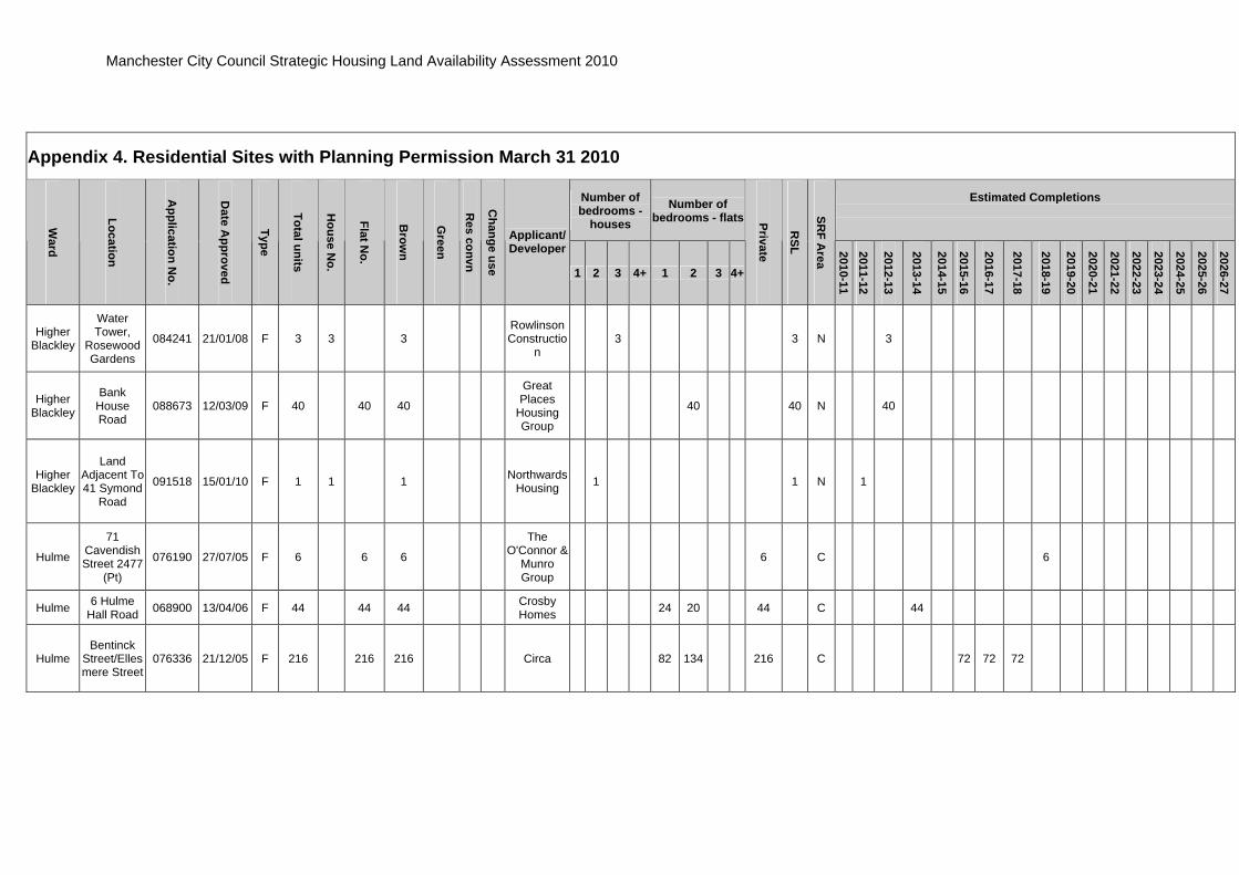
Higher Blackley
Water Tower,
Rosewood Gardens
084241 21/01/08 F 3 3 3 Rowlinson Constructio
n 3 3 N 3
Higher Blackley
Bank House Road
088673 12/03/09 F 40 40 40
Great Places
Housing Group
40 40 N 40
Higher Blackley
Land Adjacent To 41 Symond
Road
091518 15/01/10 F 1 1 1 Northwards Housing 1 1 N 1
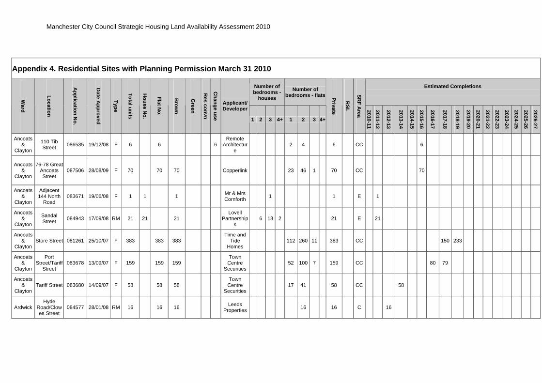
Hulme
71 Cavendish Street 2477
(Pt)
076190 27/07/05 F 6 6 6
The O'Connor &
Munro Group
6 C 6
Hulme 6 Hulme Hall Road 068900 13/04/06 F 44 44 44 Crosby
Homes 24 20 44 C 44
Hulme Bentinck
Street/Ellesmere Street
076336 21/12/05 F 216 216 216 Circa 82 134 216 C 72 72 72
Manchester City Council Strategic Housing Land Availability Assessment 2010
Appendix 4. Residential Sites with Planning Permission March 31 2010
Number of bedrooms -
houses Number of
bedrooms - flatsEstimated Completions
W
ard
Location
Application N
o.
Date A
pproved
Type
Total units
House N
o.
Flat No.
Brow
n
Green
Res convn
Change use
Applicant/ Developer
1 2 3 4+ 1 2 3 4+
Private
RSL
SRF A
rea
2010-11 2011-12
2012-13
2013-14
2014-15
2015-16
2016-17
2017-18
2018-19
2019-20
2020-21
2021-22
2022-23
2023-24
2024-25
2025-26
2026-27
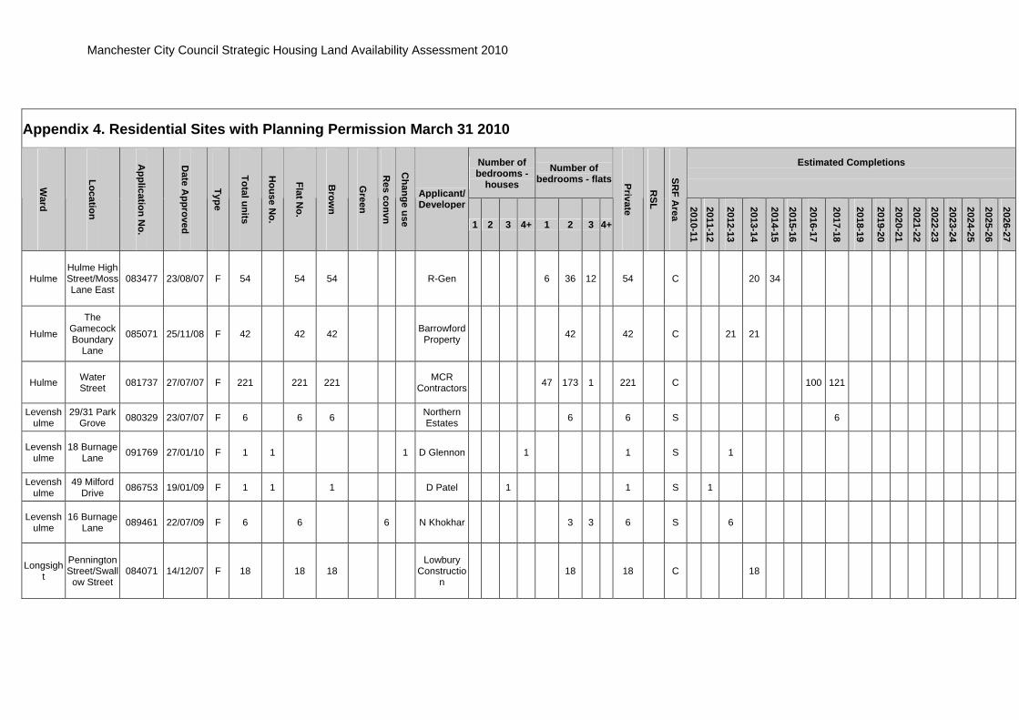
Hulme Hulme High Street/Moss Lane East
083477 23/08/07 F 54 54 54 R-Gen 6 36 12 54 C 20 34
Hulme
The Gamecock Boundary
Lane
085071 25/11/08 F 42 42 42 Barrowford Property 42 42 C 21 21
Hulme Water Street 081737 27/07/07 F 221 221 221 MCR
Contractors 47 173 1 221 C 100 121
Levenshulme
29/31 Park Grove 080329 23/07/07 F 6 6 6 Northern
Estates 6 6 S 6
Levenshulme
18 Burnage Lane 091769 27/01/10 F 1 1 1 D Glennon 1 1 S 1
Levenshulme
49 Milford Drive 086753 19/01/09 F 1 1 1 D Patel 1 1 S 1
Levenshulme
16 Burnage Lane 089461 22/07/09 F 6 6 6 N Khokhar 3 3 6 S 6
Longsight
Pennington Street/Swallow Street
084071 14/12/07 F 18 18 18 Lowbury
Construction
18 18 C 18

Manchester City Council Strategic Housing Land Availability Assessment 2010
Appendix 4. Residential Sites with Planning Permission March 31 2010
Number of bedrooms -
houses Number of
bedrooms - flatsEstimated Completions
W
ard
Location
Application N
o.
Date A
pproved
Type
Total units
House N
o.
Flat No.
Brow
n
Green
Res convn
Change use
Applicant/ Developer
1 2 3 4+ 1 2 3 4+
Private
RSL
SRF A
rea
2010-11 2011-12
2012-13
2013-14
2014-15
2015-16
2016-17
2017-18
2018-19
2019-20
2020-21
2021-22
2022-23
2023-24
2024-25
2025-26
2026-27
Longsight
12 Kedleston Avenue
082376 08/05/07 F 1 1 1 A Mohammed 1 1 C 1
Longsight
1 Stamford Road 084801 28/03/08 F 4 4 4 A Ali 4 4 C 4
Longsight
Duncan Road/Drisc
ol Street 084369 26/10/07 F 1 1 1
Manchester Methodist Housing
1 1 C 1
Longsight
Plymouth Grove 090644 18/11/09 F studen
t Land &
Development Ltd
C
Miles Platting & Newton Heath
Sawley Road 081872 20/07/07 F 17 11 6 17 Genesis
Estates 11 6 17 E 10 7
Miles Platting & Newton Heath
Adj 1328 Oldham
Road/Dulverton St
082516 10/04/08 F 110 110 110 Yes Group 27 68 15 110 E 50 60
Miles Platting & Newton Heath
Culcheth Lane 076708 03/11/05 F 32 32 32
Podium Property
Devts 32 E 32

Manchester City Council Strategic Housing Land Availability Assessment 2010
Appendix 4. Residential Sites with Planning Permission March 31 2010
Number of bedrooms -
houses Number of
bedrooms - flatsEstimated Completions
W
ard
Location
Application N
o.
Date A
pproved
Type
Total units
House N
o.
Flat No.
Brow
n
Green
Res convn
Change use
Applicant/ Developer
1 2 3 4+ 1 2 3 4+
Private
RSL
SRF A
rea
2010-11 2011-12
2012-13
2013-14
2014-15
2015-16
2016-17
2017-18
2018-19
2019-20
2020-21
2021-22
2022-23
2023-24
2024-25
2025-26
2026-27
Miles Platting & Newton Heath
Dean Lane 082213 08/02/08 F 156 78 78 156 Elite Homes 16 36 26 3 75 156 E 20 39 39 39 19
Miles Platting & Newton Heath
Adj 24 Stansfield
Street 083618 24/04/08 F 2 2 2 T Flynn 2 2 E 2
Miles Platting & Newton Heath
11 Thornton Street 081840 02/08/07 F 6 6 6 Genesis
Estates 6 6 E 6
Miles Platting & Newton Heath
New Allen Street
(excluding 080520, 084942,
084943/4)
079633 05/09/06 O 1333 785 548 1333 Lovell
Partnerships
1333 E 50 100 100 100 100 125 125 125 125 125 108 100 50
Miles Platting & Newton Heath
Miles Platting Sawley Road,
Bradford Road,
Chippenham Road
080520/084504 26/10/06 F 9 9 9
Lovell Partnership
s 9 9 E 9

Manchester City Council Strategic Housing Land Availability Assessment 2010
Appendix 4. Residential Sites with Planning Permission March 31 2010
Number of bedrooms -
houses Number of
bedrooms - flatsEstimated Completions
W
ard
Location
Application N
o.
Date A
pproved
Type
Total units
House N
o.
Flat No.
Brow
n
Green
Res convn
Change use
Applicant/ Developer
1 2 3 4+ 1 2 3 4+
Private
RSL
SRF A
rea
2010-11 2011-12
2012-13
2013-14
2014-15
2015-16
2016-17
2017-18
2018-19
2019-20
2020-21
2021-22
2022-23
2023-24
2024-25
2025-26
2026-27
Miles Platting & Newton Heath
Adj 25 Berry Brow 082201 21/08/07 F 1 1 1 A McNeill 1 1 E 1
Miles Platting & Newton Heath
Rosedale Building, Dulverton
Street
082859 14/04/08 F 114 114 114 Cityscape 35 65 14 114 E 44 70
Miles Platting & Newton Heath
Rear 50 Graver Lane
087508 04/03/09 F 1 1 1 W Ahmed 1 1 E 1
Miles Platting & Newton Heath
Adj 929 Oldham Road
081890 16/07/07 F 1 1 1 Dr Ruslan Gnativ 1 1 E 1
Miles Platting & Newton Heath
Regent Street 090492 24/08/09 O 3 3 3
Culcheth Methodist
Church 3 3 E 3
Miles Platting & Newton Heath
Landos Road 084944 04/07/08 RM 26 26 26
Lovell Partnership
s 6 18 2 26 E 26

Manchester City Council Strategic Housing Land Availability Assessment 2010
Appendix 4. Residential Sites with Planning Permission March 31 2010
Number of bedrooms -
houses Number of
bedrooms - flatsEstimated Completions
W
ard
Location
Application N
o.
Date A
pproved
Type
Total units
House N
o.
Flat No.
Brow
n
Green
Res convn
Change use
Applicant/ Developer
1 2 3 4+ 1 2 3 4+
Private
RSL
SRF A
rea
2010-11 2011-12
2012-13
2013-14
2014-15
2015-16
2016-17
2017-18
2018-19
2019-20
2020-21
2021-22
2022-23
2023-24
2024-25
2025-26
2026-27
Miles Platting & Newton Heath
2 Varley Street 089146 02/06/09
nursing
home
OPH Properties E
Moss Side
Service Station, Princess
Road
069541 22/08/05 F 38 7 31 38 Kirkland
Developments
38 C 7 31
Moss Side
Greenheys Playing Field
090824 20/10/09 F 65 45 20 65 Mosscare 6 38 1 20 65 C 20 45
Moss Side
Maine Road (residue) 076455 07/09/07 F/O 235 123 112 235 Lowry
Homes plc 87 36 86 26 235 C 50 70 50 50 15
Moss Side
Maine Road Phase 3 085090 15/02/08 RM 98 6 92 98 Lowry
Homes plc 6 27 65 98 C 20 40 38
Moss Side
64 Parkfield Avenue 082677 04/06/07 F 1 1 1
Freehold Manager
Plc 1 1 C 1
Moss Side
9-11 Carlton Avenue
083652 10/10/07 F 2 2 2 SD Inman 2 2 C 2
Manchester City Council Strategic Housing Land Availability Assessment 2010
Appendix 4. Residential Sites with Planning Permission March 31 2010
Number of bedrooms -
houses Number of
bedrooms - flatsEstimated Completions
W
ard
Location
Application N
o.
Date A
pproved
Type
Total units
House N
o.
Flat No.
Brow
n
Green
Res convn
Change use
Applicant/ Developer
1 2 3 4+ 1 2 3 4+
Private
RSL
SRF A
rea
2010-11 2011-12
2012-13
2013-14
2014-15
2015-16
2016-17
2017-18
2018-19
2019-20
2020-21
2021-22
2022-23
2023-24
2024-25
2025-26
2026-27
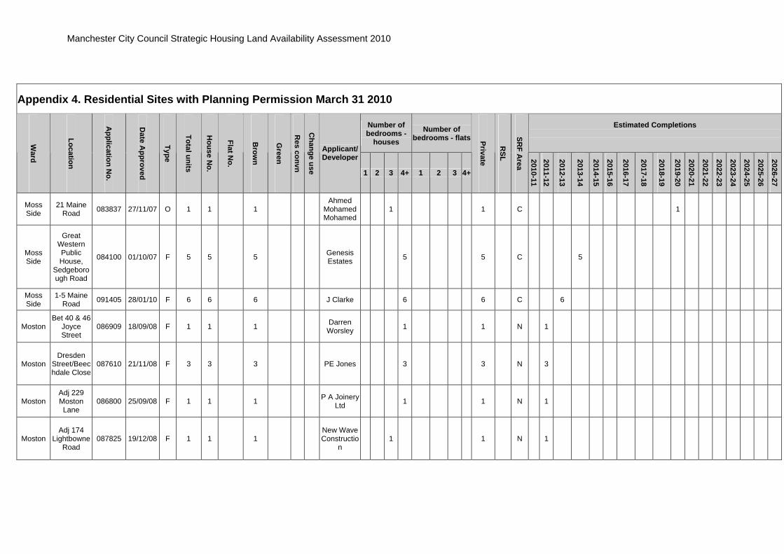
Moss Side
21 Maine Road 083837 27/11/07 O 1 1 1
Ahmed Mohamed Mohamed
1 1 C 1
Moss Side
Great Western Public House,
Sedgeborough Road
084100 01/10/07 F 5 5 5 Genesis Estates 5 5 C 5
Moss Side
1-5 Maine Road 091405 28/01/10 F 6 6 6 J Clarke 6 6 C 6
Moston Bet 40 & 46
Joyce Street
086909 18/09/08 F 1 1 1 Darren Worsley 1 1 N 1
Moston Dresden
Street/Beechdale Close
087610 21/11/08 F 3 3 3 PE Jones 3 3 N 3
Moston Adj 229 Moston Lane
086800 25/09/08 F 1 1 1 P A Joinery Ltd 1 1 N 1
Moston Adj 174
Lightbowne Road
087825 19/12/08 F 1 1 1 New Wave Constructio
n 1 1 N 1

Manchester City Council Strategic Housing Land Availability Assessment 2010
Appendix 4. Residential Sites with Planning Permission March 31 2010
Number of bedrooms -
houses Number of
bedrooms - flatsEstimated Completions
W
ard
Location
Application N
o.
Date A
pproved
Type
Total units
House N
o.
Flat No.
Brow
n
Green
Res convn
Change use
Applicant/ Developer
1 2 3 4+ 1 2 3 4+
Private
RSL
SRF A
rea
2010-11 2011-12
2012-13
2013-14
2014-15
2015-16
2016-17
2017-18
2018-19
2019-20
2020-21
2021-22
2022-23
2023-24
2024-25
2025-26
2026-27
Moston Adj 60
Williams Road
090614 18/12/09 1 1 1 K Gardener 1 1 N 1
Moston 62 Williams Road 085084 19/05/08 F 1 1 1
K Gardner & Nick Lowe
1 1 N 1
Northenden
Palatine Road/Churc
h Road 074034 28/04/05 F 14 14 14 D Fisk & M
Rawlings 14 Wy 14
Northenden
Palatine Road/Churc
h Road 074033 20/10/05 F 14 14 14 NAC Devts 14 Wy 14
Northenden
Church Inn Church Road
081467 23/10/07 F 18 4 14 4 14Arrows
International
4 2 11 1 18 Wy 18
Northenden
Between 28 & 30
Allanson Road
083629 27/02/08 F 1 1 1 Peter
Hunter & Sons
1 1 Wy 1
Northenden Moat Road 083073 28/06/07 F 4 4 4 Willow Park
Trust 4 4 Wy 4
Northenden
The Boat House,
Boat Lane 085343 09/09/08 F 3 3 3 A Shahid 3 3 Wy 3

Manchester City Council Strategic Housing Land Availability Assessment 2010
Appendix 4. Residential Sites with Planning Permission March 31 2010
Number of bedrooms -
houses Number of
bedrooms - flatsEstimated Completions
W
ard
Location
Application N
o.
Date A
pproved
Type
Total units
House N
o.
Flat No.
Brow
n
Green
Res convn
Change use
Applicant/ Developer
1 2 3 4+ 1 2 3 4+
Private
RSL
SRF A
rea
2010-11 2011-12
2012-13
2013-14
2014-15
2015-16
2016-17
2017-18
2018-19
2019-20
2020-21
2021-22
2022-23
2023-24
2024-25
2025-26
2026-27
Northenden Boat Lane 085274 06/02/08 F 1 1 1 Irish Anglo
Properties 1 1 Wy 1
Old Moat 396
Wilmslow Road
084697 19/02/08 O 28 28 28 Otybo Ltd 26 2 28 S 14 14
Old Moat 51 Burton Road 078271 12/09/07 F 4 4 4 FM
Properties 4 4 S 4
Old Moat 7A Colgate Crescent 085898 24/12/08 F 1 1 1 R L'Anson 1 1 S 1
Old Moat Fallowfield Tennis Club 092091 03/03/10 RM 9 9 9
Fallowfield Bowls and
Lawn Tennis Club
1 8 9 S 4 5
Old Moat 32
Mauldeth Road
084484 01/12/08 F 1 1 1 N Carr 1 1 S 1
Rusholme
6-8 Conyngham
Road 081739 26/07/07 F 9 9 9
Harvey Property
Investments
3 6 9 C 9
Rusholme
Langdale Hall, Upper Park Road
073960 17/10/05 F 46 46 31 15 Classic Homes 46 C 23 23

Manchester City Council Strategic Housing Land Availability Assessment 2010
Appendix 4. Residential Sites with Planning Permission March 31 2010
Number of bedrooms -
houses Number of
bedrooms - flatsEstimated Completions
W
ard
Location
Application N
o.
Date A
pproved
Type
Total units
House N
o.
Flat No.
Brow
n
Green
Res convn
Change use
Applicant/ Developer
1 2 3 4+ 1 2 3 4+
Private
RSL
SRF A
rea
2010-11 2011-12
2012-13
2013-14
2014-15
2015-16
2016-17
2017-18
2018-19
2019-20
2020-21
2021-22
2022-23
2023-24
2024-25
2025-26
2026-27
Rusholme
Greygarth, 1 Lower
Park Road 084064 23/11/07 F studen
t Greygarth Association C
Rusholme
Aldwych Avenue 081843 08/08/07 O 6 6 6
Feltham Manageme
nt 6 6 C 6
Rusholme
Adjacent 508
Claremont Road
088231 15/01/09 F 1 1 1 H Karami 1 1 C 1
Rusholme
Copthorne Cres 091523 30/03/10 F 1 1 1 A Ahad 1 1 C 1
Rusholme
Victory Street 091446 30/11/09 F 6 6 6 F Sayed 1 5 6 C 6
Rusholme
23 Dennison Road/7
Conyngham Road
087418 15/10/08 F 6 6 6 Property Route 6 6 C 6
Sharston 1
Crossacres Road
078880 25/06/07 O 10 10 10 Together Trust 10 10 WY 10

Manchester City Council Strategic Housing Land Availability Assessment 2010
Appendix 4. Residential Sites with Planning Permission March 31 2010
Number of bedrooms -
houses Number of
bedrooms - flatsEstimated Completions
W
ard
Location
Application N
o.
Date A
pproved
Type
Total units
House N
o.
Flat No.
Brow
n
Green
Res convn
Change use
Applicant/ Developer
1 2 3 4+ 1 2 3 4+
Private
RSL
SRF A
rea
2010-11 2011-12
2012-13
2013-14
2014-15
2015-16
2016-17
2017-18
2018-19
2019-20
2020-21
2021-22
2022-23
2023-24
2024-25
2025-26
2026-27
Sharston Oxton Avenue 084718 18/09/08 F 4 4 4
Willow Park Housing
Trust 4 4 Wy 4
Sharston Stancliffe Road 080838 07/06/07 F
27 extra beds
to nursin
g home
BUPA
Careservices
WY
Whalley Range
28-30 Wellington
Road 091071 18/01/10 F 5 5 5 Seddon
Homes 5 5 S 5
Whalley Range
10/12 Alexandra
Road South 075035 13/12/05 F 12 12 12 Mr Munif 3 9 12 S 12
Whalley Range
Clarendon Road 086430 10/06/08 F 2 2 2 Mosscare 2 2 S 2
Whalley Range
52 College Road 082057 09/12/08 F 20 20 20
Range Warehouse
s 20 20 S 20
Whalley Range
Between 40 and 50
Grosvenor Road
086221 11/11/08 F 2 2 2 Beckhall Ltd 2 2 S 2

Manchester City Council Strategic Housing Land Availability Assessment 2010
Appendix 4. Residential Sites with Planning Permission March 31 2010
Number of bedrooms -
houses Number of
bedrooms - flatsEstimated Completions
W
ard
Location
Application N
o.
Date A
pproved
Type
Total units
House N
o.
Flat No.
Brow
n
Green
Res convn
Change use
Applicant/ Developer
1 2 3 4+ 1 2 3 4+
Private
RSL
SRF A
rea
2010-11 2011-12
2012-13
2013-14
2014-15
2015-16
2016-17
2017-18
2018-19
2019-20
2020-21
2021-22
2022-23
2023-24
2024-25
2025-26
2026-27
Whalley Range
Ellesmere Road 086354 12/06/09 F 14 14 14
South West Manchester
Cricket Club
14 14 S 2 12
Whalley Range
Adj 11 Burford Drive
092160 10/03/10 F 1 1 1 G Shiels 1 1 S 1
Whalley Range
136 Egerton
Road North 090315 03/11/09 F 4 4 4 Centurion
Properties 2 2 4 S 4
Whalley Range
1 Lynwood Avenue 089895 27/07/09 F 1 1 1 A Shabbir 1 1 S 1
Withington
403-409 Wilmslow
Road 086439 29/07/09 F 10 10 10 G Malkie 10 10 S 10
Withington
5 Derby Road 072922 06/05/05 F 7 7 7 MSW
Partnership 7 7 S 7
Withington
489 Wilmslow
Road 083260 30/07/07 F 8 8 8 D Payne 7 1 8 S 8

Manchester City Council Strategic Housing Land Availability Assessment 2010
Appendix 4. Residential Sites with Planning Permission March 31 2010
Number of bedrooms -
houses Number of
bedrooms - flatsEstimated Completions
W
ard
Location
Application N
o.
Date A
pproved
Type
Total units
House N
o.
Flat No.
Brow
n
Green
Res convn
Change use
Applicant/ Developer
1 2 3 4+ 1 2 3 4+
Private
RSL
SRF A
rea
2010-11 2011-12
2012-13
2013-14
2014-15
2015-16
2016-17
2017-18
2018-19
2019-20
2020-21
2021-22
2022-23
2023-24
2024-25
2025-26
2026-27
Withington
1A Parsonage
Road 087907 16/12/08 F 1 1 1 D Gilbert
Butler 1 1 S 1
Woodhouse Park
40 Trenchard
Drive 089230 04/02/10 F 6 6 6 Genesis
100 Ltd 6 6 Wy 6
Woodhouse Park
Greenwood Road/Gladeside Road
083189 28/09/07 F 32 32 32 Water Avenue Ltd 18 14 32 Wy 16 16
Woodhouse Park
Oatlands Road 089986 18/12/09 O 26 20 6 26
IEM Developme
nts 6 14 6 26 Wy 10 16
Woodhouse Park
Portway/Painswick Road
090189 24/02/10 F 88 44 44 88 Willow Park 43 1 44 88 Wy 44 44
Woodhouse Park
Braintree Road 091803 03/02/10 F 6 6 6 Willow Park 6 6 Wy 6
Totals
15121
2632
11379
14247
572
115
187
17 272
633
457
2058
3967
298 2
14629
492
66 655
1071
1325
846
694
1313
1609
1091
712
839
975
983
944
850
600
548

Manchester City Council Strategic Housing Land Availability Assessment 2010
Appendix 5 . Additional Sites March 31 2010
Site Reference Address
SRF A
rea
Site Area (H
a)
Density/H
a
Units
Ow
nership
Environmental R
isk
Open Space A
udit
Timescale Years
2010/11
2011/12
2012/13
2013/14
2014/15
2015/16
2016/17
2017/18
2018/19
2019/20
2020/21
2021/22
2022/23
2023/24
2024/25
2025/26
2026/27
Anco_Cap_015 Tartan Street/Bank Street E 1.52 25 38
CC (CPO) M Y
10 0 0 0 0 0 0 38 0 0 0 0 0 0 0 0 0 0 Anco_Cap_028 Iron Street E 1.27 35 45 CC? M/L Y 5 0 0 0 0 0 0 0 0 0 0 0 0 0 45 0 0 0
Anco_Cap_030 Naval Street/Jersey Street E 0.69 111 76
PR VH N 5 0 0 0 0 0 0 0 0 0 0 0 0 0 0 0 0 76
Anco_Cap_034 Blossom Street E 0.63 214 135 N 10 0 0 0 0 35 50 50 0 0 0 0 0 0 0 0 0 0 Anco_Cap_036 Corporation Street N 0.13 98 13 PR M N 5 0 0 0 0 0 0 0 0 0 13 0 0 0 0 0 0 0 Anco_Cap_037 Peary Street N 0.56 425 239 N 5 0 0 0 0 0 0 0 0 0 0 0 50 75 74 40 0 0 Anco_Cap_039 Canberra Street E 0.28 50 14 CC M N 5 0 0 0 0 7 7 0 0 0 0 0 0 0 0 0 0 0
Anco_Cap_043 Murrays Mill, Redhill Street E 0.49 230 112 N 10 0 0 0 0 0 0 0 0 0 0 0 0 0 56 56 0 0
Anco_Cap_045 Harriett Street E 0.22 107 24 H N 5 0 0 0 0 0 12 12 0 0 0 0 0 0 0 0 0 0
Anco_Cap_049 162-208 Oldham Road E 0.40 110 44 M/L N
5 0 0 0 0 0 0 0 0 0 0 0 0 0 0 0 44 0
Anco_Cap_051
Poland Street/Naval Street/George Leigh Street E 0.39 110 43
Leased from Council
VH N 5 0 0 0 0 0 0 0 0 0 0 0 0 0 0 0 43 0
Anco_Cap_052 Bank Street/Fairclough Street E 0.39 49 19
CC/PR H N 5 0 0 0 0 0 9 10 0 0 0 0 0 0 0 0 0 0

Manchester City Council Strategic Housing Land Availability Assessment 2010
Appendix 5 . Additional Sites March 31 2010
Site Reference Address
SRF A
rea
Site Area (H
a)
Density/H
a
Units
Ow
nership
Environmental R
isk
Open Space A
udit
Timescale Years
2010/11
2011/12
2012/13
2013/14
2014/15
2015/16
2016/17
2017/18
2018/19
2019/20
2020/21
2021/22
2022/23
2023/24
2024/25
2025/26
2026/27
Anco_Cap_055 Seymour Road South E 0.18 83 15CC/PR M/L N
5 0 0 0 0 0 0 0 0 0 0 15 0 0 0 0 0 0 Anco_Cap_056 Blossom Street E 0.35 552 194 N 10 0 0 0 0 0 0 0 0 0 0 0 97 97 0 0 0 0 Anco_Cap_059 Hamnett Street E 0.19 52 10 PR M/L N 5 0 0 0 0 0 0 0 0 5 5 0 0 0 0 0 0 0 Anco_Cap_060 Gould Street N 0.25 96 24 PR/CC M N 5 0 0 0 0 0 0 0 0 0 12 12 0 0 0 0 0 0
Anco_Cap_070 Jersey Street/Poland Street E 0.29 111 32
PR/CC H N 5 0 0 0 0 0 0 32 0 0 0 0 0 0 0 0 0 0
Anco_Cap_076 66 Jersey Street E 0.38 263 100 PR H N 5 0 0 0 0 0 0 0 0 0 0 0 0 0 50 50 0 0 Anco_Cap_078 Rochdale Road N 0.25 232 57 PR M N 5 0 0 0 0 0 0 0 0 25 32 0 0 0 0 0 0 0
Anco_Cap_079 Rochdale Road/Swan Street N 0.24 45 11
PR/CC M N 5 0 0 0 0 0 0 0 0 0 11 0 0 0 0 0 0 0
Anco_Cap_082 Naples Street/Ludgate Hill N 0.22 96 21
PR M N 5 0 0 0 0 0 0 0 0 21 0 0 0 0 0 0 0 0
Anco_Cap_083 Bromley Street/Burstock Street N 0.22 101 22
PR/CC N 5 0 0 0 0 0 0 0 0 22 0 0 0 0 0 0 0 0
Anco_Cap_087 Cable Street N 0.21 110 23 PR/CC M N 5 0 0 0 0 0 0 0 0 0 23 0 0 0 0 0 0 0 Anco_Cap_088 Bendix Street N 0.21 72 15 PR M N 5 0 0 0 0 0 0 0 0 0 0 15 0 0 0 0 0 0
Anco_Cap_090 Jersey Street/Bengal Street/ E 0.20 110 22
NWDA? H N 5 0 0 0 0 0 0 0 0 22 0 0 0 0 0 0 0 0
Anco_Cap_091 Henry Street/11-13 Blossom Street E 0.19 98 19
PR H N 5 0 0 0 0 0 0 0 0 0 19 0 0 0 0 0 0 0

Manchester City Council Strategic Housing Land Availability Assessment 2010
Appendix 5 . Additional Sites March 31 2010
Site Reference Address
SRF A
rea
Site Area (H
a)
Density/H
a
Units
Ow
nership
Environmental R
isk
Open Space A
udit
Timescale Years
2010/11
2011/12
2012/13
2013/14
2014/15
2015/16
2016/17
2017/18
2018/19
2019/20
2020/21
2021/22
2022/23
2023/24
2024/25
2025/26
2026/27
Anco_Cap_099 Ashton New Road E 0.16 62 10 CC? L Y 5 0 0 0 0 0 0 0 0 10 0 0 0 0 0 0 0 0 Anco_Cap_102 Bristowe Street E 0.16 38 6 PR M N 5 0 0 0 0 0 0 0 0 0 0 6 0 0 0 0 0 0
Anco_Cap_104 Blossom Street/Hood Street E 0.04 186 8
NWDA? H N 5 0 0 0 0 0 0 0 0 8 0 0 0 0 0 0 0 0
Anco_Cap_107 Silk Street/Cinder Street E 0.05 264 14
PR M/L N 5 0 0 0 0 0 0 0 0 14 0 0 0 0 0 0 0 0
Anco_Cap_109 Silk Street E 0.14 112 16 PR/CC M N 5 0 0 0 0 0 0 0 0 0 0 16 0 0 0 0 0 0
Anco_Cap_111 Aspin Lane/Mincing Street N 0.14 72 10
PR L N 5 0 0 0 0 0 0 0 0 10 0 0 0 0 0 0 0 0
Anco_Cap_115 George Leigh Street/Silk Street E 0.15 100 15
PR M N 5 0 0 0 0 0 0 0 0 15 0 0 0 0 0 0 0 0
Anco_Cap_116 Silk Street/Poland Street E 0.14 110 15
CC/PR M N 6 0 0 0 0 0 0 0 0 15 0 0 0 0 0 0 0 0
Anco_Cap_118 154-168 Corporation Street N 0.13 76 10
PR M N 5 0 0 0 0 0 0 0 0 0 0 10 0 0 0 0 0 0
Anco_Cap_119 Hall adjacent 132 Seymour Road South E 0.13 46 6
Leased from Council
M N 5 0 0 0 0 0 0 0 0 0 0 0 0 0 0 0 0 6
Anco_Cap_120 Kingsheath Close E 0.27 37 10 CC M Y 5 0 0 0 0 0 0 0 0 0 10 0 0 0 0 0 0 0
Anco_Cap_123 Oswald Street/Beswick Row N 0.13 71 9
PR M N 5 0 0 0 0 0 0 0 0 0 0 9 0 0 0 0 0 0
Anco_Cap_124 Rochdale Road N 0.12 88 11 PR M/L N 5 0 0 0 0 0 0 0 0 0 0 0 0 0 0 0 0 11 Anco_Cap_125 Marshall Street N 0.12 88 11 PR M N 5 0 0 0 0 0 0 0 0 0 11 0 0 0 0 0 0 0

Manchester City Council Strategic Housing Land Availability Assessment 2010
Appendix 5 . Additional Sites March 31 2010
Site Reference Address
SRF A
rea
Site Area (H
a)
Density/H
a
Units
Ow
nership
Environmental R
isk
Open Space A
udit
Timescale Years
2010/11
2011/12
2012/13
2013/14
2014/15
2015/16
2016/17
2017/18
2018/19
2019/20
2020/21
2021/22
2022/23
2023/24
2024/25
2025/26
2026/27
Anco_Cap_127 Goulden Street N 0.12 244 30 PR M N 5 0 0 0 0 0 0 0 0 0 30 0 0 0 0 0 0 0 Anco_Cap_128 Coatbridge Street E 0.12 57 7 PR M N 5 0 0 0 0 0 0 0 0 7 0 0 0 0 0 0 0 0
Anco_Cap_130 Addington Street N 0.12 82 10
Leased from Council
M/L N 5 0 0 0 0 0 0 0 0 0 10 0 0 0 0 0 0 0
Anco_Cap_132
Coatbridge Street/Ashton New Road E 0.12 50 6
PR M N 5 0 0 0 0 0 0 0 0 0 0 0 0 0 0 0 0 6
Anco_Cap_133 Mason St/ Cable St N 0.12 417 50 PR N 10 0 0 0 0 0 0 0 0 25 25 0 0 0 0 0 0 0
Anco_Cap_135 40 George Leigh Street E 0.06 202 13
PR M/L N 5 0 0 0 0 0 0 0 0 0 0 13 0 0 0 0 0 0
Anco_Cap_137 Marshall Street N 0.04 571 20 PR M N 5 0 0 0 0 0 0 0 0 0 20 0 0 0 0 0 0 0 Anco_Cap_139 Cable Street N 0.11 107 12 PR M N 5 0 0 0 0 0 0 0 0 0 0 12 0 0 0 0 0 0
Anco_Cap_140 Cinder Street/Silk Street E 0.11 108 12
PR M N 5 0 0 0 0 0 0 0 0 12 0 0 0 0 0 0 0 0
Anco_Cap_141 Silk Street/George Leigh Street E 0.11 110 12
PR VH N 5 0 0 0 0 0 0 0 0 0 0 12 0 0 0 0 0 0
Anco_Cap_144 28 Mason Street N 0.11 75 8
Leased from Council
M N 5 0 0 0 0 0 0 0 0 0 0 0 0 0 0 0 0 8
Anco_Cap_145 Dantzic Street/Little Nelson Street (S) N 0.11 66 7
PR M/L N 5 0 0 0 0 0 0 0 7 0 0 0 0 0 0 0 0 0

Manchester City Council Strategic Housing Land Availability Assessment 2010
Appendix 5 . Additional Sites March 31 2010
Site Reference Address
SRF A
rea
Site Area (H
a)
Density/H
a
Units
Ow
nership
Environmental R
isk
Open Space A
udit
Timescale Years
2010/11
2011/12
2012/13
2013/14
2014/15
2015/16
2016/17
2017/18
2018/19
2019/20
2020/21
2021/22
2022/23
2023/24
2024/25
2025/26
2026/27
Anco_Cap_147 Bendix Street N 0.11 76 8
Leased from Council
M N 5 0 0 0 0 0 0 0 0 8 0 0 0 0 0 0 0 0
Anco_Cap_152 Jactin House E 0.10 110 11 NWDA? H N 5 0 0 0 0 0 0 0 0 11 0 0 0 0 0 0 0 0 Anco_Cap_154 Vale Street E 0.10 62 6 PR M N 5 0 0 0 0 0 0 0 0 6 0 0 0 0 0 0 0 0
Anco_Cap_175 Bendix Street N 0.08 39 3
Leased from Council
M/L N 5 0 0 0 0 0 0 0 0 3 0 0 0 0 0 0 0 0
Anco_Cap_177 32-34 George Leigh Street E 0.08 105 8
PR M/L N 5 0 0 0 0 0 0 0 0 8 0 0 0 0 0 0 0 0
Anco_Cap_182
Addington Street/Oldham Road/Cable Street N 0.07 95 7
PR M/L N 5 0 0 0 0 0 0 0 7 0 0 0 0 0 0 0 0 0
Anco_Cap_194 Ludgate Street/Rochdale Road N 0.06 141 9
Leased from Council
M/L N 5 0 0 0 0 0 0 0 9 0 0 0 0 0 0 0 0 0
Anco_Cap_198 Goulden Street/Cross Keys St (NW) N 0.06 50 3
Leased from Council
M/L N 5 0 0 0 0 0 0 0 0 0 3 0 0 0 0 0 0 0
Anco_Cap_200
Gun Street/Jersey Street/Great Ancoats Street E 0.05 127 6
NWDA? L N 5 0 0 0 0 0 0 0 0 6 0 0 0 0 0 0 0 0
Anco_Cap_202 16 Blossom Street E 0.06 102 6 PR M/L N 5 0 0 0 0 0 0 0 6 0 0 0 0 0 0 0 0 0

Manchester City Council Strategic Housing Land Availability Assessment 2010
Appendix 5 . Additional Sites March 31 2010
Site Reference Address
SRF A
rea
Site Area (H
a)
Density/H
a
Units
Ow
nership
Environmental R
isk
Open Space A
udit
Timescale Years
2010/11
2011/12
2012/13
2013/14
2014/15
2015/16
2016/17
2017/18
2018/19
2019/20
2020/21
2021/22
2022/23
2023/24
2024/25
2025/26
2026/27
Anco_Cap_208 13-17 Rochdale Road N 0.13 339 43 PR 10 0 0 0 43 0 0 0 0 0 0 0 0 0 0 0 0 0 Anco_Cap_211 Crown Lane N 0.06 36 2 PR M/L N 5 0 0 0 0 0 0 0 0 0 0 2 0 0 0 0 0 0
Anco_Cap_317
Folkestone Road/Folkestone Road East E 0.08 49 4
CC? L N 5 0 0 0 0 0 0 0 0 0 4 0 0 0 0 0 0 0
Anco_Cap_318 Clayton Road E 0.10 52 5 CC? M Y 5 0 0 0 0 0 0 0 5 0 0 0 0 0 0 0 0 0 Anco_Cap_319 Ladylands Avenue E 0.10 50 5 CC? VL Y 5 0 0 0 0 0 0 0 5 0 0 0 0 0 0 0 0 0
Anco_Cap_320 Crown & Poland St Industrial Estates E 0.70 110 77
CC/PR H N 5 0 0 0 0 0 0 0 0 0 0 0 0 0 0 30 47 0
Anco_Cap_321 Marshall Street N 0.08 376 29 PR M/L N 5 0 0 0 0 0 0 0 0 29 0 0 0 0 0 0 0 0 Anco_Cap_324 School Street N 0.02 649 14 PR M N 5 0 0 0 0 0 0 0 0 14 0 0 0 0 0 0 0 0 Anco_Cap_325 Powell Street E 0.01 68 1 PR N 5 0 0 0 1 0 0 0 0 0 0 0 0 0 0 0 0 0 Anco_Cap_326 12-20 Cotton Street E 0.03 499 16 PR M N 5 0 0 0 0 0 0 0 0 16 0 0 0 0 0 0 0 0 Anco_Cap_327 32-40 Oldham Road E 0.05 492 24 PR N 5 0 0 0 0 0 0 0 0 24 0 0 0 0 0 0 0 0
Anco_Cap_328 51 Great Ancoats St - Ancoats E 0.04 197 8
PR N 5 0 0 0 0 0 0 0 0 8 0 0 0 0 0 0 0 0
Anco_Cap_329 Bengal House, Bengal Street E 0.15 895 135 N 5 0 0 0 0 0 0 50 85 0 0 0 0 0 0 0 0 0
Anco_Cap_330 Addington Street N 0.14 382 53 N 5 0 0 0 53 0 0 0 0 0 0 0 0 0 0 0 0 0
Anco_Cap_331
Port Street/Houldsworth Street CC 0.06 400 25 N 5 0 0 0 0 0 0 0 0 0 25 0 0 0 0 0 0 0

Manchester City Council Strategic Housing Land Availability Assessment 2010
Appendix 5 . Additional Sites March 31 2010
Site Reference Address
SRF A
rea
Site Area (H
a)
Density/H
a
Units
Ow
nership
Environmental R
isk
Open Space A
udit
Timescale Years
2010/11
2011/12
2012/13
2013/14
2014/15
2015/16
2016/17
2017/18
2018/19
2019/20
2020/21
2021/22
2022/23
2023/24
2024/25
2025/26
2026/27
Anco_Cap_332 4 Angel Street N 0.06 793 46 PR N 5 0 0 0 46 0 0 0 0 0 0 0 0 0 0 0 0 0
Anco_Cap_333 Plots J&K Union Street, New Islington E 0.60 332 200 N 5 0 0 0 0 0 0 50 50 50 50 0 0 0 0 0 0 0
Anco_Cap_334 Mason Street/Cable Street N 0.10 439 46 N 10 0 0 0 46 0 0 0 0 0 0 0 0 0 0 0 0 0
Anco_Cap_335 45 Goulden Street N 0.11 480 54 N 10 0 0 0 54 0 0 0 0 0 0 0 0 0 0 0 0 0
Ardw_Cap_036 Stockport Road/Grindlow Street C 0.66 36 24 PR/CC
M/L Pt 5 0 0 0 0 0 0 0 0 0 12 12 0 0 0 0 0 0
Ardw_Cap_053 Plymouth Grove C 0.35 65 23 PR/CC M N 5 0 0 0 0 0 0 0 0 0 0 0 0 23 0 0 0 0
Ardw_Cap_067
Plymouth Avenue/Plymouth Grove C 0.21 38 8
CC L Y 5 0 0 0 0 0 0 0 0 0 8 0 0 0 0 0 0 0
Ardw_Cap_068 Kale Street C 0.20 55 11 CC L N 5 0 0 0 0 0 0 0 0 0 11 0 0 0 0 0 0 0
Ardw_Cap_069 21 Plymouth Grove C 0.18 49 9CC M/L N
5 0 0 0 0 0 0 0 0 0 0 9 0 0 0 0 0 0 Ardw_Cap_076 Grindlow Street C 0.14 36 5 CC L Y 5 0 0 0 0 0 0 0 0 0 0 5 0 0 0 0 0 0
Ardw_Cap_093 Downing Street/Manor Street C 0.05 396 20
PR L N 5 0 0 0 0 0 0 0 0 0 0 20 0 0 0 0 0 0
Ardw_Cap_100 Islamic Academy Upper Brook Street C 0.14 14 2
CC M/L N 5 0 0 2 0 0 0 0 0 0 0 0 0 0 0 0 0 0

Manchester City Council Strategic Housing Land Availability Assessment 2010
Appendix 5 . Additional Sites March 31 2010
Site Reference Address
SRF A
rea
Site Area (H
a)
Density/H
a
Units
Ow
nership
Environmental R
isk
Open Space A
udit
Timescale Years
2010/11
2011/12
2012/13
2013/14
2014/15
2015/16
2016/17
2017/18
2018/19
2019/20
2020/21
2021/22
2022/23
2023/24
2024/25
2025/26
2026/27
Ardw_Cap_101 UU Offices, Hathersage Road C 1.24 141 175
UU N 5 0 0 0 0 0 50 50 75 0 0 0 0 0 0 0 0 0
Ardw_Cap_102 Hostel Site, Downing Street C 0.26 94 24
CC M/L N 5 0 0 0 0 0 0 0 0 0 12 12 0 0 0 0 0 0
Ardw_Cap_103 West Gorton C 55.89 20 1100 CC VH Pt 5 0 50 50 100 100 100 100 100 100 100 100 100 100 0 0 0 0
Ardw_Cap_104 Brunswick Growth Point Site C 27.37 13 350
CC H Pt 5 0 0 0 0 65 92 63 67 63 0 0 0 0 0 0 0 0
Ardw_Cap_105 Portland Crescent C 0.11 75 8 PR L N 5 0 0 0 0 0 0 0 8 0 0 0 0 0 0 0 0 0 Ardw_Cap_106 Chancellors Place C 16.53 112 1852 PR VH Pt 5 0 0 0 0 0 100 100 150 150 150 150 150 150 150 200 200 202
Ardw_Cap_107
Coverdale Crescent/New Bank Street C 9.25 22 200
CC/PR H Pt 5 0 0 0 0 50 75 75 0 0 0 0 0 0 0 0 0 0
Ardw_Cap_108
Coverdale Crescent/New Bank Street C 8.64 23 200
CC/PR M Pt 5 0 0 0 0 50 75 75 0 0 0 0 0 0 0 0 0 0
Ardw_Cap_109 Cakebread Street C 0.11 224 25 PR M N 5 0 0 0 0 0 0 0 0 0 10 15 0 0 0 0 0 0
Ardw_Cap_111 Devonshire Street/Stockport Road C 0.82 121 100
PR Y 5 0 0 0 50 50 0 0 0 0 0 0 0 0 0 0 0 0
Ardw_Cap_112 60 Hathersage Road C 0.03 36 1 PR M/L N 5 0 0 0 0 0 0 0 0 0 1 0 0 0 0 0 0 0
Ardw_Cap_113
Plymouth Grove/Lauderdale Cres (part) C 0.51 183 94 PR N 5 0 0 44 50 0 0 0 0 0 0 0 0 0 0 0 0 0

Manchester City Council Strategic Housing Land Availability Assessment 2010
Appendix 5 . Additional Sites March 31 2010
Site Reference Address
SRF A
rea
Site Area (H
a)
Density/H
a
Units
Ow
nership
Environmental R
isk
Open Space A
udit
Timescale Years
2010/11
2011/12
2012/13
2013/14
2014/15
2015/16
2016/17
2017/18
2018/19
2019/20
2020/21
2021/22
2022/23
2023/24
2024/25
2025/26
2026/27
Ardw_Cap_114 42 Grafton Street C 0.02 230 4 N 5 0 0 0 4 0 0 0 0 0 0 0 0 0 0 0 0 0 Ardw_Cap_115 65 Plymouth Grove C 0.13 76 10 PR N 5 0 0 0 0 10 0 0 0 0 0 0 0 0 0 0 0 0 Ardw_Cap_116 Kirkstall Square C 0.98 35 34 PR N 5 0 0 34 0 0 0 0 0 0 0 0 0 0 0 0 0 0 Bagu_Cap_005 Clay Lane W 0.78 24 19 CC M N 5 0 0 0 0 19 0 0 0 0 0 0 0 0 0 0 0 0 Bagu_Cap_007 Greenbrow Road W 0.40 98 39 CC VL N 5 0 0 0 0 19 20 0 0 0 0 0 0 0 0 0 0 0 Bagu_Cap_009 Club, Hall Lane W 0.33 27 9 CC/PR VL N 5 0 0 0 0 0 0 0 0 0 0 0 0 0 0 0 0 9
Bagu_Cap_010 Altrincham Road W 0.32 37 12
Leased from Council
VL N 5 0 0 0 0 0 0 0 0 0 12 0 0 0 0 0 0 0
Bagu_Cap_013 Pub, Scout Drive/Newall Road W 0.26 34 9
Leased from Council
VL N 5 0 0 0 0 0 0 0 0 0 0 9 0 0 0 0 0 0
Bagu_Cap_015 Petrol Station, Altrincham Road W 0.23 52 12
Leased from Council
H N 5 0 0 0 0 0 0 0 0 0 0 0 12 0 0 0 0 0
Bagu_Cap_016 Club, Deptford Avenue/ Greenbrow W 0.22 50 11
Leased from Council
L N 5 0 0 0 0 0 0 0 0 0 0 0 0 0 11 0 0 0
Bagu_Cap_017 Leaton Avenue W 0.21 28 6 CC VL N 5 0 0 0 0 0 0 0 6 0 0 0 0 0 0 0 0 0
Bagu_Cap_018 Adjacent to Church Floatshall Road W 0.08 24 2
RSL VL N 5 0 0 0 0 0 0 0 0 0 2 0 0 0 0 0 0 0
Bagu_Cap_019 Blackcarr Road W 0.17 24 4 RSL L N 5 0 0 0 0 0 0 0 0 0 0 4 0 0 0 0 0 0

Manchester City Council Strategic Housing Land Availability Assessment 2010
Appendix 5 . Additional Sites March 31 2010
Site Reference Address
SRF A
rea
Site Area (H
a)
Density/H
a
Units
Ow
nership
Environmental R
isk
Open Space A
udit
Timescale Years
2010/11
2011/12
2012/13
2013/14
2014/15
2015/16
2016/17
2017/18
2018/19
2019/20
2020/21
2021/22
2022/23
2023/24
2024/25
2025/26
2026/27
Bagu_Cap_021 Pub, Firbank Road/Greenbrow Road W 0.13 30 4
Leased from Council
M N 5 0 0 0 0 0 0 0 0 0 0 4 0 0 0 0 0 0
Bagu_Cap_022 Adj 303 Greenbrow Road W 0.58 19 11
PR M/L N 5 0 0 0 0 11 0 0 0 0 0 0 0 0 0 0 0 0
Bagu_Cap_023 Scout Drive W 0.38 27 10 CC VL N 5 0 0 0 0 0 0 10 0 0 0 0 0 0 0 0 0 0
Bagu_Cap_024 Newall Green Farm, Barnacre Avenue W 0.60 42 25
PR L N 5 0 0 0 0 10 10 5 0 0 0 0 0 0 0 0 0 0
Bagu_Cap_025 Rear of Hallwood Road W 1.20 33 40
RSL VL Y 5 0 0 0 0 0 0 0 0 0 0 0 0 0 0 0 40 0
Bagu_Cap_026 Hall Road/Nearcroft Road W 0.65 18 12
CC/RSL VL Y 5 0 0 0 0 0 0 0 0 12 0 0 0 0 0 0 0 0
Bagu_Cap_027 Dunkeld Gardens, Dunkeld Road W 0.11 28 3
CC VL N 5 0 0 3 0 0 0 0 0 0 0 0 0 0 0 0 0 0
Bagu_Cap_028 Hucklow Avenue/Kennet Road W 2.19 50 110
RSL M/L N 5 0 0 0 0 0 0 25 25 25 25 10 0 0 0 0 0 0
Bagu_Cap_029 Greenbrow Road W 0.54 50 27 CC VL N 5 0 0 0 0 0 0 0 0 0 12 15 0 0 0 0 0 0
Bagu_Cap_030 Police Station, Hall Lane W 0.21 121 25
PR/CC N 5 0 0 0 0 0 10 15 0 0 0 0 0 0 0 0 0 0
Bagu_Cap_031 Tuffley Road, Rodborough Road W 1.51 49 74
PR VH N 5 0 0 30 44 0 0 0 0 0 0 0 0 0 0 0 0 0
Brad_Cap_005 Melba Street E 4.51 30 135 PR N 5 0 0 0 25 30 40 40 0 0 0 0 0 0 0 0 0 0

Manchester City Council Strategic Housing Land Availability Assessment 2010
Appendix 5 . Additional Sites March 31 2010
Site Reference Address
SRF A
rea
Site Area (H
a)
Density/H
a
Units
Ow
nership
Environmental R
isk
Open Space A
udit
Timescale Years
2010/11
2011/12
2012/13
2013/14
2014/15
2015/16
2016/17
2017/18
2018/19
2019/20
2020/21
2021/22
2022/23
2023/24
2024/25
2025/26
2026/27
Brad_Cap_006 Crabtree Lane E 5.27 37 197 CC/PR H Pt 5 0 0 0 0 0 0 0 0 50 50 47 50 0 0 0 0 0 Brad_Cap_027 Parkhouse Street E 1.42 40 57 CC/PR Pt 10 0 0 0 0 0 0 0 0 0 0 0 0 0 0 25 32 0 Brad_Cap_028 Louisa Street E 1.52 50 76 CC/PR H N 10 0 0 0 0 0 0 0 0 0 0 0 0 0 0 0 38 38 Brad_Cap_032 Louisa Street E 1.34 35 47 PR H N 10 0 0 0 0 0 0 0 0 0 5 42 0 0 0 0 0 0 Brad_Cap_038 Louisa Street E 1.10 35 38 CC H N 10 0 0 0 0 0 0 0 0 0 0 0 0 0 0 38 0 0 Brad_Cap_040 Chisolm Street E 1.01 64 65 CC H Y 10 0 0 0 0 0 0 0 0 30 35 0 0 0 0 0 0 0 Brad_Cap_046 South Street E 0.81 50 40 PR L Y 10 0 0 0 0 0 0 0 0 0 0 20 20 0 0 0 0 0 Brad_Cap_052 Battersby Street E 0.40 40 16 CC M/L Y 5 0 0 0 0 0 0 0 8 8 0 0 0 0 0 0 0 0 Brad_Cap_054 Columbine Street E 0.63 24 15 PR N 5 0 0 0 0 0 0 15 0 0 0 0 0 0 0 0 0 0
Brad_Cap_065 Pollard StreetBoond Street E 0.53 79 42
CC/PR H N 10 0 0 0 0 0 0 0 0 0 0 42 0 0 0 0 0 0
Brad_Cap_072 Aston Old Road E 0.44 32 14 CC/PR M/L N 5 0 0 0 0 0 0 0 0 0 0 14 0 0 0 0 0 0 Brad_Cap_083 Battersby Street E 0.09 54 5 CC VL N 5 0 0 0 0 0 0 0 0 5 0 0 0 0 0 0 0 0 Brad_Cap_085 Greenside Street E 0.16 57 9 PR M Y 5 0 0 0 0 0 0 0 9 0 0 0 0 0 0 0 0 0
Brad_Cap_096
Leamington Street/Ashton Old Road E 0.16 63 10
CC M/L Y 5 0 0 0 0 0 0 0 10 0 0 0 0 0 0 0 0 0
Brad_Cap_104 99-113 Wheler Street E 0.13 30 4CC L N
5 0 0 0 0 0 0 0 0 0 4 0 0 0 0 0 0 0 Brad_Cap_124 Munday Street E 0.07 205 14 PR L N 5 0 0 0 0 0 0 0 0 0 14 0 0 0 0 0 0 0 Brad_Cap_141 Lower Medlock E 49.06 16 800 MXD VH Pt 5 0 0 0 0 75 100 125 125 125 100 100 50 0 0 0 0 0
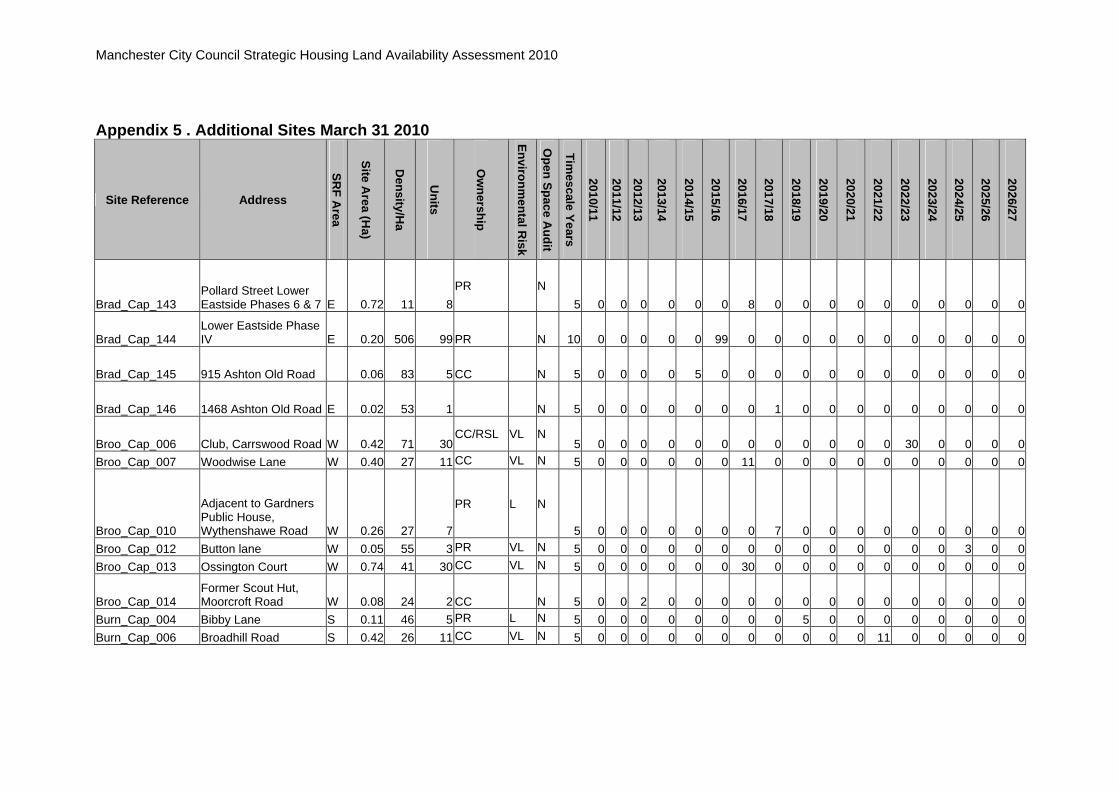
Manchester City Council Strategic Housing Land Availability Assessment 2010
Appendix 5 . Additional Sites March 31 2010
Site Reference Address
SRF A
rea
Site Area (H
a)
Density/H
a
Units
Ow
nership
Environmental R
isk
Open Space A
udit
Timescale Years
2010/11
2011/12
2012/13
2013/14
2014/15
2015/16
2016/17
2017/18
2018/19
2019/20
2020/21
2021/22
2022/23
2023/24
2024/25
2025/26
2026/27
Brad_Cap_143 Pollard Street Lower Eastside Phases 6 & 7 E 0.72 11 8
PR N 5 0 0 0 0 0 0 8 0 0 0 0 0 0 0 0 0 0
Brad_Cap_144 Lower Eastside Phase IV E 0.20 506 99 PR N 10 0 0 0 0 0 99 0 0 0 0 0 0 0 0 0 0 0
Brad_Cap_145 915 Ashton Old Road 0.06 83 5 CC N 5 0 0 0 0 5 0 0 0 0 0 0 0 0 0 0 0 0
Brad_Cap_146 1468 Ashton Old Road E 0.02 53 1 N 5 0 0 0 0 0 0 0 1 0 0 0 0 0 0 0 0 0
Broo_Cap_006 Club, Carrswood Road W 0.42 71 30CC/RSL VL N
5 0 0 0 0 0 0 0 0 0 0 0 0 30 0 0 0 0 Broo_Cap_007 Woodwise Lane W 0.40 27 11 CC VL N 5 0 0 0 0 0 0 11 0 0 0 0 0 0 0 0 0 0
Broo_Cap_010
Adjacent to Gardners Public House, Wythenshawe Road W 0.26 27 7
PR L N
5 0 0 0 0 0 0 0 7 0 0 0 0 0 0 0 0 0 Broo_Cap_012 Button lane W 0.05 55 3 PR VL N 5 0 0 0 0 0 0 0 0 0 0 0 0 0 0 3 0 0 Broo_Cap_013 Ossington Court W 0.74 41 30 CC VL N 5 0 0 0 0 0 0 30 0 0 0 0 0 0 0 0 0 0
Broo_Cap_014 Former Scout Hut, Moorcroft Road W 0.08 24 2 CC N 5 0 0 2 0 0 0 0 0 0 0 0 0 0 0 0 0 0
Burn_Cap_004 Bibby Lane S 0.11 46 5 PR L N 5 0 0 0 0 0 0 0 0 5 0 0 0 0 0 0 0 0 Burn_Cap_006 Broadhill Road S 0.42 26 11 CC VL N 5 0 0 0 0 0 0 0 0 0 0 0 11 0 0 0 0 0

Manchester City Council Strategic Housing Land Availability Assessment 2010
Appendix 5 . Additional Sites March 31 2010
Site Reference Address
SRF A
rea
Site Area (H
a)
Density/H
a
Units
Ow
nership
Environmental R
isk
Open Space A
udit
Timescale Years
2010/11
2011/12
2012/13
2013/14
2014/15
2015/16
2016/17
2017/18
2018/19
2019/20
2020/21
2021/22
2022/23
2023/24
2024/25
2025/26
2026/27
Burn_Cap_014 Fog Lane/Parrswood Road S 0.17 99 17
PR VL N 5 0 0 0 0 17 0 0 0 0 0 0 0 0 0 0 0 0
Burn_Cap_019 Kingsway/Fog Lane S 0.18 174 32 PR M N 5 0 0 0 0 16 16 0 0 0 0 0 0 0 0 0 0 0 Burn_Cap_020 Kingsleigh Road S 0.67 37 25 PR M/L N 5 0 0 0 0 0 0 0 0 0 0 0 0 0 0 0 10 15 Burn_Cap_021 154 Burnage Lane S 0.07 28 2 PR N 5 0 0 0 0 0 0 0 0 0 0 0 0 0 0 0 2 0
CC_Cap_001 St Georges CC 4.66 198 921MXD VH Pt
10 0 0 0 0 0 0 0 0 71 100 100 100 100 100 100 100 150
CC_Cap_002 Great Jackson Street CC 5.85 267 1560MXD VH N
10 0 0 0 0 0 0 100 100 100 150 150 150 150 150 150 180 180
CC_Cap_003 Central Spine CC 9.80 163 1600MXD VH N
10 0 0 0 0 0 50 100 100 150 150 150 150 150 150 150 150 150
CC_Cap_004 Southern & Derwent CC 1.63 207 338 H N
10 0 0 0 0 0 0 0 50 50 60 60 0 0 68 50 0 0
CC_Cap_005 Left Bank/Granada CC 15.56 135 2100MXD VH Pt
10 0 0 0 0 0 0 100 100 100 100 200 200 250 250 275 275 250
CC_Cap_006 Victoria Station CC 2.17 276 600 VH N
10 0 0 0 0 0 0 0 0 0 0 0 100 100 100 100 100 100
CC_Cap_007 Eastern Gateway (South) CC 9.95 151 1500
MXD VH N 10 0 0 0 0 0 0 100 100 100 150 150 150 150 150 150 150 150
CC_Cap_008 Bainbridge House, London Road CC 0.13 193 25
PR N 10 0 0 0 0 0 0 0 0 0 0 0 0 0 25 0 0 0

Manchester City Council Strategic Housing Land Availability Assessment 2010
Appendix 5 . Additional Sites March 31 2010
Site Reference Address
SRF A
rea
Site Area (H
a)
Density/H
a
Units
Ow
nership
Environmental R
isk
Open Space A
udit
Timescale Years
2010/11
2011/12
2012/13
2013/14
2014/15
2015/16
2016/17
2017/18
2018/19
2019/20
2020/21
2021/22
2022/23
2023/24
2024/25
2025/26
2026/27
CC_Cap_009 Land at Store Street CC 0.11 94 10BWB N
10 0 0 0 0 0 0 0 0 0 0 0 10 0 0 0 0 0
CC_Cap_010 Linley House, Portland Street CC 0.58 342 200
UU N 10 0 0 0 0 0 0 0 0 0 0 0 0 0 0 0 100 100
CC_Cap_011 Jacksons Wharf Site, Blantyre Street CC 0.45 195 88
PR N 10 0 0 0 0 0 44 44 0 0 0 0 0 0 0 0 0 0
CC_Cap_012 Employment Exchange Aytoun Street CC 0.22 ### 237
PR H N 10 0 0 0 0 0 0 0 0 100 137 0 0 0 0 0 0 0
CC_Cap_013 Lee House Bridgewater St CC 0.21 384 79
N 10 0 0 0 0 0 0 0 0 0 0 0 0 0 39 40 0 0
CC_Cap_014 28-30 Oldham Street CC 0.07 202 14PR H N
10 0 0 0 0 0 0 0 0 0 14 0 0 0 0 0 0 0
CC_Cap_015 2-4 Chester Road CC 0.17 348 60PR Pt
10 0 0 0 0 0 0 0 0 0 60 0 0 0 0 0 0 0
CC_Cap_016 58 Richmond Street CC 0.02 491 8 PR N 5 0 0 0 0 0 0 0 0 8 0 0 0 0 0 0 0 0
CC_Cap_017 48 Shudehill CC 0.01 677 9 PR N 5 0 0 0 0 0 0 0 0 9 0 0 0 0 0 0 0 0
CC_Cap_018 10 Little Peter Street CC 0.01 335 5 PR N 5 0 0 0 0 0 5 0 0 0 0 0 0 0 0 0 0 0
CC_Cap_080 Tib Street/Church Street CC 0.28 686 192 PR N 10 0 0 0 0 0 0 0 0 0 0 0 0 0 96 96 0 0

Manchester City Council Strategic Housing Land Availability Assessment 2010
Appendix 5 . Additional Sites March 31 2010
Site Reference Address
SRF A
rea
Site Area (H
a)
Density/H
a
Units
Ow
nership
Environmental R
isk
Open Space A
udit
Timescale Years
2010/11
2011/12
2012/13
2013/14
2014/15
2015/16
2016/17
2017/18
2018/19
2019/20
2020/21
2021/22
2022/23
2023/24
2024/25
2025/26
2026/27
Char_Cap_003 Booth Hall Hospital N 8.97 33 300 PR H Pt 5 0 0 30 50 60 70 50 40 0 0 0 0 0 0 0 0 0
Char_Cap_004 School Croft Hill Road N 4.56 36 164 H Pt
5 0 0 0 0 0 0 0 30 30 35 35 34 0 0 0 0 0 Char_Cap_006 Raycroft Avenue N 1.64 31 50 CC L N 5 0 0 0 0 0 25 25 0 0 0 0 0 0 0 0 0 0
Char_Cap_007 Adjacent to Colmore Drive N 1.19 54 65 N 5 0 0 0 0 0 10 20 35 0 0 0 0 0 0 0 0 0
Char_Cap_008 Hall Moss Road N 0.47 49 23 PR L N 5 0 0 0 0 23 0 0 0 0 0 0 0 0 0 0 0 0 Char_Cap_011 Moston lane N 0.85 30 25 PR H N 5 0 0 0 0 0 0 0 0 0 20 5 0 0 0 0 0 0
Char_Cap_018 Rochdale Road/Whitemoss Road N 0.13 40 5
M Pt 5 0 0 0 0 0 0 0 0 5 0 0 0 0 0 0 0 0
Char_Cap_020 Booth Hall Road N 0.30 27 8 PR L N 5 0 0 0 0 0 0 0 8 0 0 0 0 0 0 0 0 0 Char_Cap_031 Grange Park Road N 0.15 26 4 PR L Y 5 0 0 0 0 0 0 0 4 0 0 0 0 0 0 0 0 0
Char_Cap_033 Pub north of Victoria Avenue East N 0.31 49 15
PR M/L N 5 0 0 0 0 0 0 0 0 15 0 0 0 0 0 0 0 0
Char_Cap_034 Spindletree Avenue N 0.61 49 30 PR Pt 5 0 0 0 0 0 0 0 0 0 0 0 15 15 0 0 0 0 Char_Cap_035 Hinchley Road N 2.77 36 100 Y 5 0 0 0 0 30 30 40 0 0 0 0 0 0 0 0 0 0 Chee_Cap_003 Hargreaves Street N 7.64 52 394 NRAIL N 5 0 0 0 0 0 0 0 0 0 0 0 0 79 79 79 78 79 Chee_Cap_006 Collyhurst Road N 3.38 72 243 PR VH N 5 0 0 0 0 0 0 0 43 60 45 45 50 0 0 0 0 0 Chee_Cap_007 Roger Street N 1.81 400 725 MXD VH N 5 0 0 0 0 0 0 0 0 0 0 0 100 100 100 100 150 175 Chee_Cap_008 Dantzic Street N 2.19 100 220 PR H N 5 0 0 0 0 0 50 50 50 70 0 0 0 0 0 0 0 0
Chee_Cap_011 Bus Depot Queens Road N 2.05 75 154
PR M N 5 0 0 0 0 0 0 0 0 40 50 64 0 0 0 0 0 0

Manchester City Council Strategic Housing Land Availability Assessment 2010
Appendix 5 . Additional Sites March 31 2010
Site Reference Address
SRF A
rea
Site Area (H
a)
Density/H
a
Units
Ow
nership
Environmental R
isk
Open Space A
udit
Timescale Years
2010/11
2011/12
2012/13
2013/14
2014/15
2015/16
2016/17
2017/18
2018/19
2019/20
2020/21
2021/22
2022/23
2023/24
2024/25
2025/26
2026/27
Chee_Cap_015 Woodlands Mill, Hazelbottom Road N 1.00 35 35
PR VH N 5 0 0 0 0 0 0 0 0 0 35 0 0 0 0 0 0 0
Chee_Cap_021 Robin Hood Street N 0.63 30 19 PR/CC M/L Y 5 0 0 0 0 0 0 19 0 0 0 0 0 0 0 0 0 0 Chee_Cap_024 Canonsleigh Close N 0.58 29 17 PR VH N 5 0 0 0 0 0 0 0 0 0 0 17 0 0 0 0 0 0 Chee_Cap_030 Tamerton Drive N 0.35 29 10 CC M/L Y 5 0 0 0 0 0 0 0 0 0 6 4 0 0 0 0 0 0 Chee_Cap_031 Bunyard Street N 0.32 28 9 CC M Y 5 0 0 0 0 0 0 0 9 0 0 0 0 0 0 0 0 0 Chee_Cap_032 Bromley Street N 0.32 149 47 PR H N 5 0 0 0 0 0 0 0 0 0 20 27 0 0 0 0 0 0 Chee_Cap_035 Alderford Parade N 0.29 35 10 CC L Y 5 0 0 0 0 0 0 0 0 0 10 0 0 0 0 0 0 0 Chee_Cap_036 Fitzgeorge Street N 0.22 85 19 PR/CC H N 5 0 0 0 0 0 0 0 0 0 0 19 0 0 0 0 0 0 Chee_Cap_037 Herbert Street N 0.25 32 8 M N 5 0 0 0 0 0 0 0 0 0 0 8 0 0 0 0 0 0
Chee_Cap_039 Cromhall Walk/Midford Walk N 0.24 29 7
CC L Y 5 0 0 0 0 0 0 0 0 0 0 7 0 0 0 0 0 0
Chee_Cap_047 Waterloo Road/Haldene Walk N 0.13 30 4
CC VL N 5 0 0 0 0 0 0 0 0 0 0 4 0 0 0 0 0 0
Chee_Cap_049 Canonsleigh Close N 0.14 14 2 PR VH N 5 0 0 0 0 0 0 0 0 0 0 2 0 0 0 0 0 0 Chee_Cap_051 Halliwell Lane N 0.14 51 7 PR VL N 5 0 0 3 0 0 0 0 0 0 0 4 0 0 0 0 0 0 Chee_Cap_057 Eckford Street N 0.10 30 3 CC M N 5 0 0 0 0 0 0 0 0 3 0 0 0 0 0 0 0 0
Chee_Cap_058 North of Dinnington Drive N 0.10 31 3
CC M/L Y 5 0 0 0 0 0 0 0 0 3 0 0 0 0 0 0 0 0
Chee_Cap_059 Calthorpe Avenue N 0.09 33 3 CC VH N 5 0 0 0 0 0 0 0 0 0 0 3 0 0 0 0 0 0
Chee_Cap_064 Rear 2-20 Leicester Road N 0.08 39 3
CC M N 5 0 0 0 0 0 0 0 0 3 0 0 0 0 0 0 0 0
Chee_Cap_066 Kelvin Grove N 0.07 29 2 PR M/L N 5 0 0 0 0 0 0 0 0 2 0 0 0 0 0 0 0 0

Manchester City Council Strategic Housing Land Availability Assessment 2010
Appendix 5 . Additional Sites March 31 2010
Site Reference Address
SRF A
rea
Site Area (H
a)
Density/H
a
Units
Ow
nership
Environmental R
isk
Open Space A
udit
Timescale Years
2010/11
2011/12
2012/13
2013/14
2014/15
2015/16
2016/17
2017/18
2018/19
2019/20
2020/21
2021/22
2022/23
2023/24
2024/25
2025/26
2026/27
Chee_Cap_078 Cheetham Fringe N 9.91 18 180 H Pt 5 0 0 0 0 0 60 60 60 0 0 0 0 0 0 0 0 0
Chee_Cap_079 22-44 Lecester Road N 0.16 50 8CC M N
5 0 0 0 0 0 0 0 8 0 0 0 0 0 0 0 0 0 Chee_Cap_080 Turley Street N 0.12 48 6 CC M N 5 0 0 0 0 0 0 0 6 0 0 0 0 0 0 0 0 0 Chee_Cap_081 Newsholme Street N 0.11 73 8 CC VL N 5 0 0 0 0 0 0 0 0 0 0 8 0 0 0 0 0 0 Chee_Cap_082 Red Bank N 0.77 74 57 NRAIL N 5 0 0 0 0 0 0 0 0 0 0 0 57 0 0 0 0 0
Chee_Cap_083 Red Bank Block 7 Budding View N 2.21 91 202
N 5 0 0 0 0 0 0 0 0 0 0 0 0 0 0 0 100 102
Chee_Cap_084 Mirabel Street CC 0.05 863 39 PR N 5 0 0 0 0 0 0 0 0 0 39 0 0 0 0 0 0 0 Chor_Cap_004 Edge Lane S 0.42 57 24 PR VL N 5 0 0 0 24 0 0 0 0 0 0 0 0 0 0 0 0 0 Chor_Cap_007 Cross Road S 0.25 36 9 PR VL N 5 0 0 0 0 0 0 0 0 0 0 0 0 0 0 9 0 0
Chor_Cap_012 Church, High Lane/ Chequers Road S 0.18 49 9
PR VL N 5 0 0 0 0 0 0 0 0 0 0 0 0 0 0 9 0 0
Chor_Cap_015 Club High Lane S 0.16 32 5 PR VL N 5 0 0 0 0 0 0 0 0 0 0 0 0 0 0 0 0 5
Chor_Cap_016
Wilbraham Road/Buckingham Road S 0.15 69 10
PR M/L N 5 0 0 0 0 0 0 0 0 0 0 0 0 0 0 0 10 0
Chor_Cap_022 503-507 Barlow Moor Road S 0.08 48 4
PR VL N 5 1 0 0 0 0 0 0 0 0 0 0 0 0 0 0 0 3
Chor_Cap_026 404 Wilbraham Road S 0.05 78 4PR VL N
5 0 0 0 0 0 0 0 0 0 0 0 0 0 0 0 0 4

Manchester City Council Strategic Housing Land Availability Assessment 2010
Appendix 5 . Additional Sites March 31 2010
Site Reference Address
SRF A
rea
Site Area (H
a)
Density/H
a
Units
Ow
nership
Environmental R
isk
Open Space A
udit
Timescale Years
2010/11
2011/12
2012/13
2013/14
2014/15
2015/16
2016/17
2017/18
2018/19
2019/20
2020/21
2021/22
2022/23
2023/24
2024/25
2025/26
2026/27
Chor_Cap_030 Chorlton District Centre S 2.88 69 200
PR M/L N 5 0 0 0 0 50 50 50 50 0 0 0 0 0 0 0 0 0
Chor_Cap_031 435 Barlow Moor Road S 0.48 25 12PR L N
5 0 0 0 0 0 0 0 0 12 0 0 0 0 0 0 0 0
Crum_Cap_001 Frenchbarn Lane/Chapel Lane N 0.63 29 18
PR VH Y 5 0 0 0 0 0 0 0 0 0 8 10 0 0 0 0 0 0
Crum_Cap_003 Chapel Lane N 6.77 28 188 CC VH N 5 0 0 0 25 40 40 48 35 0 0 0 0 0 0 0 0 0
Crum_Cap_009 South Blackley New Road N 1.51 50 76
PR Pt 5 0 0 0 0 0 15 15 17 29 0 0 0 0 0 0 0 0
Crum_Cap_019 Parkhill Avenue N 0.11 133 15 PR M/L N 5 0 0 0 0 15 0 0 0 0 0 0 0 0 0 0 0 0
Crum_Cap_021 Bank Road/Willow Hill Road N 0.11 27 3
PR M/L N 5 0 0 0 0 0 0 0 3 0 0 0 0 0 0 0 0 0
Crum_Cap_022 57-59 Catherine Road N 0.22 27 6PR L N
5 0 0 0 0 0 0 0 0 0 0 6 0 0 0 0 0 0
Crum_Cap_025 119-155 Cleveland Road N 0.11 55 6
CC M/L Y 5 0 0 0 0 0 0 0 0 6 0 0 0 0 0 0 0 0
Crum_Cap_032 Holland House, 33 Wilton Road N 0.34 29 10
PR VL N 5 0 0 0 0 0 0 0 0 0 10 0 0 0 0 0 0 0
Crum_Cap_033 Delaunays Road N 0.05 39 2 PR M/L N 5 0 0 0 0 0 0 0 0 0 2 0 0 0 0 0 0 0
Crum_Cap_035 Anglia Crown, Crescent Drive N 0.55 51 28
PR M N 5 0 0 0 0 0 14 14 0 0 0 0 0 0 0 0 0 0
Crum_Cap_036 9-11 Old market Street N 0.18 177 32 PR/CC N 5 0 0 32 0 0 0 0 0 0 0 0 0 0 0 0 0 0

Manchester City Council Strategic Housing Land Availability Assessment 2010
Appendix 5 . Additional Sites March 31 2010
Site Reference Address
SRF A
rea
Site Area (H
a)
Density/H
a
Units
Ow
nership
Environmental R
isk
Open Space A
udit
Timescale Years
2010/11
2011/12
2012/13
2013/14
2014/15
2015/16
2016/17
2017/18
2018/19
2019/20
2020/21
2021/22
2022/23
2023/24
2024/25
2025/26
2026/27
Crum_Cap_037 9 Bennett Road N 0.08 74 6 PR N 5 0 0 0 0 6 0 0 0 0 0 0 0 0 0 0 0 0 Crum_Cap_038 Springfield Avenue N 0.04 49 2 PR N 5 0 0 0 0 2 0 0 0 0 0 0 0 0 0 0 0 0 Crum_Cap_039 Saddlecote Close N 0.08 37 3 PR N 5 0 0 0 0 3 0 0 0 0 0 0 0 0 0 0 0 0 Crum_Cap_040 19 Cleveland Road N 0.01 83 1 RSL? N 5 0 0 0 1 0 0 0 0 0 0 0 0 0 0 0 0 0
Crum_Cap_041 Parkhill Avenue Phase
1 N 0.15 87 13 CC N 5 0 0 13 0 0 0 0 0 0 0 0 0 0 0 0 0 0 Crum_Cap_042 42 Seymour Road N 0.12 8 1 PR N 5 0 0 0 0 1 0 0 0 0 0 0 0 0 0 0 0 0 Did_E_CAP_004 Parrswood S 2.43 27 65 PR M/L N 5 0 0 0 0 0 0 0 0 0 0 0 25 25 15 0 0 0 Did_E_CAP_006 Parrswood S 1.57 118 185 CC L N 5 0 0 0 0 40 40 50 30 25 0 0 0 0 0 0 0 0 Did_E_Cap_021 Francis Road S 0.08 64 5 PR N 5 0 0 0 0 5 0 0 0 0 0 0 0 0 0 0 0 0 Did_E_Cap_027 2-8 Kingslea Road S 0.09 43 4 PR M/L N 5 0 0 0 0 0 0 4 0 0 0 0 0 0 0 0 0 0
Did_E_Cap_029 MMU Campus, Wilmslow Road S 3.75 50 188
MMU VL Pt 5 0 0 0 0 0 50 50 50 38 0 0 0 0 0 0 0 0
Did_W_Cap_008 836 Wilmslow Road S 0.62 40 25 CC L N 5 0 0 0 0 12 13 0 0 0 0 0 0 0 0 0 0 0 Did_W_Cap_016 95 Palatine Road S 0.26 100 26 PR M/L N 5 0 0 0 0 0 0 0 0 13 13 0 0 0 0 0 0 0 Did_W_Cap_019 Palatine Road S 0.25 8 2 PR M/L N 5 0 0 0 0 2 0 0 0 0 0 0 0 0 0 0 0 0
Did_W_Cap_032 566-8 Wilmslow Road S 0.12 136 17PR M/L N
5 0 0 0 0 0 0 0 0 0 0 0 0 17 0 0 0 0
Did_W_Cap_039
Jewish Youth Centre etc, Old Lansdowne Road S 0.49 41 20
PR L N 5 0 0 0 0 0 0 0 0 10 10 0 0 0 0 0 0 0
Did_W_Cap_040 Wrengate, Palatine Road S 3.09 10 30
PR N 5 0 0 15 15 0 0 0 0 0 0 0 0 0 0 0 0 0

Manchester City Council Strategic Housing Land Availability Assessment 2010
Appendix 5 . Additional Sites March 31 2010
Site Reference Address
SRF A
rea
Site Area (H
a)
Density/H
a
Units
Ow
nership
Environmental R
isk
Open Space A
udit
Timescale Years
2010/11
2011/12
2012/13
2013/14
2014/15
2015/16
2016/17
2017/18
2018/19
2019/20
2020/21
2021/22
2022/23
2023/24
2024/25
2025/26
2026/27
Did_W_Cap_041 232-236 Palatine Road S 0.28 131 36PR M/L N
5 0 0 0 0 0 0 0 0 0 0 0 0 0 0 0 18 18 Did_W_Cap_042 Adj 2 Goulden Road S 0.01 71 1 PR N 5 0 0 0 1 0 0 0 0 0 0 0 0 0 0 0 0 0 Fall_Cap_002 Withington Road S 1.14 30 34 CC L Y 5 0 0 0 0 0 0 0 0 0 0 0 0 34 0 0 0 0 Fall_Cap_004 Ladybarn Road S 0.45 65 29 PR M N 5 0 0 0 0 0 0 0 0 0 0 0 0 0 0 15 14 0 Fall_Cap_006 Ladybarn Road S 0.36 63 23 PR H N 5 0 0 0 0 0 0 0 0 10 13 0 0 0 0 0 0 0
Fall_Cap_010 Rear of Horton Road/Hart Road S 0.19 62 12
CC L N 5 0 0 0 0 0 0 0 0 0 0 0 12 0 0 0 0 0
Fall_Cap_012 30 Wilbraham Road S 0.18 50 9 PR L N 5 0 0 0 0 0 0 0 0 0 9 0 0 0 0 0 0 0 Fall_Cap_016 32 Wilbraham Road S 0.10 51 5 PR VL N 5 0 0 0 0 0 5 0 0 0 0 0 0 0 0 0 0 0
Fall_Cap_024 Hart Road/Lloyd Street South S 0.35 69 24
PR VL N 5 0 0 12 12 0 0 0 0 0 0 0 0 0 0 0 0 0
Gort_N_Cap_002 Hyde Road E 13.10 45 589PR H N
5 0 0 0 0 0 0 0 0 50 80 80 80 80 75 75 69 0
Gort_N_Cap_010 Abbey Hey Lane E 1.66 35 58CC? VH Y
10 0 0 0 0 0 0 0 0 25 33 0 0 0 0 0 0 0
Gort_N_Cap_011 Gorton Lane/Crossley Street E 1.51 35 53
CC/PR M Pt 10 0 0 0 0 0 0 0 0 0 0 20 33 0 0 0 0 0
Gort_N_Cap_012 Hyde Road E 1.46 50 73PR H N
10 0 0 0 0 0 0 0 0 0 0 20 33 20 0 0 0 0
Gort_N_Cap_019 Vine Street E 1.96 24 47CC/PR VH Y
10 0 0 0 0 0 0 0 0 20 27 0 0 0 0 0 0 0

Manchester City Council Strategic Housing Land Availability Assessment 2010
Appendix 5 . Additional Sites March 31 2010
Site Reference Address
SRF A
rea
Site Area (H
a)
Density/H
a
Units
Ow
nership
Environmental R
isk
Open Space A
udit
Timescale Years
2010/11
2011/12
2012/13
2013/14
2014/15
2015/16
2016/17
2017/18
2018/19
2019/20
2020/21
2021/22
2022/23
2023/24
2024/25
2025/26
2026/27
Gort_N_Cap_021 Hyde Road/Mount Road E 0.75 50 37
CC/PR M Y 10 0 0 0 0 0 0 37 0 0 0 0 0 0 0 0 0 0
Gort_N_Cap_026 Hyde Road E 6.75 40 272PR Pt
5 0 0 0 0 0 0 0 0 50 50 60 60 52 0 0 0 0
Gort_N_Cap_029 Hyde Road E 0.53 45 24CC H N
5 0 0 0 0 0 0 0 0 24 0 0 0 0 0 0 0 0
Gort_N_Cap_033 Constable Street E 0.36 36 13CC M Pt
5 0 0 0 0 0 0 0 13 0 0 0 0 0 0 0 0 0
Gort_N_Cap_042 Clowes Street E 0.24 49 12
Leased from Council
N 5 0 0 0 0 0 0 0 0 0 0 12 0 0 0 0 0 0
Gort_N_Cap_045 Garratt Way E 0.19 48 9CC VL Y
5 0 0 0 0 0 0 0 0 0 9 0 0 0 0 0 0 0
Gort_N_Cap_050 Jessop Street E 0.15 33 5CC L N
5 0 0 0 0 0 0 0 0 5 0 0 0 0 0 0 0 0
Gort_N_Cap_051 Chapman Street E 0.15 33 5PR H N
5 0 0 0 0 0 0 0 0 0 5 0 0 0 0 0 0 0
Gort_N_Cap_059 Hyde Road E 0.06 47 3 M/L N
5 0 0 0 0 0 0 0 0 0 3 0 0 0 0 0 0 0
Gort_N_Cap_062 Wellington Street/Cross Lane E 0.05 38 2
PR VL N 5 0 0 0 0 0 0 0 0 0 0 2 0 0 0 0 0 0
Gort_N_Cap_065 Abbey Hey Lane E 0.04 51 2PR L N
5 0 0 0 0 0 0 0 0 0 0 2 0 0 0 0 0 0

Manchester City Council Strategic Housing Land Availability Assessment 2010
Appendix 5 . Additional Sites March 31 2010
Site Reference Address
SRF A
rea
Site Area (H
a)
Density/H
a
Units
Ow
nership
Environmental R
isk
Open Space A
udit
Timescale Years
2010/11
2011/12
2012/13
2013/14
2014/15
2015/16
2016/17
2017/18
2018/19
2019/20
2020/21
2021/22
2022/23
2023/24
2024/25
2025/26
2026/27
Gort_N_Cap_066 Beyer Close E 0.08 67 5PR VL N
5 0 0 0 0 0 0 0 0 5 0 0 0 0 0 0 0 0
Gort_N_Cap_067 Former Forrester House, Blackwin Street E 0.12 41 5 CC N 5 0 0 0 0 5 0 0 0 0 0 0 0 0 0 0 0 0
Gort_N_Cap_068 574-576a Hyde Road E 0.04 99 4 PR N 5 0 0 0 0 0 0 0 4 0 0 0 0 0 0 0 0 0
Gort_S_Cap_053 Pomona Hotel, 24 Reddish Lane E 0.16 58 9 PR N 5 0 0 0 0 0 0 0 9 0 0 0 0 0 0 0 0 0
Gort_S_Cap_010 Mount Road C 3.25 44 143PR M Y
5 0 0 43 40 40 20 0 0 0 0 0 0 0 0 0 0 0
Gort_S_Cap_011 Levenshulme Road E 0.60 50 30PR L N
5 0 0 0 0 0 0 0 0 15 15 0 0 0 0 0 0 0
Gort_S_Cap_015 Hemmons Road/Longden Road C 0.65 35 23
PR H N 5 0 0 0 0 0 0 0 0 0 10 13 0 0 0 0 0 0
Gort_S_Cap_021 Peter Moss C 0.31 35 11PR? H Y
5 0 0 0 0 0 0 0 0 0 5 6 0 0 0 0 0 0
Gort_S_Cap_023 Longen Road C 0.26 27 7PR M/L N
5 0 0 0 0 0 0 0 0 0 7 0 0 0 0 0 0 0
Gort_S_Cap_024 Matthews Lane C 0.22 27 6PR L N
5 0 0 0 0 0 0 0 0 0 3 3 0 0 0 0 0 0
Gort_S_Cap_029 7-9 Chapel Street C 0.17 52 9PR M N
5 0 0 0 0 0 0 0 0 0 0 9 0 0 0 0 0 0

Manchester City Council Strategic Housing Land Availability Assessment 2010
Appendix 5 . Additional Sites March 31 2010
Site Reference Address
SRF A
rea
Site Area (H
a)
Density/H
a
Units
Ow
nership
Environmental R
isk
Open Space A
udit
Timescale Years
2010/11
2011/12
2012/13
2013/14
2014/15
2015/16
2016/17
2017/18
2018/19
2019/20
2020/21
2021/22
2022/23
2023/24
2024/25
2025/26
2026/27
Gort_S_Cap_039 Garage Site adjacent to 161 Barlow Road C 0.10 62 6
PR M/L N 5 0 0 0 0 0 0 0 0 0 0 0 0 0 0 6 0 0
Gort_S_Cap_044 3 Chapel Street C 0.07 43 3PR M/L N
5 0 0 0 0 0 0 0 0 0 0 3 0 0 0 0 0 0
Gort_S_Cap_049 Byrom Shopping Parade Barlow Road C 0.09 54 5
PR L N 5 0 0 0 0 0 0 0 0 0 0 0 0 0 0 0 5 0
Gort_S_Cap_050 Matthews Lane Tip, Matthews Lane E 1.85 25 46
CC VH Y 5 0 0 0 0 0 0 0 0 0 0 0 0 0 0 0 23 23
Gort_S_Cap_051 Melland Road E 4.27 31 133 PR N 5 0 0 0 0 33 33 33 34 0 0 0 0 0 0 0 0 0
Gort_S_Cap_054 337 Mount Road C 0.10 49 5 PR N 5 0 0 0 0 0 5 0 0 0 0 0 0 0 0 0 0 0
Gort_S_Cap_055 303 Mount Road C 0.10 59 6 PR N 5 0 0 0 0 0 0 0 6 0 0 0 0 0 0 0 0 0 Harp_Cap_007 Pitsford Road N 2.87 27 77 PR M/L N 10 0 0 0 0 0 0 0 0 0 15 25 37 0 0 0 0 0 Harp_Cap_008 Bute Street CPO N 2.86 28 81 CC L N 5 0 10 30 41 0 0 0 0 0 0 0 0 0 0 0 0 0 Harp_Cap_013 Factory Lane N 0.46 35 16 CC H Y 10 0 0 0 0 0 0 0 0 0 0 16 0 0 0 0 0 0 Harp_Cap_015 Albine Street N 0.80 39 31 CC H N 15 0 0 0 15 16 0 0 0 0 0 0 0 0 0 0 0 0 Harp_Cap_017 Moss Brook Road N 0.74 27 20 MXD H N 10 0 0 0 0 0 0 0 0 0 0 0 0 0 0 0 0 20 Harp_Cap_020 Parkmount Road N 0.58 40 23 CC H Y 15 0 0 0 0 0 0 0 0 0 0 0 0 10 13 0 0 0
Harp_Cap_022 Simister Street/Jonas Street N 0.50 44 22
CC L N 10 0 0 11 11 0 0 0 0 0 0 0 0 0 0 0 0 0

Manchester City Council Strategic Housing Land Availability Assessment 2010
Appendix 5 . Additional Sites March 31 2010
Site Reference Address
SRF A
rea
Site Area (H
a)
Density/H
a
Units
Ow
nership
Environmental R
isk
Open Space A
udit
Timescale Years
2010/11
2011/12
2012/13
2013/14
2014/15
2015/16
2016/17
2017/18
2018/19
2019/20
2020/21
2021/22
2022/23
2023/24
2024/25
2025/26
2026/27
Harp_Cap_023 Adjacent 45 Slack Road N 0.23 81 19 PR N 10 0 0 0 0 0 0 0 0 0 0 0 0 0 0 7 12 0
Harp_Cap_026 Tidebrook Walk N 0.41 34 14 CC L N 10 0 0 0 0 0 0 0 0 0 0 14 0 0 0 0 0 0 Harp_Cap_029 Winston Road N 0.42 34 14 CC L N 15 0 0 0 0 0 0 0 0 0 0 0 0 14 0 0 0 0
Harp_Cap_030 Southwell Streey/Conran Street N 0.30 36 11
PR H N 15 0 0 0 0 0 0 0 0 0 0 0 0 0 0 0 0 11
Harp_Cap_031
Water Street/Fernclough Road N 0.30 36 11
CC M/L Y 15 0 0 0 0 0 0 0 0 0 0 0 0 11 0 0 0 0
Harp_Cap_032 Moorsholme Avenue/Chirton Walk N 0.29 34 10
CC M Pt 15 0 0 0 0 0 0 0 0 0 0 0 10 0 0 0 0 0
Harp_Cap_035 Queens Road N 0.25 36 9 CC M/L Y 15 0 0 0 0 0 0 0 0 0 0 0 9 0 0 0 0 0
Harp_Cap_037 Carisbrook Street N 0.23 35 8
Leased from Council
H N 15 0 0 0 0 0 0 0 0 0 0 0 0 8 0 0 0 0
Harp_Cap_039
Rochadle Road/Westbourne Grove N 0.20 35 7
MXD L N 15 0 0 0 0 0 0 0 0 0 0 0 7 0 0 0 0 0
Harp_Cap_040 Palgrave Avenue N 0.19 37 7 CC M/L N 15 0 0 0 0 0 0 0 0 0 0 0 7 0 0 0 0 0
Harp_Cap_042 Sunday School, Kenyon Lane N 0.18 39 7
PR L N 15 0 0 0 0 0 0 0 0 0 0 0 0 0 0 0 0 7

Manchester City Council Strategic Housing Land Availability Assessment 2010
Appendix 5 . Additional Sites March 31 2010
Site Reference Address
SRF A
rea
Site Area (H
a)
Density/H
a
Units
Ow
nership
Environmental R
isk
Open Space A
udit
Timescale Years
2010/11
2011/12
2012/13
2013/14
2014/15
2015/16
2016/17
2017/18
2018/19
2019/20
2020/21
2021/22
2022/23
2023/24
2024/25
2025/26
2026/27
Harp_Cap_043 Blackley Park Road N 0.17 41 7 CC L N 15 0 0 0 0 0 0 0 0 0 0 0 0 0 7 0 0 0 Harp_Cap_044 Club, Zeta Street N 0.17 41 7 PR L N 15 0 0 0 0 0 0 0 0 0 0 0 0 0 7 0 0 0 Harp_Cap_045 Dalbeattie N 0.16 37 6 CC M N 15 0 0 0 0 0 0 0 0 0 0 0 0 6 0 0 0 0 Harp_Cap_046 Carisbrook Street N 0.15 32 5 CC H N 15 0 0 0 0 0 0 0 0 0 0 0 0 0 5 0 0 0 Harp_Cap_048 Wembury Street N 0.15 40 6 CC L Y 15 0 0 0 0 0 0 0 0 0 0 0 0 6 0 0 0 0
Harp_Cap_051 Adjacent 112 Moston Lane N 0.14 28 4
PR VL N 15 0 0 0 0 0 0 0 0 0 0 0 0 0 4 0 0 0
Harp_Cap_052 Benton Street N 0.13 30 4 CC M N 15 0 0 0 0 0 0 0 0 0 0 0 0 0 4 0 0 0 Harp_Cap_054 Audrey Street N 0.12 42 5 CC VH N 15 0 0 0 0 0 0 0 0 0 0 0 0 0 5 0 0 0 Harp_Cap_057 Church lane N 0.11 36 4 CC L Y 15 0 0 0 0 0 0 0 0 0 0 0 0 0 4 0 0 0 Harp_Cap_058 Winston Road N 0.11 37 4 CC M/L Y 15 0 0 0 0 0 0 0 0 0 0 0 0 0 4 0 0 0
Harp_Cap_061 Rochdale Road/Alfed Street N 0.09 32 3
CC N 15 0 0 0 0 0 0 0 0 0 0 0 0 3 0 0 0 0
Harp_Cap_063 Zeta Street N 0.09 43 4 PR L N 15 0 0 0 0 0 0 0 0 0 0 0 4 0 0 0 0 0 Harp_Cap_064 Douglas Street N 0.09 33 3 CC N 15 0 0 0 0 0 0 0 0 0 0 0 0 0 3 0 0 0
Harp_Cap_069 8 Brendon Avenue & Adjacent land N 0.04 45 2
PR L N 15 0 0 0 0 0 0 0 0 0 0 0 0 0 2 0 0 0
Harp_Cap_070 Ada Street N 0.07 28 2 CC L N 15 0 0 0 0 0 0 0 0 0 0 0 0 0 2 0 0 0 Harp_Cap_076 Hodge Street N 0.13 37 5 CC L N 15 0 0 0 0 0 0 0 0 0 0 0 0 0 5 0 0 0 Harp_Cap_086 Harpurhey/Moston N 2.32 42 97 CC M/L N 5 0 0 20 40 37 0 0 0 0 0 0 0 0 0 0 0 0 Harp_Cap_087 Collyhurst N 52.48 25 1300 CC VH Pt 5 0 0 0 0 50 75 100 100 100 150 150 120 120 120 120 50 45
Harp_Cap_088 East Of Rochdale Road N 35.18 23 800
CC H Pt 5 0 0 0 0 50 100 100 100 100 90 90 88 82 0 0 0 0

Manchester City Council Strategic Housing Land Availability Assessment 2010
Appendix 5 . Additional Sites March 31 2010
Site Reference Address
SRF A
rea
Site Area (H
a)
Density/H
a
Units
Ow
nership
Environmental R
isk
Open Space A
udit
Timescale Years
2010/11
2011/12
2012/13
2013/14
2014/15
2015/16
2016/17
2017/18
2018/19
2019/20
2020/21
2021/22
2022/23
2023/24
2024/25
2025/26
2026/27
Harp_Cap_090 Rochdale Road/Cockcroft Street N 0.17 48 8
PR VH N 15 0 0 0 0 0 0 0 0 0 0 0 0 0 0 8 0 0
Harp_Cap_091 Land at Cockcroft Street N 0.10 50 5
PR VH N 15 0 0 0 0 0 0 0 0 0 0 0 0 5 0 0 0 0
Harp_Cap_092 Lord Lovat PH Kingsbridge Road N 0.26 59 15
PR N 15 0 0 0 0 0 0 0 0 0 0 0 0 15 0 0 0 0
Harp_Cap_093 Deneside Care Home, Silchester Drive N 0.24 42 10 CC N 15 0 0 0 0 10 0 0 0 0 0 0 0 0 0 0 0 0
Harp_Cap_094 Brook Villas Church Lane N 0.20 122 25 PR N 15 0 0 0 25 0 0 0 0 0 0 0 0 0 0 0 0 0
High_Cap_003 Rear Sandyhill Road N 0.86 41 35 CC L Pt 10 0 0 0 0 0 0 0 0 0 15 20 0 0 0 0 0 0
High_Cap_009
Victoria Avenue/Middleton Road (S) N 1.79 25 45
CC L Y 10 0 0 0 0 0 0 0 0 0 20 25 0 0 0 0 0 0
High_Cap_010 Riverdale Road N 1.47 28 41 CC VH Y 10 0 0 0 0 0 0 0 0 0 0 20 21 0 0 0 0 0
High_Cap_023 Off Boothroyden Road N 0.75 29 22PR L N
10 0 0 0 0 0 0 0 0 0 11 11 0 0 0 0 0 0 High_Cap_025 Stella Street N 0.31 39 12 CC L N 15 0 0 0 0 0 0 0 0 0 0 0 6 6 0 0 0 0
High_Cap_030 194-212 Chapel Lane N 0.22 64 14CC M N
15 0 0 0 0 0 0 0 0 0 0 0 7 7 0 0 0 0

Manchester City Council Strategic Housing Land Availability Assessment 2010
Appendix 5 . Additional Sites March 31 2010
Site Reference Address
SRF A
rea
Site Area (H
a)
Density/H
a
Units
Ow
nership
Environmental R
isk
Open Space A
udit
Timescale Years
2010/11
2011/12
2012/13
2013/14
2014/15
2015/16
2016/17
2017/18
2018/19
2019/20
2020/21
2021/22
2022/23
2023/24
2024/25
2025/26
2026/27
High_Cap_032 Plant Terrace Hill Lane N 0.21 66 14CC/PR L N
15 0 0 0 0 0 0 0 0 0 0 0 7 7 0 0 0 0 High_Cap_036 Blackley New Road N 0.11 53 6 CC M N 15 0 0 0 0 0 0 0 0 0 0 0 0 0 6 0 0 0
High_Cap_037 1161 Rochdale Road N 0.20 30 6PR M N
15 0 0 0 0 0 0 0 0 0 0 0 0 0 0 6 0 0
High_Cap_038
Riverdale Road/Burnthorp Avenue N 0.19 38 7
CC/PR L N 15 0 0 0 0 0 0 0 0 0 0 0 0 0 7 0 0 0
High_Cap_041 Symond Road N 0.90 33 30 CC H N 10 0 0 0 0 0 0 0 0 0 15 15 0 0 0 0 0 0 High_Cap_052 Poolton Road N 0.11 27 3 CC L N 15 0 0 0 0 0 0 0 0 0 0 0 3 0 0 0 0 0 High_Cap_055 Blackley New Road N 0.10 31 3 CC/PR VL Y 15 0 0 0 0 0 0 0 0 0 0 0 0 3 0 0 0 0
High_Cap_061 53-55 Heathbank Road N 0.07 28 2CC L N
15 0 0 0 0 0 0 0 0 0 0 0 0 0 2 0 0 0
High_Cap_066 Adjacent 31 Bank House Road N 0.06 72 4
CC M N 15 0 0 0 0 0 0 0 0 0 0 0 0 0 4 0 0 0
High_Cap_071 Sankey Grove N 0.09 22 2 CC L N 15 0 0 0 0 0 0 0 0 0 0 0 0 2 0 0 0 0
High_Cap_072 Bridgnorth Road/Riverdale Road N 0.17 12 2
CC L Y 15 0 0 0 0 0 0 0 0 0 0 0 0 2 0 0 0 0
High_Cap_073 Riverdale Road/Inchcape Drive N 0.61 21 13
CC M/L Pt 15 0 0 0 0 0 0 0 0 0 0 0 13 0 0 0 0 0
High_Cap_074 Garage Court Rear of Tweedle Hill Road N 0.22 32 7
CC L N 15 0 0 0 0 0 0 0 0 0 0 0 0 0 7 0 0 0

Manchester City Council Strategic Housing Land Availability Assessment 2010
Appendix 5 . Additional Sites March 31 2010
Site Reference Address
SRF A
rea
Site Area (H
a)
Density/H
a
Units
Ow
nership
Environmental R
isk
Open Space A
udit
Timescale Years
2010/11
2011/12
2012/13
2013/14
2014/15
2015/16
2016/17
2017/18
2018/19
2019/20
2020/21
2021/22
2022/23
2023/24
2024/25
2025/26
2026/27
High_Cap_077 Southbrook Avenue N 0.19 26 5 PR VL Y 15 0 0 0 0 0 0 0 0 0 0 0 0 0 5 0 0 0 High_Cap_078 Longhurst Road N 0.53 38 20 CC N 15 0 0 0 0 20 0 0 0 0 0 0 0 0 0 0 0 0
Hulm_Cap_023 Council Depot, Denmark Road C 0.35 49 17
CC M N 5 0 0 0 0 0 0 0 0 0 17 0 0 0 0 0 0 0
Hulm_Cap_054 Former School, Moss Lane East C 1.31 50 65
CC M N 10 0 0 0 0 0 0 0 0 30 35 0 0 0 0 0 0 0
Hulm_Cap_055 Afewe, Royce Road C 0.07 232 17 MXD VL N 5 0 0 0 0 0 0 0 0 0 17 0 0 0 0 0 0 0
Hulm_Cap_056 Land adjacent to Hippodrome C 0.28 49 14
CC L N 5 0 0 0 0 0 14 0 0 0 0 0 0 0 0 0 0 0
Hulm_Cap_057 Coupland Street/Boundary Lane C 0.52 96 50
MXD N 5 0 0 0 25 25 0 0 0 0 0 0 0 0 0 0 0 0
Hulm_Cap_058 Leaf Street C 0.79 111 88 CC N 10 0 0 0 0 0 0 20 30 38 0 0 0 0 0 0 0 0
Hulm_Cap_059 Oaklands, Chorlton Road/City Road C 0.46 22 10 CC N 5 0 0 0 0 10 0 0 0 0 0 0 0 0 0 0 0 0
Hulm_Cap_060 Birley Fields Site M Bonsall Street C 0.69 51 35 CC N 10 0 0 0 0 35 0 0 0 0 0 0 0 0 0 0 0 0
Hulm_Cap_061 Birley Fields Site E Old Birley Street C 1.11 49 55 CC N 10 0 0 0 0 20 35 0 0 0 0 0 0 0 0 0 0 0
Leve_Cap_005 Moseley Road/Railway S 0.65 50 32PR/CC M N
5 0 0 0 0 0 0 0 0 0 16 16 0 0 0 0 0 0
Leve_Cap_009 961 Stockport Road/Garage Court S 0.38 21 8
PR/CC M N 10 0 0 0 0 0 0 0 0 0 0 8 0 0 0 0 0 0

Manchester City Council Strategic Housing Land Availability Assessment 2010
Appendix 5 . Additional Sites March 31 2010
Site Reference Address
SRF A
rea
Site Area (H
a)
Density/H
a
Units
Ow
nership
Environmental R
isk
Open Space A
udit
Timescale Years
2010/11
2011/12
2012/13
2013/14
2014/15
2015/16
2016/17
2017/18
2018/19
2019/20
2020/21
2021/22
2022/23
2023/24
2024/25
2025/26
2026/27
Leve_Cap_014 Buffoline Trading Estate, Chapel Street S 1.58 95 151
PR H N 5 0 0 0 0 0 0 40 30 40 41 0 0 0 0 0 0 0
Leve_Cap_019 2 Broom Lane S 0.15 26 4
Leased from Council
M/L N 10 0 0 0 0 0 0 0 0 0 0 4 0 0 0 0 0 0
Leve_Cap_020
Chapel Street/Backchapel Street S 0.15 34 5
PR H N 10 0 0 0 0 0 0 0 0 0 5 0 0 0 0 0 0 0
Leve_Cap_022 The Crescent S 0.14 43 6 PR/CC M N 10 0 0 0 0 0 0 0 0 0 0 6 0 0 0 0 0 0
Leve_Cap_027 Between 1076 and 1082 Stockport Road S 0.10 31 3
PR L N 10 0 0 0 0 0 0 0 0 0 0 3 0 0 0 0 0 0
Leve_Cap_028 Hall, Chapel Street S 0.09 55 5 CC M N 10 0 0 0 0 0 0 0 0 0 5 0 0 0 0 0 0 0 Leve_Cap_029 Slade Lane S 0.09 70 6 PR L N 10 0 0 0 0 0 0 0 0 0 0 0 0 0 0 0 0 6 Leve_Cap_030 Birchfields S 0.08 61 5 PR M/L N 10 0 0 0 0 5 0 0 0 0 0 0 0 0 0 0 0 0 Leve_Cap_033 Hapton Street S 0.07 30 2 PR VL N 10 0 0 0 0 0 0 0 0 0 0 2 0 0 0 0 0 0 Leve_Cap_035 135-9 Broom Lane S 0.06 47 3 PR M N 10 0 0 0 0 0 0 0 0 0 0 3 0 0 0 0 0 0
Leve_Cap_036 Backchapel Street/Elbow Street S 0.06 54 3
PR H N 10 0 0 0 0 0 0 0 0 0 0 3 0 0 0 0 0 0
Leve_Cap_048 Land Adjacent to Arcadia S 0.23 48 11
CC M/L Y 10 0 0 0 0 0 0 0 0 0 0 0 11 0 0 0 0 0
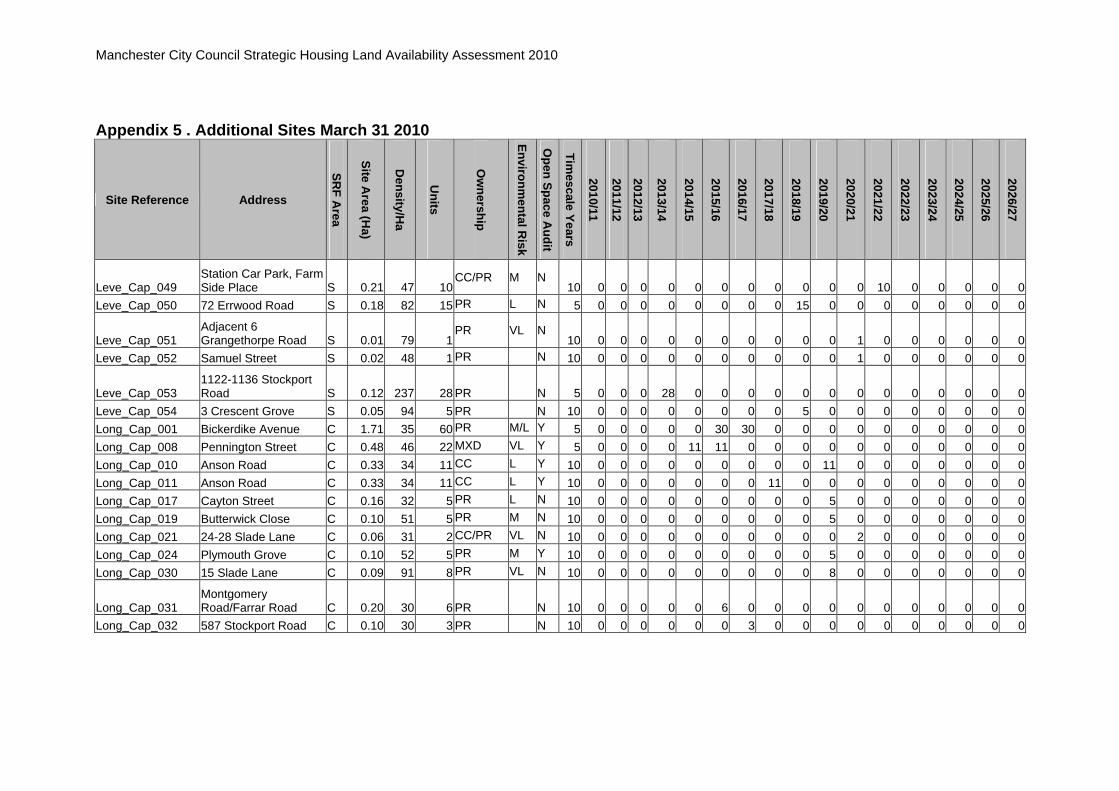
Manchester City Council Strategic Housing Land Availability Assessment 2010
Appendix 5 . Additional Sites March 31 2010
Site Reference Address
SRF A
rea
Site Area (H
a)
Density/H
a
Units
Ow
nership
Environmental R
isk
Open Space A
udit
Timescale Years
2010/11
2011/12
2012/13
2013/14
2014/15
2015/16
2016/17
2017/18
2018/19
2019/20
2020/21
2021/22
2022/23
2023/24
2024/25
2025/26
2026/27
Leve_Cap_049 Station Car Park, Farm Side Place S 0.21 47 10
CC/PR M N 10 0 0 0 0 0 0 0 0 0 0 0 10 0 0 0 0 0
Leve_Cap_050 72 Errwood Road S 0.18 82 15 PR L N 5 0 0 0 0 0 0 0 0 15 0 0 0 0 0 0 0 0
Leve_Cap_051 Adjacent 6 Grangethorpe Road S 0.01 79 1
PR VL N 10 0 0 0 0 0 0 0 0 0 0 1 0 0 0 0 0 0
Leve_Cap_052 Samuel Street S 0.02 48 1 PR N 10 0 0 0 0 0 0 0 0 0 0 1 0 0 0 0 0 0
Leve_Cap_053 1122-1136 Stockport Road S 0.12 237 28 PR N 5 0 0 0 28 0 0 0 0 0 0 0 0 0 0 0 0 0
Leve_Cap_054 3 Crescent Grove S 0.05 94 5 PR N 10 0 0 0 0 0 0 0 0 5 0 0 0 0 0 0 0 0 Long_Cap_001 Bickerdike Avenue C 1.71 35 60 PR M/L Y 5 0 0 0 0 0 30 30 0 0 0 0 0 0 0 0 0 0 Long_Cap_008 Pennington Street C 0.48 46 22 MXD VL Y 5 0 0 0 0 11 11 0 0 0 0 0 0 0 0 0 0 0 Long_Cap_010 Anson Road C 0.33 34 11 CC L Y 10 0 0 0 0 0 0 0 0 0 11 0 0 0 0 0 0 0 Long_Cap_011 Anson Road C 0.33 34 11 CC L Y 10 0 0 0 0 0 0 0 11 0 0 0 0 0 0 0 0 0 Long_Cap_017 Cayton Street C 0.16 32 5 PR L N 10 0 0 0 0 0 0 0 0 0 5 0 0 0 0 0 0 0 Long_Cap_019 Butterwick Close C 0.10 51 5 PR M N 10 0 0 0 0 0 0 0 0 0 5 0 0 0 0 0 0 0 Long_Cap_021 24-28 Slade Lane C 0.06 31 2 CC/PR VL N 10 0 0 0 0 0 0 0 0 0 0 2 0 0 0 0 0 0 Long_Cap_024 Plymouth Grove C 0.10 52 5 PR M Y 10 0 0 0 0 0 0 0 0 0 5 0 0 0 0 0 0 0 Long_Cap_030 15 Slade Lane C 0.09 91 8 PR VL N 10 0 0 0 0 0 0 0 0 0 8 0 0 0 0 0 0 0
Long_Cap_031 Montgomery Road/Farrar Road C 0.20 30 6 PR N 10 0 0 0 0 0 6 0 0 0 0 0 0 0 0 0 0 0
Long_Cap_032 587 Stockport Road C 0.10 30 3 PR N 10 0 0 0 0 0 0 3 0 0 0 0 0 0 0 0 0 0

Manchester City Council Strategic Housing Land Availability Assessment 2010
Appendix 5 . Additional Sites March 31 2010
Site Reference Address
SRF A
rea
Site Area (H
a)
Density/H
a
Units
Ow
nership
Environmental R
isk
Open Space A
udit
Timescale Years
2010/11
2011/12
2012/13
2013/14
2014/15
2015/16
2016/17
2017/18
2018/19
2019/20
2020/21
2021/22
2022/23
2023/24
2024/25
2025/26
2026/27
Mile_Cap_002 Jacksons Brickworks Briscoe Lane E 19.04 21 400
PR N 5 0 0 0 0 0 0 0 0 0 0 100 100 100 100 0 0 0
Mile_Cap_006 James Street/Canal E 2.09 64 134 MXD VH Y 5 0 0 0 0 0 0 0 0 0 0 0 34 50 25 25 0 0 Mile_Cap_010 Ten Acres Lane E 1.84 51 94 PR VH N 5 0 0 0 0 0 0 0 0 0 0 0 0 0 0 50 44 0
Mile_Cap_011 South of Sawley Road E 1.53 80 122CC M Pt
5 0 0 0 0 0 0 0 0 0 0 40 48 34 0 0 0 0
Mile_Cap_014 Allotments rear of Ascot Road E 1.10 69 76
CC? VH Pt 5 0 0 0 0 0 0 0 0 0 0 0 0 0 0 0 50 26
Mile_Cap_015 Eldridge Drive E 1.08 57 61 CC? M N 10 0 0 0 0 0 0 0 0 0 0 0 0 0 20 20 21 0
Mile_Cap_017 Vickers Street/James Street E 0.96 64 61
PR H N 10 0 0 0 0 0 0 0 0 0 0 0 0 0 20 20 21 0
Mile_Cap_021 Limerston Drive E 0.73 57 42 CC? M/L N 10 0 0 0 0 0 0 0 0 0 0 21 21 0 0 0 0 0
Mile_Cap_025 Adjacent 85 Graver Lane E 0.54 35 19
PR M/L N 5 0 0 0 0 19 0 0 0 0 0 0 0 0 0 0 0 0
Mile_Cap_028 Flash Street E 0.48 35 17 CC L Y 5 0 0 0 0 0 0 0 0 17 0 0 0 0 0 0 0 0
Mile_Cap_030 Droylesden Road north of Canal E 0.41 36 15
PR H N 5 0 0 0 0 0 0 0 0 0 15 0 0 0 0 0 0 0
Mile_Cap_031 Holyoak Street E 0.41 52 21 CC M Y 5 0 0 0 0 0 21 0 0 0 0 0 0 0 0 0 0 0
Mile_Cap_032 East of Rossington Street E 0.41 69 28
CC VL Y 5 0 0 0 0 14 14 0 0 0 0 0 0 0 0 0 0 0
Mile_Cap_033 James Street E 0.39 64 25 CC H N 5 0 0 0 0 0 0 0 0 0 0 0 0 0 0 0 0 25 Mile_Cap_034 Octavia Drive E 0.34 35 12 CC H Pt 5 0 0 0 0 0 0 0 0 12 0 0 0 0 0 0 0 0

Manchester City Council Strategic Housing Land Availability Assessment 2010
Appendix 5 . Additional Sites March 31 2010
Site Reference Address
SRF A
rea
Site Area (H
a)
Density/H
a
Units
Ow
nership
Environmental R
isk
Open Space A
udit
Timescale Years
2010/11
2011/12
2012/13
2013/14
2014/15
2015/16
2016/17
2017/18
2018/19
2019/20
2020/21
2021/22
2022/23
2023/24
2024/25
2025/26
2026/27
Mile_Cap_035 Dob Brook Close E 0.34 36 12 PR M/L N 5 0 0 0 0 0 0 0 12 0 0 0 0 0 0 0 0 0
Mile_Cap_036 Silk Street/Droylesden Road E 0.33 69 23
CC M/L N 5 0 0 0 0 0 0 0 0 0 0 23 0 0 0 0 0 0
Mile_Cap_038 Silk Street E 0.29 70 20 CC H N 5 0 0 0 0 0 20 0 0 0 0 0 0 0 0 0 0 0
Mile_Cap_042 Between 975 and 1009 Oldham Road E 0.26 34 9
CC? L N 5 0 0 0 0 0 0 0 9 0 0 0 0 0 0 0 0 0
Mile_Cap_044 Berry Brow E 0.26 35 9 PR L N 5 0 0 0 0 0 0 0 9 0 0 0 0 0 0 0 0 0
Mile_Cap_046 Rear of Elstree Avenue E 0.23 47 11CC/PR L N
5 0 0 0 0 0 0 0 11 0 0 0 0 0 0 0 0 0 Mile_Cap_047 Briscoe lane E 0.23 69 16 CC M Y 5 0 0 0 0 0 0 16 0 0 0 0 0 0 0 0 0 0 Mile_Cap_048 Grimshaw Lane E 0.23 35 8 CC? M N 5 0 0 0 0 0 0 0 0 0 0 8 0 0 0 0 0 0
Mile_Cap_054 Newton Silk Mill, Holyoak Street E 0.17 151 25
PR VH N 5 0 0 0 0 0 0 0 0 25 0 0 0 0 0 0 0 0
Mile_Cap_057 Adjacent 1290 Oldham Road E 0.15 75 11
Leased from Council
M/L N 5 0 0 0 0 0 0 0 11 0 0 0 0 0 0 0 0 0
Mile_Cap_062 Rear of Gaskell Street E 0.12 33 4PR VL Y
5 0 0 0 0 0 0 0 0 0 4 0 0 0 0 0 0 0
Mile_Cap_063
Rosebank Road/Wimbledon Terrace E 0.12 69 8
CC M/L Y 5 0 0 0 0 0 0 0 0 8 0 0 0 0 0 0 0 0
Mile_Cap_068 Regent Street 0.08 37 3 PR VL N 5 0 0 0 0 0 0 0 0 3 0 0 0 0 0 0 0 0

Manchester City Council Strategic Housing Land Availability Assessment 2010
Appendix 5 . Additional Sites March 31 2010
Site Reference Address
SRF A
rea
Site Area (H
a)
Density/H
a
Units
Ow
nership
Environmental R
isk
Open Space A
udit
Timescale Years
2010/11
2011/12
2012/13
2013/14
2014/15
2015/16
2016/17
2017/18
2018/19
2019/20
2020/21
2021/22
2022/23
2023/24
2024/25
2025/26
2026/27
Mile_Cap_069 Thompson Street/Bower Street E 0.07 41 3
PR L N 5 0 0 0 0 0 0 0 0 0 3 0 0 0 0 0 0 0
Mile_Cap_070 St Mary's Road/High Peak Street E 0.06 65 4
CC? M/L N 5 0 0 0 0 0 0 0 0 0 4 0 0 0 0 0 0 0
Mile_Cap_079 Ringstead Drive N 2.66 50 133 PR Pt 5 0 0 0 0 0 0 40 40 53 0 0 0 0 0 0 0 0
Mile_Cap_080 Amos Avenue/Verona Drive E 0.04 51 2
PR L N 5 0 0 0 0 0 0 0 0 0 2 0 0 0 0 0 0 0
Mile_Cap_081 Millwright Street/May Street E 1.51 53 80
CC/PR L Pt 10 0 0 0 0 0 0 40 40 0 0 0 0 0 0 0 0 0
Mile_Cap_082 Oldham Road/Erwin Street E 0.07 53 4
CC/PR L N 5 0 0 0 0 0 0 0 0 0 4 0 0 0 0 0 0 0
Mile_Cap_083 Oldham Road/City Boundary E 0.17 88 15
PR N 5 0 0 0 0 0 0 0 0 0 15 0 0 0 0 0 0 0
Mile_Cap_084 Seabrook Road E 0.11 36 4 PR N 5 0 0 0 0 0 0 4 0 0 0 0 0 0 0 0 0 0
Moss_Cap_003 Bus Depot Princess Road C 2.16 120 260
CC/PR M N 5 0 0 0 0 50 50 50 60 50 0 0 0 0 0 0 0 0
Moss_Cap_008 Bold Street C 0.59 93 55 CC M/L Y 5 0 0 0 0 0 0 0 0 0 20 35 0 0 0 0 0 0 Moss_Cap_010 Quinney Crescent C 0.43 94 40 CC M Y 5 0 0 0 0 0 0 0 0 0 0 20 20 0 0 0 0 0 Moss_Cap_011 Barnhill Street C 0.41 93 38 CC M/L N 5 0 0 0 0 0 0 0 0 0 18 20 0 0 0 0 0 0 Moss_Cap_016 Heald grove C 0.47 51 24 PR H N 5 0 0 0 24 0 0 0 0 0 0 0 0 0 0 0 0 0 Moss_Cap_017 Acomb Street C 0.24 94 23 PR/CC L N 5 0 0 0 0 0 0 0 0 0 23 0 0 0 0 0 0 0

Manchester City Council Strategic Housing Land Availability Assessment 2010
Appendix 5 . Additional Sites March 31 2010
Site Reference Address
SRF A
rea
Site Area (H
a)
Density/H
a
Units
Ow
nership
Environmental R
isk
Open Space A
udit
Timescale Years
2010/11
2011/12
2012/13
2013/14
2014/15
2015/16
2016/17
2017/18
2018/19
2019/20
2020/21
2021/22
2022/23
2023/24
2024/25
2025/26
2026/27
Moss_Cap_022 Great Western Street C 0.16 37 6PR M N
10 0 0 0 0 0 0 0 0 0 0 6 0 0 0 0 0 0
Moss_Cap_024 Raby Street/Barnhill Street C 0.15 91 14
Leased from Council
M/L N 5 0 0 0 0 0 0 0 0 14 0 0 0 0 0 0 0 0
Moss_Cap_026 324-342 Moss Lane East C 0.17 70 12
PR M/L N 5 0 0 0 0 0 0 0 0 0 12 0 0 0 0 0 0 0
Moss_Cap_027 Sedgeborough Road/Yarburgh Street C 0.12 32 4
CC VL Y 10 0 0 0 0 0 0 0 0 0 0 4 0 0 0 0 0 0
Moss_Cap_029 Bold Street C 0.10 93 9 CC L N 10 0 0 0 0 0 0 0 0 0 0 9 0 0 0 0 0 0
Moss_Cap_033 Adjacent 117a Withington Road C 0.06 35 2
PR VL N 5 0 0 0 0 0 0 0 0 0 2 0 0 0 0 0 0 0
Moss_Cap_038 Job Centre Site, Great Western Street C 0.15 162 24
PR H N 5 0 0 12 12 0 0 0 0 0 0 0 0 0 0 0 0 0
Moss_Cap_039 Barnhill Street/Princess Road C 0.56 50 28
CC/PR L N 5 0 0 0 0 14 14 0 0 0 0 0 0 0 0 0 0 0
Moss_Cap_040 Raby Street/Barnhill Street C 0.57 51 29
CC/PR L N 5 0 0 0 0 14 15 0 0 0 0 0 0 0 0 0 0 0
Moss_Cap_041 480 Moss Lane East student flats C 0.09 275 24 PR N 5 0 0 0 0 0 0 0 0 0 0 24 0 0 0 0 0 0

Manchester City Council Strategic Housing Land Availability Assessment 2010
Appendix 5 . Additional Sites March 31 2010
Site Reference Address
SRF A
rea
Site Area (H
a)
Density/H
a
Units
Ow
nership
Environmental R
isk
Open Space A
udit
Timescale Years
2010/11
2011/12
2012/13
2013/14
2014/15
2015/16
2016/17
2017/18
2018/19
2019/20
2020/21
2021/22
2022/23
2023/24
2024/25
2025/26
2026/27
Most_Cap_003 Egbert Street N 2.59 50 128 CC M/L N 5 8 40 40 40 0 0 0 0 0 0 0 0 0 0 0 0 0
Most_Cap_008 Winnie Street/Wilfred Street N 1.01 47 47
CC L N 5 0 20 27 0 0 0 0 0 0 0 0 0 0 0 0 0 0
Most_Cap_024 Kenyon Lane/Sulby Street N 0.11 36 4
CC L N 5 0 0 0 0 0 0 0 0 0 4 0 0 0 0 0 0 0
Most_Cap_028
Kenyon Lane/Faversham Street N 0.09 47 4
CC L N 5 0 0 0 0 0 0 0 0 0 4 0 0 0 0 0 0 0
Most_Cap_030 Northfield Road N 0.20 5 1 PR VH N 5 0 0 0 0 0 0 0 0 0 1 0 0 0 0 0 0 0 Nort_Cap_003 Yew Tree Lane W 0.92 27 25 CC/PR M/L N 5 0 0 0 0 0 0 0 0 0 0 0 0 0 25 0 0 0
Nort_Cap_006 Greenwood Road/Haveley Road W 0.66 45 30
CC L N 5 0 0 0 0 0 15 15 0 0 0 0 0 0 0 0 0 0
Nort_Cap_007 Mill Lane W 0.73 34 25 CC H N 5 0 0 0 0 10 15 0 0 0 0 0 0 0 0 0 0 0
Nort_Cap_009 Substation rear of Homewood Road W 0.50 26 13
CC/PR H Pt 5 0 0 0 0 0 0 0 0 0 0 0 0 0 0 0 0 13
Nort_Cap_014 Beechpark Avenue W 0.26 19 5
Leased from Council
VL N 5 0 0 0 0 0 0 0 5 0 0 0 0 0 0 0 0 0
Nort_Cap_016 Pub, Royle Green Road W 0.22 41 9
PR M/L N 5 0 0 0 0 0 9 0 0 0 0 0 0 0 0 0 0 0
Nort_Cap_019 St Hildas Road W 0.18 95 17 PR M N 5 0 0 0 0 0 0 0 0 0 0 0 17 0 0 0 0 0
Nort_Cap_022 Northenden Library and adjacent units W 0.12 49 6
CC/PR L N 5 0 0 0 0 0 0 0 6 0 0 0 0 0 0 0 0 0

Manchester City Council Strategic Housing Land Availability Assessment 2010
Appendix 5 . Additional Sites March 31 2010
Site Reference Address
SRF A
rea
Site Area (H
a)
Density/H
a
Units
Ow
nership
Environmental R
isk
Open Space A
udit
Timescale Years
2010/11
2011/12
2012/13
2013/14
2014/15
2015/16
2016/17
2017/18
2018/19
2019/20
2020/21
2021/22
2022/23
2023/24
2024/25
2025/26
2026/27
Nort_Cap_023 School Yew Tree Lane W 0.88 40 35CC VL N
5 0 0 0 0 0 0 0 10 25 0 0 0 0 0 0 0 0 Nort_Cap_024 165 Yew Tree Road W 0.10 10 1 PR L N 5 0 0 0 0 0 0 0 0 0 0 0 0 0 0 1 0 0 Old _Cap_006 30 Palatine Road S 0.23 57 13 PR M/L N 5 0 0 0 0 13 0 0 0 0 0 0 0 0 0 0 0 0 Old _Cap_009 Candleford Road S 0.17 35 6 PR L N 5 0 0 0 0 0 0 0 0 0 0 0 0 0 0 6 0 0 Old _Cap_012 122 Burton Road S 0.09 137 13 PR M N 5 0 0 0 0 0 0 13 0 0 0 0 0 0 0 0 0 0 Old _Cap_017 494 Wilmslow Road S 0.04 423 17 PR M/L N 5 0 0 17 0 0 0 0 0 0 0 0 0 0 0 0 0 0
Old_Cap_016 White Lion PH, Wilmslow Road S 0.09 117 10
PR M/L N 5 0 0 0 10 0 0 0 0 0 0 0 0 0 0 0 0 0
Old_Cap_018 344 Wilmslow Road S 0.19 53 10 PR VL N 5 0 0 0 0 0 10 0 0 0 0 0 0 0 0 0 0 0 Old_Cap_019 Cape Street S 0.02 90 2 PR N 5 0 0 0 0 2 0 0 0 0 0 0 0 0 0 0 0 0 Old_Cap_020 8 Victoria Grove S 0.03 192 6 PR N 5 0 0 6 0 0 0 0 0 0 0 0 0 0 0 0 0 0 Park_Cap_004 Darley Avenue S 2.44 35 86 CC L N 5 0 0 0 20 46 20 0 0 0 0 0 0 0 0 0 0 0 Park_Cap_005 Cavendish Road S 1.79 87 155 PR M N 5 0 0 0 0 0 0 0 35 30 50 40 0 0 0 0 0 0 Park_Cap_010 Barlow Moor Road S 0.54 71 38 PR H N 5 0 0 0 0 0 0 0 0 0 0 0 0 0 19 19 0 0
Park_Cap_018 Barlow Moor Road/Hardy Lane S 0.25 36 9
CC VL N 5 0 0 0 0 0 0 0 0 0 0 0 0 0 0 0 0 9
Park_Cap_023
Barlow Moor Road/Elizabeth Slinger Road S 0.12 32 4
CC/PR M/L N 5 0 0 0 0 0 0 4 0 0 0 0 0 0 0 0 0 0
Park_Cap_024
Alexandra Road South/Mauldeth Road West S 0.10 58 6
PR M N 5 0 0 0 0 0 0 0 0 0 0 0 6 0 0 0 0 0

Manchester City Council Strategic Housing Land Availability Assessment 2010
Appendix 5 . Additional Sites March 31 2010
Site Reference Address
SRF A
rea
Site Area (H
a)
Density/H
a
Units
Ow
nership
Environmental R
isk
Open Space A
udit
Timescale Years
2010/11
2011/12
2012/13
2013/14
2014/15
2015/16
2016/17
2017/18
2018/19
2019/20
2020/21
2021/22
2022/23
2023/24
2024/25
2025/26
2026/27
Park_Cap_027 Library Site, Merseybank Avenue S 0.10 58 6
CC VL N 5 0 0 0 0 0 0 0 0 0 0 6 0 0 0 0 0 0
Park_Cap_028 The Boulevard, Didsbury Point S 0.24 149 36 PR N 5 0 0 0 0 36 0 0 0 0 0 0 0 0 0 0 0 0
Rush_Cap_004 TA Centre Norman Road C 0.72 35 25
PR M/L N 5 0 0 0 0 0 0 0 0 0 0 0 25 0 0 0 0 0
Rush_Cap_009 Stockport Road C 0.18 45 8 PR M/L N 10 0 0 0 0 0 0 0 0 0 8 0 0 0 0 0 0 0
Rush_Cap_011 Carolside Upper Park Road C 0.16 77 12
PR VL N 10 0 0 0 0 0 0 0 0 0 0 0 0 0 0 0 0 12
Rush_Cap_017 Victory Street C 0.09 54 5 CC L N 10 0 0 0 0 0 0 0 0 0 0 0 0 0 0 0 5 0 Rush_Cap_018 Adj 1 Omer Ave C 0.02 43 1 PR N 5 0 1 0 0 0 0 0 0 0 0 0 0 0 0 0 0 0
Rush_Cap_019 Adjacent 261 Wilmslow Road C 0.17 159 27 PR N 5 0 0 0 0 27 0 0 0 0 0 0 0 0 0 0 0 0
Shar_Cap_008 Brownley Road/Hollyhedge Road W 0.49 26 13
RSL? L N 5 0 0 0 0 13 0 0 0 0 0 0 0 0 0 0 0 0
Shar_Cap_009 Hollyhedge Road W 0.47 36 17 RSL? VL N 5 0 0 0 0 0 0 0 7 10 0 0 0 0 0 0 0 0
Shar_Cap_012 Fenside Road W 0.44 34 15
Leased from Council
L N 5 0 0 0 0 0 0 0 0 0 0 0 0 0 0 15 0 0
Shar_Cap_014 Stancliffe Road W 0.36 36 13 CC VL N 5 0 0 0 0 0 0 0 0 0 0 0 0 0 0 0 0 13 Shar_Cap_016 Askern Avenue W 0.10 39 4 RSL VL N 5 0 0 0 0 0 0 0 0 0 0 0 0 0 0 4 0 0

Manchester City Council Strategic Housing Land Availability Assessment 2010
Appendix 5 . Additional Sites March 31 2010
Site Reference Address
SRF A
rea
Site Area (H
a)
Density/H
a
Units
Ow
nership
Environmental R
isk
Open Space A
udit
Timescale Years
2010/11
2011/12
2012/13
2013/14
2014/15
2015/16
2016/17
2017/18
2018/19
2019/20
2020/21
2021/22
2022/23
2023/24
2024/25
2025/26
2026/27
Shar_Cap_018 Greenwood Road/Honford Road W 0.20 73 15
Leased from Council
VL N 5 0 0 0 0 0 0 0 0 0 0 0 0 0 0 15 0 0
Shar_Cap_023 East Of Rowlandsway W 4.17 22 90MXD M/L N
5 0 0 0 15 30 45 0 0 0 0 0 0 0 0 0 0 0 Shar_Cap_026 Gresty Avenue W 0.11 18 2 CC 5 0 0 2 0 0 0 0 0 0 0 0 0 0 0 0 0 0
Whal_Cap_014 136 Withington Road S 0.25 36 9PR L N
5 0 0 0 0 0 0 0 0 0 9 0 0 0 0 0 0 0 Whal_Cap_023 Range Road S 0.13 37 5 PR VL N 5 0 0 0 0 0 0 0 0 0 0 0 0 0 0 0 5 0
Whal_Cap_025 140 Withington Road S 0.06 53 3PR L N
5 0 0 3 0 0 0 0 0 0 0 0 0 0 0 0 0 0 Whal_Cap_026 28 Demesne Road S 0.08 87 7 PR VL N 5 0 0 0 0 7 0 0 0 0 0 0 0 0 0 0 0 0
Whal_Cap_028 59 Upper Chorlton Road S 0.17 91 16
PR M N 5 0 0 0 0 16 0 0 0 0 0 0 0 0 0 0 0 0
Whal_Cap_030 31 Range Rd/131 Withington Rd S 0.43 68 29
PR N 5 0 0 0 14 15 0 0 0 0 0 0 0 0 0 0 0 0
Whal_Cap_032 145/7 Upper Chorlton Road S 0.14 146 20
PR N 5 0 0 0 0 20 0 0 0 0 0 0 0 0 0 0 0 0
Whal_Cap_033 76 St Werburgh Road S 0.06 17 1PR VL N
5 0 0 0 1 0 0 0 0 0 0 0 0 0 0 0 0 0
Whal_Cap_034 Presbytery, Alexandra Road South S 0.44 27 12 PR N 5 0 0 0 0 0 12 0 0 0 0 0 0 0 0 0 0 0

Manchester City Council Strategic Housing Land Availability Assessment 2010
Appendix 5 . Additional Sites March 31 2010
Site Reference Address
SRF A
rea
Site Area (H
a)
Density/H
a
Units
Ow
nership
Environmental R
isk
Open Space A
udit
Timescale Years
2010/11
2011/12
2012/13
2013/14
2014/15
2015/16
2016/17
2017/18
2018/19
2019/20
2020/21
2021/22
2022/23
2023/24
2024/25
2025/26
2026/27
Whal_Cap_035 Dudley Road S 0.22 95 21 PR N 5 0 0 21 0 0 0 0 0 0 0 0 0 0 0 0 0 0
Whal_Cap_036 Egerton Garage, Egerton Road North S 0.12 41 5 PR N 5 0 0 5 0 0 0 0 0 0 0 0 0 0 0 0 0 0
With_Cap_006 177-179 Mauldeth Road S 0.11 158 17
CC L N 5 0 0 0 7 10 0 0 0 0 0 0 0 0 0 0 0 0
With_Cap_011 Club, Beverley Road S 0.24 51 12 PR VL N 5 0 0 0 0 0 0 0 0 0 0 0 0 0 12 0 0 0
With_Cap_014 377-385 Wilmslow Road S 0.21 138 29
PR VL N 5 0 0 0 0 0 0 0 0 0 0 0 0 0 29 0 0 0
With_Cap_016 Pub, Green Street/Rink Street S 0.13 53 7
PR M N 5 0 0 0 0 0 0 0 0 0 0 0 0 0 0 7 0 0
With_Cap_020 Adjacent 33 Heaton Road S 0.09 22 2
PR VL N 5 0 0 0 0 0 0 0 0 0 0 0 0 0 0 2 0 0
With_Cap_021 Brook Road S 0.07 54 4 PR M/L N 5 0 0 0 0 4 0 0 0 0 0 0 0 0 0 0 0 0
Wood_Cap_008 Selstead Road W 0.30 56 17
Leased from Council
VL N 5 0 0 0 0 0 0 0 0 0 0 0 7 10 0 0 0 0
Wood_Cap_009 Cotefield Road W 0.36 48 17 CC M N 5 0 0 0 0 7 10 0 0 0 0 0 0 0 0 0 0 0 Wood_Cap_010 Kingsgate Road W 0.33 36 12 CC L Y 5 0 0 0 0 0 0 0 0 0 12 0 0 0 0 0 0 0
Wood_Cap_011 Cornishway W 0.25 36 9
Leased from Council
VL N 5 0 0 0 0 0 0 0 0 0 0 0 9 0 0 0 0 0
Wood_Cap_014 Pub, Portway W 0.19 47 9
Leased from Council
M/L N 5 0 0 0 0 0 0 0 0 0 0 9 0 0 0 0 0 0

Manchester City Council Strategic Housing Land Availability Assessment 2010
Appendix 5 . Additional Sites March 31 2010
Site Reference Address
SRF A
rea
Site Area (H
a)
Density/H
a
Units
Ow
nership
Environmental R
isk
Open Space A
udit
Timescale Years
2010/11
2011/12
2012/13
2013/14
2014/15
2015/16
2016/17
2017/18
2018/19
2019/20
2020/21
2021/22
2022/23
2023/24
2024/25
2025/26
2026/27
Wood_Cap_016 Ashmoor Road W 0.14 29 4 RSL M/L Y 5 0 0 0 0 0 0 0 0 0 0 4 0 0 0 0 0 0
Wood_Cap_017 Portway W 0.13 37 5
Leased from Council
VL N 5 0 0 0 0 0 0 0 5 0 0 0 0 0 0 0 0 0
Wood_Cap_018 Hucclecote Avenue W 0.11 37 4 CC L Y 5 0 0 0 0 0 0 0 0 0 0 0 0 0 4 0 0 0 Wood_Cap_019 Greatfield Road W 0.10 39 4 CC L Y 5 0 0 0 0 0 0 0 0 0 0 0 0 0 0 4 0 0
Wood_Cap_020 Ruddpark Road W 0.10 32 3
Leased from Council
L N 5 0 0 0 0 0 0 0 0 0 0 3 0 0 0 0 0 0
Wood_Cap_022
Former Temple Mead Care Home, Cornishway W 0.37 27 10
CC L N 5 0 0 0 0 0 0 10 0 0 0 0 0 0 0 0 0 0
Total
32274
9
121
507
1012
1592
2035
2483
2290
2798
3055
2867
2546
2298
2253
2175
2186
2047

Manchester City Council Strategic Housing Land Availability Assessment 2010
Appendix 6. Changes to Sites April 1 2009 to March 31 2010
6a. Sites Gaining Planning Permission for 5 or More Units
Site Reference Location SRF Area
Site Area (Ha)
Assumed Capacity
Units Granted Permission Reference
Anco_Cap_322 & Anco_CAP_053
North Road/Stanton Street/Viola Street E 0.69 29 28 091228
Chee_CAP_020 Dalton Street N 0.99 30 30 089311
Chor_Cap_033 Chorlton Green S 0.07 4 4 088945
Did_W_CAP_030 Grounds of Jessiefield, Lancaster Road S 0.14 2 2 089194
Gort_N_Cap_056 Adjacent 522 Hyde Road E 0.48 46 46 085150
Harp_Cap_085 Monsall Road/ Emmett Street East N 0.5 30 30 087221
High_CAP_015 Jurby Avenue N 1.04 67 13 091770, now under construction
High_CAP_047 Bank House Road/Plant Hill Road N 0.13 5 4 091664, now under
construction
High_Cap_070 Sherwell Road N 0.15 4 6 091665, now under construction
Mile_Cap_068 Regent Road E 0.04 6 3 090492
Moss_CAP_004 Great Western Street C 1.25 65 65 090824
Shar_Cap_024 179 Brownley Road W 0.22 6 6 088826, now under construction
Shar_Cap_025 Halfacre Road/Littlewood Road W 0.22 12 12 088921, now under
construction
Whal_Cap_029 Brantingham Road S 0.26 14 14 086354
Whal_Cap_031 28/30 Wellington Road S 0.14 12 5 091071
Wood_Cap_015 Oatlands Road W 0.19 24 26 089986
Wood_Cap_021 Portway/Petheridge Drive W 1.37 98 88 090189

Manchester City Council Strategic Housing Land Availability Assessment 2010
6b. Deleted sites
Site Reference Location SRF Area
Site Area (Ha)
Assumed Capacity Reason
Brad_CAP_109 Rock Street/ Buckley Street E 0.11 3 To be used as garden
extensions
Brad_Cap_140 Methodist Church Stanley Street E 0.09 5 In use as a college
Shar_CAP_020 Peel Hall Road W 0.08 2 Site no longer considered appropriate
High_CAP_006 Middleton Road/River Irk/ South of Heaton Park Road West
N 3.08 83 To remain as open space
Shar_CAP_020 Peel Hall Road W 0.08 2 Site no longer considered appropriate
077634 90 Darley Avenue, Chorlton Park S 0.05 3 Site remains in residential use
072144 4 Tripps Mews, Didsbury West S 0.01 1 Still in use as an office
073885 9 Barlow Moor Road, Didsbury West S 0.01 1 Building to be used as café
079729 128 Kingsbrook Road, Fallowfield S 0.07 2 Site remains in residential use
078419 136 Craig Road, Gorton South E 0.01 1 Site remains in residential use
080016 384 Wilbraham Road, Whalley Range S 0.01 1 Site remains as garden to house
080279 157 Queens Road, Cheetham N 0.001 1 Site is tarmaced and appears to
be part of adjacent footpath
078244 Ashfell Court, Edge Lane, Chorlton S 0.5 8 Expired application for addition
of extra floor to flats
072985 359-361 Wilbraham Road, Fallowfield S 0.14 14 Site in use for offices
065969 56-58 Dale Street, City Centre Ward CC 0.12 17 Vacant commercial buildings, to
be used as offices

Manchester City Council Strategic Housing Land Availability Assessment 2010
Appendix 7 . New Sites Identified April 1 2009 to March 31 2010
Reference Ward Address Units Ha Comments
Bagu_Cap_031 Baguley Tuffley Road, Rodborough Road 74 1.51 Scheme by Parkway Green
Housing Trust
Brad_Cap_145 Bradford 915 Ashton Old Road 5 0.06 Site identified for disposal by Manchester City Council
Broo_Cap_014 Brooklands Former Scout Hut Moorcroft Road Brooklands 2 0.08 Site identified for disposal by
Manchester City Council
Char_Cap_035 Charlestown Hinchley Road 100 2.77 Surplus to Educational requirements
Fall_Cap_024 Fallowfield Hart Road/Lloyd Street South 24 0.35 Planning application submitted
Gort_N_Cap_067 Gorton North
Former Forrester House, Blackwin Street 5 0.12 Site identified for disposal by
Manchester City Council
Gort_S_Cap_051 Gorton South Melland Road 133 4.27
Subject of planning application, developers back in discussion over site
Harp_Cap_093 Harpurhey Deneside Care Home, Silchester Drive 10 0.24 Site identified for disposal by
Manchester City Council
High_CAP_041 Higher Blackley Symond Road 30 0.90 Site identified as having
potential for housing
High_Cap_078 Higher Blackley
Longhurst Childrens Centre, Longhurst Road 20 0.53 Site identified for disposal by
Manchester City Council
Hulm_Cap_059 Hulme Oaklands, City Road/Chorlton Road 10 0.45 Site identified for disposal by
Manchester City Council
Hulm_Cap_060 Hulme Birley Fields Site M 35 0.68 Site identified as having potential for housing
Hulm_Cap_061 Hulme Birley Fields Site E 55 1.11 Site identified as having potential for housing
Long_Cap_031 Longsight Montgomery Road/Farrar Road 6 0.20 Call for Sites
Park_Cap_028 Chorlton Park
The Boulevard, Didsbury Point 36 0.24 Planning application submitted
Shar_Cap_026 Sharston Gresty Avenue 2 0.10 Site identified for disposal by Manchester City Council
Whal_Cap_034 Whalley Range
Presbytery, Alexandra Road South 12 0.44 Call for Sites

Manchester City Council Strategic Housing Land Availability Assessment 2010
Appendix 8. Expired Permissions Transferred to Additional Sites
Ward Location Planning Reference Site Status
New Site Reference
Number of Units
Ancoats & Clayton Blossom Street 076755 Mainly cleared site Anco_Cap_034 135
Ancoats & Clayton Peary Street 078859 Cleared site Anco_Cap_037 239
Ancoats & Clayton
Murrays Mills Redhill Street 076932
Former industrial building, shell repair carried out
Anco_Cap_043 112
Ancoats & Clayton Blossom Street 081412
Partly cleared site with underused/empty buildings
Anco_Cap_056 194
Ancoats & Clayton Mason St/ Cable St 077325 Car Park Anco_Cap_133 46
Ancoats & Clayton
13-17 Rochdale Road 216c 081552 Cleared fenced site Anco_Cap_208 43
Ancoats & Clayton
Bengal Mill, Naval Street 079367 Mainly cleared site Anco_Cap_329 135
Ancoats & Clayton Addington Street 073350 Commercial building in
use Anco_Cap_330 53
Ancoats & Clayton
Port Street/Houldsworth Street
070449 Cleared site used for car parking Anco_Cap_331 25
Ancoats & Clayton 4 Angel Street 078011 Industrial buildings Anco_Cap_332 46
Ancoats & Clayton
Plots J&K New Islington 081529 Cleared site Anco_Cap_333 200
Ancoats & Clayton Mason St/ Cable St 080045 In use for car parking Anco_Cap_334 50
Ancoats & Clayton 45 Goulden Street 073047 Underused
commercial buildings Anco_Cap_335 54
Ancoats & Clayton 45 Goulden Street 079201 Underused building Anco_Cap_335 54
Ancoats & Clayton 48 Shudehill 080087 Cleared site used for
car parking CC_Cap_017 9
Ardwick Plymouth Grove/Lauderdale Crescent
078970 Cleared site Ardw_Cap_113 94
Ardwick 42 Grafton Street 067124
Grassed site, adjacent area used as site compound for adjacent development
Ardw_Cap_114 4
Ardwick 65 Plymouth Grove 079845 Underused building Ardw_Cap_115 10 Ardwick Kirkstall Square 084758 Overgrown site Ardw_Cap_116 34
Bradford
Phase 4 Lower Eastside, Great Ancoats Street 361b
082796 Cleared site suitable for residential use Brad_Cap_144 99
Bradford 1468 Ashton Old Road 072126 Vacant site Brad_Cap_146 1

Manchester City Council Strategic Housing Land Availability Assessment 2010
Appendix 8. Expired Permissions Transferred to Additional Sites
Ward Location Planning Reference Site Status
New Site Reference
Number of Units
Burnage 154 Burnage Lane 080728 In use as side garden/parking area of adjacent property
Burn_Cap_021 2
Charlestown Adj Colmore Drive 2727a 078018 Cleared overgrown
site Char_Cap_007 65
Cheetham Mirabel Street 078851 Cleared site used for car parking Chee_Cap_084 39
City centre Ward 58 Richmond Street 079807 Vacant building
suitable for conversion CC_Cap_016 8
City Centre Ward
10 Little Peter Street 069457 Vacant building CC_Cap_018 5
City centre Ward
Tib Street/Church Street 069870 Site used as car park CC_Cap_080 192
Crumpsall Old Market Street 077553 Overgrown fenced off site Crum_Cap_036 32
Crumpsall 9 Bennett Road 080100 Tarmaced car parking area Crum_Cap_037 6
Crumpsall Springfield Avenue 069020 Cleared site suitable for residential use Crum_Cap_038 2
Crumpsall Saddlecote Close 076623 Cleared site suitable for residential use Crum_Cap_039 3
Crumpsall Site of 19 Cleveland Road 080503
Grassed site currently appears to be used as garden area
Crum_Cap_040 1
Crumpsall Parkhill Ave Phase 1 077369 Grassed and heavily
treed site Crum_Cap_041 13
Crumpsall 42 Seymour Road 080646 Boarded up building. Enabling works carried out
Crum_Cap_042 1
Didsbury East Francis Road 081492 Buildings on site Dids_E_Cap_021 5
Didsbury West
Adj 2 Goulden Road 072578 Vacant overgrown site
used for fly parking Dids_W_Cap_042 1
Gorton North 574-576a Hyde Road 081202 Underused retail units
and yard to rear Gort_N_Cap_068 4
Gorton South Pomona Hotel, 24 Reddish Lane 080676 Boarded up public
house and car park Gort_S_Cap_053 9
Gorton South 337 Mount Road 071689 Grassed and treed site Gort_S_Cap_054 3
Gorton South 303 Mount Road 071243 Cleared site Gort_S_Cap_055 6
Harpurhey Adj 45 Slack Road 079320 In use by Howarth Metals Harp_Cap_023 19
Harpurhey Brook Villas, Church Lane 076317 Cleared overgrown
site with trees Harp_Cap_094 25

Manchester City Council Strategic Housing Land Availability Assessment 2010
Appendix 8. Expired Permissions Transferred to Additional Sites
Ward Location Planning Reference Site Status
New Site Reference
Number of Units
Levenshulme 1122-1136 Stockport Road 075353
In use as car wash, proposal for MOT garage approved
Leve_Cap_053 28
Levenshulme 3 Crescent Grove 071039 Industrial buildings Leve_Cap_054 5
Longsight 587 Stockport Road 076798 Former car sales site Long_Cap_032 3
Miles Platting & Newton Heath
Seabrook Road 078006 Flat grassed/overgrown site
Mile_Cap_084 4
Moss Side 480 Moss Lane East student flats 067371 Cleared site suitable
for residential use Moss_Cap_041 24
Old Moat 3 Cape Street 079513 Garage Old_Cap_019 2
Old Moat 8 Victoria Grove 077155 In use but still potential for development Old_Cap_020 6
Rusholme Adjacent 261 Wilmslow Road 066785
Former petrol station/garage underused car wash site
Rush_Cap_019 27
Whalley Range Dudley Road 070269 Hotel Whal_Cap_035 21
Whalley Range
Egerton Garage, Egerton Road North 072146
Garage in poor condition, previous approvals/applications for residential use
Whal_Cap_036 5

Manchester City Council Strategic Housing Land Availability Assessment 2010
Appendix 9: Housing locations considered in the Flood Risk Balance Sheet of the SFRA Miles Platting (079633/M0008) Recommendation: Acceptable with some detailed consideration of flood risk issues in a FRA and where planning policies will ensure vulnerable development will not be placed in high flood risk areas. Commentary: Development on the south west of the site would need to take account of the risk from a breach on the Rochdale or Ashton Canals and overtopping from the Rochdale Canal in urban design. It would be difficult to provide flood warning for such an occurrence. Surface water flood risk associated with 'lost watercourses' needs further consideration in a FRA. Newton Heath (Assorted sites including 082213,08536 & Mile_Cap_031, 054/M0009) Recommendation: Acceptable subject to FRA. Commentary: Surface water flood risk, including that associated with a 'lost watercourse' needs further consideration in a FRA. West Gorton (Ardw_Cap_103/M0010) Recommendation: A limited range of land uses could be put forward after careful consideration and detailed FRA, but more vulnerable uses should be steered to lower risk areas. Flood risk is an important influence on how the area could be developed, both spatially and in the design response (1st floor accommodation may be necessary). Commentary: Areas to the west of the site are at significant risk from the Corn Brook in a 1 in 100 year event, with increasing risk for extreme events. Proceeding with development here would need careful consideration of urban form and should be sequentially avoided in the areas of highest risk in a 1 in 100 year event, considering climate change. Brunswick (Ardw_Cap_104 /M0011) Recommendation: Acceptable with some detailed consideration of flood risk issues in a FRA and where planning policies will ensure vulnerable development will not be placed in high flood risk areas. Commentary: Areas to the west of the site are at some risk from the Corn Brook in a 1 in 100 year event and with climate change. There is residual risk associated with localised significant depths and hazards in an extreme 1 in 1000 year event. Development here would need careful consideration of urban form to account for residual risk. Coverdale Crescent (Ardw_Cap_107 & 108/M0012) Recommendation: Acceptable subject to FRA. Commentary: Surface water flood risk, including that associated with 'lost watercourses' needs further consideration in a FRA. Collyhurst (Harp_Cap_087/M0013) Recommendation: Acceptable with some detailed consideration of flood risk issues in a FRA and where planning policies will ensure vulnerable development

Manchester City Council Strategic Housing Land Availability Assessment 2010
will not be placed in high flood risk areas. Commentary: Extreme events give rise to limited residual risk on the site from the River Irk and Moston Brook. Development here would need careful consideration of urban form to account for this residual risk. Surface water flood risk associated with a 'lost watercourse' needs further consideration in a FRA. Harpurhey/Moston (Most_Cap_003, 008, 028, Harp_Cap_008, 015, 022, 086/M0015 to M0020) Recommendation: Acceptable subject to FRA Commentary: Limited surface water flood risk should be explored further in a FRA. Irk Valley (Assorted sites including Chee_Cap_003, 006, 007, 008/M0021) Recommendation: A limited range of land uses could be put forward after careful consideration and detailed FRA, but more vulnerable uses should be steered to lower risk areas. Flood risk is an important influence on how the area could be developed, both spatially and in the design response (1st floor accommodation may be necessary). Commentary: Riverside areas next to the River Irk are at risk in 1 in 100 year event and considering climate change. There is residual risk in riverside areas in extreme events, with larger areas of significant depths and hazards. In flow path so any mitigation measures, such as land raising would need careful consideration. Proceeding with development here would need careful consideration of urban form and should be sequentially avoided in the areas of highest risk in a 1 in 100 year event, considering climate change. Booth Hall (Car_Cap_003/M0022) Recommendation: Acceptable subject to FRA. Commentary: Limited surface water flood risk should be explored further in a FRA. Blackley Village (Crum_Cap_003/M0023) Recommendation: Acceptable subject to FRA. Commentary: Limited flood risk from surface water and a minor tributary of the River Irk should be explored further in a FRA. Holt Town (083447/M0024): Recommendation: A limited range of land uses could be put forward after careful consideration and detailed FRA, but more vulnerable uses should be steered to lower risk areas. Flood risk is an important influence on how the area could be developed, both spatially and in the design response (1st floor accommodation may be necessary) Commentary: Highest risk is to riverside areas in the south of the site with significant depths and hazards expected locally to the river. Development on the centre of the site would need to take account of the risk from a breach on the Ashton Canal in urban design. It would be difficult to provide flood warning for such an occurrence. Proceeding with development here would need careful consideration of urban form and should be sequentially avoided in the areas of highest risk from the River Medlock in a 1 in 100 year event, considering climate change.

Manchester City Council Strategic Housing Land Availability Assessment 2010
Chancellors Place (Ardw_Cap_106/M0025) (including area within Eastern Gateway at risk from the River Medlock): Recommendation: Acceptable with some detailed consideration of flood risk issues in a FRA and where planning policies will ensure vulnerable development will not be placed in high flood risk areas Commentary: There is generally low risk to the site with the exception of residual risk to a limited area in the north west corner of the site from the River Medlock, with significant localised depths and hazards in an extreme 1 in 1000 year event. In flow path so any mitigation measures, such as land raising would need careful consideration. Proceeding with development here would need careful consideration of urban form and should be sequentially avoided in the areas of highest risk from the River Medlock in a 1 in 100 year event, considering climate change. Lower Medlock (Brad_Cap_141/M0026): Recommendation: A limited range of land uses could be put forward after careful consideration and detailed FRA, but more vulnerable uses should be steered to lower risk areas. Flood risk is an important influence on how the area could be developed, both spatially and in the design response (1st floor accommodation may be necessary). Commentary: Highest risk is to riverside areas in the south of the site with significant depths and hazards expected. Development on the west of the site would need to take account of the risk from a breach on the Ashton Canal in urban design. It would be difficult to provide flood warning for such an occurrence. In flow path so any mitigation measures, such as land raising would need careful consideration. Proceeding with development here would need careful consideration of urban form and should be sequentially avoided in the areas of highest risk from the River Medlock in a 1 in 100 year event, considering climate change. Surface water flood risk associated with a 'lost watercourse' needs further consideration in a FRA.

Manchester City Council Strategic Housing Land Availability Assessment 2010
Appendix 10: Smaller Sites Outside Strategic Housing Location Falling Within Flood Zones 2-3b
% Site falling within Flood Zones
Site Zone 2
Zone 3a
Zone 3b
Total Units
Estimated Completion Comments
Approx Number Units Within Zones 2-3b
Affected Units Within 5 Year Supply
Approx Number Units in Zone 2
Approx Number Units in Zone 3a
Approx Number Units in Zone 3b
Ardw_Cap_100 49 0 0 2 2012/13 Within 5 year supply 1 1 1 0 0
Broo_Cap_010 7 0 11 7 2018/18
Flood Zone area is to rear of the site, and can probably be excluded from built area. 1 0 1 0
CC_Cap_001 0.08 0 0 921 2018/27
Very small area of site, can be excluded from built area. Not within 5 year supply 0 0 0 0 0
CC_Cap_003 11 0 0 1600 2015/27
Site suitable for mixed-use development, with residential units mainly on upper levels only. Partly within 5 year supply. 176 5 176 0 0
CC_Cap_005 32 <1 0 2100 2016/27
Site suitable for mixed-use development, with residential units mainly on upper levels only. Not within 5 year supply. 693 0 672 21 0
CC_Cap_006 11 0 0 600 2021/2027
Site suitable for mixed-use development, with residential units on upper levels only. Not within 5 year supply. 66 0 66 0 0
CC_Cap_007 6 5 <1 1500 2016/27
Site suitable for mixed-use development, with residential units mainly on upper levels only, Not within 5 year supply 180 0 90 75 15
CC_Cap_011 82 0 0 110 2015/17
Plans for the building indicate less vulnerable commercial uses at ground floor. A FRA has been prepared for the site. 90 36 90 0 0
CC_Cap_015 13 0 0 60 2016/18
Expired planning permission, design for site excludes flood zone 0 0 0 0 0
Chee_Cap_015 37 52 0 35 2019/20 Site does not fall within 5 year supply 31 0 13 18 0
Chee_Cap_024 35 0 0 17 2020/21 Site does not fall within 5 year supply 6 0 6 0 0
Chee_Cap_032 80 14 6 47 2019/21
Site does not fall within 5 year supply. Zone 3b area is at edge of site and could be excluded from area of built development. Site does not fall within 5 year supply. 47 0 38 6 3

Manchester City Council Strategic Housing Land Availability Assessment 2010
Appendix 10: Smaller Sites Outside Strategic Housing Location Falling Within Flood Zones 2-3b
Chee_Cap_036 30 0 0 19 2020/21 Site does not fall within 5 year supply 6 0 6 0 0
Chee_Cap_059 0 100 0 3 2020/21 Site does not fall within 5 year supply 3 0 0 3 0
Chee_Cap_082 77 0 0 57 2021/22
Considered suitable for mixed scheme with commercial at ground floor. Site does not fall within 5 year supply. 44 0 44 0 0
Chor_Cap_031 81 0 0 12 2018/19 Site does not fall within 5 year supply 10 0 10 0 0
Crum_Cap_009 <1 17 0 76 2015/19
Indicative layout for site shows open space along river, low lying section of site to east is in Zone 3b and covers approx 14 houses. A FRA has been prepared for the site which indicates that ground floor levels should be raised. 14 14 0 14 0
Did_W_Cap_040 31 0 <1 30 2011/13
Design for site is for low density large family housing, flood area does not fall within area identified for built development 0 0 0 0 0
Did_W_Cap_041 0 0 100 36 2025/27
Existing properties within site are flood zone 3a, the garden areas are 3b. Any demolition would place site entirely in Zone 3b. Site considered to have some potential for conversion. Does not fall within 5 year supply 36 0 0 36 0
Fall_Cap_002 31 69 0 34 2022/23 Site does not fall within 5 year supply 34 0 11 23 0
Fall_Cap_010 100 0 0 12 2021/22 Site does not fall within 5 year supply 12 0 12 0 0
Fall_Cap_024 100 0 0 24 2012/13
Part of the site will be developed for commercial uses. A FRA has been prepared by the site 24 24 24 0 0
High_Cap_009 4 3 <1 45 2019/21
Site does not fall within 5 year supply. Flood Zone at rear of site and could be excluded from area of built development. Area of 3b is watercourse crossing part of site. Site does not fall within 5 year supply. 3 0 2 1 0
Hulm_Cap_057 4 53 0 50 2013/15 Site is within 5 year supply 28 28 2 26 0
Leve_Cap_051 100 0 0 1 2020/21 Site does not fall within 5 year supply 1 0 1 0 0
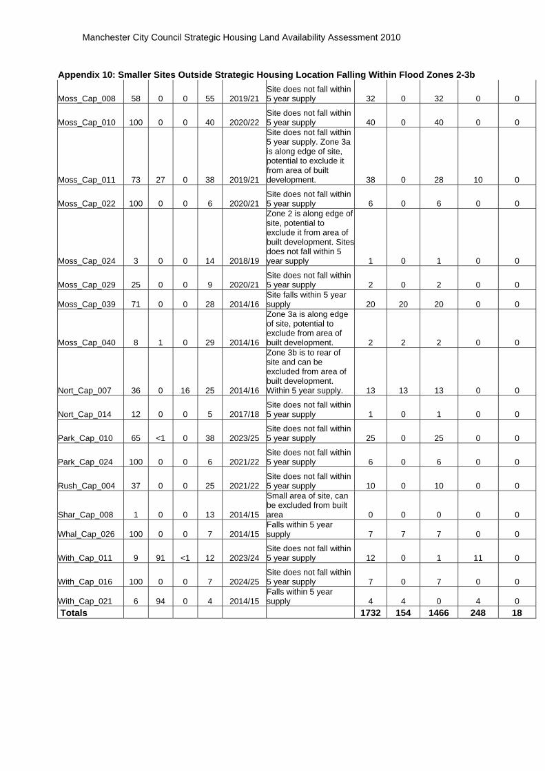
Manchester City Council Strategic Housing Land Availability Assessment 2010
Appendix 10: Smaller Sites Outside Strategic Housing Location Falling Within Flood Zones 2-3b
Moss_Cap_008 58 0 0 55 2019/21 Site does not fall within 5 year supply 32 0 32 0 0
Moss_Cap_010 100 0 0 40 2020/22 Site does not fall within 5 year supply 40 0 40 0 0
Moss_Cap_011 73 27 0 38 2019/21
Site does not fall within 5 year supply. Zone 3a is along edge of site, potential to exclude it from area of built development. 38 0 28 10 0
Moss_Cap_022 100 0 0 6 2020/21 Site does not fall within 5 year supply 6 0 6 0 0
Moss_Cap_024 3 0 0 14 2018/19
Zone 2 is along edge of site, potential to exclude it from area of built development. Sites does not fall within 5 year supply 1 0 1 0 0
Moss_Cap_029 25 0 0 9 2020/21 Site does not fall within 5 year supply 2 0 2 0 0
Moss_Cap_039 71 0 0 28 2014/16 Site falls within 5 year supply 20 20 20 0 0
Moss_Cap_040 8 1 0 29 2014/16
Zone 3a is along edge of site, potential to exclude from area of built development. 2 2 2 0 0
Nort_Cap_007 36 0 16 25 2014/16
Zone 3b is to rear of site and can be excluded from area of built development. Within 5 year supply. 13 13 13 0 0
Nort_Cap_014 12 0 0 5 2017/18 Site does not fall within 5 year supply 1 0 1 0 0
Park_Cap_010 65 <1 0 38 2023/25 Site does not fall within 5 year supply 25 0 25 0 0
Park_Cap_024 100 0 0 6 2021/22 Site does not fall within 5 year supply 6 0 6 0 0
Rush_Cap_004 37 0 0 25 2021/22 Site does not fall within 5 year supply 10 0 10 0 0
Shar_Cap_008 1 0 0 13 2014/15
Small area of site, can be excluded from built area 0 0 0 0 0
Whal_Cap_026 100 0 0 7 2014/15 Falls within 5 year supply 7 7 7 0 0
With_Cap_011 9 91 <1 12 2023/24 Site does not fall within 5 year supply 12 0 1 11 0
With_Cap_016 100 0 0 7 2024/25 Site does not fall within 5 year supply 7 0 7 0 0
With_Cap_021 6 94 0 4 2014/15 Falls within 5 year supply 4 4 0 4 0
Totals 1732 154 1466 248 18