Appendix C Archaeological Strategy - Kilkenny County Council
256
Appendix C Archaeological Strategy
-
Upload
khangminh22 -
Category
Documents
-
view
1 -
download
0
Transcript of Appendix C Archaeological Strategy - Kilkenny County Council
I Urban Design Framework for Abbey Creative Quarter, Kilkenny
Appendix C
Archaeological Strategy


ABBEY QUARTER MASTERPLAN AREA
ARCHAEOLOGICAL STRATEGY
for
KILKENNY COUNTY COUNCIL
By
COURTNEY DEERY HERITAGE CONSULTANCY LTD

CONTENTS
EXECUTIVE SUMMARY i
BACKGROUND
DELIVERABLES
OPPORTUNITIES
SUMMARY OF CULTURAL SIGNIFICANCE
VULNERABILITIES
SUMMARY OF RECOMMENDATIONS xv
SECTION I: APPROACH AND METHODOLOGY 1
1.1 THE APPROACH
1.2 SOURCES
1.2.1 Historic Sources
1.2.2 Conservation Sources
1.2.3 Archaeological Sources
1.2.4 Cartographic Sources
1.2.5 Photographic Collections
1.2.6 The National Museum of Ireland - Artefacts
1.2.7 Site and photographic survey
1.3 STATUTORY POLICY AND GUIDANCE
SECTION II: UNDERSTANDING THE PLAN AREA: HISTORY AND
CHRONOLOGY 14
2.1 HISTORY AND CHRONOLOGY
2.1.1 Designations
2.1.2 Archaeological Background
2.2 CARTOGRAPHIC RECORD
2.3 OUTLINE CHRONOLOGY
SECTION III: THE ARCHAEOLOGICAL CONTEXT 58
3.1 INTRODUCTION
3.1.1 Archaeological investigations within the Masterplan Area
3.1.2 Areas investigated outside the Masterplan area
3.1.3 Summary of archaeological investigation works
SECTION IV: UNDERSTANDING THE MONUMENTS & BUILDINGS 82
4.1 THE MASTERPLAN AREA
4.2 DESCRIPTION OF THE BUILDINGS AND FABRIC
4.2.1 St Francis’ Abbey
4.2.2 The Medieval City Wall and Mural Towers
4.2.3 Structural Assessment: Evan’s Tower and Wall Walk
4.2.4 Structural Assessment: The Town Wall
4.2.5 Bull Inn
4.2.5.1 Structural Assessment: Bull Inn Wall
4.2.6 The Tea Houses
4.2.7 Original Gateway
4.2.8 The Visitor Centre
4.2.9 The Maturation Building
4.2.10 The Brewhouse
4.2.11 The Mayfair
4.2.12 The Mill
4.2.13 Other Structures
SECTION V: CONTEXT AND SETTING 121
5.1 URBAN CONTEXT
5.2 COMPARATIVE ANALYSIS
5.3 PRESENTATION OF THE MONUMENTS & SETTING
5.3.1 Relationship of setting to curtilage, character and context
5.4 HISTORICAL ILLUSTRATIONS
5.5 PUBLIC EXPECTATIONS
PART VI: CONCLUSIONS 142
6.1 REVISIONING OF THE MASTERPLAN AREA
6.2 THE MANAGEMENT OF CHANGE
6.3 DEVELOPING AN ARCHAEOLOGICAL STRATEGY
6.4 HISTORIC CHARACTER AREAS AND PLACENAMES
6.5 TEST INVESTIGATION AND EXCAVATION
6.6 INTERPRETATION AND PRESENTATION
6.7 REPLACE OR RETAIN
6.8 NEW STRUCTURES
6.9 PHASING
6.10 CIVIC ENGAGEMENT & MANAGEMENT TOOLS
6.11 GOVERNANCE
6.12 COLLABORATION
FIGURES
Figure 1 Aerial view of Kilkenny and the Masterplan Area
Figure 2 Map of Masterplan Area
Figure 3 Archaeological sensitivity mapping
Figure 4 Zone of Archaeological Potential for Kilkenny
Figure 5 RMP, RPS and NIAH site locations
Figure 6 St Francis’ Abbey OPW 1966
Figure 7 Down Survey c. 1656
Figure 8 Rocque 1758
Figure 9 Loughman’s Estate map, date uncertain
Figure 10 A Plan of the City of Kilkenny, by Sam Byron, c. 1781
Figure 11 Hogan’s map of 1860
Figure 12 OS First Edition 6-inch map, 1839-40
Figure 13 OS Second Edition 25” scale (1872 published)
Figure 14 OS Revised Edition 25-inch Map, 1900
Figure 15 OS Revised Edition 25-inch Map, 1946
Figure 16 Map after Bradley (2000) Medieval City Walls
Figure 17 KKAP Overview
Figure 18 Plan of St. Francis’ Abbey OPW 1966
Figure 19 Plan of St. Francis’ Abbey, areas of archaeological investigation
Figure 20 Masterplan area, below ground remains and areas of investigation
Figure 21 Reconstruction of Mill based on archaeological remains on the mill
island
Figure 22 Plan, section, and elevations of Pleasure House
Figure 23 Geotechnical investigations monitored by CDHC in 2013/14
Figure 24 Proposed Demolitions
Figure 25 Monuments and historic structures within the Masterplan area
Figure 26 Plan survey of Evan’s Tower by Consarc (c. 2001)

Figure 27 Geodetic Survey of Evan’s Tower (MGL 1999)
Figure 28 Plan showing Condition of City Wall Sept. 1999 MGL
Figure 29 Site plan of Tea House after MGL 2001
Figure 30 Section of walling Bateman Quay jetty after MGL 2001
Figure 31 Tea House Roof Condition
Figure 32 Tea House Proposed Roof Repairs
Figure 33 Tea House Proposed Lintel Repairs
Figure 34 Plan of subsurface plant room
Figure 35 Typical Franciscan Abbey layout
Figure 36 Grey Abbey Co Kildare reconstruction
Figure 37 Franciscan Friary Castledermot Co Kildare
Figure 38 Notes on St Francis’ Abbey P Conlon
Figure 39 ACA map
Figure 40 NIAH sites, RPS and RMP sites and monuments within and adjacent
to the Masterplan area
Figure 41 Minister’s legal ownership of St Francis’ Abbey
Figure 42 Extent of National Monument St Francis’ Abbey
Figure 43 St Francis’ Abbey Grose 1792
Figure 44 J.G. Robertson 1851 – St Francis’ Abbey and Mills
Figure 45 Castletown House Collection (Cat No. 28) Kilkenny City from the
east
Figure 46aSt Francis’ Abbey, pencil drawing R. Gibbs c. 1810
Figure 46bSt Francis’ Abbey Brewery, pencil drawing c. 1860
Figure 47 ‘The Nore’ by E. J. Brenann 1882
Figure 48 Historic Character Map
Figure 49 Historic OPW photographs of structures surrounding St Francis’
Abbey
Figure 50 Previous excavation and monitoring work at St Francis’ Abbey
Figure 51Ordnance Survey manuscript town plan of Kilkenny 1841
Figure 52 Areas identified though research for archaeological investigation
Figure 53 Rocque’s map showing area of investigation
Figure 54 Masterplan proposal

PLATES
Plate 1 Presentation of City Wall at Watergate
Plate 2 East Window of St Francis Friary
Plate 3 The Liber Primus Kilkennienis
Plate 4 An extract from the Concise History of the Corporation of
Kilkenny 1873
Plate 5 Eastern Elevation of Tower1926
Plate 6 Eastern Elevation of Tower 1928
Plate 7 Detail of stone work 1952
Plate 8 Stone masons at work St Francis Abbey
Plate 9 The Edwin Rae Collection, sedila in the choir
Plate 10 The Stalley Collection, Bell capital
Plate 11 A sample of 17th century pottery
Plate 12 Reconstructed pots
Plate 13 A sample of floor tiles
Plate 14 Corbel figurines, St Francis’ Abbey
Plate 15 The Irishtown Seal
Plate 16 Extract from Ledwich (1781)
Plate 17 St Ciaran’s Font, St Francis Abbey
Plate 18 Bull Inn by Graves 1841
Plate 19 Bull Inn plaque
Plate 20 Bull Inn plaque
Plate 21 St Francis’ Abbey Brewery c. 1900
Plate 22 St Francis’ Abbey Brewery c. 1900
Plate 23 Single-column beam engine
Plate 24 St Francis’ Abbey Brewery c. 1900
Plate 25 St Francis’ Abbey Brewery c. 1900
Plate 26 Delahunty grave slab in situ
Plate 27 Delahunty grave slab present location
Plate 28 Collection of clay pipes uncovered during the River Nore
Flood Alleviation Scheme
Plate 29 Monitoring ESB trench, culvert section 1
Plate 30 Metal Detection of Spoil
Plate 31 Revetment wall at Evan’s Tower
Plate 32 Model of Medieval Kilkenny

Plate 33 Protected structure that faces onto the Masterplan area
Plate 34 Protected structure that faces onto the Masterplan area
Plate 35 Northern elevation of tower 1928
Plate 36 Work in progress to the East Window and Gable
Plate 37 Underside of vaulting in tower
Plate 38 Work in progress on the sacristy
Plate 39 Sample Rooms
Plate 40 The sacristy today
Plate 41 Evan’s Tower east elevation
Plate 42 Evan’s Tower northeast elevation
Plate 43 Evan’s Tower and wall walk landside
Plate 44 Evan’s Tower and wall walk from the River Breagagh
Plate 45 City Wall
Plate 46 City Wall
Plate 47 City Wall
Plate 48 City Wall
Plate 49 Bull Inn Wall
Plate 50 Bull Inn Wall
Plate 51 Bull Inn Wall
Plate 52 Bull Inn Wall
Plate 53 Tea House - Consolidated
Plate 54 Tea House – Sentry Box
Plate 55 Tea House – Ceiling interior
Plate 56 Tea House – doorway and window
Plate 57 Original Gateway
Plate 58 Jenkin’s Laneway
Plate 59 Brew Masters House
Plate 60 Visitors Centre
Plate 61 Maturation Building external elevation
Plate 62 Maturation Building external elevation
Plate 63 Maturation Building internal workings
Plate 64 Maturation Building internal workings
Plate 65 Brewhouse northern elevation
Plate 66 Brewhouse northeast elevation
Plate 67 Brewhouse western elevation

Plate 68 Brewhouse subterranean plant room
Plate 69 Interior of Brewhouse
Plate 70 Brewhouse interior – storage vats
Plate 71 Brewhouse interior – storage vats
Plate 72 Mayfair Building
Plate 73 Section of City Wall - landside
Plate 74 Section of City Wall - riverside
Plate 75 City Wall to the rear of the Mayfair Building taken from the
east showing spring stones of a former bridge site
Plate 76 City Wall to the rear of the Mayfair Building taken from the
west (Watergate)
Plate 77 View of ruined Mill from the southeast
Plate 78 View of ruined Mill from the east
Plate 79 Truck wash garage
Plate 80 Bottling store
Plate 81 Hop store
Plate 82 Kegging store
Plate 83 Masterplan area c. 1950’s
Plate 84 Franciscan Friary Donegal, founded 1474
Plate 85 Quin Franciscan Friary, Co Clare, founded 1433
Plate 86 View of St Francis’ Abbey taken from the north
Plate 87 Franciscan Friary at Castledermot, showing transept
Plate 88 Franciscan Friary at Castledermot founded c. 1247
Plate 89 Views from the Masterplan area towards St Canice’s
Plate 90 Kilkenny Streetscape
Plate 91 Rive Nore view to the south
Plate 92 Panoramic view of the northern section of the Masterplan area
Plate 93 Brew Masters House
Plate 94 View to the east from the East window St Francis’ Abbey
Plate 95 Smithwicks yard to the southeast of St Francis’ Abbey

APPENDICES
Appendix A St Francis’ Abbey Historic Sources
Appendix B Irish Historic Towns Atlas Gazetteer
Appendix C County and City Gaol
Appendix D Geotechnical Results
Appendix E Archaeological Investigations
Appendix F Architectural Heritage Inventory
Appendix G Conservation Measures
i
The Team
The team comprised Courtney Deery Heritage Consultancy (CDHC) Ltd and
Lisa Edden, Conservation Engineer. Steve Hickey of CDHC produced all the
drawings within the report.
Acknowledgements
CDHC wishes to acknowledge the assistance provided by Kilkenny County
Council. Many thanks are also extended to the National Monuments Service
of the Department of Arts, Heritage and Gaeltacht, the National Museum of
Ireland and the OPW who allowed their archives to be reviewed, and special
thanks is extended to Tony Roche for assisting us with trawling through the
photographic archive. Thanks are due to Heritage Council who provided
valuable insights in relation to the heritage and archaeological monuments
of the Masterplan area and to Margaret Gowen who provided the
archaeological strategy from which this framework document evolved from.
Margaret is also to be commended for allowing illustrations and drawings of
the River Nore Flood Alleviation Scheme to be reproduced in this document.
Thanks to Cóilín O’Drisceoil (Kilkenny Archaeology), Rob Goodbody and
Grace Fegan (Rothe House) for providing copies of historic maps and
illustrations. Finally, thanks to all the archaeologists that investigated the
plan area and whose work is recorded within this report.
We would also like to express our gratitude to David Sweetman, formerly
Chief Archaeologist of the State, who responded to queries regarding the
excavation and monitoring works carried out in the early 1970’s at St Francis’
Abbey and kindly allowed his site plan to be reproduced in this document.
We also acknowledge the excavation work carried out by Marcus Ó
hEochaidhe at St Francis’ Abbey and the late John Bradley, medieval
archaeologist and urban historian in relation to charting the development of
Kilkenny and bringing to life the historic character of this great medieval city.

ii
Figure 1 Aerial view of Kilkenny and the Masterplan Area

iii
EXECUTIVE SUMMARY
Kilkenny is an ancient city characterised by beautifully restored old buildings, winding
laneways and nationally important landmark monuments such as Kilkenny Castle
and St Canice’s Cathedral. It is widely regarded as Ireland’s most intact and easily
legible medieval town.
The Masterplan area is located at the heart of the medieval core of Kilkenny on lands
comprising of some 7.5 hectares. Part of the lands (approximately 5.3 hectares)
were previously occupied by Smithwicks/DIAGEO as part of an active brewery,
known locally as ‘St Francis’ Abbey Brewery’ (SFAB). The local authority has entered
into an agreement to purchase these lands. Within the brewery site, large scale
clearance including the demolition of existing modern structures to the ground slab
level is planned prior to Kilkenny County Council taking ownership of the site.
The lands align the western bank of the River Nore in the townlands of Gardens
(Kilkenny City By., St Canice Par.) and St Mary’s Parish and form part of the Zone of
Archaeological Potential of the Historic Town (KK019-026---) as well as St Canice’s
and the City Centre architectural conservation areas (ACAs). The site is divided by
the River Breagagh in an east-west fashion, historically the south of the river was
defined as Englishtown or Hightown while north of the river was part of Irishtown.
The site is bordered to the south by Bateman Quay and the Market Yard. To the
north lie some residential properties and industrial units which are accessed from
Green Street, this northern area is less developed and was primarily used by the
brewery for vehicular parking, truck washing and storage. Parliament Street, along
with Horse Barrack Lane and Vicar Street bound the site on the west.
The acquisition of the site by Kilkenny County Council and the rejuvenation of these
lands provides a unique opportunity to preserve, enhance and present key
upstanding medieval structures such as St Francis’ Abbey, Evan’s turret (or tower)
and wall walk and the city wall as well as the brewery buildings and protected
structures such as the Tea Houses and integrate them within the historic character
and newly visioned streetscape of Kilkenny and within the existing urban context of
a living and vibrant city.

iv
Figure 2 Map of Master Plan Area based on Ordnance Survey of Ireland Map Licence No.
Kilkenny/CCMA/08/12
v
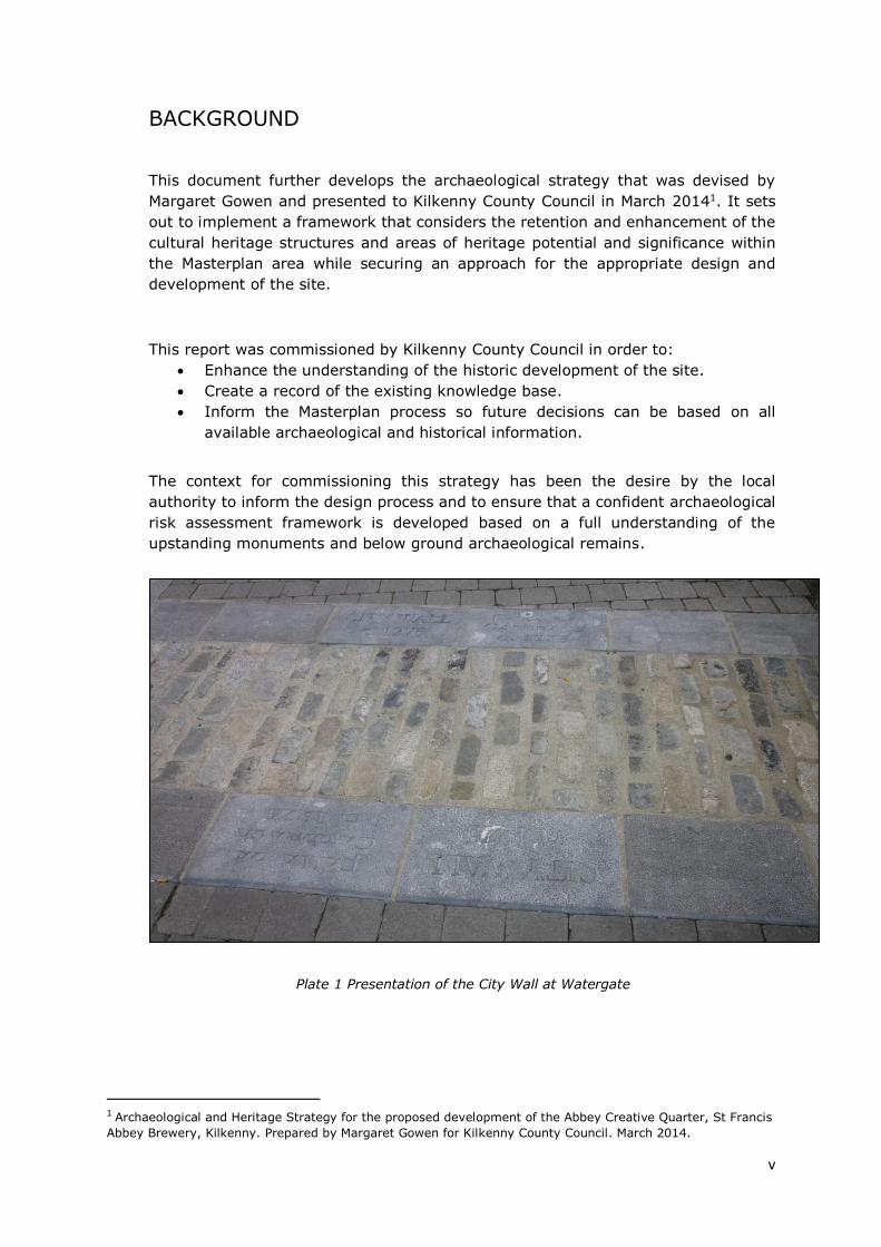
BACKGROUND
This document further develops the archaeological strategy that was devised by
Margaret Gowen and presented to Kilkenny County Council in March 20141. It sets
out to implement a framework that considers the retention and enhancement of the
cultural heritage structures and areas of heritage potential and significance within
the Masterplan area while securing an approach for the appropriate design and
development of the site.
This report was commissioned by Kilkenny County Council in order to:
Enhance the understanding of the historic development of the site.
Create a record of the existing knowledge base.
Inform the Masterplan process so future decisions can be based on all
available archaeological and historical information.
The context for commissioning this strategy has been the desire by the local
authority to inform the design process and to ensure that a confident archaeological
risk assessment framework is developed based on a full understanding of the
upstanding monuments and below ground archaeological remains.
Plate 1 Presentation of the City Wall at Watergate
1 Archaeological and Heritage Strategy for the proposed development of the Abbey Creative Quarter, St Francis
Abbey Brewery, Kilkenny. Prepared by Margaret Gowen for Kilkenny County Council. March 2014.

vi
DELIVERABLES
The deliverables of the framework are to: -
Prepare a baseline historical and cartographical study.
Engage with relevant stakeholders.
Produce a scaled drawing of previous site investigations.
Undertake a review of all standing buildings and their fabric to include a
preliminary conservation assessment of the historic structures.
Compile geo-technical and deposit information from previous archaeological
investigations and monitoring reports and prepare where possible an
archaeological deposit model.
Review OPW excavation archive.
Identify the scope, position and nature of further archaeological
investigations required and indicate at what stage in the development
process that these would take place.
Make recommendations as to all necessary mitigation measures for inclusion
in the Masterplan.
To achieve these deliverables it is necessary first to: -
Understand the history and development of the site.
Understand the nature and significance of the visible structures and the
underlying archaeology.
Understand the vulnerabilities that may give rise to damage or degradation
of the conservation value of the monuments and protected structures on site.
Only then is it possible to make recommendations for the safeguarding of above
ground structures and the below ground potential that provide for:
The development of our knowledge and understanding of the site.
The appropriate terms of reference for the protection and management of the
heritage structures now and in the future.
A plan for repairs and conservation works.
The future uses and management of the site.
OPPORTUNITY
The site sits at the heart of the Zone of Archaeological Potential for Kilkenny City,
and, any ground breaking works within it has the potential to uncover archaeological
remains. Through a detailed study of existing cartography, extant archaeological
monuments and features, and an examination of the findings from literally hundreds
of test trenches, bore holes, window samples, dredged river areas, and
archaeological assessments, it is possible to generate an understanding of where
there is a potential to reveal significant below ground archaeological remains.
The site as it exists today exerts a strong industrial presence over the Kilkenny
skyline and as a result of this and the private ownership of the lands, the earlier
medieval structures lack a legibility within the streetscape of Kilkenny and are
difficult to access having largely gone unrecognised. There is a significant
opportunity to reconnect these historic landmark sites and the River Nore and to
vii
provide a strong, distinct visual and physical presence to the existing streetscape of
Kilkenny.
The phased and planned removal of some of the modern structures within the site
as well as the sensitive redevelopment of industrial buildings from the 1930’s to the
1960’s has the potential to enhance and redefine the space surrounding the historic
monuments. By providing a diverse building template, as well as revitalising and
reusing modern buildings, a balance can be achieved between old and the new
thereby creating an interesting sense of place adapted for a new range of uses
meeting the needs of the local population and visitors alike.
SUMMARY OF CULTURAL SIGNIFICANCE
The collection of upstanding monuments is a testament to an unusually
complete survival of a nationally significant complex of medieval buildings
and structures within an urban environment. The abbey is the only example
of a Franciscan monastery in a city scape set within an open space albeit
altered throughout the years.
St Francis’ Abbey is regarded as an elegant construction that demonstrates
the wealth of the order while showcasing the engineering ingenuity and
masonry skills of the craftsmen during the medieval period.
The Abbey is also known to have been the final resting place for several
citizens of high standing within Kilkenny and was associated with the
renowned scholar Friar John Clyn who provided valuable insights into
medieval society and documented the spread of the Black Death in 1348
before it is thought that he succumbed to the plague himself and died in
Kilkenny.
As a centre of learning and enlightenment the Abbey was celebrated
throughout the Franciscan community and obtained the status of a studium
for both philosophy and theology the only house to achieve this double
status2.
Marcus ÓhEochaidhe’s excavations in 1963 combined with monitoring
through the 1970s by David Sweetman of St. Francis’ Abbey has indicated
the possible extent of significant medieval ecclesiastical remains, revealing
that the standing tower and unroofed choir were once flanked by a transept,
2At the provincial chapter of 1647, Kilkenny was designated as a studium for philosophy and theology,
Benignus Millett, The Irish Franciscans 1651-1665 (Rome 1964), pg 357 in Joseph Mac Mahon ‘The Franciscans
in Kilkenny’, OKR, 64 (2012). The double status of the stadium relates only to the Irish Franciscans in
Ireland. Each province of the Order (Ireland was a province) was obliged to have at least one studium or study
house where all Franciscan students would be taught either philosophy or theology. In the years in question,
St Francis Abbey was allowed to teach both disciplines which demonstrates that it was considered to be a
significant foundation which is not surprising considering that Kilkenny was a politically important location at
the time.
viii
nave, sacristy, cloister, and cloister walk. There is a strong likelihood that
further important remains of the Franciscan abbey (including a chapter house,
and living quarters) are present below ground.
The uncovering of a series of inhumations within the abbey points to its
regular and continued use as a burial ground as well as the potential that
further human remains are present in the environs.
The location of these medieval structures within what was once a traditional
brewery site in single ownership has helped protect them over the years but
has also kept them separate from the rest of the historic building stock of the
city. The former brewery that dominated the western banks of the river Nore,
is important in its own right for the economic, social, industrial and
technological contributions that it made to Kilkenny city.
Monitoring and testing within the Masterplan site has created an
understanding of how the general area developed along with how it was
dictated by flooding events of the Rivers Nore and Breagagh. This
development stems from the gradual reclamation of land, to the setting out
of medieval burgage plots (appearing as shallow, long ditches orientated both
north–south and east–west) as shown in Rocque’s Map of 1758, and the
adaption in the use of the river with the development of mills, and the strong
association with brewing.
A wide range of archaeological remains, artefacts, and features are seen
within the Masterplan area. Finds of possible plague victims from the medieval
period, Franciscan abbey remains, ruined towers, city walls and defences, and
medieval deposits, burgage plots, industrial mill houses, riverside pleasure
houses with stone jettys, along with burials of felons from a 19th century gaol
house, indicate an extremely rich and varied archaeological record.
The archaeology and history of the site represents at least seven hundred
years of development, redesign, alteration, re-use and adaptation, reflecting
the changing fortunes of the monastery and later developments on the site
such as the Horse Barracks and St Francis’ Abbey Brewery. It is a unique
urban historic area.
VULNERABILITIES
Nestled within the former brewery site, the medieval structures, have not enjoyed
the widespread public appreciation and interaction that other medieval monuments
in Kilkenny have had due to restricted access issues. As a result they have become
lost and forgotten locally, regionally and nationally. The Masterplan has the potential
to breathe new life into these historic gems.
Whilst part of St Francis’ Abbey has been excavated in the 1960’s unearthing the
nave and transept, and further excavations on adjacent sites have taken place such
as those at Grace’s Castle/ Kilkenny Courthouse and the Vicar’s Choral there are no

ix
published accounts of any of these excavations. Without the full archive available
for review, inconsistencies in the existing record and knowledge gaps can develop
causing difficulty in understanding the development and the fabric of the site. This
can lead to an inadvertent loss of material and an improper use of modern
structures, uses and material.
The ownership and long term management of the site has ramifications as to how
the area is developed, and how control measures are implemented to ensure that no
inadvertent damage/loss occurs to below ground remains and for ensuring that the
developer is fully aware of the archaeological significance and potential of the site.
The responsibility for the maintenance, conservation and future use of the national
monuments onsite held by the, Department of Arts, Heritage and Gaeltacht, Kilkenny
County Council and the OPW may be subject to differing priorities and conflicting
management styles. However views from different organisations can contribute
positively to the discussion of the monuments and enhance the overall interpretation
and presentation of these features.
Funding for archaeological assessment work and the maintenance and servicing of
monuments is now limited and this is a further significant challenge to ensure plans
for the area are appropriate and sustainable.

x
Figure 3 Archaeological Sensitivity Mapping

xi
SUMMARY OF RECOMMENDATIONS
Approach and Collaborative Design Process
With a development of this nature and scale at the heart of the historic city of
Kilkenny there is the potential for conflicting values to be placed on different
aspects of the site and for competing visions. It is the purpose of this document to
provide an understanding of the cultural heritage value so it may be considered
along with other values and be part of a collaborative decision making and design
process.
1. The successful implementation of a collaborative and balanced approach depends
on a wide acceptance and active support from all interested stakeholders/ parties.
2. The objective is to retain and celebrate the historic quality of the plan area and to
promote its significance through interpretation and appropriate presentation while
developing a site that is an example of high quality urban planning and design that
is fit for purpose and meets the needs of modern Kilkenny.
3. Understanding and respecting the historic monuments and open spaces that occupy
the Masterplan area is central to the design process. The protection of the historical
character must seek to strengthen visual and physical links with other historical
and archaeological sites within Kilkenny.
4. The job at hand is to manage the change appropriately and to place the Abbey
precinct at the centre of the development. Evidence has shown that successful
integration of historic environments and contemporary developments help create
vibrant and distinctive places that encourage sustainable growth and social
interaction (and ultimately the protection of the cultural heritage resource)3.
Information and Research
5. Significant archaeological excavation work has taken place on and adjacent to the
plan area but the results have never been assembled or assessed, nor do they form
part of the public record and cannot be brought forward as part of the ‘cultural
artefact’ for the site. While this report has sought to provide an understanding and
overview of this work it should be a priority to gain access to the original archives
so they can inform the future development of the Masterplan area.
6. Develop a centralised digital archive so all information is maintained and accessible.
All future archaeological work associated with the plan area can in turn be informed
by this archive and add to it.
7. Develop a research framework and partnership with academic institutions, heritage
networks and the Discovery Programme for future archaeological, architectural and
historical research and targeted investigation to increase the understanding of the
monument complex and purposely contribute to the discussion regarding the use
and chronology of the site.
3 New life for historic cities – The historic urban landscape approach explained UNESCO 2013
xii
Archaeological Strategy - Investigation
In order to provide an understanding of the extent and type of below ground
archaeological potential, archaeological test excavation and excavation is required.
Within the former Diageo site, the stratigraphy demonstrated in archaeological
investigations throughout the site commonly shows a sequence of modern
concrete, sitting above made ground, over evidence of post medieval walls or
structural foundations, overlaying (an often sterile) organic dark silty clay with
occasional finds dating it to the medieval period, along with river silts and gravels,
and a yellow boulder clay.
It is suggested that the following guiding principles are adopted to facilitate an
understanding of the below ground archaeological remains and to minimise
disturbance of the remains where possible, the strategy involves a combination of
full excavation and preservation in situ:
8. Excavation is to take place in the environs of St Francis’ Abbey with investigations
extending to Evan’s Tower and St Francis’ Well site at the waterfront and to the
extant buildings to the south and the River Breagagh to the north. The concrete
slab in and around the National Monument of St Francis’ Abbey is to be lifted and
the area investigated and excavated (Figures 52 and 53).
9. The purpose of this excavation is to confirm the limited knowledge that exists today
through cartographic and documentary research and also to confirm the findings
of Marcus ÓhEochaidhe’s excavation in the 1960’s as shown on a map belonging to
that time (Figure 6). It is hoped that this will answer key questions such as the
location and extent of burials, the survival and ground plan/layout of the transept,
nave and cloister, whether the Abbey Precinct was walled and if this can be defined
and any additional features that may have influenced life in a medieval Franciscan
friary or finds that can further inform the significance of the monument.
10. There is merit and precedence to link research excavation work with volunteer
programs and open the experience to the general public and interested parties as
a structured learning programme. This also has the advantage of uniquely
identifying St Francis’ Abbey within the medieval city of Kilkenny and act as a live
attraction and educational experience4.
11. The extent of these excavations is to be informed and guided by a comprehensive
and targeted testing programme (Figure 3; archaeological sensitivity map)
(detailed in Section VI).
12. The findings from these excavations are to be included in the proposed framework
for the area in an imaginative and creative way lending themselves to an
educational experience.
4 Several submissions including Kilkenny Archaeological Society (RV51) and Liam Mannix (RV13) have suggested that excavations are undertaken by professionals, volunteers and students and open to the public, lending themselves to an educational and learning experience.

xiii
13. Depending on the nature of the remains, consideration is to be given to leaving
below ground masonry remains in-situ so they can be explored as part of the St
Francis’ Abbey experience and exhibited.
14. Archaeological investigation in the form of test trenching and strategically placed
boreholes will assist the development of the southern and northern portion of the
plan area. Initially it is proposed to place a series of boreholes at regular intervals
in order to build a cross-section, below ground profile of the site. This will be
supplemented by testing where necessary and areas of interest will be excavated.
15. Where there is an existing concrete slab (300-400mm thick) within the Diageo site
(immediately north of the River Breagagh and to the south of the Abbey), it is
proposed that this remains in-situ (subject to verification from an engineering
perspective that it is suitable to build upon) and that no basements or lower ground
levels are permitted onsite. This approach will minimise disturbance to the below
ground archaeological deposits.
16. A proposed sub-structure will consist of a series of piles set out to a 7.5m grid with
a ground beam located above the existing slab level. All excavation work and the
proposed piling strategy within the complex will be preceded and informed by an
appropriate programme of archaeological evaluation (Section VI).
17. It is also proposed that new services, where possible, are to be located in a 500-
1500mm band of made ground (detailed Section VI, 6.8 New Structures), raised
up from the existing slab and in the case of drainage that it will linked with existing
services on the site.
18. To the north and south of the plan area, post medieval, medieval linear garden
plots extending east–west have been recorded in excavations and from
cartographic references. In the design of this area elements must be introduced
(hard landscaping, plots, open space etc) that will reflect the medieval garden plot
layout.
19. The River Breagagh and Nore are integral to the setting and history of the site and
substantial deposits as well as features were revealed along the waterfront during
previous investigations and are detailed in Section III of the report. Works
associated with the rivers in previously unexplored areas will be appropriately
archaeologically investigated where necessary.
Conservation and Repair
The conservation priorities documented in this report established the need for:
1. Immediate stabilisation works
2. Archaeological investigation works in order to inform conservation
practices
3. Conservation works fit for purpose

xiv
20. Future proposals associated with St Francis’ Abbey will have to be agreed in
advance with the relevant authorities. Previous interventions and additions to fabric
such as the concrete superstructure and iron pillars now examples of historic
conservation should be retained where appropriate and where these do not
diminish the integrity of the structure.
21. The conservation of Evan’s Tower and wall walk and the city defences central to
the plan area as well as the tea houses at the southern end and the Bull Inn wall
located to the northwest and the mill buildings to the north is largely dependent on
the proposed future function of these historic features and the role that they will
have in the overall development proposal. A range of conservation measures are
proposed in Section IV and Appendix F of the report.
Implementation, Delivery and Finance
Governance and the management of property within the Masterplan area has to be
placed within a robust framework to ensure the delivery of a design approach that
takes cognisance of the historic character and the buried archaeological potential
of the site. This may be achieved through Kilkenny County Council retaining an
interest or appropriate partnerships being forged, local management frameworks
created and mandatory archaeologically-led guidelines informing the design
process contributing to the sensitive redevelopment of the site. This is an
opportunity to set a model of urban design for the regeneration of a historic town.
22. In order to ensure that these proposals are carried out, mandatory procedures or
specific design contracts detailing the archaeological conditions will be required in
order to confirm compliance and will have to be adopted by potential developers
on the site.
23. It is recommended that potential avenues for funding from the EU, government,
development-led and private sources is actively investigated as a priority in order
to support the archaeological investigation of the site.
xv
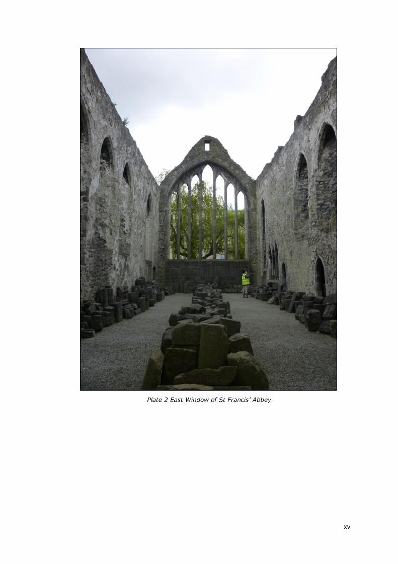
Plate 2 East Window of St Francis’ Abbey
Kilkenny Masterplan Area Archaeological Framework ________________________________________________________________________________________________
Page | 1
SECTION 1 APPROACH AND METHODOLOGY

Kilkenny Masterplan Area Archaeological Framework ________________________________________________________________________________________________
Page | 2
SECTION I APPROACH AND METHODOLOGY
1.1 THE APPROACH
This framework document was carried out in two stages:
Stage 1: the information gathering stage included an examination of published
and unpublished documentary and cartographic sources and numerous site
inspections. Documentary Research has been carried out in the following
repositories:
National Library
National Archives – Royal Irish Academy
Irish Architectural Archive
Trinity College Map Library
Kilkenny City Town Hall
Archaeological Survey of Ireland
National Museum of Ireland
Department of Arts, Heritage and Gaeltacht, storage facility Swords,
Dublin
OPW photographic archive
The information gathering process was complemented by consultations and
attendance at a work shop over two days in relation to the revisioning of the
Masterplan. Structured meetings and informal discussions with a number of
stakeholders and interested groups expanded the consultation process1.
Stage 2: the review stage, sought to establish the chronological development
of the plan area and the significant phases of building.
This stage also sought to provide an understanding of the significance of the
plan area from an archaeological and historical view point. In order to
safeguard and protect the above ground structures and below ground features
this report also sought to develop a risk assessment strategy based on the
available archaeological and historical information to date on and in the
environs of the plan area.
1Included the following individuals and organisations: Kilkenny County Council, The National
Museum of Ireland, The Department of Arts, Heritage and the Gaeltacht, OPW, The Heritage
Council, DIAGEO, Arup Consulting Engineers, CONSARC, Reddy Architecture, Mitchell Associates,
David Sweetman, Margaret Gowen, Shaffrey Associates Architects, Joseph Mac Mahon, David
Sweetman, Edel Bhreathnach, Liam Mannix, Cóilín Ó’Drisceoil, Gill McLoughlin, Mark Moraghan,
Brenda O’Meara, Catherine McGloughlin, Rob Goodbody, Stephen Johnson and Colm Flynn.

Kilkenny Masterplan Area Archaeological Framework ________________________________________________________________________________________________
Page | 3
1.2 SOURCES
1.2.1 Historic Sources
The city of Kilkenny has been more than fortunate in the number and
importance of its early records, it has a wealth of primary medieval and
secondary historical records which is unusual for Ireland. This tradition of
recording and archiving extends to modern day through the Journal Royal
Society of Antiquities of Ireland (JRSAI) (originally founded as the Kilkenny
Archaeological Society) and the Old Kilkenny Review (OKR). Material in the
Kilkenny County Council Archives, includes the original Charter of Kilkenny
dating to the 11th of April 1609 from King James I where upon he raised the
dignity of Kilkenny to city status. Although Kilkenny was a city it did have two
separate corporations ruling over separate jurisdictions, Hightown and
Irishtown, evidence for feuds and disputes between these neighbouring seats
are common place in the records. For the purpose of this project the
Corporation records detailing the administration and various leases of
Hightown and Irishtown were reviewed.
The Liber Primus
Kilkenniensis is the first
minute book of the
Corporation and contains
the proceedings of the
municipal body from 1231
to 1586, it is Kilkenny’s
most ancient record. A
second book known as the
Liber Secondus dating to
1544-1572 is now missing.
Plate 3 The Liber Primus Kilkennienis
In 1988, Honora Faul2 organised the Corporation’s Charters and minutes and
so they are accessible to researchers, the documents have been arranged in
sections according to either document type or subject matter. Within each
section, items are in chronological order. All documents are referenced with CR
and then a letter describes the type of document for example A; relates to
charters, B; grants and C; leases etc. The minutes provide an invaluable
source of everyday life in Kilkenny during that time. While evidence relating to
2 Faul, Honora (1988) [Catalogue of Corporation Archives] typescript A Charters (1608-1862); B Grants (1244-1596; C Copies and Translations (1223-1690); D Corporation Minute Books (1231-1952); E Urban Sanitary Authority Records (1875-1945); F Corporation of Irishtown (1544-1834); G Tithe Applottment
Books (1826-33); H Other Bound Records (C16-C20); I Leases (1511-1792); J Accounts, etc (1577-1733); K Documents (1547- 1768); L Parish of Skeirke (1804-1920); M Market (1962-8); N Photographs (1893); O Former catalogues (1878-1952)
Kilkenny Masterplan Area Archaeological Framework ________________________________________________________________________________________________
Page | 4
St Francis’ Abbey was scant, a number of references were revealed and are
detailed in Appendix A. The references date from 1544 and mostly pertain to
different land leases and a grant from King Henry VIII describes the Grey
Friary as consisting of a church, belfry, dormitory hall, chapter house, three
chambers, kitchen, ‘Garnen’ house with three cellars, an enclosure, gardens,
lands, tenements, orchards etc3.
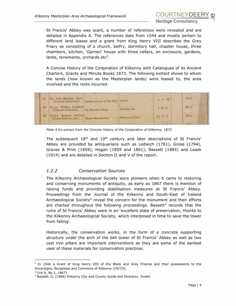
A Concise History of the Corporation of Kilkenny with Catalogues of its Ancient
Charters, Grants and Minute Books 1873. The following extract shows to whom
the lands (now known as the Masterplan lands) were leased to, the area
involved and the rents incurred.
Plate 4 An extract from the Concise History of the Corporation of Kilkenny, 1873
The subsequent 18th and 19th century and later descriptions of St Francis’
Abbey are provided by antiquarians such as Ledwich (1781), Grose (1794),
Graves & Prim (1859), Hogan (1859 and 1861), Bassett (1884) and Leask
(1914) and are detailed in Section II and V of the report.
1.2.2 Conservation Sources
The Kilkenny Archaeological Society were pioneers when it came to restoring
and conserving monuments of antiquity, as early as 1867 there is mention of
raising funds and providing stabilisation measures at St Francis’ Abbey.
Proceedings from the Journal of the Kilkenny and South-East of Ireland
Archaeological Society4 reveal the concern for the monument and their efforts
are charted throughout the following proceedings. Bassett5 records that the
ruins of St Francis’ Abbey were in an ‘excellent state of preservation, thanks to
the Kilkenny Archaeological Society, which interposed in time to save the tower
from falling’.
Historically, the conservation works, in the form of a concrete supporting
structure under the arch of the bell tower of St Francis’ Abbey as well as two
cast iron pillars are important interventions as they are some of the earliest
uses of these materials for conservation practices.
3 In 1544 a Grant of King Henry VIII of the Black and Grey Friaries and their possessions to the
Soveraigne, Burgesses and Commons of Kilkenny (CR/C9). 4 (Vol.6, No.1, 1867) 5 Bassett, G. (1884) Kilkenny City and County Guide and Directory. Dublin

Kilkenny Masterplan Area Archaeological Framework ________________________________________________________________________________________________
Page | 5
Plate 5 Eastern Elevation of Tower1926 Plate 6 Eastern Elevation of Tower 1928
Conservation works have already occurred on site as part of the River Nore
Flood Alleviation Scheme6, in particular work was carried out at Evan’s Tower,
City Wall and at the Tea House on Bateman Quay. Copies of rectified surveys
were accessed from Consarc and archaeological consultant, Margaret Gowen.
The Heritage Council in 2005, published the Kilkenny City Walls Conservation
Plan, which provides for a conservation strategy of each section of the City
Wall and associated defences and the presentation of the circuit7.
1.2.3 Archaeological Sources
The Urban Archaeological Survey of Kilkenny8 is an invaluable inventory of all
archaeological sites within Kilkenny. The Kilkenny Archaeological Project builds
upon all existing sources and captures them within an impressive GIS
environment, securing all elements for future reference9. The Irish Historic
Towns Atlas10, focuses on the development of Kilkenny through mapping, and
6 Gowen et al 2003, Archaeological Archive for the River Nore Flood Alleviation Scheme. 7 Oxford Archaeology 2005 Kilkenny City Walls Conservation Plan, The Heritage Council. 8 OPW, 1993, The Urban Archaeological Survey of Kilkenny compiled by J.Farrelly, B. O’Reilly and A. Loughran for the Archaeological Survey of Ireland 9 O’Drisceoil C., et al 2008 The Kilkenny Archaeological Project (KKAP) Report for the Irish National Strategic Archaeological Research (INSTAR). Heritage Council 10 Bradley 2000 Irish Historic Towns Atlas, no 10 Kilkenny. Dublin: Royal Irish Academy

Kilkenny Masterplan Area Archaeological Framework ________________________________________________________________________________________________
Page | 6
references referring to the study area are presented in Appendix B, as does the
study by Thomas on the Walled Towns of Ireland11 which provides a gazetteer
of Irish town walls.
Plate 7 Detail of stone work 1952 Plate 8 Stone masons at work St Francis’ Abbey
Archaeological excavation was carried out at the site to determine the extent of
the Abbey’s below ground remains by Marcus Ó hEochaidhe in 1963 and
monitoring by David Sweetman occurred in the early 1970’s. Mid-excavation
photographs and site notes have been recovered for the archaeological
excavation and monitoring works from the OPW and DAHG archives.
Since then, small scale investigation in the form of test trenching and
archaeological monitoring has continued on an intermittent basis over forty
years in and around the Masterplan area and these investigations are
summarised in the Excavation Bulletin (www.excavations.ie). Where possible,
consultation with archaeologists who have worked in and around the
Masterplan area was carried out as part of the project’s scope.
1.2.4 Cartographic Sources
Historical mapping for the site prior to the establishment of the Ordnance
Survey is limited, comprising mainly the Down Survey Maps (1655), Rocque
(1758), Loughman’s estate map (c. 1750?) and Hogan (1861). Mapping
sources are reviewed in Section II of the report.
11 Thomas, A 1992 The Walled Towns of Ireland, 2 Vols. Dublin

Kilkenny Masterplan Area Archaeological Framework ________________________________________________________________________________________________
Page | 7
Subsequent Ordnance Survey mapping recorded in the report includes the
1840 and 1870 six inch editions and later twenty five inch editions. The OPW
plan of St Francis’ Abbey (1966) was reviewed along with sketches of later
monitoring work undertaken by Sweetman in the 1970’s. Drainage and the
sewer plan maps held by Kilkenny County Council were also reviewed for the
area.
1.2.5 Photographic Collections
The photographic archive of the OPW was accessed to gain photographs of the
excavations that took place in the 1960 and 1970s. In addition to these a
number of photographs dating from the 1920-1950s of the site were also
discovered. Drawings and illustrations were reviewed at the Irish Architectural
Archive and from various antiquarian publications. The Stalley Collection and
Edwin Rae Collection are also listed on Gothic Past, a visual archive of Gothic
architecture and sculpture in Ireland.
Plate 9 The Edwin Rae Collection, architectural drawing,sedila in the choir, St Francis’ Friary,
www.gothicpast.com
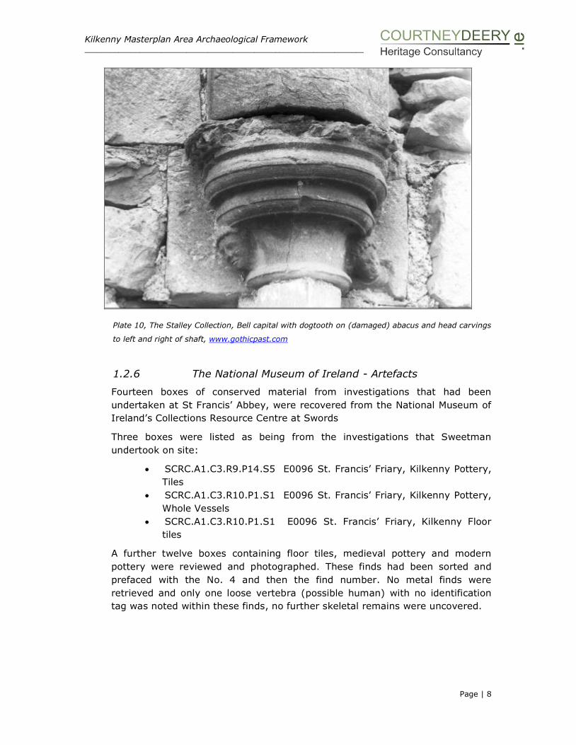
Kilkenny Masterplan Area Archaeological Framework ________________________________________________________________________________________________
Page | 8
Plate 10, The Stalley Collection, Bell capital with dogtooth on (damaged) abacus and head carvings
to left and right of shaft, www.gothicpast.com
1.2.6 The National Museum of Ireland - Artefacts
Fourteen boxes of conserved material from investigations that had been
undertaken at St Francis’ Abbey, were recovered from the National Museum of
Ireland’s Collections Resource Centre at Swords
Three boxes were listed as being from the investigations that Sweetman
undertook on site:
SCRC.A1.C3.R9.P14.S5 E0096 St. Francis’ Friary, Kilkenny Pottery,
Tiles
SCRC.A1.C3.R10.P1.S1 E0096 St. Francis’ Friary, Kilkenny Pottery,
Whole Vessels
SCRC.A1.C3.R10.P1.S1 E0096 St. Francis’ Friary, Kilkenny Floor
tiles
A further twelve boxes containing floor tiles, medieval pottery and modern
pottery were reviewed and photographed. These finds had been sorted and
prefaced with the No. 4 and then the find number. No metal finds were
retrieved and only one loose vertebra (possible human) with no identification
tag was noted within these finds, no further skeletal remains were uncovered.

Kilkenny Masterplan Area Archaeological Framework ________________________________________________________________________________________________
Page | 9
Plate 11: A sample 17th century pottery Plate 12: E0096 Reconstructed Pots
Plate 13: A sample of the floor tiles
1.2.7 Site and photographic survey
In addition to the desk based assessment, physical research included
specialised surveys, multidisciplinary team visits to the Masterplan Area and a
review of existing interventions and conservation work, see Section IV of the
report.
Kilkenny Masterplan Area Archaeological Framework ________________________________________________________________________________________________
Page | 10
1.3 STATUTORY POLICY AND GUIDANCE
The conclusions and recommendations within the report are placed within an
existing framework of statutory legislation, policy plans, Charters, guidance
documents which are listed below:
National Monuments Act, 1930, as amended in 1954, 1987, 1994, 2004 and
2012
Heritage Act, 1995
The Architectural Heritage (National Inventory) and Historic Monuments
(Miscellaneous Provisions) Act, 1999
Local Government (Planning and Development) Act, 2000 (as amended)
Kilkenny County Council Development Plan 2014-2020
Council of Europe Convention for the Protection of the Architectural Heritage of
Europe (Granada) 1985, ratified by Ireland in 1991
Council of Europe European Convention on the Protection of the Archaeological
Heritage (Valletta) 1992, ratified by Ireland in 1997
The Burra Charter, the Australia ICOMOS Charter for Places of Cultural
Significance 1999
The Ename Charter, the charter for the interpretation and presentation of
cultural heritage sites, 2007, ICOMOS, Abdijstraat
ICOMOS Xi’an Declaration on the Conservation of the Setting of Heritage
Structures, Sites and Areas. Paris: International Council on Monuments and
Sites, 2005
Framework and Principles for the Protection of the Archaeological Heritage
(1999) (DAHGI)
Policy and Guidelines on Archaeological Excavation (1999) (DAHGI)
Architectural Heritage Guidelines for Planning Authorities (2011) (DAHG)
The importance of protecting the setting of heritage assets is recognised by a
number of international conventions and instruments. The ‘Valletta and
Granada’ Council of Europe conventions place legal obligations on Member
States in relation to the recording, conservation and management of
archaeological and built heritage. In essence these conventions prescribe that
heritage is conserved and maintained preferably in-situ and that archaeological
and architectural heritage concerns are integrated into the planning and
development process. In Ireland these conventions are given effect through the
National Monuments Acts 1930-2012 and the Planning and Development Act
2000 and its amendments.
The Granada Convention requires that ‘In the surroundings of monuments,
within groups of buildings and within sites, each Party undertakes to promote
measures for the general enhancement of the environment’.
The 1988 ICOMOS Charter for the Conservation of places of Cultural
Significance, the Burra Charter, sets down the principles for assessing the

Kilkenny Masterplan Area Archaeological Framework ________________________________________________________________________________________________
Page | 11
cultural significance of an historic site. This charter defines cultural significance
as ‘the aesthetic, historic, scientific or social values for past, present or future
generations’.
According to the Ename Charter (2007) interpretation refers to the full range of
potential activities intended to heighten public awareness and enhance
understanding of cultural heritage sites. These can include print and electronic
publications, public lectures, on-site and directly related off-site installations,
educational programmes, community activities, and ongoing research, training,
and evaluation of the interpretation process itself.
Presentation more specifically denotes the carefully planned communication of
interpretive content through the arrangement of interpretive information,
physical access, and interpretive infrastructure at a cultural heritage site. It can
be conveyed through a variety of technical means, including, yet not requiring,
such elements as informational panels, museum-type displays, formalized
walking tours, lectures and guided tours, and multimedia applications and
websites.
The X’ian Declaration on the Conservation of the Setting of Heritage Structures,
Sites and Areas (ICOMOS 2005) is the only international instrument dedicated
to setting.
Monuments
The National Monument Act, 1930 and subsequent amendments provide the
formal legal mechanisms to protect monuments in Ireland. There are four
mechanisms by which a monument is protected under the Acts; these are:
• The Record of Monuments and Places (RMP)
• The Register of Historic Monuments (RHM)
• Preservation Order (PO) or Temporary Preservation Order (TPO)
• National Monuments (NM) either in the care (ownership or guardianship)
of the State or a local authority
All known sites and monuments in Ireland are identified and listed for
protection in the Record of Monuments and Places (RMP). This is a statutory
inventory of sites protected under the National Monuments Acts.
The prior written consent of the Minister is required for any works at or in
proximity to a National Monument in the ownership or guardianship of the
State, the Minister or a local authority, or those which are subject to a
Preservation Order.
Protected Structures
A protected structure is a structure that is considered to be of ‘special interest’,
which is broadly defined by the Planning and Development Act, 2000 as
structures of architectural, historical, archaeological, artistic, cultural, scientific,
social or technical point interest. The 2000 Act requires each planning authority

Kilkenny Masterplan Area Archaeological Framework ________________________________________________________________________________________________
Page | 12
to compile and maintain a Record of Protected Structures (RPS). The RPS is a
mechanism for the statutory protection of the architectural heritage and is
listed in every County Development Plan and Town Development Plan.
By definition, a protected structure includes the land lying within its curtilage
and other structures within that curtilage and their interiors. The notion of
curtilage is not defined by legislation, but according to Architectural Heritage
Protection Guidelines for Planning Authorities (2011) it is that parcel of land
immediately associated with the structure and which is (or was) in use for the
purpose of the structure. The attendant grounds of a structure are the lands
outside the curtilage of the structure but which are associated with the
structure and are intrinsic to its function, setting and/or appreciation.
Architectural Conservation Areas
Architectural Conservation Areas (ACA) are places, groups of structures or
townscapes that are of special architectural, historical, archaeological, artistic,
cultural scientific, social or technical interest/value or contribute to the
appreciation of Protected Structures. ACAs and candidate ACAs are listed in
every County Development Plan and Town Development Plan.
National Inventory of Architectural Heritage
The National Inventory of Architectural Heritage (NIAH) places a statutory basis
under the provisions of the Architectural Heritage (National Inventory) and
Historic Monuments (Miscellaneous Provisions) Act 1999. The NIAH’s role is to
identify record and evaluate the post-1700 architectural heritage of Ireland. It
aims to promote the appreciation of, and contributes to the protection of, the
built heritage by systematically recording a representative sample of that built
heritage on a nationwide basis. The surveys provide the basis for the
recommendations of the Minister to the planning authorities for the inclusion of
particular structures in the Record of Protected Structures (RPS).
Kilkenny City Walls, Conservation Plan (2005)
A conservation plan has been prepared for Kilkenny County Council and the
Heritage Council by Oxford Archaeology which sets out the significance of the
Kilkenny City Walls, identifies threats to their significance and policies for the
future protection and management.
National Policy on Town Defences Environment Heritage and Local
Government (2008)
Town defences are considered to be monuments for the purposes of the
National Monuments Acts, 1930-2004, and are duly protected under that
legislation. They are also protected under the Planning and Development Acts,
2000-2006, (where listed as protected structures or located within architectural
conservation areas).

Kilkenny Masterplan Area Archaeological Framework ________________________________________________________________________________________________
Page | 13
This publication sets out the national policy for the protection, preservation and
conservation of the defences of towns and cities. The policy document defines
town defences as including all walls, gates, towers, earthen banks and fosses,
bastions, outworks and other features. The document is intended to assist
planning authorities, and other agencies, owners and occupiers responsible for
protecting structures of special architectural, historical, archaeological, artistic,
cultural, social or technical interest. The Appendix to the policy document
contains important information on Ministerial Consent Policy, and provides
essential guidance for any person proposing to carry out work at or in proximity
to town defences (whether upstanding or buried remains).

Kilkenny Masterplan Area Archaeological Framework ___________________________________________________________________________________________________
Page | 14
SECTION II: UNDERSTANDING THE PLAN
AREA: HISTORY AND CHRONOLOGY
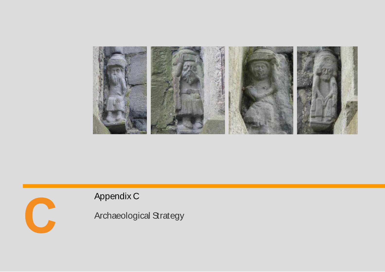
Plate 14 Corbel figures, St Francis’ Church bell-tower, these figures were modelled
supposedly on members of the Confraternity of St Francis’ charged with
supervising the building of the bell-tower, many see expressed the shock and
sadness of the people confronted by the terror of the plaque.
Photographs taken in 1950s (Row 1) and 2014-2015 (Row 2).
Kilkenny Masterplan Area Archaeological Framework ___________________________________________________________________________________________________
Page | 15
SECTION II: UNDERSTANDING THE PLAN AREA
2.1 HISTORY AND CHRONOLOGY
The Masterplan area consists of a large area on the western banks of the River Nore
containing many different monuments from various ages however the most visually
dominant of all of these is St Francis’ Abbey (a National Monument in State care)
and its associated medieval monuments of the city wall and Evan’s Tower. The
monastery has been studied by several distinguished scholars and it fortunes were
well chronicled by Friar John Clyn in his annals; a Franciscan monk belonging to the
abbey, however despite this knowledge, the site as it appears today within a modern
brewing complex is still reluctant to yield its secrets.
Detailed documentary information on the early history of the St Francis’ Abbey is
scant and while there is a general consensus of when and how the monastery
developed, there is little definitive information on the extent of the precinct and the
location of key features within the complex such as the cemetery, precinct/ boundary
walls and mill. In addition, the excavations that took place in the late 1960’ and early
1970’s served to inform us of a significant below ground presence and a much more
substantial structure then is evidenced by the upstanding building encompassing a
transept, north aisle, nave, western range and cloister. The size and scale of the
structures revealed by the excavations substantiate the historical accounts that this
was indeed a monastery of considerable importance and it is only through targeted
excavation that a full appreciation of this intriguing complex will emerge.
2.1.1 Designations
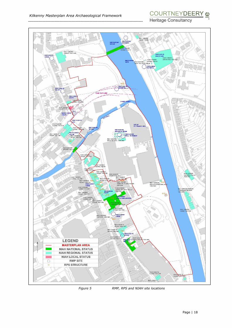
The Masterplan area is located within the area of archaeological potential for
Kilkenny City (KK019-026---) (Figure 4) and also located within the City Centre and
St. Canice’s Architectural Conservation Areas (ACAs). The following is a table of
monuments recorded (Figure 5) from various sources that are located within the
plan area:
Legal Status Site Class Townland KK019-026101
NIAH 12000008 Nat. Mon. Ref. 72
Religious House – Franciscan Friars, St
Francis’ Abbey – National Monument in State care (National Monument Ref:72)
St Mary’s Parish
KK019-026150 Font St Mary’s Parish
KK019-026151 Inscribed slab St Mary’s Parish
KK019-026183 Wall monument St Mary’s Parish
UAS 4a:101 St Francis’ Well St March’s Parish
Part of the Kilkenny City Wall Defences, National
Monument in private
ownership soon to be Kilkenny County Council
UAS 4a:7
Evan’s Tower and wall walk St Mary’s Parish
Part of the Kilkenny City
Wall Defences, National Monument, in private
ownership soon to be Kilkenny County Council
City Wall St Mary’s Parish

Kilkenny Masterplan Area Archaeological Framework ___________________________________________________________________________________________________
Page | 16
Legal Status Site Class Townland UAS 4a-4d: 6
KK019-026102 UAS 4a:102
Bridge site Gardens (Kilkenny City By., St Canice Par.)
KK019-026122 UAS 4a:122
16th/17th century house Gardens (Kilkenny City By., St Canice Par.)
KK019-026107
UAS 4a:107
Bull Inn Townparks
(Nethercross By.)
KK019-026124
UAS 4a:124
Water mill - unclassified Gardens (Kilkenny City
By., St Canice Par.)
Table 2.1: The classification of monuments within the Masterplan Site
Figure 4 Zone of Archaeological Potential for Kilkenny
Kilkenny Masterplan Area Archaeological Framework ___________________________________________________________________________________________________
Page | 17
The site lies within the reclaimed flood-plains of the Nore and Breagagh Rivers and
the extent of these flood waters have been reconstructed and mapped by Ó Drisceoil1
(and reproduced in the KKAP2). This process was achieved by plotting the
occurrences of alluvial material in archaeological and geotechnical investigations
throughout the city and relating them to its contours. It was concluded from these
investigations that over half of the medieval town of Kilkenny was constructed on
ground that was reclaimed in the thirteenth century from the floodplains of the rivers
Nore and Breagagh3. Indeed the name for the River Breagagh is derived from the
Irish bréagach meaning deceitful4, and there have been many occasions through
history when the raging torrents of this otherwise innocuous stream has engulfed
adjacent land holdings.
In terms of archaeological evidence (discussed in Section III of the report) within
the Masterplan area, investigations along Bateman Quay have revealed a riverside
wall, 3.5m in height associated with the development in the 17th century of a new
quay to connect the river Nore to the Fishmarket or ‘Shambles’ area5. Other features
such as riverside post and wattle fencing, wooden revetments and medieval masonry
walls have been found along the river Breagagh6 and demonstrate the potential to
reveal similar structures within the Masterplan area along the river Nore. A number
of flood events have been chronicled historically by Friar John Clyn, one of which
occurred on the 7th of November 1337 and covered everything except the high alter
at St Francis’ Abbey.
The findings from the excavation that took place to the rear of the court house and
Gaol also demonstrate a rich repository of waterlogged soils and almost 500 pieces
of well-preserved wood was recovered from the site7.
1 C. Ó Drisceoil (2003) ‘Kilkenny reclaimed: the archaeological evidence for medieval reclamation in Kilkenny
City’, in Old Kilkenny Review 55, 58-69 2 C. Ó Drisceoil et al (2008) The Kilkenny Archaeological Project (KKAP) Report for the Irish National Strategic
Archaeological Research (INSTAR), Heritage Council. 3 Ibid. 4 J. Bradley (2000) Irish Historic Towns Atlas, No. 10, Kilkenny. Dublin: Royal Irish Academy 5 Dr N. Brady (2001) ‘Excavation of Bateman Quay, Kilkenny’ in www.excavation.ie 6 I Doyle (2003) ‘Medieval Settlement’ in the River Nore Flood Alleviation Scheme unpublished report Margaret
Gowen & Co Ltd 7 M. Saunderson (2008) ‘Kilkenny Courthouse, Parliament Street, Kilkenny’, License Ref 08E0462 in
www.excavations.ie
Kilkenny Masterplan Area Archaeological Framework ___________________________________________________________________________________________________
Page | 18
Figure 5 RMP, RPS and NIAH site locations

Kilkenny Masterplan Area Archaeological Framework ___________________________________________________________________________________________________
Page | 19
2.1.2 Archaeological Background
While there is no evidence of archaeological activity or material on the site prior to
the medieval period, archaeological monitoring works of the River Nore has produced
finds from the Mesolithic and Neolithic in the form of flints and a polished stone axe
as well as a post and wattle structure beneath John’s Bridge that was radiocarbon
dated to the late Bronze Age. It is possible that prehistoric deposits or stray finds do
survive buried deeply within the Masterplan area however archaeological
investigations have demonstrated that this area was not reclaimed until the late 12th-
early 13th century8.
The expansion of Kilkenny from the early medieval monastic enclosure of St Canice’s
as evidenced by the curving street pattern of Vicar Street, St Canice’s Place, Dean
Street and Thomas Street9 was driven by the Anglo-Normans who established a
fortification on a hill overlooking the river Nore at the south end of Kilkenny. By
1173 a castle had been established and as an Anglo-Norman borough, Kilkenny,
flourished during the 13th and mid-14th centuries.
The initial Anglo-Norman settlement appears to have extended from the castle to
the modern day James Street. A deed dating to c. 1207 indicates a land swap
between William Marshal and the bishop of Ossory, whereby the bishop received land
at Aghaboe in return for providing Marshal an expanse of land lying between James
Street and the Breagagh River. The deed states that the purpose of the exchange
was to enable Marshal to enlarge the town. The new area was probably occupied
between, c. 1207 and c. 1231, and it is at this stage that the foundation of the
Franciscan friary developed in the north-east corner10. The economic success of
Kilkenny led to a rapid growth of the town, initially this urban expansion led to the
development of the flood-plains of the rivers Nore and Breagagh, the area of the
Masterplan. Further developments included the suburb of Irishtown which was
already a pre-existing early medieval centre and was given a separate borough
status and developments to the south and east.
The Masterplan area encompasses two adjacent towns, Irishtown and Hightown
(Englishtown), each of which had an enclosing town wall built during the medieval
period. The Hightown town wall was constructed in the mid-13th century and encloses
a roughly rectangular area of approximately 29 hectares, though there is no known
wall on the eastern side of Hightown, as it was thought that the River Nore acted as
a natural line of defence, as Bradley states ‘no wall was built along the river’ 11 and
in (2000, 2) he reiterates ‘there is no evidence for the existence of a river wall beside
the Nore’12. Thomas13 however postulates that Evan’s Tower may have been
8 Cotter, C., 1992, ‘Archaeological Excavations at Dean Street, Kilkenny, 1990’ Old Kilkenny Review, 44, 1056-
1076 Ó Drisceoil, C. (2003) ‘Kilkenny reclaimed: the archaeological evidence for medieval reclamation in Kilkenny City’, in Old Kilkenny Review 55, 58-69 9 Bradley, J. (1990) ‘Early development of the medieval town in Kilkenny,’ Nolan, W. & Whelan, K. (eds) Kilkenny: History and Society. Dublin, 63-74. 10 Bradley, J. (2000) Historic Towns Atlas: Kilkenny, Royal Irish Academy, Dublin, pg. 2 11 Bradley, J. (1975-6) ‘The town wall of Kilkenny’, in Old Kilkenny Review, I no. 2 (1975), 85-103; no. 3 (1976), 209-19 12 Ibid. Bradley, J. (2000) 13 Thomas, A., (1992), The walled towns of Ireland. Dublin, Irish Academic Press, pg., 40
Kilkenny Masterplan Area Archaeological Framework ___________________________________________________________________________________________________
Page | 20
associated with the remains of the town wall or of a defended friary wall. While the
river front in Hightown appears to be open in the middle of the seventeenth century,
with properties aligned east-west from the Main Street to the River Nore (Civil Survey
1654-56) this may not have always been the case. It is possible that with the threat
of attack lessened in later years and the increase in trade necessitated access to the
river and that the wall along this section would have been removed in a piecemeal
fashion. Equally a riverside defensive wall may have been built at a later stage then
the rest of the circuit as there was already a natural enclosing feature in the form of
the river. As stated in the introduction archaeological evidence has produced findings
of a riverside wall associated with 17th century development along Bateman Quay
and it is likely that only archaeological test excavation will resolve this matter within
the former brewery complex and establish if there was an earlier defensive wall or
medieval revetments associated with reclamation works.
The wall around the Irish Town is thought to have been completed in the fourteenth-
century14 and ran directly north from the Breagagh River and across Dean Street,
around St Canice’s Cathedral up to Troy’s Gate and finally met the River Nore, north
of Green’s Bridge. There is no evidence for a wall protecting Irishtown on the eastern
side parallel to the River Nore and unlike Hightown there is no evidence for a wall
alongside the Breagagh. An early description by Bishop Rothe (c. 1625) describes
Irishtown as ‘washed by the river’ on the east and ‘defended by walls and turrets’ on
the west. In all an area of some 380m x 260m (about 10 hectares) was enclosed
and it appears that no mural towers were present on the circumference. Some four
gates provided access to Irishtown, these were the Irishtown Gate (Watergate),
Dean’s Gate, Troy’s Gate and Green’s Gate. Irishtown was dominated by St Canice’s
Cathedral and within the Masterplan area, St Canice’s influence is seen in the form
of the Chancellors mills and just outside the area on Vicar Street, the area formerly
occupied by the Choral building associated with the abbey was excavated in 2004
(detailed in Section III).
Irishtown Gate
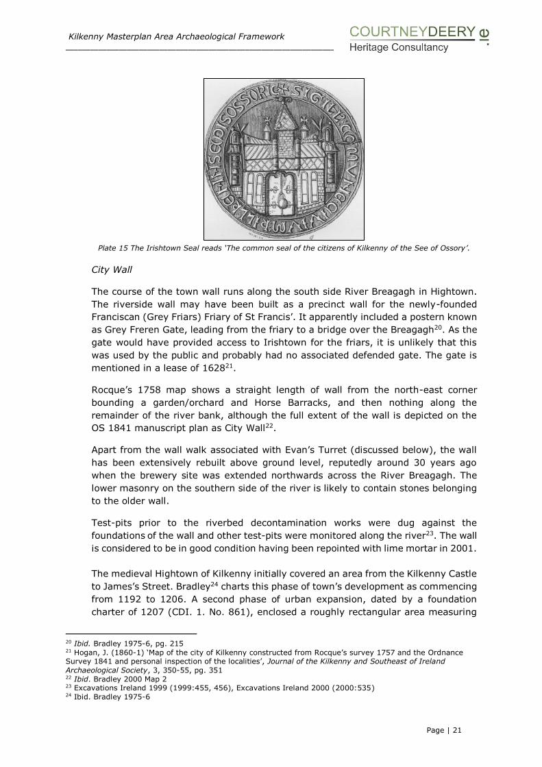
The main access from Irishtown to Hightown was through the Irishtown Gate (also
known as Watergate and Hightown Gate) and across Irishtown bridge (Plate 15). The
Irishtown gate is mentioned in 1383-84 when ‘John Corvisor is keeper of the hate of
Irestoun and of that murage, taking yearly 8s’ 15. The Watergate was ordered for
demolition in 175916. Irishtown bridge appears to have existed from the early
thirteenth century. In 1207 the transactions between the Earl Marshall and the
Bishop of Ossory mentioned ‘the water called Bregath’ running under Coterel
Bridge’17. A reference from 1352 to the ‘stream running under Coterelesbrigge’18 also
suggests that Cotterels Bridge may be equated with Irishtown bridge (another
alternative is put forward on pg. 29 of the report). The Irishtown bridge was repaired
in 1558 and was ordered to be widened in 175919. Structures were present on the
downstream side of this bridge until the middle of the twentieth century.
14 Ibid. Thomas, 1992 pg. 127 15 McNeill, C., (1931) Kilkenny City Records Liber Primus Kilkenniensis, Irish Manuscript Commission (IMC)
Dublin pg., 44 16 Ibid. Bradley, 2000, pg 14 17 Berry, H.F. (1907 –9) ‘Ancient Charter in the Liber Albus Ossoriensis’ in Proceedings of the Royal Irish
Academy 27C 115-25, pg. 124 18 Ibid. McNeill, C., (1931), pg. 30 19 Ibid. Bradley 2000 pg 21
Kilkenny Masterplan Area Archaeological Framework ___________________________________________________________________________________________________
Page | 21
Plate 15 The Irishtown Seal reads ‘The common seal of the citizens of Kilkenny of the See of Ossory’.
City Wall
The course of the town wall runs along the south side River Breagagh in Hightown.
The riverside wall may have been built as a precinct wall for the newly-founded
Franciscan (Grey Friars) Friary of St Francis’. It apparently included a postern known
as Grey Freren Gate, leading from the friary to a bridge over the Breagagh20. As the
gate would have provided access to Irishtown for the friars, it is unlikely that this
was used by the public and probably had no associated defended gate. The gate is
mentioned in a lease of 162821.
Rocque’s 1758 map shows a straight length of wall from the north-east corner
bounding a garden/orchard and Horse Barracks, and then nothing along the
remainder of the river bank, although the full extent of the wall is depicted on the
OS 1841 manuscript plan as City Wall22.
Apart from the wall walk associated with Evan’s Turret (discussed below), the wall
has been extensively rebuilt above ground level, reputedly around 30 years ago
when the brewery site was extended northwards across the River Breagagh. The
lower masonry on the southern side of the river is likely to contain stones belonging
to the older wall.
Test-pits prior to the riverbed decontamination works were dug against the
foundations of the wall and other test-pits were monitored along the river23. The wall
is considered to be in good condition having been repointed with lime mortar in 2001.
The medieval Hightown of Kilkenny initially covered an area from the Kilkenny Castle
to James’s Street. Bradley24 charts this phase of town’s development as commencing
from 1192 to 1206. A second phase of urban expansion, dated by a foundation
charter of 1207 (CDI. 1. No. 861), enclosed a roughly rectangular area measuring
20 Ibid. Bradley 1975-6, pg. 215 21 Hogan, J. (1860-1) ‘Map of the city of Kilkenny constructed from Rocque’s survey 1757 and the Ordnance Survey 1841 and personal inspection of the localities’, Journal of the Kilkenny and Southeast of Ireland
Archaeological Society, 3, 350-55, pg. 351 22 Ibid. Bradley 2000 Map 2 23 Excavations Ireland 1999 (1999:455, 456), Excavations Ireland 2000 (2000:535) 24 Ibid. Bradley 1975-6

Kilkenny Masterplan Area Archaeological Framework ___________________________________________________________________________________________________
Page | 22
29 hectares25 and extended the limits of the town from ‘Keverocke's well’ (or Kieran’s
well,) to the River Breagagh (CDI. 1. No. 861). It is also suggested that this phase
contained a riverside defensive wall linking the corner bastion ‘Evan’s Turret’ at the
eastern end of the River Breagagh to St. John’s Bridge gate-tower26. No other
historical, cartographic or archaeological evidence for a defensive wall along
Bateman Quay exists however, and it is probable that the river was regarded as a
strong enough deterrent.
The City Wall is part of the defences of Kilkenny City and is a National Monument.
The section or line of the wall within the Masterplan Area is therefore a National
Monument.
Evan’s Turret
The mural tower ‘Evan’s Turret’ is located at the junction of the River Breagagh and
the River Nore, at the north-eastern end of the Hightown wall. It became known as
‘Evan’s Turret’ when the land around it was leased by the Corporation to Alderman
Evans in 1724 and remained in his family for over a century27. The structure appears
as a two storey rectangular tower, which was accessed by a wall walk along the town
wall. While the form of the tower is suggestive of a late date (c. 1400), it is possible
that its location reflects that of an earlier tower.
The friary passed to the Corporation in 1543; in 1598, the payment for carriage of
79 cartloads of stone ‘for making up the tower at Francis Well’ is likely to refer to
this tower (Corporation Archives, CR/J/28). In 1650, the Civil Survey describes it as
‘a little castle in the garden’ of the friary (CS 6, 519). The tower and the stretch of
adjoining city wall are marked on the OS 1841 manuscript map and the tower was
illustrated in 1851 when still roofed.
The tower is described in detail in Section IV of the report. It is recorded that a
member of the Evan’s family lived at the tower as a recluse in order to evade
payment of a debt. When this person died, the body was carried in a boat across the
river and buried in St John’s Abbey28.
The tower and section of City Wall are both National Monuments and are considered
to be an important surviving section of city wall and mural tower on a prominent
site.
The Franciscans
The Franciscans arrived in Kilkenny in 1234 having crossed from England probably
to Dublin in the late 1220s29 and rapidly advanced into the surrounding counties in
the subsequent years. Kilkenny would have been an attractive destination, as an
Anglo-Norman stronghold and a prosperous town with extensive trade and economic
links, the city was well connected with many generous wealthy patrons.
25 Ibid. Thomas 1992 26 Ibid. Thomas 1992 27 Lanigan, K. & Tyler, G. (1987) Kilkenny Its Architecture and History. Dublin, pg. 36 28 P.M. Egan 1884,The Illustrated Guide to the City and County of Kilkenny, High Street, Kilkenny, pg 244 29 Francis Cotter, The Friars Minor in Ireland. From their arrival to 1400 (St Bonaventure, 1994), 11-13
Kilkenny Masterplan Area Archaeological Framework ___________________________________________________________________________________________________
Page | 23
Such wealth was evident at St Francis’ Abbey allowing a marble high alter to be built
and consecrated in 1323 and Caen stone to be used for the window jambs30 as well
as an elegant belfry tower to be constructed. The friars also enjoyed a guaranteed
income in the form of land grants31 that they would then lease out as well as alms
that they received when they visited various communities in Kilkenny’s hinterland.
Another significant source of income and an indicator of patronage were the burial
rights enjoyed by important patrons and funeral offerings flowing from these32.
Among the patrons whose names have been recorded are Robert Shortals in 1323,
Raymond le Ercedeakne and members of his family slain by the O’Moores in 1335,
and Isabella Palmer, who had paid for the front part of the new choir, who was
interred in 134733. Such was the demand for burial close to the friars that a new
cemetery was consecrated in Kilkenny in 133134.
The 1479 land grant mentioned above numbered among its purposes ‘the
maintenance of the study of sacred theology therein’, a clear signal that theology
was being taught in Kilkenny friary by then35. Promising young men from here would
have been sent for further studies at the custodial houses of Cashel or Dublin and
possibly some may have studied at the studium generale at Paris or elsewhere36.
The friary assumed a greater importance with the establishment of a philosophical
stadium in 1627 and at the provincial chapter of 1647 St Francis’ Abbey was
designated as a stadium for both philosophy and theology, the only house to be
given this double status.
St Francis’ Abbey
St Francis’ Abbey is a National Monument in state care. The abbey lay in an area
known as the North Quarter and lay south of and next to the River Breagagh, this
area was originally owned by the bishop of Ossary and ceded to the Marshalls in
1207. Its location here marked the limits of the town in its early development.
Now located within a former brewery site, St Francis’ Abbey was founded by Richard
Marshall between 1231 and 1234 and given a royal grant in 1245. This was followed
on November 6, 1246 by another royal grant for building purposes. The abbey
started as a small rectangular chapel but then expanded as funds allowed. It grew
to reach from Kilkenny city walls to the river Nore and became important enough to
hold the Provincial Chapters of the friars in 1267 and 130837.
Friar Clyn, a member of the community, chronicles the various new additions to the
abbey during his lifetime (d. 1349): the choir was finished in 1321; a new high altar
30 Canice Mooney, ‘Franciscan architecture in pre-Reformation Ireland’, Journal of the Royal Society of
Antiquaries of Ireland, 86 (1956), 125-169:128 31 The first recorded land grant is dated to 1479 when Sir James Butler made a grant of land at Donore and
Troystown – White, Irish monastic and episcopal deeds, 236-7. 32 Joseph MacMahon (2012), The Franciscans in Kilkenny, OKR 64, 27-40. 33 Williams, Clyn, 178, 216, 242. 34 Williams, Clyn, 206. 35 White, Irish monastic and episcopal deeds, 236-7 36 See Williams, Clyn, 55 for John Clyn’s education. 37 Williams, B. ed 2007 The Annals of Ireland by Friar Clyn and Thady Dowling (1845). Dublin: Four Courts
Press pgs. 10, 13

Kilkenny Masterplan Area Archaeological Framework ___________________________________________________________________________________________________
Page | 24
was consecrated on January 11, 1323; and the cemetery was completed in 1331. On
November 7, 1337 an enormous flood covered everything except the high altar and
caused much damage38. In 1347 a confraternity was established to raise funds to
build a new bell tower but the following years witnessed the scourge of the Black
Death and so this tower was probably not completed until much later in the century.
Friar Clyn also communicated the horrors of the plague in his writings and is
presumed to have died in and around 1348 from the outbreak, leaving behind his
final entry:
‘Lest the writing should perish with the writer, and the work fail with the workman,
I leave behind me parchment for continuing it, if any man should have the good
fortune to survive this calamity, or any one of the race of Adam should escape this
pestilence, to continue what I have begun.’
In 1351 the Liber Primus Kilkenniensis, one of the most important sources for
Kilkenny city in the later Middle Ages, records a perpetual endowment by Kilkenny
Corporation for the celebration of masses39.
The archaeological evidence indicates that late in the fourteenth century the sacristy
and living quarters were built to the south of the church and an aisle was added on
the northern side of the nave. The sacristy has been restored as an oratory by
Smithwicks40. When the huge transept chapel was constructed is unknown but has
been ascribed to the second half of the fifteenth century when such extensions were
typical of Franciscan friaries then undergoing a period of artistic and devotional
renewal41 (Figure 6). Part of the north aisle was demolished and some of the north
wall of the nave was replaced by a pair of arches which were also placed along the
rear of the transept chapel42. The results of the onsite excavations are detailed in
the Section III of the report.
38 Ibid Williams 2007 pg 34 39 Peter Smithwick 1988 ‘Saint Francis Abbey’ in The Old Kilkenny Review (OKR) 2nd series, Vol. 3 No. 5, 521-526, pg 523 40 Ibid. Lanigan, K. M and Tyler, G., 1987, 26 41 Patrick Conlon, 1975 ‘Notes on St Francis’ Abbey’ in OKR Vol. 1, No. 2 Kilkenny Archaeological Society, 80-84, pg. 83 42 George Henry Basset 1884 Kilkenny City and County Guide and Directory

Kilkenny Masterplan Area Archaeological Framework ___________________________________________________________________________________________________
Page | 25
Figure 6 St Francis’ Abbey OPW 1966
The Abbey Precinct
It is recorded in the ‘White Book of Ossory’43 that Hugh Rufus, the first English bishop,
granted by charter to the Earl Mareschal, the land extending from ‘Cotteral’s bridge, over
the Bregach river, to St Kenerock’s (ie St Ciaran’s) well’ and on the land thus obtained the
Earl erected the Franciscan Abbey. The grounds of the abbey continued to expand
throughout the fifteenth century and on into the sixteenth century. In 1479, 1525 and
1538 various interests in the lands of Troyswood and Donore were granted to the abbey44.
This expansion was, however, rapidly halted with the dissolution of the monasteries in the
sixteenth century. After the Dissolution, the friary fell into disrepair, although in the early
seventeenth century mass was being celebrated there.
There is an account of Cromwell attacking the abbey on the 27th March 1650, a breach of
the wall of the Franciscan Abbey was exploited by using pick-axes to make way for his
horses and men to enter, he was beaten back but retuned the next day with 1,500 fresh
men and an agreement was entered into by Sir Walter Butler and Cromwell45. Egan also
refers to this encroachment and mentions that Cromwell crossed the stream (the River
Breagagh) and breached the wall of the ‘Franciscan Monastery about 20 yards west of
Evan’s Turret’46.
43 Quoted by Rev. James Graves in History, Antiquities and Architecture, Cathedral Church of St Canice p. 31 44 W. Carrigan (1905) The History and Antiquities of the Diocese of Ossory, Vol. III Dublin: Sealy, Bryers &
Walker, pg. 107 45 Ledwich E. (1781) History and antiquities of the Irishtown and Kilkenny from original records and authentic documents’, in Charles Vallency (ed.) Collectanea de rebus Hibernicis, ii, 349-562, pg. 475 46 Ibid. P.M Egan (1884), pg 39

Kilkenny Masterplan Area Archaeological Framework ___________________________________________________________________________________________________
Page | 26
A rates list of 1628 refers to the following features within St Francis’ Abbey:
Plate 16 Extract from the History and Antiquities of Irishtown and Kilkenny, Ledwich (1781)
The lands were returned to Kilkenny Corporation during the suppression of religious houses
and in a corporate rental dating to 1688, it was noted that the boundary of the property
which reverted to the authority from the Francisan Abbey, was formed by a stream of
water that ran to the river from St Kieran’s well47. It may be concluded that the original
Abbey precinct extended from the Breagagh to this point as shown on the historic maps
as ‘King Street Market’ (1872, 25 inch revised OS edition) and on the 1946 revised OS 6
edition as ‘St Kiernan’s Well’ however it is not clear how Grace’s Castle would have fitted
into this arrangement and if there was a boundary between the Castle and the Abbey.
As the religious community of St Francis’ Abbey suffered their demise so the secular
interests continued to grow throughout the seventeenth century. According to the 'Clasped
Book' of the Corporation of Kilkenny, the Franciscan Abbey was assigned for the building
of a military barracks on September 19, 1698. On April 5, 1700 'the waste of Francis's
Abbey' was added to the former grant for building a barracks48. This cavalry barracks was
the first of three military barracks constructed in Kilkenny. This barracks is often referred
to as ‘Horse Barracks’.
Ledwich in his account of the abbey also states that the ‘monastery and its offices were of
great extent, reaching from the street and city walls to the river. The windows are towers
are inferior to none. Part is made a horse barrack’49.
47 Ledwich 1781 History of Irishtown and Kilkenny, pg. 439 48 Ibid. Carrigan 1905, pg. 109 49 Ibid. Ledwich 1781, pg. 494

Kilkenny Masterplan Area Archaeological Framework ___________________________________________________________________________________________________
Page | 27
The 'Clasped Book' claims that St Francis' Abbey belonged to John Desborough in August
31 it was given to his son John Jr. for 41 years except for 'the horse-barrack, hay-yard
and a set of pillars and uncovered walls within the said abbey'. This exception to the grant
must have been what remained of the outbuildings surrounding the surviving buildings
after the construction of the barracks. It appears from the City Books that the Franciscan
abbey was 'canted' to Alderman Evans on December 19, 1724 for a fee-farm lease and
continued to be held by his descendants until 1849 (Rev. James Graves in Annals of
Ireland, Intro, xxxi).
Writing in 1849 Reverend James Graves describes the ruins of St. Francis' Abbey as 'the
chancel and belfry tower, with a small fragment of the conventual buildings adjoining the
south side of the latter'50. Bassett records the remains as consisting of ‘the tower and
chancel and a small portion of the conventual buildings’51. During this period the remains
of the church were also used as a tennis-court52 or ball alley and the elaborate east window
was bricked in. It was around 1870 when the owner of the Abbey finally allowed to have
the bricks removed. The outlook from the window was then into the ‘yard of Messrs. E.
Smithwick and Sons,… and in this yard many tablets, originally belonging to the Abbey are
set into the wall’53. During the 1880s the abbey and a well-established fruit garden and
cottage was sold to Mr William Morrissey, a hardware merchant for £600 and in 1884 it
was in the possession of Mrs Morrissey. As proprietor of the abbey Mrs Morrissey took
great care of her domain and had the floor of the chancel covered with a living carpet of
green.
The Abbey came into State ownership via the Irish Church Act 1869 and the order made
by the Church Temporalities Commission dated 30 October 1880. Repair work was carried
out on the tower and chancel c.1870 by the Board of Works and again in 1889, at which
time it was a National Monument. In the 1960’s, excavations were carried out (Ó
hEochaidhe, unpublished), which revealed the presence of a large transept and an aisle in
the nave, on the north side of the church in which some graves were found54 which is
detailed in Section III.
A number of recorded monuments such as a font and inscribed slab lie within the friary.
The thirteenth-century limestone font, decorated with flutes in Romanesque pairs and
fleur-de-lys, was found in St. Kieran’s Well55 and is now kept in St Francis’ Friary, in a
niche at the base of the tower. A number of fragments of inscribed slabs were uncovered
by M. Ó hEochaidhe (unpublished), during his excavation of the friary. Other fragments
are incorporated in the east wall of the chancel. Only one medieval slab has been recorded
from the abbey, that of Richard Purcell56 57.
In the National Museum of Ireland there is a fragment of an effigial monument consisting
of a portion of a lion upon which the armoured legs of a knight rest. It was discovered in
1862 as a building stone in a house adjacent to the friary58. It is significant in that it shows
50 Ibid. Carrigan 1905, 109 51 Ibid. Bassett (1884) pg. 35 52 S. Lewis (1837) A Topographical Dictionary of Ireland, Vol. II. London, pg. 115 53 Ibid Bassett 1884 pg 37 54 Ibid. Lanigan and Tyler 1987, pg. 26 55 St Ciaran’s Well has been noted as St Kenerock’s, Keveroke’s and Kieran’s throughout different historic texts. 56 Carrigan, 105; Jrl. Assoc. Mem. Dead Irl. Vii (1907-09), 121 57 Bradley 1980 ‘Some New and Neglected Medieval Tomb Slabs and Fragments from Kilkenny’ in OKR, N.S. Vol. III, No. 2, 5-21 58 JRSAI vii (1862-3), 95

Kilkenny Masterplan Area Archaeological Framework ___________________________________________________________________________________________________
Page | 28
that there was at least one effigial monument in the building. Bradley59 thought that it
probably was sixteenth century in date.
Cemetery, Burial Ground
While there are no above ground remains of a burial ground or cemetery, there are
numerous references in historical documents that describe an extensive graveyard around
the abbey building. These references are supported by the findings of the archaeological
monitoring carried out by Sweetman in the 1970’s which are documented in the next
section of the report.
Ledwich 60 records that in ‘1331 Nicholas Welifed, bishop of Waterford, consecrated the
new cemetery without the church on a Friday, being the feast of St Cecilia’.
According to Egan61 ‘the cemetery must have been extensive, for bones have been dug up
in most of the grounds occupied by Smithwick’s Brewery, and in the gardens along the
bank of the river for a considerable distance. Though the monuments erected here are
said to have been costly and elaborate, yet strange to say, none remain, as if the bed of
the river was doomed to be their last resting place. One mural slab may alone be seen. It
is built into one of the walls of the brewery buildings, and is neatly lettered.’
The remains of the abbey as chronicled by Bassett in 1884 included the much admired
east window which occupied nearly the whole of the gable and consists of a cluster of
seven lancet lights divided by slender mullions. Bassett62 while writing at the same time
as the aforementioned Egan notes that ‘the outlook from it (east window) is into the yard
of Messrs E Smithwick & Sons, St Francis Abbey Brewery. In this yard many tablets,
original belong to the Abbey are set into the walls’. This quote is significant as it appears
to refer to grave slabs being visible from the east window and located to the east of the
abbey.
While Williams63 records that there were numerous records of burials which took place in
the monastery graveyard.
Further excavation on the site of St Francis' Abbey would present the possibility of
revealing burials.
St Francis’ Well
St Francis’ Well was a large spring or pool apparently surrounded by a wall located c. 45m
north-east of the friary. The water from the well was piped and channelled into the
workshops of the friary and then by a different channel, carried off all the sewage to the
river64. Ledwich65, wrote that this enclosed well was famous for its miraculous cures and
this is supported by Jennings66 who wrote that ‘the miraculous water from the well of St
Francis’ was known to return people to good health. Hogan, writing c. 1860 states that it
59 John Bradley OKR Vol. II, no.2 (1980) pg 15 60 Ibid Ledwich 1781, pg. 493-494 61 Ibid Egan 1884, pg 241 62 Ibid. Henry Bassett 1884 Kilkenny City and County Guide and Directory, pg.37 63 Ibid Williams 2007 64 Mooney, Rev. C., (JRSAI), 1957, 37, 121-22 65 Ibid Ledwich 1781 , 349-562 66 Brendan Jennings (ed.), ‘Brussels MS. 3947: Donatus Moneyus, De Provincia Hiberniae S. Francisci’,
Analecta Hibernica, vi (1934), 12-138:83
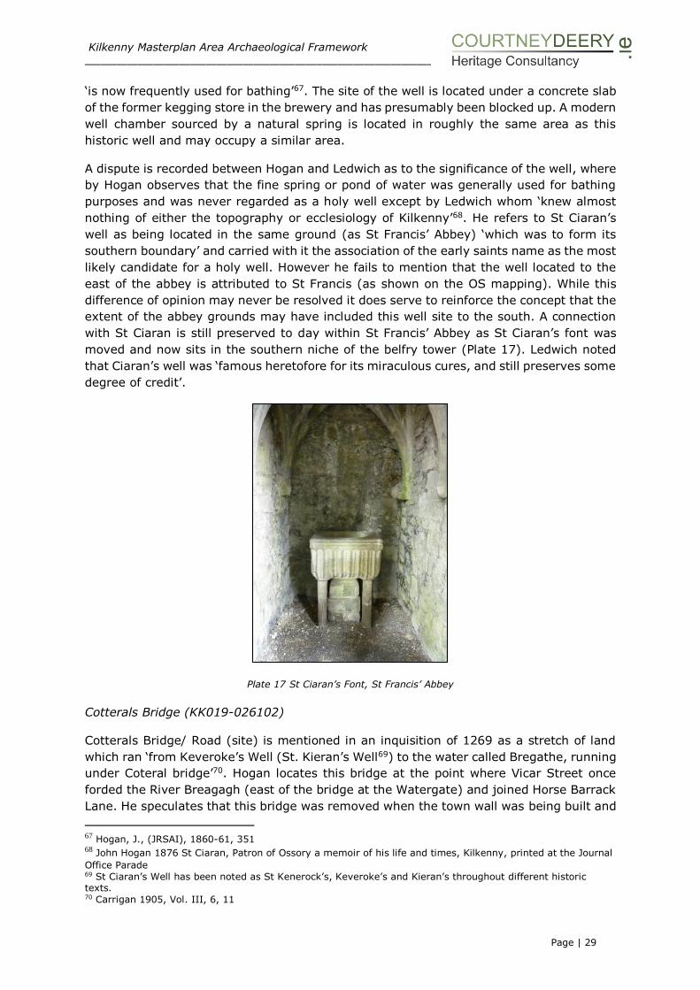
Kilkenny Masterplan Area Archaeological Framework ___________________________________________________________________________________________________
Page | 29
‘is now frequently used for bathing’67. The site of the well is located under a concrete slab
of the former kegging store in the brewery and has presumably been blocked up. A modern
well chamber sourced by a natural spring is located in roughly the same area as this
historic well and may occupy a similar area.
A dispute is recorded between Hogan and Ledwich as to the significance of the well, where
by Hogan observes that the fine spring or pond of water was generally used for bathing
purposes and was never regarded as a holy well except by Ledwich whom ‘knew almost
nothing of either the topography or ecclesiology of Kilkenny’68. He refers to St Ciaran’s
well as being located in the same ground (as St Francis’ Abbey) ‘which was to form its
southern boundary’ and carried with it the association of the early saints name as the most
likely candidate for a holy well. However he fails to mention that the well located to the
east of the abbey is attributed to St Francis (as shown on the OS mapping). While this
difference of opinion may never be resolved it does serve to reinforce the concept that the
extent of the abbey grounds may have included this well site to the south. A connection
with St Ciaran is still preserved to day within St Francis’ Abbey as St Ciaran’s font was
moved and now sits in the southern niche of the belfry tower (Plate 17). Ledwich noted
that Ciaran’s well was ‘famous heretofore for its miraculous cures, and still preserves some
degree of credit’.
Plate 17 St Ciaran’s Font, St Francis’ Abbey
Cotterals Bridge (KK019-026102)
Cotterals Bridge/ Road (site) is mentioned in an inquisition of 1269 as a stretch of land
which ran ‘from Keveroke’s Well (St. Kieran’s Well69) to the water called Bregathe, running
under Coteral bridge’70. Hogan locates this bridge at the point where Vicar Street once
forded the River Breagagh (east of the bridge at the Watergate) and joined Horse Barrack
Lane. He speculates that this bridge was removed when the town wall was being built and
67 Hogan, J., (JRSAI), 1860-61, 351 68 John Hogan 1876 St Ciaran, Patron of Ossory a memoir of his life and times, Kilkenny, printed at the Journal
Office Parade 69 St Ciaran’s Well has been noted as St Kenerock’s, Keveroke’s and Kieran’s throughout different historic texts. 70 Carrigan 1905, Vol. III, 6, 11

Kilkenny Masterplan Area Archaeological Framework ___________________________________________________________________________________________________
Page | 30
that the road passing over it became obsolete at the same time. However Bradley equates
the bridge with the bridge at Irishtown71. A bridge is shown on the 1872 and 1914
Ordnance Survey mapping linking Horse Barrack Lane to the north of the River Breagagh.
The remnants of the stone arch can still be seen on the southern boundary wall of the
River Breagagh.
The ‘Bull Inn’ (KK019-026107)
Prim72 suggests that the ‘Bull Inn’ may have been the first inn or ‘place of call’ established
in Irishtown, Kilkenny, although there probably were older inns in Englishtown, Kilkenny.
The ‘Bull Inn’ is located on the south side of St Canice’s Place (formerly known as Bull
Alley). This was a three-storey gable-fronted stone building, the apex of which was
surmounted by a stone chimney. An illustration by Reverend James Graves in 1841,
published in JRSAI (1862-63) and said to be an accurate sketch (Plate 18)73, indicates a
window and off-centre door on the ground floor, two windows on the second storey and
two small windows on the third storey. The windows on the ground floor and the second
story are divided by mullions and all the opes have hood-mouldings. There is a discrepancy
between this drawing and Prim’s description of the opes on the ground floor, with Prim
describing a central door at ground level and a window on each side. It is possible that
Prim’s description describes the building as it was originally built, and that the 1841
drawing represents later changes to the door and window, as Prim does make reference
to modern alterations to the door. Prim also tells us that the stone framed windows in the
rear of the building were all extremely small in the ground floor, but the stories above had
high, narrow slit-like windows, similar to, but not quite as large as the two uppermost
windows in the gable fronting the street. The 1841 drawing depicts the building as
unroofed.
Plate 18 Bull Inn, Kilkenny by Reverend James Graves, 1841 (reproduced from JRSAI, 1862-63)
71 Irish Town Atlas (2000). Bradley identified Cotterel's Bridge with Irishtown Bridge in the Historic Towns
Atlas. He lists a separate bridge on the Breagagh, unnamed, and states that it led from King Street to St Francis' Abbey. He cites Hogan, 1884, as evidence that this bridge was built prior to 1540. 72 John G. A. Prim, (1862) ‘Notes on Kilkenny Inns and Taverns’ in the Journal of the Kilkenny and South-East of Ireland Archaeological Society, New Series, Vol. 4, No. 1 pgs 152-180, published by RSAI. 73 Ibid. Prim (1862)
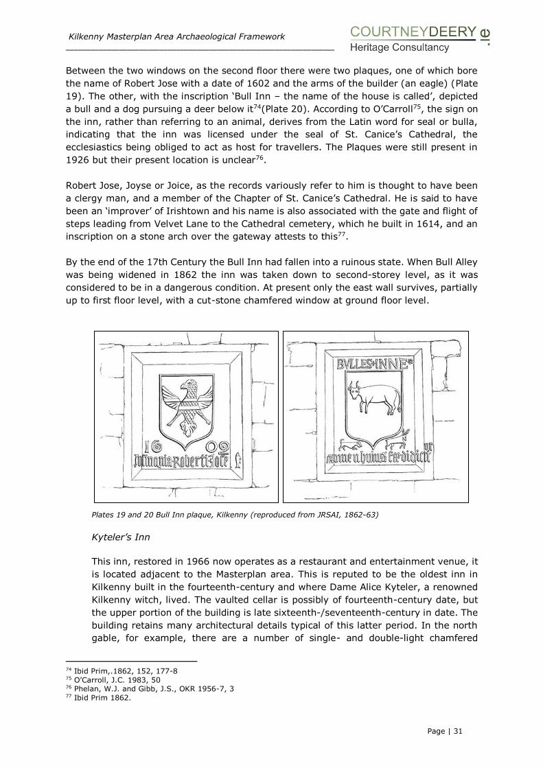
Kilkenny Masterplan Area Archaeological Framework ___________________________________________________________________________________________________
Page | 31
Between the two windows on the second floor there were two plaques, one of which bore
the name of Robert Jose with a date of 1602 and the arms of the builder (an eagle) (Plate
19). The other, with the inscription ‘Bull Inn – the name of the house is called’, depicted
a bull and a dog pursuing a deer below it74(Plate 20). According to O’Carroll75, the sign on
the inn, rather than referring to an animal, derives from the Latin word for seal or bulla,
indicating that the inn was licensed under the seal of St. Canice’s Cathedral, the
ecclesiastics being obliged to act as host for travellers. The Plaques were still present in
1926 but their present location is unclear76.
Robert Jose, Joyse or Joice, as the records variously refer to him is thought to have been
a clergy man, and a member of the Chapter of St. Canice’s Cathedral. He is said to have
been an ‘improver’ of Irishtown and his name is also associated with the gate and flight of
steps leading from Velvet Lane to the Cathedral cemetery, which he built in 1614, and an
inscription on a stone arch over the gateway attests to this77.
By the end of the 17th Century the Bull Inn had fallen into a ruinous state. When Bull Alley
was being widened in 1862 the inn was taken down to second-storey level, as it was
considered to be in a dangerous condition. At present only the east wall survives, partially
up to first floor level, with a cut-stone chamfered window at ground floor level.
Plates 19 and 20 Bull Inn plaque, Kilkenny (reproduced from JRSAI, 1862-63)
Kyteler’s Inn
This inn, restored in 1966 now operates as a restaurant and entertainment venue, it
is located adjacent to the Masterplan area. This is reputed to be the oldest inn in
Kilkenny built in the fourteenth-century and where Dame Alice Kyteler, a renowned
Kilkenny witch, lived. The vaulted cellar is possibly of fourteenth-century date, but
the upper portion of the building is late sixteenth-/seventeenth-century in date. The
building retains many architectural details typical of this latter period. In the north
gable, for example, there are a number of single- and double-light chamfered
74 Ibid Prim,.1862, 152, 177-8 75 O’Carroll, J.C. 1983, 50 76 Phelan, W.J. and Gibb, J.S., OKR 1956-7, 3 77 Ibid Prim 1862.
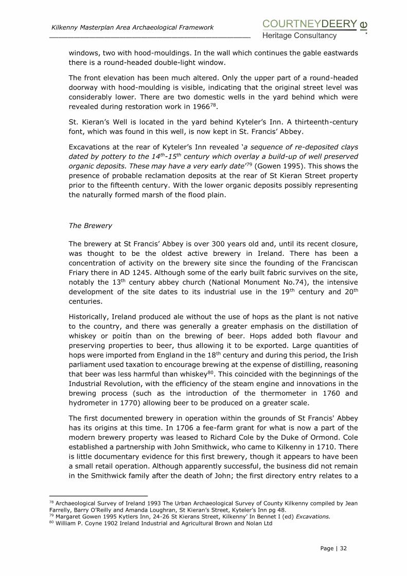
Kilkenny Masterplan Area Archaeological Framework ___________________________________________________________________________________________________
Page | 32
windows, two with hood-mouldings. In the wall which continues the gable eastwards
there is a round-headed double-light window.
The front elevation has been much altered. Only the upper part of a round-headed
doorway with hood-moulding is visible, indicating that the original street level was
considerably lower. There are two domestic wells in the yard behind which were
revealed during restoration work in 196678.
St. Kieran’s Well is located in the yard behind Kyteler’s Inn. A thirteenth-century
font, which was found in this well, is now kept in St. Francis’ Abbey.
Excavations at the rear of Kyteler’s Inn revealed ‘a sequence of re-deposited clays
dated by pottery to the 14th-15th century which overlay a build-up of well preserved
organic deposits. These may have a very early date’79 (Gowen 1995). This shows the
presence of probable reclamation deposits at the rear of St Kieran Street property
prior to the fifteenth century. With the lower organic deposits possibly representing
the naturally formed marsh of the flood plain.
The Brewery
The brewery at St Francis’ Abbey is over 300 years old and, until its recent closure,
was thought to be the oldest active brewery in Ireland. There has been a
concentration of activity on the brewery site since the founding of the Franciscan
Friary there in AD 1245. Although some of the early built fabric survives on the site,
notably the 13th century abbey church (National Monument No.74), the intensive
development of the site dates to its industrial use in the 19th century and 20th
centuries.
Historically, Ireland produced ale without the use of hops as the plant is not native
to the country, and there was generally a greater emphasis on the distillation of
whiskey or poitín than on the brewing of beer. Hops added both flavour and
preserving properties to beer, thus allowing it to be exported. Large quantities of
hops were imported from England in the 18th century and during this period, the Irish
parliament used taxation to encourage brewing at the expense of distilling, reasoning
that beer was less harmful than whiskey80. This coincided with the beginnings of the
Industrial Revolution, with the efficiency of the steam engine and innovations in the
brewing process (such as the introduction of the thermometer in 1760 and
hydrometer in 1770) allowing beer to be produced on a greater scale.
The first documented brewery in operation within the grounds of St Francis' Abbey
has its origins at this time. In 1706 a fee-farm grant for what is now a part of the
modern brewery property was leased to Richard Cole by the Duke of Ormond. Cole
established a partnership with John Smithwick, who came to Kilkenny in 1710. There
is little documentary evidence for this first brewery, though it appears to have been
a small retail operation. Although apparently successful, the business did not remain
in the Smithwick family after the death of John; the first directory entry relates to a
78 Archaeological Survey of Ireland 1993 The Urban Archaeological Survey of County Kilkenny compiled by Jean
Farrelly, Barry O’Reilly and Amanda Loughran, St Kieran’s Street, Kyteler’s Inn pg 48. 79 Margaret Gowen 1995 Kytlers Inn, 24-26 St Kierans Street, Kilkenny’ In Bennet I (ed) Excavations. 80 William P. Coyne 1902 Ireland Industrial and Agricultural Brown and Nolan Ltd

Kilkenny Masterplan Area Archaeological Framework ___________________________________________________________________________________________________
Page | 33
Patrick Brennan, who was listed in Pigot's directory for 1824 as a distiller on the site
of the abbey.
Brewing prospered in the early decades of the 19th century and by 1814 Ireland was,
for the first time, exporting more beer to England than it imported81. In 1831, Ireland
had 215 breweries, a figure which had shrunk considerably by the end of the
nineteenth century, by which time Guinness’s Brewery was the largest in the world.
The St Francis’ Abbey brewery was bought back by the Smithwick family during the
boom brewing period; in 1827, John’s grandson Edmund purchased a piece of
freehold property, including ‘a distillery and a brewery’ through the Court of
Chancery from the Ormond estate82. A large brewery was constructed on the site
and by the mid-19th century, Smithwick’s was one of only two breweries in Kilkenny
(Plates 21 and 22); Slater's directory of 1856 lists Edmund Smithwick at St Francis'
Abbey Brewery and Richard Sullivan in James Street. Breweries and distilleries were
often fairly extensive, incorporating a malt-house where the barley was germinated,
a kiln to arrest the germinations process, a mill to process the malted grain, and the
brew/still house where the alcohol was prepared. Such operations required
considerable amounts of water, and with few exceptions breweries were to be found
along rivers, which also supplied the motive power.
Plates 21 and 22 Showing St Francis’ Abbey Brewery late 19th century
It was during this time that investment took place at the site and a small, single
beam engine, reputedly bought by William Smithwick in 1847 at the Manchester
Exhibition was installed in the St Francis’ Abbey Brewery, where it was worked up
until about 1930. The engine is now maintained as a working exhibit at the Steam
Museum at Straffan, Co Kildare (Plate 23).
81 Ibid Coyne 1902 82 Halpin T. B (1989) A history of Brewing in Kilkenny OKR 2nd Series Vol 4, No. 1 pgs 583-591
Kilkenny Masterplan Area Archaeological Framework ___________________________________________________________________________________________________
Page | 34
Plate 23 Single-column beam engine
The private company of E. Smithwick and Sons was established in 1898 and
prospered in the early 20th century after winning military contracts for the sale of
beer to garrisoned troops. When Sullivan's of James's Street closed around 1914,
the property was bought by the E. Smithwick’s Brewing Company, which provided
much needed brewing machinery to support the market expansion. The brewery
buildings of the St. James's Street Brewery on James's Street were demolished to
make way for the Market Cross Shopping Centre and multistorey car park.
St Francis’ Brewery continued to grow throughout the 20th century and from 1944
onwards the brewery distributed its beer on a national scale (Plates 24 and 25).
The brewery maintained a traditional 19th century plant throughout the 1950s, with
no modernisation of the brewing machinery or processes. In 1965 Smithwick's
became public as part of Irish Ale Breweries and was taken over by Arthur Guinness,
Son & Company (Dublin) Ltd. A modernisation plan was launched in 1964 with the
construction of a new brew-house. A large fermentation block, a storage vessel block
and packaging plant were also installed. This 20th-century construction was
subsequently updated and replaced by a 21st-century computer operated brewery.
The Kilkenny Industrial Archaeological Survey83 notes that most of the original
buildings were demolished and machinery removed during the modernization
process. It considers the brewery to be of contemporary interest.
83 Fred Hamond An Industrial Archaeological Survey of County Kilkenny for Kilkenny County Council Planning
and Environment Section January 1990 pg 42

Kilkenny Masterplan Area Archaeological Framework ___________________________________________________________________________________________________
Page | 35
Plates 24 and 25 St Francis’ Abbey Brewery c. 1900’s
By the time of its closure in 2013, the brewery comprised a bottling and kegging
store, a brew-house, maturation building, the Mayfair building (staff offices and
facilities), sample rooms, a laboratory, offices, a cellar and visitor centre, all located
on the south side of the river. North of the River Breagagh was a cluster of modern
buildings, including a truck-wash, hop store / squash court, car-parking shed and
fuelling tank facility.
Kilkenny Courthouse, County and City Gaol, Grace’s Castle
While outside the Masterplan area, this building has already been subject to a
complete architectural transformation and archaeological excavation and no study of
the general area would be complete without reference to the site. There are three
significant phases of historic occupation:
Graces Castle
County Gaol and Courthouse
City Gaol, County and City Courthouse
The building while set back from the Parliament Street is a prominent landmark and
contains an interesting history which spans from 1210 to modern day. Grace’s Castle
built c.1210 remained as a family residence in the ownership of the Grace’s until
1566 when it was transferred into the ownership of the crown to be used as a gaol
by the Kilkenny authorities and by 1691 it had become the County Gaol. A County
Courthouse also occupied the site by the mid-eighteenth century when the Black
Abbey ceased to have a role as a house of justice for County Kilkenny. Since 1790
the County Courthouse, County Gaol and City Gaol were located at the same site.
Occasionally the building also functioned as a theatre and public meetings were held
there for elections. Appendix C contains a number of references from 1807-1832
where the conditions at the prison were reported to the Inspector General and on a
number of occasions; the security of the goal was mentioned with the necessity of
having to raise the wall that lay between the yards to the rear and the surrounding
brewery.
In 1824-5 the courthouse street front elevation was substantially remodelled when
William Robertson84 carried out alterations to the building. The building served as a
Bridewell from 1871-1946. The results of an excavation that took place in advance
84 Fenlon Associates (2004) Kilkenny Courthouse Parliament Street Kilkenny, unpublished report for the OPW

Kilkenny Masterplan Area Archaeological Framework ___________________________________________________________________________________________________
Page | 36
of the conservation and large scale alterations to the building are detailed in the next
section of the report85.
Brewer (1825)86 noted that
‘The court house stands on part of the site of Grace’s Castle, extensive structure,
supposed to have been erected by William le Gras, before the eleventh of John
(1210). It is certain that the antient (sic) and distinguished family of Grace possessed
much power and property at Kilkenny, in the early part of the thirteenth century.
William le Gras, the supposed founder of the former embattled pile on this site, was
appointed for life constable and seneschal of Leinster and governor of Kilkenny. The
same dignified officer is thought to have erected ‘the antient (sic) tower and
gateway, commonly called Grace’s Gate or Grace’s Pass, or Way, which formerly
flanked the city walls on the west’. The castellated residence of this family in Kilkenny
is thus noticed in a recent work: ‘Grace’s Castle was situated between the Marshal’s
Castle and the Abbey of St Francis. It presented a front of 130 feet, and its massive
out-works extended to the river Nore, where some well-cemented fragments of them
are still visible’.
Gardens, Orchards, Mills and Industry
Gardens are shown on Rocques’ map (1758) stretching from ‘Cole Market’ to the
River Nore at the south end of the Masterplan area. These elongated garden plots
emerged from the earlier burgage plots and enabled the burgesses to grow
vegetables and herbs, as well as to plant fruit orchards. In 1500 it was forbidden for
any man or woman to go into ‘any orchard or garden of madder or herbs within the
said town or franchise to steal apples, pears or any other kind of fruit, plants of
madder or herbs’87. At the end of the fifteenth century, gardens within and without
the town were extensively planted with madder, which was a lucrative crop88. There
are numerous references to madder in the Liber Primus Kilkenniensis from the
opening years of the sixteenth century and this may give some indication of the
importance of cultivation during this period. The root of madder was a source of red
dye for clothing and textiles. From the late sixteenth century onwards, gardens and
orchards are consistently highlighted by antiquarians and in visitor accounts as
striking features in the street scape of Kilkenny89.
The origin of the name of the River Nore is unclear. Like the names of many physical
features of the Irish landscape, the name belongs to one of the oldest strands of
place-names, and the meaning is not properly known. Evidence of the name can be
traced back to the twelfth century (c.1180 “Eoyrus”, c. 1250 “Heur”, c.1351 “Neor”
and Noyer”). O’Brien90 (1956) wrote that in Irish the Nore is “Feoir”, the initial “N”
owing to the preceding definitive article being attached to it, i.e. “An Fheoir”. This
directly translates as ‘Grass’ or ‘Grassy-banked’. The prominence of low lying
85 Arch-tech (2007) Archaeological Testing Report, Kilkenny Courthouse, Parliament Street, Kilkenny,
unpublished report for the OPW 86 James Norris Brewer (1825) The Beauties of Ireland, 2 Vols, London, pg. 444 87 Liber Primus Kilkenniensis 1961 Otway-Ruthven, J. A. pgs 77, 80, 82 and 98 88 Ibid. Liber Primus Kilkenniensis 89 Watters (1872 pg 59) 90 O’Brian MA 1956 ‘Placenames’ in Meehan and Webb (eds) A View of Ireland: Twelve Essays on Different
Aspects of Irish Life and the Irish Countryside. Dublin

Kilkenny Masterplan Area Archaeological Framework ___________________________________________________________________________________________________
Page | 37
meadowland adjacent to the river seems therefore to be the most probable reason
as to why the River was given that name.
To the north of the River Breagagh, there are a number of historic properties which
align Vicar Street, while outside the Masterplan area they are referred to in the report
as some lands/gardens plots associated with these houses extend into the study
area. The corner property between Vicar Street and Green Street was the site of a
house owned by Alderman Connell, the town clerk, this area now presents as
landscaped seating area. Further south along the street at Nos. 15 -16 is the site of
the Vicar’s Choral, this is discussed in Section III as the site has been subject to
archaeological testing and excavation. At the corner of Vicar Street and St Canice’s
Place is a dwelling reputed to be the ‘Prebendary of Tascoffin’. There has been much
debate over this structure as it was scheduled to be demolished as a result on the
Kilkenny Central Access Scheme (KCAS), which crosses the Masterplan area in an
east-west direction and links in with Dean Street. As in-situ medieval masonry was
revealed within the structure, a decision was made to retain the southern gable, this
lies adjacent to the Masterplan area. The KCAS is currently being built and
archaeological investigation is ongoing, the results of which should be able to inform
the Masterplan area to the north and south on either side of the route. The existing
testing results are detailed in the next section of the report.
It is likely that the land to the south of the scheme and immediately north of the
River Breagagh (shown as an open area on Rocques map (1758)) was probably a
low lying meadow subject to flooding in the winter months but traditionally used for
summer grazing91.
There were many mills located along the River Nore including the cluster of mill
buildings at Green’s Bridge at the V-weirs. Mills were located on the larger rivers and
were mainly driven by large undershot ‘paddle’ waterwheels, these being suitable to
high and low fall water regimes. The Chancellor’s Mills were later replaced by a corn
mill and a woollen factory. In 1880 there was a revival of the woollen industry in
Kilkenny and by 1885 three companies were trading near Green’s Bridge. Nealy’s
Woollen Mills operated in Irishtown. These mills now form a picturesque ruin along
the banks of the River Nore and are considered to be of special interest at a local
interest, as a consequence of a particular architectural, technical features or
landscape feature92. Works on the River Nore to widen and deepen the river channel
afforded the opportunity to archaeologically examine a medieval milling complex at
Green’s Bridge and this is detailed in Section III of this report.
Cattle were important not only for their meat and dairy products but also for leather.
Tanneries converted the raw animal hide into cured leather for use as clothing and
shoes, and this process involved the steeping of skins in a series of tannin-enriched
basins of water (tanning pits) thus softening and conditioning the skin, the tannin
itself was extracted from oak and birch trees, by soaking crushed bark in luke-warm
water. Hogan’s map (1860) refers to the ‘Chancellor’s orchard and tan house’ while
the first edition 6-inch OS (1839-40) shows a ‘Tan yard and ‘Tannery’ within the
Masterplan area, north of the river Breagagh.
91 Ledwich, Edward (1781) History and antiquities of Irishtown and Kilkenny from original records and authentic
documents, pg 401 92 Fred Hamond 1990 Kilkenny Industrial Archaeological Survey, pgs 90 and 108

Kilkenny Masterplan Area Archaeological Framework ___________________________________________________________________________________________________
Page | 38
Archaeological Investigation and Secondary Sources
Gardens from medieval times onwards were used for multiple purposes. In many
ways, gardening was the chief method of providing food for households, but also
encompassed orchards, cemeteries and pleasure gardens, as well as medicinal and
cultural uses. The cultivation of herbs, vegetables, flowers, trees and fruit are all
fundamental to the development of a garden.
Furthermore, gardening was especially important in monasteries, as they were used
extensively by the monks and created a way of life, supplying their overall livelihood.
Typically, many of the fruits, vegetables, and herbs that were grown were utilized in
multiple ways and over multiple parts of the garden.
Rothe House in Kilkenny is a unique 17th century merchant’s townhouse of national
importance. The garden to the rear of the house reflects a typical garden of this time.
The design of the garden is based on archaeological evidence and secondary sources
and have determined the use of the long vegetable beds, the position of the
ornamental trees and the extent of the orchard. The objective of the project was the
reconstruction of the original garden site using all the available knowledge and
information. It reflects the long linear east-west burgage plot.
At Bremore Castle in Co Dublin the subsequent analysis of plant remains taken from
excavated pits, gullies and furrows contained large quantities of cereals comprising
wheat; some oats and a very small sample of barley a smaller component of legumes
were also found in the sample. The wheat recovered was rivet wheat (Triticum
turgidum) – a common type used in English medieval sites but unusual in Irish
medieval context93.
This excavation has added a new facet to the interpretation of Bremore and shows
that it was a residence and a farm which was predominately concerned with arable
agriculture. This is in line with recent research undertaken by Murphy and Potterton
(2010) which indicates that arable production was the most important farming
enterprise across the Dublin region in the late medieval period. A model of mixed
farming, with cereal-growing predominant is likely to have been the most prevalent
farming system in the more productive land-holdings during the period.
Drimnagh Castle Gardens was developed with plants and herbs that would have been
popular from medieval times onwards. The development of a parterre is a formal
garden construction and the castle parterre is a simple symmetrical design of four
squares, divided into for triangular herb beds. The gardens are now managed by a
charity, Our Lady’s Hospice & Care Services.
Marley Park Dublin walled garden takes its planting form from a Regency-style
ornamental garden with displays of colourful period plants, ranging from herbaceous
borders to shrub beds and a kitchen garden is set out in a traditional early19th
century manner.
93 Margaret Murphy and Michael Potterton 2010 The Dublin Region in the middle ages Four Courts Press Dublin

Kilkenny Masterplan Area Archaeological Framework ___________________________________________________________________________________________________
Page | 39
Rothe House, all the plants and trees in the garden and orchard were based on the plant remain
revealed during the archaeological excavation on site and from secondary sources.
Barrycourt Castle, Co Cork with orchard and terracing to the forefront, the orchard has been restored to
an original 16th century design. A herb garden has been reinstated in the bawn

Kilkenny Masterplan Area Archaeological Framework ___________________________________________________________________________________________________
Page | 40
Boundaries and Garden Structure
The structure of the gardens, were often enclosed with fences, walls or hedges in
order to protect them and sometimes divided by ditches. Stone and brick walls were
typically used by the wealthy, such as manors and monasteries. However, wattle
fences were used by all classes and were the most common type of fence. They were
made using local saplings and woven together. They were easily accessible and
durable, and could even be used to make beds. Bushes were also used as fencing,
as they provided both food and protection to the garden.
An irrigation and water source was imperative to keeping the garden alive and this
is why we probably have so many garden leading down to the River Nore. Kitchen
garden ponds also were used come the 14th and 15th centuries, and were meant to
offer ornamental value as well. The well at St Francis Abbey is unusually large in size
and it is possible that it could have acted as a fish pond or a source for watering the
gardens that surrounded the Abbey.
Orchards and the madder plant were both important elements to medieval gardens in Kilkenny
Market Area
The earlier reclamation phases at the south end of the Masterplan area are
documented through archaeological excavation in Section III of the report while the
later development of the ’Market Area’ is detailed below in the cartographic sources.
The markets were a source of great economic wealth and gathering places within the
town. Writing in 1802, Tighe reported that:

Kilkenny Masterplan Area Archaeological Framework ___________________________________________________________________________________________________
Page | 41
‘The market of Kilkenny is well supplied with every article, with sea fish in plenty
from Dungarvan, and with all kinds of garden stuff and fruit in the season; even
peaches, melons, grapes and pineapples; as the produce of several gardens are sold
besides that of Mr Robertson’s hot houses and nursery; the cultivation of vegetables
by market gardeners has increased three or four fold, within these twenty years. No
regular meat market is held at any other town (in Co Kilkenny), though meat is
occasionally sold’94.
The proximity of the present day Bateman Quay to the old market ground gave
access from the river directly to the consumers of Kilkenny and this location would
have been an attractive feature encouraging trade and the easy movement of goods.
The area occupied by the Corporation Market (OS 25 inch 1872) is known as various
names in the historic sources such as the ‘Shambles’ which opened in 1837 and
closed in c.1868 and traded fish, wool, butter, milk and potatoes.
Around the beginning of the nineteenth century a series of five Tea-Houses (called
‘Pleasure Houses on the 1839-1842 Ordnance survey) were constructed along
Bateman Quay between what is now the southern end of SFAB and Johns Bridge.
Two tea-houses remain, both protected structures, one of which has been
consolidated.
The most northern teahouse is an upstanding, if derelict, rectangular building, an
associated semi-circular riverside revetment wall was removed under archaeological
supervision as part of the River Nore flood alleviation scheme. Both structures are
further discussed in Section IV of the report.
94 William Tighe 1802, Statistical observations relative to the county of Kilkenny made in the years 1800 and
1801. Dublin, p.498. The location of Robertson’s nurseries is unknown.
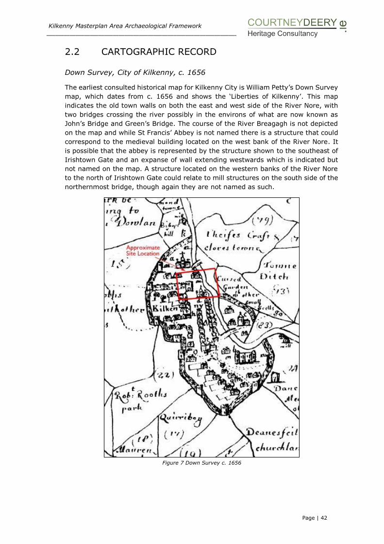
Kilkenny Masterplan Area Archaeological Framework ___________________________________________________________________________________________________
Page | 42
2.2 CARTOGRAPHIC RECORD
Down Survey, City of Kilkenny, c. 1656
The earliest consulted historical map for Kilkenny City is William Petty’s Down Survey
map, which dates from c. 1656 and shows the ‘Liberties of Kilkenny’. This map
indicates the old town walls on both the east and west side of the River Nore, with
two bridges crossing the river possibly in the environs of what are now known as
John’s Bridge and Green’s Bridge. The course of the River Breagagh is not depicted
on the map and while St Francis’ Abbey is not named there is a structure that could
correspond to the medieval building located on the west bank of the River Nore. It
is possible that the abbey is represented by the structure shown to the southeast of
Irishtown Gate and an expanse of wall extending westwards which is indicated but
not named on the map. A structure located on the western banks of the River Nore
to the north of Irishtown Gate could relate to mill structures on the south side of the
northernmost bridge, though again they are not named as such.
Figure 7 Down Survey c. 1656

Kilkenny Masterplan Area Archaeological Framework ___________________________________________________________________________________________________
Page | 43
Rocque’s map of Kilkenny, 1758
Rocque’s map shows the remains of St Francis’ Abbey standing within a large,
predominantly open area extending east to the River Nore. A range of structures
extend north-south at the western end of the abbey. The associated well associated
is shown as a circular structure on the banks and issuing in to the River Nore. The
cloister to the south of the friary was taken down c. 1700 to make way for a
barracks; the ‘Horse Barracks’ named on the map. The open area around the abbey,
which is subdivided into four large plots of land, is in contrast to the built-up,
compact nature of the surrounding city blocks. The outer perimeter of these plots
appear to have been walled and extend northwards to the River Breagagh (shown
but not named), to the River Nore to the east, a short distance to the south and to
the west the abbey opens onto a laneway that leads to ‘Cole Market’.
More subdivision of land occurs to the south, as well as a long building plot with dog-
leg return that backs onto the ‘County Gaol’ and runs east from ‘Cole Market’, before
terminating at a possible laneway that accesses the river bank. Narrow defined
garden plots extending in an east-west direction are located to the rear of buildings
that face onto the ’Shambles’. An access way of lane way leading from the stree
frontage to the River Nore is annotated as ‘The New Quay’.
Immediately north of the River Breagagh, the land is open and defined by a laneway
to the north that extends from Vicar Street to the unnamed mill buildings on the
River Nore. At the corner of the Vicar Street and Bull Lane, structures are shown,
one of which is probably the Bull Inn, although it is not named as such on the map.
To the rear of these properties garden plots extend north-south towards the River
Breagagh.
North again, the land to the rear of the structures that face out onto ‘Vicar Street’ is
divided into narrow plots which extend in an east-west fashion. Some appear as
regulary planted garden plots, perhaps planted with orchards extending towards the
River Nore.
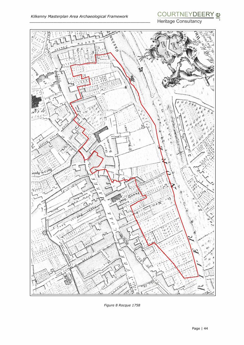
Kilkenny Masterplan Area Archaeological Framework ___________________________________________________________________________________________________
Page | 44
Figure 8 Rocque 1758
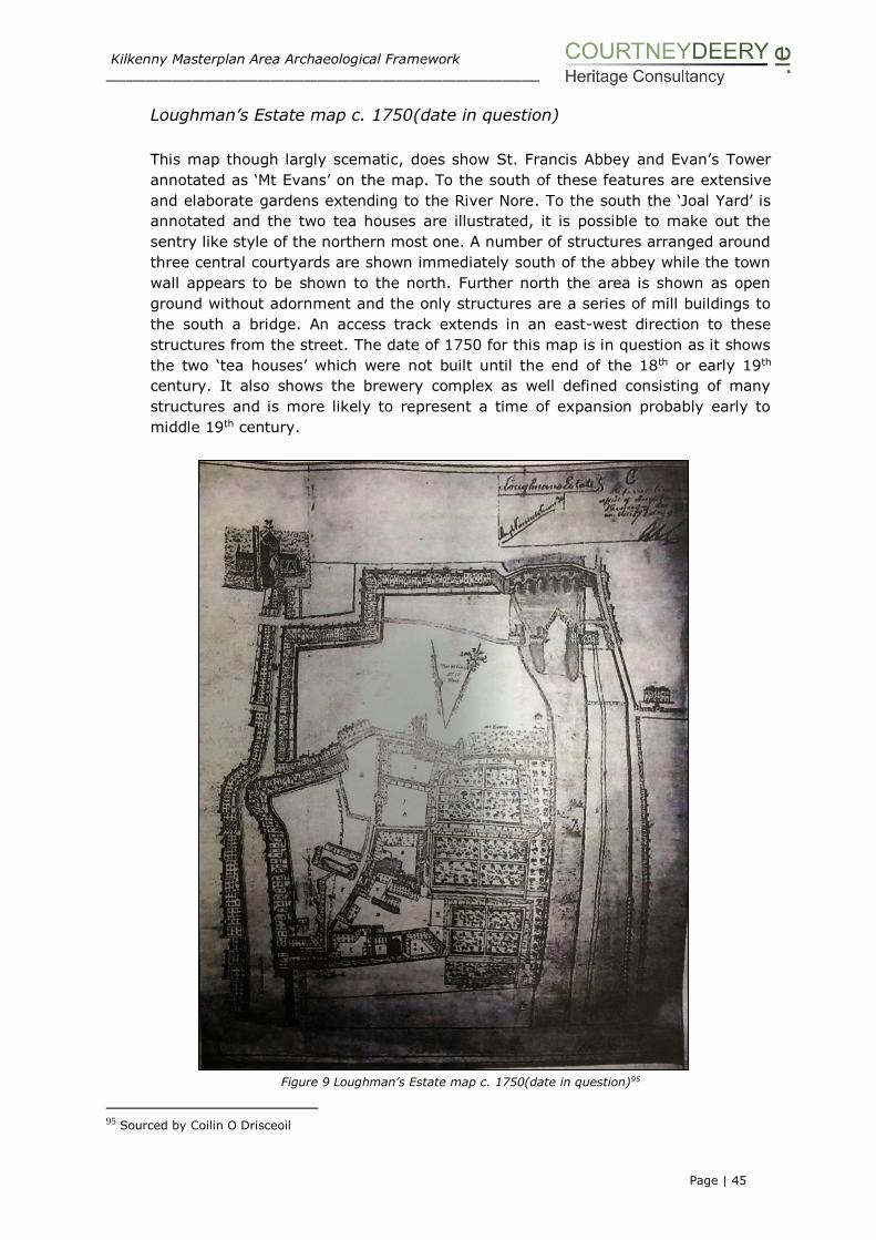
Kilkenny Masterplan Area Archaeological Framework ___________________________________________________________________________________________________
Page | 45
Loughman’s Estate map c. 1750(date in question)
This map though largly scematic, does show St. Francis Abbey and Evan’s Tower
annotated as ‘Mt Evans’ on the map. To the south of these features are extensive
and elaborate gardens extending to the River Nore. To the south the ‘Joal Yard’ is
annotated and the two tea houses are illustrated, it is possible to make out the
sentry like style of the northern most one. A number of structures arranged around
three central courtyards are shown immediately south of the abbey while the town
wall appears to be shown to the north. Further north the area is shown as open
ground without adornment and the only structures are a series of mill buildings to
the south a bridge. An access track extends in an east-west direction to these
structures from the street. The date of 1750 for this map is in question as it shows
the two ‘tea houses’ which were not built until the end of the 18th or early 19th
century. It also shows the brewery complex as well defined consisting of many
structures and is more likely to represent a time of expansion probably early to
middle 19th century.
Figure 9 Loughman’s Estate map c. 1750(date in question)95
95 Sourced by Coilin O Drisceoil

Kilkenny Masterplan Area Archaeological Framework ___________________________________________________________________________________________________
Page | 46
A Plan of the City of Kilkenny, perfected from the latest survey of
observations by Sam Byron, c. 1781
This map appears to be very similar to Rocque, key features such as St Francis’
Abbey and the Horse Barracks and the County Gaol are all named and annotated on
the map.
Figure 10 A Plan of the City of Kilkenny, by Sam Byron, c. 1781
Hogan’s Map of 1860
While later in date this map is derived from Rocque96 but there are a number of
subtle differences in how some buildings are presented and the extent of properties.
The area surrounding St Francis’ Abbey is named as ‘Gray Freren Park’ and appears
to be delineated to the north by the town wall and to the south by a mill stream that
emanates west of Water Gate from the south side of the River Breagagh and
traverses the street to a structure before crossing south of the abbey and issuing
into the River Nore. While unnamed there does appear to be a structure represented
by a circular marking indicating the site of Evans Tower. A list of named structures
that accompanies reference numbers on the map is very helpful in identifying key
features. Within the study area these are named as:
1. “Gray Freren Gate.” This was not a public passway, it led from the Abbey grounds
into the “Chancellor’s orchard;” there was no castle over it: for a “stone house” that
stood near it, Patt Murphy, who occupied it in 1628, paid the Corporation 17s 4d.
yearly rent.
96 Hogan 1861

Kilkenny Masterplan Area Archaeological Framework ___________________________________________________________________________________________________
Page | 47
8. “St. Francis’ Well.” This is a very beautiful and copious spring of pure limpid water,
in the garden behind the Abbey. Ledwich says it was famous for miraculous cures.
In the summer season it is now frequently used for bathing.
9. “The Grey, or St. Francis’, Abbey.’’ The choir and tower of the Church of the
Monastery still stand; the former is now used as a ball-court.
10. “Horse Barrack.” The cloisters of St. Francis’ Abbey were taken down to erect
this barrack, which was built on their site in the last century.
57. “The Chancellor’s orchard and tan-house,” now in the possession of Mrs.
Sullivan, and well known as “Chancellor’s Mill.”
59. “The Treasurer’s Manse, garden, and mill.” This was the next garden to that of
the Vicars’ Choral. The house stood in Vicar’s street, and was “next Alderman
Connell’s,” now Mr. Phelan’s, at the corner of Green-street. The Treasurer’s mill is
next that of the Chancellor.
60. “Prebendary of Tascoffin;” the small premises behind, and including Mr.
Connery’s house in the south angle of Vicar-street.
62. “The Bull Inn.” The large ruined house in Bull-lane.
Figure 11 Hogan’s map of 1860
Located outside but adjacent to the study area the following features are named:
12. “Grace’s old Castle.” First converted into a prison in 1566.
13. “Emlyn’s Hall.” One of Sir Richard Shee’s town mansions: it was, as is asserted
by tradition, the Parliament House of the Confederate Catholics in 1645.
14. St. Keneroc’s Well, i.e. St. Kyran’s Well, also called the “Ark Well.” It now
supplies water through the pump in the old shambles’ yard.
30. “Ancient Market Cross.” For an account of which see “Transactions,” Vol. II, p.
219.
2. “The Hightown Gate,” sometimes called the Water Gate, stood on Watergate
bridge, afforded communication between the Hightown and Irishtown; for the castle
over it, Richard Lawless paid the Corporation 3s. annual rent.
45. “Green’s-gate” stood at the town side of Green’s bridge.
46. “Troy’s-gate” fell down in the time of Queen Elizabeth; it stood where Drysdale’s-
lane (now closed), intersected Vicar-street.

Kilkenny Masterplan Area Archaeological Framework ___________________________________________________________________________________________________
Page | 48
Ordnance Survey First Edition 6-inch map, 1839-40, sheet 19
The formerly open site has been considerably developed since earlier maps, with the
extensive Brewery buildings and a starch manufacturing plant joining the Horse
Barracks (‘Old Caval. Bar.’), the remaining abbey buildings (indicated as ‘in ruins’)
and a ‘tower’ (also ‘in ruins’) is marked to the east/northeast of the abbey.
All of the development has taken place within the western half of the site, with
gardens or orchards occupying the fields in the eastern half, along the banks of the
River Nore. The brewery buildings and yards extend as far south as the long building
plot with dog-leg return that was shown on Rocque’s map and which, apart from an
extension on its north side, appears unchanged. The brewery presents as a series of
yards, a small structure and orchard / garden areas. To the south, the County Court
House and City Goal are indicated and south of this again the ‘New Bank of Ireland’
is annotated with gardens located to the rear extending to the River Nore.
To the north of the River Breagagh, the ‘Woollen Factories’ are shown on the banks
of the River Nore and a ‘Tan Yard’ is located to the north of these. Garden/orchards
stretch from Vicar Street to the River Nore while garden plots from the properties
that face onto Green Street are oriented north-south.
Figure 12a OS First Edition 6-inch map, 1839-40

Kilkenny Masterplan Area Archaeological Framework ___________________________________________________________________________________________________
Page | 49
Figure 12b OS First Edition 6-inch map, 1839-40

Kilkenny Masterplan Area Archaeological Framework ___________________________________________________________________________________________________
Page | 50
Ordnance Survey Second Edition 25” scale (1872 published), Sheet 19
The brewery buildings expanded between 1840 and 1871. The brewery is shown as
a series of buildings while much of the area along the river bank remained as semi-
formal garden / orchard areas with trees and a series of paths. St Francis’ Abbey
Brewery appears to form part of an enclosed space possible defined by walls and
distinctive from the barracks which appear to be concentrated to the south of the
River Breagagh and to the northwest of St Francis’ Abbey, the barracks also appear
to be enclosed by a series of walls. The garden area extends along the bank of the
River Nore and two mill streams flow into the river.
St Francis’ Abbey and St Francis’ Well are both named and clearly shown. The well
appears as a circular walled structure with access steps located on the west. The well
is connected to the River Nore by a channel on the eastern side. A structure appears
to have been placed in the area between St Francis’ Abbey and St Francis’ Well. A
feature not marked on the earlier maps is a small square building situated at the
confluence of the River Breagagh and the River Nore. This is likely to be the remains
of Evans’s Turret, a bastion on the old city wall. The wall walk associated with this
tower and the city wall is clearly shown to the west of the tower. The city wall is
marked along the course of the River Breagagh. The River Breagagh is bridged
further to the west allowing access to Horse Barrack Lane.
To the north of the Breagagh, ‘Mill Lane’ is named as well as the ‘Woollen Factory’,
‘Corn Mill’ and a well is identified and named immediately north of mill lane. Further
north the lands are shown as orchards located within irregular plots.
To the south, to the rear of the ‘Court House and Bridewell’ gardens are shown and
to the south of this the ‘Market (Corporation)’ is named and shown as a large area
along the banks of the River Nore to the rear of the ‘National Bank’ and ‘King Street
Market’. The southern-most teahouse is named as a ‘turret’ while the other one is
unnamed on the map.

Kilkenny Masterplan Area Archaeological Framework ___________________________________________________________________________________________________
Page | 51
Figure 13 OS Second Edition 25” scale (1872 published)
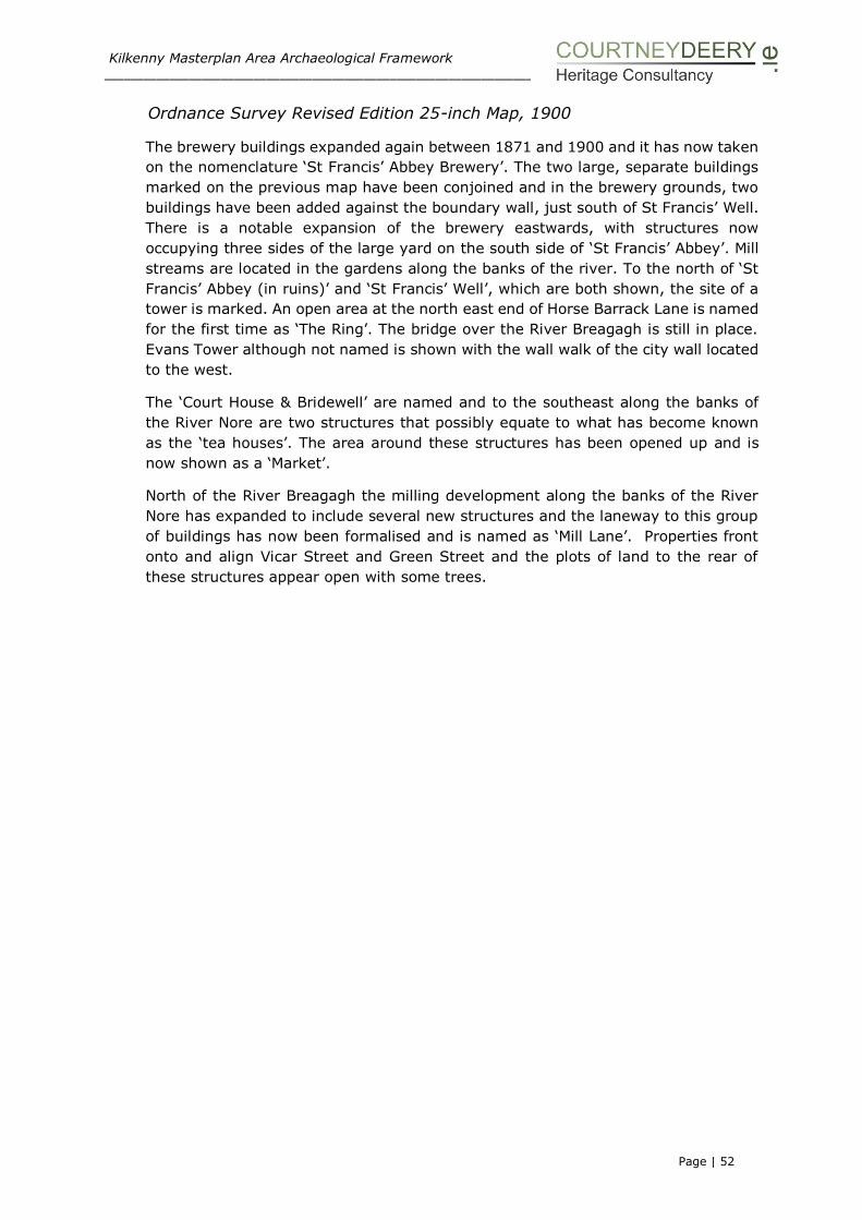
Kilkenny Masterplan Area Archaeological Framework ___________________________________________________________________________________________________
Page | 52
Ordnance Survey Revised Edition 25-inch Map, 1900
The brewery buildings expanded again between 1871 and 1900 and it has now taken
on the nomenclature ‘St Francis’ Abbey Brewery’. The two large, separate buildings
marked on the previous map have been conjoined and in the brewery grounds, two
buildings have been added against the boundary wall, just south of St Francis’ Well.
There is a notable expansion of the brewery eastwards, with structures now
occupying three sides of the large yard on the south side of ‘St Francis’ Abbey’. Mill
streams are located in the gardens along the banks of the river. To the north of ‘St
Francis’ Abbey (in ruins)’ and ‘St Francis’ Well’, which are both shown, the site of a
tower is marked. An open area at the north east end of Horse Barrack Lane is named
for the first time as ‘The Ring’. The bridge over the River Breagagh is still in place.
Evans Tower although not named is shown with the wall walk of the city wall located
to the west.
The ‘Court House & Bridewell’ are named and to the southeast along the banks of
the River Nore are two structures that possibly equate to what has become known
as the ‘tea houses’. The area around these structures has been opened up and is
now shown as a ‘Market’.
North of the River Breagagh the milling development along the banks of the River
Nore has expanded to include several new structures and the laneway to this group
of buildings has now been formalised and is named as ‘Mill Lane’. Properties front
onto and align Vicar Street and Green Street and the plots of land to the rear of
these structures appear open with some trees.

Kilkenny Masterplan Area Archaeological Framework ___________________________________________________________________________________________________
Page | 53
Figure 14 OS Revised Edition 25-inch Map, 1900

Kilkenny Masterplan Area Archaeological Framework ___________________________________________________________________________________________________
Page | 54
Ordnance Survey Revised Edition 25-inch Map, 1946
There is very little change between the 1900 and 1946 O.S. maps in the area of St
Francis’ Abbey Brewery. The abbey, the well and the tower (site of) are again marked
and no change to the brewery buildings can be noted. The garden area along the
banks of the River Nore has been split in two with the northern half retaining its
original character while the southern half has reverted to waste land. A bridge is
shown across the small northern mill stream within the Brewery. A second bridge
across the river Breagagh which was first noted on the 1839 O.S. map and which
opened out on to the area called, ‘The Ring’, is no longer shown and, a new building
blocks the site of the road leading to the bridge. The ‘Mayfair Ballroom’ is named and
shown on the map. Two structures are shown in the areas where the ‘tea houses’
are now located. The most northern structure is associated with a semi-circular
feature, possibly a quay, which projects out over the River Nore. The ‘Market’ is still
shown as is the ‘Court House & Bridewell’.
North of the River Breagagh, ‘Mill Lane’ is named, providing access to the ’Corn Mill’,
‘weir’ and ‘Woollen Mill’ from Vicar Street. The land to the north of the river is
otherwise unoccupied and shown as open plots with orchards.

Kilkenny Masterplan Area Archaeological Framework ___________________________________________________________________________________________________
Page | 55
Figure 15 OS Revised Edition 25-inch Map, 1946

Kilkenny Masterplan Area Archaeological Framework ___________________________________________________________________________________________________
Page | 56
2.3 OUTLINE CHRONOLOGY
Date Description
1207 Arrival of William Marshal (1146-1219), Earl of Pembroke in Ireland.
1207-
10
Hugo Rufus Bishop of Ossory (1202-1218) grants William Marshal land
between St Kieran’s well and the River Breagagh (Liber Albus Oddoriensis,
H.F. Berry, Proceedings Royal Irish Academy XXVII (1907-9), 124.
c.1231-1234
Franciscan friary founded by Richard Marshall.
c.1210 Grace’s Castle built.
1245 The Abbey was given a royal grant in 1245. It began as a small, rectangular chapel which expanded as funds allowed. Only the choir dates to this period.
1246 Royal grant awarded for building purposes.
1269 Cotterals Bridge is mentioned in an inquisition as ‘… to the water called
Bregathe, running under Coteral bridge’ (Carrigan 1905).
Mid 13thC
Hightown wall constructed in the mid-13th century enclosing approx.. 29 hectares (Bradley 1975).
1321 Choir was extended in 1321. Extension included the seven light east window (Butler 1849, Harbison 1992, Leask, Churches II 1958).
1323 High alter consecrated (Butler 1849).
1331 Cemetery completed (Butler 1849, Ledwich 1781).
1337 Huge flood covered everything except the high alter (Butler 1849, Williams
2007 and Clyn 1845, 24).
1347 Funds raised to build the bell tower (probably not built until later in the century due to black death 1348-9 (Conlon 1975). The tall and slender tower
is reputed to be one of the earliest of the Franciscan towers in Ireland
(Harbison 1992).
1348-9 The Black Death claimed many lives in Kilkenny including it is thought Friar
Clyn.
1383-
84
Irish town gate is mentioned ‘John Corvisor is keeper of the gate of Irestoun
and of that murage, taking yearly 8s’ (McNeill 191).
14thC Irish town wall is thought to have been completed in the 14th century (Thomas 1992).
14th C Kyteler’s Inn built
Late
14thC
Sacristy & living quarter built to the south (Conlon 1975).
Late 14thC
Aisle added on northern side of nave (Conlon 1975).
Late 15thC ?
Transept chapel (Conlon 1975). Part of the north aisle was demolished and some of the north wall of the
nave was replaced by a pair of arches, which were also placed along the rear
of the transept chapel (Bassett 1884).
1540 The Abbey was supressed and the following was seized (Carrigan 1905) ‘a
church & belfry, two chambers (named), a granary over three cellars, a barn, kitchen, cemetery and an orchard with two small closes’, cont. 2 acres, a
weir on the River Nore, a watermill, a tiled chapel, 18 messuages, over 100
acres of land, etc…’(Gwynn and Hadcock 1970).
1543 Including the buildings already named, a dormitory hall, third chamber and
cloister are mentioned when the friary was granted to the sovereign and commonalty of Kilkenny (Gwynn and Hadcock 1970).
1566 Grace’s Castle transferred into the ownership of the Crown to be used as a
gaol.
1598 Payment for a carriage of 79 cartloads of stone for making up the tower at
Francis Well (Corporation Archives, CR/J/28).
1612 Abbey in a state of disrepair (Carrigan 1905).
1625 Irishtown described as being washed by the river by Bishop Rothe.
1647 St Francis’ Abbey designated a house dedicated to the study of theology and philosophy.
1650 Civil Survey describes Evan’s Turret as a ‘little castle in the garden’ (CS 6,
519).
1650 Cromwell uses a breach in the City Wall to attack the Abbey (Ledwich 1804,
475 and Egan 1884, 39).
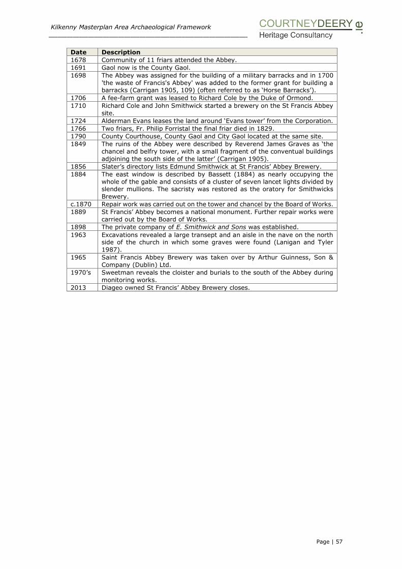
Kilkenny Masterplan Area Archaeological Framework ___________________________________________________________________________________________________
Page | 57
Date Description
1678 Community of 11 friars attended the Abbey.
1691 Gaol now is the County Gaol.
1698 The Abbey was assigned for the building of a military barracks and in 1700
'the waste of Francis's Abbey' was added to the former grant for building a barracks (Carrigan 1905, 109) (often referred to as ‘Horse Barracks’).
1706 A fee-farm grant was leased to Richard Cole by the Duke of Ormond.
1710 Richard Cole and John Smithwick started a brewery on the St Francis Abbey
site.
1724 Alderman Evans leases the land around ‘Evans tower’ from the Corporation.
1766 Two friars, Fr. Philip Forristal the final friar died in 1829.
1790 County Courthouse, County Gaol and City Gaol located at the same site.
1849 The ruins of the Abbey were described by Reverend James Graves as ‘the
chancel and belfry tower, with a small fragment of the conventual buildings
adjoining the south side of the latter’ (Carrigan 1905).
1856 Slater’s directory lists Edmund Smithwick at St Francis’ Abbey Brewery.
1884 The east window is described by Bassett (1884) as nearly occupying the
whole of the gable and consists of a cluster of seven lancet lights divided by slender mullions. The sacristy was restored as the oratory for Smithwicks
Brewery.
c.1870 Repair work was carried out on the tower and chancel by the Board of Works.
1889 St Francis’ Abbey becomes a national monument. Further repair works were
carried out by the Board of Works.
1898 The private company of E. Smithwick and Sons was established.
1963 Excavations revealed a large transept and an aisle in the nave on the north side of the church in which some graves were found (Lanigan and Tyler
1987).
1965 Saint Francis Abbey Brewery was taken over by Arthur Guinness, Son &
Company (Dublin) Ltd.
1970’s Sweetman reveals the cloister and burials to the south of the Abbey during
monitoring works.
2013 Diageo owned St Francis’ Abbey Brewery closes.

Kilkenny Masterplan Area Archaeological Framework ___________________________________________________________________________________________________
Page | 58
SECTION III: UNDERSTANDING THE PLAN
AREA
The Archaeological Context
Map after Bradley (2000) Medieval City Walls

Kilkenny Masterplan Area Archaeological Framework ___________________________________________________________________________________________________
Page | 59
SECTION III: The ARCHAEOLOGICAL CONTEXT
3.1 INTRODUCTION
This section examines the archaeological findings to date at the Masterplan site and
discusses the below ground archaeology and potential of the area. Research and
development led archaeological monitoring and excavation has been conducted
within and in the immediate vicinity of St Francis’ Abbey.
Fig 17. KKAP Overview – Map showing investigations as plotted from the Kilkenny Archaeology Project (noted
investigations in brown date up to 2006).

Kilkenny Masterplan Area Archaeological Framework ___________________________________________________________________________________________________
Page | 60
3.1.1 Archaeological Investigations within the Masterplan Area
The development lands of St. Francis’ Abbey Brewery located on the western bank
of the River Nore cover a 7.5 hectare area. The site is located within the zone of
archaeological potential for Kilkenny city (KK019–026). The area contains a number
of extant archaeological remains as well as being host to many excavations, testing
schemes and phases of monitoring since the early 1960s. Upstanding remains
include an abbey consisting of an unroofed chancel and tower (KK019-026101), a
river wall (which forms part of the town wall circuit), the remains of a bridge (KK019-
026102), a 17th Century wall monument (KK019-026183), a font (KK019-026150),
an inscribed slab (KK019-026151), and Evans turret and wall walk (with foundations
dating to the 13th Century). To the north of the River Breagagh in the north-west
corner of the site is the Bull Inn (KK019-026107) and the site of a 16th/17th century
house (KK019-026122), whilst on the banks of the river Nore is the site of a watermill
(KK019-026124), a site which has been investigated by Paul Stevens as part of the
River Nore Flood Alleviation Scheme.
One large excavation took place in the immediate surroundings of the Abbey under
the direction of Marcus Ó hEochaidhe, this was followed by the monitoring of the
demolition of brewery buildings by David Sweetman. It had been previously assumed
in excavation.ie reports that these archaeological works took place in 1966 and 1969,
but a study of Sweetman’s original site notes and cross referencing sources places
them securely in 1963 and 1970 respectively.
Ó hEochaidhe 1963 - Excavation
Archaeological investigations began in 1963 with an excavation to the immediate
north and west of the standing abbey ruins by Marcus Ó hEochaidhe. The results of
this excavation were never fully published, however site plans in the records of the
OPW, combined with record photography from the excavation, provide an insight
into the below ground remains of the abbey. An estimate of the extent of the area
opened for excavation would be 40m x 30m (Figure 18), with a depth varying
between 0.4m and 1m from the then existing ground level (this was gathered from
the photographic archive of the excavation).
Archaeological works exposed the foundations of the north aisle of the religious
complex dating to the 14th Century, along with those of a substantial transept to its
north dating to the 15th/16th Century (Figure 18). Photographic records of the
exposure of at least one medieval burial near the transept, along with the discovery
in the north transept of the Delahunty grave slab (with Gothic inscription and dated
1624, Plates 26 and 27), indicate the potential for more human remains in the
immediate surroundings.
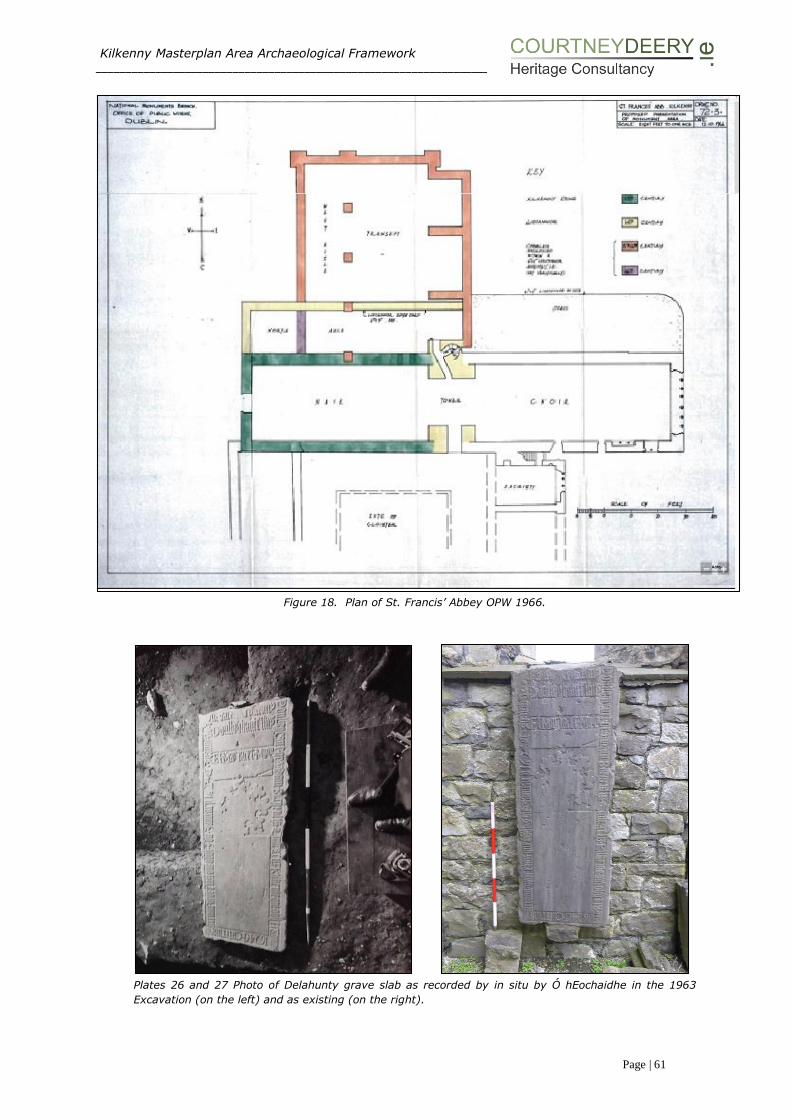
Kilkenny Masterplan Area Archaeological Framework ___________________________________________________________________________________________________
Page | 61
Figure 18. Plan of St. Francis’ Abbey OPW 1966.
Plates 26 and 27 Photo of Delahunty grave slab as recorded by in situ by Ó hEochaidhe in the 1963
Excavation (on the left) and as existing (on the right).

Kilkenny Masterplan Area Archaeological Framework ___________________________________________________________________________________________________
Page | 62
The potential for human remains was verified by Sweetman in the proceeding
monitoring briefs of the 1970s. Interestingly, Con Manning, in an article on the
Delahunty grave slab in the Old Kilkenny Review (2007), notes that; “burial at the
site continued as late as 1687, as shown by a recorded inscription, but may have
ceased after 1698, when the site was given over for use as military barracks”1.
Sweetman 1970 - Monitoring
The next series of archaeological investigations in the vicinity of the abbey began in
September 1970 and continued intermittently for the next decade. In this case all
archaeological monitoring of demolition works and service development was carried
out by David Sweetman. The findings were unpublished, however, monitoring notes
and a number of sketches were on record at the DAHG. These investigations
uncovered the walls of the west range (a large area to the immediate south of the
nave), a cloister walk wall, the western wall of the sacristy and a substantial amount
of human remains. Initial investigations to the immediate west of the standing tower
of St. Francis’ Abbey located the east end of the south wall of the nave (the wall as
it ran westwards had been completely destroyed by the insertion of a modern sewer
system). Another trench was dug to expose the south west corner of the nave and
in turn verified the full length of the south wall. Both of these trenches exposed a
number of burials, dated to “no later than the 18th Century”2. A mechanical digger
was then used to remove rubble from the demolished brewery and expose large
areas of the west range and in turn the remains of 15th century walls. Due to the
concentration of haphazard fill of a 17th and 19th century date in this area, Sweetman
suggests that this part of the west range was in fact a cellar, which was filled up with
rubble, prior to been covered with reinforced concrete for the construction of the
brewery.
1 Con Manning 2007 The Delahunty Grave Slab in St Francis’ Abbey, in OKR No. 59 pgs 48-51 2 David Sweetman’s monitoring notes 1969-71, unpublished.

Kilkenny Masterplan Area Archaeological Framework ___________________________________________________________________________________________________
Page | 63
Figure 19. Plan of St. Francis’ Abbey, below ground remains and areas of investigation.
In early October 1970, another cutting was made in the west range in an attempt to
locate the cloister. Following the removal of a large amount of reinforced concrete,
the cloister walk was discovered, however the flagstones of the walk had been
removed except for a few which had been used for secondary burials. The cloister
walk (measuring 1.8m wide) proved to be full of burials, many piled on top of one
another, and not orientated in the traditional Christian east-west fashion. This
indicates a hasty interment and suggests they were possibly victims of disease.
Kilkenny Masterplan Area Archaeological Framework ___________________________________________________________________________________________________
Page | 64
Pottery sherds from the site were overwhelmingly 17th century and of English origin,
they also included one German wine container (a Belermine Jug). A few sherds of
13th century English ware and sherds of 13th century French wine jugs were also
uncovered (these were mingled with the 17th century wares and 20th century debris).
Excavation continued in December 1970 following the breaking up of concrete by the
demolition crew in the northwest section of the cloister area. 19th century disturbance
had removed the expected northwest corner of the cloister, although further areas
of the west wall were uncovered and planned.
Additional archaeology works took place over the next few years, following the
uncovering of features during site development or service works. In February 1971
a small area of the friary was investigated, locating the extreme north end of the
east wall of the west range. March 1973 also saw a site visit by Sweetman to
ascertain if an exposed wall was part of the original friary. A one day investigation
took place recording what proved to be the west wall of the sacristy.
The opening of four trial trenches (trenches 1 to 4 in Fig.19) was supervised by David
Sweetman in January 1980 prior to the laying of foundations for a new building
immediately to the south of the existing choir. This building still stands and is
referred to as the “Sample Rooms” on site (Fig.19 above). The first three test
trenches were dug to a depth of 1m (which was below the formation level of the
proposed building) and exposed rough cobbling over a fill of brick, stone, ashes and
charcoal. The fourth trench revealed the east face of a substantial wall running south
from the south eastern corner of the sacristy. Sweetman notes that this wall (south
of the sacristy marked on Fig.19) is the remains of the outer facade of the eastern
wall of the chapter room marked on plans drawn during the excavation by Ó
hEochaidhe in 1963. Plans of this area from 1963 are not available for viewing but
their mention does indicate that Ó hEochaidhe carried out investigations south of the
choir. Testing exposed 4.5m of this wall face and it was taken down to a depth of
1.6m. The wall stands at 0.8m above its footing (which consist of 0.8m of
foundations). The western wall of the chapter room was not located. A human skull
(belonging to a burial noted as being in a “disturbed position”) was exposed at the
bottom of the trench and reburied in situ. It was noted that south of this trial trench
there is a modern building (erected in 1976), the construction footprint of which
exposed a large amount of modern rubble and disturbance. Following testing it was
concluded that the construction of the proposed building (the ‘sample rooms’) would
not disturb any features of archaeological interest.

Kilkenny Masterplan Area Archaeological Framework ___________________________________________________________________________________________________
Page | 65
Figure 20. Masterplan area, below ground remains and areas of investigation.
Kilkenny Masterplan Area Archaeological Framework ___________________________________________________________________________________________________
Page | 66
Archaeological Site Assessment and Testing within the Masterplan Area
Between the mid-1990s and 2007, a number of archaeological assessments were
carried out, throughout the brewery complex (Figure 20). The assessments and
resulting investigations related to a number of localised development and up grading
schemes on the brewery site itself as well as large riverside infrastructural projects.
Works requiring archaeological monitoring and investigation included the multiphase
development of a number of fermentor blocks, drainage remediation works, the
construction of a wastewater treatment plant, and a flood alleviation scheme related
to the River Nore.
Monitoring works on KKCC Drainage (to the southwest of St. Francis’ Abbey) 1996/7
Two archaeological investigations took place in 1996 and 1997 to the immediate
west of the Masterplan area relating to the construction of a new main drainage
system in Kilkenny. These works involved archaeological monitoring of open cut-
trenches, ground stabilisation in advance of thrust-boring, and the thrust-boring
operation itself. Monitoring was carried out under licence by Martin Reid and Patrick
Neary (License Refs. 96E0047 and 97E0481 respectively). The former monitoring
brief noted the foundations of a medieval rectangular stone building, which was cut
by an eighteenth-century mill-race, which was itself demolished and built on by a
later mill-race enclosed in a tunnel. This culverted mill-race is believed to be that
which runs from the Breagagh River, south-eastward under Parliament Street,
through the theatre carpark, onto the Brewery (where it was uncovered during
monitoring, under licence 04E0694), and into the Breagagh. The interpretation of
this material is that the mill-race was used as a rubbish dump by the locals before it
was culverted in the post-medieval period.
A battered wall foundation on the south side of Mill Lane, at No 20 Vicar Street was
revealed. This extended in an easterly direction towards the River Nore, on which a
mill was located, the remains of which are still upstanding. The battered foundation
extended beyond the limit of excavation, which was 2m deep beneath present
ground surface. The existing upstanding wall is built on top of the earlier foundations
at a depth of approx. 0.6m below present ground surface.
At the junction of Irishtown and St Canice’s Place at a depth of 1.4m below the road
surface, Patrick Neary noted in his brief (License Ref. 97E0481), that a considerable
quantity of pottery, bone, horn, leather and glass was recovered, some of which no
doubt came from the medieval period, but also included a large amount of post-
medieval material.
Fermentor Block (Phase V to VIII)
A series of monitoring works and test excavations were undertaken in relation to the
phased development and extension of an existing fermentor block between 1995 and
1999. These investigative works took place over 4 construction phases (Phase’s V-
VIII) under archaeological licenses 95E0242, 97E0099, 98E0069, and 99E0148. All
phases of the development were in close proximity to each other. Initial excavation
(Phase V) revealed an organic silt deposit (with a depth of 1.32m), thought to be of
possible medieval date, sealed below a made ground fill of construction rubble (seen
to a depth of 1.25m below ground level).

Kilkenny Masterplan Area Archaeological Framework ___________________________________________________________________________________________________
Page | 67
Prior to the construction of a new fermentor block at the brewery in 1997 (part of
Phase VI), Ed O’Donovan carried out an archaeological assessment License Ref.
97E0099. A small test trench measuring 2m x 1.3m was opened, and revealed yellow
boulder clay sealed by a layer of sterile black silty clay at a depth of 2.5m to 1.25m
below a layer of demolition rubble. It was hoped that some trace of the mill race
identified on Rocque’s Map of 1758 would be uncovered during this investigation,
however, nothing was uncovered, and it is believed it was positioned further south.
Investigation of Phase VII of the fermentor development took place under license
98E0069, this consisted of two trenches, one aligned east-west along the line of 3
no. pile caps and the other aligned north-south along the long axis of the proposed
block on its western side, test trenches revealed masonry wall foundations. These
two structures were considered to be of post-medieval date on the basis of their size,
nature and stratigraphic relationship with the deposits recorded in their vicinity, and
indicated further structural remains at the southern end of the brewery compound.
Phase VIII was carried out under License Ref 99E0148, and took part in two stages.
The first stage involved a trench which was 11.5m long, 1m wide and excavated to
a depth of between 1m and 2.7m. A thin layer of gravel was identified over boulder
clay. This was overlain by a soft, silty, organic material that consistently produced
occasional post-medieval pottery. It directly underlies a mortar layer representing
barracks activity. Two parallel limestone walls orientated northeast/southwest were
uncovered. The walls were post medieval and made from rubble limestone bonded
with a white lime based mortar. These walls were left in situ. The second stage saw
the opening of a north-south aligned trench, 20m long, 1.30m wide and excavated
to a depth of between 1m-3.10m, and confirmed these findings.
Improvements to flood defences, drainage system and waste water treatment
facilities between 1999 and 2007 resulted in a series of monitoring briefs and test
trenching being carried out under licence (License Ref. 99E0385, 99E0385ext,
00E0406, 00E033, 00E0405, 01E0608, 01E0821, 04E0694, 04E0694ext, and
07E1061) within the masterplan area of the St. Francis’ Abbey Brewery site.
Monitoring for the River Nore Flood Alleviation Scheme – River Breagagh:
In 1999 the decision to commence with the Nore Flood Alleviation Scheme
necessitated the riverbed level to be reduced by bulk excavation. This excavation
was essential to remove any stabilised PCB contaminated material due to a spillage
from a refrigerated unit over twenty years earlier. These works, commenced under
License Ref. 99E0385 by Margaret Gowen & Co. Ltd. included the initial excavation
of 6 test pits in the riverbed, a survey of the medieval wall, and the monitoring of
geotechnical bore holes. These pits were excavated in pumped, sand-bagged
locations roughly 1.5 x 1.5m. Of the six, four were opened along the medieval wall
and two were opened on the northern side adjacent to a modern concrete wall. Only
test pit, number four yielded anything of archaeological significance; two sherds of
medieval pottery. Excavation on the southern side, against the medieval wall,
revealed that the gravel extended down for at least 0.8m and that it possessed
modern debris to that depth. No medieval material was noted in any of the material
excavated along the southern side, although large quantities of modern bottles,

Kilkenny Masterplan Area Archaeological Framework ___________________________________________________________________________________________________
Page | 68
some delph, plastics and some metal objects were removed for identification. No
archaeological features or artefacts were uncovered during the bore hole sampling.
Archaeological assessment and monitoring of dredging in the River Breagagh
included the detailed survey of the former northern boundary wall of the friary
complex and what is regarded as the City Wall in this location. The survey established
that the foundations and lowermost 1.50m or more of the wall was composed of
original medieval masonry. It also established that the wall had very shallow
foundations and that it incorporated a footing of some 1-3 courses in depth.
Plate 28Collection of clay pipes uncovered
during the River Nore
Flood Alleviation Scheme (courtesy of
Margaret Gowen & Co. Ltd.)
An extensive programme of archaeological testing, monitoring and excavation was
undertaken by Margaret Gowen & Co. Ltd as part of the River Nore Flood Alleviation
Scheme between 2001 (License No. 00E0406 and 00E033 and 00E0405, 01E0608,
01E0821) and 2005. The drainage scheme covered approximately five kilometres of
rivers running through the medieval city, and the subsequent twenty excavations,
and vast amount of varied stray finds give a unique insight into the city’s prehistory
and history. As part of this programme archaeological excavations were carried out
at Green’s Bridge, Mill Island and Green’s Bridge Weir. Between 2001 and 2002 Mill
Island and Green’s Bridge Weir were excavated in advance of removal of the island
and remodelling of the weir. This site formed part of a large milling complex that
spanned both sides of the River Nore (Figure 21).
Six areas were opened over two seasons of excavation. Seven phases of construction
of the mill buildings on Mill Island were identified, from the use and modification for
the processing of corn, to dereliction, and destruction. These areas were excavated
to sterile river gravels. North of the plan area the late 17th to early 18th century
abutment of Green’s Bridge was excavated in 2003, informing a current
understanding about historic bridge construction. The original Green’s Bridge was
north of the modern bridge, in line with Green Street.

Kilkenny Masterplan Area Archaeological Framework ___________________________________________________________________________________________________
Page | 69
Figure 21 Reconstruction of Mill based on archaeological remains on the mill island (courtesy of Margaret
Gowen & Co. Ltd.).
Seven excavations took place either within or in the immediate proximity of the
masterplan area as part of mitigation for the River Nore Drainage Scheme.
Combining both above ground and underwater excavation a series of investigations
into 18th/19th Century pleasure houses, an early modern gazebo, revetment walls,
and a stone jetty, were carried out. Five buildings situated along the river’s edge at
Bateman Quay (all annotated as ‘Pleasure Ho[use]’ on the First Edition Ordnance
Survey map) were excavated (under License Refs. 01E0554 and 01E0555).
Excavation work was undertaken in June 2002 on a riverside stone jetty by Paul
Stevens (License Ref. 01E0554), accompanied by underwater monitoring and
excavation by Dr Niall Brady of ADCO Ltd (License Ref. 01E0036). Two phases of
domestic mooring usage were revealed dating from the mid-17th/early 18th century
and the later 18th/early 19th century respectively. The rebuilding relates to a rise in
water levels associated with the building of weirs both up and downstream. The
structure was built of reused vernacular architectural stone fragments, dating from
the medieval, Tudor and post-medieval periods, and had been heavily truncated by
a number of modern drainage and landscaping features.
This was followed by excavation of the five “Pleasure House” buildings dating to the
end of the 18th and the beginning of the 19th century. Full measured survey and
rectified drawings of the upstanding house remains and that of a circular revetment
wall were carried out (Figure 22 below). A high concentration of post medieval glass

Kilkenny Masterplan Area Archaeological Framework ___________________________________________________________________________________________________
Page | 70
bottles, clay pipe, weapons, and pottery were retrieved during the monitoring of this
scheme.
Figure 22 Plan, section, and elevations of Pleasure House (courtesy of Margaret Gowen & Co. Ltd.)
excavated under License 01E0555.
Monitoring of On-Site Drainage Remediation Works:
Between 2004 and 2006 a series of drainage remediation works within Smithwick’s
Brewery required licensed monitoring. Commencing in 2004 in the southern portion
of the brewery, works were carried out by archaeologist Kevin Lohan (of Margaret
Gowen & Co. Ltd under license Ref. 04E0694). Pre-disturbance and the pre-emptive
redesign of a number of proposed trenches meant that the only archaeology
encountered in five separate area’s (A to E below) was a culverted medieval
millstream (which had previously been uncovered in 1996/7 further to the west in
the monitoring of the carpark of the Watergate Theatre under Licence Refs. 96E0047
and 97E0481). In 2006 the licence was extended to cover works in the northern
portion of the brewery, carried out by Brenda O’Meara under license 04E0694ext
(Phase’s 1 to 3 below).
Area A & B - Following consultation between the directing archaeologist, the NMS,
and the client, it was decided that a redesign of the proposed trenching scheme was
necessary, this was due to their close proximity of the standing remains of St.
Francis’ Abbey and potential burial grounds. Re-lining of existing service trenches
eliminated any requirement to excavate, and in turn any impact on potential
archaeological remains.

Kilkenny Masterplan Area Archaeological Framework ___________________________________________________________________________________________________
Page | 71
Area C – An 8m north-south test trench (depth 2m) in Area C crossed the line of a
probable medieval millstream adapted in the 19th Century into a culvert. The eastern
façade of the trench revealed the slightly disturbed west face of an arched culvert
was exposed. The limestone masonry of the arch spanned an area measuring 2.4m
wide. The apex of the arch was exposed 0.8m below the ground. The eastern extent
of this masonry culvert was not revealed. The remainder of the millstream, east to
the river was culverted in the late 20th century.
Area D - Required the installation of an access chamber in an area that was already
disturbed by an earlier chamber. There was no further excavation into undisturbed
ground and there was no archaeological implications for this work.
Area E – This involved monitoring of a 55m east-west trench, in the kegging area,
running adjacent to and just south of the River Breagagh. Layers of made ground,
dark silts and natural river gravel all noted but nothing of an archaeological
significance.
In 2006 a second phase of drainage remediation works was carried out which
required archaeological monitoring at the site. The license (Ref No. 04E0694ext) was
extended to cover these works. They were carried out by Breda O’Meara and focused
in the northern portion of the brewery on the northern side of the River Breagagh.
The works were carried out in 3 phases. Phases 1 and 2 were composed of linear
east-west trenches adjacent to the River Breagagh and were excavated to a depth
of 2m. These service trenches revealed a sterile black riverine silt clay at between
1.2m and 2m below the present ground level. This material was sealed by a thick
deposit of mixed building rubble and gravelly sand interpreted as late nineteenth
/early twentieth-century reclamation and levelling. Two layers of concrete yard
surface separated by gravel filling were recorded in the uppermost section of the
trenches. Phase 3 saw deep excavations required to accommodate the insertion of
petrol interceptor tanks. Between 2.7m and 3.5m of material was removed exposing
a deposit of black riverine silt clay, c. 0.65m thick, over river gravel. No
archaeological material was recovered from these riverbed and accumulated river
bank deposits. These deposits were sealed by late 19th/early 20th-century rubble
and gravel reclamation and levelling deposits and by concrete yard surfaces.
Monitoring of the Development of a Waste Water Treatment Facility:
In 2008 the development of a wastewater treatment plant, an associated service
road, and general landscaping within the north-eastern corner of the masterplan
area necessitated archaeological investigation. Under License Ref. 07E1061 Nikolah
Gilligan of Margaret Gowen & Co Ltd monitored a total six test trenches. Four east–
west and two north–south-orientated trenches were machine excavated across the
footprint of the proposed site in an area known as the orchard. Remnants of two
north–south-orientated stone walls were noted during testing. The walls appeared
to have been fairly disturbed by post-medieval and modern activity on the site, which
took place in the form of millrace reclamation and drainage works. The first wall was
noted in Trench 1, at a depth of 0.6m below the present ground surface (c. 43.1m
OD). It is situated in the same location as the original eastern boundary wall visible
on Rocque’s 1758 map and was probably a renovated version of the original
boundary wall. The second feature was located in Trench 4, at a depth of 1.7m below
the present ground level (c. 42.55m OD). This was probably the remains of a north–

Kilkenny Masterplan Area Archaeological Framework ___________________________________________________________________________________________________
Page | 72
south dividing wall which was constructed within an east–west-orientated burgage
plot. The plot probably belonged to a house fronting onto Vicar Street, depicted on
Rocque’s Map of 1758.
Testing for the Proposed Kilkenny Central Access Scheme 2010-12:
The requirement for archaeological test trenching was one of several mitigation
measures contained in An Bord Pleanála’s decision regarding the granting of
permissions for the construction of the Kilkenny Central Access Scheme (KCAS). Both
underwater and above ground testing was required. An underwater investigation to
sections of the riverbed that will be impacted on by the insertion of a proposed bridge
crossing associated KCAS was carried out by ADCO in 2010, under License
Ref.10E323. No archaeological features were recorded.
As part of works associated with the KCAS archaeological test trenching took place
in July 2012, and was carried out by Colm Flynn for Valerie J Keeley Ltd. Previously
unknown archaeology was identified in four of the six test trenches excavated to the
north of the River Breagagh. The nature of the archaeology present and the
artefactual evidence indicates that it relates to 18th-19th century buildings and
associated yards. It is possible that the archaeology that was identified relates to
buildings depicted on Rocque’s map, dating to the 1758. The buildings on Rocque’s
map are shown along one side of a roadway named Mill Lane. It has been suggested
that Mill Lane is the cobbled area identified in Test Trench IV. Buildings are not shown
in the location of the archaeology in the 1st ed. OS 6-inch map of the area, which
dates to the 1839. Buildings are also depicted in this area on 3rd ed OS maps of the
area, which dates to the 1910’s. It is unlikely these buildings are the same as those
shown on the earlier Rocque’s map. Test Trench VI excavated along the western
shore of the River Nore identified riverine silt deposits, and modern quarried stone,
and no evidence of archaeology.
Monitoring of a trench for an underground ESB cable 2010-12:
The monitoring was carried out by Gill McLoughlin of Courtney Deery Heritage
Consultancy Ltd. on behalf of Diageo Limited (License Ref:14E0250), in July and
August 2014. The trench for the ESB cable snaked its way for 160m at the southern
end of the Masterplan. A series of 19th and 20th century walls, box drains, and
culverts were uncovered. A number of which tie in with Rocque’s map of 1758 and
the 1st ed. OS 6-inch map of 1839.
In general the stratigraphy of the trenches was as follows:
Depth Context
no.
Description
0-0.28m C1 Concrete.
0.28-0.45m C2 Loose deposit of stones and coarse sand, rounded and
angular cobbles average diameter 0.08m.
0.45-1m C3 Mixed deposit of light-mid orange-brown sandy clay with
inclusions of red brick, slate and mortar. There were many
variations in the deposits at this level along the length of the
trench, however they all contained some modern inclusions,
indicating disturbance.
The route of the ESB trench was extensively disturbed and with the exception of one
sherd of medieval pottery from a disturbed context, all the finds were of 19th –20th

Kilkenny Masterplan Area Archaeological Framework ___________________________________________________________________________________________________
Page | 73
century date. Remnants of a number of walls were identified, many of which appear
to correspond with walls depicted on the early OS mapping of the area. Most of the
walls were similar in size and construction, and date to the 19th century, with possibly
one or two walls dating to the 18th century. A culvert identified at the north end of
section 1 of the trench may relate a structure depicted possibly on Rocque (1758)
and on the 1st ed. OS 6-inch map. This culvert may represent the line of an earlier
mill stream which issued to the River Nore (Plate 29). The culvert was oriented west-
northwest – east-southeast and was constructed of large limestone blocks measuring
up to 0.4m x 0.5m. It was present at 0.45m deep, was 1m wide and was cemented
in on both sides.
Plate 29 Monitoring ESB trench, culvert section 1
The results of the archaeological monitoring of the ESB trench correspond well with
previous monitoring of a service trench in the immediate vicinity in early 2014 (Flynn,
between February-May 2014 in relation to the Smithwicks Visitor Attraction Project)
which identified two stone walls thought to be part of an 18th -19th building, roughly
corresponding with the location of the culvert and a post 19th century stone wall
corresponding with the wall and associated flagstones in the south end of the trench.
Monitoring of an outfall upgrade by a licensed archaeologist took place to the rear of
the courthouse within the brewery yard in 2014. This excavation examined an area
7m x 4m and over 3m deep. The area had been previously extensively disturbed due
to two existing manholes and no archaeological features or finds were revealed. A
possible riverine deposit (a dark grey brown silt) was detected below c. 1.5m.
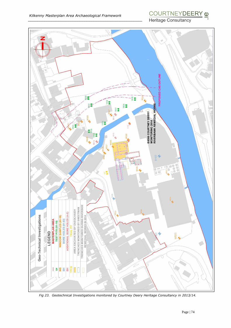
Kilkenny Masterplan Area Archaeological Framework ___________________________________________________________________________________________________
Page | 74
Fig 23. Geotechnical Investigations monitored by Courtney Deery Heritage Consultancy in 2013/14.
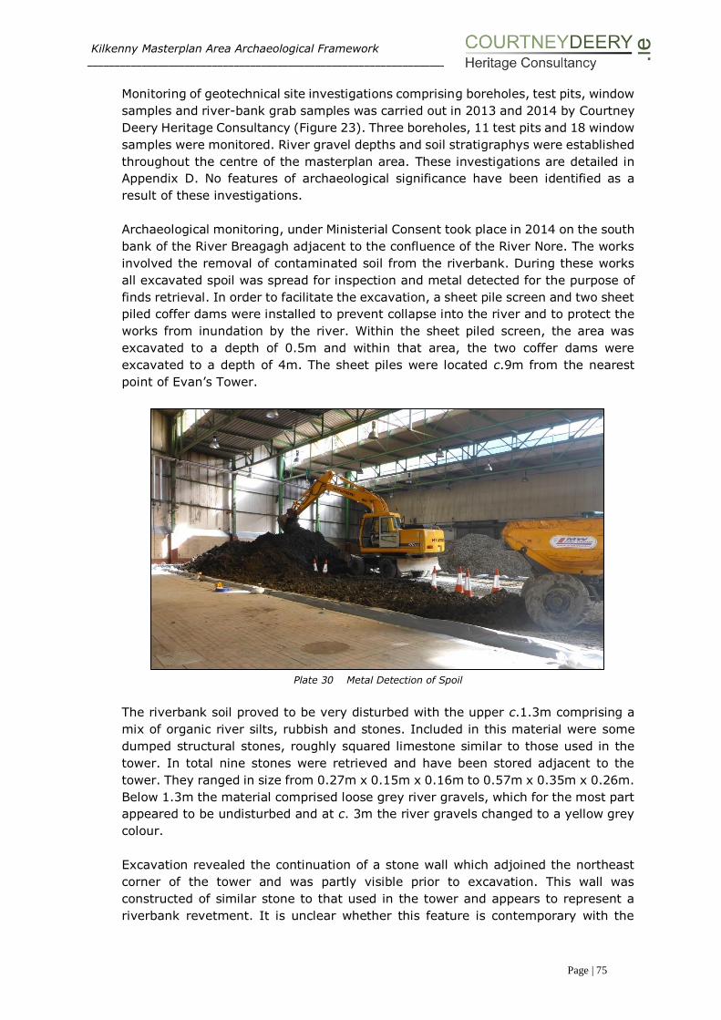
Kilkenny Masterplan Area Archaeological Framework ___________________________________________________________________________________________________
Page | 75
Monitoring of geotechnical site investigations comprising boreholes, test pits, window
samples and river-bank grab samples was carried out in 2013 and 2014 by Courtney
Deery Heritage Consultancy (Figure 23). Three boreholes, 11 test pits and 18 window
samples were monitored. River gravel depths and soil stratigraphys were established
throughout the centre of the masterplan area. These investigations are detailed in
Appendix D. No features of archaeological significance have been identified as a
result of these investigations.
Archaeological monitoring, under Ministerial Consent took place in 2014 on the south
bank of the River Breagagh adjacent to the confluence of the River Nore. The works
involved the removal of contaminated soil from the riverbank. During these works
all excavated spoil was spread for inspection and metal detected for the purpose of
finds retrieval. In order to facilitate the excavation, a sheet pile screen and two sheet
piled coffer dams were installed to prevent collapse into the river and to protect the
works from inundation by the river. Within the sheet piled screen, the area was
excavated to a depth of 0.5m and within that area, the two coffer dams were
excavated to a depth of 4m. The sheet piles were located c.9m from the nearest
point of Evan’s Tower.
Plate 30 Metal Detection of Spoil
The riverbank soil proved to be very disturbed with the upper c.1.3m comprising a
mix of organic river silts, rubbish and stones. Included in this material were some
dumped structural stones, roughly squared limestone similar to those used in the
tower. In total nine stones were retrieved and have been stored adjacent to the
tower. They ranged in size from 0.27m x 0.15m x 0.16m to 0.57m x 0.35m x 0.26m.
Below 1.3m the material comprised loose grey river gravels, which for the most part
appeared to be undisturbed and at c. 3m the river gravels changed to a yellow grey
colour.
Excavation revealed the continuation of a stone wall which adjoined the northeast
corner of the tower and was partly visible prior to excavation. This wall was
constructed of similar stone to that used in the tower and appears to represent a
riverbank revetment. It is unclear whether this feature is contemporary with the
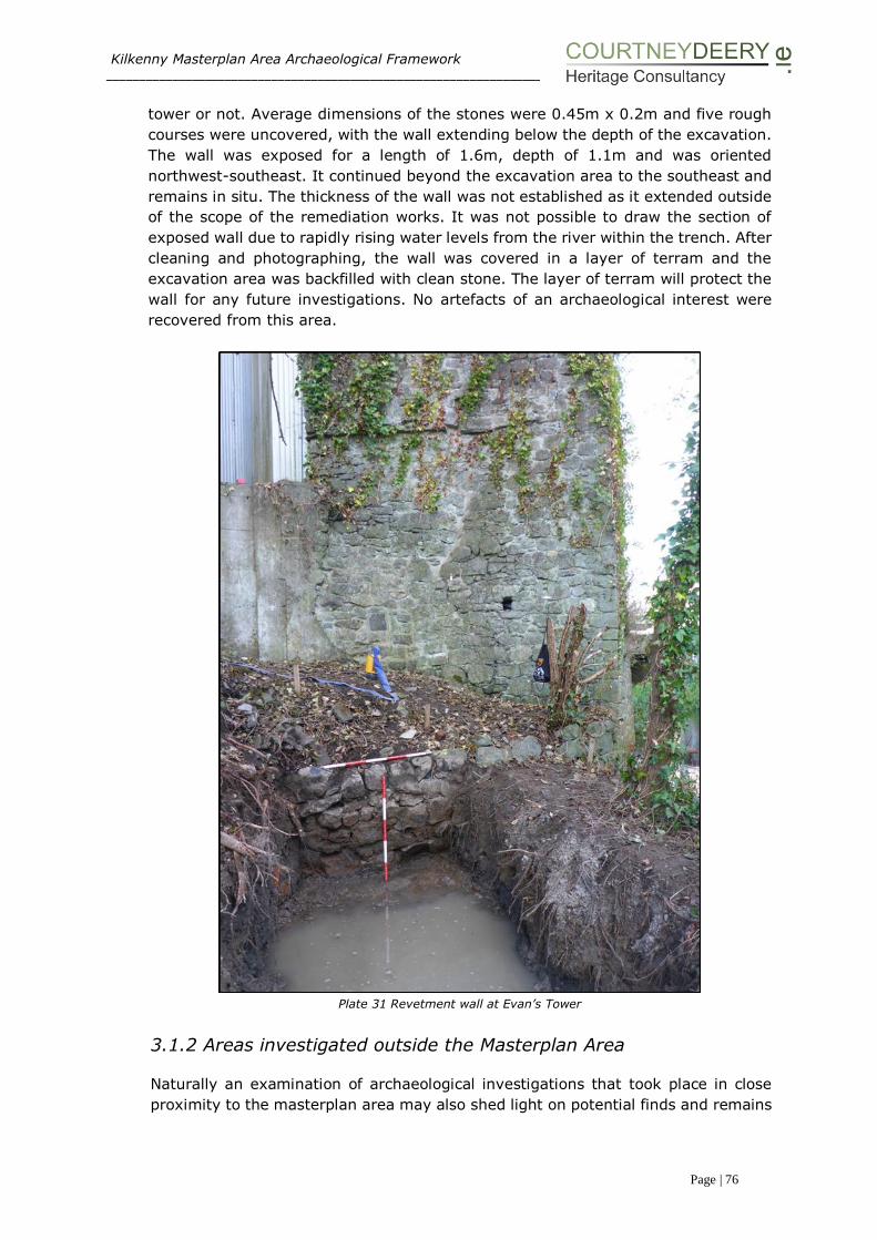
Kilkenny Masterplan Area Archaeological Framework ___________________________________________________________________________________________________
Page | 76
tower or not. Average dimensions of the stones were 0.45m x 0.2m and five rough
courses were uncovered, with the wall extending below the depth of the excavation.
The wall was exposed for a length of 1.6m, depth of 1.1m and was oriented
northwest-southeast. It continued beyond the excavation area to the southeast and
remains in situ. The thickness of the wall was not established as it extended outside
of the scope of the remediation works. It was not possible to draw the section of
exposed wall due to rapidly rising water levels from the river within the trench. After
cleaning and photographing, the wall was covered in a layer of terram and the
excavation area was backfilled with clean stone. The layer of terram will protect the
wall for any future investigations. No artefacts of an archaeological interest were
recovered from this area.
Plate 31 Revetment wall at Evan’s Tower
3.1.2 Areas investigated outside the Masterplan Area
Naturally an examination of archaeological investigations that took place in close
proximity to the masterplan area may also shed light on potential finds and remains

Kilkenny Masterplan Area Archaeological Framework ___________________________________________________________________________________________________
Page | 77
within the site. In this case, four sites are mentioned below, three of which abutt
the plan area, and conform with general findings from numerous investigations
across the Masterplan site.
The common thread often being that, where ground breaking works uncovered
archaeology, it often fell into a stratigraphy of made ground, sitting over post
medieval foundations, sitting over organic, silty medieval deposits, which, along with
evidence of a history of flooding, occasionally featured the burial of human remains.
Two sites at the rear of 15-16 and 19 Vicar Street, tested in 2000 and 2003, indicate
dark silty layers of medieval date sitting below post medieval walling relating to
outhouses. Likewise, the full excavation in 2008 at the courthouse facing onto
Parliament Street adjacent to the Grace’s Castle site uncovered post medieval
structural development, a prison burial plot, evidence of land drainage, burgage
plots and a large amount of domestic medieval evidence (with artefacts of ceramic,
wood, bone, and iron). Knowledge of these sites indicates the potential of
archaeology in the Masterplan area.
No. 1 Irishtown 02E1592
This excavation took place to the north of the River Breagagh, near Irishtown Gate,
approximately 120m west of St Francis’ Abbey and 300m west of the Breagagh and
Nore confluence. Prior to the excavation of the area (60m southwest x 20m
southeast/northwest) testing had revealed a substantial linear timber structure
(Licence Ref. 00E406). The excavation allowed an examination of the archaeological
deposits to the north of the river within the area of the medieval borough of
Irishtown and provided a valuable insight to the development of the area. A
significant medieval settlement was revealed with similar structures and revetments
found in Dublin, Drogheda and Cork. Five phases of archaeological activity was
excavated, the earliest of which dated to the later 12th century right through to the
post-medieval period3.
Amongst these findings were the discovery of portion of a post and wattle building
which is likely to date to the late twelfth century. This is the first structure of this
type to be revealed in Kilkenny the evidence of these excavations it is possible that
reclamation may have commenced during the late 12th century.
One of the interesting findings was that the modern day plot boundaries did not
evolve until the late 13th or early 14th centuries. This may indicate a certain fluidity
in the evolution of this part of the settlement during the previous centuries. Also a
poorly preserved baseplate revetment was the first example of this type to be
revealed in Kilkenny, although it is likely that examples of this type of riverside
carpentry survive elsewhere in Kilkenny4.
Features and structures revealed included riverside fences and revetments, property
plots, structures, a cess pit and masonry walls. Finds included animal bone, leather,
copper alloy objects and pottery.
3 I Doyle (2003) ‘Medieval Settlement’ in the River Nore Flood Alleviation Scheme unpublished report Margaret
Gowen & Co Ltd 4 C. Ó Drisceoil (2003) ‘Kilkenny reclaimed: the archaeological evidence for medieval reclamation in Kilkenny City’, in Old Kilkenny Review 55, 58-69
Kilkenny Masterplan Area Archaeological Framework ___________________________________________________________________________________________________
Page | 78
The remains of a stone weir consisting of limestone blocks bonded with mortar,
shown the mid-19th century OS maps was also revealed. This arrangement allowed
the water of the Breagagh to be largely diverted into a mill race which led off to the
southeast, this feature would have extended into the Masterplan area, south of St
Francis’ Abbey.
Testing exposing medieval deposits at rear of 19 Vicar Street - 2000
The development of a private dwelling at the rear of 19 Vicar Street, which abutts
the masterplan area was, in accordance with planning, subject to an archaeological
assessment and testing plan. This took place in April of 2000 under licence ref.
00E0170 by Mary Henry Archaeological Services Ltd. Three test trenches were dug
to a depth of 1.7m below ground level (OD 44.76m) and uncovered the remains of
relatively modern walls, probably associated with outhouses that stood on the site.
It was under these walls that a series of deposits of archaeological interest were
revealed; dark grey sand and silt layers at a depth of 1.1m, and at a depth of 1.5m
a very dark, organic, grey to black silty sand with a sherd of medieval pottery,
possibly local-ware (which may have been a stray find). It was concluded that the
deposits on site indicated medieval activity.
Excavation of the late medieval foundations of the ‘Vicar’s Choral’ at 15-16 Vicar
Street – 2003/5
In advance of the construction of a four-storey hotel at 15-16 Vicar Street in 2003 a
series of test trenches were excavated by John Tierney of Eachtra Archaeological
Projects (License Ref 03E0707). Like the site at 19 Vicar Street, this site also abutts
the masterplan area and along with medieval deposits also uncovered the remains
of an early post-medieval structure at the site's Vicar Street frontage. The
foundations of the preceding buildings on 15 and 16 Vicar’s Street were encountered
at a depth of 0.5m (Trench 1) and 1m (Trench 2) below the sites ground surface.
Both walls were 1.1m thick, and the location of the foundation walls and their
dimensions tallied with a number of references to the house of the Vicar’s Choral, a
later medieval structure. Potential archaeological sediments were identified and
further testing followed the demolition of modern structures at the site and the
removal of modern overburden. This was carried by Catherine McLoughlin of Stafford
McLoughlin Archaeology (License Ref. 03E1901), confirming the presence of the
remains of a substantial masonry structure at the site's street frontage and
uncovered medieval and post-medieval archaeological deposits and features to the
rear of this structure. These deposits in turn were excavated in the summer of 2004
under an extension to license (License Ref. 03E1901).
Excavation of the deposits uncovered to the rear of the street-fronting structure was
undertaken by the writer under an extension to license 03E1901 in the summer of
2004. The excavation also revealed the floor plan of the street-fronting property.
The structure uncovered was a substantial two-celled rectangular building that
appeared to be the remains of the 'Vicar's Choral', a late medieval building
demolished in the modern period. The structure was constructed of mortar-bonded
stone (mostly limestone) and was floored with a variety of ceramic tiles, bricks and
stone flags and extended across the entirety of the street frontage of 15-16 Vicar

Kilkenny Masterplan Area Archaeological Framework ___________________________________________________________________________________________________
Page | 79
Street. A smaller, single-roomed structure uncovered to the rear of the building
appeared to be a later extension. Although the floor plan of the structure was largely
uncovered, the building was not entirely excavated but was preserved in situ beneath
the newly built hotel.
To the rear of the stone structure, modern buildings, foundations and a cellar had
removed any archaeological stratigraphy that may have been at the same level as
the structure. However, excavation in the area of the new hotel's basement revealed
a series of medieval pits and stake-holes overlain by layers of possible flood deposits.
A substantial stone-built wall with an L-shaped return was also uncovered in this
area. Although the function of this structure was unclear, it did appear to be of at
least early post-medieval date. To the rear of the hotel's basement, in the area of a
new carpark, layers of medieval and post-medieval silty deposits were preserved
beneath the new development.
Further monitoring at the site of this development in 2005 did not uncover any
further archaeological remains.
Courthouse Excavation – 2007/8
A testing programme was carried out by Maedbh Saunderson on behalf of Arch-tech
Ltd in 2007 (Licence Ref.07E0549), following a proposed development to partly
demolish existing buildings in the eastern part of the Kilkenny Courthouse complex,
and construct a four-storey office block, linking atrium, and associated services and
elements on the cleared site. The Courthouse itself is a Protected Structure and is
immediately adjacent to the site of Grace’s Castle and within the site of the later
County Gaol. The site is located between Parliament Street and the River Nore, an
area which from c. 1207 formed part of the medieval Irishtown south of the Breagagh
River, and north of the earlier Hightown. The land to either side of Parliament Street
was divided into long narrow burgage plots which would have contained a house and
shop on the street frontage, with outhouses, sheds, yards, gardens and orchards to
the rear. The Urban Archaeological Survey (Farrelly et al. 1993) identifies a castle
built immediately to the west of the proposed development by William LeGros in the
13th century. In 1566, James Grace gave the castle to the corporation to use as the
County Gaol. The Parliament Street Courthouse dates from 1786, when it was
established in the upper part of the soon-to-be-closed County Gaol, with substantial
remodeling in the early 19th century. The lower part was converted to the City Gaol
by 1824, which served as the Bridewell from 1871 to 1946. Five test trenches with
a total length of 50m were excavated in June of 2007 and a number of features of
archaeological interest were identified. These trenches uncovered a burial, a number
of medieval deposits, a well, and some post medieval walls. As a result, it was
considered that there was a good likelihood that further archaeological material
relating to the medieval burgage plot and the post-medieval/early modern gaol may
remain unidentified within the footprint of the proposed development, and a full
excavation was recommended.
In November of 2008 a crew of 25 carried out a follow up excavation, directed by
Maedbh Saunderson (License Ref. 08E0462), at the rear of the Courthouse. The site
proved to be a rich archaeological area producing over 1000 contexts which resulted
in over 200 excavated features. There were 4000 sherds of medieval pottery and
2000 sherds of post-medieval pottery recovered. Almost 500 pieces of extremely
Kilkenny Masterplan Area Archaeological Framework ___________________________________________________________________________________________________
Page | 80
well preserved wood were recovered from the site. This wood consisted of stakes
and timbers from the wood-lined cesspits, as well as eight wooden artefacts, eleven
coins, three brass artefacts, over two-hundred iron artefacts, thirty bone artefacts,
two copper-alloy objects with gold and thirty bone artefacts. Pottery provisionally
dated from the late 14th to 20th century was recovered from the site.
The site consisted of remnants of medieval domestic activity revealed as pits, wood-
lined cesspits and plot boundaries/burgage plots. These cesspits and pits had large
amounts of domestic refuse. The burgage plots/property divisions were evident on
the site as shallow, long ditches orientated both north–south and east–west. These
earliest phases of activity were sealed by the introduction of soil layers possibly from
another area of Kilkenny. The pottery provisionally identified from these features
dates from the mid-12th to 14th century.
The evidence for the later phases of activity was directly linked to the changes in the
usage of the building. The structure changed from domestic (Grace’s Castle) to civil
use, firstly as a gaol in 1566 and then as both gaol and courthouse in 1794.
During this post-medieval phase there was evidence for land consolidation. Several
ditches excavated were filled with porous building material, possibly to assist in the
draining of the land. The site was located within the old flood-plain of the River Nore.
This was evident during the excavation by the continuous problem of flooding
encountered on the site.
Twenty-three inhumations were recorded to the rear of the site. The burials
excavated were probably felons executed within the confines of the prison
environment. Detailed historical, environmental, and artefactual analysis was
ongoing in 2008, however this excavation report has not been fully published.
3.1.3 Summary of archaeological investigation works
Over the past fifty years an extensive number of archaeological investigations,
excavations, testing, monitoring, and recording has taken place in the Masterplan
area. As the site sits at the heart of the Zone of Archaeological Potential for Kilkenny
City, any ground breaking works have the potential to uncover archaeological
remains. Through a detailed study of existing cartography, extant archaeological
monuments and features, and an examination of the findings from literally hundreds
of test trenches, bore holes, window samples, dredged river areas, and
archaeological assessments, it is possible to generate an understanding of where
the potential for archaeology is high.
Marcus Ó hEochaidhe’s excavations in 1963 combined with monitoring through the
1970s by David Sweetman of St. Francis’ Abbey began to show the extent of the
medieval ecclesiastical remains, revealing that the standing tower and unroofed
choir were once flanked by a transept, nave, sacristy, cloister, and cloister walk.
There is a strong likelihood that further remains of the Franciscan abbey (including
a chapter house, and living quarters) are present below ground. The uncovering of
a series of inhumations within the abbey points to its regular use as a burial ground
as well as the potential that further human remains are present in the environs.

Kilkenny Masterplan Area Archaeological Framework ___________________________________________________________________________________________________
Page | 81
Monitoring and testing within the Masterplan area has created an understanding of
how the general area developed along with how it was dictated by the flooding of
the Rivers Nore and Breagagh (culverts and millstreams are seen throughout). This
development stems from the riverside prehistoric stray finds associated with fishing
uncovered in the River Nore Drainage Scheme, to the medieval layout of burgages
plots (appearing as shallow, long ditches orientated both north–south and east–
west) seen in Rocque’s Map of 1758, to a gradual land reclamation, and the
development of mills and adaption in the use of the river, up to the plan’s area
strong association with brewing. At the southern end of the site we see evidence of
a slow land reclamation practices - where a wooden palisade at the bank would have
a second palisade built riverside, and be filled with debris, whereby the process
would be repeated. Revetments and wooden barriers are regularly noted in testing
reports close to the quay. Whilst to the north made ground of red brick and
demolition rubble of the 19th/20th century helped raise the ground level.
The stratigraphy seen in archaeological investigations throughout the site commonly
shows evidence of modern concrete, sitting above made ground, over evidence of
post medieval walls or structural foundations, overlaying (an often sterile) organic
dark silty clay with occasional finds dating it to the medieval period, along with river
silts and gravels, and a yellow boulder clay. A blend of archaeological remains,
artefacts, and features are seen within the Masterplan area. Finds of possible plague
victims from the medieval period, Franciscan abbey remains, ruined towers, city
walls and defences, burgage plots, and medieval deposits, riverside pleasure houses
with stone jettys, industrial mill houses, along with burials of felons from a 19th
century gaol house, indicate an extremely rich and varied archaeological history.

Kilkenny Masterplan Area Archaeological Framework _____________________________________________________________
Page | 82
SECTION IV: UNDERSTANDING THE
MONUMENTS & BUILDINGS
Plate 32 Model of Medieval Kilkenny showing St Francis’ Abbey, the city wall and Evan’s
Tower.

Kilkenny Masterplan Area Archaeological Framework _____________________________________________________________
Page | 83
PART IV: UNDERSTANDING THE MONUMENTS &
BUILDINGS
4.1 THE MASTERPLAN AREA
The Masterplan area contains many different structures that reflect the historic,
social and economic past of Kilkenny. As well as the archaeological monuments
south of the River Breagagh, the area consists of a bottling and kegging store, a
brewhouse, maturation towers building, the Mayfair building, the sample rooms,
a fermentation block and adjacent but outside the Masterplan development is the
visitor centre (Protected structures 1200087).
North of the Breagagh modern buildings such as the truck wash, hop
store/squash court, car parking shed and fuelling tank facility are present (Figure
24). The demolition of a number of structures to slab level on site (ie no
excavation work required) will take place prior to Kilkenny County Council taking
ownership of the site, these structures are highlighted in brown in Figure 24.
Figure 24 Proposed demolitions shown in brown, structure highlighted in green are to be retained
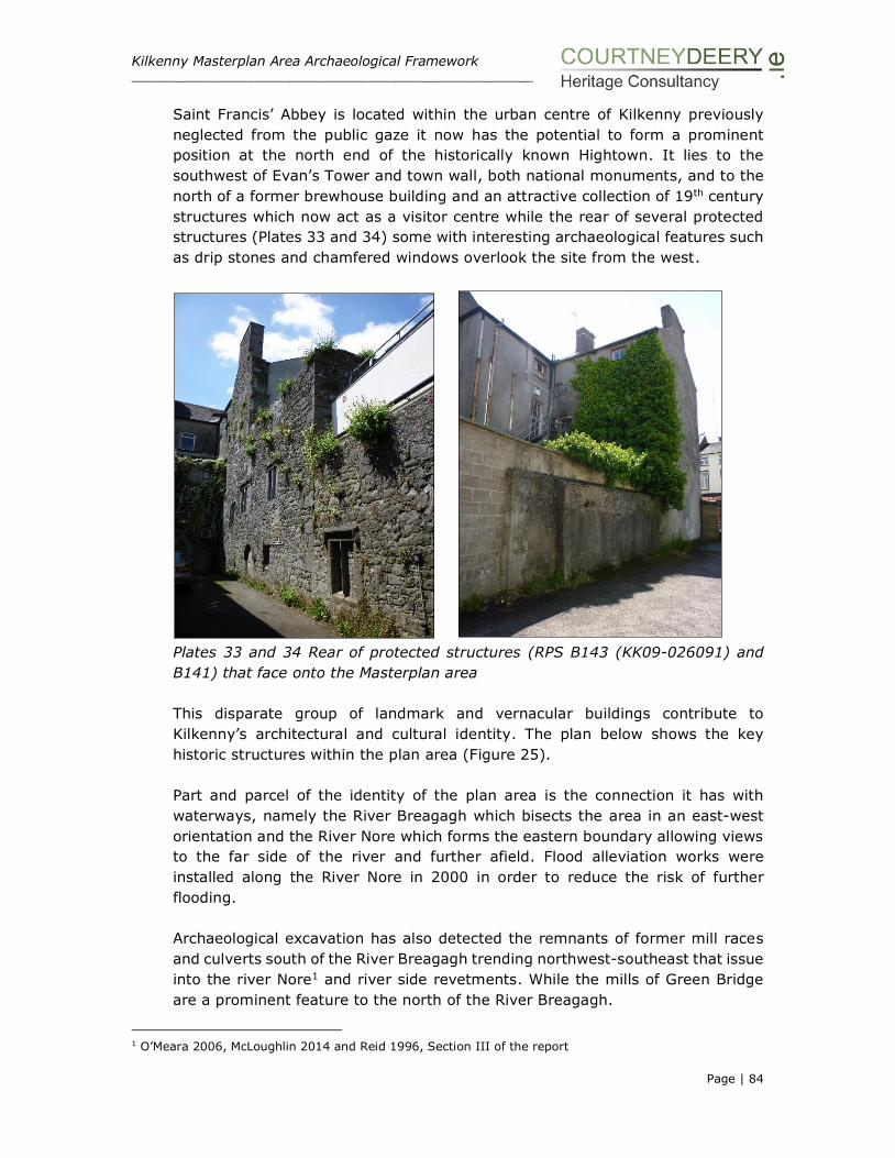
Kilkenny Masterplan Area Archaeological Framework _____________________________________________________________
Page | 84
Saint Francis’ Abbey is located within the urban centre of Kilkenny previously
neglected from the public gaze it now has the potential to form a prominent
position at the north end of the historically known Hightown. It lies to the
southwest of Evan’s Tower and town wall, both national monuments, and to the
north of a former brewhouse building and an attractive collection of 19th century
structures which now act as a visitor centre while the rear of several protected
structures (Plates 33 and 34) some with interesting archaeological features such
as drip stones and chamfered windows overlook the site from the west.
Plates 33 and 34 Rear of protected structures (RPS B143 (KK09-026091) and
B141) that face onto the Masterplan area
This disparate group of landmark and vernacular buildings contribute to
Kilkenny’s architectural and cultural identity. The plan below shows the key
historic structures within the plan area (Figure 25).
Part and parcel of the identity of the plan area is the connection it has with
waterways, namely the River Breagagh which bisects the area in an east-west
orientation and the River Nore which forms the eastern boundary allowing views
to the far side of the river and further afield. Flood alleviation works were
installed along the River Nore in 2000 in order to reduce the risk of further
flooding.
Archaeological excavation has also detected the remnants of former mill races
and culverts south of the River Breagagh trending northwest-southeast that issue
into the river Nore1 and river side revetments. While the mills of Green Bridge
are a prominent feature to the north of the River Breagagh.
1 O’Meara 2006, McLoughlin 2014 and Reid 1996, Section III of the report

Kilkenny Masterplan Area Archaeological Framework _____________________________________________________________
Page | 85
A concrete slab some 300-400mm thick forms the existing ground level within
the former brewery site. The only vegetation within the brewery occurs along the
tree lined bank of the River Nore and in the immediate environs of St Francis’
Abbey. To the south along Bateman Quay there is a grassy bank adjacent to the
River Nore.
Figure 25 Monuments and historic structures within the Masterplan area

Kilkenny Masterplan Area Archaeological Framework _____________________________________________________________
Page | 86
Previous conservation interventions, detailed below, have occurred to the tower
structure of St Francis’ Abbey, temporary stabilisation works to Evan’s tower and
wall walk and detailed survey, vegetation clearance, repair and repointing to the
entire length of the City Wall.
4.2 DESCRIPTION OF THE BUILDINGS AND FABRIC
Within the Masterplan area, structures stand in various states of repair, whilst
some have been stabilised in modern times, or are currently scheduled for
stabilisation work in the near future, others are showing signs that remedial work
is required. The main phases of building, namely: St Francis’ Abbey, the Horse
Barracks and the Brewery to the south of the River Breagagh and the mill
structures to the north of the river are still legible to a greater or lesser extent
throughout the area.
4.2.1 St Francis’ Abbey
St Francis’ Abbey was founded by Richard Marshall between 1231 and 1234 and
it is recorded that it initially grew from a small rectangular chapel to a substantial
monastic establishment as funding and patronage allowed. The abbey underwent
extensive renovations in the first half of the 14th century and the elegant
craftsmanship and stone masonry achievements are celebrated in the east
window which is formed by a cluster of seven lancet lights divided by slender
mullions and the stone figures which depict the friars that adorn the bell tower.
The upstanding remains contain the eastern choir, central bell tower and sacristy
now used as a chapel on site. The transept, northern isle, nave, cloister and
western range are no longer upstanding and are now all located below ground,
(see OPW original plan Figure 6). A bench mark at the base of the western
elevation(380mm above existing ground level) is recorded at 44.99OD.
Following an inspection in 1867 of the bell tower at St Francis’ Abbey several
cracks and fissures were reported to the Kilkenny Archaeological Society. In 1868
Thomas Drew, Architect drew up plans to secure and stabilize the Bell Tower at
St Francis’ Abbey. It was anticipated that these works, which involved the
insertion of braces and shoring (see below) would support the tower, and would
cost in the region of £100, a cost that could not be met at the time by the Society.
Drew commented that the tower was in a critical state and urgently required
work to ensure its preservation. He proposed to commence work on the north
side where the exposed masonry of the haunch should be cleaned and raked out
and thoroughly grouted with Portland cement. The masonry should then be
raised to its original level and then covered with flags and jointed in cement.
Once this was properly set, the great arch could be accurately centred and braced
and the openings in the east and west faces also braced. The south wall should
then be strongly shored, this would necessitate the removal of a roof of a building
belonging to Messrs. Smithwick and Son’s. Then the exposed masonry of the

Kilkenny Masterplan Area Archaeological Framework _____________________________________________________________
Page | 87
southern haunch would be examined, raked out and if found practicable some
long stones inserted in the haunch under the line of the face of the tower, the
loose masonry should be grouted, raised and covered in a similar manner to the
other side. Drew commented that the floor over the arch should be laid with flags
in cement, or ‘in such other manner as will prevent the percolation of any water
into the masonry’2, an issue which is still visibly present on the walls within the
interior of the tower today.
Other options were sought and it was suggested that the tower could be propped
by the provision of two beams of red deal, placed beneath the vault, close by the
south internal wall. Another method of stabilisation proposed was to place two
pillars of cast iron, as props, in the same position as the timber beams3. While
this latter solution was again outside the monetary reach of the society, an
arrangement must have been agreed and additional funding secured from the
Corporation of Kilkenny as it is observed in the 1869 proceedings of the society
that cast-iron props had been inserted and it was hoped that work would
commence on repairing the haunch of the tower. It was also noted that there
was now an opportunity of having the choir windows and the sedilia opened
(which had been previously bricked up). These cast iron pillars are still in place
today. From photographic evidence (OPW archive) of before and after (1926-
1928) it appears that the concrete supporting structure was inserted under the
arch of the bell tower c. 1927 (Plates 5-6 Section I and Plates 35-37).
Plate 35 Northern elevation of Tower 1928 Plate 36 Work in progress to East Window
2 The Journal of the Kilkenny and South-East of Ireland Archaeological Society, 1867, New Series, Vol. 6,
No. 1pp 69-73 3 The Journal of the Historical and Archaeological Association of Ireland, 1868, Third Series, Vol. 1, No. 1, 81-82 and 267

Kilkenny Masterplan Area Archaeological Framework _____________________________________________________________
Page | 88
Plate 37 Underside of vaulting in tower Plate 38 Work in progress on the sacristy
As part of the demolition works to the DIAGEO site, a photographic survey of the
Abbey has been carried out and vibration monitors installed. Hoarding has been
placed around the entire structure to ensure the protection of the National
Monument. All work is taking place in consultation with the authorities under
Ministerial Consent.
A. Sacristy
The sacristy is a single cell masonry structure that has been considerably
repaired and reconstructed in the last fifty years (Plates 38 and 40). It was
restored as an oratory by Smithwicks4. There is one door in the west wall. This
structure will be retained as part of the Masterplan works and incorporated into
a newly created public realm for St Francis Abbey.
B. The Sample Rooms
The sample rooms structure is a modern construct (c.1980’s). It presents as a
modest one storey, three bay range to the south of the brewery. It is listed in
the NIAH building survey as being of architectural regional interest
(NIAH12000008). It is a detached gothic style building with features such as
paired window openings and a well-designed doorcase. It has a pitched slate roof
with clay ridge tiles and is constructed of random rubble limestone walls with
cut-limestone quoins to corners. While the survey states that the masonry work
and craftsmanship used further enhances the visual link with the abbey, the
structure does block and obstruct views of the abbey from the south and while
intending to blend in with the medieval structure is clearly a building of a later
4 Lanigan, K. M and Tyler, G., 1987, 26

Kilkenny Masterplan Area Archaeological Framework _____________________________________________________________
Page | 89
date. During construction a skull was revealed in a test pit at the west end of the
building (this is detailed in Section III of the report).
This building does not enhance the abbey and does not conform with the layout
of a Franciscan friary or take into account of the below ground remains. Further
to discussion with the Authorities it is proposed to remove this structure as part
of the Masterplan process in order to reveal the southern elevation of the abbey
and allow excavation works to take place.
Plates 39 Sample Rooms Plate 40 The Sacristy today
A couple of areas were noted in relation to conservation issues within the abbey
and require intervention and on-going monitoring:-
• A nearby weeping willow tree is in contact with the tall, slender stone mullions
which form the east window and the OPW have been alerted to this.
• Tower to west end of the upstanding remains is leaking significant amounts of
water and has many open joints.
• Large span arches to the south side of abbey have moved previously and are
showing signs of ongoing movement.
The Minister for the OPW5 in relation to Heritage Services has publically stated
that the main focus in recent years has been on the protection and maintenance
of structures with a greater emphasis on minor improvements works rather than
on major capital projects. Any investment funds that are available will go to sites
most in need and importantly to where capacity has been identified that will
generate increased business and receipts. The planned re-investment of surplus
receipts generated from creating such additional capacity will support a strong
incentive to increase activity at Heritage sites and improve business
opportunities.
The reintroduction of the apprenticeship programme is to be welcomed and the
National Monuments division has recently recruited 21 apprentices in the crafts
5Simon Harris, Minister of State, note from public address on priority programmes of work to be funded from the 2015 Revised Estimate in the OPW 11 Feb 2015.

Kilkenny Masterplan Area Archaeological Framework _____________________________________________________________
Page | 90
of carpentry, joinery and stone masonry. This will assist in ensuring that these
skills will be maintained and benefit the conservation of historic buildings,
including those at St Francis’ Abbey in the future.
All proposed excavation works associated within the Abbey are detailed in the
archaeological strategy in section VI of the report.
4.2.2 The Medieval City Wall and Mural Towers
The city wall bisects the plan area in an east-west orientation, while it is a
mixture of original wall and rebuild, it has a special significance in defining the
medieval town. At the lower reaches of the River Breagagh, this is one of the
longest surviving stretches of the City Wall in Kilkenny and while some of it is
not easy to access there is the potential to enhance and protect this feature, as
well as protecting views from the opposite river bank (from the north looking
south). The City Wall is recognised in the NIAH as being of National importance.
The structure is a National Monument.
Policy Declaration6:
‘The known and expected circuits of the defences (both upstanding and buried,
whether of stone or embankment construction) and associated features of all
town defences are to be considered a single national monument and treated as
a unit for policy and management purposes. There should be a presumption in
favour of preservation in-situ of archaeological remains and preservation of their
character, setting and amenity’.
Associated with the wall are the following elements: Evan’s Tower and wall walk,
and Cottrell’s Bridge.
Evan’s tower is built as an irregular four sided structure, with an angled face on
the north side, projecting out over the River Breagagh and a triangular corner
pointing south-east. The monument is approached from the west by a rising stair
(a wall walk) between the external parapet and an internal wall, built over a vault
which has now collapsed. The feature appears as a double stretch of walling
approx. 1.20m wide (from interior of one wall to the exterior of the other wall).
The lower levels are intact and it tapers to a single wall. The wall walk attaches
to the western side of the tower and forms part of the city defences in a seamless
manner. The short length of wall survives to a height of some 3 metres above
the river level. It extends westwards from the tower as far as the modern
brewery access bridge across the River Breagagh.
The tower has a basement level (with an internal arched entrance, a first floor
and an upper level with remains of windows or crenellations). Judging from its
appearance when still roofed, it is likely that the tower has been modified and
6 Dept Environment, Heritage and Local Government 2008 National Policy on Town Defences

Kilkenny Masterplan Area Archaeological Framework _____________________________________________________________
Page | 91
heightened to form a garden feature overlooking the river (perhaps in the 18th
century, see Section V, illustrations and drawings of the tower from 1810
onwards). The external string course and associated holes might therefore reflect
the base of an earlier parapet. The monument is braced with wooden posts at
the upper levels (now rotted and not forming any function) and repairs have
occurred in many places. As part of the River Nore Flood Relief Scheme 2001-
2005 measures were taken to survey and secure the fabric of the tower.
Conservation works were undertaken by Consarc (Figure 26) and entailed the
erection of internal scaffolding, the infilling of the joist pockets with salvaged
stone and small sneck stones were set in lime mortar. This work allowed
additional Cintec anchors to be inserted on order to stabilise the structure. All
work was carried out under licence to the Department of Arts, Heritage, Gaeltacht
and the Islands (now DAHG) (archaeological licence no. 01E0632).
The ground level in the immediate vicinity south of the tower is built up with soil
and debris and overgrown with vegetation. The tower is located approximately
5m to the north of the former kegging store, now decommissioned from use and
scheduled for demolition. All machinery has been removed and the warehouse is
not considered to be of architectural heritage merit. The tower and wall walk are
both National Monuments.

Kilkenny Masterplan Area Archaeological Framework _____________________________________________________________
Page | 92
Figure 26 Plan survey of Evan’s Tower by Consarc (c. 2001)
Plate 41 East elevation showing the repair work (2014) Plate 42 Northeast elevation
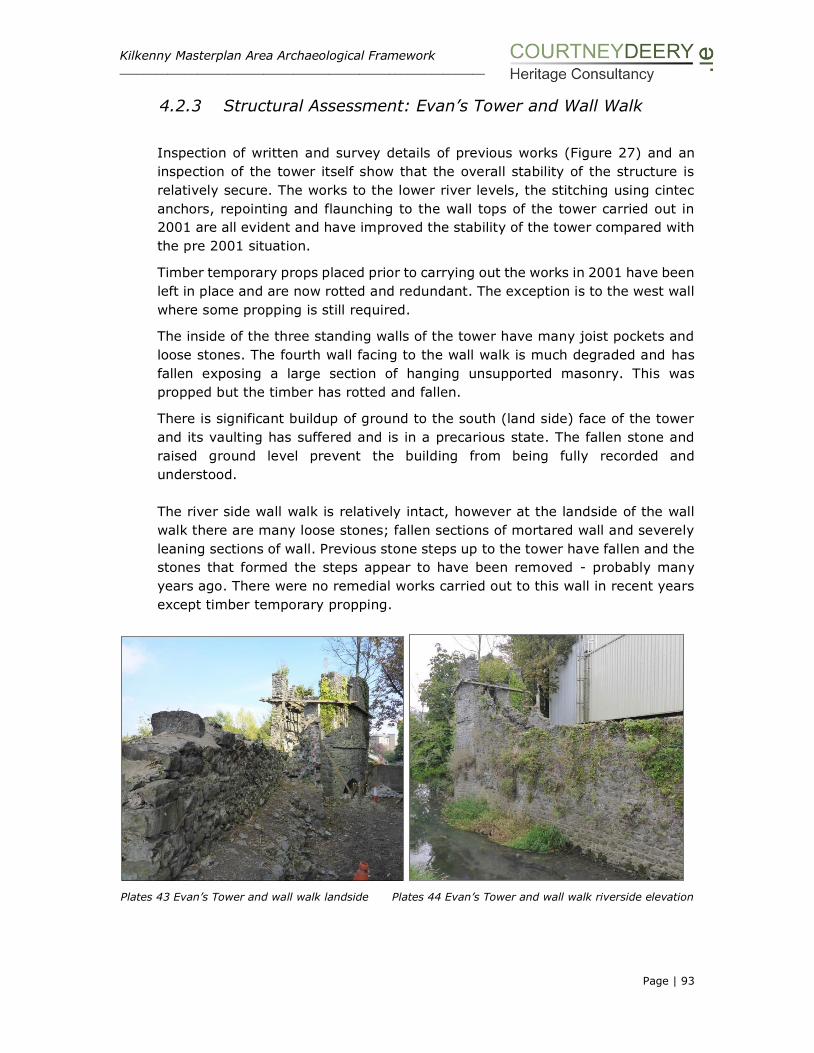
Kilkenny Masterplan Area Archaeological Framework _____________________________________________________________
Page | 93
4.2.3 Structural Assessment: Evan’s Tower and Wall Walk
Inspection of written and survey details of previous works (Figure 27) and an
inspection of the tower itself show that the overall stability of the structure is
relatively secure. The works to the lower river levels, the stitching using cintec
anchors, repointing and flaunching to the wall tops of the tower carried out in
2001 are all evident and have improved the stability of the tower compared with
the pre 2001 situation.
Timber temporary props placed prior to carrying out the works in 2001 have been
left in place and are now rotted and redundant. The exception is to the west wall
where some propping is still required.
The inside of the three standing walls of the tower have many joist pockets and
loose stones. The fourth wall facing to the wall walk is much degraded and has
fallen exposing a large section of hanging unsupported masonry. This was
propped but the timber has rotted and fallen.
There is significant buildup of ground to the south (land side) face of the tower
and its vaulting has suffered and is in a precarious state. The fallen stone and
raised ground level prevent the building from being fully recorded and
understood.
The river side wall walk is relatively intact, however at the landside of the wall
walk there are many loose stones; fallen sections of mortared wall and severely
leaning sections of wall. Previous stone steps up to the tower have fallen and the
stones that formed the steps appear to have been removed - probably many
years ago. There were no remedial works carried out to this wall in recent years
except timber temporary propping.
Plates 43 Evan’s Tower and wall walk landside Plates 44 Evan’s Tower and wall walk riverside elevation

Kilkenny Masterplan Area Archaeological Framework _____________________________________________________________
Page | 94
Figure 27 Geodetic Survey of Evan’s Tower and Wall Walk courtesy of Margaret Gowen & Co Ltd

Kilkenny Masterplan Area Archaeological Framework _____________________________________________________________
Page | 95
Piling works were carried out in the vicinity of the tower and wall walk in September
and October of 2014 to allow soil remediation measures to take place. These works
were archeologically and structurally monitored. There was no sign of movement in
the recent pointing to previous crack lines in the tower or outer face of the city wall
despite the nature of the work. The un-mortared nature of the inner face of the City
Wall and wall walk, makes it more difficult to confirm if any movement was
experienced but there does not appear to be any degradation to the monument
resulting from these piling operations.
Proposed interventions (Demolition contract, work undertaken by Diageo)
The immediate proposals in the vicinity of Evan’s Turret and adjoining City wall
include a full digital survey of the remains, vibration monitoring and the installation
of temporary works (wooden props) to replace those that have rotted away since
2000 (Appendix F ref LE drgs 101 & 102)
The nearby twentieth century framed warehouse is to be demolished to slab level
only. A fuller assessment of the monument particularly the sub ground structures
will be much easier post demolition when access is improved.
Proposed works post demolition
When demolition works have been carried out it is recommended that an
archaeological test excavation limited to two number trial pits is carried out to
understand the depth of foundations, ground conditions and to sample the
archaeological deposits (Appendix F ref LE 112).
In order to inform the conservation strategy of the monument, excavation work is
to take place after the demolition of the adjacent building. All work is to be carried
out by hand under Consent from the Minister as this is a monument of national
importance. It is assumed that this excavation may be fairly extensive. These works
will be undertaken by archaeologists assisted by the general contractor and
stonemasons and will involve ongoing assessment of the ruin stability and design
of propping to the arches as the excavation increases in depth. A detailed
assessment of the standing remains charting the different phases and building
techniques of the Tower can also take place by a building archaeologist at this stage
of the process.
There are a number of possible end products to the remedial works to Evan’s Tower
and wall walk. All would be subject to the appropriate permissions and also involve
coordination with the masterplan for the area. The options that should be discussed
/ explored are outlined below:-
Kilkenny Masterplan Area Archaeological Framework _____________________________________________________________
Page | 96
Stabilise all upstanding remains as they are and leave tower only accessible
for maintenance – i.e. public access precluded
This solution will encompass the minimum amount of work required and is
likely to involve the stabilisation of existing arch abutments in traditional
masonry work using stone salvaged from the site set in appropriately
matched lime mortars. Once abutments have been repaired the arches will
be pinned using replacement tooled stone where any stones missing and
natural slate slithers and mortar matched to existing to pin between the arch
stones to stabilise the arches. Stitching using Cintec anchors or similar will
only be deployed where it gives the option of retaining more original
structure than traditional masonry repair techniques allow.
There may be situations such as inside the tower where replacing the original
stone vaulting would involve too much conjecture and the overall stability of
the tower may not require such rebuild. This can only be assessed when the
fallen stone work has been cleared and indeed the proposed end use /
product decided upon.
Stabilise all upstanding remains as they are and with enough local new build
to support modern intervention of steps and deck and guard rails so tower
can be used as viewing point.
Stabilise all upstanding remains and rebuild vaulting and stone steps and
wall walk walls so that tower can be used as part of public amenity as close
to original form as possible.
These proposals have been devised having considered the policies and
recommendations put forward in the Kilkenny Conservation Plan7.
4.2.4 Structural Assessment: The Town Wall
The medieval wall, which formed part of the friary precinct and the urban
defences, was surveyed and conserved during the River Nore Flood Alleviation
works in 1999 and 2001 from the River Nore to the corner of the Horse Barracks.
In 2004 Consarc on behalf of Mottt McDonald undertook a condition survey and
repair works of the masonry walls from Irishtown Bridge to the corner of the
Horse Barracks, essentially completing the survey and consolidation works to this
stretch of walling (Appendix F8).
The wall is in a stable condition and relatively free from vegetation along is upper
courses while vegetation has grown back at the lower levels partially obscuring
the original City Wall (Plates 45-48 and 71-74).
7 Kilkenny City Walls Conservation Plan 2005 Oxford Archaeology for the Heritage Council pg 50-56
and158 8 Appendix F contains a copy of the original Consarc drawings and photos which detail the level of work required to conserve the masonry wall from Irishtown Bridge to the corner of the Hose Barracks (site of)

Kilkenny Masterplan Area Archaeological Framework _____________________________________________________________
Page | 97
Figure 28 Plan showing Condition of City Wall September 1999, courtesy of Margaret Gowen & Co
Ltd
Appendix F contains the original digital survey drawings undertaken by Margaret
Gowen & Co Ltd in 1999 showing the extent of the original City Wall and the
modern reconstruction and rebuilt wall. The survey also details areas of repaired
masonry and features such as relieving arches, outflow pipes and blocked opes
within the wall. While the masonry is in a reasonable condition and repointed
with lime mortar in 2001 and 2004, notes and drawings from that time show the
condition of the wall which can generally be taken as the current condition. There
is one breech in this section of wall, effectively separating Evan’s Tower and wall
walk from the main section of City Wall. This breech forms a bridge which was
constructed c.1974 and this was used to access the northern banks of the River
Breagagh by the brewery site. The original City Wall runs underneath this bridge
and was repaired and repointed with lime mortar in 2001.
Conservation works to date have consolidated the remaining original City Wall,
rebuild and features. Prior to any work taking place in the vicinity of this
monument a monitoring survey may need to be undertaken in order to assess
the effectiveness and present condition of the conservation measures that took
place between 1999-2005.

Kilkenny Masterplan Area Archaeological Framework _____________________________________________________________
Page | 98
As part of the Masterplan works vegetation regrowth should be removed and a
visual inspection of the existing conservation works take place. As part of a long
term strategy a maintenance programme could be implemented (Plates 71-74)
which would involve an inspection and clearance of vegetation at regular intervals
to be determined by a conservation professional.
Plate 45 Plate 46
Plates 47-48 Show the present day condition (2015) of the area that was subject to survey 1999-2001
For Masterplan works in association, adjacent or affecting town defences the
following criteria are considered by the DAHG when reviewing applications9:
To seek the protection and preservation in-situ of these national
monuments including the town walls, embankments and ditches, gates,
bastions or ancillary fortifications or portions thereof;
To seek the preservation of important views and prospects inside and
outside the walls so as to preserve the setting of the monuments and to
increase the appreciation of the circuit and character of the walled town.
9 DEHLG 2008 National Policy on Town Defences pgs 10-11

Kilkenny Masterplan Area Archaeological Framework _____________________________________________________________
Page | 99
The Department may require a satisfactory buffer area to be established
between any new development and the town defences in order to ensure
the preservation and enhancement of the amenity associated with the
presence of town defences within the historic urban pattern;
To require any proposals for works to town defences to be preceded by a
detailed measured survey of the monuments so as to have an
appropriately detailed record;
To provide pre-planning advice to developers where town defences are
close to or included in their proposal site;
To require the involvement of qualified and experienced conservation
professionals in the detailed design and overseeing of works to town
defences;
Not to favour new roads crossing the wall or the line of the wall or the
formation of any new openings in the wall;
To favour the minimal intervention necessary to the authentic fabric of
the monument and avoidance of unnecessary reconstruction;
To require good quality, context-sensitive design for development
proposals affecting the upstanding town defences that would not detract
from the character of the town defences or their setting by reason of the
location, scale, bulk or detailing;
To encourage the enhancement of the setting of town defences including
the pedestrianisation of town gates where this can be achieved without
requiring new roads to be opened through the circuit of the walls. To
encourage also the improvement of signage and public utilities structures,
etc. where these affect the visual amenity of the defences;
To require as a condition of Ministerial Consent that appropriate
programmes of regular maintenance and repair works to the town
defences be put in place;
To promote the retention of the existing street layout, historic building
lines and traditional burgage plot widths within historic walled towns
where these derive from medieval or earlier origins and to discourage the
infilling or amalgamation of such plots and removal of historic boundary
walls save in exceptional circumstances.
4.2.5 The Bull Inn
The ‘Bull Inn’ is located on the south side of St Canice’s Place (formerly known
as Bull Alley). The only upstanding remnant of this seventeenth century inn is a
substantial stone wall which forms part of a recorded monument (KK019-
026107). There is a cut-stone, square, chamfered ope at ground–floor level.
From the street and to the west of the entrance this medieval structure presents
Kilkenny Masterplan Area Archaeological Framework _____________________________________________________________
Page | 100
as a substantial masonry wall over 4m high with limestone quoin stones. It has
been repaired and stabilised on its north-western edge. The Bull Inn wall is
constructed in random rubble limestone and is truncated to first floor level with
an undulating broken wall head.
In order to facilitate a full assessment of the wall by a conservation architect,
vegetation was removed from the wall under archaeological supervision in
November 2014. The purpose of the archaeological monitoring was to ensure
that the removal of vegetation from the wall would not damage the structure,
and in the event that any masonry was dislodged from the wall, it could be
recorded, catalogued and retained on site for future re-use.
4.2.5.1 Structural Assessment: The Bull Inn Wall
The Bull Inn wall and associated adjoining upstanding masonry walls are in a
ruinous condition. This is typical of walls that no longer have the roofs with
which they were once protected nor the use for which they were originally
constructed.
The wall is overall structurally stable but has suffered mortar loss, robbing of
dressed stones, later insertions and disruption of fabric from vegetation growth.
The wall needs careful repair consisting of removal of vegetation including the
roots of the plants, local reinsertion of stones, general repointing and a new
weathering detail to the wall top to prevent water ingress into the core fabric.
All works to walls of historic fabric should be carried out in materials to match
the original such as soft flexible lime based mortars and sands to match the
river deposit sands and gravels. All replacement stones should be if possible
retrieved from local fallen random rubble and any new dressed stones such as
lintels and quoins clearly marked (albeit in a desecrate location) with the date
of insertion.
A series of drawings showing stabilisation measures are included in Appendix
F. An appropriate design solution should be sought for the successful inclusion
of this feature wall into the overall Masterplan development, it could form part
of a modern street scape. As part of the Masterplan process the Bull Inn will
now be open to view by the public and part of the public realm of Kilkenny
further enhancing the medieval fabric of the city.
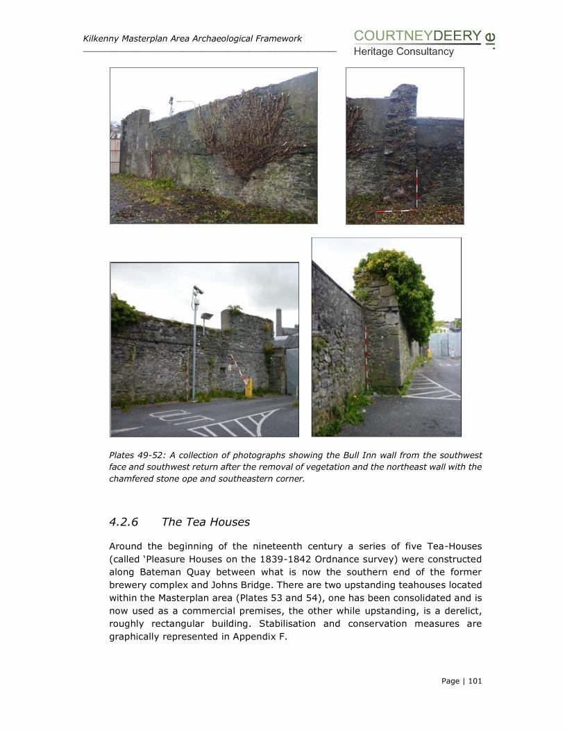
Kilkenny Masterplan Area Archaeological Framework _____________________________________________________________
Page | 101
Plates 49-52: A collection of photographs showing the Bull Inn wall from the southwest
face and southwest return after the removal of vegetation and the northeast wall with the
chamfered stone ope and southeastern corner.
4.2.6 The Tea Houses
Around the beginning of the nineteenth century a series of five Tea-Houses
(called ‘Pleasure Houses on the 1839-1842 Ordnance survey) were constructed
along Bateman Quay between what is now the southern end of the former
brewery complex and Johns Bridge. There are two upstanding teahouses located
within the Masterplan area (Plates 53 and 54), one has been consolidated and is
now used as a commercial premises, the other while upstanding, is a derelict,
roughly rectangular building. Stabilisation and conservation measures are
graphically represented in Appendix F.
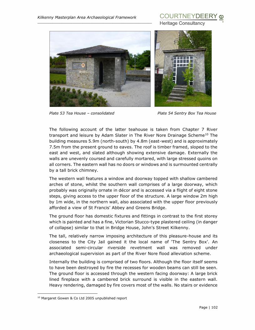
Kilkenny Masterplan Area Archaeological Framework _____________________________________________________________
Page | 102
Plate 53 Tea House – consolidated Plate 54 Sentry Box Tea House
The following account of the latter teahouse is taken from Chapter 7 River
transport and leisure by Adam Slater in The River Nore Drainage Scheme10 The
building measures 5.9m (north-south) by 4.8m (east-west) and is approximately
7.5m from the present ground to eaves. The roof is timber framed, sloped to the
east and west, and slated although showing extensive damage. Externally the
walls are unevenly coursed and carefully mortared, with large stressed quoins on
all corners. The eastern wall has no doors or windows and is surmounted centrally
by a tall brick chimney.
The western wall features a window and doorway topped with shallow cambered
arches of stone, whilst the southern wall comprises of a large doorway, which
probably was originally ornate in décor and is accessed via a flight of eight stone
steps, giving access to the upper floor of the structure. A large window 2m high
by 1m wide, in the northern wall, also associated with the upper floor previously
afforded a view of St Francis’ Abbey and Greens Bridge.
The ground floor has domestic fixtures and fittings in contrast to the first storey
which is painted and has a fine, Victorian Stucco-type plastered ceiling (in danger
of collapse) similar to that in Bridge House, John’s Street Kilkenny.
The tall, relatively narrow imposing architecture of this pleasure-house and its
closeness to the City Jail gained it the local name of ‘The Sentry Box’. An
associated semi-circular riverside revetment wall was removed under
archaeological supervision as part of the River Nore flood alleviation scheme.
Internally the building is comprised of two floors. Although the floor itself seems
to have been destroyed by fire the recesses for wooden beams can still be seen.
The ground floor is accessed through the western facing doorway: A large brick
lined fireplace with a cambered brick surround is visible in the eastern wall.
Heavy rendering, damaged by fire covers most of the walls. No stairs or evidence
10 Margaret Gowen & Co Ltd 2005 unpublished report
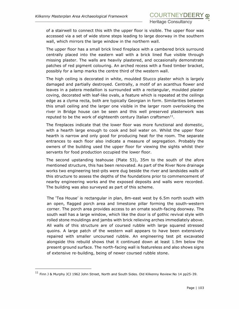
Kilkenny Masterplan Area Archaeological Framework _____________________________________________________________
Page | 103
of a stairwell to connect this with the upper floor is visible. The upper floor was
accessed via a set of wide stone steps leading to large doorway in the southern
wall, which mirrors the large window in the northern wall.
The upper floor has a small brick lined fireplace with a cambered brick surround
centrally placed into the eastern wall with a brick lined flue visible through
missing plaster. The walls are heavily plastered, and occasionally demonstrate
patches of red pigment colouring. An arched recess with a fixed timber bracket,
possibly for a lamp marks the centre third of the western wall.
The high ceiling is decorated in white, moulded Stucco plaster which is largely
damaged and partially destroyed. Centrally, a motif of an acanthus flower and
leaves in a patera medallion is surrounded with a rectangular, moulded plaster
coving, decorated with leaf-like ovals, a feature which is repeated at the ceilings
edge as a clyma recta, both are typically Georgian in form. Similarities between
this small ceiling and the larger one visible in the larger room overlooking the
river in Bridge house can be seen and this well preserved plasterwork was
reputed to be the work of eighteenth century Italian craftsmen11.
The fireplaces indicate that the lower floor was more functional and domestic,
with a hearth large enough to cook and boil water on. Whilst the upper floor
hearth is narrow and only good for producing heat for the room. The separate
entrances to each floor also indicate a measure of segregation. Probably the
owners of the building used the upper floor for viewing the sights whilst their
servants for food production occupied the lower floor.
The second upstanding teahouse (Plate 53), 35m to the south of the afore
mentioned structure, this has been renovated. As part of the River Nore drainage
works two engineering test-pits were dug beside the river and landsides walls of
this structure to assess the depths of the foundations prior to commencement of
nearby engineering works and the exposed deposits and walls were recorded.
The building was also surveyed as part of this scheme.
The ‘Tea House’ is rectangular in plan, 8m-east west by 6.5m north south with
an open, flagged porch area and limestone pillar forming the south-western
corner. The porch area provides access to an ornate south-facing doorway. The
south wall has a large window, which like the door is of gothic revival style with
rolled stone mouldings and jambs with brick relieving arches immediately above.
All walls of this structure are of coursed rubble with large squared stressed
quoins. A large patch of the western wall appears to have been extensively
repaired with smaller uncoursed rubble. An engineering test pit excavated
alongside this rebuild shows that it continued down at least 1.9m below the
present ground surface. The north-facing wall is featureless and also shows signs
of extensive re-building, being of newer coursed rubble stone.
11 Finn J & Murphy JCJ 1962 John Street, North and South Sides. Old Kilkenny Review:No 14 pp25-39.
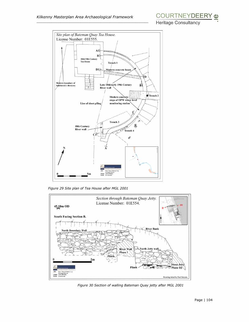
Kilkenny Masterplan Area Archaeological Framework _____________________________________________________________
Page | 104
Figure 29 Site plan of Tea House after MGL 2001
Figure 30 Section of walling Bateman Quay jetty after MGL 2001
Kilkenny Masterplan Area Archaeological Framework _____________________________________________________________
Page | 105
The more northern Tea House is in close to its original form but in a very ruinous
state. Timber elements such as the first floor have rotted away and the roof is
in an extremely precarious condition. The Tea-House backs onto the Smithwick’s
brewery modern masonry boundary wall of the brewery. The roof and ceiling
including the fine moulded ceiling decoration are in danger of complete collapse.
There has been significant loss of fabric already. The degradation of the timber
lintels and bonding timbers puts the wall tops and other local sections of the four
external walls in jeopardy.
It is proposed as part of the demolition works to stabilise this structure and the
following works will take place:
Essential structural works include:-
• Stabilising and reinstatement of the roof
• Rescuing as much as possible of the ceiling ornamentation to inform repair
works.
• Replacement of rotted lintels and bonding timbers throughout the building
Such works will leave the building weather tight and stable but not necessarily
attempt to re-create lost details.
Proposed works to stabilise the Tea House include the following:
Install vibration monitors.
Crop vegetation.
Digitally survey building and submit to design team and Kilkenny County
Council.
Proceed with bracing doorway and large rear window and secure the
building from unauthorised entry.
Carefully separate adjoining walls from buildings that are to be
demolished to reduce any vibration on the Tea House.
Proceed with adjoin demolition works.
As part of the Masterplan process further conservation works are detailed in Figures
31-33.It is proposed that the Tea House will be conserved and renovated to facilitate
its use as a commercial premises.

Kilkenny Masterplan Area Archaeological Framework _____________________________________________________________
Page | 106
Plates 55-56
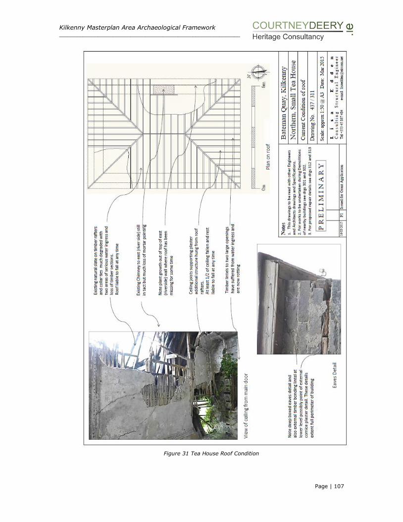
Kilkenny Masterplan Area Archaeological Framework _____________________________________________________________
Page | 107
Figure 31 Tea House Roof Condition

Kilkenny Masterplan Area Archaeological Framework _____________________________________________________________
Page | 108
Figure 32 Tea House Proposed Roof Repairs

Kilkenny Masterplan Area Archaeological Framework _____________________________________________________________
Page | 109
Figure 33 Tea House Proposed Lintel Repairs

Kilkenny Masterplan Area Archaeological Framework _____________________________________________________________
Page | 110
4.2.7 Original Gateway
The original gateway (NIAH 12000087) to the brewery dates to about 1875 and
fronts onto Jenkin’s Lane (Plate 18). The gateway comprises a segmental-headed
carriageway with a pair of painted rusticated rendered piers having dentilated
moulded cornices. There are tongue-and-groove timber panelled double doors
with decorative wrought iron hinges, moulded archivolt having keystone, raised
lettering, tooled rendered panels. This entrance feature forms a picturesque
feature in the streetscape of Jenkin’s Lane. The limestone cobbling of the lane
with cut-limestone flagged wheel tracks is an attractive and protected (NIAH
12000086) aspect of the streetscape. This laneway and entrance while located
outside the Masterplan area can provide pedestrian access into towards the area
and out to Parliament Street.
Plates 57-58 Original gate and laneway
4.2.8 The Visitor Centre
The visitor centre is now housed in No 44 Parliament Street, a protected structure
(B146) and included in the NIAH survey (NIAH 1200085). This Victorian
structure, built c. 1882 has a redbrick façade and a stone ashlar plinth at ground
level. To two buildings to the rere are placed around an internal courtyard. The
original brewmaster house and office is located on the northern side of this
courtyard and while it is much altered with unsympathetic building additions and

Kilkenny Masterplan Area Archaeological Framework _____________________________________________________________
Page | 111
finishes, the original structure is very much evident. The other sides of the
courtyard are flanked by rendered buildings now used as part of the visitor
experience and offices. This collection of buildings is to be retained by and remain
in the ownership of Diageo. They are to be collectively used and developed as a
visitor centre showcasing the Smithwicks experience and continuing the
association of the Smithwicks family and the tradition of brewing on the site.
Plates 59-60 Visitor Centre showing Brew Masters House
4.2.9 The Maturation Building
The Maturation building has been redundant since the cessation of brewing
operations at the brewery site. The building comprises a single-storey concrete
structure that is utilised as a support to the 22 large maturation tanks of the
brewery. The late 20th century structure was an integral component of the
brewery operations on the site, where the tanks were used for the maturation
and storage of beer. Processes such as centrifuging and bottoming of yeast as
well as maturation over 14 days took place in the Maturation Building.
The traditional maturation process involved storing beer in casks to allow them
to mature naturally, thus improving the flavour (the German word ‘lager’ means
‘storage’). In traditional beer production, beers would be ‘lagered’ or stored for
as long as nine months. This allowed for the production of beer using the new
season’s malted barley and hops in the autumn when temperatures were mild,
with fermentation occurring when the beers were stored in cellars over the cold
winter, to be available fully matured as a light, fresh drink during the summer.
With the advent of modern machinery and processes, such as rapid continuous
maturation systems, the required flavour changes can be achieved within a few
hours and storage times reduced to as little as three days.
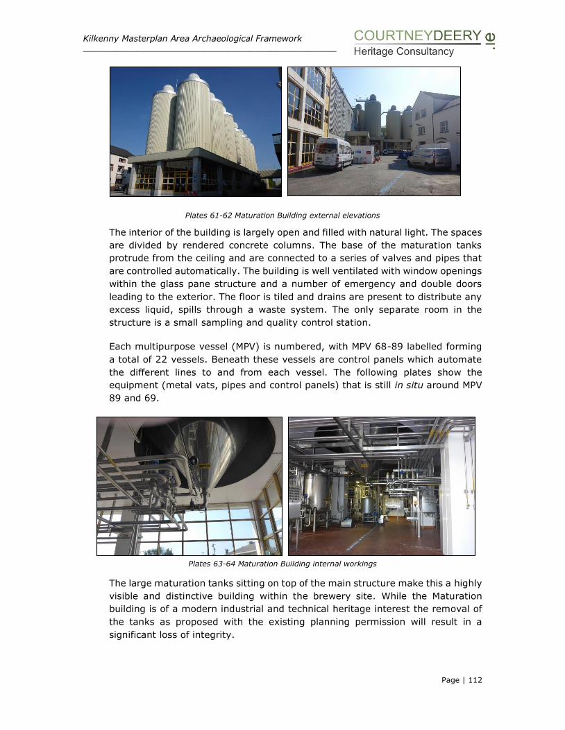
Kilkenny Masterplan Area Archaeological Framework _____________________________________________________________
Page | 112
Plates 61-62 Maturation Building external elevations
The interior of the building is largely open and filled with natural light. The spaces
are divided by rendered concrete columns. The base of the maturation tanks
protrude from the ceiling and are connected to a series of valves and pipes that
are controlled automatically. The building is well ventilated with window openings
within the glass pane structure and a number of emergency and double doors
leading to the exterior. The floor is tiled and drains are present to distribute any
excess liquid, spills through a waste system. The only separate room in the
structure is a small sampling and quality control station.
Each multipurpose vessel (MPV) is numbered, with MPV 68-89 labelled forming
a total of 22 vessels. Beneath these vessels are control panels which automate
the different lines to and from each vessel. The following plates show the
equipment (metal vats, pipes and control panels) that is still in situ around MPV
89 and 69.
Plates 63-64 Maturation Building internal workings
The large maturation tanks sitting on top of the main structure make this a highly
visible and distinctive building within the brewery site. While the Maturation
building is of a modern industrial and technical heritage interest the removal of
the tanks as proposed with the existing planning permission will result in a
significant loss of integrity.

Kilkenny Masterplan Area Archaeological Framework _____________________________________________________________
Page | 113
4.2.10 The Brewhouse
The St Francis’ Abbey Brewery has a long-standing industrial presence in the city
and although many of its modern structures are not of historic architectural
significance, the brewhouse has become a landmark building within Kilkenny and
its skyline.
The photograph below (Plate 65) shows the northern elevation of the Brewhouse,
which is a concrete structure with a steel framed clad infill elements such as brick
built in the 1960’s. Large expanses of symmetrically laid panes of glass punctuate
the elevations of the structure ensuring plenty of light to the interior. The
structure has a number of accumulated extensions up to the 1980’s and extends
to five stories high along it eastern elevation and four stories at the northeast.
The structure as part of the large scale brewing industry at St Francis’ Abbey
Brewery, Kilkenny, is of industrial heritage interest.
Plates 65-66 Brewhouse northern and northeast external elevations
Plates 67 Brewhouse western external elevations
The interior of the structure was stripped out and modernised in the 1990’s. The
building functioned as a brewhouse and contained the boiler house, engine room
and operation centre. At the northern end are the only subsurface stores of the
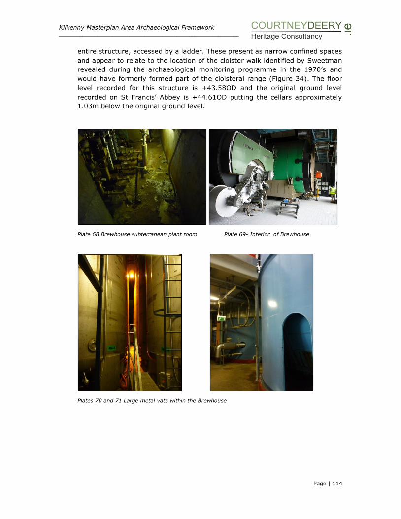
Kilkenny Masterplan Area Archaeological Framework _____________________________________________________________
Page | 114
entire structure, accessed by a ladder. These present as narrow confined spaces
and appear to relate to the location of the cloister walk identified by Sweetman
revealed during the archaeological monitoring programme in the 1970’s and
would have formerly formed part of the cloisteral range (Figure 34). The floor
level recorded for this structure is +43.58OD and the original ground level
recorded on St Francis’ Abbey is +44.61OD putting the cellars approximately
1.03m below the original ground level.
Plate 68 Brewhouse subterranean plant room Plate 69- Interior of Brewhouse
Plates 70 and 71 Large metal vats within the Brewhouse
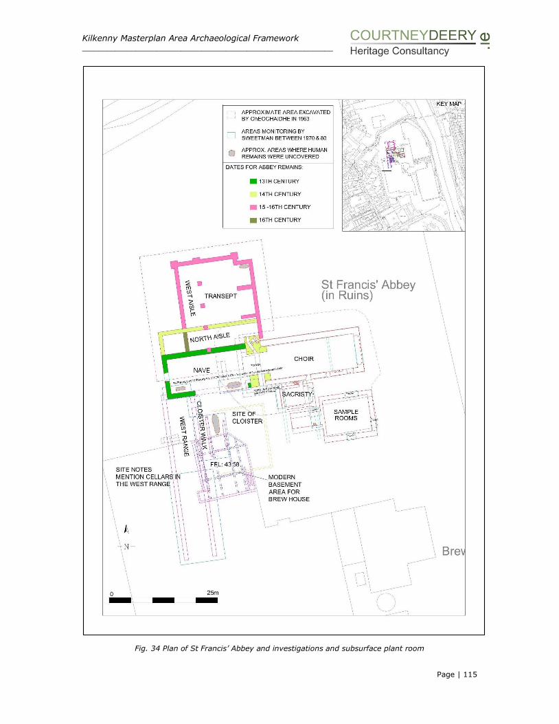
Kilkenny Masterplan Area Archaeological Framework _____________________________________________________________
Page | 115
Fig. 34 Plan of St Francis’ Abbey and investigations and subsurface plant room

Kilkenny Masterplan Area Archaeological Framework _____________________________________________________________
Page | 116
4.2.11 The Mayfair
The Mayfair building referred as the ‘Mayfair Ballroom’ on the 1946 OS ed. map
is a structure of social and cultural heritage interest. It originally functioned as a
ballroom and attracted big bands throughout the 1950s-1970s, until due to the
decline of showbands it closed its doors in 1973. Since then and until recently it
was used as offices, kitchens, welfare facilities and a staff canteen for the
brewery.
The 1930’s structure consists of a mass concrete frame and is two stories high
to the southeast where a covered walkway provides access to offices along the
front of the building, it is not considered to be of architectural heritage
significance. The rear of the structure is built up against the city wall and the
River Breagagh.
Plate 72 Mayfair Building – front elevation
It is partially located on the site of the ‘Horse Barracks’ which were built in 1699
and later demolished to make way for the expanding brewery. Part of the city
wall along the River Breagagh could have been reused, built up to once form the
northern extent of this former building and the existing wall could be the last
upstanding remnants of the Horse Barracks (Plates 71-72). A separate
archaeological and architectural study on the Mayfair Building has been produced
by Kilkenny Archaeology (2014)12 in order to inform the proposed redevelopment
of this building.
While the Mayfair building is associated with the past brewing complex the
structure itself is not of architectural significance and is not protected structure
or considered to be of architectural merit within the record. The building is
located at the entrance of the present brewing complex and its height
12 Kilkenny Archaeology 2014 Archaeological Assessment The Mayfair Ballroom unpublished report for Reddy architecture + urbanism

Kilkenny Masterplan Area Archaeological Framework _____________________________________________________________
Page | 117
complements the surrounding building scale, affording views of St Francis’ Abbey
from St Canice’s Round Tower. From a sustainability view point the retention of
structures are to be welcomed also retaining the familiar can benefit the creation
of interesting places by bringing the old, existing and new building stock
together.
Plates 73-74 Section of walling to the immediate east of the Mayfair Building landside and riverside
Plate 75 City Wall to the rear of the Mayfair Building taken from the east showing spring stones of a
former bridge site

Kilkenny Masterplan Area Archaeological Framework _____________________________________________________________
Page | 118
Plate 76 City Wall to the rear of the Mayfair Building taken from the west (Watergate)
4.2.12 The Mill
Plate 77 and 78 View to the mills taken from the eastern bank of the River Nore
The ruined Mill building is placed on the western banks of the River Nore with a
slipway present to the south of the structure. The setting of the site has altered
recently with the development of the KCAS. Indeed for the purpose of this report
the ruin could not be accessed for a detailed assessment as hoarding has been
placed around the protected structure in order to protect it from ongoing
construction works.

Kilkenny Masterplan Area Archaeological Framework _____________________________________________________________
Page | 119
In recent years, the structure formed part of the public realm with public access
around the exterior of the structure, however no access was provided to the
interior with a low wooden fence preventing entry. At a cursory inspection the
remaining masonry appears to be in a reasonable condition however it is heavily
overgrown with vegetation.
4.2.13 Other Structures
Other structures within the former brewery site, both north and south of the
River Breagagh are modern industrial features and without any historic or
cultural recommendations. They are all scheduled for removal as part of the
demolition works that are taking place in advance of Kilkenny County Council
taking ownership of the site. The structures are a variety of large warehouses
and mechanical stores, concrete and steel famed in construction and consist of
the:
Plate 79 Truck Wash Garage Plate 80 Bottling Store
Plate 81 Hop Store Plate 82 Kegging Store
The removal of these features will enhance the overall redevelopment of the
Masterplan area and provide the space required for the creation of the linear park
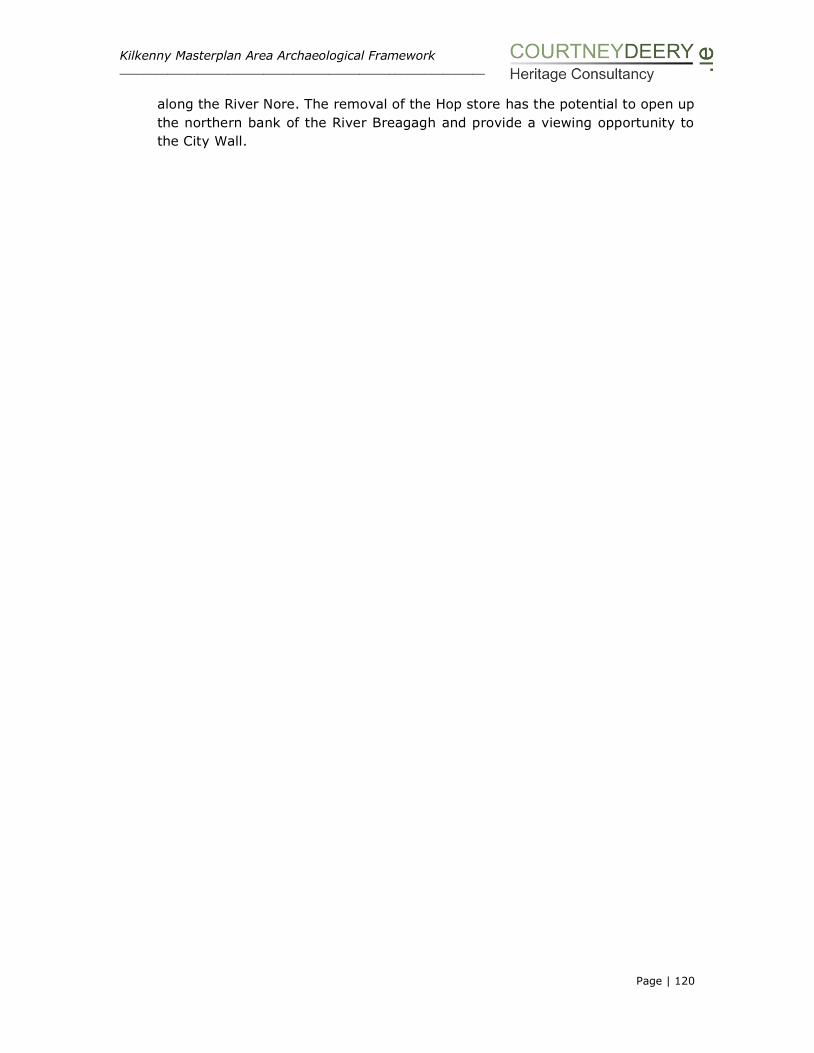
Kilkenny Masterplan Area Archaeological Framework _____________________________________________________________
Page | 120
along the River Nore. The removal of the Hop store has the potential to open up
the northern bank of the River Breagagh and provide a viewing opportunity to
the City Wall.
Kilkenny Masterplan Area Archaeological Framework ___________________________________________________________________________________________________
Page | 121
SECTION V: CONTEXT AND SETTING
Plate 83 Masterplan area c. 1950’s

Kilkenny Masterplan Area Archaeological Framework ___________________________________________________________________________________________________
Page | 122
SECTION V: THE CONTEXT AND SETTING
5.1 URBAN CONTEXT
Watters1 the Town Clerk of Kilkenny, describes the river side setting from Green’s
Bridge and the eastern bank of the River Nore in 1872 as:
‘one of the most beautiful public walks perhaps to be found in any town in the
Empire’.
The eastern bank of the River Nore was then known as the ‘Mayor’s Walk’ and it is
from there that St Francis’ Abbey as well as St Canice’s and the mills and weirs could
be viewed. Watters paid particular note to the orchards which he claimed were
formed in the ‘last fifteen years’ by the Corporation (probably in and around 1850’s).
The urban context of St Francis’ Abbey and the Masterplan area which is intimately
connected with the development and urban grain of the existing street scape of
Kilkenny juxtaposed with the western bank of the River Nore in a relatively open
area makes for an interesting dynamic.
So while the site is part of the development of the city it is still strangely set apart.
The site has changed over time, while being in the ownership of one private company
has helped preserve it as one coherent unit and ceased the piecemeal development
of the land. The result is an opportunity to develop a sizable portion of land within
an urban context that still contains well preserved upstanding, impressive, medieval
masonry monuments of a national significance. These monuments are part and
parcel of the cultural heritage significance of the medieval city of Kilkenny.
With a development of this nature and scale at the heart of a city there is the
potential for conflicting values to be placed on different aspects of the site and for
competing visions. It is the purpose of this document to provide an understanding
of the cultural heritage value so it may be considered along with other values and
be part of a collaborative decision making and design process.
The objective is to retain and celebrate the historic quality of the site and to promote
its significance through interpretation and appropriate presentation while developing
the site that is fit for purpose and meets the needs of modern Kilkenny. The job at
hand is to manage the change appropriately and intelligently and to place the Abbey
precinct at the centre of the development. The ultimate visitor and end user
experience has to be interconnected between all disciplines.
Urban settlements will and must continue to change and develop. However, this
necessary continuum must recognise and preserve the character, setting and
amenity of all upstanding medieval monuments and urban defences and the
archaeological evidence that survives, or may survive, below ground.
While investigation and monitoring has taken place within the Masterplan area it has
never been subject to a comprehensive archaeological survey and until this has taken
1 Patrick Watters 1872 The Approaches to Kilkenny in Olden Times, as compared with the present, The Journal
of the Royal Historical and Archaeological Association of Ireland, Fourth Series, Vol. 2, No1 pgs 50-59

Kilkenny Masterplan Area Archaeological Framework ___________________________________________________________________________________________________
Page | 123
place the proposed chronology of the upstanding buildings and how the site
developed and was used is open to interpretation and subject to change when further
information becomes available.
Given the amount of development on site the sequencing of below ground remains
is a problematic task and made more difficult when investigating small areas such
as has occurred on site to date. It is difficult to reach a firm conclusion about the
nature and date of buildings and ranges without further archaeological excavation
and consideration of St Francis’ Abbey in the context of abbey sites elsewhere.
English Heritage have developed the Buildings in Context Toolkit which is supported
and promotes:
Quality and heritage
Innovation and history
Sustainability
Balance decisions
Local Communities
The Heritage Council and Dublin Civic Trust have used this process to assess
developments proposal for Aungier Street Dublin2 which followed the following
guiding principles:
The historic environment is a shared resource;
Participation of all stakeholders is necessary to sustain the historic
environment;
Understanding the significance of the place is key;
Significant places should be managed to sustain their values;
Decisions need to be reasonable, transparent and consistent.
The toolkit programme aims3 to:
Enable a wider understanding of the principles of developing appropriate
contemporary design in historic areas to a range of professional and
community groups;
Enable those involved in making decisions affecting historic areas in their
attainment of a more effective, balanced and efficient service resulting in an
improvement of those decisions affecting the quality of the historic
environment for future generations;
Promote sustainable new and re-used development that doesn’t sacrifice
what future generations will value for the sake of short-term and often illusory
gains so that we use already developed areas in the most efficient way, while
making them more attractive places in which to live and work and conserving
our cultural heritage.
2 The project was implemented as part of a Public Realm Strategy in relation to Aungier Street area of Dublin
by Dublin City Council and Dublin Civic Trust in 2012. 3 www.Building-in-context.org. The Building in Context toolkit has been developed by English Heritage, CABE
and the Kent Architecture Centre. It grew out of the publication ‘Building in Context’ published by EH and CABE
in 2001. The purpose of the publication was to stimulate a high standard of design when development takes place in historically sensitive contexts. The founding principle is that all successful design solutions depend on
allowing time for a thorough site analysis and character appraisal of context.

Kilkenny Masterplan Area Archaeological Framework ___________________________________________________________________________________________________
Page | 124
5.2 COMPARATIVE ANALYSIS
St Francis’ Abbey represents an impressive testimony to 13th and 14th century Irish
Gothic architecture. Other Franciscan Abbeys which have a similar layout to St
Francis’ Abbey in Kilkenny include Donegal Franciscan Friary and Quin Franciscan
Friary, Co. Clare, both of which have a choir to the east and nave to the west
separated by a central tower, in common with Kilkenny. Both of these also have a
cloister garth to the north and transept to the south, while at Kilkenny these
elements are reversed, however they are c.200 years later than St Francis’ Abbey in
Kilkenny.
Plates 84-85 Franciscan Friary Donegal, founded 1474 Quin Franciscan Friary, Co Clare, founded 1433
The reconstruction illustration of Grey Abbey in Kildare is based on a typical
Franciscan Abbey layout, the upstanding remains at the site and an interpretation of
a geophysical survey and test excavation (Dennehy 20064). The abbey is of a similar
date to Kilkenny, having been founded in 1254.
Figures 35 and 36 Typical Franciscan Abbey layout (left) and Grey Abbey Co Kildare (founded 1254),
artists reconstruction, based on this layout, upstanding remains and archaeological findings (Dennehy
2006)
4 Dennehy, E. 2006 Directors Findings: Excavations at Grey Abbey Friary, Kildare. Presentation to the Grey
Abbey Conservation Group.

Kilkenny Masterplan Area Archaeological Framework ___________________________________________________________________________________________________
Page | 125
While the basic elements of Franciscan church building of the medieval period
comprise a nave to the west, where the congregation was accommodated, and the
choir to the east with an alter positioned at the eastern end. In general the church
layout is simple and rectangular in form, running East-West, with internal divisions
by means of wooden screens. The church structure grew with the additions of aisles
and transepts as the congregation grew and as funds allowed. At a later stage this
long church may have been sub-divided by a tower. The base of the tower divided
the church into a choir and nave. At St Francis’ Abbey while the form of the building
is simple there are many decorative stone carvings reflecting the wealthy patronage
and a superior craftsmanship.
Domestic buildings were normally located to the north of the church in a rectilinear
alignment around a cloister, the east, south and west ranges could contain rooms
functioning as the monks dormitory, hall, necessaria, kitchen and refectory and the
lay dormitory, cellars and drainage system. However there are many cases where
these living quarters were located to the south as shown at Askeaton, Claregalway,
Nenagh, Roscrea, Carrick-on-Suir, Castledermot and Kilkenny. Belfries were either
free standing or attached to the church. Monastic gardens were located to the north,
the monastic graveyard to the east and an infirmary to the southeast. All additional
buildings such as barns, mills and brewhouses etc. were located in the outer court
of the monastery. While these are the main elements of a Franciscan monastery, the
layout of these elements varied from Friary to Friary and often was inverted.
The layout at the friary in Castledermot which was founded c.1247 is also very similar
to that at Kilkenny, with a transept and aisle to the north of the nave and a cloister
to the south (Halpin & Newman 20065). The proportions of both churches are similar
in that there are approximately 8m in width while St Francis’ Abbey is some 6m
longer standing at 47m. In both cases the northern aisle was partially destroyed to
accommodate the construction of the transept chapel. Both have the same plan,
three chapels with a row of arches creating a false aisle to the rear. This latter feature
is found in other Franciscan transepts but the triple chapels are unique to these two
sites. Kilkenny has the largest of the 25 known Franciscan transepts in the country6,
and the transept at St Francis’ Abbey is estimated at 18 x 20m. This is large in size
when compared to Castledermot at 11 x 11.5m.
5 Halpin, A. & Newman, C. 2006 Ireland: An Oxford Archaeological Guide, 289-291. Oxford University Press 6 Patrick Conlon (1975) ‘Notes on St Francis’ Abbey Kilkenny’ in O.K.R The Old Kilkenny Review Vol.1, No.2,
Kilkenny Archaeological Society, 80-84

Kilkenny Masterplan Area Archaeological Framework ___________________________________________________________________________________________________
Page | 126
Figure 37 Franciscan Friary Castledermot, Co Kildare (founded. 1240)
Figure 38 Taken from P. Conlon Notes on St Francis’ Abbey
Plate 86 View of St Francis’ Abbey taken from the north showing the chancel/choir to the east and tower
to the west

Kilkenny Masterplan Area Archaeological Framework ___________________________________________________________________________________________________
Page | 127
Plate 87 Franciscan Friary at Castledermot, showing trancept, through excavation it is known that St
Francis’ Abbey Kilkenny has a similar layout and it is possible to visualise what the transept would have
looked like from this photograph7.
Plate 88 Franciscan Friary at Castledermot founded c. 1247
5.3 PRESENTATION OF THE MONUMENTS & SETTING
‘architecture, like all other cultural objects, is not made just once, but is made and
remade over and over again each time it is represented through another medium,
each time its surroundings change, each time different people experience it.’8
The assessment of setting is concerned with the understanding and appreciation of
the cultural heritage asset and its significance. In accordance with the accepted
guidance, setting is not exclusively about the visual envelope, it embraces
considerably more than just views; an impact on setting will only occur if the
change affects the contribution made by setting to the significance of that asset.
7 Monastic Ireland, The Discovery Programme, Castledermot Franciscan Friary 8 From Strangely Familiar (1996):eds., Iain Borden, Joe Kerr, Alica Pivaro, et al., Routledge, London.
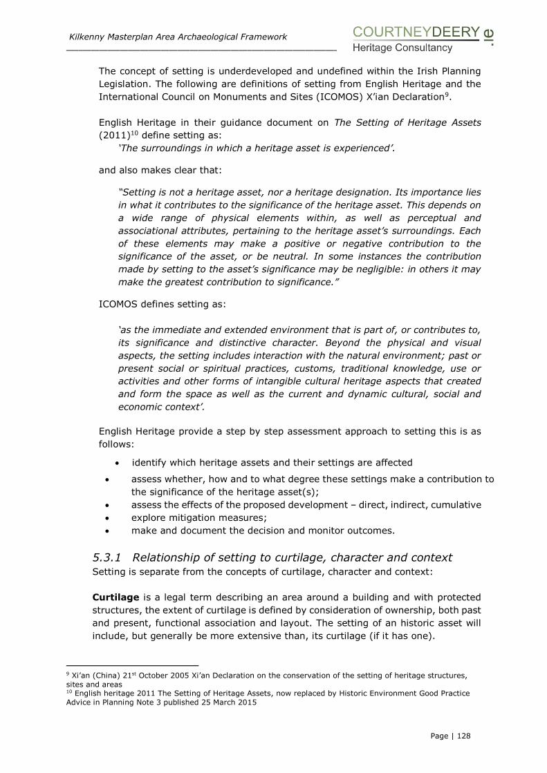
Kilkenny Masterplan Area Archaeological Framework ___________________________________________________________________________________________________
Page | 128
The concept of setting is underdeveloped and undefined within the Irish Planning
Legislation. The following are definitions of setting from English Heritage and the
International Council on Monuments and Sites (ICOMOS) X’ian Declaration9.
English Heritage in their guidance document on The Setting of Heritage Assets
(2011)10 define setting as:
‘The surroundings in which a heritage asset is experienced’.
and also makes clear that:
“Setting is not a heritage asset, nor a heritage designation. Its importance lies
in what it contributes to the significance of the heritage asset. This depends on
a wide range of physical elements within, as well as perceptual and
associational attributes, pertaining to the heritage asset’s surroundings. Each
of these elements may make a positive or negative contribution to the
significance of the asset, or be neutral. In some instances the contribution
made by setting to the asset’s significance may be negligible: in others it may
make the greatest contribution to significance.”
ICOMOS defines setting as:
‘as the immediate and extended environment that is part of, or contributes to,
its significance and distinctive character. Beyond the physical and visual
aspects, the setting includes interaction with the natural environment; past or
present social or spiritual practices, customs, traditional knowledge, use or
activities and other forms of intangible cultural heritage aspects that created
and form the space as well as the current and dynamic cultural, social and
economic context’.
English Heritage provide a step by step assessment approach to setting this is as
follows:
identify which heritage assets and their settings are affected
assess whether, how and to what degree these settings make a contribution to
the significance of the heritage asset(s);
assess the effects of the proposed development – direct, indirect, cumulative
explore mitigation measures;
make and document the decision and monitor outcomes.
5.3.1 Relationship of setting to curtilage, character and context
Setting is separate from the concepts of curtilage, character and context:
Curtilage is a legal term describing an area around a building and with protected
structures, the extent of curtilage is defined by consideration of ownership, both past
and present, functional association and layout. The setting of an historic asset will
include, but generally be more extensive than, its curtilage (if it has one).
9 Xi’an (China) 21st October 2005 Xi’an Declaration on the conservation of the setting of heritage structures,
sites and areas 10 English heritage 2011 The Setting of Heritage Assets, now replaced by Historic Environment Good Practice
Advice in Planning Note 3 published 25 March 2015

Kilkenny Masterplan Area Archaeological Framework ___________________________________________________________________________________________________
Page | 129
The character of an historic place is the sum of all its attributes, which may include:
its relationships with people, now and through time, its visual aspects, and the
features, material, and spaces associated with its history, including its original
configuration and subsequent losses and changes. Heritage assets and their setting
contribute to character but it is a broader concept, often used in relation to entire
historic areas and landscapes.
The context of a heritage asset is a non-statutory term used to describe any
relationship between it and other heritage assets, which are relevant to its
significance, including cultural, intellectual, spatial or functional. They apply
irrespective of distance, sometimes extending well beyond what might be considered
an asset’s setting, and can include that relationship of one heritage asset to another
of the same period or function, or with the same designer or architect.
The National Monument of St Francis’ Abbey as defined by the National Monuments
Service is shown on Figure 42.
The Masterplan area is located within the City Centre and St Canice’s Architectural
Conservation Areas (ACAs) (Figure 39).
The City Centre ACA forms part of the medieval core of Kilkenny. It is characterised
by its tight urban grain, colourful streetscapes and network of lanes dating mainly
from the 16th, 17th and 18th centuries. This district includes the triangle of High
Street/ Parliament Street, Kieran Street and Rose Inn Street, which comprises the
principle retail area of the city.
The area is characterised by the almost continuous enclosure of the streets with
mainly three storey 18th and 19th century buildings built on medieval plots and
foundations. The area also includes sections of the medieval Kilkenny City Walls
(Hightown Circuit). The stepped lanes running from High Street to Kieran Street and
from St. Mary’s Lane to Rose Inn Street are a notable feature of Kilkenny. There are
numerous notable Protected Structures that surround the Masterplan area and
belong in the conservation area, including St Francis Abbey, Irishtown Bridge, the
City Hall and Courthouse and Rothe House on Parliament Street to name but a few.
The St Canice’s ACA is dominated by the Cathedral district at the centre of which is
the visually prominent 13th century St Canice’s Cathedral. Vicar and Green Street
have experienced some dereliction in the recent past, however there is potential for
renovation in this area. The Masterplan area extends into the southern section of
this conservation area along the banks of the River Nore.

Kilkenny Masterplan Area Archaeological Framework ___________________________________________________________________________________________________
Page | 130
Plate 89 Views from the Masterplan area towards St Canice’s
According to Kilkenny City Development Plan11 any new development within an ACA
and in particular St Canice’s and City Centre ACAs should:
• Encourage the introduction of buildings of high quality contemporary and
vernacular design and materials, as appropriate to the character of the existing
streetscape.
• Encourage the retention of the historic scale and plot size when new buildings are
being introduced into an ACA.
• Minimise the impact of new development on existing amenities, including
residential and land uses.
• Seek the retention of mature trees (those in good condition) which contribute to
the character of the areas where appropriate.
Seek the conservation of St Francis Abbey and its setting.
Ensure that any development occurring along the River Nore will be sensitive in
its design and mindful of its proximity to the river.
Enhance the character of Vicar Street and Troy’s Lane.
Protect and retain the historic integrity of the City Walls, in accordance with the
Kilkenny City Walls Conservation Plan12.
Protect the historic and architectural character of St Canice’s Cathedral and its
unique setting.
Encourage the renovation and re-use of any vacant or derelict buildings.
Retain the existing scales of building heights of three and four storey buildings.
Improve the visual appearance of the car parking area at the Market yard, and
ensure a high standard of architectural design for any development at Bateman
Quay.
11 Chapter 7, Heritage, Kilkenny City and Environs Development Plan 2014-2020 12 Heritage Council 2005
Kilkenny Masterplan Area Archaeological Framework ___________________________________________________________________________________________________
Page | 131
In urban environments the numbers and proximity of heritage assets mean that the
protection and enhancement of setting is intimately linked to townscape and urban
design considerations (Figure 40), including the degree of conscious design or
fortuitous beauty and the consequent visual harmony or congruity of development,
and often relate to townscape attributes such as lighting, trees, verges or the
treatment of boundaries, street surfaces and material used within buildings13.
13 English Heritage Historic Environment Good Practice Advice in Planning, Note 3, The Setting of Heritage
Assets, March 2015 p 1-2 and 6

Kilkenny Masterplan Area Archaeological Framework ___________________________________________________________________________________________________
Page | 132
Figure 39 ACA Map
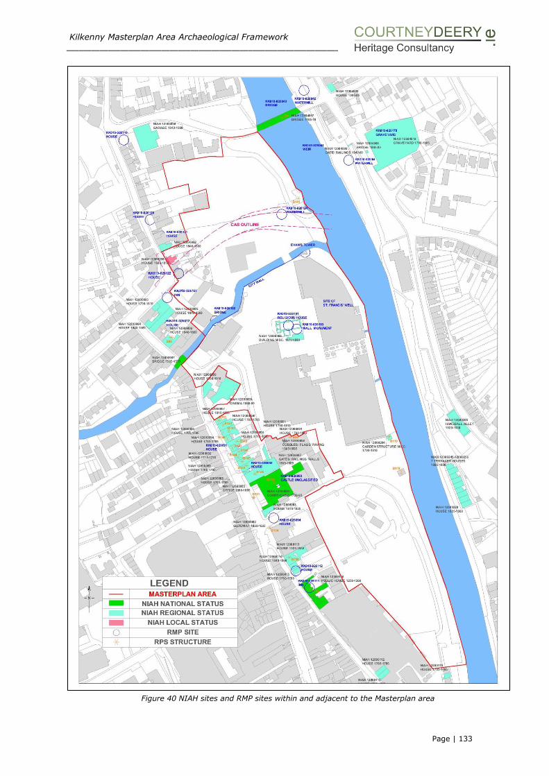
Kilkenny Masterplan Area Archaeological Framework ___________________________________________________________________________________________________
Page | 133
Figure 40 NIAH sites and RMP sites within and adjacent to the Masterplan area

Kilkenny Masterplan Area Archaeological Framework ___________________________________________________________________________________________________
Page | 134
In terms of St Francis’ Abbey the contribution of setting on the significance of the
monument can be attributed to:
The group value placed on the complex of upstanding well preserved medieval
monuments including the City Wall, Evan’s Turret and the Abbey itself and
extending to the extensive below ground remains.
The influence of the River Nore and River Breagagh in determining the
location of the site.
The location of the site within the historic town of Kilkenny
The Masterplan should provide for the potential of a newly enhanced urban
environment that embraces the significance of the monuments and increases the
appreciation and understanding of each individual heritage asset.
The approach of independently evaluating and reusing modern existing buildings
within the brewery site will assist in retaining the urban, industrial character and will
also contribute to retaining the significance of the brewing industry that was integral
to the social, economic and technological growth of Kilkenny. For example, the
retention of the Brewhouse, a side from its name, provides a strong physical and
visual link with the former function of the site.
While the Masterplan area may appear to consist of competing heritage assets and
values, a medieval abbey precinct and a brewery – both these sites have existed
side by side for the last 300 years and together create an interesting and distinctive
historic place that is inextricable linked to the development of Kilkenny. The following
photographs show how the Masterplan area sits within the urban and street scape of
Kilkenny and along the banks of the River Nore and Breagagh.
Plate 90 Kilkenny Streetscape

Kilkenny Masterplan Area Archaeological Framework ___________________________________________________________________________________________________
Page | 135
Plate 91 Rive Nore view to the south
Plate 92 Panoramic view of the northern section of the Masterplan area taken from the west
The Department of Arts, Heritage and the Gaeltacht have issued the extent of the
area of which the Minister for Arts, Heritage and Gaeltacht is the owner. The
Department considers that this map (Figure 41) accurately depicts the extent of the
Minister’s legal ownership of the national monument known as St Francis Abbey.
Figure 41 Minister’s legal ownership of St Francis’ Abbey

Kilkenny Masterplan Area Archaeological Framework ___________________________________________________________________________________________________
Page | 136
The following map was supplied by the National Monuments Service is relation to the
extent of the National Monument of St Francis’ Abbey which is defined by the dotted
line14.
Figure 42 Extent of National Monument Saint Francis’ Abbey
14 The map of St Francis’ Abbey was prepared in 1968 and shows the boundary of the National Monument as
far as could be ascertained by surface indications, see dotted line on the map.

Kilkenny Masterplan Area Archaeological Framework ___________________________________________________________________________________________________
Page | 137
5.4 HIST0RICAL ILLUSTRATIONS
Grose (1792) shows a depiction of the abbey when both the choir and nave were
still standing and separated by the belfry tower. The illustration appears to be
looking towards the east window which is blocked up and shows four small one
storey thatch structures located within the nave above which the remains of three
lancet windows project. The elegant arch of the belfry is clearly depicted.
Figure 43 St Francis’ Abbey, Kilkenny, Grose 1792
The following are all antiquarian drawings of the plan area and key features
produced after 1800. The illustrations date from 1810 to 1882 and all depict a
tranquil setting along the River Nore with the buildings set within lush vegetation
rather than the increasingly industrialised backdrop with the expansion of the
brewery and mill sites that were occurring at the time.

Kilkenny Masterplan Area Archaeological Framework ___________________________________________________________________________________________________
Page | 138
Figure 44: St Francis’ Abbey and Mills, with Evan’s Tower in the centre. Print from Antiquities and
Scenery of the County Kilkenny, ed. J.G. Robertson, 1851 reproduced with the permission of the Irish
Architectural Archive, Dublin.
Figure 45: Watercolour view of City from east with St Francis’ Abbey (left), Cathedral centre back,
Evan’s Tower centre front and mill to the right. Taken from Collection: Castletown House (Cat. No. 28).
Reproduced with the permission of the Irish Architectural Archive, Dublin.

Kilkenny Masterplan Area Archaeological Framework ___________________________________________________________________________________________________
Page | 139
Figure 46a: St Francis’ Abbey viewed from the east bank of River Nore with St Canice’s Cathedral and
round tower in distance. Pencil drawing by R. Gibbs c. 1810 (see preface to Antiquities and Scenery of
County Kilkenny, 1851). Reproduced with the permission of the Irish Architectural Archive, Dublin.
Figure 46b: St Francis’ Abbey Brewery c. 1860 viewed from the east bank of River Nore, image
supplied by Grace Fagan, Rothe House

Kilkenny Masterplan Area Archaeological Framework ___________________________________________________________________________________________________
Page | 140
Figure 47: ‘The Nore’ by E.J. Brenann 1882, oil on canvas, Butler Gallery. This painting focuses on the
river and mills at Green’s Bridge. The belfry tower at St Francis can just be made out in the
background.
5.5 PUBLIC EXPECTATIONS
Public consultation and workshops took place on the weekends of 9/10th January
and the 24th January 2015 with regard to re-visioning the Masterplan area.
Comhairle na nÓg workshop took place on the 18th of February. Previous to this a
draft plan was on display in December 2013. The purpose of these workshops was
for the public to express their views and for suggestions for the future development
of the site. In addition to this 71 submissions were received during the consultation
period from the 12th of December 2014 to the 9th of February 2015. These
submissions and issues raised at the workshops have been taken into consideration
when preparing this document.
It was clear from the workshops that there was a genuine and pressing concern
that archaeology and the built heritage should inform the design process. Everyone
present agreed that central to the design of the scheme was the protection and
enhancement of the archaeological and built heritage on the site, indeed this was
a strong theme expressed throughout both weekends at each workshop.
As a result of the consultation process the following action was recommended by
Kilkenny County Council:
Complete the archaeological assessment and devise an Archaeological Strategy
for the plan area in conjunction with all stakeholders, initiate further feedback
once the strategy is published.
The following vision statement reflects the aspiration from each of the themes
discussed at the workshops:

Kilkenny Masterplan Area Archaeological Framework ___________________________________________________________________________________________________
Page | 141
To plan the area as a seamless complement to the medieval city as an inclusive
place for an inter-generational community to work, live, visit and play with St.
Francis Abbey at its core. The regeneration of the area will focus on embracing
the sites’ natural, cultural and built heritage, whilst maximising the benefits of
the rivers Nore and Breagagh, providing for a broad range of uses, sustaining
growth in employment and advancing economic activity in a sustainable and
energy efficient fashion where innovation can flourish. The area will be a
permeable expansion of the city for pedestrians and cyclists where smarter
travel principles are provided for15.
As with all vision statements, they form part of an organic progress that evolve as
further information is gathered, it is a live document which is constantly changing.
The vision statement provides a starting off point into which a framework can then
be built around and an agreed approach developed.
15 The Brewery: Re-Visioning Report on Public Consultation, March 2015 Kilkenny County Council

Kilkenny Masterplan Area Archaeological Framework ___________________________________________________________________________________________________
Page | 142
SECTION VI: CONCLUSIONS
Plate 93 Brew Masters House area c. 1900

Kilkenny Masterplan Area Archaeological Framework ___________________________________________________________________________________________________
Page | 143
SECTION VI: CONCLUSIONS
6.1 REVISIONING OF THE MASTERPLAN AREA
Key proposals presented in the original Masterplan document included:
A linear park on the banks of the River Nore, linking Bateman Quay to Green’s
Bridge
Conservation of historic structures on site
Retention, adaptation and reuse of existing modern structures on site
Provision for cultural, housing, retail, educational and tourist uses
Access
Demolitions (to slab level) are taking place by DIAGEO in advance of the handover
of the site to Kilkenny Council and include the following structures, this work will be
archaeologically monitored: The garage and car port to the north of the River
Breagagh and the kegging and bottling plant, maturation tanks and fermentor block
to the south of the river (Section IV Figure 24).
The Masterplan is a land use and urban design document and evidence from across
the world has shown1:
Historic environments allow distinctive businesses to thrive
They create oases in towns and cities which are fundamental to their appeal,
encourage social interaction, people making repeat visits and staying for
longer
Imaginative leadership of their development and management can achieve
outstanding results in a relatively short period.
Conservation has become a strategy to achieve a balance between urban growth and
quality of life. The greater the availability of sustainable planning, design and building
practices can improve urban areas and the quality of life they support. When properly
managed, new functions in urban historic settlements such as services and tourism
are important economic initiatives that can contribute to the conservation of cultural
heritage. Failing to capture these opportunities leads to unsustainable cities and poor
implementation results in the destruction of heritage assets.
Work associated with the redevelopment of the plan area has sought to protect the
historic character, the monuments, their setting, views and prospects and encourage
the creation of new vistas to existing landmarks. Redevelopment provides an
opportunity for an integrated multi-disciplinary approach to improve the
presentation, legibility and civic amenity of these monuments together with
identifying a potential dividend for the further enhancement of the city’s historic
core.
1 The Viking Triangle Waterford City Centre Failte Ireland and Waterford County Council p. 4

Kilkenny Masterplan Area Archaeological Framework ___________________________________________________________________________________________________
Page | 144
6.2 THE MANAGEMENT OF CHANGE
In order to inform the Masterplan process, an archaeological strategy has been
developed. This strategy is driven by the need to protect and understand the above
ground structures and their setting including the extensive below ground
archaeological remains and retain their significance within a newly architecturally
designed quarter.
The strategy also seeks to understand the iterative design process and the phasing
of proposed developments in order that archaeological proposals are presented in a
timely and appropriate manner.
Throughout the Masterplan area a wide range of archaeological remains, artefacts,
and features have been encountered to date. Burials, Franciscan abbey remains,
ruined towers, city walls and defences, burgage plots, medieval deposits, industrial
mill houses, along with burials of felons from a 19th century gaol house and
reclamation practices, riverside pleasure houses with stone jettys, indicate an
extremely rich and varied archaeological record.
Part and parcel of this report was to understand the evolution of the area and assess
the layered deposits that have accumulated over time contributing to the setting and
urban history of the area. It is these multiple layers that need to be understood and
celebrated within the new proposal.
6.3 DEVELOPING AN ARCHAEOLOGICAL STRATEGY
The most successful strategies are a step by step, targeted process that engage with
and build from previous and available information. This report provides an overview
of the existing knowledge base that can be availed of for future investigation work
on site and can act as the beginning of an archaeological and historic archive to be
added to and developed throughout the subsequent building phases of the plan area.
Key to developing the plan area is understanding the archaeology, this includes the
above ground monuments and the below ground potential2.
The absence of an overall strategic direction in the archaeological research that has
taken place within the Masterplan area to date has left the overall testing and
excavation record fragmented and difficult to interpret. Also there is no final
archaeological excavation report for three large excavations (with Medieval findings)
that have taken place within and adjacent to the Masterplan area, namely the
Courthouse, St Francis’ Abbey, the Vicar’s Choral building.
The development of an archaeological deposit model was explored for the plan area.
A deposit model is basically a contour map showing the top level of archaeology
identified by a recognisable layer consistent in most trenches and geotechnical
investigations within the plan area. The information from existing test trenches,
2 Historic England Guidance May 2015 Preservation in situ, condition assessment and monitoring Draft for
consultation

Kilkenny Masterplan Area Archaeological Framework ___________________________________________________________________________________________________
Page | 145
excavations and site investigations were reviewed for this purpose, however, an
archaeological deposit model was ultimately not possible to produce as there is no
identified level for the top of archaeology in test trenching and geotechnical
investigations through the plan area.
While isolated spots of material were visible such as possible post medieval walls
(north end of the site at 43.1m and 42.44m OD) or exposed 18th -19th building
material with the KCAS, this information cannot be consistently identified throughout
the plan area. Attempting to extrapolate the levels to top of archaeological areas
within the plan area is therefore not feasible and assumptions made based on
isolated results can easily lead to overestimating or underestimating the impact of
development on the area. Simply put there is not enough information to identity
local variations in the record.
All investigations have been placed on mapping accompanying this report and are
detailed in the narrative as well as Appendix E.
Broadly considered, the archaeological evidence to date has placed earlier medieval
deposits and features along the street frontage from Vicar Street, Parliament Street
and onto Kieran’s Street at the south end of the plan area. The obvious exception to
this is St Francis Abbey and the medieval structures within the precinct that extend
to the River Nore.
The stratigraphy seen in archaeological investigations throughout the former
DIAGEO site commonly shows a sequence of modern concrete, sitting above made
ground, over evidence of post medieval walls or structural foundations, overlaying
(an often sterile) organic dark silty clay with occasional finds dating it to the medieval
period, along with river silts and gravels, and a yellow boulder clay.
Based on the current information it is proposed to carry out large scale excavation
in the area defined as the Abbey Precinct and investigation in order to answer key
research questions (Figure 52 and 53). It is proposed that the existing ground level
in and around the historic monument of St Francis’ Abbey will be largely reproduced
throughout the Abbey precinct area (ie reducing the existing ground level) to provide
a cohesiveness for this area and connecting topographically the various historical
elements while distinctly setting the precinct area within the wider Masterplan area.
Targeted investigation is proposed at this stage throughout the rest of the site, this
is based on the historic and excavation information we have to date. It is proposed
to gain a better understanding of the sub-profile of the Brewery, Grace’s Castle and
the Market Yard /Historic Garden character areas through a series of systematic
boreholes which will be devised in order to provide information on the nature and
depths of deposits. Test excavation can then take place in response to the findings
and the proposed design.
To the north of the River Breagagh ongoing archaeological investigation from the
KCAS should inform the archaeological approach and highlight any areas of potential
that may extend into the plan area. In the design of this area, elements (for example,
open spacing, hard landscaping, the planting regime) must be introduced that will
reflect the medieval garden plots.

Kilkenny Masterplan Area Archaeological Framework ___________________________________________________________________________________________________
Page | 146
To the north and south long linear garden plots developed from medieval burgage
plots and reclamation practices and stone jetties have been revealed along the River
Nore. Targeted investigation presents an opportunity to gain a better understanding
of the underground profile of these areas and an appreciation of the historic
development, allowing the future use of the plan area to be designed in response to
the archaeological findings whilst also enabling the interpretation and enhancement
of the upstanding elements.
Measures for conserving historic structures throughout the entire area are detailed
in this report (Section 4 and Appendix F). Further collaborative research and survey
on the upstanding building remains should be sought in association the conservation
work for the Tea House, Evan’s Tower, and the city wall. As St Francis’ Abbey is in
state care it is presumed that conservation will be undertaken by the authorities as
necessary.
Future phases of work that require excavation or a reduction in ground level provide
an opportunity to investigate the below ground level archaeological potential of the
area in a planned and strategic manner. In terms of the investigation, excavation
should be planned in order to answer key research questions and to gather
information to appropriately conserve the upstanding monuments and understand
their setting and how the area developed over time. Preservation in-situ is
considered the preferred option when designing and constructing within an
archaeological sensitive area.3
The proposed design principal of piling seeks to minimise the impact on the below
ground archaeology by minimising the amount of excavation required and this
principal will be further informed once the detailed design is known and an
archaeological impact statement prepared for each proposed structure. This
approach favours preservation insitu so the Masterplan area can be developed and
maintained in such a manner that it will retain the significance of the place, facilitate
public access and add to the social and cultural infrastructure of Kilkenny town.
Preservation insitu - The Piling Concept
In the character areas outside the Abbey Precinct, where the ground level consists
of a reinforced concrete slab, the approach is to minimise the impact on buried
archaeological material and features and avail of piling techniques to develop the
plan area.
Archaeological testing can take place in advance in order to understand the below
ground potential of where the piling is proposed so informed decisions can be made
in relation to avoidance.
While piling is the preferred technique, it should be recognised that the need to
minimise the impact of piling may have significant effects on the design and cost of
the structure. Non-standard forms of structure will be needed and will have to be
3 Framework and Principles for the protection of the archaeological heritage DAHGI 1999 pg 24
Kilkenny Masterplan Area Archaeological Framework ___________________________________________________________________________________________________
Page | 147
agreed either by contract or through a guidance mechanism that proposed
developers will have to agree to.
The viability of the remaining ‘post piling’ archaeology is contingent on the extent of
interpreting the entire site. Where the plan area has been adequately characterised,
it should be possible to avoid the most archaeologically sensitive areas of the site
through the careful placement and appropriate load-bearing spanning structures4.
Where piling techniques are adapted to meet archaeological parameters and the
requirements for the substructure, pile centres cannot be less than 6m5. It is
proposed that a sub-structure of all new buildings within the Masterplan will consist
of piles set out to a 7.5m grid with the ground beam located above the existing slab
level. This will occur in order to minimise the impact on archaeological deposits which
will be left in-situ for future investigations.
Pile caps, ground beams, drainage pipes, and utilities ducts will all be located above
the existing ground level. Ground levels will be made up to allow universal access.
Investigations into retaining the existing slab will be required to assess its load
bearing capacity and effectiveness from an engineering point of view so the overall
approach can be validated.
In the vicinity of new buildings the ground level will be raised by c. 500mm (centre
of the plan area)-1500mm (extreme north of plan area), this is dependent on the
flood requirement mitigation measures. Where possible new services will be located
within this built up zone thereby not affecting the archaeological layers. In the case
of drainage there is a preference to link to existing services and there by minimise
below ground disturbance.
It is also proposed that there will be no basemented structures and that the existing
structures such as the Brewhouse and Mayfair will be left in place in order to minimise
ground disturbance6.
For the proposed building locations a detailed impact assessment can be carried out
in relation to the potential impact of piling on below ground remains. Where it
becomes clear that excavation may be required to accommodate a building design,
lift shaft or retaining wall, if required, the appropriate archaeological response can
be formulated in conjunction with the authorities.
In order to assist in future decisions, it is essential that a record of the foundations,
as built, is kept with the archaeological archive for the plan area.
This should include a final pile plan and loading details as well as records from any
investigation test pits (including geotechnical). All information should also be lodged
with the National Monuments Service as part of the licensing requirement.
4 English Heritage, , Piling and Archaeology – An English Heritage Guidance Note, pg 21 5 This is recommended in Archaeology and Development Guidelines for good practice for developers (2000) Section 2.33 Substructure design – foundations pg 13 6 Archaeology and Development Guidelines for Good Practice for Developers, prepared by ICOMOS for the
Heritage Council, 2000, section 2.3.5 substructure design – basements pg. 14 and Framework and Principles
DAHGI, 1999 section, 3.8 Historic Towns within present day urban areas pg. 30.

Kilkenny Masterplan Area Archaeological Framework ___________________________________________________________________________________________________
Page | 148
6.4 HISTORIC CHARACTER AREAS AND PLACENAMES
Cartographic and documentary sources have been used to compile the following
mapping information (Figure 48) reflecting the dominant character areas throughout
the plan area. The existing landuse can be classified as industrial and transport in
the form of carparking, both urban in nature. However this was not always the case
and from north to south the principle historic land uses are broadly captured through
an analysis of cultural heritage datasets and the findings from excavation reports
providing an overview of the most significant activities and features onsite. The
character areas are as follows:
1. The Gardens (including burgage plots)
2. Mills, Dwellings and Industry
3. The Horse Barracks
4. Watergate
5. The Abbey Precinct
6. The Mill Stream
7. The Brewery
8. Grace’s Castle/ City and County Gaol and Courthouse
9. The Market Yard – formerly historic garden
10. Historic gardens – (including burgage Plots)
While each of these unique character areas are located within the zone of
archaeological potential and within the area of medieval reclamation within Kilkenny,
they all have to potential to reveal distinct historical/ archaeological remains when
investigated. This type of information along with the design process can assist in
focusing the archaeological investigation in each of these areas and developing the
overall archaeological strategy.
As part of the Masterplan programme consideration should be given to the
appropriate naming of various sectors with the overall area. Place names are an
important part of our cultural heritage. They provide a link to the past and reflect
the natural, built and cultural heritage of a locality. It is important that place names
of all new developments reflect the local topography, history, culture, ecology or
significant people and events and incorporate traditional and Irish language place
names from the locality.
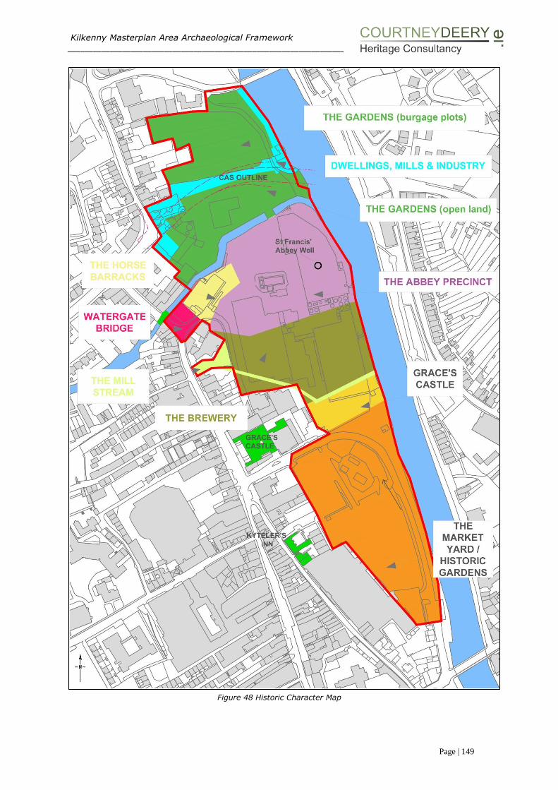
Kilkenny Masterplan Area Archaeological Framework ___________________________________________________________________________________________________
Page | 149
Figure 48 Historic Character Map

Kilkenny Masterplan Area Archaeological Framework ___________________________________________________________________________________________________
Page | 150
6.5 TEST INVESTIGATION AND EXCAVATION
As part of the Masterplan process this report provides broad archaeological
information in relation to potential below ground findings. Further investigation of
below ground remains will add to the existing knowledge of the plan area.
In brief the archaeological findings and knowledge for each area is outlined below
but is dealt with in more detail in Sections 2, 3 and 4, Appendix C, D and E and
Figures 20 and 23 of the report. Also outlined below, is the Masterplan proposal at
the present time, for proposed buildings within each character area (Figure 54). This
is the general design proposal at this stage of the process and will be subject to
alteration as further information emerges.
Key to considering preservation in situ are the following questions:
What is the current condition of the archaeological finds and deposits?
What are the likely development or land-use impacts?
(in relation to waterlogged sites) what is the availability and quality of water
on the site and its wider catchment?
Whilst the archaeological strategy seeks to guide the future use of the site, detail
design will allow specific proposals to emerge. To date the design framework has
undergone significant alteration and has the capacity for further modification
depending on archaeological investigations results. As this is an iterative process
testing and excavation will inform the final detailed design proposals. As a result of
the work carried out for the archaeological report, the following information and
various research questions within individual historic character areas have emerged,
these include-
The Gardens (including burgage plots) (north of KCAS)
This is the most northern area. On mapping sources it is shown as garden plots laid
out in an orchard extending north-south from Green Street and east-west from Vicar
Street. One of the plots is known as the ‘Treasurer’s garden’ on Hogan’s map of 1860
(Figure 11). Excavations to date have revealed the remnants of two stone walls at a
depth of 0.6m (c. 43.1m OD) and 1.7m (c. 42.44m OD) below present ground level
and probably relate to walls shown on Rocque’s map (1760) (Figure 20 and Figure
8). Also to the north of the Masterplan area, the late seventeenth to early eighteenth
century abutment of Green’s Bridge was excavated in 2003.
Medieval deposits and structures have been revealed along Vicar Street and Green
Street, with for example the excavation of the Vicar’s Coral building (03E1901), a
medieval battered wall at Mill Lane (97E0481) and organic reclamation deposits of a
possible medieval date as well as post medieval deposits on Green Street (99E0713).
There is the possibility that medieval deposits may extend into the Masterplan area
however to date only post medieval features have been revealed.
To the north of the Masterplan area the land is characterised historically by medieval
burgage plots overlain with historical gardens as shown on the cartographic sources.

Kilkenny Masterplan Area Archaeological Framework ___________________________________________________________________________________________________
Page | 151
It is proposed to construct community and social housing (Building No. 14)
immediately to the north of the KCAS.
The Gardens (including burgage plots) (south of KCAS)
Immediately north of the River Breagagh the lands on historic maps are shown as
large open areas probably meadow land used for summer grazing and the river is
shown extending into this area on earlier maps.
Test pits excavated for geotechnical purposes in 2014 (Appendix D) (TP08, 05, 07,
04 and 09) provided an understanding of the below ground profile, a modern surface
was encountered from 0.0m-0.5m and modern made ground with inclusions of
mortar, red brick, yellow brick and modern glass was recorded from 0.25-2.2m,
another modern surface - concrete slab, was encountered in TP04 and TP07 between
0.6-0.65m bgl. Archaeological monitoring of drainage works in 2004 was carried out
in an east-west direction along the northern bank of the River Breagagh to a depth
of 2m. A sterile black riverine silt clay was revealed between 1.2 and 2m bgl sealed
by a deposit of mixed building rubble. Two concrete surfaces were encountered.
Overall the area appears to be disturbed and built up in a staged process with made
ground (this possibly occurred with the construction of the bridge over the River
Breagagh in 1974 so the ground level would be roughly level on both sides of the
river) with possible river silts encountered at the lower levels.
Mills, Dwellings and Industry
Archaeological investigation has been carried out along the River Nore and also for
the Kilkenny Central Access Scheme (KCAS) combining both ground excavation and
underwater survey. A large industrial 17th century milling complex that spanned both
sides of the River Nore was excavated revealing seven phases development.
Features such as cobbled areas and post medieval structures relating to features
shown on Rocque (1760) and ‘Mill Lane’ as named on later OS mapping have been
revealed as part of the KCAS. In general archaeological features relating to the post
medieval period were revealed at 1m below existing ground level and riverine
deposits were found at 1-2m, archaeological investigation for the KCAS is ongoing.
In brief, to date 90 architectural fragments have been revealed and excavation work
is currently taking place investigating post medieval material to a depth of
approximately 1.2m bgl7 to the rear of 22 Vicar Street.
The Chancellor’s House is shown adjacent to Mill Lane on Hogan (Figure 11) and the
1840 OS mapping (Figure 12). A small portion of this area was archaeologically
monitored as part of drainage works to a depth of 2.7-3.5m bgl and exposed a
deposit of black riverine silt approx. 0.65m thick and sealed by mixed building rubble
and gravelly sand interpreted as late 19th/ 20th century reclamation and levelling8.
No structural evidence of the Chancellor’s House was revealed.
7 pers. comm. C. Flynn, May 2015 8 04E0694ext Phase 3
Kilkenny Masterplan Area Archaeological Framework ___________________________________________________________________________________________________
Page | 152
The Bull Inn is recorded at the corner of Vicar St and St Canice’s Place and this has
been assessed and a stabilisation programme proposed for the one remaining wall
that is left of the structure. Of interest in this area is the potential to reveal the
remains of a medieval building. The area was previously tested by VJK Archaeologists
and walls belonging to a long narrow building (potentially medieval) were revealed
at 600mm bgl extending southwards into the Masterplan area9. Of interest is the
early date for these walls at such a level.
As part of the Kilkenny Main drainage scheme10, a substantial battered wall was
revealed approx. 0.6m bgl which extended for a further 2m and consisted of
approximately 12-14 courses of stone and extended for approximately 12m in an
east-west direction at the north end of No 20 Vicar Street. This substantial structure
was recorded and preserved insitu and may extend into the Masterplan area along
what was historically called Mill Lane11.
As part of the KCAS works, an area of approx. 20m x 20m at chainage 110 has
revealed evidence for milling complexes at 2.4m bgl and these are to be preserved
insitu and may extend into the northern most section of the Masterplan area.
Two structures are proposed to be located between the two afore mentioned
character areas. Both buildings (Building No. 12 and Building No. 13) are located
in the northern section of the Masterplan area, immediately north of the River
Breagagh and south of the KCAS.
The Horse Barracks
The location of this structure (built c.1700) is shown on the historic maps as backing
onto the River Breagagh and probably incorporated the City Wall. Excavation (trial
bore holes (99E0385 ext) have revealed early modern pottery, glass and metal,
rubble, undated brick, mortar and animal bone probably associated with this
building. It partially occupied the space now inhabited by the Mayfair. It looked out
to an area known locally as the ring. On the riverside there is the remains of a bridge
structure surviving as two spring stones of a truncated arch.
Three window samples have taken place in this area (WS13, 16 and 17 (2014
Appendix D). Reinforced concrete and hardcore was encountered from 0.00-0.45m
with made ground to a depth of 1.2m and natural encountered from 1.2-6.2m.
Of interest is Test pit CB which included dark brown organic peaty material, animal
bone and charcoal from 1.8-3.1m below ground level that has been interpreted as a
possible archaeological layer and river silts related to a flood event.
It is proposed to retain and adapt the existing Mayfair building (Building No 10)
(Section 4.2.11 and 6.7). The Mayfair building currently occupies part of the location
of the former ‘Horse Barracks’. Any interventions to the Mayfair will be
archaeologically investigated under Ministerial Consent due to the close proximity of
9 pers. comm. Colm Flynn, May 2015 10 Patrick Neary Licence Number 97E0481 11 pers. comm. C. Flynn, May 2015

Kilkenny Masterplan Area Archaeological Framework ___________________________________________________________________________________________________
Page | 153
the city wall and Watergate which form part of the city defences, national monument,
and all excavation work will be carried out under archaeological supervision.
The Abbey Precinct
St Francis’ Abbey forms the focus of this area and is accompanied by the impressive
remains of Evan’s Tower and the City Wall. Extensive excavations have taken place
revealing that a transept, nave, cloister and cloister walk once flanked the
upstanding bell tower and unroofed choir. Further features located on historic maps
include St Francis’ well, precinct walls, as well as the possibility of further towers.
Documentary sources also indicate the presence of a cemetery and excavation to
date have revealed burials in the transept likely to be 17th century in date (evidenced
from the retrieval tomb fragments) and multiple burials located at the cloister walk
which may be victims of the plague given the haphazard nature that they were buried
in. It is thought that further extensive burials will be revealed on site.
Apart from Ó hEochaidhe’s excavation located to the west of St Francis’ Abbey there
has been no other large scale archaeological investigation in this area. To date,
geotechnical investigations including the 2 window samples (WS) WS18 and WS03
and the 2 boreholes (BH), BHD and BHE excavated in the area surrounding St Francis
Abbey (Figure 23), have not revealed any archaeological material. A compact grey
clay with occasional red brick fragments was revealed at a depth of 1.2-2.2m and
beneath this was a grey green sandy clay with small angular stones at 2.2-3.2m in
WS18. In WS03, a grey sandy clay with mortar and grey brown clay was revealed at
1.2-2.2m this was interpreted as early modern made up ground.
In BHD black silty deposits containing frequent inclusions of red brick and mortar
were revealed between 0.9m-1.5m. Modern pottery was recovered from these
deposits at 1.1m and 1.5m below ground level (bgl). Between 1.5m-2m mid grey
silty sand with frequent inclusions of mortar, red brick, roots, wood fragments and
charcoal was identified. In BHE a mixed grey brown coarse silty sand containing
mortar, red brick and some stones was revealed from 0.9m-1.6m, with a layer of
mortar contained within, at 1.3-1.4m. Between 1.6m-2.0m dark grey brown sandy
silty clay contained inclusions of cinder and mortar. These deposits were interpreted
as early modern made up ground.

Kilkenny Masterplan Area Archaeological Framework ___________________________________________________________________________________________________
Page | 154
Figure 49 Historic OPW photographs of structures surrounding St Francis Abbey
The Abbey Precinct – St Francis’ Abbey (National Monument)
The Masterplan proposes to retain National Monument of St. Francis’ Abbey, protect
the existing remains and enhance the setting of the abbey. It is proposed to excavate
this area of the site to reveal the original walls of the Transept, Nave, Cloister and
potential burial grounds probably located adjacent to the abbey to its south east and
north east (Figure 50). The identification of buried archaeological material and
structures will help define the medieval precinct and features that surround St
Francis Abbey.
Kilkenny Masterplan Area Archaeological Framework ___________________________________________________________________________________________________
Page | 155
The treatment and presentation of the structural remains will be dependent on the
condition of the newly revealed features. One option maybe to mark the location of
these walls by the use of stone flags in a fashion similarly used by Kilkenny County
Council to mark the line of the City Walls at Irishtown / Watergate if they are in a
poor condition but at this stage of the design process it is about keeping as many
options open for the interpretation of features.
The approach to large scale excavation on site and the re-investigation of the
trancept, nave and cloister should consider strategic partnerships with academic
institutions and delivering research excavations educating 3rd level volunteers12.
Excavation involving the public and educated volunteers is not a new phenomenon
in Ireland with a number of archaeological schools and community led programmes
being set up in recent years.
There is merit and precedence to associate investigative work with volunteer
programs and open the experience to the general public in a controlled manner
subject to health and safety requirements. This also has the advantage of uniquely
identifying St Francis’ Abbey within the medieval city of Kilkenny and acting as a live
attraction and educational experience.
It is also proposed to excavate in the area of St. Francis’ Well to determine its exact
location and identify any adjoining structures. The well structure will be fully recorded
and potentially exposed for viewing by the general public depending on the quality
of the archaeology revealed. If the revealed original walls of the well are in poor
condition it is proposed to mark the location of these walls by the use of stone flags
or another suitable material.
Based on an assessment of historic mapping it is proposed to excavate test trenches
in an east-west direction to establish the possible line of the City Wall or Abbey
Precinct wall (Figure 51). Based on the results of these initial test trenches further
excavations may be undertaken to reveal structural remains. All revealed structures
will be recorded fully and potentially exposed for viewing by the general public
depending on the quality of the archaeology revealed.
Historic mapping indicates the possibility of further towers to the north and south
east of the Abbey. It is proposed to test excavate these areas to establish if there
are any below ground remnants of these structures. Depending on the nature of the
remains, a presentation strategy will be established.
12 Programmes such as the ‘Archaeological Adventure at the Blackfriary in Trim Co Meath’ provides a
structured learning experience open to participants of 12 years and older that is accredited by St Patricks
College, Dublin, City University.
The Bective Abbey Project is partly funded by the RIA grant programme (2010-2013) and supported by
Meath County Council as an action of its Heritage Plan 2007-2011. This research excavation is about
educating 3rd level volunteers in the traditional and modern methods of archaeological excavation and
communicating the experience of participating in a ‘dig’ and understanding the processes through a series
of podcasts. In many ways it is an innovative social and communicative exercise as much as a research
project.
Kilkenny Masterplan Area Archaeological Framework ___________________________________________________________________________________________________
Page | 156
Actions (Figures 52 and 53)
• Reinvestigation of Marcus Ó hEochaidhe’s excavation, establishing the extent,
depth and nature of the subsurface remains.
Identification of the monastic cemetery – burials have been found to the south
of the nave and in the cloister area (and these areas will be revisited) investigations should concentrate to the north and east of St Francis Abbey.
Investigation of the location of St Francis’ well and site of a tower as shown on
the first edition OS 6-inch Map.
Investigation of precinct walls, along the waterfront and to the east of the abbey.
Archaeological investigation is required around Evan’s tower in order to understand its current stability and the conservation methods required – these
proposals are detailed in Section IV and Appendix F. A detailed building survey
should take place in association with the conservation work in order to
understand the age and phasing as well as areas of rebuild of the structure.
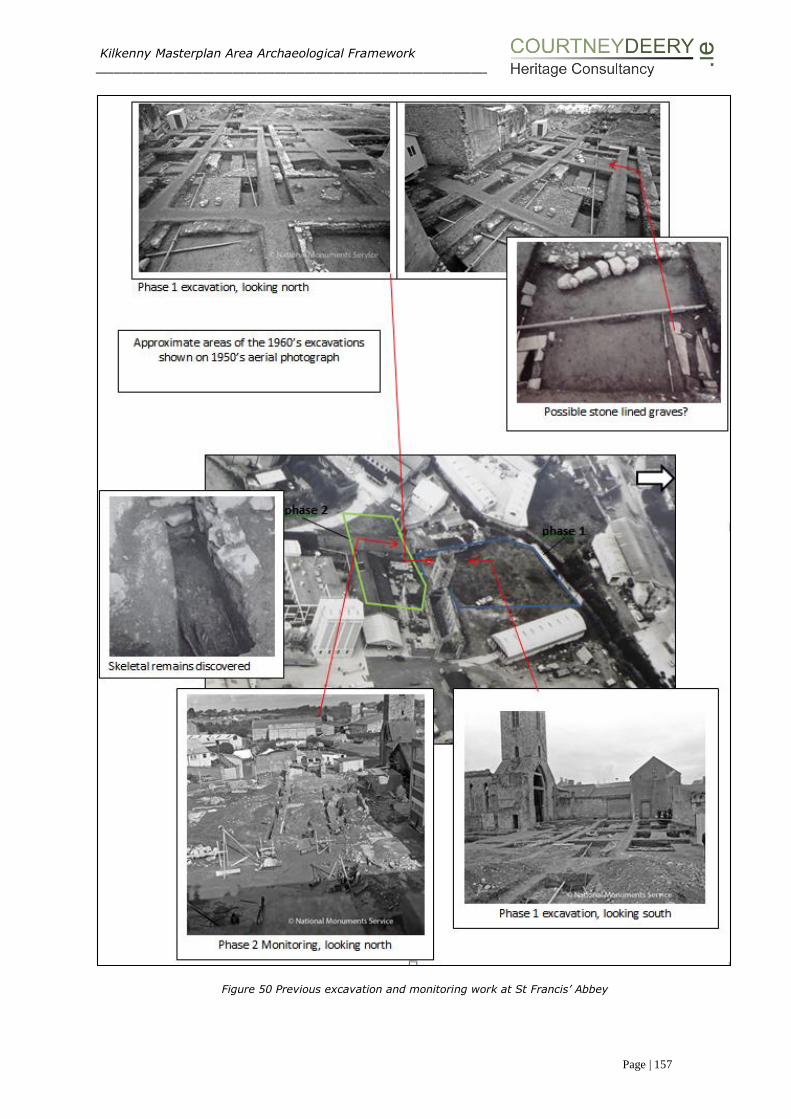
Kilkenny Masterplan Area Archaeological Framework ___________________________________________________________________________________________________
Page | 157
Figure 50 Previous excavation and monitoring work at St Francis’ Abbey

Kilkenny Masterplan Area Archaeological Framework ___________________________________________________________________________________________________
Page | 158
Plate 94 view from the east window Plate 95 Smithwicks yard to the SE of the Abbey
Figure 51 Ordnance Survey manuscript town plan of Kilkenny produced in 184113
13 Provided by Rob Goodbody and taken from the National Archives

Kilkenny Masterplan Area Archaeological Framework ___________________________________________________________________________________________________
Page | 159
Figure 52 Areas identified though research for archaeological investigation
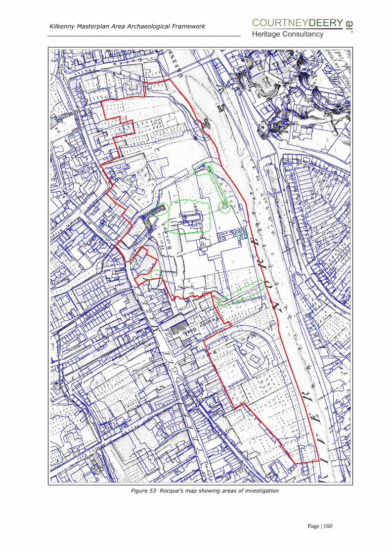
Kilkenny Masterplan Area Archaeological Framework ___________________________________________________________________________________________________
Page | 160
Figure 53 Rocque’s map showing areas of investigation
Kilkenny Masterplan Area Archaeological Framework ___________________________________________________________________________________________________
Page | 161
The Mill Stream
This area now a carpark to the south of the Watergate theatre was revealed through
excavation as the foundations of a medieval rectangular stone building which was
cut by an 18th century mill-race and built upon by later millrace enclosed in a
tunnel14. Bradley has noted in the Kilkenny Town Atlas that this was the site of St
Francis’ Abbey mill.
One new structure is proposed in the central section of the plan area to the east and
south of the Watergate Theatre, building No. 11 (Watergate Theatre), this will
possibly connect to the Watergate Theatre to facilitate the extension and an
improvement of its facilities.
The Brewery
There has been a commercial brewing presence on site for the last 300 years. Historic
maps chart the development of the area and the site has undergone major
redevelopment from the 1960’s onwards with the development of the brewhouse,
maturation building, fermentor block as well as the bottling and kegging plant. Test
excavation of the Fermentor Block took place over 4 phases and the initial phase
revealed a black organic silty clay deposit with a decayed horizontal decayed timber
beam thought to be possibly medieval in date (1.32m below ground level), later
phases revealed possible walls considered to be post-medieval in date. Also within
the brewery complex an organic silt, possibility a medieval reclamation layer was
discovered at the base of an excavated cutting at 2.50m deep. A limestone arch of
a 19th century culvert thought to be adapted from a medieval millstream was exposed
0.8m below ground level (04E0694). Monitoring for an underground ESB cable
revealed a series of 18th and 19th century walls, box drains and culverts a number of
which tie in with Rocque’s map (1758) and the 1st ed 6-inch OS (1839) all were
revealed within 1m below the existing ground level.
Four window samples (WS12, 04, 02, 01) have taken place within this area
(Appendix D). Reinforced concrete and hardcore extends from 0.3 to 0.45 across the
area from beneath the present ground level. The deposits from between 2.2m to
6.2m were interpreted as natural and appear as sand and gravels. Window Sample
1 encountered brown and black silty clays from 0.6-2m bgl., and Window Sample 2
encountered a dark brown black course sandy clay at 0.45-1m and a grey sandy clay
at 1.2-2.2m. Both these samples are located nearer the river Nore and are different
in their make up when compared to Window Samples 012 and 04, these samples
have compact grey brown clay with mortar and occasional red brick from 1.2 – 2.2m
overlain by deposits that include mortar, red brick, angular stones and shell.
Findings to date within the plan area have revealed a series of post medieval walls,
reclamation processes, a possible medieval sterile layer and former millraces now
culverted.
It is proposed to place three new buildings in this central section of the plan area
and retain the brewhouse:
14 Martin Reid 96E0047

Kilkenny Masterplan Area Archaeological Framework ___________________________________________________________________________________________________
Page | 162
Building No.6 (Riverside B) - Overlooks the River Nore on the site of the Bottling
Store which is to be removed.
Building No.7 - Located on the site of the Maturation Building which is to be
removed.
Building No.8 (Brewhouse) - Existing structure to be retained and refurbished
(refer section 4.2.10 and section 6.7).
Building No.9 (Riverside C) - Overlooks the River Nore on the site of the bottling
Store.
Grace’s Castle/ City and County Gaol and Courthouse
Grace’s Castle is known through documentary sources and the Courthouse and Gaol
are shown on historic map sources. The land associated with these structures
extends to the banks of the River Nore in a narrow linear garden plot extending east-
west. This plot of land is located adjacent to the south of the millrace within the
existing brewery complex. It is shown on the 1950’s aerial photograph (Plate 83) as
a vacant plot. Documentary evidence has suggested that there may be buried
defences associated with the earliest phase, Graces Castle, now contained within the
brewery site while the Gaol and courthouse have clearly been separate and distinct
properties as evidenced in Appendix C. Investigations in the form of geotechnical
investigation (Appendix D BH01 and WS11) and excavation for an outfall upgrade
(4m x 7m by 3m deep) (Figures 20, 23) has failed to reveal any features associated
with the Castle. A possible riverine deposit (a dark grey brown silt) was detected
below c.1.5m.
Excavations associated with the Courthouse (which is located outside the Masterplan
area) revealed a rich archaeological area producing over 1000 contexts and over 200
excavated features. Medieval burgage plots were evident orientated both north-
south and east-west and pottery revealed from these features dated from the mid-
12th to 14th century. 23 inhumations were recorded and probably related to felons
executed within the confines of the prison. To date, this excavation report is not
published and the depth of the deposits and how they relate to the Masterplan area
is unknown. What is known from the test excavation report is that a possible
medieval layer was encountered at approximately between 1.30m-1.55m below
current ground level and was approximately 0.8m thick.
As stated in section 6.4, following the demolitions on the DIAGEO site it is proposed
to carry out a systematic bore hole survey to obtain a below ground profile in order
to inform proposals and test excavation where necessary. Investigation to the rear
of Grace’s Castle will seek to establish if there are any defences associated with the
castle and whether or not medieval burgage plots found during the courthouse
excavations extend into this area as well as seeking to identify the historic mill race.
Two buildings are proposed in this area Building No.4 which is located in the
southern section of the Masterplan site abutting the rear boundary of the Courthouse
and Building No.5 (Riverside A) which is located in the southern section of the
Masterplan site overlooking the River Nore on the site of the Bottling Store which is
to be removed.

Kilkenny Masterplan Area Archaeological Framework ___________________________________________________________________________________________________
Page | 163
The Market Yard (former garden plots)
This area of the Masterplan has altered over time changing from burgage plots and
elaborate gardens as shown on the historic maps to an open area used as a market.
Excavations along Bateman Quay have revealed post medieval reclamation
practices, revetment walls and a stone jetty associated with the northern most
teahouse. Both tea houses have been previously archaeologically assessed15 and
conservation measures have been put forward as part of this report. To the east of
the area, along Kieran Street, reclamation deposits overlying organic medieval
material (95E0062, 25-26 St Kieran Street) have been encountered as well as
medieval housing and reclamation practices (98E0167 and 97E0334, Nos 10-13 St
Kieran Street).
To the south of the Masterplan area the land is characterised historically by medieval
burgage plots overlain with historical gardens as shown on the cartographic sources.
Three new buildings are proposed in the southern section of the plan area:
Building No.1 - Located within the Bateman Quay surface car park.
Building No.2 - Located immediately adjoining the Pump House Station.
Building No.3 - Located between the Pumping Station and the Bank of Ireland
building.
15 Licence Refs 01E0554 and 01E0555
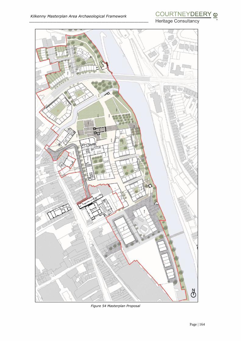
Kilkenny Masterplan Area Archaeological Framework ___________________________________________________________________________________________________
Page | 164
Figure 54 Masterplan Proposal
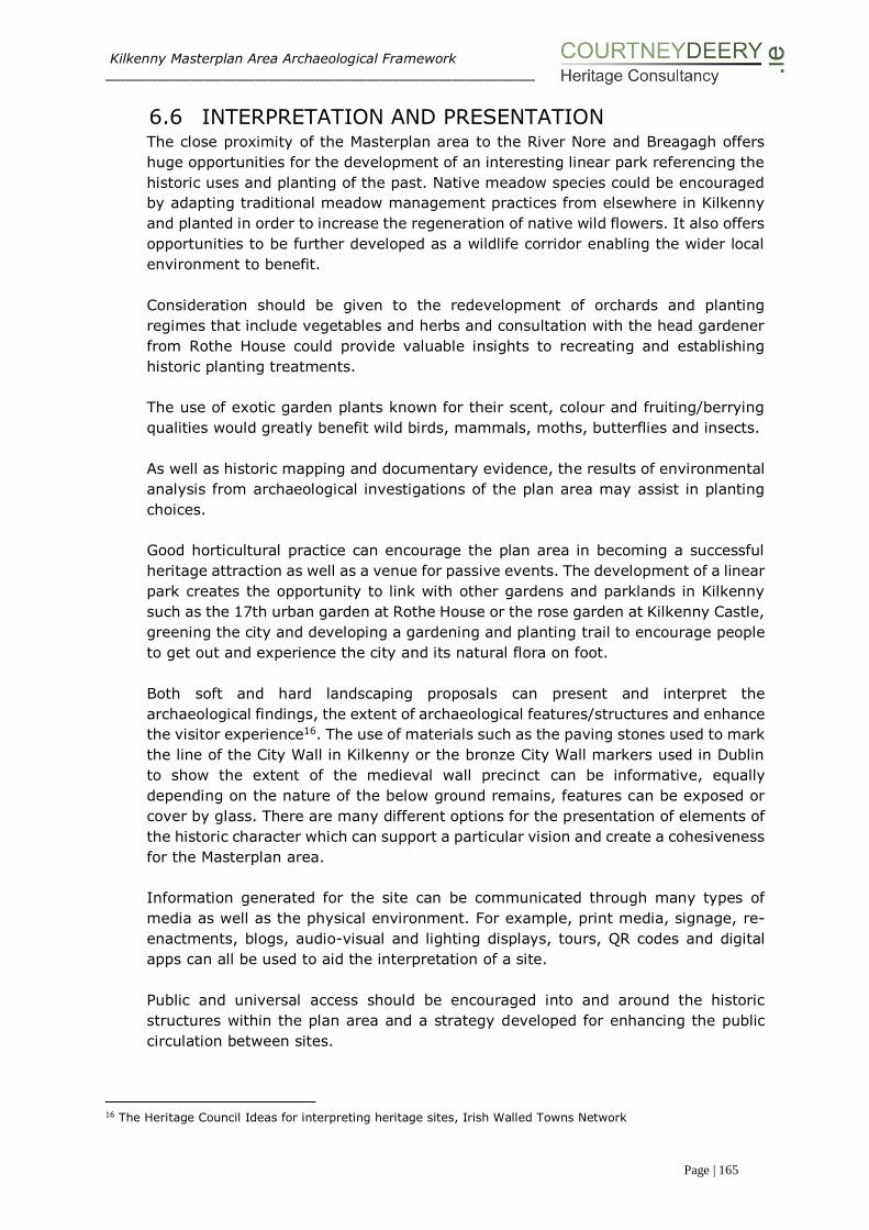
Kilkenny Masterplan Area Archaeological Framework ___________________________________________________________________________________________________
Page | 165
6.6 INTERPRETATION AND PRESENTATION The close proximity of the Masterplan area to the River Nore and Breagagh offers
huge opportunities for the development of an interesting linear park referencing the
historic uses and planting of the past. Native meadow species could be encouraged
by adapting traditional meadow management practices from elsewhere in Kilkenny
and planted in order to increase the regeneration of native wild flowers. It also offers
opportunities to be further developed as a wildlife corridor enabling the wider local
environment to benefit.
Consideration should be given to the redevelopment of orchards and planting
regimes that include vegetables and herbs and consultation with the head gardener
from Rothe House could provide valuable insights to recreating and establishing
historic planting treatments.
The use of exotic garden plants known for their scent, colour and fruiting/berrying
qualities would greatly benefit wild birds, mammals, moths, butterflies and insects.
As well as historic mapping and documentary evidence, the results of environmental
analysis from archaeological investigations of the plan area may assist in planting
choices.
Good horticultural practice can encourage the plan area in becoming a successful
heritage attraction as well as a venue for passive events. The development of a linear
park creates the opportunity to link with other gardens and parklands in Kilkenny
such as the 17th urban garden at Rothe House or the rose garden at Kilkenny Castle,
greening the city and developing a gardening and planting trail to encourage people
to get out and experience the city and its natural flora on foot.
Both soft and hard landscaping proposals can present and interpret the
archaeological findings, the extent of archaeological features/structures and enhance
the visitor experience16. The use of materials such as the paving stones used to mark
the line of the City Wall in Kilkenny or the bronze City Wall markers used in Dublin
to show the extent of the medieval wall precinct can be informative, equally
depending on the nature of the below ground remains, features can be exposed or
cover by glass. There are many different options for the presentation of elements of
the historic character which can support a particular vision and create a cohesiveness
for the Masterplan area.
Information generated for the site can be communicated through many types of
media as well as the physical environment. For example, print media, signage, re-
enactments, blogs, audio-visual and lighting displays, tours, QR codes and digital
apps can all be used to aid the interpretation of a site.
Public and universal access should be encouraged into and around the historic
structures within the plan area and a strategy developed for enhancing the public
circulation between sites.
16 The Heritage Council Ideas for interpreting heritage sites, Irish Walled Towns Network

Kilkenny Masterplan Area Archaeological Framework ___________________________________________________________________________________________________
Page | 166
6.7 REPLACE OR RETAIN All historic monuments will be retained, conserved and sensitively incorporated into
the Masterplan area. Both Kilkenny Development Plan (2014-2020) and The Heritage
Council advocate the use and reuse of existing buildings17. The Brewhouse (built
1960’s) is a structure of industrial and technological importance while the Mayfair
(built 1930’s) and its association with the Ballroom and the Brewery make it
significant from a social perspective. The Brewhouse serves to retain an association
with industry and brewing on site, a commercial activity that has taken place over
the last 300 years.
Creative adaption of each of the above structures could readily enhance their purpose
on site and how they are appreciated, while maintaining an association with the
brewing industry. The reuse and adaption of both the Brewhouse and the Mayfair
would limit further archaeological disturbance in key sensitive areas.
Brewhouse
The Masterplan proposes the retention and reuse of the Brewhouse Building as an
Office Building / 3rd Level Educational Facility / Research & Development Centre. It
is believed that this building is of interest from an industrial heritage perspective and
its retention is appropriate within the overall plan area.
The elevations of the Brewhouse building are very distinctive and are one of the few
expressions of 1960s and 1970s modern industrial architecture to be found in
Kilkenny city. It is proposed to externally insulate the building and replace the
existing single glazed windows with a Crittal or similar steel framed double glazed
window system sympathetic to the original industrial aesthetic.
Mayfair
The Masterplan proposes the retention and reuse of the Mayfair Building as an office
building. A detailed appraisal of the existing two storey building suggests that it is of
little architectural significance internally or externally. What merit the building has
lies in its social heritage.
Consideration should be given to adapting the structure so instead of turning its back
on the City Wall it embraces this historic feature and provides viewing opportunities
to showcase the early defensive system of the city.
The City Wall to the rear of the Mayfair building is partially overgrown with vegetation
and while there is a clear view provided of the structure from Watergate Bridge
(Irishtown) this view is currently dominated by the adjacent Mayfair building on the
south bank and the gable end and other structures (see section 4.2.13 Hop Store)
on the north bank.
With the redevelopment of the Masterplan area there is an opportunity to enhance
the setting of this section of City Wall including considering the pedestrianisation of
the line of the City Wall connecting Watergate and Evan’s Tower and incorporating
17 The Heritage Council, Dublin City Council 2004 report ‘Built to Last: the sustainable re-using of buildings’
Kilkenny Masterplan Area Archaeological Framework ___________________________________________________________________________________________________
Page | 167
these features into the Medieval Mile which is now part of the Ireland’s Ancient
Southeast initiative18.
In accordance to Kilkenny City and Environs Development Plan19, it is an objective
(71) of the County Council:
‘to facilitate and support the implementation of the existing (and any further)
conservation plans’.
The Kilkenny City Wall Conservation Plan seeks to protect, maintain and encourage
the enhancement and setting of the City Wall and riverside defences. Creative
architectural design solutions should be sought that will enable this enhancement to
take place while complementing the redevelopment process.
Maturation Building
As part of the proposed demolition works by Diageo the superstructure of the
Maturation Buildings will be removed. The building is a single-storey concrete
structure that is utilised as a support to 22 large maturation tanks in the brewery.
The structure, while of industrial and technical heritage interest, does not function
as a building without the tanks and while currently retained with in the plan area its
integrity is heavily compromised.
The Masterplan proposes the removal of the Maturation Building. This is a very robust
reinforced concrete single storey building of approximately 950 sq.m. with the roof
slab effectively acting as a transfer slab. The nature of the existing concrete framed
structure unfortunately does not lend itself to reuse or conversion to an alternate
use in the long term.
Historic Monuments
Historic monuments namely the tea house, Evan’s Tower and wall walk, the Bull Inn
wall and the mill will all be appropriately incorporated and conserved as part of the
Masterplan process.
The Mill
The Masterplan proposes the retention of the Mill and allows for a visual link to be
established between it and both Evans Tower and the Tea Houses located to the
south. This is a protected structure and of interest from an industrial heritage
perspective. The newly created linear park along the western bank of the River Nore
will facilitate public access to the structure in the future.
The removal of vegetation is required in order to carry out a conservation survey to
establish the current condition and how best to conserve this ruinous structure.
Evan’s Tower
The Masterplan proposes to retain Evans Tower and the adjoining Wall Walk. It is
proposed to initially stabilise all upstanding remains as they are. The Masterplan
18 Failte Ireland April 2015 19 Kilkenny City and Environs Development Plan 2014-2020 Section 7.3 Built Heritage pg 114

Kilkenny Masterplan Area Archaeological Framework ___________________________________________________________________________________________________
Page | 168
proposes the excavation of ground immediately adjoining the tower to allow a full
understanding of the structure for the conservation process.
The Masterplan is also proposing two alternate future uses for this structure:
(a) A local new build is proposed to support the modern intervention of steps and
deck and guard rails to allow the tower to be used as a viewing point by the
general public.
(b) Stabilise all upstanding remains, rebuild the vaulting and stone steps and wall
walk so that the tower can be used as part of a public amenity as close to the
original form as possible.
Sacristy
The Masterplan proposes to retain the Sacristy in place as this is fundamental to the
understanding of the layout of the Abbey.
The Sample Rooms
While acknowledging that the Sample Rooms are listed in the NIAH as being of
architectural regional interest the Masterplan proposes to remove this structure as it
blocks views of the abbey from the south and disturbs the understanding of the
relationship between the Choir, Sacristy and Cloister. Based on reviewed records it
is anticipated that the west elevation of the Sample Rooms wall is located on human
remains which it is proposed to investigate, and fully record fully as part of the wider
excavation of the area.
Bull Inn
The Masterplan proposes the provision of a new street along the line of the original
Bull Alley. The existing wall of the Bull Inn will be retained and stabilised as
necessary.
Tea Houses The Masterplan proposes the retention of both Tea Houses. The first will continue to
be used as a commercial premises. The second Tea House, while currently derelict,
will be renovated to facilitate its use as a commercial premises.
Other Structures
The Masterplan is cognisant of the fact that the Truck Wash Building, the Bottling
Store, Hop Store and Kegging Store are to be removed by Diageo in advance of
Kilkenny County Council taking possession of the site. It is acknowledged that these
are utilitarian structures of no architectural or heritage value.
6.8 NEW STRUCTURES
Kilkenny County Council seeks continually to develop the city as a centre of
excellence for creativity in all sectors whilst ensuring the continued protection and
enhancement of the city’s magnificent built and natural heritage, its thriving cultural
and artistic base and its strong and dynamic services economy. This will ensure that
the city will be a vibrant and attractive place for people to visit, work and live in.
In response to these goals the following objectives are fundamental to achieving
that vision;

Kilkenny Masterplan Area Archaeological Framework ___________________________________________________________________________________________________
Page | 169
• Integration of former Smithwick’s Brewery site and quayside into the
medieval city.
• Redevelop and regenerate the former Smithwick’s Brewery site as a
modern, vibrant and permeable complement to the medieval core of
Kilkenny City which will consolidate the city’s role as a regional hub.
• Creation of a quayside quarter which addresses the River Nore.
• Establishment of a mixed use Creative Quarter which enhances the Life of
the City in Economic, Commercial and Social terms.
• Development of Kilkenny as a location for Creative Industries, Research and
Development, Incubation Clusters, University Faculties and Cultural
Institutions.
• Development of Kilkenny as Ireland’s Environmental centre of excellence
through regeneration of the quayside quarter.
• Establishment of ‘Green City’ Kilkenny as a model for Irish and European
cities and communities.
• Allow for the Government ‘Smarter Travel’ initiative published in 2009 and
the ‘Mobility Management Plan’ adopted for Kilkenny City.
It is the Council’s aspiration, to create an urban design layout and architectural
framework to provide a new urban mixed use quarter for Kilkenny City in a socially
inclusive and sustainable manner, which will:
• Have a well-defined sense of place.
• Have a healthy mix of uses including educational, employment, residential,
enterprise development, recreational and community uses.
• Have suitable short to medium term uses on site while development
proposals are evolving over time.
• Encourage sustainable transport with safe and direct routes for pedestrians
and cyclists and provide for the availability of public transport into the city
centre and connections with adjacent areas.
• Develop a framework for providing a high standard of architecture and urban
design which will induce a dynamic/vibrancy to the character of the area.
• Draws from the unique natural, cultural and built heritage of the area and adds
to that context.
• Have a high visual and varied environmental quality aimed at enhancing
quality of life.
• Promote an awareness of the principles of sustainability in architectural
design to produce buildings that are benign in the use of resources while
being attractive and aesthetically pleasing.
• Be substantially achievable in a 15 to 20 year time frame.
To this end several new buildings (section 6.5) are proposed within the Masterplan
area and they are designed to be consistent with the flood assessment guidelines.

Kilkenny Masterplan Area Archaeological Framework ___________________________________________________________________________________________________
Page | 170
6.9 PHASING At this interval it is proposed that the following phases will form the redevelopment
of the Masterplan area, this may be subject the change:
Immediate and short term works
Vacant site post DIAGEO Brewery clearance.
Proceed with archaeological site investigation.
Development of a linear park:
Kilkenny County Council have committed to stabilise, protect and conserve the
historic structures of Evan’s Tower, the Tea House and the Mill.
Archaeological investigation will take place in order to establish the location of below
ground remains including St Francis’ well, precinct walls, burial grounds and possible
additional towers. Once the concrete slab is removed it may be possible to carry out
geophysical investigation as well as excavations. This work will take place under
Ministerial Consent. No excavation works are anticipated along the River Nore, which
will necessitate archaeological investigation, as it is proposed to build up the existing
bank.
Development of buildings The development of the proposed buildings (1-14) will occur in a phased approach
with the appropriate licenced archaeological investigation taking place in tandem
with the proposed development. It is proposed to develop the northern section (north
of the KCAS area) of the plan area first, with the immediate redevelopment of the
Mayfair and the Brewhouse, south of the Breagagh. Archaeological work associated
with the Mayfair will be under Ministerial Consent due to the proximity of the city
wall. No ground breaking works are anticipated in association with the
redevelopment of Brewhouse.
Long term works (5 year plan)
Kilkenny County Council have committed to the reinvestigation of OhEochaidhe’s
excavation as part of a large scale research project.
6.10 CIVIC ENGAGEMENT & MANAGEMENT TOOLS The development of a Masterplan historic and archaeological paper and digital
archive would assist in the transfer of information from one phase to the next and
provide a centralised record for all consultants to use and for the general public and
interested stakeholders to review.
The development of a Geographical Information System (GIS) could integrate the
information gathered for the purpose of this report and add it to the KKAP GIS
thereby building up a digital record of all archaeological investigations in Kilkenny.
Kilkenny County Council could manage and update the system.
Kilkenny Masterplan Area Archaeological Framework ___________________________________________________________________________________________________
Page | 171
The Heritage Council in collaboration with the four heritage offices for Dublin as well
as the DAHG, and the National Museum have developed the Dublin City and County
Archaeology GIS project20. The objectives of the project was to:
Develop a systematic and comprehensive GIS dataset of licensed
archaeological activity reports and licence numbers issued in order to
streamline access to archaeological information by the profession,
professional and non-professional users.
To raise awareness and facilitate spatial analysis of data, through the web-
based presentation/dissemination of information at local, regional and
national levels.
If the development of a GIS system and protocols for meta data for the Masterplan
area are based on the above named project, the information could be integrated in
a seamless manner and form part of a new national information dataset on
excavation. Liaison with the Heritage Council could advance this proposal.
6.11 GOVERNANCE All archaeological work to take place in the vicinity of St Francis’ Abbey, Evan’s Tower
and the City Wall will have to be completed under Ministerial Consent.
Archaeological investigation and monitoring in other areas of the site will be carried
out under archaeological licence as all work is located within the Zone of
Archaeological Potential for the historic town of Kilkenny.
The Masterplan is a land use and urban design document. While considerations
relating to long term ownership and funding are outside the scope of the brief it is
important to highlight that it is a key issue in relation to funding archaeological
investigation and determining control measures for the proposed design. This is an
opportunity to set a model in urban regeneration provided that the governance and
property control of this site is placed within a robust framework. It is anticipated that
the cost of carrying out archaeological excavation of St Francis’ Abbey will be
significant. It is proposed that funding should be sought from Government special
funding and EU sources.
While the plan does not deal with the delivery methodology for construction of the
various elements into the future, or the setting out of procurement mechanisms or
allied funding, Council members should be made aware of any cultural heritage or
archaeological funding and compliance issues when deciding on governance issues.
6.12 COLLABORATION
Partnerships with academic institutions that have an interest in the site and projects
such as the Monastic Ireland – A guide to Ireland’s Medieval Past developed by the
Discovery Programme should be considered in order to archaeologically investigate
the site in a strategic manner.
20 CDHC Ltd and Compass Infomatics Ltd were the consultants engaged on the project.

Kilkenny Masterplan Area Archaeological Framework ___________________________________________________________________________________________________
Page | 172
These partnerships could assist and encourage in the development of academic
research programmes that would add to the knowledge and prestige of the plan area
and the historic features and monuments within it.
The Irish Walled Town Network have been involved with the management,
conservation and enhancement of historic walled town in Ireland since 200521. Active
liaison should be promoted with the network and their international counterpart the
Walled Towns Friendship Circle.
In terms of physical conservation works collaboration with the OPW and the skilled
crafts people that they are training through their newly commissioned apprentice
scheme should be sought.
Development of a strategy for enhancing tourist and public circulation within the plan
area and link in with existing initiatives such as the Kilkenny’s Medieval Mile and
Ireland’s Ancient East.
As the plan progresses provision should be made for further consultation with
stakeholders and statutory consultees.
Available funding and heritage grants while limited nowadays should be explored
immediately.
21 The sharing of information through the Network informed the manner in which the works to Talbots Tower, a defensive 13th century mural tower in Kilkenny were undertaken. Also the walled towns grant funding ensured
that the project was carried out and completed on a phased basis.

APPENDIX A: St Francis’ Abbey Historic Sources
In 1544 a Grant of King Henry VIII of the Black and Grey Friaries and their
possessions to the Soveraigne, Burgesses and Commons of Kilkenny.
CR/C9 – Copy of a translation of a Grant made by King Henry the 8th to the
Sovereign- Burgesses and Commons of the Town of Kilkenny of the Black and Grey
– Friaries and their possessions in the 35th year of his Reign
‘And the whole House [Satis] site? boundary ambit and precincts of the late
Monastery or House of Franciscan Friars of Kilkenny, aforesaid in the said County,
Commonly called the Grey Friars of Kilkenny. And the whole Church Belfry
Dormitory, Hall, Chapter House, three Chambers a Kitchen, a House called the
Garnen with three cellars under same House, and an enclosure within the Site of
said late monastery or House, and all Edifices Messuages Gardens Lands
tenements Orchards and heredutaments whats occurs with this appertaining in or
within the Site Bounds Circuit and precincts of said late Monastery or House’.
CR/C18 – Letter Patent of Charles I (1640-1693)
‘... also all the houses scite ambit and precincts of the late Monastery or house of
Franciscan Friars of Kilkenny aforesaid commonly called the Grey Friars of Kilkenny
Late in the sais County and now in the County of the City of Kilkenny and all the
churches belfries Domitories halls the Chapter House three bedrooms one kitchen
a house called the garner with three cellars under said house and an enclosure
within the said Scite of said Monastery or house of Grey Friars and also all the
house edifices gardens orchards lands tenements and hereeditaments with their
appurtenances within the said Scite ambit and precincts of the said late monastery
or house of Grey Friars and all the castles messuages lands tenements mills weirs’.
CR/H 2 relates to a volume entitled ‘Folio Volume containing entries of leases and
fee farms No 13’ entries appear under the headings; ‘The Comon Lande, St. John’s
Lande, the Freren Landes’ dating to 1500-1678. The document discusses the
leases on Grey Friar Abbey amongst other matters.
The following are leases dating from 1592 that relate to land holdings in and
around St Francis’ Abbey then referred to as ‘Grey Friar Abbey’:
CR/I 24 - 18th July 1592 Lease past to John Rothe Fitz Jerkin, Burgess of two
messuages, part of the ‘ Grey Fryers land’ for 61 years at 7 shillings and 4 pence.
CR/I 30 – 4th July 1595 Lease past to Katherin Ronan of Kellis (Kells) single
woman, Patrick Gaffney her son, Walter Johns of Kellis and Margaret Ronan his
wife, of a messuage and garden situated in the precinct of the late Monastery or
house of the Grey Friars of Kilkenny, together with a ‘little void or wast place’
situated between the said house and the west end of the abbey, for 58 years at 1
shillings and 8 pence per annum.
CR/ I 60 - 19th October1632 Lease past to Richard Roth Fitz Edward, Alderman of a
messuage a void room or garden situated within the precinct of the late dissolved

house or Franciscan Abbey of the city, together with the cloister of the abbey, for
99 years 4 score and 19 years.
CR/I 103 - 4th July 1753 Lease past to William Archbold, Esquire, of the Franciscan
Abbey situated in St Mary’s parish for ever at the yearly rate of 4 pounds.
‘Known by the name of the Franciscan Abbey not in the possession of the said
William Archabold Smithwick Lying and being in the Parish of St Mary in the said
City Together with all and Singular the houses Buildings Rights Members
Appurtenances Privileges and Advantages.... To hold the said Houses, Gardens,
Orchards and Buildings and every part and parcels thereof with the
appurtenances’.
CR/H6 relates to a book that documents - A Concise History of the Corporation of
Kilkenny with Catalogues of its Ancient Charters, Grants and Minute Books 1873.

Appendix B Irish Historic Towns Atlas Kilkenny Gazetteer
The following information was extracted from the Irish Historic Towns Atlas Kilkenny,
Topographical Information by John Bradley (2000). It relates to features noted to lie
within the Masterplan area. These structures/features and associated references are
included in a gazetteer format.
Mills
St Francis’ Abbey Corn Mill, Water gate E., part of St Francis’ Abbey Brewery (q.v.)
Grefryrs Mylle 1541 (Extents Ir. Mon. possessions, 200). Edmund Smithwick, oatmeal
miller, 1846, 1856 (Slater). Corn mill 1850 (Val. 1), 1858-1910 (Val. 2).
Mill race, from Breagagh R., Water Gate W. to River Nore: water course, property of St
Francis’ Abbey (see 11 Religion) 1540 (Carrigan, iii, 107); 1758 (Rocque); mill race
1841-1946 (OS).
Forges and smithies
Horse Barrack Lane N., in part of former starch factory (q.v.) 1869-1901 (Val. 2), 1871
(OS). Horse Barrack Lane, site unknown. Peter Dowling 1884 (Bassett, 141). Horse
Barrack Lane, site unknown. Patrick Hennebery 1884 (Bassett, 141).
Distilleries
Parliament St E., on site of later St Francis Abbey Brewery (q.v.).1824 (Pigot). Distillery,
malt house, corn stores and water mill 1827 (KM 24.1.1827). Incorporated in St Francis’
Abbey Brewery (q.v.) in 1827 (Halpin, 587). Location unknown. Rectifying distillery 1829
(KM 12.8.1829).
Breweries
St Francis Abbey Brewery, Parliament St E., in S. part of St Francis’ Abbey (see 11
Religion). St Francis Abbey Brewery, opened by Edmund Smithwick incorporating earlier
distillery (q.v.) in 1827 (Halpin 586-7); 1831 (KJ 1841; Smithwick Brewery 1871 (OS).
St Francis’ Abbey Brewery, 4 malt houses, saw mills, 2 steam engines, water wheel 1884
(Egan, 142-3). St Francis’ Abbey Brewery 1900-46; brewery 1983 (OS) St Francis’
Abbey Brewery 2000
Woollen manufactories
Chancellor’s Woollen Factory, Vicar St E. Chancellor’s Mills 1830; Chancellor’s Mills, grist,
tuck and spinning mills 1841 (KJ 24.31830, 31.7.1841) Chancellor’s Woollen Factory
1841; woollen factory 1871 (OS). Closed in c. 1881 (Val. 2). Incorporated in chancellor’s
Mill (q.v.) by 1946 (OS).
Starch manufactories:
Parliament St E., associated with St Francis’ Abbey Brewery (q.v.). 1841 (OS), 1870;
closed in c. 1882 (Val. 2).

Services
Bull Inn, St Canice’s Place S. (04306335). Bulles Inn, opened in 1602 9Prim, 1862, 177).
Closed by 1833 (KJ 9.2.1833). In ruins 1862 (Prim 1862, 1770). Part extant 2000.
Transport
Irishtown Bridge, Breagagh R., Irishtown to Water Gate (04406250). Bridgec. 1207;
Cotterell’s Bridge 1269, 1352 (Berry, 124; Liber primus, 25). Repaired in 1568
(Ainsworth, 33). Widening ordered in 1759 (KCM 5.4.1759). Bridge at Water Gate 1833
(KJ 27.2.1833). Unnamed 1841-1999 (OS) Irishtown Bridge 2000.
Bridge, Breagagh R., King St to St Francis’ Abbey, associated with Grey Freren Gate.
Said to have been built before 1540 (Hogan, 1884, 393).
Residences
St Francis’ Abbey (house), Parliament Street E., in St Francis Abbey brewery. Smithwick
residence 1837 (KJ 15.11.1837).
Streets
Horse Barrack Lane ‘Road leading to monastery of the Friars Minor, 1498 (Liber primus,
103). Graiefreryn Street or Lane 1615 (Healy 389). Lane to the horse barracks 1715 (CB
17.9.1715). Horse Barrack Lane 1786 (FLJ 22.7.1786), 1835; St Francis Street 1830; St
Francis Abbey Street 1840 (KJ 29.4.1835, 4.12.1830, 17.6.1840). Horse Barrack Lane
1841 (OS).
Religion
St Francis Abbey, Water Gate E. Franciscan friary founded by Richard Marshal in c 1231-
4; new chancel built in 1321; new cemetery added in 1331; chancel extended in 1347;
friary: church, belfry, barn, cemetery, Dr Clinton’s chamber, garret chamber, granary
with 3 cellars, kitchen, orchard with 2 small closes containing 2 acres, 1 water course,
suppressed in 1540; granted to mayor and citizens in 1543 (Carrigan ii, 104-10).
Reoccupied in 1553, vacated in 1559, reoccupied by 1599; new friary built in 1612
(Jennings, 146, 176). Chamber, chapter house, choir, cloister, Grey Freren park, kiln,
nave, steeple, void room c. 1633 (Ledwich, 409-10). Closed in 1650 (Jennings, 180).
‘Mary’ Abbey c. 1655(DS). Assigned as site of cavalry barracks in 1698 (CB 16.9.1698).
Franciscan Abbey 1708 (Pratt). Roof and gallery timbers removed in c. 1719 (KCM
19.9.1719). St Francis Abbey 1758 (Rocque). Church nearly entire, unroofed with tower
1837 (Lewis, ii 115). St Francis’ Abbey, in ruins 1841-1999 (OS). Remains of chancel,
tower, vaulted chamber 2000.
St Francis’ Well: c. 1633 (Ledwich, 410), 1837 (Lewis, ii, 115); spring 1841; St Francis
Well 1871-1946 (OS); built over by 1977 (Lanigan and Tyler, 26).
The Franciscan friary lay within a one hectare precinct occupying the north-eastern
corner of Hightown, bounded on the north by the Breagagh River and on the east by the
Nore. The site is low-lying and on soft alluvial soil subject until recently to sever winter
flooding. Referenced to the ‘angled lane leading to the friars Minor’ suggest that access
to the church during the medieval period was via Jenkin’s Lane, now the southern part of
The Ring, while a bridge over the Breagagh gave access, through Grey Freren Gate, from
Irishtown. The founder appears to have been Richard Marshal, Lord of Kilkenny from
1231 to 1234. But the first definite reference to the Franciscans at Kilkenny, does not
occur until 1245. The surviving remains consist of the thirteenth- century choir with an
east end added in the 1320’s and a belfry started in the 1340s but left unfinished until
the fifteenth century because of the Black Death.
Defence
St Francis’ Tower, Parliament street E. (06106330). Tower, site of, 1900-46; built over
by 1983 (OS).
Evan’s Turret, Horse Barrack Lane N. Turret 1841; unnamed 1871-1999 (OS). Extant
2000.
Horse barracks, Water Gate E. Built in c 1700 (CB 16.9.1698, 5.4.1700); 1758 (Rocque).
Extended in 1758 (KCM 20.5.1758); 1787 (FLJ 24.2.1787). Closed in c. 1800 on
construction of infantry barracks (q.v.) Old cavalry barracks, sold to corporation for 200
in 1829 (KCM 12.5.1829). Old horse barracks 1841 (OS), 1872 (Val. 2) in ruins 1900;
demolished, replaced by ballroom by 1946 (OS).
Gardens
Grey Freren park, Water Gate E., associated with St Francis Abbey, site unknown c.
1633 (Ledwich 409-410).
Orchard
Chancellors orchard, Vicar St. E. (04956410). 1654 (CS), 1781 (Ledwich 486, 1843 (KJ
17.5.1843).
Appendix C County and City Gaol Records
Inspector-General’s report of the state of the prisons of Ireland for the year
1807-1808
Redmond Duffy local inspector and Rich Elseworth gaoler (360)
‘A new gaol was begun for this county, under the superintendence of Mr Robertson, the
architect, about 5 years ago, the work is nearly finished… supposed … be fit for the
reception of prisoners about mid-summer and may serve as a model for strength and
accommodation to the other counties in Ireland’.
Thomas Hutchinson local inspector, William Montgomery gaoler (361)
‘This gaol is kept clean and regular, the inspector is very attentive and the gaoler
humane and vigilant, when the new county gaol is occupied, the corporation should
purchase the old county yard, and add it to the airing ground for the city prisoners. The
walls of it should be raised’.
Report on the General State of Prisons of Ireland 1818 App.
Thomas Hutchinson local inspector, Thomas Tallant gaoler
‘I visited this gaol in January 1818, it had a disorderly appearance, occasioned by the
county yards being left in an unfinished state, the debtors are obliged for air and
exercise to use the female court, which often occasions improper conversations to pass
between the sexes. A wall is absolutely necessary to mask the adjoining brewery; until
this is built the gaol cannot be considered secure. The cells and rooms of the prison were
clean, and the gaol very healthy, but the halls were certainly dirty, by reason of the
courtyards not being flagged or gravelled’.
First Report of the Inspectors General on the General State of Prisons of
Ireland 1823… ‘If the wall recommended in the yard adjoining the brewery is built the
lasses will have their separate yards…..’
Second Report of the Inspectors General on the General State of Prisons of
Ireland 1824… ‘The situation of this gaol is indifferent, it being the ground floor of the
county and city courthouse, it is however more open to the rear than would appear by
viewing it from the street, and with a well regulated system of yards, may afford air
sufficient for the health of the prisoners. Stones have been drawn to build a wall
recommended in my last report and before the erection thereof the grand jury propose
to employ the prisoners in breaking stones and laying a solid foundation in the yards for
a dry gravelling floor.
Third Report of the Inspectors General on the General State of Prisons of
Ireland 1825 recommendation to build the walls some feet higher to prevent escape
also to erect a chapel and infirmary which the law requires.
Eight Report of the Inspectors General on the General State of Prisons of
Ireland 1830 This building shall be converted into a female prison – house of
correction.

Tenth Report of the Inspectors General on the General State of Prisons of
Ireland 1832
‘There is no boundary wall and the yard is surrounded by buildings giving every facility
to escape………’
In subsequent years, the gaol is described as being not fit for purpose.
In documented leases the land to the rear of the court house is described as consisting
of the ‘shed, yard and garden behind Grace’s old Castle, with the passage coming into
the yard (9th March, 1840 from William Hawkesworth to Sir Jonah Wheeler
(Commissioners appointed by the Grand Jury of the County of Kilkenny for the purpose
of purchasing or renting premises for building of new Court-houses and Prisons in said
county, pursuant to the provisions of the Acts of 7th George IV).
The following table details sources relation to Grace’s Castle, City and County Gaol and
Courthouse
Location Dates Sources Date of
Source
Comment of source
Grace’s Castle
[Parliament
Street East]
c. 1211 Ledwich 1804 William Grace (le Gras)
builds castle
1566 Calendar of Patents of
Elizabeth Ireland. 1566
[Chk list of buildings
owned by Corp. in Ms]
1566 [Ownership transfer to
Kilkenny corporation as goal
(see note*below)]
1678 Ormonde Leases 1678 Grace’s Castle [leased to
High Sheriff]
1697 Ormonde Deeds 1830 [back of Grace’s Castle let
to Richard Connell]
c. 1708 Pratt 1708 ‘Grace’s Castle and county
Gaol”
1786 Finn’s Leinster Journal 9/9/1798 ‘Grace’s old castle’
April 1798 Neely +
Finn’s Leinster Journal
1989
1798
[A meeting of the
magistrates held at Grace’s
Old Castle]
15th January
1828
The presentments of
Grand Jury of the
county of Kilkenny
1833 ‘A meeting if the
magistrates held at Grace’s
Old Castle.’
1831 Kilkenny Journal 26/10/1831
1837 Lewis 1837 ‘The courthouse, called
Grace’s Old Castle’ [ city
and county-at-large courts]
1841 Ordnance Survey 1841 ‘Grace’s old Castle or
County Courthouse. City
Gaol’
County Gaol
[Parliament
Street East]
1691 Rental 1691 Grace’s Castle/county gaol
Unknown date
pre-1708
Ledwich 1804 William[le Gras] erected a
castle in the city; this old
building, some years ago,
was pulled down and a court
house and prison erected on
its site at the expense of the
county
r 1780-1807 Pratt 1708 ‘Grace’s castle and county
Location Dates Sources Date of
Source
Comment of source
Gaol’
1735 Kilkenny Corporation
Minutes
24/9/1735 ‘County Gaol’
1758 Rocque Map 1758 ‘County Gaol’
1781 Samuel Byron Map 1781 ‘County Gaol’
1800 Tighe 1802 ‘To be closed’
Court house
[Parliament
Street East]
1752 Pococke 1891 [County courthouse and
gaol being built]
1756 Watters 1875 ‘county courthouse’
1786 Finn’s Leinster Journal 9/9/1786 ‘County courthouse’
1789 Finn’s Leinster Journal 6/5/1789 [used as] ‘Theatre’
1790 Ni Chinneide and de
Montbret
1974 A new prison is being built.
1792 Finn’s Leinster Journal 9/10/1792 ‘New gaol’ + ‘some plans of
material service to the court
house’
9th October
1794
British Association
[2ndary] Carrigan
1878
1884
‘First Assizes and quarter
sessions for the city at city
courthouse’
1795 Inspector- General of
Prisons report + Tighe
1796
1802
[possibly at Parliament
Street End as Old Tholsel
demolished 1795 see note
†] ‘City gaol built’ [on model
of county gaol]
1807 Tighe
Inspector-General’s
Report
+ Lewis
1802
1807 +
1837
[old county gaol (+
courthouse) ‘becomes City
Gaol’ (+courthouse)] [new
county gaol (architect
William Robertson) opens in
summer 1807 at Stephen
Street West Kilkenny Begun
1802]
1807 Inspector-Generals
reports
1808 [city and (old) county gaol
yards in proximity on site at
Parliament St.]
1807 Accounts of
presentments passed
by the Grand Juries
1807 ‘Improvements done to the
city gaol’ [£120]
1822 Brewer +
Kilkenny City
Presentments
1823 +
1830
‘Recently completed by Mr.
Robertson, the architect’
1823-1824 Inspector- General’s
Report
Pigot
1823 + 1824 [court house above city
gaol] ‘ground floor of city
and county courthouses’
1841 Ordnance Survey 1841 ‘Grace’s old Castle or
County Courthouse. City
Gaol’ [1841 OS including
debtors airing ground,
women’s airing ground.]
1843 Inspector-General
Reports
1843 [proposals to amalgamate
county and city gaols under
consideration] ‘£48 5s for
repairs. 1 kitchen lately
built. 16 cells; 2 rooms for
females; 5 dayrooms; 3
yards; 2 rooms used for an
hospital.’
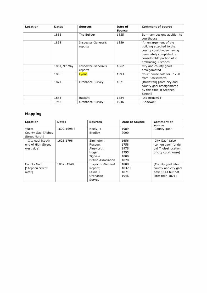
Location Dates Sources Date of
Source
Comment of source
1855 The Builder 1855 Burnham designs addition to
courthouse
1858 Inspector-General’s
reports
1859 ‘An enlargement of the
building attached to the
county court house having
been lately completed, a
considerable portion of it
embracing 2 stories’
1861, 9th May Inspector-General’s
reports
1862 City and county gaols
amalgamated
1865 Lyons 1993 Court house sold for £1200
from Hawksworth
1871 Ordnance Survey 1871 [Bridewell] [note city and
county gaol amalgamated
by this time in Stephen
Street]
1884 Bassett 1884 ‘Old Bridewell’
1946 Ordnance Survey 1946 ‘Bridewell’
Mapping
Location Dates Sources Date of Source Comment of source
*Note
County Gaol [Abbey
Street North]
1609-1698 ? Neely, +
Bradley
1989
2000
‘County gaol’
† City gaol [south
end of High Street
west side]
1626-1796 Simington,
Rocque.
Ainsworth,
Hogan,
Tighe +
British Association
1656
1758
1978
1795
1800
1878
‘City Gaol’ (also
‘comon gaol’ [under
old Tholsel location
of city courthouse]
County Gaol
[Stephen Street
west]
1807 -1948 Inspector-General
Report;
Lewis +
Ordnance
Survey
1808
1837 +
1871
1946
[County gaol later
county and city gaol
post-1843 but not
later than 1871]

Appendix D: Detailed Results of Window Samples, Boreholes and Test Pits Window Samples
WS01
(Inspection
Pit)
Pit dimensions:
1.05m x 0.42m x 1.3m
Depth Description Interpretation
0.0m-0.3m Re-enforced concrete Modern surface.
0.3-0.6m Brown silty clay with c. 80% rounded
stones
Modern fill.
0.6-1.3m Black silty clay with round and
angular-shaped stones. Inclusions of
mortar, red brick fragments.
Early modern fill material.
WS01
(Borehole)
Dimensions:
100mm
Depth Description Interpretation
1m-2m Black silty clay with round and
angular-shaped stones. Inclusions of
mortar, red brick fragments
Early modern fill material.
2m-3m Compact grey clay Natural
3m-4m Compact orange clay (upper 0.5m);
sand and gravels (lower 0.5m)
Natural
4m-5m Sand and gravels Natural
5m-6m Sand and gravels Natural
WS02
(Inspection
Pit)
Dimensions:
0.94m x 0.48m x 1.m
Depth Description Interpretation
0.0m-0.45m Re-enforced concrete and hardcore. Modern surface
0.45m-1m Dark brown black coarse sandy clay
with occasional red brick fragments
and mortar.
Early modern made-up
ground
WS02
(Bore Hole)
Dimensions:
100mm
Depth Description Interpretation
1.2m-2.2m Grey sandy clay with mortar(1.2-
1.7m); grey brown clay (1.7m-2.2m)
Early modern made-up
ground.
2.2m-3.2m Grey brown clay. Natural
3.2m-4.2m Grey brown clay. Natural
4.2m-5.2m Sand and gravels. Natural
5.2m-6.2m Sand and gravels. Natural
WS03
(Inspection
Pit)
Dimensions:
0.93m x 0.42m x 1.2m
Depth Description Interpretation
0.0m-0.3m Re-enforced concrete and hardcore. Modern surface
0.3m-0.6m Loose grey brown clay sand with
rounded stones (80%)
Modern surface
0.6m-0.8m Concrete Modern fill
0.8m-1.2m Black sandy clay with red brick
fragments, mortar.
Early modern made-up
ground.
WS03 Dimensions:

(Bore Hole) 100mm
Depth Description Interpretation
1.2m-2.2m Grey sandy clay with mortar(1.2-
1.7m); grey brown clay (1.7m-2.2m)
Early modern made-up
ground.
2.2m-3.2m Grey brown clay. Natural
3.2m-4.2m Grey brown clay. Natural
4.2m-5.2m Sand and gravels. Natural
5.2m-6.2m Sand and gravels. Natural
WS04
(Inspection
Pit)
Dimensions:
0.9
m x 0.48m x 1.2m
n/a
Depth Description Interpretation Finds
0.0m-0.4m Re-enforced concrete and
hardcore.
Modern surface N/A
0.4m-1.2m Grey brown coarse sandy clay
with small round stones.
Frequent red brick and
mortar, shell
Early modern
made-up
ground
Clay pipe
stem; animal
bone.
WS04
(Bore Hole)
Dimensions:
100mm
Depth Description Interpretation Finds
1.2m-2.2m Light grey clay with red brick
fragments and mortar.
Early modern
made-up
ground
None.
2.2m-3.2m Grey sandy clay. Natural None
3.2m-4.2m Sand and gravels Natural None
4.2m-5.2m Sand and gravels. Natural None
5.2m-6.2m Sample Fail Natural None
WS05
(Inspection
Pit)
Dimensions:
1m x 0.48m x 1.2m
Depth Description Interpretation
0.0m-0.3m Re-enforced concrete and hardcore. Modern surface
0.30m-
0.55m
Grey clay with mortar, red brick and
angular stones
Modern made-up
ground
0.55m-1.2m Grey brown clay with occasional
mortar and red brick fragments.
Early modern made-up
ground
WS05
(Bore Hole)
Dimensions:
100mm
Depth Description Interpretation
1.2m-2.2m Compact grey brown clay with mortar
and occasional red brick
Early modern made-up
ground.
2.2m-3.2m Very compact green grey clay. Natural
3.2m-4.2m Grey green sand and gravels. Natural
4.2m-5.2m Grey sand and gravels. Natural
5.2m-6.2m Grey sand and gravels. Natural
WS06
(Inspection
Pit)
Dimensions:
0.9m x 0.48m x 1.2m
Depth Description Interpretation
0.0m-0.3m Re-enforced concrete and hardcore. Modern surface
0.3m-0.85m Grey brown coarse sand and rounded Modern made-up

stones. ground
0.85m-1.2m Coarse sand with red brick fragments
and mortar.
Early modern made-up
ground.
WS06
(Bore Hole)
Dimensions:
100mm
Depth Description Interpretation
1.2m-2.2m Coarse sand with red brick and
mortar.
Early modern made-up
ground.
2.2m-3.2m Light grey sandy clay, changing to
mid grey at approx. 3m.
Natural
3.2m-4.2m Dark grey sand with some organic
clay at approx. 4m.
Natural
4.2m-5.2m Dark grey-black sandy silt and stone. Natural, possibly river
silts
5.2m-6.2m Dark grey-black sandy silt and stone. Natural, possibly river
silts
WS07
(Inspection
Pit)
Dimensions:
0.95m x 0.40m x 1.2m
Depth Description Interpretation
0.0m-0.18m Re-enforced concrete and hardcore. Modern surface
0.18m-
0.83m
Grey sand and gravels with pieces of
concrete. Occasional red brick
fragments
Modern made-up
ground
0.83m-
0.1.2m
Red brick pieces and fragments and
mortar.
Early Modern made-up
ground
WS07
(Bore Hole)
Dimensions:
100mm
Depth Description Interpretation
1.2m-2.2m Mortar and red brick (upper 0.5m) /
compact fine grey green clay (lower
0.5m)
Early modern made-up
ground/natural
2.2m-3.2m Compact grey green clay. Natural
3.2m-4.2m Compact grey green clay (upper
0.5m) / sand and gravels (lower
0.5m)
Natural
4.2m-5.2m Sand and gravels Natural
5.2m-6.2m Sand and gravels Natural
WS08
(Inspection
Pit)
Dimensions:
0.93m x 0.42m x 1.1m
Depth Description Interpretation
0.0m-0.3m Re-enforced concrete and hardcore. Modern surface
0.3m-0.9m Grey coarse sand with rounded
stones. Occasional red brick
fragments
Early modern made-up
ground
0.9m-1.1 Organic black clay with visible plant
remains.
Natural
WS08
(Bore Hole)
Dimensions:
100mm
Depth Description Interpretation
1.1m-2.1m Black clay with occasional red brick,
mortar and angular stones.
Early modern made-up
ground

2.1m-3.1m Yellow clay with stone Natural
3.1m-4.1m Rounded stones and gravels. Natural
4.1m-5.1m Rounded stones and gravels. Natural
5.1m-6.1m Coarse sand and pebbles Natural
WS09
(Inspection
Pit)
Dimensions:
0.95m x 0.5m x 1m
Depth Description Interpretation Finds
0.0m-0.3m Re-enforced concrete and
hardcore
Modern surface N/A
0.3m-1m Brown grey clay with small
gravels (80%). Inclusions of
red brick fragments and
mortar.
Early modern
made-up
ground.
Clay pipe
stem (1 No.),
ceramic (1
No.)
WS09
(Borehole)
Dimensions:
100mm
Depth Description Interpretation Finds
1.2m-2.2m Compact dark clay with
occasional red brick and
mortar fragments.
Early modern
made-up
ground
None
2.2m-3.2m Compact dark brown clay
with rounded pebbles
Natural None
3.2m-4.2m Grey clay with gravel stones Natural None
4.2m-5.2m Grey clay with gravel stones Natural None
5.2m-6.2m Coarse sand and gravels Natural None
WS10
(Inspection
Pit)
Dimensions:
0.8m x 0.5m x 1.2m
Depth Description Interpretation Finds
0.0m-0.35m Tarmac and hardcore. Modern surface N/A
0.35m-1.2m Grey clay with red brick
fragments, mortar and slate
Early modern
made-up
ground.
Glass
WS10
(Bore Hole)
Dimensions:
Depth Description Interpretation Finds
1.2m-2.2m Grey clay with occasional red
brick fragments and mortar.
Early modern
made-up
ground.
None
2.2m-3.2m Compact light grey clay sand. Natural None
3.2m-4.2m Compact light grey clay sand. Natural None
4.2m-5.2m Sand and gravels. Natural None
5.2m-6.2m Sand and gravels Natural None
WS11
(Inspection
Pit)
Dimensions:
0.83m x 0.42m x 1.2m
Depth Description Interpretation
0.0m-0.3m Re-enforced concrete and
hardcore.
Modern surface
0.3m-0.85m Dark grey brown clay sand
with frequent red brick and
mortar.
Modern made-up ground

0.85m-1.2m Light grey brown clay with
rounded stones
Natural
WS11
(Bore Hole)
Dimensions:
100mm
Depth Description Interpretation
1.2m-2.2m Compact grey clay. Natural
2.2m-3.2m Grey green sandy clay. Natural
3.2m-4.2m Compact orange brown clay. Natural
4.2m-5.2m Sand and gravels. Natural
5.2m-6.2m Sand and gravels. Natural
WS12
(Inspection
Pit)
Dimensions:
1m x 0.5m x 1.2m
Depth Description Interpretation Finds
0.0m-0.3m Re-enforced concrete and
hardcore.
Modern surface N/A
0.3m-1.2m Modern hardcore material
with occasional red brick
fragments.
Modern made-
up ground
Ceramics (1
No.)
WS12
(Bore Hole)
Dimensions:
100mm
Depth Description Interpretation Finds
1.2m-2.2m Grey clay, sand and gravels
with occasional mortar and
red brick fragments
Modern made-
up ground/
natural
interface.
None
2.2m-3.2m Grey clay sand and gravels. Natural None
3.2m-4.2m Wet grey clay with rounded
stones.
Natural None
4.2m-5.2m Grey sand and gravels. Natural None
5.2m-6.2m Fine sand and gravels. Natural None
WS13
(Inspection
Pit)
Dimensions:
0.94m x 0.44m x 1.2m
Depth Description Interpretation Finds
0.0m-0.36m Re-enforced concrete and
hardcore.
Modern surface N/A
0.36m-
0.76m
Loose grey brown clay with
small stones. Inclusions of
mortar, red brick.
Early modern
made-up
ground
Glass, clay
pipe stem,
bone.
0.76m-
0.1.2m
Dark grey clay with
occasional red brick
fragments
Early modern
made-up
ground
None
WS13
(Bore Hole)
Dimensions:
100mm
Depth Description Interpretation Finds
1.2m-2.2m Dark grey clay with stones. Natural None
2.2m-3.2m Grey sandy clay with stones. Natural None
3.2m-4.2m Yellow brown sand and
gravels.
Natural None
4.2m-5.2m Yellow brown sand and
gravels.
Natural None
5.2m-6.2m Sand and gravels. Natural None
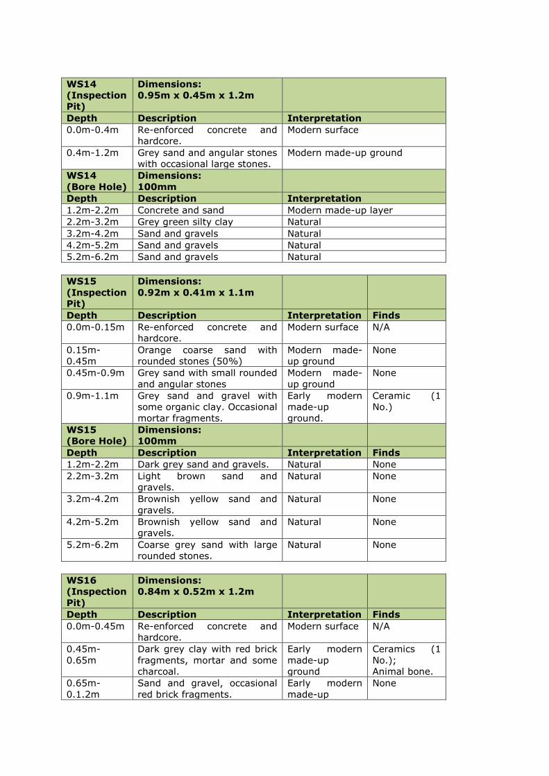
WS14
(Inspection
Pit)
Dimensions:
0.95m x 0.45m x 1.2m
Depth Description Interpretation
0.0m-0.4m Re-enforced concrete and
hardcore.
Modern surface
0.4m-1.2m Grey sand and angular stones
with occasional large stones.
Modern made-up ground
WS14
(Bore Hole)
Dimensions:
100mm
Depth Description Interpretation
1.2m-2.2m Concrete and sand Modern made-up layer
2.2m-3.2m Grey green silty clay Natural
3.2m-4.2m Sand and gravels Natural
4.2m-5.2m Sand and gravels Natural
5.2m-6.2m Sand and gravels Natural
WS15
(Inspection
Pit)
Dimensions:
0.92m x 0.41m x 1.1m
Depth Description Interpretation Finds
0.0m-0.15m Re-enforced concrete and
hardcore.
Modern surface N/A
0.15m-
0.45m
Orange coarse sand with
rounded stones (50%)
Modern made-
up ground
None
0.45m-0.9m Grey sand with small rounded
and angular stones
Modern made-
up ground
None
0.9m-1.1m Grey sand and gravel with
some organic clay. Occasional
mortar fragments.
Early modern
made-up
ground.
Ceramic (1
No.)
WS15
(Bore Hole)
Dimensions:
100mm
Depth Description Interpretation Finds
1.2m-2.2m Dark grey sand and gravels. Natural None
2.2m-3.2m Light brown sand and
gravels.
Natural None
3.2m-4.2m Brownish yellow sand and
gravels.
Natural None
4.2m-5.2m Brownish yellow sand and
gravels.
Natural None
5.2m-6.2m Coarse grey sand with large
rounded stones.
Natural None
WS16
(Inspection
Pit)
Dimensions:
0.84m x 0.52m x 1.2m
Depth Description Interpretation Finds
0.0m-0.45m Re-enforced concrete and
hardcore.
Modern surface N/A
0.45m-
0.65m
Dark grey clay with red brick
fragments, mortar and some
charcoal.
Early modern
made-up
ground
Ceramics (1
No.);
Animal bone.
0.65m-
0.1.2m
Sand and gravel, occasional
red brick fragments.
Early modern
made-up
None
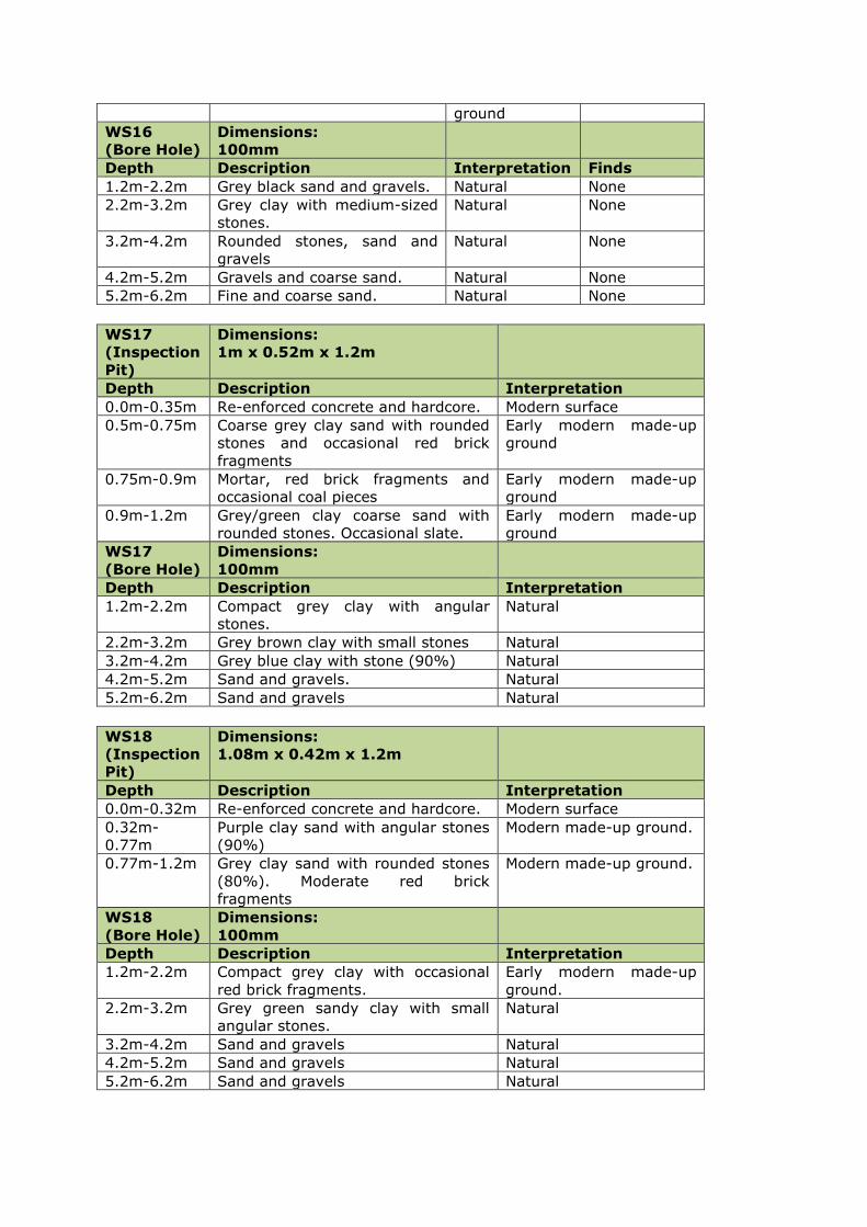
ground
WS16
(Bore Hole)
Dimensions:
100mm
Depth Description Interpretation Finds
1.2m-2.2m Grey black sand and gravels. Natural None
2.2m-3.2m Grey clay with medium-sized
stones.
Natural None
3.2m-4.2m Rounded stones, sand and
gravels
Natural None
4.2m-5.2m Gravels and coarse sand. Natural None
5.2m-6.2m Fine and coarse sand. Natural None
WS17
(Inspection
Pit)
Dimensions:
1m x 0.52m x 1.2m
Depth Description Interpretation
0.0m-0.35m Re-enforced concrete and hardcore. Modern surface
0.5m-0.75m Coarse grey clay sand with rounded
stones and occasional red brick
fragments
Early modern made-up
ground
0.75m-0.9m Mortar, red brick fragments and
occasional coal pieces
Early modern made-up
ground
0.9m-1.2m Grey/green clay coarse sand with
rounded stones. Occasional slate.
Early modern made-up
ground
WS17
(Bore Hole)
Dimensions:
100mm
Depth Description Interpretation
1.2m-2.2m Compact grey clay with angular
stones.
Natural
2.2m-3.2m Grey brown clay with small stones Natural
3.2m-4.2m Grey blue clay with stone (90%) Natural
4.2m-5.2m Sand and gravels. Natural
5.2m-6.2m Sand and gravels Natural
WS18
(Inspection
Pit)
Dimensions:
1.08m x 0.42m x 1.2m
Depth Description Interpretation
0.0m-0.32m Re-enforced concrete and hardcore. Modern surface
0.32m-
0.77m
Purple clay sand with angular stones
(90%)
Modern made-up ground.
0.77m-1.2m Grey clay sand with rounded stones
(80%). Moderate red brick
fragments
Modern made-up ground.
WS18
(Bore Hole)
Dimensions:
100mm
Depth Description Interpretation
1.2m-2.2m Compact grey clay with occasional
red brick fragments.
Early modern made-up
ground.
2.2m-3.2m Grey green sandy clay with small
angular stones.
Natural
3.2m-4.2m Sand and gravels Natural
4.2m-5.2m Sand and gravels Natural
5.2m-6.2m Sand and gravels Natural

Bore Holes
BH02
(Inspection
Pit)
Dimensions:
0.96m x 0.5m x 1.2m
Depth Description Interpretation
0.0m-0.45m Re-enforced concrete and
hardcore.
Modern surface
0.45m-
1.05m
Grey brown sandy clay with
mortar and rounded stones
Modern made-up ground
1.05m-1.2m Coarse sand with rounded
stones.
Early modern made-up ground
BH02
(Bore Hole)
Dimensions:
100mm
Depth Description Interpretation
Abandoned due to difficult
ground (deep concrete)
BH02(b)
(Inspection
Pit)
Dimensions:
0.9m x 0.43m x 1.2m
Depth Description Interpretation
0.0m-0.3m Re-enforced concrete and
hardcore.
Modern surface
0.3m-0.6m Coarse sand, rounded stones Modern made-up ground.
0.6m-0.75m Concrete Modern made-up ground.
0.75m-1.2m Grey brown coarse sand with
rounded stones.
Modern made-up ground.
BH02 (b)
(Bore Hole)
Dimensions:
100mm
Depth Description Interpretation
1.2m-2.2m Grey gravelly sand (to 1.5m);
dark brown silty clay with
inclusions of small stones and
patches of mortar (to 1.6m);
Early modern made-up ground.
BH01
(Inspection
Pit)
Dimensions:
0.94m x 0.47m x 1m
Depth Description Interpretation
0.0m-0.32m Re-enforced concrete and
hardcore.
Modern surface
0.32m-1.0m Grey clay with rounded stone
and gravels.
Modern made-up ground
BH01
(Bore Hole)
Dimensions:
100mm
Depth Description Interpretation
1.2m-2.2m Compact grey clay with small
rounded stones. Some red
brick fragments and mortar.
Early modern made-up ground.
2.2m-3.2m Grey green sandy clay. Natural
3.2m-4.2m Yellow grey clay sand and
stone.
Natural
4.2m-5.2m Coarse sand and gravel. Natural
5.2m-6.2m Coarse sand and gravel. Natural
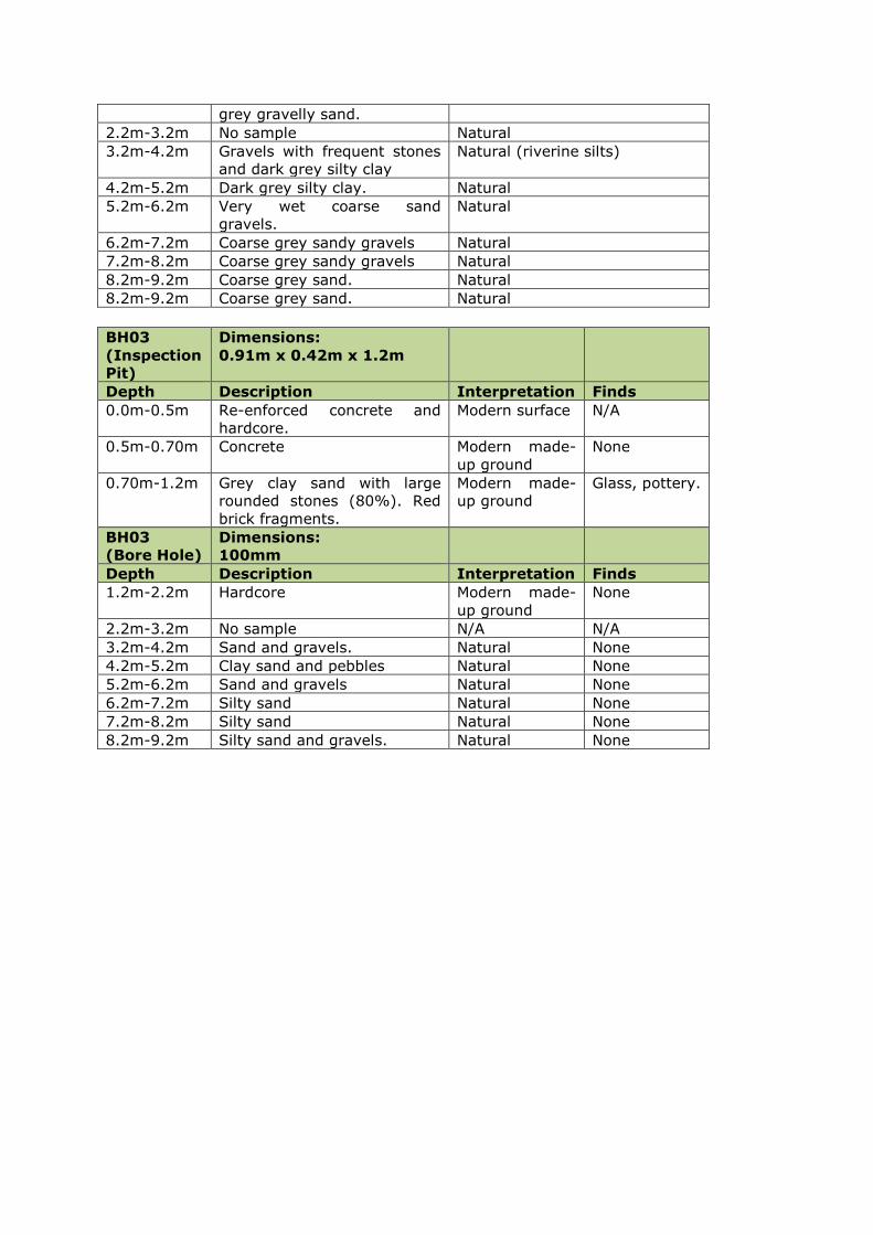
grey gravelly sand.
2.2m-3.2m No sample Natural
3.2m-4.2m Gravels with frequent stones
and dark grey silty clay
Natural (riverine silts)
4.2m-5.2m Dark grey silty clay. Natural
5.2m-6.2m Very wet coarse sand
gravels.
Natural
6.2m-7.2m Coarse grey sandy gravels Natural
7.2m-8.2m Coarse grey sandy gravels Natural
8.2m-9.2m Coarse grey sand. Natural
8.2m-9.2m Coarse grey sand. Natural
BH03
(Inspection
Pit)
Dimensions:
0.91m x 0.42m x 1.2m
Depth Description Interpretation Finds
0.0m-0.5m Re-enforced concrete and
hardcore.
Modern surface N/A
0.5m-0.70m Concrete Modern made-
up ground
None
0.70m-1.2m Grey clay sand with large
rounded stones (80%). Red
brick fragments.
Modern made-
up ground
Glass, pottery.
BH03
(Bore Hole)
Dimensions:
100mm
Depth Description Interpretation Finds
1.2m-2.2m Hardcore Modern made-
up ground
None
2.2m-3.2m No sample N/A N/A
3.2m-4.2m Sand and gravels. Natural None
4.2m-5.2m Clay sand and pebbles Natural None
5.2m-6.2m Sand and gravels Natural None
6.2m-7.2m Silty sand Natural None
7.2m-8.2m Silty sand Natural None
8.2m-9.2m Silty sand and gravels. Natural None
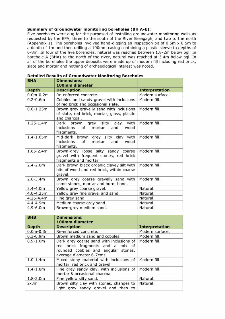
Summary of Groundwater monitoring boreholes (BH A-E):
Five boreholes were dug for the purposed of installing groundwater monitoring wells as
requested by the EPA, three to the south of the River Breagagh, and two to the north
(Appendix 1). The boreholes involved hand-digging an inspection pit of 0.5m x 0.5m to
a depth of 1m and then drilling a 100mm casing containing a plastic sleeve to depths of
6-8m. In four of the five boreholes, natural was reached between 1.8-2m below bgl. In
borehole A (BHA) to the north of the river, natural was reached at 3.4m below bgl. In
all of the boreholes the upper deposits were made up of modern fill including red brick,
slate and mortar and nothing of archaeological interest was noted.
Detailed Results of Groundwater Monitoring Boreholes
BHA Dimensions:
100mm diameter
Depth Description Interpretation
0.0m-0.2m Re-enforced concrete. Modern surface.
0.2-0.6m Cobbles and sandy gravel with inclusions
of red brick and occasional slate.
Modern fill.
0.6-1.25m Brown grey gravelly sand with inclusions
of slate, red brick, mortar, glass, plastic
and charcoal.
Modern fill.
1.25-1.4m Dark brown grey silty clay with
inclusions of mortar and wood
fragments.
Modern fill.
1.4-1.65m Mid-dark brown grey silty clay with
inclusions of mortar and wood
fragments.
Modern fill.
1.65-2.4m Brown-grey loose silty sandy coarse
gravel with frequent stones, red brick
fragments and mortar.
Modern fill.
2.4-2.6m Dark brown black organic clayey silt with
bits of wood and red brick, within coarse
gravel.
Modern fill.
2.6-3.4m Brown grey coarse gravelly sand with
some stones, mortar and burnt bone.
Modern fill.
3.4-4.0m Yellow grey coarse gravel. Natural.
4.0-4.25m Yellow grey fine gravel and sand. Natural.
4.25-4.4m Fine grey sand. Natural.
4.4-4.9m Medium coarse grey sand. Natural.
4.9-6.0m Brown-grey medium sand. Natural.
BHB Dimensions:
100mm diameter
Depth Description Interpretation
0.0m-0.3m Re-enforced concrete. Modern surface.
0.3-0.9m Brown medium sand and cobbles. Modern fill.
0.9-1.0m Dark grey coarse sand with inclusions of
red brick fragments and a mix of
rounded cobbles and angular stones,
average diameter 6-7cms.
Modern fill.
1.0-1.4m Mixed stony material with inclusions of
mortar, red brick and gravel.
Modern fill.
1.4-1.8m Fine grey sandy clay, with inclusions of
mortar & occasional charcoal.
Modern fill.
1.8-2.0m Fine yellow silty sand. Natural.
2-3m Brown silty clay with stones, changes to
light grey sandy gravel and then to
Natural.

medium grey sand with decomposed
organic matter and snail shells and
finally to mid grey stones and fine sand
close to 3m.
3-4m Yellow grey gravel, sandier in the last
20cms.
Natural.
4-5m Fine grey gravel, sandier towards 5m. Natural.
5-6m Coarse grey sand to around 5.2m and
then stony gravel to 6m.
Natural.
6-7m Light brown sandy gravel, changing to
fine light brown sand from 6.35m.
Natural.
7-8m Fine light brown sand. Natural.
BHC Dimensions:
100mm diameter
Depth Description Interpretation
0.0m-0.2m Re-enforced concrete. Modern surface.
0.2-0.45m Brown medium sand and cobbles. Modern fill.
0.45-1.0m Mix of mid grey coarse sandy gravel with
stones, red brick fragments and bits of
mortar, slate and cinder.
Modern fill.
1.0-1.4m Mix of mortar, red brick, slate and
gravel.
Modern fill.
1.4-1.6m Dark brown silty sandy clay with red
brick, mortar and charcoal.
Modern fill.
1.6-1.85m Light grey brown silty sandy clay with
some stones and flecks of mortar.
Modern fill.
1.85-1.95m Mid-grey silty sandy clay with inclusions
of mortar and red brick.
Modern fill.
1.95-2.9m Light grey fine silty clay. Natural.
2.9-3.4m Coarse stony gravel. Natural.
3.4-6.9m Coarse gravelly sand with some fine
gravel. Includes bands of grey and
brown-yellow sandy gravel.
Natural.
6.9-7m Coarse mid-brown sand. Natural.
BHD Dimensions:
100mm diameter
Figure:
Appendix 1
Depth Description Interpretation Finds
0.0m-0.2m Re-enforced concrete. Modern surface. N/a
0.2-0.55m Grey brown, mix of mortar,
stones and brown silty sand
with flecks of red brick.
Modern fill. None.
0.55-0.9m Light grey sandy gravel with
stones and occasional bits of
red brick.
Modern fill. None.
0.9-1.0m Black silty clay with mortar &
red brick inclusions.
Modern fill. None.
1.0-1.5m Black silty sand with frequent
mortar & cinders.
Modern fill. Modern
pottery.
1.5-2.0m Mid grey silty sand with
frequent bits of mortar and
red brick, roots and wood
fragments, charcoal.
Modern fill. Modern
pottery.
2.0-2.1m Light grey medium sand Natural. N/a
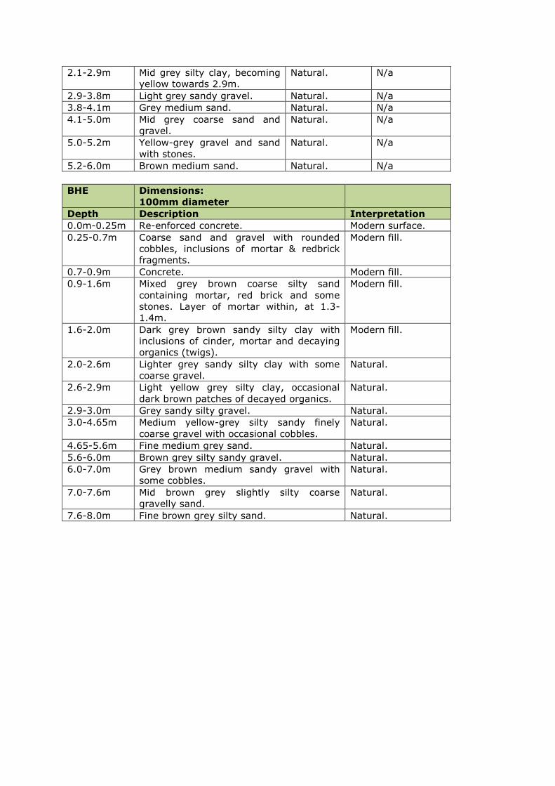
2.1-2.9m Mid grey silty clay, becoming
yellow towards 2.9m.
Natural. N/a
2.9-3.8m Light grey sandy gravel. Natural. N/a
3.8-4.1m Grey medium sand. Natural. N/a
4.1-5.0m Mid grey coarse sand and
gravel.
Natural. N/a
5.0-5.2m Yellow-grey gravel and sand
with stones.
Natural. N/a
5.2-6.0m Brown medium sand. Natural. N/a
BHE Dimensions:
100mm diameter
Depth Description Interpretation
0.0m-0.25m Re-enforced concrete. Modern surface.
0.25-0.7m Coarse sand and gravel with rounded
cobbles, inclusions of mortar & redbrick
fragments.
Modern fill.
0.7-0.9m Concrete. Modern fill.
0.9-1.6m Mixed grey brown coarse silty sand
containing mortar, red brick and some
stones. Layer of mortar within, at 1.3-
1.4m.
Modern fill.
1.6-2.0m Dark grey brown sandy silty clay with
inclusions of cinder, mortar and decaying
organics (twigs).
Modern fill.
2.0-2.6m Lighter grey sandy silty clay with some
coarse gravel.
Natural.
2.6-2.9m Light yellow grey silty clay, occasional
dark brown patches of decayed organics.
Natural.
2.9-3.0m Grey sandy silty gravel. Natural.
3.0-4.65m Medium yellow-grey silty sandy finely
coarse gravel with occasional cobbles.
Natural.
4.65-5.6m Fine medium grey sand. Natural.
5.6-6.0m Brown grey silty sandy gravel. Natural.
6.0-7.0m Grey brown medium sandy gravel with
some cobbles.
Natural.
7.0-7.6m Mid brown grey slightly silty coarse
gravelly sand.
Natural.
7.6-8.0m Fine brown grey silty sand. Natural.

Test Pits
TP01
(Test pit)
Dimensions:
1m x 0.7m x 2.6m
Depth Description Interpretation Finds
0.0m-0.2m Tarmac and hardcore Modern surface N/A
0.2m-0.45m Grey black gravel and sand Modern made-
up ground
None
0.45m-
0.55m
Deposit of dumped red brick
fragments and mortar
Modern made-
up ground
None
0.55m-0.9m Mid grey brown sandy clay Modern made-
up ground
None
0.9m-1.35m Grey silty clay with some
inclusions of mortar and slate
fragments
Modern made-
up ground
None
1.35m-2.5m Very fine dark black-brown
silty clay, inclusions of slate,
red brick, animal bone
Organic
deposit, post
medieval or
later, possibly
related to a
flood event
Pottery
(Brownware)
2.5m-2.6m Fine brown silt River deposit,
possibly related
to a flood event
None
2.6m Mid grey sandy gravel Natural None
TP02
(Test pit)
Dimensions:
1.5m x 0.7m x 1.5m
Depth Description Interpretation Finds
0.0-0.2m Re-enforced concrete and
hardcore.
Modern surface N/A
0.2m-0.7m Loose light brown sand and
gravel, occasional red brick
fragments and flecks of
mortar throughout.
Modern made-
up ground
None
0.7m-0.95m Loose dark grey black sandy
clay mixed with red brick and
mortar.
Early modern
made-up
ground
None
0.95m-1.5m Dark brown mottled silty clay
with flecks of mortar and red
brick. At c.1m some large
stones at the north end of the
test pit may represent the
face of a wall oriented
roughly SW-NE.
Early modern
made-up
ground,
possible stone
wall
Modern
pottery, glass
TP03
(Test pit)
Dimensions:
1.5m x 0.65m x 2.35m
Depth Description Interpretation Finds
0.0m-0.2m Re-enforced concrete and
hardcore.
Modern surface N/A
0.2m-1m Loose light brown sand and
gravel, occasional red brick
fragments.
Modern made-
up ground,
possibly river
gravels
None
1m-1.9m Dark grey black silty clay, Early modern Modern

inclusions of red brick, slate
and wood fragments.
made-up
ground
pottery, glass,
oyster shell
1.9m-2.35 Fine grey silty clay River silts None
TP04
(Test pit)
Dimensions:
1m x 0.7m x 0.6m
Depth Description Interpretation
0.0m-0.2m Re-enforced concrete and
hardcore.
Modern surface
0.2m-0.4m Loose light brown gravel and
sand
Modern made-up ground
0.4m-0.6m Loose grey gravel and sand Modern made-up ground
0.6m Concrete slab Modern surface
TP05
(Test pit)
Dimensions:
1m x 0.7m x 2.25m
Depth Description Interpretation Finds
0.0m-0.5m Re-enforced concrete and
hardcore.
Modern surface N/A
0.5m-1.35m Loose light brown gravel and
sand
Modern made-
up ground
Modern
pottery
1.35m-1.8m Loose dark brown silty clay
with frequent inclusions of
mortar and red brick.
Modern made-
up ground
Modern
pottery,
animal bone
1.8m-2.3m Mid-dark grey silty gritty clay
with frequent inclusions of
red brick fragments and
mortar
Modern made-
up ground
Modern
pottery
2.3m-2.55m Grey gravel Natural None
TP06
(Test pit)
Dimensions:
1.5m x 0.7m x 2.25m
Depth Description Interpretation Finds
0.0m-0.2m Re-enforced concrete and
hardcore.
Modern surface N/A
0.2m-1.35m Loose light brown gravel and
sand, inclusions of mortar,
red and yellow brick, slate
and plastic.
Modern made-
up ground
Modern
pottery,
1.35m-
1.95m
Mid-dark brown silty clay with
flecks of mortar and red
brick.
Modern made-
up ground
None
1.95m-
2.25m
Fine dark grey silty clay Post medieval
or later,
possibly related
to a flood event
Pottery
(Brownware)
and clay pipe
stem
fragments
(x2)
TP07
(Test pit)
Dimensions:
1.5m x 0.7m x 0.65m
Depth Description Interpretation
0.0m-0.25m Re-enforced concrete and
hardcore.
Modern surface
0.25m-
0.65m
Loose mid brown gravel and
sand
Modern made-up ground

0.65m Concrete slab Modern surface
TP08
(Test pit)
Dimensions:
1m x 0.7m x 2.4m
Depth Description Interpretation Finds
0.0m-0.25m Re-enforced concrete and
hardcore.
Modern surface N/A
0.25m-1.1m Mid brown rubble material
with lots of mortar, yellow
and red brick, slate
fragments
Loose light brown gravel and
sand, inclusions of mortar,
red and yellow brick, slate
and plastic.
Modern made-
up ground
Early modern
white glazed
yellow brick
(stamped “J &
M Craig
Kilmarnock
Scotland)
dates to early
19th-early 20th
Century.
1.1m-2.2m Dark brown silty clay with
lumps and flecks of mortar
and animal bone.
Modern made-
up ground
Modern glass
bottle
2.2m-2.4m Grey brown sandy clay. Natural None
TP09
(Test pit)
Dimensions:
1.5m x 0.7m x 2.4m
Depth Description Interpretation Finds
0.0m-0.25m Re-enforced concrete and
hardcore.
Modern surface N/A
0.25m-0.4m Black loose gravel. Modern made-
up ground
None
0.4m-1.2m Loose mid brown gravel and
sand, inclusions of mortar,
red brick, slate and plastic.
Modern made-
up ground
Modern
pottery
1.2m-2.4m Dark brown sandy clay with
bits of mortar and red brick,
slate, plastic, re-bar, wire,
animal bone.
Modern made-
up ground,
dumped
rubbish
Bead
(probably
modern),
modern glass
TP10
(Test pit)
Dimensions:
1.9m x 0.6m x 2.2m
Depth Description Interpretation Finds
0.0m-0.3m Re-enforced concrete and
hardcore.
Modern surface N/A
0.3m-0.8m Loose mid brown sand and
gravel, inclusions of mortar
flecks.
Modern made-
up ground
Modern
pottery
0.8m-1.8m Loose dark brown sandy silt,
flecks and lumps of mortar.
Modern made-
up ground
None
1.8m-2.2m Mid grey silty clay, inclusions
of animal bone, burnt bone
and flecks of charcoal.
River silts,
possibly an
archaeological
layer.
None
TP CB
(Test pit)
Dimensions:
2m x 4m x 3.1m
Depth Description Interpretation Finds
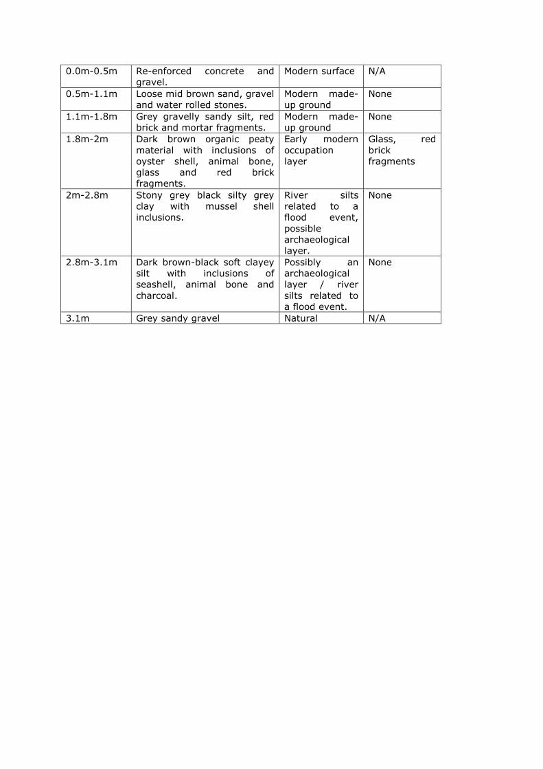
0.0m-0.5m Re-enforced concrete and
gravel.
Modern surface N/A
0.5m-1.1m Loose mid brown sand, gravel
and water rolled stones.
Modern made-
up ground
None
1.1m-1.8m Grey gravelly sandy silt, red
brick and mortar fragments.
Modern made-
up ground
None
1.8m-2m Dark brown organic peaty
material with inclusions of
oyster shell, animal bone,
glass and red brick
fragments.
Early modern
occupation
layer
Glass, red
brick
fragments
2m-2.8m Stony grey black silty grey
clay with mussel shell
inclusions.
River silts
related to a
flood event,
possible
archaeological
layer.
None
2.8m-3.1m Dark brown-black soft clayey
silt with inclusions of
seashell, animal bone and
charcoal.
Possibly an
archaeological
layer / river
silts related to
a flood event.
None
3.1m Grey sandy gravel Natural N/A
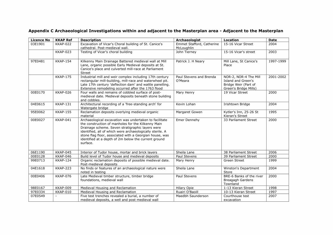
Appendix C Archaeological Investigations within and adjacent to the Masterplan area - Adjacent to the Masterplan
Licence No KKAP Ref Description Archaeologist Location Date
03E1901 KKAP-022 Excavation of Vicar's Choral building of St. Canice's cathedral. Post-medieval wall.
Emmet Stafford, Catherine McLoughlin
15-16 Vicar Street 2004
KKAP-023 Testing of Vicar's choral building John Tierney 15-16 Vicar's street 2003
97E0481 KKAP-154 Kilkenny Main Drainage Battered medieval wall at Mill
Lane, organic possible Early Medieval deposits at St. Canice's place and culverted mill-race at Parliament
Street
Patrick J. H Neary Mill Lane, St Canice’s Place
1997-1999
KKAP-175 Industrial mill and weir complex including 17th century rectangular mill-building, mill-race and waterwheel pit. Late 17th century 'deflection dam' and wattle panelling. Extensive remodeling occurred after the 1763 flood
Paul Stevens and Brenda O’Meara
NOR-2, NOR-4 The Mill Island and Green's Bridge Weir (Part of Green's Bridge Mills)
2001-2002
00E0170 KKAP-026 Four walls and remains of cobbled surface of post-medieval date. Medieval deposits beneath stone building and cobbles.
Mary Henry 19 Vicar Street 2000
04E0615 KKAP-131 Architectural recording of a 'free-standing arch' for Watergate bridge
Kevin Lohan Irishtown Bridge 2004
95E0062 KKAP-155 Reclamation deposits overlying medieval organic material
Margaret Gowen Kytler's Inn, 25-26 St Kieran’s Street
1995
00E0027 KKAP-041 Archaeological excavation was undertaken to facilitate the construction of manholes for the Kilkenny Main Drainage scheme. Seven stratigraphic layers were identified, all of which were archaeologically sterile. A stone flag floor, associated with a Georgian house, was identified at a depth of 2m below the current ground surface.
Emer Dennehy 33 Parliament Street 2000
06E1190 KKAP-045 Interior of Tudor house, mortar and brick layers Sheila Lane 38 Parliament Street 2006
00E0128 KKAP-046 Build level of Tudor house and medieval deposits Paul Stevens 39 Parliament Street 2000
99E0713 KKAP-124 Organic reclamation deposits of possible medieval date. Post-medieval deposits
Mary Henry Green Street 1999
04E1618 KKAP-223 No finds or features of an archaeological nature were noted in testing
Sheila Lane Winston‘s Department Store
2004
00E0406 KKAP-076 Late Medieval timber structure, timber bridge foundations, medieval wall
Paul Stevens BRE-6 Banks of the river Breagagh Gardens Townland
2000
98E0167 KKAP-009 Medieval Housing and Reclamation Hilary Opie 1-13 Kieran Street 1998
97E0334 KKAP-010 Medieval Housing and Reclamation Ruairi O’Baoill 10-13 Kieran Street 1997
07E0549 - Five test trenches revealed a burial, a number of medieval deposits, a well and post medieval wall
Maedbh Saunderson Courthouse test excavation
2007
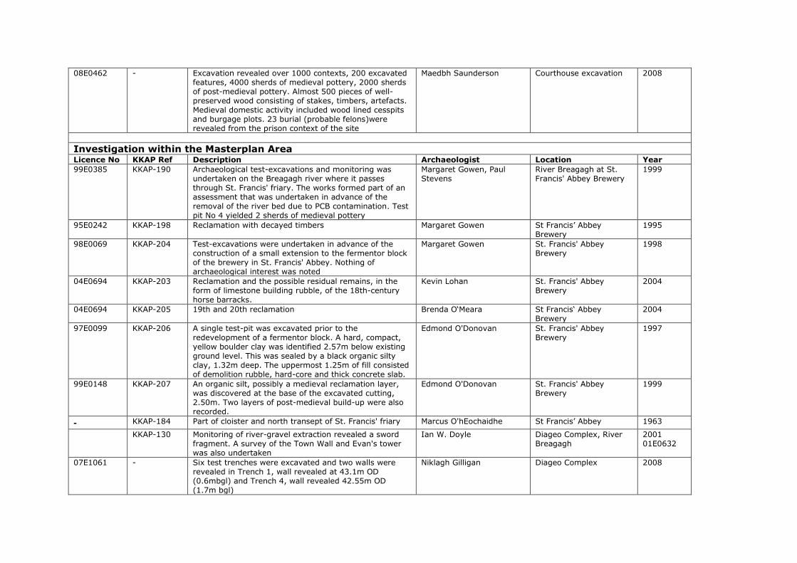
08E0462 - Excavation revealed over 1000 contexts, 200 excavated features, 4000 sherds of medieval pottery, 2000 sherds of post-medieval pottery. Almost 500 pieces of well-preserved wood consisting of stakes, timbers, artefacts. Medieval domestic activity included wood lined cesspits and burgage plots. 23 burial (probable felons)were revealed from the prison context of the site
Maedbh Saunderson Courthouse excavation 2008
Investigation within the Masterplan Area Licence No KKAP Ref Description Archaeologist Location Year
99E0385 KKAP-190 Archaeological test-excavations and monitoring was undertaken on the Breagagh river where it passes through St. Francis' friary. The works formed part of an assessment that was undertaken in advance of the removal of the river bed due to PCB contamination. Test pit No 4 yielded 2 sherds of medieval pottery
Margaret Gowen, Paul Stevens
River Breagagh at St. Francis' Abbey Brewery
1999
95E0242 KKAP-198 Reclamation with decayed timbers Margaret Gowen St Francis’ Abbey Brewery
1995
98E0069 KKAP-204 Test-excavations were undertaken in advance of the construction of a small extension to the fermentor block of the brewery in St. Francis' Abbey. Nothing of archaeological interest was noted
Margaret Gowen St. Francis' Abbey Brewery
1998
04E0694 KKAP-203 Reclamation and the possible residual remains, in the form of limestone building rubble, of the 18th-century horse barracks.
Kevin Lohan St. Francis' Abbey Brewery
2004
04E0694 KKAP-205 19th and 20th reclamation Brenda O‘Meara St Francis‘ Abbey Brewery
2004
97E0099 KKAP-206 A single test-pit was excavated prior to the redevelopment of a fermentor block. A hard, compact, yellow boulder clay was identified 2.57m below existing ground level. This was sealed by a black organic silty clay, 1.32m deep. The uppermost 1.25m of fill consisted of demolition rubble, hard-core and thick concrete slab.
Edmond O'Donovan St. Francis' Abbey Brewery
1997
99E0148 KKAP-207 An organic silt, possibly a medieval reclamation layer, was discovered at the base of the excavated cutting, 2.50m. Two layers of post-medieval build-up were also recorded.
Edmond O'Donovan St. Francis' Abbey Brewery
1999
- KKAP-184 Part of cloister and north transept of St. Francis' friary Marcus O'hEochaidhe St Francis’ Abbey 1963
KKAP-130 Monitoring of river-gravel extraction revealed a sword fragment. A survey of the Town Wall and Evan's tower was also undertaken
Ian W. Doyle Diageo Complex, River Breagagh
2001 01E0632
07E1061 - Six test trenches were excavated and two walls were revealed in Trench 1, wall revealed at 43.1m OD (0.6mbgl) and Trench 4, wall revealed 42.55m OD (1.7m bgl)
Niklagh Gilligan Diageo Complex 2008
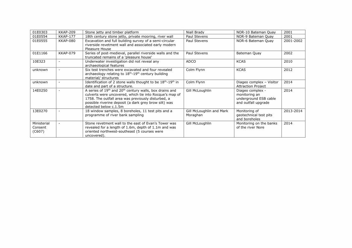
01E0303 KKAP-209 Stone jetty and timber platform Niall Brady NOR-10 Bateman Quay 2001 01E0554 KKAP-177 18th century stone jetty, private mooring, river wall Paul Stevens NOR-9 Bateman Quay 2001 01E0555 KKAP-080 Excavation and full building survey of a semi-circular
riverside revetment wall and associated early modern Pleasure House
Paul Stevens NOR-6 Bateman Quay 2001-2002
01E1166 KKAP-079 Series of post-medieval, parallel riverside walls and the truncated remains of a 'pleasure house'
Paul Stevens Bateman Quay 2002
10E323 - Underwater investigation did not reveal any archaeological features
ADCO KCAS 2010
unknown - Six test trenches were excavated and four revealed archaeology relating to 18th-19th century building material/ structures
Colm Flynn KCAS 2012
unknown - Identification of 2 stone walls thought to be 18th-19th in date and part of a structure.
Colm Flynn Diageo complex – Visitor Attraction Project
2014
14E0250 - A series of 19th and 20th century walls, box drains and culverts were uncovered, which tie into Rocque’s map of 1758. The outfall area was previously disturbed, a possible riverine deposit (a dark grey brow silt) was detected below c.1.5m
Gill McLoughlin Diageo complex - monitoring an underground ESB cable and outfall upgrade
2014
13E0270 - 18 window samples, 8 boreholes, 11 test pits and a programme of river bank sampling
Gill McLoughlin and Mark Moraghan
Monitoring of geotechnical test pits and boreholes
2013-2014
Ministerial Consent (C607)
- Stone revetment wall to the east of Evan’s Tower was revealed for a length of 1.6m, depth of 1.1m and was oriented northwest-southeast (5 courses were uncovered).
Gill McLoughlin Monitoring on the banks of the river Nore
2014
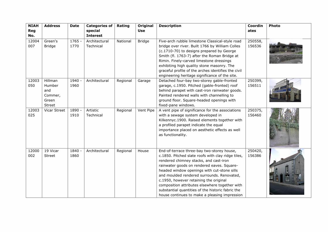
NIAH
Reg
No.
Address Date Categories of
special
Interest
Rating Original
Use
Description Coordin
ates
Photo
12004
007
Green's
Bridge
1765 -
1770
Architectural
Technical
National Bridge Five-arch rubble limestone Classical-style road
bridge over river. Built 1766 by William Colles
(c.1710-70) to designs prepared by George
Smith (fl. 1763-7) after the Roman Bridge at
Rimin. Finely-carved limestone dressings
exhibiting high quality stone masonry. The
graceful profile of the arches identifies the civil
engineering heritage significance of the site.
250558,
156536
12003
050
Hillman
Humber
and
Commer,
Green
Street
1940 -
1960
Architectural Regional Garage Detached four-bay two-storey gable-fronted
garage, c.1950. Pitched (gable-fronted) roof
behind parapet with cast-iron rainwater goods.
Painted rendered walls with channelling to
ground floor. Square-headed openings with
fixed-pane windows.
250399,
156511
12003
025
Vicar Street 1890 -
1910
Artistic
Technical
Regional Vent Pipe A vent pipe of significance for the associations
with a sewage system developed in
Kilkennyc.1900. Raised elements together with
a profiled parapet indicate the equal
importance placed on aesthetic effects as well
as functionality.
250375,
156460
12000
002
19 Vicar
Street
1840 -
1860
Architectural Regional House End-of-terrace three-bay two-storey house,
c.1850. Pitched slate roofs with clay ridge tiles,
rendered chimney stacks, and cast-iron
rainwater goods on rendered eaves. Square-
headed window openings with cut-stone sills
and moulded rendered surrounds. Renovated,
c.1950, however retaining the original
composition attributes elsewhere together with
substantial quantities of the historic fabric the
house continues to make a pleasing impression
250420,
156386

in an historic streetscape.
12000
001
24 Vicar
Street
1900 -
1910
Architectural Regional House Attached two-bay two-storey house, built
1905, with two-bay two-storey return to east.
Hipped slate roof with terracotta ridge tiles.
Painted rendered, ruled and lined walls with
rendered vermiculated quoins to ends. A
pleasant small-scale house distinguished in the
streetscape on account of attributes including
camber-headed openings with one
incorporating an elegant bipartite arrangement,
subtle decorative render detailing, and so on,
all of which enhance the architectural design
value of the composition.
250402,
156379
12000
258
20 Vicar
Street
1890 -
1910
Architectural Local House End-of-terrace three-bay two-storey house,
c.1900, possibly originally two separate single-
bay two-storey houses incorporating fabric of
earlier house, pre-1840, on site. Hipped and
pitched slate roof with clay ridge tiles. Square-
headed window openings and door opening
with moulded rendered surround. Interior with
remains of timber panelled reveals/shutters to
window openings. Road fronted with concrete
footpath to front.
250427,
156371
12000
003
D. Walsh,
Saint
Canice's
Place
1790 -
1810
Architectural Regional
House
Terraced three-bay three-storey house, c.1800.
Pitched slate roof with clay ridge tiles. Square-
headed window openings with cut-stone sills.
Ground floor remodelled, c.1975. Road fronted
with concrete footpath to front. A well-
appointed substantial house incorporating
Classically-derived proportions with the
diminishing in scale of the openings on each
level lending an elegant formal quality to the
street scene. The survival of the original
composition attributes to the upper floors
together with most of the early fabric
250410,
156317

significantly enhances the contribution the site
makes to the character of the streetscape.
12000
004
Phil Treacy,
11
Irishtown
1840 -
1860
Architectural Regional House A well-composed Classically-proportioned
substantial house lending a formal quality to
the streetscape. Terraced three-bay three-
storey house, c.1850, possibly originally with
shopfront to ground floor. Pitched (shared)
slate roof with decorative terracotta ridge tiles.
Painted rendered. Square-headed window
openings and square-headed door opening with
timber panelled door having overlight. Road
fronted with concrete footpath to front. The
original form of the upper floors survives
substantially intact together with much of the
early fabric both to the exterior and to the
interior, thereby significantly enhancing the
character of the site.
250413,
156310
12000
005
Phil Treacy,
12
Irishtown
1840 -
1860
Architectural Regional
House Terraced three-bay three-storey house, c.1850,
possibly originally with shopfront to ground
floor. Pitched (shared) slate roof with
decorative terracotta ridge tiles. Square-
headed window openings with cut-stone sills,
moulded rendered surrounds, and one-over-
one timber sash windows. Square-headed
openings to ground floor remodelled, c.1950,
with fixed-pane timber window to left ground
floor, and glazed timber panelled double doors
to right ground floor having fascia over.
Interior with timber panelled shutters to
window openings. Road fronted with concrete
footpath to front.
250416,
156301

12000
006
Antique
Clique
(The), 16
Irishtown
1840 -
1860
Architectural
Artistic
Regional
House Terraced three-bay two-storey house, c.1850.
Pitched slate roof with clay ridge tiles, painted
rendered walls and square-headed window
openings. Timber shopfront, c.1900, to ground
floor with pilasters, fixed-pane timber windows,
timber panelled door, glazed timber panelled
door to house, and fascia over having moulded
cornice. Road fronted with concrete footpath to
front. A modest-scale house retaining most of
the historic composition attributes together
with substantial quantities of the early fabric
including a fine shopfront of artistic design
merit displaying good quality craftsmanship
while maximising on the streetscape presence
of the site at street level.
250426,
156278
12000
007
Irishtown
Bridge,
Irishtown,
Watergate
1565 -
1570
Archaeological
Technical
National Bridge Two-arch rubble stone bridge widened in 1759
after reconstructed in 1568. Incorporating
fabric of earlier bridge, 1352. A bridge has
existed on site since 1207 with the early
provenance serving to identify the
archaeological significance of the site.
Meanwhile the traditional construction in
unrefined rubble stone produces an appealing,
if subtle textured visual effect in the street
scene.
250438,
156254
12000
099
James
Hughes, 31
Parliament
Street
1890 -
1910
Architectural Regional House An appealing modest-scale building possibly
originally built as two separate houses
successfully navigating an important corner site
through the use of a chamfered side elevation.
Detached four-bay two-storey house, c.1900,
on a corner site probably originally two
separate two-bay two-storey houses with two-
bay two-storey chamfered side (north-west)
elevation. Renovated, c.1925. Pitched slate
roofs with clay ridge tiles, painted rendered
250468,
156223
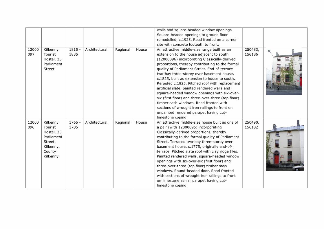
walls and square-headed window openings.
Square-headed openings to ground floor
remodelled, c.1925. Road fronted on a corner
site with concrete footpath to front.
12000
097
Kilkenny
Tourist
Hostel, 35
Parliament
Street
1815 -
1835
Architectural Regional House
An attractive middle-size range built as an
extension to the house adjacent to south
(12000096) incorporating Classically-derived
proportions, thereby contributing to the formal
quality of Parliament Street. End-of-terrace
two-bay three-storey over basement house,
c.1825, built as extension to house to south.
Reroofed c.1925. Pitched roof with replacement
artificial slate, painted rendered walls and
square-headed window openings with six-over-
six (first floor) and three-over-three (top floor)
timber sash windows. Road fronted with
sections of wrought iron railings to front on
unpainted rendered parapet having cut-
limestone coping.
250483,
156186
12000
096
Kilkenny
Tourist
Hostel, 35
Parliament
Street,
Kilkenny,
County
Kilkenny
1765 -
1785
Architectural Regional House An attractive middle-size house built as one of
a pair (with 12000095) incorporating
Classically-derived proportions, thereby
contributing to the formal quality of Parliament
Street. Terraced two-bay three-storey over
basement house, c.1775, originally end-of-
terrace. Pitched slate roof with clay ridge tiles.
Painted rendered walls, square-headed window
openings with six-over-six (first floor) and
three-over-three (top floor) timber sash
windows. Round-headed door. Road fronted
with sections of wrought iron railings to front
on limestone ashlar parapet having cut-
limestone coping.
250490,
156182
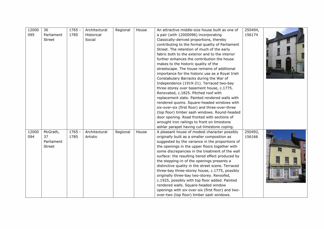
12000
095
36
Parliament
Street
1765 -
1785
Architectural
Historical
Social
Regional House An attractive middle-size house built as one of
a pair (with 12000096) incorporating
Classically-derived proportions, thereby
contributing to the formal quality of Parliament
Street. The retention of much of the early
fabric both to the exterior and to the interior
further enhances the contribution the house
makes to the historic quality of the
streetscape. The house remains of additional
importance for the historic use as a Royal Irish
Constabulary Barracks during the War of
Independence (1919-21). Terraced two-bay
three-storey over basement house, c.1775.
Renovated, c.1825. Pitched roof with
replacement slate. Painted rendered walls with
rendered quoins. Square-headed windows with
six-over-six (first floor) and three-over-three
(top floor) timber sash windows. Round-headed
door opening. Road fronted with sections of
wrought iron railings to front on limestone
ashlar parapet having cut-limestone coping.
250494,
156174
12000
094
McGrath,
37
Parliament
Street
1765 -
1785
Architectural
Artistic
Regional House A pleasant house of modest character possibly
originally built as a smaller composition as
suggested by the variance in the proportions of
the openings in the upper floors together with
some discrepancies in the treatment of the wall
surface: the resulting tiered effect produced by
the stepping-in of the openings presents a
distinctive quality in the street scene. Terraced
three-bay three-storey house, c.1775, possibly
originally three-bay two-storey. Reroofed,
c.1925, possibly with top floor added. Painted
rendered walls. Square-headed window
openings with six-over-six (first floor) and two-
over-two (top floor) timber sash windows.
250492,
156166

Timber shopfront, c.1900. Road fronted with
concrete footpath to front.
12000
093
Ristorante
Da
Pino/James
Harte and
Son, 38
Parliament
Street
1715 -
1735
Architectural
Archaeological
Regional House A well-appointed middle-size house originally
forming part of a larger composition with the
range adjacent to south (12000092)
representing the continuation of a long-
standing presence on site: incorporating
substantial portions of the late sixteenth-
century Red Lion Inn the house forms an
important element of the archaeological
heritage of Kilkenny. Terraced two-bay three-
storey over basement house, c.1725, originally
forming part of larger five-bay three-storey
house with building to south with single-bay
three-storey return to east incorporating fabric
of medieval inn, c.1575, having two-bay single-
storey range to east. Renovated, c.1850.
Reroofed, c.1950. Painted rendered walls to
front (west) elevation with exposed random
rubble stone walls to remainder. Square-
headed window openings to front (west)
elevation with cut-stone sills with chamfered
reveals, chamfered mullions, and hood
mouldings. Timber shopfront to ground floor.
Road fronted with concrete footpath to front.
250501,
156162

12000
092
James
Harte and
Son, 39
Parliament
Street
1715 -
1735
Architectural
Archaeological
Regional
House A well-appointed middle-size house originally
forming part of a larger composition with the
range adjacent to north (12000093)
representing the continuation of a long-
standing presence on site: incorporating
substantial portions of the late sixteenth-
century Red Lion Inn the house forms an
important element of the archaeological
heritage of Kilkenny. Terraced three-bay three-
storey over basement house, c.1725, originally
forming part of larger five-bay three-storey
house c.1575, Renovated, c.1850. Reroofed,
c.1950. Pitched (shared) roofs with
replacement artificial slate, c.1950. Painted
rendered wall to front (west) elevation with
exposed random rubble stone walls to
remainder. Square-headed window openings to
return and to range to east with cut-stone
surrounds having chamfered reveals,
chamfered mullions, hood mouldings over, and
replacement timber casement windows.
Square-headed door opening with timber
panelled door having overlight. Road fronted
with concrete footpath to front.
250499,
156155
12000
091
Sherry
Fitzgerald
McCreery,
40
Parliament
Street,
1790 -
1810
Architectural
Artistic
Regional House
An elegantly-composed substantial house built
as one of a pair (with 12000090) incorporating
Classically-derived proportions enhancing the
formal quality of the streetscape of Parliament
Street. Exhibiting high quality stone masonry a
finely-carved doorcase accommodating two
door openings (a characteristic of Kilkenny)
and further enlivens the external expression of
the composition. The house potentially
represents an important element of the
archaeological legacy of Kilkenny City. Terraced
250507,
156152

two-bay four-storey over basement red brick
house. Pitched (shared) slate roof behind
parapet. Red brick Flemish bond walls with
square-headed window openings with cut-stone
sills, red brick voussoirs, six-over-one (first
floor), three-over-six (second floor) and three-
over-three (top floor) timber sash windows.
Square-headed door opening in shared
elliptical-headed doorcase with three cut-
limestone steps, cut-limestone engaged Tuscan
columns supporting frieze, timber panelled
door, and shared fanlight having cut-limestone
archivolt. Interior with entrance hall having
carved timber architraves to door openings
with timber panelled doors, plasterwork cornice
to ceiling having decorative plasterwork
rosette, and timber panelled shutters to
window openings. Road fronted with sections of
wrought iron railings to front on rendered
plinth having cut-limestone coping.
12000
090
Michael
Buggy, 41
Parliament
Street,
1790 -
1810
Architectural
Artistic
Regional House An elegantly-composed substantial house built
as one of a pair (with 12000091). Terraced
two-bay four-storey over basement red brick
house, c.1800, with single-bay four-storey
return to east. Pitched (shared) slate roof
behind parapet. Red brick Flemish bond walls.
Square-headed window openings with six-over-
one (first floor), three-over-six (second floor)
and three-over-three (top floor) timber sash
windows. Square-headed door opening (shared
with 12000091). Interior with entrance hall
having carved timber architraves to door
openings with timber panelled doors,
plasterwork cornice to ceiling having decorative
plasterwork rosette, round-headed door
250506,
156145

opening to stair hall having fanlight, carved
timber staircase, and timber panelled shutters
to window openings. Road fronted with sections
of wrought iron railings to front on rendered
plinth having cut-limestone coping.
12000
089
Kilkenny
County
Enterprise
Board, 42
Parliament
Street,
1765 -
1785
Architectural Regional House A well-composed substantial house built as one
of a pair (with 12000088) incorporating
Classically-derived proportions with the
resulting diminishing in scale of the openings
on each floor enhancing the elegant formal
quality of the streetscape.
Terraced three-bay three-storey over basement
red brick house, c.1775. Pitched (shared) slate
roof with clay ridge tiles. Red brick Flemish
bond walls with cut-limestone chamfered,
quoins to ends. Square-headed window
openings with cut-stone sills, six-over-six and
three-over-three (top floor) timber sash
windows. Round-headed door opening with
Gibbsian surround. Road fronted with sections
of wrought iron railings to front on cut-
limestone plinth.
250511,
156140
12000
088
Smithwick,
43
Parliament
Street
1765 -
1785
Architectural
Regional House A well-composed substantial house built as one
of a pair (with 12000089) incorporating
Classically-derived proportions with the
resulting diminishing in scale of the openings
on each floor enhancing the elegant formal
quality of the streetscape of Parliament Street.
Terraced three-bay three-storey over basement
red brick house, c.1775, with single-bay three-
storey recessed end bay to right having round-
headed carriageway to ground floor. Pitched
slate roofs (shared to main block) with clay
ridge tiles. Red brick Flemish bond walls with
cut-limestone dressings. Square-headed
250514,
156133
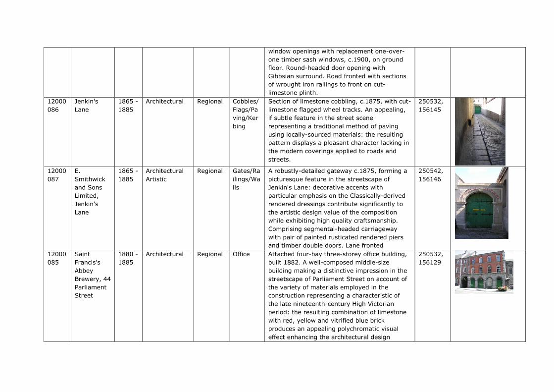
window openings with replacement one-over-
one timber sash windows, c.1900, on ground
floor. Round-headed door opening with
Gibbsian surround. Road fronted with sections
of wrought iron railings to front on cut-
limestone plinth.
12000
086
Jenkin's
Lane
1865 -
1885
Architectural Regional Cobbles/
Flags/Pa
ving/Ker
bing
Section of limestone cobbling, c.1875, with cut-
limestone flagged wheel tracks. An appealing,
if subtle feature in the street scene
representing a traditional method of paving
using locally-sourced materials: the resulting
pattern displays a pleasant character lacking in
the modern coverings applied to roads and
streets.
250532,
156145
12000
087
E.
Smithwick
and Sons
Limited,
Jenkin's
Lane
1865 -
1885
Architectural
Artistic
Regional Gates/Ra
ilings/Wa
lls
A robustly-detailed gateway c.1875, forming a
picturesque feature in the streetscape of
Jenkin's Lane: decorative accents with
particular emphasis on the Classically-derived
rendered dressings contribute significantly to
the artistic design value of the composition
while exhibiting high quality craftsmanship.
Comprising segmental-headed carriageway
with pair of painted rusticated rendered piers
and timber double doors. Lane fronted
250542,
156146
12000
085
Saint
Francis's
Abbey
Brewery, 44
Parliament
Street
1880 -
1885
Architectural
Regional
Office Attached four-bay three-storey office building,
built 1882. A well-composed middle-size
building making a distinctive impression in the
streetscape of Parliament Street on account of
the variety of materials employed in the
construction representing a characteristic of
the late nineteenth-century High Victorian
period: the resulting combination of limestone
with red, yellow and vitrified blue brick
produces an appealing polychromatic visual
effect enhancing the architectural design
250532,
156129

importance of the composition. Finely-carved
details displaying high quality stone masonry in
locally-sourced County Kilkenny limestone
further enliven the external expression of the
building while the retention of substantial
quantities of the early fabric ensures that the
site contributes positively to the historic
character of the street scene.
12000
084
Kilkenny
City
Courthouse,
Parliament
Street
1790 -
1795
Architectural
Artistic
Archaeological
Historical
Social
National Court
House
An edifice of national significance in the
architectural heritage of Kilkenny occupying a
site having origins in the thirteenth-century
Grace's Castle reputedly surviving to the
present day in fragments in the basement
level. Subsequently yielded by James Grace (n.
d.) for adaptation to use as a bridewell or gaol
the building represents one of the earliest-
surviving civic institutions in the locality.
Converted to use as a courthouse possibly to
designs prepared by Sir Jerome Fitzpatrick (n.
d.) with an internal configuration highlighting
the prevailing influence of James Gandon's
(1743-1823) contemporary (1784) Waterford
City Courthouse (demolished pre-1849) the
composition as it appears today is primarily the
product of a comprehensive redevelopment in
the early nineteenth century to designs
prepared by William Robertson (1770-1850):
the resulting Classical scheme surmounting a
somewhat haphazard base forms an elegantly
distinctive focal point in the centre of
Parliament Street.
250547,
156112
12000
236
Parliament
Street
1881 -
1901
Artistic
Historical
Social
Regional Post Box Freestanding cast-iron pillar post box, between
1881-1901, with raised "VR" royal cipher,
moulded necking, and shallow domed capping.
Road fronted on concrete brick cobbled
250521,
156098
No image
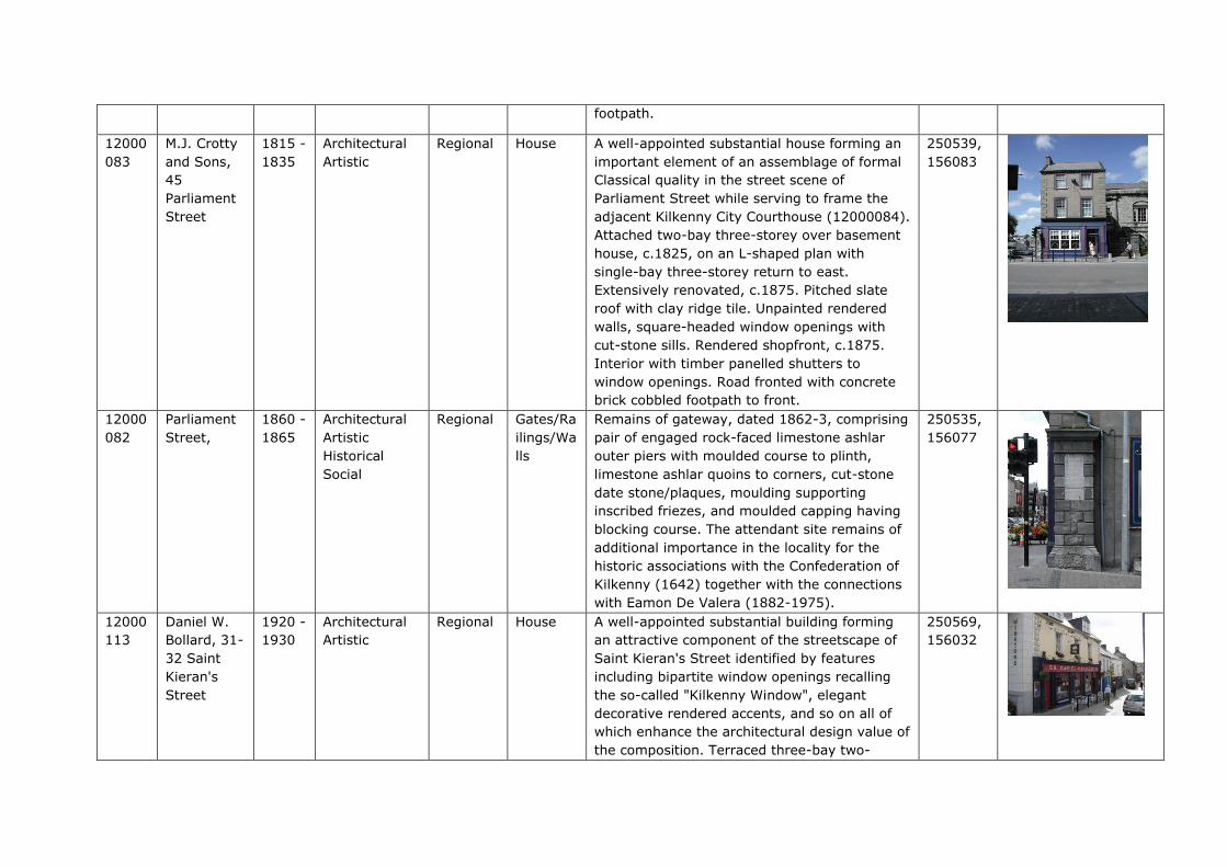
footpath.
12000
083
M.J. Crotty
and Sons,
45
Parliament
Street
1815 -
1835
Architectural
Artistic
Regional House A well-appointed substantial house forming an
important element of an assemblage of formal
Classical quality in the street scene of
Parliament Street while serving to frame the
adjacent Kilkenny City Courthouse (12000084).
Attached two-bay three-storey over basement
house, c.1825, on an L-shaped plan with
single-bay three-storey return to east.
Extensively renovated, c.1875. Pitched slate
roof with clay ridge tile. Unpainted rendered
walls, square-headed window openings with
cut-stone sills. Rendered shopfront, c.1875.
Interior with timber panelled shutters to
window openings. Road fronted with concrete
brick cobbled footpath to front.
250539,
156083
12000
082
Parliament
Street,
1860 -
1865
Architectural
Artistic
Historical
Social
Regional
Gates/Ra
ilings/Wa
lls
Remains of gateway, dated 1862-3, comprising
pair of engaged rock-faced limestone ashlar
outer piers with moulded course to plinth,
limestone ashlar quoins to corners, cut-stone
date stone/plaques, moulding supporting
inscribed friezes, and moulded capping having
blocking course. The attendant site remains of
additional importance in the locality for the
historic associations with the Confederation of
Kilkenny (1642) together with the connections
with Eamon De Valera (1882-1975).
250535,
156077
12000
113
Daniel W.
Bollard, 31-
32 Saint
Kieran's
Street
1920 -
1930
Architectural
Artistic
Regional House A well-appointed substantial building forming
an attractive component of the streetscape of
Saint Kieran's Street identified by features
including bipartite window openings recalling
the so-called "Kilkenny Window", elegant
decorative rendered accents, and so on all of
which enhance the architectural design value of
the composition. Terraced three-bay two-
250569,
156032
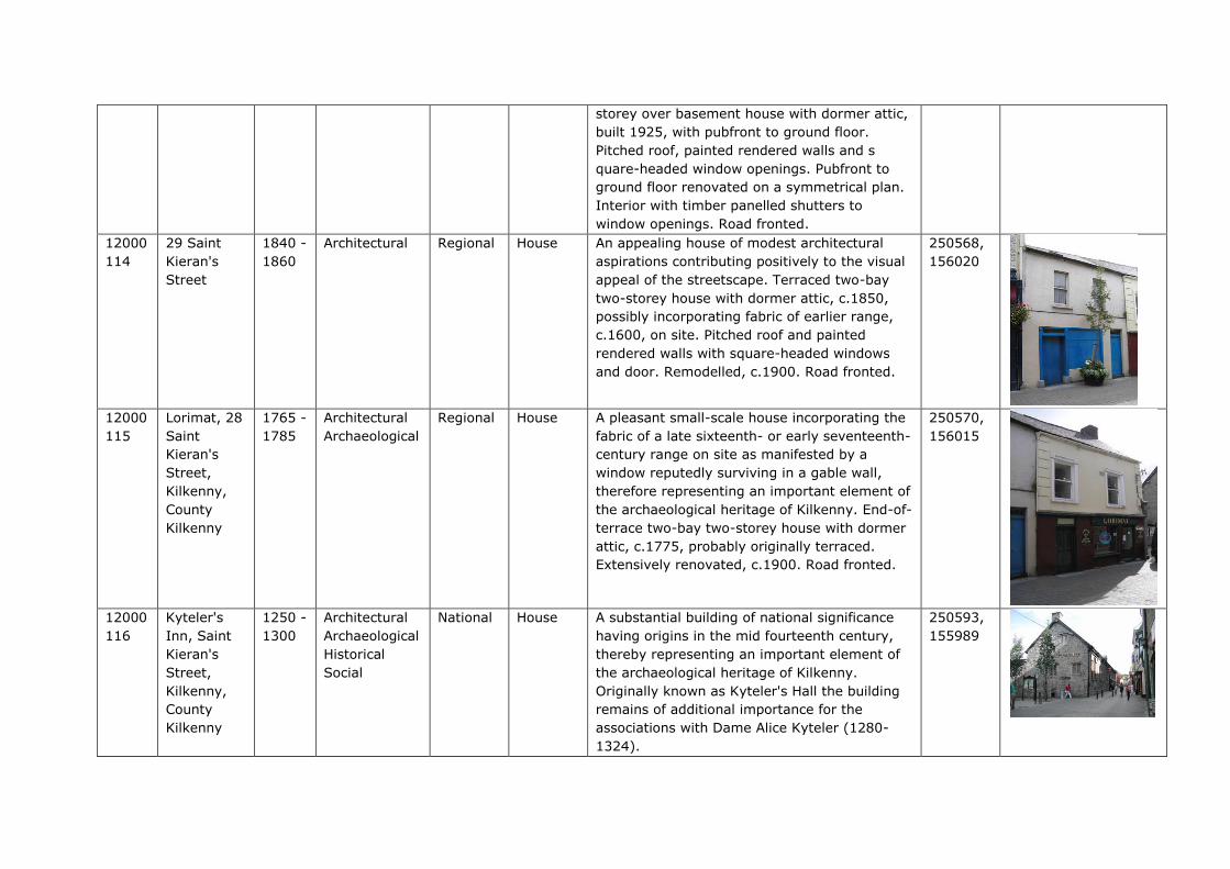
storey over basement house with dormer attic,
built 1925, with pubfront to ground floor.
Pitched roof, painted rendered walls and s
quare-headed window openings. Pubfront to
ground floor renovated on a symmetrical plan.
Interior with timber panelled shutters to
window openings. Road fronted.
12000
114
29 Saint
Kieran's
Street
1840 -
1860
Architectural
Regional House An appealing house of modest architectural
aspirations contributing positively to the visual
appeal of the streetscape. Terraced two-bay
two-storey house with dormer attic, c.1850,
possibly incorporating fabric of earlier range,
c.1600, on site. Pitched roof and painted
rendered walls with square-headed windows
and door. Remodelled, c.1900. Road fronted.
250568,
156020
12000
115
Lorimat, 28
Saint
Kieran's
Street,
Kilkenny,
County
Kilkenny
1765 -
1785
Architectural
Archaeological
Regional House A pleasant small-scale house incorporating the
fabric of a late sixteenth- or early seventeenth-
century range on site as manifested by a
window reputedly surviving in a gable wall,
therefore representing an important element of
the archaeological heritage of Kilkenny. End-of-
terrace two-bay two-storey house with dormer
attic, c.1775, probably originally terraced.
Extensively renovated, c.1900. Road fronted.
250570,
156015
12000
116
Kyteler's
Inn, Saint
Kieran's
Street,
Kilkenny,
County
Kilkenny
1250 -
1300
Architectural
Archaeological
Historical
Social
National
House A substantial building of national significance
having origins in the mid fourteenth century,
thereby representing an important element of
the archaeological heritage of Kilkenny.
Originally known as Kyteler's Hall the building
remains of additional importance for the
associations with Dame Alice Kyteler (1280-
1324).
250593,
155989

Attached seven-bay single-storey over part-
raised basement rubble stone house with
dormer attic, c.1275, probably originally
detached with single-bay single-storey return
to east. Subsequently in use as inn, post-1449.
Extensively reconstructed, c.1625. Renovated,
c.1950, with some openings remodelled.
Renovated, 1966, with some openings
remodelled to accommodate alternative
commercial use. Refenestrated, c.2000. Road
fronted.
12000
204
Tea House
Designs,
Bateman
Quay,
Kilkenny,
County
Kilkenny
1790 -
1810
Architectural Regional
Garden
Structure
Misc
A pleasant small-scale building making a
picturesque impression in a site overlooking
the River Nore. A number of features
enhancing the architectural design importance
of the building include the pointed-arch
openings lending a Gothic quality to the
composition. Detached two-bay single-storey
rubble stone Gothic-style tea house, c.1800,
with square-headed cut-away corner porch to
left. Restored, 1993, to accommodate
commercial use. Now disused. Hipped slate
roof with clay ridge tiles. Random rubble stone
walls repointed, 1993. Pointed-arch window
openings with cut-limestone sills. Pointed-arch
door opening in square-headed cut-away
corner porch having limestone ashlar pier, and
replacement glazed timber panelled door,
1993, having overlight. Set back from line of
road on bank of River Nore with random rubble
limestone boundary wall, 1993, to site.
250677,
156167
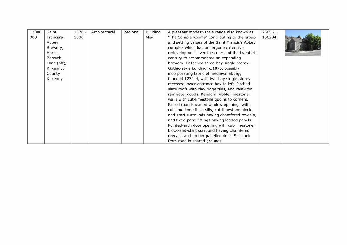
12000
008
Saint
Francis's
Abbey
Brewery,
Horse
Barrack
Lane (off),
Kilkenny,
County
Kilkenny
1870 -
1880
Architectural Regional Building
Misc
A pleasant modest-scale range also known as
"The Sample Rooms" contributing to the group
and setting values of the Saint Francis's Abbey
complex which has undergone extensive
redevelopment over the course of the twentieth
century to accommodate an expanding
brewery. Detached three-bay single-storey
Gothic-style building, c.1875, possibly
incorporating fabric of medieval abbey,
founded 1231-4, with two-bay single-storey
recessed lower entrance bay to left. Pitched
slate roofs with clay ridge tiles, and cast-iron
rainwater goods. Random rubble limestone
walls with cut-limestone quoins to corners.
Paired round-headed window openings with
cut-limestone flush sills, cut-limestone block-
and-start surrounds having chamfered reveals,
and fixed-pane fittings having leaded panels.
Pointed-arch door opening with cut-limestone
block-and-start surround having chamfered
reveals, and timber panelled door. Set back
from road in shared grounds.
250561,
156294

Appendix G – Conservation Drawings