An Analysis of Land use and Land cover Characteristics of ...
15
Nigerian Annals of Pure and Applied Science Vol. 3 Issue 3, 2020 |53 N PAS A N i g e r i a n A n n a l s o f P u r e a n d A p p l i e d S c i e n c e s An Analysis of Land use and Land cover Characteristics of Kanke, Pankshin, and Langtang Local Government Areas, Plateau State, Nigeria. Andesikuteb, Y.A., 1 Musa, W.W., 2 Ezra, L.V., 3 Obasi, M.T., 3 Rogers, R.G. 4 and Mohammed, Y.T. 5 1 Department of Environmental Management, Bingham University, Karu, Nasarawa State, Nigeria. 3 Department of Environmental Management, Faculty of Environmental Science, Kaduna State University, Nigeria. 5 Savanna Forestry Research Station, Zaria. Corresponding email: [email protected] Abstract This study assessed landuse and landcover changes and how they affect the agrarian production in Kanke, Pankshin and Langtang North Local Government Areas of plateau state, Nigeria. The study adopted the survey design. The primary data was obtained through field observations, interview of stakeholders, satellite (landsat8 and shuttle radar terrain mission) and questionnaire administration which asked questions on socioeconomic status of respondents, constraints to farmers and the respondents’ perception on the existing adaptation strategies in place. ArcGIS10.6version software was employed for the classification of land cover types while supervised classification method was adopted using maximum likelihood algorithm for the classification of feature types. Data generated by Landsat8 and ArcGIS10.6 version software were subjected to Pan-Sharpening processing for clarity of terrain features. The study findings revealed that 66.13% of the earth’s surface in the study area is covered by rock outcrops while water body; one of man’s most precious resources occupied less than 1% (0.15%). The distribution of farmers based on constraints to farming indicated that poor soils and small farm land sizes constituted the most severe challenges to farming activities in the study area. As an adaptation strategy to inadequate farm lands, terrace farming practice and dry season farming, large scale quarrying activities is recommended to serve as a source of employment and income to authorities and a means of surface leveling to convert the dominant rock outcrops to productive land and prioritizing farming in the limited plains. Keywords: Agrarian Activities, Land Resources, Landcover, Landuse, Water Resources
-
Upload
khangminh22 -
Category
Documents
-
view
4 -
download
0
Transcript of An Analysis of Land use and Land cover Characteristics of ...

Nigerian Annals of Pure and Applied Science Vol. 3 Issue 3, 2020 |53
N PASA
Nig
eri
an
Anna
lsof Pure and Applie
dS
cie
nce
s
An Analysis of Land use and Land cover Characteristics
of Kanke, Pankshin, and Langtang Local Government
Areas, Plateau State, Nigeria.
Andesikuteb, Y.A.,1 Musa, W.W.,2 Ezra, L.V.,3 Obasi, M.T.,3
Rogers, R.G.4 and Mohammed, Y.T.5
1Department of Environmental Management, Bingham
University, Karu, Nasarawa State, Nigeria. 3Department of Environmental Management, Faculty of
Environmental Science, Kaduna State University, Nigeria. 5Savanna Forestry Research Station, Zaria.
Corresponding email: [email protected]
Abstract This study assessed landuse and landcover changes and how they affect the agrarian production in Kanke,
Pankshin and Langtang North Local Government Areas of plateau state, Nigeria. The study adopted the
survey design. The primary data was obtained through field observations, interview of stakeholders,
satellite (landsat8 and shuttle radar terrain mission) and questionnaire administration which asked questions
on socioeconomic status of respondents, constraints to farmers and the respondents’ perception on the
existing adaptation strategies in place. ArcGIS10.6version software was employed for the classification of
land cover types while supervised classification method was adopted using maximum likelihood algorithm
for the classification of feature types. Data generated by Landsat8 and ArcGIS10.6 version software were
subjected to Pan-Sharpening processing for clarity of terrain features. The study findings revealed that
66.13% of the earth’s surface in the study area is covered by rock outcrops while water body; one of man’s
most precious resources occupied less than 1% (0.15%). The distribution of farmers based on constraints
to farming indicated that poor soils and small farm land sizes constituted the most severe challenges to
farming activities in the study area. As an adaptation strategy to inadequate farm lands, terrace farming
practice and dry season farming, large scale quarrying activities is recommended to serve as a source of
employment and income to authorities and a means of surface leveling to convert the dominant rock
outcrops to productive land and prioritizing farming in the limited plains.
Keywords: Agrarian Activities, Land Resources, Landcover, Landuse, Water Resources

54| An Analysis of Land use and land cover Characteristics of Kanke,…
Introduction
Land cover dynamic has the global
concern of the twenty-first century, with the
dramatic implication for human survival. Land
cover change is the change in the physical as
well as biological characteristics of land which
is attributable to management including
conversion of grazing and forest land into
farming land, pollution and land degradation,
removal of vegetation, and conversion to non-
agricultural uses (Meshesha, et. al., 2016).
Analyzing the trend of land use/land cover
change and its cause and consequence on
human livelihoods as well as on the
environment is a matter of concern for
sustainable development and management of
natural resource. The increasing change is
alarming, and can have a huge implication on
local, regional, national and global
environment and consequently affect the food
availability (Minale, 2013 and Danjuma, et. al.,
2014).
Land and water resources degradation
are the major problems in most highland areas.
Poor land use practices and improper
management systems have played a significant
role in causing high soil erosion rates, sediment
transport and loss of agricultural nutrients. The
effect of land cover change has caused the loss
of fresh and portable water needs loss in the
area alongside occupational dislocation
(Andualem, et. al., 2018). According to
Pandian et. al., (2014) Land use/ land cover is
an important component in understanding the
interactions of the human activities with the
environment and thus it is necessary to monitor
and detect the changes to maintain a sustainable
environment.
Land and water resources are two of the
most important assets of humans throughout
the world especially, for the rural and urban
poor whose livelihoods basically rely on
agriculture (USAID, 2007). Land is the
custodian of all the natural resources like water,
mineral resources, plants and animals that man
depends on for survival and all his activities,
but this valuable property is being degraded
due to soil erosion, adverse weather conditions
and soil nutrients depletion (Amsalu and
Graaff, 2007). Land is an indispensible
resource and a prerequisite for both direct and
indirect activities of man such as farming,
construction, and infrastructure. As one of the
most precious resources, it serves as soil and
mineral nutrients for crops and plants, as open
space and wild places for recreational activities
with interminable list of uses as it also supports
natural ecosystem, source of water, mineral and
energy for agriculture and other human
activities.
Agrarian activities are dependent upon
having sufficient access to water but water
scarcity is already a critical constraint to
agriculture in many parts of the world in
addition to environmental degradation,
declining groundwater, lack of infrastructures
and greater health risk. Without access to clean
water, nearly every industry would suffer, most
notably would be agriculture. As water scarcity
grows as a global concern, food security is also
brought to consideration (Sheila, 2011 and
Vivan, et. al., 2015). Water is one of the most
precious resources we have on this earth and it
is under increasing stress therefore, all of us
have responsibility to provide leadership in
preserving it for efficient utilization and for
future generation (Silvakumar, 2011).
Just the way humans require water and
nutrition for a healthy life storm immune
system, plants and animals require the same for
healthy growth and good yield. Unfortunately,
today, 31 countries accounting for about 8% of
the world’s population face chronic fresh water
shortages (UNEP, 2008). By the year 2025,
however, 48 countries are expected to face
shortages, affecting more than 2.8 billion
people, 35% of the world’s projected
population (VJEL, 2007). Among countries
likely to run short of water in the next few years
are Ethiopia, India, Kenya, Nigeria and Peru.
Parts of other large countries such as China
already face chronic water problems (UNEP,
2008). Intense pressure on agricultural land,
forest land and the availability of fuelwood in
the sounding area is the result of spatial and
demographic changes; it exerts massive
pressure on land use, agricultural productivity,
water resources and the use of ecosystem in
general (Minale and Rao, 2011, Minale and
Rao, 2012a).

Nigerian Annals of Pure and Applied Science Vol. 3 Issue 3, 2020 |55
This study aimed at assessing the
landcover and landuse characteristics and how
they affect agrarian activities in Kanke,
Pankshin and Langtang North Local
Government Areas while the objectives include
determination of the areal coverage of
cultivated land, water body, rock outcrops,
vegetation cover and built-up area as well as
respondents’ perception on the existing
adaptation strategies in place.
Materials and Methods
This study utilized both primary and
secondary data sources. The primary data was
obtained through field observations, interview
of stakeholders, satellite (landsat8 and shuttle
radar terrain mission) and questionnaire
administration which asked questions on
socioeconomic status of respondents,
constraints to farmers and the respondents’
perception on the existing adaptation strategies
in place. Kanke, Pankshin and Langtang North
Local Government Areas were selected for this
study due to their similarities in physical
settings, contiguity of landmass and peculiarity
in land and water resources challenges. The
respondents were purposively chosen in order
to ensure that only inhabitants that practice
farming were selected as study participants.
Three hundred questionnaires were
strategically administered in the three Local
Government Areas that formed the study area.
At the end, 294 questionnaire representing 98%
were retrieved, analyzed and used for this
study.
Satellite data used for the study
includes Landsat8 and Shuttle Radar Terrain
Mission (SRTM), while ArcGIS 10.6 version
GIS software was employed for the
classification of land cover types. The data
were subjected to Pan-Sharpening processing
for clarity of terrain features. Training samples
(picture elements in the satellite images) that
are representative of terrain features were
carefully and systematically identified and
selected. Supervised classification method was
adopted using maximum likelihood algorithm
for the classification of feature types. Statistical
computation of each feature class were
automatically computed in ArcGIS software
and exported to EXCEL for statistical
manipulation. Documented sources like
satellite images were also explored for data on
location, size of landmass, annual rainfall and
water resources which were complemented by
the researchers’ field observation. The data
collected were presented, analyzed and
summarized using descriptive statistics in the
form of mean and percentages. The satellite
images of the area were presented in form of
tables and maps.
The Study Area
Location, Position and Size
Kanke, Pankshin and Langtang North
Local Government Areas have a total projected
population of 727,803 based on the 2006
census figure and population growth rate of
3.2% per annum with a total land area of
3,638km2 located on Latitude 90 23’ 35” N and
Longitude 90 37’ 58” E (Kanke); Latitude 90 19’
31” N and Longitude 90 26’ 06” E (Pankshin);
Latitude 90 08’N and Longitude 90 47’E
(Langtang North) Figure 1. These Local
Government Areas share boundary with
Langtang South to the South, Bauchi State to
the East, Shendam, Quaan pan and Mikang to
the West and Mangu Local Government Area
to the North.
Relief and Drainage
The areas particularly around Kanke
and Pankshin have a high relief particularly in
the north and this serves as a hydrological
centre for many small rivers that drain the place
and also confers on the area a cool climate. The
landscape of the area rises steeply from 200
metres to an average height of 1,000 metres on
the Kanke and Pankshin ranges. Langtang
North area has both relief features but with
greater expanse of lowland areas with just very
few rock outcrops. The areas has radial
drainage pattern interspersed area which drains
the rain water from high to lowland areas in the
three Local Government Areas. Langtang
North Local Government Area has relatively
flat terrain but with poor soils that is heavily
polluted which is not quite fit for agricultural
activities while Kanke and Pankshin Local
Government Areas have rugged topography
apart from quick runoff that occurs
immediately after rains resulting in difficulty of

56| An Analysis of Land use and land cover Characteristics of Kanke,…
access to ground water and hence, poses
serious water scarcity issues as it is very
difficult to drill boreholes and wells to access
quality water for domestic, industrial and
agricultural uses (Wambai, et. al., 2017). The
terrain and topography of the area is dominated
by hills and valleys with highly limited plains
and infertile land which limits agricultural
activities in the area (Worldbank, 2019).
Climate
Kanke, Pankshin and Langtang North
Local Government Areas has the tropical
savannah climate that is marked by rainy and
dry seasons with a temperature range of 170c to
380c and annual rainfall of about 1,500mm
(NIMET, 2018). The average annual rainfall is
1324 mm. Average annual humidity rises
above 80%. Humidity is highest around July
and August at about 85% and then usually
drops to about 60% in January. The area has
temperate climate on the Jos Plateau and a hot
and humid climate on its lower parts. It has two
distinct seasons - rainy season (April-October)
and much colder during the harmattan period
(December - February).
Geology and Soils
The geology of the study area is the
basement complex of Nigeria which lies
entirely within the crystalline basement terrain
with no porosity and normally, in fresh non-
fractured rocks, which is the case in most parts
of the study area, the porosity is often less than
2%, as a result, run off is high, infiltration rate
is very low and little or no water bearing (Izam
and Izam, 2009). The drainage pattern of the
study area is dendritic or tree-like pattern,
normally developed on homogeneous rock or
beds of equal resistance (Anon, 2011). The area
is an erosional relic covering an area of about
7,780 sq.km and is a product of distinct phases
of volcanic activities when younger granite
rocks extensively intruded into the older
basement complex rocks. Each phase of
volcanic activities was followed by a long
period of weathering and erosion when tin
bearing rocks were deposited in the valleys and
buried by floods of basalt from subsequent
volcanic eruptions. There are also extinct
volcanoes and crater lakes on the Jos Plateau
(Worldbank, 2019).
The area has a tropical ferruginous
soils, which are much thinner on the high
plateau but attain greater depths in the southern
part of the state. There are also sizeable pockets
of loamy soil of volcanic origin in the high
Plateau. Soils are generally of poorer quality
than those in other parts of the country and
dominated by reddish laterite soils that are less
fertile than those of the North because they are
not subject to as much seasonal drying nor do
they receive the greater rainfall that occurs in
the southern regions (Bennett, et. al., 1978).
Soil erosion and loss of vegetation resulting
from over grazing and over cultivation has led
to gullying along the numerous cattle paths
which criss-cross the surface constituting
major environmental issues of the area (Vivan,
et al 2015 and Worldbank, 2019).
Vegetation
Most vegetation falls largely within the
northern guinea savannah zone which consists
mainly of short trees, grasses and the Plateau
type of mosaic vegetation. There are also
fringing woodlands or gallery forests which
can be found along some river valleys. Some
villages have thick hedges of cacti, which have
been planted around household farms or
compound lands. The highland areas have
montane vegetation especially on mountain
tops around the hilly parts of Kanke and
Pankshin Local Government Areas
(Worldbank, 2019).
Economic Activities
Farming, hunting and petty trading are
the major occupations of the inhabitants. The
area is endowed with feldspar, quartzite,
limestone, granite, marion, muscovite, zircon
and pyrite among others making it a potential
area for solid mineral mining, precious stones
processing and quarrying. Agriculture is also
an important activity with major crops like
cotton, groundnuts, rice, Irish potatoes, maize
and soya bean being produced.

Nigerian Annals of Pure and Applied Science Vol. 3 Issue 3, 2020 |57
Figure 1: Map of Plateau State showing the study area
Source: National Centre for Remote Sensing, Jos, 2019
Results and Discussion
The analysis of the socioeconomic
background of the respondents on occupation
(Table 1) shows that only 147 out of 294 (50%)
of the respondents practice peasant farming
against 80 – 90% in most rural communities in
Nigeria due largely to inadequate land and
water resources as revealed by the statistical
feature classes of the three (3) Local
Government Areas that formed the study area.
Similarly, according to Table 1, fishermen
constituted only 2.72% of the respondents
which formed the least occupation as a result of
limited water bodies in Kanke, Pankshin and
Langtang North L.G.As.

58| An Analysis of Land use and land cover Characteristics of Kanke,…
Table 1: Socioeconomic background of respondents
s/no Socioeconomic
Characteristics
Description No of
Respondent %
Percentage
No%
1 Occupation Farming
Artisan
C/Servants
Trading
Fishing
Others
All of the above
147
43
11
36
8
31
18
50.00
14.63
3.74
12.25
2.72
10.54
6.12
2 Age < 20
21-30
31-40
41-50
Above 50
13
31
61
137
52
4.42
10.54
20.75
46.60
17.69
3 Farm size(Ha) 1-5
6-10
11-20
Above20
Landless
145
83
41
17
8
49.32
28.23
13.95
5.78
2.72
4 Household size 1-5
6-10
11-15
35
162
97
11.91
55.10
32.99
Source: Field survey 2019
The data on age distribution of the
respondents showed that people between the
ages of 41 – 50 years constituted the majority,
probably, because heads of households are
normally persons that must have attained
adulthood. The information on farm sizes of the
respondents (Table 1) revealed that 145 out of
294 (49.3%) have farm sizes in hectares
between 1 – 5 which strongly agreed with the
opinion of virtually all the stakeholders
interviewed that there is serious land scarcity
which is responsible for small farmlands and
land fragmentations in the study area. The
average household size in the study area is
between 6 – 10 persons which constituted
55.10% of the respondents (Table 1). The
dominance of 6 – 10 persons in a household in
the study area could be due to culture and
religious influence. Being a Christian
dominated Local Government Areas, men are
only allowed to marry one wife and family
planning techniques have wider acceptance
compared to Muslims dominated areas.
Nigerian Annals of Pure and Applied Science Vol. 3 Issue 3, 2020 |59
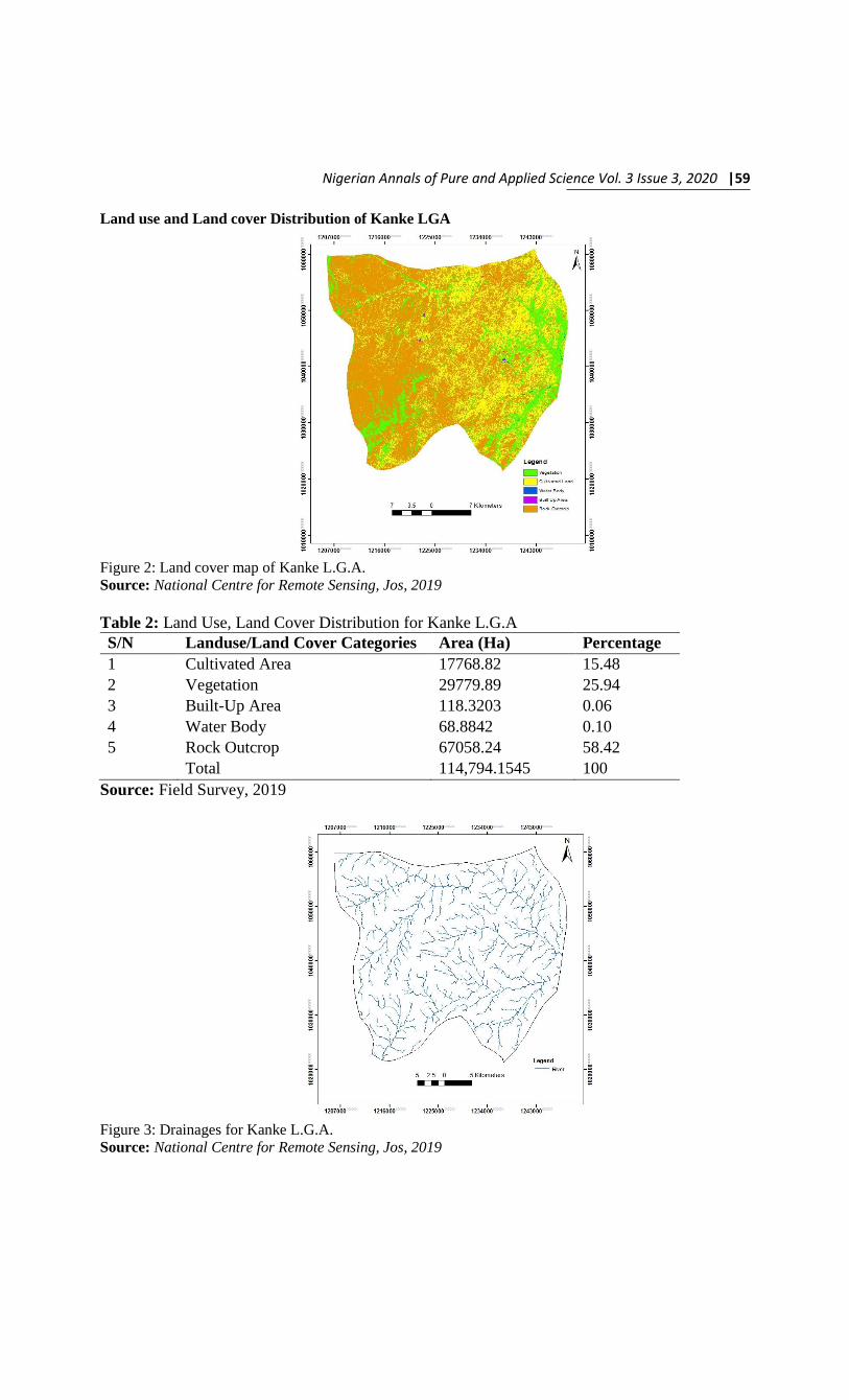
Land use and Land cover Distribution of Kanke LGA
Figure 2: Land cover map of Kanke L.G.A.
Source: National Centre for Remote Sensing, Jos, 2019
Table 2: Land Use, Land Cover Distribution for Kanke L.G.A
S/N Landuse/Land Cover Categories Area (Ha) Percentage
1 Cultivated Area 17768.82 15.48
2 Vegetation 29779.89 25.94
3 Built-Up Area 118.3203 0.06
4 Water Body 68.8842 0.10
5 Rock Outcrop 67058.24 58.42
Total 114,794.1545 100
Source: Field Survey, 2019
Figure 3: Drainages for Kanke L.G.A.
Source: National Centre for Remote Sensing, Jos, 2019

60| An Analysis of Land use and land cover Characteristics of Kanke,…
Based on the land cover map of Kanke
L.G.A (Figure 2 and Table 2), the statistical
feature classes’ type revealed that rock
outcrops constituted 67058.24 (Hectares) out
of 114,794.1545 (Hectares) representing
58.42%, This implies that most parts of the land
in Kanke L.G.A. cannot be used for crop
production as a result of dominance of the
surface land by rock outcrops, hence, there is
serious scarcity of productive land as evident
by the small farm sizes of the respondents.
While about 71% of the earth’s surface is
covered by water, analysis of the statistical
feature classes’ type for Kanke L.G.A (Table 2)
indicated that water body constituted the least
with 68.8842 hectares out of 114,794.1545
hectares, representing 0.06%. This suggest
glaringly that there is water resources scarcity
in Kanke L.G.A. which in turn impact the
agricultural sector negatively, thereby,
depriving potential farmers practicing it as
shown by the occupation distribution of the
respondents which agrees with Linping, et. al.,
(2018).
The land use and land cover distribution
for Kanke L.G.A. indicates that vegetation
cover formed the second largest in hectares
after rock outcrops. According to the analysis,
vegetation cover constituted 25.94% of the
total land area which could be link to the
dominance of poor soils in the study area as
revealed by the related literatures reviewed.
Similarly, cultivated land area constitute only
15.48% in Kanke L.G.A. due to unfavourable
factors like rock outcrops, poor soils and
unreliable water supply for farming activities.
Analysis of the land cover map of Kanke
L.G.A. also showed that built-up area formed
the second least after water body with 0.10%.
Thus, the rate of urbanization is not as rapid as
in most Local Government Areas of Plateau
State.
Landcover and Landuse Characteristics of Pankshin LGA
Figure 4: Land cover map for Pankshin L.G.A.
Source: National Centre for Remote Sensing, Jos, 2019

Nigerian Annals of Pure and Applied Science Vol. 3 Issue 3, 2020 |61
Table 3: Land Use, Land Cover Distribution for Pankshin L.G.A.
S/N Landuse/Land Cover Categories Area (Ha) Percentage
1 Cultivated Area 7262.432 5.96
2 Vegetation 20159.48 16.55
3 Built-up Area 240.2127 0.20
4 Water Body 32.4576 0.03
5 Rock outcrop 94100.67 77.26
Total 121,975.2523 100
Figure 5: Drainages for Pankshin L.G.A.
Source: National Centre for Remote Sensing, Jos, 2019
The land cover map of Pankshin L.G.A.
and the statistical feature classes’ type of the
L.G.A. (Figure 4 and table 3) indicated that
rock outcrops occupied 77.26% of the total
land area. This result justified the rationale
behind the serious land resources scarcity in
Pankshin L.G.A. This is further reflected in the
cultivated area of 7262.432 hectares out of
121,795.2523 hectares, representing 5.96%
which is grossly inadequate to support 80 –
90% of the potential population that are
expected to be peasant farmers being the
practice in most rural communities in Nigeria.
Water is one of the most precious
resources humans have on this earth and plants
and animals require it for healthy growth and
good yield. Unfortunately, the analysis of the
land cover map of Pankshin L.G.A. shows that
water body constituted the least with only
0.03% far less than 1% of the total land area in
the entire L.G.A. Due to poor soils and
unreliable water supply in Pankshin L.G.A,
vegetation cover formed 20159.48 hectares out
of 121,795.2523 hectares, accounting for
16.55% of the total land area in the L.G.A. but
remain untapped because of the above
mentioned challenges. According to table 3,
built-up areas in Pankshin L.G.A. formed
0.20% which is more than that of Kanke
L.G.A.This could be because Kanke was
created out of Pankshin L.G.A. which was
formerly the headquarters of the two Local

62| An Analysis of Land use and land cover Characteristics of Kanke,…
Government Areas and as well the only major
town within Kanke and Pankshin Local
Government Areas till date.
Similarly, like in Kanke and Pankshin
Local Government Areas, the land use and
land cover distribution for Langtang North
L.G.A. (Table 4) shows that rock outcrops
occupied the largest portion of the land surface,
contributing 40,561.68 out of 68,442.4907,
representing 59.26%. The implication is that
there is obviously, less land for agricultural
activities. This supports the opinion of most of
the stakeholders interviewed that because of
inadequate land and the cost of hiring a land for
farming, most people ordinarily prefer to be
engaged in other sectors than agriculture which
is certainly the reason why the largest employer
of labour in Nigeria (Farming), accounted for
only 50% of the respondents against the over
80% in most rural communities as explained by
Ali, et. al., (2014).
Landcover and Landuse Characteristics of Langtang North LGA
Figure 6: Landcover map for Langtang North L.G.A.
Source: National Centre for Remote Sensing, Jos, 2019
Table 4: Land Use, Land Cover Distribution for Langtang North L.G.A.
S/N Landuse/Land Cover Categories Area (Ha) Percentage
1 Cultivated Area 13161.95 19.23
2 Vegetation 6276.224 9.17
3 Built-up Area 8095.261 11.83
4 Water Body 347.3757 0.51
5 Rock Outcrop 40561.68 59.26
Total 68,442.4907 100
Source: Field Survey, 2019

Nigerian Annals of Pure and Applied Science Vol. 3 Issue 3, 2020 |63
Figure 7: Drainages for Langtang North LGA
Source: National Centre for Remote Sensing, Jos, 2019
The analysis of the land cover map of
Langtang North L.G.A. (Figure 6 and Table 4)
also indicated that water body constituted the
least, contributing only 347.3757 hectares out
of 68,442.4907 hectares (0.5%). This is in line
with the findings of the related literatures
reviewed that unreliable water supply is the
second most severe problem facing farmers
after poor soils in the study area. Unlike Kanke
and Pankshin Local Governments Areas,
Langtang North L.G.A. has a built up area
surface cover of up to 11.83%, indicating
evidence of possible rapid urbanization in the
near future. Similarly, Langtang North L.G.A.
cultivated area is more than that of Kanke and
Pankshin, because there is more rock outcrops
in Kanke and Pankshin (Tables 2 and 3).
The vegetation cover of Langtang
North L.G.A. constituted only 6276.224
hectares out of 68,442.4907 hectares (9.17%).
This implies that there is more untapped land in
Kanke and Pankshin with vegetation surface
cover of 25.94% and 16.55% respectively.
The drainages of Kanke, Pankshin and
Langtang North Local Government Areas
(Figures 3, 5 and 7) show dendritic or tree-like
drainage pattern, normally developed on
homogeneous rocks or beds of equal resistance.
Also of interest is the fact that flash flooding is
common in the study area which contaminates
existing water sources making water resources
problem more pronounced. As evident from the
drainage systems of the three (3) Local
Government Areas, rivers are shallow with
more run off than percolation due to deep well
drained sandy soil and in areas where the soil is
porous, rain water infiltrates into the soil
rapidly without having been used beneficially
and resulting in little or no surface storage for
agricultural production as a result, evidence of
physical water scarcity is a common
phenomenon in the study area (Wambai, 2017).
Summarily, the land cover maps of
Kanke, Pankshin and Langtang North Local
Government Areas, revealed that 66.13% of the
earth’s surface in the study area is covered by
rock outcrops, leaving only 33.87% for
agriculture, built-up, water body and
vegetation cover which suggests tense
competition for access and ownership of land
resources. Similarly, water body, the second
most precious resource after air according to

64| An Analysis of Land use and land cover Characteristics of Kanke,…
some literatures reviewed occupied less than
1% (0.15%) of the total earth’s surface in the
study area. Coupled with significant reduction
in the amount and intensity of rainfall as one
moves from south to the North and inability to
make beneficial uses with rainwater, it is clear
that water resources is a major constraint to
agricultural production in the study area.
According to the statistical feature classes of
the three (3) Local Government Areas,
vegetation cover constituted 18.43% while
cultivated area and built-up area contributed
12.52% and 2.77% respectively.
Table 5: Distribution of farmers based on constraints to farming
Constraints Frequency Percentage
Small farm size
Water shortage
57
40
19.39
13.61
High cost of land 12 4.08
Rocky terrain 49 16.66
Poor soils 57 19.39
Long distance to farms 51 17.35
All of the above 28 9.52
Total 294 100
Source: Field survey, 2019
The distribution of farmers based on
constraints to farming (Table 5), revealed that
poor soils and small farm land sizes constituted
the most severe constraints with 19.39% each
followed by long distances to farms 17.35%,
rocky terrain 16.66%, water shortage 13.61%,
and high cost of land 4.08% respectively. An
assessment of the respondents’ perception on
problems of land and water resources
availability for farming (table 6),m respondents
maintains that poor soils is the most
fundamental problem accounting for 20.75%,
followed by rocky terrain 19.73%, dominance
of high lands 18.37% and water shortage
16.67% in that order. An investigation into the
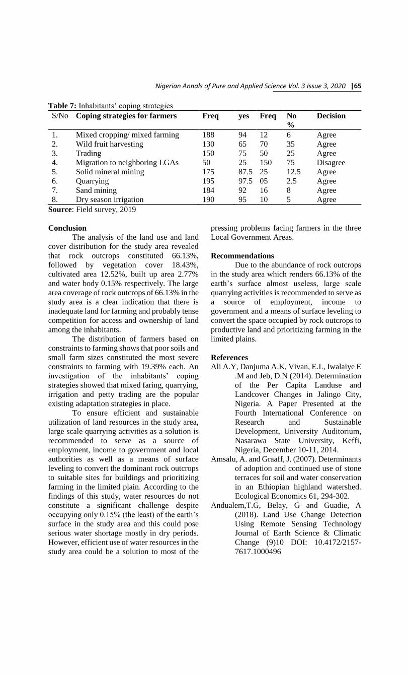
inhabitants’ coping strategies (Table 7), shows
that mixed farming, wild fruit harvesting,
irrigation, trading, mining and quarrying are
the popular existing adaptation strategies in
place and this is in tandem with studies by
Wambai, et. al., (2018).
Table 6: Problems of land and water resources availability for farming
S/no Parameter No of respondents percentage
1 Water shortage 49 16.67
2 Dominance of high lands 54 18.37
3 Poor soils 61 20.75
4 Rocky terrain 58 19.73
5 All of the above 72 24.48
Total 294 100
Source: Field survey, 2019
Nigerian Annals of Pure and Applied Science Vol. 3 Issue 3, 2020 |65
Table 7: Inhabitants’ coping strategies
S/No Coping strategies for farmers Freq yes Freq No
%
Decision
1. Mixed cropping/ mixed farming 188 94 12 6 Agree
2. Wild fruit harvesting 130 65 70 35 Agree
3. Trading 150 75 50 25 Agree
4. Migration to neighboring LGAs 50 25 150 75 Disagree
5. Solid mineral mining 175 87.5 25 12.5 Agree
6. Quarrying 195 97.5 05 2.5 Agree
7. Sand mining 184 92 16 8 Agree
8. Dry season irrigation 190 95 10 5 Agree
Source: Field survey, 2019
Conclusion
The analysis of the land use and land
cover distribution for the study area revealed
that rock outcrops constituted 66.13%,
followed by vegetation cover 18.43%,
cultivated area 12.52%, built up area 2.77%
and water body 0.15% respectively. The large
area coverage of rock outcrops of 66.13% in the
study area is a clear indication that there is
inadequate land for farming and probably tense
competition for access and ownership of land
among the inhabitants.
The distribution of farmers based on
constraints to farming shows that poor soils and
small farm sizes constituted the most severe
constraints to farming with 19.39% each. An
investigation of the inhabitants’ coping
strategies showed that mixed faring, quarrying,
irrigation and petty trading are the popular
existing adaptation strategies in place.
To ensure efficient and sustainable
utilization of land resources in the study area,
large scale quarrying activities as a solution is
recommended to serve as a source of
employment, income to government and local
authorities as well as a means of surface
leveling to convert the dominant rock outcrops
to suitable sites for buildings and prioritizing
farming in the limited plain. According to the
findings of this study, water resources do not
constitute a significant challenge despite
occupying only 0.15% (the least) of the earth’s
surface in the study area and this could pose
serious water shortage mostly in dry periods.
However, efficient use of water resources in the
study area could be a solution to most of the
pressing problems facing farmers in the three
Local Government Areas.
Recommendations
Due to the abundance of rock outcrops
in the study area which renders 66.13% of the
earth’s surface almost useless, large scale
quarrying activities is recommended to serve as
a source of employment, income to
government and a means of surface leveling to
convert the space occupied by rock outcrops to
productive land and prioritizing farming in the
limited plains.
References
Ali A.Y, Danjuma A.K, Vivan, E.L, Iwalaiye E
.M and Jeb, D.N (2014). Determination
of the Per Capita Landuse and
Landcover Changes in Jalingo City,
Nigeria. A Paper Presented at the
Fourth International Conference on
Research and Sustainable
Development, University Auditorium,
Nasarawa State University, Keffi,
Nigeria, December 10-11, 2014.
Amsalu, A. and Graaff, J. (2007). Determinants
of adoption and continued use of stone
terraces for soil and water conservation
in an Ethiopian highland watershed.
Ecological Economics 61, 294-302.
Andualem,T.G, Belay, G and Guadie, A
(2018). Land Use Change Detection
Using Remote Sensing Technology
Journal of Earth Science & Climatic
Change (9)10 DOI: 10.4172/2157-
7617.1000496

66| An Analysis of Land use and land cover Characteristics of Kanke,…
Anon, (2011). Physical Settings. Volume 14,
Issue 5.
http://www.onlinenigeria.com/links/ba
uchi.asp?blurb=200. Accessed on May
19, 2011.
Bennett, J.G., Rains, A.B., Gosden, P.N.,
Howard, W.J., Hutcheon, A.A., Kerr,
W.B., Mansfield, J.E., Rackham, L.J.
and Wood, A.W. (1978). Land
resources of central Nigeria agricultural
development possibilities volume 1B.
The Bauchi Plains. LRDC Ministry of
Overseas Development, Tolworth
Towers, Surbiton, Survey, England,
KT67DY. Hill, I.D. (ed).
Danjuma, A.K; Ali, A.Y; Lagan, A.N,
Iwalaiye, E.M and Oyatayo, K.T
(2014). Classification of Major
Landuse and Landcover Types in
Jalingo Metropolis, Taraba State,
Nigeria. The International Journal
Science and Technoledge, Vol. 2, Issue
7 (3): Www.Theijst.Com
Danjuma, A.K, Ali, A.Y, Lagan, A.N, Jeb, D.N
and Karma, I.M (2014).Determination
of Change Matrix among the
Landuse/Landcover Types in Jalingo,
Metropolis, Nigeria. International
Journal of Innovation and Applied
Studies, Vol 7. No 1 Www.Ijias.Issr-
Journals.Org
Izam, M.M. and Izam, B.D. (2009). Resistivity
Investigation for the location of
underground water at Magama, Toro
L.G.A., Bauchi State, Nigeria. In the
University of Jos. Journal of
Environmental Sciences 13, 1/11, 62-70.
Liping, C, Yujun, S and Saeed, S (2018).
Monitoring and predicting land use and
land cover changes using remote
sensing and GIS techniques—A case
study of a hilly area, Jiangle, China
PLOS ONE 13(7): e0200493.
https://doi.org/10.1371/
Meshesha, T.W, Tripathi, S.K and Kare, D
(2016). Analyses of land use and land
cover change dynamics using GIS and
remote sensing during 1984 and 2015 in
the Beressa Watershed Northern
Central Highland of Ethiopia. Springer
Link
Minale AS (2013) Retrospective analysis of
land cover and use dynamics in Gilgel
Abbay Watershed by using GIS and
remote sensing techniques,
Northwestern Ethiopia. Int J Geosci
4(07):1003
Minale AS, Rao KK (2012a) Impacts of land
cover/use dynamics of Gilgel Abbay
catchment of Lake Tana on climate
variability, Northwestern Ethiopia.
Appl Geomat 4(3) 155-162
Minale AS, Rao KK (2011) Hydrological
dynamics and human impact on
ecosystems of Lake Tana Northwestern
Ethiopia, Ethiopian Journal of
Environmental Studies, Manag 4(1)
Nigeria Meteorological Agency [NIMET],
(2018). National Weather Forecasting
and Climate. Research Centre,
Directorate of research and training,
research division. Current climate
review bulletin. Seasonal rainfall
prediction. National weather
forecasting and climate research centre,
Abuja, Nigeria.
Pandian, M, Rajagopal,N, Sakthivel, G and
Amrutha, D.E (2014). Land Use and
Land Cover Change Detection Using
Remote Sensing and GIS in Parts of
Coimbatore and Tiruppur Districts,
Tamil Nadu, India. International
Journal of Remote Sensing &
Geoscience (IJRSG) www.ijrsg.com
3(1) Jan 2014
Sheila, M. (2011). Water Supply and Poor
Communities: What’s price got to do
with it? Environment, Science and
Policy for sustainable development,.
45(10), 22-35. London: Routledge.
http://dx.doi.org/10
Silvakumar, B. (2011). Water Crisis: From
Conflict to Cooperation – An
Overview. Hydrological Sciences
Journal, 56(4), 531-552, London.
Published by Taylor and Francis
Mortimer Street.
United Nations Environment Programme
[UNEP], (2008). Vital Water graphics
update: Towards a World of Thirst?
Geneva, Switzerland.

Nigerian Annals of Pure and Applied Science Vol. 3 Issue 3, 2020 |67
United States Agency for International
Development [USAID], (2007). Land
tenure and property rights framework.
Vermont Journal of Environmental Law
[VJEL], (2007). Water, Water, every
where, Not any Drop to Drink. Erin
Barnes (ed.).
Vivan, E.L, Ali, A.Y and Shehu, B.M (2015).
Climate Change and its implication on
Crop Production in Barkin Ladi Local
Government Area, Plateau State,
Nigeria. Studies in climate change,
physical and Human Resource
Utilization and Development in
Nigeria: Festschrift in Honour of Prof
A.A Adepetu. M O Press and
Publishers Ltd Kaduna
Wambai, M.W., Dabi, D.D., Ali, A.Y. and
Vivan, E.L. (2017). Domestic water
scarcity in the Guinea Savanna Region
of Bauchi State, Nigeria. Journal of
Environmental Science and Policy
Evaluation. 9(2): Insurderc Academic
Publishers.
Wambai, M.W, Ali, A.Y, Dabang, C.T &
Shenpam, G.D (2018). Assessment of
adaptation Strategies for domestic
water supply scarcity in the Guinea
savannah Regionnof Bauchi State,
Nigeria. Journal of environmental
sciences and policy evaluation 8(1) 1-
16
WorldBank (2019). Improved Child Survival
Program for Human Capital MPA,
Environmental and Social Management
Framework (ESMF)- Draft Final.
http://documents.worldbank.org/curate
d/en/951491570776521515/pdf/Enviro
nmental-and-Social-Management-
Framework.pdf. accessed June 25,
2020, 4.38pm