AGE AND STATISTICAL PROPERTIES OF THE SUMMIT PALAEOSURFACE OF SOUTHERN ITALY
14
289 ABSTRACT: SCHIATTARELLA M., GIANO S.I., GIOIA D.,MARTINO M. & NICO G., Age and statistical properties of the summit palaeosurface of southern Italy. (IT ISSN 0391-9838, 2013). Age constrains and statistical properties of the summit palaeosurface of the south-Apennine chain - Calabrian Arc have been investigated with the aims of refining its use as a morphotectonic marker and distinguish- ing climate and tectonic contributions in landscape evolution. The tops of the mountains of southern Italy are often featured by erosional flat land- forms representing the remnants of a wide palaeosurface attributed to the late Pliocene - Quaternary boundary. Apatite fission-track analyses col- lected in the last years furnished new chronological constrains in terms of its absolute age: this kind of data has been here used in combination with geology and morphotectonics to better define its evolution. On this basis, we infer that both the cooling event and the erosion land surface now preserved at the top of the relief are evidence of the same episode of ex- humation. It is worthy to note that the AFT cluster is comprised between 2 and 3 Ma, as well as mid-Pliocene sediments are the youngest deposit involved in the ancient planation process. Curiously, also the new inter- pretation of these data in the key of land surface dating suggests that the transition period between the late Pliocene and the early Pleistocene rep- resents the time-span in which the summit palaeosurface developed. Such a regional feature was displaced by the 1.8 Ma regional tectonic stage. Maps of palaeosurfaces derived by geomorphological survey have been compared to those constructed by identifying pixels on the SRTM DEM on the base of their current altitude and slope. The Sila Massif (Calabrian Arc) and the Campania-Lucania segment of the southern Ital- ian Apennines, characterized by quite different geological settings, are chosen as test sites. The statistical properties of the palaeosurface rem- nants are here interpreted in terms of a common climate-driven fluvial erosion process and different tectonic activities in the two study areas. KEY WORDS: Tectonic geomorphology, Geomorphometry, Land surfa- ce dating, Fluvial dissection, Long-term landscape evolution, Southern Italy. RIASSUNTO: SCHIATTARELLA M., GIANO S.I., GIOIA D.,MARTINO M. & NICO G., Età e proprietà statistiche della paleosuperficie sommitale del- l’Italia meridionale. (IT ISSN 0391-9838, 2013). La sommità dei rilievi appenninici è spesso caratterizzata da lembi di superfici di spianamento di importanza regionale attribuite ad un inter- vallo temporale corrispondente al passaggio Pliocene-Quaternario. In questo lavoro vengono definiti i vincoli cronologici e le proprietà statisti- che della superficie di spianamento sommitale dell’Appennino meridio- nale («Paleosuperficie» Auctt.) e dell’Arco Calabro, allo scopo di render- ne sempre più affidabile il suo utilizzo come marker morfotettonico. Le caratteristiche di un simile elemento relitto possono, inoltre, costituire nel loro insieme un riferimento sostanziale per discriminare il contributo tet- tonico da quello climatico nella successiva opera di dissecazione e rimo- dellamento del paesaggio fisico dell’Italia meridionale. I dati ottenuti in anni recenti dall’analisi di tracce di fissione in apati- te (AFT) hanno fornito migliori vincoli in termini di età assoluta. Il loro uso in combinazione con le informazioni di cronologia relativa (di natura geologica e morfostratigrafica) ha permesso di ipotizzare che gli eventi di raffreddamento responsabili del cluster più recente di età ricavate dalle tracce di fissione e l’inizio del modellamento della paleosuperficie siano espressione dello stesso processo esumativo della catena orogenica. Poi- ché l’addensamento di dati AFT è compreso tra 2 e 3 Ma, e i depositi me- diopliocenici rappresentano i sedimenti più giovani coinvolti nel processo di spianamento della superficie sommitale, la genesi della stessa si può collocare ancora nell’intervallo temporale compreso tra il Pliocene supe- riore ed il Pleistocene inferiore, seppur in riferimento alla nuova scala geocronologica del Quaternario. La paleosuperficie è tettonicamente di- slocata a scala regionale a 1.8 Ma. La comparazione tra carte delle superfici erosionali, ricavate da rilie- vi di terreno ed analisi di aerofoto, con omologa cartografia automatica estratta da SRTM DEM ha permesso di validare quest’ultima e di utiliz- zare pertanto i modelli digitali di terreno come sorgente di dati topografi- ci e statistici relativi all’oggetto di questo studio, con particolare riferi- mento al segmento campano-lucano dell’Appennino e al massiccio della Sila in Calabria, caratterizzati come noto da differenti assetti geologici e geomorfologici. Le differenze nelle proprietà statistiche dei lembi relitti di paleosuperfici appartenenti ai due domini sono state interpretate come dovute a differente attività tettonica nelle due aree, in termini per esem- pio di spaziatura delle faglie principali, consumatasi tuttavia sotto un co- mune fattore di controllo climatico che ha pilotato la dissezione dei pa- leopaesaggi ad opera della rete drenante. TERMINI CHIAVE: Geomorfologia tettonica, Geomorfometria, Data- zione di una superficie, Dissezione fluviale, Evoluzione a lungo termine del paesaggio, Italia meridionale. Geogr. Fis. Dinam. Quat. DOI 10.4461/GFDQ.2013.36.23 36 (2013), 289-302, 10 figg., 1 tab. MARCELLO SCHIATTARELLA (*), SALVATORE IVO GIANO (*), DARIO GIOIA (**), CLAUDIO MARTINO (*) & GIOVANNI NICO (***) AGE AND STATISTICAL PROPERTIES OF THE SUMMIT PALAEOSURFACE OF SOUTHERN ITALY (*) Dipartimento di Scienze Geologiche, Università degli Studi della Basilicata, Via dell’Ateneo Lucano 10 - I-85100 Potenza, Italy. (**) Istituto per i Beni Archeologici e Monumentali, Consiglio Nazio- nale delle Ricerche (CNR-IBAM), Contrada Santa Loja - I-85050 Tito Scalo (Potenza), Italy. (***) Istituto per le Applicazioni del Calcolo, Sezione di Bari, Con- siglio Nazionale delle Ricerche (CNR-IAC), Via Amendola 122 - I-70126 Bari, Italy. Corresponding author. E-mail: [email protected]
Transcript of AGE AND STATISTICAL PROPERTIES OF THE SUMMIT PALAEOSURFACE OF SOUTHERN ITALY

289
ABSTRACT: SCHIATTARELLA M., GIANO S.I., GIOIA D.,MARTINO M. &NICO G., Age and statistical properties of the summit palaeosurface ofsouthern Italy. (IT ISSN 0391-9838, 2013).
Age constrains and statistical properties of the summit palaeosurfaceof the south-Apennine chain - Calabrian Arc have been investigated withthe aims of refining its use as a morphotectonic marker and distinguish-ing climate and tectonic contributions in landscape evolution. The tops ofthe mountains of southern Italy are often featured by erosional flat land-forms representing the remnants of a wide palaeosurface attributed to thelate Pliocene - Quaternary boundary. Apatite fission-track analyses col-lected in the last years furnished new chronological constrains in terms ofits absolute age: this kind of data has been here used in combination withgeology and morphotectonics to better define its evolution. On this basis,we infer that both the cooling event and the erosion land surface nowpreserved at the top of the relief are evidence of the same episode of ex-humation. It is worthy to note that the AFT cluster is comprised between2 and 3 Ma, as well as mid-Pliocene sediments are the youngest depositinvolved in the ancient planation process. Curiously, also the new inter-pretation of these data in the key of land surface dating suggests that thetransition period between the late Pliocene and the early Pleistocene rep-resents the time-span in which the summit palaeosurface developed. Sucha regional feature was displaced by the 1.8 Ma regional tectonic stage.
Maps of palaeosurfaces derived by geomorphological survey havebeen compared to those constructed by identifying pixels on the SRTMDEM on the base of their current altitude and slope. The Sila Massif(Calabrian Arc) and the Campania-Lucania segment of the southern Ital-ian Apennines, characterized by quite different geological settings, arechosen as test sites. The statistical properties of the palaeosurface rem-nants are here interpreted in terms of a common climate-driven fluvialerosion process and different tectonic activities in the two study areas.
KEY WORDS: Tectonic geomorphology, Geomorphometry, Land surfa-ce dating, Fluvial dissection, Long-term landscape evolution, Southern Italy.
RIASSUNTO: SCHIATTARELLA M., GIANO S.I., GIOIA D.,MARTINO M.& NICO G., Età e proprietà statistiche della paleosuperficie sommitale del-l’Italia meridionale. (IT ISSN 0391-9838, 2013).
La sommità dei rilievi appenninici è spesso caratterizzata da lembi disuperfici di spianamento di importanza regionale attribuite ad un inter-vallo temporale corrispondente al passaggio Pliocene-Quaternario. Inquesto lavoro vengono definiti i vincoli cronologici e le proprietà statisti-che della superficie di spianamento sommitale dell’Appennino meridio-nale («Paleosuperficie» Auctt.) e dell’Arco Calabro, allo scopo di render-ne sempre più affidabile il suo utilizzo come marker morfotettonico. Lecaratteristiche di un simile elemento relitto possono, inoltre, costituire nelloro insieme un riferimento sostanziale per discriminare il contributo tet-tonico da quello climatico nella successiva opera di dissecazione e rimo-dellamento del paesaggio fisico dell’Italia meridionale.
I dati ottenuti in anni recenti dall’analisi di tracce di fissione in apati-te (AFT) hanno fornito migliori vincoli in termini di età assoluta. Il lorouso in combinazione con le informazioni di cronologia relativa (di naturageologica e morfostratigrafica) ha permesso di ipotizzare che gli eventi diraffreddamento responsabili del cluster più recente di età ricavate dalletracce di fissione e l’inizio del modellamento della paleosuperficie sianoespressione dello stesso processo esumativo della catena orogenica. Poi-ché l’addensamento di dati AFT è compreso tra 2 e 3 Ma, e i depositi me-diopliocenici rappresentano i sedimenti più giovani coinvolti nel processodi spianamento della superficie sommitale, la genesi della stessa si puòcollocare ancora nell’intervallo temporale compreso tra il Pliocene supe-riore ed il Pleistocene inferiore, seppur in riferimento alla nuova scalageocronologica del Quaternario. La paleosuperficie è tettonicamente di-slocata a scala regionale a 1.8 Ma.
La comparazione tra carte delle superfici erosionali, ricavate da rilie-vi di terreno ed analisi di aerofoto, con omologa cartografia automaticaestratta da SRTM DEM ha permesso di validare quest’ultima e di utiliz-zare pertanto i modelli digitali di terreno come sorgente di dati topografi-ci e statistici relativi all’oggetto di questo studio, con particolare riferi-mento al segmento campano-lucano dell’Appennino e al massiccio dellaSila in Calabria, caratterizzati come noto da differenti assetti geologici egeomorfologici. Le differenze nelle proprietà statistiche dei lembi relittidi paleosuperfici appartenenti ai due domini sono state interpretate comedovute a differente attività tettonica nelle due aree, in termini per esem-pio di spaziatura delle faglie principali, consumatasi tuttavia sotto un co-mune fattore di controllo climatico che ha pilotato la dissezione dei pa-leopaesaggi ad opera della rete drenante.
TERMINI CHIAVE: Geomorfologia tettonica, Geomorfometria, Data-zione di una superficie, Dissezione fluviale, Evoluzione a lungo terminedel paesaggio, Italia meridionale.
Geogr. Fis. Dinam. Quat. DOI 10.4461/GFDQ.2013.36.2336 (2013), 289-302, 10 figg., 1 tab.
MARCELLO SCHIATTARELLA (*), SALVATORE IVO GIANO (*), DARIO GIOIA (**),CLAUDIO MARTINO (*) & GIOVANNI NICO (***)
AGE AND STATISTICAL PROPERTIES OF THE SUMMITPALAEOSURFACE OF SOUTHERN ITALY
(*) Dipartimento di Scienze Geologiche, Università degli Studi dellaBasilicata, Via dell’Ateneo Lucano 10 - I-85100 Potenza, Italy.
(**) Istituto per i Beni Archeologici e Monumentali, Consiglio Nazio-nale delle Ricerche (CNR-IBAM), Contrada Santa Loja - I-85050 Tito Scalo(Potenza), Italy.
(***) Istituto per le Applicazioni del Calcolo, Sezione di Bari, Con-siglio Nazionale delle Ricerche (CNR-IAC), Via Amendola 122 - I-70126Bari, Italy.
Corresponding author. E-mail: [email protected]

290
AIMS AND METHODS
In the last decade, there has been a rise of interest onthe role of climate changes in landscape evolution (Whip-ple & alii, 1999; Bonnet & Crave, 2003; Burbank & alii,2003; Whipple, 2009). On the other hand, long-termlandscape evolution reflects the interaction and feedbackamong tectonics, erosion and climate (Willett, 1999; Wil-lett & Brandon, 2002; Wobus & alii, 2003; Schiattarella &alii, 2006; Bishop, 2007). In tectonically active areas char-acterized by a complex morpho-structural evolution, bothrelict and active landforms coexist as a result of exogenic vs.endogenic processes. Ancient landforms such as palaeo-landsurfaces represent non-equilibrium features (cf. Bra-cken & Wainwright, 2006) resulting by surface uplift andsubsequent degradation due to erosion. The analysis ofthese geomorphological features is used to assess the rela-tionships among tectonics, surface processes and climatefluctuations during the geological past. The term palaeo-surface denotes any identifiable surface of demonstrableantiquity, often characterized by gentle topography repre-sented by relics of an ancient erosional land surface, thatevolved in response to particular combination of geomor-phological processes (Widdowson, 1997; Bonow & alii,2006). The physical correlation of discrete remnants ofpalaeosurfaces allows to recognize extension and morphol-ogy of such ancient planation surfaces related to a formerbase level of the erosion (i.e. not in accordance with pre-sent morpho-climatic conditions), and they are identifiedin terms of attitude (i.e. characterized by little slope an-gles, not exceeding few degrees) and on the grounds ofseveral markers of geomorphic processes acting in the past.
The reconstruction and dating of ancient land surfacecan provide useful information on morphotectonic evolu-tion, whereas the nature of subsequent modifications bychanging erosional and weathering regimes can reveal keyaspects of subsequent environmental change (Borger, 1997;Schoenbohm & alii, 2004). Hung land surfaces (i.e. ter-raced surfaces suspended with regard to the present-daythalwegs) are also markers of regional-scale neotectonicdeformation and provide information on the rate and tim-ing of uplift and erosion (Schiattarella & alii, 2006; Marti-no & alii, 2009). Recently, the relation between morpho-tectonic features and the fractal dimension of topographyof Taiwan has been explored as well (Sung & Chen, 2004).It has been found that the fractal morphology may reflectsome subtle changes in topographic properties of a land-scape sculpted by surface processes, which in turn are in-fluenced by tectonic activities. This property is perhapsmore diffused than reported in that paper, because a frac-tal behaviour was also found in studies of coastal and flu-vial features (Rigon & alii, 1994; Turcotte, 1999; De Pippo& alii, 2004; Rinaldo & alii, 2006). The Hack’s law relat-ing the upstream length and the total drainage area at agiven location is another evidence of fractal geometry in fluvial landforms. These statistical properties of riverbasins are irrespective of age even if real drainage basinsevolve on a long-term time-scale. Furthermore, it was re-ported that the fractal dimension of the drainage network
can also provide a method for assessing the degree of tec-tonic control on the geometry of fluvial networks (DelMonte & alii, 1999).
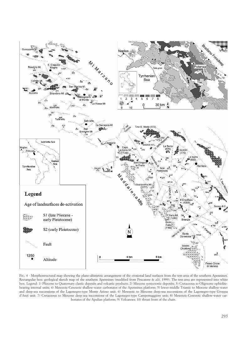
The purpose of this study is to better define the ageof the summit palaeosurface of the southern Italian Apen-nines (i.e. «Paleosuperficie» Auctt.) by both morphostrati-graphic and AFTA dating methods. A similar approach hasbeen recently used also by Japsen & alii (2009), but for anarea located on a passive continental margin (West Green-land). In addition, we aim to investigate the statistical prop-erties and the modalities of the «fragmentation» processesof the south-Italian palaeosurface (i.e. the physical separa-tion due to fault displacement and/or fluvial dissection)which led to the present-day arrangement of its morpho-logical relics. Such a result may help to recognize regionswith different tectonic histories and/or to emphasize theeventual role of other control factors. To this end, the mor-phometric properties of palaeosurfaces are extracted froma Digital Elevation Model (DEM) and maps of palaeosur-faces automatically derived using a recently publishedmethodology (Martino & alii, 2009). The DEM used in thisstudy is obtained by the Shuttle Radar Topography Mission(SRTM). In order to check the fit of the DEM-extractedflat surfaces with the real landforms related to erosionalpalaeosurfaces, the regional-scale automatic cartographyhas been compared with the geomorphological maps andschemes present in the literature relative to southern Italyand, overall, with a survey-derived map of land surfaces.To this aim, a local scale test-site (Mount Marzano - Mad-dalena Mts ridge) has been chosen to perform a more de-tailed comparison with the computer-aided cartography. Inany case, a good correspondence between traditionallymapped and DEM-extracted land surfaces has been veri-fied (cf. par. Identification and age of palaeosurfaces).
The statistical analysis of the properties of land sur-faces of southern Italy has been carried out choosing twoquite different test areas, but roughly characterized by thesame climatic environment. The Sila Massif (CalabrianArc) is the southernmost test area. It is characterized bywide and old land surfaces, at least Pliocene in age, proba-bly inherited by pre-Tortonian flat landscape formed atsea level and weathered under tropical conditions (Scar-ciglia & alii, 2005). During Quaternary times, the SilaMassif underwent a generalized uplift without internalblock faulting. Consequently, the summit palaeolandscapeof this area is loosely fragmented by recent tectonics andscarcely dissected by fluvial erosion (Molin & alii, 2004).The Campania-Lucania segment of the southern Apen-nines is much more morphologically articulated, due tothe more closely spaced Quaternary faulting, associatedwith a higher and more pervasive fluvial dissection.
REGIONAL OUTLINES
The southern Apennines are a northeast-verging fold-and-thrust belt (fig. 1), built on the western border of theAfrican-Apulian plate from late Oligocene - early Miocenetimes. From Langhian-Tortonian times, the thrust front

291
moved progressively toward the east, as documented bythe age of syntectonic deposits (Pescatore & alii, 1999, andreferences therein). Thrusting in the frontal sector of thechain was followed by back-arc extension, responsible forthe Tyrrhenian sea opening (Malinverno & Ryan, 1986).Starting from the Tortonian, the orogen underwent low-angle extension which led to the exhumation of its non-metamorphic core complex constituted of Mesozoic Lago-negro-type pelagic units (Schiattarella & alii, 2003, 2006).Transpressional to transtensional tectonics was responsiblefor the Pliocene to early Pleistocene evolution of thesouth-Apennine chain, whereas high-angle extensionalfaulting took place in mid-Pleistocene times in the axialzone of the chain (Schiattarella, 1998).
The belt is mainly composed of shallow-water anddeep-sea sedimentary covers, deriving from Mesozoic-Cenozoic circum-Tethyan domains, covered by Neogene-Pleistocene foredeep and satellite-basin deposits. It isstrongly uplifted and fragmented by late Pliocene to Qua-ternary faulting and morphologically articulated by thepresence of longitudinal and transversal fault-boundedbasins. The main orientations of these high-angle strike-slipand normal faults are N120±10°, N150±10° and N50±20.
The belt tops are frequently characterized by remnantsof an ancient flat landscape, uplifted and dismembered byQuaternary fault activity. Consequently, the erosional landsurfaces are arranged in several superimposed levels (Schi-attarella & alii, 2003, 2006). The regional uplift hung the
ancient erosional base level to which this palaeolandscapewas related, triggering new morphoevolutionary stages. Asa consequence of the former erosional stages, the paleosur-faces are low-relief and high-altitude relict geomorphologi-cal features (Schiattarella & alii, 2003, 2006).
The Calabrian arc, which from a geographic point ofview represents the southern continuation of the Apennines(fig. 1), is made of crystalline metamorphic units thrust onthe Mesozoic African-Apulian carbonate domains, locallyoutcropping in tectonic windows. Its Neogene tectonictransport is toward the southeast and the thrust front in off-shore (i.e. in the Ionian Sea). The Calabrian arc is partlycharacterized by flat-topped mountains as well, especially inthe Sila Massif, where the top palaeolandscape is deeply af-fected by tropical-type weathering (Guzzetta, 1974; Scar-ciglia & alii, 2005). The arc is strongly articulated in longitu-dinal and transversal horst and graben structures (Ghisetti &Vezzani, 1981), which are genetically related to high-anglefaults mainly oriented in WNW-ESE and N-S directions.
IDENTIFICATION AND AGE OF PALAEOSURFACES
Geomorphological and chronological constraints on palaeo-surface dating
Long-term landscape evolution of an orogen resultsfrom the interaction between tectonic and geomorphologi-cal processes, largely controlled by regional uplift, fault ac-
FIG. 1 - Geological map of theCampania-Lucania Apennine (a)and northern Calabria (b), south-ern Italy. In the inset on the topright: regional localization (mod-ified after Martino & alii, 2009).

292
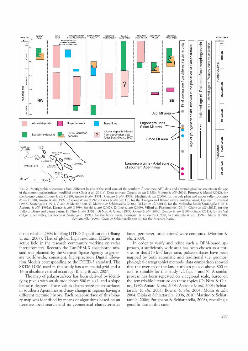
tivity and climate changes. The morphostructural evolu-tion of the southern Apennines is characterized by stagesof tectonic uplift and fault activity alternated with periodsin which sculpture of erosional surfaces and deposition ofsedimentary bodies took place in several intermontanebasins. Both flat land surfaces and the tops of the alluvialdeposits are related to the different past base levels. In thedifferent catchment basins and surrounding ranges, threeor four generations of erosional land surfaces, carved inboth Mesozoic-Cenozoic bedrock and Pliocene-Quater-nary clastic sediments of the basin infill, are normally rec-ognized (Schiattarella & alii, 2003; Boenzi & alii, 2004;Gioia & alii, 2011). The highest land surfaces (summitpalaeosurface, or S1 after Schiattarella & alii, 2003) repre-sent the morphological remnants of a regional planatedlandscape. They unconformably cut across tilted Meso-zoic-Cenozoic shallow-water limestones and coeval basinalformations and lower-middle Pliocene marine sedimentsoutcropping along the Campania-Lucania segment of thesouthern Apennines. Apatite fission-track data from rocksbelonging to different tectonic units of the axial zone ofthe southern Apennines (Aldega & alii, 2005; Mazzoli &alii, 2008) indicate a concordant final cooling age of ca2.5-2.6 Ma (average value, Schiattarella & alii, 2009; Gioia& alii, 2011), suggesting a widespread exhumation duringthe late Pliocene. This relatively young exhumation is like-ly related to erosional denudation rather than tectonics(i.e. low-angle extension, as suggested by other authors forolder stages, see Schiattarella & alii, 2006), thus implying alate Pliocene stage widely affected by intense exogeneticprocesses. It can be argued that such a regional denudationcould be related to the summit palaeosurface morphogen-esis. The attribution of those features to the late Plioceneis strengthened by the presence of lower-middle Plioceneclastic deposits outcropping at the top of the MaddalenaMts (Schiattarella & alii, 2003) and in the Mt. Marzanoarea, involved in the planation of the palaeosurface.
Based on the assumption that the regional uplift andfault activity related to the tectonic stage responsible forthe morphological de-activation of that ancient land sur-face created the accommodation space for continental in-fill of the intermontane catchments, the regional correla-tion of the stratigraphic successions from different basinscan provide chronological constraints to better identify theage of the first significant vertical movements (fig. 2). Thisvertical motion is responsible for the geomorphologicalde-activation of the palaeosurface and its uplift, whereaspervasive faulting and fluvial erosion are accountable forits subsequent fragmentation (Martino & alii, 2009).
According to all these evidences, it is possible to assigna late Pliocene age to the oldest palaeosurface (i.e. S1 afterSchiattarella & alii, 2003) of the Alburni and Mt. Marzanomassifs, generally found above 1100 m a.s.l.. The S2 ero-sional land surfaces (Schiattarella & alii, 2003) frequentlyrepresent dislocated remnants of the oldest one and theirchronological attribution at the early Pleistocene is corrob-orated by the presence of lower Pleistocene fluvial de-posits in many basins of the axial zone, morphologicallyinserted in such flat surfaces. The S3 erosional surfaces
have been used to morpho-stratigraphically correlate theclastic infill of the different basins (Schiattarella & alii,2003; Boenzi & alii, 2004); as a matter of fact, the S3 landsurfaces often cut both bedrock and Pleistocene fluvio-la-custrine deposits along the axis of the entire Campania-Lucania orogenic segment. Several key-data producedabout the radiometric ages of the fluvial-lacustrine de-posits (Karner & alii, 1999; Di Leo & alii, 2009) allowedus to well-constrained the genesis and de-activation of theS3 surfaces, that can be reasonably referred to the earlyPleistocene-middle Pleistocene time-span (fig. 2).
Apatite fission-track analysis (AFTA) furnished addi-tional data concerning the time and rates of cooling relat-ed to exhumation in the uppermost part of the crust (i.e.below the 110°C isotherm). Thermal histories of rocks be-longing to different tectonic units of the southern Apen-nines (Aldega & alii, 2005; Mazzoli & alii, 2008) havebeen used in combination with geology and morphotec-tonic analysis to define both the amounts and timing of de-nudation and/or uplift. An absolute chronology may bedefined by combining the onset and duration of coolingevents estimated from AFTA with stratigraphical data (i.e.hiatuses in the stratigraphy, age of the syntectonic basins)and the formation of erosional surfaces on a regional scale.Being the onset of the cooling episode determined fromapatite fission-track data in agreement with the relativetiming for the formation of the regional palaeosurface inthe southern Apennines, we infer that both the coolingevent and the erosion land surface are evidence of thesame episode of exhumation. A similar approach has beenrecently used in different tectonic setting and geodynamiccontexts (Gunnell, 1998; Schoenbohm & alii, 2004;Bonow & alii, 2006; Japsen & alii, 2006).
The youngest AFT cluster chracterizing the axial zoneof the southern Apennines is comprised between 2 and 3Ma (fig. 3), as well as mid-Pliocene sediments are theyoungest deposit involved in the ancient planation process.Curiously, also the new interpretation of these data in thekey of land surface dating suggests that the transition peri-od between the late Pliocene and the early Pleistocene rep-resents the time-span in which the summit palaeosurfacedeveloped. Such a regional feature was firstly displaced bythe 1.8 Ma tectonic stage, so generating polygenic surfacesre-shaped by fluvial and karst processes, in turn faultedand hung with regard to the erosion base level at about 1.2Ma («Emilian» tectonic stage).
Geomorphological vs. automatic mapping of the south-Apennine palaeosurfaces
Morphometric analysis of palaeosurfaces was performedby using an altimetric dataset derived by the interferomet-ric data acquired during the SRTM mission. The 11-dayspaceborne mission SRTM, was realized in 2000 with theaim of producing a global high resolution DEM of theEarth surface, covering 80% of whole lands between 60°N and 56° S, using the radar interferometry technique(Rabus & alii, 2003). The main advantage of SRTM digitaltopographic maps is to meet requirements for a homoge-
293
neous reliable DEM fulfilling DTED-2 specifications (Bhang& alii, 2007). That of global high resolution DEMs is anactive field in the research community working on radarinterferometry. Recently the TanDEM-X spaceborne mis-sion was planned by the German Space Agency to gener-ate world-wide, consistent, high-precision Digital Eleva-tion Models corresponding to the DTED-3 standard. TheSRTM DEM used in this study has a m spatial grid and a16 m absolute vertical accuracy (Bhang & alii, 2007).
The map of palaeosurfaces has been derived by identi-fying pixels with an altitude above 800 m a.s.l. and a slopebelow 6 degrees. These values characterize palaeosurfacesin southern Apennines and may change in regions having adifferent tectonic history. Each palaeosurface of this bina-ry map was identified by means of algorithms based on aniterative local search and its geometrical characteristics
(area, perimeter, orientations) were computed (Martino &alii, 2009).
In order to verify and refine such a DEM-based ap-proach, a sufficiently wide area has been chosen as a test-site. In this 250 km2-large area, palaeosurfaces have beenmapped by both automatic and traditional (i.e. geomor-phological-cartographic) methods: data comparison showedthat the overlap of the land surfaces placed above 800 ma.s.l. is suitable for this study (cf. figs. 4 and 5). A similarprocess has been repeated on a regional scale, based onthe remarkable literature on these topics (Di Niro & Gia-no, 1995; Amato & alii, 2003; Ascione & alii, 2003; Schiat-tarella & alii, 2003; Boenzi & alii, 2004; Molin & alii,2004; Gioia & Schiattarella, 2006, 2010; Martino & Schiat-tarella, 2006; Putignano & Schiattarella, 2008), revealing agood fit also in this case.
FIG. 2 - Stratigraphic successions from different basins of the axial zone of the southern Apennines, AFT data and chronological constraints on the ageof the summit paleosurface (modified after Gioia et al., 2011a). Data sources: Capaldi & alii (1988), Munno & alii (2001), Porreca & Mattei (2012), forthe Acerno basin; Cinque & alii (1988), Amato & alii (1991), Caiazzo & alii (1992), Magliulo & alii (2006), for the Sele plain and upper valley; Buccino& alii (1978), Amato & alii (1992), Ascione & alii (1992b), Gioia & alii (2011b), for the Tanagro and Bianco rivers (Auletta basin); Lippman Provansal(1987), Santangelo (1991), Giano & Martino (2003), Martino & Schiattarella (2006), Di Leo & alii (2011), for the Melandro basin; Santangelo (1991),Ascione & alii (1992a), Karner & alii (1999), Barchi & alii (2007), Di Leo & alii (2009), Villani & Pierdominici (2010), Giano & alii (2012), for the Vallo di Diano and Sanza basins; Di Niro & alii (1992), Di Niro & Giano (1995), Giano & alii (2000), Zembo & alii (2009), Giano (2011), for the Vald’Agri River valley; La Rocca & Santangelo (1991), for the Noce basin; Bousquet & Gueremy (1968), Schiattarella & alii (1994), Marra (1998),
Schiattarella (1998), Gioia & Schiattarella (2006), for the Mercure basin.

294
It is useful to note that the most part of the high-alti-tude flat land surfaces are identified as erosional featurescutting old, conservative, structurally complex, and vari-ously tilted rocky successions; only a few amount of sub-horizontal surfaces above an altitude of 800 m a.s.l. can beascribed to relatively small depositional features, such asstratigraphical tops of Quaternary undeformed sedimentsof different nature (karstic infill and limno-palustrine de-posits in many cases). For this reason, one can concludethat synoptic or statistical comparisons between mappedand DEM-extracted morphological elements of the physi-cal landscape are almost totally based on the real taxonom-ic similarity of the confronted categories.
Statistical analysis of morphological elements
The number of palaeosurface remnants extracted bythe DEMs of the Sila Massif and of the Campania-Lucaniasegment of the southern Apennines are, respectively, 3804and 5864. All these elements have an area larger than 0.01km2. The cumulative frequency distributions of their spa-tial extensions, derived by counting the number of rem-nants with an extension larger than a given value A, areplotted in figure 6. These distributions flatten out for areassmaller than about 0.06 km2. It is worth noting that thischange in distributions occurs at values larger than theminimal spatial resolution of the dataset, given by the spa-tial extension of each pixel corresponding to 8.1 ·103 m2.Thus, it does not appear to be an artifact due a lack ofcompleteness of the dataset. For spatial extensions in therange from Exp(11.5) m2 (≅ 0.10 km2) to Exp(13) m2
(≅ 0.44 km2), the frequency distributions in the Campania-Lucania Apennine (hereafter CLA) and Sila Massif (here-after SM) are both characterized by a power law with an
exponent of approximately –1.2, that is N(area > A)≅ A–1.21.The Pearson coefficient of linear correlation is 0.92 corre-sponding to a goodness-of-fit exceeding 95%. The spatialextension of palaeosurfaces follows a power law also forvalues larger than Exp(13) m2 (≅ 0.44 km2), even if powerlaw coefficients are different in this range. It has been esti-mated a coefficient equal to 1.56 in CLA and to 0.69 inSM. In both cases, the Pearson coefficient of linear corre-lation is 0.92 corresponding to a goodness-of-fit exceeding95%. Table 1 summarizes the properties of power lawscharacterizing the cumulative frequency distributions ofpalaeosurfaces spatial extension in CLA (and its subdo-mains Maddalena Ridge, Pollino-Lauria-Orsomarso Mts,and Cilento region) and SM. The fragmentation index ofpalaeosurfaces can be defined as:
ApalIfr = ———–Npal · Atot
where Apal and Npal are, respectively, the total area and thenumber of palaeosurface remnants, and Atot is the surfacearea of the whole studied region.
FIG. 3 - AFT ages from the south-ern Apennines (after Aldega & alii,2005, and Mazzoli & alii, 2008). Itshould be noted that the youngercluster groups cooling ages includ-ed in the 2.4-2.7 Ma range (in turncomprised in the wider 3.9-1.5 Maset) and may represent the exhu-mation episode linked to the relati-vely fast planation of the chain dur-ing the Pliocene-Pleistocene transi-tion, whereas the older clusters (atabout 5 and 9 Ma) have to be at-tributed to tectonic denudationphenomena (i.e. low-angle exten-sion) leading to the genesis of thenon metamorphic «core complex»of the southern Apennines (Schiat-tarella & alii, 2003, 2006; Invernizzi& alii, 2008; Mazzoli & alii, 2008).
TABLE 1 - Properties of power laws characterizing the cumulative fre-quency distributions of palaeosurfaces from the study areas
Study area Aps/Atot nps If
Campania-Lucania Apennine 0.0085 5568 1.97·10–6
Maddalena Ridge 0.0217 1158 18.7·10–6
Pollino-Lauria-Orsomarso Mts 0.0174 1410 12.3·10–6
Cilento region 0.0189 767 24.7·10–6
Sila Massif 0.0962 3805 25.3·10–6
295
FIG. 4 - Morphostructural map showing the plano-altimetric arrangement of the erosional land surfaces from the test-area of the southern Apennines.Rectangular box: geological sketch map of the southern Apennines (modified from Pescatore & alii, 1999). The test-area are represented into whitebox. Legend: 1) Pliocene to Quaternary clastic deposits and volcanic products; 2) Miocene syntectonic deposits; 3) Cretaceous to Oligocene ophiolite-bearing internal units; 4) Mesozoic-Cenozoic shallow-water carbonates of the Apennines platform; 5) lower-middle Triassic to Miocene shallow-waterand deep-sea successions of the Lagonegro-type Monte Arioso unit; 6) Mesozoic to Miocene deep-sea successions of the Lagonegro-type Groppad’Anzi unit; 7) Cretaceous to Miocene deep-sea successions of the Lagonegro-type Campomaggiore unit; 8) Mesozoic-Cenozoic shallow-water car-
bonates of the Apulian platform; 9) Volcanoes; 10) thrust front of the chain.

296
Low values for the fragmentation index indicate a larg-er breaking-up of palaeosurfaces. Hence, results in table 1have shown that the fragmentation process has been moreintense in the Maddalena Ridge and Pollino-Lauria-Orso-marso Mts than in the Cilento region and Sila Massif.
The threshold between the regions of validity of thetwo power laws in each dataset is estimated to be 0.44km2. Departure from linearity for spatial extensions largerthan Exp(14) m2 (≅ 1.2 km2) in CLA and Exp(15) m2
(≅ 3.27 km2) in SM can be attributed to undersampling ar-
FIG. 5 - DEM-extracted erosional land surfaces from the test area of the southern Apennines with an altitude above 800 m a.s.l. and a slope below 6 degrees.

297
tifacts. This result suggests the existence of the sub-popu-lations in the dataset of palaeosurfaces identified in bothgeographical areas, as confirmed by a simple quantile-quantile analysis. Such analysis is used to determinewhether two samples come from the same statistical distri-bution. If this is the case, samples lie along a strait line.Figure 7 reports the quantile-quantile plot of CLA vs. SMdatasets. The spatial extension of palaeosurfaces are given
in logarithmic units. The plot shows a linear behaviourwith a clear knee between 5.6 and 5.7, corresponding to arange between 0.4 and 0.5 km2. This means that two sub-populations are present in both datasets. Smaller palaeo-surfaces (before the knee) follow the same distribution inboth the SM and CLA. On the contrary, larger palaeosur-faces (after the knee) belong to a different population. Inother words, the sub-population identified before the kneein SM and CLA traces the same distribution which is dif-ferent from the common distribution followed by the sub-populations after the knee.
A closer analysis of the geometric properties of landsurface elements is furnished by diagrams in figures 8 and9 (CLA and SM, respectively). Each palaeosurface is rep-resented as a point whose polar coordinates are given byits spatial extension and orientation. The orientation iscomputed as the angle between the x-axis and the majoraxis of the ellipse having the same second-moment as theshape of palaeosurface on the binary map. In both figures,a belt composed of palaeosurfaces with small extensionand random orientation can be recognized. Beyond a polardistance of 5.7 on a logarithmic scale, corresponding toabout 0.5 km2, there are only a few palaeosurfaces. Theyhave a large extension and a well defined orientation. TheSila Massif (fig. 9) shows less elements of such large rem-nants than the Campania-Lucania segment of southernApennines (fig. 8). It is worth of note that the directions ofthe large palaeosurfaces correspond to the strikes of themain faults of the orogenic chain.
Although the fragmentation processes of the summitpaleosurface – and, more in general, of the three or four
FIG. 6 - Cumulative frequency dis-tributions related to the palaeosur-faces of the two test areas locatedat an altitude above 1000 m a.s.l.
FIG. 7 - Quantile-quantile plots of palaeosurfaces areas of Sila Massif vs. Campania-Lucania segment.

298
main land surface orders featuring the southern ItalianApennines – seem to be largely linked to the Quaternarytectonic activity (mainly block faulting), also the role ofthe fluvial dissection due to not tectonically controlledstreams has to be taken into account. Further, both paleo-surface remnants and hydrographic networks show powerlaw distributions and fractal dimensions, so remarking thelink between the fragmentation process and the fluvial netevolution. Anyway, to test the behaviour of the hydro-graphic nets from the study area, five catchments of south-ern Italy have been examined from a quantitative point ofview. In particular, the statistical properties of the fluvialnetworks have been stressed using a number of streamsvs. hierarchical order diagram. The hierarchical channelarrangement has been also computed with the aim to ap-preciate the role of geological and morpho-structural pe-
culiarities on a catchment scale. Amazingly, the hierarchi-cal properties of the drainage network appears to be verysimilar in all the basins (fig. 10), although the single catch-ments are characterized by very contrasting geological set-tings and quite different geomorphological features. Thisproperty can be interpreted as a result of the scarce sensi-tivity of the drainage systems to the litho-structural controlwhereas it seems remarkable the super-regional climateinfluence.
Interpretation of DEM-extracted data
The non linearity of the quantile-quantile plot (fig. 7)indicates that smaller and larger palaeosurfaces do notcome from the same probability distribution in both theSila Massif anf the Campania-Lucania segment of southernApennines. Futhermore, the analysis of the cumulative
FIG. 8 - Representation of extension and orientation of palaeosurfaces inthe Campania-Lucania segment: (top) areas are on a logarithmic scale;
(bottom) areas are on a linear scale.
FIG. 9 - Representation of extension and orientation of palaeosurfaces in the Sila Massif: (top) areas are on a logarithmic scale; (bottom) areas
are on a linear scale.

299
area frequency distributions put in evidence the existenceof two populations of palaeosurfaces in the two study ar-eas. In both cases the threshold between the two popula-tions was found to be about Exp(13) m2 (≅ 0.44 km2).
The close agreement between the slope of best fittingstraight lines to frequency distributions before the abovethreshold could be explained in terms of a common sur-face segmentation genesis, probably related to a commonclimate-driven erosion. This result shows an unexpectedagreement with the representation of the hierarchic ar-rangement of several drainage basins of the southernApennines (fig. 10). Such basins show different tectonicstructures, lithological characters, and morphostructuralfeatures (Schiattarella & alii, 2003, 2006, 2008): all thesefactors do not influence significantly the distribution ofthe number of channels per hierarchical order, which canbe therefore considered an invariant parameter (except forthe number of high order streams of some basins, depend-ing on the different size of the catchments). One can con-clude that climate is a prominent control factor of the hier-archical arrangements of the fluvial nets draining the axialzone of the chain. Indeed, the analysis of the hierarchicalproperties of the drainage network seems to confirm thatclimate-driven fluvial erosion processes have mainly con-trolled the fragmentation of the palaeosurfaces. On theother hand, the good correspondence between the direc-tions of the large palaeosurfaces and the strikes of themain faults of the chain suggests that the first stage ofpalaeosurfaces fragmentation is related to the activity ofthe faults.
As time flows, erosion-induced fragmentation increasesthe number of small-area surfaces and reduces the averagearea of fragmented surfaces. Hence, the time evolution oferosion effects, producing smaller and smaller surfaces, in-creases the slope of the left part of figure 6 and possiblydisplaces the border towards large area values.
Both the slope and border depend on the elapsed timemeasured from the starting of erosion, on the climatic fac-tor intensity and, of course, on the surface geology. The offigure 6 could be useful to extract information about pastclimatic environment and climatic changes. Beyond this
threshold value, the cumulative area-frequency curves ofthe two datasets remarkably differ. In the Sila Massif aHurst coefficient H < 0.5 has been found denoting agreater randomess with respect to the Campania-Lucaniasegment where H > 0.5. This different behavior could berelated to the different tectonic activity in the study areas.Both studies area, even if characterized by different tec-tonic histories, experienced the same erosion-inducedfragmentation as expected being all areas studied in thiswork included in a narrow range of latitude and hencecharacterized by the same climatic environment.
FINAL REMARKS
Apatite fission track analysis on rocks belonging to dif-ferent tectonic units of the axial zone of the southernApennines indicates a concordant middle to late Pliocenefinal cooling age of ca 2.5-2.6 My (fig. 3). Although the ge-othermal gradient is poorly constrained and the exhuma-tion rates can be affected by errors, the values of the ex-humation rates are significantly higher than estimated de-nudation and uplift rates. An exhumation rate of about 1.6mm/yr for the last 3 My can be in fact inferred from ther-mochronometry, remarking the existence of past erosionalprocesses faster than the recent and present-day exogenicdismantling, whose velocities have been obtained by ourpalaeotopographic reconstruction (Schiattarella & alii,2008; Gioia & alii, 2011). Tectonic denudation processeshas been accounted for the exhumation of Mesozoic coreof the chain during older periods (from late Miocene toearly-middle Pliocene) of the orogenic evolution (Schiat-tarella & alii, 2003, 2006), but they seem not suitable forthe time interval here considered.
Regarding the genesis of the summit palaeolandscape,an attempt of morpho-stratigraphic correlation of manyremnants has been done on a regional scale. The recon-struction of the original land surface palaeomorphology al-lowed to infer a probable origin at the sea level by marineerosion (Martino & Schiattarella, 2006). Such a geneticprocess is compatible with the very fast rates of the palaeo-
FIG. 10 - Plot of the number ofchannels for each hierarchic or-ders in five basins of the southern
Apennines.

300
surface morphogenesis. Marine erosion linked to eustaticrising can be taken in consideration as an efficient mecha-nism of planation on a regional scale, able to sculpturehuge flat landscapes and to dismantle large volumes ofrocks. It is probable that AFT data cluster at 2.5-2.6 Mycould really represent the age of formation of the palaeo-surface of the southern Apennines: in such a case, thehigher denudation rates may be due to the rapid disman-tling of shaly units (e.g. Liguride units, i.e. ophiolite-bear-ing «internal» units, Sicilide units, mainly composed ofdeep-sea polychrome clay, and Miocene Flysch units)which tectonically or stratigraphically covered the Campa-nia-Lucania carbonate platform.
A quantitative analysis of an interferometric SRTMDEM for the identification of the statistical properties ofsouthern Italy palaeosurfaces has been here presented.The analysis concerned two study areas characterized bythe same present-day climate environment and similarpalaeo-climate conditions, but featured by quite differenttectonic settings: the Campania-Lucania Apennines andthe Sila Massif in southern Italy. The cumulative frequencydistribution of palaeosurfaces as well as a quantile-quantileanalysis show the existence of two populations in bothstudy areas. The threshold area value between the twopopulations is about 400 squared meters. Below this value,the surface fragmentation process has the same scalingproperties in both datasets. Above this threshold value thetwo cumulative frequency distributions differ. The repre-sentation of palaeosurfaces in a polar diagram in terms oftheir extension and orientation clearly discriminate a set ofa few palaeosurfaces with an area larger than 500 squaredmeters and well defined orientations from a cloud of uni-formly distributed palaeosurfaces having small area andrandom orientation.
These properties are interpreted in terms of a commonclimate-driven fluvial erosion process and different tectonicactivities in the two study areas. Neotectonic behaviour isexpressed by an uniform block uplift in the Sila Massif,with a major kinematic role of the fault-bounded borders,whereas the Quaternary activity of the dense fault networkof the Campania-Lucania Apennines assign to this sector ofthe chain a strong non-homogeneity of the uplift pattern.
REFERENCES
ALDEGA L., CORRADO S., DI LEO P., GIAMPAOLO C., INVERNIZZI C.,MARTINO C., MAZZOLI S., SCHIATTARELLA M. & ZATTIN M. (2005) -The southern Apennines case history: thermal constraints and recon-struction of tectonic and sedimentary burials. Atti Ticin. Sci. Terra,Spec. Ser., 10, 45-53.
AMATO A., AUCELLI P.P.C. & CINQUE A. (2003) - The long-term denuda-tion rate in the Southern Apennines Chain (Italy): A GIS-aided estima-tion of the rock volumes eroded since middle Pleistocene time. Quater-nary International, 101-102, 3-11.
AMATO A., ASCIONE A., CINQUE A. & LAMA A. (1991) - Morfoevoluzione,sedimentazione e tettonica recente dell’alta Piana del Sele e delle suevalli tributarie (Campania). Geografia Fisica e Dinamica Quaternaria,14, 5-16.
AMATO A., CINQUE A., SANTANGELO N. & SANTO A. (1992) - Il bordomeridionale del massiccio del Monte Marzano e la valle del FiumeBianco: geologia e geomorfologia. Studi Geologici Camerti, VolumeSpeciale 1992/1, 191-200.
ASCIONE A., CINQUE A., IMPROTA L. & VILLANI F. (2003) - Late Quater-nary faulting within the Southern Apennines seismic belt: new datafrom Mt. Marzano area (Southern Italy). Quaternary International,101-102, 27-41.
ASCIONE A., CINQUE A., SANTANGELO N. & TOZZI M. (1992a) - Il bacinodel Vallo di Diano e la tettonica trascorrente plio-quaternaria: nuovivincoli cronologici e cinematici. Studi Geologici Camerti, VolumeSpeciale 1992/1, 201-208.
ASCIONE A., CINQUE A. & TOZZI M. (1992b) - La valle del Tanagro (Cam-pania): una depressione strutturale ad evoluzione complessa. StudiGeologici Camerti, Volume Speciale 1992/1, 209-219.
BARCHI M., AMATO A., CIPPITELLI G., MERLINI S. & MONTONE P. (2007)- Extensional tectonics and seismicity in the axial zone of the SouthernApennines. Bollettino della Società Geologica Italiana, Volume Spe-ciale 7, 47-56.
BHANG K.J., SCHWARTZ F.W. & BRAUN A. (2007) - Verification of the ver-tical error in C-band SRTM DEM using ICESat and Landsat-7, OtterTail County, MN. IEEE Transanction on Geoscience and RemoteSensing, 45.
BISHOP P. (2007) - Long-term landscape evolution: Linking tectonics andsurface processes. Earth Surface Processes and Landforms, 32, 329-365.
BOENZI F., CAPOLONGO D., CECARO G., D’ANDREA E., GIANO S.I., LAZ-ZARI M. & SCHIATTARELLA M. (2004) - Evoluzione geomorfologia poli-fasica e tassi di sollevamento del bordo sud-occidentale dell’alta Vald’Agri (Appennino meridionale). Bollettino della Società GeologicaItaliana, 123, 357-372.
BONNET S. & CRAVE A. (2003) - Landscape response to climate change:Insights from experimental modeling and implications for tectonics ver-sus climatic uplift of topography. Geology, 31, 123-126.
BONOW J.M., LIDMAR-BERGSTRÒM K. & JAPSEN P. (2006) - Palaeosurfacesin central West Greenland as reference for identification of tectonicmovements and estimation of erosion. Global and Planetary Change,50, 161-183.
BORGER H. (1997) - Environmental changes during the Tertiary: the exam-ple of palaeoweathering residues in central Spain. In: Widdowson M.(ed.), Palaeosurfaces, Recognition, Reconstruction and Palaeoenviron-mental Interpretation. Geol. Soc. London, Spec. Publ., 120, 159-174.
BOUSQUET J.C. & GUEREMY P. (1968) - Quelques phénomènes de néotec-tonique dans l’Apennin calabro-lucanien et leurs conséquences mor-phologiques. 1) Bassin du Mercure et haute vallée du Sinni. Revue deGéographie Physique et de Géologie Dynamique, 10, 225-238.
BUCCINO G., D’ARGENIO B., FERRERI V., BRANCACCIO L., FERRERI M.,PANICHI C. & STANZIONE D. (1978) - I travertini della bassa valle delTanagro (Campania). Studio geomorfologico, sedimentologico e geochi-mico. Bollettino della Società Geologica Italiana, 97, 617-646.
BRACKEN L.J. & WAINWRIGHT J. (2006) - Geomorphological equilibrium:myth and metaphor? Transactions Institute of British Geographers,31, 167-178.
BURBANK D.W., BLYTHE A.E., PUTKONEN J., PRATT-SITAULA B., GABET
E., OSKIN M., BARROS A. & OJHA T.P. (2003) - Decoupling of erosionand precipitation in the Himalayas. Nature, 426, 652-655.
CAIAZZO C., GIOVINE G., ORTOLANI F., PAGLIUCA S., SCHIATTARELLA M.& VITALE C. (1992) - Genesi ed evoluzione strutturale della depressio-ne tettonica dell’Alta Valle del Sele (Appennino Campano-Lucano).Studi Geologici Camerti, Volume Speciale 1992/1, 245-255.
CAPALDI G., CINQUE A. & ROMANO P. (1988) - Ricostruzione di sequenzemorfoevolutive nei Picentini meridionali (Campania, Appennino Meri-dionale). Suppl. Geografia Fisica e Dinamica Quaternaria, 1, 207-222.
CINQUE A., GUIDA F., RUSSO F. & SANTANGELO N. (1988) - Dati cronolo-gici e stratigrafici su alcuni depositi continentali della Piana del Sele(Campania): i «conglomerati di Eboli». Geografia Fisica e DinamicaQuaternaria, 11, 39-44.

301
DE PIPPO T., DONADIO C., MAZZARELLA A., PAOLILLO G. & PENNETTA
M. (2004) - Fractal geometry applied to coastal and submarine featu-res. Zeitschrift für Geomorphologie N.F., 48, 185-199.
DEL MONTE M., FREDI P., LUPIA PALMIERI E. & SALVINI F. (1999) - Frac-tal analysis to define the drainage network geometry. Bollettino dellaSocietà Geologica Italiana, 118, 167-177.
DI LEO P., GIANO S.I., GIOIA D., MATTEI M., PESCATORE E. & SCHIAT-TARELLA M. (2009) - Evoluzione morfotettonica quaternaria del bacinointermontano di Sanza (Appennino meridionale). Il Quaternario, 22,189-206.
DI LEO P., GIOIA D., MARTINO C., PAPPALARDO A. & SCHIATTARELLA M.(2011) - Geomorphological, mineralogical, and geochemical evidenceof Pleistocene weathering conditions in the southern Italian Apenni-nes. Geologica Carpathica, 62, 43-53.
DI NIRO A. & GIANO S.I. (1995) - Evoluzione geomorfologica del bordoorientale dell’Alta Val d’Agri (Basilicata). Studi Geologici CamertiSpec. Vol., 1995/2, 207-218.
DI NIRO A., GIANO S.I. & SANTANGELO N. (1992) - Primi dati sull’evolu-zione geomorfologica e sedimentaria del bacino dell’alta Val d’Agri(Basilicata). Studi Geologici Camerti, volume speciale 1992/1, 257-263.
GHISETTI F. & VEZZANI L. (1981) - Contribution of structural analysis tounderstanding the geodynamic evolution of the Calabrian arc (southernItaly). Journal of Structural Geology, 3, 371-381.
GIANO S.I. (2011) - Quaternary alluvial fan systems of the Agri intermon-tane basin (southern Italy): Tectonic and climatic controls. GeologicaCarpathica, 62, 65-76.
GIANO S.I., GIOIA D. & SCHIATTARELLA M. (2012) - The connected Aulet-ta, Vallo di Diano, and Sanza basins, southern Apennines, Italy: ope-ning kinematics and morphostructural evolution. Rend. online Soc.Geol. It., 21, 1239-1241.
GIANO S.I. & MARTINO C. (2003) - Assetto morfotettonico e morfostrati-grafico di alcuni depositi continentali pleistocenici del bacino del Per-gola-Melandro (Appenino Lucano). Il Quaternario, 16, 289-297.
GIANO S.I., MASCHIO L., ALESSIO M., FERRANTI L., IMPROTA S. & SCHIAT-TARELLA M. (2000) - Radiocarbon dating of acting faulting in the Agrihigh valley, southern Italy. Journal of Geodynamics, 29, 371-386.
GIOIA D., MARTINO C. & SCHIATTARELLA M. (2011a) - Long- to short-termdenudation rates in the southern Apennines: geomorphological markersand chronological constraints. Geologica Carpathica, 62, 27-41.
GIOIA D. & SCHIATTARELLA M. (2006) - Caratteri morfotettonici dell’areadel Valico di Prestieri e dei Monti di Lauria (Appennino meridionale).Il Quaternario, 19, 129-142.
GIOIA D. & SCHIATTARELLA M. (2010) - An alternative method of azimu-thal data analysis to improve the study of relationships between tecto-nics and drainage networks: examples from southern Italy. Zeitschriftfür Geomorphologie, 54, 225-241.
GIOIA D., SCHIATTARELLA M., MATTEI M. & NICO G. (2011b) - Quanti-tative morphotectonics of the Pliocene to Quaternary Auletta basin,southern Italy. Geomorphology 134, 326-343.
GUNNELL Y. (1998) - Present, past and potential denudation rates: is therea link? Tentative evidence from fission-track data, river sediment loadsand terrain analysis in the South Indian shield. Geomorphology, 25,135-153.
GUZZETTA G. (1974) - Ancient tropical weathering in Calabria. Nature,251, 302-303.
INVERNIZZI C., BIGAZZI G., CORRADO S., DI LEO P., SCHIATTARELLA M.& ZATTIN M. (2008) - New thermobaric constraints on the exhuma-tion history of the Liguride accretionary wedge, southern Italy. Ofioliti,33, 21-32.
JAPSEN P., BONOW J.M., GREEN P.F., CHALMERS J.A. & LIDMAR-BERG-STRÖM K. (2006) - Elevated, passive continental margins: Long-termhighs or Neogene uplifts? New evidence from West Greenland. Earthand Planetary Science Letters, 248, 330-339.
JAPSEN P., BONOW J.M., GREEN P.F., CHALMERS J.A. & LIDMAR-BERG-STRÖM K. (2009) - Formation, uplift and dissection of planation surfa-ces at passive continental margins - a new approach. Earth SurfaceProcesses Landforms, 34, 683-699.
KARNER D.B., JUVIGNÉ E., BRANCACCIO L., CINQUE A., RUSSO ERMOLLI
E., SANTANGELO N., BERNASCONI S. & LIRER L. (1999) - A potentialearly middle Pleistocene tephrostratotype for the Mediterranean basin:the Vallo di Diano, Campania, Italy. Global and Planetary Change,21, 1-15.
LA ROCCA S. & SANTANGELO N. (1991) - Nuovi dati sulla stratigrafia esull’evoluzione geomorfologica del bacino lacustre pleistocenico delFiume Noce (Basilicata). Geografia Fisica e Dinamica Quaternaria,14, 229-242.
LIPPMANN PROVANSAL M. (1987) - L’Apennin méridionale (Italie): étudegéomorphologique. Thèse de Doct., d’Etat en Géogr. Phys., Univ.d’Aix, Marseille.
MAGLIULO P., TERRIBILE F., COLOMBO C. & RUSSO F. (2006) - A pedo-stratigraphic marker in the geomorphological evolution of the Campa-nian Apennines (Southern Italy): The Paleosol of Eboli. QuaternaryInternational, 156-157, 97-117.
MALINVERNO A. & RYAN W.B.F. (1986) - Extension in the Tyrrhenian Seaand shortening in the Apennines as result of arc migration driven bysinking of the lithosphere. Tectonics, 5, 227-245.
MARTINO C., NICO G. & SCHIATTARELLA M. (2009) - Quantitative ana-lysis of palaeosurfaces and erosion rates from southern Italy by meansof InSAR Digital Elevation Models. Earth Surface Processes andLandforms, 34, 3-15.
MARTINO C. & SCHIATTARELLA M. (2006) - Aspetti morfotettonici del-l’evoluzione geomorfologica della valle del Melandro (Appennino cam-pano-lucano). Il Quaternario, 19, 119-128.
MARRA F. (1998) - Evidenze di tettonica trascorrente alto pleistocenica alconfine calabro-lucano: analisi morfostratigrafica e strutturale del baci-no del Mercure. Il Quaternario, 11, 201-215.
MAZZOLI S., D’ERRICO M., ALDEGA L., CORRADO S., INVERNIZZI C., SHI-NER P. & ZATTIN M. (2008) - Tectonic burial and «young» (<10 Ma)exhumation in the southern Apennines fold-and-thrust belt (Italy).Geology, 36, 243-246.
MOLIN P., PAZZAGLIA F.J. & DRAMIS F. (2004) - Geomorphic expressionof active tectonics in a rapidly-deforming forearc, Sila Massif, Calabria,southern Italy. American Journal of Science, 304, 559-589.
MUNNO R., PETROSINO P. & ROMANO P. (2001) - A late middle pleistoce-ne climatic cycle in southern Italy inferred from pollen analysis andtephrostratigraphy of the Acerno Lacustrine Succession. GéographiePhysique et Quaternaire, 55, 87-99.
PESCATORE T., RENDA P., SCHIATTARELLA M. & TRAMUTOLI M. (1999) -Stratigraphic and structural relationships between Meso-Cenozoic La-gonegro basin and coeval carbonate platforms in southern Apennines,Italy. Tectonophysics, 315, 269-286.
PORRECA M. & MATTEI M. (2012). Tectonic and environmental evolutionof Quaternary intramontane basins in Southern Apennines (Italy): In-sights from palaeomagnetic and rock magnetic investigations. Geophy-sical Journal International, 182, 682-698.
PUTIGNANO M.L. & SCHIATTARELLA M. (2008) - Struttura, esumazione edevoluzione morfologica del nucleo mesozoico del Monte Motola (Cilen-to, Italia meridionale). Bollettino della Società Geololica Italiana (Ita-lian Journal of Geosciences), 127, 477-493.
RABUS B., EINEDER M., ROTH A. & BAMLER R. (2003) - The Shuttle RadarTopography Mission a new class of digital elevation models acquired byspaceborne radar. ISPRS Journal of Photogrammetry and RemoteSensing, 57, 241-262.
RIGON R., RINALDO A. & RODRIGUEZ-ITURBE I. (1994) - On landscapeself-organization. Journal of Geophysical Research 99 (B6), 11971-11993.
RINALDO A., BANAVAR J.R. & MARITAN A. (2006) - Trees, networks andhydrology. Water Resourses Research, 42, W06D07.
SANTANGELO N. (1991) - Evoluzione geomorfologica e stratigrafica di alcu-ni bacini lacustri del confine calabro-lucano (Italia meridionale). Tesidi Dottorato inedita, Università «Federico II», Napoli, pp. 109.
SCARCIGLIA F., LE PERA E., VECCHIO G. & CRITELLI S. (2005) - The inter-play of geomorphic processes and soil development in an upland envi-ronment, Calabria, South Italy. Geomorphology, 69, 169-190.

302
SCHIATTARELLA M. (1998) - Quaternary tectonics of the Pollino Ridge, Ca-labria-Lucania boundary, southern Italy. In: Holdsworth R.E., Stra-chan R.A. & Dewey J.F. (eds), Continental Transpressional andTranstensional Tectonics. Geological Society, London, Spec. Publ.,135, 341-354.
SCHIATTARELLA M., BENEDUCE P., CAPOLONGO D., DI LEO P., GIANO
S.I., GIOIA D., LAZZARI M. & MARTINO C. (2008) - Uplift and erosionrates from the southern Apennines, Italy. Bollettino di Geofisica Teo-rica ed Applicata, 49, suppl. 2, 470-475.
SCHIATTARELLA M., DI LEO P., BENEDUCE P. & GIANO S.I. (2003) - Qua-ternary uplift vs tectonic loading: a case-study from the Lucanian Apen-nine, southern Italy. Quaternary International, 101-102, 239-251.
SCHIATTARELLA M., DI LEO P., BENEDUCE P., GIANO S.I. & MARTINO C.(2006) - Tectonically driven exhumation of a young orogen: an exam-ple from southern Apennines, Italy. In: Willett S.D., Hovius N., Bran-don M.T. & Fisher D. (eds.), Tectonics, climate, and landscape evo-lution. Geological Society of America, Spec. Paper, 398, PenroseConference Series, 371-385.
SCHIATTARELLA M., GIOIA D. & MARTINO C. (2009) - The age of the sum-mit palaeosurface of the southern Apennines: geomorphological andchronological constraints. IUGS 13th Congress RCMNS «Earth Sy-stem Evolution and the Mediterranean from 23 Ma to the Present»,Napoli, 2-6 Settembre 2009, Acta Naturalia de «L’Ateneo Parmen-se», 45, n. 1/4-2009, 176-177.
SCHIATTARELLA M., TORRENTE M.M. & RUSSO F. (1994) - Analisi struttu-rale ed osservazioni morfostratigrafiche nel bacino del Mercure (confinecalabro-lucano). Il Quaternario, 7, 613-626.
SCHOENBOHM L.M., WHIPPLE K.X., BURCHFIEL B.C. & CHEN L. (2004) -Geomorphic constraints on surface uplift,exhumation, and plateaugrowth in the Red River region, Yunnan Province, China. GeologicalSociety of America Bulletin, 116, 895-909.
SUNG Q.C. & CHEN Y.C. (2004) - Self-affinity dimensions of topographyand its implications in morphotectonics: an example from Taiwan.Geomorphology, 62, 181-198.
TURCOTTE D.L. (1999) - Self-organized criticality. Reports on Progress inPhysics, 62, 1377-1429.
VILLANI F. & PIERDOMINICI S. (2010) - Late Quaternary tectonics of theVallo di Diano basin (southern Apennines, Italy). Quaternary ScienceReviews, 29, 3167-3183.
WHIPPLE K., KIRBY E. & BROCKLEHURST S. (1999) - Geomorphic limitsto climatically induced increases in topographic relief. Nature, 401,39-43.
WHIPPLE K.X. (2009) - The influence of climate on the tectonic evolutionof mountain belts. Nature Geoscience, 2, 97-104.
WIDDOWSON M. (1997) - The geomorphological and geological importanceof palaeosurfaces. In: Widdowson M. (ed.), Palaeosurfaces, Recogni-tion, Reconstruction and Palaeoenvironmental Interpretation. Geo-logical Society of London, Spec. Publ., 120, 1-12.
WILLETT S.D. (1999) - Orogeny and orography: The effects of erosion onthe structure of mountain belts. Journal of Geophysical Research 104,28957-28981.
WILLETT S.D. & BRANDON M.T. (2002) - On steady states in mountainbelts. Geology, 30, 175-178.
WOBUS C.W., HODGES K.V. & WHIPPLE K.X. (2003) - Has focused denu-dation sustained active thrusting at the Himalayan topographic front?Geology, 31, 861-864.
ZEMBO I., PANZERI L., GALLI A., BERSEZIO R., MARTINI M. & SIBILIA E.(2009) - Quaternary evolution of the intermontane Val d’Agri Basin,Southern Apennines. Quaternary Research, 72, 431-442.
(Ms. received 1 November 2012; accepted 1 May 2013)