A MODULAR STANDARD FOR THE CADASTRAL DOMAIN
16
A MODULAR STANDARD FOR THE CADASTRAL DOMAIN (*) Christiaan Lemmen, PaulVan Der Molen Dutch Cadastre, Apeldoorn, The Netherland & International Institute for Geo-Information Science and Earth Peter Van Oosterom, Hendrik Ploeger, Wilko Quak, Jantien Stoter, Jaap Zevenbergen Department of Geodesy, Delft University of Technology. Delft, The Netherland A standardized core cadastral domain model, covering land registration and cadastre in a broad sense (multipurpose cadastre), will serve at least two important goals: 1. avoid reinventing and re-implementing the same functionality over and over again, but provide a extensible basis for efficient and effective cadastral system development based on a model driven architecture, and 2. enable involved parties, both within one country and between different countries, to communicate based on the shared ontology implied by the model. The contributions of this paper consist of an improved and extended version of the existing cadastral domain model, and the introduction of a modular approach (packages). One of the main preconditions of the model development is to keep the model as transparent and simple as possible in order to be useful in practise. Until today most countries (or states or provinces) have developed their own cadastral system because there are supposed to be huge differences between the systems. The one operates deeds registration, the other title registration, some systems are centralized, and others decentralized. Some systems are based on a general boundaries approach, others on fixed boundaries. Some cadastres have a fiscal background, others a legal one. However, it is also obvious that the separate implementation and system’s maintenance of a cadastral system are not cheap, especially if one considers the ever-changing requirements. Also, the different implementations (foundations) of the cadastral systems do not make meaningful communication very easy, e.g. in an international context such as within Europe. Looking at it from a little distance one can observe that the systems are in principle mainly the same: they are all based on the relationships between persons and land, via (property) rights and are in most countries influenced by developments in the Information and Communication Technology (ICT). The two main functions of every cadastral system are: 1. keeping the contents of this relationship up-to-date (based on legal transactions) and 2. providing information on this registration. In many global documents (Agenda21, Habitat, Johannesburg) land is considered as being an important issue. Main political objectives such as poverty eradication, sustainable housing and agriculture, strengthening the role of vulnerable groups (indigenous, women), are one way or another related to access to land, and to land-related opportunities. This definitely impacts on the policy of donor agencies (e.g. the English policy on ‘better livelihoods for people’, the German policy on ‘land tenure in development cooperation’, and the Dutch policy on ‘business against poverty’), and on Poverty Reduction Strategy Papers for the Worldbank. How with this respect governments deal with the land issue, could be defined as ‘land policy’. Having a policy is one thing, having the instruments to enforce the policy is another. Therefore governments need instruments like the regulations concerning land tenure security, the land market, land use planning and control, land taxation and the management of natural resources. It is within this context that the function of land administration systems can be identified: a supporting tool to facilitate the implementation of a proper land policy in the broadest sense. The UN Land Administration Guidelines (UN/ECE, 1996) speak about land administration as the ‘process of determining, recording, and disseminating information on ownership, value and use of land when implementing land management policies’. If ‘ownership’ is understood as the mode in which rights to land are held, we could also speak about ‘land tenure’. Amain characteristic of land tenure is that it reflects a social relationship regarding rights to land, which means that in a certain jurisdiction the relationship between people and land is recognised as a legally valid one (either formal or non- formal). These recognised rights arc in principle eligible for registration, with the purpose to assign a certain legal meaning to the registered right (e.g. a title). Therefore land administration systems are not ‘just handling only geographic information’ as they represent a lawfully meaningful relationship amongst people, and between people and land. As the land administration activity on the one hand deals with huge amounts of data, which moreover are of a very dynamic nature, and on the other hand requires a continuous maintenance process, the role of information technology is of strategic importance. Without availability of information systems it is believed it will be difficult to guarantee good performance with 231 Octubre 2004 (*) This paper was presented in the III ISDE Congress developed at Chec Republic on September 2003. The CT/Catastro board thanks the authors for the copyright for the reproduction in this issue of the revue.
-
Upload
independent -
Category
Documents
-
view
0 -
download
0
Transcript of A MODULAR STANDARD FOR THE CADASTRAL DOMAIN

A MODULAR STANDARD FOR THECADASTRAL DOMAIN (*)Christiaan Lemmen, PaulVan Der MolenDutch Cadastre, Apeldoorn, The Netherland& International Institute for Geo-InformationScience and Earth
Peter Van Oosterom, Hendrik Ploeger,Wilko Quak, Jantien Stoter, Jaap ZevenbergenDepartment of Geodesy, Delft Universityof Technology. Delft, The Netherland
A standardized core cadastral domain model,covering land registration and cadastre in a broadsense (multipurpose cadastre), will serve at least twoimportant goals:
1. avoid reinventing and re-implementing thesame functionality over and over again, butprovide a extensible basis for efficient andeffective cadastral system development basedon a model driven architecture, and
2. enable involved parties, both within onecountry and between different countries, tocommunicate based on the shared ontologyimplied by the model. The contributions ofthis paper consist of an improved andextended version of the existing cadastraldomain model, and the introduction of amodular approach (packages). One of themain preconditions of the modeldevelopment is to keep the model astransparent and simple as possible in order tobe useful in practise.
Until today most countries (or states or provinces)have developed their own cadastral system becausethere are supposed to be huge differences between thesystems. The one operates deeds registration, the othertitle registration, some systems are centralized, andothers decentralized. Some systems are based on ageneral boundaries approach, others on fixedboundaries. Some cadastres have a fiscal background,others a legal one. However, it is also obvious that theseparate implementation and system’s maintenance of acadastral system are not cheap, especially if oneconsiders the ever-changing requirements. Also, thedifferent implementations (foundations) of the cadastral
systems do not make meaningful communication veryeasy, e.g. in an international context such as withinEurope. Looking at it from a little distance one canobserve that the systems are in principle mainly thesame: they are all based on the relationships betweenpersons and land, via (property) rights and are in mostcountries influenced by developments in theInformation and Communication Technology (ICT).The two main functions of every cadastral system are: 1.keeping the contents of this relationship up-to-date(based on legal transactions) and 2. providinginformation on this registration.
In many global documents (Agenda21, Habitat,Johannesburg) land is considered as being animportant issue. Main political objectives such aspoverty eradication, sustainable housing andagriculture, strengthening the role of vulnerablegroups (indigenous, women), are one way or anotherrelated to access to land, and to land-relatedopportunities. This definitely impacts on the policy ofdonor agencies (e.g. the English policy on ‘betterlivelihoods for people’, the German policy on ‘landtenure in development cooperation’, and the Dutchpolicy on ‘business against poverty’), and on PovertyReduction Strategy Papers for the Worldbank. Howwith this respect governments deal with the land issue,could be defined as ‘land policy’. Having a policy is onething, having the instruments to enforce the policy isanother. Therefore governments need instruments likethe regulations concerning land tenure security, theland market, land use planning and control, landtaxation and the management of natural resources. It iswithin this context that the function of landadministration systems can be identified: a supportingtool to facilitate the implementation of a proper landpolicy in the broadest sense.
The UN Land Administration Guidelines (UN/ECE,1996) speak about land administration as the ‘process ofdetermining, recording, and disseminating informationon ownership, value and use of land when implementingland management policies’. If ‘ownership’ is understoodas the mode in which rights to land are held, we couldalso speak about ‘land tenure’. Amain characteristic ofland tenure is that it reflects a social relationshipregarding rights to land, which means that in a certainjurisdiction the relationship between people and land isrecognised as a legally valid one (either formal or non-formal). These recognised rights arc in principle eligiblefor registration, with the purpose to assign a certain legalmeaning to the registered right (e.g. a title). Thereforeland administration systems are not ‘just handling onlygeographic information’ as they represent a lawfullymeaningful relationship amongst people, and betweenpeople and land. As the land administration activity onthe one hand deals with huge amounts of data, whichmoreover are of a very dynamic nature, and on the otherhand requires a continuous maintenance process, the roleof information technology is of strategic importance.Without availability of information systems it is believedit will be difficult to guarantee good performance with
231
Octubre 2004
(*) This paper was presented in the III ISDE Congressdeveloped at Chec Republic on September 2003.
The CT/Catastro board thanks the authors for the copyrightfor the reproduction in this issue of the revue.

respect to meeting changing customer demands.Organisations are now increasingly confronted with rapiddevelopments in the technology, a technology push:internet, (geo)-databases, modelling standards, opensystems, GIS, as well as a growing demand for newservices, a market pull: e-governance, sustainabledevelopment, electronic conveyance, integration ofpublic data and systems. Cadastral modelling isconsidered as a basic tool facilitating appropriate systemdevelopment and re-engineering and in addition it formsthe basis for meaningful communication betweendifferent (parts of the) systems.
Standardization is a well-known subject since theestablishment of cadastral systems. In both paperbased systems and computerized systems standards arerequired to identify objects, transactions, relationsbetween real estate objects (e.g. parcels) and persons(also called subjects in some countries), classificationof land use, land value, map representations of objects,etc. etc. Computerized systems ask for even furtherstandardization when topology and identification ofsingle boundaries are introduced (Van Oosterom,Lemmen, 2001). In existing cadastral systemsstandardization is limited to the territory orjurisdiction where the cadastral system is in opera-tion. Open markets, globalisation, and effective andefficient development and maintenance of flexible(generic) systems ask for further standardization. In(Van Oosterom, Lemmen, 2003) an overview is givenof the following initiatives and developments:
1. Land Title and Tenure SIG: first initiative ofthe OpenGIS Consortium (OGC) in 2000.
2. Several standardization initiatives anddevelopments in Cadastral Organizationsa) Introduction of ISO Standards in
Germany (Seifert, 2002).b) US National Integrated Land System
(FGDC, 1999, Meyer, von et al., 2001).c) Initiatives from Australia and New
Zeeland (LINZ, 2002, LandXML, 2002,ICSM 1999,2002).
d) Initiative from Sweden: The EULISproject (Ollen, 2002).
3. COST Research Activity Statement.4. The International Federation of Surveyors,
FIG (Greenway, 2002).
Further initiatives can be recognised in Europe:INSPIRE is “an initiative to support the availability ofspatial information for the formulation, implementationand evaluation of Union policies”. 60 spatial datacomponents, grouped around 17 themes have beenidentified as important data-sets, among otherstopography, cadastral properties, geographical namesadministrative areas, postcodes, buildings and addresses,terrain elevation and orthophotos. INSPIRE ‘intends toset the legal framework for the gradual creation of aspatial information infrastructure’. INSPIRE can beconsidered as an outcome of the 6th EnvironmentalAction Program 2001 -2010 of the EU. (www.ec-gis.org/inspire).
After the ‘false start in 2000’, the OGC now seekssponsors for Property and Land Initiative as announcedin a press release of March 25, 2003: ‘The Open GIS
Consortium, Inc. (OGC) is issuing a Call for Sponsorsfor a Planning Activity that may support futuredevelopment of an OGC Property and Land Information(PLI) Initiative. This planning activity will seekinterested sponsors to provide input on technologyrequirements and concepts to foster development ofnext-generation interoperable networked architecturesand capabilities to enable broader sharing andapplication of property data and land informationbetween collaborating organizations’. And:
‘The ultimate goal of the OGC Property and LandInformation Initiative is to promote increasedunderstanding of the application of OpenGIS®Specifications to the challenge of cross-organizationaland cross jurisdictional access to critical information.The Initiative would seek to design, test andoperationally validate open architectural frameworks fordistributed property and land information networks. Aspart of the growing “Spatial Web”, these networks willallow information to be easily exchanged betweenconsumers, governments, and businesses for manydifferent purposes. This information would be accessibleonline through OpenGIS Interface Specifications andother standards consistent with best practices defined aspart of National and Global Spatial Data Infrastructuresand E-Govemment initiatives. This initiative willdemonstrate how standards-based distributed networksof databases and information services can helpconsumers and citizens to access vital data, businesses tooffer premium customer services, and governments toprovide more effective service to citizens’.
This paper continues in Section 2 with anoverview of the progress made so far in thedevelopment of a standardized Cadastral DomainModel based on the geographic standards from ISOand OGC (OpenGIS). This cadastral model isdeveloped in cooperation with the FIG, the research isalso related to the framework of the COST (Co-ordination in the field of Scientific and TechnicalResearch) Action G9: ‘Modelling Real PropertyTransactions’. Alternatives for 3D Cadastral modellingare discussed in Section 3 and the dynamic nature ofCadastral systems is elaborated on Section 4. Themain conclusions and future work are finallydescribed in the last section.
Cadastral Domain Model
The core of the cadastral domain model as depictedin Figure 1 is the central part of the model as wasalready presented at the FIG working week in April2003, Paris (Lemmen, Van Oosterom 2003). It showsthe Unified Modeling Language (UML) class diagram,which represents the result of the previous work. Therelationship between real estate objects (e.g. parcels)and persons (sometimes called ‘subjects’) via rights isthe foundation of every land administration. Besidesrights, there can also be restrictions between the realestate objects and the persons. The figure shows thatRightOrRestriction is an association class between theclasses Person and RealEstateObject. Note that this ann-to-m relationship, with the conditions that everypersons should at least be associated with oneRealEstateObject and vice versa every RealEstate objectshould be associated with at least one Person (indicated
232
CHRISTIAAN LEMMEN, PAUL VAN DER MOLEN, PETER VAN OOSTEROM, HENDRIK PLOEGER, WILKO QUAK, JANTIEN STOTER, JAAP ZEVENBERGEN

in the UML diagram with the multiplicity of’l..*’ at bothends of the association).
When presenting or trying to describe a model, onealways faces the question ‘how to describe this modelfor domain experts (non-technical end-users, managers,but not modeling experts)?’. This question reappears inevery context where models are developed. Textualdescriptions alone are difficult to understand, as themodel structure may not be visible. For this purpose allkinds of diagrams have been developed with ‘boxes andarrows’. However, every time the “boxes and arrows’ didhave a different meaning, which made generalunderstanding, even by modeling specialists, difficult.Therefore, the Object Management Group (OMG, seeBooch, Rumbaugh, Jacobson, 1999) standardized themain types of diagrams and the meaning of ‘boxes andarrows’. In this paper we will mainly use UML classdiagrams to describe the cadastral domain model. Thereare several other types of UML diagrams. Normally themodeling starts with the development of use casediagrams (for this work we refer to the COST Action G9‘Modeling Real Property Transactions’). In this paper westart with the class diagrams as these are the most ‘stable’and independent of organizations and actors, UML classdiagrams are reasonably well suited to describe a formaland structured set of concepts, that is an ‘Ontology’(Gmber, 1993). This is one of the main results from our
attempt to develop a Cadastral domain model.Experiences (in other domains) show that it is still noteasy to read these diagrams. The solution used in thispaper is to use ‘Literate Modeling’, that is UML diagramsembedded in text explaining the models. More detailsand discussion on Literate Modeling, with examplesfrom British Airways, can be found in (Ariow, Emmerichand Quinn, 1998).
A UML class diagram describes the types ofobjects and the various kinds of structuralrelationships that exist among them like associationsand subtypes. Furthermore the UML class diagramsshow the attributes and operations of a class and theconstraints that apply to the way objects areconnected (Booeh, Rumbaugh, Jacobson, 1999). Theproposed UML class diagram for the cadastral domaincontains both legal/administrative object classes likepersons, rights and the geographic description of realestate objects, this means in principle that data couldbe maintained by different organizations, e.g.Municipality, Planning Authority, private Surveyor,Cadastre. Conveyancor and/or Land Registry. Themodel will most likely be implemented as adistributed set of (geo-) information systems, eachsupporting the maintenance activities and theinformation supply of parts of the dataset representedin this model (diagram), thereby using other parts of
233
A MODULAR STANDARD FOR THE CADASTRAL DOMAIN
Figure 1: Core of the Cadastral Domain Model: Person, RightfOrRestricton, RealEstateObject

the model. This underlines the relevance of thismodel; different organizations have their ownresponsibilities in data maintenance and supply andhave to communicate on the basis of standardizedprocesses in so called value adding production chains.
One should not look at the whole model (allpackages together as presented at the end of thissection) at once as the colours are representing UML‘packages’ or coherent parts of the model:
Green and yellow: legal/administrative aspects,green and blue: real estate object specializations, blue,pink and purple: geometric/topological aspects. It islikely that more packages will be developed. Besidesbeing able to present/document the model incomprehensive parts, another advantage of usingpackages could be that it is possible to develop andmaintain these packages in a more or less independentway. Domain experts from different countries couldfurther develop each package. It is not the intention ofthe model that everything should be realized in onesystem. The true intention is that, if one needs thetype of functionality covered by a certain package,then this package should be the foundation andthereby avoiding reinventing (re-implementing) thewheel and making meaningful communications withothers possible. Furthermore basic packages could beimplemented by software suppliers, e.g. GIS supplierslike ESRI are providing models for several domainslike agriculture, topographic mapping, biodiversity/conservation, defence, energy utilities, environmentalregulated facilities, forestry, geology, historicpreservation, hydrograpic/navigation, marine,petroleum, pipeline, system architecture, telecom-munications, urban, water utilities, water resources.One domain of interest for ESRI is Cadastre 2014(KLaufmann, Steudler, 1998). The principles opCadastre 2014 are integrated in our approach. In thefollowing subsections the different packages will bedescribed in more detail.
Specializations of RealEstateObject:object detail classes
A RealEstateObJect is an abstract class, that is,there are no object instances of this object class.However, it has specialization classes (which haveobject instances), such as Parcel, ParcelComplex,PartOfParcel, VolumeProperty, RestrictionArea,ApartmentUnit, and NonGeoRealEstate. In a UMLclass diagram the specialization classes point to themore generic class with an open headed arrow. Thespecializations are mutual exclusive. Thespecializations of the RealEstateObJect class arerepresented in the ‘blue’ package; see Figure 2. Allthese specialisations of RealEstateObjects haveassociations with one or more Persons via theRightOrRestriction association. The Parcels are alsopart of a two dimensional partioning of the surface(see section 2.4), but not all these parts have thisdirect association with Persons. There are parts, calledServingParcels in our model, which only have directassociations with two or more (main) Parcels (inDutch mandeligheid). This means that aServingParcel serves a number of other Parcels; e.g. ajoint facility, such as a path or playground. A straight
line in the UML class diagram depicts this association.It could be considered as some kind of jointownership via the (main) Parcels. In the UML classdiagram Parcel and ServingParcel are bothspecializations of PartitionParcels, which all-togetherform the partition of the 2D domain. ThePartitionParcel class, just as the RealEstateObjectclass, is an abstract class as there will never beinstances of this class. Note that Parcel is based onmultiple inheritance (from RealEstateObject andPartitionParcel, both abstract classes).
A ParcelComplex is an aggregation of Parcels.The fact that the multiplicity at the sideParcelComplex is 0.1 (in the association with Parcel)means that this is optional. A ParcelComplexsituation might occur in a system where a set ofParcels –could be in one municipality or even inanother administrative unit– has a legal/customarymeaning, for instance being the object of onemortgage. A Parcel can be subdivided in two or morePartOfParcel’s. This case could occur when‘preliminary’ Parcels are created during a conveyancewhere the Parcel will be split and surveying is doneafterwards. It could also be helpful to supportplanning processes, based on cadastral maps, whereestablishment of Parcels in the field is done later intime. Note that in the model a composite associationis used, indication that the components (from theclass PartOfParcel) have no meaning/right ofexistence without the aggregate class (Parcel), this inindicated with the closed diamond.
An ApartmentComplex is associated with one ormore Parcel’s. There can be at most oneApartmentComplex located on a Parcel. There can betwo or more ApartmentUnit’s in an ApartmentComplex. In case the multiplicity of a class in anassociation is one (‘1’), then this is not explicitlyshown in the UML class diagram as is the case at thesite of the ApartmentComplex in the associationbetween ApartmentUnit and ApartaifflntCoroplex.Note that artApartmentUnit is intended in the generalsense, not only/unit for living purpose; but also forother purposes, e.g. commercial. In other words, allbuilding units with legal/registration significance areincluded here.
Parcel’s are defined by ParcelBoundaries and havea geometric/topological description (Ousterom, van.Lemmen, 2001). The class ParcelBoundaries alwayshas two neighbour PartitionParcel’s, where territorialParcelBoundary’s have one ‘zero-Parcel’ as neighbour,representing the external territory. There can be morethen one ParcelBoundaries between two neighbourPartitionParcels, depending on attributes and thegeometric configuration. Exclaves and enclaves fromterritorial perspective can be managed in thisapproach. In general this approach implies thatindividual PartitionParcels, and therefore also thederived classes Parcel and ServingParcel., are notexplicitly represented as ‘closed polygons’. Attributescan be linked to individual boundaries; this allows forexample classification of individual boundaries basedon the administrative subdivision of the territory. Inthis way double, triple or multiple storage of the sameboundary can be avoided, thus avoiding all kind of‘gap and overlap’ problems, which don’t have ameaning in reality.
234
CHRISTIAAN LEMMEN, PAUL VAN DER MOLEN, PETER VAN OOSTEROM, HENDRIK PLOEGER, WILKO QUAK, JANTIEN STOTER, JAAP ZEVENBERGEN
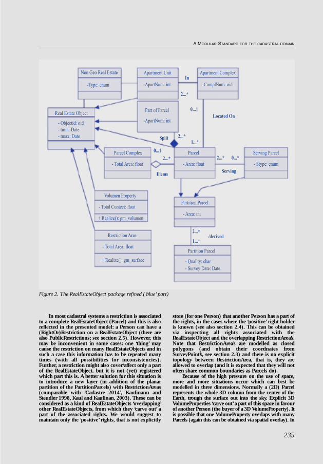
In most cadastral systems a restriction is associatedto a complete RealEstateObject (Parcel) and this is alsoreflected in the presented model: a Person can have a(RightOr)Restriction on a RealEstateObject (there arealso PublicRestrictions; see section 2.5). However, thismay be inconvenient in some cases: one ‘thing’ maycause the restriction on many ReaIEstateObjects and insuch a case this information has to be repeated manytimes (with all possibilities for inconsistencies).Further, a restriction might also cover/affect only a partof the RealEstateObject, but it is not (yet) registeredwhich part this is. A better solution for this situation isto introduce a new layer (in addition of the planarpartition of the PartitionParcels) with RestrictionAreas(comparable with ‘Cadastre 2014’, Kaufmann andSteudler 1998, Kaul and Kaufinan, 2003). These can beconsidered as a kind of ReaIEstateObjects ‘overlapping’other ReaIEstateObjects, from which they ‘carve out’ apart of the associated rights. We would suggest tomaintain only the ‘positive’ rights, that is not explicitly
store (for one Person) that another Person has a part ofthe rights, in the cases where the ‘positive’ right holderis known (see also section 2.4). This can be obtainedvia inspecting all rights associated with theRealEstateObject and the overlapping RestrictionArea’s.Note that RestrictionArea’s are modelled as closedpolygons (and obtain their coordnates fromSurveyPoint’s, see section 2.3) and there is no explicittopology between RestrictionArea, that is, they areallowed to overlap (and it is expected that they will notoften share common boundaries as Parcels do).
Because of the high pressure on the use of space,more and more situations occur which can best bemodelled in three dimensions. Normally a (2D) Parcelrepresents the whole 3D column from the center of theEarth, trough the surface out into the sky. Explicit 3DVolumeProperties ‘carve out’ a part of this space in favourof another Person (the buyer of a 3D VolumeProperty). Itis possible that one VolumeProperty overlaps with manyParcels (again this can be obtained via spatial overlay). In
235
A MODULAR STANDARD FOR THE CADASTRAL DOMAIN
Figure 2. The RealEstateObject package refined (‘blue’ part)

the same manner as suggested for RestrictionAreas, wesuggest that it is best only to register the ‘positive’ side ofthe registration without redundancy. VolumePropertiesare modelled without external topology, but with internaltopology by referencing several times to the same SurveyPoint, when this is shared between the different faces of apolyhedron. VoluroeProperties should not overlap in 3Dspace. However, their projection in 2D space may overlap.It is expected that it will not happen often thatVolumeProperties will share faces with other explicitVolumeProperties (as is the case in 2D with thePartitionParcels). Might this assumption tourn out to bewrong, then a 3D topological structured model should beintroduced. More background and discussion on alter-native 3D cadastral modelling can be found in section 3.
The class NonGeoRealEstate can be useful in casewhere a (complete) geometric description of theRealEstateObject does not (yet) exist. E.g. in casewhere only one co-ordinate inside theRealEstateObject is observed, using Satellite Images orGPS. Or in case of a right to fish in a commonly heldarea (itself depicted as a ServingParcel), where theholder of the fishing right does not (or no longer)hold rights to a land parcel in the area.
Surveying Classes
Object classes related to surveying are presentedin pink colour; see Figure 3. A cadastral survey isdocumented on a Survey Document, which is a (legal)source document made up in the field. Mostimportantly, this document contains signatures; in afull digital surrounding a field office may be requiredto support this under the condition that digitalsignatures have a legal support. Otherwise paperbased documents should be considered as an integralpart of the cadastral system. Files with terrestrialobservations –distances, bearings, and referredgeodetic control– on points are attributes ofSurveyDocument, the Measurements. BothParcelBoundary and SurveyPoint are associated withSurveyDocument. From the multiplicity it can berecognized that one SurveyDocument can beassociated with several SurveyPoints. In case aSurveyPoint is observed at different moments in timethere will be different SurveyDocuments. In case aSurveyPoint is observed from different positionsduring a measurement there is only one associationwith a SurveyDocument.
Geometry and Topology: importedOpenGIS classes
Object classes describing geometry and topologyare presented in purple; see Figure 4. The CadastralDomain Model is based on already accepted andavailable standards on geometry and topologypublished by ISO and OGC (ISO. 1999a, 1999b,OpenGIS Consortium 1998, 2QOOa, 2000b. 2000cand 2000d). Geometry is based on SurveyPoints(mostly after geo referencing, depending on datacollection mode: tape, total station, GPS, etc) and isassociated with the classes tp_node (topology node)and tp_edge (topology edge) to describeintermediate ‘shapes’ points between nodes,imetrically based on SurveyPoints. The associationbetween a Parcel Boundary and SurveyDocument isderived via the classes SurveyPoint, tp_nodeandtp_edge.
Parcels have a 2D geometric description. A Parcelcorresponds one-to-one to the tp_face in a topologicalstructure (as defined by ISO TC 211 and OpenGISConsortium). A face is bounded by its edges in 2D. Anedge is related one-to-one to a Parcel Boundary, which
may contain non-geometric attributes as explained in6.2. Every edge has exactly two end points,represented in tp_Nodes. In addition, an edge mayalso have several intermediate points. Bothintermediate points and nodes are associated withSurveyPoints. The topological primitives tp_face,tp_edge and tp_nodes, have all a method (‘operation’)called ‘Realize’ which can be used to obtain a fullmetric representation,
There are two additional geometry layers, whichare not based on explicit topology structure, these canbe found in respectively the classes RestrictionAreaand VolumeProperty. As in the topology/geometrylayer of PartionParcel, all coordinates are obtainedfrom the SurveyPoints. There are also‘Realize’methods available within the RestrictionAreaand VolumeProperty classes to return the completeand explicit geometry respectively gm_surface andgm_volume. A VolumeProperty is defined by at least 4non-planar SurveyPoints; this would result in atetrahedron. the simplest 3D volume object. TheRestrictionArea is defined by 3 or more SurveyPoints,which all have to locate in the same horizontal plane(of the earth surface).
236
CHRISTIAAN LEMMEN, PAUL VAN DER MOLEN, PETER VAN OOSTEROM, HENDRIK PLOEGER, WILKO QUAK, JANTIEN STOTER, JAAP ZEVENBERGEN
Figure 3. The Survey Package, ‘pink’.

Legal/Administrative classes
Object classes presented in yellow cover therefinements in the Legal/Administrative side; see Figure5. A 11 updates associated to JRightsOrRestrictions arebased on LegalDocuments as source. In principle legaldata will not be changed without provision of aLegalDocument. The essential data of a LegalDocumentare associated with (‘can be represented in’) the classesRightOrRestriction, Mortgage or PublicRestriction. Asingle legal document may be the source of multipleinstances of these classes and may even create of mix ofthese three types. In the other direction, aRightOrReslriction, Mortgage or PublicRestriction isalways associated with exactly one LegalDocument asits source.
Each jurisdiction has a different ‘land tenuresystem’, reflecting the social relationships regardingrights (and restrictions) to land in that area. Thevariety of rights is already quite large within mostjurisdictions and the exact meaning of similar rightsstill differs considerably between jurisdictions.
Usually one can distinguish between a number ofcategories of land rights.
a) Firstly we have the strongest right availablein a jurisdiction, called e.g. ownership, free-hold or property.
b) Secondly we have derived rights from theprevious category where the holder of thisderived right is allowed to use the land in itstotality (often within the limits of a certainland use type, e.g. housing or animalfarming).
c) Thirdly we have minor rights that allow theholder of it to some minor use of someoneelse his land. e.g. walking over it to the road.Such rights can be called servitude oreasement, and also may include the right toprevent certain activities or construction atsome nearby land, e.g. freedom of view.
d) Fourthly we have the so called securityrights, whereby certain of the previouslymentioned rights can be used as collateral,
237
A MODULAR STANDARD FOR THE CADASTRAL DOMAIN
Figure 4. The Geometry, Topology and some related packages, purple

mainly through bank loans, e.g. mortgage,hypothec, lien.
The aforementioned rights are primarily in thedomain of private law. Usually the rights are createdafter an agreement between the person getting theright and the person losing something (who sees hisright restricted by the newly created right). The rightsand restrictions we are concerned with here usuallyremain valid, even if these persons change after theright was created (and registered). This is called aright in rem in many jurisdictions. There is adifference between legal systems and registrationapproaches in whether rights, other than under a), areformulated and recorded primarily as the right of theholder, as a restriction to the right (or object) they are‘carved’ out from, or both. The last solution is of
course risky from data management point of view,since inconsistencies can arise.
Because property and ownership rights are basedon (national) legislation, ‘lookup tables’ can supportin this. E.g., the right of ’ownership’ might be‘Norwegian Ownership’, ‘Swedish Ownership’, etc.etc. ‘Customary Right’ related to a region or ‘InformalRight’ can be included; from modelling perspectivethis is not an item for discussion. Of course, for theactual implementation in a given country or region,this is very important.
In addition to those private law restrictions, manycountries also have public law restrictions, which areusually imposed by a (local) government body. The‘holder’ of the right is abstract (either “megovernment” or “society-at-large”) and usually theyare primarily seen as restrictions. Some of them apply
238
CHRISTIAAN LEMMEN, PAUL VAN DER MOLEN, PETER VAN OOSTEROM, HENDRIK PLOEGER, WILKO QUAK, JANTIEN STOTER, JAAP ZEVENBERGEN
Figure 5: The legal/administrative classes (yellow) and person classes (green).

to a specific RealEstateObject (or right therein) or asmall group of them. E.g. most pre-emption rights, orthe duty to pay a certain tax for improvements on theroad, or the duty to repair damage or perform belatedmaintenance. Others have their own area ofapplication, like whether there is soil pollutionpresent, flood plains, (re) zoning of areas (esp. whenurban development is made possible in a rural area).
Each restriction type has its own place in thecadastral domain model. Public restrictions with theirown areas can be recorded via the RestrictionArea class,not being linked to a specific holder. Obviously thedocuments on which they are based need to beincluded. Public restrictions, which apply toRealEstateObject’s but have no clear beneficiary, arerecorded as PublicRestrictions. Other restrictionsshould be recorded as well as possible as rights in thename of the holder, but in certain countries some typesdo not state the holder (or the holder is a neighbouringRealEstateObject, regardless of who holds thatRealEstateObject). In such cases the restriction as suchis recorded on the RealEstateObject, often without aperson connected to it. Nevertheless, the most vitalrights are usually in the name of a person, likeownership, leasehold or usufruct. Security rights differbetween jurisdictions. Sometimes the holder of the right(e.g. bank) is recorded, in other cases there is only arestriction recorded, informing others someone alreadyhas a security right on this RealEstateObject (often onlya defined, and often recorded, amount of money issecured, and a second or third mortgage could becreated). For every RightOrRestriction it is importantthat it is made clear how it is recorded. In all cases therelevant source LegalDocument(s) should be associated.One should finally be aware that in most jurisdictionscertain use rights and certain security rights can existtotally outside the registration system. These so called‘overriding interests’ are valid, also against third parties,without registration. Examples can be rent contracts forshorter periods, certain agricultural tenancy agree-ments, and ‘liens’ by tax authorities.
The abstract class ‘Person’ (that is again a classwithout object instances) has as specialisation classesNaturalPerson or NonNaturalPerson like organisations,companies, co-operations and other entitiesrepresenting social structures. If a Person is aNaturalPerson it cannot be a NonNaturalPerson andthe other way around. That is, NaturalPerson andNonNaturalPerson are mutual exclusive.
Right (a subset based on the type attribute inRightOrRestriction) is compulsory associationbetween RealEstateObject and Person, where this isnot compulsory in case of restriction (the other subsetin RightOrRestriction). For example, a restriction likeencumbrance is only associated with the land: theRealEstateObject.
The class RightOrRestriction allows for theintroduction of ‘shares of rights’ in case where a groupof Persons holds a undivided part of a ‘complete’ right.
History and dynamic aspects
There are two different approaches whenmodelling the result of dynamic systems (discretechanges in the state of the system): event and/or statebased modelling:
– In event based modelling, transactions aremodelled as a separate entity within the system(with their own identity and set of attributes).When the start state is known and all eventsarc know it is possible to reconstruct everystate in the past via traversing the whole chainof events. It is also possible to represent thecurrent state, and not keep the start state (andgo back in time via the ‘reversal’ of events).
– In state based modelling, only the states (thatis the results) are modelled explicitly: veryobject gets (at least) two dates/times, whichindicate the time interval during which thisobject is valid. Via the comparison of twosucceeding states it is possible to reconstructwhat happened as result of one specific event.It is very easy to obtain the state at a givenmoment in time, by just selecting the objectbased on their time interval (tmin-tmax).
In our model we have introduced a hybridapproach as both aspects of event and state basedmodelling can be found. The (legal and survey)documents can be considered as explicit repre-sentation of events (transactions). However, theeffects of these events are kept in the states of theassociated objects (which have tmin and tmaxattributes). New inserted instances get a tmin, equalto the check-in/transaction time and a tmax equal tothe maximal (integer) value. A deleted instance gets atmax equal to its check-in/transaction time. In case ofupdate of one or more attributes, a new instance willbe created (as copy from the old instance with its newvalues for updated attributes) with a tmin equal tocheck-in/transaction time and a tmax equal to a maxi-mum value. The old instance gets a tmax equal tocheck-in/transaction time. This allows to query for thespatial representation of cadastral objects at anymoment t back in time or to query for all updatesbetween a moment t1 and t2 in the past. Apart fromcheck-in/transaction times the real dates ofobservation in the field can be included to managehistory.
Note that nearly every object inherits these tminand tmax attributes via either RealEstateObject,Rightor-Restriction or Person. It would have beenpossible to introduce a new object (TemporalObjectwith tmin and tmax) from which in turn these threementioned classes would inherit their temporalattributes (mainly because of legitability this was notdone). In addition to the event and state modelling, itis also possible that the ‘parent/child’ associationsbetween cadastral objects are modelled (lineage), e.g.in case of sub-division of a cadastral parcel. However,as these associations can also be derived from a spatio-temporal overlay, it was decided to not furthercomplicate the model with the explicit parent-childrelationships.
Besides the data modelling aspect of the dynamicprocesses within the Cadastral Domain, one couldquestion how are the functions and processes relatedto each other? Focus of the work until now has beenon the UML class diagram, that is, the structuralaspect. The UML class diagram should further becompleted by diagrams covering other aspects, e.g. viastate (use case, sequence, collaboration, state oractivity) diagrams. Figure 6 shows a state diagram of
239
A MODULAR STANDARD FOR THE CADASTRAL DOMAIN

the splitting of a parcel. Activity diagrams show howprocesses are related to the information (data) andhow one ‘flows’ from on to the other. In all the othermentioned types of UML diagrams, actors ororganizations play an important role and this may bequite dependent on that (national) set-up. The
introduction of different ‘stages’ of a parcel (one-point, image, surveyed), a right (start, landhold,freehold) and a person could further reflect thedynamic nature of the system. More backgrounddiscussion related to the dynamic aspects of acadastral system can be found in section 4.
Further developments
As indicated in the beginning of this section, thepresented third version of the Core Cadastral DomainModel (see Figure 7) is just a proposal and a potentialstart for the final standardized model. Many morethings have to be done (and perhaps modelled inadditional packages or refinements). Potential furtherdevelopments could be:
• GeodeticReferencePoints, could be a speciali-zation of SurveyPoint. This will make Survey-Point an abstract class with CadastralSurveyPoints and Geodetic-ReferencePoints as itsspecializations. Further specialization couldbe CadastralCentroidPoint, in case only onepoint of a Parcel or NonGeoRealEstate isobserved, see Jackson 2002.
• Higher level administrative units (aggregations:sections, municipalities,…) and the rela-tionship to the lower level units. If possibleredundant storage of the geometric andtopological data should be avoided.
• Land consolidation/reform, urban development,urban and rural cadastres
• Links to external registrations could include:1. Persons (e.g. via fiscal person identifier, or
other approved identifiers)2. Companies/organizations (e.g. chamber of
commerce)
3. Addresses and zip codes, related to objectsand subjects
4. Buildings or more general, topographicdata, in relation to core cadastral data.
Figure 7: the ‘complete’cadastral core model, version3.0 (See http://www.eulis.org/pdf/4_annex5.pdf)
Three dimensional alternatives/extensions
Current cadastral registration systems, based on2D topological and geometrically described parcels.have shown limitations in providing insight in (the2D and 3D) location of 3D constructions (e.g.pipelines, tunnels, building complexes) and in thevertical dimension (depth and height) of rightsestablished for 3D constructions (Stoter and Ploeger,2002; Stoter and Ploeger, 2003). In the previoussection the VolumentricProperty was introduced, butthis requires a significant change in the legislation inmost countries. Therefore in this section somealternatives (with less legal impact and based on thewell known concept of the2D parcel) for 3D situationsare presented together with their UML class diagrams.In addition to the 3D legal volumes, the 3Dconstructions themselves cannot be queried incurrent cadastral registration systems, for example it
240
CHRISTIAAN LEMMEN, PAUL VAN DER MOLEN, PETER VAN OOSTEROM, HENDRIK PLOEGER, WILKO QUAK, JANTIEN STOTER, JAAP ZEVENBERGEN
Figure 6: State diagram of splitting a PartionParcel. If a part of a parcel is sold, the parcel is split into severalPartOfParcels, which become regular parcels again only when their boundary is surveyed.

is not possible to perform a query such as ‘who is theowner of this tunnel?’. To overcome these limitations,the 3D aspect should be incorporated in the corecadastral data model. Two alternatives to theVolumetricProperty of the core cadastral data modelhave been introduced in the 3D cadastre research(Stoter and Ploeger, 2002; Stoter and Ploeger, 2003).These will be described in this section.
Registration of the 3D extension of rights
The first alternative is just a simple extension ofthe core model: the introduction of a 3D right-object. The 3D right-object is the 3D representationof a right that is established on a parcel for a 3Dconstruction (Stoter and Ploeger, 2002). The 2Dextent of a 3D right-object is the actual parcel-boundary. The upper and lower limits of the 3Dright-object are the upper and lower limits of thespace where the right applies (Stoter and Ploeger,
2002). The 3D right-object gives insight in thevertical dimension of the rights established. Forexample when a railway tunnel crosses a parcel anda right of superficies is established on the parcel, the3D right-object is the 3D description of the spacewhere the right applies. This example is illustratedin figure 9. For this example new (fictive) parcelboundaries were created in order to avoid that partsof parcels that do not overlap with the tunnel areaffected with a right of superficies. With the 3Dright-objects it is possible to see that the rights areestablished for an underground construction, alsothe depth and height of the construction is visible,which is not visible on conventional cadastral maps.The UML class diagram of 3D right-objects is shownin figure 8. For every right that is established on aparcel and that concerns a complex situation (oneparcel is used by more than one person) a 3D right-object is maintained. This contains the 3Drepresentation of the right, which is also maintainedin the DBMS.
One 3D right-object can be associated with morethan one right, e.g. if a tunnel is held by two subjects.One 3D right-object can have a reference to more thanone physical object. For example when two tunnelsheld by one subject cross a parcel and only one rightis established for the two tunnels. All 3D right-objectsbelonging to one physical object can be found sincethey refer to the same 3D physical object. The factualownership of a volume of space can be found bytracing the subject(s) that has/have the right that isassociated with the 3D right-object. The data modelneeds some adjustment compared to the currentcadastral model, but the principle of the 2D parcels asbasic objects remains the same. The registration of a3D right-object will not take place if only one subjecthas the complete right on a parcel. For the tunnel theregistration of 3D right-objects will not take place,when the Ministry of Transport and Public Worksowns the intersecting parcel. This leads to ‘gaps’in the3D registration. This is clearly illustrated in Figures9b and 9c. Figure 9b shows the situation when newparcels are created and some of these parcels are in fullownership with the Ministry. For those parcels a 3Dright-object will not be created (the Ministry owns the
whole parcel column). The situation is even less clearin figure 9c. This will be the case when both newparcels and the original undivided parcels are in fullownership.
Figure 9: 3D right-objects representing the 3D extentof rights established on 2D parcels for a railway tunnelowned by the Ministry. Figure a (top left): all the parcelsare encumbered by right of superficies, new parcels arecreated for all intersecting parcels. Figure b (top right): asfigure a, but now three newly created parcels are in fullownership of the Ministry. Figure c (bottom: three newlycreated parcels are- in full ownership, two parcels that arenot subdivided are in full ownership. All the other (new)parcels are encumbered with a right of superficies.(See http://www.eulis.org/pdf/4_annex5.pdf)
Legal space of object is registered
How to know the actual location of the tunneland to avoid the ‘gaps’ in the registration? The onlysolution is the registration of the complete
241
A MODULAR STANDARD FOR THE CADASTRAL DOMAIN
Figure 8: UML class diagram of 3D right-objects.

construction itself, as is shown for the railway timneiin Figure 10. This would be the most optimal solutionto register 3D situations and is the second alternativeproposed: registering the 3D physical object itselftogether with a spatial description of the legal space ofthe object. The legal space is the space that is relevantfor the cadastre (bounding envelope of the object),which is usually larger than the physical extent of theobject itself (for example including a safety zone).Note that this solution does not introduce thepossibility to register 3D physical objects as real-estateobjects. The cadastral registration of the legal status ofreal estate is still based on 2D parcels.
Figure 10: .Registration of the legal space of therailway tunnel. The dashed line is the project ion of thetunnel on the surface. Note that the parcels are notdivided into smaller parcels.(See http://www.eulis.org/pdf/4_annex5.pdf)
The UML class diagram of this registration isshown in figure 11. Apart from parcels (cadastralobjects), 3D physical objects are also registered. Theholder of the 3D physical object is a subject with a
right on the intersecting parcels established for the 3Dphysical object (factual ownership, which is not thesame as the juridical ownership). This can be right ofsuperficies, but also complete ownership. In generalthe holder of a 3D physical object is the person ororganization who is responsible for the 3D physicalobject, and uses the object as if he were the owner.Rights and limited rights are still registered on parcels.The only right that a person can get on a 3D physicalobject is that he can become the holder of this object.Therefore, a 3D physical object is not a subset ofcadastral objects: 3D physical objects are maintainedin addition to 2D parcels.
The juridical relationship between the legal spaceof the 3D object and the intersecting parcel(s) isstored implicitly, because the holder of a 3D physicalobject is maintained. This is the same (non-natural)person who has a right on the intersecting parcels.The solution of registering the legal space of 3Dobjects compensates many limitations of currentcadastral registration. The intersecting parcels stillneed a right referring to a 3D construction, but theparcels need not to be divided into smaller parcels.The spatial relationships between parcels and the(legal space of the) 3D physical object can bemaintained with spatial functions in the DBMS.
Dynamic Aspects of the model
The dynamic nature of land tenure is a majorchallenge for cadastral modelling. In section 2.5 wediscussed some structural aspects of the dynamiccadastral systems, mainly at an overview level in the
model. In this section some more details andconsiderations are presented. In the first place thereis variety of forms of tenure (Toulmin & Quan,2000), (Zoomers & Van Der Haar, 2000) and it ispossible to switch between these forms, and‘upgrade’ of the right. Regarding private tenure there
242
CHRISTIAAN LEMMEN, PAUL VAN DER MOLEN, PETER VAN OOSTEROM, HENDRIK PLOEGER, WILKO QUAK, JANTIEN STOTER, JAAP ZEVENBERGEN
Figure 11: UML class diagram of 3D physical objects.

are for example rights to land with an unlimitedduration (like freehold, ownership, mulk), rightswith limited duration (like leasehold and Miri),condominium and strata title, rents, derived rightslike usufruct, superficies, easements, mortgages,and forms of adverse possession. Regarding publicforms of land tenure we observe crown lands, statelands, parastatal lands, and various forms of publicinterest in land (like encumbrances pertaining toland use regulations, pre-emptive rights,expropriation). Also land rights within thecustomary law and tradition are more and moreconsidered as being ‘legal’ moreover it they arerecognised explicitly by statutory law. Without sucha recognition however one could assume theywithin the jurisdiction of the customary traditionthey are as valid as written law. Various forms aretribal lands, collective lands, individual use rights,secondary rights (right to collect firewood, grazingafter harvest, water rights, berry picking etc.), andpastoral rights (grazing lines, corridors, reservedgrazing areas). The dynamic nature of land tenuredoes not pertain to the normal land market and landdevelopment (land reform) only, it reflects also theenvolving rights to land in countries whereadjudication and cadastral boundary survey thatresults in the issuing of full fletched titles to land(freehold) is considered as being much tooexpensive and too demanding. New right top landare envolving, such as native title (Australia, USA,Canada), Maori title (New Zealand), certificates ofcustomary ownership and occupation certificates(e.g. Uganda), co-titling (e.g. Mozambique), starterand landhold title (e.g. Namibia), cadastralcertificates (Albania), village titles (e.g. Tanzania),to name a few. Also quite a few countries areattempting to integrate their customary tenure inthe statutory environment, such as the new landlaws in Uganda (1998) and Mozambique (1998),Namibia (pending), South Africa CommunalProperty Bill (pending), Bolivia INRA-law (1996),Ghana Constitution (1992).
Similar innovative concepts (Fourie et al,2002) are observed for the geometric componentof land administration, where a well knownguiding principle for the cadastre ‘specialty’,requires an good identification of the land parcelthat is subject to the execution rights, normally bythe survey of its boundaries. Apart from thedynamics of the land parcel as the result of theland market and land development (subdivision,consolidation, redistribution, restitution etc.) newforms of identification are mentioned such asmidpoint co-ordinates only, topographic visualisa-tion (similar to the application of the generalboundary rule in e.g. in England and Wales) andalike (Jackson, 2002). All these examples mightprovide some evidence that the creation of corecadastral domain models might be of a complexnature, and is a challenge. However the driver forthe development of a core cadastral domain is thebasic concept of a relationship between peopleand land, whatever right holders, whatever rights,and whatever land object. The here presenteddynamic aspects could be represented in theproposed model, further research is required toverify this.
CONCLUSION
A core cadastral data model should serve at leasttwo purposes:
– Enable effective and efficient implementationof flexible (and generic) cadastral informationsystems based on a model driven architecture(as argued in this paper), and
– Provide the ‘common ground’ for dataexchange between different systems in thecadastral domain.
The later one is a very important motivator todevelop a core cadastral data model, which could beused in an international context; e.g. the EULISproject. The OpenGIS Consortium ‘Property and LandInformation Initiative’, as announced in March 2003,underlines the relevance of standardization. We wouldagain like to emphasize that the current (third)version of the Core Cadastral Domain Model is just aproposal; it is incomplete and may even containerrors. We would like to encourage everybody toparticipate in the further development of this model inorder to make this standardization effort really work.Worldwide many efforts can be recognized related tostandardization in the cadastral domain. It is againproposed here to join forces between FIG andOpenGIS (ISO TC211) and to establish an OGC SIGfor the Cadastral Domain. The activities of this SIGcould be organized in close co-operation with the FIG.The introduction of a de facto standard on thecadastral domain, which is OpenGIS compliant, is asubstantial effort. In any case there should besufficient support world wide.
Acknowledgements
The authors would like to thank all personinvolved in the discussion related to the creation of acore cadastral data model (in alphabetical order):Martin Ameskamp, Jaap Besemer, Greg Buebler,Rolfde By, Jonathan Doig, Jiirgen Ebbinghaus, AndrewFrank, lan Greenway, Winfried Hawerk, AndrewJones, Jurg Kaufmann, Christian Kaul, Wemer Kuhn,Ron Lake, Hans Mattson, Gerhard Muggenhuber,Markus Muller, Augustine Mulolwa, Carl Reed, GuusSchreiber, Erik Stubkjaer, Arbtnd Tuladhar, and PeterWoodsford.
Bibliography
Arlow, Jim, Wolfgang Emmerich and John Quinn(1999): Literate Modeling –Capturing BusinessKnowledge with the “UML” in “The Unified ModelingLanguage”, UML’98– Beyond the Notation. First Inter-national Workshop, Mulhouse, France, June 1998,Selected papers, Springer-verlag, vol. 1618, editorsJean Bézivin and Pierre-Alain Muller, p. 189-199,1999.
Booch, Grady, James Rumbaugh, and Ivar Jacob-son, (1999): “The Unified Modeling Language”. UserGuide. Addison-Wesley Technology Series, Addison-Wesley, 1999.
243
A MODULAR STANDARD FOR THE CADASTRAL DOMAIN

Boagearts, T. and Zevenbergen, J., (2001): “Cadas-tral Systems–Alternatives”, in: “Computers, Environ-ment and Urban Systems”, Theme Issue “Cadastral Sys-tems”, p. 325-337, Volume 25, number 4-5, 2001,Elsevier Science, New York.
Buehler, K. and L. McKee, (1998): “The OpenGISguide Introduction to interoperable geoprocessing”.Technical Report Third edition, The OpenGIS Con-sortium, Inc., June 1998.
ESRI, (1999): “Managing Spatial Data: The ESRISpatial Database Engine for Informix”.
FGDC, (1996): “Cadastral Data Content Standardfor the National Data Infrastructure”, United StatesFederal Geographic Data committee (US FGDC)Secretariate, Proposed Final Versión,www.fgdc.gov/pub/standards/cadastral, May 1996.
FIG, (2002): “FIG Guide on Standardisation”,FIG Publication, No. 28, www.fig.net/figtree/pub/fig-pub/pub28/figpub28.htm
Fourie, C. and Van Der Molen, P. and Groot, R.,(2002): Land Meanagment, Land Administrationand Geospatial Data: exploring the conceptual lin-kages in the Developing World, Geomatica vol 56,No. 4 2002.
Greenway, Iain, 2002, “Standards and Surveyors:FIG’s Past and Future Response”, FIG XXII Congress,Washington DC, USA, April 2002, www.fig.net/fig-tree/pub/fig_2002/JS3/JS3_greenway.pdf
Gruber, Thomas R., (1993): “Toward Principles forthe Design of Ontologies Used for Knowledge Sharing”,in proceedings of the “International Workshop on For-mal Ontology”, editor incola Guarino, marcha 1993,Padova, Italy.
ICSM, (1999): “National Cadastral Data Model”,Version 1.1, Intergovernmental Committee on Surve-ying and Mapping (ICSM), Cadastral Data WorkingGroup, June 1999.
ICSM, (2002): “Harmonised Data Manual theHarmonised Data Model”, Intergovernmental Com-mittee on Surveying and Mapping (ICSM), 2002.
ISO TC 211/WG 2, (1999-a): “Geographic Infor-mation–Spatial Schema”, Technical Report seocnddraft of ISO 19107 (15046-7) International Organiza-tion for Standardization, November 1999.
ISO TC 211/WG3, (1999b): “Geographic infor-mation–Meta data”. Technical Report draft of ISO19115 (15046-15), International Organization forStandardization, June 1999.
Jackson, J. (2002): Technology as a problem inSouthern African land tenure reform, Proceedings FIGPretoria Nov 6-7, 2002
Kaul, Christian and Kaufmann, Jürg, (2003):“Cadastre 2014 and the GeoInformation Standars”,paper presnted to the Workshop on Cadastral DataModelling”, Enschede, The Netherlands, March 2003,www.oicrf.org
Kaufmann, Jürg and Steudler, Daniel, (1998):“Cadastre 2014, a Vision for a Future Cadastral Sys-tem, FIG, July 1998, http://www.swisstopo.ch/fig-wg71/cad2014.htm
LandXML, (2002): “LandXML Schema, v1.0”,www.landxml.org/spec.htm
Lemmen, Christiaan and Oosterom, Peter van,(2003): “Further Progress in the Development of aCore Cadastral Domain Model”, FIG Working Week,Paris, France April 2003. To be published at FIG web-site and www.oicrf.org
LINZ, (2002): “Cadastral Survey Data ExchangeFormat–LandXML, Release v1.0”, New Zeeland LandInformation, Survey & Title Automation Programme,Landonline Stage Two, Feburary 2002.
Meyer, Nancy von, Oppmann, Scott, Grise, Steveand Hewitt, Wayne, (2001): “ArcGIS Conceptual Par-cel Data Model”, March 16, 2001.www.blm.gov/nils/bus-req/arcgis-parcel-3-16-01.pdf
Molen, van der, (2003): “The Future of Cadas-tres–Cadastres after 2014”, FIG Working Week, Paris,France, April 2003. To be published at FIG websiteand www.oicrf.org
Mulolwa, Augustine, (2002ª): “Appropriate tenu-re models for sub-Saharan Africa”, FIG XXII Congress,Washington DC, USA, April 2002, www.fig.net/fig-tree/pub/fig_2002/Ts7-7/TS7_7_mulolwa.pdf
Mulolwa, Augustine, (2002b): “Integrated LandDelivery, towards improving Land Administration inZambia”, PhD Thesis, Delft University Press, Delft,The Netherlands.
Naylor, J, (1996): “Operations Management”, Pit-man Publishing, London, United Kingdom.
Ollén, Joakim, (2002): “ArcCadasre and EULIS-new tools for higher value and increased efficiency inthe property market”, FIG XXII Congress, WashingtonDC, USA, April 2002,www.fig.net/figtree/pub/fig_2002/Js8/JS8_ollen.pdf
Oosterom, van PJM and Lemmen CHJ (2001):“Spatial Data Management on a very large cadastraldatabase”, in: “Computers, Environment and UrbanSystems”, Theme Issue “Cadastral Systems”, p. 509-528, Volume 25, number 4-5, 2001, Elsevier Science,New York.
Oosterom, van, Peter and Lemmen, Christiaan,(2002ª): “Impact Analysis of Recent Geo-ICT develop-ments on Cadastral Ssytems”, FIG XXII Congress, Was-hington DC, USA, April 2002,www.fig.net/figtree/pub/fig_2002/Js13/JS13_vanoosterom_lemmne.pdf
Oosterom, van, Peter and Lemmen, Christiaan,(2003): “Towards a Standard for the CadastralDomain”, Journal of Geospatial Engineering, p. 11-28,Vol. 5, Number 1, June 2003.
OpenGIS Consortium, Inc. (1998): “OpenGISsimple features specification for SQL”, TechnicalReport Revisión 1.0
OpenGIS Consortium, Inc. (2000ª): “OpenGIS cata-log interface implementation specification” TechnicalReport version 1.1 (00-034), OGC, Draft.
OpenGIS Consortium, Inc. (2000b): “OpenGISgrid coverage specification”, Technical Report Revi-sion 0.04 (00-019r), OGC.
OpenGIS Consortium, Inc. (2000c): “OpenGISrecommendation–Geography Markup Language(GML)” Technical Report version 1.0.0 (00-029),OGC.
OpenGIS Consortium, Inc. (2000d): “OpenGISweb map server interface implementation specifica-tion”, Technical Report version 1.0.0 (00-028), OGC.
Seifert, Markus, (2002): “On the Use of ISO stan-dards in Cadastral Information systms in Gemany”FIG XXII Congress, Washington DC, USA, April 2002www.fig.net/figtree/pub/fig_ 2002/JS4/JS4_seifert.pdf
Siegel, Jon and the OMG Staff Strategy Group,(2001): “Developing in OMG’s Model Driven Archi-tecture”, Object Management Group White Paper,November 2001.
244
CHRISTIAAN LEMMEN, PAUL VAN DER MOLEN, PETER VAN OOSTEROM, HENDRIK PLOEGER, WILKO QUAK, JANTIEN STOTER, JAAP ZEVENBERGEN

Snodgrass, R.T., I. Ahn and G. Ariav, (1994):“TSQL2 language specification”. SIGMOD Record,23(1): 65-86.
Stoter, Jantien et al., (2002): “Towards a 3DCadastre”, in proceedings: FIG, ACSM/ASPRS, April19-26-2002, Washington DC, USA,ht tp : / /www. f i g .ne t / f i g t ree /pub / f i g_2002 /Ts7-8/TS7_8_stoter-etal.pdf
Stoter, J.E. and H.D. Ploeger, (2002): Multipleuse of space: current practice and development of a3D cadastre. In: E.M. Fendel, K. Jones, R. Laurineand M. Rumor (eds), Proceedings of UDMS ‘02 23rdUrban Data Management Symposium, “30 Years ofUDMS, Looking Back, Looking Forward” (Prague,Czech Republic, 1-4 October 2002), Prague, pp.I.1.I.16. Cdrom. ■
245
A MODULAR STANDARD FOR THE CADASTRAL DOMAIN

Necessary conditions for sending articles to CT/CATASTRO
CT/Catastro is a magazine from the Spanish Directorate General for the Cadastre,with a four-monthly periodicity and it is specialized in cadastral management an realstate tax establishing a fund of discussion and analysis of all problems derived fromthe mentioned management, it also deals with the interests of the localadministration world which are directly related to the Cadastre.
The magazine is open to any person who wishes to collaborate. The articles that aresent to be published:
• Should be sent in a magnetic support, written at a double space and they shouldbe not more than 25-30 pages long. It also should have title, author’s name andorganization’s name to whom belongs.
• If a part of the text is wanted to be written in italics, it should be underlined in theoriginal. Notes must be correlatively numerated in the text using brackets and willbe located in the page of the text to which it corresponds. Bibliography shall be atthe end of the article ad must be alphabetically presented under the titleBIBLIOGRAPHY, having the following format: SURNAME; name’s initial;publication date in brackets; article’s title or book’s title; magazine’s title precededby the word In or Editorial; Place on publication (only for books); number ofpages, followed by the abbreviation pgs.
• The graphic part will be printed in white and black –diagrams, graphics, maps,etc.– should be sent all together with the original text, pointing the exact locationinside it.
Articles should be sent to the technical coordination of the magazine:
Coordinación Técnica de CT/CatastroDirección General del CatastroMinisterio de Economía y HaciendaPaseo de la Castellana, 27228046 MADRIDTelf. (91) 583 67 02 Fax (91) 583 67 52E-mail: [email protected]