A memoir on the Indian surveys; - Public Library UK
346
-
Upload
khangminh22 -
Category
Documents
-
view
3 -
download
0
Transcript of A memoir on the Indian surveys; - Public Library UK


MEMOIR
ON
THE INDIAN SURVEYS;
BY
CLEMENTS R. MARKHAM.
PRINTED BY ORDER OP HER MAJESTY*S SECRETARY OF STATE FOR INDIA IN COUNCIU
» » », >», • »«,
LONDON:SOLD BY W. H. ALLEN AND CO., 13, WATERLOO PLACE;
EDWARD STANFORD, 6, CHAIUNG CROSS;HENRY S. KING AND CO., 65, CORNHILL.
1871.

Printed by Etre & Spottiswoode,
Her Majesty's Printers.

o
in
i»J
ai
4 on
CONTENTS.
Page
Preface - -.--....yAnalytical Table of Contents - - - - - - xi
Sections.
I. Indian Marine Surveys . . . . . . i
II. Major Rennell and the Route Surveys - - - - 39
III. First Period of the Trigonometrical Surveys 44
IV. First Period of the Topographical Surveys - - - 58
V. Second Period of the Tiigonometrical Surveys - - - 68
VI. Second Period of the Topographical Surveys - - - - - 81
VII. Third Period of the Trigonometrical Surveys - - . - - 87
Vni. Third Perioil of the Topographiciil Surveys ... 102
IX. Fourth Period of the Trigonometrical Surveys ..... 109
X. Fourth Period of the Topographical Surveys .... 126
XI. Supply of Instruments for the Indian Surveys . - - 138
cj XII. The Geological Survey of India - - ..... 145oXIII. The Archasological Survey of India ..... 170
XrV. Meteorological and Tidal Observations in India - - - 204
XV. Astronomical Observations in India ...... 232
XVI. Physical Geography of India ...... 246
XVII. The Geographical Department of the India Office - - - 274
List of the Members of the Great Trigonometrical, Topographical, and
Revenue Surveys of India ...... 290
Members of the Geographical Department of the India 0£5ce - - 301
Members of the G^eological Survey of India ... 302
MAPS.
I. Index Chart to the Great Trigonometrical Survey of India To face page 109
II. Map of India, showing the extent of the Topographical
and Revenue Surveys, on a scale of one inch to mile - „ 136
III. Inde.x Map to the Geological Survey of India - - „ 145
IV. Index to the Indiau Atlas ... . „ 281
a 2
357193

PREFACE.
The object of the present Memoir is to fumisli a general view of
all the surveying and other geographical operations ia India from
thcu- first commencement ; in order that, in reading reports of
current work, ready means of reference to the previous liistory of
each branch of the subject may be at hand. In case it should be
desired to follow up an enquiry into the details of any particular
operation or series of operations, the references in the foot notes
have been made as coj)ious as possible.
It has been difficult to l3riag together a complete record of the
marine sm'veys, ia consequence of the destruction of dociunents,
and it would have been impossible without the aid of several
surveying ofl&cers of the Indian Navy, who kindly fm'nished mewith the necessary information.* Nothing has been done for manyyears to continue and complete the admirable work of the surveyors
of the Indian NaA'y, but this state of things cannot last, and it is
hoped that, before veiy long, the section on Marine Surveys will
be useful as a means of reference.
The history of the labours of Major Rennell and his fellow route-
surveyors is particularly interesting, as the commencement of the
vast operations of which they were the precursors. But their work
is still extremely valuable in itself. For the decision of important
points in physical geography, and of some engineering questions, it
is necessaiy to compare surveys of the same place made at long
* Namely, Captains Jenkins, Lyncli, Felix Jones, Selby, Constable, Taylor, Ward,
Heathcote, Sweny, and Cruttenden, and Lieutenants Collingwood and Barker,
Mr. Mai'shall, and Dr. Carter.

VI PREFACE.
intervals. The work done by Major Ronncll in 1780 enabled
Mr. Fergusson in 1863 to argue from data, the absence of which
would have left the question he was discussing in doubt ; while the
want of early obsei'vations on the Kattywar coast deprives the
present tidal measurements of their comparative interest.
The narrative of the operations connected with the Trigono-
metrical and Topographical Surveys is an attempt to describe work,
the immense value and interest of which admits of no dispute.
The main objects of these sections of the Memoii* are to enable an
enquirer to gain a clear and comprehensive idea of the scope and
nature of the surveying operations, to fm-nish hmi with the means
of prosecuting liis researches further, and to enable him to refer
at once to the previous history of any particidar survey. The
account of the surveys is followed by a Section on the arrangements
for the supply of instruments, which have been made by Colonel
Strange. It contains a brief description of his observatory in
Belvidere Road, and some information respecting liis plan of ex-
amining and testing instruments, and his system of obtaining them.
I have endeavoured, in the section on the Geological Sm-vey, to
enumerate the writings of those earlier labourers in this field
who did such excellent service before the commencement of the
Government Survey ; and to describe veiy briefly the operations of
Dr. Oldham and his accomplished colleagues since that period.
Besides supplying references to the volumes of the memoii's and
records in which the accounts of the surveys are given, a perusal
of the Section itself wUl give a general notion of the nature and
extent of the Geological Siu-vey, which has now been so ably and
energetically directed by Dr. Oldham for upwards of twenty years ;
and it ought also to convey some idea of the arduous and perilous
character of the service, and of the high qualities necessary for its
due performance.
The researches of archaeologists are closely connected with the
science of physical geography, and therefore natm-ally find a place
in this Memoir. A perusal of General Cvmningham's recently
published work on the ancient geography of India will show how

PllEFACE. VU
close is the connection. Moreover, the labours of the archaeologist
involve very arduous field work, and he therefore belongs to the
brotherhood of surveyors and geographical explorers. In the
section on the Archaeological Siu'vey of India I have enumerated
the descriptions of ruins and the interpretations of inscriptions by
Sir William Jones and liis disciples, and have given a sketch of the
interesting labours of James Piinsep and his enthusiastic com-
panions in research. These earlier investigators prepared the way
for our living antiquaries and students of Indian monuments, among
whom General Cunningham, Mr. Fergusson, Sir Walter Elliot,
Dr. Wilson, Colonel Meadows Taylor, and Mr. Thomas take the
lead. I have ranged their work under eight heads ; and have also
given a brief sketch of the recent investigations of General Cim-
ningham, Lieut. Cole, and Mr. Boswell. The Government of India
are now fully alive to the value of archaeological research ; fiu-ther
sm'veys will no doubt be actively prosecuted ; and the foot notes
containing references to the various operations mentioned in the
lexi of this section may, I hope, prove useful.
There is a strong disposition in India to establish a system of
meteorological observing and reporting on a really satisfactory basis
;
and a review of previous efforts of the kind, and of the laboiu-s of
former observers, may be of some ser\4ce in the consideration of
fiitm'e arrangements. The meteorological section is merely intended
to fui-nish a history of previous operations, and to be useful for
piu'poses of reference. It will serve to show how much con-
scientious labour is often wasted and lost from want of systematic
organization ; but it also records much invaluable work, such as that
of General Boileau at Simla, and of Mr. Broim in Ti"avancorc, as
well as the earlier most admu-ablc observations and deductions of
Colonel Sykes in the Dcccan. Tidal observations have been much
neglected in India. The efforts of Dr. Whcwell bore scarcely any
fruit, and there is little that is satisfactory to record, except the
useful computations of ]Mr. Parkes for the tides at Kurrachee and
Bombay. A series of careful observations at other selected points
round the coast is urgently needed.

TUl PREFACE.
Indian astronomy dates back for more than a tliousand years ;
and old Aiyabhata was nobly represented in later times by the
learned and eneri^etic Rajah Jey Sing, with liis five observatories
and colossal instruments. Worthy successors to the famous llajpoot
astronomer have been found in the Directors of the Madras and
Trivandrum observatories, and a Memoir on scientific operations in
India would be very incomplete without a notice of the labours of
the astronomers.
The section on the physical geography of India is intended to give
a comprehensive \'iew of the attempts to deduce generalizations from
the numerous classes of observations that have been collected by the
surveyors, whether geodcsists, geologists, antiquaries, or meteorolo-
gists ; and it also contains some additional references to original
sources of information, including a sketch of the labom's of botanists
and forest conservators. The subject is one which could not be done
justice to witbin the limits of even a large volume, and a mere sketch,
such as is contained in this section, can only be of use in supplying
references, and possibly in fm'nisliing a few suggestions and incen-
tives to further inquiry ; for physical geography is the comprehen-
sive science which iitUizes and makes fruitful the observations
accvunulated by many classes of inquirers. If the triangulations of
the geodcsists are the skeletons which the topographical surveyor
supplies with flesh and blood, it is the physical geographer who
clothes these naked bodies with every description of graceful adorn-
ment, and gives them beauty and completeness.
The Memoir concludes with some account of the system by which
these difficult and expensive operations in India have been reduced
to shape, and made serviceable, both to science and to the general
public. The work of compilers and map makers forms a nccessaiy
supplement to the more ai-duous labours in the field. The Spanish
Coimcil of the Indies established an efficient Department for the
utilization of the work of explorers, of which I have given some
account ; but Hakluyt was the ancestor of our Geographical Depart-
ment at the India Office, which also inherits the traditions of RenneU,
of Dalrymple, and of Horsburgh. These are great names, and con-

PREFACE. IX
scicntious efforts to emulate their services cannot fail to ensure
satisfactory results.
In the wild confusion that still prevails respecting Indian ortho-
graphy, it was considered that the oflBcial spelling in Thornton's
Gazetteer must be continued, until the authorities have come to a
final decision. Meanwhile most of us look forward with some dread
to an adoption of the so-called " scientific " system, or to the proso-
dial marks of Dr. Hunter ; and pray for the success of the common
sense views of Colonel Meadows Taylor and the Revd. J. Barton.
CLEMENTS R. MAEKHAM,Geographical Department
of the India Office.
January 1871.


ANALYTICAL TABLE OF CONTENTS.
Sections.
I.
—
Indian Marine Surveys.Page
1. Early Voyages and the Bomba}/ Marine, A.D. 1601-1830 - - - 1
First voyages of tho East India Company - - - - i
Works of Hakluyt and Purchase - - - - - 2Logs and Journals preserved at the India Office - . . 3Services of the Bombay Marine - - - - .4Ritchie's Survey of the Bay of Bengal, 1770-178.5 - - - 4
Huddart's observations on the ^Malabar Coast, 1780-90 ... 5
McCluer and Wedgbrough on the West Coast, 1790-93 - - - 5
Blair's Survey of the Andamans - - - - 5
Michael Topping's Surveys ------ 5
The Red Sea. Operations of Lord Valentia and Captain Court - - 6-7
Captain Court as Marine Surveyor General - - - - 8
Surveys of the China seas by Daniel Ross - - - 7
Maxfield and Knox's Surveys in the Bay of Bengal - - - 8Blackwood's harbour - - - - - ..gCaptain Horsburgh - - - - - . 8
Daniel Ross as Marine Surveyor General. His surveys - - - 9The Old Persian Gulf Survey, by Guy and Brucks - - - 10
Cogan and Peters, Survey of Bombay - - - - 1
2
2. The Indian Navy, A.D. 1832-1862 - - - - - 13
Sir Charles Malcolm as Commander-in-Chief - - - 13
Moresby's Survey of the Red Sea - - - - - 14
Moresby's Survey of the Maldives and Ch.ngos Ai'chipclago - - - l.i
Survey of the Gulf of Manaar and Palk Strait, by Powell - - 16
Arabian Coast Survey by Haines - - - - 17
Journey to Sana by Hulton and Cruttenden - - . - is
Whitelock's Suryey of the Coiist of Katt}-war - - - 18
Ethersey's Survey of the Gulf of Cambay - - - - 18
Operations of Lieutenant Wood, on the Indus - - - 19
Wood's discovery of the source of the Oxus - - - .19Survey of the mouths of the Indus by Carless - - - 20
Indus Flotilla under CaptJiin Powell - - - - - 20Christopher's experimental voyage up the Indus and Sutlej - - 20Sir Robert Oliver as Commander-in-Chief - - - 21
Office of the Draughtsmeu of the Indian Navy. Colaba Observatory - 2
1

}24
Xn ANALYTICAL TABLE.
Page
Arabian Const Sui-vey by Capfniii Sanders - - - 22
iSurvpys of Grievo and Ward on the Arabian coast - - - 22
Dr. Carter's scientific labours ----.... 22
Montriou's operations on the west coast of India - - - 23
Survey of tli(> N. C'oncan coast by Rennie and Constable - - 23
Taylor's Survey of the Gulf of Cutoh 23
Sclby's Survey of the coast from Cape Coinori II to Beypore - - 23
Sclby's Survey of the Bombay bank of soundin<;s - - - - 23
Operations on the Somali coast
Surveys of Carless, Christopher, and Grieve
Ca]itain Lloyd as Marine Suryeyor General - - - - 2.5
Lloyd's Survey of the sea face of the Sunderbunds - - - - 2.i
Fell's Surveys on the Coroniandel and Marlabiin coasts - - - 26
Ward's Surveys of the Mutlah river, &c. - 26
II<'athcote's Survey of the western entrance of the Ilooghly - - 26
I Icalhcote's chart of the Bay of Bengal - - - - 27
Sweny's Survey of the Coromandel Coast - - - - 27
Mesopotamian Survey under Captain Lynch - - - 27
Operations of Captain Felix Jones in MesopoUimia - - - 28
Captain Selby's Surveys in Mesopotjimia . - - - - 30
Bewsher's Survey in Mesopotamia - - - - 31
Survey of the Malabar coast by Taylor - - - - 31
.Survey of Bombay harbour by Wliish - - - - 32
Marshall's Survey of Port Blair - - - - 32
Survey of the Persian Gulf by Constable and Stiffe - - - - 33
Current charts by Taylor, Heathcote, and Fergusson - - - 34
Cyclones and hurricanes. Piddington's Memoirs - - - 34
Memoirs on Cyclones by Carless, Buist, and Thorn - - - - 35
Colonel Fraser's wreck charts - - -- -- -36Services of the Indian Navy ... .....35list of Surveys which remain to be executed - - - 37
Arrangement for Marine Surveys made in 1861 - - - 37
II. Major Rennell and the Route Surveys, 1763-1800.
Birth and early career of Major Rennell - ----- 39
Rennell's Survey of Bengal and Behar - - -- 39
Colonel Call as Surveyor General, 1782 - - - - -- 40
Route Sur\ey of Colonel Pcarse from Calcutta to Madras, 1784 - - 40
Route Sur\eys of Kelly and Pringlc in the Carnatic - -- 41
Colonel Call's map of India - - - -- 41
Astronomical observations by Reuben Burrow - - - - 41
Colonel Wood as Sun-eyor General, 1788 42
Route Surveys of Emmitt, Colebrooke, Kyd, Hunter, &c. -- 42
Route Surveys and Map by Colonel Reynolds - -- 43
Liberal encouragement of Surveyors by Government - - - - 43

AXALTTICAL TABLE. XIU
III.
—
First Peuiod of the Trigojjometricai, Surveys, 1800-23.Page
a. Introductory - - - - . . 44
Measurcmonts of Arcs of the Meriilian - - - - - - 44Birth and oarly carwr of Lambton - - - - - 45
Major Lambton's project for a Trigonometrical Survey - - 46
The measurement of an Arc of the Meridian in India - - - 46
Trigonometrical Sun'eying - - - - - - 46
b. Colonel Lambton and the Measurement of an Arc of the Meridian - - 48• Lambton appointed t« conduct the Trigonometrical Survey - - 48
Instruments supplied to Lambton - - - - 48The longitude of Madras - - - - - . 49
The use of astronomical observations in the Survey - - - 50
Importance of the Madras longitude - - - - 50
Commencement of the Great Trigonometrical Survey - - - 51
Measurement of the first base line - - - - 51
Measiu-ement of the first Arc of the Meridian - - - - 5
1
Bangalore base line of 1804 - - - - - 51
Measurement of the wdth of the Indian Peninsula - - - - 52
The Tanjore base line - - - - - 52Accident to the Gary theodolite - . . . . - 52Tinnevelly base line. Triangles extended to Cape Comorin - - 53Gooty base Une. Triangidation to Kistna river - - - 53Bedar base line, 1815 - - - - - 53Colonel Lambton's devotion to his work - - - - 54Lambton's difficulties - - - - - 54The Survey to be called " The Great Trigonometrical Survey of India,
1815" - 54Appointment of George Everest as Lambton's Assistant - - 54Everest's account of Colonel Lambton - - - - 55Everest's operations in Central India ------ 55Takalkhera base line. Lambton's failing powers - - - 55Everest's commencement of the Bombay Series - - - - 55Death of Colonel Lambton - - - - - - 55List of Lambton's works, and of notices of his services - - - 56
IV.
—
First Period of the Topographical Surveys, 1800-23,
Notice of Colin Mackenzie's services - - - . - 58Mackenzie in chai-ge of the Mysore Sui-vey ... - 58Mackenzie's Survey of the Ceded Districts, and other services - - 58Survey of Goa, Soanda, and Cooig, by Garling and Conner - - 60Survey of Travancorc by Ward and Conner, 1816-21 - . - 61Survey of Malabar by Ward and Conner - - . - - 61Survey of Tinnevelly by Turnbull - - . . - 61Surveys of Dindigul and Madura by Keyes and Ward - - - 61Survey of Coimbatore and the Ncilgherries ... q\Lambton's Peak Range - - . - . . - 62Survey of Trichinopoly and the Carnatic ... - 62

Xir ANALTTICVL T.VBLE.
Page
Mountford and Snell in the Circi\rs - - - - - 62
Memoirs of the Madras Surveys - - - - - - 62
Colonel Colebrookc as .Sur\cyor General ... - 63
The position of the source of the Ganges - - - - - 63
Chinese map of the Himalayas of 1717 - - - - - 63
Views of D'Anville, Rennell, and Anquetil . - - - 63
Tietfcnthaler's Survey - - - - - --64Wood's Survey of the Gauges - - - - - - 64
Webb's Sui'vey and exploration of the Ganges - - - - 64
Cra^vford's measurement of Ilim;Jayan peaks - - - - 64
Colonel Garstin as Sur^•eyor Grcneral - - - - - 65
Colonel Cra-vvford as Surreyor General ... - 65
Survey of Bengal by Dr. Buchanan Hamilton - - - - 65
Colonel Colin JIaekcnzie as Surveyor General - - - - 65
Survey of the mountainous region between the Ganges and Sutlcj by
Hodgson and Herbert - - - - - 65
Survey of Kumaon by Webb - - - - - 66
Survey of Gurhwal by Hodgson and Herbert - - - 66
Franklin's Survey of Bundelcund - - - - 66
Johnson's Survey of Bhopal and Baireeah - - - - 66
Survey of the Sunderbunds by the Alorriesons - - - 66
Buxton's Survey of Cuttack - - - - - 66
Surveys by Monier Williams in Guzerat - - - - 67
Dangerfield's Surveys in Malwa - - - - - 67
Plan of Bombay by Dickenson and Tate - - - - 67
V.
—
Second Pekiod of the Trigonometrical Sorveys. 1823-43.
Sir George Everest, and the completion of the measurement of an Arc of the
Meridian .........68Birth and early career of George Everest - - - - 68
Difficulties of Everest on taking charge of the Survey - - - 68
Everest takes the triangulation across the Satpoora hills - - - 69
Measurement of the Sironj base - - - - 69
Everest goes to England on sick leave - - • - 69
The Calcutta Longitudinal Series under Olliver - - - - 69
Return of Everest with new instruments ... .69Description of Colby's compensation bars - - - - 70
Measurement of the BaiTackporc base - - - -- 71
Extension of the Ai'c Series across the Ganges plain - - - 71
Waugh and Renny join the Survey - - - - - 72
Approximate Series by Olliver and Rossenrode - - - 72
Erection of masts for selection of stations - - - - - 72
Ray tracing ........ ^2
Day and night signals...... -73Description of the permanent towers - - - - - 73
Measurement of the Dehra Doon base - - - - - 73
Horizontal angles observed in the plain ... - 74

ANALYTICAL TABLE. XV
Page
Kaliann Observatory - - - - - - - 74
Astronomical circles adjusted by Everest ami Syiid Mohsiu - - 74
Kalianpoor Observatory - - - - - 75Ke-ineasuremeiit of the Seronj base - - - - - 75
Waiigb's revision of the Deccan angles - - - - 75
Observations of stars for difiFerence of latitude - - - 75
Re-measnrement of the Bedar base - - - - - 75
Completion of the Great Arc Series of India. - - 75
Colonel Everest, ^lajor Jer\is, and the Royal Society - - - 76
Completion of the Bombay Longitudinal Series - - - - 77
The Gridiron Series. The ten Meridional Series across Bengal, Behar,
and the N.W. Provinces - - - - - 78
Retirement of Sir George Everest. His services, and death - - 79
List of works by Sir Gieorge Everest - - - - 80
VI.
—
Second Period of the Topographical Surveys, 1823-43.
The Revenue and Topographical Surveys - - - - - 81
Colonel Blacker as Surveyor General - - - - 81
Commencement of Revenue Surveys - - - - 81
Colonel Hodgson as Surveyor General - - - - 81
Colonel Everest as Surveyor General - - - - 81
May's Survey of the Nuddeii rivers and Hooghly - - - - 82
Revenue Surveys in the N.W. Provinces - - - - 82
Districts surveyed between 1822 and 1842 - - - - 82
New Suney of Bundelcund by Abbot and Stephen - - - 82
Survey of districts round Benares - - - - 82
Wroughtou's Survey of the Saugor and Nerbudda territory - - 82
Survey of Orissa by Smyth and Thuillier - - - - 82
Survey of Berar and Nagpore by Norris and Weston - - - 83
Conference of Surveyors of Allahabatl - - - - 83
Survey by Waugh and Renuy of the sources of the Sone and Nerbudda - 83
The Brahmapootra Surveys by Wilcox and Bedford - - - 83
Pembcrtoii's Survey of Muneepoor - - - - - 84
Richardson and McLcod in Burmah - - - - 84
Forgusson's Sketch Survey of the Lower Ganges - - - 85
Survey of the Nizam's territory - - - - - "85
Revisions of Surveys in the Madras Presidency - - - 85
Surveys in the Deccan by Grafton and Boyd - - - - 85
Survey of the South Concaii by Jervis - - - - 85
Map of Sind, from the Route Survey of Burnes - - - 86
Review of Topographical Surveys under Everest - - - 86
Vn.
—
Third Period of the Trigonometrical Surveys, 1843-61.
Sir Andrew If'artr/h as Superintendent of the Great Trigonometrical Survey - 87
Colonel Waugh succcols Sir George Everest - - - - 87
The Gridii-on system - - - - - --87

XVI ANALYTICAL TABLE.
Page
Complotion of tlio Meridional Series - - . . - 87
Tlio Calcuttn Meridional Serios - - - - - - 89
Tho N.E. Himalayan Series. Difficulties, and seTerity of the service - 89
Riivajjes of fever among the Surveyoi's - - - - - 90
Measurement of the Himalayan peaks - - - - - 90
Measurement of the Sonakhoda base - - - - - 91
South Concan and Khanpisura Series - - - - - 91
Commencement of the Coast Series - - . . - 92
Gndiron of trianjjiilation westward of the Great Arc Series - - 92
North-west Himalayan Series - - - - - 93
Western section of the Great Longitudinal Series - - - 93
Operations of Captain Strange in tli(» Desert - - - - 93
Captain Strange's work in Siiul. Difficulties overcome - - 94
Measurement of the Chueh base - - - - - 95
Measurement of the Kurrachec base - - - - - 96
Colonel Waugh's volume on the Measurement of Bases - - - 96
The Great Indus Series. Major J. T. Walker - - - 97
Levelling operations - - - - - - 97
The Cashmere Survey under Captain Montgomerie - - - 98
The Jogi Tila Series - - - - - - 99The Coast Series, under Captain Strange - - - - 99
Retirement and services of Sir Andrew Waugh - - - 100
List of documents illustrating Waugh's operations - - - 100
VIIL
—
Third Period of the Topographical Series, 1843-61.
The Revenue and Topographical Surveys - - - - - 102
Sir Andrew Waugh's administration. M.'ijor Thuillier as his Deputy - 102
Thuillier's Official Manual of Surveying in India - - - 102
Boileau's Traverse Tables - - - - - 102
Method of conducting the Revenue Surveys - - - - 102Sir Andrew Waugh's instructions for Topographical Surveying - - 103
Progress of the Revenue Surveys - - - - - 103
Failure of the first Punjab Surveys .... io3
The Hyderabad Survey - .... io4
Operations of Colonel Meadows Taylor in Berar - - - 104
Robinson's Survey of the Sinde Sagur Doab ... io4
Montgomerie's Cashmere Survey - - - - - 105
Madras Revenue Sui-vey - - . - . . 106
Ouchterlony's Survey of the Ncilgherries - . - .108
IX.
—
Fourth Period of the Trigonometrical Survets, 1862-70.
Colonel Walker and the Great Trigonometrical Survey - - - 109
Colonel Walker succeeds Sir Andi-ew Waugh. His services - - 109
The Rahoon Meridional Scries . - - . . 109
The Gurhagarh Meridional Series ..... 109
Sutlej Series - - - . - 110

ANALYTICAL TABLE. XVll
Page
Measurement, of tlie Vizajjapatam base ----- 110
Captain Basovi at work on the Coast Series - - - 111
Survey of Jeypoor by Bascvi - - - - - - 111
Completion of the Coast Scries by Captain Branfill - - - 1 11
Ee-mcasurcment of the Bangalore base - - - - -111Report on Lambton's work, l>y Professors Airy and Stokes - - 112
ileasurement of the Cape Comorin base - - - - - 1 12
East Calcutta Longitudinal series under Lieut. Thuillier - - 113
Brahmapootra vScries - - - - - - - 114
Eastern Frontier Series under Mr. Lane - - - - 114
Captain Haig on the Mangalore Series. Accident to the theodolite - 114
Continuation of the Mangalore Series - - . - 115
Sumljulpore and Jubbulpore Series - - - - - 115
Revision of the old Calcutta Longitudinal Series - - - 115
Beder Longitudinal Series - - - - - -115Cashmere Survey completed - - - - -115Kumaon and Gurhwal Surveys - - - - - -116Exploring expeditions of the Pundits - - - - 117
Kattywiir and Guzerat Surveys - - - - - -118Levelling operations - - - - - -119Astronomical observations - - - - - -119Major Tennant's observations of the ecUpse of the Sun, 1868 - - 120
Pendulum observations by Captain Basevi - . . . 120
Reduction of observations in the computing office - - - 122
Introduction of photo-zincography by Mr. Hennessey - - - 123
Pubhcation of maps at Dclira ----- 123
Verification of the sUindards of length - - - - 123
Concluding remarks ou the Great Trigonometrical Survey. - - 124
Publication of Colonel Walker's History of the Survey. Vol I. - 125
Colonel Walker's Reports .-.-.. 125
X.—Fourth Peuiod of the Topogkaphtcal Surveys.
Colonel Thuillier and the Revenue and Topographical Surveys - - 126
Colonel Thuillier's services ----- 126
Revival of the Revenue and Topographical Surveys - . - 126
Method of operations ----- 127
Captain Melville in Central India ... - - 128
Mr. Mylheran in the Upper Godavery district - - - 128
Colonel Saxton in Gaujam and Orissa - ... - 128
Captain Deprce in Cliota Nagpore - - . . 128
Captain Murray in Rewah and Bundelcund . . - - 128
Captain Godwin Austin in the Garrows and N. Cachar - » 128
The Pegu Survey - - - - - - - 128
TopogrJiphical Survey Parties----- 128
Extent of the Revenue Sm-voy operations - - - . 129
Colonel Johnstone and the Punjab Frontier Survey - - - 129
The Sinde Revenue Survey -...-- 129

XVIU ANALYTICAL TABLD.
Page
Revenue Survey Piirties in the Lower Provinces - - - 130
Extent and cost of Surveys from 1836 to 1869 - - - - 130
Office of the Surveyor General - - - - 1 30
Publishing, lithographic, and photographic branches - - - 130
Introduction of photo-zincography . - . . 131
Maps published - - - - - - - -131Re-survey of the N.W. Pro^^nces - - - - 133
The Madras Revenue Survey - - - - - - 133
Maps published at Madras - - - - - 134
The Bombay Revenue Survey - - - - - - 134
Survey of Bombay Island by Colonel Laughton - . . 136
Future operations - - - - - - - 136
List of Colonel Thuillier's Reports - - - - 136
XI.
—
Supply of Insteoments foe the Indian Survey.
Ancient Hindoo instruments - - - - - -138Instruments supplied to Reuben Burrow - - - - 138
Colonel Lambton's difficulties about instruments - - - - 138
Colonel Hodgson's remarks upon the suiiidy of instruments - - 139
Colonel Everest personally superintended the construction of his instru-
ments in England - - - - - - -139Mathematical Instrument Factory at Calcutta, under Mr. Barrow - 139
Mr. Barrow succeeded by Syud Mohsiu - - - - - 139
Colonel Strange appointed to design and superintend the construction of
a new set of instruments for the suiTey ... i4o
Description of Colonel Strange's Observatory in Belvidere Road - 141
Examination of gi'aduated circles - - - - 141
Examination and testing of meteorological instruments - - - 142
System adopted by Colonel Strange - - - - 143
The new instruments for the G. T. Survey - . . . 143
Lieut. Herschel's Report on the Zenith Sector ... 144
XII.
—
The Geological Survey of India.
Mr. Voysey, the first geologist. His labours .... 145
Captain Dangerfield on the geology of Malwa - »• - 146
Captain Franklin on the geology of Bundelcund - - - 146
Sleeman, Spilsbury, Waugh, Adam, and Finnis - - - - 146
Mr. Hislop on the Nagpore countiy - - - - 146
Rev. R. Everest - - - - - - - - 146
NicoUs and Keatinge on Nerbudda fossils - - - - 146
M, Jacquemont on the Rewah rocks ..... 146
Early examinations of coal fields - - - - 147
Mr. Calder's geological papers ...... 147
Discovery of the Sewalik fossils, by Captains Cautley, Baker, and Durand 147
Dr. Falconer on the Sewalik fossils .... - 147
Reports on Spiti fossils by Strachey, Grerard, and Huttou - - 149
ANALYTICAL TABLE. XIX
PageSykes and Malcolmson on Deecan geology - - - - 150
Captain Ncwbold's geological labours - - - - 150
Cretaceous fossils discovered by Messrs. Kaye and Cunliffe - - 151
Grant ou the Catch plant bearing formation ... 151
Christie and Aytoun ou 8. Mahratta geology . - . . 152
Meadows Taylor on the geology of Shorapore - - .152Fleming on the nummulitic limestones of the Sulinian range - - 152
Sir Bartle Frere on the Runn of Cutch - - - - 152
Geology of Bombay Island l)y Thompson, Buist, and Carter - - 152
Nummulitic limestones. Malcolmson, Fulljaracs, and Rogers - - 152
Dr. Carter's geological labours - - - - - .153Greenough's geological map of India - - - - 153
McClelland's geological Report ...... 154
The Geological Survey, 1851-71 - - - - 154
Arrival of Dr. Oldham. His first operations .... 154
Organization of the Survey by Lord Canning - . - 155
Dr. Oldham's plan of operations - . - . . 155
The Blanfords in Cuttack - - - - . 155
Examinations of coal fields ----.. i5g
General conclusions respecting the coal fields - - . 155
Mr. Blanford's investigation of Raueeguuge fields ... 157
Returns of the (luantify of coal raised - - - . 158
The Vindhyan formation ...... 259
Surveys of Medlicott, Oldham, Mallet, and Ilackett - - 159
Mr. Medlicott's Survey of the Scwaliks imd Outer Himalayas - - 160
Messrs. Theobald and Mallet in the Spiti Valley - . . igl
Mr. Mallet and Dr. Stoliczka in the Himalayas .... jgj
The Geological Survey extended to the Madi-as Presidency - . 161
Examination of cretaceous rocks by Messr.s. King and Foote - . 161
Cuddapah and Kurnool hills surveyed by C. Oldham, King, and Foolo - 162
Survey of British Burmah. Blanford, Theobald, Fedder - . 163Survey of the Bombay Presidency by Jlessrs. Blanford, Wilkinson, and
Wynne - - - - - . . - 163
Mr. Blanford in the Central Provinces - - . . . 164Mr. Wynne's Sui-vey of Cutch - - - . . 260
Mr. Wynne ou the geology of Mount Tilla .... 265Discovery of stoue implements in various parts of India - . 265
Dr. Oldham's superintendence. His numerous journeys - - . 165
The Chandii coal fields - - - . . 266
Museum of geologj'. Collection of meteoric stones - - - 167Publications of the Geological Survey - - - . 268
Arduous nature of the service ......XIII.
—
The Akch^ological Sdbvet of India.
Importance of an Arcboeological Sm-vey - - . - 170Descriptions of early travellers -.- . . . -170Sir William Jones and the foundation of the Asiatic Society - - 171

XX ANALYTICAI. TABLE.
Page
Formation of Societies at Bombay and ^ladras - - - - 1 7
1
Early labours in the field of Indian Arebasology - - - 171
Deciphering of inscriptions, in the Asiatic Researches - - - 172
Discovery of Sir William Jones, that Chandraguptji was the Sandi-acottus
of the Greeks - - - - - - 174
Descriptions of ruins, in the Asiatic Researches - - - - 174
Mr. Erskine's account of Elephanta ... - 175
Mr. Salt's account of the caves of SaLsettc - - . . 175
Colonel Sykes on Beejapore and the Ellora caves ... 175
(ireat value of the Mackenzie MSS. - - - . . 175
Daniell's drawings of Indian monument.-i - - - - 176
Notice of James Prinsep - - - - - -17fi
Prinsep's labours in deciphering Bhuddist inscriptions - - 177
Captain Kittoe's discoveries in Cuttack, and excavations at Sarnath - 178
The GiiTiar inscription - - - - - 178
The Manikyala tope. Researches of Vcutuni and Court - - 179
Death of J.imes Prinsep - ... - 179
Prinsep's discovery of dates in Indian history ... igQ
Later Indian archaeologists ...... mQNotice of Mr. James Fergusson - - - - 180
Fergusson's classification of Indian architecture ... 132
Prehistoric remains in India - - - -- - -182Bnddhist remains - - - - - - -184Dravidian architecture - ..... jgg
Bengalee architecture - - ..... . jqq
Chalukya architecture - - - - - -190Jaina architecture - - - - --191Saracenic architecture - - - - - -192Coins and inscriptions ..... ^93
Ruins of Brahminabad - - - - - - 19.5
General Cunningham appointed Archaeological Surveyor - - - 196
Cunningham's operations in 1861-62 ... . jgg
Cimuingham's operations in 1862-63 - ... 197
Cunningham's operations in the Punjab in 1863-64 - - - 198
Cunningham's operations in 1864-65 .... . . j9g
Examination of temples in Ka-shmere by Lieut. Cole - - . 199
Casting of the Sanchi gateway, by Lieut. Cole - ' - - 1 99
Dr. Forbes Wat.son's report on the means of illustrating the archaic archi-
tecture of India .......... oqq
Steps taken by Government to conserve ancient structures - - 200
Re-appointraent of General Cunningham in December 1870 - - 201
Work remaining to be don(^ - - - - - 202
Report of Mr. BosweU ....... 202
XIV.
—
Meteoeologicax and Tidal Observations in India.
Importance of Meteorological Observations - - - 204
Series taken at Calcutta by Colonel Pearse, 1785-88 - - - 204
ANALYTICAL TABLE. Xxi
Page
Series by Mr. Traill, 1784-8.''. 20.5
General Hanhvicke's observations at Dum Dum, 1816-23 - - 205
James Prinsep's Benares Series, 1823 -.-... 205Sir J. Herschel's circular recomniendiuf^ horary observations - - 205Horary obs<'rvatious by Mr. Barrow, Colonel Colvin, and Lieuts. Durandand Baker ...... 205
Numerous observations by travellers - - - - 206Re^sters of Medical Officers. List - - . . . 2O6Dr. Royle's Series. Series by Cunninghaiu, Strachey, Hooker, &c. - 206Dr. Lambe's abstract of registers at 126 - - - . 207Messrs. Schlagintweit's abstracts - - - . 207The Series taken at the Surveyor Greneral's Office - - . 207Dr. :McClelland's abstracts for 1843-44 - - . - 208General Boileau's observations at Simla - - - . . . 2O8The Series taken at the Madras Observatory - - - - 209The Dodabetta Observatory ... ... .. 910
The Trivanderum Observatory - . . . -211The Aghastya MuUa Peak Observatory - - - - . -212Meteorological labours of Mr. Broun in Travancorc - . - 212Horary observations in the Madras Presidency - - - 213Observations in Wynaad and Coorg - - . - -213Diagram by Dr. Arnold Smith, to illustrate the meteorological condition
of Secunderabad - - - - . - . -213Observations of Colouel Sykes in the Deccan - - . - 214Discussion of the results of observations by Colonel Sykes - - 214The Colaba Observatory at Bombay - - - - 215Observations by Mr. Orlebar - - - - - - - -215Observations by Dr. Buist ..... . 215General Sabine on Dr. Buist's observations ... 2I6Dr. Murray's Series at Sattara and Mahabaleshwur . . - 216Observations by Mr. Orlebar, Captain Jlontriou, and Lieut. Fergusson, at
the Colaba Observatory - - - - . 217Colonel Sykes on the further.progress of Meteorology in India n[> to I80O 217Registers of rainfall and temperature by Meilical Officers - - 219Mr. Glaisher's Report on the Meteorology of India - - - 219Meteorologicjil Committee at Calcutta to establish warnings and forecasts - 220Appointment of Meteorological Reporters - - . 220Dr. A. Neil's Reports on Punjab Meteorology- - - . 220Dr. Murray Thompson on the Meteorology of the North \N'est Provinci-s - 221
Mr. Blanford on the Meteorology of Bengal - ... 222Analysis of Mr. Blanford's Reports .... 222Progress of Meteorology in Madras - - . . 224Meteorological registers at the Bombay Obser\atory - - 224Concluding remarks by Mr. Blanford .... 225
Tidal Observations - - - - - . . 22.5
Captain Ivyd's tidal observations in the Hooghly, 1806-27 - . 225Paper on co-tidal lines by Dr. Whewell - - - . 226Dr. Whewell's suggeitions for tidal observations in India - . 226
XXll ANALYTICAL TABLE.
Mr. Sinclair's tabic of times of high water .it places between Calcutta and
Page
Point Palmyras - - ..... 227
Madras tides - - - . - - 227
Chittaj;ong tides bj' Limit. Siddons .... 227
Tides at .Singnijore and in the Indian Archipelago ... 227
Prediction of tide tables for the Hooghly 227
Self-l'egistering tide gauge ])ut up at Bombay by Dr. Buist - - 228
Cajitain Montriou'.s Series ..... 228
Captain Ross's Bombay Tide Tables, 1835-40 - - - - 228
Tide Tables by Survej'ors of the Indian Navy ... 228
Tides on the West Coast of India - - - - 229
Captain Taylor's views on the causes of tidal irregularities ... 229
Mr. Parkes's computation of Tide Tables for Kurrachee -*
- 230
INIr. Parkes's investigation of diurnal inequality - - - 230
Mr. Parkes's Bombay Tide Tables - - - - 231
XV.
—
Astronomical Observations in India.
Antiquity of the study of Astronomy in India - - - - 232
Aryabhata's knowledge of Astronomy ..... 232
Mr. S[)ottiswoode on Aryal>hata's system .... . . 933
Vahara-mihira, Bnahmegupta, and Bhascara .... 233
The Arab Astronomers ...... 233
Ulugb Beg's Catalogue of Stars - - - - - 234
The Rajahs of Dhoondar - - .... 235
Rajah Jey Sing apjiointed to construct tables ... 236
Descriptions of the ol)servatories of Jey Sing - - - - 236
Tables and computations of Jey Sing - - - - 237
Colonel Hodgson's observations ..... 238
The Lucknow Observatory - - ... 238
The Madras Observatory - - .... 238
Mr. Goldingham's labours ..... .. . 239
Notice of Mr. Taylor. His Catalogue of Stars - - - 239
Notice of C'a])tain Jacob. His revision of Taylor's Catalogue - - 240
Major Worster's Catalogue of Stars - - - - - 241
Death of Captain Jacob - - - - - 241
Major Tennant in charge of the Madras Observatory - - . 241
Ai)pointmcnt of .Mr. Pogson to the charge of the Madras Observatory - 241
Observations for the determination of the sun's parallax - - - 241
Catalogue of new small southern stars - - - - - - 242
Observations of right ascension and polar distance ... 942
Discovery of the planets " Sylvia" and " Camilla " .at M.idras - - 242
Sh.ire of the Madras Observatory in the Survey of the Southern Iinav(.'us - 242
Trivanderum Observatory, Mr. Caldecott .... 243
Trivandcrimi Observatory, Mi". Jolm A. Broun .... 243
Bombay Observatory - - - ... 245
The Madras Observatoi'y now the sole point for astronomical work in
India - - - - - - - 245
ANALYTICAL TABLE. XXlll
XVI.—PuTsicAL Geography of India.Page
Objects of operations described in previous sections - - - 246
Objects of the present section ----- 246
PwHumeration of subjects - . . - . 246
Structuic of the Ilimahiyan mass - - - - - 247
Early travellers in the Ilinmlayas - - - - - 247
Captain Herbert's general view of the Himalaya • - - - 248
Travellers subsequant to Herbert's time (1818) - - - 249
Ctinninghani, on the Physical Features of the W. Himalayas - - 250
Henry and Richard Strachcy on the W. Himalayas - - - 251
Dr. Thomson on the W. Himalayas - - - - 251
Mr. Hodgson on the Nepaul division of the Himalayas - - 252
Dr. Hooker's view of the structme of the Himalayas - - - 252
Humboldt on the mountains of Central Asia - - - 253
Recent examinations of the West Himalayas - - - 254
Ml-. T. Saunders on the structure of the Himalayas - - - 254
Extent of the area still unexplored in the Himalayas - - - 255
River systems of the Indus and Ganges - - - - 255
Cataclysms of the Indus anil Siitlcj - - - - 256
Changes in the Punjab rivers - - - - - 256
Changes in the course of the Indus . - - - 257
Physical features of the Desert and Runn of Cutch - - - 258
Region between the Sutlej and Jumna - - - - 258
Mr. Fergussou on changes in the Delta of the Ganges - - 259
Plateaux of Bundelcund and Mahvn - - - - - 261
Valley of the Nerbudda - - - - - 262
Satpoora hills and valley of the Taptee - - - . 262
The Deccan and Mysoic - - - - - - 262
Valley of the Mahanuddy - - - - - 263
Basins of the Godavery, Kistna, and Cauvery . - - 263
The Western Ghauts - - - - - - 263
Accounts of v.arious sections of the Ghauts - - - - 264
Botanical Geography. Early botanists - - - - 264
The " Hortus Malabaiicus " - - - - - 264
Notice of Dr. Roxburgh. His works - - - - 265
Labours of Dr. Wallieh ... - - 265
Dr. Griffith - - - - - - - 266
Works of Dr. Forbes Royle - - - - - 266
Works of Dr. Wight - - - - - - 268
" Flora Indica " of Drs. Hooker and Thomson - - - 268
Collections of plants made in various districts - - - 268
Preliminary essay in the " Flora Indica" - - - - 269
Effects of human action on the physical condition of the earth's surface - 270
Use of forest.s 270
Forest conservancy ------ - 270
Services of Dr. Cleghorn ------- 270
Value of Chinchona plantations - - - - - -271Modifications of climate caused by different soUs - - - 27
1

XXIV AN.VLTTTCAL TABLE.
Page
Cliniifjos taking plaop on the sea coast . . . . . 271
Concluding rcinrirks ..-..-- 272
Maps to illustriite llic physical geography and Btatistics - - 273
Mr. Prinsop's maps of the Sejilkote district - - - - 273
Maps in the Central Provinces. Admini-stration Reports - - - 273
Want of maps illustrating physical features - . . - 273
XVII.
—
The GEOGitivniicAi, Department op the India Office.
Importance of a Geogi'aphical Department ... 274
Cosmographers' Department in the Council of the Indies - - 274
Course of lectures l)y the Spanish cosniographer - - - 274
Kichard Ilakluyt, the founder of the Cieographical Department - 275
Edward AVright, the first compiler of charts - - - - 276
Major Rennell's works and labours .... 276
Kennell's declining years and death - - - - 277
A. Dalrymple appointed Ilydrograjiher to the Company - - 278
Dalrymple's works - - - - - - 278
Notice of Cajjtain liorsburgh ----- 279
Arrowamith's maps of India - - . - . 280
Question of the publication of the Atlas of India - - - 280
Notice of Mr. John Walker - - - - - 281
Mr. Walker appointed to compile and cngravi? t\w Atlas - - 281
Death of Sii' Charles Wilkins and Captain liorsburgh - - - 281
Mr. Widker appointed Geographer . - - - 281
Mr. Walker's puldieations . - . - . 2^2
Arrangements for engraving the sheets of the Atlas iu India - - 283
Colonel ThuUlier returns to India with a staff of engravers - - 284
Opinion of tin," Surveyor General on the importance of a responsible
Geographicid Department at the India Office .... 285
Mr. Trelawney Saunders appointed Assistant Gleographer - - 285
Value of the collection of maps and records - - - - 285
Arrangement of the collection - - . - . 285
Publication of a catalogue - . - - - 286
Set of copies of ancient Portuguese plans - - - - 286
Copies of Dutch maps and charts at the Hague - . . 287
Arrangements for exchange of maps with the Russian and Netherlands
Gtovernments .--.-- 287
Recoveiy of lost sheets of the Mesopatamian Survey - - - 287
Repair and cleaning of manuscript maps - - ... 288
Memoir on the mountains and river biisins of India by Mr. Saunders - 288
Map of the central part of British Burmah by Mr. Saunders - ~ 288
Completion of the sheets of the Hyderabad Survey - - - 288
Work of the Grtographical Department - - - - 289

ANAXYTIC.\X TABLE. XXV
LIST OF THE MEMBERS OF THE GREAT TRIGONOMETRICAL,TOPOGRAPHICAL, REVENUE, AND GEOLOGICAL SURVEYS OFINDIA; AND OF THE GEOGRAPHICAL DEPARTMENT OF THEINDIA OFFICE.
Page
SuKVEY Dei-ahtjiknt ------ 290
Great TKiGoxoaiExniCAL Survey ----- 290
ToPOGRAPincAL Survey of Ixdia - - ... 293
Revenue Surveys under the Government of Indlv - - - 294
Surveyor General's Office - - - - - - 297
Office of the Superintendent of Revenue Surveys - - - 298
Madras Revenue Survey------ 298
Bombay Revenue Survey - - - - - - 299
Inspection of Instruments foe the Indian Surveys - - - 301
MAT'nEMATIC<VL InSTRUJIENT DEPARTMENT . - - - 301
GEOGRAPinCAL DEPARTMENT OF THE InDLS. OfFICE - - - 301
Members of the Geological Survey of India - - - - 302


I.-INDIAN MARINE SURVEYS.
1.—EARLY VOYAGES AND THE BOMBAY MARINE.
A.D. IGOl—1830.
The Surveys of India licgaii along the coasts, and the sailors
preceded the shore-going surveyors by nearly 200 years. A sketch
of the great services of the Indian NaA'y, therefore, will fitly precede
an account of the operations of the surveyors on land. Before
India could he measured, it was necessary to get there : and the
history of Indian surveying takes us back to the day when JamesLancaster's fleet of four ships and a victualler, got imder weigb from
Torbay on the 2d of May ICOl. The East IncUa Company set forth
a voyage every year during the next twenty years ; and the Com-pany's sea captains observed for latitude and variation with the
greatest diligence, keeping careful journals Avhich must have been
full of valuable information for the construction of charts.
Lancaster and Middleton, the commanders of the two first East
India fleets, only visited the Eastern Islands, and came home with
ladings of pepper and cheerful hearts. It was Captain KecHng, the
leader of the third voyage in 1G07, who first went to Sm-at, landed
Mr. Pinch to form a factory, and sent Captain Hawkins, his second
in command, to persuade the great Mogul, at Agra, to order his
officers to deal justly and favoiu-ably \\ ith the English. Then fol-
lowed Sharpey's unlucky voyage and shipwreck on the shoals of
Cambay, tlie remarkable voyage of Saris to Japan, and the esta-
blisliment of factories on the Malabar coast by other captains, downto 1G21.
The observations of these bold and talented seamen bore good
fruit in the shape of " plotts" (charts) and sailing directions, whichwere condensed into " Rules for our East India Navigations," bythe famous 3Ir. John Davis of Limehouse, who made five voyages
himself.*
• Harris's Voyages, I., ch. xliii, p. 224.
(6409.) A
2 EARLY VOYAGES.
Ricliai'd Hakluyt, Archdeacon of Westminster, was the histo-
riographer of the East Indies, receiving the appointment from Sir
Thomas Smith, the first Chairman of East India Directors, in 1601.
Hakluyt had the custody of all the journals of East India voyages,
and made excellent use both of them and of the information he
gleaned from " noted seamen of Wapping,"* with whom he con-
stantly conversed. For he freely comm\inicated liis knowledge by
giving lectures to the students at Oxford, and " was the fii'st that
" produced and showed both the oldc and imperfectly composed" and the new lately reformed mappes, glob(>s, sjihercs, and other
" instruments of his arte, for demonstration in the common" schooles, to the singular pleasure and great contentment of his
" auditory."
Wliile Hakluyt thus made the maps and journals from the Indies
useful to the public, Edward Wright, the excellent mathematician
and engineer who accompanied the Earl of Ciunbcrlaud (m his
voyage to the Azores, was compiling and systematizing the logs
and charts. He was the first person appointed by the Company to
perfect their charts, in IGIG, on a salary of 50^. a year,t and was
thus the John Walker of the seventeenth ccntiuy.
Hakluyt died in 161G, and the journals of the East Indian
voyages, no doubt Avith the consent of the Directors, were handed
over to the Rev. Samuel Purchas, the quaintest and most enter-
taming of old AVTiters, but one who was much too fond of taking
liberties Avith liis materials. " Pm'chas his Pilgrimcs " was pub-
lished in 1625, and included the journals of the fii'st twenty voyages
set forth by the East India Company, but in a sadly abridged and
mutilated form. Several of the originals have disappeared, and only
two were ever published separately. $ Sir Thomas Smith, the Chair-
man, who was the first to aUow the jovirnals to be lent, died on
the 4th of September 1625, the year the " Pilgrimes " were pub-
lished, and Pm'chas himself died in 1626. The deaths of lender and
* Fuller's Worthies, p. 39.
f Calendar of State Papers, East Indies, p. 284.
J I. "A briefe discourse of the voyage of Sir James Lancaster in 1601." This,
the first voyage set forth by the Company, has never been printed since, and awaits
an editor.
II. '• The voyage of Sir Henry Middleton to Bantam and the IVIaluco Islands,
printed for Walter Burre, 1606." A new edition of this voyage was edited and
annotated by Bolton Corney, Esq., and printed for the Hakluyt Society in 1855.

STJRVIVrNG RECORDS. 3
boiTower, occurring nearly at the same time, possibly account for
the loss of some of the earliest journals of the Company's voyages.
The rest are still preserved at the India Office, and are numberedin two scries ; the first, consisting of GS volumes, extending from
lOOG to 1708 ; and the second, containing the logs of the East India
Company's ships, from 1708 to 1832. The jom-nals of Lancaster,
Middleton, and Saris are missing. A copy of the latter (being the
eighth voyage of the East India Company) was pm'chased someyears ago, from Mr. Kerslakc, a bookseller at Bristol, and is now in
the Topographical Dep6t of the "War Office. The oldest logs, at the
India Office, are those of Captain Keelinge in 1606, and Captain
Sharpey in 1607. Among the other jom-nals, of the first series,
there is a cvu'ious treatise on map making in Thomas Love's log
kept on board the " Peppercorn" in 1610; Downton's memorial of
his second voyage in 16] 3; the journal of the junk " Sea Adven-
ture," on her voyage from Eirando to Siam, kept by Captain
Adams ; Sayer's journal kept from Eirando to Cochin China ; the
journal kept in 1621 during a cruize off Manilla on board a sliip
in the combined English and Dutch fleets which sailed from
Eirando ; and journals of other voyages to Aden, Sm-at, the Persian
Gulf, and the Malabar and Coromandel coasts. One only of the
Arctic voyages set forth by the East India Company has been
preserved, and is about to be printed and edited by Sir Leopold
McCHntock. It is that of Captain Knight who sailed in 1606, and,
landing on some frozen shore, was never heard of again. The dis-
covery of the manuscript of Captain Knight's joiu'nal goes someway to exonerate old Purchas, and to show that he did rctium the
joimials he borrowed, for Knight is one of liis " Pilgrimes." Butthough many of the logs have fortunately escaped destruction,* a
thick darlcncss closes over the subject of marine surveying, and
continues far into the eighteenth century. Eor in 1860 tons of
precious records in the India Office shared the fate of the Alexan-
di'ian Library. Among them, the Minutes and Reports of the
Committee of Shippmg, containing a rich mine of information
relating to all that concerned the marine branch of the Company's
affairs, as well as the Indian Navy logs that had been sent home,
* The destruction of a log book is little short of sacrilege ; and thanks are due, from
all literary men, and especially from all who take an interest in the history of our
Indian Empire, to Mr. Clinrlcs Mason of the India Office, to whose remonstrances
the preservation of the old log books is owing.
A 2

4 BOMBAY MARINE.
were consicfiicd to a fate worse than that of warming a true
believer's hath.
Thus there is little light to he tlirown upon marine affairs in the
East Indies, and on the observations and surveys of the gallant
seamen belonging to the Company's service for many years ; but
during those years tlie Bombay marine was being developed into a
ser\'ice which was destined to jiroduce a noble succession of sur-
veyors. From very early times armed vessels Avere employed at
Bombay to protect the Company's ships from the pu'ates that
swarmed along the coast. In 1742, on a reduced establishment,
wc find a commodore of the Bombay marine with three 20-guu
ships, and several armed gallivats and grabs under his command.*
In 1755 Commodore James, with a small force of the BombayMarine, took the castle of Severndroog, and in the same year
Admiral Watson, in taking Gheriah, the stronghold of Angria,
with five ships of the British navy and 2,000 soldiers vmder Clivc,
had besides nearly a dozen anned vessels of the Bombay marine.
Here then was the material for training surveyors ; but it was
not until the days of Bcnnell and Dalrymple that real encourage-
ment began to be bestowed upon marine surveying, and tliat its
great importance was at last appreciated.
Captain John Ritchie was Hydrographical Surveyor to the East
India Company from about 1770 to 1785, and surveyed the coasts
of the Bay of Bengal and the outlets of the Gauges. His work
formed part of the material for Hcnnell's map of Ilindostan. Manyof his charts were engraved by Dalrymple, the Company's hydi'o-
grapher, and a manuscript volume of his remarks is preserved in
the Geographical Department of the India Office.! But his lati-
• " Anderson's Western India." " Rise of the army and navy at Bombay."" Bomljay (Quarterly Review, V., p. 265."
•f" Remarks upon the coast and b.ay of Bengal, the outlets of tlio Cinges and
iuterjacent rivers, according to the surveys of John Ritchie, hydrographei' to the
United India Company."Contents.
1. Entrance to the Ilooghlj', and remarks on its pilotage.
2. Rivers eastward to tlie Megna, Coast Islands.
3. Chittagoug and I.-^lands.
4. Tempests to wliich the head of the bay is subject.
5. Coast of Arracan.6. Coast of Ava to C. Negrais.
7. Andaman Islands.
8. Nicobar Islands.
Dalrymple engraved Ritchie's chart of the Coromandel and Orissa coasts (1771),
and others.
SURVEYOnS FROM 1770 TO 1806. 5
tudcs and lonf^itudes were taken afloat, and his soundings were
barely more than sufficient to show the track of his vessel. ACaptain Lacam also surveyed the coast at the mouth of the Hooghlyin 1770.
Captain Iluddart is mentioned by Major Ronnell in his Memoiron the map of Iliiidostan, as having taken' a series of observations
for latitude and longitude along the Malabar coast between 1780and 1790. Captain John McClucr, with Lieut. Wedgbrough, in the
ships " Endeavour " and " Panther," was employed in surveying the
west coast of India from September 1790 to July 1793. Captain
McCluer's work was reported to be very incomplete and unintel-
ligible, and there were no astronomical observations in his journal.
The resulting chart was drawn by Lieut. Wedgbrough, and many of
McCluer's smaller plans were engraved by Dalrj^mple. McClueralso made one of the earliest plans of Bombay harboiu*, assisted
by Lieutenant Court, which was afterwards coiTccted by Domi-nicetti, and Wedgborough made a chart of the Laccadivc islands.
Betwen 1777 and 1795 Lieutenant Archibald Blair was very
actively engaged in making surveys of parts of the AndamanIslands, the Kattywar coast, Salsette, and other patches here andthere.*
In 1788 Captain Michael Topping submitted a journal kept onboard the E. I. C. ship " Walpole," in a voyage to Madi-as, -n-ith achart of the Bay of Bengal. In 1790 he was sent to make a survey
of Coringa and the mouth of the Godavcry river, a service whichhe performed most creditably, submitting a chart and a valuable
memoir as its results. He was then employed during 1792 in
taking observations for determinmg the course of the cm-rents
in the bay of Bengal ; and he afterwards took a series of levels
of the river Kistnah from the sea to Bezwarra, with a view to
the construction of in-igation Avorks. These services led to his
appointment as chief sm-vcyor at Madras in 1791, Avhen he di'cw upa general plan for tlie improvement of the geography and navigation
of India. The bay of Coringa Avas surveyed again in 1805-0 bvLieutenant "NVaiTcn, who also made a plan of the roadstead of
Vizagapatam.f
* For an account of Blair's Suney of the Andamans, see " Selections from thoRecords of the Government of India (Home. No. 24)."
t A manuscript memoir of Lieut. Warren's .Survey is preserved in the GeographicalDepartment of the India Office. Captain Topping's Jlemoir on Corin'^a, with notesby Lieut. Warren and Captain Biden, was published by the Madras Government inl8oo,—'i>clcclioHSy JS'o. xix.

6 BOMBAY JL\IIINE.
The expedition to the coast of Egypt led to an examination
of the Red Sea in 1799-1800, and Sir Home Popham, who com-
manded the fleet, drew up some sailing directions for its navigation.
But even thon it was not entirely unknown. On Lord Valcntia's
chart the tracks arc given of the cruizcr " Swallow " in 1770,
" Venus " in 1787, and in 1795 Lieutenant Court had taken the
" Panther " up as far as Suez. A chart of the E-cd Sea was
tb'a\vn hy Lieut. Rohcrt T\niitc in 1796, for which he received
much praise and his promotion. In 1803 Lord Valentia was
travelling in India, and while at Calcutta he declai'cd to Lord
Wcllesley, the Governor General, that he felt it to he a national
disgrace that the western coast of the Red Sea should he a perfect
hlank on our charts; and his lordsliip volunteered to embark on
board one of the crvuzers of the Bomhay marine and investigate
that shore, with a view to prosecuting fm-thcr inquiries into the
state of Ahyssinia. The great Viceroy concurred, and Captain Keys
of the cruizcr "Antelope" was ordered to take Lord Valentia on
hoard at IMangalorc, and place himself under his lordship's orders.
The "Antelope" sailed for Aden on March 13th, 1804, with
Captain Keys as Commander, Lieutenants Hall and Maxfield, Mid-
shipman Hiu'st, Lord Valentia in the anomalous position of com-
manding the commander, and Mi*. Salt as private secretary. The
arrangement did not answer. At Mocha Captain Keys hegan to
show a disinclination for the work, at Dhalac he accused Lord
Valentia of wanting to get the credit of discoveries made by his
officers, and at MassoAva they came to an open quarrel, and only
conmiunicatcd with each other in writing. They returned to
Bomhay in September, and Captain Keys was put under arrest.
Yet neither Lord Wellesley nor Lord Valentia were disheartened.
Two other vessels were ordered to be fitted out for a second expe-
dition under the same arrangement, which tliis time answered
admirably. Captain Com-t, who had a high character both as a
seaman and a man of science, took command of the " Panther,"
with Lord Valentia and Mr. Salt on board, and two midshipmen
named Hm-st and Crawford, while Lieutenant Maxfield had the
tender " Assaye," a small schooner. They sailed from Bombay on
December 4th, 1804, sm-veyed part of the Dhalac Islands, the great
bay to which Captain Com't gave the name of Annesley, the
island which he called Valentia, and the coast for some distance to
the north of Massowah. In July 1805 Lord Valentia landed his
secretary, Mr. Salt, at Arkccko, accompanied by Captain Rudland
LORD VALENTIA AND CAPTAIN COURT. 7
of the Bombay army, a Mr. Carter, and an adventurous blue-jacket
named Pearce, to go on a mission to the ruler of Tigre at AntAIo
;
his lordship visiting Mocha and other places in the meanwhile.
The embassy was a success; but as for geography, !Mr. Carter
observed for latitude several times at AntMo, and his result was
nearly 40 miles out. In November 1805 the whole party sailed
from Massowa, and reached Suez in the end of Januarv 1806.
Lord Valentia had agreed perfectly with Court and Maxfield, and
had got some useful work done. They parted with regret, and the
crew of the " Panther " gave his lordship three cheers when he
went over the side. The results of the surveys of Captain Court
and his officers are given in a chart of the Ped Sea in two sheets,
ia Lord Valentia's travels.* Lieutenant Maxfield also made a chart
of Massowa, and part of the Abyssinian coast, assisted by young
Crawford and Hiu-st ; for which he received Rs. 600 from the
Government as a recognition of his zeal, and his youngsters were
granted Rs. 200 each.
The hydrography of the Indian seas at the opening of the present
centmy was deemed of sufficient importance to warrant the appoint-
ment of a Marine Surveyor General at Calcutta, and Captain Coiurt
was selected for the post, which he held imtil 1823. Dvuing this
period, from 1806 to 1820, Captain Daniel Ross was engaged, with
the assistance of Lieutenant Maughanf and others, in sxu^'cying the
coast of China. J Ross made siu-veys of a portion of the Gulf of
Pechili and of the Canton province, as well as of some of the eastern
islands. His charts were published as they were completed, and the
whole were incorporated into a general chart by Captain Horsburgh.
Adniii-al Collinson, when siun'eying in China, had opportunities of
testing several of the charts drawn from surveys by officers of the
Bombay Marine, and he bears testimony to the accm'acy of their work.
It surprised him to find how much further advanced the Bombayofficers were than the marine surveyors of that period in England.
• " Voyages and travels to InJia, Ceylon, the Red Sea, Abyssinia, and Egypt,
in 1802-6, by George Viscount Valentia," 3 vols. (London, 1809).
)• In 1804 Lieutenant Maugb.in luul made a survey of the Gulf of Cutch, for which
he received Ks. 1,000 from the Government, " as an encouragement to others to emulate
his praiseworthy conduct."
J "Directions intended to accompany the chart of the South Coast of China, by
Daniel Ross and Philip Maughan, Lieuts. of the Bombay Marine. Printed by order
of the Directors of the East India Company." (London, 1808.)

8" Bo:^^BAT jrAuiNE.
The surveys of the Canton river, and of the coast 100 miles on each
side, by Daniel Ross, were found by Admii-al Collinson to he
remarkably eon-cct. Captain Court also had two vessels surveying
the Bav of Bonsai under Lieutenant Maxfield, and caused searches
to be made for various shoals. Captain Knox surveyed a portion
of the sea-face of the Suuderbunds in 1803-i ; and Captain ^Max-
field's chart of the coast from Saugor point to Lighthouse point at
the mouth of the Uooghly, from a survey executed in 181G, was
in use until it was superseded by Captain Lloyd's work in 1811.
Admiral Sir Ilem-y Blackwood having reported that H. M. S.
" Leander " had l)ecn safely at anchor inside the Armagon shoal,
north of Madras, for four days durmg the monsoon, Captain
jMaxfield was sent to investigate the capabilities of the place,
which has since been called Blackwood's Ilarbour. He Avent
there in 18^2 on board the "Henry Meriton," accompanied by
Captain De Haviland, but the conclusion come to at the time
was that its distance from INIadras was an inconvenience which
outweighed any advantages it might have as an anchorage.*
In 1823, however, the Madras Government hired a schooner called
the "Mary Anne" to ride out the monsoon in Blackwood's Har-
bour, as an experiment.
While Captain Court was Marine Surveyor General at Calcutta,
the name of James Horsljurgh became indissolubly connected with
the Marine Surveys of India. Beginning life as a cabin boy, this
bold and diligent Scotch sailor soon rose to the command of a vessel
in the Eastern seas, and his innate love of surveying had excellent
opportunities for development. After many years he returned to
England, and the publication of a set of his charts, engraved by
"Walker, at once placed him in the first rank of hydrographers.
Mr. Dalrymple, who was hydrographer to the East India Company,
died in 1807, and the post remained vacant for three years. During
that interA'al Captain Horsburgh published the first etUtion of his
East Indian Directory,! for which the Court of Directors granted
him a hundred guineas, and on November 10th, 1810, he was
appointed to examine the jom-uals of the Company's ships, and
became hydrographer. Prom that time all charts passed under his
• Chart of Pulicat and Armagon slioals, by Captain JIaxfield.
t The second editiou appealed in 1817; the lirst in 1808. A sixth edition ii iu
preparation.

CAPTAIN DANIEL ROSS. 9
scrutiny, and were published with the benefit of Lis superintendence
until the time of his death in 1836.*
On the death of Captain Court in 1823, he was succeeded at
Calcutta bv Daniel Ross, " The Father of the Indian Surveys " as
he was called. He was indeed the first who introduced a really
scientific method. During the Burmese War from 1823 to 1826
the useful operations under his superintendence were interrupted,
but he had the " Eesearch "C300 tons) and "Investigator" (ioO
tons) at work in the Mergui Archipelago ; and in 1827, Captaia
Crawford, the midshipman whose zeal, when with Lord Valentia, had
been rewarded by a grant of Es. 200, smweyed part of the coast
of Arracan in a hired brig. John Crawfurd, in his embassy to
Ava, speaks in the highest terms of Captain Crawford's smweying
work. The " Research " was given up to Captain Dillon to go
in search of La Perouse, but the little " Freak " was substituted,
and siu'veys were made along the !Martaban coast.
In 1828 there was a fit of ruinous economy. The " Freak " wassold, the " Investigator " was declared to be imseaworthy on account
of the ravages of white ants, and Lord William Bentinck ordered
the surveyiQg estitblishment to be broken up.
But stout old Daniel Ross wns urgent and importunate in advo-
cating a resumption of the good work : and in. 1830 he again had
two brigs, the " Flora " and " Sophia," ui the Mergui Ai-chipelago,
under his assistant, Lieutenant Lloyd, while he himself examined
the coast of Arracan.f Captain Ross did his work Avith great care
and regard for scientific accuracy, and it was all on a trigonometrical
* Captain Horsburgh's copy of the " Jlinutes of the Commiltee of Shipping" is
preserved in the Geographical Department of tlie India Otfice. The fir^t entry is
that recordijg his appointment on Nov. 10th, 1810, the last is on June 20ih, 1837,
the year after his deatli.
B'ourteen charts, actually compiled by Horsburgh himself, were published by the
East India Company, viz. :
—
1. North Atlantic Ocean.
2. South Atlantic Ocean.
3. Part of the Indian Ocean.
4. East Peninsula of India.
5. West coast of Sumatra.
6. Straits of Rhio and Durian.
7. Straits of Banca and Caspar.
8. Carimata Passage.
9. Strait of Sunda.
10. China Sea (2 sheets).
11. Canton River.
12. East coast of China.
13. Eastern passages to China (3
sheets).
14. Tracks through Pitt Passage andDampier Strait (1793).
t Captain D. Ross's M.S. sailing directions for the Mergui Archipelago arc pre-
served in the Geographical Department of the India Office.

10 BOMBAY MARINE.
basis. Ho mcasm'cd bases on shore by running a ten-foot rod along
a cord stretched tight between the extreme points, and kept in
position by stakes, the direction being verified by a telescope. "When
work on shore was impracticable, recourse was had to measm-ement
by sound. The vessels were anchored when the weather was calm,
and the time was taken between the flash and report of a gun, on
the assumption that sound travels 1,110 feet per second. All angles
were taken with a sextant, and the triangulation was verified by
frequent astroiiomical observations. In Ross's time the Government
of India used to strike off a few copies of his charts at Calcutta by
lithography, and send the originals to the India House for engraving
and publication.*
Captain Daniel Ross resigned his appointment m November
1833, and was succeeded by his able assistant Lloyd. Heretired to Bombay, Avhere he was Master Attendant, and President
of the Geographical Society from 1839 until just before his death.
t
In 1820 the siu'vey of the Persian Gulf was commenced]: under
Captain Guy of the " Discovery" (268 tons), with Captain Prucks
as his assistant, in the brig " Psyche." Guy retu-ed, after having
examined the Arabian side up to the head of the Gulf.§ His suc-
cessor, Captain Brucks, was a good sailor, though unfortunately not
a scientific surveyor ; but he had under him Lieutenants Haines,
Kempthorne, Cogan, Pinching, Etliersey, Whitelock, and Lynch,
all men of scientific and literary attainments, while the charts were
constructed with great taste and ability by Lieutenant Houghton, a
most accomplished di'aughtsman.
It must not be forgotten that surveying was but a small part of the
work of the Indian Navy. The influence of England m the Persian
* "Progress of Maritime Surveys." " Journal of the Asiatic Society of Bengal,"
L, p. 327.
t The followiug is .a return of the cost of the Bengal Surveys from 1H21 to
1824 :—1821-22. Annual expense of survey vessels "Nearchus," " Minto," " Sophia,"
and " Henry Meriton," Rs. 1,19,055.
1823-24. Annual expense of survey vessels " Research " and " Investigator,"
Rs. 59,379.
1833-34. Annual expense of survey vessels " Flora" Jind " Sophia," Rs. 25,055.
X The Persian Gulf Survey was commenced by Captain Maughan at Cape Mussen-
dom, but he had done very little when Guy succeeded him
§ The memoir of Captain Guy's portion of this survey, drawn up at his request
by Lieutenant Houghton, is preserved in the Geographical Department of the India
Office in MS.

THE PERSIAN GULF SURVEY. 11
Gulf was exercised to suppress piracy and extend commerce, to
maintain the status quo of the chiefs, to exclude foreign influence,
and to root out the slave trade. The English may look upon then-
coimexion with the Persian Gulf with almost unmixed satisfaction.
They have hunted down the atrocious hordes of pu-ates, and haveenabled imarmcd merchantmen to pass up and down in safety. Thesuccessful invasion of Persia in 1856 is amongst the more recent opei-a-
tions of tlie Indian Na\7-. The naval head-quarters were at Bassadore,
in the Island of Kishm, where there was a guard ship and hospital,
and on shore a bazar, five or six private houses, a billiard room, a
fives court, and livery stables for the sailors when on liberty.*
The survey occupied ten years, from 1820 to 1830, and Lieutenant
Haines also examined the Mekriin coast. The results are sriven in
li charts. We also have, as results of the old Persian Gulf Sur-
vey, a " Memoii' descriptive of the Navigation of the Persian Gulf,"
being sailing du-ections by Captain Brucks himself ;t notes made byLieutenant Kcmpthorne on the identification of places touched at
by Nearchus, which woidd have gladdened old Dr. Vincent's heart
;
on the ancient commerce of the gulf, and on a visit to the ruins of
Tahrie; % and three papers by Lieutenant Whitelock, one being a
description of the islands at the entrance of the gulf, another anaccount of the Arabs on the pirate coast, and the third a narrative
of a jom'ney in Oman.§Captain Brucks was an old sailor who had been at sea ever since
he was 11 years of age, and he had completed 16 years' service in
the Bombay Marine. He endeavoured to give his work a trigonome-
trical basis, and always observed for latitude and longitude on shore,
with an artificial horizon, because the refraction was so great as to
make it useless to observe vnih. the natural horizon. But in fact
only a portion of the sm-vey was trigonometrical, and the bases weremcasm-ed from ship to ship by soimd. The other portion was merely
a running sm-vey, verified to some extent by astronomical observations.
There Avas also some confusion in the longitudes. One half of the
siu'vey is referred to the meridian of Bassadore, which was fixed by
* "Report on Bassadore, with a plan of the roads, by Midshipman Hewett."" Bombay Selections," No. 24, p. 47.
f" Bombay Selections," No. 24, pp. 527-634.
X" R. G. S. Journal," v. p. 263. " Bombay G. S. Journal," i. p. 294, and xiii.
p. 125.
§ " R. G. S. Journal," viii. p. 1 70. " Bombay G. S. Journal," i. p. 294.

12 BOMBAY MARINE.
chi-onomctric measurement from Bombay ; hut, in those days, Bom-
hay -was 7 miles too far to the east. The other half of the suney
nas calculated from Bushirc, the longitude of Avhich had heen cor-
rectly fixed hy 'Sir. Eich, a former Political llcsidcnt, of high
scientific attainments. Thus the Avork does not come up to the
standard of excellence sidjsequently reached by the officers of tlic
Indian Xavy, and most of it has since required rcA^ision.
At the same time this old sm'vcy of the Persian Gulf r(>fl(>cts
credit on those -nho executed it, when the imperfection of their
instruments and the difficulties they had to overcome arc taken into
consideration. Captain Bracks returned to England in 1842, and
resided at Exeter, of which city he was mayor. Ho died in 1850.
He Avas for years employed in preparing a history of the Indian
Na\y, but the papers collected by him on this subject have never
.been published.*
After returning from the Persian Gulf, Lieutenants Cogan and
Peters made a survey of Bombay liarboiu" and of the coast as far as
Bankote in 1832, which was published on a chart of two sheets ;f
and in the same year Captain Moresby was engaged in a partial
examination of the Laccadive Islands.
In 1832 the Bombay Marine was converted into the Indian Navy,
by the Avish and command of King "William IV., and an admirable
system of suiToying was inaugm'ated under the auspices of its fii-st
Commander-in-Chief, Sir Charles Malcolm.
• See "Bombay Times," March 16, 1850.
t The oldest English plan of the harbour of Bombay is in Fryer's work, published
in 1(598. Next there is one by Mr. Nicholson, master of H.]M.S. " Elizabeth," i)ublished
in 1787 ; it is stated to be an index to a large one in eight sheets. Then foUoweil that
by McClure and Court, corrected by Dominicetti ; and then the survey by Cogan and
Peters. (See page 32.)
Dahymple published a plan of Mahim and the north end of Bombay Island by
Lieut. Edward Harvey, from a survey in 1777.
( 13 )
2.—THE INDIAN NAVY.
A.D. 1832—1862.
When Sir Jolin Malcolm came out as Governor of Bombay in
1827, liis brother Sir Charles was appointed Commander-in-Chief
of the Bombay Marine, which was henceforth to be called the
Indian Navj'.* The change dated from 1832. Sir Charles Malcolminstituted several extensive and important sm'vcys : and the Indian
Navy, Avhich came into existence imder his auspices, saw its mostpalmy days dui-ing his administration. He was the first Commander-in-Cliief of that distinguished service. He was also the foimder of
the Bombay Geographical Society, an enlightened patron of science
and literature, and a AAarm friend to the officers who served imder
him.f The first important act of his administration was the forma-
tion of the Red Sea Sm-vey.
In 1829 the Indian Government resolved to prepare to open the
route by Egypt for steam vessels, and coal Avas sent from Bombayto Suez in a collier, escorted by the teu-gim brig " Thetis," as a
protection from pirates tliat then swarmed in the Bed Sea. Theold tub was lost on the reefs north of the Jafiatine Islands, and on
the return of the " Thetis " to Bombay a regular survey was resolved
upon.
At that time all knowledge of the Red Sea was derived from the
chart of 1796 by Lieutenant White, from some sailing directions
drawn up by Sir Home Popham dm-ing the expedition of 1800, andfrom Captain Coiu-t's charts of part of the western coast, whenwith Lord Valentia.
Captain Moresby, an excellent seaman and surveyor, was ajjpointed
to the " Palinm'us " to survey the northern half from Suez to Jiddah,
while Captain Elwon, in the " Benares," took up the southern half
from Jiddah to Bab-el-Mandeb. The officers were picked men ; there
* Sir Charles Malcolm, one of three distinguished brothers, was born in September1782, and entering the n.ivy served in his brother Pulleney's ship at tlie cuttino- out
of vessels at Manilla, in 1798. His promotion was rapid, and he saw much service
throughout the war. lie was knighted by Lord Wellesley at Dublin in 1826, andbecame a Kcar-Admiral in 1837.
t The Bombay Geographical Society was instituted on April 9th, 1831, and Sir
Charles Malcolm was its first President, from its foundation until he left India in
1838, when he was succeeded by Captain D. Koss.

14 THE INDIAN SURVEY.
were Carless, the future surveyor of the mouths of the Indus ; JamesYoung ; Pinching ; Powell ; Barker, the Abyssinian traveller ; Chris-
topher, the pioneer of the Indus, who fell gloriously at Mooltan
;
Wcllsted, the accomplished author; and Felix Jones, then a very
young officer, but whose skill as a draughtsman was already appre-
ciated. No expense was spared in fitting out the expedition, andall the surveying appliances of the day were provided, besides amplesupplies of well-found boats and tenders. The latter were native
craft mth iVi-ab crews. The sea was then practically unknown, andgreat dangers and privations were inseparable from such a service.
The first base was measured by a chain at Suez by Captain
Moresby in 1830, and the survey was steadily continued, without
other interruptions than were necessary to refit the ships and crews,
to its completion in 1834, by a system of triangidation down cither
shore. The work was verified Ijy frequent bases, by almost daily
azimuths, by latitudes by the sun and stars observed on shore with
artificial horizons, and by chronomctric differences.*
The original charts were di'awni on a scale of an inch to a
mile, but in places where the complicated nature of the channels
required greater nicety, scales as high as ten inches were employed.
The original dra-\vings were mostly by Felix Jones.
The noble resolution of all the officers was that the Hed Sea Sur-
vey should be as perfect as labom* and skill could make it ; and it
has served weU to guide thousands of steamers up and down one of
the most important and, at the same time, one of the most intricate
routes in the world.
The charts were compiled at Bombay from the original di-awings
by lieut. Carless, and sent home to be engraved. The northern
part of the Bed Sea, by Captain Moresby, was published in two sheets
in 1833, and the southern, by Captain Elwon, also in two sheets, in
1834. Two sheets of harboiu-s in the Bed Sea, and the sailing
directions by Captains Moresby and Elwon, were published in 1841.
In 1848 Captain Barker, I.N., made a re-survey of the anchorage at
Suez ;t and Suez Bay, as well as the straits of Jubal, have recently
been again examined by Captain Mansell, 11.N. In the contem-
plated partial revision of the survey, called for by the opening of
• "Letter from Captain Felix Jones to the Hydrographer of the Admiralty,
July 13th, 1870."
I Captain Barker's chart of Suez Bay was accompanied by a memoir.

RED SEA AND MALDIVE SURVEYS. 15
the Suez Canal and the great increase of traffic, the original draw-
ings on larger scales would have been of the greatest possible value,
but it is feared that they have been carelessly thrown aside and lost.
The literature of the lied Sea Survey is cliiefly from the pens of
Lieuts. Carlcss and Wcllstcd. In the second volume of his " Travels
in Arabia,"* Wellsted gives a most interesting account of the pro-
ceedings of the survey in the gulfs of Suez and Akaba, and along the
coast of Arabia ; and he also wrote several detached papers liearing onthe work on Avhich he was engaged in the lied Sea, while Carless
furnished a valuable memoir on the gulf of Akaba.
f
A survey of the coral islands which cross the track of Indian
trade had long been considered of the greatest importance to navi-
gation, and Captain Horsbuvgh strongly luged its necessity. J Assoon, therefore, as Captain Moresby had completed his work in the
Red Sea, he was ordered to proceed in the surveyuig ship
" Benares," with the " Royal Tiger," commanded by his assistant
surveyor, Lieut. Powell, and a large decked boat called the
"Maldiva," to survey the Maldive Islands. The surveying staff
was composed of Lieuts. Robinson, James Young, Barker, Mac-donald. Riddle, § Christopher, Michael Lynch, and Eelix Jones. Thelatter officer drew the original charts, and their execution was so
beautiful that they were brought home for the Queen's inspection.
The Maldive Islands were almost ixnknown, and in order to acquire
a knowledge of the language, customs, and resom-ccs of the inha-
bitants, Lieuts. Young||and Christopher were landed in June 183-1,
* " Travels in Arabia, by Lieut. J. R. Wellsted" (2 vols.), 1838.
f "Notes on Bruee's charts of the coast of the Red Sea, compared with the posi-
tions of tlie recent survey, by Lieut. Wellsted."
—
R. G. S. Journal, v. p. 286." Observations on the coast of Arabia between Ras Mohammed and Jiddah, by
Lieut. Wellsted."
—
B. G. S. Journal, vi. p. 51.
" Memoir on the Gulf of Akabuh, from notes during the survey by Moresby in
1833, by Lieut. Carless, I.N."—Boml>ai/ G. S. Journal, vol. i.
Lieut. Wellsted died in 1843. He also published a work entitled "The City of the
Caliphs," 2 vols., and wrote an elaborate memoir on the Island of Socotra, which hovisited and explored in 1834, in the R. G. S. Journal, v. pp. 129-229, with a map.See also Journal of the Asiatic Societi/ of Bengal, iv. p. 138.
X Captain Ilorsburgh luad written a paper in 1832 on the " Navigable Channelsseparating the atolls of the Maldive Islands."
—
R. G. S. Journal, ii. p. 72.
§ Mr. Riddle died from the eflects of the climate of the Maldives.
II
This distinguished officer was lost in a hun-icane on the Malabai- coast in April
1847, when in command of the " Cleopatra." See a paper on the subject of this
hurricane by Captain Carless in the "Bombay G. S. .lournul," viii. p. 93.
James Young was engaged at the time of his death in diligently collecting materialsfor wind and current charts.
16 INDIAN NAVT.
and resided for some time at Male, the prineipal island. The
results of their obsciTations arc recorded in a very interesting
memoir.* It was found that the Maldivans wore a civilized, com-
mercial, and seafaring people, who constructed their own quadrants,
and translated our nautical tables into their languagc.f Having
completed the Maldive Survey, Captain Moresby proceeded to the
Chagos Archipelago in Pebruary 1837, and aftevAvards surveyed
part of the Saya dc Malha bank, about five degrees S.E. of the
Seychelles. He completed this important work, and returned to
Bombay in September 183S.J
The Gulf of Manaar and Palk Strait, with the Paiimben Channel
and Ceylon coast, Avcre then taken up by Lieuts. Powell and Ethersey,
assisted by Lieuts. Grieve and Christoj)her, Avith Eelix Jones again
as draughtsman. They sm-veyed the Paumben Pass, the west side
of Palk Strait, Adam's Bridge, the Avest coast of Ceylon from Galle
to Colombo, and a small portion of the Tinnevelly coast. After
their recall in April 1838, the Avork Avas continued by Captain
Franklin, R..N., the Madi-as Master Attendant. § This officer exe-
* " Memoir on the inhabitants of the Malilive Islands, by Lieut. James Young and
Lieut. Christopher."
—
Bombay G. S. Journal, i. p. 54. Vocabulary of the Maldivan
language, compiled by Lieutenant Christopher, I. N.
—
Journal of the lioynl Asiatic
Society, vi. p. 42.
f See a very interesting account of the nautical instruments used by the Maldive
navigators, by James Prinsep, in the "Journal of the AsiaticSociety of Uengai,"v. p. 784.
X The charts resulting from these surveys are
—
1. !Maldive Islands, by Captain Moresby and Lieut. I'owell. 3 sheets. 1835.
2. Maldive Islands (reduced).
3. Chagos Archipelago, by Moresby and Powell. 1836.
4. Principal groups in the Chagos Archipelago, by Moresby and Powell. 1837.
Captain Moresby drew up sailing directions for the Maldive L>ilands and Chagos
Archipelago: "Nautical directions fur the Maldive Islands and tlic Ciiagos Archi-
" pelago, by Commander Itobert Moresby, I.N., 1839. Printed by order of the
" Court of Directors." (London, 1 840.) See a Summary of " Moresby's Report on
the Maldives" in the " BomKny G. S. Journal," i. p. 102.
§ The resulting charts are
—
1. Coast of Madura, by Powell, Ethersey, and Franklin (1838).
2. Western side of Palk Strait, by Powell and Ethersey (1838).
3. Paumben Pass, by Powell and Ethersey (1837).
4. Islands of Eameswaram and Manaar, by Powell and Ethersey.
5. AV. coast of Ceylon. Franklin, Powell, and Ethersey. 4 sheets.
6. Palk Strait and Gulf of Manaar. Powell, Ethersey, and Franklin. 2 sheets.
(1838 and 1845.)
7. Harbour of Tuticorin. Franklin (1842).
8. Coast of Tinnevelly. Franklin (1842).
Lieut. Christopher wrote an account of Adam's Bridge and Rameswaroni, with a
plan of the temple.
—
Bombay G. S. Journal, vol. vii.

ARABIAN COAST SURVEY. 17
cuted his sui-vey in a small country craft of 60 tons, between 1840
and 1815. He completed the coast from Cape Comorin to Point
Calimere on the Indian side, and made a plan of Tuticorin harbour,
and of the pearl banks.* Dalrymple had published a plan of Tuti-
corin by Van Keulen, in 1782.
While Moresby went to the Maldives on board the " Benares"
the old "Palimu'us" was fitted out for the sun'ey of the south
coast of Arabia, which was commenced in October 1833. Captain
Haines received the command, and his officers were Lieutenants
Sanders, Cruttenden, Grieve, Rennie, and Dr. Hulton. The survey
was intended to cover 500 miles of coast, but it was discontinued
in May 1837, and Captain Haines was employed on political
work connected with the occupation of Aden, of whicli acquisi-
tion he was the first Political Resident. t He, however, effected
the survey of a large portion of the south coast of Arabia, and ia
October 1837 Lievit. Carless was despatched to survey the coast of
Africa about Cape Guardafui, work which was satisfactorily ac-
complished.
These sm'veys are utilized by the publication of ten charts, J
and arc also described in several very interesting memoii-s.
Captain Haines himself has given a graphic accovmt of the Hadra-
maut and Yemen coasts in two elaborate papers ;§ and his assistant.
Captain Sanders, has supplemented them by a further paper; ||
* Captain Franklin's sailing directions were published by the Madras Government." Instructions for navigating the Gulf of Mauaar and Palk's Bay." (1851).
f Correspondence relating to Aden, Parliamentary Paper, 1839.
J 1. Entrance to the Red Sea, by Haines. (1835.)
2. S.E. coast of Arabi.a. Haines. 3 sheets. (1836.)
3. Several bays near Cape Aden. Haines. (1836.)
4. N.E. coast of Arabia. Sanders and Grieve. (1849.)
5. Gulf of Aden. Haines, Barker, and Grieve. (1847.)
6. Kooria Mooria Islands. Haines. (1837.)
7. Island of Socotra. Haines. (1834.)
8. Islands west of Socotra. Cirieve. (1848.)
9. N.E. coast of Africa. Carless. 2 sheets. (1838.)
10. GulfofMaseera. Grieve. 2 sheets. (1847.)
§ " Memoirs to accompany the chart of the south coast of Arabia, by Captain
Haines," Parts I. and 11.—//. G. Si. Journal, ix. p. i25, and xv. p. 104.
Two copies of the original manuscript of the first part of Captain Haines's Memoir,
with pen and ink sketches and copies of Himaritic inscriptions at Sana, by Lieut.
Cruttenden, are preserved in the Geographical Department of the India Office.
II
"Short memoir of the proceedings of East India Company's brig ' Palinurus'
during the examination of the Arabian coast."
—
R. G. S. Journal, xvi. p. 169.
(6409.) B

18 INDIAN NAVr.
Avlaile Lieut. Cruttenden has given us a journal of his excursion
into Dafar.* Dr. Ilulton, the sm-gcon of the " Palinm-us," fur-
nished a very interestmg history of the Kooria Mooria Islands,! and
Lieut. Cruttenden has published a still more valuable aecount of
his visit to Sana, the capital of Yemen, Avhile the " Palinurus " was
siu'veying Mocha roads in 183G.J Sana had not been seen by any
Em-opcan since the time of Niebuhr in 1762, § which gives addi-
tional importance to Lieut. Cruttenden's account of the town, and
of the coffee-pelding highlands which he traversed to reach it.
Dr. Hidton, who was Cruttenden's fellow traveller, was taken ill
on the road, and died soon after returning to Mocha.
In 1833, wliile Moresby went to the Maldives and Haines to
Arabia, Lieut. "Wliitelock, a veteran of the Persian Gulf, com-
menced a rough sm-vey of the west coast of Kattywar, and had
completed it as far as Diu, including the island of Beyt, at the time
of his death in 1836. In the following year Lieut. Ethersey zea-
lously took up the work where Whitelock left off, and surveyed the
coast roimd the head of the Gidf of Cambay, and do^vTi the cast side
to Sm'at, as well as the N. Concan coast from St. John's to Bassein.
He performed this work in a miserable native pattamar called the
" Bhowany," with the water washing up to his ankles imder the
cabin table.||
Dm-ing this service Ethersey laid down the dan-
gerous shoals off Surat called the Malacca banks, on which Captain
Sharpey was wi-ccked in 1607, attentively observed the bore or
rushing tide at the head of the GuLf of Cambay for two successive
seasons, and explored the fossiHferous tertiary formations on the
• " Journal of an excursion into Dafar, by Midsliipman Cruttentlen."
—
Bombay
G. S. Journal, vol. i.
The MS. of Cruttenden's Journal, dated "Palinurus, March 16th, 1836," is pre-
served in the Geographical Department of the India Office.
I "Account of the Curia Muria Isles, by the late Dr. Hulton."
—
R. G. S. Journal,
xi. p. 156; Bomhatj G. S. Jotiruul, vol. iii.
+ " Excursion to Sana, the capital of Yemen, by Lieut. Cruttenden."
—
Bombay G.
S. Journal, vol. ii. and R. G. S. Journal, viii. p. 267.
§ The Rev. Mr. Stern, who afterwards suffered a long captivity in Abyssinia, was
at Sana in 1855.
II
The charts representing this work of Whitelock and Ethersey are
—
1. Coast of Kattiawar from Diu to Dwarka. Whitelock. 1833.
2. Kattiawar from Diu to Perim Isle. 2 sheets. Ethersey. J 836.
3. Diu Harbour. Whitelock. 1833.
4. Gulf of Cambay. Ethersey. 1845.

INDUS SURVEYS. 19
island of Pcrim. Besides liis charts, the results of bis survey are
recorded iu two valuable memou-s.*
We now come to the important work of the ofl&cers of the Indian
!N^avy in the Hiver Indus. When Colonel Pottinger went to Sinde
in 1833, he was accompanied by Lieut. Del Hoste, who prepared a
topographical memoir Avith sketch maps, and Alexander Bumes was
also exploring the Indus in those days.f The work of Lieut.
John Wood in the Indus commenced in about the year 1835, in
command of the first steam vessel that floated on the river, when he
examined its com-se from the sea to Hyderabad, and remained in
the country to observe its periodical rise and fall. In 1 836 Lieut.
Wood accompanied Alexander Burnes in his mission to Kabool,
and afterwards performed one of the most remarkable journeys
that has ever been vmdertaken in Central Asia. Wood made a
surA'ey of the Indus from its mouth to Attock. At Kalabagh, the
point where the mighty stream escapes from the Salt Bange, he
found it impossible to stem the cvurent. Undaunted by the
difficulty. Wood landed and went by forced marches to Attock,
thence descending the river and completing his survey amidst the
falls and rapids. After reaching Kabool he crossed the mountains to
Koondooz, and was eventually the first and only Eiu-opean, except
Marco Polo, who has ever reached the " Bam-i-Doonya " or roof of
the world. Thus in 1838 Wood discovered the source of the Oxus,
and for this splendid achievement he received the gold medal of the
Boyal Geographical Society. $
* " On the bore or rushing tide in the GulfofCambay."
—
R. G. S. Journal, viii. p. 196.
"Notes on Perini Island, in the Gulf of Cambay."
—
Bombai/ G. S. Journal, ii.
"The I'ore in the Gulf of Cambay."
—
Bomlxnj Svhctions, No. 25.
I In the Gcograj)hical Department of tlie India Office there is a MS. " Route book
of the mission to Sind in 1833, with sketch maps," by Lieut.<. Patterson and Del
Iloste. (There is a memoir by Lieut. Del Hoste on fSind in the " Bombay G. S.
Journal," i. p. 22.)
Also MS. map of the Indus and Pnnjiib rivers from the sea to Lahore, by A.liurnes,
with a paper regarding the construction cf the map.
X " Jlemoranda on the River Indus, by Lieut. John Wood."
—
Bombay G. S.
Journal, vol. i.
" Report on the source of the Oxus, by Wood."—//. G. S. Journal, x. p. 520.
"Personal narrative of a journey to the source of the River Oxus, by the route of
the Indus, Kabool, and Badakslian, by Lieut. John Wood. (1845.)"
Selections from the Records of the Bombay Government, No. 17.
There arc several manuscript maps by Lieut. Wood in the Geographical Depai't-
ment of the Indxa Office. A series of sheets of the Indus and a chart of the Indus
B 2
20 IXDTAX NAVY.
At about the samo limo Lieut. Wyburd ol' (lie Indian Navypenetrated into Central Asia, and his fate still remains a mystoiy.
Meanwhile Lieut. Carless, in the " Palinurus," had carefully
surveyed Kurracliee, and the whole coast froin the eastern mouthof the Indus to Soumeanec, in 1837 and 1838.* Tlic Indus
mouths were again sm-veyed, in 1816, by Captain Sclby, assisted liy
Midshipmeii Taylor and Stroyan, in the Taptee brig-. He drew
maps shcwim;; the great swatch-way in which, in a regular line of
9 to 10 fathoms, there is a sudden dip of 10 to 08 fathoms, and so
to 120. He concluded this to be tlie vast bed of the Indus before
it had brought down the mountains of soil which now divide its
stream into so many channels. These maps have never seen the
light. Subsequently the operations of the Punjab campaigns led
to the formation of an Indus Flotilla, imder the command of Captain
Powell, to ascertain the cajjabilities for navigation both of the Indus
and of its Punjab tributaries. In 1817 Lieut. Christopher, Avith this
view, went up the Sutlej and the Chenab in the steam tender
" Meanee," with an iron flat laden Avith merchandise in tow, and
made full reports of his observations.t Lieut. Christoplier joined tlic
force before Mooltan under Herbert EdAvardes in 1848, and was killed
dm"ing the siege. An elaborate sm'vey of Km-rachee Harbour was
from Mittun to Attock in 1838; four sheets, on a scale of two inches to the mile,
not colon rcil.
The original ^IS. maps, showing the routes of Lieut. Wood in Central Asia, are
also preserved in tlie Geograjjliical Department of the India Office. They consist of a
map of the upper valley of the Oxus i'rom Koondooz to its source, showing the new
ground cx])lored by Lieut. Wood, 1837-38; a survey of routes from Peshawur to
Bamian, with sketches and sections of the Khyber and Hindoo Koosli passes ; the
route of Burues's mission to Kaboul, in three sheets ; and the whole of Burnes's route
from Kabool to Bokhara, and thence through Persia to Bushire, in nine sheets, drawn
by Lieut. Wood. There are also a set of route surveys in Turkislan (seven sheets),
and a reconnoitring survey of the Khawk pass, the most easterly from Kabool to Balkh
in Turkislan.
* '• ^Memoir to accomiiany the survey of the Delta of the Indus, in 1837, by
Lieut. Carless."
—
li. G. S. Journal, viii. p. 328. Bombay Selections, No. 17.
In the Geographical Department of the India Office there are three copies of a MS.map of the Indus, from Hyderabad to the sea, bj- Lieut. Carless.
t" Report of an experimental voyage up tlie Indus and Sutlej, by Lieut. Chris-
topher."
—
Bombai/ G. S. Journal, viii. p. 144.
" Journal of an ascent of the River Chenab, by Lieut. Christopher."
—
Bombay G.
<S'. Journal, viii. y. 23(5.

THE DRAUGHTSMAN S OFFICE. 21
made by Captain Grieve in 1853-54,* assisted by Lieuts. Constable,
W. n. Barker, and Stiffc.
Sii' Charles Malcolm presided over the Indian Navy from 1827 to
1838. In the latter year Sir Charles was succeeded by Captain
Robert Oliver, R.N., who had to recall all the surveys in consequence
of the breaking out of war, and from 1839 to 18ii surveying opera-
tions were almost entirely suspended. Even when, after the latter
date, a few surveys were sanctioned, they were confined to the
narrowest limits, the officers were miserably found both as regards
vessels and instniments, their alloM'ances were cut doAvn, and the
acquisition of all knowledge beyond bearings and soundings was
coldly discountenanced.
But officers who had been trained by Moresby and Haines, and
whose zeal had been encouraged by Sir Charles Malcolm during so
many years of progress, could not so easily be tm-ned from theii"
useful careers. They worked on, in spite of official discourage-
ment. In 1823 an observatory had been formed at Colaba, the sea-
girt spit of land south of Bombay, and Mr. Cmmn received the ap-
pointment of Company's Astronomer, but the instruments supplied
to him were so bad that he refused to make use of them. Other
instruments were sent out in 1835, and remained unpacked for five
years. Tlie transit instrument was put up at last, in 1840; and
since September 1841 a regular register of magnetic and meteoro-
logical observations, commenced by Mr. Orlebar, has been kept.
Time is observed for rating ships' chronometers ; but the longitude
of Bombay still depends upon that fixed by the Madras obseiTatory.
In Sir Robert Oliver's time, the chart office of the Indian Xavv was
one little comer of the sail loft in the dockyai-d at Bombay, where
numbers of valuable documents were eaten by white ants and cock-
roaches. The office of the draughtsman of the Indian Navy was
afterwards removed to the observatory at Colaba, by Su- llobert
Oliver, and here the charts were compiled, drawn, and occasionaUy
lithographed. Captain Montriou held this office jQ.'om 1847 to 1852,
and drew up the information called for in the Parliamentary Paper
printed in 1852. He was succeeded by Lieut. Pergussou, who held
* In two slicets on a scale of eight inches to the mile. When Mr. Walker drew up
his report on Kurraclico Harbour he acknowledged his indebtedness to the excellent
chart by Captain Grieve. This meritorious officer co-opcratcd with Mr. Parkes in his
examination of the harbour until his sudden death on Jan. 17th, 18.58. Mr. Parkes
took Gricve's chart as the general basis of his survey of Kurrachee Harbour.

22 INDIAN NAVY.
the appointmont until the end came in 1862. The estahlishmcnt
consisted of the drau!2:htsman, and two natives for copying, and its
whole cost was under 500/. a j'ear.
In 1814 a few surveys were again permitted, but in such a niggard
spii'it that an oflicer making geological or other scientific investiga-
tions apart from sounding with the lead was obliged to pay his own
boat hire ! Captain Sanders* was sent in the " Palinurus " to complete
the portions of the Arabian coast left unfinished by Captain Ilaines,
assisted by Lieutenants Fell, Constable, Ward, and Whish, and
accompanied also by that accomplished naturalist and geologist
Dr. H. J. Carter. The work was completed by Lieutenant Grieve in
1848, wlio also, assisted by Lieutenant Ward, carefully surveyed
the islands lying to the west of Socotra.f The second survey of the
Arabian coast enabled Dr. Carter to make and record those valuable
geographical and geological observations, wliicb have siace, from
time to time, been published. J
Sir Robert Oliver, the second Commander-in-Chief of the Indian
Navy, died at Bombay, and, after a short interval, was succeeded in
1849 by Captain Lushington, who set several useful surveys on foot,
and did his best to restore the service to the state of efficiency it
had attained in the days of Sir Charles Malcolm.
* Captain Sanders died at sea, near Malta, on his way home, in 1848.
I Tlie sailing directions for the Arabian coast and Socotra have been drawn up
by Cominr. Ward : " The Gulf of Aden Pilot, compiled by Comni. C. Y. \\'ard,
H.M.I.N." (Published by the Admiralty In 1863.)
J III 184() Ur. Carter published an account of the ruins of " El Bcllad," formerly a
town on the siiore, in the province of Uafar, on the south-east coast of Arabia, in the
R. G. S. Journal, xvi. p. 187, and with additions in the Bombay G. S. Journal,
vii. p. 225, with a plate. In 1847 his notes on the Gurrah Tribe of the south-east
coast of Arabia appeared in the Jouniul of the Bombay branch of the Asiatic Society,
ii. p. 195, with a plate. Also notes on the Mahrah Tribe of the south-east coast of
Arabia, with a vocabulary of their language, and further notes on the Gurrah,
iii. p. 339, and a description of the frankincense tree of Arabia {Bosivellia
papi/rifcra), ii. p. 380. His memoir on the geology of the south-east coast of
Arabia is in the same journal for 1852, iv. p. 21, and the second edition, which
is the best, \n\\ be found in the "Geological Papers on Western India" (1858),
p. 551.
Dr. Carter's admirable geographical description of the south-east coast of Arabia,
together with an essay on the comparative geography of that coast, was published in
the number of the Journal of the Bombay branch of the Asiatic Society tor January
1851. It has since been reprinted separately.
He also wrote a jiaper on the igneous rocks of Muscat and its neighbourhood, and
on the limestone formation at their circumference, in the Journal of the Bomb.ay
branch, No. XIII. (1850).
GULF OP CUTCH, AND WEST COAST OF INDIA. 23
From 181-1' to 1847 Captain Montriou, assisted by MidshipmenTaylor, "Wliish, Nixon, Lamb, and Dickson, sm-vcycd tlie ancliorai^es
of A^iziadrooi?, Rutnaghorry, and others south of Bombay in the
"Taptec" brig, but was frequently called away to assist in quell-
ing the Sawunt-WaiTce insurrection. Captain Selby, in the" Palinums," with Lieuts. Stroyan, Swony, and May, having the
"Nerbudda" cutter, commanded by Midshipman Charles Foster, as
a tender, trigonometricaUy surveyed the coast of India from CapeComorin to Beypoor and the Laccadive Islands, including the
Sesostris bank. He constructed a map of a constant circular cur-
rent prevailing between the Malabar coast and the Laccadives,
which was not published, and the want of it caused the loss of one
of the P. and O. steamers.* In the memoir which accompanied his
drawings. Captain Selby described the remarkable mud bank at
Aleppi, and entered at some length on the effects of the fearful
cyclone of 1848 in the Laccadive group.
Captain Lushington seems to have systematized and -put fresh
vigom" into this somewhat desultory work. During 1850-52 Lieu-
tenants Eennie and Constable, on board the " Euphrates " brig,
filled in the gaps left by Ethersey on the North Concan coast, while
Lieutenant Taylor, assisted by Lieutenant Whish, with Barker,
Stiffe, and Macaulay, surveyed the Gulf of Cutch and coast of
Kattywar on board one little 2mttimar and the " Maldiva " cutter.
Lieutenant Taylor's Survey was plotted on fom* sheets, on the scale
of one inch to a mile, then reduced to one sheet by Whish andStiffe. Their admirable chart is densely covered with soundings,
and Taylor pointed out in his memoir the merits of the anchora"-es
to the eastward of Beyt Harbom*. Indeed one important result of
his labom's was to establish the existence of good harbours suitable
for the export of Guzerat cotton, which are two days to windwardof Bombay.f
Captain Selby was engaged from 1848 to 1850 ia making a very
important chronometric survey of the Bombay bank of sounduigs,
on board the " Taptee " brig, assisted by Wliish, Sweny, !Macaulav,
and Foster. At a distance of 100 to 150 miles Irom the shore there
is a vast step or precipice some 2,000 feet deep, and the lead
is all at once brought from 50 to 300 fathoms and no bottom.
• MS. letter from Captain Selby to Sir Heniy Leeke, dated October 13tli, 1855.
t " General doscript ion .ind sailing directions for the coast of Kattiwar." (Bom-bay, 1855.) See also the important paper by Captain Taylor on the harbours ofIndia, read at the meeting of the British Association at Liverpool. 1870.

24 INDIAN NAVY.
But within this ridge, tlic bank, from Diu on the north to
Eutnaghcrry on the south, has a gradual and well-defined slope,
so that hy the unaided load, and without seeing a heavenly body
for days, the navigator may track his way safely and surely to his
port.* Captain Sclby also surveyed the entii-e approach to Bombayharbour from about 17°. 30 N. to 19°. 30 N. ; and connected the
North Canara with the Guzerat coast, including the tail of the
Malacca banlcs.
The laboiu's of officers of the Indian Navy have been the chief
means of bringing the SomaU coast of Africa to cm- knowledge.
In 1838 Captain Carless had made a beautiful sm"vey of the African
coast fi'om Eas Hafun to Eas Gulwainee, assisted by Lieutenants
Grieve and Selby. The results of Captain Carless's labom-s would
l^robably have been lost had not the steam frigate " Memnon," under
the command of Captain Powell, been wrecked on that coast in De-
cember 1843. She was supplied with a little outline chart, the result
of Captain Owen's running survey of 1823-26. The qviestion was
asked whether Owen's Avas the best chart in existence, and it then
came out that Carless had madci an elaborate sm^vey and drawn charts
of the coast some years before the wreck of the "Memnon." His chart
was llien, when the mischief had been done, ordered to be engraved.
Lieutenant Christopher Avas at work in 1841 on the African coast,
near the mouth of the Juba, and he (hscovered the Haines river,
which flows for many miles parallel to the coast, and terminates in a
deep lake about 50 miles N.E. of the mouth of the Juba. Lieutenant
Barker examined the coast S.W. of the straits of Bab-el-Mandeb
and the Gulf of Tajiu-a in 1840, and tAvo years afterwards he
accompanied the embassy of Major Sir W. C. Harris to the Abyssinian
King of Shoa, as astronomer. Lieut. Grieve, in 1848, surveyed
the Somali coast between Berbera and Eas Gulwainee. The Somali
coast was also visited and reported upon by Lieutenant Cruttenden
in 1848, who was then Assistant PoUtical Agent at Aden ; and
Lieut. Stroyan was killed when serving on tliis coast, with the
expedition of Burton and Speke. These oflicers have recorded
the results of theu' obserA'ations in several papers. Lieutenant
Christopher kept a journal, and noted doAvn his inquiries into the
resom*ces of N.E. Africa ;f Lieutenant Barker Avi'ote on the same
• " Bombay G. S. Journal," xii. p. xx.
t "Bombay G. S. Journal," vol. vi. " U. G .S. Journal," xiv. p. 76. There is a
MS. extract from the .Journal of Lieut. Christopher (H.C. Brig Tigris) on the N.E. coast
of Africa, May 8th, 1843, kept in the Geographical Department of the India Oflicc.

BAY OF BENG^Ui. 25
subject,* and Lieutenant Cruttenden published two memoii's on
Eastern Africa and on the tril^es of the Somali coast,fOn the Bengal side, when Daniel Ross returd, his second in
command. Captain Lloyd, succeeded as Marine Siu-veyor General,
with J. Young, FeU, Ronnie, and Montriou as his assistants. Lloyd
had been in the survey department under Daniel Ross since 1823.
In 1833 he had one brig, with which he conducted a siurey of the
inland navigation of Ai-racau, but, after the fii'st season, his opera-
tions were put a stop to by severe illness, conti-acted by muchcxposm-e in that imhcalthy climate. On his restoration to health,
he, in 1835, smweyed the river Hooghly from Saugor Island to Cal-
cutta, carefully connecting his work with the base line measm'cd bvColonel Everest on the Barrackpoor road. In 1810 he completed the
sm-vey of the sea face of the Smiderbunds from Cliittagong to Hidgel-
lee, the residts of which he submitted to Government in the form of
carefully draAvn charts and a most valuable and interesting memoir.He compares the state of the coast at the dates of different sm-veys,
and his "Remarks, in sliowing the changes that are taking place,
prove the urgent necessity for periodical revisions of the sm-veys.
He also describes the remarkable phenomenon at the head of the
Bay of Bengal, similar to that reported by Captain Selby off the
mouths of the Indus, called the "swatch of no groimd." It is adeep chasm, open to seaward and very steep on the north-west face,
with no soundings at 250 fathoms. | Captain Lloyd also sm-veyed
the Cliittagong river, and made additions to Ross's survey of the
Mergui Ai'chipelago, a short accoimt of wliich he published at
the time. Ross had laid down the outer islands between 1827 and1830, and Captain Lloyd filled up the inner portions, and delineated
the coast line.§ The coast of the island of Cheduba was surveyed
for the Indian Government by Captain Halstead, R.N., in 1810.||
• "R. G. S. Journal," xviii. p. 130.
t "Bombay G. S. Journal," viii. p. 177, and "E. G. S. Journal," xviii. p. 136.
See also a paper by Lieut. Fraser, I.N., relative to the River Juba.
—
Bomfxn/ G.S. Jotiriial, xvi. p. 78.
% "The nautical remarks to accompany a survey of (he sea face of the Sundor-bunds, by Captain Lloyd," dated February 1841, are preserved in the GeographicalDepartment of the India Oflice, in manuscript.
§ Journal of the Asiatic Society of Bengal, vii., p(. ii., p. 1027.
II
In M. II. R. Cliildcrs. Sec Admiral Ilalstead's interesting Report on the Island
of Cheduba J. A. S. R., vol. x., pt. i., p. 349.
26 INDIAN NAVY.
On the retirement of Captain Lloyd in 1810 tlic Marine SiuTeyor
Generalship at Calcutta was abolished ; but Captain Fell wasemployed from 1811 to 1818 on board the brig " Kiislma " in
finisliing detached sm-veys on the Coromandel coast, along the Pegu
and Martaban shores, and on the north coast of Sumatra.* In 1851
he was engaged in comf)iling a chart, in three sheets, of the whole
survey of the Coromandel coast fi-om Pulicat to Bimlipatam.
Captain Ward succeeded Pell m the command of the " Krishna."
Between 1851 and 1859 he laid dovra the Mutlah river, the Proparis
north channel, the Bassein and Rangoon rivers, the Malacca strait,f
and Penang. Captain Ward also made surveys of the Sittang river
and of the main branch of the Irrawaddy, but notliing has been
licard of them since he sent in the di'awings to the government.
Pinally Lieutenant Ileathcote was engaged upon the sm-veys of
the Bay of Bengal from 185G to 1862. In the former year he made
a survey of the western entrance of the Hooghly, from Kaokali to
the Pilot Station at the Sand Heads. It was undertaken because
the Gaspar channel, that commonly used, was becoming dangerous
owing to accumulations of sand, and thi-eatening to obstruct the
traffic to Calcutta. This sm-vey, which required very great exact-
ness, was performed in the sm'veying vessels " Krishna " and" Spy," and the chart was drawn on a large scale, showing the
depth of water to feet. It was accompanied by a report upon all
the channels of the Hooghly, comparing their present form with
that which they showed upon the last sm-veys, and showing the
amoimt of accumulation that had taken place in the intervals.
The work was connected with the stations of the Great Trigono-
metrical Sm'vev.
In 1855, Captains Rennie and Heathcote were appointed to
accompany Sir Arthiir Phayre's Mission to the Coast of Ava, with
instnictions to make such a survey of the Irrawaddy above the
British possessions as the opportunity afforded. The cu'cumstanccs
were favourable for astronomical observations of all kinds. The
geographical positions of places and points were fixed, and a sketch
* There are printed sailing directions by Captain Fell for the coast of Pegu and
Gulf of Martaban, dated Mardi 4th, 1852, and MS. sailing directions for the nortii
coast of Sumatra, from Achen Head to Diamond Point, in the Geographical Department
of the Indi.i Office.
t SaiUng directions for the Malacca Strait, by Captain Ward, are published in the
last edition of Horsburgh's Directory.

MESOPOTAMIAN STIRVEY. 27
survey of the rivers was forwarded to Calcutta, and afterwards
lithographed for use in navigation. A section of the Irrawaddy at
a point a little ahove Ava was obtained, and the volume of its
discharge at that point calculated.* In 1861, Captain Heathcote
was employed by the Admhalty to compile a chart of the hay of
Bengal ; and in 1857 he had made some additions and corrections
on the Arracan coast. He also made a chart of the ciUTents of the
S. W. Monsoon in the hay of Bengal, intended as an accompani-
ment to Taylor's chart of the Arabian sea for the same season.
The currents Avcre worked out from a great number of the logs of
the old Indiamen.f
Lieutenant Sweny completed the Coromandel coast from point
Calimere to Pulicat in 1860.
The survey of the rivers Euphrates and Tigris, and of that
region of Mesopotamia, which, for its historical associations, its capa-
bilities, and the importance of its geographical position, surpasses
almost any other countiy in the world, is mainly the Avork of
the Indian 'Na\^. J Dm-ing upwards of 26 years the accomplished
and persevering officers who executed the Mesopotamian Survey
continued to work in the face of great difficulties and dangers ; and
for this alone the Indian Naw takes rank amonsr the foremost
contributors to geographical knowledge.
After the time of Colonel Chesney, his second in command,who was nearly lost in the ill-fated " Tigris," had charge of the
survey in Mesopotamia. This was Hemy Blosse Lynch, an excellent
scientific observer and daring explorer, who had commenced his
career in the Persian Gulf Sm-vey. In 1837 Captain Lynch, C.B.,
traversed the Avliole com'se of the Tigris from its som-ce in Ai'menia
to Bagdad, fixing the chief positions by astronomical obser-
vations, and others by cross bearings. He then comiccted
Nineveh, Bagdad, Babylon, and Ctesiphon by triangulatibn
;
* For an account of the manner in which this running survey of the Irrawaddy
was perlbrmcd, i^ee thu Journal of the Uoyal United Service Institution, appended to
ii paper by Admiral Collinson on the Survey of Rivers.
f The chart was sent to tlic India Office, and is printed, together with tlie Memoirwhich acronipanicd it, in the Ji. G. S. Journal for 1862.
X Jn 1826-30 Lieutenant Oruisby, leaving the Indian Navy, had devoted three
years to exploring jNIesopotamia. His adventures are described by Wellsted in his
"Travels to the City of the Caliphs." (2 vols., London. 1840.)

28 INDIAN XAVV.
and, when he completed the Tigris map in 1839,* his mind
was full of interest in his Avork, and lie exclaimed that the field of
operations, instead of dinTinishing, appeared to extend.
In Octol)er 1811 Lynch commenced the survey of the Euphrates
by measuring a base on the level plain between Balis and Giaber,
He had the steamers " Nitocris " " Nimrod," and " Assyria," and
was assisted by Lieuts. Fehx Jones, Campbell, Selby, and Grounds.
After ascending the river, it was connected with the Mediterranean
by chronoinetric measm-cments.f Captain Lynch rctu-ed from the
sm-vey m 1843, and his assistant, Felix Jones, succeeded him.
Felix Jones had already seen service in the Eed Sea Survey,
in the IMaldives, m Ceylon,J and in the INLnnaar Gulf, and he had
reported upon the harbour of Grane or Kowait in 1839, since which
time he had been serving imder Captain Lynch in the Euphrates.
He was stationed at Bagdad, in command of the " Nitocris
"
steamer, and had other duties besides surveying ; but every year
he succeeded in completing some interesting and valuable sm'veys,
although for a great part of the time he was almost single handed.
In such a region it was impossible to go m any direction mthout
meeting with woi'k well worth the domg, and Felix Jones made the
best use of his opportunities. The country, infested by wild tribes
of Arabs, was frequently dangerous, and it Avas necessary to seize
upon any chance that offered for exploring and surveying.
In 181 1 Captain F. Jones accompanied Sir Hem-y Rawlinson on
a journey to collect information respecting the boimdary between
Persia and Tm'kev. The results were a memoir and map of a
* The map is on a scale of 1 2 inclies to a degree.
See "Note on a part of the River Tigris between Baghdad and Samawah."
—
E. G. S. Journal, ix. p. 471.
" Note accompanying a survey of the Tigris from Ctesiphon to Mosul."
—
R. G. S.
Joiinifil, \\. ]\ -iil. Captain Lynch was ably assisted in this survey by his brother
Micliael Lyncli, whose coustitulion did not ei|ual liis zeal, as he died from the effects of
hard work and exhauslion at Diarbeker. This officer had suffered before from the
climate of the Maldives.
f" Memoir of the River Euphrates, in throe parts, to accompany the map."—
Bombay G. S. Journal, vi. p. 169.
" Memoir of the country between Baghdad and the Ilamreed hills, by Lieut.
Grounds."
—
Bombay G. S. Journal, vol. vi.
J While employed here he visited and fixed Adam's Peak and the Horton Plains,
descending by the Caltura River, of which he made a survey, in company with Major
General Adams, who fell at Inkermann. They pushed their way over the higher
ranges by the Elephant paths, there being then no constructed loads.

MESOPOTAMIAX SURVEY. 29
country but little known. In 184G he made an ascent of the Tigi-is,
from Bagdad to Samarrah, on boal-d the " Nitocris."* In 1848 he
imdertook a journey to determine the com*se of the ancient Nehrwan
Canal, and to sm-vey the once fertile region wliich it ii*rigatcd,
—
now a desolate and almost impassable waste. His interesting
memoir on the Nehi'wan Canal, accompanied by a map, gives the
histoiy of the work from the days of its construction in the time of
the Sassanian dynasty, and mmutcly describes its vast brickwork
dams and sluices. In April and September 1850 Captain Jones
sm-veyed the old bed of the Tigris, discovered the site of the ancient
Opis, and made researches in the vicinity of the Median wall and
Physcus of Xenophon. In 1852 he made a trigonometrical sm-vey of
the country between the Tigris and the Upper Zab, including the
ruins of Nineveh, fixing positions by meridian altitudes of the sun
and stars, with chronometric differences for longitude. The results
of this work are recorded in the beautifid maps of " Assyrian Ves-
tiges," in fom* sheets, and in a valuable memoir. During 1853
Captain Felix Jones, assisted by yoiuig Collingwood, then a mid-
shipman, completed a map of Bagdad on a large scale, with a
memoir on the province full of statistical information ;t and in 1854
he sent home his maps of Babylonia. They consisted of three sheets
with a detailed mcmou-, and included the country from Musoyb,
north of Hillah, down to the N.W. end of the sea of Nejf. Unfor-
tunately these maps were lost in the India House, f
In 1846 Captain Felix Jones compiled a general map of !Meso-
potamia, from Scanderoon on the [Mediterranean to Bussorah, which
was based on the siu-veys by Chesney, Lynch, and himself. Cap-
tain Jones retired from the Mesopotaniian Survey, to take up
the post of Political Besident at Bushire in the Persian Gulf,
in 1855. He possessed all the knowledge and tact Avhich were
necessary for an officer in his position. For the work of the
Mesopotaniian Sm'vey several acquirements w ere essential in addi-
• " R. G. S. Journal,"' xviii. p. 1.
t The memoirs and maps liy Captain Felix Jones will be found in the " BombaySelections," No. xliii. (New Series). Most of the memoirs were reprinted in the
Transactions of the Bombay Geographical Society.
I On the Survey of Nineveh and Babylon he was much indebted to Dr. .1. M.Ilyslop of tlic Bomlaj' Army, for valua!)le aid in the field operations, and to Mr. T. K.Lynch, now Consul General for Persia in Loudon, who entered " con auiore " into the
work from a love of research alone.
30 INDIAN NAVY.
tion to those of a surveyor ; such as an acquaintance with the
language and ancient liistory of the country, tact and judgment in.
dealing with Avild ^\j'ab tribes, and capacity for enduring fatigue
and privations. All these were possessed by rdix Jones in an
eminent degree. In 1857, while he was Political Resident at
Bushire, the Persian war broke out. This he had foreseen and
provided for by furnishing to the government of India an elaborate
plan for invasion, containing itineraries t^u'ough Persia, and guides
for the Commissariat Departments of the Ai"my and Na\'y. This
paper obtained for him great commendation under Earl Canning's
ova\ hand.* Assisted by Captain Malcolm Green, he made a sm-vey
of the Shat-el-Arab, including the Karoon, which enabled Su- JamesOutram to attack Mohammerah.
Captain Selby took charge of the Sm'vey of Mesopotamia in
1855. He had previously done veiy important semce in the
spring of 1842, by ascending the Persian rivers Karoon and Dizful
in the E.I.C. steamer " Assyria," thus demonstrating their naviga-
bihty.f He had with him in the Mesopotamian Survey Lieuts.
Collingwood and Bewsher as assistants. These officers made a
trigonometrical survey of the region west of the Euphrates,
including the sea of Nejf, which is fed by that river, and em-
bracing the classic sites of Meshed Alj, Birs Nimi'ood, Kcrbela,
Kufa, and Babylon, and the portion of Mesopotamia from Sa-
maiTah on the Euphrates to a point about 10 miles above Bagdadon the Tigris. The former portion was completed and sent homein 18G1, with an elaborate memou- by Captain Selby. But both
maps and memoir were lost, through some unaccountable carelessness.
The origiual maps and field books have, however, been procured
from Bagdad, and the maps have been redrawn by Lieutenant Col-
lingwood, and are to be engraved. Lieutenant Collingwood also
sm-veyed and di'cw maps of the Shat-el-ib.'ab from Bussorah to Makil,
and of the com-se of the old Hindiyeh Canal, near Meshed Hoossein.
It is feared that this valuable work is also irretrievably lost. Captain
Selby and Lieutenant Collingwood, while tracing the old bed of the
Euphi-atcs vdth great care, and surveying the Bahi- el Nejf, were
exposed to much harrassing work among the marshes. They also
sent in accurate plans of the irruptions from the Tigris, and showed
* Indian Eecords, Political and Secret,
t" 11. G. S. Journal," vol. xiv. p. 219.

WEST COAST OF INDIA. 31
that, before long, if no efficient steps were taken to check the evil,
that river would he as unuavigahle as the Euphrates now is.
The latter portion of the smwey from above Bagdad, to Tel
Ibraliim, and from Tel Ibrahim to Samarrah on the Euphrates, was
commenced in October 18G2. In the end of that year Captain Selby
retired, and Lieutenant Bewsher, who then took charge of the work
that had thus been begun, completed it iu 1865. The maps (seven in
number) have been engraved in two sheets, and BeA\sher's memoii-
*
contains an interesting accoimt of the ancient canals which can
stiU be traced, and some details respecting the humbler modern
system of irrigation. The ability and learning shown in this
memou" are proofs that Lieutenant Bewsher would have been a
worthy successor of the earlier sm-veyors ; but he died of diseases
contracted dui"ing the service, and the Government abruptly put a
stop to the survey, leaving it incomplete, and with much work stUl
to be done.
The survey of the west coast of India, south of Bombay, mth the
exception of some roadsteads and detached bits of coast laid down by
Montriou, and the portion from Beypoor to Cape Comoriu by Selby,
had not been revised since the old charts Avere di'aA\Ti by McCluer
in the last centmy. This most impoi"tant work was entrusted to
Lieutenant A. Dimdas Taylor, who received the command of an old
j)attimar, the " Pownah," afterwards exchanged for tlie " Bheema."
He was assisted by Lieutenant Sweny, and mates May, Bewsher,
Williams, and Lewis, and commenced work in 1853. The whole
of Taylor's work is admu-ably executed on a trigonometrical basis,
with bases mcasm-ed on shore, and is mcluded in six sheets of the
coasts of the South Concan, Canara, and Malabar,t It occupied
six years, from 1853 to 1859. He also smweyed the harbour at
Carwar, the anchorages at Beypoor and Cochin, and the Bay of
Coriaga % on the east coast in 1857. There is no man living who
* " On the part of Mesopotamia contnincd bctweeu Sheriat el Beytlia, on the
Tigris, and Tel Ibrahim." By Lieut. Bewsher, I.N.
—
li. G. S. Journal, x.vxvii.
p. 160.
t John Edye, Esq., who was master shipwright at Trincomalce in 1832-38, wrote
a valuable paper on the sea ports of the JInlabar coast, with remarks on the poon spars,
coir fibre, and a list of timber in the forests ; and another describing the native craft
in use on that coast. See " Journal of the Koyal Asiatic Society, I., p. 1 , and 1 1., p. 324.
J Coringa Bay, it will be remembered, was surveyed by Michael Topping in 1790,
and Lieut. Warren in 1805. 6V<' p. 5. There is also a chart by Lieut. Fell, 1846;
and Ualryuiple engraved a plan of Coringa roads by Wm. Stevens, dated 1773.

'iZ INDIAN N.WT.
is SO intimately acquainted with the anchorages on the Indian coast
from the mouths of the Indus to those of the Godavery, or who so
corapletcly understands theii* capabilities for improA'emcnt. Since
his rctui'u to England he has drawn up a vokune of sailing dnec-
tions for the west coast of India.* Lieutenant Williams afterwards
completed the coast from Boria to Bombay. These coast surveys
were ably supplemented with deep sea soundings by Lieutenant
Foster in the cutter " Nerbudda."
In 1859 Lieutenant Whish examined and reported upon the
harbour in Bahrein Island and on a channel called the Kliaur-el-Bab,f
and in the following year he made a complete survey of Bombayliarbour on several sheets on a large scale, which has since been
reduced and published by the Admiralty.
In 18G0-61, under instructions from the Government of India,
Mr. William Marshall, senior midshipman of H.M. gunboat" Clyde " of the Indian Navy, then stationed at the AndamanIslands, made a trigonometrical siu'vey of Port Blair, which has
since been published by the Admiralty. JHe also made rough
fiiu^eys of Port Meadow, Middle Straits, and part of Great Coco
Island, all of which were lithographed in India. The natives of
these islands being very savage, the siuweys were executed in boats
fidly manned and armed, and before taking observations on
shore it was generally necessary to station outposts in the jungle
to prevent surprises. Mr. Marshall also discovered, by several
chronometiic measurements taken between Bombay, Madras, and
Calcutta, that the Andaman Islands were placed eleven miles too
far to the westward on the charts, and that the Great Coco Island
was placed six miles too far to the westward of Port Blaii'.
The last and not the least important work of the officers of the
Indian Navy has been a carefid revision of the old survey of the
Persian Gidf in 1857-60, by Captain Constable, assisted by Lieutenant
Stiffe.
Captain Constable had for many years taken a deep interest in the
maritime geography of the Pei"sian Gulf, and had gi-aduaUy collected
a large mass of material with a Adew to preparing a sailing directory,
* " West Coast of Hindostan Pilot, including the Gulf of Manar, the Maldivh and
the Lakadivh Islands, compiled by Com. A. D. Taylor, H.M. I.N." (Published by the
Admiralty in 1866.)
I "Memoir on Bahrein, by Lieut. Whish, I.N."
—
Bombay G. S. Journal, xvi.
p. 40.
X Seepages 119-120.

REVISION OP PERSIAN GULF SURVEY. 33
with a description of the shores and islands. A vast number of
omissions and inaccm-acies had been discovered in the okl suivey
from time to time, and there was a weight of evidence to show that
the knoAvledgc of the gulf was very imperfect. One remarkable
instance of the unreliable character of the old charts was furnished
by Commodore Carless in 1848, when entering the gulf on board the
" Elphinstonc." He foimd that a shoal marked on the chart as three
miles from the Persian coast, really extended seven or eight miles to
seaward. Numerous other discoveries of the same character had
been reported. There is no published chart of the Shiit-el-AraK
from Bussorah to the sea,* and no marine siu'vey of the Island of
Karrak.f In 1846 Captain CarlessJ went to the gulf with eight
chronometers and proved that the longitude of Bassadore was nearly
coiTcct with reference to Bombay : but that Bushire was eight miles
too far west.§
It was abundantly clear that there existed a pressing necessity
for a revision of the Persian Gulf Sm^vey, and Lieutenants Constable
and StifFe were commissioned to execute it in 1857. They had the
brig " Euplu-ates " from 1857 to 1858, and the schooner "Marie"
from 1858 to 1860. Their revision of the old sm-vey consisted in
carefully determining certain positions round the gulf by observed
latitudes (the altitudes all being taken -with artificial horizons) and
longitudes by chronometer, with as much triangulation in the
vicinity of the fixed positions as time would admit of. They com-
piled a general chart of the Persian Gulf in two sheets in 1860,
which is thus a correct skeleton of the islands and principal pomts
round the gulf, with some detail of the coast line romid the fixed
positions triangulated, and the remainder adopted from the old
charts. 11
* Lieut. Collingwood made one, and so, I believe, did Capt. Felix Jones, but both
have been lost.
t Dalrymplc published a plan of this island from a French MS. in 1787 ; and Ensign
Anderson (afterwards murdered at Mooltan) made a trigonometrical survey on a
scale of GjJ inches to a mile in 1839, on which every ravine and Sssurc is accurately
laid down ; but there is no marine survey of its shores.
I This officer died in 1848.
§ " ^lemoir relative to the hydrography of the Persian Gulf, by Lieut. Constable,
I.'N."—Bo))i/Hit/ G. S. JoiirnaJ, xii. p. 98.
II
"Persian Gulf Pilot, including the Gulf of Oman, compiled by Capt. C. G.
Constable and Lieut. A. W. StifTe, I.N. Published by the Admiralty." (Loudon,
1864.) Captain Constable's chart of the Persian Gulf was published by the Admiralty
(6409.) C

34 INDIAN NAVY.
Lieutenant Stiffc now holds the post of Director of the Persian
GuK Cable. He is one of the most able, scientific, and accom-
plished of those surveyors who made the Indian Isaxj famous, and
thoug;h his immediate duties are now imconnccted with surveying,
he has never missed an opportunity of impro^-ing, con-ecting, or
adding to the charts. Mr. Girdlestone, formerly a midshipman in
the Indian Navy, and now in the Topographical Sm-vey Department,
is about to be sent to the Persian Gulf to complete the sm-vey of
the reefs and channels between Bahrein Island and El Katiff.
The subject of winds and cmi-ents in the Indian seas, to which
Major Rcnnell devoted so much attention, has been carefully studied
since Ids time. Lieutenant A. D. Taylor compiled a chart of the
Ai-abian Sea with great cai'c, sho^™ig the wmds and cmi-euts dvu-ing
the S.W. monsoon, by a comparison of upwards of a hundi-ed logs
of vessels of the Indian Na'vy* and Lieutenant Heathcotc madea similar wind and ciu-rent chart of the Bay of Bengal. Lieutenant
Fergussou, the di-aughtsman of the Indian Navy, also prepared thi-ee
sets of charts, each set containing a chart for every month in the
year, showing the winds and currents of the Red Sea, Persian
Gulf, and Indian and China seas.f
Hemy Piddington, of Calcutta, J was, however, the gi*eat contributor
to the study of the law of storms. His attention was first tm-ncd
to the subject by the reviews of Colonel Heid's work ; and he tells
us that it was, to him, a subject connected with many associations
of his early life, and more especially with one instance in which to
the veering of a hm'ricane alone he owed his safety from shipwreck,
after cutting away the mainmast of the vessel he then commanded.
His first memou's on cyclones or cu-cular storms were i^ublished in
1839. In the following year he received extracts from nimierous
and the hydrographer, the late Admiral Washington, sent it to the Great International
Exhibition of 1862 as a good specimen of English chart drawing.
Dr. Carter reported on the geological specimens brought from the Persian Gulf by
Constable and Stiffe, in the "Journal of the Asiatic Society of Bengal," No. 97, N. S.,
p. 41.
* Sent home with a letter dated January 16, 1852, in which Captain Lushington
called ationtion to Lieut. Taylor's zeal, assiduity, and ability. The chart was published
in 1853, with a memoir.
j- Published in 1856.
I Captain Piddington was Foreign Secretary to the Agricultural Society of India,
Sub-Secretary to the Asiatic Society of Bengal, Curator of the Museum of Economic
Geology and President of the Marine Court of Enquiiy at Calcutta.
CYCLONES AND nURRICANES. 35
logs preserved at the India House, furnishing records of hurricanes
from 1780 to 1811 ;* and he thus accumulated proofs that these
great storms are circular, that they turn from right to left, north
of the equator, and that they are progressive. He also made out
the tracks on which they move, and theu' rates. Mr. Piddington
continued to publish accounts of all important cyclones that
occun'cd in the Eastern seas from 1839 to 1851. This involved
immense lahom' and research, the imtu-ing and persevering collec-
tion of materials, and no small ability and judgment in their
an-angcmcnt. Each memou- was accompanied by a chart showing
the course of the storm. Mr. Piddington was zealously assisted in
his labours by Captain Christopher Biden, the Master Attendant at
Madras.f
The impetus thus given by the zeal of Captain Piddington to the
study of the law of storms was communicated to the western side of
India. The great hiuTicane of April 1847, in which the " Cleopatm "
was lost, was carefully observed, and remarks upon it were published
by Captaui Carless, of the Lidian Naw,J and by Dr. Thorn, of the
83rd foot.§ Dr. Buist afterwards collected accounts of hmTieanes on
the west coast fi-om 1G17 to 1847, and wi'ote a careful memoir on the
subject of cyclones,! to which he added another reviewing the coui-se
of storms from 1854< to 1859,^ and Lieut. Pergusson published an
accoimt of the cyclone of November 18G2.**
At Madi-as, Mr. Pranklin, the master attendant, published an
account of the storms of October 20th and November 25th, 1816,
with diagramsjtt and Lieutenants Mvdlins and Hemery of the
Engineers described the cyclone at Nellore and Cuddapah on
November 2nd, 1857. t J The full report on the Calcutta cyclone of
October 5th, 18G1, was drawn up by Colonel Gastrell and jMi-. H.P. Blanford, with maps and diagrams. At the end there is a list
• Journal of the Asiatic Society of Bengal, vol. xi., pt. ii., p. 60.5.
f Mr. Piiulington pubiislieJ 23 memoirs on cyclones, in volumes 8, 9, 10, 11, 12, 13,
14, 1.5, 16, 17, 18, 19, 20, 21, and 23 of the Journal of the Asiatic Society of Bengal,
lie also published " A Horn Books of Storms." Calcutta. (^Second edition.) 184j.
J "Journal of the Bombay Geographical Society," viii. p. 1.
§ "Journal of the Bombay Geographical Society," viii. p. 93.
II
" Journal of tlie ISombay G. S.," vol. xii. p. xxv.
% "Journal of the Bombay G. S.," vol. xv. p. 19.
** "Journal of the Bombay G. S.," vol. xvi. p. 127.
ff" Madras .lournal of Literature and Science," xii. p. 146.
JJ Ibid, iii, N. S., pp. 65 and 70.
C 2
o G INDIAN NAVV.
of recorded storms in the Bay oi' Bengal from 1737 to 1865, cliicfly
from Piddington's Memoirs.
In 1861 Colonel Eraser, who erected the lighthouses on the coast
of British Burinah, made a proposition that monthly retm-ns of
wrecks should he fm-nished, with a vicAV, fii'st, to show the positions
of wx'ccks on a chart ; second, to shoAV the general causes of losses at
sea ; and, third, to give a tahle of loss of life, cargo, and ships, with
the value. In accordance with this idea, the first wreck chart of
India for 1861-65 was i^roduccd in 1865. Another was published
at the Surveyor General's office for 1866, and a wreck chart of the
approaches to Bombay harbom* has been prepared with reference to
the urgency of its being adequately lighted. It shows the wrecks
from 1826 to 1866, and Avas compiled by the Master Attendant.
Nor must the chart by Colonel Fraser, showing the lighthouses on the
Burmese coast, Avith printed du-ections, be omitted ui an enumeration
of valuable publications for the use and guidance of navigators.
In 1862 the Indian Navy ceased to exist, and all the sui*veys were
abruptly sto})pod and left incomplete. In his anniversary adcb-ess to
the Geographical Society for that year, Su* Roderick Murchison said,*
" The war sei-vices of the Indian NaAy, as well as the beneficial and" endm'ing results of its repression of piracy and the slave ti-ade,
" are Avell knoAvn. These serAaces have been varied, honourable,
" and useful ; but in the eyes of geographers the wide-spread
" and lasting utility of the excellent surA'cys made by otlicers of the
" Indian NaA^y hold an equally prominent place."
Before the Indian NaA^^ had become a thing of the past, there
was a destruction of the materials for its history. Previous to 1860
there Averc many and most valuable records of that service in the
India Office ; but in that year nearly all were reduced to pulp. Thecharts, with the copper plates, ' original drawings, and sailing direc-
tions, wei'C transferred to the Admu-alty in 1861.
In 1862 four of the leading sm-vcying officers of the Indian Navysubmitted a memorandum to the late hydi-ographer of the Admi-ralty,t shoAxing the sm-veys which remain to be executed. They are
as follows
:
1. Bank of soundings on the S.W. side of Soc6tra.
* " R. G. S. Journal," vol. xxxiii. p. cliii.
t Memorandum on the present state of the coast surveys of India, signed by Capt.
C. G. Constable, H.M.I.N. (Maich 3rd, 1862).
SURVEYS LEFT INCOMPLETE. 37
2. The coast of Africa between Ras Bir and the entrance of the
Red Sea, lying at the junction of two surveys, which has
never been examined at all.
3. Anchorage of Soor, near Muscat, on the Ai-abian coast.
4. Revision, from Muscat to the entrance of the Persian Gulf.
5. Shat-el-Arab from Bussorali to the sea. The charts of Captain
Felix Jones and Lieut. CoUingwood appear to have been lost.
6. Outer soundings on the Mekran coast, with a search for somereported shoals.
7. More soundings at the entrance of the Gulf of Cutch.
8. The reef off Danu.
9. The Gulf of Cambay and ]\Ialacca banks require revision, as
they have altered much since Lieut. Ethersey's survey in
18.35-37.
10. T)cep-sca soundings in the Gulf of Manaar, between Cape
Comorin and Colombo ; and soundings in Palk Strait,
between Point Pedro and the coast of India.
1 1
.
The east coast from the Santapilly rocks to pomt Pabnyias.
12. The coast from Chittagong to Akyab is very inaccm-ate, andrequires to be re-smweyed.
13. Are-survey of the coast from Cheduba Island to Cape Negrais.
14. Outer soundings in the Gulf of Martaban.
15. The coast from Amherst to Tavoy, with the islands off it.
16. Outer soundings from Tavoy to Pakchan river.
17. A survey of the Andaman Islands.
18. A survey of the Nicobar Islands.
19. Outer soundings on the east side of the Bay of Bengal.
20. A revision of the meridian distances in the Bav of Bcnsal.
21. The survey of the Saya de Malha banks requires completion.
23. Several doubtful dangers on charts of the Indian Oceanshould be investigated.
In August 1861 it was arranged that the portions of the survev
of the coasts and harbom's of India that were incomplete or required
verification should be completed by vessels and officers of the
Indian Navy, and that all further surveys that might be required
sbould be conducted by the Royal Navy, and at the expense of the
Imperial Government as in other parts of the world. In April 1862
Admiral "Washington, who was then hydrographer to the Admiralty,
submitted a list of the surveys that should be done by the Indian
Government, under this arranojement.
357193

38 INDIAN NAVY.
The surveys enumerated in the memorandum of 1862 remain un-
touched iu 1870. But some marine survey operations have recently
been can-led on by the Bengal Government on the Chittagong and
Orissa coasts, to provide for local exigencies.
The whole subject of Marine Surveys is about to receive the
serious consideration of the Government.
The official records of the Bombay INIarine and Indian Navy have
been almost entu-ely destroyed. Its history can now only be traced
in the fragmentary memoirs, papers, and reports which have afready
been quoted and indicated by references. Some statistical details
will be foimd in a Parliamentary Paper called for by Mr. Joseph
Hiune, and printed in August 1851.* It is much to be desired that,
before the generation of Indian marine surveyors passes away, one
of their number would gather together the recollections of his col-
leagues, and with the aid of such fi'agments as have sm-vived the
general destruction, give to the world a liistory of the work done
by the Indian Navy in war and during peace. The history of its
war services, containing such episodes as the gallant capture of the
" Media" by Hemy Meriton, and many deeds of daring in Persia,
Bm*mah, and China, combined with the splendid services of its
surveyors, Avould form a very noble record,t
• " Statement of the nature and locality of tlie maritime surveys undertaken by
the East India Company since 1820, and other pajicrs connected with the subject."
•fA work intitbd "Till- Land of t lie Sun" (1870) has bron pnblisjicd by Lieut.
C. R. Low, late of the Indian Navy, giving an account of Iiis services in the Ked Sea
and Persian Gulf, with notices of Aden, Pcrini, the Somali coast, the Aiidamans, and
the ports in the Persian Gulf, &c.
Note.—The following are some of the surveys made by ofliccrs of the Indian Xavy,
but never publislied :
—
1. Large-scale plan of Masireh Island and Straits, by Sanders and (uicve. 1846.
2. Plan of Makullah, by Ilaines. 1835.
3. Large-scale plans of Ivhor Jeramah, Bundar Khc'iran, and Binular Jezzai-, by
Lieut. Grieve. 1848-49.
4. Plan of the Deimaniyeh group, by Com. Constable and Lieut. Stitfe. 1858.
5. Chart of Soonniiany and Kurachcc Bays, by Captiiin Carless. 1838.
6. Plans of Porbunder and Verawul Roads, by Licuts. Constable and Stiffe. 1853.
7. Beyt Harbour ; corrections to 1859, by Lieut. Taylor.
8. Capt. Selby's chrononietric measurements between Minicoy and the Malabar
coast, and chart of the currents in that part of the sea.
9. Chart of Ilooringottah River, by Lieut. Sweny.
10. Mouths of the Indus from Ilajamri to Waree, by Captain Selby and Lieuts
Taylor and Stroyan.
11. Charts of Sittang and Irrawaddy rivers by Captain Ward.
( 30 )
II.-MAJOR RENNELL AND THE ROUTE SURVEYS,17G3-1800.
The land survey and mapping of British India have advanced
with the acquisitions of territory ; they were commenced when the
fii'st battles were fought, and the first provinces gained. Rennell,
the father of Indian geogi-aphy, served under Clive, the conqueror
of Plassy.
At that time all existing knowledge of India, derived from routes
of soUtaiy travellers and rough charts of the coasts, had just been
collected and utilized by the great French geographer D'Anville.*
His map of India appeared five years before the date of the battle
of Plassy ; and eight years aftci-wards Rennell was at work in the
newly acquired territoiy of Bengal and Bahar, laying the founda-
tions for the construction of a map which was destined to succeed
the admii^able work of D'Anville.
James RcmicU, the son of a captain in the artUlery, was bomat Chudleigh in Devonshire in 1712. He entered the navy, anddistinguished himself as a midshipman at the siege of Poudicherry
;
but soon afterwards took service in the army imdcr Clive, rose to
the rank of major, and was eventually, but when still quite a youngman, appointed Sm-vcyor-General of Bengal.
Major RenneU's labom-s in the field extended over a period from
about 1763 to 1782, when he finally left India. In Section II. of
his memou* he describes this survev as coverinsr an area about 900miles long by 360 to 210 wide, from the eastern confines of Bengal
to Agra, and from the feet of tlie Himalayas to Calpee. The dis-
tances appear to have been chained, and observations were taken
for latitude and longitude at certain stations. The measm-ed dis-
tances arc said to have accorded minutely with observations for
latitude, and closely with those for longitude.
RenneU's maps of the rivers Ganges and Brahmapootra, reduced
fi'om the original surveys by himself, are preserved in the Geogra-
phical Department of the India Office. They are on a scale of
two miles to an inch. A ]iortion of the original sxirveys in
• The English edition of his map by Herbert, with a memoir, appeared in 1754.

40 MAJOR WENNELL.
15 sheets, on a scale of 500 yards to the inch, is also preserved.
Tliese ai'c not only interesting memorials of the great geographer
"who executed them ; but, looking to the changes which have since
taken place in the rivers, are still useful in the study of the causes
which operate to effect these changes. For instance, Rennell's
Siu-veys were tm'ued to good account by Mr. Fergusson, in his
thoughtful and well-considered paper on the recent changes in the
delta of the Ganges.* The maps of the districts of Bengal and
Baliar are of course entirelv superseded by those of the Kevenue
Sm'vey, and now have only an historical interest. They are on a
scale of five mUes to an inch (that of Chittagong being rather
larger), and were compiled, by Major Renucll, from 500 original
sivn'cys made by himself and nine assistants. These maps were
published in 1781 as the " Bengal Atlas."t
Major Rennell returned to England in 1782, the very year of
D'Anville's death ; and thus as it were received his mantle, and
.
commenced that useful career of nearly 50 years' duration, which
has won him a place in the first rank of geographers. The stoiy
of his labours in England belongs to another section of this
memoir.
Colonel John Call, who had made some route sm-veys of the southern
part of the peninsula,| succeeded Major Rennell as Surveyor General
of India in 1782 ; and the following years saw much good and zealous
geograpliical work done by the disciples of Rennell. Colonel Pearse
was engaged in making astronomical observations at Calcutta from
about 1774 to 1782, and in the latter year he undertook a journey
to Madras, for the pm'pose of fixing positions, and laying down the
intermediate coast line, for a distance of 700 miles. He observed
for latitude by stars' meridian altitudes, for longitude by immersion
of Jupiter's satellites, and measm'ed tlic distances with a peram-
bulator. This work occupied two years, from 1782tol78i; and
• " On recent changes in the delta of the Ganges," by James Fergusson, F.R.S.
—
Qiiarterli/ Geological Journal, xix. p. 321. (1863.)
f The originals are now in the Geogi-aphical Department of the India Office.
Tliey were taken home by some official, and treated by him as private property, till
they were accidentally discovered in the collection of a lady of ranij, and j)iirchased
for 100/. by their lawful owners, the Court of Directors.
—
Bombai/ Qiiarlerli/ Review,
iii. p. 140.
X In the '• Philosophical Transactions " for 1772, vol. 62. p. 353, there is a letter
from John Call to the Astronomer Royal, Nevil Maskelyne ; on the signs of tiie
Zodiac he had observed on the ceiling of a choultry near Cape Comorin.
COLOXEL CALL AXD REUBEN BURROTV. 41
Colonel Pearsc was ably assisted by young Colebrooke, the future
Surveyor General, who latterly took all the observations. During
this period intelligent surveyors accompanied every army in the
field, and good route maps were thus obtained. In 1783, Colonel
Kelly is reported to have made a most valuable collection of
routes and maps of the Camatic during a long course of ser\-ice,
some of which had proved valuable guides to General Sir Eyre
Coote. Captain Pringle also made maps, and measured 2,000 miles
of road, in the Camatic, during the war with Hyder Ali.
Thus materials were rapidly accumulating, and Colonel Call, the
Sm-veyor General, imdertook the compilation of an Atlas of India
in 20 sheets, to be collected afterwards into one general map on a
smaller scale. In 1787 it was nearly completed, and the Bengal
Government ordered that a fair copy of it, on a scale of four inches
to a degree, should be made, and hvmg up in the Council Room at
Calcutta for constant reference. Colonel Call went home in 1788,
but died soon after he landed in England ; and his map, which must
have entailed an enormous amount of labom' and expense, appears
to have been lost.
lu 1787, when Colonel Call was compiling his map of India, he
found so many contradictions and absurdities in the various smweys,
that he requested Mr. Reuben Burrow, an experienced marine
surveyor and an accomplished mathematician,* to consider the
subject, and cbaw up a plan for determining astronomically the
positions of the principal places in Bengal. Eventually Burrow
received orders from Major "Wood, Colonel Call's successor, to deter-
mine the latitude and longitude of Moorshedabad, Rajmahal, Mon-ghyr, Patna, Dacca, Goalpara, and Chittagong. But there was
great difficulty in procuring the necessary instruments. It soimds
strange in these days, that the equipment of this Government
• Reuben Burrow contributed several mathematical papers to the " Asiatic
Kesearchcs " :
—
1. " Hints relative to iViction in Mechanics," i. p. 171.
2. " ]Method of calculating Moon's parallax," i. p. 3.
3. " Remarks on the Artificial Horizon," i. p. 327.
4. " Demonstration of a Theorem^ concerning the Intersection of Curves,"
i. p. 330.
5. "Corrections of the Lunar Method of finding the Longitude," i. p. 433.
6. "A Proof tliat tlic Hindoos had tlic Binomial Theorem," 11.
7. "Method of Reducing Practical Tables," iii.

42 ROUTE SURVEYS.
expedition eould only be scciu'cd by borrowing a sextant here, a
watch there, and a quadrant in another quarter, from different
officers at Calcutta who happened to possess them.
In addition to the work sketched out for him, Reuben Bm*row
went up the Ganges as far as Ilurdwar, taking observations, and
making careful notes of everything he saw.* It is remarkable that
Hcmiell should not allude to the sm-vey by Eeuben Burrow in his
second edition of the memoir, published in 1792.
Colonel Call was succeeded in the office of Surveyor General of
India by Colonel Wood, who was strongly impressed with the im-
portance of making the marches of troops subservient to the pro-
motion of geographical knowledge. lie actively collected infor-
mation and materials for correct maps wherever it was to be
obtained. In 1792 he received the surveys by Lieut. Emniitt, of
portions of the Deccan, made during the previous war, which are said
to have been both reliable and elegant. In 1793, Colonel Wood's
assistant, Lieut. Colebrook(>, submitted a map of the part of Mysore
traversed by the army under Lord Coruwallis, with a mcmou', and
received Rs. 6,000 for his trouble. In the same year Major Kydsurveyed the route fi'om Seringapatam, through Coorg, to the west
coast, and Dr. Hunter, the sui-geon to the Residency at Scindia's
Com't, scut in route siu'veys made on marches from Delhi and Agrato Gwalior and Oojein.f A map of Calcutta and^ its cn-vn'ons was
made by a j\tr. Upjohn in 1791', who secm'cd liberal j)atronagc
from the Government ; and in 1795 Lieut. Hoare received instruc-
tions to make a suiTcy of the River Jumna. When Captain Symeswent on a mission to the Covu-t ofAva in 1795, he was accompanied
by Dr. Buchanan and Lieut. Wood. The latter officer sm'veyed the
route, and afterwards submitted a map of the Irrawaddy from
Rangoon to Amarapoora, with a paper of astronomical observations.
Mr. John Cra^wfurd, when he went over the same ground in 1820,
bore "fatness that Wood's sm-vey was still the best extant.J
• "Remarks inatle in (he Ganges and Bunainpooter Rirers in 1787, by ReubenIJnrrows," MS. vnlnme ]>rcscrvP(l in the Geo<;ni])hii:il Dep:iitnient of the [nilia Office.
See also Iiis tables of latitudes and longitudes deteimiued from astronomical obser-
vations, in the " Asiatic Researches," iv. p. 325,
t See also Dr. Hunter's Astronomical Observations, taken during a journey from
Upper liindoostan to Oujein, in the Asiatic Researches, iv. p. 41.
X Syme's Embassy is in Pinherton's Voyages, ix. p. 24() ; and was alao published
separately in IbOO.

UOUTE SURVEYS. 43
On the Bombay side Captain Moncrioff sun^eyed the district of
Canara in 1799, while Colonel Charles Reynolds made a careful
route survey of Malwa and part of Bcdnore. Colonel Reynolds was
for years engaged in collecting materials for a great map of India,
which was at last completed and sent home in 1798, but it was never
published.* Reynolds measured one long line of route with great
care, checking it at each end by observations for latitude, and
established it as a base to which all other diverging routes were
referred, the intei-vals being filled in from native information. But
such work was of course very inaccurate ; and the maps of that
period were only of service while India was an unknown region, to be
traversed by armies, and ceased to be tolerable when that vast
country became a British imperial possession, requiring to be ad-
ministered.
At the commencement of the present century the great triau-
gulation was begun, which AA^as to furnish a permanent geodetical
basis of the highest order of accm-acy, for all future siu-veying
operations in India. The process of constructing maps from route
surveys and astronomical observations has since been gradually
discontinued in the ])roA'inces Avhich arc mider the immediate
control of the British Government, though it is still necessarily
practised in geographical explorations beyond the fi'ontier, and more
particrdarly in the Trans-Himalayan regions.
Yet the labours of Rennell and his school were not only useful at
the time, but also serA'cd as incitements to encourage then.' succes-
sors ; and the names of those fii'st pioneers of the Indian Surveys
will ever be held in reverence by geographers. It is particularly
pleasant to note the liberal and hearty encom-agement Avhich AAas
given to young surveyors by the Government in those days, by
granting them a good round sum of money for their services Avhen-
cver thoy submitted creditable results of their labours in the field.
Tliis Avas done to show them that theu- hard and meritorious Avork
was appreciated, and to excite a feeling of emulation and zeal.
* Some rough sheets for this map are still preserved, but the great map ofIndia by
Reynolds itself, a work of considerable value and interest, appears to have been lost
in the deslruetioii of precious records which took idace at the time of the abolition of
the East India Company.

( U )
III.—riRST PERIOD OF THE TEIGONOMETRICALSUIWEYS.1800-23.
(a.) Introductory.
It was not until the end of the last century that a trigonometrical
survey was f»cnerally allowed to be the only accurate basis for the
mapping of a country. The obsonations for ascertaining the shape
of the earth by measuring an arc of the meridian were commenced a
few years after the death of Sir Isaac Newton, but not by his
coimtrymen ; and these observations were the forerimners of the
great trigonometrical surveys. The famous French expedition of
Condaminc and Bougucr went to South America in 1735, and the
admiiablc work of these savans, aided by the Spanish brothers
UUoa, consisted in the measiu'eracnt of two bases connected by a
series of triangles, one north and the other south of the equator on
the meridian of Quito, the arc l^eing 180 miles long. It is to be
regretted that while Franco and Spam were thus combining in the
interests of science, England was less nobly engaged in burning
churches and cutting off supplies from the Peruvian coast.
The labours of Condaminc were followed by the measurement of
an arc ui Lapland, of another in Fi-ance, and finally the countrymen
of Newton took up the work at which they should ha^'o been fore-
most.* The idea of a Trigonometrical Survey of Great Britain was
first conceived by General Watson, after the Scottish rising of 1745.
It was intended to extend over the disaffected parts of the High-
•
COLONEL LAMBTOX. 45
lands, and the design was subsequently extended so as to include all
Great Britain and Ii-eland. The work was committed to General
Roy in about 1781, when he measured his famous base on Hounslow
Heath, lie died in 1790, and Colonel Mudge was engaged in the
measm-ement of his arc from Dunnose to Clifton in Yorkshire, in
1802.* Thanks to the genius and resolution of one man, to whomthe early commencement of similar work in the east is due, British
India was only a few years behind France and England in beginning
a gi'eat trigonometrical sm-vcy ; a stupendous work, wliich has
occupied the lifetime of several noble and devoted surveyors, and
which, Avhen completed, will be among the most glorious monu-
ments of British rule in the east.
The man who originated the great Indian Survey was an infantry
officer serving in the army of General Hams, in the war with
Tippoo. William Lambton was bom in 1753. He was very re-
served in aU particulars respecting his origin or family, and it is not
known where he was born or who were his parents. But his name
points to the county of Durham, and he certainly passed his boy-
hood at Darlington. Por many years he devoted a large portion of
his pay to the support of one of liis parents. He obtained a com-
mission in the 33rd Regiment, and his proficiency in surveying
obtained for him the work of measuring land granted to settlers in
America. He was appointed barrack master in Isova Scotia, and
applied himself for several yeax's to the study of mathematics.
Lambton was entirely self-educated. In 1795 the Duke of York
issued an order that all officers in civil employment were to be
struck oft the strength of then- regiments. Lambton, therefore,
gave up his barrack-mastersliip, and joined the 33rd at Calcutta,
after an absence of 13 years fi'om regimental duties. He was well
acquainted with the methods of observing and computing which
were in use among the learned men who had recently been engaged
in the measui'ement of arcs in Em-ope. He rejoined the 33rd Regi-
ment, then commanded by Su- ^U-thur WeUesley, at Calcutta in
1797,t was brigade major dm-ing the Mysore campaign, and dis-
tinguished himself by leading the left column, after all his superior
officers had been disabled, in the storming of Seringapatam.
After the foil of Tippoo, Lord Wellesley took measm'es for explor-
* « Philosophical Transactions," 1803.
f While at Calcutta, Lambton contributed two nialhematical papers to the Asiatic
Researches :— 1. '" Observations on the Theory of Walls," vi. p. 93.
2, " On the Effects of Machines when in Motion," vi. p. 309.

46 TRIGOKOMETKICAL SURVEY.
ing and collocting accurate information respecting the vast tcmtoiy
Avliic'li had thus been thrown open to the English. Dr. Buclianau
was employed to report upon the agriculture and products of Mysore
and Malabar. Colui !Mackeuzie proceeded with his admii'ablc
topographical siu-veys and memoirs : and it was then also that Major
Lambton submitted his project for the measurement of an arc of
the meridian, and for a trigonometrical suiTcy across the peninsula.
The measm-emcnt of an arc in the peninsula of India was, in a
purely scientific point of view, of the highest importance. By it
the exact figure of the earth was to be ascertained ; and it should
be remembered that this was not, as has been asserted, an object of
mere cmiosity. It affects some of the tables used in navigation,
especially all those of which the moon's parallax is an element, and
is therefore an investigation of the greatest practical consequence
to the whole civilized world. Moreover, the measm-ed base line, the
series of accurately measured triangles, and points fixed by numerous
astronomical observations, all which arc necessary for ascertaining
the shape of the earth, were the basis from which, as a back bone, the
triangulation was eventually to be extended over the whole of India.
The primaiy triangles formed guides by which the topogi-aphical and
revenue surveyors were enabled to fill in the details, and delineate
all the main featm-es of the country withia fixed limits of eiTor.
Trigonometrical sm-veying is divided into three distinct branches.
Pu'st, the selection of sites for base lines to' form the ends of
cortam ranges of triangles ; then' setting out ; and their measiu'o-
ment with the utmost attainable accuracy. The base line becomes
the side of a triangle, the length of which is thus known, and
by trigonometiy the distance of other points, visible from its
extremities, can be ascertained through angular observations with
suitable instruments. Second, the construction of the range of
triangles. This is done by ascertaining the position of selected
points on the earth's sm'face by angles taken at fii'st from the ends
of a measm-ed base, and then carried on from j)oint to point in.
succession so as to foi-m a network of positions fixed by this trian-
gulation along a belt of countiy. The acciu'acy of the work is
checked by the base line which terminates it. The primaiy triangu-
lation is completed by a sufficient number of such belts across the area
of the sm-vey, both in the dnection of latitude and longitude. Third,
as a fm-tber check to the triangulation, astronomical observations for
latitude and longitude arc made at selected points.
The positions of a sufficient number of places spread over the area
of smrvey are in this way fixed with the greatest accm'acy ; and they

TRIGONOMETRICAL SURVEY. 47
become the starting points from which the topogi-apliical sm-vcyors
proceed to fill in the detail, as well as checks upon their accuracy.
But from the fii"st, the staff of the great trigonometrical sm-vcy
was distinct from that of the topographical and revenue surveys.
The nature of the work, the training, and the objects, were distinct
;
and even the time requ^kcd for each, and the calls of the public
service rendered it impracticable that they shoidd be carried on
together. The trigonometrical surv'eyor was obliged to secure ex-
treme accm*acy, both in his terrestrial measui'cments and in his
celestial observations. The same stars had to be taken over and
over again, and it was often necessary to wait for days until they
were in the desu'cd positions. His mathematical attainments must
be of the highest order, and he would have neither the time nor, as
a rule, a special aptitude for the collection of topogi-aphical details
for filling up the exact skeleton furnished by his scientific labom-s.
The two kinds of work are distinct, and requu'c a different training
in many respects, and a different turn of mind. On the other hand,
the topographical and revenue surveyors found the main landmarks
on which their maps were to be based, ah-eady fixed and established
to theu' hands. Theu" Avork consisted of secondaiy triangulation,
and filling in the details with the plane table. It was their duty to
cxammc and delineate all the natural features of the countrj^, to markboundaries, and collect information of aU kinds. While they Avould
never be dctauied so long at one spot, as would often be the case with
the trigonometrical siu'vcyor, they would be longer in one district, fill-
ing in and completuig the maps. Thus, though then" work was in some
respects similar, and even may be said to dove-tail at certain points,
it was on the whole so distinct that it has generally been foimd
most convenient to carry on the two surveys apart from each other.
By the trigonometrical sm-vey a network of primary triangles
was formed with numerous fixed positions. By the topographical and
revenue surveys the details were filled in, and the data for the mapscollected. These points will be brought out more clearly as the nar-
rative of the sm-vcys proceeds. The labours of each system will be
recorded sejiaratoly, h\ the successive periods. The fii-st period covers
the work of Major Lambton, and "will be divided into two sections
;
first that treating of the trigonometrical siurveys of Lambton bun-
self from 1800 to 1823 ; and secondly that mider which the topo-
graphical sm-veys of Colin Mackenzie and his folloAvers in the
penhisula, and of other workers in the Bengal Presidcncyj must be
recorded, coveiing the same period of time.
( 48 )
III.—FIRST PERIOD OF THE TRIGONOMETRICALSURVEYS.1800-23.
i.- -Colonel Lambton and the Measurement of an arc of
THE Meridian.Major Lambton's proposal for a mathematical and geograpliieal
survey of the peninsula and the measm-ement of an arc of the meri-
dian in connection therewith was supported by Sk Artluu- Wellesley
and api)roved by the Madi-as Government. It is a curious coin-
cidence that two of the most energetic and influential Supporters of
Lambton's proposal, Mr. Petrie and Mr. Antlrew Scott, should have
been first cousins of the father of the future superintendent of the
siu'veys, Sir Andrew Waugh. Lambton was liimseK appointed to
conduct the measurement, but it was not until 1802 that he wasfurnished with the necessary instruments. Meanwhile he organized
an efficient staff, and obtained the able assistance of Lieut. Warren of
the 33rd,* and Lieut. Kater.f
Lambton's instruments were a theodolite, zenith sector, and steel
chains. The three-foot theodolite, by Cary, was captured on the
passage to India by the French frigate " Piemontaise," and landed
at Mauritius ; but it was eventually forwarded to its destination bythe chivah'ous French Governor, De Caen, with a complimentary
letter to the Governor of Macbas. The zenith sector was one of
5 feet radius by Ramsden. The chain was one that had been sent
as a present to the Emperor of China, with Lord Macartney's Em-bassy, and refused. It was handed over to Mr. Dinwiddle, tlie
astronomer to the mission, apparently as part payment for his
services, and he brought it to Madras with the zenith sector. J Both
* Author of the Kala Sankalita. This officer was descended from a noble Frenchfamily, by the mother's side.
f Kater, iiftcrwards so well known for his pendulum and other scientific observations
in England, was appointed an Assistant in the Survey in October 1803. He invented
a very ingenious method of ascertaining the amount of moisture in the atmosphere,
while serving under Lambton. He observed that the bearded seed of a species of
grass called in Tamul yerudoovaal pilloo {Andropogon contortum, Lin.), possessed
an extreme sensibility of moisture, and he constructed a hygrometer of this material.
Asiatic Researches, IX., p. 24 and 375."—Henry Kater was born at Bristol in
1777, and went out to India in 1794, as an Ensign in the 12th Regt. Ill health
obliged him to return to England m 1806. He is most generally known in connexion
with his labours for the construction of standards of weights and measures. Captain
Kater died in 1835.
\ According to another account, th-ese instruments were bought from Dinwiddle at
Calcutta, and sent down to Madras.

THE LONGITUDE OF iLiDRAS. 49
wero bought l)y the Government for !Major Lambton's survey. The
chain was 100 feet long, consisting of 10 steel links of 2i feet each.
In May 1802 another steel chain an-ived from England, manufac-
tured by Ramsden, and having been set off from his bar at a tem-
perature of 50°. This was never used in the field, but reserved as a
standard with wliich the old chain was compared both before and
after mcasiu'cment. There was also a standard brass scale by Caiy,
3 feet long, for use if the standard chain failed.
The fixed position or point of departm-e of the Trigonometrical
Survey of India is the Madras Observatoiy ; and its longitude was
always a matter of some moment. Observations had been taken
since 1787 ; but the biulding was erected in 1792. It contained a
20-inch transit, and a 12-iuch altitude and azimuth instrument
by Troughton. From 1796 there is a regidar series of meteoro-
logical reports, and the astronomical results are recorded in
huge folios printed at Madi-as.* jVir. Goldmgham, who seems
to have succeeded Michael Topping, was the Madras astronomer
contemporary with Colonel Lambton. He made experiments with
the penduliun at Madras, and on the equator near Bencoolcn in
Sumatra ; other careful experiments for ascertaining the velocity of
soimd ; and observed regularly for latitude by the transit of heavenly
bodies over the meridian, and for longitude from eclipses of Jujjiter s
satellites and lunars. Since 1787 a regidar series of obsei-vations
of eclipses of Jupiter's satellites had been taken, and about 800
limar distances. The means of the eclipses gave a longitude of
80° 18' 30" E., but the results from the lunars were 2' 55" more to
the east. In 1815 Lieutenant Warren had charge of the observatory
during Mr. Goldiiigham's absence in England, and reduced the longi-
tude to JS"^ 17' 21" E. These figures were adopted by Colonel Lambton
in tlie survey ; but they were destined to fm-ther change. Mr. Taylor
succeeded 'Ms. Goldingham as astronomer at Mach-as in 1831, and
was supplied with a new set of instruments consisting of a five-foot
• " Astronomical Observations," by J. Goldingham. 4vob. (folio) .Warfros, 1825-27,
" Madras Obserratory Papers," by Jolin Goldingham, Astronomer.
—
{Madras,
1827.)
•' Results of Astronomical Observations made at the H. E. I. C. Observatory at
Madras," by T. G. Taylor. 4 vols. Madras, 1831-37.
See also Journal of the Asiatic Society of Bengal, ii. p. 380. The Meteorological
Reports of the ^Madras Observatory will be found in the JIadi'as Journal of Literature
and Science.
(6409.) D

50 THE TRIGONOMETRICAL SURVEY.
transit instnunent, a mural circle, and a five-foot telescope cqua-
toriaUy mounted. He specially devoted his attention to the positions
of 2881 fixed stars, to observations of planets passing the meridian,
moon culminating stars, and occultations. He reduced the longi-
tude of Madras to 80° IJi' 19'5" E., by observations between 1839
and 1847.*
It must be borne in mind that the astronomical observations of
the surveyors were not taken only for the pm-pose of fixing points
for geographical pm-poses. The object of the astronomical obser-
vations was also to mcasui-e the angular, as distinguished from the
linear, length of a degree. Thus, supposing observations for
latitude were taken at two points distant from each other exactly
one degree or sixty minutes of a celestial ai'c ; then by triangulation
the distance of these points in yards, feet, inches, and decimal
parts of an inch, might be ascertained by angular observations
referred to a measm-ed base line; or the distance itself might
possibly be measiired by the same method as a base line ; or it miglit
be traced or staked on the ground, measured, and corrected for
irregularities of the sm'face by levelling operations. By such meansthe length of a degree of latitude on the earth's siu-face would be
ascertained if the two points were on the same meridian ; or of a
degree of longitude if they were on the equator or a parallel. So
also the actual form of the earth's circumference, and any departure
of it from the regulai-ity of the celestial arc can be obtained.
The longitude of Madras is important, as that of the secondary
meridian, or substitute for the prime naeridian of Greenmch Obser-
vatory, from which observations for longitude in the Indian Sm'vey
are reckoned. Every station and place in that Sm^ey ^rill be eiTO-
neous if the longitude of Madras is in error. In other words, the
accm-acy with which the entu-e map of India, as a whole, vnH be
placed on the globe, will correspond precisely to the acciu'acy mthwhich the geographical position of the Madras observatory has been
* Mr. Taylor was followed, at the Madras Observatory, by Captain Worster, MajorJacob, Major Tennant, and Mr. Pogson. According to Findlay, in the new edition of
his Directory, the last result (80° 14' 19-5") was from observations by Major Jacob.
The observations of Worster and Jacob were also published, and extend from 1848to 1852.
Besides the publications of Goldingham, Taylor, and Jacob, see " Philosophical
Transactions," vol. 112, p. 408, Memoirs of the Astronomical Society, xxxi. p. 83.
(1861-63), and a short account of the observatories in India, in the " Times of India,"
for June loth, 1850.

C0M3IEXCEMEXT OF OPERATIONS. .j1
determiued. At present three different authorities, commenced at
different periods, are based on the tliree different results, accepted
as accui-atc at the time of adoption. The Indian Athis adopts
80° 18' 30" E. as tlie longitude of Macb-as ; the SiuTey Department
in India uses 80° 17' 21"
; wliile the Admiralty, on their charts, have
80° 14' 19"5'^. The point ^vill be again investigated when the longi-
tude is ascertained thi'ough the electric telegraph from Greenwich.
The actual work of the Great Trigonometrical Survey of India
was commenced on the 10th of April 1802, by the mcasiu'ement of
a base line near Madras. The ground selected by Major Lambtonfor this operation was a flat plain near eight miles long, with
St. Thomas's mount near its northern, and Perumbauk hill near its
southei-n end. The chain was fitted into five coffers of wood, each
20 feet long, which were supported on tripods with elevating screws.
The base line was 7i- miles long, and the measurement was com-
pleted on the 22d of May, when observations were taken to deter-
mine the angle of the base with the meridian.
Major Lambton, by means of triangulations from this base line,
then proceeded to measm'c an arc of the meridian, and the length of
a degree at right angles mth the meridian, in the neighbourhood of
Madi-as. These operations were conducted Avith great care ; and
the Major himself devoted 16 nights to the observation of the star
Aldebaran at each of the stations at the extremities of the arc
;
while Lieutenant Warren filled in tlie topographical details of this
part of the survey, from Cuddalore to Paudrce, north of Madi-as.
But these prcliminaiy labom's were only fii'st trials in which the
yoimg sui-veyors were, as it were, trying their wings. Su George
Everest says, in one of his letters to the Duke of Sussex, that they
were afterwards rejected by Major Lambton himself, and never
adverted to by him in his latter days, but as faUiures.
From the Madras base line a series of triangles was carried up to
the Mysore plateau, and a second base was measm-cd near Bimgalore
in 1804, by Lieutenant "Wan-en ; as a datimi for extending the tri-
angles to the Malabar coast ; and as a base of verification for the tri-
angles brought from the^Madras base.* Lieutenant WaiTcn also madesome experiments to estimate the effects of terrestiial refraction.
f
Lieutenant Kater was next despatched to select stations in the moun-
• A base, which afterwards appears to have been rejected, was measured by Lamb-ton himself at Bangalore between October 14th and December 20tb, 180O.
t" Asiatic Researches " ix. p. 1
.
D 2

o2 THE TRTGOXOMETRICAL STTUVEY.
tains of Coorg and Bcdnoor, whence the flag staves on the -western
sea coast could be intersected. A series of triangles, in two degrees
of latitude, -was then can'ied across the peninsula ; the flag staves at
Tellichcrry, Cannanoro, and on Mount Dclly, being intersected from
the summit of Todiandamole, the highest peak in Coorg ; hut no
base line was measured on the Malabar coast.
The distance across the peninsula, at this point, was foimd to be
3G0 miles ; while the best maps had hitherto given it as 100 miles.
Thus -10 miles had to be taken oiT the width of th(> peninsula at one
swoop, and the absolute necessity for a Trigonometrical Survey,
owing to the hopeless inaccm-acy of other methods, was thus demon-
strated. This work was completed in 1806.
Having coninH'ted the two sides of the peninsula, Major Lambtondevoted much of his futm'e labors to the measurement of an arc of
the meridian, and the series of triangles that was measured for this
pm-pose is kno^^^l as the " Great Arc Series." He first brought the
series down from the Bangalore base line towards Cape Comorin
;
and a new base line was measured in Coimbatoor in 1800. But
this was very far from rcprcisenting the whole of his work, which
included a network of primaiy and secondary triangles, almost
covering the peninsula.
In 1808 a base line was measured at Tanjore, and on this occasion
Major Lambton dispensed with the tripods, and made the measure-
ment on tlic ground, di-aAving out the chain by means of two small
capstans. In this flat covmtry Major Lambton availed himself of
the goperams or lofty towers of the pagodas, on which scafToldings
were erected, and thus the triangles Avere formed, connectmg Tanjore
Avith Nagorc and Negapatam. But, in hoisting the thi-ee-foot Gary's
theodolite to the summit of the Tanjore pagoda, a most serious
accident occrn'red. One of the guys caiTied away, and the instru-
ment Avas dashed Avith great force against the wall of the pagoda,
the bloAV falling upon the tangent scrcAV and clamp, and quite dis-
torting the limb. Ordinary men would have been disheartened at
such a mishap, but Lambton was endowed Avith indomitable resolu-
tion, and was full of resource. He hm-ried back Avith the theodolite
to Bangalore, where there was an establishment of ordnance arti-
ficers, and shut himscK up in his tent, refusmg admittance to all
comers except a few of the workmen who assisted him. He then
took the instrument entu-ely to pieces, cut out a cu-cle of the exact
size on a flat plank, and gradually di-ew the limb out so as to fit into
the circumference by using wedges, screws, and piillics. In six
THE GEEAT ARC SERIES. 53
weeks he had brought it back nearly to its original form, and the sameinstrument was used for all the subsequent observations up to 1 830.A base line at Tinnevelly was measured in 1809, and the primary
triangles were extended thence to the sea shore at Punnae, eight
miles north-east of Cape Comorin. This terminal station is a squarebuilding with two doors and two arched windows, and a solid pillar
in the centre, on the top of which is a large circular stone with ahole through it. It is a mile south-east of the village of Pimnae,and about 700 yards from the beach. Major Lambton devoted 28days to fixing the latitude of the Pimnae Station, during which timehe took 23C astronomical observations. In addition to the " Great ArcSeries," another series of triangulations was carried across the penin-
sula from Negapatam to Ponany and Cahcut, and another romid the
coast from Rameswaram, through Travancorc and Cochin, to Calicut.
The Arc Series was thus completed from Cape Comorin to
Bangalore; and in 1811 Major Lambton and his staff turned their
whole attention to its extension northwards, in the direction of the
Himalayas. Major Lambton himself, ever hopeful and buoyant,
calculated on personally completing it as far as Agra. A base wasmeasured at Gooty, with triangles connecting it with that nearBangalore, and others extending to the river Tumbuddra. TheGooty base is also the foundation of a series of triangles conuectino-
Masulipatam with Goa ; and bases of verification were measm-cdnear Guntoor, on the beach at Coomta, and at Cape Eamas. Thusan accm'ate basis of triangulation was formed from Cape Comorin to
the Kistnah river, enabling the Topographical Surveyors to proceed
with the mapping of the country ; and the heights of peaks andtable lands Avere carefully measm-cd.
Major Lambton then crossed the Tiunbuddra and entered the
territory of the Nizam, continuing the Great Arc Series to the
neighbom-hood of Bcder, where another base line was measuredat a station called Dumargidda in 1815. Astronomical obsorwitions
were taken with the zenith sector to determine the celestial arcs ofamplitude, and nothing rcmamed to the completion of near 10
degrees of the meridional arc from Cape Comorin to Bedor. Inconcluding liis fifth report, the enthusiastic surveyor thus wi'ites :
" In 20 years devoted to this work I have scarcely experienced a" hea\-y horn*. Such is the case when the himian mind is absorbed*' in pursuits that call its powers into action. A man so cno-ao-cd,
" his time passes on insensibly, and if his efforts arc successful his
" reward is great, and a retrospect of his labors will afford him an
54 THE GREAT TRIGONOMETRICAL SURVEY.
" endless gratifieation. If such should he my lot I shall close my" career -mth heartfelt satisfaction, and look hack with unceasing
" delight on the years I have passed in India."
Yet the difficulties in the field were not the only ohstacles with
which Lamhton had to contend. He was called upon, from time to
time, to demonstrate the utility of his work ; even Major Rennell
came forward to maintain that route surveys on an astronomical
basis were equally accurate and more economical, and Major
Lamhton's resom-ces wei'e crippled and starved by the Finance
Committee at Madi-as.* Nor did he receive any encoui-agement
from scientific bodies in Europe during the early years of his survey,
when such support was most needed, and would have been most
welcome. Professor Playfaii' reviewed his work in the Edinburgh
in 1813, and he received one letter from Ncvil Maskelyne at a time
when he was surrounded by difficulties, and when he was vainly
endeavouring to impress the nature and utility of his operations on
the local Government. He used to dwell on this letter from the
Astronomer Royal as tlie event Avhich had most cheered him under
all his toils. But for many years he never received one word of
encouragement, sympathy, or advice, either from the Government
or from the E-oyal Society. Indeed it was a foreign nation that was
the fij-st to recognize the importance of his services. In 1817 Major
Lambton was made a corresponding member of the Prench Institute,
but it was not imtil the following year that the Royal Society tardily
followed the example, and elected him a FeUow.
The Governor General, "not imaware that with minds of a certain
" order he might lay himself open to the idle imputation of vainly
" seeking to partake the gale of public favour and applause which" the labom's of Lieutenant-Colonel Lambton have recently at-
" tracted," at last recognized the great importance of the survey.
He transferred it to his immediate control on January 1st, 1818
;
and ordered it to be denominated for the future, " The Gr(\it Trigo-
nometrical Survey of India." Captain Everest was appointed as
Colonel Lamhton's chief assistant, and Dr. Voysey as medical atten-
dant to the surveying parties, and geologist.!
In the end of 1818 yovmg Everest joined Colonel Lambton at
Hyderabad. The assistant describes his chief, at this time, as an
old man with a bald head fringed with a few snow white hairs,
* " Calcutta Review," vol. iv., p. 80 (J845.)
t For a notice of Dr. Voysey's work, see the section on the Geological Survey, p. 145.
COLONEL LAMBTON. 55
about six feet high, erect, well formed, and muscular. His com-
plexion was fair and his eyes blue, but dimmed and weakened bytime. Yet when he aroused himself to adjust the great theodolite,
they shone with the lustre, and his limbs moved with the vigour, of
full manhood. " His high and ample forehead gave animation and
dignity to a countenance beaming with intellect and manly beauty."
But those moments of activity were like the last fiickerings of anexpu'ing lamp. The old surveyor was gradually wasting away, andin June 1819 was the last occasion of his ever taking part in the
work of triangulation.
Central India was then in a most unsettled state ; and instead of
attempting to push forward the Great Arc Series, Lambton employed
his parties in completing the triangulation between the rivers
Kistnah and Godaveiy. In June 1819 Everest was despatched uponthis duty, into a wild coimtry, where each village had its mud fort
defended by jinjals, and many districts were in rebellion against the
Nizam's government. He overcame the difficulties arising from the
distm'bed state of the country ; but he and his party, working in aregion teeming with malaria under a tropical sun, were at length
prostrated by jungle fever, and in 1820 Everest liimsclf went to the
Cape of Good Hope for the recovery of his health.
Meanwhile the indefatigable but now aged and broken chief of
the sm'vey once more began to push forward the Great Ai-c Series.
He measm-cd a base line with the steel chain stretched on the
gi'ound by capstans, at Takalkh^ra in the valley of Berar, in the
•winter of 1822 ; but the standard had got rasty, and was imrcliable.
Old Colonel Lambton dm*ing this time, was constantly at work with
the zenith sector, exposed to a tropical sun, and imaided, for his
assistants were aU sick owing to the reckless exposm-e to which hehad subjected them. He himself took no rest at night, but con-
tinued to work at the zenith distances of stars. His constitution
received its death bloAv, whUo his observations proved wild, and wereconfusedly registered. " Men cannot last for ever," wrote liis assis-
tant, " and the Colonel's infirmities had evidently subdued all but his
" spirit, at the time of his last effort."
On Everest's return from the Cape, he was detached, in October
1822, to bring up a series of triangles connecting Bombay with the
Great Arc Series. Colonel Lambton set out from Hyderabad to
Nagpoor, to make arrangements for continuing the Great Arcoperations. But he died on the road at Hingimghat, now one of

56 THE GREAT TRIGONOMETRICAL SURVEY.
the great Borar cotton marts, on the 20tb of January, 1823,
aged 70.* llis assistants and sor\'ants wore affcctionatoly attaclied
to him and looked upon him as a lather ; and in 1822 he counted
three generations of them in his camp. Ilis assistants, Dc Penning
and Rossem-odc, attended upon him in his last hours. A tomb was
erected over his remains at Hingunghat, by Mr. Jenkins, the then
Resident at Nagpoor.
Colonel Lambton, the first Superintendent of the Great Trigono-
metrical Sm-vey, completed the triangulation of 165,3 i!2 square
miles in the peninsula of India, at a cost of 83,537^. lu concluding
his last report he says, " I sincerely hope that, after I relinquish
" the Avork, somebody •nill be foimd possessing zeal, constitution,
" and attainments wherewith to prosecute it ; and it would indeed
*' be gratifying to me if I could but entertain a distant hope,
" that a work which I began should at some futm-e day be extended
" over British India."
That hope was fulfilled in the appointment of George Everest as
his successor.
The labom's of Colonel Lambton are recorded in the following
manuscript volumes, deposited in the Geograpliical Department of
the India Office.
Vol. I. (Parti.)—Trigonometrical Operations, 1802—3, with a
map.
„ (Part 2.)—Trigonometrical Operations, 1803—6, with a
map.
Vol. II.—Operations, 1807—11.
Vol. III.— „ 1811—14. Dated at Hyderabad in 1818.
Vol. IV.—jMissing from the Geographical Department of tlie
India Office.
Vol. V.—Operations to Jan. 1823. Signed W. Lambton, and
counter-signed in 1832 by Everest.
Vol. VI.—End of Lambton's Reports, Tvith an Appendix by
Everest, relating to his own operations under Lambton
in 1822—23, and to Capt. Garliug's in 1810—17.
Signed by Everest in 1832.
Abstracts of these accounts will be found in vols. 7, 8, 10, 1 2, and 1 3,
of the Asiatic Researches. The fii'st three of these were reviewed
in the 21st volume of the Edinburgh Review (1813) by Professor
• The Government Gazette of tlic lime gave his age at 75.

AVORKS OF COLONEL LAMBTON. 57
Playfaii-. Colonel Lambton published an abstract containing the
results of all liis measurements from Punnae to Dumargidda in the
Philosophical Transactions of 1818. See also Everest's " Account
of the Measui-ement of an Arc of the Meridian (1830)," and his
series of letters to the Duke of Sussex (London 1839), for some
further interesting particidars respecting Colonel Lambton and his
services.* The operations of the sun'cy under Colonel Lambton
are also described in the "Account of the operations of the Great
Ti-igonometrical Survey of India," vol, i., by Colonel J. T. Walkc'r,
RE.,F.R.S. (DehraDoon, 1870.) There is a" Biographical Sketch
of the late Colonel Lambton " in " Gleanings in Science," vol. ii.,
p. 27, (Calcutta, 18.30,) and an article "On the Measurement of
the Indian Meridional Arc," in the same work, vol. iii., p. 337.
The whole of Colonel Lambton' s operations arc sho^^Ti in a chart of
eight sheets engraved by Mr. Walker.
* Major .lervis published some extracts from Colonel Lambton's Notices of Malabar
(Coimbatorc ?) in tlio Bombay Geographical Societi/'s Journal, vol. iv., (1840).
( 58 )
IV.—FIKST PERIOD OP THE TOPOGRAPHICALSURVEYS.
1800-23.
Hitherto, the maps of Indian districts had been based on militaiy
route siu-veys. The initiation of detailed topographical surveys,
based on triangulation, is due to Colin Mackenzie, one of the most
indefatigable surv^eyors and persevering collectors of information
that ever served this country.
Colonel ^Mackenzie commenced his exploring labours after the
close of the war of 1783. In that and the following years he was
at work in Coimbatoor and Dindigul. In ITOO-O'l he was engaged
in sm-veying Nellore, Guntoor, and the Ceded Districts; and his
journal in manuscript is one of the most interesting relics in the
Geographical Department of the India Office.* In 1799 he Avas
appointed to conduct the topographical sm-vcy of Mysore.
It was Jilackenzie who suggested the establishment of the Madras
Militaiy Institution, which, under the able superintendence of
Captain Troyer, trained most of the surveying officers who, under
Mackenzie and others, carefully sm-vcyed the peninsula of India.
Mackenzie was engaged on the Mysore Sm-vey dui-ing several
years. His system of triangulation was independent of Colonel
Lambton's, and the two officers do not appear to have worked
harmoniously, Mackenzie measured five bases in the Mysore
countiy, in convenient situations, each from three to five miles long,
and connected them by triangles. His results were a topograjihical
• " Remarks on a journey in the countries of Cummum, Purwathum, and Canoul
;
bein^ a continuation of the survey of the frontier and passes between the Pennair and
the Krishna in 1794, by Captain Colin Mackenzie." This manuscript volume is in the
form of a journal, witli archaeological and other notes, and sketches on the margins.
The following manuscript maps, drawn by Colin Mackenzie at this period, arc also
preserved in the Geographical Department of the India Office :
—
1. Nizam's dominions and Mysore, showing acquisitions of territory, 1799.
2. Military chart of the Carnatic, 1802.
3. Roads from Bangalore to Nellore, &c., 1793.
4. Survey of passes leading from the Carnatic to Kurnool, 1792.
5. Passes between the Pennair and and the Krishna, 1 794.
Mackenzie's account of the Perwuttun Pagoda is published in the Asiatic Researches, v.,
p. 303.

COLIN ILVCKENZIE. 59
survey comprising 40,000 square miles, a general and seven pro-
vincial maps, and a valuable memoir in, seven folio volumes, con-
taining, besides a naiTative of the survey, much carefully digested
statistical, historical, and antiquarian information. The copies of all
these precious records, formerly in the India House, are nowmissing ! !
In 1809 Mackenzie was removed from the Deccan Surveys, and
became Sm-veyor General of Madras. In 1811 he went with the
expedition to Java, where he got through much work ^-ith his
usual zeal and energy, and resumed his post at Madras on his
return in 1815, He superintended the continuance of the survey
of the Ceded Districts, commenced in 1809, until he was removed to
Calcutta, and took up the appointment of Surveyor General of India.
But his sm'veys were only a part, and, indeed, a small part of the
stupendous labom-s of Colin Mackenzie. He devoted himself to the
study of Indian antiquities, and visited eveiy place of any interest,
from the Kistnah to Cape Comorin, accompanied by a native staff
of assistants, copying and collecting records. He got together
3,000 sassanums or tenm*es inscribed on stone or copper ; and the
Mackenzie collection consists of 1,568 manuscripts in different
Indian languages, 8,070 inscriptions, 2,630 di-a'ndngs, 78 plans,
6,218 coins, and 106 images. He sent some beautiful sculptured
stone work from the Araravatec tope to the India House before 1820,
and published various papers on historical and topographical sub-
jects.* Among the results of his labom's were the discovery of the
existence of the Jain religion, and of other sects, and the descriptions
of tumuli of oarlv tribes.
After Colonel Mackenzie's death, Horace Wilson volunteered to
examine and report upon his manuscripts, and the result appeared
in 1828.t Our knowledge of the literature and early history of
Southern India is almost entirely due to the Mackenzie MSS.
* In Dalrymple's Oriental Repertory are papers by Mackenzie on routes in Nellore,
and on the source of the Pennaar. In the Asiatic Annual Register for 1804 are his Life
of Hyder Ally, and his Histories of the Bijayanuggur and Auagoondy Rnjahs ; iind in
vol. ix. of the Asiatic Researches he first brought to notice the religion and monu-
ments of the Jains.
I" JIackenzie Collection of Oriental Manuscripts, by H. H. Wilson, Secretary to
the Asiatic Society." 2 vols. (Calcutta, 1828). A further series of Reports on the
Mackenzie MSS. was made to the Madras Government by Revd. W. Taylor. Theyare printed in vols, vii., viii., ix., of the Madras Journal of Literature and Science.
See a notice of Colin Mackenzie in the Journal of the Royal Asiatic Society, i., p. 333,
and Madras Journal of Literature and Science, ii., p. 262.

GO THE TOrOGRAPniCAL STTRVEYS.
In 1811 Lieutenant Garling, an cl6vc of the Madras Military
Institution, commenced the survey of the Portuguese territory of
Goa. A base was measiu'cd at Cape Eamas, and the surv'ey was
complotod in 3^12. Besides the maps, Lieutenant Garling wrote a
memoir in four yohimcs, containing a general description of the
Goa teiTitory, and detailed accounts of the coast, anchorages, rivers,
population, and villages, with tables, cultivation, towns, and roads
and passes.
As soon as the Goa Sm-vey was completed, Lieutenant Garling,
with Lieutenant Conner and three sub-assistants, commenced woi-k
in Soanda and Bilgy, in North Canara, in 1813. The topographical
survey of Soanda is founded on the base measm-ed near Goa, Avhencc
a net of triangles was extended over the new country, and united
with tlie stations of Lambton's Trigonometrical Survey. The detail
Avas taken up by plane tables on a scale of one inch to a mile, and all
topographical objects that could be expressed on the scale were
embraced in the sm-vey. The field work was completed in March
1815, and the descriptive memoir, in two volumes, contains an
account of the general aspect of the region smTcycd, with details
respecting the cultivation, water supply, inhabitants, tenm-es, trade,
routes, and history.
Lieutenant Conner then proceeded to conduct a sui*vey of the
little moimtainous principality of Coorg, exactly on the same plan as
that of Soanda. Colonel Lambton had earned his primary triangles
tlirough Coorg, so that Conner could use them as a basis on which
to construct his secondary series. He commenced work in 1815,
and completed the survey in October 1817. The memou', in one
volume, intended to illustrate the map, contains details respecting
the boimdaries and extent of Coorg ; a table of areas of the districts
;
accounts of the principal places; descriptions of the moimtains,
rivers, forests (with a catalogue of trees), animals, agricultiu-e,
implements of husbandry ; a register of viUages ; and tables of
triangles, and of bearings and distances.
Travancore and Cochin were surveyed by Lieutenants Wardand Conner between 1816 and 1821. Their memoir, in seven
volumes, contains a jom-nal; tables of triangulation ; and descrip-
tions of the districts, villages, forests, productions, and passes.
Extracts from it, describing the hill tribes of Travancore, were
published in the Madras Journal of Literature and Science, vol. i.,
pp. 1 and 54-.
SURVEYS IN THE M.VDUAS DISTRICTS. Gl
IMalahai" was surveyed by Lieutenants Ward and Conner between
1825 and 1829. Their memoir, in one volume, furnishes a special
description of each talook, including Wynaad, but Ward refers to
the great work of Buchanan for fuller details.*
Tinnevelly was surveyed by Assistant Surveyor Thomas TumbuUand others, between 1807 and 1813, and the memoir which accom-
panied the map is most valuable, but, unfortunately, it was left
unfinished, owing to the death of its author. Tinnevelly Avas a
portion of the ancient Pandian kingdom, and the memoir describes
inscriptions on granite walls ; the temples and other religious
monuments ; the climate, population, products ; and gives details
respecting the boundaries, the resources of each talook, and the
roads. This was the best account of the people in the extreme
south of India that had appeared since the publication of the
" Lettres Edifiantes." The Tinnevelly sui'veyors, however, could
not be induced to penetrate into the forest covered mountains
toAvards the Travancore frontier, from a not altogether erroneous
idea that they were imhealthy ; and there is still a large blank
space on the atlas in that direction.
The provinces of Dindigul and Madura were surveyed between
1815 and 1824 by Assistant Surveyors Thomas Tui-nbull and
William Keyes, and afterwards by Lieutenant Ward. Tlieir
memoirs are well "m-itten and most valuable, containing full details
respecting those provinces, and an accoimt of the wild and little
known hUl region bordering on Travancore. The accoimt of the
Pulney hills, from Lieutenant Ward's memoir, is published in the
Madras Journal of Literatm-e and Science (vol. vi., p. 280.)
Ward and Keyes also sm-veyed the Coimbatorc district between
1821 and 1824, and a descriptive memoir accompanied their maps.
They were the discoverers and explorers of the Neilgherry lulls
;
and Ward completed a map and memoir of that mountain, knot in
1821. An isolated range of hills, with a remarkable peak, sepai-ated
• The memoir on Malabar, by Captains Ward and Conner, was communicated byMajor Jervis to the Bombiiy Geograpliical Society, and published in their vol. iv.
(May 1840). The map of JIulabar was drawn on a scale of one inch to a mile, but
there is only one sheet of it in the Geographical Department of the India Office. Abeautiful reduction of it was drawn in 1832 at Madras, on a scale of two inches to the
mile, by C. Iguatio, (draftsman), a complete copy of which is preserved in the Geo-graphical Department. The portion including Wynaad has been lithographed
separately at Madras by Colonel Priestley.

(52 TOPOGKAPniCAL SURVEYS.
from ilie NeilglieiTles l)y the Bhowauy river, was named after the
fouuder of the Great Siu'vcy, and is known as Lamhton's Peak
Range.
The Carnatic was topographioally surveyed by the officers of the
Military Institute, and Trichinopoly hy Lieutenant A¥ard, whose
memoii', in two volumes, contains registers of triangles ; tables of
bearings and distances ; maps of roads on a scale of one mile to
an inch; and accomits of the system of irrigation, trade, and
agriculture.
The eastern districts of Ellore, llajahmundry, and Guntoor were
surveyed between 1815 and 1823 by Lieutenant Mountford and the
officers of the Military Institute. The memoir on the Ellore
Survey is in three volumes. That of llajahmundry, in two volumes,
by Captaui Snell, contains tabulated routes with coloured maps.
For this sm'vey a base was roughly measm-ed on the borders of the
Colaii" Lake in May 1820, and connected by triangulation with two
of Lambton's points near the Kistnah. The map was on a scale
of one mile to an inch. The survey of the Nizam's territory,
eormnenced in Colonel Lambton's time, occupied upwards of
30 years.
Thus full materials for a map of the whole peninsula of India
south of the Kistnah, based on Lambton's Great Trigonometrical
Survey, were furnished. The memou's, Avith a few exceptions, are
preserved in the Geograpliical Department of the India Office.
Those that are wanting are the memoirs of the Mysore Survey in
seven volumes,* those of Madura and Dindigid, that of the Neilgher-
ries by Ward, and the two first volumes of the Ti-avancore Memoir,
wliich were lent many years ago to some one who never retm-ned
them. These manuscripts appear to have been placed in the hands of
Mr. Montgomery Martin, for publication, by the Court of Directors.
A small portion of the Coorg Memoir appeared in two parts in the
Colonial Magazine dm-ing the year 1812, and extracts from the
Travancore and Diudigid Memoirs were published in the Matb-as
Jom-nal of Literature and Science ; but, with these exceptions, and
that of the Malabar Memoir in the Bombay Geograpliical Society's
Jommal, the whole of these valuable and interesting memoirs
remain in manuscript.
* We have, however, a manuscript volume by Colin Mackenzie, entitled, " Report
on the State and Results of the Survey of ^lysore, in a geographical, statistical, and
historical view, up to July 1st, 1807, with a map explanatory."

THE SOrnCE OF THE GANGES. 03
While the topographical sin-veyors of Madras Averc thus energeti-
cally miing in and completing Colonel Lambton's work, their
bretkren in the north of India were not idle.
That indefatigable geographer, Colonel Colebrooke, was Surveyor /
General at Calcutta from 1803 until liis death in 1810. He had
previously made a series of astronomical observations in the Car-
natic in 1791, consisting of latitudes by meridian altitudes of stars,
and longitudes by eclipses of Jupiter's satellites ; and in the previous
year he had made similar observations dm'ing a voyage to the
Andaman and Nicobar Islands.* lie also made a survey of the
Gauges ; but only one of the original sheets has escaped destruction,
and is now in the Geographical Department of the India Office.f
Colebrooke's attention was early called to what was, at that time,
one of the most interesting problems in Indian geography,—the
position of the source of the Ganges. The only knoAvledge then
attainable of the Upper Himalayas and Tibet was derived from
Chinese som'ces through the Jesuit missionaries. It appears that a
map of Tibet was put into the hands of Eather Regis at Pekin, in
1711, and that he reported its defects to the Emperor Kang-hi, whoresolved to procm-e one that was more acciu'ate and reliable. Twolamas, who had been instructed by the Jesuits at Pekin, were sent
to prepare a map from Sining to Lassa, and the som-ce of the Ganges.
The results of their laboiu's Avere given to the missionaries in
1717, by whom they were commimicated to Du Halde, and pub-
lished in Paris. Much of this map was fi'om oral information ; but
all that was derived from personal observation appears to have been
well laid down. Our knowledge of Tibet and of the course of the
Sanpoo Avas cutu-ely derived from this som-ce, until the journeys of
Captain Montgomerie's pimdits corrected the old lamas' woi'k,
within the last few years, while confirming its general accuracy.
The map published by Du Halde was re-examined by D'Anville,
who moved the source of the Ganges fm-ther north ; and Rcnnoll,
in his first map, copied D'Anville almost exactly. ^Uterwards,
Anquetn du Perron obtained the results of some observations along
the com'se of the Ganges from a Jesuit missionary named Tiefien-
thaler, who did not, however, cai-ry his compass smwcy beyond
* Asiatic Researches, iv., p. 317, and p. 321.
t No. 3, Mouth of the Cossimbazar to Colgong. It is d.itod 1796. There are also
three sheets of another incomplete set by Colebrooke, dated 1801.
01. TOPGORAPniCAL SURVEYS.
Hui'dwai", the rest being laid down from native information.*
E-cnnell, in his second edition, adopted the position of the som'cc of
the Ganges from Tieifeiithaler, Avhich was hased on no better
authority than that of the lamas, namely, the reports of natives.
Thus this important geographical question was left in a state of
doubt ; and Colonel Colebrookc considered that, as Surveyor General,
and for the honom* of his country, it was his duty to attempt its
solution.
In 1800, Lieutenant Wood, the former surveyor of the Irrawaddy
in 1795, had, " by order of General Sir James Craig, K.B., com-
manding the Army in the Field," made an elaborate survey of the
Ganges from Hurdwar to Allahabad;! and in 1808, Colonel Cole-
brookc resolved to complete the examination of the sacred river
from Hvu'dAvar to its source. Captain Guthrie and Mr. Daniell the
artist in 1789, and Colonel Hardwicke in 1796, had already pene-
trated as far as Srecnuggur, and the observations of these officers
had enabled Rennell to correct the error of Tieffenthalcr in placing
Srcenu"ijur N.N.W. instead of E.N.E. of llurdwar. But the soui'ce
of the Ganges had not yet been reached.
Such was the state of knowledge wdien Colonel Colebrooke
obtained the sanction of the Government for his exj)edition. But
wliih; he was preparing to set out, the Surveyor General was seized
with a fatal illness, and the execution of the project devolved upon
Captain Webb, who was accompanied l)y Lieutenants Raper and
Ilearsey. They surveyed the course of the Granges from Hurdwar
to near its source at Gangotri, and fixed the position of Sreenuggiu*,
on the Aluknunda, and other points, between April and June 1808. J
In 1805, Colonel Crawford, while conducting a sm-vey in Nepal,
measm'cd some of the peaks of the Himalayas, and was the first to
• There is a copy of this curious map of the Ganges, published by Anquetil, in tlie
Geographical Department of the India Office, entitled, " Carte General du eours du
Gauge et du Gogre, dressee sur les cartes du Tieflenthaler, INlission.aire. Par
M. Anquetil du Perron. Paris, 1794."
"fThis survey is beautifully drawn and coloured on several sheets. The MS. is
preserved in the Geographical Department of the India Office, and there is also a
second set of sheets of Wood's .Survey on a reduced scale. But both are in a
disgraceful state from long neglect.
J The Manuscript of Webb's Survey of 1808, in 12 sheets, from Hurdwar to
Gangotri, is preserved in the Geographical Department of the India Office. Tlie
jiarrative of his expedition was written by his companion. Lieutenant Raper, and
published in the Asiatic Researches, xi., p. 446-C3.

SIJIIVETS BY nODGSON AND HEKBEHT. G5
announce their immense height, but the journal of his siirvey
is unfortunately lost. ]\Ir. Colehrooke, the Sanscrit scholar, and
kinsman of the Surveyor General, took a great interest in the
question of the height of the Himalayan peaks, hereafter to be
finally settled by Andrew Waugh, and wi'ote a paper on the subject.*
After the untimely death of Colonel Colehrooke, the ofi&ce was
held by Colonel Garstin from 1810 to 1814, and Colonel Charles
Crawford sviccecded him. During this period many usefid route
surveys were made by officers Avho accompanied the armies in Oude
and Eohilcund; and in 1807, Dr. Buchanan, who had so ably
reported upon Mysore and Malabar, was nominated by Lord
Hastings to make a statistical sm-vey of Bengal, with an account of
the condition of the people, their religion, agriculture, productions,
&c. He had efficient assistants and draftsmen, and liis labour's
extended over seven years, from 1807 to 1814.
f
In 1816, Colonel Colin Mackenzie, who had been working in
the Madras Presidency for more than 30 years, became Surveyor
General at Calcutta, where he reduced and compiled many useful
maps, and set several sm'veys on foot. He eventually (bed there of
old age in 1821, and was temporarily succeeded by Colonel Hodgson.
After the termination of the Nepaul War, Lord Hastings, in
1815, appointed Captain J. A. Hodgson and Lieutenant Herbert to
sm'vey the mountainous regions between the Sutlej and the Ganges,
which are bovinded on the north by Chinese Tibet. A base was
measured by Lieutenant Herbert with staves made of dcoddra wood,
latitudes were fixed by stars' zenith distances, and longitudes by
observations of Jupiter's satellites ;$ but, although the scientific basis
* lu tlie Asiatic Researches, vol. xii. For interesting particulars respecting early
incasurcments of Ilimalayan peaks, sec also " iSIurray's Discoveries in Asia," ii., p. 382,
" ISaillie Fraser's Jouiiial," p. 323, " Buchanan llauiilton's Nepal," anil the Quarterly
Review, No. 34. The reviewer challenges the accuracy of the observations, and, like
a true conservative, declares that the Andes will be found to l>o higher than the
Himalayas.
t Dr. lUielianan's Survey cost 30,000/. His ]MSS. were sent home in 181G, and in
1838 Mr. Montgomery Martin got leave from the Court of Directors to publish
extracts, which accordingly appeared in three thick volumes. There are a series of
manuscript maps of the Beniral Districts, drawn for Dr. Buchanan, in the Geographical
Department of the India OiBce, but tlioy arc mcrel}' compilations to illustrate his
reports, and were engraved by Mr. Walker in 1838 for Mr. Montgomery Martin's book.
I The original manuscript map ?howing the base measured by Hodgson and Herbert
near Saharunpore, and the triangulation founded on it, to ascertain the heights of
peaks, is preserved iu the Geographical Department of tho India Ollicc.
(6409.) E

no TOPOcnAPniCAL surveys.
of the survey is liiglily creditable to the olliecrs employed, the
interior filling in was seanty and inaccui'ate.* Captain Webb was
employed to continue the survey over the province of Kumaon, from
1815 to 1820, and in 1818 Hodgson and Ilerbcrt were engaged! in
Gurhwal.
33etween 1815 and 1821, Captain James Franklin, a very accom-
plished officer, surveyed the whole of Bundelcund, and produced a
valuable map of that region, and a mcmou- on its geology. Asurvev based on routes and cross routes was also made in 1821 bv
Captain Johnson, of Bhopal and Bairseah, in Central India. J
The Sunderbunds were sm-veyed between 1812 and 1818 by two
young brothers, Lieutenants Hiigh and W. E, Momeson. They
were much annoved bv tigers and alligators, and thev relate how a
tiger sprang from a branch just over their theodolite while in the
act of obser^'ing, and hoAV the shaking of the ground near themmade the instrument vibrate, owing to the tread of huge monsters
in the jungle. Hugh died of jungle fever at Jessore in 1818, and
his brother was killed in an action with the Goorkhas.§
A rough survey of Cuttaek was commenced in 1818 by Lieutenant
Buxton ; a survey of Backergunge was instituted in 1819 ; and those
of the Sylhet frontier, and of Azimghiu* and Joimpoor were com-
* Interesting accounts oi' these operations will be i'niind in tlic Asiatic Researches,
vol. xiii., p. 297, and vol. xiv., p. 60 and p. 187.
The operations of Hodgson and Herbert were also published in a work entitled
"Astronomical Observations in various parts of Hindustan, and a Survey of the
sources of the Ganges and Jumna," by Capt. J. A. Hodgson ;" with operations for
" determining the heights of peaks in the Him.alayas, by Captains Hodgson and Her-" bert, 1817." Tt contains an account of their measurement of a base, with drawings
of the apparatus.
There is a copy of this work in the Geographical Department of the India Office,
bound in red morocco and gilt, with a manuscript title page.
In 1829, Ilerbcrt commenced a periodical at Calcutta, called " Gleanings in Science,"
to which James Prinsep was a frequent contributor. Herbert became Astronomerat the Lucknow Observatory in 1831, and Prinsep took his place as editor. In 1832the " Gleanings " were converted into the " Journ.al of the Asiatic Society of Bengal,"
and have been published monthly ever since. Herbert died at Luekiiow on Septem-
ber 24th, 1833.
t The original " Journal of the Survey of Gurhwal," by Lieutenant J. D. Herbert,
8th Regiment N.I., in 1818 ; is preserved in the Geographical Department of the
India Office.
J The field books of Captains Franklin and Johnson are preserved in the
Geographical Department of the India Office.
§ Their field books are preserved at Calcutta. See " Calcutta Review," vol. G3
(1859).
SUTIVETS IX BOMBAY DISTRICTS. 67
menced in 1818. A line of country was also surveyed by Lieutenant
Jackson, from Miduapore to Nagpore in 1818, Avitli a view to ascer-
taining the practicability of making a road.*
In the Bombay Presidency, diu'ing this period, Colonel Monier
"Williams made a careful sm-vey by compass and perambulator of
Guzerat, Cutcb, and Kattywar, between 1813 and 1820 ; and some
maps were compiled from route surveys in the Deccan, but none
were based on triangulation. Captain Dangerfield was engaged on
geographical work in Malwa, and between 1812 and 1810 Colonel
Dickenson and Captain Tate surveyed the town and islands of
Bombay and Salsette, and this map was accompanied by a statistical
memoir.f
• See a dispatch from Lord Hastings, dated February 15th, 1821.
t The map of Bombay, by Dickenson and Tate, was lithographed for Major Jervis
in 1843, on a scale of 1 inch to 1,200 yards; but it is very inaccurate.
E

( 68 )
v.—SECOND PERIOD OF THE TRIGONOMETRICALSURVEYS.
1823-43.
Sir George Everest, and the completion op the
Measurement op an Arc of thk Meridl\.n.
On the death of Colonel Lamhton in 1823, his assistant George
Everest was appointed to succeed him as Superintendent of the
Great Trigonometrical Survey of India ; and thus the hope of the
veteran surveyor, expressed in his last Report, Avas fulfilled. " A" man Avas found, after he relinquished the work, possessing zeal,
" constitution, and attainments wherewith to prosecute it."
George Everest, son of Tristram Everest, Esq., of Gwemvale in
Brecon, AAas horn on Jidy 4th, 1790. He hegan his education at
Marlow, and completed it at Woolwich, where he passed a hrilhant
examination, lie sailed for Bengal as an Artillery Cadet in 1800,
and executed a reconnaissance survey for Sir Stamford Raffles in
Java in 1811—IG,* when he became the friend of Mr. John Crawfurd.
In 1817 he was employed in establishing a telegraph system from
Calcutta to Benares, and joined the survey in 1818.
He had heen Colonel Lambton's chief assistant for upwards of
five years. At the time of his chiefs death he was engaged on the
Bombay longitudinal series. On taking charge of the survey,
he found the most northern work to be a base line measured at
Takalkhera in the valley of Berar, but the triangulation had not
been extended so far. Here Everest commenced work in Novem-
ber 1828.
He was suiTOvinded by many difficulties. His colleague.
Dr. Voysey, died in December 1823, and Lambton's principal
assistant, Mr. De Penning, a half caste from Madras, became weary
of the service, and retu-ed in February 1824. The rest of Lambton's
staff consisted of Madi-as men, who were unwilling to go so far from
their homes, and there were no trained hands to take their places.
* The MS. volume containing the original route survey of Java in 1814-16 is
preserved in the Geographical Department of the India Office.
COLONEL EVEREST. 69
Everest himself was attacked with, a severe fever, and liis limbs
were paralyzed. Still he resolutely persevered, lest, if he broke
down, the establishment should be scattered, and the trained menbe lost, whom it would be impossible to replace. He was lowered
into and hoisted out of his seat by two men, when he observed with
the zenith sector.
lie now had to take the meridional arc series across the Satpoora
hills,* which bound the valley of Berar to the north, about 15 miles
north of the Takalkhera base. He anticipated that the density andmagnitude of these mountains woidd cause a considerable deflection
of the plumb line, and made some careful observations with a view
to deciding the point. He then carried the triangulation across the
Satpoora hills as far as the plain of Sironj, where a base line wasmeasured with the old chain in November 1824. In January 1825
a scries of observations was taken at Kalianpoor near Sironj, andthen at last the Superintendent's health completely broke down.
He was obliged to go to England on sick leave, but still retaining
his appointment, in 1825.
During Colonel Everest's absence, a longitudinal series of triangles
was extended from the Su'onj base to Calcutta, over nearly 700 miles
of difficult and little known countiy. This important work wasentrusted to Mr. Joseph OUiver, who had been Everest's pupil from
the time he first joined the survey in 1818, and whom he called his
" right arm."
Colonel Everest was in England from 1825 to 1830 ; and his time
was fully employed in studying the newest improvements andsuperintending the construction of instruments on the most approved
jirinciples. When he retm-ned to India in 1830, he was provided
with the best instruments that could then be produced. He had
a large theodolite with an azimuth cucle 30 inches in diameter, byTroughton ; and two double vertical circles three feet in diameter,
by Troughton and Simms. But the most important improvement
introduced into the sm'vey by Everest, at this time, was the nicasiu'c-
ment of the bases by compensation bars, instead of the old inaccm-ate
method by chaiiis.
One of the objections to the chain method was the impossibility
of determining the temperature of its diffferent parts wMle in actual
* He calls them the Mabadeo llill:^.

70 THE GREAT TEIGOXOMETllICAL SURVEY.
use. Colonel Colby, of tlic Irish Siu-vey, invented the method of
measuring bases by compensation bprs,* foimded on the principle of
eliminating the errors arising from changes of temperature by
compensation or self correction. Advantage is taken of the unequal
expansion of various metals to eliminate the effects of variations of
tcmperat lu-e altogether. Two bars, one of brass and one of iron,
each about 10 feet long, are firmly clamped together in the middle
so that no motion can take place near the centre ; and any expan-
sion from change in temperature must be towards the extremities.
At a temperatue of 62' the two bars arc precisely the same length.
At each end of both bars an aperture is worked out to admit a
conical pivot, and the two pivots, one in the brass the other in the
iron bai', arc adjusted to a flat iron tongue. TMien the temperature
rises, the brass bar will be lengthened more than the ii'on one, and
the tongues will incline inwards, and vice versa. Consequently
there is a point on the tongues at which theoretically the expansion
of the bars is compensated by the inclination of the tongues.
This point is marked with a dot on each tongue, and the distance
betw(HMi tlu'S(> dots is, as nearly as it can be made, ten feet. TJic
bars are supported on brass rollers and enclosed in deal boxes, from
which the tongues only project. Before going to India, Colonel
Everest tried the compensation bars m Lord's cricket grouiid. T\\ o
iron standard bars were made of 10 feet each, called A. and B., and
two brass standard scales of six inches, also A. and B, with wliicli
the compensating bars and microscopes were frequently compared.
All the measurements were refeiTcd to these standards, t
Colonel Everest an'ived at Calcutta in the autumn of 1830, with
six sets of bars, and Avell supplied ^-ith the most improved instru-
ments. He combined the appointments of Surveyor General and
Superintendent of the Great Trigonometrical Survey in his own per-
son. He found that Mr. OUiver had nearly completed the Calcutta
longitudinal scries, which originates at Kalianpoor, and terminates at
• It is said that a base 100 feet long in Ireland was measured six times with
Colby's compensation bars, and that the extreme ditlbrcnce between the measurements
did not exceed half the breadth of a sharp steel point on a plate of metal, observed
with a microscope.
t" Transactions of the Physical Class of the Asiatic Society of Bengal." 1839.
This was an interesting lecture by Everest on the compensation bars, the substance of
which will be found in the Asiatic Researches, xviii. p. 189.

THE BARllACKPORE BASE. 71
Fort William, Calcutta. On Everest's arrival he resolved to measurea base line of verification for this series, which is interesting as the
first base line in Intlia that was measured with the compensation Ijars.
Mr. Taylor, the Astronomer at the Madras Observatory, Avas deputed
to Calcutta to assist Colonel Everest at the measurement of tliis
base. It extends for 6^ miles along the road from GovernmentHouse at Calcutta to Barrackpore. The extremities are marked bytwo towers 76 feet high, which overtop the trees and houses.* Themeasm'cment was commenced on November 23rd, 1831, finished onJanuary 21st, 1832, and the triangulation of the Calcutta longitu-
dinal series was completed on July 2nd, 1832.
f
In 1832 Colonel Everest resumed the Avork connected with the
meridional arc scries, and in the commencement he had to encounter
difficulties Avhich could only liave been surmoimted by a combination
of quaUties which are rarely found united in one man. His staff
had to be trained to the work, and, in addition to his incessant
laboiu-s in the field, he had to transact aU the business connected
with his office as Surveyor General.
Hitherto the meridional arc series had been conducted OAcr the
elevated plateau of the Deccan, where niunerous rocky heights
offered excellent sites for stations. But in extendinsr the triancrula-
tion beyond the Sironj base, the sm-veyors entered upon a muchmore difficult coimtry for their work. Here the great plateau of
Central India terminates with the high laud roimd GwaUor, and the
valley of the Chumbul commences. Erom this point the east flank
of the meridional series is on flat land, while the western side rests
on low hills as far as Delhi. But from Delhi a wide plain, over-
grown with groves of mango and tamarind, iutcrmmgled A^ith lofty
peepul and banian trees, and thickly scattered over with villages,
extends for 104 miles to the foot of the Sewalik hills, the first out-
work of the Himalayas. At a distance of a few miles from the
observer on the great Gangetic plain, the trees appear to form a
continuous belt of foliage, while clouds of dust often obscm-e the view.
* The following officers were engaged in measuring this base. Lieutenants Western
and Bvidgman, Mr. Taylor the jNIadras Astronomer, INIessrs. Logan, Ollivcr, Pcvton,
Torrick, Roi>senrode, and Lieutenant Wilcox the surveyor of Assam. There is an
account of the meaaurement in the Journal of the Asiatic Society of Bengal, i. p. 71
.
See also James Prinsep's determination of the constant of expansion of the standard,
i. p. 130.
•j" The area suruoycd was 33,442 square miles. Total cost 13,074/.

72 THE GREAT TRIGONOMETRICAL SURVEY.
In entering upon this difficult country, Colonel Everest was
supported by able and zealous youns^ assistants. In 1832, AndrewWauEjh*, his future successor, and Kenny joined the survey, and
Olliver and Rosseni'ode had akeady been in training for some
years.
It is the practice of the sui-vey, before commencing the main
triangulation of a series, to execute an approximate series by which
the stations for observing the angles of tlie main series are selected,
and the positions of the triangles sketched out.
Mr. Olliver commenced the new work by exploring the tract
north of the Chumbul, while Mr. Rossenrode was deputed to canyon an approximate series along the meridian of the great arc as far
as the Chumbul river. It then became necessary to erect permanent
towers for stations on the Gangetic plain ; and in order to select their
positions, Colonel Everest designed a mast 30 feet high, ivith a
circulai* table, 40 inches in diameter at the top, round which a
square scaffolding of large bamboo was built. This was intended
to obseiTC from ; and 13 other masts, 70 feet high, with cross
bamboo staves having an ignited blue light at one end, and a sway
rope at the other, were placed on the surroundmg stations.
On December 6th, 1833, Colonel Everest anived at Muttra, the
station for collecting bamboos for the masts and scaffolding. The
instrument used on tlie top of the observing mast was a Trougliton
and Simms 12-inch theodolite, constructed in 1830. The signals
at the pinnacles of the other masts were blue lights, burnt by sets
of foui*, at intervals of 10 minutes. But, owing to the distance
between the stations, the signals were scarcely ever visible to the
naked eye, and it Avas necessary to lay the telescope in the proper
direction, to be calculated beforehand by a series of minor triangles.
This system, invented by Colonel Everest, was called "ray tracing."
By May 1831 all the 35 stations between the Chumbul and the foot
of the Sewahk lulls had been selected. Day and night, at all hom^s,
from December to May, Everest was perpetually at work. Colonel
Lambton had used masts and flag staves as signals. But, owing to
the nature of the atmosphere, objects of this kind cannot be easily
bisected in the day time during the healthy season, and are often
invisible for days together. So Lambton chose the rainy season,
when the atmosphere is very cleai', for field observations. The con-
* Nominated July 2n(l, 1832.

Everest's arrangements, the dehra base. 73
sequence was a reckless ^v^astc of life and health, besides muchsuffering and discomfort. But luminous objects were found to
succeed best in the dry healthy season. Everest therefore substi-
tuted the heliotrope* for day observations at short distances, and re-
verbcratory lamps with argand ljurners,t or blue lights, for the night.
The position of each station having thus been fixed, 17 permanent
towers were erected. They are square at the base, about 50 feet
high, Avith walls five feet thick at the bottom and two at the top.
The roof or terrace is supported by two large stone beams on Avhich
rests a cylindrical well of masonry sm-moimted by a circular slab
of sandstone. At right angles to these stone beams, and 3| feet
above them, are rafters su])porting the stage for the observer, roimd
which is a hand rail with rings for the observmg tent. Thus the
instrument is completely isolated from the stage on which the ob-
server stands. The instrument is hoisted up by a crane at one angle.JThese important but tedious preliminaries having been completed,
the great work of measuring tlic most northern base for the great
arc scries was commenced in the end of 1834. The region selected
for this measurement was the Dehra Doon, a beautiful valley between
the Sewalik hills and the Himalayas, 2,000 feet above the sea. Thewestern end of the base line is 1,886 and the eastern 2,073 feet
above the level of the sea. The mcasm-cment was commenced on
December 1st, 50 comparisons having lu'st been made between each
of the six compensation bars and the iron standard, while the
standards A and B were compared with each other 101 times. Assoon as the base was measured, it was remeasured in reverse order by
Waugli and llenny, the error l)eing 2 • 396 inches. The whole dis-
tance was 7 • 12 miles. On March 28th, 1835, the work of measmingwas completed. The luicultivated part of the countiy, over which
the base line passes, Avas afterwards piu'chased by Captain Kirko,
who called it Arcadia, in compliment to the great arc scries. Colonel
Everest's head quarters were at Hatipaon, in the Dehra Doon, Avhcnce
* The heliotrope is .a circuhir mirror, 10 to 12 inches in diameter, fitted for vertical
and horizontal motion.
f The lamps constructed in 1830 consisted of a parabolic reflector 12 inches in
diameter, applied to an argand burner, the whole enclosed in a wooden shed with a
glass window, which served as a packing case in travelling.
X See an article on the detail of the working of the Great Trigonometrical ?>urvey,
describing the duties in the field, the rules for selecting stations, the heliotrope and
other apparatus, in the "Professional Papers on Indian Engiueuriug," vol. iv. p. 303.

71 THE GREAT TRIGONOMETRICAL SURVEY.
he commanded a \4cw of the lovely valley. The base was transferred,
by triangulation, to the peaks of the Sewalik hills, called Amsot
and Banop;, Avliicli arc visible both fromDohra and from the Ganj^etic
plain. During this period Colonel Everest's healtli suflercd very
severelv, and he was ordered liome, but this was impossible, as none
of his staff could then have taken his place.
Between October 183i and June 1835, all the horizontal angles
across the plain, from the Chumbul to the foot of the Sewalik hills,
were taken. The instruments used were two three-foot theodolites,
one by Troughton and the other by Mr. Barrow, the instrimient
maker whom Colonel Everest had brought out fi-om England, and
established as head of a factory at Calcutta. Barrow's theodolit(Mvas
partly composed of portions of the old instrument of Colonel Lambton,
and the circle was graduated at Calcutta by Barrow. Members
of the siu-veying staff were now rapidly gaining knowledge and
efficiency.
An ol3servatory was formed at Kaliana, near the foot of the
Sewalik hills. It consists of a room 20 feet long by 12, termuiated
at cither end by a scmicu-cular bow, and two side rooms. Pillars
are passed up through the floor, and free from contact with it, and
opposite each there are two meridional apertures 21 inches Avide.
Here one of the double vertical circles was placed on a column of
carved sandstone, surmounted by a capital of brass. The instrument
is three feet in diameter, and consists of two cu-cles Avith a telescope
between them. These astronomical cu'clcs were found to vibrate
BO much as to render accuracy impossible. At first this was attri-
buted to the wooden tripods on which they were placed, but the
same defect was apparent when they were remoA'cd to the stone
columns, and it became evident that they were top heavy. Everest
set hunself resolutely to work to devise a remedy. He was ably
assisted by Syud Mohsin, a native of Arcot, who came to Calcutta
under the patronage of Colonel Blacker, the Surveyor General, and
was engaged by Everest in 1830. The task was one of great
delicacy, and requiring an intimate knowledge of the subject, as
Avcll as much mechanical skill. Finally, however, the great surveyor
and his native colleague achieved a complete success.
On the 1st of October 1836, Colonel Everest took the field with
both the large theodolites, and four 18-incli altitude and azimuth
instruments. He divided his staff into two distinct parties, under
himself and Andrew Waugh, and by February 1837 they had con-

THE STRONJ AND BEDER BASES. 75
nected the Dchra Doon base with that measured on the Sironj plain
near Kalianpoor in 1824. At the latter place another observatory
was erected, exactly like that at Kaliana.
It then became nccessaiy to re-measure the Sironj base with the
same instruments that had been used in the Dehra Doon. This
work was commenced on December 1st, 1837, and completed on
January 18th, 1838. The old base proved to be too short by 2-825
feet, and the error Avas attributed to want of means of kuomng the
true length of the chain and the true temperature.
In October 1838 Captain Waugh was sent south to revise the
angles in the Deccan with Ti-oughton's large theodolite, and he
completed a series of triangles over a meridional distance of 260
mUes, returning to Dehra in June 1839. To show the Avondcrful
accm-acy of these observations, it may be stated that the difference
between the length of the Dehra Doon base as measm-ed, and as
computed by triangidation from the Su'onj base, was only 7" 2 inches.
The difference of latitude between the Kaliana and Kalianpoor
observatories, which are on the same meridian, was fixed by simul-
taneous observations of the same stars with the two great astrono-
mical circles.* The stars selected for simultaneous observation were
36 in number. On the 25th of November 1839 Captain Waughreached the Kalianpoor observatory, with the instrument called
" Troughton," while Everest and lienny remained at Kahana with" Simms." The scries of observations' was completed on the 23rd of
January 1840, and an arc of amplitude was thus determined on this
section of the meridian. Waugh then went south to Dumergidda
near the old Beder base line, and Everest came down to Kalianpoor.
Simultaneous observations of 32 selected stars were then commencedon November 24th, 1840, and completed on January 11th, 1841, and
another arc of amplitude was determined. From Kaliana to Ka-lianpoor the arc is 5° 23' 37", and from Kalianpoor to Dumargidda6° 3' 55-9" In 1841 Waugh proceeded to re-measm-e the old IBeder
base Une, after making 57 comparisons between the compensation
bars and the standard. The difference between the lenirth as
measm-ed, and as computed from the Sironj base, was 4-296 inches.
Thus were brought to a close the operations of the great arc of
India series, which extends from Cape Comorin to Banog in the
* By the simultaneous observation of the same stars, tiie errors in the catalogued
places of stars wore eliminated.
76 THE GREAT TRIGONOMETRICAIj SURVEY.
Himalayas. The portion from Cape Comorin to Dumargidda and the
Beder base is dependent on Lamhton's ehain measurements. That
from Dumargidda to Banog depends on the iron standard bars A and
B, and the brass standard scales. B was sent to England in 1843-4,
and deposited at Southampton. A was at first deposited in the fort
at Agra, and now remains with the rest of the apparatus in charge
of the officers of the Survey.
In these observations Everest deemed symmetry essential to
acciu-acy in his triangles (" triangles bien conditionncs), and allowed
no angles to be less than 30° or greater than 90°. The total cost
of Everest's Great Ai'c Series was 89,833/., and the area covered
50,997 square miles.*
In 1835 Colonel Everest had had a serious and almost fatal illness,
and at one time his recovery Avas pronounced to l)c beyond all hope.
In September 1837 the Court of Directors appointed Major Jcrvis,
an engineer oflBcer who had been engaged in some of the surveys
in the Bombay Presidency, to succeed Colonel Everest as Sm-veyor
General in the event of his death, that the Avork might not be
impeded. Major JeiTis had made himself Avell known in England
by reading papers and submitting proposals for improved methods
of conducting the surveys ;t and eventually the President and several
Fellows of the Boyal Society addressed a memorial to the Directors of
the East India Company, m-ging them to adojit the views of Major
Jervis, without alluding to the gi"eat sendees of Colonel Everest
and liis admirable stafi". This proceeding excited great indignatioii
in those distinguished officers who had bonic the heat and burden of
the day, and gave rise to a series of letters addressed to the Duke of
* There was an interesting discussion on the Great Indian Arc and the figure of
the earth, between Archdeacon Pratt and Captain Tennant. See the Philosophical
Transactions 18.55 (p. 78) ; papers read before the Astronomical Society in January
and June 18o7 ; and the Journal of the Asiatic Society of IJengal, xxvin. p. 20.
Archdeacon Pratt held that it would be necessary to allow for the effect of mountain
refraction on the plumb line, in calculating the curvature of the earth. See further
on at page 121.
t See his " Address delivered in the Geographical Section of the British Assoeia-
" tion at Newcastle on August 26th, 1838, on the state and prospects of the Surveys" in India, with a prefatory sketch of the principles and requirements of Geography," by Major Jervis, appointed provisionally Surveyor General of India ; with intro-
'• ductory remarks. By Sir George Back, Vice-President of the Section."
It is published in Vol. J\. of the Bombay Gteographical Society's Journal, pp. 1 57-
89. ( 1840,) luid was printed separately at Torquay.

THE BOMBAY LOXGITTTDINAL SERIES. 77
Sussex* as President of the Royal Society, from Colonel Everest,
remonstratina: asainst the conduct of that learned bodv. These
letters arc WTitten in a vein of humorous sarcasm, and they so com-
pletely gained the writer's object that nothing more was ever heard
of Major Jervis in connection A\ith the Sm-veyor Genemlship. Useful
sei-vice was, however, unintentionally done by arousing the great Sm--
veyor's indignation, for his letters contain many interesting detaUs
which would otherwise have been lost.
The labours of Colonel Everest, as Superintendent of the Great
Trigonometrical Survey of India, are by no means comprised in the
Great Arc Series. He also completed the Bombay Longitudinal
Series, and designed and partly carried out a scheme for covering
Bengal and Behar with a gricUron of triangles.
The Bombay Longitudinal Series had been commenced by Everest
himself, as long ago as 1822, and he had reached as far as the
meridian of 76°, when he received the news of Lambton's death.
This portion was revised by Lieutenant Jacob in 18l!0-41. Duiing
Everest's absence in England, Captain Jopp, the Deputy Surveyor
General at Bombay, proposed the continuation of the work in 1827,
and Lieutenant Shortredef was appointed to undertake it. But these
officers committed the great mistake of commencing from a base of
their o^vn, unconnected Avith Lambton's triangulation, and this too,
in the teeth of remonstrances fii-om Colonel Hodgson, then Surveyor
General at Calcutta. They measured an independent base on the
Karlee plain, 40 miles east of Bombay, with a steel chain made by
Gary. The rest of their work, as regards observations of angles and
celestial azimuths, was considered by Colonel Everest to be slovenly
and objectionable, and he set it aside. When Lieutenant Shortrede
resigned in 1836, Lieutenant Jacob was appointed to succeed liim,
and took the field in October 18374 ^^ labom-s were completed
with the revision of Everest's old work by himself and "Waugh, and
thus the Bombay Longitudinal Series was fijiished in 1841. It is
* Published in a pamphlet by Pickeiing, in 1839.
t Author of " Logaiithniic and new Astronomical and GeoJosical Tiililes, by Robert
Shortrede, Captain E. I. C. S." (Edinbui-gh 1844.) He afterwards had charge of the
Punjab Revenue Survey, from 1849 until 1856. General Shortrede died at Black-
heath in 1868.
J Between 1845 and 1848 Jacob made a catalogue of double stars from observations
at Poena, with a five-foot equatorial by DoUond. {Memoirs of the Astronomical
Society, xvii, p. 79.) He afterwards had charge of the Madras Observatory, from
1848 to 1856. See the section on Astronomical Observations in ludia.

78 THE GREAT TRTOOXOifETRICAL SURVEY.
315 miles in k'uglli. Tlic area surveyed is 15,19S square miles.
Total cost 13,742/.
A comjilcte revision of the famous old survey by Major E-ennell
was also designed by Everest. He resolved to oiuginatc several
Meridional Scries from tlie Calcutta Loni^-itudinal Series, to terminate
at the foot of the Himalayas, and eventually to be connected by
another Longitudinal Series along the base of the mountains. This
is the gridii'on, in contradistinction to Lambton's network system
of triangles. The plan was approved in 1832, and nine stations
about GO miles apart, were selected on the Calcutta Series, as origins
of as many Meridional Series ; namely,
1. Budaon, passing through Gwalior and the western part of the
North-West Provinces to Dehra.
2. Bcnigheer, through the western part of the Xorth-Wcst Pro-
vinces.
3. Aimia, going through the central part of the North-West Pro-
viuccs and Oude.
4. Karara, do. do.
5. Giincani, do. do.
G. Gora, going by Goruckpore, through the eastern part of the
North-West Provinces.
7. Kurilaong, through the Lower Provinces. '
8. Chindtear, do. do.
9. FarisHctth, which goes both north and south from the Calcutta
Series, through the Lower Provinces.
10. Maluncha, also going north and south, through the Lower
Provinces.
Thus the North-West Provinces, Rohilkhuud, Oudh, Bahar, and
half Bengal would be crossed by lines of primary triangles, sixty
miles apart.
The first series taken in hand was that of Parisnath, under Lieu-
tenant Western. The northern portion was executed between 1832
and 1835, and the southern part, extending to Balasore, imdcr Colonel
Boileau, between 1835 and 1840. The Budaon Series was com-
menced in 1832 by Lieutenant Roderick Macdonald, who died at
his post, and finished by Captain Renny.* The Eangheer Series was
begun by Captain Waugh in 1834, and completed in April 1840.
The Amua Series was begun in 1834, and iinished in June 1839.t
• Vol. ix., pt. i. t Vol. ix., pt. iii.

RETIKEMEXT OF GEOKGE EVEREST. <9
The northern connecting series was also proceeded with in Colonel
Everest's time. Captain Du Yeniet connected the Great Arc Series
with that of Rangheer between 181-1 and 1813, and in November 1812
Captain Waiigh continued the work thence to the head of the Aniua
Series, through the Terai north of E-ohilcund, a fever haunted country
covered with dense forest and brushwood. Everest designates this
piece of work by Andrew Waugh " as complete a specimen of rapidity
" combined with accuracy of execution as there is on record in the
" volumes."*
The Superintendent of the Great Trigonometrical Survey finally
quitted the scenes of his labom's and triiunphs in 1813, and retired
from the service after having been connected with the survevs for
twenty-five years. He refused the knighthood which was then
offered to him, but accepted it with a C.B. in 18G1. lie had completed
one of the most stupendous works in the whole history of science. Noscientific man ever had a grander monument to his memoiy than
the Great Meridional iii'c of India. Everest's was a creative genius.
The whole conception of the sm-vey, as it now exists, was the creation
of his brain. He entirely altered and revolutionized the old system
of Lambton by substituting the gridiron for the network method.
He introduced the compensation bars which have measm-ed eveiy
basetin India down to the present day. He invented the plan of
obser\'iug by heliotrope flashes, and the system of ray tracing, and
designed the plan for the towers. There have been modifications
and improvements since liis time ; but nearly everything in the
surveys was originated by the great geodesist. Su* George Everest
died in 1866. In one of his letters to the Duke of Sussex, he
speaks of two of liis assistants as having " attained a degree of
" accm-acy and perfection of skill which it would be impossible to
" sm-pass." One of these, now Sir Andi-ew Waugh, was his suc-
cessor.!
Records of the labom's of Sir George Everest arc to be found in
the following published and manuscript books :
—
1. " Accoimt of the Measurement of an Ai-c of the Meridian.''
—
(London, 1830. Ito.)
* Budaon Series, cost 17,259/. Area 12,468 sq. miles,
Rangbeer Series, cost 11,837/. Area 16,087 sq. miles,
Amua Series, cost 10,495/. Area 5,565 sq. miles.
t The other was Major Kenny Tailyour.

80 WORKS OF GEORGE EVEREST.
2. " Accoiant of the Measurement of two sections of the Meri-
dional Arc of India," by Lieut.-Colonel Everest.—(London,
1847. 4.to.)
3. Account of the Compensation Bars, in the Asiatic Researches,
xviii. p. 189.
4. Edinburgh Review. (ISiS.) Vol. 87, p. 372.
C. A Series of Letters addressed to II.E.II. the Dulce of Sussex,
by Lieut.-Colonel Everest. (London, Pickering. 1839.)
G. The operations of the Trigonometrical Suney from January
1823 to 1837. Great Arc Series, Beder to Seronj and Dchra.
Vol. 7, parts i. and ii., with Maps and Appendix to part ii.,
MS.7. Calcutta Longitudinal Series, with a map. Vol. 8, part L
MS.8. Bombay Longitudinal Series, with a map. Vol. 8, part ii., MS.9. Budhon Series. Vol. 9, part i., MS. (Skeleton maps.)
10. Eangheer Series. Vol. 9, part ii,, MS. (Maps.)
11. Amua Series, &c., with maps. Vol. 9, part iii., MS.12. Himalaya Longitudinal Series. Vol. 9, part iv., MS.13. PUibit Series. Vol. 9, part v., MS.14. " Remarks respecting the errors Ukely to arise from the false
position of the fixed axes of the pendulum," by George
Everest. Memoirs of the Boyal Astronomical Society, iv.,
p. 29.
15. " On Instruments and Observations for Longitude for travel-
lers on land," by Colonel G. Everest. Journal of the Moyal
Gcogrcq^hical Society, Vol. xxx., p. 315.
16. " Goodesical operations in India," by Sir George Everest.
British Association Reports, 1844, p. 3, and 1845, p. 25.
The obituary notice of Sii" George Everest, by Sir Roderick
Murchison, in his anniversaiy address for 1867, will be found in the
Jour7ial of the Royal Geographical Society, Vol. xxxvii., p. cxv.
There is another obituary notice in the; addi-css of the President
of the Astronomical Society, on February 8th, 1867. Rroceedings,
vol. xxvii. p. 105.
( 81 )
VI.—SECOND PERIOD OF THE TOPOGRAPHICALSURVEYS.1823—1843.
The Reventte and Topographical Surveys.
During the period from 1823 to 1830 there was a Surveyor
General at Calcutta, and Deputy Surveyors General at Madras and
Bombay. The post at Calcutta, from 1823 to 1827, was held by
Colonel Valentine Blacker, whom Sir Andi'cw Waugh speaks of as,
with the exception of Everest, the ablest and most scientific manthat ever presided over the department.* The revenue suiveys in.
the North-West Provinces were commenced under his auspices ; and
his thorough appreciation of the importance of the sm'veys on a
geodetic basis is shown in his able paper on the subject, which
has been reprinted by Su- Andrew Waugh. Colonel Blacker died of
fever in 1827, and was succeeded by Colonel Hodgson, who had
previously held the ofiicc from 1821 to 1823, and who now held the
post imtil 1829, when he retui-ned to England, in the expectation of
being employed on the engraving of the Indian Atlas, t Major
H. Walpole acted as Surveyor General for a short time in 1829-30.
In the same year Colonel Everest assimied the duties both of Super-
intendent of the Great Trigonometrical Survey and Surveyor General
of India ; and about 1834 the posts of Deputy Surveyor General at
Bombay and Madras J were abolished.
There was convenience in placing the whole department imder
one head ; but it must be confessed that, owing no doubt to the
absorbing natvu'c of Colonel Everest's duties connected with the great
arc, and to the difiiculties which siurroimded him in the organization
of his department, the progress of the geographical delineation of
* Parliamentary Paper, April 1851.
t This is the same offici-r who surveyeil part of the Himalaya witli Captain Herbert.
(See page 65.) John Anthony Hodgson was born at Bishop Auckland on July 2nd,
1777, and went to India a.s a cadet in 1799. After his return to England, he lived at
Durham. He Ixjcame a M.ajor-General in 1845, received a command in India, and
died at Umballa on March 28th, 1848. Hodgson was also an accomplished astronomer.
See the section on Astronomical Observations.
J Captain D. Montgomerie had been Deputy Surveyor General at Madras since
July 1829. A map of the peninsula of Lidia, to be compiled from the surveys, had
beeu called for .so long ago as 1819 ; and in 1830 Montgomerie submitted a map of
most of the Madras CoUectorates on a scale of four miles to the inch, with a sketch
map of southern India, on a scale of 24 miles to the inch, as a key.
(6409.) F
82 BEVENTJE AND TOPOGRAPHICAIi SURVEYS.
the country had languished in some degree during the period of his
incumhency.
In 1828, Mr. J. S. May, the Superintendent of the Nuddea rivers,
surveyed and made maps of the Hooglily, Bhagruttee, Jellingheo,
and Matabhanga ; and J. Prinsep lithographed maps of the Ilooghly
and Ganges, from old surveys by Colebrooke, corrected up to his
own time from May's work.
The revenue surveys in the North-West Provinces were commenced
in 1823. They were vmdertaken mainly with a view to forming a
settlement for the land revenue, and the correct delineation of
boundaries of estates was considered of more importance than
accurate topographical detail ; while rapidity of execution, rather
than good mapping, was the object of the surveyor. The revenue
survey was divided into two parts, scientific and native. The
scientific survey laid down, on a scale of four inches to the mile, the
village boundaries, and the main geographical features of the
country. The native survey consisted of a rough plan of the village
and fields, called a shiijreh, and the list of the fields with their mea-
sm-ement, or khusrah.
Between 1822 and 1812, the districts west of the Jiimna (Hur-
reeanah, Paneeput, Bhuttiaua, DcUii, Rolituk, Goorgaon, Muttra, and
Agra,) were surveyed in this way by Captains W. Brown, Simmonds,
OKver, "Wroughton,* and Pordycc ; the districts of the Dooab by
Captaias Eraser, H. LawTence, "Wroughton, W. Brown, Abbott,
and Stephen ; and those of Eohilcimd by Captains Birnie, Brown,
Bedford, Wroughton, Eraser, and Abbott.
Abbott and Stephen, between 1839 and 1812, completed a survey
of Buudolcimd in three maps, which superseded the old route survey
of Pranklin, and showed great changes in the country. Several
villages marked on Franklin's map are not found in the later sm-vey.
The districts round Benares were surveyed from 1839 to 1841 by
Abbott, Wroughton, Maxwell, Fordyce, and H. Lawrence, whose
work superseded the old route sm-veys. A siu-vey of the Saugor
and Nerbudda country was completed by Captain Wroughton in
1842, while that of Behar and Bengal was commenced in 1837, and
was still progressing at the time of Everest's retii'ement.
Lieutenant Thuillier, who entered the service in 1832, and is nowSurveyor General of India, was engaged on the survey of Ganjam and
* See a statistical return of the Muttra District (Act 1835), by Captain Wroughton.
—Journal of the Asiatic Society of Bengal, v., p. 216.

THE BRAHMAPOOTRA SURVEYS. 83
Orissa, in conjunction with Lieutenant Smyth,* from 1839 to 1842 ;
and afterwards sm-veyed the districts of Silhct and Cachar. Arough suiTcy was also made of Chittagong, for a district map,
hetween 1835 to 1841 ; and in 1831 Lieutenants Noms and Westonsm'vcyed the Berar and Nagporc country, and made a map, whichcontained much detailed geographical information.
The topographical details of these Revenue Surveys were tolerahly
well executed until 1834, when a conference of surveyors was held
at Allahahad, hy order of Lord William Bentinck. The great object
was to get the surveys done, in order to commence a new system of
revenue settlement. A new plan Avas therefore adopted, introducing
economy and rapidity, and sacrificing quaUty for quantity. Themaps were only rcqmi-ed to delineate village boundaries and sites,
with rough outlines of roads and the courses of rivers, and were
mere skeleton sketches. They preceded the Great Trigonometrical
Survey : and thus a proper connexion was not in the first instance
established between the two operations. Major Bedford was appointed
Superintendent of the Revenue SuiTeys of Bengal, under Colonel
Everest, in the end of 1838.
On the fii'st appointment of Captains Waugh and Renny to the
Trigonometrical Sm-vey in 1832, Colonel Everest sent them to ex-
plore the wild jungly country between Chunar and the sources of
the Sone and Ncrbudda, up to Jubbulpoor. They completed this
service, and submitted a topographical and geological report in
1834.t
The breaking out of the Burmese War led to the acquisition of
much valuable geographical information in the direction of the north-
east frontier of Bengal, and of that vast unknown region beyond,
which then, as now, was delineated only from the maps of d'Anville.
Captain Bedford and Lieutenants Wilcox and Burlton were sent to
explore the Brahmapootra towards its source in 1825, under instruc-
tions from Colonel Blacker, then Surveyor General. Bm-lton
surveyed the Brahmapootra as far as Sudiya, Bedford went up the
* Their memoir on the Ganjiim district is preserved in the Geographical Depart-
ment of the India Office. It contains an account of the boundaries, area, divisional
soil, productions, population, ports, lakes, &c. Their new map is in 15 sheets, (and
an index) on a scale of four miles to the inch.
I A manuscript volume, containing the journal of the route from Shergotty to
Chunar, and thence to Jubhulpoor, by Lieutenants Waugh and Rennj, is preserved in
the Geographic.ll Department of the India Office. At the end there is .a " Geological
Journal," with coloured sketches of the route.
F 2

84 REVEXrE AND TOPOGRAPIITCAL SURVEYS.
rivers Dihong (Sanpu ?) and Diboni^ until he was stopped by wild
frontier tribes, and "Wilcox made one journey beyond tbc frontier
up the Brahmapootra valley, and in another penetrated to the banks
of the Irrawaddy.* Captain Boileau Pcmbcrton surveyed the
territory of Muneejioor and surroundini? country, and portions of
Cachar, between 1825 and 1830; and from 1830 to 1837
Dr. Ilichardsou and Captain McLeod made exploring journeys from
Moulmein to Ava and to Kiang Ilung near the Chinese frontier. To
this day no explorer has succeeded in adding, in any appreciable
desrree, to the knowled2re conveved bv the discoveries of Bedford
and Wilcox, as regards the region beyond our north-east frontier,
and towards the sources of the head waters of the Brahmapootra and
Irrawaddy. Captam Pemberton's exceedingly valuable large map,
compiled from the route surveys of all these officers, was lithographed
at Calcutta in 1838.tIn 1830 a survey was commenced to connect the map from
Goalpara, where it tenninated in Captain Wilcox's survey of the
Assam valley, wdth the surs^eys of the Ganges. In 1834 Lieutenant
Ommanney was engaged in tracing the line of the Brahmapootra
from Goalpara, roimd the difficult country at the root of the Cossyah
• " The Memoir of the Survey of Assam, 1825-28," with a detailed account of the
discoveries, aud a map, by Lieutenant Wilcox, will be found in the Asiatic Researches,
vol. xviii., p. 314.
f The record of these surveys will be found in the following printed and manuscript
books :
—
Vols. xvi. and xviii. of the Asiatic Researches.
No. xxiii. of the selections from the records of the Bengal Government. (1855.)
Report on the Eastern Frontier of British India, by Captain Pemberton.
(Calcutta, 1835.)
Journal (abstract)of an expedition from Moulmein to the Chinese frontier, in December1836, by Captain McLeod.
—
Journal of the Asiatic So(i( li/ of Beiig(il,yi., Pt. ll., p. 989.
The niiinuscript journals of Captain McLcod's iuid Dr. Hicliardson's expeditions are
>/ preserved in the Political Department of the Lulia Oflicc. They were printed by order
of the House of Commons in 1870, with a map compiled by Mr. Saimders. Captain
McLeod's original map appears to be lost.
Original Journal of Captain James Bedford on the Brahmapootra and Dihong.1824-25. MS.Note book of route from Kusan on the Dihong, towards the source of the Irrawaddy
in 1826, by Lieutenant Wdcox. MS.Field booli of the survey of part of the Brahmapootra in 1825. MS.Survey of the Brahmapootra from Goalpara to Bislienath in 1828. MS.These manuscript volumes are preserved in tlie Geographical Department of the
India Office.

THE HYDERAiJAD AND OTUEll SURVEYS. 85
hills, to witliiii thirty miles of Dacca, when a sudden order of the
Government directed the work to be suspended, thus rendering it
comparatively useless for want of the connecting link which it
would only have taken three months to complete.*
In 1835 ;Mr. Fer^usson made a sketch survev of the lower Ganges
and Brahmapootra, from Jaffiergunge to the sea, which was com-
bined in a small atlas published at Calcutta by Mr. J. B. Tassin
;
and a topographical survey of the river Hooghly from Bandel to
Garden Reach was compiled and pubKshed in 1841, by Mr. Charles
Joseph.
t
The survey of the Nizam's tenitory was progressing throughout
the period of Colonel Everest's incumbency, having been commencedin 1816. The officers engaged upon it were Captains Garling,
Young, Macpherson, Du Vernet, Morland, and Crisp. ' The siu-vey,
based on the trigonometrical operations of Colonel Lambton, pro-
gressed systematically and steadily. It was conducted on the
principles of the Madras Military Institution Sui-vey, and the mapsare full of topographical detail. They were accompanied by several
voliuncs of memou's, which are deposited in the Geographical
Department of the India Office.
Several districts were re-surveyed, and the sm-veys of others were
completed in the Madras Presidency, including Xellore, Vizagapatam,
Salem, Ganjam, and the Arcots, betAveen 1833 and 1840, by Cap-
tains Snell and JMacpherson. In the Bombay Office some mapswere compiled, from compass and perambiUation siurveys not based
on triangulation, of Cutch, Kattywar, part of Guzerat, Ahmedabad,and Surat. Captain Grafton and Lieutenant Boyd were surveying in
the Deccan in 1829, and a siu-vey of the South Concan was executed
in detail by Captain Jervis, between 1824 and 1829, but it was
grouuded on imperfect triangulation, and is now obsolete. J This is
the officer who was to have succeeded Colonel Everest, and, durin? the
time that he was in England in 1837, he obtained a donation of 1,000/.
from the Court of Directors, " as a testimonv of their hisrh sense of
the value of his labom"S."§ In the same year he wrote a memoir
" James Prinsep. In the Journal of the Asiatic Society of Bengal," iv. p. 63.
t Sec the " Calcutta Review," iii. p. 428.
J "Bombay Quarterly Review," iii. p. 133.
§ Nov. 10th, 1837. (No. 2,670.)

86 REVENUE AND TOPOGEAPHICAL SURVEYS.
on. the sm-veys in India, which is published in the Journal of the
Royal Geographical Society.*
In 1841 a map of Sind was compiled from the survey of Alexander
Burnes and other soui'ces.
The Eevcnue Surveys were imder Major Bedford from 1830 to
1840 ; and in 1814 Major Wroughton succeeded, and was Super-
intendent until 1847, when he made over the work to Captain
Thuillier, and died in 1849.
On the whole, although much was done both as regards explora-
tion and the filling in of topographical details, the incumbency of
Sii" George Everest ^dll be more memorable for the great scientific
results of his labom-s as a geodesist than for the quantity of reliable
material that was fm'nished to the map makers. It was said of
him that " he would have nothing to do with researches Avhich he" did not think admitted of the accm'acy he cultivated, lest his
" assistants, whom he had trained with so much care and labour,
" might lose their aptitude for his objects."!
* Vol. vii., p. 127. (1837.) It is re-published in the Madras Journal of Literature
and Hcieiice, vol. rii., p. 424. Major Jervis retired in 1842. In 1845 he published
a translation of" Biiron lliigcl's travels in Cashmere and the Punjab. In ISoo he was
appointed the first Director of tlie Topographical Depot of the War Department, and
died in 1858. See an Obituary Notice of Major Jervis, by Professor Phillips, in the
Transactions of tlic Goological Society.
f "Proceedings of the Astronomical Society," xxvii. p. 105.
( 87 )
VII.—THIRD PERIOD OF THE TRIGONOMETRICALSURVEYS.1843-61.
Sir Andrew Waugh as Superintendent of theGreat Trigonometrical Survey,
Wlicn Sii' George Everest retired, he recormDended that his ahle
and indefatigable lieutenant, Andrew "Waugh, should suecced liini.
In doing so he thus spoke of his successor :" He is beloved and
" respected by all the subordinate members of my department, and" held in honoiu' and esteem by all who know him personally. His" talents, acquirements, and habits as a scholar, a matiicmatician,
" a gentleman, and a soldier, are of a high order." Colonel "Waughtook charge in 1843,* and, like his predecessor, received the appoint-
ments both of Superintendent of the Great Trigonometrical Survey
and Smweyor General of India. His first work was to complete Sir
George Ev^erest's project for the triangulation of the important
region between the Great Arc Series and Calcutta, including the
North-West Pro\ances and Bengal.
Lambton's system had been to throw a network of triangles over
the whole face of the countiy. But Everest considered tliis to bo
unnecessarily laborious, and that nothing more was required than
to execute meridional scries about a degree apart, tied together at
then- ends by longitudinal series. This is termed the gridii'on
system, and is analogous to the French and Russian methods. Su*
George Everest had projected a gridiron of which the Great Arcand a Calcutta Meridional Series formed two sides, the Calcutta
Longitudinal Series and a Series along the base of the Himalayas
being the other two ; and ten Meridional Series, GO miles apart, origi-
nating from the Calcutta Longitudinal, and ending in thcHimalavanSeries, forming the grating. It has been seen that three of these,
namely, Budaon, Ranghecr, and Amua, had been completed in
Everest's time. On assuming the command, Colonel Waugh set
himscK steadily to work to finish his old chief's project.
The Karara Meridional Series comes next to tlie Amua, emanating
from a liiU called Karara on the Calcutta Longitudinal Series, and
* Andrew Stott Wiuigli, son of Genenil Gilbert Wsuigli, llic >rilit:iiy Auditor
General iit Madras, was Ijorn iii ISIO. Ho entered the corps of Bengal Engiueers
in 1827, became garrison engineer at Allahabad in 1830, and joined the survey
iu 1832.

88 THE GKEAT TRIGONOMETBICAL SURVEYS.
passing through Rewah, AUahahad, and Lueknow, to the Terai.
The first part passes through a hilly country covered with pestiferous
jungle, and the rest is in the Gangetic valley. The work was com-
menced ill Fchruary 1838, under Mr. Scully and Lieutenant Jones
;
hut the whole party was prostrated with jungle fever, of which
Mr. Scully died. In Febmary 18-12, Lieutenant Shortrede took
charge of the Karara Series, but he retii-ed in 1845. It was then
arranged that Mr. Ai-mstrong should advance from the south, Avhile
Lieutenant Du Vcrnet carried a series of triangles from the AmuaSeries to the meridian of Karara, and thence turned south until a
jimction Avas effected with Ai-mstrong's work. In May 1845 this
junction was established. The area surveyed covered 5,819 square
miles, at a cost of Rs. 1,34,908.*
Next comes the Gurwani Meridional Series, 235 miles long. It
was begim in December 1845 by Lieutenant Du Vei-net, and com-
pleted on May 24th, 1847, the 18-inch theodolite by Syud Meer
Mohsin being used for mcasurmg angles in the fii'st season, and
Colonel Waugh's 24-inch in the second. The positions of Jounpoor,
Oude, and Fyzabad, were fixed by secondary triangulation. The
area of the operations covered 6,298 square miles, and the cost was
Rs. 53,019.t
The next is the Gora Series, 208 miles long, which was com-
menced by Lieutenant Jones in 1844, but he died of jungle fever.
Lieutenant Garforth then took charge, and completed the series.
Of the stations, sis were on hill tops, and 23 were towers in the
valley of the Ganges. The area is 4,416 square mUes, surveyed at
a cost of lis. 7C,948.|
Then comes the Hurilaong Series, 208 miles long, which was exe-
cuted by Mr. Armstrong between 1848 and 1852. Of the 32 stations
7 were placed on hills, and rest were marked by towers. The series
crosses the rivers Ganges and Gogra near their junction.
Then follows the Chundwar Series, 181 miles long, of which 86 is
through hill country, with 11 stations, and the rest in the Gangetic
valley, where 19 towers had to be erected. It was commenced by
Mr. Logan, in December 1843, and completed in April 1846. The
area is 3,565 square miles, surveyed at a cost of Rs. 64,504. §
• Vol. X., pts. 1 and 2.
t Vol. X., pt. 3.
+ Vol. X., pt. 4.
§ Vol. xi.. pt. 2.
TUB N. E, UIMALAYA SERIES. 89
The Parisnath North Meridian Scries* was completed byMr. Nicolson between 1850 and 1852 ; and lastly the Maluncha
Meridional Scries was commenced by Captain Renny Tailyour in
1841. But he was called away to serve as Brigade Major of
Engineers in the Gwalior campaign, and was present at the battle of
Mahi'irajpoor. Lieutenant E,cginald Walker then took up the work,
and comjiietcd it in 1846. Tiie length is 157 miles, a large proportion
being over very unhealthy ground. The area was 4,765 square
miles, and the cost E,s. 52,878. f
The eastern side of Everest's gridiron is formed by the Calcutta
Meridional Series, originating from his base line in the Barrackpoor
road, passing north parallel to the Hooghly and Bhagruttee rivers,
and ending at a new base line at Sonakhoda, near the foot of the
Darjecling mountains. Tlie preliminary work of selecting stations
was begun by Mr. Lane in December 1813, Mr. Peyton took charge
in 1844, and the series was completed in 1848. It consists of a
simple series of triangles, and all the 56 principal stations necessitated
the buikUng of a tower. The area surveyed is 4,136 square miles,
at a cost of Rs. 1,10,302.
We now come to the North-Eastern Himalaya Series which
connects the northern ends of all these meridional series, and the
dangers and difficulties in the execution of which were far greater
than have been encountered in the majority of Indian campaigns.
Military service, plentifully rewarded by the praise of men and by
prizes of all kinds, is neither so perilous nor so honom-ablc as that
of the Indian Surveyor, ^^ho devotes great talent and abiUty to
scientific work in the midst of as deadly peril as is met Avith on the
field of battle, and with little or no prospect of reaping the reward that
he deserves. His labours, unlike those of a mere soldier, arc of per-
manent and lasting value ; but few know who obtained the valuable
results, except the gallant sm-veyor's immediate chiefand colleagues.
The North-Western Himalaya S(>ries was the most desperate of
these grand undertakings, and the average slaughter was greater
than in many famous battles.
This memorable series was commenced in 1845, and completed in
1850, and was the longest series between measured bases m the
' Vol. xi., ]>(. 4.
t Vol. xii., pt. 2.
J Vol. xii., pt. 4.

90 THE GREAT TKIGONOMETRICAL SURVEY.
world, being 1G90 miles long from the Dchra Doon base to that of
Sonaklioda, in Purneah. It was originally intended to have been
carried along the Himalaya Mountams, but the Ncpalesc Govem-rcfuscd to allow the operations to enter their territory. So, after
crossing the liills of Gunvhal and Kumaon, the triangles were
brought down into the Tcrai near Bareilly, whence they continued to
pass tlu-ough the deadly tracts of marsh and jimglc which fringe the
Himalayas. The first and second parts were, as has already been
stated, performed by Du Vernct and Waugh himself ; and the next
section, as far as the head of the Chuudwar Series, Avas completed,
amidst great difiiculties, by Mi*. Logan, who did the work admu-ably,
observing with Barrow's great theodolite. In one season 40 natives
died of jungle fever ; ]\Ii'. Logan was himself prostrated, and in 1817
the whole sm-veying party was conveyed in a helpless condition
from fever to Goruckpore. In 1817 Lieutenant Eeginald Walker
took charge ; but be also was attacked by the terrible scourge. Hehurried towards Darjeeling, and was found dead in his dooly when it
arrived, on April 21tli, 1817. Mr. Charles Lane completed the eastern
end in 1818, when Colonel Waugh liimself joined the party, to canyon operations for fixing the heights of Himalayan peaks. The com-
pletion of the worst part of this series is due to the ability, com'age,
and perseverance of INIr. George Logan, who died from the effects of
diseases contracted in the Terai, about three years afterwards. Ofthe five officers who had charge of the scries at different times, two
retired, and two fell victims to the climate.
The mightiest of the Himalayan peaks are visible from the prin-
cipal trigonometrical stations of this series, and were fixed by mea-
suremciits A\dth the great theodolite. The primary difficulty of the
computer was the identification of nimicrous points, the positions of
which had been observed by different persons from different points
of view. The series was carefully projected on a scale of fom* miles
to an inch, and the rays emanating from the stations of observation
exactly drawn. Their intersection defined the j)oints sought for. The
area of the largest triangle to a Himalayan peak is about 1,70G square
miles, with a side 151 miles long. The heights of 79 peaks were
fi:xed, of which 31 have names, and the rest only niunbers. Then-
positions are coiTCct withm a quarter of a second as regards latitude,
and half a second as to longitude, and the heights arc probably true
to within 10 feet, all being too low, if anything, owing to deflection
due to mountain refraction. Ko. 15 peak, the highest of all, 29,002

THE SONAKHODA BASE. 91
feet above the sea, was well named by Colonel Waugh, after his
old chief, Mount Everest.
The N.E. Ilimalayan Series* covered an area of 15,826 square
miles, exclusive of the operations of the mountain peaks in Sikkim,
which included 73,920, or a total area of 89,716 square miles. The
cost of the survey was Rs. 2,14,257.
Colonel "Waugh then proceeded to measure a base at the junction
of the N.W. Himalaya and Calcutta Meridional Series, to verify
both triangulations, and with a view to the futm-e extension of oper-
ations eastward into Assam. The site selected Avas an unbroken
level plain near Sonakhoda, and the measurement was performed
in the season 1817-48. Waugh was assisted by Captain Renny
Tailyom-, Mi-. Logan, and ]\Ir. Lane ; but the whole party suffered
severely from fever. Colby's compensation apparatus, brought out
by Everest in 1830, was used, and the measm-ement was proved by
a system of minor triangulation in four sections. The bars were
compared with the standard 53 times before measurement, 60 at the
middle, and 80 times afterwards.
f
With the Sonaklioda base Colonel Waugh completed the project
of Sir George Everest, for placing a gridiron of trigonometrical series
over the North-West and Lower Pro^dnces. Acem-ate data were now
supplied for the complete fiUing in and mapping of this important
region.
Operations were progressing to the south at the same time. In
1842 Captain Jacob had commenced the South Concan Series from
a side of the Bombay Longitudinal Series, but was obliged to go
home OAVong to iU health. He was succeeded by Lieutenant Ilany
Eivers of the Bombay Engineers, who worked with an 18-inch
theodolite, made by Dolloiid imdcr instructions from Kater. This
series is not, in Colonel Waugh's opinion, in the first rank of geo-
detical operations, but it is sufficiently accurate for geographical
piu-poscs. The series passes through Mahabuleshwm*, and goes
south as far as Goa.J It was completed in 1811, and Bivcrs then
took up the Xorth Concan and Khanpisura Series, which extends
north as far as Neemuch.
• Vol XV., of the Trigonometrical Operations, il.S.
"Calcutta Kcview," vol. xxxviii. (1^63).
•'Journal Asiatic Society of Ueiigal,"' vol. xxxi. (J»(}2), p. 32.
)• Vol. xii., pt. iv.
J Vol. xiv., pt. i.

92 THE GREAT TlMGONOMETllICAL SURVEY.
Sii" Georf^c Everest had also projected the execution of a chain of
triangulation along the east coast of India, from the Calcutta base
line to the observatory at Madras ; and two of the Meridional Series,
namelv, those of Parisnath and Maluncha, were to be extended
south fi-om the Calcutta Longitudinal Scries, to join it. The South
Parisnath Series was commenced as early as 1832 by Lieutenant
Western, assisted by Lieutenant Boileau. The next year Captain
]\Iacdonald was sent to take charge, but fell a sacrifice to the arduous
nature of the work, and in 1835 Boileau and the whole party were
pi'ostrated l)y sickness. The series was completed in 1839. The
work is second rate, but will answer all pm-poses of geography.*
The Coast Series was commenced by Captain Thorold Hill, who
had ])reviously, from 1815 to 1817, been engaged on the South
Maluncha. He was supplied with a new 21-inch theodolite in
1817, and began the coast operations from the Calcutta base line,
but found extreme difficulty in crossing the flat swampy country,
intersected by creeks, between Calcutta and Balasore. His health
suffered so much that he was obliged to go to sea for two years,
and thus progress was very sIoav. He A\as replaced by Mr. J.
Peyton.
After the measurement of the Sonakhoda base, Colonel Waughwas free to undertake a work originated by himself, and the ac-
quisition of Sinde and the Punjab offered a vast field for fresli oper-
ations, lie conceived a jn-oject for forming a gridu'on of triangu-
lation to the westward of the Great Arc Series, to include all the
newly acquired territory, which entailed more labom- and was on a
grander scale even than Everest's gridii'0)i to the eastward. Colonel
lYaugh's plan commcncod with the Great Arc Series, having the
Dchra Doon base at the north, and the Sironj base at the south end.
From the Dchra base a N.W. Himalaya Series was to be extended
to near Attock, where a new base was to be measui-ed ; while from
the Sironj base the line of the Calcutta Longitudinal Series was to
be extended to Kurrachee, to be called the Great Longitudinal
Se ries (Western Section) . At Kurrachee another base was to be mea-
sured, and a Great Indus Series was to form the western side of the
quach-ilateral. Eiually, a set of interaiediate Meridional Series was
to complete the gridiron. This magnificent project was commenced
Vol. xiii. pi. i.

THE GREAT LOXGTTLTIXAL SERIES. 9.>
in 1847-48, with the Longitudinal Series from the two bases at Dehra
Doon and Sironj.
Lieutenant Du Vcrnet began the North-West Himalaya Series in
1847 from the Dolira Doon base : but in the following year an insur-
rectiou in the Jaswan Doon ch-ove the party from their work. The
triangulation was proceeded with by Mr. Logan, who reached Attock
in 1853. The series consists of 77 principal triangles, in quadri-
laterals and polygons, covering an area of 33,000 square miles. The
direct length is 416 miles, and there are no towers, as all the stations
are on mounds or hill tops.
The western section of the Great Longitudinal Series was com-
menced from the Sironj base by Captain Renny, assisted by Captain
Strange of the Madras Cavalry, in the end of 1848. After the first
season E,enny, who had done such excellent service during 16 years,
retired from the Survey Department,* and Captain Strange took
charge of the series. He was assisted by Lieutenant Tennant, R.E.,
Mr. C, Lane, Mr. Eossenrode, Mr. Burt, and Mr. McGill. The
triangulation had to be taken across the rugged range of Aravidli
moimtains, then over the great ThmT or desert to the north of the
E-unn of Cutch, and finally across the Indus valley to KmTachee,which place was reached in April 1853, after five seasons of veiy
severe work. This series is 668 miles long, consisting of 173 prin-
cipal triangles, and covering an area of 20,323 square miles. Of the
117 stations only 22 are towers.
A few details respecting the progress of Captain Strange's party
will give a general idea of the obstacles to be encountered in workof this kind. The great difficidty, peculiar to this scries, was the
crossing of the desert. No geodesical operation of the first order
had, at that time, ever been conducted in a desert, and experience
was therefore totally at fault as to the probable obstacles to be
encountered. Stations had to be selected, in the first instance, byan advanced party. At each station a masonry platform had to be
erected in a country entu-ely composed of sand, and destitute of
builduig materials. After this had been accomplished, the mainparty engaged in taking the final observations, numbering 200 men,
• On the death of his father in 1849, lie succeeded to the estate of BoiTowfield, in
Forfarshire, ami retired from the service, taking the name of Tailyour. lie is uo\v
Major Thomas Reiuiy Tailyour, of Borrowfield. Jlis eldest sou is named after his old
colleague, Waugh.
94 THE GREAT THIGONOMETRTCAL STJRVET.
had to l)c mainlairicd in tlio doscrt durina: a whole season. The
desert furnished only three things useful to man or beast, namely,
grass, immediately after the rainy season ; limited supplies of milk
;
and brackish, or, more correctly, salt water in deep wells, scattered
at wide intervals. The approximate series was conducted by
Mr. J. Rossenrodo, to avIiosc courage, energy, and sagacity as a
pioneer Captain Strange attributed, in no small degree, the success
of the undertaking. The information gained by Mr. Rossenrode
while conducting the approximate series witli a small party was
invaluable in oi-ganizing the arrangements necessary to maintain the
main body durmg the succeeding season. These arrangements
involved the supply of provisions of every description for 200 menduring scA'cral months, and also the distribution of these provisions
to the numerous detachments into wliich the party was necessarily
divided. For this piirpose, depots had to be established beforehand,
throughout the tract to be crossed. Special arrangements were
also necessary for supplying the people with water from distant
wells. Being favoiu'cd with good weather, and immunity from
sickness, the final triaugx,dation of the desert was completed in one
season, 1851-52. In November 1852 Captain Strange's party finally
marched across the desert from Deesa to the verge of the Indus val-
ley, and commenced work in Sinde. These arrangements, requii-ing
so much calculation and forethought, remind one of the precautions
and minute attention to details which alone enabled McClintock
to explore the Arctic Ptcgions in search of Franklin. Like
McClintock, the leader of the Great Longitudinal Series had to form
dep6ts of food at certain intervals for his people, and to calculate
exactly the weight of the food consumed by each man, and the weight
Ms camels (the sleighs of the Thurr) could caiTy at each trip.
The principal stations in Sinde are from 12 to 20 miles asimder,
each defined by masonry pillars four feet in diameter, sm'rounded by
a platform for the observer's tent, according to Su- George Everest's
pattern. They vary in height from 8 to 35 feet, according to the
nature of the coxmtry intervening between two points of observation.
When the only practicable view is obstructed by trees or houses,
the practice is to remove them, paying the o^\niers fau' compensation,
in commvuiication with the viUagc authorities. Captain Strange's
party reached the borders of Sinde, and commenced operations on the
8th of December 1852. The first station was Chortlee, where it was
necessaiy to observe from a tower 37 feet high, the side being 22

THE CHTJCH BASE. 95
miles long, aud crossed by the Indus. The view was obstructed bya dense hahool jungle, intersected, in many places, by sheets of water.
It was a tedious task to clear the line, and then it was long before
the signal could be made out at the other station of Helaya, 22 miles
away. After a wearisome detention of 25 days, and much painful
straining of the eyes, occasional faiat glimpses of Helaya were
caught, and at length the angle was satisfactorily observed. Atthe next station of Kanad there were fresh misfortunes. The tower.
39 feet high, began to emit a crackling sound towards evening, and
luckily the great theodoUte had not been placed, when one of the
angles fell in. These Sind towers were built of alternate layers of
wetted earth and stout branches, but this one had been carelessly
tin-own up. In rebuilding it a ramp was raised round the walls for
tsvo thirds of their height. At another place the gi-eat theodolite nar-
rowly escaped destruction from a hunicane, and was rescued by the
desperate efforts of its guardians, amidst the roar of the tempest, in a
night of inky darkness. Such are the sort of harassing difficulties
and delays which foim the daUy life of the surveyor, but which are
ever cheerfully faced and overcome. Captain Strange and his party
had their full share ; but at length their work was completed, andthe last angle of the series was taken at Muggur Peer Station, onthe 22nd of April 1853.
At the western termiiiations of these two Longitudinal Series it
was necessary to measure bases.
Accordingly, Colonel Waugh selected a site for the northern base
in 1851-2, in the Chuch Doab, near Attock, and the chief officers of
the sm-vey. Walker, Montgomerie, and Strange, were summoned to
assist at the measm-ement. George Logan was also there at the
conunencement. He adhered to his post, with imdaimted resolution,
though the hand of death was on liini. He had been at the mea-surement of every base since 1831, but here he was forced to suc-
cumb, and this brave and zealous officer died at Mussom-ee, on the
10th of June 1854., aged 45.
The ground at the Chuch base was more level than at any previous
one : and as the plain was studded with ancient moimds, the termini
were placed on two of them. The stone piers used by Everest in
1831 for bar comparisons, were brought all the way ti-om DehraDoon in a platform cart, and set up on Dec. 2ud, 1853. On the 6th
there was a violent shock of earthquake. Many comparisons weremade with the standard, but the length of the compensation bars

96 THE GREAT TRTGOXOMETRTCAT, SFRATiY.
was found, as on former occasions, not to be constant during a single
hour of the day, owLug to the dissimilar radiating power in the brass
and iron. The only aA'ailablo romcdy was to compare them with the
standard, under circumstances exactly identical with those prevailing
during the measiu*ement.
The verification triangles of the Chuch base were executed by
Lieutenant Montgomerie, with Barrow's great theodolite.
On the completion of this measurement, the apparatus was sent
down to Km-rachee, where Mr. llossenrode had already selected the
ground. It is a nearly uniform ascent from the south to the north
end, with masonry towers at the termini. The verificatory trian-
gulation was etfected by Lieutenant Tennant previous to the mea-
sm-ement, and the apparatus was delivered over to Captain Strange,
who had the principal charge of the KuiTachee base operations,
under Colonel Waugli. Syud ^Mohsin, the mathematical instrument
maker, came round by sea from Calcutta. The Surveyor General
himself had been ovei'worked with his multifarious duties, and had
been prostrated by fever ; but he joined the party at Km-rachee, on
December Gth, 1854;, Montgomerie, Tennant, and Nasmyth were
also present.
The measurement was commenced on December 6th, 1854, and
completed on January 20th, 1855. Lieutenant Tennant also took
810 observations to fix the latitude of Kurrachee.
Colonel Waugh took especial pains in the preparation of the
volmne recording the measurement of the Chuch and Kun-achee
bases ; and previously drew up instructions for the selection of sites,
and a memorandimi to serve as a guide for other base lines that mayhereafter be measm-ed. No man li\ang has had so much experience,
and he made the volume* as complete as possible, furnishing detailed
instrvictions and suggestions for evexy conceivable contingency.
His final conclusion was that Colby's compensation system was un-
satisfactoiy ; and he recommended that the Survey should be
equipped with a new apparatus of the most perfect kind, free fi-om
aU its defects. Careftd observation, extending over many years,
showed that the relative length of the bars changed according to
some law independent of temperatm'e. He would, therefore, discard
the compensation principle, and substitute simple iron bars 10 feet
• MS. Vol., not numbered.

THE GREAT INDUS SERIES. 97
Jong, couplcxl by a pair of microscopes revolving round an axis
regulated by a level.
It remained to complete the quadrilateral by connecting the two
bases at Cliucli and Kurracliee along the Indus valley. This oper-
ation is comprised in the Great Indiis Series, which was commencedat both ends, the parties to meet and connect their work half way.
The ajiproximatc triangulation of the southern half, commencing
from Kurracliee, was effected in a remarkably short time by 'Mr.
W. C. Rossenrode.* Major J. T. Walker took charge of the northern
section of the Indus Series in October 1856, Tvdth Lieutenant Basevi
as liis assistant. One flank was placed in the Sinde Sagur Dooab,
and the other in the Derajat, with the Indus between them, as far
as Sukkur ; but below, the series is taken along the western bank of
the Indus to KxuTachee. At the conclusion of the season of 1857
the mutinies broke out : and Major Walker joined the moveable
column imder General Chamberlain at the siege of Delhi, where he
was wounded. This threw back the work a year ; but in 1858 it Avas
resumed. The Indus Series was completed in 1860. It is 706 miles
long, and covers an area of 2,925 principal and 8,157 secondaiy
triangles. Of the 148 stations, 122 in the flat valley of the Indus
are towers. The heights of niimerous peaks in the SuUman moun-
tains were fixed, bvit political considerations prevented the explo-
ration of that range, t
In 1856 Colonel Waugh determined to institute a series of levelling
operations to determine the height of the base lines in the interior.
These heights had already been approximately measured by vertical
observations between the principal stations. The method of deter-
mining heights of stations above the sea l)y taking reciprocal vertical
angles, which was the plan which had hitherto been pursued in the
Sm'vey, is susceptible of a high degree of accuracy, provided that
the observations are taken during the period of minimum refraction,
• This series formed the basis for the Sinde and Khelat Boundary Survey, for the
conduct of which C.iptain Strange drew u]) a set of instructions. The line begins at
Cape Monze, follows the River Ilubb for HO miles, and then approaches close to the
sides of the triangles of the Indus Series. The boundary pillars were all connected
with the Indus Series. This boundary survey was entrusted to Jlr. J. Kosscnrode.
{ Blue Book. Report for three years, ending 1858-59.
"Calcutta Review (1863)" vol. 38. Major Walker has contributed an interesting
paper on the Suliiuan Range, to the Geographical Society, entitled "On the Highland
region adjacent to the Trans-Indus frontier of India." By Major Walker of the BombayEngineers.
—
Jourii. H. G. S., xxxii. p. 303.
(6409.) G

98 THE GREAT TRIGONOMETRICAL SURVEY.
which occm's hetwccn 1 and 3 p.m. Eut the scries of triangles is
the longest in the world, and it beeame necessary to check the
results of the ohsei-vations by vertical angles, by instituting a series
of levelling operations.
The series was commenced in the Indus valley in 1858, imder
the superintendence of Major "Walker, and has connected KiuTachce
with the Chuch, Dchra, and Su-onj bases. The spu'it levels used
were 21 inches focal length, and had been made for the Punjab
Canal Department. The levelling staves were painted, and divided on
both faces to feet, tenths, and hundredths, one face being white with
black div-isions, and the other black with white. The operations were
commenced by tlu-ee observers working over the same ground ; and
the results, as regards agreement with heights previously determined
trigonometricaUy, were remarkably satisfactory. The distance from
the sea to the Chuch base is 706 miles, and the difference between
the result by vertical angles and that by spmt levelling was found to
be only 3 feet 2 inches. At Dchra the difference was 5 feet 1 inch
;
and at Su-onj, in levelling from Delu'a, 1 foot and 8 inches ; and
from KiUTachee to Sirouj 2 feet 1 inch.*
As soon as the measurement of the KmTachce base was com-
pleted, the survey of Cashmere, and the mighty mass of motmtains
up to the Tibetan fi'ontier, was commenced, imder the superin-
tendence of Captain Montgomerie, who began Avork in the spring of
1855 with the li-inch theodolite by Troughton and Simms. Great
difficulties were encountered from the outset, and manfuUy over-
come. The Cashmere Series originates from that of the North
"West Himalaya between Sealkotc and Goordaspoor, and dm-ing the
first season it was taken across the Pii* Panjal range into Cashmere.
Two of the stations were 13,000 and 15,000 feet above the sea.
Building materials had to be dug out of the snow for the station
pillars, and the observers were detained at one station for 22 days,
owing to the storms of snow and the foggy Aveather. Afterwards,
as the party penetrated into the mountains, the height of the stations
averaged 17,000 feet, and Iviminous signals were used from peaks
19,000 and even 20,000 feet above the sea. Between 1855 and 1861
the triangulation was extended over 93,500 square miles. Mr.
* Tables of Heights in Sind, the Punjab, N.W. Provinces, and Central India, for
May 1862. (Calcutta 1863.) Major Walker communicated a paper on the methods
of fixing the heights of Stations, in use in the Great Trigonometrical Survey of India,
to the Astronomical Society.
—
Memoirs. Astrononiitul Society, xxxlii,, p. 103.

THE COAST SERIES. 99
Johnson, one of the party, took observations from a station which
was 20,000 foot above the sea, and marks were erected on peaks
as high as 21,480 ; while a peak on the Karakonmi range temporarily-
called K. 2. was found to have a height of 28,290 feet, and to be
second only to Moimt Everest. This most difficult and laborious
sun'ey is remarkable for its accm'acy : and in a circuit of 890 nules,
only a discrepancy of ^^y of a second in latitude and of ^^ in longitude
was foimd. In the Cashmere Series the topographical filling in by
plane table advanced with the triangulation, both being under
Captain Montgomcrie.
Of the Meridional Series forming the bars of Colonel "Waugh's
gridiron, the Jogi TUa, executed by Captain Walker and Lieutenants
Tennant and BroA\Tilow, passes by Jhelum, and is stopped by the
Great Desert. The Gurhagarb Series is on the meridians of Amritsir
and Fcrozepoor, and extends south, joining the Arumlia Scries by
Captain Eivcrs, at Ajmcer. It was commenced by Lieutenant
Tennant, but almost entirely executed by Mr. Shelverton. It was
designed for the incorporation of the Revenue Survey with the
general map of the Pimjab. Captain Nasmytb, after triangiilating
Kattywar and Cutch, connected his Avork with the Great Longitudinal
Series.
In 1855 Captain Strange was appointed to take chai'ge of the
Eastern Coast Series, succeeding jMi-. Peyton, who was invalided.
Captain Strange left bead quai'ters at Mussom-ee on the 17th of Oc-
tober for Cuttack, and visited the fine observatory at Lucknow on
his way.* The early reports of this Coast Series record a yearly suc-
cession of disasters, disappointments, and faUiu-es ; and it takes rank
among the most diOicult of the whole siu"vey. Captain Sti'ange
was ably assisted by IMi-. "W. C. Ilossenrodc, who pushed forward the
approximate series, and by Mr. Clarkson. The difficidties consisted
in an inaccessible country, unhealthy climate, unfavourable state of
the atmosphere, and an inefficient native staff. At one station the
party was detained for 19 days before they coidd obtain observations.
In 1850-57 INIr. Clarkson completed the Sumbulpore Series, Mi'.
Shelverton commenced a secondary series from the Clulka lake to
Balasore, to fix the coast line, and some progress was made in the
main triangulation. But the whole party sulTered from a jungle
• This observatory, with its instruineuts and the whole of its valuable series of
obscrvatious, was entirely destroyed during the mutiny.
G 2

100 THE GKEAT TRTGONOMETllICAL SERIES.
fevev, producing the utmost debility and depression both of mental
and physical powers, and six men died of cholera. In 1S57-58
further progress was made ; but in August 1860 Captain Strange, in
consequence of his promotion, regimentally, to the rank of major,
was obliged to retire from charge of the series, and from the Survey
Department, after a service in it of thirteen years. In addition to his
ability as a sm*A'eyor, bis rare knowledge of the mechanism of
mathematical and astronomical instruments, his never failing re-
som-ce in an emergency or when any accident hapioened, and his
inventive faculty, rendered hun a pre-eminently valuable member of
the Siu'vey. He was succeeded in the charge of the Coast Series
by Captain Basevi.
The Superintendent of the Survey designed and saw the com-
mencement of two more important Longitudinal Series, one from Cal-
cutta to the eastward, and the other extentbng from the Sonakhoda
base into Assam.
Sir Andi-ew Waugli became a Major General, and was knighted,
in 1861. He rctii'ed in March 1861, after having held the appoint-
ment for 17 years. When he returned to England, he took Avith
him the appreciative thanks of his Government, and the attachment
of a splendid staff of sm*veyors who had been trained under his
auspices.* He had pushed forward the great work with such ability
and energy that his successor could see his way to its completion in
a specified number of years.
The results of Sir Andrew Waugh's labours will be found in the
following volumes :
—
(1.) Vol. 10, parts 1, 2, 3, and 4. Accoimts of the Karara,
North Longitudinal connecting Amua and Karara, Gm--
wani, and Gora Series. MS.
(2.) Vol. 11, parts 2, 3, and 4. Chimdwar, Hm-Uaong, and North
Parisnath Series. MS. Part 1 of this volume is wanting.
(3.) Vol. 12, parts 2, 4. Malimcha Series. Calcutta Meridian
Series. Measm'ement of the Sonakhoda base. MS.Parts 1 and 3 are missing.
(4.) Vol. 13. Part 1. Southern Parisnath Series. MS. The
remainder is missing.
(5.) Vol. 11. Part 1. South Concan Series ui the Bombay Presi-
dency. MS. The remainder is missing.
* The whole staff, 197 in number, presented Sir Andrew Waugh with a service of
plate in 1862.
TTORKS OF SIR AKDREW WAUGH. 101
(G.) Vol. 15, and appendix in a separate volume. The North-East
Longitudinal Series. MS.
(7.) Volume on the Chuch and Kurrachec base lines ; not num-bered. MS.
(8.) " Report by Colonel Waugh on the extent and nature of the
operations of the Grand Trigonometrical Survey," with
Appendices. Called for by Mr. Joseph Hume, and pre-
sented to Parliament in April 1851.
(9.) Report on the Surveys of India, by Sir Andrew Waugh, for
the three years ending 1858-59.
(10.) Report on the Siu'vcys of India, by Sir Andrew Waugh,dated January 31st, 1801, being his last.
(11.) " Calcutta Review" for 1842, vol. 4, p. G2. On the Great
Trigonometrical Survey.
(12.) " Calcutta Rc\'iew " for 1863, vol. 38. On the Great Tri-
gonometrical Survey. This article is by Colonel Walker.
(13.) " Journal of the Asiatic Society of Bengal " for 1862, vol. 31,
p. 22.
The labours of the survey under Su* Andi'cw Waugh were brought
to public notice in several of the annual adth'csses of the Presidents
of the Royal Geograpliical Society,* and in 1S5G he was awarded
the gold medal.
A history of the operations of the Great Trigonometrical Survey
down to the time of Su* Andrew Waugh's resignation, compiled from
the reports, by H. Duhan, personal assistant to the Surveyor-General,
will be found in five articles in the " Professional Papers on Indian
Engineering," edited by Major J. G. Medley, C.E., (Roorkee), vol. ii.,
p. 285 and p. 398, and vol. iii., pp. 94, 305, and 402. The articles are
illustrated by a map showing the direction of the series and by prints
of the astronomical circle by Troughton and Simms, of a sketch re-
presenting the measurement of a base line, of an observing tower,
and maps of the Tso-Morari lake and of the Baltoro glacier in Tibet,
as sui-veycd by Captain Godwin Austen. The fifth article describes
the operations of the Cashmere Survey.
• By Sir R. Murchison in 1844 and 1845, Lord Colchester in 1846, Mr. Hamilton
in 1848 and 1849, Admiral .Smyth in 1851, Lord Ellcsmcre in 1855, Admiral Beechey
in 1856, and Lord do Grey in 1860.

( 102 )
VIII.—THIRD PERIOD OF THE TOPOGRAPHICALSURVEYS.
1813—61.
The Revenue and Topographical Stjiivets.
Great progress was made in the Topograpliical and Revenue
Surveys during the administration of Sir AntkeAV Waugli, who was
admii-ably supported by Major Thuillicr, his Deputy in the Sui'veyor
General's Office, from 184.7.
In 1851 the Official Manual of Surveying for India, by Captains
Smith and Thuillier, was published ;* a thick volume divided into
live parts :
—
1. Geometry and trigonometry.
2. Surveying instruments.
3. Siu'vcying.
4.. On native field measiu-emcnt (khusrah).
5. Practical astronomy, and its a])plication to surveying.
Captain BoUeau prepared a new and complete set of traverse tables,
chiefly for the use of officers of the Revenue Survey. It was the
first that was calculated to single minutes, or carried out to five
places of decimals.
f
The Revenue Survey is conducted as foUows :—The settlement
officers mark the boundaries of the pergunnah, and furnish the
surveyor with a rough sketch demarcation map, called thak-hiist.
With this map men go round, fixing the stations and clearing the
ground for measurements. Tlic surveyor then runs a line from
station to station, as near the boundary as possible, entering eveiy
measm'ement in a field book, and parties of viUagc boimdary sur-
veyors do the same with the villages. The Ichnsrah, or field measure-
ment by natives, is checked by the general survey ; and the physical
details are filled in by the plane table. The pergimnah maps are
* " jNIanual of Surveying for India, detailing the mode of operations in the Revenue
Survey of Bengal, compiled by Captains R. Smyth and II. L. Thuillicr." (Calcutta,
1851.) " Calcutta Review," vol. xvi., p. 321, 1851. A second edition of the Manual,
with additions, was published in 1860.
j- " A new and complete set of traverse tables, shewing the differences of latitude
and the departures to every minute of the quadrant, and to five places of decimals;
together with a table of the lengths of cacli degree of latitude and corresponding
degree of longitude from the equator to the poles, with other tables useful to the Sur-
veyor.'' Ky C'a|itain .1. T. Boileau. (2nd ud. Luiulon. 1839.)

EEVENUE AND TOPOGRAPHICAL SURVEYS. 103
(IraAvn on a scalo of ono mile to an inch, and thn zillah or district
maps four mUcs to an inch. The plans of cantonments arc drawn
on a scale of 12 or 18 inches to a mile.
One important ohject of the Eerenue Survey is to fill up the
outlines fixed by the Great Trigonometrical Survey, and, as the Cal-
cutta Review expresses it, " to put sinews and flesh on the colossal
skeleton which that survey constructs,"
In 18G1 Sir Andrew TVaugh published his Instructions for Topo-
graphical Surveying, in which, adopting the rules laid down in
ThuiUier's Manual as a basis, he devclopes the system best suited to
sm-veys purely topographical in character.* The special province
of the Revenue Surveys is to define the boundaries of estates ; while
Topographical Surveys are mainly for the measm'ement and de-
lineation of natural featm'cs in wild districts or native states. Thestations of the Great Trigonometrical SuiTcy give the topogi'apliical
surveyor four initial elements required for commencing a survey,
namely, a point of dcpartm*e "with latitude and longitude, a base, an
azimuth or true direction of the meridian, and the height above the
sea. But the great stations are too far from each other for use in
filling up topographical details, and the principal triangles have,
therefore, to be broken up into smaller ones by the Hay Ti-ace
System, introduced by Sir George Everest.
Rapid progress was made with Revenue Surveys under Sir AndrewWaugli, by Blagrave in the Julinder Dooab, GastrcU in the
Sundcrbunds, O'Donel in AiTacan,f and Van Rencn in Nagpore,
The Hyderabad Survey, which had been progressing since 1818,
was suspended in 1852, owing to the mismanagement of the ofiicer
in charge ; but in 1855 it was resumed by Mr. Mulhcran, an ex-
cellent sm-veyor, who made good progress, and successfully carried
a branch scries of triangles from the Great Arc to Xagpore, during
the rising of Tantia Topee. A survey in Ganjam and the Cuttack
Mchals proceeded under Captains Saxton and Depree.J
The fii'st khiisrah siurvey of the Punjab proved a failm-e. It wasmade by plane table to which native-made compasses were attached,
* " Instructions for Topofrrapliical Surveying, by Licut.-Coloncl Sir AndrewWaugli, for the use of the Surveying Dep.irtmcnt." (Roorkee, 1861.)
t Sec " Notes on the tribes of the Eastern Frontier, by J. H. O'Donel." Nos. 1, 2,
3, in the Journal of the Asiatic Socirfi/ of JJoif/nf, vol. 32 (1863.)
% Registers of computations of triangle?, I'cc, i*cc., f<n- tlie Ganjam Survey fi-oni,
1845 to 1864, aie preserved in the Geographical Department of the India Office.

104 REVENUE AND TOPOGRAPHICAL SITRVETS.
wliicli wore in the last degree uncertain and confounding. A book
of instructions was issued for their use, and a great deal of work
was done with them at a very considerable expense. The surveyors
to bo employed were the putwarces of villages. In 1856 it Avas
reported that all the work done in this way was utterly useless, and
that the system had broken dowa. Colonel Meadows Taylor had
meanwhile been ordered to introduce it into the Hyderabad Assigned
Districts, but had reported that it would be quite impossible to work
out the system as proposed. Hewas, however, ordered to use the plane
table, instead of the cross staff and chain used m the Bombay revenue
smweys, and he adopted a plan of his own, by working by back and
foro^ard sights only, as with a theodolite. The method was readily
learned by native assistants, who became wonderfully expert and
correct. The work had been cheap and comparatively rapid, and
when tested by scientific processes in connexion Avith the points of
the Great Trigonometrical Sm'vey, it had proved very satisfoctory.
A good deal of work Avas done in 185G-57 in the Nuldi'oog district,
and Colonel Meadows Taylor Avas ordered to prepare an establish-
ment for the Revenue Survey of the Avhole of the Assigned Districts,
of which he was to have been the head. But the mutiny broke out
in 1857, causing a suspension of Avork, and when quiet was restored
a part of the Bombay Bevenue Sm-vey establishment was set to
work in Berar.
The most interesting and valuable of the topographical surveys
executed in Sir Andrew Waugh's time are imdovibtedly those of
Cashmere and the Sinde Sagm- Doab, under Montgomerie and
Bobinson.
After the Sutlej campaign, Captam Bobinson was employed on a
irdlitary reconnaissance of the Hazarah hdl district, and as soon as
the second Punjab AA^ar Avas over he Avas ordered to survey the Salt
Bange. Sir Andrew Waugh speaks of the rcsidt as an admu-able
work, to which Captain Bobinson's great talent for topographical
delineation has imparted the highest character for fidehty and beauty
of execution.
Bobinson's work comprises a complete survey of the whole highland
country of the Sinde Sagur Doab, betAveen the rivers Indus and
Jhelum.* Prom the nature of the covmtry, this was a work of great
* General Report of the Survey of the Kohistan of the Sind Sagor Dooab, by
Captain D.G. Robinson, Bengal Engineers, F.R.G.S.; Seasons 1851-59. M.S. Volume

THE SINDE SAUGOR AND CASHMERE SURVEYS. 105
diflficulty. The area amounts to 10,554 square miles, and the cost
of the svurey was Rs. 1,93,465. The region is the scene of some of
the exploits of Alexander the Great, and includes the site of
ancient Taxila, the biu'ial place of Bucephalus. Here too is the line
on which India has been invaded from the days of Alexander to those
of Xadir Shah. The coimtry abounds in strong positions, and an
elaborate and accurate map is important in a strategic point of \-icw,
and in facilitating public works operations. The map, which is on
eight parts published in 28 large sheets on a scale ofone inch, comprises
the whole of Kawul Pindi and Jhelimi, including the Salt Range, andthe liilly parts of Shahpoor and Leia. The greater portion consists of
elevated plateaux of marl and clay, resting in basins of sandstone andlimestone, supported by the Salt Range and several parallel ridges,
which run east and west. These ridges, some of them rising like fish
fins, others expanding into moimtains nearly 10,000 feet high, protect
the siu'face fi-om denudation ; but the water, acting on the under-
lying sandstone, is constantly wasliing it away, and cutting up the
cotmtry into a series of deep and intricate ravines, in the bottoms of
which the richest cultivation is found. The drainage of the country
thus becomes exceedingly complicated ; but it was made the funda-
mental part of tlie field sketching, and is delineated on the map with
admirable exactness.* Captain Robinson trained 17 surveyors.
The work was commenced in 1851 and completed in 1859.
The Topographical SmTcy of Cashmere proceeded pari passu with
the main triangulation, and both were under the superintendence of
Captain Montgomcrie. The filling in Avas executed by the plane
table, on a scale of two miles to the inch for the valleys, and of
four miles for Ladak and the wilder region. A plan of the city
of Cashmere, with the lake and suburbs, was also executed on a
in the Geographical Department of the India Office, with an introduction by Sir
Andrew Waugh.* Colonel Robinson speaks of this service as eight years of hard but pleasing labour.
He says of the maps, that " they arc not lil^ely to be of great interest as mere indi-
" cations of the gecgvaphy of that part of India, but they are valuable as indicatiug,
" with complete fidelity, the extraordinary geographical contortions of that wild district,
" and it is much to be regretted that the adjacent countries have not been surveyed" with the same care"
—
Letterfrom Colonel liobuison to C. R. Markhani, Oct. 1866.
In 1865 Captain (now Colonel) Robinson quitted the Survey Department, and wasappointed Director General of tlie Telegraph Department.
106 EEVENUE AND TOPOGRAPHICAL SURVEYS.
scale of two inches to the mile. This work was in full swin£» when
Sii' Andrew Wangh retired; and several of those who are now
leading officers in the survey, such as Montgomerie, Bascvi, God\vin
Austen, and Melville, were partly trained in the Cashmere moun-
tains. Godwin Austen, especially, sketched some most difficult
ffround vnth. ureat taste and skill, including the enormous glaciers
of Little Tibet, one of them 36 miles long. One of the most dis-
tinguished of the Cashmere smweyors was Elliot Brownlow, whowas slain at the siege of Lucknow. " His adventures and achieve-
" ments in the snowy mountains, and his hardiliood and endm*ance,
" were the theme of much praise amongst his brother surveyors. He" had intended to devote Ms rare and splendid qualities as a mountain'' surveyor to the exploration ofCentral Asia on rigorous principles
.
"*
Between 1849 and 1853, Lieutenant WaUvcr, the future successor
of Sir Andrew Waugh, executed a military reconnaisancc of the
Trans-Indus region from Pesha^vur to Dera Ismael Khan, single
handed.
The subject of a Eevenue Survey of the Madras Presidency, with
a new assessment of the land, had engaged the attention of the
local Government for upwards of ten years, but it was not luitil the
end of the year 1855 that they submitted the final result of their
deliberations to the Coiu't of Directors and the Government of India,
for approval. At that time no regular survey had ever been made,
and in many disti-icts the land revenue demand was based merely on
the imchecked statements of the cm-nums. The object of the
suiTcy was to coiTcct the measurements of superficial areas, and to
ensure a fair and just assessment on each descrij)tion of land, by a
classification of the different fields in each village.
But the Board of Bevenue at Macbas were at first disinclined or
at least indifferent to the geographical aspect of the question, and
objected to the sm-vcy being conducted in connexion with Colonel
Lambton's triangulation. They tu-ged that they only required field
maps for fiscal purposes ; and that geodesical operations would cause
extra expense and delay, which they strongly deprecated. Major
Thuillier, on the other hand, in a letter dated May 6th, 1857, repre-
sented that no general survey of the Madras Presidency ought to be
• Colonel Thuillier, in a paper read before tlic Asiatic Society at Calcutta, on Julj
Gth, 1859.

THE MADRAS EEVENUB SURVEY. 107
commenced without full and ample precautions heinf* taken for
making the materials subservient to the general purposes of geogra-
phy. At the same time he showed that the utmost facilities existed
for connecting the Revenue Survey operations with the trigono-
metrical points of Colonel Lambton.
Fortimately, Colonel Thuillier's opinion prevailed ; the Court of
Directors approved of the arrangements on December 17th, 1856, and
on August 18th, 1857, Captain Priestley, of the 74th Highlanders,
was appointed Superintendent of the Madras Revenue Survey. This
officer had entered the service in 1838, and became a captain in
1853. He had already acquired considerable experience, and had
been conducting an experimental sm'vey in South Arcot since 1854.
The area to be surveyed was assumed at 60,000 square miles, or
38 million acres, and it was originally expected that the survey
would cost Rs. 38,10,000, and be completed in 14 years. The survey
is conducted on an English and not on an inaccurate native method,
such as the khusrah of Bengal ; and it is designed to show all the
principal variations in the siu-face of the soil, such as hUls, jungles,
woods, channels, tanks, topes, houses, cultivated and cultivable
laud, whether niinjah (irrigated) or punjah (unirrigated), and the
area of each field. The village maps are on a scale of 16 inches
to the mile, the talook maps one inch to the mile, and it wasintended that, from these materials, district maps should have
been compiled on a scale of half an inch to the mile. The Avork is
connected with the Great Trigonometrical Survey by the following
method. The first operation is the identification of the Great Trigo-
nometrical Survey stations. From one of these the traverse workcommences, and nms along a village or talook boundary until it
reaches a convenient point to connect it with another trigono-
metrical station. These traverses embrace circuits of from 50 to
100 square mUcs. The bearing of station lines is ascertained at
intervals by astronomical observations, and the traverses are cor-
rected by comparison with the sides of the Great Ti-igonometrical
Survey triangles, the errors being proportionately distributed. Thus
coiTCctcd, the work of the Madi-as Revenue Survey adapts itself
exactly to Lambton's triangulation. At every tri-junction point
the boundaries of villages are marked by masonry pillars, two feet
square and three feet high.
Captain Priestley commenced work with an establishment con-
sisting of 18 surveyors and deputy scrvcyors, 30 sm'vcy auieeus.

108 REVENUE AND TOPOGRAPHICAL SURVEYS.
30 cjomastalis, 20 draftsmon and computers, 77 poons and mcasnrors,
and 19 station markers, at an annual cost of Us. 31,338. Mr. Newill
was appointed suj)erintcndent of the new assessment, and the two
officers worked in concert. In 1857 two talooks, one in South
Arcot and tlie other in Trichinopnly, were surveyed. In 1858 the
sun^ey was commenced in the llajahmuudry district ; in 1859 Masuli-
patam was taken up ; and in 18G0 there were parties in Nellore,
Trichinopoly, and Salem.
In 1 859 a survey was undertaken of the important cofFec-growing
district of Wynaad, under Lieutenant Ilessey, who liad been working
with Captain Priestley since 1855, and had, hy his untiring exertions,
contributed much to the success of the experimental survey in South
Arcot. The main ol)ject of the Wynaad Survey was to define the
boundaries of the coffee estates, and Lieutenant Ilessey began it in
tlie Nelloornaad Umshum near Manantawaddy, the principal station.
Tlie district had been siu'veyed as a part of Malabar by Captain
Ward in 1826,* who jfixed 16 stations from those of Lambton's
Triangulation ; but the sites of villages and pagodas are said to have
been very loosely laid down in Ward's survey. Ilessey commencedwork in 1860, forming a system of secondary triangulation from
Ward's points, and filling in the detail by the plane table.
A lithographic press, with a suitable staff', Avas established at
Madras, under Mr. Paczcnsky, for the publication of the talook and
village maps, and during 1859 the number printed was 145, com-
prising 4,195 copies. The work of the Madras Revenue Survey,
which has been conducted imder the superintendence of Colonel
Priestley from the first, is still progressing.!
In 1851 and 1852 the Ncilgherry and Koondah hills were sur-
veyed, under the superintendence of Colonel Ouehterlony. The mapis in 1(5 sheets, on a scale of 1,000 feet to an inch, and is accom-
panied by a geographical and statistical memoir. J
* See page 61.
I For an account of the Madras Revenue Survey, sec the vohimiuous correspondence
published in the Selections from Ihe Records of the Madras Government, No. LIII.
(1858) and No. LXXIV. (1863.)
f Published in the "Madras Journal of Literature and Science," XV. p. 1. Also
presented to Parliament.


'^VI>V\\' £kp' J^tia (Wi.
D i)

( 109 )
IX.—FOURTU PERIOD OF THE TRIGONOMETRICALSURVEYS.1862—70.
Colonel Waxker and the Geeat Trigonometrical Survey.
On tlic retirement of Sir Andrew Waugh, the two offices of
Surveyor General and Superintendent of the Great Trigonometrical
Sui'vey were once more separated, after having been united in one
person since 1830. Colonel Thuillier became Surveyor General;
and Colonel Walker was appointed Superintendent of the Survey, on
the 12th March 1861. James Thomas "Walker joined the BombayEngineer Corps on December 9th, 1844, and served in the Punjab
campaign at the siege of Mooltan and battle of Gujerat, and in
various affairs on the Trans-Indus frontier under Su- Charles Napier,
Sir Colin Campbell, and Sir Neville Chamberlain. After the an-
nexation of the Punjab in 1849, he was ordered by Lord Melville,
who then commanded at Peshawur, to make a military survey
within ten miles radius of that station; which was afterwards
extended to embrace the whole of the British territory beyond the
Indus, as far south as Dera Ismael Khan. On the completion of this
important work, he became a member of the Great Trigonometrical
Surveying Department, and had latterly been in charge of the
Great Indus Series, and of the spirit levelling operations. In 1857
he was wounded at the siege of Delhi. He assumed charge of the
Great Survey, with the invigorating prospect, which had been
denied to his predecessors, of completing the grandest series of
survey operations ever undertaken in the world, during his ownincumbency.
As Sir i^drew's first work was the completion of some of the
Meridional Series in Everest's eastern gridii'on, so Colonel Walker's
opening laboiu* was the completion of the great north-western grid-
iron, designed by Sir Andrew Waugh. The Rahoon Meridional Series,
after six years of work, was finished by Mr. Kcelan in 1863, by
being connected with the Great Longitudinal Series (western
branch). It is 457 miles long ; its triangles cover an area of 23,020
square miles, and the total cost was Rs. 2,01,609. The Gm-hagarh
Series, mider Mr. Shelverton, having occupied live years, was completed
in 1S62, by being joined to the Ai-imilia and Khaupism-a series
brought up from the Bombay Longitudinal Series to the Great
Westem Longitudinal Series and thence from Bombay to Ajmeer

llO THE GREAT TIIIGONOMETIITCAL SUIIVEY.
by Captain Ptivers. Its length is 587 iiiilcs, covering an area
of 19,090 square miles, and the cost was Rs. 1,08,212. Anobhque series was also brought up from Mittimkote near the junc-
tion of the Indus and Garra, to a side of the Gm-hagtu'h Series, being
300 miles long, A\-ith an area of 8,142 square miles. It was begim
by Lieutenant Ilerschel in 18G0, and completed by Mr. Shelverton
in 1863, Mr. Eyall working zealously imder him, and clearing 300
miles of trace. This is called the Sutloj Scries, and cost Pis. 80,713.
But Colonel Walker's first work was the measm'cment of a
base line at Vizagapatam, nearly in the same latitude as Bombay,
at which point the Longitudinal Series, from Bombay to the Bedcr
base line, was eventually to touch the east coast. The Coast Series
in charge of Captain Basevi, had ah'cady been completed from
Calcutta to Vizagapatam. Captain Basevi was engaged dm'ing the
season of 18G1 in selecting a site, but he met with much difficulty,
owing to the numerous ii'rigation tanks with which the district is
studded. At length he fovmd a suitable site on an undulating plain
near the military station of Vizagapatam, and about 15 miles from
the port of Bimlipatam. Trenches Avere dug to cany away the
rainfall of the monsoon ; but, notwithstanding this precaution, the
line was submerged in the following October, and was not drained
off without much trouble and exertion.
In the autumn of 18G2 Colonel Walker arrived with Colby's
compensation bars and microscopes, the same that had been brought
out to India by Sir George Everest, and had measm-ed every base
line since that time. Colonel Walker was assisted by Captains
Basevi and Branfill, and Lieutenant Campbell. The base line
measiu-ement occupied two months, and was finished on the 5th of
November 1862. The line is 64 miles long, and was divided into
three verificatoiy sections, checked by a double series of triangles,
one on each flank of the base. These tests of accm-acy were most
satisfactoiy. The difference between the measui-ed length, and the
length as computed fi'om the triangles commencing at the Calcutta
base, was ^ of an inch. When it is considered that the distance
from Calcutta is 480 miles, and that the Coast Series passes through
a region of dense jungle, such accm-acy is perfectly marvellous.
Colonel Walker, mindful of the maxim that " the ends of a base
line should be guarded with religious veneration," gave much atten-
tion to the measures for theu* preservation at Vizagapatam, In
India such marks are viewed with cupidity not tmmixed T;vith fear.
The natives have an idea that money is bmied luider these

COMPLETION OF THE COAST SERIES. Ill
mysterious monvimcnts erected by the western sti-angcrs, while they
feel a dread that they may cast a spell over the district. Ilcnce
they are exposed to a doixlde danger, and those at Sironj were
actually destroyed. At Vizagapatam substantial domes oi" cut stone
masomy -without openings were built over the marks at each end
of the base line, and put in charge of the police.
After the measui-ement, Captain Basevi was sent to make a re-
connaissance in the almost imknown Jeypoor territoiy, with refer-
ence to the extension of the Bombay Longitudinal Series to the
East Coast, The whole party was attacked by fever, but the result
was a good preliminary map of Jeypoor, and a valuable memoir by
Captain Basevi.*
Meanwhile Captain Branfill connected the Vizagapatam base
line with the principal triangles of the Coast Series, and in December
1863 he commenced work near Guntoor, with a view to the exten-
sion of the Coast Series to Madras. The Madras Observatory is the
only one in India at which systematic observations for longitude
haA'c been taken, for a number of years ; and it was very important
to connect the Coast Series with it. It will be remembered that this
Madras Observatory was the fixed point from which Colonel Lamb-ton started with his triangidation in 1802. It was the pivot on
which the whole fabric rested.f Now, after a lapse of 62 years,
Cajjtain Branfill was bringing back the triangidation to the old
starting point. Unluckily several trees inteiTupted the view between
the nearest station and the observatoiy, and extravagant compen-
sation was demanded for permission to remove them. One manAvanted Bs. 300 for a single branch of a casuarina tree. Eventually
a pillar had to be erected to overlook the intervening obstacles, and
a seaffolding was raised at the observatoiy, so that the theodohte
could be fixed at a height of 63 feet from the ground. Thus, in
1861, the Coast Series from Calcutta to Madras was completed.
In 1865-66, Captain Branfill and lus pai"ty observed a Longitu-
dinal Series over Colonel Lanibton's old ground, from the Madi'as
Observatory to the Bangalore base line. It is 118 miles long, and
consists of 23 principal triangles, covering 2,641 squai-e miles.
Secondary triangulations were also completed from Gimtoor to
* "Report by Capt. .T. P. Uasevi. R.E., on a reconnaissance of part of the Jeypore
Territory," forms an Appendix to Colonel Walker's Report for 1862-63.
t See Page 49.

112 THE GREAT TRTGONOMETniCAL SURVEY.
Masulipatani, to fix the positions of the lighthouses on the coast.
Most of the party were struck down by fever, and Captain BraufiU
himself was obliged to go home on sick leave.
In the season of 1SGG-G7, Lieutenant Campbell took charge of
the party at Bangalore. He extended the triangulation for somedistance to the westward, and s6uth for 60 miles in the direction of
Cape Comorin. He also successfully re-measured two of the last
years' triangles, which had been rejected owing to the grazing of
the rays of light against the slope of an intervening hill, which
caused an error of ;V'*8. This error was reduced to 0"-7.
Colonel Walker now gave orders for the rc-measurcment of the
Bangalore base line. In 1861 Professors Airy and Stokes, at the
request of the Royal Society, had reported upon Colonel Lambton's
Surveys. They were of opinion that, owing to his instrumental
appliances having been far less complete than at present, his work,
though executed with the greatest care and ability, admitted of
being improved in every part ; and they expressed a hope that the
whole of his sm'vey Avould be repeated with the best modern ap-
pliances. The Superintendent, therefore, resolved to re-measm'c
the bases at Bangalore and Cape Comorin, and to revise the inter-
vening triangles.
In 1867 Lieutenant Campbell selected a site for the new base near
Bangalore. Colonel Lambton's terminal marks were still in exis-
tence, and in good preservation, but the surface of the countiy was
much changed. L'rigation tanks, as well as a lofty railway embank-
ment, now cross Colonel Lambton's base line. Hence the necessity
for a new site.
Colonel Walker was prevejitcd by a severe accident from going
south to measui'c the new Bangalore base, and ' he deputed Mr.
Hennessey, one of his most trusted assistants, to take his place.
The length of the base line is 6"8l miles, and, like that at Vizagapa-
tam, it was divided into three verificatory sections, with triangula-
tion on both flanks. The difference between the result by measm-e-
ment and that by calculation from the Vizagapatam base was again
only a quarter of an inch. Lieutenant llogers, a young officer whonow commenced his career in the survey, connected the base with
the main triangulations, and with Lambton's base and his astrono-
mical station at Dadagoontah.
Captain Braufill then proceeded to Cape Comorin, to select a base
line site at the southern extreme of the Great Arc. He found the

EAST CALCUTTA LONGITUDINAL SERIES. 113
country studded with rocky precipitous liills, and large groves of
palmyra palms, but at last lie fou.nd a site near Lambton's old
station at Punnae, and prepared the groimd. The measurement of
the base, dm*ing the season of 1868-69, was entrusted by Colonel
Walker to Captain Basevi, with Branfill, Ilerschel, and Rogers to
assist htm. This is the last base necessary for the verification of the
triangles within the limits of India proper, and the tenth that was
measiu'ed with the compensation bars brought out to India by Sir
George Everest in 1830. The system adopted was to divide the line
into three sections, measure the central one, which is 1"68 miles
long, four times over, and determine the length of the other two
from the central one by triangulation on both flanks. The latter
operation was performed by Lieutenant Rogers, and the result of
the measurement was highly satisfactory.
While this important revision of Colonel Lambton's work was
proceeding, the Superintendent continued to push forward the other
sm'vey operations with vigour and judgment. In September 1862
he formed the party under Lieutenant Thiullier for the East Cal-
cutta Longitudinal Series, to extend from the Calcutta Meridional
Series to the eastern frontier, and form a basis for the siu'vey of the
districts of Nuddea, Jessore, and Dacca. Operations were com-
menced at Chinsura in November, but the party encoimtered great
difficulties. In working through jvmgle it is first necessary to cut
a narrow glade in a perfectly straight line in the du'ection requii-ed
for a station, for 8 or 10 miles. The ground is then reconnoitred
for a suitable site, to wliich a glade is cut from the trial line. Twosides and the included angle thus give the data to ascertaui the
direct line between the two stations, which is then cleared to briu"-
them in sight. Inunense labour is thus involved, and, in a populous
country Like Lower Bengal, the tUfficulty is increased by having to
make bends to avoid houses and gardens, and by being exposed
to worrying litigation for compensations. The towers of imburnt
bricks were found to be unsafe in so moist a climate, and masonrv
walls roimd the central pUlar wiU be essential.
The country Avhich Avas the scene of Lieutenant Thuilher's opera-
tions was perfectly level, covered with malarious swamps, and inter-
sected by great rivers, with densely wooded banks. In the seasou of
1864-65, 174) miles of trial lines and 314 of final lines were cleai-ed
through the jungle. Cholera and fever were raging in the country,
and twenty men of the party fell \ictims. Yet ThuilUer remained
(6409.) H

111. THE GREAT TRIGONOMETRICAL SURVEY.
steadily at his post, and made satisfactory progress, completing the
series as far as the eastern frontier in 18GG-C7, on the parallel of
23°. It is 210 miles long, and consists of 41 triangles, every station
necessitating the erection of a tower.
Lieutenant Thuillicr then commenced a Meridional Series on the
meridian of 90°, called the Brahmapootra Series, to complete the basis
for the surveys of Nuddea, Jessore, Dacca, and other parts of Eastern
Bengal. Again the ground was level and covered with vast swamps.
During 1867-68 upwards of 700 miles of glades were cleared
through heavy jungle, and ten towers were built, the season being
entirely devoted to preliminary operations. But in 1808-69 the
measm-cment of the triangles was commenced with a 24-inch
theodoUtc by Troughton and Simms. At the same time Lieutenant
Lannmie commenced a chain of secondary triangles to be can-ied
tlu'ough the valley of Assam, Avhere the Kcvenue Survey operations
are in progress. A series of triangles from Calcutta to Port Canning
Avas commenced by Mi". E/yall, but it was permanently interrupted
by litigious fellows through whose gardens the line had to be taken.
Half Mr. Eyall's time was passed in the com-ts of law ; and Colonel
Walker represented the urgent necessity for extending the provi-
sions of Act VL of 1857 to the officers of the Survey Department.
The Eastern Frontier Series was commenced by Mr. C. Lane in
1861-62, near the western extreme of the Assam valley. He was
ably seconded by Mr. Bossem'ode, and in 1862-3 they were in
Independent Tipperah, and working down towards Chittagong.
The physical difficulties to be overcome were very great.* In 1865-66
Mr. Eossenrode assumed charge, and the series was brought downto the eastern fi-onticr towards Akyiib, and through An-acan. In
1867-68 and the following year the party crossed the difficiilt range
of lulls between AiTacan and Prome, and pushed their operations
into British Burmah.
In the Bombay Presidency a series of triangles was commencedby Captain Haig south of Bombay (on the meridian of Mangalore).
He, however, fii'st revised a large portion of the old Bombay Longi-
tudinal Series. In the season of 1862-63 good progress was being
made, when a tower, on wliich the large theodolite had been placed
for observing, gave way on one side, and the iustnunent was so
* See Extracts from a " Report on Independent Tipperah, by C. Lane, Esq." in
Colonel Walker's Report for 1862-63. (Appendix.)

TOPOGRAPHICAL STTRVEYS. 115
severely injured as to be incapable of further use until it had been
repaii-cd in England. It was sent out again overland, reached
Bombay in November 1864, and work was re-commenced. The
design Avas to take the series south to Mangalore, and thence east to
the Bangalore base line. In 1866-67 Lieutenant Trotter took
charge, when the work was still 180 nules from Mangalore, and on
the verge of the dense and deadly jungles of North Canara. The
whole party was stmck down with fever, and Lieutenant Trotter
himself was obliged to go home. When completed this series will
extend from the northern frontier of Cashmere to Mangalore, over
22° of latitude. Lieutenant Hcaviside is now taking astronomical
observations upon it.
Two additional Meridional Series are designed to pass south from
the old Calcutta Longitudinal, called the Sumbulpore and Jubbulporc
Series. They were in charge of Mr. Kcelan and Mr. Shelvei-ton,
who commenced their operations by a revision of a large portion
of the Calcutta Longitudinal Series from the Sironj base to the
Gora hill station. ]VIi'. Keelan then worked south, through
"nild tracts covered with almost impeneti'able forest, where his
party suffered severely from fever, intending to nm into the Coast
Series near Madras. Mr, Shelverton's operations were on the
meridian of Jubbulpoor. From 1861 to 1866 he worked tlu'ough
the Central Provinces, and was prostrated by fever, but satisfactorily
completed the series in the latter year. It is intended, hereafter,
to extend it down the east coast to the straits of Manaar, and so
connect it with the island of Ceylon.
As soon as the Jubbulpoor Scries was finished, 'Mr. Shelverton
was employed to continue the Bombay Longitudinal Series from the
Bcder base line to the Vizagapatam base. In 1868-69 he had com-
pleted the portion between the Great Ai-c and the Jubbulpore Series
;
receiving much assistance from the Nizam's Government, Avhich was
urgently required, as 72 hill tops had to be cleared of forest for
observing stations. This series is called the Beder Longitudinal
Series.
In the Cashmere Survey Sir Andrew Waugh fu-st combined ti'igo-
nometrical and topographical work in the duties of one party.
Colonel Walker continued this principle in two or three instances,
in anticipation of the completion of the trigonometrical siu'vey,
foreseeing the importance of having his officers ti-ained to topo-
graphical work, that their services might eventually be available in
H 2

116 THE CHEAT TUIGONOMETKICVL SITR\'EY.
fillinii' in tho miu'lilv ski'lctou, which their accurate ol)scrYati()ns and
higli mathematical attainments will have completed.
Diiring 18(52-63 £»rcat progress was made with the Cashmere
Survey east of Leli. Stations were fixed on the Chinese frontier, and
peaks wore determined at a distance of a hundred miles from it.
On the 21st of April 18G1 Lieutenant Carter joined the party as
second Ti-igonometrical Assistant, and helped Captain Montgomeric
in obser\nng for latitude, while Godwin Austen and Johnson turned
out much efTective topographical work. At the close of ].8G4 the
Caslimere Series was completed. It consists of a siu^eyed area of
70,000 s(piare miles, in every variety of climate and scenery. There
is not a valley in these wild regions of perpetual snow that was not
visited by the sm'veyors, the triaugulation covering Jamoo, Cash-
mere, Khagan, Ladak, and Little Tibet ; and peaks were fixed, some
of which (among them that named K 2) being second only to Mount
Everest. In 1865 Mr. Johnson crossed the frontier, and visited
Ilchy, the capital of Khotan, obtaining two observations for latitude
there, and reconnoitring an area of 21,000 square miles.*
After ten years of uninterrupted labor in Cashmere, Montgomeric
went home on leave, and Lieutenant Carter received charge of the
party, Avhich was sent to commence a topographical survey of
Kumaon and Gm-hwal, on a scale of one inch to the mile, Anth a
svu'vey of the tea plantations, eight inches to the mile, and of the
stations of ]Mussouree and Landom-, 12 inches to the mile. Lieutenant
Carter pushed the work forward "with much zeal and ability during
the time that he was in charge, and on May 1st, 1867, Captain
IMontgomerie returned, and resvuned his labors.
TVhile he has made good progress vrith the surveys of Kumaonand Gm-whal, Captain Montgomeric has been also busily engaged
in superintending the geographical explorations of regions beyond
the Ilimalava. The Chinese authorities would not allow English
ofiicers to penetrate beyond the frontier, and the use of Asiatics for
purposes of exploration was fii-st proposed, and approved by Govern-
ment, in 1861. Colonel AValker engaged two pundits from one of
the upper valleys of the Himalaya, Avho were trained to the use of
the sextant, compass, and In^jsometer.
• For an account of the Cashmere Survey see the " Journal of the Asiatic Society
of Bengal," vol. xxix. p. 20, and vol. xxx. p. 99.

THE PUNDITS. 117
The first expedition was undertaken by one Muliamed i Hamed,who went from Ladak to Yarkand by the Karakoram pass, and fixed
the latitude of Yarkand, but died soon after his return. The second
vas by a pundit who started in January 18G5, and went by Khatman-doo and the valley of the Sanpoo, to Lassa, the capital of Tibet. Hewas obliged to conceal his object, and profess devotion to Buddhism.
In his hand he carried a prayer wheel, which consists of a hollow
cylindrical copper box revolving round a spindle, one end of whichis the handle. But inside, instead of the usual scroll with a prayer
on it, the cunning pundit had slips of paper for entering his bearings
and distances. He took 31 obsen-ations for latitude, 30 for boilins:
point, and laid down 1,200 miles of route sun'cy. In 1867 a third
pundit was sent across the basins of the Sutlej and Indus into Great
Tibet as far as the gold field of Thok Jalung; another got as far as
Rudok, and a fifth penetrated to the lofty region in the rear of
Mount Everest. A Mohammedan named Mirza Sooja, under the
same auspices, reached the Pameer Steppe and the distant city of
Kashgar.
The stupendous character of the glaciers and moimtains, and the
geographical interest attaching to the explorations of these pundits,
has attracted special attention to Captain Montgomcrie's operations
in the Himalaya.
So far as the Eoyal Geograpliical Society is concerned, this
interest had first been excited, long before, by the valuable papers
of the two Stracheys on Tibet and Kvmiaon, in 1851 and 1853, and
by Dr. Thomson's in 1849, on the Karakorum Pass ; while, in
1851, Mr. Purdon commimicated some account of the Cashmere
Survey.* H. Strachcy and Dr. Thomson received gold medals in
1851 and 1865. Their communications were followed by papers
written by the actual surveyors, God^^in Austen and Johnson ; and
* R. G. S. Journal, 1851, p. 57. On the physical geography of the proTinces of
KumaoD and Gurhwal, by R. .Stnichey.
„ „ 1853, p. 1. On the physical geography of Western Tibet, by
H. Strachey.
„ „ 1 849, p. 25. Successful journey to the Karakorum Pass, by
Thomas Thomson, M.D.
„ „ 1861, p. 14. On the trigonometrical survey anJ physical con-
figuration of the valley of K.ishmir, by William II. Purdou
(Ex. Eng. Punjab).

118 THE GREAT TRIGONOMETRICAL SURVEY.
Montgomeric gave a most interesting account of the explorations of
the pundits. The Geographical Society awarded a gold medal to
Captain Montgomerie in 1804, and in 1867 presented a gold watch
to the pundit who reached Lassa.*
Colonel Walker has another topograpliical survey party at work
in the Bomhay Presidency. In 1865 it was engaged, in BombayIsland, in forming a basis of triangulation for a detailed cadi'astal
survey ; and in 1866 it was transferred to Kattywar, imder Captain
Haig, to resume the survey commenced in 1861-, hut suspended in
consequence of a famine in 1865. Topographical operations arc
also being commenced in Guzerat, where an attempt is being made
to utilize the details of the fiscal surveys which have been can'icd
over British Guzerat by the Bombay Hcvonuc Sm'voyors, and wliich
have been mapped on a scale of from 8 to 12 inches to the mile, by
native smTcyors, hut "nith no attempt at delineating the configu-
ration of the grovmd.
The Kattywar survey has progressed satisfactorily. It differs from
all other topographical operations in that the plane table or field
sections are drawn on an enlarged scale of two instead of, as is usual
in India, one inch to the mile. The maps are prepared on three scales
of 2, 1, and ^ inches to the mile. Dr. Oldham, of the Geological
Survey, has suggested that points should be selected on the south
coast of Kattyn^ar dm'ing the operations, to determine the existing
relative level of land and sea by a series of tidal observations (the
stations being connected by a line of levels), with reference to the
chansres in the relative level of land and sea that are believed to be
going on in various parts of the Bombay Presidency.
* R. G. S. Journal, 1861, p. 30. Notes on the valley of Kashmeer, by Captain
H. Godwin Austen, Topi. Asst. G. T. S.
„ „ 1864, p. 19. On the glaeicrs of the Mustukh Ran{:;c, by
Captain Godwin Austen.
,, „ 1867. Report on his journey to Ilchi, the capital of Khotan,
in Chinese Tartary, by W. H. Johnson, F.R.G.S.
„ ,, 1867, p. 343. Notes on the Pangong Lake District of Ladak,
from a journal made during a survey in 1863, by Captain
H. Godwin Austen, F.R.G.S.
„ ,, 1868, p. 129. Route survey by tlie Puntlit, from Nepal to
Lhasa, and thence through the upper valley of the Brah-
maputra to its source, by Captain Montgomerie, F.R.G.S.
See also Notes on the Fangong District of Ladakh, made in 1863, printed in the end
of Colonel Walker's Report for 1864-65; and Mr. Johnson's
Report on Ilchi in that for 1865-66.

LEVELLING OPERATIONS. 119
Colonel Walker has not failed to push forward those important
spirit levelling operations which he himself commenced in Sir
Andrew Waugh's time. In 1862 Mr. Donnelly had completed 212
miles of levelling np the valley of the Ganges, when he was com-
pelled, hy severe illness, to close work near Bhagiilpoor. In 1863
Captain Trotter took charge of the levelling party, and got as far
as AUahahad, though he and his party were prostrated hy fever.
He found the levels of the railway oflBcials to be very inaccurate.
In 1861< Ti'otter brought the scries of levellings up to Agra. Km*-
rachee is connected with Calcutta hy a line of levels 2,200 miles
long, heing the longest and prohahly the best ever executed, besides
830 nules of branch lines, the origin or datum being the mean sea
level of KiuTachee, and the temainus the sill of Kidderpoor Dock, at
Calcutta.
In 1866-67, branches were taken from the main, line of levels to
connect the levels of canals and railways at Delhi, Lahore, Mooltan,
and other places. In 1867-68 a line was brought through Rohil-
cimd, and in 1868-69 a line was taken from BareUly for 350 miles
to Lucknow, Cawnporc, and Fyzabad.
A second volume of levels has been published imder Colonel
Walker's instructions, recording a portion of these operations ;* andtwo sheets of a series of maps showing the various levels of trigono-
metrical stations, canals and raUroads.f
During the last few years there have been parties engaged on
purely astronomical observations. In 1861, j\Ir. Nicolson was sent
to fix the positions of the Andaman and other islands which wereeri'oneoiisly placed on the charts ; but after taking a series of obser-
vations at Port Blair, and fixing its position, this work was handed
over to the marine siu-vcyors.J In 1863, however, two astronomical
parties were organized to fix the latitudes of trigonometrical stations,
at moderate distances, all over India. One was to begin at Calcutta,
and observe at each of the stations along the Calcutta LongitucUnal
Series, wlience the Meridional Series of Sir George Everest's grid-
• " Tables of Heights in N.AY. Provinces and Bengal, to May 1865 (Roorkee,
1866)," with ail introduction by Lieutenant Trotter.
f " Spirit Level and Trigonometrical Heights of the Great Trigonometrical Survey of
India, with canal and railway levels, compiled from various sources." Sheets 1 and 3photo-zincogr.aphed at Dchra Doon in 1867. These two maps comprise the districts ol^
Urabalhi, Suiiarunpoor, Dclira Doon, and ilozutVurnuggur ; and are accompanied byprinted sheets describing the bench marks, and giving other information.
X See page 32.

120 THE GREAT TRIGONOMETRICAL SURVEY.
ii'on started ; while the other was to work north and south at certain
stations, ahout a degree apart, on the Great Arc Series. The lati-
tudes were to he ohserved from the zenith distances of pairs of
north and south stars. Mr. Taylor, Lieutenants Camph(>ll and
Ileaviside, and latterly Captain Hcrschel, have heen employed on
these operations.*
In 1868 the total eclipse of the sun in India gave some additional
work to the scientific surveyors. The ohscrvations Avcrc entrusted
to Major Tennant, Avhom we last met with at the measurement of
the Kurrachee base, and who had since been in charge of the
Madras Observatory. He came out from England with instruments
supplied by the Eoyal Astronomical Society, and was joined by Cap-
tain Branfill. After much careful inquiry, it Avas decid(>d that the
most favourable positions for observing the eclipse, as regarded the
probable absence of clouds and rain, would be Beejapoor, and Gun-
toor on the east coast. Tennant and Branfill observed at Guntoor,
llerschel, Campbell, and Ilaig, at Beejapoor, and the conclusions
arrived at from their investigations were that the corona, in an eclipse,
was but slightly, if at all, self-luminous, while red flames werc.f
There is a method, independent of triaugulation, by which the
ellipticity of the earth can be determined, and it seemed important
that it should be tested over the same ground as was traversed
by the Great Arc Scries. Tliis method is by observing the pen-
dulum. The force of gravity increases from the equator to the
poles : and a pendulum, Avliich makes a certain number of vibrations
in a given time at the equator, Avilf make a greater number at all
other points, the munber increasing, as a rule, Avith the latitude. The
experiment consists in determining the number of vibrations which
a given penduliun of invariable length makes in 24 hom-s, at the
position selected for the operations. PrcAdous observations had been
taken chiefly on islands and near the coast, notably by the veteran
observer. General Sabine. It Avas a desideratum to obtain experi-
ments in the interior of continents to combine with those taken
near the sea. The Bussian Government had caused them to be
taken at the principal stations of the Great Bussian Arc, and
General Sabine was anxious that a series should be observed in India.
* At Isanfur, near the uorthcrn end of the Punjab jihiins, the difi'erence between
the observed latitude and that computed from ti-iangulatiou was only 06". ! ! !
t See an article on the eclipse observations for 1868 in the "Professional Papers
on Indian EngineerinfT," vol. vi., p. 9.3. See also " Revista de Espafia " Tom. xvii.,
No. 67. (^Madrid, 1870.) " El eclipse du sol considcrado bajo el puuta de vista fisica."

PENDULUM OPERATIONS. 121
The tendency of the plumb line to deviate from its normal direc-
tion in consequence of local irregularities of the earth's crust, is a
source of error wliich requires tlie most careful investigation. Theplummet is supposed to he attracted by moimtains and repelled by
oceans ; and even on level plains deflection is said to exist when the
rocks below are of imequal densities, on either side of the pliunmet.
Archdeacon Pratt, after close examination of the effects of this at-
traction on the operations of the Trigonometrical Survey, came to the
conclusion that the probable error caused at Kahanpoor, by proximity
to the Himalaya, was one fom'th of a mile ; but tliis only affects
astronomical observations. In the triangulations the correctness of
the relative distances is of course unaffected.*
The pendulum observations mU give an independent determina-
tion of the ellipticity of the earth, and throw light on its physical
constitution, by determining the intensity of the force of gravity.
Captain Basevi, wliile he was on leave in 180 1, learnt the use of
the apparatus that had been used by General Sabine ui the course
of liis pendulum operations at Kew, and in March 1865 the appa-
ratus was sent out to India. Captain Basevi then received charge
of the penduliun experiments, which have been earned over the
Great Arc from Dehra Doon to Cape Comorin, in compliance with
a suggestion from General Sabine.f
Tlie two penduhims are of Kater's pattern, and slightly longer than
a seconds pendidum. (Nos. 4 and 1821.) They are swung in a
vacuum, to be free from all disturl)ing cm'rents, and the vacuumap])aratus, vnth its air-pump, requires incessantly watchful care.
The pendulum is set up in fi'ont of tlie pendidum of an astronomical
clock, the first being slightly the longest, and vibrating more slowly.
The clock pendulum gains on the other, and they diverge more andmore up to a certain point, then commence conA'erging, and once morecoincide after an interval. It is thus kno^vn that the pendulum has
* " A series of papers on mountain and other local attraction in India, and its effect onthe caleiiliilions of the Great Trigonometrical Survc)', by John II. Pratt, M.A." (Cal-
cutta, 1862.) These papers are reprinted from the Transactions of the Royal Society.
j- This is not the first series of pendulum observations that has been taken in India.
In June 1809, Captain John Warren, Colonel Lambton's able assistant, made experi-
ments for determining the length of the seconds pendulum, and IM. le Gentil madesimilar experiments at rondicherry and Manilla. Warren's result at the MadrasObservatory was 39.026273 ins., which ho compared with those of other observers,
in a paper in the "Asiatic Researches," vol. ix., p. 293. Subsequently, John Gold-
ingham conducted a series at the Madras Observatory in 1821. The apparatus was
sent out to him by Captain Kater, and was similar to the one used liy Katcr at the
122 THE GREAT TRIGONOMETRICAL SURVEY.
made two vibrations less than the clock in a given interval indicated
by the clock. With this datum and the rate of the clock, the nimiber
of Anbrations in 24 hours is computed.*
Captain Bascvi also commenced a scries of mai^nctic observations
for variation, dip, and intensity. In 1867 he observed at Mussom-ce,
Dehra, Meerut, Agra, and Kalianpoor. In 1868 he had reached
Bangalore ; and in 1869 the pendulum observations on the Great
Arc were completed to Cape Comoriii. He Avill also observe at
certain points on the coast, and on Mcuikoy Island ; while a series
of magnetic observations have been taken in Kimiaon and Gurwhal
by Captain Montgomerie.
One fact of great scientific importance has been ascertained by
these experiments, namely, that the density of the strata of the
earth's crust under and near the nimalaya is less than that under
the plains to the south, f It is also a noticeable feature of Captain
Basevi's observations, and one ali'cady observed in comparing
pendulum observations made in other parts of the world, that at
inland stations gravity appears to be in defect of that observed at
coast stations in similar latitudes. The cause of tliis is still uncertain.
The superintendence of work in the field only forms a part of
Colonel Walker's anxious and absorbing duties. The labors in the
computing and dra^-ing oflice also require his close attention, and
here he has been ably assisted by Lieutenants Herschcl and Mr. Hen-
nessey. One matter for careful thought is the dispersion of imavoid-
able though minute errors in the observation of latitudes, longitudes,
and azimuths, in such a nianner as to obtain the closest approach
to accuracy. This is a consideration of great intricacy and difficulty,
and the preliminaries for eventual calculations have been carefully
elaborated in the computing ofiice. AU the observations are reduced
de novo, which involves an enormous amount of calculation. In
1865 Mr. Hennessey, who had studied at Cambridge and Southamp-
ton while he was in England, resumed charge of the computing
stations of the Trigonometi-ical Survey of England. Goldingbam's result was as
follows :
—
Kater's length of a seconds pendulum in London (temp. 70°), 39.142213 ins.
Goldingham's „ at Madras „ 39.026302 „
From this he computes the diminution of gravity from the pole to the equator to
be 0052894, and ellipticity Tji^^^y^ PIdlosopliical Tra/isactio7is for 1822, vol. 112,
p. 27.
• See a paper on the pendulum operations in the " Professional Papers on Indian
Engineering," vol. v., p. 30.5.
t" See note at page 76.

THE COMPUTING AND DRAWING OFFICES. 123
office. He commencccl the printing of the observations of all the
principal angles, which, except the Great Arc Series, published by-
Sir George Everest, liad hitherto been only in manuscript.* Healso introduced photo-zincography, having learnt the process at
Southampton, and the sheets of topogi'aphical smweys were rapidly
re-produced.f Photographic apparatus had been in use in the
drawing office some years before, for copying and reducing. Heretlie Cashmere maps were compiled, and one of Central Asia, byMr. Scott, in 1860, and many others.
In 1866-G7 Colonel Walker was engaged, with IVIr. Hennessey, in
the verification of the standards of length. At the mcasm'cment of
each base the relative length of the standard barA and the six com-pensation bars was found to be altering ; and as aU the bars told
the same tale, it seemed probable that theu* lengths had remained
constant, and that the standard had changed. While Colonel
Walker was in England, in 1861, two new standard bars, one of brass
and the other of iron, were constnicted for him. They aiTived at
Dehra Doon, in 1866 and were compared with A, having first been
compared with B at Southampton. The comparison showed that
the relative length of A and B was nearly the same as in 1834, whenthey were last compared together. Then B was 1 • 28 millionths
longer than A. Now B is 3 • 08 millionths longer. Thus the old
standards have not altered appreciably, and the changes must be
due to the compensation bars. J
Tlie tables to facilitate the calculations of the Sm'vey Departmentwere also rcAased and extended, under the direction of Colonel Walker,
in 1866, by llr. Hennessey.
§
In 1867 the Cashmere and Ladak maps were completed, together
with a series of maps with lines of levels||
; and in 1868 a valuable
new map of Central Asia, in fom- sheets, was compiled and pub-
lished. Preliminary charts of triangulation for the use of surveyors,
and new maps of the Himalaya, arc; also in course of preparation,
and many maps have been photo-zincographed. All this uscfid workis done under the immediate supervision of the Superintendent at
* Odc copy at the India OflSce and another at Calcutta,
t See page 131.
f See " Professional Pupcis on Indian Engineering," vol. v., p. 305.
§ " Auxiliary Tables to fiicilitatc the Calculations of the Survey Department" (Dehra
Doon, 1868).
IISee page 119 {note).

124 THE GREAT TRIGONOMETRICAL SURVEY.
Lis head quarters, and is independent of the more voluminous
labors of the Siureyor General at Calcutta, whose operations A\ill
be the subject of the next section.
The magnificent work, so ably commenced by Colonel Lambton
in the first year of the centiuy, is now nearly completed. The
topographical siuTeying of the present day is so much more accurate
than it was in Lambton 's, or even in Everest's time, that a smaller
amoimt of tviangulation suffices as its basis. When ihe remainder
of the Boder Series, that from the west coast to Bangalore, the
continuation of tlie Jubbulpoor Scries to the southward, and some
revisions of old work, are finished, there will be nothing more left
to do in India Proper. In Burmah there will be further triangula-
tion, and probably two bases to measure ; and, in some future day,
the great arc ^y\\\ doidjtless be carried northward over the mountain
banners to the shores of the Arctic ocean. A preliminary approxi-
mate series would extend our geograpliical knowledge of Ccnti-al
Asia, while it would establish the practicability of a final nieasure-
ment. Sir George Evei'est looked forward to an arc of the meridian
cxt(^nding from Cape Comorin to the northern shore of Siberia, as the
final achievement by which his successors wovdd complete his labours.*
Colonel Walker, the fom'th in succession of the gi'cat sm-vcyors
who have sujierintended tliis most difficult and important Avork, will,
in all human probability, have the high honour and satisfaction of
being at his post when it is completed. It is, and has been, a very
noble band, that body of sm'A'eyors who have been trained aud
have worked under Lambton, Everest, Waugh and Walker. It
is no small honour to be at their head. These men must combine
the knowledge and liabits of thought of a Cambridge "SATanghn- with
the energy, resource, and presence of mind of an explorer or a back-
woodsman, and they must add to this the gallantry and devotion
which mspire the leader of a forlorn hope. The danger of serA-iee
in the jungles and swamps of India, with the attendant anxiety and
incessant work, is greater than that encountered on a battle field
;
the per-centagc of deaths is larger; while the sort of courage that
is required is of a far higher order. The story [of the Great Trigo-
nometrical Suney, when fitly told, will form one of the proudest
pages in the history of English domination in the east.
* See the preface to "An account of the measurement of two sections of the meri-
dional arc of India," p. 7.
UKPOKTS BY COLONEL WALKEK. 125
Since Sir Andrew Wauj^h's time, the manuscript volumes con-
taining the Superintendent's reports and the triangulations for each
series have not been forwarded to the India Ollice. Preluuinary
charts containing all requisite data for Topographical Sui-veyors and
Geographers are published by photo-zincography annually, but the
reports arc kept back ruitil the whole of the results can be printed
in a final and complete form. A considerable portion of the original
obsei'vations is already in the press.
Colonel Walker has completed the first volume of this series,
being a history of the Great Trigonometrical Survey of India,
Avhich includes an inti-oductoiy account of the early operations
of the Sm-vey dm-ing the period 1800-30 ; and sections on the
standards of measm-c and on the measm-ement of base lines. The
complete work will consist of about tAventy voliimes.* Accounts of
Colonel Walker's Avork are to be found in his annual printed Re-
ports, and in the abstracts of them which he has from time to
time commimicated to the Journal of the Asiatic Society (Bengal.) f
The progress of the Survey is noticed in the anniA'ersary addresses
of the President of the Royal Geographical Society, and there arc
articles on the Survey in the Calcutta Review for 18G3,J and in the
Quarterly Journal of Science for October 1870, the latter by F.C.
DauA'ers, Esq.
The annual repoi"ts by Colonel Walker, in the Geographical Depai't-
ment of the India Office, are as folioavs :
—
1. Report on the operations of the Great Trigonometrical Sm-vey
of India, 1862-63. An abstract of this report is also given in vol. i.,
p. 180, of the " Professional Papers on Indian Engineering "( Roorkee)
1863.
2. Report on the operations of the Great Trigonometrical Survey
of India, 1863-61.
3. „ „ „ 186i-65.
4. „ „ „ 1865-66.
5. „ „ „ 1866-67.
6. „ „ „ 1867-68.
7. „ ,, „ 1868-69.
* " Account of the operations of the Great Trigonometrical Survey of India,"
vol. i. By Colonel J. T. Walker, R.E., F.K.S., Superintendent of the Survey. (Delira
Doon, 1870.)
t Vol. xxxii., (1863,) p. HI. Vol. xxxi. (1862,) p. 32.
X Vol. xxxviii.. No. 75.

( 12G )
X.—FOURTH PERIOD OF THE TOPOGRAPHICALSURVEYS.
1862-70.
Colonel TauiLLiEK, axd the Revenue andTopographical Surveys.
Colonel Tbiiillicr succeeded Sir Andrew Waugli as Surveyor
General of India, on the 13tli of March 1861. Hemy E. Landor
Thuillier entered the Bengal ArtiUery in 1832, and joined the
surveying sei*vice in 1836. He had been Sir Andrew's Deputy
in charge of the office at Calcutta since 1847, and during those
fifteen years the general usefulness of the surveying operations
had been increased a hundredfold. Thuillier's energy and talent
for organization had been devoted alike to improving the system of
surveying in the field, and making its results more readily accessible
to the public. In all this he was well supported by his chief. In
one of his early reports Colonel Thuillier " records his sense of the
" valuable and hearty support always rendered by Su- Andrew" Waugh's method of conducting the great triangulation to meet" the necessities and requirements of the Revenue Survey, and of
" his forethought and great consideration for the important objects
" of the extension of the geographical knowledge of India."
The revival of the Revenue and Topographical Surveys may be
dated from the appointment of Colonel Thuillier, at the end of the
first Punjab war in 1847. Since that date they have been conducted
with ever increasing efficiency, and with annually improving
arrangements for extending the sphere of then- usefuluess. The
previous history^of the sui-veys will have sho"VMi that the gi-eat triangu-
lation has, as a rule, been prosecuted by a distinct staff, and separate
from the operations of filling in details for the maps. Men trained
for the strictly scientific work of the great triangulation are not always
adapted for the detail sm-veys, or vice versa, wlule the two classes of
operations must be conductedon distinct principles.* The revenue and
topographical surveys must be undertaken -with reference to the public
rcqmrements, while the triangulation is regularly proceeded with on a
fixed plan. But it has always been Colonel Thuillier's cai-e to follow
in the tmck of the different trigonometrical series, and thus have
the advantage of fixed stations on which to base his detail surveys.
• See pages 47 and 86.

KEVENTJE AND TOPOGRAPniCAL SUHVEYS. 127
The Revenue Branch conducts a capital detail survey of all
British revenue paying districts on a scale of foui- inches to the
mile, showing the limits of every village community. The opera-
tions of this branch are much influenced by local civil require-
ments, are under local Governments, and subject to local budgets.
The Topographical Surveys, on the other hand, usually on the scale
of one inch to the mile, are simply intended for Native States or
non-regidation British districts of a vnld rugged character and
small value, as regards revenue, Trhere only a military map on a
smaller scale is requii-ed. Both are carefuUy connected with the
great triangulation ; the revenue by a chain and theodolite system
of measurement fixing all boundaries of estates and villages ; the
topographical by breaking up the lai'ge triangles into minor triangu-
lations with sides sufficiently short to give bases for plane table
sketching. The chain is not generally used by the Topographical
Smn'eyor because it is pohtically obnoxious to independent ti-iljes,
and is looked upon as the sm'e harbinger of loss of territory. Thenumber of points used by the sm'veyor with the plane table in
delineating the ground is the criterion of the value of his survey;*
and Hnes are run across the ground, either with chain or peram-
bulator, to test the acem'acy of the work, by traverse.
The Bcvcnue Siu-veyors are at Avork in several districts of the
Bengal Presidency, turning out about 15,000 to 20,000 square mUesa year.
The Topographical Surveys, when Colonel Thuillicr took charge
in 1861, consisted of fom- parties m Central India, the Nizam's
Territory, Ganjam, and Chota Kagpore, comprising a total area of
43,316 square miles. "When this was completed, there still remained
319,338 square miles to be done in the Native States, and 21,13Jf
in the wild hiUs of Eastern, Bengal. In 1802 a fifth pai-ty wasorganized to sm-vey Rewah.
In 1864, after 18 years of iminterrupted and ai'duous service in
charge of the Surveyor General's Office at Calcutta, Colonel Thiiillicr
* The work is divided into sections, 15 minutes in latitude and lonpjitude containing
270 square miles. The surveyor fills in the dctail:i round the trigonometrical points
ah-eady projected on bis plane table, and at each trigonometrical station he draws a series
of rays to neighbouring objects, the positions of which arc determined by intersection.
The points of iutersectiou are then visited, and a similar process is gone through.
The position of each detail need not be more than jV of an inch in error on the
maps, but there is often great difficidty when the points are concealed from each other
by jungle.

]28 KEVENTTE ANT) TOPOGKATOICAL SURVEYS.
wont home for 20 mouths ou sick leave, Colonel Walker officiating
for him as Surveyor General and Superintendent of the Topo-
graphical Sm'veys, and Colonel Gastrcll as Superintendent of the
Hevenue Survey.
During the two seasons, 18G1-66, Captain Melville was at work
in Central India. Mr. Mulheran was at work in the upper Godaveiy
district, in the midst of heavy forest and tangled luiderwood.
He fell a victim to his own unceasing exertions in the survev of the
Kii-mul jungles, a most pestilential tract on the Wvirda and
Godavery rivers ; and added one more to the long list of zealous
and devoted si.u*veyors who have laid down their lives in the
sei-vice of their country.
Colonel Saxton continued his severe work in Ganjam and Orissa>
regions of a uniformly deadly and malarious nature, where the majo-
rity of the officers who were associated with hun had perished. The
survey in Chota Nagpore was conducted by Captain Depree, and that
in llewah and Eundelcund was ixnder Captain Mm-ray. GodAvin
Austen, the topographer of the lofty region of the] Pangoug lake,
had accompanied Mr. Eden's Bhotan mission, and had served with
the Dooar field force. He now headed a sixth topographical party,
to survey the forest covered and pestilential Garrows, the Cossyah
and Jynteah hills, Nowgong, and North Cachar.
The Pegu Sm'vey is distmct from these, and is on a scale of four
miles to the inch. The survey was commenced in about 1854 ; but
Avhen Captain Fitzroy took charge, in 18G0, he rejected the work
executed by his predecessors, and commenced de novo, which gave
rise to considerable delay. In 1805, Captain Edgcome, the Principal
of the Madi-as College of Civil Engineering, took charge of the
Pegu Sm-vey. He completed tbe field work, constructed ieik or
district maps on a one-incb scale, besides the quarter-inch geogra-
phical map, and prepared a memoii' containing much valuable
statistical information.
Colonel Thuillier retm'ned to India, and resumed charge on the
12th of December 1866 ; but be was again in England from the
10th of May 1868 to the 7th of January 18G9, when his duties
were shared by Colonel Walker, Colonel Gastrell, and Captain
Montgomerie. On the latter occasion Colonel Thuillier was on duty,
matiu"ing an'angements for the transfer of the engraving of the
sheets of the Indian Atlas from London to his own office at Calcutta.
During the two last seasons there have been seven parties of
topographical suiTcyors in the field in Rajpootana, the Central
PUNJAB FRONTIER SURVEY. 129
Provinces, and the wild region on the N.E. frontier. The country
under survey embraces every variety of ground, from the arid and
sandy tracts of Beekaneer to the mountains of Cossyah and Jynteah,
which are dehigcd with a rainfall of 600 inches in the year. The
surveyors penetrate into the wildest and most secluded spots. In
the Central Provinces they came upon a tract utterly devastated bya tigress which had killed 50 people, and driven the inhabitants
from 13 villages. In many parts they traversed regions hitherto
not only unmapped but unknown. Then* system of work is suited
to native states ; their operations with the theodolite and plane
table, and no chain, excite little jealousy, and they usually succeed
in establishing friendly relations with the wildest hill tribes.
The last Revenue Survey Report, that of 1808-69, shows an area
of 19,369 square miles sm'veyed by 17 parties,* at a total cost of
Es. 8,90,314. The revenue smweys are divided into an upper and
lower ch'cle ; the former comprising the Xorth-TTest and Central
Pro^dnccs, Oude, Punjab, and Sinde, under Colonel Gastrell, and the
latter including the Lower Provinces and British Burmah, under
Van Renen.
Colonel Johnstone, of the Punjab Prontier Survey, accompanied
the Huzara Field Force in October 1868 and following months, with
his staff of sm-veyors, and completed a sketch map of 400 square
mUes of hitherto unexplored and unkno'WTi countiy during the
expedition, resuming his regular duties on its retm*n. The workwas amongst glaciers and mountains of perpetual snow. Johnstone
fixed stations on peaks that had hitherto been pronounced impracti-
cable, and made an important geographical discovery respecting the
true course of the Indus, between Astor and the Black Mountain.
The Sinde Revenue Suney was commenced in 1855-56, and will
be completed in 1869-70. Dm-ing 1868-69 about 6,000 square
miles were surveyed in the plain of Omercote, and in ThuiT andParkur. All that remains, to complete this siuwey, is the Shah-
bmider district.!
• Four in the Central Provinces, one in Oude, two in N.W. Provinces, one in the
Punjab, one in Sinde, six in Lower Provinces, one in Burmah, and one in Punjabcantonments.
t Work completed: Seonee, commenced 1865, finished 1869.
Kheree, „ 1865 „ 1869.
Thurr .t Parkur „ 1862 „ 1869.
Huzara „ 1865 „ 1869.
Camroop „ 1865 „ 1869.
East Dooars „ 1867 ,. 1869.
Palamow,, 1863 „ 1869.
(6409.) I

130 REVENUE AND TOPOGRAPHICAL STJRVETS.
Six parties have been at work, duvini;; 18G8-G9, in the Lower
Pro^-inces, cMefly in Cooch Beliar, and in the Cami-oop and Luckim-
poor districts of Assam. In Luckimpoor Lieutenant Barron had
most severe work, cutting his way through dense jungles with
imported labor, and his health has suffered much by it. His
services have been specially recognised in a despatch from the
Secretary of State.
Since Colonel Thuillier took charge of the office at Calcutta ia
1847, down to 1869, the out-tiu'n of work has been as follows :
—
Square Miles
surveyed. Cost.
(1836-69) Topographical SuiTcys 97,028 Rs. 35,11,281
(1816-09) Revenue - - 400,162 1,15,14,371
597,190 Rs. 1,50,28,052
A large office establishment is requu-ed for the reduction, compi-
lation, and publication of such a mass of geograpliical materials
;
and in its efficient management the great talent for organization
which tlistinguishes Colonel Tluiillier has perhaps been most
conspicuously displayed. Certainly it is in the system by which he
year by year extends and increases the general usefulness of the
sru^veys, by making their results rapidly and easily accessible, that
his services have borne most fruit.
In the Sm-veyor General's office at Calcutta there is a di-awdng
and compUing, a lithographic, and a photographic branch. The
publishing branch may be said to have been completely formed by
Colonel Thuillier. Origiaally there was only one small lithographic
press, but during the tci*m of Colonel Thuillier's tenm-e of office,
the establishment has been gradually increased, imtU now the
printing branch has 20 presses continually at work, besides three
smaU. type presses for departmental forms. In addition to the mapprinting, all kinds of work are executed, as the different Govern-
ment Departments indent on the Surveyor General's Office to print
any diagrams, sketches, or illustrations that they may require to
accompany reports. It is worthy of remark that the ffi'st postage
stamps ever used in India were lithographed at the Surveyor
General's office. Until within the last few years, all the maps of
the Indian Siu'vey, (with the exception of the Atlas sheets,) were
put on to stone by hand di'awiug on transfer paper, a very laborious

PnOTO-ZIXCOGRAPHT. 131
process, and very liable to error, particularly when executed by
natives wbo cannot read English, and who simply copy what they
do not understand. The climate of Calcutta also niilitates very
much against the successful transfer from paper to stone. Latterly
natives, who have acquired a small knowledge of English, have
been easily attainable, and apprentices have been carefully trained
to write on stone, and thus better and more certain results are
obtained.
The gi-eatest advance of all was the introduction of photo-zinco-
graphy into the office. The credit of having fii-st introduced the
process into India is due to !Mr. Hennessey of the Great Trigono-
metrical Survey,* and the first photo-zincograph was executed by
himself in the office of the Superintendent at Dehra Doon. Before
Mr. Hennessey's retiu'U to India in 1 8G5, maps had been copied by
photography both in the office at Calcutta and in that at Dehra
Doon. Colonel Thuillier had two Serjeants employed in his office,
who were sent out, after receiving instruction in photo-zincography
at the Ordnance Siu-vey office at Southampton, but their attempts
were not very satisfactory. Photo-zincography cannot be said to
have been fauly introduced into Calcutta untU 1866, when sm^eyofficers, who had been trained in the process under Mr. Hennessey,
were available to take charge of this branch. Since that year pro-
gress has been steadily made, the establishment has been enlarged,
and the out-turn of work, already enonnous, is yeai'ly increasing.
It must be remembered that the great demand in India is not for
highly finished, but for rough accurate maps, published as soon after
survey as possible. By means of photo-zincography the results of
the siu'veys are immediately made available for general use. Cap-
tain MclviEc and Lieutenant Waterhouse have ably supeiintended
this department, t and dui-ing the year 1868-69 as many as 44,092
copies of maps were struck off". In the same year 97,647 were
lithographed; so that the total oiit-tiu-n amounted to 141,739
maps. The demand, both from official^ and general som-ccs, is
in proportion to the supply, and these branches arc not only self-
payuig but remunerative. The value of the work turned out by the
* See page 123.
t See " Report on the Cartogi-nphic Applications of Photography, and notes on the
European and Indian Surveys, by Lieutenant J. Waterhouse, R.A.'' (Calcutta, 1870.)
X 21,848 maps supplied.
I 2

132 RE^'ExrE axd topoghapiitcvi, srnvEYS.
litlio and ])lioto-/.iiu-()i;Tapliic branches von" consiik-rably exceeds the
cost of the working: expenses, and as most of the initial expenditure
has been incurred, the returns will probably increase year by year.
Colonel Thuillier has compiled and published many useful general
raajis ; among Avhicli may be mention(Hl his small scale maps of
India ; his new map of India, on a scale of 32 miles to an inch
;
his eight sheet map of the Punjab ; his Punjab and its dependencies,
in four sections, on a scale of IG miles to an inch ; and his maps of
Sinde and Oud(\
In concluding this very inadequate sketch of the recent operations
of the llcA'euue and Topographical Surveyors, it will l)c weU to glance
at what remains to be done in India under this head.
Since the api)ointment of Colonel Thuillier in 18 17 the work has
been thoroughly avcU done, and there ar(> excellent surveys of the
Punjab, Oude, Sinde, the Lower Provinces, and of all the districts
included in the operations of his parties. But unfortunately the
surveys of the North-West Provinces were executed before his time.
It will be remembered that, at the conference of sm-veyors held at
Allahabad in 1831', it was resolved to sacritice everything to cheap-
ness and rapidity of execution.* The consequences of this resolution
have been most disastrous. The sm*veys of the North-West
Provinces were made at a galloping rate each season, owing to
the pressure of the revenue officers, who wanted to complete the
settlement. The result was, that the maps were the merest
and most inaccm-ate skeletons, while topographical details were
altogether omitted. The surveys were confined to the actual de-
finition of village boimdaries, and the work on opposite sides of a
river Avas never even connected. As geographical material, they are
perfectly useless, and there is now no reliable map of the North-
West Provinces for engineering or local pui-poses. These were the
materials from which the geographical maps on a scale of foiir mUes
to the inch were lithographed at Allahabad, after having been
reduced by native draftsmen. They have no trigonometrical jJoints,
and no basis of any kind;yet from these maps the sheets of the
Indian Atlas have been filled up.
Most of the original village plans, bound up in folio volumes,
were destroyed in the mutinies ; but those of twelve districts were
saved, and deposited in the Surveyor General's ofiice at Calcutta.
* See page 83.

MADRAS KKVliXUE SURVEY. 133
The time has now arrived for a second settlement of the North-
West Provinces, and the local Government proposed to dispense with
a proper survey, because they thought that the khunyoh or measiu-e-
ment of fields by a native amecn Avas so accurate that nothing more
was required ; and that, if anything fm-ther was wanted for geographi-
cal purposes, a bare survey like that made in the native states would
suffice. Thus we are thi-catened with a repetition of the lamentable
and short-sii^hted mistake that was mad(> thirtv vears ago.*
In reahty the khnsrah measurements, however carefidly made,
having no l)asis or fixed points, must necessarily have an ever accumu-
lating en-or. In the Revenue ,Sm"vey the maximum error allowed is
half an acre per cent., and that is considered bad work ; while the
khusrah cn-or, when vinchecked, is from 3 to 7 per cent. Theregidar siuveys check the gross village areas, and furnisli reliable
vUlage maps on a scale of 4 inches, and district and pergunnah mapsof 1 inch to the mile. It is most surprising that such a proposal as
to dispense with acciu'ate surveys should have been made in these
days, when it is well known tliat it woukl be ridiculous to attempt
to use the old revenue skeleton maps of the North-West Provinces
as a basis on which to work for preparing any engiaeering project,
or indeed for any usefid pm'pose.
A good survey of the North-West Provinces, similar to those of
other districts akeady mapped, will have to be executed ; and the
khusrah or field measurements ought to be taken out of the hands
of the native ameens, and handed over to the professional smveyors,
so that the whole operation may proceed on one regular and scientific
system.
The Madras llevenuc Survey iias been steadily progressing, imder
the superintendence of Colonel Priestley, since 185G, and it has the
great triangulations as its basis. It consists of an admu-al^le cadas-
tral field survey on a scale of IG inches to the mile for every village
m British revenue paying districts, and many thousands of square
miles are completed. The maps arc well drawn, ard arc litlio-
graphed very shortly after survey. But all ti-acts of lands which
are held by rent-free tenm-es Avere omitted m\til quite recentlv.
Now, however, these gaps have been ordered to be filled in, bvmeans of a topographical survey on a moderate scale ; so that the
materials for compiling geographical maps will be complete.
* See page 103 for an accouut ol" the coniequences of adopting a native system of
surveying in the Punjab.

134 REVENUE AND TOPOGRAPHICAL SURVEYS.
The reduction of the results of the ]\Iadras Siu-vey to maps of con-
venient size is making some progress. But the truth is that Colonel
Priestley and his staff have as much to do as they can possibly get
through, and there is no machinery for utilizing then- work for geo-
graphical purposes. There can now be no doubt that the abolition of
the office of Deputy Surveyor General at Madras, in 1831<, was a great
mistake. The beautiful old Military Institute Maps of the early
part of the century remain in manuscript. Tliey were used for the
sheets of tlie Indian Atlas, but have never been published on their
own most useful scale of an inch to a mUe. Since those maps were
drawn, geographical interests have somewhat languished in the
Matbas Presidency. Yet a good deal has been done at various
times. Colonel Scott, the Quartermaster General of the Madras
army, compiled an excellent map of tlie Presidency on two sheets,
on a scale of 24s miles to the inch, in 1863. Large maps of the
Presidency on a scale of 8 miles to the incli, showing aU tlic works
of in-igation, finished and in progress, have been compiled for the
Secratary of State, from information supplied by the superintending
engineers, m 1858, 59, GO, G3,.C1<, and 05. In 1862 a map showing
the extent of cotton cultivation, on a scale of 24 miles to the inch,
was published to illustrate the oflicial cotton hand-book. Maps of
the talooks have also been compiled from the old surveys on a scale
of two miles to an inch, and published, but they are meagre, and
contain few of the names given on the original maps. A map of
the Tanjore irrigation channels, of the Denkanicotta range, showing
the Salem forests, some road maps, and a few others, have also been
engraved. But much remains to be done. The Revenue Surveys
should be reduced, and compiled on a scale of 4 miles to the inch,
and results of general utility should thus be secured, from the
excellent work of the surveyors.
District maps of KiuTiool, S. Arcot, Tinnevelly, and Vizagapatam,
17 talook maps, 8 maps of parts of the toAvn of Madras, 76 plans of
"Wynaad coffee estates, and 5,650 village maps Avere on the Avay to
the Geographical Department of the India Office, from the Madras
Government, in January 1871.
A minute revenue suiTcy of the "Bombay coUectorates was com-
menced in about 1836 by Major Wingate and Mr. Goldsmid, of the
Civil Service, the latter aiding in the revenue jiortion. Major
Wingate carefully elaborated the original design of the Survey. It
consists of a cadastral measui-ement of fields, by means of the cross

BOMBAY REVENUE SURVEY. 135
staff and chain ;* but this operation has not, and, I behove, cannot
be generalized and reduced into a convenient scale, on a proper
basis. There is no basis to build upon, and when any attempt is
made to join the component parts of this field survey together
nothing l)ut failure results.
There is a quartermaster general's map of the Presidency on a
scale of 20 miles to the inch, but this is all that exists of nearly
half the entire area of the Presidency, for the rough lithographed
maps of districts and collectorates are so badly executed, and so
meagre as regards details, that they are of little use.
The consequence is, that the Baroda and Ahmedabad Railway,
and the Great Indian Peninsula Railway, south of the Taptce, exist
on the maps solely by guess work.
The triangidation of the Great Trigonometrical Survey is nowwell extended over the Bombay Presidency as a basis ; and it is,
therefore, much to be regretted that, as in Madras, the field surveys
were not connected with it, so as merely to require reduction to be
made usefid for general gcogra])hical purposes. As it is, sixteen
slioets of the Indian Atlas, belonging to the Bombay Presidency,
remain unjiublished.
I understand that it would noAv be impossible to connect the
Bombay field sm-veys with the Great Trigonometrical points. Whenthe lands of a village have been surveyed by cross staff and chain,
and mapped, the work is tested by theodolite ; but the points of the
Great Trigonometrical Siu'vey form no part either of survey or
proof. Another defect is the absence of topographical features,
such as hills, in the maps, though the rivers and streams arc
partially entered. The Bombay field sm'vey is available for revenue
purposes only.
The state of the case, as regards Bombay, is at present as follows.
Sind has been sm'vcyed by Colonel Thuillier's parties, Kattywar
and Guzerat have been taken in hand by Colonel Walker, and the
North Concan is fairly well surveyed. There remain al)out 80,000
square miles to be surveyed by future parties, working on the basis
of the great triangulation. But the pai'tics do not exist, and the
Avork has not yet been commenced.
* See a pnjier " On the Principles and Practice of the Bombay Kevenuo Survey,"
by Lieutenant-Colonel A. Cowper, K.E. (1866), in the " Frofcssional I'apers on Indian
Engineering," vol. iii., p. 184.

136 REVENUE AND TOPOGRAPHICAL SURVEYS.
One excellent and most creditable piece of work, connected with
the Bombay Presidency, has just been completed. This is the new
survey of the island and city of Bombay by Lieut.;-Colonel Laugh-
ton, for the mimicipaUty, some sheets of which have been photo-
zincographed. They are to be engraved on scales of 4-0 and 100 feet
to an inch.*
There may be various desultory Sm'veys in existence, but there
is a pressing necessity for a more syst<^matic organization of the
Surveys in the Bombay Presidency, first to utilize all existing mate-
rials, and to compile a good map of the Presidency from them, and
afterwards to superintend the surveying operations of the futm*e.
Thus there is a vast field for future work in India, in the North-
West ProA-inces, in Madras and in Bombay ; besides that of parties
still progressing in Central India and Eastern Bengal. Yet year by
year a good out-tiu-n of work is produced ; the system is admirable,
and ere many decades have passed the whole structure of accurate
triangulation will be clothed with useful and reliable topographical
detail.
The history of Colonel Thuillier's work is to be found in his own
annual reports. Those now in the Geographical Department of the
India Office are as foUows :
—
1. Report of the Revenue Sm-veys (Lower Provinces), 1854-55.
2. „ „ „ ( „ „ ), 1856-57.
3. „ „ „ [N. W. P., Punjab, Sind),
1856-57.
4!. 5J 5J J) ^ 5J J> )>
1857-58.
5. General Report of the Revenue Surveys, 1858-61.
6. Report of the Revenue Surveys {Lower Provinces), 1861-62.
7. „ „ „ (TJjjper Produces), 1861-65.
8. General Report of the Revenue Surveys, 1865-66.
9. Report of the Revenue Sm-veys ( Uj)per Circle), 1866-67.
10. „ „ „ * ( M ), 1868-69.
11. „ „ „ {Lower Provinces), 1868-69.
12. General Report on the Topographical SmTeys, 1860-62.
13. „ „ „ „ 1862-63.
14. „ „ Topographical and Revenue Sm-veys,
1863-64.
* See the Annual Reports of the Municipal Commissioner of Bombay, 1867, p. 20 5
1868 p. 13 ; 1869 p 13.
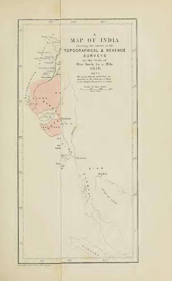

^
MAP or INDIA
TOPOGRAPHICAL & REVENUESURVEYSon th.; Sinle of
One Inch to a ilUe
1H70NOTE
IJu Paru alrtaify publuhrd iirt
tpt^^/i^ in tilt Cmai^gixr ^Mapt
ini»*' /*!.' AJ™ IWrt /,

REPORTS BY COLONEL THTJILLIER. 137
15. Topographical Sui-veys (With Colonel Walker's G. T. S. Report),
186i-65.
1865-66.
17. General Report on the Topographical Surveys, 1866-67.
18. „ „ „ „ , 1867-68.
19. „ „ „ „ ,1868-69.
See also " Selections from the Records of the Government of
India (Home Department)," No. LXXIV. (1869).
Por details of the mode of working, see " Report on the Carto-
graphic applications of photography, &c.," pi'inted in Calcutta in
1870 ; and prepared hy Lieutenant Waterhouse, under the direction
of Colonel Thiiillier.

( 138 )
XI.—SUPPLY OF INSTRUMENTS FOR THE INDIANSURVEYS.
Tlio suporiority of moflorn surveys rests mainly on the perfection
to Avliich the maniifactiu'c of instruments has attained. Ohscrvers
in the old days AA'^ere as careful and thoughtful, but this availed them
little without the needful appliances. What could the most learned
Hindoo astronomer achieve with sucli instruments as Sir Rohert
Barker found on that terrace at Benares in 1777 ?—Quadrants with
a 20-foot radius, and the arc carved on a stone wall, so that to take
an angle a Bralmian, how high soever his caste, must have been
slung ia a bowline knot, and hoisted up and down with guys. Roughapproximations would be aU that an observer -Rith such an instrument
could hope for.*
When Englishmen became the rulers in India, the instrimients
they brought with them were certainly improvements on the wonder-
ful structures in the observatories at Delhi and Benares; but at
fii'st the difference was not so veiy great. Reuben Burrow, , in
starting upon a Govcmmcnt sm-vey, had to l)orrow his tools anyhow,
and complained that among them he got a wretched quadrant from
Captain Ritchie. It was probably such an instrument as Bruce took
Avith him to Abyssinia, wliich it required four men to carry.
Colonel Lambton was in constant dilFicultics Avith his instruments,
for, though he Avas cA'cntually provided with the best that the artists
of that period could produce, he had no means of getting repairs
done, and no trusty coadjutor in England to refer to, until Captain
Kater went home. It Avill be remembered how, when the guy
can-ied away, and the great theodolite was violently bumped against
the tower of the pagoda at Tanjorc, Lambton shut liimseLf up in a
tent for weeks, and rcpaii-ed the damage Avith his OAvn hands. When,
in the evening of his days, difficulties arose respecting the measuring
chains,! he felt the Avant of a proper system for the supply and
* "An account of the Bramin's Observatory" at Benares, by Sir Robert Barker
(May 1777). Pbilosopliical Transactions, vol. 69, pt. 2. See also " Benares, Ancient
and Modern," by FitzEdward HiiU.
f The first bases were measured witli wooden rods. Colonel Eoy, after a careful
series of experiments on the dilatation of various boilics, adopted gl;iss tubes 20 feet
long. Then the lOO-foot steul chains came into use ; and finally the compensation
bars.
MR. BARROW AND SYUD MOHSIX. 139
testing of instruments. In those days it was the custom of the
service, until the fii-st Burmese war, for of&cers to supply their owninstruments. Colonel Iloclgson, when he was smweying, had instru-
ments and books of his own to the value of lis. 13,000, and nothing
belonging to Government. As Surveyor General he considered this
to be a better system than the supply by contract, and declared that
the instruments sent out for the Revenue Survey of 1821, by contract,
were not such as a good observer would consent to vise.
Everest saw these evils, and provided a remedy. He personally
superintended every detail in the construction of his instruments
while he was in England, watching their progress day after day,
and examining them at eveiy stage. When he returned to India
with them in 1830, he took an accomplished maker, Mr. BarroAV,
out Avith him, and established a mathematical instriunent manu-factory at Calcutta. Yet even these precautions were insufficient,
and when Colonel Everest began to observe with the large astro-
nomical circle he found that it was top heaA-y from faults in the
construction, and um-cliablc. Again the Superintendent of the
Survey A\-as thrown upon his own resom'ces, and, A\ith the aid of SyudMohsin, invented and appUed the remedy with his own hands.*
'Mr. BaiTOw was established at the head of a useful factory at
Calcutta, where instruments of all kinds could be repaired, and muchgood work done. Indeed the second great theodolite, known as
Barrow's theodolite, Avliich has measm-ed the angles of several of the
Trigonometrical Series, was made at the mathematical instrument
manufactory, under Colonel Everest's du-ection. The graduation
of the cu-cle was performed by ]Mr. BaiTOW, and the instrmnent wasbuilt out of old musket barrels, and parts of Colonel Lambton's
trusty old theodolite that was damaged by a blow against the pagoda
at Tanjore. Lambton's old zenith sector is laid up in ordinary at
Calcutta. "When Mr. Bari'ow retued he was succeeded bv SvudMohsin, a native of Arcot, possessed of great mechanical talent.
Colonel Everest, like most men of genius, had a sort of intuitive
perception in selecting the right man, and at once singled out SyudMohsin as an able mechanician. He was right. Tliis native of
India, though he coidd not read English, would have taken a leading
place even among Eiuopcan instriunent makers. Wiien he died
* See page 74.

140 SUPPLY OF INSTRUMENTS.
bis place was takcu by a mechanician from Mr. Cooke's establish-
ment at York, and the factory continues to turn out plenty of useful
work.
But all important instruments, and all that require nicety and
accuracy in their construction, must still be made in Europe ; and,
moreover, they must have the benefit of scientific supervision of the
hit^hest order if they are to prove efficient in such a service as the
Indian Survey. It was obvious that the Su])erintendent of the Survey
could only occasionally be in England, at intervals of several years,
while the supervision of instruments was a constant requu'cment.
In 1802 the supply of a complete new set of instruments was
sanctioned for the Great Trigonometrical Survey, and in the following
year the importance of having all instruments for Iiulia subjected
to special scientific examination became apparent.
It would be impossible to find half a dozen men in England who
combine the experience of India, knowledge of the highest branches
of mechanical science, fertility of resource, and inventive genius,
which are required in the oificer to whom the superintendence of
the manvifactory of instruments for the Indian Siu-veys can be
properly entrusted. Most fortunately tlie services of Colonel Strange
were secured, an officer wiio possesses all these qualifications.
Colonel Strange was a member of the Great Trigonometrical Survey
from 1847 to 18G0. It mil be remembered that he conducted the
Western Longitudinal Series, superintended the measurement of the
Kurrachee base, and for a short time was in charge of the Coast
Series. He thus had had considerable practical experience in trigo-
nometrical surveying, while his mechanical genius, and knowledge
of mathematical, geodetical, aiul astronomical instruments, is not
em-passed by any man in England.
In 1862 the Secretary of State for India entrusted Colonel Strange
with the task of designing and superintending the construction of a
set of geodetical and astronomical mstrnments of the first order,
for the Great Trigonometrical Survey ; and in 1863 he was appointed
to examine and test all instnmients ordered for India.
A set of instnmients was required for the efficient discharge of
his duties, and a special observatory for testing was an absolute
necessity. The provision of these requisites was sanctioned in 1864
and 1865, and the observatory was erected at the warehouse of the
Store Department of the India Office in Belvidere Eoad (Lambeth),
where Colonel Strangc's office was established.
THE LAMHETTT OBSERVATORY. Ill
The site of the observatoiy at Lamljeth is on the banks of the
Tlianies, close to a railway, and is exposed to much vibratoiy motion
;
wliile it is essential to secure rest and complete isolation for the
proper examination of astronomical and geodetical instruments.
Colonel Strange foimd it necessary to pierce right through the
London clay, and established a basis on the imderlying gravel, in
order to ensure stability for his instruments dm-ing the process of
testing.
For this purpose twelve screw piles were wormed into the gravel,
Avhich here lies 24 feet below the surface of the London clay. Broad
heads of cast iron were keyed upon the top of the piles ; and stone
slabs were laid on tlie pile heads, the space beneath being filled in
for a depth of three feet Anth concrete cement. A cu'cular platform
of brick work was built on the flag stones. A solid column of
masonry was then erected in the centre, and two semi-circular
segments of wall were raised roimd the circvunference. In order to
secure complete isolation between the observer and the instruments
resting on the piled foimdation, the wooden flooring, between the
central column and the circular Avail, lie^ upon beams which are
supported from beyond the brick work biult over the piles. Theobserver thus walks on the flooi*, Avithout shaking, or affecting in any
A\'ay, the instruments on the Avail or column. The floor is reached by
a flight of stairs.
This arrangement is on the principle designed by Sir George
Everest for the towers of observation in India, a central column for
the instrument, with complete isolation for the observer.
For the examination of graduated cu'cles for taking horizontal
angles, the instrument is placed on the central column. Fom- colli-
mators are fixed on different parts of the circular wall. These are
horizontal telescopes containing marks for observation. In one there
arc diagonally crossing spider threads, in another liorizontally andvertically crossing threads, in a third an artificial star or speck of
light. The angular intervals between the collimators arc 30°, 60°,
120°, and 150° ; an arrangement which admits of twelve different
angles being taken, by A^arying the sets of coHLmatoi-s. The positions
of the collimators themselves also admit of alteration. The angles
between them must have exactly the same A^alues, whichever part
of the circle is employed. This forms a severe and searching test.
There are contrivances in the roof of the observatory for enabling
observations of celestial bodies to be taken ; and verticle cii'cles are
142 SUPPLY OF IXSTHTIMENTS.
tested, when necessary, by observing stars as tbey pass tbe
meridian.
There are two eloeks, built into the eircular Avail, one for mean,
tbe other for sidereal tiuTe, the mean time clock being connected by
electric virives with Greenwich.
The methods for testing spii'it levels and telescopes to small
surveying instruments are equally complete and searching. These
operations are performed in the obseiTatory.
In another room, in the body of the building, arc the standai'd
bai'ometer and thermometer. They have been compared at the
observatories at Kew and Greenwich, and it is an important fact that
the two comparisons do not exactly agi-ee. So that there is no fixed
standard iir England to which observations can be referred, a de-
ficiency which Colonel Strange has brought to the notice of the
Hoyal Society ; but no steps have yet been taken to remedy this
defect in physical science. Colonel Strange, therefore, gives the
error on both for every instrument that passes, and is sent out to
India.
Every kind of meteorological instrument is tested and examined.
There is a most ingenious contrivance for comparing the aneroids.
They arc placed in a reservoir connected with the receiver of an
air pump in such a way that the channel of communication is
crossed by a diaphragm of porous porcclam. When the receiver of
the au*-pump is exhausted to a certain degree, the exhaustion of
the resers^ou' containing the aneroids goes on very gradually through
the porcelain. Thus the action of the instrument is exactly the
same as it would be in the pocket of a man slowly ascending a
moimtain. At every half inch of change the aneroid is compared
with an accm'ate mercurial barometer.*
As many as 7,000 instruments of more than a hundred different
kinds are examined yearly, and the nimiber is largely on the increase.
f
The system, ably and thoroughly worked out by its talented founder
and inventor, is a complete success.
• See an arricle by Dr. Mann, in the " Quarterly Journal of Science," entitled
*' The Lambeth Observatory," wliich gives an excellent popular account of Colonel
Sti-ange's operations. The article is also printed in " Scientific Opinion," in the
numbers for July 21st and 28th, and August 4th, 1869.
f It is curious to compare the return of instruments in store in the oflSce of the
Surveyor General and in use in the surveys, which was drawn up by Colonel Hodgson
in 1828, with Colonel Strangc"s Return, showing the number of instruments ordered
in 1868 and 1869.

COLONEL STRAKGE's SYSTEM. 143
The following system has been adopted by Colonel Strange. All
pattern instruments have been abolished, for he considers patterns
to be an oljstacle to improvement, and no two l)atches of important
instruments have been sent out by him which have been identical
in construction. But the abolition of patterns adds enormously to
his labour, and keeps the inventive faculty constantly on the stretch.
A sufficient amount of competition, both in price and quality, is
ensm-ed by employing at least two makers for each separate class of
instruments. At the same time competition in price has been
abolished. This was formerly the chief, if not the only competition
relied on, and the consequence was that the prices became such as
no really good conscientious maker could compete with. The supply
tlms fell into fifth-rate hands. The selection of makers is madechiefly with reference to two points, character and general manufac-
turing power in the fij-st place, and secondly special knowledge of
partieidar branches of the profession. Thus makers of meteorolo-
gical instruments are seldom distinguished for the excellence of their
surveying instruments. Ail instruments are subjected to rigorous
inspection, Colonel Strange's decision on them being accepted, in
every contract, as final.
Colonel Strange's most absorbing work has been the designing
and superintendence of the construction of the grand new set of
instruments for the Trigonometrical Siu'vey. They consist of a great
theodolite with a three-foot horizontal circle, and two zenith sectors,
by Troughton and Simms ; two five-foot transit instruments, and twosmaller ones by Cooke of York; two 12-inch vertical eii-cles byllepsold of Hambm-gh ; two galvanic chronographs for registering
transit observations, by MM. Secretau and Hardy of Paxis; andthree astronomical clocks by Frodsham.
The five-foot transit instruments have very powerful telescopes of
five inches clear apertiu-e, with a hollow axis of aluminium bronze,
cast in one piece. They are provided with four levels for rendering
the axis horizontal ; and there are peculiar methods for adjusting the
axis vertically and azuuuthally, the object sought being to exclude
shake, obviate strain, and cause the expansions to take place fromthe centre outwards. These adjustments are exceedingly delicate
in theii' action, and very stable.*
• "On a transit instrument and zenitli sector, to be used on the Great Trigono-metrical Surveyor India, for the determination, respectively, of longitude and latitude,"
by Lieutenant. Colonel A. Strange, V.U.S.—Proceedings of the Royal Societi/, No. 90.1.S67.

144 SUPPLY OP TXSTRT'MEXTS.
The zenith sectors arc (lesiguod by Colonel Strange, on a new
plan, liis endeavonr heing to combine niaximnm power with minimumweight. The weight is 595i lbs. One of them is already in India,
and Lieutenant llerschel, whose astronomical talent is mherited,
was observing with it at the Coimbatore base in March 1870. His
report is most satisfactory. He takes about 50 stars at each station,
three times each ; and 30 stars observed in six hours will suffice to
give a result whose probable error will not be greater than I of a
second. When he wrote, Lieutenant Herschel had taken about
1,200 zenith distances with the instrument. He says, "There can
" be no better proof of forethought and efficiency of design and
" execiition in an instrument than tliat it allows of rapidity and
" certainty and comfort m manipulation, and spares the observer
" mental and physical distraction and distress. The graduatioii
" seems to be almost perfect."
Such testimony must be most gratifying to the designer of the
instrument, Avhose time had been so long absorbed by the trials and
experiments to which it was necessary he should subject it, before
its despatch to India.


#'"W"PW Dn>' /ni^u (Win-

( 145 )
XII.—THE GEOLOGICAL SURVEY OF INDIA.
A Geological Survey of India, regularly organized and working
systematically, has not reached the fifteenth year of its existence.
But ever since cultivated Englishmen have been at work in India,
in the sui-vcying, military, clerical, or medical services, there
have been keen observers of everything worth observing ; and the
Indian rocks and minerals, viewed sometimes from a practical and
at others from a pm'ely scientific point of view, have had their due
share of attention. Thus there have been many geological reports
on various Indian districts in the years preceding the regular esta-
bUshment of the Siu'vey ; but it wiU only be possible to enumerate
those that arc best known.
It will be remembered that when Su* George Everest first joined
Colonel Lambton in 1818, he had with him, as a colleague. Dr.Voysey,
who was sm-geon and geologist to the Survey. This was probably
the first official appointment of a geologist in India*, when the science
was in its infancy, and Dr. Voysey's papers refer to the Wemerian.
and Huttonian systems. He was sent by Colonel Lambton to
reconnoitre the country in advance, as far as Agra. He accompanied
Everest in his severe work on the Godavery, and was one of the
earliest writers on the rocks of the Deccan. He exploi-ed the Nalla-
Malla mountains between Cummimi in Cuddapah and Amrabadnorth of the Kistnah, and wrote an interesting account of the
diamond mines in southern India. He also wrote papers on the
building stones of Agra, and on petrified sliells in thcTaptee vaUey.f
This able and zealous officer died of fever, on his way to Calcutta,
in 1823.
* A Mr. Laidlnw was appointed as mineralogist and geologist to the Survey la
Kumaon under Captain Webb (see page 64) in June 1817, but his allowances were
stopped in 1819 Despatch from Lord IffisfiiigSyYeh. 15th 1821. Laidlaw was a
very able man, and is said to have been badly treated.
t See "Asiatic Researches," xviii., p. 187, and xv., p. 429 and p. 120. Dr. Voy-
sey's Private Journal during 1819 was published in the "Journal of the Asiatic
Society of Bengal," xix., p. 201. See also " Gleanings in Science," ii. p. 27 (Calcutta
1H30). Dr. Voysey's 1st and 2nd Reports, on the geology of Hyderabad, are in the
" Journal of the Asiatic Society," vol. ii., pp. 298 and 392. Dr. J. H. Carter speaks of
" the sagacity, ability, and truthfulness which characterize Dr. Voysey's observations."
(6409.) K
146 THE GEOLOGICAL SURVEY.
Dr. Yoyscy was followed by various other observers, who repoi'ted
upon the rocks aud minerals in diflerent parts of India. Captain
Dangerfield wrote a notice of the geology of ]\Ialwa, the result of
careful observation, previous to 1823 ;* and Captain Franklin,
while executing the topographical survey of Ikmdelcund in 1828,
also reported on its geology.f Colonel Sleeman discovered fossils
near Jubbulpoor in 1830,J Dr. Spilsbui'y made fm-thcr collections,§
and the geological investigations of Sir Andi'ew Waugh and Major
Rcnny Tailyour have already been mentioned. Lieutenant Finnis
wi'ote upon the rocks of the country between Iloshimgabad and
Nagpore in 1834, |1and in 1842 Dr. Adam described the rocks of
Bundelcimd, north of Spilsbmy's work.^ The E-ev. S. Hislop also
"\\Tote various papers on the geology of the Nagpore countiy,** and
in 1831 the Rev. R. Everest recorded his geological observations
between Calcutta and Ghazeepoor. He also criticized Captain'
Pranklin's work in a jiaper entitled " The Sandstones of India."tt
James Prinsep wrote papers, in his journal, on the fossil bones
foimd in the Jumna and Nerbudda valleys. J J In 1854 Captain
Nicolls made large and valuable collections of fossils from the mtei"-
trappean lacustrine limestone deposits at Saugor, and from the
Nerbudda valley ; and Lieutenant Keatinge collected fossil ammo-nites and bivalves of what was supposed to be the Cretacean age, at
Bagh, near the Nerbudda.
There are some geological notices on the rocks of the Rewahtable land, and other parts of India, in the valuable work of M.Jacquemont.§§
* Published in 1823 in Sir John IVIalcolm's « Central India," ii. p. 320.
t Papers in the " Journal of the Asiatic Society of Bengal," and in the " Transac-
tions of the Geological Society."
X" Journal of the Asiatic Society of Bengal," i. p. 456.
§ Ibid., ii. p. 549, and xiii. pt. ii. p. 765.
IIIbid., iii. p. 71, and xi. p. 20.
f Ibid., vol. xi., p. 392.
** There is an account of the inter-trappean freshwater .ind estuarine formations of
the peninsula of India, by Mr. Hislop, in the " Quarterly Journal of the Geological
Society," xtI. p. 154 ; and Professor Owen described the fossil cranium of a labyrintho-
dont reptile, obtained by i\Ir. Ilislop from the sandstone of Mangoli, 60 miles south of
Nagpore, in the " Quarterly Journal of the Geological Society," xi. pt. i. p. 37.
tt" Gleanings in Science," iii. p. 129 and 207.
J{ " Journal of the Asiatic Society of Bengal," iii. p. 396.
§§ "Voyage dans les Indes Orieufales."

THE SEWALIK FOSSILS. 147
Attention was oavly turned to the coal bearing rocks of Bengal and
the Nerl)v;dda valley. Coal Avas known to exist in the Damnioodali
valley so long ago as 1774, and was actually worked in 1777-
Mr. Jones described the coal fields and opened mines in 1815,* and
in 1830 there were several collieries in the Raneegimge country.
Mr. Hisloi) wrote a paper on the age of the coal strata in Western
Bengal, and a description of the coal fields in the Dammoodah valley
by Mr. Homfray was published in 1842. f But the Baneegunge coal
field was fii'st carefully examined and reported on by Mr. Williams
in 1845, who was appointed Geological Surveyor to the East India
Company.! Mr. Williams died of jungle fever at Hazareebagh in
1849. The earliest explorer of the Nerbudda coal region was
Colonel Ouseley, who tried a quantity of the coal in 1838.
§
In 1833 Mr. Calder wrote a general review of the geology of
India, which forms a sort of introduction to various geological
papers in the 18th volume of " Asiatic Researches," by Franklin,
Voysey, Hardie, Jones, and Coulthard.
The most interesting geological work in India, before the com-
mencement of the Survey, was imdoubtedly the examination
of the Sewalik hills by Dr. Falconer and Sir Proby Cautley, and the
famous discovery of their wonderful fossil fauna.
Dr. Falconer took charge of the government gardens at Sahaiam-
pore in 1832, and at once began to investigate the geology of the
Sewalik liills. This is a ridge running parallel to the gi'eat chain of
the Himalaya, and consisting of rocks of very late formation. In
strictness the Sewalik arc the range of hills rising from the plains
between the Ganges and Jvmina, but the term is usually applied to
the outermost ridge along the whole length of the Himalaya.||
Herbert had examined and reported on the Sewab'k rocks whenengaged on the Survey ;Y but Captain Webb is said to have been
the first to prove the existence of fossil bones. Yet they were
* " Description of the N.W. Coal District, stretching along the river Damoodah."—" Asiatic Researches," xviii. p. 163.
t "Journal of the Asiatic Society of Bengal," voL xi. pt. ii. p. 723.
J "A Geological Report on the Damoodah Valley, by D. H. Williams, Esq., late
" Geological Surveyor in the Service of the East India Company." (^London 1850.)
The work was reprinted in Calcutta.
§ " Jourual of the Asiatic Society of Bengal," iv. p. 648.
II Rennell applied the name to the hills from Ilurdwar to the Sutlej.—" Memoirs,"
p. 233.
% •' Journal of the Asiatic Society," vol. xi. (App.)
K 2
118 THE GEOLOGICAL STJRTEY.
known to Fevozo TTI. as lonu^ ai;o as l.'JGO. ]*'(>risljta tolls us that
this monarch, while cutting through a hill willi HO, ()()() workmen, to
lead the waters of the Soorsutty into the Scliona, came upon bones
of giants throe vards lonir.
Dr. Falconer was led to expect the discoveiy from the nature of
the rocks, and he had noted the above passage in Perishta. At that
time three officers, who have since linked their names indissolubly
Avitli the history of Indian irrigation, Sir Proby Cautloy, Sir William
]iakor, and Sir Hoiu-y Durand, Avorc at work on those Jumna canals,
the heads of which are close to Dr. Palconer's abode at Suharunporo
;
and he had them as fellow labourers in the same field of research.
Falconer and Cautley both found fossil bones in 1831, and Cautley
(>nergetically followed up the seai'ch by blasting operations in the
KalaAvala pass of the SoAvalik. These discoveries were not fortui-
tous, but were results led up to by previous special study. In 1834
Baker and Durand discovered the great ossiferous deposit near the
valley of the Markunda, below IS'ahun. Two days after they got
their first specimens, Paleonor was on the spot, and collected 300
specimens of fossil bones Avithin six hours.
Thus Avas a sub-tropical mammalian fossil fauna brought to light,
which was unexampled in richness and extent in any other region
then knoAvn. The liistory of the discovery is recorded in various
papers publislied in Scientific Journals, and the whole was to IiaA'c
been embodied by Dr. Falconer in a great Avork entitled " Fauna
Antiqua ScAailensis." It was commenced, and 1123 sj)ecimens were
figm-ed. but Dr. Falconer Avas not spared to complete it. He died
in 18G5, and all his papers bearing on this subject haA'c been ably
edited and ])ublished by Dr. Murcbisou.* Dr. Poylc, in bis great
Avork on the llimalayas, both figiu'cs and describes the ScAvalik fossils. •)•
* "Palteontological Memoirs and Notes, by Hugh Falconer," 2 vols. 1868.
His first account of the Sewalik is in the " Journal of the Asiatic Society of
Bengal," i. p. 96. (1832). Cautley's first memoir is in the " Asiatic Researches,"
vol. xvi. In vol. xix. of the " Asiatic Researches " are seven papers by Falconer,
Cautley, and Durand. On the fossil camel at p. 115, fossil tiger, p. 135, fossil Lear,
p. 193. See also Baker's papers iu the "Journal of the Asiatic Society," iv. p. 506, 694,
706, V. p. 729. There is also a paper by Cautley in the " Geological Transactions
(2nd Series)" v. p. 276 (1836). Cautley's paper on a fossil giraffe in the Sewalik is
in the "Journal of the Asiatic Society," vii. pt. ii. p. 658, and Falconer's on the
(luaJrumaiia of the vSewalik, ibid. vi. pt. i. p. 354.
t" Illustrations of the botany and ether branches of the natural history of the
Himalaya mountains," by J. Forbes Royle. (London, 1839. 2 vols.)

THE SETT^VLIK FOSSILS. 149
These important discoveries have throA^Ti light upon the state of
India in the most remote ages. On their authority Ave may con-
ceive an ancient sea to have occupied the valleys of the Indus
and Ganges, washing the bases of the Himalaya on one side,
and the Vindhya of the Deccan on the other, and receiving all
the silt bearing rivers from both. In com-se of time the sea wasfilled up, and the alluvial valleys teemed with tlie animals whosebones are now imbedded in the Sewalik. Smiilar remains exist
in Sinde. They Avere also foimd l)y Mr. CraAA"fm-d on the banks
of the Irrawaddy in 182G,* by Dr. Spilsbmy in the Xcrbuddavalley, and by Captain Fulljames on the island of Pcrim in the gulf
of Cambay.f These points indicate the vast area over which the
Sewalik animals of that remote tertiary age roamed. There were
mastodons, elephants, five species of hippopotami, rhinoceroses,
gu-aflfes, horses, pigs, camels, stags, antelopes, hyaenas, dogs, and
cats, monkeys, ostriches, and huge cranes. There are also the
sivatherium, a bull the size of an elephant with foxiv horns and a
roman nose ; and the colossachelys atlas, a gigantic tortoise G feet
high and 22 feet long.
The upheaval of a narrow belt of the plains of India, at the foot
of the Himalayas, into hills 3,500 feet high, seems to mark the time
when the present epoch commenced in India, as these lulls form the
grave and monument of an earlier and distinct fauna.
The investigation of the Sewaliks was followed bv Colonel
Richard Strachey's examination of the lofty ranges in theii* rear,| andby reports on the fossils of the Spiti Valley by Dr. Gerard§ and
Captain Hutton.if Captain Henry Strachcy also explored Western
Tibet, including the remarkable alluvial plain of Guge, which the
* See the account of the rocks and animal remains collecteil by ilr. Ci-awfurJ in
1826-27, on the banks of the Irrawaddy, by Dr. Buckland, in " Crawfiii-d's Enibtussy,"
ii., App. p. 143, and in the " Transactions of the Geological Society." The collection
consisted of bones of mastodons, rhinoceroses, hippotamuses, tapirs, oxen, deer, and
land tortoises.
t Baron Ilugel had a large collection of fossils from Perini. Captain Fullj.amcs
reported on them in the " IJengal Asiatic Society's Journal," i. p. 233. See also
" Notes on the Island of Pcrim, in the Gulf of Cambay, by Lieut. Ethcrsey," "BombayGeographical Society's Journal," vol. ii. Dr. Falconer described the Perira fossils
in the " Quarterly .Journal of the Geological Society," i. p. 356.
X" Quarterly Journal of the Geological Society," vii. p. 292.
§ "Asiatic Researches," xviii. pt. ii. p. 238.
f " Journal of the Asiatic Society of Bengal." (1841,) p. 198.
150 THE GEOLOGICAL SURVEY.
Sutlej lias excavated to the depth of a full vertical mile ;* and Dr.
Thomson, in his journey through Ladak to the Karakorum pass in
1848, made very careful geological notes, t
The peninsida of India has been examined and reported upon hy
several ardent geologists. Colonel Sykes has wi-itten upon the trap
formation of theDeccan,J and Dr. Malcolmson's paper on fossils
of the eastern portion of the great basaltic region had for its object
an endeavour to arrive at a conclusion respecting the age of the
basalt which is spread over 200,000 square miles on the plateau of
the Indian peninsula. The fossils were collected in 1832, on the
Sichel hills, which extend from the junction of the "Wurdah and
Godavery towards Aiu-imgabad.§
But perhaps the most eminent of the Indian geological observers
of those days was Captain Newbold, the Assistant Resident at
Km-nool, an officer who had entered the army in 1827. He made
several careful sections across the peninsula, and reported upon the
whole region south of a line drawn from Ganjam to Bombay. No
formation has attracted more attention than the laterite, a rock
peculiar to India, which was first noticed and named by Dr. Buchanan,
in his work on Malabar. Captain Newbold described it very fully
as a reddish brown tubular and cellular clay, more or less indurated,
and often impregnated with iron. The air-exposed surface of laterite
is hard and glazed, but a few inches below the surface it becomes
softer, and is cut out in blocks with a spade, hardening after expo-
sure to the atmosphere. It is used largely for building and for
repairing roads, and, among other edifices, the arcaded Inqviisition at
Goa is built of laterite. The laterite formation covers the western
coast almost continuously from Bombay to Cape Comorin, and
generally from the sea to the foot of the ghauts. It is also foimd
in detached beds in many other parts of India. It is of late origin.
* " Physical Geography of Western Tibet," in the " R. G. S. Journal," vol. xxiii.
p. 1. Henry Strachey is a Gold Medallist of the Royal Geographical Society.
•j- "Western Himalaya and Tibet. A journey during the years 1847-48," by
Thomas Thomson, M.D. (1852.)
J" Colonel Sykes on the Geology of a portion of the Dukhun." (4to, London,
1836.) Re-printed from the " Transactions of the Geological Society," vol. iv.
(Second Series.)
§ " Transactions of the Geological Society," v. p. 537. Dr. Malcolmson, who was
Secretary to the Bombay Branch of the Asiatic Society, died at Dhoolia in the Taptec
valley, while engaged in the pursuit of his favourite science, in February 1844. See
a notice of him in the "Bombay Times" of April 30th, 1844.

CAPTAIX NEWBOLD. 151
Some wi'iters derive it from the weathering of trap rocks, but the
lateritc beds are sometimes conglomeritic, cover indiscriminately all
kinds of formations, and rest imdistiu'bed alike on the traps and
on the cretaceous limestones of Pondicherry, -while they are never
invaded by trap dykes.*
General Cullen, an officer of high scientific attainments, who wasfor many years resident in Ti'avancore, foitud beds of lignite in the
lateritc near Quilon.
The regur or black cotton soil was also carefully studied by Cap-
tain Newbold ;t and he formed a theory respecting the origin of those
nodules of lime so well knoAvn in India by the name ofkimkm*, which
are met vnth. as irregular overlying beds, or filling up chinks and
fissures of rocks of cveiy age. He referred their origin to the action
of springs charged with carbonic acid, bringing up lime in solution,
and either depositing it as the temperature lowered, or parting with
the carbonic acid. J
In 1840 Captain Xewbold A'isited the fossihferous limestones of
South Arcot and Trichinopoly, Avhich Avcrc afterwards cai-efuUy ex-
amined by Mr. C. Tiu'ton Kaye and Mr. Brooke Cunliffe of the
Madras Civil Serv'ice. These gentlemen collected 178 fossUs from
the cretaceous formation near Pondicherry, described by Sir Philip
Egerton and Professor Edward Porbes.§
Captain John Warren, the assistant of Colonel Lambton, had ex-
amined the petrified drift wood at lYeevikera near Pondichcny in
1808,11 which. Captain Newbold tells us, closely resembles the petri-
fied Avood in the desert near Cau*o.
In the Western Presidency, Captain Grant examined the important
* See also a paper on lateritc by Dr. Cole, in the '• Madras Journal of Literature
and Science,'" iii. p. 100 ; and another by Dr. Clark, viii. p. 334.
t Paper read before the Royal Society, March 22nd, 1838.
I Captain Newbold's papers will be found in the " Transactions of the Geological
Society," in the " Journal of the Royal Asiatic Society," vol. vii., and in " Notes,
chiefly Geological," in four parts, in the " Journal of tiie Asiatic Society of Bengal."
Tlie papers in the " Journal of the Asiatic Society " are on the Mineral Resources of
India, in eight numbers. They contain accounts of the gold tracts, and of the mines
of lead, manganese, rubies, garnets, diamonds, &c. See also the " Calcutta Review,"
ix. p. 314. He also wrote papers on the geology of Egypt, and on the i)etrified
forest near Cairo. (" Quarterly Journal of the Geological Society," iv. pp. 324—49.)
Captain Newbold was an accomplished antiquary and Persian scholar, as well as a
geologist. He died at Mahabulashwiu- on June 2nd, 1850.
§ "Madras Journal of Literature and Science," No. 28, xii. p. 37. " Transactions of
tlie Geological Society," vii. p. 97. Mr. Kayo died in October i84o.
li" Asiatic Researches," xi. p. i.

152 THE GEOLOGICAL SURVEY.
plant bearing formation in Cutch.* Dr. Cln*istio gave an account
of the geology in the Southern Maliratta country in ]83C),t and
Lieutenant Aytoun reported upon the geology of parts of Bclgaum.|
Colonel Meadows Taylor has described the geology of tlie district of
Shorapore in the Deccan, where the several formations of that region
unite with those of the Carnatic, accompanied by evidence of muchlocal disturbance. Ilis observations connect the work of Captiiin
Ncwbold at Kui-nool witli that of Dr. Christie and Lieut. Ayiouu
in the Southern Mahratta country. § Dr. Tleming descril)cd the
nunimvditic limestone in the Suliman range, above the DcM-ajat.]]
In Sinde, Sir Bartle Frere has written upon the geology,^ and also
contributed a most admirable paper on the Desert and the llimn of
Cutch. The same region was described by Alexander Burnes and
Mac Murdo ; and Sir Charles Lyell has given an interesting account
of the Allah Bund, and of the effects of the earthquake of 1819,
in his "Principles of Geology." Dr. Boliert Thompson,** Dr. Buist,ff
and Dr. H. J, Carter, J J have written upon the geology of thclsland
of Bombay.
The nummulitic limestone formation in Avestern India has
attracted much attention, and has been carefully studied. In ISHDr. Malcolinson, just before his deatli, discovered a nummulitic bed
in the Bajpeepla hills, crossing tlie Nerbudda valley ; and ]\Iajor
FuUjames, in 1852, reported upon the same formation. More
recently, in 1861, Mr. Alexander Ilogcrs, the Collector of Surat,
"who is an accomplished and enthusiastic geologist, discoA'cred num-
mulitic limestone at Tm"keysur, between Surat and Broach. Tims
the existence of the nummulitic formation in the Bajpeepla hills,
which form the westernmost termination of the Satpoora range, was
fully estabUshed.§§
* " Transactions of the Geological Society (2nd Series)," v. p. 289.
f" Madras Journal of Literature and Science," iv. p. 452.
J^" Journal of the Bombay Geogra[)liical Society," xi. p. 20.
§ See the " Transactions of the Royal Geological Society of Ireland."
II"Quarterly Journal of the Geological Society," ix. p. 346.
f Ibid., ix. p. 349.
** In 1836. "Madras Journal of Literature and Science," v. p. 129.
ff "Journal of the Bombay Geographical Society," x. p. 167.
JJ "Bombay Branch of the Asiatic Society," iv. p. 161. Dr. Carter made a final
geological examination of Carinja, Elephanta, Trombay, Salsette, and the other islands
round Bombay. See "Journal of the Bombay Branch," Nov. I860.
§§ A work on the nummulitic fossils of India was published in France in 1853.
" Description des animanx fossiles de groupc nummulitique de I'lnde, piecedco d'un
" resume geologiquc et d'unc monographic des nummulitcs, par le Vicomtc de Archiac
"ct Jules Haine." 4to. 32 plate.-;. Paris, 1853.
DR. CARTER AND MR. GREENOUGH. 153
Dr. Carter, then in the Indian Navy, was the most distinguished of
the pioneers of Indian geology. While ser^dng with Captain Sanders
in the jPalinitriis, he examined the rocks of the Arabian coast,* and ho
aftcrAvards reported upon the geology of the Islands of Bombay and
Salsette. But his most valuable work consisted in the collection
and classification of all the geological labours of his predecessors,
to which is added a reprint of his Summary of the Geology of India
between the Ganges, Indus, and Cape Comorin. This work was
undertaken at the instance of Lord Elphinstone.f The plan is first
to introduce the reader to the geology of the great trappean region
of Western India, and then to carry him round its outskirts, in order
that he may become acquainted with the geological formations of
India generallv. His attention is then dnected to the crcolocrv of
Cutch, afterwards to that of Sinde, and lastly to that of the Arabian
coast. For this purpose almost all the geological papers on India
that had then been Avritten were re-printed in extenso.
In 1853 Mr. Greeuough caivfuUy compiled his geological map of
India, showing the state of our knowledge at that date; J copies of
which were transmitted to the Local Governments, and elicited
several reports from officers interested in the subject. §
Such were the principal labom's in the field of Indian geologists
previous to the establishment of the official survey. They were
results obtained by independent uiquirers ; and, such as were re-
corded when geology was in its infancy, are now to some extent
out of date. There was of course a great want of concentration in
• See note at page 22.
t "Geological Papers on Western India, indiuling Cutcli, Siiid, and the South-cast" Coast of Arabia, to which is appended a Summary of the Geology of India generally ;
" edited for the Government l>y Ilcury J. Carter, Assistant Surgeon." (Bombay1857.") See a Ecview of this valuable work in the " Bombay Quarterly Kcview^vol. vii. p. 316. ,^
\ " General Sketch of the Physical and Geological Features of British India* by" G. B. Grcenough, Esq., engraved by A. Peterniann." The map is 7 feet long by
5J. It is described by Sir Koderick Murchison in one of his anniversary addresses
as President of the Geographical Society. '" K. G. S. Journal," xxiii. p. cviii. *
§ " Correspondence on tho subject of the Geological Map of India, compiled byProfessor Grcenough." (Madr.is 1857.) This pamphlet contains remarks by General
Cullen on the laterite of Tiavancore ; by Major Dallas and Dr. Cole on tlic geological
features of tho Ceded Districts ; and memoranda by Dr. Ranking, Dr. Balfour, Dr.
Hunter, and Rev. C. F. Muzzy. Mr. INIuzzy wrote a paper on the geological features
of Madras, Triehinopoly, and Tanjore, in the " Madras Journal of Literature and
Science," i. N.S., p. 90.
154) THE GKOLOGICAL SURVEY.
these laboiu's, and the value of many obsei'vations was lost OAving to
the absence of an intelligible nomenclature. Much has requu-ed
revision, but at the same time the lal)ours of those Indian geologists
who were lii'st in -the licild are valuable and important.
Dr. McClelland, who held the office of Geological Surveyor for
two years after the death of Mr. Williams,* wrote a Ecport on the
Geological Survcv of India for the Session 1818-49, and described
the coal slrata of the Rajmehal hills.f lie also mapped the Kur-
habaree field.
The work of Dr. Oldham, the present Superintendent of the Geo-
logical Sm'vey of India, extends over a period of upAvards of 20 years.
Before commencing his service in India he had been on the Irish
Sui-vey, and Professor of Geology at Trinity College, Dublin. Hearrived in India in March 1851, and found that the establishment of
the Geological Siu-vey then consisted of one peon and one writer,
Avith no Em'opeau assistant, and no preparation of any field Avork.
The few existing records were kept in a box in a small room in the
Sm'vevor-General's office. Dr. Oldham obtained sanction for the
employment of Mr. J. G. Medlicott, who had served A\ith him for
several years on the Sun^ey of Ireland, as assistant ; and in 1852
Ml-. St. George Avas added. The only idea tlie Government then
had of the duties of a geological surveyor Avas that he shoidd go
about from place to place, and report upon real or fancied discoveries
of minerals. The difficulty of the position was increased by the
small confidence that could be placed in much that bad previously
been done. The beds represented by the former Coal Committee to
be the very lowest of the carboniferous period are in reality eocene
or miocene resting upon niunmulitic limestone ; and the coal mea-
sm-es of the Eajmehal hills, Avhich had been stated to be newer than
or to rest upon the trap floAvs of that district, are in reality exactly
tbc opposite. Dr. Oldham worked steadily on, in the face of many
(Ufficidtics at the outset, to obtain a definite geological horizon from
Avhich to work up or doAvn, and so obtain a true basis for futm-e
operations. This was, hoAvever, impracticable while he Avas expected
* See page 147.
t Dr. McClelland was secretary to a committee for the iuvcstigation ol the coal
resources of India. See the Report printed at Calcutta in 1841. There is also a
work on the Geology of the Province of Kumaon, liy John McClelland. (Svo. Cal-
cutta, 1835.)

DR. 0LDUA3I. 155
to go fii'st to the eastern boundary of Bengal, then to the southern
extreme ol' Tenasserim, and next towards Bombay.
Lord Canning really took an enlightened interest in geology, and
on his arrival Ur. Oldham was able for the first time to commence a
regular survey of the country. Lord Canning ordered that, imless
under very special circumstances, the geological surveyors were to
confine thcnr labours to those parts of the countiy which had already
been mapped, and steadily to proceed, as far as the maps existed,
over the country from east to west. Before Lord Canning's arrival
Dr. Oldham had, in 1851, proceeded to Cherra-Poonjee, with a view
to examining the u'on ores in the Khasia hills. He made a collec-
tion of fossils, chiefly from the nummulutic limestone of the Khasia
hills, establishing the occurrence of rocks of the upper cretaceous
age in Eastern Bengal.* In 1852-53 he examined the geological
features of the Bajmahal hills ;f and Mr. Theobald, one of his as-
sistants, made a detailed report upon the Punjab Salt Bange in 1853. J
In 1855 Dr. Oldham accompanied Sir Arthur Phayre's mission to
Ava, and wrote a memoh' on the geological features of the banks of
the Irrawaddy, and of the coimtry north of Amarapoora.§
In 1856 Lord Camiing placed the Geological Sm-vey upon a proper
footing. Dr. Oldham's staff was increased, the labours of the Sur-
vey were systematized, and the reports were ordered to be published
in a uniform series. The operations have. been du-ected to those
districts Avhere the Revenue and Topographical Surveyors have com-pleted then- maps, and AA-hcre the most valuable practical or scientific
results were to be obtained. But the geologists have been constantly
hindered m then- work by the want of maps, and indeed this has
been one of their chief difficulties. The supcrmtendent and his staff
liave also been frequently detached fi-om then* regular work to report
* " On the Geological Structure of part of the Khasi hills, with observations on the" meteorology and ethnology of that district, by Thomas Oldham, A.M.," &c. (4to,
Calcutta, 1854, with geological maps). See also the " Quarterly Journal of the Geo-logical Society," xix. p. 524. " Geological Memoirs," i. p. 94. Colonel Ilannay andCaptain Dalton reported upon the economic geology of Upper Assam at about the
same time. " Journal of the Asiatic Society of Bengal," vii. p. 625, xxii. p. 511, xxv.
p. 230. See also their report on auriferous deposits in Assam " Memoirc," i. p. 90.
Dr. Hooker described the structure of the Khasia hills, much as Dr. Oldham did after-
wards. This district is the Cossyah hills of other authors.
f" Journal of the Asiatic Society of Bengal," xxiii. p. 268., and xxv. p. 249.
jlbid. Nos. 3, 4, 5, of 1853. In 1848 Dr. A. Fleming, of the 7th N. I., had also
written a paper on the Salt Hange. Ibid., xvii. pt. 2, p. 500.
§ " Yule's Mission to Ava," Api). A., p. 309.

156 THE GEOLOGICAL SURVEY.
upon some special point for the Government, Avliieh (though useful
service is sometimes performed in the interval) has delayed the
prop;ress of the Survey.
The hest way to convey a tolerahly clear idea of the geological
work that has heen done will perhaps he to take the history of the
progress of the surv'ey in each district, instead of revicAving the
whole of the operations year hy year ; and, with this ohject, it will
he as well to hegin with the coal yielding region.
In 1856-7 Cuttack was examined hy three of the staff, Messrs.
W. T. and H. P. Blanford and Mr. J. G.' Medlicott, from the Chilka
lake to Miduapoor, and Mr. lilanford reported upon the laterite of
Orissa.* Tlie Blanfords discovered and named the important
Talcheer group of rocks underlying the coal hcds. The separation of
theTalcheer from the coal l)caring rocks is applicahle in all districts.
During the two following years, Mr. W. T. Blanford was zealously
investigating the Haneegunge coal field,f while Mr. Medlicott was
engaged in tlie suiTcy of the Kurruckpoor hills and on the examination
of the Kurhaliaree coal district. The existence of a large supply of
coal west of the river Barakur was estahlished, and Dr. Oldham had
himself explored the Cossyah hills in former ycars.J Mr. Blanford
completed field maps of the Haneegunge, works which are as useful
to the practical worker as the geologist, and he also l)rought togellu^r
retiu'us of the coal raised from the several ojjen Avorks and pits.
In 1859-GO there were 370,200 tons of coals raised. At the close
of 18G1 Mr. Blanford was transferred to Burmah.
The examination of the coal country Avas continu(>d in 18G3 hy
Mr. Hughes and Mr. Willson, at Jherria§ and Kurhaharee. In tlie
folloAving year Mr. Medlicott Avas on detached duty in Assam,|| and
came to satisfactory conclusions respecting the value of coal in that
district. In 18G5 Mr. Hughes coutinued his Avork in the coal region,
* See " Memoirs," vol. i., " On the Coal and Iron of Talcheer in CuUack." " Structure
and Kcliitions of the Tiilchir Coul Fields." " Geology of Jlidnapore and Orissa."
" Laterite of Orissa." These labours are reviewed in the " (Quarterly Journal of tiio
Geoloo-ical Society," xiii., p. cviii. The coal and iron of Talcheer had previously
been written upon hy Captain Kittoe. "Journal of the Asiatic Society of Bengal,"
viii. p. 137.
+ " Memoirs," vol. iii., " On the Raniganj coal field."
t "Memoirs," vol. i., " Geology of the Khasi hills."
S "Memoirs," vol. v., " On the Jherria coal field," by T. Hughes.
II
"Memoirs," vol. iv., "On the coal of Assam," liy 11. 1). .Alcdlicolt.

IXDIAN COAL FIELDS. 15?
oxplorini? the ITazarccbagli and Bokaro * fields ; and m 1806
]\Ir. Blanford made; his first examination of the Chanda coal field,
and indicated the localities where borings should he made. The
Palamow coal fields could not he proceeded with for want of maps.
In 18C8 Mr. Medlicott traversed a wide tract of country to investi-
gate the extent and relations of the several series of sandstones
associated with coal in Bengal, as compared with those in Central
India ; and proceeded, in the following year, to the Nerhudda valley,
to work out th(; coal hearing rocks in that area, which had been first
visited 12 years before, when there were no maps.f In 1809 two
geologists were sent to revise the maps of Bhagulpoor and Beerbhoom,
the earliest coal region examined by the Survey.
These Indian coal fields are situated in the drainage basms of
the rivers Dammoodah, Sonc, Mahanuddy, Godaveiy, and Nerbudda.
The oldest and best known, namely, the Baneegunge, Jhen-ia,
Bokaro, llamghur, and Karampoora fields are in the Dammoodahdrainage basin. J The Itkurce and Kurhabarec fields are in Chota
Nagpoor province, on the Barakm*, the chief effluent of the
Dammoodah, from which river it is separated, in the upper part of its
course, by the lofty Parasnath hill and the wide plateau of Hazarec-
bagh. The whole of these may be considered to have been deposited
in one great estuary. In the Sone valley are the Palamow, Sin-
growlee, and South Bewah coal fields, the Talchecr and Belaspoor
fields are in that of the Mahanuddy, and the Chanda in the Godavery.
The conclusions derived from the Siu?vey are, that the rocks
associated with coal are separated into several distinct groups.
The lowest is the Talchecr group, first established by the brothers
Blanford, and not containing coal. The Dammoodah series contains
most of the coal beds of Bengal and Central India. It was separated
from the overlying rocks by Dr. Oldham. There arc also the
Bajmahal group, and the tertiary series of the Cossyah hills. The
data for this classification of the coal bearing rocks consist of the
remains of plants.
• " Memoirs," vol. vi., pt. 2, " On the Bokaro coal field." G. T. W. Hughes.
t" On the Jlolipani coal field in the Nerbudda valley," by H. B. Medlicott. " Re-
cords," iii. pt. 3, (ISTO.)
'IAn atlhient of the Hoogly, rising in the province of Chota Kagpoor, and flowing
through the Bancoorali, Burdwan, and lloogly districts of the Lower Provinces of
Beniial.

158 THE GEOLOGICAL STTKVEY.
Ill tilt" oastern coal lickls there arc five well mavkctl sub-
divisions :
—
1. The Talelicor l)o(ls, the lowest, in wliicli no coal is known ;
so called by the Blanfords, from tlie district in Cuttack
wliei'c they Avcrc first examined.
2. The Barakm* beds, formerly called Lower Dammoodah.
3. Ironstone shales.
4. llancegunge beds.
5. Panchct beds, or upper series. First separated as a distinct
sub-division, and so named by Mr. Blanford. They are of
the triassic epoch, and contain bones of labyrinthodont and
dicynodout amphibia. Panchet is the name of a remark-
able hill, and the title of a Eajah.
To the westward these become three :
—
1. Talcheer.
2. Barakiu'.
3. Panchet.
Dr. Oldham's general conclusions, respecting these coal series,
are that the drainage basins of India Avere marked out and existed
at the enormously distant period when the deposition of the great
plant bearing formations commenced. All the successive beds
represent an enormous lapse of time, and seem to be fresh Avater or
estuarine deposits. He also concludes that the present limits of the
coal measm-es coincide vnt\i the original limits of deposition, and
are not the results of faulting or even mainly of denudation.* The
Dammoodali system is believed to represent the Permian period of
European geology, together with a portion of the upper carboni-
ferous epoch.
Dr. Oldham has, from time to time, prepared returns of the amount
of coal raised. In June 1859 he fm-nished one of the Raneegunge
fields; in 1861 rctiu'ns were given in Mr. Blanford's Ileport;t and
in June 1861 the fii'st general statement of the out-torn- of Indian
coal was given by Dr. Oldham. In March 1867 he prepared a
Report on the coal resovirces of India, for the Secretary of State,
with results from 1861 to 1866 ; and in June 1869 he sent in a
* See Dr. Oldham's papers " On the geological relations and probable geological
age of the several systems of rocks in Central India and Bengal," (Memoirs, vol. ii.,
p. 299), and " Additional Remarks " in (Memoirs, vol. iii., p. 198).
j- Memoirs, iii. p. 179.
1868, coal used on railways connected with Calcutta, 66,20,837 luaunds.

THK VIXDHYAN FORMATTOX. 159
Return for 1868, with statistics of the methods of working the coal,
and statements tabulated for each year from 1858 to 1868.
The next investigation is that respecting the alluvial deposits of
the Ganges valley, which was commenced in the first year of the
Survey. In 1859 the portion from the Bhagruttee northwards to the
foot of the hills was examined and mapped. In 1860, Mr. Theobald
was fixing the boundaries and extent of recent alluvial deposits from
Burdwan to Mongliyr. In 1861 the investigation Avas continued
over the plains south of the Ganges to Patna and Shahabad ; and
in 1862 the examination was completed.
The geological survey of the important formations in Central
India was also a great object.* In 1855, Mr. J. G. Medlicott
passed from Jubbulporc westward down the Nerbudda valley ; while
his brother crossed the Rcwali country and the river Sone to the
Singrowlee coal field. Both considered that the sandstone rocks of
Rewah and Bundelcund should be entirely separated from the sand-
stones associated with coals in Bengal and in the Xerbudda vallcv.
Dr. Oldham visited the same country in 1856, and gave the name of
ViNDHYAN to the entire group, because it is best seen in the scai-ped
mountains of that name on the northern side of the Nerbudda
valley, t It includes the diamond yielding rocks of Central India,
and is one of the most remarkable and interesting series in the
country. Ilitherto (1870), no fossils have been found in it. Its age
cannot therefore be determined ; but the Vindhyan rocks are older
than the carboniferous series of India. In 1863, Mr. Mallet was
engaged in tracing out the divisions and boundaries of this forma-
tion in Rewah, while ]\Ir. Ilackett worked ovit the limits of the
trappean rocks in Saugor, and jNIr. II. B. Medlicott was closing up
the gaps in the geological mapping between Central India and the
Sone vaUey. In 1861', Mr. Mallet revised the bovmdarios of the
Vindhyan rocks north of the Nerbudda valley, covering 2,200 square
* Mr. J. G. Medlicott compiled the " Cotton Hand Book" for Bengal in 1862, for
tlio Government.
I" Memoirs," vol, ii., p. 1,
'' On the Vindhyan rocks and their associates in Bundol-
khund." " Geological structure of the central portion of the Nerbudda district," p. 95.
" Tertiary and alluvial deposit'? of the Nerbudda valley." p. 279. " The Vindhyan
scries," vol. vii., pt. 1. Dr. Oldham proposed the name ViNunrAN in a paper in tho
Journal of the Asiatic Society of Bengal," xxv. p. 249. See also his paper on the
Geological relations of the rock systems of Central India and Bengal."—" Memoirs,"
ii. p. 299. There is a useful list of all papers relating to the Nerbudda valley, pub-
lished previously to the date of vol. ii. of the " Geological Jlcmoirs," at page 387.
" Records," vol. ii., pt. 2, " Sketch of the mctamorphic rocks of Bengal."

100 THE GEOLOGICAL STTRTEY.
miles of ground, while INIr. Hackett examined the Gwalior eountiy.
During this year Dr. Oldham himself examined the rocks on the
south bank of the Ganges, from Gya to near Bliaugulpoor. In 1HG7
Mr. Medlieott undertook the investigation of a wild and diflieult
coimtry from llaneegunge and llazareehagli in the Dammoodah basin
to the basin of the Mahanuddy. lie came again upon the old
Vindhyan rocks, chiefly limestone, which cover 12,000 square miles,
abutting against crystalline rocks to the north, and passing under
the Deccan traps to the south and west. In 1SG9, Mr. AVillson was
at w^ork in Jhansi, to connect with Mr. Hackett in Gwalior,* and
Mr. Mallet was in the Sons valley.
A complete and connected history of the Vindhyan formations
has been chawu up by Mr. ]\Iallct : and still more recently Mr. Blan-
ford has re-examined part of the Vindhyan series, but he could find
no fossils to determine their age, which therefore still remains
unsettled.
Mr. H. F. Medlieott, then Professor of Geology in the Roorkee
College, commenced the examination of the Sewahks, and upper and
outer Himalaya, in 1859, during the intervals of time that his
collegiate duties permitted of his taking the field. His stvidies w ere
more directed to the orographical relations of these hills than to
their fossils. In the folloA^dng years he continued his examination
to near Kangra ; and the results of his labours are embodied in a
valuable memou". These arc the hills in which Dr. Ealconer dis-
covered numerous mammalian remains. They are of miocene and
post miocene age. NummuUtic rocks occur north of the Sewaliks,
and appear to form a large proportion of the ranges in the Punjab.
Kepreseutatives of these tertiary rocks extend to the east, are foimd
at the base of the hills in Sikkim, and stretch far up the Assam
valley. Dr. Hooker also found the niuumulites in Tibet, noi*th of
Sikkim, at 10,000 feet above the sea. One important consequence of
Mr. Medlieott' s survey of this region was the discoveiy of a good
water supply at UmbaUa. He reported that water bearing beds
must exist there, and the trial confii-med his expectations.f Mr.
Medlieott also reported upon the reh efiioreseenee which has given
rise to so much anxiety, and on the waters of the rivers and canals
in the N. W. Provinces. J
* " Records," vol. iii., pt. 2, " Geology of Gwalior and vicinity."
) " Memoirs," vol. iii., " On the southern portions of the Himalayan ranges."
X" Journal of the Asiatic Society," xx., p. 326.

OPERATIONS ON THE HIMALAYAS AND IN MADRAS. IGl
In 1862, Messrs. Theobald and Mallet were sent in the footsteps
of Colonel Richard Strachey, to collect fossils, and trace out the
succossion of sedimentary beds on the northern slopes of the westeni
Himalaya and in the Chini and Spiti valleys, up to an elevation of
18,000 feet. They were found to be identical ^vith known species
from Em-ope occurring in the same association. Ti-iassic and oolitic
beds are especially abundant about Spiti. In 1864 Mr. Mallet,
in company with Dr. Ferdinand Stoliczka, who was formerly in the
Austrian Geological Suney, and a colleague of Dr. Hochstetter,
were despatched to the Himalaya to work out their structure, and
revise the fossil fauna. Undoubted representatives were proved to
occur of the European Silurian, carboniferous, triassic, lias, Jurassic,
and cretaceous periods, and, out of 200 varieties collected, only 32 are
new.* In 1805, Dr. Stoliczka extended his investigations in the Hi-
malaya as far as Leh, but in 1867, he went home with IMr. Oldham.
The great mass of the Himalayan ranges consists of metamorphic
rocks, in places highly granitoid, in others slatey or schistose.
The operations of the Survey were extended to the Mackas Presi-
dency in 1857. The party was in charge of Mr. H. F. Blanford,
and consisted of Mr. C. Oldham, Mr. King, and !Mr. Geoghegan.
The latter gentleman died suddenly of sun stroke early in 1858,
and was succeeded by Mr. R. Bnice Foote. They were instructed
first to examine the important group of cretaceous rocks in South
Arcot and Trichinopoly, the fossils of which had been collected in
former years by Kaye and CimliflFe, and thence to work northward.
In the fii-st year Mr. Blanford reported upon the geology of the
Neilghcrry hills. f The siuwoy of the highly interesting cretaceous
formations was completed in 1861;}:, and in the same yeai' King
* " Memoirs," vol. v., " Sections across N.W. Himalaya from Sutlej to Indus." " Onthe gypsum of Spiti." " Summary of Geological Observations in S. Ladak, Western
Tibet, &c.," by F. Stoliczka.
t" Memoirs," vol. i., p. 211, "The Nilghiri Hills." Dr. Benza wrote papers on
the geology of the Neilgherries and Koondahs, on that of the country between the
Neilgherries and Madras, and on the geology of the Northern Circars, in the "MadrasJournal of Literature and Science," in 1835-36, vols. iii. and v.
J" Memoirs," vol. iv., " On the Cretaceous Rocks of the South Arcot and Trichi-
nopoly districts, by H. F. Blanford. " On the Structure of the Districts of Trichi-
nopoly and Salem." " On the Occurrence of Crystalline Limestone in the vicinity of
Trichinopoly," by W. King.
—
Madras Journal, iv. N.S., p. 271.
(6409.) L
1G2 THE GEOLOGICAL SURVEY,
and Foote examined the iron deposits of Salem. Mr. H. F. Blanford
then retired from the Survey.*
The other members of the party, in 1862, commenced an exami-
nation of the hill ranefc Avhich separates Cuddapah and Kurnool
from Nellore, a very difficidt and almost roadless country. In 1&G3
Mr. King traced the boundaries of these Cuddapah rocks, chiefly
quartzites and slates, into Bellary and Kurnool. Mr. Foote Avas
engaged dming the same year m examining rocks near Madras.
f
He met with beds of marine fossils intercalated with others holding
abmidance of vegetable remains of the same sjiecies as have been
found in the Rajmahal hills and in Cutcli. This discovery of the
Avide extension of the llajmahal series is a fact of high interest.
The Cuddapah formations appear to represent an older portion of
the great Vindhyan series. The diamond beds of Southern Incha
occm* in these formations, and they show veiy favorable traces of
lead, coj)per, and u-on. The main object of the geologists was to
work out the true succession and extent of these remarkable and
mteresting series of quartzitc, slate, schist, and limestone beds in
Cuddapah, Nellore, and Km-nool. In 186G Mr. Foote was working
along theu- eastern and Mr. C. Oldham up theii- western boimdaries,
Wilde Mr. King was in the centre. They completed the area in
Cuddapuh and Km-nool dm'ing 1868, when the superintendent took
an opportunity of testing the accm'acy of their mapping, and in
1809 Mr. Foote began to work across the Kaichoor Dooab towards
the Bombay Presidency. Mr. King has di-awn up a general report
on the entire series. | During the hot weather in each year, the
gentlemen of the Madi'as Survey were usefidly employed in ar-
ranging and catalognmg the fossils and minerals of the Madras
Central Museum, for Captain Mitchell, the cm-ator ; and Mr. C. Old-
ham, followed by Messrs. King and Foote, have delivered a series of
leetm'es on geology at the Madras Engineering College. Mr. Old-
ham went home on leave in 18G8, and died from the eiTccts of
disease contracted in India in April 18G9. An able and talented
* He wrote papers ou the occurrence of crystalline limestone in Coimbatore, and on
the geological age of the sandstones at Trivicary, near Pondicherry, in the "Madras
Journal of Literature and Science," iii. N.S., p. 60, and iv. N.S., p. 47.
t" Kecords," vol. ill., pt. 1, " Notes of the Geology of the Neighbourhood of Madras."
J'• Records," vol. ii., pt. 1, "On the Kuddapah and Kurnool formations."

OPERATIONS IN BTJRMAH. 163
geologist, and a painstaking conscientious public servant, was thus
lost to his country.
Tlie Geological Siu'vey of British Burmah was commenced in 1860,
under ^fr. W. T. Blanford, with the llenzada district in Pegu, where
there arc petroleum wells and salt springs. This district was selected
because it was the only one of wliich there were rehable maps, and
the future direction of geological researches had to depend on the
publication of the results of the Topographical Survey. Mr. Blan-
ford was transferred to Bombay in the follo^nng year, and INIr. Theo-
bald took charge in Biu-mah ; indeed he was single handed. Hewas at Avork in the Yoma range and on the west coast, but was muchhampered in his operation by the want of trustworthy maps. Thegreat Yoma range is composed of sKghtly altered sandstones and
shales of unknown age, but expected to be in part at least cretaceous.
Upon them, in Pegu, rest nummuHtic rocks. Some peculiar ser-
pentines are associated with the Yoma rocks. In 1864 Mr. Theo-
bald took advantage of the publication of a sheet of the survey byCaptain Fitzroy to comjilete the geological examination of the
country contained in it, including Eangoon ; and in the two fol-
lomng years he and Mr. Peddon Avcre at work in the groimd covered
by the second sheet, east of the Ii-rawaddy and north of Prome.
In 1864-65 Mr. Pedden accompanied an expedition through the
Shan provinces of the kingdom of Bm'mah to the Sal\\'een river,
and constructed a map of the route. In 1807 Mr. Theobald went
home, after a continuous service of 18 years. But in 1868 he was
again at Avork in the Prome district of Pegu, the east part of which
he completed ; taking up the western banks of the Irrawaddy,
where there is a formation of nummulitic rocks, in 18G9.*
Mr. Blanford took charge of the party in the Bombay Presidency,
with Mr. Wilkinson and Mr. Wynne as his assistants, in 1863. Hecommenced at Sm-at, and on the shores of the gulf of Cambay,
with the view of connecting his work with that of Mr. Medlicott in
the Nerbudda valley, and thus completing a band of geological
* " Records," vol. ii. pt. 4, " On the Beds containing Silicified Wood in Eastern
Prome."
„ vol. iii, pt. 1, "On the Alluvial Deposits of the Irrawaddi."
„ vol. iii., pt. 3, " Note on Petroleum in Burmaii."
L 2
IGi THE GEOLOGICAL STIRTEY.
survey across India from sea to sea, on that parallel. In ilio follow-
ing season the line from sea to sea, containin<Tf some ol' the most
important formations in India, was comi)leted. The hill ranpjes
north of Guzerat are partly metamorphic and partly trap, and not
far from the coast nummulitic rocks arc found resting on the traj).
Mr. Wilkinson also examined the "Western Ghauts in the rocks of
jNIahabuleshwur, Rutnagherry, and Sawunt WaiTce ; and Mr. Wynneinvestigated the geology of the island of Bombay, and showed howerroneous the previous conclusions respecting its structm-o had lioen
in some respects.*
In 18G3 Mr. Blanford was detached to report upon a supposed
discoveiy of coal near Kotree, in Sinde, for the Bombay government.")'
He foimd it to be lignite and of no commercial value, but on his
return he took the opportunity of visiting the intei'csting formations
in Cutch.J In 18G5 tlic northern declivities of the Nerbudda
valley were reached, and a tract of 5,000 square miles was examined,
chiefly trap with bottom rocks of granite or gneiss. In 1800
]\[r. Blanford was at work in the upper Taptee and the Poorna and
Wurda valleys,§ and reported upon the Chanda coal fields. Hewas usefully employed in Abyssinia, and in completing the
publication of his results, during the greater part of the two follow-
ing years ; and in 1870 be returned to his old work in the Central
Provinces, -with Mr. Hughes and Mr. Fedden as assistants. He has
since reported on the coal and lead ores in Chutteesgm-h.||
Mr.
Blanford is an accomplished natm-alist, as "well as an able and
experienced geologist, and during the period that lie Avas employed
on detached duty in Abyssinia, he did work of the highest scientific
value.
After Mr. Blanford's visit to Cutch in 1863, Mr. Wynne was sent
to make a fuller and more exhaustive examination of the rocks in
* "Memoirs," vol. v., "On the Geology of Bombay."
t Ibid., vol. vi., pt. l,"On the Geology of the neighbourhood of Lynyan andRunueecote in Sind."
+ Ibid., vol. vii., pt. 2, " On the Geology of a Portion of Cutch."
§ Ibid., vol. vi., pt. 2, " The Traps of Western and Central India," by W. T.
Blanford.
„ pt. iii, ''The Taptee and Lower Nerbudda valleys."
"Records," vol. ii., pt. 1, "The valley of the Poorna river."
„ vol. ii., pt. 4, "Lead in Raipur District."
„ vol. iii., pt. 2, Ibid.

THE STONE AGE IN INDIA. 165
that district. There was an important question as to the relation of
certain beds of fresh-water origin containing imperfect layei*s of
coal and plant remains, vnth others which yielded marine fossils of
undoubted Jurassic age in Kuch. Mr. Blanford decided that the
two groups were intercalated and not superimposed, and thus fixed
the age of the plant beds. He also ascertained the extension of the
Deccan trap rocks into Cutch. Mr. "Wynne reported that the
jm-assic rocks occupied a large portion of the northern half of the
province, and also formed the hilly parts of the islands in the Runn.His complete report and map have not yet appeared.*
This year Mr. "Wynne has proceeded to the Punjab, to take up the
geology of that important province, and has reported upon the
gealogy of Mount Tilla.f
Dm'ing the examination of Indian rocks, geologists have not failed
to discover traces of a race of men belonging to that stone age the
history of wliich has been so carefidly examined in Europe by Sir
John Lubbock and other writers. In 1864 Messrs. King and Footc
discovered chiselled stone implements spread widely over the country
west and north of the toAvn of Madi-as, all of the ruder type, andmade of semi-vitreous quartzites from the Cuddapah rocks. In1861. Ml'. Ball found a chipped implement in the Jherria coal field,
and Mr. Theobald foimd others in Bm-mah. A chipped stone
weapon of hard close grained quartzite was found near Neemuehby Mr. Mcdlicott, and in 1868 the Madi-as implements were traced
up to the banks of the Elistnah. More recent observations havo
shown that these implements occm- over a much larger extent of
countiy to the north of the Kistnah river, and close to the southern
edge of the region examined by Mr. Blanford on the Godavcry.
The superintendence and control of all these operations have
devolved upon Dr. Oldham, the Superintendent of the Survey,
besides the direction of the musemn and the publications. He has,
in addition to liis orduiary duties, been constantly called uponio makespecial reports to the Government on such points as the propriety
* "Memoirs," vol. ii., pt. 3, "Preliminary Notes on the Geology of Cutch." See
also a " Report on the geological action on the south coast of Kattiwar and in the Runnof Cutch," l>y William Sowerliy, C.E.
—
Bomhai/ G. S. Jonrnul, xviii., p. 9(5.
•]" " Note on the Petroleum Locality near Rewal-PinJec, byA.U.Wynne.'"—"Records,"
vol. ill., pt. 3, p. 73. " Geology of Mount Tilla," by A. B. Wynne. Ibid., pt. 4, p. 83.

166 THE GEOLOGICAL SIimT:Y.
of sinking Ai'tesian wells in particular localities, on the structiu-c of
rock to be cut through for engineering puiiioses, on the selection of
lines of railroad A\dth reference to the position of coal fields, and on
proper sites for barracks. Ho must have travelled over many
thousand of miles, sometimes to confmn the importance of us(>ful
discoveries, at others to expose mares' nests. A brief sketch of the
extent and objects of these jom'neys wUl convey some idea of
Dr. Oldham's labom-s.
In 18G0, Mr. Oldham went to Kumaon to report upon the iron
works, which he considered to be essentially a practical and not a
geological question. In 18G2 he went to England to seek for assis-
tants, and brought five out with liim. In 1863 he was engaged on the
investigation of the modes of deposit of Hguite in the Salt llange, in the
northern part of the Pimjab. The Salt Range contains an extensive
series of carboniferous, triassic, oolitic, and tertiary rocks. In 1867
he was again in England for a few months. In 1868 he went to ex-
amine some alleged coal bearing rocks near the Kistnah, but found
that nothing of the kind existed in that region. Later in the year he
went to Attock, to examine the rocks on the Indus tlu-ough which
the timnel drift is carried. He saw nothing to prevent its being
enlarged into a regular road way, so far as the nature of the rock is
concerned. Afterwards he examined the Goorgaon and Dhiu-msala
districts in the North-West Provmccs, with regard to the possibility
of utilizing the kaolin clay ; and in 1869 he visited the scenes of the
earthquake in Cachar and Sylhet. He has since prepared a list of
earthquakes that have occuiTcd in India.* In this year he was also
engaged in important work at the Clianda coal field.
The credit of discovering the Chanda coal belongs to Major Lucie
Smith, the Deputy Commissioner of the Central Provinces, in 1866.
Mr. Blanford was there early iti 1867, and recommended borings,
pointing out where they should be put down. He felt some doubt,
at first, as to the ultimate value of the discovery, because the beds
belong to the series known as Barakm",f which have a tendency to
* Colonel Baird Smith had pi'eviously compiled a memoir on Indian Earthquakes,
in three parts.—" Journal of the Asiatic Society of Bengal," vols, xii., p. 257 and
1227, and xiii., p. 964.
t See page 157.

TIIK MUSEUM OF GEOLOGY. 167
exluljit very great variation both in thickness and quality within
short distances. Mr. Mark Fryar, a mining engineer, had joined
the Survey at ahout the same time, and was sent to Raneegunge to
learn the methods of coal mining in India, and get some practical
acquaintance with the nature of the foimations. In 1868 he wasremoved to Chanda, to explore the beds regularly, hy boring ; and
two skilled borers, with the nocessaiy tools, were despatched from
England. After some vmsuccessful trials, a point was selected by
Dr. Oldham near Telwasa, about 10 miles north of the river Wurdah.Here 41 feet 7 inches of coal were found in a total depth of 138
feet. The investigation is still progressing, with very promising
results.*
A small museum of economic geology was established at Calcutta in
184)0, under the du-ection of Captain Piddington,t who was curator for
some years before his death, and made many useful analyses. His
careful experiments to ascertain the quantity of silt in the Hooghly at
different seasons were especially valuable. In 1856 the museum wasplaced in connexion with the Geological Survey, and under the super-
intendence of Dr. Oldham. As early as 1859 it contained 1,100 speci-
mens of fossils, minerals, rocks, and ores. The various members of the
Survey of course contributed ; so that there are good series of creta-
ceous fossils from Macb'as, of fossil plants from the Rajmahal hills,
of tertiary fossils from the Spiti valley, of minerals obtained by Mr.
Blanford on the Bhore Ghaut, of fossils from the Salt Range and the
Jurassic beds of Cutch, and from other places. But the great boast
of the museum is its collection of meteoric stones. It contains
specimens from 217 falls, and in this branch its collection i-anks
among the first in the world. A very complete geological library
has also been gradually formed.
The mviseum is of gi'eat practical use, as its officers are constantly
applied to for information, and to supply assays and analyses for
companies and private individuals, as well as for the Government
In 1862, Mr. Tween, the curator, made 23 analyses of coals, seven
of soils, 18 of iron ores, nine of limestones, and seven of water.
• " Records," vol. ii., pt. 4, " Coal Field near Chand.a."
„ vol. iii., pt. 2, "The Wanllia Kiver Coal Fields."
t Piddingtou's Memorandum on the estal)lishnieut of the Geological Museum is
printed iu Thuillier's Manual of Surveying. Appendix, p. xxxiii.
1G8 THE GEOLOGICAL SURVEY.
Tlie puhlications of the Geological Survey, under the direction of
Dr. Oldham, consist of "Memoirs," "Records," and the " Palaeon-
tologia Indica."
The " Memoh-s," which have now reached to the seventh volume,
are the detailed and matured results of the sm-vey of each district,
\M-itten hy the geologist who has conducted it. Tlie volumes are
fully illustrated with maps, sections, and sketches.
The " Palceontologia Indica" is a superb scries, containing figures
and descriptions of the organic remains procm-ed during the progress
of the Survey. The volumes already issued contain the cephalopoda
and gasteropoda of the cretaceous rocks of Southern India, the fossil
flora of the llajmahal series, and the vertebrate fossils of tlie Panchct
rocks. The Panchet fossils are described by Professor Huxley.
They arc bones of fossil reptiles, hitherto only known in South
Africa.
The " Records " were commenced in 1868, and arc publislicd quar-
terly in rather small type and on thin paper, for ready transmission
by post. They contain the Superintendent's aimual reports, brief
abstracts of the labours of members of the Sui-vey in the field during
the quarter, and other papers of general interest.*
There is a vast field still spread before the Geological Survey of
India ; a great work yet to be achieved, though much certainly has
already been done. They must be animated by a n oble devotion to the
cause of science^these Indian geologists, for theirs is neither a safe
nor an easy task. Out of the two dozen or so that have enter(Hl the
Smvey smce it commenced, 34 per cent, have been stnick down by
death or incapacitating disease. The rest work on zealously and
bravely, reflecting honour on Enghsh administration by the results
of their laboiu-s, extending the sum of human knowledge, and doing
mvich practically useful work.f
In spite all ditficultics of climate, inaccessibility of districts, and
slowness of means of travel, they have examined an area about four
times as large as Great Britain.
* We have ten of Dr. Oldham's Annual Reports, 1858 to 1868 in separ.ate covers,
and the two last, for 1868 and 1869, bound up in the " Records," vol. ii., pt. 2, and vol.
iii., pt. 1.
f There is a short notice of llic operations of the Geological Survey of India, by
H. Woodward, Esq., in the " Quarterly Journal of Science," for Oct. 1870, No. xxviii.,
p. 458.

GEOLOGICAL MAP OF INDIA. 169
A year or two more will enable Dr. Oldham to issue a general
map of the geology of India, which \yi\\ hold the position which
Greenough's map of England, or Griffiths' map of Ireland, do A^-ith
reference to general knowledge ; and the map wih, of course, be
added to and improved as the coimtry is opened out and examined.

( 170 )
XIIL—THE ARCHiEOLOGICAL SURVEY OF INDIA.
A surrey of tlio arclifeological remains throughout India, which
arc as iiuportant as regards art, as th(>y arc indispcnsahlc to the
study of history, has only of late years heen considered to be a work
which conies within the province of the Government to undertake.
This is the more to he regretted because the loss of time is iiTcparablc.
All investigations connected with pliysieal science are almost inde-
pendent of delay, and can be made as well in one year as in another,
but archaiological remains arc liable to deterioration, and delay
causes absolute loss. Paintings fade from walls, sculptured edifices
are destroj-ed by the A^gorous growth of trees, and by ruthless
modern builders in want of material, coins and mscriptions arc
mislaid or effaced, and all the works of man suffer more or less under
the hand of time. In connection Avith geograj)liy, the study of
archaeology forms a most important branch ; for, through the iden-
tification of ancient sites, the physical changes that have taken
place in a country are determined.
Yet it was not possible that a sui-vcy of this nature could have
been entered upon with any useful rcsiilt before the English occupa-
tion, or even until long after oui" poAver was established. Mere
descriptions of ruins and other remains ai-e of little use unless tlic
observer has mastered their liistory and true significance, and tliis
was impossible until the study of the languages and literature of
India Avas well advanced. Thus the earliest accounts of Indian
archajological remains were only useful in exciting an interest in
the subject, and in stimulating later enquirers to labour at those
'
studies which alone could qualify them, and others of later genera-
tions who benefited by their Avorks, for the task of investigating the
mysteries of Indian chronology and art.
Glowing descriptions of the architectural monuments of India
are not wanting among the writings of early travellers.
The Hindoo capital of Bijayanuggm* is described in the works of
Varthema,* Nicolo di Conti, Abder Razzak, Nikitm,t Barbosa,i and
* Hakluyt Society's Translation, p. 125.
f The narratives of Conti, Abder Kazzak, and Nikitin will be fouud in the Hakluyt
Society's volume, entitled " India in the 15th century.''
J Hakluy Society's volume, entitled " The Coasts of East Africa and Malabar,"
p. 85.
THE ASIATIC SOCIETY. 171
Caesar Frederick ;* the beauties of Beejaporc were noticed by Taver-
iiicr ;t and Finch, Thevenot, Bernicr, and others, who visited the
court of the Mogul, did not fail to recount the wonders of Agra and
Dellu. The cave temples of Western India also received attention
from early travellers. Thevenot J and Anquctil du Perron explored
the caves of Ellora; Linsclioten, Boon,§ Anquetil, and Salt described
Salsettc; Salt was at Karli with Lord Valentia, and the famous
cave of Elephauta was visited and described by jS'iebulu-, Fryer,
Hamilton, Anquetil, Lord Valentia, and others.||
The perusal of some of these authors had filled the mind of Sir
William Jones with a keen interest in the literatm-e and antiqidtics
of the East, and Ms arrival at Calcutta is the epoch from which
any attempt at the systematic investigation of Indian antiquities
dates. The Asiatic Society at Calcutta was instituted on the 22nd of
January 1784, and a centre was thus formed to which individual
inquii'crs might forward the results of their labom-s, and from which
they might derive assistance and advice. In the absence of an
exhaustive survey vmder the direction of the Government, such an
institution as the Asiatic Society was invaluable. Warren Hastings
was obliged to decline the post of President, which he was so
admirably fitted to occupy, from want of leisiu'c to perform the
duties, and Sir William Jones presided over the proceedings of the
society from its first institution until his death. A branch of the
Asiatic Society was formed at Bombay by Sii* James Mackintosh
in 1804. The Madras Literary Society, iinder the auspices of Sir
John Newbold, the Cliicf Justice, was established in 1818.
The residts of the early labom's of English antiquaries in India are
recorded in the twenty volumes of the Asiatic Besearehes from 1788
to 1836, in the three volumes of the Transactions of the Literary
Society of Bombay, 1819-21 ; and in the opening nimibers of the
Jom*nal of the Madras Literary Society, which was commenced in
1827.
• Viaggio di M. Cesai-c Fcdrici iiclT India Uiientalc (Vcuctia, 1587), p. 32.
I lu Piiikcrton.
j Travels, Part III., Chap. 45 (Eng. Trans.)
§ Governor of Bombay.
IISee the Archaiologia, vii., p. 323. Linschoteu mentioned the cave of Elephanta
in 1579. Dr. Fryer describes the Sal.sette caves in his travels published in 1698;
J. Oviugton, 1689 ; Hamilton in his Voyage, I., chap, xx., p. 33S ; Anquetil, ZendAvesta, I., pp. 234, 249, 419, 394.

172 THE ARClIJiOLOGiaVL SURVKY.
The earliest laboiu-ers in the fi-uitful and important field of Indian
archaeology were Sir Wilham Jones, Charles Wilkins,* HenryColebrooke,t Francis Gladwin, J William Chambers, and Colin
Mackenzie, § followed by Buchanan lIamilton|| and Horace "Wilson. ^[
These learned and accomplished scholars were zealously assisted and
furnished with material for their researches by numerous younger
cxplorei's who forwarded to them the results of their investigations
in all parts of India.
The description and delineation of architectural remains were of
great unportance, liut the decipliering of inscriptions on pillars,
metal plates, or coins was most essential to the student of Indian his-
tory, for by that means alone could dates be obtained, without which
history would have no coherence. The learning and sagacity and
* Charles Wilkins went to Bengal, in the Civil Service, in 1770. After studying
Sanscrit for several years, he translated the Bhagavat Gita, to which WaiTen
Hastings prefixed a learned dissertation. The Court of Directors published this
work in 1785. AVilkins prepared the first types for Bengalee and Persian that were
ever used in India. He returned home in 178^5, and in 1795 he published his transla-
tion of Sacontala. He became Librarian of the East India House in 1800, in 1808 he
published his Sanscrit Grammar, and he took an active part in the promotion of the
Oriental Translation Fund. He was knighted by William IV., and died in Baker
Street on May 13tb, 1836, aged 86.
f Henry T. Colebrooke, son of Sir George Colebrooke, Bart., the Chairman of the
East India Company, was horn in Ix)ndon in 1765. He went out to India as a writer in
1782, and in 1794 undertook the translation of a digest of Hindu Law, compiled under
the direction of Sir William Jones. In 1803 he was at work on a Sanscrit jrrammar,
and published the first volume in 1805, but abandoned the rest, owing to the publication
of the grammar by Wilkins. Colebrooke became a member of Council at Calcutta in
1805, returned home in 1815, and died in 1837. His works are the "Digest of
Hindoo Law" (4 vols., folio, 1798), the first volume of a Sanscrit grammar (1805),
lexicon (1808), Sanscrit algebra (1817), and numerous essays in the "Asiatic
Researches," "Transactions of the Royal Asiatic Society," &c.
J Translator of the Ayeen Akberi.
§ See page 58.
IIDr. Buchanan is well known for his explorations in iS'epaul, Mysore and Malabar,
and Burmah, and for his survey of Bengal.
% Horace H. Wilson went out to India as assistant surgeon in 1808, and was
attached to the Calcutta mint. In 1813 he published Calidasa's " Cloud Messenger ;"
and in 1819 the first edition of his Sanscrit dictionary appeared. In 1826 his
"Hindu Theatre" was published. In 1812 he became Secretary to the Asiatic
Society at Calcutta ; and, after his return to England, he was elected Professor of
Sanscrit at Oxford in 1833, and Librarian to the East India Company on the death
of Sir Charles Wilkins in 1836. The last years of his life were devoted to the
translation of the Rig Veda. He died on May 23rd 1860, and his numerous works
on Sanscrit literature and kindred subjects have been re-published since his death.
DECTPnERING OF INSCKIPTIONS. 173
the indefatii^able industiy that have been broiii?ht to hear upon the
cleciplieriiiy' of inscriptions in India have ncvor lu'cn sui-j)asspd, and
have porhaps produced the most valuable results of archieological
research in that country. The importance of this branch of the
investigation was felt from the very first. Colonel Polier described
the famous Boodhist pillar Avith its inscriptions, known as the Foroze
Lat,* and a paper was contributed to the Asiatic Researches on the
same subject by Colebrooke.f Blunt J and Ewer § described the
Kuttub Minar pillar at Delhi, and Harington and Buchanan contri-
buted papers describing the remains at Boodh Gya.|| Charles Wilkins
vvi'oto six papers on'the meaning of various inscriptions that had been
forwarded to huu,^ and Colebrooke wi'ote an essay on inscriptions
generally, especially on those found on ancient monuments.** Se-
veral were also translated by Captain Fell from Hissar and Benares,
containing genealogies of Indian dynasties ft; and Lieutenant Price
translated a Sanscrit inscription on a stone found in Bundelcund. + t
Wilson contributed translations of three copper plates Ibimd in
Chuttishgur§§ and ofmany Sanscrit inscriptions at Abu, which throw
much light on the history of the Jain temples from 1189 to 1752.||||
In the last vohmie of the Researches there are translations of various
inscriptions found in the niins of Bijayanuggur by Mr. Eavenshaw,
with observations hj Wilson. They consist of genealogies of the
kings and grants of land.^^
In the total absence of authentic materials for fixuig dates in
Indian written histories, very great importance attaches to all
genuine monuments and inscrij^tions on stone or metal. Tlie principal
* Asiatic Researches, i., p. 379.
t » vii., p. 175.
j „ iv., p. 313.
§ rtxiv., p. 480.
II „ i., p. 276. " Deseriptiou of tiic Ruins at Buddha Gaya," by
Dr. Buchanan Hamilton.— Transactions of the Royal Asiatic Society, ii., p. 40.
^ On a copper plate found at Monghir, i., |). 123; on u stone pillar near Buddal,
i., p. 131 ; on Boodh Gya, i., p. 284 ; on au inscription near Gya, ii., p. 167 ; on
Islamabad, ii., p. 383 ; and another on Boodh Gya, i., p. 276.
*• ix., p. 398.
tt XV., p. 387.
XX XV., p. 437.
§§ XV., p. 499.
nil xvi., p.284.
nil XX., p. 1.

174 THE AKCn.EOLOGICAL STOVEY.
discovery resulting from researches of tliis nature was made by Sir
William Jones, and announced in his anniversary address delivered
on the 28th of Febnxary 1793.* It had been a question where the
city of Palibothra was situated, which was visited by the Greek
ambassador Megasthenes. Sir "William discovered in a Sanscrit
book that Hirayabalm or " the golden armed," which the Greeks
changed into Erannaboas,t was only another name for the river Sone.
This discovery led to another of great moment, for King Chandragupta
actually fixed the seat of his empire at Pataliputra at the mouth of
the Sone (the Palibothra of Strabo) , and was no other than the very
Sandracottus who concluded a treaty with Seleucus Nicator. ThusSir William Jones fixed the first great landmark in the ancient
history of India. He reserved his proofs for a future essay, but his
interesting labom's were cut short by a prematm'e death.
Detailed descriptions of ruins and other architectural remains
were also contributed to the Asiatic Researches. William Chambers
visited the fomous ruins on the Coromandel coast known as the
Seven Pagodas or Mavalipm'am in 1772, and again in 1776, and
described them; J and another more detailed account of the Mava-lipuram sciUptiu-es was furnished by Mr. Goldingham, the astronomer
at Macb-as,§ who also vncotc an account of the cave of Elephanta.
Sir C. Malet contributed a paper on the Ellora caves ia 1791, with
tb-aAvings by Lieutenant Manby;|| and Colin Mackenzie described
the pagoda of Pcnvuttnm in a wild tract near the south bank of the
Ki'ishna,^ and MTote an account of the Jains.** A full description of
the gi-and Mohammedan ruins at Beejapore was wi'itten by Captain
Sydenham in 1811, who also made a careful survey.ft They had
been previously described by Major Moor in 1791,JJ and when Sir
James Mackintosh visited them in 1808 he called Beejapore the
" Palmyra of the Dcccan."
* Asiatic Researches, iv., p. 1 1.
I Strabo, XV., c. i. and ii., 1, 9.
J Asiatic Researches, i., p. 123.
§ „ iv., p. 69.
II „ vi., p. 389.
T „ iv., p. 303.
•• „ vii., p. 175.
tt „ xiii., p. 433.
JJ Major Moor's " Narrative of the Operations of Captain Little's Detachment,"
p. 310.

COLIX MACKENZIE. 175
The antiquaries on the Bombay side of India emulated the ex-
ample of their brethren at Calcutta. Mr. Salt, Lord Valentia's se-
cretary, wrote an account of the caves in Salsette in 1806, illus-
trated by drawings and copies of sculptures.* Mr. Erskine drew uphis exhaustive essay on the cave of Elephauta,t the whole con-
ception and plan of which he tnily describes as extremely gi'and and
mai^nificent. His accoiint, which is correct and minute without being
tedious, and is by far the best description of the cave that has been
published, is illustrated by plans and copies of sculpture.J It waswritten in November 1813.§ In 1819 and 1820 Colonel Sykes wrote
accounts of the ruined city of Beejapore and of the Ellora caves.||
In Madras the leading antiquary of the earlier period was Colin
Mackenzie, whose labom-s have already been noticed.^ Ilis vast
collections of s((ss(mH7)is or inscriptions on stone and copper, of manu-scripts and coins, have alone enabled the early history of Southern
India and its dynasties to be understood and written.** To Mac-kenzie's researches Ave owe WUson's history of the great Pandyaudynasty of Madm-a,ft and Dowson's paper on the Chcra djTiasty.Jt
* Transactions of the Literary Society of Bombay, i., p. 41. The Rev. J. Steven-
son afterwards wrote a paper on the rock inscriptions of the island of Salsette.
—
Journal of Bombay Branch of Asiatic Societi/, iv., p. 132.
I Transactions of tlie Literary Society of Bombay, i., p. 198.
\ See also " An Account of the Cave of Elcplianta," by Mr. Goldingham.
—
Asiatic
Researches, iv., p. 407.
" On the Three-faced Siva at I-31cphauta," by Colonel Sykes.
—
Journal of tlie UoyalAsiatic Societi/, v., p. 81.
" The Theory of the Great Elephanta Cave," by Dr. Stevenson.
—
Journal ofBomhiii/ Branch of Asiatic Society, iv., p. 261.
§ William Erskine came out to India with Sir James Mackintosh in 1804, and wasfor many years a magistrate at Bombay. He returned to England in 1823. Whenthe Literary Society of Bombay was instituted in 1804 he became its Secretary.
Besides his paper on the Cave of P^lephanta, he wrote an ess.ay on the sacred books
of the Parsces in 1819 ; and bis valuable translation of the Memoirs of Baber waspublished in 1823.
II Transactions of the Literary Society of Bombay, iii., pp. 55, 265.
IT See p. 58.
•* " Mackenzie Collection of Oriental Manuscripts," by PL H. Wilson. 2 vols.
(Calcutta, 1828).
" 1st Report on the Mackenzie MSS., by Rev. A\m. Taylor. (Madras Journal ol
Literature and Science, vol. vii., p. 1.) 2d, 3d, 4th, and 5th Reports in vols. viii. and ix.
ft Journal of the Royal Asiatic Society, iii., p. 199.
XX .. J. viii., p. 1.

17G THE ARCII.EOLOOTCAL SURVEY.
A correct estimate of tlie beauty and magnificence of Indian
architectural art and of the interest A\liieli attaches to it, Avas fur-
nished to our fathers hy Thomas Uaniell, an artist who passed tlie
greater part of the last decade of the last century in traversing all
parts of India, and executing -waler-colnur draAvings of the highest
merit, of all the principal monuments and edifices. His labours
were given to the Avorld in six large folio volumes, containing 120
coloured views engraved by himself and his nephew between 1797
and 1809. Here will be found most acc\u*ate drawings of the tem-
ples and palaces at Madura and Tanjore and of the ruins at Mava-
lipuram, to represent the architecture of Southern India ; the Taj
Mahal, Akbar's tomb, and mosques at Juanpore and Delhi, as spe-
cimens of Mohammedan art ; and the rock-hewn temples at Salsette
and Elephanta. This work also contains an elaborate series of views
of the caves at EUora, drawn by jNIr. Wales, but engraved by the
Daniells ; as well as numerous general views. They are draAm with
such care and accuracy that they bear the test of comparison with
recent photographs.
Such were the advances that were made in the investigation of
Indian antiquities during what may be considered as the first period
of the study of the subject. The second period is that in which
James Prinsep took the lead, a man whose equal has rarely been
found in acute reasoning and unflagging industry, backed by an en-
thusiastic love of research. He added to rare gifts of intellect an
amiable and generous disposition, giving all credit to his fellow
labourers and reserving none for himself, so that men worked as
much to please James Prinsep as for the sake of Indian archaeology.
The son of an East India agent and nephew of Mr. Auriol, Warren
Hastings's secretary, James Prinsep Avas one out of seven brothers
who obtained employment in India. He was born in' 1799, and was
appointed assistant assay master at the Calcutta mint in 1819,
serving under Horace Wilson. In 1820 he became assay master
at Benares, where he executed a series of accurate di'awings of
streets and buildings which were published by the Asiatic Society ;
and in 1825 his " Views and Illustrations of Benares " appeared.
In 1830 Prinsep rettu-ned to Calcutta, where he joined heartily wdth
Major Herbert in his project of imbUsliing a periodical called
" Gleanings in Science," of Avhich he became editor and proprietor
in 1831, when Herbert accepted the post of astronomer at Lucknow.
JAMES PRIXSEP. 177
He succeeded Wilson as assay master of tlic Calcutta mint in 1832,
and became secretary to the Asiatic Society, altering the title of
his " Gleanings '' to that of " The Journal of the Asiatic Society of
Bengal," the first number of which appeared on March 7th, 1832. It
has been published monthly ever since. For the remaining 10 years
of his life James Prinsep devoted his energies to the solution of a
most diflicult problem, and bis marvellous success has thrown newlight on ancient Indian history, while it has immortalized his nameamong oriental scholars.
The Buddhist remains were known to be the most important and
the most ancient in India, but the numerous inscriptions connected
with them were still unreadable puzzles. The inscriptions on the
pillars at Delhi and Allahabad had been copied and published, but
they had baflied the scholarship of Jones and Colebrooke to decipher.
In the years 1835 and 183G, notices of James Prinsep 's success in
d(X'ipheriug the inscriptions were published. In 1831 Lieutenant
]?uit had Avritten a description, Avitb di-awings, of tlie Boodliist stone
pillar at Allahabad,* which was said by the Hindoos to be the club
with which the hero Bhima ground his bhang. There are four
inscriptions engraven upon it in different characters. Of these the
first is the same as that on the Delhi pillar, and the second is the
same as the Gya inscription, the key to which was supplied byWilkius's translation. t The name of Chaudragupta, the king whose
identity with Sandracottus had been established by Sir William
Jones, occurs on the second inscription. But the clue was fii-st
obtained when, in June 1837, Prinsep received copies made by
Captain E. Smith of sentences cut on the pillars round the famous
Sanchi tope or mound, near Bhilsa, in Central India. J Each sen-
tence ended with the same two letters, and it occuiTcd to Prinsep,
by a sort of inspiration, that these two letters represented the A'crb
" to give," or " a gift." It was thus that ho finally obtained a clue
to the alphabet, and the language turued out to resemble the Pali
of Ceylon. He applied this alphabet to the inscriptions on the lals
or pillars at Delhi and Allahabad, and the great discovery was com-pleted. They all proved to be the same series of edicts by the famous
• Asiatic Researches, iii., p. 106.
t „ i., p. 279.
{ "J. A. S. B.", iii., p. 488 ; vi., pt. i., p. 4Jl.
(6409.) M

178 TUE ARCU.EOLOGICAL SURVEY.
Buddhist King Asoka.* The name on the pillars was Pryadasi,
which Mr. Turnour.f the Pali scholar, identified with that of Asoka.
Among the most indefatigable of Prinsep's coadjntors was Lieu-
tenant Kittoc, who investigated the ruins in Orissa, and discovered
an important series of inscriptions on a rock at Dhauli, in Cuttack.
He was also employed by Government to make excavations at
Sarnath, near Benarcs.J At about the time that Kitto found the
Dhaidi inscription, a copy of the rock inscription at Ghnar, in
Guzerat, was made by Captain Lang, and sent to Prinsep in 1837
by Mr. Wathen ; and a thu-d series was discovered at Kapur di
Gii'i, near Peshawar, in the far north of India. Prinsep studied the
first two of these rock inscriptions with the utmost care.§ Tliosc
discovered by Kittoe at Dhauli, in Cuttack, proved to be identical
with those received from Girnar, in Guzerat, being a series of
inscriptions by King Asoka. The names of Antiochus the Great,||
of -:Vntigonus, and of one of the Ptolemiesl" occm" and fix theii- date,
* "J. A. S. B." iii., p. 257. Restoration of No. 2 inscription on the Allahabad
Lat, by Dr. Mill.
„ vi., p. 1. Restoration anil translation of the inscription on the
Bhitari Lat in Ghazeepore, by Dr. Mill.
„ vi., p. 451. Note on fac-similes of inscriptions from Sauchi, taken
by Capt. E. Smith.
„ iii., p. 488. Copy of the inscription on the iron pillai" at Delhi.
„ vi., pt. 2., p. 566. Interpretation of the inscriptions on the Ferozc
Shah and Allahabad Lats.
„ vii., p. 219. Edicts on Girnar and Dhauli rocks.
„ vii., pt. i., p. 434. Edicts on the Dhauli rock.
„ „ p. 4562. More denams, sent from the Sanchi Tope byCapt. Burt, and translated by Prinsep.
t See an account of these investigations in the introduction to Tumour's Maha-wauso.
X Lieut. Markhara Kittoe wrote many papers in the Journal of the Asiatic Society
of Bengal:—"Journal of his tour in Orissa" (vii., pt. 2, p. 679); "A journeythrough the forests of Orissa" (viii., pts. 1 and 2); "On the viharas and chaityas
round Gyah" (xvi., pt. 1, p. 272) ; "On sculptured images on the temple of Grames-wara in Cuttack " (xvi., pt. 2, p. 660) ;
" On pillars found in the Gauges " (viii.,
p. 681) ;" Notes on the places visited by F. A. Hian " (xvi., p. 953) ;
" Inscriptions at
Juanpore " (xix., p. 454) ;" On antiquarian researches" (xvii., p. 536); "The temple
of Durga at Badieswar" (vii., p. 828). These contributions range from 1838 to 1850.
He was Curator and Librarian to the Asiatic Society at Calcutta until 1838, when hewas appointed to survey the road to Bombay. He died soon after returning to
England in 1853. '
§ '-J. A. S. B.," viii., pt. l,p. 156.
11 „ vii., pt. 1, p. 156.
f „ „ p. 334.
BrDDHIST INSCRIPTIONS. 170
wMle tlie prohibition of the sacrifice of animals either for food or
ceremonies, the order that medical aid shall be supplied for animals
as well as men, that for the planting of trees and digging of wells
by the roadsides, and the publication of precepts, prove that the
royal lawgiver was a follower of the creed of Buddha.
Important researches were successfully condvicted in the north of
India dming the time of James Prinsep's editorship, which engaged
his attention. Generals Ventura and Court, officers in the service
of Himjeet Sing, opened a tope at Manikyala, in 1830, and
others between Jhelum and the Indus in 1833 and 1834. They
found a gold box containing coins and relics ; while Masson, Honig-
berger, and Gerard examined some equally interesting topes near
Jellalabad.* Captain "William BroMH, of the Revenue Survey, also
gave an account of the ancient temple and famous ship model at
Hissar, in Prinsep's Journal.t
The copy of the Girnar inscription was not quite satisfactory, and
through Prinsep's influence, Lieutenant Postans was employed by
the Bombay Government to take exact fac-similes. But James
Prinsep had worn liimself out by intense and continuous study.
He was obliged to return home in a hopeless condition, and died on
April 22ud, 1840. J Meanwhile, Lieutenant Postans took infijiite
pains to secm-e exactitude in his fac-similes of the Girnar inscription,
which were sent to Calcutta. They arrived too late. The guiding
spirit of these investigations—the heart and soul of Indian archaeo-
logical research—had already passed away. Prinsep sailed for
England just before the residts of the labom's of Lieutenant Postans
aiTived. The manuscripts and cloth copies were thl•o^^^l carelessly
aside, and rotted in a godo^Ti at Calcutta. §
* "Asiatic Kesearches," vol. xvii. "J. A. S. B.," iii., p. 313. "Remarks on the
Relic in the Mauikyalu tope by Prinsep," iii., p. 436 and p. 556. Masson on Cabul
Coins, v., p. 537.
t "J. A. S. B.," vol. vii., pt. 1, p. 429.
X The seven first volumes of the Journal of the Asiatic Society of Bengal were
edited by Prinsep, 1832-38. See a notice of him, written by his brother, at the
beginning of "Essays on Indian Antiquities, by the late James Prinsep, edited by
E. Thomas" (2 vols. Murray, 1858). In this work Prinsep's essays were reprinted,
owinjr to :m increased demand for the early copies of the Journal of the Asiatic
Society of Bengal, in which they first appeared.
§ " Journal of the Bombay Branch of the Asiatic Society," i., p. 25". The Girnar
inscription was again copied by Lc Grand Jacob and the Danish Zend scholar
Westergaard ; and a second copy was sent to Professor Lassen.
M 2
180 THE ARCII.EOLOGICAL SURVEY.
Prinsep's genius discovered the first positive dates iu early Indian
history, and opened to European scholars a mine of knowlede^e
Avhich has been ably followed up by his disciples. His conclusions
were closelv criticised, and were more fullv established bv the
ordeal. Iloracc Wilson* expressed doubts of the correctness of
Prinsep's identification of the Pryadarsi of the inscriptions with the
great King Asoka ; but lie has been completely answered by
General Cunningham,f and the soundness of Prinsep's interpreta-
tions are no lonf^-er impuG^ned. The history of these discoveries, and
a veiy complete and interesting notice of Asoka, his religion and
government, was published by Sir Erskine Perry.
J
The thii'd and last period of Indian archaeological research, extend-
ing from the death of Prinscp in IS 10 to the present year, has been
one of great activity, the zeal and scholarship of Prinsep having been
inherited by numerous successors. Cunningham and ilaisey in the
north, Meadows Taylor and Wilson in Bombay, Walter Elliot in
Madras, have taken the lead, and they have had many followers
;
while photography has lately increased the means of illustrating and
elucidating their researches. Eut it is to Pergusson that luu-opean
inquii-ers are most indebted for having brought a knowledge of
Indian architecture within their reach, and for having svstcmatized
and rendered clear the chronology and history of eastern art, while
he has explained and illustrated its rare beauty and excellence. Abrief notice of his labours will be a fitting prelude to the enume-
ration of the various archceoloc:ical researches of the last thirty
years.
Mr. James Pergusson, having, as far as he was able, qualified
himself for the task of thoroughly investigating the architecture and
antiquities of India, left England in 1829, Avith the intention of
availing himself of any opportimities of pursuing his inquiries that
might be offered him, and which his professional engagements would
admit of. During his residence in Jessore, from 1829 to 1833, he
repeatedly visited Dacca, llajghur, and the few other places in the
Ganges Delta which contain any remains of architectural art. In
* "Rock Inscriptions of Kapur di Giri, Dliauli, and Giinar," hy II. II. Wilson.—
.
Journal of the Roi/al Asiatic Society, xii., p. 236.
t" Bhilsa Topes," p. 100.
\ .lournal of the Bombay Branch of the Asiatic Society, iii., p. 149. Sir Erskine's
notice is chiefly based on Lassen's " Indische Alterthumskunde."

JAMES FERGUSSON. 181
1831 he went to Benares, and thence visited Agra and Delhi, re-
turning hy way of Deeg and Jeypore, Canouge, Lucknow, and
Juanpore, and visiting all the cities on the Ganges as far as Gourand Moorshedahad. In 1836 he was present at the festival of Jug-
gcrnath at Pooree, and visited all the places of interest in Cuttack.
In 1839 he again visited most of the cities in the Gangetic valley,
including Agra and Delhi, and went on as far as the Sutlcj. He also
passed four months in wandering tlurough Central India, xasiting
most of the principal cities of Rajpootana, as far west as Abu, and
thence making his Avay to Bombay, by Ajunta, EUora, and Karli.
He examined these caves, as well as those of Salsctte and Elephanta,
before leaving Bombay on his return to England in 1839. !Mi'. Fer-
gusson had occasion to revisit India in 181-2, and he took the oppor-
timitv of makini? a coast vova<?e from Bombav to Goa, Cannanore, andCalicut, thence crossing the peninsula by way of Tanjore, Trichi-
nopoly, CheUumbarum, Conjeveram, and the rock- cut temples at
Sadi'as. He thus made himself acquamted with the arcliitecture of
Southern India. During all these journeys Mr. Eergusson kept a
careful record of what he saw, and made drawings of everything of
interest. His next object was to give the results of his investigations
to the world, and in 1813 he read a paper before the Royal Asiatic
Society on the " Rock-cut Temples of India,"* which may be con-
sidered as baAnng placed the theory of the age and uses of those
monmnents on a basis of certainty, which has never since been caUed
in question. This paper was followed, in 181-7, by a folio volume of
plates entitled " Pictm'esqi\e Illustrations of Ancient Architectm-e in
India," with an introductory historical essay and full desciiptions of
the plates. He intended to have continued the Avork by publishing
similar volmnes on Buddhist, Jaina, and Mohammedan architecture,
but the expense was so great and the encouragement so small that
the idea was abandoned. Since that time various papers by Mr.Eergusson on the architecture of India have appeared in the tran-
sactions of learned Societies, and chapters on all its branches are
given in his handbook, and with greater fulness and detail in his
History of Ai'chitectm*e. But the great project to which all these
steps Avere merely preliminary still remains in abeyance. Besides
his own personal researches, it is understood that during the last
* Printed in vol. viii. of tlio Journal of ilie Koyal Ayiatic Society, and altervrards
published separiitcly iu 1845, with a Iblio volume of platts.

182 THE ARCH/EOLOGICAL SURVEY.
30 years Mr. Fcrgusson has been collecting draAvings and photo-
graphs, with the idea of writing an illustrated history of Indian archi-
tectural art. The expense, however, would be very great, and the en-
couragement is so problematical that it is to be feared that the publi-
cation of this valuable and important Mork may be indefinitely post-
poned.
Meanwhile the luminous classification of Indian architcctiu-e by
Mr, Fergusson furnishes the means of reviewing the researches
of the last 30 years in a more systematic way than was possible
in the case of earlier labours, in days when the distinctions of time
and race were only very imperfectly understood. The subject is
now divided under the following heads :
—
1. Prehistoric archaeology of India.
2. Buddhist monuments. (The Aryans who composed the
Vedas built no permanent edifices.)
3. Dravidian architectm-e of Southern India.
4. Bengalee architecture.
6. Eajpoot or Chalukya architecture.
7. Jaina arclutectui'e.
8. Saracenic architecture, which Mr. Fcrgusson divides into
eight styles, as developed at diff'erent times and in various
parts of India.
9. The collection and deciphering of coins, and inscriptions on
metal or stone plates is a distinct and very important
branch of research, through which the ancient history of
India has been elucidated.
1. Freliistoric Bemains.
The prehistoric remains in India consist of caims, cromlechs,
and other cognate remains of unknown age, and constructed by an
imknown people. They are probably scattered -nidely, but have
hitherto only been examined in a few localities. In 1820 Mr.
Babington described the Kodey Kulls or Pandoo Koolics of Malabar,*
Avhich consist of several stones set upon end with then- points
meeting, on which a large mushroom-shaped stone is fixed. Un-
derneath are found urns containing fragments of human bones
mixed with charcoal and fine sand. The next notice of prehistoric
• " Transactions of the Literary Society of Bombay," vol. iii.
ruEnisTonic r.Esr.vixs. 183
remains was by Captain Harkncss, wlio published an account of
some cairns he found in the Ncilglierries in 1832. He was followed
by Captain Conj^revo, who wrote a detailed account of the cromlechs
and cairns of the Ncilghorries ;* and 12 years afterwards the Rov.
J. T. Kearns, an S. P. G . missionary, published an interesting^ paperon the cairns, containini:^ vims, which occur in tlic Tencassy talook
of Tinnevelly.t Captain Newbold discovered some ancient sepul-
chres, consistincj of slabs of granite forming four sides and a top,
surrounded by circles of stones, in a secluded A'allcy of North Arcot,
three miles from Chettoor.J Captam Congrevc described a re-
markable cromlech near Pullicondah, in the Carnatic.§ Colonel
Meadows Taylor has devoted much attention to the prehistoric
archficology of India, and has himself made important discoveries in
the Shorapore province of the Deccan, just above the junction of
the Bhima and Krishna rivers. The Shorapore remains consist of
cairns, cromlechs, and kistvaens of sandstone slabs placed upright
on their sides, and covered with a slab monolith which projects over
them. They are scattered over the province in groups.|| Large
groups of cairns also occm* near Hyderabad in the Deccan,^ in the
Raichoor Doab, in Bellary, and in the Central Provinces, whereexcavations have recently been made by the Archaeological Society
at Nagpore. Sir Bartle Frere also described some cairns and crom-
lechs in Beloochistan.** On the Khasia Hills, Colonel Yule, found
megalithic monvunents scattered on every wayside. They consist of
rows of pillars some 27 feet high, cromlechs or large flat stones
resting on four rough pillars, and tombs formed of four large slabs
on their edges, roofed over by a fifth placed horizontally. ft Tlie
whole subject was recently discussed by Colonel Meadows Taylor
* "Antiquities of the Neilgheny Hills," by Captain U. Congrevc (1847) Journal
of Literature and Science of Madras, viv., p. 77. " Remarks on Druidic Antiquities
of vSoutlipin India," by Major IT. Congreve,—N.s., vol. vi., p. 205.
t Ibiil,, N.S., v., p. 27.
\ " Journal of the Royal Asiatic Society," x., p. 90.
§ Madras Journal, xiii., pt. ii., p. 47.
II
" Ancient remains at the village of Jiwarji, near Farozabad, on the Bhima," byColonel IMeadows Taylor.
—
Jounxil of the Bonibai/ Tirnucli of the Asiatic Soricti/, iii.
p. 179. "Cromlechs and Cairns in Sorapore," by Colonel Meadows Taylor,
—
Ibid.
iv., p. 380. See also the " Transactions of the Royal Irish Academy " (1865), vol. xxiv.
% "Transactions of the Roy.al Irish Academy " (1867).*• " Journal of the Bombay Branch of tlio Asiatic Society," v., p. 349.
tt "'T. A. S. B.," vol. xiii., pt. ii., p. 612. See also Hooker's Journal.

184 THE AIlCn.T50L0GICAL SUUVET.
in a paper read before the Ethnological Society,* and he has also
drawn attention to its impoi'tancc in an official memorandum.
f
Quite recently, Mr. Boswcll has reported upon the kist-vacns and
rude stone circles in the Ivistna district.!
2. Butldhist Bemains.
A Avidc interval lies between the cromlechs and cairns and the
Euddhist remains that come next in order, for the Aryans who com-
posed the Vcdic literature and poured out soma juice to their gods
in their own houses, built nothing that has endured to our time.
AVe, therefore, come at once from the ])eriod of unknown antiqiuty
when the cromlechs were built, to the centuries immediately pre-
ceding and follomng the Christian era, when Buddhism flourished
in India. From B.C. 250 for five centuries all monuments in India
arc Buddhist. Forgusson calls this earliest style " a wooden art,
painfully struggling into lithic forms.'' Gateways and railings of
masonry were imitated from the earlier forms carved out of timber.
The Buddhist remains consist of rock inscriptions, § lats or pillars||
with inscriptions, topes or stupas, rock-hewn temples, and viharas
or monasteries. Tiie inscriptions on the rocks and pillars had already
received full attention from James Prinsep and his predecessors.
The topes have been examined by General Cunnmgham, Colonel
Maisey, Sir Walter Elliot, and others.
The most important group of topes *^ or vast moiuids for the re-
ception of relics, is near Bhilsa in the Bhopal State of Central India.
There arc about 30, but that known as the Sanehi Tope is the
largest, and indecMl the finest in central India, the dome being 12 feet
high and faced ^\•ith masonry. It is surrounded by a stone fence
* " On Prehistoric Arclijcology of India," by Colonel Meadows Taylor. —Joitrmd
oj the Elhuolofjical Socifli/, i., No. 2, p. 157.
f" Report on the Illustration of the Archaic Architecture of India," Appendix E.
\ IjoswcH's Report on the archseology of the Kistna district.
§ The rock inscriptions are at (iirnar in Guzerat, at Dhauli near Cuttack, at
Kapardi Giri near Feshawnr, and a fourth copied by General Cunningham at Drhra
Dhoon.
IIThe lats arc, 1,—that of Feroze Shah at Delhi ; 2, another of iron near Delhi ;
3, that in the fort at Allahabad ; 4, 5, 6, near the Guuduck in Tirhoot ; and 7, was
used as a roller on the Benares road by an engineer officer.
1[ An Afghan word, meaning a solid mound of masonry. It is the same as the Pali
thupo, and Sanscrit slupa, a mound or tumulus.
urDDnisT hemains. 185
consisting of uprights with tlircc horizontal cross pieces, and is
approached hy four masonry gateways covered with sculpture. The
Sanchi Tope was first injudiciously dug into by Sh* H. Maddock in
1819. Caj)taiu E. Smith sent copies of the sentences carved on
the pillars to James Prinsep in ly37, and Captain W. Murray made
a series of drawings.* In January 1851 the Bhilsa Topes were
minutely examined and opened by Major Alexander Cunningham,
an enthusiastic scholar and antiquarj^ and a friend of James Piinsep,
with whom was associated Lieutenant F. Maisey, who had previously
been employed in describing the antiquities at Kalinjar.f Colonel
Maisey executed a beautiful series of drawings in 1854, and a series
of photographs of the Sanchi Tope was taken by Lieutenant Water-
house. General Cunningham published a full description of the
Bhilsa Topes, with an interesting sketch of the rise and progress of
Buddhism, in the same year ;t. and Mr. Fergusson's superb work on" Tree and Serpent AVorship," illustrated by Lieutenant Water-
house's photographs and by lithographs of Colonel Maisey's draw-
ings of the Sanchi Tope, appeared in 1868. § A brief accoimt of the
Bhilsa Topes will also be found in the " History of Architectiu'e."||
The Amravati Tope is another magnificent Buddhist monument.
It is in the Guntoor district, near the mouth of the Kistna, and
elaborate drawings were made of it, and of its minutely carved
stones in the last century, by Colin Mackenzie. He first visited
the spot in 1797, and in 1810 he caused careful plans and maps,
and 80 drawings of sculptures to be made by his assistants, which
are imsurpassed for accuracy and beauty of finish.^ Sir "Walter
• ".T. A. S. B.," vi., lit. i., p. 4ol.
f Ibid., pt. i., vol. xvii., p. 171 ; and report to the gorernment of the N. W. Pro-
vinces, 1847. Kalinjar is mentioned in the Vedas.
J" The Bhilsa Topes or Buddhist monumnnts of Central India; compiisin^ a brief
sketch of the rise, progress, and decline of Buddhism," by Brevet Major Alexander
Cunningham (Bengal Engineers). Illustrated with 33 plates. London, 1854.
§ " Tree and Serpent Worship ; or illustrations of mythology and art in India in
the first and fourth centuries after Christ, from the sculptures of the Buddhist Topes
at Sanchi and Amravati, prepared under the authority of the Secretary of State for
India in Council, with introductory essays and descriptions of the jilates," by Jamesl-Vigiision, Ksq., F.H.S. (London, India Museum, 1868.)
II
Fergusson's " History of Architecture," ii., p. 463.
f "Asiatic Researches," ix., p. 272. Three copies of Colin Mackenzie's drawings
were made, one for the library of the Court of Directors, one for the Asiatic Society
of Bengal, and a third for Madras. Specimens of sculjiture were also sent to the
India House. See " Description of the Amravati Topo in Guatoor," by JamesFergusson.^-t/bwrHo/ of the Royal Asiatic Society, n.s., iii., p. 132.

186 THE AKCH.T.OLOrrTCAL SFRVET.
Elliot, who was Commissioner in Guntoor in 1810, excavated a
portion of the monument, and sent IGO frac;ments of sculpture to
Madras,* which were forwarded to the India House in 1856.
Some of these seulptm*es were exhibited in the museum at Fyfo
Ilouse, and the others, on account of want of space, were placed
in store, where they remained until they were brought to
the notice of Mr. Fergusson, at whose desire photogi-aphs were
taken of the entu-e series. The whole of these remarkable
sculptures have recently been arranged in the inner court of the
India OfQce ; and 52 photographs of them, with descriptions by
Mr. Fergusson and a map, are published in "Tree and Serpent
Worship."!
The examination of the Jellalabad Topes by Masson, and of
those in the Pimjab by Ventura and Court, took place in Prinsep's
time, and has already been alluded to. There is another group
of Buddhist ruins near Benares, called Sarnath, the principal
of which is a tower 100 feet high. It was opened in 1835 by
General Cunningham, who made the excavations, as well as
a set of drawings of the elaborate ornament of the great
tower, entirely at his own expense. Subsequently, some further
excavations were made at Saniath, at Government expense,
under the superintendence of Captain Kittoe, in 1852. After his
departiu-e they were continued by Mr. Edward Thomas J and
Professor Hall.
The cave temples have been visited and noticed by numerous
travellers from the time of Thevenot, and described in detail by
Mr. Fergusscn§ in his " Illustrations of the Eock-cut Temples of
India." Dr. Wilson, of Bombay, has also written two memoirs on
the rock-cut temples. At the suggestion of Mr. Fergusson in 1850,
the Asiatic Society had represented to the Com-t of Dii-ectors the
propriety of taking steps for the preservation of the cave temples
* " Selections from the Records of the Madras Government," 2d series, No. xxxix.,
p. 195.
j- See also " History of Architecture," ii., p. 471.
J" Notes on the excavations at Sarnath."—./. A. S. /?. (1S.54), p. 469.
& fit Slip. See also the "History of Architecliire," ii., p. 479. In 1863
Mr. Fergusson edited a small volume of 78 photographs of the caves of Ajunta and
Ellora, by Major Gill, which, though containing little that is new, are interesting as
confirming the accuracy of the lithographs published by Mr. Fergusson 18 years
before.

BTTDDHIST REMAINS. 187
and other ancient monuments,* and Dr. Wilson then prepared a
descriptive list of all the rock temples in Western India.f There are
900, of wliieh nine tenths are in the Bomhay Presidency. Dr. James
Bird puhlished descriptive accounts of the sculptures m the caves,+
Westergaard gave a hrief accoimt of some minor caves near Karli,§
Sir Bartle Frere described those at Karadh and at Waee,|l and
Colonel Sykes -nrote a paper on inscriptions from Buddli caves near
Joonur.^ The Court of Directors, through the efforts of Colonel
Sykes, employed ]\[ajor Gill to copy the paintings in the caves, and
he was engaged upon this work for twenty years. Eventually a
series of oil paintings was transmitted to the India House. The
paintings were exhibited in the Crystal Palace at Sydenham, where
they were all burnt in December 1867, except four, whicli had been
forgotten to be sent, and wliich are now at the India Office. TJnfor-
timately some application that had been made to the originals in the
caves, to bring them out more clearly for copying, has injured themirremediably, and they are now rapidly fading away.**
The raths or rock-hewn edifices at Mavalipiu'am, near Sadras, on
the Coromandel coast, which were described in the last centiuy by
* Karli cave was described by Lord Valentia, and fac-similes of inscriptions were
iaken by Dr. Stevenson and Dr. Wilson.
Ajunta caves were first mentioned in Mr. Erskine's paper ; a short account of
them was read before the Royal Asiatic Society, by Lieut. J. E.Alexander, in 1829
( Trans. R. A. S., iii., p. 62). Mr. Ralph also described them in the J. A. S. B., v.,
p. 5.57. Fac-similes, tr.inscripts, and translations of the inscriptions were made by
Dr. Bhau Dajee in 1863. See "Journal of the Bombay Branch of the Asiatic.
Society," vii., p. 53.
Ellora caves were first described by Sir C. Mallet in the "Asiatic Researches."
Drawings were taken by Mr. Wales ; and Colonel Sykes wrote a paper on them in
vol. iii. of the " Transactions of the Bombay Literary Society."
Aurungabad caves were first described by Dr. Bird. Junegad and Girnar caves
were visited by Dr. Wilson.
t" Memoirs on the cave temples, and monasteries of Western India," by Dr.
Wilson.
—
Journal of the Bombay Branch of the Asiatic Society, iii., p. 36, iv.,
p. 340.
J Historical researches on the origin and principles of the Bouddha and Jain
religions, illustrated by descriptive accounts of sculptures in the caves of Western
India," by James Bird.
—
Ihiil., ii., p. 71.
§ Ibid., i., p. 438.
{{Ibid., iii., p. 36, and p. 1 08.
^ "Journal of the Royal Asiatic Society," iv., p. 287.
•• At Mr. Fergusson's suggestion, the plans, photographs, and drawings of Ajunta
and other temples were purchased from Major Gill by the Government in 1868; 61
negatives, 36 pencil drawings, and books containing ground plans and sketches.
188 THE arch.t:ological survey.
Chambers and Goldingham, and are commonly kno'WTi as the seven
pagodas, are classed by Mr. Fergusson as forms of Buddhist archi-
tecture adopted by the Hindu.* lie considers them to be close
copies of a ]?ud(lhist storied vchara or monastery. The most com-
plete descriptions of these monuments were written by Dr. Babingtou,
Avho gives draAvings and copies of inscriptions,! and by Sir Walter
Elliot; J and they are also described by 35isliop HelxT in his
journal. § The ISIadras Government have recently printed all these
papers together, in a small octavo volvime, edited by Captain Carr,
Avith a map dra\vn under instructions from Colonel Priestley.||
3. Dravidian Architecture.
The Dravidian style of architecture extends over all India south
of the river Kistna, except Mysoi'e, and had its origin in the three
ancieiit kingdoms of Pandya, Chola, and Chera. The Dravidian
temples are of vast extent and magnificent design. They consist of
the vimctna or shrine, the mantapas or porches leading to it, the
(jopuras or lofty gate pyramids ia the quadrangular surrounding
walls, and the pillared halls or chooltries. In 1830 a learned natiA-e
of Tanjore, named Eam Eaj, wrote an essay on the architecture of
Southern India. His project was to collect ti'catises on architecture
in the native languages, collate them, and produce an exposition
such as should enable a European reader to form an opinion on the
system. The holy Eishi Aghastya, who brought the first Erahmancolony into Southern India, is said to have AA'ritten a treatise on
architecture, and others were also composed in ancient times, Avhieh
collectively Averc called SQpa Sastra, but fcAV traces of them remain.
One, called Manasara, on the biiildiug of sacred edifices, and eight
others, are extant. Prom these sources Eam Eaz described the
* "History of Arcliitccturc," ii., p. 502.
t" Transactions of the Royal Asiatic Society," ii., p. 2.58.
\ " Madras .Tournal of Literature and Science," xiii., pt. i., p. 46., and |i(. ii., p. 36.
" A guide to tlie sculptures and excavations at Mamalhiipur, generally known as the
" seven pagodas, by Lieut. .John Braddock; archaeological notes by Rev. W. M. Taylor,
" and n supplementary account of the remains at Salvan Cuppam, by AA'aller Elliot.
§ iii., p. 216.
II
" Descriptive and liistorical papers relating to the seven pagodas, on the Coro-'' mandel Coast, by G. W. Chambers, J. Goldiugham, B. G. Babiugton, Rev. G. W." Mahon, Lieut. J. Braddock, Rev. W. Taylor, Sir Walter Elliot, and C. Gubbins," Esq. Edited by Captain M. W. Carr."—jl/«f/r«.s 1869, 8vo.

DRAVIDIAN ARCHITECTURE. 189
mouldings of pedestals, the bases, pillars, shape of the padma or
lotus, and other architectural details. But his descriptions and
illustrations arc more applicable to the modern system of temple
building;, and are of no gi-cat arclufological value.*
TIk! only complete account of the Dravidian temples will be found
in Mr. Pergusson's History of Architecture,! and they are best illus-
trated in ])aniell's great volumes of engravings. Descriptions Avill
l)e found of some of the Southern Indian temples in the manuscript
memoirs of the early Topographical Surveys, and there are scattered
notices elsewhere. + Mr. Eergusson considers the style to be well
deserving of more attention than has hitherto been bestowed upon
it, and that the buildings lo which it gave rise, often combine
grandeur of form with great beauty of detail.
Of late years the Madras Government have, from time to time,
shown an interest in the preservation and illustration of architec-
tural monuments. In Lord Harris's time, and at the instance of
Sir Walter Elliot, Captain Tripe, of the 51st PtCgiment, was appointed
to execute a series of photographs ; but he only held the ollice for
three or four years, and it was abolished by Sir Charles Trevelyan.
During that time he took photographs of most of the edifices in the
soutlieru half of Mysore, and the whole of the inscrijjtions on the
gi-eat temple of Tanjore. But imluckily the photograjjhs were not
well fixed, and have since faded sadly. In 1857 the Madras Govern-
ment ordered district engineer officers to report upon the ancient
architectm'al remains in their several districts. This order was issued,
irrespective of the tastes and knowledge of tlie subject of those whowere expected to attend to it, and it natm-ally bore little fruit.
Mr. Fraser, the engineer at Coimbatore, took great pains with his
report, and sent in a description of temples, tumuli, cromlechs, andother monuments. Captain Ilarington reported upon an uiscriptiou
on a rock in Ganjam, Captain ^Mullins upon an ancient inscription
on a tank in Xellore, Captain Emery sent in annual reports on the
* Ram Kaz was a native judge at Bangalore. He was born in about 1790, and died
ill 1833. His work was pulilished by tiie Oriental Translation Fund. " Essay on the
Architecture of the Hindus," by Ram Raz. (43 plates. London. 1834.)
t ii., pp. 5.J8-584.
X See an account of the temple of Uamisweram, with a plan, by Lieut. Christopher,
I. N., in the "Journal of the Bombay Geographical Society," vol. vii.
A description ot the temple and other edifices at Madura will be found in " Travels
ia Teru and India," by Clements K. Markham, p. 415.

190 THE AKCn^OLOGICAL SURVEY.
arcliitectiiral remains in Cuddapah, Captain Prendergast described
the old fort at Arcot, and Lieutenant Drewer reported upon the ruins
at Gui'scppali.* Dr. Hunter, tlic Superintendent of the Government
Industrial Schools at Madras, has trained pupils in photography,
and sends them out to take photographs of the most interesting
remains in various parts of the Presidency. The Government have
also recently employed Captam Lyon to execute a series of photo-
graphs designed to illustrate the ancient architecture of Southern
India,! but there is a great want of accurate plans and descriptions.
4. Bengalee Architecture.
Dravidian temples are at once recognized by their pyramidal form,
distinction of storeys, and separation into compartments by pilastere.
The Bengalee or northern temples, on the contrary, have no trace
of division into storeys, no pilasters, and a curvilinear outline, with
a polygonal base. The best examples are foimd at Bolaneswar, in
Orissa, and round the temple of Juggernath, and thence across
India as far as Dhai-war. The style first appears in the Gtli or 7th
centmy, but Mr. Pergusson looks upon its origin as mysterious and
unaccovmtable, and as one of the art-problems that await solution.
He is uiclined to date back its invention to a period anterior to
Buddhism.
5. Clialuhja Architecture.
This style is that of Guzerat, Mysore, and Bajpootana, and origi-
nated with the Piajpoots, the Scythian hordes Avhich entered India
dmiug the fii-st two or three centmies after Christ. The most
magnificent remains are at HuUabecd and Belloor, ia Mysore, and
there are others in various parts of Mysore and Dharwar, The
Hullabced temple, which Avas built at the same time as Lincoln and
Salisbmy cathedi-als, is perhaps the finest example of minute and
elaborate calling made subservient to unity and grandeur of general
cflect that is to be found in India. Mr. Pergusson considers it to be
* "Madras Journal of Literature and Science," n.s., vol. vi. (1861).
j" " Notes to accompauy a series ot" photographs designed to illustrate the ancient
architecture of Southern India, taken for the Government and described by
Captain Lyon. Edited by James Fergusson, F.R.S." (London, Marion & Co., 22 & 23,
Soho Square, 1870.)

CHALUKYA AND JAINA AKCHITECTURE. 191
among the most marvellous exhibitions of patient human labour
the world ever produced.*
6. Jaina Architecture.
The temples of the Jains are nearly as numerous and quite as
elaborate as those of any other sect in India. The most extensive
group is that on the sacred hill of Satriingya, near PaHtana, where \«Ui-«<»Aj«
the temples exist literally in hundreds, some of great beauty and
magnificence. They have been well described by Mi'. Burgess, and
photographed by Messrs. Sykes and Dyer of Bombay,! and also byCaptain Lyon. Mr. Burgess has also illustrated the Jain temples
at Girnar, which form the group next in importance in Guzerat.J
In the same neighbourhood arc the wonderful white marble temples
on Moimt Abu, and further on that of Sadree,§ one of the most
elaborate and extensive temples of the class in India, built by a
liana of Odeypore, in about the middle of the fifteenth centurj'.
Jain temples are also found all along the western coast as far as
Belgaum, and there is an important establishment of this sect at
Beligola,|| in the Mysore country. Jain temples are also found on
Moimt Parisuath and other places in Bengal, and throughout the
Central Provinces. Xo temple, in its present form, is earlier than
A.D. 1000, while many hundred were built within the present
centurj'. In elaborateness of detail, and in elegance of form, they,
in some respects, sm-pass even the thii'teenth ccntiuy buildings of
the Chalukyas.^
• " Aichitecture in Dharwar aud Mysore, photogiapheJ by the late Dr. Pigou,
A. C. B. Neill, Esq., and Colonel Briggs, R.A., with a uicraoir by Colonel MeadowsTaylor, and architectural notes by James Fergusson." (ilurray, 1866, folio.)
This superb work contains 52 plates illustrative of Chalukya architecture, including
the Ilullabeed and Belloor temples, and the ruined city of Bijayanuggur.
See also the " History of Architecture," ii. p. 609.
t " Satrungya, photographed by Sykes and Dyar, with explanatory text byJ. M. Burgess."—(/'oAo. Bomhaij, 1869.)
\ '• Somnath, Girnar, and Junaghad, photographed by Sykes and Dyer, withdescriptive letter-press by J. M. Burgess."
—
{Folio. Bombay, 1869.)
See also the " Account of the remains of the temple at Somnath," by AlexanderBui-nes (1834)
—
Joum. R. A. S., v., p. 104.
§ See " Tod's Kajasthan."
II" Architecture of Dharwar, Mysore, &c."
% For accounts of Jaina Temple, see Colonel Tod's travels in Western India. Alsohis " Annals and Antiquities of Kajast'han, or the Central and Western Rajpoot States."
192 THE ARCn.5:0L0GICAL SURVEY.
7. Saracenic Architecture.
The l)oautiful mosques and tomljs of the Molmmmedans, which
arc scattered over nearly all parts oi" India except the extreme south,
were the first monuments to attract the attention of travellers, and
are those which have heen most thoroughly examined. The various
styles bear the impress of the localities in which they were origi-
nated ; comhining the general features of Islamism with manyspecial details jicculiar to native art. According to 3lr. Pcrgusson's
division the earliest ]\Iohammedan style is that of the Pathans at
Delhi, which possesses a certain stern severity. It includes the
Kootuh Minar, a careful phm of which has heen made hy Mr. Fer-
gusson, and the tombs of Altumsh and Togluck. The dates of the
Pathan monuments range from 1190 to 1235, and much of their
detail is copied from the old Jaina edifices. The tomb of Altumsh
is mentioned as a remarkable example of Hindu art applied to
Mohemmedan ])urposes.* At Gour, Avhere the Pathans established
their Bengal capital, the buildings arc peculiar for their segmental
form of roof and cornice, representing the bamboo roofs of huts
in lower Bengal. The large mosques and tombs at Jaunpore
(a.d. 1397-1178), fine illustrations of which may be seen in the
volumes of Daniell, are noticeable instances of the use of Hindu
forms. At Ahmedabad the mosques and tombs are in the Jaina
style in every detail. The Jumma Musjid at Ahmedabab is one of
the most beautiful mosques in the east. Its 15 domes are supported
by 200 pillars, and perforated stone screens of exquisite beauty
exclude the glare of the sun. A series of photographs of the
Ahmedabad edifices by Colonel Briggs has recently been published
in a magnificent volume, to which Prcmchund Bamchuud, a Jaina
(2 vols. London, 1829, 4to.) It contains .a jilatc of a Jaina temple at Ajmeer, ami
others. There is also an account of the Jains in "The Cities of Gujarashtra, tlieir
topography and history," by Henry George Briggs. (Bombay, 4to. 1847.) Colin
Slackenzie's account of the Jains is in the " Asiatic Researches," vii., p. 176; Dr. Bird's,
on the origin and principles of their religion, in tiie "Journal of the Bombay Branch,
A. S." ii., p. 71. "Account of the remains of the temjjle of Pattan Somnath," by
A. Burnes (1834).
—
Journal of the Royal Asiatic Societi/, v., p. 104. Lieut. Postans
wrote accounts of the Jaina temples at Badrasir and Badranagiri in Cutch.
—
J. A.
5. .B., vii., p. 431. See also the " History of Architecture," ii., p. 620; and the
" Asiatic Researches," vol. xvi. p. 284.
• "Asiatic Researches," iv., p. 313.

SARACENIC ARCHITECTURK. 193
of Guzerat, contributed 1,000/.* The style of ai*cliitectui-e at
Beejapore forms an exception to the usual influence of Ilindu art
on Mohammedan huildini^s. In that wonderful city everything is
pervaded by Moslem ideas. From the time of Tavemier, manyobservers have recorded the wonders of Beejapore. After the visits
of Moore and Sydenham, Colonel Sykes contributed notes respecting
the principal remains of the ruined city,t and Dr. Bird wi'ote a paper
on the ruins of Beejapore and its Persian inscriptions.! In 1866 a
work on Beejapore containing 46 photographs and 4 woodcuts,
with memoirs by Colonel Meadows Taylor and Mr. Fergusson, was
published by Miu-ray, chiefly at the expense of a wealthy native of
India named Kursondas Madhowdas.§ The Mogul arcliitecture,
represented in the tomb of Akbar, and above all in the Taj INIehal,
that great triumph of art, has been thoroughly examined and
illustrated, and the monuments of that period will now, there is
reason to hope, be well and carefully preserved.
8. Coim and Inscriptions.
The collection and decipliering of coins and plates is an im-
portant branch of Indian archaeological research, because, by the
study of such relics alone can the chronology and sequence of the
ancient dynasties bo ascertained. It has been seen that much was
done in this line in the time of the Asiatic Researches ; and the
scattered numismatic memoirs of James PrinsepH have been col-
lected and reprinted. Mr. "Wathen discovered and reported upon
ten inscriptions on stone and copper in the Deccan,^ and, besides
the great collection of sasanums made by Colin Mackenzie, which
* " Architecture of Alimeilabad, photographed by Colonel Briggs. Historical
sketch, by Theodore C". Hope, Bombay Civil Service. Ai-chitectural notes, by JamesFergusson." (4to., Murray, 1866.) 120 photographic plates. See also " Forbes's
Oriental iMcraoirs," iii., ch. xxx.
t " Transactions of the Literary Society of Bombay," iii. p. 55.
X" Journal of the Bombay Branch of the Asiatic Society, i., p. 367.
§ " Architecture at Beejapore, from drawings by Captain Hurt and A. Cumming,
C. E. ; and photographs by Colonel Briggs and Major Loch. Memoir by Colonel
Meadows Taylor, and architectural notes by James Fergusson." (Folio. Murray.
1866.)
II" Essays on Indian Antiquities," by the late James Prinsep. (2 vols., 1858.)
% " Ten inscriptions on stone an<l copper found on the west coast of Indiii, and
translated by \V. II. Watheu, with remarks by II. II. Wilson."
—
Journal of the lioi/ai
Asiatic Society, ii., p. 378.
(6409.) N

194 THE ARCHAEOLOGICAL SURVEY.
have akeady been meutioned, Sii- Walter Elliot has done great
service to Indian historical knowledge by his laboiu-s iu this branch
of inquiry. He obtained copies of 595 inscriptions, collected in
Dharwar, Soonda, and North Mysore. Most of them are engraved
on blocks of basalt, others arc carved on pillars of temples, and a
few consist of deeds on sheets of copper. The monumental stones
are invariably in Canaresc ; the others are in Sanscrit, %vith Canarcse
words intermixed. They all record grants of land or money, or
transfers of rights to temples, and relate to four dynasties reigning
over the Deccan, the oldest being the Chalukya dynasty of
Ptajpoots.* Su* "Walter Elliot also contributed two important papers
on the coins of Southern Incha, with descriptions and plates. Alarge collection was fomied by Colin Mackenzie, and deposited in
the India Museum ; and there are scattered notices of other cabinets
which have enabled Su* Walter to fm-nish a lucid review of the
subject.! He points out that the only trustworthy data, from which
a knowledge of the earlier southern dynasties and kingdoms can be
obtained, are the contemporary records offered by deeds inscribed
on stone and copper, and l)y coins. In the north of India, numis-
matics have foimd zealous students in James Prinsep, Wilson,
Cunmngham, and Edward Thomas. In his paper on the coins of
the Ghuznee Kings, collected in Affghanistan by Mr. Masson, and
now in the India Office Museum, i\Ir. Thomas thi-ows doubt on the
assertion that Mahmud was the lii'st Sovereign who used the title
of Sultan, and shows that one of his successors, Modud (A.D. 1041),
adopted the Siva bull or naudi as a device. Mr. Thomas, by means
of coins, has also illustrated the history of the Sassanians, the
epoch of the Sah Kings of Guzerat, the chronology of the Bactrian
Kings, of the Gupta dynasty, of the Patau Sultans of Hindustan,
• First published iu the "Journal of the Royal Asiatic Society," iv., p. 1., (1836),
but the paper was incorrectly printed, and was re-published more accurately in the
"Madras Journal," vii., p. 190.
•]• " Numismatic Gleanings, being descriptions of the coins of Southern India," by
Sir Walter Elliot.
—
Madras Journal, iii., p. 220.
Wilson wrote a paper on the collection of Colin Mackenzie in the " Asiatic
Researches," vol. xvii. Moore figured 23 specimens of coins of Southern India, which
were bought by Major Trice at the prize sale of Tippoo's treasury, in his "Hindu
Pantheon," and a series of Mysore coins in his " Narrative of Little's detachment,"
p. 455. See also Prinsep's notice of Southern Indian coins in the " Journal of the
Asiatic Society of Bengal," vol. vi., plate xx.

COINS AND rS'SCRIPTIOXS. 195
and of tlic Parthian Arsacida?.* General Cunningham has con-
tributed papers on Bactrian and Indo-Scythian coins, and on the
coins of the Indian Buddhist Satraps.f The few pre-Moham-
medan wi'itten histories are so confused as regards dates and
the succession of Kings that nothing reliable could be established
without the aid of coins and deeds ; and even as regards the records
of Fcrishta and other Mohammedan authors, coins are of essential
use as coiToborative evidence. Thus there can be no doubt of the
great importance of this branch of the investigation.
The extensive ruins at Brahminabad, in Sind, do not come under
the head of any of the above styles, but they are too interesting to
be omitted in this enumeration. The great city, entirely biult of
baked bricks, and nearly fom- miles in circumference, was the
capital of a Hindu dynasty from about the seventh to the eleventh
centmy. It was entirely destroyed by an earthquake, and nothing
but one tower is intact. We are indebted to Mr. Bellasis for a
detailed account of these ruins, and he discovered beautiful
engravings on cornelian and agate, and other relics among the
debris. J
The above enumeration of the various branches into which Indian
archaeological research is now systematically divided will give an
idea of the extent and scope of the subject ; and, while shoAnng howmuch has ah-eady been done, will also prove how much remains to
be achieved. The great need has always been a proper organization,
which could only be partially attempted by the Societies at the
Presidencies, whose admirable efforts and encoiu'aging assistance to
indi\-idual enquiries, though most important, could not possibly
bring the needful power and means to bear. An efficient ai'choeo-
logical sun-ey can only be cai'ried on, with any prospect of
satisfactoiy completeness, thi-ough the agency of the Government.
General Cunningham, the old friend of James Prinsep, whose
zeal and sagacity as an antiquary he emulates, published his views
* In the Journals of the Asiatic Society for 1848, 1849, 1852, 1859, 1862, and
1866 there arc 16 papers by Mr. Thomas on eastern coin?, bound up as " Tracts -on
Oriental Literature," by Edward Thomas, Bengal C. S. Mr. Thoisas has also written
on Cufic and Sassanian coins in the Journal of the 15. A. S., vol. xx. pp. 337 and 525.
•j- "Journal of the Asiatic Society of Bengal," ix., pp. 531, 867, xiv., p. 430, xi..
p. 130, xxiii., p. 679.
X" An account of the ancient and ruined city of Brahminabad, in Sind, by
A. F. BQUmisr—Bombay Brunch, It.A.S., v., p. 413 (,1856.)
N 2
lOG THE AnCH/T:OLOOICAL SITKVEY.
on archrcological investigation in ISIS.* But it was not nntil 1800
that the Government of India institntcd an archaeological survey,
with the object of preseiTing ancient monuments, rendering them
easy of access, obtaining correct copies of inscriptions and pieces of
sculpture, and thus facilitating the studies of future antiquaries and
liistorians. General Cunningham was the officer selected by Lord
Canning to conduct the operations of this sm-vey, and certainly no
better choice could have l)oen made. As a scholar, an antiquary,
and a numismatist, Cunningham Avas in the foremost rank ; and he
had already done important service in the examination of the
Sarnath and Ehilsa topes, and in other kindred work.
The year 18G1-62 was the first of General Cunningham's opera-
tions as archaeological surveyor. They extended over the co\mtry
between Gaya and Goruckpore, on both sides of the Ganges,
embracing the principal ruins in the ancient kingdom of Magadha,
the centre of Indian Buddhism during the period of its ascendancy.
Two Chinese^ pilgrims named Pa Ilian (A.D. 399-414) and Ilwan
Tlisang (A.D. 029-42), whoso travels have been translated by
Mr. Beal and M. Stanislas Julien,t visited India when Buddhism
was in the ascendant, and described many cities and temples.
It has thus been one very important and interesting object among
Indian antiquaries to identify the spots mentioned by these ancient
pilgrims. General Cunningham has observed t that as Pliny, in
his eastern geography, follows the route of Alexander, so an in-
quirer into Indian archoeology should tread in the footsteps of
the Chinese pilgrims, Hwan Thsang and Fa Hian. During liis
labours in 1801-02, General Cunningham succeeded in identil'ying
a number of Buddhistic rums of viharas and stupas with buildings
that are minutely described in the writings of the ancient pil-
grims. At Buddha Gaya especially, several objects enumerated
by Hwan Thsang were recognized from their exact correspondence
* Proposed arcli.Tological investigation," by A. Cunningham.
—
Journal of the
Asiatic Society of Bengal, xvii. pr. 1. p. 33o.
f The first translation of Fa Ilian's pilgrimafje was published by Abel Remusat in
1S3G, and entitled Fn-konc-lii. The English translation is by the Rev. S. IJcal, late
chaplain of H.JI.S. " Sybille."—
(
Triihuer, 1869.) In 1853, M. Stanislas Julion pub-
blished his " Ilistoire de la Vie de Hiouen Thsang et de ses voyages dans I'lnde,
traduite du Chinois;" which was followed in 1857 by his " Memoires sur les contrees
oecidentales par Hiouen Thsang."
—
(2 vols. Paris.)
X "J. A. S. B.," xvii. pt. i. p. 535.

Cunningham's survey, 197
witli his descriptions. Ciinningham carefully examined 24 ruins
diu'ing liis first season, including the caves in the Barabar hills,
excavated by King Asoka. Much had Ijcen gone over, in eai'ly
days, by Dr. Buchanan llamilton, but Cimninghani made a more
careful and accurate examination of the diflferent ruins, took
impressions of inscriptions, and recommended that some of the
more important pieces of scidpturc should be photographed. His
first rejiort concludes with a full account of the great Buddhist
tower at Sarnath, near Benares, which had been one of the
objects of his earlier research, twenty-six years before. The
operations of 1861-62 bore fruit in some valuable deductions.
Thus, judging from the style of an inscription at Gaya, on which
the date is given as the year 1816 of the nirvana of Buddha, General
Cunningham assigns the year B.C. 477 as the period of that event,
a calculation which has been adopted by Max Muller, though a
century later than the Ceylon era. By a similar calculation, the
dates of the foundation of BajagrUia, the capital of Magadha, and
of Nalanda, once the most famous seat of Buddhistic learning in all
India, are fixed. Interesting accounts are given, in the Report, of
the ruins which he identifies as the sites of these ancient cities.
In the season of 1862-63, the siu'vcyor's torn- was extended
through Futtehgm-, Kanouj, Boorkee, Khallsi, and Muttra, to
Delhi. lie examined the niins of Sankissa, the spot on which
Buddha alighted when he descended from heaven. At Khallsi he
made an impression of that famous inscription of King Asoka, con-
taining the names of five Grecian Kings, and pronounced the fifth
name, which had not before been made out, to be that of
Alexander II. of Epii-us. At Muttra and Delhi he copied several
inscriptions, and made numerous drawings and measurements. AtDelhi he examined two human statues lately found inside the
area of the palace walls, and the remains of two statues of elephants
in black stone. He thinks it probable that these are the statues
mentioned in Baber's Memoirs as standing outside the gate of
Gwalior, whence they are believed to have been removed byAuvungzelie. They are now erected in the Delhi Garden, as unique
specimens of Indian portrait sculpture of life size. General Cun-
ningham made a complete examination of the ruins in the
vicinity of Delhi. After a careful mvestigation he came to the
conclusion that not a single stone remains of Indraprastha, the
capital of the Pandus, the most ancient city near the site of

198 THE AUCHiEOLOGICAIi SURVEY.
modern Delhi.* lie described, in the Report for this season, the
architectural remains attributable to Hindee and to various epochs
of Mahommcdan ascendancy. lie made a careful impression of the
very important piUar inscription of Asoka, abeady published byJames Prinsep, and the corrections he has supplied show the
justice of Bm-nouf's opuiion, that " a new collation of the pillar
inscriptions would be of the greatest value."
In 18G3-G1 the SmTeyor explored the ruins in the Punjab, andworked at the identification of the cities and peoples described in
the expedition of Alexander the Great. Commencing from the
west bank of the Indus, he worked downwards, on the track of
Alexander and the Chinese pilgrims, examining every site men-tioned either by the Grecian -vM-iters or by Hwen Thsang. His
accounts of Taxila, Manikyala, and of the scene of Alexander's
battle with Porus on the Jhelum, are especially interesting. Healso explored, during this season, the famous region watered by the
Saraswati, including Sii'hind and Thancsar.
In the season of 1864-05, General Cunningham continued his
labours, explored and described the ancient cities between the
Jiunna and Nerbudda, and drew up an interesting accoimt of the
Dhamnar caves. f He had now carefully examined and described
the rvuns and inscriptions in nine of the ancient kingdoms of Hin-
dostan.J But in 1866 Lord Lawrence aboUshed the appointment
of Ai"cha3ological Surveyor, and for a season these useful and im-
portant labovu's were stopped. At the same time their value Avas
appreciated by the Secretary of State for India, who considered
that they fuUy justified the anticipations which were entertained
by Lord Canning when he first conceived the idea of the survey,
and that similar operations should be set on foot in other parts of
* The date of the occupation of Indraprastha by Yudhisthira, the eldest of the
Pandus, is fixed in the latter half of the 15th century B.C., from certain positions of
the planets recorded in the Mahabharata.
•fAlso described by Fergusson in his " Rock-hewn Temples of India."
j Namely, Magadha (Behar), Mithila (Tirhout), Ayodhya (Oude), Panchala fRohil-
cund), Antarbeda (the Doab), Kurukshetra (Tlianesnr), Madra Desa, and iSindhu
Sauriva (Punjab), and Madhya-desa (Central India).
See " Reports of the operations of the Archneological Surveyor to the Govern-
ment of India during the seasons 1861-62, 1862-63, 1863-64, 1864-65." There are
copies in the India Office, and in the libraries of the Society of Antiquaries and of the
Royal Asiatic Society.

COLES SURVEY, 199
India. The Secretary of State also expressed an opinion that the
preservation of the historical monuments of India, and their accurate
description by competent observers, were objects well deserving the
attention of the Government.* General Cunningham's sui-vey has
borne rich fruit since his return to England, in his learned work onthe ancieiit geography of India, in which he discusses the routes
taken by Alexander the Great and by the Buddhist pilgrim, HwanThsang, and identifies the places mentioned by the Grecian andChinese writers. His chief discoveries have been Aornos, the rock
fort captured by the Macedonian king ; TaxUa, the ancient capital
of N.W. Pimjab ; Baii'at, the capital of Matsya, south of Delhi
;
SanJdsa, near Kanouj, the spot where Buddha descended fi-om
heaven ; and Nalanda, the most famous Buddhist monastery in all
India.f
In 1868, Lieutenant H. H. Cole was appointed to conduct anarchaeological siu^ey in the Xorth-West Provinces and the Punjab,
lie was occupied until November in examining the principal ancient
temples of Kashmere, with a photographer, and afterwards surveyed
the ancient buildings in the neighboiu'hood of Muttra, accompanied
by the Eev. Mr. Simpson, avIio took 58 photographs. In May 1869,
Lieutenant Cole left Bombav for England, to make aiTanjrcments
for casting one of the great stone gateways of the Sanchi tope.
Three sappers were trained in the most recent methods of makingclastic moulds with gelatine, and in October 1869 Lieutenant Cole
returned to India with these men and the necessaiy materials. It
took CO carts to convey the 28 tons of material from Jubbulpore to
Sanchi, which was reached in January 1870. There were 737 square
feet of can'ed work on the gateway, to be cast in 112 pieces. Thework was completed in February, and the pieces composing the
"parent "cast were carofidly packed, and sent to England, to be
fitted together, in order that copies of the gateway may be re-
produced for the museums at Kensington, Dublin, and Edinburgh.
Detailed cbawings were made of the other gateways.
It was decided to publish two voliunes illustrative of the archaeo-
logical survey conducted by Lieutenant Cole. The first containing
• Despatch (Public Works) Juno 24th, 1864, No. 28.
„ Juno 16th, 1866, No. 29.
f" The ancient geography of Imlia. i. The Buddhist period, inchiding llic
" campaigns of Alexander, and the travels of Hwen Tlisang. By Alexander Cun-" ningham, Major-Gcneral, R.E."
—
(Triibner, IS71. 13 maps.)
200 THE ARCHAEOLOGICAL SURVEY.
the photogi-aplis of the Kashmu'ian temples, ^vith descriptions, has
already been published. The seeond Avill contain those of the
buildiniijs round Muttra, with descriptive notes, and is nearly ready.
Lieutenant Cole considers that the principal aims which he should
endeavour to keep in view in collecting illustrations are to show the
faith and state of civilization of the natives who occupied any
pai'ticular period or locality, as represented in their sculptui-ed
architectm'e, to offer a means of elucidatmg the true position of
architecture in England by widening the base of observation, to
instruct native builders and artizans in diiferent Indian styles, and
to furnish the means of selecting appropriate forms out of which to
design mimicipal and other buildings for native puproses.*
In 1869 Dr. Forbes Watson of the India Oflice cbew up a valuable
report on the various means of illustrating the archaic architecture
of India, by means of photographs, drawings, plans, and sections,
models, moulds, and casts. In the appendices attached to the
report there is a memorandum by ]\Ii'. Fergusson on the architectm'al
objects in India, of which it is desirable to obtain photographs,
with some account of the work of this kind that has already been
done; and two others on objects for casts,f and on the conservancy
and representation of ancient monuments. He considers that plans
and descriptions, accompanied by photographs and drawings, would
convey more information than castings, and at the same time aid
the selection of objects that should be cast; and he urges that an
officer should be appomted in each Presidency, to devote his whole
time to archteology.
In Auarust 1867 the Government of India had forwarded a circular
to the Local Governments, expressing theu." sense of the desirability
of conserving ancient architectural structui'cs or theu* remains, and
other works of art in India, and of organizing a system for photo-
graphing them. Lists were called for, of all such remains and works
* " Ai'chaeological Survey of India," Lieut. II. II. Cole's Report for the year
1869-70.
f Ho recommends that casts should he taken of various sculptures in the Calcutta,
Madras, and Lahore museums, of those in the Udyagiri caves near Cuttack, of objects
at the black pagoda, of the rail once surrounding the bo tree at Boodh Gya, of frag-
ments of the Buddhist rail at Muttra, of the carved details on the old Pathan tombs
and mosques, of the Somnath gates in the Agra arsenal, of the pillars and brackets of
Akbar's tomb, sculptures at Elephants, the double elephant capitals at Karh, sculptures
at Hullabeed, &c.

APPOINTMENT OP GENEKAL CUNNINGHAM. 201
of art in Bengal, Oudb, the North-West Provinces, the Punjab, the
Central Provinces, Hyderabad, Bombay, Mach-as, Bui-mah, and
Mysore. The proposal in the circular was that photographs shoidd
be executed by amateurs, and that some assistance should be given
by Government, through the pvirchase of a certain number, if they
were really good. This circular met with some response, and a
considerable nujnber of photographs were received by the Govern-
ment during the two following years.* The Government of India
also proposed to expend a sum of 52,000 Ks. a year for the employ-
ment of parties in Bombay, Madras, Bengal, the North-West Pro-
vinces, and the Pimjab, to make complete sets of models of one or
more large buildings, with accui'ate plans, photographs, and descrip-
tions ; and the Principals of the schools of art at the presidency
towns were to train men in the art of modelKng.
The interest shown by the Government of India in the preservation
and illustration of ancient monuments Avas very encouraging, as it
thus became clear that the importance of the subject was fully
appreciated. But it was neeessai*y that the researches should be
conducted in a more systematic manner, and on some definite plan ;
and in July 1870 it was resolved that a central establishment should
be formed to collect the results of former researches, to train a
school of archgcologists capable of conducting local enqumes, and to
direct, assist, and systematize the various efforts and enqiui-ies made
by local bodies and private persons as well as by the Goveiimient.
The du"ection of this establishment was offered to General Cunning-
ham. India was so fortunate as again to secure tlic services of that
eminent scholar and archiieologist, and he left England, to resume
those useful and interesting labom's which had akeady occupied so
* Photographs were forwarded, of the palace at Sambulporc, the black pagoda,
the caves in Cuttack, Juggernath, and otlicrs. A set of photographs were fur-
nished of ancient buildings in Mysore, and Captain Lyon was employed to complete
a series in the Madras Presidency. Reports and pliofojiraphs were also sent from
Rajpootana, the Central Provinces, (where a separate chapter on arcliaeology is given
in the Administration Reports,) the Hyderabad Assigned Districts (where a Committee
was formed at each station to prepare archaeological reports,) Nepal, and Sikkim. In
Bombay Mr. 8ykes w;ls employed to take photographs of the caves and temples round
Nassick, and his negatives were purchased by Government. There was also a grant
of Rs. 10,714 at Bonibaj', which was entrusted to Mr. Terry, the acting super-
intendent of Sir Jamsetjee Jejeebhoy's school of art. This sum was employed by
Mr. Terry in moulding, sketching, measuring, and photographing the temple of
Ambernath near Bombay, with a staff of artists, moulders, and draftsmen. He pro-
duced a set of casts from the moulds, and sent in his Report in July 1 869.
202 THE ARCH^OLOGICAL SURVEY.
many years of his life, in December 1870. It is also expected that
Mr. Buri,'ess, the head of Sii- Jamsetjce Jecjeel)hoy's school, and
an archaiologist of merit, may take charge of the archaeological
survey in the Bombay Presidency.
So long ago as in 1848, General Cunningham had pointed out the
necessity for confiding the selection of objects for preservation to an
instructed archieologist, "vnth a knowledge of ancient Indian histoiy,
and that Avithout such a guide the labom's of the best draftsmen
and photogi'aphers would be thi'own away. Under such trained
supervision, however, much important and valuable work wall be
done ; and a glance at the appendices by Mr. Fergusson and General
Cunningham at the end of Dr. Forbes Watson's report will give
some idea of the amoimt of work that remains to be done before the
archajological survey of India approaches completion. There are
portions of the Central Provinces which are rich in ancient and
most interesting remains, but which are unexplored. Much also
awaits investigation in Guzerat and Cutch, from Sadree to Somnath.
At a place called Adjmeerghm" there is a sacred tank whence flow the
sources of the rivers Sone, Nerbudda, and Mahanuddy, and the spot
is surrounded by temples. This region requii'cs examination ; and
Mr. Fergusson thinks it possible that here the problem of the origin
of that Bengalee style of architecture, which has hitherto puzzled
him, may be solved. The districts round the delta of the Kistna,
including the beautiful and ancient temples of Shreechellum, are full
of antiquities of great interest, utterly unknown to Em'opeans ; and
the sculptures at Amravati, in Gimtoor, have not yet been photo-
graphed in situ* The rock inscription in Ganjam, which is another
version of the Asolna edict, requires photographing. The buildings
about Kalyan and Deoghur, the central region of the Chalukya style
of arcliitecture, are also still unexamined, as well as the Saracenic
monuments of the Bahmany and Golconda dynasties in the Deccan;
and a good svu'vey of Vegi, the capital of a Buddh dynasty before
the foundation of the Eastern Chalvikya kiagdom, is another
desideratum.
* Mr. Fergusson, in June 1868, suggested that the photographers engaged in
observing the eclipse of the sun, as soon as they had done their work, should be
instructed to photograph the sculptures at Amravuli, the caves and teinjdes at
D.ichapuUy in the Palnaud district, and the caverns in EUore. But nothing wasdone.

MR. boswell's repokt. 203
In March 1870, Mr. Boswcll, the Collector of the Kistna district,
submitted a very interesting report on the archaeological remains in.
his district to the Mach'as Government.* It includes descriptions
of natm'al caves, enlarged by man and used as dwelling places, of
cromlechs and stone circles, of Buddhist topes and temples, and of
more recent edifices. His account of the cave near Bezwada almost
certainly identifies that place with the capital city visited by Ilwan
Thsang, while the ruins at Amravati, with their exquisite sculptures,
are those of a cluster of religious buildings. Mr. Boswell anticipates
that important results would follow the prosecution of further re-
searches, especially at Amravati ; and the Madras Government have
given orders that steps may be taken for the preserwition and pro-
tection of all sculptures and other archicological remains. Theyhave also expressed their readiness to aid the efforts of any archae-
ologist of eminence, who may be disposed to institute further
inqviiries in the Kistna district, by every means in then- power.
There remains a great and important field of researcli for the
archaeological surveyors in India, and the futvu'e operations of
General Cimningham, and his fellow labourers, may be confidently
expected to lead to very important results. General Cunninghamhas been instructed fii'st to prepare a summary of the labom-s of
former inquii'ers, and of the results obtained, and then to draw up a
general scheme of systematic inquiry for the guidance of his staff
of assistants. He Avill submit an annual Report of his proceedings.!
* " Letter from J. A. C. Boswell, Esq., Officiating Collector of the Kistnali district,
" to the Acting Secretary to tiie Board of Revenue. Madras. Dated, Masulipatam," 31st March 1870."
f Resolution of the Government of India, 2nd February 1871.

( 204 )
XIV.—METEOROLOGICAL AND TIDAL OBSERVATIONSINDIA.
The practical importance of meteorological observations is so
great as to have ensured their registration in India, at a very great
number of stations, and over a long period of time. They affect the
operations of the seaman and of the husbandman, and are a vital
element in the calculations of healtli officers, of administrators, and
of engineers.* Their usefulness, therefore, ha-s always been fidly
recognized; but it was long before any attempt was made' to intro-
duce an organized system of registration ; all work connected Anth
the generalization and utilization of the ever accumidating materials
was left to the zeal and industry of volunteers ; and even now,
though excellent measures have recently been adopted, there is
much to be done before a meteorological department in India can be
considered as established on a perfectly satisfactory footing.
Medical officers at stations and hospitals have been exjiected to
keep meteorological journals from a very early period, and numerousvolunteers have registered observations ; but, owing to the want of
a central department, and to other causes, much of the earlier ma-terial is lost, and much tluit is preserved is of but moderate value.
In the Bengal Presidency the earliest series I have met with is
the meteorological jom-nal of Colonel Pearsef kept at Calcutta
between March 1st, 1785, and February 28th, 1788. It includes
observations of the barometer, thermometer, liygrometer, du-ection
and force of wind, and rainfall, taken generally at about 7 a.m.
and 2.15 p.m. J A similar diaiy was kept at Calcutta by Mr. Hemy
* " It can scarcely be necessary to insist on the practical importance of this science" to the agriculturalist, to the navigator, and in<leecl to every branch of human affairs,
" or to dilate on the benefits which must accrue to mankind in general from any suc-
" cessful attempts to subject to reasonable and well-grounded prediction the irregular
" and seemingly capricious course of the seasons and the winds, or on tlie advantages," purely scientific, which must arise from a systematic dovcloj)ment of laws, exemplified" on the great scale in the periodical changes of the atmosphere, depending, ns they" do, on the agency of all the most influential elements, and embracing in their scope" every br.anch of physical science."
—
Sir John Ilersclicl.
f See page 40.
\ " Asiatic Researches," i. p. 442.

PRINSEP AND 'IIARDTVICKE. 205
Traill, from February 1st, 1784., to December 31st, 1785.* The
hygrometers of those clays were of very primitive construction. Mr.
Traill used a bit of fine sponge suspended in a scale on the end of a
steel yard, Avith a semicircular scale at the top ; and Captain Kater's
ingenious device for ascertaining the amount of moisture in the at-
mosphere has already been described.!
James Prinsep took a careful series of meteorological observations
at Benares for two years, and published his general results for 1823 ;
including the mean daily range of the barometer for each month,
the monthly means and extremes of the thermometer, the bygrome-
tric entiies, the rainfall, du-ection of the wind, and weather. J General
Thomas Hardwicke kept a meteorological register at Dum Dum,from 1816 to 1823. It contains daily and monthly means of seven
daily obsei-vations of the thermometer; barometrical observations
taken daily at sunrise, noon, and evening, with monthly means ; a
register of the hygrometer ; an enumeration of days of rain, and pre-
vailing wmds.§
TMaen Sir John Horschcl was at the Cape he sent a circidar to
India, suggesting that horary observations should be taken for 2J<
hours together at the time of the equinoxes and solstices.||
Several
observers complied with the great astronomer's dhections, in various
parts of India. 'Mr. Barrow, the mathematical instrument maker at
Calcutta, took observations of the barometer and thermometer everv
hour, on the 21st and 22nd of December 1835, and on the 21st and
22nd of March 1836 ;T| and Colonel Cohan, assisted by Lieutenants
Baker and Durand, registered horaiy readings at Dadapore, on a
day in September 1835, and on another in March 1830.
Numerous observations were made, from time to time, by travel-
lers and residents, while the registers of medical ofl&cers were con-
tinually accumulating. In 1/98 Dr. Himter recorded observations
• " Asiatic Researches," ii., p. 420.
f See note at page 48.
J" Asiatic Researches," xv., App. p. vii.
§ " eTournal of the Royal Asiatic Society,'' i., App.
II
Sir John Herschel rccoramended 3 and 9 a.m. and 3 and 9 p.m. as the most impor-
tant hours for observation ; and that hourly observations for 24 hours should be taken
on the 21st of March, June, September, and December. These are called " term obser-
" vations."
% "J. A. S. B." v., p. 51 and p. 243.
20G METEOROLOGICAL OBSEUVATIONS.
on the rainfall and climate at Oujcin.* In 1835 the Rev. R. Ever-
est wrote an essay on the revolution of the seasons, and on the cor-
respondence between atmospheric phenomena and the changes of
the moon ;f and the same observer also published a valuable paper
on the rain and drought of eight seasons in India, from 1831 to 1838,
giving the rainfalls at Calcutta, Madras, Bombay, and Delhi4Among travellers General Cunningham, in his work on Ladak, gives
a scries of meteorological observations taken in the Spiti valley, Kash-
mir, Ladak, and other parts of the Himalayan region ;§ Dr. Hooker,
in his jom"nal, furnishes a series of observations registered in Darjee-
ling, Khasia, and Cachar, the Behar hills, the valley of the Sone, Mii'-
zapore, and the Kymore hills, which include minima, maxima, andmeans of the thermometer, the wet and dry bulb, and solar and ter-
restrial radiation;II
and Colonel Richard Strachey made some hom-ly
observations of the barometer in August 18 19, at 18,400, 16,000, and
11,500 feet above the sea, in the moimtains of Tibet.^ A notice of
the climate of Kmnaon and Gurhwal will be found in Mr. HenryStrachey' s paper.** Dr. Royle took a series of observations at
Saharunpore from 182G to 1830, and wrote an account of the mete-
orology of the plains and mountains of N.W. India ;tt and Drs.
Hooker and Thomson have given a sketch of the meteorology of
India, in the Preliminary Essay to then" Flora IniUca.XX It
Avould be a hopeless task to attempt a complete enumeration of all
the observations of this kind, or of those kept by medical officers
and others at fixed stations ; but the enqturer will find abstracts
of a great number of registers in the volimies of the jom'nal of the
Asiatic Society of Bengal. §§
* " Asiatic Researches," vi., p. 63.
t" J. A S. B.," iv., p. 257. ; vi., pt. i. p. 303.
X « J.A.S.B.," viii., pt. i. p. 313.
§ Cunningham's " Ladak." On climate pp. 171-190, and tables, p. 442.
II
Hooker's Journal," ii., p. 357. Appendix A, on Meteorology.
1[ " R. G. S. J," xxiii., p. 64. Colonel Strachey's observations at great heights tend
to show that the atmospheric pressure is subject to the same sort of fluctuations on the
Tibetan table land as prevail in the lower regions elsewhere.
•• " R. G. S. J," xxi., p. 72.
\\ " Elustrations of Himalayan botany," i., p. xxx.
\\ Flora Indica, i., p. 74.
§§ At Simla, vol. v., p. 825; at Bijnore, ii., p. 206 ; Bombay, v. p. 821, Katmandu ; v.
p. 824, and xii, p. 768; at Tirhoot, v. p. 822; Socolra, v. p. 821 ; Bangalore, v. p. 296 ;
Darjeeling, vi., pt. i., p. 308 ; Rangoon, vol. xxii. ; Agra, xxii. ; Bankura, i. ; Chin-
suRVEYOK general's observatioxs. 207
From time to time endeavours have been made to classify and uti-
lize the ever aceimiulatiag meteorological obsei-vatious of medical
officers in India. In 1852 Dr. Lambe drew up an abstract of the
registers of 126 stations in Bengal and the N.W. Provinces for the
year 1851, giving the monthly mean temperatiures and rainfalls.*
The Messrs. Schlagintwcit, who were in India from 1851< to 1858,
published the meteorological voliune of then- work in 1866. f The
meteorological registers received by the Medical Board at Calcutta
were handed over to them in 1857, comprising a series of 38 folio
volumes in manuscript. The observations, thus obtained, were taken
at no less than 250 stations. They consist of entries for temperatiu'e
and rainfall, and sometimes for readings of the wet and cUy bulli
thermometers, and ia the sun's rays. The residts, from this great
mass of material, are a series of tables of monthly means of tempera-
ture, with maxima and minima, in some instances, for two and some-
times for thi'ee years. J
A regular series of meteorological observ'ations has been kept at
the Siu'veyor General's Office at Calcutta from 1829 irntU the
present year, and montlily and yearly abstracts of them have been
published, first in the " Gleanings in Science," and since 1832 in
the " Journal of the Asiatic Society of Bengal." At fii'st the hours
of observation were sunrise 10 a.m., noon, and svmset ; but after-
wards they were altered to sunrise, 9.50 a.m., 2.40 p.m., 4 p.m.,
and sunset ;§ and since 1856 the observations have been taken
every hoiu\ Observations of maxima and minima temperatures
sura, ii.; Gazipore, ii. ; Lucknow, xxiii. ; Mussoorie, iv. ; Cherraponji, i. ; Mozufforpore, ii.
;
Niigpore, ii., p. 239; Singapore, ii.; Nushirabad, ii., p. 128, and v.; Dadapore, v.;
Umballa, iv. Sir Jolm Malcolm registered the barometer and thermometer five times
a day, at Muudleysir in July, and at JIhow in January 1821. Central India, ii.,
p. 350. See also a meteorological register at Shillong and Cherraponoji for August
1860, and a register of temperature at Kamptee and Muhtoor hills for May 1860, in
the " Report on the Sanitary Etablishments for European Troops in India," (No. iii.,
Calcutta, 1862.) Abstract of meteorological observations made at Futtehgur byJohn C. Pyle in 1850. See "British Association" xx., p. 40.
* " J. A. S. B.," vol. xxi. p. 383 ; and British Association Eeporls, xxi., p. 52.
f" Meteorology of India ; an analysis of the physical conditions of India," vol. iv.,
(1866.)
I A list of works on the subject of Indian meteorology wiU be found in this volume
of the Messrs. Schlagintweit's work.
§ Observations at sunrise, noon, and sunset involve computations for determining
diurnal barometric oscillations.

208 3rETE0R0L0GICAL OBSERVATIONS.
first appear in 1848. The abstracts wore also published in the
" Calcutta Journal of Natural History ;" but, as tho registers worn
bulky, little used if given in detail, and useless if too much abridged,
Dr. McClelland, the cditox*, discontinued their pubUcation, and gave
instead the general results to be deduced from these records for the
year 1843-44 iu a series of tables. These tables show the monthly
means, maxima, and minima of the thermometer and barometer
;
the monthly rainfall, du-ection of wind and Avcathcr.* In 1848
Colonel Thuillier prepared a tabular statement of the number of
rainy days, and the quantity of rain which fell in Calcutta, for every
month from the year 1829 to 181.7.t
Since 1868 the abstracts of the results of the hourly meteorological
observations taken at the Surveyor General's Office at Calcutta have
been published separately in monthly parts. They give daily means
of the hourly observations of the barometer and thermometer, for
means, maxima, and minima ; daily and hourly means of the wet
bulb, dry bidb, dew point, dry bulb above doAV point, mean clastic
force of vapour, mean weight of vapour rcquu'cd for complete
saturation, mean degree of humidity, and the maximum solar
radiation, rainfall, du'oction of wiud and weather. Two tables have
also been published showing the moan monthly and the meanhom-ly variations of temperature and hmnidity for fifteen years,
from 1855 to 1869, as detei-mined in the Sm'veyor General's Office
at Calcutta. Facsimiles of the indications given by the anemo-
meter at the time of the cyclones of May 16th and June 9th, 1869,
showing the dii'cction and pressure of the wind per square foot,
have also been published.
A valuable series of meteorological observations was taken at
Simla, under the direction of Major Boileau, between 1841 and
1846. They consisted of registers of temperature, of maxima and
minima, of. readings of the dry and wet bulb thermometers, from
which were deducted the dew point, tension, and temperature, dew-
points by Daniell's hygrometer, solar and terrestrial radiation, wind
and quantity of rain. The observations were made hourly for six
* " Eeduction of the meteorological register kept at the Surveyor General's Office
at Calcutta for the year 1st Nov. 1843 to 31st Oct. 1844, by J. McClelland." Calcutta
Journal of Natural History, v. p. 533.
t "J. A. S. B.," vol. xvii. pt. i., p. 312.

SIMLA AND MADKAS OBSERVATORIES. 209
days in the week.* Dr. Lloyd, of Dublin, reported that the Simla
obsei-vatory, under Major Boileau's superintendence, was in all
respects admirably organized ; and pointed out the great value of an
extended and complete series of observations made at an altitude of
8,000 fcet.f
A complete series of meteorological observations has been regis-
tered at the astronomical observatory at Madras, from the year 1796
to 1870, by the astronomers who have successively been in charge.
The earliest I have seen are for 1819. J The hours of observation
were then at sunrise, noon, 2 p.m., svmset, and 9 p.m. ; and the
entries were the readings of the thermometer, rain gauge, wind and
weather. The series from 1822 to 184.3, taken by Mr. Goldinghamand Mr. Taylor, successive astronomers, was published in a folio
volimie with plates. § From 1837 the hours of observation were
10 a.m., 4 p.m., and 10 p.m. A further series of observations byMr. Taylor, Major Worster, and Major Jacob, from 1841 to 1850,
has also been published.! Hourly observations were taken of
* All the Simla observations had been printed, and were packed at Agra, ready for
transmission to England, when the mutiny broke out, and they were burnt. Themanuscript monthly abstracts of the obseryations from September 1841 to the end of
1845 are preserved, and are now in the hands of the Royal Society, but the mass of
the original observations was lost in the fire. The Simla observations were among the
most extensive and carefully made records ever taken, and their loss is a great
calamity as regards science, as well as a source of deep disappointment to General
Boileau. That ofRcer also published a useful volume of tables :" A collection of
" tables astronomical, meteorological, and magnetical; also for determining the alti-
" tudes of mountains, by Lieut.-Colonel J. T. Boileau, computed at the office of
" H. E. I. Co.'s magnetic observatory at Simla." (Umballa, 1850.) See also
J. A. S. li., xiii., p. 135.
f Reports of the British Association, xiv., p. 3.
X There arc the following manuscripts in the Geographical Department of the India
Office :—" Meteorological .Journal kept at the Madras Observatory for 1819."
"Meteorological Journal kept at the Madras Observatory for 1824."
" Meteorological Journal kept at the Madras Observatoi-y in 1830."
§ There are printed meteorological observations taken at Madras in 1841, 1842,
1843, 1844, and 1845.
See also^" Meteorological register kept at the observatory at Madras for the
" years 1822-1843 ; by John Goldingham and Thomas Glanville Taylor." (Plates.
Folio. Madras. 1844.)
II" Meteorological observations made at the Honorable P^ast India Company's obser-
" vatory at Madras, by the late T. G. Taylor, Esq., F. R. S., Captain Worster, M. A.,
" and Captain Jacob, Astronomers, 1841-50."
The meteorological abstracts from the Madras Observatory have been published
(6409.) O

210 METEOKOLOGICAL OBSERVATIONS.
barometric pressui-e, thermometer, humidity of the air, direction
and force of the wind, rainfall, cvaporatioii, and state of the weather
;
and m 1853 Dr. Balfour published a series of barometric sections.
The register has since been regularly kept by Mr. Pogson, the
present astronomer, up to the cm-rent year. The observations at the
Madras Observatory are now taken three times a day, and the
results are published in the Fort St. George Gazette and in one
local paper. The homdy observations were taken for twenty years,
and the series is now nearly worked up for publication. Rain
retm-ns have been kept at 350 stations, more or less regularly, since
1852, under the control of the Revenue Board. They will furnish
an interesting rain map of the Madras Presidency, showing the
comparative influences of elevation above the sea-level, and proximity
to the coast.*
In 1846 the Court of Directors gave orders that a series of meteoro-
logical observations should be taken at a considerable height above
the level of the sea, on the Neilgherry hills ; and sent out a set of
instruments for the purpose. Mr. Taylor, the Madras astronomer
considered that no set of observations could really be considered
valuable unless they were made on the summit of the peak of
Dodobetta, 8,640 feet above the sea, and within the influence of
both monsoons. A bungalow was accordingly erected, and on
the 12th of Januaiy 1847 the instruments were fixed, under the
charge of John de Ci*uz, an assistant of the Madras Observatory.
The instruments were an Osier's anemometer, a standard barometer,
thermometers, and rain gauges ; and the hours of observation were
at 9.40 a.m. and 3.40 p.m., the supposed hours of maxima and
minima. At this great elevation, as in Colonel Sykes's Deccan
observations, to be noticed presently, there is not a single day
throughout the year in which the pressure at 3.40 p.m. is higher than
that at 9.40 a.m. On the 21st and 22nd of each month horary
observations were taken for 24 consecutive hom-s.f Work was
in the " Joui-nal of Literature and Science of Madras " since 1 833. There was a long
hiatus in the publication of the journfil from 1840 to 1847 ; but in the latter year the
monthly meteorological abstracts re-appeared, and have been continuously published
ever since. They are signed by Mr. Norman Robert Pogson, the present Astronomer
at Madras, since 1861.
* Proceeding of the Astronomical Society, vol. xxiii., p. 178.
\ " Meteorological Observations made at the meteorological bungalow on Dodobetta
" Peak, 8640 feet above the sea, in 1847-48, under the directions of T. G. Taylor, Escj.,
" F. R. S." See also Colonel Sykes's paper, P/iU. Trans. 1850., pt. ii. (xv.)

THE TUrVANDRIIM OBSEKVATORY. 211
commenced in February 1847, and was continued until about 1858,
when the Dodabctta Station was abolished, by Sir Charles Trevelyan.
Observations for temperature, rainfall, and directions of Avind at
Ootacamund and Kotergherry on the Neilgherries, will be found in
Ouchterlony's report of the survey made in 1847, where there are
also some remarks on the climate.*
The foundation of the obscrvatoiy at Trivandrum was due to the
great interest taken both by the late Eajah of Travancorc and by
General Fraser, the Resident at his court, in the sciences of
astronomy and meteorology. Mi*. John Caldecott received the
appointment of astronomer, and the bviilding was erected in 1836,
on a hill 190 feet above the sea.f Mr. Caldecott died in December
1849, and, dm-ing an interregnum of two years, Mr. G. Sper-
shneider registered the observations. The Trivandrum obsci-vations
will be found in several nrmibers of the Mackas Journal of Literature
and Science, and the means of Mr. Caldecott's hourly observations,
between 1837 and 1842, were published by Professor Dove. J General
Cullen also had observations taken to ascertain the rainfall, from
1842 to 1846, at Cochin, Quilon, Allepy, Cape Comorin, and other
points on the Ti*avancore coast. § But the best and most extensive
observations in Travancore were made by Mr. John Allan Broim,
who formerly had charge of Sir Thomas Brisbane's observatory at
Makerstown in Scotland, and arrived at Ti-ivandrum, as Astronomer
to the Rajah of Travancore, in Januaiy 1852. He continued the
series of meteorological observations at Trivandi-mn, and after
* aI' Geographical and Statistical Memoir of the Neilgherry Hills." Presented to Par-
liament, and also i)rintcd in the IMadras Journal., xv., p. i. There is a series of mete-
orological observations taken on the Neilgherry Hills hy J. Glen, from 1829 to 1836,
in the Journal of the Physical and Medical Society of Bombay. See also " Travels in
Peru and India, by Clements K. Markham," pp. 359 and 382 ; and tables in M<^Ivor's
Annual Reports on Chinchona cultivation.
t See a sketch and plan of the building in the " Jladras Journal of Literature and
Science," vol vi., p. 56 and p. 339. Mr. Caldecott also published " a notice accompany-
ing a series of meteorological observations made at Trivandrum."
—
Report, British
Assoriatinii, (pt. 2., 1840,) p. 28. " Observations on the temperature of the earth in
India."
—
Proceedings of the Edinburgh Uoynl Society, i., p. 432 (1845,) and "Obser-
vations on the ordinary temperature of the ground at Trivandrum from May [1842
to Dec. 1845."
—
Transactions of the Edinburgh Jiogat Society, xvi. p. 379 ; and Pro-
ceeditigs, ii., ]>. 29.
J" British Association." Reports, ix., p. 28.
§ General Cullen also published a series of bai-ometrical levellings in the Madras
Presidency.
—
"Reports. British Association," xv., p. 22; xvi., p. 42; and xvii.,
p. 39.
O 2

212 METEOROLOGICAL OBSEKVATIONS.
two years consumed in the undertakini^, he ostahhslied a braneh
observatory on the summit of the peak of Aghastya-muUa, (>,2(»()
feet above the sea. In reaching this h)fty site, paths liad to be
cut through jungles infested by wikl elephants, and there were
delays, owing to labourers running aAvay, from fear and cold.*
The Aghastya-mulla Observatory was at last completed in March
1855 ; and from its platfoi-m the whole south of the Indian penin-
sula is seen, from Cape Comorin to Cochin on one side, and to Adam's
Bridge on the other ; an almost imcqualled view. Mr. Broun has
given a most interesting account of the observatory, and of the difl&-
culties overcome in its construction, in liis Beport of 1857. The
assistants at this lofty observatory were arranged into three sets of
fom' men each, according to their castes, the first set being Syrian
Christians, the second Brahmans and Sudras, and the third RomanCatholics, relieving each other every three months. The observations
were commenced on July 1st, 1855 ; but during Mr. Broun's absence
in England in 1860 the observatory was allowed to fall to pieces.
On his return in 1863, he had it rebuilt, and a second scries of obser-
vations was taken, which extended over ten months. Mr. Broun
also caused a series of hourly observations to be taken in different
years, simultaneously with those at Trivandrum and Aghastya, at
stations near the latter, and at 5,000 feet lower level, one east and
one west. This series had special reference to questions connected
with the atmospheric pressure, temperature, humidity, and evapora-
tion. In 1859, a similar series of liom-ly observations was taken at
five diflFerent stations rising about 1,200 feet one above the other, in
connection with the same meteorological questions. In all these
series the best instruments were used. Base lines were measured by
Mr. Broun, on both sides of the Aghastya-mulla peak, in order to
ascertain trigonometrically the exact height of the observatory, and
the lower stations. When the Travancore Government decided on
abolishing the observatories in 1865, Mr. Broim obtained leave for
the continuation of a limited series to be made by the two oldest and
best of his native observers ; and a Syrian Christian, his principal
assistant, is still in charge, and forwards monthly reports andabstract of meteorological observations to Mr. Broun, in Eu^rope.
* Eeport on the " Observatories of his Highness the Rajah of Travancore," by
John Allan Broun, F.R.S., Director.(Trivandrum, 1857.) Reports. British
Association" xxiv., p. 25; xxvii., p. 30.

OBSERVATIONS IN THE MADRAS PRESIDENCY. 213
There is every reason to believe that this series, which is of great
importance in reference to many questions of interest, will be con-
tinued. The cfrcat mass of results has yet to be reduced and pub-
lished. This will be done by Mr. Broun, at the expense of the
Travancorc Government.
Sir John nerschel's suggestion, that horary observations should
be taken for 24 hours together on four fixed days of each year,
received due attention from the Madras obsei-vers. Such observa-
tions were registered, both at the Madras and Trivandrum obser-
vatories, on December 20th and 22nd, 1836, in January 1838 at both
places, and also by Dr. Gilchrist at Iloonsoor in June and September
1838, in April 1839, and again in 1840.* Dr. Mouat, also, at
Bangalore, took horary observations, in conformity with Sir JohnHerschel's circular, on the 21st and 22nd of March 1836. His
previous meteorological observations extended over the years 1834and 1835. t
Registers of observations have been published, which were taken
in the hill regions of Wynaad and Coorg. Captain Mincliin observed
at Manantoddy in Wynaad dm'ing the year 1832, and gives the
monthly mean temperatui-e at daylight, noon, the mean and greatest
heat, and the number of days of rain. J In Coorg the register waskept at Mercara by Dr. Baikie, who published liis notes on the
climate, with a table giving the monthly means of the barometer,
thermometer, and hygrometer, observed at 6 a.m., 10 a.m., and5 p.m.§
A diagram showing the meteorological condition of Sccunderabad
for the year 1864 was lithographed and published at Madras in 1866.
It gives the amoimt of ozone, atmospheric pressure, rainfall, tempe-rature of the air in sun and shade, the amount of humidity, andprevailing winds. The work is valuable, and does great credit to
the industry and zeal of its author, Dr. W. Ai*nold Smith.||
In the Bombay Presidency a regular register of the thermometerwas kept for 26 ycai-s, from about 1816, by Mr. Benjamin and
* Madras Journal of Literature and Science, v. p. 214, vii. p. 144., viii. p. 397, ix.,
p. 454.
t J. A. S. B., vol. v., p. 296.
I Madras Journal, !., p. 38.
§ Ibid, iii., p. 338.
IITlicre are several copies of this diagram iu the Geographical Department of the
India Otfice.
214 METEOROLOGICAL OBSERVATIONS.
Mr, George Noton, of tlie Company's service; but the leading
meteorologist of India, who first classified, and drew sound deduc-
tions from his work, was Colonel Sykcs. This accomplished observer
kept a register in the Deccan and at Bombay from 1825 to 1830,
and gave liis results to the world in an elaborate paper which was
read before the Royal Society in 1835.*
Colonel Sykes points out that the great features in his baro-
metrical indications are the diurnal and nocturnal tides, embracing
two maxima and two minima hi the 21 hours, the former between
9 and 10 a.m. and 10 and 11 p.m., and the latter between 4 and
5 p.m. and 4 and 5 a.m. In many thousand observations there
was not a solitary instance in which the barometer was not higher
at 9 to 10 a.m. than at sunrise, and lower at 4 to 5 p.m. than at
9 to 10 a.m. His hygrometric observations, and those for the
direction of the wind, were very complete and satisfactory. The
great feature as regards wind in the Deccan is its extreme rareness
from the north or south. Wliirlwinds arc common in the hot
months ; columns of dust in the form of trumjiets, chasing over the
treeless plains, and carrying sand, straw, clothes, and baskets to a
height of 200 feet in the vortex of heated air. The deductions
derived from the observations by Colonel Sykes are important and
numerous. In the fii-st place, they removed the doubts, previously
entertained by Humboldt, as to the suspension of the atmospheric
tides during the monsoon in Western India ; next. Colonel Sykes
proved the existence of four atmospheric tides in the 24 hours, two
diiu'nal and two nocturnal, and each consisting of a maximum and
minimum tide ; as well as the occurrence of the tides within the
same limit hom's as in America and Em'ope. He discovered that
the greatest mean diurnal oscillations took place in the coldest
months, and the smallest tides in the damp months of the monsoon
in the Deccan ; that the diurnal and nocturnal occuiTcnce of the
tides was regular, without a single case of intervention ; and that
the diurnal and annual oscillations were trifling, compared with
those of extra-tropical climates. He found that the annual range
of the thermometer was less than in Em'ope, but that the diurnal
range was much greater. He also described the remarkable cucular
and white rainbows in the Deccan, the peculiarities of the winds,
* "Philosophical Transactions," No. x (1835), p. 161. "On atmospheric tides
and the meteorology of the Deccan, by Lieut. Colonel W. H. Sykes, F.K.S."

BOMBAY OBSERVATORY. 215
the frequency of calms, the quantity of electricity in the atmosphere
under certain circumstances, and the singxilar opacity of the atmo-
sphere in hot weatlier. The tables which accompany this important
paper show the oscillations of the barometer, the barometric obser-
vations at Poena, Bombay, andiMahabaleshwur, the hygrometric
observations, the register of the ombrometer, and the prevailing
winds.
The Bombay obsci-vatory at Colaba was first established mider
Mr. Cumin in 1823, but the records previous to 1840 are scanty
and imperfect. In the end of the latter year a set of instruments,
originally intended for Aden, were transfen-ed to Bombay, and
Mr. Arthur B. Orlebar, who was Elphinstone Professor of Astronomy
and Mathematics, took charge of the observatory, at the request of
Colonel Sykes. Ilis series extends over the year 1811—42, and on
the 15th of July 1842 Dr. George Buist assumed charge of the
Colaba observatorv.* The results of Dr. Buist's meteorological
observations from 1812 to 1844 are published monthly in the
Journal of the Bombay Branch of the Asiatic Society. He had three
native assistants, and horary readings were registered of the baro-
meter, thermometer, wet and dry bulb, and direction of the Wind.f
Dr. Buist had devoted much attention to meteorological subjects.
He collected a vast amount of data, and the ncAvspaper he edited
at Bombay is full of information respecting phenomena connected
with the weather. Dr. Buist published the results of a comparison
of the observations of nine different barometers read every half houi*
for 24 successive hom's;+ a catalogue of remarkable hail storms
from 1822 to 1850, in India ;§ and a notice of remarkable meteors.||
He put thermometers for recording solar and terrestrial radiation
* Dr. Buist published an account of " the Observatories of India" in the " Times
of India," June loth, 1850.
f "Meteorological Observations, Bombay, 1842, Dr. George Buist, L.L.D.," 1843.
"Journal of the Bombay Branch of the Asiatic Society," i., pp. 49-90, 14o-l?00,
255-354.
"Provisional Report on the Meteorologicid Observations at Bombay for 1844."
(Cupar, 1845.)
"Journal of the Bombay Branch," i., p. 287, and printed separately.
" Journal of thu Bombay Gfogra])hical Society, ix., p. 184 and p. 1.
J" Journal of the Bombay Branch," i„ p, 207, and printed separately.
§ "Journal of the Bombay Geographical Society," ix., p. 104, and x.ii., p. 1, and
" British Association Reports" xx., p. 31, and xxiv., p. 35.
II
Ibid, ix., p. 197.

216 METEOROLOGICAL OBSERVATIONS.
into use at the Colaba observatory, and constructed a diagram of
hourly barometric curves at Bombay, comparing them with those
at Madras and Trivandrum. Dr. Buist endeavoured to make the
study of meteorology interesting ; and in his very pleasantly
Avritten paper on the climate of Western India, he complained that
" pictm-osque and descriptive meteorology had almost altogether
been buried under minute instrumental details."*
Dr. Buist furnished General Sabine with observations taken in
1843, consisting of the mean temperature, mean barometric pressm'c,
mean tension of the atmosphere, and mean gaseous pressure at
every second hour. These data formed the subject of a paper
read before the British Association by General Sabine in 1845,
f
and assisted in the explanation of the diurnal variation of barometric
pressure. General Sabine had already noticed, from observations
taken at Toronto, that the aqueous and gaseous constituents of
barometric pressm'e, when presented separately, exhibited, in their
variations, a striking accordance with variations of temperature.
The data supplied by Dr. Buist tended to confirm these deductions,
which suggest an extension in height and consequent overflow of
the column of air in the higher regions of the atmosphere, over
the place of observation in the day time, when the surface of the
earth is gaining heat by radiation, and a contraction when the
temperature is diminishing.
Dr. James Murray was actively engaged in meteorological studies
in the Deccan during the time that Dr. Buist was at work in.
Bombay. He registered a series of observations at Sattara from
1844 to 1847, consisting of means, maxima, and minima, and daily
ranges for each month ; and had previously completed a series at
Mahabaleshwur, extending from 1829 to 1843, J Avhich had been
commenced by Drs. Walker and Morehead.
* " Sketch of the Climate of Western India, Ijy Dr. Buiit." Reports of the British
Association, xx., p. 29.
\ British Association Reports, xiv., p. 73. Reprinted in tlie " Madras Journal of
Literature and Science," xiii., p. 106.
J See his " Observations on the climate of the Mahabaleshwur hills."
—
Journal o/the
Medical and Physical Society of Bombay, \. p. 79 (1838) ; and " Notes on the meteo-
rology of the Sattara Territory for 1848."
—
Journal of the Bombay Geographical
Society, vol. ix., p. 13 (1850.)
See also his paper entitled '• Practical observations on the nature and oftects of the
hill climates of India ;" in which he gives the mean temperature at Simla, Ootaca-

COLONEL SYKES. 217
Professor Orlebar resumed the charge of the Colaba observatory
in 1844, and superintended the registration of hourly readings in
1845.* He prepared a series of hygrometric tables, based on those
of Major Boileau.f In 1846 the Colaba observatory was handed
over to Captain Montriou,J of the Indian Navy, who had the obser-
vations registered evciy two hours. His elements were atmospheric
pressure, temperatiu'e of the free air, of the stratum of air in contact
with the ground, of the ground six feet below the surface, of the
wet and dry bulbs, the force and direction of the wind, rainfall,
evaporation, and clouds. He also gives tables of means. Captain
Montriou was succeeded by Lieutenant Fergusson, of the Indian
Navy, who held the appointment until 1804.§ In his time the
instruments were in an open shed-like building at Colaba, fitted
with screens to regulate the absence of glare and sunshine. The
observations were horary, and he published summaries of results,
with diagrams of diurnal changes of the meteorological elements, and
of variations of temperature.||
Lieutenant Fergusson was succeeded
by Mr. Morland, and Mr. Chambers has continued the series down
to the present year.
In 1850 Colonel Sykes contributed another valuable paper,
embodying the results of the further progress that had been madein India up to that date. It is entitled " A discussion of the
" meteorological observations taken in India at various heights,
" embracing those at Dodabetta on the Neilgherry hills at 8,G40 feet
" above the sea."^ The paper contains many important generaliza-
tions, and the additional information gives occasion for a further
examination of the phenomena of horary oscillations, and the times
niuud, Darjeeling, Kotaghcrry, Landoor, Mahabaleshwur, &e.— Transactions of the
Medical and Physical Socicti/ of Bombay, vol. vii., p. 3. (1844.)
* " Meteorological Observations, Bombay, 18 io." Arthur B. Orlebar." (Bombay
1846. 4to.) "On magnetic and meteorological observations at Bombay, by A. B.
Orlcbiu-." Reports. Brit. Ass., xvi., p. 28.
•f"Journal of the Bombay Branch," ii., p. 309.
J "Observations made at the Bombay observatory for 1847." C. W. Montriou,
Commander, I.N." Part ii., meteorological. (Bombay, 1851. 4to.)
§ "Meteorological Observations." Bombay, 1K.53, Lieut. E. F. T. Fergusson, I.N.
Also 1857 (Bombay, folio, 2 vols. 1855,) and 1 859-64.
IIA Report on the subject of the rainfall in the Deccan, and on the climatic dis-
turbance apparent during 1861 and 1862, was published in 1863. See "BombaySelections," No. 78, N.S.
\ "Philosophical Transactions" (1850), pt. ii. xv.

218 METEOROLOGICAL OBSERVATIONS.
of ebb and flow of atmospheric tides at an increased number of
observing stations, some of them, like Dodabctta, at great elevations
above tlic sea. Among other deductions, Colonel Sykcs points out
that climate is not absolutely dependent on latitude, but is aflfectcd
by numerous local cu'cumstances. Thus the three hill stations of
Mahabaleshwur, Mercara, and Uttray Mullay in Travancore arc
exactly the same height above the sea,* but widely separated as
regards latitude. The mean temperatures of Mahabalesln\ ur and
Mercara are almost identical, while Uttray JMullay, which is muchnearer the equator, is 3° 35' lower. It is within the influence of
both monsoons. Colonel Sykcs points out great anomalies in the
liom-s of the occm-rencc of maxima and minima of temperature at
Madras, and remarks upon the range of temperature at Calcutta,
Sattara, MahabaleshAvur, and Dodabctta. The Dodabctta tempera-
tm-e, at 8,642 feet, compared Avith that of Mahabaleshwm*, at 4,500
feet, has a decidedly diminished daily, hoiu-ly, and annual range.
The probable som-ces of error in the degree of humidity in the ah,
as represented by the wet bulb observations in India, are discussed
at some length, and Colonel Sykes recommends caution in gene-
ralizations from a limited number of local observations for the
determination of the dew pomt.f He then gives a most valuable
comparative summary of the amoimt of rainfall in vaiious latitudes,
and at different heights above the sea, showing that, on the
ghauts, the elevation of greatest fall is 4,500 feet above the sea
;
and that there is an extraordinary diflTcrence between points on the
western rim of the ghauts and others a fcAV miles fiu-ther cast. AtMahabaleshwur the fall in 1849 was 338 inches, and at Paimchgimny,
only 11 miles to the eastward, 58 inches. The phenomena of
winds, fogs, and electricity are also discussed. Colonel Sykes's
paper is accompanied by tables showing the mean oscillations of
the barometer at Calcutta, Bombay, and Madi-as; and the meanhorary oscillations at Calcutta from 1845 to 1848, and at Bombayand Madras from 1843 to 1845.
Of late years the increased attention that has been paid to sanitaiy
measures, to the causes of periodical famines, and to the phenomena
* 4,500 feet.
f A paper by Dr. Forbes Watson, illustrative of Colonel Sykes's remarks, and
showing the small value to be attached to observations of the hygrometric slate of the
air in India, as obtained by means of the dry aud wet bulb thermometer, will be
published shortly.

glaisuer's report. 219
of cyclones, has led to a more systematic study of the laws affecting
the changes of the atmosphere in India. It has heen seen howzealously the study of the law of storms was pursued,* on the
publication of Colonel Reid's work, by Piddington at Calcutta,
Biden at Madras, and Buist and Thorn in the Bombay Presidency.
At about the same time the Government of India gave some atten-
tion to the more complete registration of meteorological data, with
reference to the prospects of the harvests. On the 21st of January
1846 the collectors were ordered to submit reports, and in 1847they were suppHed with thermometers and rain gauges. For three
years these statistics were given in the Annual Revenue Picports,
but in 1852 the instruments were made over to the medical officers
at the several stations, who were charged with the duty of keeping
registers of the rainfall and temperature. It appears, however,
that these records were not satisfactorily kept. The hours of obser-
vation were nominally at suniise, 10 a.m., 4 p.m., sunset, and10 p.m.
In 1863 IVIr. Glaisher prepared a report upon the meteorology of
India from all the data that were then accessible. His mostreliable sources of information were the observatories at Madi'as
and Bombay, but he also availed himself of a great mass of obser-
vations taken at other stations. He found those for himiidity
of the air to be far too few, as well as those for solar evaporation.
Mr. Glaisher discussed his materials with a view of rendering the
results applicable for the pui-poses of the Ai'my Sanitary Commission,
and especially endcavom-ed to indicate, at different seasons of the
year, the height at which the English climate is most nearly
approached. The most valuable and reliable section of his report is
that on the fall of rain in India. All the materials that could then
be collected were examined and utilized by Mr. Glaisher; but they
were far from satisfactory, and he expressed a hope that futiu-c
meteorological obsen^ations in India might be carried out imder
some general system, and on a uniform plan, both ^ith respect to
instruments, their position, and general instructions.!
Admiral FitzEoy's introduction of the system of warnings andforecasts in England gave a fresh impetus to similar investigations
* See page 34.
j- Report upon the Meteorology of India in relation to the health of the troops, byJames Glaisher, F.R.S. In the Report of the Roy;il Commission on the Sanitary State
of the Army in India. I., pp. 781-943. (London, 1863.)
220 METEOROLOGICAL OBSEIIVATIONS.
in the east. The Achiiiral's " weather book " was published in 1SG3,
and in March 1865 a Meteorological Committee was appointed at
Calcutta, to consider the best means of establishing a system of
observations for the protection of that port. The Committee
recommended the appointment of observers, generally assistants in
the Electric Telegraph Department, to be stationed at a series of
points round the coast of the bay of Bengal, and in some other
directions, which should be in telegraphic communication Avith
Calcutta. They were supplied Avith instriuuents for observing the
barometric pressiu-e, humidity of the air and rainfall, and were to
observe at 9 30 a.m. and i p.m. Their observations were to be
transmitted daily by telegraph, and to be received at the meteoro-
logical observatory attached to the Surveyor General's Office at
Calcutta, whence, if necessary, they were to be commimicated to the
master attendant. The Committee also recommended that the
thermometrical observations should be restricted to six first-class
stations ; namely, Patna, Monghyr, Hazarcebagh, Berhampore,
Shillong, and Goalpara.* Sheds of uniform pattern were ordered
to be erected for dry and wet bulb, maxima, and minima thermo-
meters. The second-class stations are those still under the Medical
Department, where the rainfall only is registered.
These measures were followed by the appointment of meteoro-
logical reporters to the Governments of the Punjab, the North-West
Provinces, and Bengal. Dr. A. Neil was appointed for the Punjab
in 1866. The records from the various stations, f comprising regis-
trations of atmospheric pressure, humidity, temperature, rainfall,
and force and direction of the wind, are forwarded to him monthly,
besides daily registers of rainfall at 32 stations, from the Revenue
Retm'ns ; and he prepares an annual condensed report on the
general barometric phenomena, with barometric and wind charts. J
* Jessore, Gaya, Cachar, and Debrooghur have since been added.
f The stations are Lahore, Mooltan, Shahpoor, Dera Israael Klian, Peshawur,
Eawul Pindee, Sealkote, Sreenaggur, Bahawulpore, Leh, Dalhousie, Rungi, Loodiana,
and Iloshiarpur.
J There have been three Punjab annual reports. " Annual Keports of the
Meteorological Observations registered in the Punjab," by Dr. A. Neil. 1867, 1868,
1869.
Dr. Neil also supplied a summary of the weather in the Punjab for 1868, which is
printed in the 5th Report of the Sanitary Commissioner with the Government of
India (1868), p. 13.

METEOKOLOGICAL r.El'ORTERS. 221
Dr. MiuTay Thomson, the meteorological reporter for the North-
West Provinces, assumed charge in February 1865. In the first
year he received returns eveiy month from 23 stations, of which
three were in the Himalaya, above 5,000 feet, and the rest on the
plains at elevations from 1,800 feet at Ajmeer to 250 at Benares.
Six of these are first-class stations, where there are complete sets of
instrimients; namely.
Roorkee,
Njmee Tal,
Agra,
Ajmeer,
Jhansi,
Benares.
The officers in charge are generally the civil surgeons of the
stations, and the barometers are read at all the extreme periods of
the daily oscillations. Two volunteers also supply valuable meteo-
rological data ; namely, Dr. Bow from Chunar, and Mr. Hennessey,
of the Great Ti-igonometrical Survey, from Mussourec, and afterwards
from Dehra. The second-class stations, where obsei"vations are
taken at G and 10 a.m. and 1 and 9 p.m., are the ci\41 and militaiy
hospitals. Dr. Miu-ray Thompson, in the fii'st year, delivered
lectures on meteorological instruments and their use, at the Agi-a
Medical School. His report for 186G contains a general retrospect
of the weather, and monthly ta])les of the barometric readings at
10 a.m. and 4 p.m. of the dew point ; elastic force of vapour; I'c-
lative hvunidity ; the thermometer exposed and in shade, and six
inches below the surface of the ground ; the rainfall and winds.* In
1868 the nvimber of stations was 11 ; namely, Chakrata, Dehra,
Roorkee, Nynee Tal, Mcorut, Barcilly, Futtehgur, Agra, Lucknow,
Ajmeer, Goruckpore, Allahabad, Benares, and Jhansi. Each year,
from the materials submitted to him. Dr. Mun*ay Thomson draws
up an annual report, giving a retrospect of the weather, remarks on
the climate, and tables of means.
t
• " Report on meteorological observations in the N. W. Provinces," by Dr. Murray
Thomson, 1866. It is publishetl as Appendix C. to the third Annual Sanitary Report
for Bengal. (Calcutta 1867.)
f "Report on the Meteorological Observations in the North-West Provinces for
1868," by Dr. Murray Thomson, Reporter on Meteorology. Printed in the " Selec-
tions from the Records of the Government of the N. W. Provinces." Second series,
vol. iii., No. 1, (1870).
Dr. Murray Thomson supplied a summary of this report to the Sanitary Commis-
sioner, and it is printed in the 5th Report, p. 13.
The Sanitary Commissioner in the Central Provinces has also taken steps to
establish a number of meteorological stations, on the same plan as those in the North-
West ; but only the Nagpore observations have yet been receivedi

222 IIETEOKOLOGICAL OBSERVATIONS.
The rainfall is also carefully registered by the canal officers, and
a great deal of information on that branch of the subject will be
found in the various m-igation reports.
On the 1st of April 1867 the otfice of meteorological reporter to
the Government of Bengal was established, to carry on the system
of storm warnings for the protection of the port of Calcutta, and to
perform duties similar to those of the meteorological reporters whohad already been apjiointed for the Punjab and the North-WestProvinces. He was also to examine existing records, and undertake
their supervision, and conversion into a form in which they might
prove useful. The reporter's work was thus divided into two
branches ; the collection of data, and its iitilization.
The appointment was accepted by Mr. H. P. Blanford, who had
already done good service in the geological survey in 1857-62, on
the Neilgherry hills,* among the crystalline limestones of Coimba-
tore and the sandstones of Ti'ivicary, as well as with his brother in
Cuttack in 185G. The office work consists of sending daily reports
to the newspapers, weekly to the Calcutta Gazette, monthly ab-
stracts and rainfall reports from 60 stations to the Board of Revenue,
and of preparing storm warnings and special reports. In 18G8 the
fii'st and second-class stations were equipped, and in 1869 they were
in good working order, while some additional stations were esta-
blished. The elements recorded at the first-class stations are the
atmospheric pressm-e, mean and extreme temperatures of the air,
solar and terrestrial radiation, humidity, rainfall, wind, and propor-
tion of clouds ; and the hom's for observation are 1 a.m., 10 a.m.,
4 p.m., and 10 p.m.f The stations are at Akyab on the Ai-racan
coast, Palse Point Lighthouse near the mouth of the Mahanuddy,
Cuttack, Saugor Island at the mouth of the Hooghly, Chittagoug,
Calcutta, Jessore, Dacca, Darjeeling, Silchar, ShiUong on the northern
slope of the Cossyah hills, Goalpara, Berhampore, Monghu-, Hazaree-
bagh, Gya, and Patna. Mr. Blanford also receives reports from
Benares, Boorkee, Madras, and Port Blair ; from Mr. Nursingrow's
observatory at Vizagapatam, where the register is imiform with those
* Seepage 161 (note.)
Most of the stations are in eliarge of electric telegraph assistants, and the
instruments supplied to each station are two mercurial barometers, dry and wet bulb
and maximum and minimum thermometers, a grass minimum I'adiating thermometer, a
Robinson's anemometer, rain gauge, and wind vane.

METEOROLOGICAL PvEPOllTEKS. 223
of the Bengal stations ; from the manager of the Tea Company's
garden in Upper Assam ; and of the rainfall from the Chinchona
plantations in Sikkim, and on the Cossyah hills. Mr. Blanford has
also set on foot a system of meteorological registration in the Indian
seas, on a small scale, and registers are now kept on board six of
the British India Steam Navigation Company's vessels. All the
barometers, except those at ^Madras, Benares, and Roorkee, have
been compared with the Calcutta standard. The third-class stations,
of which there are 36, only record the rainfall.
In his annual reports, Mr. Blanford digests the information he
receives from the nu^mcrous stations, and shows the results in a
series of tables. These include the monthly means of atmospheric
pressure,* the monthly mean pressure at all the stations reduced to the
sea level, the maximum, minimum, and mean monthly temperatm^es,
humidity, serenity, comparison of serenity, solar radiation and meantemperature in hot weather months, rainfall, comparison of rainfall
with averages, summary of observed -winds, and monthly \nnd
resultants. There is also a sketch of the normal character of the
monsoons, with notices of the storms on May 1st and 13th, June 5th
and 10th, and October 7th and 8th of 1869.t Mr. Blanford sup-
plies memoranda on the chief characteristics of the meteorology of
each year to the Sanitaiy Commissioner, j " The accvmiulation of
" trustworthy and systematic observations," Mr. Blanford reports,
" which far exceed anything previously available for Bengal, has
" admitted of a more scientific discussion than had previously l^cen
" practicable ; and a beginning has been made to educe from the
" tabulated and reduced results, some general conclusions."
The Sanitaiy Commissioners in the three Presidencies have greatly
promoted meteorological science, in the well-founded expectation
that systematic observations over wide areas would enable them to
form conclusions as to the effects of climate on the diseases of the
• Ho communicated a paper on barometric irregularities to the " Journal of the
Asiatic Society of Bengal," 1870, pt. ii., No. '2.
f See also the " Ucport on the Calcutta cyclone of October 5th, 1864," by Colonel
Gastrell and Mr. IL F. IJlanford, noticed at page 36.
t Mr. Blanford has submitted three annual reports, " Reports of the Meteorological
Observer to the Government of Bengal," 1867, 1861, 1869, and an Administration
Report for 1869-70.
See also the 5th Report of the Sanitary Commissioner with the Government of
India (1868), p. 13.

221 METEOROLOGICAL OllSEUVATIOXS.
countiy. In 1865 the Madras Sanitary Commissioner, Mr. Ellis,
prepared and submitted a scheme for recording meteorological
observations at each of the chief, civil, and military stations, whichreceived the sanction of the Supreme Government.* The stations
are to be under the superintendence of the senior medical officer,
and the registers will all be forwarded to Mr. Pogson, the astro-
nomer at Madi'as, for reduction, who will prepare annual reports.
He drew up a memorandum on the meteorological character of the
year for the Sanitary Eeport of 1868,f but had not had time to
prepare the returns for publication which he had received from the
stations in the districts. These will appear in future years.
The meteorological registers at the Bombay Observatory have
always been regularly kept, and yearly abstracts by Mr. Chambers,
who has been the Superintendent since 1856, are published with the
Reports of the Muiiicipal Commissioner. J These abstracts give the
pressure of the air, temperature, dcAv point, humidity, rainfall, and
force of the land and sea winds for each month. Ualf yearly Meteo-
rological Reports, by Mr. Chambers, are also regularly transmitted
to the Astronomer Royal. But no general system for observing at
numerous stations and of sending the records to a central reporter
for reduction, such as exists under the other Local Governments,
appears to have been established at Bombay.
The machinery is, however, available for making important
scientific deductions from observations taken at points scattered
over the greater part of India, all of which are in regular communi-cation with central stations. Mr. Blanford has pointed out that the
distribution of relative pressm'es is an important object of inquiry,
because the local character of the south-west and probably of the
north-west monsoon is greatly aff'ected by its variations in different
years. There are other points which require a very wide field of
* The stations are Kamptee, Secunderabad, Vizagapatam, Ik'llary, Bangalore,
Negapatam, Salem, Masulipatam, Cannanore, Trichinopoly, Rangoon, Jakatalla,
Tinnevelly, Madura, Coirabatore, Kurnool, and Cochin.
f See the Reports of the Sanitary Commissioner for Madras, 1866 and 1868, p. 114.
I Annual Reports of the Municipal Commissioner of Bombay, 1866. App. i., p. 45.
Do. for 1867, p. 52. Do. for 1868, at the end of Dr. Lumsdaine's Report, the Health
Office, p. 6. Do. for 1869, by Dr. Hewlett. See also " Reports of the Superintendent
of the Gtovernment Observatory, Colaba." 1866, 1868, 186S), 1870. "Normal Winds
of Bombay," by Charles Chambers, Esq., F.R.S.
—
[Bombay Builder. June 1869.)
Statistics of the rainfall will be found in the " Bombay Times " Directories.
TIDAL OBSERVATIOXS. 225
observations for their elucidation ; and thus Bengal, or any one local
jjroWnce, cannot usefully he treated independently of the other
parts of India. It is to be hoped that, before long, it vnll be pos-
sible to include the data of a wide area, and, indeed, of the whole
Indian Empire, in one general Meteorological Report. " The busi-
" ness of a meteorological department," says Mr. Blanford, " is to
" discuss as well as to record facts, to compare and correllate them" imder the guidance of accepted physical laws, and to endeavom*" to trace out the causes which operate in producing the normal" features of our seasons, as well as those of their irregularities, the" important influence of which on the welfare of the country has,
" of late years, been too painfully obvious. In order to do this,
" however, with any degree of completeness, a uniform system of
" registration must be extended much beyond the limits of Bengal."
Tidal Observations.
The earliest recorded tidal observations in India, which I have
met with, were taken at the Kiddcrporc dock-head, on the Ilooghly,
by Mr. James Kyd,* for 22 years, from 180G to I827.t Mr. Kyddid not publish his results in tables, but showed them on a seiies of
diagrams, which he accomjianied by some suggestive remarks. Heobserved that in the Ilooghly there were two long imequal tides,
eight months of flood and four of ebb. He assumed that the
south-west mud in March caused the currents to set up the Bay of
Bengal, and raise the sea several feet at its head, and in the Hooghly,
long before the freshes from the rivers are felt. Tliis cavtse con-
tinues till October. Then the river freshes of August and Sep-
tember, and the change of wind, give the ctu'rents a set in the
contrary dii'ection. The rise of the Ganges affects the Hooglily
early in July, and its level is bodily raised, the low water (neaps)
at the time of the freshes being even higher than the high water
(also neaps) of the dry season. Mr. Kyd suggests that the Damooda,Ptoopuaraiu, and Hidgelee rivers occasion the height of low water
in the season of freshes, by acting as a dam, and preventing the
• Mr. Kyd was an East Indian, who set an example of independent enterprise to
his countrymen, in forming a hirge docking establishment at Kidderpore, which after-
wards became the property of the Government.
—
Calcutta Ji'erivw, iii. p. 249.
) " Asiatic Researches, xviii. p. 259.
(6409.) P

220 1)K. WnE-WELL.
ebbing of tbe waters quickly into the sea. Another local phenome-
non of the Hooghly tides which he could not satisfactorily explain
is, that in the north-east monsoon the night tides arc highest, and
in the south-west the day tides. The bores in the Uooghly only
occui- on the highest spring tides.
Mr. Kyd's observations were continued in 1828 and 1829 at
Mud Point, on Saugor Island, and a further series of tidal regis-
trations was published by James Prinsep.*
While these early tidal observations were being taken in the
Ilooghly, the subject was being carefully studied in England by
Su- John Lubbockf and Dr. "Whewell. Their papers on co-tidal lines
hi the Philosophical Ti-ansaetions excited general interest ; but on
the chart which accompanied Dr. WheweU's essay, $ though a nume-
rous series of cotidal lines in other parts of the world was given, the
coasts of India presented nearly a blank. In the same year in
which the essay was published. Dr. WheweU's " suggestions to
" persons who have opportunities to make or collect observations of
" the tides " appeared in the Journal of the Asiatic Society of
Bengal ; § and the Governor-General, at the same time, requested
that the Society would undertake to promote inquiries on the
Indian coasts to complete the cotidal Imes for the Bay of Bengal.||
It was considered that the most important branch of the investiga-
tion Avas that for the determination of the diurnal inequality or
ditferencc between day and night tides, which depends on the
declination of the moon north or south of the equator ; and the
Society sent a cu'cular on the subject to members residing at coast
stations.^ Dr. WhcAvell also expressed a hope that tidal obser-
• "Gleanings in Science," Nov. l«2f) and Jan. 1830.
f "Philosophical Transactions," 1831.
f "Phil. Trans., 1833." "Essay towards an approximation to a map of cotidal
lines." Dr. Whewell wrote 14 memoirs on tides in the Philosophical Transactions
from 1833 to 18.50. " Researches on the tides, and their diurnal ine(iiialities," were
published separately. (London, 1848.) See also Professor Aiiy's article on "Tides
and Waves," in the Encyclopadia MetropolUanu.
§ "J. A. S. B., ii., p. 151.
II"J. A. S. B., iv., p. 401.
^ "J. A. S. B.," vi., p. 401. James Prinsep expressed his confident belief that
" all who had seen Professor WheweU's laborious map of the tidal wave, traced in its
" course over the whole surfiice of the globe, would willingly contribute to the per-
" fection of so intcrcstiug and useful a problem."

TTDAL obst:kvatioxs. 227
vations Tvoiild he made from an extensive range of places in
India.*
The first result of these measures was the contribution of a table of
the times of high water at the principal places between Calcutta
and Point Palmyras, which was prepared by Mr. P. G. Sinclair.
Then the results of observations made on the tides at Madras in
1821, by means of a tide gauge fixed near the north-east angle of
Fort St. George, was published.! In 1837, observations of tides
were made by Lieutenant 11. Siddons at Chittagong, in confoi-mity
Avith the cu'cular of the Asiatic Society, J and a succinct review of
obsei-vations of tides made in the Indian Archipelago in 1839 was
also publishcd,§ as well as the registers of the rise and fall of the
tide at Prince Edward's Island in ISlO-l^l, and at Singapore in
1831-35.(1 Professor Whcwell also received the Singapore observa-
tions which were taken by Mr. Scott, the Master Attendant, and
he notices the enormous diiu'nal inequaUty.^
A special series of tidal observations was ordered to be taken in
the Hooghly in 18G9, with reference to the effect of a cyclone wave
if the river was embanked. Tidal obser\'ations arc also taken at
Kidderpore dockyard ; and the Master Attendant at Calcutta prc-
tlicts tide tables, giving the anticipated time of high and low water
for every day, which are published annually. But the tables, when
compared by !Mr. Parkes with the register furnished from the Master
Attendant's Office, were fouud to be so erroneous that they can be
of no practical use. For the complete investigation of the Hoogldy
tides observations should be made near the mouth of the river.
The earliest register of tides on the west coast of India will, I
think, be found in a table shewing the rise of the spring tides in
Bombay harbom-, during night and day, for 1832, which was com-
municated by Benjamin Noton Esq.** When the Colaba obseiTa-
* "J. A. S. B.," iv., p. 517. " Though wc have some detached observations on the
" coast of India, wc have nothing which gives us a con-ect view of the progress of the
" tide." Dr. Whewell, in a paper read before the British Association, " On our
" ignorance of the tides." (18.31) xx., p. 27.
t" Madras Herald, Juno 3rd, 1835.
X" J. A. S. 1$., vi., p. 949.
§ " J. A. S. B.," X., p. 302.
II
"J. A. S. B." xi., pp. 149 and 263, and xix.
^ " 7th series of researches on the tides. On diurnal inequalitiest a Singapore.''
r/iil. rraits. 1837, p. 75.
*• « J. A. S. B." ii., p. 247. And in >* Kushtou's Gazetteer " for 1842.
P 2

228 TIDAL OB.SEI^VATIO^'S.
tory was fivst ostablislicd, Captain Daniol Ross sui^gostcd a coniri-
vancc for registering tides hy means of a large float and pulley in a
well 22 feet deep, with a register house over it, just above high-water
mark ; but it Avas found impracticablo to couuoct the well with the
sea by a cutting. Nothing was, therefore, done until Dr. Buist took
charge of the obserA'atory, in July 1812, when the self-registering tide
gauge was put into working order, and the well was connected with
the sea by a siphon pipe.* The tides liavc since been observed at
the Colaba obsen'atory, though n'ith much in-egularity. The regis-
ters, while Captain Montriou was in charge, have been published for
184G, 1847, and 1848. Serjeant Dunn, of the Sappers and Miners, a
veiy active and intelligent man, was the actual observer, and tbe
series for 184G is partially reliable ; but those for subsequent years are
very doubtful. Captain Montriou remarked that the law of tides had
been found to differ materially from that which had been determined
relative to the tides in Europe.f Captain Ross, as Master Attendant
at Bombay, constructed a set of tables from observations made at
the dock head, from May 1835 to December 1840.|
In the paper which accompanies Captain Ross's tables. Dr. Buist
observed that the amount of information respecting the tides of the
west coast of India was then singularly meagi-e in amount and incom-
plete in kind. Great tidal iiTcgularities prevail at Mahim, Tannah,
Panwell, and Nagotna ; and there are remarkable local cuiTcnts de-
pendent upon tides, but none of these phenomena have been carc-
fvQly observed. Fvu'ther ii'regularities are said to have been subse-
quently caused in the tides by the construction of the Bandora andIMahim causeway.
Tide registers were kept by the Surveyors of the Indian Navy, and
were always sent in with the field books and jom"nals of the respec-
tive ships. These have never been published ; but the tide tables,
annually issued at the Admiralty, give the time of high water at the
full and change of the moon, and the ranges of tides at springs and
neaps, for 98 places on the coast of India. The geographical arrange-
ment of the table foUows nearly the same order as the progress of the
• " -Journal, Bombay G. S., vi., p. 235.
f" Observations made at the Bombay Observatory," by Capt. Montriou and Lieut.
Fcrgussun. (Bombay 4to.) See those for 1847 and 1862 especially.
J" Journal, Bombay G. S., vi., p. 243.

TIDES ON THE WEST COAST OF INDIA. 229
great tidal wave from S.W. to N.E.* The tidal wave strikes Western
Ilindostaii, from the west, at right angles to the mean du-ection of
the shore line, thus causing very little difference in the times of high
water along the whole length of coast, except when tlic wave has to
rim up indentations of the land, such as the gulfs of Camhay and
Cutch. From Mangalore to Jyghur (100 miles south of Bomhay)no tidal stream is ohservcd along the coast, except just off the mouths
of rivers ;t hut along the Northern Concan the flood stream sets to
the north, and increases until, in the gulf of Camhay, it finishes with
the well-known hore which was described hy Lieutenant Ethcrsey.
This tidal hore sets in like a sti-aight wall of water with a head 5 or
G feet high, each suceeediag wave decreasing more and more, until
the Avholc gulf is reduced to the same level \vith the sea outsidc.J
South of Mangalore the flood stream is from the X-W. Kurrachec
and Porbunder receive the tidal wave earlier than any other parts of
India ; and thence the flood tide sets eastward along the coast of
Sind and Cutch, north above Porbimdor, and south-east along the
Kattiwar coast to Diu head. Off Din head there are frequent eddies
caused by the ebb stream of the gulf of Camhay running westward,
while the flood stream, from Porbunder is running to the east.
Captain Taylor has suggested other causes for tidal irregularities.
Where evaporation is so great as it is in the Indian seas, there are
doubtless local movements of the ocean dependent on that cause.
At Cochin the stream, flowing into the backwater, is sometimes con-
stant for twenty hom*s, although the regular but inconsiderable rise
and fall has been marked on the tide guage.§
It was also observed by Captain Taylor that, in the S.W. monsoon,
in the harbours on the west coast of India, more especially in Jy-
ghur, Viziadroog, and Carwar, the water in the daytime was on a
higher level by 2 or 3 feet than in the dry season. The three ahove-
* See " Findlay's Directory for the Navigation of the Indian Seas " (2d cd. 1870)
p. 77. Imray's " Seaman's Guide to the Navigation of ihe Indian Ocean ;" and" Horsburgh's Indian Directory."
f "The West Coast of II iudostan Pilot," compiled i>y Commander A. D. Taylor,
I.N. (1866) p. 8.
J" R. G. S. Journal," viii. p. 96 and p., "02. For a notice of Lieut. Kihersey's
Survey, see p. 18.
§ " Taylor's West Coast Pilot," p. 8. A tidiil register was kept :it Cochin so long
ago iis when Dr. Ruist wrote his reuiurks in IH'M —Bumbui/ (.!.S, Joiinml, vi.
p. 250.
230 TIDAL OBSEUVATIONS.
mentioned ports are formed by points of land running out to seaward
on their southern sides. Captain Taylor suggests that the great body
of water brought down by the rivers, at that season, is stopped bythe force of the monsoon blowing upon the shore, and that the
observed phenomenon of the water in these harbours being at a
higher level in the rain is thus partially accounted for.
Mr. William Parkes, the Consulting Engineer of the Kurrachee
Harbour Works, has computed very accurate tide tables, both for
that port and for Bombay. His data for Kurrachee were sets of
observations taken at ]N[anora Pomt from December 1857 to March
1858, and at Keamari from March 1st to August 31st, 1865.
His calculations were made with a view to determining the laws
which govern the tides of the Indian seas, where the diiu-nal in-
equality gives to alternate tides an elevation or depression in height,
and an acceleration or retardation in time. The theory of these
diurnal inequalities has been elaborately investigated by the Astro-
nomer lioyal and others. The desideratum is to bring the art of
tidal prediction for Indian ports, where there is a large diurnal
inequality, to the same degree of precision as has been arrived at
in the case of English tides, Avhere the ii'regularity is unimportant.
At Kurrachee the diurnal inequality sometimes affects high water
to the extent of two hours and low Avater 40 minutes, and as regards
height, as much as 12 inches at high and 30 at low water. These
effects are far too great to be neglected in the prediction of tides.
Mr. Parkes based his investigation on the fact that the diiu-nal
inequality was caused by a diiu-nal tide which alternately raises and
depresses, accelerates and retards, the semi-diurnal tides ; and the
problem was to find the relation between the movements of the sim
and moon, and the varying times and heights of this diurnal tide.
The result of the calculations has been very satisfactory ; and the
rules for the prediction of tides for the port of KuiTachee have been
(bawn up, and the tables computed, by combining the semi-diurnal
and diumal tides.* The tidal observations at Kvirrachee, taken at
Manora Point by a self-acting register in charge of Mr. Humby,
since 1865, are now becoming of great value, at a very small cost
;
* "Report on the tides of the Port of Kurrachee," by W. Parkes, Esq., C.E. 1866.
See also a paper road before the Royal Society, " On the Tides of Boiiibay and
Kurrachee," by William Parkes, M. Inst., C.E.-l'/ii/. Trans. IsfiS^ xxix., p. 685.
Mr. Parkes has computed the Tide Tables for Kurrachee and Bombay for tlie years
1866, 1867, 1868, 1869, 1870, and 1871.

T^VBLES BY MR. PARKES. 231
and have served to suggest fm-thcr corrections in the formulae hy
which the tables are calculated.
The data used hy ]Mr. Parkes for his Bomhay tide tables were the
registers taken at the Colaha observatory by the self-acting tide
gauge in 1816. From these materials the Bombay Time Tables are
computed, and Mr. Parkes, in his report, gives the modifications
necessary for making the rules given for the prediction of tides at
Kurrachcc applicable to Bombay, as well as a diagram of curves of
semi-monthly inequalities of time and height. The Bombay Tables
have been compared with tidal observations taken from January 28th
to June 4th, 18G7, by Mr. Ormiston, the Government engineer of
reclamations, by direct reading from a graduated staff at every ten
minutes.
Su- William Thomson, using materials fm-nished by Mr. Parkes
as part of the basis of his argument, has suggested a new mode of
investigating tidal observations, which is being worked out imder
the auspices of a Committee of the British Association.*
It is very important that the investigation of the laws of the tides
of the Indian seas shoidd be extended to other ports than Bombayand Km-rachee, both from a purely scientific and from a practical
point of view. But so incredibly long does it take for such measures
to pass from the stage of discussion to that of action that the sug-
gestions of Dr. "Whewell, made in 1832, and the importance of which
were fuUy recognized by the Government of India at the time, have
borne little fruit. Mr. Parkes, the value of whose accurate tide tables
are fully appreciated at Kurrachcc and Bombay, has recently renewed
the attempt of Dr. WhcAvell. He lu-ges that a series of obsen'ations,
extending over twelve months, should be taken at several judiciously
chosen points round the coast ; and that a competent person should
be appointed to the special duty of systematically collating these
observations, deducing fi'om them formuhe for the computation of
tide tables, and annually issuing the tables. Such an investigation
woidd be as valuable to pi-actical seamen as to men of science.
• "Reports, British Association," 1868, 1870,

232
XV.—ASTRONOMICAL OBSERVATIONS IN INDIA.
"A laudable ciu'iosity prompts to inquii'c the sources of knowledge,
" and a review of its progress furnislies suggestions tending to pro-
" mote the same or some kindred study. We would know the
" names at least of the individuals to whom wo owe successive steps
" in the advancement of knowledge." Tlie above remark is equally
applicable to all the sections of this memoir, but it was made by
Mr. Colcbrooke, when he iatroduced the ancient Indian astronomers,
and opened his dissertation upon thoir systems. Of all the sciences
Avliich have been cultivated in India under the auspices of the Go-
vernment, astronomy alone has a history which goes back ages before
the English occupation, and which requires, in this enumeration of
those to whom, in India, we owe successive steps in the advance-
ment of knowledge, a wider range than is included within the last
centuiy. Renncll and Voyscy, the fathers of Indian geography and
geology, flourished Avithin the memory of living men ; but we must
go back to the 5th century for the era of Aryabhata, the sage whostands at the fountain head of the history of Indian astronomy.
Aryabhata must have flourished before the sixth centui*}'. HeaflBi-med the diurnal revolution of the earth on its axis, accounting
for it by a current of aerial fluid, extending to a height of 114< miles
above the earth's surface ; and he calculated the earth's circumfer-
ence to be 25,080 miles. He believed the moon and primary pla-
nets to be dark, and only illumined by the sun ; and he possessed the
true theory of lunar and solar eclipses. He is also the earliest autlior
that is known to have treated of algebra.* In his Surya Siddhanta
he deduced from observations the values of the mean motions of the
sun, moon, and planets, and of tlicir apsides and nodes, and calculated
eclipses. Mr. William Spottiswoode at one time had an intention
of translating the Surya Siddhanta, and he has actually enabled an
* Colebrooke on Indian algebra.

EAllLY HINDOO AND ARAB ASTRONOMERS. 233
enquirer to vuiderstancl the ancient astronomer's system, by giving
his rules in modern mathematical language and formula).*
Vahara-miliira, another astronomer, flourished in the generation
after Aiyahhata.
Brahmegupta, who wrote in 628. A.D., set himself the task of cor-
recting the earlier system, which had ceased to agree with the phe-
nomena, and of reconciling computation with observation. His
Brahma Siddhanta, in 21 chapters, contains calculations of the
mean motions and true places of the planets, of lunar and solar eclip-
ses, of the rising and setting of planets, of the position of the moon's
cusps, and of observations of altitudes by the gnomon. The princi-
ples of his astronomical system are given in a compendious treatise
on spherics. He frequently quotes from Aryabhata.
Bhaseara, a later astronomer, completed his work on algebra, arith-
metic, and mensuration in about 1150 A.D.fThe systems of the earlier of the ancient Hindu sages were com-
municated to the astronomers of the court of the Abbasside Caliph
Almamun at Baghdad ; and the knowledge derived from this source,
combined Avitli the learning of Ptolemy, after beuig cultivated by
the more enlightened sovereigns of Central Asia, came back again to
India, with tlie descendants of Timour.
The Arabs began to study astronomy under the Caliph Almamim,and in 827 the iUmagest was translated into Ai-abic. Al Batany,
the most celebrated of their astronomers, noticed errors in the posi-
tions of stars in Ptolemy's catalogue, in consequence of that astro-
nomer's error "oith regard to the precession of the equinoxes ; and
in 882 he determined the amount of this precession with greater
aecm"acy. Dr. iialley calls Al Batany " Vh- admirandi aceiuninis
• " On the Surya Suldhanta, and the Hindu method of calcuhiting eclipses, by" William Spottiswoode." (1863.) Joiirn. I{. A. S.,xx., p. 345. Dr. Bhau Duji wrote
"Brief notes on the age and authenticity of the works of Aryabhata." Joiirii. li. A.
X i., (N.S.) xiv., p. 322. See also Dr. Kern—" On some fragments of Aryabhata."
Joiini. N. A. S., xx., p. 375. Lassen's " Indische Altfrihumskunde,"' ii., p. 113(5.
Burgess's translation of Aryabhata, and Fitz Edward llall on the Arya Siddhanta, in
the Jnnrnul of the American Oriental Society, vi., pp. 14o-oo9. Bentley's " Histori-
cal View of Hindu Astronomy" (London 1825.) Airs. IManning's "Ancient and rae-
uireval India," i., 362.
f" Algelira, with arithmetic and mensuration, from the Sanscrit of Brahmegupta
" and Bhaseara. Translated by H. T. Colebrooke," (Murray, 4to 1817.)

23d) ASTRONOMICAL OBSERVATIONS.
" ac in administranclis observationibus cxorcitatissimus." EbnYoimis observed tbrce eclipses atCairo betwcen977and979, and Aboul
Wefa, Avlio died in OSG, composed a catalogue of the fixed stars.*
The learning thus fostered on the banks of the Tigris spread to the
east and west,t and the Mongol Holagou Khan established an obser-
vatory at Maraga in Azerbijan, where Xasr Eddin composed his
Eelkhanee tables in the thirteenth centmy.
TJlvigh Beg, the grandson of Timoiir, -nas for many years governor
of Mawer-ul-nahr during the reign of his virtuous father Shah lloldi,
and reigned himself from 14;17 imtil he was assassinated by his ownson in ILid. Ulugh Beg attracted to his com*t all the most celebra-
ted astronomers, from various parts of the world, lie erected a col-
lege and observatory at Samarcand at which a hundred people Avero
constantly occupied in the pursuits of science ; and among other
instruments he had a quadrant, the radius of which equalled in length
the height of the dome of St. Sophia. J Having found that cer-
tain stars in Ptolemy's catalogue, reduced to his own epoch, did not
coincide with observations made at Samarcand, Ulugh Beg and his
learned assistants undertook to re-observe the whole of the stars in
Ptolemy's catalogue, and to construct a new set of astronomical
tables. This was ultimately accomplished. The tables, called Zig
Uliiffh Beg, are divided into four parts, referring to treatises on epochs
and eras, on the knOAvlcdge of time, on the coiu'scs of planets, and
on the positions of fixed stars. Ulugh Beg re-observcd all Ptolemy's
* " Asiatic Miscellany, i., p. 34.
f Abu Ol)oy(lali Moslonia, a native of Madrid, who bad studied in the east, was the
most renowned astronomer of" Mobammcdan Spain. lie was well acquainted wilb the
movements of the heavenly bodies. He reformed the kiblali, giving the true bearing
of Mecca from Spain, and his work on the manner of constructing and using astrolabes
is preserved in the library of the Escurial. He is also said to have translated the Al-
magest of Ptolemy, and to have constructed some excellent astronomical tables. See
an account of his life in Casiri, ]., p. 378. c. 2., and ii., p. 147. c. 2. and Ga>/aiir/os's
Al Makknri, i., pp. 149, 427, 465. Moslema died at Cordova in 1007 A.D. ; so that
he was the contemporary of the eastern astronomers Ebn Younis and Aboul Wcfa.
% At least so the Turks, who had it from Persians of credit, told Professor Greaves.
But Mr. Baily thinks it was more probably a gnomon. The Spanish Ambassador, RuyGonzalez de Clavijo was at Samarcand thirty years or more before Clugh IJeg built
his observatory. This is to be regretted, as Clavijo described all he saw at Samarcand
very minutely. See "Narrative of the Embassy of Clavijo to the court of Timour,"
translated and edited, with a life of Timour, by Clements R. Markham, (printed for
the Hakluyt Society, 185y.,) p. 169.

ULUGH BEG. 235
stars but 27, whicli were too far south to be visil)lc at Samarcand.*
One of these was Soheil or Canopus, a star which was first seen bythe great Timouricle astronomer's cousin Babcr, when lie crossed
the Hindoo Koosh, on his Avay to bring the learning of Aryabhata,
increased by that of Ptolemy and Ulugh Beg, back to its native
source on the plains of Hindoostan.
Thus the Timouride emiicrors at Delhi boasted of a famous
astronomer among their collateral ancestors ;f but none of the
family had since turned their attention to the subject, and it was
from among the Hajpoot princes, Avhose valour was a main support of
the Delhi throne, that the greatest Indian astronomer since the days
of Aryabhata was to arise. The rajahs of Dhoondar, of the race of
Cuchwaha Rajpoots, and descended from Rama the king of Ayodya,
were the first among the native rulers who became vassals of Mo-hammedan emperors. Bhagwandas, the Prince of Dhoondar, wasthe friend of the great Akbar, and his daughter married Akbar's son,
the Emperor Jelianghir. Maun Sing, another Dhoondar Prince
was the most brilliant coiuticr and the most successful general at
the Delhi com"t. Jey Sing, the great astronomer, succeeded as
Rajah of Dhoondar in 1699, and was famous as a general and
a statesman, but above aU as a man of science. Amber was the
ancient capital of his state, but in 1728 he founded another capital,
the only one in India which is built on a regular plan, Avith streets
bisecting at right angles ; and he called it after himself—Jcyporc.
It is six miles from Amber, which is included in the lines of its
fortifications. Under Mohammed Shah of DeUii, the Rajah Jey
* The tables of Ulugh Beg were first brought to the knowledge of Europeans bythe greut orientalist and matheniiiticiun, -John Greaves, Savilian Professor at Oxford,
1642-48. Sou " Life of Greaves, and miscellaneous works," 2 vols. 8vo, 17.37 (London.)
Dr. Tliomas Hyde also translated and published the whole catalogue in 1665, with anaccount of the life of Ulugh Jiog. "TabuUu long, ac hit. Stellarum fixarum ex obscr-
vatione Ulugh Beighi, Tamerlanis niagni nepotis," &c., 1 vol. 4to, Oxon. 166o. Thowork was reprinted, with corrections, by Siiarpo. in 1767. M. Sedillot translated tho
tables of Ulugh lieg, with the preliminary discourse. In 1S43 was printed in vol.
xili. of the Memoirs oftlic Astronomical Sncic/i/ :—" The Catalogues of Ptolemy, Ulun-h
" Beigli, Tycho Brahe, Ilalley and Hcvetius," with a preface to each catalogue by Fran-
cis Baily. The Ulugh Beg tables here given arc reprinted from Sliarpe's edition ofHyde; which is from a collation of tiirce Persian MSS. at Oxford. See also, "AsiaticMiscellanies," i., p. 51. Kinneir often (piotes the tables of Ulugh Beg, in determinin"-
the latitudes of places in Persia.
t Ulugh Beg was a first cousin of Baber's great grandfather.
236 ASTRONOMICAL OBSERVATIONS,
Sing served as Subadar of Agra and Malwa, and he was also chosen
to construct a new sot of tables to supersede those of TJlugh Beg.
They were called Zig Mohammedshahy, in honour of the emperor^
and Avere completed in 1728.
The instruments formerly in use appear to have been in brass, but
they did not come up to Jey Sing's ideas of accuracy, owing to the
smallness of their size, to then* imperfect graduation, to the shaking
and shifting of their planes, and to the wearing of the axes, lie
therefore, invented enormous instruments of his own, of masonry
work ; and to confirm and check the truth of the observations, he
formed live observatories, each with a complete set of instruments,
at Delhi, Jeypore, Muttra, Benares, and Oojein. Those at Delhi
have been minvitcly described by Dr. Hunter,* and Sir Robert
Barker! has given an account of the instruments at Benares, with
illustrations.
The Dellii observatory was outside the walls of the toAvn. The
large equatorial dial is of stone, witli edges of Avhite marble for
graduation. The gnomon in the centre is 56 feet 9 inches high. Amasonry Avall has a graduated semicircle for taking altitudes of
bodies east and west, from the eye. Ajiother is in the plane of the
meridian, having a double quadrant described in it, with the two
upper corners of the wall as centres, for obsen'ing altitudes of bodies
passing the meridian north or south of the zenith. One degree on
these quadrants is 2f inches long, and the degrees arc divided into
minutes. Tlierc are also two buildings of peculiar construction, for
takini; simultaneous observations of the altitudes and azimuths of
heavenly bodies.
At Oojein observatory there was a double mm-al quadi-ant on a wall
27 feet high, and 2G feet long. On the west side of the wall there
was a stair to the summit, and the east side was smooth and gradu-
ated. At the top, near the comers, were tAVO iron spikes, 25 feet
1 inch from each other ; and with these spikes as centres, and a
radius equal to then- distance, tAA'o arcs of 90", intersecting each
other, are graduated on the AA^all. The diA"isions are into G", 1", G',
and 1'. By this instrument Jey Sing, avIio, as Subadar of Mahva,
had a palace at Oojein, made the latitude 23" 10' N. Dr. Hunter,
• "Asiatic Researclies," v., p. 177.
f" Philosopliical Transactions," vol. 69, pt. 2, p. ii. The BeiiaiTs Observatory is
also described, with wood cuts nfthc instruments, in Dr. Hooker's Journal.
JEY SING. 237
l)y several careful oLsei'vatious, made it 23" 10' 24" N. Oojein
appears to have been the prime meridian of early niiidu geogra-
phers.*
At Muttra the instruments were on the roof of a room in the fort,
and were small and imperfect ; but at Benares they were large, and
equal to those at Delhi and Oojein. A drawing of the beautiful
balcony of Jey Sing's observatory at Benares is given by James
Priiisep, and the masonry equatorial dial at Delhi is aiiioug the
di-awings engraved by Daniell.t
Jey Sing, with his instruments at Delhi, determined the obliquity
of the ecliptic to be 23" 28' in 1729, within a year of Godin's deter-
mination, which only differed 1)y 28". The great Rajpoot astro-
nomer also constructed a table of the daily places of stars, and,
hearing that other tables had been previously published in Europe,
he sent skilful persons to Portugal, with a certain Father Manuel,
to procure them. Xavier da Silva was despatched to India with the
tables of De la Hire, the first edition of which had been published
in 1680 and the second in 1702. Jey Sing also had Euclid and
Napier's logarithms translated into Sanscrit. His o\\ti tables, which
were completed in 1728, give the mean longitude and motions of
the sun and of his apogee for 30 years, equation of time, and the
motions of the moon and planets. Down to Colonel Tod's time, all
computations were made and almanacks constructed by the tables
of Jey Sing.
This great and wise prince intended to have completed his career,
by getting up the asioameda yuga, or horse sacrifice. After a reign
of 43 years he died in 1718, aud three of his wives ascended the
funereal pyre, on which Hindu science expu-ed with him. J
Dr. Hunter was acquainted with a grandson of Vidhyadhur, a
Jain, and one of the chief coadjutoi's of Jey Sing, who inherited his
ancestor's learning and traditions. Dr. Hunter himself, as well as
Colonel Pearse aud others, towards the end of the last century, took
many astronomical observations, but they were made more for the
pm-poscs of a survey than in the interests of pm-e astronomy, and
• Sec Lieut. ConoUy's paper on Oojein
—
J. A. S. B. (1837) p. 813.
f Plates xix. and xx. ISee also " Life in ancient India," by Mr. Spiers, pp. 422 aud
460.
Dr. Hunter gives a complete translation ol' the preface to Jey Sing's tables, with
the original text.
—
Asiatic lit'scarr/ics, v., p. 177.
I For a very interesting account of Joy Sing, his family, and his principality, see
Toits liajasUiun, ii., p. 345.

238 ASTROXOMTCAL OBSEHVATTOXS.
have already been noticed. Colonel Hodgson, the Surveyor General
of India from 1821 to 1827, was an astronomer, and a series of
transi': observations were made vmder bis su])orintendencc at Cal-
cutta.* lie also determined tbe longitudes of Calcutta, Madras, and
Futtehgurh, by lunar transits, and eclipses of Jupiter's first sateUite ;
tbe diifercnce bet\tcen bis Madras result, and tbat of tbe astronomer
Goldingbam, l)eing less than a second of timc.f
Tbe King of Oude established an observatory at Lucknow on a
considerable scale, and Major Herbert was induced to hand over
bis editorial labours at Calcutta to James Prinsep, and take charge
of it in 1832, but ho died at Lucknow on September 2 Ith, 1833.
This obscrvatoiy was supplied with a mural circle of six feet, an
eight feet transit, and an cquatoreal by Troughton and Simms. In
about 184il Major Wilcox assumed charge of it, and made a valua-
ble series of observations with tbe help of native assistants ; but be
died in October 1818, and in 1819 tbe King of Oude abolished the
observatory. The records were gradually eaten away by insects,
and when the mutinies broke out, the instruments were destroyed.!
Thus all tbe work of this once first class obsei*vatory has been lost
to the Avorld, and its records have perished without rendering anyresult to science.
The Madras Observatory has been the centre of astronomical
work during the British occupation of India. It was founded in
the days of Su' Thomas Munro, and has ever since been directed by
a succession of able astronomers. Besides the value of tbe workthat has been performed at Madras to astronomical science, the
observatory is specially important because tbe longitudes of tbe
Great Trigonometrical Survey depend on the meridian passing
tlu'ougb it. The various determinations of the Madras Longitude,
with reference to the Survey, have akeady been discussed in a pre-
vious section of this Memoir ; and it is here only proposed to give
a brief sketch of the other laboius of tbe astronomers.
* "Transactions of the Astronomical Societj, iii., pt. ii., p. 358.
f Hodgson's was ."ili. 21in. 8-64s. Goldiugham's oh. 21in. 9'4s. John Anthony
Hodgson was born at Bishop Auckhxndou July 2i;d, 1777, and was educated at Durham.
He went to India, as a cadet, in 1799, and in 1817 was selected, with Herbert, to
survey the sources of the Ganges and Jumna. He was Surveyor General fiom 1821
to 1827. lu 184o he went out to India again as Major General of tlic Rohiicuud
Division, and died at Umballa on the 28th of March 1848.
I Report by Major Tcnuaut.
—
Protcc(li/i(/s of the Asirvnomicul Soc'wti/, xvii., p. 63.
MADRAS OBSEKVATOUV. 239
The Madras series of observations commenced in 1787, and the
observatory building was erected in 171)2, and furnished with a
20-incli transit, and a 12-incli altitude and azimuth instrument by
Trouii'hton. Mr. John Goldin^liam was the first astronomer ; and
his labom-s have already been noticed, in the discussion on the
longitude of Madras,* He was an antiquary and an architect, as
well as an astronomer ; and wi'ote papers on the seven pagodas, and
on the cave of Elephanta. He also built the banqueting room at
Madras. He retu-cd in 1830, and died at Worcester, at an advanced
age, in 1819.1
Thomas Glanville Taylor, who succeeded Mr. Goldingham, was
born at Ashburton, in Devonshire, on November 22nd, 1801; a year
before his father Thomas Taylor was appointed Assistant to
Dr. Maskelyne at Greenwich. Young Taylor was brought up as an
astronomer, and in 1822 he was placed on the establishment of the
Royal Observatory, taking charge of the night transit observations.
He also gave Sabine much assistance in bis pendulum operations.
In the spring of 1830, at the recommendation of Mr. Pond, then
Astronomer Eoyal, he was appointed to the charge of the Macbas
obsci-vatory. At the same time a new five-foot transit instriunent
was supplied, and Mr. Taylor began his series of observations of
moon culniinating stars with it, in 1831-33, whence a new deter-
mination of the longitude of Madras was obtained.
J
* Sco page 49.
f His livljours at tho obsprvjitory aie |iiiiittcl in ,'> folio volumes :
—
" Astronoiniciil Observations," by Jolin (Joldiiigliam, 4 vols. (foL), Madras l,S2o-27.
" Madras Observatory Papers," by John Gol<lingiiam, Astronomer. (Madnus 1827.)
See also "A paper on the longitude of Madras, iis deduced from observations of
eclipses of the first and second satellites of Jupiter, 181 7-2(5, by J. Goldingham."
—
{Pro. As, Soc, i. p. 13.) A notice of the life of Mr. Gohlinglmm will be found in the
J'ro. As. Soc. X. p. 80.
h. ui. s.
J Goldingham's result was 5 21 9-35.
Hodgson's „ 5 21 8-64.
Taylor's „ 5 20 .57-28.
On June 13th, lS4o, a paper was read before the Astronomical Society, giving Tay-
lor's recomputed results, from 442 observations of the Inoon's first limb, and 86 of the
second limb. Mr. Riddle, of the Greenwich School, in a paper read on April 10th,
1840, entered at length on tho method of computing longitudes by moon culminating
obsi'rvations. He makes the
—
h. ro. s.
Longitude of Madras, from 54 observations at Greenwich and Madrn:^ 5 20 55
„ „ 5() „ Cambridge „ 5 20 55
„ „ 65 ,, Edinburgh ,, 5 20 58
See Proceedings of the Royal Astronomical Society, vi., p. 247., v. p. 49., xv. p. 110.

240 ASTUOXOMICAL OBSERVATIOXS.
Mr. Taylor also made a cataloguo of fixed stars,* on -wliich
Mr. Baily based his great catalogue. Tlie observations, during
Mr. Taylor's time, were regularly published in four volumes. IIo
visited England in 1810. After his return, he met with a severe
accident at Trivandrum, a fall occasioned by extreme short sight,
from which he never quite recovered. Owing to his daughter's
illness, he again went home, but too late to sec her, and died on
May Ith, 184-8, leaving a widow and three sons.
Captain Jacob succeeded Mr. Taylor as Astronomer at Madras.
William Stephen Jacob, son of the Rev. S. Jacob, was born at
"Woolavington in Somersetshire on November 19th, 1813. lie wasat Addiscombe in 1828, and sailed for India in 1831, where he Avas
appointed to assist Colonel Shortrede in the surveys in the BombayPresidency. Between 1837 and 1841, assisted by Sir AndrewWaugh, he. completed the Bombay Longitudinal Series, which wasan excellent piece of work. lie went to England in 1813, but
retiu-ncd in 1815, and during the three following years he took
astronomical observations at Poona with a five-foot equatoreal byDollond, and made a catalogue of double stars.f In 1848 he' was
appointed to the charge of the Madras observatory. Captain Jacob
was an accomplished astronomer, a careful and accurate observer,
and an able computer ; but the climate of Madras did not agree
with him, and he suffered much from ill health. In 1850 he wasoccupied in revising and perfecting Taylor's catalogue of stars, andon the orbits of « Centauri, (wliich investigation he had madepeculiarly his own,) and other double stars. In 1853 he sent homea catalogue of 144 double stars, as a continuation of his Poonacatalogue.;); Neptune was also observed since 1849, and careful
measures were taken of Satm-n and his ring.§
* Upwards of 8,800 stars. lu the second volume of obscrv^ations by Taj'lor, tlioro is
a catalogue of 11,015 star^; collected from the five volumes of JMadras observations,
including all those in the Astronomical Society's and Piazzi's Catalogues visible at
Madras, reduced to Jan. 1st, 1835, being about the middle period of the observations.
" Results of Astronomical Observations made at the 11. E. 1. C. Observatory at
Madras," by J. G. Taylor, 4 vols. (Madras 1S31-37.) {J. A. S. B., ii. p. 380. Pro.
A. S., v. p. 27., vi. p. 187., ix. p. 62.)
)• Memoirs of the Astronomical Society, xvii. p. 79.
X Trans. A. S., vol. xvii., Pro. A. S., x. 87., xi. 103., xv. 133.
§ In 1854 another volume of iladras observations was published, containing those
for 1848-52, with an Appendix bringing some of them up to 1854.
Captain Jacob has also written, '' Catalogue of 317 stars selected from the B. A. Cala-

MADRAS OnSERVATOllY. 241
In 1854 Captain Jacob was obliged to go home on sick leave, and
Major Worster, of the Madras Artillery, assumed temporary charge
of the ol)servatory. He was engaged in examining 400 stars
atfected by proper motion to the extent of 0"5" annually.
In 1856 a new meridional circle by Simms, was ordered for the
Madras observatory, which arrived in 1857 ; Captain Jacob having
resumed charge in December 1855. He commenced a series of equa-
torial observations of the satellites of Jupiter and Satiu-n ; but he was
again obliged to go home, owing to ill health, in April 1858, and
Major Worster once more took temporary charge of the observatoiy.
A useful catalogue of starswas prepared under his management. After
recruiting his health, Captain Jaeol) purchased a nine-inch aperture
telescope, and set out, under the auspices of the Astronomical Society,
to establish an observatory in the Bombay Presidency. He landed
at Bombay on August 8th, 1862, but died at Poena on the 16th, and
the hopes that had been raised as to the residts to be derived from
the labom's of so accomplished an observer came to an end.
Major Tennant of the Great Trigonometrical Survey, who had
assisted at the measiu*ement of the KvuTachee base, assumed charge
of the Madras observatory on October 13th, 1859 ; but he only held
the post for a short time, and in 1860 Mr. Pogson was appointed
Astronomer. Noi-man Robert Fogson was already well known as
an observer of variable stars, and as the discoverer of several small
planets, and he had been in charge of Dr. Lee's obser\'atory at
Hartwell since 1858. In 1862 he imdertook equatorial observations
of Mars and neighbouring stars, for determination of Sun's parallax,
with the old equatorial at Maihas.* A new Transit Cmde was com-
pleted and set up in June 1862, which Mr. Pogson has employed for
the determination of the positions of comparison stars used for equa-
torial observations, of all obseiTable variable stars, and of such small
planets as come to opposition south of the equator.f In 1863 the for-
logui', being such as arc supposed to have large proper motions," by Captain Jacob,
Mem. A. S., xix. p. 61.
"On the ring of Saturn and on Jupiter's Satellites," by Captain Jacob.
—
Mem. A. S.
XXX. p. 236.
" Micrometrical measures of 12 double or multiple stars," by Captain Jacob.
—
Mem.A. S., xix., p. 68.
" On Jupiter's mass," by Capfnin Jacob.
—
Mem. A. S., xxviii.
"Month. Not., A. S.," 1862.
t "Pro. A. S.," xi.\., p. 141 ; xxiii.. 178.
(6409.) Q

242 ASTUOXOMICAL OBSERVATIONS.
niation of a catalogue of new small soiitlicrn stars was commenced, as
zero points for the Southern Celestial Survey which Mr. Pogson had
taken in hand. In 18G5 the construction of a room with a revolving
dome, for the new equatorial, was completed. This new instrmnent
is hy Troughton and Simms. The former one, hy Lerehours and
Secretan, is also in working order. Dming 1865-66 the observations
with the Transit Cu-cle were made thi'oughout the year by the two
head native assistants ; and between 1862 and 1866 they took 9,618
complete observations of right ascension and polar distance, aver-
aging 2,443 a year ; a large per-centage referring to stars in the
southern hemisphere, the positions of which had not been previously
determined at any other observatory. The old equatorial was chiefly
used in the construction and revision of an atlas of variable stars.*
On May 17th, 1866, a new minor planet was discovered from the
Madi'as observatory, and named (87) " Sylvia,"f and another named" Camilla " was discovered in November 1868. The Madras meantime of the flash of the evening gun is noted, to facilitate the rating of
chronometers ia the roads. Mr. Pogson's chief difficulty has hitherto
been the prepai-ation of work for publication,—the great desideratum
;
owing to the want of an efficient establishment. One of the mostvaluable of his imdcrtakings will be the share of the Madi-as obser-
vatory in the great survey of the southern heavens. The arrange-
ment is that the southern heavens shall be divided into zones for
mapping and publication, and that shares of the work of examioing
them shall bo taken by the thi'ce southern obsei-vatories at the Cape,
MelboiuTie, and Madras. The following division has been an'anged :—
Zones, 1.—Equator to 20° S,
2.— 20" to 40" S.
3.— 40° to 60° S.
4.— 60° to 80° S
5.— 80° to the Pole.
Ml". Pogson commences. -nath Zone 2, and then follows with 1. ]\Ir.
Elleiy, at Mclbom-ue, takes 4 and 3 ; and Sir Thomas Maclear, at the
Cape, undertook 5. Mr. Pogson has also commenced upon the
application of precession to Taylor's Madras catalogues, to reduce
them to the epoch 1875. t
• "Pro. A. S.." xxvii., p. 122.
t" Mon. Not., A. S.," xxvi., p. 311.
t" Mon. Not., A. S.," xxv., p. 118.

TRIVANDRUM OBSERVATORY. 243
In 183G ;Mr. John Caldccott, the commercial agent to the Ti-avan-
core Government at Alipee, pomted out to General Fraser, the
Eesident, the advantages to science to be derived from the establish-
ment of an observatory at Trivandi-um. The latitude is 8" 30' 35"
N., and observations taken ia such a position were considered hkely
to yield valuable results, owing to its proximity to the equator.
Ti'ivandrum is, also, only about 70 miles south of the magnetic
equator. Rama Kermah, the late llajah of Travancore, who was a
learned and cultivated prince, entered warmly into the project, £ind
appointed IVIr. Caldccott his astronomer, with authority to build an
observatory at Trivandrum. The building was planned and erected
by Captain Horsley of the Madras Engineers in. 1837, on a laterite
hUl two miles from the sea, and 195 feet above it, whence there
is a magnificent ^"iew. On one side is the sea bordered by groves of
cocoa-nut trees, on the other the rich undulating country, bounded
by the many peaked ghauts, Mr Caldecott went to England for
instraments in December 1838, and returned in April 1841 Avith a
transit instrument by Dollond, two mural cu'clcs, an equatorial,
altitude and azimuth, and magnetic and meteorological instruments.
Mr. Caldecott forwarded complete copies of his observations to the
Court of Dnectors and the Eoyal Society, and iii 1846, leaving the
Rev. Dr. Spershneider in charge of the observatory, he came hometo try and obtaiu the aid of some of the scientific Societies in
publishing them, but without success. He returned to Tiivandrum
ill 1847, and died there on December 17th, 1849.
The observatory was in charge of iSlr. Spershneider for two years,
but in 1851 the Rajah of Travancore appoiiited Mr. John Allan
Broim, who had been in charge of Sir Thomas Brisbane's observatory
at Makerstown from 1842 to 1850, to be the astronomer at Trivan-
(bum. Mr. Broim arrived on Januaiy 11th, 1852 ; but he found
the astronomical instriunents in so unsatisfactory a condition that
he thought it best to devote his chief attention to magnetism and
meteorology. An account of his meteorological work, and of the esta-
blishment ofan obsen'atoiyon thesummit ofAghastya-mvdla has been
given in the previovis Section. He also built a house adjoining the
observatory at Trivandi-um, Avith a roAv of Doric columns supporting
an entablatm-e imitated from that by Inigo Jones on the church in
Covcnt Garden, and a teiTace. In July 1852 he commenced a series
of lectm-es on the instrimients, their objects, and the results derived
from them ; and in com-se of time he succeeded in training: a very
Q 2

21
1
a.strono:n[tcal OBSEnvATioxs.
efficient set of assistants. In 1853 lie built rooms for a now set of
maii^nctical instruments which were obtained from England, and his
magnetic uivestigations are of great value and importance. He ol)-
tainod a complete set of hourly magnetic observations at Trivandruni
from March 1S52 to March 18G5, and at Ai?hastva from June 1855
to July 185M, and during ten months in 18G3, Mr. Broun also madea short series of hourly magnetic observations simultaneously at
three different stations, relative especially to the diurnal variation
of magnetic declination. One was as nearly as possible on the
magnetic equator, about 30 miles north of Trivandrum, the other
at the observatory, and the third at Cape Comorin. In 1859-GO he
made a magnetic survey of the west coast of India, for the purpose
of ascertahiing the position of the magnetic equator which passes
through Travancoro, and the variations of intensity about the line
of no inclination. Stations were chosen at intervals along the coast,
which were eventually extended up to the Bombay. The horizontal
intensity was foimd to be nearly the same from Bombay to Cape
Comorin.
The present Bajah of Travancore resolved to discontinue the
observatory establishment, and Mi-. Broun left Trivandrum in
IMarch 1865. But it was an-anged that a limited series of obser-
vations should be continued by the two most experienced native
assistants, who still forAvard monthly reports and abstracts of obser-
vations to Mr. Broun, which are of great importance with reference
to several questions of interest. Mr. Broun is now engaged in
preparing his work for the press, and the whole will be printed at
the exjoense of the Travancore Government.*
* A history of the observatory, and a most iiilorcstiiig account of the establishment
of the branch observatory on the Aghastja-miilla peak will be found in the " Report
on the observatories of His Highness the Rajah of Travancore, at Trivandrum and at
the peak of Agustier on the Western Ghats," by John Allan Broun, F.R..S., Director
of the Observatories. {Trivandrum, 1857.) This is the only report that has been printed.
Mr. JJroun h.as contributed papers to the Transactions of the Royal Society of Edinburgh
(vol. xxii. and xxiv., p. 669), on horizontal force of the earth's magnetism, and on the
bifilar magnetometer, on diurnal variation of the magnetic declination at Trivandrum,
deduced from 12 years' observations, and on an examination of diurnal observations at
nine other s(ations ; for which he received the Keith biennial prize. In the ComtesRenducs of the Academy of Sciences for July 4th, 1870, Mr. Brouu's paper on the
secular variation of the magnetic declination, as deduced from observations made at
Trivandrum, 1853-70, is published. In the Philosophical Magazine for July 1858 is
Mr. Broun's letter to Sir David Brewster on the results and views derived from Lis
TRIVANDRU3I OBSERVATORY. 245
The Bombay observatory is confined to magnetic, tidal, andmeteorological observations, and to observations for time to rate
the chronometers in the harbour. Major Jacob's desire that an
astronomical observatory should be established in the Western
Presidency has never been fulfilled.
The Madras observatory is now the sole pomt for astronomical
work in India, and the only successor of the famous establishments
fomided by Jey Sing. It has been presided over by a succession of
six able and accomplished astronomers, it has produced results which
entitle it to take rank with the observatories of Europe, and its
present Du'cctor is engaged in the prosecution of laboiu^s which arc
of great importance to astronomical science.
observations in Scotland and India. See also British Association Reports, ix., p. 38
;
XV., p. 22 ; xxiv., p. 28 ; xxvii., p. 30 : xxix., p. 20, 24, 27, 74 ; and " Proceeding* of
the Royal Society," xvi., p. 59.

( 246 )
XV.—PHYSICAL GEOGRAPHY OP INDIA.
The operations which haA'c been enumerated in the previous
sections are intended to furnish minute and exact information
respecting the topography of every part of India ; the heights,
positions, and ramifications of its mountain masses ; the courses of
its rivers and streams ; the nature of its coast line ; the geological
character and climate of its various regions ; while a part of the
object of an archajological survey is to investigate the physical
changes that have taken place within historic times, by a comparison
of the information supplied by ancient writers with the actual state
of the country. Such is the material by the aid of which it is the
task of the physical geographer to form a systematic view of the
various regions, with reference both to the action of natural causes
on their physical conditions, and to the changes produced by humanmeans. It will be the object of the present section to supply infor-
mation respecting the various attempts that have been made to
utilize the material that has been collected, and to deduce generaliza-
tions from numerous classes of observations, as well as to point out
where material is to be found for generalization, in regions or on
subjects where nothing of the kind has hitherto been attempted.
With this object the travellers who have explored portions of the
Himalayan range will be enumerated, and an endeavour AviU be
made to give an idea of the views some of them have enunciated
respecting the physical structm'c of that great moimtain mass.
Some account will then be attempted to be given of the writers Avho
have formed general views on the great river basins, and of those
who have written on the physical geography of other parts of India.
A sketch of the botanical geography, ^vith an enumeration of the
principal works on Indian botany, will then be given, and some
information respecting the ^^Titers on the importance of forests and
on forest conservancy will follow, with reference to the effect of
human agency on pliysical geography. Pinally there will be an
allusion to the physical geography of the Indian seas, and to the
value of maps showing the various features which compose a physical
and statistical atlas.

THE HIMALAYAS. 247
The structure of the great Himalayan mass Avhich bounds India
to the north is the branch of the subject to which attention is
natm'ally drawn in the fii-st place, and it is that to which both
travellers and systematic geographers have devoted the largest share
of their labours.
The reports of a long series of travellers necessarily preceded the
iii'st attempt at generalization. Those who first penetrated into
the apparently inextricable labyi-inth of snowy peaks, such as the
Missionaries Desideri, Freyre, and Antonio di Andi'ada,* were simply
appalled at the horrid aspect of the mountains, and at the eternal
winter. The English officers who afterwards contemplated the
mighty banner from the plains became desirous of ascertaining the
real height of the peaks, and of exploring the hidden som-ces of
the great rivers. It was with these objects tliat Colonel Hodgson,
Herbert, and Webb were ordered to survey the mountains between
the Sutlcj and the Kali, that HardAvickc penetrated to Sreenuggur,
and that BailUe Eraser fu-st crossed the range, on the southern slope
of which the Jumna rises. A few years later, Moorcroft and Trebeck
explored the upper coiu'scs of the Indus and the Sutlej, and reached
the Mansarowa lake, while Dr. Gerard ascended the Spiti A'alley.f
Mr. Eogle and Captain Tiu'ner were sent by Wan-en Hastings on
an embassy to the Lama of Tibet, and crossed the eastern Himalaya
from Bhootan to the valley of the Sanpu ; a feat which has never
since been achieved by any modem traveller, though Dr. Hookerpenetrated some distance beyond the water parting. | Opportunities
oifered by embassies to Nepal enabled Kii'kpatrick, Crawford, and
* "Lettres Edifiantes," XV., 183.
—
Royle's Illustrations.
f See page 149. Webb's Survey is in the Asiatic Bcsearches, xi., p. 447. See
also a paper by Mr. Colebrooke on the Sources of the Ganges.
—
Asiatic Bcsearches,
xi., p. 429. " Journal of a Tour through part of the Snowy Range of the Himalaya
mountains," by James Baillio Fraser (London, 1820). " Travels in the Himalayan
provinces," &c., by William Moorcroft and George Trebeck, in 1819-25 (2 vols.,
1841). See also R. G. S. Journal, i., p. 232. "Observations on the Spiti Valley,"
by Surgeon J. G. Gerard.
—
Asiatic Researches, xviii., p. 239. The original MS.Journal of Herbert's Survey in 1818 is preserved in the Geographical Department
of the India Office.
X" An account of an Embassy to the Court of the Teshoo Lama in Tibet," by
Captain Samuel Turner (London, 4to, 1800). The Journal of Mr. Bogle has never
been printed.
248 PHYSICAL GEOGRArilY.
Buclinnnn Hamilton to collect sonic information rcspcctiniij tlic
central portion of the great chain.*
Captain Herbert, whose writings deserve to he better known, was
the first geographer who attempted to give a gencml view of the
physical character of the Himalaya. TVi-iting in 181 S, his informa-
tion was necessarily limited, but he had before him the results
obtained by most of the travellers whose Avorks I have enumerated,
and he had some personal knowledge of the Western Himalaya from
the Kalee to the Sutlej. The physical features of Central Asia were
unknown to him, and he laments the deep obsciu-ity which then
covered the geography of that interesting region. His conception
of it was a vast central space from the circiunference of A\hicli rivers
flowed in all directions, and he perceived that a line connecting their
sources must be of great elevation, compared with other parts of
Asia external to such a line. He knew also that this interior space
was siu'rounded by mountains, and supposed it to be a very lofty
plateau. But with part of the southern boundary, the stupendous
mountains traversed by Webb, Turner, and himself, he was familiar.
He was the first to point out Ihat the line of water parting was by
no means synonymous Avith that of greatest elcA'ation. In exploring
the Western Himalaya he could distinguish no continuous chain of
elevations on a ciu'soiy glance. There seemed to be nothing to lend
a clue to the development of the mountain masses, and there
appeared an assemblage of elevated peaks confusedly heaped together.
But he soon perceived that, by tracing the courses of the rivers and
their tributary streams, a clue would be found to lead an observer
out of this labyrinth. As regards the part of the Himalaya from the
Sutlej to the Kalee,f instead of a succession of parallel ranges rising
one behind another in regular array, he made out a continuous chain
forming an irregular curved line, with the Sutlej bounding it to the
north, and bending round its convex side, while the sources of the
Ganges rise Avithin its concavity. He calls this the Indo-Gangetic
chain, and his description of it is precise and accm*ate. His next
* "An account of the kingdom of Nepal," by Colonel Kirkpatrick, in 1793
(London, 1811), with a map by Colonel Gerard.
" An account of the kingdom of Nepal, by Francis Buchanan Hamilton, M.D.,
1802-3 (Edinburgh, 1819). At the end a table of the heights of 8 peaks, measured"
by Colonel Crawford is given. The plants collected by Buchanan Hamilton were
described by Don, in the " Prodromus Flonu Nepalensis."
f A chief branch of the Gogra.

THE HIMALAYAS. 249
chain is tliat separating the sources of the Jumna and Ganges,
which was crossed hy Baillie Eraser. He adds, that the ramifica-
tions of ridges would almost bid defiance to any analysis, but for
the assistance derived from observing the com*ses of the rivers.
Herbert also observed that the ridge separating the Ganges and
Indus basins was by no means the highest ground, and that the
most elevated peaks were on a series of transverse ridges which
ramify from the Indo-Gangetic chain, over which they tower several
thousand feet. He traced a connected line of peaks, not imder
21,000 feet in height, and intersecting the watercom'scs ; and botli
Wel)b and Herbert gave 27,000 feet as the height of Dhawala-giri.*
In his valuable memoir, Herbert also speculates upon the relation
between the height of the sources of rivers and the length of theu*
courses, and gives a most interesting account of the Boons, the
parallel chain of the Sewaliks, the forest belt at their bases, and
the Terai region beyond.
f
After the time when Herbert was engaged on his survey, a
nmnbor of able geographers and naturalists explored the Himalaya
mountains. VigneJ and Falconer penetrated into Balti and
Ladak, Jacqucmont§ andHugel|| exjilored Cashmere, Cunningham^thoroughly examined the Ladak region. Dr. Thomson** reached the
simimit of the Karakorum pass. Captain Gerard gave an account
of Spiti and Koonawur,tt and the StracheysJ J surveyed Kumaonand
* Actually 26,826 English feet.
t " Report of the Mineralogical Survey of the Himalaya Mountains, by Captain
J. D. Herbert," J. A. S. B., xi. pt. i. p. x.
X'' Travels in Kashmir, Ladak," &c., by G. T. Vigne. (2 vols., 1835.)
§ "Voyage dans I'lndc," par Victor Jacquemont, 1828-32. (Paris, 1841.)
II"Kaschmir und das Keich der Sick." Carl von Hiigel (4 vols. Vienna, 1840).
Translated into English by Major Jervis (London, 1845). tSee also It. G. S. Journal,
vi., p. 343.
f "Ladak; physical, statistical, and historical," by A. Cunningham, Major, Bengal
Engineers (1854).
•• « Western Himalaya and Tibet, a narrative of a journey during the years
1847-8," by Thomas Thomson, M.D. (1852).
ft" Account of Koonawur, in the Himalaya," by Captain A. Gerard. Edited by
Lloyd. (Map. 8vo. 1841.)
%% " On the physical geography of the provinces of Kumaon and Gurhwal in the
Himalaya mountains, and of the adjoining parts of Tibet," by R. Strachey, Esq., of
the Bengal Engineers.
—
R. G. S. Journal, xxi., p. 57.
"Physical Geography of Western Tibet," by Captain II. Strachey of the Bengal
Army.
—
R. G. S. Journal, xxiii., p. 2. Published separately in 1854 ; and his
" Journey to Lake Manasarowa." Published at Calcutta. 8vo. 1848.

250 PHYSICAL GEOGRAPHY.
Western Tibet, Tlie valley of Katmandu had an able generalizer
in Mr. Ilodgson,* who was for many years the British Em^oy in
Kepanl ; and in 18X8 Dr. Ilookerf threw a flood of light on the
geography of the Sikldm portion of the eastern chain.
Dr. Forbes Royle discusses Himalayan geography in liis great
work illustrating the botany of the mountains.J
Cunningham, in his work on Ladak, gives a general view of the
physical features of the Western Himalayas. Their most striking
characteristic is the parallelism of the mountain ridges, whichstretch through the country from S.E. to N.W., their general
direction determining the com-se of the rivers, and the valleys lying
along the head waters of the Indus, Sutlej, and Chenab. He divides
the raoimtain region into six distinct ranges :—
§
1. The Karakoram range, from the soiu-ccs of the Gilgit andYasan, to that of the Shayok.
2. The Kailas or Gangri range, traversing Western Tibet, along
the right bank of the Indus from its som-ce to its junction vdth the
Shayok, and onwards to the junction of the Hunza and Nager.
3. The Trans-Himalayan range branches off from Gangri to the
south of Garo, and extends to Zanskar in an unbroken line. Herethe river rushes dark and tui-bulent through a vast chasm whichhuman foot has never trod. Thence the range continues to the
Dras, where it is • cut through by a narrow gorge called the wolf's
leap ; and thence to the great southern bend of the Indus, at the
jimction of the Gilgit.
4. The Great Himalaya, which is the natm'al boimdaiy between
India and Tibet, is a mighty chain 650 miles long, pierced in three
places by the Sutlej, its afl3.uent the Para, and the Indus.
5. The Mid-Hamalaya, or Pir Panjal, consists of four distinct
masses, the Bisakar, Lahul, Pir Panjal, and Swj'it.
* " On the physical geography of the Himalaya," by B. H. Ilodgson, Esq.
—
J. ^. .Sr. 5., xviii., pt. 2., p. 701.
t" Himalayan Journal," by J. D. Hooker. (2 vols. 8vo. 1854).
"Notes, chiefly botanical, made during an excursion from Darjiling to Tonglo."
—
J. A. S. B., xviii., pt. 1., p. 49.
+ " Illustrations of the botany and other branches of the natural history of the
Himalayan mountains," by J. Forbes Ivoylc. (London, 1839. 2 vols. 4to.;
§ Csoma de Koriis says, that from the first range on the Indian side to the plains
of Tai-tary the Tibetans count six chains of mountains,
—
J. A. S. B., i., p. 121.

THK HIMALAYAS. 251
6. The Outer Himalaya. This classification only applies to the
portion of the system from the hend of the Beas to the Indus.
Henry Strachey, in his general sketch of Western Himalayangeography, adopts the native Tibetan nomenclature. He considers
the general plan of the mountain system to he a series of parallel
ranges rimning in an oblique line to the general extension of the
whole ; the great peaks being generally on terminal butt ends of
the primary ranges. The chief watersheds are often found to follow
the lowest of the ridges, and the channels of drainage to cross the
highest, deep fissures intersecting the moimtains, often directly
transverse to the main lines of elevation. No traveller, except the
Pundit sent by Major Montgomerie in 186G, has ever visited anypart of the great transverse watershed separating the Indus andSutlej from the Sanpu ; though the western shores of Lake Man-sarowar were reached by Moorcroft and Hearsey in 1812, and bythe Sti-achcys in I84G and 1848. Henry Strachey describes the
alluvial beds in the Himalaya, and the wonderful gorge where the
Sutlej flows over bare rocks with walls of alluviimi on either side
upwards of a mile high. Richard Strachey gives a very clear andinteresting description of the Sewaliks, rising abruptly from the
plains along the whole southern edge of the Himalaya, with a steep
outward face, and a gentle declivity sloping inwards, and forming
the Boons or shallow valleys, by meeting the foot of the next range
ofmountains. He also explains the natiu'c of the coimtry at the base
of the Sewaliks, the waterless belt covered with forest, and the line
of swampy Terai beyond, where the cbainage of the higher countiy
breaks out in copious streams in the country east of the Ganges.
The fact of this Terai region terminating at the Ganges is accounted
for by the slope being less to the eastward of that river. The limit
of the snow line on the different ranges is discussed by Cunning-
ham, llichard Strachey, and Captain Thomas Hutton.*
Dr. Thomson, who was the first traveller, after the Chinese
pilgrim Fa Hian, to reach the summit of the Karakorum pass,t has
discussed the physical structm'e of the Western Himalaya with great
ability. He considers that the only feasible mode of division is
afforded by the com"ses of the different rivers. If these be taken as
* "J. A. S. B.,"xviii., p. 954.
t He Ibiind its lieight to be 18,660 feet.
252 PHYSICAL GEOGRAPHY.
!:?ui(lcs, the mountains will be found to resolve themselves into two
great systems. Dr. Thomson gives Ilcrbert the credit of having
first pointed out tlie impropriety of regarding the mountains as a
single chain parallel to the plains, lie proposes to call llerhert's
Indo-Gangetic the Cis-Sutlej, and the chain commencing at Kailas
the Trans-Sutlej range. These would he the Mid-IIamalaya and
Great Himalaya of Cunningham's system. Dr. Thomson also
described the alkmal deposits in the Uimalayas, and the shells that
are found in them.
The generalizations of Cunningham, the Stracheys, and Thomsonrefer to the Western Himalayas, and are not intended to apply to the
i-anges eastward of the Xepal frontier. Mv. Hodgson, during a long
residence at Katmandu as llesident, thought much over the con-
figuration of the mountains towering above the valley to which his
personal observation was confined. In his paper on the physical
geography of the Himalaya* he describes the Nepaul division of
the system as consisting of three river basins, those of the Karnali,
Gunduck, and Cosi, separated by peaked ridges, parallel to each
other, and at right angles with the main chain.
Sikkim has been explored by Dr. Hooker and Dr. Camiibell, and
the I'ormcr traA'eller examined two passes in Eastern Ne2)aul. As a
physical geographer, Dr. Hooker, combining his own acute obser-
vation with an intimate knowledge of the results obtained by others,
has fm-nished his view of the composition of the great mormtain
mass. A prodigious chain ti-averses Asia from east to west, and
south of it flow the Indus and Brahmaputra, in different directions,
rising nearly together. The chain between these rivers and the
plains of India is the Himalaya, connected with the Kuen-lun in
rear, at the sources of the two rivers. The axis of the main Hima-
* "J. A. S. E.," xvii. pt. 11.,J).
761.—It is to be icj,'rcttcd that Mr. Hodgson has
never published a work on Ncpaul in :i complete form. Ills scattered papers on the
topography, cthnogr.aphy, philolog}', and above all on the /oology of Nepnul are very
numerous. liesides 4 books on the Buddhist religion, on the aborigines of India, and
on Indian education, Jlr. Hodgson has contributed no less than 170 papers to various
periodicals, chiefly the Journal of the Asiatic Society of Bengal, the Transactions and
Journal of the Agri-Horticultural Society of India, the Proceedings of the Zoological
Society of London, and IMcClelland's Journal of Natural History. In the examination
of the anatomy of the birds and (juadrupcds of Nepaul, Mr. Hodgson received muchassistance fioni Dr. Campbell, who also resided 8 years at Katmandu, before lie com-
menced his career of more active usefulness at Darjecling.
THE HIMALAYAS. 253
layan chain lies far back, and nearer to the two great rivers than to
the plains ; Avliile from the central axis successions of secondary
ranges descend on either side. These secondary ranges vary in
direction, some being almost perpendicular to the main range, and
others forming a very acute angle with it. All ramify very much,
giving off chains of a third order, which separate the tributaries of
the great rivers. Dr. Hooker thus considers the system as consist-
ing of a main range, with numerous secondary chains branching
from it, but all connected with the central axis, and not forming
distinct mountain ranges. Most of the loftiest peaks are on the
secondary chains. He compares the Sikkim Himalaya to Norway.
The narrow valleys of Sikkim are analogous to the Norwegian
fiords, the lofty snowy peaks to the islands on the coast, the broad
rearward axis is the same in both cases, and the Sanpu valley
occupies the relative position of the Baltic. Dr. Hooker points out
that Herbert's proposition of the line of great peaks intersecting the
river basins, and not forming the true axis, was the fii'st enunciation
of a very important fact in physical geography.
Humboldt made his Russian expedition in 1829, and published
his " Pragmens Asiatiquc " in 1831,* while Ins " Asie Centrale"
appeared in 1813,t some years before the above explorers had com-
pleted their labors. But in 1833 Klaproth had produced liis mapof Central Asia, based on a great mass of Chinese material, and on
the work of missionaries employed by the Chinese Government, J
and Humboldt also obtained much information from Stanislas
Julien, and Carl Hitter. From these data Hu.mboldt formed his
theory of the mountain system of Central Asia, as consisting of four
great chains, the Altai and Tian-Chan on the north, and the Kuen-
lim and Himalayas on the south, issuing from the central knot of
Bolor or Pamir. But he furnishes little information respecting the
* " Fragmens de Geologie et de Climatologie Asiatique." (2 vols. 8vo., Paris,
1831.)
f " Asie Centrale, Rechcrches sur les Chaiiics de Montagues ct la Climatologie
compar^e. (3 vols. 8vo., Paris, 1843.)
J Klaprotli. " Carte ile I'Asio Centrale, ilressue J'apres les cartes levees par onlre do" TEnipcreur Khian-loung par les Missionaires do Peking, et d'apres un grand" nombres de notions extraites et traduites do livres Chinois." (1833.) The Jlis-
" sionaries were Fathers Felix d'Aroeha, Espinha, and liallerstein, who appe.ar to
" have observed the latitude of Khotan.

254 PHYSICAL GEOGRAPHY.
nimalaya, and refers his readers to the collections made by Carl
Eittor.*
The complete topographical survey of the Western Himalaya,
conducted under the superintendence of Major Montgomerie, the
detailed accounts of its glaciers by Major Godwin Austen, and the
examination of the structure of its southern portion by Mr. H. B.
Medlicott, have rendered om* knowledge of that section of the region
both accm'ate and complete. But, to the eastward of the Nepaulese
frontier, nothing has been done since the days of Hodgson, Campbell,
and Hooker.
The most recent systematic attempt to give a general idea of the
physical structure of the Himalayan region will be found in the
sketch map and memoir prepared by Mr. Trclawney Saimders, after
a study of all the foregoing authorities.
The Himalayan region is included between the plains of India
and the upper courses of the Sanpu, Sutlej, and Indus, and extends
from the gorge of the Indus to the gorge of the Sanpu or Brama-
putra, a distance of 1,400 miles. Its general structure, according to
the view of Mr. Saimders, is briefly as follows :—The Himalaya
culminates in two parallel ranges running through its enth'c length,
and these he "would call the Northern and Southern Himalaya
respectively. Kearly all the great snowy peaks to the eastward of
the Sutlej, which have been fixed and measm'ed by distant triangu-
lation, are in the southern range ; w^hile the same part of the
northern range has so far received scarcely any attention. It is,
however, the northern range which forms the water-parting between
the Ganges basin and the Sanpu. A series of valleys separates the
two ranges, and through them flow the upper courses of the Jhclum,
Chenab, Spiti, Baspa, Ganges, and numerous aflSuents of the Ganges
and Bramaputra, in the direction of the Himalayan axis, until they
break through the southern range to join the main streams in the
plains of India. The Indus, Sutlej, and Sanpu form a continuous
trough in the same axial direction, and divide the Himalaya from
* " tjne immense masse de materiaux dus aux dominateursactucls de I'lnde, comma" aux courageux efforts de Jaquemont et de Hugel, a ete reunie et discutee recem-
" ment dans rexcellcnt ouvrage de M. Eitter."
—
Asie Centrale, ii., p. 439. Healludes, of course, to Eitter's " Die Erdkunde von Asien." (9 vols.) ; the Himalayan
part of which was published previous to the explorations of Cunningham, Hooker,
Thomson, and the Stracheys.

BASIN OF THE INDUS. 255
tlic Karalcoram and Gangs-ri mountains. The Karakoram dmdcsthe Indus from tlic basin of Lake Lob. The Gangs-ri divides the
Indus, Sutlej, and Sanpu from the extremely elevated plateau of
Tibet, which is drained by inland lakes. The northern limit of this
very high plateau is formed by the Kuenlun mountains, which
descend to the comparatively low plain of Gobi. The Gangs-ri and
Kuenlun meet the Karakoram mountains at the head of the Kara-
kash valley. The Himalaya unites with the Karakoram, Hindoo-
Koosh, and Bolor or Pamir moimtains, in the central knot of TaghDumbash or Poosht-i-Khar.
The general character of the highlands beyond the eastern ex-
tremity of the Himalaya and Assam, towards China and Bm-mah,
has also been defined by Mr. Saunders, from a combination of the
scraps of intelligence which contain om' present knowledge of this
remarkable part of the Indian frontier.
Although the scale is very small, the map by Mr. Saunders
shows these featiu-es with much clearness and precision, and the
position of each peak and spur of importance is accurately defined.
There is still a great field for exploration in the Himalayan region.
The whole of the Nepaul portion of the ranges for a distance of 500
miles, and the greater part of Bliotan, a long reach of the Indus, the
valley of the Sanpu eastward of Lassa, and the mountain region
still fm-ther to the east, where the Irawaddy, Salween, Cambodia,
and Yangtse rise, are entirely unkno\\Ti.
The rivers flowing from the Himalaya, and forming the two great
systems of the Indus and Ganges, have been studied with minute
attention. Upon the water supply brought down by these sti'cams
from the Himalayan snows the very existence of the millions in-
habiting the plains of India depends. The physical laws regulating
the direction and voliunc of the rivers are of such practical im-
portance that they have formed the subject of close investigation for
many years, and this great section of Indian physical geography has
thus been minutely and elaborately examined.
The best general account of the Indus and its five tributaries,
before they enter the plains, will be found in Cunningham's Ladak.
He traces them from thcu- som-ccs, and describes the peculiar knee-
bends in each, at the points where, after flowing down the long
lateral valleys in the Himalaya, they bm-st thi-ough the chain, andalter theu- com'ses to reach the plain. He also gives an accoimt of
the tremendous cataclysms which periodically take place, especially

256 PIIYi^TCAL GEOGT^APITV.
in the valleys of the Indus and Sutlej. These floods appear to be
caused hy the fall of huge masses of rock, or of parts of a glaeier,
which block up the rivers until at length the pent-up waters burst
forth with irresistible fury. Dr. Ealconer considered the Indus
cataclysm of July 1841 to be one of the most remarkable natural
catastrophes hitherto recorded as having occurred on the continent
of India.* A great flood is also recorded of the Sutlej, whicdi took
place in 1819. The shoulder of a mountain gave way at Seoni,
about 20 miles north-Avest of Simla, where the river flows between
precipitous cliff's. The fallen mass choked the bed for a height of
400 feet, the river ceased to flow for 40 days, when it burst the
obstruction, and rushed down in an irresistible Avave a hundred feet
high.
It is in tracing the alterations that have taken place in the courses
of rivers, and in studying the physical causes which have given rise
to these changes, that archgeology has rendered most useful service
to physical geograj)hy. By a careful study of the historians of
Alexander's campaign, of the Chinese pilgrims, and of the Ayeen
Akberi, General Cunningham has collected most interesting evi-
dence respecting the former history of the Punjab rivers and of the
Lower Indus. The Punjab rivers have frequently shifted their
channels. Thus, in the time of Akbar, the Chenab and Indus
united at Uch ; now the junction takes place 60 miles lower down,
at Mittankotc. Mooltan was once on two islands in the Eavee ; it
is now 30 miles from that river. The confluence of the Beas with
the Sutlej only dates from about 1790, and the aaIioIc bed is nowpart of a complicated network of dry channels.! A very complete
knowledge of the present aspect of the Punjab and its rivers maybe obtained from a study of the reports of irrigation officers. $
The course of the Indus from Mittankote to the sea has been the
subject of equally close study with reference to the improvement of
* J. S. A. B., X., pt. 2, p. 615, and xviii., p. 231 ; Vigne, ii., p. 362.
t General Cunningham's Ancient Geography of India.
J Selections from the Records of the Government of India.
—
Punjab Reports,
1849-56.
"Agricultural resources of the Punjab," by Lieut. 1\. Baird Smith (1849).
Memorandum on the Baree Doab Canal, by Colonel Crofton. April 3rd, 1868.
Colonel Napier's Report on the inundation canals. Sept. Uth, 1852.
" On the rivers of the Punjab," by W. Purdon, C.E. 1860.
THE 1X7)rs. 257
irrigation in Scincle. At tlio time of Alexander's invasion, and
down to the visit of the Chinese pilgrim, Hwon Tlisang, the Indus
flowed to the eastward of its present coui'se, doAvn the bed nowknown as the Eastern Narra. But it is believed by many geo-
graphers that a gradual westing of all rivers flowing north and
south is the natm-al result of the earth's revolution from west to
cast, which gives their waters a permanent bias towards their
western banks.* At last the Indus turned the northern end of the
Alor range, and cut a passage for itself through the gap in the
limestone rocks between Roree and Bukkur, in about 680 A.D.
Sindc is described by Sir William Baker and Colonel Fife as an
alluvial plain, almost every portion of which has, at some time or
other, been sAvept by the Indus or its branches. The land is always
highest at the river banks. The silt with which the waters are
charged is deposited diu'ing the season of overflow most abundantly
near the edge of the stream, thus forming a natural glacis, the crest
of which is on the river bank, while the slope falls away gradually
towards the boundary of the vaUey. A continuance of this process
raises the level of the river-bed until, during some extraordinary
flood, at intervals of many centuries, it bm'sts its embankment,and takes to one of the lower tracts. Thus the bed and banks are
continually rising, f
The changes in the valley of the Indus have also been effected, to
a great extent, by earthquakes, which entii'cly destroyed the great
city of Brahminabad some centuries ago,{ and threw up the Allah-
bund in more recent times. § But a discussion of Indian earth-
* This fact, in physical geography, was first enunciated by the Russian naturalist,
K. E. von Baer.
t Lieut. Postans.—./. A. S. B. (1838), p. 103.
Capt. McMurdc—./. A. S. B., i., p. 33.
Capt. McMmdo.—Joiirn. R. A. S., i., p. 223.
Capt. Del Uoste.—J. A. S. B. (1840), p. 913.
" On the canals and forests in Scinde." Report by Colonel Walter Scott.
Baker's Report on the Eastern Narra. Oct. ]4th, 1344.
Mcrcwether on the Bigaree Canal. Oct. 1856.
Colonel Fife on irrigation in Sciud. October 18.55.
J Bellasis on the ruins of Brahminabad.
—
Journal of the Buinbay Ercntch of the
Asiatic Society.
§ " Remarks on the Alia Bund and drainage of the eastern part of the Scmde basin,"'
by Capt. W. E. Baker.
—
Bombai/ G. S. Journal, vii., p. 186.
See also Lyell's Principles of Geology.
" Memoir on the eastern branch of the Indus, giving an account of the alterations
(6409.) R

258 PHYSICAL GEOGRArnY.4
quakes, as a branch of physical geography would, of itself, occupy a
volume.
The physical featui'cs of the Thurr, or desert, to the eastward of
the Indus valley, of the lluuu of Cutch, of the valley of the Looni,
and of the Ai'avally hills, protecting the Ganges basin from the
encroachments of the sand-drifts, vrere first fully described by
Colonel Tod,* who was followed by Alexander Burnes,t and a most
interesting paper on the Runn of Cutch and neighbouring region by
Sir Bartle Frere will appear in the Journal of the Royal Geographi-
cal Society for 1870.$
The vast plain of India, including the lower parts of the basins of
the Indus and Ganges, extends uninterniptedlj'^ along the base of the
Himalaya, and nowhere attains a greater height than 900 feet, from
the Arabian Sea to the Bay of Bengal. But, at its highest point,
where the water-parting separates the Jiimna from the Sutlej, there
is an interval where the floods of the classic Saraswati once watered
the land of Kuru, on their way to the Indus, but Avhere now the
streams have ceased to be perennial, Avhile the desert fast encroaches
,on the once rich kingdom of Sthaneswara. The causes of the physi-
cal changes in this interesting tract of country have been discussed
by several able writers. § In 18i0 Sir William Baker ran a line of
levels across it from Kurnool to Loodiana, finding the greatest
elevation above the Jumna and Sutlej to be 68 feet, and he after-
wards carefully siu"veyed the courses of its river beds. Captaia
Brown, of the Bevenue Sm'vey, also examined and described the
Avater-parting region between the basins of the Indus and Ganges.||
caused by the earthquake;" also, " A theory of the formation of the Runn, 1827-28,"
by A. Burncs.— Trans. R. A. S., iii., p. 550.
*" " Annals and antiquities of Eajasthan," by Lieut.-Colonel James Tod. (2 vols.
London, 1829.)
•f-
" Countries on the N.W. frontier of India," by Alexander Burnes.—i?. G. S.
Journ., iv., p. 88.
" Description of the saltworks at Panchpadder, in Marwar," by Alexander Burnes.
—J. A. S. B., ii., p. 365.
X" Notes on the Eunn of Cutch and neighbouring region," by Sir H. Bartle Frere.
—R. G. S. Joimi., xl., p. 181.
§ Colvin, Fergusson, Baker, Cunningham.
II General Cunningham's ancient geography of India.
Captain W. Brown (Revenue Sui-vcyor) on the Bhuttee States.
Eeport on the Cuggur and Soorsooty, by Captain W. Brown.
Baker's Report on the Cuggur, Sept. 17th, 1841.
" Eeport on a line of levels between the Jumna and Sutlej rivers," by Lieut.
W. E. Baker.—J: A. S. B., ix., p. 688.
Eeport on the Baiigur lands of Bawulpore, by Mr. Barns. 1870.
THE GANGES. 259
TIic basin of the Ganges, with its tributary rivers and their
peculiarities, has been minutely examined and described by the
officers who have constructed those irrigation works which Avill be the
proudest and most enduring monuments of British rule in India
;
and the lower part of the valley of the Bramapootra has been almost as
fully treated of, in the published reports of officers on Assam and
tlic north-eastern frontier, from the time of Bedford and Wilcox.
But the physical laws which regulate the great Indian river systems
have been most ably discussed by Mr. Fergusson in his paper on
recent changes in the delta of the Ganges.* He points out the law
by which all rivers oscillate in curves, the tendency of rivers in
alluvial soils to raise their banks, and so confine themselves in then*
beds, and the mode in which deltas are gradually raised. On the
first point Mr. Fergusson shows that all rivers oscillate in curves
whose extent is directly proportionate to the quantity of water
flowing through them, any obstruction or inequality causing
oscillation, which goes on increasing until it reaches the meanbetween the force of gravity tending to di-aw it in a straight line
and the force due to the obstruction tending to give it a directiori
at right angles with the former, the extent of the curves being
projiortioned to the slope of the bed. With reference to the
tendency of rivers in alluvial soUs to raise their banks, he calls
attention to the important fact that Avater resists water far better
than earth does. A river can attack its banks in detail, and carry
the bits away, bvit still water, by producing a state of rest, forces a
river to deposit its silt exactly where it is most usefvd in forming a
barrier against fiu'ther incursions, and so finally repels its advance.
In India these expanses of still water, called j heels, are at about the
same level as the river. In the rains they rise "with it, so that,
when it overtops its banks, it meets this body of still water, and
deposits its silt along the limits between the moving and the
stationary mass. The mode by which it now appears that deltas
are raised is by a river flowing through some low j)art of the
country, gradually embanking itself, then raising its bed until the
body of its water is higher than the country round. Into this it
eventually falls, and commences a similar process of embanking
itself, till, in the course of time, it is forced to seek a lower bed.
Thus the whole delta is gradually raised by continual shifting of
* "Quarterly Geological Journal," xix., p. 321.
R 2

2(50 PTTYSiTCVL nEOGKAPIIY.
the plains of the rivers. Mr. Fergusson forms the conclusion, from
a long and careful study of these Gangetic phenomena, that from
4,000 to 5,000 years ago the sea, or at least the tide, extended as
far as Rajmehal, and that Bengal proper was a vast hay or lagoon.
The gradual raising of the delta, which caused the lower part of the^ Ganges hasin to hecome inhahitahlc, is indicated hy the positions of
the capital cities, Avhich Avere first on the Avater parting hetween the
Ganges and Indus basins, and were established lower down the
Ganges valley by successive dynasties as the progress of the
physical changes rendered the former lagoons and swamps fit
places for the abodes of men. The first cities really in the plains
were Hastanajnira on the Ganges and Ayodya on the Gogra, which
flourished from 2,000 to 1,000 J$.c. Then Canouj A\as built ; at a
later date Palibothra or Patna ; the early Mohammedans made Gour,
opposite Rajmehal, their capital ; and finally Dacca was built in
1604. near the mouth of the riA'er. Thus in 3,000 B.C. the only
practically habitable part of the alluA'ial plain of India was the
water-parting betAveen the Sutlej and Jumna. The rest has only
^ecome fit for man's occupation Avithin the historical period, and
hundreds of square miles of the delta have become habitable since
the days of Clive. Great changes have taken place since Rennell's
survey. In 1785 that great geographer found the Bramapootra
flowing through Sylhet with a Avidth of a mile and a half in the dry
season. Now the same bed is a mere creek, or rather chain of
ponds, while tlie volume of water has passed into the Jennai (then
an insignificant stream), some 70 miles further westward than the
bed it occupied in the beginning of the century. Then the Teesta
joined the Ganges at Jafl&ergunge ; now it flows into the Brama-
pootra. Earthquakes have aided the more gradual action of AA'ater
in effecting changes in the delta. In 17G2, in the great earthquake
at Chittagoug, a large tract Avas submerged, and now forms the
Sylhet jheels, through which Dr. Hooker sailed, while other parts
K were elevated.* Mr. Fergusson points out another important
hydi'ographic law, namely, that the mouths of tributaries shift
upwards along the main stream in consequence of the decrease of
slope caused by the rise of the delta, which obliges the tributaries
to increase the angle at which they fall into the Ganges. Careful
* "Phil. Trans.," Iviii., p. 251 ; "Hooker's Journal," ii.. p. 256.
THE XERBUDDA AND TAPTEE. 261
oljsenration of the rate at which this takes place would show the
progress of the rise in the delta. " Hitherto, " says Mr. Fergusson," dipping tiinihlers from the sides of budgerows " (to ascertain the
quantity of silt in suspension) " has been supposed to be sufficient
" to gauge the growth of continents ; but the safest test of the
" elevation of the delta is the progi'css of the retrocession of the
" tributaries."
It has been seen that both in the Indus and Gauges basins
earthquakes have formed an important element in the changes that
have taken place. This branch of the subject has received muchattention, and descriptive lists of earthquakes in India have
been dra^m up by Colonel Baird Smith, and more recently by
Dr. Oldham.*
South of the Ganges valley, long flat topped spurs descend
towards the Jumna, and almost reach the river to the eastward of
Gwalior. But further east they recede, and fomi an amphithoatro
of precipices, shaping tlie plain of Bundelcund into a bay surrounded
by sandstone cliffs, which again advance to the Jumna near Mu*-
zapore. This is the northern face of the plateau of Malwa, and.
highland of Bundelcund and Bewah, which is bounded to the south
by the valleys of the Nerbudda and Sone. These two valleys form
a continuous and almost straight line of depression across India,
from the gulf of Cambay to Patna on the Ganges. Thus the
plateaux of IMalwa and Bundelcimd, or, as it may more properly be
called with reference to physical geography, the Vindhyan table
land, forms a gi-eat triangle, with the line of the Xerbudda and Sone
as one side, the Ganges valley as another, and the Aravalli mountains
separating it from the Looni basin and the desert, as a thirtl. To
the south the great rock escarpment of the Vindhyan hiUs tenninates
the table land, and overhangs the valley of the Nerbudda, presenting
the appearance of a weather-beaten coast line. From its summit
there is no abrupt descent to the north, corresponding to their
southern decliAity; yet the northern slope, though slight, coimnences
at the very edge of the escarpment above the Nerbudda, where the
Betua, Dessaun, and Sonar rivers rise, and flow northwards to
the Ganges. The escarpment of Vindhyan rocks, here called the
* Sec also the paper on earthquakes, and especially on that in tlie X.W. part of the
Bombay Presidency, en April 29tli 1864, by D. J. Kennclly, Esq.
—
Bombai/, G. S.J.,
xviii., p. 28>s.

262 PHYSICAL GEOGRAPHY.
Kymore hills, continues along the north flank of the Sone valley.
It is said that on the remarkahlc hill of Aniarkuntak, the three
rivers Sone, Nerbudda, and Mahanuddy rise from one tank. This
is not true, but theu- sources are really only a few niiles from each
other. This region has been best described by Dangerficld,* Frank-
lin,! JacquemontjJ Oldham, § and Medlicott;|| "vvhile Dr. Hooker
crossed and described the Kymore hills.
The Nerbudda itself forms one of the most important and
interesting featiu-es of the physical geography of Western India.
To the north of its valley are the flat topped cliffs of the Vindhyan
hills, from 300 to 800 feet high ; and to the south is the Mahadco or
Satpoora range, sloping gently towards the Nerbudda, and with its
abrupt face to the southward, formiag the northern boundary of the
Taptee valley. The Satpoora hills have been described by Rigby ;^and the Taptee valley by Edwards.** Both the Viadhya and Satpoora
ranges are abrupt and scai-ped to the south, and slope off gently on
their northern sides. Dr. Impey wrote a fidl description of the
physical character of the Nerbudda valley in 1855,ft it was reported
i;pon by Evans, Keatinge, and Del IIoste,JJ and has since been
carefully examined by the Geological Surveyors.
The extensive region bounded by the Ganges, the Sone, the
Mahanuddy, and the Bay of Bengal, and drained by the Damoodaand other streams, has received very close investigation on its
northern side, where the mineral treasm*es of the Bajmahal hills have
long attracted attention ;§ § but the southern and western parts of the
tract are less known. A party of the Topographcial Survey is nowengaged in the exploration and mapping of part of this region.
The plateau of the Deccan has been best described by Colonel
Sykes ; and no accoiuit of Mysore has yet appeared to supersede the
* Malcolm's Central India.
t Gf-ological Society, Trans. III. 2d. S.
J Voyage dans I'Inde.
§ J. A. S. B. XXV. p. 249.
IIGeological Memoirs.
^ JomTi. Bombay G. S. xi. p. 69.
•• „ „ G. S. xi. p. 16.
It Bombay Selections. No. xiv. N. S.
W Journal, Bombay G. S. viii. 119 and 174, and i. 174.
§ § See " Notes upon a tour through the Kajmahal hills, by Capt. Sherwill, E. E.''
.7. A. S. B. XX. p. 544 ; the Geological Memoirs ; and Dr. Hooker's Journal, and his
paper in the J. A. S. B., xvii. pt. 11. p. 355.

THE WESTERN GHAUTS. 263
admircible work of Dr. Buchanan ; but the schemes for navi!»atiou
and irrigation, and the works already executed, have led, morerecently, to frequent and minutely detailed examinations of the
basins tlu-ough which flow the rivers which traverse the peninsula,
and fall into the bay of Bengal.
The Mahanuddy, rising in the mountainous region which bounds
the Chutteesgurh plateau, has a comparatively short course, andniunerous tributaries converging from a limited cii'cumfcrence to a
common centre. Thus a single storm will often affect the whole
area of the basin. This peculiarity has caused those destructive
floods in. Cuttack which necessitate a system of carefully constructed
embankments. Captain. Hams, from liis position in charge of these
works, has studied the meteorological phcnonoma of the Mahanuddybasin witli close attention ; but the best general description of the
region is by Sir Bichard Temple.*
The basin of the Godavery is very fully described in the reports of
Colonel Haig ; the Kistna and Cauvery, with the smaller streams
along the coast, have also been minutely described in numerousii'rigation reports ;f and the eastern hills of the peninsula have been
for several years the scene of the laboiirs of Mi-. King and his col-
leagues of the Geological Survey.
The western ghauts, extending from the Taptec to Cape Comorin,
with one remarkable gap at Palghat, and the peculiarities of their
western drainage system, would require a large volume for their
satisfactory description.
No general work of the kind exists, and the different portions or
districts can onlv be studied in detail.
The northern portion is included in various accoimts of the
Deccan; but I know of no detailed geographical description of
Nuggur and Munjcrabad, nor of Coorg and Wynaad, apart from
the maniTscript memoirs of the old surveys. The best general accoimt
of Coorg is given in Colonel Sankey's interesting report, on the roads,
* Selections (India P. W. D.), No. xliii., Journal, R. G. S., xxxv. p. 70, (1865.)
I See, ou the.se siibjeets, Major Orr's Report on the works of the Mailras Irrijration
Company at Kurnool, dated .Taniiary 8th, 1861, Sir William Denison's Minute of Jlarch 2d,
1861, and Colonel Ludlow's Report of October 1862. For an excellent general account
of the works on the deltas of the Godavery, Kistna, and Cauvery, see Colonel Baird
Smith's Report (London 1856). For the Kistna, see also Major Anderson's Rejwrt of
January 6th, 1863.

264 PHYSICAL GEOGRAPHY.
and I have myself reported upon the Wynaad district.* Oncliterlony's
report gives details of the geographical features of the Neilgherry
and Koondah liills,f and the first account of the Auamallays ap-
peared in Dr. Cleghorn's "Forests and Gardens of Southern India."
The Pulneys have been described by Captain Ward, Captain Bed-
dome, Dr. Wight, and by myself; and I have also reported upon
the mountainous region between Travancore and Madura.J Yet
wide tracts of the "O'cstern ghauts arc; und(\scribcd, and others are
still unexplored. Malabar was explored, early in this century, by
Dr. Buchanan, and his is still the standard work on the subject
;
but the system of back waters along the coast, and all the pheno-
mena connected with the western drainage of the ghauts, is a branch
of physical geography which would still repay careful study.
§
The distribution of plants, and their influeiice upon the cluuate,
and, through the climate upon the physical character of a region, is
one of the most important branch(>s of geographical science ; and it
is one Avhich, in India, has been studied frou\ a very early period.
The first Indian herbalists, however, collected and examined plants
without reference to any such general views. It was to learn their
healing virtues that the holy sage Aghastya explored the wonders of
the vegetable kingdom,||that Ibn ul Bakhtar came all the way from
distant Spain to collect the plants of India,T[ and oxen that the
Portuguese physician Cristobal da Costa made his botanical obser-
vations.** The first great Indian work on plants was the " Hortus
Malabaricus," undertaken imder the auspices of Henry von Rheede,
the Dutch governor of Malabar. The specunens Avere collected by
Brahmans between 1674 and 1676, and sent to Cochin, where draw-
ings were made by the missionary Mathceus, and descriptions in
* "ChinchonaBlun Book," (1870) pp. 61-93; "Travels in Peru and India, p. 402 ;
"Madras Journal, vi., p. 280, v., p. 280, and 18.i7 ; "Forests and Gardens of South
India," p. 289-302.
f See also the earlier report on the Neilglierries by Messi's. Fox and Turubull.
—
Bombay G. S. J., iv., p. 9.
X "Chinchona Blue Book," (June 1866,) p. 283.
§ "On the inland navigation of Travancore."
—
H. G. S. Jour». xxxv'i., ]). 195.
(1866.) See also Mr. Kennedy's interesting report to the Madras Government on the
back-water navigation, and the works required at Cochin, dated Oct. 9th, 1862.
II
" Aghastier Vytia Anyouroo." A medical Sastrum frequently quoted in Ainslie's
Materia Medica.
IT Escurial, MSS. Casiri.
** His observations form the basis of " Ausius. Exoticorum libri decern." (Antwerp1.563.)

BOTANY. 265
Malayalim were translated into Latin by Hermann von Doulp,
the secretary to Government at Cochin. The Avork was published
at Amsterdam in 12 folio volumes,with 79i plates, between 1680 and
1703 ; and a commentary on it, by Dr. Buchanan Hamilton, has
since been printed in the Transactions of the Linnaean Society.*
William Eoxbm-i^h was bom at Underwood, in Scotland, on
June 29th, 1759. He entered the Madras medical ser^-iee in 1786,
and John Kcenigf of Courland came out to India in the service of
the Danish Government in 1768. These two eminent men, with
Sir Wdliam Jones, Buchanan Hamilton, Himter, Carey, and Bottler,
foruKHl themselves into a society for the promotion of botany ; and
Roxburgh was the fii'st to reduce the plants of the east to the form
of a flora. In the early part of his career he resided at Samulcottah
in the Northern Circars, and vreote some valuable papers for Dal-
rymple's Oriental Repository, on the cultivation of rice, sugar, and
pepper. In 1793 Roxburgh became the first Siiperintendent of the
botanical gardens at CaleuttaJ, where he remained luitil 181 1, whenhe went home, and died at Edinhm-gh in April 1815. Roxburgh
caused 2,000 colom'ed cbviAnngs of plants to be made, 300 of which
were published by the East India Company in tlu-ee large A^olumes
entitled " The Plants of Coromandel," between 1795 and 1S16. The
published plants were selected chiefly for their useful qualities, and
included the sandal wood tree, catamaran, nux vomica, teak, areka
catechu, minosa Arabica, and terminalia chebula. Roxbm'gh's" Flora Indica" (3 vols. 8vo.) was published between 1820 and 1832.§
Wallieh received Dr. Roxburgh's mantle, and succeeded him as
the leading Indian botanist. Nathaniel Wallieh was a Dane bomat Copenhagen on the 28th of January 1786. He went out to India
as surgeon of the Danish settlement of Seramporc, and was taken
prisoner Avhen that place Avas captured by the English. His gi*eat
• Vols. xiii. xiv. xv.
t Koenig's herborium and MSS. arc in the British Museum.
X The gardens wore commenced by Captain Kyd in March 1786.
§ The first volume of Roxburgh's "Flora Indica " was edited by Drs. Carey and
Wallieh, and |)ublislied in 1820, the second in 1824. Dr. Roxburgli's sons brought
out the three complete volumes in 1832. Copies of all Dr. Roxburgh's unpublished
drawings were made by the late Sir William Hooker, on a reduced scale.
In the " Hortus Bengalensis " a list of all the plants described in Ro.xburgh's Flora
is arranged according to the Linnaan system, with native names, habit, time of
flowering, and references to the plates in Von Riieede's " Hortus Malabaricus."
There is an obituary notice of Dr. Roxburgh, with u portrait, in the 38th volume
of the Tranaactions of the Society of Arts.

266 PHYSICAL GEOGRAPHY.
attainments as a botanist soon secured for him tlio transfer from a
prison to the charge of tlie Government gardens at Calcutta, as
Dr. Buclianan Hamilton's successor, in 1815. Dr. Buchanan
Hamilton had taken Dr. Roxljm'gh's place for a year. During the
next thirteen years Wallich added enormously to the extent of the
collections. In 1820 he made a botanical excm*sion to Nepaul,
and in 1824 he commenced the publication of his "Tcntamcn Flora)
Kejialensis." In 1825 he was sent to inspect the timber forests of
Oudc and Ptohilcimd, and made large collections of plants ; and in
1826 he enjoyed fiu'ther opportunities as a member of the mission to
Ava. He also employed many collectors in rarious parts of India,
In 1828 Dr. Wallich came to England Avith an enormous collection
of plants, which he distributed among the priacipal botanists of the
day. He made a catalogue, consisting of 253 folio pages, of the
specimens retained at the India House (7683). In 1832 WaUich's
original herbarium was presented to the Linnrean Society by the
East India Company. It consists of about 7,000 specimens, and has
become a standard work of reference.* "While he was in England
Dr. "Wallich also completed his " Planta) Asiaticge Rariores," a
magnificent work in 3 folio volumes, contaiuing 300 coloiu'cd plates,
which was published by the East India Company in 1832. In 1833
Dr. "Wallich returned to India, and resumed his labors at the gardens
with unremittrag zeal. From 1836 to 1840 he distributed no less
than 189,932 plants to 2,000 different gardens. He was engaged in
examining the capabilities of Assam for tea cultivation in 1843, but
in 1847 was obliged to go home from Ul health ; and this most
zealous and able public servant died in London on the 28th of AprU1854, aged 69. His successors at the Calcutta gardens have been
Drs. Falconer, Thomson, Anderson, and Kiag.
William Grififith must be mentioned as one of the leading Bengal
botanists. Born in 1810, he arrived at Calcutta as assistant sm'geon
in 1835, and was appointed to accompany Dr. WaUich to Assam.
He traversed the unexplored tracts near the Mishmee mountains,
between Sudeya and Ava, collecting insects and plants ; and in
February 1836 he made a jom'ncy from Assam to Ava, and downthe Irawaddy to Rangoon. Next, as surgeon to Pemberton's
embassy, he traversed 400 miles of the Bhootan country, returning
* There is also a set of the WalHchian Herbarium at Kcw. Dr. Hooker has since
rescued 12 or 14 waggon loads of dried plants from the cellars of the India House,
and arranged and distributed them, within the last ten years.

BOTANY. 267
to Calcutta in June 1839. In November of the same year he joined
the army of the Indus in a scientific capacity, and went from Cahid
to Khorassan, making large collections of plants. Dr. Grifiith died
in February 1845. The great object of Ids life was the preparation
of a general scientific Flora of India. He devoted 12 years of un-
remitted exertions to this work ; collecting 2,500 species from the
Khasia hills, 2,000 from Tenasscrim, 1,000 from Assam, 1,200 from
the Mishmee countiy, 1,700 from Bhootan, 1,000 from the neigh-
bourhood of Calcutta, and 1,200 from the Naga hills.*
The public garden at Saharunpore was ^established in 1779 byZabita Khan, who appropriated the revenues of seven villages for
its maintenance ; Gholam Kadir, and the Mahratta chiefs after him,
continued the grant ; and in 1823 Lord Hastings ordered the esta-
blishment to be converted into a botanical garden of 400 acres, to
which was afterwards added a UTirsery of trees for the canal banks.f
Dr. Forbes Royle was the first Superintendent, and, in his " Illus-
trations of the botany of the Himalayan Moimtains," he was the
first to attempt to demonstrate the prominent featm'os of the geo-
graphical distribution of North Indian plants, in reference to tho
elevations and cHmates they inhabit, and to the botany of the sm*-
roimding country. In his paper on the geographical disti'ibution of
the Flora of India, Dr. Royle makes some most interesting remarks
on the vegetation of Indian lakes, and suggests the process by which
the coal formations have been deposited. The lakes arc often
covered with numerous stems, leaf and flower stalks of a variety of
plants closely interlaced and matted together ; and cattle are even
said to graze upon the grasses with which the lakes becomecovered; the matted growth being strong enough to bear their
weight.J
Dr. Royle was succeeded at Saharunpore by Di-s. Falconer and
Jameson.
* " Posthumous papers bcqueatliod to the II. E. I. C, and printed by order of tho
Government of Bengal ; being journals of travels by tho late William Griffith, Esq.,
arranged by John IMcClelland, M.D." (Calcutta, 1847. 8vo.)
They include his journals of travels in the Mishmee country, Upper Assam, to Ava,Bhootan, Candahar, and Cabul.
t J. A. S. r.., i., p. 11.
J "General observations on the geographical distribution of the Flora of India, andremarks on the vegetation of its lakes, by Dr. Forbes Roylc."
—
Reports of the British
Association, xv., p. 74 (1846.)

268 PHYSICAL GEOGRAPHY.
Di'. "Wight stands at the head of the botanists of the Madras
Presidency. His " Prodromus Plora; Peninsula) India; Oricntalis"
is pronounced by Dr. Hooker to be the most able and valuable con-
tril)ution to Indian botany that has ever appeared.* In 1853
Dr. "Wight returned to England with an enormous collection of plants,
chiefly from the hill districts. In 1830 Dr. Graham made a catalogue
of the Bombay plants, and he has been followed by Law, Dalzell,
Gibson, Birdwood, and others.
f
The " Flora Indica " of Drs. Hooker and Thomson will combine
all the information that has hitherto been collected on the subject
of Indian botany. In 1S51 the Court of Du-ectors refused to promote
this great national object, though strongly memorialized by the
British Association ; yet a first voliune, with a most valuable and
interesting preliminary essay, was jiublishcd in 1855. It is now in
contemplation that Dr. Hooker should edit a Plora of British India,
by engaging and superintending the labours of various botanists as
authors. The number of species to be described is computed at
12,000, and all will be included in four volumes, Svo., of 800 pages
each. All plants foimd betAveen Tibet and Ceylon and Singapore,
and from the Indus to the Irawaddy, are to be included. After
enumerating the works of pre'vious botanists and the labom-s of
various collectors, + the Preliminary Essay by Hooker and Thomson
* By Robert Wight and G. A. W. Ariiott (2 vols. 1834.) Dr. Wight has also
published, "Illustrations of Indian Botany," commenced in 1838; " Iconcs Plant-
arum India3 Oricntalis," (2, 101 plates,) and " Spicilegium Neilgherrense " (coloured
plates). Dr. Leschenault, the director of the botanic gardens at Pondicherry, and
Mr. Gardner of Ceylon, also explored the Flora of the Neilgherries.
f" The Bombay Flora, or short descriptions of all the indigenous plants in the
Bombay Presidency," by N. A. Dalzell and A. Gibson. (Bombay 1861.)
" Catalogue of the economic products of the Presidency of Bombay ;" compiled byAssistant Surgeon Birdwood, M.D. (Bombay, 1862.)
J Richard Strachey collected 2,000 species in the Himalaya, and distributed them
to several European museums. Munro made a large collection in Madras, Coorg,
Agra, and Simla ; Falconer in Tibet ; .Schmid in the Neilgherries, Coorg, and Canara(named by Miquel) ; Lobb in Cossyah and Malabar; Law in Bombay; Dalzell in
the Concan ; Sykes and Gibson in the Deccau ; Stocks in Sinde ; Madden in Simla
and Kumaon ; Vicary in the Punjab and Sinde ; Edgewortli in Moultan and Bundel-
cund ; Fleming in the Salt Range ; Jameson at Mussoorie ; Thomson 3,000 species
in Rohilcund, Kashmir, Tibet, and the Punjab, and in the Himalaya; Hooker 1,000
in Behar and the Gaugetic valley, 3,500 in Sikkim, 3,000 in the Cossyah hills, 1,000
in Cachar and the Sunderbunds ; GrifEth in Bhootan. Jacquemont's collection waspublished by Cambessides and Decaisnc, 180 plates, 4to. (Paris, 1S44.)

BOTANY. 269
gives a lucid sketch of the physical features aud vegetation of the
provinces of India.
The authors, in gi\^ng a comprehensive view of Indian botany,
divide the country into 18 botanical provinces, including Ceylon,
with reference to physical features.* The total number of Indian
species is from 12 to 15,000, but there is almost a total absence of
absolutely local plants, while India contains representatives of
almost every natural family on the globe. The general physiognomyof the greater part of the Tlora approximates more to that of tropical
Africa than to any other part of the world. The plains are very
poor in species, and there are few countries in which the vegetation
presents so little beauty, or such short seasons of bloom. In the
Carnatic, where the Flora has been thoroughly investigated, the
vegetation is neither rich nor varied ; and there are no forests
except on the flanks of the mountains. In Malabar, where there is
abundant rainfall, the luxiu-iant vegetation is Malayan ; while in
the Concan, further north, where the country is more open, andheavy forests are rarer, there is a mixtvire of African types. On the
Deccan the Flora is not extensive, and in Berar and Elhandeish
little is known of it. On the Vindhyan table land the Flora re-
sembles that of the eastern ghauts, but the Malwa Flora is scarcely
knoAvn, In Sinde, where there are about 400 species, nine tenths
are indigenous to Africa ; and the vegetation of the Punjab is very
Hke that of Sinde. There is nearly complete identity of vegetation
between Sinde and Egypt.
The Himalayan region, as regards its botany, is divided longitu-
dinally into east, central, and west; latitudinally into exterior,
interior, and Tibetan ; and altitudinally into tropical, temperate, andalpine. In the eastern portion Dr. Hooker explored the dense
forests of Sikkim, which extend up to 12,000 feet, collecting 2,770
species of flowering plants and 150 ferns. Many Em-opean types
do not reach beyond the western Himalaya, while others, such as
* Namely, 1. Ceylon,

270 pnrsiCAL GEOGRArnv.
walnuts, ivy, junipers, and yews, extend over the whole range. Asmany as 222 British plants arc found in India ; hut to the eastward
of Kumaon the Euroj)ean types rapidly disappear. The deodara or
cedar of Lebanon is only found to the west of Nepaul. Very fewEuropean plants extend into that central part of the region, and
fcAver still into Sikkim. This is probably connected with the
gradvially diminishing rainfall to the westward. The phenomena of
vegetation are less dependent upon the mean tempcrati;rc of the
year than upon that of the season of growth, and it is therefore
important to know the mean temperatm-e of each month.
The effects of human action on the physical condition of the
earth's surface have been veiy great ; and the planting and destruc-
tion of forests have been among the chief agents in the changes
thus caused.* It is true that too much importance has been
attributed to the influence of forests, as if they were the principal
causes of the moistm^e of a cKmato. Lieutenant W. H. Parish, in a
very interesting paper on this subject, f has well pointed out that
temperature, the pressure of the atmosphere, and its electrical state
are the chief agents towards the formation of rain, and that moim-tain chains and forests are merely local causes. Humboldt considers
that forests exercise a triple influence on climate, by protecting [the
soU against the rays of the sun, producing a constant evaporation,
and increasing the radiation through the leaves. The entire de-
struction of many forests has certainly rendered India liable to those
di'eadful calamities which always follow a deficiency of rain ; and,
during the troubles attendant on the fall of the Mohammedanempke, many districts were denuded of their trees, and converted
into dreary wastes. The attention of the English rulers was first
tm'ned to the subject by the rapid failure of the supply of timber
for ship building in the Malabar forests, and Dr. Gibson was ap-
pointed as conservator of the forests in the Bombay Presidency.
Broader views, however, soon began to be entertained, and a regu-
larly organized system of forest conservancy is now established
throughout India. Much valuable information on this subject will
be found in the work of Dr. Cleghorn, to whose skill and ability as
an administrator the present success of forest conservancy in India
is mainly due ; in the reports of Dr. Brandis, the present accom-
* The best and most instructive work on this subject is " Physical Geography, as
modified by human action," by George P. Marsh. (London, 1864.)
t "J. A. S. B." xviii., p. 791.

FOREST CONSERVANCY. 271
plishccl Inspector General of Forests; and in the writings of
Dr. Balfour and others.* On the western ghauts, owing to the in-
troduction of coffee cultivation, many thousands of acres have been
cleared of forest, and it is impossible to exaggerate the importance
of ascertaining the nature of the changes caused by these clearings,
and the best means of obviating the evils that may arise fi-om
them ; for on the water supply from the ghauts depends the irri-
gation of a large part of the peninsula. Among other measiu'es, I
believe and trust that the Chinehona plantations, formed within the
last ten years on most of the mountains of India, will be as useful
as the trees they have supplanted, in preventing evaporation,
regulating di-ainage, and receiving the moistm-e which is wrung out
of the passing clouds, f
The natiu'e of the soil is another cause which produces modifi-
cations in climate, owing to greater or less power of radiating heat.
Sandy soils become rapidly and intensely hot, and when the rays of
the sun are withdrawn they readily radiate to the atmosj^hcre the
heat they have acquired. Clayey soils, on the other hand, become
slowly heated, and as slowly part with heat. Swampy ground chills
the air ; thus, if marshes are drained or forests cleared, the tempe-
rature is raised.
The changes that take place along the coasts, and are still in
progress, have only been partially investigated. Eor this purpose
the examination of charts of the same places, made at different
periods, is very important. At Cochin, for instance, round the
Vypeen point, the action of the S.W. monsoon and of the backwater
* " Forests and Gardens of Southern India," by Hugh Cleghom, M.D. (London.
1861.)
" Timber Trees of India," by Dr. Balfour. (Madras. 1862.) A new edition
:il)j)Ciired in 1871.
« Useful Plants of India," by Major Heber Drury. (Madras. 1858.)
" Handbook of Indian Botany," by Major Heber Drurj-. (Madras. 2 vols.)
" Index to the native .and scientific names of Indian plants and products," by Dr.
Forbes Watson. (India Office. 1866.)
" Trees of tlie Madras Presidency," by Captain Beddome. (Madras. 1863.)
" Timber Trees of India," by George Bidie, M. B. (Madras. 1862.)
" Timber Trees of Upper Assam.'"
—
Journal Ay. and Hort. Socy. of India, iii.,
pt. ii., p. 6-10.
Dr. J. L. Stewart is about to publish his " Flora Si/lvatica " of the Punjab and
N.W. Provinces.
) "On the effects of the destmction of forests in the western ghauts of India, on the
water supi)Iy," by C. R. Markham, R. G. S. Journal, xxxvi. p. 180 (1866); see also
Chinehona Blue Books, presented to Parliament, passim.

272 rnrsTCAL nEOGr.APiiv.
produces incessant change* Such phenomena as the Alipee mud-hank, and others connected with the relations hetwcen the Malahar
hackwatcrs and the ocean, requu-c fiu-ther study and examination ;f
as do also the hores in the Gulf of Camhay, and at the mouth of the
Salween, and other tidal phenomena, the changes at the mouths of
rivers, and the so-called " swatches of no ground" off the mouths of
the Indus and Ganges. A complete and thorough investigation of the
evidence of upheaval and depression round tli(> sea shores of India is
also a desideratum. Indeed " the physical geography of the Indian
Seas" is a valuable and important volume which has yet to be written.
An attempt has been made in this section to give a general idea
of the points of chief interest that have been discussed by physical
geograj)hers in connection with India ; with references to their
writings. It is of course only possible to fm'uish a cursory view of
so vast a subject, within such narrow limits. A great mass of
accurate and well digested observation has been accumulated, to all
of which it has not been possible to refer ; but very rich veins of
good metal vnll reward the explorer who searches among the selec-
tions from Government Records, the volumes of the Asiatic Society
of Bengal, and those of other societies established in India. There
is ample material already garnered to enable a physical geographer
to follow up and form generalizations on any branch of his science,
while fresh stores are constantly being collected by the Topogra-
phical and Geological Surveyors and by other observers. Siu'veyors
are expected to send in a full account of the geographical features
of the districts under survey, with notes on their aspect, climate,
superficial configm'ation, forests, rivers, soils, productions, &c.J
Few attempts have hitherto been made to produce really good
maps to illustrate the physical geography and statistics of India.
In 1833 Mr. Walker brought out a set of maps to show the European
connection with India ; but these are merely skeleton maps, givmg
the political boundaries, and those for military, revenue, and judicial
pm'poses. A second edition, wdth five additional maj)s, was published
in about 1848.
* See Kennedy's Report, Oct 9tb, 1862.
•fSee, on this subject, " On the Inland Navigation of Travancore ; an account of the
Alipee mud bank and the Wurkallay Barrier," by C. R. Markham, R. G. S. Journal,
xxxvi. p. 195, (1866.)
:j:" Manual of Surveying for India," p. 634. The last volume of ; elections from Survey
Reports contains accounts of Buraicb, Seonoe, Raeporo, Chandu, iamroop, Gowalpani,
and the Dooars. (No. Ixxiv.)
MR. E. PRINSEP'S MAPS. 273
The best series of illustrative maps is that prepared by Mr. EdwardA. Prinsep, the settlement ofl&cer in the Scalkotc district of the
Punjab. Then- design is admirable, and they display both taste and
skill in their execution. They arc invaluable, as far as they go, and
it is much to be desired that similar maps should be prepared in
other parts of India. These arc confined to the Scalkotc district,
and the series of sixteen shows at a glance the details of every
branch of uiformation required by a revenue officer, and much that
is most useful to a general enquu-er.* Mr. Prinsep also made a
map of the Umritsur Division of the Pimjab, showing the general
featui-es of the hills and plains, rivers and canals, the roads, and
limits of fiscal and civil divisions. There are also lines shomng the
zones of rainfall, and the depth of wells thi'oughout the diAasion.f
In 1870 Mr. Prinsep published a very interesting series of maps of
the Punjab, showing the State canals acting on improvable waste
lands, the depth of weUs, the rainfall and zones of drought, and the
parts of the countiy already iiTigated.J
A series of skeleton maps of the Central Provinces has been Litho-
graphed to accompany the Administration Reports, sho\ving, very
roughly, the lines of railways, mineral resom-ces, and positions of
forests. They are quite of a different character from Mr. Prinsep's
maps, both as regards design and execution; yet they are welcome
as showmg the interest that is taken in these matters.
We may look forward, hereafter, to seeing general maps of India,
as well as those of particular districts, with strictly accurate out-
lines, prepared for the purpose of illustrating botanical and other
branches of physical geography, forest tracts, areas of cultivation, irri-
gation Avorks, systems of communication, and other features which
compose a physical atlas ; as w^eU as statistics, and revenue details.
* I. " Report on the revised fiscal settlement of iSeaJkote district in Amritsur
division," effected by E. A. Prinsep. (Liiliorc, I860.)
II. '• St^itistical iiccount of the Scalkotf distriet," goofj^-iipliically sketched by E. A.Prinsep, scttlcniciit oflicer, I8.J0-6O. The maps shew the agricultuial tribes iiri-antfeil
according to occupancy of land ; political and fiscal divisions ; rent-free aspect of the
district ; physical features and /.oni>s of fertility; productive power as influeneetl by rain
or aidcil l)y inigatioii ; different kinds of soils ; acres under different kinds of produce
;
police divisions, and haunts of erimiiial races ; roads and lines of trailic ; statistical ai;pect
of area, agriculture, and population ; and |)revaihng tenures and modes of assessment.
The nmj)s were lithographed at the Surveyor General's Otfice at Calcuttju
I Scale 4 inches to the mile. Lithographeil by Walker in 1863.
J At the end of his " How to make State Canals without borrowing," being a few
suggestions by Edward A. Prinsep, Settlement Commissioner, Punjab. (Laliore, 1870.)
(6409.) S

( 271. )
XVII.—THE GEOGRAPHICAL DEPARTMENT OF THEINDIA OFFICE.
A Department for the systematic utilization of geographical work
has been considered to be an important and indeed an essential
element in the Home Government of a great Colonial Power, ever
since Coliunbvis first sailed from Palos. Bishop Fonseca was alive
to its necessity, and as soon as the Royal Council of the Indies was
forined, in 1524, for the Home Government of the vast trans-
Atlantic possessions of Spam, a Geographical Department was regu-
larly organized. In those days it was called the OflB.ce of the Cosmo-
grapher of the Indies, but, allowing for the difference of time, the
duties were the same as those wliich should devolve upon a similar
Department at the present day. The utilization of geograpliical
knowledge was as important, and the value of science in all branches
of administrstion was as great, then as now.
It was the duty of the Cosmographer's Department, in the Office
of the Coimcil of the Indies, to fm-nish geographical knowledge to
officers and servants of the State ; to supply uistriunents ; to apprise
officers in the Indies of the times for observing ; to collect and enter
in books all routes and journeys made in the Indies with care and
accuracy ; to construct maps and charts in accordance with the
descriptions received, and to record all such descriptions, and other
reports of a Kke natm'c. Finally, the Cosmographer was called upon
to train up a class of efficient geographers ; and this was one of the
most important parts of his duty. He gave three-yearly coiirses of
lectures, which were attended by young officers and pilots. The
com'se for the first year consisted of the fom* rules of arithmetic,
the rule of thi'ce, extraction of square and cube root, fractions, and
Sacrobosco's " De sphtera mundi." The second year's course com-
prised the six first books of Euclid, arcs and chords, right sines
tangents and secants, the tables of King Alfonso, George Pm*bach's
theory of the planets, and the foiu'th book of the spherical triangles
of Muller (or Juan de Monte Regio, as the Spaniards called him).
The thii'd year's coiu-sc included the Almagest of Ptolemy, cosmo-
graphy and the art of navigation, the use of the astrolabe and its

RICHARD nAKLUYT. 275
mechanism, the uso and adjastments of other instruments, and the
method of oljserving the movements of the heavenly hodies.*
This wise care for the instruction of their officers as geographers,
on the part of the Council of the Indies, was one of the most admir-
able parts of their system, and one which woiild he well worthy of
imitation. Tor the rest, the labours of their Geographical Depart-
ment were of inestimable value, and a knoAvledge of them will always
he indispensable to students in the wide field of research which they
embrace. The one great favdt of the Spanish officials was their love
of secrecy, but even this arose, in gi'oat part, from their sense of the
value of the information that had been collected, and it ensm-ed, at
all events, due care in the presentation of the records. All branches
of knowledge connected with geography were not utterly neglected,
nor were precious documents destroyed by cartloads, or left to rot
and perish.
When the East India Company was first formed in London, its
enhghtened managers had not then a great empire to administer,
like the Council of the Indies at Seville ; biit very few days had
elapsed before they saw the necessity for a Geographical Department
as part of their system of management. Correct geographical infor-
mation was, they well knew, as necessary for a body of merchants as
for the administrators of an empire ; and two months after the incor-
poration of the Company we find Richard Ilakluyt, the illustrious
founder of the East India Geographical Department, preparing me-
moranda of the chief places where sundiy sorts of spices do grow,
gathered out of the best and latest authors ; of the prices of precious
stones and spices ; of what is good to bring from the Indies by him
that is skilful and trusty ; of certain commodities of good request
gathered out of authors that have lived and trafficked in those parts
;
and of other information of a like natiu^e.f A few years afterwai-ds
• " Ordenauza.s del Consejo Real do hxs Indias, por cl Key Felipe IV., 1636,"
ccxxxviii. to ccxliii. Also in the " Eecopilacion de leyes do los rcynos de las Indias,
Carlos II." Lib. ii., Titulo xiii., Leyes i., to v. (Tom. i., p. 185.)
It should be remembered that the Cosmographcr's Department of the Council of the
Indies was quite distinct from that of the " Piloto Mayor " at the '• Casa de Contra-
tacion." The latter was analogous to the present Ilydrographer's Department at the
Admiralty.
I" Divers Voyages, by Richard ll.ikluyt," printed for the Ilakluyt Society, and
edited by ilr. Winter Jones '1850), p. 151.
Calendar of State Papers (Colonial, 1513-1616), para. 284.
S 2
276 THE GEOGRAPHICAL DEPARTMENT.
Eclwavcl Wriglit was added to the Department, to compile the mapsand cliarts ; and the collection of geographical information in the
form of logs and jom-nals was commenced.*
For a century and a half the lahours of the Geographical Depart-
ment were chiefly confined to the preparation of charts and the
record of voyages ; but with the acquisition of Bengal by Lord Clive
commenced the land siirveys of Rennell, " the Father of Indian Geo-
graphy." When Major Hennell returned from his severe labours as
a sm-veyor in Bengal, he devoted the remainder of his life to the
interests of Indian Geography at home. lie was the unpaid but most
efficient head of the Geographical Department of the India House.
His Bengal Atlas was already published by order of the Company in
1781 ;t but in March 1788 his famous map of India appeared, and
the memoir followed in 1792. This is the starting point in the his-
tory of Indian Government map making, and the memoir furnished
a complete account of the material upon which Eennell's map is based.
The map of D'AnvUle, published in 1751 and 1752, -was still the basis
upon which the new work was to be founded, but Hennell collected
much additional material. He had the route surveys of General God-
dard from the Jiunna to Poona, of Captain Reynolds through Malwa,
of Colonel Fullarton in Coimbatore, of Colonel Call in Tinnevelly, and
those made in the wars with Hyder and Tippoo ; besides the marches
of Bussy in the Deccan. On the Bengal side he had his own admir-
able smTcys ; but D'Anville's maji Avas still the best authority for
the Punjab and the coiu'se of the Indus, as it was imtil very lately
for the upper basia of the Brahmaputra. Bennell's interest was
excited by the accounts he had obtained, from the notes of Captain
Kirkpatrick, of the remains of old irrigation works north of Delhi,
the canal of Shah Feroze and the new cut of Shah Jehan, and he
regrets that the descriptions of them were so obscure. He also dis-
cussed in his memoir the question of the identity of the Brahmaputra
with the Sanpu, advocating that view against a cormter theory of
D'Anville ; and he identified some of the Punjab rivers with those
mentioned by Arrian and Pliny. It is imnecessary to say that,
though Hennell continued to labom* zealously in the interests of
* Calendar of State Papers (Colonial, 1513-1616), para. 284.
•f"Bengal and Behar Atlas," by .Tames Rennell, 1781, published by order of the
East India Company. The maps are dedicated to the memory of Lord Clive, to War-ren Hastings, Sir Hector Munro, Mr. Verelst, &c.

MAJOR RENNELL. 277
Indian geography for the remainder of his life, liis works were byno means confined to the scenes of his active sei'vice. He welcomedall geographical material, and warmly supported all explorers. Whenthe engineers who accompanied the Indian armies, in their various
campaigns, produced new work, it was Renncll who promptly brought
it to the knowledge of their counti-ymen at home.* In 1798 he wasassisting Mungo Park in the aiTangement of his African travels.
His great work, the " Geogra])hical System of Herodotus examined
and explained," was published in 1800, and in 181G it was followed
by his " Geographical Illustrations of the Retreat of the Ten Thou-
sand." He also devoted many years to the collation of the logbooks
of the Indiamen for 40 years back, and his valuable results, entitled
" Investigations of the Currents of the Atlantic," &c., were published
by his daughter. Lady Rodd, with several large charts, after his death.
Rennell lived to a gi-eat age, and never ceased to devote his time
to the interests of Indian geography, ^yter he had reached his 87th
year he possessed in full vigour all his intellectual faculties, and,
though suffering little short of martyrdom from frequent attacks
of the gout,t he still devoted many hours of each day to his favorite
pursuit. There is but one thing to regi'ct in the great geographer's
career. His early pi'ejudice in favor of route siirveys led liim to
withhold from Colonel Lambton that hearty support which wouldhave been invaluable, from such a quarter, when the Trigonometri-
cal Survey was in its infancy. But he became convinced of the
superiority of Lambton's method long before his death, and welcomedwith joy the G-sheet map of Indiaby "Walker,! which was partly based
on triangulation. He was remarkable for true, patient, and per-
severing research; his critical judgment was seldom at fault, and his
work is always reliable.
Rennell died on the 29th of March 1830, at the great age of 88,
and was buried in Westminster Abbey, where there is a muralmonument to his memory.§
• "On the Miirclics of the British Ai-my in India, during the Campaign of 1791 ," byJames Rennell. (1793.)
t "Quarterly Review," Vol. 39, p. 179 (1829).
I Allen's.
§ A memoir of M.ajor Rennell, reprinted from tlic "Address of the Prcsiilent of the
Royal Society," on November 30th, 1830, is given in Gleanings in Science, iii., p. 409,(Oi/ciittfi,) 1830.
Src also " Notice Ilistoriquc siir la vie cl led ouvragcs do James Rennell, pur ."M. lo
Baron Walckenaer'' (4to, Paris, 18-12).
278 THE GEOGRAPHICAL DEPARTMENT.
Major Rennell never held any official apiiointmcnt after bis
return to England. His great services to India were all rendered
from motives of zeal. His contemporary and active fellow labourer,
Dalrymplc, was tbc recognized official Hydi'ograpbcr in tbose early
days.
Alexander Dalrymplc, tbe seventb out of 16 cbildren of Sir James
Dalrymplc, was born at New Hailes on tbe 24tb of July 1737. Hereceived little or no education, and it was not until after be liad
gone out to Macb-as as a wi'iter in 1752 that be taught himself
accovmts and the French and Spanish languages. In 1759 he was
sent on a voyage to tbe Eastern Islands, and acquired muchnaiitical experience. In 1765 he retiu-ned to England, and pub-
lished several charts and plans of coasts and anchorages. He went
back to Madi'as as a Member of Coimcil, under Lord Pigot, in 177G,
and finally went home in 1777. Two years afterwaxds he received
the official appointment of Hydrograpber to the East India Com-
pany. Dabymple was a most indefatigable collector of geographical
materials. Rennell acknowledges the assistance he received from
the Company's Hydrograpber in the preparation of his great map of
Hindustan ; and Dr. Vincent was indebted to Dalrymplc for tbe
maps and charts to illustrate his great work, " The Voyage of
Nearchus." Dalrymplc was, indeed, a most industrious and mi-
tiring workman. He translated and pubUshed several voyages
from the Spanish;* and Admhal Burney, in the preface to his
great work on voyages in tbe Pacific, says that the above trans-
lations of Dalrymplc were his vade mecum, and that he was largely
indebted to then" author. Dalrymple advocated the existence of a
southern continent, and was anxious to sail with Captain Cook in
tbc " Endeavovu'," but was prevented, because be had not been bred
in tbe Navy. He gave innumerable tracts to the world on various
subjects.! In 1790 he made a useful suggestion to the East India
* " A historical collection of the s-evoral voyages and discoveries in the South Pacific
Ocean, being chiefly a literal translation from the Spanish writers, by A. Dalrymple,'
London, 1770, 2 vols. With an extraordinary dedication, stating to whom it is not
dedicated. lie gives jMagellan from Ikrrora and Barros, Juan Fernandez from the
Memorial of Arias, Mandana anil Quiros from Figueroa and Torqucmada, Le Maire
and Schouten, Tasmau and Koggewein. At the end there are many curious
woodcuts.
•fBound up in three volumes in the Geographical Society's library.
ALEXANDER DALRTMPLE. 279
Company, wliicli was approved, and 200^. was granted for the pur-
pose. The scheme was, to publish tracts from time to time on the
geography, commerce, and products of the East. The result was"The Oriental Repository," in two Yoluracs, which contains several
papers of considerable interest, especially those on the cultivation
of various Indian'products, by Dr. Roxburgh. Dalrymple's strictly
oflBcial work is represented by 58 charts, 7-iO plans, and 57 views of
coasts; in all, 855 plates, besides 50 nautical memoirs.* In 1795
the office of hydrographer to the Admiralty was created, and Dal-
rymple was the first to hold it, together with the same post at the
India House. He filled it imtU 1808, when he was suddenly called
upon to resign by Lord Mulgrave. He declined to do so, and wassummarily dismissed on the 28th of May. On the 31st he published" The Case of A. Dalrymplc," bitterly complaining of the treatment
he had received. It broke the old man's heart, and he died on the
19th of the foRoAving June.f
On Dalrymple's death, Captain Hurd succeeded him at the
Admiralty, but his post at the India House remained for some time
vacant, imtn an accumulation of nautical materials led to the
appoiatment of Captain Horsbm'gh, who had made himself knownby the publication of several valuable charts of the Cliina seas. Sir
Charles Wilkins, the librarian, had charge of the original maps,
memoii's, and other records, ^vhilc Uorsbm-gh performed the duties
of hydrographer.
James Horsbm-gh was born of hiunble and respectable parents at
the smaU village of EHc, on the south-east coast of Fife. He com-menced his career as a cook and cabin boy, and eventually rose to
be captain of the " Anna," East Indiaman, in whicli he sailed from
England in 1802, returning in 1805. In a paper printed in the" PhOosophical Transactions," he detailed his meteorological obser-
vations, and in 180G he began to collect materials for sailing du"ec-
tions. After some years of indefatigable researeh, he completed
his East India Directory, which has gone through eight etlitions,
and is still the recognized guide for the navigation of the Indian
• A large number of Dalrymple's charts and j)lans are bound up together in a
volume preserved in the Geographical Department of the India Office. The numberis 454.
f There is a memoir on Dah-ymple, prcpai-ed bj himself, in the "EuropeanMagazine," Nov. and Dec. 1802.
280 THE GEOGRAPHICAL DEPARTMENT.
ecas.* Under Horsljurgh's superintendence at the India House,
which hegan in 1810, many valuable charts Tvcre compiled and
published.
Dalrymple was more an industrious collector of materials than a
compiler. Tlie map of India which succeeded Hcnncll's was by
that great cartographer, Aaron Arrowsmith. This was the last great
map based on route sm'veys. The materials were furnished from
papers and drawings belonging to the Duke of Wellington, Sir John
Malcolm, Dr. Buchanan, and Colonel Colin Mackenzie. It was
published in 1816, in nine sheets, on the scale of 16 miles to
an inch.
But the labours of the topographical surveyors of the Madras
Military Institute, based on the triangidation of Colonel Lambton,
began to attract attention as soon* as their results arriA'cd in Eng-
land, and the necessity for the publication of more acciu'ate and
detailed maps of India than had liitherto been produced, was soon
acknowledged. Aaron ArroAYsmith was of coiu'sc consulted. lie
constructed a projection for a new atlas of India, on the scale of foiu"
miles to an inch, and the Madras survey maps were placed in his
hands. The result was the publication of his atlas of South India,
from Cape Comorin to the Kistnah, in 18 sheets, on the scale
proposed, which appeared in July 1822.
The question of the publication of the results of the great trigo-
nometrical and topographical surveys, which had now been in
progress for upwards of 20 years, was carefully and anxiously con-
sidered by the Court of Directors, and Colonel Salniond, then
Military Secretary, was, for some years, in considtation with Colonel
Mackenzie, the Siuweyor General at Calcutta, on the subject.
Colonel Hodgson, Mackenzie's successor, returned to England, in
the hoj)e and expectation that the great work would be entrusted
to him. It, however, would no doubt have been given to AaronArrowsmith, who had already made the i)rojection, and, indeed.
r-j rj * It was preceded by Laurie and Wliittle's " Oriental Pilot." The first edition of
I • Horsburgh's Directory appeared in 1808, the second in 1817, the fifth in 1841, the
{ 1)oiCt*^ eighth and last, in 1864. ' '?<"^- "
Captiiin Horsburgh became a Fellow of the Royal Society iu 180G. In 1816 he
published his " Atmospheric Register for indicating storms at sea." In 1830 ho
contributed a paper to the Royal Society on " Icebergs met with in the Southern
Hemisphere."
H^


p
w
r
i.Mii:\
THE INDIAN AYU3Ti'ij::;miiiiiifliii.Ml Siii've\' of lutlm
Ti>j»ojp-aj)liit-al an<\ Ri-veiun- Sui-vpys
rv, Hw S^.,U .«• -t mtln. I.. I iiuK
Tht fTIuyni ilnni^ puMiM*! on Untrd..
"«.A f-ii^ig^V'r'-'^'v'
44 M-'-^'^ri
:Tt-"\
3EGroyryj/ilif /hf''. huhur ttlh'. LvniL^-
:^ jic^
^

AARON ARROWSMITH. 281
published several sheets in the best style of the day ; but, just at
that time, the veteran cartographer died. The East Indian Directors
then appointed Mr. John Walker to compile and engrave the sheets
of the great atlas of India.
Mr. Walker comes of a family of map engravers, llis father
had worked for Dahymple, and his name appears on the maps in
Vincent's Nearchus, on that in Salt's Abyssinia, on those in the
Arctic voyages of Pany and Franklin, and on many others of that
period. His name was also immortalized by Sir Edward Pany on
a lofty cape in the far north, which is well known to many an
Ai'ctic traveller. The son was thoroughly trained, and the amount
of judgment and ability he brought to the great task he undertook is
shown by the often disputed but ever approved excellence of his work.
The Indian Atlas was designed to occupy 177 sheets, 10 inclies
by 27, and the globular projection and scale (4 miles to the inch),
originally proposed by Mr. Aaron Arrowsmith, were adopted. The
scheme embraces the region from Km-rachec to Singapore, and
includes Ceylon. Since 1825 Mr. Walker has combined the various
documents sent home by the sm-veyors in India, prepared the sheets
for publication, engraved them on copper, and issued them to the
Surveyor General in India and to the London Agent.
Sii* Charles Wilkins, the librarian who had charge of all geo-
graphical records, died in Baker Street, at the great age of 85, on
the 13th of May 1836. Captain Horsbiu'gh, the hydographer to the
East India Company, died at Ilerne Hill, at the age of 71;, on the
14th of the same month of the same year. Mr. Walker was then
engaged to take charge of all the records that had previously l)ecn
under the care of Sir Charles Wilkins, in addition to his other
duties. As Captain Horsburgh's coadjutor and successor, Mr. Walkerproduced nearly a hundred charts, many of wliich are of a large
size, and the majority continue to be the chief authorities followed
by navigators in the Eastern seas to this day. He also continued
to engrave the sheets of the Atlas and other maps. Engraving was
his special work. The care of records and conduct of geographical
business required departmental agency for its eflBeient discharge.
None was furnished. All geographical work ceased to be performed;
the records were lost or left to rot, and even the correspondence
book was destroyed. But Mr. Walker's duties as a cartographer
were admirably performed.
282 THE GEOGRAPHICAL DEPAETMENT.
The first sheets of the Atlas were of coiirse those for which tlic
Madras Topographical Surveys furnished the materials. The first
was puhlished in 1827. Tlicn followed one of Bundclcimd fi-om
Captain Franklin's work, and the lliinalayan region from Hodgson's
and Herbert's sm-veys. These, however, have since imdergone
complete revision. In 1860, and again, in 1863, remonstrances
were received from India, at the delay in the execution of the
sheets, after the materials for them had been sent home. With a
view to obviating this delay, a proposal was made l)y the Surveyor
General in July 1864 that the sheets of the Atlas should hence-
forth be brought out in quarter sheets. Mr. "Walker concmi-ed
that this arrangement would expedite the work, and it Avas accord-
ingly adopted. There has always been the liighcst testimony to
the accvu-acy and excellent style with which Mr. Walker has pro-
duced the Atlas sheets.
But Mr. Walker's work is by no means confined to the sheets of
the Atlas. He has engraved seven maps of the triaugulations,
including Lambton's operations, Everest's great Arc Series, and
Waugh's N.W. Series, the last forming a chart of five feet bysix in extent. Of general maps of India, he has draA^Ti and
engraved one on six sheets for ]\Iessrs. Allen, a skeleton maj) on
six sheets for the Government, a map in two sheets, and some
others. Sinun's large plan of Calcutta, di-awn in 1818—49, wasreduced and engraved by Mr. Walker in fom* sheets.* From 1846
to 1848 a number of maps of districts in the Bengal Presidency
were required to be reduced from the Revenue Surveys to a ^ inch
scale, and lithographed. Those of the North West Provinces were,
as has been seen, prej)ared and published at Allahabad, imdcr the
orders of Mr. Hugh M. Elliot, the Secretary to the Board of
Bevenuc. But those of the Lower Provinces were sent home to
be lithographed in England. Of these 31 were executed by
Mr. Walker, and a few appear to have been entrusted to Mr. Wyld,
in 1848. t Mr, Walker also executed a Revenue Map of the North
West ProA*inces, and one of the Ajmeer District.
The most beautiful specimens of Mr. Walker's lithography are
his production of Colonel Robinson's remarkable sui'vey of Jhelum
* Tlie inanuscript is deposited in the Geographical Department of the Indiii Office,
f Balasoie, Bijnoui-, Goruckpore, Ghazeepore, Jounpore, Moradabad, Patna.

JOHN WAXKEll. 283
and EaA\ail Pindee ia eight pai-ts, on 28 sheets ; and his mapshowing the results of Captain Montgomcrie's sui-veys in Junimoo
and Cashmere. There are four sheets on a scale of two niiles, and
four on a scale of four miles to an inch.
A map of the Julindcr Division of the Punjab, maps for General
Cunningham's and again for Mr. Vigne's travels, the map for
Wood's Oxus, one of Gwalior in four sheets, one of Nagpore and
Wuvdali, and a carefully compiled map of the North "West Frontier
of India on tAvo large sheets, are also among Mr. Walker's works.
The manuscript maps forming the residts of the Hyderabad
Siu'vey were sent home and taken in hand by Mr. Walker, and he
completed 13 cu-cars on a scale of a mile to an inch. The rest
remain to be done.
Mr. Walker engraved the two sheets of Colonel Scott's excellent
general map of the Madi-as Presidency, and another general map of
the Bombay Presidency in three sheets. He constructed a map of
Arabia in two sheets, one of the routes between Constantinople andDeUii, and engraved a series of elaborate maps illustrating the
Assyrian Vestiges, l)y Captain Felix Jones, in four sheets, and the
Surveys in Mesopotamia by Selby, CoUingwood, and Bewsher, in
two sheets. Add to this 87 out of the 200 charts published from
stu"veys executed by ofllcers of the Indian Navy.
Such is an cnimieration of the work performed by the veteran
geographer of the East India Company. It is work of which he
may well be proud, and places him in the first rank of the geographers
of the present century.
In 1868 the question was raised whether the time had not comewhen the remaining sheets of the Atlas might with advantage be
taken up by the Siu-veyor Geneml himself, and engraved at Calcutta.
Hitherto the difficulties in the way of such a course had consistcnl
in the want of means and the absence of an efficient staff. These
difficulties had to a great extent l)een surmounted diu-ing the time
that Colonel Thuillier had been in charge, who had year by year
increased the efficiency of the hthographic and drawing branches of
his office, and continually introduced new improvements. Theadvantages of the arrangement were obvious. It was most desirable
that the sheets should be compiled and prepared within easy distance
of the Surveyoi-s who had made the original drawings, and to whomreference could at once be made for the solution of any point that
might arise. Much time might also be expected to be saved. Even
281 THE GEOGRAPHICAL TEPAKTMENT.
ill an economical point of view the change would pvohahly he
advantageous, as soon as the natives of India had learnt the art of
engraving and hill etching.
Tlic change was accordingly sanctioned, and Colonel Thuillier
was deputed to make the necessary arrangements in England dm-ing
the year 1868. He arranged with Mr. Walker that all plates of
sheets of the Atlas actually in progress, or for which materials had
been sent to England, should he finished by Mr. Walker ; and that
the rest should be undertaken by the Surveyor General in India.
Thus time would be given for Colonel Thuillier to organise his
increased staff at Calcutta. Up to this time Mr. Walker had com-
pleted the engraving of 81< of the Atlas sheets.*
Colonel Tluullier returned to India with a staff of carcfidly selected
English engravers, in January 1869 ; and we may look forward A\'ith
confidence to the success of the new arrangement for the pubhcation
of the Atlas, which he has thus inaugurated.
The whole work from the preluninary reconnaissance for the
Bvu'veys to the publication of the maps will now be done in Iiidia,
imder the immediate eye of one chief ; AvhUc plenty of useful \\ork
will remain to be performed in the India Office.
Since 1836 aU geographical and kindi-ed subjects had been
deprived of separate departmental supervision, and the maps,
jom'uals, and other records had been cast aside to rot and perish.
Those which were not lost were frayed and dust-stained, and finally
a quantity were sold as waste paper. Ancient journals of great
na-vigators, abstracts of which alone exist in the Pilgrims of Purchas,
have disappeared ; and many of the later memoirs and sm-vcys of
the time of Colin Mackenzie, and even a voliune of the Great
Trignometrical Survey Series, are missing.
Yet, after all these deplorable losses, there remained a most
valuable collection of maps and records ; and the re-constitution of
a Geographical Department at the India Office, such as had been
found essential to efficient administration alike by the Council of
the Western Indies in Seville and by the founders of the East
• Mr. Walker lias since engraved 25 more quarter sheets- Eight whole sheets and
one quarter sheet remain to be taken up, and will be proceeded with in due course.
This leaves about 82 sheets to be prepared aud engraved in Iiidi;i before the
whole grand undertaking of the Indian Atlas is finally completed.

VIEWS OF THE SURVEYOR GEXER.\X. 285
Indian Empii-e in London, was urgently needed. The Surveyor
General, while he was in England in 1868, represented the necessity
for such a step, and the great inconvenience that had long been felt
from having no separate Department of the India Office in du-ect
communication with the Smwey Departments of India. Such a
branch of the Home Government would attend to the hitherto
neglected duties of receiving, analyzing, and arranging for general
reference and use, all geographical and geological docvmients ; of
quickly disseminating all maps of a general character emanating
from the great national surveys of India ; and of transacting all
business connected with the surveys and other scientific branches of
the service. It was also represented to be essential, in order to
meet the increasing demands for geographical infonnation, that there
should be proper arrangements for ready reference to, for the exhi-
bition of, and for the immediate issue, for i^ublic purposes, of all
geogi-aphical materials. The serious detriment to the public seiwice
caused by no Geographical Department having existed for several
years was shown in the total loss of maps and memou-s representing
recent surveys, which can never be replaced ; in the long delays
that had occiUTcd in noticing important proposals for scientific
piurposes ; and in the faUm-e to make annovmcements of great
moment to mariners or men of science, which had been duly reported
from India.
In consequence of these representations, the geographical and
other kindred business of the India Office was placed in charge of
the compiler of this memoir, and Mr. Trelawney Saimdcrs was
appointed Assistant Geographer. This arrangement took effect in
the autumn of 1868, and has practically continued in force ever
since. Thus the labors of the re-constituted Geographical Depart-
ment of the India Office extend over a period of two years.
A perusal of the foot notes in the previous sections of this memoirwill give a general idea of the value and importance of the maps and
records that have sm-vived, and which are now preserved in the
Geographical Department. They were found in a state of inde-
scribable confusion, and imdcrgoing rapid deterioration ; and it occu-
pied "Mr. Saunders, whose experience at the Geographical Society
had thoroughly qualified him for the task, for 165 days, six hours
each day, to reduce the chaotic mass to anything like order. Thearrangement of this valuable and in some respects imique collection
of geographical records was completed in May 1869.

28G THE GEOGRAPniCAL BEPAHTMENT.
The next work was the establishment of a system for bringing
the maps emanating from the great national surveys of India
AA-ithin the reach of geographers and other enquirers in Europe.
Hitherto, it had only been possible to proeure the sheets of the
Atlas, and the numerous useful majis produced in India could
not be obtained by the public, and indeed were iinknown. In
December 18G9 thi-ee agents were appointed in London* for the
sale of all maps published in the Siu'veyor General's Office at Cal-
cutta, or in the office of the Superintendent of the Great Trigo-
nometrical Survey, and the whole of these maps ai'e now within the
reach of any pm-chaser. Mr. Saunders has completed "A Catalogue
" of Maps of the British Possessions in India and other parts of
" Asia, issued by order of the Secretary of State for India," which
may also be had from the agents. It contains a synopsis of the
political divisions of India, furnishing the key to the arrangement
of the catalogue ; an index map to the Indian Atlas, carefidly and
accurately constructed ; the catalogue itself, giving the full titles
of all the maps ; and a general index. Fresh editions aatII be
prepared as new material is received from India.
The valuable collection of manuscript maps and other documents,
including many dra-WTi by Eenncll, Colebrooke, Mackenzie, Burnes,
Wood, and other Indian worthies, is also ojien to enquirers for
reference and inspection, and it is hoped that a complete catalogue
of its contents will be issued before the end of the ensuing year.
The study of comparative geography is a necessity for the historian
and the antiquary. It is also of practical importance to men of
science and engineers. The examination of a series of maps of a
river or of a liarbom*, from the fixst ever drawn to the residts of the
latest survey, is a thing rarely to be obtained, but one of great
interest, and often of practical utility. Efforts have been madetowards the improvement of the manuscript collection in this
respect. A complete set of coj)ies of ancient Portuguese plans of
towns and ports along the west coast of India,f the originals of
wliich are in the British Museum, is in com'se of preparation for the
* 1. W. H. Allen & Co., 13, Waterloo Place.
2. Edward Stanford, 6, Charing Cross.
3. Henry S. King & Co., 65, Cornhill.
f The list of them will be found in the " Catalogo dos manuscriptos da Bibliotheca
Eborense, Cunha Kivera," i., p. 302.

CURRENT WORK. 287
Geogi'aphical Department. There is also a vciy precious collection
of 110 maps and charts of the Indian coasts, the dates of which
range over a period of a centuiy and a half, among the Eoyal
Archives at the Hague. The whole of these are being copied for
the Geographical Department, through the kind intervention of
Commodore Jansen of the Dutch Navy.*
Ai'rangements have been made for a regular exchange of maps
with the Russian and Netherlands Governments in duplicate, one
set being sent to the office of the Surveyor General at Calcutta, and
the other being retained in the Department. It is hoped that before
lonsr similar arransrements will be made with other GoAcmments.
The advantage thus gained is twofold. Geogi'apliical information is
obtained, while, as the Surveyor General has observed, " the pos-
" session of such splendid specimens of engraving and lithography,
" for the instruction of members of his Department, is exceedingly
" valuable."
Exertions have been made to recover some of the lost treasures,
and not wholly without success. The original manuscript of a
jom-nal kept by Captain Knight during a voyage towards the North
Pole in 1606 has been discovered amongst a heap of rubbish. It
is to be printed and edited by Sh* Leopold McClintock. This
interesting enterprizc, which ended in the mysterious disappearance
of Knight himself on the Labrador coast, was previously only
known tlirough a meagre abstract in Purchas. A like success has
attended an attempt to recover the results of Captain Selby's survey
of the sea of Nejf, and part of the course of the Euphrates, which
had been lost dm'ing the time that there was no sepai-ate Geo-
grapliical Department. The original maps and field books had
fortimately been left at Baghdad. They were sent for; li maps
and 6 field books were duly received, and Lieutenant Collingwood
has been employed to reproduce the maps for engraving. The
groimd they cover is most important, including the ruins of Birs
Nimi'oud, Cufa, Meshed Ali, and Kerbela, and showing the region
into which the waters of the Euphi-ates are being drained. The loss
of such a survey, executed at considerable expense and with im-
common zeal by the able officers in charge of it, woidd have been
• The list of these Dutcli maps of the coast of India is given in the " Inventaris
dor Verzamcling Kaarten berustendc in het Rijks Archief," (1867i) pp. 130-64.
t See p. 30.

288 THE GEOr.nAPnTCAL DEPAKTMENT.
most serious. Lieutenant Collingwood completed his work in June1870, and the maps will now be lithoi^raphcd. Like success has
not attended an efTort to recover Captain Selby's surveys of part of
the Shat-cl-Arab, nor the original cbawings of the Re(J Sea survey
for the hydrographer of the Admiralty.
The manuscript maps in the collection, many of them mostprecious relics of illustrious geographers and explorers, were never
backed, nor adequately cared for. Diu-ing the period that noseparate Geographical Department existed, they were frayed andtorn, stained with dust, and left in a most disgraceful state. Noblame whatever attaches to Mr. Walker, Avho had not the means of
pro-\dduig against this destruction of the records. The whole
collection is now being gradually and steadily cleaned and backed.
During the two years that Mr. Saunders has occupied the post of
Assistant Geographer, he has been chiefly employed in cataloguing
and arranging the collection ; but he has also had time to execute
maps requiring much careful research, and to pre^jare several
valuable geographical memoirs. His " Memoirs of the mountains
and river basins of India," with two maps, were published in the
form of a quarto pamphlet early in 1870. The distinctive feature
of the maps is, that the Himalaya mountains are given in a newform, the great peaks being represented in a culminating outer
range, separated by a chain of elevated valleys from an inner
range, which forms the water-parting between the basins of the
Ganges and Sanpu. The Tibetan highland is also clearly defined,
and the various elevations above the sea are admu-ablv shoA\Ti
by varying depths of shading, and by sections. The map of the
river basins also shows their extent at a glance, and the
memoii- is accompanied by a table of the areas of the basins, andlengths of the main streams. His map of the central part of
British Burmah, to illustrate the Journals of Captain McLeod,Dr. Richardson, and subsequent travellers, is also a valuable addition
to geographical knowledge, as it combines the routes of eight dis-
tinct explorers. The collation of theii' observations, and the com-bination of different and sometimes conflicting authorities, is workwhich requires the experience and sagacity of a practised geographer
for its satisfactory performance. The completion of the lithography
of the sheets of the Hyderabad Survey, left unfinished by Mr. Walker,
has also been taken in hand. Several other pieces of work of a
similar character have been midertaken from time to time, according
to the requu'cments of the service.

CTJRREXT TTORK. 289
Tlio uses of the Geographical Department at the India Office
will in future be, to keep up direct communication with the survey
and other scientific branches of the ser^nce in India, and to transact
all business connected with them ; to disseminate and utilize the
results of their work ; to keep on record, and ready for the use of
enquii-ers, Avhat remains of the once magnificent collection of geo-
graphical materials, and to add to it ; and to produce all googi'aphical
and other scientific work that requires to be executed in England.
There is every reason to expect that the public service and the
interests of science will be fiu'thered in no small degree by the
careful performance of these dvities.
/j (6409.,
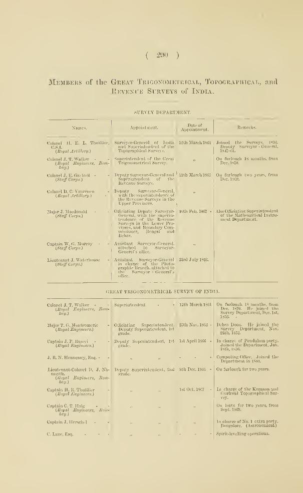
( 290 )
Members of the Great Trigonometrical, Topographical, and
Revenue Surveys of India.
SURVEY DEPARTMENT.
Xaines. Appointment.Date of
A])pointinent.Rcmnrks.
Colonel H. E. L. Thuillier,
C.S.I.
(Royal Artillery.)
Colonel J. T. Walker -
(Royal Engineers, Bom-bay.)
Colonel J. E. Gastrtll -
(Staff Corps.)
Colonel D. C. Vnnrencn(Royal Artillery.)
Ilajor J. Macdonald(Staff Corps.)
Captain W. G. Jlurray -
(Staff Corps.)
Lieutenant J. Waterliouac
(Sl<nff Corps.)
Surveyor-General of Indiaand Superintendent of theTopoirraphical Surveys.
Siipcrintcndent of the GreatTrigonometrical Survey.
Deputy Surveyor-General andSuperintendent of theRevenue Surveys.
Deputy Suneyor-General.with the superintendence ofthe Revenue Sun'eys in theUpper Provinces.
OlTiciating Deputy Surveyor-General, with the superin-tendence of the RevenueSurieys in the Lower Pro-vinces, and Boundary Com-missioner, Bengal andBehar.
Assifitant Surveyor-General,attached to Surveyor-General's office.
Assistant Surveyor-Generalin charge of the Photo-graphic Branch, attached tothe Surveyor - General'soffice.
nth March 1887
10th Feb. 1867 -
2Srd July 1866.
12th March 1861 Joined the Surveys, 18S6.
Deputy Surveyor - General,1817-61.
On furlough 18 months, fromDec. 1870.
On furlough two years, fromDec. 1869.
Also Officiating Superintendentof the Mathematical Instru-ment Department.
GREAT TRIGONOMETRICAL SURVEY OF INDIA.
Colonel J. T. Walker -
(Royal Mnrjincers, Bom-bay.)
Major T. G. Moiitgomeric(Royal Engineers.)
Captain J. P. Bascvi(Royal Engineers.)
J. B. N. Hennessey, Esq. •
Lieutenant-Colonel D, J. Na-smyth.(Royal Engineers, Bom-bay.)
Captain H. R. Thuillier(Royal Engineers.)
Captain C. T. Haig(Royal Engineers, Bom-bay.
\
Captain J. Herschel
C. Lane, Esq. - - -
Superintendent
OITieiating Superintendent.Deputy Superintendent, 1st
grade.
Deputy Superintendent, 1st
grade.
Deputy Superintendent, 2ndgrade.
12th March 1861
25th Nov. 1862
Ist April 1866 - I
8th Dec. 1866 -
1st Oct. 1867
On furlough 18 months, fromDec. 1870. He joined theSurvey Department, Dec. 1st,
1853. •
Dehra Doon. Ho joined theSurvey Department, Nov,25Dh, 1S52.
In charge of Pendulum party.Joined the Department, Jan.18th, 1850.
Computing Office. Joined theDepartment in 1841.
On furlough for two years.
In charge of the Kiimaon andGurhwal Topographical Sur-vey.
On leave for two years, fromSept. 1869.
In charge of No. 1 extra party.Bangalore. (Astronomical.)
I Spirit-levelling operations.
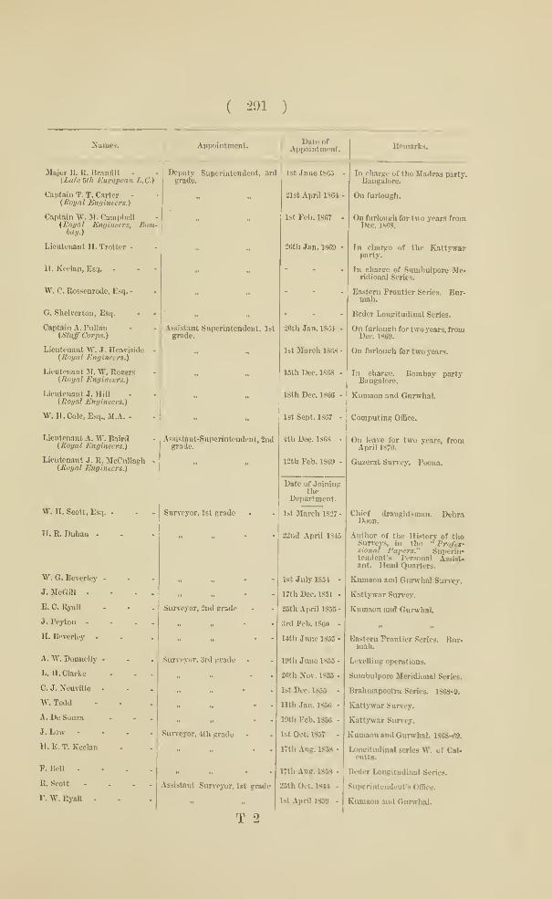
( 291 )
Names. Appointment.Date of
Appointment. Remarks.
Major B. R. Branfill -
{Late Uh European L.C.)
Captain T. T. Carter -
(Koual Engineers.)
Captain W. M. Camplwll{Royal Engineers, Bom-bay.)
Lieutenant H. Trotter -
H. Keelan, Es:i.
W. C. Rossenrode, Esq. -
G. Shelverton, Esq.
Captain A. Ihillan
(Staff Corps.)
Lieutenant W. J. Heaviside{Royal Engineers.)
Lieutenant JI. W. Rogers{Royal Engineers.)
Lieutenant J. Hill(Royal Engineers.)
\V. n. Cole, Esq., M.A. -
Lieutenant A. W. Baird(Royal Engineers.)
Lieutenant J. R. McCullagh(Moi/al Engineers.)
W. H. Scott, Esq.
H. R. Duhan -
W. G. Beverley
J. MeGill -
E. C. Ryiill
J. Peyton -
H. Beverley
A. W. Donnelly
L. 11. Clarke
C. J. Ncuville
\V. Todd
A. De Souza
J. Low
H. E. T. Keelan
F. Bell -
R. Scott
F. W. Ryall -
Deputy Superintendent, 3rd 1st June 1865 -
grade.
2lst April ISM '
Ist Feb. 1867
2«tli Jan. 1869 -
Assistant Superintendent, 1stgrode.
Assistant-Superintendent, 2ndgrade.
Sur\-eyor, 1st grade
Surveyor, 2nd grade
Surveyor, 3rd grade
Surveyor, 4tli grade -
Assistant Surveyor, Ist grade
T 2
20th Jan. 1861
1st March 1868 -
15th Dec. 1868 -
18th Dec. 1866 -
1st Sept. 1S67 -
4th Dec. 1868 -
12th Feb. 1869 -
Date of Joiningthe
Department.
1st March 1827 -
22nd April 1815
1st July 1854 -
17th Dec. 1851 -
25th April 1855-
3rd Feb. 1860 -
14th Juno 1855 -
I'.'th Juno 1855 -
26th Nov. 1865 -
1st Dec. 1855 -
nth Jan. 1856 -
19th Feb. 1856 -
1st Oct. 1857 -
17th Aug. 1858 -
I7th Aug. 1858 -
25th Oct. 18M -
1st April 1859 -
lu charge of tho Madras party.Bangalore.
On furlough.
On ftjrlough for two years fromDec. 1868.
In charge of the Kattywarparty.
In charge of Sumbulpore Me-ridional Series.
Eastern Frontier Scries. Bnr-niah.
Bcder Longitudinal Series.
On furlongh for two years, fhjmDec. 1869.
On furlough for two years.
In charge. Bombay partyBangalore.
Eumaon and Gurwhal.
Computing Offlce.
On leave for two years, ftromApril 1870.
Guzerat Survey. Poena.
Chief draughtsman. DehraDooD.
Author of the History of theSurveys, in tho •' Pro/efsional Papers." Suiwrin-tendent's Personal Assist-ant. Head Quarters.
Kumaon and Gurwhal Survey.
Kattj-war Survey.
Kumaun imd Gurwhal.
Eastern Frontier Scries. Bur-raah.
Levelling operations.
Sumbulpore Meridional Scries.
Bralimapootra Series. 1868-9.
Katt>-W!ir Siu^cy.
Kattywar Survey.
Eumaon and Gurwhal. 1868-69.
Longitudinal scries \V. of Cal-cutta.
Bcdcr Longitudinal Series.
Superintendent's OOice.
Kumaon and Gurwhal.

( 292 )
Niiiues.

( 293 )
TOPOGRAPHICAL SURVEY OP INDIA.
Names. Appointment.Date of
Appointment.Remarks.
Colonel H. E. L. Thuillier,
C.S.I.(Royal Artillery.)
Colonel G. H. Saxton -
(Madras Staff Corps.)
Major G. C. Deprce(Staff Corps.)
Major H. H. Godwin Austen(Staff Corps.)
Captain A. B. Melville -
(Staff Corjis.)
Captain W. G. Murray -
(Staff Corps.)
Lieutenant O. Stralian •
(lioyat Engineers.)
1. 0. N. James, Esq. -
J. B. Girdlestone, Esq.
Lieutenant R. V. Riddell(Royal Eufiincers.)
Lieutenant C. Strnban •
(Royal Engineers.)
Lieutenant A. E. DowninR(Late i\st N.I.)
Caiitian W. P. Badgley -
(Staff Corps.)
Lieutenant M. T. Sale(Royal Engineers.)
Lieutenant T. H. Holdieh(Royal Engineers.)
H. Horst, Esq.
Lieutenant J. R. Wilmcr(Royal Artillery.)
N. A. Belletty, Esq.
C. H. T. Neale
J. P. Boncss -
A. C. Cluunarett -
H.J.Bolst -
G. A. McGill -
D. Atkinson
J . Vanderputt
R. \V. Chew
Superintendent
Deputy Superintendent, 1stgrade.
Deputy Superintendent 3ndgrade.
Deputy Superintendent, 3rdgrade.
Assistant Superintendent, 1st
grade.
Deputy Superintendent, 3rdgrade.
Assistant Superintendent, 1st
grade.
Probationarj' Assistant Super-intendent, 3rd grade.
Surveyor, 1st gnido
„ 3nd grade
„ 3rd grade
„ 4tli grade
12th Mareh 1801
1st April 1866 -
20th Oct. 1806 -
ist Jan. 1808 -
1st April 1809 -
1st July 1800 -
Ist April 18GB -
1st Jan. 1867 -
l8t Oet. 1867 -
Ist Dee. 1807 -
7th Nov. 1807 -
8th May 1868 -
IBth Dec. 1868 -
1st Oct. 1S6Q -
24th Aug. 1869 -
Date of Joiningthe
Department.
15th July 1817 -
21st April 18S5 •
Sth Sept. 1850 -
2nd June 1832 -
20th July 1852 -
8th April 1855 -
Ith Aug. 1856 -
1st Sept. 1856 -
l&lh Sept. 1850-
Calcutta.
Central Provinces and Vizaga-pat.am Agency Survey. Oota-camund.
On leave for two years, fromDee. 1868.
On leave for two years, fromApril 1870.
Surveyor-General's Office.
Rajpootana Survey. Mus-soorie.
Assistant to Surveyor-Generalon duty at Head Quarters.Previous service from July29th l»t5 in subordinatobranch.
Joined the Survey in 1S63.
Pormerly a midshipman inthe Indian Navy,
Bundclcund Survey.
Gwalior and Central IndiaSurvc}'.
On leave, from 12th Dec. 1868.
On leave, from 23nl Jan. 1869.
Chota Nagporo Survey.
Gwalior and Central IndiaSuncy.
Rajpootana Survey. I*reviousservice since 1S51 in sub-ordinate branch.
Bundelcund TopographicalParty.
Cossyah and Garrow HillsSurvey.
On leave for two years, fromAug. 1870.
Geographical Examiner. HeadQuarters.
Head Quarters.
Gwalior and Central IndiaSurvey.
Chota Xagporc Survey.
Draughtsman. Head Quarters.
Cliotn Nagporc Surrey.
Central Provinces and Vizafia-
patam.

( 29t )
Names.Date of
Joininfr theDepartment.
Kcmarks.
J. Harper . . - -
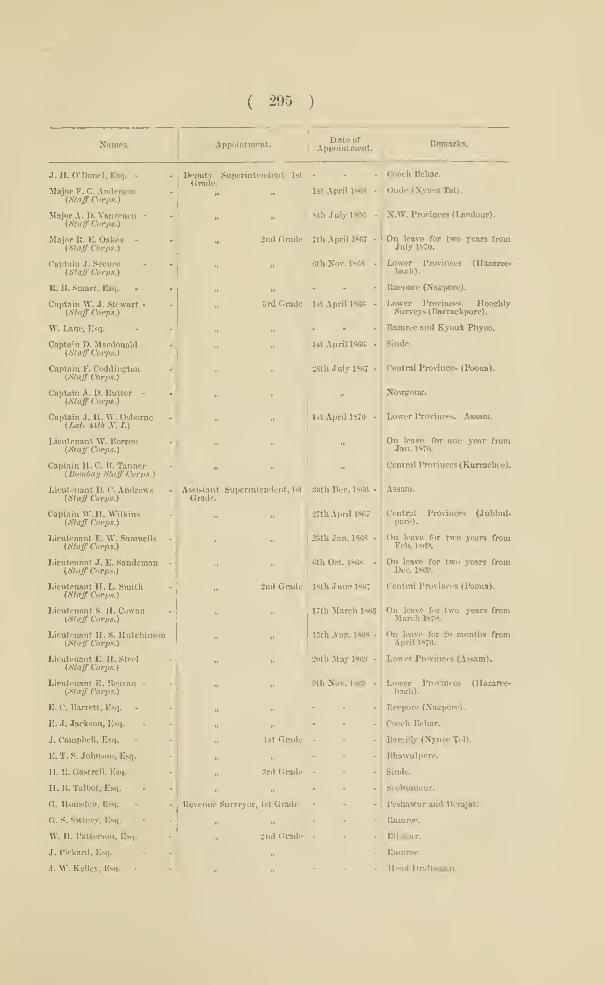
( 295 )
Names. Appointment.Dat«or
Appointment.B«marks.
J. H. O'DoneI.Esq. -
Major F. C. Anderson(Staff Corps.)
Major A. B. Vanrenen -
(Staff' Corps.)
Major R. E. Oakes -
(Stair Corps.)
Captain J. Sconco(Staff Corps.)
R. B. Smart, Esq.
Captain W. J. Stewart •
(Staff Corps.)
W. Lane, Esq.
Captain J). Mardonald(Staff Co)-ps.)
Captain F. Coddiiigtou(Staff Corps.)
Captain A. D. Butter -
(Staff Corps.)
Captain J. H. W. Osborne(Late Mh .V. /.)
Lieutenant \Y. Borron(Staff Corps.)
Captain H. C. B. Tanner(Bombay Staff Corps.)
Lieutenant D. C. Andrews(Staff Corps.)
Captain 'W.H. W'ilkins(Sttfff Corps.)
Lieutenant E. W. Samuells(Sto.^ Corps.)
Lieutenant J. E. Sandemsn(Staff Corps.)
Lieutenant H. L. Smitli(Staff Corps.)
Lieutenant S. H. Cowan(Staff Corps.)
Lieutenant II. S. Hutchinson(Staff Corps.)
Lieutenant E. 11. Steel
(Staff Corps.)
Lieutenant R. Benvan -
(Staff Corps.)
S. C. Barrett, Esq. -
£. J. Jaekson, Esq.
J. Campbell, Esq.
£. T. S. Johnson, Esq.
H. E. Gastrcll. Esq.
U. B. Talbot, Esq.
U. Housdcn, Esq.
G. S. Swiney, Esq.
W. H. Patterson. Esq.
J. Piekard, Esq.
.1. W. KeUe.v, Esq. -
Deputy Superintendent 1stJcputyGrade.
1st April 1868
]8th July 1886
ind Grade ' 7th April 1867
6th Not. 1868
;>rd Grade
Assistant Superintendent, 1st
Grade.
2nd Grade
Revenue Surveyor, 1st Grade
„ -Jnd Gradi'
1st April 1866 -
1st April 1866 -
26th July 1867 -
1st April 1870 -
30th Dec. 1866 -
27th April 1867
25th Jan. 186S -
6th Oct. 1863 -
18th June 1867
17th March 1868
13tb Au;. 1868
20th May 1809
9th Nov. 1869
1st Gnide
3nl Grade ;
Cooch Behar.
Oudc (NynceTal).
N.W. Prorinces (Landour).
On leave for two years fromJuly 1870.
Lower Provinces (Hazaieo-bogh).
Raepore (Nagpore).
Lower Prorinces. HooghlySur^•eys (Barrackpore).
Bomrcc and Eyouk Pbyoo.
Sinde.
Central Provinces (Poona).
Nowgong.
Lower Provinces. Assam.
On leave for one year fromJan. 1870.
Central Provinces (Kurrachce).
Assam.
Central Provinces (Jubbul-pore).
On leave for two years fromFeb. 1S69.
On leave for two .vears fromDec. 1869.
Central Provinces (Foona).
On leave for two years tnmMarch 1S70.
On leave for 20 months fromApril 1870.
Lower Provinces (Assam).
Lower Provinces (llazaree-bagh).
Reepore (Nagpore).
Coo<'h Behar.
Bareilly (Nynec Tol).
Bhawulpore.
Sinde.
Seebsaugur.
Peshawur and Derajat.
Kamrec.
Bijnour.
Ramruc.
I(e-.id Draftsman.

( 290 )
Nmiics. Appointment.
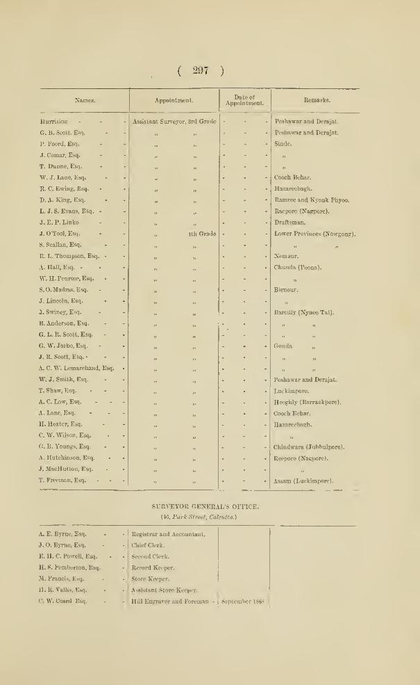
( 297 )
Names.
Hurrising
G. B. Scott, Esq.
P. Foord, Esq.
J. Comar, Esq.
T. Dnnne, Esq.
W. J. Lane, Esq.
B. C. Ewing, Esq.
D. A. King, Esq.
L. J. S. Evans, Esq. •
J. E. P. Linko
J. O'Tool, Esq.
S. Scallan, Esq.
R. L. Thompson, Esq.
A. Hall, Esq. -
W.H.Penrose, Esq.
S.O.Madras, Esq.
J. lancoln, Esq.
J. Swiney, Esq.
B. Anderson, Esq.
G. L. E. Scott, Esq.
G. W. Jarbo, Esq.
J. B. Scott, Esq. -
A. C. W. Lcmarchand, Esq.
W. J. Smith, Esq.
T. Shaw, Esq.
A. C. Low, Esq.
A. Lane, Esq.
H. Hexter, Esq.
C. W. Wilson, Esq.
G. B. Youngs, Esq.
A. Hutchinson, Esq.
J. MacHutton, Esq.
T. Freeman, Esq.
Appointment.
Assistant Surveyor, 3rd Grade
ith Grade
Date ofAppointment.
Bemarks.
Peshawar and Derajat.
Peshawar and Dcrajat.
Sinde.
Cooch Bebar.
Hazarecbagb.
Bamree and Kyonk Fhyoo.
Baepore (Xagpore).
Draftsman.
Lower Provinces (Nowgong).
Nemaur.
Chnnda (Poona).
Bignour.
Bareilly (Nynee Tal).
w n
Gonda „
Peshawar and Derajat.
Luckimpore.
Hoogbly (Barrackpore).
Coocb Bebar.
Hazareebogb.
Chindwara (Jubbulpore).
Beepore (Nainmre).
Assam (Luckimpore).
SUEVEYOR GENERAL'S OFFICE.
(46, Park Street, Calcutta.)
A. E. Byrne. Esq.
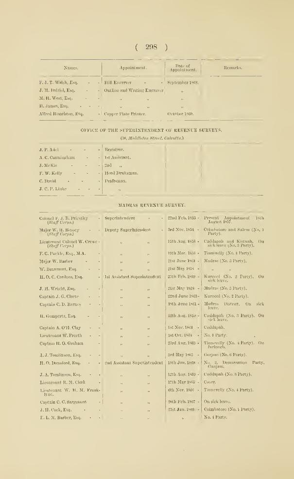
( 298 )
Names. Appointment. DatootAppointment Bemarki.
F. J. T. Walsh, Esq.
J. JI. DaUicI, Esq.
M. H. West, Esq.
H. James, Esq.
Alfred Uoughton, Esq.
Hill Enirmer • -. September 1868.
Outline and Writing Engraver „
- ' Copper Plate Printer. October 1809.I
OFFICE OF THE SFPERIXTENDENT OF REVENUE SITRVEYS.
(10, MiddMon Street. Calcutta.)
J. P. Add

( 299 )
Names. Appointment. Ap^'ntment.

( 300 )
Names. Appointment.Date of
Appointment. Remarks.
H. H. Summers, Esq.
W. B. Prescott, Esq.
A. B. Fordc, Esq.
Lieutenant C. Hexton
W. Harrison, Esq.
J. R. Gilison, Esq,
H. K. Disney, Esq.
J. W. Young, Esq.
Lieutenant C. Echalaz
11. A. Cummings, Esq.
W. Fletcher, Esq.
J. W. Scott, Esq.
£. Hcarn, Esq.
Lieutenant J. G. McKac
E. A. Francis, Esq.
Lieutenant W. C. Black
E. B. Pitt, Esq.
E. A. Hobson, Esq.
A. Guerin, Esq.
Captain G. Mackenzie
Captain C. C. Pemberton
F. T. Willaume, Esq.
Lieutenant F. Plummer
"W. Ashbumcr, Esq.
W. Tumbull, Esq.
H. S. Spring, Esq.
Lieutenant R. Price
C. L. Horant, Esq.
J. B. Morgan, Esq.
R. T. Wingate, Esq.
J. H. D. Dunsterville, Esq.
Lieutenant J. H. Bawlo
E. R. CritchcU, Esq.
F. D. Souza, Esq.-
W. E. Waite. Esq.
J. C. Whitcomh, Esq.
G. Bctham, Esq.
Lieutenant Ward
G. Berrie. Esq.
J. F. Nash, Esq.
J. Dowraan, Esq.
C. H. Marsb, Esq.
T. R. Fcniaiiduz, Esq.
Assistant Superintendent
Settlement OfiBcer •
Superintendent
Superaumerao' AssistantSuperintendent.
Sub-Assistant Superintendent
Supemumerar>'
1st Class Assistant
2nd
Guzerat.
North Division.
On sick leave.
Berar.
Guzerat.
S. Mahratta Country.
Guzerat.
N. Division.
Berar.
u
Sinde. Right bank of Indus
Left
» Right „
Left

( 301 )
Namm. Appointment.Diteof
Appointment.Remarlis.
6. F. Uathieson, Esq.
E. Steele, Esq.
H. V. Fitzgerald, Esq.
IL Giles, Esq., B.A.
W. A Boulton, Esq.
Khodur Mull
Heea Mahomed
3rd Class Assistant
Supernumerary .,
Sub-Assistant
Siudc. Left bank of Indus.
, Bight „
. Left
Eight „
INSPECTION OF INSTRUMENTS FOE THE INDIAN SURVEYS.
{Observatory, Belvidere Road, Lambeth.)
Lieutenant Colonel A. Strange,F.R.S.
Inspector of Scientific Instru-ments. Lambeth Obsenra-torj-.
1862.
MATHEMATICAL INSTRUMENT DEPARTMENT.
<JVo. 9, Park Street, Calcutta.)
Major J. Macdonald
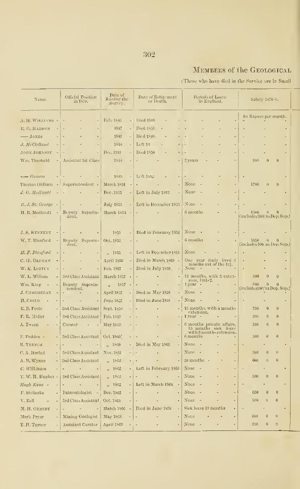
302
Members of the Geological
(Those who have died in the Service iire in Small
Name. Official Positionin 1S70.
IDate of
Joining theSnney.
Date of Retirementor Death.
Periods of Leavein Engtand. Salarj- 1870-1.
A. II. WllLI.lMS -
It. Ci. Haduox
J0XE3
J. McClelland -
.Ions Jonxsos -
Wm. Theobald -
— Gomess
Thomas Oldham •
J. O. lledlicott •
R. J. St. George •
a. B. Medlicott -
J. S. Kbksedy -
W. T. Blanford -
H. F. Blanford -
C. d'.. Oldham -
W. K. LOFTCS
Vt. h. "Willson
"Wm. King
J. GEOonEGAir -
H. Child
R. B. Footo
F. R. JIallct
A. Tween
F. Fedden -
R. Teekch
C. A. Hacket
A. B. Wynne
C. Wilkintott
T. W. H. Hughes -
Hugh Kane •
F. Stoliczka
V. BaU - -
M. H. Obusby -
Slark Fryar
T. n. Turner
Assistant 1st Class
Superintendent
Deputy Superin-Jepi
delent.
Deputy Supcrin-(leiit.
3rd Class Assistant
Deputy Superin-tendent.
3nd Class Assistant
Srd Class Assistant
Curator
Srd Class Assistant
Srd Class Assistant
2nd Class Assistant
Srd Class Assistant
Palaeontologist -
Srd Class Assistant
Mining Geologist
Assistant Curator
Fell. 1*10
1847
1847
1848
Dec. 1848
1848
1S49
March 1851
Dec. 1851
July 1853
March 1S54
1865
Oct. 1855
„ 1855
April 1856
Feb. 1857
March 1857
„ 18.57
April 1857
June 1857
Sept. 1858
Feb. 1859
May 1859
Oct. 18C0'
„ 1860
Nov. 1801
„ 1862.
„ 1862
„ 1862
„ 1862
Dec. 1862
Oct. 1861
March 1866
May 1868
April 1869
Died 1848
Died 1831
Died 1848
Left 18
Died 1850
Left 1S52
Left in July 1862
Left in December 185S
Died in February 1856
Left in December 1861
Died in March 1869
Died in July 1859,
Died in May 1858
Died in June 1858
Died in May 1361
Left in Febrnar>' 1865
Left in March 1864
Died in June 1870
2 years
None -
None -
None -
6 months
None -
6 months
None
One year (only livedmonths out of the 12).
None -
12 months, with 3 cxtcnsion, 1801-2.
1 year -
None -
None -
15 months, with 4 monthsextension.
1 year -
6 months private affairs,
15 mouths sick leavewith 3 months extension
6 months
None -
None -
20 months •
None -
None -
None -
None -
None -
Sick leave 18 months
None
None -
In Rupees per month.
170O
1100(includcslOO/asDep.Sup.)
105O(incIudeslOO; ns Dep.Sup.)
800(includeslOO/ as Dep. Sup.)
700
500
600
500
500
600
500
650
50O
600
230

303
Survey of India.
Capitals, those retired from the Service ia Italics.)
TnivclliiiKand IlursfAJiowaiiccs.

LONDON:Printed by Georcf. E. Eyuk and William SromswooDE,
Printers to the Queen's most Excellent Majesty.
tHXA/


A«9ttoltlAllMi.e*^«M tory 212 Ttalrjr^l* ,AlQz».r tor 278 UcCl.llanl Dr.John 154
\nraTati T^pa 185 "C*** •^ A.nMrjEiFl«''279 UcLoA &Rich r4»"UtmlE»lii tt
Arclilt ct«r« »f B««J r»r« nan-^rflsl l.Car*- 146 Chin.Prontior Pari "Pfr 1870
1866 P* 193 ' Dp.nl•ll.Th'^naa 176 lIcClMr.Capt.J^hn 5 (8j|B" la Dkarwur ft Uyatr* B.I.C**b Li¥:\rarifins Ibidrft* Jl Litor,& itcft«nc«
52 pi. 1866 P* 191 'liy-lM 1800-36 1,60 VI, 61 (1827) 171; 1847 SB
ArrrBTilth'g Ma.p« 280 ilntn H H 1856-60 lliiiras O^sarrtry 209,238
Bairi Snitli,Ltnt H. llll«%,iJir Waltor 194 ItoT.S«rT8y 106
Acrle.Ito«o«rac- .f P«njuli Br»kin«,V*i 175n Ifc-lsey C.1,185
1849 256» SthorM7,L*nt 18 lb-lc»ln,Slr Chaa 12
Hn.»n 0«A*T,Klgtna &Ca«T«ry 3T«r«»t,G«f.68,79 (77[UaldlTe iBlanlB Monoir >y T»«»e
D«l%a« Lsn'^n 1856 263ii Latter* tt Dak* •t Saa»«x) ft Christtrhar 18;'6 16
BaiiMil Atlas (nannoU) 40n,276n I^lctnar Dr. 140 Uarah P Phya.Oaacr.. ^» n»UB«w»har.Ltnt.3l ^rc«»a»n.Ja««» 180 ¥y lUEuai action 1864 270m
Bhllaa (Bh«rai ;%at«) 184 "Bacy^cat Ton la. P* tf pl.Harwhall % 32
Taraicmnin hpn) 33 pi. 1845 181a Ifc.afi^.Ltnt 7n
1854 185 Parraaaon Ltnt J H i4 ItoaAawa-Tp. Isr.C 1, 104.15n82
Blacyor,C«|J.Vj.lan^.(Sarr.Gnl^74) Prr.nyjln.C- t.I« 16 (166) u,Allcatt J G 154
Blalr.Lt.IrchWA 5 (8i.)G- a."BanAolcan4 Gaely4i«iTlllG Copt. 128
Ballaam< llajar Slnla .'^09a .Grrllnff'a SatnAa arv-y 60 ltote9r,.0^aarT.liarera 1784 T 2(.i
B-^n^ay Gaaer.Sae.#aan»al I-XI3L13 Godwin Aastan 106 Msnlar V'illlrna Gazcrat 67
Brahnina^ai-Slndh 195 GalUnthan.Jahn 49.239 Itanteanary Cap*.98,105
Briec».'^rchltact.,A)ino<a¥a* 4ta GraanaaeJi Carraapca aa Gaelecl Merasliy Capt. 15
120 ahtta pi. 1866 193 M»P •' 1»^1» »»^^'»* ^^^T 153a Haw^alA Capt. 150
H Bra«a,Ja]m Allaa Hap.TruTancora <)lwtol"^« C»rt. 21 Iarl,alil Sir J»ta Chf f«»*«»^*«lO^aarratery 212 Griffith ".h 266 UCIO 17]
Bracka.Cart. 10.11.12 IL i"«» C.-r*- "^^
I.W.Min: laya. Trlc^orr.. 89
Bachanaa Hanlltan Ace X^iB •t KapalK-^orrt Um 65.66n , ^^
Prorincaa Hap 132
S4in>.18l9 PAM
Bmist Dr.Oaarna 215
BarraTr,i{a«1ion 41Calcatta RaTlor 1851{p.?2l)102nC*14acatt,Jalm 2/3 -Ua«*.^<^-^'^Call ,Jahn( Smrr.Gnl )40
"^^
Carlasa Ltnt 20.24
Cart or Hy J. 22
Qaal.i^r- an Vto,I>B©nli
Ca«tl«y,'»ir Pvaliy 148Chaanay Cal.27Chrl.t rhor Ltnt 20CalaW ObaarTtry ^\Calln llacKienzia 58.59.185Cale¥ra»>3 Cal(3«rr.Gnl )41.42.63
•• Hy ?.. 172aC:«nnar,C9ar8r Sarray 60
Caaiv • CanaarCanata¥l6,Capt> 32Caart Capt . ^Canii2iM|M|Hl#*
Ciamlne9Ma,]I^J.Alaa3aai4ar 185
Cr.pt. J D S48-9 ( 77.81a toldhnn 154
Hoil-.-Kon,Col.Jolm Anty.(»ttrr.Gnl)oilTt>r Ccpt. Robert 21.^2
Hora"bnr':h,Ja on 8.279.281 OlllTor,J9 8 ah 69
Hortaa MalalMiraicaB A* Asa 16B6- Paarce.Cel 40
170S 12 T^l.Fa 774 pi. 264 Pe- ,Tiortan,C::.-t,Boil©aa 84
Hantcr Dr (1793) 42
IjlAian Kary Rae. Dastr^
"(Yg^jJaca* Ltnt 77
V i857}J«rTl».M*J®r 76.85.G6a
Jay Slnch »f J«:T''ra 235
Jahnstaaa Col.129
PlAAlnctan.Capt. Ham Bk af36 Stama C:<.lc.l845 34
Poller Gal. 173POL;':'.na,Ltnt 179Pawall C pt. 20.24Prlastloy C^.pt. 107
Jaaaa.JWllx "Asayrlan Va8tlEaB'«129prin{:la Cipt. 41
Jaaaa.Slr Vta 171.174
Kail ,Cal.41iCittaa Ltnt iL^richan 178a
KyA.Jjjnaa 225
Lacan Capt. 5
Lalilaw 145aLa' btonj^n. 45
ir% Pa:^Jc 62
y.n Cr a. 90
Law' 8 •*Lan-l" af the San'»38a
Lacknavf O^aorratry 238
Lr.ahi ^--tan CivrV. r.2.23
jynok capt. 27
Prlnaap.Janaa 176.180(1858 17 ]
Bsii'.ya on In li.n .tatlqnj*!
Prlnsap B.A. Statl.Ac9.9f *<:
fc>ta 1855-60 273aRan Rax 186Bad Saa Sarray 1829 15
Raimall J&r.aa 39 276-7
Ranny,Capt. 93,9: nRaranaa Sarrcys 83
R*ynal<lB,Col. 43Ritchie Ciipt
.pJohn 4
RaU.Laiy. Danntll's InraBtle. *f Sykioa, Lt>,Col. ;7 H 214Currants in .tirntic 18.-1 277 Sy«d Uohaln 74.96.139
Rasa.C ' . D ni«l 7.0.10 T:iylar,Ltnt A D v -l:-.a 31
Rsz'BarnJi ta 265 Ini & C rrent Charta 34ii r:. ln\ii.. 3 r. Ovo 18."0-32 Tackle *lr RichrA 26:'n
R.v;l9,Dr.Par^sjIllBtns i# Batunj ft IThailllar (SttrT>Gnl) 82.126athar Ifetl.li-.ta'^' of Hinalayaa Tapping Capt. HicJiaol 5.49
V-'ollataA J R Trarala InAr ¥la. 15b
llldn i.Chaa 172n 281Bh..?:aTat Ghita 1785 172
niaon H H 172nT
2 TolB.|1839 148a 267^iaharanpara GAnd 267laanAara.Tral rrXj 285Scatt^CalJIa- af Hairaa 134SaUy,Capt . '^O.P.'J .24.30Salactlana Indian P ".' D 263aShartrotla Ro¥. 7r
SEqrth ft Thallll«r,l!«al.Sarraye laIndia 1851 10.*^
Snail, SajaiEicndry Sarray, 62S^ iffa,Ltnt 34Jtrr nco,Cr.pt. (ilniji) 9;'..100
••watch af m cnftani" -"0.25
«j»Talyan,Slr Chaa 211 -f*
TamTiall'a Tiraiarelly 61 (39a )'
Unpawn aha * InAl n Ni'.Ty iarroyoj'
mikaxaaar 'Vat lea anr Rannall"|
4ta Paria 1842 277brraivor Ltnt 10«.109
John 281Mallieh,irthnl 265 Plantaa Ab-.HpWI
Rariaraa 3 r^.Fa 1832 266
arA Ca. t> 26
"arran Ltnt 48nWaar:}i,Andrew 72.79.87.100T.a¥¥*a SHTT.-jf Gancaa HardTWir ta
Gcineatrea 1008 64
19