A Hydraulic Construction of the Mam luk Period at El-Madah il, Northeast of the Hula Valley
16
‘Atiqot 71, 2012 A HydrAulic construction of tHe MAMluk Period At el-MAdAHil, nortHeAst of tHe HulA V Alley HerVé BArBé During November–December 2004, a salvage excavation was conducted at el-Madahil (map ref. NIG 26078/79016, OIG 21078/29016) following the partial destruction of wall remains during the supervised digging of a trench to accommodate a water pipe. 1 El- Madahil, a registered archaeological site, is located at c. 91.5 m asl on a small, gently sloping basaltic hill on the eastern side of Nahal Hermon, northeast of the Hula Valley (Fig. 1). Nahal Hermon runs c. 500 m west of el-Madahil from north to south at an elevation of slightly less than 88 m asl. The site, which was initially documented during a survey (Shaked 1998:76), was attributed at that time to the end of the Medieval period. The remains of the abandoned village of al-‘Abisiyya are in the immediate vicinity of the site (Khalidi and Elmusa 1992:429–430). tHe excAVAtion The trench opened for the water pipe was c. 1.5 m wide and oriented roughly east–west. Two parallel walls, relatively close to one another, were visible in the southern section of the trench on its eastern end. No remains were visible in the northern section of the trench. Accordingly, an excavation area measuring c. 5.5 × 7.0 m was opened south of the wall remains exposed by the trench. Approximately one meter of surface debris was mechanically removed from the surface. The finds revealed by the excavation are presented in this report Fig. 1. Location map. 258 000 260 000 788 000 792 000 790 000 256 000 0 2 km 254 000 Nahal Dan Nahal Hermon Nahal Senir Qiryat Shemona Ha-Gosherim Sede Nehemya Kefar Szold Tel Turmus ‘En Turmus The Excavation el-Madahil
-
Upload
independent -
Category
Documents
-
view
2 -
download
0
Transcript of A Hydraulic Construction of the Mam luk Period at El-Madah il, Northeast of the Hula Valley

‘Atiqot 71, 2012
A HydrAulic construction of tHe MAMluk Period At el-MAdAHil, nortHeAst of tHe HulA VAlley
HerVé BArBé
During November–December 2004, a salvage excavation was conducted at el-Madahil (map ref. NIG 26078/79016, OIG 21078/29016) following the partial destruction of wall remains during the supervised digging of a trench to accommodate a water pipe.1 El-Madahil, a registered archaeological site, is located at c. 91.5 m asl on a small, gently sloping basaltic hill on the eastern side of Nahal Hermon, northeast of the Hula Valley (Fig. 1). Nahal Hermon runs c. 500 m west of el-Madahil from north to south at an elevation of slightly less than 88 m asl. The site, which was initially documented during a survey (Shaked 1998:76), was attributed at that time to the end of the Medieval period. The remains of the abandoned village of al-‘Abisiyya are in
the immediate vicinity of the site (Khalidi and Elmusa 1992:429–430).
tHe excAVAtion
The trench opened for the water pipe was c. 1.5 m wide and oriented roughly east–west. Two parallel walls, relatively close to one another, were visible in the southern section of the trench on its eastern end. No remains were visible in the northern section of the trench. Accordingly, an excavation area measuring c. 5.5 × 7.0 m was opened south of the wall remains exposed by the trench. Approximately one meter of surface debris was mechanically removed from the surface. The finds revealed by the excavation are presented in this report
Fig. 1. Location map.
258
000
260
000
788000
792000
790000
256
000
0 2km
254
000
Nahal
Dan
Nahal Herm
on
Nah
al S
enir
Qiryat Shemona
Ha-Gosherim
Sede Nehemya
Kefar Szold
Tel Turmus
‘En Turmus
The Excavation
el-Madahil

HerVé BArBé94*
according to phases of construction, occupation, destruction and abandonment.
Construction PhaseThe remains unearthed by the excavation were relatively dense for the size of the exposed area (slightly more than 30 sq m). They consisted
of one structure and two related installations (Plan 1; Figs. 2, 3; Table 1). The structure was delimited by two parallel walls oriented north–south (W100 and W101) and a third wall (W102), which ran perpendicular to them, joining with W101 and abutting W100. A circular installation (L1009) was excavated
0 2m
1-1
W102
W101W100
W103W102
W100
L1002L1009
L1011L1015
L1000
L1005
90.00
90.00
91.00
91.00
92.00
93.00
89.00
89.00
2-2
3-3
92.00
93.00
91.00
1
2
3
1
2
3L1003L1008 L1004
L1007
L1005L1015
L1001
L1002
L1011
L1009
L1006
W105
W104
L1010
L1011
L1012
L1013
L1014W101
W100
W103
W102
L1012
90.41
90.55
Plan 1. Plan and sections of the remains.

A HydrAulic construction of tHe MAMluk Period At el-MAdAHil 95*
Phase
Abandoment
Destruction
Occupation
Construction
1000
1006 1008
W102 W105W103
1003 1012
1001 1002
1003
1004
1007
1005
1015
W104
1001
W100W101
1010
1009
Fig. 2. Schematic diagram of the stratigraphy (floors indicated in bold).
Locus Stratigraphic Relationship Description DateLoci Above Loci Below Loci at Same
Level1000 1001/1002 Surface layer Ottoman and Mamluk1001 1000 1003 Fill Ottoman and Mamluk1002 1000 1005/1006/1008 Fill Mamluk1003 1001 1004 Fill Mamluk1004 1003 1007 Destruction Mamluk1005 1002 1015 Plastered floor Mamluk1006 1002 Fill Mamluk1007 1004 Sterile clay Alluvium Mamluk1008 1002 Fill Mamluk1009 1000 1011 Circular stone
installation1010 1000 1013 Fill Mamluk1011 1000/1009/1015 1012 Fill Mamluk1012 1011 Sterile clay 1013 Fill Mamluk1013 1010 Sterile clay 1012 Fill Mamluk1014 Cleaned section1015 1005 1011 Plastered
installation and floor
Mamluk
Table 1. List of Loci
HerVé BArBé96*
west of this structure and another installation (L1015), in the southwestern part of the excavation area.
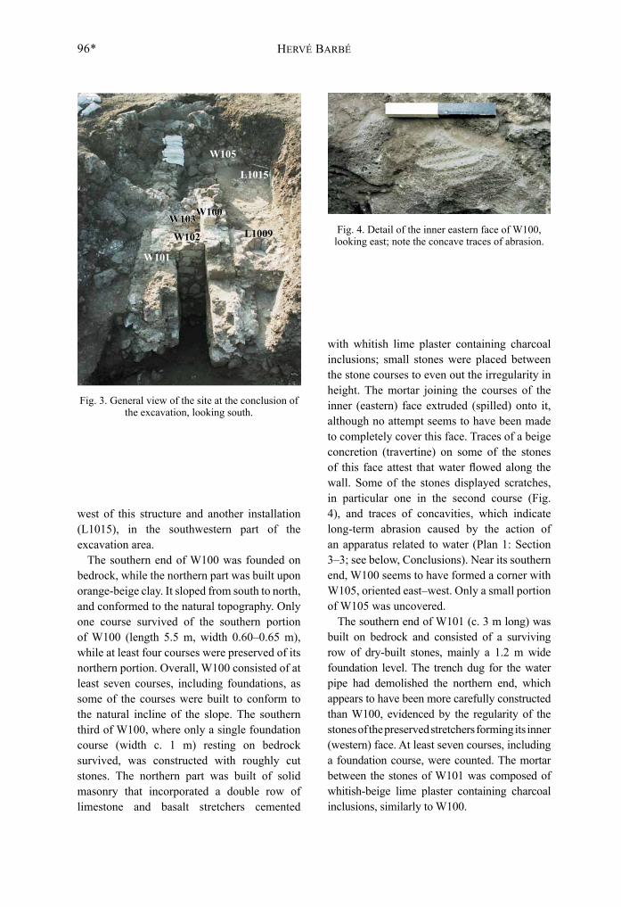
The southern end of W100 was founded on bedrock, while the northern part was built upon orange-beige clay. It sloped from south to north, and conformed to the natural topography. Only one course survived of the southern portion of W100 (length 5.5 m, width 0.60–0.65 m), while at least four courses were preserved of its northern portion. Overall, W100 consisted of at least seven courses, including foundations, as some of the courses were built to conform to the natural incline of the slope. The southern third of W100, where only a single foundation course (width c. 1 m) resting on bedrock survived, was constructed with roughly cut stones. The northern part was built of solid masonry that incorporated a double row of limestone and basalt stretchers cemented
with whitish lime plaster containing charcoal inclusions; small stones were placed between the stone courses to even out the irregularity in height. The mortar joining the courses of the inner (eastern) face extruded (spilled) onto it, although no attempt seems to have been made to completely cover this face. Traces of a beige concretion (travertine) on some of the stones of this face attest that water flowed along the wall. Some of the stones displayed scratches, in particular one in the second course (Fig. 4), and traces of concavities, which indicate long-term abrasion caused by the action of an apparatus related to water (Plan 1: Section 3–3; see below, Conclusions). Near its southern end, W100 seems to have formed a corner with W105, oriented east–west. Only a small portion of W105 was uncovered.
The southern end of W101 (c. 3 m long) was built on bedrock and consisted of a surviving row of dry-built stones, mainly a 1.2 m wide foundation level. The trench dug for the water pipe had demolished the northern end, which appears to have been more carefully constructed than W100, evidenced by the regularity of the stones of the preserved stretchers forming its inner (western) face. At least seven courses, including a foundation course, were counted. The mortar between the stones of W101 was composed of whitish-beige lime plaster containing charcoal inclusions, similarly to W100.
Fig. 4. Detail of the inner eastern face of W100, looking east; note the concave traces of abrasion.
Fig. 3. General view of the site at the conclusion of the excavation, looking south.
W105
W103
W102
W101
W100
L1015
L1009

A HydrAulic construction of tHe MAMluk Period At el-MAdAHil 97*
The space between W100 and W101 was c. 0.7 m wide and closed off to the south by perpendicular W102. This wall was less carefully constructed than W100 and W101 and only its northern face, built of relatively coarsely hewn stretchers and fieldstones, was visible; its southern face rested against bedrock. Seven courses survived of W102 at its western end, all abutting the inner (eastern) face of W100. The five lowest courses of W102 at its eastern end abutted the inner (western) face of W101, while its two upper courses protruded above W101. In contrast to the strictly vertical faces of W100 and W101, the face of W102 inclined somewhat and its upper portion was almost concave.
One meter south of and parallel to W102, a fourth wall was unearthed (W103). The surviving remains of this wall comprised only some fieldstones, exposed at its western end, which were mortared to bedrock and to the eastern face of W100. Remains of mortar that apparently cemented W103 to bedrock at its eastern end provided indirect evidence for the extent of the wall in this direction.
The narrow space (L1008; c. 0.5 × 0.7 m) defined by W100, W101, W102 and W103 was filled with beige-colored earth containing chalk nodules, small stones and chunks of mortar, all dating from the construction phase. While these walls all rested, at least in part, on a natural floor—bedrock to the south and clay to the north—the northern portions of the western and eastern walls (W100 and W101 respectively) were set into earth fills, which were extensively excavated during the dig. The absence of a foundation trench is characteristic of construction in wet environments. Similar techniques were used in the Middle Ages for drainage of ponds (Barbé 1990:47, Fig. 5). The foundations of W100 and W101 were undoubtedly set into the lower levels of these fills, while the walls were built up against the inner faces of the foundation trench. We therefore conclude that the fills date to the construction phase, if not earlier, as they were exposed below the floor surfaces.
Two loci (L1012, L1013), located on either side of the structure, were defined and partially excavated just outside and adjacent to the structure’s western and eastern sides. Resting on natural clay, these loci are situated in a layer of orange-beige silt that contains chalk nodules and some stones. The homogeneity of this sediment, both to the east and west of the structure, provides evidence that this was a single stratigraphic unit cut by the construction of the walls. The top levels of these loci (L1012: 90.41 m asl; L1013: 90.55 m asl) correspond to that of the level between the foundations and the walls. West of the structure, the silt (L1012) is covered by a brown earth fill containing stones (L1011), while to its east, the silt (L1013) is covered by a dense layer of small stones that evokes a bed for the laying of a floor (L1010). This latter layer yielded, in addition to potsherds, a small, polished, conical basalt object that was either a weight or a crusher (see Fig. 12).
In the southwestern part of the excavation area, a plastered installation (L1015) displaying several building stages was uncovered. In its first stage, it abutted the angle formed by the western and southwestern walls (W100 and W105) of the structure west of L1006, and extended 2.3–2.5 m northward and 2.1 m westward from this corner (Fig. 5). Grayish-white lime plaster containing fine charcoal
Fig. 5. The southeastern corner of the structure with floor and plastered walls (L1015),
looking southeast.
HerVé BArBé98*
inclusions coated both the floor and the walls. The plaster coating the walls, each coat 0.5–2.0 cm thick, survived to a total thickness of 0.25–0.30 m. The precise east–west dimensions of the floor were difficult to establish, because its western portion terminated at the section wall of the excavation. However, a length of 2.3 m for the north–south dimensions of the floor from the first construction stage seems reliable as the corner still bore a fragment of wall plaster that abutted the western face of W100.
Occupation PhaseThe three main walls (W100, W101 and W102) formed an open space (L1007) below the level of the floor. At the bottom of this space, the wear of flowing water formed a basin-like depression in the natural clay. This depression was filled with beige-colored sandy alluvium rich in aquatic mollusk shells (Melanopsis), below the first course of the wall faces. This locus (L1007), the upper level of which corresponds to the bottoms of the three walls, yielded only a few potsherds and 40 iron nails.2
During this phase, two additional layers of plaster were laid upon the original floor of the installation (L1015) north of W105. Another plaster floor (c. 0.20–0.25 m thick) was laid directly upon a layer of brown earth (L1005) during this phase of the installation. This new floor abutted the walls of the original installation, extending at least 0.5 m northward beyond the end of the earlier floor (L1015). Two layers of plaster were laid on this extended floor. The plaster layers ranged from 2–10 mm in thickness, consistent with the natural incline of the slope; all the floors from the various construction stages sloped slightly from south to north.
The last changes to the installation were attested by the presence of a dry-built stone wall (W104) comprising four limestone fieldstones placed on an east–west axis for a length of c. 0.9 m, near the southeastern corner of the original structure. Wall 104 reduced the size of the structure on the south, confirmed
by five layers of plastered floors, all of which abutted the new southern limit of the structure.
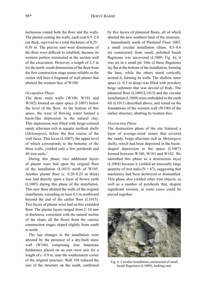
Immediately north of Plastered Floor 1005, a small circular installation (diam. 0.5–0.6 m) constructed from small, polished basalt flagstones was uncovered (L1009; Fig. 6); it was set in a small pit. One of these flagstones lay flat at the bottom of the installation, forming the base, while the others stood vertically around it, forming its walls. The shallow inner space (c. 0.3 m deep) was filled with powdery beige sediment that was devoid of finds. The plastered floor (L1005/L1015) and the circular installation (L1009) were embedded in the earth fill (L1011) described above, and rested on the foundations of the western wall (W100) of the earlier structure, abutting its western face.
Destruction PhaseThe destruction phase of the site featured a layer of average-sized stones that covered the sandy, beige alluvium rich in Melanopsis shells, which had been deposited in the basin-shaped depression in the space (L1007) formed between W100, W101 and W102. We identified this phase as a destruction layer (L1004) because it yielded an unusually large quantity of iron nails (N = 67), suggesting that machinery had been destroyed or dismantled. This phase also yielded other iron objects, as well as a number of potsherds that, despite significant erosion, in some cases could be pieced together.
Fig. 6. Circular installation constructed of small basalt flagstones (L1009), looking east.
A HydrAulic construction of tHe MAMluk Period At el-MAdAHil 99*
Abandonment PhaseTwo layers of fill covered all the remains at the site. One, the uppermost part of the fill (L1001, above L1003), in the space between W100, W101, and W102, was excavated manually; it had been deposited on top of the walls in the northern portion of the site and consisted of heterogeneous brown to light beige earth containing chalk nodules and fragments of lime plaster. The lower down this fill was excavated, the fewer artifacts were found, primarily iron nails—nine in L1001 and nine in L1003. The other layer of fill (L1000, L1002), which covered the plaster floors, the dry-stone walls and the bedrock in the southern portion of the site, was much more homogeneous in composition, and consisted of brown to beige earth. The upper portions of the these fills, consisting of deposits of a brown humus-like soil (c. 1 m thick), were mostly removed using a mechanical excavator, while their bottom portions were excavated manually (L1000).
tHe finds
The PotteryGlazed Wares.— The vast majority of ceramic artifacts unearthed at the site were glazed, mainly monochrome, wares. These wares feature a light green glaze with darker green stains applied over a white slip. The glaze covers the entire inner part of the vessel, in some cases also spilling over the outer edge of the rim and partially covering the external slip, leaving the external slip partially visible. At el-Madahil, this type of glaze is always associated with carinated bowls. Examples were uncovered in the occupation phase (Fig. 8:1), the destruction phase (Fig. 9:2–4) and the abandonment phase (Figs. 10:2; 11:2). This pottery type has parallels in Middle Eastern assemblages dating from the second half of the thirteenth to the fifteenth centuries (Avissar and Stern 2005:12). It was particularly popular during the Mamluk period.
The second type of glazed ware found at the site is essentially a subcategory of the first.
This type also has a monochrome glaze, but the shape of the vessels in particular links the type to parallels from Mamluk contexts at Yoqne‘am (Avissar 1996:100, Type 49). The vessels from Yoqne‘am are relatively open bowls with a thickened, more-or-less everted rim that were white-slipped and then covered with a green glaze. These vessels date from the fourteenth to the fifteenth centuries (Avissar and Stern 2005:14). By contrast, the open-shaped vessels, from both the construction (Fig. 7:1) and abandonment (Fig. 11:1) phases, are yellow-glazed.
Pottery bearing painted decorations on a white-slipped background and covered with yellow glaze was uncovered in three phases: the construction phase (Fig. 7:2, 3), the occupation phase (Fig. 8:3) and the abandonment phase (Fig. 11:3). This type was dated at Abu Ghosh to between the mid-twelfth and the fifteenth centuries (de Vaux and Stéve 1950:133, 137–138). The type was also uncovered at Emmaus-Qubeibeh, in a context that could be dated with more precision, spanning the mid-twelfth to the mid-thirteenth centuries (Bagatti 1993:119, 143–147). A number of subsequent studies have demonstrated that this pottery type continued into the Mamluk period and beyond (Avissar and Stern 2005:19–21). One vessel from el-Madahil, the base of an oil lamp (Fig. 8:3), is particularly noteworthy; it dates between the mid-twelfth and the thirteenth centuries and parallels have been discovered at nearby Baniyas (Avissar and Stern 2005:124–126).
The third type of glazed ware discovered at el-Madahil, very similar to the type above, is known as Reserved Slip Ware. This type differs from the previous one in that portions of the interior of the bowl are not slipped and therefore, the glaze in these areas appears brown. Possible parallels to this ware from other assemblages have been dated from the thirteenth to the fourteenth centuries (Pringle 1985:179; Avissar 1996:96, Type 46). However, the un-slipped interior portions of the vessels of this type from el-Madahil do not produce the precise geometrical decorations characteristic

HerVé BArBé100*
No. Vessel Basket Locus Description Parallels 1 Bowl 10009-1 1008 Light orange-brown clay; white slip
on int. and rim under transparent yellow glaze
Avissar and Stern 2005: Fig. 5:1, 2
2 Bowl 10016-1 1013 Dark orange-brown clay; slip-painted decoration on int. under transparent yellow glaze on int. and rim
Pringle 1986: Fig. 50:68 Bagatti 1993: Fig. 31:11–13 Avissar 1996: Fig. XIII-32:4
3 Bowl 10011-1 1010 Light orange-brown clay; slip-painted decoration under transparent yellow glaze on int. and ext.
Bagatti 1993: Fig. 31:10 Avissar 1996: Fig. XIII-33:1
4 Cooking pot 10016-2 1013 Light orange-brown clay, dark inclusions; patches of brown glaze on rim
Stern 1999: Fig. 3:40 Avissar 2005: Fig. 2.18:11
5 Lid 10012-1 1011 Reddish brown clay Riis and Poulsen 1957: Fig. 972 Avissar 1996: Fig. XIII-109:1
54
2
3
1
100
Fig. 7. Glazed and non-glazed pottery from the construction phase.
No. Vessel Basket Locus Description Parallels 1 Bowl 10008-1 1007 Light orange-brown clay; white
slip on int. down to carination on ext. under green glaze on int. and rim, splashes of green glaze on ext.
Toueir 1973: Pl. VI:6 Pringle 1984: Fig. 7:42–44 Avissar 1996: Fig. XIII-36:2, 3 Avissar and Stern 2005: Fig. 4:10, 14
2 Cooking bowl 10021-6 1005 Orange-brown clay; purple-brown glaze on int. and rim
Avissar and Stern 2005: Fig. 41:3
3 Oil lamp 10021-1 1005 Orange-brown clay; slip-painted decoration under transparent yellow glaze int. and splashes of glaze on ext.
Tushingham 1985: Figs. 34:40; 35:42 Avissar 2003: Pl. 19 2:21 Avissar and Stern 2005: Fig. 52:3, 4
2
3
1
100 20
Fig. 8. Glazed pottery from the occupation phase.

A HydrAulic construction of tHe MAMluk Period At el-MAdAHil 101*
of the type. Therefore, one cannot rule out the possibility that the vessels reminiscent of Reserved Slip Ware from el-Madahil were not intentionally decorated using this method, but
are the result of the potter’s careless application of the white slip. This type was uncovered only in the destruction phase (Fig. 9:1, 5).
54
2
31
78
6
100
Fig. 9. Glazed pottery from the destruction phase.
No. Vessel Basket Description Parallels 1 Bowl 10006-1 Light brown clay, gray core; reserved
white slip on int. down to carination on ext. under green glaze on int. and rim
Avissar 1996: Fig. XIII-34:2, 4 Stern 1999: Fig. 1:10 Avissar and Stern 2005: Fig. 8:3, 4
2 Bowl 10006-3 Light orange-brown clay; white slip on int. down to carination on ext. under green glaze on int. and rim, splashes of green glaze on ext. and base
Toueir 1973: Pl. VI:6 Pringle 1984: Fig. 7:42–44 Avissar 1996: Fig. XIII-36:2, 3 Avissar and Stern 2005: Fig. 4:10, 14
3 Bowl 10006-13 Light orange-brown clay; white slip on int. down to carination on ext. under green glaze on int. and rim, splashes of green glaze on ext.
Toueir 1973: Pl. VI:6 Pringle 1984: Fig. 7:42–44 Avissar 1996: Fig. XIII-36:2, 3 Avissar and Stern 2005: Fig. 4:10, 14
4 Bowl 10006-12 Light orange-brown clay; white slip on int. and partly on ext. under green glaze on int. and rim
Avissar 1996: Fig. XIII-36:7, 8
5 Bowl 10006-16 Light orange-brown clay; reserved white slip on int. and rim under green glaze on int. and rim
Avissar 1996: Fig. XIII-34:2, 4 Stern 1999: Fig. 1:10 Avissar and Stern 2005: Fig. 8:3, 4
6 Cooking bowl 10006-10 Light orange-brown clay, black, white and red inclusions; greenish brown glaze on int. and rim
Loffreda 1982: Fig. 9:11 Avissar 1996: Fig. XIII-105:2
7 Cooking pot 10006-11 Orange-brown clay, gray core; brown glaze with splashes of greenish-brown glaze on int. and on ext. rim
8 Closed vessel (incense burner?)
10006-8 Light orange-brown clay, white inclusion; patches of greenish glaze

HerVé BArBé102*
The lower layers of the abandonment phase yielded a bowl fragment decorated with external sgraffito (Fig. 10:1). This vessel type, poorly represented at the site and possibly dating to the fourteenth to fifteenth centuries, has parallels from the northern part of the country (e.g., at Baniyas, Zefat, Kefar Nahum, Giv‘at Yasaf and Yoqne‛am). The example from el-Madahil is virtually an identical match to a vessel from Baniyas whose external decoration also consists of vertically incised zigzags separated by groups of lines (Avissar and Stern 2005:16–18).
No parallel was found for a vessel of unknown function discovered in the destruction layer (Fig. 9:8). Openings below the rim are reminiscent of those appearing on incense burners of Late Antiquity, but it is also possible that this vessel was a lantern. The fabric is reminiscent of Lebanese Rashaya el-Fukhar Ware, mostly associated with the Ottoman period. However, the type may have begun to appear during the Mamluk period. A number of vessels in an assemblage from the excavations conducted at Zefat Castle may provide evidence for this conjecture. The date of this assemblage was firmly established in the fifteenth century thanks to some imported vessels and a small
hoard of Venetian and Mamluk coins (Barbé and Damati 2004:88).3
Cooking Vessels.— Several types of cooking bowls or pots were unearthed during the excavations. A rim fragment of a cooking bowl with a very open shape (Fig. 8:2) was uncovered in the occupation level. The everted rim had a flattened edge and was coated inside and on the lip with a purple-brown glaze. This vessel has parallels at Yoqne‘am, dating to the Frankish period (Avissar 1996:142–143, Type 16).
Recovered from the destruction phase was a cooking bowl with a thick, rounded rim coated with a greenish brown glaze both inside and on the inner part of the top of the rim (Fig. 9:6). A parallel for this bowl was discovered below the destruction levels in the stables at ‛Atlit—according to the excavator (Johns 1936:55–56), these destruction levels do not antedate 1291 CE. However, recent numismatic research (Metcalf, Kool and Berman 1999:107) sets the earliest possible date for these layers at ‛Atlit to the year 1265. Vessels similar to the el-Madahil bowl were found at Yoqne‛am and Kefar Nahum, where they were attributed to the end of the thirteenth century (Loffreda 1982:422; Avissar 1996:143).
2
31
100
Fig. 10. Glazed and non-glazed pottery from the abandonment phase (lower layer).
No. Vessel Basket Description Parallels 1 Bowl 10004-1 Light orange-brown clay; white slip on
int. and ext., green glaze on int. and ext., sgraffito decoration on ext.
Loffreda 1982: Fig. 9:6 Avissar 1996: Fig. XIII-35:3 Stern 1999: Fig. 3:30 Avissar and Stern 2005: Fig. 6:8, 9
2 Bowl 10004-2 Light brown clay; white slip on int. and rim, dark green glaze on int. and rim
Avissar and Stern 2005: Fig. 4:10–14
3 Jug 10004-3 Light brown clay, many black and white inclusions
de Vaux and Stéve 1950: Pl. G:25 Avissar 1996: Fig. XIII-150:1–3 Lazar 1999: Fig. 6:5

A HydrAulic construction of tHe MAMluk Period At el-MAdAHil 103*
The abandonment phase yielded a cooking-bowl fragment (Fig. 11:4) paralleled by an example from Giv‘at Yasaf dated to the end of the thirteenth to the fifteenth centuries (Stern 1999:134). One notable difference, however, is that our fragment is not glazed, while the Giv‘at Yasaf example shows traces of glaze on the rim.
Two cooking pots and one lid were also found. The first cooking pot, uncovered in the construction phase (Fig. 7:4), belongs to a type that, because of its presence at Giv‘at Yasaf and
Yoqne‘am and its absence at Acre, cannot be dated before the fourteenth century (Avissar 2005:63). No parallel was found for the second pot, uncovered in the destruction phase (Fig. 9:7). The lid (Fig. 7:5) was unearthed in the construction phase.
Coarse Ware.— A jug (Fig. 10:3) retrieved from the abandonment phase is similar to examples discovered in Mamluk contexts, particularly at Yoqne‛am (Avissar 1996:167). A fragment of an
No. Vessel Basket Locus Description Parallels 1 Bowl 10000-3 1000 Light pinkish clay, dark and white
inclusions; white slip on int. and ext., dark yellow glaze on int. and rim
Avissar and Stern 2005: Fig. 5:1
2 Bowl 10000-4 1000 Light brown clay, dark inclusions; slip on int. and down to carination on ext., green glaze on int. and rim
Avissar and Stern 2005: Fig. 4:14
3 Pot 10000-1 1000 Orange brown clay; slip-painted decoration under transparent yellow glaze on int.
Avissar and Stern 2005: Fig. 7:7
4 Cooking bowl
10000-2 1000 Light brown clay, gray core; smoothed ext. Avissar 1996: Fig. XIII-105:2 Stern 1999: Fig. 3:44
5 Oil lamp 10001-1 1001 Orange-brown clay, many white inclusions Avissar 1996: Fig. XV-29:32 Avissar and Stern 2005: Fig. 52:5, 6
5
4
2
3
1
100
20
Fig. 11. Glazed and non-glazed pottery from the abandonment phase (upper layer).

HerVé BArBé104*
oil lamp “with a long nozzle” (Fig. 11:5; Avissar and Stern 2005:124) was also discovered in this phase; it is comparable with a type of oil lamp very popular in Fatimid Egypt, where it was produced in a buff fabric. Production of this lamp type continued until the Mamluk period, when an orange-brown fabric, instead of the earlier buff, prevailed. This difference in fabrics provides a reliable indication of the date (Avissar and Stern 2005:128), even though examples of the same orange-brown fabric have also been found in Frankish contexts (Avissar 1996:195). Thus, based on its fabric, the nozzle from el-Madahil is either from the Frankish or the Mamluk period. Whereas known parallels of this lamp type do in fact display traces of glaze, the example discovered at el-Madahil is unglazed.
Basalt ObjectA small, polished conical object (Fig. 12) that was either a weight or a crusher was unearthed from a floor (L1010) in the construction phase.
Iron NailsMore than one hundred forged iron nails, square in section, were found among the stone collapse layer (L1007; the majority of the nails) and in the overlying alluvium (L1004). A group of twelve nails treated in the IAA laboratory revealed at least three different nail types grouped by size and weight (Fig. 13): Type 1 nails ranged in length from 5.84 to 8.28 cm and all weighed less than 20 g; Type 2 nails ranged in length from c. 8 to 10 cm and ranged in weight from 25 to 45 g; and Type 3 nails ranged from approximately 12.5 to 14.5 cm in length and weighed from about 80 to 125 g.
CoinsThree coins were retrieved during the excavation. One coin was a surface find (B10005-1); another was discovered during the cleaning of the northern section of the water-pipe trench (L1014, B10018-1); and the last coin was uncovered at the bottom of the upper layer of building fill (L1000, B10000-1). All three coins date to the Mamluk period, between 1377 and 1399 CE (Table 2).Fig. 12. Basalt weight or crusher.
20
Fig.13. Nails after treatment, arranged by type.
40
5
4
2
3 11
12
1
10
9
7
8
6

A HydrAulic construction of tHe MAMluk Period At el-MAdAHil 105*
conclusions
Interpreting the RemainsThe small size of the excavated area and the relatively short time devoted to the salvage excavation did not enable us to establish with certainty the function of the structural remains. Their arrangement seems to attest to a homogeneous construction that was altered only when the plaster floors were repaired. Evidence hinting at the strong flow of water through the structure is provided by the layer of sandy alluvium containing mollusk shells (L1007) uncovered at the base of the tank-like construction formed by main W100, W101 and W102. Further evidence for prolonged contact with running water is attested by the eroded edges of the pottery sherds uncovered in the destruction phase (L1004). Therefore, it
is likely that this structure operated by means of the driving force of water. This speculation is reinforced by the presence of a travertine deposit on the eastern face of western W100. The scratches of concave wear observed on that same face may very well have been due to the friction caused by the circular motion of a vertical mill wheel (Plan 2). If so, the slope of the southern wall of the tank-like construction (W102) can be attributed to the rotating movement of the wheel: the distance between the edges of the blades and the face of this wall would have had to remain as even as possible to guarantee a regular driving pressure. The water, channeled from upstream, would have been directed toward the site, where the bedrock drops almost 4 m over a length of less than 5 m, which would have certainly been sufficient to provide the force required to drive a mechanical
Fig. 13
No. Locus Basket Length (cm) Section (cm) Weight (g)1 1010 10011-1 5.84 0.62/0.57 13.562 1004 10006-6 7.22 0.79/0.78 17.133 1003 10004-2 8.28 0.80/0.72 18.494 1004 10006-5 6.98 0.78/0.58 19.955 1007 10008-2 8.26 0.80/0.72 24.366 1004 10006-4 8.12 0.74/0.70 27.747 1013 10016-1 10.12 0.60/0.58 29.018 1004 10006-3 8.52 0.98/0.96 45.799 1003 10004-1 14.49 1.00/0.92 81.75
10 1007 10008-1 12.54 1.20/1.15 93.2211 1004 10006-1 13.75 1.29/1.29 106.4112 1004 10006-2 12.85 1.46/1.44 124.31
Locus Basket Date References1000 10000-1 Al-Mansur al-Din Ali,
1377–1381Balog 1964:234–235, Nos. 501, 502
1014 10018-1 Barquq, 1382–1389 Balog 1964:258, No. 561Surface 10005-1 Barquq, 1390–1399
(second reign) Balog 1964:266, No. 590
Table 2. Chronological Distribution of the Mamluk Coins

HerVé BArBé106*
wheel. Following this line of reasoning, both the thickness of the plaster and its coating on the two main walls (W100 and W101) can be explained by the need to resist these hydraulic forces.
The large number of iron nails found in L1007 and L1004 suggests that machinery was destroyed or dismantled. There appear to have been three standards of nails, based on size and weight, as revealed by the examination of the twelve nails in Fig. 13. The evidence seems to support the notion that the structure was constructed of timber, as the fastening of its various elements would have necessitated the use of nails of different sizes and strengths.
However, several factors seem to contradict this interpretation.4 First, the wall faces of the structure are not vertical nor are they completely and uniformly coated with plaster, as is usually the case (a-Salam Sa’id and ‘Ad 2004:21). Second, the travertine concretions, as well as the traces of abrasive wear, affect only the eastern face of the western wall (W100), and even there, only partially. Finally, the tank-like construction, in which the suggested vertical wheel would have been located, did not have a built floor.
Unfortunately, the northern section of the remains was destroyed by a mechanical
excavator while digging the trench for the laying of the water pipe that resulted in the initial discovery of the structure. It may be that the tank-like construction (W100, W101 and W102) was originally closed by yet a fourth wall to the north, or remained open, thereby confirming the existence of an outlet channel. The cleaning of the northern section of the trench (L1014) did not provide conclusive results.
Dating the RemainsThe chronological evidence derived from an examination of the finds, almost exclusively pottery, dates the remains at the site with certainty to the Mamluk period, and confirms the date suggested following the survey conducted prior to the excavation (Shaked 1998:76). The building fill separating the two phases of plastered floors (L1005 and L1015) provides the only sealed context uncovered during the excavations. The relatively few finds discovered in situ in this context seem to place activity as early as the thirteenth century (Fig. 8). However, the structure from which these finds were retrieved can only have been built after the depositing of the fill related to the construction phase. As indicated, this fill produced artifacts that have been attributed to the fourteenth or fifteenth centuries (Fig. 7:1, 4). The destruction and abandonment (lower layer) phases do not go beyond the fifteenth century. Only the upper building fills (L1000–L1002), in which Mamluk pottery still dominates, produced some sherds ascribable to Ottoman times. Unfortunately, the few coins discovered at the site did not originate from stratified contexts. However, they date, as do the pottery sherds, to the Mamluk period.
The installation—the nature of which is not entirely understood—was constructed and used in the Mamluk period (fourteenth–fifteenth centuries), more precisely the second half of the fourteenth century, based on the dates of the coins.
Reconstruction of wheel
W102 W100
Plan 2. Reconstruction of vertical mill wheel.

A HydrAulic construction of tHe MAMluk Period At el-MAdAHil 107*
notes
1 The excavation (Permit No. A-4298) was directed by the author on behalf of the Israel Antiquities Authority with the participation of Yossi Yaakobi (administration), Vadim Essman and Viatcheslav Pirsky (surveying and drafting), Howard Smithline (field photography), Clara Amit (small finds photography), Natalya Zak (plans), Robert Kool (numismatics), Olga Shor (pottery restoration), Carmen Hersch (pottery drawings) and Raisa Vinitsky (metallurgical laboratory). 2 A large number of nails were unearthed at the site, particularly from the lower strata; only 12 nails were treated in the metal laboratory. However, the heads of the nails, some of which were fused together by corrosion, were all numbered. Therefore, the number
of nails cited here represents a minimum number of items.3 The final study of the finds from Zefat Castle has yet to be published. A description of the architectural remains, dated in part by the coin hoard discovered during the excavations there, will appear in a forthcoming article by the author. Two additional articles will describe further aspects of the finds: the pottery will be described in a study by Edna J. Stern, and the mid-fifteenth century hoard of Venetian and Mamluk silver coins will be discussed by Robert Kool. 4 My warm thanks to Dr. Yosef Porath for the valuable remarks he made while visiting the site, which led me to reassess and temper my original conclusions.
references
a-Salam Sa‘id A. and ‘Ad U. 2004. Nahal Tanninim Dam. HA–ESI 116:19–22.
Avissar M. 1996. The Medieval Pottery. In A. Ben-Tor, M. Avissar and Y. Portugali. Yoqne‘am I: The Late Periods (Qedem Reports 3). Pp. 75–172.
Avissar M. 2003. Early Islamic through Mamluk Pottery. In H. Geva ed. Jewish Quarter Excavations in the Old City of Jerusalem Conducted by Nahman Avigad, 1969–1982 II: The Finds from Areas A, W and X-2. Final Report. Jerusalem. Pp. 433–441.
Avissar M. 2005. Yoqne‛am: Excavation on the Acropolis (IAA Reports 25). Jerusalem.
Avissar M. and Stern E.J. 2005. Pottery of the Crusader, Ayyubid and Mamluk Periods in Israel (IAA Reports 26). Jerusalem.
Bagatti B. 1993. Emmaus-Qubeibeh: The Results of Excavations at Emmaus-Qubeibeh and Nearby Sites (1837, 1887–1890, 1900–1902, 1940–1944) (Studium Biblicum Franciscanum Collectio Maior 4). Jerusalem.
Balog P. 1964. The Coinage of the Mamluk Sultans of Egypt and Syria (The American Numismatic Society). New York.
Barbé H. 1990. L’aménagement des étangs en Berry (XIIe–XVIIIe siècles). Cahiers d’Archéologie et d’Histoire du Berry 101:43–48.
Barbé H. and Damati E. 2004. Le château de Safed. Sources historiques, problématique et premiers résultats des recherches. In N. Faucherre, J.
Mesqui and N. Prouteau eds. La fortification au temps des croisades (Parthenay, 26–28 Septembre 2002). Rennes. Pp. 77–93.
Johns C.N. 1936. Excavations at Pilgrims’ Castle‘ Atlit (1932–3); Stables at the South-West of the Suburb. QDAP 5:31–60.
Khalidi M. and Elmusa S.S. 1992. All that Remains: The Palestinian Villages Occupied and Depopulated by Israel in 1948. Washington, D.C.
Lazar D. 1999. A Mamluk and Ottoman Settlement at Giv‘at Dani in the Ayalon Valley. ‘Atiqot 38:127*–136* (Hebrew; English summary, pp. 231–232).
Loffreda S. 1982. Documentazione preliminare degli oggetti della XIV campagna di scavi a Cafarnau. LA 32:409–426.
Metcalf D.M., Kool R. and Berman A. 1999. Coins from the Excavations at ‘Atlit (Pilgrims’ Castle and its Faubourg). ‘Atiqot 37:89–164.
Pringle D. 1984. Thirteenth-Century Pottery from the Monastery of St. Mary of Carmel. Levant 16:91–111.
Pringle D. 1985. Medieval Pottery from Caesarea: The Crusader Period. Levant 17:171–202.
Pringle D. 1986. The Red Tower (al Burj al Ahmar): Settlement in the Plain of Sharon at the Time of the Crusaders and Mamluks (A.D. 1099–1516) (British School of Archaeology in Jerusalem. Monograph Series I). London.
Riis P.J. and Poulsen V. 1957. Hama IV, 2: Fouilles et recherches 1931–1938: Les verreries et poteries

HerVé BArBé108*
médiévales (Nationalmuseets Skrifter Storre Beretninger 3). Copenhagen.
Shaked I. 1998. The Settlements Pattern and the Road System in the Hula Valley during the 10th–13th Centuries. M.A. thesis. Bar-Ilan University. Ramat Gan (Hebrew).
Stern E. 1999. The Pottery of the Thirteenth–Fifteenth Centuries from Giv‘at Yasaf (Tell er Ras). ‘Atiqot 37:125–136.
Toueir K. 1973. Céramiques Mameloukes à Damas. Bulletin d’etudes Orientales 26:209–217.
Tushingham A.D. 1985. Excavations in Jerusalem, 1961–1967 I: Excavations in the Armenian Garden on the Western Hill. Toronto.
de Vaux R. and Stéve A.M. 1950. Fouilles à Qaryet el-‘Enab, Abu Gosh, Palestine. Paris.