A Comparison of Different Approaches for Assigning Geographic Scopes to Documents
12
A Comparison of Different Approaches for Assigning Geographic Scopes to Documents Ivo Anast´ acio, Bruno Martins, and P´ avel Calado Instituto Superior T´ ecnico, INESC-ID, Av. Professor Cavaco Silva, 2744-016 Porto Salvo, Portugal {ivo.anastacio,bruno.g.martins,pavel.calado}@ist.utl.pt Abstract. In this paper, we compare different methods for the auto- matic assignment of geographic scopes to Web pages, based on place- names mentioned in the text. The methods under study are the Yahoo! Placemaker Web service, the hierarchy-based method originally proposed for the Web-a-Where system, the spatial overlap-based method origi- nally proposed in the GIPSY project, the graph-based method originally proposed in the GREASE project, and three simple baseline methods corresponding to using the most frequently occurring place, the spatial area that covers all mentioned places, or the spatial area that covers all mentioned non-outlier places. The task under study may be included into the broader problem of Geographic Information Retrieval. Experiments were carried out on Web pages from the Regional Section of the Open Directory Project, comparing the automatically assigned scopes against those assigned by human editors. The results show that the Web-a-Where method gives the best results, closely followed by the GraphRank method and by the baseline based on to the most frequent occurring place. Sum´ ario Este artigo compara diferentes m´ etodos para atribuir auto- maticamente ˆ ambitos geogr´ aficos a p´ aginas Web, com base nos nomes de locais mencionados no texto. Os m´ etodos avaliados s˜ao o do servi¸ co Web Yahoo! Placemaker, o m´ etodo proposto para o sistema Web-a-Where baseado em hierarquias, o m´ etodo proposto no projecto GIPSY baseado na sobreposi¸ c˜ ao espacial, o m´ etodo proposto no projecto GREASE com base em grafos, e trˆ es baselines correspondentes a atribuir o lugar mais frequentemente mencionado, a regi˜ ao que cobre todos os locais men- cionados, e a regi˜ ao que cobre todos os locais mencionados que n˜ ao s˜ ao outliers. A tarefa de atribuir ˆ ambitos geogr´ aficos pode ser inclu´ ıda no problema mais abrangente da Recupera¸ c˜ ao de Informa¸ c˜ ao Geogr´ afica. As experiˆ encias utilizaram as p´ aginas Web presentes na sec¸c˜ ao Regional do Open Directory Project, comparando-se os ˆ ambitos atribu´ ıdos auto- maticamente com os atribu´ ıdos por humanos. Os resultados mostram que o m´ etodo Web-a-Where produz os melhores resultados, seguido de perto pelo GraphRank e pela baseline com base no local mais frequente. Key words: Cross-Method Comparison, Geographic Text Mining This work was partially supported by the FCT (Portugal), through project grant PTDC/EIA/73614/2006 (GREASE-II).
Transcript of A Comparison of Different Approaches for Assigning Geographic Scopes to Documents

A Comparison of Different Approaches forAssigning Geographic Scopes to Documents
Ivo Anastacio, Bruno Martins, and Pavel Calado
Instituto Superior Tecnico, INESC-ID,Av. Professor Cavaco Silva, 2744-016 Porto Salvo, Portugal
{ivo.anastacio,bruno.g.martins,pavel.calado}@ist.utl.pt
Abstract. In this paper, we compare different methods for the auto-matic assignment of geographic scopes to Web pages, based on place-names mentioned in the text. The methods under study are the Yahoo!Placemaker Web service, the hierarchy-based method originally proposedfor the Web-a-Where system, the spatial overlap-based method origi-nally proposed in the GIPSY project, the graph-based method originallyproposed in the GREASE project, and three simple baseline methodscorresponding to using the most frequently occurring place, the spatialarea that covers all mentioned places, or the spatial area that covers allmentioned non-outlier places. The task under study may be included intothe broader problem of Geographic Information Retrieval. Experimentswere carried out on Web pages from the Regional Section of the OpenDirectory Project, comparing the automatically assigned scopes againstthose assigned by human editors. The results show that the Web-a-Wheremethod gives the best results, closely followed by the GraphRank methodand by the baseline based on to the most frequent occurring place.
Sumario Este artigo compara diferentes metodos para atribuir auto-maticamente ambitos geograficos a paginas Web, com base nos nomes delocais mencionados no texto. Os metodos avaliados sao o do servico WebYahoo! Placemaker, o metodo proposto para o sistema Web-a-Wherebaseado em hierarquias, o metodo proposto no projecto GIPSY baseadona sobreposicao espacial, o metodo proposto no projecto GREASE combase em grafos, e tres baselines correspondentes a atribuir o lugar maisfrequentemente mencionado, a regiao que cobre todos os locais men-cionados, e a regiao que cobre todos os locais mencionados que nao saooutliers. A tarefa de atribuir ambitos geograficos pode ser incluıda noproblema mais abrangente da Recuperacao de Informacao Geografica.As experiencias utilizaram as paginas Web presentes na seccao Regionaldo Open Directory Project, comparando-se os ambitos atribuıdos auto-maticamente com os atribuıdos por humanos. Os resultados mostramque o metodo Web-a-Where produz os melhores resultados, seguido deperto pelo GraphRank e pela baseline com base no local mais frequente.
Key words: Cross-Method Comparison, Geographic Text Mining
This work was partially supported by the FCT (Portugal), through project grantPTDC/EIA/73614/2006 (GREASE-II).

2 Ivo Anastacio, Bruno Martins, Pavel Calado
1 Introduction
Recently, Geographical Information Retrieval (GIR) has captured the attentionof many researchers that work in fields related to text mining and data retrieval.Most text documents can be said to be related to some form of geographiccontext [9]. However, exploring this information presents non-trivial problems,due to the inherent ambiguity of natural language (e.g., placenames often haveother non geographic meanings, different places are often referred to by the samename, and the same places are often referred to by different names). Handlingplace references in text has nonetheless been addressed by several previous works,with the aim of supporting subsequent GIR processing tasks.
The automatic assignment of geographic scopes to Web documents, basedon the place references that are present in the text, is an example of a complexGIR problem that has been getting increasing attention. Given a set of diversegeographic regions, corresponding to the placenames mentioned in a given Webpage, the problem concerns finding the geographic region that best summarizesand describes them all. The use of the word diverse proposes that the set ofregions referenced in a document may not be trivial to combine, since theremay be some errors in the disambiguation of the placenames mentioned in thetext, and not all of the regions resulting from the disambiguation may corre-spond to sub-areas of a single well-bounded place, like a city. However, it isassumed that the set is somewhat coherent—we do not expect that some placereferences correspond to regions in Lisbon, Portugal while other place referencesin the same document correspond to regions in Sidney, Australia. While severaldifferent strategies have been proposed in the past, there is nowadays no clear in-formation about the trade-offs involved in choosing a particular algorithm. Eachdifferent algorithm makes specific assumptions, therefore resulting in differentapproximations for the geographic scope of the documents.
This paper presents an empirical comparison of different methods for theautomatic assignment of geographic scopes to Web pages, based on placenamesmentioned in the text. The GeoCLEF campaign has addressed the black-boxevaluation of GIR systems, some of them considering components for scope as-signment [4]. However, to the best of our knowledge, no cross-method compar-ison on the specific problem of scope assignment has ever been reported. Themethods considered in this study are the Yahoo! Placemaker Web service, thehierarchy-based method originally proposed for the Web-a-Where system, thespatial overlap-based method originally proposed in the GIPSY project, thegraph ranking method originally proposed in the GREASE project, and threesimple baseline methods corresponding to using the most frequently occurringplace, the spatial area that covers all mentioned places, or the spatial area thatcovers all mentioned non-outlier places. The cross-method comparison was car-ried out by comparing the automatically assigned scopes against those assignedby humans. As reference dataset, we used a collection of 6,000 Web pages ex-tracted from the Regional Section of the Open Directory Project1, which contains
1 http://dmoz.org/
Comparison of Methods for Assigning Documents to Geo-Scopes 3
documents classified according to both broad (e.g., United States) and narrowadministrative regions (e.g., Plymouth, a city in Minnesota).
The rest of this paper is organized as follows: Section 2 discusses the recog-nition and disambiguation of place references in text, a necessary pre-processingstep in the task of scope assignment. Section 3 details the different scope as-signment approaches that are the target of this study. Section 4 presents theexperimental evaluation. Finally, Section 5 presents our conclusions, also givingsome ideas for future evaluation studies.
2 Recognizing Place References in Text
One of the particular problems that has been extensively explored in the areaof GIR relates to handling place references, a.k.a. geotagging text. This is acrucial task for other GIR-related problems, such as the determination of thegeographic scope of Web pages. Handling place references requires recognizingthe mentions to places given over text, by delimiting their occurrences, as well asdisambiguating these occurrences into the corresponding locations on the sur-face of the Earth, by assigning geospatial coordinates to the place references.The main challenges involved in both sub-tasks are related to ambiguity in nat-ural language. Amitay et al. characterized ambiguity problems according to twotypes, namely geo/non-geo and geo/geo [3]. Geo/non-geo ambiguity refers tothe case of placenames having other non-geographic meanings, since some ofvery common words are also place names (e.g., Turkey the country, or Readingin England). Geo/geo ambiguity arises when two distinct places have the samename. For instance almost every major city in the Europe has a sister city ofthe same name in the (so-called) New World.
Leidner surveyed a variety of approaches for handling place references ontextual documents [2]. Most methods usually rely on finding the placename ina dictionary of known locations (a gazetteer), together with natural languageprocessing heuristics such as default senses (i.e., disambiguation should be madeto the most important referent, estimated based on population counts) or geo-graphic heuristics such as spatial minimality (i.e., disambiguation should mini-mize the bounding polygon that contains all candidate referents). Place referenceresolution technology is nowadays mature, and commercial services offering thistype of functionalities are starting to appear.
Metacarta2 is an example of a commercial company that sells state-of-the-art geographic information retrieval technology. The company also provides afreely-available Web service that can be used to recognize and disambiguateplace references over text. An early version of the Metacarta geotagger has beendescribed by Rauch et al. [5]. The Yahoo! Placemaker Web service also providesa functionality for geotagging text. The Yahoo! Placemaker is used in all ourexperiments to handle the recognition and disambiguation of place references,and will be further described in Section 3.1.
2 http://metacarta.com/

4 Ivo Anastacio, Bruno Martins, Pavel Calado
3 Scope Assignment Approaches
This section presents the different scope assignment methods that are the focusof this study, also discussing particular issues regarding the implementationsthat were used in the experiments.
3.1 The Yahoo! Placemaker Web Service
Yahoo! Placemaker3 is a geotagging web service that provides third-party de-velopers the means to enrich their applications or Web sites with geographicinformation. The service is able to identify, disambiguate, and extract placenames from unstructured and semi-structured documents. It is also capable ofusing the place references in a document, together with a pre-determined set ofrules, to discover the geographic scope that best encompasses its contents. Thus,given a textual document, Yahoo! Placemaker returns unique Where-on-Earthidentifiers (WOEIDs) for each of the named places and scopes. Through theseidentifiers, one can use the Yahoo! GeoPlanet4 Web service to access hierarchicalinformation (i.e., containing regions) or spatial information (i.e. centroids andbounding boxes).
There are two flavors of document scopes in Placemaker, namely the geo-graphic scope and the administrative scope. The geographic scope is the placethat best describes the document. The administrative scope is also the place thatbest describes the document, but is of an administrative type (i.e., Continent,Country, State, County, Local Administrative Area, Town, or Suburb). Sincethe reference document collection that we used for our experiments only con-tains documents assigned to administrative regions, we limited our cross-methodcomparison to using Placemaker’s administrative scopes.
Placemaker is a commercial product and not many details are available re-garding its functioning. However, some information about the service is avail-able in the Web site, together with its documentation. For instance, the Website claims that when the service encounters a structured address, it will notperform street level geocoding but will instead disambiguate the reference tothe smallest bounding named place known, frequently a postal code or neigh-borhood. The Web site also claims that besides place names, the service alsounderstands geography-rich tags, such as the W3C Basic Geo Vocabulary andHTML microformats5. However, no details about the rules that are used in thescope assignment process are given in the documentation for the service.
The Placemaker Web service accepts plain text as input, returning a XMLdocument with the results. The service has an input parameter that allows usersto provide the title of the document separately from the rest of the textualcontents, weighting the title text as more representative. In our experiments, weused the Web service as a black-box to assign scopes to the Web documents,using the option that weights the title text as more important than the rest.3 http://developer.yahoo.com/geo/placemaker/4 http://developer.yahoo.com/geo/geoplanet/5 See http://microformats.org/wiki/geo or http://microformats.org/wiki/adr

Comparison of Methods for Assigning Documents to Geo-Scopes 5
3.2 The GIPSY Scope Assignment Method
In one of the pioneering works in the area of GIR, Woodruff and Plaunt proposeda technique for computing the geographic scope of a given textual documentbased on the place references discovered in the text [2]. Their method is based ondisambiguating the place references into their respective bounding polygons. Thegeographic scope of the document is afterwards computed using the overlappingarea for all the polygons, trying to find the most specific place that is related toall the place references made in the text.
Consider, for instance, the following example. A given document containsreferences to Portugal, to the city of Lisbon, and to the Iberian Peninsula. Afterdisambiguation, each of these place references is represented as a bounding box.For the GIPSY algorithm, the bounding boxes are seen as thick polygons, witha base positioned in an (x, y) plane, but extending upwards a distance of z, toa higher parallel plane. One by one, the three bounding boxes corresponding tothe place references are analyzed by the GIPSY algorithm, in order to build askyline of bounding boxes. Three different cases can occur:
– When adding the bounding box for Portugal, it would not intersect withother bounding boxes. Portugal would simply be laid at z = 0;
– When adding the bounding box for Lisbon, it would be completely containedwithin a bounding box which already exists on the skyline, in this case thebounding box for Portugal. Lisbon would be laid on top of the Portuguesebounding box, i.e. its base would be positioned at a higher z plane.
– When adding the bounding box for the Iberian Peninsula, it would intersectother bounding boxes but it would not be wholly contained. The bound-ing box would first be split into multiple polygons. Then, the intersectingpolygons would be laid on top of the existing bounding boxes, one on topof Lisbon and another on top of Portugal, and the non-intersecting polygon(continental Spain) would be laid at a lower level.
Finally, all the bounding boxes would be sorted according to their z order andthe highest ranking bounding box is selected as the scope. In our example, theresulting scope would correspond to the area of Lisbon.
The Yahoo! Placemaker Web service was used to recognize place references inthe documents and disambiguating them into bounding boxes. The Java Topol-ogy Suite [8] provided the required functionality related to spatial computations.
3.3 The Web-a-Where Scope Assignment Method
In the context of the Web-a-Where project, Amitay et al. proposed a techniquefor assigning Web documents to the corresponding geographic scopes [3]. Theirtechnique leverages on part-of relations among the recognized place references,provided by a hierarchical gazetteer. The basic idea is that, for instance, if severalcities from the same country are mentioned, this might mean that this countryis the scope, i.e. the algorithm tries to generalize from the disambiguated placereferences. More specific places are scored higher if they are the only places

6 Ivo Anastacio, Bruno Martins, Pavel Calado
mentioned, but at the same time we also permit a general region to be chosen ifseveral different places in it are mentioned, with no specific emphasis on any.
The algorithm starts by placing the recognized place references in a loca-tional hierarchy. By looping over the disambiguated references, the algorithmaggregates the importance of the various levels in the hierarchy. The levels arethen sorted by importance and the highest ranked level is returned as the scope.
Consider, for instance, the following example. After place reference disam-biguation, a document contains a reference to the city of Lisbon (i.e., Europe-/Portugal/Lisbon) with confidence 0.5, and a reference to Portugal (i.e., Eur-ope/Portugal) with confidence 0.8. A taxonomy is first built from the disam-biguated place references. Then, the taxonomy nodes are weighted accordingto the disambiguated place references, where Europe/Portugal/Lisbon gets aweight of 0.52 and Europe/Portugal gets a weight of 0.82. This quadratic scoringfunction increases the relative weight of very confident disambiguations.
After assigning the initial weights we propagate scores to the parent regionsin the taxonomy, by adding the scores of their respective sub-regions. Thus, weadd 0.52 × 0.7 to Europe/Portugal and 0.52 × 0.72 + 0.82 × 0.7 to Europe. Themultiplying discount parameters correspond to those originally reported in theWeb-a-Where paper. Finally, we select the highest scoring taxonomy node as thescope to assign (Portugal, in our example).
We used the Yahoo! Placemaker Web service as the means for recognizingplace references in the documents and disambiguating them into nodes in thehierarchical gazetteer used in the Yahoo! GeoPlanet platform.
3.4 The GraphRank Scope Assignment Method
In the context of the GREASE project, Martins and Silva proposed a scopeassignment method based on a graph-ranking approach [6]. The idea was to rep-resent the gazetteer used for place reference disambiguation as a graph, wherethe nodes correspond to different places and the edges correspond to semanticrelationships (part-of, containment or adjacency) between places. Nodes on thisgraph can be weighted according to the occurrence frequency of place referencesin a document, and edges can be weighted according to the relative importanceof the different types of relationships. A graph-ranking algorithm, PageRank, isthen applied to this graph, and finally the highest ranked node is selected asthe scope. In case of ties, the node connected to the highest number of edgesis selected. By propagating scores across the graph, this algorithm tries, at thesame time, to generalize and to specify from the available information, in orderto find the region that best reflects the scope of the document. For computingthe PageRank score, we used the open-source weighted PageRank implementa-tion made available by the Laboratory for Web Algorithmics of the Universityof Milan [7]. Since this implementation does not allow for weighted nodes, weinstead use self-edges, one for each occurrence of a given place in the document.
Consider the following example. A given document contains references toUnited States and to Los Angeles, which are extracted and disambiguated withconfidences of 0.9 and 0.8, respectively. In order to generate the graph, we would

Comparison of Methods for Assigning Documents to Geo-Scopes 7
first find the hierarchical parents of the references that are made in the docu-ment, the neighboring places to the document references, and the hierarchicalparents for these neighboring places. The places discovered through the aboveprocedure would be the nodes of the graph and the relationships between themwould be used to produce directed edges between the nodes. For all the nodeswith no outlinks (i.e., the roots and the leaf nodes) we would add artificial edgesto all other nodes in the graph. The part-of, containment, and adjacency edgeswould all get a value of 0.4, and artificial edges 0.01. These weights were tunnedempirically, and a challenge for future work consists of using automated ap-proaches for tunning these parameters. United States and Los Angeles wouldalso have edges to themselves, with weights equal to their confidence scores. ThePageRank algorithm would then be applied and, in the end, the highest scoringnode would be selected as the scope.
The Yahoo! Placemaker Web service was used for recognizing place referencesin the documents and disambiguating them into nodes in a hierarchical gazetteer.The complementing Yahoo! GeoPlanet Web service was used to retrieve theparent and neighboring regions for each of the place references that are made inthe document. The graph is built by considering all this information.
3.5 Baseline Scope Assignment Methods
The previously described methods make non-trivial assumptions about how placereferences should be combined to discover the geographic scope of a document.In order to assess what are the gains introduced by these assumptions, we im-plemented three simple baseline methods, which we now describe:
– Assigning the scope according to the most frequently occurringplace reference - The number of times a place is referenced in a documentreflects the importance of that place to the document’s subject. We thereforeexperimented with a simple scope assignment method that chooses the mostfrequently occurring place reference as the scope. In case of ties, the placereference corresponding to the largest area is chosen.
– Assigning the scope according to the bounding box that covers allthe place references - The different place references made in the documentshould all contribute to the document’s scope. We therefore experimentedwith a simple scope assignment method that computes the bounding boxthat covers all the place references made in the document.
– Assigning the scope according to the bounding box that covers allthe place references that are not outliers - This is a refinement of theprevious strategy, in the sense that not all place references should contributeto the scope, but only the place references that are somewhat interrelated.The idea is to be able to filter the errors made while recognizing and disam-biguating place references, as well as filtering out the place references thatare only tangential to the content of the document. We first compute theaverage centroid point for all the place references made in the document, aswell as the average distance between the place references and this centroid.

8 Ivo Anastacio, Bruno Martins, Pavel Calado
All Pages Countries States Cities
Number of documents 6000 2000 2000 2000Number of ODP sub-classes 1440 692 665 303Number of different regions 1127 1 51 1075Average document length (bytes) 4143 4235 3841 4354Average number of place references 9.2 9.1 9.1 9.4
Table 1. Statistical characterization for the test collection of ODP documents.
Then, we filter out those place references whose centroid is at a distance thatis greater than twice the average distance value. Finally, we assign a scopecorresponding to the bounding box that covers all the remaining place refer-ences, if none the closest is chosen. This baseline is inspired on a techniqueproposed by Smith and Crane for placename disambiguation [10].
We implemented the above three strategies by using the Yahoo! PlacemakerWeb service to recognize place references in the documents and disambiguatethem into bounding rectangles. The Java Topology Suite [8] provided the re-quired functionality related to spatial computations.
4 Comparative Experiments
In this section, we describe the details of our empirical evaluation. This includesthe experimental design, the datasets, and the evaluation metrics that were con-sidered, as well as the results of the experiments that evaluate the effectivenessof the methods under study.
4.1 Dataset
We evaluated the algorithms described in Section 3 for assigning documents togeographic scopes by comparing their assignments to those of the human editorsof the Open Directory Project (ODP). Specifically, we selected a random sampleof 6,000 Web-pages from the ODP’s Regional/North America/United Statessection, that were written in English, were larger than 2 KBytes, and containedat least one geographic reference. The collection contains documents classifiedaccording to both broad (e.g., United States) and narrow (e.g., Plymouth, Min-nesota) administrative regions. Table 1 presents a statistical characterizationof the test collection, separating the pages according to the type of geographicscope to which they belong (i.e., country, state, and city).
4.2 Evaluation Metrics
We propose to compare the different approaches by measuring the distance andthe relative overlap between the geographic scope that was assigned by the al-gorithms and the geographic scope that was assigned by the human editors of
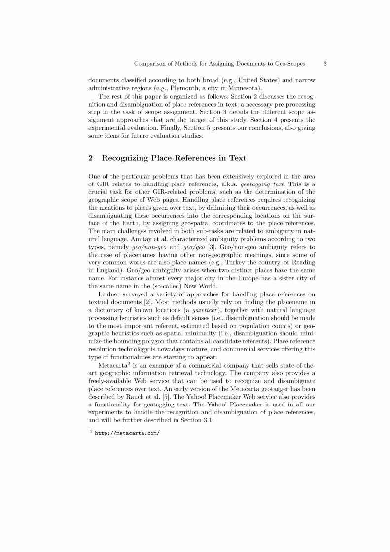
Comparison of Methods for Assigning Documents to Geo-Scopes 9
Avg. Std.dev. Avg. Std.dev. Accuracy Accuracy AccuracyDistance Distance Overlap Overlap (D=0 Km) (D<100 Km) (O>0.75)
Placemaker Admin. 1030 1460 0.42 0.49 0.37 0.45 0.39Web-a-Where 955 1890 0.48 0.49 0.47 0.54 0.47GIPSY 1265 2247 0.25 0.41 0.14 0.4 0.19GraphRank 1083 1955 0.48 0.49 0.47 0.53 0.48Covering Area 2655 3009 0.25 0.38 0 0.21 0.18Most Frequent 1093 2331 0.49 0.49 0.37 0.55 0.43Non-outliers 1740 2826 0.36 0.46 0.24 0.39 0.34
Table 2. Comparison of human-assigned versus automatically assigned scopes.
the Open Directory Project. Besides the average distances and overlaps, we alsocompute their standard deviation. Thresholding the distance results at differentlevels, we also measure results according to the standard information retrievalmetric of accuracy (i.e., the proportion of correct results given by the algorithm).
4.3 Comparison Results
Figure 1 and Table 2 show the obtained results for the cross-method comparison.Figure 1 plots, for each algorithm, the distances from the assigned scopes to thereal scopes of the documents. Each value on the x axis corresponds to a documentin the collection, and documents are sorted according to the distance. Table 2summarizes the values obtained using all the evaluation measures.
The charts show that the covering area baseline produces more errors. In mostof the considered approaches, more than half of the documents are assigned toa nearby scope. The GIPSY method and the most frequent baseline producemore errors on pages whose scope corresponds to countries, whereas the othermethods have errors equally distributed across countries, states, and cities.
The Web-a-Where method produced the best overall results. The averagedistance and accuracy to the correct scope were 955 Km and 47%, respectively.The baseline considering the most frequent place reference provided very com-petitive results, outperforming all other approaches when assigning scopes withan error below 100 Km. The baseline with the most frequent place also obtainedthe best average overlap with the correct scope (0.49). The GraphRank methoddid well, matching Web-a-Where’s accuracy for exact matches and obtaining thebest accuracy for approximate overlaps.
Since the methods with best performances exhibit different types of problems(e.g., the most frequent baseline fails on countries), their combination seems likea promising approach. For instance, Web-a-Where tends to fail when incorrectlygeneralizing to a broader area, while the most frequent baseline does not gener-alize when it should.
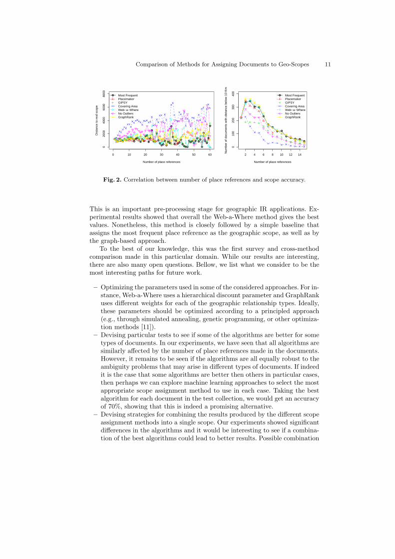
We also analyzed how accuracy varies according to the number of place refer-ences contained in the documents. Figure 2 presents the obtained results, show-ing that the errors increase with the number of different place references con-tained in the document. The baseline method corresponding to the covering areais particularly sensitive to this parameter.

10 Ivo Anastacio, Bruno Martins, Pavel Calado
050
0010
000
1500
020
000
Document Instances
Dis
tanc
e in
Kilo
met
ers
Placemaker Admin.
countrystatecity
050
0010
000
1500
020
000
Document Instances
Dis
tanc
e in
Kilo
met
ers
GIPSY
countrystatecity
050
0010
000
1500
020
000
Document Instances
Dis
tanc
e in
Kilo
met
ers
Web−a−Where
countrystatecity
050
0010
000
1500
020
000
Document Instances
Dis
tanc
e in
Kilo
met
ers
GraphRank
countrystatecity
050
0010
000
1500
020
000
Document Instances
Dis
tanc
e in
Kilo
met
ers
Most Frequent
countrystatecity
050
0010
000
1500
020
000
Document Instances
Dis
tanc
e in
Kilo
met
ers
Covering Area
countrystatecity
050
0010
000
1500
020
000
Document Instances
Dis
tanc
e in
Kilo
met
ers
Non−outliers
countrystatecity
Fig. 1. Distances between the human-edited and automatically assigned scopes.
When interpreting the results, it should be noted that the scope assignmentalgorithms use the information provided by the Yahoo! geotagger about the in-dividual places mentioned in the text. Thus, any errors made by the geotaggerinfluence the outcome of the scope assignment methods (i.e., this test only eval-uates geotagging plus scope assignment as a whole). Nevertheless, this does notinvalidate the goal of the experiments, which is to compare the scope assignmentmethods under the same conditions.
5 Conclusions and Future Work
In this paper, we compared different methods for the automatic assignment ofgeographic scopes to Web pages, based on placenames mentioned in the text.
Comparison of Methods for Assigning Documents to Geo-Scopes 11
●●●
●●
●●●
●●●●
●
●●●
●
●●
●●
●
●
●
●●
●
●
●●
●
●
●
●●
●
●
●
●
●●
●
●●●●
●●
●●
●
●
●●
●
●
●●
●
●
0 10 20 30 40 50 60
020
0040
0060
0080
00
Number of place references
Dis
tanc
e to
rea
l sco
pe● Most Frequent
PlacemakerGIPSYCovering AreaWeb−a−WhereNo OutliersGraphRank ●
●●
● ●
●
●
●
● ●
●●
● ●●
2 4 6 8 10 12 14
010
020
030
040
0
Number of place references
Num
ber
of d
ocum
ents
with
dis
tanc
e be
low
10
Km
● Most FrequentPlacemakerGIPSYCovering AreaWeb−a−WhereNo OutliersGraphRank
Fig. 2. Correlation between number of place references and scope accuracy.
This is an important pre-processing stage for geographic IR applications. Ex-perimental results showed that overall the Web-a-Where method gives the bestvalues. Nonetheless, this method is closely followed by a simple baseline thatassigns the most frequent place reference as the geographic scope, as well as bythe graph-based approach.
To the best of our knowledge, this was the first survey and cross-methodcomparison made in this particular domain. While our results are interesting,there are also many open questions. Bellow, we list what we consider to be themost interesting paths for future work.
– Optimizing the parameters used in some of the considered approaches. For in-stance, Web-a-Where uses a hierarchical discount parameter and GraphRankuses different weights for each of the geographic relationship types. Ideally,these parameters should be optimized according to a principled approach(e.g., through simulated annealing, genetic programming, or other optimiza-tion methods [11]).
– Devising particular tests to see if some of the algorithms are better for sometypes of documents. In our experiments, we have seen that all algorithms aresimilarly affected by the number of place references made in the documents.However, it remains to be seen if the algorithms are all equally robust to theambiguity problems that may arise in different types of documents. If indeedit is the case that some algorithms are better then others in particular cases,then perhaps we can explore machine learning approaches to select the mostappropriate scope assignment method to use in each case. Taking the bestalgorithm for each document in the test collection, we would get an accuracyof 70%, showing that this is indeed a promising alternative.
– Devising strategies for combining the results produced by the different scopeassignment methods into a single scope. Our experiments showed significantdifferences in the algorithms and it would be interesting to see if a combina-tion of the best algorithms could lead to better results. Possible combination

12 Ivo Anastacio, Bruno Martins, Pavel Calado
strategies include taking the bounding box that covers all scopes, or takingthe bounding box from their overlapping area.
– Devising experiments to measure the trade-offs in selecting more than onescope for each document. Many documents can not be naturally summarizedinto a single scope, and some applications may also benefit from havingmultiple scopes. When considering multiple scopes, there is a chance thatwe are increasing recall. Precision would nonetheless be impacted, since wewould select more scopes incorrectly. A particular challenge is finding theappropriate thresholds for selecting candidates as scopes.
– Devising experiments for measuring how the quality of place reference disam-biguation influences the quality of the scope assignments. Instead of alwaysrelying on a single approach for place reference disambiguation, it wouldbe interesting to experiment with other geotagging approaches, measuringtheir performance and their impact on the scope recognition performance. Itwould also be interesting to see if the scope assignment methods are robustenough to work with all the possible place referents, therefore dispensing thepre-processing step of place reference disambiguation.
References
1. Woodruff, A. G., and Plaunt, C. (1994) GIPSY: automated geographic indexing oftext documents. Journal American Society Information Sciences, 45(9).
2. Leidner, J. L. (2007). Toponym Resolution: a Comparison and Taxonomy of Heuris-tics and Methods. PhD Thesis, University of Edinburgh.
3. Amitay, E., Har’El, N., Sivan, R., and Soffer, A. (2004) Web-a-Where: geotaggingweb content. In Proceedings of the 27th Annual international ACM SIGIR Confer-ence on Research and Development in information Retrieval.
4. Mandl, T., Gey, F., Di Nunzio, G., Ferro, N., Sanderson, M., Santos, D. and Womser-Hacker, C. (2008) An evaluation resource for geographic information retrieval. InProceedings of the 6th Language Resources and Evaluation Conference.
5. Rauch, E., Bukatin, M., and Baker, K. (2003) A confidence-based framework for dis-ambiguating geographic terms. In Proceedings of the HLT-NAACL 2003 Workshopon Analysis of Geographic References.
6. Martins, B., and Silva, M. J. (2005) A Graph-Ranking Algorithm for Geo-Referencing Documents, In Proceedings of the 5th IEEE International Conferenceon Data Mining.
7. Boldi, P., Santini, M., and Vigna, S. (2005) PageRank as a function of the dampingfactor. In Proceedings of the 14th International World Wide Web Conference.
8. Johansson, M., and Harrie, L. (2002) Using Java Topology Suite for real-time datageneralization and integration. In Proceedings of the 2002 workshop of the Interna-tional Society for Photogrammetry and Remote Sensing.
9. Jones, R., Zhang, W. V., Rey, B., Jhala P., and Stipp E. (2008) Geographic intentionand modification in Web search. International Journal of Geographical InformationScience, 22(3).
10. Smith, D. A. and Crane, G. (2001) Disambiguating Geographic Names in a His-torical Digital Library. In Proceedings of the 5th European Conference on Researchand Advanced Technology For Digital Libraries.
11. Spall, J. C. (2003) Introduction to Stochastic Search and Optimization, Wiley-Interscience.