A Case Study of Xiong'an New Area, China - MDPI
17
Citation: Xia, Y.; Li, H.; Wang, B.; Ma, Z.; Guo, X.; Zhao, K.; Zhao, C. Characterization of Shallow Groundwater Circulation Based on Chemical Kinetics: A Case Study of Xiong’an New Area, China. Water 2022, 14, 1880. https://doi.org/ 10.3390/w14121880 Academic Editors: Zhonghe Pang, Fengtian Yang and Pingheng Yang Received: 25 April 2022 Accepted: 7 June 2022 Published: 11 June 2022 Publisher’s Note: MDPI stays neutral with regard to jurisdictional claims in published maps and institutional affil- iations. Copyright: © 2022 by the authors. Licensee MDPI, Basel, Switzerland. This article is an open access article distributed under the terms and conditions of the Creative Commons Attribution (CC BY) license (https:// creativecommons.org/licenses/by/ 4.0/). water Article Characterization of Shallow Groundwater Circulation Based on Chemical Kinetics: A Case Study of Xiong’an New Area, China Yubo Xia 1,2, *, Haitao Li 3 , Bing Wang 4 , Zhen Ma 1,2 , Xu Guo 1,2 , Kai Zhao 3 and Changrong Zhao 1,2 1 Tianjin Center China Geological Survey (CGS), Tianjin 300170, China; [email protected] (Z.M.); [email protected] (X.G.); [email protected] (C.Z.) 2 North China Center for Geoscience Innovation, Tianjin 300170, China 3 China Institute of Geo-Environment Monitoring, Beijing 100081, China; [email protected] (H.L.); [email protected] (K.Z.) 4 Tianjin Geothermal Exploration and Development-Designing Institute, Tianjin 300250, China; [email protected] * Correspondence: [email protected]; Tel.: +86-022-8411-2916 Abstract: Xiong’an New Area, located in the middle of the North China Plain, will have been built as a “city of the future.” Urban planning and construction need to comprehensively consider the constraints of hydrogeological conditions such as aquifer structure and parameters. As the main aquifer in this area, the paleo-channel is heterogeneous and anisotropic, and the two-dimensional hydraulic conductivity in each horizontal direction cannot be obtained from aquifer tests. Therefore, this study adopts a chemical kinetics method to calculate the ionic activity and mineral saturation indices of shallow groundwater, determine the groundwater chemical potential field, and construct a horizontal two-dimensional groundwater chemical kinetics model. This model is used to calculate the hydraulic conductivity, flow rate and retention time of groundwater in areas of different chemical kinetics, as well as evaluate horizontal heterogeneity of the Quaternary paleo-channel aquifer. The results indicate that the groundwater chemical potential field can reflect the characteristics of the groundwater seepage field in each horizontal direction. The paleo-channel is the main channel of groundwater circulation, which shows the statistical difference of its permeability. Alluvial and lacustrine strata affect groundwater circulation due to their different hydrogeological structures and permeability. The groundwater chemical kinetics results of hydraulic conductivity along the paleo- channel are approximately consistent with traditional hydrogeological calculation results derived from aquifer test data. Hydraulic conductivity is higher in the extension direction of the paleo- channel, and lower if the path crosscuts multiple paleo-channels. This feature can be used to build a hydrogeological structure model combined with drilling data. Furthermore, excessive groundwater exploitation will change the actual flow rate and retention time of groundwater, thereby affecting the groundwater circulation conditions. This study of groundwater circulation in Xiong’an New Area by means of chemical kinetics makes up for the deficiency in the study of the unconsolidated sedimentary aquifer anisotropy within the paleo-channel. Keywords: chemical kinetics; mineral saturation index; hydraulic conductivity; heterogeneity; Xiong’an New Area 1. Introduction Groundwater is a crucial resource for various socio-economic activities [1]. Groundwa- ter contains many dissolved inorganics with a wide variety of chemical constituents, whose concentrations depend on interactions between the water and water-bearing sediments [2]. As groundwater passes through different geological units, the concentration of dissolved substances typically increases [3]. The water cycle not only comprises different water parts, Water 2022, 14, 1880. https://doi.org/10.3390/w14121880 https://www.mdpi.com/journal/water
-
Upload
khangminh22 -
Category
Documents
-
view
1 -
download
0
Transcript of A Case Study of Xiong'an New Area, China - MDPI

Citation: Xia, Y.; Li, H.; Wang, B.; Ma,
Z.; Guo, X.; Zhao, K.; Zhao, C.
Characterization of Shallow
Groundwater Circulation Based on
Chemical Kinetics: A Case Study of
Xiong’an New Area, China. Water
2022, 14, 1880. https://doi.org/
10.3390/w14121880
Academic Editors: Zhonghe Pang,
Fengtian Yang and Pingheng Yang
Received: 25 April 2022
Accepted: 7 June 2022
Published: 11 June 2022
Publisher’s Note: MDPI stays neutral
with regard to jurisdictional claims in
published maps and institutional affil-
iations.
Copyright: © 2022 by the authors.
Licensee MDPI, Basel, Switzerland.
This article is an open access article
distributed under the terms and
conditions of the Creative Commons
Attribution (CC BY) license (https://
creativecommons.org/licenses/by/
4.0/).
water
Article
Characterization of Shallow Groundwater Circulation Basedon Chemical Kinetics: A Case Study of Xiong’an NewArea, ChinaYubo Xia 1,2,*, Haitao Li 3, Bing Wang 4, Zhen Ma 1,2, Xu Guo 1,2, Kai Zhao 3 and Changrong Zhao 1,2
1 Tianjin Center China Geological Survey (CGS), Tianjin 300170, China; [email protected] (Z.M.);[email protected] (X.G.); [email protected] (C.Z.)
2 North China Center for Geoscience Innovation, Tianjin 300170, China3 China Institute of Geo-Environment Monitoring, Beijing 100081, China; [email protected] (H.L.);
[email protected] (K.Z.)4 Tianjin Geothermal Exploration and Development-Designing Institute, Tianjin 300250, China;
[email protected]* Correspondence: [email protected]; Tel.: +86-022-8411-2916
Abstract: Xiong’an New Area, located in the middle of the North China Plain, will have been builtas a “city of the future.” Urban planning and construction need to comprehensively consider theconstraints of hydrogeological conditions such as aquifer structure and parameters. As the mainaquifer in this area, the paleo-channel is heterogeneous and anisotropic, and the two-dimensionalhydraulic conductivity in each horizontal direction cannot be obtained from aquifer tests. Therefore,this study adopts a chemical kinetics method to calculate the ionic activity and mineral saturationindices of shallow groundwater, determine the groundwater chemical potential field, and construct ahorizontal two-dimensional groundwater chemical kinetics model. This model is used to calculatethe hydraulic conductivity, flow rate and retention time of groundwater in areas of different chemicalkinetics, as well as evaluate horizontal heterogeneity of the Quaternary paleo-channel aquifer. Theresults indicate that the groundwater chemical potential field can reflect the characteristics of thegroundwater seepage field in each horizontal direction. The paleo-channel is the main channel ofgroundwater circulation, which shows the statistical difference of its permeability. Alluvial andlacustrine strata affect groundwater circulation due to their different hydrogeological structures andpermeability. The groundwater chemical kinetics results of hydraulic conductivity along the paleo-channel are approximately consistent with traditional hydrogeological calculation results derivedfrom aquifer test data. Hydraulic conductivity is higher in the extension direction of the paleo-channel, and lower if the path crosscuts multiple paleo-channels. This feature can be used to build ahydrogeological structure model combined with drilling data. Furthermore, excessive groundwaterexploitation will change the actual flow rate and retention time of groundwater, thereby affectingthe groundwater circulation conditions. This study of groundwater circulation in Xiong’an NewArea by means of chemical kinetics makes up for the deficiency in the study of the unconsolidatedsedimentary aquifer anisotropy within the paleo-channel.
Keywords: chemical kinetics; mineral saturation index; hydraulic conductivity; heterogeneity;Xiong’an New Area
1. Introduction
Groundwater is a crucial resource for various socio-economic activities [1]. Groundwa-ter contains many dissolved inorganics with a wide variety of chemical constituents, whoseconcentrations depend on interactions between the water and water-bearing sediments [2].As groundwater passes through different geological units, the concentration of dissolvedsubstances typically increases [3]. The water cycle not only comprises different water parts,
Water 2022, 14, 1880. https://doi.org/10.3390/w14121880 https://www.mdpi.com/journal/water
Water 2022, 14, 1880 2 of 17
but is also a geochemical process involving mineral dissolution/precipitation, ion oxidiza-tion/reduction, and ion exchanges [4]. During this process, groundwater componentsmigrate, accumulate and divide along the groundwater flow path [5]. As such, the naturalcomposition of water molecules, hydrogen and oxygen isotopes mark the water cycleprocess and play an indicator role in the study of groundwater interactions [6]. The degreeof hydrochemical evolution is largely determined by the residence time of the water withinthe aquifer, i.e., by the duration of the water–rock interaction [7]. Hydrogeochemical toolscan cleanly differentiate different water types originating from mountain front recharge,artesian discharge, river leakage or floodwater recharge [8]. By analyzing the historicaldatabase of groundwater major ion chemistry, the connectivity between alluvium aquiferand basin can be investigated [9,10]. Therefore, understanding the different processescontrolling groundwater quality is crucial for groundwater circulation.
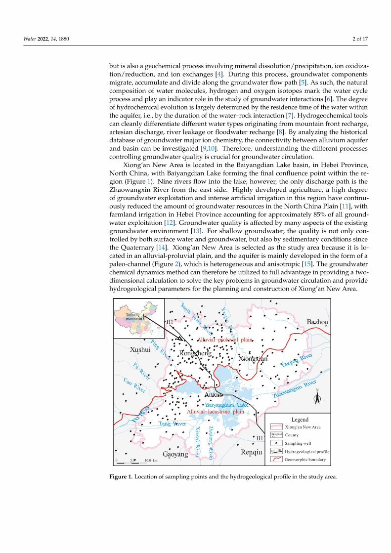
Xiong’an New Area is located in the Baiyangdian Lake basin, in Hebei Province,North China, with Baiyangdian Lake forming the final confluence point within the re-gion (Figure 1). Nine rivers flow into the lake; however, the only discharge path is theZhaowangxin River from the east side. Highly developed agriculture, a high degreeof groundwater exploitation and intense artificial irrigation in this region have continu-ously reduced the amount of groundwater resources in the North China Plain [11], withfarmland irrigation in Hebei Province accounting for approximately 85% of all ground-water exploitation [12]. Groundwater quality is affected by many aspects of the existinggroundwater environment [13]. For shallow groundwater, the quality is not only con-trolled by both surface water and groundwater, but also by sedimentary conditions sincethe Quaternary [14]. Xiong’an New Area is selected as the study area because it is lo-cated in an alluvial-proluvial plain, and the aquifer is mainly developed in the form of apaleo-channel (Figure 2), which is heterogeneous and anisotropic [15]. The groundwaterchemical dynamics method can therefore be utilized to full advantage in providing a two-dimensional calculation to solve the key problems in groundwater circulation and providehydrogeological parameters for the planning and construction of Xiong’an New Area.
Figure 1. Location of sampling points and the hydrogeological profile in the study area.

Water 2022, 14, 1880 3 of 17
Figure 2. Pleistocene paleo-channel distribution map inferred by boreholes.
In comparison to traditional hydrogeological research (e.g., field aquifer tests), ground-water chemical kinetics research employs the hydrogeological unit to determine spatiotem-poral changes in the water flow field and water quality concentration field, whose kineticparameters are a function of space and time [5]. By analyzing the formation of groundwaterkinetic and hydrochemical fields, dynamics of groundwater and chemical kinetics can becoupled to evaluate groundwater quantity, surface water quality and water environmentsto more effectively solve practical problems related to water resources and the ecological en-vironment [16]. This method has been widely used in the study of groundwater circulationin karstic spring basins [17–19]. In karst aquifer system, the geological structure controlsthe flow direction of groundwater [20,21]. The lithology is mainly limestone, meaningthat the chemical components of groundwater are high in these subregions. Carrying outgroundwater chemical kinetics evaluation along the direction of groundwater flow allowsfor the calculation of the relevant parameters and can assist in restoring the groundwatercirculation conditions. In the unconsolidated sedimentary pore aquifer, especially in theQuaternary sedimentary layers with complex hydrogeological conditions and intricatepaleo-channels, the material source of groundwater and flow conditions are uneven, dueto the diversity of minerals in the stratum and the heterogeneity of the hydrogeologicalstructures [22,23], and so groundwater chemical kinetics has not been widely used in suchcontexts. Taking Xiong’an New Area as an example, using the data of 283 wells, a MiddlePleistocene paleo-channel map of the main aquifers can be reconstructed. Comprehensiveinterpretation of local high-density borehole and geomorphic data can determine the dis-tribution of some paleo-channels, and then determine the structure of the aquifers. Thepattern of the Middle Pleistocene aquifer is then verified by calculating the connectivitybetween paleo-channels. Based on the results of groundwater chemical dynamics, thedistribution of paleo-channels in areas with low borehole density can be inferred. Thegroundwater circulation in the alluvial-proluvial and alluvial-lacustrine plains can there-fore be studied, which makes up for the lack of research on unconsolidated sedimentaryaquifers in which paleo-channels are the main aquifers.
The purpose of this study is to establish a chemical kinetic model of the groundwater inXiong’an New Area. This model is then used as follows: (1) to calculate the hydrogeologicalparameters in the direction of the flow field; (2) to analyze the shallow groundwatercirculation conditions according to the principles of groundwater chemical kinetics; and
Water 2022, 14, 1880 4 of 17
(3) to analyze the applicability of groundwater chemical kinetics to studying unconsolidatedsedimentary aquifers with paleo-channels as the main aquifers.
2. Materials and Methods2.1. Study Area
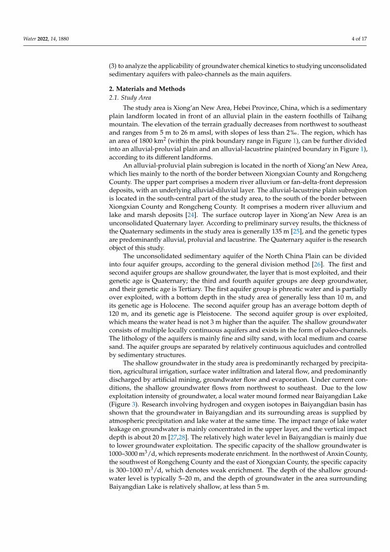
The study area is Xiong’an New Area, Hebei Province, China, which is a sedimentaryplain landform located in front of an alluvial plain in the eastern foothills of Taihangmountain. The elevation of the terrain gradually decreases from northwest to southeastand ranges from 5 m to 26 m amsl, with slopes of less than 2‰. The region, which hasan area of 1800 km2 (within the pink boundary range in Figure 1), can be further dividedinto an alluvial-proluvial plain and an alluvial-lacustrine plain(red boundary in Figure 1),according to its different landforms.
An alluvial-proluvial plain subregion is located in the north of Xiong’an New Area,which lies mainly to the north of the border between Xiongxian County and RongchengCounty. The upper part comprises a modern river alluvium or fan-delta-front depressiondeposits, with an underlying alluvial-diluvial layer. The alluvial-lacustrine plain subregionis located in the south-central part of the study area, to the south of the border betweenXiongxian County and Rongcheng County. It comprises a modern river alluvium andlake and marsh deposits [24]. The surface outcrop layer in Xiong’an New Area is anunconsolidated Quaternary layer. According to preliminary survey results, the thickness ofthe Quaternary sediments in the study area is generally 135 m [25], and the genetic typesare predominantly alluvial, proluvial and lacustrine. The Quaternary aquifer is the researchobject of this study.
The unconsolidated sedimentary aquifer of the North China Plain can be dividedinto four aquifer groups, according to the general division method [26]. The first andsecond aquifer groups are shallow groundwater, the layer that is most exploited, and theirgenetic age is Quaternary; the third and fourth aquifer groups are deep groundwater,and their genetic age is Tertiary. The first aquifer group is phreatic water and is partiallyover exploited, with a bottom depth in the study area of generally less than 10 m, andits genetic age is Holocene. The second aquifer group has an average bottom depth of120 m, and its genetic age is Pleistocene. The second aquifer group is over exploited,which means the water head is not 3 m higher than the aquifer. The shallow groundwaterconsists of multiple locally continuous aquifers and exists in the form of paleo-channels.The lithology of the aquifers is mainly fine and silty sand, with local medium and coarsesand. The aquifer groups are separated by relatively continuous aquicludes and controlledby sedimentary structures.
The shallow groundwater in the study area is predominantly recharged by precipita-tion, agricultural irrigation, surface water infiltration and lateral flow, and predominantlydischarged by artificial mining, groundwater flow and evaporation. Under current con-ditions, the shallow groundwater flows from northwest to southeast. Due to the lowexploitation intensity of groundwater, a local water mound formed near Baiyangdian Lake(Figure 3). Research involving hydrogen and oxygen isotopes in Baiyangdian basin hasshown that the groundwater in Baiyangdian and its surrounding areas is supplied byatmospheric precipitation and lake water at the same time. The impact range of lake waterleakage on groundwater is mainly concentrated in the upper layer, and the vertical impactdepth is about 20 m [27,28]. The relatively high water level in Baiyangdian is mainly dueto lower groundwater exploitation. The specific capacity of the shallow groundwater is1000–3000 m3/d, which represents moderate enrichment. In the northwest of Anxin County,the southwest of Rongcheng County and the east of Xiongxian County, the specific capacityis 300–1000 m3/d, which denotes weak enrichment. The depth of the shallow ground-water level is typically 5–20 m, and the depth of groundwater in the area surroundingBaiyangdian Lake is relatively shallow, at less than 5 m.
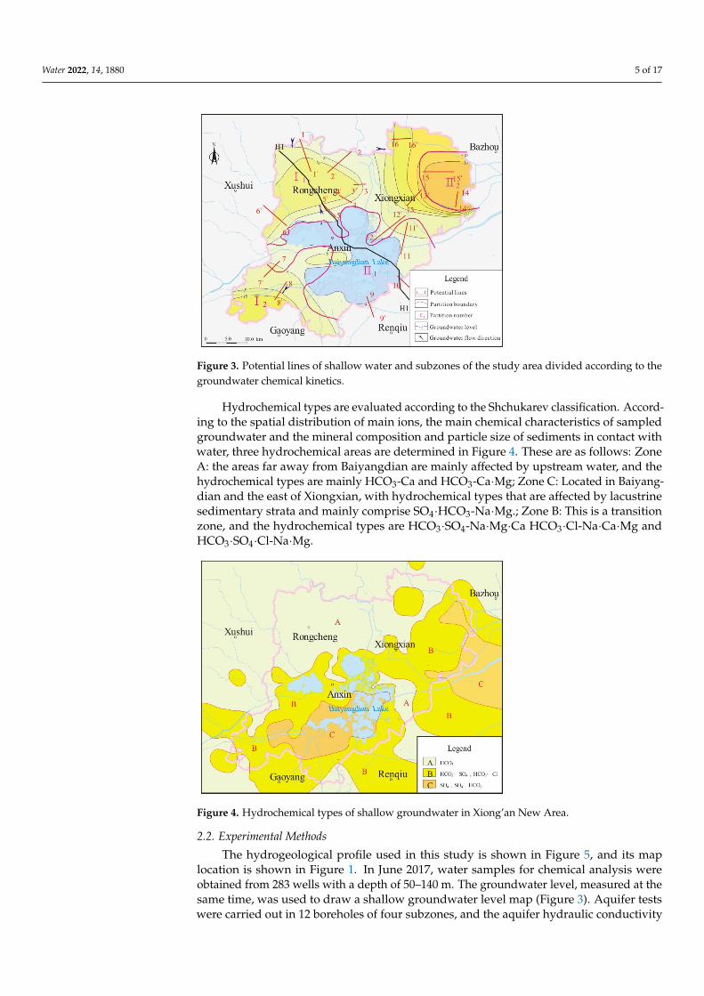
Water 2022, 14, 1880 5 of 17
Figure 3. Potential lines of shallow water and subzones of the study area divided according to thegroundwater chemical kinetics.
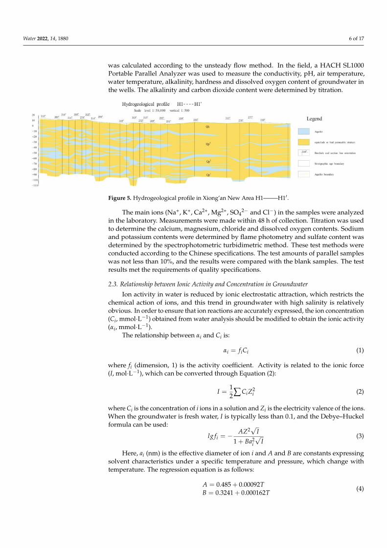
Hydrochemical types are evaluated according to the Shchukarev classification. Accord-ing to the spatial distribution of main ions, the main chemical characteristics of sampledgroundwater and the mineral composition and particle size of sediments in contact withwater, three hydrochemical areas are determined in Figure 4. These are as follows: ZoneA: the areas far away from Baiyangdian are mainly affected by upstream water, and thehydrochemical types are mainly HCO3-Ca and HCO3-Ca·Mg; Zone C: Located in Baiyang-dian and the east of Xiongxian, with hydrochemical types that are affected by lacustrinesedimentary strata and mainly comprise SO4·HCO3-Na·Mg.; Zone B: This is a transitionzone, and the hydrochemical types are HCO3·SO4-Na·Mg·Ca HCO3·Cl-Na·Ca·Mg andHCO3·SO4·Cl-Na·Mg.
Figure 4. Hydrochemical types of shallow groundwater in Xiong’an New Area.
2.2. Experimental Methods
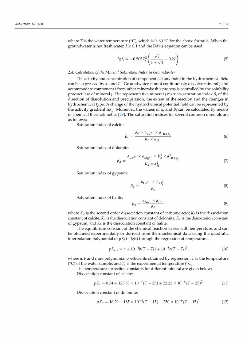
The hydrogeological profile used in this study is shown in Figure 5, and its maplocation is shown in Figure 1. In June 2017, water samples for chemical analysis wereobtained from 283 wells with a depth of 50–140 m. The groundwater level, measured at thesame time, was used to draw a shallow groundwater level map (Figure 3). Aquifer testswere carried out in 12 boreholes of four subzones, and the aquifer hydraulic conductivity
Water 2022, 14, 1880 6 of 17
was calculated according to the unsteady flow method. In the field, a HACH SL1000Portable Parallel Analyzer was used to measure the conductivity, pH, air temperature,water temperature, alkalinity, hardness and dissolved oxygen content of groundwater inthe wells. The alkalinity and carbon dioxide content were determined by titration.
Figure 5. Hydrogeological profile in Xiong’an New Area H1——–H1′.
The main ions (Na+, K+, Ca2+, Mg2+, SO42− and Cl−) in the samples were analyzed
in the laboratory. Measurements were made within 48 h of collection. Titration was usedto determine the calcium, magnesium, chloride and dissolved oxygen contents. Sodiumand potassium contents were determined by flame photometry and sulfate content wasdetermined by the spectrophotometric turbidimetric method. These test methods wereconducted according to the Chinese specifications. The test amounts of parallel sampleswas not less than 10%, and the results were compared with the blank samples. The testresults met the requirements of quality specifications.
2.3. Relationship between Ionic Activity and Concentration in Groundwater
Ion activity in water is reduced by ionic electrostatic attraction, which restricts thechemical action of ions, and this trend in groundwater with high salinity is relativelyobvious. In order to ensure that ion reactions are accurately expressed, the ion concentration(Ci, mmol·L−1) obtained from water analysis should be modified to obtain the ionic activity(αi, mmol·L−1).
The relationship between αi and Ci is:
αi = fiCi (1)
where fi (dimension, 1) is the activity coefficient. Activity is related to the ionic force(I, mol·L−1), which can be converted through Equation (2):
I =12∑ CiZ2
i (2)
where Ci is the concentration of i ions in a solution and Zi is the electricity valence of the ions.When the groundwater is fresh water, I is typically less than 0.1, and the Debye–Huckelformula can be used:
lg fi = −AZ2√
I1 + Ba2
i
√I
(3)
Here, ai (nm) is the effective diameter of ion i and A and B are constants expressingsolvent characteristics under a specific temperature and pressure, which change withtemperature. The regression equation is as follows:
A = 0.485 + 0.00092TB = 0.3241 + 0.000162T
(4)
Water 2022, 14, 1880 7 of 17
where T is the water temperature (◦C), which is 0–60 ◦C for the above formula. When thegroundwater is not fresh water, I ≥ 0.1 and the Davis equation can be used:
lg fi = −0.505Z2i
( √I
1 +√
I− 0.2I
)(5)
2.4. Calculation of the Mineral Saturation Index in Groundwater
The activity and concentration of component i at any point in the hydrochemical fieldcan be expressed by αi and Ci. Groundwater cannot continuously dissolve mineral j andaccommodate component i from other minerals; this process is controlled by the solubilityproduct law of mineral j. The representative mineral j restricts saturation index βj of thedirection of dissolution and precipitation, the extent of the reaction and the changes inhydrochemical type. A change of the hydrochemical potential field can be represented bythe activity gradient ∆αij. Moreover, the values of αi and βi can be calculated by meansof chemical thermokinetics [29]. The saturation indices for several common minerals areas follows:
Saturation index of calcite:
βc =K2 × αCa2+ × αHCO−3
Kc × αH+(6)
Saturation index of dolomite:
βd =αCa2+ × αMg2+ × K2
2 × α2HCO−3
Kd × α2H+
(7)
Saturation index of gypsum:
βg =αCa2+ × αSO2−
4
Kg(8)
Saturation index of halite:βh =
αNa+ × αCl−
Kh(9)
where K2 is the second order dissociation constant of carbonic acid; Kc is the dissociationconstant of calcite; Kd is the dissociation constant of dolomite; Kg is the dissociation constantof gypsum; and Kh is the dissociation constant of halite.
The equilibrium constant of the chemical reaction varies with temperature, and canbe obtained experimentally or derived from thermochemical data using the quadraticinterpolation polynomial of pKj (−lgK) through the regression of temperature:
pK(t) = a + 10−4b(T − Tt) + 10−6c(T − Tt)2 (10)
where a, b and c are polynomial coefficients obtained by regression; T is the temperature(◦C) of the water sample; and Tt is the experimental temperature (◦C).
The temperature correction constants for different mineral are given below:Dissociation constant of calcite:
pKc = 8.34 + 123.33× 10⁻⁴(T − 25) + 22.22× 10⁻⁶(T − 25)2 (11)
Dissociation constant of dolomite:
pKd = 16.29 + 185× 10−4(T − 15) + 250× 10−6(T − 15)2 (12)

Water 2022, 14, 1880 8 of 17
Dissociation constant of gypsum:
pKg = 4.61− 7× 10⁻⁴(T − 25) + 75.33× 10⁻⁶(T − 25)2 (13)
First order dissociation of each mineral:
pK1 = 6.35− 52.5× 10⁻⁴(T − 25) + 175× 10−6(T − 25)2 (14)
Secondary order dissociation of each mineral:
pK2 = 10.33− 90× 10−4(T − 25) + 111.11× 10⁻⁶(T − 25)2 (15)
Henry constant:
pKH = 1.47− 123× 10−4(T − 25) + 66.7× 10⁻⁶(T − 25)2 (16)
The groundwater chemical kinetic constant kj (×10−8 mol·L−1·d−1) can be obtainedby sample testing and field testing, using the following equations:
Chemical kinetic constant of calcite:
kc =2K∆h
(∆aCa2+−∆aMg2+−∆a
SO2−4
)∆S2(2−βcA−βcB)
[∆aCa2+ > ∆aMg2+ + ∆aSO2−4
; 2>βcA + βcB](17)
Chemical kinetic constant of dolomite:
kd =2K∆h∆aMg2+
∆S2(2−βdA−βdB)
[∆aMg2+B ≥ ∆aMg2+A; 2>βdA + βdB](18)
Chemical kinetic constant of gypsum:
kg =2K∆h∆a
SO2−4
∆S2(2−βgA−βgB)[∆aSO2−
4 B ≥ ∆aSO2−4 A; 2>βgA + βgB]
(19)
Chemical kinetic constant of halite:
kh =2K∆h∆aCl−
∆S2(2−βhA−βhB)
[∆aCl−B ≥ ∆aCl−A; 2>βhA + βhB](20)
2.5. Calculation of Groundwater Parameters
Since the basic minerals constituting all carbonates and sulfates are calcite, dolomite,gypsum and halite, the theory of simultaneous dissolution and separate precipitation ofmultiple minerals is needed in the study of hydrogeochemical field [5,29]. The groundwaterhydraulic conductivity, retention time and velocity were calculated for the study area [5].The formula for the groundwater hydraulic conductivity can be derived from Darcy’s law:
KiAB =∆S2
AB ∑mj=1 vijk j
(2− β jA − β jB
)2∆αijAB∆hAB
(21)
where KiAB (m/d) is the hydraulic conductivity determined by the chemical index ofcomponent i at any two points, A and B, on the Potential lines; ∆hAB is the differentialwater head between A (m) and B (m); ∆αijAB is the activity difference of i ions at pointsA and B; β jA and β jB are the saturation indices of mineral j at points A and B; ∆SAB (m)

Water 2022, 14, 1880 9 of 17
is the distance between A and B; vij is the stoichiometric coefficient; and kj is a chemicalkinetic constant.
The groundwater retention time t (a) was calculated as follows:
tijAB =2n∆aijAB
∑mj=1 vijk j
(2− β jA − β JB
) (22)
t =∆SiAB·n
VniAB(23)
where tijAB refers to the groundwater age of any two points, A and B, on the Potential linesshowed by mineral j with i components (a); n is the porosity of the rock (k j = nkj); and VniABis the “tracer” infiltration velocity of component i on the groundwater flow line between Aand B.
The actual groundwater velocity (U m/d) was calculated as follows:
UijAB =VijAB
n=
∆SiAB ∑mj=1 vijk j
(2− β jA − β JB
)2n∆aijAB
(24)
3. Results3.1. Major Mineral Saturation Indices
The mineral saturation indices of groundwater can indicate the dissolved/diluted stateof major ions in the minerals [30,31]. Laboratory experiments have shown that the pH valueand temperature have certain effects on mineral dissolution and precipitation [32,33]. As ahydrogeological unit of alluvial-pluvial and alluvial-lacustrine, the structure of the studyarea is complex and diverse, and the saturation indices are influenced by the groundwatertemperature [34]. In this study, the saturation index of each mineral is derived, where β ≥ 1indicates a diluted state as the basic theoretical condition for the study [35].
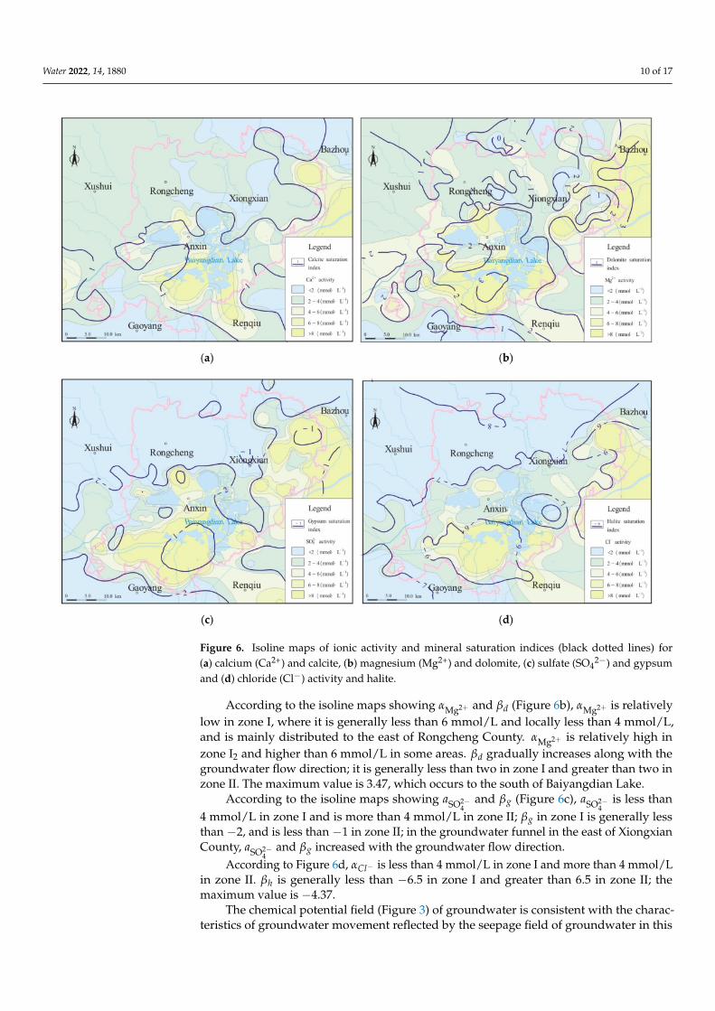
βc is less than 1 around Baiyangdian Lake, Zhaowangxin River and the eastern partof Xiong’an New Area, indicating a continuous and zonal subregion, and less than zeroin Rongcheng County, indicating a scattered and discontinuous subregion. βd is greaterthan two around Baiyangdian Lake and in the eastern areas of Xiong’an New Area, greaterthan three in the southern part of Baiyangdian Lake, less than one in the eastern partof Rongcheng County and Xiongxian County, and less than zero in scattered areas ofRongcheng County, indicating a scattered distribution. The saturation indices of βg and βhare less than zero throughout the study area. Saturation trends are similar for βc and βd,with relatively high index values to the south of Baiyangdian Lake.
The isoline maps showing αCa2+ and βc (Figure 6a; the different hydrochemical zonesare shown in Figure 3) indicate an increasing trend from north to south in zone I1 andwest to east in zone I2, and αCa2+ is generally less than 2 mmol/L. The concentration isthe highest in the south of Baiyangdian Lake and northeast of Xiong’an New Area, whereαCa2+ is generally greater than 2 mmol/L; αCa2+ then decreases toward the surroundingarea. βc also exhibits a consistent value that varies by less than one. βc is less than one inmost of zone I and ranges between 1 and 1.8 in zone II. Compared with the groundwaterlevel, αCa2+ and βc gradually increase along the groundwater flow direction. Zone I isdistributed in neither a lake nor groundwater funnel area. Although there are groundwaterfunnels in Rongcheng, Gaoyang and other areas, the current hydrochemical field indicatesno substantial hydrochemical change in the historical flow field. However, in the funnelarea of the eastern part of Xiongxian County (east part of zone II), the ionic concentrationand αCa2+ are higher in the funnel area (which exhibits a decrease in the water level) than inthe non-funnel area, with the latter reaching a maximum value in the center of the funnel.
Water 2022, 14, 1880 10 of 17
Figure 6. Isoline maps of ionic activity and mineral saturation indices (black dotted lines) for(a) calcium (Ca2+) and calcite, (b) magnesium (Mg2+) and dolomite, (c) sulfate (SO4
2−) and gypsumand (d) chloride (Cl−) activity and halite.
According to the isoline maps showing αMg2+ and βd (Figure 6b), αMg2+ is relativelylow in zone I, where it is generally less than 6 mmol/L and locally less than 4 mmol/L,and is mainly distributed to the east of Rongcheng County. αMg2+ is relatively high inzone I2 and higher than 6 mmol/L in some areas. βd gradually increases along with thegroundwater flow direction; it is generally less than two in zone I and greater than two inzone II. The maximum value is 3.47, which occurs to the south of Baiyangdian Lake.
According to the isoline maps showing aSO2−4
and βg (Figure 6c), aSO2−4
is less than4 mmol/L in zone I and is more than 4 mmol/L in zone II; βg in zone I is generally lessthan −2, and is less than −1 in zone II; in the groundwater funnel in the east of XiongxianCounty, aSO2−
4and βg increased with the groundwater flow direction.
According to Figure 6d, αCl− is less than 4 mmol/L in zone I and more than 4 mmol/Lin zone II. βh is generally less than −6.5 in zone I and greater than 6.5 in zone II; themaximum value is −4.37.
The chemical potential field (Figure 3) of groundwater is consistent with the charac-teristics of groundwater movement reflected by the seepage field of groundwater in this

Water 2022, 14, 1880 11 of 17
area; thus, the activity and saturation index of the hydrochemical index increase graduallyalong the direction of groundwater flow (Figure 3 blue arrow). In the process of ground-water exploitation, a change of water level (head) will locally change the groundwaterflow field and affect the hydrochemical index. Generally, the groundwater flow condi-tions in zone I are relatively smooth, and the water chemistry types are predominantlyHCO3-Ca and HCO3-Ca·Mg. From the perspective of the groundwater flow path, there isa trend of groundwater flow from the surrounding area toward Baiyangdian Lake, alongwith increasing ionic concentration and saturation indices. The hydrochemistry graduallychanges from HCO3 to HCO3•SO4 and HCO3•Cl in zone II. After entering the lake, thehydrochemistry changes to SO4·HCO3. The hydrogeological parameters were calculatedusing the groundwater chemical kinetics method.
As the terrain of the study area is flat, the depth of shallow groundwater can repre-sent the characteristics of groundwater flow in the interior of the study area. Through acorrelation between the depth of shallow groundwater and each ion, the migration char-acteristics of water flow for each ion can be qualitatively described for any location [36].This, combined with the geological, geomorphologic, hydrogeological and hydrochemicalconditions, allowed us to divide the study area into two zones (I (βc > 1) and II (βc < 1, waterlevel <−25 m)) and four subzones (I1, I2, II1 and II2) according to the mineral saturationindex contours (Figure 3).
3.2. Calculation of Hydrogeological Parameters
According to the ionic activity of each component and the saturation index of eachmineral (Figure 6), the hydraulic conductivity was obtained (based on field aquifer testresults) and the reaction rate constant was calculated by selecting 16 groups of samplingpoints in the direction of groundwater flow. These 16 groups of sampling points basicallycovered four subzones, with a length of 5 to 10 km and no crossing. The groundwaterchemical kinetics results are shown in Table 1.
Table 1. Chemical reaction rate constant for each zone of the study area.
Area NumberReaction Rate Constant/(×10−8 mol−1·d−1)
kc kd kg kh
zone I1 0.845 0.299 0.063 0.008zone I2 9.031 0.145 0.372 0.086zone II1 1.199 0.030 0.063 0.008zone II2 23.971 0.720 4.011 0.259
The hydraulic conductivity was obtained for different positions of shallow ground-water. The hydraulic conductivity measurements at each sampling point in each zone arelisted in Table 2, which reveals an average hydraulic conductivity of between 2.75 m/dand 7.29 m/d for the study area. The hydraulic conductivity value calculated by thegroundwater chemical kinetic method was verified using aquifer test data, and the tworesults are compared in Table 3. The values derived using groundwater chemical kineticsare approximately consistent with those derived using the traditional hydrogeologicalcalculation method (aquifer tests), but slightly lower. The reason for this difference is asfollows. First, the hydrogeological parameters calculated by aquifer tests only represent thehydrogeological conditions around the pumping well, whereas the groundwater kineticmethod reflects the changing seepage field and hydrochemical potential field [31]. Second,different geological conditions may affect the permeability values. The study area is locatedin an alluvial-diluvial and alluvial-lacustrine plain, where most of the aquifers exist in theform of paleo-channels, which are locally continuous, with different aquifer thicknesses,heterogeneity and non-isotropy. Thus, it is possible that the theoretical values calculated byaquifer tests and groundwater chemical kinetics are not universal. Despite the influenceof these two effects, the calculation results are similar for both methods, indicating thatthe method of groundwater chemical kinetics can be used to obtain groundwater kinetic

Water 2022, 14, 1880 12 of 17
parameters in areas with a dense distribution of wells via sampling and testing. This cancompensate for a lack of aquifer test data in local areas, which can replenish the calculationof hydrogeological parameters.
Table 2. Hydraulic conductivity calculated at each sampling point in the study area.
AreaNumber
Potential LinesNumber
Aquifer Test(m/d)
HydraulicConductivity (m/d)
Average HydraulicConductivity (m/d)
zone I1
1 6.43 5.51
5.66
2 - 2.973 - 7.634 - 1.075 8.90 7.936 - 3.77
12 - 9.1413 - 2.3616 - 10.51
zone I27 - 5.66
7.298 - 8.92
zone II1
9 - 3.682.7510 - 3.20
11 - 1.36
zone II214 - 2.95
3.0515 - 3.16
Table 3. Hydraulic conductivity calculated by the chemical kinetics method and the aquifer test (m/d).
Area Number Chemical Kinetics Method Aquifer Test
zone I1 5.66 6.49zone I2 7.29 8.09zone II1 2.75 2.8zone II2 3.05 3.26
As shown in Table 4, the retention time of groundwater in zone I1 and zone I2 isrelatively short (0.14–0.86 a), with average values of 0.48 a and 0.44 a, respectively, andthe flow rate is relatively high. The actual average groundwater velocity in these zonesis 16.78 m/d and 22.21 m/d, respectively. The groundwater retention time in zone II1 isrelatively long, with an average value of 2.62 a and an average velocity of 4.75 m/d. Theaverage retention time in zone II2 is shorter than that in zone II1 (0.26 a), whereas theaverage velocity is higher (26.35 m/d).
Table 4. Groundwater storage time (a) and actual groundwater velocity (m/d) at each sampling pointin the different zones of the study area.
Area Number Potential Lines Number Retention Time/(a) Velocity/(m/d)
zone I1
1 0.53 15.982 0.86 9.163 0.17 23.274 0.67 5.245 0.14 29.026 0.78 9.69
12 0.58 18.5813 0.42 12.7816 0.17 27.28
average 0.48 16.78

Water 2022, 14, 1880 13 of 17
Table 4. Cont.
Area Number Potential Lines Number Retention Time/(a) Velocity/(m/d)
zone I2
7 0.74 7.488 0.14 36.94
average 0.44 22.21
zone II1
9 0.54 8.1610 4.68 2.5811 2.64 2.97
average 2.62 4.57
zone II2
14 0.24 24.7015 0.28 27.99
average 0.26 26.35
3.3. Analysis of Groundwater Circulation Conditions
The study area belongs to the medium permeability zone (1 m/d < K ≤ 10 m/d),as shown by the slightly higher hydraulic conductivity of zone I and zone II. These twozones are alluvial-proluvial and alluvial-lacustrine, which are closer to the upper reachesof the flow field. Zone II1, the alluvial-lacustrine layer, has a lower hydraulic conductivity.Theoretically, the groundwater flow conditions are weak, and the water circulation condi-tions are not smooth. According to section H–H’ (Figure 5), the aquifer in zone I is morecontinuous than that in zone II1. Moreover, borehole data reveal that the aquifer lithologyin zone I and zone II2 is coarser than that in zone II1. Therefore, the hydrogeology, hydro-geochemistry, and groundwater chemical kinetics indicate that alluvial, alluvial-alluvialand alluvial-lacustrine strata influence the circulation of groundwater in terms of structureand permeability.
A quantitative evaluation of the changes in groundwater characteristics can also beused to analyze the groundwater circulation conditions, which requires quantification ofthe actual velocity and retention time of groundwater. According to previous research [37],water circulation can be completed in an aquifer in hydrogeological units with fast watercirculation and a groundwater velocity of ≥ 1 m/d after t ≤ 10 a. The shallow groundwatercycle in Xiong’an New Area is characterized as an alternating fast zone. In zone II1, locatedin and around Baiyangdian Lake, the aquifer is characterized by relatively fine particles, alack of development, poor hydraulic connection and relatively slow water cycle changes.The average groundwater flow velocity in this zone is 72–79% slower than that in zone I,and the average retention time is 4.5–5 times longer than that in zone I. Zone II2, locatedin the drawdown funnel area, exhibits increased groundwater flow velocity because ofthe large artificial mining area within the scope of the hydraulic gradient. Specifically, theaverage groundwater flow is 19–57% faster than that in zone I and the average retentiontime is 42–47% shorter than that in zone I. This indicates that groundwater characteristicsare affected not only by the hydrogeological structure, but also by over-exploitation, whichwill affect the actual velocity, retention time and circulation conditions of groundwater, asrevealed by hydrogeochemical and groundwater chemical kinetics parameters.
3.4. Revealing the Burial Conditions of Paleo-Channels by Groundwater Chemical Kinetics
Large scale drilling has been carried out in Xiong’an New Area. In the area withdense boreholes, the distribution of paleo-channels can be described by using boreholedata and geomorphic data. Taking the west side of zone I1 as an example, the density ofboreholes can reach one borehole per square kilometer (Figure 7), and the extension ofpaleo-channels can be better described. Comparing the results of groundwater chemicalkinetics calculations with the Middle Pleistocene paleo-channels, it can be observed thatthe path along the paleo-channel facilitates good connectivity within the aquifer, and thehydraulic conductivity is still relatively high, such as potential lines 1 and 5. If the pathcrosscuts a single paleo-channel, the result is still high, such as potential lines 3. However,if the path crosscuts multiple paleo-channels, for aquicludes or less permeable strata, as

Water 2022, 14, 1880 14 of 17
shows on the Figure 7, hydraulic conductivity is small, such as potential lines 2 and 4.The difference in hydraulic conductivity in different directions with relation to the paleo-channel reflects the heterogeneity of aquifer parameters. This can also be explained in ZoneII. The potential lines 14 and 15 do not trend along the paleo-channel and so the hydraulicconductivity calculated is much lower. In short, the permeability calculated by this methodcan be mutually confirmed against the distribution of the paleo-channels.
Figure 7. Modified paleo-channel distribution map in Qp2 based on the results of boreholes andchemical kinetics.
This method has a certain control effect on areas with low borehole density. Taking po-tential line 12 as an example, the borehole density on the west side is low, and the boreholedata cannot determine whether the paleo-channel extends to this location. The calculationresults show that the hydraulic conductivity is 9.14 m/d. Compared with the calculationresults in this area, it can be inferred that the area through which the potential line passes iswithin the paleo-channel course. The calculated hydraulic conductivity of potential lines 11and 13 to the south is 1.36 m/d and 2.36 m/d. Combined with the stratigraphic informationrevealed by the borehole, it is inferred that the two potential lines are not within the scopeof the paleo-channel. Using the information of potential lines 7 and 8, we can further inferthe distribution of paleo-channels in area I2. The groundwater chemical kinetic methodhas certain advantages in the study of the unconsolidated groundwater aquifer in thepaleo-channel.
4. Conclusions
Through the construction of a groundwater chemical kinetics model of alluvial-proluvial and alluvial-lacustrine groundwater aquifers in Xiong’an New Area, and theverification of hydrogeological parameters obtained by traditional hydrogeological sur-vey methods, the important parameters of groundwater circulation can be obtained indetail, and the method is shown to be effective. This method partly addresses the lack ofresearch into groundwater circulation of unconsolidated sedimentary aquifers dominatedby paleo-channels. The main conclusions are as follows:
(1) The study area was divided into two zones and four subzones. The groundwaterchemical kinetics parameters of shallow groundwater were calculated for each zone, andthe chemical potential field of groundwater was determined according to major mineralsaturation indices and ionic activity. The chemical potential field of groundwater was

Water 2022, 14, 1880 15 of 17
consistent with the groundwater movement characteristics reflected by the groundwaterseepage field.
(2) The groundwater chemical kinetics results of hydraulic conductivity along thepaleo-channel are approximately consistent with traditional hydrogeological calculationresults derived from aquifer test data. However, the scale effect and complex geologicalconditions of the study area resulted in the calculated hydraulic conductivity being slightlylower than that derived from field aquifer tests. The calculation method of groundwaterchemical kinetics can compensate for a lack of aquifer test data in local areas, and cantherefore help determine the hydrogeological parameters.
(3) A groundwater chemical kinetics model was established to evaluate the groundwa-ter circulation conditions in Xiong’an New Area. Differences in hydrogeological parametersand changes in groundwater characteristics both affect the groundwater circulation condi-tions. Specifically, the difference in structure and permeability between alluvial-alluvialstrata and alluvial-lacustrine strata affects the circulation of groundwater. Excessive ground-water exploitation will change the actual velocity and retention time of groundwater, whichwill influence the groundwater circulation conditions. Characterization of groundwatercirculation in the study area was effectively achieved using the method of groundwaterchemical kinetics.
(4) In the area with dense borehole concentration, the distribution of paleo-channelscan be described by using borehole data and geomorphic data. Comparing the results of thegroundwater chemical kinetics calculation with the distribution of the Middle Pleistocenepaleo-channels, the data can be mutually confirmed. The difference in hydraulic conductiv-ity in different directions with relation to the paleo-channel reflects the heterogeneity ofaquifer parameters. This method has a certain control effect on areas with low boreholedensity, enabling the distribution of the paleo-channels to be inferred. The groundwa-ter chemical kinetic method has certain advantages in the study of the unconsolidatedgroundwater aquifer within the paleo-channel.
Author Contributions: Conceptualization, Y.X. and H.L.; methodology, Y.X. and B.W.; investigation,C.Z., X.G. and K.Z.; data curation, Y.X. writing—original draft preparation, Y.X.; writing—review andediting, B.W. and Z.M.; supervision, Z.M.; project administration, Z.M.; resources, Y.X., H.L., Z.M.,K.Z., X.G. and C.Z.; All authors have read and agreed to the published version of the manuscript.
Funding: This research was funded by China Geological Survey, grant numbers DD20189122,DD20189142, DD20190338 and DD20221759.
Institutional Review Board Statement: Not applicable.
Informed Consent Statement: Not applicable.
Data Availability Statement: Data sharing is not applicable.
Conflicts of Interest: The authors declare no conflict of interest.
References1. Mattos, J.B.; Cruz, M.; Jeronimo, M.; Paula, F.D.; Carlos, F.; Sales, E.F. Spatio-seasonal changes in the hydrogeochemistry of
groundwaters in a highland tropical zone. J. S. Am. Earth Sci. 2018, 88, 275–286. [CrossRef]2. Redwan, M.; Moneim, A.A.A. Factors controlling groundwater hydrogeochemistry in the area west of Tahta, Sohag Upper Egypt.
J. Afr. Earth Sci. 2016, 118, 328–338. [CrossRef]3. Gupta, R.; Misra, A.K. Groundwater quality analysis of quaternary aquifers in Jhajjar District, Haryana, India: Focus on
groundwater fluoride and health implications. Alex. Eng. J. 2016, 57, 375–381. [CrossRef]4. Wang, D.C.; Zhang, R.Q. General Hydrogeology, 3rd ed.; Geological Publishing House: Beijing, China, 1986.5. Cao, Y.Q.; Hu, K.R. Groundwater Chemical Kinetics and Eco Environmental Zonation, 1st ed.; Science Press: Beijing, China, 2009;
pp. 5–8.6. Liu, X.; Xiang, W.; Si, B.C. Hydrochemical and isotopic characteristics in the shallow groundwater of the Fenhe River basin and
indicative significance. Environ. Sci. 2021, 42, 1739–1749. (In Chinese) [CrossRef]7. Moral, F.; Cruz-Sanjulián, J.J.; Olías, M. Geochemical evolution of groundwater in the carbonate aquifers of sierra de segura (betic
cordillera, southern spain). J. Hydrol. 2008, 360, 281–296. [CrossRef]

Water 2022, 14, 1880 16 of 17
8. Scheiber, L.; Cendón, D.I.; Iverach, C.P.; Hankin, S.I.; Vázquez-Suñé, E.; Kelly, B.F.J. Hydrochemical apportioning of irrigationgroundwater sources in an alluvial aquifer. Sci. Total Environ. 2020, 744, 140506. [CrossRef] [PubMed]
9. Owen, D.D.R.; Cox, M.E. Hydrochemical evolution within a large alluvial groundwater resource overlying a shallow coal seamgas reservoir. Sci. Total Environ. 2015, 523, 233–252. [CrossRef] [PubMed]
10. Owen, D.D.R.; Pawlowsky-Glahn, V.; Egozcue, J.J.; Buccianti, A.; Bradd, J.M. Compositional data analysis as a robust tool todelineate hydrochemical facies within and between gas-bearing aquifers. Water Resour. Res. 2016, 52, 5771–5793. [CrossRef]
11. Guo, H.P.; Bai, J.B.; Zhang, Y.Q.; Wang, L.Y.; Shi, J.S.; Li, W.P.; Zhang, Z.C.; Wang, Y.L.; Zhu, J.Y.; Wang, H.G. The evolutioncharacteristics and mechanism of the land subsidence in typical areas of the North China Plain. Geol. China 2017, 44, 1115–1127.(In Chinese) [CrossRef]
12. Siebert, S.; Henrich, V.; Frenken, K.; Burke, J. Update of the Digital Global Map of Irrigation Areas to Version 5; Food and AgricultureOrganization of the United Nations: Rome, Italy, 2013. [CrossRef]
13. Sun, X.M.; Wu, D.D.; Xiao, G.Q.; Ma, Z.; Wang, W.D.; Xu, J.G.; Wang, L.H.; Xing, Z.X. Discussion on ground water research andgeo-environment research in Circum-Bohai-Sea Region. China. Geol. Surv. Res. 2006, 29, 47–56.
14. Yan, J.H.; Chen, J.S.; Zhang, W.Q. Study on the groundwater quality and its influencing factor in Songyuan City, Northeast China,using integrated hydrogeochemical method. Sci. Total. Environ. 2021, 773, 144958. [CrossRef]
15. Zhao, K.; Qi, J.X.; Yi, C.; Ma, B.H.; Li, Y.; Guo, H.M.; Wang, X.Z.; Wang, L.Y.; Li, H.T. Hydrogeochemical characteristics ofgroundwater and pore-water and the paleoenvironmental evolution in the past 3.10 Ma in the Xiong’an New Area, North China.China Geol. 2021, 4, 476–486. [CrossRef]
16. Lu, B.Q.; Zhang, Y.; Sun, H.G.; Zheng, C.M. Lagrangian simulation of multi-step and rate-limited chemical reactions in multi-dimensional porous media. Water Sci. Eng. 2018, 11, 101–113. [CrossRef]
17. Peyraube, N.; Lastennet, R.; Denis, A. Geochemical evolution of groundwater in the unsaturated zone of a karstic massif, usingthe PCO2–SIc relationship. J. Hydrol. 2012, 430–431, 13–24. [CrossRef]
18. Li, S.L.; Liu, C.Q.; Li, J.; Lang, Y.C.; Ding, H.; Li, L.B. Geochemistry of dissolved inorganic carbon and carbonate weathering in asmall typical karstic catchment of Southwest China: Isotopic and chemical constraints. Chem. Geol. 2010, 277, 301–309. [CrossRef]
19. Hunkeler, D.; Mudry, J. Hydrochemical methods. In Methods in Karst Hydrogeology; IAH International Contributions to Hydroge-ology; Goldscheider, N., Drew, D., Eds.; British Geological Survey: Wallingford, UK; Taylor & Francis Group e-Library: London,UK, 2007; pp. 93–121.
20. Mercado, A.; Billings, G.K. The kinetics of mineral dissolution in carbonate aquifers as a tool for hydrological investigations, i.concentration-time relationships. J. Hydrol. 1975, 24, 303–331. [CrossRef]
21. Dreybrodt, G.W. The impact of hydrochemical boundary conditions on the evolution of limestone karst aquifers. J. Hydrol. 2003,276, 240–253. [CrossRef]
22. Ptak, T.; Schmid, G. Dual-tracer transport experiments in a physically and chemically heterogeneous porous aquifer: Effectivetransport parameters and spatial variability. J. Hydrol. 1996, 183, 117–138. [CrossRef]
23. Atchley, A.L.; Navarre-Sitchler, A.K.; Maxwell, R.M. The effects of physical and geochemical heterogeneities on hydro-geochemicaltransport and effective reaction rates. J. Contam. Hydrol. 2014, 165, 53–64. [CrossRef]
24. Guo, S.J.; Yu, L.; Ren, Z.W.; Wang, C.H.; Ming, Y.Y. Application of high-density resistivity method in fine division of Quaternarygeological structure in the starting area of Xiongan New Area. N. China Geol. 2021, 44, 45–51. [CrossRef]
25. Liu, K.M.; Xu, Q.M.; Duan, L.F.; Niu, W.C.; Teng, F.; Wang, X.D.; Zhang, W.; Dong, J. Quaternary stratigraphic architecture andsedimentary evolution from borehole GB014 in the western Xiong’an New Area. Sci. China Press 2020, 65, 2145–2160. [CrossRef]
26. Wang, S.; Shao, J.; Song, X.; Zhang, Y.; Huo, Z.; Zhou, X. Application of MODFLOW and geographic information system togroundwater flow simulation in North China Plain. China Environ. Geol. 2008, 55, 1449–1462. [CrossRef]
27. Wang, Y.S.; Yin, D.C.; Qi, X.F.; Xu, R.Z. Hydrogen and Oxygen Isotopic Characteristics of Different Water and IndicativeSignificance in Baiyangdian Lake. Environ. Sci. 2021, 43, 1920–1929. [CrossRef]
28. Wang, Y.S.; Yin, D.C.; Wang, X.Q.; Qi, X.F.; Xia, Y.B.; Ma, Z.T.; Zhang, L.; Xu, R.Z. Groundwater- surface water interactions in theBaiyangdian wetland, Xiong’an New Area and its impact on reed land. Geol. China 2021, 48, 1368–1381.
29. Cao, Y.Q.; Hu, K.R. Karst Hydrogeological Chemistry Environment, 1st ed.; Jilin University Press: Changchun, China, 1994; pp. 13–34.30. Geng, X.X.; Wang, F.G.; Gao, Z.K.; Cai, Z.M.; Gao, D.Y. Simulation of hydrochemical evolution characteristics in Yellow river
irrigation area of Ling-Wu county. Water. Sav. Iron. 2013, 2, 29–33. (In Chinese)31. Wang, N.; Cao, J.F.; Jiang, J.X.; Ping, J.H.; Shen, Y.Y.; Qin, L.J. Attempt to use the theory of hydrochemical dynamics to calculate
the permeability coefficient of panshi’s groundwater system. J. Jilin Univ. 2004, B10, 74–79. (In Chinese) [CrossRef]32. Sun, Y.Q.; Qian, H.; Duan, L. Impact of pH dissolution and precipitation of mineral in mixing solution. J. Earth Sci. Environ. 2009,
31, 413–417. [CrossRef]33. Pokrovsky, O.S.; Golubev, S.V.; Schott, J. Dissolution kinetics of calcite, dolomite and magnesite at 25 ◦C and 0 to 50 atm pCO2.
Chem. Geol. 2005, 217, 239–255. [CrossRef]34. Mayo, A.L.; Loucks, M.D. Solute and isotopic geochemistry and ground water flow in the central Wasatch Range, Utah. J. Hydrol.
1995, 172, 31–59. [CrossRef]35. Chao, Y.Q.; Hu, K.R.; Hu, Z.Y. Hydrogeochemical reaction–migration—differentiation model. J. Changchun Univ. Sci. Tech. 2000,
30, 251–256. [CrossRef]

Water 2022, 14, 1880 17 of 17
36. Liu, Y.; Lu, C.M.; Ma, R. Discriminant analysis on iron ion provenance in groundwater, eastern Hebei Plain. Geol. Surv. Res. 2019,42, 135–142.
37. Kenoyer, G.J.; Bowser, C.J. Groundwater chemical evolution in a sandy silicate aquifer in northern Wisconsin: 1. Patterns andrates of change. Water Resour. Res. 1992, 28, 579–589. [CrossRef]