(70) Kesik Plain and Alacalıgöl Mound. An Assesment of the Paleogeography Around Troia
28
Transcript of (70) Kesik Plain and Alacalıgöl Mound. An Assesment of the Paleogeography Around Troia


KesıK plaın and alacalıgöl moundan assessment oF the paleogeography around troia
İlhan Kayan
AbstrAct
the Kesik plain is situated about 4 km west of troia. ıt is an indentation extending towards yeniköy ridge from the Karamenderes delta-flood plain, and it covers an area of about 1 km2. some investigators have supposed this low-lying area to be a convenient harbor location for troia. a canal connecting the west side of the plain to the aegean sea has been considered a waterway. our investigations in the years of 1990 revealed that intruding sea into Karamenderes (scamander) valley during the holocene transgression covered also Kesik plain and formed a small inlet. however, this small inlet could not have been used as an harbor during troia Vı and later because this area had turned into land by siltation before the late Bronze age. ın addition, it was deduced that the canal to the west could not have been a waterway between the Kesik depression and the aegean sea.
a new prehistoric settlement site was found near alacalıgöl on the southwest part of the Kesik plain during our renewed research since 2000. ın light of new data, the formation and development of the Kesik plain can be explained as follows:
rising sea in the holocene intruded into the Kesik depression from the former Karamenderes valley. Based on paleogeographical and sedimentological evidence, as well as c14 dating, the rise in sea level ended about 6000 years ago at the present level. the alacalıgöl settlement has been dated to the neolithic-chalcolithic peri-ods by archaeologists. accordingly, about 7000-6000 years ago, this settlement was located about 3-4 m above sea level on the tip of a narrow and low-lying ridge extending toward a small indentation in the southwest of the Kesik inlet. a fresh-water spring on the western shore and plenty of seafood in the shallow-water inlet were probably important reasons why this place was chosen for settlement.
ıt seems that the depth of water in the Kesik inlet was about 4 m at this time. then, marine sedimentation continued to fill the bottom while sea level remained about its present level. ın the following period, sea level fell about 2 m. the rising sedimentation and the falling sea level met at a surface about 1 m below present sea level. this surface is represented by a swampy sedimentation unit dated to about 4000–3500 Bp. the alaca-lıgöl mound and its surroundings were not settled in this period or later, including the period of troia Vı and the period of the following (supposed) troian Wars. therefore, the Kesik inlet could not have been used as an harbor site at this time.
later, the Kesik depression filled with colluvial sediments with a generally fine-grained texture and compact-blocky structure. Formation of the alacalıgöl swampy environment occurred much later, probably only a few centuries ago. swamp development is related to Karamenderes flood sediments which covered and then slightly elevated the eastern part of the depression. due to less sediment income from surrounding slopes, and because of its location far from Karamenderes flood sediments, a swamp developed in the low-lying areas around alacalıgöl. ın recent times, drainage and reclamation works have tried to create arable land. But it is not possible to drain the Kesik plain via the Kesik canal. the threshhold of the bedrock lies on a higher level than the Kesik depression. on the other hand, in the 1950s the national Water survey drained the area with a smal-ler ditch along the north of Kesik plain. private drainage works continue today by area farmers.
ZusAmmenfAssung
die Kesik-ebene liegt etwa 4 km westlich von troia. sie ist wie eine Bucht ausgebildet, die sich vom Karamenderes-delta bis zum yeniköy-rücken erstreckt und ein gebiet von etwa 1 km2 bedeckt. einige Forscher haben diese niedrig gelegene gegend als einen passenden ort für einen hafen für troia angesehen, und ein Kanal, der vom Westen der ebene zur Ägäis führt, wurde als Wasserstraße gedeutet. unsere Forschun-gen in den 1990er Jahren haben gezeigt, dass das in das Karamenderes-Flussbett eindringende meer während der holozän-Überschwemmung auch die Kesik-ebene überflutet hat und einen kleinen meeresarm bildete. dieser meeresarm konnte jedoch nicht als hafen während troia Vı und später genutzt werden, weil dieses gebiet schon vor der späten Bronzezeit verlandet war. außerdem konnte festgestellt werden, dass der nach Westen führende Kanal keine Wasserstraße zwischen der Kesik-ebene und der Ägäis gewesen sein konnte.
eine weitere prähistorische siedlung wurde in der nähe von alacalıgöl im südwestlichen teil der Kesik-ebene während unserer neuen Forschungsperiode in den 2000er Jahren entdeckt. ım lichte neuer Fakten kann die entstehung und entwicklung der Kesik-ebene wie folgt erklärt werden:

ilhan Kayan106
der steigende meeresspiegel überschwemmte im holozän vom älteren Karamenderes-tal aus die Kesik-ebene. aufgrund von paleogeographischen und sedimentologischen Beweisen und c14-daten endete der meeresanstieg vor 6000 Jahren auf der heutigen höhe. andererseits wurde die alacalıgöl-siedlung durch die archäologen in die neolithisch-chalcolithische periode datiert. Folglich war die siedlung vor etwa 7000–6000 Jahren auf der spitze eines engen und niedrigen rückens gelegen, der sich gegen eine schmale einbuchtung im südwesten des Kesik-meeresarms erstreckte. sie lag etwa 3–4 m über meereshöhe. höchstwahrscheinlich waren eine süßwasserquelle an der Westküste und genügend meerestiere im niedrigen Wasser des meeresarms wichtige gründe dafür, dass dieses gebiet als siedlungsplatz gewählt wurde.
die Wassertiefe im Kesik-meeresarm betrug um diese Zeit wahrscheinlich etwa 4 m. darauf füllten mee-resablagerungen den grund, während die meereshöhe etwa der heutigen entsprach. ın der folgenden periode fiel der meerespiegel um etwa 2 m. steigende ablagerungen und fallender meersspiegel trafen sich auf einer höhe etwa 1 m unter der gegenwärtigen meereshöhe. diese oberfläche wird gebildet von einer sumpfigen ablagerung, die etwa 4000–3500 Bp datiert. der hügel von alacalıgöl war in dieser Zeit und später niemals ein siedlungsplatz, die troia Vı-Zeit und die angenommenen troianischen Kriege geschahen in späterer Zeit. daher kann der Kesik-meeresarm in dieser Zeit nicht als hafen benutzt worden sein.
ın späteren Zeiten füllte sich die Kesik-ebene mit kolluvischen ablagerungen, die allgemein feine körnige Form und kompakt-blockige struktur haben. die Bildung der sumpfigen alacalıgöl-umgebung entstand viel später, möglicherweise nur vor ein paar Jahrhunderten. die sumpfentwicklung hängt mit den Karamenderes-ablagerungen zusammen, die den östlichen teil der senke überdeckten und leicht anhoben. Weil von den umliegenden hängen weniger ablagerungen herunterkamen, und weil es fern der Karamenderes-ablagerungen lag, blieb das alacalıgöl-gebiet niedrig, und es entwickelte sich eine sumpfige gegend. ın neuerer Zeit wurden einige entwässerungs- und urbachmachungsarbeiten durchgeführt, um ackerbaufähiges land zu gewinnen. es ist jedoch nicht möglich, die Kesik-ebene über den Kanal zu entwässern. die schwelle des Felsgrundes im Kanal liegt deutlich höher als die Kesik-ebene. die nationale Wasser-Behörde entwässerte die gegend in den 1950er Jahren mit einem kleineren graben entlang dem nördlichen rand der Kesik-ebene. Kleinere entwässerungsarbeiten werden immer noch privat von den Bauern durchgeführt.
ıntroduction
archaeological research at troia* has revealed that the settlement history of this area goes back to 5000 years before present (Bp). there are even earlier neolithic settlements near troia, especially along the edges of the Karamenderes delta-flood plain, including settlements at Kumtepe, Beşik sivritepe, Beşik yassıtepe, hanaytepe, and Çıplak (Fig. 1).1 now even another archaeological site, unnoticed by previous explorers, has been found by our paleogeographical investigations on the Kesik plain. the Kesik plain is situated about 4 km west of troia, on the inner edge of yeniköy ridge, which separates the Karamenderes plain from the aegean sea. alacalıgöl, the new archaeological site, is located on the southwest of Kesik plain, on the boundary between the alluvial bottom and the very low inclined foot of a ridge on the bedrock. ıt covers an area of about 2–3 decares (Figs. 2–5). there is no soil development on the present sur-face here; instead, the surface is covered by a 50–70 cm thick layer of light colored, carbonated-sandy-silty sedi-ment with the appearance of travertine, with abundant inclusions of sherds, simple stone tools (such as grind-ing stones and stone axes), and many broken pieces of marine shells (generally large ceridium and ostrea). according to troian archaeologists, the findings are about 7000 years old and can be correlated with findings
of Kumtepe, Beşiktepe and other neolithic settlements.2 alacalıgöl is located in a seasonally swampy area. dur-ing rainy seasons, rising ground water forms a tempo-rary lake across the area, especially in the southwest of Kesik plain. ın dry summers, the surface has a mottled appearance, covered over by different colored plant and soils. therefore, this area is named alacalıgöl by local inhabitants (alacalı means mottled, and göl means lake: mottled lake). thus, this new neolithic settlement site is called “alacalıgöl mound” (suppl. 1).
alacalıgöl mound is located on the southwest edge of the Kesik plain, which has aroused interest for a number of reasons. First of all, the geomorphological configura-tion of the plain has given rise to thought that this could have been a very convenient harbor site for troia. ındeed, investigations on troia environs have revealed that a long and narrow bay or inlet formed along the lower valley of the Karamenderes river during the holocene transgression (Fig. 9). then, the present-day Karamenderes delta-flood plain was formed by alluvial deposition. during the course of these changes, the sea reached up to near pınarbaşı in the south about 7000–6000 years ago. the prograding del-taic shoreline came back to a line between troia and the Kesik plain about 5000–4000 years ago (Fig. 10).3 thus troia was a coastal settlement during its early period of settlement (troia ı, ıı, ııı) beginning about 5000 years ago. ın these periods and later, there were possible harbor

KesıK plaın and alacalıgöl mound 107
Fig. 1 geomorphological outlines of the troia area and location of Kesik plain.
Fig. 2 an aerial photograph of Kesik plain. alacalıgöl mound (1) is located at the tip of a very low extension of horizontal-bedded upper miocene sediments (2), and surrounded by seasonally wet ground of alacalıgöl (means “mottled lake”).

ilhan Kayan108
structures such as storehouses, wharves or piers. ındeed, a fixed location would not have been feasible given the rapidly prograding deltaic shoreline.
the location of any harbor or landing site of the akhaian fleet during the alleged “troian War” is a prin-cipal topic of discussion for the archaeology of troia. a small coastal plain, Beşige (Beşik), to the south of yeniköy, has been considered by many to be the most con-venient harbor site (Fig. 1). our participation in the troia project under the direction of prof. dr. Korfmann started out with this argument in mind. during archaeologi-cal excavations on Beşik yassıtepe and Beşik sivritepe between 1983 and 1988, we performed 80 hand drillings across the small coastal plain. sedimentological data and c14 dating obtained from drilling cores indicated that Beşik plain had indeed formed as a small bay by holo-cene transgression about 7000–5000 years ago. however, it has been inferred that in the late Bronze age, including the time of the supposed “troian War” (ca. 4000–3000 years ago), a 2–2.5 m drop in sea level transformed this area into a shallow lagoon separated from the sea by a rather wide, sandy coastal barrier (Fig. 11).4
the Kesik plain, on the inner edge of the yeniköy ridge has more striking features. at first glance, the Kesik depression appears to be a convenient natural harbor site as an indentation of the former “Karamenderes bay” (Fig. 9). the Kesik canal extending towards the aegean sea by cutting westward across the yeniköy ridge, has been interpreted as an outlet for the supposed “harbor” in the Kesik depression (Figs. 2 and 12). the straight shape of the canal and the absence of any river inside it imply that the canal is artificial. some explorers postulated that the “canal” was formed on a structural line (a fault line), considering the different elevation between the upper sur-face on each side (Fig. 4 and 5). the many assumptions
Fig. 3 a view to the southern part of the Kesik plain from the west. alacalıgöl mound (1) is situated on a very flat surface of horizontal-bedded upper miocene sediments (2). the low Ballıkaya ridge (3) bounds the plain from the south with low scarps (4). troia (5) is in the far
foreground (about 4 km) to the east of Karamenderes (scamander) flood plain (6).
Fig. 5 a closer view to the alacalıgöl mound area from the east. here, also little elevation difference between both sides of the Kesik canal is seen clearly. Very low and flat ridge on the horizontal-bedded upper miocene silty sediments (1) and location of the alacalıgöl mound (2). green field (3) may be imagined as a part of marine environmment in the neolithic times, encircling the mound ridge; but its
level was 3–4 m lower.
Fig. 4 a ground view to the southern edge of the Kesik plain from the east. little elevation difference between both sides of the Kesik canal is noticeable. one of the steep parts of the low Ballıburun ridge is in alignment with the Kesik canal, and
alacalıgöl mound is located in between.
sites at some small embayments or inlets along the shore-line, close to the growing city troia. however, evidence for this has not been discovered. ın fact, such an expec-tation may not be necessary. troia may have never had a major harbor at a fixed location with ancillary harbor
KesıK plaın and alacalıgöl mound 109
on this matter are summarized by cook.5 however, all of these are based on topographical features alone, without any positive evidence. more recently, Zangger proposed that troia was “atlantis” and that Kesik was a part of a harbor system connected to other harbors by canals. he also supposed that the Kesik depression was an important harbor site of Bronze age troia and that it was connected to the aegean sea.6 But these assumptions also lacked reasonable evidence.
With core drillings and unimog trenches in the 1990s, we discovered that the depth of bedrock was 13 m above sea level, even at the lowest part of the Kesik canal.7 the canal is very narrow. other than a layer of natural col-luvial soil less than 2 m thick on the bedrock, significant sediment deposition or archaeological findings were not detected. accordingly, Kesik canal cannot be a waterway between a supposed harbor in the Kesik depression and the aegean sea. moreover, our core drilling data indicated that although the sea intruded into this area during the middle holocene about 7000–6000 years ago, this small bay or inlet had already converted into land in the late Bronze age about 4000–3000 years ago.8
the Kesik plain is a worthy area to obtain evidence for holocene stratigraphy, sea-level changes, and active tectonics around troia. therefore, we have performed new research in this area with our advanced experience and specialized technical equipment. pollen research has also been introduced into our project. ın former years pollen was examined in experimental work intended to
to examine the holocene pollen profile for this region. detailed pollen analyses on samples retrieved from core drilling at the center of the plain are ongoing (Fig. 14, drilling number 201).
We had already performed 18 core drillings through the Kesik plain and Kesik canal in the 1990s. they were bored with eijkelkamp hand drilling and unimog auger equipment. some trenches were also dug with the uni-mog bucket-excavator. afterwards, for reasons men-tioned above, we began new core drillings on the Kesik plain in 2003 to produce new data with percussion cobra corer equipment. during this stage of our project, the alacalıgöl prehistoric settlement was discovered on the southwest Kesik plain. drilling work was then concen-
Fig. 6 a closer view to the alacalıgöl mound area (1) and the low ridge of upper miocene bedrock behind the mound (2). When the mound area was plowed by farmers to obtain arable land, neolithic mound material appeared. darker
earth (3) belongs to upper levels of the alacalıgöl swamp.
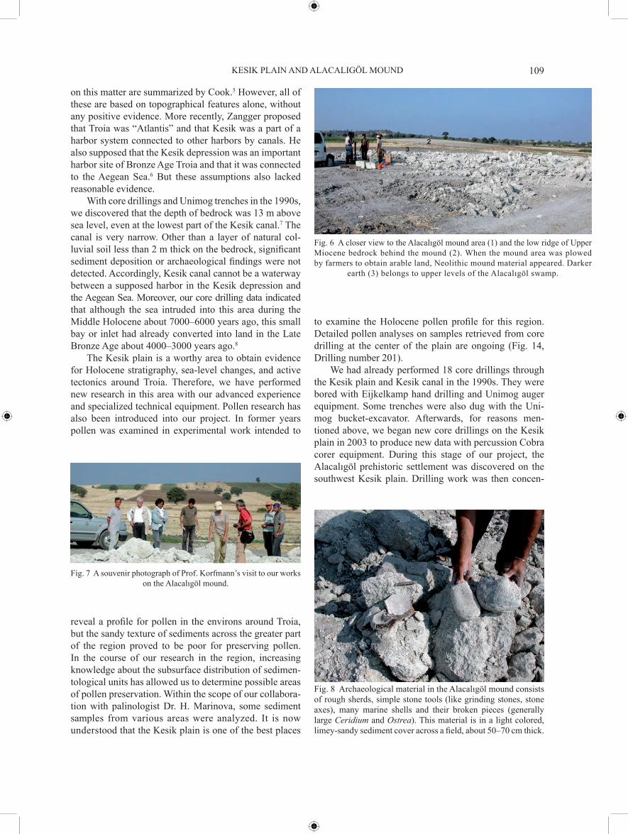
Fig. 7 a souvenir photograph of prof. Korfmann’s visit to our works on the alacalıgöl mound.
reveal a profile for pollen in the environs around troia, but the sandy texture of sediments across the greater part of the region proved to be poor for preserving pollen. ın the course of our research in the region, increasing knowledge about the subsurface distribution of sedimen-tological units has allowed us to determine possible areas of pollen preservation. Within the scope of our collabora-tion with palinologist dr. h. marinova, some sediment samples from various areas were analyzed. ıt is now understood that the Kesik plain is one of the best places
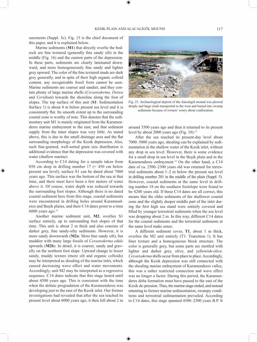
Fig. 8 archaeological material in the alacalıgöl mound consists of rough sherds, simple stone tools (like grinding stones, stone axes), many marine shells and their broken pieces (generally large Ceridium and Ostrea). this material is in a light colored, limey-sandy sediment cover across a field, about 50–70 cm thick.

ilhan Kayan110
as deep as 20 m and examined for changing environmen-tal characteristics. ın addition to our grain-size analysis and macro-fossil interpretations, some samples were sent to laboratories for c14 datings (suppl. 2). then, de-scriptions of subsurface sedimentary units for each drilling profile were plotted on a standard computer for-mat, and cross-sections along various lines on the plain were drawn with a correlation of sedimentary units. ulti-mately, paleogeographical maps of different stages were drawn combining the cross-sections (suppl. 3). Within this research, this paper focuses on environmental change and geoarchaeological interpretation of the area around alacalıgöl mound.
present-day geomorphology of the Kesik plain and morpho-dynamic processes
as stated above, the Kesik plain developed in an indentation on the eastern edge of the yeniköy ridge which divides the Karamenderes flood plain from the aegean sea. ın contrast to its 8 km length from north to south, the yeniköy ridge is only 800–1000 m wide, with a maximum height of 60 m. ıts western edge faces out to sea and is rather straight with steep cliffs. ın contrast, slopes to the east are very gradual. here, two major secondary and flat ridges, about 20–25 m high, extend eastward around three small indentations. these are Kumtepe in the north, yeniköy (Çapırdüzü) in the south, and the Kesik plain in the middle. each indentation covers an area of about 1 km2 (Fig. 1).
landforms on the yeniköy ridge are composed of two different litho-stratigraphic units of upper miocene shallow marine-brackish sediments, each with a distinct morphology and lithological characteristics. the lower unit consists of generally loose, carbonated-clayey-silty-sandy sediments. this unit rises to a maximum 25–30 m high along the western edge of the ridge, and its different layers can be observed along the cliffs facing out to sea
Fig. 11 middle-late holocene relative sea level changes in the troia area (Kayan 1991).
Fig. 10 geomorphological development of the Karamenderes (scamander) plain (Kayan 2000).
Fig. 9 paleogeographical reconstruction of the lower parts of the Karamenderes (scamander) and dümrek (simois) valleys in the middle holocene, about 7000–6000 years ago. ın this stage, the lower Karamenderes valley was completely cove-red by the rising sea and formed a marine embayment. a troia settlement did not exist yet. however, the alacalıgöl and Kumtepe neolithic settlements were
already established on the shoreline of the embayment.
trated on this area, and 16 new core drillings were per-formed in 2003, 2005 and 2006. thus, the total number of drillings reached 34, and sufficient sedimentological data were obtained from different points of the plain for better interpretation. sediment samples were taken from

KesıK plaın and alacalıgöl mound 111
(Fig. 12). By contrast, very low inclined slopes occur along the indented inner edge of this unit. the upper unit is also carbonated, but consists of harder-brittle limestone, sand-stone and conglomerate layers. this unit does not cover the entire surface of the ridge; instead, it appears as divided horizontal plates on the lower unit. the plates which are surrounded by steep corniches, are wider in the south near yeniköy, but form smaller mesa features towards the north (Figs. 1, 4, and 21). the smallest part, called Kesiktepe, is located to the west of the Kesik plain and is essentially a remnant of an eroded “butte”. this hill rises about 15 m to a platform 35–40 m above sea level, and its lower diameter is about 200 m. this neat, conical hill has been identified as a tumulus by some archaeolo-gists. on the other hand, this hill has an important strate-gic location. From Kesiktepe, one can see the vast marine expanse between Bozcaada (tenedos) and the entrance to the Çanakkale strait (dardanelles), as well as a greater part of the plain surrounding troia. Kesiktepe was even used for military observations in 20th century, during the World Wars and the Çanakkale War. a round pit at the top of the hill con-stitutes remains from this period, and the hill is therefore named “Kesiktepe (cut-hill)”. this is yet another place described as “kesik” in this region (suppl. 1).
geological formations of the yeniköy ridge have not been studied in detail. studies performed by tpao and sakınç-yaltırak9 are both recent and noteworthy for the regional geology, but their stratigraphical interpretations are not in exact agreement. ın the tpao report, which is more consistent with our findings, the lower unit belongs to the regionally described and named Kirazlı formation and the upper unit to the alçıtepe formation. Because the main topic of this paper is the holocene paleogeography
Fig. 12 a general view over the Kesik canal from the west. altho-ugh it seems as a passage between the aegean sea and the Kesik plain, drilling evidence revealed that it has never been a waterway.
Fig. 13 topography and drainage area of the Kesik depression.1) plateau (50-60 m) on the upper miocene, horizontally bedded alçıtepe formation, 2) low (less than 50 m) and gentle ondulated slopes on the upper miocene
Kirazlı formation (partly colluvium along the footslope), 3) Watershed of the Kesik basin, 4) cliff, 5) Beach, 6) Flood plain of the Karamenderes (scamander) river, 7) alacalıgöl wetland, 8) spreaded flood sediments from old channel of the Karamenderes river, 9) Wells and fountains,
10) surface elevations in metre (see also endnote 3c). contour interval is 10 m. dashed lines 5 m and 7,5 m. (Based on a 1/25.000 scale topographical map).
Fig. 14 ıkonos imagery of the Kesik plain and its surroundings. locations of core drilling points are shown by different colors which indicate two stages of our research (purple: unimog trench and auger 1991–1992; red: cobra core drilling
2003–2006). a: alacalıgöl mound.

ilhan Kayan112
Fig.
15
sW
-ne
cros
s-se
ctio
n ov
er th
e K
esik
dep
ress
ion.
red
arr
ow in
dica
tes
cont
inui
ng s
edim
enta
tion
in v
ario
us e
nviro
nmen
ts th
roug
h th
e m
iddl
e-la
te h
oloc
ene
(s: s
edim
enta
tion
sur-
face
). B
lue
arro
ws i
ndic
ate
sea
leve
l cha
nges
in th
e sa
me
perio
d (s
l: s
ea le
vel p
ositi
on).
Four
dig
it nu
mbe
rs n
ear d
rillin
g co
re p
rofil
es in
dica
te c
14 d
ates
from
the
core
. sep
arat
e nu
mbe
rs
indi
cate
c14
dat
es o
btai
ned
from
oth
er d
rillin
gs w
hich
are
not
on
the
cros
s-se
ctio
n lin
e. t
heir
verti
cal p
ositi
ons a
re e
xact
. c14
dat
es a
re ro
unde
d. F
or fu
rther
exp
lana
tions
see
text
. dar
ker
line
on th
e in
set fi
gure
indi
cate
s the
loca
tion
of th
e cr
oss-
sect
ion.
dril
ling
logs
add
ed o
nly
to re
pres
ent s
ourc
e of
sedi
men
tolo
gica
l dat
a an
d th
eir l
ocat
ions
.

KesıK plaın and alacalıgöl mound 113
of the Kesik plain, geological problems will not be dis-cussed here, and the neogene paleogeography and litho-stratigraphy of the yeniköy ridge will be considered only when necessary.
For the development of the present geomorphology of the upper miocene formations of the yeniköy ridge, it is clear that the most effective factor has been regional, young tectonic movements. When the Kesik depression is considered in a wider surrounding area of the Karamen-deres plain, some significant relationships can be perceived between its geomorphological outlines and regional tectonic lineations.10 to the south of the Kesik plain, Ballıburun hill and its extension (Ballıburun ridge) run in a sW-ne direction (Figs. 1 and 2). this is one of the most outstand-ing lineation of the region, including Çanakkale strait. as for the northern margin of the depression, it runs in an west-east direction. this is also the direction of the troia ridge to the east. the north-south direction of the west-
ern margin is in concordance with the yeniköy ridge. accordingly, the upper miocene sedimentary forma-tion of the region broke up in the late neotectonic stage as uplifted and downfaulted blocks. the yeniköy ridge was formed as an uplifted block or horst, between the downfaulted aegean and Karamenderes blocks. ın addi-tion, in the inner structure of the ridge, there are tectonic deformations in concordance with sW-ne regional lin-eations. Briefly, the Kesik depression seems to have been formed in a secondary depression between n-s, W-e and older sW-ne structural lineations (generally fault zones). among these geomorphological outlines of the Kesik depression, the most outstanding structural lineation is sW-ne along the southern edge.
slopes all around the Kesik plain are very low inclined, and the transition to the alluvial bottom is indistinct. as an exception, there are some small and low scarps along the northern slopes of Ballıburun ridge (Figs. 3 and 4). these have a sW-ne alignment that is aligned with the Kesik canal and main structural lineation to the east of the Karamenderes plain. this implies that the south-ern edge of the Kesik plain has been subjected to more active faulting in recent times. however, sedimentologi-cal evidence obtained by core drillings and correlation of the subsurface sedimentary units has revealed that the holocene sediments have not been affected and deformed by severe tectonic movements.
ın comparison with the rather small area of the Kesik plain described above (about 1 km2), its surficial drain-age area, which is important for the alluvial formation of the plain, is only about 6 km2 (Fig. 13). ın addition, flow velocity and the power of surface waters to trans-port alluvium are very low because of the flatness of the surrounding topography. ın fact, there is no major river that flows into the Kesik depression. the material washed down from the surrounding gentle slopes is only
Fig. 16 12 m sediment profile (log) of core drilling number 201 from the central part of the Kesik plain. m1: Fine sandy-silty, gen-erally laminated marine sediments (transgressive sequence); s1: surface 1; m2: more fine sandy marine sediments (regressive sequence); t1 and t2: swampy environments (transition to ter-restrial sediments); tc: terrestrial sediments originated from sur-rounding low slopes; ts: swamp sediments; tF: micaceous, fine sandy flood sediments originating from the Karamenderes river; tr: recent colluvial cover on the surface. s: large shells (Cerasto-
derma edule). see also Figs. 14 and 15.
Fig. 17 looking to the north from near the west of alacalıgöl mound (the mound is just to the right of the photograph). owner of the field dug a deep well to collect excessive ground water and drain to main drainage ditch to the north (see Figs. 2, 13 and 14). the mouth of drainage pipe to empty the well is seen on the wall. Because of deposition in the alacalıgöl swampy environment, color
of the earth is black.

ilhan Kayan114
fine-grained, muddy, colluvial sediment. under these cir-cumstances, the origins of the sediments that filled the depression and formed an alluvial plain here, as well as their transport and deposition, must be considered a mor-phodynamic process different from the present day. this is only possible to know by means of examination of the holocene stratigraphy and paleogeography based on data obtained from various subsurface sedimentary units in the Kesik plain.
subsurface sedimentary units of the Kesik plain, the holocene stratigraphy and paleogeography
as stated above, 18 drillings were performed in the 1990s using eijkelkamp hand equipment and unimog hydraulic auger. then, in the 2000s, we performed 16 vibro-core drillings using cobra percussion equipment. thus, we have now drilled a total 34 points on the plain (Fig. 14). many of these are at the southwest, near the
alacalıgöl mound and the entrance to the Kesik canal. others are distributed sufficiently to draw strati-graphic cross-sections on the plain in different directions. Based on sedimentological data obtained from various depths as deep as 20 m, detailed descriptions and interpretations have been carried out on the subsurface sedimentary units concerning their changing paleogeographies. all of this information was plotted on a standard computer layout. since detailed sedimentary interpretations are not the main focus of this paper, only descriptions of the main sedimentary units, their spatial and chronological correla-tions, and holocene paleogeography are considered here.
the deepest drillings, number 17 and 197, are located at the opening of the Kesik plain to the Karamenderes flood plain (Fig. 14). number 197 is closer to the south-ern slope, where bedrock was reached at a depth of 20 m. as for number 17, it is located in the middle, where bedrock was not reached. number 200 is another drill-ing in the same area, closer to the northern slope, and bedrock was reached at 9 m. except numbers 17 and 201
Fig. 18 sW-ne longitudinal cross-section along the old western creek (azmak) of alacalıgöl to the west of the mound. For further explanations see Fig. 15.

KesıK plaın and alacalıgöl mound 115
Fig.
19
sW
-ne
long
itudi
nal c
ross
-sec
tion
alon
g th
e ol
d ea
ster
n cr
eek
(azm
ak) o
f ala
calıg
öl to
the
east
of t
he m
ound
. Fo
r fur
ther
exp
lana
tions
see
Fig.
15.

ilhan Kayan116
footslope. accordingly, the bedrock surface below the holocene sediments is deeper towards the middle and eastern side of the depression. however, it seems that the bedrock is not much deeper than 20 m below the present surface, even in the easternmost part of the depression. present surface elevations of the wider middle part of the Kesik plain are about 4–5 m on a 1/5000-scale cadastral plan, while the Karamenderes flood plain is about 5–6 m to the east. although these elevations were found about 1 m lower than precise gps measurements, in all cases, the present level of the Kesik plain is about 1 m lower than the Karamenderes plain to the east (suppl. 3c).
the sedimentological evolution and formation of the Kesik plain are directly related to the geomorphologi-cal development of the Karamenderes plain through the holocene. our drilling evidence indicated that in place of the Karamenderes flood plain there was an erosional valley floor on the upper miocene bedrock or partly pre-holocene terrestrial deposits during a eustatic lowstand of sea level in the early holocene. this was about 20–30 m below the present surface in the middle part of the valley to the east of the Kesik depression.11 according to c14 dates, the rising sea in the holocene first intruded into the Karamenderes river bed and then flooded nearly the entire area of the present plain about 7000–6000 years ago (Fig. 19). coastal sediments occur almost exactly at the present sea level along the shoreline of this embay-ment, and their c14 dates are about 6000 years old, indi-cating that the sea reached to the present level about 6000 years ago and did not rise to a higher level (Fig. 11).
drilling evidence indicates that the rising sea also intruded into the Kesik depression from the Karamend-eres embayment during the holocene. here, in drillings where we reached bedrock, terrestrial sediment cover, such as fluvial deposits, were not encountered on the bed-rock. ınstead, the corer came directly upon the surface of bedrock layers, which were generally loosened by ground water. the bedrock, as stated above, generally consists of carbonated clayey-sandy upper miocene sediments (Kirazlı formation). therefore, the cobra corer was able to penetrate about several ten centimeters, sometimes 20, 30 cm into these clayey layers. absence of any pre-holo-cene sediment cover on the bedrock surface indicates that the bottom of the Kesik depression was an erosional sur-face in the early holocene.
holocene subsurface sedimentary units and their changing environments are shown on Fig. 15. this cross-section cuts across the plain from sW to ne and includes alacalıgöl mound at the sW. new gps measurements were carried out for more accurate vertical correlation. this data set was adjusted to the old troia-dörpfeld system which is 65 cm lower than measurements on the national topographical system. therefore, necessary cor-rection was made by adding 65 cm to the new gps mea-
Fig. 20 a paleogeographical reconstruction map of the Kesik inlet and alacalıgöl settlement area about 7000 years ago. purple dots
edged in black are locations of cobra drilling points.
Fig. 22 a paleogeographical representation of the view in Fig. 21 in the neo-lithic time, about 7000–-6000 years ago.
Fig. 21 a panoramic view towards the yeniköy plateau ridge from the north. yeniköy (1) is located on a platform of the upper unit of horizontally bedded upper miocene formation (locally named alçıtepe formation) (2). the lower unit of the upper miocene sediments (Kirazlı formation) forms low undulated topography (3). one of the very flat ridges consists of light grey fine sandy-silty sediments extending into the alacalıgöl swampy area (4). the alacalıgöl mound (5) is located on the northern tip of this extension. ın the foreground, the western part of today’s Kesik ditch (6) drains alacalıgöl waters to the Karamenderes
western main drainage canal.
in the middle of the plain, all other drilling holes reached the upper miocene bedrock at different depths down to 15 m, depending on the distance from the closest
KesıK plaın and alacalıgöl mound 117
surements (suppl. 3c). Fig. 15 is the chief document of this paper, and it is explained below.
marine sediments (M1) that directly overlie the bed-rock are fine textured (generally fine sandy silt) in the middle (Fig. 16) and the eastern parts of the depression. ın these parts, sediments are clearly laminated down-ward, and more homogeneously fine sandy and lighter grey upward. the color of the fine textured muds are dark grey generally, and in spite of their high organic colloid content, any recognizable fossil form cannot be seen. marine sediments are coarser and sandier, and they con-tain plenty of large marine shells (Cerastoderma, Ostrea and Ceridium) towards the shoreline along the foot of slopes. the top surface of this unit (S1: sedimentation surface 1) is about 4 m below present sea level and it is consistently flat. ıts smooth extent up to the surrounding coastal zone is worthy of note. this denotes that the sedi-mentary unit m1 is mainly originated from the Karamen-deres marine embayment to the east, and that sediment supply from the inner slopes was very little. as stated above, this is due to the small drainage area and the flat surrounding morphology of the Kesik depression. also, such fine-grained, well-sorted grain size distribution is additional evidence that the depression was covered with water (shallow marine).
according to c14 dating for a sample taken from 850 cm deep in drilling number 17 (= 450 cm below present sea level), surface s1 can be dated about 7000 years ago. this surface was the bottom of the sea at that time, and there must have been a few meters of water above it. of course, water depth was reduced towards the surrounding foot slopes. although there is no dated coastal sediment here from this stage, coastal sediments were encountered in drilling holes around Karamend-eres and Beşik plains, and their c14 dates point to a time 6000 years ago.12
another marine sediment unit, M2, overlies s1 surface entirely, up to surrounding foot slopes of that time. this unit is about 2 m thick and also consists of darker grey, fine sandy-silty sediments. however, it is more sandy downwards (M2a: more fine sandy silt), but muddier with many large fossils of Cerastoderma edule upwards (M2b). ın detail, it is coarser, sandy and grav-elly on the northern foot slope. upward change to lesser sandy, muddy texture (more silt and organic colloids) may be interpreted as shoaling of the marine inlet, which caused decreasing wave effect and water movements. accordingly, unit m2 may be interpreted as a regressive sequence. c14 dates indicate that this stage lasted until about 4500 years ago. this is consistent with the time when the deltaic progradation of the Karamenderes was developing just to the east of the Kesik inlet. our former investigations had revealed that after the sea reached its present level about 6000 years ago, it then fell about 2 m
around 3500 years ago and then it returned to its present level by about 2000 years ago (Fig. 10).13
after the sea reached its present-day level about 7000–5000 years ago, shoaling can be explained by sedi-mentation in the shallow water of the Kesik inlet, without any drop in sea level. however, there is some evidence for a small drop in sea level in the Beşik plain and in the Karamenderes embayment.14 on the other hand, a c14 date of ca. 2500–2300 years old was returned for terres-trial sediments about 1–2 m below the present sea level in drilling number 201 in the middle of the plain (suppl. 5). however, coastal sediments at the same level in drill-ing number 18 on the southern footslope were found to be 4200 years old. ıf these c14 dates are all correct, this means that the older sediments of the shallower coastal zone and the slightly deeper middle part of the inlet dur-ing the first high sea stand were entirely covered and filled by younger terrestrial sediments when the sea level was dropping about 2 m. ın this way, different c14 dates for the coastal sediments and the terrestrial sediments at the same level make sense.
a different sediment cover, T1, about 1 m thick, overlies the m2 unit entirely (t1: transition 1). ıt has finer texture and a homogeneous block structure. the color is generally grey, but some parts are mottled with lighter and darker grey, olive, and yellowish-olive. Cerastoderma shells occur from place to place. accordingly, although the Kesik depression was still connected with the shoaling marine embayment of Karamenderes valley, this was a rather restricted connection and wave effect was no longer a factor. during this period, the Karamen-deres delta formation must have passed to the east of the Kesik de-pression. thus, the marine stage ended, and instead returning to former marine sedimentation, swampy condi-tions and terrestrial sedimentation prevailed. according to c14 dates, this stage spanned 4500–2500 years B.p. ıt
Fig. 23 archaeological deposit of the alacalıgöl mound was plowed deeply and large clods transported to the west and buried into swamp
sediments because of owners’ worry about confiscation.

ilhan Kayan118
seems that the rate of sedimentation in the Kesik depres-sion was reduced during this rather long stage. this is partly related to the changing environment in the part of the Karamenderes embayment to the east of the Kesik depression because of faster deltaic progradation in this regressive stage (Fig. 11). ın addition, sediment supply from the surrounding flat slopes of the Kesik depression was low as usual.
Formation of the sedimentary unit t1 must have coincided with the end of m2 regressional stage, which is also a meeting point between falling sea surface between 5000–3500 years ago and continuously ris-ing sedimentation surface on the depression bottom. above this level, any marine or coastal sediment or something related to these environments, like Cerasto-derma shells, are not evident. some sediment transporta-tion must have occurred from the prograding Karamende-res delta towards the north of the Kesik depression during the formation of t1. the loose, washed, micaceous sand deposits in this part (t1a) indicate deltaic-fluvial condi-tions instead of a coastal environment.
T1 is covered with sedimentary unit T2, about 1 m thick. although transition is gradual, color difference is distinct. ınstead of the darker grey color of t1, t2 is lighter and mottled with light olive from place to place, especially upward. this unit is generally silty and has a hard block structure. small carbonated concretions are common. these characteristics indicate an environment generally dry but alternatively wet-moist from time to time. therefore, sedimentary unit t2 can be considered as evidence of gradual desiccation of the bottom of depres-sion due to rising ground by sedimentation. ın addition, the light grey color of this unit can be correlated with a certain level of upper miocene bedrock strata. ıt seems that t2 originated from the light grey silty layers of the horizontal upper miocene bedrock formation, not from the Karamenderes marine environment. according to c14 dates, unit t2 is about 2500–2300 years old (suppl. 5), and coincides with the period of rising sea level after the 2 m fall. although t2 is completely below the present sea level, the Kesik plain has not been inundated at this stage because the coastline of the prograding Karamend-eres delta had passed to the east of the Kesik plain and the area had already been transformed into land (Fig. 10). however, a small rise in sea level about 2000 years ago may have affected the ground water and its capillary action in the new sedimentary unit t2. this may also explain the hard block structure of the sedimentary unit and its carbonated concretions.
the upper part of unit t2 can be recognized by color change and carbonated concretions about 0.5–1 m below present sea level. although the transition is gradual upwards, the overlying sedimentary unit tc (originating from colluvium) is clearly different from t2. ıt is about
3 m thick and consists of homogeneous silty hard block deposits of colluvium washed down from surrounding low slopes. the color is generally light brown but mottled with grey, olive, and rust from place to place. lighter car-bonated concretions are another mottling element. thick-ness and c14 dates indicate that the rate of sedimentation increased during the deposition of this unit. the reason must have been elevation control of the alluvial depo-sition to the east. ındeed, faster alluvial sedimentation in the Karamenderes flood plain in this stage elevated the surface to the east of the Kesik plain. at the same time, its small lower bottom in the west retained col-luvial material washing down from surrounding low slopes instead of washing it out from the bottom. also pertinent is accelerated erosion due to destruction of natural vegetation during classical times. although this may be taken into account as a normal process, we expect that dr. marinova’s studies on pollen will reveal its degree of importance.
there are some noticeable changes on the latest sedi-mentary units of the Kesik depression. on drilling pro-files in the middle and eastern parts of the Kesik plain, a fluvial cover, less then 1 m thick, was encountered about 1 m below the present surface (tF). this is yellowish-olive, silty fine sand. a great deal of mica flakes is good evidence that the material originated from floods of the Karamenderes river, because there is no bedrock including mica in the hydrographic basin of Kesik plain. ın addition, geomorphological marking of flood channels is visible on old aerial photographs taken before recent reclamation projects on the Karamenderes plain and its surroundings (Fig. 2). ın one case one of these is quite visibly directed towards the Kesik depression. Formation of a crevasse splay may have caused the spread of some flood sedi-ments over the eastern part of the Kesik plain in recent times.
the slightly elevated surface of the eastern part of the Kesik plain with flood sediments supplied by Kara-menderes caused the western and southwestern parts to remain lower. accordingly, this area covered with water to form a seasonal lake or swamp, especially in years of excessive rain. here, the ground is still blackish today, and this indicates that it was a wet environment with thick vegetation before recent reclamation works (ts). drilling profiles denote that the wet ground was extending towards the middle of the plain. another reason for water accumulation here may be a fresh water spring. a water reservoir dug by modern farmers reveals a strong flow of water from only a few meters below the present sur-face. this means that the mouth of the spring in the bed-rock was buried by sediments but has been continuing to supply ground water. as stated above, this area is named alacalıgöl (“mottled lake”) because of different ground colors related to wet and dry seasons.
KesıK plaın and alacalıgöl mound 119
many attempts have been made to drain excessive water from the alacalıgöl area in order to convert it into arable land. their exact times are not known, but they may have been in the last centuries. local people and farmers postulate that the Kesik canal was also an attempt for the same purpose, but for some reason was never completed. contrary to opinions of some histori-ans and archaeologists, there is some evidence to indi-cate that such attempts do not belong to historical times. For example, the thickness of the upper terrestrial sedi-ment unit in the middle part of the plain is about 3 m, and its base dates back to 2300 years ago (suppl. 5). this is a rather homogeneous sediment unit on the bottom of the Kesik depression, and it does not have any sedimen-tary characteristics that indicate a drainage problem. above this unit, discharge deficiency of surface waters started following the formation of low flood (crevasse) sediments of Karamenderes river to the east of Kesik plain. ın consideration of the sedimentation rate, this formation must have occurred in the last few centuries. to produce more arable land during the 1950s, some reclamation projects were realized by the government and excessive surface waters of the alacalıgöl wetland were drained by a secondary ditch to the main drainage canal in the west of Karamenderes plain. a farmer in this area, adil pınar, who had not contented with the actual system, dug a deep well to collect water and divert it to the northern drainage ditch (Fig. 17). From the bottom of the well, a rather strong spring of water wells out, and this indicates that spring waters also influenced the for-mation of the alacalıgöl wetland. today, springs along the slopes of yeniköy ridge leak from different bed-rock layers. ıt seems that in alacalıgöl area, a similar spring mouth has been covered by terrestrial sediments, obscuring the main outlet. however, spring waters con-tinued to feed ground water.
although the Kesik plain has reached a graded profile in the present morphology, it is still slightly lower than the Karamenderes plain, and the sediment supply is not pro-vided by surface flow. slow-water runoff washes colluvial material down from the low surrounding slopes and forms an edge-plain along the footslopes. on the other hand, flood sediment transport from the Karamenderes into the Kesik plain is not possible today because of agricul-tural activities, excessive use of ground water, drainage control of surface water, and control of spring waters by dykes. ınstead, some small scale changes observable on the surface morphology may be due to cultivation activi-ties, especially levelling works on the footslope fields.
alacalıgöl prehistoric settlement site and geoarchaeological interpretations
landforms to the south of the Kesik plain run sW to ne. here, Ballıburun ridge, only about 15–20 m high, bounds the plain in this direction (Figs. 1 and 2). the lowest part of the Kesik plain is situated between yeniköy and Ballıburun ridges. this area is known as alacalıgöl („mottled lake“) because ground was covered with water seasonally, especially before modern reclamation works, and it exhibits patchy color related to different periods of wetness and vegetation. the bedrock consists of sandy-silty-clayey-carbonated, almost horizontally bedded, easily erodable, shallow water sediments of the upper miocene (locally known as the Kirazlı for-mation). Because of almost horizontal bedding, its very light grey, carbonated, fine sandy-silty layers extend in a wide area to the south of alacalıgöl and form a very low undulated topography. ın the middle part of this area, a very flat ridge runs from sW to ne towards alacalıgöl and gradually disappears under dark colored swamp sedi-ments (Figs. 2–6).
ın recent years, even loose pre-holocene sedimen-tary bedrock has been plowed and irrigated for agricul-ture because of the increasing value of arable land in this area. therefore, it is difficult to know the origi-nal limits of the flat ridge as a landform, especially around its northeastern extension towards the Kesik plain. however, the low ridge, which is only about 1–2 m higher than the plain, can be clearly distinguished on aerial photo-graphs, as well as in the field by means of color contrast between light grey bedrock of the ridge and blackish bottom sediments of the alacalıgöl wetland. an archaeological deposit covering surface of the northeastern end of the flat ridge makes this location peculiar (Figs. 6–8). at first glance, it is difficult to dis-tinguish because it has the same color as the light grey, loose, upper miocene bedrock. this may explain why this site has not been discovered until now. ıt has been named “alacalıgöl mound” by the troia project.
We met the owners of the fields in this area, adil pınar and his son aytaç, during our 2003 field studies. they wanted to show us their continuing regulation and reclamation works surrounding the mound site. they had two problems: one was the infertility of the mound area, because it is bedrock without any topsoil, and the other was a drainage problem in the alacalıgöl area that had delayed planting for years. the first problem they had solved by plowing the area of the mound (!) to a depth of about 50 cm. the surface of the field was covered by large clods of earth which were very light grey, fine-tex-tured (much limey fine sand and silt) with the appear-ance of travertine with moulds of plantal roots. they were full with coarse potsherds, stone tools (grinding
ilhan Kayan120
stones, axe type tools, spindle whorls) and a great deal of large Cerostoderma, Ceridium and Ostrea shells (Fig. 8). these were also evidence of a prehistoric settlement. the block structured matrix looked like dried swamp sediments which covered the site during the highest and maximum extended periods of the alacalıgöl swampy environment. however, color contrast between the light matrix of archaeological material and the dark swamp sediments indicates that the matrix originated from the miocene bedrock.
owners of the field were not aware that the site was an archaeological mound. We explained the importance of the site and asked them to take care of it. the surface area of the mound is about 2–3 decares, and the thickness of the archaeological deposit is less then 1 m (plowing makes the actual depth difficult to ascertain). the site and finds were examined by archaeologists from troia and the first introductory paper on the site has been published on a collection consisting of about 260 finds.15 accord-ingly, this settlement can be dated to the 5th millennium Bc (7000–6000 Bp), which means that it is as early as the oldest settlements around troia (Kumtepe, Beşik sivritepe).
our paleogeographical research on the Kesik plain revealed that the environment changed rapidly in the holocene. therefore, the geographical environment of the alacalıgöl mound area during initial settlement stages about 7000 years ago must have been greatly different from its present appearance. We performed new bore-hole drillings on the mound area in order to examine these differences and to investigate the natural charac-teristics of this place that were attractive for settlement. ın the meantime, drainage works made by modern farm-ers contributed to our endeavors. their aim was to drain excessive water from the alacalıgöl area to prepare the fields for cultivation on time. ın order to do this, they dug a pit on the blackish swamp sediments at the western edge of the mound about 3 x 6 m wide and 4 m deep (Fig. 17). accumulated water in the pit was attempted to be transferred into the main ditch to the north by means of a drainage pipe. When water in the pit was emptied for us by a pump, we observed a strong flow of water entering the pit from the northeastern corner of the bottom.
this suggested that water in this area is a combination of surface water and spring water. there is no doubt that the existence of such fresh water springs here would have been one of the most important reasons why this location was preferred for settlement. ın other parts of this area, some actual small springs or recently dried outlets were observed between lithologically different bedrock layers. however, the spring in the pit is quite different from the others because of its higher flow rate. When this spring is weighed against the structural and landform features of this area, it seems that a fault zone may have caused the
formation of the spring. ın the course of time, the area was covered by meters of sediments and the outlet of the spring disappeared. the water coming from the faulted bedrock below terrestrial sediment cover continued to feed surface water of the alacalıgöl swamp environment from underground.
the flat mound ridge divides the southwestern part of the alacalıgöl area into two parts. our core drill-ings on the western part (especially numbers 203 and 206) revealed the existence of a valley-shaped depres-sion below the swamp sediments (Figs. 14 and 18). this depression seems to be in accordance with the general structural sW-ne lineaments, and it also shows that the morphology on the bedrock was more uneven then the present surface. the elevation was about 3 m at the loca-tion of drilling number 203 to the west of the pit. here, light grey, clayey miocene bedrock was encountered at about 10 m deep. this means that there was a depression to the west of the mound about 10 m deep during the early holocene. rising sea in the holocene inundated the depression and fine sandy shallow marine sediments con-taining small shells were deposited first. these formed a 4 m thick sediment unit (m1a). then gravelly-coarse sandy (not well-worked) coastal sediments with large shells (Cerastoderma, Ceridium, Ostrea) were deposited as a second unit about 3 m thick (c: coastal). terrestrial and swamp sediments overlie these units. Bedrock was encountered about 6 m below present sea level in drilling number 206, just southwest of 203 (Fig. 14). the cov-ered outlet of the fresh-water spring occurs at this level. Fine, textured marine sediments (m1) couldn’t intrude into this shallower part. gravelly, coarse sandy coastal sediments containing shells, in concordance with a sim-ilar unit in drilling 203 (c), occur at about 1 m below present sea level and are overlain by swamp sediments. although gravels and coarse sands imply an old river channel here, as stated above, the morphology is not suit-able for any river flow to provide enough power to trans-port this coarse material. also marine shells in the coarse material indicate that this is a coastal deposit washed by low-energy waves in a small indentation of the old Kesik marine embayment. ındeed, coarse material does not exist below or above this coastal zone and it does not continue northward. according to c14 dates of similar formations on the other parts of the Kesik plain, this material must have been about 6000 years old. ıt is therefore possible to postulate that during the initial settlement stages of the mound, there was a small marine indentation to the west of the mound about 3–4 m lower than the settlement plat-form with a fresh water spring on the sandy coast.
another small depression occurs to the east, between the mound and the Ballıkaya ridges. ın drilling number 205, clayey miocene bedrock was encountered at 11 m deep (Figs. 14 and 19). this is overlain by marine sediments

KesıK plaın and alacalıgöl mound 121
about 7 m thick which consist of finer and coarser sediment bands. larger and smaller marine shells occur along the entire profile. also at this location, the marine sediment unit is overlain by terrestrial sediments about 4 m thick, which imply a changing wet environment from time to time.
at drilling number 207 to the north of the mound, the clayey bedrock was encountered at 8.5 m deep (Fig. 14). here, about 1.5 m of the lower part of the overlying marine sediment unit consists of only coarse sand, gravel and large shells. the marine sediments are finer upward and gradually change to light grey, fine textured (fine sandy silt), homogeneous block mud. this unit seems derived from the miocene bedrock that the mound was situated on. a similar stratigraphical sequence appears in drilling profiles to the west and east of the mound.
ın conclusion, according to our investigations at the alacalıgöl mound, especially sedimentological data obtained from borehole drillings, it is possible to make a paleogeographical reconstruction of the area during the initial period of settlement, dated by archaeologists to about 7000 years old (Figs. 20 and 22). For the position of the shoreline, there is some evidence from our former research. accordingly, the sea was almost at the same level as its present surface about 6000 years ago. on the other hand, in drilling number 201 in the central part of Kesik plain, the c14 date for the upper surface of the marine sediment unit m1, which is 8.5 m below the pres-ent surface (about 4 m below from the present sea level), is about 7000 years old. supposing a few meters of water above the bottom, a shoreline reconstruction is possible surrounding the ridge of the mound. during the initial stages of settlement, the mound was located at the tip of a low ridge about 3–4 m above the surrounding sea. during these times, the ridge was more distinct than it is today, and its silty bedrock surface was exposed to erosion. ın addition, the northern surrounding slopes were under the effect of wave erosion. although wave energy was low because of the shallowness of the Kesik embayment, the unresistant silty bedrock was easily eroded and depos-ited along the shallow foreshore zone to form fine tex-tured mud. spring water coming from the upper miocene bedrock layers on the western footslope of the mound, various seafood (Cardium, Ostrea and fish) in the shallow marine waters of the Kesik embayment were attractive natural resources of the site for settlement.
as stated above, in the following Bronze age period, because of a slight drop in sea level, the Karamenderes and Kesik marine embayments rapidly filled with alluvium and turned into land. thus, the favorable conditions for the original settlement at alacalıgöl disappeared. ın fact, archaeologists working at the site have not mentioned the existence of any material belonging to the chalcolithic, early Bronze age, or following periods. ıt is also evident that the bottom of the Kesik depression changed into a
swampy environment when the sea receded from the area during the Bronze age regression. this change may be the most important reason for the ending of settlement at alacalıgöl. these two events – the formation of the swamp environment and the end of settlement at alacalıgöl – are chronologically in very well accord with each other.
although owners of the fields in the area around the mound were friendly and helpful to us, in spite of our request for them to keep the area untouched, they deeply plowed the mound and broke up the layer that was full of archaeological material immediately after we left. ın addition, they took measures to avoid confiscation of land. First, they transported large blocks of the archae-ological layer to the western mouth of the Kesik canal on the coast. this caused confusion to colleagues, who misinterpreted these remains as evidence for another neolithic site. ın the following summer, when we visited the area for gps measurements, we saw that they had opened the ground widely into the blackish swamp sedi-ments near the pit, dumped broken clods of the archaeo-logical layer inside, and then covered them again with the blackish earth (Fig. 23). this activity will no doubt complicate future geophysical prospections and lead to further confusion about neolithic settlement by future archaeologists working in this area.
discussions
Active tectonics in the troia area have been a focus of attention and dispute by earth scientists, especially fol-lowing the marmara earthquake of 1999. For troia, earth-quakes have special significance because of evidence for severe earthquakes responsible for the destruction of the prosperous city of troia Vı, as well as the mythology of earthquakes in homeric poetry and the story of the alleged troian War. the troia area is located on the southern flank of the north anatolian Fault Zone and in a transitional region between this zone and aegean tensional tectonics. therefore, geological and geomorphological evidence of young tectonic activity is abundant everywhere. on a regional scale, it is not possible to explain geomorpho-logical features without considering tectonic activities. however, time is a very important factor in terms of chronological sequence and duration of tectonic events. earth scientists are accustomed to measure time in mil-lions of years, while archaeologists, historians and even social geographers are accustomed to only thousands of years at most, and more generally only hundreds of years. they must be careful to respect this difference in order to understand each other. the geological structure and geo-morphological formation of the ridge of troia and its sur-roundings span the last 10 million years. But inundation of the Karamenderes lower valley and its tributaries by rising

ilhan Kayan122
sea in the holocene, the alluviation of this region, and the establishment and development of neolithic and Bronze age settlements occurred only in the last 10 thousand years. differences between magnitudes and sequences of the events that have occurred across 10 million years and across only 10 thousand years must be realized correctly.
as stated above, structural lineations of landforms around the troia and Kesik depression are very distinct as a reflection of the basement structure in ne-sW and the neotectonic break up along the n-s and e-W direction. ın fact, outlines of the aegean coastline and lower part of the Karamenderes plain were formed as a result of these structural lineations. however, the subsurface geometrical configuration of the middle and late holocene sedimentary units, which has been determined by bore-hole drillings on the Karamenderes and Kesik plains, has revealed that the sedimentary units have not been subjected to tectonic deformation. From this point of view, the very smooth and horizontal extent of the uppermost surface of the marine sedimentation unit of the holocene transgression is partic-ularly remarkable (Fig. 15: s1). c14 dates from this surface are about 6000–7000 years old, and its plane morphology indicates that the surface formed out of spreading marine sediments coming from the Karamenderes marine embay-ment instead of from terrestrial material washed down from the surrounding slopes. any deformation, such as tilt-ing, has not been detected on the surface, and this indicates that severe tectonic activity of a magnitude that could have had an effect on the morphology has not transpired dur-ing the last 7000 years. of course, this is not evidence for the stability of the region during this period. severe earth-quakes are clear evidence for continuing active tectonics. the matter important to emphasize here is that tectonic activity during this period has not affected and deformed the geomorphology, at least in a recognizable magnitude. ın other words, tectonic activity or deformations are not visible on the landforms and have not been a primary fac-tor for the geomorphological development of the region since the middle holocene.
ın addition, evidence for tectonic deformation has not been detected in the sedimentation units above the s1 surface, which was formed in the last 7000 years. surfaces of these units (Fig. 15: s2, s3) extend smoothly and horizontally on the bottom of the depression. how-ever, lateral transition between footslope colluvial depos-its and the bottom sediments are more evident upwards, which is something not observed in s1. this is because the sediments were not deposited in the depression in a water environment as before. ınstead, they were accumu-lated along the footslopes in a terrestrial environment and slowly washed down into the bottom of the depression, separate from the Karamenderes sediments.
Compaction of the sediments deposited at the bot-tom of the Kesik depression is another matter that deserves
consideration. ın particular, the marine section of holocene sediments that filled an embayment in a rather short time consist of loose silty-fine sandy mud with high organic content. therefore, it is normal to expect some compac-tion in the mass of this sedimentation unit. however, cor-relation of the core drilling logs has not revealed any evi-dence for this type of deformation on the surface of marine sediment unit s1. this may be explained by the inadequate thickness of the marine sediment unit, which is only about 15 m in the deepest part of the depression (drilling number 17), along with the overlying terrestrial deposits, which amount to a little more than 20 m of holocene sediments. also, in general terms, a tectonic shock, something like a severe earthquake, might have brought about vibration and compaction effects on silty marine sediments. however, there is no evidence for such deformation in the marine or overlying terrestrial sediment units and their discernable top surfaces (Fig. 15: s1, s2 . . .).
ın defining tectonic deformations in young tectonic movements in the troia area, including the Kesik depres-sion, one aim of earth scientists is to detect evidence for severe earthquakes which are often proposed as a cause of destruction, especially for troia Vı. some earth scien-tists attempt to dig trenches and examine their profiles to find signs of recent earthquakes. however, these trenches only reach depths of about 4–5 m. ground water presents problems for deeper trenches. according to sedimento-logical evidence obtained by bore-hole drillings and c14 dating, 6 to 7 m of sediment has been deposited in the Kesik depression since troia Vı (over the last 3250 years). obviously, it makes no sense to try to find marks of tectonic deformation from supposed earthquakes in the troia Vı period in these younger sediment layers.
ın conclusion, there is no doubt that geomorphologi-cal outlines of the Kesik depression and its surroundings were drawn by young tectonic movements. however, “young” here does not include the holocene, especially the sedimentary units that began to be formed in the middle holocene in the Kesik depression. therefore, it seems that earth science research techniques alone are not enough to obtain evidence to prove one way or the other if earthquakes destroyed troia Vı. archaeological evidence must be taken into account too.
a supposed tsunami or tsunamis that may have affected troia in the holocene is another topic of interest in recent years. some scholars postulate that troia and the surrounding area may have suffered tsunamis in the holocene. there is no specific evidence in favor of this argument, which became popular following the dreadful tsunami disaster in southeast asia in 2005. ın our bore-hole drillings, which reached 318 in number on the valley bottom of the Karamenderes-dümrek rivers, on the Beşik coastal plain, and in small indentations along the inner edge of the yeniköy ridge, we have never encountered

KesıK plaın and alacalıgöl mound 123
any evidence for a tsunami. of particular concern is the magnitude of a tsunami wave that might have developed in the northern aegean sea, as well as the possibility of a wave’s intrusion from the Çanakkale strait into the Kara-menderes valley or over the lowest parts of the yeniköy ridge. ıt is hard to postulate such an occurrence in the present day or in the holocene geographical configura-tion given the topographic-batimetric features of the region, the distances and directions for travel of waves, and magnitudes of holocene tectonic activities. a great deal of marine shells in the earth around troia have been presented as evidence for a severe tsunami event by some earth scientists. But shells are found at all archaeologi-cal sites on coastal regions, and troia is no exception. ın archaeological surveys, shells are normally interpreted as evidence for archaeological sites in the same way as pot sherds. shells are generally remains of marine gastropods (mostly cerastoderma edule) which were consumed as food. ın addition, shells can be transported in mud taken from deltaic swamps to produce mud bricks. they are also found at settlements as remains of personal ornament or other domestic usage. therefore, the existence of shell remains at a site about 30 m above sea level like troia is not an evidence of an inundation caused by a tsunami.
Geophysical research at troia led to the creation of a detailed city plan of the troia lower city.16 this suc-cessful result suggested that geophysical methods might also be helpful to identify and delineate different sub-surface sedimentation units and their environments (like identifying changes to river channels and the existence of former shorelines) on the Karamenderes alluvial plain and its extensions. however, this idea has not been appro-priate on the alluvial plain because the main bedrock for-mations produce generally fine sandy alluvium without much textural difference between sedimentary units. also, the structural characteristics of the alluvium and their effects on ground water present difficulties for applying most geophysical research methods to distinguish subsur-face sedimentary units.
Holocene sea-level changes and their effects on the troia area is also a subject of discussion. some evidence and interpretation on this matter has been pointed out in our previous publications.17 accordingly, rapidly rising sea in the early holocene reached its present level about 6000 years ago. after a 2 m fall between 5000–3500, it rose again to its present level about 2000 years ago. the first perceptible evidence for this was obtained from our core drillings in the Beşik coastal plain, which was formed by marine processes. coastal sediments with plenty of shells were encountered when drill-holes reached down to present sea level along the footslopes surrounding the plain. ın general, c14 dates from these drill-holes produced dates about 6000 years old. similar features and results have been found in the vicinity of
troia. as for the Kesik depression, in drilling number 18 on the southern foot-slope, the c14 date of shell sam-ples of coarse sandy coastal sediments about 1 m below present sea level is 4200 years old. ın drilling number 17, a shell sample taken from a similar sediment unit about 1 m deeper, is 4400 years old. on the other hand, the same level in drilling number 201 in the middle part of the plain is dated to 2500 years old (Figs. 13, 15). this difference can be explained by considering a small drop in sea-level in the late Bronze age (5000–3500 years ago). When marine water on s1 bottom of the Kesik embayment about 7000–6000 years ago is taken into account, deposition of coarse textured coastal sedi-ments with shells, 4200 years old, coincides to the stage of falling sea levels in the Bronze age. deposition of swamp sediments in place of retreating sea water con-tinued in later times (up to 2500 years ago).
although we have enough evidence for small sea-level changes during the last 6000 years, there is no proof for the cause of these events. ın the troia-Karamenderes area, holocene (or the late pleistocene) sediments belonging to marine or coastal environments have never been encountered above present sea level. on the con-trary, in our former, deeper drilling holes in the Karamen-deres plain, some marine sediment formation older than 30,000 years (c14 dates) were bored in deeper levels.18 accordingly, there is no indicator denoting any uplift of the pre-holocene surface on which holocene marine sed-iments accumulated. ın addition, the middle-late holo-cene sea-level changes can be followed in the same order and magnitude all along the aegean coast of anatolia. the aegean coastal region has faulted-blocky structure and tectonic reasons are not convincing explanations for uniform sea-level changes. thus, an eustatic reason con-cerning a climatic effect must be taken into account for sea-level changes, otherwise new evidence must be pro-duced if any different explanations are to be considered.
The origin of the Kesik canal between the Kesik depression and the aegean sea is also a subject of dis-cussion. our interpretations on this matter have been explained in former publications.19 ın the new stage of our research we have obtained no evidence to change our former interpretation. ın brief, the Kesik canal appears artificial with its very straight direction. however, no evi-dence has been discovered to suggest that it was dug out, nor has any trace of dumped material been found in sur-rounding fields. the canal is very narrow and the bedrock forms a threshold in the middle at a height of 13 m above sea level. therefore, the canal cannot possibly be used as a waterway between the Kesik depression and the sea. ın addition, archaeological material was not found in collu-vial deposition about 2 m thick in trenches which we dug across the canal with the unimog shovel dredger.

ilhan Kayan124
on the other hand, there is some evidence implying that the canal depression is naturally formed on a fault line. this is based on differences in elevation between two sides (north and south) of the canal and the mor-phology of the bedrock along the eastern extension of the canal on the surface (Ballıkaya ridge) and underly-ing alluvium (drilling data). however, sedimentological and stratigraphical features of the holocene deposits in the Kesik depression do not support such tectonic activ-ity during the holocene. according to available data, the most probable explanation may be as follows:
the Kesik canal may have originally formed on a fault line before the holocene, long before human activity in this area. ın prehistoric times, inhabitants had no need for a canal here. although the bottom of the Kesik depres-sion was a marine environment in the neolithic, humans living in this area, such as at alacalıgöl mound, were not able to attempt such a big project, so this period is not included in the following discussion. But the Bronze age, especially the period of troia Vı, remains under discus-sion as a period of possible canal construction. during this period the Kesik depression was not a marine embay-ment; in-stead, it was covered by a swamp. therefore, a harbor is not a subject of discussion for the Kesik depres-sion and a canal was not necessary for a waterway con-nection with the aegean sea. ın fact, there is no archaeo-logical evidence beyond the chalcolithic period in this area. ıt seems that the Kesik area lost its convenient nature and was abandoned because of its swampy forma-tion. ın recent historical times, the Kesik plain became more valuable because of agricultural necessities. the development of sigeion to the north may be one of the reasons for use the Kesik plain for agriculture. on the other hand, the stratigraphical sequence of the upper sedi-ments in the plain indicates that the plain was not covered by a swamp completely and continuously during histori-cal times. only in recent centuries did the swampy area expand again because of alluvial development on the Kar-amenderes plain. then, people attempted to drain exces-sive water from the alacalıgöl part of the plain in order to create arable land. ıt is also possible that they tried to dig some small trenches to accomplish this, but nothing as large as the Kesik canal. the canal has been used continu-ously for land passage between the Kesik plain and the coast of the aegean sea. this usage may have been more important during the wars of the last century.
conclusion
the geomorphological outlines of the troia area developed on the upper miocene shallow marine-brackish water sed-iments which are composed of sandy-clayey-carbonated, stratified sediments. their bedding is almost horizontal or
slightly inclined. the upper miocene sediments regionally uplifted and broken into divided blocks formed 50–70 m lower plateau ridges. among them, downfaulted blocks formed long depressions where major rivers of the area settled down and filled with alluvium over time. alluvial development was controlled by sea level change, espe-cially during the holocene transgression.
the Kesik plain is formed in an indentation with an area of about 1 km2 on the eastern edge of yeniköy ridge, which runs in a north-south direction between the lower Karamenderes (scamander) valley and the aegean sea as a low and narrow plateau ridge. geomorphological characteristics of the area denote that the Kesik plain is formed in a post miocene structural depression, which is located at the intersection of regional fault zones.
ın the holocene, as a consequence of climatic change the sea level rose and intruded into the lower Karamen-deres valley and reached maximum extension across the entire bottom in the middle holocene about 7000 years ago. a small extension of this marine embayment covered the bottom of the Kesik depression too. From the end of rising sea level about 6000 years ago, the southern part of Karamenderes plain rapidly turned into land due to alluvial deposition and deltaic progradation, and the coastal zone of the delta reached to the east of the Kesik inlet about 5000–4000 years ago. thus, the Kesik inlet was dammed and a new sedimentation stage started in the inner part of depres-sion in accordance with local geographical features of the basin. ıt has been possible to distinguish this difference in the cores of the cobra driller, and middle-upper holocene sedimentary units are clearly separated by means of care-ful sediment examinations. sedimentological evidence is consistent with the geomorphological development. the holocene sediments filling the Kesik depression consist of three main units: early-middle holocene marine sedi-ments, swampy transition in the late middle holocene and terrestrial upper holocene.
lower marine sediments have similar characteris-tics within the Karamenderes marine embayment (fine sandy silt generally, micaceous, containing high organic colloids, homogenous grey marine sediments). this unit changes into coarser sandy marine sediments about 4–4.5 m below present sea level, and this indicates that the Karamenderes deltaic zone came closer to the east of the Kesik inlet about 5000–4000 years ago. ın the fol-lowing stage, the great difference between c14 dates for the surrounding coastal sediments and for the terrestrial sediments in the middle can be explained by a drop in sea level of about 2 m at about 4000–3500 years ago. this is consistent with other evidence for this drop in sea-level in the region.
marine sedimentary units are covered by sediments from swampy or wet environments. this marks a transi-tion between lower marine and upper terrestrial sediments

KesıK plaın and alacalıgöl mound 125
where changes are gradual. here, instead of sediments originating from the Karamenderes marine embayment, terrestrial sediments originating from the surrounding low slopes are prevalent (light grey silty sediments under the effect of bedrock). there is no major river reaching to the bottom of the Kesik depression because the drainage basin is rather small and the surrounding slopes are very low and flat. Fine-textured colluvial sediments originated from surrounding slopes and slowly filled the bottom of the divided Kesik depression. however, the surface of the bottom was always lower than the part of Karamenderes plain to the east of the Kesik indentation.
there is some evidence concerning the alluvial devel-opment of the Kesik plain in recent centuries. a flood channel from the Karamenderes was diverted towards the Kesik depression and this spread micaceous fine sandy-silty flood sediments from the eastern opening towards the inside. this caused the western and southwestern parts of the plain to remain lower. since accumulated water could not drain to the east, eventually the alacalıgöl swampy area came into existence. then, some attempts were made to drain water from this area to obtain arable land. regard-ing these efforts, there is a unrealistic hypothesis that the Kesik canal was opened to drain water to the aegean sea, but there is no evidence that the Kesik canal was dug for this purpose. structural lines across the area and differ-ences in elevation between its sides support the impression that the canal was a structural feature, at least originally. Besides, the alacalıgöl lowland was connected to the main western drainage canal of the Karamenderes plain by a smaller canal along the northern edge of the Kesik plain, and this attempt to drain the swamp achieved substantial success. these data do not support the interpretation that the Kesik depression was a harbor for troia in the Bronze age and that the Kesik canal was excavated to connect the harbor to the aegean sea. First of all, the bottom of the Kesik depression had already been turned into land by the time of the Bronze age. moreover, all attempts concerning drainage matters date to recent centuries.
archaeological material found on the tip of a very flat and small ridge extending towards alacalıgöl has been dated to the neolithic period by troia archaeologists. considering its environmental development and related data, the alacalıgöl mound is a coastal settlement site at the maximum extension of the holocene transgression. an abundance of large marine shells is evidence that the Kesik inlet was an important source of food about 7000–6000 years ago. ın addition, there is evidence of a fresh water spring near the mound. Following retreat-ing marine conditions from the Kesik inlet, the alacalıgöl settlement terminated at the end of neolithic time. ın fact, archaeological material from the chalcolithic and follow-ing periods has not been found in the site.
supplements
1. The names of localities designated here are not the names used by local inhabitants or official names on maps. ın archaeological literature, the ridge separating the Karamenderes plain from the aegean sea is called the “sigeion ridge”, because the ruins of ancient sigeion appear at the northern part of the ridge. Besides, for later periods “yenişehir ridge” concerning the former village yenişehir, and actually “yeniköy ridge” are being used because of the existence of the modern village yeniköy on the southern part. as for name “Kesik”, this is used for the canal that cuts the ridge (Kesik means “cut” in turk-ish). to the north of the canal, a small hill, something like a mound, is named Kesiktepe („cut hill“), although it is sometimes called sivritepe („conical hill“) on the maps. Because of a hole on the summit dug during the wars, the crest of the hill appears to be cut. to designate the depression and its flat bottom to the east of Kesik (canal), “Kesik depression” and “Kesik plain” are used in this paper. the name alacalıgöl („mottled color lake“) is used for the southwestern part of the Kesik plain by local inhabitants. here is the lowest part of the plain, and it is covered by water occasionally.
2. our research program in the troia area started in 1977. since then a great number of C14 dating analyses have been made in different laboratories. during this rather long time, techniques for analysis and calculation have changed. ın general, shells (mostly cerastoderma edule) and plant or total organism (in lesser number) that were taken from former shallow marine or coastal environ-ments were used for c14 dating analyses. cerastoderma shells have a wide range of living conditions. they can survive in shallow marine environments in deltaic outlets and lagoons. they could have been worked and transported by waves of the rising sea during the holocene, and espe-cially the middle holocene, when sea level was closer to present day level. only bivalve shells represent their original living location, but these occur in very limited number. consequently, although chronological data ob-tained by c14 were carefully evaluated, paleogeographic reconstructions have not been done on these data alone. ıt seemed to us that a more reliable source for paleogeo-graphical reconstructions is the subsurface distribution of sedimentary units and their physical characteristics, such as color, texture, structure, faunal and floral remains, and some special formations like concretions, and lithologi-cal-mineralogical compositions.
3. several matters concerning the interpretation of the core-drilling data are necessarily explained here: a) For checking the accuracy and concordance between former and new core drillings which were made using

ilhan Kayan126
different equipment, new drillings numbered 206 and 204 were made near the former drillings numbered 13 and 16, respectively. levels of vertical boundaries of subsurface sedimentary units of the former and new drilling cores were found to be very consistent.b) the Karamenderes plain and its extension, Kesik plain, are areas of significant geographical environment change, especially in the middle holocene. therefore, sometimes a thin sediment layer or band may represent an impor-tant geographical change, such as a coastal change, a flood event, or a change of a river channel. to show these changes, vertical scales of each single drilling log and consequently cross sections have been exaggerated. this may cause misinterpretation of topographical inclina-tions, so this should be taken into account for examina-tion of the cross sections.c) Knowledge of accurate altitudes of drilling points are very important for the correlation of subsurface sedimen-tary units and their paleogeographical interpretations. this matter has always created great difficulty for our drilling works since 1983. topographical measurements have been performed in the same system since the time of dörpfeld’s research at troia to keep all data and inter-pretations consistent. ın the new period of research led by prof. dr. Korfmann, geodetic experts have continued to use dörpfeld’s system to provide continuity. this system is 60–65 cm lower than the turkish national geodetic system, which is being used in all turkish topographical maps and engineering works today. We had new topogra-phical measurements made in 1992, based on the present mean sea level to the west of the Kesik canal. Besides, very precise measurements have been possible in recent years using gps electronic devices. here the important point is to know which global system is being used. con-sequently, topographical maps at a scale of 1/25000 and 1/5000 (generated from 1/25000) we used for our mea-surements in 1992, but gps measurements in recent years have provided different data. this incompatibility causes great difficulty for the correlation of subsurface sedimen-tary units in cross-sections. as mentioned above, the ver-tical scale has been exaggerated. For example, about 20 cm difference of altitude causes an abnormally inclined view of the surfaces of sediment units on cross sections. this may imply tectonic deformation (like tilting), but this is not intentional.
to minimize such misinterpretations, some regula-tions have been made by multi-directional cross-checks and comparisons.
4. the north facing slopes of Ballıburun ridge, to the south of the Kesik depression, extend as an indented line. along this line, low scarps are prominent at the northern tips of small, low and flat promontories. although these topographically unconformable features are partly related
to the structural effect of almost horizontal upper mio-cene (Kirazlı) stratum, leveling for reclamation works are another reason for the distinct shape of the scarps. Fields on the low promontories and along the skirts of gentle slopes have been leveled by plowing. thus, the former gentle slopes of the promontories changed into low steppe-like scarps, especially at the tips. there-fore, these scarps cannot be interpreted as fault scarps. however, core drilling data revealed that there are some other scarps under alluvial cover to the north, slightly away from the foothill. there is no doubt that the origin of the Kesik depression is tectonic and that its southern edge must be delineated by faults which had broken long before the holocene. on the other hand, we do not have enough evidence to draw the exact position of the fault line. also, we are not sure that the scarps below the pres-ent plain surface, obscured by alluvium, were formed by faulting (fault scarp) or by former erosional-structural landforms, such as a corniche, which formed during the pre-holocene low sea stand.
however, we do not have enough evidence to say that the scarps below the present plain surface were former erosional-structural landforms (corniche) or fault scarps.
5. Because pollen data is one of the basic sources of pa-leogeographical interpretation, from the beginning of our drilling works and sedimentological analysis, we have needed to include a comprehensive pollen study into our research on the troia area. however, our initial attempts with some competent persons failed. ıt was decided that the dominate sandy sediments in the alluvium surrounding troia, and calcification especially in the upper levels of flood sediments, have negative influences on the preser-vation of pollen. ın the course of time, our knowledge about the subsurface sedimentary distribution increased. ıt is now understood that some sedimentary units promising good preservation are able to be found in some places. the Kesik plain was one of them. dr. h. marinova made some test analyses and revealed that swampy or wet environment sediments between lower marine and upper terrestrial sediment units have suitable conditions to per-form a systematic pollen analysis. ın 2005, dr. marinova started to work on pollen in the sediment samples taken from drilling number 201 in the middle part of Kesik plain. this project is in progress.
meanwhile, dr. p. Jablonka obtained c14 datings from plant remains of pollen samples which were taken at 600 cm and 530 cm from drilling number 201. results revealed c14 dates about 2500 and 2350 years Bp re-spectively. dr. Jablonka reported his interpretation of the dates, including calibrations and reservoir corrections and comparison with other c14 dates we have from the Kesik plain. We are thankful to him for this important contribu-tion. as stated above note number 2, in this paper, changes

KesıK plaın and alacalıgöl mound 127
bibliogrAphy
bilgin, t. 1969. Biga yarımadası güneybatı kısmının jeo-morfolojisi. İstanbul Üniv. Yay. No: 1433; Coğ. Enst. Yay 55, 273.bürkAn, k. A. – A. okAy. 1990. XVıı. Bölge Jeoloji haritası: i-16. TPAO Arama Grubu. ankara. cook, J. m. 1973. The Troad. An Archaeological and topographical study. oxford. 443.erol, o. 1992. Çanakkale yöresinin jeomorfolojik ve neotektonik evrimi (geomorphologic and neotectonic evolution of the dardanelles area, nW türkiye), TPJD Bulletin V. 401. ankara. 147–165. forchhAmmer, p. W. 1842. observations on the topo-graphy of troy. Journal of the Royal Geographical Soci-ety of London, Vol. 12. 28–44. (http://www.jstor.org).gAbriel, u. 2000. mitteilungen zum stand der neolithi-kumsforschung in der umgebung von troia. Kumtepe 1993–1995; Beşik-sivritepe 1983–1984, 1987, 1998–1999, Studia Troica 10: 233–238.gAbriel, u. 2001. die ersten menschlichen spuren in der umgebung troias. grabungsergebnisse am Kumtepe und Beşik-sivritepe, in: Troia – Traum und Wirklichkeit. Begleitband zur ausstellung stuttgart – Braunschweig – Bonn. stuttgart. 343–346. gAbriel, u. – r. AslAn – s. W. e. blum. 2004. alacalıgöl: eine neu entdeckte siedlung des 5. Jahrtausends v. chr. in der troas, Studia Troica 14: 121–134.gökAşAn, e. – m. ergin – m. öZyAlvAç – h. İ. sur – h. tur – t. görüm – t. ustAömer – f. g. bAtuk – h. Alp – h. birkAn – A. türker – e. geZgin – m. öZturAn. 2007. Factors controlling the morphological evolution of the Çanakkale strait (dardanelles, turkey). Geo-Mar Lett. DOI 10.1007/s00367-007-0094-y. Berlin.JAnsen, h. g. – n. blindoW. 2003. the geophysical mapping of the lower city of troia/ılion, in: WAgner, g. a. – e. pernickA – h.-p. uerpmAnn (hrsg.). Troia and the Troad. Scientific Approaches. Berlin/heidelberg/new york. 325–340. kAyAn, İ. 1991. holocene geomorphic evolution of the Beşik plain and changing environment of ancient man, Studia Troica 1: 79–92.kAyAn, İ. 1995. the troia bay and supposed harbour sites in the Bronze age, Studia Troica 5: 211–235. kAyAn, İ. 2000. the water supply of troia, Studia Troica 10: 135–144. korfmAnn, m. – c. gİrgİn – ç. morçöl – s. kiliç. 1995. Kumtepe 1993. Bericht über die rettungsgrabung, Studia Troica 5: 237–291. krAft J. c. – İ. kAyAn – o. erol 1980. geomorphic reconstructions in the environs of ancient troy, Science 209 no. 4458: 776–782.krAft J. c. – İ. kAyAn – o. erol. 1982. geology and paleogeographic reconstructions of the vicinity of troy,
to geographical environment are not interpreted based on c14 dates alone; they are used carefully and suspiciously. therefore, c14 dates are all used as rounded values and all dating evidence from around troia has been taken into consideration as a whole. ın fact, very precise dates are necessary in archaeology, but not generally for environ-mental changes.
notes
*acknowledgementas well as on my previous troia publication, this paper on paleo-geography of Kesik plain and alacalıgöl mound also is based on our research which had been performed under favour of continu-ous support and encouragement of prof. dr. m. o. Korfmann since 1983. ı will remain grateful to him forever, for his friendly interest and support. ın recent years, prof. dr. e. pernicka, dr. p. Jablonka, doç. dr. r. aslan encouraged and supported me to continue research and contributed valuable idea and opinions on my interpretations of geoarchaeological topics of troia. ı am greatly thankfull to them. prof. dr. William aylward has read the paper and corrected for better english. mrs erdmute Koppen-höfer and prof. dr. dietrich Koppenhöfer also worked patiently on the paper to improve it during the course of editing. ı thank them for their kind cooperation and contribution. 1 gabriel 2000; 2001.2 gabriel et al. 2004.3 Kraft et al. 1980, 1982; Kayan 1995.4 Kayan 1991.5 cook 1973.6 Zangger 1992.7 Kayan 1995.8 Kayan 1991.9 siyako et al. 1989; Bürkan – okay 1990; sakınç-yaltırak (2005).10 Kayan 2000.11 Kayan 1995.12 Kayan 1991; 1995.13 Kayan 1991.14 Kayan 1991; 1995.15 gabriel et al. 2004.16 Jansen – Blindow 2003.17 Kayan 1991, 1995.18 Kraft et al. 1980.19 Kayan 1995.

ilhan Kayan128
in: rApp g. Jr. – J. A. gifford (eds.). Troy, the Archae-ological Geology. supplementary monograph 4. prince-ton. 11–41. krAft, J. c. – g. rApp – İ. kAyAn – J. v. luce. 2003. har-bor areas at ancient troy: sedimentology and geomorpho-logy complement homer’s ıliad, Geology 31: 163–166. sAkinç, m. – c. yAltirAk. 2005. messinian crisis: What happened around the northeastern aegean? Marine Geo-logy 221: 423–436. siyAko, m. – k. A. burkAn – A. okAy. 1989. tertiary geology and hydrocarbon potential of the Biga and geli-bolu peninsulas (in turkish), Bull Turkish Assoc. Petrol Geol. 1(3):183–200.sumengen, m. – i. terlemeZ – k. şentürk – c. kArA‑köse – e. erkAn – e. unAy – m. gürbüZ ‑ Z. AtAlAy. 1987. stratigraphy, sedimentology, and tectonics of the tertiary sequences in gelibolu peninsula and southwes-tern thrace (in turkish). Miner Resources Explor Turkey Tech Rep 8128. ankara.
yAltirAk, c. – b. AlpAr – m. sAkinç – h. yüce. 2000. origin of the strait of Çanakkale (dardanelles): regional tectonics and the mediterranean-marmara incursion, Mar Geol 164:139–159.ZAngger, e. 1992. The flood from heaven. Deciphering the Atlantis legend. london.
Prof. Dr. İlhan KayanEge Üniversitesi – Edebiyat FakültesiCoğrafya BölümüTR-35100 Bornova – İzmirTürkiyeEmail: [email protected]


![TURKEY'S INVOLEMENT IN SOMALIA: ASSESMENT OF A STATE-BUILDING IN PROGRESS [SETA: Ankara, 2014]](https://static.fdokumen.com/doc/165x107/6320c3c318429976e4065aa4/turkeys-involement-in-somalia-assesment-of-a-state-building-in-progress-seta.jpg)