(43) The water supply of Troia
12
\ ( - ' Sonderdruck aus ' STUDIA - TROICA Band 10 · 2000 ' ./ ) \ VERLAG PHILIPP VON ZABERN · MAINZ AM RHEIN t
Transcript of (43) The water supply of Troia

\
(
- ' Sonderdruck aus
'
STUDIA -TROICA Band 10 · 2000
'
./
)
\
VERLAG PHILIPP VON ZABERN · MAINZ AM RHEIN
t

136 İLHAN KAYAN
ÇANAKKALE STRAIT I (DARDANELLES) / /
. .
. -<:-·-· ..... \ 1
; /
·'
." ... ..
, 2 km , . / .. ·
(=::J HOLOCENE (Alluvium)
C=:J PLEISTOCENE (Terrestrial-detritic)
c::ı PLIO-PLEISTOCENE (Terrestrial-detritic)
/
/' ....
C:J NEOGENE (Limestone, marl, claystone, sandstone)
I / / / _,._.., _,,.
I
- NEOGENE (Volcanic: Basaltic)
- ULTRAMAPHIC ROCKS (Serpentinite)
! t'
- PERMIAN (Crystalline limestone, marble)
(:=J CRYSTALLINE BASEMENT (Schist)
e Major spring areas
Fig. 1 Geological map of the Troia area (Compiled from various maps and unpublished geological reports of MTA - Al i illustrations by the author).
alluvial deposits, thereby forming the exıstıng
plains. During this formation, changes in sea level caused sea water to enter the valleys from time to time. The latest ingression occurred in the Holocene epoch, during the post-glacial transgression, and the sea covered the embayment along the lowest part of the Karamenderes valley about 7000-6000 B.P. 1 Since then, this narrow bay has been filled by the alluvium of the Kara-
menderes river, and the present morphology of the fl ood-delta plain has developed (fıg . 2).
The breakup of the earth 's crust, which is very important to the formation of the environs of Troia, is related to strong movements influencing the entire Anatolian peninsula. According to the movements of the earth plates in the region, Anatolia shows a rotationaJ shift from east to west or southwest. This movement occurs on the southern

THE WATER SUPPLY OF TROIA
İlhan Kayan
ABSTRACT
Although the surface and ground waters around Troia are relatively abundant, the ancient inhabitants were nevertheless consistently concerned with developing new ways of supplying the settlement with water. There were deep wells in the city, a big well or cistern below the Northeast Bastion, an artifıc ial cave (KASK.AL.KUR) to the west, and an aqueduct near the modern vill age of Kemerdere that brought water from the south to Troia. This article includes a discussion of the geomorphological and geological characteristics of the various water sources in the area of Troia, and analyzes the changes that occu1Ted over time.
ZUSAMMEN FASSU NG
Obwohl die Oberfüichen- und Grundwasser um Troia relativ ergiebig sind, suchten seine Einwohner doch stets nach neuen Wegen der Wasserversorgung ihrer Siedlung. ln der Stadı gab es tiefe Brunnen, einen groBen Brunnen oder eine Zisterne unter der Nordostbastion, eine künstliche Höhle (KASKAL.KUR) im Westteil der S tadı und einen Aquadukt in der ahe des heutigen Dorfes Kemerdere, über den Wasser von Süden nach Troia geleiteı wurde. Dieser Beitrag enthalt eine Diskussion der geomorphologischen und geologischen Charakteristik der verschiedenen Wasserressourcen Troias und untersucht deren zeitliche Veranderungen.
The origin of the surface and ground waters in the area of Troia is precipitation : the average annual precipitation is around 600 mm, with a maximum 900 mm and a minimum of 400 mm. But the existence of usable water is dependent on the geological structure of the area beneath the surface. Consequently, we should first briefl y consider the geological and geomorphological characteristics of the environs of Troia.
Geological Structure
The geological structure of the area around Troia consists of two main units. üne of them is the older basement rock, which is composed of crystalline schist, limestone and serpentine (fig. 1). A wide plateau about 200- 250 m high (the High Plateau) to the south of the Karamenderes t1ood-
delta plain was formed on this basement complex during a l_ong erosional period (fıg. 2). The other unit consists of younger sediment cover; this was deposited in a shallow marine embayment that extended from the north at the end of the Miocene epoch of the Neogene geological period. At that time, the southern area was an erosional upland and consisted of shallow marine sediments with sand, clay, and lime. These sediments were eventually depos ited on the bottom of the sea to the north.
As a result of uplift movements in subsequent geological periods, the old sea floor rose and broke into long fault blocks. The plateau ridges (the Low Plateau ca. 50- 100 m high) and valley depressions visible today were formed on these uplifted, down-faulted and tilted blocks of the Miocene marine sediments (figs. 3 and 4).
Rivers later settled in the long depressions between the uplifted ridges and fılled them with

138 İLHAN KAYAN
5\RAll
o
Fig. 3 Morpho-structural lineations of the Troia area.
Sources of fresh water
The most important source of fresh water in the environs of Troia is the Karamenderes (Scamander) river. This river originates in the northern slopes of the Ida mountains, and collects surface waters from the greater part of the Biga peninsula; it then brings them to the flood-delta plain to the west of Troia.3 Alluvium in the plain also has great importance as a meclium to hold fresh water and facilitate the formation of the watertable.
The depth of the water table froın the surface of the plain changes according to seasonal rain-
fail, but it is not deeper than about 3 ın even at the end of the driest suınıner period. This water can be easily reached and used in ınany parts of the plain by digging wells. There is not enough water at present, however, to be pumped to the fields for agricultural iıTigation and huınan use. Where the plain has been dri lled to deeper levels, for example deeper than 10 m near Troia, EarlyMiddle Holocene marine sediments are encountered (fıg. 5). They are not convenient sources of usable water due to their fıne grained texture and a salty-acidic chemical composition of the water. Because engine-use was out of question throughout ancient times, water may have been supplied

THE WATER SUPPLY OF TROİA 137
EEE High plateau (200-250 m)
ıs::::l Low plateau (40-80 m)
D Flood plains about 6000 B.P.
O Troia and Beşik Bays 6000 B.P.
ili Swamps
m:ID Scarps
°lJ>;u Cliffs
~ Beaches
~ Rivers
• Springs
50 Elevations in meters
• Present villages
• Archaeological sites
A Araplar gorge
YE Yeniköy plain
KE Kesik plain
KT Kumtepe plain
""-( Coastllne positions ~1 (Yeare B•fon Pruent}
(q"r' ~
~ (q"r'
0 (q
"r'
N
t o 3km
STRAIT (Oardanelles) ÇANAKKALE
Fig. 2 Geomorphological units and development of the Karamenderes (Scamander) pla in.
plates of a long strike-slip fault zone running along the Northern Anatolian Mountain Belt. The north Anatolian Faul t Zone divides into branches on the Marmara basin, and the Biga peninsula is located just to the southern fl ank of this zone. This is why the people who lived at Troia suffered earthquakes of different magnitudes through the ages.2
The effects of tectonic movements on the geomorphological formation of the Troia area are clearly seen on a lineation map (fig. 3). Here the main morpho-structural lineaments of the preNeogene basement follow a NE-SW direction. The direction of the Ezine-Bayramiç depression and the lda mountains in the south, and the Gelibolu peninsula and Çanakkale strait in the north are the major features in the morphology of thi s
structural lineament. The boundary between the basement and younger structural uni ts to the southeast of Troia also follow the same direction. There is enough evidence to prove that it is an important fault zone (the Pınarbaş ı fault). The Late Miocene basaltic lava flows and the great fault springs along this zone are the most outstanding evidence of the fault zone (fıgs . 1 and 3).
The NE-SW cuts and southwesterly shifts of the fault blocks on the Neogene sedimentary structure are clearly seen on the lineation map of the Troj an area. These lineations on the main blocks between N-S, W-E and NW-SE major faults indicate their shift by the most recent horizontal tectonic compressions. In conclusion, this region has been broken up in various di rections by a great number of faults.

THE WATER SUPPLY OF TROİA 139
NW SE
HIG H PLATEAU ~ ~
250 L OIV PL A TE AU 250
200 200
1 SO ÇAMKJCAlC STRA.IT Eastern pıın of t ke
tRı'.ıA RIOGE 150
100 (CAltCWl:tı.lS) 'f't'4)(.UMKJ>..E RI OGt 100
50
m
9
8
6
3
-1
-2
-4
-5
-7
-8
I I
• ~::.:;:;:..H HCt.OCE"E (Alluv1um)
~ MOOENE (Lımestone, claystone. sandstone)
.. N:.o:;E~ (Vole.ani c: Bas al tic) (Can.er zone r»shed scftıt.,,.udy)
/
/ /
/
10 14 16
.. ~ESOZOC ~PLEX (SerpentıN ıe and c rystall ine l 1 mestone)
Cl CRYSTALLIM BASEMENT (Generally schist)
so
18 km
Fig. 4 A schematic cross-scction of morpho-structural units of the Troia area.
NW SE
Lower part ol the Dümrek Plain (North ol Trola)
126
flood plaın sedıments
lrens ı hon zone belween mnrınc llılld lluv ı a l seclıons
il The deepest posıtıon of or choeological malerial (Potsherds nnd fi re remaıns)
43 127
129 15
75
1----=--=-==- .ı.:' .::· . . ./>-'"-.==--..,...-Q-c c:.. 1
<:) Preıont
--J:.==:ı==~·'v r= ıea level
h=~ ...... ~: . ~~"'":·:·:·-·· ---= · ı., ..
---~-=~-cıo ~,"""". -~~·
,__._ __ .___....__~"-.... 1.__-''--
Fig_ 5 Geological cross-section of the steep northem slope of Troia. Drilling evidence indicates that the course of the Dümrek river occurred ftrst near the steep slope after the area turned over to dry land (yellow transition zone between blue marine and orange flood plain sediments). The Trojans used the area between the slope and the
river after the marine environment had changed to a dry strip of land (Kayan J 996).

140 İLHAN KAYAN
N s T R O A
: Well '
~a:=~:;;:ıl5=Siji:l~~ Dümrek pi ai n
. Wel l . ı
~ Cave
Fig. 6 Schematic geological s truc ture of the Trojan ridge related to the ground water, wells and spring formation. The small fıgure represents the stratigraphical sequence of the bedrock layers of the man-made cave (KASKAL.KUR) on the western slope of Troia
(See also fıg . 1 O).
by digging wells on the plain that were not too deep. However, there is no archaeological evidence that the Trojans dug such wells. This may be related to different environmental characteristics of the plain in ancient times.4
The Trojan area is also rich in regard to other ground water types. Great fresh water springs in the southwestern part of the Karamenderes plain are the fırst outstanding examples of this richness. The springs are grouped in two areas today. One of them is to the south of the Karamenderes river course, near Pınarbaşı (Kırkgöz springs) (fig. 7),' and the other is the Düden springs to the north. They have similar characteristics concerning their geological structure and formation. Both of these springs occur on the Pınarbaş ı fault, which is a main structural !ine of the region in the direction of NE-SW. As stated above, this is an old joint zone between the pre-Neogene basement and younger structural units, and a basaltic lava formation can be followed along this zone (figs. 1, 2, 3).
The Pmarbaşı and Düden springs are located at the intersection of the Pınarbaşı fault and other major faults extending NW-SE, which form the southem part of the Karamenderes plain. it seems that weak points at the intersections of major fault zones facilitate ground waters that rise to the surface . in addition, the limestone basement in this
area indicates karstic effects on the forrnation of the springs. They are therefore karstic-fault springs.
The Pınarbaş ı and Düden springs are located on the southern part of the plain about 17 m higher than present sea level. However, our drilling evidence indicates that the sea intruded near this area in the mid-Holocene, about 7000- 6000 years ago.5 This means that the surface of the plain here was not as high as it is today. Accordingly, the springs must have been about 10- 15 m below the current surface during that period. If it were possible to take out about 15 m of alluvium from this area, many springs would be seen along the !ine between the two spring points that are currently visible.
During the geomorphological development of the plain, the alluvium brought by the Karamenderes always filled the middle paıt of the plain first, while side areas received less alluvium. in addition, the spring waters do not contain solid sediments and they also wash down li ttle alluvium in the course of their flow. The eastern and western sides of the Karamenderes plain have therefore always been lower and covered by swamps (fig. 2). Our drilling data is in harmony with thi s conclusion. The water flow of the Pınarbaşı springs in the west was greater and swamps covered wider areas, while water of the Düden springs in the east was drained by the KaJ afatl ı creek (azmak), and swampy areas in the east were more limited.
in historical times it is known that some fresh water was taken from the Pınarbaş ı springs to the Beşik plain by a canal.6 This canal was !ast used
Fig. 7 P ınarbaş ı springs in 1977.
142 İLHAN KAYAN
Fig. 10 Artificial cave (KASKAL.KUR) on the western slope of Troia in 1997, before excavation. The upper section of the strata is limestone and rain water can easily penetrate down by following the cracks ( 1., clearly seen on the right, in the excavated area). Then the water is sucked by a sandy-s ilty layer (2, left of the entrance) and oozes above clayey beds
(See fig. 6).
Even the occurrence of such water sources in thi s area must be taken into account as one of the reasons why Trojans preferred this area for a settlement.
The Trojans appear to have perceived this geological characteristic and they dug wells on the surface of the ridge to a depth at which watersaturated sandy beds were encountered. The water in the wells probably was not enough, but at least it partly satisfied their needs. The large well or cistern connected with the Northeast Bastion is another example of oozing water coming from porous layers which were used in ancient times.7
In addition, a man-made cave (KASK.AL.KUR) on the westem slope of the Trojan ridge is a special example of water taking advantage of the stratigraphical sequence of the strata in ancient times. In this area silty-fine sandy beds also preserve ground water between the upper limestone and lower clay layers of sediments (fıgs . 6 and 10). This water was collected as seepage in the horizontally dug, narrow galleries and taken out from the mouth of the cave. Archaeological excavations have been continuing here and in the Bastion.8
Today water does not exist in the old wells at Troia. The amount of water seepage in the artifıcial cave is also not substantial. üne of the rea-
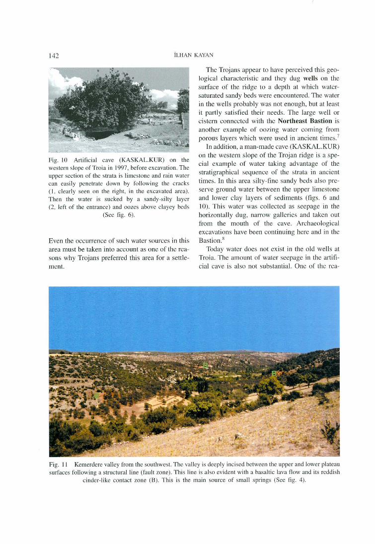
Fig. 11 Kemerdere valley from the south\vest. The va lley is deeply incised between the upper and lower plateau surfaces following a structural line (fault zone). This line is also evident with a basaltic lava flow and its reddish
cinder-like contact zone (B). This is the main source of small springs (See fi g. 4).

THE WATER SUPPLY OF TROİA 141
in the 1950' s to work a water mili (Hanımdeğir
meni) to the east of the Beşik plain. The swamps were subsequently drained to make arable land. More recently, the Pınarbaşı spring waters have been taken by pumps and collected near villages for distribution. The area around the Pınarbaş ı
springs is therefore dry today. The relationship between the springs and the
fault lines suggests that some hot springs ex isted in this area. in fact, there are some well -known hot springs on the other main fault zones of the region. The Kestanbol and Tuzla hot springs to the south of Alexandria Troas are the nearest examples. In the lliad Homer mentions hot and cold springs, although there are no hot springs today in the vicinity of Troia. This may be because of thick alluvial sedimentation along the base of the slopes. it can be assumed that some warm-water may have continually come from rather small springs beneath the alluvium, which is about 10- 15 m thick in some places. This water may be diffuse in the loose alluvium and mixed into the present water-table. It may therefore not be possible to find it on the surface (figs. 5 and 6).
Another kind of ground water in the area of Troia is the water in sandy strata. As stated above, the low plateau ridges derive from muddy sediments stratified on the bottom ofa wide and shallow marine embayment in the Neogene. They consist of various lithological elements like limestone, claystone, siltstone and sandstone. These stratified sediments formed the current low plateau ridges, and the beds of the sedimentary rocks are slightly inclined. The ridges therefore have asymmetrical shapes and their northern slopes, for example on the Troia ridge, are very steep.
Various lithological units or beds can be seen on the steep slopes (figs. 5 and 6). In general, the uppermost section on the Trojan ridge consists of limestone beds. They are not porous but permeable or pervious because of their interconnected joints and cracks through which rain water can readily flow downwards. This water has been sucked by sandy layers beneath the limestone. The sandy unit does not consist of pure sand and is not very porous in this area, but at least the leaking water can be sucked up. In some places, where a bed of clay exists beneath the sandy
Fig. 8 üne of the present-day running fountains ( 1) of Troia on the northern steep slope, north of
Tevfıkiye, and uppermost limestone layers (2).
strata, small springs can emerge along the steep slopes, such as the area north of the Trojan ridge (fıg. 6).
Two running fountains are the present-day examples of these springs on the steep slope facing the Dümrek plain to the north of Tevfıkiye (fig. 8). in addition, some old, dry fountain points can be recognized on the same slope at the west (fig. 9). The water flow is generally low in this type of spring and cannot survive long because the water seeping from the upper limestone unit has much residual material, and causes the porous sandy layers to be fılled and cemented. The springs consequently dry up or change location in the course of time. It is obvious that the Trojans used this kind of water source in ancient times.
Fig. 9 An old fountain on the foot of the steep northern slope of the Trojan ridge (east of the Roman Theatre A of Troia) which dried up in the course of time because limy precipitation from seeping water
filled the pores of sandy-silty strata (See fig. 6).

THE WATER SUPPLY OF TROİA 143
sons is that an adequate supply of water cannot be collected in the small catchment areas. The other is that the lithological characteristics of the porous layers are not sufficient for the preservation of water. Tn addition, there is an earth cover on the surface today. This cover is interesting because it is full of archaeological material like potsherds from top to bottom, as far as the surface of the limestone bedrock layers. This is always clearly seen on the profiles of excavated trenches. This implies that the bedrock surface was exposed; there was not any earth or natural soil formation on the surface in ancient times. Consequently, rain water could easily enter the cracks of the limestone layers on the surface, especially in the area where the surface inclination is gentle, and this water soaked into the porous layers undemeath (fig. 6). Thus, we can conclude that more water could be supplied from the springs on the northern slope, and from the wel Is and manmade galleries at the west. Today, however, the ruins form an impervious cover over the surface, and rain water flows over the ground rather than percolating down into the porous layers. As a result there is, in general, less ground water in the area today.
Similar springs or seepage may have occurred along the Iowermost parts of the steep slopes in ancient times, before these areas were covered by alluvium. Our drilling evidence shows that since the Bronze Age about 8-1 O m of alluvial-colluvial sediment has buried the lower parts of the slopes surrounding Troia (fig. 5). Tt can be assumed that the water may be conti nuing to seep from these springs today but they do not have enough pressure to reach the present surface. They may ctisperse in the allu vial cover and feed only the water-table.
One of the water sources of the Trojan area which was used in ancient times lay in the Kemerdere valley to the southeast of the Karamenderes plain (fig. 1). it is one of the biggest tributaries of the Karamenderes river, which comes from the east to the lower plain . The main valley of Kemerdere extends over the boundary between the geological basement to the south and the younger (Neogene) cover formation to the north (fig. 4). Thus, the southem tributaries of Kemerdere are incised into the southem basement
rocks of the higher plateau, and the northem tributaries into the Neogene sedimentary and volcanic rocks of the lower plateau. All of the valleys of the incised drainage basin of the Kemerdere have steep slopes, and deep, narrow morphology.
There is an interesting feature of the Kemerdere valley related to the ground water. This valley has been dug on a young basaltic lava formation extending aJong the NE-SW joint line between two structural units. The Java formation has a porous structure related to cracks and gas bubbles formed while cooling. ln addition, the lava flow formed a cinder-like layer. This reddish layer, which .is very porous, is especially vi sible between the serpentine formation of the basement and the lava flow on top of it (fig. 11). Carbonaceous-sandy Neogene sediments overlie the basaltic formation from the north . During the uplift of the region, Kemerdere vaJley incised into the weak fault zone and opened the basalt and ci nder-like baked zone along its deep valley. Rain water enters cracks and gas-blown cavities and reaches a very porous cinder-like baked zone. Because of the existence of impervious rocks (generaJly serpentine) below, ground water seeps out from the contact zone. This constitutes lines of small springs on both sides of the Kemerdere valley. Small cuts of tributaries are the main locaJities of springs along the main valley slopes.
Water from the Kemerdere springs was directed down to Troia in Roman times. it was necessari fırst to transfer the water from the southern slope to the north. The water of the southern slope was therefore collected in earth pipes and crossed little creeks in small aqueducts. Ali of the collected southern water was then carried to the northern slope by a magnificent aqueduct, and added to the collected seeping water of the northern slope. It subsequently flowed about 10 km to Troia closely following the topographical gradient (figs. 4 and 12).
Ali these efforts indicate that water obtained from the small slope springs and deep wells in Troia were not enough for the Roman city. It seems that water from the water-table in the plain was sti li not sufficient to supply the city during thi s period. The residents of the area therefore devoted considerable energy to bringing water to the area from di stant sources.

144 İLHAN KAYAN
Fig. 12 Kemerköy aqueduct in the Kemerdere valley which was constructed to channel water collected from the southern slope (right) to the north (See fıg. 4).
In the following period the Kemerdere waterway seems not to have been used, not because the Trojans found another source of water, but as a result of reduced water demand in the city. üne can conclude that the populati on of the city decreased after the !ate Roman period, and thi s is also evident in the ceramic assemblages from Troi a. This reduced demand for water continued until the 1950 ' s, af ter which a new peri od of use began. A great deaJ of ground water from the upper water-table in the plain and from deep ground water aquifers was sucked up by pumps for agricultural irrigation and human use in the modern villages. Today few are interested in the small slope springs, the wells on the surface of the plateau ridge, and the Kemerdere water system'.
Norns
1 Kayan 1999. 2 Rapp 1982. 3 Bilgin 1969. 4 Kayan 1995, l 996. 5 Kraft et al. J 980. 6 Arel 1993. 7 Korfmann 1999. 8 Korfmann 1999, Rose 1999.
BıBLIOGRAPHY
AREL, AYDA. 1993. About the " Hasan Paşa Tower" at Yerkesiği , on the plain of Troia, Studia Troica 3: 183- 189. BİLGİ N , TuRGUT. 1969. Biga Yarımadası Güneybatı Kısmının Jeomorfolojisi. İstanbul Ünivers itesi Coğrafya Enstitüsü Yay ın 1433. İstanbul. KAYAN, İ L HAN . 1995. The Troia bay and supposed harbour sites in the Bronze Age, Sıııdia Troica 5: 211- 235. KAYAN, İLHAN . 1996. Holocene stratigraphy of thc lower Karamenderes-Dümrek plain and archaeological material in the alluvial sediments to the North of the Troia ridgc, Stııdia Troica 6: 239- 249. KAYAN, İLHAN. 1999. Holocene stratigraphy and geomorphological evolution of the Aegean coastal plains of Anatolia. The Late Quaternary in the Eastern Mediterranean Region, Qııaıerııa ry Science Reviews 18: 541 - 548. KORFM ANN, MANFRED. 1999. Troia - Ausgrabungen 1998, Stııdia Troica 9: 1 - 34. KRAFT, JOHN c. - İLHAN KAYAN - Ü GUZ EROL. 1980. Geomorphic reconstructions in the environs of ancient Troy, Science 209: 776- 782. RAPP JR., GEORGE. 1982. Earthquakes in the Troad, in: RAPP JR .. GEORGE - JoHN A. Gı FFORD (Eos.). Troy Supp/eıneııtary Monograph 4. The Archaeological Geology. 43-58. Princeton. RosE, CH. BRIAN. 1999. The 1998 Post-Bronze Age excavations at Troia, Studia Troica 9: 35-7 1.
Prof Dr. İlhan Kayan Ege Üniversitesi - Edebiyat Fakültesi Coğrafya Bölümü TR-35100 Bornova - İzmir Türkiye Email: [email protected]

INHALT - CONTENTS
Teil A: Troia und Troas - Aktuelle Teil B: Weitere Forschungen Ausgrabungen und Urnfeld
1. ThüİA, GRABUNGSBERICHTE 4. PHILOLOGIE UND ALTE GESCHICHTE
Manfred Koifmann: Troia - Ausgrabungen 1999 ...... . .. .
Charles Brian Rose: The 1999 Post-Bronze Age Excavations at Troia
2. ThOİA, ARCHITEKTUR, BEFUNDE
UND FUNDE
Donald F. Easton: Schliemann's "Burnt City"
Billur Tekkök: The City Wall of Ilion: New evidence for Dating ......................... .
Kent J. Rigsby: A Greek Inscription from Troia, 1998
Peter Jablonka: Computergestützte Rekonstruktion und Darstellung der Stratigraphie von Troia
3. TROİA, NATURWISSENSCHAFTLICHE
UNTERSUCHUNGEN
Norbert Blindow, Hans Günter lansen und Kathrin Schröer: Geophysikalische Prospektion 1998/99 in
1
53
73
85
97
99
der Unterstadt von Troia . . . . . . . . . . . . 123
İlhan Kayan: The Water Supply of Troia . . ....... . 135
Peter Högemann: Zum Iliasdichter - Ein anatolischer Standpunkt . . . . . . . . . . . . . . . . . . . . . . . 183
Jörg Weilhartner: Ober- und Unterstadt von Troia im archliologischen Befund und in den homerischen Epen . . . . . . . . . . . . . . . . . 199
Michael Sage: Roman Visitors to Ilium in the Roman Imperial and !ate Antique Period: The Symbolic Functions of a Landscape 211
5. ThOAS UND ANATOLIEN
Utta Gabriel: Mitteilung zum Stand der Neolithikums-forschung in der Umgebung von Troia 233
Donald F. Easton: A Pair of Pendent Earrings of Trojan Type . 239
Hans-Günter B~chholz: Erganzungen zu einer Obsidian-Bibliographie . . . . . . . . . . . . . . . . . . . . . 251
ANHANG
Corrigenda 279
Margarete Uerpmann und Wim Van Neer: Danksagung _ Acknowledgements . . . . . 280 Fischreste aus den Grabungen in Troia (1989-1999) . . . . . . . . . . . . . . . . . . . . . 145 Video . . . . . . . . . . . . . . . . . . . . . . . . . . . 284
IX, 286 Seiten mit 11 Farbabbildungen, 97 SchwarzweiBabbildungen, 8 Strichtafeln, 2 Faltabbildungen, 20 Tabellen
© 2000 by Verlag Philipp von Zabem, Mainz am Rhein ISBN 3-8053-2702-X
ISSN 0942-7635