A Geomorphological reconnaissance of Tromelin Island, Indian Ocean

Sonderdruck aus
STUDIA TROICA Band 7 · 1997
VERLAG PHILIPP VON ZABERN · MAINZ AM RHEIN

GEOMORPHOLOGICAL EVOLUTION OF THE ÇIPLAK VALLEY AND ARCHAEOLOGICAL
MATERIAL IN THE ALLUVIAL SEDIMENTS TO . THE SOUTH OF THE LOWER CITY OF TROIA
İlhan Kayan
ABSTRACT
in the 1996 field season, new percussion drilling equipment was used for tlıe fırst time for paleogeographical investigations on the Troia area. in addition to the previous 33 drillholes, 20 new drillholes were bored on the plain between tlıe Lower City of Troia and Kalafatlı village. Percussion drilling with tlıe gouge-auger exhibited excellent performance and provided valuable <lata. The drilling in 1996 penetrated a maximum deptlı of 27 m witlı a total drillhole length of 235 m. The plain was formed by tlıe Çıplak river in a structural depression between two low ridges consisting mostly of Neogene sandstones. Drilling evidence indicates a preHolocene formation of the depression and an Early Holocene marine transgression, followed by stages of alluvial-colluvial sedimentation. The first archaeological material to be found consisted of sherds, marine shells which were tlıe remains of food, and grains of charcoal in sediments located beyond tlıe maximum extended position ofthe Middle Holocene coastline about 13 m below the present surface. Altlıough the absolute date ofthis material is unknown, by comparison witlı geomorphological evidence and 14C dates from otlıer drillholes, it may be dated to about the 7tlı millennium BP. Alluvial-colluvial sediments above present sea level have contained a small number of sherds and marine shell fragments from food remains. The most distinctive archaeological material was found in an approximately 1 m tlıick layer situated 2-4 m below tlıe present surface. This particular layer lies in front of the foot of the southern slope near the Lower City. it is a sandy alluvial-colluvial mud composed primarily of small grains of sherds and charcoal extending south to an old river channel, where it is interrupted. Anotlıer similar layer or band of sediment less filled witlı sherds stretches along the southem edge of the channel. Both of these layers suggest a destruction, perhaps by fire, of tlıe Lower City. Material washed downslope from the ruins must ha ve formed tlıis sediment layer. Altlıough datable material stili proves elusive, Troia archaeologists are of the opinion that a Hellenistic-Roman date is most probable. This assessment corresponds well with sedimentological and geomorphological evidence.
ZUSAMMENFASSUNG
Wfilırend der Kampagne 1996 konnte das erste Mal eine neue Bohrausrüstung für paliiophysikalische Untersuchungen in der Umgebung von Troia eingesetzt werden. Zu den bereits vorhandenen 33 Bohrlöchem wurden 20 neue Bohrlöcher in der Ebene zwischen der U nterstadt von Troia und dem Dorf Kalafat angelegt. Die Ebene wurde durch den Flufi Çıplak geformt in einer strukturellen Eintiefung zwischen zwei niedrigen Hügeln, die überwiegend aus neogenem Sandstein bestehen. Die Bohrergebnisse deuten auf eine priilıoloziine Entstehung der Eintiefung und eine früh-

490 İLHAN KAYAN
holoziine Meerestransgression hin, die von mehreren alluvial-kolluvialen Sedimentationstufen abgelöst wurde. Das erste vorgefundene archiiologische Material bestand aus Keramikscherben; Meeresmuscheln, die als Nahrung dienten und Holzkohle, die sich hinter der maximalen Ausdehnung der mittelholoziinen Küstenlinie, ca. 13 m unter der heutigen Oberfliiche befanden. Obwohl das absolute Alter dieses Materials unbekannt ist, kann es durch Vergleiche von geomorphologischen Nachweisen und 14C-Daten aus den anderen Bohrlöchem ungeführ in das 7. Jahrtausend BP. datiert werden. Alluvial-kolluviale Sedimente über dem heutigen Meeresspiegel enthielten eine geringe Zahl an Scherben und marinen Nahrungsüberresten. Das charakteristischste archiiologische Material wurde in einer ca. lm miichtigen Schicht gefunden, die 2-4 m unterhalb der rezenten Oberfliiche lag. Diese Schicht befindet sich vor dem Fu13 des Hügels in der Niihe der Unterstadt. Sie besteht aus einem sandigen alluvial-kolluvialem Lehm, der sich überwiegend aus kleinkörnigen Keramikscherben und Holzkohle zusammensetzt und sich bis zu einer Stelle südlich eines alten Flu13kanals ausdehnt, wo er dann unterbrochen wird. Eine iihnliche Schicht bzw. ein Sedimentband mit weniger Keramikmaterial erstreckt sich entlang des Südkante des Kanals. Diese beiden Schichten implizieren eine Zerstörung der Unterstadt, vielleicht durch Feuer. Material, das von der Ruine herabgeschwemmt wurde, bildet diese Schichten. Obwohl bisher noch kein datierbares Material gefunden wurde, vertreten die Archaologen von Troia die Ansicht, da13 ein hellenistisches/römisches Datum am wahrscheinlichsten sei. Diese Annahme würde mit den sedimentologischen und geomorphologischen Ergebnissen übereinstimmen.
Introduction
Our investigations of the natural environment of Troia ha ve continued since 1988 in conjunction with the new Troia project led by Prof. Dr. Manfred Korfmann. 1 As explained in previous volumes of Studia Troica , the airn of our research is to interpret geomorphological shifts, as well as changes in the environrnent or general physical geography of the region, and to elucidate the connections between these environmental changes, the cultural periods of Troia, and the characteristics of land use since the first settlement periods. 2
Landforrns in the vicinity of Troia consist of low plateau ridges about 40-80 m high separated by wide valley depressions (Fig. 1). The ridges are formed from slightly consolidated sandy-clayeylimy sediments . A low undulating topography has been formed by erosioo on the surface of the ridges. Erosiooal material transported by rivers as alluvium and by slope-wash sheet-floods as colluvium has filled the depressions and floors of the valleys.3
Sedirnent uoits in the lower part ofa valley acquire characteristics from surrouııding environmental
conditions. Clirnate and sea-Jevel, for example, especially control alluvial formation. Consequently, in order to clarify both paleogeographical and environrnental changes, the most practical and effective approach is to examine old sediment uoits and to interpret their sedimentary environrnents. Drilling offers the only successful technique for collecting <lata about subsurface sedimentary units in an alluvial-colluvial area because sedimeots in such conditions are generally not highly consolidated and are easy to penetrate for takiııg samples by hand or by means of light powered drilling equipment. In 1977, our drilling studies in the Troia area started with 7 rotary-corings completed by the M.T.A. Institute (Geological Survey of Turkey). The thickness of the Holocene sediments (younger alluvium) was found to be less than 30 m in many places on the plain to the west of Troia, and much less to the north and south. The old bed of the Karameııderes river (Scamander) , however, was discovered about 75 m below the preseııt surface in a steep cut of the river in the lower section of the plain.4
Drilling studies have conti nued since 1983 with the

GEOMORPHICAL EVOLUTION OF THE ÇIPLAK VALLEY 491
CANAKKALE STRAIT lO~rd~nelles)
o
Fig. l Geomorphological outlines ofthe Lower Karamenderes plain showing the position of the Troia-Kalafatlı ridge.
Beşik-Tepe and Troia Archaeological Expeditions led by Prof. Dr. Manfred Korfrnann. Research conducted in the Beşik plain generated evidence for sea-level cbanges as well as data outlining the geomorphological development of this small coastal plain.5 Since 1988, our exploration has concentrated on the alluvial plain surrounding Troia. A variety of techniques and equipment have been employed to suit not only our various objectives but also the material to be penetrated. Unimog rotary-auger drillholes reached a depth of 20.5 m, Eijkelkamp hand-auger drillholes 8-10 m, and Unimog trenches 2.5 m. By 1996, the number of drilling points in the landscape around Troia reached a total of 210 in number. Sediment samples were physically examined and analysed specifically for grain-size in our laboratory in the Department of Geography at Ege U niversity. Organic
material, especially marine shells, was dated by Dr. B. Kromer at the Institut für Umweltphysik der U niversitiit Heidelberg. Consequently, quite detailed information was obtained regarding alluvial sedimentation and stratigraphy from the area encircling Troia. 6
Although the Unimog supplied valuable data by means of its great hydraulic power, samples could not be taken as undisturbed cores, because of the mixing effect of rotary-auger drilling. ln addition , due to the great size of the auger-rods , sediments climbed upward under high pressure during operation, obscuring the true depth of selected samples. These conditions presented a great obstacle to making precise correlations, substantiating our preference for percussion drilling equipment during recent studies. Our proposal to acquire percussion drilling equipment was endorsed by Prof. Dr.

r:::;i Low plateau ridges ı..- on the stratified
Neogene sediments
D Alluvial-colluvial plains (c: colluvium)
l:':.:. '.:~.:J Sand cover
~Scarps
~ Rivers
,. Watershed ·"' of the Çıplak river
~oo' Contour lines :::,..,o_,. (50 m and 100 m only)
-- Main roads
N t O 1km
Fig. 2 Hydro-morphological map ofthe Çıplak valley and the lower flood plain between the Troia and Kalafatlı ridges.
+:.
iS
~-> z
~ z

,,,.- Contour lfnes _,ı(l / lntervals: 1 m below 15 m __,,ı 5 m above 15 m
-- Main roads
- - - - Field roads
"
N
t
Drllfholes: Unimog rotary auger drilling Unimog trench Percussion drilling
o 100 200 m lııııww m 1
-..'-' .._-ı.
·~' ~,. ,.-ı.
.,~
\ ' , ', / " / ' I \/ '•\ ,fo \
~~ \. '2 , \•
*--ı.''l> / ' ,' ' ~ '
1 1 1 1 1 1 1 1
' 1
' ' 1 1 1
' ' ' 1 1 1
1 I
\,_/ __ /
I I 1
1
\ TROIA )~1
() ~)
--;-- - / ...... ,,'
'...... ,,""' ___ i_.-"
Çıplak rivtr ___ .. ____ ---..... ..... .... _
Fig. 3 Topography ofthe flood plain in the lower Çıplak valley between the Lower City ofTroia and present-day Kalafatlı village, and the drillhole locations. (Based on 115000 scale of maps and data obtained by topographical measurements of the Troia Excavation).
cı t?1 o 3:: o !;1::1 "O ::ı:: (S > r t?1 <: o t"" c:::: >-l o z o "Tj
~ t?1 o()
=:o t"" > "' ~ t""
~ -<
""" l.D w

494 İLHAN KAYAN
Fig. 4 Panorarnic view to the North from ıninaret of the Kalafatlı mosque. Lower City of Troia was situated on the westem tip ofa low plateau visible in the distance, center. Present plain is formed by floods ofthe Çıplak river, which today has only a small channel. (A !ine between fields from white car to the right). üne can imagine, however, that the area of the plain was a bay extending close to the small tree on the river course to the right. Drilling work for number 113 continues in front of the car. Gelibolu penin sula and the Çanakkale Strait on the far left. Yenilcumkale
(or only Kumkale) village visible in the background.
Manfred Korfmann. A set of this equipment was generously provided for our studies by the Troia Project. By 1996, 33 drillholes and trencbes had been made on the tlood-plain of the Çıplak river and along its slightly inclined northern extension near the foot of the Lower City of Troia (Figs. 2 and 3). Some of the drillholes were bored in the lower part of tbe plain using an Unimog rotary-auger which penetrated down to a depth of 20.5 m . Trenches dug by the Unimog reached a depth of about 2.5 m, and drillholes were made with band equipment down to bedrock along the foot of tbe slope. in 1996, 20 additional drillholes were made in the same area using the new percussion equipment. The total length attained by these new drillholes was 235 m,
with the deepest being 27 m. Thus, quite detailed information was collected on subsurface sedimentary units in a relatively small area. Those results considered to be of greatest geomorphological and archaeological importance constitute the central theme of this paper.
Geomorphology of the Çıplak Valley
in the Troia area, low plateau ridges have formed on sandy-clayey-limy shallow marine sediments which were originally deposited and stratified on the bottom ofa shallow marine embayment extend-
GEOMORPHICAL EVOLUTION OF THE ÇIPLAK VALLEY 495
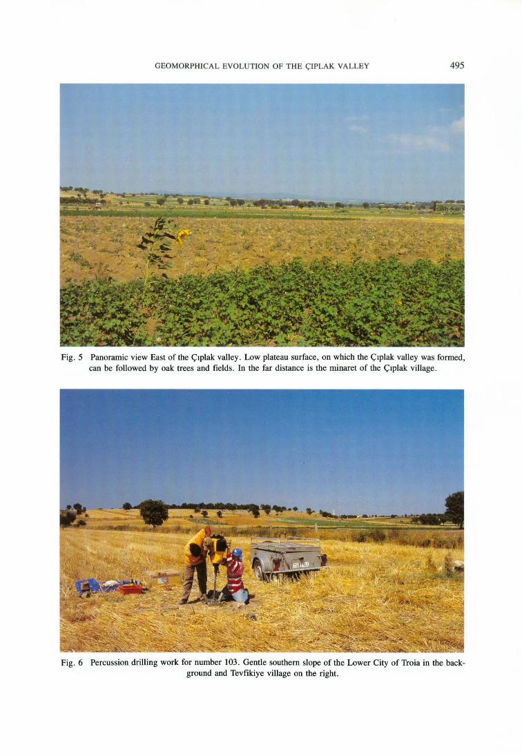
Fig. 5 Panoramic view East of the Çıplak valley. Low plateau surface, on which the Çıplak valley was formed, can be followed by oak trees and fieJds. in the far distance is the minaret of the Çıplak village.
Eig. 6 Percussion drilling work for number 103. Gentle southern slope of the Lower City of Troia in the background and Tevfikiye village on the right.
496 İLHAN KAYAN
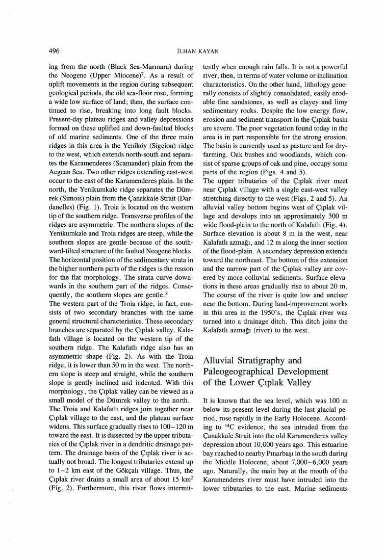
ing from the north (Black Sea-Marmara) during the Neogene (Upper Miocene)7 . As a result of uplift movements in the region during subsequent geological periods, the old sea-floor rose, forming a wide low surface of land ; then, the surface continued to rise, breaking into long fault blocks . Present-day plateau ridges and valley depressions formed on these uplifted and down-faulted blocks of old marine sediments. üne of the three main ridges in this area is the Yeni.köy (Sigeion) ridge to the west, which extends north-south and separates the Karamenderes (Scamander) plain from the Aegean Sea. Two other ridges extending east-west occur to the east of the Karamenderes plain. in the north, the Yenikumkale ridge separates the Dümrek (Simois) plain from the Çanakkale Strait (Dardanelles) (Fig. 1). Troia is located on the westem tip of the southem ridge. Transverse profil es of the ridges are asymmetric. The northern slopes of the Yenikumkale and Troia ridges are steep, while the southern slopes are gentle because of the southward-tilted structure ofthe faulted Neogene blocks. The horizontal position of the sedimentary strata in the higher northern parts of the ridges is the reason for the flat morphology. The strata curve downwards in the southem part of the ridges. Consequently , the southem slopes are gentle. 8
The westem part of the Troia ridge, in fact, consists of two secondary branches with the same general structural characteristics. These secondary branches are separated by the Çıplak valley. Kalafatlı village is located on the western tip of the · southern ridge. The Kalafatlı ridge alsa has an asymmetric shape (Fig. 2). As with the Troia ridge, it is lower than 50 m in the west. The northem slope is steep and straight, while the southem slope is gently inclined and indented. With this morphology , the Çıplak valley can be viewed as a small model of the Dümrek valley to the north. The Troia and Kalafatlı ridges join together near Çıplak village to the east, and the plateau surface widens. This surface gradually rises to 100-120 m toward the east. it is dissected by the upper tributaries of the Çıplak river in a dendritic drainage pattem. The drainage basin of the Çıplak river is actually not broad. The longest tributaries extend up to 1-2 km east of the Gökçalı village. Thus , the Çıplak river drains a small area of about 15 km2
(Fig. 2). Furthermore, this river flows intermit-
tently when enough rain falls. it is nota powerful river, then, in terms of water volume or inclination characteristics. On the other hand, lithology generally consists of slightly consolidated, easily erodable fıne sandstones, as well as clayey and limy sedimentary rocks. Despite the low energy flow, erosion and sediment transport in the Çıplak basin are severe. The poor vegetation found today in the area is in part responsible for the strong erosion. The basin is currently used as pasture and for dryfarming. Oak bushes and woodlands , which consist of sparse groups of oak and pine, occupy some parts of the region (Figs. 4 and 5). The upper tributaries of the Çıplak river meet near Çıplak village with a single east-west valley stretching directly to the west (Figs. 2 and 5). An alluvial valley bottom begins west of Çıplak village and develops into an approximately 300 m wide flood-plain to the north of Kalafatlı (Fig. 4). Surface elevation is about 8 m in the west, near Kalafatlı azmağı, and 12 m along the inner section of the flood-plain . A secondary depression extends toward the northeast. The bottom of this extension and the narrow part of the Çıplak valley are covered by more colluvial sediments. Surface elevations in these areas gradually rise to about 20 m. The course of the river is quite low and unclear near the bottom. During land-improvement works in this area in the 1950's, the Çıplak river was tumed into a drainage ditch . This ditch joins the Kalafatlı azmağı (river) to the west.
Alluvial Stratigraphy and Paleogeographical Development of the Lower Çıplak Valley
it is known that the sea level, which was 100 m below its present level during the last glacial period, rose rapidly in the Early Holocene. According to 14C evidence, the sea intruded from the Çanakkale Strait into the old Karamenderes valley depression about 10,000 years ago. This estuarine bay reached to nearby Pınarbaşı in the south during the Middle Holocene, about 7,000- 6,000 years ago. Naturally, the main bay at the mouth of the Karamenderes river must have intruded into the lower tributaries to the east. Marine sediments

GEOMORPHICAL EVOLUTION OF THE ÇIPLAK VALLEY 497
of a secondary estuarine bay extending into the Dümrek valley, in fact, have been discovered by drillhole studies.9 it is also known from our old drillholes that marine intrusion spread into the lower half of the Çıplak river to the south of Troia. The data, however, were insuffıcient to delineate the extent of this old marine intrusion. it has now been possible to elucidate the stratigraphical and paleogeographical characteristics of this area with additional information obtained from 20 new drillholes which were made in the 1996 fıeld season (Figs. 3 and 6). The main stages, separated according to changing environmental characteristics, are explained below in chronological order.
Pre-Holocene Formation
Drillholes in the lower part of the Çıplak valley also supplied good information about pre-Holocene geomorphological development. These recent investigations resulted in the identification of an intermediate terrestrial sediment unit between the Neogene bedrock and the Holocene sediments (Figs. 7, 8 and 9). This deposition essentially consists of sandy-clayey-limy material originating from disaggregated Neogene bedrock which was apparently transported a short distance and then tightly consolidated. This deposition layer can be distinguished from the N eogene base and the Holocene sediments by its reddish-yellow, mottled color and non-homogenous structure. Clean, coarse sandy bands from place to place indicate flood effects during deposition. Rather than being the alluvial fill ofa river, however, this sediment unit has the characteristics of colluvial material washed from the slopes by sheet-floods. This unit occurs only below younger sediments on the slightly inclined northem slope of the valley. On the steep southern slope, the Holocene sediments are found directly above the Neogene base. This information indicates that the lower part of the Çıplak valley underwent several deposition (filling) and erosion (emptying) processes before the Holocene (Pleistocene ?) . The asymmetrical shape of the valley can be followed below the present alluvial fili. The steep southern slope is probably faulted. The first river, then, which shaped the
depression into a valley, must have flowed along the southern slope in a patlı corresponding to its asymmetrical shape. The depth of this former river course is about 20 m in the rniddle part of the plain. in the successor phase, the valley depression filled with reddish-yellowish, mottled colluvium. This deposit does not show any sedimentary structure to indicate regular water flow. This implies an arid or serni-arid climate during deposition which may be a dry interglacial stage of the Pleistocene. Although there is no chronological evidence, the Riss/Wurm interglacial stage is quite consistent with this formation. in the lower part of the Karamenderes delta plain, an older marine sediment unit actually exists below the Holocene sediments. 14C results date the age of this unit between 20,000-40,000 BP. 10 If the terrestrial sediment unit in the Çıplak valley is compared with the older Karamenderes marine sediment unit, a Riss/Wurm oran early Wurmian date can be accepted as plausible. During the pre-Holocene, old colluvial fıll in the valley underwent an erosional forınation in two stages. A trough-like deeper section with steep slopes continues to a depth of 10 m. Since Holocene marine sediments have fılled this part, the erosional trough must have been cut by water flow during the Wurrnian period of low sea level. The upper part is wider and starts with a clear shoulder almost at present sea level, below the present surface of the plain. This upper part has been filled by younger (Middle-Late Holocene) fluvial-colluvial sediments. Sediment layers corresponding to cultural stages of Troia have been discovered in this same upper layer (Fig. 7).
Early Holocene Marine Transgressıon
A small bay formation in the lower part of the Çıplak valley in the early Holocene advanced parallel to the general post-glacial transgression in the region. There is a shallow marine sediment unit here below present sea level under the alluvialcolluvial upper section (Figs. 7 and 8). The base of this unit consists of coarse sandy-gravelly lag deposits. The main part is composed of a fıne sandy, blackish, sticky mud with a high content of

WEST AA CROSS-SECTION +-- KARAMENDERES PLAIN
.ın.
15
10
5
Oıtı trom dri tlhol u no . 26, 27 '11ınd 111 whıch u • not on th• prof ıl • lın •
Kalahtlı azmaDı (river)
--
117
.j,
r
-~~~--~
7200 B.P.
Flood plain of the Cıplak rlvtr
120 42 .j.
AJ
106 25 .j,
- ;=-----
,...
:::;;r~
F ine sandy shallow marine sediments
109
.j.
_.....
21
.j.
---- -----Alluvial - colluvia l f İ ll
of tht lowcr Çıp lak vallty ,...
A2 ,... ----
-- --
-
.- ......
22 .j,
--
EAST CIPLAK VALLEV --+
--
112
-- .t--/
/
////
// / / / / /
,.,",/ // /
---- ---- // // _..,,,,,...,... / /
..... // / _,,. / A / ,/ / / /'./.
// / /
------- ,..,,,. / __ ..... .- ,...,,,. / //
,........ /
.,...,,....... " ,.,., ......
---..... ,...,,,.
.,..... ..... ---: r. ,......- At~·"
.ın.
15
10
5
o - 1
-5 .J... 10Ş.../"f' t\.0) .. ,.- ~ .....-.M lııl -5
120
-10
-ıs
21 ~,, ...... ,,..
•"' ... .cc fC•·'
@o9 ... \.Ct .L 21
End ol drillholes and numbers
Coasttine position during the maximum extension ol the Holocene marina intrusion about 7000 B.P.
Archaeological lindings (Sherds, ete.)
r. Marine shells in terrestrial sediments (Probabty remains ol lood)
,-.:;ı Stones in !ine sediments <V (Probably related to human usage)
At , A2, A3, A4 : Archaeological f indings respectively foUow a re latıve chronological O<der
7200 B.P. and 5200 B.P. are C14 dates obtained !rom the drillhole number 26.
/ / Aelative time-sedimentation surfaces ....- which appear by change ot sedimentation
m O 100 500 1000 m
El
-2 S ı:: ... · Fig. 7 West-East cross-section along the flood-plain in the lower Çıplak valley (A-A' tine on Figure 12).
The lower flat cross-section is the same as the main cross-section above, but here, the horizontal and vertical scales are equal (1/2500). This is added to explain real distance-thickness proportion of marine sedimentary units in the area (Marine unit is fılled grey). Since various sedimentary units cannot be shown on this vertical
scale. exaıı:ıı:eration is necessarv. Vertical exaırneration is 25 times on the above cross-section.
-10
-15

5
NORTH - LOWER CITV OF TROİA
69
.J.
Field road
:s2 1
: ı 70
ı
88' CROSS-SECTION SOUTH
Flood p l ain of tfıe Cıpl a k river
ıo2
.j.
ıoJ
.j.
ıo4 101 l ı~7 ı ıos
.j, 25 .j,
KALAFATLI VIL LAGE -+
Present canal of the Çıplak Rive;
ıos
-l-
- - - - - - - - - - ___ __ ~'!! ~a~! ho~~ı:_nı:u~ _ ~l~~h~d- ~u~ ~c.! ~~ ___ _ _ _ _ _ _ __ _ _ _ _
F lood sediments
AJ ,.
A2 Fl ood sed iments
Fine sandr mud ( Swampr environment)
o~----·.-··--·-·--·--··-- - ··· f. R.s.Ş~~ T ___ ş_ı; ~ _g _'!'_i; k ... __ -·-··- --·····-·-·· .ı 103
Coarse sandv bHch~
-ı
-5
-ıo ' '
- ı5 LI
o
106 Drillholes and numbers ~
..L 106 End of drillholes and numbers
r Archaeological findings (Sherds, ete.)
,.., Marina shells in terrestrial sediments (Probably remains of food)
@ Stones
A 1, A2, A3, A4 : Archaeological findings respectively follow a relative chronological order
so ıoo
"' ."\
°"' ''~ ~;,
~~
Coarse sandy de l taic lob
F ine sandy shall ow marine sediments
'it~ ~
Fig. 8 North-South cross-section acı:oss the westem part of the flood plain in the lower Çıplak vali ey (B-B' line on Figure 12).
SOO m
.!!l
ıs
ıo
5
o - ı
-5
-10
-ıs

NE C C' CROSS-SECTION ~ TEVFİKİYE
61 ı
m - ---.__ 20 - .......
-........ Eastern p;;ırt of the Lower Çıplak Vatıey
15
10
5
"-............ ,.. '-...
"' r ı_ "-. A4
~61 "'
"-
"'
60
.J.
" r "'~ "' '-.
58
.J. 50
.J.
r -..... l'"\r ........_-.......... ,. ""-.....__ A4
r -- w -- ---- r ---A3 "r
O • · ... . J'.'3.~~~ !'.! ___ Ş_E_~J~Xf:J ... .. - ..... ---· . . _____ ---- --------
_,
-s U
-10
o
21 Drillholes and numbers ı
...L 21 End ol drillholes and numbers
,... Archaeological lindings (Sherds , ete.)
" Marina shells in terrestrial sediments (Probably remains ol lood)
@ Stones
A1, A2, A3, A4 : Archaeoıogical lindings respectively lollow a relative chronological order
50 100
110 .J. 21
.J. 109
ı
Altuvi;;ıt -col l uvi;;ıl sediments
Al
Coarse sandy ;;ılluvium
muine embayment )_ı_
109
300 m
sw KALAFATLI ~
113
.J.
Fig. 9 NE-SW cross-section across the eastern part of the flood plain in the lower Çıplak valley (C-C ' line on Figure 12).
m
20
15
10
5
o -ı
-5
-ıo
Uı o o
~· > z ~
~ z

GEOMORPHICAL EVOLUTION OF THE ÇIPLAK VALLEY 501
organic colloids. A coarser sandy deltaic lobe can be distinguished in the middle part. Depending on the bottom topography, the thickness of the marine unit is about 15 m in the west (east of Kalafatlı azmağı). The inner (eastem) edge of this old bay lies between drilling points number 109 and 21 (Figs. 4 and 7). During the period when the sea reached its maximum extension into the Çıplak valley, coarse sandy river sediments were deposited behind (east of) the coast. Although no 14C date is yet available from this area, two 14C dates obtained from drillholes to the near west of the Troia ridge are comparable and indicate that the sea reached its maximum extension into the Çıplak valley around 7000 BP. The sea level did not reach its present-day position at that time but continued to rise. Despite the slowly rising sea, the coastline filled with the alluvium of the Çıplak river and retreated toward the west.
Middle Holocene Marine Regression and Alluvial Progradation
Drilling evidence indicates that a coastal barrierlagoon form of geomorphological development dominated during the regression stage in the Middle Holocene. A careful examination of the sea !eve! revealed that marine sediments did not occur higher than the present sea level, and the highest position of marine sandy sediments, probably coastal sand deposits , was located almost at present sea level (Figs. 7 and 8). This confums that the sea level during the Holocene was never higher than its present position. No new evidence, however, was found here concerning the Bronze Age marine regression discussed in previous publications. 11
This is to be expected, because this area is a quiet secondary embayment of the main Karamenderes estuarine bay. Nevertheless, the surface of the fıne sandy marine sedirnents inclines westward in the west and is covered by coarser sandy deltaiccoastal sedirnents. This feature can perhaps be interpreted as the result ofa small decline in sea-level during the Bronze Age which, in tum, speeded the alluviation process and advanced the presence of coarser coastal sedimentation on the bottom of the main Karamenderes embayment.
The accumulation of even fıner alluvial muddy sediments deposited during the rise in sea-level stopped, and the coastline started to retreat (Fig. 7 and 10). The fıne sediments possess some characteristics associated with swamp or wetland environments. In many places, they contain limy concretions and are quite hard due to the high carbonate content. Thus, some paleo-climatical interpretations are possible. Summers, then, must have been hot and dry at that time and a high rate of evaporation caused a carbooate conceotration by capillary processes. This coincides well with the climatic conditions ofa period when the temperature reached its maximum point since the last glacial time, within the Climatic Optimum of about 6000-5000 BP. The fıne grained muddy section of sediment fili in the lawer Çıplak valley constitutes a transition zone between marine or related wetland sediments beyond the coast, and completely terrestrial (alluvial-colluvial) upper sediment units. Although no archaeological material was found in this unit, some marine shells which had been transported into terrestrial mud suggest that human occupation sites existed in the surrounding area at that time and that shell-fısh were consumed there. Sherds, marine shells from food remains, and a large stone were found in drillhole number 22 just on the pre-Holocene terrestrial fiil of the valley at a depth of 13 m below the present surface, which coincides _with the present sea level (Fig. 7). This material, however, could not be evaluated archaeologically because of the disadvantages of the rotary-auger drilling. Its vertical and horizontal position conform to a marine retreating stage. Thus, one can imagine a shallow, quiet marine embayment to the west, which made obtaining marine food convenient, a small lagoonal or swampy back-shore environment to the east, and human occupation sites on the alluvial cover of the Çıplak river near the slopes of the vali ey. The various pieces of data generated thusfar correspond to one another to form a single coherent paleographical picture. This probably represents the earliest settlement phase in the area, dating to around 7000-6000 BP. (although no absolute date is available).
502 İLHAN KAYAN
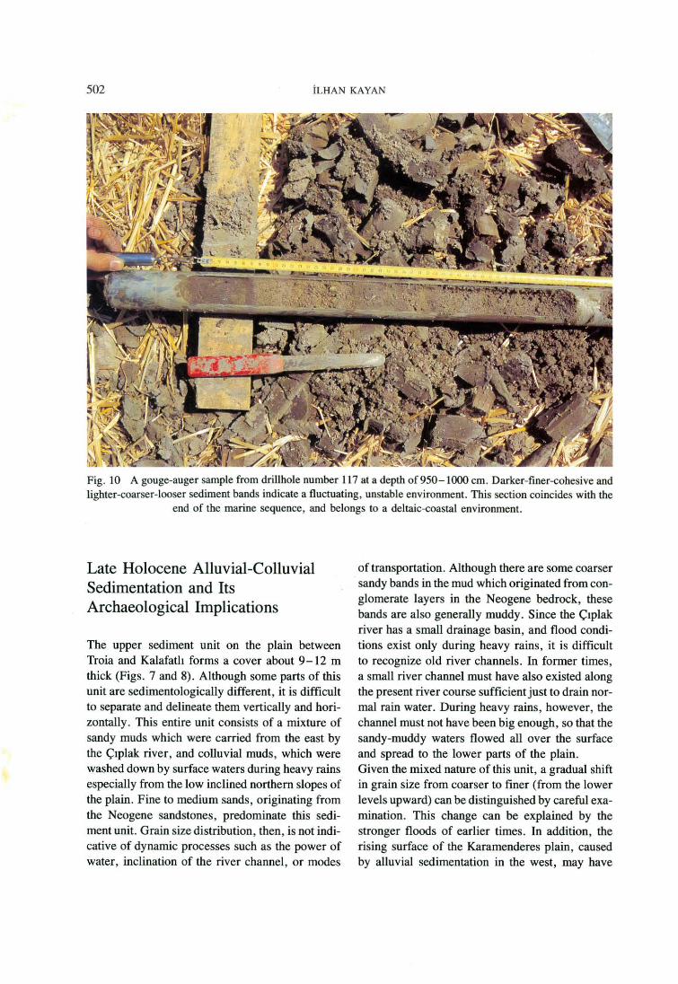
Fig. 10 A gouge-auger sarnple from drillhole number 117 ata depth of 950-1000 cm. Darker-finer-cohesive and lighter-coarser-looser sediment bands indicate a fluctuating, unstable environment. This section coincides with the
end of the marine sequence, and belongs to a deltaic-coastal environment.
Late Holocene Alluvial-Colluvial Sedimentation and Its Archaeological Implications
The upper sediment unit on the plain between Troia and Kalafatlı forms a cover about 9-12 m thick (Figs. 7 and 8). Although some parts of this unit are sedimentologically different, it is difficult to separate and delineate them vertically and horizontally. This entire unit consists of a mixture of sandy muds which were carried from the east by the Çıplak river, and colluvial muds, which were washed down by surface waters during heavy rains especially from the low inclined northem slopes of the plain. Fine to medium sands, originating from the Neogene sandstones, predominate this sediment unit. Grain size distribution, then, is not indicative of dynarnic processes such as the power of water, inclination of the river channel, or modes
of transportation. Although there are some coarser sandy bands in the mud which originated from conglomerate layers in the Neogene bedrock, these bands are also generally muddy. Since the Çıplak river has a small drainage basin, and flood conditions exist only during heavy rains, it is difficult to recognize old river channels. In former times, a small river channel must have also existed along the present river course sufficientjust to drain normal rain water. During heavy rains, however, the channel must not have been big enough, so that the sandy-muddy waters flowed all over the surface and spread to the lower parts of the plain. Given the mixed nature of this unit, a gradual shift in grain size from coarser to finer (from the lower levels upward) can be distinguished by careful examination. This change can be explained by the stronger floods of earlier times. In addition, the rising surface of the Karamenderes plain, caused by alluvial sedimentation in the west, may have

GEOMORPHICAL EVOLUTION OF THE ÇIPLAK VALLEY 503
Fig. 11 A gouge-auger sample from drillhole number 101. it is tak.en from 300-350 cm below present surface by percussion drilling. A sample is tak.en from a colluvial sediment unit which contains a high density of small grains of sherds, charcoal, and marine shelJs (remains of food). This unit covers a fairly wide area to the south
of the Lower City .
affected the flow-power necessary for sediment transportation in the lower Çıplak valley. Marine shell fragments , which must be food-remains carried from habitation sites in the surrounding area, are sparsely distributed in the coarser sandy lower part. Grain size is generali y finer in the uppermost 3-4 m layer. Although sherds can be found scattered throughout this section, an especially distinctive archaeological layer along the foot of the southem slope of the Lower City of Troia is distinguishable (Figs. 8 and 11). it is about 1 m thick and occurs between 2 and 4 m below the surface. lts dark brown-gray mottled color is darker than the lower and higher sediment units and contains a sizable number of sherd grains generally smaller than 1 cm. The rounded-angular shape of the grains indicate transportation by surface waters. Thls layer must have been deposited in connection with a specific event which occurred at a habitation site
on the upper part of the slope in the Lower City. This event could have been a massive conflagration or demolition. A great number of charcoal grains, only a few millimeters in size, suggest destruction by fire. The dark color of the layer is attributable to this mixture of various grains. Because of the small, eroded nature of the sherd grains, a date has not yet been established. Several larger, sparsely distributed sherds have been dated to the Hellenistic-Roman periods by archaeologists at Troia. This particular layer is encountered first in drillhole number 101 , between 3-4 m be~ow the surface (Figs. 3 and 11). The same layer, however, was found 2-3 m deep in other driJJholes to the north of drillhole 1O1. The distance between driJJholes was reduced about 10 m in order to pinpoint the exact position ofthe layer. Asa result, an interruption and a sharp change in level were revealed for this layer between drillholes 101 and 107.

504 İLHAN KAYAN
A loose, coarse, sandy-gravelly sediment section just below the layer containing sherd grains was described as channel-fıll from an old river here. Consequently, muddy floods coming from the Lower City, including a large number of sherd grains, spread over the foot of the northem slope to the river, where they were then transported to the west along the channeJ. The level of the mud layer to the south of the old channel is therefore about 1 m lower than the northem one (Fig. 8). All of these sediment layers , which are distinguishable by their finer texture, contain a high density of sherd grains resting directly on top ofa coarse, sandy alluvial sediment unit. Thus, it can be assumed that this area initially suffered frequent and severe floods which only gradually weakened during the Hellenistic-Roman periods of denser habitation. in addition to the drillholes on the plain, four more drillholes were bored at the bases of the westem edges of the Troia and Kalafatlı ridges to determine the connection between the lower Çıplak plain and the Karamenderes plain to the west (Fig. 3). These investigations revealed that the bedrock topography in both locations consists of narrow platforms about 3-4 m below the surface which then steeply descend. Sirnilar platforms were found all along the feet of the slopes in this area. They are primarily associated with horizontal or low inclined layers of the Neogene bedrock and their geomorphological formation. A sirnilar platform, found north of the Troia ridge, was covered by shallow marine and coastal sediments during the maximum extension of the sea in the Middle Holocene. 12
Near an adjacent slope, its terrestrial cover contains slope-washed habitation material such as sherds and burned debris. A sirnilar bedrock platform has been discovered several meters below the present surface along the southern foot of the slope of the Lower City. Various investigations undertaken in this area include drillhole and trench analyses , and geophysical prospection to exarnine bedrock topography, sediment cover, and land-use pattem. 13 The rather wide surface of the platform here was exposed in previous habitation periods. Colluvial sediments containing habitation material such as stone blocks, broken tiles, sherds, bones, ete., directly cover the surface. The density of this material in
the colluvial sediments decreases toward the rniddle-lower part of the plain to the south. in 1995, based on geophysical interpretations, some artificial cuts in the bedrock were found stretching longitudinally along the foot ofthe slope in an east-west direction. Dr. P. Jablonka proposed that the ditch was fırst dug in the Bronze Age, Troia VI. 14 During the Hellenistic period, the ditch was both widened and deepened. The fill of the deeper ditch contains mud deposited in calm water. it has no flow structure. Nevertheless, an undisturbed seasonal mud-crack structure is apparent. This ditch, then, cannot have been dug as a water canal. in the wider upper part of the ditch, some bands of mud containing a high density of small sherd grains, sirnilar to those found near the lower plain, have been detected. The discovery of such sherd grains in both locations may indicate a connection between the two areas. Since the surface at the foot of the slope to the south of the Lower City is under cultivation today, all coarse material has long since been ploughed and cleaned from this area. Thus, the soil on the surface exhibits a finer texture and a more homogenous structure. Surfaces on both sides of the Kalafatlı azmağı to the west of the Kalafatlı ridge are covered by windblown loose sand (Figs. 2 and 12). This condition results from sandy river sediments in the lower Karamenderes plain being brought by the northerly winds which dorninate this region. Evidence obtained from the new drillholes 115 and 116 show that the sand cover is about 1. 5 - 2 m thick on the surface and covers finer sandy-silty flood plain sediments. Bedrock was reached at a depth of 360 cm in the deeper drillhole, number 116. A layer of muddy colluvium over the bedrock is about 1 m thick. Large stones and sherds in this section must be associated with a habitation site just behind the low inclined slope surface. The fındings from the drillhole, however, were insufficient to date and archaeologically interpret this site.

-D
30-50 m low plateau ridges on the sırati fied Neogene bedrock Colluvial foot of slope (Mora slope-wash deposit)
D Alluvial plain (More sandy river deposit)
CJ Sand cover (Wind-blown)
7JTTI' Scarps
j \ Gentle slopes
o
27
Coastline during the maximum extension of the Holocene marine intrusion about 7000-6000 B. P.
Cross-section llnes : A - A' Figure 4 B - B' Figure 5 C - C' Figure 6
Drillholes : (Plotted drillholes are only on the cross-section lines) Unimog rotary auger drilling Unimog trench Percussion drilling
":".;.':
··.= ... ··"::·.:.
\ ',
:·.:.
·::.~~:
'~ ', '·:''"·:;~~:::·.:::·.: ... • ·.:\ıoı \
117•\ ·• • . 04
A 10 ~ 1~;:: .. ,.,.,:, .. ;,,._,,,,,,:.
106 ·;,. 110°
ıs. • 1~9 /)
·------<f... ___ .,., ,, ,, ,,,
22
,,--
Çı plıl< r iv~r ____________ .... - ...
/,, ' ,,--""' 112 ..... _
.; .
Fig. 12 Main geological and geomorphological units of the lower Çıplak valley between the Lower City of Troia and present-day K.alafatlı village, and coastline during the maximurn extension of the Holocene marine intrusion about 7000- 6000 BP.
o m o :::: o
~ -()
> r m < o ~ --ı
ö z o 'Tl ...., ::ı: m <"l ; r
~ ~ r ~ ....::
Uı
~

506 İLHAN KAYAN
Conclusions From an Archaeological Point of View
Some archaeological material was found in the alluvial-colluvial sediments which fill the depression between the Troia and Kalafatlı ridges forming the lower part of the Çıplak valley. Essentially, this material is composed of sherds, marine shells from food remains , and grains of charcoal which have been transported by surface waters rnixed in mud. The number of fınds is inadequate for either archaeological interpretation or dating. The fınds suggest, however, the existence of several occupation sites once located on slopes throughout the plain and the relationship between their locations and the natural environment. According to their stratigraphical positions in the sediments, the archaeological finds can be classified into four groups : Al. The oldest material consists ofa large stone surrounded by a fine grained mud, sherds, and burned grains of soil, which were found 13 m below the present surface in drillhole number 22 (Figs. 3 and 7). Their location dates the maximum extended marine environment in the Middle Holocene, which immediately follows the coastal environment, to around the 7th millennium B. C. A2. The second group of finds basically consists of grains of sherds and marine shell food remains in alluvial-colluvial muddy sediments, which were transported by surface waters. Although generally common in all alluvial-colluvial fili on the plain above the marine sediments, such material is rare in some places, especially in those areas far from the slopes. These finds also indicate that the slopes around the plain were occupied almost continuously by man after the plain became land in the Middle Holocene regression, following alluvial progradation. This finding was neither archaeologically identifiable nor datable. A3. The third group of finds clearly belongs to the Late Holocene. in the middle-lower part of the plain, these materials parallel those from the second group. They exhibit, however, archaeological stratification, though not very clearly, toward the northern foot ofthe slope. A layer of dark colored sandy mud is especially noticeable here, (Figs. 7 and 11) with a great number of small sherd and
charcoal grains. They must be related to a fire or destruction in the Lower City. This layer is 1 m thick and is situated between 2 and 4 m below the present surface. it is interrupted at the edge by an old river channel to the south. A4. Along the foot ofthe slope to the north, colluvial sedirnent covering the bedrock platform is full of archaeological material: stones, broken bricks and tiles, sherds, bones ete. The surface layer here, however, has been ploughed and cleaned of large material for cultivation. This area remains the focus of great archaeological interest and research today.
NüTES
1 This research was made possible through the kindness of Prof. Dr. M. Korfmann, who since 1988 has provided support for my work under the auspices of his project. This unflagging support resulted in the purchase of new percussion drilling equipment and, in turn, the initiation ofa new phase in our work. I wish to express my gratitude to Prof. Korfmann. Dr. Ertuğ Öner and Serdar Vardar worked tirelessly on the percussion drilling in 1996. In addition, Ahmet Kader skillfully bored the drillholes and dug the trenches using the Unimog. Many workers, especially Ömer Kahraman, deserve recognition for their hard work. I wish to express my thanks to them. The manuscript of this paper was read and corrected fırst by Alec Rylands and subsequently by Kirsten Gay. I anı greatly indebted to them.
2 Kayan1991, 79-92; Kayan 1995, 211 - 235; Kayan 1996, 239-249.
3 Kayan 1996, 241-243 . 4 Kraft - Kayan - Erol 1980, 779 ; Kraft - Kayan -
Erol 1982, 26. 5 Kayan 1991, 90. 6 Kayan 1995, 211-235; Kayan 1996, 239-249. 7 Bilgin 1969, 128- 135; Erol 1992, 157. s Kayan 1996, 241-243. 9 Kayan 1995, 221. ıo Kraft - Kayan - Erol 1980, 779. 11 Kayan 1991, 89; Kayan 1995, 230. 12 Kayan 1996, 246-247. 13 Becker - Fassbinder - Jansen 1993, 117-134;
Becker - lansen 1994, 105-114; Jablonka 1996, 65-96.
14 Jablonka 1996, 65-96.
GEOMORPHICAL EVOLUTION OF THE ÇIPLAK VALLEY 507
BJBLIOGRAPHY
BECKER , HELMUT - JÖRG FASSBINDER - HANS GüNTER JANSEN. 1993. Magnetische Prospektion in der Unterssied.lung von Troia 1992, Studia Troica 3: 117-134. BECKER, HELMUT - HANS GüNTER JA NSEN . 1994. Magnetische Prospektion 1993 der U nterstadt von Troia und Ilion, Studia Troica 4: 105- 114. BiLGİN , TuRGUT. 1969. Biga Yanmadası Güneybatı Kısmının Jeomorfolojisi. İstanbul Üniversitesi Coğrafya Enstitüsü Yayın No. 1433. İstanbul. EROL, OCuz. 1992. Çanakkale Yöresinin Jeomorfolojik ve Neotektonik Evrimi (Geomorphologic and Neotectonic Evolution of the Dardanelles Area, NW Türkiye), Turkish Association Petroleum Geological Bulletin 4,1 : 147-65. Ankara. JABLONKA, PETER. 1996. Ausgrabungen im Sütlen der Unterstadt von Troia. Grabungsbericht 1995, Studia Troica 6: 65-96. KAYAN, İLHAN. 1991. Holocene Geomorphic Evolution of the Beşik Plain and Changing Environrnent of Ancient Man, Studia Troica 1 : 79-92.
KAYAN, İLHAN. 1995. The Troia Bay and Supposed Harbour Sites in the Bronze Age, Studia Troica 5: 211-235. KAYAN, İLHAN . 1996. Holocene Stratigraphy of the Lower Karamenderes-Dümrek Plain and Archaeological Material in the Alluvial Sediments to the North of the Troia Ridge , Studia Troica 6: 239-249. KRAFT, JOHN c. -İLHAN KAYAN-OCuz EROL. 1980. Geomorphic Reconstructions in the Environs of Ancient Troy, Science 209: 776-82 . Washington. KRAFT, JoHN C. - İLHAN KAYAN -OCuz EROL. 1982. Geology and Paleogeographic Reconstructions of the Vicinity of Troy , in : RAPP, GEORGE JR. - J. A. GıFFOR.D (Eos.), Troy: 1he Archaeological Geology. Supplementary Monograph 4. 11 -40. Cincinnati.
Prof. Dr. İlhan Kayan Ege Üniversitesi Edebiyat Fakültesi Coğrafya Bölümü TR-35100 Bornova/İzmir

INHALT - CONTENTS
Vorwort . . . . . . . . . . . . . . . . . . . . . . . . . . . . . . . . VII Stella Miller-Collen and Margaret Cool Root:
Teil A: Troia und Troas - Aktuelle Ausgrabungen und Umfeld
1. T'ROİA, ÜRABUNGSBERICHTE
Manfred Korfmann: Troia - Ausgrabungen 1996 1
Charles Brian Rose: The 1996 Post-Bronze Age Excavations at Troia 73
2. TROİA, KERAMIK- UND KLEINFUNDE
UNTERSUCHUNGEN
Christiane Frirdich: Die Keramik der maritimen Troia-Kultur (Troia 1 - III) . . . . . . . . . . . . . . . . . . . . . . . . . . . . 111
P. A. Mountjoy: Loca) Mycenaean Pottery at Troia . . . . . . . . . . . 259
P. A. Mountjoy: A Trojan Mycenaean Pictorial Krater . . . . . . . . 269
P. A. Mountjoy: Troia Phase Vlf and Phase Vlg: The Mycenaean Pottery . . . . . . . . . . . . . . . . . . . . . . . . . . . . . . . . . 275
Dietrich Koppenhöfer: Troia VII - Versuch einer Zusammenschau einschlieBlich der Ergebnisse des Jahres 1995 . . . 295
An Achaemenid Seal from the Lower City . . . 355
3. TROAS
Beate Böhlendorf: Byzantinische Keramik des Beşik-Tepe . . . . . . . 363
Teil B: Weitere Forschungen
T'ROAS UND ANATOLIEN
Frank Starke: Troia im Kontext des historisch-politischen Umfeldes Kleinasiens im 2. Jahrtausend . . . . . . 447
İlhan Kayan: Geomorphical Evolution of the Çıplak Valley and Geo-archaeological Interpretations Concerning the Lower City of Troia . . . . . . . . . . . . . . . . . . . 489
Ursula Wittwer-Backofen und Henrike Kiesewetter: Menschliche Überreste aus den neuen Ausgrabun-gen in Troia. Funde der Kampagnen 1989-1995 509
Marian Fabis A Case of an lnfectious Disease among Domestic Fowl of Troia IX . . . . . . . . . . . . . . . . . . . . . . . . 539
ANHANG
Corrigenda 550
Danksagung - Acknowledgements . . . . . . . . . . 551
Video 1996 . . . . . . . . . . . . . . . . . . . . . . . . . . . . . 556
XIII, 558 Seiten mit 38 Farb- und 294 Schwarzwei.6abbildungen, davon 2 Faltabb.
© 1997 by Philipp von Zabem, Mainz am Rhein ISBN 3-8053-2357-3
ISSN 0942-7635
Copyright © 2022 FDOKUMEN