The DEM of Mt. Etna: geomorphological and structural implications
Upload
independentCategory
view
6download
0
lable at ScienceDirect
Quaternary International 232 (2011) 31e44
Contents lists avai
Quaternary International
journal homepage: www.elsevier .com/locate/quaint
Palaeogeographic reconstruction of northern Tyrrhenian coast usingarchaeological and geomorphological markers at Pianosa island (Italy)
F. Antonioli a,*, M. D’Orefice b, S. Ducci c, M. Firmati d, L.M. Foresi e, R. Graciotti b, M. Pantaloni b,d,P. Perazzi c, C. Principe f
a ENEA, Dipartimento Ambiente, via Anguillarese 301, Roma 00123, Italyb ISPRA, Dipartimento Difesa del Suolo-Servizio Geologico d’Italia, Roma, Italyc Soprintendenza per i beni archeologici della Toscana, Firenze, ItalydMuseo Archeologico del Distretto Minerario di Rio nell’Elba, Livorno, ItalyeDipartimento di Scienze della Terra, Università di Siena, Siena, Italyf Istituto di Geoscienze e Georisorse, Archaeomagnetic Laboratory, Pisa, Italy
a r t i c l e i n f o
Article history:Available online 20 May 2010
* Corresponding author. Tel.: þ390630483955.E-mail address: [email protected] (F. Anto
1040-6182/$ e see front matter � 2010 Elsevier Ltd adoi:10.1016/j.quaint.2010.03.017
a b s t r a c t
This paper provides new data and interpretations on the relative sea level change occurred at Pianosaisland (Italy) since the last w125 ka, where the recent relative sea level changes have not yet beenadequately constrained, based on geomorphological and archaeological research of tectonic movements.The MIS 5.5 deposits are characterized by a 2 m thick sandstone, cropping out at a maximum altitude of4 m a.s.l. containing Strombus bubonius, and are associated with an abrasion platforms carved by lith-odome holes. These deposits, considered one of the best long term sea level markers, establish thatPianosa was a stable area since 125 ka. Archaeological remains provide evidence of sea level change forthe last w8 ka. Particularly useful are some fishtanks and a quarry cut around 2 ka BP (Roman age). Themeasurements, compared with predicted sea level curves, have established that Pianosa has remainedstable during the last millennia. Based on this assumption, palaeomorphology variations since Palae-olithic age for this portion of the Tuscan Archipelago are reconstructed.
� 2010 Elsevier Ltd and INQUA. All rights reserved.
1. Introduction
The Island of Pianosa, located in central Italy 12 km southeast ofElba Island (Tyrrhenian Sea, Tuscan Archipelago, Fig. 1), representsthe emerged portion of a long NeS submarine ridge. The island hasa sub-triangular shape with an approximately 10 km2 surface anda maximum height of 29 m a.s.l. The landscape of the island ismodelled by coastal and karst processes.
Due to its archaeological remains and geological land morpho-logical features, Pianosa represents a good benchmark for a multi-disciplinary approach for relative sea level change studies,potentially with important results regarding the palae-oethnological civilization of the Mediterranean. The aim of thisresearch is to estimate if Pianosa was a tectonically stable island atleast since from the Last Interglacial (125 ka) to the present day,using geomorphological markers and, for the last millennia,archaeological markers. This result is used to reconstruct thepalaeocoastline evolution since the late Paleolithic (between 15 and11.5 ka cal BP). Finally, the timing when Pianosa became an island
nioli).
nd INQUA. All rights reserved.
and detached from the Italian peninsula due to the sea level risebetween Late Pleistocene and Holocene is investigated.
1.1. Geological background
“Pianosa” in Italian means flat island. Its bedrock consists ofNeogene sedimentary rocks that have been divided into threeformations (Graciotti et al., 2003 and references therein). In thelower part of the succession, the turbiditic marleclay facies of theMarina del Marchese Formation, dated as Burdigalian (Colantoniand Borsetti, 1973; Foresi et al., 2000) crop out, characterized by150 m visible thickness. This unit is underlain by the Golfo dellaBotte Formation, dated as Upper TortonianeLower Messinian. It ismade up of about 300 m of clayey-sandy sequences with arena-ceous and conglomeratic deposits interlayered in the upper part.This unit was deposited in an environment ranging from lacustrineto lagoonal. Between the two Miocene formations there is a strati-graphic unconformity, dated Upper BurdigalianeLower Tortonian.
With a marked unconformity, the Middle PlioceneeLowerPleistocene Pianosa Formation rests on Miocene formations. Thisunconformity indicates that between the two depositional phases,uplift occurred, with emersion and tilting of Miocene deposits.
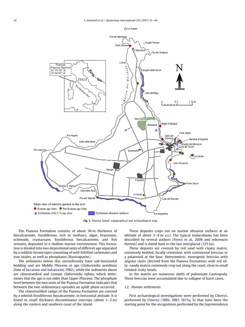
Fig. 1. Pianosa Island: topographical and archaeological map.
F. Antonioli et al. / Quaternary International 232 (2011) 31e4432
The Pianosa Formation consists of about 30 m thickness ofbiocalcarenite, fossiliferous, rich in molluscs, algae, bryozoans,echinoids, crustaceans, fossiliferous biocalcarenite, and fishremains, deposited in a shallow marine environment. This forma-tion is divided into two depositional units of different age separatedby a reddish-brown layer consisting of well-lithified carbonates andiron oxides, as well as phosphates (fluoroapatite).
The sediments below this unconformity have sub-horizontalbedding and are Middle Pliocene in age (Globorotalia aemilianaZone of Iaccarino and Salvatorini, 1982), while the sediments aboveare clinostratified and contain Globorotalia inflata, which deter-mines that the age is not older than Upper Pliocene. The phosphatelevel between the two units of the Pianosa Formation indicates thatbetween the two sedimentary episodes an uplift phase occurred.
The clinostratified ramps of the Pianosa Formation are coveredby a whitish fossiliferous biocalcarenite, in horizontal attitude. It isfound in small thickness discontinuous outcrops (about 1e2 m)along the eastern and southern coast of the island.
These deposits crops out on marine abrasion surfaces at analtitude of about 3e4 m a.s.l. The typical malacofauna has beendescribed by several authors (Foresi et al., 2008 and referencestherein) and is dated back to the last interglacial (125 ka).
These deposits are covered by red sand with clayey matrix,commonly bedded, locally cemented, with continental breccias ora palaeosoil at the base. Heterometric, monogenic breccias withangular clasts (derived from the Pianosa Formation) with red sil-tyesandy matrix commonly crop out along the coast, close to smallisolated rocky heads.
In the matrix are numerous shells of pulmonate Gastropoda.These breccias were accumulated due to collapse of karst caves.
1.2. Human settlements
First archaeological investigations were performed by Chierici,performed by Chierici (1882, 1883, 1875a, b) that have been thestarting point for the recognitions performed by the Soprintendenza
F. Antonioli et al. / Quaternary International 232 (2011) 31e44 33
Archeologica della Toscana team during the last 30 years (Ducci andPerazzi, 2002a).
The human presence in Pianosa is documented since the UpperPaleolithic in the Cala Giovanna cave (Grifoni, 1966) (Fig. 1) fromlithic tools. Materials used for these tools do not come from theGolfo della BotteMiocene conglomerate (Graciotti et al., 2003). Dini(2007) does not exclude the possible provenance of these materialsfrom silicic rocks inside the ElbaePianosa bridge, emerged duringthe upper Epigravettian (before 13.5 ka cal BP) and now submerged.Cala Giovanna tools have been ascribed to a lithic industry olderthan the other Tuscan findings (Dini, 2007). Following this author,this is in agreement with a sea level 80 m lower than today, thatwas reached about 13.5 ka cal BP (Lambeck et al., 2010), hence thissettlement is older (Boschian, 2007).
The colonization of the Tuscan Archipelago starts at least duringancient Neolithic age (Ducci et al., 2000). Pianosa is one of the oldersettlements of the West Mediterranean Sea. This fact is confirmedby the finding on La Scola islet (Fig. 1) of impressed pottery (Car-dium pottery) (Ducci and Perazzi, 1998, 2000, 2002a,b; Ducci et al.,2000). There are strong similarities between the decorative style ofthis pottery (alternating bands impressed with shells and wellimpressed points) and the pottery of Basi (Corsica) dated to theancient Neolithic at about 8.4 ka cal BP (7.700�150 BP uncal 14Cage in De LanFranchi and Weiss, 1997).
The La Scola settlement dates from ancient times. Thisassumption is based on evidence of an economy based on hunting,fishing, shells and rearing sheep and goats, with very few traces ofpigs but without cattle.
In the Cala Giovanna-Piano area, settlements of AncientNeolithic age have been found and dated (between 6,222� 60 and5,680� 40 ka BP; Colombo and Tozzi, 2007), corresponding to anage between 7.3 and 6.5 ka cal BP. The little caves may be Neolithicor date to the early Bronze Age (between the IV and III millenniumAC) (Ducci et al., 2000).
On the Southern coast of the Island (Punta del Segnale locality,Fig. 1), recent research (Ducci and Perazzi, 2002a) found a MiddleBronze Age settlement excavated between 2004 and 2007. Potteryfragments, with Apennine style decoration, date this complex tothe Middle Bronze Age (between 3.4 and 3.3 ka BP). There are someindications that the human presence on the island continuedduring following times, even if precise dating from the pottery andmetal fragments is not possible.
2. Materials and methods
The measurements of the height of the abrasion platforms, andof the Tyrrhenian marine deposits and the lithodome holes presentin the ancient cliffs, were performed with an invar graduated stage,or with a 20 m length tape rule with the help of a spirit level.
The measurements have been referred to the actual sea levelwithout taking into account the range of the tide value. Thecorrection for the tide value was not considered because themeasurements obtained fell within the tolerance of the 1:10.000scale Regional Technical Map (CTR), provided by the TuscanyRegion, used as the topographic base for the geomorphologicalsurvey.
The abrasion surfaces related to MIS 5.5, particularly extensivein the island, have been grouped at 2e4 m a.s.l. The Tyrrheniandeposits were found on flat surfaces up to about 5 m a.s.l. Lith-odome holes have been detected to amaximumheight of about 7 ma.s.l.; this value was measured directly on the ancient cliff. Uncer-tainties along the vertical are �0.5 m.
Themeasurements for the sketch (Figs. 3e5) were carried out in1989 using sea level at the time of surveys as reference plane forelevation measurements, without applying tidal corrections.
Therefore they are shown in figures on a grey background, next tothe original ones of the graphic relief, the only units found in thecourse of this research (Figs. 3 and 4).
Measurements of the current heights of significant archaeo-logical and geomorphological markers with respect to the currentsea level at the time of the survey were performed by an invar rod(Figs. 6e8). Data have been corrected for tides and relative atmo-spheric pressure using data from the tide gauges of Livorno andCivitavecchia (http://www.wxtide32.com) (www.idromare.it) andfrom the meteorological site www.wunderground.com.
To relate the archaeological structures to ancient MSL, theirformer functional height was defined as a parameter to estimatesea level change at each location. The functional height is defined asthe height of a specific architectural part of an archaeologicalstructure with respect to the mean sea level at the time of itsconstruction and use. This depends on the type of structure, its use,and the local tide amplitude (Lambeck et al., 2004b; Auriemma andSolinas, 2009). The Calib 5 program (Stuiver et al., 2005) was usedfor 14C age calibration.
3. Data
3.1. Geomorphology
Pianosa Island displays a flat sub-triangular shape, gently tiltedeast. A clear difference exists between the western and easternparts of the island, due to the geological features. The former hassteep cliffs and is characterized by a deep and wide inlet (Golfodella Botte). The latter shows less steep coasts dipping toward theeast, articulated and indented due to the presence of rocky heads(or promontories) and small bays. The morphogenetic processesdriven the present landscape modelling of the island and erosionallandforms are essentially two: coastal-marine and karst.
The geomorphological evolution of the island is almost drivenby tectonics, volcanism and eustatic movements that affectedrepeatedly the Northern Tyrrhenian Sea since Lower-MiddlePleistocene. Transgressive cycles are marked by wave-cut plat-forms. Two main orders of marine abrasion surfaces are docu-mented at about 2e4 m, and 22e25 m a.s.l. Thewave-cut platformsof the first order (2e4 m) crop out along the island coast exceptwhere marlyeclay Miocene sediments crop out and favour theformation of steep cliffs due to their high erodibility.
The size of these surfaces is very different both in width andlength; some are represented by small platforms, others stretchtowards the sea tens of metres in width and several hundreds ofmetres in length. They contain rock pools with different shapes.Biocalcarenitic and biocalciruditic Last Interglacial deposits cropout on the wave-cut platforms.
The wave-cut platforms of the second order, which coincidewith the summit topographic surface, are located along thewesternand southern coast of the island, characterized by active cliffs. Inthese cases the erosion surfaces truncates the sharply clinos-tratified ramps of the Pianosa Formation.
Sea level evidence from the Last Interglacial transgression isrepresented by lithodome holes placed up to 7 m a.s.l. Featuressimilar to tidal notches are carved in the cliff up to about 9.6 m a.s.l.between Scoglio del Marzocco and Cala dei Turchi (Figs. 1 and 8D)and backward paleocliffs, but these are not considered to be tidalnotches due to the absence of lateral continuity on the whole island(Graciotti et al., 2003). The landscape modelling is also due to thekarst process that originated epigean forms such as dissolutionflutes, grooves, dissolution plans, and a major expansion of hypo-gean landforms. The hypogean karst of Pianosa consists of cavesand conduits, with amainly horizontal development, articulated on
F. Antonioli et al. / Quaternary International 232 (2011) 31e4434
several levels. Numerous caves have their entrances at the currentsea level.
3.2. Archaeology
This section describes the remains, their structure, the history ofbuilding and the archaeological attribution, including a detailedplan and sections (Figs. 2e5). The subaerial plan and underwatersurveys allows understanding the functionality of pools and quarryand estimate the palaeosea level.
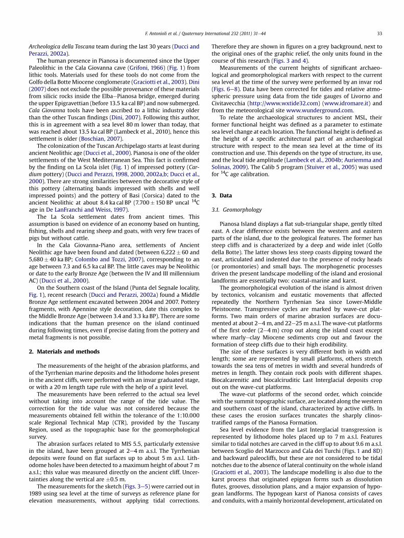
Fig. 2. Plan of the archaeological structures
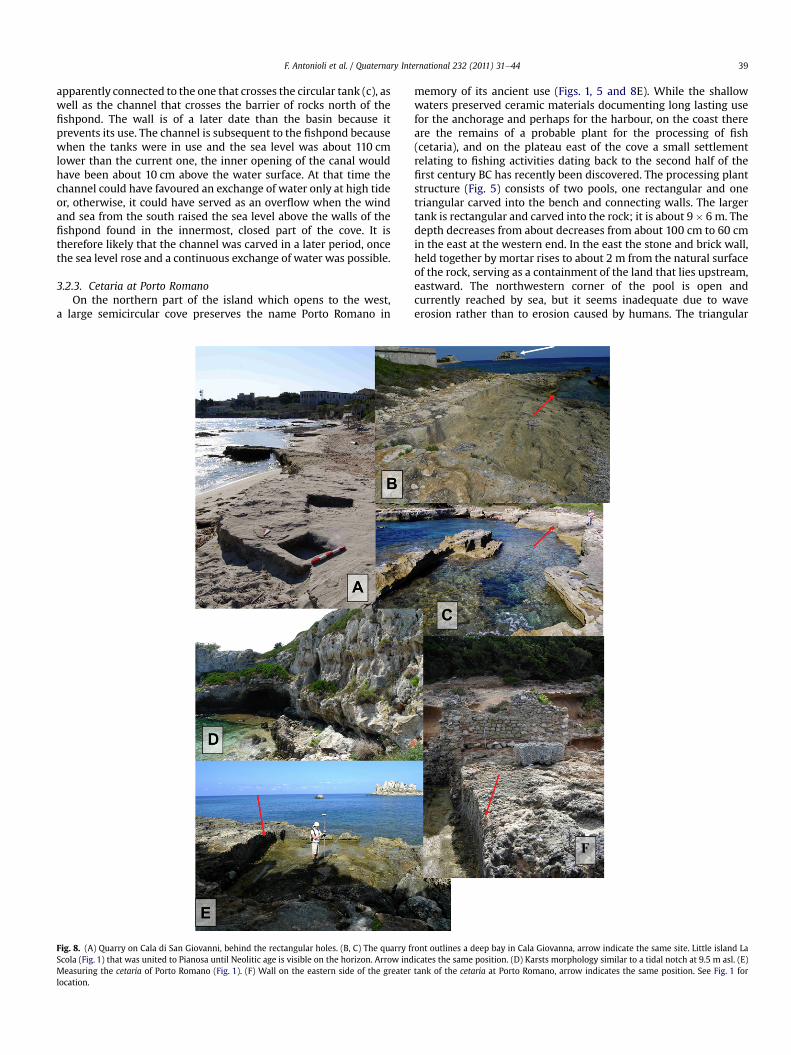
3.2.1. Submerged archaeological remains of Bagni d’AgrippaThe imposing ruins near Cala di San Giovanni (Fig. 1) to the
north, on the eastern coast, have been known since the nineteenthcentury as “Bagni d’Agrippa” (Giuli, 1833; Chierici, 1875a,b) (Fig. 2).The building has a very complex planwhich extends along an EeWaxis from the odeon through the peristyle, the pool and round roome or terrace e reaching as far as the sea with two circular basins.Around the theater are cubicula and private rooms, whereas northand south of the peristyle there are a wide oecus and the thermalrooms, respectively. The monument is scenically developed in
at Bagni d’Agrippa (from Chierici, 1875).
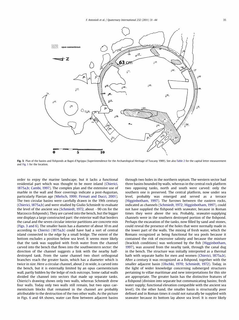
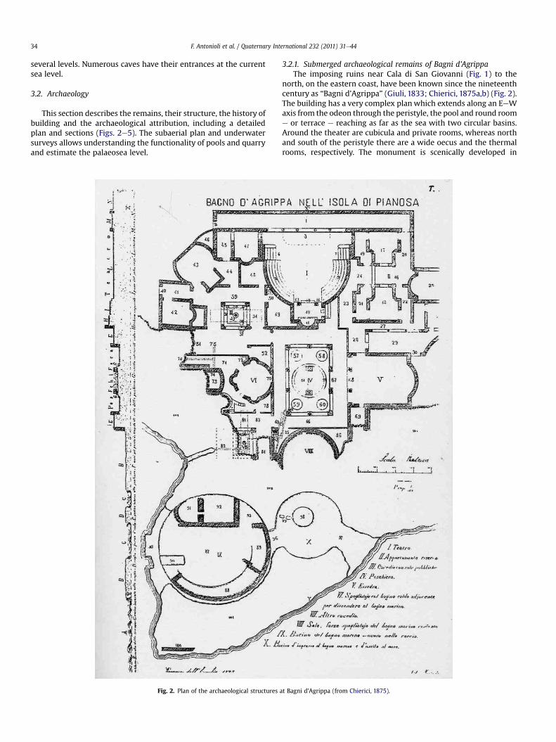
Fig. 3. Plan of the basins and fishponds at Bagni d’Agrippa (Superintendence for the Archaeological Heritage of Tuscany 1989). See also Table 2 for the capital letter measurementand Fig. 1 for the location.
F. Antonioli et al. / Quaternary International 232 (2011) 31e44 35
order to enjoy the marine landscape, but it lacks a functionalresidential part which was thought to be more inland (Chierici,1875a,b; Cambi, 1997). The complex plan and the extensive use ofmarble in the wall and floor coverings indicate a post-Augustan,particularly Flavian age (Mielsch, 1999; Firmati and Ducci, 2001).The two circular basins were carefully drawn in the 19th century(Chierici, 1875a,b) and were studied by Giulio Schmiedt to evaluatethe level of the ancient sea (Schmiedt, 1972, about �90 cm for theMarzocco fishponds). They are carved into the bench, but the biggerone displays a large constructed part: the exterior wall that bordersthe canal and the seven circular interior partitions are concrete mix(Figs. 3 and 6). The smaller basin has a diameter of about 10 m andaccording to Chierici (1875a,b) could have had a sort of centralisland connected to the edge by a small bridge. The extent of thebottom excludes a position below sea level. It seems more likelythat the tank was supplied with fresh water from the channelcarved into the bench that flows into the southwestern sector: thedirection of the channel suggests a link with the nearby half-destroyed tank. From the same channel two short orthogonalbranches reach the greater basin, which has a diameter which istwice in size. Here a circular channel, about 2 mwide, is carved intothe bench, but it is externally limited by an opus caementiciumwall, partly hidden by the ledge of rock outcrops. Some radial wallsdivided the channel into sectors that made up separate tanks.Chierici’s drawing shows only two walls, whereas Schmiedt drewfour walls. Today only two walls still remain, but two opus cae-menticium blocks that remained in the channel are probablyattributable to the destruction of the two other walls. As the picturein Figs. 6 and 4A shows, water can flow between adjacent basins
through two holes in the northern septum. The western sector hadthree basins bounded bywalls, whereas in the central rock platformtwo opposing tanks, north and south were carved: only thesouthern one is preserved. The central platform, now under sealevel, probably was emerged and served as a terrace(Higginbotham, 1997). The furrows between the eastern rocks,indicated as channels (Schmiedt, 1972; Higginbotham, 1997), couldnot have supplied the fishpond with seawater, because in Romantimes they were above the sea. Probably, seawater-supplyingchannels were in the southern destroyed portion of the fishpond.Perhaps the excavation of the tanks, now filled by sand and stones,could reveal the presence of the holes that were normally made inthe lower part of the walls. The mixing of fresh water, which theRomans recognized as being functional for sea pools because itcontained the risk of excessive salinity and because the mixture(brackish conditions) was welcomed by the fish (Higginbotham,1997), was assured from the nearby tank, through the canal dugin the bench. The structure was initially interpreted as a thermalbath with separate baths for men and women (Chierici, 1875a,b).After a century it was recognized as a fishpond, together with thesmaller adjacent basin (Olschki, 1970; Schmiedt, 1972). Today, inthe light of wider knowledge concerning submerged structurespertaining to villae maritimae and new interpretations for this siteare appropriate. The greater basin has the distinctive features ofa fishpond (division into separate but communicating basins; freshwater supply; functional elevation compatible with the ancient sealevel). On the other hand, the smaller basin is structurally poordefined and in Roman times it could not naturally be supplied withseawater because its bottom lay above sea level. It is more likely
Fig. 4. A plan of Marzocco fishpond, 4B section, (Superintendence for the Archaeological Heritage of Tuscany, 1989). See also Table 2 for the capital letter (measures uncorrected fortide) measurement and Fig. 1 for the location.
F. Antonioli et al. / Quaternary International 232 (2011) 31e4436
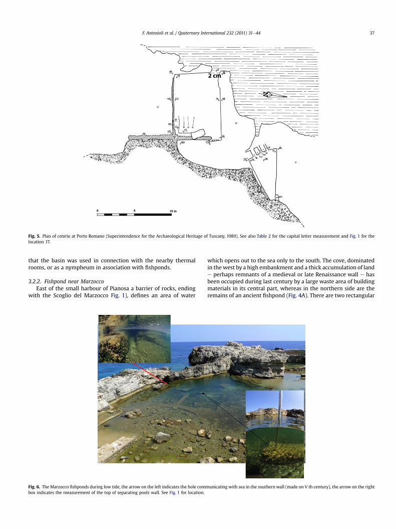
Fig. 5. Plan of cetaria at Porto Romano (Superintendence for the Archaeological Heritage of Tuscany, 1989). See also Table 2 for the capital letter measurement and Fig. 1 for thelocation 17.
F. Antonioli et al. / Quaternary International 232 (2011) 31e44 37
that the basin was used in connection with the nearby thermalrooms, or as a nympheum in association with fishponds.
3.2.2. Fishpond near MarzoccoEast of the small harbour of Pianosa a barrier of rocks, ending
with the Scoglio del Marzocco Fig. 1), defines an area of water
Fig. 6. The Marzocco fishponds during low tide, the arrow on the left indicates the hole commbox indicates the measurement of the top of separating pools wall. See Fig. 1 for location.
which opens out to the sea only to the south. The cove, dominatedin thewest by a high embankment and a thick accumulation of lande perhaps remnants of a medieval or late Renaissance wall e hasbeen occupied during last century by a large waste area of buildingmaterials in its central part, whereas in the northern side are theremains of an ancient fishpond (Fig. 4A). There are two rectangular
unicating with sea in the southern wall (made on V th century), the arrow on the right
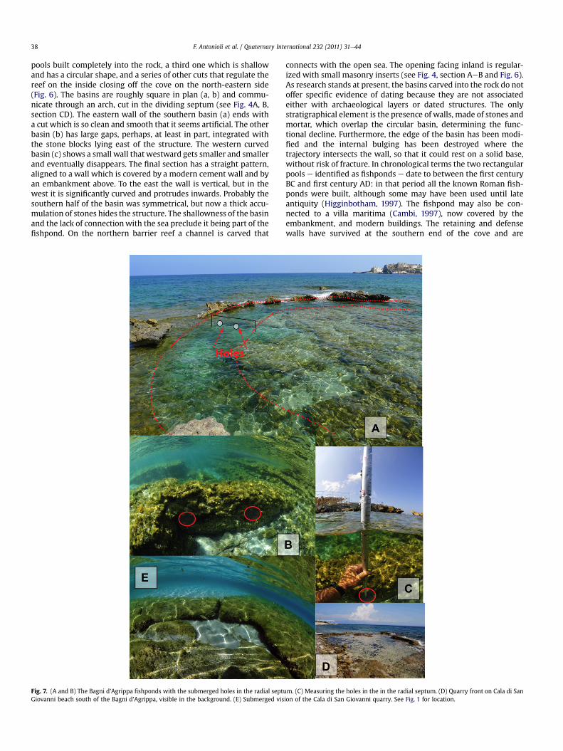
F. Antonioli et al. / Quaternary International 232 (2011) 31e4438
pools built completely into the rock, a third one which is shallowand has a circular shape, and a series of other cuts that regulate thereef on the inside closing off the cove on the north-eastern side(Fig. 6). The basins are roughly square in plan (a, b) and commu-nicate through an arch, cut in the dividing septum (see Fig. 4A, B,section CD). The eastern wall of the southern basin (a) ends witha cut which is so clean and smooth that it seems artificial. The otherbasin (b) has large gaps, perhaps, at least in part, integrated withthe stone blocks lying east of the structure. The western curvedbasin (c) shows a small wall that westward gets smaller and smallerand eventually disappears. The final section has a straight pattern,aligned to a wall which is covered by a modern cement wall and byan embankment above. To the east the wall is vertical, but in thewest it is significantly curved and protrudes inwards. Probably thesouthern half of the basin was symmetrical, but now a thick accu-mulation of stones hides the structure. The shallowness of the basinand the lack of connectionwith the sea preclude it being part of thefishpond. On the northern barrier reef a channel is carved that
Fig. 7. (A and B) The Bagni d’Agrippa fishponds with the submerged holes in the radial septuGiovanni beach south of the Bagni d’Agrippa, visible in the background. (E) Submerged vis
connects with the open sea. The opening facing inland is regular-ized with small masonry inserts (see Fig. 4, section AeB and Fig. 6).As research stands at present, the basins carved into the rock do notoffer specific evidence of dating because they are not associatedeither with archaeological layers or dated structures. The onlystratigraphical element is the presence of walls, made of stones andmortar, which overlap the circular basin, determining the func-tional decline. Furthermore, the edge of the basin has been modi-fied and the internal bulging has been destroyed where thetrajectory intersects the wall, so that it could rest on a solid base,without risk of fracture. In chronological terms the two rectangularpools e identified as fishponds e date to between the first centuryBC and first century AD: in that period all the known Roman fish-ponds were built, although some may have been used until lateantiquity (Higginbotham, 1997). The fishpond may also be con-nected to a villa maritima (Cambi, 1997), now covered by theembankment, and modern buildings. The retaining and defensewalls have survived at the southern end of the cove and are
m. (C) Measuring the holes in the in the radial septum. (D) Quarry front on Cala di Sanion of the Cala di San Giovanni quarry. See Fig. 1 for location.
F. Antonioli et al. / Quaternary International 232 (2011) 31e44 39
apparently connected to the one that crosses the circular tank (c), aswell as the channel that crosses the barrier of rocks north of thefishpond. The wall is of a later date than the basin because itprevents its use. The channel is subsequent to the fishpond becausewhen the tanks were in use and the sea level was about 110 cmlower than the current one, the inner opening of the canal wouldhave been about 10 cm above the water surface. At that time thechannel could have favoured an exchange of water only at high tideor, otherwise, it could have served as an overflow when the windand sea from the south raised the sea level above the walls of thefishpond found in the innermost, closed part of the cove. It istherefore likely that the channel was carved in a later period, oncethe sea level rose and a continuous exchange of water was possible.
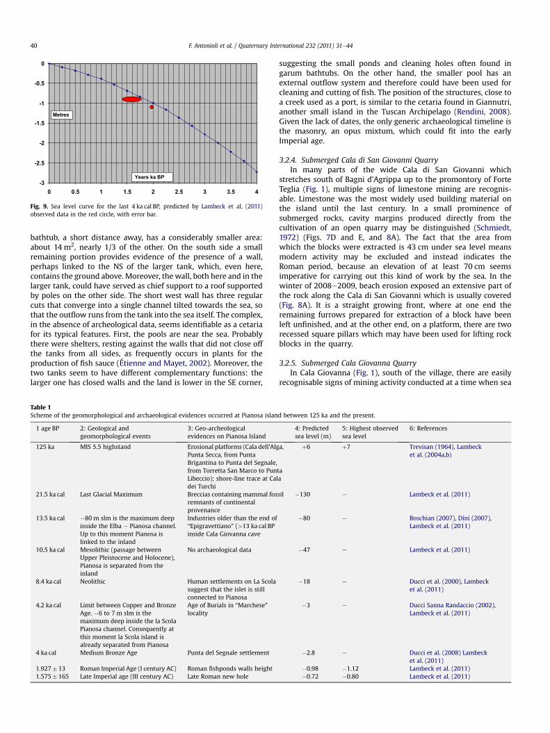
3.2.3. Cetaria at Porto RomanoOn the northern part of the island which opens to the west,
a large semicircular cove preserves the name Porto Romano in
Fig. 8. (A) Quarry on Cala di San Giovanni, behind the rectangular holes. (B, C) The quarry fScola (Fig. 1) that was united to Pianosa until Neolitic age is visible on the horizon. Arrow indMeasuring the cetaria of Porto Romano (Fig. 1). (F) Wall on the eastern side of the greaterlocation.
memory of its ancient use (Figs. 1, 5 and 8E). While the shallowwaters preserved ceramic materials documenting long lasting usefor the anchorage and perhaps for the harbour, on the coast thereare the remains of a probable plant for the processing of fish(cetaria), and on the plateau east of the cove a small settlementrelating to fishing activities dating back to the second half of thefirst century BC has recently been discovered. The processing plantstructure (Fig. 5) consists of two pools, one rectangular and onetriangular carved into the bench and connecting walls. The largertank is rectangular and carved into the rock; it is about 9� 6 m. Thedepth decreases from about decreases from about 100 cm to 60 cmin the east at the western end. In the east the stone and brick wall,held together by mortar rises to about 2 m from the natural surfaceof the rock, serving as a containment of the land that lies upstream,eastward. The northwestern corner of the pool is open andcurrently reached by sea, but it seems inadequate due to waveerosion rather than to erosion caused by humans. The triangular
ront outlines a deep bay in Cala Giovanna, arrow indicate the same site. Little island Laicates the same position. (D) Karsts morphology similar to a tidal notch at 9.5 m asl. (E)tank of the cetaria at Porto Romano, arrow indicates the same position. See Fig. 1 for
-3
-2.5
-2
-1.5
-1
-0.5
0
0 0.5 1 1.5 2 2.5 3 3.5 4
Metres
Years ka BP
Fig. 9. Sea level curve for the last 4 ka cal BP, predicted by Lambeck et al. (2011)observed data in the red circle, with error bar.
F. Antonioli et al. / Quaternary International 232 (2011) 31e4440
bathtub, a short distance away, has a considerably smaller area:about 14 m2, nearly 1/3 of the other. On the south side a smallremaining portion provides evidence of the presence of a wall,perhaps linked to the NS of the larger tank, which, even here,contains the ground above. Moreover, thewall, both here and in thelarger tank, could have served as chief support to a roof supportedby poles on the other side. The short west wall has three regularcuts that converge into a single channel tilted towards the sea, sothat the outflow runs from the tank into the sea itself. The complex,in the absence of archeological data, seems identifiable as a cetariafor its typical features. First, the pools are near the sea. Probablythere were shelters, resting against the walls that did not close offthe tanks from all sides, as frequently occurs in plants for theproduction of fish sauce (Étienne and Mayet, 2002). Moreover, thetwo tanks seem to have different complementary functions: thelarger one has closed walls and the land is lower in the SE corner,
Table 1Scheme of the geomorphological and archaeological evidences occurred at Pianosa islan
1 age BP 2: Geological andgeomorphological events
3: Geo-archeologicalevidences on Pianosa Island
125 ka MIS 5.5 highstand Erosional platforms (Cala dell’AlgPunta Secca, from PuntaBrigantina to Punta del Segnale,from Torretta San Marco to PunLibeccio); shore-line trace at Caldei Turchi
21.5 ka cal Last Glacial Maximum Breccias containing mammal fosremnants of continentalprovenance
13.5 ka cal �80 m slm is the maximum deepinside the Elba e Pianosa channel.Up to this moment Pianosa islinked to the inland
Industries older than the end of“Epigravettiano” (>13 ka cal BPinside Cala Giovanna cave
10.5 ka cal Mesolithic (passage betweenUpper Pleistocene and Holocene),Pianosa is separated from theinland
No archaeological data
8.4 ka cal Neolithic Human settlements on La Scolasuggest that the islet is stillconnected to Pianosa
4.2 ka cal Limit between Copper and BronzeAge. �6 to 7 m slm is themaximum deep inside the la ScolaPianosa channel. Consequently atthis moment la Scola island isalready separated from Pianosa
Age of Burials in “Marchese”locality
4 ka cal Medium Bronze Age Punta del Segnale settlement
1.927� 13 Roman Imperial Age (I century AC) Roman fishponds walls height1.575� 165 Late Imperial age (III century AC) Late Roman new hole
suggesting the small ponds and cleaning holes often found ingarum bathtubs. On the other hand, the smaller pool has anexternal outflow system and therefore could have been used forcleaning and cutting of fish. The position of the structures, close toa creek used as a port, is similar to the cetaria found in Giannutri,another small island in the Tuscan Archipelago (Rendini, 2008).Given the lack of dates, the only generic archaeological timeline isthe masonry, an opus mixtum, which could fit into the earlyImperial age.
3.2.4. Submerged Cala di San Giovanni QuarryIn many parts of the wide Cala di San Giovanni which
stretches south of Bagni d’Agrippa up to the promontory of ForteTeglia (Fig. 1), multiple signs of limestone mining are recognis-able. Limestone was the most widely used building material onthe island until the last century. In a small prominence ofsubmerged rocks, cavity margins produced directly from thecultivation of an open quarry may be distinguished (Schmiedt,1972) (Figs. 7D and E, and 8A). The fact that the area fromwhich the blocks were extracted is 43 cm under sea level meansmodern activity may be excluded and instead indicates theRoman period, because an elevation of at least 70 cm seemsimperative for carrying out this kind of work by the sea. In thewinter of 2008e2009, beach erosion exposed an extensive part ofthe rock along the Cala di San Giovanni which is usually covered(Fig. 8A). It is a straight growing front, where at one end theremaining furrows prepared for extraction of a block have beenleft unfinished, and at the other end, on a platform, there are tworecessed square pillars which may have been used for lifting rockblocks in the quarry.
3.2.5. Submerged Cala Giovanna QuarryIn Cala Giovanna (Fig. 1), south of the village, there are easily
recognisable signs of mining activity conducted at a time when sea
d between 125 ka and the present.
4: Predictedsea level (m)
5: Highest observedsea level
6: References
a,
taa
þ6 þ7 Trevisan (1964), Lambecket al. (2004a,b)
sil �130 e Lambeck et al. (2011)
�80 e Boschian (2007), Dini (2007),Lambeck et al. (2011)
�47 e Lambeck et al. (2011)
�18 e Ducci et al. (2000), Lambecket al. (2011)
�3 e Ducci Sanna Randaccio (2002),Lambeck et al. (2011)
�2.8 e Ducci et al. (2008) Lambecket al. (2011)
�0.98 �1.12 Lambeck et al. (2011)�0.72 �0.80 Lambeck et al. (2011)
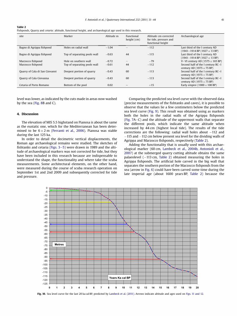
Table 2Fishponds, Quarry and cetaria: altitude, functional height, and archaeological age used in this research.
site Marker Altitude m Functionalheight (cm)
Altitude cm correctedfor tide, pressure andfunctional height
Archaeological age
Bagno di Agrippa fishpond Holes on radial wall �1.04 e �112 Last third of the I century AD(1941e1914 BP (1927� 13 BP)
Bagno di Agrippa fishpond Top of separating pools wall �0.63 44 �115 Last third of the I century AD(1941e1914 BP (1927� 13 BP)
Marzocco fishpond Hole on southern wall �0.72 e �79 VeVI century AD (1575� 165 BP)Marzocco fishpond Top of separating pools wall �0.61 44 �112 Second half of the I century BCeI
century AD (1975� 75 BP)Quarry of Cala di San Giovanni Deepest portion of quarry �0.43 60 �113 Second half of the I century BCeI
century AD (1975� 75 BP)Quarry of Cala Giovanna Deepest portion of quarry �0.43 60 �113 Second half of the I century BCeI
century AD (1975� 75 BP)Cetaria of Porto Romano Bottom of the pool 0.02 e þ15 Early empire (1900� 100 BP)
F. Antonioli et al. / Quaternary International 232 (2011) 31e44 41
level was lower, as indicated by the cuts made in areas nowwashedby the sea (Fig. 8B and C).
4. Discussion
The elevation of MIS 5.5 highstand on Pianosa is about the sameas the eustatic one, which for the Mediterranean has been deter-mined to be 6� 2 m (Ferranti et al., 2006). Pianosa was stableduring the last 125 ka.
In order to detail the decimetric vertical displacements, theRoman age archaeological remains were studied. The sketches offishtanks and cetaria (Figs. 3e5) were drawn in 1989 and the alti-tude of archaeological markers was not corrected for tide, but theyhave been included in this research because are indispensable tounderstand the shape, the functionality and where take the scubameasurements. Some architectural elements, on the other hand,were measured during the course of scuba research operation onSeptember 1st and 2nd 2009 and subsequently corrected for tideand pressure.
-125-120-115-110-105-100-95-90-85-80-75-70-65-60-55-50-45-40-35-30-25-20-15-10-50
0 1 2 3 4 5 6 7 8 9 1
Metres
Years Ka c
Fig. 10. Sea level curve for the last 20 ka cal BP, predicted by Lambeck et
Comparing the predicted sea level curve with the observed data(precise measurements of the fishtanks and caves), it is possible toobserve that the values lie a few centimeters below the predictedsea level curve (Fig. 9). This result was obtained using as markersboth the holes in the radial walls of the Agrippa fishponds(Fig. 7AeC) and the altitude of the uppermost walls that separatethe different pools, which indicate the same altitude whenincreased by 44 cm (highest local tide). The results of the tidecorrections are the following: radial wall holes about �112 and�115 and �112 cm below present sea level for the dividing walls ofAgrippa and Marzocco fishponds, respectively (Table 2).
Adding the functionality that is usually used with this archae-ological marker (60 cm, Lambeck et al., 2004b, Antonioli et al.,2007) at the submerged quarry cutting altitude obtains the samepalaeolevel (�113 cm, Table 2) obtained measuring the holes inAgrippa fishponds. The artificial hole carved in the big wall thatseparates the southern portion of the Marzocco fishponds from thesea (arrow in Fig. 6) could have been carved some time during thelate imperial age (about 1600 years BP, Table 2) because the
0 11 12 13 14 15 16 17 18 19 20
al BP
al. (2011). Arrows indicate altitude and ages used on Figs. 11 and 12.
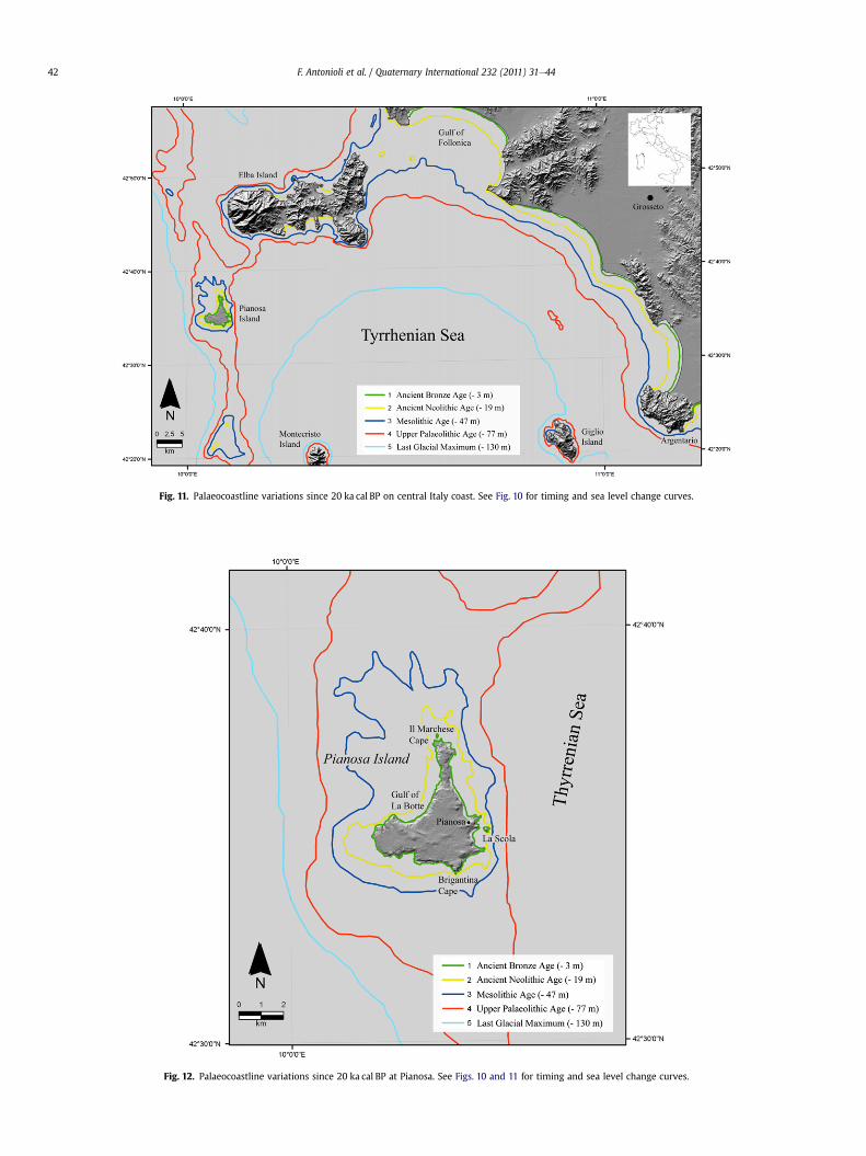
Fig. 11. Palaeocoastline variations since 20 ka cal BP on central Italy coast. See Fig. 10 for timing and sea level change curves.
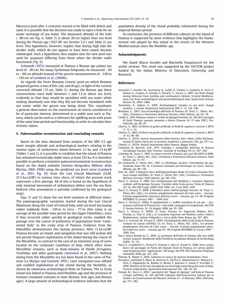
Fig. 12. Palaeocoastline variations since 20 ka cal BP at Pianosa. See Figs. 10 and 11 for timing and sea level change curves.
F. Antonioli et al. / Quaternary International 232 (2011) 31e4442
F. Antonioli et al. / Quaternary International 232 (2011) 31e44 43
Marzocco pool after 3 centuries started to be filled with debris andsand. It is possible that the decision was made to open a hole for aneasier exchange of sea water. The measured altitude of the hole(�80 cm see Fig. 6, Table 2) is about 30 cm higher than sea levelduring the Flavian age (1927 BP, see Section 3.2.1 and Table 2) sealevel. This hypothesis, however, implies that during high tide thedivider walls, which do not appear to have been raised, becamesubmerged. Such a hypothesis thus implies that the new pool wasused for purposes differing from those when the divider wallsfunctioned (Fig. 9).
Schmiedt (1972) measured at Pianosa a Roman age palaeo sealevel of �90 cm. For many Tyrrhenian fishponds, he measured �50to�60 cm altitude instead of the precise measurements of �120 to�130 cm of Lambeck et al. (2004b).
As regards the Porto Romano Cetaria (pool on which Romansprepared garum, a mix of fish, salt, and drugs), in light of the currentcorrected altitude (15 cm, Table 2), during the Roman age theseconstructions were built between 1 and 1.5 m above sea level,evidently so that they would be sprinkled with sea water whilemaking absolutely sure that they did not become inundated withsea water while the garum was being dried. This constitutesa general observation on the construction of cetaria considered tobe of particular interest, determined in a stable area such as Pia-nosa, which can be used as a reference for uplifting areaswith poolsof the same time period and functionality, in order to calculate theirtectonic values.
5. Paleocoastline reconstruction and concluding remarks
Based on the data obtained from analysis of the MIS 5.5 ageinner margin altitude and archaeological markers relating to thevarious types of settlements dated between 2.1 ka and 1.5 ka BP(Tables 1 and 2), it is possible to establish that the island of Pianosahas remained tectonically stable since at least 125 ka. It is thereforepossible to perform a tentative paleoenvironmental reconstructionbased on the depth isobaths (Istituto Idrografico Militare dellaMarina, 1966, 1998) using the predicted sea level curve (Lambecket al., 2011, Fig. 10) from the Last Glacial Maximum (LGM,21.5 ka cal BP) to various time slices, of which the present workrepresents a first attempt. All of this is based on the hypothesis ofonly minimal movement of sedimentary debris over the sea floorbedrock (this assumption is partially confirmed by the geologicalmap).
Figs. 11 and 12 show the sea level variation at different times.The palaeogeographic variations started during the Last GlacialMaximum along the coast of Central Italy, with sea level increasingrather suddenly from �130 m to circa �77 m (this value is anaverage of the possible time period for the Upper Paleolithic), evenif they occurred rather quickly in geological terms, enabled thepassage over the course of prehistory of populations from “conti-nental Italy” to the rocky strip of Pianosa. Evidence from thePaleolithic demonstrates this human presence. After 11 ka cal BP,Pianosa became an island, and navigation that was still archaic didnot permit frequent exploitation of the island during the course ofthe Mesolithic, in contrast to the case of an extensive array of caveslocated on the carbonate coastlines of Italy, which often showMesolithic remains, such as food-remains of Patella ferruginea,Trochidae and other gastropods (Antonioli et al., 2007). Nothingdating from the Mesolithic era has been found in the caves of Pia-nosa (La Morgia and Giuntoli, 1991). Later navigation was refinedand enabled exploitation of the island during the Neolithic, asshown by numerous archaeological finds on Pianosa. The La Scolaisland was linked to Pianosa until Neolithic age and the presence ofhumans remained constant in time (Bronze, Iron ages and Romanages). A large amount of archaeological evidence indicates that the
population density of the island probably culminated during theimperial Roman period.
In conclusion, the presence of different cultures on the island ofPianosa is supported by more evidence that highlights the funda-mental role played by this island in the events of the WesternMediterranean since the Neolithic age.
Acknowledgments
We thank Marco Anzidei and Marinella Pasquinuccii for theuseful reviews. This work was supported by the VECTOR projectfunded by the Italian Ministry of Education, University andResearch.
References
Antonioli, F., Anzidei, M., Auriemma, R., Gaddi, D., Furlani, S., Lambeck, K., Orrù, P.,Solinas, E., Gaspari, A., Karinja, S., Kova�ci�c, V., Surace, L., 2007. Sea level changeduring Holocene from Sardinia and northeastern Adriatic (Central Mediterra-nean sea) from archaeological and geomorphological data. Quaternary ScienceReview 26, 2463e2486.
Auriemma, R., Solinas, E., 2009. Archaeological remains as sea level changemarkers: a review. Quaternary International 206 (1e2), 134e146.
Boschian, G., 2007. Geo-archeologia dell’isola di Pianosa. In: Tozzi, C., .Weiss, M.C.(Eds.), Preistoria e Protostoria dell’area tirrenica. Felici Editore, pp. 65e74.
Cambi, F., 1997. Planasia romana e l’esilio di Agrippa Postumo. In: Atti del Convegnodi Studi. Pianosa: passato, presente e futuro (Pianosa 16e17 may 1997), Por-toferraio, pp. 86e91.
Chierici, G., 1882. Gli Iberici in grotte artificiali, in fondi di capanne e caverne 1. BPI 8(1e3), 1e21.
Chierici, G., 1883. Gli Iberici in grotte artificiali, in fondi di capanne e caverne 2. BPI 9(4e6), 48e60.
Chierici, G., 1875a. Antichi monumenti della Pianosa, Atti e Mem. Delle R.R.Depu-tazioni di Storia Patria per le province modenesi e parmensi, VIII, pp. 217 e ss.
Chierici, G., 1875b. Antichi monumenti della Pianosa, Reggio Emilia.Colantoni, B., Borsetti, A.M., 1973. Geologia e stratigrafia dell’isola di Pianosa
(Arcipelago Toscano, Mar Tirreno). Giornale di Geologia 39 (2), 287e302.Colombo, M., Tozzi, C., 2007. Le nuove ricerche a Pianosa: gli scavi dal 2003 al 2006.
In: Tozzi, C., Weiss, M.C. (Eds.), Preistoria e Protostoria dell’area tirrenica. FeliciEditore, pp. 75e87.
De Lanfranchi, F., Weiss, M.C., 1997. Le Néolitique ancient: L’introdution du pas-toralisme dans l’Ile. In: L’aventure humaine pre-historique en Corse. Aiaccio,Albiana, pp. 80e110.
Dini, M., 2007. L’industria litica dell’Epigravettiano finale di Grotta Giovanna (Pia-nosa-Campo nell’Elba). In: Tozzi, C., Weiss, M.C. (Eds.), Preistoria e Protostoriadell’area tirrenica. Felici Editore, pp. 185e193.
Ducci, S., Perazzi, P., 1998. Una testimonianza del Neolitico a ceramica impressacardiale nell’Arcipelago Toscano: l’isolotto della Scola presso l’Isola di Pianosa(LI). In: Atti XIII Congr. UISPP, Forlì 1996, vol. 3 sez 9425e430.
Ducci, S., Perazzi, P., 2000. Il Neolitico antico dell’Arcipelago Toscano. In: Tozzi, C.,Weiss, M.C. (Eds.), Les primier peuplements olocenes de l’aire corso e toscane.Il primo popolamento olocenico dell’area corso e toscana, pp. 53e56. ProgettoINTERREG II, Corsica 1997 e 1999, Pisa.
Ducci S., Perazzi P., 2002a. Il popolamento e i traffici marittimi di età pre e pro-tostorica nell’Isola di Pianosa (LI): i dati dalle campagne di ricognizione, Atti PPEV, Sorano-Farnese 12e14 maggio 2000, pp. 95e109.
Ducci, S., Perazzi, P., 2002b. La Scola, Toscana. In: Fugazzola Delpino, M.A.,Pessina, A., Tiné, V. (Eds.), Le ceramiche impresse nel Neolitico antico. Italia eMediterraneo. Istituto Poligrafico e Zecca dello Stato, Roma, pp. 397e405.
Ducci, S., Guerrini, M., Perazzi, P., 2000. L’insediamento della Scola (Isola di Pianosa,Comune di Campo nell’Elba, LI). In: Tozzi, C., Weiss, M.C. (Eds.), Les primierpeuplements olocenes de l’aire corso e toscane. Il primo popolamento oloce-nico dell’area corso e toscana, pp. 83e90. Progetto INTERREG II, Corsica 1997 e1999, Pisa.
Ducci Sanna Randaccio, S., 2002. La preistoria dell’Isola di Pianosa alla luce dellerecenti scoperte. Rendiconti della Pontificia Accademia Romana di ArcheologiaLXXIV, 35e54.
Ducci S., Grandinetti G., Perazzi P., Principe C., Ricci S., Tosatti A., 2008. Terra, acqua,fuoco nel paesaggio di Punta del Segnale (Isola di Pianosa, LI): prima ipotesisulla frequentazione “appenninica” del luogo, Atti PPE VIII, Valentano-Pitiglianosettembre 2006, pp. 213e229.
Étienne, R., Mayet, F., 2002, Salaisons et sauces de poisson hispaniques, Paris.Ferranti, L., Antonioli, F.,Mauz, B., Amorosi, A., Dai Pra, G.,Mastronuzzi, G.,Monaco, C.,
Orrù, P., Pappalardo, M., Radtke, U., Renda, P., Romano, P., Sansò, P., Verrubbi, V.,2006. Markers of the last interglacial sea-level high stand along the coast of Italy:Tectonic implications. Quaternary International 145e146, 30e54.
Firmati, M., Ducci, S., 2001. I pavimenti del “Bagni di Agrippa” sull’isola di Pianosa(Campo nell’Elba). In: Atti dell’VIII Colloquio dell’Associazione Italiana per loStudio e la Conservazione del Mosaico (Firenze 21e23 february 2001), Ravenna,pp. 271e282.
F. Antonioli et al. / Quaternary International 232 (2011) 31e4444
Foresi, L.M., Aldinucci, M., Sandrelli, F., Cornamusini, G., 2008. L’Isola di Pianosa:perla neogenica dell’Arcipelago Toscano. ETRURIANATURA 5, 128e151.
Foresi L.M., CornamusiniG., BossioA., FerrandiniM.,MazzeiR., SalvatoriniG.,Argenti P.,2000. The Miocene sedimentary succession of the Pianosa Island, NorthernTyrrhenian Sea. In: “Evoluzione geologica e geodinamica dell’Appennino” inmemoria del Prof. G. Pialli. Foligno (Pg) 16-18 Febbraio 2000, pp. 155e157.
Giuli, G., 1833. Descrizione delle tracce di Fabbriche Romane, e dei bassi tempi, chesi trovano in alcune isole toscane. L’Indicatore senese e grossetano, II, 11, 1 ss.
Graciotti, R., Foresi, L.M., Pantaloni, M., 2003. Caratteristiche geomorfologiche del-l’isola di Pianosa (Arcipelago Toscano). Atti della Societa Toscana di ScienzeNaturali Memorie, Serie A 108, 95e111.
Grifoni R, 1966. Contributi alla conoscenza della preistoria toscana. Industria di tipoPaleolitico superiore dell’isola di Pianosa esistente al Museo di Reggio Emilia.Atti della Societa Toscana di Scienze Naturali Memoir Series A LXXIII, 49e61.
Higginbotham, J., 1997. Piscinae: Artificial Fishponds in Roman Italy. The Universityof North Carolina Press, Chapel Hill.
Iaccarino, S., Salvatorini, G., 1982. A framework of planktonic foraminiferalbiostratigraphy for early Miocene to late Pliocene in the Mediterranean area.Paleontology Stratigraphy Evolution 2, 115e125.
Istituto Idrografico Militare della Marina, 1998. Isole di Giannutri, Montecristo ePianosa, Mare Tirreno, Italia. Reprinted in 2000. Istituto Idrografico MilitareDella Marina.
Istituto Idrografico Militare della Marina, 1966. Dal Canale di Piombino al Prom-ontorio Argentario. Istituto Idrografico Militare Della Marina.
Lambeck, K., Antonioli, F., Purcell, A., Silenzi, S., 2004a. Sea level change along theItalian coast for the past 10,000 yrs. Quaternary Science Review 23, 1567e1598.
Lambeck, K., Anzidei, M., Antonioli, F., Benini, A., Esposito, E., 2004b. Sea level inRoman time in the Central Mediterranean and implications for modern sealevel rise. Earth and Planetary Science Letter 224, 563e575.
Lambeck, K., Antonioli, F., Anzidei, M., Ferranti, L., Leoni, G., 2011. Sea level changealong italian coast during holocene and a proiection for the future. QuaternaryInternational 232, 250e257.
La Morgia, J., Giuntoli, R., 1990e1991. Cavità naturali e artificiali dell’isola di Pianosa(Arcipelago Toscano). In: Le grotte d’Italia. Atti del XVI Congresso Nazionale diSpeleologia, 4, vol. XV, pp. 235e244.
Mielsch, H., 1999. La villa romana, con guida archeologica alle ville romane, Firenze(translation from: Das Römische Villa, Architektur und Lebensform, München,1987).
Olschki, A., 1970. Proposta del Gruppo ricerche scientifiche e tecniche subacquee diFirenze per la costituzione di un parco nazionale insulare all’isola di Pianosa sulmar Tirreno. Relazione preliminare al Convegno Nazionale “Pianificazione ter-ritoriale e conservazione del paesaggio vegetale” della Società Botanica Italianae di Italia Nostra (Firenze 19e20 ottobre 1970), pp. 3e10.
Rendini, P., 2008. (Ed.) I monumenti antichi dell’Isola di Giannutri. Venti anni diattività della Soprintendenza per i Beni Archeologici della Toscana(1989e2008), Siena.
Schmiedt, G., 1972. (Ed.) Il livello antico del Mare Tirreno: testimonianze dei restiarcheologici, Firenze.
Stuiver, M., Reimer, P.J., Reimer, R., 2005. Calib Radiocarbon Calibration, ExecuteVersion 5.0.2. http://calib.qub.ac.uk/calib.
Trevisan, L., 1964. Carta geologica dell’Isola di Pianosa. Unpublished manuscript,Dipartimento di Scienze della Terra di Pisa.
Copyright © 2022 FDOKUMEN