Geomorphological hazards and monitoring activity along the western rocky coast of the Portofino...
12
Quaternary International 171–172 (2007) 131–142 Geomorphological hazards and monitoring activity along the western rocky coast of the Portofino Promontory (Italy) Pierluigi Brandolini a, , Francesco Faccini a , Andrea Robbiano b , Remo Terranova c a University of Genoa, DISAM—Via Balbi 2, 16126 Genoa, Italy b Geologist, via Capoluono 46, 16167 Genoa, Italy c University of Genoa, Italy Available online 22 May 2007 Abstract The results of geomorphological studies and monitoring activity conducted in the western sector of the Portofino Promontory are presented here. This sector is characterized by numerous, extensive landslide masses and there is evidence of their reactivation during the last century. The instability phenomena can be attributed to landslides with complex kinematics classifiable as rock slump and rock topple, rock slide and rock fall, and rock fall and rock flow. They have involved hamlets and communication routes, with observable damage to man-made structures and terraced agricultural terrain, including collapses and deformations of the dry-stone walls. The geomorphological surveys, the boreholes and the monitoring activity have shown that several landslides are active, with movement rates of some cm/year. With the presence of predisposing factors relating to the structural lithology and geomorphology of the rocky slopes, the triggering causes of the gravitational movements are attributable to extreme heavy rainfall and to wave cutting, often with concomitant action on the part of both. The study offers a contribution to encourage concrete efforts to continue the monitoring of this area; the overall objective would entail the planning of general stabilization measures, or at least measures to reduce evident geomorphological risks, also taking into account the remarkable environmental value and qualities of this coastal sector. r 2006 Elsevier Ltd and INQUA. All rights reserved. 1. Introduction In the last few decades, the study of areas characterised by the presence of landslide movements has taken on considerable importance due to the more and more frequent consequences they have on settlements and infrastructures. From this perspective, the contribution given by geomorphological analyses and the monitoring of instability dynamics is of essential importance in permitting proper land planning aimed at risk reduction (Bell, 1999; Glade et al., 2005). This paper presents a significant case regarding these issues in the western slope of the Portofino Promontory, a coastal sector in Liguria of great environmental value. The Promontory itself has been under the protection of Portofino Park since 1935, and the seaward area became a marine reserve in 2001. Extending along the coastline from the town of Camogli, situated at the base of the Promontory, to the southernmost limit of Punta Chiappa, the western slope has in past decades witnessed various conditions of instability and sliding, including serious landslides. It has thus been included on the list of places and settlements designated for Italian government protection and consolidation for close to a century. The government has intervened even recently with hydro- geological, drainage and forest management measures (Terranova, 1964, 1999; Provincia di Genova, 2004). The entire study area lies within the limits of the small town of Camogli. The town’s historical archives contain many records of the series of disastrous events that occurred in the past, including the one in 1915 that led to the loss of lives. There are reports and comments on the instability phenomena dating as far back as the 19th century (Issel, 1892) and the beginning of the 20th century (Ristori, 1901; Rovereto, 1902–1903, 1924; Pellati, 1934). However, the first scientific study on the Castellaro ARTICLE IN PRESS 1040-6182/$ - see front matter r 2006 Elsevier Ltd and INQUA. All rights reserved. doi:10.1016/j.quaint.2006.11.006 Corresponding author. Tel.: +39 10 2099606; fax: +39 10 2095254. E-mail addresses: [email protected] (P. Brandolini), [email protected] (A. Robbiano).
Transcript of Geomorphological hazards and monitoring activity along the western rocky coast of the Portofino...
ARTICLE IN PRESS
1040-6182/$ - se
doi:10.1016/j.qu
�CorrespondE-mail addr
geotecam@libe
Quaternary International 171–172 (2007) 131–142
Geomorphological hazards and monitoring activity along the westernrocky coast of the Portofino Promontory (Italy)
Pierluigi Brandolinia,�, Francesco Faccinia, Andrea Robbianob, Remo Terranovac
aUniversity of Genoa, DISAM—Via Balbi 2, 16126 Genoa, ItalybGeologist, via Capoluono 46, 16167 Genoa, Italy
cUniversity of Genoa, Italy
Available online 22 May 2007
Abstract
The results of geomorphological studies and monitoring activity conducted in the western sector of the Portofino Promontory are
presented here. This sector is characterized by numerous, extensive landslide masses and there is evidence of their reactivation during the
last century. The instability phenomena can be attributed to landslides with complex kinematics classifiable as rock slump and rock
topple, rock slide and rock fall, and rock fall and rock flow. They have involved hamlets and communication routes, with observable
damage to man-made structures and terraced agricultural terrain, including collapses and deformations of the dry-stone walls. The
geomorphological surveys, the boreholes and the monitoring activity have shown that several landslides are active, with movement rates
of some cm/year.
With the presence of predisposing factors relating to the structural lithology and geomorphology of the rocky slopes, the triggering
causes of the gravitational movements are attributable to extreme heavy rainfall and to wave cutting, often with concomitant action on
the part of both. The study offers a contribution to encourage concrete efforts to continue the monitoring of this area; the overall
objective would entail the planning of general stabilization measures, or at least measures to reduce evident geomorphological risks, also
taking into account the remarkable environmental value and qualities of this coastal sector.
r 2006 Elsevier Ltd and INQUA. All rights reserved.
1. Introduction
In the last few decades, the study of areas characterisedby the presence of landslide movements has taken onconsiderable importance due to the more and morefrequent consequences they have on settlements andinfrastructures. From this perspective, the contributiongiven by geomorphological analyses and the monitoring ofinstability dynamics is of essential importance in permittingproper land planning aimed at risk reduction (Bell, 1999;Glade et al., 2005).
This paper presents a significant case regarding theseissues in the western slope of the Portofino Promontory, acoastal sector in Liguria of great environmental value. ThePromontory itself has been under the protection ofPortofino Park since 1935, and the seaward area became
e front matter r 2006 Elsevier Ltd and INQUA. All rights re
aint.2006.11.006
ing author. Tel.: +3910 2099606; fax: +39 10 2095254.
esses: [email protected] (P. Brandolini),
ro.it (A. Robbiano).
a marine reserve in 2001. Extending along the coastlinefrom the town of Camogli, situated at the base of thePromontory, to the southernmost limit of Punta Chiappa,the western slope has in past decades witnessed variousconditions of instability and sliding, including seriouslandslides. It has thus been included on the list ofplaces and settlements designated for Italian governmentprotection and consolidation for close to a century.The government has intervened even recently with hydro-geological, drainage and forest management measures(Terranova, 1964, 1999; Provincia di Genova, 2004).The entire study area lies within the limits of the small
town of Camogli. The town’s historical archives containmany records of the series of disastrous events thatoccurred in the past, including the one in 1915 that led tothe loss of lives. There are reports and comments on theinstability phenomena dating as far back as the 19thcentury (Issel, 1892) and the beginning of the 20thcentury (Ristori, 1901; Rovereto, 1902–1903, 1924; Pellati,1934). However, the first scientific study on the Castellaro
served.

ARTICLE IN PRESSP. Brandolini et al. / Quaternary International 171–172 (2007) 131–142132
and San Rocco landslides was published by Terranova(1964), who analysed the mass movements of 1961 and1964.
The geomorphological slope conditions were analysedthereafter, also in relation to the likelihood of theoccurrence of landslide phenomena (De Stefanis et al.,1978). More recently, geomorphological instability andrisks in the high coast sectors have been studied(Terranova, 1999; Federici et al., 2004) and preliminaryresults regarding geomorphological hazards connectedwith tourism have been presented (Brandolini et al., 2006).
The investigations carried out as part of this studyfocused on the high rocky coast characterised by very steepslopes and large cliffs, in an area that extends fromCamogli to the slope below San Rocco, and in thelowermost part, southward, of Porto Pidocchio and PuntaChiappa, as well as the coastal area made up ofaccumulated landslide debris in the coastal stretch situatedbelow the hamlets of Mortola and San Nicolo.
One of the aims of the investigations was to verify andcompare the current and past stability conditions on aslope that is undergoing continuous evolution, as demon-strated by the numerous cracks in buildings and thedeformations affecting man-made structures and agricul-tural lands.
Fig. 1. Geological sketch map of the Portofino Promontory and surrounding
(upper Cretaceous–Paleocene); (3) sandstones of Mt. Gottero (upper Cretaceo
Valley (lower Cretaceous); (6) bedrock attitude; (7) main tectonical lineations
After a brief outline of the geographical setting of thearea, this paper focuses on the results of a detailedgeomorphological survey carried out on the landslides onthe western side of the Portofino Promontory. Thisresearch, which has included basic geological investi-gations and monitoring activities, is fundamental formanagement purposes, to mitigate environmental risks(Panizza, 1987; Grecu et al., 2003; Solana and Kilburn,2003).
2. Regional setting
Situated about 25 km E of Genoa, the PortofinoPromontory, with a surface area of about 18 km2, appearsas a vast, massive and prominent SSW projection clearlydifferentiating the rectilinear pattern of the coastlinebetween Genoa and Sestri Levante (Fig. 1). The westernside extends in a N–S direction and is almost rectilinearbetween Camogli and Punta Chiappa. The inlets of Caladell’Oro and San Fruttuoso are found on the southern side,showing a general E–W orientation.Mt. Portofino (610m) represents the highest orographic
elevation on the Promontory, while also constituting theculmination of the divide subparallel to the southernshoreline. Several minor peaks are observable, including
areas: (1) conglomerate of Portofino (Oligocene); (2) flysch of Mt. Antola
us–Paleocene); (4) slates of Mt. Verzi (Cretaceous); (5) shales of Lavagna
. The grey rectangle indicates the studied area.
ARTICLE IN PRESSP. Brandolini et al. / Quaternary International 171–172 (2007) 131–142 133
Mt. Tocco (543m), Mt. delle Bocche (506m) and Mt.Pollone (465m).
The climate of the Promontory is conditioned by themorphology, so that it can be subdivided into two zones:(a) a typically Mediterranean one on the southern slope,with dry, warm summers and mild winters; (b) a mid-hillzone on the northern slope, with lower mean wintertemperatures and higher rainfall, especially in the northernsectors.
In general, maximum rainfall occurs in the autumnmonths, whereas the minimum occurs in the summermonths. Annual mean rainfall varies between 1000 and1400mm and the annual mean temperature ranges between12 and 13 1C, reaching a 23–24 1C peak in the summer anda low of 7–8 1C in the winter.
Winds from the S are warm and saturated with watervapour after crossing wide expanses of sea. As theyencounter and climb the natural barrier of the promontory,the temperature decreases, causing condensation of largeamounts of water, especially in the summer. This is largelydue to the temperature gradient between the air and therock discontinuities. This process supplies the numerousperennial springs, which are also found at high altitudes.The springs have been used since historical times and arestill used today by trekkers and visitors (Faccini et al.,2005).
The geological units present on the Portofino Promon-tory are the Portofino Conglomerate, of Oligocene age,which crops out in the southern part and overlies the Mt.Antola Flysch, of Cretaceous–Palaeocene age. The strati-graphic contact dips southward about 351 (Terranova,1964, 1995).
The flysch is made up of marly limestone layers rangingin thickness from decimetres to metres. Colour varies fromyellowish grey to dark grey, depending on the degree ofalteration. The marly limestones are intercalated withblackish grey layers of clayey shales of thickness in thecentimetre–decimetre range. Alternating layers of calcar-enites and sandstones are present to a lesser extent. Theyrange from grey to brown and they reach thicknesses in therange of meters (Marini, 1981).
The conglomerate consists prevalently of clasts ofmarly limestone, of sandy limestone, sandstone and lessfrequently clasts of ophiolites, gneisses and granites.Roundness classes vary from subangular to moderatelyrounded. The matrix is sandy and presents calcitic cement(Giammarino et al., 1969).
The flysch is affected by brittle-ductile deformations,with very complex structural settings. More specifically,numerous decametre-scale folds appear in the study area,and are well exposed along the cliffs between Camogli andthe hamlet of Pego. These rocky scarps present on the slopesectors two main subvertical fault systems, dippingapproximately N 70 and N 150, respectively (Corsi et al.,2001). The conglomerate is also affected by a principalsystem of faults, dipping N 125, and by a secondarysystem, in an approximately N 40 direction, both of which
are visible along the cliffs in the vicinity of Punta Chiappa.Together with the faults affecting the flysch, they clearlycondition the pattern of the coastal profile and the drainagenetwork.The relationships between structural features and
morphogenetic phenomena are evident. In the westerncoastal strip the exogenetic processes are controlled byrelict tectonic lineations, on a local and regional scale, andare responsible for the progressive slope retreat (Fanucciand Nosengo, 1979; Cevasco et al., 2004).Among the gravity-related landforms, landslides char-
acterized by different movement types are observable, withactive and dormant scarps, whereas the action of therunning waters creates rapid flows through steep, incisedsmall rock valleys. Undercutting produced by the contin-uous action of wave motion is responsible for the presenceof high active cliffs along large stretches of the coastalsector (Terranova, 1964; Brandolini et al., 2006).The sector most affected by sea wave action is the
dominant SW sector (Libeccio) with an aperture angle of471 and azimuthal coordinates between 1871 (PuntaScandola, Corsica) and 2341 (Capo Mele, western Liguria).Waves produced by the prevailing southeasterly winds(Scirocco) do not affect this sector, as the Promontory actsas a barrier.The trains of waves produced by SW winds approach the
coast obliquely, creating littoral drift towards Camogli,which is situated further N. The Libeccio wind has a fetchof 650 km, creating waves of a maximum height of 4–5m asthey approach the coast, a length of 120m, a propagationvelocity of 12–14m/s, and a wave period of 8–9 s; windduration is generally 3 days with maximum velocity of 30knots. The resulting wave energy, estimated using Suna-mura’s equation (1992), is 200–300 kN.Waves with peak heights of 6m and lengths of 260m
have been taken into account in the design and construc-tion of outer breakwater projects to protect ports. They arevery rare occurrences, and the relative energy values exceed900 kN.
3. Methods
The methodology adopted to collect detailed informa-tion on the characteristics of the landslides and thedynamics of the active movements is quite complex.Research conducted included detailed bibliographical workwas conducted in the historical archives of related publicagencies, a series of interviews with residents, and aresearch to collect journalistic documents and photo-graphic records.The collection and processing of available meteorologi-
cal/climate data was considered a necessary step, especiallyin relation to rainfall and wave action. Precipitationanalysis included historical rainfall data recorded at themeteorological stations of Colonia Arnaldi, Santa Mar-gherita Ligure and San Pietro di Novella, and more recentdata collected by the Nautical Institute of Camogli and by
ARTICLE IN PRESS
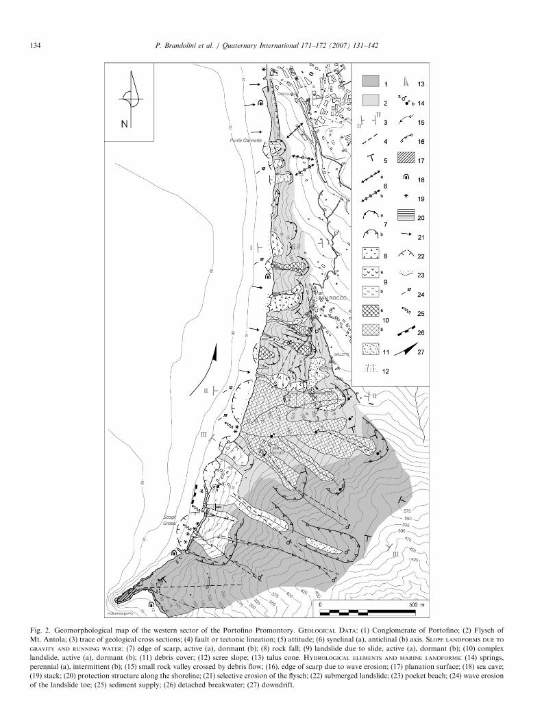
Fig. 2. Geomorphological map of the western sector of the Portofino Promontory. GEOLOGICAL DATA: (1) Conglomerate of Portofino; (2) Flysch of
Mt. Antola; (3) trace of geological cross sections; (4) fault or tectonic lineation; (5) attitude; (6) synclinal (a), anticlinal (b) axis. SLOPE LANDFORMS DUE TO
GRAVITY AND RUNNING WATER: (7) edge of scarp, active (a), dormant (b); (8) rock fall; (9) landslide due to slide, active (a), dormant (b); (10) complex
landslide, active (a), dormant (b); (11) debris cover; (12) scree slope; (13) talus cone. HYDROLOGICAL ELEMENTS AND MARINE LANDFORMS: (14) springs,
perennial (a), intermittent (b); (15) small rock valley crossed by debris flow; (16). edge of scarp due to wave erosion; (17) planation surface; (18) sea cave;
(19) stack; (20) protection structure along the shoreline; (21) selective erosion of the flysch; (22) submerged landslide; (23) pocket beach; (24) wave erosion
of the landslide toe; (25) sediment supply; (26) detached breakwater; (27) downdrift.
P. Brandolini et al. / Quaternary International 171–172 (2007) 131–142134
ARTICLE IN PRESSP. Brandolini et al. / Quaternary International 171–172 (2007) 131–142 135
a privately owned station in San Rocco. The HydrographicInstitute of the Italian Navy was the reference source forinformation regarding wave motion in the sector betweenGenoa and Punta Chiappa.
A geological and geomorphological survey of the entiresector was conducted. This included comparison of aerialphotos taken in the course of the last few decades, andcomparison also with historical maps dating as far back asthe 18th century.
A detailed geomorphological analysis was carried out bymeans of field and offshore observations. This led to thedefinition of the states of activity characterizing the slopeprocesses and the resulting phenomena, especially those af-fecting man-made structures, which provide evidence of thegravitational deformations currently in progress (Fig. 2).
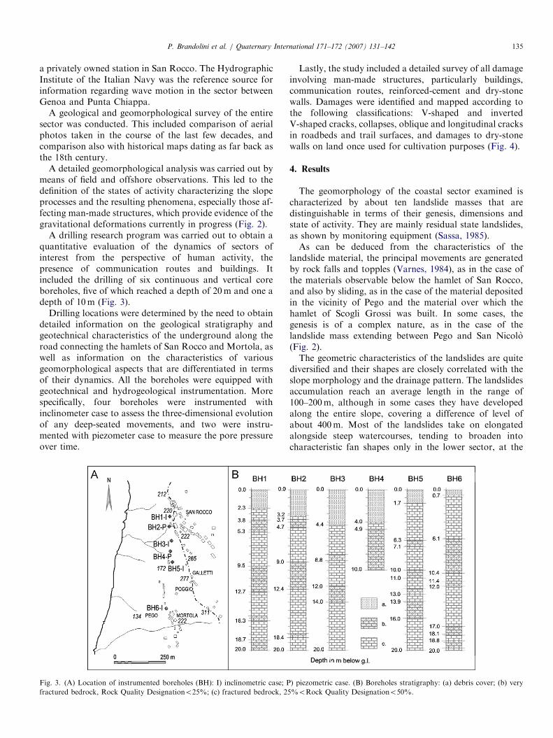
A drilling research program was carried out to obtain aquantitative evaluation of the dynamics of sectors ofinterest from the perspective of human activity, thepresence of communication routes and buildings. Itincluded the drilling of six continuous and vertical coreboreholes, five of which reached a depth of 20m and one adepth of 10m (Fig. 3).
Drilling locations were determined by the need to obtaindetailed information on the geological stratigraphy andgeotechnical characteristics of the underground along theroad connecting the hamlets of San Rocco and Mortola, aswell as information on the characteristics of variousgeomorphological aspects that are differentiated in termsof their dynamics. All the boreholes were equipped withgeotechnical and hydrogeological instrumentation. Morespecifically, four boreholes were instrumented withinclinometer case to assess the three-dimensional evolutionof any deep-seated movements, and two were instru-mented with piezometer case to measure the pore pressureover time.
Fig. 3. (A) Location of instrumented boreholes (BH): I) inclinometric case; P
fractured bedrock, Rock Quality Designationo25%; (c) fractured bedrock, 25
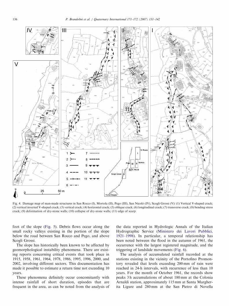
Lastly, the study included a detailed survey of all damageinvolving man-made structures, particularly buildings,communication routes, reinforced-cement and dry-stonewalls. Damages were identified and mapped according tothe following classifications: V-shaped and invertedV-shaped cracks, collapses, oblique and longitudinal cracksin roadbeds and trail surfaces, and damages to dry-stonewalls on land once used for cultivation purposes (Fig. 4).
4. Results
The geomorphology of the coastal sector examined ischaracterized by about ten landslide masses that aredistinguishable in terms of their genesis, dimensions andstate of activity. They are mainly residual state landslides,as shown by monitoring equipment (Sassa, 1985).As can be deduced from the characteristics of the
landslide material, the principal movements are generatedby rock falls and topples (Varnes, 1984), as in the case ofthe materials observable below the hamlet of San Rocco,and also by sliding, as in the case of the material depositedin the vicinity of Pego and the material over which thehamlet of Scogli Grossi was built. In some cases, thegenesis is of a complex nature, as in the case of thelandslide mass extending between Pego and San Nicolo(Fig. 2).The geometric characteristics of the landslides are quite
diversified and their shapes are closely correlated with theslope morphology and the drainage pattern. The landslidesaccumulation reach an average length in the range of100–200m, although in some cases they have developedalong the entire slope, covering a difference of level ofabout 400m. Most of the landslides take on elongatedalongside steep watercourses, tending to broaden intocharacteristic fan shapes only in the lower sector, at the
) piezometric case. (B) Boreholes stratigraphy: (a) debris cover; (b) very
%oRock Quality Designationo50%.
ARTICLE IN PRESS
Fig. 4. Damage map of man-made structures in San Rocco (I), Mortola (II), Pego (III), San Nicolo (IV), Scogli Grossi (V): (1) Vertical V-shaped crack;
(2) vertical inverted V-shaped crack; (3) vertical crack; (4) horizontal crack; (5) oblique crack; (6) longitudinal crack; (7) transverse crack; (8) bending stress
crack; (9) deformation of dry-stone walls; (10) collapse of dry-stone walls; (11) edge of scarp.
P. Brandolini et al. / Quaternary International 171–172 (2007) 131–142136
foot of the slope (Fig. 5). Debris flows occur along thesmall rocky valleys existing in the portion of the slopebelow the road between San Rocco and Pego, and aboveScogli Grossi.
The slope has historically been known to be affected bygeomorphological instability phenomena. There are exist-ing reports concerning critical events that took place in1915, 1958, 1961, 1964, 1978, 1986, 1995, 1996, 2000, and2002, involving different sectors. This documentation hasmade it possible to estimate a return time not exceeding 10years.
These phenomena definitely occur concomitantly withintense rainfall of short duration, episodes that arefrequent in the area, as can be noted from the analysis of
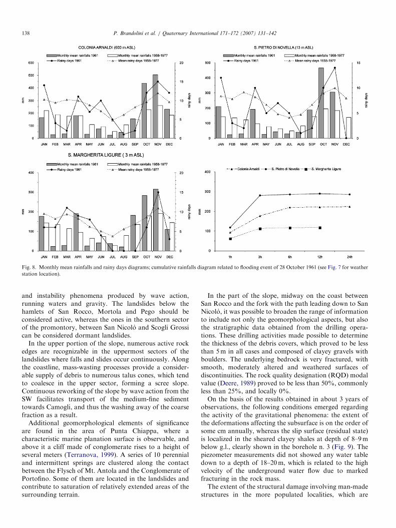
the data reported in Hydrologic Annals of the ItalianHydrographic Service (Ministero dei Lavori Pubblici,1921–1998). In particular, a temporal relationship hasbeen noted between the flood in the autumn of 1961, theoccurrence with the largest registered magnitude, and thetriggering of landslide movements (Fig. 6).The analysis of accumulated rainfall recorded at the
stations existing in the vicinity of the Portofino Promon-tory revealed that levels exceeding 200mm of rain werereached in 24-h intervals, with recurrence of less than 10years. For the month of October 1961, the records showpeaks 3 h accumulations of about 180mm at the ColoniaArnaldi station, approximately 115mm at Santa Margher-ita Ligure and 280mm at the San Pietro di Novella

ARTICLE IN PRESS
Fig. 5. Panoramic view of western slope of Portofino Promontory showing complex foldings and landslides below S. Rocco hamlet.
Fig. 6. San Rocco landslide occurred in 1964.
Fig. 7. Isoieth maps (rainfall in mm): flooding event of 6 September 1961
(a); flooding event of 28 October 1961 (b).
P. Brandolini et al. / Quaternary International 171–172 (2007) 131–142 137
stations, compared to monthly mean accumulations of 226,183 and 197mm, and annual rainfalls amounting to 1880,1430 and 1415mm, respectively (Figs. 7 and 8).
As concerns the landslide dynamics, activity-relatedconditions are easily defined in areas where the cracks inexisting man-made structures appear to be in continuousevolution or where, as in contact with the sea, there areappreciable morphological variations in the slope profile.Evidence of the latter consists in clearly evident erosion
ARTICLE IN PRESS
Fig. 8. Monthly mean rainfalls and rainy days diagrams; cumulative rainfalls diagram related to flooding event of 28 October 1961 (see Fig. 7 for weather
station location).
P. Brandolini et al. / Quaternary International 171–172 (2007) 131–142138
and instability phenomena produced by wave action,running waters and gravity. The landslides below thehamlets of San Rocco, Mortola and Pego should beconsidered active, whereas the ones in the southern sectorof the promontory, between San Nicolo and Scogli Grossican be considered dormant landslides.
In the upper portion of the slope, numerous active rockedges are recognizable in the uppermost sectors of thelandslides where falls and slides occur continuously. Alongthe coastline, mass-wasting processes provide a consider-able supply of debris to numerous talus cones, which tendto coalesce in the upper sector, forming a scree slope.Continuous reworking of the slope by wave action from theSW facilitates transport of the medium-fine sedimenttowards Camogli, and thus the washing away of the coarsefraction as a result.
Additional geomorphological elements of significanceare found in the area of Punta Chiappa, where acharacteristic marine planation surface is observable, andabove it a cliff made of conglomerate rises to a height ofseveral meters (Terranova, 1999). A series of 10 perennialand intermittent springs are clustered along the contactbetween the Flysch of Mt. Antola and the Conglomerate ofPortofino. Some of them are located in the landslides andcontribute to saturation of relatively extended areas of thesurrounding terrain.
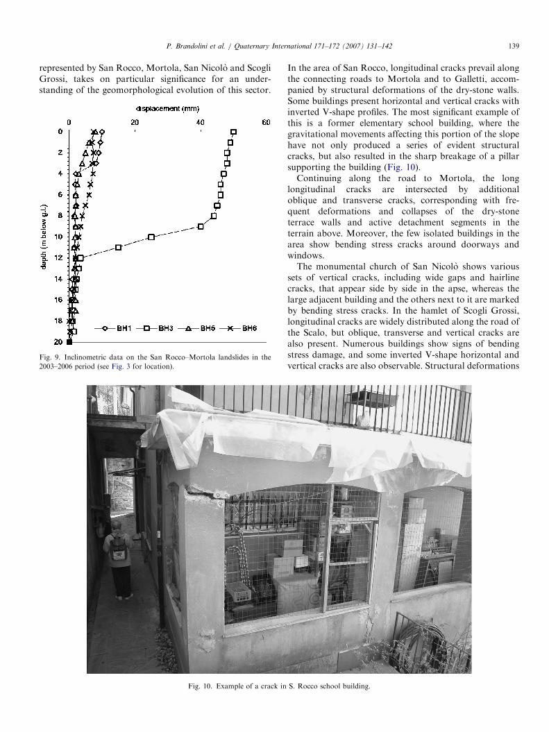
In the part of the slope, midway on the coast betweenSan Rocco and the fork with the path leading down to SanNicolo, it was possible to broaden the range of informationto include not only the geomorphological aspects, but alsothe stratigraphic data obtained from the drilling opera-tions. These drilling activities made possible to determinethe thickness of the debris covers, which proved to be lessthan 5m in all cases and composed of clayey gravels withboulders. The underlying bedrock is very fractured, withsmooth, moderately altered and weathered surfaces ofdiscontinuities. The rock quality designation (RQD) modalvalue (Deere, 1989) proved to be less than 50%, commonlyless than 25%, and locally 0%.On the basis of the results obtained in about 3 years of
observations, the following conditions emerged regardingthe activity of the gravitational phenomena: the extent ofthe deformations affecting the subsurface is on the order ofsome cm annually, whereas the slip surface (residual state)is localized in the sheared clayey shales at depth of 8–9mbelow g.l., clearly shown in the borehole n. 3 (Fig. 9). Thepiezometer measurements did not showed any water tabledown to a depth of 18–20m, which is related to the highvelocity of the underground water flow due to markedfracturing in the rock mass.The extent of the structural damage involving man-made
structures in the more populated localities, which are
ARTICLE IN PRESSP. Brandolini et al. / Quaternary International 171–172 (2007) 131–142 139
represented by San Rocco, Mortola, San Nicolo and ScogliGrossi, takes on particular significance for an under-standing of the geomorphological evolution of this sector.
Fig. 10. Example of a crack in
Fig. 9. Inclinometric data on the San Rocco–Mortola landslides in the
2003–2006 period (see Fig. 3 for location).
In the area of San Rocco, longitudinal cracks prevail alongthe connecting roads to Mortola and to Galletti, accom-panied by structural deformations of the dry-stone walls.Some buildings present horizontal and vertical cracks withinverted V-shape profiles. The most significant example ofthis is a former elementary school building, where thegravitational movements affecting this portion of the slopehave not only produced a series of evident structuralcracks, but also resulted in the sharp breakage of a pillarsupporting the building (Fig. 10).Continuing along the road to Mortola, the long
longitudinal cracks are intersected by additionaloblique and transverse cracks, corresponding with fre-quent deformations and collapses of the dry-stoneterrace walls and active detachment segments in theterrain above. Moreover, the few isolated buildings in thearea show bending stress cracks around doorways andwindows.The monumental church of San Nicolo shows various
sets of vertical cracks, including wide gaps and hairlinecracks, that appear side by side in the apse, whereas thelarge adjacent building and the others next to it are markedby bending stress cracks. In the hamlet of Scogli Grossi,longitudinal cracks are widely distributed along the road ofthe Scalo, but oblique, transverse and vertical cracks arealso present. Numerous buildings show signs of bendingstress damage, and some inverted V-shape horizontal andvertical cracks are also observable. Structural deformations
S. Rocco school building.
ARTICLE IN PRESSP. Brandolini et al. / Quaternary International 171–172 (2007) 131–142140
also prove to be extensive and substantial in the walls alongthe road and terrace walls.
5. Discussion
The historical evidence and the most recent studies bothpoint to a vigorous activity of the gravity controlledgeomorphological processes of the western slope of thePortofino Promontory. Based on all the surveys conducted,it was possible to formulate a detailed definition of thelayout of the landslides, the balance of which is correlatedwith the lithology and structural characteristics of thebedrock, the geomorphological and hydrogeological con-ditions of the slope, and with the effects of precipitationand wave action above all. The influence of human activityappears to be of minor importance, although a lack ofmaintenance of the abandoned terrains over the last fewdecades has surely led to an acceleration of the phenomena.
The particular lithological characteristics of theMt. Antola flysch, distinguished by alternating layers oflimestone and clayey shale differing in their geomechanicalresponses and in alteration, represent a predisposing factorfor the triggering of the landslides. In fact, the limestonelayers are affected by pervasive fracture systems, especiallyon the brittle, folded structures, whereas chemical andphysical degradation prevail in the clayey layers, whichleads to a differential type of erosion.
The morphology of the slope, which is marked by a highslope gradient and steep narrow rocky valleys, represents afavourable condition for the movement of loose material,especially during intense rainstorms of brief duration,which are certainly not infrequent in this area and arecapable of triggering debris flows of various magnitudes(De Chano and Butler, 2001). Precipitation also affectsthe state of activity of the landslides, as they generally leadto saturation of the thickest debris covers, therebyfacilitating mobilization of them due to a decrease in shearstrength.
Among the determining factors, sea storms are offundamental importance. They often occur along withheavy rains, which rapidly create conditions of markedslope instability. In particular, wave action at the foot ofthe slope involves dynamic pressure against the rocky cliffsand the debris covers, together with abrasive and erosiveaction on the part of the coarse-grained materials as theyare cast against the coast.
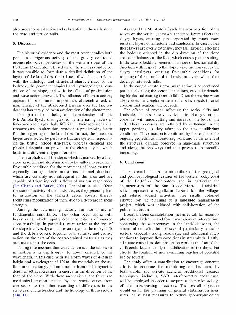
Taking into account that wave action sets the sedimentsin motion at a depth equal to about one-half of thewavelength, in this case, with sea storm waves of 4–5m inheight and wavelengths of 120m, the materials on the seafloor are increasingly put into motion from the bathymetricdepth of 60m, increasing in energy in the direction of thefoot of the slope. With these mechanisms, the force andmechanical erosion created by the waves varies fromone sector to the other according to differences in thestructural characteristics and the lithology of those sectors(Fig. 11).
As regard the Mt. Antola flysch, the erosive action of thewaves on the vertical, somewhat inclined layers affects theclayey layers, creating gaps separated by much moreresistant layers of limestone and sandstone. In cases whenthese layers are overly extensive, they fall. Erosion affectingthe bedding oriented in the dip direction of the slopecreates imbalances at the foot, which causes planar sliding.In the case of bedding oriented in a more or less normal dipdirection with respect to the slope, wave motion erodes theclayey interlayers, creating favourable conditions fortoppling of the more hard and resistant layers, which thendevelops into rock falls.In the conglomerate sector, wave action is concentrated
particularly along the tectonic lineations, gradually detach-ing blocks and causing them to fall. Often the marine wateralso erodes the conglomerate matrix, which leads to arealerosion that weakens the bedrock.The effects of erosion affecting the rocky cliffs and
landslides masses slowly evolve into changes in thecoastline, with undercutting and retreat of the foot of thecliff. These processes are reflected by settlement in theupper portions, as they adapt to the new equilibriumconditions. This situation is confirmed by the results of theongoing geotechnical monitoring work and by the extent ofthe structural damage observed in man-made structuresand along the roadways and that proves to be steadilyincreasing.
6. Conclusions
The research has led to an outline of the geologicaland geomorphological features of the western rocky coastof the Portofino Promontory and in particular thecharacteristics of the San Rocco–Mortola landslides,which represent a significant hazard for the villagesand related tourist activities. The results obtainedallowed for the planning of a landslide managementproject, which was initiated with collaboration of thepublic institutions.Essential slope consolidation measures call for geomor-
phological, hydraulic and forest management intervention,concerning the watercourses in the landslide zones, thestructural consolidation of several particularly unstablesectors, especially along roadways, and additional inter-ventions to improve flow conditions in streambeds. Lastly,adequate coastal erosion protection work at the foot of thecliffs could lead not only to stabilization of the slope, butalso to the creation of new swimming beaches of potentialuse by tourists.The study offers a contribution to encourage concrete
efforts to continue the monitoring of this area, byboth public and private agencies. Additional researchtechniques, including SAR interferometry techniques,will be employed in order to acquire a deeper knowledgeof the mass-wasting processes. The overall objectivewould entail the planning of general stabilization mea-sures, or at least measures to reduce geomorphological
ARTICLE IN PRESS
Fig. 11. Geological cross sections (see Fig. 2 for the location): (1) marine deposit; (2) debris cover; (3) Conglomerate of Portofino; (4) flysch of Mt. Antola.
Cross section I-I: (A) limestone blocks detachment sector; (B) rock fall sector due to wave erosion; (C) marine deposit casted against the coast by sea
storms. Cross section II–II: (A) and (B) tension cracks on the slope and damages in the buildings; (C) landslide foot undercutted by sea storms; (D) marine
deposit casted against the landslide body by sea storms. Cross section III–III: (A) conglomerate blocks detachment sector; (B) limestone blocks
detachment sector; (C) landslide foot undercutted by sea storms; (D) marine deposit casted against the coast by sea storms.
P. Brandolini et al. / Quaternary International 171–172 (2007) 131–142 141
risks, while also taking into account the rema-rkable environmental value and qualities of this coastalsector.
Acknowledgements
This work was carried out in the frame of Instruction,University and Research Ministry project ‘‘Geomorpholo-
gical heritage as a resource for a sustainable tourism’’(COFIN 2004), National Coordinator: Prof. M. Panizza,local project of Genoa University Unit ‘‘Liguria’s geomor-
phological heritage as a resource for a sustainable tourism’’,coordinator: Prof. M. Piccazzo. The Authors are gratefulto M. Giardino, E. Reynard and Peter Bobrowsky foruseful suggestions and improvements of the text andfigures.

ARTICLE IN PRESSP. Brandolini et al. / Quaternary International 171–172 (2007) 131–142142
References
Bell, F.G., 1999. Geological Hazards: their Assessment, Avoidance and
Mitigation. Taylor Francis, London, 648pp.
Brandolini, P., Faccini, F., Piccazzo, M., 2006. Geomorphological hazard
and tourist vulnerability along Portofino Park trails (Italy). Natural
Hazard and Earth System Sciences 6, 1–8.
Cevasco, A., Faccini, F., Nosengo, S., Olivari, F., Robbiano, A., 2004.
Valutazioni sull’uso delle classificazioni geomeccaniche nell’analisi
della stabilita dei versanti rocciosi: il caso del Promontorio di
Portofino (Provincia di Genova). GEAM 111, 31–38.
Corsi, B., Elter, F.M., Giammarino, S., 2001. Structural fabric of the
Antola Unit (Riviera di Levante, Italy) and implications for its alpine
versus Apennine origin. Ofioliti 26 (1), 1–8.
De Chano, L.M., Butler, D.R., 2001. Analysis of public percep-
tion of debris flow hazard. Disaster Prevention and Management 10,
261–269.
Deere, D.U., 1989. Rock quality designation (RQD) after 20 years. US
Army Corps Engrs, Contract Report GL-89-1. Waterways Experi-
mental Station, Vicksburg, MS.
De Stefanis, A., Marini, M., Terranova, R., Canepa, G., Carli, M., De
Luigi, G., Giorgi, M., 1978. Due esempi di analisi geomorfologica di
dettaglio sui promontori di Portofino e del Mesco della costa ligure.
Memorie Societa Geologica Italiana 19, 153–160.
Faccini, F., Brandolini, P., Bonino, E., Piccazzo, M., Olivari, F.,
Robbiano, A., 2005. Phenomenes de condensation et sources perennes
dans le Promontoire de Portofino (Italie). Actes du XVIII Colloque
Internationale de Climatologie (AIC) ‘‘Climat Urbain, Ville et
Architecture (a la memoire de Roberto Rossetti, co-fondateur de
l’AIC),’’ Genes, 7–11 Septembre 2005, pp. 205–208.
Fanucci, F., Nosengo, S., 1979. Rapporti tra neotettonica e fenomeni
morfogenetici del versante marittimo dell’Appennino ligure e del
margine continentale. Bollettino Societa Geologica Italiana 96,
41–51.
Federici, P.R., Capitani, M., Chelli, A., Del Seppia, N., Serani, A., 2004.
Atlante dei centri instabili della Liguria. vol. II, Provincia di Genova.
Tipografia Nuova Ata, Genova, 234pp.
Giammarino, S., Nosengo, S., Vannucci, G., 1969. Risultanze geologico-
paleontologiche sul Conglomerato di Portofino (Liguria orientale).
Atti Ist. Geologica University Genova 7, 305–363.
Glade, T., Anderson, M.G., Crozier, M.J., 2005. Landslide Hazard and
Risk. Wiley, New York, 807pp.
Grecu, F., Comanescu, L., Cruceru, N., 2003. The perception of
geomorphic risks in different territorial geosystems. Dynamic and
applied signifiactions. In: Workshop on ‘‘Geomorphological Sensitiv-
ity and System Response,’’ Camerino—Modena Apennines (Italy),
pp. 87–98.
Issel, A., 1892. Liguria Geologica e Preistorica. In: A. Donath (Ed.), 2
vol., Genova, 440pp. and 376pp.
Marini, M., 1981. Analisi geologico-strutturale ed interpretazione
paleogeografica e tettogenetica dei calcari del M.Antola (Appennino
ligure). Ofioliti 6 (1), 119–150.
Ministero dei Lavori Pubblici, 1921–1998. Annali Idrologici del Servizio
Idrografico.
Panizza, M., 1987. Geomorphological Hazard Assessment and the
Analysis of Geomorphological Risk. Intern Geomorph., 1. Wiley,
London, 323pp.
Pellati, A., 1934. La Penisola di Portofino. Note Geomorfologiche. Riv. di
Sc. Nat. ‘‘Natura,’’ vol. XXV, pp. 1–23.
Provincia di Genova, 2004. Studio dell’ambito costiero. Tratto tra Punta
Vagno ed il Golfo Paradiso. Edizione Colombo Grafiche, Genova,
256pp.
Ristori, G., 1901. Il conglomerato miocenico ed il regime sotterraneo delle
acque nel Promontorio e Monte di Portofino. Mem. Soc. Tosc. Sc.
Nat., Pisa, vol. XVIII, pp. 49–67.
Rovereto, G., 1902–1903. Geomorfologia delle coste. Atti Soc. Ligust. Sc.
Nat., vol. XIII, XIV, Genova, 396pp.
Rovereto, G., 1924. Forme della Terra. Trattato di Geomorfologia.
Hoepli Milano, 1190pp.
Sassa, K., 1985. The geotechnical classification of landslides. In:
Proceedings of the Fourth International Conference and Workshop
on Landslides, Tokyo, pp. 31–40.
Solana, M.C., Kilburn, C.R.J., 2003. Public awareness of landslide
hazards: the Barranco de Tirajana, Gran Canaria, Spain. Geomor-
phology 54 (1–2), 39–48.
Sunamura, T., 1992. Geomorphology of Rocky Coast. Institute of
Geoscience, University of Tsukuba, Japan. Wiley, 302pp.
Terranova, R., 1964. Le frane del Castellaro e di S.Rocco sul versante
occidentale del Promontorio di Portofino. Atti Ist. Geol. Universita di
Genova, pp. 342–376.
Terranova, R., 1995. Guida all’escursione geografica in mare da Genova a
Portofino, a Chiavari e a San Salvatore dei Fieschi. Atti del Convegno
in onore di D. Ruocco, Genova, 5–6 maggio 1994, Loffredo Ed.,
pp. 107–158.
Terranova, R., 1999. Squilibri geomorfologici e rischi sulla costa alta
rocciosa occidentale del Promontorio di Portofino (Liguria Orientale).
Studi geografici e geologici in onore di S. Belloni. Universita degli
Studi di Milano e Milano Bicocca, pp. 595–607.
Varnes, D.J., 1984. Landslide hazard zonation: a review of principles and
practice. Natural hazards, 3, UNESCO. 63pp.