Geomorphological evidence for variations of the North Patagonian Icefield during the Holocene
15
Geomorphological evidence for variations of the North Patagonian Icefield during the Holocene Neil F. Glasser a, T , Krister N. Jansson a , Stephan Harrison b , Andres Rivera c a Centre for Glaciology, Institute of Geography and Earth Sciences, University of Wales, Aberystwyth, Ceredigion SY23 3DB, Wales, United Kingdom b School of Geography and the Environment, University of Oxford, Mansfield Road, Oxford OX1 3TB, England, United Kingdom c Departamento de Geografia, Universidad de Chile, PO Box 3387, Santiago, Chile and Centro de Estudios Cientı ´ficos, Valdivia, Chile Abstract Elucidating the timing and extent of former glacier fluctuations is important because of the palaeoclimatic inferences that can be drawn from such studies. Here we present new geomorphological evidence of the patterns of glacier behaviour around the North Patagonian Icefield during the Holocene. Mapping is based on visual interpretation of Landsat 7 ETM+ and Terra ASTER satellite images, including the contemporary glaciers, areas of ice-scoured bedrock, trimlines, glacial lineations, terminal moraines, sandur and fluvial sediments, deltas and ice-contact deposits and alluvial fans. Recession of the icefield is marked by three distinct moraine sets. These moraine sets are interpreted as marking terminal positions related to the bLittle Ice AgeQ and two preceding, but as yet undated, phases of Holocene glacier expansion. Large arcuate terminal moraines in front of three of the western glaciers are interpreted as composite features, reflecting topographic limits to glacier expansion, indicating that caution is required in the interpretation of previous 14 C dates obtained from these moraines. There are strong contrasts in the patterns of glacier behaviour between the east and west sides of the North Patagonian Icefield, which cannot be attributed simply to an east/west differential in the rates of change of atmospheric temperature and precipitation. We argue here that glacier response to first-order climate forcing is tempered by second-order controls introduced by regional-scale topographic effects, notably glacier drainage basin extent and area, topographic controls on glacier snout morphology and differences in terminal environment (calving/non-calving) during glacier recession. Keywords: North Patagonian Icefield; Glacial geomorphology; Glacier fluctuations; Little ice age; Holocene; Chile 1. Introduction The outlet glaciers of the two Patagonian Icefields (the North and South Patagonian Icefields; Fig. 1) are influenced by the strong climatic gradients across T Corresponding author. Fax: +44 1970 622659. E-mail address: [email protected] (N.F. Glasser).
-
Upload
independent -
Category
Documents
-
view
1 -
download
0
Transcript of Geomorphological evidence for variations of the North Patagonian Icefield during the Holocene

Geomorphological evidence for variations of the North Patagonian
Icefield during the Holocene
Neil F. Glassera,T, Krister N. Janssona, Stephan Harrisonb, Andres Riverac
aCentre for Glaciology, Institute of Geography and Earth Sciences, University of Wales, Aberystwyth,
d, United Kingdom
7, Santiago, Chile and Centro de Estudios Cientıficos, Valdivia, Chile
Geomorphology 71 (2005) 263–277
www.elsevier.com/locate/geomorph
bSchool of Geography and the Environment, University of OxfcDepartamento de Geografia, Universidad de Chile, PO Box 338
Abstract
Elucidating the timing and extent of former glacier fluctuations is important because of the palaeoclimatic inferences that can
be drawn from such studies. Here we present new geomorphological evidence of the patterns of glacier behaviour around the
North Patagonian Icefield during the Holocene. Mapping is based on visual interpretation of Landsat 7 ETM+ and Terra
ASTER satellite images, including the contemporary glaciers, areas of ice-scoured bedrock, trimlines, glacial lineations,
terminal moraines, sandur and fluvial sediments, deltas and ice-contact deposits and alluvial fans. Recession of the icefield is
marked by three distinct moraine sets. These moraine sets are interpreted as marking terminal positions related to the bLittle IceAgeQ and two preceding, but as yet undated, phases of Holocene glacier expansion. Large arcuate terminal moraines in front of
three of the western glaciers are interpreted as composite features, reflecting topographic limits to glacier expansion, indicating
that caution is required in the interpretation of previous 14C dates obtained from these moraines. There are strong contrasts in
the patterns of glacier behaviour between the east and west sides of the North Patagonian Icefield, which cannot be attributed
simply to an east/west differential in the rates of change of atmospheric temperature and precipitation. We argue here that glacier
response to first-order climate forcing is tempered by second-order controls introduced by regional-scale topographic effects,
notably glacier drainage basin extent and area, topographic controls on glacier snout morphology and differences in terminal
environment (calving/non-calving) during glacier recession.
Keywords: North Patagonian Icefield; Glacial geomorphology; Glacier fluctuations; Little ice age; Holocene; Chile
1. Introduction
The outlet glaciers of the two Patagonian Icefields
(the North and South Patagonian Icefields; Fig. 1) are
influenced by the strong climatic gradients acrossT Corresponding author. Fax: +44 1970 622659.
E-mail address: [email protected] (N.F. Glasser).
Ceredigion SY23 3DB, Wales, United Kingdom
ord, Mansfield Road, Oxford OX1 3TB, Englan
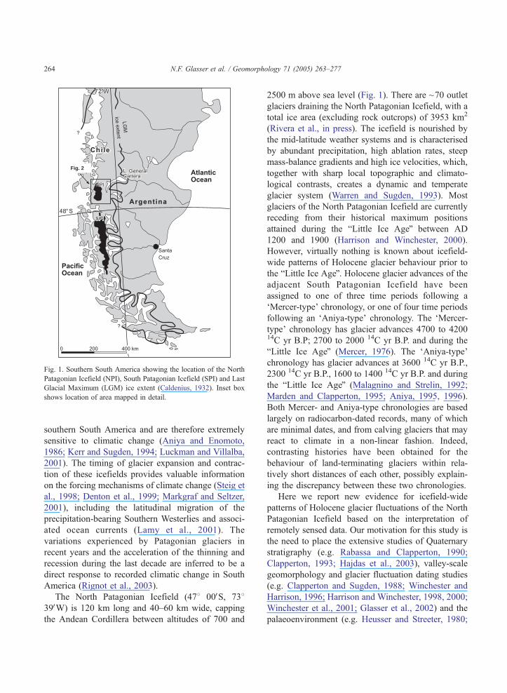
Fig. 2
2
8
2
Fig. 1. Southern South America showing the location of the North
Patagonian Icefield (NPI), South Patagonian Icefield (SPI) and Last
Glacial Maximum (LGM) ice extent (Caldenius, 1932). Inset box
shows location of area mapped in detail.
N.F. Glasser et al. / Geomorphology 71 (2005) 263–277264
southern South America and are therefore extremely
sensitive to climatic change (Aniya and Enomoto,
1986; Kerr and Sugden, 1994; Luckman and Villalba,
2001). The timing of glacier expansion and contrac-
tion of these icefields provides valuable information
on the forcing mechanisms of climate change (Steig et
al., 1998; Denton et al., 1999; Markgraf and Seltzer,
2001), including the latitudinal migration of the
precipitation-bearing Southern Westerlies and associ-
ated ocean currents (Lamy et al., 2001). The
variations experienced by Patagonian glaciers in
recent years and the acceleration of the thinning and
recession during the last decade are inferred to be a
direct response to recorded climatic change in South
America (Rignot et al., 2003).
The North Patagonian Icefield (478 00VS, 73839VW) is 120 km long and 40–60 km wide, capping
the Andean Cordillera between altitudes of 700 and
2500 m above sea level (Fig. 1). There are ~70 outlet
glaciers draining the North Patagonian Icefield, with a
total ice area (excluding rock outcrops) of 3953 km2
(Rivera et al., in press). The icefield is nourished by
the mid-latitude weather systems and is characterised
by abundant precipitation, high ablation rates, steep
mass-balance gradients and high ice velocities, which,
together with sharp local topographic and climato-
logical contrasts, creates a dynamic and temperate
glacier system (Warren and Sugden, 1993). Most
glaciers of the North Patagonian Icefield are currently
receding from their historical maximum positions
attained during the bLittle Ice AgeQ between AD
1200 and 1900 (Harrison and Winchester, 2000).
However, virtually nothing is known about icefield-
wide patterns of Holocene glacier behaviour prior to
the bLittle Ice AgeQ. Holocene glacier advances of theadjacent South Patagonian Icefield have been
assigned to one of three time periods following a
dMercer-typeT chronology, or one of four time periods
following an dAniya-typeT chronology. The dMercer-
typeT chronology has glacier advances 4700 to 420014C yr B.P; 2700 to 2000 14C yr B.P. and during the
bLittle Ice AgeQ (Mercer, 1976). The dAniya-typeTchronology has glacier advances at 3600 14C yr B.P.,
2300 14C yr B.P., 1600 to 1400 14C yr B.P. and during
the bLittle Ice AgeQ (Malagnino and Strelin, 1992;
Marden and Clapperton, 1995; Aniya, 1995, 1996).
Both Mercer- and Aniya-type chronologies are based
largely on radiocarbon-dated records, many of which
are minimal dates, and from calving glaciers that may
react to climate in a non-linear fashion. Indeed,
contrasting histories have been obtained for the
behaviour of land-terminating glaciers within rela-
tively short distances of each other, possibly explain-
ing the discrepancy between these two chronologies.
Here we report new evidence for icefield-wide
patterns of Holocene glacier fluctuations of the North
Patagonian Icefield based on the interpretation of
remotely sensed data. Our motivation for this study is
the need to place the extensive studies of Quaternary
stratigraphy (e.g. Rabassa and Clapperton, 1990;
Clapperton, 1993; Hajdas et al., 2003), valley-scale
geomorphology and glacier fluctuation dating studies
(e.g. Clapperton and Sugden, 1988; Winchester and
Harrison, 1996; Harrison and Winchester, 1998, 2000;
Winchester et al., 2001; Glasser et al., 2002) and the
palaeoenvironment (e.g. Heusser and Streeter, 1980;
N.F. Glasser et al. / Geomorphology 71 (2005) 263–277 265
Bennett et al., 2000; Massaferro and Brooks, 2002)
into a regional geographical context. We use these
geomorphological data to elaborate on the factors
contributing to the pattern and extent of Holocene
glacier fluctuations and to speculate on the timing of
these phases of glacier expansion and recession.
2. Methods
The glacial geomorphology of the area surrounding
the North Patagonian Icefield was mapped by visual
interpretation of Terra ASTER (Advanced Spaceborne
Thermal Emission and Reflection Radiometer) and
Landsat 7 Enhanced Thematic Mapper Plus (ETM+)
satellite images. The images were radiometrically and
geometrically corrected using the orbital parameters
supplied by the USGS, producing a horizontal error
on the order of one pixel (15 m for ASTER and 30 m
for Landsat ETM+). The data sources used in this
study are listed in Table 1, and the features identified
on satellite images and the criteria used in their
identification are listed in Table 2. The geomorpho-
logical mapping was augmented by valley-scale
mapping conducted by the authors over a number of
field seasons in the following valleys: the San Quintin
and San Rafael valleys (Winchester and Harrison,
1996) the Gualas and Reicher valleys (Harrison and
Winchester, 1997, 1998), the Arco and Colonia
valleys (Harrison and Winchester, 2000), the Nef
valley (Winchester et al., 2001), the Soler valley
(Glasser and Hambrey, 2002; Glasser et al., 2002) and
the Exploradores valley (Harrison et al., 2004).
Information on glacier terminal environments and
Table 1
Data sources used in the compilation of the glacial geomorphological ma
Satellite image ID number
Terra ASTERa AST_L1B.003:2012491016
Terra ASTERa,b AST_L1B.003:2004080855
Terra ASTERa AST_L1B.003:2011896528
Terra ASTERa AST_L1B.003:2006008908
Terra ASTERa AST_L1B.003:2012443150
Landsat 7 ETM+c 7232092000107050
Landsat 7 ETM+c 7232093000107050
a Spatial resolution 15 m in near-infrared.b ~50% thin snow cover.c Spatial resolution 30 m in visible and near-infrared and 15 m in the p
the topographic context of glacier snouts was also
recorded (Table 3).
3. Results: glacial geomorphological mapping
In this section, we provide a description of the
glacial geomorphology of the North Patagonian Ice-
field and surrounding area (Fig. 2). Figs. 3–6 show
typical examples and interpretations of landforms
mapped from the satellite images. Table 3 is a summary
of the main attributes of the glaciers draining the
icefield and their proglacial geomorphology.
3.1. Contemporary glaciers
The outlet glaciers typically descend steeply from
the icefield, many via icefalls (e.g. Soler, Leones, San
Rafael). Glacier surfaces are commonly heavily cre-
vassed (especially at calving termini) with variable
amounts of supraglacial material organised into flow-
parallel medial and lateral moraines (Figs. 4C and 6).
Only one of the contemporary western outlet glaciers
(San Rafael) is tidewater, terminating in a tidal lagoon.
The remainder of the western outlet glaciers terminates
in freshwater lakes (e.g. Gualas, Reicher, Benito,
HPN2, HPN3, Steffan). An exception to this is the
San Quintin Glacier which, until recently (1998), was
land terminating but which is now also receding into a
freshwater lake (Harrison et al., 2001). The eastern
outlet glaciers terminate almost exclusively in fresh-
water lakes (e.g. Leones, Nef, Colonia, Arenales, Arco,
Pared Norte, Fiero), with active lake-calving fronts.
The glaciers that are not currently lake-terminating
p of the area surrounding the North Patagonian Icefield
Date scene acquired Cloud cover (%)
2000/5/2 6
2001/9/3 6
2002/1/18 5
2002/2/10 25
2003/2/22 7
2001/3/11 0
2001/3/11 7
anchromatic band.

Table 2
Criteria used in identifying landforms from satellite imagery
Landform/feature Identification criteria Possible identification errors Glaciological significance
Morphology Colour/structure/texture
Contemporary
glaciers
Bare ice, snow and debris.
Surface structures
(e.g. crevasses) common.
White to light blue. Surface smooth
to rough.
Minor over-estimate in glacier
extent possible where confused
with snow cover.
Foci for ice discharge from
the contemporary icefield.
Ice-scoured
bedrock
Widespread exposures of bare
or lightly vegetated bedrock.
Numerous small lake basins
and open joints visible.
Grey to light pink when vegetation
cover is present. Bedrock structures
and faults often present. Upper
surface often has a rough and
irregular texture.
Possible under-estimate where
bedrock obscured by vegetation
cover.
Evidence for extensive areas
of former glacier ice at its
pressure-melting point.
Trimlines Sub-horizontal lines on valley
sides separating areas of
non-vegetated and vegetated
land or areas covered by
different types of vegetation.
Sharp altitudinal change in surface
colour and texture due to change
in vegetation cover.
Possible, but unlikely, confusion
with other sub-horizontal or
horizontal features such as glacial
lake shorelines.
Former vertical dimensions of
glaciers.
Glacial lineations Parallel features indicating
ice-flow direction. Formed in
bedrock by glacial erosion or
by sediment accumulation.
In bedrock, change in surface
structure compared to surrounding
terrain. In debris, different colour
compared to surrounding terrain
due to change in vegetation cover.
Possible under–estimate in areas
of thin debris cover. Bedrock
landforms may be confused with
bedrock structures in certain
lithologies.
May indicate high former ice
velocities, when highly
attenuated.
Terminal moraines Prominent cross-valley single
or multiple ridges with positive
relief. Linear, curved, sinuous
or saw-toothed in plan.
Shadowing due to change in
relief and change in colour
where moraines are vegetated.
Possible, but unlikely, confusion
with trimlines where moraines
have low relative height.
Moraines mark the former
terminal position of outlet
glaciers.
Sandur/fluvial
sediment
Valley floor accumulations of
sediment, commonly dissected
by a braided stream pattern.
Flat, mainly light red areas with
medium grey where there is thin
vegetation cover. Erosional scars
and sharp boundaries with
surrounding terrain.
Possible, but unlikely, confusion
with deltas or ice-contact deposits.
Marks major drainage routes
from contemporary glaciers
and other glacier-fed streams.
Delta or ice-contact
deposits
Flat-topped sediment
accumulations above the
present day valley floor,
commonly with a steep
delta front.
Homogeneous surface texture with
flat upper surfaces, erosional scars
and sharp boundaries with
surrounding terrain.
Possible, but unlikely, confusion
with sandur or alluvial fans.
Sediments deposited by streams
draining tributary valleys
onto/against glacier ice in main
valleys. Indicates thickness and
extent of ice in the main valley.
Alluvial fans Sub-horizontal fans on valley
sides. Typically fed by a
meltwater channel or stream.
Fan shaped accumulation with
sharp boundary with surrounding
terrain due to change in vegetation
cover. Pattern of braided streams
on upper surface.
Possible to misinterpret as fossil
delta or ice-contact deposit.
Reworking of unconsolidated
material by contemporary
meltwater channels and streams.
N.F.Glasser
etal./Geomorphology71(2005)263–277
266
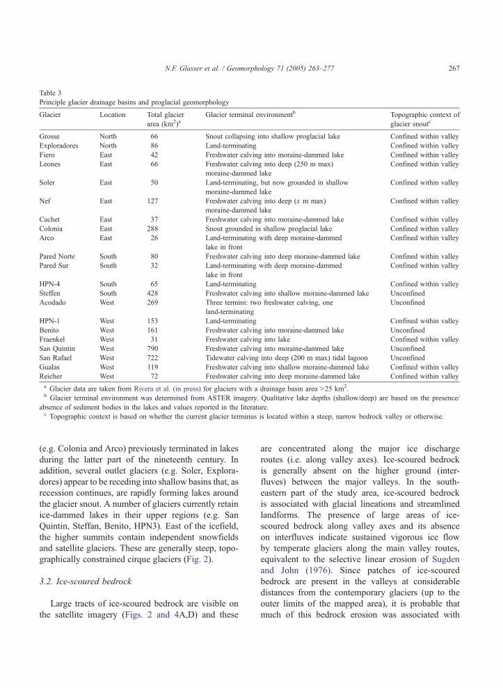
Table 3
Principle glacier drainage basins and proglacial geomorphology
Glacier Location Total glacier
area (km2)aGlacier terminal environmentb Topographic context of
glacier snoutc
Grosse North 66 Snout collapsing into shallow proglacial lake Confined within valley
Exploradores North 86 Land-terminating Confined within valley
Fiero East 42 Freshwater calving into moraine-dammed lake Confined within valley
Leones East 66 Freshwater calving into deep (250 m max)
moraine-dammed lake
Confined within valley
Soler East 50 Land-terminating, but now grounded in shallow
moraine-dammed lake
Confined within valley
Nef East 127 Freshwater calving into deep (x m max)
moraine-dammed lake
Confined within valley
Cachet East 37 Freshwater calving into moraine-dammed lake Confined within valley
Colonia East 288 Snout grounded in shallow proglacial lake Confined within valley
Arco East 26 Land-terminating with deep moraine-dammed
lake in front
Confined within valley
Pared Norte South 80 Freshwater calving into deep moraine-dammed lake Confined within valley
Pared Sur South 32 Land-terminating with deep moraine-dammed
lake in front
Confined within valley
HPN-4 South 65 Land-terminating Confined within valley
Steffen South 428 Freshwater calving into shallow moraine-dammed lake Unconfined
Acodado West 269 Three termini: two freshwater calving, one
land-terminating
Unconfined
HPN-1 West 153 Land-terminating Confined within valley
Benito West 161 Freshwater calving into moraine-dammed lake Unconfined
Fraenkel West 31 Freshwater calving into lake Confined within valley
San Quintin West 790 Freshwater calving into moraine-dammed lake Unconfined
San Rafael West 722 Tidewater calving into deep (200 m max) tidal lagoon Unconfined
Gualas West 119 Freshwater calving into shallow moraine-dammed lake Confined within valley
Reicher West 72 Freshwater calving into deep moraine-dammed lake Confined within valley
a Glacier data are taken from Rivera et al. (in press) for glaciers with a drainage basin area N25 km2.b Glacier terminal environment was determined from ASTER imagery. Qualitative lake depths (shallow/deep) are based on the presence/
absence of sediment bodies in the lakes and values reported in the literature.c Topographic context is based on whether the current glacier terminus is located within a steep, narrow bedrock valley or otherwise.
N.F. Glasser et al. / Geomorphology 71 (2005) 263–277 267
(e.g. Colonia and Arco) previously terminated in lakes
during the latter part of the nineteenth century. In
addition, several outlet glaciers (e.g. Soler, Explora-
dores) appear to be receding into shallow basins that, as
recession continues, are rapidly forming lakes around
the glacier snout. A number of glaciers currently retain
ice-dammed lakes in their upper regions (e.g. San
Quintin, Steffan, Benito, HPN3). East of the icefield,
the higher summits contain independent snowfields
and satellite glaciers. These are generally steep, topo-
graphically constrained cirque glaciers (Fig. 2).
3.2. Ice-scoured bedrock
Large tracts of ice-scoured bedrock are visible on
the satellite imagery (Figs. 2 and 4A,D) and these
are concentrated along the major ice discharge
routes (i.e. along valley axes). Ice-scoured bedrock
is generally absent on the higher ground (inter-
fluves) between the major valleys. In the south-
eastern part of the study area, ice-scoured bedrock
is associated with glacial lineations and streamlined
landforms. The presence of large areas of ice-
scoured bedrock along valley axes and its absence
on interfluves indicate sustained vigorous ice flow
by temperate glaciers along the main valley routes,
equivalent to the selective linear erosion of Sugden
and John (1976). Since patches of ice-scoured
bedrock are present in the valleys at considerable
distances from the contemporary glaciers (up to the
outer limits of the mapped area), it is probable that
much of this bedrock erosion was associated with
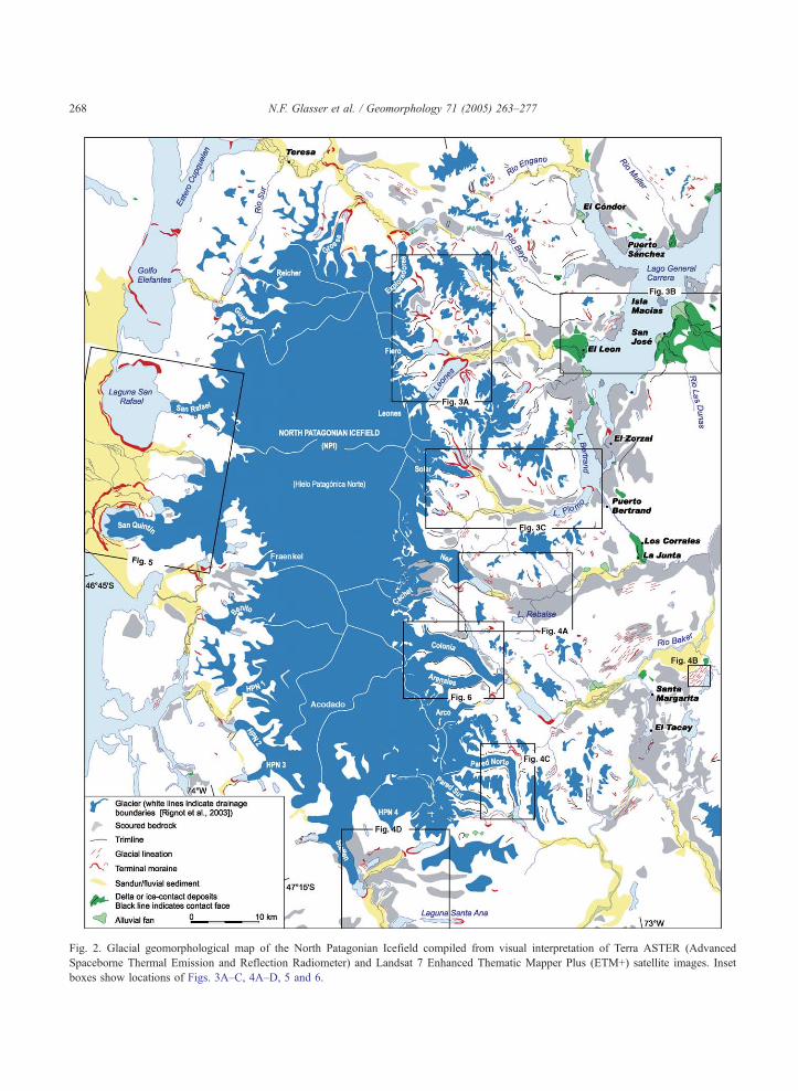
Fig. 2. Glacial geomorphological map of the North Patagonian Icefield compiled from visual interpretation of Terra ASTER (Advanced
Spaceborne Thermal Emission and Reflection Radiometer) and Landsat 7 Enhanced Thematic Mapper Plus (ETM+) satellite images. Inset
boxes show locations of Figs. 3A–C, 4A–D, 5 and 6.
N.F. Glasser et al. / Geomorphology 71 (2005) 263–277268

Fig. 3. Landforms on the north and eastern side of the North Patagonian Icefield: Terra ASTER subscenes (bands 1, 2, and 3N) and
interpretation showing the major geomorphological features of the area. (A) Glaciers Exploradores, Fiero, Leones and satellite glaciers. The
icefield glaciers have large terminal moraines enclosing proglacial lakes and trimlines, whilst the satellite glaciers have smaller terminal
moraines. (B) Part of Lago General Carrera showing large deltas and ice-contact deposits at the mouths of tributary glaciers. The deltas and ice-
contact deposits are being incised by contemporary streams to produce alluvial fans. (C) Rio Soler showing the contemporary glacier, extensive
sandur and the large arcuate moraine in Lago Bertrand. For location and key to geomorphological features, see Fig. 2.
N.F. Glasser et al. / Geomorphology 71 (2005) 263–277 269
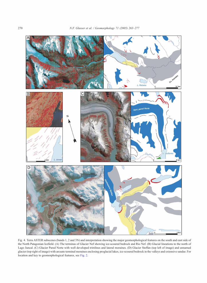
Fig. 4. Terra ASTER subscenes (bands 1, 2 and 3N) and interpretation showing the major geomorphological features on the south and east side of
the North Patagonian Icefield. (A) The terminus of Glacier Nef showing ice-scoured bedrock and Rio Nef. (B) Glacial lineations to the north of
Lago Juncal. (C) Glacier Pared Norte with well developed trimlines and lateral moraines. (D) Glacier Steffan (top left of image) and unnamed
glacier (top right of image) with arcuate terminal moraines enclosing proglacial lakes, ice-scoured bedrock in the valleys and extensive sandur. For
location and key to geomorphological features, see Fig. 2.
N.F. Glasser et al. / Geomorphology 71 (2005) 263–277270
Fig. 5. Landsat ETM+ subscene showing arcuate terminal moraines
and sandar marking the limits of large former piedmont lobes on the
west side of the North Patagonian Icefield. For location and key to
geomorphological features, see Fig. 2.
N.F. Glasser et al. / Geomorphology 71 (2005) 263–277 271
the Last Glacial Maximum ice masses (Glasser and
Jansson, 2005).
3.3. Trimlines
Sub-horizontal trimlines are present along the
margins of many of the contemporary glaciers,
especially those on the eastern side of the icefield
(Figs. 2 and 4C). Trimlines can be traced along the
glacier margins for considerable distances (e.g. 10
km at Lago Leones) before merging with well-
developed terminal and lateral moraines (Fig. 3A).
The trimlines mark the vertical extent of former
glaciers and are useful in making glaciological
reconstructions. Dendrochronology and lichenometry
indicate that most are very recent in age, dating from
the Little Ice Age, around AD 1700–1900 (e.g.
Harrison and Winchester, 1998), although Aniya and
Naruse (1999) dated similar trimlines in the Soler
valley to ca. AD 700.
3.4. Glacial lineations
At several locations in the study area, streamlined
landforms/lineations occur, and are defined by sharp
lateral boundaries (Fig. 2). These landforms, com-
monly associated with scoured bedrock, are generally
aligned along major ice discharge routes (i.e. along
valleys) such as those present in the Rio de la Colonia/
Rio Baker valley. The occurrence of glacially stream-
lined landforms in areas of thin debris cover or the
absence of soil indicates that these features are mainly
drumlinoids and/or grooved bedrock (for example east
of Cordon Cabeza de Leon). Regular drumlins and
flutes are present for example north of Laguna Juncal
(Fig. 4B). These features are typically between 500 m
and 2 km in length and approximately 100 m wide.
The lineations east of the North Patagonian Icefield
are attenuated lineations. Streamlined landforms are
more common to the east of the North Patagonian
Icefield and are notably lacking from the areas
surrounding the western outlet glaciers (Fig. 2).
3.5. Terminal moraines
Well-developed terminal moraines mark the former
extent of many of the outlet glaciers of the icefield
and its satellite glaciers (Fig. 2). Three moraine sets
are recognised, defined by their relative size, mor-
phology and distance from the contemporary icefield.
All three moraine sets are located within the
established Last Glacial Maximum limits of the North
Patagonian Icefield (Morner and Sylwan, 1989;
Wenzens, 1999; Strelin and Malagnino, 2000; Kaplan
et al., 2004) (Fig. 1A). The first set includes the small
moraines that lie within 5 km of virtually all
contemporary glacier snouts, marking post-bLittleIce AgeQ glacier recession (Winchester and Harrison,
1996; Winchester et al., 2001; Harrison and Win-
chester, 1998, 2000) (Fig. 3A). The second set
includes moraines that lie 5 to 15 km from the
contemporary glacier snouts. This set includes three
large arcuate terminal moraines that mark former
terminal positions of the San Quintin, San Rafael,
Gualas and Reicher Glaciers (Fig. 5). Possible east
side equivalents are the large moraines that dam the
proglacial lakes at Leones, Nef, Colonia and Pared
Norte Glaciers (Fig. 2). The third set includes
moraines and associated ice-contact deposits over 15

TrimlineTrimline
Medial moraineMedial moraine
Glacial lakeGlacial lake
Icefall
Lateral moraine
Medial moraine
Glacial lake
Vent. Colonia
Vent. Arenales
0 2 km
Trimline
Fig. 6. Glaciers Arenales and Colonia showing glacier surface features and surrounding geomorphology. For location, see Fig. 2.
N.F. Glasser et al. / Geomorphology 71 (2005) 263–277272
km from the contemporary glacier snouts. The largest
of these is the terminal moraine in the Rio Soler
between Lago Plomo and Lago Bertrand (Fig. 3C).
3.6. Sandur/fluvial sediment
Large sandur (outwash plains) are present on the
valley floors in front of all the contemporary glaciers
(e.g. Leones, Soler, Nef, Colonia), either draining the
glaciers directly or buffered from the glaciers by
proglacial lakes (Figs. 3A,C and 4D). On the west side
of the icefield, sandur are present only outside the
large arcuate moraine systems (Fig. 5). Here, they
cover broad extensive areas and are less confined than
the eastern sandur.
3.7. Delta and ice-contact deposits
The delta and ice-contact deposits identified in this
study are large sediment accumulations at the con-
fluences of tributary valleys and the eastward-trending
main valleys (Fig. 2). Their flat upper surfaces and
steep outer faces indicate that these delta and ice-
contact deposits were built out against glacier ice
occupying lower ground in the main valleys. The delta
and ice-contact deposits therefore mark the former
vertical extent of the glaciers in these main valleys.
Particularly well-developed examples occur at the
mouth of the Leones Valley where it joins Lago
General Carrera (Fig. 3B) and in the Rio Nef. By
contrast, these features are absent from the west side
of the icefield.
3.8. Alluvial fans
Alluvial fans identified in this study are large
sediment accumulations at the mouths of the valleys
to the east of the icefield (Fig. 2). In some instances
(e.g. around Lago General Carrera; Fig. 3B), the
alluvial fans appear to be reworking older delta and
N.F. Glasser et al. / Geomorphology 71 (2005) 263–277 273
ice-contact deposits. These alluvial fans are inter-
preted as contemporary fluvial features.
4. Discussion
4.1. Moraine sets and correlation
The moraine sets around the North Patagonian
Icefield and their association with areas of ice-scoured
bedrock, trimlines, glacial lineations, sandur and
fluvial sediments, deltas and ice-contact deposits and
NPI
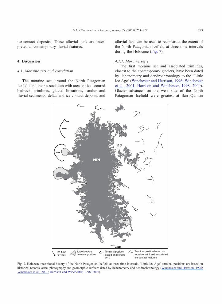
Fig. 7. Holocene recessional history of the North Patagonian Icefield at th
historical records, aerial photography and geomorphic surfaces dated by li
Winchester et al., 2001; Harrison and Winchester, 1998, 2000).
alluvial fans can be used to reconstruct the extent of
the North Patagonian Icefield at three time intervals
during the Holocene (Fig. 7).
4.1.1. Moraine set 1
The first moraine set and associated trimlines,
closest to the contemporary glaciers, have been dated
by lichenometry and dendrochronology to the bLittleIce AgeQ (Winchester and Harrison, 1996; Winchester
et al., 2001; Harrison and Winchester, 1998, 2000).
Glacier advances on the west side of the North
Patagonian Icefield were greatest at San Quintin
ree time intervals. bLittle Ice AgeQ terminal positions are based on
chenometry and dendrochronology (Winchester and Harrison, 1996;
N.F. Glasser et al. / Geomorphology 71 (2005) 263–277274
Glacier, where an arcuate moraine (labelled outer
moraine on Fig. 5) marks the presence of a large
piedmont lobe, but advances were more restricted at
San Rafael, Gualas and Reicher Glaciers. Historical
records (e.g. Simpson, 1875) indicate that the termi-
nus of San Rafael Glacier failed to cross the Laguna
San Rafael during the bLittle Ice AgeQ. The bLittle IceAgeQ advance of San Rafael Glacier was probably
restricted because rapid iceberg calving accompanied
its advance into the deep water of the Laguna San
Rafael (Warren, 1993). The Reicher and Gualas
Glaciers were probably confluent at this time but
their termini ended in overdeepened lakes and thus
did not extend far down the Gualas valley (Harrison
and Winchester, 1998). In contrast, the land-terminat-
ing San Quintin Glacier was not affected by calving
during the bLittle Ice AgeQ. Deep freshwater terminal
lakes are also present on the east side of the North
Patagonian Icefield, and again the potential for rapid
iceberg calving restricted the bLittle Ice AgeQ advan-ces of many of these glaciers.
4.1.2. Moraine set 2
The second moraine set includes (i) arcuate
terminal moraines 5 to 15 km from the contemporary
glacier snouts at San Rafael, Gualas and Reicher
Glaciers to the west of the North Patagonian Icefield,
marking the position of former piedmont lobes and
(ii) moraines damming the proglacial lakes of
Leones, Colonia and Pared Norte Glaciers to the
east of the North Patagonian Icefield. The San Rafael
moraine has traditionally been considered to mark the
onset of Neoglaciation in the southern Andes around
5000 14C yr B.P. (e.g. Clapperton and Sugden, 1988;
Porter, 2000; Heusser, 2002). However, the age of
the San Rafael moraine is debated; 14C dates for this
moraine range from 6850F200 14C yr B.P. (Heusser,
1960) to 3600 14C yr B.P. (Muller, 1960). Dating of
moraines in front of these piedmont lobes is
problematic because it is possible that these moraines
are in fact composite features, marking terminal
positions occupied more than once during the
Holocene. Thus, the different age estimates for the
San Rafael moraines may be the result of the
reworking of older sediments during more than one
advance. If such reworking took place, it is possible
that these moraines are actually much younger than
their apparent 14C-dated age.
4.1.3. Moraine set 3
On the east side of the North Patagonian Icefield,
over 15 km from the contemporary glacier snouts, is a
third moraine set and associated ice-contact deposits
interpreted to be older than moraine sets 1 and 2 (Fig.
7). There are no documented west side equivalents of
these moraines. The age of these landforms is
uncertain, but since they lie within the established
Last Glacial Maximum limits of the North Patagonian
Icefield (Morner and Sylwan, 1989; Wenzens, 1999;
Strelin and Malagnino, 2000), we speculate that they
may represent an early Holocene or Late-glacial phase
of glacier expansion.
4.2. Possible explanations for Holocene glacier
behaviour
The distribution of the three moraine sets indicates
clear differences in the response styles of the outlet
glaciers of the North Patagonian Icefield to imposed
Holocene climate change and its consequent changes
in glacier mass balance. For example, on the west of
the North Patagonian Icefield, moraine set 2 is marked
by large arcuate terminal moraines indicating the
position of former piedmont lobes and sandar 5 to 15
km from the contemporary glacier snouts, whilst
expansion of the eastern glaciers is marked by smaller
within-valley terminal moraines. There are 4 possible
explanations for these east/west contrasts in Holocene
glacier behaviour.
I. Changes in Holocene atmospheric temperature
and precipitation were not uniformly distrib-
uted, causing glaciers to the east and west of the
icefield to react differently to changes in climate
and glacier mass balance (Warren and Sugden,
1993). However, the marked synchroneity in
recession of outlet glaciers on both sides of the
icefield during the bLittle Ice AgeQ (Fig. 2)
suggests that this differential climate forcing did
not operate during historical times.
II. The terminal moraines marking the former
position of large piedmont lobes at San Quintin,
San Rafael, Gualas and Reicher Glaciers are a
function of the relatively large drainage basins
of these glaciers and therefore reflect the greater
overall mass fluxes of these western glaciers.
Two western glaciers, the San Quintin and San
N.F. Glasser et al. / Geomorphology 71 (2005) 263–277 275
Rafael Glaciers together drain ~38% of the area
of the entire contemporary North Patagonian
Icefield (1512 km2 of a total area of 3953 km2;
Table 3).
III. Holocene glacier response is closely related to
changes in terminal environment (e.g. calving/
non-calving and temporal transitions between
these two states) during glacier recession
(Warren, 1994; Warren and Aniya, 1999). The
potential for western glaciers to form tidewater
termini (e.g. San Rafael and Gualas) and eastern
glaciers to form lake-calving termini (e.g.
Leones, Nef, Colonia, Pared Norte) means that
fluctuations do not always accurately reflect
regional climatic events. Differences in the
behaviour of neighbouring glaciers (e.g. San
Quintin, San Rafael, Gualas and Reicher) can
also be explained by their contrasting terminal
environments. For example, the land-terminat-
ing San Quintin Glacier sustained a larger
bLittle Ice AgeQ advance than the adjacent San
Rafael Glacier because advances of the latter
glacier were inhibited by rapid tidewater calving
into water depths locally in excess of 200 m
(Warren, 1993).
IV. There are strong topographic controls on glacier
extension. On the west of the North Patagonian
Icefield, the Liquine Ofqui mega fault (marked
on Fig. 5) and its seaward topographic depression
allow lateral expansion of advancing glaciers to
form low-gradient piedmont lobes, whereas to
the east of the North Patagonian Icefield, the
narrow valleys confine alpine-type glaciers (Fig.
2). Thus, there are internal glaciological thresh-
olds, most notably the high ablation rates
associated with these western piedmont lobes,
which limit expansion of the glaciers and which
may cause these glaciers to re-occupy the same
position during successive advances.
5. Conclusions
Areas of ice-scoured bedrock, trimlines, glacial
lineations, terminal moraines, sandur and fluvial sedi-
ments, deltas and ice-contact deposits and alluvial fans
around the North Patagonian Icefield indicate the
presence of three distinct glacier limits, inferred to be
of different ages. Terminal moraines and trimlines
closest to the contemporary glacier snouts have been
dated to the bLittle Ice AgeQ but, in the absence of
dating control, absolute ages cannot be assigned to the
two phases of glacier extension. This overall pattern is
comparable to that of the adjacent South Patagonian
Icefield, where pre-bLittle Ice AgeQ advances have
been dated to 3600 14C yr B.P., 2300 14C yr B.P. and
1600 to 1400 14C yr B.P. Strong contrasts exist in the
geomorphology and inferred patterns of glacier behav-
iour between the east and west sides of the North
Patagonian Icefield, which implies that glacier
response to first-order climate change is moderated
by second-order controls. These second-order controls
include glacier drainage basin area, topographic limits
on glacier snout morphology and differences in
terminal environment (calving/non-calving) during
glacier recession.
Acknowledgements
This work was funded by grants from the Royal
Geographical Society (grant RGS 03/02) and the UK
Natural Environment Research Council (grant NER/
B/S/2002/00282). GLIMS and the USGS gave unre-
stricted access to ASTER and LANDSAT ETM+
images. Krister Jansson acknowledges funding from
the Royal Physiographic Society in Lund. We thank
Raleigh International for field logistical support in
Chile over a number of years.
References
Aniya, M., 1995. Holocene glacial chronology in Patagonia:
Tyndall and Upsala Glaciers. Arctic and Alpine Research 27,
311–322.
Aniya, M., 1996. Holocene variations of Ameghino Glacier,
southern Patagonia. The Holocene 6, 247–252.
Aniya, M., Enomoto, H., 1986. Glacier variations and their causes
in the Northern Patagonian Icefield, Chile since 1944. Arctic
and Alpine Research 18, 307–316.
Aniya, M., Naruse, R., 1999. Late-Holocene glacial advances at
Glaciar Soler, Hielo Patagonico Norte, South America. Trans-
actions of the Japanese Geomorphological Union 20, 69–83.
Bennett, K.D., Haberle, S.G., Lumley, S.H., 2000. The last glacial-
Holocene transition in Southern Chile. Science 290, 325–328.
Caldenius, C.C., 1932. Las glaciaciones cuaternarios en la
Patagonia y Tierra del Fuego. Geografiska Annaler 14, 1–164
(English summary, 144–157).

N.F. Glasser et al. / Geomorphology 71 (2005) 263–277276
Clapperton, C.M., 1993. Quaternary Geology and Geomorphology
of South America. Elsevier, Amsterdam. 779 pp.
Clapperton, C.M., Sugden, D.E., 1988. Holocene glacier fluctua-
tions in South America and Antarctica. Quaternary Science
Reviews 7, 185–198.
Denton, G.H., Heusser, C.J., Lowell, T.V., Moreno, P.I., Andersen,
B.G., Heusser, L.E., Schluchter, C., Marchant, D.R., 1999.
Interhemispheric linkage of paleoclimate during the last
glaciation. Geografiska Annaler 81A, 107–153.
Glasser, N.F., Hambrey, M.J., 2002. Sedimentary facies and
landform genesis at a temperate outlet glacier: Soler Glacier,
North Patagonian Icefield. Sedimentology 49, 43–64.
Glasser, N.F., Jansson, K., 2005. Fast-flowing outlet glaciers of
the Last Glacial Maximum Patagonian Icefield. Quaternary
Research 63, 206–211.
Glasser, N.F., Hambrey, M.J., Aniya, M., 2002. An advance of Soler
Glacier, North Patagonian Icefield at c. AD 1222–1342. The
Holocene 12, 113–120.
Hajdas, I., Bonani, G., Moreno, P.I., Ariztegui, D., 2003. Precise
radiocarbon dating of Late-Glacial cooling in mid-latitude South
America. Quaternary Research 59, 70–78.
Harrison, S., Winchester, V., 1997. Age and nature of paraglacial
debris cones along the margins of the San Rafael glacier,
Chilean Patagonia. The Holocene 7, 481–487.
Harrison, S., Winchester, V., 1998. Historical fluctuations of the
Gualas and Reicher Glaciers, North Patagonian Icefield, Chile.
The Holocene 8, 481–485.
Harrison, S., Winchester, V., 2000. Nineteenth- and twentieth-
century glacier fluctuations and climatic implications in the
Arco and Colonia Valleys, Hielo Patagonica Norte, Chile. Arctic
Antarctic and Alpine Research 32, 55–63.
Harrison, S., Warren, C.R., Winchester, V., Aniya, M., 2001. Onset
of rapid calving and retreat of Glaciar San Quintin, Hielo
Patagonico Norte, southern Chile. Polar Geography 25, 54–61.
Harrison, S., Glasser, N.F., Aniya, M., 2004. Morphostratigraphy of
moraines in the Lago Tranquilo area, Chilean Patagonia.
Bulletin of Glaciological Research 21, 37–43.
Heusser, C.J., 1960. Late-Pleistocene environments of the Laguna
San Rafael area, Chile. Geographical Review 50, 555–577.
Heusser, C.J., 2002. On glaciation of the southern Andes with
special reference to the Penınsula de Taitao and adjacent Andean
cordillera (~46830VS). Journal of South American Earth Scien-
ces 15, 577–589.
Heusser, C.J., Streeter, S.S., 1980. A temperature and precipitation
record of the past 16,000 years in southern Chile. Science 210,
1345–1347.
Kaplan, M.R., Ackert, R.P., Singer, B.S., Douglass, D.C., Kurz,
M.D., 2004. Cosmogenic nuclide chronology of millennial-scale
glacial advances during O-isotope stage 2 in Patagonia. Geo-
logical Society of America Bulletin 116, 308–321.
Kerr, A.R., Sugden, D.E., 1994. The sensitivity of the southern
Chilean snowline to climatic change. Climate Change 28,
255–272.
Lamy, F., Hebbeln, D., Rfhl, U., Wefer, G., 2001. Holocene rainfall
variability in southern Chile: a marine record of latitudinal shifts
of the South Westerlies. Earth Planetary Science Letters 185,
369–382.
Luckman, B.H., Villalba, R., 2001. Assessing the synchroneity
of glacier fluctuations in the western cordillera of the
Americas during the last millennium. In: Markgraf, V. (Ed.),
Interhemispheric Climate Linkages. Academic Press, Lon-
don, pp. 119–140.
Malagnino, E., Strelin, J., 1992. Variations of Upsala Glacier in
southern Patagonia since the late Holocene to the present. In:
Naruse, R., Aniya, M. (Eds.), Glaciological Researches in
Patagonia. Japanese Society of Snow and Ice, pp. 61–85.
Marden, C.J., Clapperton, C.M., 1995. Fluctuations of the Southern
Patagonian icefield during the last glaciation and The Holocene.
Journal of Quaternary Science 10, 197–209.
Markgraf, V., Seltzer, G.O., 2001. Pole-equator-pole paleoclimates
of the Americas integration: toward the big picture. In:
Markgraf, V. (Ed.), Interhemispheric Climate Linkages. Aca-
demic Press, London, pp. 433–442.
Massaferro, J., Brooks, S.J., 2002. Response of chironomids to Late
Quaternary environmental change in the Taitao Peninsula,
southern Chile. Journal of Quaternary Science 17, 101–111.
Mercer, J.H., 1976. Glacial history of southernmost South America.
Quaternary Research 6, 125–166.
Morner, N., Sylwan, C., 1989. Magnetostratigraphy of the
Patagonian moraine sequence at Lago Buenos Aires. Journal
of South American Earth Sciences 2, 385–389.
Muller, E.H., 1960. Glacial chronology of the Laguna San Rafael
area, southern Chile. Geological Society of America Bulletin 71,
2106.
Porter, S.C., 2000. Onset of neoglaciation in the Southern Hemi-
sphere. Journal of Quaternary Science 15, 395–408.
Rabassa, J., Clapperton, C.M., 1990. Quaternary glaciations of the
southern Andes. Quaternary Science Reviews 9, 153–174.
Rignot, E., Rivera, A., Casassa, G., 2003. Contribution of the
Patagonia icefields of South America to global sea level rise.
Science 302, 434–437.
Rivera, A., Benham, T., Casassa, G., Bamber, J., Dowdeswell, J., in
press. Ice elevation and areal changes of glaciers from the North
Patagonian icefield, Chile. Global and Planetary Change.
Simpson, E.M., 1875. Esploraciones hechas por la corbeta Chac-
buco. Anuario Hidrografico de la Marina de Chile 1, 3–166.
Steig, E.J., et al., 1998. Synchronous climate changes in Antarctica
and the North Atlantic. Science 282, 92–95.
Strelin, J., Malagnino, E., 2000. Late-glacial history of Lago
Argentino, Argentina, and age of the Puerto Bandera Moraines.
Quaternary Research 54, 339–347.
Sugden, D.E., John, B., 1976. Glaciers and Landscape. Edward
Arnold, London.
Warren, C.R., 1993. Rapid recent fluctuations of the calving San
Rafael glacier, Chilean Patagonia: climatic or non-climatic?
Geografiska Annaler 75A, 111–125.
Warren, C.R., 1994. Freshwater calving and anomalous glacier
oscillations: recent behaviour of Moreno and Ameghino
glaciers, Patagonia. The Holocene 4, 422–429.
Warren, C.R., Aniya, M., 1999. The calving glaciers of southern
South America. Global and Planetary Change 22, 59–77.
Warren, C.R., Sugden, D.E., 1993. The Patagonian icefields:
a glaciological review. Arctic and Alpine Research 25,
316–331.

N.F. Glasser et al. / Geomorphology 71 (2005) 263–277 277
Wenzens, G., 1999. Fluctuations of outlet and valley glaciers in the
southern Andes (Argentina) during the past 13,000 years.
Quaternary Research 51, 238–247.
Winchester, V., Harrison, S., 1996. Recent oscillations of the San
Quintin and San Rafael glaciers, Patagonian Chile. Geografiska
Annaler 78A, 35–49.
Winchester, V., Harrison, S., Warren, C.R., 2001. Recent retreat of
Glaciar Nef, Chilean Patagonia, dated by lichenometry and
dendrochronology. Arctic Antarctic and Alpine Research 33,
247–252.