Esthetic patient satisfaction, marginal bone loss and peri-implant ...

Late Quaternary geomorphological evolution and erosion rates in the clayeyperi-Adriatic belt (central Italy)
Marcello Buccolini a, Bernardino Gentili b, Marco Materazzi b,⁎, Tommaso Piacentini c
a Dipartimento di Geotecnologie per l'Ambiente ed il Territorio, Università “G. d'Annunzio” Chieti-Pescara, Via dei Vestini 30, 66013 Chieti Scalo (CH), Italyb Dipartimento di Scienze della Terra, Università di Camerino, Via Gentile II da Varano, 62032 Camerino (MC), Italyc Dipartimento di Scienze della Terra, Università “G. d'Annunzio” Chieti-Pescara, Via dei Vestini 30, 66013 Chieti Scalo (CH), Italy
a b s t r a c ta r t i c l e i n f o
Article history:
Received 14 February 2008
Received in revised form 16 October 2009
Accepted 21 October 2009
Available online 28 October 2009
Keywords:
Geomorphological evolution
Denudation rates
Small catchments
Central Italy
Last Glacial Maximum
This study analyses the geomorphological evolution during the last 20000 years in two areas representative
of the peri-Adriatic belt of central Italy: Mt. Ascensione in the high hilly sector (600–1100 m a.s.l.) and the
Atri district in the hilly-coastal sector (up to ca. 500 m a.s.l.). In both areas the lithostructural setting is
characterized by an east-verging monocline mainly composed of clayey formations. The two areas are
compared in relation to their morpho-chronological aspects and geomorphological dynamics. The results
suggest two fundamental evolutionary phases: 1) About 20000 yr BP sedimentation occurred along the main
valleys when the middle to upper portions of slopes were covered by colluvial deposits; and 2) At the
beginning of the Holocene, the climatic improvement triggered erosion along rivers, producing deep and
narrow valleys. Estimated denudation rates during the last 20000 yr are 7.8 mm yr−1 for the Mt. Ascensione
area and 2.4–3.0 mm yr−1 for the Atri district, reflecting frequent landslides and fluvial erosion. The rates are
consistent with the data available in literature. Denudation rates double if we assume most of the erosion
process took place after the beginning of the Holocenic warming phase.
© 2009 Elsevier B.V. All rights reserved.
1. Introduction
Small catchments may respond directly to environmental changes.
Their evolution is influenced by several factors: climate (Preece and
Bridgland, 1999; Starkel, 2003; Brocard et al., 2003), sea level
oscillations (Schumm, 1993; Mizutani, 1996; Holbrook et al., 2006),
tectonics (Merritts et al. 1994; Coltorti et al., 1996; Schumm et al.,
2000), lithostratigraphy and structural setting of bedrock, (Dunne,
1980; Currado and Fredi, 2000; Pellettier, 2003), and human activity
(Garcìa-Ruiz and Valero-Garcès, 1998; Buccolini et al., 2007).
Therefore, studies on small catchments may provide important
findings regarding relationships between geomorphic evolution and
environmental factors.
This paper discusses the origin and development of small
catchments in the peri-Adriatic belt of central Italy (Fig. 1) since the
Last Glacial Maximum, in relation to late Pleistocene–Holocene
environmental change. Our study is based on the analysis of two
sample areas (Mt. Ascensione and Atri), which are considered
representative of the clayey landscape of central Adriatic Italy
(Castiglioni, 1935; Demangeot, 1965; Parea and Valloni, 1983;
Centamore and Deiana, 1986; Moretti and Rodolfi, 2000). In these
areas certain chronological constraints based on the absolute dating of
slope deposits are available, despite the general difficulty in finding
datable materials in central Adriatic Italy (Gentili et al., 1998; Aringoli
et al., 2007). These deposits permitted the reconstruction of land-
forms at about 20000 yr BP and the estimation of the late Quaternary
erosion rates through a comparison with the current topography.
2. Geological and geomorphological settings
2.1. Regional settings
The two sample areas, Mt. Ascensione (Area 1) and Atri (Area 2),
are located in the peri-Adriatic belt (Fig. 1), which represents one of
the three fundamental physiographic units of central Adriatic Italy
together with the Apennine chain and the Pedemountain belt. In
particular the Mt. Ascensione area (between 400 and 1100 m a.s.l.,
about 35 km2) is located northward, along the western margin of the
peri-Adriatic belt; the Atri area, further to the south (between 0 and
450 m a.s.l., about 100 km2), is located on the eastern margin, along
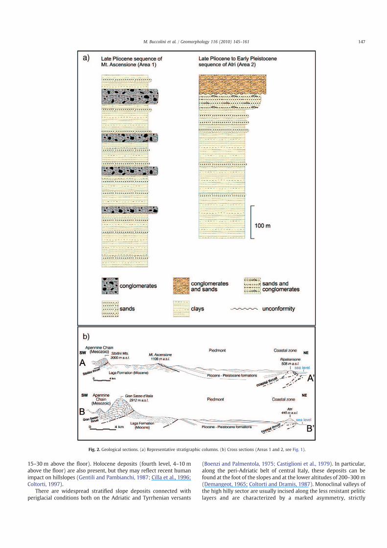
the coastal belt. Both areas share analogous geological settings (Fig. 2)
and similar morphometric features as well as elevation.
The formation of the central Apennine originated from the
emersion of calcareous rocks in the westernmost areas (Late Trias–
Early Miocene). These rocks, folded and overthrust on the Laga
Formation turbidites (Messinian) due to the Late Miocene–middle
Pliocene compressive tectonics (Calamita and Deiana, 1988), formed
the Umbria–Marche Ridge (maximum elevation 2476 m a.s.l. at Mt.
Vettore) and the Gran Sasso d'Italia Massif (2912 m a.s.l.). Different
Geomorphology 116 (2010) 145–161
⁎ Corresponding author. Tel.: +39 737 402603; fax: +39 737 402644.
E-mail address: [email protected] (M. Materazzi).
0169-555X/$ – see front matter © 2009 Elsevier B.V. All rights reserved.
doi:10.1016/j.geomorph.2009.10.015
Contents lists available at ScienceDirect
Geomorphology
j ourna l homepage: www.e lsev ie r.com/ locate /geomorph
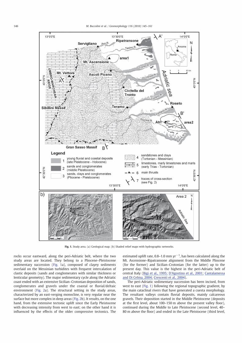
rocks occur eastward, along the peri-Adriatic belt, where the two
study areas are located. They belong to a Pliocene–Pleistocene
sedimentary succession (Fig. 1a), composed of clayey sediments
overlaid on the Messinian turbidites with frequent intercalation of
clastic deposits (sands and conglomerates with similar thickness or
lenticular geometry). The major sedimentary cycle along the Adriatic
coast ended with an extensive Sicilian–Crotonian deposition of sands,
conglomerates and gravels under the coastal or fluvial/deltaic
environment (Fig. 2a). The structural setting in the study areas,
characterized by an east-verging monocline, is very regular near the
surface but more complex in deep areas (Fig. 2b). It results, on the one
hand, from the extensive tectonic uplift since the Early Pleistocene
with decreasing intensity from west to east; on the other hand it is
influenced by the effects of the older compressive tectonics. The
estimated uplift rate, 0.8–1.0 mm yr−1, has been calculated along the
Mt. Ascensione–Ripatransone alignment from the Middle Pliocene
(for the former) and Sicilian–Crotonian (for the latter) up to the
present day. This value is the highest in the peri-Adriatic belt of
central Italy (Bigi et al., 1995; D'Agostino et al., 2001; Cantalamessa
and Di Celma, 2004; Crescenti et al., 2004).
The peri-Adriatic sedimentary succession has been incised, from
west to east (Fig. 1) following the regional topographic gradient, by
the main cataclinal rivers that have generated a cuesta morphology.
The resultant valleys contain fluvial deposits, mainly calcareous
gravels. Their deposition started in the Middle Pleistocene (deposits
at the first level, about 100–150 m above the present valley floor),
continued during the Middle to Late Pleistocene (second level, 40–
80 m above the floor) and ended in the Late Pleistocene (third level,
Fig. 1. Study area. (a) Geological map. (b) Shaded relief maps with hydrographic networks.
146 M. Buccolini et al. / Geomorphology 116 (2010) 145–161
15–30 m above the floor). Holocene deposits (fourth level, 4–10 m
above the floor) are also present, but they may reflect recent human
impact on hillslopes (Gentili and Pambianchi, 1987; Cilla et al., 1996;
Coltorti, 1997).
There are widespread stratified slope deposits connected with
periglacial conditions both on the Adriatic and Tyrrhenian versants
(Boenzi and Palmentola, 1975; Castiglioni et al., 1979). In particular,
along the peri-Adriatic belt of central Italy, these deposits can be
found at the foot of the slopes and at the lower altitudes of 200–300 m
(Demangeot, 1965; Coltorti and Dramis, 1987). Monoclinal valleys of
the high hilly sector are usually incised along the less resistant pelitic
layers and are characterized by a marked asymmetry, strictly
Fig. 2. Geological sections. (a) Representative stratigraphic columns. (b) Cross sections (Areas 1 and 2, see Fig. 1).
147M. Buccolini et al. / Geomorphology 116 (2010) 145–161
congruent with the structural setting of bedrock. The wide coastal
morphostructures (hilly coastal sector), on the other hand, are
dissected by almost symmetric secondary cataclinal valleys, directly
flowing towards the Adriatic Sea. Moreover, the coastal belt greatly
differs from the neighbouring inner landscape because of the presence
of more resistant sandy-conglomeratic rocks and the tectonic uplift
along the coastal belt (Fig. 2b).
2.2. Mt. Ascensione (Area 1)
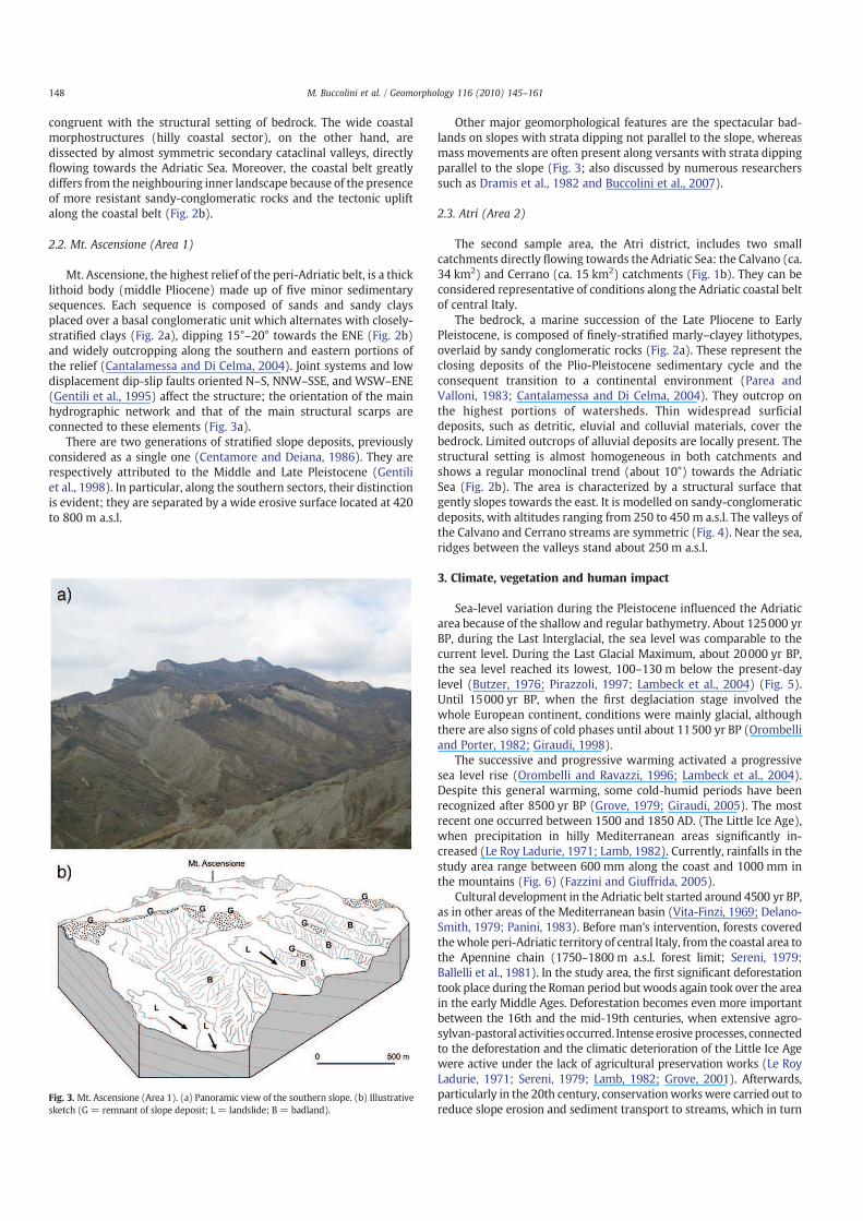
Mt. Ascensione, the highest relief of the peri-Adriatic belt, is a thick
lithoid body (middle Pliocene) made up of five minor sedimentary
sequences. Each sequence is composed of sands and sandy clays
placed over a basal conglomeratic unit which alternates with closely-
stratified clays (Fig. 2a), dipping 15°–20° towards the ENE (Fig. 2b)
and widely outcropping along the southern and eastern portions of
the relief (Cantalamessa and Di Celma, 2004). Joint systems and low
displacement dip-slip faults oriented N–S, NNW–SSE, and WSW–ENE
(Gentili et al., 1995) affect the structure; the orientation of the main
hydrographic network and that of the main structural scarps are
connected to these elements (Fig. 3a).
There are two generations of stratified slope deposits, previously
considered as a single one (Centamore and Deiana, 1986). They are
respectively attributed to the Middle and Late Pleistocene (Gentili
et al., 1998). In particular, along the southern sectors, their distinction
is evident; they are separated by a wide erosive surface located at 420
to 800 m a.s.l.
Other major geomorphological features are the spectacular bad-
lands on slopes with strata dipping not parallel to the slope, whereas
mass movements are often present along versants with strata dipping
parallel to the slope (Fig. 3; also discussed by numerous researchers
such as Dramis et al., 1982 and Buccolini et al., 2007).
2.3. Atri (Area 2)
The second sample area, the Atri district, includes two small
catchments directly flowing towards the Adriatic Sea: the Calvano (ca.
34 km2) and Cerrano (ca. 15 km2) catchments (Fig. 1b). They can be
considered representative of conditions along the Adriatic coastal belt
of central Italy.
The bedrock, a marine succession of the Late Pliocene to Early
Pleistocene, is composed of finely-stratified marly–clayey lithotypes,
overlaid by sandy conglomeratic rocks (Fig. 2a). These represent the
closing deposits of the Plio-Pleistocene sedimentary cycle and the
consequent transition to a continental environment (Parea and
Valloni, 1983; Cantalamessa and Di Celma, 2004). They outcrop on
the highest portions of watersheds. Thin widespread surficial
deposits, such as detritic, eluvial and colluvial materials, cover the
bedrock. Limited outcrops of alluvial deposits are locally present. The
structural setting is almost homogeneous in both catchments and
shows a regular monoclinal trend (about 10°) towards the Adriatic
Sea (Fig. 2b). The area is characterized by a structural surface that
gently slopes towards the east. It is modelled on sandy-conglomeratic
deposits, with altitudes ranging from 250 to 450 m a.s.l. The valleys of
the Calvano and Cerrano streams are symmetric (Fig. 4). Near the sea,
ridges between the valleys stand about 250 m a.s.l.
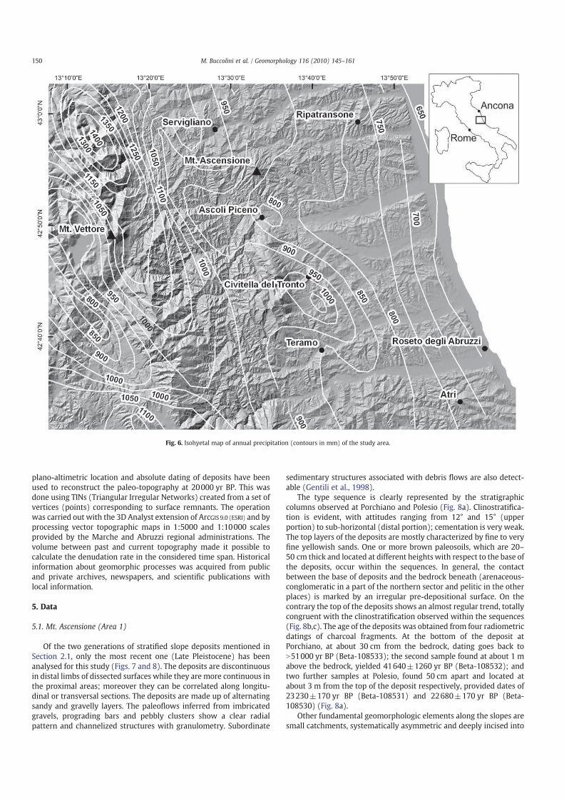
3. Climate, vegetation and human impact
Sea-level variation during the Pleistocene influenced the Adriatic
area because of the shallow and regular bathymetry. About 125000 yr
BP, during the Last Interglacial, the sea level was comparable to the
current level. During the Last Glacial Maximum, about 20000 yr BP,
the sea level reached its lowest, 100–130 m below the present-day
level (Butzer, 1976; Pirazzoli, 1997; Lambeck et al., 2004) (Fig. 5).
Until 15000 yr BP, when the first deglaciation stage involved the
whole European continent, conditions were mainly glacial, although
there are also signs of cold phases until about 11500 yr BP (Orombelli
and Porter, 1982; Giraudi, 1998).
The successive and progressive warming activated a progressive
sea level rise (Orombelli and Ravazzi, 1996; Lambeck et al., 2004).
Despite this general warming, some cold-humid periods have been
recognized after 8500 yr BP (Grove, 1979; Giraudi, 2005). The most
recent one occurred between 1500 and 1850 AD. (The Little Ice Age),
when precipitation in hilly Mediterranean areas significantly in-
creased (Le Roy Ladurie, 1971; Lamb, 1982). Currently, rainfalls in the
study area range between 600 mm along the coast and 1000 mm in
the mountains (Fig. 6) (Fazzini and Giuffrida, 2005).
Cultural development in the Adriatic belt started around 4500 yr BP,
as in other areas of the Mediterranean basin (Vita-Finzi, 1969; Delano-
Smith, 1979; Panini, 1983). Before man's intervention, forests covered
thewhole peri-Adriatic territory of central Italy, from the coastal area to
the Apennine chain (1750–1800 m a.s.l. forest limit; Sereni, 1979;
Ballelli et al., 1981). In the study area, the first significant deforestation
took place during the Roman period but woods again took over the area
in the early Middle Ages. Deforestation becomes even more important
between the 16th and the mid-19th centuries, when extensive agro-
sylvan-pastoral activities occurred. Intense erosiveprocesses, connected
to the deforestation and the climatic deterioration of the Little Ice Age
were active under the lack of agricultural preservation works (Le Roy
Ladurie, 1971; Sereni, 1979; Lamb, 1982; Grove, 2001). Afterwards,
particularly in the 20th century, conservation workswere carried out to
reduce slope erosion and sediment transport to streams, which in turnFig. 3. Mt. Ascensione (Area 1). (a) Panoramic view of the southern slope. (b) Illustrative
sketch (G = remnant of slope deposit; L = landslide; B = badland).
148 M. Buccolini et al. / Geomorphology 116 (2010) 145–161

caused intense linear erosion. Then, in the early 1960s, significant land
transformation was carried out by means of powerful machinery to
increase agriculture (Desplanques, 1975; Gentili and Pambianchi, 2002;
Buccolini et al., 2007).
4. Methodology
We chose an integrated approach based on geomorphological
surveys at different scales, sampling and dating of Quaternary
deposits, and topographic and morphometric analyses in a GIS
environment. Geomorphological surveys were carried out at a
relatively rough scale for the whole study area, and at a finer scale
(1:10000) for the two sample areas. Landforms caused by mass
movements (landslide bodies, crowns and scarps) and by running
water (badlands and fluvial terraces) and Quaternary deposits were
also analysed with reference to their location, geometry and
morphology, relationship with bedrock, stratigraphic and granulo-
metric characteristics, presence of continental fossils, paleosols, and
datable material. The deposits were chronologically constrained
based on the AMS 14C dating of charcoal fragments and organic
levels, conducted at the Beta Analytic Radiocarbon Dating Laboratory,
Miami, USA. The calibrations were performed using the newest
(INTCAL 98) database (Talma and Vogel, 1993; Stuiver and van der
Plicht, 1998; Stuiver et al., 1998). For some dating results derived from
previous studies by the same authors, only non-calibrated conven-
tional 14C ages are presented.
In both study areas data acquired from the above mentioned
detailed geomorphological surveys allowed the correlation of the
remnants of erosion and depositional surfaces; in particular geometry,
Fig. 4. Cerrano stream. (a) Panoramic view. (b) Illustrative sketch (C = remnants of conglomerates; S = sand; Cl = clay; L = landslide; B = badland).
Fig. 5. Reconstructed shoreline at about 20000 yr BP (Last Glacial Maximum; modified
from Lambeck et al., 2004). The box indicates the location of the study area.
149M. Buccolini et al. / Geomorphology 116 (2010) 145–161
plano-altimetric location and absolute dating of deposits have been
used to reconstruct the paleo-topography at 20000 yr BP. This was
done using TINs (Triangular Irregular Networks) created from a set of
vertices (points) corresponding to surface remnants. The operation
was carried out with the 3D Analyst extension of ArcGIS 9.0 (ESRI) and by
processing vector topographic maps in 1:5000 and 1:10000 scales
provided by the Marche and Abruzzi regional administrations. The
volume between past and current topography made it possible to
calculate the denudation rate in the considered time span. Historical
information about geomorphic processes was acquired from public
and private archives, newspapers, and scientific publications with
local information.
5. Data
5.1. Mt. Ascensione (Area 1)
Of the two generations of stratified slope deposits mentioned in
Section 2.1, only the most recent one (Late Pleistocene) has been
analysed for this study (Figs. 7 and 8). The deposits are discontinuous
in distal limbs of dissected surfaces while they are more continuous in
the proximal areas; moreover they can be correlated along longitu-
dinal or transversal sections. The deposits are made up of alternating
sandy and gravelly layers. The paleoflows inferred from imbricated
gravels, prograding bars and pebbly clusters show a clear radial
pattern and channelized structures with granulometry. Subordinate
sedimentary structures associated with debris flows are also detect-
able (Gentili et al., 1998).
The type sequence is clearly represented by the stratigraphic
columns observed at Porchiano and Polesio (Fig. 8a). Clinostratifica-
tion is evident, with attitudes ranging from 12° and 15° (upper
portion) to sub-horizontal (distal portion); cementation is very weak.
The top layers of the deposits are mostly characterized by fine to very
fine yellowish sands. One or more brown paleosoils, which are 20–
50 cm thick and located at different heights with respect to the base of
the deposits, occur within the sequences. In general, the contact
between the base of deposits and the bedrock beneath (arenaceous-
conglomeratic in a part of the northern sector and pelitic in the other
places) is marked by an irregular pre-depositional surface. On the
contrary the top of the deposits shows an almost regular trend, totally
congruent with the clinostratification observed within the sequences
(Fig. 8b,c). The age of the deposits was obtained from four radiometric
datings of charcoal fragments. At the bottom of the deposit at
Porchiano, at about 30 cm from the bedrock, dating goes back to
N51000 yr BP (Beta-108533); the second sample found at about 1 m
above the bedrock, yielded 41640±1260 yr BP (Beta-108532); and
two further samples at Polesio, found 50 cm apart and located at
about 3 m from the top of the deposit respectively, provided dates of
23230±170 yr BP (Beta-108531) and 22680±170 yr BP (Beta-
108530) (Fig. 8a).
Other fundamental geomorphologic elements along the slopes are
small catchments, systematically asymmetric and deeply incised into
Fig. 6. Isohyetal map of annual precipitation (contours in mm) of the study area.
150 M. Buccolini et al. / Geomorphology 116 (2010) 145–161
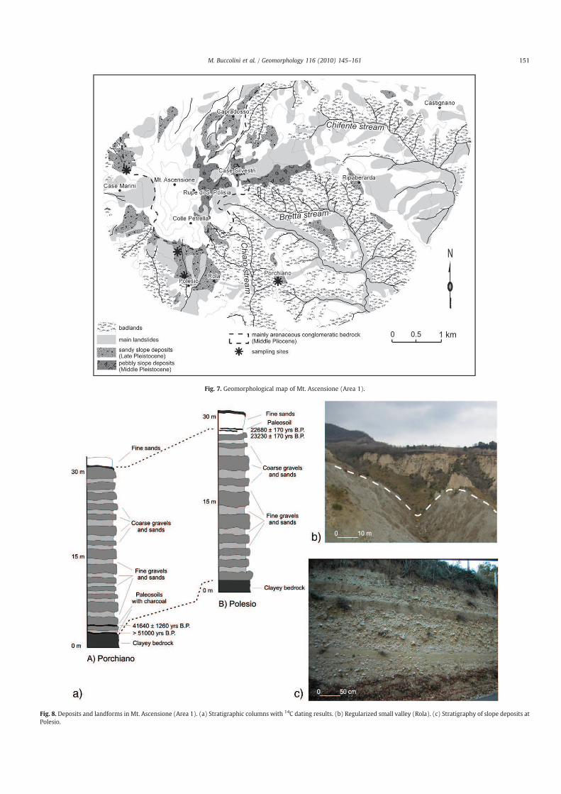
Fig. 7. Geomorphological map of Mt. Ascensione (Area 1).
Fig. 8. Deposits and landforms in Mt. Ascensione (Area 1). (a) Stratigraphic columns with 14C dating results. (b) Regularized small valley (Rola). (c) Stratigraphy of slope deposits at
Polesio.
151M. Buccolini et al. / Geomorphology 116 (2010) 145–161

the pelitic bedrock. Numerous studies during the last thirty years have
indicated intense andwidespread erosion in the area, characterized by
badland formation and landslides. Inmany cases, the limbs of the slope
deposits are disjointed by fractures, trenches, benches, counterslopes,
scarps and steps. All these elements are typical of mass movements at
different evolutional stages, whose shear zones are located inside the
weathered levels of clayey bedrock. In some cases both newly formed
landslides (Rupe di Santa Polisia, Ripaberarda) and old ones
(Porchiano and Ripaberarda) were observed (Figs. 7 and 9). Very old
landslides left only crowns and/or scarps behind, and their toes have
already been removed by fluvial erosion. The morphodynamic setting
of the area is therefore characterised by long translational slideswhere
strata dip parallel to the slope and shear zones and spectacular
badlandswith local rotational slides, falls and toppleswhere strata dip
transversally to the slope (Figs. 7 and 9b,c).
Historical documents (Carlini De Carolis, 1792; Galiè and Vec-
chioni, 1999; Santoni et al., 2005) show that many landslides affected
villages since the 13th century (Table 1). In all cases, buildings
affected by the landslides were located near badlands or landslide
scarps, and mass movements were always preceded by an intense
deepening of the clayey bedrock by fluvial erosion. The most
significant example is represented by Castignano, a historical village
of the early Middle Ages, whose southern slope repeatedly experi-
enced large mass movements (Table 1) which forced the inhabitants
to move towards the northern sectors.
Historical studies and oral witnesses also evidenced the marked
increase in linear water erosion between 1850 and 1950 leading to
20–30 m of channel deepening; it was substantially reduced after
1950 due to the construction of small dams and groynes along the
river banks, mainly along the Bretta and Chifente streams (Fig. 7).
5.2. Atri (Area 2)
In the Atri district the main active morphogenetic processes are
also mass movements and fluvial erosion that form crowns, scarps,
rills, gullies and badlands (Moretti and Rodolfi, 2000; Buccolini et al.,
2007). A huge landslide occurred in 1627 at the hydrographic left
slope of the Cerrano stream that destroyed houses and killed
numerous animals (De Secinara, 1652); the disappearance of a port
between the mouths of the Calvano and Cerrano streams is also
Fig. 9. Landslide related features in Mt. Ascensione (Area 1). (a) and (b) Gravitational fissures and fractures within slope deposit and pelitic bedrock at Porchiano. (c) Tilted 15th
century tower bell at Ripaberarda.
Table 1
Chronology of major landslides in Mt. Ascensione (Area 1).
Chronology of major landslides
Castignano 1204, 1335, 1450, 1500, 1574, 1605,
1634, 1717, 1772, 1777 and 1927
Porchiano End of 16th century
Ripaberarda 16th century, 1999
Capradosso 16th century
Rotella 1755
Appignano 1548, 1561, 1573, 1650, 1703, 1725,
1757, 1765, 1803, 1819, 1847 and 1995
152 M. Buccolini et al. / Geomorphology 116 (2010) 145–161
ascribed to landslides at the beginning of the 16th century (Buccolini
and Crescenti, 1991).
For this study, essential geomorphological elements are the
discontinuous limbs of sub-horizontal erosion surfaces (Fig. 10); they
have no chronological correlationswith theMiddle and Late Pleistocene
fluvial terraces along the main valleys; they are hereafter called
“benches”. Many benches are located in both Calvano and Carrano
catchments at different altitudes, and some of them can be correlated.
Except for the highest one, which is located at the boundary of the
sandy-conglomeratic and pelitic units, the benches are rarely related to
bedrock structure (Fig. 11). They represent former wide valley bottoms
(Buccolini et al., 2007). In many cases, along the lower edge of the
benches, the accumulation of slope material is observed. Along the
Cerrano stream at an altitude of 125 m a.s.l., two levels of clayey silt
containing organic substances and intercalated with fluvial gravel were
found along the edge of a bench. The lower level yielded a 14C age of
19260±210 yr BP (23330 to 22 360 cal. yr BP) and the higher level
17650±100 BP (21550 to 20440 cal. yr BP) (Beta-192039, Beta-
192040; Fig. 12).
6. Data analysis and interpretation
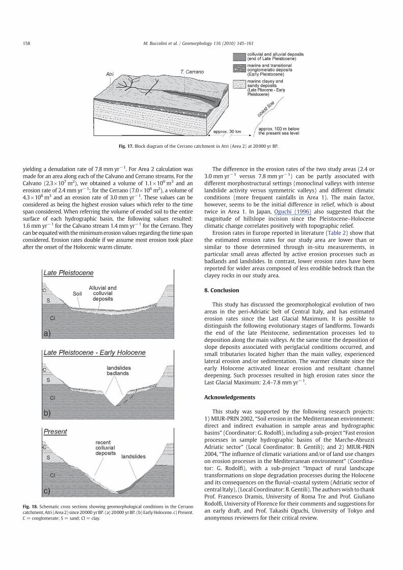
6.1. Mount Ascensione district (Area 1)
We reconstructed the topography of Mt. Ascensione at about
20000 yr B.P using ArcGIS 9.0 (Fig. 13a). Geological and sedimento-
logical characteristics such as stratigraphic continuity confirmed by
the progressive decrease of granulometry and clinostratification
angle, as well as elevation of land surfaces allowed the reconstruction.
The chronological data of the deposits below the surfaces, between
40000 and 20000 yr BP, support the reconstruction. The recon-
structed surface is located about 220–240 m above the valley bottom
(Figs. 13b and 14).
Around 20000 yr BP, the fundamental features of Mt. Ascensione
were defined. A high border scarp on the northern sector was formed
on bedrock, whereas the middle to upper portions of the surrounding
slopes were covered with slope deposits. The slopes below fluvial
benches and scarps were partially affected by erosion along the small
tributaries of the Tronto River. Sediment supply from the tributaries
contributed to the formation of the Late Pleistocene alluvial fans and
terraces (Fig. 14).
The morphodynamic evolution of the last 20000 years can be
interpreted as a result of successive erosive phases. According to
Demangeot (1965), Castiglioni et al. (1979) and Coltorti and Dramis
(1987), the formation of the Mt. Ascensione slope deposits at ca.
20000 yr BP was associated with the periglacial conditions in the Last
GlacialMaximum. This situation lasted until the end of the Pleistocene,
when periglacial processes terminated and fluvial incision started
(Orombelli and Porter, 1982; Giraudi, 1998; Fig. 15a). Development of
vegetation cover under a warmer Holocene climate (Erhard, 1956;
Dramis et al., 1982) further limited debris production on slopes and
activated linear erosion that formed deep gullies (Fig. 15b).
Fig. 10. Geomorphological map of Atri (Area 2).
153M. Buccolini et al. / Geomorphology 116 (2010) 145–161

Fig.1
1.GeologicalandgeomorphologicalcrosssectionsandpanoramicviewsinAtri(Area2)indicatingthelocationofbenches(seeFig.10forthelocationofsections).(a)Profile1alongtheupperpartoftheCalvanocatchment.(b)Panoramicviewof
profile1.(c)Profile2alongthemiddlepartoftheCerranocatchmentclosetoMutignano.(d)Panoramicviewofprofile2.(e)Profile3alongthemiddlepartoftheCalvanocatchment.f)Panoramicviewofprofile3.
154 M. Buccolini et al. / Geomorphology 116 (2010) 145–161
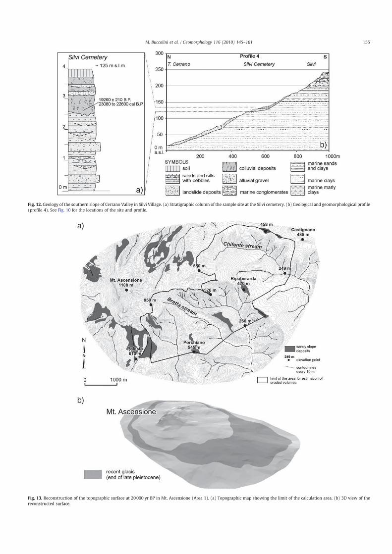
Fig. 12. Geology of the southern slope of Cerrano Valley in Silvi Village. (a) Stratigraphic column of the sample site at the Silvi cemetery. (b) Geological and geomorphological profile
(profile 4). See Fig. 10 for the locations of the site and profile.
Fig. 13. Reconstruction of the topographic surface at 20000 yr BP in Mt. Ascensione (Area 1). (a) Topographic map showing the limit of the calculation area. (b) 3D view of the
reconstructed surface.
155M. Buccolini et al. / Geomorphology 116 (2010) 145–161

Historical data demonstrates thatmorphodynamics during the late
Middle Ages was analogous to that of the present, forming deep,
asymmetric valleys with landslides on one side and badlands on the
other (Fig. 15c). The activation of mass movements affected several
villages (Table 1), particularly between the 15th and 18th centuries. It
was certainly favoured by increased rainfall at that time as in some
other Mediterranean areas (Provansal, 1995; Dìez et al., 1996; Grove,
2001; Giraudi, 2005), and by intensified agriculture after the Middle
Ages (Calzecchi Onesti, 1957; Desplanques, 1975; Gentili and
Pambianchi, 1987, 2002; Ruiz-Flaño et al., 1992; Garcìa-Ruiz and
Valero-Garcès, 1998).
Consequently the small catchments of the tributaries of the Tronto
River mainly developed in the Holocene. Although available data are
limited, erosion seems to have intensified during the cold and humid
periods of the Holocene such as the Little Ice Age, as suggested by the
record of floods and landslides (Grove, 1979; Lamb, 1982; Pavese
et al., 1992; Camuffo and Enzi, 1992; Pfister, 1994; Provansal, 1995;
Dìez et al., 1996; Antonioli et al., 2000; Grove, 2001; Giraudi, 2005;
Aringoli et al., 2007).
6.2. Atri (Area 2)
The data acquired for the Atri district also enabled the reconstruc-
tion of the topographic surface at 20000 yr BP. We first correlated
surfaces with chronological references; then other surfaces on the
basis of their height and inclination with respect to the current valley
floor, as proposed by Selby (1985) and Starkel (2003) (Fig. 16).
The erosion process that formed the surface at 20000 yr BP seems to
have started during the Last Interglacial (Butzer, 1976), and it continued
slowly and progressively in response to the lowering of the sea level.
According to Erhard (1956) and Pellettier (2003), the erosion process
was enhanced under cold and arid conditions. These conditions, as well
as a low topographic gradient, prevented linear erosion. Therefore, we
assume a limited river incision at 20000 yr BP (Fig. 17).
As indicated by Mizutani (1996) and Trenhaile (2002), active marine
erosion after a marine transgression around 10000 yr BP created a
platform bounded by a cliff. This process and tectonic uplift along the
Fig. 14. Schematic block diagram showing the morphological setting of the southern slope of Mt. Ascensione (Area 1) at 20000 yr BP.
Fig. 15. Schematic cross sections showing geomorphological conditions in Mt. Ascensione
(Area 1) since 20000 yr BP. (a) 20000 yr BP. (b) Early Holocene. (c) Early Middle Ages to
the present.
156 M. Buccolini et al. / Geomorphology 116 (2010) 145–161

coast led to a relative loweringof the local base level of theCerranoRiver
in spite of the sea level rise, enhancing erosion along streams.
The presence of the benches at different levels may be related to
several phases of Holocene marine ingression (Mörner, 1982;
Pirazzoli, 1997). This may have also led to alternating phases of
rapid and slow stream incision, together with mass movements along
the valley sides. As indicated by Moretti and Rodolfi (2000), they may
also be responsible for the activation of badland development
(Fig. 18). Recent mass movements were enhanced by deforestation
for cultivation (Buccolini et al., 2007).
7. Estimation of late Quaternary erosion rates
The comparisonbetween thecurrent topographyand that at 20000 yr
BP allowed us to estimate the total volume of erosion since 20000 yr BP.
For Area 1 (9.7×10⁶m2) a volume of 1.55×10⁹m3 has been calculated,
Fig. 16. Reconstruction of the topographic surface at 20000 yr BP in Atri (Area 2). (a) Topographicmap showing the limit of the calculation area. (b) 3D viewof the reconstructed surface.
157M. Buccolini et al. / Geomorphology 116 (2010) 145–161
yielding a denudation rate of 7.8 mm yr−1. For Area 2 calculation was
made for an area along each of the Calvano and Cerrano streams. For the
Calvano (2.3×10⁷m2), we obtained a volume of 1.1×10⁹m3 and an
erosion rate of 2.4 mm yr−1; for the Cerrano (7.0×10⁶m2), a volume of
4.3×10⁸m3 and an erosion rate of 3.0 mm yr−1. These values can be
considered as being the highest erosion values which refer to the time
span considered. When referring the volume of eroded soil to the entire
surface of each hydrographic basin, the following values resulted:
1.6 mm yr−1 for the Calvano stream 1.4 mm yr−1 for the Cerrano. They
canbeequatedwith theminimumerosionvalues regarding the time span
considered. Erosion rates double if we assume most erosion took place
after the onset of the Holocenic warm climate.
The difference in the erosion rates of the two study areas (2.4 or
3.0 mm yr−1 versus 7.8 mm yr−1) can be partly associated with
different morphostructural settings (monoclinal valleys with intense
landslide activity versus symmetric valleys) and different climatic
conditions (more frequent rainfalls in Area 1). The main factor,
however, seems to be the initial difference in relief, which is about
twice in Area 1. In Japan, Oguchi (1996) also suggested that the
magnitude of hillslope incision since the Pleistocene–Holocene
climatic change correlates positively with topographic relief.
Erosion rates in Europe reported in literature (Table 2) show that
the estimated erosion rates for our study area are lower than or
similar to those determined through in-situ measurements, in
particular small areas affected by active erosion processes such as
badlands and landslides. In contrast, lower erosion rates have been
reported for wider areas composed of less erodible bedrock than the
clayey rocks in our study area.
8. Conclusion
This study has discussed the geomorphological evolution of two
areas in the peri-Adriatic belt of Central Italy, and has estimated
erosion rates since the Last Glacial Maximum. It is possible to
distinguish the following evolutionary stages of landforms. Towards
the end of the late Pleistocene, sedimentation processes led to
deposition along the main valleys. At the same time the deposition of
slope deposits associated with periglacial conditions occurred, and
small tributaries located higher than the main valley, experienced
lateral erosion and/or sedimentation. The warmer climate since the
early Holocene activated linear erosion and resultant channel
deepening. Such processes resulted in high erosion rates since the
Last Glacial Maximum: 2.4–7.8 mm yr−1.
Acknowledgements
This study was supported by the following research projects:
1) MIUR-PRIN 2002, “Soil erosion in the Mediterranean environment:
direct and indirect evaluation in sample areas and hydrographic
basins” (Coordinator: G. Rodolfi), including a sub-project “Fast erosion
processes in sample hydrographic basins of the Marche-Abruzzi
Adriatic sector” (Local Coordinator: B. Gentili); and 2) MIUR-PRIN
2004, “The influence of climatic variations and/or of land use changes
on erosion processes in the Mediterranean environment” (Coordina-
tor: G. Rodolfi), with a sub-project “Impact of rural landscape
transformations on slope degradation processes during the Holocene
and its consequences on the fluvial–coastal system (Adriatic sector of
central Italy), (Local Coordinator: B. Gentili). The authorswish to thank
Prof. Francesco Dramis, University of Roma Tre and Prof. Giuliano
Rodolfi, University of Florence for their comments and suggestions for
an early draft, and Prof. Takashi Oguchi, University of Tokyo and
anonymous reviewers for their critical review.
Fig. 17. Block diagram of the Cerrano catchment in Atri (Area 2) at 20000 yr BP.
Fig. 18. Schematic cross sections showing geomorphological conditions in the Cerrano
catchment, Atri (Area 2) since 20000 yrBP. (a) 20000 yrBP. (b) EarlyHolocene. c) Present.
C = conglomerate; S = sand; Cl = clay.
158 M. Buccolini et al. / Geomorphology 116 (2010) 145–161

Table
2
KnownerosionratesintheMediterraneanareaandsurroundings.
IDLocality
Environment
Lithology
Method
Erosionrate
Period
Author
1SouthernApennineChain
Mountainbelt
Limestonesandmarly
limestones
GISanalysisonsummitalpaleosurfaces
0.22–0.30mm/yr
MiddlePleistocene–
Present
Amatoetal.
(2003)
2Alps
Mountainchain
Various
Sedimentvolumetrappedinvalleysandlakebasin
1.77mm/yr
LateGlacial
Hinderer(2001)
3Alps
Mountainchain
Various
Sedimentvolumetrappedinvalleysandlakebasin
0.6mm/yr
Last17000yr
Hinderer(2001)
4CentralSpain
Mountainchain
Granitesandgneisses
Dendrogeomorphologicalmethods
1.7–2.6mm/yr
Last101years
Bodoqueetal.
(2005)
1.1–1.8mm/yr
Last42years
5Blackseasourcearea
Mountainchains,hills
andplains
Various
SedimentsvolumetrappedinBlackSea
0.063mm/yr
Holocene
Degensetal.
(1976)
6AdriaticCentralItaly
Mainfluvialbasin
Alluvialdeposits
Thermochronometry
0.7–1.5mm/yr
Last20000yr
Coltortietal.
(1991)
7LacChambon(Massifcentral,
France)
Mountainbasin
Lacustrinedeposits
Qualitativeestimation
0.12mm/yr
Lastdeglaciation
Gayetal.(1998)
8LacChambon(Massifcentral,
France)
Mountainbasin
Lacustrinedeposits
Qualitativeestimation
0.05–0.1mm/yr
Holocene
Gayetal.(1998)
9EbroBasin(NE-Spain)
Badlandsonhillyarea
Clayeybedrock
Directmeasuresonerosionplotsinbadlandareas
5.6–11.2mm/yr
Present(1991–1993)Sirventetal.
(1997)
10SouthernTuscany
Hillyarea
Clayeybedrock
Directmeasures
15–30mm/yr(badlands)
Present
Ciccaccietal.
(2006)
60–90mm/yr(landslides)
11CentralItaly
Hillyareas
Clayeybedrock
Directmeasurescomparedwithindirectestimation
fromquantitativegeomorphologyondrainagenetwork
10–25mm/yr(badlands)
Present
DellaSetaetal.
(2007)
30–40mm/yr(landslides)
12Europe
Various
Soil
Various
10–20tha−
1yr−
1(overall)
Present
Verheijenetal.
(2009)
455tha−1yr−
1(gullyerosion-
maximumvalue)
13Mt.Ascensione(Area1)
Highhills
Slopedepositsandclayey
bedrock
RadiometricdatingsandGISanalysis
7.8mm/yr(156tha−1yr−
1)
Last20000yr
Thispaper
15.6mm/yr(312tha−
1yr−
1)
Holocene
14Atri(Area2)
Coastalhills
Colluvialdepositsandclayey
bedrock
RadiometricdatingsandGISanalysis
2.4–3mm/yr(48–60tha−
1yr−
1)
Last20000yr
Thispaper
4.8–6mm/yr(96–120tha−1yr−
1)
Holocene
159M. Buccolini et al. / Geomorphology 116 (2010) 145–161

References
Amato, A., Aucelli, P.P.C., Cinque, A., 2003. The long term denudation rate in theSouthern Apennine Chain (Italy): a GIS-aided estimation of the rock volumeseroded since middle Pleistocene time. Quaternary International 101–102, 3–11.
Antonioli, F., Baroni, C., Camuffo, D., Carrara, C., Cremaschi, M., Frisia, S., Giraudi, C.,Improta, S., Magri, D., Margottino, C., Orombelli, G., Silenzi, S., 2000. Le fluttuazionidel clima nel corso dell'Olocene: stato dell'arte. Il Quaternario 13, 95–128.
Aringoli, D., Farabollini, P., Gentili, B., Materazzi, M., Pambianchi, G., 2007. Climaticinfluence on slope dynamics and shoreline variations: examples from the Marcheregion (central Italy). Physio-Géo, Geographie Physique et Environnement 1, 1–20.
Ballelli, S., Biondi, E., Cortini Pedrotti, C., Francalancia, C., Orsomando, E., Pedrotti, F.,1981. Il patrimonio vegetale delle Marche. Regione Marche, Praxis, Roma, 214 pp.
Bigi, S., Cantalamessa, G., Centamore, E., Didaskalou, P., Dramis, F., Farabollini, P., Gentili, B.,Invernizzi, C., Micarelli, A., Nisio, S., Pambianchi, G., Potetti, M., 1995. La fasciaperiadriatica Marchigiano–Abruzzese dal Pliocene medio ai tempi attuali: evoluzionetettonico sedimentaria e geomorfologica. Studi Geologici Camerti. Volume Speciale1991/2, 21–26.
Bodoque, J.M., Dıèz-Herrero, A., Martìn-Duque, J.F., Rubiales, J.M., Godfrey, A., Pedraza, J.,Carrasco, R.M., Sanz, M.A., 2005. Sheet erosion rates determined by usingdendrogeomorphological analysis of exposed tree roots: two examples from CentralSpain. Catena 64, 81–102.
Boenzi, F., Palmentola, G., 1975. Effetti di fenomeni periglaciali quaternari nella Calabrianord-occidentale. Bollettino della Societa Geologica Italiana 94, 871–875.
Brocard, G.Y., van der Beek, P.A., Bourlès, D.L., Siame, L.L., Mugnier, J.L., 2003. Long-termfluvial incision rates and postglacial river relaxation in the French Alps from 10Bedating of alluvial terraces with assessment of inheritance, soil and wind ablationeffects. Earth and Planetary Science Letters 209, 197–214.
Buccolini, M., Crescenti, U., 1991. Instabilità lungo la costa abruzzese: il caso dellaTorre di Cerrano. Ricerca Scientifica ed Educazione Permanente, Suppl. 93,Milano,Italy, pp. 17–26.
Buccolini, M., Gentili, B., Materazzi, M., Aringoli, D., Pambianchi, G., Piacentini, T., 2007.Human impact and slope dynamics evolutionary trends in the monoclinal relief ofAdriatic area of central Italy. Catena 71, 96–109.
Butzer, K.W., 1976. Geomorphology from the Earth. Harper and Row, New York. 463 pp.Calamita, F., Deiana, G., 1988. The arcuate shape of the Umbria–Marche Apennines
(central Italy). Tectonophysics 146, 139–147.Calzecchi Onesti, A., 1957. Sistemazioni in collina. Ramo Editoriale degli Agricoltori,
Roma. 348 pp.Camuffo, D., Enzi, S., 1992. Reconstructing the climate of northern Italy from archive
sources. In: Bradley, R.S., Jones, P.D. (Eds.), Climate sinceA.D. 1500. Routledge, London,pp. 143–154.
Cantalamessa, G., Di Celma, C., 2004. Sequence response to syndepositional regionaluplift: insights from high-resolution sequence stratigraphy of late Early Pleistocenestrata, Periadriatic Basin, Central Italy. Sedimentary Geology 164, 283–309.
Carlini De Carolis, P.C., 1792. In: Colucci, G. (Ed.), Memorie istoriche di Castignano.Fermo, Italy.
Castiglioni, B., 1935. Ricerche morfologiche sui terreni pliocenici dell'Italia centrale.Pubblicazione Istituto Geografico Università di Roma Serie A 4 (160 pp.).
Castiglioni, G.B., Girardi, A., Sauro, U., Tessari, F., 1979. Grèzes litées e falde detritichestratificate di origine crionivale. Geografia Fisica e Dinamica Quaternaria 2, 64–82.
Centamore, E., Deiana, G., 1986. La geologia delle Marche. Studi Geologici Camerti.Volume Speciale (145 pp.).
Ciccacci, S., Del Monte, M., Lupia Palmieri, E., Salvatore, M.C., 2006. Entità dei processi didenudazione e variazioni morfologiche recenti nell'area di Radicofani (ToscanaMeridionale, Italia). In: Rodolfi, G. (Ed.), Erosione idrica in ambiente mediterraneo:valutazione diretta e indiretta in aree sperimentali e bacini idrografici: Volumespeciale progetto MIUR-PRIN/COFIN 2002-2004, pp. 29–64.
Cilla, G., Coltorti, M., Farabollini, P., Dramis, F., Gentili, B., Pambianchi, G., 1996. Fluvialsedimentation during the early Holocene in the Marchean valleys (central Italy). IlQuaternario 9, 459–464.
Coltorti, M., 1997. Human impact in the Holocene fluvial and coastal evolution of theMarche region. Catena 30, 311–335.
Coltorti, M., Dramis, F., 1987. The significance of stratified slope waste deposits in theQuaternary of Umbria–Marche Apennines (Central Italy). Zeitschrift für Geomor-phologie. Supplement band 71, 59–70.
Coltorti, M., Consoli, M., Dramis, F., Gentili, B., Pambianchi, G., 1991. Evoluzionegeomorfologica delle piane alluvionali delle Marche centro-meridionali. GeografiaFisica e Dinamica Quaternaria 14, 87–100.
Coltorti, M., Farabollini, P., Gentili, B., Pambianchi, G., 1996. Geomorphologicalevidences for anti-Apennines faults in the Umbro–Marchean Apennines and inthe peri-Adriatic basin, Italy. Geomorphology 15, 33–45.
Crescenti, U., Milia, M.L., Rusciadelli, G., 2004. Stratigraphic and tectonic evolution ofthe Pliocene Abruzzi basin (Central Apennines, Italy). Bollettino della SocietàGeologica Italiana 123, 163–173.
Currado, C., Fredi, P., 2000. Morphometric parameters of drainage basin andmorphotectonic setting of eastern Abruzzo. Memorie della Società GeologicaItaliana 55, 411–419.
D'Agostino, N., Jackson, J.A., Dramis, F., Funiciello, R., 2001. Interactions betweenmantleupwelling, drainage and active normal fault: an example from central Apennines(Italy). Geophysical Journal International 147, 475–497.
Degens, E.T., Paluska, A., Eriksson, E., 1976. Rates of soil erosion. In: Svensson, B.H.,Soderlund, R. (Eds.), Nitrogen, Phosphorus and Sulphur — Global Cycles. SCOPEReport 7: Ecology Bulletin, vol. 22, pp. 185–191.
Delano-Smith, C., 1979. Western Mediterranean Europe. Academic Press, London.453 pp.
Della Seta, M., Del Monte, M., Fredi, P., Lupia Palmieri, E., 2007. Direct and indirectevaluation of denudation rates in Central Italy. Catena 71, 21–30.
Demangeot, J., 1965. Géomorphologie des Abruzzes adriatiques. Mémoires et docu-ments, vol. 15. Editions du centre National de la Recherche Scientifique, quaiAnatole-France, Paris. 403 pp.
De Secinara, F., 1652. Trattato universale di tutti li terremoti occorsi e noti con li casi infaustied infelici pressagiti da tali terremoti. Biblioteca Nazionale, L'Aquila, Italy. 130 pp.
Desplanques, H., 1975. Campagne umbre: contributo allo studio dei paesaggi ruralidell'Italia centrale. Quaderni Regionali dell'Umbria, Perugia, vol. 1. 135 pp.
Dìez, A.G., Salas, L., Diaz de Teràn, J.R., Cendrero, A., 1996. Late Quaternary climaticchanges and mass movement frequency and magnitude in the Cantabrian region,Spain. Geomorphology 15, 291–309.
Dramis, F., Gentili, B., Coltorti, M., Cherubini, C., 1982. Osservazioni geomorfologiche suicalanchi Marchigiani. Geografia Fisica e Dinamica Quaternaria 5, 38–45.
Dunne, T., 1980. Formation and control of drainage networks. Progress in PhysicalGeography 4, 211–239.
Erhard, H., 1956. La genèse des sols en tant que phénomène geologique, 2nd Ed.Masson, Paris. 177 pp.
Fazzini, M., Giuffrida, A., 2005. Une nouvelle proposition quantitative des regimespluviometriques dans le territoire de Italie: premiers resultats. Climat Urbain, Villeet Architecture, Acts XVIII Colloque Internationale del Climatologie, pp. 361–365.
Galiè, N., Vecchioni, G., 1999. Il Monte dell'Ascensione. Società Editrice Ricerche,Folignano (AP). 151 pp.
Garcìa-Ruiz, J.M., Valero-Garcès, B.L., 1998. Historical geomorphic processes and humanactivities in the Central Spanish Pyrenees. Mountains Research and Development18, 309–320.
Gay, I., Macaire, J.J., Cocirta, C., 1998. Evolution qualitative des flux particulaires depuis12600 ans dans le bassin du lac Chambon, Massif central, France. Bulletin de laSociété Géologique de France 169, 310–314.
Gentili, B., Pambianchi, G., 1987. Morfogenesi fluviale ed attività antropica nelle Marchecentro-meridionali. Geografia Fisica e Dinamica Quaternaria 10, 204–217.
Gentili, B., Pambianchi, G., 2002. La dégradation géomorphologique dans quelquesrégions viticoles et vinicoles desMarches (Italie centrale). Géologues 135, 107–113.
Gentili, B., Pambianchi, G., Aringoli, D., Cilla, G., Farabollini, Materazzi, M., 1995.Rapporti tra deformazioni fragili Plio-quaternarie e morfogenesi gravitativa nellafascia alto-collinare delle Marche centro-meridionali. Studi Geologici Camerti.Volume Speciale 1995/1, 421–435.
Gentili, B., Materazzi, M., Pambianchi, G., Scalella, G., 1998. I depositi di versante delMonte dell'Ascensione (Marche meridionali, Italia). Geografia Fisica e DinamicaQuaternaria 21, 205–214.
Giraudi, C., 1998. Alcuni dati per l'inquadramento cronologico delle fasi glaciali tardo-pleistoceniche dei Monti Greco e Serra Chiarano (Abruzzo-Italia centrale). IlQuaternario 11, 115–120.
Giraudi, C., 2005. Middle to Late Holocene glacial variations, periglacial processes andalluvial sedimentation on the higher Apenninemassifs (Italy). Quaternary Research64, 176–184.
Grove, A.T., 2001. The “Little Ice Age” and its geomorphological consequences inMediterrean Europe. Climatic Change 48, 121–136.
Grove, J.M., 1979. The glacial history of the Holocene. Progress in Physical Geography 1,1–54.
Hinderer, M., 2001. Late Quaternary denudation of the Alps, valley and lake fillings andmodern river loads. Geodinamica Acta 14, 231–263.
Holbrook, J., Scott, R.W., Oboh-Ikuenobe, F.E., 2006. Base level-buffers and buttresses: amodel for upstream versus downstream control on fluvial geometry andarchitecture within sequence. Journal of Sedimentary Research 76, 160–172.
Lamb, H.H., 1982. Climate. History and the Modern World. Routledge, London. 433 pp.Lambeck, K., Antonioli, F., Purcell, A., Silenzi, S., 2004. Sea-level change along the Italian
coast for the past 10,000 yr. Quaternary Science Reviews 23, 1567–1598.Le Roy Ladurie, E., 1971. Times of Feast, Times of Famine: a History of Climate since the
Year 1000. Trams. B. Bray. Doubleday, New York. 426 pp.Merritts, D.J., Vincent, K.R., Wohl, E.E., 1994. Long river profiles, tectonics and eustasy: a
guide to interpreting fluvial terraces. Journal of Geophysical Research 99 (B7),14031–14050.
Mizutani, T., 1996. Longitudinal profile evolution of valley on coastal terraces under thecompound influence of eustasy, tectonism andmarine erosion. Geomorphology 17,317–322.
Moretti, S., Rodolfi, G., 2000.A typical “calanchi” landscapeon the EasternApenninemargin(Atri, central Italy): geomorphological features and evolution. Catena 40, 217–228.
Mörner, N.A., 1982. Sea level curves. In: Schwartz, M.L. (Ed.), The Encyclopedia ofBeaches and Coastal Environments. Hutchinson Ross, Stroudsburg, Pennsylvania,pp. 729–733.
Oguchi, T., 1996. Factors affecting the magnitude of post-glacial hillslope incision inJapanese mountains. Catena 26, 171–186.
Orombelli, G., Porter, S.C., 1982. Late Holocene fluctuations of Brenva Glaciers.Geografia Fisica e Dinamica Quaternaria 5, 14–47.
Orombelli, G., Ravazzi, C., 1996. The late Glacial and Holocene climate chronology andpaleoclimate. Il Quaternario 9, 439–444.
Panini, G.P., 1983. Civiltà antiche: dai primi villaggi ai grandi imperi fluviali. Mondadori,Milano (Italy). 249 pp.
Pavese, P.M., Banzon, V., Colacino, M., 1992. Three historical data series on floods andanomalous climatic events in Italy. In: Bradley, R.S., Jones, P.D. (Eds.), Climate sinceA.D. 1500. Routledge, London, pp. 155–170.
Parea, G.C., Valloni, R., 1983. Le paleospiagge pleistoceniche della zona di Atri-Silvi(Abruzzo). Atti Società Natutalistica e Matematica di Modena 114, 51–82.
Pellettier, J.D., 2003. Drainage basin evolution in the rainfall erosion facility:dependence on initial condition. Geomorphology 53, 183–196.
160 M. Buccolini et al. / Geomorphology 116 (2010) 145–161

Pfister, C., 1994. Spatial patterns of climatic change in Europe A.D. 1675–1715. In:Frenzel, B., Pfister, C., Glaser, B. (Eds.), Climatic Trends and Anomalies in Europe1675–1715. Fischer, Stuttgart, pp. 287–316.
Pirazzoli, P.A., 1997. Sea-Level Changes: the Last 20, 000 Years. John Wiley & Sons,Chichester. 211 pp.
Preece, R.C., Bridgland, D.R., 1999. Holywell Coombe, Folkestone: a 13, 000 year historyof an English Chalkland Valley. Quaternary Science Reviews 18, 1075–1125.
Provansal, M., 1995. The role of climate in landscape morphogenesis since the BronzeAge in Provence, southeastern France. Holocene 5, 348–353.
Ruiz-Flaño, P., Garcia-Ruiz, J.M., Ortigosa, L., 1992. Geomorphological evolution of
abandoned fields. A case studying the central Pyrenees. Catena 19, 301–308.Santoni, E., Albertini N., Girolami, L., Marucci, V., 2005. I movimenti franosi in
Appignano (secoli XVI–XX). Gagliardi Ed., Ascoli Piceno, Italy, 158 pp.
Schumm, S.A., 1993. River response to baselevel change: implication for sequencestratigraphy. Journal of Geology 101, 279–294.
Schumm, S.A., Dumont, J.F., Holbrook, J.M., 2000. Active Tectonics and Alluvial Rivers.Cambridge Univ. Press, New York. 276 pp.
Selby, M.J., 1985. Earth's Changing Surface: An Introduction to Geomorphology.
Clarendon Press, Oxford University Press, New York, 607 pp.
Sereni, E., 1979. Storia del paesaggio agrario italiano. Ed. Laterza, Bari, Italy, 500 pp.
Sirvent, J., Desir, G., Gutierrez, M., Sancho, C., Benito, G., 1997. Erosion rates in badlandareas recorded by collectors, erosion pins and profilometers techniques (Ebro
Basin, NE-Spain). Geomorphology 18, 61–75.Starkel, L., 2003. Climatically controlled terraces in upliftingmountain areas. Quaternary
Science Reviews 22, 2189–2198.Stuiver, M., van der Plicht, H., 1998. Editorial comment. Radiocarbon 40, xii–xiii.
Stuiver,M., Reimer, P.J., Bard, E., Beck, J.W., Burr,G.S., Hughen,K.A., Kromer, B.,McCormac,G.,
van der Plicht, J., Spurk, M., 1998. INTCAL98 radiocarbon age calibration. Radiocarbon40, 1041–1083.
Talma, A.S., Vogel, J.C., 1993. A simplified approach to calibrating 14C dates. Radiocarbon35, 317–322.
Trenhaile, A.S., 2002. Rocky coasts, with particular emphasis on shore platforms.
Geomorphology 48, 7–22.Verheijen, F.G.A., Jones, R.J.A., Rickson, R.J., Smith, C.J., 2009. Tolerable versus actual soil
erosion rates in Europe. Earth Science Reviews 94, 23–38.Vita-Finzi, C., 1969. The Mediterranean valleys. Geological Changes in Historical Times.
Cambridge Univ. Press, Cambridge. 433 pp.
161M. Buccolini et al. / Geomorphology 116 (2010) 145–161
Copyright © 2022 FDOKUMEN