L'utilisation d' Accord.net pour la reconnaissance des paroles
Upload
independentCategory
view
0download
0
www.cerf-jcr.org
A Geomorphological Reconnaissance of Tromelin Island,Indian Ocean
Nick Marriner{, Paolo A. Pirazzoli{*, Michel Fontugne1, Max Guerout{{, Mireille M.M.Guillaume{{11, and Jean-Louis Reyss1
{Centre Europeen de Recherche etd’Enseignement des Geosciences del’Environnement CNRS UMR6635
Europole de l’Arbois, BP 8013545 Aix-en-Provence cedex 04, France
{Laboratoire de Geographie Physique(CNRS-UMR 8591)
1 Place Aristide Briand92190 Meudon, [email protected]
1Laboratoire des Sciences du Climat et del’Environnement (UMR 8212 CNRS-CEA-UVSQ)
Avenue de la Terrasse91198 Gif-sur-Yvette, France
{{GRAN4 rue Antoine Condorcet34500 Beziers, France
{{Departement Milieux et PeuplementsAquatiques (UMR CNRS-MNHN-UPMC-IRD BOrEA)
Museum National d’Histoire Naturelle61 rue Buffon75005 Paris, France
11Laboratoire ECOMARUniversite de la ReunionBP 715197715 Saint-Denis Messag cedex 9, France
ABSTRACT
Marriner, N.; Pirazzoli, P.A.; Fontugne, M.; Geerout, M.; Guillaume, M.M.M., and Reyss, J.L., 2012. A geomorphologicalreconnaissance of Tromelin Island, Indian Ocean. Journal of Coastal Research, 28(6), 1606–1616. Coconut Creek(Florida), ISSN 0749-0208.
Tromelin is a small coral reef island (,1 km2) located in the Indian Ocean, approximately 440 km E of Madagascar and580 km N of La Reunion. Despite the presence of a permanent Meteo France weather station on Tromelin since the1950s, a detailed geomorphological study of the island has never been undertaken. In this paper, we describe thegeomorphology of the atoll, detailing seven geomorphological zones from the outer reef to the atoll crown. We also discussHolocene relative sea-level changes in the light of new radiometric datings. Uranium–thorium dating of a remnant mid-Holocene reef-flat yielded an age of 5700 6 400 years and could be interpreted as a relative sea level approximately 1.2 mabove present. Subsequent possible sea-level positions have been inferred from coral conglomerates left by high-energywaves. These conglomerates might be interpreted as a beachrock, cemented mainly in the former intertidal zone whensea level was still approximately 1.2 m above present. The radiocarbon dating of three coral fragment samples collectedfrom these conglomerates has yielded ages spanning 4200 to 2900 calibrated years BP.
ADDITIONAL INDEX WORDS: Coral reef, patch reef, cay, Holocene sea level, geomorphology, cyclone, storm deposits,Scleractinian coral.
INTRODUCTION
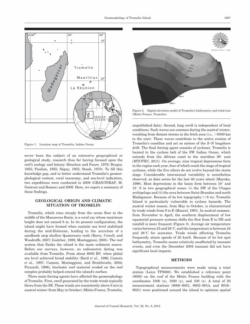
Located about 580 km NW of La Reunion (54u319 E, 15u539 S),
Tromelin is a small coral island about 1750 m long by 700 m
wide and bordered by a reef system exposed at low tide
(Figures 1 and 2). Tromelin belongs to the French Eparses
Islands and, together with the islands of Glorieuses, Juan de
Nova, Bassas da India, and Europa, located in the Mozambique
Channel, constitutes the fifth district of the Terres Australes et
Antarctiques Francaises (TAAF) since February 2007.
Discovered on 10 August 1722, by la Diane, a vessel of the
French East India Company, the island is best known for the
tragic events that followed the sinking of l’Utile (Guerout, 2007;
Guerout and Romon, 2007, 2008). On 31 July 1761, 120 crew
members and 60 slaves were marooned on the island following
the wrecking of l’Utile, en route from Madagascar to the Ile de
France (present-day Mauritius). From the wreckage, the
survivors built a second boat, la Providence, and on 27
September of the same year the French mariners set sail for
Madagascar, leaving the Madagascan castaways behind. Only
eight survivors, seven women and a young child, were rescued
on 29 November 1776 (Guerout and Romon, 2010).
In 1953, the Direction des Services Meteorologiques decided
to locate a weather station on Tromelin Island. The runway was
completed on 20 June 1954 and the first liaison with La
Reunion was completed on 9 July of the same year. The runway
is oriented SSE–NNW and is around 1100 m long. The weather
station buildings are situated on the western extremity of
Tromelin, the highest point on the island (Marriner, Guerout,
and Romon, 2010). This infrastructure includes the weather
station and service buildings, an electric generator, and an
aeolian. Four Meteo France workers, who undertake daily
meteorological measurements, permanently occupy the island.
Although described and visited by numerous travelers since
the 18th century (Guerout and Romon, 2008), Tromelin has
DOI: 10.2112/JCOASTRES-D-11-00029.1 received 13 February 2011;accepted in revision 21 March 2011.* Corresponding author.’ Coastal Education & Research Foundation 2012
Journal of Coastal Research 28 6 1606–1616 Coconut Creek, Florida November 2012
never been the subject of an extensive geographical or
geological study, research thus far having focused upon the
reef’s zoology and botany (Bouchon and Faure, 1979; Brygoo,
1955; Paulian, 1955; Seguy, 1955; Staub, 1970). To fill this
knowledge gap, and to better understand Tromelin’s geomor-
phological context, coral taxonomy, and sea-level indicators,
two expeditions were conducted in 2008 (GRAN/INRAP, M.
Guerout and Romon) and 2009. Here, we report a summary of
these findings.
GEOLOGICAL ORIGIN AND CLIMATICSITUATION OF TROMELIN
Tromelin, which rises steeply from the ocean floor in the
middle of the Mascarene Basin, is a coral cay whose maximum
height does not exceed 8 m. In its present configuration, the
island might have formed when eustatic sea level stabilized
during the mid-Holocene, leading to the accretion of a
sandbank atop shallow Quaternary reefs (Barry, Cowell, and
Woodroffe, 2007; Guilcher, 1988; Montaggioni, 2005). The reef
system that flanks the island is the main sediment source.
Before our surveys, however, no radiometric dating was
available from Tromelin. From about 6000 BP, when global
sea level achieved broad stability (Bard et al., 1996; Camoin
et al., 1997; Camoin, Montaggioni, and Braithwaite, 2004;
Pirazzoli, 1996), bioclastic reef material eroded on the reef
complex probably helped extend the island’s surface.
Three main forcing agents have affected the geomorphology
of Tromelin. First, swell generated by the trade winds typically
blows from the SE. These winds are consistently above 8 m/s in
austral winter (from May to October) (Meteo France, Tromelin,
unpublished data). Second, long swell is independent of local
conditions. Such waves are common during the austral winter,
resulting from distant storms in the fetch area (i.e., .6500 km
to the east). These waves contribute to the active erosion of
Tromelin’s coastline and act as motors of the S–N longshore
drift. The final forcing agent consists of cyclones. Tromelin is
located in the cyclone belt of the SW Indian Ocean, which
extends from the African coast to the meridian 90u east
(MTOTEC, 2011). On average, nine tropical depressions form
in the region each year, four of which reach the stage of tropical
cyclones, while the five others do not evolve beyond the storm
stage. Considerable interannual variability is nonetheless
observed, as data series for the last 40 years attest (Mayoka,
1998). Most depressions in the basin form between 10u and
15u S in two geographical zones: (i) the SW of the Chagos
archipelago and (ii) the area between Saint-Brandon and north
Madagascar. Because of its low topography (,8 m), Tromelin
Island is particularly vulnerable to cyclone hazards. The
austral winter season, from May to October, is characterized
by trade winds from S to E (Mancel, 1991). In austral summer,
from November to April, the southern displacement of low
equatorial pressure systems shifts the flow from E to NE and
rainfall is more frequent (Figure 3). Average air temperature
varies between 23 and 28uC, and the temperature is between 24
and 28uC for seawater. Trade winds affecting Tromelin
frequently attain speeds of 20 km/h. Because of its hot spot
bathymetry, Tromelin seems relatively unaffected by tsunami
events, and even the December 2004 tsunami did not have
significant local impacts.
METHODS
Topographical measurements were made using a total
station (Leica TPS800). We established a reference point
(9000) on the roof of the Meteo France building with the
coordinates 1000 (x), 1000 (y), and 100 (z). A total of 20
measurement stations (9000–9001, 9003–9014, and 9016–
9021) were positioned around the island to optimize spatial
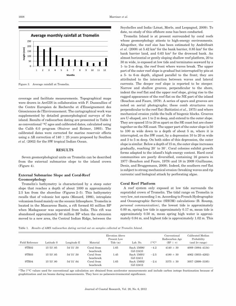
Figure 2. Digital elevation model of Tromelin’s bathymetry and wind rose
(Meteo France, Tromelin).
Figure 1. Location map of Tromelin, Indian Ocean.
Geomorphology of Tromelin Island 1607
Journal of Coastal Research, Vol. 28, No. 6, 2012
coverage and facilitate measurements. Topographical maps
were drawn in ArcGIS in collaboration with P. Dussoulliez of
the Centre Europeen de Recherche et d’Enseignement des
Geosciences de l’Environnement. The cartographical work was
supplemented by detailed geomorphological surveys of the
island. Results of radiocarbon dating are presented in Table 1
as conventional 14C ages and calibrated dates, calculated using
the Calib 6.0 program (Stuiver and Reimer, 1993). The
calibrated dates were corrected for marine reservoir effects
using a DR correction of 140 6 25 years proposed by Southon
et al. (2002) for the SW tropical Indian Ocean.
RESULTS
Seven geomorphological units on Tromelin can be described
from the external submarine slope to the island crown
(Figure 4).
External Submarine Slope and Coral-ReefGeomorphology
Tromelin’s bathymetry is characterized by a steep outer
slope that reaches a depth of about 1000 m approximately
2.5 km from the shoreline (Figures 2–5). This bathymetry
recalls that of volcanic hot spots (Menard, 1986), intraplate
volcanism found mainly on the oceanic lithosphere. Tromelin is
located in the Mascarene Basin, a rift formed 83 million BP
when Madagascar was separated from India. This rift was
abandoned approximately 60 million BP when the extension
moved to a new area, the Central Indian Ridge, between the
Seychelles and India (Lenat, Merle, and Lespagnol, 2009). To
date, no study of this offshore zone has been conducted.
Tromelin Island is at present surrounded by coral reefs
whose geomorphology attests to high-energy environments.
Altogether, the reef size has been estimated by Andrefouet
et al. (2008) at 5.42 km2 for the bank barrier, 0.85 km2 for the
bank barrier land, and 0.63 km2 for the drowned bank. An
almost horizontal or gently sloping shallow reef platform, 20 to
30 m wide, is exposed at low tide and terminates seaward by a
1- to 2-m drop, the reef front where waves break. The upper
part of the outer reef slope is gradual but interrupted by pits at
a 5- to 6-m depth, aligned parallel to the front; they are
attributed to the interaction between waves and lateral
currents. The deeper reef slope is reported to be steeper.
Narrow and shallow grooves, perpendicular to the shore,
indent the reef flat and the upper reef slope, giving rise to the
ragged appearance of the reef flat on the NE part of the island
(Bouchon and Faure, 1979). A series of spurs and grooves are
noted on aerial photographs; these comb structures run
perpendicular to the reef flat (Battistini et al., 1975) and where
mechanical erosion yields the bulk of biogenic blocks. Grooves
are U-shaped, are 1 to 2 m deep, and extend to the outer slope.
They are spaced 15 to 20 m apart on the SE coast but are closer
together on the NE coast. The upper part of the outer slope is 50
to 100 m wide down to a depth of about 5 m, where it is
interrupted, on the SW coast, by a depression 10 to 20 m wide
and 3 to 5 m deep. On both sides of this depression, the outer
slope is similar. Below a depth of 15 m, the outer slope increases
gradually, reaching 20u to 30u. Coral colonies exhibit growth
forms adapted to the island’s high-energy context. Hard coral
communities are poorly diversified, containing 16 genera in
1977 (Bouchon and Faure, 1979) and 18 in 2009 (Guillaume,
Denis, and Bruggemann, 2009). Indeed, the southern reef flat
is subject to strong mechanical erosion (breaking waves and rip
currents) and biological attack by perforating algae.
Coral Reef PlatformA reef system only exposed at low tide surrounds the
supratidal crown of Tromelin. The tidal range on Tromelin is
very low, not exceeding 1 m. According to French Hydrographic
and Oceanographic Service (SHOM) calculations (B. Roump,
personal communication), the lowest tide is approximately
0.00 m, spring low tide is approximately 0.17 m, mean tide is
approximately 0.50 m, mean spring high water is approxi-
mately 0.84 m, and highest tide is approximately 1.02 m. This
Figure 3. Average rainfall at Tromelin.
Table 1. Results of AMS radiocarbon dating carried out on samples collected at Tromelin Island.
Field Reference Latitude S Longitude E Material
Elevation Above
Present Low
Tide (m) Lab. No. q13C*
Conventional
Radiocarbon Age
(BP 6 s)
Calibrated Median
Probability
(and 2s range)
9TR02 15u539.85 54u319.50 Coral from
beachrock
1.65 SacA 15690/
Gif-12410
24.2 4140 6 30 4009 (3884–4134)
9TR03 15u539.85 54u319.50 Coral from
beachrock
1.45 SacA 15691/
Gif-12411
22.5 4180 6 30 4062 (3933–4202)
9TR04 15u539.80 54u319.64 Coral from
beachrock
1.65 SacA 15692/
Gif-12412
22.4 3375 6 30 3057 (2999–3195)
* The q13C values used for conventional age calculation are obtained from accelerator measurements and include carbon isotope fractionation because of
graphitization and ion beams during measurements. They have no palaeoenvironmental significance.
1608 Marriner et al.
Journal of Coastal Research, Vol. 28, No. 6, 2012

substrate, of which some remains are presently found about 1 m
above current sea level, has been extensively eroded by wave
action since the stabilization of relative sea level around 6000
BP; the reef yields the majority of bioclastic material to the
island crown. We also studied sediment transfers, particularly
the movement of coral blocks, gravels, and sands from the S to
the N of the island. The coral reef yields the bulk of the
sediment budget to the island’s supratidal formations. Accord-
ingly, with the exception of some pumice stones of undefined
origin, the island’s sediments are bioclastic. The sedimentary
deposits, studied through a series of sampling stations, show a
clear S–N grain-size differentiation. These variations are
mainly the result of the dominant meteomarine forcing agents.
A band of raised reef fringing the beach, mapped in the SW
part of the island by Staub (1970) as ‘‘upraised coral reef rocks,’’
is the only reference to possible local sea-level changes that
could be found in the literature before our fieldwork. These
features appear as highly eroded remnants of former reef
structures now emerging at low tide from the present reef flat a
few meters from the contemporary beach (Figure 6). These
remnants, which are not located on the windward side of the
reef, form lines parallel to the reef margin or beach and are
scattered, with decreasing height, at variable distances from
the shoreline. They could be dismantled remnants of a former
rampart-rock platform (Scoffin and McLean, 1978), and their
lithification is inferred to have taken place in the intertidal
zone. From these remnants, a coral sample (9TR01) of Favites
peresi was collected 1.2 m above spring low tide at 15u539.82 S,
54u319.46 E (near topographical station 9008). This species
belongs to the present coral communities (Bouchon and Faure,
1979; Guillaume, Denis, and Bruggemann, 2009).
In the field, it was difficult to ascertain whether this was
organically cemented reef rock (i.e., whether the coral sample
was in growth position, therefore testifying to a former mean
sea level, or MSL, at least 1.2 m above present) or whether
Staub’s (1970) description was incorrect and the sample
collected was just a reef block deposited within a rampart-rock
(i.e., consistent with a sea level similar to present). Because
sample 9TR01 could be older than the Holocene a priori,
uranium–thorium (U/Th) dating was undertaken. The arago-
nitic coral (calcite ,0.5%) yielded an age of 5.7 6 0.4 ka
(Table 2).
Figure 4. Digital elevation model of Tromelin.
Geomorphology of Tromelin Island 1609
Journal of Coastal Research, Vol. 28, No. 6, 2012

Absence of watercourses on the island provides little
terrestrial sediment to feed longshore drift. Fourteen repre-
sentative sampling stations were studied at strategic locations
around the island (Figure 5). We find that the main axis of the
largest block decreases from about 75 cm for southern stations
(e.g., station 9010) to less than 20 cm for northern stations.
Some large blocks (.1 m at the longest axis) lie on the edge of
the southern reef, just above MSL. These blocks correspond to
wave-fractured sections of the reef from which they have been
displaced just a few meters. Despite Tromelin’s high-energy
context, we found no evidence for megablocks on Tromelin.
Beachrock FormationsThe southern fringe of the island is characterized by outcrops
of beachrock, particularly in the south of the island. These
formations show stratification in slabs, with a seaward dip that
follows the alignment of the present beach clasts. Beachrocks
are lithified conglomerates of coastal sediments, formed by
carbonate cement precipitation, mainly calcite, aragonite, and
magnesium (Vousdoukas, Velegrakis, and Plomaritis, 2007).
The outcrops studied correspond to the beachrock definition
given by Scoffin and Stoddart (1987) ‘‘consolidated deposits that
result from lithification by calcium carbonate of sediments in
Figure 5. Location map of topographical stations and cartography of coral blocks around Tromelin.
1610 Marriner et al.
Journal of Coastal Research, Vol. 28, No. 6, 2012

the intertidal and spray zones of mainly tropical coasts.’’
Lithification normally occurs in the intertidal zone, some-
times over very short decadal timescales. Mechanisms of
cementation may include physicochemical precipitation of
high-Mg calcite and aragonite from seawater as a result of
high temperatures, CaCO3 supersaturation, evaporation, or
a combination of these; physicochemical precipitation of low-
Mg calcite and aragonite by mixing of meteoric water with
seawater; physicochemical precipitation of high-Mg calcite
and aragonite by degassing of CO2 from beach sediment pore
water; and finally precipitation of micritic calcium carbonate
as a byproduct of microbiological activity (Turner, 2005). At
Tromelin, the beachrock formation disappears beneath the
boulder ramparts, comprising coral blocks and slabs of
detached beachrock (Figure 7A).
Some former beachrock-type outcrops, developed higher
than the present intertidal range, up to 1.7 m above present
sea level, have been investigated in greater detail. At the foot of
the boulder rampart, near topographical station 9009, a
beachrock is developed between about 0.8 m and 1.6 to 1.7 m
above low tide, with a slightly inclined morphology (Figure 7B).
Its surface, frequently washed by waves in this exposed part of
the island, is devoid of a cover of unconsolidated beach
sediments. The conglomerate slab consists of a single unit
apparently representing a single episode of deposition and
cementation. A sample of coral fragments (sample 9TR04)
collected from the surface of the slab has been radiocarbon
dated at the Saclay Artemis accelerator mass spectrometry
(AMS) facilities to 3375 6 30 BP (Table 1).
In the same area, the surface of the conglomerate is quite
regular, consistent with a heterometric sediment composition.
In some instances, a similar beachrock is found forming
irregular mounds (again between about 0.8 m and about 1.6 m
above low tide), probably attesting to chaotic deposition and
high-energy wave action during and after the projection of the
storm material. The surface of the formation is in this case very
irregular (Figure 7C). The sediments forming the conglome-
rate were deposited by very high-energy waves in a coral reef
island context. The great variety in the conglomerate’s size and
material was confirmed in an exposed section near topograph-
ical station 9011 (Figure 7D), which contained a 0.5-m-wide
coral boulder, coral fragments of various sizes, and even some
thin coral sand, all lightly cemented together. The section is
about 0.8 m high, i.e., equivalent to the local spring tidal range.
These deposits, which were found at just a few locations in the
southernmost part of the island, seem to have been left by a
strong storm and subsequently consolidated, possibly in the
intertidal zone of a sea level that could have been approxi-
mately 1.2 m above present. In the present intertidal range,
there is often no evidence of beachrock or even of unconsol-
idated beach deposits in the same area of the island.
Hopley (1986) notes that, for beachrock interpretation,
problems may arise with dating material from outcrops,
because a maximum age may be obtained from constituent
organic material and there can be chronological offsets between
the death of the organism and the cementation of the
beachrock. In the present case, dated material comprises small
coral fragments of various sizes that, in such an exposed
environment, could have been reworked from the reef directly
or shortly after the coral death. The three dated beachrocks
therefore probably comprise sediments eroded from the reef
between 3300 and 4200 BP. The vertical range of lithification,
in the three cases examined, corresponds to the tidal range of a
sea level about 1.2 m higher, which suggests that the beachrock
may be consistent with a higher sea level.
As an indicator of former sea levels, Hopley (1986) recom-
mends that, where possible, beachrock should be used in
conjunction with other types of evidence. In Tromelin, however,
no other type of evidence could be found. Kelletat (2006)
remarks on the possibility, in extremely exposed locations, of
supratidal genesis of beachrock, in which the carbonates
necessary for cementation may be delivered by sea spray. On
the southern coast of Tromelin, exposed to frequent tropical
cyclones, it is not possible to exclude the possibility that the
Figure 6. ‘‘Upraised coral reef rock’’ (Staub, 1970) reaching up to 1.2 m
above spring low tide level. An in situ coral sample (9TR01) of Favites
peresi, collected from the top, has been dated by U/Th to 5.7 6 0.4 ka. One
meter gives scale.
Table 2. Results of Th/U analysis carried out on samples collected at Tromelin Island.
Field
Reference Latitude S
Longitude
E Material
Elevation
Above
Present
Low Tide
(m) 238U (ppm) 234/238U (ppm) 230/234U (ppm) Age (ka) (234/238U)t0
232Th
(ppb)
230/232Th
(ppb)
9TR01 15u539.82 54u319.46 Favites
peresi
,1.0 2.416 6 0.042;
2.380 6 0.050
1.140 6 0.016;
1.144 6 0.017
0.051 6 0.016 5.7 ± 0.4 1.142 6 0.02;
1.144
2 6 11 270
Geomorphology of Tromelin Island 1611
Journal of Coastal Research, Vol. 28, No. 6, 2012

beachrock was lithified by spray from an undetermined sea
level even higher than the present one.
The limestone substratum comprises the geological base upon
which the Holocene deposits have accreted; no precoralline out-
crops are exposed on the island. A large amount of volcanic
pumice is observed in supratidal storm deposits, especially on the
SE flank of the island. At present, the origin of the pumice
remains unclear, although we suggest that they are linked to the
volcanic base of the island; the possibility of a more distant origin
must not, however, be discarded. Mechanical erosion of the
beachrock formations by strong wave action has led to a fracturing
of the outcrops, which are undergoing active erosion at present.
The Beach SystemTromelin’s beach system is divided into three units: (i) the
storm beaches to the south of the island, comprising coral blocks
(15u539.562 S, 54u319.242 E and 15u539.341 S, 54u319.484 E);
(ii) mixed sediment beaches to the SE and SW (15u539.464 S,
54u319.164 E to 15u 539.660 S, 54u319.313 E and 15u539.303 S,
54u319.423 E to 15u539.391 S, 54u319.571 E); and (iii) the sandy
beaches to the north. Wave diffraction and S–N sediment
transfers have formed a prominent sand spit (,125 3 ,225 m),
whose morphology varies seasonally in response to the
changing meteomarine contexts. This sandbank comprises
gravels and coarse-grained sands and is located in a sheltered
downwind position behind the island.
The southern beaches are around 20 to 35 m wide and
constitute coral blocks eroded during storm episodes and
deposited in the supratidal zone; these deposits form a
staircase of storm berms parallel to the shoreline (Otvos,
2000). Several generations of storm ridges are present,
although at present there is no chronological control for these
elements. The most recent ridge lies just above MSL and
constitutes white coral blocks that contrast with the darker
shades, because of Cyanobacteria, of older ridges. Tromelin’s
reef flat is relatively wide (300–400 m, depending on location),
with gentle slopes that promote the transport of clastic
Figure 7. Beachrock and storm tract deposits. (A) Near topographical station 9010, other beachrock slabs, higher and possibly older, extend the beachrock
formation in the foreground below storm deposits. (B) Beachrock slabs are developed as irregular slabs between approximately 0.8 m and 1.6 to 1.7 m above
low tide, where the first boulders of the rampart appear. A sample of coral fragments (sample 9TR04) collected from the surface of the slab at 1.65 m (close to
the hammer) has been dated 3375 6 30 BP. (C) Beachrock-type material is found forming irregular mounds, probably attesting to chaotic deposition and high-
energy wave action during and after the projection of the beachrock material. The surface of the formation is in this case very irregular, suggesting the
presence of heterometric material. A sample (9TR03) of coral fragments collected 1.45 m above low tide (left of the hammer) has been dated 4180 6 30 BP.
(D) A section of the beachrock shows that the height of the formation is about 0.8 m (i.e., of a range similar to that of the tide). The size of the material
contained in the beachrock is extremely heterometric, from boulders several decimeters wide to small coral fragments and coral sand. A sample (TR02)
collected near the top of the section, 1.65 m above low tide (left of the hammer), has been dated 4140 6 30 BP. White and blackened layers of the boulder
rampart can be seen in the background.
1612 Marriner et al.
Journal of Coastal Research, Vol. 28, No. 6, 2012

material to the shoreline. The exposure of the southern coast to
the SE winds and swell evokes the reworking of older storm
ridges during powerful cyclone events (Nott and Hayne, 2001;
Nott et al., 2009; Scoffin, 1993).
A transitional zone is observed between the southern storm
beaches and the sandy northern beaches that is linked to
source to sink sediment transfers. This area is characterized by
coarse bioclastic sands and coral-block storm deposits.
The northern beaches reach a maximum width of about 50 to
75 m and are characterized by white biogenic sands, reworked
from the south by the dominant longshore drift from the SE.
Locally, the clastic sediments have been eroded to expose
beachrock outcrops. A few coral blocks are present, generally
less than 20 cm in diameter.
DunesThe best-developed dunes are located in the N, NE, and NW
parts of Tromelin, usually associated with Tournefortia
argentea, a shrub about 1 to 1.5 m high. This dune system
reaches a maximum width of 200 m and lies about 8 m above
MSL. Dune heights vary from 10 cm for the southern
microdunes to 250 cm in the NE of the island. The dunes are
Figure 8. Simplified geomorphological map of Tromelin, depicting the distribution of the storm tract and dune systems.
Geomorphology of Tromelin Island 1613
Journal of Coastal Research, Vol. 28, No. 6, 2012

parabolic, oriented SE–NW (Pye and Tsoar, 1990). To the SW of
Tromelin, this dune system is less well developed (Figure 8).
The presence of a coral block ridge in the upper part of the
crown inhibits sediment supply to the dune field. The
vegetation cover comprises herbaceous plants, mainly Boerha-
via diffusa (Paulian, 1955), which are well adapted to the sandy
matrix with very low nutrient content.
Two factors explain the absence of dunes in the south of the
island. First, salt spray is not conducive to the establishment
of an important vegetation cover. The relative absence of
vegetation therefore means that fine-grained sediment is not
readily trapped. Second, the southern storm ridges block fine-
grained sediments, starving sediment supply and its transport
by aeolian processes in this area.
Storm TractThe southern facade of Tromelin is characterized by a series
of boulder ramparts, juxtaposed parallel to the shoreline from
MSL up to the atoll crown. We measured four ramparts at 1, 3,
4.5, and 7 m above MSL. The height of these ramparts may
reach as high as 6.5 m above high tide level between stations
9012 and 9013 (Figure 9), which is exceptional for a coral reef
(Pirazzoli, 2010) and has principally resulted from the strength
of tropical storms and the long fetch area (.6500 km from the
east). The blocks constituting this embankment are generally
rounded and shaped by abrasion and saltation processes
during their reworking from the intertidal zone.
Exceptional storm waves have breached the upper part of
the boulder rampart to form a storm tract up to 250 m
inland. The sediments are mostly of hydrodynamic origin,
deposited by high-energy waves associated with intense
cyclones. These storm deposits comprise coral blocks (usually
,30 cm) and are principally visible in the south of the island
because of the low vegetation cover and low sediment
budgets. This unit also covers the geomorphological dune
area between 54u319.300 E, 15u539.400 S and 54u319.200 E,
15u539.400 S. The largest blocks (long axis 5 40–30 cm) are
located close to the southern beach berm. Their presence
behind the storm beaches implies that they were transported
by high-energy storm waves and deposited on the supratidal
crown of the island.
Figure 9. Boulder rampart attested all around the southern part of
Tromelin. White boulders correspond to deposits left by recent storms. In
the upper part of the rampart, which may reach up to 6.5 m above high tide
level, the boulders have been blackened by cyanophycean algae, indicating
less recent storms. A folded double meter gives scale.
Figure 10. N–S transect of Tromelin.
1614 Marriner et al.
Journal of Coastal Research, Vol. 28, No. 6, 2012

Southern DepressionThe southern depression covers an area of 40,000 m2. Its
lowest area lies a mere 1.2 m above MSL. A thin layer of well-
sorted aeolian sand characterizes this zone; surface sediments
have undergone an active aeolian deflation that has shaped
small fields of microdunes, which accrete slowly because of low
sediment supply and high wind speeds in this part of the island.
Clastic sediments are rapidly lithified to form a conglomerate
about 15 cm below the ground surface. This low topography has
resulted from low sediment supply and the strong accretion of
flanking areas during storm events.
DID THE HOLOCENE SEA LEVEL EXCEED THEPRESENT ONE AT TROMELIN?
Sea-level changes in the Mascarene Basin are generally
considered not to have reached a level higher than present
during the Holocene (Camoin et al., 1997; Camoin, Montag-
gioni, and Braithwaite, 2004; Montaggioni, 1979). This absence
of higher sea level, which has been ascribed to the specific
response of volcanic islands to hydroisostatic processes,
contrasts to the higher sea levels reported from the coasts of
Madagascar (Battistini, 1970; Battistini, Delibrias, and La-
borel, 1976; Laborel and Delibrias, 1976), from Farquhar atoll,
south of the Seychelles Archipelago (Battistini and Jouannic,
1979; Pirazzoli, Kaplin, and Montaggioni, 1990), and from the
eastern (Cocos Islands) and central (Chagos) Indian Ocean
(Woodroffe, 2005; Woodroffe et al., 1990). Particular attention
was therefore paid to possible former sea-level indicators.
In the absence of drilling possibilities below the reef surface,
a careful survey was undertaken along the coast and on the
surface of Tromelin in search of fossil sea-level indicators
exposed in growth position. None, however, were found.
The elevated ‘‘reef rock’’ mentioned by Staub (1970), which
we dated to 5.7 6 0.4 ka (as explained earlier), cannot be
considered as a reliable sea-level indicator. In a less exposed
context, the beachrock-like conglomerates developed higher
than the present intertidal range and could attest to a former
sea-level position about 1.2 m higher than present about 3300
to 4200 BP. Nonetheless, because of the frequency of cyclonic
events in Tromelin, with the possibility of supratidal genesis of
cementation by sea spray (Kelletat, 2006), further data are
required from other types of evidence.
CONCLUSION
Topographical and geomorphological data have allowed seven
geomorphological units to be defined on Tromelin, from the
outer slope to the cay’s crown. Sediment transport takes place
via two pathways, S–N longshore drift and aeolian transport,
driven by the prevailing winds and swell from the SW. Cyclones
have played an important role in the island’s morphogenesis
and the distribution of its sedimentary formations, as shown by
a N–S transect of the island (Figure 10). Indeed, the geomor-
phology of the island’s windward facade is in stark contrast to
the leeward flank. Southern Tromelin comprises high-energy
boulder ramparts mobilized during storm and heavy swell
episodes. Because of the strength of aeolian processes (.8 m/s
20% of the time) and the trapping of fine-grained sediments by
the boulder ramparts, accretion of the southern island crown is
relatively moderate. The northern part of Tromelin is charac-
terized by important accretion of bioclastic sediments, essen-
tially rounded gravels and coarse to medium sands. This is the
highest and best-sheltered point on Tromelin, an environmental
potentiality that was exploited by the castaways during the 18th
century to build their camp. The northern spit’s morphology
varies according to seasonal weather and oceanic conditions.
Concerning Holocene changes in sea level, while some
beachrock evidence may suggest that Tromelin’s sea level
could have been about 1.2 m higher than present during the
mid-Holocene, the occurrence of a higher sea level remains
uncertain in the absence of other data.
ACKNOWLEDGMENTS
We thank S. Fuma, J. Guesnon, L. Hoarau, J. Mouret, J.-F.
Rebeyrotte, and T. Romon for their assistance during the
2008 expedition. We also wish to thank the following
institutions: the Prefecture des Terres Australes et Antarc-
tiques Francaises, the Commandement des Forces Armees
dans la Zone Sud de l’Ocean Indien, Meteo France La
Reunion, the Fondation du Patrimoine, the Conseil Regional
de La Reunion, the Direction Regionale des Affaires Cul-
turelles de la Reunion, and the Fondation d’Entreprise
Groupe Banque Populaire.
The 2009 fieldwork has benefited from financial support by
the CNRS (UMR-8591), the Agence Nationale de la Recher-
che ANR-06-BDIV-002-BIOTAS Program, and the DRRT-
Reunion. It would not have been possible without the logistic
support of the TAAF, which organized the 2009 scientific
expedition aboard the Marion Dufresne, and the logistic help
of C. Marteau and T. Perillo. We thank J.P. Dumoulin and C.
Moreau for AMS measurements and B. Roump (SHOM) for
hourly tide predictions.
LITERATURE CITED
Andrefouet, S.; Chagnaud, N.; Chauvin, C., and Kranenburg, C.J.,2008. Atlas of French Overseas Coral Reefs. Nouvelle-Caledonie,France: Centre IRD de Noumea, 153p.
Bard, E.; Hamelin, B.; Arnold, M.; Montaggioni, L.; Cabioch, G.;Faure, G., and Rougerie, F., 1996. Sea level record from Tahiticorals and the timing of deglacial meltwater discharge. Nature, 382,241–244.
Barry, S.J.; Cowell, P.J., and Woodroffe, C.D., 2007. A morphody-namic model of reef-island development on atolls. SedimentaryGeology, 197, 47–63.
Battistini, R., 1970. Etat des connaissances sur les variations duniveau marin a Madagascar depuis 10.000 ans. Comptes rendusSemaine geologique Madagascar, 13–15 [in French].
Battistini, R.; Bourrouilh, F.; Chevalier, J.-P.; Coudray, J.; Denizot,M.; Faure, G.; Fisher, J.-C.; Guilcher, A.; Harmelin-Vivien, M.;Jaubert, J.; Laborel, J.; Montaggioni, L.; Masse, J.-P.; Mauge, L.-A.;Peyrot-Clausade, M.; Pichon, M.; Plante, R.; Plaziat, J.-C.; Plessis,Y.B.; Richard, G.; Salvat, B.; Thomassin, B.A.; Vasseur, P., andWeydert, P., 1975. Elements de terminologie recifale indopacifique.Tethys, 7, 1–111 [in French].
Battistini, R.; Delibrias, G., and Laborel, J., 1976. Datations deniveaux holocenes a Madagascar. Comptes rendus sommairesSeances Societe geologique de France., 6, 284–285 [in French].
Battistini, R. and Jouannic, C., 1979. Recherches sur la geomorpho-logie de l’atoll Farquhar (Archipel des Seychelles). Atoll ResearchBulletin, 230, 1–20 [in French].
Geomorphology of Tromelin Island 1615
Journal of Coastal Research, Vol. 28, No. 6, 2012
Bouchon, C. and Faure G., 1979. Apercu sur les peuplements a basede Scleractiniaires du recif de l’1le Tromelin (Ocean Indien).Cahiers de l’Indo-Pacifique, 1, 25–37 [in French].
Brygoo, E., 1955. Observations sur les oiseaux de Tromelin. LeNaturaliste Malgache, 7, 209–214 [in French].
Camoin, G.F.; Colonna, M.; Montaggioni, L.F.; Casanova, J.; Faure,G., and Thomassin, B.A., 1997. Holocene sea-level changes and reefdevelopment in the southwestern Indian Ocean. Coral Reefs, 16,247–259.
Camoin, G.F.; Montaggioni, L., and Braithwaite, C.J.R., 2004. Lateglacial to post-glacial sea levels in the western Indian Ocean.Marine Geology, 206, 119–146.
Guerout, M., 2007. Tromelin, l’1le des esclaves oublies. Archeologia,443, 30–42 [in French].
Guerout, M. and Romon, T., 2007. Tromelin (ocean Indien): unearcheologie de la detresse. Les Nouvelles de l’Archeologie, 108–109,113–118 [in French].
Guerout, M. and Romon, T., 2008. L’Utile 1761…. ‘‘Esclaves oublies.’’Archeopages: Constructions de l’Archeologie, 59–62 [in French].
Guerout, M. and Romon, T., 2010. Tromelin: l’Ile aux EsclavesOublies. Paris: CNRS Editions/Inrap, 195p [in French].
Guilcher, A., 1988. Coral Reef Geomorphology. Chichester, UnitedKingdom: Wiley, 228p.
Guillaume, M.M.M.; Denis, V., and Bruggemann H., 2009. Survey ofcoral communities and their bleaching susceptibility in the FrenchEparses Islands in 2009. 6th Scientific Symposium of the WesternIndian Ocean Marine Science Association (Saint-Denis de laReunion) Book of Abstracts, 103p.
Hopley, D., 1986. Beachrock as a sea-level indicator. In: Van dePlassche, O. (ed.), Sea-level Research: A Manual for the Collectionand Evaluation of Data. Norwich, United Kingdom: Geo Books, pp.157–173.
Kelletat, D., 2006. Beachrock as sea-level indicator? Remarks from ageomorphological point of view. Journal of Coastal Research, 22,1558–1564.
Laborel, J. and Delibrias, G., 1976. Datations de niveaux marins aVermets sur la cote ouest Africaine. Bulletin Association francaisepour l’etude du Quaternaire., 47, 97 [in French].
Lenat, J.-F.; Merle, O., and Lespagnol, L., 2009. La Reunion: anexample of channeled hot spot plume. Journal of Volcanology andGeothermal Research, 184, 1–13.
Mancel, F., 1991. Ernista. La Reunion, France: Centre Meterologiquede la Reunion, 81p.
Marriner, N.; Guerout, M., and Romon, T., 2010. The forgotten slavesof Tromelin: new geoarchaeological data. Journal of ArchaeologicalScience, 37, 1293–1304.
Mayoka, M., 1998. Les cyclones a La Reunion. Direction Interregio-nale de Meteo France a La Reunion, 48p [in French].
Menard, H.W., 1986. Islands. New York: Scientific American Library,230p.
Montaggioni, L.F., 1979. Le probleme de l’absence de hauts stationne-ments marins d’age Holocene dans l’archipel des Mascareignes,Ocean Indien occidental. Comptes Rendus del’Academie desSciences, Paris D, 288, 1591–1594 [in French].
Montaggioni, L.F., 2005. History of Indo-Pacific coral reef systemssince the last glaciation: development patterns and controllingfactors. Earth-Science Reviews, 71, 1–75.
MTOTEC, 2011. Cyclone Basin of the South-West Indian Ocean.http://www.mtotec.com/ (accessed June 4, 2011).
Nott, J. and Hayne, M., 2001. High frequency of ‘‘super-cyclones’’along the Great Barrier Reef over the past 5,000 years. Nature, 413,508–512.
Nott, J.; Smithers, S.; Walsh, K., and Rhodes, E., 2009. Sand beachridges record 6000 year history of extreme tropical cyclone activity innortheastern Australia. Quaternary Science Reviews, 28, 1511–1520.
Otvos, E.G., 2000. Beach ridges: definitions and significance.Geomorphology, 32, 83–108.
Paulian, R., 1955. Observations de la faune terrestre de l’1le deTromelin. Le Naturaliste Malgache, 7, 1–7 [in French].
Pirazzoli, P.A., 1996. Sea Level Changes: The Last 20,000 Years.Chichester, United Kingdom: Wiley, 211p.
Pirazzoli, P.A., 2010. Boulder zone/ramparts. In: Hopley, D. (ed.),Encyclopedia of Modern Coral Reefs. Dordrecht, the Netherlands:Springer-Verlag, pp. 167–168.
Pirazzoli, P.A.; Kaplin, P.A., and Montaggioni, L.F., 1990. Differentialvertical coastal movements deduced from Late Holocene coral-richconglomerates: Farquhar and St. Joseph Atolls (Seychelles,western Indian Ocean). Journal of Coastal Research, 6, 381–389.
Pye, K. and Tsoar, H., 1990. Aeolian Sand and Sand Dunes. London:Unwin, 474p.
Scoffin, T.P., 1993. The geological effects of hurricanes on coral reefsand the interpretation of storm deposits. Coral Reefs, 12, 203–221.
Scoffin, T.P. and McLean, R.F., 1978. Exposed limestones of theNorthern Province of the Great Barrier Reef. PhilosophicalTransactions of the Royal Society A, 291, 119–138.
Scoffin, T.P. and Stoddart D.R., 1987. Beachrock and intertidal cements.In: Scoffin, T.P. (ed.), An Introduction to Carbonate Sediments andRocks. Glasgow, United Kingdom: Blackie Publishing, pp. 401–425.
Seguy, E., 1955. Dipteres de l’1le de Tromelin. Le NaturalisteMalgache, 7, 8–12 [in French].
Southon, J.; Kashgarian, M.; Fontugne, M.; Metivier, B., and Yim, W.,2002. Marine reservoir corrections for the Indian Ocean andSoutheast Asia. Radiocarbon, 44, 167–180.
Staub, F., 1970. The geography and ecology of Tromelin Island. AtollResearch Bulletin, 136, 197–209.
Stuiver, M. and Reimer, P.J., 1993. Extended 14C data base and revisedCalib 3.0 14C age calibration programme. Radiocarbon, 35, 215–230.
Turner, R.J., 2005. Beachrock. In: Schwartz, M.L. (ed.), Encyclopedia ofCoastal Science. Dordrecht, The Netherlands: Springer, pp. 183–186.
Vousdoukas, M.I.; Velegrakis, A.F., and Plomaritis, T.A., 2007.Beachrock occurrence, characteristics, formation mechanisms andimpacts. Earth-Science Reviews, 85, 23–46.
Woodroffe, C.D., 2005. Late Quaternary sea-level highstands in thecentral and eastern Indian Ocean: a review. Global and PlanetaryChange, 49, 121–138.
Woodroffe, C.; McLean, R.; Polach, H., and Wallensky, E., 1990. Sealevel and coral atolls: late Holocene emergence in the Indian Ocean.Geology, 18, 62–66.
1616 Marriner et al.
Journal of Coastal Research, Vol. 28, No. 6, 2012
Copyright © 2022 FDOKUMEN