
The Geoarchaeology of Utica, Tunisia: The Paleogeography of the Mejerda Delta and Hypotheses...
16
Research Article The Geoarchaeology of Utica, Tunisia: The Paleogeography of the Mejerda Delta and Hypotheses Concerning the Location of the Ancient Harbor Hugo Delile, 1,2, * Abdelhakim Abichou, 3 Ahmed Gadhoum, 4 Jean-Philippe Goiran, 5 Elisa Pleuger, 6 Jean-Yves Monchambert, 7 Andrew Wilson, 8 Elizabeth Fentress, 9 Josephine Quinn, 10 Imed Ben Jerbania, 11 and Faouzi Ghozzi 11 1 Universit ´ e Lumi ` ere Lyon 2, CNRS UMR 5600, 69676 Bron, France 2 Ecole Normale Sup ´ erieure de Lyon, Universit ´ e Claude Bernard-Lyon I, Lyon, France 3 Laboratoire de Cartographie G ´ eomorphologique des Milieux, des Environnements et des Dynamiques, Facult ´ e des Sciences Humaines et Sociales de Tunis, Tunis, Tunisia 4 D´ epartement d’Arch ´ eologie Sous-Marine, Institut National du Patrimoine, Tunis, Tunisia 5 CNRS UMR 5133, Maison de l’Orient et de la M ´ editerran ´ ee, Universit ´ e de Lyon, Lyon, France 6 D´ epartement de G ´ eologie, UR Argiles, G ´ eochimie et Environnements S ´ edimentaires,Universit ´ e de Li ` ege, Li ` ege, Belgium 7 Laboratoire Orient et M ´ editerran ´ ee (UMR 8167),Universit ´ e Paris-Sorbonne (Paris IV), Paris, France 8 Institute of Archaeology, University of Oxford, Oxford, UK 9 Independent scholar 10 Worcester College, University of Oxford, Oxford, UK 11 Institut National du Patrimoine, Tunis, Tunisia Correspondence * Corresponding author; E-mail: [email protected] Received 16 September 2014 Revised 13 February 2015 Accepted 14 February 2015 Scientific editing by Jamie Woodward Published online in Wiley Online Library (wileyonlinelibrary.com). doi 10.1002/gea.21514 Although the ancient site of Utica has been studied since the 19th century, the location of its harbors remains unresolved as they were buried under sedi- ments as the Mejerda delta prograded and left Utica 10 km inland. Using relief data and a coring survey with sedimentological analysis, we identify the dy- namics of the delta’s progradation, which produced a double system of alluvial fans. These show that the ancient bay of Utica silted up faster and earlier than was thought, probably before the end of the Punic period. Combined with the radiocarbon dates from coring, this suggests that the harbor lay on the north- western side of the Utica promontory, communicating with the sea by a marine corridor west of the northern compartment of the delta. As the infilling of the ancient bay progressed, this corridor narrowed until it disappeared completely in the early 5th/mid-6th century A.D., when a peat bog developed on the northern side of the promontory, sealing the fate of Utica as a port. This rela- tive environmental stability ended in the 9th–10th century A.D. when about 4 m of sediment, probably of fluvial origin, covered the peat bog, leaving the site more than 4.5 m above the local sea level. C 2015 Wiley Periodicals, Inc. INTRODUCTION The progradation of the Mejerda delta in the ancient bay of Utica, the Sinus Uticensis, has been the subject of nu- merous studies since the end of the 19th century. This infilling of sediment has been studied through the writ- ten sources (Tissot, 1884), then by means of archaeol- ogy (Reyniers, 1951; L ´ ezine, 1966, 1970) and geology (Pimienta, 1959; Jauzein, 1971) and most recently us- ing geoarchaeology (Paskoff, 1985, 1994; Paskoff, Slim, & Trousset, 1991; Paskoff & Trousset, 1992; Chelbi, Paskoff, & Trousset, 1995; Slim et al., 2004; Oueslati, Charfi, & Baccar, 2006). These studies have involved developing a spatiotemporal outline for the many changes of course (avulsions) to which the Mejerda has been subjected dur- ing its advance toward the sea. Thus, the periods of ac- tivity of the different channel beds of the Mejerda have been more or less well identified, ending in the infilling of the Utica gulf along a south-west/north-east orientation. The point of convergence of all these studies concerns the infilling of the area between the promontory of Kalaat el-Andalous (Castra Cornelia) and peninsula of Utica Geoarchaeology: An International Journal 30 (2015) 291–306 Copyright C 2015 Wiley Periodicals, Inc. 291
-
Upload
univ-lyon2 -
Category
Documents
-
view
5 -
download
0
Transcript of The Geoarchaeology of Utica, Tunisia: The Paleogeography of the Mejerda Delta and Hypotheses...
Research Article
The Geoarchaeology of Utica, Tunisia: The Paleogeography ofthe Mejerda Delta and Hypotheses Concerning the Location ofthe Ancient HarborHugo Delile,1,2,* Abdelhakim Abichou,3 Ahmed Gadhoum,4 Jean-Philippe Goiran,5 Elisa Pleuger,6
Jean-Yves Monchambert,7 Andrew Wilson,8 Elizabeth Fentress,9 Josephine Quinn,10 Imed Ben Jerbania,11
and Faouzi Ghozzi11
1Universite Lumiere Lyon 2, CNRS UMR 5600, 69676 Bron, France2Ecole Normale Superieure de Lyon, Universite Claude Bernard-Lyon I, Lyon, France3Laboratoire de Cartographie Geomorphologique des Milieux, des Environnements et des Dynamiques, Faculte des Sciences Humaines et Sociales deTunis, Tunis, Tunisia4Departement d’Archeologie Sous-Marine, Institut National du Patrimoine, Tunis, Tunisia5CNRS UMR 5133, Maison de l’Orient et de la Mediterranee, Universite de Lyon, Lyon, France6Departement de Geologie, UR Argiles, Geochimie et Environnements Sedimentaires,Universite de Liege, Liege, Belgium7Laboratoire Orient et Mediterranee (UMR 8167),Universite Paris-Sorbonne (Paris IV), Paris, France8Institute of Archaeology, University of Oxford, Oxford, UK9Independent scholar10Worcester College, University of Oxford, Oxford, UK11Institut National du Patrimoine, Tunis, Tunisia
Correspondence*Corresponding author; E-mail:
Received16 September 2014
Revised13 February 2015
Accepted14 February 2015
Scientific editing by Jamie Woodward
Published online in Wiley Online Library
(wileyonlinelibrary.com).
doi 10.1002/gea.21514
Although the ancient site of Utica has been studied since the 19th century,the location of its harbors remains unresolved as they were buried under sedi-ments as the Mejerda delta prograded and left Utica 10 km inland. Using reliefdata and a coring survey with sedimentological analysis, we identify the dy-namics of the delta’s progradation, which produced a double system of alluvialfans. These show that the ancient bay of Utica silted up faster and earlier thanwas thought, probably before the end of the Punic period. Combined with theradiocarbon dates from coring, this suggests that the harbor lay on the north-western side of the Utica promontory, communicating with the sea by a marinecorridor west of the northern compartment of the delta. As the infilling of theancient bay progressed, this corridor narrowed until it disappeared completelyin the early 5th/mid-6th century A.D., when a peat bog developed on thenorthern side of the promontory, sealing the fate of Utica as a port. This rela-tive environmental stability ended in the 9th–10th century A.D. when about4 m of sediment, probably of fluvial origin, covered the peat bog, leaving thesite more than 4.5 m above the local sea level. C© 2015 Wiley Periodicals, Inc.
INTRODUCTION
The progradation of the Mejerda delta in the ancient bayof Utica, the Sinus Uticensis, has been the subject of nu-merous studies since the end of the 19th century. Thisinfilling of sediment has been studied through the writ-ten sources (Tissot, 1884), then by means of archaeol-ogy (Reyniers, 1951; Lezine, 1966, 1970) and geology(Pimienta, 1959; Jauzein, 1971) and most recently us-ing geoarchaeology (Paskoff, 1985, 1994; Paskoff, Slim, &Trousset, 1991; Paskoff & Trousset, 1992; Chelbi, Paskoff,
& Trousset, 1995; Slim et al., 2004; Oueslati, Charfi, &Baccar, 2006). These studies have involved developing aspatiotemporal outline for the many changes of course(avulsions) to which the Mejerda has been subjected dur-ing its advance toward the sea. Thus, the periods of ac-tivity of the different channel beds of the Mejerda havebeen more or less well identified, ending in the infilling ofthe Utica gulf along a south-west/north-east orientation.The point of convergence of all these studies concerns theinfilling of the area between the promontory of Kalaatel-Andalous (Castra Cornelia) and peninsula of Utica
Geoarchaeology: An International Journal 30 (2015) 291–306 Copyright C© 2015 Wiley Periodicals, Inc. 291
THE PALEOGEOGRAPHY OF THE MEJERDA DELTA, TUNISIA DELILE ET AL.
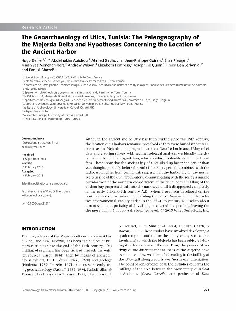
Figure 1 General location maps of the Mejerda catchment and delta. The numbers correspond to those of the Mejerda paleochannels.
(Figure 1). It is through this sector that the Mejerdareaches the northern compartment of the delta. Our re-search is also concerned with this transition zone, be-cause it holds the key to understanding the choices in-volved in establishing the first settlements of the Phoeni-cian city and thus the location of its harbor basins, to-day buried under the alluvium. Harbor geoarchaeologyhas made great strides in recent years, using coring tech-niques to investigate the ancient harbor basin at Marseille(Morhange, 1994) and to discover lost harbors at Tyre(Marriner, 2007) and the riverine harbor of Ostia (Goiranet al., 2014). By contrast, a coring program has shownthat the harbor at Cumae could not have lain to the southof the acropolis (Morhange et al., 2001). Our fieldworkhas applied similar techniques to the question of wherethe harbor of Utica was located.
On the basis of textual and archaeological evidenceand from analysis of satellite images (Paskoff & Trous-set, 1992), the latest research situates the harbor basinsof the city in the north-western part of the peninsulaof Utica (Figure 2). Without investigations beneath thepresent ground surface, these hypotheses cannot be con-firmed or rejected. The infilling of the harbor would havebegun following the Mejerda’s avulsions to the northernpart of the delta before the end of Antiquity (Paskoff &
Trousset, 1992; Chelbi, Paskoff, & Trousset, 1995; Slimet al., 2004), leading to the progressive abandonment ofthe city by the 7th century A.D. (Paskoff, 1994; Chelbi,Paskoff, & Trousset, 1995).
Using a geographic information system (GIS) that in-cludes digital elevation data, as well as topographic andgeological maps and geo-referenced aerial photographs(taken in 1947, 1954, 1956, and 1962), and an initial se-ries of borehole cores, we propose a hydrogeomorpho-logical rereading of the Mejerda delta progradation, inwhich the hydro- and morphosedimentary processes canbe identified. The geoarchaeological implications of ourresults provide new insights concerning the location ofthese harbor basins.
Furthermore, the knowledge of the relative sea level(RSL) of the Roman period will provide information bothon the approximate position of the harbor deposits withinthe stratigraphy and the rate of sea level rise for about2000 years. Anzidei et al. (2011) have evaluated at differ-ent archaeological sites of Punic–Roman age the changein sea level since about 2000 years ago along the coastsof Tunisia and Libya. They relied on archaeological mark-ers of Punic–Roman age, such as ancient fish tanks, piers,slipways, quarries, and harbors, which are presently sub-merged. Their estimation of the sea level rise over the last
292 Geoarchaeology: An International Journal 30 (2015) 291–306 Copyright C© 2015 Wiley Periodicals, Inc.

DELILE ET AL. THE PALEOGEOGRAPHY OF THE MEJERDA DELTA, TUNISIA
Figure 2 Plan of Utica, with main buildings, and locations of the five cores taken in 2012. (1) Location of possible circus. (2) Large Baths. (3) Columbarium.
(4) Possible temple. (5) Vaulted structure. (6) Mosaic and ornamental fountain. (7) Public square, or reservoir? (8) Temple? (9) House with intarsia. (10)
Staircase or ramp. (11) Public square? (12) Mortared rubble foundation. (13) Fish-salting vats. (14) Basilica. (15) Forum. (16) House of the Grand Oecus.
(17) Colonnaded Street. (18) Theatre. (19) Baths. (20) Houses excavated in 1950s. (21) Punic kiln. (22) Limekiln. (23) Feature supposed by Lezine to be
ramparts; actually natural break of slope. (24) Citadel. (25) Early Church. (26) As 23. (27) Aqueduct. (28) Reservoir cisterns. (29) Amphitheatre. (30) Street
going uphill. (31) Roman necropolis. (32) Small amphitheatre? (33) Stadium or circus. Source: Kallala et al. (2010), Figure 11.
2000 years is between 0.2 and 0.5 m on these coasts. Asimilar method has been employed on Roman fish tanksat Frejus by Morhange et al. (2013) who estimated a RSLrise of 40 ± 10 cm since Roman times. These results,which are consistent with those of Oueslati (1995) andSlim et al. (2004), show significant variability in the risein the sea level at different sites. The rise in sea level ispart of a global process resulting from both eustatic andglacio-hydro-isostatic changes in the Mediterranean sincethe end of the last glacial maximum, but the local vari-ation is explained by tectonic vertical movements of theland, such as subsidence, causing higher values in someareas, such as Gammarth, where RSL around �A.D. 200(±50 years) stood at 0.58 ± 0.3 m below the local meansea level (LMSL; Anzidei et al., 2011).
SETTING
Geological and Geographical Background
The delta of the Mejerda is the outlet for the waterand sediment discharges of Tunisia’s largest river, whichdrains along its course of 460 km the waters of a basinoriented south-west/north-east that has a surface area of23,700 km² (Figure 1). The source of the Mejerda liesin Algeria in the high mountains (1300 m) of the semi-arid Tell Atlas formed by Eocene and Senonian lime-stones, from which the river flows in torrents up tothe Tunisian–Algerian border (David, 1956). The lowercourse of the river, 340 km in length, begins east ofthe frontier where the widening of the alluvial plain re-sults in the development of wide meanders, mainly fed
Geoarchaeology: An International Journal 30 (2015) 291–306 Copyright C© 2015 Wiley Periodicals, Inc. 293

THE PALEOGEOGRAPHY OF THE MEJERDA DELTA, TUNISIA DELILE ET AL.
by the wadis Beja, Kessab, Tessa, Seliana, and Mellegue(Figure 1).
The regime of the Mejerda includes contrasting sea-sonal flows with summer discharges of 1 m3/s, associ-ated with a period of drought (Jauzein, 1971; Oueslati,Charfi, & Baccar, 2006). On the other hand, the winterrainy season produces high flows and floods are a nor-mal occurrence between October and March with a dis-charge above 80 m3/s. The deltaic plain of the Mejerdahas developed in a subsiding synclinal structure, delim-ited by an assemblage of small anticlinal reliefs such asthe recent hills (jebels) of Ennadhour and Kechabta tothe north and the older jebels Ammar and Ennahi tothe south. The deltaic plain of the Mejerda is dividedinto two compartments, north and south, either side ofthe anticlines of Menzel Roul and Kalaat el-Andalous(Figure 1). Tunisia’s location at the convergence of theAfrican and Eurasian tectonic plates results in compres-sion movements toward Africa, which led to the forma-tion of Pliocene folds, including the anticline of Utica(Paskoff & Oueslati, 1988). Recent research has high-lighted abnormal contact between the sandstones of thePliocene and Quaternary silts containing potsherds. Thesedata show the Late Pleistocene–Holocene activity of theUtique Fault. An example of this active faulting is the de-structive earthquake of A.D. 412 in Utica (Paskoff, Slim,& Trousset, 1991; Vogt, 1993; Mejri et al., 2010, Mejri,2012).
The annual deposition of sediment in the gulf of Tu-nis, estimated at �22 million tons (Oueslati, Charfi, &Baccar, 2006), has resulted in the construction of a deltaof 450 km² since the early Holocene. In this lower val-ley of the Mejerda, all the major hydrogeomorphologi-cal units of a delta are present. The lowest levels are thehumid zones such as marshes, sebkhas (sebkha of El Ar-iana), and ancient (lagoon of Garaet El Mabtouha) andmodern lagoons (lagoon of Ghar El Melh). The latter aredelimited by a coastal belt constructed by longshore drift.This favors the construction of dune ridges that fit to-gether and are parallel, particularly visible at the presentriver mouth. The delta of the Mejerda also contains a net-work of paleochannels (Figure 1), evidence of the com-plex construction of this lower plain.
The delta shoreline is washed by shallow waters, withthe 5 m isobath sometimes located more than 1.5 km off-shore (Oueslati, Charfi, & Baccar, 2006). These shoresare also fairly well protected from the western strongwinds by the hills that form an almost continuous chainalong the northern edge of the plain. The most frequentwinds from the north, particularly the north-west, forma swell in the same direction; the swell caused by thenorthwest winds is diffracted by the promontory of RassEttarf (Oueslati, Charfi, & Baccar, 2006). The southward
longshore drift thus created provides an estimated coastaltransfer of 30,000 to 40,000 m3 of sediment per year(Paskoff, 1985). The tide is weak, fluctuating between0.1 m at low tide and 0.3 m at high tide.
Historical and Archaeological Background
The foundation of the Phoenician city of Utica is tradi-tionally said to date to 1101 B.C., predating Carthage,although the earliest known archaeological remains arefrom the 8th century B.C. The early city occupied a smallpromontory on the western side of the Mejerda estuary,with its cemeteries to the south. Over time, the city ex-panded southward over rising ground. Following Rome’sdefeat of Carthage in 146 B.C., Utica became the seat ofthe provincial governor of the new province of Africa.During the Civil Wars the city was besieged by Curio in49 B.C., though not before 200 merchant ships had leftthe harbor to go over to the besieging side (Caesar, DeBello Civile II.25); and the Younger Cato famously com-mitted suicide there in 46 B.C., following Caesar’s vic-tory at Thapsus. The capital was transferred to Carthagein the reign of Augustus, after the refoundation of thatcity, but Utica evidently prospered, first as a municipiumand then, from the reign of Hadrian, as a colonia. Overthe first two centuries A.D., it acquired the full rangeof public buildings one would expect in a major Romancity: a civil basilica, aqueduct and reservoir cisterns, pub-lic baths, theatre, amphitheatre, and a stadium or circus,although the site and nature of the harbor are unknown(Figure 2). Much of the city was laid out on a rectangu-lar street grid, fringed to the south-west by a suburbanzone of pottery and lime kilns and cemeteries. Privatehouses with lavish mosaics evidently flourished into the4th century A.D., although there is a notable decreasein activity in the late Roman period, particularly in thearea of the forum, where we find no pottery later thanthe 4th century. Overall the ruins cover some 100 ha, in-cluding cemeteries, and the population of the city at itspeak might have been between 15,000 and 30,000. Re-cent archaeological work suggests that the civil basilicawas demolished in the late Roman period, and later anearly Islamic village grew up over the ruins (Kallala et al.,2010; Fentress et al., 2012).
MATERIALS AND METHODS
GIS Design
This study is based in part on analysis using a GIS consist-ing of topographic (topographic map of the Mejerda deltaat 1:25,000 and 1:50,000 scales) and geological maps (ge-ological map of the Mejerda delta at 1:50,000 scale) and
294 Geoarchaeology: An International Journal 30 (2015) 291–306 Copyright C© 2015 Wiley Periodicals, Inc.

DELILE ET AL. THE PALEOGEOGRAPHY OF THE MEJERDA DELTA, TUNISIA
aerial photographs (archives from the Department of theFrench Air Force). After having georeferenced all thesedata, we proceeded to study the topography of the deltaby defining contour lines and altimetric points on the ge-ological map at 1:50,000.
Measurement of the Current Sea Level
Because of the infilling of the Utica gulf since Antiquity,the remains of the ancient harbor are buried deep underthe alluvia. Only borehole cores, by which the thicknessof the alluvia may be measured, can enable determina-tion of the altitude of the ancient installations. However,comparison between the absolute altitudes indicated onthe plans of A. Lezine in the 1960s and those determinedin 2011 based on the WGS84 system of reference es-tablished with a differential GPS by the British missionin 2010 shows differences of the order of 1.7 m, whichmakes the interpretation of the cores difficult. To avoidall uncertainty, it was decided to measure the local sealevel with respect to the global mean sea level (MSL)that serves as the reference basis for the GPS system usedby the British team (differential GPS, in UTM projectionzone 32 North based on a WGS84 geodesic system).
A 10-km-long transect (27 relays) between the archae-ological site and the nearest maritime point, in the lagoonof Ghar el Melh, enabled us to establish that the sea leveltoday lies 1.60 m below the new reference zero pointor global MSL. These measurements correspond, withinabout 10 cm, to those of A. Lezine.
This difference is explained by the utilization of two dif-ferent geodesic systems—a local system used by A. Lezineand the global standard geodesic system, WGS84, used bythe British team. Although the WGS84 system defines anMSL with respect to which altitudes are calculated, in re-ality sea level is not constant, and the variations acrossthe globe amounting to as much as a hundred meters.Here the difference is of the order of 1.60 m. It is of coursethe local sea level and not the global MSL that one needsto consider when investigating the harbor structures ofUtica, and we therefore need to add 1.60 m to the alti-tudes given by the GPS to give altitudes relative to theLMSL.
The measurement of the current local sea level is cru-cial for two main reasons. The first is that it enables us tocompare the stratigraphy of the different cores. Indeed,the coring areas show some important discontinuities inelevation that, without this accurate measurement of theelevation of the cores, would induce stratigraphic offsetsbetween boreholes. In addition, this measure of the localsea level is also the only way to position in the stratigra-phy the RSL of the Roman period that has recently beenestimated at Carthage and Gammarth by Anzidei et al.
(2011). We have therefore represented it in Figure 3 us-ing data provided by Anzidei et al. (2011) for Gammarth.
Cores and Radiocarbon Dating
In order to compare the results from the GIS study withthe actual composition of the deposits beneath the sur-face, in October 2012 we extracted five cores using amanual auger (Figure 2). These cores, whose lengths arebetween �2.80 and �6.60 m, also provide an efficientmeans of testing the location of the harbor basins (Goiran& Morhange, 2003). This coring season was aimed atinvestigating a possible location for the harbor on thenorth-western side of the promontory of Utica (cores UTC1 and UTC 2), and investigating the supposed coastaledges of the Roman city next to the present marsh (coreUTC 7) and in the sector of the Large Baths (core UTC9). Core UTC 8 was extracted north of the Large Baths, inwhat was presumed to be the area of the Roman coast-line, near an alluvial fan of the Mejerda.
Radiocarbon dating was performed on peat and shellsamples from cores UTC 2 and UTC 1. Only the peat sam-ples were dated, owing to the lack of organic materialsin the other sedimentary units or their advanced state ofdegradation. The laboratories of Oxford and Groningencarried out the analyses using the AMS dating method.The 14C (B.P.) dates were converted into calibrated B.C.and A.D. dates using the continental and marine curvesof Reimer et al. (2009) by means of the Clam software(Blaauw, 2010). Errors on raw radiocarbon ages B.P. arereported at the 95% confidence level (2σ ). The radiocar-bon ages are shown in Table I and Figure 3.
Samples and Analytical Techniques
We sampled cores UTC 2 and UTC 8, which we analyzedfor grain-size distributions (see Delile et al., 2014, foranalytical details) in order to characterize hydrodynamicand sediment conditions (Marriner, Morhange, & Goiran,2010). The interpretation of granulometric curves wasbased on the CM diagram (also called the Passega image),which uses the median (D50) and the coarsest percentile(D99) to determine depositional and transport processes(Passega, 1957; Bravard & Peiry, 1999; Salomon et al.,2012; Delile et al., 2015). The cores were analyzed in theOMEAA laboratory in Lyon.
Magnetic susceptibility (MS) measurement was per-formed on samples to detect variations in ferrimagneticmineral contents in sediments, mostly Mn and Fe ox-ides, hydroxides, and oxyhydroxides (Dearing, 1999). Ina deltaic environment, MS reflects the terrigenous fluxderived from fluvial processes. MS was measured threetimes using a Bartington MS2E1 (Dearing, 1999).
Geoarchaeology: An International Journal 30 (2015) 291–306 Copyright C© 2015 Wiley Periodicals, Inc. 295

THE PALEOGEOGRAPHY OF THE MEJERDA DELTA, TUNISIA DELILE ET AL.
Figure 3 Descriptions of the stratigraphic units of the five cores.
We did not measure the degree of compaction of thepeat layers because this type of analysis is intended forstudies of sea-level variations throughout the Holocene,where the succession of coastal peats in the stratigraphyis considered as an indicator of former sea levels (Vella &Provansal, 2000; Lampe et al., 2010). In this case, knowl-edge of the top of the peat is indispensable to properlyassess the maximum sea level rise. Since ancient sea level
is not calculated in this study, the intensity of its com-paction is not a relevant factor.
RESULTS
We describe here only the results related to the coresand the dating. The figures produced using the GIS
296 Geoarchaeology: An International Journal 30 (2015) 291–306 Copyright C© 2015 Wiley Periodicals, Inc.

DELILE ET AL. THE PALEOGEOGRAPHY OF THE MEJERDA DELTA, TUNISIA
Table I 14C dating of samples from the peat unit (B) in cores UTC 2 and UTC 1.
Core Depth (cm)
Depth (m)
relative to
the LMSL Laboratory code Material δ 13C
14C age
(B.P.)
Calibrated age
(Reimer et al.,
2009; 2σ)
UTC 1 440–450 0.14–0.04 OxA-29185 Peat −27.31 1599 ± 26 A.D. 405–537
UTC 2 413–416 0.46–0.43 OxA-28614 Peat −26.13 1362 ± 26 A.D. 619–758
UTC 2 413–416 0.46–0.43 Lyon-10289(GrA) Peat NA 1195 ± 30 A.D. 720–941
UTC 2 437–444 0.22–0.15 Lyon-10288(GrA) Peat NA 1295 ± 30 A.D. 662–770
UTC 2 444–447 0.15–0.12 Lyon-10291(GrA) Shell* NA 1860 ± 35 A.D. 443–635
UTC 2 456–461 –0.02–0.03 Lyon-10290(GrA) Peat NA 1560 ± 30 A.D. 420–565
Ages were calibrated according to the IntCal09 and the Marine09 (marked by an asterisk) radiocarbon calibration curves (Reimer et al., 2009).
(Figures 4, 6, 7) support the interpretation of the resultsin section 5.1. A complete discussion of these results ispresented in Delile et al. (2014). In all cases the strati-graphic units are described from bottom to top in eachcore.
Stratigraphic Description of the North-westernSide of the Utica Promontory Provided by CoresUTC 1 and UTC 2
Cores UTC 1 and UTC 2 were taken from a marshyzone, on the north-western side of the promontory ofUtica (Figure 2). Paskoff and Trousset (1992) consideredthis the most probable location of the ancient harborbasins of Utica. Cores UTC 1 and UTC 2 have a lengthof �6 m and are similar in their stratigraphy. Thealtitudes of the two points of coring, in relation to theLMSL, are +4.54 m for UTC 1 and +4.59 m for UTC 2(Figure 3). Based on the stratigraphy and dating, coresUTC 1 and UTC 2 can be divided into three major units:unit A corresponds to the prepeat environment, unit B
is a typical peat environment, and unit C corresponds tothe postpeat state (Figure 3). Unit D is similar in all thecores; it corresponds to the present marshy ground level.
Unit A: Prepeat environment
According to the radiocarbon dates from cores UTC 2 andUTC 1 (Figure 3 and Table I), this unit A is earlier than theByzantine period and should thus correspond to the Ro-man period. The thickness of this unit A is approximately1.40 m in core UTC 1, and 1.20 m in core UTC 2.
Unit A in the core UTC 2 is dominated by compact graysilt sediments (�99%). The base of core UTC 1, some20 cm deeper than core UTC 2, presents a small propor-tion of fine sands between 0.96 and 1.46 m below theLMSL.
Unit B: Peat environment
Unit B corresponds to a peat layer situated between thedepths of 0.01 m below and 0.49 m above LMSL in core
Figure 4 Main hydrogeomorphological units of the northern part of the Mejerda delta.
Geoarchaeology: An International Journal 30 (2015) 291–306 Copyright C© 2015 Wiley Periodicals, Inc. 297

THE PALEOGEOGRAPHY OF THE MEJERDA DELTA, TUNISIA DELILE ET AL.
UTC 1 and between the depths of 0.01 m below and0.84 m above LMSL in core UTC 2 (Figure 3). It hasproduced six radiocarbon dates (Table I). These showthat the peat bog developed between the end of theRoman period (�A.D. 500) and end of the High MiddleAges (�A.D. 900). In this chronological interval, anaverage rate of accretion of the peat bog can be estimatedat �0.22 cm/yr. The base of this peaty level is situatedat the same elevation as the LMSL. Thus, this peat bogdeveloped slightly above the supposed medieval sealevel, presumed to lie between the RSL (Anzidei et al.,2011) and present sea level.
Unit C: Postpeat environment
This sedimentary unit presents generally the same char-acteristics as unit A, in which silts and light-gray claysdominate the texture of the sediment. The only differ-ences observed from unit A are the presence of plant de-bris and fine chromatic variations in the deposits. Whilethe texture is dominated by compact dark silts (>99%) inthe core UTC 2, deposits between 1.80 and 2.30 m abovethe LMSL show a slight enrichment of sands (�1%),meaning that the MS values are higher than in lowerunits. A rate of sedimentation of �0.33 cm/yr can becalculated—that is, 50% higher than for the peat.
Stratigraphic Description of the Coring Sectorsby the Large Baths (Core UTC 9) and ColonnadedStreet (Core UTC 7)
Cores UTC 7 and UTC 9 were extracted from a marshyzone on the northern margins of the ancient city, UTC7 situated at +5.15 m by the edge of the marsh nearthe western end of the “Colonnaded Street,” and coreUTC 9 in the area of the Large Baths (Figure 2). In the19th century, and even until the mid-20th century, somescholars thought the area of the Large Baths held the har-bor of Utica (Daux, 1869; Reyniers, 1952), although thisidea was rejected late 19th century onward (e.g., Torr,1894a:46–47; Torr, 1894b) and comprehensively refutedby Picard in 1953. In order to investigate the ancienttopography of this zone, and definitively refute this as-sumption with another method, we extracted core UTC 9situated at +5.94 m above LMSL (Figure 3). Both coresUTC 7 and UTC 9 show comparable stratigraphy, whichcan be divided into two major units.
Unit A
Unit A consists of an alteration level of the substratumand/or colluvia, from the erosion of the Utica promontoryslopes by runoff, in which are intermixed yellowish-to-
beige silty and gravelly sands. This level is found between2.35 and 3.35 m above LMSL in core UTC 7 and between1.64 and 3.84 m above LMSL in core UTC 9. We could notdrill more deeply because we hit the substratum at thesedepths, which firmly excluded any idea that a Phoenicianharbor could have existed within the area later occupiedby the Roman baths.
Unit B
Unit A is surmounted by unit B, which is silty and grayin color, and is situated between 3.5 and 4.95 m aboveLMSL in core UTC 7 and between 3.84 and 4.74 m abovethe LMSL in core UTC 9. A rapid comparison of this unitshows that it is slightly coarser in core UTC 9 (presenceof sands, gravels, and oxyhydroxides of Fe and Mn) thanin UTC 7, where it contains plant debris, not observed incore UTC 9.
Stratigraphic Description of an Alluvial Fan,from Core UTC 8
Core UTC 8 was extracted in a zone to the north-westof the Large Baths that was probably constructed by analluvial fan (Figure 1). This fluvial form is character-ized initially by a relatively high topographic level, sit-uated at 5.15 m above LMSL. There is, thus, an altitudi-nal difference of �60 cm with the potential harbor sectorinvestigated by UTCs 1 and 2. Overall, the more sandystratigraphy of this core is evidence of a more sustainedhydrodynamism in this zone.
Unit A
This deposit, situated between 1.45 and 0.95 m belowLMSL, consists of medium-to-coarse gray sands. Uniden-tified shell debris was also found in this unit.
Unit B
Unlike unit A, this sandy deposit (50–80%) located be-tween 0.95 and 0.55 m below LMSL is yellow in colorand contains no shell. This unit is situated at the samedepth as the RSL determined at Gammarth (Anzidei et al.,2011).
Unit C
Unit C (0.55 m below to 0.05 m above LMSL) incorpo-rates fine particles that give a compact aspect to this graysilty deposit (>87%). Its intermediate position betweenthe two sea levels (RSL and the present LMSL) could
298 Geoarchaeology: An International Journal 30 (2015) 291–306 Copyright C© 2015 Wiley Periodicals, Inc.

DELILE ET AL. THE PALEOGEOGRAPHY OF THE MEJERDA DELTA, TUNISIA
Figure 5 C/M diagram for cores UTC 2 and UTC 8.
explain the presence of oxyhydroxides of Fe and Mn re-sulting from fluctuations of the water table.
Unit D
Unit D is a light-blue extremely compact silty deposit (65–99%), also containing traces of Fn and Mn oxides, thatcontrasts strongly with the color of the main body of thedeposit. This unit is situated between depths of 0.55 and0.05 m above LMSL.
Unit E
Unit E is the largest unit in this core as it extends fromthe depths of 0.55 to 3.4 m above LMSL. More or lessenriched in silts (�99–48.6%), sands (0 to �50%) arewell represented in this grayish deposit. This enrichmentof the sandy fraction is also seen in a corresponding in-crease in the MS values for this unit.
Unit F
Between 3.4 and 3.95 m above LMSL, this unit is com-posed of more or less sandy yellow silts flecked withtraces of Fe and Mn. These disappear in the upper part
of the unit, between 3.95 and 4.65 m above the LMSL,where the texture of the sediment becomes coarser withyellow silty sands. Once again, the sand fraction (41.5–52%) is accompanied by an increase in the MS values.
INTERPRETATION AND DISCUSSION
The Progradation of the Delta and its Effect onthe Harbor of Utica
At the scale of the delta we have identified a series oflow-angle alluvial fans (Figures 1, 4), more or less coales-cent depending on the site, characterized by an elevatedand rounded topography resembling lobes. These formsfollow the different beds of the Mejerda, occurring par-ticularly at the ancient sites where the river avulsions oc-curred. This observation is as valid for the southern partof the delta, for the zone at the foot of jebel Maıana andat the level of the divergence points of river beds 1, 2, and3 (Figure 1), as it is for the northern part with beds 4, 5,6, 7, and 8 (Figure 4). Based on these observations, wecan propose the hypothesis of a regime of high-intensitydeltaic progradation capable of constructing such forms,on which the ancient avulsions of the Mejerda probablyoperated.
Geoarchaeology: An International Journal 30 (2015) 291–306 Copyright C© 2015 Wiley Periodicals, Inc. 299
THE PALEOGEOGRAPHY OF THE MEJERDA DELTA, TUNISIA DELILE ET AL.
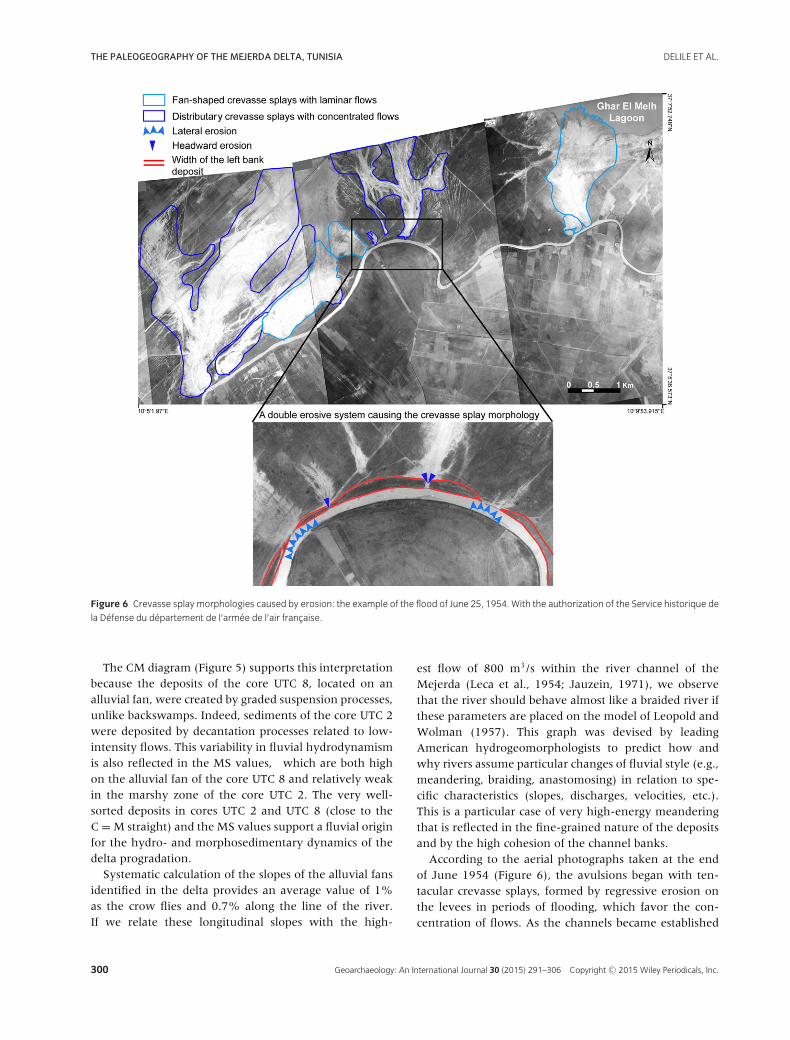
Figure 6 Crevasse splay morphologies caused by erosion: the example of the flood of June 25, 1954. With the authorization of the Service historique de
la Defense du departement de l’armee de l’air francaise.
The CM diagram (Figure 5) supports this interpretationbecause the deposits of the core UTC 8, located on analluvial fan, were created by graded suspension processes,unlike backswamps. Indeed, sediments of the core UTC 2were deposited by decantation processes related to low-intensity flows. This variability in fluvial hydrodynamismis also reflected in the MS values, which are both highon the alluvial fan of the core UTC 8 and relatively weakin the marshy zone of the core UTC 2. The very well-sorted deposits in cores UTC 2 and UTC 8 (close to theC = M straight) and the MS values support a fluvial originfor the hydro- and morphosedimentary dynamics of thedelta progradation.
Systematic calculation of the slopes of the alluvial fansidentified in the delta provides an average value of 1%as the crow flies and 0.7% along the line of the river.If we relate these longitudinal slopes with the high-
est flow of 800 m3/s within the river channel of theMejerda (Leca et al., 1954; Jauzein, 1971), we observethat the river should behave almost like a braided river ifthese parameters are placed on the model of Leopold andWolman (1957). This graph was devised by leadingAmerican hydrogeomorphologists to predict how andwhy rivers assume particular changes of fluvial style (e.g.,meandering, braiding, anastomosing) in relation to spe-cific characteristics (slopes, discharges, velocities, etc.).This is a particular case of very high-energy meanderingthat is reflected in the fine-grained nature of the depositsand by the high cohesion of the channel banks.
According to the aerial photographs taken at the endof June 1954 (Figure 6), the avulsions began with ten-tacular crevasse splays, formed by regressive erosion onthe levees in periods of flooding, which favor the con-centration of flows. As the channels became established
300 Geoarchaeology: An International Journal 30 (2015) 291–306 Copyright C© 2015 Wiley Periodicals, Inc.

DELILE ET AL. THE PALEOGEOGRAPHY OF THE MEJERDA DELTA, TUNISIA
and the flows more and more concentrated, a mainchannel emerged (Morozova & Smith, 2000; Morozova,2005). At the end of its course in the distal parts of thedelta, this channel formed a subdelta in the shape of acrow’s foot (Figure 6), whose distal part was shaped bythe distributary bars of the river mouth. Then, the sub-delta rose progressively to form a true deltaic alluvial fan(Fisk, 1944; Coleman & Gagliano, 1964; Saucier, 1994;Coleman, Roberts, & Stone, 1998), the phases ofconstruction occurring during high-energy hydrologicalevents (Delile et al., in press). If this model of the Mejerdadelta progradation is transposed onto the paleogeographicreconstruction of the delta in the sector of the city, somehypotheses can be proposed concerning the possible lo-cation of the harbor of Utica and the configuration of itscommunication with the sea, as well as its development.
Review of the Ancient Coastline and thePaleogeographical Evolution of the NorthernPart of the Mejerda Delta
At the exit of the bottleneck between the promontoriesof Utica and Kalaat El Andalous, the top of these co-alescent alluvial cones lies between 6 and 10 m aboveLMSL (Figure 4). This sedimentary thickness would thushave buried the paleochannels responsible for the in-filling of this ancient arm of the sea and of the north-ern compartment. In other words, beds 4, 5, and 6(Figures 1, 4), visible on the surface and classically heldresponsible for this infilling (Jauzein, 1971; Paskoff, 1985,1994; Paskoff, Slim, & Trousset, 1991; Paskoff & Trousset,1992; Chelbi, Paskoff, & Trousset, 1995; Slim et al., 2004;Oueslati, Charfi, & Baccar, 2006) cannot be responsiblebecause their altitude is too high. This appears to be con-firmed by the fact that the sea level in the Punic–Romanperiod was lower by several decimeters than the presentLMSL (Figure 3; Oueslati, 1995; Slim et al., 2004; Anzideiet al., 2011).
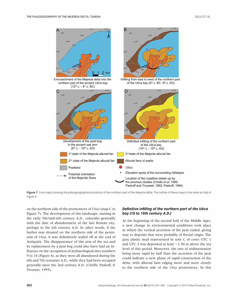
Encroachment of the Mejerda delta in the northernpart of the ancient bay of Utica (12 to 4th centuryB.C.)
These conclusions appear to be confirmed by the archae-ological surveys carried out on the delta in the 1990s(Chelbi, Paskoff, & Trousset, 1995). These revealed inparticular an archaeological site that had been occupiedfrom the Punic period (site no. 1 in Figure 4), only a fewdecimeters beneath the surface. We can thus definitivelyexclude our predecessors’ hypothesis of a silting-up ofthe northern compartment in late Antiquity by the pa-leochannels visible on the surface (Paskoff & Trousset,1992; Chelbi, Paskoff, & Trousset, 1995). Instead of
this traditional short chronology, we propose a longerchronology in which the passage of the Mejerda intothe northern part occurred at the latest before the endof the Punic period and perhaps even before the leg-endary foundation of Utica at the end of the 12th centuryB.C. (map A in Figure 7). Indeed, the Punic–Roman lev-els dated earlier than the 4th century B.C. (site no. 1 inFigure 4), and situated at an altitude of more than 6 m inthe corridor formed by the jebels Menzel Roul and KalaatEl Andalous, show that the line of the coast in this periodmust have been positioned in the northern part of thedelta. This altitude of more than 6 m is definitively toohigh to imagine the Roman–Punic coastline in this sectorbecause shorelines are found around sea level. Thus, theharbor basins that are today preserved under the alluviacan only be situated on the northern side of the penin-sula of Utica (Figure 7), as previous studies have suggested(Paskoff et al., 1991; Paskoff & Trousset, 1992; Paskoff,1994; Chelbi, Paskoff, & Trousset, 1995; Slim et al., 2004),and not on the eastern side.
Infilling from east to west of the northern part ofthe Utica bay (4th century B.C. to 6th century A.D.)
The communication between the harbor and sea wouldthus have been through a marine corridor situated be-tween the coastal alluvial fans to the west and thoseof the Mejerda to the east. The latter fans developedin the northern compartment during the Roman pe-riod (map B in Figure 7). This major result contrastswith previous studies (Chelbi, Paskoff, & Trousset, 1995;Paskoff & Trousset, 1992; Paskoff, 1994) that locatedthe coastline at the exit of the bottleneck between thepromontories of Utica and Kalaat El Andalous (map B inFigure 7). The hypothesis of a communication betweenthe harbor and sea by this western arm of the sea isso probable that we suggest, contrary to the position ofprevious workers, that the passage of the Mejerda to-ward the north would not have constituted a threat ofinfilling by alluvia to the harbor basins. In fact, at theexit of the bottleneck the alluvial fans probably devel-oped in an east–west orientation, because of the coastaldrift oriented toward the south (Pimienta, 1959; Delileet al., in press).
Development of the peat bog in the ancient arm ofthe sea (6 to 10th century A.D.)
As the alluvial fans filled in the northern part of the bay,this marine corridor progressively shrank during the Ro-man period. This situation definitively isolated the cityfrom the sea by the 6th century A.D. at the latest, as in theMiddle Ages a landscape of peat bogs became established
Geoarchaeology: An International Journal 30 (2015) 291–306 Copyright C© 2015 Wiley Periodicals, Inc. 301
THE PALEOGEOGRAPHY OF THE MEJERDA DELTA, TUNISIA DELILE ET AL.
Figure 7 Four maps showing the paleogeographical evolution of the northern part of the Mejerda delta. The outline of these maps is the same as that of
Figure 4.
on the northern side of the promontory of Utica (map C inFigure 7). The development of this landscape, starting inthe early 5th/mid-6th century A.D., coincides generallywith the date of abandonment of the late Roman city,perhaps in the 6th century A.D. In other words, if theharbor was situated on the northern side of the penin-sula of Utica, it was definitively sealed off at the end ofAntiquity. The disappearance of this arm of the sea andits replacement by a peat bog could also have had an in-fluence on the occupation of archaeological sites numbers9 to 14 (Figure 4), as they were all abandoned during the6th and 7th centuries A.D., while they had been occupiedgenerally since the 2nd century A.D. (Chelbi, Paskoff, &Trousset, 1995).
Definitive infilling of the northern part of the Uticabay (10 to 15th century A.D.)
At the beginning of the second half of the Middle Ages,a new change in environmental conditions took placein which the vertical accretion of the peat ended, givingway to deposits that were probably of fluvial origin. Thegray plastic mud represented in unit C of cores UTC 1and UTC 2 was deposited at least �1.50 m above the sealevel of this period. Moreover, the rate of sedimentationbeing more rapid by half than the accretion of the peatcould indicate a new phase of rapid construction of thedelta, with alluvial fans edging more and more closelyto the northern side of the Utica promontory. In this
302 Geoarchaeology: An International Journal 30 (2015) 291–306 Copyright C© 2015 Wiley Periodicals, Inc.
DELILE ET AL. THE PALEOGEOGRAPHY OF THE MEJERDA DELTA, TUNISIA
period, it is probable that the northern compartment ofthe delta was mostly infilled (map D in Figure 7) as sug-gested by Jauzein (1971); Paskoff, Slim, and Trousset(1991); Paskoff and Trousset (1992); Paskoff (1994); andChelbi, Paskoff, and Trousset (1995). This dynamic led toa rapid aggradation of this sector, causing the site to be�+4.50 m above the LMSL. This proximal fluvial influ-ence may be clearly seen in core UTC 8, taken from a relicof an alluvial fan, which has recorded a sustained periodof active fluvial processes seen in the volume of sand inall its stratigraphy.
The Ancient Harbors
Definitive rebuttal of the earlier theories on thelocation of a pre-Roman harbor in the Large Bathsand Colonnaded Street sectors
While Beule (1861), Daux (1869), and Reyniers (1952)thought that the area of the Large Baths hosted the an-cient harbor of Utica (Figure 2), with a basin enclosing acentral island like the harbor of Carthage, the ruins herewere first identified as Roman baths by Torr (1894a,b)and later studies demonstrated that they had noth-ing to do with a supposed Phoenician or Punic harbor(Martin, 1915; Gsell, 1920; Cintas, 1951; Picard, 1953;Lezine, 1966, 1970). In order to remove all ambigu-ity concerning earlier theories for the location of a pre-Roman harbor in this zone, we extracted core UTC 9within the sunken esplanade of the baths area. Thestratigraphy of this core shows very clearly that a harborcould not have been located in this zone. Likewise, coreUTC 7 extracted near the western end of the colonnadedstreet showed that the wide linear depression later occu-pied by the street could never have been an arm of thesea. Indeed, unit A shows that the substratum outcropsin this sector, with its alteration levels and/or the collu-via lying only 2 m beneath the present ground surface,and over 3 m above the modern sea level, and even moreabove the RSL. This was solid ground in antiquity.
Hypothesis that the harbor was located on thenorth-west side of the Utica promontory
The paleogeographic reconstruction presented in the pre-vious section corresponds perfectly with the informationthat we have concerning this sector in late antiquity. Ifthe harbor basins were located to the northwest of thepromontory, they would have been permanently out ofuse in this period because the peat indicates an environ-ment in the process of silting up. Our observations thus
correspond with what is known about the site for this pe-riod.
The position of this coastal peat, whose altitude is closeto LMSL, indicates that the sea level rise from the Romanperiod reached the LMSL around late antiquity accordingto the peat bottom dates. Indeed, littoral peat formationoccurs approximately at the same level as the sea due toits link with the phreatic system (Triat-Laval, 1978; Vella& Provansal, 2000; Lampe et al., 2010). Moreover, the lo-cation of the RSL coupled with the peat bottom dates in-dicate that the hypothetical levels of the harbor depositsshould be found under the peat. The fact that these de-posits that are earlier than the end of the Roman periodare found at �1 m under the RSL (base of the cores) in-dicates a draft equivalent to a maximum of ±1 m. Such ashallow depth of water renders navigation possible onlyfor small craft, less than 50 tons (Boetto, 2010). If we ex-tend these results toward assumptions needing to be con-firmed by future research, as a result, small craft wouldhave been needed to transfer goods between the city andthe largest ships anchored in the open sea, unless theharbor also possessed constructed moles running out intodeeper water.
The absence of dating for the sedimentary unit (A) be-neath the peat means that the hypothesis that merchan-dise was transferred by lighters cannot be chronologicallyproven. With the caution due to the age-depth model, ifwe extrapolate the rate of sedimentation of 0.33 cm/yrcalculated for U.S. C uniformly to unit A of core UTC 2,we obtain a model age of A.D. 130 for the base of thecore. In view of what has been stated in the precedingparagraph, this would signify that if the harbor of Uticawas located here, it started to be filled in in the 2nd cen-tury A.D. This date echoes the interpretation made byBraemer (1992) of the opening of a direct route, datedby military milestones of the reign of Hadrian (2nd cen-tury A.D.), linking the harbor of Tabarka (on the north-ern coast of Tunisia) to the quarry of Simitthus (ancientChemtou) for the distribution of marble. Braemer thinksthat this road was opened in the 2nd century A.D. toremedy the inevitable loss of the harbor of Utica which,according to the evidence of a stone-paved road linkingthe quarries of Simitthus to the left bank of the river(Khanoussi, 1994), originally provided a regional outletfor the products coming from the upper valley of theMejerda. However, without any direct dating from thebase of the cores, it is difficult to conclude that the har-bor was no longer in use by the time of the High RomanEmpire. Consequently, these assumptions concerning thelocation and the depth of the harbor basin require moreinvestigations, and in particular deeper cores need to betaken on the northwest side of the Utica promontory.
Geoarchaeology: An International Journal 30 (2015) 291–306 Copyright C© 2015 Wiley Periodicals, Inc. 303

THE PALEOGEOGRAPHY OF THE MEJERDA DELTA, TUNISIA DELILE ET AL.
CONCLUSIONS
This geoarchaeological and geo-historical study of thedelta of the Mejerda provides a basis for the reconstruc-tion of the processes involved in the deltaic progradationof this river, whose avulsions leading to the formationof deltaic alluvial fans appear to be the principal cause.The combination of the processes acting on these deltaicalluvial fans and the archaeological data available sug-gests that the passage of the Mejerda into the northerncompartment of its delta occurred at the latest beforethe Punic period and possibly even before the legendaryfounding of Utica in the 12th century B.C. For this rea-son, the harbor basins of Utica could only have been lo-cated on the northern side of the Utica peninsula, wherecommunication with the sea would have been throughan ancient sea corridor located to the west of the north-ern part. In other words, it is unlikely that the harbor ofUtica could have been located on the southeast side of thepeninsula. As the alluvial fans at the mouth of the riverthickened and progressively filled the northern part ofthe Utica Bay, this ancient sea corridor became narrowerin the Roman period and completely disappeared in theearly 5th/mid-6th century A.D. In this period a peat bogdeveloped on the northern side of the Utica promontoryand thus sealed the fate of Utica as a maritime harbor.
The series of cores taken have excluded the idea of a lo-cation for the harbor in the sunken esplanade around theLarge Baths, because of a substratum that outcrops at lessthan 2 m from the present ground surface, above RSL.However, the sector slightly to the north has shown thatthe deposits situated under the medieval peat could bethose of the harbor levels, because the bases of cores UTC1 and UTC 2 suggest a draft of ±1 m, which is enoughfor small sea craft. This last hypothesis could be tested byfuture research based on a new coring campaign, and bymodeling of currents and sedimentary processes (Millet,Tronchere, & Goiran, 2014; Seeliger et al., 2014). Never-theless, for the first time, these GIS and geoarchaeologi-cal approaches have improved our understanding of thenorthwest side of the Utica promontory, both inside andoutside the marshes.
We would like to thank Camel Boumedjmadjen of the Bib-liotheque Universitaire Pierre et Marie Curie for his welcomeand his valuable help in the department CADIST Geoscienceset Environnement. We also thank the Department of the De-fence Historical Service of the Air Force for authorization to re-produce aerial photographs of the Mejerda basin. We are grate-ful to Pol Trousset and Veronique Blanc-Bijon of the MaisonMediterraneenne des Sciences de l’Homme of the UniversiteAix-Marseille for their welcome and for access to their archives.We wish to record our thanks to the Incitation a l’utilisationScientifique des Images SPOT program, as well as to the Insti-tut National du Patrimoine de Tunisie, especially Nabil Kallala,
who facilitated our research in the field. For their logistical andfinancial support, we thank the CNRS, Baron Lorne Thyssen,ENVI-MED program, Maison Archeologie et Ethnologie (MAE),University of Paris-Sorbonne, and ERC Advanced Grant ProjectRome’s Mediterranean Ports (102705) financial support for theanalysis of core samples. Finally, we are very grateful to Profes-sor Jean-Paul Bravard for his constructive comments, and thetwo anonymous reviewers who gave valuable comments on thedraft of the article.
REFERENCES
Anzidei, M., Antonioli, F., Lambeck, K., Benini, A., Soussi,
M., & Lakhdar, R. (2011). New insights on the relative sea
level change during Holocene along the coasts of Tunisia
and western Libya from archaeological and
geomorphological markers. Quaternary International, 232,
5–12.
Beule, C.-E. (1861). Fouilles a Carthage. Paris, France:
Imprimerie imperiale.
Blaauw, M. (2010). Methods and code for “classical”
age-modelling of radiocarbon sequences. Quaternary
Geochronology, 5, 512–518.
Boetto, G. (2010). Le port vu de la mer: L’apport de
l’archeologie navale a l’etude des ports antiques (pp.
112–128). Presented at the XVII International Congress of
Classical Archaeology, Vol. special issue. Roma: Bolletino di
Archeologia On line.
Braemer, F. (1992). Les gisements de pierres a l’epoque
romaine. Methodes, etat de la question. (pp. 227–234).
Presented at the 117e Congres National Societe Savante.
Clermont-Ferrand, Paris: CTHS.
Bravard, J.-P., & Peiry, J.-L. (1999). The CM pattern as a tool
for the classification of alluvial suites and floodplains along
the river continuum. In Floodplains: Interdisciplinary
Approaches (pp. 259–268), Vol. 163. London: S.B. Marrott
and J. Alexander.
Chelbi, F., Paskoff, R., & Trousset, P. (1995). La baie d’Utique
et son evolution depuis l’Antiquite: Une reevaluation
geoarcheologique. Antiquites Africaines, 31, 7–51.
Cintas, P. (1951). Deux campagnes de fouilles a Utique. Karthago. Revue d’archeologie africaine, 2, 5–88.
Coleman, J.M., & Gagliano, S.M. (1964). Cyclic sedimentation
in the Mississippi River deltaic olain. Gulf Coast Association
of Geological Societies Transactions, 14, 67–80.
Coleman, J.M., Roberts, H.H., & Stone, G.W. (1998).
Mississippi River delta: An overview. Journal of Coastal
Research, 14, 698–716.
Daux, A. (1869). Recherches sur l’origine et l’emplacement
des emporias pheniciens dans le Zeugis et le Byzacium (pp.
1–145). Paris: Impr. Imperial (Pairs).
David, L. (1956). Etude geologique des monts de la haute
Medjerda. Alger: Service de la carte geologique de l’Algerie.
Dearing, J.A. (1999). Environmental magnetic susceptibility.
Using the Bartington MS2 System (pp. 32–54). Kenilworth:
Chi Publishing.
304 Geoarchaeology: An International Journal 30 (2015) 291–306 Copyright C© 2015 Wiley Periodicals, Inc.
DELILE ET AL. THE PALEOGEOGRAPHY OF THE MEJERDA DELTA, TUNISIA
Delile, H., Goiran, J.-P., & Bravard, J.-P. (In press).
Contribution du SIG a la reconstitution des processus de
progradation de la Majerda: Quels enjeux pour le port
d’Utique? In Actes du premier colloque organise par
l’Association pour l’Etude du Quaternaire en Tunisie
(p. 23). Presented at the ATEQ First Meeting. Tunis.
Delile, H., Mazzini, I., Blichert-Toft, J., Goiran, J.-P.,
Arnaud-Godet, F., Salomon, F., & Albarede, F. (2014).
Geochemical investigation of a sediment core from the
Trajan basin at Portus, the harbor of ancient Rome.
Quaternary Science Reviews, 87,
34–45.
Delile, H., Blichert-Toft, J., Goiran, J.-P., Stock, F.,
Arnaud-Godet, F., Bravard, J.-P., Bruckner, H., &
Albarede, F. (2015). Demise of a harbor: A geochemical
chronicle from Ephesus. Journal of Archaeological Science,
53, 202–213.
Fentress, E., Ghozzi, F., Quinn, J., & Wilson, A. (2012).
Excavations at Utica by the Tunisian-British Utica Project
2012 (pp. 1–27).
Fisk, H.N. (1944). Geological investigation of the alluvial
valley of the lower Mississippi River
(p. 170). Vicksburg, M S: Mississippi River Commission.
Goiran, J.P., & Morhange, C. (2003). Geoarcheologie des
ports antiques de Mediterranee: Problematiques et etudes
de cas. Topoı, 11, 645–667.
Goiran, J.-P., Salomon, F., Mazzini, I., Bravard, J.-P., Pleuger,
E., Vittori, C., Boetto, G., Christiansen, J., Arnaud, P.,
Pellegrino, A., Pepe, C., & Sadori, L. (2014).
Geoarchaeology confirms location of the ancient harbour
basin of Ostia (Italy). Journal of Archaeological Science,
41, 389–398.
Gsell, S. (1920). Histoire ancienne de l’Afrique du Nord, vol.
2. L’etat carthaginois. Paris: Librairie Hachette.
Jauzein, A. (1971). Les agents de la morphogenese: Document
evolution recente du delta de la Medjerda (Tunisie), Vol. 5.
Paris: Travaux du laboratoire de geologie de l’ENS.
Kallala, N., Fentress, E., Quinn, J.C., & Wilson, A. (2010).
Survey and excavation at Utica.
Khanoussi, M. (1994). Note preliminaire sur le praesidium. In
Der Tempelberg und das romische lager, Simitthus III (pp.
241–247). Mainz: DAI et INP.
Lampe, R., Endtmann, E., Janke, W., & Meyer, H. (2010).
Relative sea-level development and isostasy along the NE
German Baltic Sea coast during the past 9 ka. Quaternary
Science Journal, 59, 3–20.
Leca, A., Valiron, F., Rolland, L., Cintas, J., & Tron, M.
(1954). La mise en valeur de la vallee de la Medjerda.
Tunis: Imprimerie La Rapide.
Leopold, L.B., & Wolman, M.G. (1957). River channel
patterns: Braided, meandering, and straight. Washington:
U.S. Govt. Print. Off.
Lezine, A. (1966). Utique: Notes de topographie (Melanges
d’archeologie et d’histoire offerts a Andre Piganiol., Vols.
1-1). France.
Lezine, A. (1970). Utique, Vols. 1-1. Tunis, Tunisie: Societe
tunisienne de diffusion.
Marriner, N. (2007). Paleoenvironnements littoraux du Liban
a l’Holocene - Geoarcheologie des ports antiques de
Beyrouth, Sidon et Tyr 5000 ans d’interactions
nature-culture. Universite Aix-Marseille I.
Marriner, N., Morhange, C., & Goiran, J.-P. (2010), Coastal
and ancient harbour geoarchaeology. Geology Today,
26(1), 21–27.
Martin, J. (1915). Reconnaissance des antiquites
prehistoriques de Chaouach: Dedicace romaine a Thala;
fouilles a Utique. Bulletin archeologique du Comite des
travaux historiques et scientifiques: xcvi-xcviii.
Monchambert, J.-Y., Jerbania, I.B., Belarbi, M., Bonadies,
L., Bricchi-Duhem, H., Jonghe, M.D., Gallet, Y., Nacef, J.,
Sghaıer, Y., Tekki, A., Thebault, E., Vermeulen, S., 2013.
Utique. Rapport preliminaire sur les deux premieres
campagnes de fouilles de la mission franco-tunisienne,
2011 et 2012. Chronique des activites archeologiques de
l’Ecole francaise de Rome 57.
Mejri, L. (2012). Tectonique Quaternaire, paleosismicite et
sources sismogeniques en Tunisie Nord-orientale: Etude de
la faille d’Utique. Universite Toulouse 3 Paul Sabatier et
Universite de Tunis El Manar.
Mejri, L., Regard, V., Carretier, S., Brusset, S., & Dlala, M.
(2010). Evidence of quaternary active folding near Utique
(Northeast Tunisia) from tectonic observations and a
seismic profile. Comptes Rendus Geoscience, 342(11),
864–872.
Millet, B., Tronchere, H., & Goiran, J.-P. (2014),
Hydrodynamic modeling of the Roman harbor of Portus in
the Tiber Delta: The impact of the north-eastern channel
on current and sediment dynamics. Geoarchaeology, 29,
357–370.
Morhange, C. (1994). La mobilite recente des littoraux
provencaux: Elements d’analyse geomorphologique.
Universite de Provence, Aix-en-Provence.
Morhange, C., Vecchi, L., Stefaniuk, L., Goiran, J.P., Bui Thi
Maı, B.M., Carbonel, P., & Oberlin, C. (2001). Il problema
della localizzazione del porto greco antico di Cuma: nuovi
metodi e risultati preliminari. Cuma, Nuove forme di
intervento per lo studio del sito antico, Atti della Giornata
di Studio, Napoli, 12, 153–165.
Morhange, C., Marriner, N., Excoffon, P., Bonnet, S., Flaux,
C., Zibrowius, H., Goiran, J.-P., & Amouri, M.E. (2013).
Relative sea-level changes during Roman times in the
Northwest Mediterranean: The 1st century A.D. fish tank
of Forum Julii, Frejus, France. Geoarchaeology, 28,
363–372.
Morozova, G.S. (2005). A review of Holocene avulsions of the
Tigris and Euphrates Rivers and possible effects on the
evolution of civilizations in lower Mesopotamia.
Geoarchaeology, 20, 401–423.
Morozova, G.S., & Smith, N.D. (2000). Holocene avulsion
styles and sedimentation patterns of the Saskatchewan
Geoarchaeology: An International Journal 30 (2015) 291–306 Copyright C© 2015 Wiley Periodicals, Inc. 305
THE PALEOGEOGRAPHY OF THE MEJERDA DELTA, TUNISIA DELILE ET AL.
River, Cumberland Marshes, Canada. Sedimentary
Geology, 130, 81–105.
Oueslati, A. (1995). The evolution of low Tunisian coasts in
historical times: From progradation to erosion and
salinization. Quaternary International, 29–30, 41–47.
Oueslati, A., Charfi, F., & Baccar, F. (2006). Presentation of
the Tunisian site: La basse vallee de l’oued Majerda et la
lagune de Ghar El Melh (p. 26). Presented at the Wadi
project, Water Demand Integration, Fifth International
Meeting, Tunis.
Paskoff, R. (1985). Les littoraux. Impact des amenagements
sur leur evolution (Masson). Paris.
Paskoff, R. (1994). Le delta de la Medjerda (Tunisie) depuis
l’Antiquite. Etudes Rurales, 133, 15–29.
Paskoff, R., & Oueslati, A. (1988). Acquisitions recentes a
propos du quaternaire superieur des cotes de la Tunisie.
Mediterranee, 64(2), 79–84.
Paskoff, R., & Trousset, P. (1992). L’ancienne baie d’Utique:
Du temoignage des textes a celui des images satellitaires.
Mappemonde, 1, 30–34.
Paskoff, R., Slim, H., & Trousset, P. (1991). Le littoral de la
Tunisie dans l’Antiquite: cinq ans de recherches
geo-archeologiques. Comptes-rendus des seances de
l’Academie des inscriptions et belles-lettres, 135,
515–546.
Passega, R. (1957). Texture as characteristic of clastic
deposition. American Association of Petroleum Geologists,
41, 1952–1984.
Picard, G.C. (1953). Un pretendu port a Utique. Revue
Archeologique, 52, 105–106.
Pimienta, J. (1959). Le cycle pliocene-Actuel dans les bassins
paraliques de Tunis. France: Universite de Paris.
Reimer, P.J., Baillie, M.G.L., Bard, E., Bayliss, A., Beck, J.W.,
Blackwell, P.G., Ramsey, C.B., Buck, C.E., Burr, G.S.,
Edwards, R.L., Friedrich, M., Grootes, P.M., Guilderson,
T.P., Hajdas, I., Heaton, T.J., Hogg, A.G., Hughen, K.A.,
Kaiser, K.F., Kromer, B., McCormac, F.G., Manning, S.W.,
Reimer, R.W., Richards, D.A., Southon, J.R., Talamo, S.,
Turney, C.S.M., vander Plicht, J., & Weyhenmeyer, C.E.
(2009). IntCal09 and Marine09 radiocarbon age
calibration curves, 0–50000 years cal BP. Radiocarbon, 51,
1111–1150.
Reyniers, F. (1951). Note sur le comblement de la Basse
Medjerdah. Tunis, Tunisie: Saliba.
Reyniers, F. (1952). Port a Utique. Alger, Algerie.
Salomon, P., Delile, H., Goiran, J.-P., Bravard, J.-P., & Keay,
S. (2012). The Canale di Comunicazione Traverso in
Portus: The Roman sea harbour under river influence
(Tiber delta, Italy). Geomorphologie, 75–90.
Saucier, R.T. (1994). Geomorphology and quaternary geologic
history of the Lower Mississippi Valley (p. 414). Vicksburg,
M S: U. S. Army Corps of Engineers.
Seeliger, M., Brill, D., Feuser, S., Bartz, M., Erkul, E.,
Kelterbaum, D., Vott, A., Klein, C., Pirson, F., & Bruckner,
H. (2014). The purpose and age of underwater walls in the
Bay of Elaia of Western Turkey: A multidisciplinary
approach. Geoarchaeology, 29, 138–155.
Slim, H., Trousset, P., Paskoff, R., & Oueslati, A. (2004). Le
littoral de la Tunisie, Etude geoarcheologique et historique
(CNRS, p. 308). Paris.
Tissot, C.J. (1884). Ge ographie compare e de la province
romaine d’Afrique (S. Reinach, Ed.). Paris, France.
Torr, C. (1894a). Les ports de Carthage. Revue Archeologique,
20, 32–47.
Torr, C. (1894b). Les ports de Carthage. Revue
Archeologique, 20, 294–307.
Triat-Laval, H. (1978). Contribution pollenanalytique a
l’histoire tardi-and postglacaire de la vegetation de la Basse
vallee du Rhone. Universite d’Aix-Marseille III.
Vella, C., & Provansal, M. (2000). Relative sea-level rise and
neotectonic events during the last 6500 yr on the southern
eastern Rhone delta, France. Marine Geology, 170, 27–39.
Vogt, J. (1993). Further research on the historical seismicity
of Tunisia. Terra Nova, 5, 475–476.
306 Geoarchaeology: An International Journal 30 (2015) 291–306 Copyright C© 2015 Wiley Periodicals, Inc.