The Mahicans, the Dutch, and the Schodack Islands in the ...
25
Northeast Historical Archaeology Volume 22 From Prehistory to the Present: Studies in Northeastern Archaeology in Honor of Bert Salwen Article 7 1993 e Mahicans, the Dutch, and the Schodack Islands in the 17th and 18th Centuries Paul R. Huey Follow this and additional works at: hp://orb.binghamton.edu/neha Part of the Archaeological Anthropology Commons is Article is brought to you for free and open access by e Open Repository @ Binghamton (e ORB). It has been accepted for inclusion in Northeast Historical Archaeology by an authorized editor of e Open Repository @ Binghamton (e ORB). For more information, please contact [email protected]. Recommended Citation Huey, Paul R. (1993) "e Mahicans, the Dutch, and the Schodack Islands in the 17th and 18th Centuries," Northeast Historical Archaeology: Vol. 22 22, Article 7. hps://doi.org/10.22191/neha/vol22/iss1/7 Available at: hp://orb.binghamton.edu/neha/vol22/iss1/7
-
Upload
khangminh22 -
Category
Documents
-
view
0 -
download
0
Transcript of The Mahicans, the Dutch, and the Schodack Islands in the ...
Northeast Historical ArchaeologyVolume 22 From Prehistory to the Present: Studies inNortheastern Archaeology in Honor of Bert Salwen Article 7
1993
The Mahicans, the Dutch, and the SchodackIslands in the 17th and 18th CenturiesPaul R. Huey
Follow this and additional works at: http://orb.binghamton.edu/neha
Part of the Archaeological Anthropology Commons
This Article is brought to you for free and open access by The Open Repository @ Binghamton (The ORB). It has been accepted for inclusion inNortheast Historical Archaeology by an authorized editor of The Open Repository @ Binghamton (The ORB). For more information, please [email protected].
Recommended CitationHuey, Paul R. (1993) "The Mahicans, the Dutch, and the Schodack Islands in the 17th and 18th Centuries," Northeast HistoricalArchaeology: Vol. 22 22, Article 7.https://doi.org/10.22191/neha/vol22/iss1/7 Available at: http://orb.binghamton.edu/neha/vol22/iss1/7
The Mahicans, the Dutch, and the Schodack Islands in the 17th and 18thCenturies
Cover Page FootnoteMany individuals have contributed to the writer's compilation and interpretation of the above research on theMahicans at Schodack Many of the deed references were provided by Shirley Dunn of East Greenbush, NewYork, who is doing extensive research on the Mahican Indians. When the 1730 deed for part of MoesmansIsland to Maes Hendricksen van Buren was discovered by the Historical Society of Esquatak, it was ShirleyDunn who immediately recognized its great importance to research on the Mahicans. The writer also wishesto acknowledge the assistance of Charles L. Fisher of the Bureau of Historic Sites in the New York State Officeof Parks, Recreation and Historic Preservation. He is currently studying archaeological evidence of theMohawks living at Fort Hunter in the Mohawk Valley in the mid-18th century. Assistance and encouragementwere also provided by Robert S. Grumet of the Mid-Atlantic Office of the National Park Service, by Lois M.Feister of the Bureau of Historic Sites, who is studying evidence from excavations at Johnson Hall, and byCharles T. Gehring of the New Netherland Project in the New York.
This article is available in Northeast Historical Archaeology: http://orb.binghamton.edu/neha/vol22/iss1/7
96 The Mahicans and Dutch at the Sclwdack Islands/Huey
THE MAHICANS, THE DUTCH, AND THE SCHODACK ISLANDS IN THE 17TH AND 18TH CENTURIES
Paul R. Huey
Documentary research calls attention to the historical and archaeological significance of an area that once consisted of three separate islands on the east side of the Hudson River below Albany. The area, called "Schodack," included the traditional council fire of the Mahican Indians. The history of these islands can be traced from 1609, when Hudson's ship, the Half Moon, anchored near them through the colonial period. Despite extensive purchases of land by the Dutch elsewhere on both sides of the river soon after 1630, the Mahican Indian owners and. occupants of these fertile islands resisted selling them to the acquisitive Dutch until a period of crisis after 1660. Although a Mahican village continued to exist on the islands until the mid-18th century, the Mahicans were gradually dispersed through the combined effects of colonial wars and activities of land specu.lators and farmers, colonial officials, and missionaries. The islands currently are owned and protected as an undeveloped state park by the New York State Office of Parks, Recreation and Historic Preservation. Deep deposits of river dredging spoil today cover the islands and hide the Mahican and colonial sites. from archaeologists, but have also effectively protected them from vandals. Many questions about the Mahican and colonial European occupation of the islands remain that can be answered only through fu.ture archaeological efforts.
La recherche documentaire permet d'attirer ['attention sur ['importance historique et archeologique d'une region qui englobait jadis trois lies distinctes sur le cote est de la riviere Hudson en aval d' Albany. La region, appelee "Schodack," comprenait le traditionnel feu de conseil des Mohicans. · On peut faire remonter l'histoire de ces fles a 1609, alors que le bateau Half Moon d'Hudson jeta l'ancre a leur proximite, et la mener jusqu'a la fin de la periode coloniale. Les proprietaires et occupants mohicans de ces fle$ fertiles refuserent de les vendre aux avides Hollandais jusqu'apres 1660, au cours d'une periode de crise, malgre les importants achats de terres faits par les Hollandais des deux cOtes du fleuve des peu apres 1630. Malgre ['existence d'un village mohican dans les fles jusqu'au milieu du XVIIf siecle, les Mohicans ant ete graduellement disperses du fait a la fois de l' effet des guerres coloniales et de l' action des speculateurs sur les terres et des fermiers, des autorites coloniales et des missionnaires. Le Bureau des pares, de la recreation et de la conservation historique de rEtat de New York est aujourd'hui proprietaire des fles et en assure la protection a titre de pare d'Etat non amenage. D' epa is depOts de deblais de dragage du fleuve recouvrent les fles aujourd'hui et cachent aux archeologues les lieux d' occupation mohicans et autres sites coloniaux, mais les protegent bien aussi contre les vandales. · Il reste beau coup de questions au sujet de l'occupation des fles par les Mohicans et les colons europeens aitxquelles seule l'archeologie pourra apporter reponse.
Northeast Historical ArchaeologyNol. 21-22, 1992-1993 97
The 17th Century
In the upper Hudson River Valley beginning about 120 mi (192 km) above its mouth, is a remarkable area of rich, fertile alluvial flats and islands that lie along the river channel. This fertile land, combined with its close proximity to trade routes such as the Mohawk River, the Normans Kill, and other tributaries reaching far inland from the west side of the Hudson, made the entire region a natural area for trade and settlement by the Dutch in the 17th century.
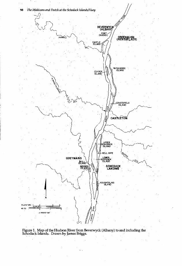
Three fertile islands along the east side of the Hudson, separated from the mainland by shallow, protected channels ideal for close contact with river transportation by sloop or smaller craft, are Upper Schodack Island, Lower Schodack Island, and Houghtaling Island (FIG. 1). Houghtaling Island, the southernmost, was shown on 17thcentury maps as Marten Gerritsens Eylant; by 1672 it was also called Schutters Island, its name through the 18th century. Lower Schodack Island, the middle island, was consistently called Moesmans Island or, by the Indians, Cachtanaquick. Finally, Upper Schodack Island was know by various names in the 17th century, including Mahicans Eylant, or Schotack, or Aepjes Island.
A serious obstacle to river navigation, a sandbar, had formed in the main channel along the west side of these islands, and on September 17, 1609, as Henry Hudson sailed north to about present Castleton, he found the islands and shallows in the middle of theriver channel. He anchored all night near the shore. The next day his mate went "on land" with an old Indian to the Indian's house. It is possible that this house was at or near the present mainland site of Castleton, but it also could
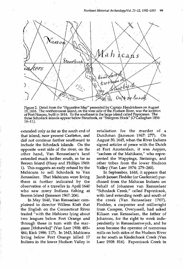
have been on one of the nearby islands at Schodack (Jameson 1967: 21-22). The three islands at Schodack are clearly shown on the figurative map presented by Captain Hendricksen in 1616, which also shows "Sturgeon Hook" opposite the vicinity of present Castleton (O'Callaghan 1856: 10-11). The Schodack islands, however, are shown much smaller than the large Papscanee Island, to the north (FIG. 2).
De Laet recorded in 1625 that the Mahicans lived on the east side of the river opposite Sturgeon Hook and Fisher's Hook (Jameson 1967: 47). In the spring of 1628, war broke out between the Mahicans living along the Hudson River, and the Mohawks, whose territory extended westward (Jameson 1967: 89). Many Mahicans were driven eastward to the Connecticut River, but the effect of this war may have been greatest on those Mahicans who lived on Papscanee Island or at other places along the river to the north closer to Fort Orange and the Normans Kill.
Fort Orange had been built by the West India Company in 1624 for trade, but the defeat of the Mahicans now offered new opportunities for the Dutch to expand their interests beyond trade to the settlement of the rich alluvial farmland along the river. In 1629 Kiliaen van Rensselaer, as a patroon under the charter granted by the West India Company, registered his intention to develop the Colonie of Rensselaerswyck above and below Fort Orange. He purchased Papscanee Island in the 1630s, but Mahicans continued to live farther south, perhaps at Schodack (Gehring 1978: 16, 29; Van Laer 1908: 198, 199, 207, 283, 306, 307, 326). It is noteworthy that with Van Rensselaer's purchase of Papscanee Island from the Mahicans in 1637, his ownership of land along the east side of the river
98 The Mahicans and Dutch at the Schodack Islands/Huey
~vJ) · . . ~~
KILOMETERS I
MILES F J. BR/GGS-'92'
KILL
GREENBUSH (RENSSELAER)
CONSTAPELS ISLAND
UPPER -~ SCHODACK ~ (\_,-
ISLAND U
HELLGATE '~ ~ ...
SCHODACK LANDING ~
Figure 1. Map of the Hudson River from Beverwyck (Albany) to and including the Schodack Islands. Drawn by James Briggs.
Northeast Historical Archaeology!Vol. 21-22, 1992-1993 99
)·· r
)
) Figure 2. Detail from the "Fi~ative Map" presented by Captain Hendricksen on August 19, 1616. The northernmost tsland, on the west side of the Hudson River, was the location of Fort Nassau, built in 1614. To the southeast is the large island called Papscanee. The three Schodack islands appear below Steurhoek, or "Sturgeon Hook" (O'Callaghan 1856: 10-11).
extended only as far as the south end of that island, near present Castleton, and did not continue farther southward to include the Schodack islands. On the opposite west side of the river, on the other hand, Van Rensselaer's land extended much farther south, as far as Beeren Island (Huey and Phillips 1969: 1). This suggests an early refusal by the Mahicans to sell Schodack to Van Rensselaer. That Mahicans were living there is further indicated by the observation of a traveller in April1640 who saw many Indians fishing at Beeren Island Gameson 1967: 206).
In May 1640, Van Rensselaer complained to director Willem Kieft that the English on the Connecticut River traded "with the Mahicans lying about two leagues below Fort Orange and through these in tum with the macquaas [Mohawks]" (Van Laer 1908: 483-484; Rink 1986: 117). In 1643, Mahicans living below Fort Orange killed 17 Indians in the lower Hudson Valley in
retaliation for the murder of a Dutchman (Jameson 1967: 277). On August 30, 1645, when the River Indians signed articles of peace with the Dutch at Fort Amsterdam, it was Aepjen, "sachem of the Mahikans," who represented the Wappings, Sintsings, and other tribes from the lower Hudson Valley (Van Laer 1974: 279-280).
In September, 1648, it appears that Jacob Jansen Plodder (or Gardenier) purchased from the Mahican Indians on behalf of Johannes van Rensselaer "Schodack Creek," called Paponicaok, with land extending north and south of the creek (Van Rensselaer 1707). Plodder, a carpenter and millwright from Campen, Overyssell, had asked Kiliaen van Rensselaer, the father of Johannes, for the right to work independently in Rensselaerswyck, and he soon became the operator of numerous mills on both sides of the Hudson River as far south as Kinderhook Creek (Van Laer 1908: 816). Paponicaok Creek in
100 The Mahicans and Dutch at the Schodilck Islands/Huey
1648 was probably the present Muitzes Kill, just south of Castleton and at the north end ofUpperSchodack Island. In March 1650, Flodder purchased from an Indian named W anemenheeten land on Upper Schodack Island described as "a piece of land on the large Island, also called by the Dutch Aepjes (little Ape's) Island, with a small piece on the east side of a little kil" (Fernow 1881: 26).
Meanwhile, Van der Donck's map of New Netherland showed, in 1656, the name "Sturgeon Hook" moved to the east side of the river just north of Mahicans Eylant. Still farther south was shown Marten Gerritsens Island (Van der Donck 1968: iv-v). In April 1660, Dutch land acquisition resumed its extension southward on the east side of the river with the purchase of land beyond the south end of Papscanee Island. Wickepie, a Mahican, sold Jeremias van Rensselaer a small parcel of land called "Sanckhasick" located "on the East bank behind the Long Island" (Van Rensselaer 1660; Gehring 1978: 18). In February 1661, at the south end of Papscanee Island, Andries Herpertsen and Rutger Jacobsen purchased from four Mahicans a small island called "Pachonakellick [and] by the Dutch named Long or Mahicanders island" (Munsell 1871: 291). The grant of this island, also known as.Constapels Island, was confirmed by Peter Stuyvesant in March (Gehring 1980: 101). The island was soon sown with grain, and a house, barn, and two ricks were constructed (Munsell 1871: 318). Peter Winne, a Fleming, was living there in October 1663 when he learned the alarming news that all Indians on the east side of the river were assembled inland and would soon attack Fort Orange. The Mahicans and Catskill Indians had abandoned their "Maize plantations," offering to sell some of
them to the Dutch for a piece of cloth, while from Fort Orange the Dutch were freely removing corn from the Indians' abandoned fields in canoes (Fernow 1881: 345). Early in 1661, Volkert Jansen Douw and Jan Thomassen Witbeck had already petitioned Governor Stuyvesant for a grant of Aepje's Island, called Schodack by the Indians, but on October 4, 1663, Douw and Witbeck evidently took advantage of this· unusual opportunity to purchase Upper Schodack Island, together with a parcel of land on the east bank of the kill "where the house of Machak Notas stood" (O'Callaghan 1865: 223; Munsell 1871: 334-335). Perhaps this house was where the "old Indian's" house visited by Hudson's mate had stood in 1609.
Douw and Whitbeck purchased the whole island in north and south sections, each sold by different Mahican Indians. These two sections of the island were evidently separated by "the Green Flat," the south end of which cut "obliquely over Apjen' s island to the kil which makes the island." On November 3, Douw and Witbeck received a patent for the island from Governor Stuyvesant (Gehring 1978: 28). Jeremias van Rensselaer early in 1664 protested mightily against this action by Douw and Witbeck, and by April he noted that they had already leased land to several people (Munsell 1871: 353-354; O'Callaghan 1865: 264, 265; Van Laer 1932a: 353) .. These people evidently included Jan Martensen, Jacob· Jansen Schermerhorn, and Melgert Abrahamsen. Schermerhorn had been a trader in Fort Orange where, in 1648, he was caught illegally taking guns from the West India Company and trading them to the Indians (Jameson 1967: 345, 369; Van Laer 1974: 522, 533-534; Van Laer 1908: 426). Representing Douw, Melgert
Northeast.Histarical ArchaeologyNol. 21-22, 1992-1993 101
Abrahamsen assisted Schermerhorn in fencing off the Calverway on Schodack Island as a common pasture, for their own use (Van Laer 1932b: 455). The Calverway, or "Calf Pasture," was evidently "the Green Flat" that originally divided the island. By 1670, Douw had provided Witbeck a house at Schodack (perhaps on the mainland), for which Witbeck owed 60 schepels of wheat, and when Douw and Witbeck divided the island between them, they divided it lengthwise. Douw's portion was the west side toward the river, while Witbeck's was on the east side toward the kill. The Calvel'Way was to remain as an undivided pasture held in common, and on September 8, 1673, DoU:w sold his half of the island to Jacob Jansen Gardenier (Van Laer 1926: 192; Van Laer 1932b: 443).
Douw and Witbeck meanwhile had continued to broaden and extend their interests in lands at Schodack and elsewhere along the Hudson River. Douw's attention had also turned to the next island farther south, which was Lower Schodack, or Moesmans, Island. The origin of the name for Moesmans Island remains unclear. · There was a ship called the Moesman that traded between the Netherlands and New Netherland as early as 1658 (O'Callaghan 1850: 52; Van Laer 1932a: 110). In the Netherlands, Arent Jansen Moesman was the partner of Jan Baptist van Rensselaer, older brother of Jeremias, and Jan Baptist described him as "a pious, honest man." In 1663 Moesman came to Rensselaerswyck with plans to manufacture potash and to purchase a thousand schepels of wheat. His attempt to make potash may have occurred on Moesmans Island, since on November 6, 1663, two soldiers from Wildwyck were ordered to accompany Moesman to Beeren Island, on the west side of the river directly opposite. In
1664, Governor Nicholls gave Moesman permission to return to Holland. Before leaving, Moesman arranged for the purchase and shipment of lumber including oak logs for wainscoting (Van Laer 1932a: 317, 333-334, 363; O'Callaghan 1851: 89; Christoph and Christoph 1982: 70).
On June 27, 1670, Wisquemett, "owner" of Moesmans Island (Cachtanaquick), conveyed this island to Jonas Volkertsen, son of Volkert Jansen Douw. Jonas Volkertsen then conveyed· this island, said to contain 100 acres, to. his brother-in-law, Gerrit Teunissen van Vechten. In August 1678, Jochem Wessels signed a petition requesting that Jan Jacobsen van Noorstrant be compelled to cut wood on Moesmans Island, a task he had agreed to do the previous fall. Gerrit Teunissen was still the owner when Governor Dongan confirmed title to this island and other land to him by patent in August 1685 (Dongan 1685; Van Laer 1928: 340). The third, southernmost island, Schutters Island, now called Houghtaling Island, by virtue of a patent on August 14,1671, was also acquired by Volkert Jansen Douw. In April1672 he conveyed it to Barent Pietersen Coeymans (Munsell 1871: 493).
Peace was signed at Fort Orange between the Mahicans and the Mohawks in September 1666, and this fragile peace endured during the early 1670s despite French attempts to turn the Mahicans against the Mohawks. The peace was renewed in 1675, but unfortunately the outbreak of King Philip's War in New England again turned the Mahicans and the Mohawks against each other. By April 1676 the Mahicans had fled from the Mohawks, but Governor Andros "sent for the Mahicanders to come back to their lands" and promised them protection (Fernow 1881: 491; Christoph,
102 The Mahicans and Dutch at the Schodack lslands/Huey
Christoph, and Gehring 1989: 352, 355, 376). The refugees from the war in 1676 evidently included some Frenchmen who Jacob Jansen Schermerhorn allowed "(out of pity) to plant land at Schodack on a one-third share." He furnished maize and peas worth 57 guilders, and they also planted cabbages and buckwheat (Van Laer 1928: 171-172).
Despite a brief clash between some Mohawks and Mahicans in the spring of 1677 just north of Albany, reprisals did not ensue. Subsequently, the Mahicans instead allegedly joined the Mohawks in raids southward against the Indians of Maryland and Virginia. Meeting with officials from Maryland in 1682 at a peace conference in Albany, Wat-tawit, Wickepee, and other Mahican sachems declared that their tribe was "Very Small, and a Litle People, & shal never doe any harme to y Christians of Virginia and maryland, nor toy Indians·Liveing in frindship w. them" (Fernow 1881: 508; Leder 1956: 34-37, 65-67).
In spite of the previous conveyances of Moesmans and Schutters Islands, Mahican Indians continued to live at Schodack, possibly on some of these islands. In 1678, Mahican Indians living at Schodack sold some land at Claverack, and in 1683, two Mahican "sachems" of Schodack witnessed the mortgage of land located far down the river near present Newburgh (Munsell 1870: 173; Pearson 1916: 183).
Meanwhile, on Upper Schodack Island, ·as use of the ll;md intensified, trouble had erupted among the Dutch owners and occupants probably by 1680. Witbeck, having had the island divided with Douw, delivered the Calverway to Schermerhorn and informed Gardenier he did not own "a foot of it." In July 1681 Witbeck sold to Schermerhorn his east half of the is-
land, together with some land on the mainland. The sale included a house, barn, and rick, located probably on the mainland and perhaps on .that portion of the land "where the house of Mahac Notas stood" (Van Laer 1932b: 467; Pearson 1916: 130-131).
Volkert Jansen Douw died in 1683, and on May 6, 1684, Jacob Jansen Gardenier sued widow DoritieDouw for a deed to Douw's half of Schodack Island, with possession of half of the Calverway on the side of the kill where Schermerhorn was encroaching and claiming exclusive privilege to it. Schermerhorn had leased his half of the island to his son Jacob, Jr., who was forbidden to plow part of the Calverway by a warrant secured by Gardenier (Van Laer 1935: 125; Van Laer 1932b: 443-444}.
The court decided the equal northsouth lengthwise division of Schodack Island should continue and that Gardenier was to have a road as free access to his land on the river side. Subsequently, the court decided on July 1, 1684, that the Calverway was. to remain in common; on January 26, 1685/86, Doritie Douw and Jonas VolertsenDouw conveyed to Jacob Jansen Gardenier title to the western· half of Schodack Island and a small parcel on the mainland "for a negroo boy called Christiaen, and y Somme of 50 bevers" (Van Laer 1932b: 467; Douw and Douw 1685/6}.
Jacob Jansen Gardenier's land on Schodack Island, divided into four lots, passed to his ~on Hendrick, who died in 1694 or 1695. Other property that had been include~ in the estate of Jacob Jansen Gardenier were "the house on the land at Shotak 7 1/2 beavers, and purchase of the house and barn, fl. 60:." It is most likely these houses were on the Gardenier land on the mainland and not on Schodack Island (Van Laer 1919: 123-124).
Northeast Historical ArchaeologyNol. 21-22, 1992-1993 103
The 18th Century
News in August 1689 at Kinderhook of the French and Indian attack and cap.ture of Pemaquid, in present day Marne, meant that war was imminent. In February 1690 the River Indians living at Beeren Island, across the river from Schodack, were ordered to go to Catskill, and on December 23, 1691, it was decided that the River Indians should move from Kinderhook and Catskill to the Platts north of Albany.
In 1700 at a meeting with the Earl of Bellomont, governor of New York, the River Indians promised to live only at Schagticoke, still farther north of Albany, but Bellomont expressed concern at their lack of interest in the Protestant religion and their communication with the French in Canada. In February 1704, however, the secretary of the Society for the Propagation of the Gospel explained to the Commissioners of Trade and Plantations that only one missionary, if any, was needed for the River Indians . ' smce they were no longer powerful, having been almost "consumed" in former wars. The missionary effort in New York, under the instigation of Robert Livingston, consequently became primarily oriented toward the Iroquois (O'Callaghan 1849: 85; 162; 1853: 816; 1854:744-745, 107~.
It is not known at present whether River Indians occupied the islands at Schodack during this wartime period of danger from French attack. Barent Pietersen Coeymans, owner of valuable lands and mills on the west side of the river, continued to own Schutters Island, and in 1699 it was discovered that the tax assessors of Kinderhook had wrongly included this island in their jurisdiction. His tax·of 10 guilders was to be returned to him, and Schutters Island was henceforth to be taxed in
the ward of Catskill. Moreover, by May 1704, title to Schutters Island had evidently passed to Barent Albertsen Bradt, who, with his wife Susannah
' sold land including Schutters Island to Myndert Schuyler and others (Munsell 1853: 104; Bradt 1704).
The River Indians, or Mahicans ' meanwhile, continued to convey title to
their remaining lands at or near Schodack. In August 1707, Mahicans with the names Aquootch, Aempamitt, Penonaemp, Tawaheese, and Mahatawee confirmed to Kiliaen van Rensselaer the land that had been granted in 1648 to Jacob Jansen Gardenier north and south of the Muitzes Kill (Van Rensselaer 1707). In 1710, the Mahicans were represented in England by Etow-oh-koam, "King of the River Nation," who visited Queen Anne with other Indian chiefs and with Peter Schuyler. Nevertheless, the situation of the Mahicans did not improve. In August 1720 the Mahicans met with Schuyler and the Commissioners of Indian Affairs at Albany and complained that the presents they had received the previous year "are all wore out and we are Naked and bare." They reminded Schuyler that
wee were here before the Christians Came Being the antient Inhabitants of those parts and when the Christians first Came we made a Covenant with them which was but of bark but afterwards the English Comeing ... we made a Covenant Chain of Silver that the thunder itself could not break it and we are no~ Come to Renew." Finally, the~ exrlamed, because of their "Great Inclination to be Christians" they regretted not being able to understand the language spoken by the minister so they could "tum from the heathenish Life wee are bred up in.
Schuyler replied only that he hoped the Mahicans would remain loyal to
104 The Mahicans and Dutch at the Schodack Islands/Huey
the British and admonished that their complaint of "Poverty and are so bare & nake which must be ascribed to your Drinking and Laziness" (O'Callaghan 1855: 562--653).
It is said that in 1724 the Mahicans exchanged their council camp fire at Schodack for a new camp to the east on the Housatonic River, later Stockbridge, Massachusetts (Bond 1974: 40, 64-65; Brasser 1978: 201-202; MacCracken 1956: 248-249). In September 1727 the Mahicans deeded to Jeremiah van Rensselaer one of the islands at or near Schodack, and, finally, in October 1730, four Mahicans deeded to Maes Hendricksen van Buren a part of Moesmans Island. Although this island was evidently previously owned by Gerrit Teunissen van Vechten in the 1680s, the deed in 1730 listed Ampamet, Manonanys, Wautaukemet, and Wanewauseet as the Mahican proprietors of Moesmans Island. It is possible that Maes van Buren had inherited a limited title to Moesmans Island from Gerrit Teunissen through a family connection, for Gerrit Teunissen's son Volkert had married in 1702 the daughter of Dirck Wessels ten Broeck and Christina van Buren. Christina was Maes Hendricksen's aunt, and she had died in 1729 (Reynolds 1909: 265; Van Buren 1730; Pearson 1976: 109, 136; Hannay 1934: 34; Rice 1987: May).
Maes Hendricksen van Buren's purchase of land on Moesmans Island in 1730 was for only part of the island, consisting of approximately the southeast third portion. The deed mentions the creek or kill "called the Hillegaat" on the northeast side of Moesmans Island, which today is known as the Hell Gate and which still partially separates Lower Schodack Island from lJpper Schodack Island. The map attached to this deed provides further valuable information.
On the northeast comer of Moesmans Island, not far from the north tip, the map shows a cluster of four rectangular structures identified as "Ampamet's house." The map, however, is more suggestive of an Indian settlement than of a single house.
Maes van Buren was buried at Schodack on April 14, 1733, and in his will he left to his son Hendrick the land on Moesmans Island. Hendrick Maesen van Buren had married Aaltie Winne in 1731, and they soon had children (Pearson 1976: 116-117; Van Buren 1733) .. The Dutch settlement on the mainland at Schodack was now rapidly growing in importance. Matthew Seutter's map of Pennsylvania, New Jersey, and New York of about 1735, for example, shows "Scotock" as a prominent place name on the east side of the Hudson River, whereas it had been omitted from most previous maps based on 17th-century prototypes (Seutter c. 1735; Portinaro and Knirsch 1987: 220).
Other pressures on the small Indian community at Schodack came from New England and the sweeping cultural changes on the eve of the Great Awakening. In 1723, Colonel Peter Schuyler had visited Boston with Iroquois, Schagticoke, and Mahican Indian chiefs for a meeting with the Massachusetts General Assembly; but the Massachusetts officials made little progress in influencing these Indians "owing to the powerful influence of the Dutch, for the sake of Trade and Commerce with them" (Wheelock 1973: 97-98, n. 27). Early in 1734, however; Reverend Samuel Hopkins of Springfield began exploring the possibility of sending missionaries to live among the Mahicans, or River Indians, while meanwhile Governor Belcher gave commissions to the two principal Mahicans living at Housatonic, Kunkapot, and Umpachanee. In May~

Northeast Historical Archaeology/Vol. 21-22, 1992-1993 105
these two Mahicans came to Springfield with their interpreter, Joachim van Valkenburg, and met with Reverend Hopkins and Reverend Stephen Williams, also of Springfield. Captain Kunkapot was anxious to have a missionary come to Housatonic to teach the Indians, although Lieutenant Umpachanee was less enthusiastic, but willing. Consequently Reverend Nehemiah Bull of Westfield and Reverend Williams arrived at Housatonic on July 8, 1734, to establish an agreement with the Indians for a mission. In September, a proposal was made to Reverend John Sergeant, a tutor at Yale College in New Haven, to go to Housatonic as a missionary, and he readily accepted (Hopkins 1972: 16-20). · By January of 1735, the Indians at Housatonic were having doubts and second thoughts about the missionary activity, for the other Mahicans on the Hudson River resented the making of these arrangements without the approval of the entire tribe. It was rumored that the Hudson River Mahicans intended to poison Captain Kunkapot and Lieutenant Umpachanee. Ultimately, several Indians at Housatonic actually were poisoned, and it would seem that the presence of missionaries at Housatonic was to become a source of friction with the Mahicans living on the Hudson River. When Sergeant preached in July at Housantonic, he found that the men had gone westward into New York to harvest crops for the Dutch. Finally, in February 1736, the Housatonic Mahicans agreed to be consolidated into a settlement at Stockbridge, but this was followed in June by news brought by a messenger from the Hudson River calling the Indians to come and consider a murder committed by one of their tribe there (Hopkins 1972: 33-35, 42-43, 53-56, 64).
Captain Kunkapot and Lieutenant Umpachanee went to the river and, while there, discussed r.eligion with many of the Indians. Surprisingly, the Hudson River Indians appeared receptive to Christianity and admitted that they "were in a wrong way" (Hopkins 1972: 64). In August 1737 at Stockbridge Reverend Sergeant baptised Umpaumut's son, Pmaupausoo, "from the island in Hudson's river where his father was a chief." Nearly two years later, Indians from Kaunaumeek (a village inland from the river and east of present Nassau in southern Rensselaer County) informed Reverend Sergeant "that the Indians of the Island were very desirous" that he come to preach to them. Sergeant agreed to be at "the Island" on June 23, 1739. Accordingly, on June 24 he preached to about 30 "intelligent" Indians "on the Island in Hudson's River." The Indians from Kaunaumeek were there, and when some of the Dutch people who "liv'd by the riverside" invited Sergeant to lodge with them, the Indians would not consent. Aunauwaunneekhheek, particularly, insisted that Sergeant stay with the Indians on the island in order for him to pray with them night and day. Weenkeesquoh, an Indian woman who had lived at Stockbridge and had kept house for Sergeant, provided him with tea, beer, and a fat lamb. Sergeant was treated graciously by the Indians, but three or four to whom he preached were averse to Christianity. Sergeant also preached in English to "a great many Dutch people" who were present, but he found their behavior much more disorderly than that of the Indians (Hopkins 1972: 71, 85-86).
As war with France again approached, the Mahicans met at Stockbridge in January 1740 to send messages to other Indians in New England
106 The Mahicans and Dutch at the Schodack Islands/Huey.
urging neutrality in the coming conflict. The River Indians greatly feared war with France, and the message of neutrality was sent by Indians of Schagticoke as well as of "Mauhekun," probably Mahican Island.
In June 1741, Reverend Sergeant travelled to the Susquehannah River, carrying a message of friendship and love to the Shawnees of Pennsylvania from their elder brothers and allies at "Mauhekun." Subsequent missionary contact with the Mahicans at Schodack may have included a visit by Reverend David Brainerd, who rode from Kaunaumeek to Kinderhook and then to the Hudson River where he "performed some business" on November 4, 1743. He may have purchased supplies at Schodack, but he did not mention any Indians there (Hopkins 1972: 87-88, 99-100; Edwards 1949: 139).
Definite evidence that an Indian settlement still existed on Moesmans Island, however, was provided by Dr. Alexander Hamilton on June 24, 1744, as he sailed by on a river sloop: "we sailed past Musman's Island, starboard, where there is a small nation of Mochacander Indians with a king that governs them. ·We run aground upon a sand bank att half an hour after" (Bridenbaugh 1948: 60). This sand bank was· probably the same shallows that Hudson had encountered on September 17,1609.
Although the term "Mauhekun" in the 1730s may have been loosely applied to the Indian settlement on Moesmans Island, Mahican Island was an original name for Schodack, or Upper Schodack, Island. Dr. Hamilton's visit in 1744 came on the eve of a second terrible war with France. Settlements in western New England were attacked, and Saratoga, north of Albany, was destroyed by French and Indians from Canada in
1745. As attacks came closer to Albany in 1746, farmers .deserted their farms, causing great hardship. In JUly two men were seriously wounded by French and Indians near Schodack, and about the middle of August six men were killed and scalped at Schodack. A seventh man was captured and taken back to Canada where he died that November. In August 1747 the French and Indians again struck Schodack, capturing 70-year-old Abraham van Valkenburg, his son, his son-in-law, and his 'four-yearold grandson (Anon. 1746a; Anon.1746b; Norton 1965: 39; Scott 1970: 11). The extreme terror and danger at Schodack and elsewhere in the area around Albany undoubtedly disrupted life among the Mahican remnant on Moesmans Island. In February 1748, the River Indians "at Mauhekun" declared they were "in poor miserable circumstances by reason of the distresses of war." Further, one of them wrote, "when I lie down at night, I am afraid I shall not live till morning, and when I rise up in the morning I am afraid I shall not live till night; I am so harrassed with the War" (Sullivan 1921: 142-143).
Land ownership on Schodack Island had continued to change before and after the war, and at least some of Hendrick Gardenier' s land on the west half of the island had passed to his son Nicholas. South of Nicholas Gardenier's land, divided from it by the "Middle Fence," was land that had passed to Samuel Coeymans and Ariantje (Coeymans) Verplanck, two children of Barent Pietersen Coeymans. On the east was land of Jacob Schermerhorn, and on. the south and west was the kill separating Schodack Island from Moesmans Island. In September 1739 Samuel Coeymans conveyed his· property to Coenradt Ten Eyck, a grandson of Barent Pietersen
Northe~~St Historical Archaeology!Vol. 21-22,1992-1993 107
Coeymans. Coenradt Ten Eyck's two sons, Anthony of New York and Jacob C. of Albany, both "shopkeepers," subsequently divided the property between them on June 25, 1754 (TenEyck 1754)~
By this time, Schodack Island had become of such value and significance that "Scotock 1." and "Staats" (located on Papscanee Island) were the only two locations on the east side of the river between Kinderhook and Greenbush (opposite Albany) identified by Lewis Evans in 1749 on his map of Pennsylvania, New Jersey, New York, and Delaware (Evans 1749).
A significant event also occurred about 1753, when a small island of two acres opposite the houses and mills at Coeymans began to rise up. and form (Smith 1964: 14). This small island was probably Mull Island, and it may have begun to join Schutters Island with Moesmans Island, perhaps eventually closing the channel between . them and increasing the importance of Schodack Creek as an access to the mainland Schodack settlements from the river. In 1755, according to published navigation directions, sloop pilots could still navigate either to the east or to the west side of the islands at Schodack. If travelling on the east side up Schodack Creek, pilots were advised to
give the Point a Birth, and you will . find 11 or 12 Feet of Water for Miles together and a sandy Bottom. Ketp the Middle ... till you come up witfi the westernmost Island ... ; keep this Island close a-board ·for near 20 Rods, then bare over. to the EastSide gradually, as the Channel will shew itself if you · observe the Current; for there is the upper Ovetslaw, or Reaf of Sand, at high Water 6 Feet Depth, or more, ev-ery common Tide. ·
Samuel Blodget of New England, the writer of the above description, himself travelled this channel in a
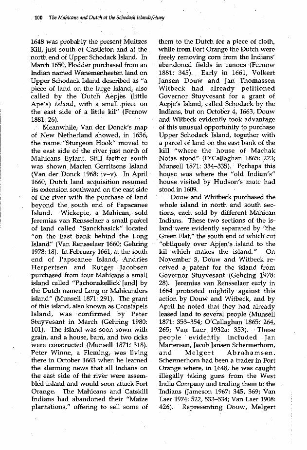
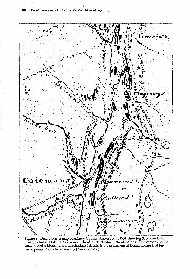
sloop. Evidently, he travelled up Schodack Creek. and then through Hell Gate "near 20 Rods" between Moesmans Island and Schodack Island. The sand bar could then be avoided by sailing close along the west side of Schodack Island (Blodget 1755: 5). A map made about 1756 (FIG. 3) showed Schutters Island still separate from Moesmans Island, but this was still to change within ten years (Anon. c. 1756).
It is possible that the Mahicans had left Moesmans Island during the difficult time of trouble in 1748. In the fall of 1755, however, Alexander McKay of New York, a merchant trading to Albany in his sloop, stopped at or near Moesmans Island and sold an Indian a pint of rum for three brooms (Sullivan 1922: 497). War between England and France had resumed, and the river was busy with transportation ofmen and supplies between New York and Albany.
On May 11, 1759, the sloop carrying Colonel James Montresor ran aground at Hell Gate, apparently in the channel between Schodack Island and Moesmans Island. From this. sloop,. Colonel Montresor could see several other sloops aground in the western channel of the river. He. was stranded for less than an hour until the rising tide got the sloqp off. This same day, General Amherst at Albany ordered Montgomerie's Highlanders, the 77th British Reghnent, to enca:r;np on their arrival at a point 7 mi (11.2 km) below Albany. This would perhaps have been on Constapels Island, north of Schodack Island, although it is possible that troops also camped on Schodack Island. Nicholas Gardenier, the owner of part of Schodack Island, had recently died; his estate included land not only on Schodack Island but also property on the south side of the Mohawk River near Fort Hunter (Scull 1882: 70;
108 The Mahicans and Dutch at the Sc1wdtick Islands/Huey
•••• ¥
..... ,._,, ... ~ . · ... /· '····· . . ~?'fl> : : .· .. / . .
·.,-' ......
·, " ,. ··., ~ ·~~4D . ,~.-":. ·,, ...
#.-·>.... • .. . '· J. .... , ..
. : ~ ·., __ .· . . .. : . .,. ·. ·-"".' ..
'/.
1: .'{:/_
- '_)
.·· ..
,·
Northeast Historical Archaeology/Vol: 21-22, 1992-1993 109
Doughty 1916: 23; Webster 1931: 10~ 109; Fernow 1896: 175).
In July 1755, a quarrel had devel..; oped between several River Indians and Colonel John van Rensselaer of Greenbush over the ownership of some land apparently near Kinderhook and Claverack, and in November, Governor Hardy feared that the River Indians "in the back parts of Orange and Ulster counties" would join the French (Lauber 1939: 211-212; Sullivan 1922: 360). The Mahicans, however, were by now a P.ispersed people, and at Stockbridge those few who remained lived in constant danger of attack (Karlsen and Crumpacker 1984: 220-222). Many had joined with other Indian groups to live on the upper branches of the Susquehanna River. By the end of 1756, Mahicans had also joined with Shawnees, Delawares, and fugitive Iroquois at Tioga. During the summer of 1756, the Nanticokes had invited the Mahicans to settle with them on the Susquehanna at a settlement called Otsiningo, and in the spring of 1757 a group of 148 Mahicans from the Susquehanna participated in an Indian conference at Fort Johnson. The Mahicans resolved to gather at. Otsiningo in one body that year, an ar;. rangement that was briefly. threatened that fall after a number of recalcitrant Mahicans livillg near Schoharie and Catskill were suspected of taking plunder at the Fort William Henry massacre. The Mahicans explained that "there are several of their People who live a wandering unsettled Life & will pay no regard to the Advice or Directions of their Wise & elderly People." Otherwise, they said, "we are a dispersed & unsettled People & . have no Land to plant ··or fixt Habitations to dwell in" (Lauber 1939: 349, 565, 682, 690, 700, 712, 786, 791-792, 833, 844-846; Sullivan 1922: 740-741).
It is probable that the wanderings of . the unsettled but independent Mahicans frequently brought them back to Moesmans Island or Schodack Island, but it would appear that the Moesmans Island Indian settlement was otherWise abandoned. In November 1763, however, a group of 48 Stockbridge Indians met with Sir William Johnson at Johnson Hall in the Mohawk Valley and begged him to use his influence to call back the Mahicans who had gone to the upper Susquehanna (Hamilton 1951: 932).
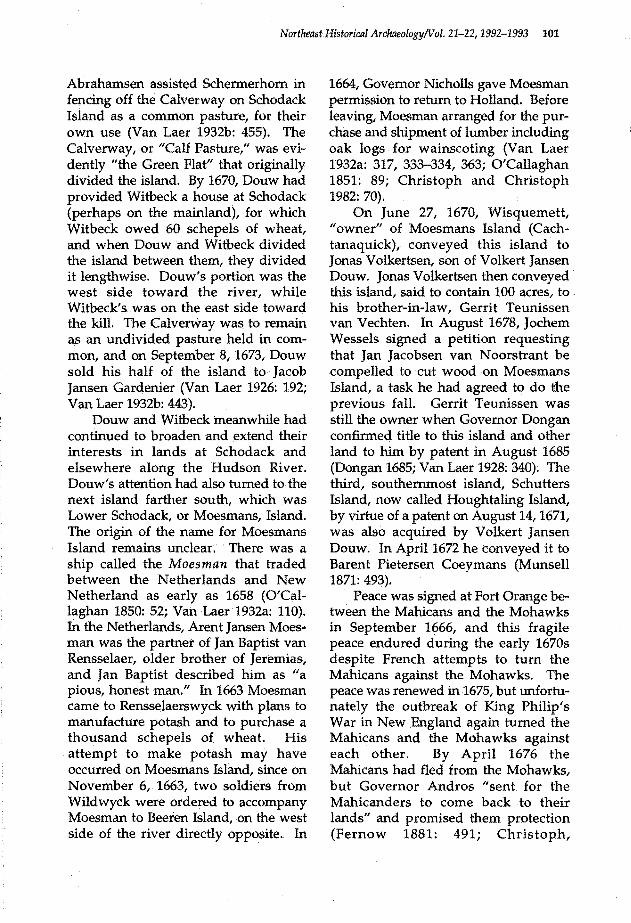
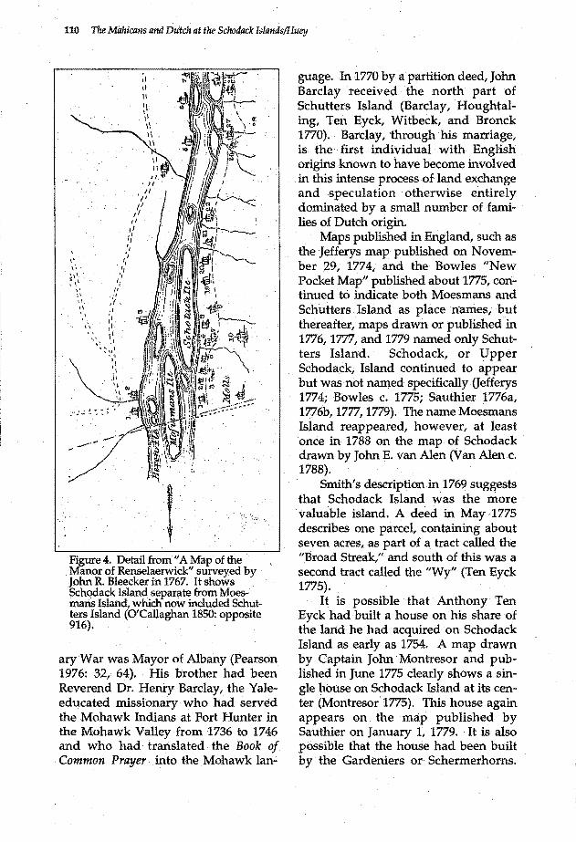
The Blee,cker map of 1767 (FIG. 4) reveals that Schutters Island and Moesmans Island had completely merged, so that the whole was called Moesmans Island and was separate from Schodack Island to the north. The map shows no houses on either island (O'Callaghan 1850: opposite 916). A traveller on a sloop in May 1769, Richard Smith, nevertheless described the southern island as Schutters Island, noting that it "affords a good low Bottom fit for Meadow and some of it improved." · He then observed the recently formed small island of ten acres, "covered with young Button wood trees," before noting Schodack Island. "The :upper End of Scotoc's Island," he wrote, "is a fine cleared Bottom not in
· Grass b:ut partly in Wheat & partly in Tilth. However there was one rich Meadow improved" (Smith 1964: 14). Perhaps the one rich meadow was the old Calverway. " .
A map drawn in 1769 shows Schutters Island separate , from Moesmans or Lower Schodack ISland. Except for the north portion called "Veif Hook," the remaining parts of the island were owned by Thomas Houghtaling and John Barclay (Gambino 1975). John Barclay was married to a daughter of ~ieter Barentsen Coeymans and during the Revolution-
110 The Mahicans and Dutch at the Schodack lslands/Huey
: ·-.·,-
Figure 4. Detail from" A Map of the Manor of Renselaerwick" surveyed by John R. Bleecker in 1767. It shows Schodack Island separate from Moesmans Island, which now included Schutters Island (O'Callaghan 1850: opposite 916). . .
ary War was Mayor of Albany (Pearson 1976: 32, 64). His brother had been Reverend Dr. Henry Barclay, the Yaleeducated missionary who had served the Mohawk Indians at Fort Hunter in the Mohawk Valley from 1736 to 1746 and who had translated the Book of
. Common Prayer into the Mohawk Ian-
guage. In 1770 by a partition deed, John Barclay received the north part of Schutters Island (Barclay, Houghtaling, Ten Eyck, Witbeck, and Bronck 1770). Barclay, through his marriage, is the first individual with English origins known to have become involved in this intense process of land exchange and speculation otherwise entirely dominated by a small number of families of Dutch origin.
Maps published in England, such as the Jefferys map published on November 29, 1774, and the Bowles "New Pocket Map" published about 1775, continued to indicate both Moesmans and Schutters Island as place names, but thereafter, maps drawn or published in 1776, 1777, and 1779 named only Schutters Island. Schodack, or Upper Schodack; Island continued to appear but was not named specifically (Jefferys 1774; Bowles c. 1775; Sauthier 1776a, 1776b, 1777, 1779). The name Moesmans Island reappeared, however, at least once in 1788 on the map of Schodack drawn by John E. van Alen (Van Alen c. 1788).
Smith's description in 1769 suggests that Schodack Island was the more valuable island. A deed in May 1775 describes one parcel, containing about seven acres, as part of a tract called the "Broad Streak," and south of this was a second tract called the "Wy" (TenEyck 1775).
It is possible that Anthony Ten Eyck had built a house on his share of the lartd he had acquired on Schodack Island as early as 1754. A map drawn by Captain John Montresor and published in June 1775 clearly shows a single house on Schodack Island at its center (Montresor 1775). This house again appears on the map published by Sauthier on January 1, 1779. ·It is also possible that the house had been built by the Gardeniers or Schermerhorns .
Northeast Historical Archaeology/Vol. 21-22, 1992-1993 111
The Gardenier land on Schodack Island remained in that family until after June 1785 (Gardenier 1785). The Ten Eyck family retained land later designated as lot numbers two and six on the south part of Schodack Island as late as September 1786 (TenEyck et al. 1816; Ten Eyck 1786).
Meanwhile, Dirck Schermerhorn had commenced disposing of the old Schermerhorn lands on the east side of Schodack Island in a final phase of 18th~century land transfers. In September 1785 he mortgaged half of a small island called Schermerhorn Island (more recently known as "Little Schodack Island") just below the south tip of Schodack Island (Schermerhorn 1785). In February 1786 he sold the southeast comer portion of Schodack Island to Benjamin Springsteen, a local blacksmith (Schermerhorn 1786). Finally, in 1789, Schermerhorn mort:.. gaged to Anthony Ten Eyck and others his entire farm on the mainland as well as all of his land on Schodack Island and. the other half .of Schermerhorn Island (Schermerhorn 1789).
Conclusion
As early as 1844 Henry R. Schoolcraft recorded that the Mahicans' "seat of their council fire, was, for a length of time, at Schodac" (Schoolcraft 1845: 104). The name Schodack, he believed, was derived from the word ishcoda meaning "fireplain," perhaps combined with the word akee meaning "earth" or "land" (Schoolcraft 1845: 104, 113). Indeed, Roger Williams in his study of the Narragansett language published in 1643 noted that the word Squtta meant "Fire" and that Auke meant "Earth or Land" (Williams 1973: 118, 167). While the Hendricksen map of 1616 clearly shows the . islands at Schodack, it is curious that the Van
Rensselaer map of Rensselaerswyck drawn about 1632 indicates a complete lack of knowledge about the Schodack area south of Papscanee and Constapels Islands (Van Laer 1908: 33-36, pocket). It is also significant that the formal Dutch purchase of islands on the east side of the river south of Papscanee Island from the Indians did not begin until1660 and that Schodack Island itself was not "sold" to the Dutch until1663.
Indian conflicts coincided with intensified English pressures on the Dutch in the Hudson Valley in the years immediately before the English taking of New Netherland in 1664. The brief first Esopus War between· the Esopus Indians and the Dutch had ended in July 1660, but in 1662 war broke out again between the Mahicans and the Mohawks, who were allies of the Dutch. The successful Esopus Indian attack on the Dutch town of Wildwyck (Kingston) occurred in June 1663, but a month later Dutch troops under Martin Cregier began hunting down the elusive Esopus Indians. From October 1 to 7 Cregier's men completed the process of destroying an Esopus Indian settlement and vitally important maize fields in military expeditions that drove the Esopus Indians northeastward to a meeting with their frightened Mahican allies. The Mahicans evidently had fled from Schodack, however, leaving their "land and com" shortly before October 7 (Fried 1975: 40, 61, 65, 93-94; Brasser 1978: 204; Fernow 1881: 303, 344-345). First, on October 4, the Mahicans had sold Schodack Island to Volkert Jansen Douw and Jan Thomassen. Whitbeck.
Schodack Island, with the nearby "house of Machak Notas," had probably been occupied by the Mahicans before 1609, and it may have been their traditional council fire location. In any case, it is clear that Schodack Island
112 The Mahicans and Dutch at the Schodack Islands/Huey
was coveted by Jeremias van Rensselaer and his successful rivals, and the new owners rapidly developed the land (Van Laer 1908: 826). Encouraged by the protective policy of Governor Andros, a number of Mahicans evidently had begun to return to Schodack Island by 1678. They were probably again forced to leave because of the danger of attack in 1690. A group of Mahicans may have transferred their traditional council fire east to a new settlement on the Housatonic River in 1724. Although a Mahican had conveyed Moesmans Island to Douw's son in 1670, in 1730 the Mahican owners of Moesmans Island nevertheless sold part of that island to Maes Hendricksen van .Buren. Despite the losses of land, and the work of English missionaries at Housatonic and Kaunaumeek, a Mahican settlement continued to exist on Moesmans Island. Whether this village endured through the dangerous French and Indian War of 1744 to 1748 is not clear, but it is likely the Mahicans had abandoned Moesmans Island before the end of the last French war in 1763. They moved probably to Otsiningo and other places on the upper Susquehanna. A number of Mahicans had remained at Stockbridge, on the Housatonic,. but the significance of Schodack as the traditional tribal council fire had evidently persisted.
With their easy access to water and to traffic on the river and with their rich alluvial soil, the islands at Schodack were of great value to the local farmers and merchants of Dutch descent who acquired them. New construction during the 19th tentury was limited mostly to large ice houses, for the storage of ice cut from the river, but in the 1920s drastic changes occurred. Dredging to create a ship channel in the river resulted in the deposition of
many feet of sand and gravel on the islands. Upper Schodack and Lower Schodack Islands were merged with Houghtaling Island. the magnificent "Castleton cutoff" railroad bridge across the river was built by the New York Central Railroad over the north end of Upper Schodack Island. Parallel with the bridge and close to it, the New York State Thruway bridge was built in the 1950s.
Fortunately, today the large island that contains Upper Schodack, Lower Schodack, and Houghtaling Islands has been acquired by the New York State Office of Parks, Recreation and Historic Preservation. It has been renamed "Castleton Island1
' and is classified as an undeveloped state park. Much planning and work will be necessary to make it accessible to the public, but every effort will be made to locate and protect all archaeological resources, whether . prehistoric or historical, as required by state preservation laws. Initial surveys to locate Mahican village sites and sites of subsequent historical structures have been unsuccessful because these sites are buried under deposits of dredging spoil that in many areas are more than 6 ft (1.8 m) deep. It is unfortunate that the dredging spoil has so effectively hidden archaeological sites and that the locations of such sites were not recorded before they were covered. It will be difficult to locate the sites in order to insure their protection and recognition. Conversely, however, the dredging spoil now also serves effectively to protect these cultural resources from vandalism and from disturbance by park development in the future. ·Surveys will be required to record precise depths and extent. of the dredging spoil, in any case.
Archaeological sites on this state land, as protected resources/ exist as a
Northeast Historical Archaeology/Val. 21-22, 1992-1993 113
public trust of which the Office of Parks, Recreation and Historic Preservation is the custodian. Such sites should be located, and they can be wisely managed and conserved as resources for continuing research and study by the use of· controlled archaeological sampling procedures of minimal impact. Data from many other sites directly relating to or occupied by the Mahicans of Schodack also still remain to be studied carefully and synthesized in relation to what may yet be found on Castleton Island. In 1986, for example, excavations in Albany revealed the remains of Volkert Jansen Douw's house, which Douw evidently occupied from about 1647 until his death (Huey 1987: 19-20). Dutch ceramics and glass, Jew's harps, and a great many tubular blue glass beads (Kidd and Kidd Variety Ilia 12) were found in deposits dating from the period of Douw's occupation (Pefta 1990: 10()..:-101). There was also a complete leather shoe found wedged between two cellar floo~ boards, where it had gotten stuck in the thick clay beneath. Earlier archaeological discoveries relating to the Mahicans of Schodack ·have occurred in the upper Susquehanna Valley. In 1971 and 1972, archaeologists discovered part of a settlement area at Otsiningo prior to construction of a comfort station off the north-bound lane of 1-81 near the site. The site, actually located in the lower Chenango River Valley, was found to be well preserved. The testing revealed scores of beads, several clay pipes, a Jew's harp, a pewter button, glass, ceramics, and several pieces of iron (Elliott 1977: 98-100). Between 1968 and 1971, meanwhile, rescue excavations were conducted at the site of Unadilla, where Mahicans were living as early as 1753 and were still living in 1769. Buttons, day pipes,
coins, gun parts, ceramics, table forks and knives, and many ·other objects of European origin· were recovered (Hesse 1975: 19, 22-30).
The Mahicans probably brought some of this· material to the upper Susquehanna with them from Schodack. They left behind at Schodack not only their traditional council fire site but also their immediate access to local Dutch merchants and traders with supplies directly from New York. They also resented the Livingstons and the Van Rensselaers who, in their eyes, had dispossessed them of their land east of the Hudson River. In 1767 they petitioned against patents that had encroached on their lands on both sides of the river (O'Callaghan 1866: 768). The next year they complained specifically to Sir William Johnson that Van Rensselaer "has got all our Lands; and we have nothing for them" (Hamilton 1957: 481, 603-604). The old chief who spoke for the Mahicans was evidently Keshomack, who in 1760 had sold land east of the river on the road between Schodack and Kaunaumeek (Huey and Phillips 1969: 5).
The archaeological study of material culture remains offers one approach to the question of whether the Mahicans resisted cultural change and to what extent native cultural traits may have been retained despite or because of the Unhappy circumstances in which there people frequently found themselves. It is through the combination of thorough historical research and careful archaeological study and comparison of Mahican sites at Schodack and elsewhere, however, that it will be possible to understand more fully the nature of changes in their culture occasioned by European contact and to avoid the bias of relying entirely on European records of that culture.
114 The Mahicans and Dutch at the Schodack Islands/Huey
Acknowledgments . .
Many individuals have contributed to the writer's compilation and interpretation of. the above research on the Mahicans at Schodack Many of the deed references were provided by Shirley Dunn of E.ast Greenbush, New York, who is doing extensive research on the Mahican Indians. When the 1730 deed for part of Moesmans Island to Maes Hendricksen van Buren was discovered by the Historical Society of Esquatak, .it was Shirley Dunn who immediately recognized its great importance to research on the Mahicans. The wnter also wishes to acknowledge the assistance of Charles .L. Fisher of the Bureau of Historic Sites in the New York State Office of Parks, Recreation and Historic Preservation. He is currently studying archaeological evidence:.of the Mohawks living at Fort Hunter in the Mohawk Valley. in the Jl1id-18th century. Assistance and encouragement were also provided by RobertS. Grumet of the Mid-Atlantic Office of the National Park Service, by Lois M. Feister of the Bureau of Historic . Sites, . who is studying evidence from excavations at Johnson Hall,. and. by Charles T. Gehring of the New Netherland Project in the New York. State Library. Typing was provided by Kathie Benac. and Mary Valek. Finally; the late Ralph D. Phillips 'of ·Nassau, New York, provided many useful references on Schodack history for which the writer is ever grateful.
References Anonymous ·
·l746a · New York, July 28. The Pe.nnsy_l-.. vania Gazette. Printed by B.
. Franklin, Philadelphia, Number 920, July 31, page 2. ·
1746h New York, Aug. 25. The American Magazine. Printed and
c.1756
Sold by Rogers and Fowle, in Queen-street next to the Prison, Boston. Augu5t1 page 382~ Map of Aloany County. CXXI/9-2, British Museum, London.
Barclay, John, Thomas Houghtaling, Peter Ten Eyck, Mayke Witbeck, and John J. Bronck ·
1770 Partition deed, September 5. Deeds, Book 8, Page '274, Albany County Clerk's Office, Albany.
Blodget, Samuel . 1755 A Prospective-Plan of the Battle
near Lake George, on the Eighth Day of SeEtemoer, 1755. Printed by Richaro Draper, for the Author, Boston. [Reprinted in Publication No. 8 of the Society of Colonial Wars of the Commonwealth of Massachusetts, Boston, 1906.]
Bond, Richmond P. 1974 Queen Anne's American Kings.
[Reprint of 1952 edition.] Octagon Bool<s, New York.
Bowles, Carrington · c.1775 Bowles's New Pocket Map of the
Most Inhabited Part of New England. Printed for the Proprietor Carrington B_ owles, No.69 in St. Pauls Church Yard, London. .
Bradt, Barent Albertsen 1704 Deed to Myndert Schuyler, et al.,
May 1. Deeds, Book 4, Page 316, Albany County Clerk's Office, Albany. ·
Brasser, T. J. . . 1978 Mahican. In Northeast, ed. by
Bruce G. Trigger, 198-212. Vol. 15 of Handbook.of North American Indians, ed. by William G. Sturtevant. . Smithsonian Institution, Washington, D. C.
Bridenbaugh, Carl, ed. 1948 Gentlemen's Progress: . The
Itineraiium df Dr. Alexander Hamilton: 1744. University of North Carolina Press, Chapel Hill. .
Christoph, Peter R., · and Florence A. Christoph, eds. . ·
1982 New York Historical Manuscripts: English. Books· of General Entries of the Colony of New York, 1664-1673. Genealogical Publishing Co., Inc., Baltimore.
Northeast Historical Archaeology!Vol. 21-22,1992-1,993 115
Christoph, Peter R., Florence A. Christoph, ap.d Charles T. Gehring, trans. andeds.
1989 The Andros Papers: 1674-1676. Syracuse University Press, Syracuse.
Dongan, Thomas 1685 Patent to Gerrit Teuriissen,
August 28. Patents, Book 5, Page · 203, Office of the New York State Secretary of State, Albany. [On microfilm at the New York State Archives, Albany.]
Doughty, Arthur G., ed; . 1916 ~pendix to an Historical Journal
. o the Campaigns in North merica for the Years 1757, 1758,
1759, and 1760 by Captain John · Knox. Vol. 3. The Champlain
Society, Toronto.
Douw, Doritie, and Jonas Volkertsen Douw 1685/6 Deed to Jacob Jansen Gardenier,
January 26. Deeds, Book 3, Page 307, Albany County Clerk's Office, Albany.
Edwards, Jonathan 1949 David Brainerd: His Life and Di
ary. Moody Press, Chicago.
Elliott, Dolores 1977 Otsiningo, an Example of an Eigh
teenth Cenh:lry Settlement Pattern. In Current Perspectives in Northeastern Archeology: Essays in Honor of William A. Ritchie, ed. by Robert E. Funk and Charles F. Hayes III, 93-105. Researches and Transactions of New York State Archeological . Association Vol. 17(1). New York State Archeological . Association, Rochester and Albany.
Evans, Lewis 1749 A Map of Pensilvania, New-Jersey,
New- York, And the Three Delaware Counties. Published by Lewis Evans March 25, Philadelphia. [Reprinted in Pennsylvania Archives, Third Series, Appendix 1-X.]
Fernow, Berthold, trans. and ed. 1881 Documents Relating to the History
and Settlements of the Towns· along the Hudson and Mohawk Rivers. Weed, Parsons and Company, Albany.
1896 Calendar of Wills on File and Recorded in the Offices of the
Clerk of the Court of Appeals, of the County Clerk at Albany, and of the Secretary of State, 1626-1836. The Knickerbocker Press,, New York..
Fried, Marc B. 1915 The Early_ History of Kingston &
Ulster County, N.Y. Ulster County Historical Society, Marbletown and Kingston, NY.
Gambino, Anthony J. 1975 Town of New Baltimore and Vicin
ity: A Historical Atlas. Privately printed, New Baltimore, NY ..
Gardenier, Nicholas, John Miller, and Nicholas Miller
1785 Deed to Cornelius. Gardenier and Hendrick Garclenier, June 9. Deeds, Book 2, Pa~e 142, Rensselaer County Clerk s Office, Troy, NY. .
Gehring, Charles, trans. and ed. 1978 A Guide to Dutch Manuscripts Re
lating to New Netherland in United States Repositories. New York State Library, Albany.
1980 · New York Historical Manuscripts: Dutch. Volumes GG, HH & II, Land Papers. Genealogical Publishing Cq., Inc., Baltimore.
Hamilton, Milton W., ed. 1951 The Papers of Sir William Johnson.
Volume 10. The University of the State of New York, Albany.
1957 The Papers of Sir William Johnson. Volume 12. The University of the State of New York, Albany.
Hannay, William V., ed. 1934 · Burial Records: First Dutch Re
formed Church, Albany; N.Y. The Dutch Settlers Society of Albany, Yearbook Vols. 8 and 9 [932-1934. Albany.
Hesse, Franklin}. 1975 The Egli and Lord .Sites: The His
toric Component-"Unadilla" 1753-1778. The Bulletin, New York ·State· Archeological Associa-tion, 63(March): 1~3L ·
Hopkins, Samuel . 1972 Historical Memoirs Relating to the
Housatonic Indians. Johnson Reprint Corporation, New York, London. [Reprint of 1912 edi-tion.] ·

116 The Mahicans anti Dutch at the Schodack lslands/Huey
Huey, Paul R. . . 1987 Archeological Evidence of Dutch
· Wooden Cellars and Perishable Wooden Structures at Seventeenth and Eighteenth Century Sites in
. the Upper Hudson Valley. In New World Dutch Studies: Dutch Arts. and Culture in Colonial America, 1609-1776, ed. by Roderic H. Blackburn and Nancy A. Kelly, 13-35. Albany Institute of HiS.. tory and Art, Albany.
Huey, Paul R., and Ralph D. Phillips . 1969 The Early History of Nassau Vil-.
· lage, 1609~1830, With Biographical Sketches of Early Settlers. Nassau Free Li6rary,Nassau, NY
Jameson, J. Franklih, ed. 1967 Narratives of New Netherland:·
1609-1664. [Reprint of 1909 edition.] Barnes &: Noble, Inc., New York.
Jefferys, Thomas · . . . · 177 4 A Map of the most Inhabited part
. of New England. November 29, 1774. ·· PuBlished according to Act ... , London. · · · ·
Karlsen, Carol F., and Laurie Crumpacker, · · eds. ·
· 1984 The Journal of Esther Edwards Burr: 1745-1157. Yale University Press, New Haven.
Lauber,Alni.on w.,ed. 1939 The Papers. o{Sir. William Johnson.
Volume 9. The University of the · State of New York, Albany.
Leder, Lawrence H., ed. 1956 The Li.vingston Indian Records:
1666-1723. The Pennsylvania Historical Association, Gettysburg.
MacCracke~,Henry Noble 1956 Old Dutchess Forever! Hastings
· House, New York.
Montresor, John 1775 A Map of the Province ofNew-
York. J>ublished as the Act directs June 10th. 1775, by A. Dury,
. Dukes Court St. Martins Lane, London.
Munsell, Joel 1853 The Annals ol Albany. Vol. 6. Joel
Munsell, 78 State Street, Albany.
1870
1871
Collections on the History of Albany. Vol. 3. J. Munsell, 82 State Street, Albany. · Collections oJ the' History of_ Albany. Vol. 4. J. Munsell, 82 State Street,Albany. .
Norton, John 1965 Narrative of the Capture and Burn
ing of Fort Massachusetts by the French and Indians. [Reprint of 1870 edition.] Re.erinted for New Englandiana Book Shop, North Adams,MA.
O'Callaghan, E. B., ed. · . 1849 The Documentary History of the
State of New-York. Vol. 2. Weed, Parsons &: Co., Public Printers, Albany.
1850 The Documentary History of the State of New-York. Vol.3. Weed, Parsons &: Co., Public Printers, Albany.
1851 The Documentary History of the State ofNew-YorlC. Vol. 4. Charles van Benthuysen, Public Printer, Albany. .
1853 Documents Relative to the Colonial History of the State of New-York. Vol. 3. Weed, Parsons and Company, Printers, Albany.
1854 Documents Relative to the Colonial History of the. State of New-York. Vol. 4. Weed, Parsons and Company, Printers, Albany.
1855 Documents Relative to the Colonial History of the State of New-York. Vol. 5. Weed, Parsons and Com-pany, Printers, Albany. .
1856 Documents Relative to the ColO.nial History of the State of New-York. Vol. 2. Weed, Parsons and Company, Printers, Albany.
1865 Calendar of Historical Manuscripts in tfie Office of the Secretary of State, Al1iany, N.Y. Weed, Parsons and Company, Printers, Albany.
· 1866 Calendar of Historical Manuscripts, in the Office of the Secretary of State, Albany, New York Part 2: Weed, Parsons and Company, Printers, Albany.
Pearson, Jonathan, trans. · 1916 Early Records of the County of Al
bany and Colony of Rensselaerswyck. Vol. 2, revised and ed. by
· A. J. F. van Laer. The University of the State o£ New York, Albany.
197 6 Contributions for the Genealogtes of_ the First Settlers of the County of Albany, from 1630 to 1800. [Re-
Northeast Historical Archaeology/Val. 21-22, 1992-1993 117
print of 1872 edition.] Genealogical Publishing Co., Inc., Baltimore.
Pefia, Elizabeth S. 1990 Wampum Production in New
Netherland and Colonial New York: The Historical and Archaeological Context. Ph.D. diss., Boston University. University Microfilms International, Ann Arbor.
Portinaro, Pierluigi, and Franco I<nirsch 1987 The Cartography of North Amer
ica: 1500-1800. Facts on File, Inc., 460 Park Avenue South, New York.
Reynolds, Cuyler 1909 New York at the Jamestown
Exposition. J. B. Lyon Company, Pnnters, Albany.
Rice, Shirley A. 1987 Women of Colonial Albany: A
Community History Calendar for 1987. Colonial Albany Social History Project, New York State Museum, Albany.
Rink, Oliver A. 1986 Holland on the Hudson: An Eco
nomic and Social History of Dutch New York. Cornell Uruversity Press, Ithaca; New York State Historical Association, Cooperstown, NY.
Sauthier, Claude Joseph 1776a A Map of the Province of New
York. Publish'd according to Act of Parliament, August 1st. 1776, by Wm. Faden, Comer of St. Martin's Lane, Charing- Cross, London.
1776b A Topographical Map of Hudsons River. Pubiish'd according to Act of Parliament Octr. 1st. 1776, by Wm. Faden, Corner of St. Martin's Lane, Charing Cross, London.
1777 A Map of the Provinces of NewYork and New-Jersey. Engraved and Published by Matthew Albert Lotter, Augsburg.
1779 A Chorographical Mal? of the Province of New-York m North America. Engraved and Published by William Faden, Charing Cross, January 1st, 1779, London.
Schermerhorn, Dirck 1785 Mortgage to Jacob C. Ten Eyck,
Septemoer 8. Mortgages, Book 6, Page 50, Albany County Clerk's Office, Albany.
1786 Deed to Benjamin Springsteen, February 8. Deeds, Book 11, Page 189, Albany County Clerk's Of
. flee, Albany. 1789 Mortgage to Benjamin Egberts,
Anthony Ten Eyck, and Aitthony Egberts,. December 9. Mortgages, Book 9, Pa~e 60, Albany County Clerk's Office, Albany.
Schoolcraft, Henry R. . 1845 · Comments, Philological and His
torical, on the Aboriginal Names and Geographical TerminoloKY, of the State of New York. Proceedings. of the New-York Historical Society, for the Year 1844, 77-115. Press of the Historical Society, New York.
Scott, Kenneth 1970 Genealogical Data from the New
York Post-Boy: 1143-1771. National Genealogical Society, Washington, D.C.
Scull, G. D., ed. 1882 The Montresor Journals. Collec
tions of the New-York Historical Society For the Year 1881. Printed for the Society, New York.
Seutter, Matthew c.1735 Pennsylvania, Nova Jersey et
Nova York. Advertisement for The Old Print Gallery,. Antiques, Volume 110(4)[0ctober 1976]: 674.
Smith, Richard 1964 A Tour of Four Great Rivers, ed.
by FranCIS W; Halsey. [Reprint of 1906 edition.] Ira J. Friedman, Inc., Port Washington, NY.
Sullivan, James, ed. 1921 The Papers of Sir William Johnson.
Volume 1. The University of the State of New York, Albany.
1922 The Papers of Sir William Johnson. Volume 2. The University of the State of New York, Albany.

118 The Mahicims and Dutch at the Schodack Islands/Huey
TenEyck, Anthony . 1786 . Mortgage to Loan-Officers of Al
bany County, September 9. Book A, Page 138, Loan Commissioners Office Book, 1786-1822, Albany County Clerk's Office, Albany.
TenEyck, Barent H. . 1775 Deed to Ar).dries TenEyck, Daniel
Schermerhorn, and Anthony J. Ten Eyck, May 24. Deeds, Book 10, Page 134, Albany County Clerk's Office, Albany.
TenEyck, Catherine, Egbert TenEyck, Jacob TenEyck, Maria TenEyck, and Conrad TenEyck .
1816 Deed to Aniliony TenEyck, Au-. gust 21. Deeds, Book 77, Page 67,
Rensselaer County Clerk's Office, Troy. .
TenEyck, Jacob C. 1754 Deed to Anthony Ten Eyck,
September 25. Deeds, Book 10, Page 59, Albany County Clerk's
. Office, Albany. ·
Van Alen, John E. c.1788 Map of Schodack. Map No. 1~,
Van Rensselaer Manor Papers, New York State Library, Albany.
Van Buren, Maes 1730 Deed from Ampamet, Manonanys,
Wautaukemet,and Wanewauseet, October 16. New York Genealog-: ical and Biographical Society, New York.
1733 Will, April 7. Wills, BOok 1, Page 202, Albany County Clerk's Of-fice, Albany. .
Vander Donck, Adriaen . 1968 .A Description of the New Nether
lands, ed. by Thomas F. O'Donnell. Syracuse University Press, Syracuse.
Van Laer, Arnold J. F., trans. and ed. 1908 Van Rensselaer Bowier Manu
.scripts. University of the State of New York, Albany. .
1919 Early Records of the City and County_ of Albany. and Colony oj RensselaerS'lQ}!ck, VoL 4. The Umversity of the State of New York, Albany. .
1926 Minutes of the Court of Albany, Rensselaersfi!Yck and Schenectady. Vol. 1 (166s:-1673). The University of the State of New York, Albany.
1928
1932a
1932b
1935
1974
Minutes of the Court of Albany, Rensselaersf1!Yck and Schenectady. Vol. 2 (1675-1680). The University of the State of New York, Albany. Correspondence of Jeremias van Rensselaer, 1651.:..1674. The University of the State of New York, Albany. Minutes of the Court of Albany, Rensselaerswyck and Schenectady. Vol. 3 (1680-1685), The University of the State or New York, Al-bany. . · Correspondence of Maria van Rensselaer: 1669-'1689. The University of the State of New York, Albany. New York Historical Manuscripts: Dutch, ed. by Kenneth Scott and Kenn Stryker-Rodda. Vol. 4. Genealogical Publishing Co., Inc., Baltimore.
Van Rensselaer, Jeremias 1660 Deed from Wickepie, Colonie of
Rensselaerswycl<, April 27. Translation on file at the Albany Institute of History and Art, Albany.
1707 Deed from Aquoatch, Aempamit, Penonaemp, Tawakeete, and Ma
. hatawee, City of Albany, August 6. The Albany Institute of History and Art, Albany.
Webster, J. Clarence, ed. 1931 The Journal of Jefiery Amherst.
The Ryerson Press, Toronto.
Wheelock, Edward, ed. . . 1973 Penhallow's Indian Wats: A Fac
simile Reprint of the First Edition, Printed in Boston in 1726. [Reprint of 1924 edition.] Comer House Publishers, Williamstown, MA. . .
Williams, Roger · · 1973 A Key Into the Language of Amer
ica, ed. by John J. Teunissen and Evelyn J. Hinz. War.ne State University Press; Detroit. ·
Paul Huey Box219 NYS Bureau of Historic Sites Peebles Island Waterford, NY 12188