(65-66-67) Chapters in: The Madra River Delta (65: The physical geography..., 66: Geomorphological...
54
Transcript of (65-66-67) Chapters in: The Madra River Delta (65: The physical geography..., 66: Geomorphological...
THE MADRA RIVER DELTA:
Regional Studies on the Aegean Coast of Turkey
KYRIACOS LAMBRIANIDES and
NIGEL SPENCER
1. Environment, Society and Community Life from Prehistory to the Present
1. The physical geography of the Madra River Delta 9-21 İ. Kayan & S. Vardar
2. Geomorphological formation and development of the delta plain of the Madra River 23-30
İ. Kayan & S. Vardar
3. Alluvial geomorphology and paleogeography of the Yeldeğirmeni mound and its environs 31-38 İ. Kayan & E. Öner
THE BRITISH INSTITUTE AT ANKARA MONOGRAPH 35
2007
iii
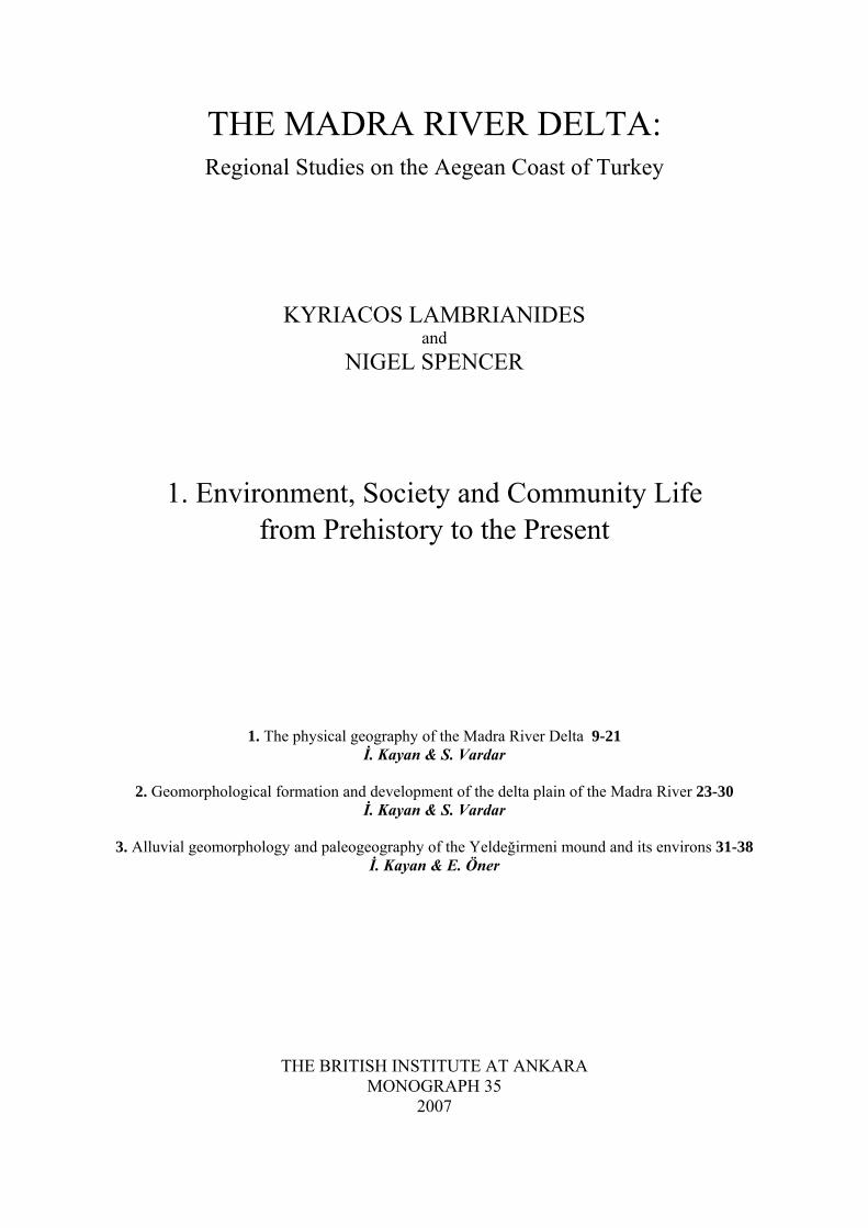
Contents
Acknowledgements v List of Figures vii List of Plates viii List of Tables ix Note on Transliteration and Abbreviations x Introduction
Regional studies and landscape archaeology in the Madra River Delta: Introduction and Background 1 Kyriacos Lambrianides & Nigel Spencer
Part 1: ‘Géohistoire’ or the ‘Longue Durée’
1. The physical geography of the Madra River Delta 9 İlhan Kayan & Serdar Vardar 2. Geomorphological formation and development of the delta plain of the Madra River 23 İlhan Kayan & Serdar Vardar 3. Alluvial geomorphology and paleogeography of the Yeldeğirmeni mound and its environs 31 İlhan Kayan & Ertuğ Öner Appendix 1: Summary of the radiocarbon dating results for the 1995 and 1997 samples taken from the
drillholes in the Madra River Delta 38 Bernd Kromer 4. Geophysical surveys at Yeldeğirmeni mound, Altınova 39 Mahmut G. Drahor, G Göktürkler & E Sengül 5. Climatic conditions in Altınova and the Madra River Delta 51 Ecmel Erlat 6. Land-use patterns in the Altınova area 59 Semra Sütgibi
Part 2: ‘Social time’ in the Madra River Delta and the northeast Aegean: the Early Bronze Age to the Early Roman period
7. The emergence of complexity in the Madra River Delta: the example of the EBA site of Thermi on Lesbos 67 Kyriacos Lambrianides 8. The ceramics of the northeast Aegean region from the Middle Bronze Age to the Early Iron Age 79 Nicholas Bayne & Nigel Spencer 9. The Archaic and Classical fine wares of the northeast Aegean and northwest Anatolia 91 Gerald P Schaus 10. The ceramics of the Hellenistic and Early Roman periods in the northeast Aegean: a brief survey of
the evidence from Mytilene, Lesbos 99 Hector & Caroline Williams
Part 3: ‘L’histoire Événementielle’
11. A study of Byzantine and Ottoman ceramic fragments found by surface survey north and west of Yeldeğirmeni mound, 1997 109
Sevinç Gök-Gürhan 12. The Madra River Delta in the Late Ottoman Period 123 Malcolm Wagstaff
Conclusions 129
Kyriacos Lambrianides and Nigel Spencer
Bibliography 131
9
1. The physical geography of the Madra River Delta
İlhan Kayan and Serdar Vardar
Introduction: geography, environment, problems and aims
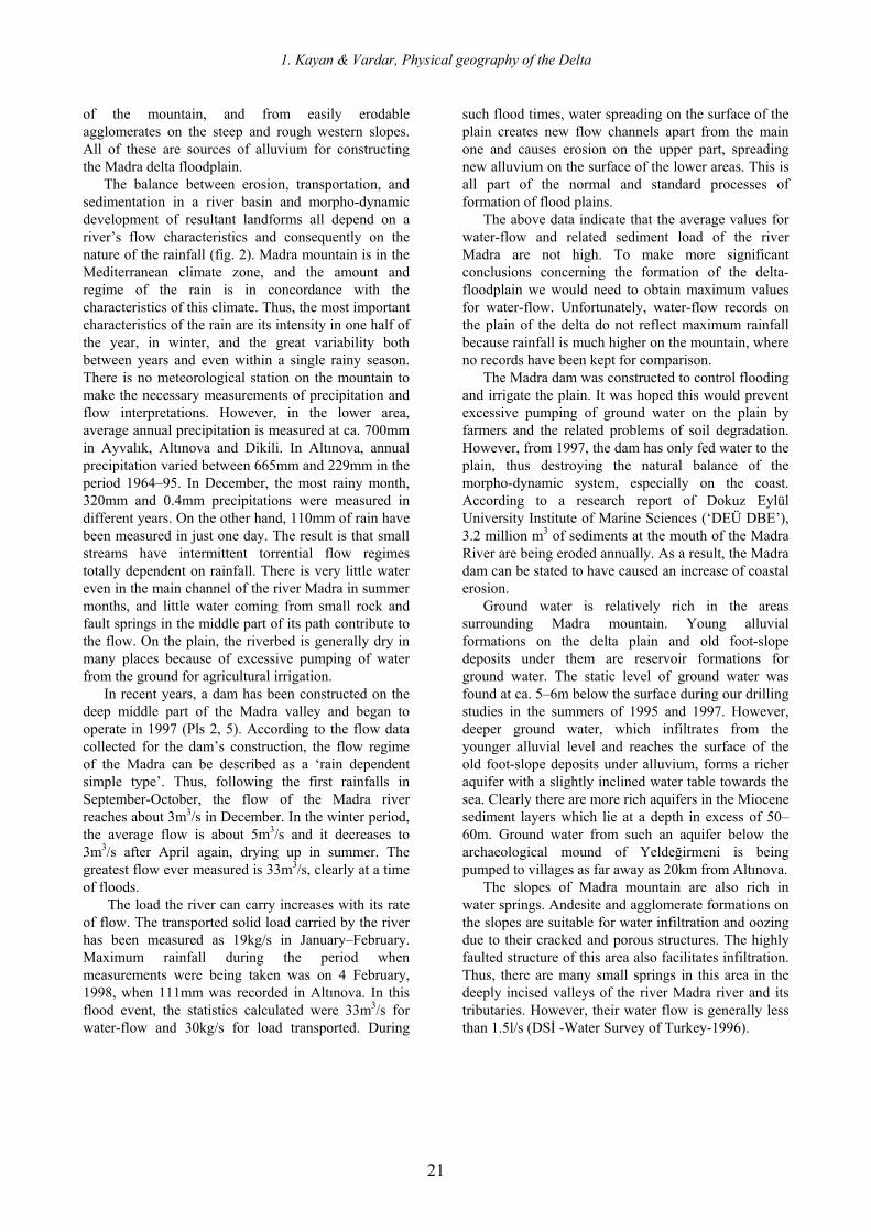
The Aegean coast of Anatolia is characterised by an extremely indented coastline and numerous offshore islands (Pl. 1). This general picture is due to the geological structure of the region, which consists of many fault blocks. As the physical map of the area shows, the main landforms follow northeast-southwest and northwest-southeast axes. However, the great structural blocks of Western Anatolia also run in the east-west direction and the major rivers of the region are located in the depressions (grabens) between rising mountain blocks (horsts) in the same direction. The coastal zone is characterised by mountain ridges often running right down to the coast, and rimmed by high and steep coastal landforms. Low delta plains have formed on the coasts of the gulfs and these extend inland along the depressions or valleys (grabens) between the mountain ridges.
The east-west mountain ridges continue into the sea where they form shallow shelf platforms submerged along the offshore zone of the Aegean coast (the lighter blue in Pl. 1). Some of the Aegean islands close to Anatolia are situated on these shelves, e.g. the island of Lesbos (Mytilene). The most prominent shelf is the submarine platform extending westward from the Biga-Gelibolu peninsula in the north. The islands Gökçeada and Limnos are situated on this platform. Further south, the İzmir-Çesme peninsula and Khios (or Chios) island are also located on a submarine platform. Farther south, the platform that carries the islands of the Dodecanese (or Dhodhekanisos) is an extension of the Mentese mountains of the mainland. These platforms are separated from each other by deep submarine depressions running west-east (the deeper blue in Pl. 1). The eastward extensions of these depressions continue inland as grabens (fault valleys) running deep into the interior of Anatolia, filled with alluvial deposits laid down by the major rivers of Western Anatolia (Pl. 1).
Our research is concerned with the Ayvalık-Altınova-Dikili coastal plain and Madra mountain (1,344m), which has a block shape formed by northeast-southwest structural (fault) lines behind the coast. This mountain range lies between the east-west structural blocks of İzmir-Manisa to the south, and the Biga-Kaz mountain range to the north (Pl. 1). The Madra mountain forms a smaller projection between the bays of Edremit to the north and Çandarlı to the
south; it points out into the sea towards the nearby island of Lesbos, an island which has been closely linked with the project’s study area since prehistory (see Chapters 7–10 below). Between these two bays the island of Lesbos rises on a submarine platform extending out into the Aegean sea. The Lesbos platform is a secondary extension between the much larger Biga and İzmir structural units.
Our research area consists of standard structural features: that is, mountains and valleys on the mainland, a continental shelf and offshore islands in the sea, and submarine depressions. Northeast-southwest and northwest-southeast structural lineaments can be seen in the coastal area between Edremit and İzmir. Madra mountain runs northeast-southwest, whereas the east coast of the island of Lesbos opposite Altınova, and the Ayvalık-Lesbos channel, all follow a northwest-southeast orientation (Pls 1–2).
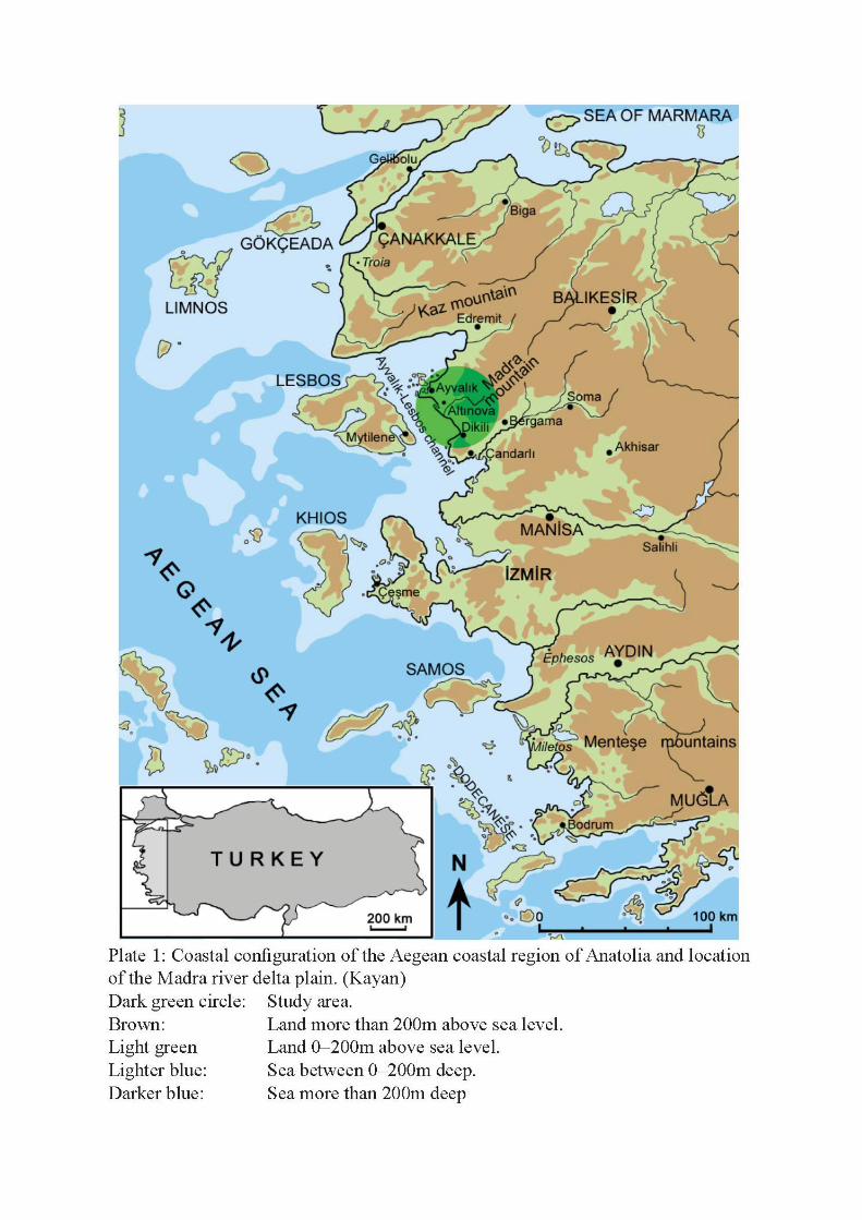
A piedmont plain (formed by alluvial fans of torrential streams descending from Madra mountain) lies between the steep west-facing slopes of Madra mountain and the present shoreline. During the Holocene transgression, the lower parts of this plain were covered by the rising sea and the present shoreline gradually formed along the edge of the plain over time. Here, the delta plain of the Madra river is one of the most important elements of recent geomorphology. The delta has been formed by the Madra river collecting surface water from a wide catchment area in the Madra mountain range and transporting alluvium down to fill the relatively low lying northern part of the piedmont’s surface (Pl. 3).
The MRD exhibits a pattern of development different from other major deltas on the Aegean coast of Anatolia. The major rivers of this region (the Bakırçay, Gediz, Kücük Menderes and Büyük Menderes) occupy tectonic depressions perpendicular to the coast (Pl. 1). During the post-glacial marine intrusion, long narrow bays formed initially, followed by the development of delta plains as a result of alluvium deposited by these rivers into the bays.
The MRD developed differently on the eastern edge of the Ayvalık-Lesbos channel. The channel is a tectonic depression (graben). Its direction is parallel to the general configuration of the coast, and the formation of the delta took place on one side of the channel instead of in a narrow bay (Pls 1–2). As a result, coastline changes have been slower and less evident than in the bays of the other major rivers,
The Madra River Delta: Regional Studies on the Aegean Coast of Turkey
10
making it more difficult to delineate the various paleogeographic stages involved.
Bathymetric data indicate that the gently-sloping surface of the piedmont along the western footslope of Madra mountain extends westward to the bottom of the Ayvalık-Lesbos channel. This surface, which is evidently covered by deltaic sediments on the coast, can be followed out to the middle of the channel. Here, the channel is less than 20km wide and only 50m deep (Pl. 2).
It is known that sea level fell down to –100m during the last glacial maximum and remained lower than –50m until 10,000bp (Kayan 1995). This means that it was possible to walk from Anatolia to the island of Lesbos at least until 10,000 years ago. Even in later times, in spite of the gradual flooding of the Ayvalık-Lesbos channel by the rising sea level, it remained much narrower than the present width and it would have been comparatively easy to pass between the island and the mainland for a very long time. It is therefore important to consider the cultural history of the region in relation to the geomorphological changes which were taking place in parallel.
Archaeological investigations at the Bronze Age settlement of Thermi, on the east coast of Lesbos (see Chapter 7 below), suggested the existence of cultural connections with the MRD directly opposite (Pl. 2) (Lamb 1936; Lambrianides 1990; 1992; Spencer 1995; Lambrianides, Spencer 1997). These archaeological surveys in the Madra plain revealed the existence of some Late Calcolithic-EBA cultural material and the possibility of relations with similar findings on Lesbos. This evidence led to Lambrianides and Spencer undertaking a multi-disciplinary research project in 1994 (Lambrianides et al. 1996: 169) with the following aims: to determine the environmental and geomorphological changes which could constitute a basis for settlement and cultural development in this area and to carry out paleogeographical reconstructions; to determine settlement distribution in this constantly changing coastal environment from prehistoric times to the present; and to examine the cultural history and interactions of societies living in the neighbouring areas of Western Anatolia and the Aegean.
The earliest archaeological exploration of this area was by Kılıç Kökten in 1949 (Kökten 1949). Kökten’s stated aim was to find a site on the mainland apart from Troy, as close as possible to Thermi on Lesbos. Kökten reported finding Troy I and II ceramics in soundings he made on a mound which he called ‘Kaymaktepe’, and he described finds belonging to the Chalcolithic and Bronze Age of Western Anatolia. However, Lambrianides could not find any site named Kaymaktepe during his survey of the delta in 1989–91 (Lambrianides 1992). He found prehistoric ceramics from two other mounds in the same area, on both sides
of the Madra River, one at Yeldeğirmeni (Yeni Yeldeğirmeni Tepe) to the north, and at Höyücek (Höyücek Tepe) to the south of the river (Pl. 3). The ceramics at these two sites are similar to the finds reported by Kökten (Lambrianides 1990; 1992). Therefore, in this project, the mounds of Yeldeğirmeni and Höyücek have been taken as both starting points and type sites for the archaeological interpretation and paleogeographical reconstruction of the area, and are examined in detail in both their natural and cultural contexts.
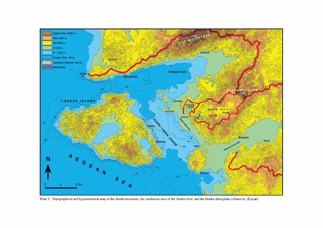
The research area consists of a piedmont, including the Madra delta plain (Pls 2 and 3). The piedmont is about 3–5km wide along the western and southwestern foot slope of Madra mountain, and extends down to the shoreline of the Ayvalık-Lesbos channel. The southeastern part of the plain is higher. Here, old alluvial fans of mountain streams form a piedmont plain about 3km wide, which descends gently to the sea. The northwestern part of the piedmont is lower, and here the Madra river has formed a delta plain. The delta is about 5km wide and is bounded on the north by a low hilly area consisting of Neogene limy sediments (Pls 4–5). Here, the town of Ayvalık is situated on volcanic hills extending out westward to the sea, and is the most important modern settlement in this region and a centre of tourism (with a population of 32,000 in 2000). The modern town of Altınova, another important settlement of this region, is located in the northern part of the Madra delta plain (Altınova had a population of just over 9,000 in 1997). Altınova is also the name given to the delta of the Madra river. The name itself (in Turkish ‘altın’ means ‘gold’, and ‘ova’ means ‘plain’) is suggestive of the richness and value of the land and the brilliant colour of the alluvial soil due to the fine mica flakes that the river brings down from crystalline rocks on the Madra mountain. Agricultural income is relatively high in Altınova. Cotton and various vegetable products predominate (see Chapter 6), crops which require plentiful irrigation, for which purpose only ground water was available until the construction of the Madra dam (completed in 1997). Altınova is also a summer resort town. Holiday homes have been built along many kilometres of the coast both north and south of the natural harbour lying only 2–3km west of the town. Altınova becomes a very crowded and active area in the summer months. Another reason for the development of a town at Altınova is its location on the main İzmir-Çanakkale highway, which follows the footslopes of the Madra mountain. Thus, Altınova has easy connections with Bergama and Dikili to the south, and Ayvalık and Edremit to the north. Other significant modern settlements of the region include Soma and Balıkesir, in the hinterlands of Bergama and Edremit respectively.
1. Kayan & Vardar, Physical geography of the Delta
11
Methodology and approach
Geomorphological changes are generally very rapid in alluvial areas, but especially so in deltas. Deltaic formation and progradation depend not only on alluvium transported by the river forming the delta, but also on geological and geomorphological factors in the area, climate, and marine influences. Wave and current processes and sea-level changes over long periods are the most important factors. Thus, deltaic formation on a coast represents the combined effects of several interacting factors. Accurate interpretation of all the characteristics of a delta is complex but can provide very valuable information on the paleogeography and environmental changes in a region.
Environmental conditions in a deltaic zone can develop and change rapidly in both vertical and horizontal directions. On land, the delta-forming river frequently floods and changes its course on the very gently inclined delta surface. This results in alluvium of varying grain sizes being spread over different areas of the surface. River channels and beds have coarser grain sizes, while wide plain surfaces have fine sandy-silty flood sediments. Swamp environments have muddy sediments, which generally include large amounts of organic colloids in dark colours. Along the coastal zone various sediments in lagoons, coastal dunes, beaches and the foreshore reflect the existence of different sedimentary environments with their different physical, chemical and biological characteristics. In this way new environments develop continuously behind the progressive delta shoreline, laying down vertically stratified sedimentary units with widely differing features. This makes it possible to follow the delta’s development by studying the changing sedimentary units and their contents, provided that adequate material can be obtained. The development of the delta can then be dated using archaeological and radiometric (particularly C14) dating techniques.
The present-day surface of the delta should be analysed first to understand the geomorphological development of this dynamic system. The present surface is formed on the most recent alluvial cover and hides different stages of deltaic development. Core drilling is, therefore, the best method of determining subsurface sedimentological features and their sedimentary environments, in order to follow the geomorphological development of the delta. Correlation of vertical (i.e. borehole) sedimentological profiles taken from different parts of a delta can then provide the basis for preparing three-dimensional paleogeographic reconstructions.
Core drilling is technically different in alluvium than in hard bedrock. Although simple equipment, using an auger rod, can penetrate easily in alluvium, loose sediments are often difficult to retrieve as
complete cores without disturbing the integrity of their sedimentological structures. The depth to which a borehole is drilled is determined by the thickness of the alluvium and/or by the drilling objectives. The thickness of the alluvium may be hundreds of metres deep and it may not be necessary to reach the very bottom in order to examine environmental changes that relate to human history. For this purpose, on coastal plains or deltas, boring down a few metres below present-day sea level may be enough. For example, on a back-shore area 10m high, sufficient data can often be obtained from a drill-hole 15–20m deep. In this approach, it is best to begin by drilling the first borehole as deep as possible to obtain the general stratigraphical sequence of the alluvium and then to examine the recent geomorphological and environmental developments with a series of many more shallow drillings. Although there are various techniques and equipment available for use with this core-drilling method, to strike a gouge corer using percussion equipment is quite practical. This method provides useful data and samples, cheaply and quickly. The gouge corer has a length of 1m and various diameters (36mm, 50mm, and 60mm). Depending on the sediment features and the information required, it is possible to go down each time one metre or less, in various diameters.
Core drilling in the Madra river delta
Core drilling in the MRD was carried out using various techniques, first of all to obtain the general geomorphological development, and then to examine the specific environments of the Yeldeğirmeni and Höyücek mounds in detail (Pl. 3; see also Chapter 3). Reconstruction of their relationship to the shoreline during the time they were first settled was one of the subjects of greatest interest. Additional data obtained by previous boreholes made by teams involved in water exploration were also evaluated. These include boreholes made by the ‘DSİ’ (‘State Water Survey Department’), İB (İller Bankası) and private drillers searching for water. Some of these boreholes reached down to bedrock and were expected to help determine the general stratigraphy of the entire alluvial sediments. However, their purpose was to find water and their techniques were not suitable for study of sediment characteristics.
Erol’s work (1975) was the first academic study of the geomorphological development of the MRD. Erol examined the main geomorphological units: the bottom of the plain; the flood and distributary channels of the Madra river and its tributaries; lagoonal swamps at the mouth of the Madra river; present-day beaches; and sandy bars on the offshore wash zone. He also examined sedimentological profiles obtained from
The Madra River Delta: Regional Studies on the Aegean Coast of Turkey
12
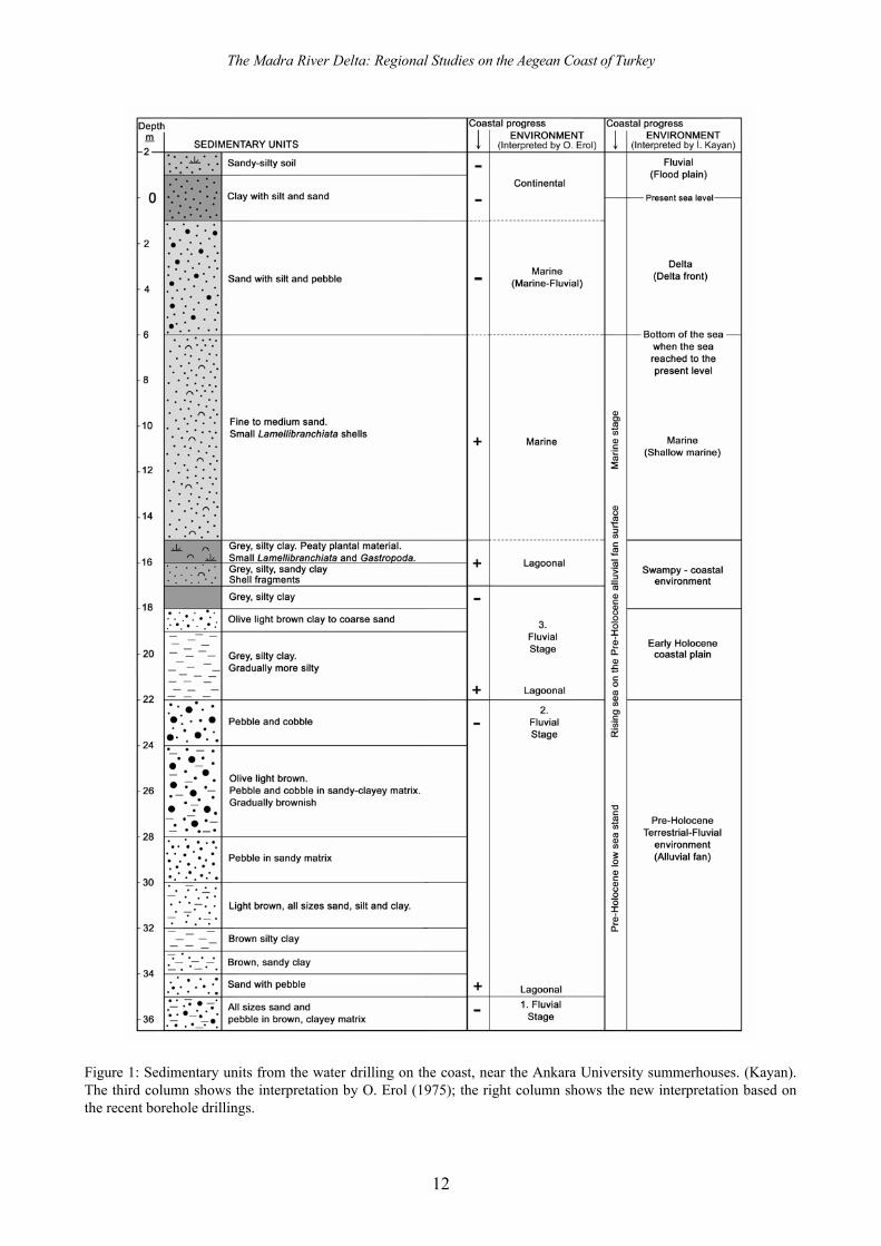
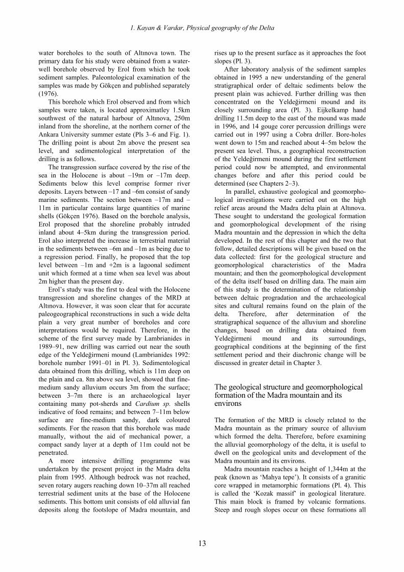
Figure 1: Sedimentary units from the water drilling on the coast, near the Ankara University summerhouses. (Kayan). The third column shows the interpretation by O. Erol (1975); the right column shows the new interpretation based on the recent borehole drillings.
1. Kayan & Vardar, Physical geography of the Delta
13
water boreholes to the south of Altınova town. The primary data for his study were obtained from a water-well borehole observed by Erol from which he took sediment samples. Paleontological examination of the samples was made by Gökçen and published separately (1976).
This borehole which Erol observed and from which samples were taken, is located approximatley 1.5km southwest of the natural harbour of Altınova, 250m inland from the shoreline, at the northern corner of the Ankara University summer estate (Pls 3–6 and Fig. 1). The drilling point is about 2m above the present sea level, and sedimentological interpretation of the drilling is as follows.
The transgression surface covered by the rise of the sea in the Holocene is about –19m or –17m deep. Sediments below this level comprise former river deposits. Layers between –17 and –6m consist of sandy marine sediments. The section between –17m and –11m in particular contains large quantities of marine shells (Gökçen 1976). Based on the borehole analysis, Erol proposed that the shoreline probably intruded inland about 4–5km during the transgression period. Erol also interpreted the increase in terrestrial material in the sediments between –6m and –1m as being due to a regression period. Finally, he proposed that the top level between –1m and +2m is a lagoonal sediment unit which formed at a time when sea level was about 2m higher than the present day.
Erol’s study was the first to deal with the Holocene transgression and shoreline changes of the MRD at Altınova. However, it was soon clear that for accurate paleogeographical reconstructions in such a wide delta plain a very great number of boreholes and core interpretations would be required. Therefore, in the scheme of the first survey made by Lambrianides in 1989–91, new drilling was carried out near the south edge of the Yeldeğirmeni mound (Lambrianides 1992: borehole number 1991–01 in Pl. 3). Sedimentological data obtained from this drilling, which is 11m deep on the plain and ca. 8m above sea level, showed that fine-medium sandy alluvium occurs 3m from the surface; between 3–7m there is an archaeological layer containing many pot-sherds and Cardium sp. shells indicative of food remains; and between 7–11m below surface are fine-medium sandy, dark coloured sediments. For the reason that this borehole was made manually, without the aid of mechanical power, a compact sandy layer at a depth of 11m could not be penetrated.
A more intensive drilling programme was undertaken by the present project in the Madra delta plain from 1995. Although bedrock was not reached, seven rotary augers reaching down 10–37m all reached terrestrial sediment units at the base of the Holocene sediments. This bottom unit consists of old alluvial fan deposits along the footslope of Madra mountain, and
rises up to the present surface as it approaches the foot slopes (Pl. 3).
After laboratory analysis of the sediment samples obtained in 1995 a new understanding of the general stratigraphical order of deltaic sediments below the present plain was achieved. Further drilling was then concentrated on the Yeldeğirmeni mound and its closely surrounding area (Pl. 3). Eijkelkamp hand drilling 11.5m deep to the east of the mound was made in 1996, and 14 gouge corer percussion drillings were carried out in 1997 using a Cobra driller. Bore-holes went down to 15m and reached about 4–5m below the present sea level. Thus, a geographical reconstruction of the Yeldeğirmeni mound during the first settlement period could now be attempted, and environmental changes before and after this period could be determined (see Chapters 2–3).
In parallel, exhaustive geological and geomorpho-logical investigations were carried out on the high relief areas around the Madra delta plain at Altınova. These sought to understand the geological formation and geomorphological development of the rising Madra mountain and the depression in which the delta developed. In the rest of this chapter and the two that follow, detailed descriptions will be given based on the data collected: first for the geological structure and geomorphological characteristics of the Madra mountain; and then the geomorphological development of the delta itself based on drilling data. The main aim of this study is the determination of the relationship between deltaic progradation and the archaeological sites and cultural remains found on the plain of the delta. Therefore, after determination of the stratigraphical sequence of the alluvium and shoreline changes, based on drilling data obtained from Yeldeğirmeni mound and its surroundings, geographical conditions at the beginning of the first settlement period and their diachronic change will be discussed in greater detail in Chapter 3.
The geological structure and geomorphological formation of the Madra mountain and its environs
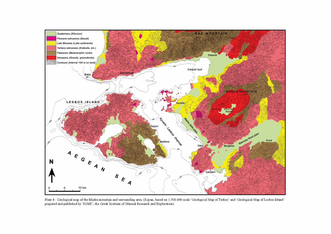
The formation of the MRD is closely related to the Madra mountain as the primary source of alluvium which formed the delta. Therefore, before examining the alluvial geomorphology of the delta, it is useful to dwell on the geological units and development of the Madra mountain and its environs.
Madra mountain reaches a height of 1,344m at the peak (known as ‘Mahya tepe’). It consists of a granitic core wrapped in metamorphic formations (Pl. 4). This is called the ‘Kozak massif’ in geological literature. This main block is framed by volcanic formations. Steep and rough slopes occur on these formations all
The Madra River Delta: Regional Studies on the Aegean Coast of Turkey
14
round the mountain. They generally consist of andesite, with agglomerate and basalt in places. On their outer belt, there are lacustrine and terrestrial sediment units in Neogene basins along the edges of faulted depressions (grabens) which cut Madra mountain. These contain a mixture of volcanic formations in many places. Finally, the bottom of the depressions encircling Madra mountain are covered by alluvial sediments, just as in the lowest parts of the depressions inundated by sea water in Edremit bay to the northwest, and in the Ayvalık-Lesbos channel.
As any geological map shows, Madra mountain has a faulted dome structure. A rather wide area of the Kozak plateau is covered by alluvium on the higher part of the mountain, and completes this picture of dome morphology. The main faults which form the Madra mountain extend northeast-southwest. The southwestern slope of the mountain lies on one of the northwest-southeast regional fault zones. The Tertiary volcanic formations which encircle the crystalline core of the mountain (granite and its metamorphic cover) reach the surface from these faults (Pl. 4).
The oldest known geological work relating to the Madra mountain is found in the research and maps made by Phillipson during his distinguished studies in Western Anatolia and published between 1910–15. During the Republican period of Turkey, the search for mineral sources intensified in the region, especially detailed geological research for iron ore as this area was reputed to be rich in such minerals.
The geology of Anatolia was interpreted anew in the light of the new theories of Plate Tectonics in the 1960s (Sengor, Dewey 1979; Sengor 1980). As a result, major structural units and their dynamic interrelations were taken now into account. Also in this period, different interpretations appeared concerning the chronology of formation and the stratigraphic sequence of the geological units of Madra mountain and its surroundings. Stratigraphic and tectonic units of Madra mountain and its surroundings will be examined in greater detail below (Pl. 4).
Kozak Massif The central, higher part of Madra mountain consists of a granitic (grano-diorite) intrusive core which is covered by crystalline (metamorphic) formations. This massif is one of the main structural elements of the geology of Western Anatolia. The crystalline rocks of the metamorphic formations which cover the intrusive core originate from old sedimentary formations and extend in a zone running northeast-southwest in this region. İzdar (1968) states that this formation creates an anticline structure extending northeast of Madra mountain. Different layers are distinguished in the internal structure of this unit. Fillits in green-schist facies dominate at the bottom. Their tightly-folded structure and mixture of volcanic minerals in places
indicate strong tectonic deformations while they were forming. Sandy-clayey schists overlay this base and encircle the Kozak intrusive massif from the northeast in a horseshoe shape. This is a complex stratigraphical unit including marble bands in some places indicating thermal metamorphism during the intrusion of the core. Finally, the uppermost unit consists of more carbonacaeous sediments occurring to the southeast of the massif. Based on Permo-Carboniferous fossils, İzdar (1968: 145) concludes that the age of the unit encircling the intrusive massif is completely Paleozoic.
The intrusive core of the Kozak massif is seen in an area 20km x 30km with a northeast-southwest long axis. Rocks here generally consist of light-coloured granodiorite and, according to changes of mineral composition, darker greenish colours are dominant towards the outer edges. Hornblend, biotit and feldspar crystals can be distinguished macroscopically in a coarse, grained structure.
The granodiorite of the Kozak massif has been dated by Bürküt (1966) using radio-isotopic techniques. He found the age of the intrusive massif to be 80 million years. İzdar (1968), who made detailed research and geological mapping in this area, argues that, based on a regional approach, its age must be older. According to İzdar, granodioritic intrusion occurred by cutting sedimentary units in the Paleozoic age and the units were turned into crystalline rocks by metamorphism. On the other hand, Akyürek and Soysal (1983) believe that there was a shallow sea in the region during the Mesozoic and that intrusion of the granodiorite occurred between the Upper Cretaceous and the Eocene.
Volcanic Formations Extrusive volcanic structures cover wide areas in Western Anatolia. The high relief between the İzmir and Biga peninsulas is formed almost entirely on such formations. Most of the island of Lesbos also consists of volcanic rocks. Although they are lithologically different, calc-alcaline andesitic rocks are prevalent. In addition, dasite, riyolite, agglomera, tuff and ignimbrite are found widely (Pl. 4).
The northeast-southwest oriented Kozak massif is completely encircled by volcanic rocks. Andesites are more common here too. However, there are also traki-andesite, dasite, and riodasite types of lavas, and agglomera and tuff in places. Rough slope morphology surrounding the Kozak massif completely dominates these formations. Andesites are generally pink in colour and contain various types of plagioclase, less hornblende and biotite minerals in a fine grained matrix. Riodasite and dasite are in dyke structures found both to the north and south of the massif, oriented northeast-southwest (İzdar 1968: 154). Apart from these, basalts are seen to the west in limited areas.
1. Kayan & Vardar, Physical geography of the Delta
15
They are dark coloured rocks, rich in augite and olivine minerals.
The occurrence of various acidic and basic volcanic rocks together in the region indicates that they formed during different eruptions at different times and their sources are not connected with each other. Their stratigraphical relations with lacustrine Miocene beds to the east of Ayvalık, and basalts overlying andesites, are evidence of their occurrence at different times. K/Ar dates of ca. 40–20 million years ago were obtained (Borsi et al. 1972) indicating that the age of calc-alkaline volcanism in this region dates to the Oligocene-Early Miocene.
On the other hand, ignimbrites seen in the Ayvacık area to the north and on Lesbos to the west came from a caldera which today is at the bottom of the sea west of Edremit bay (Öngür 1978; Ercan 1982). Dates from the samples suggest that the formation is about 17 million years old (Borsi et al. 1972). Thus, andesitic volcanism in the Early Miocene, which depended on compressional tectonism, later changed into tensional processes represented by ignimbrite, tuff, agglomera and basalt (Öngür 1973; Ercan et al. 1995; Savaşçın, Güleç 1990).
It is believed that basaltic extrusions and some tuff and ignimbrits seen locally in the region are much younger. Most of them are found along a tectonic zone between Behramkale and Çandarlı. Ercan et al. (1995) found their age to lie between 12 and 8 million years ago in Ayvalık and Çandarlı. Based on local basaltic extrusions that cut other volcanic formations, Akyürek and Soysal (1983) state that local basaltic extrusions in the same zone, north of Salihler village to the southeast of Altınova (Pl. 3), are younger than the Pliocene.
The main density of Quaternary volcanic activity in the region is found in the Aegean Sea. Tuff, ignimbrite, basalt and slags came about by island arc volcanic activity here (Savaşçın, Güleç 1990). The youngest and most typical example of this type of volcanism is the Minoan eruption on the island of Santorini. Here, many explosions occurred repeatedly, with the explosions in the period 3,300–1,400 years ago being very well-known. Their ashes and tuffs spread over a very wide area and are encountered in sediments of coastal, lacustrine and swampy environments of Western Anatolia (Friedrich 1978; Sullivan 1988).
The Neogene basins and sedimentation In the Neogene, following a general rise of the earth’s crust in the region, while mountainous blocks were being formed, depressions and basins developed between them. This development continued together with intense volcanic activity along the fault zones that separate the mountain blocks. Thus, while Madra mountain to the east, Kaz mountain to the north, Lesbos island to the west were all rising as major structural blocks, in-between them formed Neogene
depressions like those of the Edremit and Bakırçay basins to the north and south respectively, and the Ayvalık-Lesbos channel to the west. The deepest parts of these depressions were covered by lakes during the Miocene. Great quantities of sediments transported by rivers from the mountain blocks were brought down to the lake depressions and deposited in wide swampy areas along the edges of the lakes and clayey-limy sediments accumulated in the deeper central parts. In addition, mixtures indicating volcanic activity are found in all these lake deposits. This indicates that tectonic movements and related volcanic activity continued throughout the Miocene period.
The distribution of Neogene sediments in the depressions surrounding Madra mountain indicates that they do not cover very extensive areas (Pl. 4). They form low hilly areas on volcanic rocks along the edges of the Edremit and Bakırçay basins. The reason for this distribution is the post-Miocene tectonic drop at the bottom of the depressions and much of the Miocene sediments being under seawater today. In addition, they are covered by alluvium along the coastal zone.
Remains of the Miocene sediments are found along the edges of the Ayvalık-Lesbos channel only in very limited areas. Along the coast of Lesbos the Miocene beds, dipping towards the east, are found only in a small area on the southeast of the island (Pe-Piper 1977). Along the Anatolian coast, small hills consisting of Miocene sediments rise on the alluvial plain along the southwest foot of Madra mountain (Pl. 5). This indicates the existence of Miocene sediments under the alluvium. The widest part of the Miocene sediments in this area is seen to the north of the Madra delta, between Altınova and Ayvalık.
The Miocene lake sediments surrounding Madra mountain exhibit a transgressive sequence. Sediments start with conglomerate at the bottom and along the edges, continue upwards with sandy, silty and clayey sediments, and come to an end at the top with limy sediments (marl and limestone). The limy upper section is most widespread to the west of Madra mountain. The presence of granodiorite pebbles in the conglomerate along the footslopes indicates that the core of Madra mountain was opened by tectonic uplift and severe erosion since the Miocene. Green sandstones along the western foot slope of Madra mountain contain abundant plant and gastropod fossils typical of swampy environments. Fossils representing a generally deeper lake environment are found in the limy upper sections that cover wide areas to the east of Ayvalık. In contrast, no marine fossils were encountered.
Basal conglomerates occur in higher positions along the foot slopes of the mountain. Deformations on the limy layers in the middle parts are the first evidence that the Miocene sediments were subjected to a great amount of tectonic pressure. Beds generally dip to the
The Madra River Delta: Regional Studies on the Aegean Coast of Turkey
16
west on the foot slopes of Madra mountain, while on Lesbos the beds dip eastward, indicating that tectonic deformations continued after the Miocene and the basin of the Ayvalık-Lesbos channel deepened gradually. In addition, volcanic mixtures in the sediments show that tectonic activity continued concurrently with volcanic activity. Thus, the tectonic rising and falling which caused the formation of the Neogene basins continued in the same way during the deposition of sediments in the basins, as well as in succeeding periods, but at decreasing rates and effects.
Geophysical investigations along the southwest foot slopes of Madra mountain (Üzel 1978), plus data obtained from deep water drillings, show that the Miocene bedrock surface is very rough below the Madra delta plain and its extension to the southeast. The thickness of alluvial cover varies between 20m and 120m. However, available data is insufficient to explain how the surface formed below the alluvial cover. Regular valley forms cannot be recognized on the surface. In contrast, deep and closed depressions imply karstic processes. However, limy Miocene bedrock in this area is not suitable for karstification, and typical karstic features are not seen today on the surface of this formation which covers wide areas north of Altınova. Therefore, the reason for the irregular relief of the Miocene bedrock covered by alluvium along the southwest foot slope of the Madra mountain must have been due to tectonic movements and deformations which continued after the Miocene.
Post-Miocene Sedimentation Viewed on a regional scale, it is evident that the Neogene basins were the subject of considerable change at the end of the Miocene. The lakes occupying the bottoms of the basins dried up and torrential water from the rising mountain blocks in the neighbourhood of the basins formed great fans along the foot slopes of the mountains. Large stone chunks found in the fan deposits indicate powerful torrential flow regimes and a reddish, clayey type of soil matrix implies hot and semi-arid climatic conditions at that time. These changes are related to regional paleogeographic processes.
As stated above, the Miocene lake sediments consist of limestone to the north of the MRD. After sedimentation, landscape development has continued here to the present day due both to tectonic deformations and to river erosion.
In contrast, alluvial fans with post-Miocene torrential deposits formed a wide piedmont plain to the south of the delta. This surface extends between the foot slope of the mountain and the shoreline with only a slight gradient, and is today being eroded by streams descending from Madra mountain. A piedmont morphology can also be distinguished along the side slope of this surface which developed on bedrock. Its
lower edge is the subject of ongoing coastal erosion (Pl. 5).
The MRD formed to the north of the piedmont described above and consists of torrential deposits. However, drilling data shows that the torrential deposits and their piedmont surface extend to the north beneath the alluvium of the delta itself. Therefore, alluvial formations shown on the geological maps along the southwest foot slope of Madra mountain must be separated into two units as older torrential deposits and younger deltaic sediments (Pl. 5). These will be examined below since their formation is directly related to the geomorphological development of the region.
Geological and geomorphological development of Madra mountain and the surrounding area
In the light of the latest knowledge on structural geology, interpretations concerning the paleogeography of Anatolia will now be considered in two inter-related sections. The first is structural geology, and the second is the development of the present landforms on the surface of this structure. These two processes are different and relate, respectively, to the Paleotectonic and Neotectonic concepts in geological literature.
The structure of Anatolia was formed in the Paleotectonic period and covers older geological stages before the Neogene. Formation of the present landscape, on the other hand, has occurred since the end of the Miocene, in the Pliocene and Quaternary, covering the last 5 million years. The geological-geomorphological development of Madra mountain and its surroundings can be summarised as follows according to the outlines given in the previous section.
In the older geological periods, during the Palaeozoic and Early Mesozoic, the region including Madra mountain was covered by a wide ocean extending between the Menderes massif in the southeast and the Trakya massif in the northwest above Troy (Pl. 1). This represented a geosyncline, an extension of the Tethian Ocean in the south. Sediments deposited in this geosyncline compressed, folded and turned into land between convergent continents towards the end of Mesozoic. The Madra mountain formed on an anticline that occured in this period, and a granodioritic magma intrusion settled in a part of the anticline to form a dome structure. Intrusive magma solidified deep in adjacent old ocean sediments and metamorphosed into crystalline rocks. Sediments that belong to the long geological periods that followed (the Early Tertiary or Paleogene) are not found in the area of Madra mountain. This is evidence of continuous rising and erosion of the mountain material. However, new magma came up to the surface as a result of
1. Kayan & Vardar, Physical geography of the Delta
17
intensive volcanic activity in this period and formed wide volcanic areas wrapping the Madra mountain block. This volcanic wrapping consists generally of andesitic rocks, which are not found on the higher parts of the mountain, indicating that Madra mountain had already formed as a high block by the period of volcanic activity (Pl. 4).
Then, in the Neogene, the Neotectonic period in the development of geological structure in Anatolia began (Şengör 1980). The compressional tectonic processes of the Paleotectonic period changed into rising and extensional processes in Western Anatolia. Morpho-structural development continued with the break-up of the earth due to the general uplifting of its crust, and the formation of the rising and falling blocks under different morpho-dynamic effects. This change affected the whole of Anatolia and is part of an event which occurred over great distances. The Arabian plate moved northward faster than the African plate, reaching southeast Anatolia in the Miocene and causing eastern Anatolia to rise through compression. Continuing compression then affected the whole of Anatolia, causing it to rise. The greater southern block was cut by the North Anatolian Fault Zone and started to drift westward.
There is a convergence zone in the south Aegean Sea between the northern plates and the African plate. This is a zone of subduction into which the Aegean plate is pulled down and consumed. As a result, Western Anatolia formed between two different processes in the Neotectonic period. On the one hand it was rising due to compressional forces from the westward drift of the Anatolian plate, on the other hand it was being pulled southward and broke up to form block structures. The formation of Western Anatolia in the Neotectonic period came about under these geodynamic processes.
The initial break-up of the blocks occurred in a northeast-southwest direction in concordance with previous structural lines. However, northwest-southeast fault-lines can also seen on the broken structure. Fault zones between rising blocks developed as depressions and became new basins of sedimentation. Thus, an additional new development of the Neotectonic period was the formation of the Neogene sedimentation basins. These basins were filled by fresh water to form lakes in the Miocene of Western Anatolia, including the areas surrounding Madra mountain. The Aegean Sea did not yet exist during this period.
Rising mountain blocks in the Neogene with basins between them created the outlines of present-day geomorphology. The mountains of today formed through erosion of the blocks since the Neogene, while the present-day plains formed through the deposition of new sediments, chiefly alluvium, in depressions or deeper parts of the Neogene basins. This general model is exactly the same in the areas surrounding Madra
mountain: Kaz mountain in the north, Samos island in the west and Madra mountain in the east all began as rising blocks. Between them, the gulf of Edremit to the north, the Bakırçay basin in the south, and the Ayvalık-Lesbos channel in the centre all developed as depression areas (Pls 2 and 4). The existence of Miocene lake sediments in all of these depressions indicates that they all formed through the same processes and in the same period. The lake sediments lie over widespread volcanic formations in the region. However, volcanic mixtures and some volcanic extrusions cut the lake sediments and cover them, providing evidence that volcanic activity continued in the Miocene and following periods. This is also confirmed by datings carried out on volcanic rocks of the region.
Stratification of the lake sediments in the areas surrounding Madra mountain starts with conglomerates at the bottom, continues with gradually finer grained sediments, and ends with limestone beds at the top. This indicates a steady deepening of the basins with related sedimentation during the Miocene. However, a great paleogeographic change occurred after the accumulation of the upper limy sediments in the region. It is evident that the lake basins dried up suddenly, sedimentation areas (lake bottoms) rose through deformation and broke up as blocks. This process resembles previous movements that had formed mountain blocks. Thus, rising sediment blocks in the Miocene now formed erosional areas in the basins, and falling blocks in between became deposition areas for terrestrial sediments on the former lake sediments. The Miocene beds to the north of Altınova formed rising blocks, while the foot slopes of Madra mountain to the south fell and were covered by terrestrial deposits. As for the Ayvalık-Lesbos channel, this is a ‘basin in a basin’ or a ‘graben’, which had deepened in the course of time and was filled with seawater.
Falling parts of the Miocene lake sediments were first covered with torrential deposits containing large rock boulders. Old alluvial fans along the southwest foot slope of Madra mountain, between the Madra delta and Dikili, are typical examples of this formation. Here, the Miocene lake sediments were reached at the lowest depths by boreholes drilled for water. Most of the coarse pebbles and large rocks in the torrential deposits belong to andesites which encircle the Madra mountain. They are well rounded, which cannot be explained by the distance they have been transported. The matrix in which this coarser materials lie consists of reddish brown, clayey-sandy soil. These characteristics indicate that climate also changed in this period and became arid to semi-arid.
This period of change at the end of the Miocene is known as the Messinian in geology and has great importance for the paleogeography of Anatolia. The
The Madra River Delta: Regional Studies on the Aegean Coast of Turkey
18
arrival of the Arabic plate put pressure on Anatolia from the southeast and caused some very important effects not only geomorphologically but also climatologically. During the Early Miocene, the Mediterranean Sea was connected to the Indian Ocean via Syria–northern Iraq and Anatolia was not as high as today (Fairbridge et al. 1997). Thus, a very rainy, hot monsoonal type of climate prevailed over Anatolia. In such conditions, the disaggregation of rocks was rapid, the leaching of soil and laterization also very strong. As relief was neither high nor rough at that time, erosion and transportation of the disaggregated surface cover were slow and regular. In summary, depressions formed in the Miocene and were covered by lakes fed by rivers with plenty of water. There were also processes of disaggregation/erosion/transportation/sedimentation, all of which continued in an orderly and balanced manner.
In contrast, at the end of the Miocene (the Messinian period referred to above, a geological stage about 6–5 million years ago) the Arabic plate arrived and pushed Anatolia from the southeast causing it to rise. This also produced changes in the area of Syria-northern Iraq, from a formerly hot sea to new hot and dry land. Thus, Anatolia also acquired a drier climate in which the former regular rainy conditions were replaced by torrential waters typical of arid climates. These torrents began to disaggregate the land surfaces over which they flowed. In addition, the faster tectonic rise increased relief energy and the power of torrents in this period. As a result, the disaggregated cover of the surface which had formed at a lower relief under formerly humid climatological conditions, started to sweep and wash rapidly, and was transported by torrents down the foot slopes of mountains to form great alluvial fans.
Along the southwest foot slope of Madra mountain, well-rounded large andesite blocks and pebbles are found in a reddish lateritic matrix. This matrix must have originated from disaggregated surface cover of the former periods (the Middle Miocene). Similar torrential deposits originating from former surface cover and accumulated along the foot slope of mountains under changing paleogeographic conditions can been seen in the surrounding areas of many mountains in Western Anatolia. The most well known example of this is the ‘Bozdağ’ or Boz mountain formation (also known as the ‘Tmolosschutt’) to the east of İzmir.
Low inclined surfaces of these footslope deposits can be seen widely in the region. They are generally found extending towards steep mountain slopes as eroded rock surfaces resembling pediments and intruding into the valleys. They are additional evidence of semi-arid climatological conditions during their formation. The piedmont surface along the southwest foot slope of Madra mountain, especially to the south and southeast of Salihler village, also continues on
volcanic bedrock as a wide pediment surface (Pl. 5). Here, the altitude of the pediment surface is between 80m and 120m. This surface extends down to the shoreline with an inclination of ca. 3% and a maximum width of ca. 3–4km. The present-day surface is cut by streams. Small hills rise from the surface consisting of Miocene sediments, and drilling evidence shows that there are Miocene lake sediments at the bottom, below the piedmont deposits.
It is difficult to find suitable dating material such as vertebrate fossils in terrestrial sediments. Therefore it is not easy to date the absolute age of torrential deposits overlying the Miocene lake sediments. However, following the very distinct geographical changes in the Messinian, formation of the torrential deposits as great alluvial fans on the foot slopes of mountains coincides with the Pliocene period of the Neogene and their stratigraphical and geomorphological characteristics. In geological maps, young, unconsolidated terrestrial deposits are usually generalized as a single unit of ‘alluvium’, but changes that have occurred in recent geological stages must be distinguished in order to understand the geomorphological development and formation of the present environment. For this purpose, it is necessary to classify sediment units according to their original environments and to describe the paleogeographic characteristics of their sedimentation areas.
Alluvial fans forming piedmont plains are dynamic landforms. Their surfaces have been worked continuously since the beginning of their formation. Streams coming from mountains have roughened their surface, cutting deep flow channels or depositing new torrential sediments from place to place. Finer elements, washed down by slow rainwater along gently inclined surfaces on the fans, have formed less inclined, smooth surfaces along the foot of the fans. During this development, different stages of the process and certain changes in morphology must be taken into account according to the climate and sea level changes. In the present-day morphology of the MRD, one passes from the alluvial fans onto the plain of the delta in the north via a very gently inclined, smooth surface along the foot of the fans. Further to the southwest the foot of the piedmont has been worked by waves and coastal processes which formed erosional land-forms along the edge of a low, gently inclined piedmont surface.
There are two great alluvial fan formations at the southeast edge of the Madra delta as parts of the piedmont plain. One starts with a rock-cut erosional surface (a pediment) to the south of Salihler village and extends to the coast. Also in this area are some small hills consisting of Miocene lake sediments (Aktepe and Mercanın tepe). The other fan, at the village of Bahçeliköy to the north, is smaller and bordered by the Madra delta plain on the west (Pl. 5). In contrast, there
1. Kayan & Vardar, Physical geography of the Delta
19
is neither a pediment nor evidence of an old alluvial fan at the foot of the mountain to the north of Bahçeliköy.
Alluvial deposits put down by the Madra river extend up to bedrock where the river reaches the plain, and along the foot slope to the north and south of this area (Pl. 5). This interesting feature implies that the area of the Madra delta is part of the piedmont that down-faulted due to recent tectonic movements. The existence of some old alluvial fan deposits below the delta sediments found by drilling, together with the remains of coarse gravelly fluvial (river or torrent) deposits on small shoulders of the steep slopes in the area where the river Madra reaches the delta plain, provide additional support for this interpretation. Thus, the surface of the Miocene lake sediments on the western foot slope of Madra mountain, which had become rougher during the paleogeographic changes in the Messinian, was covered by terrestrial deposits at the foot of the slopes in the Pliocene. Some deformations then occurred on this depositional surface due to new tectonic movements. During this last period, the southern part of the Miocene platform rose together with Madra mountain, creating a new area of depression between Ayvalık and Altınova in which rivers, primarily the Madra, flowed to form the present delta plain.
Following this introduction on structural outlines and the base of the Madra delta, it is useful to examine briefly the hydro-geomorphological characteristics of the basin from where the river Madra obtains its water, and the effects of climate and vegetation on the flow and regime of the river.
Hydro-geomorphological characteristics of the Madra river basin
The major constructor of the geomorphological formation observable today as the MRD flood plain is the Madra river itself, although the Karakoç river has also contributed alluvium to the development of the northern part of the delta. The Madra river has nearly 400km2 of catchment area and its sources originate from waters in the higher parts of Madra mountain. The Madra river basin narrows as it descends to the west, reaching the delta plain by passing through a steep, deep, gorge-like valley. The Madra basin thus consists of three parts each with different geomorphological characteristics (see Pl. 2):
- the upper basin (the higher part); - the section descending from Madra mountain (the
middle part); and - the delta-flood plain (the lower part).
Precipitation, infiltration and flow characteristics in each of these parts differ in accordance with the
prevailing geomorphological characteristics. Thus, they can be considered as hydro-geomorphological divisions.
The Upper basin Madra mountain has an intramontaine depression at the centre related to its dome structure (Pls 2–4). This depression is a wider part of the Madra river basin and is about 500m high at its base and is named the ‘Kozak basin’, ‘Kozak Yayla (pasture)’, or ‘Kozak plateau’ in terms of its morphology. The peak of Madra mountain is 1,344m high northeast of the Kozak basin. From here mountain ridges ca. 700–800m high extend north and south of the basin and join the Çıralıdag mountain (778m high) to the west. Thus, the Kozak depression is a true intramontaine basin. The river Madra comes into existence by collecting mountain streams in a centripetal mode in the bottom of the basin and leaves the basin through a gorge to the south of Çıralıdag mountain. The Kozak depression is thus the upper basin of the Madra river.
The Kozak depression and the encircling ridges are formed on the granodioritic core of Madra mountain (Pl. 4). The valleys have ‘V’-shaped profiles and steep slopes. Although peaks on the ridges are steep, a low undulating morphology is observable between them, especially on the metamorphic schists in the vicinity of Kozak town. The sandy alluvium produced by the disaggregation of granodiorites cannot be transported out of the basin completely because of the narrow gorge south of Çıralıdag mountain (Pl. 2) and thus part of the sandy alluvium has been deposited on the bottom of the basin to form a small plain about 7km x 2km in size. The thickness of the deposit on the bottom is not more than 10m (Üzel 1978).
The section descending from Madra mountain The western slopes of Madra mountain are formed of volcanic rocks that surround the metamorphic layer of the granodiorit core. They consist mostly of andesite, agglomera in some places, and basalts in a dome structure on the lower parts of the slopes. The Madra river leaves its mountain basin by passing through the Çıralıdag gorge, then flows down a steep and narrow valley with volcanic formations (Pls 2 and 4). The alignment of the valley follows its structural lines: these lead first towards the northwest, then west, and finally southwest. On steep slopes, some landform features are shaped by their lithological differences, for example scarps are formed between agglomera and andesite because of their different durability to erosion. Valley slopes are very rough, especially on agglomera, because erosion takes place more easily on such formations. The floor on the lower part of the valley runs northeast-southwest before the river reaches the plain, but this is not fully developed back into bottom of the valleys of tributaries. The length of the
The Madra River Delta: Regional Studies on the Aegean Coast of Turkey
20
tributaries tends to be very short and they generally consist of torrential stream channels cutting steep valley slopes. These are deeper on parallel structure lines extending northwest-southeast and the main river curves when it reaches these lines. This young morphology is a result of the rapid rise of the Madra mountain block between major fault zones and later tectonic activity along the western slopes in northwest-southeast directions.
Delta-flood plain The Madra river flows through an alluvial delta-flood plain with the same northeast-southwest direction of flow as in the lower part of its descent from the mountain, and reaches the sea through a flood channel about 7km long (Pl. 5). As a river coming from high relief, it leaves coarser material on the foot slope where it opens into the plain. Here, altitude is about 25m, and the slope inclination is about 0.1% in the first 1km where the river course descends until 15m altitude. From this point, it reaches the sea with a gradually decreasing slope inclination averaging 0.04%. However, no alluvial fan formation is observed where the river reaches the plain. Here the surface of the plain intrudes into the mountain as a narrow valley floor of ca. 3km showing alluvial ‘drowning’. The river flows in a wide graded bed on the higher part of the plain. Below the 10m contour, the river-bed becomes
narrower and more stable toward the coast. Therefore, although it is not clear in the morphology, it is possible to divide the plain into two different parts according to morpho-dynamic characteristics, when considering the flow modality of the Madra river. The river spreads its coarser sandy load on the upper part of the plain above 10m. In the lower part the bed becomes narrower, since here it can transport only finer loads. Clearly, therefore, only the finer sedimentary material reaches to the coast to form a small deltaic projection (Pl. 5).
As mentioned above, the northern part of the Madra delta has been filled by alluvium brought by the Karakoç river from the north. The Karakoç drains a small basin which developed outside the ridges encircling the Kozak basin in the north, and it has advanced from the west (Pl. 2). It takes its upper tributaries from the volcanic frame of the mountain and opens onto the plain by passing through a gorge, like the Madra river. The northern tributaries in the lower part of the Karakoç have settled on the Miocene lake sediments east of Ayvalık. However, these tributaries are small streams on a low hilly area, and cannot contribute much to the flow of the Karakoç. In addition, sediment load is little from this part because lithology generally consists of limy rocks. Water and sediment volumes of small streams that come from the Miocene hilly area directly to the Madra delta also contribute very little. The lower altitude and the slow rate of deltaic aggradation on the northern part of the delta must have been due to the low volume of sediment reaching this part as well as due to tectonic subsidence.
As already mentioned, the delta-flood plain of the Madra river is bounded on the southeast by a piedmont plain formed by old alluvial fans (Pls 2, 4–5). Between the plain and the alluvial fans, finer sediments have been washed down from the surface of the fans by slow rains forming a slightly inclined, smooth transition surface. It can be seen clearly on aerial photographs that the transition surface does not cover a wide area and fan deposits do not pass west of Dombay river which runs from Bahçeliköy village southward along the foot of the alluvial fans (Pl. 5).
The Madra is one of the major rivers of the Aegean coastal region of Anatolia which collects and carries surface waters from a single mountain block to the sea, thus constructing a wide delta floodplain. It is, therefore, different from other major rivers in the region that have settled in grabens or faults. The steep and rough slopes of Madra mountain rise sharply just behind the coastal zone and provide convenient conditions for abundant rain from northwesterly and southwesterly air masses. The Kozak basin, moreover, is a natural reservoir for collecting rain water and for regulating its flow on the higher, most rainy part of the mountain. A great deal of sediment occurs from decomposition of the granodiorites in the central part
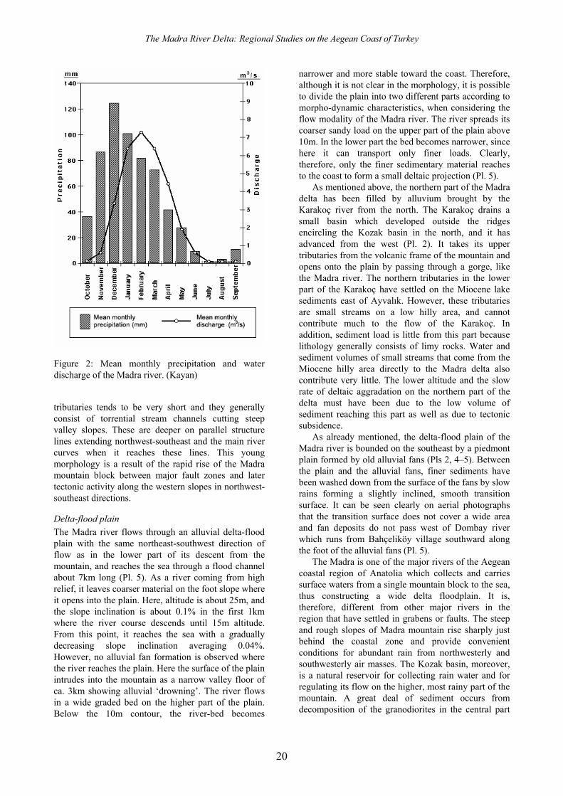
Figure 2: Mean monthly precipitation and water discharge of the Madra river. (Kayan)
1. Kayan & Vardar, Physical geography of the Delta
21
of the mountain, and from easily erodable agglomerates on the steep and rough western slopes. All of these are sources of alluvium for constructing the Madra delta floodplain.
The balance between erosion, transportation, and sedimentation in a river basin and morpho-dynamic development of resultant landforms all depend on a river’s flow characteristics and consequently on the nature of the rainfall (fig. 2). Madra mountain is in the Mediterranean climate zone, and the amount and regime of the rain is in concordance with the characteristics of this climate. Thus, the most important characteristics of the rain are its intensity in one half of the year, in winter, and the great variability both between years and even within a single rainy season. There is no meteorological station on the mountain to make the necessary measurements of precipitation and flow interpretations. However, in the lower area, average annual precipitation is measured at ca. 700mm in Ayvalık, Altınova and Dikili. In Altınova, annual precipitation varied between 665mm and 229mm in the period 1964–95. In December, the most rainy month, 320mm and 0.4mm precipitations were measured in different years. On the other hand, 110mm of rain have been measured in just one day. The result is that small streams have intermittent torrential flow regimes totally dependent on rainfall. There is very little water even in the main channel of the river Madra in summer months, and little water coming from small rock and fault springs in the middle part of its path contribute to the flow. On the plain, the riverbed is generally dry in many places because of excessive pumping of water from the ground for agricultural irrigation.
In recent years, a dam has been constructed on the deep middle part of the Madra valley and began to operate in 1997 (Pls 2, 5). According to the flow data collected for the dam’s construction, the flow regime of the Madra can be described as a ‘rain dependent simple type’. Thus, following the first rainfalls in September-October, the flow of the Madra river reaches about 3m3/s in December. In the winter period, the average flow is about 5m3/s and it decreases to 3m3/s after April again, drying up in summer. The greatest flow ever measured is 33m3/s, clearly at a time of floods.
The load the river can carry increases with its rate of flow. The transported solid load carried by the river has been measured as 19kg/s in January–February. Maximum rainfall during the period when measurements were being taken was on 4 February, 1998, when 111mm was recorded in Altınova. In this flood event, the statistics calculated were 33m3/s for water-flow and 30kg/s for load transported. During
such flood times, water spreading on the surface of the plain creates new flow channels apart from the main one and causes erosion on the upper part, spreading new alluvium on the surface of the lower areas. This is all part of the normal and standard processes of formation of flood plains.
The above data indicate that the average values for water-flow and related sediment load of the river Madra are not high. To make more significant conclusions concerning the formation of the delta-floodplain we would need to obtain maximum values for water-flow. Unfortunately, water-flow records on the plain of the delta do not reflect maximum rainfall because rainfall is much higher on the mountain, where no records have been kept for comparison.
The Madra dam was constructed to control flooding and irrigate the plain. It was hoped this would prevent excessive pumping of ground water on the plain by farmers and the related problems of soil degradation. However, from 1997, the dam has only fed water to the plain, thus destroying the natural balance of the morpho-dynamic system, especially on the coast. According to a research report of Dokuz Eylül University Institute of Marine Sciences (‘DEÜ DBE’), 3.2 million m3 of sediments at the mouth of the Madra River are being eroded annually. As a result, the Madra dam can be stated to have caused an increase of coastal erosion.
Ground water is relatively rich in the areas surrounding Madra mountain. Young alluvial formations on the delta plain and old foot-slope deposits under them are reservoir formations for ground water. The static level of ground water was found at ca. 5–6m below the surface during our drilling studies in the summers of 1995 and 1997. However, deeper ground water, which infiltrates from the younger alluvial level and reaches the surface of the old foot-slope deposits under alluvium, forms a richer aquifer with a slightly inclined water table towards the sea. Clearly there are more rich aquifers in the Miocene sediment layers which lie at a depth in excess of 50–60m. Ground water from such an aquifer below the archaeological mound of Yeldeğirmeni is being pumped to villages as far away as 20km from Altınova.
The slopes of Madra mountain are also rich in water springs. Andesite and agglomerate formations on the slopes are suitable for water infiltration and oozing due to their cracked and porous structures. The highly faulted structure of this area also facilitates infiltration. Thus, there are many small springs in this area in the deeply incised valleys of the river Madra river and its tributaries. However, their water flow is generally less than 1.5l/s (DSİ -Water Survey of Turkey-1996).

İlhan Kaya
Note
23
2. Geomorphological formation and development of the delta plain of the Madra River
İlhan Kayan and Serdar Vardar
This chapter attempts to define and understand the nature and development of the Madra River Region and its Delta plain as a genuine physical region. We here trace the development of the Delta plain through the various fluctuations of sea-level that took place before and during human occupation.
Surface morphology of the delta
The most recent geomorphological element in the environs of Madra mountain (itself formed in various environments starting from the oldest geological periods) is the delta plain of the Madra river. As explained in the previous chapter on its structural characteristics, the Madra delta plain developed in the lowest part of a piedmont that is on average 4km wide and extends northwest-southeast between the western slope of Madra mountain and the Ayvalık-Lesbos channel.
The delta is bordered by a low hilly area to the north which is formed on Miocene lake sediments, and by old alluvial fans of the piedmont to the south and southeast. Although the fan deposits are shown as alluvium on geological maps, they consist of older deposits, probably of Pliocene age. They are completely different from the real delta plain with their torrential nature and piedmont form including a narrow pediment-type extension towards the upper parts of the foot slope (Pl. 5).
Within this frame, the eastern and northern edges of the Madra delta are bordered by high relief. However, the northern part of the delta plain has not been filled by Madra river. As already explained in Chapter 1, this part has been formed by the Karakoç river flowing from the north. Instead of forming a separate delta, the Karakoç has filled a depression between the main Madra delta and the Neogene hilly area to the north. This is the lowest part of the plain because of an insufficient volume of alluvium, as the Karakoç river leaves the greater part of its alluvium in an upper depression which is separated from the lower part by a gorge. In addition, the low hilly Neogene area to the north of Altınova supports only a small amount of alluvium brought by rather small streams. Although the Karakoç river brings less alluvium, its lower course was diverted northward by a canal in order to protect the natural wharf of Altınova from being silted up. In
front of the new mouth, a new deltaic projection about 300m wide has developed during the last few decades (Pl. 5).
The boundary is not clear in the south and southeast of the delta because it has been covered by fine colluvial material which even a small amount of rainfall washes down from the surface of the alluvial fan deposits. The boundary can, however, be picked out on aerial photographs as a strip of land between delta plain and alluvial fans. Dombay river can be taken as the present boundary between the alluvial fans and the delta plain due to its configuration and geomorphological effects on the surface of the delta. Drilling evidence indicates that the pre-Holocene fan deposits continue beneath the Madra river’s deltaic sediments, and there is an erosional surface under the alluvium, at the surface of the old fan formation. Moreover, there is a rather deep incision of a river on the fan deposits just below the present bed of the Madra river. This incision must have been the ancestral course of the Madra river, cut during the pre-Holocene low sea-level stand (Pl. 6).
The Madra delta plain has a maximum width of ca. 7km from the point where the river reaches the plain to its mouth on the coast, and the delta has about 10km of coastline. On the inland side, to the east of the delta, the alluvial plain extends about 2–3km towards the mountain as a narrow valley bottom. The altitude of the valley bottom is about 25m at the point where the river reaches the plain. Naturally, inclination is steeper on the upper part and the axial profile of the plain is slightly concave. However, no sharp change in inclination is seen on the plain. This indicates a regular and continuous geomorphological development. There is a very indistinct relief on the plain related to changes of the river-beds during floods and local surface flows. Their routes can be seen on aerial photographs and the main flow morphology of the surface can be followed on large-scale topographical maps as indentations in the contour lines (Pl. 5).
Delta coasts
The coastal features of a delta are a complementary element of its surface morphology. Configuration of the coastline of the Madra delta plain is separated into three sections by means of two distinct projections
The Madra River Delta: Regional Studies on the Aegean Coast of Turkey
24
along the coast. They also have different morpho-dynamic characteristics. The southern coastline section formed along the skirts of old alluvial fans extending down to the coast. Littoral drift transports erosional material from this part northward and contributes to the formation of the real delta coast to the north (Pl. 5).
For interpretation of coastal geomorphology numeric data indicating effective dynamic elements are necessary. These are mainly data on wind, wave, current, and littoral drift. Although they are incomplete in this area, it is possible to make some general conclusions concerning the coast of the Madra delta using geomorphological evidence.
Northerly winds are predominant in the region, although they are not very strong. In contrast, southerly winds, especially the ‘lodos’ (as the strong southwesterly winter wind is called), occur less frequently but their stronger waves cause important changes to the coast in a short time. There is no strong current along the coast, but a weak littoral drift transports loose material slowly from south to north. It appears that general water and sediment transport along the coast have been affected by the configuration of the coastline and some local changes in direction have taken place. In general, it seems clear that deltaic projections themselves play an important role in shaping geomorphology.
According to the available evidence, different sections of the coastline of the Madra delta can be identified separately, from south to north, as follows (Pl. 5).
Southern coastline on the old alluvial fans Alluvial fans are dynamic landforms. Although erosional and depositional processes continue on their surface concurrently, some changes in their morphology may occur due to environmental changes such as tectonic movements, climate changes, changes of sea level, or the level of the riverbed. As stated above, the alluvial fans along the foot-slope of Madra mountain are a depositional part of a pediment/piedmont-type plain formed in semi-arid climatological conditions. It can be said that the surface of the alluvial fans were formed under changing climatological conditions during the Pleistocene. It is perceived that in the last climatic (glacio-eustatic) sea-level fall, mountain streams bringing new alluvial material washed finer particles down from the surface of former fans and spread them over the lower encircling skirts. The rising sea in the Holocene reached its present level and covered the skirts of the alluvial fans. Then, coastal erosion formed a low wave-cut cliff along the coast about 1–2m high on the easily-eroded, fine-grained, unconsolidated sediments (Pl. 5). This cliff now retreats in each storm and causes loss of arable fields near its edge. Meanwhile, all along the coast, littoral drift transports
finer particles northward and a narrow, coarse sandy-gravelly beach now extends in front of the low cliff.
Coastline section extending towards the east from the present mouth of the Madra river The present mouth of the Madra river is situated in the southern part of the delta plain. Here, a deltaic projection has formed about 1km long. The maximum coastal sedimentation on the delta coast occurs on the eastern part of this projection. The greater part of the material, which is eroded from the skirts of the alluvial fans farther east and transported northeast by littoral drift, is deposited on this section. Thus, a sandy coast up to 200m wide is formed here, together with swamps and azmak or lagoonare features. These ‘lagoons’ are the lowest parts of the distributary channels on the delta coast. They contain stagnant water in summer when the river mouth is closed off by sandy beach. In rainy winter seasons they have flowing water as outlets (Pl. 5).
Coastline section extending northwest from the present mouth of the Madra river There is severe erosion on the recent deltaic projection of the Madra river on the coast. This is explained by the Madra dam construction on the upper basin of the river (Pl. 2). The greater part of the water and sediment load are trapped in the reservoir and less water and sediment are reaching the mouth of the river. Thus, the original balance between the elements of the coastal process has been disturbed and coastal erosion has become more severe. This erosion continues up towards the older mouth of the river to the northwest. The absence of a wide sandy beach between the two mouths (as can be seen in the southeast in Pl. 5) and less azmak or lagoonare features closer to the coastline are evidence of this change in coastal development. Recently, it has become necessary to get coastal erosion under control here as it is now a major threat to the summer houses built too close to the shoreline. For this purpose, the coastline was filled with large blocks of rocks and some groins were also constructed. Additionally, loose material transported northwest by littoral drift forms offshore bars towards the old mouth parallel to the present coastline.
The second great projection on the coast of the Madra river delta is the spit forming the natural wharf of Altınova harbour. The direction of the coastline turns northward at this projection. Completely flat alluvial fans extend westward from Altınova town to this harbour, and flood beds reaching down to the harbour along the southern edges of the fans can be clearly seen on aerial photographs of the area. In addition, coarse sandy old river channels were encountered in the boreholes drilled around the Yeldeğirmeni mound. These indicate that the Madra
2. Kayan & Vardar, Geomorphological development of the Delta plain
25
river first developed its delta in the north, and only later in the south where the present course lies.
There is today a great and complex coastal barrier-spit system which developed from the old mouth of the river towards the northwest. It appears that the spit was formed with sediments transported from the south by littoral drift. The drift must have been directed northwest by the deltaic projection on the coast. The complex and irregular shape of the spit can be explained by the presence of the much greater Ayvalık peninsula to the north, and its strong influence on the direction and power of the currents and sediment transport along the coast (Pls 2, 5). A long-shore bay or else an open lagoonal area between the spit and the inner shoreline that widens towards the north, forms what might be described as a modest harbour for Altınova.
Coastline section extending north from Altınova harbour This section of the delta extends north-south and is the coastal sedimentation area of the Karakoç river, not the Madra river. It was realized that the Karakoç river would close off the entrance of Altınova harbour through deltaic progradation, so the mouth of the river was diverted further north by a canal. The Karakoç river then formed a few hundred metres of a new delta projection here. The southward curving shape of the course at the mouth of the Karakoç river and the most recent deltaic projection indicate that slow coastal current and littoral drift from south to north is being reflected back by the south face of the Ayvalık peninsula, causing it to turn back south along the coast. As stated above, the Karakoç river does not bring much sediment to the coast. In addition, the long spit that extends northwest prevents the inner shoreline (inside the spit, that is) from receiving sediments from the southerly littoral drift which feeds Sarmısaklı beach to the south of Ayvalık peninsula (Pl. 2). The result is that the coastline north of Altınova harbour and the small delta projection of the Karakoç river extend in linear fashion and there is no beach formation along this part of the coast (Pls 2–3).
In conclusion, the two deltaic projections of the MRD, the older one in the north and the more recent one to the south, affect coastal erosion, sediment transport and coastal deposition along the entire delta coastline (Pl. 5). Coastal erosion is dominant in the south, along the skirts of old alluvial fans caused by the effects of littoral drift. Erosional material obtained from this section is deposited to the east of the more recent deltaic projection. Both on the projection and also along the coastal section extending northwest of the river mouth, erosion again becomes dominant. Erosional material obtained from this section forms a long coastal spit-bar formation extending from the old mouth of the river towards the northwest. Between the
spit-barrier formation and the inner shoreline, Altınova harbour is situated. Although river sediments from the Madra cannot reach inside the spit, this natural harbour is in danger of being filled by sediments from the Karakoç river, so in order to prevent or delay this process, the mouth of the Karakoç river had to be diverted northward by human intervention.
Effects of sea-level changes on the delta development
The geomorphological characteristics of the MRD described above represent conditions that are in balance with their present-day morpho-dynamic processes. It should, however, be borne in mind that many natural factors appear stable in the short term, yet can cause changes in the landforms over longer periods. The changeable nature of natural factors must always be taken into account in examining the geomorphological development of the MRD. Among these factors, sea-level change is the most important dynamic factor with direct geomorphological effects, together with tectonic movements and climate.
Sea-level changes are generally faster than tectonic movements. For example, the raising of mountains and the formation of depressions between them requires millions of years. In contrast, sea-level rose ca. 100m during the last 15,000–13,000 years. The reason for this change in sea-level was the worldwide change in climate (climatic-eustatic). During periods of cold climate, water taken from the oceans by evaporation precipitated on the land as snow and formed glaciers due to the very low temperatures. This loss of water from the oceans resulted in a fall in sea-level. In contrast, during periods of hot climate, the glaciers melted and returned the water back to the oceans, causing sea-level to rise. At least 4 main glacial (cold) and 3 interglacial (warm) stages occurred during the last one million years. The last glacial stage ended about 15,000–13,000 years ago when the most recent postglacial stage (the Holocene) began. Clearly it is also possible that during climatic-eustatic sea-level changes regional or local tectonic movements, both uplift and subsidence, can take place. However, the effects of tectonic movements are very slow and it is difficult to distinguish their effects on recent depositional coastal areas such as river deltas.
Research on the Aegean coast of Anatolia has shown that the rising sea in the Holocene reached its present level ca. 6,000 years ago from a low level of ca. –100m during the last glacial maximum (before 15,000 years ago) (Kayan 1991; 1996). Although rivers continued to deposit alluvium during the periods of rising sea-level, the faster rise of the sea caused intrusions of sea-water into the lower parts of the land,
The Madra River Delta: Regional Studies on the Aegean Coast of Turkey
26
such as river mouths. Instead of delta development drowned features, such as bays and gulfs, were formed.
However, the MRD has formed along the skirt of a piedmont and not of a bay like the other major river deltas on the Aegean coast of Anatolia. For this reason, the rising sea-level did not produce a long indented coastline here as it did elsewhere. Drilling evidence shows that during the first rapid rise of sea-level in the early Holocene, the shoreline intruded inland ca. 2–3km. This means that the two main archaeological mounds on the delta, Höyücek and Yeldeğirmeni, were located much closer to the coast in former times, especially at the time they were occupied by humans in prehistory.
At many places on the Aegean coast of Anatolia, sufficient evidence has been found to show that in the period 5,000–3,500bp (known as the Bronze Age by archaeologists) sea-level fell by ca. 2m (Kayan 1997). Archaeological remains, including architecture in situ, have been found on the shallow sea bottom in support of this event. Geomorphological evidence from the coast and sedimentological evidence from coastal plains also support this conclusion. This fall in sea-level is, however, best explainable in terms of regional tectonic movements rather than climatic changes. It should be mentioned here that apart from this general explanation, no specific evidence has been found to indicate the occurrence of a small eustatic-climatic reverse in sea-level on the coast of Madra delta.
Sea-level rose again in the first millennium BC and reached almost up to the present level at the time of Christ. This rise was very slow and small in scale and did not affect the progradation of the delta towards the sea at a time of rapid alluviation. Consequently one may conclude that no marine intrusion took place during this period.
The other great significance of delta plains is that they are recent landforms which have developed during the period of human history. Deltas are places where the rich resources of marine, coastal and terrestrial environments are found together. The Aegean coastal zone is also very useful for naval transportation and provides many convenient natural harbours with its indented coastline and great number of offshore islands. Rapidly changing coastal environments such as beaches, lagoons and coastal swamps are rich zones for hunting, gathering and fishing. Backshore coastal plains with rich alluvial soils, forested hill and mountain areas also provide rich resources for exploitation by humans. For all these reasons, delta areas are extremely important regions for archaeological research.
Sedimentological units and alluvial geomorphology of the Madra delta plain
The present-day surface of the Madra delta plain has formed on the alluvium deposited on the coast of a rapidly rising sea since the beginning of the Holocene. The alluvium was deposited by the Madra river in different sedimentary environments at each stage, both today and in the past, according to the rise in sea-level and the change of shoreline: in the sea, on the actual coastline, and in backshore areas. The geographical positions of the different sedimentary environments changed configuration at the surface each time. As the surface of the delta rose with continuous sedimentation, former environments were covered and buried by different sedimentary units. It must always be borne in mind that the morphology of the present-day surface is not permanent and is only a stage in an ongoing process. Thus, in order to understand the development of the delta, detailed data is needed about the stratigraphic sequence of the alluvial sediments deposited in different environments over the life of the delta, as well as their subsurface horizontal distribution. In order to do this, cores were obtained by drilling boreholes in the plain of the Madra river delta. Additional data from drillings made by other teams for various purposes (especially in search of water supplies) were also taken into account by our study.
In our drilling campaign, we first examined the general development of the delta. Technical details of the drilling and equipment were described in Chapter 1 (see pp. 11–12). Then, changes of the delta surface since its early occupation phases were examined at the Yeldeğirmeni mound and related to the evidence from archaeological soundings. This made it possible to examine and interpret the vertical and horizontal positions of cultural deposits in changing natural environments. From the data obtained the general development of the delta may best be described in terms of the following three phases.
Early Holocene rapid transgression Sea-level was about 100m below the present-day level towards the end of the last glacial period (‘Würm’) about 15,000–13,000 years ago (Kayan 1996). Bearing in mind that the deepest part of the Ayvalık-Lesbos channel is about 50m, it is obvious that at this time the island of Lesbos was connected to the mainland as an extension of Anatolia (Pl. 2). The surface of the alluvial fans extends from the foot-slope of the Madra mountain down to the lowest part of the Ayvalık-Lesbos channel. This surface has been worked and formed by the Madra river and other streams coming down from the Madra mountain since the Pliocene. Drilling data indicate that the Madra river cut quite a deep course on the surface of old alluvial fans below the present surface (Pl. 6).
2. Kayan & Vardar, Geomorphological development of the Delta plain
27
The early Holocene was a period of warming and rapid global sea-level rise because of melting glaciers in higher latitudes. The first resultant geographical change was the separation of Lesbos from Anatolia as an island when seawater filled the depression now known as the Ayvalık-Lesbos channel. Although the time of this event is not known exactly, evidence from the area of Troy to the north, including C14 datings, suggests that sea level was around –50m below present levels about 10,000 years ago (Kayan 1995). It is clear that the Madra delta did not yet exist at that time, and incised channels by the Madra river and other streams have been observed on the old alluvial fan formation. Once seawater began to cover the bottom of the Ayvalık-Lesbos channel, an initial delta began to develop on the former coastline, today covered by seawater. Two of these former coasts are noticeable today as projections of the present-day coastline on the bathymetric map of the channel (Pl. 2). It is clear that these two projections (represented by 30m depth contours) have similar configurations to the existing delta on the present-day coastline.
In the following period, when sea-level rose rapidly, frontier parts of the initial delta (the foredelta) were covered by seawater, and delta formation continued while the shoreline retreated inland (eastward) towards the foot-slope of Madra mountain. Broadly speaking, the rate of sea-level rise began to slow down in the period about 7,000bp. Sea-level continued to rise for some time until about 6,000bp, but the coastline stopped advancing inland towards Madra mountain, as marine intrusion was now being balanced by fluvial alluviation, which became relatively more effective than when sea-level was rising faster. The rising sea reached its present level ca 6,000bp. At that point, the relative importance of alluvial sedimentation became more efficient, the shore-face filled, delta development grew faster, and the coastline began to progress rapidly towards the sea. A different development period, the Middle Holocene, had now begun.
A few metres in the upper part of the old alluvial fan deposits that were covered by rising sea in the Early Holocene exhibit different characteristics from the deeper parts. The lower, ‘real’ fan deposits are typical foot-slope deposits brought by mountain streams with coarse pebbles and large boulders contained in a finer matrix. However, a few metres of the upper zone form a cover that consists of cleaner, gravelly-sandy river deposits (Pl. 6). This cover must have been formed by the deposition of sandy alluvium behind the coastal zone due to the decreasing transportation energy of the streams as sea-level rose.
Naturally, the first sediments of the rising sea on the pre-Holocene surface belong to a coastal environment. It is expected that the coastal sediments covered the old surface first because the coastline
advanced onto the land in accordance with the rate of sea-level rise. However, our drillings in the Madra delta did not encounter any specific transgressive ‘lag’ deposits. This indicates that the sea advanced slowly and regularly on a gently-inclined old surface, and wave energy was not strong at the shallow shore face.
Deltaic sediments of the Early Holocene can be cut as complete sections by drilling close to the present coast. The first was obtained by Erol (1975), from which he took samples for sedimentological and paleontological examination. Erol’s borehole (borehole ‘75–01’ on Pl. 5) was made between the two projections of the present delta coast as part of the drilling to supply water to the summer houses of members of Ankara University. Drilling was carried out on a surface about 2m above present sea-level and reached down to a depth of 38m. A gravelly-sandy, brownish, pre-Holocene terrestrial sediment unit (of old alluvial fan deposits) was encountered at a depth 24m from the surface (Fig. 1). This was overlain by a dark-grey marine sediment unit between 8–24m below the surface, which consists of a muddy lower part and a fine sandy upper part. Various macro- and micro-fossils were found which represent a shallow marine environment, in both parts, and many plant remains were also found at the transition zone between the two layers of the marine unit (Erol 1975; Gökçen 1976). The overlying gravelly section was interpreted as river deposits. However, its composition, which goes down to 6m below the present sea-level, suggests that this belongs to an azmak type of environment (an environment found at the mouth of a distribution channel with intermittent flow). Finally, there is a fine-grained alluvial cover at the top, ca. 3m thick.
A similar profile was encountered in the borehole carried out in 1995 (1995–06) about 1km inland from the present mouth of the Madra river. In the drill profile of borehole 1995–05, about 500m north of Erol’s drillhole, the bottom of the pre-Holocene unit was encountered at a higher level and a grey marine mud section was struck between –3m and –13m (compared to a depth of between –6m and –22m in Erol’s borehole). A similar result was obtained in the 1995–02 drilling profile to the southeast of the present mouth. Here too a marine unit was encountered between –3m and –9m. This suggests that the Madra river had cut a channel about 14–15m deep on a surface about 20m below the present plain. When sea-level rose in the Holocene in front of the old alluvial fan, sea water first of all intruded into the channel cut by the river and, after rising a further 10–15m, it reached and covered the whole of the surrounding surface of the former alluvial fan (Pls 6, 7 and 8).
Based on drilling evidence, the pre-Holocene surface below the alluvium shows a rather flat profile: it rises as one proceeds inland and the thickness of the marine sediment unit first decreases, and then
The Madra River Delta: Regional Studies on the Aegean Coast of Turkey
28
disappears, about 3–4km inland from the present shoreline (Pls 7 and 8). In the coastal zone, when the present sea-level is reached by drilling, sediments belonging to coastal swamps are encountered. On the inland edge of the coastal zone the height of the present surface of the plain is about 8–10m. This suggests that after the sea reached its present level the shoreline remained stable for a period and wide areas turned into swamps due to alluvial deposition along a shallow shoreface. This period of environmental changes can be attributed to the Middle Holocene (Kayan 1999).
Middle Holocene coastal swamps The Holocene marine sediment unit is encountered by drilling at almost present-day sea-level below alluvium about 3–4km inland from the present shoreline. It is about 5–6m thick on the pre-Holocene terrestrial unit. Profiles obtained from borehole numbers 1995–04 and 1996–01 near Yeldeğirmeni mound (about 2.5km from the coast) provide good examples of this sedimentological sequence (Pls 7–8). C14 dates from marine shells taken from the upper part of the marine unit in borehole 1995–04 date to ca. 7,000bp. This date is in exact concordance with the Holocene chrono-stratigraphy of the region as determined at other sites.1 Transition surfaces between the sediment units are almost at the same depths in the south, obtained from borehole 1995–03, to the east of the Madra river.
In contrast, a fine sandy mud unit deposited in coastal swamps replaces the marine unit in the profile of borehole 1995–07 to the north of the river. In borehole number 1995–01 in the south, near Höyücek mound, the pre-Holocene bottom is encountered at a depth 8m below the modern surface of the plain and about 15m above present-day sea-level (Pl. 8).
Based on these data, it can be said that the rising sea in the Holocene reached very close to its present level about 7,000 years ago and its maximum intrusion inland towards the Madra mountain occurred in this period. It would appear that the configuration of the coastline at that time fits well the present-day 10m contour line on the delta surface but, of course, about 10m below the present surface (Pl. 9). Although sea-level continued to rise slowly for a few metres more during the period 7,000–6,000bp, it seems that the coastline could not intrude any further inland. This is due to a compensative balance between sea-level rise and the sediment volume deposited by the river on the coast.
For the following period, evidence obtained from the Troy area indicates that sea-level was almost at its present position until 5,000bp (Kayan 1991; 1995). Thereafter, it fell about 2m in the period 5,000–
1 This chrono-stratigraphic sequence is not in concordance with
the C14 dates of about 9,000–10,000bp obtained from the 1997 boreholes. See the discussion on C14 datings on pp. 36–7 and in the Appendix (p. 38).
3,500bp. It rose again and reached almost up to present-day levels at about the time of Christ. It is possible to confirm this conclusion at many parts of the Aegean coast of Anatolia (Kayan 1997). To verify this process in the Madra delta would require a great number of additional boreholes to be drilled on the coastal zone followed by correlation of their profiles. For now, this has not been possible and available data are insufficient for a more precise interpretation. However, the occurrence of the deltaic-terrestrial sediments and deep river cuts a few metres below present-day sea-level on the coastal zone may be interpreted as evidence of a small sea-level fall in this period similar to the one which occurred at Troy and other coastal areas of Aegean Anatolia.
In general, it can be said that the coastal zone of the Madra delta formed mainly under the control of alluvial deposition without any noticeable effect from sea-level changes for a rather long period of the Holocene. In this period two developments were, first, the shallow shore-face filled and changed into coastal swamps and, second, these were covered by flood-plain sediments in the following period.
In the sequence of delta sediments, the Early Holocene is represented by sediments deposited at the bottom of the rising sea. These marine sediments generally consist of fine-grained mud. They are loose, fine, sandy or sticky, with high organic colloids in places and do not indicate a great variety. In contrast, the most distinctive characteristic of the Middle Holocene is the variety of sedimentation environments. The distance from the mouth of the main river, indentations along the coastline, and small differences of depth, all created distinctly different physical environments. These can be recognized and delineated on the drilling profiles. For example, the swamps are distinguishable by the sandy mud of rainy seasons and large quantities of plant remains in stagnant conditions, mixed with sandy sediments in summer periods. Some seasonally wet areas adjacent to the swamps can be identified by sedimentological structures indicating summer droughts. The presence of archaeological material is another important element in these deposits because this period belongs to prehistoric periods, when human survival was even more dependent on natural resources. Examples of such swampy environments are the lagoons and remains of distributary river channels (in Turkish, azmak) which occur in shallow coastal environments and provide important sources of seafood (shells and fish), supplemented by the hunting of birds and small animals. Yeldeğirmeni mound to the north of the river and Höyücek mound to the south, both on the Madra delta, are examples of such prehistoric settlement sites which exploited these resources, lying on or close to the old (Middle Holocene) coastal zone with its varied wetlands. Interpretation of sub-surface evidence
2. Kayan & Vardar, Geomorphological development of the Delta plain
29
obtained from boreholes made on the Yeldeğirmeni mound, and their paleogeographic reconstructions will be examined in detail in the following chapter.
Based on the first results of our investigations, the Middle Holocene represents the beginning of cultural history in this area and initial settlements occurred on or close to the coastal zone. The configuration of the coastline during the maximum intrusion of the sea is therefore one of the most important topics for geoarchaeological investigation in this study. Sandy barriers and lagoons are the primary landforms found in shallow coastal zones. They develop on gently inclined shore-face profiles when supplied with sufficient sediments as on the coast of the Madra delta. It is the natural process for lagoons first to fill with terrestrial sediments and change into swamps, and then into alluvial plains in the course of time. Therefore, in some cases, it can be difficult to distinguish between swamp and lagoon sediments. Fossils are an important tool for distinguishing between the two, although many organisms can adapt to changing conditions of salinity and it can prove difficult to find genuinely representative species for the two types of environment. However, some sediment units have typical sedimentological characteristics which assist interpretation of their environment. For example, the sand deposits of a coastal barrier or coastal beach, and the muddy sediments in a coastal swamp or lagoon, can be separated by their grain size, sorting and bedding structures.
It is obvious that a great number of boreholes must be drilled close to each other in such an area where sedimentary environments change over short distances. The drillings made by this study have not been enough for such a detailed interpretation. However, detailed reconstructions of old coastal environments are possible for the area on and around the mound of Yeldeğirmeni due to the great concentration of boreholes made in this area close to each other in our study (see the following chapter where the findings are discussed in detail). In general, it is possible to say that coastal barriers and lagoons were not formed frequently on the coast of the Madra delta during the Middle Holocene because of rapid deltaic progradation and continuous coastal changes. Instead, coastal swamps and azmak features at the mouths of distributary channels of streams flowing from the delta plain were more frequent, as can be seen on the present coastal zone.
Late Holocene floodplain sedimentation As stated above, delta flood-plain systems are dynamic formations and their geomorphology develops continuously. While low wetlands on the coastal zone fill with alluvium and coastlines prograde, the new land surface is covered by alluvial sediments during the flooding of rivers. The gradient and flow energy of a
river decrease as a result as distance from the coast increases. The river then overflows its bed more easily and more frequently and causes aggradation on the surface by spreading alluvium. Aggradation is more efficient on the inner parts of a delta plain. Thus, for example, in the areas of the mounds of Yeldeğirmeni and Höyücek on the Madra delta plain, alluvial sedimentation raised their present-day surface by up to 10m. Of course, this thickness increases towards the mountain and decreases towards the present-day coastline. This means that new alluvial sedimentation has constituted a prismatic cover on the surface of the plain. Its bottom is a horizontal surface formed by the filling of old coastal wetlands under the control of sea level, and the upper surface is the present plain with an inclination of about 0.5%. By this process, a new sediment formation developed on the former surface of the plain in the Late Holocene.
Today, the plain is continuing to form under two main influences. One is the effect of water covering the surface during flooding by the Madra river. Flowing water causes a slight degree of erosion and forms shallow flow channels on the surface. At the same time, continuous aggradation occurs through the sedimentation of mud in flood-water. The other effect is the flow of rain water which precipates directly onto the surface of the plain. This transports the finer grained particles of alluvium from the upper areas down to the lower parts of the delta, causing this area to be raised gradually but continuosly. It is clear that surface erosion and cutting by the river become more effective on the gradually rising surface of the inland part, whereas sedimentation is more efficient on the lower part. This feature can be identified by following the indented configurations of the contour lines on a large-scale topographical map.
On a detailed topographical map, it is easy to notice that the Yeldeğirmeni mound is located on a relatively higher part of the plain (Pl. 5). Here, the 10m contour line extends southwest, drawing a wide arc shape, while slightly lower areas occur to the north and south. Of course these are not easy to detect on a wide plain, but they can be studied by topographical measurements and by examining the effects of ground water on plant cover in places. This very low, flat relief is a most important factor in the flow of surface waters, which are the most crucial factor involved in present morphology.
Conclusion The sub-surface sedimentary units of the Madra delta can be described comparatively as follows. The Early Holocene is represented by easily recognizable, fairly homogeneous, fine silty-sandy and generally grey- coloured marine sediments. The Late Holocene can also be separated clearly in drilling profiles on account of its brownish, fine-grained flood sediments. In

The Madra River Delta: Regional Studies on the Aegean Coast of Turkey
30
contrast, small local differences in the transition zone between marine and terrestrial environments create a number of different physical and dependent ecological units that are difficult to correlate. This transition is of considerable importance for geo-archaeological studies. The change from a marine to a terrestrial environment created new coastal areas for human
exploitation and thus radically affected the pattern of land-use. In this respect, the study of Yeldeğirmeni mound, one of the earliest settlement mounds in the Madra delta, by intensive drilling on and around its surface, is of considerable value, as the discussion of results in Chapter 3 shows.
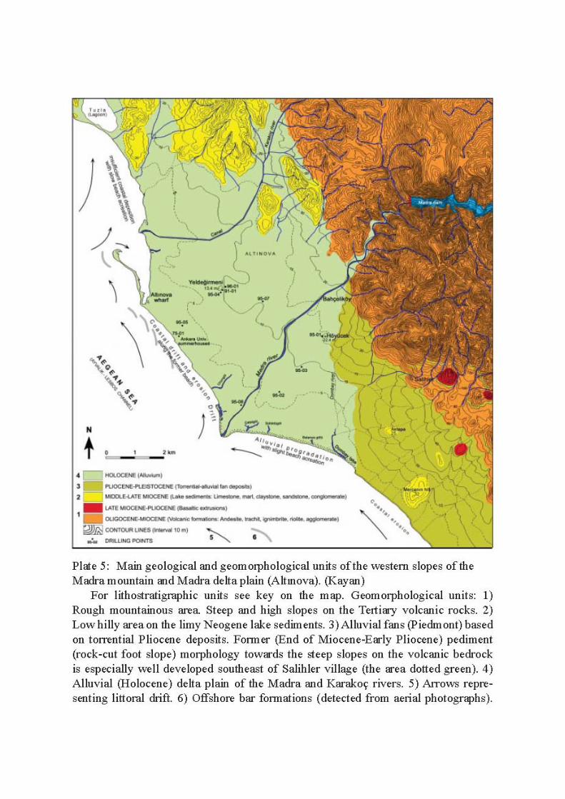
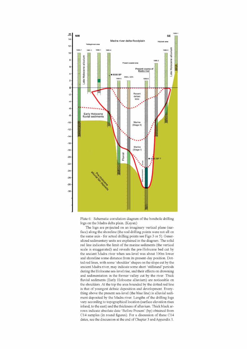
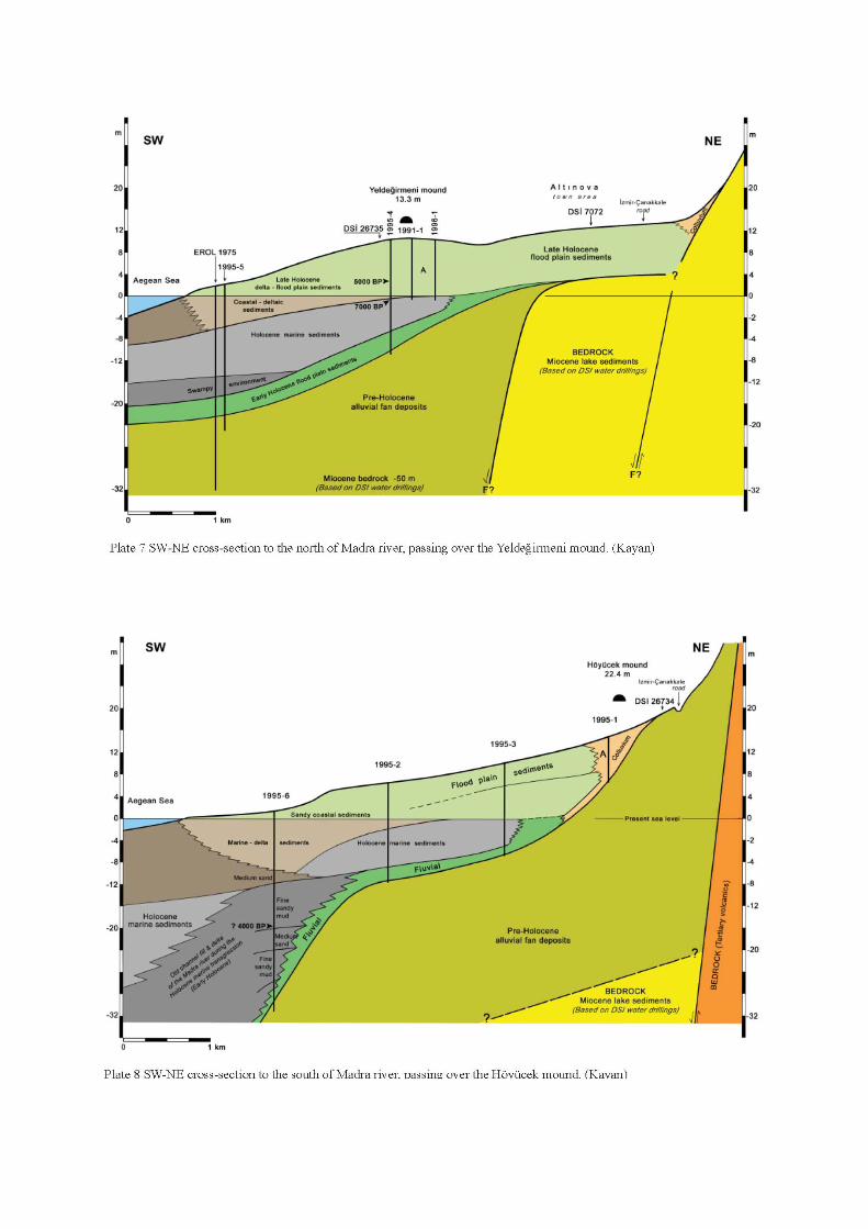
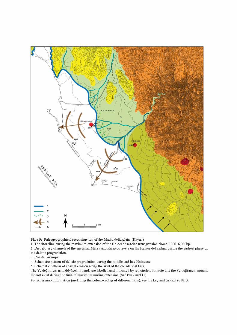
31
3. Alluvial geomorphology and paleogeography of the Yeldeğirmeni mound and its environs
İlhan Kayan and Ertuğ Öner
This chapter (and also Chapter 4 which follows) brings us to the heart of the project and its aims – to examine the origin and nature of the earliest human settlement in the Delta. It focuses on the EBA site of Yeldeğirmeni mound, located about 2.5km from the present coast and about the same distance from the modern municipality of Altınova. Many boreholes were drilled at this site, which revealed the earliest levels of human activity and reached down through permanent and seasonal phases of occupation to pre-human levels when the area was a purely marine environment.
Introduction
As stated at the beginning of Chapter 1, the aim of this study was to determine the main features of the physical environment of the MRD, its plain and surrounding hinterland, especially during the earliest human settlement of the area. Environmental change over long time periods, and its effects on the settlement pattern and activities of the settlers, were also major concerns of this study. The formation of the region’s natural environment and related factors were examined first. Of these, geological development requires the longest time-scale. Geomorphological and climatological processes and associated changes occur over relatively shorter periods of time, though in terms of social and cultural time they too cover much longer periods compared to the length and duration of human history.
As already discussed in Chapter 2, delta plains have provided extremely important settings for human activity ever since prehistoric times, and they are special places where geomorphological changes tend to occur relatively rapidly. Because environmental changes in such areas exert direct effects on settlement history and cultural development, modern archaeological projects now consider it essential to investigate the natural environment and its changes over time as fully as possible (see the discussion of approaches to landscape archaeology in the Introduction).
Above we have described how the shoreline of the MRD intruded inland about 2–3km and reached a point to the east of Yeldeğirmeni mound around 7,000–6,000 years ago, since which time about 8–10m of alluvium
has been deposited on this delta plain (see pp. 28–9). For this reason it is likely that any cultural remains left by prehistoric people on the surface of the delta before that time would be under a thick alluvial cover today.1
Archaeological mounds (‘höyüks’ in Turkish) are made up of the accumulated debris of old settlements which have been built up on the same place over long periods of time, and appear as high mounds on the aggrading surface of an alluvial plain. Two such mounds which formed on the Madra delta plain in this way are Yeldeğirmeni mound north of the river, and Höyücek mound south of the river (Pls 3, 5).
Yeldeğirmeni mound (the focus of the study presented in this chapter, see Pl. 15) is located about 2km southwest of Altınova town. It is ca. 2.5km inland (east) of the present shoreline and rises ca. 5m above the surface of the plain, which is now 8m above sea-level (Pls 3, 10). This small hillock is therefore over 13m above present-day sea-level, whereas in the EBA of 5,000 years ago it was a living coastal settlement slightly (1–2m) above sea level (Pls 11–13). It has a circular base and a diameter close to 150m. The western edge of the mound has been cut into and destroyed by agricultural ploughing. A section about 50m wide and 3m high has been cut in the western side of the mound running northwest-southeast, and levelled. This now forms a low scarp on the western edge of the mound. Furthermore, a water reservoir has been built into the top of the mound, causing substantial damage. The agricultural ploughing and the construction of the water station have brought to light much archaeological material, providing evidence of the site’s cultural importance before any systematic archaeological excavations were undertaken.
Many other remains of settlement in antiquity were found by archaeological surface survey on the Madra delta plain and its surrounding areas (Lambrianides et al. 1996). They generally occur on the first hills rising up along the eastern foot slope of the plain where the land surface has not been covered by younger sediments of more recent periods. Along the foot-slope of Madra mountain, from north to south, Çakmakköy, Pandır tepe, Asarkaya (Taşağıl), Kazan tepe (Aktepe), Kozaklı tepe (Agios Ilias), and Mercanın tepe (Makaron çiftliği) are some of the archaeological sites
1 This conclusion had a significant impact on the design of
collection strategies for the archaeological surface survey in the project which will be explained in detail in MRD 2.
The Madra River Delta: Regional Studies on the Aegean Coast of Turkey
32
which have been examined and their related archaeological findings described (Lambrianides et al. 1996). Most of the finds belong to (post-Bronze Age) historical periods, but some prehistoric (in particular EBA-LBA) material has been found at Pandır tepe and Kazan tepe, although more detailed investigations are required at these sites.
The Yeldeğirmeni and Höyücek mounds are both different from the archaeological sites on the foot-slope of the mountain: they are located in the middle of the plain and form small hillocks rising about 5m high above the present delta surface. However, the original surface on which each settlement stood now lies many metres deep below the present delta surface. For technical reasons it is difficult to reach down to this depth by means of archaeological excavation alone. One of the difficulties is that the old surface is now below the existing water table. It is, however, possible to reach down and study the buried settlement surface and to examine the stratigraphy of the mound by means of modern drilling techniques, a fact which emphasises the importance in the project’s research strategy of collaboration between geomorphological borehole drilling and archaeological examination.
The 1997 borehole study at Yeldeğirmeni mound
Of the two mounds, it was decided to examine Yeldeğirmeni first, given that preliminary drilling work in earlier fieldwork (Lambrianides 1990; 1992; Lambrianides et al. 1996) indicated the site had the potentially interesting feature that it lay at the frontier of land and sea in the EBA (a topographical feature not shared by Höyücek). A detailed study was therefore carried out at the Yeldeğirmeni mound in 1997, in which 14 boreholes were drilled using a Cobra percussion drill (Pls 10 and 16). It was possible to reach down 15m below the present delta surface using gouge augers of 36, 50 and 60mm diameter. From the cores obtained it was possible to extract samples of 1m of relatively undisturbed material from a number of different sedimentological units (see Pls 17–21). On the highest part of the mound, auger drilling could not penetrate down to the required depths due to the many large stones from the foundations of prehistoric structures which hindered the boring. However, on the slope and skirts of the mound, drilling was possible down to 15m and a marine sediment unit was encountered at the bottom. The pre-Holocene terrestrial layer was encountered in drill hole number 04 bored in 1995 to the south of the mound, at a depth of 17m from the present surface, which is about 9m below present sea-level (Pl. 7). As explained above, the topmost 3–4m of terrestrial deposits on the delta are gravelly-sandy river sediments and the deeper part consists of
flood deposits containing large andesite blocks. Since the primary aim of the drilling programme was to examine the transition from marine environment to terrestrial conditions and to identify the sedimentological units where cultural layers begin, it was not deemed necessary to reach the bottom of the marine sediment unit.
In order to carry out accurate paleogeographic reconstructions of a coastal plain, drilling profiles need to be correlated with each other and with reference to present sea-level. The profile (log) of each drillhole is first established separately, then arranged side-by-side for correlation of sedimentary units along various axes, always in relation to sea-level (Pl. 11). The standard source of topographical data is the 1:25,000 scale maps with contour lines at 10m intervals. Using such maps, the natural surface of the plain surrounding the mound has been estimated to be ca. 9–10m above present sea-level (Pl. 10). However, a problem was encountered in the case of Yeldeğirmeni mound, as a result of measurements taken by the Municipality of Altınova (using modern equipment), which found that the surface surrounding the mound was 8m above sea level instead of 9–10m. The base for this measurement is a trigonometric point to the east of the mound 8.17m high. This is also a reference point on the 1:25,000 scale map prepared by the National Map Survey. This discrepancy of 1m between the two measurements is too great to be ignored and makes accurate interpretation of the sedimentary environments close to the former coastline rather hazardous. For the purposes of this study we have taken the new measurement data as the base, but the discrepancy must be taken into account when new research is carried out in this area in the future.
The stratigraphic and sedimentological data obtained from the 14 boreholes acquired by Cobra core-drillings on the mound, plus the profiles of three boreholes made using alternative techniques and equipment at points surrounding the mound, were set up as log profiles and analysed as follows. All the profiles were arranged in a row with basic reference point the present sea-level (Pl. 11). In this analysis, instead of choosing any specific axis, all drilling profiles were arranged as a superimposed projection on a vertical surface extending west-east. This provided a general view of all the sedimentological units and their sequences below the mound, enabling us to identify the base of the mound, and highlighted the relations between archaeological strata and changing environments in the surrounding area over the course of time. In addition, two profiles were taken on the east-west axis and one on the north-south axis across the mound to help trace relations between the sedimentological units and mound geometry. This, in turn, made it possible to attempt paleogeographic
3. Kayan and Öner, Geomorphology and paleogeography of the Yeldeğirmeni mound
33
reconstructions and maps (Pl. 9) based on vertically changing sedimentary units (Pl. 11).
It should be noted that, in plate 11 and the discussion below, the sedimentological units have been named so as to reflect the environments changing over time. The following abbreviations are used:
YM Yeldeğirmeni marine (oldest); YD1 Yeldeğirmeni deltaic 1, coastal; YD2 Yeldeğirmeni deltaic 2, lagoonal; and YF1–4 Yeldeğirmeni flood-plain/fluvial (youngest) This analysis follows the paleogeographical
development from the bottom layer up (from older to younger).
YM: Marine sediment unit under the mound (Oldest)
The marine sediment unit is encountered about 10–12m below the present surface of the plain in the area of the mound (Pls 11–13). This unit generally consists of a greenish-grey, hard mud (silt-clay). There are plenty of marine shells (generally Cerastoderma sp.) in the sediment. Some of these are closed bi-valves which indicate they are not transported but in their living position. Although the sediment unit is generally homogeneous, some sandy bands containing plant remains were encountered and cut by the drilling auger. They denote a shallow marine environment where coarse-grained material originating from terrestrial sources was deposited from time to time.
Although the upper surface of the marine unit generally seems flat, it is noticeable that in the middle part of the mound the surface is lower and rises slightly to both east and west. Since an insufficient number of boreholes were drilled around the mound, the exact position of the coastline during the maximum marine intrusion, the distribution of related coastal sediments, and the nature of the low depression below the mound, could not be interpreted directly. However, the upper units, especially the coarse sandy deposit that fills the low depression, imply that an old deltaic lobe may have developed in this area.
The C14 date from the uppermost level of the marine sediment unit in drill-hole number 1995–04 was found to be 7,000bp. In addition, at the same stratigraphical level in drilling core profile 1997–11, the C14 date of shells was ca. 7,500bp (Pl. 11).2 This date is in exact concordance with our knowledge of the regional paleogeography. Therefore, it can be assumed that the sea-level was about 2m below the present and
2 Other Cerastoderma shells at the same stratigraphical level in
drillholes 1997–1 and 1997–6 produced dates of ca. 10,000bp, see the discussion of C14 dating at the end of this chapter and Appendix 1.
still rising about 7,000 years ago, and that the shoreline had reached to the east of Yeldeğirmeni mound. No archaeological finds were encountered in the marine sediment unit in any of the drilling holes. This supports the view that there was no settlement on the near-shore area in this period. Furthermore, no archaeological evidence has been found in this area so far that can be dated to this period, although this may be simply a result of insufficient exploration and survey.
YD 1: Coarse sandy river-delta sediments under the mound
The fine-grained (silt-clay) marine sediment unit found below the Yeldeğirmeni mound is overlain by coarser, unsorted sand (a mixture of coarse, medium, and fine sand) ca. 1–2m thick (Pls 11–13). This unit generally has a grey colour and the sand is clean and loose. This means that the finer particles (silt and clay) have been washed out of this sediment by various processes. The loose sand fell from the auger rod in some drilling holes, and no sample could be taken from those units. However, sampling was possible in most of the drilling holes due to the tight structure of the matrix of sand mixed with plant remains. Marine shells were found in large numbers between the sediment bands containing plant remains, especially in the lower parts of the sandy unit. Another notable characteristic is the wide range of grain sizes found in some drill-holes. However, homogeneous medium and fine sandy bands were also encountered in several samples.
The sandy unit is completely below present sea-level. Although its bottom surface on the marine unit is rather flat just below the mound, it rises slightly towards the west and east with flat concave profiles, and reaches up to the present sea-level at the drilling points of 1995–04 and 1996–01 to the east of the mound. Therefore, the sandy unit overlies or fills a very low depression or a wide trough along the former coastline on the surface of the lower marine sediment unit. According to its sedimentological characteristics, the sandy unit is fluvial, rather than belonging to a coastal barrier. However, plant remains and marine shells contained in the sand are evidence that this paleo-environment was close, or adjacent to the sea at that time. Thus, it can be postulated that the sandy unit belongs to a wide deltaic lob at the mouth of the river. A similar formation can be seen today at the mouth of the Madra river on the present coastline (Pl. 9). In addition, a wide sub-recent flood channel of the Madra river extending from the east towards Yeldeğirmeni mound can be followed on aerial photographs. Of course, this channel is not related to the sandy unit at the bottom of the mound; but it does indicate that the course of the river has changed repeatedly during the development of the delta, which is part of the normal
The Madra River Delta: Regional Studies on the Aegean Coast of Turkey
34
process of delta formation. In the circumstances, the mound area may have been on one of the main courses of the river, or else on a delta lob similar to the present-day one, which may have developed in this area at the time the coastline had reached the vicinity of the site. In any case, these formations all existed before the mound area first came into use as a human settlement.
In conclusion, the coarse sandy sediment unit may have developed as a deltaic projection in front of the coastline and coincides with the maximum intrusion of the rising sea during the Holocene. Such a widespread sand cover must have belonged to the Madra river itself. However, the unit is not very thick, and this indicates that the river did not use this mouth for very long. It appears that the flow of water over the surface, which brought the coarse sand, also had the effect of washing away finer particles like silt and clay. In addition, the flow action may have slightly scraped the surface of the lower marine sediment unit. Thus, a broad low trough formed at the bottom of a shallow marine unit, and at the same time, it was filled by sandy sediments brought by the river. This is typical of the processes taking place on a deltaic coast.
Since archaeological material has not so far been found in the sandy sediment unit, we are forced to conclude that human activity had not yet reached the vicinity of the mound during the formation of this unit. Clearly much more drilling is necessary in this area if we are to reach a better understanding of the paleogeography of those times.
YD 2: Fine sandy deltaic coastal plain sediments under the mound
The coarse sandy sediment unit under the Yeldeğirmeni mound is overlain by a black/dark-grey, fine sandy, very micaeous, homogeneous mud unit. The colour of this unit changes as one moves upwards, becoming gradually lighter: first dark-grey, then greenish-grey (see Pl. 17 for the change in colour, as seen in borehole YD10). This unit is also completely below present sea-level. The bottom surface of this unit is rather flat where it rests on the sandy unit beneath, and its flat upper surface coincides exactly with present sea-level. The average thickness of this unit is about 1.5m.
The transition between the lower sandy unit and the upper, fine-grained unit is very clear. This distinct sedimentation change indicates a sudden and important environmental change in this area. The reason may have been a diversion of the river’s course from here towards another area during a severe flood event. During this change, the former broad river bed in the middle of the old deltaic lob must have changed into a stagnant water or swamp area in the coastal zone behind the new coastline of the prograding delta. This
can be compared with azmak areas on the present coast at locations such as Çatal gölü (göl/gölü meaning lake), Sülüklü göl, and Balanya gölü (see the further discussion of these wetland environments below, and Pl. 5). Thus, in this environment, sediment input was slow and of minor volume, and it was an environment in which only fine-grained sediments of muddy flood waters could be transported and deposited over the area. Sediments of this low wetland are, in general, a blackish sticky mud due to the presence of organic colloids originating mainly from plant remains but also from various other organic remains. Although the water content of such an environment is ultimately controlled by the sea-level, seasonal drought becomes increasingly evident and important going upwards in this sediment unit, as the mixture of colloids created by organic material increases. At the same time, its colour becomes lighter due to oxidation.
One of the most notable characteristics of this sedimentological unit in the drilling profiles is the occurrence of archaeological material, seen here for the first time in the deepest (oldest) level, although at this level such material is still rare. Potsherds and large stones were encountered, especially to the north of the mound in the cores from boreholes numbered 04, 08, and 09 (Pl. 11). Large stones, which could only have been brought here by human agency, are not usually found mixed in with fine–grained sediments brought by natural processes. Such finds are clearly important for the archaeological analysis. Based on this evidence, it can be hypothesised that there was human activity behind the coastline during the formation of this unit and/or that humans came to this wetland at least from time to time for the purpose of fishing and hunting.
In profiles from drill-holes bored in the middle part, and to the west of the mound (drill hole numbers 13 and 03) a section consisting completely of plant remains, like peat, was found. Its horizontal distribution below the mound indicates a narrower channel feature (such as an azmak or old distributary channel) extending east-west, cutting the wider YD2 sediment unit (Pls 10–13). This channel must have had water continuously under the control of sea-level, but without any flow. In such a stagnant wetland, various hygromorphic plants grew densely and their remains accumulated as a peat layer. Thus, the peat-filled channel can be interpreted as the remainder of a wider former river channel that contained stagnant water for some more time after the river had diverted away from this area. Peat material was deposited in the azmak channel while silty mud covered the flat areas on either side. It is possible to see such environments on the coast today, for example, at Çatal gölü and Sülüklü göl (Pl. 5). These wide wetlands are covered by dense vegetation and distinguished by remains of old distributary channels on a slightly incised surface. These channels are filled with stagnant water and

3. Kayan and Öner, Geomorphology and paleogeography of the Yeldeğirmeni mound
35
linked with ground water, and eventually filled with plant remains. As described already, this type of wetland formed by the remains of distributary channels which can open to the sea during severe floodings are known on the Anatolian coast as azmak wetlands.
In the middle part of the mound, in the profile of borehole 13, the thickness of the peat layer above the YD1 sandy unit is more than 3m. This means that the peat formation continues above unit YD2. On the west side, in drill-profile 03, the peaty bed does not go down to the bottom of unit YD2 but ends in the middle of it. This difference may be due to the location of the borehole, which may have encountered a peripheral area. Here, some pieces of potsherds and stones were found at the bottom of the peat which is about 1m below present sea-level to the west of the mound in borehole number 10. This indicates the existence of human activity in the surrounding area during the formation of these sediment units.
YF: Flood plain sediments under the mound
As stated above, the upper surface of unit YD2 is flat and coincides exactly with present sea-level. The nature of the sedimentation changes sharply at this interface and hydromorphic characteristics decrease. Above this, the surface of the deltaic sediment is covered by flood sediments behind the coastline, which at this stage is itself prograding westwards. About 8m of alluvium, that is the complete unit YF, has been deposited in the area of the Yeldeğirmeni mound up to the present day. No notable changes in sedimentation have been observed here, indicating that there has been a continuous sedimentation under stable environmental conditions during the deposition of this unit. The entire unit consists of generally brown to olive brown, fine to medium sandy, homogeneous flood plain sediments.
It is, however, possible to distinguish some layers within this thick alluvial deposit, which indicate small environmental changes. One of the most evident is a section about 2m thick (YF1) above present sea-level (from which come the samples shown in Pls 18–20). The thickness of the peat formation found in the azmak environment in drill-profile 13 in the middle of the mound was more than 3m thick. This means that the peat-filled azmak remained in its original location while peat-formation and flood-plain sedimentation continued together above present sea-level, even after the formation of the upper surface of YD2 had taken place at present sea-level. The peat layer in drill-profile 03 shows that the old azmak channel extended towards the west. In addition, peat layers in drill-profiles 10 and 12 indicate that the peat-filled channel widened when its surface had risen, through alluviation, above present sea-level (Pls 10–13).
The peaty channel ends about 2m above present-day sea-level and is covered by flood-plain sediments. However, another peaty bed encountered in drill-hole number 05 in a higher level is evidence that wetland conditions continued for some time still in this area with only slight changes in the river’s course. The presence of marine shells in the first 2m of alluvium implies that marine species, such as Cerastoderma edule, could intrude inland via azmak channels, despite the distance of this area from the coastline at that time.
Unit YF1 contains a great deal of archaeological material, particularly potsherds and large stones. These were found in almost all of the drill cores. In particular, some were found in contexts related to past fire events, including charcoal and stones probably belonging to prehistoric fireplaces. Indeed, a great deal of charcoal was found in drill-hole 1995–04 to the southwest of the mound, about 6m below the surface (about 2m above sea-level). From here, a piece of charcoal was found with a C14 date of 5,000bp. These deposits of YF1 (at 2m above sea-level today) where stones and potsherds are more abundant can be correlated with many other core profiles and it should be regarded as a further notable surface in its own right. It is important to note that in situ archaeological material and architectural remains were not encountered here. It appears, instead, that all the archaeological material found here was transported from surrounding areas by floodwater, or else left by someone who only stopped here for temporary or seasonal activities. Remains of fire in this wetland do appear to indicate hunting and cooking, but the flat upper surface of YF1 has no convincing evidence of any established settlement here at this early time.
Similar characteristics continue to be seen in the upper alluvial sections. In addition, a coarse sandy fill of an old river channel appears in the cores of drill-profiles 04 and 10, confirming each other at a depth between 4m and 5.5m above sea-level, indicating that a small stream probably ran around the north of the mound at one time. More evidence of fire and archaeological material that is not in situ was found in the drill-cores of the mound area belonging to the same period (see Pl. 21 indicating traces of fire in the upper YF4 stratum of borehole YD13). As before, there is still no evidence of an established settlement in these upper levels either (YF2 and YF3).
The bottom of the first settlement on the mound area was found at about 6.5m down from the top (ca. 6.5m above present-day sea-level) based on evidence obtained from archaeological excavations on the western edge of the mound (Pls 11 and 12).3 Here, the constructions of stone and mud-brick were dated by means of in situ pottery to the EBA. This also provides
3 See the detailed report of the 1997 excavations at the mound in
volume 2 of the report.
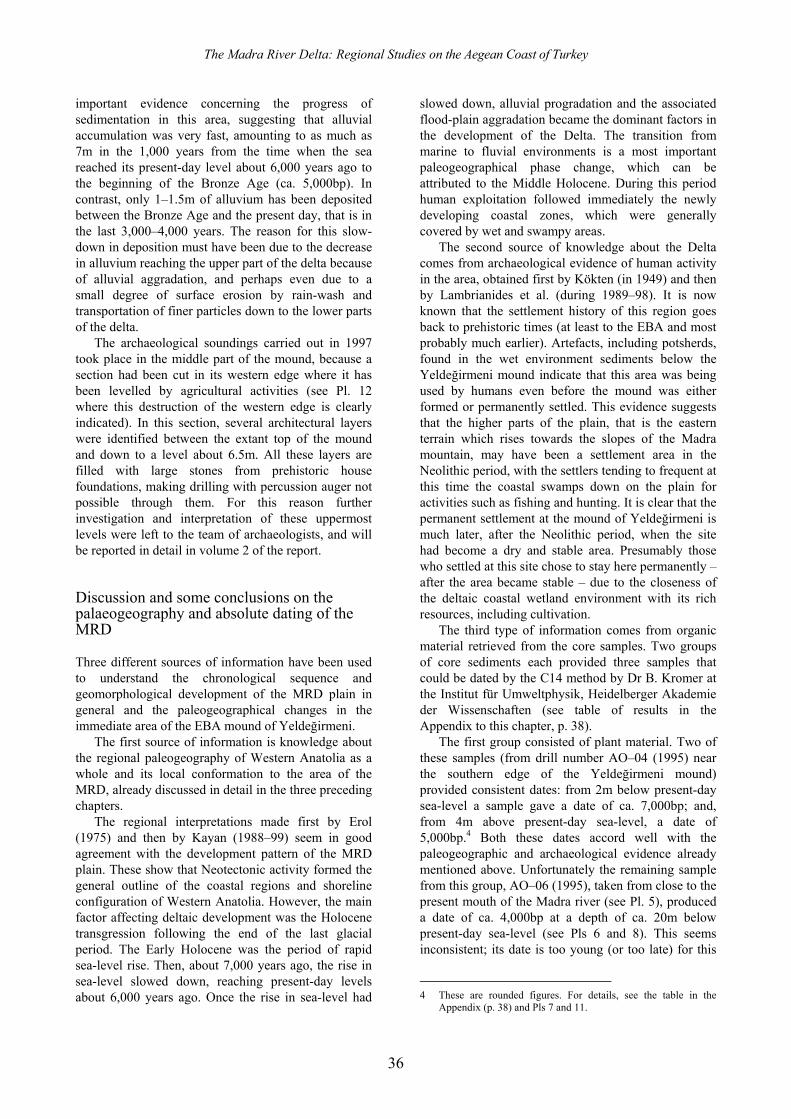
The Madra River Delta: Regional Studies on the Aegean Coast of Turkey
36
important evidence concerning the progress of sedimentation in this area, suggesting that alluvial accumulation was very fast, amounting to as much as 7m in the 1,000 years from the time when the sea reached its present-day level about 6,000 years ago to the beginning of the Bronze Age (ca. 5,000bp). In contrast, only 1–1.5m of alluvium has been deposited between the Bronze Age and the present day, that is in the last 3,000–4,000 years. The reason for this slow-down in deposition must have been due to the decrease in alluvium reaching the upper part of the delta because of alluvial aggradation, and perhaps even due to a small degree of surface erosion by rain-wash and transportation of finer particles down to the lower parts of the delta.
The archaeological soundings carried out in 1997 took place in the middle part of the mound, because a section had been cut in its western edge where it has been levelled by agricultural activities (see Pl. 12 where this destruction of the western edge is clearly indicated). In this section, several architectural layers were identified between the extant top of the mound and down to a level about 6.5m. All these layers are filled with large stones from prehistoric house foundations, making drilling with percussion auger not possible through them. For this reason further investigation and interpretation of these uppermost levels were left to the team of archaeologists, and will be reported in detail in volume 2 of the report.
Discussion and some conclusions on the palaeogeography and absolute dating of the MRD
Three different sources of information have been used to understand the chronological sequence and geomorphological development of the MRD plain in general and the paleogeographical changes in the immediate area of the EBA mound of Yeldeğirmeni.
The first source of information is knowledge about the regional paleogeography of Western Anatolia as a whole and its local conformation to the area of the MRD, already discussed in detail in the three preceding chapters.
The regional interpretations made first by Erol (1975) and then by Kayan (1988–99) seem in good agreement with the development pattern of the MRD plain. These show that Neotectonic activity formed the general outline of the coastal regions and shoreline configuration of Western Anatolia. However, the main factor affecting deltaic development was the Holocene transgression following the end of the last glacial period. The Early Holocene was the period of rapid sea-level rise. Then, about 7,000 years ago, the rise in sea-level slowed down, reaching present-day levels about 6,000 years ago. Once the rise in sea-level had
slowed down, alluvial progradation and the associated flood-plain aggradation became the dominant factors in the development of the Delta. The transition from marine to fluvial environments is a most important paleogeographical phase change, which can be attributed to the Middle Holocene. During this period human exploitation followed immediately the newly developing coastal zones, which were generally covered by wet and swampy areas.
The second source of knowledge about the Delta comes from archaeological evidence of human activity in the area, obtained first by Kökten (in 1949) and then by Lambrianides et al. (during 1989–98). It is now known that the settlement history of this region goes back to prehistoric times (at least to the EBA and most probably much earlier). Artefacts, including potsherds, found in the wet environment sediments below the Yeldeğirmeni mound indicate that this area was being used by humans even before the mound was either formed or permanently settled. This evidence suggests that the higher parts of the plain, that is the eastern terrain which rises towards the slopes of the Madra mountain, may have been a settlement area in the Neolithic period, with the settlers tending to frequent at this time the coastal swamps down on the plain for activities such as fishing and hunting. It is clear that the permanent settlement at the mound of Yeldeğirmeni is much later, after the Neolithic period, when the site had become a dry and stable area. Presumably those who settled at this site chose to stay here permanently – after the area became stable – due to the closeness of the deltaic coastal wetland environment with its rich resources, including cultivation.
The third type of information comes from organic material retrieved from the core samples. Two groups of core sediments each provided three samples that could be dated by the C14 method by Dr B. Kromer at the Institut für Umweltphysik, Heidelberger Akademie der Wissenschaften (see table of results in the Appendix to this chapter, p. 38).
The first group consisted of plant material. Two of these samples (from drill number AO–04 (1995) near the southern edge of the Yeldeğirmeni mound) provided consistent dates: from 2m below present-day sea-level a sample gave a date of ca. 7,000bp; and, from 4m above present-day sea-level, a date of 5,000bp.4 Both these dates accord well with the paleogeographic and archaeological evidence already mentioned above. Unfortunately the remaining sample from this group, AO–06 (1995), taken from close to the present mouth of the Madra river (see Pl. 5), produced a date of ca. 4,000bp at a depth of ca. 20m below present-day sea-level (see Pls 6 and 8). This seems inconsistent; its date is too young (or too late) for this
4 These are rounded figures. For details, see the table in the
Appendix (p. 38) and Pls 7 and 11.
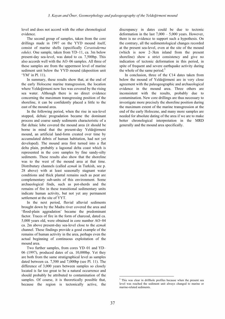
3. Kayan and Öner, Geomorphology and paleogeography of the Yeldeğirmeni mound
37
level and does not accord with the other chronological evidence.
The second group of samples, taken from the core drillings made in 1997 on the YYD mound itself, consist of marine shells (specifically Cerastoderma edule). One sample, taken from YD–11, ca. 3m below present-day sea-level, was dated to ca. 7,500bp. This also accords well with the AO–06 samples. All three of these samples are from the uppermost level of marine sediment unit below the YYD mound (deposition unit ‘YM’ in Pl. 11).
In summary, these results show that, at the end of the early Holocene marine transgression, the location where Yeldeğirmeni now lies was covered by the rising sea water. Although there is no direct evidence concerning the maximum transgressing position of the shoreline, it can be confidently placed a little to the east of the mound area.
In the following period, when the rise in sea-level stopped, deltaic progradation became the dominant process and coarse sandy sediments characteristic of a flat deltaic lobe covered the mound area (it should be borne in mind that the present-day Yeldeğirmeni mound, an artificial land-form created over time by accumulated debris of human habitation, had not yet developed). The mound area first turned into a flat delta plain, probably a lagoonal delta coast which is represented in the core samples by fine sandy-silty sediments. These results also show that the shoreline was to the west of the mound area at that time. Distributary channels (called azmak in Turkish, see p. 28 above) with at least seasonally stagnant water conditions and thick plantal remains such as peat are complementary sub-units of this environment. Some archaeological finds, such as pot-sherds and the remains of fire in these transitional sedimentary units indicate human activity, but not yet any permanent settlement at the site of YYT.
In the next period, fluvial alluvial sediments brought down by the Madra river covered the area and ‘flood-plain aggradation’ became the predominant factor. Traces of fire in the form of charcoal, dated ca. 5,000 years old, were obtained in core number AO–04 ca. 2m above present-day sea-level close to the azmak channel. These findings provide a good example of the remains of human activity in the area, perhaps even the actual beginning of continuous exploitation of the mound area.
Two further samples, from cores YD–01 and YD–06 (1997), produced dates of ca. 10,000bp. Yet they are both from the same stratigraphical level as samples dated between ca. 7,500 and 7,000bp (see Pl. 11). The difference of 3,000 years between samples so closely located is far too great to be a natural occurrence and should probably be attributed to contamination of the samples. Of course, it is theoretically possible that, because the region is tectonically active, the
discrepancy in dates could be due to tectonic deformation in the last 7,000 – 5,000 years. However, there is no evidence to support such a hypothesis. On the contrary, all the sedimentological changes recorded at the present sea-level, even at the site of the mound (which is now 2–3km inland from the present shoreline) show a strict consistency and give no indication of tectonic deformation in this period, in spite of frequent and severe earthquake activity during the whole of the same period.5
In conclusion, three of the C14 dates taken from below the mound of Yeldeğirmeni are in very close agreement with the paleogeographic and archaeological evidence in the mound area. Three others are inconsistent with the results, probably due to contamination. New core drillings are thus necessary to investigate more precisely the shoreline position during the maximum extent of the marine transgression at the end of the early Holocene, and many more samples are needed for absolute dating of the area if we are to make better chronological interpretation in the MRD generally and the mound area specifically.
5 This was clear in drillhole profiles because when the present sea level was reached the sediment unit always changed to marine or marine-related sediments.
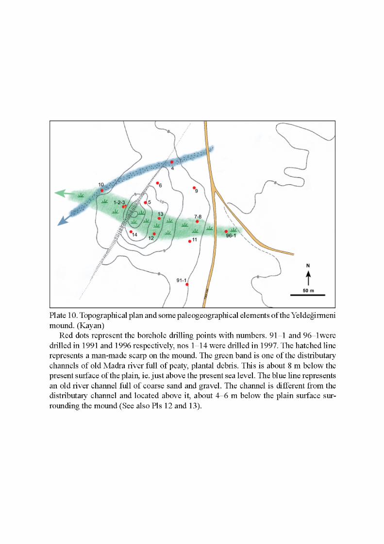
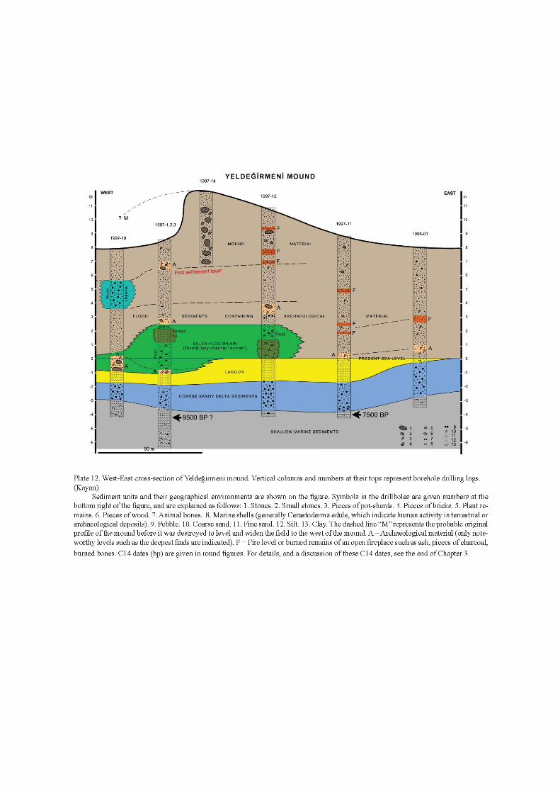
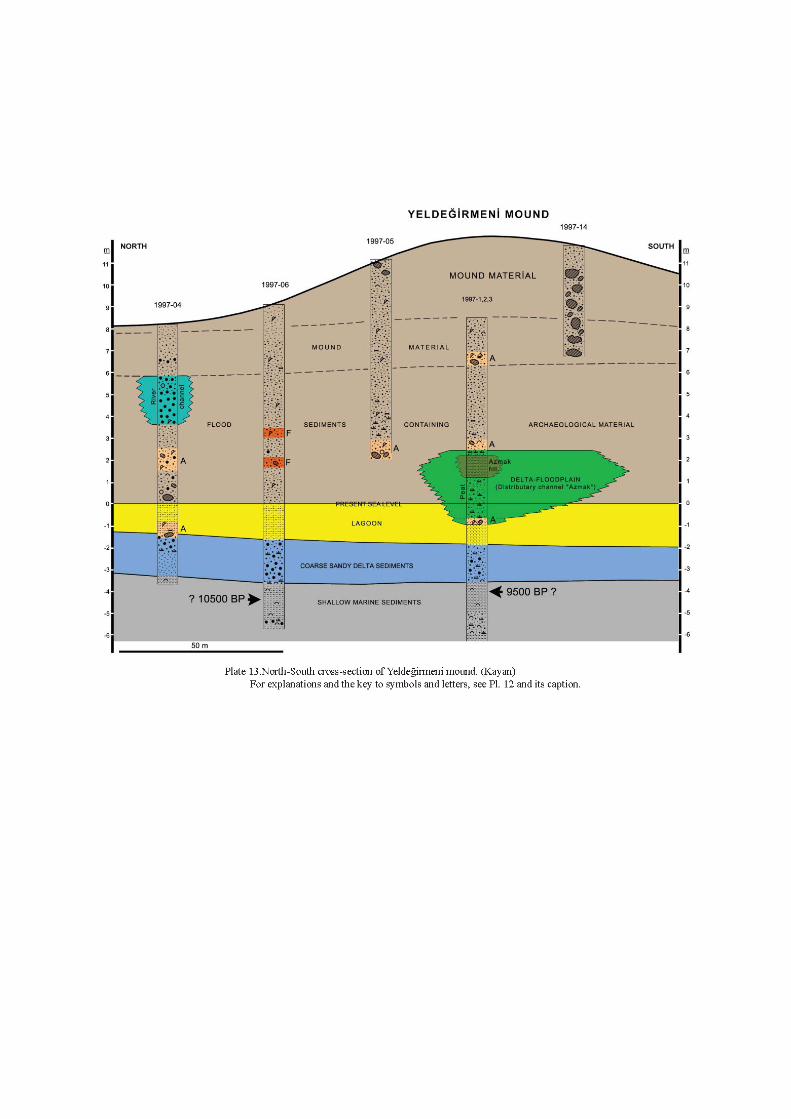
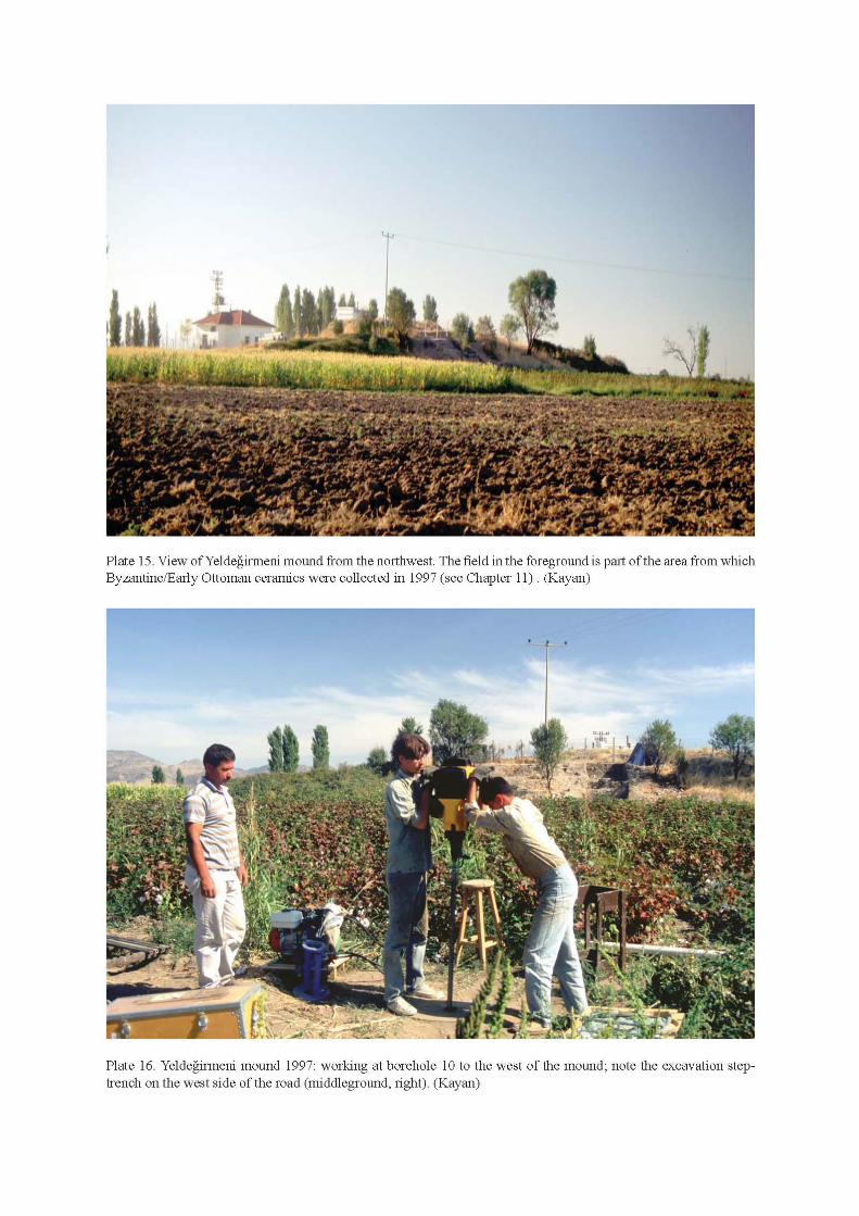
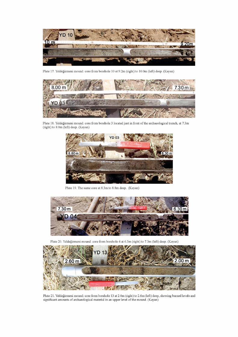
131
Bibliography
Administrative Division, State Institute of Statistics 1997: Population Count, Prime Ministry, Republic of Turkey
Admiralty Hydrographic Department 1955: Mediterranean Pilot 8th edition, Volume 4. London
Aitken, M J 1959: ‘Magnetic prospecting-an interim assessment’ Antiquity 33: 205–207
— 1974: Physics and Archaeology. Oxford Aitken, M J, Tite, M S 1962: ‘A gradient
magnetometer using proton free-precession’ Journal of Scientific Instruments 39: 625–9
Akurgal, E 1950: Bayraklı: first preliminary report on the excavations in Old Smyrna. Ankara
— 1987: Griechische und römische Kunst in der Türkei. Munich
Akyürek, B, Soysal, Y 1983: ‘Biga yarımadası güneyinin (Savaştepe-Kırkağaç-Bergama-Ayvalık) temel jeolojik özellikleri’ Maden Tetkik ve Arama Enstitüsü Dergisi, Sayı: 95–96 (s.1–12)
Alcock, S 2001: ‘Review of Ashmore and Knapp 1999’ American Journal of Archaeology 105: 108–9
Alexandris, A 1999: ‘The Greek census of Anatolia and Thrace (1910–1912): a contribution to Ottoman historical demography’ in D. Gondicas, C. Issawi (eds), Ottoman Greeks in the Age of Nationalism. Princeton: 45–76
Altun, A 1989: İznik Çini Fırınları Kazısı, II. Dönem 1981–88, İstanbul
— 1991: ‘İznik Çini ve Seramikleri’ Sadberk Hanım Müzesi, Türk Çini ve Seramikleri. İstanbul: 8–48
Ashmore, W, Knapp, A B 1999: ‘Archaeological landscapes: constructed, conceptualized, ideational’, in Ashmore, Knapp 1999a: 1–30
— (eds) 1999a: Archaeologies of Landscape: Contemporary Perspectives. Oxford
Aslanapa, O 1965: Anadolu’da Türk Çini ve Seramik Sanatı. İstanbul
— 1965a: ‘Kırmızı hamurlu İlk Osmanlı keramikleri (Milet İşi Denen Keramikler)’ Türk Kültürü III: 30: 391–9
— 1989: ‘İznik kazılarına göre Osmanlı keramik sanatı’ Kültür ve Sanat 1.4, Aralık: 5–9
Atasoy, N, Raby, J 1989: İznik Çinileri. İstanbul Atıl, B E 1973: Freer Gallery of Art Fiftieth
Anniversary Exhibition, III. Ceramics from the World of Islam. Washington
Atkinson, R J C 1952: Méthodes électriques de prospection en archéologie, in A. Laming (ed.) La Découverte du passé: progrès recents et techniques nouvelles en préhistoire et en archéologie. Paris: 59–70
— ‘Ayazma’ 1993: Ana Britannica volume 4. İstanbul
Bailey, G, Parkington, J 1988: The Archaeology of Prehistoric Coastlines. Cambridge
Barrett, J C 1989: ‘Time and tradition: the rituals of everyday life’ in H-A Nordstrom, A Knape (eds) Bronze Age Studies: Proceedings of the British-Scandinavian Bronze Age Colloquium. Stockholm
— 1994: Fragments from Antiquity: an Archaeology of Social Life in Britain, 2900–1200BC. Oxford
— 1999: ‘The mythical landscapes of the British Iron Age’ in Ashmore, Knapp 1999b: 253–63
Barrett, J C, Bradley, R, Green, M 1991: Landscape, Monuments and Society: the Prehistory of Cranborne Chase. Cambridge
Barrett, J C, Halstead, P (eds) 2005: The Emergence of Civilisation Revisited (Sheffield Studies in Aegean Archaeology 6). Oxford
Basedow, M A 2000: Beşik-Tepe: das spätbronzezeitliche Gräberfeld (Studia Troica Monographs). Mainz am Rhein
Başokur, A T 1990: ‘Microcomputer program for the direct interpretation of resistivity sounding data’ Computers and Geosciences 16: 587–601
— 1997: ‘The interpretation of resistivity data by forward and iterative approximation methods, modelling’ in N Canitez (ed.) Geophysical Modelling. Istanbul: 101–15
Bayne, N 1963/2000: The Grey Wares of North-west Anatolia in the Middle and Late Bronze Age and the Early Iron Age and their Relation to the Early Greek Settlements (Asia Minor Studien 37). Bonn
Bender, B 1992: ‘Theorising landscapes, and the prehistoric landscape of Stonehenge’ Man 27 (new series): 735–55
— (ed.) 1993: Landscape: Politics and Perspectives. London
Bérard, J 1959: ‘La migration éolienne’ Révue Archéologique 1: 22–28
Berger, P L Luckmann, T 1967: The Social Construction of Reality: a Treatise in the Sociology of Knowledge. London
Berktay, H, Faroqhi, S (eds) 1992: New Approaches to the State and Peasant in Ottoman History (Journal of Peasant Studies Series 18.3–4). London
Bernabo-Brea, L 1964: Poliochni. Città preistorica nell’isola di Lemnos I. Rome
Bilici, S 1997: ‘Antalya ve Bodrum müzelerinde champlevé dekorlu bizans seramikleri’ Adalya 3: 223–34
The Madra River Delta, volume I Delta
132
Blegen, C W 1938: ‘Review of W Lamb, Excavations at Thermi in Lesbos, 1936’ American Journal of Archaeology 42: 593–4
Blegen, C W, Caskey, J L, Rawson, M (eds) 1953: Troy: Excavations Conducted by the University of Cincinnati, 1932–38. Volume 3: The Sixth Settlement. Princeton
— 1958: Troy: Excavations Conducted by the University of Cincinnati, 1932–38. Volume 4: Settlements VIIa, VIIB and VIII. Princeton
Boehlau, J, Schefold, K 1940: Larisa am Hermos. Die Ergebnisse der Ausgrabungen 1902–1934. I. Die Bauten. Berlin
— 1942: Larisa am Hermos. Die Ergebnisse der Ausgrabungen 1902–1934. III. Die Kleinfunde. Berlin
Borsi, S, Ferrara, C, Innocenti, F, Mazzuoli, Z 1972: ‘Geochronology and petrography of recent volcanics of Eastern Aegean Sea (West Anatolia and Lesbos Island)’ Bulletin Volcanologique 36.3: 473–96
Bradley, R 1993: Altering the Earth: the Origins of Monuments in Britain and Continental Europe. The Rhind Lectures 1991–1992 (Society of Antiquaries of Scotland Monograph Series 8). Edinburgh
Braudel, F 1972: The Mediterranean and the Mediterranean World in the Age of Philip II (2 volumes). London
Brückner H 1986: ‘Man’s impact on the evolution of the physical environment in the Mediterranaen region in historical times’ Geojournal 13.1: 7–18
Buchholz, H-G 1975: Methymna, archäologische Beiträge zur Topographie und Geschichte von Nordlesbos. Mainz am Rhein
Bulut, L 1988: ‘Selçuk (Ayasuluk) kazılarında ele geçen İslâm devri seramikleri’. in Birinci Uluslararası Geçmişten Günümüze Selçuk Sempozyumu, 4–6 Eylül 1997. İzmir: 343–55
— 1991: Samsat İslami Devir Sırsız ve Tek Renk Sırlı Seramikleri (Ege University Institute of Social Sciences unpublished PhD thesis). İzmir
— 1994: ‘Kabartma desenli Samsat Ortaçağ seramikleri’ Sanat Tarihi Dergisi 7: 1–18
— 1996: ‘Samsat Ortaçağ sgraffito ve champlevé seramikleri’ in Ş Yetkin (ed.) Anısına Çini Yazıları. İstanbul: 31–46
— 1999: ‘Toplumsal dayanışma-seramik tabak’ in G. Öney, R.H. Ünal (eds) Akdeniz’de İslam Sanatı, Erken Osmanlı Sanatı (Beyliklerin Mirası, Yayıma Hazırlayanlar). Madrid: 131–4
— 1999a: ‘“Ateşte açan çiçekler” 14–15. yüzyıl çini ve seramik sanatı’ in G Öney, R H Ünal (eds) Akdeniz’de İslam Sanatı, Erken Osmanlı Sanatı (Beyliklerin Mirası, Yayıma Hazırlayanlar). Madrid: 140–1
Bürküt, Y 1966: Kuzeybatı Anadolu’da yeralan plütonların mukayeseli jenetik etüdü (PhD thesis, İ.T.Ü. Yayın No. 272). İstanbul
Burton, M, Moore, C, Whiting J, Romney A K 1996: ‘Regions based on social structure’, Current Anthropology 37.1: 87–123
Çelebi, K 1749: Cihannüma. İstanbul Cherry, J, Davis, J L Mantzourani, E 1991: Landscape
Archaeology as Long-term History: Northern Keos in the Cycladic Islands (Monumenta Archeologica 16). Los Angeles
Childe, V G 1934: New Light on the Most Ancient East: the Oriental Prelude to European Prehistory. London
— 1950: ‘The urban revolution’ Town Planning Review 21.1: 3–17
Clark, A 1975: ‘Archaeological prospecting: a progress report, Journal of Archaeological Science 2: 297–314.
— 1996: Seeing Beneath the Soil: Prospecting Methods in Archaeology. London
Clinkenbeard, B 1982: ‘Lesbian wine and storage amphoras’ Hesperia 51: 248–67
Clogg, R 1972: ‘Two accounts of the Academy of Ayvalik (Kydonies) in 1818–1819’ Revue des Etudes Sud-Est Européennes 10: 633–67
Conze, A (ed.)1913: Altertümer von Pergamon I.2, Stadt und Landschaft. Berlin
Cook, J M 1973: The Troad: an Archaeological and Topographical Study. Oxford
Cook, M A 1972: Population Pressure in Rural Anatolia, 1450–1600. London
Cook, R M, Dupont, P 1998: East Greek Pottery. London
Crumley, C 1999: ‘Sacred landscapes : constructed and conceptualised’ in Ashmore, Knapp 1999a: 269–76
Cuinet, V 1890–95: La Turquie d’Asie. Géographie administrative, statistique, descriptive et raisonnée de chaque province de l’Asie-Mineure, 4 volumes. Paris
Danişmend, İ H 1947: İzahlı Osmanlı Tarih Kronolojisi, volume 1. İstanbul
Davis, J L (ed.) 1998: Sandy Pylos: an Archaeological History from Nestor to Navarino. Texas
Davis, J L, Alcock, S E, Bennet, J, Lolos, Y G, Shelmerdine, C W 1997: ‘The Pylos Regional Archaeological Project Part I: overview and the archaeological survey’ Hesperia 66.3: 391–494
Demir, E 1998: Madra Dağı Batı Kesiminin Bitki Örtüsü Çalışması. Bitirme tezi (unpublished). Ege Üniversitesi Edebiyat Fakültesi Coğrafya Bölümü. İzmir
Döğer, L 1993: İzmir Arkeoloji Müzesi’ndeki Bir Koleksiyon ile Selçuk-Ayasuluk Tepesinde Bulunan Bizans Sırlı Seramiklerinde İslâm Sanatı Etkileri, Unprinted Masters Thesis. İzmir
Bibliography
133
— 1997: ‘İslâm sanatı etkisinde palmet motifli sırlı bizans seramikleri’ Arkeoloji ve Sanat. 88: 40–3
— 1998: İzmir Arkeoloji Müzesi koleksiyonları’ndaki sualtı buluntusu slip teknikli bizans seramikleri’ Adalya 3: 179–94
— 1999: ‘İzmir Arkeoloji Müzesi’nde bulunan balık figürlü sgraffito bizans seramikleri’ Arkeoloji ve Sanat Year: 1 no. 93 Kasım-Aralık. İstanbul: 38–42
— 1999a: ‘Kûfi yazı taklidi motiflerle bezeli sgraffito ve kazıma sgraffito teknikli bizans seramikleri’ Antik & Dekor, Antika, Dekorasyon ve Sanat Dergisi 55: 148–51
Doumas, C, La Rosa, V (eds) 1997: Poliochni e l’Antica Età del Bronzo nell’ Egeo Settentrionale. Convegno Internazionale Atene, 22–25 Aprile 1996. Athens
Drahor, M G 1992: ‘Arkeolojik alanlarda jeofiziksel prospeksiyonun önemi’, IX. Araştırma Sonuçları, 27–31 Mayıs 1991, Çanakkale, Bildiri özetleri kitabı: 235–50
— 1998: ‘Arkeoloji jeofiziği: Arkeojeofizik I’ Arkeoloji ve Sanat 87: 16–25
— 1999: ‘Arkeoloji jeofiziği: Arkeojeofizik II’ Arkeoloji ve Sanat 88: 2–12
Duru, R 1980: ‘Kuruçay Höyüğü kazıları. 1978–1979. Çalışma raporu’ Anadolu Araştrmaları, Ek yayın 2 (Jahrbuch für Kleinasiatische Forschung, Beiheft 2)
Easton, D F 1976: ‘Towards a chronology for the Anatolian Early Bronze Age’ Anatolian Studies 26: 145–73
Easton, D F, Hawkins, J D, Sherratt, A G, Sherratt, E S 2002: ‘Troy in recent perspective’ Anatolian Studies 52: 75–109
Eliot, C 1908: Turkey in Europe. London (2nd ed., reprint 1965):
Encyclopaedia of Islam, 1960–78 4 volumes (new edition). Leiden
Ercan, T 1982: ‘Batı Anadolu’nun genç tektoniği ve volkanizması paneli bildiri kitabı’ Türkiye Jeoloji Kurultayı: 5–14
Ercan, T A, Türkecan, M, Karabıyıkoğlu, F, Şaroğlu, D S 1995: ‘A review of Tertiary and Quaternary Volcanism in West Anatolia’ International Earth Science Colloquium on Aegean Regions Abstracts. İzmir: 4
Erder, L T, Faroqhi, S 1980: ‘The development of the Anatolian urban network during the sixteenth century’ Journal of the Economic and Social History of the Orient 23: 265–303
Erol, O 1975: ‘Ayvalık Güneyi-Altınova çevresinde Madra Çayı deltasının holosen birikintileri ve deltanın gelişim safhaları’ Ankara Üniversitesi, Dil ve Tarih-Coğrafya Fakültesi, Coğrafya Araştırmaları Dergisi, Sayı 7: 1–44
Ersoy, B 1992: ‘Altınova (Ayvalık) tarihine ait bazı notlar ve yöredeki mimari eserler’ Kültür ve Sanat 13: 38–43
Fairbridge, R, Erol, O, Karaca, M, Yılmaz, Y 1997: ‘Background of mid-Holocene climatic change in Anatolia and adjacent regions’ in H N Dalfes, G Kukla, H Weiss (eds) Third Millennium Collapse BC Climate Change and Old World Collapse (NATO ASI Series I). Berlin-Heidelberg: 595–610
Faroqhi, S 1993: Osmanlı’da Kentler ve Kentliler. İstanbul
Filges, A 1992: ‘Korinthisch und attische Keramik der archaische und klassische Zeit’ in Serdaroğlu, Stupperich 1992: 109–43
Fındık, N O 2001: İznik Roma Tiyatrosu Kazı Buluntuları (1980–1995) Arasındaki Osmanlı Seramikleri. Ankara
Finlay, G 1971: History of the Greek Revolution and the Reign of King Otho (reprint of 1877 ed.). London
Fletcher, R 1992: ‘Time perspectivism, Annales, and the potential of archaeology’, in A B Knapp (ed.) Archaeology, Annales and Ethnohistory. Cambridge: 35–49
Frangakis-Syrett, E 1992: The Commerce of Smyrna in the Eighteenth Century (1700–1820). Athens
Frasca, M 1993: ‘Osservazioni preliminari sulla ceramica protoarcaica ed arcaica di Kyme’ in G Rizza (ed.) Studi zu Kyme eolica. Atti della giornata di studio della Scuola di Specializzazione in Archeologia dell’Università di Catania, Catania 16 maggio 1990 (Cronache di Archeologia 32): 51–70
Friedrich, W I 1978: ‘Fossil plants from Weichselian palaeosols Santorini, Thera and the Aegean World I’ (Papers presented at the Second International Scientific Congress, Santorini, Greece, August 1978). London: 741–44
French, D H 1967: ‘Prehistoric sites in northwest Anatolia I: the İznik area’ Anatolian Studies 17: 49–100
— 1969: ‘Prehistoric sites in northwest Anatolia II: the Balıkesir and Akhisar-Manisa area’ Anatolian Studies 19: 41–98
Gardner, E A 1888: Naukratis: Part II. London Gebauer, J 1992: ‘Die archaische geglättete graue
Keramik’ in Serdaroğlu, Stupperich 1992: 65–101 Giddens, A 1979: Central Problems in Social Theory:
Action, Structure and Contradiction in Social Analysis. London
— 1984: The Constitution of Society: Outline of the Theory of Structuration. Oxford
— 1985: A Contemporary Critique of Historical Materialism 2: The Nation-state and Violence. Cambridge
The Madra River Delta, volume I Delta
134
Gifford, J 1983: ‘Core sampling of a Holocene marine sedimentary sequence and underlying Neolithic cultural material off Franchthi Cave, Greece’ in P Masters, N Flemming (eds) Quaternary Coastlines and Marine Archaeology. London: 269–81
Gökçen, N 1976: ‘A palaeontological and palaeoecolgical investigation of the Post-Glacial Madra Çayı deposits in the North-Eastern coasts of the Aegean Sea’ Bulletin de la Société Géologique de France, 7. Série, tome XVIII, No: 2: 469–75
Goldman, H 1931: Excavations at Eutresis in Boeotia. Cambridge (Massachusetts)
Gunel, S 1999: ‘Vorbericht über die mittel- und spätbronzezeitliche Keramik vom Liman Tepe’ Istanbuler Mitteilungen 49: 41–82
Harta Genel Müdürlüğü 1947/48: 1:200,000, E-I, Ayvalık
Hasluck, F W 1929: ‘The rise of the Karaosmanoğlu’ in F.W.Hasluck Christianity and Islam under the Sultans. Oxford volume 2: 597–603
Hawkins, J D 1998: ‘Tarkasnawa king of Mira, “Tarkondemos”, Boğazköy sealings and Karabel’ Anatolian Studies 48: 1–31
Hayes, J W 1995: ‘A Late Byzantine and Early Ottoman assemblage from the Lower City in Troia’ Studia Troica: 197–210
Hayward Gallery 1976: The Arts of Islam (Hayward Gallery 8 April–4 July 1976). Great Britain
Hertel, D 1997: ‘Untersuchungen zur Geschichte der Aiolis in der Bronzezeit und der griechisch-römischen Zeit’ Archäologisches Nachrichtenblatt 2.1: 80–7
— 1999: ‘Der Aiolische Siedlungsraum (Aiolis) am Uebergang von der Bronze- zur Eisenzeit’. Paper presented to the Congress on Early Ionia, Panionion, September 1999
2001: Troia: Archaeologie, Geschichte, Mythos. Munich
Hertel, D, Schachner, A — 2000: ‘Nachwort’ in Bayne 1963/2000: 297–315 Hesse, A 1966: Prospections géophysiques à faible
profondeur: applications à l’archéologie. Paris — 1966a: ‘Perfectionnement des applications
archéologiques de la prospection électrique’ Comptes rendus mensuels Société Préhistorique Française 1: 15–19
Hitchcock, L 2000: ‘Review of Hodder and Whitley’ American Journal of Archaeology 104: 373–4
Hodder, I 1982: Symbols in Action. Ethnoarchaeological Studies of Material Culture. Cambridge
— 1987: ‘Converging traditions: the search for symbolic meanings in archaeology and geography’ in M Wagstaff (ed.) Landscape and Culture. Geographical and Archaeological Perspectives. Oxford: 134–45
Hodder, I, Shanks, M, Alexandri, A, Buchli, V, Carman, J, Last, J, Lucas, G (eds) 1995: Interpreting Archaeology: Finding Meaning in the Past. London
Hours, F, Copeland, L 1988: ‘Cultural and environmental change during the Palaeolithic: research methods combining geomorphology with prehistory’ in J L Bintliff, D A Davidson, E G Grant (eds) Conceptual Issues in Environmental Archaeology. Edinburgh: 233–45
Hutchinson, R 1936: ‘Early Bronze Age hearths and housepits’ in W. Lamb, Excavations at Thermi in Lesbos. Cambridge: 55–64
İnalcık, H 1995: From Empire to Republic: Essays on Ottoman and Turkish Social History. İstanbul
İnalcık, H, Quartaert, D (eds) 1994: An Economic and Social History of the Ottoman Empire, 1300–1914. Cambridge
Israel, F L 1967: Treaties of Modern History, 1648–1967. New York
İzdar, E 1968: ‘Kozak intruzif masifi petrolojisi ve Paleozoik çevre kayaçları ile jeolojik bağlantıları’ Türkiye Jeoloji Kurumu Bülteni 11, Sayı: 1–2: 140–79
Jameson, M H, Runnels, C N, van Andel, T H 1994: A Greek Countryside: the Southern Argolid from Prehistory to the Present Day. Stanford
Jeffery, L H 1990: The Local Scripts of Archaic Greece (2nd edn., edited by A W Johnston). Oxford
Jowett, W 1818: Extract from his journal printed in R Clogg (ed.), The Movement for Greek Independence 1770–1821: A Collection of Documents. London Basingstoke [1976]: 77–80
Karpat, K H 1985: Ottoman Population, 1830–1914. Madison
Kayan, İ 1988: ‘Late Holocene sea-level changes on the Western Anatolian coast, palaeogeography, palaeoclimatology, palaeoecology’ Quaternary Coastal Changes 68.2–4: 205–18
— 1991: ‘Holocene geomorphic evolution of the Beşik Plain and changing environment of ancient man’ Studia Troica 1: 79–92
— 1995: ‘The Troia bay and supposed harbour sites in the Bronze Age’ Studia Troica 5: 211–35
— 1996: ‘Holocene coastal development and archaeology’ Turkey, Zeitschrift für Geomorphology, Supplementband 102: 37–59
— 1997: ‘The Bronze Age regression and change of sedimentation on the Aegean coastal plains of Anatolia (Turkey), third millenium BC climate change and the old world collapse’ (NATO Advanced Research Workshop September 19–23, 1994, Lamont-Doherty Earth Observatory of Columbia University. Palisades, NATO ASI Series, Volume I, 49). Berlin/Heidelberg: 431–50
— 1999: ‘Holocene stratigraphy and geomorphological evolution of the Aegean
Bibliography
135
coastal plains of Anatolia’ in N Roberts, C Kuzucuoğlu, M Karabıyıkoğlu (eds) The Late Quaternary in the Eastern Mediterranean Region, Quaternary Science Reviews 18.4–5. London: 541–8
Kealhofer, L 1999: ‘Creating social identity in the landscape: Tidewater, Virginia 1600–1750’ in Ashmore, Knapp 1999a: 58–82
Kıpçak, M R 1964: 50. Yılda Balıkesir. Ankara Knapp, A B 1992: ‘Archaeology and Annales: time,
space and change’, in A B Knapp (ed.) Archaeology, Annales, and Ethnohistory. Cambridge: 1–22.
— 1993: Society and Polity at Bronze Age Pella: an Annales Perspective. Sheffield
Knapp, A B, Ashmore, W 1999: ‘Archaeological landscapes: constructed, conceptualised, ideational’ in Ashmore, Knapp 1999a: 1–32
Koçman A 1993: ‘Ege Ovalarının İklimi’ Ege Üniversitesi Edebiyat Fakültesi Yayınlar 73. İzmir
Kökten, K 1949: ‘1949 yılı tarih öncesi araştırmaları hakkında kısa rapor’ Belleten 13: 811–31
Kontis, I D 1978: Λέσβος και η μικρασιατική της περιοχή. Athens
Köppenhofer, D 1997: ‘Troia VII—Versuch einer Zusammenschau einschliesslich die Ergebnisse des Jahres 1995’ Studia Troica 7: 295–353
Korfmann, M 1983: Demircihüyük. Die Ergebnisse der Ausgrabungen 1975–78, Bd. I: Architektur, Stratigraphie und Befunde, Mainz
— 1991–2001: Excavation reports in Studia Troica 1–11
Korfmann, M, Kromer, B 1993: ‘Zur Chronologie von Demircihüyük, Beşik-tepe und Troia’ Studia Troica 3: 135
Kouka, O 1997: ‘Οργάνωση και χρήση του χώρου στη Θερμή Λέσβου κατά την πρωϊμή εποχή του Χαλκού’ in Doumas, La Rosa 1997: 467–95
Lamb, W 1930/1: ‘Antissa’ Annual of the British School at Athens 31: 166–78
— 1931/2: ‘Antissa’ Annual of the British School at Athens 32: 41–67
— 1932: ‘Grey Wares from Lesbos’ Journal of Hellenic Studies 52: 1–12
— 1936: Excavations at Thermi in Lesbos. Cambridge
Lambrianides, K 1990: ‘Palaeogeographic factors in the development of early coastal communities on the Aegean coast of Turkey’ Anatolian Studies 40: 24–6
— 1992: ‘Preliminary survey and core sampling on the Aegean coast of Turkey Anatolian Studies 42: 75–8
— 1993: ‘Preliminary survey and core sampling of the Madra Çay delta at Altınova, near Ayvalık’ Araştırma Sonuçları Toplantısı 10: 227–30
— 1995: ‘Present-day Chora on Amorgos and prehistoric Thermi on Lesbos: alternative views of communities in transition’ in N. Spencer (ed.) Time, Tradition and Society in Greek Archaeology: Bridging the ‘Great Divide’. London: 64–88
Lambrianides, K, Spencer, N 1997: ‘Unpublished material from the Deutsches Archäologisches Institut and the British School at Athens and its contribution to a better understanding of the Early Bronze Age settlement pattern on Lesbos’ Annual of the British School at Athens 92: 73–107
— 1998: ‘Regional studies in the Madra Çay delta: archaeology, environment and cultural history on the Aegean coast of Turkey from the Early Bronze Age to the Ottoman empire’, in R Matthews (ed.) Ancient Anatolia: Fifty years’ Work by the British Institute of Archaeology at Ankara. London: 207–24
— 1998a: ‘The Madra Çayı delta archaeological project 1996 season: archaeological and geomorphological survey at Altınova in northwest Anatolia’ Araştırma Sonuçları Toplantısı 15.1: 397–418
Lambrianides, K, Spencer, N, Vardar, S, Gümüş, H 1996: ‘The Madra Çayı delta archaeological project, first preliminary report: geomorphological survey and borehole sampling of the Altınova coastal plain in northwest Turkey’ Anatolian Studies 46: 167–200
Lane, A 1965: Early Islamic Pottery, Mesopotamia, Egypt and Persia. London
— 1957: Later Islamic Pottery: Persia, Syria, Egypt, Turkey. London
— 1957a: ‘The Ottoman pottery of İznik’ Ars Orientalis 2: 247–81
Last, J 1995: ‘The nature of history’ in Hodder et al. 1995: 141–57
Leaf, W 1923: Strabo on the Troad. Cambridge Leake, W M 1830: Travels in the Morea (3 volumes).
London — 1835: Travels in Northern Greece (4 volumes).
London Le Goff, J 1985: ‘Mentalités: a history of ambiguities’
in Le Goff, Nora 1985: 166–80 Le Goff, J, Nora, P (eds) 1985: Constructing the Past:
Essays in Historical Methodology. Cambridge Lewis, M 1991: ‘Elusive societies: a regional-
cartographic approach to the study of human relatedness’ Annals of the Association of American Geographers 81.4: 605–26
Llewellyn-Smith, M 1998: Ionian Vision: Greece in Asia Minor 1919–1922 [facs. of 1973 ed.]. London
The Madra River Delta, volume I Delta
136
McDonald, W A, Rapp, J R 1972: The Minnesota Messenia Expedition: Reconstructing a Bronze Age Regional Environment. Minneapolis
McMullen-Fisher, S 2000: Ceramics and Culture: The Archaic Finewares of Ilion (Diss. University of Cincinnati)
Manning, S 1997: Troy, radiocarbon, and the chronology of the northeast Aegean in the Early Bronze Age’ in Doumas, La Rosa 1997: 498–520.
— 1998: ‘From process to people: Longue Durée to history’ Aegaeum 18: 311–27
Manyas, M 1978: Bati Anadolu’da altı ve yedinci yüzyıl monochrom gri seramik (Diss. University of Ankara, unpublished)
Masters, P, Flemming, N 1983: ‘Summary and conclusions’ in P Masters, N Flemming (eds) Quaternary Coastlines and Marine Archaeology. London: 602–29
Mazarakis-Ainian, A 1997: From Rulers’ Dwellings to Temples. Architecture, Religion and Society in Early Iron Age Greece (1100–700 BC) (Studies in Mediterranean Archaeology 121)
Megaw, A H S 1968: ‘Zeuxippus ware’ Annual of the British School at Athens 63: 67–88
Mellaart, J 1958: ‘The end of the EBA in Anatolia and the Aegean’ American Journal of Archaeology 62: 1–33
— 1975: The Neolithic of the Near East. London Meteorological Office 1962: Weather in the
Mediterranean I. General Meteorology, MO 391. London
Miller, D, Rowlands, M, Tilley, C 1989: ‘Introduction’ in D Miller, M Rowlands, C Tilley (eds) Domination and Resistance. London: 1–26
Moore, M 1982: ‘The fill of the temenos and the terrace’ in P. Lehmann, D. Spittle, Samothrace 5: The Temenos. Princeton: 318–82
Mountjoy, P 1998: ‘The east Aegean-west Anatolian interface in the Late Bronze Age: Myceneans and the kingdom of Ahhijawa’ Anatolian Studies 48: 33–67
Munn, N 1971: ‘The transformation of subjects into objects in Walbiri and Pitjantjatjara myth’ in R Berndt (ed) Australian Aboriginal Anthropology. Nedlands: 141–63
— 1973: Walbiri Iconography: Graphic Representation and Cultural Symbolism in a Central Australian Society. Ithaca
— 1973a: ‘The spatial presentation of cosmic order in Walbiri iconography’ in A. Forge (ed.) Primitive Art and Society. Oxford
Mutaf, A 1997: Salnâmelerde Karesi Sancağı (1847–1922). Balıkesir
Naval Intelligence Division 1942: Geographical Handbook Series: Turkey. London
Nicholls, R V 1958/9: ‘Old Smyrna: the Iron Age fortifications and associated remains on the city
perimeter’ Annual of the British School at Athens 53/54: 35–137
Öney, G 1976: Türk Çini Sanatı, İstanbul — 1989: Beylikler Devri Sanatı XIV.-XV. Yüzyıl
(1300–1453). Ankara — 1992: Anadolu Selçuklu Mimari Süslemesi ve El
Sanatları. Ankara — 1993: ‘Türk çini ve seramik sanatı’ in M. Önder
(ed.) Başlangıcından Bugüne Türk Sanatı. Ankara Öngür, T 1972: Dikili-Bergama jeotermal araştırma
sahasına ilişkin jeoloji raporu, Maden Tetkik ve Arama Enstitüsü Rapor No: 5444 (Yayımlanmamış). Ankara
— 1978: ‘Behram kalderası, KB Anadolu’ Türkiye Jeoloji Kurumu 32. Bilimsel ve Teknik Kurultayı Bildiri Özetleri Kitabı: 42
Öztuna, Y 1996: Devletler ve Hanedanlar, Türkiye (1074–1990) volume 2. Ankara
Panzac, D 1980: ‘Activité et diversité d’un grand port ottoman: Smyrne dans la premièr moitié du XVIIIe siècle’ in R Mantran (ed.) Mémorial Ömer Lûtfi Barkan. Paris: 159–64
Parker, M 1964/5: ‘Anadolu beylikler devri keramik sanatı’ Sanat Tarihi Yıllığı 1. İstanbul
Parman, E 1978: Bizans Keramik Sanatı ve Ayasoluk Tepesinde Bulunan Bizans Keramikleri (Diss. Hacettepe University, Ankara, unpublished).
Patitucci-Uggeri, S 1993: ‘Ceramica tipo “Zeuxippus” dal Castello di Kyme in Turchia’ Studi su Kyme eolica, Cronache di Archeologia 32: 71–101
Pe-Piper, G 1977: ‘Source of the Miocene ignimbrites of Lesbos as shown by tephra orientations’ in G Kallergis (ed.), Proceedings of the VI Colloquium on the Geology of the Aegean Region 3. Athens: 939–44
Petrie, W M F 1886: Naucratis I. London Philippson, A 1910: Reisen und Forschungen im
westlichen Kleinasien. (Ergänzungsheft 167 zu Petermanns Mitteilungen). Gotha
— 1911: Reisen und Forschungen im westlichen Kleinasien 2: Ionien und das westliche Lydien (Ergänzungsheft 172 zu Petersmann Mitteilungen) Gotha
— 1920: ‘Zur morphologischen Karte des westlichen Kleinasien’ Petermanns Mitteilungen 66: 197–202
— 1921: ‘Die Höhenschichtenkarte des westlichen Kleinasien’ Petermanns Mitteilungen 67: 123
— 1996: Wie ich zum Geographen. Aufgezeichnet im Konzentrationslager Theresienstadt zwischen 1942 und 1945. Bonn
Philon, H 1980: Benaki Museum Athens, Early Islamic Ceramics. Athens
Plat-Taylor, D du, Megaw, A H S 1951: ‘Cypriot medieval glazed pottery’ Report of the Department of Antiquities Cyprus 1937–1939: 1–13
Bibliography
137
Raban, A 1988: Archaeology of Coastal Changes: Proceedings of the First International Symposium ‘Cities on the Sea – Past and Present’, Haifa, Israel. Sept 22–29, 1986 (British Archaeological Reports International Series 404). Oxford
Radt, W 1992: ‘Die frühesten Wehrmauern von Pergamon und die zugehörigen Keramikfunde’ Istanbuler Mitteilingen 42: 163–234
Rose, C B 1999: ‘The 1998 post-Bronze Age excavations at Troia’ Studia Troica 9: 35–71
Rubinstein, L 2004: ‘Aiolis and south-western Mysia’ in M H Hansen, T H Nielsen (eds) An Inventory of Archaic and Classical Poleis. Oxford: 1033–52
Sahlins, M 1985: Islands of History. Chicago Sarre, F 1935: Die Keramik der islamischen Zeit von
Milet (Das islamische Milet, Band 3) Berlin Savaşcın, Y, Güleç, N 1990: ‘The relationship between
magmatic and tectonic activities in Western Anatolia: with examples from the coastal section’ IESCA, International Earth Science Colloquim on Aegean Regions, Proceedings: 300–13
Schachner, A 1994/95: ‘Untersuchungen zur chronologischen Stellung der grau-minyschen Keramik in Westanatolien unter Berucksichtigung der Schliemann-sammlung im Berliner Museum für Vor- und Frühgeschichte’ Acta Praehistorica et Archaeologica 26/27: 90–115
Schaus, G P 1992: ‘Archaic imported fine wares from the acropolis, Mytilene’ Hesperia 61: 355–74
Scollar, I, Krueckeberg, F 1966: ‘Computer treatment of magnetic measurements from archaeological sites’ Archaeometry 9: 61–71
Scollar, I, Tabbagh, A, Hesse, A, Herzog, I1990: Archaeological Prospecting and Remote Sensing. Cambridge
Seeher, J 1991: ‘Die Nekropole von Demircihüyük-Sarıket. Grabungskampagne 1990, mit einem Beitrag zur geomagnetischen Prospecktion von Hans Günter Jansen’ Istanbuler Mitteilungen 41: 97–124
— 1992: ‘Die Nekropole von Demircihüyük-Sarıket. Grabungskampagne 1991’ Istanbuler Mitteilungen 42: 5–19
Şengör, A M C 1980: ‘Türkiye‘nin neotektoniğinin esasları’ Türkiye Jeoloji Kurumu Konferanslar Serisi, No: 2, 40. Ankara
Şengör, C, Dewey J F 1979: ‘Aegean and surrounding regions: complex multiplate and continuum tectonics in a convergent zone’ Bulletin of the Geological Society of America 90.1: 84–92.
Serdaroğlu, Ü, Stupperich R (eds) 1992: Ausgrabung in Assos 1990 (Asia Minor Studien Band 5). Bonn
— 1993: Ausgrabung in Assos 1991 (Asia Minor Studien Band 10). Bonn
— 1996: Ausgrabung in Assos 1992 (Asia Minor Studien Band 21). Bonn
Sevim, Y Y-A 1991: Klâsik Dönemin Üç Hükümdarı, Fatih-Yavuz-Kanuni. Ankara
Shaw, S J, Kurel, E 1976/1977: History of the Ottoman Empire and Modern Turkey, 2 volumes. Cambridge
Smith, M E 1992: ‘Braudel’s temporal rhythms and chronology theory in archaeology’ in B A Knapp (ed.) Archaeology, Annales, and Ethnohistory. Cambridge: 23–34
Spencer, N 1995: ‘Early Lesbos between east and west: a ‘grey area’ of Aegean archaeology’, Annual of the British School of Athens 90: 269–306
— 1995a: A Gazetteer of Archaeological Sites in Lesbos (British Archaeological Reports International Series 623). Oxford
— 2000: ‘Wealth and stasis in Archaic Lesbos’ in S. Hodkinson, R. Brock (eds) Alternatives to Athens. Oxford: 68–81
Spencer, N, Lambrianides, K, 1997: ‘The Madra Cay delta regional archaeological project’ Proceedings of 12th Symposium of Archaeometry Results. Ankara: 177–99
Stuvier, M, Reimer, P J, Braziunas, T F 1998: ‘High-precision radiocarbon age calibration for terrestrial and marine samples?’ Radiocarbon 40: 1127–51
Strauss, J 1990: ‘The Cretan Muslims and their struggle for Ottomanism: some evidence from the periodical press (Sada-yi Girid, İstikbal)’ in Milletlerarası Türkiye Sosyal ve İktisat Tarihı Kongresi. Tebligler: 55–66
Sullivan, D G 1988: ‘The discovery of Santorini Minoan tephra in western Turkey’ Nature 333: 552–4
Taçon, P 1999: ‘Identifying ancient sacred landscapes in Australia: from physical to social’ in Ashmore, Knapp 1999a: 33–57
Tanyeli, S U 1994: Sanat Kavram ve Terimleri Sözlüğü. Aralık
Thomas, J 1993: ‘The politics of vision and the archaeologies of landscape’ in B. Bender (ed.) Landscape: Politics and Perspectives. Oxford: 19–48
— 1995: ‘Reconciling symbolic significance with being-in-the-world’in Hodder et al. 1995: 210–11
Tilley, C 1990: Reading Material Culture. Oxford — 1994: A Phenomenology of Landscape: Places,
Paths and Monuments. Oxford Providence Toynbee, A J 1922: The Western Question in Greece
and Turkey. London Treuil, R, Darcque, P, Poursat, J-C, Touchais, G 1989:
Les civilisations égéennes du Néolithique et de l’Age de Bronze. Paris
Turner, J 1986: ‘The structuration theory of Anthony Giddens’ in J Turner The Structure of Sociological Theory. Chicago: 456–78
The Madra River Delta, volume I Delta
138
Utili, F 1992: ‘Früh- und hocharchaische bemalte Schalen’ in Serdaroğlu, Stupperich 1992: 33–63
— 1996: ‘Archaische ostgriechische Lekanai’ in Serdaroğlu, Stupperich 1996: 59–70
— 1999: Die archaische Nekropole von Assos (Asia Minor Studien Band 31). Bonn
Üzel, C 1978: Dikili ovası jeofizik etüd raporu (D.S.İ. İzmir Bölge Müdürlüğü Arşivi). İzmir
Uzunçarşılı, İ H 1988: Anadolu Beylikleri ve Akkoyunlu, Karakoyunlu Devletleri. Ankara
van Andel, T H, Sutton, S (eds) 1987: Landscape and People of the Franchthi Region. Excavations at Franchthi Cave, Greece (Fascicle 2). Bloomington
van Andel, T H, Hansen, J M 1987: ‘Evolution of the Franchthi landscape’ in van Andel, Sutton, 1987: 55–62
Vardar, S 1999: Madra Çayı Deltası ve Çevresinin Jeomorfolojisi (Diss. Ege Üniversitesi İzmir)
Voigt, M M, Henrickson, R C 2000: ‘Formation of the Phrygian state: the Early Iron age at Gordion’ Anatolian Studies 50: 37–54
Waagé, F O 1933: ‘The Roman and Byzantine pottery’ Hesperia 2: 309–18
Wagstaff, J M 1987: Landscape and Culture. Oxford Walker, R, Somers, L, 1994: Geoplot 2.01, Instruction
Manual 1.01. Geoscan Research Walter-Karydi, E 1970: ‘Äolische Kunst’ in E Langlotz
Studien zur griechischen Vasenmalerei (Antike Kunst Beiheft 7): 3–18
Warner, J 1979: ‘The megaron and apsidal house in Early Bronze Age western Anatolia’ American Journal of Archaeology 83: 133–47
Warren, P 1972: Myrtos: an Early Bronze Age Settlement in Crete (British School of Archaeology at Athens Supplement 7). London
1987: ‘The genesis of the Minoan palace’ in R Hägg, N Marinatos (eds) The Function of the Minoan Palaces (Skriftter utgivna av Svenska Institutet I Athen). Stockholm
Warren, P, Hankey, V 1989: Aegean Bronze Age Chronology. Bristol
Weymouth, J W, 1986: ‘Geophysical methods of archaeological site surveying’ Advances in Archaeological Method and Theory 9: 311–95
— 1986a: ‘Archaeological site surveying program at the University of Nebraska’ Geophysics 51: 538–52
Whitelaw, T M 1983: ‘The settlement at Fournou Korifi, Myrtos and aspects of early Minoan social organisation’ in O Krzyszkowska and L Nixon (eds) Minoan Society: Proceedings of the Cambridge Colloquium 1981. Bristol: 323–45
Wigley, T M L, Farmer, G 1982: ‘Climate of the eastern Mediterranean and the Near East’ in J L Bintliff, W Van Zeist (eds) Palaeoclimates, Palaeoenvironments and Human Communities in the Eastern Mediterranean Region in Later Prehistory (British Archaeological Reports International Series 133). Oxford: 3–39
Wilkinson, T J 2003: Archaeological Landscapes of the Near East. Arizona
Williams, H, Williams, C 1984–91: ‘Reports on the excavations at Mytilene’ Echos du Monde Classique/Classical Views new series 3–10
Zachariadou, E, 1983: Trade and Crusade: Venetian Crete and the Emirates of Menteshe and Aydin (1300–1415) (Library of the Hellenic Institute of Byzantine and Post-Byzantine Studies 11). Venice
— (ed.) 1993a: The Ottoman Emirate (1300–1389). (Papers presented at the Symposium ‘Halcyon days in Crete 1’, 11–13 Janaury 1991 at Rethymnon). Rethymnon
— 1993b: ‘Foreword’ in Zachariadou 1993a: ix–x — 1993c: ‘The emirate of Karasi and that of the
Ottomans: two rival states’ in Zachariadou 1993a: 225–36
— (ed.) 1996: The Via Egnatia under Ottoman rule (1380–1699) (‘Halcyon Days in Crete 2’: a symposium held in Rethymnon 9–11 January 1994). Rethymnon