
(52-53-54) Chapters in: Troia and the Troad-Scientific Approaches (52: Stratigraphy, geochemistry...
70
Troia Günther A. Wagner Ernst Pernicka Hans-Peter Uerpmann and the Troad App r oaches ' Springer
Transcript of (52-53-54) Chapters in: Troia and the Troad-Scientific Approaches (52: Stratigraphy, geochemistry...
Troia
Günther A. Wagner Ernst Pernicka Hans-Peter Uerpmann
and the Troad Scientifıc Approaches
' Springer
Günther A. Wagner Ernst Pernicka Hans-Peter U erpmann Editors
Troia and the Troad Scientific Approaches
With 135 Figures, 36 in colour, and 23 Tables
Natural Science in Archaeology Series Editors: B. Hermann, G.A. Wagner
Springer Beri in Heidelberg New York Hong Kong Landon Mi lan Paris Tokyo
Springer

Volume Editors PROFESSOR DR. GüNTHER A. WAGNER
Max-Planck-Institut für Kernphysik Forschungsstelle Archiiometrie Heidelberger Akademie der Wissenschaften Saupfercheckweg ı 69117 Heidelberg, Germany E-mail: [email protected]
PROFESSOR DR. ERNST PERNICKA
Bergakademie Freiberg Archiiometrie Gustav-Zeuner-Str. 5 09596 Freiberg, Germany E-mail: ernsı[email protected]
Series Editors PROFESSOR DR. BERND HERRMANN
Universitiit Göttingen Institut für Anthropologie BürgerstraBe 50 37073 Göttingen, Germany E-mail: [email protected]
PROFESSOR DR. DR. HANS-PETER UERPMANN
Universitiit Tübingen Institut für Ur- und Frühgeschichte Schloss 72070 Tübingen, Germany E-mail: lıans-peter.uerpmann@unituebingen.de
PROFESSOR DR. GüNTHER A. WAGNER
Max-Planck-lnstitut für Kernphysik Forschungsstelle Archiiometrie Heidelberger Akademie der Wissenschaften Saupfercheckweg J 69117 Heidelberg, Germany E-mail: [email protected]
ISBN 3-540-43711-8 Springer-Verlag Berlin Heidelberg New York
Library of Congress Cataloging·iıı - Puhlication Data Troia aııd the troad : scientifıc approaches / Günther Wagııer, Ernst Pcrnicka, Hans -l'eter Ucrpmanıı (editors).
p.cm. - (Natura] science in archacology) ISBN 3540437118 (alk. Papcr)
1. Troy (Extiııc t city) - Congresses. 2. Greeks - Turkcy - Troy (Extinct city) - Aıı t iquities -Congresses. 3. Excavatioııs (Archaeology) - Turkey- Troy (Extinct city) - Coııgresscs. 1. Wagner. Günther, 1941· il. Pernicka, Ernst. ili. Ucrpmann, Hans-Pcter, 1941 · iV. Series.
This work is subject to copyright. Ali rights arc reserved, whether the whole or parı of the matcrial is conccrned, specifıcally the rights of translat ion, reprinting, reuse of illustrations, recitat i oıı, broadcasting. reproduct ioıı on microfılm or in any oıher way, and storagc in da ta banks. Duplication of this publication or par ıs thereof is pcr· mitıed only undcr the provisions of the German Copyright Law of Septembcr 9, 1965, in its cıırrent vcrsion , aııd permission for use ınust always be obıained frum Springer· Verlag. Violations are Jialıle for prosccut ion un der ıhe Germaıı Copyrighı Law.
Springer-Verlag Berlin Heidelberg New York a ınember of BertelsmannSpringer Scicnce+Business Media GınbH
http://www.springer.de
Springer-Vcrlag Berlin Heidelberg 2003 Printed in Germany
The use of general descriptivc names, registered names, trademarks, ete. in this publication does noı imply, evcıı in the absence ofa specifıc statement, that such naınes are cxempı fro m ıhe relcvanı proıecıive laws and regula· ıions and therefore free for general use. Product liability: The publishers cannoı guarantee thc accuracy of any informat ion about thc applicaıioıı of operative techrıiques and ınedications contained in this book. in cvcry iııdividua l case the user musı check such information by consulting the relevant literaturc.
Typeseııing: Fotosatz-Service Köhler GmbH, Würzburg Cover design: design & production , Hcidelherg Printed on acid-free paper SPJN 10837378 32/314 1/as 5 4 3 2 ı O

Foreword
lt is my pleasure to welcome you here on the occasion of the lnternational Symposium, "Landscape Troia between Earth History and Culture".
The topic Troia has stimulated many scientists, historians and experts in the history of arts to interpret <lata and adjust concepts regarding the development of early Troia. in the past two decades the Heidelberg Academy of Sciences and Humanities has supported several research activities which are related to the Troia project.
One of the aims of the archaeometry laboratory is to localize Aegean and Anatolian sources for the procurement of prehistoric metals such as gold, silver, lead, copper and tin. ln particular in the Troad, numerous min ing and smelting sites have been found and characterized, allowing one to investigate to which extent they might have been exploited by the acient Troians. When analytically comparing ores and slags with Troian metal art ifacts, early t rade connections can be traced .
The landscape around Troia underwent rather fast and drastic changes. The natura! embayment was silted up over the past 7000 years, forming the present Troian plai n, so that the shoreline moved about 8 km away from Troia. Obviously, the reconstruction of this <levelopment is crucial for understanding the role of ancient Troia. For this purpose, a luminescence technique was developed wh ich enables the dating of the sediments that filled the embayment. ln addition, numerous thermoluminescence ages of ceramics from Troia 1 levels at Beşiktepe were supplied by the archaeometry group in order to improve the Early Bronze Age chronology.
The archaeometry laboratory of the Heidelberg Academy of Sciences and Humanities has played a key role in the past in the procurement of prehistoric metals over more than three decades. lt is hosted by the Max-Planck-Institut für Kernphysik in Heidelberg. The Academy gratefully acknowledges the support given to this laboratory by the Max Planck Society.
Another group, also supported by the Heidelberg Academy of Sciences and Humanities, is the radiometry laboratory of the University of Heidel-

vı Foreword
berg, which investigated numerous samples from Troia and which also plays a leading role in the calibration of radioactive age scales.
The radiocarbon laboratory is involved in the dating of Troia and neighboring sites. Altogether 159 radiocarbon dates of Troia I to VIII and Kum tepe, ranging from the late sixth millenium to ca. 840 B.C., have been contributed. These data provide a firm base for the prehistoric chronology of the northeastern Aegean and for the settlement history of Troia.
Using the thorium/uranium disequilibrium method, the radiometry laboratory succeeded in dating individual calcite layers that grew on the walls of artificial water-supply tunnels underneath of the hill of Troia. The results indicate that the tunnels must have been built during the Early Bronze Age and were used also during the Late Bronze Age as well as during the "Homeric" and Roman periods.
1 anı pleased that this International Symposium will collate the present knowledge of this field of science and provide unambiguous data for the discussion on the development of ancient Troia.
1 wish you a successful meeting.
Prof. Dr. Dr. h.c. mult. Gisbert Freiherr zu Putlitz President of the Akademie der Wissenschaften, Heidelberg
Pref ace
When reconstructing the past as thoroughly as possible, the archaeologist needs to take into account ali kinds of relevant information. This is of particular importance when dealing with prehistoric periods for which no written evidence is available. ln such cases all fındings, pits, ditches and architecture, pottery and other artefacts, human and animal bones, sediments, soils or even the whole landscape around a site need to be evaluated. In order to exploit such silent sources, the natura) sciences play an indispensable role, since they reveal a wealth of information that remains hidden to the archaeologist's naked eye. Troia is a remarkable site in this respect as well. Already the fırst excavator, Heinrich Schliemann, invited scientists to join him, among them the renowned pathologist, Rudolf Virchow. The present Troia project, under its director Manfred Korfmann, integrated various disciplines of natura) sciences into its program from the beginning in ı988. These include geoarchaeology, archaeobotany, zooarchaeology, anthropology, geophysical prospection as well as chemical and technological studies of metal, stone and pottery. There is hardly any other archaeological project that is supported so intensely and on such a broad scale by archaeometric investigations as the international research at Troia. This unusually broad co-operati on turned out to be very fruitful and yielded a wealth of - otherwise irretrievable - insights of which most have already been published in the monograph series of Studia Troica.
Since these investigations require specialists from various fıelds with their own terminology and concepts, it often happens that their results do not become immediately clear to others to whom they may concern. This is, of course, not specifıc for Troia, but a general diffıculty of interdisciplinary projects. üne evening in summer 1999 - when watching the sunset over the Troian plain - we discussed this situation with Manfred Korfmann, and the idea to organize a symposium was bom, with the aim of scientifıc interaction and synopsis of the various disciplines engaged in Troia.
With the substantial support of the Heidelberger Akademie der Wissenschaf ten, the International Symposium "Lebensraum Troia zwischen
VIII Preface
Erdgeschichte und Kultur" was held from 2- 5 April 2001 in Heidelberg. Together with the Heidelberger Akademie der Wissenschaften, the symposium was organized by the Gesellschaft für Naturwissenschaftliche Archiiologie -Archaeometrie and the Troia-Projekt der Eberhard-Karls-Universitat Tübingen. About ıoo researchers and students attended the conference. At the end of the symposium it was agreed to publish the results jointly. The present volume, Troia and the Troad - Scientifıc Approaches, contains most of the contributions presented at the symposium.
The contents of the book is organized according to the main topics of the symposium, "Historical and Geological Context of the Troad" with eight contributions, "Mineral Deposits and Materials" with five, "Archaeobiology" with six, and "Landscape Change of the Troian Site and Plain" with five contributions. We are grateful to Professor Dr. Gisbert zu Putlitz, president of the Heidelberger Akademie der Wissenschaften, for the Foreword and Professor Dr. Manfred Korfmann, director of the Troia-Projekt, for the lntroduction to this book.
As the contributions to this volume underwent a refereeing process, we would like to acknowledge the advice of the following colleagues: Prof. Dr. A. Aksu, St. John's, Prof. Dr. K. W.Alt, Mainz, Prof. Dr. H. Brückner, Marburg, Prof. Dr. H. Hauptmann, Heidelberg, Dr. P. Jablonka, Tübingen, Dr. H.G. Jansen, Tübingen, Prof. Dr. J. Latacz, Basel, Dr. W. Neubauer, Wien, Prof. Dr. Ryan, Palisades, and Prof. Dr. B. Schröder, Bochum.
The publication was generously supported by the Heidelberger Akademie der Wissenschaften, which is gratefully acknowledged. Springer-Verlag kindly accepted this book in its series Natura/ Science in Archaeology.
Heidelberg, Freiberg and Tübingen, February 2002
Günther A. Wagner Ernst Pernicka
Hans-Peter Uerpmann
Contents
1 Introduction - Troia and Natura! Sciences M. Korfmann
Historical and Geological Context of the Troad
2 The Case for Historical Significance in Homer's Landmarks at Troia . . . . . . . . . . . . . . . . . . . . . . . . . . . . . . 9 J. V. Luce
3 The Relationship Between Man and Landscape in the Troad During the Ottoman Period R.Aslan
31
4 Heidelberg Radiocarbon Dates for Troia 1 to VIII and Kum tepe 43 B. Kromer, M. Korfmann , P. Jablonka
5 Seismotectonics and Geology of Troia and Surrounding Areas, Northwest Anatolia . . . . . . . . . . . . . . . . . . . . . . . . 55 Y. Yılmaz
6 The Link Between the Black Sea and the Mediterranean Since the End of the Last lce Age: Archaeology and Geology . . . . . 77 P. Jablonka
7 On the Oscillations of the Black Sea Level in the Holocene Period from an Archaeological Viewpoint B. Govedarica
8 The Black Sea, the Sea of Marmara and Bronze Age Archaeology -
95
an Archaeological Predicament . . . . . . . . . . . . . . . . . . . 105 M. Özdoğan
X Contents
9 Delta Evolution and Culture - Aspects of Geoarchaeological Research in Miletos and Priene . . . . . . . . . . . . . . . . . . . 1 21 H.Brückner
Mineral Deposits and Materials
1 O Early Bronze Age Metallurgy in the Northeast Aegean . . . . . . 143 E. Pernicka, C. Eibner, Ö. Öztunalı, G. A. Wagner
11 On the Composition and Provenance of Metal Finds from Beşik.tepe (Troia) . . . . . . . . . . . . . . . . . . . . 173 F. Begemann, S. Schmitt-Strecker, E. Pernicka
12 Provenance of White Marble Building Stones in the Monuments of Ancient Troia . . . . . . . . . . . . . . . . . . . . . . . . . 203 J. Zöldföldi, M. Satı r
13 Provenance Studies of Pottery and Granite Columns in Troia . . 223 M. Satır, J. Zöldföldi
14 On the Origin of Coarse Wares of Troia VII . . . . . . . . . . . . 233 M. Guzowska1 I. Kuleff, E. Pernicka, M. Satır
Archaeobiology
15 Environmental Aspects of Economic Changes in Troia . . . . . . 251 H.P. Uerpmann
16 Troia and Fallow Deer . . . . . . . . . . . . . . . . . . . . . . . . 263 M. Fabis
17 Troian Bird Remains - Environment and Hunting . . . . . . . . 277 P. Krönneck
18 Proposal of an Effective Concept for the Troad - a Strategy for the Preservation of an Important Ecological Building Block in the lnternational System of Bird Migration . . . . . . . . . . 285 G. Schwaderer
Contents XI
19 Rural Plenty: the Result of Hard Work - Rich Middle Bronze Age Plant Remains from Agios Mamas, Chalkidike . . . . . . . . . . 293 H. Kroll
20 Regional Palaeodemographic Aspects of Troia and lts Ecosystem . . . . . . . . . . . . . . . . . . . . . . . . . 303 U. Wittwer-Backofen
Landscape Change of the Troian Site and Plain
21 Some Open Questions About the Plain of Troia .. ........ 317 E. Zangger
22 The Geophysical Mapping of the Lower City of Troia/Ilion . . . 325 H. G. Jansen, N. Blindow
23 Stratigraphy, Geochemistry and Geochronometry of Sedimentary Archives Around Hisarlık Hill - a Pilot Study . . 34 l J. Göbel, M. Satır, A. Kadereit, G. A. Wagner, I. Kayan
24 Sedimentary Facies Patterns and the Interpretation of Paleogeographies of Ancient Troia . . . . . . . . . . . . . . 361 J. C. Kraft, l. Kayan, H. Brückner, G. Rapp
25 Geoarchaeological Interpretations of the "Troian Bay" . . . . . 3 79 I. Kayan, E. Öner, L. Uncu, B. Hocaoğlu, S. Vardar
References 403
lndex . . . 433
CHAPTER 2J
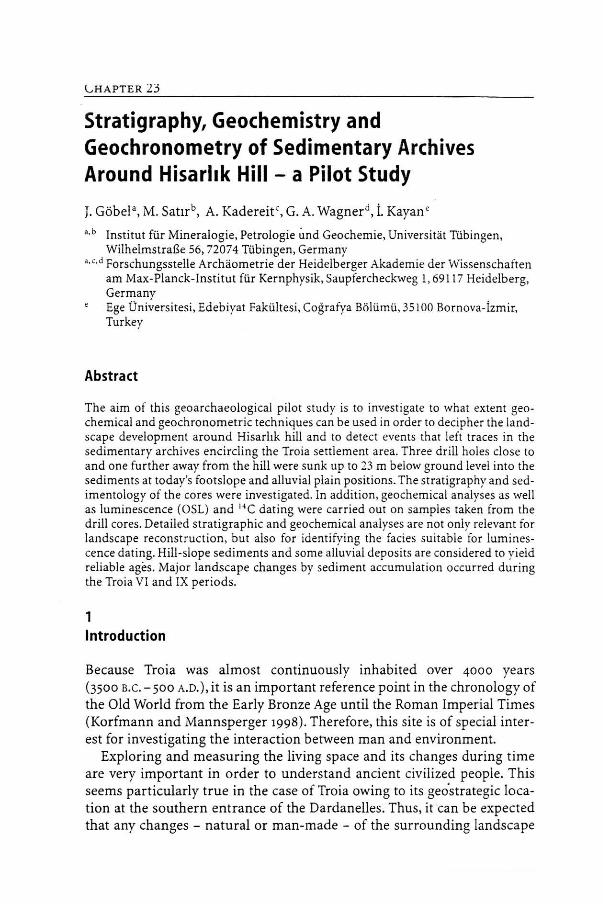
Stratigraphy, Geochemistry and Geochronometry of Sedimentary Archives Around Hisarhk Hill - a Pilot Study
J. Göbela, M. Satırb, A. Kadereit ' , G. A. Wagnerd, i. Kayan•
a.b Institut für Mineralogie, Petrologie Ünd Geochemie, Universitat Tübingen, Wilhelmst ra6e 56, 72074 Tübingen, Germany
a.c.d Forschungsstelle Archaometrie der Heidelberger Akademie der Wissenschaften anı Max-Planck-Institut für Kernphysik,Saupfercheckweg 1,691 17 Heidelberg, Germany Ege Üniversitesi, Edebiyat Fakültesi, Coğrafya Bölümü, 35100 Bornova-İzmir, Turkey
Abstract
The aim of this geoarchaeological pilot study is to investigate to what extent geochemical and geochronometric techniques can be used in order to decipher the landscape development around Hisarlık hill and to detect events that left traces in the sedimentary archives encircling the Troia settlement area. Three drill holes close to and one further away from the hill were sunk up to 23 m below ground level into the sediments at today's footslope and alluvial plain positions. The st ratigraphy and sedimentology of the cores were investigated. ln ad<lition, geochemical analyses as well as luminescence (OSL) and 14 C dating were carried out on samples taken from the drill cores. Detailed stratigraphic and geochemical analyses a re not only relevant for landscape reconstruct ion, but also fo r identify ing the facies suitable for luminescence dating. Hill-slope sediments and some alluvial deposits are considered to yield reliable ages. Major landscape changes by sediment accumulation occurred during the Troia VI and IX periods.
1 lntroduction
Because Troia was almost continuously inhabited over 4000 years (3500 B.C. - 500 A.D.), it is an important reference point in the chronology of the Old World from the Early Bronze Age until the Roman Imperial Times (Korfmann and Mannsperger 1998) . Therefore, this site is of special interest far investigating the interaction between man and environment.
Exploring and measuring the living space and its changes during time are very important in order to understand ancient civilized people. This seems particularly true in the case of Troia owing to its geo'strategic location at the southern entrance of the Dardanelles. Thus, it can be expected that any changes - natura! or man-made - of the surrounding landscape
342 CHAPTER 23 J. Göbel
had crucial effects on Troia's culture-historical role. Studies adjacent to the settlement of Troia give the possibility to conclude from scientific results both natural and historical events, as the sediments represent and archive geological and geomorphological events as well as historical and archaeological ones.
Besides the extensive archaeological excavations, started in 1870/ı871 by Heinrich Schliemann and going on today by Manfred Korfmann's team, a great number of geomorphological investigations in the plain of Troia was done by ilhan Kayan (cf. Kayan et al., this Vol.) within the last years. Kayan and his colleagues drew up the stratigraphy of that area forming the hasis for the studies and analyses presented here. Four drill cores, described in this paper, are part of that geomorphological work. To our knowledge, it is the first time that geochemical methods together with sedimentological and chronometric studies were performed on the deposits of the plain of Troia. An aim of this study is to quantify the sedimentary processes.
The deposits in the plain of Troia consist mostly of alluvial sediments of the two rivers Karamenderes and Dümrek, which have eroded the Mesoıoic and Palaeoıoic marbles and serpentinites as well as the Tertiary volcanic deposits in the hinterland. Occasionally, colluvial and marine deposits are included in the alluvial sediments the expression 'colluvial' here is used in its meaning according to Dalrymple et al. (1968). lnfrared stimulated luminescence (IRSL) can be used for age determination of colluvial and alluvial sediments; the former ones have mostly been dated successfully (e.g., Lang 1996; Kadereit 2000), whereas the latter ones commonly are problematic.
2 Material
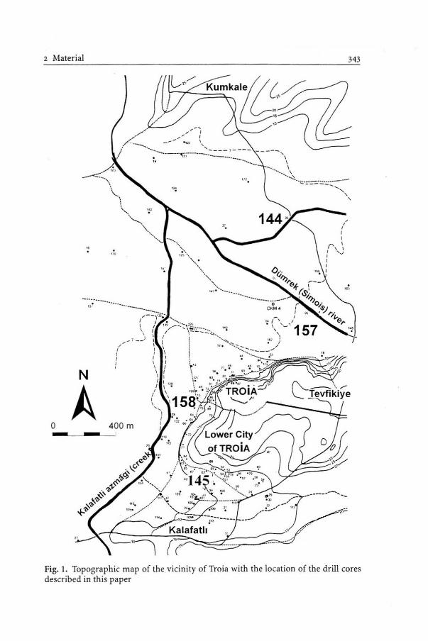
The vicinity of Troia is characteriıed by a low and a high plateau which consists of shallow marine limestones. Troia itself is located ona ridge of the lower plateau. In the north, west and south the ridge is surrounded by the delta plains of the Karamenderes and Dümrek Rivers (Kayan 1995, 1996).
The actual study area is situated close to the ancient city of Troia. Sediment samples have been taken from four drill cores, three of them (numbers 145, 157, 158) being located quite near the "Troia-ridge", the fourth, number 144, in the delta plain of the Dümrek about ı.5 km north of Troia (Fig. ı). This latter drill core reached a depth of 23 m. Drill site 157, situated about 500 m northeast of the great theatre of Troia and about 100 m away from the slope, reached a depth of 12 m. Located about 100 m away from the cave to the west of Troia, drill hole 158 reached a depth of 11.2 m. Drill site 145, reaching a
2 Material
A ) _..::::\
\ .. \
--~., .,
··........_ ............. ·;.. ,,., .. . , .
'•,, ..
,,.
·., .~~'-.............. .
"'
" i
N
A o 400 m
,.. 1 I 1
,,. I ' I
. \ '-' 157 ıu ' • I
343
Fig. l. Topographic map of the vicinity of Troia with the location of the drill cores described in this paper
344 CHAPTER 23 J. Göbel
Fig. 2. Simplifıed model of sedimentary archives
depth of 7.3 m, is located in the vicinity of the lower city of Troia in the Çiplak valley, at a distance of about 250 m from the old town wall.
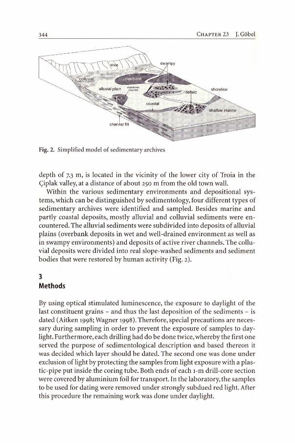
Within the various sedimentary environments and depositional systems, which can be distinguished by sedimentology, four different types of sedimentary archives were identifıed and sampled. Besides marine and partly coastal deposits, mostly alluvial and colluvial sediments were encountered. The alluvial sediments were subdivided into deposits of alluvial plains (overbank deposits in wet and well-drained environment as well as in swampy environments) and deposits of active river channels. The colluvial deposits were divided into real slope-washed sediments and sediment bodies that were restored by human activity (Fig. 2).
3 Methods
By using optical stimulated luminescence, the exposure to daylight of the last constituent grains - and thus the last deposition of the sediments - is dated (Aitken 1998; Wagner 1998). Therefore, special precautions are necessary during sampling in order to prevent the exposure of sarnples to daylight. Furthermore, each drilling had do be done twice, whereby the fırst one served the purpose of sedimentological description -and based thereon it was decided which layer should be dated. The second one was done under exclusion of light by protecting the samples from light exposure with a plastic-pipe put inside the coring tube. Both ends of each 1-m drill-core section were covered by aluminium foil for transport. in the laboratory, the samples to be used for dating were removed under strongly subdued red light. After this procedure the remaining work was done under daylight.
4 Results 345
First, the drill cores were described sedimentologically. Besides the visual documentation of the structure, texture, colour and the grain roundness, the grain-size distribution and the water content were also determined.
Ali specimens for geochemical analysis were taken strictly in the same layer that was sampled for dating. The bulk sediment samples were analysed by X-ray fluorescence (main elements and trace elements). After
. crushing, subsamples of ı.5 g each were mixed with 7.5 g of lithium borate as flux and homogenised. For each sample two tablets were produced and analysed. Table ı shows the arithmetic mean value of both aliquots.
IRSL dating is based on the ability of non-conducting solids, such as feldspars, to store a measurable part of the energy of ionising radiation in the crystal lattice. The ionising radiation arises from natural radioactivity and cosmic rays. When interacting with lattice atoms it releases charges, which are trapped at lattice imperfections over time. This stored energy can be set free as an emission of light during the supply of stimulation energy, in the case of IRSL, by infrared illumination. The intensity of the luminescence signal can be used for dating.
In the laboratory dark room the samples were taken from the drill cores. The material was removed from both ends, because it may have been exposed to daylight during the field sampling. Af ter splitting the plastic tubes in half, the sediments were sampled from the inner part of the core. Dose rate and moisture were determined on the material from the outer parts. For luminescence dating the polymineral fine-grain fraction ( 4 - ıı µm) was used. In order to remove organic material and calcareous components, the samples were treated with H20 2 and CH3COOH. After this, the desired grain fraction was separated. Finally, the samples were divided into 80 -100 parts (aliquots) and deposited on aluminium discs. Each disc carries 1- 2 mg of the sample material. For more information of the laboratory procedure, see Lang et al. (1996).
4 Results
4.1 Sedimentology
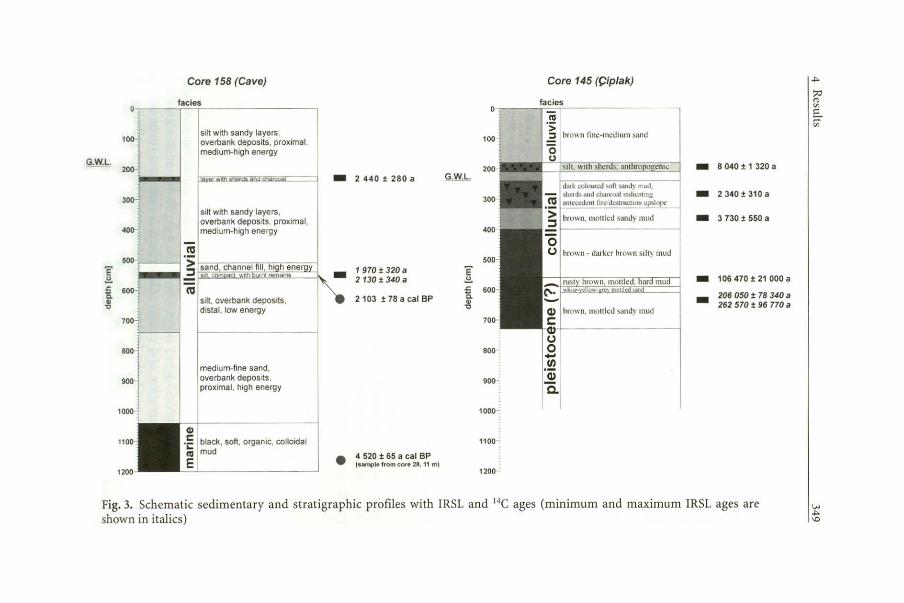
4.1.1 Core 144
Between the base and up to 9.40 m depth of the drill core, a l;>lack, soft, colloidal mud with a high content of organic material was found (Fig. 3). In the following 4.30 m, the colour changes from grey-brown to olive. This layer shows graded bedding from medium sand to silty mud, which formsa very
~ .ı:.
°' 1
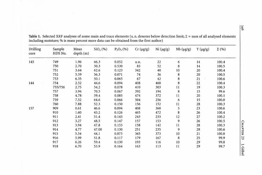
Table 1. Selected XRF analyses of some main and trace elements (u.n. denotes below detection limit; I = sum of ali analysed elements including moisture; % is mass percent more <lata can be obtained from the fırst author)
Drilling Sample Mean Si02 (%) PıOs (%) Cr (µg/g) Ni (µg/g) Nb (µg/g) y (µg/g) I (%) core HDS No. depth (m)
145 749 1.96 66.3 0.052 u.n. 22 6 14 100.4 750 2.70 50.3 0.530 83 52 8 14 100.5 751 3.64 62.6 0.123 342 40 10 20 100.4 752 5.59 56.3 O.ü71 74 36 8 20 100.5 753 6.35 50.1 0.065 67 42 8 21 100.6
144 754 2.52 44.6 0.094 408 460 8 22 100.4 755/756 2.75 54.2 0.078 410 303 11 19 100.3 757 3.94 70.5 0.067 392 194 8 15 99.6 758 4.78 . 59.4 0.085 474 372 11 20 100. l 759 7.52 64.6 0.066 504 256 6 15 100.0 760 7.88 52.3 0.150 156 152 11 28 100.3
157 909 0.61 46.6 0.094 408 360 5 23 100.6 910 1.60 43.2 0.126 465 472 8 26 100.4 911 2.41 51.4 0.143 243 233 12 27 100.2 912 3.27 48.5 . 0.147 157 153 9 26 100.5 ()
913 3.94 47.8 0.153 158 142 11 28 100.3 ::ı: >
914 4.77 47.00 0.130 251 235 9 28 100.6 "" .,ı
915 5.54 44.l 0.073 365 373 10 21 100.0 trı ;.ı
916 5.99 51.8 0.117 179 167 8 25 99.9 N ~
917 6.26 59.4 0.130 193 116 10 29 99.8 918 6.70 53.9 0.164 163 113 11 29 99.7 -C'l o:
o-!!..

919 6.99 54.0 0.187 181 128 920 7.59 51.7 0.166 135 127 921 8.38 47.8 0.144 217 201 922 8.99 45.3 0.114 265 250 923 9.33 70.5 0.040 758 413 924 9.99 60.1 0.128 196 159 938 10.87 50.8 0.1 38 222 231
158 925 1.69 57.5 0.148 150 93 937 2.18 71.l 0. 109 170 57 926 2.32 57.8 0.176 126 127 927 3.56 70.5 0.109 104 38 928 3.75 56.8 0.440 108 80 929 4.57 54.0 0.602 110 46 930 5.50 46.9 0.898 106 65 931 5.78 50.9 0.764 112 56 932 6.59 51.9 0.515 94 71 933 7.66 58.4 0.201 194 103 935 8.81 76.3 0. 108 227 91 936 9.53 66.0 0.104 137 55
9 25 8 27 6 24 5 21
u.n. 10 12 30 14 30 10 27 6 20 8 26 8 18 7 20
u.n. 15 u.n. 17 6 ı s
7 23 9 25 6 14 6 21
100.1 99.6 99.8 99.2 98.0 98.2 99.2 99.8
100.l 99.7 99.5
100.0 99.3
100.0 100.6 100.2 100.3 99.8
100.4
1
-1>-
;ı;:ı l'1>
"' ı:: ::+' "'
V> ~ '-1

VJ ..,. 00
Core 144 (Dümrek) Core 157 (Theatre)
0,.--facies facies
o silty mud: overbank deposits, low energy,
100-1 1 1 flood sediments in wet 100 environment G.W.L.
G.W.L. 2oo-J / .~ silty mud with little fine sand:
200
> overbank deposits, very low -4 840 ± 1 930 a t;; i dark brown sandy silt -2100 ± 540 a
300-1 1.:! energy,swampy • wet -7 450 :!: 2 280 a > 300 (ii envıronment :::ı
400-ti 1 400 o ı -3 450 :1: 300 a coarse sand: (.)
channe ı fi li, hig h energy -5 950 ± 670 a 1 4580 ± 2470a -500 ??? 5020:!: 2610 a
'E
~ 1
°'" mOO ''"" "°'' ~d) 'E 6420 ± 1980 a
~ ~ ve com act -7000 :!: 2150 a a .s::: a 600 brown silty mud -2 710 :!: 590 a Q) - deltaic, distal, low energy .. -3 070 ± 610 a " ,! coastal wet environment " P.S.L. -2 880 ± 1 410 a ... "' 700·
<U o
1
-6 450 ± 3 310 a
ı ·!! '~'";"m '"" oo•= u"" (.) fıne-medium sand: ·ı > overbank deposits, proximal,
deltaic, proximal, medium • 3 158 :!: 53 cat BP :::ı medium energy and 1 -3 090 :!: 300 a energy <U channel fılls, high energy • 3 7 45 ± 70 cal BP
900 (sample from core 38. 8·8.S l (J :ı:: >
Q)
I! c: Q) 4 860 :1: 55 cal BP 'i: black. soft, organic, c: • ( sample f rom core 03, 10-11 mı
<U colloidal mud • < 5744±43 cal BP 'i: black, soft. organic, colloktal
E ( sample f rom 22 • 23 m) <U mud
E 1 '';"-' C'l o: er ~
Core 158 (Cave) Core 145 (Çiplak)
facies facies
1~1 · ı j 1 bro" n fiııc-mcdıum >and silt with sandy layers. 1 100-l 1 1 overbank deposits, proximal
medium-high energy G.W.L. 200~ 1 1 200 enıc -8 040 t 1 320 a -2 440 t 280 a G.W.L.
1
300 -2340t 310a
silt with sandy layers, 1 overbank deposrts, proximaı , bro\\n, ınotı lcd sandy mııd -3 730 t 550 a
400 ~ ' 1 medium-high energy
500 ___ - 8 I brown • darkcr brown siiıy ınud
'E -1970t 320 a 'E .!!. 2130t340a .!!. -106 470 :t 21 ooo a .t:. 600 .t:. 600 a
s ılt, overbank depostts, 2 103 t 78 a caı BP a 206 050 :t 78 340 a "' .. -,,
dısla l. low energy ,, 262 570 t 96 770 a
brown, moıılcd ;andy ınud 700- 700
---
~ (.)
800 o ... medıum-fıne sand,
t/)
overbank deposrts. 900 ·;
proxımal , hıgh energy a. 1000~ 1000
1 100~ black. sofi. organıc, colloidal 1100 ~ mud • 4 520 t 65 a caı BP E 1H n'1> .. from core 28, 11 m)
1200 1200
Fig. 3. Schematic sedimentary and stratigraphic profıles with IRSL and 14C ages (minimum and maximum IRSL ages are shown in italics)
.j>.
::ı::ı (1l
"' E.. ..... "'
..,,.
.j>. \O
350 CHAPTER 23 J. Göbel
hard block above 7.50 m depth. Above 5.10 m depth, an olive-coloured coarse sand that includes a few well-rounded pebbles occurs up to the 3.60 m level. From there to the top follows a light brown silty mud with some organic material and at the base a little fıne sand.
4.1.2 Core 157
From the base of the drilling up to 10.10 m depth, there is a black, soft, colloidal, laminated mud, which includes organic material (Fig. 3). Above, a light brown-yellowish coloured sediment package follows up to 6.40 m. It consists of fine to medium and coarse sands with some silty layers in between. Up to a depth of 5.30 m a brown to light brown-yellowish layer of silty mud was observed. This layer is very compact between 5.70 and 5.60 m in depth. Up to the surface a dark-brown, homogeneous, sandy silt occurs containing tiny fragments of ceramics.
4.1.3 Core 158
As before, a black, soft, colloidal, laminated mud with organic material was found from the base up to 10.40 m depth (Fig. 3). Within the following 3.00 m, multicoloured medium sands interchange with fine sands. A darkbrown, homogeneous silt with little organic material forms the next layer up to the 5.60-m level. A ca. 20-cm-thick, compact, dark-brown layer contains a !ot of charcoal and ceramic fragments in a silty matrix. It is overlain by a brown-yellowish, 30-cm-thick medium-sized sand. From 5.10 m up to the surface the profile consists of silt with partly sandy zones. Its colour changes from brown-orange to brown-yellowish. in this layer another layer, containing charcoal and ceramic fragments in silty matrix, is included from 2-40 to 2.25 m depth.
4.1.4 Core 145
Core 145 consists at the base ofa browrl-mottled sandy mud (Fig. 3), which contains a few pebbles up to 1 cm in size. Up to a depth of 5.90 m a gradual change in sedimentation and colour takes place. A fine sand turns into a mottled, compact mud, the brown colour alters to a white-yellow-grey shade. At 5.90 m a sudden change in colour to rusty brown takes place, which changes gradually from dark to medium brown. Between 5.90 and 4.00 m a homogeneous, mottled mud was found. A clear boundary at
4 Results 351
4.00 m marks the beginning ofa new layer. lt is a brown, densely pressed mud with sandy particles at the base. Ata depth of 3.20 up to 2.40 m a darkcoloured, soft, sandy mud is included, which contains charcoal and numerous ceramic fragments. Above a distinct boundary at 2-40 m, a light olive-coloured, medium-sized sandy, soft mud with layers of coarse sand at the base fallows. This mud changes into a light-brown, medium-sized sand and on the top to a dark brown-coloured fıne to medium sand. At around 2 m a silty layer with ceramic fragments is intercalated.
4.2 Geochemistry
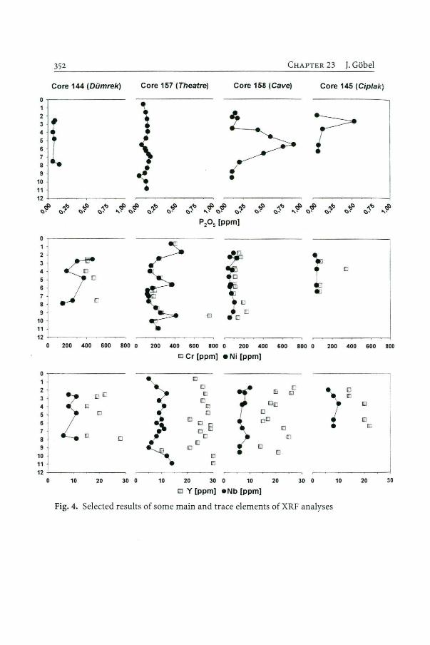
In Table 1 and Fig. 4, some representative results of the XRF analysis are summarised. Most element concentrations are rather high and range widely. Because the whole-rock fraction was analysed, the Si02 contents are relatively high and range between 43 and 76 mass %. Especially remarkable are some very high values of P 20 5• Five samples of drill core 157 show a higher content than the other samples. Samples HDS 928 and HDS 929 have much higher contents of P 20 5, reaching a maximum of 0.90 mass % in sample HDS 930 and decreasing gradually in the fallowing samples: sample HDS 933 stili shows a high content while sample HDS 935 reaches a lower value around 0.12 mass%. A second maximum value shows sample HDS 750 from drill core 145· Some trace elements alsa display a very high variation of their contents. So the sediments of drill core 144 and drill core 157 have evidently higher contents of Cr (156- 504 µg/g, drill core 144; 135 - 758 µg/g, drill core 157) and Ni (152 - 460 µg/g, drill core 144; 113-472 µg/g, drill core 157) compared to the sediments of the other two drill cores.
4.3 Dating
Altogether, 40 samples were taken far IRSL dating. Table 2 shows the dates received so far. For core 144 the ages range from 4.8 ± ı.9 to 7.5 ± 2.3 ka (ka = lOOo years). The ages far core 157 are mostly around 2-9 ± o.6 ka, and only samples HDS 914 and HDS 915 yield higher ages up to 7.0 ± 2.2 ka. For core 158 only two ages are currently available. Both are around 2.2 ± 0.3 ka, but far the second one only lower and upper limits can be given. For core 145 the ages range between 2.3 ± 0.3 and 263 ± 96.8 ka, the last age is only a maximum age. Again, the sediments of this drilling show an inverse order of ages.
352
Core 144 (Dümrek)
o ~-------1 2
ll 9
10 11
12 +--------<:lıf
o- -------
!1 : 1 7 -8 J
1~ ı 11 1 12 - - -
0 200 400 600 800 o
o ~-------
2 '
~ j 5 j 6 l 7
10 11
o
12--~-----
10 20 30 o
C HAPTER 23 J. Göbel
Core 157 (Theatre) Core 158 (Cave) Core 145 (Cip/ak)
• .... ~ ~ ,.,,, .şı ~ ..... ~~. ~~.
<:l•' " ' ~· <:l.. <:l• .;~ ., ~
P20 5 (ppm]
o
o
200 400 600 800 o 200 400 600 800 o 200 400 600
o er [ppm] • Ni (ppm]
o
ı:ı
El o El
o o o
a 8 Ll o
[]
o l!I
•
ı::ı
Ol!J o ı::ıD
o EJ
10 20 30 o 10 20
o Y [ppm] • Nb [ppm]
o
c El
o
30 o 10
o
o ı:;ı
20
Fig. 4. Selected results of some main and trace elements of XRF analyses
800
1
30

Table 2. IRSL ages I""' ::ı:ı ~
Core Sample HDS No. Mean depth (m) Facies Age ± l a(a) Date ± 1 o (s.c ./ A.D.) ,~ 144 754 2.52 Alluvial, swampy 4840 ± 1930 2840 ± 1930 B.C.
756 2.75 Alluvial, swampy 7450 ± 2280 5450 ± 2280 B.C.
758 4.78 Alluvial, channel fıll 5950 ± 670 3950 ± 670 B.C.
759 7.52 Coastal deltaic 6450 ± 3310 4450 ± 3310 B.C.
157 909 0.6 1 Colluvial Not datable 910 1.60 Colluvial Not datable 911 2.41 Colluvial 2100 ± 540 100 ± 540 B.C.
913 3.94 Colluvial 3450 ± 300 1450 ± 300 B.C.
914 4.77 Landslip >4580 ± 2470 2580 ± 24 70 B.C.
<5020 ± 2610 3020 ± 2610 B.C.
915 5.54 Landslip >6420 ± 1980 4420 ± 1980 B.C.
<7000 ± 2150 5000 ± 2150 B.C.
916 5.99 Colluvial 2710 ± 590 710 ± 590 B.C.
917 6.26 Colluvial 3070 ± 610 1070 ± 610 B.C.
918 6.70 Alluvial, overbank 2880 ± 1410 880 ± 1410 B.C.
921 8.38 Alluvial, overbank 3090 ± 300 l 090 ± 300 B.C.
158 926 2.32 Archaeological layer 2440 ± 280 440 ± 280 B.C.
930 5.50 Archaeological layer > 1970 ± 320 30 ± 320 A. O.
<2130 ± 340 130 ± 340 B.C.
145 749 1.96 Anthrop. fiil, sherds 8040 ± 1320 6040 ± 1320 B.C.
750 2.70 Colluvial, burnt layer 2340 ± 310 340 ± 310 B.C.
751 3.64 Colluvial 3730 ± 550 1730 ± 550 B.C.
752 5.59 Pleistocene 106 ± 21 ka 753 6.35 Pleistocene >206 ± 78 ka
<263 ± 97 ka 1 w Vl w
354
5 Discussion
5.1 Sedimentology and Dating
5.1.1 Core 144
CHAPTER 23 J. Göbel
Very fıne-grained sediments and an apparent absence of sedimentary structures indicate a low-energy environment deposit. Above the marine hasis at 9.40 m the sediments are fluvial, while up to a depth of 5.10 m there is a prograding delta situation with some disturbance by wave action. The coastal sediments change from a proximal delta situation at the bottom to a distal low energy facies. The uppermost 5.10 m were deposited in a proper terrestrial floodplain. The alluvial deposits consist either of coarse sandy channel fılls or muddy overbank deposits ofa swampy, badly drained environment. Four samples were taken for OSL dating: from the proximal deltaic sediments at 7.52 m, the sandy channel fılls at 4.78 m, the muddy overbank deposits at 2.75 and 2.52 m depths. As an independent age control two 14C-ages of organic material from the coastal and marine sediments of this drill core (sample 1: 8.50-m level, coastal environment, plant remains; sample 2: 22.00 - 23.00 m level, marine environment, plant remains) are available. Sample ı gave an age of 3158 ± 53 cal B.P. (i. e., uo8 ± 53 B.c.) and sample 2 an age of 5744 ± 43 cal B.P. (i. e., 3794 ± 43 B.c.). The IRSL ages of samples (from the base up) HDS 759, 758, 756 and 754 (Table 2, Fig. 3a) clearly show that all these IRSL ages are signifıcantly overestimated. This result came as no surprise to us, because these samples all come from environments where sediments are not properly bleached. Both the deltaic proximal and the channel infılls are situations where the sediment is transported at the bottom of the fluvial channels. The other ones are muddy deposits that were laid down in a badly drained overbank situation with colloidal transport. For OSL dating this means that fıne-grain material is transported as aggregates, the interior of which certainly would not be struck by daylight.
5.1.2 Core 157
Core 157 also begins with a marine section at the base, but the horizontal lamination indicates a depositional environment of the beach zone. Above, the profile contains sand of different grain-sizes characterising different
5 Discussion 355
subfacies within an alluvial environment. As before, the coarser sands represent channel fılls, which cut the fıner-grained overbank deposits. On top of the alluvial sediments follow colluvial deposits. These slope-washed sediments exhibit an enormous thickness of 6 m, a lack of any sedimentological structures and contain scattered small ceramic fragments. Near the hasis of this package, between 4.70 and 5.75 depth, there is a layer embedded that defınitely cannot be interpreted as colluvium, with the lower 30 cm being very compact, and the material above exhibiting unusual geochemical characteristics. This clearly shows that this layer could be interpreted either as an anthropogenic filling or as a landslip from the alluvial material rather than being colluvial in origin.
As to dating, two '4C ages from two nearby cores with alluvial and marine facies (sample 1: 3745 ± 70 cal B.P., i. e., 1795 ± 70 B.C., core 38, depth: 8.oo - 8.70 m, limestone; sample 2: 4860 ± 55 cal B.P., i. e., 2910 ± 55 B.C., core 03, depth: 10.oo-1ı.50 m, marine shell) are available. Apart from the two samples collected from the problematic non-colluvial section (HDS 914, 915, giving abnormally high OSL ages) ali OSL ages are either equally older or younger than the independent '4C ages and, thus, are stratigraphically consistent. Figure 3 shows that ali materials between 8.38 and 2.41 m depth were deposited within the same interval, most probably between Troia VI and Vlll.
5.1.3 Core 158
Above the. marine sediments at the base of core 158, the whole sediments of the profile are interpreted as alluvial deposits. Channel fılls alternate closely with overbank sediments. Intercalated are layers full of archaeological remains such as charcoal, ceramic fragments and other burnt materials ("archaeological layers"). Such layers were found at 2.25- 2.40 and 5.40- 5.60 m depth. For this core there are alsa two independent age controls by '4C-dating. One was taken from the nearby core 28 ( depth: l0.80 -1ı.30 m, limestone giving an age of 4520 ± 65 cal B.P., i. e., 2570 ± 65 B.c.). The other one was taken from the very archaeological layer at core 158 (5.50 m depth) yielding an age of 2103 ± 78 cal B.P. (i.e., 153 ± 78 B.c.). IRSL analysis of the sedimentary matrix of sample HDS 930 gives an upper limit of < 2130 ± 340 a (i. e., 130 ± 340 B.c.) and a lower limit of > 1970 ± 320 a (i. e., 30 ± 320 A.D.). The notation of possible minimum and maximum ages is due to radioactive disequilibrium determined by low-level gamına spectrometry in the 238U chain. This age range, however, is concordant with '4C-age of the charcoal from this layer. Therefore, this fire event took place in the late Hellenistic or early Roman periods. For the second ar-
CHAPTER 23 J. Göbel
chaeological layer (HDS 926) at 2.30 m depth an IRSL age of 2440 ± 280 a, i. e., 440 ± 280 B.C. was determined which, within the error limits, agrees with the age of the lower archaeological layer. This implies that both layers belong to the same cultural period in which intermittently 3 m thick alluvial overbank material was accumulated.
5.1.4 Core 145
This core is completely made up of slope-wash material apart from a 30-cm-thick layer between ı.80 and 2.10 m depth that contains many sherds and is very compact. lt most probably has to be interpreted as anthropogenic filling. At a depth between 2-40 and 2.30 m another archaeological layer was faund which is dark in colour and contains abundant sherds and charcoal, indicating a conflagration uphill. Whereas from stratigraphical analysis the uppermost 5.60 m are interpreted as Holocene colluvial material, the deposits below were, due to their different appearance, considered to be of pre-Holocene (Pleistocene) age.
Altogether five samples were collected from this core far OSL dating. Apart from sample HDS 749, which was taken from the anthropogenic layer the OSL ages show decreasing stratigraphically consistent values from bottom to top. The stratigraphically inconsistent overestimated age of sample HDS 749 is not surprising as the material was dumped by man, and thus had certainly not been properly bleached with the interior of the lumps. The lowermost samples HDS 752 (106 ± 21 ka) and HDS 753 (lower and upper limits of 206 ± 78 and 263 ± 97 ka, respectively) give preHolocene ages, thus confırming the assumption of their Pleistocene origin. The colluvial sample HDS 751 (3730 ± 550 a) thus gives an age belonging somewhere between Troia 11 and Troia Vll. Far the archaeological layer (HDS 750, 2340 ± 310 a, i. e., 340 ± ııo B.c.), as far the other two archaeological layers, faund in core 158, again an OSL age is observed which, according to the Troia stratigraphy by Korfmann and Mannsperger (1998), either belongs to the late Hellenistic or early Roman periods.
5.2 Geochemistry
With the results of the geochemical analyses it is possible to support the sedimentology and the stratigraphy. The P20; content enables us to detect an anthropogenic influence. This fact explains itself by the existence of bone particles with hydroxyl apatite (Ca5[P04b[OH]) as surviving material. Unusually high phosphate contents indicate the archaeological layers in
5 Discussion
N
A
2km
Legend
D Holocene
D Pleistocene {terrestria-
D Neogene (limestone. marı ,
claystone, sandstone)
• Neogene (volcanic: basalt)
357
• Permian (crystalline limestone, marble)
D Micaschist
D Plio-Pleistocene (terrestrial-detritic) • Ultramaphic rocks (serpentintte) e major spring areas
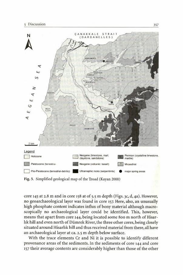
Fig. 5. Simplifıed geological map of the Troad (Kayan 2000)
core 145 at 2.8 m and in core 158 at of 5.5 m depth (Figs. 3c, d, 4a). However, no geoarchaeological layer was found in core ı57. Here, also, an unusually high phosphate content indicates influx of bony material although macroscopically no archaeological layer could be identifıed. This, however, means that apart from core 144, being located some 800 m north of Hisarlık hill and even north of Dümrek River, the three other cores, being closely situated around Hisarlık hill and thus received material from there, all have an archaeological layer at ca. 2.5 m depth below surface.
With the trace elements Cr and Ni it is possible to identify different provenance areas of the sediments. In the sediments of core 144 and core 157 their average contents are considerably higher than those of the other
C HAPTER 23 J. Göbel
two cores. This fact reflects the chemical composition of the geological setting of the Dümrek drainage area which differs from that of the Karamenderes drainage area (Fig. 5). In core 145 the Cr content in sample HDS 752 is h igher than in the other samples of this drill core. This is possibly an outlayer, because the Cr/Ni ratio, which usually ranges between ı.6 and 2.1 at this site, is 8.6 in that sample. Also, Nb and Y mirror the petrologic characteristics of the provenance area. Core 157 shows a slightly higher value of these elements. Nb and Y are incompatible elements, which are enriched, for example, in the minerals olivine, plagioclase and amphibole. These minerals occur in basalts. Therefore, the basaltic rocks south of Troia might be the source of these sediments of core 157· As a medium of transport only the River Karamenderes is possible. Although the River Dümrek also passes basaltic rocks, in the case of the Karamenderes both the drainage area and the spreading area of basalt are signifıcantly larger compared to th e Dümrek, resulting in higher Nd and Y signals. Core 145 should have similar high values, but due to the wider branching of the River Karamenderes the original signal is diluted by the River Çiplak. Far future studies a sample would be essential in order to analyse the surrounding rocks of the river catchments accordingly. Core 157 at 5.0- 5.5 m depth possesses anomalous high Ni and Cr contents (j ust above the very compact layer at 5.6- 5.7 m ). These high Ni and Cr values indicate fluvial input from the east, whereas low ones reveal the dominance of slope wash from Hi sarlık hill.
6 Conclusion
The geochemical studies show that such <lata are important for stratigraphical, sedimentological and facies analysis as well as the identification of source areas for sediments.
OSL dating was applied to slope-wash material (Pleistocene deposits, Holocene colluvium), alluvium (channel fills and overbank deposits from well-drained and swampy regions), archaeological layers, anthropogenic fills and probably land-slip material. Additive multiple aliquot protocols were used for polymineral fıne-grain fractions (IRSL) of these sediments. The results show that slope-wash material is reliably datable - a finding that is consistent with earlier experiences in Middle Europe (Lang and Wagner 1996; Lang et al. 1999; Kadereit 2000).Alluvial sediments, however, turned aut to be rather problematic. Not surprisingly, channel fili and overbank deposits from swampy areas were apparently not properly bleached and consequently show s ignifıcant age over-estimation. Overbank deposits from well-drained areas are stratigraphically consistent and
6 Conclusion 359
thus seem to be more suitable for OSL dating. Of course, anthropogenic deposits and land-slip blocks are not datable, since the interio'r grains have not been exposed to light.
As this is only a pilot study, error margins are stili quite large. ln the future the error limits can be significantly reduced for the dose by using single aliquot techniques and for the dose-rate when more information on the moisture content of the sediments becomes available.
For the archaeological layers in the cores 145 and 158 a mean OSL age of 202 ± 313 B.c. was calculated, which together with the '4C age (153 ± 78 B.c.) from below the layers in core 158 is in accordance with the archaeological assumption that these layers may be either from the cultural periods of Troia VII or IX (Korfmann, pers. comm.). Considering the numerical dates one can exclude Troia VII. Thus, drilling cores taken close to Hisarlık hill prove to be excellent archives storing information about the destructive event upslope.
The observation that sediment packages of several m thickness, namely in core 157 and 158, were deposited probably during the periods Troia VI to IX show that enormous landscape changes in the alluvial plain took place and that the Jandscape found today. These results are in full agreement with Kayan's findings of the delta progradation (this Vol.).
Acknowledgements. The present project is part of the interdisciplinary research within the DFG Graduate School ,,Anatolia and its neighbours" at the University of Tübingen and a co-operation between the ,,Forschungsstelle Archiiometrie" in Heidelberg and the Institute of Geochemistry at the University of Tübingen. Dr. B. Kromer, Forschungsstelle Radiometrie der Heidelberger Akademie der Wissenschaften, graciously supplied the 11C ages. Thanks are extended to G. Bartholoma, S. Lindauer and M. Schumann for their help with laboratory procedure. Discussions with Dr. Ch. Wolkersdorfer improved an earl ier version of th is paper.
References All references of the chapters are at the end of the book. Total 30 pages of these references are not included here.
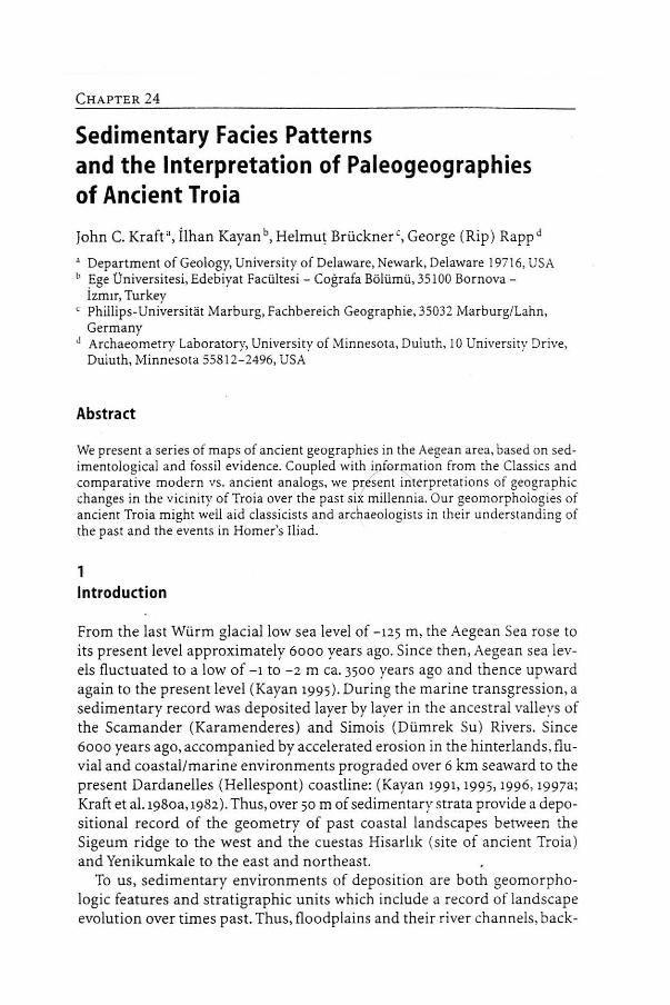
CHAPTER 24
Sedimentary Facies Patterns and the lnterpretation of Paleogeographies of Ancient Troia
John C. Kraft•, İlhan Kayan b, Helmut Brückner ' , George (Rip) Rapp d
a Department of Geology, University of Delaware, Newark, Delaware 19716, USA b Ege Üniversitesi, Edebiyat Facültesi - Coğrafa Bölümü, 35100 Bornova -
İzmır, Turkey c Phillips-Universitat Marburg, Fachbereich Geographie, 35032 Marburg/Lahn,
Germany J Archaeometry Laboratory, University of Minnesota, Duluth, 10 University Drive,
Duluth, Minnesota 55812-2496, USA
Abstract
We present a series of maps of ancient geographies in the Aegean area, based on sedimentological and fossil evidence. Coupled with ipformaıion from the Classics and comparative modern vs. ancient analogs, we pr/sent interpretations of geographic changes in the vicinity of Troia over the pası si~ millennia. Our geomorphologies of ancient Troia might well aid classicists and archaeologists in rheir understanding of the past and the events in Homer's Iliad.
1 lntroduction
From the last Würm glacial low sea level of -125 m, the Aegean Sea rose to its present level approximately 6000 years ago. Since then, Aegean sea levels fluctuated to a low of - ı to - 2 m ca. 3500 years ago and thence upward again to the present level (Kayan 1995). During the marine transgression, a sedimentary record was deposited layer by layer in the ancestral valleys of the Scamander (Karamenderes) and Simois (Dümrek Su) Rivers. Since 6000 years ago, accompanied by accelerated erosion in the hinterlands, fluvial and coastal/marine environments prograded over 6 km seaward to the present Dardanelles (Hellespont ) coastline: (Kayan 1991, 1995, 1996, 1997a; Kraft et al. 198oa, ı982). Thus, over 50 m of sedimentary strata provide a depositional record of the geometry of past coastal landscapes between the Sigeum ridge to the west and the cuestas Hisarlık (site of ancient Troia) and Yenikumkale to the east and northeast.
To us, sedimentary environments of deposition are both geomorphologic features and stratigraphic units which include a record of landscape evolution over t imes past. Thus, floodp lains and their river channels, back-
CHAPTER 24 J. C. Kraft
swamps, levees and ponds; coastal barriers, lagoons, marshes and asmaks (small drowned river estuaries); and shallow marine embayments are the surficial expressions of past sedimentary processes and their resultant strata. Coupled with evidence from their lineaments or geometries, internal sedimentary structures, flora! and fauna! (fossil) remains, and 14C dates there from, they form geomorphic models upon which we may base interpretations of ancient landforms, processes, salinities, ete. To do this we use basic geological principles and methodologies. Walther's principle of the correlation of sedimentary facies is the concept whereby we can interpret conformable and nonconformable sedimentary strata both laterally and vertically into possible map delineations of the past. Allied with the concept of uniformitarianism or its modern variant actualism, we use present geometries of sedimentary environments of deposition as analogs for our interpretation of past morphologies. The study of modern depositional environments and nıorphologies and their ancient equivalents become an exercise in reasoning based on the partial information available to us in the stratigraphic record. This is also an exercise in ontologic methodology based on the observations of present interrelationships of sedimentary depositional body shapes and structures versus the processes impinging upon, molding, and constantly reforming fluvial, coastal, and nearshore marine environments (Kraft ı971; Kraft and Chrzastowski ı985) .
Perhaps nowhere are such analyses more useful than in the reconstruction of ancient coastal landscapes associated with historical and archaeological sites. We present a series of modern/ancient studies in coastal Greece and Turkey to illustrate possible variants in the coastal morphologies for Troia and its environs over the past six millennia. These, coupled with evidence from archaeology and history, allow more precise paleogeographic reconstructions of the locales long associated with the events in Homer's Iliad.
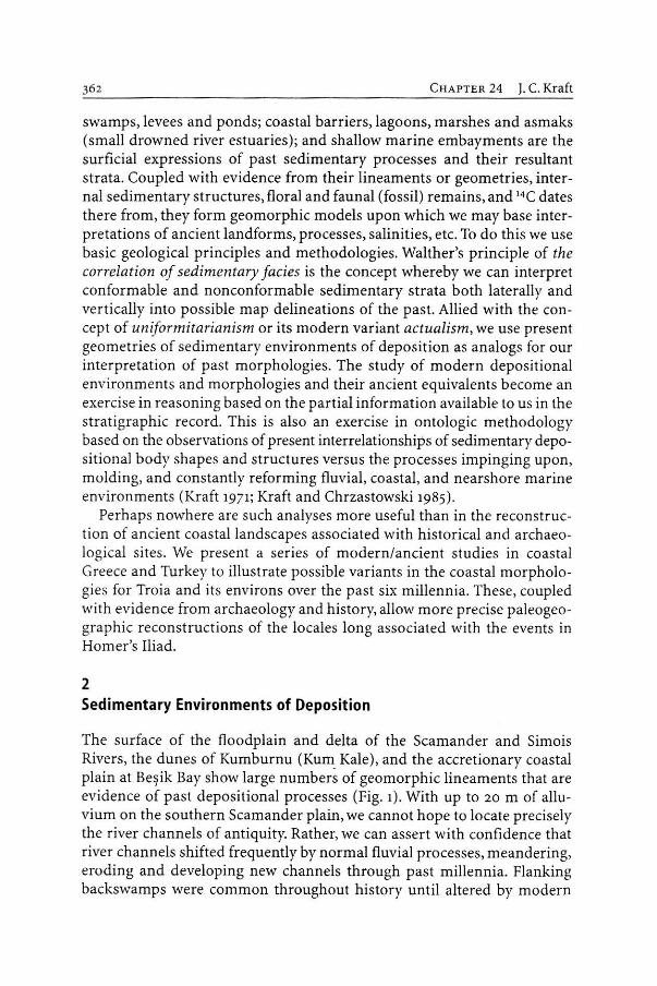
2 Sedimentary Environments of Oeposition
The surface of the floodplain and delta of the Scamander and Sirnois Rivers, the dunes of Kurnburnu (Kum Kale), and the accretionary coastal plain at Beşik Bay show large nurnbers of geomorphic linearnents that are evidence of past depositional processes (Fig. ı). With up to 20 m of alluvium on the southern Scamander plain, we cannot hope to locate precisely the river channels of antiquity. Rather, we can assert with confıdence that river channels shifted frequently by normal fluvial processes, meandering, eroding and developing new channels through past millennia. Flanking backswamps were common throughout history until altered by modern
2 Sedimentary Environments of Deposition
Fig. 1. Troia and its environs showing physiographic lineaments on the Scamander and Simois floodplains and the Beşik embayment coastal plain (from air photo analysis by O. Erol 1972) . Fluvial lineaments dominate, with coast-parallel lineaments only near the Dardanelles. The sand dunes of Kumburnu lie adjacent to shallow marine shoals and coast-parallel littoral transport sands of the Aegean shore
C HAPTER 24 J. C. Kraft
drainage and irrigation structures of the twentieth century. As noted on some early maps, irregularities along the flanking hills sheltered remanent lakes or ponds and swamps, possible loci of ancient anchorages or harbors. Coast-parallel lineaments occur only in the lower 2 km of the Scamander floodplain. Barrier accretion ridges do occur on the Beşik coastal plain. T. Spratt of the HMSN Beacon mapped the Troad in 1839 A.D. and showed the natura! flood channels of the Scamander River (Fig. 2).
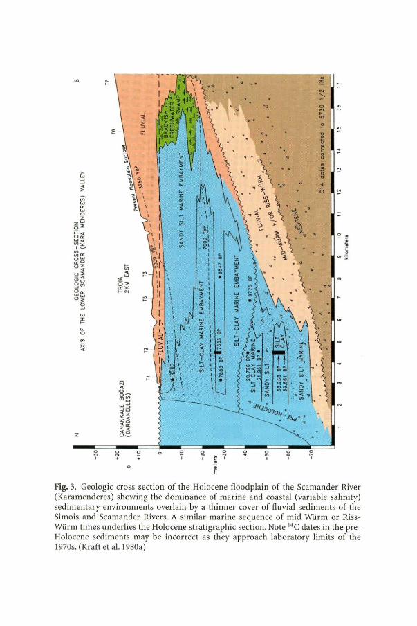
The cross section in Fig. 3 shows Holocene sedimentary strata indicating environments of deposition ranging from shallow nearshore marine silt-clay, nearshore marine, lagoon and estuarine sandy silts, organic silts of brackish to saline coastal marslı es, and fresh water sand, silt and clay of the prograding delta channels, floodplain, ponds and backswamps.
Fossil pelecypods and gastropods are sometimes indicative of strictly marine conditions, but in shallow marine embayments, such as the vicinity of ancient Troia, the common molluscs present were tolerant of ranges from brackish to normal marine salinity.
Yang (1982) identified five biofacies based on microfaunal analysis of seven drill cores: IA fluvial including freshwater charophytes; IB marsh or coastal swamp and t idal creeks, seasonally variable from freshwater to brackish; lJ nearshore restricted marine to brackish marslı and shallow marine embayments, lagoons; III brackish to moderately saline lagoons, estuaries or marshes (with rare freshwater incursions); and IV very shallow nearshore marine embayment or lagoon with variable salinities and water depth to 40 m (see alsa Kraft et al. 198oa, 1982). Microfauna such as foraminifers and ostracods serve as environmental indicators in bays, lagoons, and streams in the lower valleys that vary significantly from fresh to variable brackish to marine (and even hypersaline) dependent on season, variable freshwater input from local rain or floods, and summer drought evaporation. it is important to note that coastal lagoons, lower delta flanking lakes, and even stream channels often have bases below sea level. This may be caused by delta dist ributary bypassing, sedimentary subsidence and compaction, and the inherent fact that river distributary channels incise below sea level in lower delta regions. The depth of incision is dependent on stream flow volume.
3 Modern-Ancient Analogs
The creation of maps of ancient sedimentary environmental landforıns by use of modern analogs is a process with roots in early geological principles. However, it is with the detailed studies of the internal structure of sedimentary strata and their enclosed biofauna/fossils, as developed in the late

3 Modern-Ancient Analogs
mını ModemTown 1: ] High Plaloau - Trovcrtine Fon o r Village
ı 1 Mounloinous Terroin 1 1 Alluvium Di•tribulory C honnols
(~ : ~ Sond Dunes o nd ~ M condcring River
1 low Plo leou 1
.·.·. 1 ..;.:·:·:-. C ooslol Borriors ~'t.f~ Sandy Coasllinc
Shallow Matine - Marsh • Archaeologicol Silcs Saııd S hoals
• Ancient Towns
Fig. 2. Geomorphic elements in the Troad , pre-m odern agricultural development (T. Spratt, 1839 A.D.,HMSN Beacon). Five river channels anda canal to amili on the Beşik plain may be compared with the la rger number of relict river channel lineaments visible in a ir photo analysis (see Fig. 1). Legend applies for most figures herein
Vl
z
>..., _, _, < >
o .., +
;::; ... .., o~
m"' ..., ~:1 ... .... "'z "' "' « o z"' ~e
~ +
o
o +
"' ~
;:.
o o 1
~ o
~ ..,
1 1
• • E
..
... ..
... '•
. q\ . . : i\ ~ .. ~ ..• .
. ~ \· . ~ 4!. '5 t .·
3 -:; ı
~ 1
.... ~ ·\.\· ~ .. '
\ . o : , "" ...
5l o ~ "' ' 1 1
;; '.::
"' ' o ~ .., ... .., 2
~ .., • Ü
~ :! o u .. • o :'.' .., ... u ~
..
Fig. 3. Geologic cross section of the Holocene floodplain of the Scamander River (Karam enderes) showing the dominance of marine and coastal (variable salini ty) sedimentary environments overlain by a thinner cover of fluvial sediments of the Simois and Scamander Rivers. A similar mar ine sequence of mid Würm or RissWürm times underlies the Holocene stratigraphic section. Note 14 C dates in the preHolocene sediments may be incorrect as they approach laboratory limits of the 1970s. (Kraft et al. l 980a)
3 Modern-Ancient Analogs
twentieth century, that paleogeographic analyses became a norm in relation to archaeological and historic sites. We present four examples of delta floodplain and coastline reconstructions that relate to archaeological/historic settings in the Aegean region. Each example includes useful concepts and information applicable to our analysis of the morphology of paleosedimentary environments in the Troad.
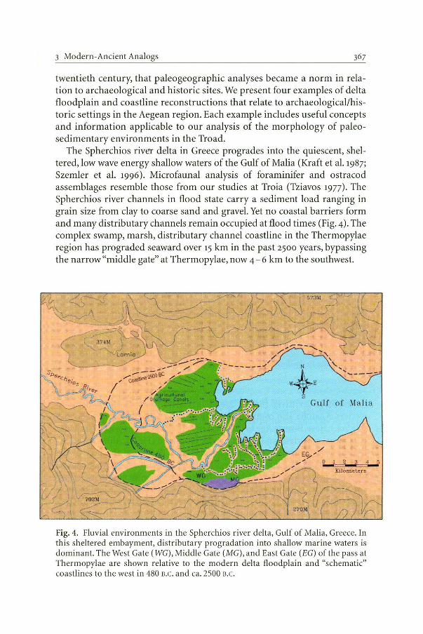
The Spherchios river delta in Greece progrades into the quiescent, sheltered, low wave energy shallow waters of the Gulf of Malia (Kraft et al. 1987; Szemler et al. 1996). Microfaunal analysis of foraminifer and ostracod assemblages resemble those from our studies at Troia (Tziavos 1977). The Spherchios river channels in flood state carry a sediment load ranging in grain size from clay to coarse sand and gravel. Yet no coastal barriers form and many distributary channels remain occupied at flood times (Fig. 4) . The complex swamp, marsh, distributary channel coastline in the Thermopylae region has prograded seaward over 15 km in the past 2500 years, bypassing the narrow "middle gate" at Thermopylae, now 4 - 6 km to the southwest.
·+' Gulf of Malia
/ t g... "'
_,. " o l 2...J w Kilometers
Fig. 4. Fluvial environments in the Spherchios river delta, Gulf of Malia, Greece. In this sheltered embayment, distribu tary progradation into shallow marine waters is dominant. The West Gate ( WG), Middle Gate (MG), and East Gate (EG) of the pass at Thermopylae are shown relative to the modern delta floodplain and "schematic" coastlines to the west in 480 B.C. and ca. 2500 B.C.
368
N
w4~E (
AECEAN
SEA o 2 • 6 8 10
Kilomefers
CHA PTER 24 J. C. Kraft
Fig. 5. The Meander River (Büyük Menderes) delta floodplain in Aegean coastal Anatolia showing a wave-modified prograding delta and shallow marine coastal lagoon and sandy barrier. Sediment supply has been reduced by ir rigation engineering. Wave act ion is moderate and periodic. The major ancient seaport ci ties of Miletus, Priene, and Herakleia in Classical t iınes, aınongst others, are shown. The boundary between the alluvium and mountainous terrain delineates ıhe coastline of Neolithic and Early Bronze age times. (With ınodifications, after Brückner 2000)
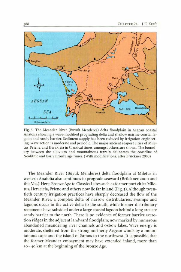
The Meander River (Büyük Menderes) delta floodplain at Miletus in western Anato lia also continues to prograde seaward (Brückner 2000 and this Vol. ). Here, Bron ze Age to Classical s ites such as former port cities Miletus, Heracleia, Priene a nd others now lie far inland (Fig. 5). Although twen tieth century irrigation practices have sharply decreased the flow of the Meander River, a complex delta of narrow d istributaries, swamps a nd lagoons occur in the act ive delta to the south, whi le former distributary remanents have subsided under a large coastaJ lagoon behind a long arcuate sandy barrier to the north. There is no evidence of fo rmer barrier accretion ridges in th e adjacent landward floodplai n, now marked by numerous abandoned meanderi ng river cha nnels and oxbow lakes. Wave energy is moderate, sheltered from the st rong northerly Aegea n winds by a mountainous cape and the island of Samos to the northwest. it is possible that the former Meander embayment may have extended inla nd, more than 30- 40 km at the beginning of the Bronze Age.
4 Paleogeographies at Troy
IXJ~O@'ii'D© LMil@ 00@00&00 (p&\ll,§@@@:@@~8
ıPfillMlO~ ooııw~oo
0-=-~==2=---=3 ==4 Kilometers
~ Pliocene
~ Pre-Pllocene
LJ Alluvium
W Torrentiol Alluvial Fa n
ı::~:::J Coastol Swomp
~ Coostline
Fig. 6. The Pamisos river delta floodplain in southern Peloponnese is shown relative to the modern, Roman, and Early Bronze Age coastlines. These coastlines are dominated by high energy storm waves with a large aınount of sand and gravel in littoral transport. Archaeological sites are shown: M Medieval, R Roman, He Hellenistic, C Classical, A Archaic, G Gcometric, and EH, MH, LJ-1 Early, Middle and Late Helladic. (Based on Kraft et al. 1975)
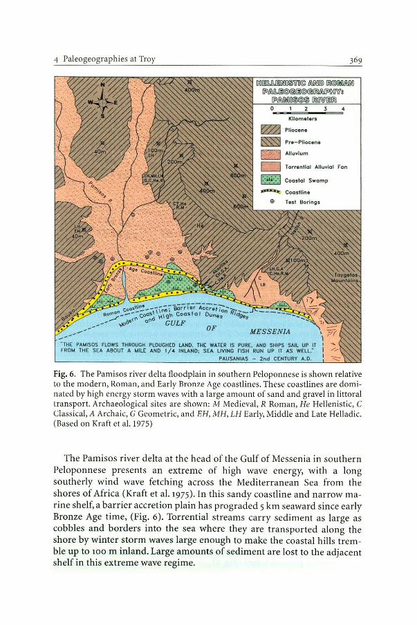
The Pamisos river delta at the head of the Gulf of Messenia in southern Peloponnese presents an extreme of high wave energy, with a long southerly wind wave fetching across the Mediterranean Sea from the shores of Africa (Kraft et al. 1975). ln this sandy coastline and narrow marine shelf, a barrier accretion plain has prograded 5 km seaward since early Bronze Age time, (Fig. 6). Torrential streams carry sedirnent as large as cobbles and borders into the sea where they are transported along the shore by winter storm waves large enough to make the coastal hills tremble up to 100 m inland. Large amounts of sediment are lost to the adjacent shelf in this extreme wave regime.
370 CHAPTER 24 J. C . Kraft
............. BORDIJI .W.BtE ,u;o SWAWPY ARU.S
f"\., OlD MU M.DER lOOPS -...,, OlD RMll SCARP - INCISED
\... SElCUK IURIC ROAD morbfe block• from (phcsuı:
E) 4UUV1Al r»1 DR. ERTUG OlfER
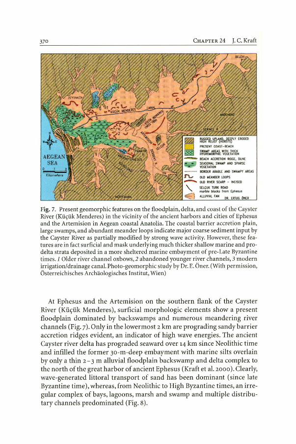
Fig. 7. Present geomorphic features on the floodplain, delta, and coast of the Cayster River {Küçük Menderes) in the vicinity of the ancient harbors and cities of Ephesus and the Artemision in Aegean coastal Anatolia. The coastal barrier accretion plain, large swamps, and abundant meander loops indicate major coarse sediment input by the Cayster River as partially modifıed by strong wave activity. However, these features are in fact surfıcial and mask underlying much thicker shallow marine and prodelta strata deposited in a more sheltered marine embayment of pre-Late Byzantine times. 1 Older river channel oxbows, 2 abandoned younger river channels, 3 modern irrigation/drainage cana!. Photo-geomorphic study by Dr. E. Öner. {With permission, Österreichisches Archaologisches Institut, Wien)
At Ephesus and the Artemision on the southern flank of the Cayster River (Küçük Menderes), surficial morphologic elements show a present floodplain dominated by backswamps and numerous meandering river channels (Fig. 7 ). Only in the lowermost 2 km are prograding sandy barrier accretion ridges evident, an indicator of high wave energies. The ancient Cayster river delta has prograded seaward over 14 km since Neolithic time and infilled the former 30-m-deep embayment with marine silts overlain by only a thin 2 - 3 m alluvial floodplain backswamp and delta complex to the north of the great harbor of ancient Ephesus (Kraft et al. 2000 ). Clearly, wave-generated littoral transport of sand has been dominant (since !ate Byzantine time), whereas, from Neolithic to High Byzantine times, an irregular complex of bays, lagoons, marsh and swamp and multiple distributary channels predominated (Fig. 8).
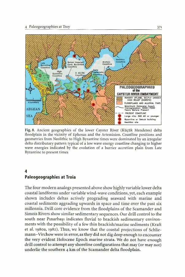
4 Paleogeographies at Troy
PAUOGIEOGMPlltlH otllıe
371
CAYSTEI RMR EllBAYMENT ~ RU~fi~ ~:~oc~m EROOEO
D rLooOPt.AJNS ANO ALUMAL rAHs
~ r,~~~~~s:!~~Söôo:~ooı Yeors Before Preunl
- - - PRESEKT COASTLINE e l orge Ylllo: $00 AD ot yo unger e 8yzonfine Ot S•lcuk bui1d ing e Neolithjc site
Fig. 8. Ancient geographies of the lower Cayster River (Küçük Menderes) delta floodplain in the vicinity of Ephesus and the Artemision. Coastline positions and geoınetries from Neolithic to I-Iigh Byzantine times were dominated by an irregular delta distributary pattern typical ofa low wave energy coastline changing to higher wave energies indicated by the evolution of a barrier accretion plain from Late Byzantine to present times
4 Paleogeographies at Troia
The four modern analogs presented above show highly variable lower delta coastal landforms under variable wind-wave conditions, yet, each example shown includes deltas actively prograding seaward with marine and coastal sediments aggrading upwards in space and time over the past six millennia. Drill core evidence from the floodplains of the Scaınander and Simois Rivers show similar sedimentary sequences. Our drill control to the south near Pınarbaşı indicates fluvial to brackish sedimentary environments with the possibility ofa few thin brackish/marine sediments (Kraft et al. 198oa, ı982). Thus, we know that the coastal projections of Schliemann-Virchowwere in error,as theydid not dig deep enough to encounter the very evident Holocene Epoch marine strata. We do not have enough drill control to attempt any shoreline configurations that may (or may not) underlie the southern 4 km of the Scamander delta floodplain.
372 CHAPTER 24 J. C. Kraft
We do, however, have the benefit ofa large amount of drill core evidence from Kayan's research of the past decade. Thus, our delineation of lower delta coastline paleogeographies can be extremely precise in some loca! areas while elsewhere overall patterns of coastline morphology remain in question (see Kayan 1991, 1995, 1996, 1997a; Kraft et al. 198oa, 1982 for drill core sites, stratigraphic cross sections and discussion).
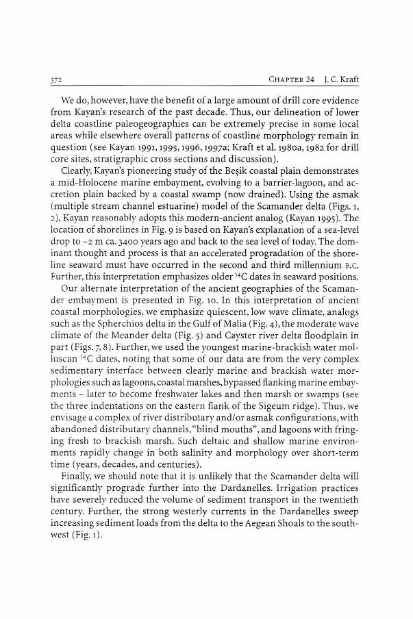
Clearly, Kayan's pioneering study of the Beşik coastal plain demonstrates a mid-Holocene marine embayment, evolving to a barrier-lagoon, and accretion plain backed by a coastal swamp (now drained). Using the asmak (multiple stream channel estuarine) model of the Scamander delta (Figs. ı, 2), Kayan reasonably adopts this modern-ancient analog (Kayan 1995). The location of shorelines in Fig. 9 is based on Kayan's explanation ofa sea-level drop to -2 m ca. 3400 years ago and back to the sea !eve! of today. The dominant thought and process is that an accelerated progradation of the shoreline seaward must have occurred in the second and third millennium B.C.
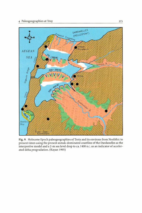
Further, this interpretation emphasizes older 14C dates in seaward positions. Our alternate interpretation of the ancient geographies of the Scaman
der embayment is presented in Fig. ıo. ln this interpretation of ancient coastal morphologies, we emphasize quiescent, low wave climate, analogs such as the Spherchios delta in the Gulf of Malia (Fig. 4), the moderate wave climate of the Meander delta (Fig. 5) and Cayster river delta floodplain in part (Figs. 7, 8) . Further, we used the youngest marine-brackish water molluscan 14 C dates, noting that some of our <lata are from the very complex sedimentary interface between clearly marine and brackish water morphologies such as lagoons, coastal marslı es, bypassed flanking marine embayrnents - later to become freshwater lakes and then marsb or swamps (see the three indentations on the eastern flank of the Sigeum ridge). Thus, we envisage a complex of river distributary and/or asm ak confıgurations, with abandoned distributary channels, "blind mouths", and lagoons with fringing fresh to brackish marslı . Such deltaic and shallow marine environments rapidly change in both salinity and morphology over short-term time (years, decades, and centuries).
Finally, we should note that it is unlikely that the Scamander delta will signifıcantly prograde further into the Dardanelles. Irrigation practices have severely reduced the volume of sediment transport in the twentieth century. Further, the strong westerly currents in the Dardanelles sweep increasing sedim ent loads from tbe delta to the Aegean Shoals to the southwest (Fig. 1).
4 Paleogeographies at Troy 373
+ AECEAN
- > •
Fig. 9. Holocene Epoch paleogeographies ofTroia and its environs from Neolithic to present times using the present asmak-dominated coastline of the Dardanelles as the interpretive model anda 2-m sea level drop to ca. 1400 B.C. as an indicator of accelerated delta progradation. (Kayan 1995)
374 C HAPTER 24 J. C . Kraft
AECE.4i'ıl
Fig. 10. Holocene Epoch paleogeographies of Troia and its environs in NeolithicEarly Bronze Age times, 1250 B.c . ca. the time of the Iliad, O B.C./ A.D. in Strabo's time, and the present coastline. This interpretation emphasizes quiescent embayment coastal environments gradually changing to the current dominated Dardanelles shoreline of present time. Selected 14C dates from Kayan (1 995, 1996, 1997a) are shown along with J.V. Luce's (1998) location of the Greek camp and ship sta tion at 20 stades (A) from Troia and (B) the Achaean harbor as perceived by the people of New Ilion at 12 stades from Troia (false harbor of Strabo 13, l , 36). Note that all 1
4 C dates are from molluscs, indicating marine to brackish salinity environments of deposition
5 Strabo and the Iliad 375
5 Strabo and the lliad
In our research over the past three decades, we attempted to test phrases in the Iliad. Nothing in our research negates the writings of Homer! However, we believe that Strabo, among others, provides important clues as to the ancient geographies surrounding Troia, particularly when coupled with the lateral and vertical sedimentary and fossil <lata from drill cores. We are indebted to J.V. Luce for his detailed translation as follows:
Strabo 13. 1. 36 fon yaQ 10 vm'.ıcmx0µv TIQOS Iıydw, n.Arıoiov öf. Kai 6 IıaXµavÖQTIS tKöiÖwoı ÖtEXWV TOÜ ' l.Afou mo:Ö(ouç ClKOOVEl fü: <j>ı\OEl n<; lOV VÜV .Acy6µcvov 'Axaıwv .Aıµiva c'lvm lO vauomeµov, tyyUtEQW nva AE~EI T6nov öoov öwöcKa amölouç öıw1wm Tftç n6.AEwç, 'fo TIQÜ Tfts n6.AEwç E:ni ea.AO:Hrı n Eöiov ouµnomı0Eiı;, öı6n 10ü10 nav nQ6xwµa 1wv nornµwv tmıv, worc ci öwÖEKaoraöı6v ton vüv TO öı&orrıµa t6tE Ka i TW ftµ loEI EAO'.Hovı'.mı)QXC
The [Homeric] Ship Station is actually close to Sigeion, and the [main] mouth of the Scamander is alsa nearby, being 20 stades distanı from Ilion, and if anyone says that the so-called ''Achaian's harbour" is the Ship Station he will be speaking abouı n place that is too close [ to Ilion], since it is about 12 sıades distant from ıh e city, taking account of the plain ta the north of the city towards the sea, because this plain consists wholly of alluvium Jrom the rivers, so that if the distance is now [ca. o B.C.!A.D. ] 12 stades, then [ca. 1250 n.c. ] it would have been half that.
Strabo 1 3.ı.31
ouµnwovtE<; yciQ ö TE Iıµ6ns Kal 6 Imµa vö<;>o<; ev Ttj':> n EÖicp no.A.Afıv
KO'.TO'.<j>EQOV!ES lAlıv TIQOOXOÜOl TTF TIO'. QO'.AlQ'.\I KQ'. i TU<j>AOV 016µa TE KO'. 1 .Aıµvoea.AcX1ms Kal t.Arı noıoüoı
The Simoeis and the Scamander effecı a conjluence in the plain, and since they carry down a great quantity of silt they advance the coastline and create a blind mouth, and saltwater lagoons, and marshes.
To some critics, Strabo's texl in regard to Troia is questioned as being "second-hand." However, we know it to be der ived from two loca! authorities, Demetrios of Scepsis who in turn relied on the lady Hestiaea of Alexandria Troas. As Luce (1998) notes, "She also raised questions aboul Homer's conception of the plain of Troy, pointing out that 'the plain now visible in front
C HAPTER 24 }. C. Kraft
of the city', was not then in existence, an insight for which she deserves much credit."
Strabo 13 .ı.31 is quite specific about the Scamander and Simois confluence in the plain at Troia and the "blind mouth and salt water lagoons and marshes." From this point alone more involute quiescent embayment shorelines as shown in Fig. 10 might be posited. However, Strabo's comments about distances may be of greater import. Note the 12 stades to the "Achaian's harbour" as thought by New Ilium peoples of o B.C./ A. D., and Strabo's note that the 12 stade distance would have only been half that, ca. 6 stades at the time of the Iliad. Further note Strabo's comment that the (Homer ic) Ship Station is actually 20 stades from Ilion and close to Sigeum. Figure 10 shows 20- and 12-stade arcs from Troia (Ilion). Strabo's comment that the (main) mouth of the Scamander is nearby (Sigeum and the shipstation) can be interpreted two ways: (1) the (ma in) mouth of the Scamander was near Sigeum in Strabo's time (see also fifth century B.c. Herodotus"'Sigeum on the Scamander" 5.65) or (2) the Scamander mouth was close to Sigeum in the time of the Iliad. Neither interpretation is incompatible with the stratigraphic da ta; and, we cannot at present date and delineate specific channels of the Scamander river from the many dozens of river channel sands that lie buried in the Scamander alluvium. See Fig. 10 for our geomorphologic interpretation of the del taic-coastal environments of 1250 s.c ., the controlling 14C dates used, and the distance noted by Strabo. J. V. Luce expands upon Homeric Troia and its ancient geography and "locales" in another chapter of this volume.
The Kesik cut immediately south of the Greek camp and Ship station may be a defensive trench before a palisade constructed by the Greeks if proven to be of three millennia or greater age (Luce 1998). it is certainly a manmade t rench as proven by Kayan (1996). E. Zangger, (this Vol.), proposes that the Kesik cut was either a failed attempt to create a ship cana! from the Aegean Sea to the "harbor" or a deep cut to facilitate the dragging of ships into an interior harbor to avoid the strong currents of the Dardanelles. Zangger further proposes that three possible harbors were used in the three western embayments of the Scamandrian Gulf in Bronze Age times. We agree that ali three embayments southwest, west, and northwest of Troia, at the foot of the Sigeum ridge, had excellent harbor potentials. However, the southerly embayment northeast of Beşik Bay was bypassed by the prograding Scamander delta before Late Bronze Age times. Finally, we agree, along with J.V. Luce that the Beşik embayment always provided a place of shelter for ships; particularly, those wishing to sail up the Dardanelles against its strong currents. Beşik Bay was an important roadstead for sailing ships until !ate in the nineteenth century (see Kraft et al 1982).
6 Conclusions
6 Conclusions
377
Questions remain about precise delineation of the lower delta floodplain and coastal environments of the past six millennia. However, a correlation of the ancient literature with the physical and fossil evidence from the late Holocene strata that undertie the Scamander and Simois river floodplains surely allows for conclusions greater then the separate sum of the two disciplines. The detail of our physical geographic/geologic evidence and analyses over recent decades has signifıcantly increased. Thus, paleogeographic delineations in the immediate vicinity of Troia are signifıcantly improved. Yet, in some areas the nature of precise positions of sedimentary environmental facies boundaries leaves much work for the future; perhaps degrees of magnitude of additional drill core <lata and 14C dates and/or geophysical applications not yet developed.
Acknowledgments. We thank the Institute of Aegean Prehistory (INSTAP) for its longterm support.
References
All references of the chapters are presented altogether end of the book. Total 30 pages of the list are not included here.

CHAPTER 25
Geoarchaeological lnterpretations of the "Troian Bay"
İlhan Kayan, Ertuğ Öner, Levent Uncu, Beycan Hocaoğlu, Serdar Vardar
Ege Üniversitesi, Edebiyat Fakültesi, Coğrafya Bölümü, 35100 Bornova-İzmir, Turkey ·
Abstract
Sea-level rise during the Holocene brought about a ria- type bay (Troian Bay) in the lower part of the Karamenderes (Scamander) valley which intruded approx. 17 km up to the south of the present plain about 7000- 6000 years ago. Since then, alluviation and deltaic progradation has moved the shoreline north of the Çanakkale Strait (Dardanelles). A relative fall in sea level of about 2 m in the Bronze Age accelerated this process. Thus, Troia was a coastal settlement at fırst, while the area to the west in periods IV, V and VI was a broad deltaic swamp. The sea in the coastal zone of the Karamenderes delta plain was very shallow, and the land was covered by swamps during the entire progradation period. Therefore, the geographical environment has never been suitable for the establishment of an important harbour or city development based on harbour activity.
1 lntrodu~tion: Aim, Method and lnvestigations
Troia, being important in archaeology and the history of culture, is a very special site with respect to the geographical changes in the surrounding area, and has been the subject of great interest and scientifıc research. Of course, the most important reason for this interest is the detailed description of the geographical environment made by Homer as he narrates events occurring in Troia and its surroundings. However, suspicions as to how much Homer's descriptions represent reality have provoked much discussion. Nevertheless, descriptions of the geographical environment of around 3250 years ago, which reached the present day as written text, are an important original feature of Troia offered by Homer.
Curious travellers in the nineteenth century carefully followed and interpreted the descriptions of Homer in order to find the site of Troia. The most outstanding subject of interest was the changes of the coastline. The idea that Troia was a coastal settlement during its early stages is generally accepted. However, the major curiosity was concerned with the location of
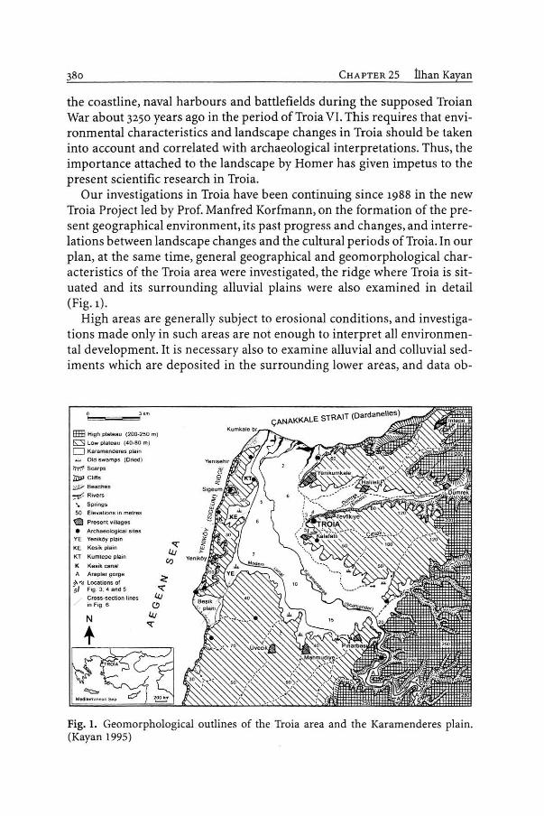
CHAPTER 25 İlhan Kayan
the coastline, naval harbours and battlefıelds during the supposed Troian War about 3250 years ago in the period of Troia VI. This requires that environmental characteristics and landscape changes in Troia should be taken into account and correlated with archaeological interpretations. Thus, the importance attached to the landscape by Homer has given impetus to the present scientifıc research in Troia.
Our investigations in Troia have been continuing since 1988 in the new Troia Project led by Prof. Manfred Korfmann, on the formation of the present geographical environment, its past progress and changes, and interrelations between landscape changes and the cultural periods of Troia. In our plan, at the same time, general geographical and geomorphological characteristics of the Troia area were investigated, the ridge where Troia is situated and its surrounding alluvial plains were also examined in detail (Fig. ı) .
High areas are generally subject to erosional conditions, and investigations made only in such areas are not enough to interpret ali environmental development. It is necessary also to examine alluvial and colluvial sediments which are deposited in the surrounding lower areas, and data ob-
EHE Hıgh pl.ıııteau ( 200-250 m)
~ Low pleleau (• 0·80 m)
O Karamcndores plain ...L Old swamps (Dncd )
i'tT'('t'C Scarps
1DJ> Clıffs
~· Beaches
~ Rıvers
'• Springs 50 Elevatıons in metres
~ Prcscnt .... rnages • Archaeological s ııes
YE Yenıköy pla in
KE Kesik ~ıtin
KT Kumtepc plain
K Kesik canaı A Araplar gorge
3\ .. , Loeations of 5/ Ftg . 3. 4 and 5
Cros.s-section lincs in Fıg 6
Fig. ı. Geomorphological outlines of the Troia area and the Karamenderes plain. (Kayan 1995)
ı Introduction: Aim, Method and Investigations 381
tained from both erosional and depositional areas should be evaluated comparatively. ln this way, it can be understood how the environment in an archaeological site has changed over thousands of years and in which way these changes have affected the land-use pattern of people who lived there. For example, the pattern of life and eating habits of the people who lived in Troia clearly changed greatly frorn the time when the area surrounding the ridge was sea to when the sarne area changed into arable land due to alluvial deposition. At this point, in order to illuminate the man-environment interrelation, it was necessary to determine what the forrner environmental characteristics or palaeogeography of the present alluvial plains surrounding Troia were. The sedimentary units deposited on the bottorn of depressions under various environmental conditions are the best tools to bring out the environment during their formation, and the dynamic effects under which they were worked, transported and deposited. To reach different sedimentary units below the present alluvial surfaces and interpret what kind of geographical environment they represent is only possible by bore-hole drillings. Horizontal and vertical distribution of sedimentary units and three-dirnensional geometry of the changing environments can only be delineated using a sufficient number of drill-hole profiles.
Dating is an important part of the interpretation. To construct an interrelation between the environment and human activity is only possible if the time of the environmental changes is known. ln order to do this, it was necessary to date when the Troia ridge was surrounded by sea and until what time this condition continued, and to follow the progress of alluviation. Currently, archaeological and radiometric dating methods are the most coıpmon for age determination. Small fındings like potsherds encountered in drill holes can sometimes be dated by archaeologists. However, this is not a generally convenient method, and 14 C dating is a more widely used technique. Resistant carbonaceous shells of marine or coastal environrnents, and in some places plant rernains, are the most suitable material for dating. Important chronological data have been obtained from these rnaterials by laboratory analysis in the USA and Germany. In particular, 14C analyses made by Dr. B. Kromer at the Institut für Umweltphysik der Hei delberger Akademie der Wissenschaften in Germany have made great contr ibutions to our palaeogeographical interpretations. ·
The number of drilling holes made since 1977 in the surroundings of Troia on the Karamenderes-Dümrek alluvial valley floor, including the Be0 ik plain on the Aegean coast, totalled 2 85 in 2001. Various techniques and equipment were used for these drillings as our resources and needs progressed over time. ·
Our fırst geoarchaeological studies in the environs of Troia started with Professors J. C. Kraft and O. Erol in 1975. ln 1977, seven rotary core drillings
CHAPTER 25 İlhan Kayan
were made on the Karamenderes and Dümrek alluvial plains surrounding Troia, with the support of the Mineral Research and Exploration lnstitute of Turkey (MTA). in most of these drill holes, of which the deepest went down 75 m to pre-Holocene bedrock, Neogene sediments were reached. This work revealed that following a sea-level fall in the last glacial stage, the Karamenderes incised a deep bed on a surface about 30 m below the present plain, and about 10,000 years ago in the post-glacial peri od, during the Holocene, the rising sea intruded into this incision, covering the entire old valley floor. Thus, it is concluded that about 7000.:.6000 years ago, an estuarine bay in the present lower Karamenderes valley west of Troia, extended southwards as far as the north of Pınarbaşı-Mahmudiye (Fig. ı). The sealevel rise stopped about 6000 years ago, and then the present alluvial plain began to prograde to the north presently reaching about 5 km northwest of Troia (Kraft et al. 198oa, 1982).
in 1982, Prof. Korfmann began an archaeological research and excavation project on Beşik Sivritepe and Beşik Yassıtepe north of the Beşik plain on the Aegean coast to the west of the Karamenderes plain. Our aim in joining this·project was to bring out the geomorphological evolution of the Beşik plain and especially to understand whether or not this plain was in a bay during the Bronze Age. Thus, we intended to interpret palaeogeographical evidence for the possibility ofa natura! harbour for the Achaean navy in the Beşik bay during the supposed Troian war. Eighty hand drillings were performed to a maximum of 8 m, and some '4 C dates were obtained. We showed that the present Beşik plain formed as a small bay about 6000 years ago. Afterwards, a coastal barrier separated a small lagoon. There is no major stream behind the Beşik plain to bring any great amount of alluvium. Therefore, coastal landforms developed here only under the control of marine processes. This made it possible to delineate small relative sea-level changes during the middle and !ate Holocene. Thus, the sea, which had reached its present level about 6000 years ago, fell about 2 m in the period 5000 - 3500 years ago, then rose again to its present level at the time of Christ. A small sea-level fall in the Late Bronze Age may have caused widening of the coastal barrier and reduced the lagoon (Fig. 2). Thus, it can be interpreted that no Bronze Age natura! harbour with an open water surface seems to have been possible here (Kayan 1991).
A new Troia project led by Prof. Korfmann started in 1988. A multi-purpose "Unimog" vehicle was granted to the project by Daimler-Benz for the heavy excavation work. in particular, it has a hydraulically powered rotaryauger drilling rig, providing powerful, fast and productive drilling capabilities down to 20.50 m. Using this equipment, tens of drill holes were bored every year, especially on the alluvial plain around Troia.

ı Introduction: Aim, Method and Investigations
.!!!.
2
-1
-2
-3
w o.. w
~ < > -v; w
o.. >< w .... v;. :::E w ;;) a:ı ><
NEO LI THIC
7 6
?
BRONZE AGE
5 3
IUON l ıuuM 1
2
Today 1
2 o o
-1
-2
-3
T 1 M E S C AL E (THOUSAND YEARS)
Fig. 2. Middle- Late Holocene relative sea-level changes in the Troia area. (Kayan 1991)
The Unimog was also used to excavate trenches down to 2.5 m in some places, especially on the colluvial deposits along the foot of slopes, in order to carry out detailed examinations of soil formations and dispersion of archaeological material from the mound. in addition, an Eijkelkamp handdrilling tool was used in places where it was more convenient. Down to a depth of 8-ıo m the .Eijkelkamp is quite good for examining surface sediment layers which formed during historical or even prehistoric times.
In 1992-1994, our research was concentrated on the Yeniköy (Sigeion in archaeology) ridge which separates the Karamenderes plain from the Aegean Sea to the west, and its eastern foot which slopes gently towards the plain (Fig. ı) . Here, geomorphological characteristics along the western edge of the Karamenderes plain suggest some old harbour locations, and there is some discussion in the literature about this. New <lata on this area were obtained from our study and they have made it possible to clarify some speculation. These will be given below.
Although the number of our drilling holes, most of which were made by the Unimog after 1988, reached 200 in 1996, the great variety of marine, coastal, deltaic, floodplain and swampy environments in the research area, in addition to colluvial and archaeological deposits, and their vertical and horizontal changes in short distances, brought about the necessity to increase the number of drillings and the variety of technjques. The Unimog provided very useful <lata by means of its great hydraulic power. It was a great advantage to be able to sink drill holes down to 20 m in a short time, cutting through all kinds of sediment sections. However, samples could not

CHAPTER 25 İlhan Kayan
be taken as undisturbed cores because of the mixing effect of rotary-auger drilling. in addition, due to the large volume of the auger-rods, sediments climb upward under high pressure during operation and samples cannot be located to their real depths. This was a great disadvantage for precise correlations, and for this reason percussion drilling equipment has been preferred in more recent studies. Our suggestion to obtain percussion drilling equipment was accepted by Prof. Manfred Korfmann, and the Troia Expedition provided a set for our studies. Using this equipment, 1 m of gouge-auger rod is driven into the ground by an engine-powered driller (Cobra), and is then driven deeper with extension rods of 1 m each. Thus, it is possible to have fairly undisturbed sediment samples, though they are slightly compressed. The diametre of the auger may be 65, 50 or 35 mm, and it is possible to reach down to 30 m in suitable sediments. However, 15-20 m is a good depth under normal conditions. in addition, deeper test drillings are also possible using thinner rods of 25 mm diametre. This is useful in order to fınd bottom depth or bedrock surface below marine sediments. After we obtained a hydraulic lifter in 1997 to take out the augers and extension rods, our drilling work reached very productive conditions for <lata collection. in 2001, the number of Cobra drillings reached 85 and the total number of Troia drillings is 285.
Sediment samples taken from the drilling-holes are first analysed in our laboratory in the Department of Geography, Ege University. These are simple grain size, pH and calcimetric analyses. Then if necessary, we prepare samples for 14C or other analyses and send them to the relevant laboratories. in 1997 and 1999, OSL ( optically simulated luminescence) analyses were tried and good results were obtained by a research team from the Heidelberger Akademie der Wissenschaften (see Chap. 23, Göbel et al., this Vol.).
Finally, drilling da ta are evaluated by computer in a standard format and prepared for drawing desired cross sections. Based on a great number of cross sections in various directions, palaeogeographical maps can be drawn and geographical reconstructions of coastline positions for various times are possible. Knowing the precise topographical elevations of the drilling points from the present sea level is especiaUy important for stratigraphical correlations between the drilling holes. The primary source of this information were 1125,000 scale m~ps. Because some corrections were necessary, special topographical measurements were made and linked to the Troia measurements. in addition, GPS measurements have been very useful in recent years, especially for some drilling points away from the Troia site. However, in recent years, a new agricultural development of the entire Karamenderes plain has changed the surface elevations of drilling points, and their locations have been diffıcult to fınd because all of them were located according to old field roads or boundaries. Thus, vertical

2 Geological Structure and General Geomorphology
shifts of up to some ıo cm must be taken into account in certain drill-hole correlations.
Our studies in the Troia area have been summarised above. Results of the studies have been published in various places, but were first published in Studia Troica, which is the annual book of the Troia Project. A brief summary of the results is given below.
2 Geological Structure and General Geomorphology
The formation of the present geographical appearance of Troia and its surroundings should be considered in terms of two phases. The fırst phase is the formation of the geological structure and its development. The succeeding phase is the shaping of the present geography on this geological structure. The !ast part of the second phase is the period in which prehistoric settlement began in the Troad. Therefore, this stage is of major importance to archaeology and the history of culture.
When examining the geological structure of the Troia area, account must be taken of the Biga and Gelibolu peninsulas and their formation over a long period of geological time. The Biga Peninsula consists of various sedimentary and volcanic rocks underlain by an older igneous and metamorphic base (Bilgin 1969). During the Neogene period, depressions were formed between raised mountain blocks. What was once a lake in what is now the Bayramiç-Ezine Basin, for instance, filled up in the course of aeons with material washed down from the surrounding slopes. Moreover, to tl}e northwest, in the place where today the Gelibolu Peninsula and the Çanakkale Strait (Dardanelles) are situated, the Black Sea extended from the north into a basin where it formed a broad, but shallow gulf. The low ridges around Troia were formed from sediment laid down on the bottom of this sea. During this time the Aegean was land with several lake basins. This palaeogeography existed within a period from 12- 2 milli on years ago (geological periods of Late Miocene and Pliocene).
While the land continued to rise, layers of sedimentary rocks consisting of sand,.clay and limestone which had been deposited on the bed of the shallow Neogene sea broke into three main blocks. These have formed the present Yeniköy Ridge to the west, and the Kumkale and Troia r idges to the east (Fig.1). The Karamenderes (Scamander) River and its tributary, the Dümrek (Simois), settled in the depressions between the ridges and filled them with alluvial deposits, which formed the plain around Troia. Because this region is situated on the southern flank of the North Anatolian Fault Zone, tectonic movements have taken place, and recent earthquakes indicate that the region still has remarkable tectonic activity (Yılmaz, this Vol.).

CHAPTER 25 İlhan Kayan
The surface of the ridges around Troia is at an elevation of 40 - 50 m and to the east rises to an elevation of up to ıoo m. This brings about a low plateau formation (Fig. 1). A fault zone with a steep slope bounds this area to the south, running from northeast to southwest. in this zone there are more recent lava flows and rich springs of water. Above this rise, that is, on the igneous and metamorphic bedrock and other geological formations, there extends a slightly undulating higher plateau surface at an elevation of 200 - 250 m. The Karamenderes River has incised this surface and opened the Araplar Gorge which connects the Bayramiç-Ezine basin to the south and lower Karamenderes delta floodplain to the west of Troia.
The Quaternary period, as we know, is much shorter than the preceding geological times (less than 2 million years). During this period of geological history, tectonic movements had less influence on geomorphology, yet climate changes shaped the environment more strongly. Unlike in Europe, there was no ice age in Turkey because it is so far south. However, the fall in sea level during the glacial periods brought about changes in coastal regions all over the world, including Turkey. Low-lying coastal areas, especially delta floodplains, underwent a great deal of geomorphological-environmental changes. This included the alluvial plain on the lower part of the Karamenderes River, west of Troia.
In the Quaternary Period at least four glacial ages occurred during which the sea level fell appreciably. In the interglacial ages, however, the seas of the world reached approximately their present level. At the end of
. the Late Glacial Maximum, about 20,000-18,000 years ago, the sea level was about 100 m lower than today, turning the Sea of Marmara and the Black Sea into lakes (Jablonka, this Yol.; Govedarica, this Yol.). The Dardanelles and the Bosporus were river valleys and the Karamenderes (Scamander) was a tributary of the main river in the Dardanelles. Sandy-gravelly alluvial sediments at a depth of about 30 - 40 m, which were encountered by drilling studies in the plain west of Troia, indicate the bottom of the valley at that time.
in the following warmer period (Holocene), the level of the sea continued to rise due to melting ice in the Polar regions and high mountains. About 10,000 years ago the sea reache9 into the lowest parts of the lower Karamenderes delta floodplain. lt can· be assumed that, even during the time the sea inundated it, the Karamenderes continued to bring alluvium, and deposited it in the bay. Thus, the position of the coastline in the bay changed continuously depending on the balance between the rise of the sea level and alluvial sedimentation. During the period of more rapid sea-level rise, until about 7000 years ago, the coastline continued to advance south, covering former delta plains and reaching the vicinity of Pınarbaşı.
3 Geographical Changes in the Holocene
It is known that the rise in the sea Jevel slowed down and that by about 6000 years ago the sea reached today's level (Fig. 2; Kayan 1988a). During this time, the shore began to be fılled with alluvium which the Karamenderes brought from the Bayramiç-Ezine depression, and the new deltaic coastline prograded northward. Drilling studies have shown that swampy areas of vast dimensions stretched south of Troia during that time (Kayan 1995).
Geomorphological investigations on the Aegean coast of Anatolia have shown that the sea level has also changed during the last 6000 years (Kayan 1999). Under the auspices of the Beşik Project headed by Manfred Korfmann (1983-1988), about 80 bore holes were drilled 7-8 m deep with a hand drill. These operations proved that the sea level fell by about 2 m between 5000 and 3500 years ago, and by the time of Christ rose again to its present level (Fig. 2; Kayan 1991). These are relative sea level changes and the reasons are not entirely known. However, the sea level fall during the Bronze Age is attributed to tectonic movements (Bronze Age Regression; Kayan 1997b ). This slight sea level fluctuation influenced the development of the alluvial plain of the Karamenderes and the Dümrek around Troia, and consequently, also had a bearing on the activities of the Troians in the Bronze Age.
3 Geographical Changes in the Holocene
Sedimentological <lata obtained from corings made on the alluvial plains surrounding Troia show that the Holocene stratigraphical sequence consists of three main units. These units and their palaeogeographical environments are summarised below in chrono-stratigraphical order, from bottom to top (Fig. 3).
3.1 Early Holocene Palaeogeography and Marine Transgression
Drilling evidence indicates that towards the end of the last Glacial period about 15,000 years ago, when the sea level was about -100 m, the bottom of the lower part of the Karamenderes valley was a slightly undulated plain on older (Pleistocene) marine and terrestrial sediments. 14C dates of marine sediments and OSL dates of terrestrial deposits support this interpretation (see Chap. 23, Göbel et al., this Vol.). The bottom of the valley at that time was about 30 m below the present plain. The ancestral Karamenderes River had an incised bed close to the western slope of Troia.
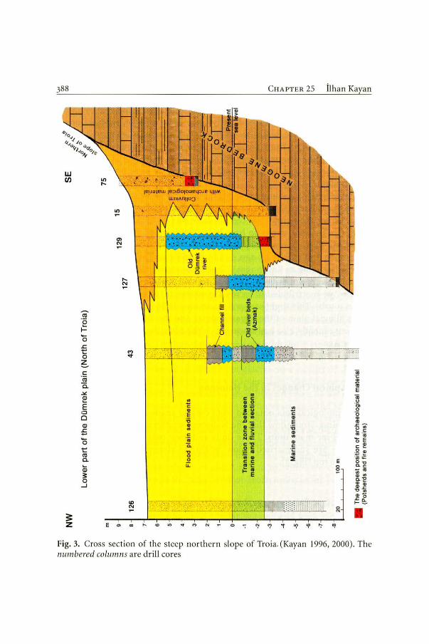
388
UJ en
== z
-ro ·e f--o .c t: o ~ ı:: ·ro a. .><!
~ E o o Q)
E -o t: m c. Q) ~ o
.....1
l() ,...
E
O> N
,... N
<') '<T
"' N
O>
.. ..
\ 1 \
-.-' .· · · -
\
"' "' ..
., c ., E :;; ., .. E
'" ö. .., o o iL
"'
iC öl c c
'" .c o /
• c c .. o 11.: ! :ı: .. • &J-11 .! c > o " .. ;: c,, o c • ii .. c c ··-~· E
C H APTER 25
il)
c ., E :;; ., .. ., .!: :o
:::ı;
İlhan Kayan
E o e
a; ·c: ~ Cll
E
~ ·c;, o o ., m .c ~ o., ~ c a:ı ·;
o E c ~
~~ o,, c. c ;;; "' ., ., c..., ., ~ ., ., -o -;; ., -~ ~
• Fig. 3. Cross section of the steep northern slope of Tro ia. (Kayan 1996, 2000). The numbered columns are d rill cores

3 Geographical Changes in the Holocene
The rapidly rising sea during the Early Holocene intruded into the incised part of the ancestral Karamenderes River at the bottom of the valley. ' 4 C dates of large marine shells (especially Cardium and Ostrea shells) taken from about 50 m below the present surface were dated to ıo ooo years ago. By 7000 years ago, the old valley bottom was completely covered by sea water and the shoreline was near Pınarbaşı-Mahmudiye to the south (Fig. ı). In drill holes which reached the Neogene bedrock marine sediments start with coarse Jag deposits (gravelly and coarse sandy transgression facies). Large oyster shells are generally abundant in this bottom deposit. Overlying fıne-grained and generally very homogeneous marine mud is the main sediment unit of the Holocene transgression. This has varying sedimentological characteristics from place to place, from well sorted very fıne sand to very sticky black mud. Sticky black mud is related to organic colloids. However, marine shells are very rare because of anoxic and acidic conditions. Some small methane explosions were experienced during the drilling operations in the south.
Although the bay at the mouth of the Karamenderes River was of an estuarine ( or ria) type, neither gravelly coarse sandy old river channels nor clean sandy beach sediments are encountered in the fıne grained marine sediments. This is related to the bedrock types. The bedrock in the surrounding area consists completely of sandy-silty-clayey-carbonaceous Miocene shallow marine sediments. In addition, the Karamenderes leaves most of the coarser alluvium in the Bayramiç-Ezine basin behind the Araplar gorge and brings generally fıner grained material to its lower delta plain. The homogeneously fıne grained nature of the Holocene sediments causes diffıculties of detailed interpretation of the morpho-dynamic characteristics of the sedimentary environments, such as delineating old river channels or old shoreline positions.
' 4 C dates of marine-coastal shells obtained from coastal deposits at the approximate present sea level below the present surface along the foot of the Neogene slopes are always found to be close to 6000 years ago. This means that the sea-level rise stopped at its present Jevel about 6000 years ago. However, maximum extension of the sea to the south close to the old river mouth may be a little earlier, about 7000 years ago, because of the balance between alluviation and sea-level rise. Towards the end of the transgression, the sea-level rise slowed down and intrusion was more than compensated by alluviation, so that in the period 7000 - 6000 years ago, the shoreline must have prograded northward in spite of the slow sea Jevel rise.

390 CHAPTER 25 İlhan Kayan
3.2 Middle Holocene Deltaic Progradation
The top surface of the marine sediment unit extends for a few metres, generally 2 m below the present sea level under almost the whole surface of the present plain, except along the foot of the edge slopes (Fig. 3). On this very flat surface, there is no clear change in the physical characteristics of the sediments. They are still blackish dark grey silty, fıne tovery fıne sandy somehow marine or marine-connected sediments. Organic colloids and marine shells are generally less frequent than below true marine sediments.
These sediments vary from place to place. For example they are homogeneous in some places, but laminated in others. Towards the lower parts of the lower tributaries, such as the Dümrek or Çıplak Rivers, they have a terrestrial content and show a hard block structure with carbonaceous concretions. Marine shells are rare and mixed with brackish-freshwater species. Ali of these characteristics indicate that this is a transition zone between lower marine and upper terrestrial units. The sediments must have been deposited in the very shallow coastal environment ofa delta floodplain. There is no beach or lagoon formation. Instead, sediments indicate swampy or seasonally wet environments. The upper surface of this unit is almost at the present sea level. Thus, it is possible to interpret that the transition zone belongs to the most recent water zone which is fılled with deltaic sediments following the end of the sea-level rise.
üne of the characteristics of the transition zone is a number of sediment belts which represent forrner deltaic distributary channels ("azmak" is a more specifıc term in Turkish). These are rnedium-coarse sandy, generally muddy and contain high amounts of organic colloids. While coarse sand implies water flow, their muddy nature and organic content represents stagnant conditions at least from time to time (or seasonally). Their depth below the present sea level is concordant with the interpretation as "azmak"s.
Over such a very shallow coastal zone, a small sea-level fall would cause a wide area to be turned into dry land. This interpretation is supported by sediment characteristics and 14C dates which point to a regressive sequence in the period between 5000 and 3500 years ago. Thus, the transition surface represents an important change from 'a wet environment to dry land suitable for human use. This makes it important from a geoarchaeological point of view.

3 Geographical Changes in the Holocene
m from sea level
'I' EAST 8
k 1
m from surface
7 ı
6
5
4
3
2
O · ·•·•·•• Present sea h3vef ••••.••
-1
-2
-3
-4
00 Pebble, granule Coarse sand
.. Medium sand Fine sand Silt, clay
Northern foot-slope of the Schliemann trench
11 c 11 b 11 a
:..--. ... - ·:::-:>~- ~ .. :~~~
:
··,:• __ .. _.:·.~_:_•.•.·_:_._-._:_• .. _·._ ••. ·_,_~-~-_:_: __ :.~:--.·.~::.:_&_-_~::.~·., .. :-,:-.: __ .-:;:_.·.· ;,W}} ~t-:;~ Recent colluvium Hard
Some slope-washed archaeological material
~ sterile sediments 2
(Flood deposit)
'.c;·~·;; - ın~'!!~ ·~·-
- - Water table - - - - - -
Terrestr ial sediments Colluvium
containing archaeological material (Mostly sherds and fire remains)
Transition zone between marine and ··················-· ·······-···-···--terrestrial sediments
9" Pot-sherds Charcoaı
(Sundy mud)
Shallow marine fine sandy mud
Animal bones Marine shells (in terrestrial sediments, 1hey indicate any relalion to archaeological material such as food remain ar sun-brick mud)
~ Small stones (Generaıty < 10 cm) ., Large stones (Generally > 10 cm)
391
WEST
k 3 + 11 d
Alarge block of stone
- ··· ·.· : : :; :,· ,
· . .. :
Fig. 4. Details of drill holes along the foot of the slope of Schliemann's north-south trench, looking south from the Dümrek plain. (Kayan 1996)
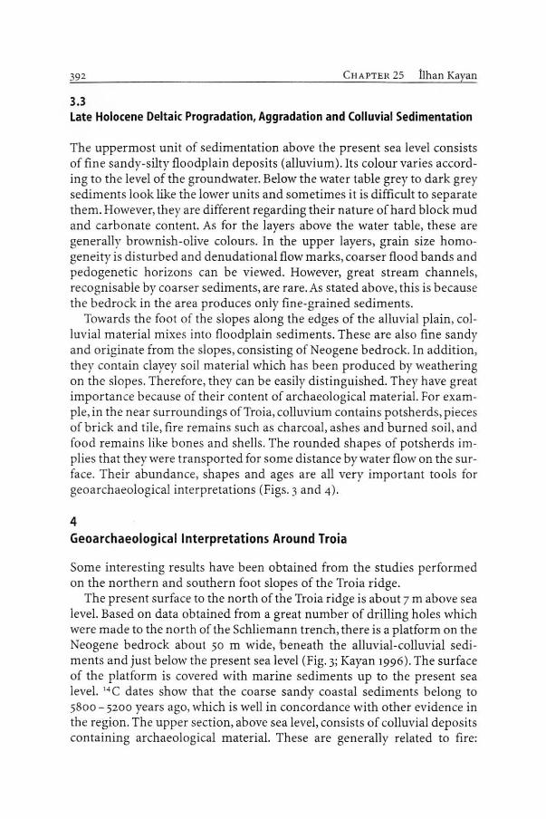
392 CHAPTER 25 llhan Kayan
3.3 Late Holocene Deltaic Progradation, Aggradation and Colluvial Sedimentation
The uppermost unit of sedimentation above the present sea level consists of fıne sandy-silty floodplain deposits (alluvium). lts colour varies according to the level of the groundwater. Below the water table grey to dark grey sediments look like the lower units and sometimes it is diffıcult to separate them. However, they are different regarding their nature of hard block mud and carbonate content. As for the layers above the water table, these are generally brownish-olive colours. In the upper layers, grain size homogeneity is disturbed and denudational flow marks, coarser flood bands and pedogenetic horizons can be viewed. However, great stream channels, recognisable by coarser sediments, are rare.As stated above, this is because the bedrock in the area produces only fine-grained sediments.
Towards the foot of the slopes along the edges of the alluvial plain, colluvial material mixes into floodplain sediments. These are also fine sandy and originate from the slopes, consisting of Neogene bedrock. In addition, they contain clayey soil material which has been produced by weathering on the slopes. Therefore, they can be easily distinguished. They have great importance because of their content of archaeological material. Far example, in the near surroundings of Troia, colluvium contains potsherds, pieces of brick and tile, fire remains such as charcoal, ashes and burned soil, and food remains like bones and shells. The rounded shapes of potsherds implies that they were transported for some distance by water flow on the surface. Their abundance, shapes and ages are ali very important tools for geoarchaeological interpretations (Figs. 3 and 4).
4 Geoarchaeological lnterpretations Around Troia
Some interesting results have been obtained from the studies performed on the northern and southern foot slopes of the Troia ridge.
The present surface to the north of the Troia ridge is about 7 m above sea level. Based on <lata obtained from a great number of drilling holes which were made to the north of the Schliemann trench, there is a platform on the Neogene bedrock about 50 m wide, beneath the alluvial-colluvial sediments and just below the present sea level (Fig. 3; Kayan 1996). The surface of the platform is covered with marine sediments up to the present sea level. 14 C dates show that the coarse sandy coastal sediments belong to 5800 - 5200 years ago, which is well in concordance with other evidence in the region. The upper section, above sea level, consists of colluvial deposits containing archaeological material. These are generally related to fire:
- 'Tl o - · <~ rt> vı .., . -0z '"O o - .... ~& < 1
"' "' -o ~c '< .... • ::r ::;> <"> o .., 3 ~ .... "' ::r "' rt> rt>
r' ~ o -· :;; o rt> ::ı ....
"' (') <"> -·.., -o '< "' o"' ..........
...,ı ::r
.., rt> o ~ -· ~ "' rt> .... "' o ;:;-~..,
::r ::ı rt> '"O
"' "' o .., c: ....
5
-1
-5
NORTH
..---- LOWER CITY OF TROİA 69
ı
70
ı
S:-o . ...... ~&
106 Drillholes and numbers -10 /1 •
"' rt> ~ :::ı ::ı o ..... o \O o.. -15 \O '"O -...ı-
"' "' ._.. 5· 5· & rt>
o
;-/iı; End of drillholes and numbers
r- Archaeological findings (Sherds, ele.)
A Laycr of archaeological fındings
Mar1ne shells in terreslrial sediments (Probably remains of food)
@ Slones (Human used)
50 100
SOUTH
KALAFATLI VILLAGE -Flood plain of !he Çıplak river
102
ı 103 104 101
ı ! T! 106
ı 25
ı
Presenl canal of the Çıplak river
- 105
ı Fine sandy tıomoııcneous ~- !'Jrf&ee soıı_ ------:v:---- ~i.--
~' - --~ -X- r r~ Flood sediments -.---· --;...,? - -- -- ----- ~ .. ,
oid,- A " - ___ _- ___ _,,./'"s,,
.q,'* :•- 7 Flood sedımenıs ~ f· .t-i?,_.;~--·-... _ cMnoel A ,... ,... ~·
v. a ('> 3 Fln .. andy mud ·
~ (Swampy anvırom.ıt)
Coarse sandy deltaic lobe
Fine sandy shallow marine sediments
sııom
m 15
10
5
1 o -1
-5
-10
1-15
~
cı rt> o "' .... <"> ::r "' rt> o o
OQ ;:::;· 2:.-5' ;:;-..,
'"O .., rt>
~ ö' ::ı
"' >-3 c: ::ı o..
a1 ı;;·
"" \O
""
394 C HAPTER 25 İlhan Kayan
stone remains of fıreplaces, burned bones and shells and ashy mud are abundant (Fig. 4). Some potsherds have been dated as Troia IV, V, and VI by archaeologists. This deposit can be followed up to the old channel of the Dümrek River, which was located about 50 m north of the foot of the steep Troia slope. Because the Dümrek River later shifted northward, the old river course is covered by fıner sediments at the top and disappears. Thus, it is understood that the sea was right at the foot of the "Schliemann trench" during the earliest periods of Troia, i.e., Troia I ·and il. During Troia IV-Vl, a strip of dry land formed between the slope and the old Dümrek channel, which was suitable for human use.
To the south of Troia, another detailed study on the outskirts of the Lower City of Troia showed that a layer of earth about ı m thick containing archaeological material spreads over a wide area about 2- 4 m below the surface (Fig. 5; Kayan 1997a). The archaeological material consists of densely packed pieces of potsherds, bricks and tiles, and burned material in colluvium. Pieces of archaeological material must have been washed down by rainwater from the city and spread over the lower area following great destruction including a fire in the city. Here, in the Çıplak valley, the lower marine sediments do not extend much to the east because the Çıplak valley is not deep on the Neogene bedrock and the river easily fılled this small valley with alluvial-colluvial sediments originating from the lower plateau surface (Fig. ı). Preliminary results of OSL datings of these sediments indicate that it is possible to correlate them with pre-Holocene (Pleistocene) marine sediments in the deeper parts of the Karamenderes valley, and suggest them as their terrestrial equivalent (see Chap. 23, Göbel et al., this Vol.).
5 About the Potential Harbour Sites
Since the Karamenderes plain was a long bay for several millennia 7000 years ago, Troia must have had a harbour or harbours in different places following changes of coastline positions during deltaic progradation. An important question then arises as to where the Troia harbours were. This is one of the main topics of discussiop. related to the paleogeographical changes in the Troia area.
As stated above, three low plateau ridges, which consist of uplifted Miocene shallow marine sediments, delineate the geomorphological outlines of the Troia area. One of them is Yeniköy ridge ( or Sigeion ridge in archaeology) in the west, which separates the Karamenderes plain from the Aegean Sea (Fig. ı ). This north-south trending ridge is about 40 - 80 m high andı km wide. Its western slope formsa steep cliff line, cutting almost
5 About the Potential Harbour Sites 395
horizontal Miocene beds of carbonaceous sandstone and claystone. ln contrast to the straight shape of the western cliff line, the eastern slopes descend gently to the Karamenderes plain and then give way to alluvial deposits. On this eastern side, the !ine between the alluvial surface and the Miocene bedrock slopes is greatly indented. Three particular indentations on this side have been interpreted by Troia visitors and explorers as possible ancient harbour sites. These are, from south to north, the Yeniköy, Kesik and Kum tepe indentations as extensions of the Karamenderes plain.
There are very shallow thresholds between the Yeniköy and Kesik plains and the sea. ln addition, there are small canals or ditches across the thresholds, which have caused some speculation about water passages between the Aegean sea and supposed inner harbours in the Bronze Age (Cook ı973; Zangger 1992; Zangger et al.1999). Kayan carried out detailed geomorphological research including drilling studies in this area in order to elucidate this matter under the light of new evidence (Kayan 1995).
5.1 Yeniköy Plain
The Yeniköy (Sigeion) ridge is interrupted towards its southern end by a structural depression extending north-east-southwest. The Beşik plain is situated on the coastal part, while the Yeniköy plain extends from the Karamenderes plain on the inner part of this depression. The Beşik and Yeniköy plains are separated from each other by a very flat threshold only about 10 m above sea level (Figs. 6 and 7). The bedrock, which consists of Miocene marine sandstone here, is open to the surface. This geomorphology has been interpreted by some explorers to show that the sea overflowed this threshold at one time and intruded into the Yeniköy plain, and thus the Yeniköy ridge formed as an island. Sandy cover and some shell fragments supported this idea. However, there is no true evidence for such a marine connection.
There is a simple man-made trench a few metres deep across the threshold. This implied to some explorers that even if there was no natura! marine connection over the threshold, a man-made cana! might have connected the Yeniköy and Beşik bays. Thus, the supposed Yeniköy bay would have been a very convenient harbour site in ancient times. Our drilling evidence clearly showed that Beşik and Yeniköy embayments were covered by seawater when the sea reached its present !eve! about 6000 years ago. However, there was no evidence to indicate any natura! or artificial connection between the two bays. On the contrary, detailed investigations showed a 2-m sea-level fail about 5000 - 3500 years ago, that is, during the Bronze Age, causing wide areas to dry up into land in both embayments (Kayan 1991, ı 995) .

CROSS-SECTIONS OF THE YENIKÖY, KESiK AND KUMTEPE EMBAYMENTS
ON THE WESTERN EDGE OF THE KARAMENDERES (SCAMANDER) PLAIN (WEST OF TROIA)
Neogene bedrock con sist s of limy, clayey, sandy shallow marine sediments . Some limestone layers ere shown on the Kesik cross-section.
Vertical lines indicata boreholes. Borehole numbers are gıven above the lines. YenikOy, Kesik, Kumtepe and Beşik plain boreholes are numbered separatety.
Four and five diglt numbers indicate C14 dates. They are callbrated age with 400 yrs reservoir correction but rounded here as simply Before Present. Borehole number 18 on the Kesik sectıon
w
.~
2
~~
K U M T E P E P L A 1 N E m Karamenderes ~ 8 {Scamander)
Dike : 6 ,...._ ____ A 1 ,
NEOOENE ,.. ;;;;;;;;;;; .. " r i ~ BEDROCK
-6
-8
K E S K P L A 1 N
18 Dralnago
16 1 17 1 e&n1ı1!
NE m 8
is not on the llne. but it is on the south edge of the same embayment. The C14 date of 4200 BP on this borehola is et the correct lev~ and in concordance wlth the o ther datcs of the end of marine sed imentation. .~ 1 1 fo r m tt tl o n · il:
·::.::? Fine sand-silt
.. :.:: Coarse sand and gravel
Marine she lls
Planı rcmalns
P.M.S.L. Present Mean Sea Level
Locattons of the cross-section lines ere shown on Fig. 1
m_SW
BEŞİK PLAIN Old water rriftl {Hanım doQirmGni) .--5----
oıı.- 1 __..,,_ -2
-4
-6 -8
100 500m
Beaik - YenikOy thrcshokı YE N I KÖY
Swamp 8"dıme"ts l·
···· ·· P.M.8.L······
Fig. 6. Cross section of the Yeniköy, Kesik, Kumtepe embayments. (Kayan 1995)
Ftne sandy Rood platn - delta sediments . •• ..••.... P_M.S.l
Fine sandy shallow marine sediments
soom
P L A 1 N
$o 1 1 1 f o rm eı ıon
500m
~[>
~I ;
o -2 -4
-6 -8
5 ; cansı 8 O<alnago NE ~m
~ : 2
o -2 -4
-6 -6
100 o
I~
n ::ı: > "O ..., 1:11 :>;; N IJı
ı ~· ::ı
~ p.ı
~
I ~
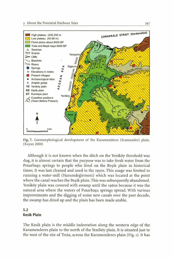
5 About the Potential Harbour Sites
- High plateau (200-250 m ls::::l Low plateau (40-80 m) D Flood plains about 6000 BP
Troia and Beşik bays 6000 BP ili Swamps
rraı! Scarps °lJ;n Cliffs ~ Beaches
~ Rivers e Springs so Elevations in metre
• Present villages • Archaeological sites A Araplar gorge
YE Yeniköy plain
KE Kesik plain KT Kumtepe plain r.-.( Coastı ine positions
A:J (Years Before Present)
N
t o 3km
""'===~
397
STRAIT (Oardanelles) ÇANAl<KALE
Fig. 7. Geornorphological developrnent of the Kararnenderes (Scamander) plain. (Kayan 2000)
Although it is not known when the ditch on the Yeniköy threshold was dug, it is almost certain that the purpose was to take fresh water from the Pınarbaşı; springs to people who lived on the Beşik plain in historical times. It was last cleaned and used in the 195os. This usage was limited to running a water-mill (Hanımdeğirmeni) which was located at the point where the canal reaches the Beşik plain. This was subsequently abandoned. Yeniköy plain was covered with swamp until the 196os because it was the natura! area where the waters of Pınarbaşı; springs spread. With various improvements and the digging of some new canals over the past decade, the swamp has dried up and the plain has been made arable.
5.2 Kesik Plain
The Kesik plain is the middle indentation along the western edge of the Karamenderes plain to the north of the Yeniköy plain. It is situated just to the west of the site of Troia, across the Karamenderes plain (Fig. ı). it has
398 CHAPTER 25 İlhan Kayan
alsa formed on a north-east-southwest structural line similar to the Yeniköy plain, and it extends toward a low gate between two horizontal limestone platforms, Yeniköy and Subaşı, on the Yeniköy (Sigeum) ridge (forming a threshold between the plain and the sea). The Kesik plain, like the Yeniköy plain, was covered by swamp until the 196os, but then it was drained and made into an arable area.
To the west of the Kesik plain, the Yeniköy ridge is o nly about 600 m wide. Elevation is a little more than 20 m at the top. The eastern slope is gende, but the western slope is a steep cliff. A dry canal-like feature cuts straight across the lowest part of the Yeniköy ridge in an east-west direction. "Kesik" means "cut" or "cleft" in Turkish and the name of the area comes from this feature. The lengthwise profile of this cleft-like feature is asymmetric in accordance with the shape of the ridge itself (Fig. 6). The highest point in the bottom is 13.7 m above sea level at a distance of about 150 m from the sea, but the inner side profile is gende and opens on to the Kesik plain at an elevation of 6.3 m about 400 m east of the top. The crosswise profile of the Kesik "canal" is alsa asymmetrical. The southern slope is steeper and higher than the northern slope because of the geological structure. The Kesik "canal" has no floor. It looks like a V-shaped valley, but there is only an earth road at the bottom which is used by people walking between the plain and the coast. Drilling holes and trench profıles on the bottom of Kesik"canal" clearly showed that the Neogene marl is covered by 2 m colluvium. No archaeological material was encountered in the many drillings which were made in the bottom of the cut (Kayan 1995).
If the geomorphological characteristics of the Kesik plain and Kesik "canal" are interpreted together with the Holocene marine transgression, in which the rising sea covered the Kesik plain to form a small bay, one can easily imagine that the Kesik plain could have been an excellent harbour which was connected to the Aegean Sea by the Kesik "canal''. Concerning this idea, there are various interpretations in the literature (Cook 1973), and the Kesik "canal" has been the subject of great interest in this respect. It is thought that the canal was opened by manto connect the harbour of Kesik bay, which was an extension of the Holocene Karamenderes bay, as a short cut to the Aegean Sea to the west. Although the canal is too high for direct water connection, there are some ideas that it could have been used as a dry slipway to transport ships between the Aegean Sea and the Kesik bay (Zangger et al.1999).
Drilling evidence clearly showed that the Kesik plain was a small bay forming an extension of the main Karamenderes ( or Troia) bay during the Holocene transgression (Kayan 1995). '4 C dates indicate that marine conditions continued up to 3500 years ago. Then, the area of Kesik bay silted up rapidly and changed into swampy land (Fig. 7). This area has never been

5 About the Potential Harbour Sites 399
completely dry because large amounts of karstic water from the Pınarbaşı springs to the south spread over it. Like Yeniköy plain, Kesik plain was also drained in the 196os and turneci into arable land.
Although the present configuration and paleogeographical characteristics of the Kesik plain imply that this area could have been used as a harbour in ancient times, ali geomorphological and various drilling evidence, including 14 C datings, clearly show that the Kesik bay was covered with very shallow sea water which was not convenient for boats, and was then swampy during the Bronze Age.
The Kesik "canal" was never used as a waterway. Although the shape of the Kesik implies that it was dug by man, there is no information about the purpose and time of construction. The only obvious feature is that it facilitates passage from the steep, high and continuous cliff coast to the inner plain on foot. lt might have been opened, and deepened from time to time, for the transportation needs of the inhabitants of Sigeion and then Yenişehir. Perhaps it took shape slowly rather than in one planned excavation. Or perhaps it is an unfinished canal construction. Finally, there is an unanswered question; where are the earth piles resulting from the excavation? There is no trace of additional earth in the area.
5.3 Kumtepe Plain
Kumtepe plain is the northerly indentation of the Karamenderes plain of the Yeniköy ridge (Fig. ı). it has the same geomorphological characteristics as Yenik.öy and Kesik plains, that is, it is formed in a northeast-southwest secondary structural depression. To the west of the Kumtepe plain, the Yeniköy ridge is lower (35 m) between higher (70 m) limestone platforms to the north and south. These are the sites of the ancient Sigeion and la ter Yeni0 ehir settlements. A very low and flat secondary ridge extends eastward, then bends to the north from the Yeniköy-Sigeion ridge. One of the oldest known settlements of the area, Kumtepe mound, is situated at the northern tip of this low ridge. The small plain separated from the Karamenderes plain by this low ridge is named Kumtepe plain here after the Kumtepe mound. Because of its geomorphological configuration, the Kumtepe plain has alsa been interpreted as an old harbour site.
Thus, the lowest part of the Karamenderes plain was described by Strabo at the time of Christ, and mapped by Leake based on his descriptions (1824, Kraft et al. 1982). No marine indentation wa~ shown on this map. Alsa, there is no evidence indicating that Kumtepe bay was used as harbour. Since it has similar characteristics to the southern indentations, we made several drilling-holes in this area to determine this matter (Kayan
400 CttAPTER 25 İlhan Kayan
1995). Based on core interpretations, there is no difference in the stratigraphical sequence (Fig. 6). Colluvial deposition is widely spread along the inner edges of the embayment. On the bottom, a coarse sandy, thick deltaic deposit is dominant. The reason for coarse sandy deposition is that the Karamenderes River first fılled the western edge of the bay during the final stage of deltaic progradation, keeping its original direction as in the south. Later, deltaic progradation stopped in front of the northern extension of the Yeniköy ridge, and during the last stage, the Karamenderes river and its deltaic progradation shifted northeast to the present position.
Today, the amount of water and sediment which the Karamenderes river can carry down to the coast and eventually to the sea is considerably reduced because ofa dam (Bayramiç dam) which has been constructed in the upper basin, and alsa because of the extraction of large amounts of ground water far agricultural irrigation. Thus, the surface flow has greatly decreased. Furthermore, the strong current in the Çanakkale Strait hinders the formation of a deltaic promontory. The very little sediment reaching the sea (Çanakkale Strait) today is carried towards the Aegean Sea by the current, and accumulates partly at the northern tip of the Yeniköy ridge and partly in various places along the western coast of the Yeniköy ridge such as the Be0 ik coast.
6 Conclusions
There is some argument as to whether the indentations along the foot of the east-facing slopes of the Yeniköy ridge to the west of Karamenderes plain were used as ancient harbour sites, especially during the Bronze Ages. Concerning this matter, we offer the following comments:
ı. Following the rise in sea level in the Holocene, the lower Karamenderes plain changed into a ria-type bay between 10,000 and 6000 years ago. During this period, indentations on the western edge formed small bays. However, the low thresholds which separate these bays from the Aegean Sea to the west have never been covered by sea. Thus, no natural water connections ever formed over theı;n. Clearly, the man-made canal or ditches on the Yeniköy and Kesik thresholds were not dug for use as a water connection between the bays and Aegean Sea (Fig. 6).
2. Based on chrono-stratigraphical evidence, after the maximum extension of the marine environment, the Yeniköy and Kesik embayments changed into land following alluviation and deltaic progradation about 5000 and 4000 years ago, respectively (Fig. 7). Therefore, Yeniköy and Kesik bays could not have been used as harbours during the Later

6 Conclusions 401
Bronze Age, especially during Troia VI. Since the water coming from the Pınarbaşı springs spread along this edge of the Karamenderes plain, the area was continuously covered by swamps until drainage canals were dug in the ı95os, and sedimentation continued with mud containing large amounts of organic colloids. These are not to be confused with marine sediments.
3. it is obvious that the shoreline, which extended south of the TroiaYeniköy line about 6000 years ago, continuously changed its location toward the north, until it reached its present position, because of alluviation and deltaic progradation. Suitable places on the changing shoreline could have been used according to necessity as natura} harbours during the various periods of Troia culture (Fig. 7). However, there is no evidence to indicate that the natura} embayments along the western edge of "Troia Bay" were arranged and used as principal harbours. in addition, the progressive coastal environment of the Karamenderes delta plain has always been covered with very shallow water or swamps. This is not a suitable place for big harbour sites. Therefore, we suggest there is no reason to create great harbour theories relating to Troia.
Acknowledgements. İ. Kayan and Prof. O. Erol were kindly invited by Prof. M. Korfmann to join this project to study environmental characteristics and change, as well as their effects on human activity in this area. Later, Prof. Kayan continued this research alone. i. Kayan was also invited by Prof. M. Korfmann to join this project, and he has been working continuously since then. Kayan thanks his many assistants and students who helped him on the drilling works, notably, Dr. Ertuğ Öner, and research assistants Serdar Vardar, Levent Uncu and Beycan Hocaoğlu.
References
All references of the chapters are presented altogether end of the book. Total 30 pages of the list are not included here.

Günther A. Wagner directs the Research Group of Archaeometry, Heidelberger Akademie der Wissenschaften, situated at the Max-Planck-lnstitut tür Kernphysik, and is professor for Geology at the Universitat Heidelberg. He has authored/coauthored numerous scientifıc articles and books and teaches re
--L___J gularly courses in archaeometry. He is president of the Archaeo-metric Society in Germany.
Ernst Pernicka studied chemistry at the Universitat Wien in Austria. He has been engaged in science-based archaeology since completing his Ph.D. thesis. From 1979 to 1997, he was senior scientist at the Max-Planck-lnstitut tür Kernphysik in Heidelberg and since 1997 he has held the chair tor archaeometallurgy at the Technische Universitat Bergakademie Freiberg. There he teaches archaeometry in a regular curriculum.
Hans-Peter Uerpmann studied veterinary medicine and prehistoric archaeology. He is Professor of Archaeobiology at the Universitat Tübingen.
Troia and the Troad
When reconstructing the past, the archaeologist needs to take into account all kinds of relevant information. Where no written sources are available, the natural sciences play an indispensable role. Troia is a remarkable site in this respect. The present excavation project at Troia, under the directorship of Manfred Korfmann, integrates various disciplines including geoarchaeology, archaeobotany, zooarchaeology, anthropology, geophysical prospection as well as chemical and technological studies of metal, stone and pottery. Hardly any other archaeological project is supported so intensely and on such a broad scale by archaeometric investigations as the international research group in Troia. in April 2001 an lnternational Symposium was held in Heidelberg, Germany, with the aim of promoting scientifıc discussion and providing synopses of the various disciplines engaged in Troia. This volume contains most of the contributions presented at the symposium. Due to its broad natural scientifıc as well as its cultural-historical scope, not only will the specialist but also the interested layman find the book rewarding.
ISBN 3-540-43711 -8
1 1 1 1111 9 783540 4371 16
http://www.springer.de


![IAC 6/19/19 Revenue[701] Ch 53, p.1 CHAPTER 53 ...](https://static.fdokumen.com/doc/165x107/632499f1f021b67e74089c77/iac-61919-revenue701-ch-53-p1-chapter-53-.jpg)


