6. The Archaeology of the Lime Industry in Renfrewshire
17
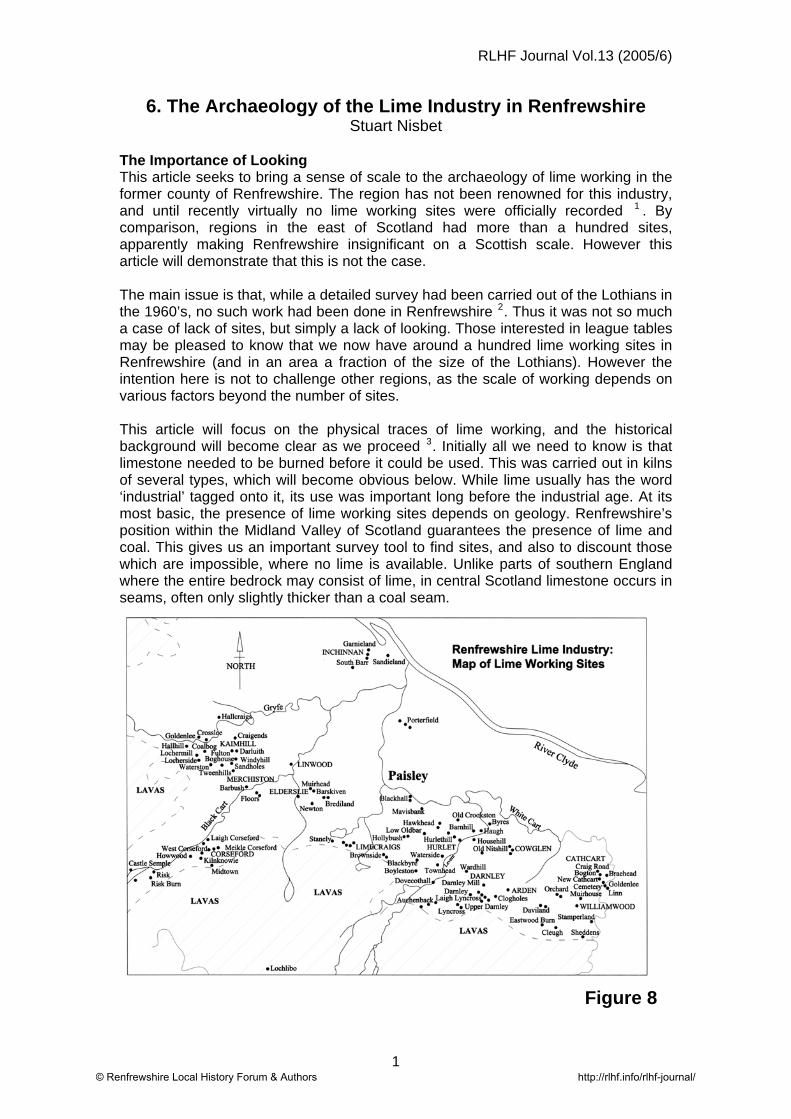
RLHF Journal Vol.13 (2005/6) 6. The Archaeology of the Lime Industry in Renfrewshire Stuart Nisbet The Importance of Looking This article seeks to bring a sense of scale to the archaeology of lime working in the former county of Renfrewshire. The region has not been renowned for this industry, and until recently virtually no lime working sites were officially recorded 1 . By comparison, regions in the east of Scotland had more than a hundred sites, apparently making Renfrewshire insignificant on a Scottish scale. However this article will demonstrate that this is not the case. The main issue is that, while a detailed survey had been carried out of the Lothians in the 1960’s, no such work had been done in Renfrewshire 2 . Thus it was not so much a case of lack of sites, but simply a lack of looking. Those interested in league tables may be pleased to know that we now have around a hundred lime working sites in Renfrewshire (and in an area a fraction of the size of the Lothians). However the intention here is not to challenge other regions, as the scale of working depends on various factors beyond the number of sites. This article will focus on the physical traces of lime working, and the historical background will become clear as we proceed 3 . Initially all we need to know is that limestone needed to be burned before it could be used. This was carried out in kilns of several types, which will become obvious below. While lime usually has the word ‘industrial’ tagged onto it, its use was important long before the industrial age. At its most basic, the presence of lime working sites depends on geology. Renfrewshire’s position within the Midland Valley of Scotland guarantees the presence of lime and coal. This gives us an important survey tool to find sites, and also to discount those which are impossible, where no lime is available. Unlike parts of southern England where the entire bedrock may consist of lime, in central Scotland limestone occurs in seams, often only slightly thicker than a coal seam. Figure 8 1 © Renfrewshire Local History Forum & Authors http://rlhf.info/rlhf-journal/
-
Upload
khangminh22 -
Category
Documents
-
view
0 -
download
0
Transcript of 6. The Archaeology of the Lime Industry in Renfrewshire
RLHF Journal Vol.13 (2005/6)
6. The Archaeology of the Lime Industry in Renfrewshire Stuart Nisbet
The Importance of Looking This article seeks to bring a sense of scale to the archaeology of lime working in the former county of Renfrewshire. The region has not been renowned for this industry, and until recently virtually no lime working sites were officially recorded 1 . By comparison, regions in the east of Scotland had more than a hundred sites, apparently making Renfrewshire insignificant on a Scottish scale. However this article will demonstrate that this is not the case. The main issue is that, while a detailed survey had been carried out of the Lothians in the 1960’s, no such work had been done in Renfrewshire 2. Thus it was not so much a case of lack of sites, but simply a lack of looking. Those interested in league tables may be pleased to know that we now have around a hundred lime working sites in Renfrewshire (and in an area a fraction of the size of the Lothians). However the intention here is not to challenge other regions, as the scale of working depends on various factors beyond the number of sites. This article will focus on the physical traces of lime working, and the historical background will become clear as we proceed 3. Initially all we need to know is that limestone needed to be burned before it could be used. This was carried out in kilns of several types, which will become obvious below. While lime usually has the word ‘industrial’ tagged onto it, its use was important long before the industrial age. At its most basic, the presence of lime working sites depends on geology. Renfrewshire’s position within the Midland Valley of Scotland guarantees the presence of lime and coal. This gives us an important survey tool to find sites, and also to discount those which are impossible, where no lime is available. Unlike parts of southern England where the entire bedrock may consist of lime, in central Scotland limestone occurs in seams, often only slightly thicker than a coal seam.
Figure 8
1© Renfrewshire Local History Forum & Authors http://rlhf.info/rlhf-journal/

RLHF Journal Vol.13 (2005/6)
2© Renfrewshire Local History Forum & Authors http://rlhf.info/rlhf-journal/

RLHF Journal Vol.13 (2005/6)
The main area to avoid looking for lime workings in Renfrewshire is in higher ground, as the region is split geologically into two main layers. The higher parts, generally above the 100 metre contour, consist of layers of lava, evident in the terraces on the skyline when looking south west from Glasgow. The lower parts, mainly in the Cart Basin, include sandstone, lime and coal (Figure 8) 4. Like any hole in the ground, once quarries are disused they attract dumping. Whilst it is actually quite difficult to completely conceal a former quarry, many sites are covered by later development and for these we must rely on mapped evidence. For some sites, particularly earlier examples, very little historical evidence survives and we must rely on landscape information. Unfortunately, little about the lime industry has been recorded, and its large scale meant that much was commonplace and not worthy of note. The following snapshot of Hurlet in 1831 shows the bustle, but also the indifference:
“Here are to be seen many lime kilns burning, wooden pumps working, numerous people wheeling barrows: here are engines, gins, railways, etc., etc., which would prove too tedious to describe…..5 ”
A Typical Lime Working Site As an introduction, we will take a brief look at the evolution of a typical site at Waterside, near Barrhead. Limestone was available in the grounds of what became the local manse, and was burnt in kilns on the site. The earliest use was mainly for local agricultural improvements, with a little lime mortar for building, such as the adjacent church and growing town of Barrhead. Demand increased from the 1750’s, partly due to the wider upsurge of mineral working and chemical production in the Levern valley, which included Copperas and Alum. The decision was taken to mine the limestone in the Waterside area on a larger scale. Mining of coal had been carried out for centuries, but would now become more organised. Underground drains or ‘levels’ were constructed to drain the workings. These led to a low point below a pumping engine at Hurlet. This was powered by a water wheel driven by a very long lade down the western bank of the Levern 6. To transport the limestone from Waterside mine down to Hurlet, a horse drawn waggonway was constructed, bridging the Levern Water, and turning down the east bank of the river on a surviving embankment. Initially clamp kilns were used to burn the lime at Hurlet, and later the tramway led to the top of a very large circular draw kiln, now demolished (Figure 9). This brief example introduces the four main aspects of the lime industry: working, burning, drainage and transport, which will now be looked at in turn.
3© Renfrewshire Local History Forum & Authors http://rlhf.info/rlhf-journal/

RLHF Journal Vol.13 (2005/6)
4© Renfrewshire Local History Forum & Authors http://rlhf.info/rlhf-journal/

RLHF Journal Vol.13 (2005/6)
1. Working of Limestone: Quarrying and mining. Limestone had first to be located, but Carboniferous limestone is not an easily identifiable mineral. Unlike the white chalky variety in southern England, it is usually grey and hard and can be confused with whin. The original use was for plaster, mortar, harling and limewash for buildings in the area, thus early sites were near settlements 7 . Cathcart lime was used extensively for the eighteenth century expansion of Glasgow, and much earlier the Cathedral is believed to have used lime from Campsie to the north. Lime for Paisley Abbey may have come from outcrops in the town centre area, although these were buried long ago by development. It is also possible that more prominent sources were used, such as at Stanely, where a very large lump projected from the brow of a hill. By 1793 several mines were driven into this limestone mass, which met in the centre, described as ‘presenting a very singular piece of subterranean scenery’. Although this source was a geological freak, outcrops were the easiest places to find and work limestone, particularly where a seam was exposed in steeply rising ground, as in the sides of river valleys. Evidence of early exploitation often comes from place names such as Lime Craig Park and Kilnknowie (Corseford), Limekilns Plantation (Lochwinnoch) or the surviving Limecraigs quarries in the rising edge of Glennifer Braes. Before geology became a profession, local masons knew where to find a good building stone, and also a local source of limestone. In the eighteenth century one source of both lime and sandstone was Hallcraigs Quarry at Houston. In the cotton boom of the 1790’s this was also the source of building stone for the very large mills such as Crosslee. Lime was also known to outcrop nearby along the Gryfe, and was quarried and burnt along the course of the mill lade and used for mortar. By the late eighteenth century many more sources of lime were found in flat virgin ground by boring. The most extensive and long lasting workings occurred where the seams of limestone were relatively flat and did not need to be chased far underground. Renfrewshire has various ‘synclines’ or bowl-shaped basins where the lime and coal dip at a shallow angle, then reappear again some distance away. This includes the synclines at Darnley, Arden, Corseford, and Limecraigs. Here a number of small quarries were initially opened up, and as the pattern of the basin gradually became clear, it was worked more extensively. In such areas almost all the limestone was initially quarried and later often completely mined away. The most familiar form of quarry was from an outcrop, which leaves most physical trace, surviving as a hollow cut into a rising slope, such as Limecraigs and Midtown. As demand increased, quarries were opened up in what was originally relatively flat farmland. Most were later filled in, but their profile can still be traced at Lochermill, Corseford and Cleugh. Some of the best examples were abandoned and never returned to agriculture, surviving as random mounds of spoil and partly flooded holes in woodland. One example is the surviving workings north of Merchiston house, part of a much longer series worked from the eighteenth century. Looking directly to the north of Merchiston Quarry, a long defile can be seen in the adjacent field, marking the former Boghouse Quarry. Slightly further north were the limestone mines and kilns at Darluith and Fulton, followed by the much earlier workings in the Locher valley at Craigends. Entering the woods at Merchiston from the cycle track, the former railway track has covered the northern edge of the quarry. South of this, the landscape consists of a seemingly endless mass of random mounds and flooded holes. These features are related to the method of working, and the quarries were commonly let to tenants for a few years, then re-let to others, which could lead to disorganised working. The lime was burnt mainly in the summer and the winter was spent ‘tirring’, or clearing the ground to expose more limestone. Most of the surviving mounds are thus rock and soil, cleared to expose the limestone, but others are waste
5© Renfrewshire Local History Forum & Authors http://rlhf.info/rlhf-journal/
RLHF Journal Vol.13 (2005/6)
from the burning process. This is confirmed by scattered lumps of partly burnt limestone and slag. The foundations of a large double draw kiln at the north west corner now lie under a scrap yard. The limestone seam was rarely flat, but dipped at varying degrees, thus the quarry gradually became deeper until the amount of material to be taken off the top was too great. If quarrying was not then abandoned, it could continue by mining from adits (tunnels) driven into the exposed face. This occurred in many places, sometime on a small scale such as on the Locher at Kaimhill or at the back of Midtown quarry, at both of which mines are still evident. It also proceeded on a much larger scale, such as in the Darnley area, where mining covered many acres and continued into the 1960’s 8. Some quite dramatic areas of ground collapse are visible in the area over shallow workings. Where the lime was valued for a specific purpose, such as for Roman Cement at Orchard, quarrying advanced to mining at a fairly steep dip, using trucks on a mineral railway. If the limestone was much deeper, or covered by surface materials such as bogs or thick boulder clay, it could be mined from shafts like coal. This was a difficult process, as limestone is much harder than coal and had to be blasted underground, not a pleasant task. At Hurlet by the 1790’s the limestone was blown down with gunpowder then pushed in baskets inside railway wagons to the foot of the shaft and raised by a steam-engine. With shafts, the only evidence, apart from the pithead itself, may be the kilns, spoil heaps and a number of small buildings including the powder store. Mining of limestone was often only viable when combined with working of other minerals, particularly coal, and this is one of the reasons for the profusion of the industry in the region. The main limestones occurring in the area, including the Hurlet and Hosie usually had a convenient seam of coal directly below them, which was quarried or mined to burn the lime. In many other cases, coal shafts were located directly beside quarries to work deeper coal. 2. Burning of Limestone: Lime Kilns Lime burning needed a relatively high temperature and to reduce the fuel needed, some form of enclosed kiln was required. Histories to date have focussed on a kiln typology based on research in only one Scottish region, but this has concealed a much richer regional diversity 9. For example recent fieldwork in Aberdeenshire has identified an entirely different type of lime kiln and pattern of use 10. Kilns in the western Highlands are different again, and an open mind is required until research and fieldwork are actually carried out in more regions 11. In Renfrewshire two main types of lime kilns have been identified: Draw Kilns and Clamp Kilns. 2.1 Draw Kilns The more substantial kiln was the stone-built “draw” kiln. These date mainly from the mid to late eighteenth century. Draw kilns were numerous in Renfrewshire, with dozens known from mapped evidence, but unfortunately very few have survived. Figure 9 shows plans & sketch reconstructions of typical sites. The partial remains of the double or triple kiln at Midtown dates from the late eighteenth century 12. Draw kilns were always built into a slope, either a natural hillside, or a mound of quarry spoil such as at Haugh and Boyleston. Larger single kilns were also common, such as the buttressed kiln at Kaimhill. Most kilns were rectangular, but the massive central kiln at Hurlet was circular to allow it to be encircled by tramways, to deliver limestone and fuel, then carry away the burnt lime.
6© Renfrewshire Local History Forum & Authors http://rlhf.info/rlhf-journal/
RLHF Journal Vol.13 (2005/6)
With draw kilns, the lime and coal were added at the top, and the burnt lime was drawn out at the bottom. The passage of one batch of lime through the kiln from top to bottom could take as little as two days. The lime burning was a continuous process, and subject to demand, the fire was usually kept going for a full spring and summer season. The lime was taken out via the arched draw holes and draw arches, which were often large enough to drive a cart into to avoid the rain. At Midtown only the central vaulted access tunnel and associated draw arches survive. As so few draw kilns have survived in the region, little can be added to more general accounts regarding their construction. However, from wider survey by the writer and other recent published material, the typology previously developed for east central Scotland can no longer be regarded as typical. For example we could take the two main elements of the draw kiln, the outer layer and the internal furnace lining. The sandstone and mortar construction of central Scotland is not typical of the rubble or drystone construction of further north, nor is a firebrick lining the norm, and in Argyll local metamorphic rock was more common and presumably just as durable. 2.2 Clamp Kilns A simpler form of kiln was the “clamp” kiln 13. This consisted of a U-shaped hollow dug into a slope, again usually a mound in the quarry (Figure 10). Clamp kilns are often dismissed as crude, outdated, and few and far between. However research and fieldwork by the writer strongly disputes this, and in the Renfrewshire region clamp kilns were more numerous than draw kilns. To assist description, a typology of clamp kilns has been developed, initially for Renfrewshire, but already some applicability has been demonstrated in other regions.
Type 1 The earliest and simplest were relatively small kilns, dug into natural or quarry banks, typically up to 5 metres long by 2 metres wide. They occur either singly, often with a few spread along a local outcrop, or scattered randomly in a quarry group. Examples range from the single surviving kiln at Craigends, to the large group shown at Inchinnan in the late 1720’s. Type 1 can be subdivided further by their construction, with Type 1A being earth-lined and Type 1B being slightly more sophisticated, with a rubble lining.
Type 2 In larger, later or more organised sites, kilns of similar size to Type 1 are repeated in parallel rows or arcs. The Corseford basin is one of the earliest lime producing areas in the region, and in the 1770’s production was stepped up, with a major partnership to extract large quantities in a deep quarry drained by water power 14. For such an organised enterprise, the conventional wisdom would be to build several large draw kilns, but instead more than two dozen clamp kilns were used. Fifty years later clamp kilns were still favoured in various parts of the country and Renfrewshire was no exception, in fact their use was stepped up 15. Type 2 kilns are typically late eighteenth century and range from a handful at Linn or Goldenlee, to the continuous arc around Corseford quarry. Again these can be further subdivided into Type 2A (earth lined) and Type 2B (rubble lined). Mapped evidence indicates rubble-lined Type 2B clamp kilns at Blackhall, Crookston and Holybush but as on many sites, excavation would be required to distinguish between subgroup ‘A’ and ‘B’ kilns 16.
7© Renfrewshire Local History Forum & Authors http://rlhf.info/rlhf-journal/
RLHF Journal Vol.13 (2005/6)
Type 3 Again, moving onward in scale, and also partly in date, to early 19th century sites. Type 3 comprise groups of larger parallel kilns typically more than 5m long, extending to 20 metres long or more. Again splitting the typology by earth or masonry construction, examples include the five earth-lined kilns at Townhead (Type 3A) and the eight masonry-built kilns at Haugh (Type 3B). The scale of operation on such sites is shown by the 140 lime blasters and miners employed at Haugh lime works in 1835 17. Fieldwork is also showing that both clamp and draw kilns often existed on the one site. Examples include Midtown and Blackhall, and it is essential on any site to look for both types of kiln. Clamp kilns are less obvious, buy once suspected, and particularly where they are less well preserved, a number of signs will confirm their presence. A single clamp kiln could simply be a hole in the ground, but they appear most commonly in parallel groups (Type 2 or 3), making identification easier. Scraping the sides, the natural soil or rubble lining will be found to be red or baked, and sometimes lined with solidified slag, with the appearance of dripping treacle 18. All clamp kilns relied on one or more flues constructed along their base to provide a draught, although this may take excavation to confirm. Spoil heaps of waste slag will often be found directly adjacent to the kilns, and pieces of partly burnt limestone or limestone fused to slag will also be scattered in the area. It was mentioned above that clamp kilns are often dismissed as being crude, but a more serious accusation is that they were somehow temporary or ethereal. However the evidence has now mounted to refute this claim. It is clear that in Renfrewshire clamp kilns were used indefinitely, whether in very local sites, in organised sites from the 1770’s, or in larger-scale industrial workings in the 19th century. There is no doubt that in some quarries, clamp kilns were abandoned and new ones constructed, but this was due to the progression of the working face, not the temporary nature of the kilns. Research is showing that draw kilns could in fact be more fragile than clamp kilns, as even in the most elaborate draw kilns, the heat caused extensive ongoing damage. Various quarry papers show that draw kilns had to be regularly repaired, usually on an annual basis, and this was a significant cost in operating a quarry. The large cracks in many draw kilns and the subsequent addition of buttresses to hold them together is further evidence of their fragility. The appearance of both draw and clamp kilns may be related to various factors, including:
• Different phases of letting and operation: some sites were worked for a century or more.
• Different scales of operation at different periods. • Burning of lime for different uses (clamps burnt slower and more thoroughly,
and were preferred for building use). • Regional variation in kiln type, style of building and lime burning skills. • Ease of and intensity of working, which is partly related to availability of lime
and geology. • Varying seasonal demand - clamps may have been favoured when demand
was intermittent. Modern lime burning trials have noted the difficulties of handling and storing an excess of burnt lime.
• Clamps were used when draw kilns were being rebuilt, repaired or re-lined. Finally, as noted earlier, it is becoming clear that regional variations are marked. This is related not only to usage but also to geology. If a very flat and valuable seam of
8© Renfrewshire Local History Forum & Authors http://rlhf.info/rlhf-journal/

RLHF Journal Vol.13 (2005/6)
lime is available over a local area, it may have been exploited intensively, and we only have to move a kilometre east of the Renfrewshire border to find such a scenario. At Thorntonhall in East Kilbride Parish, draw kilns are much more prevalent, with many surviving in an area barely 1km square 19. A similar situation exists just over the Renfrewshire border into Ayrshire at Lugton and at Glengarnock, but no published studies are known for these areas. 3. The Key to Working: Drainage Apart from quarries in cliff faces, all quarry sites required the digging of a hole, which in the west of Scotland soon fills with water. Working on any significant scale thus needed a means of drainage. The simplest solution was to prevent surrounding ground water from running into the quarry, and drainage ditches can still be seen around the perimeter of quarries such as Midtown and Linn. Working at any depth needed more sophisticated drainage. An early solution was to construct tunnels or ‘levels’ from the bottom of the quarry to the nearest low point in the landscape 20. Once the level was completed, quarrying could carry on for many years, with no worry of flooding. Early examples include Bogton (Cathcart) with a tunnel draining to the White Cart, or in the Corseford area draining to the Black Cart. The alternative was to pump the water out. This was a laborious task and encouraged innovation to find a source of power which could run day and night at little cost. The solution was often to use water to drain the water, with a water wheel turning a pump. By the early eighteenth century water power was being used at the ‘great’ lime work at Craigends where the lade from the Locher, water wheel site, quarry, kiln and coal pit can still be seen. At Corseford, the water was carried to the water engine for a great distance on an elevated wooden channel 21. Wind power was also used, particularly at Blackhall and at Boghall, on the west side of Windyhill. On other sites, such as on the Speirs estate at Elderslie, horse powered gins were employed 22. A combination of methods, such as drainage levels and pumps could also be employed. Where the ground was too flat to drain to a low point, the level drain would fall to the bottom of a communal shaft, from where all the water in the area was pumped out by powered means. One example of this was at Hurlet where the water engine is shown in 1796, powered by a long lade down the west of the Levern. By the late eighteenth century steam power was also an option, usually at combined coal and limestone mines in many parts of the area, including Bogton, Corseford and in the Linwood area. 4. Transport The economics and scale of lime working were related closely to the availability of transport. This affected both the carriage of the limestone and fuel for the kilns. In some regions the proximity of ports to outcrops allowed the export of lime great distances by sea. However in Renfrewshire the limestone was available almost exclusively inland, and before good cart roads were available, the minerals served only internal local farming and building. Until the 1770’s lime, coal and grain were carried on horseback 23. Turnpike Road Acts in Renfrewshire dated from the 1760s, but in the initial improvements only three main through-roads were upgraded, and remained very hilly and poorly aligned, often unsuitable for wheeled traffic. The first effective road improvements began in the mid 1780s 24 . Later other constraints emerged, particularly the high cost of tolls for carting minerals 25. Water transport came quite late in the region, although in 1773 James Watt had surveyed the route of an intended canal from the Hurlet coal and lime works to Paisley 26.
9© Renfrewshire Local History Forum & Authors http://rlhf.info/rlhf-journal/

RLHF Journal Vol.13 (2005/6)
However the only canal actually built in the region, the Glasgow to Johnstone canal, was not opened until 1810. Despite the failure to build Watt’s earlier Hurlet canal, a horse drawn waggonway was built from Hurlet to the new Johnstone canal in 1810. This was a major undertaking, with bridges over the Levern and Cart, and a deep tunnel under the hill at Crookston 27. Numerous branch lines were laid to lime and coal pits along the route, including the long extension up the Levern to Waterside noted above. The scale of the industry by this time was extensive and in areas such as Cathcart, lime quarrying and burning were the main employer in the Parish after agriculture. The late eighteenth century was probably the peak of the industry, if measured by the number of production sites, with a mixture of large sites and much more extensive local sites. Around 30,000 tons of burnt lime were being produced annually in the biggest Renfrewshire lime works for agricultural use 28. As lime halved in weight when burnt, this represents 60,000 tons of quarried limestone, and an additional amount of fuel. The much more numerous smaller quarries and pits probably accounted for as much as this again, giving an output of well over 100,000 tons of limestone per annum. This estimate only covers agricultural use, not the extensive growth of building in the region, nor the chemical industry at Hurlet and Nitshill. This was not the end of the story, as the demand in the region was such that lime was also imported, not only across the county border from East Kilbride, Lugton, Kilbirnie and Beith, but also via the Clyde estuary from Arran and Mid Argyll. Thereafter, with a few exceptions, local production gradually declined due to the transport improvements which allowed sites such Hurlet to expand to supply a 12 mile radius. Despite the decline in number of sites, by the 1820’s production had increased by a further thirty percent. The picture given by the first Ordnance surveys of the 1850’s is of large areas such as Corseford and Hurlet dominated by lime production. It was transport improvements which eventually caused the decline of the industry in the region. The coming of the railway from the mid 19th century brought cheap lime from further afield, making most local sources uneconomic. However it also opened up external markets to Renfrewshire lime, allowing the larger works to expand. By the mid 20th century only the Arden lime works at Darnley survived, mainly because of the extensive resources which were suitable for shallow mining and the value of the lime in the building industry. At least a square kilometre was worked-out, and the kilns had reached a new dimension, like a pair of giant cooling towers 29. Conclusion This article has demonstrated the extensive scale of the lime industry in Renfrewshire. In some ways the clues were already available, as this region was the source of most of the traditional limestone names used throughout Central Scotland, including the Arden, Cowglen, Darnley, Dykebar, Blackhall, Blackbyre, Lyncross, Hollybush, Hurlet and Orchard Limestones. It has also contradicted some popular misconceptions, firstly that the overall lime market in Scotland was supplied by only four regional quarries (none of which were in Renfrewshire) 30 . This is partly due to an understandable focus on previously published material, which has led to further spurious claims. In particular, the suggestion that as the Lothians is the only region which has been studied fully, thus it was somehow the ‘cradle of the industry’ in Scotland. Such claims do not stand up to modern archaeological or historical challenge. Before transport improvements, local resources had been exploited for building use in most regions since the 11th century or earlier. Inland areas did not have the luxury of using imports and almost any inland
10© Renfrewshire Local History Forum & Authors http://rlhf.info/rlhf-journal/

RLHF Journal Vol.13 (2005/6)
historic building built before the mid-eighteenth century relied on local sources of lime. For too long Renfrewshire’s importance in the Scottish lime industry has been hidden. At the very least this study suggests that wider regions deserve some serious attention. As part of this research the writer has built up a database of more than a thousand lime working sites in Scotland. More detailed regional studies are likely to increase this total by hundreds. It is clear that we still have still a long way to go to fully understand the scale and diversity of lime working and burning in Scotland.
11© Renfrewshire Local History Forum & Authors http://rlhf.info/rlhf-journal/
RLHF Journal Vol.13 (2005/6)
Gazetteer of Renfrewshire Lime Working Sites Lime kilns are noted only where they are recorded, and significant remains survive only where specifically noted. However, as the lime was burnt on site at almost all quarry or pit sites, it is not a case of whether kilns existed, but where they actually are. For ease of location quarries have been grouped under sub-regions. All grid references have the ‘NS’ suffix, and the main sources are given in brackets and summarised at the end. LOCHWINNOCH AREA (Lochwinnoch Parish) Netherhouses 355 570 Kiln and old quarry in Broadstone limestone south of Barr Loch (Ainslie, Thomson, McD) Limekiln Plantation, Corsefauld 341 589 18thC quarries survive in series of tiers down hill, but kilns no longer visible (Semple). Castle Semple North 371 596 Limekiln in 1720’s (Watt, DES 2003). Castle Semple South 372 594 Limekiln in 1720’s. Site altered by drainage canal and railway but still scattered with lime and slag (Watt, DES 2003). Blackdyke 33 56 Coal and limestone pit sunk to depth of 70m (Cairn, Advert 1792). Risk 378 597 Quarry c.1820 (Canal map). Risk Burn 377 592 Quarry c.1800. Park 355 558 ‘Great’ lime quarry c.1820 (Canal map). Kerse 33 56 Lime and coal works drained by water power, gin and steam engine (Ainslie). CORSEFORD BASIN (Lochwinnoch Parish) Initially quarrying, then mining, until almost all the limestone was worked-out. Kilnknowie (Coalhouse) 403 604 Draw kiln and several Type 2 clamp kilns in quarries now infilled (Ainslie, Advert 1797). Meikle Corseford 411 608 String of early quarries along outcrop worked as far west as 407 607. Culminated in large-scale quarry from 1776 surrounded by nearly 30 surviving Type 2A clamp kilns. (Semple, Ainslie, HJ, RLHF Journal Vol.10, DES 2003). Corseford 405 610 At least 14 Type 3 kilns in 1850’s supplied by mining from the centre of the syncline, with waggonway to the mainline railway nearby. Laigh Corseford 406 613 Draw kilns and quarry in 1796, two quarries by 1820’s on S side of Black Cart (Ainslie, Thomson). Howwood 399 605 Pre-1830’s quarry with four Type 2 clamp kilns, now site of park in village (Monty). Midtown 407 602 Typical late 18th century site with most aspects surviving. Draw kilns, Type 1A and 2A clamp kilns, large quarry, drainage channel and mine. (Ainslie, RLHF Journal, DES 2002). KAIMHILL AREA (Kilbarchan and Houston Parish) Various quarries listed below and shallow mining from numerous pits in Hurlet seam pre-1870. Also continued across Locher into Houston Parish. Kaimhill 404 656 Site of large buttressed draw kiln disused by 1850’s, and road terrace in river bank to surviving mine entrances in cliff. In 1808 half the coal was to be used for lime burning and half sold. Plan of coal and lime mines 1828 (Semple, DES 2002, McD)Lochermill 402 647 Various quarries in this area, at least one evident in open field. Locherside 412 654 Lime quarry and coal pits (Semple, Ainslie) Coalbog 397 653 Large quarry and spoil heap. Adit to limestone at 402 655 and several shafts in area. Hallhill 397 652 Lime quarry (Semple).
12© Renfrewshire Local History Forum & Authors http://rlhf.info/rlhf-journal/
RLHF Journal Vol.13 (2005/6)
Waterston 406 643 Quarry in Hurlet limestone 1780’s (Semple). Tweenhills 413 647 Lime work covered by railway (Semple). Sandholes 412 643 Pre-1830’s lime and coal work (Monty). Hallcraigs 413 666 Limestone worked below sandstone quarries which were main local source of building stone for centuries. Crosslee 403 656 Quarry, Type 2A clamp kilns and coal shaft survive beside lade (DES 2002). Goldenlee 399 657 Small remnant of very large pre-1830’s quarries and Type 2A clamp kilns survive on N. bank of Crosslee mill lade (Monty, DES 2002). Barbush 424 636 Quarry at Johnstone Bridge in 1850’s. MERCHISTON AREA (Kilbarchan Parish) Craigends 418 656 Type 1A clamp kiln, quarry, coal pit and lade for water-powered drainage survive. Water wheel shown on 1720’s survey. More extensive workings on opposite side of burn now landscaped. (Watt, Semple, DES 2002) Merchiston 418 645 Large draw kiln and surviving quarry (now partly flooded) and at least three shallow pits in immediate area. Further possible Type 1A clamps kilns in quarry. Boghouse 419 648 Quarry along outcrop north of Merchiston. Darluth 421 650 Mining in Hurlet seam at 80m, covering considerable area. Several Type 3B clamp kilns at pithead. Fulton 419 650 At least 8 Type 3B clamp kilns by 1850’s and mining as per Darluth to west. Windyhill Pit 422 644 Hurlet limestone and coal mined from here over large area at 85m depth c.1840-96. LIMECRAIGS BASIN (Abbey Parish) Local syncline with workings in Hollybush, Blackbyre and Hurlet limestones, plus old coal workings below the quarries. Stanely 462 613 Describe in 1790’s as noted in text, but effectively quarried away by late 19th century (Semple, OSA, Adverts from 1792, Ainslie). Limecraigs 467 609 Remains of four main quarries survive including limestone exposures worked until early 19th century. Traces of three Type 2 clamp kilns (Ainslie). LINWOOD AND ELDERSLIE AREA (Abbey Parish) Linwood Basin Outcrops buried under Linwood moss, but limestone mined at various depths in 19th century in conjunction with other minerals. Elderslie 446 631 Large limestone quarry in village. Barskiven Hill 453 637 Quarry north of Elderslie (Ainslie). Muirhead 450 635 Lime pit with steam engine erected in 1792 (Ainslie, advert 1792). Newton 450 628 Speirs of Elderslie carried out explorations and bores on his lands and was letting a limestone mine and kilns here in the 1790’s (Speirs Papers, advert 1792, Wilson). Floors 428 631 Quarry and various Type 1A clamps kilns in 1720’s, still operating in 1790’s during development of Johnstone new town (Watt, Semple, OSA) HURLET AREA (Abbey Parish) Extensive area worked from 16th to 20th century. Origin of this limestone name. Hurlethill 513 614 Type 2A clamp kilns and quarry. Mining from top of hill to east. Hurlet By the 1830’s, mined from pits up to 70m deep, in conjunction with coal, alum, and copperas. In 1837 ten clamp kilns were used, and by 1850’s a large circular draw kiln (518 611). (Semple, RHP 3567, 3670). Waterside 512 604 Type 2A clamp kilns disused by 1830’s, surviving adit and waggonway (see text). Old Nitshill 528 607 Five Type 3B clamp kilns burning limestone mined with other
13© Renfrewshire Local History Forum & Authors http://rlhf.info/rlhf-journal/

RLHF Journal Vol.13 (2005/6)
minerals. Barnhill 522 615 Two draw kilns supplied by workings in area linked by waggonway. Haugh 525 616 Eight Type 3B clamp kilns supplied by pits linked to Hurlet waggonway. Old Crookston 522 619 Several early limekilns and workings on Hurlet seam. Byres, Crookston 532 618 Limestone mined with coal and alum from ‘Exhibition’ pit. Cowglen 54 60 Various workings in Index (or Cowglen) limestone and coal (NSA). Blackhall 496 631 Early source close to Paisley centre, drawkiln and Type 1 and 2 clamp kilns, later mined by stoop-and-room c.1790-1860. In 1793 the seam was 1m thick in the Hurlet limestone and coal, and the limestone was ‘blown down with gunpowder’ and drained by a windmill. Origin of this limestone name (Semple, Ainslie, OSA, Advert 1797, Wilson). Mavisbank 499 628 Various quarries east of Blackhall, late 18th to early 19th century. Dovecothall 507 593 Quarry in Index limestone near bridge, continuing E along S of Levern. Wardhill 524 598 Quarry then mine in Index Limestone. Boylestone 496 600 Better known as a large whinstone quarry, but the Hollybush limestone was also worked and burnt in two draw kilns to the E, pre-1850’s. Townhead 508 601 Five massive Type 3A clamp kilns and mine with short tramway to siding on Barrhead railway, pre-1850’s. Low Oldbar 505 614 Various quarries in Hollybush limestone from 18th C. Househill Quarry 524 612 Although originally a quarry, by 1837 area was already being mined in a similar fashion to Hurlet, but deeper (Carmichael). Brediland 459 629 Workings in the Hollybush Limestone and coal. (Semple, Advert 1792). Brownside 487 605 Quarry worked to around 1800, survives partly infilled (Semple). Hollybush 493 613 Early Type 1A and 2A clamp kilns and various quarries in Hollybush limestone, and origin of this limestone name. Blackbyre 502 603 Early workings and origin of limestone name. Hawhead 509 620 Workings in outcrop along Oldbar Burn, now infilled and burn culverted. GARNIELAND AREA (Inchinnan Parish) Garnieland 478 697 Field of Type 1A clamp kilns in 1720’s. Quarry from Garnieland to Inchinnan Kirk 477 690. Latterly mined, partly from an adit which was still open in 1920. Possible clamp kilns still visible beside ridge 2003 (Watt). Sandieland 486 694 Type 1 clamp kilns survive in wood, flooded quarries and coal pit. South Barr 45 68 Mining in Hurlet seam c.1870 at 60m depth, W. of Wardhouse smithy. (Old Mains 492 684 Noted for interest only as this was a suspected lime kiln, but is in fact a rubble-built corn drying kiln with kiln bowl and flue surviving). DARNLEY & ARDEN (Eastwood Parish) Extensive quarries over large area from 18th C. By the 20th century, mainline railway laid into quarries and mines, which only closed on the 1960’s. Arden limestone packaged and sold all over Britain to building industry, eg an advert in 1820 recommended Arden and Darnley lime for ‘coating buildings, quays, dams and aqueducts’. (Ainslie, Carmichael, Lst Scot). Auchinback (Neilston Parish) 498 581 Quarry in Index limestone. Lochlibo 43 55 Lime and coal workings (Semple, RLHF Journal Vol.12). Lyncross (Neilston Parish) 521 581 Mined until 1914 from adit. Laigh Lyncross (Neilston Parish) 517 585 Quarry at Laigh Lyncross, in 1790’s used only locally due to poor roads. Clogholes 534 586 Quarry in late 18th century (Ainslie). Darnley Mill 528 594 Latterly large industrial kilns served by railway network from
14© Renfrewshire Local History Forum & Authors http://rlhf.info/rlhf-journal/

RLHF Journal Vol.13 (2005/6)
quarries (Ainslie, aerial photograph 1950’s). Darnley House/ Bleachfield 524 587 Large 20th century quarry and mines from quarry face. BGS photos of quarry, adits and tramway on SCRAN website, 2005. Darnley Hospital 529 598 Limestone mine. Upper Darnley 527 584 Lime quarry (Ainslie). Arden 539 589 Lime and coal works. Traditionally burnt for use by estates in region for lime washing buildings. By 1830’s, slaked and barrelled for distant markets (Semple, Ainslie Farm). Davieland 553 583 Large quarry and draw kiln 1789 (Ainslie, Ainslie Farm Plan). Orchard 563 587 Quarried then mined from adits accessed by mineral railway. Draw kilns in what is now car park of Church. Origin of this limestone name. Cleugh Farm 562 573 Quarry along outcrop. Still visible in golf course. Eastwood Burn 556 574 Workings at outcrop in burn (Stewart). Sheddens 573 568 Early quarry for development of Clarkston settlement. WILLIAMWOOD & BOGTON (Cathcart Parish) Williamwood 570 582 Orchard limestone quarried and burnt in large kilns in 1860’s (OS, SW). Muirhouse 572 585 Quarry and kilns in 1730’s (MW). Burnside Road 567 574 Quarry beside Old Mearns Road (Stewart). Goldenlee, Bogton 581 594 Surviving quarry and several Type 2A clamp kilns (DES 2004). Linn Cottages (Hagtonhill) 584 591 Surviving quarry dating from mid 18th century and Type 2A clamp kilns. In 1789 a man was killed here by a rock fall (Semple, Adverts from 1793, DES 2002, Glasgow Journal). Bogton/ New Cathcart 580 599 Quarries and lime and coal pits in Index limestone. Lime kilns documented from 1600 when peat was used as fuel. Drained at various periods by horse gins, steam engine and level drains to White Cart. One of four Cathcart sources mined by 1793 (Glasgow Presbytery Records, RMS, Adverts from 1763, OSA, Stewart). Cathcart Cemetery 581 597 Deep quarry progressing to mining, with level drain to Linn Falls. Coal pit and site of draw kilns adjacent. Braehead 583 601 Similar workings to Bogton, several early shafts in area and towards Cart. Craig Road 581 601 Quarries and mines in Index limestone (Advert 1793, Stewart, Wilson) Renfrew Parish Porterfeld 49 66 At least seven pits in the Hurlet seam worked 1770-1800 (NSA). Outside Mapped Area: Inverkip Parish Shiels 239 720 Draw kiln in raised mound demolished 2005. Cornstones quarried to south including kilns and workings in Shielhill glen, where old kiln demolished 1810 (Monty, DES 1998, SB). Inverkip Quarries and kilns SW of Inverkip House. The limestone here was found as cornstone nodules. Draw kiln at Inverkip station (Monty). Greenock Finnart 27 76 Lime quarry (Ainslie, Thomson, Monty) Gourock 24 76 Lime Quarry (Monty) Eaglesham This parish is almost wholly underlain by lavas and only three sources of lime are known, all of which have been worked to a small extent, at Allerton, on the banks of the
15© Renfrewshire Local History Forum & Authors http://rlhf.info/rlhf-journal/

RLHF Journal Vol.13 (2005/6)
Enoch Burn W of Over Enoch Farm and above Nethercraig Bridge. Sources: Three sources are not mentioned specifically in each entry, firstly, all sites which have not been redeveloped have been visited and many entries are based on fieldwork over the years. Fieldwork was backed up by mapped evidence, principally the first edition 1:2500 survey and the 6 inch geological sheets. Thirdly, many sites are mentioned either in the Geological Memoirs, Transactions of the Glasgow Geological Society, or geological excursion publications. Key to Sources and Abbreviations in Gazetteer Ainslie: Ainslie’s Map of Renfrewshire 1796 Canal Map: Map of proposed Glasgow to Ardrossan canal (undated, c.1810), thanks to
Sylvia Clark for this source. Carmichael Carmichael, J., ‘Account of the Principal Limestone Quarries of Scotland’, Trans.
Highland and Agricultural Society Ser 2, Vol. V (1837). DES: Discovery and Excavation in Scotland Lst Scot: The Limestones of Scotland, HMSO, (2nd impression, 1976) McD: McDowall of Castle Semple Papers MW: Maxwell of Williamwood Papers Monty: Montgomery, W. Outlines of the Geology of Renfrewshire Trans Highland and
Agricultural Society Vol. XII (1839). NSA: New Statistical Account OSA: Old Statistical Account RLHF: Renfrewshire Local History Forum Journal SB: Stewart of Blackhall Papers Speirs: Speirs of Elderslie Papers SW: Stewart of Williamwood Papers. Stewart: Stewart, J. (of Williamwood) ‘Notes on the Limestones in the Parishes of
Cathcart and Eastwood’ Trans. Glasgow Geological Society (1881). Thomson: Thomson’s Map of Shire, 1820. Watt: Surveys by John Watt, in Boulton & Watt Collection Wilson: Wilson, J., General View of the Agriculture of Renfrew (1812). Others Bassett, D.A. Geological Guide to Glasgow District (1958) Forsyth, I.H. ‘The Lower Carboniferous Sequence in the Howwood Syncline, Renfrewshire’ Bulletin of the Geological Survey of GB No. 60 (1978). Forsyth, I.H. ‘The Stratigraphy of the Upper Limestone Group in the Glasgow District’ Bulletin of the Geological Survey of GB No. 82/4 (1978). McNair, P., ‘The Geology of the Rouken Glen’ Trans. Glasgow Geological Society (1905). These transactions are particularly good for historical geology information. Thanks to Brian Skillen and Gordon McCrae for inspiration and assistance with fieldwork.
16© Renfrewshire Local History Forum & Authors http://rlhf.info/rlhf-journal/

RLHF Journal Vol.13 (2005/6)
1 RCAHMS Canmore records 2 Skinner, B.C. The Lime Industry in the Lothians (Edinburgh University 1969). 3 For general historical background see: Nisbet S.M. ‘The 18th Century Lime Industry in Scotland’ Scottish Local History, 58 (2003). 4 The map only shows the Cart basin and a number of sites, including around Lochwinnoch, Greenock and Inverkip lie outside the map. 5 Taylor, C., The Levern Delineated (1831), p.81. 6 Discovery and Excavation in Scotland (DES) 2002, p.99. 7 Limestone was never used for building stone in this region. 8 Photos on Scran website (2005) of Darnley quarries and mine openings, showing railways entering the tunnels. 9 Further work on the ‘National’ Lime Industry (but only for England) has developed an outline typology: Trueman, M., ‘Lime Kilns – Modeling their technological Development’ Industrial Archaeology News 112, p.4,5. 10 Cruikshank, K., Nisbet, J. & Greig, M., The Limekilns of Upper Donside : A Forgotten Heritage (Aberdeenshire Council, 2004). An excellent study looking at more than 100 drystone drawkiln sites. 11 Nisbet DES 2005 (forthcoming). 12 RLHF Journal Vol.9, p.30. 13 Also know as the horseshoe kiln, and a variety of other regional names. 14 Nisbet, S.M. ‘An 18th Century Innovation: Meikle Corseford Lime Quarries’ RLHF Journal Vol. 10 (2000). 15 Carmichael, J., ‘Account of the Principal Limestone Quarries of Scotland’, Trans. Highland and Agricultural Society Ser 2, Vol. V (1837). 16 Further afield, good examples survive at Scalpsie Point, Bute and behind Brodick Castle, Arran, recently excavated by Derek Alexander of NTS. 17 NSA Paisley 18 Some of the best examples of this are in Lennox Forest, north of Glasgow where clamp kilns are also prevalent. 19 Nisbet, S.M. & Welsh T.C., The Thorntonhall Lime Industry (Unpublished Paper, gazetteer and map, 2003). 20 The term ‘level’ seems to have originated from the very flat gradient of these tunnels. Mining of levels was an expensive outlay and their gradient was minimised to keep the length of tunnel to the nearest low point to a minimum. 21 Nisbet, Meikle Corseford: elevated channel also sketched on Estate Plan of Castle Semple, c.1790 (Paisley Museum). 22 Speirs of Elderslie Papers, Glasgow City Archives. 23 NSA Paisley. 24 Although a decade later the output of rural pits was still restricted ‘due to bad roads’: Wilson, J., General View of the Agriculture of Renfrewshire (Paisley 1816), p.176-7; OSA Renfrewshire, Neilston, Vol.2, p.147. 25 1820 Advert. 26 Wilson, General View of the Agriculture of Renfrew (1812), p.186/7. 27 DES 2002; also fieldwork at Cart bridge and Crookston tunnel entrance and tunnel air shafts with G. McCrae (2001). 28 Wilson, p.24, 132-3, 139; the proportion of coal to lime varied widely depending on quality and efficiency of burning. 29 Kilns evident on 1950’s aerial photographs. The Arden limestone was one of only two British lime sources which was sold nationally and recommended in British Standards well into the 20th century: Gwilt, J., Encyclopaedia of Architecture (1888), p.50. 30 The only previous publication on the archaeology of the lime industry also suggests only four main lime producing regions, ie the Lothians, Fife, the north east coast and Dumfries and Galloway: Skinner, B.C., ‘The Archaeology of the Lime Industry in Scotland’ Post Mediaeval Archaeology No.9 (1975).
17© Renfrewshire Local History Forum & Authors http://rlhf.info/rlhf-journal/