6. EM Petanidou Kizos Soulakellis
17
Socioeconomic Dimensions of Changes in the Agricultural Landscape of the Mediterranean Basin: A Case Study of the Abandonment of Cultivation Terraces on Nisyros Island, Greece Theodora Petanidou Thanasis Kizos Nikolaos Soulakellis Published online: 1 January 2008 Ó Springer Science+Business Media, LLC 2007 Abstract Agricultural landscapes illustrate the impact of human actions on physical settings, and differential human pressures cause these landscapes to change with time. Our study explored changes in the terraced landscapes of Nisyros Island, Greece, focusing on the socioeconomic aspects during two time periods using field data, cadastral research, local documents, and published literature, as well as surveys of the islanders. Population increases during the late 19 th to early 20 th centuries marked a significant esca- lation of terrace and dry stone wall construction, which facilitated cultivation on 58.4% of the island. By the mid- 20 th century, the economic collapse of agricultural activi- ties and consequent emigration caused the abandonment of cultivated land and traditional management practices, dra- matically reducing farm and field numbers. Terrace abandonment continued in recent decades, with increased livestock grazing becoming the main land management tool; as a result, both farm and pasture sizes increased. Neglect and changing land use has led to deterioration and destruction of many terraces on the island. We discuss the socioeconomic and political backgrounds responsible for the land-use change before World War II (annexation of Nisyros Island by the Ottoman Empire, Italy, and Greece; overseas migration opportunities; and world transportation changes) and after the war (social changes in peasant societies; worldwide changes in agricultural production practices). The adverse landscape changes documented for Nisyros Island appear to be inevitable for modern Medi- terranean rural societies, including those on other islands in this region. The island’s unique terraced landscapes may qualify Nisyros to become an archive or repository of old agricultural management techniques to be used by future generations and a living resource for sustainable management. Keywords Agricultural landscape Á Landscape elements Á Land-use change Á Population migration Á Animal husbandry Á GIS mapping Á Aegean islands Introduction Agricultural Landscape Common definitions for agricultural landscapes focus on land use and production (Forman and Godron 1986; Wa- scher 2000a) as well as on micro- and macro-scale structures within the landscape (Wascher 1999, 2000a; CEC 2000). Such definitions are adequate for the analysis of agriculture and animal husbandry in an area, but they lack a broader perception at the landscape level because they consider the associated rural societies to be isolated or static entities. Landscapes, however, alter continuously in response to the changing characteristics of an area. Such characteristics can be environmental (isolation, natural boundaries, climate, resources, etc.) and societal (produc- tive structures, power relations, etc.) (Muir 2003; Antrop 2005; Kayhko and Skanes 2006). The interaction of envi- ronment with society may bring about drastic modifications in the economic processes and systems of a society, and the effects of these modifications eventually become visible in the landscape. This is why the agricultural landscape is more than just a view (an ‘‘extensive area of sceneries viewed from a single place’’; Haber 1990) or a morpho- logical structure (‘‘all the natural features… that T. Petanidou (&) Á T. Kizos Á N. Soulakellis Department of Geography, University of the Aegean, University Hill, GR 81100 Mytilene, Greece e-mail: [email protected] 123 Environmental Management (2008) 41:250–266 DOI 10.1007/s00267-007-9054-6
Transcript of 6. EM Petanidou Kizos Soulakellis
Socioeconomic Dimensions of Changes in the AgriculturalLandscape of the Mediterranean Basin: A Case Study of theAbandonment of Cultivation Terraces on Nisyros Island, Greece
Theodora Petanidou Æ Thanasis Kizos ÆNikolaos Soulakellis
Published online: 1 January 2008
� Springer Science+Business Media, LLC 2007
Abstract Agricultural landscapes illustrate the impact of
human actions on physical settings, and differential human
pressures cause these landscapes to change with time. Our
study explored changes in the terraced landscapes of
Nisyros Island, Greece, focusing on the socioeconomic
aspects during two time periods using field data, cadastral
research, local documents, and published literature, as well
as surveys of the islanders. Population increases during the
late 19th to early 20th centuries marked a significant esca-
lation of terrace and dry stone wall construction, which
facilitated cultivation on 58.4% of the island. By the mid-
20th century, the economic collapse of agricultural activi-
ties and consequent emigration caused the abandonment of
cultivated land and traditional management practices, dra-
matically reducing farm and field numbers. Terrace
abandonment continued in recent decades, with increased
livestock grazing becoming the main land management
tool; as a result, both farm and pasture sizes increased.
Neglect and changing land use has led to deterioration and
destruction of many terraces on the island. We discuss the
socioeconomic and political backgrounds responsible for
the land-use change before World War II (annexation of
Nisyros Island by the Ottoman Empire, Italy, and Greece;
overseas migration opportunities; and world transportation
changes) and after the war (social changes in peasant
societies; worldwide changes in agricultural production
practices). The adverse landscape changes documented for
Nisyros Island appear to be inevitable for modern Medi-
terranean rural societies, including those on other islands in
this region. The island’s unique terraced landscapes may
qualify Nisyros to become an archive or repository of old
agricultural management techniques to be used by future
generations and a living resource for sustainable
management.
Keywords Agricultural landscape � Landscape elements �Land-use change � Population migration �Animal husbandry � GIS mapping � Aegean islands
Introduction
Agricultural Landscape
Common definitions for agricultural landscapes focus on
land use and production (Forman and Godron 1986; Wa-
scher 2000a) as well as on micro- and macro-scale
structures within the landscape (Wascher 1999, 2000a;
CEC 2000). Such definitions are adequate for the analysis
of agriculture and animal husbandry in an area, but they
lack a broader perception at the landscape level because
they consider the associated rural societies to be isolated or
static entities. Landscapes, however, alter continuously in
response to the changing characteristics of an area. Such
characteristics can be environmental (isolation, natural
boundaries, climate, resources, etc.) and societal (produc-
tive structures, power relations, etc.) (Muir 2003; Antrop
2005; Kayhko and Skanes 2006). The interaction of envi-
ronment with society may bring about drastic modifications
in the economic processes and systems of a society, and the
effects of these modifications eventually become visible in
the landscape. This is why the agricultural landscape is
more than just a view (an ‘‘extensive area of sceneries
viewed from a single place’’; Haber 1990) or a morpho-
logical structure (‘‘all the natural features… that
T. Petanidou (&) � T. Kizos � N. Soulakellis
Department of Geography, University of the Aegean,
University Hill, GR 81100 Mytilene, Greece
e-mail: [email protected]
123
Environmental Management (2008) 41:250–266
DOI 10.1007/s00267-007-9054-6
distinguish one part of the surface of the earth from another
part’’; Steiner 1991; Wascher 1999). Instead, the agricul-
tural landscape is defined by the numerous relationships
between a society and the landscape it inhabits over a
certain time period, and its form results from the interac-
tions of natural and human factors over time (Wascher
2006). In this article, we have chosen to consider the
agricultural landscape as the palimpsest of human actions
over a landscape, reflecting natural and cultural goods or
history in visible or invisible ways that are measurable to
some extent.
This definition implies that an agricultural landscape is
defined by economic, ecological, and cultural factors.
Economic factors refer to the products of agricultural land
uses in the landscape, including both commodities and
services (e.g., tourism, recreation). The ecological dimen-
sions of agricultural landscapes sustain a range of species
and habitats, and every change in the landscape’s agricul-
tural systems and practices is reflected in corresponding
changes in the diversity of species and natural resources
(Forman and Godron 1986; Turner and others 2003;
Jongman 1997; Wascher 2000b; Stobbelaar and van
Mansvelt 2000; Mander and others 2005). The symbolic
cultural dimension is also important, as it represents the
wider meanings, values, and ideologies of rural societies,
and is thus far richer in symbolic content than the agri-
cultural land uses alone (Palang and others 2005).
Cultivation Terraces in the Mediterranean Basin
In the Mediterranean basin, traditional agricultural prac-
tices dating back hundreds or thousands of years have
clearly shaped the landscape. Cultivation terraces are the
most conspicuous landscape elements in the Mediterranean
basin that have been created to manage agricultural land,
second only to human settlements. Other important land-
scape elements in the Mediterranean basin include fences
(hedgerows and dry stone walls), footpaths, structures built
to support agriculture and animal husbandry (storehouses,
animal yards, dwellings; structures that support watering of
the animals or that support cultivation, harvesting, and
processing of agricultural products, such as threshing
floors, wine presses, wind and water mills, wells, tanks,
etc.), and other rural structures such as temples and chur-
ches (Rackham and Moody 1996; Gasparis 1997;
Petanidou and others 2001; Kizos and Spilanis 2004).
Terraces, which are referred to as pezoules throughout
Greece and as vastadia on Nisyros Island, refer to horizontal
man-made spaces created to permit or facilitate cultivation
on sloping terrain (i.e., on hills and mountains), and in the
Mediterranean region, terraces have almost always been
supported by dry stone walls (Petanidou and others 2001).
Although typical of the Mediterranean basin, these terraces
are also found around the world (Netting 1993; Petanidou
and others 2001). In cross-section, the terraces resemble
wedges cut out of the slope by digging from above the
eventual position of the terrace and then back-filling with the
excavated material (or, in extreme cases, with soil brought
from elsewhere) to create a level surface. Three major types
of dry stone wall terrace are recognized in the Mediterranean
basin: step terraces, which form relatively straight lines,
often oriented along the slope’s contour and perpendicular to
the slope; braided terraces, which zigzag back and forth
along a slope; and pocket terraces, which are isolated patches
of soil that typically support individual trees (Rackham and
Moody 1996; Fig. 1). The first two types of terraces have
sustained a variety of different land uses in the past, such as
cultivation of cereals, vegetables, and pulses; viniculture and
tree farming (orchards, olives, chestnuts, and other dry nuts);
and grazing (Grove and Rackham 2002; Kizos and Koulouri
2005). Pocket terraces are used to support individual trees,
especially olives in the Aegean area (Petanidou and others
2001).
Land terracing has been one of the most important human
interventions that has shaped the Mediterranean landscape
(Petanidou and others 2001), and the presence of terraces
throughout most of the Mediterranean basin suggests that
this has been an effective land management tool (Veeck and
others 1995; Hammad and Borresen 2006). Although the
past distribution of terraces has been questioned, terraces
were reported as far back as the 5th century BC (Brunet 1990;
Rackham and Moody 1992, 1996; Lohmann 1992; Whitelaw
1994; Jameson and others 1994; Doukellis 1998; Fittschen
1998; French and Whitelaw 1999; Price and Nixon 2005) and
there is evidence that they were present even during the Iron
Age (Barker and others 1995; Grove and Rackham 2002;
Petanidou and others 2001).
It is not clear when the currently evident massive
landscape sculpturing with terraces took place in the
Mediterranean basin. Construction probably followed the
demographic demands of individual areas and undoubtedly
did not happen all at once. Although direct evidence is
lacking, historical data imply that large-scale terrace con-
struction in the Mediterranean basin began after the end of
the Middle Ages, around the time of the Renaissance: on
the Dalmatian islands of Hrvar and Krk, this period begins
around the 16th to 17th centuries (Nicod 1990), whereas on
the island of Lesvos and throughout the Aegean, it began
between the end of the 14th century and continued until
roughly the 19th century (Argyris 2001). A historical
review of the Aegean archipelago showed that all positive
demographic events (e.g., inflow of immigrants) were fol-
lowed by expansion of the area of arable land, most likely
by establishing additional terraces in marginal lands (Ar-
gyris 2001).
Environmental Management (2008) 41:250–266 251
123
Throughout the Aegean archipelago, terraces have been
cultivated for centuries, and cultivation continued until the
beginning of the 20th century. Since then, terrace cultiva-
tion was progressively abandoned in favor of farming in
easy-to-cultivate lowlands (Margaris 1992). A visible
consequence of terrace abandonment has been the collapse
of the network of dry stone walls due to a lack of economic
interest and a loss of the necessary knowledge and skills, as
well as other reasons of secondary or local importance. As
a result, soil erosion (Inbar and Llerena 2000; Duiker and
others 2001; Cammeraat and others 2005; Koulouri and
Giourga 2007), a decrease in soil fertility and crop yield
(Vagen and others 1999; Gebremedhin and others 1999),
and possibly biodiversity loss (Petanidou and others 2001;
A. Dalaka and T. Petanidou, unpublished data, University
of the Aegean) are more likely to take place where the
terraces have been abandoned, thus increasing the risk of
desertification in these regions, at least in the short term
(Petanidou and others 2001). In the latter study, it is stated
that the research respondents in many islands of the south-
eastern Aegean agreed that frequent landslides and gully
erosion on the islands in recent years were potentially
related to terrace degradation and destruction. Because
terraced environments have largely been abandoned, and
the terraces and their support structures are no longer
maintained, the terrace landscape element is endangered
and the terrace ecosystems that have evolved over centuries
or millennia may be lost if they are not actively preserved.
Inbar and Llerena (2000) proposed that terrace degra-
dation results from a combination of physical and
socioeconomic factors. We believe that terrace degradation
is the physical symptom of these factors, and results from
land abandonment caused by socioeconomic processes. We
hypothesize that terrace abandonment goes hand-in-hand
with changes in population structures and economic
development, and that these changes have dramatic, or
even irreversible repercussions for the type and extent of
land use in an area. One possible cause of this abandon-
ment could be the reduction in profitability of agriculture,
resulting in emigration of farmers to other areas or changes
in their profession. We tested these hypotheses by means of
a case study of the island of Nisyros, in the Dodecanese
region of the Aegean archipelago. Our research objectives
focused on defining landscape change in the context of two
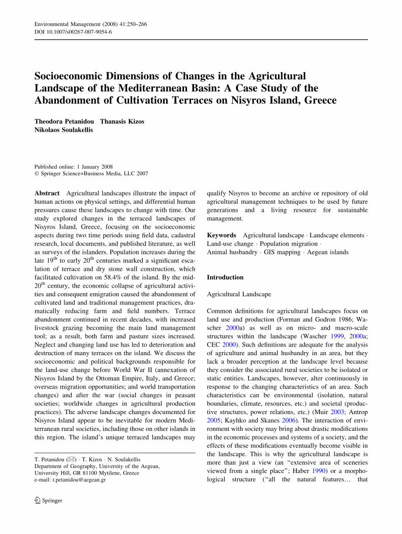
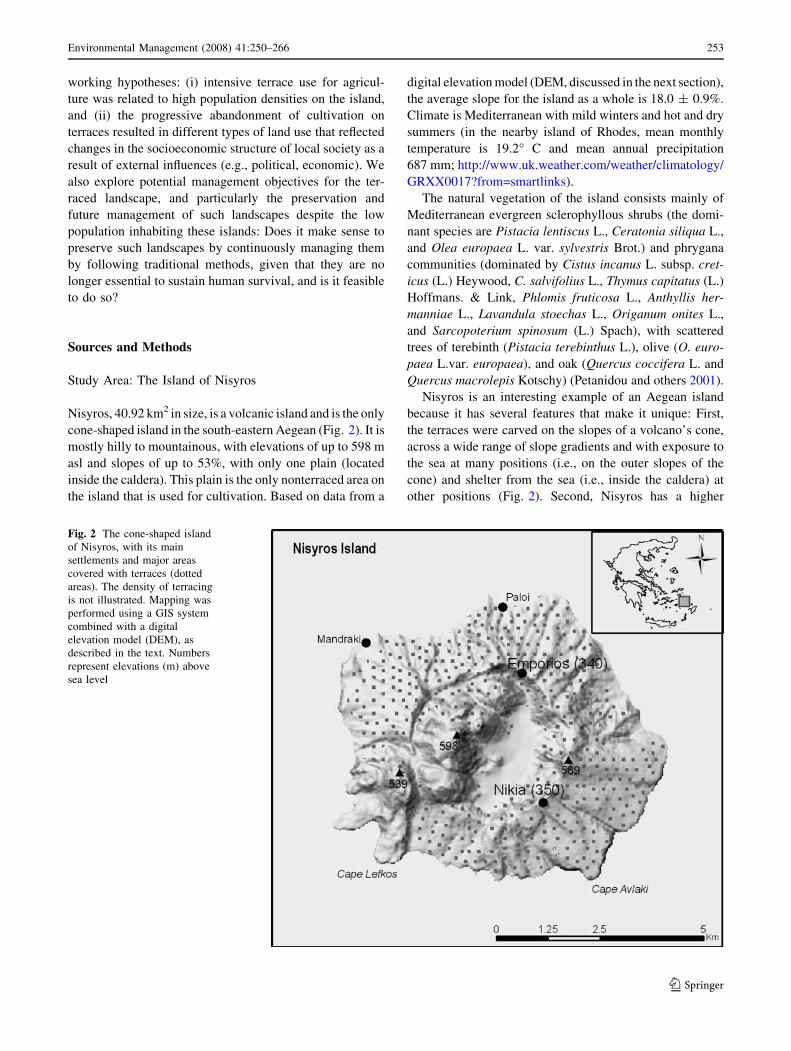
Fig. 1 Illustration of the Nikia settlement on Nisyros and the surrounding landscape, which faces south to the sea. Typical landscape elements,
as they appear in reality, are depicted in the main picture, with detailed explanations given in the smaller surrounding pictures. Drawings by T.
Kizos after a photo by C. de Vries (Ekonomakis and de Vries 2001)
252 Environmental Management (2008) 41:250–266
123
working hypotheses: (i) intensive terrace use for agricul-
ture was related to high population densities on the island,
and (ii) the progressive abandonment of cultivation on
terraces resulted in different types of land use that reflected
changes in the socioeconomic structure of local society as a
result of external influences (e.g., political, economic). We
also explore potential management objectives for the ter-
raced landscape, and particularly the preservation and
future management of such landscapes despite the low
population inhabiting these islands: Does it make sense to
preserve such landscapes by continuously managing them
by following traditional methods, given that they are no
longer essential to sustain human survival, and is it feasible
to do so?
Sources and Methods
Study Area: The Island of Nisyros
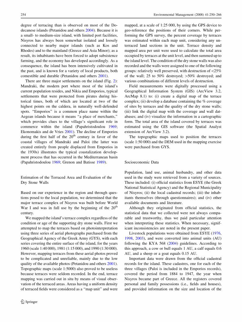
Nisyros, 40.92 km2 in size, is a volcanic island and is the only
cone-shaped island in the south-eastern Aegean (Fig. 2). It is
mostly hilly to mountainous, with elevations of up to 598 m
asl and slopes of up to 53%, with only one plain (located
inside the caldera). This plain is the only nonterraced area on
the island that is used for cultivation. Based on data from a
digital elevation model (DEM, discussed in the next section),
the average slope for the island as a whole is 18.0 ± 0.9%.
Climate is Mediterranean with mild winters and hot and dry
summers (in the nearby island of Rhodes, mean monthly
temperature is 19.2� C and mean annual precipitation
687 mm; http://www.uk.weather.com/weather/climatology/
GRXX0017?from=smartlinks).
The natural vegetation of the island consists mainly of
Mediterranean evergreen sclerophyllous shrubs (the domi-
nant species are Pistacia lentiscus L., Ceratonia siliqua L.,
and Olea europaea L. var. sylvestris Brot.) and phrygana
communities (dominated by Cistus incanus L. subsp. cret-
icus (L.) Heywood, C. salvifolius L., Thymus capitatus (L.)
Hoffmans. & Link, Phlomis fruticosa L., Anthyllis her-
manniae L., Lavandula stoechas L., Origanum onites L.,
and Sarcopoterium spinosum (L.) Spach), with scattered
trees of terebinth (Pistacia terebinthus L.), olive (O. euro-
paea L.var. europaea), and oak (Quercus coccifera L. and
Quercus macrolepis Kotschy) (Petanidou and others 2001).
Nisyros is an interesting example of an Aegean island
because it has several features that make it unique: First,
the terraces were carved on the slopes of a volcano’s cone,
across a wide range of slope gradients and with exposure to
the sea at many positions (i.e., on the outer slopes of the
cone) and shelter from the sea (i.e., inside the caldera) at
other positions (Fig. 2). Second, Nisyros has a higher
Fig. 2 The cone-shaped island
of Nisyros, with its main
settlements and major areas
covered with terraces (dotted
areas). The density of terracing
is not illustrated. Mapping was
performed using a GIS system
combined with a digital
elevation model (DEM), as
described in the text. Numbers
represent elevations (m) above
sea level
Environmental Management (2008) 41:250–266 253
123
degree of terracing than is observed on most of the Do-
decanese islands (Petanidou and others 2004). Because it is
a small- to medium-size island, with limited port facilities,
Nisyros has always been somewhat isolated and loosely
connected to nearby major islands (such as Kos and
Rhodes) and to the mainland (Greece and Asia Minor); as a
result, its inhabitants have been forced to adopt subsistence
farming, and the economy has developed accordingly. As a
consequence, the island has been intensively cultivated in
the past, and is known for a variety of local products, both
comestible and durable (Petanidou and others 2001).
There are three major settlements on the island (Fig. 2):
Mandraki, the modern port where most of the island’s
current population resides, and Nikia and Emporios, typical
settlements that were protected from pirates during his-
torical times, both of which are located at two of the
highest points on the caldera, in naturally well-defended
spots. ‘‘Emporios’’ is a common place name within the
Aegean islands because it means ‘‘a place of merchants,’’
which provides clues to the village’s significant role in
commerce within the island (Papahristodoulou 1969;
Ekonomakis and de Vries 2001). The decline of Emporios
during the first half of the 20th century in favor of the
coastal villages of Mandraki and Paloi (the latter was
created entirely from people displaced from Emporios in
the 1930s) illustrates the typical coastalization develop-
ment process that has occurred in the Mediterranean basin
(Papahristodoulou 1969; Grenon and Batisse 1989).
Estimation of the Terraced Area and Evaluation of the
Dry Stone Walls
Based on our experience in the region and through ques-
tions posed to the local population, we determined that the
major terrace complex of Nisyros was built before World
War I and was in full use by the beginning of the 20th
century.
We mapped the island’s terrace complex regardless of the
condition or age of the supporting dry stone walls. First we
attempted to map the terraces based on photointerpretation
using three series of aerial photographs purchased from the
Geographical Agency of the Greek Army (GYS), with each
series covering the entire surface of the island, for the years
1960 (scale 1:40 000), 1981 (1:15 000), and 1990 (1:30 000).
However, mapping terraces from these aerial photos proved
to be complicated and unreliable, mainly due to the low
quality of the available photos (Petanidou and others 2001).
Topographic maps (scale 1:5000) also proved to be useless
because terraces were seldom recorded. In the end, terrace
mapping was carried out in situ by means of visual obser-
vation of the terraced areas. Areas having a uniform density
of terraced fields were considered as a ‘‘map unit’’ and were
mapped, at a scale of 1:25 000, by using the GPS device to
geo-reference the positions of their corners. While per-
forming the GPS survey, the percent coverage by terraces
was estimated within each map unit, considering any un-
terraced land sections in the unit. Terrace density and
mapped area per unit were used to calculate the total area
occupied by terraces at the unit level, and then summed up to
the island level. The condition of the dry stone walls was also
recorded and the walls were assigned to one of the following
groups: relatively well preserved, with destruction of\25%
of the wall; 25 to 50% destroyed; [50% destroyed; and
various combinations of different levels of destruction.
Field measurements were digitally processed using a
Geographical Information System (GIS) (ArcView 3.2,
ArcMap 8.1) to: (i) create a digital map of the terrace
complex; (ii) develop a database containing the % coverage
of sites by terraces and the quality of the dry stone walls;
(iii) link the digital map with the coverage and wall dat-
abases; and (iv) visualize the information in a cartographic
form. The total area of the island covered by terraces was
estimated using the GIS software (the Spatial Analyst
extension of ArcView 3.2).
The topographic maps used to position the terraces
(scale 1:50 000) and the DEM used in the mapping exercise
were purchased from GYS.
Socioeconomic Data
Population, land use, animal husbandry, and other data
used in the study were retrieved from a variety of sources.
These included: (i) official statistics from ESYE (the Greek
National Statistical Agency) and the Regional Municipality
of Nisyros; (ii) the local cadastral records; (iii) the inhab-
itants themselves (through questionnaires); and (iv) other
available documents and literature.
Although they originated from official statistics, the
statistical data that we collected were not always compa-
rable and trustworthy, thus we paid particular attention
when interpreting these statistics. When necessary, signif-
icant inconsistencies are noted in the present paper.
Livestock populations were obtained from ESYE (1976,
1998, 2003), and were converted into animal units (AU)
following the KYA 568 (2004) guidelines. According to
this approach, a cow or bull equals 1 AU, a calf equals 0.6
AU, and a sheep or a goat equals 0.15 AU.
Important data were drawn from the official cadastral
records for the island. These cadastres, one for each of the
three villages (Paloi is included in the Emporios records),
covered the period from 1884 to 1947, the year when
Nisyros became part of Greece. All the registers covered
personal and family possessions (i.e., fields and houses),
and provided information on the size and location of the
254 Environmental Management (2008) 41:250–266
123
fields, as well as the dates and motives for transfers of
ownership. The Nikia cadastre only provided the sizes and
locations of fields. We independently analyzed each of the
three cadastres that were available for the island. In each
cadastre, we examined all records in the cadastre, in the
order in which they were listed. To facilitate our analysis,
we grouped these records into triplets (e.g., records 1 to 3,
4 to 6, 7 to 9, and so on), then analyzed only the first record
in each triplet (e.g., 1, 4, and 7). Where the first record in a
triplet was illegible, we instead analyzed the second record
(e.g., 2, 5, or 8), and where that record was also illegible,
we analyzed the third record. As a result of this approach,
we were able to analyze a sample amounting to one-third of
the available data. In total, we recorded 5562 cultivated
fields, which suggests a total of 3 9 5562 = 16,686 fields
for the entire island during this period.
Data concerning the period after annexation by the Greek
State (i.e., after 1947), which roughly coincided with the
major period of terrace abandonment, were almost totally
lacking. As a result, we obtained these data directly from the
island’s inhabitants through two questionnaires. The first
survey collected qualitative information on management
practices, especially those related to terrace maintenance. It
was carried out from April to August 2000 and consisted of
nine open interviews of 1 to 2 hours each with local farmers
and other knowledgeable people. The number of interviews
was determined by the quantity of information added by
each new interview. The survey was concluded when little
or no new information was gained. The second survey
(based on a structured questionnaire) collected quantitative
and qualitative data on the process involved in the aban-
donment of terrace cultivation on Nisyros in terms of time
and extent, and the associated motives. This survey was
carried out in May 2003 using a total sample of 30 farmers,
including some of the nine farmers from the first survey.
The interviewees were selected from among farmers who
were still actively cultivating land on the island (the 2001
agriculture census listed 42 farmers, not all of whom were
still active) using the snowball sampling method (Robson
2002). The sample was distributed among three settlements
proportionally to their population size (24 in Mandraki, and
3 each in Nikia and Emporios–Paloi). Both surveys focused
on gaining information on the period before the 1990s, a
decade when the most dramatic farming changes had
already occurred on the island. For this reason, we believe
that the 3-year interval between the two surveys had no
measurable effect on the quality of our data.
Results and Discussion
The results presented in this article mainly concern two
broad periods: from the 19th century through to the 1940s,
and the modern period after World War II. These periods
correspond roughly to different groups of social and eco-
nomic factors that were important in shaping the
agricultural landscape of Nisyros; in the earlier period, the
basic landscape elements were established, whereas in the
later period, these elements began to deteriorate seriously.
The Agricultural Landscape of Nisyros Before the
1940s
Agricultural Production and Practices
Agriculture on Nisyros appears to have been typical of that
practiced in many small or remote locations in the Medi-
terranean basin, with production oriented towards
consumption by the farmer and their family, but always
with a view to local or nearby markets. As Horden and
Purcell (2000) point out, under Mediterranean conditions,
autarky (the Greek term for self-sufficiency) was a desired
goal, even though the goal has rarely been feasible.
Diversification of production and land uses, storage of raw
or processed products, and redistribution to markets low-
ered the economic risks and insured a strong connection
with markets within the dense communication networks
that developed in this region (Asdrahas and others 2003).
As shown by our fieldwork and subsequent GIS analysis,
58.4% of the island’s surface is still terraced (all categories
of wall quality combined). This means that if none of the
terraced fields have disappeared as a result of erosion or
conversion to other land uses, most of the island’s surface
was terraced and cultivated during the first decades of the
20th century: terraces covered a total of 2390 ha, with
nonterraced areas excluded from this total (e.g., the plain
inside the volcano’s caldera). If the latter are considered,
then the island’s cultivated land covered a much broader
area (Fig. 2). This high percentage differs noticeably from
the value estimated based on the cadastral data, in which
cultivated lands were limited to only 35.3% of the total
area. This low percentage may have resulted from delib-
erately falsified field size records in the cadastres (i.e., to
reduce taxes, which were calculated based on the area of
the land), from unique characteristics of the social behavior
of the villagers, or from the fact that these fields constitute
grey records (fields that were recently terraced but not
declared, that were left behind or unclaimed, that belonged
to the church, or that were not recorded at all for various
other reasons).
The main agricultural land uses on Nisyros were cereal
cultivation (primarily barley, with a lesser amount of
wheat) and viniculture, followed by trees (figs, almonds,
olives, and terebinths), all in mixed cultivation of the
terraced land. Trees were generally planted (or grafted) in
Environmental Management (2008) 41:250–266 255
123

a sparse dehesa style (a mixed-cultivation system
encountered mainly in Spain, consisting of scattered trees
grown for various products and fuel, with the soil beneath
the trees grazed or cultivated for field crops, typically
cereals, or for other herbaceous species; Plieninger 2006).
The arable lands were managed collectively at each
location using a crop rotation system: a large part of the
total area was sown with winter cereals and the rest was
cultivated to produce legumes, summer cereals, and
sometimes seasonal vegetables. The local name for the
area sown with winter cereals is kritharia, which means
‘‘the barley place;’’ this suggests the dominance of barley,
which generally grows better than wheat in relatively
barren soils such as those of the Aegean islands. See
Logothetis (1963) and Petanidou and others (2001) for
more details. Due to its exceptional fertility, the plain’s
area inside the volcano’s caldera was sown almost
entirely with cereals every year. In all cases, manure was
used as a fertilizer, and was provided by grazing animals
(mainly sheep and goats, as well as working or pack
animals). All grazing animals were under the vigilance of
specially appointed guards to avoid any possible damage
to the land sown with cereals throughout the island. This
traditional practice contributed greatly to keep terraces in
place over time. Due to a shortage of cultivated land,
Nisyrians very rarely left fertile land fallow. Other
activities of local importance to Nisyros were the col-
lection of terebinth nuts and olives, both used on the
island to make oil. The part of the island that was not
cultivated constituted grazing land managed to support
oaks, from which acorns were gathered and exported for
use in tanning. Such pluri-activity and land uses were
common practices in the Mediterranean basin, especially
the eastern end, until the end of the 19th century (Kostis
1987; Pratt and Funell 1997; Gasparis 1997; Horden and
Purcell 2000; Asdrahas and others 2003).
The general picture at the end of the 19th century and
beginning of the 20th century was that of a place with
limited resources (water, soils, and plains) that was man-
aged extensively and effectively, as suggested by the
relatively large area of cultivated land compared with later
periods. This large area of agricultural land coincided with
peaks in the island’s population (see the section ‘‘Demo-
graphic issues and the local economy’’).
Landscape Elements
Characteristic landscape elements related to the traditional
agricultural practices on Nisyros include terraces, enclo-
sures with stone walls, paved paths, and different types of
living and storage buildings (Ekonomakis and de Vries
2001; Petanidou and others 2001; Petanidou 2005).
Terraced fields currently cover a total of 58.4% of the
island’s area. The dominant type is step terraces, whereas
pocket terraces are totally absent. The supporting walls
range up to 3 m in height, and are made of nondressed
stone, which is usually excavated locally or which is
occasionally obtained from nearby quarries. Many of the
walls bear cavities at their base that are used for storage or
for production, such as the melissothyries (‘‘bee gates’’;
Fig. 1) that are used for bee-keeping (Petanidou and others
2001; Petanidou 2005).
Stone wall enclosures of medium height (between ca.
1.5 and 2.0 m), also constructed from nondressed stone
(mainly volcanic material), are very common. Many of
them bear spaces meant for wooden doors, which indicate
that animals were kept within the enclosures during cer-
tain times for grazing and to provide manure for fertilizer.
Paved paths were also very common on the island,
forming a dense network that connected settlements and
cultivated sites. Remnants of this network can still be
seen today.
Buildings constructed on the terraces were always
small and simple. Either alone or in small groups, they
provided temporary accommodation for the farmer’s
family during extended periods of fieldwork. Such
buildings, locally called spiladi, consisted typically of a
single room frequently built with thick stone walls, usu-
ally with a two- to three-arched stone ceiling, or simply
excavated underground at the height of a terrace or carved
into solid rock. Other similar constructions served as
animal shelters or storage places and, if supplied with the
necessary equipment, as foot-presses for winemaking and
the famous distilleries (kazanario) used to produce a local
alcoholic drink made of grapes (Tarsouli 1950; Petanidou
2005). Threshing floors constructed either on the ground
or on the roof of a building were common throughout the
island.
An important characteristic of the landscape of Nisyros
is that all the abovementioned functional elements are
combined with small fields of irregular size in a way that is
unique to the island and the Mediterranean basin. Figure 1
shows the different elements of this complex landscape
under the Nikia settlement.
Terrace Abandonment and Land-Use Change on
Nisyros
Demographic Issues and the Local Economy
Population estimates for Nisyros before the 18th century are
uncertain, as this humble island has not received the same
attention bestowed on larger Dodecanese islands, such as
Rhodes or Kos (Savorianakis 2000). Assuming that it
256 Environmental Management (2008) 41:250–266
123
followed the same general pattern as other small islands in
the area, Nisyros in the 18th century was probably self-
governed under the Ottoman Empire and later under the
Frankish regime (Liata 1987; Lock 1995; Savorianakis
2000; Lowry 2002), and was only taxed by the Ottoman
province of Rhodes (Savorianakis 2000). In the late
Empire, most of the region’s Muslims resided on the
islands of Kos and Rhodes, and the population of Nisyros
was Christian. The population also included local officials
representing the empire, a common Ottoman practice in
remote or Christian-populated areas (Savorianakis 2000;
Lowry 2002).
Population estimates are available for the 19th century,
and show a maximum population of 5000 by the beginning
of the 20th century (Table 1). These data parallel the
developments on similar nearby islands. The population of
Rhodes did not exceed 35,000 from the 16th century until
the last quarter of the 19th century (totalling 30,606 in
1886; Savorianakis 2000), but reached 55,000 by the
beginning of the 20th century (an increase of ca. 80%). For
Kos, the increase from 1886 to 1928 was ca. 63% (from
12,965 to 21,170 inhabitants). Similarly, the population of
Nisyros increased by ca. 52% from 1821 to ca. 1910
(Table 1). Such an increase in population size is interesting
given the limited primary production potential of the
island: this amounts to a maximum cultivated area of 0.30
ha per capita according to the cadastral and population data
available (Tables 1 and 2). Assuming that the results from
the cadastres are reliable, such a small area could not cover
the dietary needs of all inhabitants at that time based on the
estimated basic metabolic rate per capita (Psihogios 1995);
intensification of agricultural production was limited under
the conditions at that time, since only labor could be
intensified (i.e., technological change was not a factor).
This may explain the poly-culture and extensive terracing
revealed by our data. This conclusion is also corroborated
by our fieldwork, even though our GIS measurements
reveal a much higher coverage of the island by terraces
(58.4% of the area, for a total of 0.46 ha of cultivated land
per capita).
Sources of data on economic activity on Nisyros are
scarce, but the island’s strong agricultural base is certain.
According to 19th century sources, the most important
agricultural islands in the area were Rhodes, Kos, and
Karpathos, followed by Leros and Nisyros, whereas the
remaining islands supported mostly seafaring cultures that
engaged in sponge fishing (Savorianakis 2000). No sig-
nificant port operated on Nisyros, but small-scale trade
between islands by merchant ships from nearby areas (Kos,
Rhodes, and Bodrum) and part-time work in fields on the
continent (olives, cereals, silk, and cotton) is known to
have occurred (Logothetis 1963; Ekonomakis and de Vries
2001). The main exports of Nisyros were almonds and
acorns (Savorianakis 2000). However, nonagricultural
activities were generally underestimated by local sources
(Logothetis 1963), who depicted a romantic peasant society
for Nisyros. This concept of a ‘‘society of abundance’’ is
contradicted by data for areas more suitable for agriculture
with similar technology and productivity in continental
Greece, where the threshold of arable land needed to feed a
person ranged from 0.7 to 1.1 ha, depending on precipita-
tion and soil fertility (Psihogios 1995). This threshold is
much higher than the per capita amount of land that was
available on Nisyros. This discrepancy suggests that
around 66 to 75% of the nutritional requirements of the
Nisyrians were obtained by means of activities other than
agriculture (e.g., fishing or trade) or were obtained from
other islands or the mainland. Households with smaller
cultivated areas in continental Greece had several options
to provide the required amount of nutrition: (i) use their
land for the production of commercial crops (especially
raisins, then olive oil); (ii) emigrate to perform seasonal
work, with one or more family members leaving for this
purpose; (iii) emigrate for permanent employment so that
money could be sent home; and (iv) employ pluri-activity
and the production of ‘‘cash crops’’ (Psihogios 1995;
Bournova and Progoulakis 1999; Asdrahas and others
2003). The traditional society of Nisyros undertook mainly
the last two options during various periods. It seems
therefore that the island’s reduced resources and the
reduced possibility to support a population as large as that
in 1910 forced Nisyrians to emigrate, often over long dis-
tances. In this respect, the 0.46 ha of cultivated land per
capita can perhaps be considered to serve as an estimate of
the instability in Nisyrian society just after the turn of the
20th century.
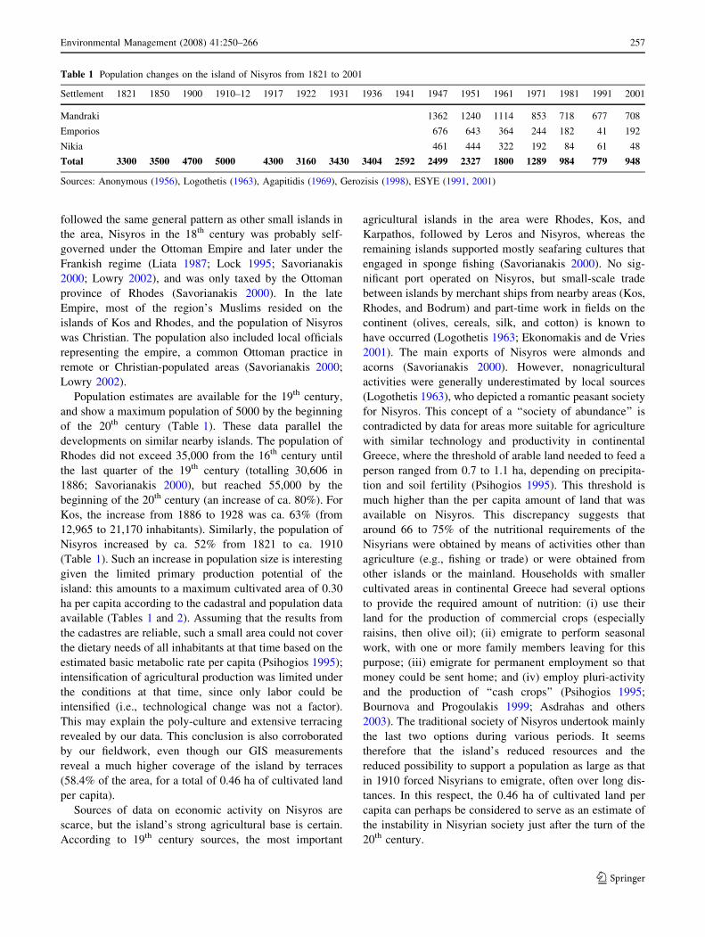
Table 1 Population changes on the island of Nisyros from 1821 to 2001
Settlement 1821 1850 1900 1910–12 1917 1922 1931 1936 1941 1947 1951 1961 1971 1981 1991 2001
Mandraki 1362 1240 1114 853 718 677 708
Emporios 676 643 364 244 182 41 192
Nikia 461 444 322 192 84 61 48
Total 3300 3500 4700 5000 4300 3160 3430 3404 2592 2499 2327 1800 1289 984 779 948
Sources: Anonymous (1956), Logothetis (1963), Agapitidis (1969), Gerozisis (1998), ESYE (1991, 2001)
Environmental Management (2008) 41:250–266 257
123
The Agricultural Landscape of Nisyros in Modern Times:
From Agriculture to Animal Husbandry
A continuous population decrease began around 1910
(Table 1), and agriculture on Nisyros responded with a
serious decline in the cultivation of terraced land (Tables 2
and 3). Abandonment of fields and the resulting neglect of
the terraces became most serious in the middle of the 20th
century according to the responses of inhabitants to our
questionnaire, and was largely completed from the 1970s
through the 1990s. This decline had the following
consequences:
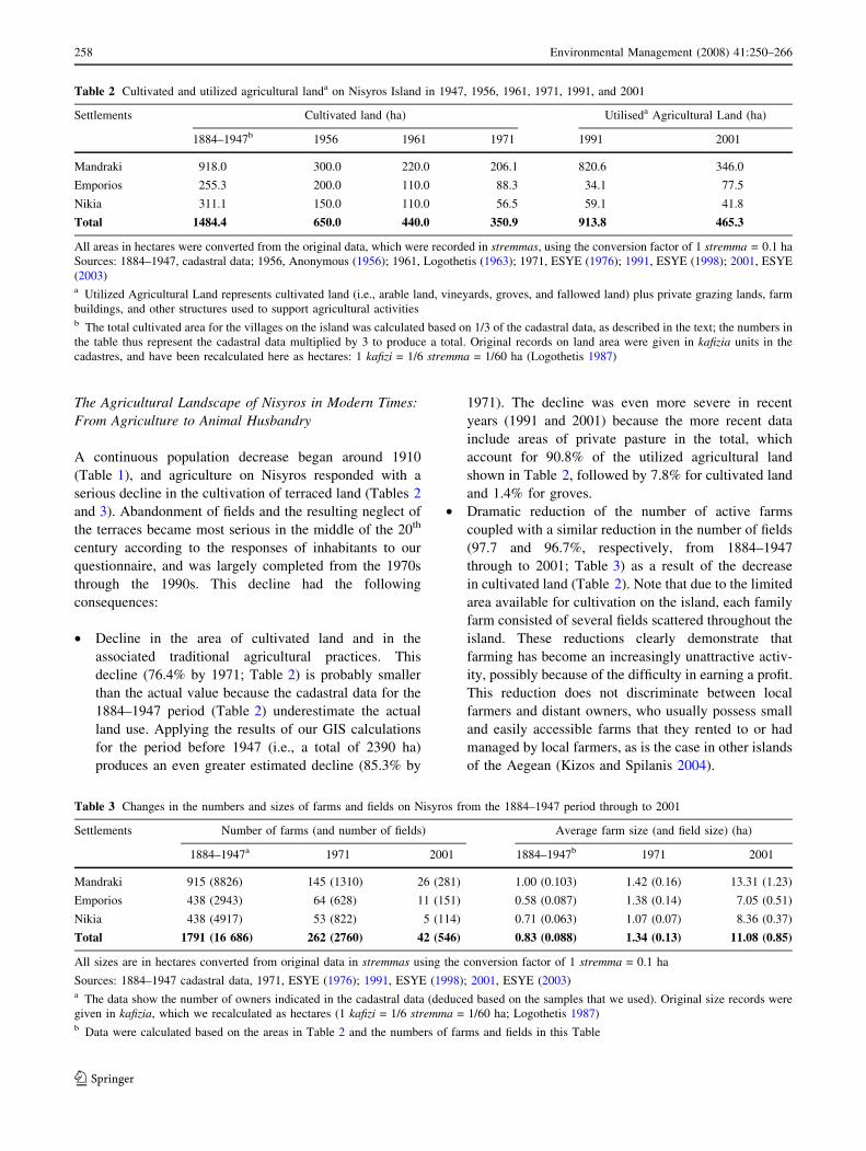
• Decline in the area of cultivated land and in the
associated traditional agricultural practices. This
decline (76.4% by 1971; Table 2) is probably smaller
than the actual value because the cadastral data for the
1884–1947 period (Table 2) underestimate the actual
land use. Applying the results of our GIS calculations
for the period before 1947 (i.e., a total of 2390 ha)
produces an even greater estimated decline (85.3% by
1971). The decline was even more severe in recent
years (1991 and 2001) because the more recent data
include areas of private pasture in the total, which
account for 90.8% of the utilized agricultural land
shown in Table 2, followed by 7.8% for cultivated land
and 1.4% for groves.
• Dramatic reduction of the number of active farms
coupled with a similar reduction in the number of fields
(97.7 and 96.7%, respectively, from 1884–1947
through to 2001; Table 3) as a result of the decrease
in cultivated land (Table 2). Note that due to the limited
area available for cultivation on the island, each family
farm consisted of several fields scattered throughout the
island. These reductions clearly demonstrate that
farming has become an increasingly unattractive activ-
ity, possibly because of the difficulty in earning a profit.
This reduction does not discriminate between local
farmers and distant owners, who usually possess small
and easily accessible farms that they rented to or had
managed by local farmers, as is the case in other islands
of the Aegean (Kizos and Spilanis 2004).
Table 2 Cultivated and utilized agricultural landa on Nisyros Island in 1947, 1956, 1961, 1971, 1991, and 2001
Settlements Cultivated land (ha) Utiliseda Agricultural Land (ha)
1884–1947b 1956 1961 1971 1991 2001
Mandraki 918.0 300.0 220.0 206.1 820.6 346.0
Emporios 255.3 200.0 110.0 88.3 34.1 77.5
Nikia 311.1 150.0 110.0 56.5 59.1 41.8
Total 1484.4 650.0 440.0 350.9 913.8 465.3
All areas in hectares were converted from the original data, which were recorded in stremmas, using the conversion factor of 1 stremma = 0.1 ha
Sources: 1884–1947, cadastral data; 1956, Anonymous (1956); 1961, Logothetis (1963); 1971, ESYE (1976); 1991, ESYE (1998); 2001, ESYE
(2003)a Utilized Agricultural Land represents cultivated land (i.e., arable land, vineyards, groves, and fallowed land) plus private grazing lands, farm
buildings, and other structures used to support agricultural activitiesb The total cultivated area for the villages on the island was calculated based on 1/3 of the cadastral data, as described in the text; the numbers in
the table thus represent the cadastral data multiplied by 3 to produce a total. Original records on land area were given in kafizia units in the
cadastres, and have been recalculated here as hectares: 1 kafizi = 1/6 stremma = 1/60 ha (Logothetis 1987)
Table 3 Changes in the numbers and sizes of farms and fields on Nisyros from the 1884–1947 period through to 2001
Settlements Number of farms (and number of fields) Average farm size (and field size) (ha)
1884–1947a 1971 2001 1884–1947b 1971 2001
Mandraki 915 (8826) 145 (1310) 26 (281) 1.00 (0.103) 1.42 (0.16) 13.31 (1.23)
Emporios 438 (2943) 64 (628) 11 (151) 0.58 (0.087) 1.38 (0.14) 7.05 (0.51)
Nikia 438 (4917) 53 (822) 5 (114) 0.71 (0.063) 1.07 (0.07) 8.36 (0.37)
Total 1791 (16 686) 262 (2760) 42 (546) 0.83 (0.088) 1.34 (0.13) 11.08 (0.85)
All sizes are in hectares converted from original data in stremmas using the conversion factor of 1 stremma = 0.1 ha
Sources: 1884–1947 cadastral data, 1971, ESYE (1976); 1991, ESYE (1998); 2001, ESYE (2003)a The data show the number of owners indicated in the cadastral data (deduced based on the samples that we used). Original size records were
given in kafizia, which we recalculated as hectares (1 kafizi = 1/6 stremma = 1/60 ha; Logothetis 1987)b Data were calculated based on the areas in Table 2 and the numbers of farms and fields in this Table
258 Environmental Management (2008) 41:250–266
123

• An increase in the average farm size (ca. 1235%) and
field size (ca. 866%) from 1884–1947 through to 2001
(Table 3). In the earlier years of the agricultural
decline, this increase was probably due to the selection
of larger fields from among those available on the
island that were left behind by emigrants. After the
1980s, the increased farm size arose from the conver-
sion of abandoned arable land into grazing land. Farms
remain highly fragmented, however, with an average of
13.0 fields per farm in 2001 versus 10.5 and 9.3 in
previous periods (in 1971 and 1884–1947, respectively;
Table 3).
• An increase in the area of pasture (Table 4). The
observed increase (31.9%) between 1956 and 1991 is
certainly lower than the actual increase because the
official statistics used in Table 4 were derived from
rough estimates by the local administration. Interest-
ingly, there has been an increase in the number of
animals since 1991 (Table 5), but a decrease compared
to 1971 levels, when abandonment of the land was not
yet complete. This overall increase probably resulted
from EU subsidies and the lower amount of labor
required by the free-range animal husbandry system
employed by the islanders. This system is structured
around abandoned arable land, which herders use
freely, regardless of ownership. Thus, animals are
almost completely free to roam even in the few
remaining cultivated fields, as all wooden gates and
many of the enclosing stone walls used to keep out
animals have been destroyed. This practice has caused
serious conflicts between herders and field owners
because of the damage caused to properties and crops
(destruction of crops, terraces, walls, etc.) by the
animals, a fact that was reflected in our survey results:
many respondents (20.4%; Table 6) claimed ‘‘uncon-
trolled grazing’’ as a reason for abandoning cultivation.
Indeed, it seems that most of the available land on
Nisyros is under constant grazing today, and that the
competition for land use favors animal husbandry over
agriculture. However, overall grazing pressure remains
low on the island, with 0.29 AU/ha in 2001 (Tables 4
and 5), versus recommended limits in the Aegean
islands of 1.0 AU/ha (KYA 568 2004).
These four developments have had significant repercus-
sions at the landscape level. The most important is that
formerly functional traditional landscape elements, such as
terraces, enclosure walls, paved paths, and other structures,
are no longer used in the current practices. Such elements
require periodic maintenance, and when neglected they
become unstable or damaged, especially in areas that are
freely grazed by cattle, sheep, and goats, which damage the
structures and accelerate their collapse. The resultant state
of the stone terrace walls in the transformed landscape of
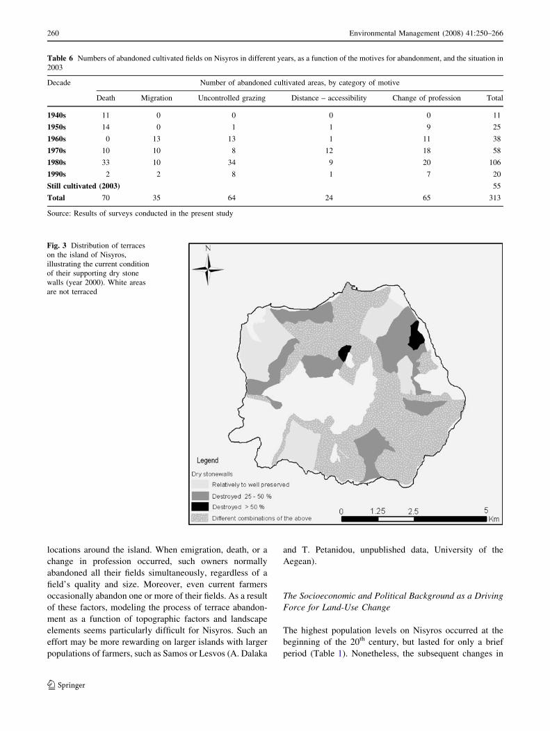
Nisyros is shown in Fig. 3.
It would be very interesting to learn whether the process
of field abandonment was affected by the distance from the
main settlements or other topographic or landscape features
such as accessibility and the type of terrace. However,
although we tried to retrieve quantitative data by analyzing
our GIS data and the survey results, this was not feasible
within the present study for several reasons. First, most of
the land owners, and especially those who had abandoned
their terraces, have emigrated long ago (mainly to the United
States, Athens, and Rhodes), which made recovery of this
data impossible. In addition, the required level of detail was
unavailable in the cadastres. Second, ownership patterns are
complicated because farmers own fields at different
Table 4 Change in the amount of land used for pasture on Nisyros
Settlement Pasture area (ha)
1956 1961 1991
Mandraki 1350 1580 2040
Emporios 900 1000 960
Nikia 700 900 890
Total 2950 3480 3890
Sources: 1956, Anonymous (1956); 1961, ESYE (1965); 1991, ESYE
(1995)
Table 5 Change in the number of animal units (AU) on Nisyros from 1971 to 2001
Settlements 1971 1991 2001 Change in AU from
1971 to 2001 (%)Cattle Sheep – Goat AU Cattle Sheep – Goat AU Cattle Sheep – Goat AU
Mandraki 540 3520 997.6 109 1467 299.7 256 3205 672.7 -32.6
Emporios 399 1533 598.3 51 33 55.3 244 534 313.4 -47.6
Nikia 73 364 120.3 91 124 107.1 90 422 144.9 20.5
Total 1012 5417 1716.2 251 1624 462.1 590 4161 1130.9 -34.1
Sources: Calculated by the authors using data on livestock numbers from ESYE (1976, 1998, 2003)
A cow or bull equals 1 AU, a calf equals 0.6 AU, and a sheep or a goat equals 0.15 AU (KYA 568 2004). % change in AU from 1971 to 2001 was
calculated as: [(AU in 2001 – AU in 1971) x 100/ AU in 1971]
Environmental Management (2008) 41:250–266 259
123
locations around the island. When emigration, death, or a
change in profession occurred, such owners normally
abandoned all their fields simultaneously, regardless of a
field’s quality and size. Moreover, even current farmers
occasionally abandon one or more of their fields. As a result
of these factors, modeling the process of terrace abandon-
ment as a function of topographic factors and landscape
elements seems particularly difficult for Nisyros. Such an
effort may be more rewarding on larger islands with larger
populations of farmers, such as Samos or Lesvos (A. Dalaka
and T. Petanidou, unpublished data, University of the
Aegean).
The Socioeconomic and Political Background as a Driving
Force for Land-Use Change
The highest population levels on Nisyros occurred at the
beginning of the 20th century, but lasted for only a brief
period (Table 1). Nonetheless, the subsequent changes in
Table 6 Numbers of abandoned cultivated fields on Nisyros in different years, as a function of the motives for abandonment, and the situation in
2003
Decade Number of abandoned cultivated areas, by category of motive
Death Migration Uncontrolled grazing Distance – accessibility Change of profession Total
1940s 11 0 0 0 0 11
1950s 14 0 1 1 9 25
1960s 0 13 13 1 11 38
1970s 10 10 8 12 18 58
1980s 33 10 34 9 20 106
1990s 2 2 8 1 7 20
Still cultivated (2003) 55
Total 70 35 64 24 65 313
Source: Results of surveys conducted in the present study
Fig. 3 Distribution of terraces
on the island of Nisyros,
illustrating the current condition
of their supporting dry stone
walls (year 2000). White areas
are not terraced
260 Environmental Management (2008) 41:250–266
123

population were important in terms of landscape change
after the period of maximal terrace use on the island.
Various significant socioeconomic and political develop-
ments during the 20th century resulted in a major
population exodus, with dramatic repercussions for terrace
abandonment (Table 1, Fig. 4).
Developments before World War II included:
• Political changes, with the Dodecanese islands being
annexed from the Ottoman Empire to the Italian State
in 1912 (Savorianakis 2000). Communication with the
continental coast of Asia Minor gradually became more
difficult, and ceased in 1947, the year in which the
Dodecanese islands were annexed by the Greek State.
This was a major blow for the seasonal migration
towards Asia Minor that used to provide important
income to Nisyrians, as it did for other islanders in the
area. As political changes complicated migration
towards the Eastern Mediterranean basin, migratory
pressure became directed towards the United States,
Rhodes, and Athens (Bournova and Progoulakis 1999).
• Changes in permanent or semi-permanent migration
opportunities, such as the emigration towards the
United States, which practically stopped in the 1920s
due to changes in the U.S. immigration policy (Bour-
nova and Progoulakis 1999). Emigrants to the United
States played a key role in the development of the
island by sending money to their family members who
stayed behind. Migrants within Greece, although
unable to contribute financially to the same extent,
created a strong union and a cultural league, the
‘‘Society for Nisyrian Studies’’ in Athens, which
remains operational today (Chartofyllis 2000).
• Transportation changes, with bigger and more modern
ships replacing small-scale transports and reducing the
use of smaller vessels.
Developments after World War II included:
• Continuous transportation changes: public transporta-
tion using ferry boats marginalized the island, with
Nisyros connected to Piraeus (i.e., the Greek mainland)
only via Kos or Rhodes, a situation that continues
today. Furthermore, these transportation changes
opened small island markets to commerce with major
trade centers (e.g., Athens) during this period, which
marginalized local producers and rendered them
unprofitable, as was the case in many other areas of
the Mediterranean basin (Pratt and Funell 1997).
• Social changes, with the traditional peasant society
gradually being transformed into a modern one, in
which agricultural employment was socially devalued
and jobs in the service sector became more appreciated
and sought after. Such changes were fuelled and
accelerated by rapid tourism development in the larger,
• Greater dependence ontourism
• Farming less profitable
• Ageing of population• Farms:
decreased, sizeincreased
• Cultivation decrease• Animal capital
increased
• Unmanaged landscape• Grazing in terraced fields
and destruction of relatedlandscape elements
• Buildings in coastal areas
Time
0891 –
ya
doT
yl raE
02
ht
yrut
nec –
s07 91
91ht –
ylrae
0 2
ht
yrut
nec
Driving forces (Economic, Political, Social)
(Local, Global)
Measurable Impactson Population, Agriculture
and Practices
Changes in the terraced landscape
• Economic alternatives overseas
• Local economicalternatives (mining,tourism)
• War, Italian occupation
• Population exodus• Change from
cultivation to animalhusbandry
• Less well managedlandscape
• Terraces still managed but sometimes only in places and occasionally
• Buildings on terracesrelatively well managed
• Local family farming
• Seasonal migration andseafaring
Local family farming
Seasonal migration andseafaring
•
•
• Well managed landscape • Terraces created and
managed efficiently• Construction of support
structures on terraces foragriculture
number
Fig. 4 Illustration of the
driving forces that have led to
dramatic changes in the terraced
landscape of Nisyros during the
20th century
Environmental Management (2008) 41:250–266 261
123
nearby islands, starting with Rhodes and continuing
with Kos, which provided more attractive jobs and
enhanced emigration from smaller islands. Survey
respondents on Nisyros confirmed the existence of
these developments during the past 50 years. In the
1950s ‘‘death’’ was reported as the main reason for
abandoning agriculture, whereas after the 1960s, low
profitability became more important, with ‘‘distance,’’
‘‘accessibility,’’ ‘‘change of profession’’, and ‘‘migra-
tion’’ becoming the main reasons cited by the
respondents (Table 6). Given that our survey did not
include emigrants, who accounted for most of the
population decrease from 2499 in 1947 to 779 in 1991,
abandonment due to emigration must be considered a
primary motivation, although part of the emigrants’
land was cultivated by the farmers remaining on the
island until the early 1970s, a practice that declined
thereafter. In 2003, the year of our survey, fields were
cultivated mainly to provide animal fodder, and even
this form of cultivation was only carried out in 55 of the
total of 313 areas in which the 30 survey respondents
owned fields (Table 6).
• General post-war changes in agriculture and livestock
management practices included the intensification of
agriculture and animal husbandry by means of mech-
anization, irrigation, chemical inputs to improve soil
fertility and combat pests, increased numbers of
livestock, and imported fodder for animals (see also
Pratt and Funell 1997). The adoption of such mecha-
nized and industrialized management systems in more
fertile areas permitted increased production for wider
markets, and increasingly marginalized most island
producers due to their low productivity. Along with the
change in management practices, most traditional
collection activities were also abandoned on Nisyros,
including those related to forests (e.g., oak and
terebinth products). Combined with the general rise of
industry in urban areas, these changes reinforced the
urbanization process and caused a widespread exodus
from rural areas. The resulting land-use changes were
important, and included a reduction in the area of
cultivated land, an increase in the area of grazing land,
and the expansion of settlements, especially on tourist
islands and in coastal areas of all Aegean islands (Kizos
2005). In some cases, these socioeconomic changes and
the abandonment of agriculture led to a recovery in
natural vegetation, which had nearly disappeared for
many centuries both in the islands and on the mainland
(Petanidou and others 2001; Grove and Rackham 2002;
J. Pantis, Aristotle University of Thessaloniki, personal
communication).
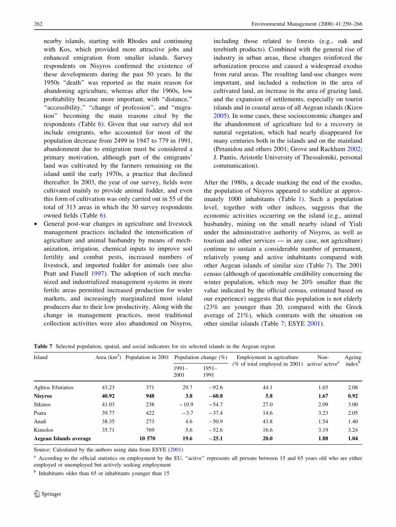
After the 1980s, a decade marking the end of the exodus,
the population of Nisyros appeared to stabilize at approx-
imately 1000 inhabitants (Table 1). Such a population
level, together with other indices, suggests that the
economic activities occurring on the island (e.g., animal
husbandry, mining on the small nearby island of Yiali
under the administrative authority of Nisyros, as well as
tourism and other services — in any case, not agriculture)
continue to sustain a considerable number of permanent,
relatively young and active inhabitants compared with
other Aegean islands of similar size (Table 7). The 2001
census (although of questionable credibility concerning the
winter population, which may be 20% smaller than the
value indicated by the official census, estimated based on
our experience) suggests that this population is not elderly
(23% are younger than 20, compared with the Greek
average of 21%), which contrasts with the situation on
other similar islands (Table 7; ESYE 2001).
Table 7 Selected population, spatial, and social indicators for six selected islands in the Aegean region
Island Area (km2) Population in 2001 Population change (%) Employment in agriculture
(% of total employed in 2001)
Non-
active/ activeaAgeing
indexb
1991–
2001
1951–
1991
Aghios Efstratios 43.23 371 29.7 -92.6 44.1 1.65 2.08
Nisyros 40.92 948 3.8 -60.8 5.8 1.67 0.92
Sikinos 41.03 238 -10.9 -54.7 27.0 2.09 3.00
Psara 39.77 422 -3.7 -37.4 14.6 3.23 2.05
Anafi 38.35 273 4.6 -50.9 43.8 1.54 1.40
Kimolos 35.71 769 5.6 -52.6 16.6 3.19 3.24
Aegean Islands average 10 570 19.6 -25.1 20.0 1.88 1.04
Source: Calculated by the authors using data from ESYE (2001)a According to the official statistics on employment by the EU, ‘‘active’’ represents all persons between 15 and 65 years old who are either
employed or unemployed but actively seeking employmentb Inhabitants older than 65 or inhabitants younger than 15
262 Environmental Management (2008) 41:250–266
123
Epitome
Cultivation terraces supported by dry stone walls are
among the most significant landscape elements of the
Aegean archipelago. Using them as a model for changing
land use, we explored the changes since the end of the 19th
century on one Aegean island (Nisyros), with a particular
focus on the socioeconomic driving forces responsible for
these changes in the landscape. Based on a diverse array of
data, we were able to draw several important conclusions:
(i) Population, economic, and societal changes have been
strong driving forces that produced obvious effects on the
landscape of the Aegean. On the island of Nisyros, as has
been the case with other islands and areas considered today
as disadvantaged or ‘‘less-favored’’ compared to more pop-
ulous or more fertile areas, the population increase at the end
of the 19th century and beginning of the 20th century created
an extended cultural landscape. The social and economic
changes that occurred during the first half of the 20th century
marginalized the economic structures of these disadvantaged
areas and caused a major population exodus that lead to the
abandonment of agriculture and changes in the form of
agriculture (from crop cultivation to animal husbandry) that
produced corresponding changes in the landscape. These
changes can be evaluated in terms of productivity (reduced
cultivated areas and fewer agricultural products) and man-
agement (fewer but bigger farms that are difficult to manage
in the traditional way by the few remaining farmers), and
changes in both parameters reflected a major loss of cultural
capital and local knowledge (e.g., craftsmanship and
knowledge of how to create the dry stone walls). In this
sense, the example of Nisyros is typical of many similar
cases in Greece and the Mediterranean basin.
Although the case of Nisyros is unique because of the
scale and intensity of the driving forces that have brought
about abrupt changes within the period covered by our
study, the intensification and abatement of various forms of
land use are recurring, long-existing phenomena within the
Mediterranean basin (Horden and Purcell 2000). Molinillo
and others (1997) and Lasanta and others (2005, 2006)
discuss the abandonment of mountain farms and its impacts
in the Spanish central Pyrenees, where, as on Nisyros,
farmers have emigrated and abandoned densely cultivated
and managed landscapes since the middle of the 20th cen-
tury. Plieninger (2006) discusses a similar case in a
mountainous part of western Spain, where demographic
changes and changing land use resulted in rural depopula-
tion, abandonment of traditional agricultural activities, and
a sharp increase in livestock husbandry, finally resulting in a
loss of dehesa as a result of shrub encroachment or con-
version to open grassland. Pinto-Correia and Vos (2004)
compared three mountain systems in Spain, Italy, and
France that were all characterized by population emigra-
tion, and the abandonment of farming and traditional
management systems, in all three cases resulting in recov-
ery of the area’s original forest vegetation. Similarly,
cultivation terraces that have been abandoned on many
islands of the south-eastern Aegean have been invaded by
shrubs, turning farmland into shrubland (Petanidou and
others 2001). Kizos and Koulouri (2005) found that on the
island of Lesvos, rural depopulation resulted in the aban-
donment of many terraces that were formerly covered by
olive plantations, and the terraces have now been taken over
by Mediterranean shrubs and forest vegetation. Many sim-
ilar cases of recent landscape change, with particular
emphasis on terraces due to the abandonment of former
management systems throughout the Mediterranean basin,
have been summarized and discussed by Grove and Rack-
ham (2002). All these approaches, ranging from landscape
ecology to historical geography, revealed that although
recent changes may be part of a historical cycle, the changes
brought about seem deeper today compared to previous
periods, and seem to be having dramatic and potentially
irreversible effects on the landscape.
(ii) The landscape changes resulting from the aban-
donment of terrace cultivation on Nisyros are so
sufficiently dramatic that they appear to be irreversible in
many cases, given the current social and economic condi-
tions. These changes encompass both the landscape
elements and the practices and social functions of the
society that created this landscape. Although this trend is
not unique to Nisyros, but rather is a common tendency
within the Mediterranean basin, the fact that Nisyros is a
small and remote island makes the problem and its con-
sequences more dramatic. Actions should be taken to
preserve the cultural, productive, and ecological qualities
of this landscape, but it’s important to note that this will be
difficult given the amount of practical knowledge that has
been lost over the past century, and such actions could
probably only reconstruct the former morphology and not
all of its functions. The diminishing number of farmers
undoubtedly leaves little space for optimism regarding a
large-scale conservation project that would encompass the
parts of the terraced landscape that have been well main-
tained due to their vital role in supporting the island’s
subsistence economy. The uniqueness of Nisyros among
other islands that have been studied in the south-eastern
Aegean (see the section ‘‘Sources and Methods’’; Petani-
dou and others 2001) may qualify the island to become an
archive or repository of old agricultural management
techniques that can be referenced and used by future gen-
erations as a living resource for sustainable management.
Although this seems to be easier said than done, it is the
only way to keep the existing terraces in place.
Environmental Management (2008) 41:250–266 263
123
Acknowledgments The study was supported by the Ministry of the
Aegean (INTERREG II Program, Project entitled ‘‘Terraces in the
islands of the Aegean: Role in the past and importance for their future
in relation to economy, ecology and culture’’, 1999–2001), and by the
Municipality of Nisyros. We thank all collaborators and students who
participated in the fieldwork and laboratory work (K. Karystinakis, P.
Spastra, H. Dahm, D. Arabatzoglou, P. Tserpelis, V. Gkelou, and T.
Kontos), for their invaluable contribution to the terrace mapping; G.
Nikolakakis and T. Iosifidis for their advice on issues related to
cultural and social documentation; and all local residents who
responded to our questionnaires and participated in our interviews,
and particularly D. Papadelias, A. Kaloudis, G. Sakellaridis, and A.
Katsimatidi. We gratefully acknowledge Y. Mahairidis, P. Katsi-
matidis, and K. Hartofyllis for offering logistical support and
providing background documents. The article benefited from a critical
reading by E. Lamborn, M. Koulouri, B. Morehouse, G. Hart, and
three anonymous reviewers.
References
Agapitidis SI (1969) O plithysmos tis Dodekanisou. Nisyriaka 3:5–22
(in Greek)
Anonymous. 1956. Statistika stoiheia Nisyrou. Nisyriaka Hronika2:49–50 (in Greek)
Antrop M (2005) Why landscapes of the past are important for the
future. Landscape and Urban Planning 70:21–34
Argyris P (2001) Historical–geographical coordinates of Dodecanese:
from the sea to the countryside. In: Petanidou T, Dahm H,
Soulakellis N (eds) The role of terraces for the future of the
islands in relation to economy, ecology and civilization –
Unpublished Final Technical Report to the Ministry of the
Aegean. University of the Aegean, Mytilene (in Greek). pp. 39–
54
Asdrahas S, Karapidaki NE, Katsiardi-Hering O, Liata E, Matthaiou
A, Sivignon M, Stoianovich T (2003) Elliniki Oikonomiki
Istoria, 15–19os aionas. Cultural Foundation of Peiraios Bank,
Athens (in Greek)
Barker G, Hodges R, Clark G (1995) A Mediterranean Valley:
Landscape Archaeology and Annales history in the Biferno
Valley. Leicester University Press, London
Bournova E, Progoulakis G (1999) O Agrotikos Kosmos 1830–1940.
In: Kremmydas V (ed), Eisagogi sti Neoelliniki Oikonomiki
Istoria (18–20os aionas). Typothito Press, Athens. (in Greek). pp.
45–104
Brunet M (1990) Terrasses de culture antiques: l’exemple de Delos,
Cyclades. Mediterranee 71:5–11
Cammeraat E, van Beek R, Kooijman A (2005) Vegetation succession
and its consequences for slope stability in SE Spain. Plant and
Soil 278:135–147
Chartofyllis KM (2000) Eisagogi. Nisyriaka 14:5–7 (in Greek)
CEC (Commission of the European Communities) (2000) From land
cover to landscape diversity in the European Union. Report from
EC DG VI, EUROSTAT, Joint Research Center, EEA
Doukellis P (1998) Versants pierreux et champs de culture a Ceos. In:
Mendoni LG, Mazarakis-Ainian AJ (eds), Kythnos: History and
Archaeology – Proceedings of an International Symposium.
Meletimata 27, Centre for Greek and Roman Antiquity. National
Hellenic Research Foundation, Athens. pp 309–330
Duiker SW, Flanagan DC, Lal R (2001) Erodibility and infiltration
characteristics of five major soils of southwest Spain. Catena
45:103–121
Ekonomakis R, de Vries C (2001) Nisyros: History and Architecture.
Melissa, Athens
ESYE. (1965) Katanomi ektaseos tis Ellados kata vasikes katigories
hriseos (Proapografika stoiheia apografis georgias – ktinotrofias
tou etous 1961). Athens (in Greek)
ESYE. (1976) Apotelesmata apografis georgias – ktinotrofias tou
etous 1971. Athens (in Greek)
ESYE. (1991) Stoiheia apografis plithysmou 1991, available at
http://www.statistics.gr/StatMenu.asp (in Greek)
ESYE. (1995) Katanomi ektaseos tis Ellados kata vasikes katigories
hriseos (Proapografika stoiheia apografis georgias – ktinotrofias
tou etous 1991). Athens (in Greek)
ESYE. (1998) Apotelesmata apografis georgias – ktinotrofias tis 7
Martiou 1991. Athens (in Greek)
ESYE. (2001) Stoiheia apografis plithysmou 2001, available at
http://www.statistics.gr/StatMenu.asp (in Greek)
ESYE (2003) Apotelesmata apografis georgias – ktinotrofias 2000–
2001. Athens (in Greek)
Fittschen K (1998) Archaeologia kai prostasia tou fysikou topiou – To
paradeigma tis Arhaias Karthaias (in Greek). In: Mendoni LG,
Mazarakis AJ-Ainian (eds), Kea – Kythnos: History and
Archaeology – Proceedings of an International Symposium,
Kea – Kythnos, 22–25 June 1994. Meletimata 27, Research
Centre for Greek and Roman Antiquity. National Hellenic
Research Foundation, Athens. pp. 539–545
Forman RTT, Godron M (1986) Landscape Ecology. John Wiley &
Sons, New York
French CAI, Whitelaw TM (1999) Soil erosion, agricultural terracing
and site formation processes at Markiani, Amorgos, Greece: The
micromorphological perspective. Geoarchaeology 14:151–189
Gasparis H (1997) I gi kai oi agrotes sti mesaioniki Kriti: 13–14os
aionas. National Research Foundation, Athens (in Greek)
Gebremedhin B, Swinton SM, Tilahun Y (1999) Effects of stone
terraces on crop yields and farm profitability: Results of on-farm
research in Tigray, northern Ethiopia. Journal of Soil and Water
Conservation 54:568–573
Gerozisis TA, (ed). (1998) Dodekanisa: Synthikes – Nomoi –
Statistikes – Hartes 1947–1997. Vouli ton Ellinon, Athens (in
Greek)
Grenon M, Batisse M (1989) Futures for the Mediterranean Basin:
The Blue Plan. UNEP, Paris
Grove AT, Rackham O (2002) The nature of Mediterranean Europe:
an ecological history. Yale University Press, New Haven
Haber W (1990) Using Landscape Ecology in Planning and
Management. In: Zonneveld IS, Forman RTT (eds), Changing
Landscapes: An Ecological Perspective. Springer, New York.
pp. 217–232
Hammad AA, Borresen T (2006) Socioeconomic factors affecting
farmers’ perceptions of land degradation and stonewall terraces
in central Palestine. Environmental Management 37:380–394
Horden P, Purcell N (2000) The corrupting sea: A study of
Mediterranean history. Blackwell, London
Inbar M, Llerena CA (2000) Erosion processes in high mountain
agricultural terraces in Peru. Mountain Research and Develop-
ment 20:72–79
Jameson MH, Runnels CN, van Andel TH (1994) A Greek
countryside: The southern Argolid from Prehistory to the present
day. Stanford University Press, Stanford
Jongman RHG (ed) (1997) Ecological and landscape consequences of
land use change in Europe – Proceedings of the first ECNC
seminar on land use change and its ecological consequences.
European Centre for Nature Conservation, Tilburg
Kayhko N, Skanes H (2006) Change trajectories and key biotopes –
Assessing landscape dynamics and sustainability. Landscape and
Urban Planning 75:300–321
Kizos T 2005. Politiki anaptyxis tis ypaithrou kai agrotiko topio sta
nisia tou Aigaiou. In: Tsaltas G (ed), Aeiforia kai perivallon:
264 Environmental Management (2008) 41:250–266
123

o nisiotikos horos ston 21o aiona. Sideris, Athens (in Greek). pp.
347–362
Kizos T, Koulouri M (2005) Economy, demographic changes and
morphological transformation of the agricultural landscape of
Lesvos, Greece. Human Ecology Review 12:183–192
Kizos T, Spilanis I (2004) The transformation of landscape: modeling
policy and social impacts on the agricultural landscape of
Lesvos. Natural Resource Modeling 17:321–358
Kostis K (1987) Agrotiki oikonomia kai Agrotiki Trapeza. Opseis tis
ellinikis oikonomias sto mesopolemo. National Bank Founda-
tion, Athens (in Greek)
Koulouri M, Giourga C (2007) Land abandonment and slope gradient
as key factors of soil erosion in Mediterranean terraced lands.
Catena 69:274–281
KYA 568. 2004. Greek Common Ministerial Decision 568/20/1/04
(Ministry of Economics and Finance, Ministry of Public Services
and Ministry of Agriculture) for ‘‘Good Agricultural Practices,’’
available at http://www.minagric.gr/greek/EPAA/INDEX%201/
INDEX%201.HTM accessed 18/04/2007
Lasanta T, Gonzalez-Hidalgo J, Vicente-Serrano S, Sferi E (2006)
Using landscape ecology to evaluate an alternative management
scenario in abandoned Mediterranean mountain areas. Land-
scape and Urban Planning 78:101–114
Lasanta T, Vicente-Serrano S, Cuadrat JM (2005) Mountain Medi-
terranean landscape evolution caused by the abandonment of
traditional primary activities: A study of the Spanish Central
Pyrenees. Applied Geography 25:47–65
Liata ED (1987) I Serifos kata tin Tourkokratia (17–19os aionas):
symvoli sti meleti ton koinonikon kai oikonomikon domon kai
tou koinotikou systimatos. Idryma Erevnas kai Paideias, Foun-
dation of the Commercial Bank of Greece, Athens (in Greek)
Lock P (1995) The Franks in the Aegean: 1204–1500. Longman,
London
Logothetis M (1963) Tourismos kai oikonomia tis nisou Nisyrou.
Nisyriaka 1:51–117 (in Greek)
Logothetis M (1987) Ta ktimatologia tis Nisyrou kata ta hronia tis
douleias (1785–1945). Nisyriaka 10:197–386 (in Greek)
Lohmann H (1992) Agriculture and country life in classical Attica. inB. Wells (ed), Agriculture in Ancient Greece – Proceedings of
the seventh International Symposium at the Swedish Institute at
Athens, 16–17 May, 1990. Paul Astr}oms F}orlag, Stockholm. pp.
29–60
Lowry HW (2002) Fifteenth century Ottoman realities: Christian
peasant life on the Aegean island of Limnos. Eren Press, Istanbul
Mander U, Palang H, Ihse M (2005) Development of European
landscapes. Landscape and Urban Planning 67:1–8
Margaris NS (1992) Primary sector and environment in the Aegean
islands, Greece. Environmental Management 16:569–574
Molinillo M, Lasanta T, Garcia-Ruiz JM (1997) Managing moun-
tainous degraded landscapes after farmland abandonment in the
Central Spanish Pyrenees. Environmental Management 21:587–
598
Muir R (2003) On change in the landscape. Landscape Research
28:383–404
Netting RM (1993) Smallholders, householders: farm families and the
ecology of intensive, sustainable agriculture. Stanford University
Press, Stanford
Nicod J (1990) Murettes et terrasses de culture dans les regions
karstiques mediterraneennes. Mediterranee 71:34–54
Palang H, Antrop M, Alumae H (2005) Rural landscapes: past
processes and future strategies. Landscape and Urban Planning
70:3–8
Papahristodoulou HI (1969) Toponymiko Nisyrou. Nisyriaka 3:230–
268 (in Greek)
Petanidou T (2005) Vastadia kai tavles – Sculpturing the landscape of
Nisyros. Nisyriaka 15:212–255 (in Greek)
Petanidou T, Dahm M, Soulakellis N (2001) O rolos ton anavathmi-
don sto parelthon kai i simasia tous gia to mellon ton nision se
shesi me tin oikonomia, tin oikologia kai ton politismo. Final
Report to the Ministry of the Aegean, Vols. 1–2, University of
the Aegean, Mytilene (in Greek)
Petanidou T, Soulakellis N, Karystinakis K, Spastra P (2004) The
Mediterranean terraced landscapes in change: estimating the
efforts to build it up and the reasons to downturn it. In:
Arianoutsou M, and V. Papanastasis. (eds), Proceedings 10th
MEDECOS Conference CD, Rhodes, Millpress, Rotterdam
Pinto-Correia T, Vos W (2004) Multifunctionality in Mediterranean
landscapes – past and future. In: Jongman R (ed), The new
dimensions of the European landscape. Wageningen UR Frontis
Series nr. 4, Springer, Berlin. pp. 155–184
Plieninger T (2006) Habitat loss, fragmentation and alteration –
quantifying the impact of land use changes on a Spanish dehesa
landscape by use of aerial photography and GIS. Landscape
Ecology 21:91–105
Pratt J, Funell D (1997) The modernization of Mediterranean
agriculture. In: King R, Proudfoot L, Smith B (eds), The
Mediterranean: environment and society. Arnold, London. pp.
194–207
Price C, Nixon L (2005) Ancient Greek agricultural terraces:
Evidence from texts and archaeological survey. American
Journal of Archaeology 109:665–694
Psihogios DK (1995) Proikes, foroi, stafida kai psomi: oikonomia kai
oikogeneia stin agrotiki Ellada tou 19ou aiona. EKKE, Athens
(in Greek)
Rackham O, Moody JA (1992) Terraces. In: Wells B (ed), Agriculture
in Ancient Greece – Proceedings of the seventh International
Symposium at the Swedish Institute at Athens, 16–17 May,
1990. Paul Astr}oms F}orlag, Stockholm. pp. 123–130
Rackham O, Moody JA (1996) The making of the Cretan landscape.
Manchester University Press, Manchester
Robson C (2002) Real world research. Blackwell, Oxford
Savorianakis P (2000) Nisiotikes koinonies sto Aigaio prin kai meta
tis othomanikes metarythmiseis: I periptosi ton Ellinon tis Rodou
kai tis Ko (18–19os aionas). Athens, Trohalia – Dimos Rodou,
Athens (in Greek)
Steiner FR (1991) The Living Landscape: An Ecological Approach to
Landscape Planning. McGraw-Hill, New York
Stobbelaar DJ, van Mansvelt JD (2000) The process of landscape
evaluation: introduction to the 2nd special AGEE issue of the
concerted action: ‘‘The landscape and nature production capacity
of organic/sustainable types of agriculture’’. Agriculture, Eco-
systems and Environment 77:1–15
Tarsouli A (1950) Dodekanisa, Volume 3. Alpha I.M. Skazikis
Publisher, Athens (in Greek)
Turner MG, Gardner RH, O’Neill RV (2003) Landscape Ecology in
theory and practice: pattern and process. Springer, Berlin
Vagen TG Tilahun Y, Esser KB (1999) Effects of stone terracing
on available phosphorus and yields on highly eroded slopes
in Tigray, Ethiopia. Journal of Sustainable Agriculture 15:61–
74
Veeck G, Zhou L, Ling G (1995) Terrace construction and
productivity on Loessal soils in Zhongyang County, Shanzi
Province. Proceedings of the Association of American Geogra-
phers 85:450–467
Wascher DM (1999) Agri-environmental indicators for sustainable
agriculture in Europe. European Centre for Nature Conservation,
Tilburg
Wascher DM, (ed). (2000a) The face of Europe: policy perspectives
for European landscapes. Technical Report series, European
Centre for Nature Conservation, Tilburg
Wascher DM, (ed). (2000b) Landscapes and sustainability – Pro-
ceedings of the European workshop on landscape assessment as
Environmental Management (2008) 41:250–266 265
123

a policy tool. European Centre for Nature Conservation, The
Countryside Agency, Tilburg
Wascher DM (2006) European Landscape Character Areas –
Typologies, Cartography and indicators for the assessment of
sustainable landscapes. Final Project Report of the European
Landscape Character Assessment Initiative. Available at
http://www.elcai.org/brochure.html accessed 18/04/2007
Whitelaw TM (1994) An ethnoarchaeological study of rural land-use
in north-west Keos: insights and implications for the study of
past Aegean landscapes. In: Doukellis PN and Mendoni LG
(eds), Structures rurales et societes antiques – Actes du Colloque
de Corfu (14–16 Mai 1992). Annales Litteraires de l’Universite
de Besancon, Paris. pp. 163–186
266 Environmental Management (2008) 41:250–266
123