3D-STRUCTURES WITH INTEGRATION GEOLOGICAL AND GEOPHYSICAL DATA: IMPLICATION FOR RESEARCH WATER...
20
[Alyahyaoui et. al., Vol.3(Iss.7):July,2015] ISSN- 2350-0530(O) ISSN- 2394-3629(P) Science INTERNATIONAL JOURNAL OF RESEARCH –GRANTHAALAYAH A knowledge Repository Http://www.granthaalayah.com© International Journal of Research -GRANTHAALAYAH [43-62] 3D-STRUCTURES WITH INTEGRATION GEOLOGICAL AND GEOPHYSICAL DATA: IMPLICATION FOR RESEARCH WATER RESOURCES IN TUNISIA: CASE OF BOTH SE JEFFARA AND UTIQUE BASIN, TUNISIA Sofien alyahyaoui * 1, 2 , Hedi Zouari 1 , Hakim Gabtni 1 , Chokri Jallouli 2, 3 *1 Georessources Laboratory, Water Researches and Technologies Centre, Borj Cedria Ecopark, BO 273, 8020, Soliman, TUNISIA 2 Department of geology, Faculty of Sciences of Tunis, University Tunis El Manar, 2092 Manar II, TUNISIA 3 Department of Geology and Geophysics, College of Sciences, King Saud University, P.O. Box. 2455, Riyadh 11451, SAUDI ARABIA Abstract: Tunisia is enriched by many natural resources (natural water and geothermal water) that are located along the South to the North. This paper aims mainly to evaluate the resources water potential. The available remote sensing images for two typical examples (SE Jeffara basin and Utique basin) are analyzed and many seismic profiles are interpreted to delineate the surface and subsurface structures. The 3-D structures of Mio-Plio-Quaternary and Upper Cretaceous aquifers in South-East of Jeffara basin show an important reservoirs of water resources. The Upper Cretaceous aquifer "Complexe Terminal" is one of the most typical examples of exploitation features in hydrogeological research. It is formed by fractured limestones. The 3D-structure of Utique basin shows an important variation of thickness of Mio-Plio- Quaternary and Triassic series. The Mio-Plio-Quaternary series is formed by sand, clays and gypsum. The Triassic series is considered typical example for research the hydrogeological and hydrothermal water in Tunisia, especially in the North. In the subsurface, the triassic aquifer of Utique regions is formed by carbonates series. The hot spring in Utique basin is directly related to the Triassic dolostones which are extensively fractured [1]. A geophysical survey was undertaken for groundwater in Tunisia. The interpretation of seismic reflection sections and petroleum wells allowed to precise the geometry in subsurface structure. Keywords: 3D-Structure, tectonic framework, water resources, SE Jeffara basin, Utique basin, Tunisia. Cite This Article: Sofien alyahyaoui, Hedi Zouari, Hakim Gabtni, and Chokri Jallouli, “3D- STRUCTURES WITH INTEGRATION GEOLOGICAL AND GEOPHYSICAL DATA: IMPLICATION FOR RESEARCH WATER RESOURCES IN TUNISIA: CASE OF BOTH SE JEFFARA AND UTIQUE BASIN, TUNISIA” International Journal of Research – Granthaalayah, Vol. 3, No. 7(2015): 43-62.
-
Upload
granthaalayah -
Category
Documents
-
view
0 -
download
0
Transcript of 3D-STRUCTURES WITH INTEGRATION GEOLOGICAL AND GEOPHYSICAL DATA: IMPLICATION FOR RESEARCH WATER...
[Alyahyaoui et. al., Vol.3(Iss.7):July,2015] ISSN- 2350-0530(O) ISSN- 2394-3629(P)
Science
INTERNATIONAL JOURNAL OF RESEARCH –GRANTHAALAYAH A knowledge Repository
Http://www.granthaalayah.com©International Journal of Research -GRANTHAALAYAH [43-62]
3D-STRUCTURES WITH INTEGRATION GEOLOGICAL AND
GEOPHYSICAL DATA: IMPLICATION FOR RESEARCH WATER
RESOURCES IN TUNISIA: CASE OF BOTH SE JEFFARA AND UTIQUE
BASIN, TUNISIA Sofien alyahyaoui *1, 2, Hedi Zouari1, Hakim Gabtni1, Chokri Jallouli2, 3 *1 Georessources Laboratory, Water Researches and Technologies Centre, Borj Cedria Ecopark,
BO 273, 8020, Soliman, TUNISIA 2 Department of geology, Faculty of Sciences of Tunis, University Tunis El Manar, 2092 Manar
II, TUNISIA 3 Department of Geology and Geophysics, College of Sciences, King Saud University, P.O. Box.
2455, Riyadh 11451, SAUDI ARABIA
Abstract:
Tunisia is enriched by many natural resources (natural water and geothermal water) that are
located along the South to the North. This paper aims mainly to evaluate the resources water
potential. The available remote sensing images for two typical examples (SE Jeffara basin and
Utique basin) are analyzed and many seismic profiles are interpreted to delineate the surface
and subsurface structures.
The 3-D structures of Mio-Plio-Quaternary and Upper Cretaceous aquifers in South-East of
Jeffara basin show an important reservoirs of water resources. The Upper Cretaceous aquifer
"Complexe Terminal" is one of the most typical examples of exploitation features in
hydrogeological research. It is formed by fractured limestones.
The 3D-structure of Utique basin shows an important variation of thickness of Mio-Plio-
Quaternary and Triassic series. The Mio-Plio-Quaternary series is formed by sand, clays and
gypsum. The Triassic series is considered typical example for research the hydrogeological
and hydrothermal water in Tunisia, especially in the North. In the subsurface, the triassic
aquifer of Utique regions is formed by carbonates series. The hot spring in Utique basin is
directly related to the Triassic dolostones which are extensively fractured [1].
A geophysical survey was undertaken for groundwater in Tunisia. The interpretation of
seismic reflection sections and petroleum wells allowed to precise the geometry in subsurface
structure.
Keywords:
3D-Structure, tectonic framework, water resources, SE Jeffara basin, Utique basin, Tunisia.
Cite This Article: Sofien alyahyaoui, Hedi Zouari, Hakim Gabtni, and Chokri Jallouli, “3D-
STRUCTURES WITH INTEGRATION GEOLOGICAL AND GEOPHYSICAL DATA:
IMPLICATION FOR RESEARCH WATER RESOURCES IN TUNISIA: CASE OF BOTH SE
JEFFARA AND UTIQUE BASIN, TUNISIA” International Journal of Research –
Granthaalayah, Vol. 3, No. 7(2015): 43-62.

[Alyahyaoui et. al., Vol.3(Iss.7):July,2015] ISSN- 2350-0530(O) ISSN- 2394-3629(P)
Science
INTERNATIONAL JOURNAL OF RESEARCH –GRANTHAALAYAH A knowledge Repository
Http://www.granthaalayah.com©International Journal of Research -GRANTHAALAYAH [43-62]
1. INTRODUCTION
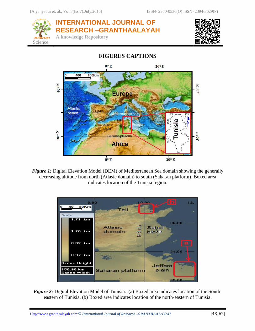
Tunisia is situated in the north of Africa plate. The northern Africa is bounded by an Alpine-type
orogen resulting from the subduction and closure of the Tethyan Ocean and from the interaction
between the European and African plates [2] and [3]. In the north of Africa is situated the
Maghrebian domain. The Digital Elevation Model view of the Maghrebian domain shows a
generally decreasing elevation from north (chain Atlasic) to south (Saharan platform) (Fig. 1 a).
Tunisia is considered to be one of the countries least well-endowed with water resources in the
Mediterranean basin. It is characterized by a semi-arid climate with mild, dry summers, wet
winters and warm. Pressure on fresh water demand is increasing as a result of demographic
increase, agricultural water use and the development of the industry and tourism sectors. These
conditions forced Tunisian authorities and policy makers to encourage for new research for
potential resources water.
2. GEOGRAPHICAL, GEOLOGICAL AND STRUCTURAL SETTING
The Digital Elevation Model (DEM) of Tunisia, which shows a wide variation in the topography
(Fig. 2). A maximum depth of 1600 m above sea level is the highly elevated mountainous in
central Tunisia.
From the North to the South, the geological and structural context of Tunisia shows five
domains:
1) The Tellian domain corresponds to "Alpine zone". This domain is characterized by the
stacking of allochtonous units [4], [5], [6], [7], [8] and [9].
2) The Atlasic domain includes the Northern Atlas, the central Atlas and South Atlas.
3) The Northern Atlas is composed by imbricate thrust series [10] and [11 and salt outcrops
zone is represented by NE-SW trending Triassic outcrops [12], [13], [14]. [11], [15],
[16], [17]. [18], [19] and [20].
4) The Central Atlas is characterized by a NE-SW folds structures that are cut orthogonally
by a graben system [21], [22], [23]. [24], [25] and [26].
5) The Southern Atlas is characterized by NW-SE and E-W to NE-SW folds [27], [28], [29].
[30], [31] [32], [28], [33], [34], [35], [36]. [37] and [38]. and bounded by the major faults
Gafsa and Negrine-Touzeur.
6) The "North-South axis" is delimited the central Atlas zone and Eastern domain. It is
composed by N-S trending faults [39], [40], [41]. [42], [43] and [44].
7) The Eastern domain is characterized by different blocks separated by N-S, E-S, NE-SW
and NW-SE faults [45], [46], [47] and [48].
8) The Saharan domain is representing by folded Paleozoic rocks of African craton and
Angular unconformity of Paleozoic series [49], [50], [51] and [52].
3. METHODOLOGY
This Research is based on the structural and strati graphical interpretation of surface data,
[Alyahyaoui et. al., Vol.3(Iss.7):July,2015] ISSN- 2350-0530(O) ISSN- 2394-3629(P)
Science
INTERNATIONAL JOURNAL OF RESEARCH –GRANTHAALAYAH A knowledge Repository
Http://www.granthaalayah.com©International Journal of Research -GRANTHAALAYAH [43-62]
seismic profiles and petroleum wells which lies in south-eastern and north eastern parts of
Tunisia.
The utilized methods in this work are mainly applied to determine the following issues:
The digital elevation model of SE Jeffara and Utique basins using remote sensing
techniques;
The surface and subsurface structure;
3-D structures of different basin;
Subsidence structure;
Deep fault system;
The research water resources.
3.1.TOPOGRAPHY
The three-dimensional structures are displayed as their intersections with two-dimensional
surfaces that may be defined analytically or with grid meshes in the case of irregular surfaces
such as the digital terrain models.
The digital elevation model (DEM) of Tunisia shows a wide variation in the topography. The
DEM of Tunisia is determined using remote sensing techniques. A maximum depth of 1600
meters is recorded at the highly elevated mountainous in central of Tunisia (Fig. 2)
The south-East Jeffara is situated in South-East of Tunisia. The digital elevation model of SE
Jeffara basin is represented by different topographic relief of almost 0 meters to 650 meters
(Fig. 3). The high topography relief is represented by mountains such as Jebel Tebaga and
Dahar. The low topography relief is marked by lowland zones such as the Chotts and SE of
Jeffara basin.
The DEM of north-eastern Tunisia (Fig. 4) is marked by different topographic relief of almost
0 meters to 600 meters. The high topography relief is represented by mountains such as Dj. el
Messftine, Dj. Hakima and Dj. Kechabta. The low topography relief is characterized by
lowland zones such as the Utique plain.
3.2.GEOPHYSICAL SURVEYS
The resource mineral can be explored and used a variety of geophysical techniques and
geological investigation as well as in the exploration of hydrocarbons and groundwater. In this
study, geological and geophysical techniques (cross-section, wells petroleum and seismic
[Alyahyaoui et. al., Vol.3(Iss.7):July,2015] ISSN- 2350-0530(O) ISSN- 2394-3629(P)
Science
INTERNATIONAL JOURNAL OF RESEARCH –GRANTHAALAYAH A knowledge Repository
Http://www.granthaalayah.com©International Journal of Research -GRANTHAALAYAH [43-62]
profiles) used by to identify the major structures sub-basin aquifers and three dimension
structures of study area.
4. RESULTS AND DISCUSSION
4.1.CASE 1: SE JEFFARA BASIN
In the SE Jeffara basin, two petroleum wells: W1 (Ben Guerdane-1), W2 (Bir Mastoura) and W3
(Utique-1) obtained from oils company (Mobile and SEREPT) and "Entreprise Tunisienne des
Activités Pétrolières" (ETAP). The location of petroleum wells shows in figure 5. Eight seismic
reflection profiles (L1 to L8) are analyzed (fig.5). The interpretation of these seismic profiles
reveals to determine Mio-Plio-Quaternary and Upper Cretaceous aquifers.
The lithostratigraphical description from deep wells (W1 and W2) shows that fractured
limestones and dolomitic of Upper Cretaceous to corresponding the lower part of "complexe
Terminal". The Mio-Plio-Quaternary to corresponding the upper part of "Complexe Terminal" is
formed by sand and silts.
The correlation of wells W1 and W2 [53], [54], [55] and [56].) Shows reduces series of Upper
Cretaceous to corresponding to "Complexe Terminal".
The figure 5 shows the disappearance of the Upper Cretaceous unit and to reduce of the Mio-
Plio-Quaternary series towards the southwest (W1 to W2).
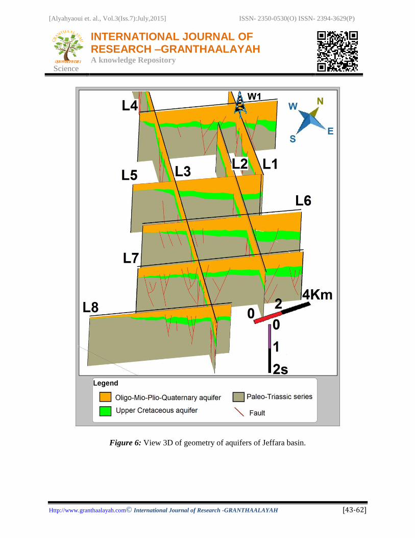
The view 3D of geometry Mio-Plio-Quaternary and Upper Cretaceous aquifers of seismic
profiles (figs. 5 and 6) The 3D view of combination seismic profiles (L1 to L8) shows the
variations of the basin’s geometry (Figs. 5 and 6). The variation of the thickness of the Upper
Cretaceous is related by a horsts and grabens structure of the Upper Cretaceous and listric faults
affected these series.
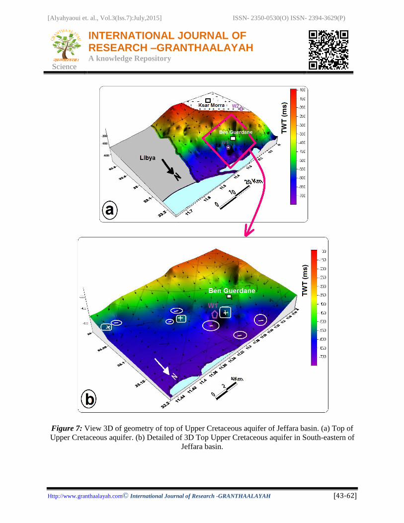
The 3-D blocks diagram representation of the top (Fig. 7) and the base (Fig. 8) of the Upper
Cretaceous aquifer was determined using the seismic sections and borehole data (W1). Its shows
that the basin increases in depth from the southwest toward the northeast and also the depth
increases toward the southeast.
4.2.CASE 2: UTIQUE BASIN
In Utique basin, the petroleum well W3 is reached a total of 2500 meters. This well shows an
important Triassic and Mio-Plio-Quaternary series. Four seismic profiles are analyzed.
In this study, analysis of the lithostratigraphic data was carried out using time-depth conversion
wells data from W3. The processed seismic reflection profiles were obtained from "Entreprise
Tunisienne des Activités Pétrolières" ETAP with the locations of profiles in Figure 9.

[Alyahyaoui et. al., Vol.3(Iss.7):July,2015] ISSN- 2350-0530(O) ISSN- 2394-3629(P)
Science
INTERNATIONAL JOURNAL OF RESEARCH –GRANTHAALAYAH A knowledge Repository
Http://www.granthaalayah.com©International Journal of Research -GRANTHAALAYAH [43-62]
The migrated seismic reflection profiles were analyzed to determine correlations between
seismic reflection horizons and stratigraphic horizons determined from the boreholes W3.
All georeferenced subsurface and surface data are integrated, interrelated and analyzed using
"midland valley" move 2014 software.
The Porto-Farina and Ariana region is characterized by Triassic to Quaternary series are
derived from the geological mapping scale 1/ 50.000 [57], [58] and [59].
In subsurface, the well petroleum W3 shows that the Triassic series are formed by domination of
fractured carbonates with an average porosity of 15% [60] and little gypsum.
Under the Miocene tortonian unconformity. Directly beneath the Miocene is a thin 11meter of
late Cretaceous. The Mio-Plio-Quaternary is approximatly 1378 meter.
The Miocene and Pliocene are composed by sand, clay and little gypsum. The Quaternary
substratum shows continental facies.
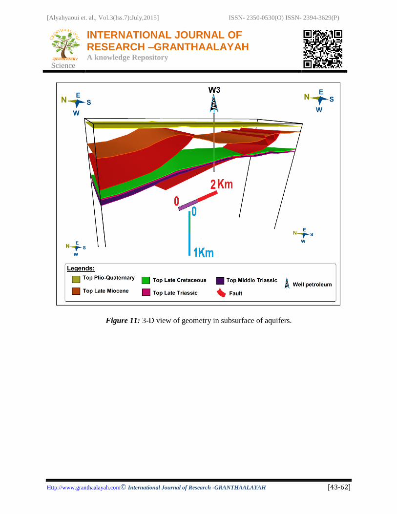
The different view 3D of interpretation in polygone of seismic profiles shows the geometry of
repartition of Mio-Plio-Quaternary and Triassic series (figs. 10 and 11).
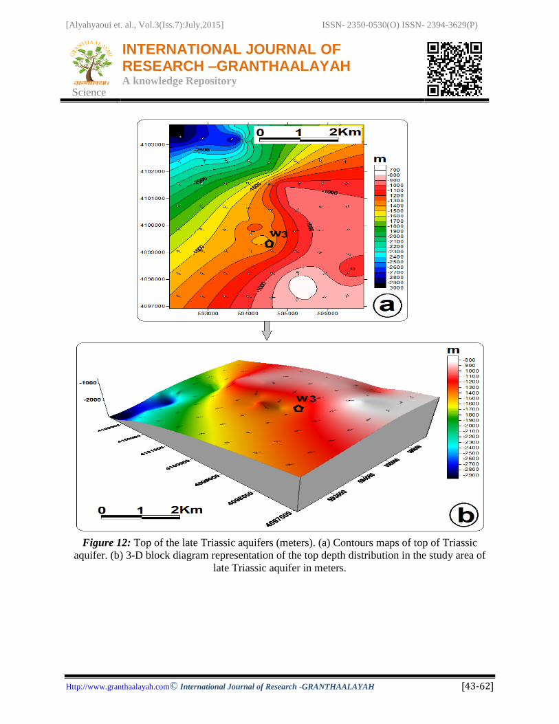
The figure 12 shows the top of the late Triassic aquifers is determined using the seismic sections
and borehole data (W1). Its shows that the basin increases in depth from the southeast toward the
northeastwest. The Triassic aquifer is formed by fractured dolostones and limestones. The
Triassic aquifer is considerate a thermal aquifer [1] and it is favorable to the hydrogeological
exploitation.
5. CONCLUSIONS
The integration of surface (geological mapping and outcrops) and subsurface studies
(petroleum's well, seismic reflection profiles and gravity data) has given an idea of geometry in
subsurface of aquifers for prospecting natural resources mineral. The Upper Cretaceous and Mio-
Plio-Quaternary of "Complexe Terminal" aquifer in the Jeffara basin and the Triassic aquifer of
Utique basin is considerate strategic a new aquifers exploration in the feature.
6. ACKNOWLEDGEMENTS
We express our appreciation to the SEREPT and ETAP for support and access to subsurface data
(petroleum wells and seismic reflection lines). We wish to thank the society Midland Valley for
access to use license academic move software 2014.

[Alyahyaoui et. al., Vol.3(Iss.7):July,2015] ISSN- 2350-0530(O) ISSN- 2394-3629(P)
Science
INTERNATIONAL JOURNAL OF RESEARCH –GRANTHAALAYAH A knowledge Repository
Http://www.granthaalayah.com©International Journal of Research -GRANTHAALAYAH [43-62]
7. REFERENCES
[1] Andolssi, M., Alyahyaoui, S., Makni, J., Charef, A., Zouari, H., Tarki, M., Challouf, B.,
Integrated study of surface and subsurface data for prospecting hydrogeothermal basins of hot
water spring Ain El Hammam: case of Utique region basin (Extreme North of Tunisia). Arab J
Geosci. DOI 10.1007/s12517-014-1743-x. 2015.
[2] Auzende, J.M., Bonnin, J., Olivet, J.L., The origin of the western Mediterranean Basin, J.
Geol. Soc. Lond. 129, 607-620, 1973.
[3] Domzig, A., Yelles, K., Le Roy, C., Déverchère, J., Bouillin, J.P., Bracène, R., Lépinay,
B.M., Le Roy, P., Calais, E., Kherroubi, A., Gaullier, V., Savoye, B., Pauc, H., Searching for
the Africa-Eurasia Miocene boundary offshore western Algeria. C. R. Géo. 338, 80-91, 2006.
[4] Jauzein, A., Rouvier, H., Sur les formations allochtones de Kroumirie (Tunisie
septentrionale). C. R. Somm. Soc. Géol. 2, 36-38, 1965. [5] Biely, A., Burollet, P.F., Lajmi, T., Etude géodynamique de la Tunisie et des secteurs
voisins de la méditerranée. Notes Serv. Géol. Tunisie 41, 23-38, 1974.
[6] Ben Ferjani, A., Burollet, P.F., Mejri, F., Petroleum Geology of Tunisia: A Renwed
Synthesis. Enterprise Tunisienne d’Activités Pétrolières, Mém. No.22, 2006.
[7] Ould Bagga, M.A., Saadi, A., Mercier, E., La "Zone des Nappes" de Tunisie: une marge
méso-cénozoïque en blocs basculés modérément inversé (région de Tabarka/Jendouba; Tunisie
nord-occidentale). Bull. Soc. Géol. France 177(3), 145-154, 2006.
[8] Boukhalfa, K., Ben Ismail-Lattrache, K., Riahi, S., Soussi, M., Khomsi, S., Analyse
biostratigraphique et sédimentologiquen des séries éo-oligocènes et miocènes de la Tunisie
septentrionale: implications stratigraphiques et géodynamiques. C. R. Geoscience 341, 49-62,
2009.
[9] Riahi, S., Soussi, M., Boukhalfa, K., Ben Ismail-Lattrache, K_., Dorrik, S., Khomsi, S.,
Bedir, M., Stratigraphy, sedimentology and structure of the Numidian Flysch thrust belt in
Northern Tunisian. Journal of African Earth Sciences 57, 109-126, 2010.
[10] Zargouni, F., Etude géologique de la chaîne de Lansarine (région de Tebourba, Atlas
tunisien). Thèse 3éme cycle, Univ. Pièrre et Marie Curie, Paris, 86 p, 1975.
[11] Perthuisot, V., Dynamique et pétrogenèse des extrusions triasiques en Tunisie
septentrionale, Thè se d’Etat, Ecole Normale Supérieure, ERA 604-CNRS, 321 p, 1978.
[12] Burollet, P.F., Importances des facteurs salifères dans la tectonique tunisienne.
Annales des Mines et de la Géologie de Tunisie 26, 11-120, 1973.
[13] Rouvier, H., Géologie de l’Extrême Nord-Tunisien : Tectoniques et paléogéographies
superposées à l'extrimité orientale de la chaîne nord maghrébine. Thèse Doctorat es Sciences
Univ. Pierre et Marie Curie, Paris VI, 1000 p. 1977.
[Alyahyaoui et. al., Vol.3(Iss.7):July,2015] ISSN- 2350-0530(O) ISSN- 2394-3629(P)
Science
INTERNATIONAL JOURNAL OF RESEARCH –GRANTHAALAYAH A knowledge Repository
Http://www.granthaalayah.com©International Journal of Research -GRANTHAALAYAH [43-62]
[14] Zargouni, F., Etude structurale de la bande triasique de Baouala- Aroussia-El
Mecherket (Zone de diapirs, Atlas tunisien). Bull. Soc. Sc. Nat. Tunis. t. 12, 79–82. 1977.
[15] Vila, J.M., Ben Youssef, M., Charrière, A., Chikhaoui, M., Ghanmi, M., Kammoun, F.,
Découverte en Tunisie au SW du Kef de matériel triasique interstratifié dans l’Albien :
extension du domaine à « glacier de sel » sous-marin des confins algéro-tunisiens, C. R. Acad.
Sci. Paris, Ser. II. 318, 109-116. 1994.
[16] Ghanmi, M., Ben Youssef, M., Jouirou, M., Zargouni, F., Vila, J.M., Halocinèse crétacée au
Jebel Kebbouch (nord-ouest tunisien) : mise en place à fleur d’eau et évolution d’un « glacier de
sel » albien, comparaisons. Eclogae Geologicae Helvetiae 94,153-160. 2001.
[17] Chikaoui, M., Jallouli, C., Turki, M.M., Soussi, M., Braham, A., Zaghbib-Turki, D., The
Triassic rocks of the Debadib-Ben Gasseur area (northwestern Tunisia): diapirwith overhangs
spreading downslope in the Albian Sea and deformed during the Tertiary compressional
deformations. Comptes Rendus Geosciences 334, 1129-1133, 2002.
[18] Ben Chelbi, M., Melki, F., Zargouni, F., Mode de mise en place des corps salifères dans
l’Atlas septentrionale de Tunis. Exemple de l’appareil de Bir Afou. C. R. Géoscience, 338,
pp349-358, 2006.
[19] Masrouhi, A., Ghanmi, M., Ben Youssef, M., Vila, J.M., and Zargouni, F., Mise en
évidence d’une nappe de charriage à deux unités paléogènes au plateau de Lansarine (Tunisie
du Nord): Définition d’un nouvel élément structural de l’Atlas Tunisien et réévaluation du
calendrier des serrages tertiaires: Comptes Rendus Géoscience, v. 339, p. 441-448, 2007.
[20] Masrouhi, A., Bellier, O., Koyi, H., Vila, J.M., Ghanmi, M., The evolution of the
Lansarine-Baouala salt canopy in the North African Cretaceous passive margin in Tunisia.
Geol. Mag. 150 (5 ), pp. 835-861, 2013.
[21] Jauzein, A., Contribution a` l’étude géologique des confins de la dorsale tunisienne
(Tunisie Septentrionale), Thèse de Doctorat Ann. Mines Geol., no 22, Tunis, 475 p.
[22] Richert J.P., 1971. Mise en évidence de quatre phases tectoniques successives en Tunisie.
Notes du Service Géologique de Tunisie 34, 115-125, 1967.
[23] Chihi, L., Dlala, M., Ben Ayed, N., Manifestations tectoniques synsédimentaires et
polyphasées d’âge Crétacé moyen dans l’Atlas tunisien central (région de Kasserine). Comptes
Rendus de l’Académie des Sciences de Paris 298 (II), 141-146. 1984.
[24] Frizon de Lamotte, D., Leturmy, P., Missenard, Y., Khomsi, S., Ruiz, G., Saddiqi, O.,
Guillocheau, F., Michard, A., Mesozoic and Cenozoic vertical movements in the Atlas system
(Algeria, Morocco, Tunisia): An overview. Tectonophysics 475, 9-28, 2009.
[25] Zouaghi, T., Bédir, M., Abdallah, H., Inoubli, M.H., Seismic sequence stratigraphy, basin
structuring, and hydrocarbon implications of Cretaceous deposits (Albian- Maastrichtian) in
central Tunisia. Cretaceous Research 30, 1-21, 2009.
[26] Zouaghi, T., Ferhi, I., Bédir, M., Ben Youssef, M., Gasmi, M., Inoubli, M.H., Analysis of

[Alyahyaoui et. al., Vol.3(Iss.7):July,2015] ISSN- 2350-0530(O) ISSN- 2394-3629(P)
Science
INTERNATIONAL JOURNAL OF RESEARCH –GRANTHAALAYAH A knowledge Repository
Http://www.granthaalayah.com©International Journal of Research -GRANTHAALAYAH [43-62]
Cretaceous (Aptian) strata in central Tunisia, using 2D seismic data and well logs. Journal of
African Earth Sciences 61, 38-61, 2011.
[27] Burollet, P.F., Contribution à l’étude stratigraphique de la Tunisie centrale. Ann.
Mines.Géol., Tunis, n° 18, 350 p., 1956.
[28] Zargouni, F., Tectonique de l’Atlas méridional de Tunisie, évolution géométrique et
cinématique des structures en zone de cisaillement. Thèse Doct. es-Sciences, Univ. Louis
Pasteur Strasbourg, 292 p.1985.
[29] Ben Ayed, N., Évolution tectonique de l’avant-pays de la chaîne alpine de Tunisie du début
du Mésozoïque à l’Actuel. Ann. Mines Geol., Editions du Service géologique de Tunisie, n° 32,
286 p., 1993.
[30] Boukadi, N., Structuration de l’Atlas de Tunisie: signification géométrique et cinématique
des noeuds et des zones d’interférences structurales au contact de grands couloirs tectoniques.
Thése Doct.Univ. Tunis II, Fac. Des Sci. De Tunis, 248 p., 1994.
[31] Bouaziz, S., Barrier, E., Turki, M.M., Tricart, P., La tectonique permo-mésozoïque (anté-
Vraconien) dans la marge sud téthysienne en Tunisie méridionale. Bulletin de la Société
Géologique de France 170 (1), 45-56, 1999.
[32] Bouaziz, S., Barrier, E., Soussi, M., Turki, M.M., Zouari, H., Tectonic evolution of the
northern African margin in Tunisia from paleostress data and sedimentary record.
Tectonophysics 357, 227–253. 2002.
[33] Zouari, H., Evolution Géodynamique de l’Atlas Centro-Méridional de la Tunisie:
Stratigraphie, Analyse Géométrique, Cinématique et Tectono-Sédimentaire. Thèse doctorat es
Sciences. Univ. Tunis, 278 p. 1995.
[34] Bedir, M., Mécanisme géodynamique des basins associés aux couloirs de cisaillements de
la marge atlasique de la Tunisie : sismostratigraphie, sismotectonique et implications
pétrolières. Thése Doct.Univ. Tunis II, Fac. Des Sci. De Tunis, 416p. 1995.
[35] Hlaiem, A., Halokinesis and structural evolution of the major features in eastern and
southern Tunisian Atlas. Tectonophysics 306, 79-95. 1999.
[36] Bedir, M., Boukadi, N., Tlig, S., Ben Timzal, F., Zitouni, L., Alouani, R., Slimane, F.,
Bobier, C., Zargouni, F., Subsurface Mesozoic Basins in the Central Atlas of Tunisia, tectonics,
sequence deposit distribution and hydrocarbon potential. American Association of Petroleum
Geologists Bulletin 85, 885-907. 2001.
[37] Riley, P., Gordon, C., Simo, J.A., Tikoff, B. and Soussi, M., Structure of the Alima and
associated anticlines in the foreland basin of the southern Atlas Mountains, Tunisia.
Lithosphere; v. 3; no. 1; p. 76-91, 2011.
[38] Rigane, A., Gourmelen, C., Inverted intracontinental basin and vertical tectonics: The
Saharan Atlas in Tunisia. Journal of African Earth Sciences 61,.109-128, 2011.

[Alyahyaoui et. al., Vol.3(Iss.7):July,2015] ISSN- 2350-0530(O) ISSN- 2394-3629(P)
Science
INTERNATIONAL JOURNAL OF RESEARCH –GRANTHAALAYAH A knowledge Repository
Http://www.granthaalayah.com©International Journal of Research -GRANTHAALAYAH [43-62]
[39] Yaich, C., Etude géologique des chainons du Chérahil et du Khechem el Artsouma (Tunisie
Centrale) ; Thèse Doct. 3éme cycle Géol. App., Univ. Franche-Comté, 119-123. 1984.
[40] Turki, M.M., Polycinématique et contrôle sédimentaire associé sur la cicatrice
Zaghouan-Nebhana. Thèse Doctorat Es Sciences, Univ. Tunis, 262p, 1985.
[41] Ouali, J., Structure et évolution géodynamique du chaînon Nara-Sidi Khalif (Tunisie
centrale). Bulletin des centres de recherches exploration-production Elf-Aquitaine 9,155-182.
1985.
[42] Ouali, J., Tricart P., Deltail J., Ampleurs et significations des recouvrements anormaux
dans l’Axe Nord-Sud (Tunisie centrale), données nouvelles dans le chaînon Nara-Sidi Khalif.
Eclogae Geologicae Helvetiae 80, 685-696. 1987.
[43] Abbès, C., Structurations et évolutions tectono-sédimentaires mésozoïques et cénozoïques
associées aux accidents réghmatiques à la jonction des marges téthysienne et nord-africaine
(chaîne Nord-Sud, Tunisie centrale). Doctorat d’Etat, Université Tunis El Manar (Tunisia),
440p. 2004.
[44] Ouali, J., Importance du réseau réghmatique dans la tectonogenèse de la Tunisie atlasique
à travers l’étude de l’axe Nord-Sud. Thèse ès Sciences, Université Tunis El Manar, Tunisie, 399
p. 2007.
[45] Kamoun, Y., Etude néotectonique dans la région de Monastir-Mahdia (Tunisie orientale).
Thèse de Doctorat de Spécialité (unpublished), Université d’Orsay, Paris XI, France, 175p.
1981.
[46] Haller, P., Structure profonde du Sahel tunisien. Interprétation géodynamique. Thèse de
Doctorat de Spécialité (unpublished), Université de Besançon, France, 163p. 1983.
[47] Ellouz, N., Etude de la subsidence de la Tunisie Atlasique, Orientale et de la mer
pélagienne. Thèse 3éme cycle, Univ. Pierre et Marie Curie, Paris. 126p. 1984.
[48] Khomsi, S., Géodynamique des bassins paléogènes et des réservoirs associés du Sahel de
Kairouan (Tunisie orientale) : structuration, sismotectonique et organisation séquentielle,
implications pétrolières. Thèse Doctorat (Ph.D), Université Tunis El Manar, Tunisie, 365 p.
2005.
[49] Busson, G., Mesozoic of Southern Tunisia. Guidebook to the Geology and History of
Tunisia, P.E.S.L., 9th Annual Field Gonf., Tripoli, 131-152. 1967.
[50] Burollet, P.F., Desforges, G., Dynamique des bassins néo-crétacés en Tunisie. Livre
Jubilaire Gabriel Lucas. Mémoire de Géologie, Université de Dijon (France) 7, 381- 389.
1982.
[51] Bouaziz, S., Turki, M.M., Zouari, H., Barrier, E., Tectonique en extension et failles de
transfert jurassiques dans la région de Tébaga de Mednine (Tunisie méridionale). Ann. Soc.
Géol. Du Nord, t. 4, 2éme Sér., 65-69. 1996.
[52] Bouaziz, S., Barrier, E., Turki, M.M., Tricart, P., La tectonique permo-mésozoïque (anté-
[Alyahyaoui et. al., Vol.3(Iss.7):July,2015] ISSN- 2350-0530(O) ISSN- 2394-3629(P)
Science
INTERNATIONAL JOURNAL OF RESEARCH –GRANTHAALAYAH A knowledge Repository
Http://www.granthaalayah.com©International Journal of Research -GRANTHAALAYAH [43-62]
Vraconien) dans la marge sud téthysienne en Tunisie méridionale. Bulletin de la Société
Géologique de France 170 (1), 45-56. 1999.
[53] Alyahyaoui, S., Etude géophysique et cartographie de l’aquifère du Crétacé supérieur
(Complexe Terminal) de la partie sud-est de la plaine de la Jeffara : implication
hydrogeologiques. Mastère, Faculté de Sciences de Tunis, 142 p. 2009.
[54] Alyahyaoui, S., Gabtni, H., Jallouli, C., Gaubi, E., Hasn,i W., Jaffal, M., Kchikach, A.,
Apport de la géophysique à la cartographie de l’aquifère du Crétacé supérieur (Complexe
Terminal) de la partie Sud-Est de la plaine de la Jeffara : Implication hydrogéologiques.
Annales des Mines et de la Géologie N° 44. p.p 41- 55. 2011.
[55] Gabtni, H., Alyahyaoui, S., Jallouli, C., Hasni, W. and Mickus, K.L., Gravity and seismic
reflection imaging of a deep aquifer in an arid region:Case history from the Jeffara basin,
southeastern Tunisia. Journal Africain of Earth Sciences. 2012.
[56] Alyahyaoui, S., Gabtni, H., Jallouli, C., Contribution de la sismique réflexion pour la
cartographie d'un aquifère profond: Exemple du l'aquifère du Crétacé supérieur (Complexe
Terminal) au Sud-Est de la Tunisie. Journal of Advanced Research in Science and Technology
ISSN: 2352-9989; 2(1): 153-172. 2015.
[57] Burrolet, P.F., Dumon, E., Carte géologique de la région de Porto Farina 1:50,000, 1952.
Edit Serv Géol (ONM), 1949.
[58] Jauzein, A. Carte géologique de la région de Ariana 1:50,000, 1952.Edit Serv Géol (ONM),
1962.
[59] Pini, S., Kchouk, F., Carte géologique de la région de Porto Farina 1: 50,000, 1952. Edit Serv
Géol (ONM), 1965.
[60] Rigo, L., Garde, S., El Euchi, H., Bandt, K., Tiffert, J., Mesozoic fractured reservoirs in a
compressional structural model for the North-Eastern Tunisian atlasic. Proceedings of the 5th
Tunisian Petroleum Exploration and Production Conferences, Tunis, 233-255. 1996.
[Alyahyaoui et. al., Vol.3(Iss.7):July,2015] ISSN- 2350-0530(O) ISSN- 2394-3629(P)
Science
INTERNATIONAL JOURNAL OF RESEARCH –GRANTHAALAYAH A knowledge Repository
Http://www.granthaalayah.com©International Journal of Research -GRANTHAALAYAH [43-62]
FIGURES CAPTIONS
Figure 1: Digital Elevation Model (DEM) of Mediterranean Sea domain showing the generally
decreasing altitude from north (Atlasic domain) to south (Saharan platform). Boxed area
indicates location of the Tunisia region.
Figure 2: Digital Elevation Model of Tunisia. (a) Boxed area indicates location of the South-
eastern of Tunisia. (b) Boxed area indicates location of the north-eastern of Tunisia.

[Alyahyaoui et. al., Vol.3(Iss.7):July,2015] ISSN- 2350-0530(O) ISSN- 2394-3629(P)
Science
INTERNATIONAL JOURNAL OF RESEARCH –GRANTHAALAYAH A knowledge Repository
Http://www.granthaalayah.com©International Journal of Research -GRANTHAALAYAH [43-62]
Figure 3: Digital Elevation Model of the South-eastern of Tunisia. 1: Mediterranean Sea, 2: SE
Jeffara basin, 3: Dahar, 4: Jebel Tebaga, 5: North chain chotts
Figure 4: Digital Elevation Model of the north-eastern of Tunisia.

[Alyahyaoui et. al., Vol.3(Iss.7):July,2015] ISSN- 2350-0530(O) ISSN- 2394-3629(P)
Science
INTERNATIONAL JOURNAL OF RESEARCH –GRANTHAALAYAH A knowledge Repository
Http://www.granthaalayah.com©International Journal of Research -GRANTHAALAYAH [43-62]
Figure 5: Determination of aquifers in Jeffara basin.(a) Interpolation of seismic profiles and
maps at scale 1/500.000 of the south-eastern of Tunisia. (b) Interpretation of seismic profiles
view 3D of interpretation of Complex Terminal aquifers.
[Alyahyaoui et. al., Vol.3(Iss.7):July,2015] ISSN- 2350-0530(O) ISSN- 2394-3629(P)
Science
INTERNATIONAL JOURNAL OF RESEARCH –GRANTHAALAYAH A knowledge Repository
Http://www.granthaalayah.com©International Journal of Research -GRANTHAALAYAH [43-62]
Figure 6: View 3D of geometry of aquifers of Jeffara basin.
[Alyahyaoui et. al., Vol.3(Iss.7):July,2015] ISSN- 2350-0530(O) ISSN- 2394-3629(P)
Science
INTERNATIONAL JOURNAL OF RESEARCH –GRANTHAALAYAH A knowledge Repository
Http://www.granthaalayah.com©International Journal of Research -GRANTHAALAYAH [43-62]
Figure 7: View 3D of geometry of top of Upper Cretaceous aquifer of Jeffara basin. (a) Top of
Upper Cretaceous aquifer. (b) Detailed of 3D Top Upper Cretaceous aquifer in South-eastern of
Jeffara basin.

[Alyahyaoui et. al., Vol.3(Iss.7):July,2015] ISSN- 2350-0530(O) ISSN- 2394-3629(P)
Science
INTERNATIONAL JOURNAL OF RESEARCH –GRANTHAALAYAH A knowledge Repository
Http://www.granthaalayah.com©International Journal of Research -GRANTHAALAYAH [43-62]
Figure 8: View 3D of geometry of Bottom of Upper Cretaceous aquifer of Jeffara basin. (a)
Bottom of Upper Cretaceous aquifer. (b) Detailed of 3D Bottom Upper Cretaceous aquifer in
South-eastern of Jeffara basin.

[Alyahyaoui et. al., Vol.3(Iss.7):July,2015] ISSN- 2350-0530(O) ISSN- 2394-3629(P)
Science
INTERNATIONAL JOURNAL OF RESEARCH –GRANTHAALAYAH A knowledge Repository
Http://www.granthaalayah.com©International Journal of Research -GRANTHAALAYAH [43-62]
Figure 9: Interpolation of seismic profiles and maps of Porto-Farina and Ariana (1/50000) and
determination of aquifers.

[Alyahyaoui et. al., Vol.3(Iss.7):July,2015] ISSN- 2350-0530(O) ISSN- 2394-3629(P)
Science
INTERNATIONAL JOURNAL OF RESEARCH –GRANTHAALAYAH A knowledge Repository
Http://www.granthaalayah.com©International Journal of Research -GRANTHAALAYAH [43-62]
Figure 10: different view 3D of interpretation in polygone of seismic profiles of series.
[Alyahyaoui et. al., Vol.3(Iss.7):July,2015] ISSN- 2350-0530(O) ISSN- 2394-3629(P)
Science
INTERNATIONAL JOURNAL OF RESEARCH –GRANTHAALAYAH A knowledge Repository
Http://www.granthaalayah.com©International Journal of Research -GRANTHAALAYAH [43-62]
Figure 11: 3-D view of geometry in subsurface of aquifers.
[Alyahyaoui et. al., Vol.3(Iss.7):July,2015] ISSN- 2350-0530(O) ISSN- 2394-3629(P)
Science
INTERNATIONAL JOURNAL OF RESEARCH –GRANTHAALAYAH A knowledge Repository
Http://www.granthaalayah.com©International Journal of Research -GRANTHAALAYAH [43-62]
Figure 12: Top of the late Triassic aquifers (meters). (a) Contours maps of top of Triassic
aquifer. (b) 3-D block diagram representation of the top depth distribution in the study area of
late Triassic aquifer in meters.