Overview of the Triassic System in Syria: Lithostratigraphic ...

http://france.elsevier.com/direct/CRAS2A/
C. R. Geoscience 340 (2008) 10–19
Internal Geophysics (Applied Geophysics)
Integrated geophysical study of the Triassic salt bodies’geometry and evolution in central Tunisia
Hajer Azaiez a,*, Dorra Tanfous Amri a,b, Hakim Gabtni a,b,Mourad Bedir a, Mohamed Soussi c
a Laboratoire de géoressources, centre de recherche et de technologies de l’eau (CERTE), Borj-Cedria Techno-Park,B.P. 273, Soliman, 8020, Tunisia<
b Département SVT, faculté des sciences de Gafsa, université de Gafsa, campus universitaire Sidi-Ahmed-Zarrouk,Gafsa, 2112 Tunisia
c Faculté des sciences de Tunis, campus universitaire El Manar Manar, Tunis, Tunisia
Received 6 November 2006; accepted after revision 6 November 2007
Available online 7 January 2008
Presented by Michel Durand-Delga
Abstract
A comprehensive study, integrating gravity, magnetic and seismic reflection data, has been used to resolve the complexTriassic salt body geometry and evolution in central Tunisia. Regional seismic lines across the study area show a detachment levelin the Upper Triassic evaporites, associated with chaotic seismic facies below the Souinia, Majoura, and Mezzouna structures.The Jurassic and Lower Cretaceous seismic horizons display pinching-outs and onlapping around these structures. A stack-velocity section confirms the existence of a high-velocity body beneath the Souinia Mountain. Regional gravity and magneticprofiles in this area were elaborated from ETAP (the Tunisian Firm of Petroleum Activities) measure stations. These profiles wereplotted following the same layout from the west (Souinia) to the east (Mezzouna), across the Majoura and Kharrouba mountains.They highlight associated gravity and magnetic negative anomalies. These gravity and magnetic data coupled to the reflectionseismic data demonstrate that, in the Souinia, Majoura, and El Hafey zones, the Triassic salt reaches a salt pillow and a salt-domestage, without piercing the cover. These stages are expressed by moderately low gravity anomalies. On the other hand, in theMezzouna area (part of the North–South Axis), the Triassic salt had pierced its cover during the Upper Cretaceous and theTertiary, reaching a more advanced stage as a salt diapir and salt wall. These stages express important low gravity and magneticanomalies. These results confirm the model of Tanfous et al. (2005) of halokinetic movements by fault intrusions inducing, fromthe west to the east, structures at different stages of salt pillow, salt dome, and salt diapir. To cite this article: H. Azaiez et al., C. R.Geoscience 340 (2007).# 2007 Académie des sciences. Published by Elsevier Masson SAS. All rights reserved.
Résumé
Étude géophysique intégrée de la géométrie et de l’évolution des corps salifères triasiques en Tunisie centrale. Étudegéophysique intégrée de la géométrie et de l’évolution des corps salifères triasiques en Tunisie centrale. Une étude intégrée utilisantla gravimétrie, la magnétométrie et la sismique réflexion a été menée dans le but de résoudre la complexité de la géométrie des corpssalifères triasiques en Tunisie centrale. Des lignes régionales de sismique réflexion qui recoupent la région montrent des niveaux de
* Corresponding author.E-mail address: [email protected] (H. Azaiez).
1631-0713/$ – see front matter # 2007 Académie des sciences. Published by Elsevier Masson SAS. All rights reserved.doi:10.1016/j.crte.2007.11.002
H. Azaiez et al. / C. R. Geoscience 340 (2008) 10–19 11
détachement au Trias supérieur évaporitique, associés à un faciès sismique chaotique sous les structures de Souinia, Majoura etMezzouna. Les horizons sismiques du Jurassique et du Crétacé inférieur montrent un biseautage et des onlap d’aggradation auxalentours de ces structures. Une section d’isovitesse de sommation confirme l’existence d’un corps rapide à l’aplomb de lamontagne de Souinia. Deux profils intégrés, gravimétrique et magnétique, ont été élaborés à partir de stations de mesures pédestresréalisées par l’Entreprise tunisienne des activités pétrolières (ETAP). Ces profils, qui ont été dessinés suivant le même tracé, partantde l’ouest (Souinia) vers l’est (Mezzouna), traversent les structures de Majoura et de Kharrouba, et mettent en évidence desanomalies gravimétriques et magnétiques négatives associées. Ces données gravimétriques et magnétiques, couplées aux donnéesde sismique réflexion, confirment que, dans les zones de Souinia, Majoura et El Hafey, les mouvements de sels triasiques ont atteintle stade de coussin et de dôme de sel sans percer leur couverture. Ces stades sont traduits par des anomalies gravimétriques etmagnétiques modérément faibles. Cependant dans la région de Mezzouna, qui fait partie de l’Axe nord–sud, les évaporitestriasiques ont percé leur couverture au Crétacé supérieur et au Tertiaire, atteignant les stades de diapir et de mur de sel. Ce travailcomplète celui de Tanfous et al. (2005) pour mettre en évidence, en Tunisie centrale, des mouvements halocinétiques par intrusionsle long de failles préexistantes, donnant naissance, d’ouest en est, à différentes structures de coussin, dôme et diapir de sel.Par ces résultats, les auteurs rejoignent les travaux de Boukadi et de Bédir en Tunisie centrale, de Yelles Chaouach et al.dans l’Atlas saharien, de Montenat et Guéry sur la marge portugaise et de Mascle et al. sur la marge téthysienne alpine. Pour citercet article : H. Azaiez et al., C. R. Geoscience 340 (2007).# 2007 Académie des sciences. Published by Elsevier Masson SAS. All rights reserved.
Keywords: Salt bodies; Geophysics; Geometry; Evolution; Central Tunisia
Mots clés : Corps salifères ; Géophysique ; Géométrie ; Évolution ; Tunisie centrale
1. Introduction
The existence of saliferous structures as well as thetiming of halokinetic movements has been the subject ofnumerous controversies in Tunisia. Many surfacestudies consider central Tunisia’s mountains as anticli-nes and reject the existence of salt domes and diapirs inthis area. Moreover, different authors have suggestedseveral epochs (Jurassic, Aptian, and Upper Cretac-eous) as the beginning of salt movements based onsurface [11,15,17,23] and subsurface [4,5,12,18,30]data. The seismic expression of such complex saltstructures can be difficult to interpret, with perhaps littleor no signal of the salt body level. However, it isprecisely in these complex geological environments thatthe gravity and magnetic fields can be better tested andare most meaningful. The bodies with no signal on theseismic lines can be interpreted as anticlines, overthruststrata, volcanic intrusions, faults, mud mounds. . . Thegravity method measures density lateral changes.Similarly, the magnetic method measures lateralchanges in magnetic mineral content. Bouguer andsusceptibility anomalies along with the velocityanalysis and the seismic interpretation allowed us toidentify the nature of these structures and define theirgeometry.
In this study, we intend to analyze subsurfacestructuring and complex salt features in central Tunisiafrom the west (Souinia) to the east (Mezzouna) acrossthe Majoura and Kharrouba domains by integratingpotential field methods (gravity–magnetic) and seismic
reflection data. We further propose to deduce thegeodynamic implication during Jurassic and LowerCretaceous extension periods.
2. Geological setting
The study area is located in the central Atlas ofTunisia (Fig. 1) and is characterized by NE–SW to east–west-trending anticlines (Fig. 1). Lower Cretaceoussediments outcrop as anticline cores of Sidi Aïch, SidiAli Ben Aoun, El Hafey, Majoura-Meloussi, Kebar,Boudouaou mountains, and in the North–South Axis.However, the Jurassic deposits only outcrop along theNorth–South Axis [1,14,24,25]. The particular NW–
SE-oriented structure of the Mezzouna Mountain rangeshows neither Lower Cretaceous nor Jurassic deposits[9,10,19] (Fig. 1). These mountains present abnormaloutcropping Triassic deposits that follow NW–SE faults[9,10]. In this structure, the Campanian–MaastrichtianAbiod Formation directly overlies the Upper Triassicsalt. Indeed, unconformities and lack of some strati-graphic levels have been noticed [9,19].
From the Late Triassic to the Early Aptian, theTunisian margin seems to be characterized bysubmeridian and east–west extensional periods[1,5,7,8,17,28,33]. This extension reactivated reghmaticdeep faults mainly oriented NE–SW, WNW–ESE andnorth–south [1].
Subsurface studies in this region demonstrated NE–
SW, NW–SE, east–west, and north–south deep-seatedflower faults, interpreted as strike-slip faults that have

H. Azaiez et al. / C. R. Geoscience 340 (2008) 10–1912
Fig. 1. Study area location map and used seismic lines.
Fig. 1. Carte de localisation du secteur d’étude et de la maille sismique utilisée.
been reactivated since the Upper Triassic–LowerJurassic rifting [4,18,30]. These faults bound differenttectonic blocks of the region and are often associatedwith Triassic salt pillows and domes that are responsiblefor high-zone and syncline basin structuring[3–6,27,30,31].
3. Seismic analysis
The area of interest is well covered by 2D seismiclines from the Gafsa–Sidi Bouzid Permit, acquired bythe AGIP (Tunisia) LTD in 1982 and 1983. However,these seismic profiles have average quality and some ofthem are not migrated, so care must be taken ininterpreting them. Previous studies that used andanalyzed these data [3–6,18,30] indicated probable saltdome existence. A recent study took interest in thegeometry evolution of the salt bodies from west to eastin this region.
Reflection seismic lines across the main structures ofthe study area have been analyzed. Seismic andsequence stratigraphic analysis, petroleum well controland surface data studies in the central Atlas of Tunisialed us to identify and to calibrate Jurassic and LowerCretaceous horizons. We selected three migratedseismic sections crossing the main structures in thisarea: L1, L2, and L3.
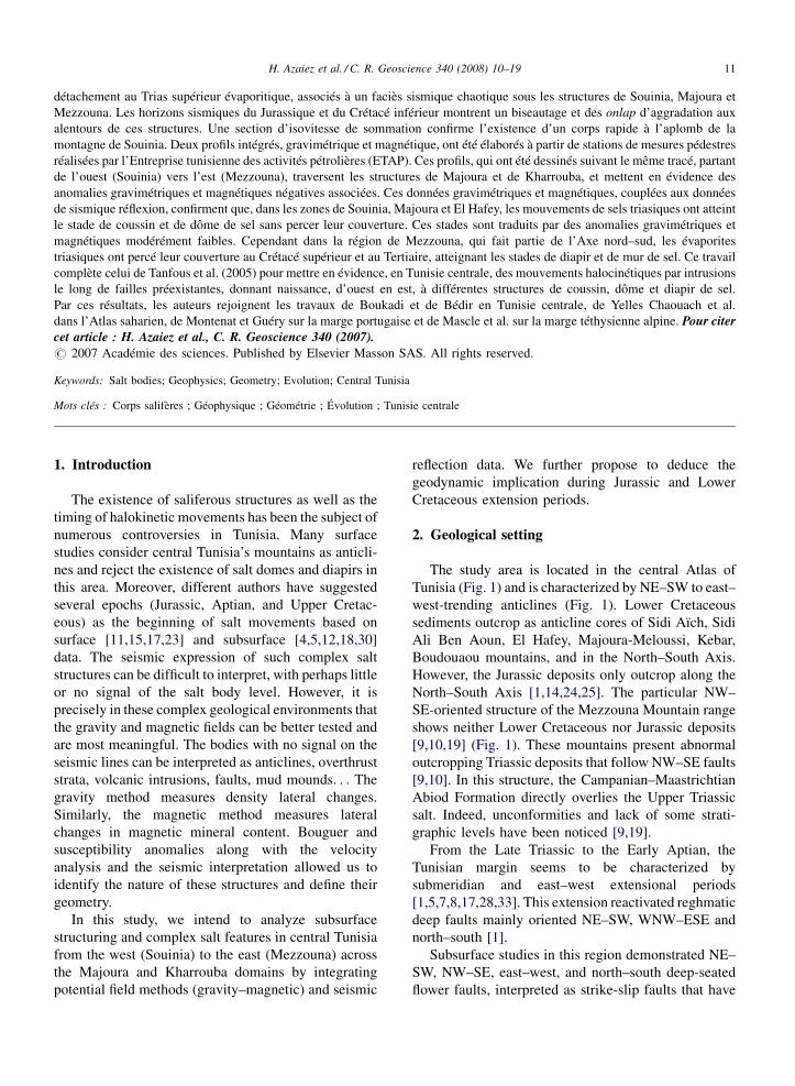
The L1 seismic section is oriented NW–SE acrossthe Souinia structure. It shows asymmetric anticlinewith large curve range affected by a flower fault system,which is associated with chaotic reflectors in the deepand apparent detachment level of the Upper Triassic(Figs. 2 and 3). The chaotic seismic facies is interpretedas Upper Triassic evaporite levels mobilized by deepfaults. This movement began at least since the Lower orthe Middle Jurassic [27]; it expressed itself throughpinching out and onlapping into the salt pillow flank(Fig. 4). Below this structure, the correspondent iso-stacking velocity section shows a pull-up velocityanomaly that we associate with the high velocity ofTriassic ascendant evaporites (Fig. 5). This configura-tion has been described in the Shib Mountain deepstructure, situated in the southern part of this area [32].
The seismic line L2, trending NW–SE, between theMajoura and El Hafey structures, (Fig. 1) shows a basinstructuring as a rim-syncline depocenter to the north-west of the Majoura structure and a high platform zoneextending towards the Jebel Majoura and Meloussioutcrops. The section shows chaotic seismic faciesunder platform highs. This facies has been interpretedas a Triassic upward-narrowing salt dome limited bymajor deep-seated faults (Fig. 6). These faults have asub-vertical structure that becomes listric in the deeperhorizons. The Jurassic and Lower Cretaceous seismic

H. Azaiez et al. / C. R. Geoscience 340 (2008) 10–19 13
Fig. 2. L1 seismic section showing the Souinia well above a salt pillow.
Fig. 2. Ligne sismique L1, montrant le puits de Souinia à l’aplomb d’un coussin de sel.
sequences show lateral thicknesses and seismic faciesvariations from the Majoura rim syncline (Fig. 6)towards the Majoura–Meloussi platform [3,27]. Thesesequences are bounded by eustatic and tectonic
Fig. 3. Detailed portion of the L1 section, showing the detachment level i
Fig. 3. Portion détaillée de la section sismique L1 montrant le niveau de d
sedimentary unconformities, which are expressed byaggradational and retrogradational onlap, toplap confi-gurations and erosional truncations [3,4,6,27,30].Below the gutter, the Upper Triassic deposit’s thickness
n the Upper Triassic salt.
écollement dans le salifère du Trias supérieur.
H. Azaiez et al. / C. R. Geoscience 340 (2008) 10–1914
Fig. 4. Detailed seismic section, showing pinching-out and onlapping on the dome flank.
Fig. 4. Portion détaillée d’une section sismique, montrant le biseautage et les configurations en onlap sur le flanc du dôme.
Fig. 5. L1 iso-stacking velocity section, showing a pull-up anomaly below the Souinia structure.
Fig. 5. Section d’isovitesse de sommation de la ligne sismique L1, montrant une anomalie en pull up associée à la structure de Souinia.

H. Azaiez et al. / C. R. Geoscience 340 (2008) 10–19 15
Fig. 6. L2 seismic line, showing the Majoura Dome and the subsequent rim-syncline.
Fig. 6. Ligne sismique L2, montrant le dôme de Majoura et la gouttière synclinale associée.
is reduced. Thus, we can relate all this to the salt creepthat was carried out towards the fault corridors since theJurassic rifting and has continued during the LowerCretaceous extension period.
The seismic line L3, oriented SW–NE across theMezzouna area, shows a large chaotic reflector to thesouthwest, interpreted as ascendant evaporitic mate-rial under the Mezzouna Mountain range. Towardsthis structure, we noticed variations in the thickness
Fig. 7. L3 seismic line across the Mezzouna mountain range, showing Jura
Fig. 7. Section sismique L3 passant par la chaîne de Mezzouna, montrant la ren allant vers la ride salifère.
of Jurassic and Lower Cretaceous sequences betweensubsiding and high blocks with aggrading andretrograding onlap and pinching-out horizons towardsthe high block border (Fig. 7). This has beeninterpreted as consequent to salt movements duringthese periods. The high block in Mezzouna is seen asa horst bordered by deep faults that probablyfacilitated salt creep and intrusion, inducing diapirformation.
ssic and Lower Cretaceous thickness reduction towards the salt wall.
éduction de l’épaisseur des séries du Jurassique et du Crétacé inférieur
H. Azaiez et al. / C. R. Geoscience 340 (2008) 10–1916
These analyses and studies of seismic data across thewhole area show differentiated structuring into highsand depocenter blocks limited by deep-seated NE–SW,north–south, east–west, and NW–SE faults interpretedas intruded by Upper Triassic salt. The early saltmigration seems to have started with the platformfracturing during the Lower Liassic rifting event [27].The salt migration is also attested to by Middle Jurassic,Upper Jurassic, and Neocomian space depocentermigrations [3,4,6,26,27,30].
4. Potential gravity and magnetic analysis
The analysis of seismic reflection profiles in centralTunisia, from the Souinia to the Majoura–El Hafey andMezzouna zones, shows a hazy expression of complexgeology. We interpret it as salt bodies, even thoughmany geologists are still sceptical about these inter-pretations and about the existence of dome in this area.In such a case, the lateral changes in density (gravitymethod) and in magnetic mineral content (magneticmethod) are of special interest, since they providevaluable information to complete and to strengthen theseismic data interpretation. Gravity and magnetic data
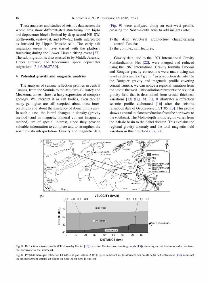
Fig. 8. Refraction seismic profile (EF, drawn by Gabtni [16], based on Geotrthe northwest to the southeast.
Fig. 8. Profil de sismique réfraction EF (dessiné par Gabtni, 2006 [16], en seun amincissement crustal en allant du nord-ouest vers le sud-est.
(Fig. 9) were analyzed along an east–west profile,crossing the North–South Axis to add insights into:
1) th
ave
bas
e deep structural architecture characterizingcentral Tunisia;
2) th
e complex salt features.Gravity data, tied to the 1971 International GravityStandardization Net [22], were merged and reducedusing the 1967 International Gravity formula. Free-airand Bouguer gravity corrections were made using sealevel as data and 2.67 g cm�3 as a reduction density. Onthe Bouguer gravity and magnetic profile coveringcentral Tunisia, we can notice a regional variation fromthe east to the west. This variation represents the regionalgravity field that is determined from crustal thicknessvariations [13] (Fig. 8). Fig. 8 illustrates a refractionseismic profile elaborated [16] after the seismicrefraction data of Geotraverse EGT’85 [13]. This profileshows a crustal thickness reduction from the northwest tothe southeast. The Moho depth in this region varies fromthe Atlasic basin to the Sahel domain. This explains theregional gravity anomaly and the total magnetic fieldvariation in this direction (Fig. 9a).
rse shooting points [13]), showing a crust thickness reduction from
ant sur les données des points de tir de Geotraverse [13]), montrant
H. Azaiez et al. / C. R. Geoscience 340 (2008) 10–19 17
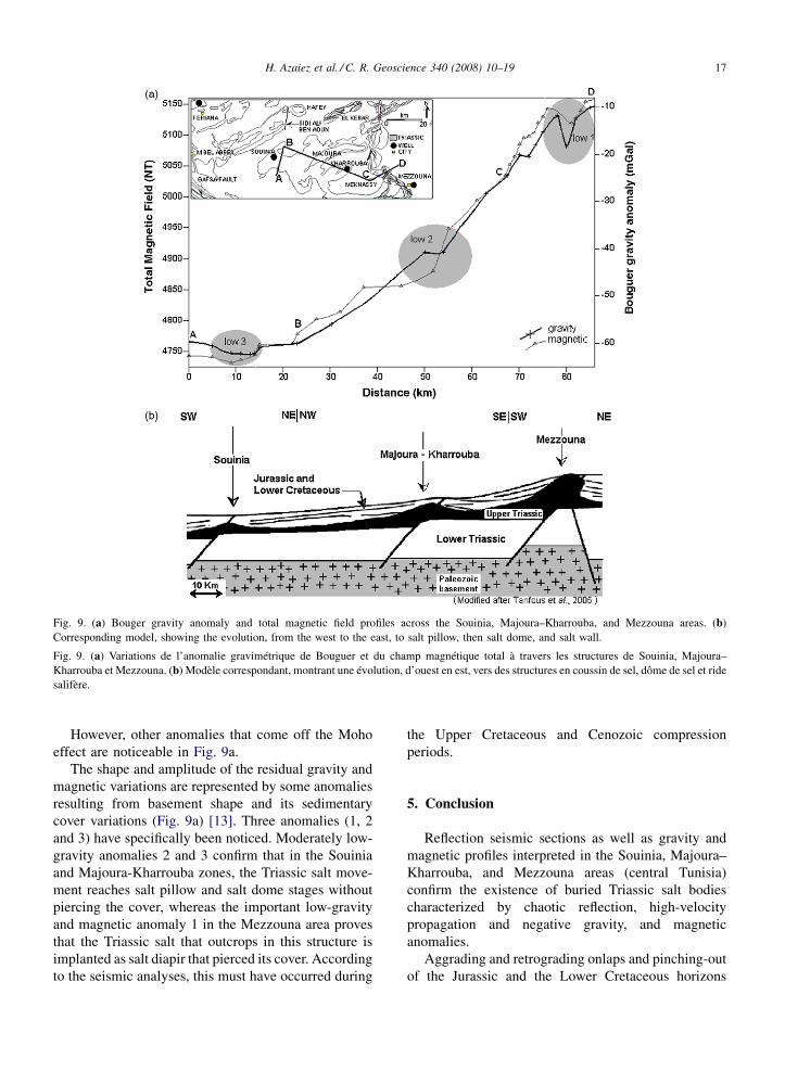
Fig. 9. (a) Bouger gravity anomaly and total magnetic field profiles across the Souinia, Majoura–Kharrouba, and Mezzouna areas. (b)Corresponding model, showing the evolution, from the west to the east, to salt pillow, then salt dome, and salt wall.
Fig. 9. (a) Variations de l’anomalie gravimétrique de Bouguer et du champ magnétique total à travers les structures de Souinia, Majoura–
Kharrouba et Mezzouna. (b) Modèle correspondant, montrant une évolution, d’ouest en est, vers des structures en coussin de sel, dôme de sel et ridesalifère.
However, other anomalies that come off the Mohoeffect are noticeable in Fig. 9a.
The shape and amplitude of the residual gravity andmagnetic variations are represented by some anomaliesresulting from basement shape and its sedimentarycover variations (Fig. 9a) [13]. Three anomalies (1, 2and 3) have specifically been noticed. Moderately low-gravity anomalies 2 and 3 confirm that in the Souiniaand Majoura-Kharrouba zones, the Triassic salt move-ment reaches salt pillow and salt dome stages withoutpiercing the cover, whereas the important low-gravityand magnetic anomaly 1 in the Mezzouna area provesthat the Triassic salt that outcrops in this structure isimplanted as salt diapir that pierced its cover. Accordingto the seismic analyses, this must have occurred during
the Upper Cretaceous and Cenozoic compressionperiods.
5. Conclusion
Reflection seismic sections as well as gravity andmagnetic profiles interpreted in the Souinia, Majoura–
Kharrouba, and Mezzouna areas (central Tunisia)confirm the existence of buried Triassic salt bodiescharacterized by chaotic reflection, high-velocitypropagation and negative gravity, and magneticanomalies.
Aggrading and retrograding onlaps and pinching-outof the Jurassic and the Lower Cretaceous horizons
H. Azaiez et al. / C. R. Geoscience 340 (2008) 10–1918
towards these structure borders illustrate the halokineticmovements of these bodies during these periods.
The Triassic salt intrusion reached stages of saltpillow and salt dome in the Souinia and the Majoura–
Kharrouba, whereas in the Mezzouna mountain range, ithad pierced its cover during the Upper Cretaceous andTertiary, reaching a more advanced stage as a salt diapirmarked by important gravity and magnetic anomalies.
In this study area, the Liassic rift faulting has induceda tilted block structuring of the initial Jurassic platform[27]. This is associated with the posterior compressiontectonic phases and the sedimentary loading thatinduced Triassic salt creep and halokinetic movementsand moulded the geometry of the salt diapir along thenormal faults. Such phenomena have been described inthe Algerian Sahara Atlas [2,29] in the Portuguesemargin [21], and in the Alps [20].
References
[1] C. Abbès, Structurations et évolutions tectono-sédimentairesmésozoïques et cénozoïques associées aux accidents reghmati-ques, à la jonction des marges Téthysienne et Nord-Africaine(chaîne nord–sud, Tunisie centrale), thèse d’État, UniversitéTunis–El-Manar, 2004.
[2] M. Aoudjehane, A. Bouzenoune, H. Rouvier, J. Thibieroz,Halocinèse et dispositifs d’extrusion de Trias dans l’Atlas saha-rien oriental (NE algérien), Geol. Mediterr. XIX (4) (1992) 273–
287.[3] H. Azaïez, M. Bédir, D. Tanfous, M. Soussi, Seismic sequence
stratigraphy and platform to basin reservoir structuring of LowerCretaceous deposits in the Sidi Aïch-Majoura region (centralTunisia), J. Afr. Earth Sci. 48 (2007) 1–18.
[4] M. Bédir, Mécanismes géodynamiques des bassins associés auxcouloirs de coulissement de la marge atlasique de la Tunisie,sismo-stratigraphie, sismo-tectonique et implications pétroliè-res, PhD Thesis, Université Tunis-2, 1995.
[5] M. Bédir, L. Zitouni, N. Boukadi, J. Saadi, R. Alouani,F. Bentimzal, S. Tlig, C. Bobier, Rifting, halocinèse et structura-tion des bassins péri-téthysiens Jurassique et Crétacé inférieur desubsurface du domaine Atlasique central de la Tunisie (région deGafsa–Sidi Ali Ben Aoun), Afr. Geosci. Rev. 7 (3) (2000)289–306.
[6] M. Bédir, N. Boukadi, S. Tlig, F. Ben Timzal, L. Zitouni,R. Alouani, F. Slimane, C. Bobier, F. Zargouni, SubsurfaceMesozoic basins in the central Atlas of Tunisia: Tectonics,sequence deposit distribution and hydrocarbon potential, AAPGBull. 85 (5) (2001) 885–907.
[7] N. Ben Ayed, Évolution tectonique de l’avant-pays de la chaînealpine de Tunisie du début du Mésozoique à l’Actuel, thèsed’État, Université Paris-Sud, Orsay, France, 1986.
[8] S. Bouaziz, Étude de la tectonique cassante dans la plate-formeet l’Atlas sahariens (Tunisie méridionale) : évolution des paléo-champs de contraintes et implications géodynamiques, thèsed’État, Université Tunis-2, Tunisia, 1995.
[9] N. Boukadi, Évolution géometrique et cinématique de la zoned’interférence de l’Axe nord–sud et de la chaîne de Gafsa
(Maknassy–Mezzouna et Jebel Bouhedma) Tunisie, thèse de3e cycle, Université Louis-Pasteur, Strasbourg, France, 1985.
[10] N. Boukadi, Structuration de l’Atlas de Tunisie : Significationdes nœuds et des zones d’interférences structurales au contactdes grands couloirs tectoniques, PhD thesis, Université Tunis-2,1994.
[11] N. Boukadi, M. Bédir, L’halocinèse en Tunisie: contexte tecto-nique et chronologie des événements, C. R. Acad. Sci. Paris, Ser.IIa 322 (7) (1996) 587–594.
[12] N. Brahim, M. Gharbi, Halocinèse et réservoirs carbonatésdu Crétacé en Tunisie centrale, Actes des Premières Journéesde géologie appliquée, Sfax, Tunisia, May–June 1988, pp.110–119.
[13] H. Buness, and 17 others, The EGT’85 seismic experiment inTunisia: A reconnaissance of the deep structures, in: R. Freeman,S. Muller (Eds.), Sixth Workshop on the European Geotraverseproject, data compilations and synoptic interpretation, EuropeanScience Foundation, Strasbourg, 1989, pp. 197–210.
[14] P.-F. Burollet, Contribution à l’étude stratigraphique de laTunisie centrale, Ann. Mines Geol. 18 (1956) 1–352.
[15] G. Creuzot, J. Ouali, Extension, diapirisme et compression enTunisie centrale : le Jebel Es Souda, Rev. Geodyn. 4 (1) (1989)39–48.
[16] H. Gabtni, Caractérisation profonde et modélisation géophy-sique des zones de transition entre les différents blocs structu-raux de la Tunisie centro-meridionale, ‘nouvelle thèse’,Université Tunis–El-Manar.
[17] C. Gourmelin, Serrage polyphasé de paléostructures distensivesdans l’Axe nord–sud tunisien : le segment Bouzer–Rheouis,thèse de 3e cycle, Université des sciences médicales de Grenoble,France, 1984.
[18] A. Hlaiem, Halokinesis and structural evolution of the majorfeatures in eastern and southern Tunisian Atlas, Tectonophysics306 (1999) 79–95.
[19] M. Khessibi, Études géologiques du secteur de Maknassy–
Mezzouna et du djebel Kbar (Tunisie centrale), PhD thesis,Université Claude-Bernard, Lyon, France, 1978.
[20] G. Mascle, H. Arnaud, G. Dardeau, J. Deblmas, P. Dubois,M. Gidon, P.-C. de Graciansky, C. Kerckhove, M. Lemoine,Halocinèse précoce sur la marge téthysienne alpine : vers uneréinterprétation des zones de gypses des Alpes, C. R. Acad. Sci.Paris, Ser. II 302 (15) (1986) 963–968.
[21] C. Montenat, F. Guéry, L’intrusion diapirique de Caldas daRainha et l’halocinèse jurassique sur la marge portugaise,C. R. Acad. Sci. Paris, Ser. II 298 (20) (1986) 901–906.
[22] C. Morelli, Modern Standards for Gravity Surveys, Geophysics41 (1976) 1051.
[23] V. Perthuisot, H. Rouvier, A. Smati, Déformations antévraco-niennes dans le Maghreb (Tunisie), Bull. Soc. geol. France (3)(1988) 391–398.
[24] M. Soussi, R. Enay, C. Mangold, M.M. Turki, The Jurassicevents and their sedimentary and stratigraphic records on thesouthern Tethyan margin in Central Tunisia, in: S. Crasquin-Soleau, E. Barrier (Eds.), Peri-Tethys Memoir 5: new data onPeri-Tethyan sedimentary basins, Mém. Mus. natl Hist. nat. 182(2000) 57–92.
[25] M. Soussi, Nouvelle nomenclature lithostratigraphique« événementielle » pour le Jurassique de la Tunisie atlasique,Geobios 36 (2003) 761–773.
[26] D. Tanfous Amri, M. Bédir, M. Soussi, M.H. Inoubli, K. BenBoubaker, Jurassic seismic sequence stratigraphic and structur-ing in the Central Atlas of Tunisia, First North African petroleum
H. Azaiez et al. / C. R. Geoscience 340 (2008) 10–19 19
& geosciences conference and exhibition proceeding EAGE,Tunis, 6–9 October 2003.
[27] D. Tanfous-Amri, M. Bédir, M. Soussi, H. Azaïez, L. Zitouni,M.H. Inoubli, K. Ben Boubaker, Halocinèse précoce associée aurifting jurassique dans l’Atlas central de Tunisie (région deMajoura-El Hfay), C. R. Geoscience 337 (7) (2005) 703–711.
[28] M.M. Turki, Polycinematique et contrôle sédimentaire associéssur la cicatrice Zaghouan–Nebhana, thèse d’État, Université deTunis, 1985.
[29] A.K. Yelles-Chaouche, R. Ait-Ouali, R. Bracene, M.E.M. Der-der, H. Djellit, Chronologie de l’ouverture du bassin des Ksour(Atlas saharien, Algérie) au début du Mésozoïque, Bull. Soc.geol. France 172 (3) (2001) 285–293.
[30] L. Zitouni, Évolution géodynamique des bassins mésozoïques desubsurface des régions de Sidi Aïch-Majoura (Tunisie centrale):
Sismostratigraphie, sismo-tectonique et implications pétrolières,PhD thesis, Université Tunis-2, 1997.
[31] L. Zitouni, M. Bédir, N. Boukadi, H. Ibouh, S. Tlig, C. Bobier,Géométrie, chronologie et cinématique des accidents N 120-140.Exemple: accident de Majoura-Mech (données de surface et desubsurface), Afr. Geosci. Rev. 4 (3) (1997) 373–380.
[32] T. Zouaghi, M.H. Inoubli, M. Bédir, Contribution of seismicvelocity studies to structural and lithostratigraphic reconstruc-tions: Salt-intruded corridor ceiling and Lower Turonian Beidaanhydrite deposits’ outline in the central–southern Atlas ofTunisia, C. R. Geoscience 339 (1) (2007) 13–23.
[33] H. Zouari, Évolution géodynamique de l’Atlas centro-méridio-nal de la Tunisie : stratigraphie, analyse géodynamique, ciné-matique et tectonosédimantaire, PhD Thesis, Université Tunis-2,1995.
Copyright © 2022 FDOKUMEN