02062018_BOA_Meeting_Packet.pdf - St. Tammany Parish ...
54
AGENDA ST. TAMMANY PARISH BOARD OF ADJUSTMENT MEETING TUESDAY, FEBRUARY 6,2018-3:00 P.M. ST. TAMMANY PARISH GOVERNMENT COMPLEX BUILDING “A” 21490 KOOP DRIVE, PARISH COUNCIL CHAMBERS MANDEVILLE, LOUISIANA CALL TO ORDER ROLL CALL APPROVAL OF THE JANUARY 3, 2018 MINUTES PUBLIC HEARINGS BOA CASE NO. 2018-904-BOA Request by applicant for variances in a HC-3 Highway Commercial zoning district inclusive of the clearing, partial reduction and select cutting of trees within the landscape buffers, and for a monument sign. The property is located on the north side of the U.S. Highway 190 Service Road and south of Helenbirg Road, south of Covington, Louisiana. Applicant: CarMax Auto Superstore, Inc. (for the Prieto Family) BOA CASE NO. 2018-910-BOA Request by applicant for variances in an A-4 Single Family Residential zoning district for a front and side yard setback from 25’ and 7.5’ required to approximately 12’ and 3.5’ (for an A/C unit) requested respectively. The property is located at 261 Clara Drive, Slidell, Louisiana. Applicant: Clint Coulon BOA CASE NO. 2018-911-BOA Request by applicant for variances in a Planned Unit Development (P.U.D.) zoning district for some partial clearing of trees within the landscape buffers and the removal of some live oaks. The property is located south of the intersection Ave De Bellevue and Ave Palais Royal streets, south of Covington, Louisiana. Applicant: Kevin Kramer BOA CASE NO. 2018-912-BOA Request by applicant for property in a Planned Unit Development (P.U.D.) to appeal a decision made by parish officials relative to the placement of fill in Goodbee Square, Phase I Subdivision. The property is located on Countryside Circle, Goodbee, Louisiana. Applicant: Lonesome Development, L.L.C. OLD BUSINESS NEW BUSINESS ADJOURNMENT
-
Upload
khangminh22 -
Category
Documents
-
view
1 -
download
0
Transcript of 02062018_BOA_Meeting_Packet.pdf - St. Tammany Parish ...

AGENDAST. TAMMANY PARISH BOARD OF ADJUSTMENT MEETING
TUESDAY, FEBRUARY 6,2018-3:00 P.M.ST. TAMMANY PARISH GOVERNMENT COMPLEX BUILDING “A”
21490 KOOP DRIVE, PARISH COUNCIL CHAMBERSMANDEVILLE, LOUISIANA
CALL TO ORDER
ROLL CALL
APPROVAL OF THE JANUARY 3, 2018 MINUTES
PUBLIC HEARINGS
BOA CASE NO. 2018-904-BOARequest by applicant for variances in a HC-3 Highway Commercial zoning district inclusive of theclearing, partial reduction and select cutting of trees within the landscape buffers, and for a monumentsign. The property is located on the north side of the U.S. Highway 190 Service Road and south ofHelenbirg Road, south of Covington, Louisiana.Applicant: CarMax Auto Superstore, Inc. (for the Prieto Family)
BOA CASE NO. 2018-910-BOARequest by applicant for variances in an A-4 Single Family Residential zoning district for a front and sideyard setback from 25’ and 7.5’ required to approximately 12’ and 3.5’ (for an A/C unit) requestedrespectively. The property is located at 261 Clara Drive, Slidell, Louisiana.Applicant: Clint Coulon
BOA CASE NO. 2018-911-BOARequest by applicant for variances in a Planned Unit Development (P.U.D.) zoning district for somepartial clearing of trees within the landscape buffers and the removal of some live oaks. The property islocated south of the intersection Ave De Bellevue and Ave Palais Royal streets, south of Covington,Louisiana.Applicant: Kevin Kramer
BOA CASE NO. 2018-912-BOARequest by applicant for property in a Planned Unit Development (P.U.D.) to appeal a decision made byparish officials relative to the placement of fill in Goodbee Square, Phase I Subdivision. The property islocated on Countryside Circle, Goodbee, Louisiana.Applicant: Lonesome Development, L.L.C.
OLD BUSINESS
NEW BUSINESS
ADJOURNMENT

MINUTESST. TAMMANY PARISH BOARD OF ADJUSTMENT MEETING3:00 PM - WEDNESDAY, JANUARY 3, 2018LA HIGHWAY 59IKOOP DRIVE ADMINISTRATIVE COMPLEX BUILDINGMANDEVILLE, LOUISIANA
The January 3, 2018 meeting of the St. Tammany Parish Board of Adjustment was called toorder by the Chairman, Mr. Tim Fandal.
The roll was called as follows:
PRESENT: Mr. Fandal, Mr. Brookter, Mr. Schneider, Mr. Gordon and Mr. Guidry
ABSENT: Mr. Ballantine
STAFF PRESENT: Mr. Keller and Mr. Sevante
APPROVAL OF THE MINUTES
Moved by Mr. Brookter and seconded by Mr. Schneider to accept the December 5, 2017 minutesas typed and delivered.
MOTION CARRIED UNANIMOUSLY
It was moved by Mr. Gordon and seconded by Mr. Schneider to bring off the floor the election ofofficers for calendar year 2018.
MOTION CARRIED UNANIMOUSLY
ELECTION OF OFFICERS
Moved by Mr. Schneider and seconded by Mr. Gordon to nominate Mr. Fandal as Chairman.
(The floor was closed for nominations; therefore, Mr. Fandal was elected Chairman byacclamation.)
Moved by Mr. Gordon and seconded by Mr. Schneider to nominate Mr. Brookter as Vice-Chairman.
(The floor was closed for nominations; therefore, Mr. Brookter was elected Vice-Chairman byacclamation.)
BOA CASE NO. 2017-864-BOARequest by applicant for a variance in an A-4 Single Family Residential zoning district for a rearyard setback from 25’ required to 20’ requested.Applicant: Ashlie L Piediscalzo
1

(Mr. Keller read the staff report into the record...)
The applicant appeared on her own behalf.
Mr. Gordon: Does your lot back up to a swamp?
Ms. Piediscaizo: No.
Moved by Mr. Gordon and seconded by Mr. Brookter to grant the variance as requested
MOTION CARRIED UNANIMOUSLY
BOA CASE NO. 2017-865-BOARequest by applicant for a variance in an A-4 Single Family Residential zoning district for a rearyard setback from 25’ required to approximately 8’ requested.Applicant: Andrew & Catherine Bumpas
(Mr. Keller read the staff report into the record...)
The applicant appeared on his own behalf
Mr. Bumpas: I have nothing to add.
Moved by Mr. Brookter and seconded by Mr. Guidry to grant the variance as requested.
MOTION CARRIED UNANIMOUSLY
BOA CASE NO. 2017-871-BOARequest by applicant for a variance in a Planned Unit Development (P.U.D.) zoning district for arear yard setback requirement from 50’ required to approximately 44’ requested.Applicant: Eric P. Seals
(Mr. Keller read the staff report into the record...)
Mr. Paul Mayronne, with the law firm of Jones Fussell, L.L.P., appeared on behalf of theapplicant and made the following initial comments:
• The property backs up to a canal.• The HOA set the 50’ setback and it is quite excessive.• There is no more room to put the covered porch.• The HOA granted a variance.
2

Moved by Mr. Guidry and seconded by Mr. Schneider to grant the variance as requested.
MOTION CARRIED UNANIMOUSLY
BOA CASE NO. 2017-872-BOARequest by applicant for a variance in a HC-3 Highway Commercial zoning district to permit afascia sign to be located above the roofline.Applicant: Ti Cabirac, Sign Lite
(Mr. Keller read the staff report into the record...)
The applicant appeared on her own behalf.
Mr. Schneider: What is the definition of a roofline (directed to Mr. Keller)?
Mr. Keller: I do not have the ordinance if front of me so I’m not sure, but we interpret theroofline based on the lowest point of the gable.
Mr. Gordon: There is already a big sign there now.
Ms. Cabirac: Yes, and it is bigger than the one we are replacing it with. We will remove thesign for the new one.
Moved by Mr. Schneider and seconded by Mr. Brookter to grant the variance as requested.
MOTION CARRIED UNANIMOUSLY
OLD BUSINESS
NEW BUSINESS
ADJOURNMENT
MR. TIM FANDAL, CHAIRMANST. TAMMANY PARISH BOARD OF ADJUSTMENTS
Disclaimer: These minutes are intended to represent an overview of the meeting and generalrepresentation of the testimony given; and therefore, does not constitute verbatim testimony ora transcription ofthe proceedings.
3

ST. TAMMANY PARISH BOARD OF ADJUSTMENTSTAFF ANALYSIS REPORT
Case File Number: BOA Case No. 2018-904-BOAInitial Hearing Date: February 6, 2018Date of Report: January 24, 2018
GENERAL INFORMATION
Applicant(s) Name: CarMax Auto Superstore, Inc.Location of Property: Hwy. 190 Service Road, Covington, LouisianaZoning of Property: HC-3 Highway CommercialVariance(s) Requested: clearing, partial reduction and select cutting of trees within the
landscape buffers, and monument signage
OVERVIEW
The applicant is requesting several variances for their site because of the proposed CarMaxfacility to be constructed. In addition, according to the applicant, while each variance requestdiverges, these requests primarily relate for the need to run utilities throughout the site.
Please see narrative attached from the applicant that explains their request in more detail.
STAFF COMMENTS
1. East Buffer Clearing: Please provide a reason why the utilities cannot be located at theback of the curb and the buffer trees to remain as per ordinance.(In the staffs opinion, a hardship has not been demonstratedfor this request.)
2. West Buffer Clearing: Clearing for drainage appears to be based on the applicant’schoice to put the pond at the back of the site instead of working with the existing grades.(In the staffs opinion, a sufficient hardship has not been demonstratedfor thisrequest.)
3. West Buffer Depth: The staff does not object to a 25’ buffer instead of the 30’ buffer forthe portion shown. It is unlikely that the street in question will ever get developed, andthe applicant has provided more than 30’ in other areas along the west buffer.

4. South Buffer Clearing: There is nothing irregular about the shape or grading requirementsof this site that would not apply to any other commercial site.(This request appears to be more ofa personal preference rather than a hardship;therefore,for that reason, the staffdoes not support this variance request.)
5. Lot 2B Clearing: The ordinance allows for under brushing, but does not allow for theclearing of the property.(Therefore, the staffhas no compelling reason to recommend a variancefor thisrequest as visibility in and of itself is subjective, and in our opinion, is not a hardshipin this instance.)
Furthermore, adjacent parcels, which do not have appropriate buffers and are not incompliance with code, will have to be handled on a case-by-case basis thru the CodeEnforcement office.
6. Monument Sign Height: The staff has no compelling reason to recommend approval forthis variance request, because in our opinion, a hardship has not been demonstrated thatwould differentiate this request from any other commercial site desiring a taller sign.
7. Monument Sign Size: The staff has no compelling reason to support this request as well,since in our opinion, a hardship has not been demonstrated that would differentiate thisrequest from any other commercial site desiring a larger sign.

PAt~o ~~C~c(t
~Th ir~ c~d RO~~BOA CASE NO. ~~‘E) I t7 IL) / ~(for office use only)
ST. TAMMANYPARISH BOARD OF ADJUSTMENT(VARIANCE/APPEAL APPLICATION FORM)
(Please “PRINT” on thefollowing lines below. Ifa company, please include a contactperson’s name)
APPLICANT’S NAME (PRINT): CarMax Auto Superstores, Inc
MAILING ADDRESS: 12800 Tuckahoe Creek Pkwy
CITY/STA TE/ZIP: Richmond, VA 23238
PHONE NUMBER: 8047470422
(Home Phone #) (Cell Phone #)
PROPERTY LOCATION FOR VARIANCE REQUESTED: ZONING: HC-3
Hwy 190 Service Road and Helenberg Rd. Covington LA The Birg Subdivision, Southern Division
Address City State Subdivision (if applicable)
(Pleases check the applicable boxes below:)
REQUEST FOR: L~ A variance of the (Unified Development Code)0 Appeal of an adverse decision made by a parish official(s)0 Appeal the interpretation by a parish official(s) of the (Unified
Development Code)
VARIANCE/APPEAL REQUESTED:
0 building setbacks (reduction of front, side and/or rear yard setbacks)0 landscape buffers (reduction of front, side and/or rear yard buffer setbacks)0 landscaping within buffers (reduction of the number of trees, bushes and/or shrubs)0 parking area requirements (reduction of parking stalls, parking greenspace islands, etc...)0 signage requirements (increase of sign area and/or sign height, lighting, coloring, etc...)
~ other See variance request #1-7 below. Variance requests are described in detail in the attached document(Specify other variance appeal on line above)
(Please state on the foliowing lines below your specific requestfor a variance/appeal:)1. Clearing and grading along eastern boundary of site
2. Clearing and grading along western boundary of site3. Setback buffer along western boundary of site4. Clearing along southern boundary of site5. Select cut landscaping on Lot 2B. the lot south of US Hwy 190 Service Road6. Height of the Monument Sign7. Size of the Monument Sign
K. Douglass Moyer8- O~D ZC~L
SIGN .“~ U I OF 0 WNER!APPLICANT DATE OFAPPLICA TION
DEPARTMENT OF PLANNING & DEVELOPMENTP.O. BOX 628 COVINGTON, LOUISIANA 70434 [email protected] 985-898-2529
WWW.STPGOV.ORG

The following variances are being requested as a result of the proposed CarMax on thissite. While the substance of each variance diverges, these requests primarily relate to theneed to run utilities through the site, to the public right of way (US Highway 190 ServiceRoad) and/or the particularities of fitting this use on a rectangle-shaped lot. Notably, thelandscaping requirements of Article 7.0104 for new landscaping will be met in full aspresented in the landscape pian for the site which includes fifty (50) new trees on site.
Variance Request 1: Clearing and grading along eastern boundary of site,necessitated by utilities passing through the site.
This variance request is for relief from Section 7.0105(B)(2) (landscaping) and Section7.0105(D)(3) (grading) of the Unified Development Code. The shape of Lot 1A is irregularand is approximately two to three times as long as it is wide. This creates a “long and lean”lot shape that is the basis of this variance request. Further, the lot is between the existingdeveloped car dealership to the west and a Cleco servitude to the east and therefore couldnot be widened in either direction to accommodate the buffer and separately the utilities.This limited the overall width of the lot. The existing land is raw land and so requires newutilities to run through this “long and lean” site from the proposed building to the street, toconnect in with public infrastructure. These utilities include water, gas, drainage, andelectricity. To run these utility lines, a significant distance is required. The removal offifteen (15) trees within the eastern buffer, as indicated in the attached tree removal exhibit,becomes necessary to run these utilities the distance of the parcel. Notably, only 10’ oflandscape buffer is required on this side of the property, but the proposed design, asindicated in the landscape plan, includes 25’ of green space. The applicant is providingmore green space than required per code. Upon completion of the utility installation andnecessary grading. the proper amount of landscaping will be installed in the buffer incompliance with the Unified Development Code.
The shape of the lot and need for new utility lines meets the following requirements ofSection 7.0102(D) of the Unified Development Code to justify the granting of this variance.
• “Unusual elevations or shape of lot...” The shape of this lot requires utilities runthrough a relatively long distance, through the length of the lot. The shape of thislot is an unusual condition and requires that the utilities run parallel to and withinthe buffer zone.
• “Unusual landscaping and/or tree preservation problems...” The length necessaryto run the utilities, through a large portion of the site creates an unusual treepreservation problem. Section 7.0105 creates an exception for, “Trees that must beremoved for utilities or drainage within a street planting area or buffer plantingarea.” In reading this section on its face, it is clear that an exception is warrantedhere, to allow for the utilities. The purported inapplicability of this exception andneed for utilities create an unusual landscaping and tree preservation problem.
• “Problems with servitudes...” This lot is adjacent to a Cleco servitude that sits tothe east, for the full length of the parcel. For this reason, the lot could not be

widened to accommodate the buffer and separately the utilities. Further, adjacencyto a Cleco servitude meets the intent of these section — to provide a landscapingbuffer between parcels. This servitude is a natural buffer between the proposedCarMax development and the future development on the other side of the servitude
Variance Request 2: Clearing and grading along western boundary of site,necessitated by stormwater movement through the site.
This variance request is for relief from Section 7.0105(B)(2) (landscaping) and Section7.0105(D)(3) (grading) of the Unified Development Code. The shape of Lot 1A is irregularand is approximately two and three times as long as it is wide. This creates a “long andlean” lot shape that is the basis of this variance request. The need for landscaping andgrading is derived from the need for drainage of stormwater to the required detention pondat the north of the site and also for signage at the southwest corner of the site. Further, thelot is between the existing developed car dealership to the west and a Cleco servitude tothe east and therefore could not be widened in either direction to accommodate the bufferand separately the drainage needs for the site. This limited the overall width of the lot. Theexisting land is raw land and so requires new drainage to run through this “long and lean”site via a drainage swale. The removal of twenty-six (26) trees within the eastern buffer,as indicated in the attached tree removal exhibit, becomes necessary to grade the site forproper drainage. Upon completion of the utility installation and necessary grading, theproper amount of landscaping will be installed in the buffer in compliance with the UnifiedDe~ eloprnent Code.
The shape of the lot and need for new utility lines meets the following requirements ofSection 7.0 102(D) of the Unified Development Code to justify the granting of this variance.
• “Unusual elevations or shape of lot...” The shape of this lot requires stormwaterdrainage run through a relatively long distance, through the length of the lot. Theshape of this lot is an unusual condition and requires that the drainage run parallelto and within the buffer zone.
• “Unusual landscaping and/or tree preservation problems...” The length necessaryto run the drainage, through this portion of the site creates an unusual treepreservation problem. Section 7.0105 creates an exception for, “Trees that must beremoved for utilities or drainage within a street planting area or buffer plantingarea.” In reading this section on its face, it is clear that an exception is warrantedhere, to allow for the drainage. The purported inapplicability of this exception andneed for drainage create an unusual landscaping and tree preservation problem.
• “Problems with servitudes...” This lot is adjacent to a Cleco servitude that sits tothe east, for the full length of the parcel. For this reason, the lot could not bewidened to accommodate the buffer and separately the drainage.

Variance Request 3: Setback buffer along western boundary of site, necessitated bystormwater movement through the site.
This variance request is for relief from Section 7.0106(a) of the Unified DevelopmentCode. The western buffer is along a “paper street”. Therefore, based on direction from thePlanning Department, the site was designed as if it abutted another lot, not as if it abutteda public right of way. For this reason, the landscaped setback buffer is 25’ as opposed to30’. Given that this is a paper street, this condition meets the requirements of Section7.0102D of the Unified Development Code.
• “Unusual effect of the requirements of the landscape and tree preservationrequirements...” Here, there is not a true right of way. Therefore, the applicabilityof Section 7.0 105 is flawed. The right of way that exists on paper but which is notplanned for development will not have traffic of a pedestrian or vehicular nature,making the exaggerated landscape buffer unnecessary. The buffer should be treatedas a buffer abutting an adjacent lot, which better reflects the condition of the site.
Variance Request 4: Clearing along southern boundary of site, necessitated by regrading of an existing ditch and visibility concerns.
This variance request is for relief from Section 7.0105(B)(2) (landscaping) and Section7.0105(D)(3) (grading) of the Unified Development Code. Presently, there is a drainageditch that runs the full length of the southern buffer. This ditch must be re-positioned andre-graded. For this reason, the removal of sixteen (16) trees is necessary, as indicated inthe attached tree removal exhibit. In addition, visibility from the service road to the storeis needed. Upon completion of the utility installation and necessary grading. the properamount of landscaping will be installed in the buffer in compliance with the UnifiedDevelopment Code.
The need for this work meets the following requirements of Section 7.0 102(D) of theUnified Development Code to justify the granting of this variance.
• “Unusual elevations or shape of lot...” The elevations and changes in elevationrequire a re-grading of a drainage ditch. This existence and re-positioning of theditch is an unusual condition.
• “Unusual landscaping andlor tree preservation problems...” The ditch re-gradingand re-positioning creates a tree preservation problem. Note, that all trees requiredto be added will be added in this buffer.
Variance Request 5: Select cut landscaping on Lot 2B, the lot south of US Hwy 190Service Road.

This variance request is for relief from Section 7.0106A of the Unified Development Code.The code requires a street planting area of a minimum of 25’ along any street. Lot 2B is20.98’ wide. While it is its own lot of record, it is also slimmer than the required landscapebuffer. When resubdivided, this lot was designated as passive green space. Therefore, theplan for CarMax necessitates select cut landscaping, but maintains the area as passive greenspace. The applicant was sure to not clear this lot in its entirety but aims to retain someexisting landscape. As indicated in the attached tree removal exhibit, the applicant isproposing to remove nineteen trees (19) from this parcel of land. This select cut methodduplicates the condition of the adjacent strip of land to the west, also between the ServiceRoad and DOTD area. This remnant parcel is undevelopable and will forever be greenspace. This development would improve this parcel by making it well landscaped passivegreen space.
The shape of this lot makes it entirely a buffer. This condition meets the requirements ofSection 7.0102D of the Unified Development Code to justify this variance.
• “Unusual elevations or shape of lot...” Lot 2B is approximately 20.98’ byapproximately 345’. This shape is most certainly an unusual shape, justifying thegranting of this variance.
• “Unusual landscaping and/or tree preservation problems...” Here, the very unusualcondition exists that the entirety of the lot width is a buffer under a strict reading ofthe code. Lot 2B is too narrow to be judged pursuant to the standard street plantingarea.
• “Unusual effect of the requirements of the landscape and tree preservationrequirements...” The unusual effect here is that the minimum buffer required islarger than the width of the lot and there is no built-in exception for an odd shapedlot such as this.
• “When more than 30% of the lot is required for the aggregate of street plantingareas...” Here, 100% of the lot is required for the aggregate of street planting areas
necessitating this variance.
These variances are being requested as a part of the proposed CarMax development on thissite. Both relate to the same sign — a monument sign near the southwest corner of this site.Summarily, this is a very large development on a very large lot, warranting the need forvariances to allow for visibility from the adjacent right of ways. Notably, there is a thirty-five (35) foot required buffer between the development and the right of way within whicha sign cannot be placed. For this reason, additional height and size are requisites for anoperational sign, which can be viewed easily and safely.
Variance Request 6 : Height of the Monument Sign.

This variance request is for relief from Section 7.0204(D)(3) which regulates that themaximum height of monument signs is nine (9) feet. The proposed CarMax sign is ten (10)feet tall.
The height of the sign meets the following requirements of Section 7.0202(D) of theUnified Development Code to justify the granting of this variance.
• “Unusual elevations or shape of lot...” This is an extraordinarily large lot toaccommodate this CarMax development at 6.25 acres. The development of a lotthis large is unusual and rare — it only occurs with major commercial developmentssuch as this. For this reason, the additional height of one foot is justified andnecessary for a sign, which can be viewed easily and safely.
• “Other problem or matter, which affects signage...” This monument sign is locateda full thirty-five (35) feet from the adjacent right of way, the US Highway 190Service Road. It is even further from the primary right of way—Interstate 12. Basedon visibility lines, the sign would be viewed a full five hundred (500) feet from apassing vehicle on this main right of way. This reason justifies the need for an extrafoot of height so that vehicular passengers can safely and quickly view themonument sign.
Variance Request 7 : Size of the Monument Sign.
This variance request is for relief from Section 7.0204(D(2) which regulates that themaximum area of monument signs is thirty-two (32) square feet. The proposed CarMaxsign is fifty (100) square feet in size.
The size of the sign meets the following requirements of Section 7.0202(D) of the UnifiedDevelopment Code to justify the granting of this variance.
• “Unusual elevations or shape of lot...” This is an extraordinarily large lot toaccommodate this CarMax development at 6.25 acres. The development of a lotthis large is unusual and rare — it only occurs with major commercial developmentssuch as this. For this reason, the additional signage square footage is justified andnecessary for a sign, which can be viewed easily and safely.
• “Other problem or matter, which affects signage...” This monument sign is locateda full thirty-five (35) feet from the adjacent right of way, the US Highway 190Service Road. It is even further from the primary right of way — Interstate 12. Basedon visibility lines, the sign would be viewed a full five hundred (500) feet from apassing vehicle on this main right of way. This reason justifies the need for an extrafoot of height so that vehicular passengers can safely and quickly view themonument sign.

RESUBDMSION OFPORTIONS OF LOTS 44—52 SQUARE 1;LOTS 46—52, PORTIONS OF LOTS 36—45 SQUARE 2;LOTS 1—68. 70, 72, PORFIONS OF LOTS 69, 71, 73, 74, 76 AND78 SQUARE 3;LOTS 1—14, 15, 17, 19. 21, 23, 25, 27, 29, 31, 33. 35. 37.39, 41, 43, 45. 47. 49. 51, 53 AND 55, PORTiONS OF LOTS 16,18. 20, 22, 24, 26, 28. 30. 32. 34, 36, 38, 40, 42, 44. 46,48, 50, 52 AND 54. 56—59. 61, 63. 65, 67, 69, 71, 73 AND 75SQUARE 4;PORTION FORMER BIRG BLVD. RIGHT OF WAY;PORTiON FORMER FiRST AVE. RIGHT OF WAY;INTO LOTS 1A, 2A. 3A, AND 4ATHE BIRG SUBDMSIONSOUTHERN DMSIONSECTIONS 15 AND 22 T7S—R1 1 EST. TAMMANY PARISHLOUISLaNA
T.L lILIES(4011 OR FORLLCRL’l)
(ROT A PlOT)
/--*~
///
~pP(0OVN~A Me~ 0) 0)0113 47-44 01_C ILLOTS 41--SI. _Cfla 0)0175 311—00. 41-45011W 11LOTS I—IL 711. 72.10110100) lOTS 01 71. 73. 74. 7124(1 75 00W042.LOTS T—14. IS, I?. It. II. IL IL 27. 71. 31. a a ~7. a Al. 43. 45, 47. 41. SI. 1300SI, 70111015 0) IRIS IL IL IL 42. 70. 42. 01 a 27. 31. 34. 32. 40, 47. 40. 44. 44. 04.52 MI, 54. 51—01 0. 13. 01 17. 01 7’. 73*_fl 011W 4:70111011 TO_C nIL Wi 0)P011201 FOlIO I_C at Wi 0)_C0110 LOTS 14. 57. 10. Me ILLml Me W~I. 5001101 ~. MeOTS IS MO 41 173—RIlE. TIlIMer 7701111.
Iç~...LINF1ELD, HUNTER &JUNIUS, INC.r’~o-.~IY1PROI’ESSIONAL ENGINEERS. ARCHITECTS,
LA~ I ILANDSCAPE ARCHITECTS AND SURVEYOR~/ 3608 I8I6SLrT7I.S4110200
MolorIr. Lo,..,.,n, 7(60)2
200’ 4070
II .17 5CAL10 T~ — 200•
11014111 1. .0.104. 73.. Pta
WA! 0) PLOT: *0151 42. 2017
404442.00 lb. 17—047
(100) 533-5250
HELENDERO RD.
— —42~7 -~
/1’
-..--.-4-.-.-..-.-.-
/I 0.4
‘I
NOTE: 2A IS DESIGNATED AS PASSIVE SELECT CUT GREEN SPACE / NO BUILD AREA &~‘4A IS DESIGNATED AS PASSIVE SELECT CUT GREEN SPACE/ NO BUILD AREA,/RESTRICTED FOR EXISTiNG BILLBOARD USE ONLY
ItII
____________________ ‘73’
NORTH ST (UNDEVELOPEDI
_____________________________I (207041.14 RIOT
—~ 10? 5010120 (ROTA 7A013
II0 ~I/2WA0100 1 9
6(0 *411(5
/ I (255.53352 SF)
LOT IA~I10000 11.13 73101)
11.20 ACRES(401.346.12 S.F.)
01CC
1.1(10 LOCATIONS OF W~J0 NIl 011006004511.4 UTOIT00 14105516100101W 0101P101105 lIMO 1001 DATA 01100 110021400 0711€ 7W_C 001150.1014 5101 RITA 00/00001*0401001 10000002010*_AOL 10424211*0101013 COITIO.LJI0 RiOT 0_CBS00_C 1511(401)1105(0)72010410010) OIL_C *041140011110040411. NOR_CO 1000110115lILY VILE) 7014 1(05! 0001111*_OIL 4001 I_COY 0110.1.0 10 0011*0101 01*11411 (0 (TIEP_CR 100*1040775 L~J0 OISTII1ATIOIS FIRER TO *7410114105 UPON 51401004010)0004044704.10171111*_Cl P1101100104041011W Will 0*4111.01*0241. (T—Me—272—1050).
2.1)4315*0.0355 5010101 000407.
2. NO 1101 fl7501 Cl OIlIlY ITEITTUOC 1110001 *41 p0000105 0)1)10 10010101.
4. AS PER ft_C 0010414! PAT! 40), 00501.ALTTY-PNIEI. 1401002 215105 0140 7. 071015107.1! *04(151 II, ISIS. 11* 1410 0 04 201113 Al. S Me C. (34 OLVATION-120)
5.1)10 000%!) 57.0115 1*11005 0 404* II *0005014CC 1011€ 11011144 ST040*II0S FOIL III!P10752W 10010040 000.135*4*00)101 ST Ill! LOI.I01LA STATE 00020 OF 140011511011 FORp0005*_IL 01040051 *00 Loll 600001_C
5. 14171405 01001 7114 BOW OIl 00101100 ftAT NO. 1.
I. C_CT 70477_C ST 14111 1. 001*414 * *35004151. NC 0115100 PROP04II. TO 0110401-12 $0011110 60170. 04105 NAY TO, 0005. 45 001111101 II 455114011 11104370 ST. T*144440YP01541 a 0) 00001.
2. 1*11001 EY 01ST!. ICALOII 44 ASSOQATOS. tIC 0(1500 3111 *~ 44 3.753 700050012011 14. II, 02 44 23, T-7-S. 1-11-0 ST. TILOINIY P01141. L0U0444A, 00705 44_Cl TO.000. POLO AS IL’? 40534 ST. TN4IIR4V P0011 0.011 OF 0040!.
3. MIELEY DY 10*0 001_CC 5200_C. PlC., 00410101, 10.114040 01111100 ~01CTI0Il 22.106115(017 51010. 5040! II EAST. ST. TNIILNIT 7245014. L001041 04100 ALJOJST 10. 072.P1017045 700 7.1. 174145 CO.. SIC.
.. fORtY 0401144 ‘74*1 0) 11€ 00011041 01_Cl 0) TIC Me OLEIRITO ON TIC 51.1 446.0.1. 41 F. 00. IS., ST. 1*4441611 P701111 L010l444 44105 141001 III. 10.00 US IL’? 111045110 mo 0.00 OF 10001 FOR III! P10201 OF ST. 00401.1441.
5. 05040100 140 011041(7544 1110. 0) 1.45 000. 44.14 0063. 2.05 ALOES. P_C. 1040 LOTII. $0010415 IS. II, 22 Me 23, 1-7-5, I-Il-!. Sr. 1744401) P740141 LOIISLNM 4410510110_C II. IllS. 0100*311.1? fuzz OF 51 17444047 WI 0~0 OF 00101.
SE0007RrjWMOl R00
1.114445// (40~)44FOp~LT)
I ST.
14 011451 ~1.to
141
WON_C P7_C 012W
LOT 44 - -(1,132.11 ~ 20.00! COT 00004 01
~ol~ REL.01400 LII! OILY
15001

0
z
o1~~ I~
~~~ iI~~ ~ h ~:~P~ ~ 116
o6’~. •~ ~ i\ iIRH IOe~P$
F~ H~ qp~~ a ~~ ~ 1!i~ I ~ I
5 —~6 THE AUTO SUPERSTORE~ I I I I
c~ ~~ U STORE NO. 6133
U HIGHWAY 190 SERVICE ROADCOVINGTON, LA
PRELIMINARYFOR REVIEW ONLYNOT FOR CONSTRUCTION
LINFIELD, HUNTER & JUNIUS, INc~ PROFESSIONAL ENGINEERS.~ ARCHITECTS, LANDSCAPE/Jj) I ARCHITECTS AND SURVEYORS
S~/ 3608 lad, S~oo, S,th~ 200~ o,,id~n~ 70002~
I,
S
- -
-—~

/ TOST.TRSEIROUOC
r5090055 TREE SOISUVOLCUSOSTS
IEESTSOU SUFFER - IS TREES
frIESTERS SUFFER .21 TRUES
SOUTHERN SUFFER- 11 TREES
HOSTRERS SUFFER STORES
SMALL PARCEL ACROSS STREET- IS TREES
1~
I/I
S
e
L222URC2PESUFFERCR FT
PROVIDED
LMICTCARCSUFFER
I ~ 100
/11/III
I 01~ o/1,
0
C CC ~C THEAUTOSUPERSTORE _______________________ C
C 5 C C——
U STORE NO.6133 8U HIGHWAY 190 SERVICE ROAD
COVINGTON, LA
PRELIMINARYFOR REVIEW ONLYNOT FOR CONSTRUCTION
[INFIELD, HUNTER 81 JUNIUS. Its~... PROFESSIONAL ENGINEERS.
N-.~1’yi ARCHITECTS. LANDSCAPEL?’.~i) ARCHITECTS AND SURVEYORS
S~/ 3608 18th ~~ 200M~ir6. Li,6n~ 70002
z
70~e ~flWTr ~
rrril II 0
1~16.
~r/,/‘I
~1/ /
4
/
LINFIELD, HUNTER & JUNIUS, IN.Jc PROFESSIONAL ENGINEERS.-~cri ARCHITECTS. LANDSCAPE/J1)J ARCHITECTSAND SURVEYORS
S~/ 3608 8th S,r,~. So6, 200M,,~,ri,, Lo,,i~no 700020,.I-h,t—~—..*~~
I ——
‘p~
88
J8~
1
-~-
— -S
C
z
N ~I ~
~ H~P~~ ~ - ~11111 ~i!jh Ij jIlli j~I 1Ii~ItiII
~II~ ~ II 1 0
9!~I ~II!I !~iii ~ ~Ij~ j~~j Ii~ ~~‘•
9a ~J dOf II
pK~
I ~j~-• ~8’
-
.1/ :1, ~ji~ -;~!‘I .fj~ ~ /
I pLA ~II pI ,
/ ~;
/1 /~
:~
If
~
1~
mc*nmax
~ THEAUTOSUPERSTORE
STORE NO.61330 HIGHWAY 190 SERVICE ROAD
COVINGTON, LA
PRELIMINARYFOR REVIEW ONLYNOT FOR CONSTRUCI1ON

I’I’I’~~I•I 111R11
Ei~~1
~ri~i’i~i~ ~H1~1
‘~I’I~kI~I• I
1’
I ~ ~
L~ ~1 Ill!IIEI
Hhi~iiii II I~lI ~ —jIll ~
I’11
[ItII
zC0
z
I
—- -~
4z
WcARaxTHEAUTOSUPERSTORE ___________________ •
STORENO. 6133HIGHWAY 190 SERVICE ROAD
CO VING TON, LA
PRELIMINARYFOR REVIEW ONLYNOT FOR CONSIERUCI1ON
LINFIELD, HUNTER & JUNIUS, R’~ PROFESSIONAL ENGINEERS,~ ARCHITECTS. LANDSCAPE
~.‘JJ)) ARCHITECTS AND SURVEYORS~/ 3688 18th So,,,. S,th, 200
Mo,io,. Los,,,, 70002

AERIAL OVERLAY with PHOTO REFERENCES
/ //1
I •
I ••
Architectural Graphics Inc.2655 International ParkwayVirginia Beach, VA 23452
Phone: 757.427-1900Fax: 757-427-6112
03l20111
2 071141173 00130117 _________
10102117
/
5--
i~Y~ ~•-~ .
~‘ ~ :___~. •- I’
Rd ‘p” --.-~i~.~1 “:
— 5;
I ;s~r.~t_;-;.5, I.
I // ‘Ic ~
( I— ~- ,~ ~- .—~ i.-
~ ~ 9~5-Se ;vIce~d 4
a ~~ ~OOP~[T ~~
- —~.. 2- - S.-5 ~—._. —--—5--..
-----5--- s.——_ .
-----5- 5 _-.i____ .. -- S - ~ ~ •4,‘5, . -~----- —5------
‘\
.5
0•~•~— 29 I :2ou~,~ ~g I è E1 311rV Dhc: ~ ~
—~--,—~—---Pc~chitoiawa~r-.
I/I —~
~ge’R-d -~
\ S
M~n~q~r R. JOHNSON
D,5s,~8~I MRAILCL
~c1LouUon
ci~maxCARMAX #6133HWY 190 Service RdCovington, LA 70433
- cj°o-~,•;.; ~I.;.- 25 2 ‘92
4 of 13

ST. TAMMANY PARISH BOARD OF ADJUSTMENTSTAFF ANALYSIS REPORT
Case File Number: BOA Case No. 2018-910-BOAInitial Hearing Date: February 6, 2018Date of Report: January 24, 2018
GENERAL INFORMATION
Applicant(s) Name: Clint CoulonLocation of Property: 261 Clara Drive, Slidell, LouisianaZoning of Property: A-4 Single Family ResidentialVariance(s) Requested: Front yard setback
OVERVIEW
The applicant is requesting a variance for a front yard setback requirement in Northshore BeachSubdivision from 25’ required to approximately twelve (12’) feet requested based on the fact thatthe land area relative to the building envelope is limited due to the property abutting a waterbody to the rear of the property.
STAFF COMMENTS
The board has granted several setback variances in the past for lots within this subdivision due tosaid limitations as mentioned above, which makes it difficult to build a modestly sized dwellingon a property without encroaching into or partially into the water body with the structure.
Therefore, since the square footage of the proposed home seems modestly sized in comparison tothe size of the lot, and due to past precedence, and for the reasons as stated above, the staff hasno objection to the proposed variance request.

BOA CASE NO. ~ ~ ~‘a (for office use only)
ST. TAMMANY PARISH BOARD OF ADJUSTMENT(VARIANCE/APPEAL APPLICATION FORM)
(Please “PRINT” on thefollowing lines below. Ifa company, please include a contactperson ‘s name)
APPLICANT’SNAME(PRINT): CA,i r~iT COUL..C*.S
MAILING ADDRESS: 1 LO~ ~ ~ Ol~ ~2. A P1. I o~
CITY/STATE/ZIP: L.A.. ‘10L~~
PHONE NUMBER: ‘3S~ Zgs~ (~53 ≤..23~- I’3’~(Home Phone #) (Cell Phone #)
PROPERTY LOCATION FOR VARIANCE REQUESTED: ZONING: A-4
‘~LIbELLAddress City State Subdivision (if applicable)
(Pleases check the applicable boxes below:)
REQUEST FOR: ~A variance of the (Unified Development Code)ID Appeal of an adverse decision made by a parish official(s)ID Appeal the interpretation by a parish official(s) of the (Unified
Development Code)
VARIANCE/APPEAL REQUESTED:
/building setbacks (reduction of front, side andJor rear yard setbacks)C landscape buffers (reduction of front, side and/or rear yard buffer setbacks)C landscaping within buffers (reduction of the number of trees, bushes and/or shrubs)ID parking area requirements (reduction of parking stalls, parking greenspace islands, etc...)C signage requirements (increase of sign area and/or sign height, lighting, coloring, etc...)
C other(Specify other variance/appeal on line above)
(Please state on the foliowing lines belowyour specific requestfor a variance/appeal:)
Parish requires a 25’ front setback and we are requesting a variance of 13’. The proposed home will start
12’ from the front property line and will be approx. 24’ from Clara Dr. On the left side, the home will sit inside
the 7’6” setback. We are requesting the A.C. be allowed to cantilever 4’ past the home with no structureto~p~ing the ground. The A.C. will be approx. 11’ off of the ground.
Ig,g~W/NA TURE OF 0’ ‘ R/APPLICANT DATE OFAPPLICATION
DEPARTMENT OF PLANNING & DEVELOPMENTP.O. BOX 628 COVINGTON, LOUISIANA 70434 [email protected] 985-898-2529
WWW.STPGOV.ORG

Coulon Variance Request
We own lot 57 on Clara Dr. located in Northshore Beach Subdivision. The lot is75’ wide and 65’ deep. We are requesting a variance for the front of the home from 25’to 12’. The current layout of the home would only allow a 27’ home from front to back inorder to not need a variance. The next door neighbor’s home, which is to our rightlooking at it from the street, sits approximately 16’ from the front property line. Thereare 2 empty lots to our left side. The Homeowners Association said no letter is neededto request for a variance although request was made to meet all requirements of thisapplication process. Our left side of the home will sit at the 7’ 6” parish setbackrequirement, but we are requesting our A/C be allowed to stick out past the houseapproximately 4’ cantilevered. The AC will be approximately 11’ off of the ground withno structure touching the ground. Thank you for your consideration.

Letter of No Objection
To: St. Tammany Parish Board of Adjustment
I do not object to the issuance of a variance of 12 feet from the front property line for Mr. andMrs. Coulon located at Lot 57 Clara Dr. The home will sit approximately 4 feet further to thestreet than my home.
Name
Address: I:z~i~..
Lo~ ~OL4~
Signed:4
Date:

Letter of No Objection
To: St. Tammany Parish Board of Adjustment
I do not object to the issuance of a variance of 12 feet from the front property line for Mr. andMrs. Coulon located at Lot 57 Clara Dr. The home will sit approximately 4 feet further to thestreet than my home.
N ame:it?~
Address: __________________________________
Lc~ ~cy-t~
Signed: ____________________________
Date: ‘~~1 1~

~ >
— -
~ ~:~: ?~-r-~- •\~. ~, ~ ~ k
c~.4c ~-‘-~-• _.s~ :.
~~ _z_/~ ii
- -
~OIEc~i~ ‘~ ~iE
Lwr ~Lor4J~~ ~5o’io.33
~: ;~
,.:~
;c,’.—.
-.
: ~ ~-\
~
\\\ -•~~ ~
‘ .—~
• •
— .- —
—~
4~ —~• • - —,•‘- —~~ -•~•.—.~
I
—,~•
-4
:.
~ ~---~~ :‘--. —.~ / I
•;s.
‘S
•5
• • 4.
~4;S. / ~--
Earth~2(, 7G:c~j~e - •-L.
/-
~ •~ LAIR ~
I
5,_S ~“ ~
—s• \ •
—‘
S.-.
• -
- A ~
‘~
300 ft
A -~
5•_ 5_.—
S
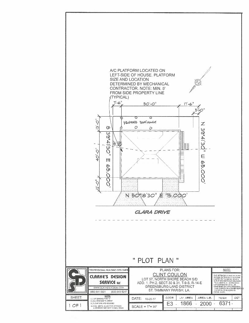
PLOT PLAN”PLANS FOR:
CLINT COULONLOT 57, NORTH SHORE BEACH S/D
ADD. 1, PH.2, SECT-30&31,T-9-S, R-14-EGREENSBURG LAND DISTRICT
ST. TAMMANY PARISH, LA.
DATE: 10-25-17
SCALE = 1=20
A/C PLATFORM LOCATED ONLEFT-SIDE OF HOUSE. PLATFORMSIZE AND LOCATIONDETERMINED BY MECHANICALCONTRACTOR. NOTE: MIN. 5’FROM SIDE PROPERTY LINE
~PICAL)r1~11
CLARA P~/V~
PROFESSIONAL BUILDING DESIGNE
CLARKE’S DESIGNSERVICE u.c
SHEET:
(985) 641-0531 (800) 843-5247
1 OF I
1.1 LOT GRADING TYPE A2 ALL DRAINAGE TO STREET
3.) ELEVATiONS ARE ASSUMEDA SIZE. SHRPE. & LOCATiON OF WALAS
& OAV’EWAY TART VARY TO SAVE TREES
THE SETBACKS & RESTRICTIONSSHOWN ON THIS PLOT PLAN ARELIMITED TO THOSE SET FORTHIN THE DESCRIPTION FURNISHEDTO CLARKES. ALL SETBACKS aLOT DIMENSIONS STALL BECONFIRMED BYA PROFESSIONALLAND SURVEYOR B OWNER BKFOLOCATION OF BUILDING ISESTABLISHED.
E3 - 1866 - 2000- 6371-
ST. TAMMANY PARISH BOARD OF ADJUSTMENTSTAFF ANALYSIS REPORT
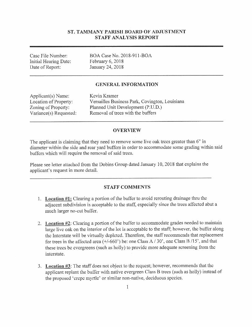
Case File Number: BOA Case No. 2018-911-BOAInitial Hearing Date: February 6, 2018Date of Report: January 24, 2018
GENERAL INFORMATION
Applicant(s) Name: Kevin KramerLocation of Property: Versailles Business Park, Covington, LouisianaZoning of Property: Planned Unit Development (P.U.D.)Variance(s) Requested: Removal of trees with the buffers
OVERVIEW
The applicant is claiming that they need to remove some live oak trees greater than 6” indiameter within the side and rear yard buffers in order to accommodate some grading within saidbuffers which will require the removal of said trees.
Please see letter attached from the Dobins Group dated January 10, 2018 that explains theapplicant’s request in more detail.
STAFF COMMENTS
1. Location #1: Clearing a portion of the buffer to avoid rerouting drainage thru theadjacent subdivision is acceptable to the staff, especially since the trees affected abut amuch larger no-cut buffer.
2. Location #2: Clearing a portion of the buffer to accommodate grades needed to maintainlarge live oak on the interior of the lot is acceptable to the staff; however, the buffer alongthe Interstate will be virtually depleted. Therefore, the staff recommends that replacementfor trees in the affected area (+1-660’) be: one Class A / 30’, one Class B /15’, and thatthese trees be evergreens (such as holly) to provide more adequate screening from theinterstate.
3. Location #3: The staff does not object to the request; however, recommends that theapplicant replant the buffer with native evergreen Class B trees (such as holly) instead ofthe proposed ‘crepe myrtle’ or similar non-native, deciduous species.
1

4. Removal of Live Oaks: This site appears to have undergone a change in the water tableover time. The result is a wet site with upland trees. Many of the live oaks on this site arein poor condition. The applicant proposes to keep seven (7) live oaks and replace theothers with different species. Due to existing conditions of the site, the staff does notobject to this request. However, the staff recommends that tree protection for all live oaksshall be accomplished by “hard fencing”. The applicant should also provide a report froma certified arborist with recommendations to ensure the best long-term survival of thepreserved live oaks on the property. In addition, the report should be submitted to theDepartment of Development-Planning, and the recommended work should be completedprior to the final landscape inspection.

BOA CASENO.c91)(L ~U1~ 1~O4 (forofficeuseonly)
ST. TAMMANY PARISH BOARD OF ADJUSTMENT(VARIANCE/APPEAL APPLICATIONFORM)
(Please “PRINT” on thefollowing lines below. Ifa company, please include a contactperson’s name)
APPLICANT’S NAME (PRINJ): Mr. Kevin Kramer
MAJUNG ADDRESS: 1 Greenbriar Dnve
CITY/STATE/ZIP: Covington, LA 70433
PHONE NUMBER: N/A 504.512.3885
(Home Phone #) (Cell Phone #)
PROPERTYLOCATION FOR VARIANCE REQUESTED: ZONING:-~.’MWfUmifr fl ~
Versailles Business Park, Section 15&16, Township 7, South-Range 11 East, Covington, LA
Address City State Subdivision (if applicable)
(Pleases check the applicable boxes below:)
REQUEST FOR: [I A variance of the (Unified Development Code)0 Appeal of an adverse decision made by a parish official(s)V’Appeal the interpretation by a parish official(s) of the (Unified
Development Code)
VARIANCE/APPEAL REQUESTED:
0 building setbacks (reduction of front, side and/or rear yard setbacks)0 landscape buffers (reduction of front, side and/or rear yard buffer setbacks)0 landscaping within buffers (reduction of the number of trees, bushes and/or shrubs)0 parking area requirements (reduction ofparking stalls, parking greenspace islands, etc...)0 signage requirements (increase of sign area and/or sign height, lighting, coloring, etc...)
~‘other Removal of Live Oak Trees/Removal of trees to grade in buffer(Specify other variance/appeal on line above)
(Please state on thefollowing lines below your specific requestfor a variance/appeal:)
We are requesting that the project be allowed to clear in the buffer in the noted areas on the attached drawings and
that we are allowed to remove live oaks as necessary, with the understanding that all required mitigation will be
et on site. PIe e see the attached letter and exhibits for further clarification.
-~ ~
tt~E~1/ ~ ~y9y~SIGNATURE OF OWNER/APPLICANT (.‘ DATE OFAPPLICA TION
DEPARTMENT OF PLANNING & DEVELOPMENTP.O. BOX 628 COVINGTON, LOUISIANA 70434 [email protected] 985-898-2529
WWW.STPGOV.ORG
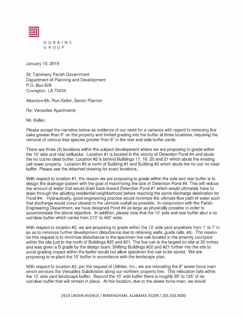
DOBBINSGROUP
January 10, 2018
St. Tammany Parish GovernmentDepartment of Planning and DevelopmentP.O. Box 628Covington, LA 70434
Attention-Mr. Ron Keller, Senior Planner
Re: Versailles Apartments
Mr. Keller,
Please accept the narrative below as evidence of our need for a variance with regard to removing liveoaks greater than 6” on the property and limited grading into the buffer at three locations, requiring theremoval of various tree species greater than 6” in the rear and side buffer yards.
There are three (3) locations within the subject development where we are proposing to grade withinthe 10’ side and rear setbacks. Location #1 is located in the vicinity of Detention Pond #4 and abutsthe no cut/no clear buffer. Location #2 is behind Buildings 17, 18, 20 and 21 which abuts the existingcell tower property. Location #3 is north of Building #1 and Building #2 which abuts the no cut! no clearbuffer. Please see the attached drawing for exact locations.
With respect to location #1, the reason we are proposing to grade within the side and rear buffer is todesign the drainage system with the goal of maximizing the size of Detention Pond #4. This will reducethe amount of water that would drain back toward Detention Pond #1 which would ultimately have todrain through the abutting residential neighborhood before reaching the same discharge destination forPond #4. Hydraulically, good engineering practice would minimize the ultimate flow path of water suchthat discharge would occur closest to the ultimate outfall as possible. In conjunction with the ParishEngineering Department, we have designed Pond #4 as large as physically possible in order toaccommodate the above objective. In addition, please note that the 10’ side and rear buffer abut a nocut/clear buffer which varies from 210’ to 480’ wide.
With respect to location #2, we are proposing to grade within the 10’ side yard anywhere from 1’ to 7’ inso as to minimize further development disturbance due to retaining walls, guide rails, etc. The reasonfor this request is to minimize disturbance to the specimen live oak located in the amenity courtyardwithin the site just to the north of Buildings #20 and #21. The live oak is the largest on site at 32 inchesand was given a B grade by the design team. Shifting Buildings #20 and #21 further into the site toavoid grading impact within the buffer would not allow specimen live oak to be saved. We areproposing to re-plant the 10’ buffer in accordance with the landscape plan.
With respect to location #3, per the request of Utilities, Inc., we are relocating the 8” sewer force mainwhich services the Versailles Subdivision along our northern property line. This relocation falls withinthe 10’ side yard landscape buffer. Beyond the 10’ side buffer there is roughly 95’ to 125’ of nocut/clear buffer that will remain in place. At this location, due to the sewer force main, we would
2914 LINDEN AVENUE / BIRMINGHAM, ALABAMA 35209 / 205.503.4000

propose re-planting that buffer with shrubs and small “crepe myrtle” type trees. Furthermore, thedeveloper will provide an additional 10’ buffer along the north side of Lot 7 that will include bambooplanting as specified per the PUD agreement between the Versailles Subdivision HOA and VersaillesBusiness Park, LLC.
The nature and footprint of the site, the layout of buildings, circulation, parking, utility, and gradingrequirements necessitate the removal of many of the existing trees, including some live oaks that fallwithin the above mentioned developed site area. There are currently 61 live oaks on the 24.5 acre sitethat are not within the buffer areas. Of these 61, it is the design team’s opinion that there are nonerated above a Grade B. Based on a thorough on-site examination of the 61 live oaks, six (6) are ratedGrade B, forty-two (42) are rated Grade C, and thirteen (13) are rated Grade D. Therefore, in thedesign team’s opinion, only 10% of the existing live oaks found in the interior of the site fall into acategory that would make them desirable to maintain. Because of the restraints listed above, seven (7)live oaks have been targeted to save, ranging from B-C grade. The developer is committed to using aLouisiana Licensed Arborist to provide a pre and post construction conference, pruning, and feeding tomaximize the potential for health longevity.
Taking into account all of the above information and attached exhibits, we are requesting thedevelopment be allowed to clear in the buffer in the limited areas depicted and that we are allowed toremove live oaks, with the understanding that all required mitigation will be met on site with a variety ofClass A trees to provide a more ‘naturalistic’ planting plan.
Our design team is ready to address any questions and comments regarding the above. Thank you foryour consideration.
David BallPrincipal

fll EXISTING TREE SURVEYV I SALE~l~1OO-O

CiD
Ti 3(41314. I’w 64,~,. 7136 0147444. flSO (lo,~k 1144 ‘4006 ‘550 10140.4 ‘300 I”~’ 1145 61,404 T~ (Ti —_ Ti” 10~40 T40’ ‘THo140*iO.43n 1244.7.3 ~~i 1414~ Ti13 p14’ risi 44, p4.. 52”_ 1~q 1” — IP’o* PS. — — 114 p14. — 0~’~ lF_ 740771014 — 1414.6,011.
T~____ 1110111 ITS, 014,17.2 Till flPITO Till 3300149 1 hI. 7610” *4* i_ iO33Tug — 41. — *1 0. 436.7010 0 ~TI 50,00* ITS, I.04p..kio-47T”P 47* T5o p33. 5235 PiM — li,o* — pupb s Ilop14o p1. “or’O. U 445.444.6. Ci. .~4 TPp14. 134 133*00,43320 — P14* TOSS 7100 4.4 — 6140.4 — PIT’ 54 6140011 — I’ 0I~ 90 024,94244062 C4~
____ 503(4 EEEE ~—. *.rr z~*. = l~~r~: ,,.. —
‘U....._ log 1T0 33 — 5434 o.k 36 7* pI.,. SI i4474~. ,oa — 7.0~.4’i — 041.74.404.T!_~_____ 0014*41. E!!!.____ — — Till S 1410 = 1044 .ITP = 3,00* , — 6*7414. iSl I 614 ________ — iO14.T..,,p’i
55 14144.4 I’~ ._. ‘!!L_ ~‘_,........ ~ — P33___ — — 14u.•___ SI_ hi,4I,h4~1~,,, — _________ — — Oo530 5414033 i’it 7* 1130 444* 69 444. 44.7.36504. no.do,t., 5 11,641, 4, 4.. 5* 14 ,T914401.
6470 133 4049.4 6., [~~,••_ ~. 0.6 a ‘os 7.,.r... oo ow 614 Ifl.ib.o~ .,o in,.. ‘0% 14”orol. 4*740.7040 4 i~
— Lr*~. p41* — 4 14*7 64,7961,06. 00 4.4 — 6140.. — 11 4799 *964*0014 3 14,7364441 7.
___ *.EZEEE - ~EEi : ~ *. ___ ___
3314*4 14400 — 64 P*70 7112 77411 7144 lIon, 1144 — 61,41.4 64 30,5(70 — 7.4441(0
T” ~,n, 1,65 — 6444142 — 11474,. — .14. i0~__ 406 — 00.0 — 2i~.. p 614,14 — 13_______ 9060.14— 1 14r 11 p14* a — 79pffio — p330 1~4o 5.2, 4,9.04,0., — .04 ,,~,_“ - SOOT 60* opliol
— 06 — 41 — ,,,~ m — 00,5,241. — 0I.,,_, 61 1*41517* — ~ 6140P...kiO.333 pfr* — — p14. — 4000. 4_ d,,ojIp — 414*4 — 62_ 1444*0 — 400 414*4.0404
— *4 33 7’ — 4’. — I 9 0233 — 014.24 — I.. TSI5 — 00441,. — 61 Z— m.~ ~ — p1T._ — 314 0_ PIM_ — 64,10,, — *00*21_ TO 11.7*2 — .~ 14.104401. 0140.hI.kia; w— ,V~ 171 7. — 4, — i — 6~5’ — OJn44rOTO — 5&I•TT — 4*’pI4. — I,,.. 41o,t....kiO-*
— __________1 I 44.4 4 1114704* 3,o.4 7* £I~41~ hIlT ‘Oo 1 0.,0n260iO-iZI p4 — — 3650*., — ot s r., — 3,0.4 — *~ fl~ofl44~o~ on 614414. 1 01I,0p.o.kiO-i4
Zr :~rr Z ~EEEZ :*.~~zo. :~-iii ~ ~‘— 6402
— Ti 74 - — 41 1341 309501 *714. — 5105 1049*. 36 4*2433i0435 4 L)134 7*4 — — ... — 6_ 4*144.6 -— —. — 110 ‘64, 14444 6_ lOT 0331. — 103,44. .4411042 645 00.~004344,i0-22 D.
~n, T77_ p4o~ .1 5,04,. T552 7.4 flS7 1414104g — 14*14* — 0_ 4610 III. — *11.100.24 4— p4* ~~___ ~ — .. — 6 ______ l 10144170 — — ______ 46 107*1 — ‘.‘01~TL.~ 665’ 10040 z— ~_‘29 64,414. 1305 l*o1010412T — 124* 1340.6 — — p14. — 4330014. — *0440 , ~ 6110.030-44 o— p4* 11T 50647. _____ — ~‘~‘!~! — 0.3 0240_ OlisOin. — 7,2441 ____ — 414* 0300_ 014070 — ______ .I~JI~ 00,00410-00 III I..— ‘0’ 61444 0~9’lb0T — 1 1214*0 04* p14. 407*. p14. tp...kiO-3i ~I 4- rE irE z EE ~..zzz E— : —:rz ____ : ~ ~ ~
— 4~_ — 104*14007 — 0.44 4_ 0*0 1~O — 10.6. — 00 — 6144150 — E ~ 02. 0079.1416134— To. *4 4244 ~ 7* 62,44151 IOIP*4 *tP1~•*1O-34
— 5 5404 140 5245 11*610. p4 p33 5045 ioftpi,P *140 2252014014031
TOO — — *0 — 44 7241 1014 p14. — p4 — 05 TOg Till — 44143336 — 1401 01400.004*44
— ~ ~ _‘__ — — 410k T 1*5*141* — *14* — P14* 0100 .2IPIIII — 34.1op **iO-274442,32— PMjOfl.*i0.01 116 — —_ — P33._______ — 9T0~ T250 3*1400* — IS14 Tlfl~f______ T5~__ 47714__,_,, ‘104 614404 T!~___ 360 — I0~lki043 — Wfr*l0.32 —— 449 4. .94o.,425 1259 044.90 lZop14. 1140.,. on 1114*. 05714. — — -
50*4 190 — — 00 — 90.6 1245 32334.6 4150 325414. — 5050* 90 641349. — PIIP — ., — .i,- 50_wa
TOO 614 P4* — _______ 0 — 50. — — 10,0.6 — 14 ~ * 03010147.4 — ____________ — ~_________ — ,.~ — p.....io.~ 050003 0*50
SCALE 0Th
FOR REVIEW
TREE SURVEY KEY
EXHIBITO2

-. —--4
P
4%
fl4 BUFFER CLEARING LOCATIONS~.P I SCALE fllOO-tr
? -. It A
U
-
- — A -.L
C
4. 0
*~ e,. ~,
I’1J 4 .~
~ Nw4>.>2
-P ~ 1’, ~: v~4;.
,j~., _%
O2 LIVE OAK REMOVAL LOCATIONSSCALE: i”100-l,

Ca.& ~
I ~0001. CAWbA 0* 6o.flMIGi.
•Ofl
On
__ ~ ~:zz:
- :~—-~
-- _
~ 1Jfl BUFFERILIVE OAK MITIGATIONICREDIT CHARTV SCALE:NTS
Cl)a.)
0. .~
Cl)~ j~
Izw
u,z
_im
Ui‘I
FOR REVIEW
BUFFERII.IVE OAKMITIOATIONICREOITCHART
E HIBITO4
:~
n2 PLANTING REQUIREMENTSV SCALE NET
REDIJIREHENT
REQUIRED OUFFERS PARISH ROQIWERENTS HUFFERDRIEN004S CLASSATREES REQUWED CLNSSARSEES PROVTDED CI.ASSOTREES REQUNRED ClASS B TREES PROSSOED CREDITS FOR PRESERVED SHRUBS REQOREDTREES
NORTIJITRUFFERYARO ICLASSPERTOLF 2.53?LF SQ N/A 56 5 67 5
6%ESTIESUFFERYMSO ICLRSSPERSOLF 2061F 7 EU/A 7 4 IC C
TOUT//WEST ITICIASSPER!CLF I.T4TLY 45 WA 45 N/A UT aSUFFERYARD
lITTLE EAST ITICLASSPERTOLF 250/1 5 WA S N/A II CRJFFERYARD
SOUR/EAST 10ICLRSSPERTOLF I.I2CLF 38 WA 31 WA 90 0RUFFERYAAD
EASTE/W110 ICLASSALRPER3SLF.I 4ICLF 4 WA 14 WA 57 45RUFFERYA/AD SIN/OR PER IO/.FEACH SUMS TO HAVE I
CLASS A TREEN/A WA WA WA WA WA WA

L
VERSAILLES APARTMENTS ~Reich Associates~ BATON ROUGE, LA
CU’
h~~7 S-~
~‘ m
qG)
ci,-I
51‘1mC,Ini
0
I
m0
m0
&
~‘
CO
N
-of,?
,0
0.
1.../
‘4(0 (0~
(A
‘4—0(
/(0
&~3Cop~
~0(N~~ ~38
port
&f:000
—
LOT 139(Not ~ Port)
-(7
~ / LOT 140(Not A Port)
//

I 14;, ~ —
L ~
-~
‘~ m
eG)
Cl,-l‘ii
I
z
w~71-I’mC)Im
G)>
0I
m0>
ni
/
‘A
‘A
-,
~ ~}‘~‘e ~
~2y ~
&,_~ / C-
a0
r-J
C’
a-
~0 ~ ~~c..
a
\—
/
/ 0>—C
-~ 0)o 0) /
/
0
‘S
z0
o
/1_~_I~_~,MATCHLINE-SEE OIIEXHIBIT 05
/.‘.-,~-- Coc~:__ — — ~
\
‘~ C VERSAILLES APARTMENTS ~Reich AssociatesBATON ROUGE, LAS -~ S
0 -0,

(‘Vo’ ~Le90, to7-
~ot Cs2
Or0,)
Al ENLARGED SITE PLAN W!BUFFER CLEARING AND LIVE OAK REMOVAL LOCATIONS~J I SCALE ruor

-~
‘~ Ci)
-~ -UI—
-4G)
-40
>-IzG)•UI>
0‘1C,I
Ci,ci)>-I
IllCi,
VERSAILLES APARTMENTS ~Reich AssociatesBATON ROUGE, LA ——
/~f /‘VI/\II
/
~•j //~\~
/
/ P//
-- I -
ITt !~ ~
I ___________— — ~~
e -

n4 SAMPLE C TREE.T456~ SCALE NTS
“4.:
J••’~ _.-.~$“ .(—.‘
~ ~ A
~ ~
4. ~
r -.— ~
~ .-~ ~ ~
fl~ SAMPLE C TREE-T464AV V SCALE ~AIS
fl I SAMPLE B TREE-T447V I SCALE NTS
•1.
n2 SAMPLE C TREE-T503V SCALE NYS
I. ~.
fl2ISAMPLE C TREE-T458AJT459A~I%1~
?v~:‘i’.- 4J5..;~’,~
~ ~ ~ ~-
n5 SAMPLE D TREE-T513V SCALE NTS

ST. TAMMANY PARISH BOARD OF ADJUSTMENTSTAFF ANALYSIS REPORT
Case File Number: BOA Case No. 2018-912-BOAInitial Hearing Date: February 6, 2018Date of Report: January 24, 2018
GENERAL INFORMATION
Applicant(s) Name: Lonesome Development, L.L.C.Location of Property: Countryside Circle, Goodbee, LouisianaZoning of Property: Planned Unit Development (P.U.D.)Variance(s) Requested: Appeal a decision made by parish officials relative to the
placement of fill provisions
OVERVIEW
The applicant is aggrieved by a decision by Department of Development Engineering for theirruling of the “after the fact” placement of fill provisions (cut and fill) in Goodbee Square, Phase1 subdivision had not been met (see email attached from the applicant’s attorney dated January 8,2018).
STAFF COMMENTS
Department of Development - Engineering’s Position:
Cut-fill calculations for Goodbee Square, submitted by Arrow Engineering, which included65,604 cubic feet of offsite fill mitigation in the form of an additional pond were reviewed andapproved in 2012 (See attached file titled “Arrow Engineering — Cut-fill Calculations09Aug20 12”). On Jan 1, 2015, the Department of Engineering received a letter from thedeveloper stating that Arrow Engineering was being replaced by Kyle Assoc. as the engineer ofrecord for this project. On February 17, 2015, the Department of Engineering received a letterfrom Kyle Assoc. requesting a limited work order in accordance with the approved hydrologicalcalculations by Arrow Engineering (See attached file titled “14062.Goodbee Square-Phase 1Letter to STP (02-17-15)”).
During construction of the subdivision, neither the Parish nor the developer noted a lack of cutfill mitigation being provided for the development of the property. This deficiency was firstnoted as punch list item No. 8 in the July 11, 2017 staff analysis report to the PlanningCommission at the time of final subdivision approval (See attached file titled “Goodbee Square,
1
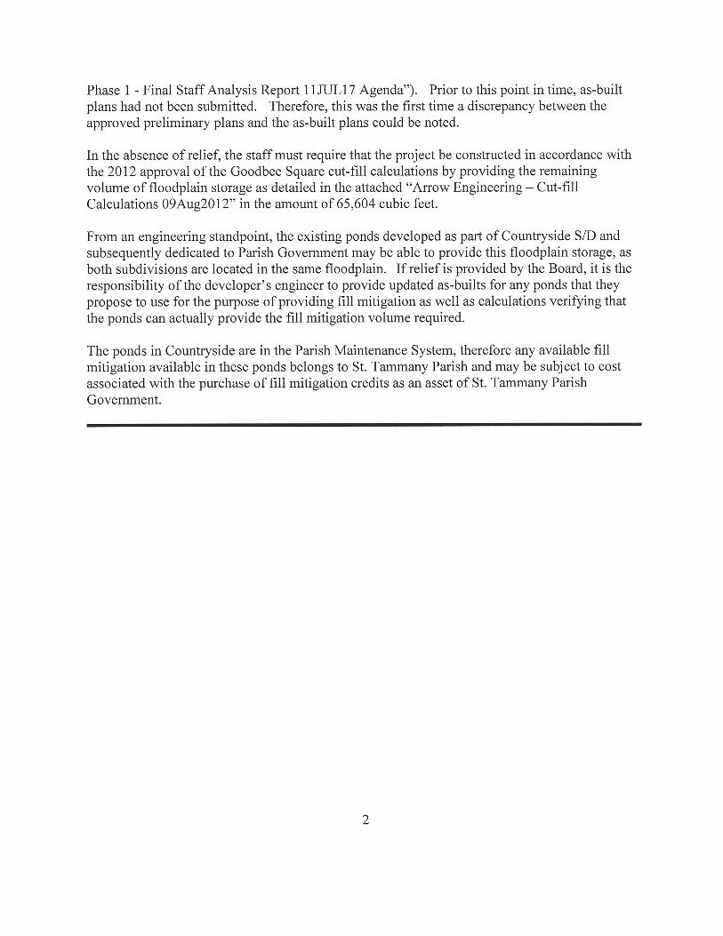
Phase 1 - Final Staff Analysis Report 11JUL17 Agenda”). Prior to this point in time, as-builtplans had not been submitted. Therefore, this was the first time a discrepancy between theapproved preliminary plans and the as-built plans could be noted.
In the absence of relief, the staff must require that the project be constructed in accordance withthe 2012 approval of the Goodbee Square cut-fill calculations by providing the remainingvolume of floodplain storage as detailed in the attached “Arrow Engineering Cut-fillCalculations 09Aug2012” in the amount of 65,604 cubic feet.
From an engineering standpoint, the existing ponds developed as part of Countryside S/D andsubsequently dedicated to Parish Government may be able to provide this floodplain storage, asboth subdivisions are located in the same floodplain. If relief is provided by the Board, it is theresponsibility of the developer’s engineer to provide updated as-builts for any ponds that theypropose to use for the purpose of providing fill mitigation as well as calculations verifying thatthe ponds can actually provide the fill mitigation volume required.
The ponds in Countryside are in the Parish Maintenance System, therefore any available fillmitigation available in these ponds belongs to St. Tammany Parish and may be subject to costassociated with the purchase of fill mitigation credits as an asset of St. Tammany ParishGovernment.

BOA CASE NO. ‘ (for office use only)
ST. TAMMANY PARISH BOARD OF ADJUSTMENT(VARIANCE/APPEAL APPLICATION FORM)
(Please print on the following lines below, if a company, please include a contact persoJz name also.)
API’LICANTS NAME: Lonesome Development, L.L.C.MAILING ADDRESS: c/c Jeffrey D. SchoenCITY/STATE/ZIP: P.O. Box 1810, Covington, LA 70434
PHONE NUMBER: 985-892-4801 985-373-0194(Home Phone #) (Cell Phone #)
PROPERTY LOCATiON FOR VARIANCE REQUESTED: ZONING: ________________
Countryside Circle near U.S. Hwy. 190 Goodbee LA Goodbee Square, Phase IAddress City State Subdivision (if applicable)
(‘Pleases check the applicable boxes below:)
REQUEST FOl?: CA variance of the (Unified Development Code)I2JAppeal of an adverse decision made by a parish official(s)C Appeal the interpretation by a parish official(s) of the (Unified
Development Code)
VARIANcE/APPEAL REQUESTED:
Dbuilding setbacks (reduction of t’ront, side and/or rear yard setbacks)
El landscape buffers (reduction of front, side andior rear yard buffer setbacks)~landscaping within buffers (reduction of the number of trees, bushes and/or shrubs)Dparking area requirements (reduction of parking stalls, parking greenspace islands, etc...)El signage requirements (increase of sign area and/or sign height, lighting, coloring, etc...)
Appeal decision of the STP Department of Engineering as to placement of fill (Chapter 7, Section 7-002.00)El other
(Specify other variance/appeal on line above)
(‘Please state on the following lines below your specific request for a variance/appeal:)
See above
~L.L.C.
By:______________________ I I ‘Iii 8SIGNA 1~URE OF O~t~1!A1’PLIcANT DATE OF APPLICATIONTIMOTHY R. HENNING, Manager

jds~jonesfusseII.com
From: [email protected]: Monday, January 08, 2018 9:22 AMTo: Ron Keller ([email protected])Cc: Sidney Fontenot (sfontenot©stpgov.org)Subject: Goodbee Square, Phase 1: Final Subdivision Approval (Appeal of Engineering Department
Interpretation of Placement of Fill Provision)Attachments: 201801 08092754409.pdf
In connection with the above referenced matter, attached please find the Appeal Application Form which I intend tosubmit to you tomorrow morning with the $200 filing fee.
The Developer (Lonesome Development, L.L.C.) of Goodbee Square, Phase 1 is appealing the after the fact (after grant ofinitially Preliminary Subdivision Approval and later Final Subdivision Approval) decision by the Department ofEngineering that the placement of fill provisions (“cut and fill”) had not been met/satisfied.
Please confirm that the filing appears to be in order in this regard; I have copied Sidney as he has been very involved inthe discussion of the issue and suggested Appeal alternative.
Many thanks,
Jeffrey D. SchoenJones Fussell, L.L.P.Northlake Corporate Park1001 Service Road E., Highway 190, Suite 103 P.O. Box 1810 Covington, Louisiana 70434Telephone: 985.892.4801Facsimile: 985.892.4925

I ‘~• E E NC AND ONSULTING INC.CI lEAN STRUcTURALENGhLE’KG
P0 BOX 881MADISONVILLE, LA
70447985-237-3908
August 9, 2012
Mr. Pa I CarrollSt. T any ParishDep ent of EngineeringP.O. B x 628Covin on, LA 70434
Re: odbee Square, P se I
Dear . Carroll:I’ve at hed revised cull fi 1 calculations for filling all the homesites to elevation 37.0’, alongwith a vised plan. The c culations and plans have been revised to address your comments inthe a lied email.
Please ntact me with any uestions and your review comments.
With b t regards,
Darrell Fussell, P.E.

• ~
4— ~7O ~~?& 431~3~4 3
~ __-~
C14:6.2
OT
II1,, 7.8
I,
CURB
6REQD 18”WEST INV.EAST INV.L=71 37~
48.00’ OC = 35.0V=32.34
ciO~L1d~
35.3xLOT~
I’)78~LOT77
37. :~
CNC~)
LO7
9= 35.0
LOT 7391.56’
II~
31148.00’
3~.1x8
48.00’
LOT 74-~-~-~91 56’~
g ._JARALL~L PARKING
I —
“ BCCMPA = 283
LOT 7591.56’
!~
•135.83
= 29.5
• ~ ! ~—‘~ ~‘A~
42~0’ O.=36.1GI 35.8NV 31.21
42.e~
L~T~41~
BEGINCURB ~c~i
N8922’24~
REQI. 18”R’S INV.3~
EAS INV. 3~L=7037-4I
C.
T (~‘T’ cL1’J I
42~
S89003’598E94.74,- ‘24.00
o~.OT~F
u-I8
LOT81
8O.00~
H! Co

d
S r~~- 2~-~ ~ 3f,~ T~-k~
‘J T V’J I L.
~ c~2 L3~O
1/
LX~r~l~ ~
~T~- L~
,ck~ ~
J
R~v 81e1~~~~ L (~ LIL~j~’~•~ ~ ~~2 ~
E~ /~-r.~ i’~f <::)W 31 ~ ~A~J \-~
F I L.L. T~ -~ ~*~Fs.B -~ B \~4
~-~Li~ç ~ ]~-~-~
-, ~EL~’J, 7~c’
c~ -rc r,~i_~Ss~ ~
T~
‘e,~51~ ,~c2
:~c4 ~
~
1LL. ~3~7-F~uL
fL~ C— <5±)
‘-7-
-
‘3
~-~3eO~ ~t
c~r —~_~
C
~-E~ ~
~~—
(~-3c~--7
Z~’~I
=
~:xr~7 ~
3(~E~ .~
~7tA~O5~
~LE~ ~(~~L2
LJDt~ L4L4~. L19
A~~c~s~i ~Ldc~~ 3’7~3~
4-
‘F
D~ 37~3~’u.~
-LoTS 5~-A -
—rca ~IL,L..
Lor~S ~c
c;~1~: ~
3C~1~L
~c3~~)c, ~
,-3c~ j~c~
F~ILdL ~
—

J
Th~-r i~ L~
Tc≤T ~
--7eL-~. ~ ~
37,~ -
~j~j: c~43~~r~t: ~
T L~I~
.~
.!LL1~ (at)
35S,~S~’ c-F1~1’~
~zjLL- ~
~‘-4~3, IBS
~::~c~) -r
~cQ~
~lL~L. ~
,& -, c?~ ~:
~ vo
I ~~_:x~
= \L9t~3jLf79’) ~ 4(~~T9’+cF
Lz~,L.Lz~(Z. ~cr;c~J 4~C~ s-c
~ 9. r3—’ •~€~Z rv~
_37,5’k-~ ‘/~)37~~-3~)
~i~_- (~t~C37.~ -3~)
~.
1~T~ 7~S~ S~7.e,i~-F
-c)~c
7 crii c~~P

v~ u ~~ c r
Q L~) V~~ ~FF~ - —
~4~7~7
_ -
I
I-~ 3’ — — — C——
2F~44 ~c 37q~c~ ~Ill, ‘~ ~7~2d(oSF - (4:-
p~ ~
Z~9 L~t 4- a~9 ~ + 4- 4 2~ C:~ - LF
V~ ~ -~
- ~

le Assodates, LLCPlanning. Engineering, and L, .ndscapeArchit.ctLna
February 17, 2015
Mr. Charles E. Williams, P.E.St. Tammany Parish GovernmentDept. of EngineeringP.O. Box 628Covington, LA 70434Email: [email protected]
RE: Goodbee Square Subdivision — Phase 1Covington, LAKA Project No. 14062
Dear Mr. Williams:
In accordance with a site meeting held with staff from your office on Thursday,February 12, 2015, we respectfully request an amended limited work order for thereferenced project to include grading and drainage work in accordance with the“Hydrological Calculations” by Arrow Engineering and Consulting revised in November2011. We understand that this report was approved by your office in 2011 and intendto maintain this basic drainage scheme moving forward with the proposedconstruction work.
The contractor will ensure that all work is done in accordance with this plan and willhave no adverse impacts on the adjacent properties. We understand that somecomplaints have been raised by adjacent property owners concerning the currentclearing and grubbing work. However, we have not been able to locate any specificissues that could be causing off-site drainage problems. We did note that some of theadjacent cleared lots as well as the existing ditches were holding a small amount ofwater. It is unclear how the work on the referenced site could have caused theseproblems.
638 VILLAGE LANE NORTH MANDEVILLE, LA 70471’ T(985) 7279377 F(985)727.9390
VIMIW.KYLEASSOCIATES.NET

Mr. Charles E. WilliamsGoodbee Square Subdivision - Phase I
February 17, 2015Page 2of2
Let us know if you have any questions or require any additional information.
Sincerely,
J Digitally signed by James E. Powell, Jr.a ru e5 • ON: cn~James E. Powell, Jr., o=KyleAssociates, LLC, ou,email [email protected],
P O\f\IC II, Jr. ~~2O15.O2.l~2329:2S~6’OO’
James E. Powell, Jr., P.E., P.L.S.Vice President — Engineering OperationsKyle Associates, LLC
638 VILLAGE LANE NORTH MANDEVILLE LA 70471 T (985) 7279377 F(985)727 9390
WiMN. KYLEASSOCIATES. NET

FINAL SUBDIVISION STAFF ANALYSIS REPORT(As ofJuly 5, 2017)
CASE NO.: 2017-71 1-FP
SUBDIVISION NAME: GOODBEE SQUARE, PHASE 1
DEVELOPER: Lonesome Development, LLC
ENGINEER/SURVEYOR: Kyle Associates, LLC
SECTION: 21 WARD: 1TOWNSHIP: 6 South PARISH COUNCIL DISTRICT: 3RANGE: 10 East
TYPE OF DEVELOPMENT: ______ URBAN (Residential lots less than 1 acre)_______ SUBURBAN (Residential lots between 1-5 acres)_______ RURAL (Residential Farm Tract lots 5 acres plus)
X OTHER (Multi family, commercial or industrial)(PUD)
GENERAL LOCATION: West side of LA 1077 and north side of LA 190 in vicinity of Goodbee.
TOTAL ACRES IN DEVELOPMENT: 20.65
NUMBER OF LOTS: 73 AVERAGE LOT SIZE: 6,500 Sq. Ft.
SEWER AND WATER SYSTEMS: Goodbee Regional
ZONING: PUD
FLOOD ZONE DESIGNATION: “A”
STAFF COMMENTARY:
Department ofEngineering
Periodic inspections have been made by this office during construction and the final inspection was madeon June 29, 2017. The inspection disclosed that all of the concrete roads are constructed and subsurfacedrainage is installed.
The following uncompleted items existed at the time of the final inspection and will be completed beforethe plats are signed;
Final Plat
1. Add to restrictive covenant #7 that the H.O.A. will be responsible for maintaining all “Private”servitudes.
2. Add a restrictive covenant stating the following: “Driveways on corner lots shall not be located
1

any closer than sixty (60’) feet from the corner of the property where the said two street rights ofway intersect.”
3. The water system Goodbee Square Ph. us tying into is Northridge, revise the Final Plat to depictthis information.
4. Revise the “Typical Concrete Entrance Section” legend to show the actual “As-Built” pavementdesign.
5. Revise the “Typical Concrete Roadway Section” to include a legend with “As-Built” information.6. The plat and the paving and drainage plan do not show the same servitudes between lots 18 & 19.7. Curve C8 does not meet the minimum required width of 25’ for public access servitude to the
detention pond.8 Certif~that the cu~t volüme froth the~pond mitigates the fill required to bring all lots up to the 100
Iea~floqd~lëv~jo~p9. The private drainage servitude around the detention pond must be removed if the Parish is to
maintain the pond.10. Remove the language regarding alleys from the dedication statement, as no alleys are a part of
this development.11. Remove references to sidewalks from the restrictive covenants, as sidewalks are not a part of this
development.12. The outfall drainage servitude is located outside of the footprint of the subdivision and must be
resolved.
“As-Built” Paving & Drainage Plan
13. Provide upstream and downstream inverts for the culvert installed at the entrance of thesubdivision.
14. The weir structure and location as well as the outfall location are not accordance with theapproved drainage plan dated 9/22/16. Revise the hydro report to confirm that the pond and weirmeet St. Tammany Parish Drainage requirements as constructed.
15. Variations greater than 1’ between the as-built invert elevations and the proposed invertelevations were observed in multiple locations (C.I. #5, 25, 23 for example). Revise the hydroreport using the as-built invert elevations to confirm that the drainage infrastructure meets St.Tammany Parish Drainage requirements as constructed.
16. The outfall drainage servitude was not approved in the preliminary plans and is located outside ofthe boundary property line of the subdivision. This issue must be resolved.
17. Provide additional clarification showing how the pond berm connects to the weir, including theslope of the ground from the weir to the op of bank elevation which is 37.5’.
18. Provide as-built elevations for the weir.19. This weir design was not approved Where is the culvert that was approved?20. Provide sufficient elevation points in the pond to show that the pond size, top of bank elevations,
pond bottom elevations, pond slopes, and pond design are in accordance with the approveddrainage plan and hydro study.
21. Identify what unit of measure is being used for all dimensions called out on the Reinforcing detailand Detail 2.
22. Provide drainage directional arrows on each lot of the development.23. There is a note that states “final as built data pending.” Approval of the as-built plans will
require all as-built data to be finalized.
“As-Built” Sewer & Water Plan
2

24. Label sheet RDI as the “As-Built Utility Plan.”
“As-Built” SWPPP
25. Revise the Erosion Control Plan to indicate physical location where the SWPPP will be kept onsite.
26. Attach the stormwater map and include the pathway from the discharge point to the ultimateoutfall at the Lake.
General
27. Municipal addresses must be included on the Final Plat.28. Provide an “As-Built” Signage Plan.29. Provide the Engineer and the Surveyor’s Stamp on required plans.30. Fire hydrants need to be painted the correct color scheme.31. Base test results, concrete test results, utility trench bedding test results, and utility backfill test
results are required.32. A negative bacteriological report relative to the construction of the project’s water system is
required.33. A letter of acceptance and responsibility for the perpetual maintenance and operation of the water
and sewer system is required from the utility provider.
Should the Planning Commission approve the request for final approval a Warranty Obligation will berequired for the infrastructure in the amount of 2346 linear feet x $25.00 per linear foot = $58,700 for aperiod of two (2) years.
Mandatory Developmental Fees are required as follows:
Road Impact Fee = $1077 per lot x 73 lots = $78,621
Drainage Impact Fee $1114 per lot x 73 lots = $81,322
Fees are due before subdivision plats can be signed.
This subdivision is within the “Urban Growth Boundary Line”.
All staff comments must be addressed before plats can be signed.
Revised drawings will not be accepted prior to July 11, 2017 Planning Commission meeting to ensure thatany additional comments established at the meeting can be incorporated into the revised plans.
Department ofDevelopment — Planning
None