02 Ismail Karamanderesi Characteristics of Geothermal reservois in Turkey
34
Karamanderesi: Characeristics of Geothermal Reservoirs in Turkey IGA Academy Report 0102-2013 Supported by: Characteristics of Geothermal Reservoirs in Turkey İ. H. Karamanderesi EVKA-3 Mah. 126 Sokak No:1 D:6 35050 Bornova/İzmir Türkiye. Abstract: Turkey is the product of a wide variety of Alp-Himalaya tectonic processes. Depending on the regional geology, compression between Eurasion-Africa continental crust and Arabian plate generate compression tectonic in eastern Anatolia. Conversely this geological mechanism creates tensional tectonic regime in western Anatolia. Depending on this mechanism Tertiary volcanism in eastern Anatolia and graben tectonics in western Anatolia have formed and they are most characterestics geological features for these regions. Depending on the structures observed in geothermal systems have evolved due to the geological structure developed in Anatolia. The edges and/or within grabens developed geothermal systems creates large structures in western Anatolia. Developing data systems and geothermal drilling in the region have created standard models for suitable geological reservoirs. Well-known geothermal fields such as Kızıldere, Germencik, Salavatlı, Alaşehir-Alkan, Salihli-Caferbeyli, MDO-1 well, Sandıklı AFS wells, Afyon geothermal area develop within the metamorphic basement, and the zones of hydrothermal alteration occurs within the advanced geological reservoirs which consist dominantly marble and volcanics. Reservoirs studied in Çanakkale Tuzla, central and eastern Anatolia indicates that faulting and volcanic activity developed these reservoirs. In addition, drilling of low enthalpy fields shows that development of such a reservoir depends on occurences of dykes and sills. In this workshop, I will try to describe characteristics of the geothermal reservoirs of Turkey. 1 Introduction The geothermal fields of western Turkey provide a unique setting of extremely high enthalpy combined with a large variation in chemical composition. The distribution of the geothermal systems follows the tectonic patterns of Turkey. The presence of active structural systems that characterizes western Anatolia is associated with young acidic volcanic activity, block faulting (grabens), hydrothermal alteration, fumaroles, and more than 600 hot springs with temperatures up to 100 0 C (Çağlar, 1961; Ercan et al., 1985; 1997). The major high- enthalpy geothermal fields of Turkey are Kızıldere (200–240 0 C), Ömerbeyli–Germencik (232 0 C), Çanakkale–Tuzla (174 0 C), Simav–Kütahya (165 0 C), Alaşehir Kavaklıdere 287 0 C and İzmir– Seferihisar (140 0 C) (Şimşek and Güleç, 1994; Gökgöz, 1998; Vengosh et. al. 2002, Fig. 1.1). The geothermal energy potential of western Turkey is used for electricity production. During 1998, Turkey produced enough geothermal heat for 50,000 houses and greenhouses of 200,000 m2 with 350 Mwt, as well as 190 hot springs with 285 Mwt (Gökgöz, 1998). Kızıldere geothermal field was the first field utilized for electricity production in Turkey. Electricity production from Kızıldere goes back 1974 where a 0.5 MWe pilot plant was used to supply electricity for 1984 (10 years) after which there exist new additions almost every year. Installed capacity has increased with an increasing trend within the period of 2009 – 2013. It is expected that four more power plants will be in operation by the end of 2013 with a total installed capacity of 150.2 MWe. Finally, the projects received license from Energy Market Regulatory Authority (EMRA) of Turkey. If all these projects are realized the total installed capacity will reach a value of 642.8 MWe (162.2 MWe already in operation, additional 150.2 MWe expected by the end of 2013 and 330.4 MWe received license).
Transcript of 02 Ismail Karamanderesi Characteristics of Geothermal reservois in Turkey

Karamanderesi: Characeristics of Geothermal Reservoirs in Turkey
IGA Academy Report 0102-2013
Supported by:
Characteristics of Geothermal Reservoirs in Turkey İ. H. Karamanderesi
EVKA-3 Mah. 126 Sokak No:1 D:6 35050 Bornova/İzmir Türkiye.
Abstract: Turkey is the product of a wide variety of Alp-Himalaya tectonic processes. Depending on the regional
geology, compression between Eurasion-Africa continental crust and Arabian plate generate compression tectonic in
eastern Anatolia. Conversely this geological mechanism creates tensional tectonic regime in western Anatolia.
Depending on this mechanism Tertiary volcanism in eastern Anatolia and graben tectonics in western Anatolia have
formed and they are most characterestics geological features for these regions.
Depending on the structures observed in geothermal systems have evolved due to the geological structure developed
in Anatolia. The edges and/or within grabens developed geothermal systems creates large structures in western
Anatolia. Developing data systems and geothermal drilling in the region have created standard models for suitable
geological reservoirs. Well-known geothermal fields such as Kızıldere, Germencik, Salavatlı, Alaşehir-Alkan,
Salihli-Caferbeyli, MDO-1 well, Sandıklı AFS wells, Afyon geothermal area develop within the metamorphic
basement, and the zones of hydrothermal alteration occurs within the advanced geological reservoirs which consist
dominantly marble and volcanics. Reservoirs studied in Çanakkale Tuzla, central and eastern Anatolia indicates that
faulting and volcanic activity developed these reservoirs. In addition, drilling of low enthalpy fields shows that
development of such a reservoir depends on occurences of dykes and sills. In this workshop, I will try to describe
characteristics of the geothermal reservoirs of Turkey.
1 Introduction
The geothermal fields of western Turkey provide a
unique setting of extremely high enthalpy combined
with a large variation in chemical composition. The
distribution of the geothermal systems follows the
tectonic patterns of Turkey. The presence of active
structural systems that characterizes western
Anatolia is associated with young acidic volcanic
activity, block faulting (grabens), hydrothermal
alteration, fumaroles, and more than 600 hot
springs with temperatures up to 1000C (Çağlar,
1961; Ercan et al., 1985; 1997). The major high-
enthalpy geothermal fields of Turkey are Kızıldere
(200–2400C), Ömerbeyli–Germencik (2320C),
Çanakkale–Tuzla (1740C), Simav–Kütahya
(1650C), Alaşehir Kavaklıdere 2870C and İzmir–
Seferihisar (1400C) (Şimşek and Güleç, 1994;
Gökgöz, 1998; Vengosh et. al. 2002, Fig. 1.1).
The geothermal energy potential of western Turkey
is used for electricity production. During 1998,
Turkey produced enough geothermal heat for
50,000 houses and greenhouses of 200,000 m2 with
350 Mwt, as well as 190 hot springs with 285 Mwt
(Gökgöz, 1998).
Kızıldere geothermal field was the first field utilized
for electricity production in Turkey. Electricity
production from Kızıldere goes back 1974 where a 0.5
MWe pilot plant was used to supply electricity for
1984 (10 years) after which there exist new additions
almost every year. Installed capacity has increased with
an increasing trend within the period of 2009 – 2013. It
is expected that four more power plants will be in
operation by the end of 2013 with a total installed
capacity of 150.2 MWe.
Finally, the projects received license from Energy
Market Regulatory Authority (EMRA) of Turkey. If all
these projects are realized the total installed capacity
will reach a value of 642.8 MWe (162.2 MWe already
in operation, additional 150.2 MWe expected by the
end of 2013 and 330.4 MWe received license).

Karamanderesi: Characeristics of Geothermal Reservoirs in Turkey
IGA Academy Report 0102-2013
2
Fig. 1.1. General map of western Turkey and
location of investigated geothermal systems (after
Vengosh, et al., 2002).
2 Goelogical Setting of Turkey and Menderes Massif
Turkey is located within the Alpine-Himalayan
orogenic belt. The distribution of seismicity and
active regimes are concentrated along high strain
zones; many of which are major strike-slip faults,
such as the North Anatolian Fault (Ketin, 1968),
East Anatolian Transform Fault (Dewey and Şengör
1979) and graben zones (e.g. Büyük and Küçük
Menderes Grabens, Gediz, Simav, Manyas, and
Kızılcahamam grabens) (Angelier et al., 1981;
Şengör, et al., 1985). The broad tectonic framework
of the Aegean region and the eastern Mediterranean
region are dominated by the rapid westwardly
motion of the Anatolian plate relative to the Black
Sea (Eurasia) plate, and west to south-westwardly
motion relative to the African plate (McKenzie,
1972, Dewey and Şengör 1979).
Menderes Massif is one of the largest metamorphic
massifs in Turkey, with a length of about 200 km
N-S between Simav and Gökova grabens, and about
150 km E-W between Denizli and İzmir in western
Anatolia (Ketin, 1983). Philippson (1910) described
the Menderes Massif as a dome-like structure, broken
by faulting during the Alpine orogeny; whereas Dixon
and Pereira (1974) regarded the Menderes Massif as
one of a number of the "zwischengebirge" massifs;
essentially microcontinental blocks, made up of pre-
Mesozoic basement rocks having some of the
characteristics of the cratons but displaying evidence of
Alpine tectonic and magmatic involvement.
The crystalline Menderes Massif is divided into two
major units: the core and the cover series. The core
series consist of Precambrian to Cambrian high-grade
schist, metavolcanic gneisses, augen gneiss,
metagranites, migmatites and metagabbros. The cover
series are composed of Ordovician to Paleocene
micaschists, phyllites, metaquartzites, meta
leucogranites, chloritoid-kyanite schists,
metacarbonates and metaolistostrom. In many places,
metabauxites (probably upper Jurassic to Cretaceous in
age) occur in the upper levels of the metacarbonate
sequence (Dora et al., 1995). Candan et al. (1992)
observed that high-grade metamorphic rocks are
located along tectonic contacts within the schist,
phyllite and marble series which envelope the core.
This is enforced by the field and drilling data
comprised by the Germencik Ömerbeyli geothermal
system (Şimşek et al. 1983; Karamanderesi and
Özgüler, 1988a; Karamanderesi et al.,1988b).
In a large scale, regional suture means this post-
metamorphic compressional phase conjugated with the
paleotectonic evaluation of the western Anatolia is in
N-S direction; but the pushing is in northward
direction. This compressional force has given rise to an
extreme cataclastic structure. The post metamorphic
granite plutons in Early Miocene are extremely
subjected to this compressional tectonics, and the
allochtonous units are cut across by the graben systems
of neo-tectonic phase started in Tortonian. According
to these data this effective compressional tectonism in
the Menderes Massif must be in the Early-Middle
Miocene period. Neogene sediments overlie the
allochthon and autochthon grouping rocks with angular
unconformity at the south of the target area. The
Neotectonic period of the Menderes Massif and
surrounding areas have been the subject of regional
research for many years (Ketin, 1966; McKenzie,
1972; Dumont et al. 1979; Angelier et al. 1981).
Extensive tectonic activity and formation of east-west
grabens have formed the shape of western Anatolia. Of
these, Büyük Menderes and Gediz grabens host the

Karamanderesi: Characeristics of Geothermal Reservoirs in Turkey
IGA Academy Report 0102-2013
3
main and the most important geothermal fields of
western Turkey. The distribution of geothermal
fields in Turkey closely follow the tectonic patterns.
All of the hot springs with temperatures above
500C-1000C in eastern and western Anatolia are
clearly related to young volcanic activity and block
faulting. The post-collosional volcanic activities,
lasting from the upper Miocene to modern time
have been responsible for heating up the
geothermal fields in Turkey (Demirel and Şentürk,
1996). The high thermal activities are reflected in
the forms of widespread acidic volcanic activity
with much hydrothermal alteration, fumaroles, and
more than 600 hot springs with temperatures up to
100°C (Çağlar, 1961).
Two different views have been proposed for the
timing of the development of the east-west grabens.
According to one view; the grabens began to
develop during Late Oligocene-Early Miocene
times and have progressively enlarged since then
(Seyitoğlu and Scott, 1996). The other view
proposes that the grabens have been forming from
the Late Miocene period to the present time (Şengör
et al. 1985; Görür et al. 1995). Resolution of this
question requires a fully understanding of the
geology of the region, as well as the detailed
geology of the grabens.
Most of the thermal waters, of which host rocks are
Menderes Massif metamorphics, discharge from the
rims of east-west trending faults that form Büyük
Menderes, Küçük Menderes, Gediz and Simav
grabens. The circulation of thermal waters is
closely related to major faults and fractured zones.
Fractured rocks of the Menderes Massif, such as
quartz-schists, gneiss and granodiorite and karstic
marbles, the shale and sandstone and limestone
megablocks of Bornova Mélange and
nonmetamorphic Mesozoic carbonates are the
reservoir rocks. Relatively impermeable Neogene
sedimentary units occur in different facies in the
northern and southern parts of the Gediz graben and
northern parts of Büyük Menderes Graben. These
rocks cap the geothermal systems. Increasing of the
geothermal gradient by the effects of graben
tectonism may be the heat resource of geothermal
systems. Thermal waters from Gümüşköy,
Germencik, Kızıldere, Tekkehamam, Ortakçı,
Bayındır, Salihli, Turgutlu, Simav, Saraycık, Gediz,
Uşak-Emirfakı and Göcek fields are hosted by
Menderes Massif rocks.
The west Anatolia has a seismically very active
crust, which is extending approximately N-S in
direction since the Miocene (Dewey and Şengör, 1979;
Şengör, 1987). The upper crust of western Anatolia
deforming under this extensional regime was broken by
normal faults controlling E-W trending grabens (Fig.
2.1). The most important and the largest grabens are:
(1) Gediz (Alaşehir) graben and (2) Büyük Menderes
Graben.
Fig. 2.1. Geological map of western Anatolia showing
the major tectonostratigraphic units on which the
Neogene and Quaternary sedimentary basins
developed. SDF, Simav detachment fault; GDF, Gediz
detachment fault; BMDF, Büyük Menderes detachment
fault; SSz, Selimiye shear zone; NMM, Northern
Menderes Massif; CMM, Central Menderes Massif;
SMM, Southern Menderes Massif. The map is compiled
from Okay and Siyako (1993), Bozkurt and Park
(1994), Sözbilir (2001, 2005), Collins and Robertson
(2003), Özer and Sözbilir (2003), Bozkurt (2004),
Bozkurt and Sözbilir (2004) and Işık et al. (2004) (after
Karaoğlu and Helvacı, 2012).
Büyük Menderes Graben is a E-W trending depression,
150 km long and 10-20 km wide, bounded by active
normal faults (Paton, 1992). The graben changes its
direction in Ortaklar, extends NE-SW through Söke,
intersects with Gediz graben in the east of Buldan and
turns to Denizli basin from Sarayköy (Westaway,
1993). The historical earthquakes occurred in B.C. 31,
26 and D.C. 2, 1653, 1895, 1899 and 1955 along the
graben bounding faults show that the region is
seismically very active (Koçyiğit et al., 2000).

Karamanderesi: Characeristics of Geothermal Reservoirs in Turkey
IGA Academy Report 0102-2013
4
3 Materials and Methods
Relatively detailed rock-cuttings analyses along
with various borehole logs were used to assess the
geothermal system into which AS-1 and AS-2,
MDO-1 or other wells were drilled.
During drilling, rock cuttings were taken at every 2
m depth interval and than properly labelled. At the
well site, a binocular microscope (Nikon 64114)
was used for the analyses of the rock cuttings. The
mud circulation losses and the rate of penetration
were recorded for each drill pipe sunk. Rock
cuttings of thin sections were analysed at MTA
Laboratories. After the regular X-ray difractometer
analyses of the 2 to 400, the samples were
glicoloted and than heated in the oven. The X-ray
diffractometer analyses were made in the
laboratories both at the MTA, and the Sivas
Cumhuriyet University.
Temperature logs were carried out during drilling to
locate aquifers and assess the condition of the wells
for drilling. Temperature logging equipment was
provided by Amerada Logging tools. This logs
provided important information on temperature
conditions, flow paths and feed-zones in the
geothermal systems. Temperature logs have also
been recorded and prepared after the drilling and
the production.
The well-testing method was controlled by
lippressure measurements that give total mass-flow
rate and the heat content (enthalpy) of a two-phase
geothermal fluid from a discharge pipe.
Samples in the well or drill boxes are wettened by
pouring water onto them. Wetting the cuttings is
necessary in order to enhance the visibility of the
samples or certain features such as finely
disseminated sulphides (e.g., pyrite). The wet
samples were then placed onto the mounting stage
of the microscope for investigation. Cutting
examination was done using binocular microscope
with a 5x10 magnification of the field of study.
Initial information obtained includes
stratigraphic/sedimentological features, alteration
mineralogy and evidence of permeabilities. In
addition to binocular microscopic study, thin
sections for petrographic study were made in order
to expand or confirm preliminary findings from the
cuttings. However, this method intends to
complement rather than replace careful binocular
microscopic studies and adds understanding with
regard to rock-mineral deposition and alteration.
Selected thin section samples were analysed using the
petrographic microscope.
X-ray diffractometric analyses were done on the ~4 µm
fractions of particular samples from the cuttings in
order to confirm and identify the types of clay minerals
present in the cuttings. Approximately two tea spoons
of drill cuttings were placed into a test tube, and dust
was washed out with distilled water. The tubes were
filled 2/3 full with distilled water and plugged with
rubber stoppers. The tubes were placed in a mechanical
shaker for 4-8 hours, depending on the alteration grade
of the samples. The content were alloowed to setle for
1-2 hours until only particles finer than approximately
~4 microns were left in suspension. A few millilitres of
liquid was pipetted from each tube and about 10 drops
placed on a labelled glass plate. An effort was made to
avoid thick samples. A duplicate was made of each
sample and left to dry at room temperature overnight.
One set of samples was placed in a desiccator
containing glycol (C2O6O2) solution and the other into
a desiccator containing CaCl22H2O. The samples were
stored at room temperature for at least 24 hours. Thick
samples needed a longer time in the desiccator - at least
48 hours. Both sets of samples were run from 2 to 150
on the XRD. One set of the samples (normally the
glycolated one) was placed on an asbestos plate and
heated in a preheated oven at 550-600°C. The oven
temperature did not exceed 600°C. The exact location
on the asbestos of individual samples was established
before heating because labelling disappears during the
heating process. The samples were cooled sufficiently
before further treatment. Then the samples were run
from 2 to 150 on the XRD.
4 Kızıldere (Denizli) geothermal field
Geothermal energy explorations in Turkey have been
carried out by the General Directorate of Mineral
Research and Exploration (MTA). The inventorial
works and hemical analyses of hot springs and mineral
waters started in 1962. All geothermal fields in Turkey
are in the water-dominated character (Fig. 4.1).
Kızıldere geothermal field is in the Sarayköy–Buldan
area, and is associated with the major fault along the
northern boundary of the Büyük Menderes Graben
(Fig. 4.1). As for other fields in the graben, the
basement in the Kızıldere field is made up of
metamorphic rocks of the Menderes Massif: augen
gneisses, schists, and an alternation of quartzites,
micaschists and marbles known as the˙İğdecik
Formation (Fig. 4.1). These rocks are overlain by
fluvial and lacustrine Pliocene sediments, which have
been divided into four lithologic units (Şimşek, 1985a)

Karamanderesi: Characeristics of Geothermal Reservoirs in Turkey
IGA Academy Report 0102-2013
5
(Figs.4.1 and 4.2). From bottom to top these are:
the Kızılburun Formation (Tk), a 200-m thick
formation of alternating red and brown
conglomerates, sandstones, shales and lignite
layers; the Sazak Formation (Ts), comprising
intercalated gray limestones, marls and siltstones,
100–250m in thickness; the Kolonkaya Formation
(Tko), made up of yellowish green marls, siltstones
and sandstones, 350–500m in thickness, and,
finally, the Tosunlar Formation (Tt), composed of
alternating units of poorly-consolidated
conglomerates, sandstones and mudstones with
fossiliferous clay units, about 500m in thickness.
Quaternary alluvium unconformably overlies these
sedimentary units. The regional geological structure
is controlled by E–W trending faults associated
with the Büyük Menderes Graben, but some NW–
SE trending, active faults have caused the uplift and
dissection of the northern and southern flanks of the
metamorphic basement. (Şimşek et. al. 2005)
Fig. 4.1. Geological map of the Kızıldere
geothermal field (after Şimşek, 1985, Çetiner,
1999)
Fig. 4.2. The Well log of the TH-2 Reinjection well
(after Çetiner. 1999).
Fig. 4.3. Kızldere Geothermal field deep reservuar
well R-1 Well log (after, Çetiner, 1999)

Karamanderesi: Characeristics of Geothermal Reservoirs in Turkey
IGA Academy Report 0102-2013
6
At the first stage of the project the 2001 m depth
deep well calIed as TH-2 were drilled in 1996 (Fig.
4.2). At the second stage of the project, 2261 m
depth drill well named as R-1 that investigates
metamorphic basement rocks (Fig. 4.3), same as the
TH-2 well, has been completed in 1998. A third
reservoir has been discovered by the completion of
the R-1 drill well first time in 1998.
The First, the Second and the Third Geothermal
Reservoirs in the field have been compared in this
study with respect to their productivity indexes,
calcium scal1ing risks and enthalpies. The results of
comparison showed that the schist formation of the
metamorphic basement (the third Geothermal
Reservoir) is not available for the reinjection
purpose. On the other hand, the third Geothermal
Reservoir has been found as a good production
zone. The second reservoir, which is being used for
the production at present, has enough permeabiIity
for reinjection comparing with the other reservoirs.
The geothermal fluid from R-l will cause calcium
carbonate scalling in the well, separator and further
and waste water channel because of the over
saturation of calcium carbonate as it is in running
production wells of 2nd Reservoir.
As a result of this study, the new production and
reinjection zones have been proposed. In the near
future, author suggests that the 3rd Reservoir should
be used for production of electricity generation
while the 2nd Reservoir should be evaluated for
reinjection purposes (Çetiner, 1999).
4.1 KD-17 Well geology
Fig. 4.4 Kızıldere (Denizli) geothermal field well
number 17th well log is showed to us that the well
was not very well planned usefull drilling. Because
well cutting undetermined by hydrothermal
alteration. So that well blow-out then finally the
well was lost (ENEL, 1989).
Fig. 4.1 shows that geologycal descriptions and
controlling of the well have been sucssesfully
completed. XRD and microscope analyses
completed from sediments of this well as well as
ÖB-20 are shown on Table 1 (Karamanderesi,
2000).
Fig. 4.4. Kızıldere (Denizli) geothermal field well
number 17 well log (after Enel Company, 1989
5 Germencik (Aydın) Geothermal Field
The Germencik–Ömerbeyli geothermal field was found
in the western part of the Büyük Menderes Graben in
1982 as a second high enthalpy geothermal field of
Turkey. Ömerbeyli geothermal fields is situated at
110km far away from to İzmir of Aydın-İzmir highway
and near Germencik (Fig. 5.1).
In the Aydın- Germencik area the preliminary studies
were carried out in 1967. Later on, detai1ed geological
mapping, hydrogeological, geophysical and
geochemical studies and drilling tests were
implemented. Germencik area was discovered in 1982
as the second important high-enthalpy geothermal field
after Kızıldere area of Turkey to produce electricity
(Şimşek, 1984a).
The basement in the Germencik field is comprised by
the Paleozoic metamorphics of the Menderes Massif.
These rocks are extensively exposed in the adjoining
higher ground of the Büyük Menderes Graben, namely
the Bozdağ horst in the north, Kızılcagedik horst in the
central part of the graben, and the Koçarlı horst in the
south. The metamorphics consist of gneisses and
schists, as well as marbles, quartzites and calcschists.

Karamanderesi: Characeristics of Geothermal Reservoirs in Turkey
IGA Academy Report 0102-2013
7
Gneisses make up the major part of the
metamorphics and is overlain by schists. In between
the gneisses and the schists, gneiss-quartzite
alternations are recognized. The Cenozoic rocks
unconformably overlie the basement metamorphics.
Miocene deposits are not extensive in the area. The
succession starts at the base with conglomerates
and is followed by alternation of lignite-bearing
clayey Iimestones and sandstones. Pliocene sediments
are rather extensive in the region and rest largely on the
metamorphic rocks of the Menderes Massif. The
succession starts with conglomerate-sandstone-
siltstone-claystone alternation and is followed by
loosely cemented conglomerates and sandstones (Fig.
5.1) Quaternary alluvium unconformably covers all the
units.
Fig. 5.1. The Geological map of the Germencik Ömerbeyli geothermal field (after Şimşek. 1984)
According to the geological studies young tectonic
activities, regional faults of high slip, young acidic
volcanics (dacite-andesite), hydrothermal
Mineralogy and petrography of ÖB-4 well could be
as follows according to the study of Gevrek at
al.(1989). Mineralogy of well-logging starts with
Illite + kaolinite paragenesis. The ratio of illite
incrises towards to the depth and becomes
dominant paragenesis after 270 m The percentage
of kaolinite decreases from upper levels towards
depth as seen from Fig. 5.2. Illite takes place of
chorite minerals after the depth of 250 m. The
variations of clay minerals are due to the
physicochemical conditions observed in the well.
The disturibution of clay minerals in this well is
shown on Fig. 5.2.
Fig. 5.2. The Ömerbeyli well number 4 of the well log
(after Karamanderesi, vd., 1986, Gevrek, et. al., 1989)

Karamanderesi: Characeristics of Geothermal Reservoirs in Turkey
IGA Academy Report 0102-2013
8
5.1 ÖB-4 Well Geology
ÖB-4 well was drilled during the year of 1984 and
it's total depth is 285 m. During the drilling
operation of this well, some problems had been
occurred due to the lack of practice and application
of the well geology knowledge and data. The main
problem was that well managment because of
shallow drilling (Fig. 5.2). Production temperature
droped quickly as the production was made from
clastics sediments. Later, after the study of well
geology during the year of 1989 the interpretation
of the field was changed. Thus, for this reason the
well geology is very important for the interpretation
of a geothermal area.
5.2 ÖB-9 Well Geology
Mineralogy of ÖB-9 well-logging starts with
Illite+klorite paragenesis. Illite is dominant mineral
upper and lower levels of the well whereas middle
part of the well, between 200-900m, the amounts of
this mineral decrease. Montmorillonite occurs
between 110-700m, 1050-1200m and 1300-1460m.
Kaolinite is observed at 700-950m and 1000-
1460m. Chloriteis present between 950-1050m and
1100-1400m. In this well, the variations of clay
minerals are due to the physicochemical conditions
similar to thosed of the ÖB-4 well. The
disturibution of clay minerals in this well is shown
on Fig. 5.3.
Fig. 5.3. Well logging of the Aydın Germencik
Ömerbeyli-9 well (after Gevrek et al., 1989)
Those all well where the orthoclase mineral occurs
as either pure and unaltered forms as well as it
alters to clay minerals (kaolinite and montmorillonite),
sericite and chlorite at the weathered zones. But, in
those weathered zones orthoclase mineral always
altered, thus orthoclase mineral indicates the leakage
zones in this geothermal area.
Plagioclase alters to sericite, chlorite and clay minerals
at the temperature of 150-165oC. They alters to sericite,
chlorite and clay minerals at the temperatures between
150-165oC whereas they alters to only sericite above
200°C temperatures.
Biotite alters to opak ninerals, carbonate and
phylogopite at the temperatus between 150-165°C, at
the temperatures between 165-200°C to carbonate and
phylogopite, and above the temperatures of 200°C to
only phylogopite.
As a result of the study of alteration minerals indicates
that the water-rock interaction between geotermal fluid
and reservair rocks has been almost completed and the
geothermal system has been partly in equilibrium.
The amount of illite increases according to depth and
temperature in all investigeted wells. Kaolinite mineral
decreases with depth and temperature in the Neogene
formations whereas increases with related to depth and
temperature in the Paleozoic formations, and upto the
temperature 210°C it keeps it’s stable position.
Montmorillonite decreases with regard to temperature
and depth in Neogene and Paleozoic formations and it
becomes unstable after the temperature of 200°C.
Chlorite occurs as different horizons and it is stable
between the temperatures 200-225°C. Illite+kaolinite
and illite+chlorite paragenesis indicates reservoir
horizons (Gevrek, et. al.1989).
6 Salavatlı geothermal field
The Aydın-Salavatlı geothermal field is located in the
middle part of the Büyük Menderes Graben, and is
characterized by E-W-trending normal faults (Fig. 1.1).

Karamanderesi: Characeristics of Geothermal Reservoirs in Turkey
IGA Academy Report 0102-2013
9
Fig. 6.1. Geological map of the Aydın Salavatlı
geothermal field (after Karamanderesi and Helvacı,
2003).
The stratigraphic sequence of the field is composed
of metamorphic rocks of the Menderes Massif and
overlying the Miocene sedimentary rocks deposited
during the Miocene exhumation of the massif. Field
data suggest that there is a connection between
tectonic development and periods of hydrothermal
alteration. Several deep wells were drilled (AS-1,
1510 m and AS-2, 962 m) and revealed low
resistivity zones (Karamanderesi 1997).
Preliminary studies were conducted on a regional
scale by Karamanderesi (1972). Geochemical
analysis of water from hot springs near Salavatlı
village indicated that the area has hot-water-
dominated geothermal potential, and geophysical
studies outlined the structural situation of the
geothermal field. Geophysical studies using gravity
(Gülay 1988) and electrical resistivity methods
(Şahin 1985) indicated that the geothermal field is
located along fault systems near the towns of
Salavatlı and Sultanhisar.
A couple of deep wells were drilled by General
Directorate of Mineral Research and Exploration
(MTA) (AS-1, 1510 m below ground level; and
AS-2, 962 m, Fig. 6.5) within a low resistivity zone
(5-10 ohmm) outlined by resistivity-depth sounding
studies. Cuttings from the AS-1 and AS-2 wells
near Salavatlı were studied by petrographic microscopy
and XRD methods, and the nature and distribution of
their mineral parageneses were determined. The data
obtained from the drill cores of these wells are used to
explain a model for the geothermal system of the
Aydın-Salavatlı field. Today, three different
geothermal power plants are in operation after
additional wells opened in the Aydın Salavatlı
geotermel field
6.1 Geology of the Aydın Salavatlı area
The Aydın-Salavatlı geothermal field is located in the
north-central part of the Büyük Menderes Graben, and
covers an area about 8 km long and 2 km wide (Fig.
6.1). The geological sequence of this area includes
orthogneiss and paragneiss, fine-grained schists,
coarsegrained augen gneiss, mica schist, quartz schist,
metaquartzite and marble units. Structural analysis
shows that these units have been reverse-faulted and
that the gneisses have been thrusted over the schists
and marbles. These structures can be seen at the surface
(Akartuna 1965) and also in the cross-section between
the AS-1 and AS-2 wells (Figs. 6.4 and 6.5).
Tertiary sedimentary rocks, which have been filling the
graben that developed as result of neotectonic activity,
have been deposited over the metamorphic basement.
These Neogene sedimentary rocks include coarse- and
fine-grained sandstones, siltstones, and wellcemented
conglomerates, and are separated by a thin lignite layer
at the base of the sequence. Sediments thicker than
1000 m have been drilled through in the Büyük
Menderes Graben at the Germencik-Ömerbeyli
geothermal field (Karamanderesi et al. 1987).
Travertine deposits, precipitated from cold or hot
springs along the faults, are present locally. Hot springs
having 2 C temperatures near Malgaçemir village are
evidence of present geothermal activity.
Based upon their mineral parageneses (Table 6.1),
metamorphic rocks of the Menderes Massif are known
to be the products of regional metamorphism
characterized by medium to high temperature and
pressure. A mineral paragenesis including chlorite -
biotite - muscovite - garnet - staurolite - kyanite -
sillimanite occurs within allochthonous augen gneisses
and cover schists. Observations within the massif show
that large fissures and fracture zones developed during
neotectonic activity, and quartz veins and calcite and
chlorite veins occur in swarms related to deep-seated
intrusive bodies. These intrusives are not exposed
because of the greater depths of their magma chambers,
but a few outcrops bearing rutile, titanite, limonite,
quartz, calcite and siderite can be observed in the

Karamanderesi: Characeristics of Geothermal Reservoirs in Turkey
IGA Academy Report 0102-2013
10
Ovacık plateau at the northern end of the study area
(Fig. 6.1). The erosion surfaces of these outcrops
have altitudes of 900 m from the Ovacık plateau
toward the south at lower altitudes, dykes of gabbro
and its derivatives, which have intruded along
small-scale fracture zones and cooled during the
Quaternary, are present. Silicified zones have
developed along the margins of these dykes. The
mineralogical composition of the gabbroic intrusive
rocks (of Early Miocene age [or post-
metamorphic]) is as follows: plagioclase,
clinopyroxene, orthopyroxene, olivine, biotite,
uralite, zoisite, chlorite, apatite, magnetite and
garnet. Locally, these gabbroic rocks have schistose
textures. Where erosion has been slow, travertine
deposits are present along the margins of these
silicified zones at the altitudes of the regional
discharge zones. Fracture-related mineralization
includes epidote, pyrite, arsenopyrite, garnet and
clay minerals. An example of such an outcrop is at
the Kabaklıdere locality. Toward the south, a
similar sort of activity is present within the vicinity
of Malgaçemir and Azapderesi. The gabro intrusion
exposed near Malgaçemir village continues to be a
heat source (Fig. 6.1).
Travertine deposits along fossil discharge areas are
at an altitude of 550 m due to regional neotectonic
uplift. Quartz veins and travertine deposits are
exposed at a discharge altitude of 600 m in
Azapderesi village. Quartz veins facilitated the
development of alteration zones of dolomite,
calcite, quartz, and clay along fracture zones within
the host rock.
The fault systems, clearly traceable around
Salavatlı, Eskihisar and Güvendik villages where
regional neotectonic activity continues, are imprints
of partially cooled intrusives. Vein mineralization
of calcite, quartz, gypsum, sulphur, pyrite and clay
occurs along these faults. It has been observed that
travertine and travertine-sulphur deposits are
located in NE-SW and N-S-trending fault zones,
respectively (Fig. 6.1). The N-S-trending faults can
be correlated with cross-faults described by Şengör
(1987), and are illustrated in Figs. 6.1 and 6.3.
Sulphur efflorescence related to the fracture zones
is exposed at a 100-m altitude to the east of
Salavatlı village, and sulphur deposits with
travertine are exposed at the same altitude at
Güvendik village. At an altitude of 50 m, calcite,
quartz, clay and sulphur efflorescence ocur between
Sultanhisar and Atça (Fig. 6.1). Sulphur
efflorescence, clays, gypsum and small-scale
carbonate mineralization are surface geothermal
manifestations along these faults.
Fig. 6.2. Geological cross section of the Aydın-
Salavatlı geothermal field (see Fig. 6.1 for location)
(after Karamanderesi and Helvacı, 2003).
Fig. 6.3. Cross section through the Aydın-Salavatlı
geothermal field (See Fig. 6.1 for location) (after
Karamanderesi and Helvacı, 2003)
The chemical composition of geothermal waters is
shown in Table 6.3. The reservoir temperature, with
respect to the chemical composition given in Table 6.3,
has been stated to be 160-1750C according to the
method of Giggenbach (1986). Also, the values of two
deep well temperatures were measured with Amerada
logging tools as 169.77-175.620C (Tables 4 and 5). The
chemistry of the waters was determined to be of the
Na-K bicarbonate type. Naturally, it is necessary to
determine the chemistry of the encrustation that will
develop from these sorts of waters, which, in this case,
precipitate calcite and illite. Water samples were taken
from the total discharge of the wells thrown out into
the atmosphere. Total discharge was measured from
the well, which had been opened for a vertical
production test. Total discharge data are as follows
WHP (bar) 2.27; Patm: 14.6 psi.a; 11% steam, 297 t of
water; 39.8 t of steam. Total production was calculated
at 336.8 t/h (after Karamanderesi and Helvacı, 200 ).
The mineralized zones observed along the N-S
traverse, as mentioned above, are related to E-W fault
systems which become younger toward the south. This
type of structure can be observed clearly in the NW-SE
cross-section (Fig. 6.2). There are two N-S-trending

Karamanderesi: Characeristics of Geothermal Reservoirs in Turkey
IGA Academy Report 0102-2013
11
strike-slip faults that form the east and west
boundaries of the Salavatlı geothermal field; the
first outcrop is exposed in Yavuzköy village and the
second outcrop is between Güvendik-Malgaçemir
villages and Sultanhisar.
Evidence of surface mineralization is also present
in the cuttings of the AS-1 and AS-2 wells. Mineral
products of hydrothermal activity (Table 6.1),
including quartz, calcite, dolomite, siderite, pyrite,
kaolinite, dickite (seen at 378 m within Miocene
sandstone of AS-1 borehole, as an acidic
alteration), montmorillonite, illite, (seen above the
lost circulation zone as the product of scaling and
cap rock in AS-1), hydrobiotite, vermiculite (seen
at 583 m in AS-1), sericite, chlorite, albite,
limonite, and opaque minerals, have been noted in
the AS-2 and AS-1 wells.
X-ray diffraction analyses were done on selected ≡4
mm samples of cuttings to identify and confirm the
types of clay minerals present in the cuttings.
Especially detailed study was done on well number
AS-1. Relevant data are given in Table 6.2.
XRD analyses for clay minerals were done on
samples taken from several depths in the AS-1 and
AS-2 wells, and indicate the presence of
montmorillonite, illite, chlorite, vermiculite,
hydrobitite and dickite. Figs. 5 and 6 show two well
sections with five different clay zones
distinguished. From top to bottom they are as
follows: a mixed-layer clay zone, an illite-kaolinite
zone, a chlorite-illite zone, an illite-montmorillonite
zone and a chlorite-epidote zone.
Fig. 6.4. Well log and temperature profile of the AS-1
well (see Fig. 6.1 for location) (after Karamanderesi
and Helvacı, 2003).
Albitization and chloritization in the metamorphic
sequences of AS-1 and particularly in AS-2 were
clearly observed. Miocene sediments in the same wells
show acidic alteration such as dickite. Vermiculite,
observed at the base of the gneisses, indicates the
presence of a nearby intrusive body which apparently
intruded the flor of the graben (Boles 1977). Feldspar,
garnet, muscovite, biotite, tourmaline, rutile, apatite,
graphite, cristobalite and epidote observed in the same
zones are either early high-temperature products of
hydrothermal alteration or relict minerals from regional
metamorphism (Table 6.2). Albite, chlorite,
vermiculite, dickite, quartz, calcite, kaolinite, dolomite,
montmorillonite, and illite are products of
hydrothermal alteration and occur as vein fillings and
in vesicules (Table 6.3). These minerals indicate a
temperature range between 150°C and 300°C (Henley
and Ellis 1983).
An NE-SW cross-section through the AS-1 and AS-2
wells (Fig. 6.3) suggests that the NE-SW fault systems
passing through marble are the production zone for

Karamanderesi: Characeristics of Geothermal Reservoirs in Turkey
IGA Academy Report 0102-2013
12
geothermal fluids in the region. Well-finishing
testing was completed for the AS-1 well. Eleven
temperature measurements were taken during the
well testing (Table 6.4). These temperature
measurements indicate that the reservoir of this
field is a horizontal-flow type located within the
fault zones between 750-780 m and 990-1000 m.
Temperature measurements are given in Fig. 6.4. A
negative thermal gradient was measured at 1000 m
depth in the AS-1 well. Stefansson and
Steingrimsson (1981) showed that there is a
negative gradient below the horizontal-flow zone in
the horizontal-flow system (after Karamanderesi
and Helvacı, 200 ).
Fig. 6.5. Well log and temperature profile of the
AS-2 well (see Fig. 2 for location) ) (after
Karamanderesi and Helvacı, 2003).
The AS-2 well was terminated at a depth of 962 m
where complete loss of circulation was attained.
Wellfinishing testing was completed for the AS-2
well. Ten temperature measurements were taken
during the well testing (Table 6.5). These
temperature measurements indicate that the
reservoir of this cross-fault zone is located between
750 and 950 m. The temperature measurements are
given in Fig. 6.5. Total discharge data are as
follows: WHP (bar.g) 2; Pc (psig) 11; total
production is calculated at 313.2 t/h. WHP (bar.g)
is 14.5. The maximum temperatures measured in the
AS-1 and AS-2 wells were 169.77°C and 175.62°C,
respectively. These maximum temperatures were
recorded between 770 and 990 m in both wells. Below
this level, the temperature in AS-1 decreased to 155°C.
These temperature data indicate that the fault systems
control the geothermal activity in the area, and that the
maximum attainable reservoir temperature can be
found to the south where the normal-fault systems are
both younger and deeper (see Fig. 6.2).
The thermal systems of western Turkey exhibit a wide
range of chemical compositions that reflect the
complex nature and different sources of thermal waters.
Vengosh et al. (2002) distinguish four major groups
that reflect different origins and mechanisms of water-
rock interactions.
The Na–Cl type originated from deep circulation and
water–rock interactions of modern sea water in the case
of Seferihisar and Bodrum systems and from deep fosil
brines originated from dissolution of Miocene
evaporites in the case of Tuzla geothermal waters.
The Na–HCO3 type characterized thermal waters from
the systems of Aydın Ilıcabaşı, Salavatlı, Urganlı,
Alaşehir, Denizli- Kızıldere and Salihli. Thermal
waters from Germencik Ömerbeyli and Izmir–Balçova
have a mixed Na–Cl–HCO3 water composition. 18O–
D data (Filiz, 1984; Ercan et al., 1994) suggest that
the origin of these waters is meteoric whereas the
temperature–ion concentrations relationships suggest
that most of the dissolved constituents were derived
from extensive water–rock interactions.
The Na–SO4 type characterizes thermal waters from
Edremit–Güre and Havran and Dikili–Kaynarca
geothermal fields, which are located at the Edremit bay
in the southern part of the Kazdağ Massif.
The Ca–Mg–SO4–HCO3 type characterizes
geothermal systems from Karahayıt and Pamukkale. It
seems that this composition reflect shallow sources and
interaction with shallow carbonate rocks.

Karamanderesi: Characeristics of Geothermal Reservoirs in Turkey
IGA Academy Report 0102-2013
13
7 Alaşehir Alkan-1 Well
Fig. 7. Well logging of the Alaşehir Alkan-1 well
section (after Karamanderesi, 2010).
7.1 Introduction to Local Geology
The Alaşehir town is located within the eastern part
of the western Anatolia, and eastern part of the
Gediz Graben which trends east-west direction
(Fig.1.1).
Alaşehir town was placed in middle of graben
structure and is bounded by high mountains at the
south and north. The Gediz Graben is on of the
main structure of the western Anatolia. The well cut
the metamorphic rocks of the Menderes Massif as a
reservoir, and Tertiary rocks as capping units
(Fig.2.1).
The logging of the Alkan-1 geothermal well starts
with 20 meters thick river sediments, old terrace
materials between 20-62meters, and Kaletepe units
between 62-198meters. Further depths, the Salihli
member of the Gediz Formation between 198-348
meters, and the Hamamdere member of the Gediz
Formation were cut. The unit between 1038-1052
meters is described as Alaşehir Formation(?). The
rocks of the Menderes Massif start at the depth of
1052meters where a fault occurs and hot waters are
present. From this depth to untill 1198meters the
well cuts only Menderes Massif metamorphic rocks
which alternates marble and schist bands dominately
micaschists. As seen from the final logs of the Alaşehir
Alkan-1 well there are five distinct fault zones and plus
some minor zones (Fig.7.1). The geological logging
and final tests completed in the well indicate that the
geothermal field has high temperature and pressure (42
Bar) field. There is no temperature data from the well
bottom, but the well has high flow rate and 180°C
temperature at the surface flow.
Breefly, when we look borhole logging in the Alkan-1
well there is no alterations in the Quaternary sediments,
Kaletepe formation and the Salihli member of the
Gediz formation. Further to the depper part of the well
the alteration starts within the Hammandere member of
the Gediz formation at 444-468 meters. From here to
below alteration continues untill the 1000meters where
the reservoir zone starts. The alteration zones in this
well is divided as kaolinte, illite and illite-chloritezones
towards the deeper part of the well. These alteration
zones indicates that granite contact alteration zone in
the Salihli-Alaşehir area.
8 Hydrothermal Alteration in well Tuzla-2, Çanakkale
8.1 General geology of tuzla field
The Tuzla geothermal field is located in the NW-part
of Turkey. Tuzla village lies within the geothermal area
(Fig. 8.1).
Fig. 8.1. Geological map of the Tuzla Field (after
Karamanderesi, 1986).
The basement of the tuzla geothermal field consists of
metamorphic rocks of Permian age (older than 200

Karamanderesi: Characeristics of Geothermal Reservoirs in Turkey
IGA Academy Report 0102-2013
14
m.y.). The metamorphic rocks include calcschist,
quartzite, marble and dolomites. The metamorphic
basement is intruded by a large granodioritic
pluton, which has been dated as young as 28 m.y.
(Fytikas et al. 1976). The basement rocks are
overlain by andesitic lavas, which have been dated
by Borsi et al. (1972) as late Tertiary (22-17 m.y)
(see Table 8.1). Therefore a chronological
relationship between the pluton and the subaerial
volcanics is evidenced, as well as a major
unconformity between the Permian and the late
Tertiary rocks.
Table 8.1 : Simplified stratigraphic division of
Tuzla geothermal field.
Unit Thickness Age Explanation
1. 50 m Recent Alluvium
--------------------Unconformity------------------------
2. 100 m Pliocene Sediments
--------------------Unconformity-------------------------
3. 150 m Miocene Rhyodacitic
ignimbrite
17.1 m. y.
4. 200 m Miocene Trachyte
19.1 m.y
5. 250 m Miocene Trachyandesite
21.5 m.y.
---------------------Unconformity------------------------
-
6. Oligocene Granodiorite
28.1 m.y.
----------------------Unconformity-----------------------
---
7. Permian Metamorphic rocks
(From : Şamilgil 1966; Age’s from Borsi et al.
1972; Öngür 1973; Fytikas et al. 1976) (after
Karamanderesi, 1986).
The author was awarded a six month UNU
fellowship to study Borehole Geology from April to
October 1986, at the UNU Geothermal Training
Programme, National Energy Authority, Iceland.
This report includes a general description of the
tectonic relationships of the Tuzla geothermal field
with respect to the hydrothermal alteration in well
T-2. (after Karamanderesi, 1986).
8.2 Tuzla T-2 well section geology
A study was made of the hydrothermal alteration
mineralogy found in well T-2, a 1020 m deep well
in the Tuzla geothermal area.
Fig. 8.2. Cross section between T-1 to T-2 in Tuzla
Field (after Karamanderesi, 1986).
The strata is composed of Quaternary and Recent
alluvium sediments, underlain by Miocene volcanic
rocks; including rhyodacitic ignimbrite, trachyte and
trachyandesite lavas, monzonite intrusion, granodiorite
intrusive rocks, and a Permian metamorphic basement
rocks (Fig. 8.2).
The strata cut by well T-2 are divided into 6 units.
Unit 1 : 0 - 30 m depth. Alluvium. In the uppermost
part of the well the sediment layer ranges in grain size
from sand to gravel. Volcanic fragments of trachyte,
ignimbrite and tuff are found in some parts of the
gravel. Primary minerals in these volcanic rock
fragments include K-feldspar, plagioclase and biotite.
Unit 2 : 30 - 130 m depth. Rhyodacitic ignimbrite
intercalated with lithic tuff and tuff layers. The
ignimbrite is extensively altered and clay replacement
of the glass is the most prominent mineralization.
Primary minerals are andesine, oligoclase and biotite.
Unit 3 : 132 - 212 m depth. Altered trachyte lavas.
Quartz, K-feldspar (sanidine), plagioclase and big
crystals of biotite are clearly seen. Matrix is highly
altered. Secondary minerals include clays, calcite and
hematite. Pyroxene pseudomorphs may be formed as
well as opaque minerals and apatite.
Unit 4 : 214 - 462 m depth. Highly altered porphyritic
trachyandesite. The phenocrysts are feldspar, highly
altered amphibole and biotite, and micro-phenocrysts
of sanidine. In a core sample from 413.50-415.30 m

Karamanderesi: Characeristics of Geothermal Reservoirs in Turkey
IGA Academy Report 0102-2013
15
depth the following minerals were determined by
Gultekin Elgin "MTA" Laboratory: Altered feldspar
microliths and small phenocrysts of sanidine,
altered biotite, volcanic glass, opaque minerals,
accessory apatite. Hydrothermal minerals include
quartz and calcite in matrix and mineral veins. The
veins additionally include chalcopyrite (CuFeS2),
pyrite (FeS2) and iron oxide (hematite).
462 - 583 m depth. No cuttings are available from
this depth interval due to total circulation loss. A
core was taken between - 535 m depth. The core
sample is composed of highly altered andesite or
trachyandesite, suggesting that main unit 4 continue
down to at least 535 m. Similarly the penetration
rate, down to 582 m, suggests that the andesite may
continue down to that depth.
Monzonite intrusion : 583 - 591.70 m depth. Drill
core mostly consisting of Quartz monzonite
intrusion. The monzonite 583.50- 589.50 m is
composed of plagioclase (oligoclase), orthoclase,
highly altered pyroxene, augite, biotite, minör
quartz, and accessory minerals of titanite, apatite,
opaque minerals (pyrite and sparser chalcopyrite).
Metamorphic basement rock micaschist, marble and
dolomite is found in the upper and lower parts of
the core.
Unit 5 : 590 - 702 m depth. Metamorphic basement
rock. The upper part of the rock is in contact with
monzonite while the lower part is in contact with a
granodiorite. In both cases an increase in typical
contact metamorphic mineralisation is found (e.g.
garnet, pyroxene, and magnetite). The metamorphic
basement rock itself consists of quartz, orthoclase,
albite, oligoclase, biotite and, muscovite.
Unit 6 :702 - 1020 m depth. Granodiorite intrusive.
Granodiorite intrusion consisting of quartz,
orthoclase, albite, oligoclase and biotite (after
Karamanderesi, 1986), (Fig. 8.3).
The hydrothermal mineralogical data include
minerals which are associated with both low and
high temperature geothermal environments. A
comprehensive study of cross-cutting vein
relationships and mineralogical evolution is
suggestive of at least two hydrothermal events.
The first hydrothermal event, involved high
temperature conditions, resulting in contact
metamorphic calc-silicate mineralization, including
garnet, epidote, chlorite, sphene, magnetite,
actinolite, diopsite and prehnite. This high
temperature ( >300°C) mineral assemblage was not
found in well T-l, suggesting a contact metamorphic
origin in well T-2.
The second hydrothermal event, which relates to the
present day hydrothermal system is evidenced by
smectite, mixed layer clay, kaolinite, mica, pyrite,
haematite, quartz, calcite, barite and gypsum.
A model of the Tuzla geothermal system suggests a
strong relationship between the geothermal waters and
a N-S striking fault zone.
8.3 Lost Circulation During Drilling
Circulating drilling mud was lost completely four times
during drilling. In all cases the circulation loss was
plugged by cement slurry. The loss-zones are listed
below and the apparent nature of aquifer discussed in
each case.
I . 214 - 234 m depth. About 10 m3 of drilling mud was
lost into this aquifer, which occurs at the boundary
between units 3 and 4 (trachyte to trachyandesite). The
water table sank to 25 m depth suggesting, a pressure
of about 20 bars in this aquifer. 8 tons of cement were
used in two cementing operations. Compared with well
T-1 at a 1 km distance from T-2 circulation loss also
occurred at this boundary, suggesting a horizontal (or
stratification) aquifer.
III. 412 - 440 m depth. About 55 m3 of drilling mud
was lost into this aquifer, which occurs in an open
fault, dipping about 50°, as seen in core sample from
413 m depth. First the water table sank to 73 m depth,
but went up to 22 m as drilling continued. 5 tons of
cement vere used to plug the aquifer.
IV. 462 - 583 m depth. This depth interval was drilled
vith a total circulation loss. The nature of this aquifer is
not clear, but one of two cores showed slickensides and
fault clay at fracture surface. This may indicate a fault
zone. Water table sank to 22 m depth suggesting a
connection with aquifer III above. The well was cased
with 6 5/8" down to 590.25 m depth (Fig. 8.3).
The deepest part of well is uncased (barefooted).
8.4 Mineral Evolution And Discussion
During the study an effort was made to map the
hydrothermal evolution in cores and cuttings of well T-
2 of the Tuzla field. A practical training in mapping
hydrothermal evolution had been gained earlier in the
fossil alteration zones of the Geitafell volcano,
described by Fridleifsson (1983, a, b). Thin sections
from the core samples of well T-2 were made to
include any apparent time relation feature, like cross-

Karamanderesi: Characeristics of Geothermal Reservoirs in Turkey
IGA Academy Report 0102-2013
16
cutting mineral veins and amygdales. The same
features were looked for in the cutting samples.
In the upper 600 m of the well cross cutting veins
suggest two chief hydrothermal episodes. The
earlier is characterized by hematite, with or without
calcite and quartz. The later is characterized by
calcite and quartz and clays, and apparently relates
to the present day hydrothermal system. The clay
minerals in veins between 320 m and 600 m were
analyzed separately by XRD, as a darkening in
colour from light to dark green had been noticed.
The XRD results did not reveal the possible
presence of dickite, which in acid hydrothermal
alteration assemblages occurs at temperatures
between 120- 260°C (Reyes 1986). The Tuzla
geothermal waters are of near neutral pH (table 2),
while acid alteration may form, contiguous with
neutral pH alteration, assemblages (Reyes 1986).
The change in colour of the clay minerals from
300-600 m depth in T-2 well should be studied by
different methods, a.g. by microprobe.
Fig. 8.3. Drilhole T-2; distribution of secondary
minerals, temperature profile and simplified
geological section (after Karamanderesi, 1986).
In the lower part of the well, calcite-quartz veins
are found in the granodiorite and monzonite
intrusions, while clear cross- cutting evidence was
not found between these and the high- temperature
calc-silicate minerals. The high temperature calc-
silicate mineralization, however, is lacking in well T-l,
as are intrusive rocks, which is then taken to imply that
the calc- silicate mineralization in T-2 is related to an
episode of contact metamorphism. Therefore, two
hydrothermal mineralizing periods are realized from
the lower part of well T-2; that of an early contact
metamorphism (garnet, magnetite and diopside) and
associated high-temperature hydrothermal system
(chlorite, epidote, sphene, actinolite), followed by the
superimposition of the present-day calcite-quartz-clay
mineralization. In spite of a lack of cutting samples
between 462-583 m depth, due total circulation loss, a
core sample (530-535 m) from this depth interval does
not show high-temperature mineralization (Fig.8.3). An
evidence of a high-temperature hydrothermal system
established by the granodiorite and monzonite intrusive
activity is therefore not found in the overlying
subaerial volcanics. This implies that the high-
temperature hydrothermal activity of late Tertiary age
pre-dates the volcanic extrusive rocks, which more or
less confirms the chronological order of volcanic rocks
gathered from outside the Tuzla field. Evidently this
rules out the other possibility of a eontemporaneous
origin of the intrusive and extrusive rocks in the Tuzla
field (after Karamanderesi, 1986).
A high-temperature hydrothermal system of late
Miocene age, related to the 28 m.y. old granodiorite
intrusion is found below 600 m depth within the Tuzla
field. The high-temperature mineral assemblages
suggest temperature above 300°C (e.g. Browne 1984).
Assuming hydrostatic condition to prevail this high
temperature would imply a pressure of approximately
100 bars. Therefore a considerable erosion in the order
of 1 km is visualized prior to the early Pliocene
volcanism. The Pliocene volcanics appear to have been
only neathered and oxidized up to the time the present-
day hydrothermal system became active, the age of
which is unknown. The mineral assemblages related to
this system are relatively simple, involving carbonates,
sulphides, oxides and intermediate and low-
temperature clay minerals (Fig. 8.3).
The geothermal model indicates an upflow along the
N-S striking fault west of the drillholes and a
horizontal flow to the west and east along stratification
boundaries. Furthermore, the isothermal pattern
suggests that the fault east of the drillholes, cut by well
T-2, may introduce cold surface water into the
hydrothermal system.
A geothermal model presented of the Tuzla field
indicates an upflow of hot water along N-S striking
fault in the western part of the Tuzla field and a
Karamanderesi: Characeristics of Geothermal Reservoirs in Turkey
IGA Academy Report 0102-2013
17
subhorizontal outflovr along stratif- ication
boundaries to the east and west. Cold water inflow
from faults east of the field is also suggested.
The hydrothermal alteration pattern of the field
shows that a fossil high-temperature hydrothermal
system of late Tertiary age rests unconformably
below the Pliocene volcanic rocks.
The hydrothermal minerals related to the present-
day hydrothermal system form a relatively uniform
mineral assemblage of calcite, quartz, pyrite,
hematite and clay minerals. No distinctive mineral
zonation is found within the system, while colour
changes of the clay minerals with depth requires
further study.
Otherwise, the main difference in hydrothermal
alteration from the surface to depths involves a
slow but progressive increase in the amount of
hydrothermal alteration minerals. No obvious
correlation between aquifers and hydrothermal
minerals was found, but in some cases an increase
in vein mineralization was seen close to the
aquifers.
Further drilling in the field should be aimed
towards cutting the N-S upflow zones in the
western part of the field at a greater depth to meet
fluids above 200°C.
9 MDO-1 Well Geology
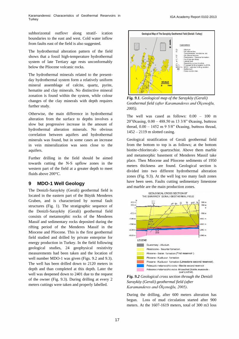
The Denizli-Sarayköy (Gerali) geothermal field is
located in the eastern part of the Büyük Menderes
Graben, and is characterized by normal fault
structures (Fig. 1). The stratigraphic sequence of
the Denizli-Sarayköy (Gerali) geothermal field
consists of metamorphic rocks of the Menderes
Massif and sedimentary rocks deposited during the
rifting period of the Menderes Massif in the
Miocene and Pliocene. This is the first geothermal
field studied and drilled by private enterprise for
energy production in Turkey. In the field following
geological studies, 24 geophysical resistivity
measurements had been taken and the location of
well number MDO-1 was given (Figs. 9.2 and 9.3).
The well has been drilled down to 2120 meters in
depth and than completed at this depth. Later the
well was deepened down to 2401 due to the request
of the owner (Fig. 9.3). During drilling at every 2
meters cuttings were taken and properly labelled.
Fig. 9.1. Geological map of the Sarayköy (Gerali)
Geothermal field (after Karamanderes and Ölçenoğlu,
2005).
The well was cased as follows: 0.00 – 100 m
20”Øcasing, 0.00 – 488.50 m 1 /8” Øcasing, buttress
thread, 0.00 – 1452 m 9 5/8” Øcasing, buttress thread,
1452 – 2119 m slotted casing.
Geological stratification of Gerali geothermal field
from the bottom to top is as follows; at the bottom
biotite-chloritecalc- quartzschist. Above them marble
and metamorphic basement of Menderes Massif take
place. Then Miocene and Pliocene sediments of 1950
meters thickness are found. Geological section is
divided into two different hydrothermal alteration
zones (Fig. 9.3). At the well log too many fault zones
have been seen. Faults cutting sedimentary limestone
and marble are the main production zones.
Fig. 9.2 Geological cross section through the Denizli
Sarayköy (Gerali) geothermal field (after
Karamanderes and Ölçenoğlu, 2005).
During the drilling, after 600 meters alteration has
begun. Loss of mud circulation started after 900
meters. At the 1607-1619 meters, total of 300 m3 loss

Karamanderesi: Characeristics of Geothermal Reservoirs in Turkey
IGA Academy Report 0102-2013
18
of mud circulation has occurred. After this level,
the drilling has been continued; partial loss and
alteration have been inspected continuously.
After the well completion tests, 1250C bottom hole
temperature was measured by Amerada temp
gauge. Production of the well was determined at 50
lt/sec. At productions test deposition of CaCO3
scalling was seen from the surface down to 120
meters in depth (Karamanderesi and Ölçenoğlu,
2005).
9.1 Borehole geology
MDO-1 Borehole geology, has been studied in
location by both binocular microscope and
examination of handspecimens analyses. In the
deeper sections, microscopic and X-ray diffractive
analyses have been done. The results are as follows;
00-60.00 m Layered with uncemented old terrace
deposits, slope debris, and alluvium fans materials
as in sandstones pebble, clay, silt etc. In the bottom
section up to ten meters there is an aquifer (Fig.
9.3).
Fig. 9.3. Well log of the MDO-1 well (after
Karamanderesi and Ölçenoğlu, 2005).
60.00-814.00 m Zone is covered with grey clay.
The samples from this zone have been analysed by
X-ray difractometer at the University of Dokuz
Eylül in İzmir. The results showed 2-3 % dolomite,
3-4% feldspar, 7-8% calcite, 8-10 % Quartz and the
rest is mainly illite. Hydrothermal alteration zone is
illite zone. 584-588 m To 692-698 m various coloured
clay, heavy pyrite and as a secondary mineral,
pyrrhotite have been detected. Additionally, remains of
plant, organic materials, pyrite, calcite, and very small
amount of silica have been seen at 798-799 m level.
The samples from the level of 806-810 meters showed;
gray clay, siltstone and the traces of heavy micro
crystalline pyrite, chalcopyrite, secondary calcite and
quartz (Fig. 9.3).
814.00- 1143 m Sazak formation. Light brown and
milky brown limestone have been detected by the
microscopic analyses. In addition to sparry calcite,
heavily fossiliferous ostracoda, vesicular limestone
have been detected. The limestone veins contained
secondary calcite and quartz as well. Between 878-896
meters, secondary silica and calcite as well as traces of
manganese have been detected, under the microscope
(Fig. 9.3).
The first loss of mud circulation has been detected at
901 m totalling 3 m3. Between 984-992 meters, the
loss of mud circulation was 5 m3. Later on between
1002-1010 meters, the loss of mud circulation was
measured as 16.13 m3. Additionally, between 1080-
1082 meters the loss of mud circulation was measured
as 7 m3. At the level of 1110-1112m, the loss of mud
circulation was measured as 5 m3 (Fig. 9. 3).
Below the 1143-m level, change in colour and
formation as well as kaolinization was observed. Eight
fault zones were discovered in the MDO-1 well.
1143-1607 m Kızılburun formation was clearly
defined. Kızılburun formation consists of coarse or fine
grained, wellcemented sandstone, clay and
conglomerate layers. Secondary pyrite, calcite, quartz
and clay matter can be seen in the conglomerate and
sandstone layers. Scattered gren layers appear to be
relict that resulted after the chlorization.
The cuttings from 1181-1184 m layer show the
slickenside, clay and heavy pyrite remnants. Between
1205-1212 meters, second fault line has been
discovered. The maroon clay and sandstone layers are
mylonitic in nature. The third zone was discovered in
between 1243-1245 meters. Between 1267-1268
meters, 8-m3 loss of circulation in mud has been
measured. The same fault zone appeared up to 1278
meters. The fourth faulting zone in between 1375-1376
meters. The casing (9 5/8ӯ) has been set at 1452 m
and than cemented. Heavy faulting, interbedded clay,
siltstone and sandstone (Fig. 9.3) have stratified 1538-
1566 meters.

Karamanderesi: Characeristics of Geothermal Reservoirs in Turkey
IGA Academy Report 0102-2013
19
1607-1950-m The most important latest discovery
was the limestone stratification in between 1607-
1950 meters in the Kızılburun formation.
Phenomenally, in the Buldan Horst, this limestone
has situated itself as outcrop on top of Menderes
Massif metamorphic-schist. These limestone layers
contained fossils, ferrous oxide, sferolitic silica,
recrystallized limestone, calcium carbonate
cemented sandstone, siltstone, fragments of
volcanic rock, tuffite, quartzite, opaque rock,
smoky quartz and feldspar.
1613 to 1617 meter zone appeared to be the main
fault zone. The mud completely disappeared at
1615 m. The total loss of mud circulation was
measured as 300 m3. As a result 1607-1617-m zone
have been temporarily cemented. Remnants of the
fault was discovered at 1644-1668 m level.
At the 1712-1766 m level, maroon clay fault lines,
secondary quartz veins and calcite fragments can be
seen in the Kızılburun Formation. The loss of mud
circulation was very low (3.5 m3 at 1732-1758 m
and 4.5m3 at 1758-1766 m in (fig. 9.3).
Petrographic analysis of 1774-1780 m cuttings: The
main material samples from this level contained,
limestone fragments, sparritic, micritic and mosaic
patterned quartzite. Traces of muscovite and
amphibole were noticed as well. In addition; chert
fragmented metamorphic rocks, quartz-micaschist,
quartzite-schist, quartz-calc schist which coloured
by ferrous-oxide have been detected in the study
microscope. In the microscopic study, quartz (mono
crystalline/Polly crystalline), biotite and muscovite
have been detected. The biotite must have been
coloured green as a result of chloritization.
Petrographic analysis of 1834-1836 m cuttings from
this level contain; micritic limestone fragments,
chloritization, silicified ferrous oxide fragments,
slate, schist, quartzite, quartz, feldspar, garnet and
opaque minerals. In the cuttings from 1862-1900 m
strata; calcite, dolomite, quartz, feldspar, muscovite
and kaolinite have been detected by the X-ray
diffraction analysis.
As a result, at the end of the drilling operation at
Kızılburun Formation, seven fault zones have been
discovered (Fig. 9.3).
Menderes Massif metamorphics have been studied
in two separated zones as follows;
Zone 1 : 1950-2050 m Marble zone,
Zone 2: 2050-2401 m Mica schist zone (İğdecik
formation, “Şimşek, 1985a, b”).
At the 1950-2036 m strata, milky white marble have
been confirmed as the top level. Additional studies
with the X-Ray diffractometer have resulted in
minerals such as calcite, dolomite, quartz, possible
various alkali feldspar (albite), muscovite and
kaolinite. Various thin section samples have shown
mica-quartz schist, quartz-mica-calc schist, quartzite,
and silicified rock fragments as well as carbonitized
rock pieces. The X-ray diffractometer analysis have
confirmed the same results as above.
At the 2036-2050 m different mineral composition
have been noticed. The X-ray diffraction studies have
discovered calcite, dolomite, quartz, feldspar, chlorite,
simectite (montmorillonite), mixed clay (possibly
mica-simectite), amphibole (hornblende), muscovite
and kaolinite respectively.
The 2050-2401 m Zone 2. 2050-2041 m mica schist
zone (İğdecik formation. “Şimşek, 1985a”). These zone
cuttings contained quartz-mica-calc-schist, quartz-calc
schist, micaquartz-schist, quartzite, mica-quartz-schist,
mica-schist, and very small amount of epidote schist.
The mineral compositions of the cuttings have been
discovered as quartz, mica (muscovite/biotite), chlorite,
simectite (montmorillonite) and kaolinite. This is the
second alteration zone discovered in the drilling
operation.
Even though there has not been any surface
manifestation, the correlation between the geophysical
data and geological survey, Sarayköy (Gerali)
geothermal field has been discovered as the newest
geothermal area in the Denizli Basin.
The exact location has been discovered to be the center
of Sarayköy town. It spreads toward Babadag in the
direction of N-S.
During drilling, two reservoirs have been discovered.
The first one has been drilled at 814-1143 meters and
the second one at 1650-2050 meters. In the first
reservoir, the temperature was measured as 96-1000C
degrees. The Sazak limestone formation has been
found to be the main rock formation.
The second (Main) reservoir has been measured at
1250C degrees maximum. Kızılburun formation (Sand
stone and Limestone) and Menderes Massif marbles
have been drilled.
In the conclusion, the first reservoir is stated to be the
limestones of Sazak Fm. and the second reservoir to be
the Kzılburun Fm. and the Menderes Massif

Karamanderesi: Characeristics of Geothermal Reservoirs in Turkey
IGA Academy Report 0102-2013
20
metamorphics. This statement is in conformity with
those in Fig. 9.2. In Fig. 9.3, however, the first
reservoir is shown as the limestones of Kızılburun
Formation.
The field has been measured approximately for.3
sq. Km. Two mineral alteration zones have
separated the two reservoirs.
10 Afyon Sandıklı geothermal field
The Afyon-Sandıklı region lies along the western
part of the Taurus mountain range of Turkey. The
Afyon zone is lowgrade metamorphic terrain lying
from the Menderes Masif on the west towards the
Uşak-Sandıklı (Afyon) on the east (Özgül 1976). In
the Sandıklı region, Paleozoic, Mesozoic and
Tertiary units are observed (Fig. 10.1) (Gündoğan
et al.2010).
The study area is located in the Sandıklı region at
40 km SW of the Afyon (Fig. 1). As related to the
neo-tectonism and active volcanism of western
Anatolia, a widespread and intense hydrothermal
alteration and geothermal system has developed in the
study area. Mutlu and Güleç (1998) were studied on
the chemical compositions of thermal waters in
Turkey. According to the authors, the hot springs are
all aligned along the faults bordering the major grabens
in western Anatolia. The reservoir rocks of the region
are pre-Mesozoic metamorphics (marbles, gneisses and
quartzites) of the Menderes Massifs, Mesozoic
limestones, and the Neogene volcanosedimentary units
(Tolluoğlu et al., 1997). The distribution of hot springs
in the Sandıklı (Afyon) region roughly parallels to the
fault system that caused intense porphyry-type
hydrothermal alteration at 4.5 km NE of the
Karacaören village (Sandıklı) (Fig. 1) (Gündoğan et al.,
2009). Miocene volcanism, around the Sandıklı region,
formed different products at wide ranges, and alkaline,
calcalkaline lavas such as trachyte, andesite,
trachyandesite (latite), latite basalt, phonolite and
tephrite, tuffs and ignimbrites have formed during
Middle-Upper Miocene at different stages.
Hydrothermal alteration is very common in these
volcanic products.
Fig. 10.1. Simplified geological map of the Sandıklı area (compiled after Gündoğan, et al.,2010
In the Sandıklı region, hydrothermal alteration of
the volcanic rocks is commonly observed from the
Hüdai thermal springs towards east and northeast of
present geothermal system.
Samples from two wells were kindly made
available for this study, namely from AFS-12 and
AFS-13 drilled to depths ranging from 450 to
500m.
The wells were located in a major fault controlled
porphyry hydrothermal system (hydrothermal
upflow zone). A widespread and intense porphyry-
type hydrothermal alteration zone has developed in the
Neogene Sandıklı volcanics at 4.5 km NE of the
Karacaören village, as a result of the intrusion of
syenite-monzonite porphyries. From distal zone to the
intrusion center, propylitic (epidote, chlorite, carbonate
minerals, albite, K-feldspar), argillic (alunitization,
illitization), phyllic (sericitic; quartz, sericite, pyrite)
and potassic (alkali metasomatic; K-feldspar and
biotite) developed, respectively, under wide range of
pH and Eh conditions.
The reservoir is hosted by interbedded pyroclastic and
lavas of trachyandesite composition with some basaltic

Karamanderesi: Characeristics of Geothermal Reservoirs in Turkey
IGA Academy Report 0102-2013
21
andesites and trachytic tuffs. The primary minerals
present in the Sandıklı subsurface rock samples are
mainly sanidine, pyroxene, biotite, plagioclase,
nosean and apatite. In general, carbonatization and
chloritization are common in the matrix and
pyroxene phenocrysts of the trachytic rocks.
On mineralogic (XRF, SEM-EDS) and petrographic
investigations on the wells at 50-60 m,
silicification, and chalcedony and hematite
formation are common. In the SEM-EDS studies,
0.75 – 1.25 % Ag was measured from the
hydrothermal quartz. At deeper levels, abundance
of hematite and pyrite with marcasite and sericite
increase due to the hydrothermal alteration. At 110-
180 m levels, euhedral Fe-Ti oxide minerals
(hematite-Fe2O3 or titanomagnetite-Fe2.5Ti0.5O4,
including Ti) are observed. However, primary
apatites and titanomagnetite minerals associated
with sanidine and euhedral pyroxene (augite) occur
within the trachyandesite. In the SEM study, it is
observed that the surfaces of the apatites were
rounded and decomposed, due to the intense
hydrothermal alteration. At 350-400 m levels,
depends on hydrothermal alteration, euhedral pyrite
crystals were formed within the dolomitic
limestones (the Çaltepe formation is not observed
on surface). Within this pyrite which replaced the
dolomite and at the boundary of dolomite-pyrite,
euhedral gypsum minerals were formed. At deeper
levels, in sandstone alternating with dolomitic
limestone, epidotization is common.
10.1 Subsurface Geology
Hüdai geothermal system is an area of out-flow
zone in the Sandıklı (Afyon) region. In ancient
times, Hüdai hot springs were a geothermal area
that its flowrate was totally 100 L/s. In previous
studies indicated that there were several natural
springs in the Sandıklı geothermal area (e.g. Çağlar,
1950; Ronner, 1962). Çağlar (1950), Ronner (1962)
have also reported that the thermal water
temperatures as 65-69 ºC and 85 ºC, respectively. In
study of MTA by Akkuş et al. (2005) from old
wells measured thermal water temperatures and
flow rates are 45-70 ºC and 112 L/s, respectively. In
this study, thermal water temperatures and flow rate
from the wells AFS-12 and AFS-13 measured 80.6-
78ºC and 75-80 L/s, respectively. Although scaling
is common in the wells near the Hüdaihamami
(Sandıklı) in the wells AFS-12 and AFS-13, scaling
occurs (Fig. 10.2).
Mutlu and Güleç (1998) reported that the temperature
of the spring waters reaches up to 100 ºC in western
Anatolia. The waters are weakly acidic to alkaline with
pH values ranging from 6.10 to 9.61, and have TDS
contents between 550 and 54884 ppm.
Fig. 10.2. Thermal water pipe line scaling in Afyon
Sandıklı Hüdai hot springs from hot water production
well (after Gündoğan et al., 2010)
The majority of waters are either Na-HCO3 or Na-Cl in
nature, although SO4-type waters are also present. The
chloride-rich waters are characteristic for the coastal
areas (Çeşme, Seferihisar, Doğanbey-İzmir; Kestanbol,
Tuzla-Çanakkale; Köyceğiz-Muğla) and their
compositions suggest a possible seawater intrusion into
the reservoir (Vengosh et al., 2002; Tarcan and Gemici,
2003). It is important to note at this stage that some of
waters from the inland areas, such as Balıkesir and
Afyon, also have Na-Cl nature which cannot be
attributed to seawater intrusion but probably results
from the involvement of connate fosil waters (Mutlu
and Güleç, 1998).
The major lithologies in the studied wells (AFS-12 and
13) are alluvium, Quaternary sediments, epiclastic
volcanoclastics and lava flows and basement rocks, and
the subsurface sequences are similar in the wells.
Well AFS-12 was drilled down to 550 m (UTM
coordinates x=4258911, y=257191, z=1020 m). The
lithologies in the well from surface to depth are
alluvium (10 m), Quaternary sediments (40 m),
epiclastic-volcanoclastics and lava flows belong to the
Neogene Sandıklı Formation-Pliocene Hamamçay unit
(220 m) and basement rocks Geyikdağı Otoctone) (280
m), respectively.
Well AFS-13 was drilled down to 422 m (UTM
coordinates x=4259211, y=257591, z=1020 m).
Similarly, the lithologies in the well from surface to
depth are alluvium (10 m), Quaternary sediments (33
m), epiclastic-volcanoclastics and lava flows belong to
the Neogene Sandıklı formation-Pliocene Hamamçay

Karamanderesi: Characeristics of Geothermal Reservoirs in Turkey
IGA Academy Report 0102-2013
22
unit (200 m) and Paleozoic Sandıklı group
basement rocks (142 m), respectively (after
Gündoğan et al., 2010).
10.2 Hydrothermal alteration
On mineralogic-petrographic investigations on the
well AFS-12, volcanic and volcanoclastic rocks
observed at 50-270 m, are commonly
trachyandesite in composition (Fig. 10.3).
Fig. 10. 3. Photomicrographs showing the
lithological facies of the well AFS-12 from surface
to depth (after Gündoğan et al., 2010).
Rarely, the clasts, derived from lamproitic rocks,
were obtained in the volcanoclastics. Xenolith
inclusions rich in mafic minerals, are common in
trachyandesites. In some of volcanic clasts, nosean
and apatite as an accessory mineral are observed.
At 120-135 meters, because of alteration of
euhedral leucites, cavities had developed in rock
clasts belong to leucitites. At 200-270 meters, a
series that consists of interbedded pyroclastic,
epiclactic rocks and trachyandesitic lava flow, were
determined. Carbonatization and chloritization are
common in matrix and pyroxene pheoncrysts of
trachytic rocks (Fig. 10.4). At 270-550 meters, the
units belong to the Sandıklı basement rocks
(Derealanı Formation, Seydişehir Formation,
Çaltepe Formation and Hüdai quartzite) are
observed. The Derealanı Formation consists of
interbedded siltstone-mudstone. Euhedral pyrite
minerals are common in this formation. In the
Seydişehir Formation that consists of interbedded
mudstone-siltstone alternating with dolomite-dolomitic
limestone, fossil shells are observed. Hematite- and
pyrite bearing ore formation is common in dolomitic
limestone unit. In cements of the Hüdai quartzite,
consisting of interbedded siltstone and sandstone
including quartz, sericitization is commonly observed.
In the well AFS-12, hematite- and pyrite-bearing ore
formations increase from surface to depth.
Fig. 10.4. Photomicrograph showing pyroxene
minerals in trachyandesite replaced by calcite related
to the hydrothermal alteration (Pseudomorphic calcite
minerals)(after Gündoğan et al., 2010).
On mineralogic-petrographic investigations on the well
AFS-13, silisification and formation of chalcedony,
hematite and pyrite minerals are observed between 50
and 60 meters (Fig. 10.5). Chalcedony replaces the
sanidine minerals (Gündoğan, et al., 2010).
In deeper levels, abundance of hematite and pyrite
increase due to the hydrothermal alteration. At 110-180
m levels, euhedral However, primary apatites and
titanomagnetite minerals associated with sanidine and
euhedral pyroxene (augite) occur within the
trachyandesite. Because of hydrothermal alteration, the
surfaces of the apatites were rounded and decomposed
(Fig. 10.6).

Karamanderesi: Characeristics of Geothermal Reservoirs in Turkey
IGA Academy Report 0102-2013
23
Fig. 10.5. Photomicrograph showing sanidine
mineral in trachyandesite replaced by chalcedony
and pyrite related to hydrothermal alteration (after
Gündoğan et al., 2010).
Fig. 10.6. Backscattered-SEM image showing
euhedral apatite crystal [Ca5(PO4)3(OH,F,Cl)]
within the trachyandesitic rock fragment from the
well AFS-13 at 185 m level. Because of the
hydrothermal alteration, the surfaces of the apatite
were rounded (after Gündoğan et al., 2010).
Fe-Ti oxide minerals (hematite-Fe2O3 or
titanomagnetite-Fe2.5Ti0.5O4, including Ti) are
observed (Fig. 10.7).
At 405 m level, due to the hydrothermal alteration,
euhedral pyrite crystals were formed within the
dolomitic limestones (called the Çaltepe formation,
not observed on surface). Euhedral gypsum
minerals were obtained within the pyrite which
replaced the dolomite, and at the boundary of
dolomite and pyrite minerals (Figs. 10.8, 10.9 and
10.10).
Fig. 10. 7. Backscattered-SEM image showing
euhedral Fe-Ti oxide titanomagnetite (Fe2,5Ti0,5O4) or
Ti-bearing hematite (Fe2O3) minerals within the
trachyandesitic rock fragment (chips) from the well
AFS-13 at 110 m level. (A) and EDS analyses (B)
(after Gündoğan et al., 2010).
The anhedral pyrites which replaced dolomite in
dolomitic limestone, have Ag, Te, and As (< 1%), and
Nb (3-4%) anomalies (Fig. 11). Measured Ag values
for euhedral secondary (epigenetic) quartz minerals,
formed due to the hydrothermal alteration, range from
0.75% to 1.25% (Fig. 10.12). Zeolite (amisite?) and
Mg-calcite minerals were also obtained in this
dolomitic limestone. EDS analyses of these two
minerals give Nb (>5%), Te (1.5-6%) and Ag (0.4-1%)
anomalies.
A widespread and intense hydrothermal alteration
zones and geothermal systems have developed in the
Sandıklı (Afyon) region. In the study area which
geothermal system is observed, Miocene age volcanism
formed different products at wide ranges, and alkalen-
calc alkalen lavas such as trachyte, andesite,
trachyandesite (latite), latite basalt, phonolite and
tephrite, tuffs and ignimbrites have formed during
middle-upper Miocene at different stages. The hot
springs of the Sandıklı region are located along the
fault system that caused intense porphyry-type
Chalsedony
Sanidine
Pyrite
Pyrite
B
B
A
Apatite

Karamanderesi: Characeristics of Geothermal Reservoirs in Turkey
IGA Academy Report 0102-2013
24
hydrothermal lateration and mineralization at 4.5
km NE of the Karacaören village (Sandıklı).
Fig. 10.8. Backscattered SEM images showing
euhedral gypsium minerals formed at the boundary
of dolomite and pyrite minerals from the well AFS-
13 at 405 m level (after Gündoğan et al., 2010).
Fig. 10.9. Photomicrograph showing dolomite
minerals, replaced by pyrite related to the
hydrothermal alteration (after Gündoğan, et al.,
2010).
The major lithologies of the wells AFS-12 and 13
are alluvium, Quaternary sediments, epiclastic-
volcanoclastics and lava flows and basement rocks.
The primary minerals present in the Sandıklı
subsurface rock samples are mainly sanidine,
pyroxene, biotite, plagioclase, nosean and apatite.
In general, carbonatization and chloritization are
common in the matrix and pyroxene phenocrystals
of the tracytic rocks. On mineralogic-petrographic
investigations on the wells, silisification, and
calcedony and hematite formation are common near
surface.
Fig. 10. 10. (A) Backscattered-SEM image showing
euhedral gypsum minerals formed by replacement of
pyrite at the boundary of dolomite and pyrite minerals
within the dolomitic limestone (Çaltepe Formation)
from the well AFS-13 at 405 m level due to the
hydrothermal alteration, (B) EDS analyses of gypsum
which replaced dolomite, (C) EDS analyses of
euhedral dolomite (after Gündoğan, et al., 2010).
Abundance of hematite and pyrite with marcasite and
sericite increase due to the hydrothermal alteration
from surface to depths. Primary apatites and
titanomagnetite minerals associated with sanidine and
euhedral pyroxene (augite) occur within the
trachyandesite at deeper levels.

Karamanderesi: Characeristics of Geothermal Reservoirs in Turkey
IGA Academy Report 0102-2013
25
Fig. 10.11. Backscattered-SEM image showing
euhedral secondary (epigenetic) quartz formed
within the dolomitic limestone (Çaltepe formation),
related to the hydrothermal alteration from the well
AFS-13 at 410 m level (A) and EDS analyses (B).
Measured Ag values for quartz range from 0.75%
to 1.25%(Gündoğan, et al., 2010).
The hydrothermal mineral paragenesis suggests that
there were several mineralizing episodes, and this
geothermal system must be considered with the
porphyry-type hydrothermal alteration and
mineralization at 4.5 km NE of the Karacaören
village (Sandıklı). The Sandıklı geothermal field is
one of good example for the type of reservoirs
related to faulting in the porphry systems.
Figure 10.12. Backscattered-SEM image showing
euhedral secondary (epigenetic) quartz formed within
the dolomitic limestone (Çaltepe formation), related to
the hydrothermal alteration from the well AFS-13 at
410 m level (A) and EDS analyses (B). Measured Ag
values for quartz range from 0.75% to
1.25%.(Gündoğan, et al., 2010).
ACKNOWLEDGEMENTS
I gratefully extend my thanks to employers, the
Mineral Research and Exploration General Directorate,
for their recommendation and granting leave of
absence during my training and working period in the
company.
I am also greatly indebted to Prof. Dr. Cahit Helvacı,
for his great advice and help towards my understanding
of borehole geology and for his careful reading and
constructive criticism of this repor.
My thanks also extends to Ezgi Yürük and Onur Melih
Kasimoğlu for their drawing the figures. Also my
thanks goes to Ali Kındap and his Company for his
permition of using the data of Alkan-1 well logging.
Sandıklı Project was supported by TÜBİTAK
(Scientific and Technological Research Concil of
Turkey) with the Project Nr:106Y153.

Karamanderesi: Characeristics of Geothermal Reservoirs in Turkey
IGA Academy Report 0102-2013
26
REFERENCES
Akartuna, M., 1965. Aydın-Nazilli hattı kuzey
versanalrı jeolojisi hakkında (About the geology of
Aydın-Nazilli region). General Directorate of
Mineral Research and Exploration (MTA) Bulletin
65. 1-10 (in Turkish with English abstract).
Akkuş, I., Akilli, H., Ceyhan, S., and Dilemre, A.,
2005. Türkiye Jeotermal Kaynaklar Envanteri.
MTA Yayini. Envanter serisi, 201, 849 p. Ankara.
Angelier, J., Dumont, J. F., Karamanderesi, I. H.,
Poisson, A., Şimsek, Ş., and Uysal, Ş.,1981.
Analyses of fault mechanisms and expansion of
South-western Anatolia since the Late Miocene.
Tectonophysics. 75 T1-T9.
Boles, J. R. 1977. Zeolite in low-grade
metamorphic grades. Mineralogy and geology of
natural zeolites. In: Mumpton, F.A. (ed),
Mineralogical Society of America Short Course
Notes 4, 103-135.
Borsi, S., G. Ferrara., F. Innocenti and R.
Mazzuoli., 1972, Geochronology and Petrology of
Recent Volcanics in the Eastern Aegen Sea. (West
Anatolia and Lesvos Island) Bull. Volcanol., 36, p
473-496.
Bozkurt, E. and Park, R.G. 1994. Southern
Menderes Massif—an incipient metamorphic core
complex in western Anatolia, Turkey. Journal of
the Geological Society, London, 151, 213–216.
Bozkurt, E. 2004. Granitoid rocks of the southern
Menderes Massif (southwestern Turkey): field
evidence for Tertiary magmatism in an extensional
shear zone. International Journal of Earth Science,
93, 52–71.
Bozkurt, E. and Sözbilir, H. 2004. Tectonic
evolution of the Gediz graben: field evidence for an
episodic, two-stage extension in western Turkey.
Geological Magazine, 141, 63–79.
Browne, P. R. L., 1984, Lectures on geothermal
energy and petrology UNU Geothermal Training
Programme, Report no. 1984-2, Iceland. 92 p.
Candan, O., Dora, O.Ö., Kun, N., Akal, C., and
Koralay, E.,1992. Aydın Dağları (Menderes Masifi)
Güney kesimindeki allokton metamorfik birimler.
TPJD Bülteni. Cilt.4, Sayı: 1 Sahife: 9 -110.
Çağlar, K. Ö.,1950. Türkiye Maden Sulari ve
Kaplicalari. Fasikül.3. MTA Genel Müdürlügü
yayini, 11, 499–509.
Çağlar, K.Ö. 1961. Türkiye maden suları ve kaplıcaları
MTA Enstitüsü Yayını. No:107, Fasikül. l4, Ankara.
Collins, A. S. and Robertson, A. H. F. 2003. Kinematic
evidence for late Mesozoic–Miocene emplacement of
the Lycian Allochthon over the Western Anatolia Belt,
SW Turkey. Geolological Journal, 38, 1–16.
Çetiner, L., 1999. The hydrogeological study of the
Kızıldere (Denizli) geothermal field for reinjection
purposes. Ph thesis. Dokuz Eylül University. P:154,
İzmir.
Demirel, Z. and Şentürk, N., 1996. Geology and
hydrogeology of deep thermal aquifers in Turkey. In:
Al-Beiruti S.N. and Bino M.J. (eds.) Integration of
information between oil drilling and hydrogeology of
deep aquifers, The Inter-Islamic Network of Water
Resources Development and Management, Royal
Scientific Society Printing Press, Amman, Jordan.
Dewey, J. F. and Şengör, A. M. C., 1979. Aegean and
surrounding regions: complex multiplate and
continuance tectonics in convergent zone. Geological
society of America Bulletin, 90, 84-92.
Dixon, C. J., and Pereira, J. ,1974. Plate tectonics and
mineralization in the Tethyan Region: Mineral.
Deposita.9, 185-198.
Dora, O. Ö., Candan, O., Dürr, St., and
Oberhanslı.,1995. New evidence concerning the
geotectonic evolution of the Menderes Massif. IESCA
- 1995 Abstracts. 13-14.
Dumont, J. F., Uysal, Ş., Karamanderesi, İ. H., and
Letozey, J., 1979. Formation of the grabens in South-
western Anatolia. Bull. of the Mineral Research and
Exploration Institute of Turkey. No:92, pp:7-18.
Ercan, T. and A. Turkecan, 1984. A General revision
of the plutons in western Anatolia, Aegean Island,
Greece and Bulgaria. Ketin Symposium. Geological
Society of Turkey. P.189 - 208. Ankara (Turkish).
Ercan, T., Satır, M., Kreuzer, H., Türkecan. A., Güney,
E., Çevikbaş, A., Ateş, M., Can, B., 1985., Batı
Anadolu Senozoyik Volkanitlerine ait yeni kimyasal,
İzotopik ve radyometrik verilerin yorumu: Geol. Soc.
Turkey Bull. 28/2, 121-136.
Ercan, T., Ölmez, E., Matsudo, I. Wagao, K., Kıta, I.,
1994. Kuzey ve Batı Anadolu’da sıcak ve mineralize
sular ile içerdikleri gazların kimyasal ve izotopik
degerleri. Turkiye Enerji Bulteni. Cilt: 1. Sayı: 2.
TMMOB Jeoloji Muh. Odası yayını. 20–21.
Ercan, T., Satır, M. Sevin, D., Türkecan. A.,1997. Batı
Anadolu’daki Tersiyer ve Kuvaterner yaşlı volkanik

Karamanderesi: Characeristics of Geothermal Reservoirs in Turkey
IGA Academy Report 0102-2013
27
kayaçlarda yeni yapılan radyometrik yaş
ölçümlerinin yorumu. MTA Dergisi. Sayı:119.
Sayfa:103-112.
ENEL, 1989. Optimızation and Development of
the Kızıldere Geothermal Field. Final Report.
ENEL Ente Nazionale per l’Energia Electrica
Unita Nazionale Geotermica. Piza, Italy, June
1989.
Filiz, Ş.,1984. Investigation of the important
geothermal areas by using C, H, O, isotopes.
Seminar on the utilization of Geothermal Energy
for Electric Power Generation and Space Heating,
14–17 May 1984, Florance, Italy. Seminar ref. No:
EP/SEM. 9/R.3.
Fridleifsson, G.O.,1983a. The Geology and the
Alteration History of the Geitafell Central Volcano,
Southeast Iceland. Ph. D. Thesis, Grant Institute of
Geology, University of Edinburgh, 371 p.
Fridleifsson, G.O,, 1983b. Mineralogical evolution
of a hydrothermal system. GRC. Trans. Vol. 7. P.
147 – 152.
Fytikas, M., 0. Giuliani., F.Innocenti., G. Marinelli
and R. Mazzuoli.,1976, Geochronological data on
Recent magmatism of the Aegean Sea:
Tectonophysics, 31, T 29- T 34.
Gevrek, A. I. and M. Şener, 1984. The
determination of hydrothermal alteration zones by
clay minerals in Çanakkale - Tuzla area. 2 nd
Turkish National clay symposium. 24 - 27
september 1985. Hacettepe University. Ankara
(Turkish).
Gevrek, A. İ., Karamanderesi, İ. H., Aydın, Ş. N.,
1989. Clay mineralogy and hydrothermal alteration
studies on Aydın-Germencik geothermal wells.
Bildiriler kitabı. Pp:11 -121. IV. Ulusal Kil
Sempozyunu, 20-23 Eylül 1989.
Giggenbach, W.F. 1986. Graphical techniques for
the evaluation of water/rock equlibration conditions
by use of Na, K, Mg and Ca- contents of discharge
waters. Proceedings of the 8th Geothecnical
Workshop, Auckland, New Zealand, 37-44.
Gökgöz, A., 1998. Geochemistry of the Kızıldere-
Tekkehamam-Buldan-Pamukkale geothermal
fields, Turkey. In: Georgsson, L. S. (ed.).
Geothermal Training in Iceland 1998, United
Nations University Geothermal Training
Programme, Reykjavik, Iceland, 115-156.
Görür, N., Şengör, A.M.C., Sakınç, M., Tüysüz, O.,
Akkök, R., Yiğitbaş, E., Oktay, F.Y., Barka, A.A.,
Sarıca, N., Ecevitoğlu, B., Demirbağ, E., Ersoy, Ş.,
Algan, O., Güneysu, C., Akyol, A., 1995. Rift
formation in the Gökova region, southwest Anatolia:
implications for the opening of the Aegean Sea, Geol.
Mag. 132. 637-650.
Gülay, O. 1988. Aydın-Nazilli Yöresi Jeofizik Gravite
Etüdleri [Geophysical Investigation (Gravity
Measurements) of Aydın-Nazilli Region]. General
Directorate of Mineral Research and Exploration
(MTA) Report No. 8322 [in Turkish, unpublished].
Gündogan, I., Yücel-Oztürk, Y., Helvaci, C.,
Karamanderesi, I. H., and Güngor, T., 2009.
Karacaoren (Sandıklı-Afyon) siyenit-monzonit
porfirine baglı gelisen hidrotermal alterasyonların
mineralojisi ve petrografisi, Abstarcts, 62.Türkiye
Jeoloji Kurultayı, 232-233, Ankara.
Henley, R. W. and Ellis, A. J. 1983. Geothermal
systems, ancient and modern: a geochemical review.
Earth Science Reviews 19, 1-50.
Işık, V., Tekeli, O. and Seyitoğlu, G. 2004. The
40Ar/39Ar age of extensional ductile deformation and
granitoid intrusion in the northern Menderes core
complex: implications for the initiation of extensional
tectonics in Western Turkey. Journal of Asian Earth
Sciences, 23, 555–566.
Karamanderesi, İ. H., 1972. Aydın-Nazilli Çubukdağ
arası bölgenin jeolojisi ve jeotermal enerji potansiyeli
(Geology of the Aydın-Nazilli Çubukdağ area and
geothermal energy potantial). General Directorate of
Mineral Research and Exploration (MTA) Report
No:5224 (in Turkish, unpublished).
Karamanderesi, I.H. and T. Öngür.,1974, The report of
gradient wells finished of Tuzla (Çanakkale)
geothermal field. MTA, Rap. No. 5524, Ankara,
(Turkish). Unpublished. 50 p.
Karamanderesi, İ. H., Eşder, T., Yılmazer, S., Güner,
A., 1982. Aydın-Germencik jeotermal sahası
Ömerbeyli-1-2- derin jeotermal sondajı kuyu jeolojisi
bitirme raporu. MTA Derleme rapor no:7746.
Karamanderesi, İ. H., 1986. Hydrothermal alteration in
well Tuzla-2, Çanakkale, Turkey. UNU Geothermal
Training Program. Report, 3 pp.36
Karamanderesi, İ. H., Yakabağı, A., Çiçekli, K., Üstün,
Z., Çağlav, F.,1987. Aydın-Sultanhisar-Salavatlı
jeotermal sahası AS-1 ve AS-2 kuyularının bölgesel
değerlendirme raporu. MTA Derleme rapor no: 9956.

Karamanderesi: Characeristics of Geothermal Reservoirs in Turkey
IGA Academy Report 0102-2013
28
Karamanderesi, İ. H., and Özgüler, M.E., 1988a.
Menderes ve Gediz graben sahalarında jeotermal
enerji alanlarının oluşum mekanizması. Akdeniz
Üniversitesi Isparta Mühendislik Fakültesi Dergisi.
4, 196-228. (in Turkish, with English abstract).
Karamanderesi, İ. H., Özgüler, M. E., Çiçekli, K.,
Üstün, Z., Yakabağı, A., Çağlav, F., 1988b. The
modelling studies of Aydın-Salavatlı geothermal
field by hydrothermal alteration Periods, UN
Seminar on New Development in Geothermal
Energy, EP/SEM.14/R. 11, Ankara, Turkey.
Karamanderesi, İ. H., 1997. Geology of and
Hydrothermal Alteration Proses of the Salavatlı-
Aydın Geothermal field. PHD Thesis. Dokuz Eylül
Üniversity Graduate School of Natural and Applied
Sciences. İzmir, Turkey (unpublished).
Karamanderesi, İ. H., 1999. Kuyu Jeolojisi ve
alterasyon mineralojisi. 2000’li yıllarda jeotermal
enerji yaz okulu. JENARUM Eğitim Dizisi No:1.
(Editörler: Savaşçın, M.Y., Drahor, M.G.,
Kumlutaş, D.) Sayfa: 1 7-152.
Karamanderesi, İ. H., and Helvacı, C., 200 .
Geology and hydrothermal alteration of the Aydın-
Salavatlı Geothermal Field, Western Anatolia,
Turkey. Turkish Journal of Earth Sciences (Turkish
J. Earth Sci.). Vol. 12. Pp. 1-27. Copyright ©
TÜBİTAK. Ankara.
Karamanderesi, İ. H., and Ölçenoğlu, K.,2005.
Geology of the Denizli Sarayköy (Gerali)
Geothermal Field, western Anatolia, Turkey.
Proceedings World Geothermal Congress 2005
Antalya, Turkey, 24-29 April 2005.
Karamanderesi, İ. H., 2010. Alkan-1 Jeotermal
Arama Kuyu Bitirme raporu (179 nolu Jeotermal
kaynak arama ruhsatı) Alaşehir-Manisa Zorlu
Jeotermal Enerji Elektrik Üretim A. Ş.
Ketin, İ. ,1966. Tectonic units of Anatolia (Asia
Minor). Bull. Min. Res. Expl. Inst. Turkey, 66, 23-
34.
Ketin, İ. ,1968. Relation between general tectonic
features and the main earthquake regions of Turkey.
Bull. Min. Res. Explo. Inst. Turkey, 71,63-67.
Ketin, İ., 198 . Türkiye jeolojisine giriş. İstanbul
Teknik Üniversitesi yayını,
Koçyiğit, A., Bozkurt, E., Cihan, M., Özacar, A.,
Teksöz, B., 2000. Neotectonic Frame of Turkey: A
special emphasis on the Gölcük-Arifiye earthquake
(NE, Marmara, Turkey): International conference
on earthquake hazard and risk in the Mediterranean
region, October 18-22, 1999, Neareast University,
North Cyprus, Proceeding, pp.1-11.
McKenzie, D.P., 1972. Active tectonic of the
Mediterranean region: Royal Astronomical Society
Geophysical Journal, v 30, p. 109-185.
MTA., 1996. Geothermal Inventory of Turkey.
(Editors: Erişen, B., Akkuş, İ., Uygur, N., Koçak, A.)
Printing office of MTA. Ankara (Turkish).
Mutlu, H., and Gülec, N., 1998. Hydrogeochemical
outline of thermal waters and geothermometry
applications in Anatolia (Turkey), Journal of
Volcanology and Geothermal Research, 85, 495-515.
Okay, A. and Siyako, M. 1993. The revised location of
the İzmir–Ankara Suture in the region between
Balıkesir and İzmir. In: Turgut, S. (ed.) Tectonics and
Hydrocarbon Potential of Anatolia and Surrounding
Regions. Ozan Sungurlu Foundation, Ankara, 333–355
[in Turkish with English abstract].
Özer, S. and Sözbilir, H. 2003. Presence and tectonic
significance of Cretaceous rudist species in the so-
called Permo-Carboniferous Goktepe Formation,
central Menderes Metamorphic Massif, western
Turkey. International Journal of Earth Science, 92,
397–404.
Özgül, N., 1976. Torosların bazı temel jeolojik
özellikleri, Türkiye Jeoloji Kurumu Bülteni, 19, 65–78.
Paton, S., 1992. Active normal faulting, drainage
patterns and sedimantation in south-western Turkey.
Journal of the Geological Society, London, 149, 1031-
1044.
Philippson, A. 1910. Reisen und Forschungen im
Westlichen Kleinasien; Petermanss Mittl.
Erganzonpseft., Hefte 167, 177, Gotha.
Reyes, A.G., 1979., The Borehole geology and
alteration Mineralogy of Malitborg-1. Tonganon,
Leyte, Philippines. UNU Goethermal Training
Programme. Report 1979-1. Iceland, 85 p.
Reyes, A.G., 1986., Acid hydrothermal lteration
occurrence in Philippine geothermal areas.WRI-5,
p.461 - 465.
Ronner, F., 1962. Sandıklı ovası coküntüsü, genc
tektonik ve volkanik durumlar: MTA Dergisi. 59, 69-
88, Ankara.
Seyitoğlu, G., Scott, B.C., 1996. The cause of N-S
extensional tectonics on western Turkey: tectonic

Karamanderesi: Characeristics of Geothermal Reservoirs in Turkey
IGA Academy Report 0102-2013
29
escape vs back-arc spreading vs orogenic collapse,
J. Geodyn. 22, 145-153.
Sözbilir, H. 2001. Extensional tectonics and the
geometry of related macroscopic structures: field
evidence from the Gediz detachment, western
Turkey. Turkish Journal of Earth Science, 10, 51–
67.
Sözbilir, H. 2005. Oligo-Miocene extension in the
Lycian orogen: evidence from the Lycian molasse
basin, SW Turkey. Geodinamica Acta, 18, 257–
284.
Stefansson, V. and Steingrimsson, B. 1981.
Geothermal Logging I: An Introduction to
Techniques and Interpretation (2nd Edition).
Reykjavik, National Energy Authority Report 0S-
80017/JHD-09.
Şahin, H. 1985. Aydın-Sultanhisar-Salavatlı Sahası
Jeotermal Enerji Aramaları: Rezistivite Etüd.
[Exploration for Geothermal Energy in Aydın-
Sultanhisar-Salavatlı Field: Resistivity Study].
General Directorate of Mineral Research and
Exploration (MTA) Report No. 7921 [in Turkish,
unpublished].
Şamilgil, E., 1984. Tuzla Geothermal field
(Canakkale/Turkey). Seminar on Utilization of
Geothermal Energy For Electric Power Production
and Space Heating. Florence (Italy),14- 17 May.
1984. 27 p.
Şengör, A.M.C., Görür, N., and Şaroğlu, F. 1985.
Strike-Slipe faulting and related basin formation in
zones of tectonic escape: Turkey as a case study.
Strike-slip deformation basin formation and
sedimentation. Society of Economic Paleontologists
and Mineralogists Special Publication No. 37
p.227-264.
Şengör, A. M. C., 1987. Cross-faults and
differential stretching of hanging walls in regions of
low-angle normal faulting: examples from western
Turkey: Coward, M.P., Dewey, J.F. ve Hancock, P.,
ed., Continental extensional tectonics. Journal of
the Geological Society, London, Special
Publication, 28, 575-589.
Şimsek, Ş., Karamanderesi, İ. H., Eşder, T.,
Yılmazer, S., ve Güner, A., 1983. Bozköy
bindirmesinin (Germencik) Büyük Menderes
Grabeni içindeki uzanımının jeotermal enerji
olanakları açısından önemi. 7. Türkiye Jeoloji
Bilimsel ve Teknik Kurultayı, Bildiri özleri., 166-167.
Şimşek, Ş., 1984a. Aydın-Germencik-Ömerbeyli
geothermal field of Turkey. Seminar on Utilization of
Geothermal Energy for Electrie Power Production
and Space Heating, 14-17 May 1984, Florenee, ItaIy.
Seminar ref. no. EP/SEM.9IR.37.
Şimşek, Ş, 1985a. Geothermal model of Denizli-
Sarayköy- Buldan area. Geothermics, 14-2/3, 393-417.
Şimşek, Ş., 1985b. Present Status and Future
Development of the Denizli-Kızıldere Geothermal
Field of Turkey, International symposium on
Geothermal Energy. International volume. pp.203-215
Hawaii.
Şimşek, Ş. and Güleç, N., 1994. Geothermal fields of
western Anatolia. IAVCEI, Ankara 94. Excursion
Guide. Pp.35.
Şimşek, Ş., 1997. Geochemical potantial in
Northwestern Turkey. In: Schindler, C. and Fister, M.
P. (eds). Active tectonics of Northwestern Anatolia –
The Marmara Poly-Project, Vdf Hochschulverlag A
Gander ETH Zürih, 111-123.
Şimşek, Ş., Yıldırım, N., Gülgör, A., 2005.
Development and environmental effects of the
Kızıldere geothermal power Project, Turkey.
Geothermics. 34, 239-256.
Tolluoğlu, A.Ü., Erkan, Y., Sümer, E.Ö., Boyacı, M.N.
ve (Bektaş) Yavaş, F., 1997. Afyon metasedimanter
grubunun Mesozoyik öncesi metamorfîk evrimi (The
Pre - Mesozoic metamorphic evolution of the Afyon
metasedimentary group), Türkiye Jeoloji Bülteni, 40, 1,
1-17.
Vengosh, A., Helvacı, C., Karamanderesi, İ. H., 2002.
Geochemical constraints fort he origin of thermal
waters western Turkey. Applied Geochemistry. 17.
163-183
Westaway, R., 1993. Neogene evolution of the Denizli
region of western Turkey. Journal of Structural
Geology, 15, 37-53.
Yılmaz, Y. 1997. Geology of western Anatolia. In
Northwestern Turkey. In: Schindler, C. and Fister, M.
P. (eds). Active tectonics of Northwestern Anatolia –
The Marmara Poly-Project, Vdf Hochschulverlag A
Gander ETH Zürih. 31-53.

Karamanderesi: Characeristics of Geothermal Reservoirs in Turkey
IGA Academy Report 0102-2013
30
Table.1. Distribution of some hydrothermal minerals in active geothermal fields (after Browne, 1984 and
Karamanderesi, 2000)
Cerr
o P
rieto
, M
exic
o
Yello
wsto
ne,
Wyom
ing
The G
eysers
, C
alif
.
Pauzhets
k,
Kam
chatk
a
Mats
ukaw
a,
Japan
Ota
ke,
Japan
Phill
ippin
es f
ield
s
Kaw
ah K
am
oja
ng,
Java
N.
Z.
Volc
anic
Zone
El T
atio,
Chile
Low
Tem
p.,
Icela
nd
Hig
h T
em
p.,
Icela
nd
Lard
ere
llo,
Italy
Olk
aria,
Kenya
Sala
vatlı,
Turk
ey
Germ
encik
, T
urk
ey
Kız
ıldere
, T
urk
ey
Quartz x x x x x x x x x x x x x x x x x
Cristobalite x x x x x x x x x
Kaolin group x x x x x x x x x x x x x
Smectite x x x x x x x x x x x x x x
Interlayered illite/mont. x x x x x x x x x x x x x x
Illite x x x x x x x x x x x x x x x
Biotite x x x x x x
Chlorite x x x x x x x x x x x x x x x x x
Celadonite x x x x x x
Alunite, Natroalunite x x x x x x
Anhydrite x x x x x x x x x
Sulphur x x x x x x x x x x
Pyrophyllite x x x x x x x x
Talc x x x
Diaspore x x x x
Calcite x x x x x x x x x x x x x x x x x
Aragonite x x x x
Siderite x x x x x x x x
Ankerite x x x
Dolomite x x x x
Analcime x x x x x
Wairakite x x x x x x x x x x
Erionite x
Laumontite x x x x x x x x x x
Phillipsite x x x
Scolecite x x x
Chabazite x x
Thomstonite x x
Epistilbite x x
Heulandite x x x x x x x
Stilbite x x x
Mordenite x x x x x x
Prehnite x x x x x x x x
Amphibole x x x x x x x
Garnet x x ? x
Epidote x x x x x x x x x x x x x x
Clinozoisite x x x x
Pumpellyite x
Sphene x x x x x x x x x x
Adularia x x x x x x x x x x x x
Albite x x x x x x x x x x x x
Leucoxene x x x x x x
Magnetite x x x x x
Hematite x x x x x x x x x x x x x x x
Pyrite x x x x x x x x x x x x x x x x x
Pyrrhotite x x x x x x
Marcasite x x x x
Base-metal sulphides x x x x x
Fluorite x x x x
Wollastonite x
Hedenbergite x

Karamanderesi: Characeristics of Geothermal Reservoirs in Turkey
IGA Academy Report 0102-2013
31
Table. 6.1. Mineral paragenesis of surface sample and well cutting in the Aydın-Salavatlı geothermal field (after
Karamanderesi and Helvacı, 2003).
*- Two different stages of mineral crystallisation.

Karamanderesi: Characeristics of Geothermal Reservoirs in Turkey
IGA Academy Report 0102-2013
32
Table 6.2. XRD results for well AS-1 clay samples (after Karamanderesi and Helvacı, 200 ).
Sample Well depth Temperature Air-dried Mg-ethylene glycol K-550 °C K-700 °C Probable
(m) (T °C) lines d lines d lines d lines d minerals
17.32 less montmorillonite
7657 6 52.1 10.15 10.04 10.15
illite
7.18 7.13 kaolinite
17.32 montmorillonite
7658 50 52.1 10.04 10.04 10.04
illite
7.13 7.19 kaolinite
8231 287 64.6 10.04 10.04 10.04 10.04 illite
7.13 7.13 7.13 dickite
17.65 montmorillonite 7927 312 64.6 10.15 10.15 10.15
illite
7.22 7.22 kaolinite
17.65 montmorillonite
7928 328 64.6 10.22 10.15 10.15
illite
7.22 7.22 7.22 kaolinite
7930 502 70.9 10.04 10.08 10.08 illite
7.13 7.15 kaolinite
17.51 montmorillonite
7931 556 77.1 10.04 10.15 10.15
illite
7.13 7.18 kaolinite
7932 566 77.1 10.08 10.15 10.04 illite
7.18 7.18 kaolinite
11.04 hydrobiotite
7933 576 77.1 10.04 10.04 10.04
illite
7.15 7.13 kaolinite
13.18 15.23 chlorite
8232 576 77.1 10.64
10.04
montmorillonite
9.92 9.82 illite
13.38 14.96 vermiculite
8233 583 77.1 10.59 13.18 10.07
chlorite
9.93 illite
7934 682 88.1 10.04 9.99 9.99 illite
7.18 7.13 kaolinite
12.61 16.99 montmorillonite
8234 682 88.1 9.98 9.93 10.04
illite
7.10 7.13 kaolinite
7935 706 88.1 10.04 10.04 10.04 illite
8235 706 88.1 9.92 9.92 9.92 illite
7.07 7.07
chlorite
7938 732 101.3 10.04 10.04 10.04 illite
8239 766 122.6 9.92 9.92 9.92 illite
8240 778 127.6 9.86 9.92 9.98
illite
7.13 7.19
kaolinite
8242 990 131.9 10.04 9.98 9.98 illite
8243 1100 162.75 9.92 9.93 9.93 illite

Karamanderesi: Characeristics of Geothermal Reservoirs in Turkey
IGA Academy Report 0102-2013
33
Table. 6.3. Analyses of spring waters and well waters (well head) from the Aydın-Salavatlı geothermal field (after
Karamanderesi and Helvacı, 2003).
Location Malgaçemir Salavatlı AS-1 AS-2
spring spring well well
Temp. °C 30 40.5 169.77 175.62
pH 7,30 6,10 8,70 7,70
K+ (mg/l) 2.Nis 3.Haz 85 90
Na+ " 12 45 1500 1100
Ca++ " 76 104 6 14
Mg++ " 35 204 0.0 1.Oca
Cl ' " 43 16 297 233
B+++ (total) < 0.1 < 0.1 66 42
so4-- " 50 298 196 170
HCO3 " 342 1025 3208 2831
SiO2 " 25 43 135 178
Calculated reservoir temperature (0C). 160 175
Table 6.4. Well AS-1 temperature measurements (T0C). (after Karamanderesi and Helvacı, 2003).
17.07.1987 19.07.1987 19.07.1987 19.07.1987 20.07.1987 20.07.1987 20.07.1987 21.07.1987 22.07.1987 28.07.1987 16.09.1996
Depth (m) Number 1 Number 2 Number 3 Number 4 Number 5 Number 6 Number 7 Number 8 Number 9 Number 10 Number 11
0.00
91.0 52.1
60.9 58.6
53.04 24.83 100.00
84.73 44.03
200.00
100.46 76.62 250.00 70.8 108.6 64.6 83.0 60.1 79.8 143.5 100.6 42.8
300.00
119.28 101.72
400.00
130.22 119.97 500.00 82.0 119.9 70.9 100.0 87.5 92.0 152.0 119.5
136.68 126.11
600.00 91.5 126.3 77.1
146.41 150.86 700.00 96.3 132.9 88.1 109.9 106.4 109.8 156.5 138.2 44.6 157.34 158.75 750.00 97.8 144.2 101.3 132.6 116.0 118.0 157.4 144.2 47.3
165.70
760.00
122.6 122.7 126.1 158.3 148.6 48.8
770.00
127.6 131.1 135.1 159.8 152.6 51.2
780.00
137.1 143.4 145.5 162.1 160.6 52.2
790.00
137.1 142.2 144.3 160.8 160.6 53.8
800.00 99.9 143.5 117.4 134.9 139.4 141.9 159.7 160.2 59.0 163.90 169.46 850.00 100.1 131.7 119.7 125.7 130.4 133.7 158.7 157.5 64.2
169.77
900.00 101.9 128.4 131.7 131.9 132.4 133.1 160.6 156.0 68.9 167.00 167.58 950.00 102.2 126.2 131.0 132.6 133.8 134.0 152.6 152.4 75.4
166.80
980.00
131.9 133.2 133.9 149.9 150.6 82.5
990.00
131.9 133.2 133.5 149.6 149.8 86.2
1000.00 103.2 125.5 130.4 132.1 133.3 133.7 149.2 149.1 90.4 165.16 165.33 1050.00 102.8 124.9 129.9 131.1 132.4 132.8 149.1 147.3 102.7
163.56
1100.00 103.2 125.1
131.5 132.3 132.8 148.9 145.7 118.6 162.75 162.70 1150.00 103.2 125.1 129.9 131.6 132.6 132.9 149.4 145.1 132.8
160.48
1200.00 103.8 125.7 130.5 131.8 132.3 133.2 149.6 145.6 145.3 160.10 159.22 1250.00 105.5 127.3 132.0 133.3 134.4 134.5 148.9 146.0 145.6
157.92
1300.00 106.4 128.2 133.1 134.4 135.8 135.8 148.4 145.5 145.7 157.00 157.03 1350.00 106.4 128.4 132.7 134.6 135.9 135.9 148.6 145.2 145.8
156.46
1400.00 107.9 130.9 135.6 137.0 138.1 138.6 151.2 147.1 146.4 155.50 156.88 1438.65
158.18
1450.00 113.2 136.5 140.9 142.3 143.4 143.3 153.7 150.97 150.9
1458.00
155.73
1494.00
144.1 145.1 145.2 155.7 153.7 152.5
1500.00 129.3 138.2 143.0

Karamanderesi: Characeristics of Geothermal Reservoirs in Turkey
IGA Academy Report 0102-2013
34
Table 6.5. Well AS-2 temperature measurements (T °C) (after Karamanderesi and Helvacı, 2003).
21.01.1988 22.01.1988 22.01.1988 25.01.1988 27.01.1988 27.01.1988 27.01.1988 27.01.1988 1.02.1988 17.09.1996
Depth (m) Number 1 Number 2 Number 3 Number 4 Number 5 Number 6 Number 7 Number 8 Number 9 Number 10
0.00 150.9 24.08
100.00 48.3 55.2 52.5 43.3 43.51
200.00 57.9 68.6 66.7 61.2 67.35
300.00 61.4 84.5
83.2
81.0 90.22
400.00 62.2 97.2 103.1 99.1 112.27
500.00 72.1 110.2 103.1 121.2 117.4 130.70
600.00 86.6 112.9 114.7 134.4 132.2 148.13
700.00 102.8 128.2 120.7 145.7
146.8 162.10
767.00 162.6 169.98
768.00 148.6 154.0
800.00 110.6 129.1 132.7 159.3 44.9 152.2 157.5 165.1 174.26
808.00 121.3 135.2 139.2 166.4 162.9 59.4 152.9 158.5 167.6
825.00
59.8 154.0 159.2
850.00 124.2 137.8 142.6 168.3 163.8 71.0 151.7 159.0 167.8 175.30
875.00 73.9 150.4 157.5
900.00 127.0 141.8 145.7 169.1 165.3 75.9 149.2 156.0 168.3 175.62
910.00 78.4 146.5 154.7
920.00 79.5 145.4 154.0
921.00
146.2
80.8
925.00 149.0
928.00 133.1 170.2 166.1 168.6
930.00 144.8 153.7
934.00 170.7 166.9 168.6 175.56
935.00 81.9 138.2 150.2
938.7
171.1
940.00
168.6
134.0 146.4
940.5 169.7
940.9
942.00
86.3