Chapter 4: Federalists and Republicans, 1789-1816 - Yonkers ...
Upload
khangminh22Category
view
1download
0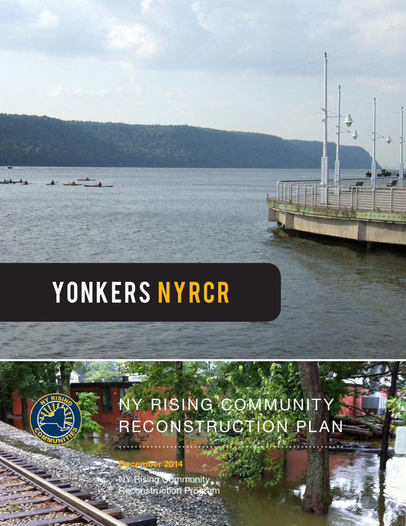
December 2014
NY RISING COMMUNIT Y RECONSTRUCTION PL AN
NY Rising Community Reconstruction Program
Y o n k e r s N Y R C R


YONKERS NY RISING Community Reconstruction Plan
iExecutive Summary
Members of the Yonkers NYRCR Planning Committee
Rick Magder, Co-chairGail O’Rourke, Co-chairSteven BrownStephen ForceKathy GravesJagdish MistryLeon NantonKerry SmithPaul SummerfieldRenee TobackBob Walters
Prepared By
This document was developed by the Yonkers NYRCR Planning Committee as
part of the NY Rising Community Reconstruction (NYRCR) Program within the
Governor’s Office of Storm Recovery. The NYRCR Program is supported by NYS
Homes and Community Renewal and NYS Department of State. The document
was prepared by the following consulting firms: AKRF, Inc.; MJ Engineering and
Land Surveying, P.C.; Nagle, Tatich, Cranston LLC d/b/a Elan.3.Consulting (E.3);
Sasaki Associates, Inc.; Arch Street Communications, Inc.; and CDM Smith, Inc.

YONKERS NY RISING Community Reconstruction Plan
ii Introduction

Foreword iii
Foreword
IntroductionIn the span of approximately one year, beginning in August 2011, the State of New York experienced three extreme weather events. Hurricane Irene, Tropical Storm Lee, and Superstorm Sandy wreaked havoc on the lives of New Yorkers and their communities. These tragic disasters signaled that New Yorkers are living in a new reality defined by rising sea levels and extreme weather events that will occur with increased fre-quency and power. They also signaled that we need to rebuild our communities in a way that will mitigate against future risks and build increased resilience.
To meet these pressing needs, Governor Andrew M. Cuomo led the charge to develop an innovative, community-driven planning program on a scale unprecedented and with resources unparalleled. The NY Rising Community Reconstruction (NYRCR) Program, within the Governor’s Office of Storm Recovery (GOSR), empowers the State’s most impacted communities with the technical expertise and funding resources needed to develop thorough and implementable reconstruction plans to build physically, socially, and economically resilient and sustainable communities.
Program OverviewThe NYRCR Program, announced by Governor Cuomo in April of 2013, is a more than $700 million planning and implementation program established to provide rebuilding and resiliency assistance to com-munities severely damaged by Hurricane Irene, Tropi-cal Storm Lee, and Superstorm Sandy. Drawing on lessons learned from past recovery efforts, the NYRCR Program is a unique combination of bottom-up com-munity participation and State-provided technical expertise. This powerful combination recognizes not
only that community members are best positioned to assess the needs and opportunities of the places where they live and work, but also that decisions are best made when they are grounded in rigorous analy-sis and informed by the latest innovative solutions.
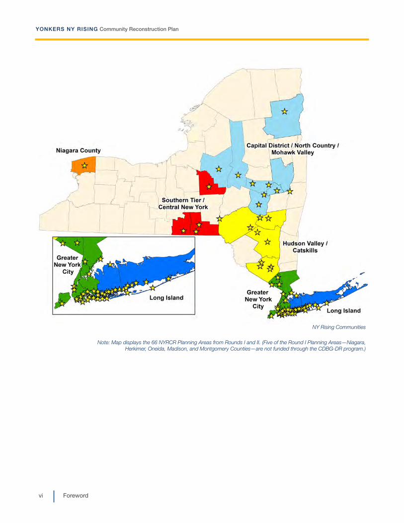
Launched in the summer of 2013 and completed in March 2014, Round I of the NYRCR planning process included 50 NYRCR Planning Areas, comprising 102 storm-impacted localities. In January 2014, Governor Cuomo announced a second round of the planning process, serving an additional 22 storm-impacted localities. Four of these localities were absorbed into existing Round I NYRCR Planning Areas, bringing the number of localities participating in Round I up to 106; the other 18 localities formed 16 new Round II NYRCR Planning Areas. Between Rounds I and II, there are 66 NYRCR Planning Areas, comprising 124 localities. The program serves over 2.7 million New Yorkers and covers nearly 6,500 square miles, which is equivalent to 14% of the overall State population and 12% of the State’s overall geography.
In Rounds I and II, the State allotted between $3 million and $25 million to each participating locality for the implementation of eligible projects identified in the NYRCR Plan. The funding for these projects is pro-vided through the U.S. Department of Housing and Urban Development (HUD) Community Development Block Grant – Disaster Recovery (CDBG-DR) program.1
Each NYRCR Planning Area is represented by a NYRCR Planning Committee composed of local residents, busi-ness owners, and civic leaders. Members of the Plan-ning Committees were identified in consultation with
1 Five of the Round I Planning Areas—Niagara, Herkimer, Oneida, Madison, and Montgomery Counties—are not funded through the CDBG-DR program.

YONKERS NY RISING Community Reconstruction Plan
iv Foreword
established local leaders, community organizations and, in some cases, municipalities. The NYRCR Program sets a new standard for community partici-pation in recovery and resiliency planning, with com-munity members leading the planning process. Across the State, more than 650 New Yorkers have repre-sented their communities by serving on Planning Committees. Nearly 650 Planning Committee Meet-ings have been held, during which Planning Commit-tee members worked with the State’s team to develop community reconstruction plans, which identify opportunities to make their communities more resil-ient. All meetings were open to the public. An addi-tional 250+ Public Engagement Events attracted thousands of community members, who provided feedback on the planning process and resulting pro-posals. The NYRCR Program’s outreach has included communities that are traditionally underrepresented, such as immigrant populations and students. All plan-ning materials are posted on the program’s website (www.stormrecovery.ny.gov/nyrcr), providing several ways for community members and the public to submit feedback on the program and materials in progress.
Throughout the planning process, Planning Commit-tees were supported by staff from GOSR, planners from New York State (NYS) Department of State and NYS Department of Transportation, and consultants from world-class planning firms that specialize in engineering, flood mitigation solutions, green infra-structure, and more.
The NYRCR Program does not end with this NYRCR Plan. Governor Cuomo has allotted over $700 million for planning as well as implementing eligible projects identified in NYRCR Plans. NYRCR Planning Areas are also eligible for additional funds through the NY Rising to the Top Competition, which evaluates appli-cations from Round II NYRCR Planning Committees across three categories—Regional Approach, Inclu-sion of Vulnerable Populations, and Use of Green Infrastructure. The winner of each category will be
allotted a share of the competition’s $3.5 million to fund additional eligible projects.
In April 2014, Governor Cuomo announced that proj-ects identified in NYRCR Plans would receive priority consideration through the State’s Consolidated Funding Application (CFA) process and charged the Regional Economic Development Councils (REDCs), which play an advisory role in the CFA process, to support NYRCR projects. In December 2014, Gover-nor Cuomo announced that 24 NYRCR projects received nearly $12 million in CFA funding. This announcement is an example of the Governor honor-ing his commitment to leverage the work of the NYRCR Planning Committees to incorporate resil-ience into other State programs and to find additional sources of funding for NYRCR projects. The NYRCR Program is also working with both private and public institutions to identify existing funding sources and to create funding opportunities where none existed before.
The NYRCR Program has successfully coordinated with State and Federal agencies to help guide the development of feasible projects. The program has leveraged the REDC State Agency Review Teams (SARTs), composed of representatives from dozens of State agencies and authorities, for feedback on proj-ects proposed by NYRCR Planning Committees. The SARTs review projects with an eye toward regulatory and permitting needs, policy objectives, and preexist-ing agency funding sources. The NYRCR Program is continuing to work with the SARTs to streamline the permitting process and ensure shovels are in the ground as quickly as possible.
On the pages that follow, you will see the results of months of thoughtful, diligent work by the Yonkers NYRCR Planning Committee, which is passionately committed to realizing a brighter, more resilient future for its community.

YONKERS NY RISING Community Reconstruction Plan
vForeword
The NYRCR PlanThis NYRCR Plan is an important step toward rebuild-ing a more resilient community. Each NYRCR Plan-ning Committee began the planning process by defin-ing the scope of its planning area, assessing storm damage, and identifying critical issues. Next, the Planning Committee inventoried critical assets in the community and assessed the assets’ exposure to risk. On the basis of this work, the Planning Commit-tee described recovery and resiliency needs and iden-tified opportunities. The Planning Committee then developed a series of comprehensive reconstruction and resiliency strategies, and identified projects and implementation actions to help fulfill those strategies.
The projects and actions set forth in this NYRCR Plan are divided into three categories. The order in which the projects and actions are listed in this NYRCR Plan does not necessarily indicate the Planning Commit-tee’s prioritization of these projects and actions. Pro-posed Projects are projects proposed for funding through an NYRCR Planning Area’s allotment of CDBG-DR funding. Featured Projects are projects and actions that the Planning Committee has identi-fied as important resiliency recommendations and has analyzed in depth, but has not proposed for funding through the NYRCR Program. Additional Resiliency Recommendations are projects and actions that the Planning Committee would like to highlight and that are not categorized as Proposed Projects or Featured Projects. The Proposed Projects and Featured Proj-ects found in this NYRCR Plan were voted for inclu-sion by voting members of the Planning Committee. Those voting members with conflicts of interest recused themselves from voting on any affected proj-ects, as required by the NYRCR Ethics Handbook and Code of Conduct.
As part of Round II of the NYRCR Program, the Yonkers NYRCR Planning Area has been allotted up to $3.0 million in CDBG-DR funds for the implementa-tion of eligible projects identified in this plan.
While developing projects for inclusion in NYRCR Plans, Planning Committees took into account cost estimates, cost-benefit analyses, the effectiveness of each project in reducing risk to populations and criti-cal assets, feasibility, and community support. Plan-ning Committees also considered the potential likeli-hood that a project or action would be eligible for CDBG-DR funding. Projects and actions implemented with this source of Federal funding must satisfy a Federally-designated eligible activity category, fulfill a national objective (i.e., meeting an urgent need, removing slums and blight, or benefiting low- to moderate-income individuals), and have a tie to the natural disaster to which the funding is linked. These are among the factors that GOSR will consider, in consultation with local municipalities and nonprofit organizations, when determining which projects and actions are best positioned for implementation.
The total cost of Proposed Projects in this NYRCR Plan exceeds the NYRCR Planning Area’s CDBG-DR allotment to allow for flexibility if some Proposed Proj-ects cannot be implemented due to environmental review, HUD eligibility, technical feasibility, or other factors. Implementation of the projects and actions found in this NYRCR Plan are subject to applicable Federal, State, and local laws and regulations, includ-ing the Americans with Disabilities Act. Inclusion of a project or action in this NYRCR Plan does not guaran-tee that a particular project or action will be eligible for CDBG-DR funding or that it will be implemented. Projects will be implemented on a staggered timeline, and the NYRCR Program will choose an appropriate State or local partner to implement each project. GOSR will actively seek to match projects with addi-tional funding sources, when possible.
In the months and years to follow, many of the proj-ects and actions outlined in this NYRCR Plan will become a reality, helping New York not only to rebuild, but also to build back better.
YONKERS NY RISING Community Reconstruction Plan
vi Foreword
NY Rising Communities
Note: Map displays the 66 NYRCR Planning Areas from Rounds I and II. (Five of the Round I Planning Areas—Niagara, Herkimer, Oneida, Madison, and Montgomery Counties—are not funded through the CDBG-DR program.)

viiTable of Contents
Section I: Community Overview .................................................................... I-1
A. Introduction to Yonkers .................................................................. I-1
B. Geographic Scope ......................................................................... I-2
C. Description of Storm Damage ..................................................... I-12
D. Critical Issues ............................................................................... I-16
E. Community Vision ........................................................................ I-18
F. Relationship to Regional Plans ..................................................... I-19
Section II: Assessment of Risk and Needs .................................................... II-1
A. Description of Community Assets and Assessment of Risk ......... II-1
i. Description of Community Assets ................................................. II-1
ii. Assessment of Risk to Assets and Systems ............................... II-15
B. Assessment of Needs and Opportunities ................................... II-23
Section III: Reconstruction and Resiliency Strategies .................................. III-1
Section IV: Proposed and Featured Project Profiles ..................................... IV-1
Section V: Additional Materials ..................................................................... V-1
A. Additional Resiliency Recommendations ...................................... V-1
B. Master Table of Projects ............................................................... V-3
C. Public Engagement Process ......................................................... V-8
D. Community Asset Inventory ........................................................ V-13
E. Endnotes ..................................................................................... V-34
F. Glossary ....................................................................................... V-37
Table of Contents

YONKERS NY RISING Community Reconstruction Plan
viii Executive Summary
ixExecutive Summary
Executive Summary
I. OverviewThe NY Rising Community Reconstruction (NYRCR) Program was established by Governor Andrew M. Cuomo to provide rebuilding and revitalization assis-tance to communities damaged by Superstorm Sandy, Hurricane Irene, and Tropical Storm Lee. Recovery and reconstruction initiatives began immediately fol-lowing these storm events, the overall success of which will be measured by the communities’ ability and commitment to become more resilient. The NYRCR Program provides an opportunity for resi-dents, business owners, and community leaders to actively participate in planning for a stronger future—to reflect, to learn, and to build back better and stron-ger. The Program empowers communities to prepare locally-driven recovery plans to identify innovative reconstruction and resiliency projects and other actions to allow each community not only to survive, but also to thrive in an era when natural risks will become increasingly common.
The Yonkers NYRCR Plan (Plan) was developed over seven months of community stakeholder engage-ment. The Plan reflects Yonkers’ vision and goals, honoring its unique qualities and assets for building a safer, more resilient, and sustainable future.
a. Community location and allotment amount(s)The City of Yonkers, located in Westchester County just north of the Bronx, measures 20.3 square miles. The diverse city has just fewer than 200,000 residents and is the fourth largest city in New York. Yonkers is the fastest growing major city in the State outside of New York City with a growth rate of 2.8%. The City is home to over 100 nationalities and has a very diverse landscape, ranging from 4.5 miles of beautiful Hudson
River waterfront along its western edge, to its bustling downtown and historic business district, to miles of hills and valleys that are home to beautiful parks and quiet suburban neighborhoods.
Yonkers is defined by a series of hills and valleys that form an integral part of the City’s landscape. Two rivers help delineate the borders of the City: to the west is the Hudson River, and to the east is the Bronx River. In between these two rivers are various streams and waterways prone to flooding, including Grassy Sprain Brook, Saw Mill River, Tibbetts Brook, and Troublesome Brook. Where development is located within the low-lying areas adjacent to these water-courses, significant flooding has occurred. In addition to the riverine flooding along the interior waterways, Yonkers is also vulnerable to coastal flooding from storm surges along the Hudson River.
This Yonkers NYRCR Plan presents proposed pro-grams, policies, and construction initiatives developed throughout the planning process.
The State has allotted up to $3 million in Federal Com-munity Development Block Grant-Disaster Recovery (CDBG-DR) funding to implement eligible projects devel-oped through the Yonkers NYRCR planning process.
b. Scope of planning areaThe planning area encompasses the entire City of Yonkers. The NYRCR Planning Committee (Commit-tee) determined that impacts from flooding, wind, stormwater, downed trees, and utility outages were widespread enough to merit including all of the City’s neighborhoods within the Scope. The areas in the City that did not suffer direct damage from these signifi-cant storms remain candidate locations for recovery services, shelters, and other important community

YONKERS NY RISING Community Reconstruction Plan
x Executive Summary
resources. Locating these types of facilities in less damage-prone areas could help the City to recover more effectively from future storm events. In addition to the Citywide Geographic Scope, the Committee determined that certain areas of the City known to have been most heavily impacted by storm damages were in need of a more detailed focus. These sections of Yonkers, centered on major watershed corridors, were developed as focus areas. A total of five focus areas were selected, including the watersheds of the Bronx River, Grassy Sprain Brook and Reservoir, Saw Mill River, Tibbetts Brook, and the City’s Hudson River waterfront.
c. Summary of storm impactsHurricane Irene (August 28, 2011) hit Yonkers with full force, causing widespread and long-lasting damage. These storms damaged public and private property and caused serious physical, economic, and safety hardships to Yonkers residents. Many of the City’s waterways reached record heights during Hurricane Irene, including the Bronx River, Saw Mill River, Grassy Sprain Brook, and Tibbetts Brook. The flood waters of both storms caused extensive damage to businesses, homes, and City infrastructure.
Superstorm Sandy (October 29, 2012) brought with it winds of up to 90 miles per hour that downed hun-dreds of trees and closed roads throughout the City. Downed trees blocked travel along City roads, and took with them electrical lines, resulting in power losses to thousands of City residents as well as closure of schools and businesses for a full week. During Superstorm Sandy the Hudson River had a high tide of approximately 14 feet above Mean Low Water, flooding much of the waterfront. Hurricane Sandy’s storm surges destroyed a lot of the equip-ment at the Yonkers Wastewater Treatment Plant (WWTP) and caused untreated and partially treated sewage to flow into the Hudson River. Some of the businesses in Yonkers remain unable to reopen since Superstorm Sandy.
The physical damage caused by Superstorm Sandy and Hurricane Irene to roads, homes, and City infra-structure, coupled with the economic impacts of pro-longed closure of businesses, continue to affect Yonkers today. The City is still recovering as its resi-dents prepare for future storm events.
d. Summary of critical issuesDuring and after Hurricane Irene and Superstorm Sandy, many water bodies in Yonkers overtopped their banks and released floodwaters throughout the City. In addition to flooding, strong winds during Superstorm Sandy brought down trees and power lines causing disruption to power. These storms exposed vulnerabilities within the City. The issues identified affect the City’s ability to withstand the impact and recover from future storms. The key criti-cal issues facing the City of Yonkers include:
��Riverine, Coastal, and Stormwater Flooding
�� Tree and Wind Damage
�� Susceptibility of Major Infrastructure to Storm Damage
��Communication and Education Challenges
��Managing the Impacts of Development, Including Resiliency Projects
II. Community-Driven ProcessAll of the material presented in the Yonkers NYRCR Plan has been developed collaboratively. The NYRCR Program provided the Community with a unique opportunity to participate in a bottom-up, community-driven planning effort to reshape Yonkers for a more resilient future. The steps in the process included organizing for action, creating an inventory of com-munity assets, determining needs and opportunities, conducting a risk assessment, engaging with the region-wide planning context, developing strategies for investment and action, and producing this final Yonkers NYRCR Plan.

YONKERS NY RISING Community Reconstruction Plan
3Executive Summary
a. Community vision/goals The Yonkers NYRCR Vision Statement:
The City of Yonkers is a vibrant and diverse community focused on protecting our residents, property, infra-structure, and natural resources from extreme flooding and natural disasters. Our goals are to work together to safeguard the public health and safety of the City’s resi-dents through flood mitigation and effective flood recovery, protect the natural environment, and enhance the City’s economy for current and future residents.
Goals: As we develop a Community Reconstruction Plan, we will strive to develop ecologically sound policies and programs that will:
�� Address flooding as a Citywide problem—with mul-tiple watersheds, rivers, and tributaries—that re-quires a coordinated mitigation effort with solutions unique to each watershed;
�� Advance educational outreach to ensure our resi-dents understand natural hazards and how they can protect themselves, their homes, and their neighborhoods against future storms in an environ-mentally sustainable way;
��Collaborate with City, County, State, and Federal agencies and adjacent municipalities regarding drainage improvements and maintenance;
��Contribute to a coordinated Citywide preparedness and response against future storms;
��Coordinate with nearby upstream municipalities that contribute to our flooding problem;
��Cultivate partnerships among private organiza-tions, public agencies, and municipalities to ensure responsible development;
��Develop policy, design, and construction standards to make our neighborhoods more resilient in the future;
��Maintain and upgrade the City’s infrastructure;
�� Preserve the character of our neighborhoods; and
�� Protect our neighborhoods from coastal and river-ine flooding.
b. Summary of public outreachThe NYRCR Program is fundamentally a grassroots ini-tiative. Initial project recommendations were generated by the Yonkers NYRCR Planning Committee, which was comprised of community leaders, storm-impacted resi-dents, and municipal staff. The Committee met approxi-mately every other week from the end of June 2014 through mid-November 2014. Materials were circulated to the Committee before and after each meeting and also posted to the City’s page on the NYRCR website. Committee members also shared information with their community by posting relevant materials to the City website and Facebook page, leaving materials in the libraries and other high traffic areas, posting information throughout the City, reaching out to friends and neigh-bors through email and conversation, and attending municipal meetings and community functions to report on their NYRCR Plan progress. To encourage participa-tion and reach as many neighborhoods within the City as possible, meeting locations moved throughout Yonkers during the planning process to accommodate residents and be as inclusive as possible.
Three Public Engagement Meetings were held through-out the seven month planning process, with a fourth to be conducted after the final plan is complete. These meetings provided the opportunity for Yonkers residents to learn about the NYRCR planning process; review and provide feedback on assets, needs, opportunities, strat-egies, and projects; and help develop community-driven plans for a more resilient future. The format of the Public Engagement Meetings varied throughout the process, but generally included PowerPoint presentations, display boards and mapping, discussion groups with handouts and markers, survey sheets, and a photo booth, where participants had photos taken to memorialize their ideas. The first meeting gathered input on the community vision, goals, assets, and planning context; the second event focused on needs and opportunities; and the third event introduced the community to the Committee’s list of projects.

YONKERS NY RISING Community Reconstruction Plan
xii Executive Summary
III. Final plan as blueprint for implementation
a. Needs and risks underpin projectsThe risks to and vulnerability of assets in the City of Yonkers were made clear when these assets were exposed to Superstorm Sandy and Hurricane Irene. Through the NYRCR planning process, the commu-nity shifted its focus from simply making repairs to improving resiliency and prioritized building back better. This change of purpose revealed significant opportunities to help the City build back better.
The Committee understands where the City is vulner-able, where critical assets are located, and what the risks are to those assets. To address their specific vulnerabilities, a comprehensive needs and opportu-nities analysis was prepared through a combination of research, analysis, discussions among the Commit-tee, and feedback from the community. A sample of the needs and the opportunities identified are:
Needs�� System to contact volunteers in each vulnerable neighborhood to participate in pre- and post-flood emergency communication, including homeowner associations and co-op/condo boards
��Generators for stores that have perishable inven-tory, especially grocery stores; for high-rise build-ings with elevators; and for other services that are critically needed after storms
��Better coordination of services/information among emergency services agencies
��Better protection of homes and neighborhoods from flooding
�� Preservation of electrical service during storms (electri-cal systems are vulnerable above and below ground)
��Restoration of streams and tributaries through the removal of debris/obstructions according to recog-nized best practices
��Regional and inter-municipal cooperation on flood-ing and resiliency issues
Opportunities�� Establish and maintain liaison with district volun-teer leaders (e.g. various homeowner associations and co-op/condo boards)
�� Find a way to incentivize stores to install genera-tors—especially grocery stores (NYS already man-dates gas stations)
�� Inform and educate emergency services personnel (ambulance drivers, firefighters, police) of emer-gency routes and driving procedures to be used during major storms
��Utilize land management tools to create flood-safe homes and neighborhoods
�� Explore alternative power opportunities such as re-newables and micro-grids for improved access to power and increased flexibility during/after storms
��Revise protocols for tree pruning, removal, and re-planting
�� Support and build on current efforts in the State legislature to establish a Statewide flood mitigation and preparedness authority
b. Strategies describe the committee’s ap-proach to meeting those needs
The strategies proposed in the NYRCR Plan consider emergency, disaster recovery, and long-term resil-iency needs that remain unmet. The strategies were developed to concentrate the resiliency efforts toward resolving critical issues identified throughout the plan-ning process. They represent statements of action that address how best to fortify community assets, capitalize on opportunities, resolve critical issues, and meet short-, medium-, and long-term goals identified during the planning process. The projects developed throughout the planning process are a path to execut-ing the strategies and realizing the vision the commu-nity has for the City of Yonkers.

YONKERS NY RISING Community Reconstruction Plan
xiiiExecutive Summary
c. Projects are the path to executing the strategies
Presented in the table below are strategies developed by the Committee and the Proposed or Featured Projects that implement them. Strategies specifically address the stated needs and transform opportunities into action items. The strategies were developed to concentrate resiliency planning efforts toward resolving critical issues identified throughout the planning process. The Pro-posed and Featured Projects are presented in conjunc-tion with the strategy that they fulfill; they are not pre-sented in any particular order of priority.
Proposed Projects are projects proposed for funding through a NYRCR Community’s allot-ment of CDBG-DR funding.
Featured Projects are projects and actions that the Planning Committee has identified as important resiliency recommendations and has analyzed in depth, but has not proposed for funding through the NYRCR Program.
Additional Resiliency Recommendations are projects and actions that the Committee would like to highlight and that are not categorized as Proposed or Featured Projects.
Table ES-1 Proposed and Featured ProjectsStrategy Project Name Project CategoryWork with neighborhoods and businesses to improve flood resistance in Yonkers’ vulnerable areas
Bronx River and Grassy Sprain Brook Hydrologic Study Proposed Project
Saw Mill River Hydrologic Study Proposed Project
Improve on existing emergency preparedness and communications
Emergency Power to Street Lights along Evacuation Routes Proposed Project
Yonkers Emergency Response and Recovery Campaign Proposed Project
Provide information and assistance to home and business owners with pre-storm floodproofing and post-storm recovery
Technical Assistance Program for Residential Resiliency Proposed Project
Promote resiliency and flood management best practices through land-use planning and regulation
Planning Study to Establish Best Management Practices for Upland Waterways
Proposed Project
Resilient Revitalization of the Alexander Street Waterfront—Study and Pilot Projects
Proposed Project
Scout Field Engineering Study Proposed Project
Repair, rehabilitate, upgrade, and fortify critical infrastructure assets
Creation of Access to Grassy Sprain Brook through Sprain Brook Parkway Sound Barrier
Proposed Project
Reconstruction of Seawall at Yonkers Paddling and Rowing Club
Proposed Project
Enhance regional coordination in flood mitigation planning
Feasibility Study for Creation of a Regional Flood Control Authority
Proposed Project
Harness resiliency potential of natural resources
Planning Study for Sprain Diversion Channel Featured Project


2014NY RIS ING COMMUNITY RECONSTRUCTION PLANY O N K E R S N Y R C R
Section ICommunity Overview


I– 1Section I: Community Overview
Community OverviewI
A. Introduction to YonkersThe City of Yonkers is located in Westchester County along the Hudson River in the lower Hudson Valley of New York State. It is situated just north of the Bronx, New York City, and less than 30 minutes from Midtown Manhattan. To the east, Yonkers is bordered by the City of Mount Vernon, the Town of Eastchester, and the Vil-lages of Tuckahoe and Bronxville. The Town of Green-burgh and the Village of Hastings-on-Hudson border the City to the north, while the Hudson River forms the entire western boundary of the City. Yonkers is New York’s fourth largest city and the largest city in Westchester County. The City has a diverse population, consisting of over 100 nationalities1. Yonkers’ equally diverse land-scape ranges from a beautiful 4.5-mile-long waterfront along the Hudson River at the City’s western edge, to a bustling downtown and historic business district, and miles of hills and valleys that are home to beautiful parks and quiet suburban neighborhoods.
Yonkers serves as the gateway between New York City and the Hudson Valley. It is well-served by trans-portation routes due to its location adjacent to New York City. The NYS Thruway (Interstate 87), connect-ing Albany and New York City, originates at the border between Yonkers and the Bronx and traverses the City from north to south. Other major roadways include the Saw Mill River, Sprain Brook, and Bronx River Parkways, all major north-south connectors within Westchester County. The Metro-North Railroad commuter rail system also provides service to Yonkers. Metro-North’s Hudson River Line serves four stations along Yonkers’ western edge, while the Metro-North Harlem Line serves an additional seven stations that
the City shares with its eastern neighbors. Yonkers’ excellent location and accessibility have made it a highly desirable community for hundreds of years.
During Colonial times, the area that is now Yonkers was part of a large land holding owned by Adriaen van der Donck, New York City’s first lawyer. Van der Donck built a saw mill in what is today the Getty Square neighborhood, beginning a long tradition of industry in Yonkers. As the city grew, so did its industrial prowess as manufacturers could be located close to the popu-lation center of New York City and along major trans-portation routes—the Hudson River, the railroads, and later, parkways and interstate highways. The Otis Elevator Company opened its first factory in Yonkers in the 1850s, and a number of other industries were located in the area including carpet makers, plastics factories, automobile makers, and the nation’s largest hat manufacturer.
The Hudson River at Getty Square, Yonkers’ Downtown Waterfront

YONKERS NY RISING Community Reconstruction Plan
I– 2 Section I: Community Overview
After the Second World War, manufacturing began to move out of Yonkers, although some manufacturing remains. This includes the Kawasaki rail car factory, which is the U.S. headquarters for that company’s operations. In recent years, Yonkers has seen a revi-talization of its waterfront and downtown, with new mixed-use construction along the Hudson River sym-bolizing a new era for the City.
Today, Yonkers is the fourth-largest municipality in New York State, with a population of 195,976 as of 2010. While many cities in New York State are shrink-ing, Yonkers is the fastest growing major city in the State outside of New York City with a growth rate of 2.8%. Fifty-six percent (56%) of the population is white, 19% is black, 6% is Asian, and 13% of the population is of Hispanic origin. Fifty-four percent (54%) of Yonkers’ housing units are renter-occupied and 46% are owner-occupied. Thirty-six percent (36%) of Yonkers’ housing units are in structures of 20 or more units. Twenty-six percent (26%) of the housing stock is in single-family detached houses. Yonkers’ housing stock is also relatively old, with only 18% built after 1970. Fifty-five percent (55%) of households living in rented housing units pay more than 30% of their monthly household income in rent. The City’s unemployment rate is a relatively low 5.7%.1
Yonkers is defined by a series of hills and valleys that form an integral part of the City’s landscape. Two rivers help delineate the borders of the City: to the
west is the Hudson River, and to the east is the Bronx River. In between these two rivers are various streams and waterways prone to flooding, including Grassy Sprain Brook, Saw Mill River, Tibbetts Brook, and Troublesome Brook. Developed areas located within the low-lying areas adjacent to these watercourses have experienced significant flooding. In addition to the riverine flooding along the interior waterways, Yonkers is also vulnerable to coastal flooding from storm surges along the Hudson River.
Hurricane Irene and Superstorm Sandy resulted in very different patterns of damage in Yonkers. Hurri-cane Irene primarily affected upland areas, where rivers and streams flooded their banks, whereas Superstorm Sandy caused its most significant damage along the Hudson River waterfront, where storm surge and wave action were the main factors.
B. Geographic ScopeDefining the physical extent of the area that the NY Rising Community Reconstruction (NYRCR) planning process will address was an early step taken by the Yonkers NYRCR Planning Committee (Committee). This planning area, or Geographic Scope, is intended to encompass areas within the City that contain assets and resources critical for the community’s response to storm events and the City’s economic drivers. The Geographic Scope also includes locations with a history of flooding and storm damage. In developing the Geographic
Greystone Railroad Station in Yonkers
Grassy Sprain Reservoir

I– 3Section I: Community Overview
YONKERS NY RISING Community Reconstruction Plan
Scope, the Committee considered locations that are most vulnerable and where assets are most at risk, as well as areas where additional economic investment will help the community’s financial resilience.
The Geographic Scope of this NYRCR Plan includes the entirety of Yonkers’ municipal limits. The Commit-tee determined that impacts from flooding, wind, stormwater, downed trees, and utility outages were widespread enough to merit including all of the City’s neighborhoods within the Scope. Even areas in the City that did not suffer direct damage from these sig-nificant storms remain candidate locations for recov-ery services, shelters, and other important community resources. Locating these types of facilities in less damage-prone areas could help the City to recover more effectively from future storm events.
This geographic study area forms the basis for all sub-sequent steps of the NYRCR planning process, including the analyses that led to the asset inventory, needs and opportunities, risk assessment, strategies, and projects. The final Geographic Scope, a map of the City of Yonkers, is depicted in Figure I-1.
In addition to the Citywide Geographic Scope, the Committee determined that certain areas of the City known to have been most heavily impacted by storm damages were in need of a more detailed focus. These sections of Yonkers, centered on major watershed corridors, were developed as focus areas. In total, five focus areas were selected, including the watersheds of the Bronx River, Grassy Sprain Brook and Reser-voir, Saw Mill River, Tibbetts Brook, and the City’s Hudson River waterfront. The final Focus Areas are depicted in Figures I-2 through I-8.
Discussion of how to determine the Geographic Scope began at the first Planning Committee Meeting. Initial conversations revolved around the importance of focusing on the three primary watersheds (i.e., Saw Mill River, Grassy Sprain Brook, and Bronx River) where flooding had routinely and severely damaged neighborhoods, and despite numerous studies and recommended flood protection measures, these neighborhoods remain unprotected. The Committee
also focused on land uses along the Hudson River that are vulnerable to tidal surges, including the Yonkers Wastewater Treatment Plant (WWTP), the North Yonkers Pump Station, the City’s Riverfront Library, and new and proposed redevelopment proj-ects along the City’s waterfront. Finally, the Commit-tee felt that Citywide policy recommendations were also warranted to make the City more resilient to future storms and to address the potential for City-
wide damage from high winds, downed trees, off-line vital infrastructure, and power outages. A Geographic Scope that excluded certain areas of the City was rejected because this would not have allowed for a comprehensive discussion of those Citywide prob-lems. A single large Geographic Scope without focus on the important watershed areas was also deemed inadequate. In the end, the Committee determined that while the entire population of the City had been affected by Hurricane Irene and Superstorm Sandy, there were areas warranting focused attention because of their continuous history of flooding and other severe storm impacts. A Citywide Geographic Scope with several localized focus areas was deter-mined to be the best approach.
The Geographic Scope and Focus Areas developed by the Committee were endorsed by the broader Yonkers community during the first of four Public Engagement Events held throughout the NYRCR process. More information about public outreach can be found in Section V.C, “Public Engagement Process.”
Members of the Public review the Geographic Scope and Focus Areas, Public Engagement Event #1

ST100
ST100
ST100
ST9A
ST100
£¤9
£¤9
£¤9
£¤9
§̈¦87
§̈¦87
§̈¦87
TibbettsLake
CrestwoodLake
HillviewReservoir
S B
road
way
M cLeanAv
e
Hi ll v iewAve
Sa
wM
ill
Riv
er
Rd
Mc L e an Ave
R oberts Av e
A u stin A ve
Palmer
Rd
P almer Rd
Mid
land
Av
e
Mid
lan
dA
v e
Bro
nx
Riv
erP
kw
y
Bro
nx
Ri v
er
Rd
As h bur ton A v e
Ra dford S t
V a lenti n eLn
Yo n k e r s A ve
Ru
ms
eyR
d
Exe
cut iveB
l v d
Sai
nt
John
sA
ve
Riv
er da
leA
ve
Nep
pe
rhan
Av
e
NB
r oa
dw
ay
Wa
rbu
r t on
Ave
Spra in
Bro
ok
Pk w
y
Sc
ars
dal
eR
d
Wal
nu
tS
t
Sa
wM
illR
iver
Rd
Ce
nt r
a lP
ark
Ave
Spr
a in
Rd
V an
Co
rtla
nd
tP
KA
ve
Saw
Mi l
lR
ive r
Pk
wy
Saw
Mil l
River
Pk
wy
Sp
rain
Rd
NB
r oad
way
Ce
nt r
alP
ark
Ave
Kim
bal
l A
ve
Neppe rh
an
Ave
BeechHill
BronxvilleHeights
BrynMawrPark
CecilPark
CedarKnolls
ColonialHeights
Crestwood
CrestwoodGardens
Glenwood
Gray Oaks
Greystone
GuntherPark
Sunnybrook
Lincoln
Ludlow
MoheganHeights
NeperaPark
Dunwoodie
Birc
hBr
ook
Sunny
Brook
Sprain Brook
GrassySprain Brook
Gras sy
Spra inB
r ook
Tibb
etts
Brook
SawM
illRiver
Bron
xRi
ver
Bro
nxRi
ver
Geographic Scope - City of Yonkers
City of Yonkers(Study Area)
Major Highways
Railroads
I2 Rail Station
Wetlands
Water Bodies
Rivers &Streams
Data SourcesLegend
City of Yonkers, ESRI,FEMA, NWI, NYSDOS,NYSITS, Westchester County´
Figure I-1
Hudson River
0 1Mile
GrassySprain
Reservoir

YONKERS NY RISING Community Reconstruction Plan
Exit6W
Exit4
Exit6
ST100
ST100
ST100
§̈¦87
§̈¦87
§̈¦87
§̈¦87Crestwood
Lake
Pa lme r Rd
Pa lme r Rd
Bro
nx
Riv
erP
kwy
Cen
tra l
Pa r
k A
ve
Pa
r kV
i ew
Av
e
Sp
rain
Rd
Spr
ain
Rd
Spra inB
roo
kP
kwy
Scar sd
a le
R d
Spra in Brook Pkwy
Bro
nx
Ri v
erP
kwy
Cen
tra l
Par
kA
ve
BeechHill
BronxvilleHeights
BrynMawrPark
CecilPark
CedarKnolls
Colonial Heights
Crestwood
CrestwoodGardens
Sunnybrook
MoheganHeights
Longvale
Brooklands
Grassy
SprainB
ro ok
Bron
xRiv
e r
Sunn
y
Broo
k
Birc
h Br
ook
SprainB rook
Bronx River Area (North) - City of Yonkers
City of Yonkers(Study Area)
NYSDOSHazard Zones
Extreme Risk
High Risk
Moderate Risk
Watersheds
Building
FEMAFloodzones
Extreme Risk
High Risk
Moderate Risk
Wetlands
Water Bodies
Rivers & Streams
I2 Rail Station
Railroads
Major Highways
Data SourcesLegendCity of Yonkers, ESRI,FEMA, NWI, NYSDOS,NYSITS, Westchester County
´
Figure I-2
Bronx River
0 0.5Mile
Yonkers
Bron
x Ri
ver
Bronx R
iver
´

Exit4S
Exit2
Exit5
Exit4
Exit4N
ST100
ST100
§̈¦87
§̈¦87
§̈¦87
HillviewReservoir
Mid
land
Av
e
Hi l lv iew Ave
McLeanAve
Yonkers Ave
Palme r
Rd
Pa lmer Rd
Sp ra inBrook
Pkwy
Bro
nx
Riv
e rR
d
Yo n k e r s Ave
Cen
t ral
Par
kAve
Kim
bal
lA
ve
C ros s Co un ty Pkwy
Ki m
bal
lA
v e
BrynMawrPark
CedarKnolls
GuntherPark
Sunnybrook
Dunwoodie
Longvale
Brooklands
GrassySprain Brook
Bron
xR
iver
Birc
hBr
ook
Sunn
yBr
ook
Bronx River Area (South) - City of Yonkers
City of Yonkers(Study Area)
NYSDOSHazard Zones
Extreme Risk
High Risk
Moderate Risk
Watersheds
Building
FEMAFloodzones
Extreme Risk
High Risk
Moderate Risk
Wetlands
Water Bodies
Rivers & Streams
I2 Rail Station
Railroads
Major Highways
Data SourcesLegendCity of Yonkers, ESRI, FEMA, NWI, NYSDOS,NYSITS, Westchester County
´
Figure I-3
Bro
nxR
iver
0 0.5Mile
Yonkers
´

YONKERS NY RISING Community Reconstruction Plan
Exit6A
Exit6W
Exit4
Exit6
ST100
ST100
ST100
§̈¦87
§̈¦87
GrassySprain
Reservoir Ce n
t ral
Pa r
kA
ve
Pa lm
e r Rd
Sp
rain
Bro
ok
Pkw
y
Sp ra inBrook
Pkw y
Sp
r ai n
Rd
Sp
r ai n
Rd
BronxvilleHeights
BrynMawrPark
CedarKnolls
ColonialHeights
GuntherPark
Sunnybrook
MoheganHeights
Longvale
Brooklands
Grassy
Sprain Brook
Gra
ssy
Spra
i nB
rook
Birch
Brook
Sunn
yBr
ook
Sprain Brook
Grassy Sprain Brook Area - City of Yonkers
City of Yonkers(Study Area)
NYSDOSHazard Zones
Extreme Risk
High Risk
Moderate Risk
Watersheds
Building
FEMAFloodzones
Extreme Risk
High Risk
Moderate Risk
Wetlands
Water Bodies
Rivers & Streams
I2 Rail Station
Railroads
Major Highways
Data SourcesLegend
City of Yonkers, ESRI,FEMA, NWI, NYSDOS,NYSITS, Westchester County´
Figure I-4
0 0.5Mile
Yonkers
´
Bron
x Ri
ver

Exit9
ST9A
ST9A
ST9A
£¤9
£¤9
Sa
wM
ill
Riv
er
Rd
Ro be rts Ave
S Broadway
Exec ut iv e
B lvd
Nep
pe
rhan
Ave
Wal
nu
tS
t
Saw
Mil
lRi v
erR
d Sa
wM
il lR
i verPkw
y
Neppe r h
a nA
ve
GrayOaks
NeperaPark
SawM
illRi
ver
Saw Mill River Area - City of Yonkers
City of Yonkers(Study Area)
NYSDOSHazard Zones
Extreme Risk
High Risk
Moderate Risk
Watersheds
Building
FEMAFloodzones
Extreme Risk
High Risk
Moderate Risk
Wetlands
Water Bodies
Rivers & Streams
I2 Rail Station
Railroads
Major Highways
Data SourcesLegendCity of Yonkers, ESRI,FEMA, NWI, NYSDOS,NYSITS, Westchester County
´
Figure I-5
0 0.5Mile
Yonkers
HudsonRiver
´

Exit2
Exit3
Exit5
Exit5A
£¤9
TibbettsLake
McLean Ave
Mc L e an Av e
Yo
nk er s
Ave
Pal
mer
Rd
Mid
lan
dA
ve
C ross
Coun tyPkwy
Ru
ms
e yR
d
Saw
Mil l
Riv e r
Pkw
y
Lincoln
Tibb
etts Bro
ok
Tibbetts Brook Area - City of Yonkers
City of Yonkers(Study Area)
NYSDOSHazard Zones
Extreme Risk
High Risk
Moderate Risk
Watersheds
Building
FEMAFloodzones
Extreme Risk
High Risk
Moderate Risk
Wetlands
Water Bodies
Rivers & Streams
I2 Rail Station
Railroads
Major Highways
Data SourcesLegendCity of Yonkers, ESRI,FEMA, NWI, NYSDOS,NYSITS, Westchester County
´
Figure I-6
0 0.5Mile
Yonkers
´

Exit2
Exit3
Exit9
Exit4
Exit5
Exit5A
ST9A
ST9A
ST9A
ST9A£¤9
£¤9
£¤9
£¤9
TibbettsLake
Saw
Mil
lR
iver
Rd
Rob e rts Av e
Cro ssCounty
Pkwy
Palm er Rd
Mid
l an
dA
ve
Yo
nk er s
Ave
Ashbur ton Ave
Yonk ers Ave
Exe cu tiv eB lvd
Nep
pe r
ha
nA
ve
N B
roa
dw
ay
Wa
r bu
rto
nA
v e
Wa l
nu
tS
t
Saw
Mil
lR
iver
Rd
Saw
Mi ll
Riv
erP
kwy
NB
roa
dw
ay
Sa
wM
illR
iverP
kw
yS
Nepp e rha n
Av
e
Glenwood
GrayOaks
Greystone
NeperaPark
Tibb
ettsBr
ook
Saw MillRiver
Hudson River Area (North) - City of Yonkers
City of Yonkers(Study Area)
NYSDOSHazard Zones
Extreme Risk
High Risk
Moderate Risk
Watersheds
Building
FEMAFloodzones
Extreme Risk
High Risk
Moderate Risk
Wetlands
Water Bodies
Rivers & Streams
I2 Rail Station
Railroads
Major Highways
Data SourcesLegendCity of Yonkers, ESRI,FEMA, NWI, NYSDOS,NYSITS, Westchester County
´
Figure I-7
HudsonRiver
0 0.5Mile
Yonkers
´
Saw M
ill R
iver

YONKERS NY RISING Community Reconstruction Plan
Exit2
Exit3
Exit5A
Exit6
Exit7
ST9A
ST9A
ST9A£¤9
£¤9
£¤9
£¤9
TibbettsLake
S B
road
way
M cLean Ave
M cL e an Av e
Rob erts Ave
Cr ossCounty
Pkwy
Yo
nk
e r s
Ave
Palm er Rd
Mid
lan
dA
ve
Saw
Mi l l
Ri ver
Pkw
y
Lud low St
Ashbur to n Av e
Ra dford S t
Val en t i ne L n
Ru
mse
yR
d
Sa i
nt
John
sA
ve
Ri ve
rda
leA
ve
Nep
pe r
ha
nA
ve
Wa
rbu
rto
nA
ve
N B
roa
dw
ay
Wa
l nu
tS
t
Saw
Mil
l Riv
erR
d
Va
nC
or t la
ndt
PK
Av e
Su
nn
ysid
eDr
Nepperh
a nA
ve
Glenwood
Lincoln
Ludlow
ParkHill
Tibb
etts Bro
ok
Saw Mill
Riv
er
Hudson River Area (South) - City of Yonkers
City of Yonkers(Study Area)
NYSDOSHazard Zones
Extreme Risk
High Risk
Moderate Risk
Watersheds
Building
FEMAFloodzones
Extreme Risk
High Risk
Moderate Risk
Wetlands
Water Bodies
Rivers & Streams
I2 Rail Station
Railroads
Major Highways
Data SourcesLegendCity of Yonkers, ESRI,FEMA, NWI, NYSDOS,NYSITS, Westchester County
´
Figure I-8
HudsonRiver
0 0.5Mile
Yonkers
´

YONKERS NY RISING Community Reconstruction Plan
I– 12 Section I: Community Overview
C. Description of Storm DamageDue to its location along the Hudson River and numer-ous other rivers and streams, Yonkers is affected by both riverine and coastal flooding, as well as wind damage and other types of storm damage. Recent storms, including two powerful nor’easters in the spring of 2007, Hurricane Irene (August 28, 2011), and Super-storm Sandy (October 29, 2012) hit Yonkers with full force, causing widespread and long-lasting damage.
In March and then in April of 2007, just four years prior to Hurricane Irene, Yonkers was in the path of low pres-sure systems that moved into southern Westchester. The April 2007 nor’easter was especially strong, and brought with it 9.84 inches of rainfall in 24 hours, as measured from the Yonkers Raceway gauge. Signifi-cant property damage resulted as floodwalls were crested, drainage systems backed up, and streams overflowed, resulting in millions of dollars in damage.
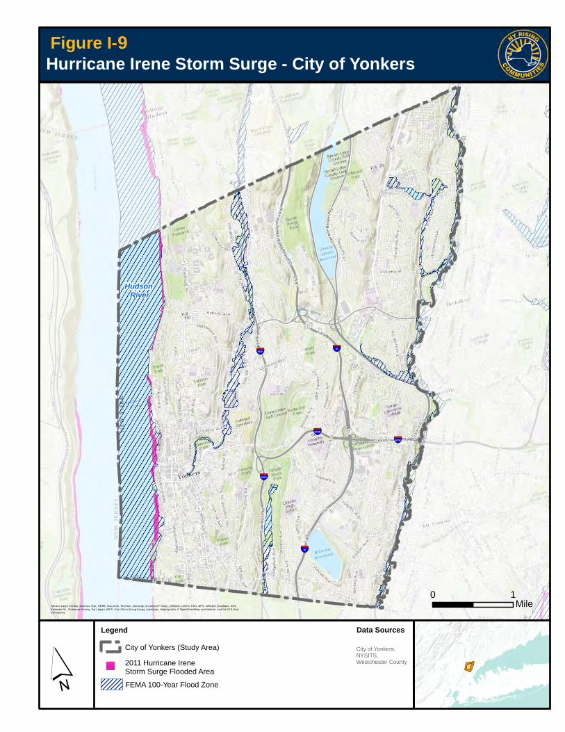
Hurricane IreneOn August 28, 2011, the torrential downpour that came ashore with Hurricane Irene caused water levels in the Bronx River, Saw Mill River, Grassy Sprain Brook, and Tibbetts Brook to reach record heights. Rainfall from Hurricane Irene was recorded to reach 9.14 inches in the City in 24 hours.2 The rising waters of the City’s rivers, brooks, and streams caused flash flood-ing. Homes, businesses, and infrastructure were destroyed throughout the City’s neighborhoods, and residential properties suffered millions of dollars in property damage. In response to Hurricane Irene, the City activated its Emergency Operations Center (EOC) and coordinated the pumping of numerous basements and other below-ground structures. Figure I-9 pres-ents a map of storm surge flooding from Hurricane Irene (shown in magenta). Mapping of storm surge in Yonkers is limited to coastal areas along the Hudson River, so the FEMA 100-year flood zone is shown on the map; this is the best available representation of the extent of upland flooding during Hurricane Irene.
Numerous roads were closed due to floodwaters over-topping culverts and bridges. Exacerbating these impacts were high winds that downed trees and electri-cal lines. Several roads were undermined and local landslides rendered roads impassable. In addition to the parkways, which run adjacent to the City’s inland rivers, many local roads in low-lying areas or upstream of river constriction points were affected, including Palmer Avenue, Nepperhan Avenue, the intersection of Yonkers and Kimball Avenues, Abner Place, Harrison Avenue, Longvale Road, and Clunie Avenue, among others.
In addition to the widespread damage to the City’s infrastructure, Hurricane Irene left a wake of destruc-tion in many of Yonkers’ neighborhoods. Along the Grassy Sprain Brook, Brooklands and Longvale were among the hardest hit areas of the City. The waters of the Grassy Sprain Brook and Bronx River flooded the Brooklands Cooperative causing $3.3 million of damage, damaging elevators, boilers, electrical trans-formers, and other facilities, and rendering 24 housing units uninhabitable for more than one year. This was only four years after the April 2007 nor’easter destroyed 25 units and nearly 100 automobiles. In the nearby Longvale neighborhood, more than 30 houses suffered extreme damage. Dozens of homes had their base-ments fully flooded as a result of Irene.3 Residents were forced to evacuate and several needed to be rescued by watercraft. Exacerbating the flood damage and creating serious health hazards, the floodwater
Flooding in Longvale after Hurricane Irene (T. Ryan)
YONKERS NY RISING Community Reconstruction Plan
Hurricane Irene Storm Surge - City of Yonkers
´
Figure I-7
0 1Mile
Legend
City of Yonkers (Study Area)
Service Layer Credits: Sources: Esri, HERE, DeLorme, TomTom, Intermap, increment P Corp., GEBCO, USGS, FAO, NPS, NRCAN, GeoBase, IGN,Kadaster NL, Ordnance Survey, Esri Japan, METI, Esri China (Hong Kong), swisstopo, MapmyIndia, © OpenStreetMap contributors, and the GIS UserCommunity
Hudson River
§̈¦87
§̈¦907W
§̈¦87
§̈¦987D
§̈¦987D
§̈¦907W
Data Sources
City of Yonkers,NYSITS,Westchester County
FEMA 100-Year Flood Zone
2011 Hurricane IreneStorm Surge Flooded Area
9

YONKERS NY RISING Community Reconstruction Plan
I– 14 Section I: Community Overview
carried with it raw sewage, home heating oil, and other toxic materials swept up by the raging currents.
Also particularly affected by the flooding was the Clunie Avenue/Nepara Park neighborhood which had to be evacuated due to the high floodwaters from the nearby Saw Mill River. Raw sewage from the City sewer line, which runs between the homes on Clunie and Nepper-han Avenues, and the City trunk line, which runs along the Saw Mill River, mixed with the flood waters. Once the flood waters had reached Clunie Avenue, ConEd turned off the power to both streets, making sump pumps useless and exacerbating the flooding. Evacua-tions also occurred for homes near Palmer Road and Kimball Avenue. Other affected areas included the “Carpet Mills” area along Nepperhan Avenue (Saw Mill River), the Harrison Avenue area (Tibbetts Brook), and St. Vladimir’s seminary (Troublesome Brook).
Superstorm SandySuperstorm Sandy’s potent mix of wind and water pushing up the Hudson River caused a record high tide in the City of Yonkers. Supplemented by spring tide (the maximum possible high tide), the storm surge was approximately 14 feet above the average water level at low tide. This surge caused extensive flooding along the City’s waterfront, damaging businesses, residences, public facilities, and City infrastructure. Several multifamily residential buildings, including the
Scrimshaw House and Hudson Park, suffered major damage, affecting hundreds of residents. The Yonkers Pier was damaged as was the restaurant X2O, on the second floor of the Pier. The Excelsior Packaging Company on Alexander Street was forced to close as a result of the damage inflicted by Sandy, and it has yet to reopen. The American Sugar refinery also suf-fered damage. Employees of these facilities were unable to go to work for an extended period of time. Other shoreline facilities, such as the Yonkers Pad-dling and Rowing Club, the JFK Marina, and the Science Barge, were damaged as a result of the high tides and devastating winds. The record storm surge from Superstorm Sandy is shown in Figure I-10.
City infrastructure also suffered as a result of Super-storm Sandy. The City’s Larkin Plaza complex, which houses the Riverfront Library and Board of Education offices, is still undergoing repairs nearly two years after the storm. The damage to the building was esti-mated at close to $3 million and included massive repairs to the elevator systems, which took 20 months to get back into service.
Flooding at Brooklands (K. Smith)
Damage at the Yonkers Wastewater Treatment Plant (J. Mistry)

YONKERS NY RISING Community Reconstruction Plan
Superstorm Sandy Storm Surge - City of Yonkers
´
Figure I-8
0 1Mile
Legend
City of Yonkers (Study Area)
Service Layer Credits: Sources: Esri, HERE, DeLorme, TomTom, Intermap, increment P Corp., GEBCO, USGS, FAO, NPS, NRCAN, GeoBase, IGN,Kadaster NL, Ordnance Survey, Esri Japan, METI, Esri China (Hong Kong), swisstopo, MapmyIndia, © OpenStreetMap contributors, and the GIS UserCommunity
Hudson River
§̈¦87
§̈¦907W
§̈¦87
§̈¦987D
§̈¦987D
§̈¦907W
Data Sources
City of Yonkers,NYSITS,Westchester County
FEMA 100-Year Flood Zone
2012 Hurricane SandyStorm Surge Flooded Area"
10

YONKERS NY RISING Community Reconstruction Plan
I– 16 Section I: Community Overview
The Yonkers Wastewater Treatment Plant (WWTP) and the North Yonkers Pump Station on the Hudson River sustained major damage. A 14-foot storm surge trav-eled up the Hudson River and inundated the Yonkers WWTP facility. The first floors in buildings at the Yonkers facility received two to three feet of water. Inundated electrical components had to be replaced, and damage occurred to boilers, communication systems, fire protection systems, settling tanks, and biological systems for sewage treatment. Forty-nine million gallons of untreated sewage flowed into the Hudson River from the Yonkers WWTP over a 14-hour period at the peak of the storm. Another 1.2 billion gallons of partially treated sewage flowed from the plant in the ensuing four weeks.
In addition to flooding along the Hudson River, Super-storm Sandy brought with it ferocious winds that left more than 20,000 City residents without electricity. It took more than two weeks to fully restore power to the City. During that time, the City’s Emergency Operations Center was again activated and coordinated rescue operations, road closures, the power restoration process, temporary housing, and the gasoline supply.
The wind also downed hundreds of trees, closing roads throughout the City. Public schools were closed for an entire week, and the County bus service, on which many City residents and employees rely, was canceled for days. Metro-North Railroad was down for 48 hours before being able to resume service. While inland neighborhoods did not experience sub-stantial flooding, many residents took costly precau-tions in anticipation of a potential flood. In the Brook-lands Cooperative, many residents evacuated the entire contents of their apartments into moving vans to wait out the storm, under great financial and emo-tional strain.
D. Critical IssuesThe Committee and members of the community expressed in sobering detail the impacts brought to bear on their City by Hurricane Irene and Superstorm
Sandy. The picture painted was one of struggle and loss during the storm events followed by an outpour-ing of support, outreach, and kindness provided by many in the immediate aftermath and beyond. The Committee expressed weariness of the flood damage that they have endured from storm after storm, and frustration that decades of studies and recommenda-tions that could protect their homes and neighbor-hoods have yet to be implemented.
Critical issues were also identified by residents during Public Engagement Events where attendees openly discussed concerns that arose from their own experi-ences with these storms. This input was used to build on the critical issues developed by the Yonkers NYRCR Planning Committee. These include:
1. Riverine, Coastal, and Stormwater Flooding
Larger storms, most recently Hurricane Irene in 2011 and Superstorm Sandy in 2012, caused substantial riverine and coastal flooding in low lying areas. These storms damaged public and private property and caused serious physical, economic, and safety hard-ships to Yonkers residents. Areas in the City especially at risk from recurrent flooding include the Brooklands, Longvale, and Nepara Park neighborhoods, resi-dences along Troublesome Brook, and much of the City’s Hudson River waterfront including Scrimshaw House, Hudson Park, Larkin Plaza, and the proposed redevelopment along Alexander Street. Protecting neighborhoods and minimizing damage from flooding are the paramount critical issues for Yonkers. The NYRCR Planning Committee and residents want flood mitigation measures to be implemented that will contain floodwaters to protect neighborhoods at risk, improve the resiliency of the City’s infrastructure, reduce flooding heights and frequency, and improve coordination between first responders and residents.
Past studies and reconnaissance efforts by the Federal Emergency Management Agency (FEMA), the U.S. Army Corps of Engineers (USACE), Westchester County, the City, and others should be revisited to

I– 17Section I: Community Overview
YONKERS NY RISING Community Reconstruction Plan
identify previously recommended flood mitigation projects that remain viable and that would be benefi-cial in flood damage avoidance. Supplemental engi-neered solutions—both hard and soft—should also be explored to target the City’s most critically flood-prone areas. These could include modifications to existing bridges, culverts, dams, outfalls, and other hard struc-tures to realize a measurable reduction in flood eleva-tions. Soft engineering solutions could include the use of green infrastructure practices, such as stream res-toration, bio-swales, rain gardens, and green roofs.
2. Tree and Wind Damage
Superstorm Sandy brought with it winds of up to 90 miles per hour that downed hundreds of trees and closed roads throughout the City. Downed trees blocked travel along City roads and took with them electrical lines, resulting in power losses to thousands of City residents. Public schools were closed for an entire week. To avoid similar disruptions from future storms, the City must develop strategies to minimize the negative conse-quences of storm-related wind damage, including such measures as regular and frequent tree maintenance programs, improved response times for removal of downed trees and other debris, and fortifying critical
infrastructure—including electric service—to withstand high winds with reduced damage.
3. Susceptibility of Major Infrastructure to Storm Damage
Protecting residents, homes, businesses, parks, natural resources, infrastructure, and energy resources from flooding, storm surge, and wave action is critical to creating a resilient Yonkers. In particular, vital City infrastructure was significantly compromised during past storms:
��Wastewater conveyance and treatment systems were inundated and had to be shut down;
�� The supply of electricity was interrupted due to damage to power lines caused by wind and downed trees, as well as ConEd’s decision to shut down the system to prevent flood damage;
��Gas stations were overwhelmed by the need for fuel due to electrical outages, and many exhausted their supply; and
�� Access to certain areas of the City was cut off as a result of roads being flooded.
In addition, infrastructure that had been designed to protect Hudson River waterfront properties, including jetties, bulkheads, and seawalls, was not able to with-stand storm damage. In particular, safeguarding the Yonkers WWTP, located on the Hudson River, is a storm resilience issue that must be addressed. In addition, keeping local roads and regional transporta-tion corridors that traverse the City open and opera-tional during and after storm events is of paramount importance to insure safety. Among such roads are the Bronx River, Saw Mill River, and Sprain Brook Parkways, Saw Mill River Road, and Nepperhan Avenue. Further consideration can also be given to the best use of the City’s Hudson Riverfront to ensure that it serves as an asset available to all City residents which can be safely evacuated in advance of storm events.
Undersized Culvert of the Metro-North Bronxville Bridge (K. Graves)

YONKERS NY RISING Community Reconstruction Plan
I– 18 Section I: Community Overview
4. Communication and Education Challenges
The recent storm events highlighted the need for better community awareness, education, and dis-semination of information about how to prepare, what to do, and where to go during storm events. Ways the City can improve its communication and education efforts to these ends include:
�� Provide critical, real-time data on road closures, power outages, flooding, and evacuation routes;
��Develop improved signage and public educational materials with instructions on safe evacuation routes, emergency shelter sites, and the locations of food and medical services in the aftermath of storm events to promote a more orderly and effi-cient response to storm events, and distribute these materials to residents;
�� Improve access to information in the aftermath of storm events, providing information on temporary shelters, replacement of lost property, and funding for the repair, rebuilding, or buy-out of damaged or lost property; and
�� Improve the means and methods of communica-tion across the different levels of government (Fed-eral, State, County, City) and link residents to criti-cal information disseminated by the government and emergency service providers.
5. Managing the Impacts of Development, Including Resiliency Projects
Yonkers is located at the lower reaches of several large, heavily developed watersheds. As a result, it experiences the cumulative flow emanating from upstream areas. It is critical for new development and redevelopment in Yonkers as well as in upstream communities to incorporate the highest levels of stormwater management possible. This may include restricting development and inappropriate land uses within floodplain areas. In addition, developed areas that exacerbate flooding should be identified—these would be areas found to have inadequate stormwater
infrastructure, or areas that effectively lack any storm-water management. Retrofitting such areas with sup-plemental stormwater detention, infiltration, or other forms of green infrastructure could be beneficial to downstream neighborhoods in high flood risk areas. In this way, the City could manage the impacts of existing and future development. The City’s stormwa-ter management regulations must be re-examined.
E. Community VisionThe Vision Statement for the Yonkers NYRCR Plan-ning Committee was developed with input from resi-dents. The Vision Statement relies heavily on Commit-tee members’ familiarity with Yonkers, the needs of the community, and previous planning efforts. A draft of the Vision Statement was shared with the public at the first Public Engagement Event; feedback from that meeting was extremely important in finalizing the Vision Statement. More information about public out-reach can be found in Section V.C, “Public Engage-ment Process.”
Through the visioning process, the Committee and the public worked to identify, assess, and conceptual-ize local and regional opportunities for Yonkers. There was general agreement that the Vision Statement needed not only to describe the Yonkers of the future, but also to identify specific ways to attain that vision.
Damaged Basement in Longvale after Hurricane Irene (T. Ryan)

I– 19Section I: Community Overview
YONKERS NY RISING Community Reconstruction Plan
Hence, the Committee and the public outlined a series of goals to help Yonkers build back better. These goals were developed to address and enhance flood resil-ience, high quality of life, collaborative partnerships, education, and the establishment of high standards for future policy and development.
The Committee wished that the Vision focus on pro-tecting Yonkers residents and their neighborhoods. Enhancing public health and safety and protecting the natural environment were also important goals that the Committee wished to express through the Vision to acknowledge that the NYRCR program is not solely about storm damage; rather, it exists to enhance the already vibrant Yonkers community.
Residents who provided feedback on the draft Vision Statement at the Public Engagement Event empha-sized the importance of having the statement focus on the people of Yonkers, rather than just the City’s resil-ience and the problems of storm damage. Residents also noted the importance of improved mobility and the condition of the Hudson River waterfront as a community asset still waiting to be fully realized.
The final Vision Statement and goals are as follows:
Goals:As we develop a Community Reconstruction Plan, we will strive to develop ecologically sound policies and programs that will:
�� Address flooding as a Citywide problem—with mul-tiple watersheds, rivers, and tributaries—that re-quires a coordinated mitigation effort with solutions unique to each watershed;
�� Advance educational outreach to ensure our resi-dents understand natural hazards and how they can protect themselves, their homes, and their neighborhoods against future storms in an environ-mentally sustainable way;
��Collaborate with City, County, State, and Federal agencies and adjacent municipalities regarding drainage improvements and maintenance;
��Contribute to a coordinated Citywide preparedness and response against future storms;
��Coordinate with nearby upstream municipalities that contribute to our flooding problem;
��Cultivate partnerships among private organiza-tions, public agencies, and municipalities to ensure responsible development;
��Develop policy, design, and construction standards to make our neighborhoods more resilient in the future;
��Maintain and upgrade the City’s infrastructure;
�� Preserve the character of our neighborhoods; and
�� Protect our neighborhoods from coastal and river-ine flooding.
F. Relationship to Regional PlansThe storms and resulting damage from Hurricane Irene and Superstorm Sandy highlighted the need for coordinated planning initiatives and policies that can significantly contribute to long-term regional resil-ience. Many regional planning efforts have been undertaken both before and after the storms in the Mid-Hudson Region and in Westchester County. In 2013, the
The City of Yonkers is a vibrant and diverse community focused on protecting our residents, property, infrastructure, and natural resources from extreme flooding and natural disasters. Our goals are to work together to safeguard the public health and safety of the City’s residents through flood mitigation and effective flood recovery, protect the natural environment, and enhance the City’s economy for current and future residents.
Vision

YONKERS NY RISING Community Reconstruction Plan
I– 20 Section I: Community Overview
Mid-Hudson Regional Sustainability Plan was released, laying out short-, mid-, and long-term goals and strate-gic priorities for the region’s development. The Mid-Hudson Regional Economic Development Council also released a 5-Year Strategic Plan in 2011, which pre-sented specific goals for the regional economy. In addi-tion, Westchester County updated its 1996 comprehen-sive plan, Patterns for Westchester, in 2008, and again in 2010 with Westchester 2025.
In the wake of Hurricane Irene, Westchester County enacted a law in 2011 requiring the County to develop ‘reconnaissance’ plans for each of its watersheds. These pre-existing regional planning efforts served as the genesis for many projects that were identified though the NYRCR process. The Planning Committee was tasked with representing the interests of Yonkers, but members understood the importance of taking a regional approach to recovery and resiliency. Committee members worked together to create strategies that were consistent with and supportive of regional goals, includ-ing planning for the effects of severe storms and flood-ing. Many of the regional planning documents, including Westchester 2025 and the Mid-Hudson Regional Sus-tainability Plan, identified the need for focused coordina-tion and cooperation among communities to achieve their goals. This sentiment is echoed by the Committee and its willingness to work toward the common goal of mitigating future flood damage and creating a more stable and climate-resilient local and regional economy.
The key challenge for the Committee was twofold: (1) to identify initiatives that would not duplicate previously completed plans, and (2) to extract from existing studies those initiatives, policies, projects, and programs that had not yet been implemented and that addressed criti-cal needs and promoted long-term resilience. This com-prehensive document review helped the Committee to recognize gaps in the existing plans and assess the potential synergies between local and regional needs and opportunities, while considering how the NYRCR Plan might support and incorporate regional goals and perspectives.
Table I-1 presents a list of available local and regional
planning documents and resources considered. These documents were reviewed for information and data per-taining to the NYRCR planning process and to assist in the identification of potential projects and strategies that could be implemented to help Yonkers build back better. Regional goals from the plans that have been incorpo-rated into the NYRCR Plan are listed along with a brief description of how the NYRCR Plan could relate to or build upon the regional plans. The findings are summa-rized in Table I-1.
Key shared local and regional themes identified by the review of existing plans included:
�� Planning for the effects of climate change, including severe storms and flooding, to avoid recurring costly damage to life, health, and infrastructure, is a critical step toward long-term resilience;
��County, State, and Federal agencies responsible for infrastructure maintenance, repair, and reconstruction have well-considered long-term plans, but are re-stricted by the lack of available funding;
�� Additional coordination and cooperation between municipalities and various local, State, and Federal agencies is required to decrease vulnerability and in-crease resilience;
��Conversion of underutilized waterfront land to open space and appropriate water-dependent uses de-signed for resilience and to accommodate sea level rise reduces risk, vulnerability, and cost of repetitive reconstruction in the event of natural disasters;
��Upgrade and repair of infrastructure to address areas of chronic flooding reduces roadway and culvert re-pair costs and limits road closures; and
�� Providing Hudson River waterfront access and addi-tional funding for linking downtown areas with the Hudson River waterfront provides economic benefits in increased tourism spending.
Throughout the planning process, the Committee reviewed many ideas for regional projects, all of which supported goals set forth in the various previously com-pleted regional plans.

I– 21Section I: Community Overview
YONKERS NY RISING Community Reconstruction Plan
Table I-1 Local and Regional Plans
Plan Relevance Key Components for NYRCR Process
City of Yonkers Plans
Draft City of Yonkers Multi-Hazard Mitigation Plan (2013)
Extensive analysis of hazards that threaten the City and ways to reduce future damages associated with these hazards.
Contains a detailed identification of hazards, including storm damage, that affect the City and strategies to reduce future damage. Also contains important background information on the City (community profile and demographics).
Incident Maps–Storm Damage from Superstorm Sandy (2012)
Geographic Information Systems (GIS)-based maps created by the Yonkers Department of Public Works in the wake of Superstorm Sandy.
Maps identify specific locations of damage to sidewalks, utilities, and street trees. Data can be used to pinpoint vulnerable areas in the City.
A Plan for Redevelopment of the Yonkers Waterfront (2010)
Substantial development plans along the Hudson River.
Proposed development projects that are currently under consideration by the City, specifically private development projects at JFK Marina, Glenwood Power Plant, and Trevor Park.
Alexander Street Master Plan (2009)
An area plan encompassing land along the Hudson River waterfront from Beczak Environmental Center to the JFK Marina.
Specific land use plan proposing a mix of residential, open space, commercial, and retail space along the Hudson River.
Saw Mill River Daylighting Analysis – River Park Center (2008)
Original Plan for the daylighting of the Saw Mill River.
HEC-RAS analysis prepared for the Saw Mill River within Yonkers.
Draft Local Waterfront Revitalization Plan (LWRP) (1989 and 2006)
Land use guidelines for activities along the entire Hudson River waterfront.
Recommendations regarding appropriate water dependent uses and improved public access to the waterfront.
Connections – The Yonkers Comprehensive Plan (2000)
Establishes community vision/goals for long-term growth and development, focusing on economic development, natural resources, health, safety and welfare, historic and cultural resources, housing, recreation, parks and open space, transportation.
Identifies goals for Yonkers including increasing the amount of green space, undertaking waterfront revitalization efforts, and improving City services and facilities.
Westchester County Plans
Westchester County Multi-Hazard Mitigation Plan (2014)
Compiles existing available data, studies, and reports concerning a variety of disaster events possible throughout Westchester County.
Provides resources and mitigation goals for Countywide hazards.
Stormwater Reconnaissance Plan for the Bronx River Basin Watershed (2013)
Compiles existing available data, studies, and reports concerning flooding within the Bronx River Watershed.
Recommends basin-wide watershed advisory board to facilitate inter-municipal agreements towards reducing flooding in the Bronx River watershed.
Stormwater Reconnaissance Plan for the Saw Mill River – Pocantico River Watershed (2012)
Compiles existing available data, studies, and reports concerning flooding within the Saw Mill River-Pocantico River Watershed.
Recommends basin-wide watershed advisory board to facilitate inter-municipal agreements towards reducing flooding in the Saw Mill River-Pocantico River watershed.
Addressing local and regional impacts – Flooding In Westchester (2012)
Guidance document with information on flood concepts and ways land use regulation can be used to mitigate flood damage.
Provides status of studies and recommended projects within critical watersheds in the City.
YONKERS NY RISING Community Reconstruction Plan
I– 22 Section I: Community Overview
Table I-1 Local and Regional Plans (cont’d)
Plan Relevance Key Components for NYRCR Process
Westchester County Plans (cont’d)
Westchester 2025 Context and Policies (Amended 2010)
Provides a general framework for planning in Westchester County through 2025, including analysis of major issues/ general policy areas, and policies for guiding sustainable growth and development.
Provides countywide context, goals, and initiatives. The plan contains very limited discussion of flooding/natural hazards, with no specific discussion of Yonkers.
Section 905(B) Reconnaissance Study, Westchester County Streams, U.S. Army Corps of Engineers (2008)
USACE feasibility study to provide flood damage reduction improvements to the Saw Mill River.
Identifies problems, needs, and opportunities related to potential improvements that would lead to reductions in flood damages in Yonkers’ watersheds.
Bronx River Watershed Management Plan (Volume 1) (2007)
Specifies priority actions and identifies candidate stormwater retrofit and watershed restoration projects in the lower reach of the Bronx River watershed.
Includes sub-watershed management strategies for the Bronx River Lower Direct Drainage, Grassy Sprain Brook, and Troublesome Brook.
Summary of Findings: Bronx River Watershed Stream Corridor and Upland Assessments (2005)
Summary of field work for Westchester County portions of the Bronx River Watershed.
Includes discussion of field work along the lower Westchester reaches of the Bronx River.
Hudson River
Scenic Hudson Sea Level Rise Mapper (2013)
Interactive mapper that provides floodplain and inundation data in combination with local assets, hazardous materials sites, wetlands, and locations of submerged aquatic vegetation (SAV).
Data can be used in Hudson shoreline assessments.
Draft Hudson River Estuary Habitat Restoration Plan (2013)
General strategies for restoring habitat in the lower Hudson River with description of habitat types along the River.
Description of habitat types along River; does not describe specific projects or locations; no specific discussion of Yonkers.

2014NY RIS ING COMMUNITY RECONSTRUCTION PLANY O N K E R S N Y R C R
Section IIAssessment of Risk and Needs


II– 1Section II: Assessment of Risk and Needs
Assessment of Risk and NeedsII
A. Description of Community Assets and Assessment of RiskAn important step in the NYRCR planning process is to assess the risk posed to assets and systems in Yonkers that were affected by past flood events or may be impacted by future storms. This evaluation provides valuable information as projects and strate-gies are developed to mitigate the risk from flooding and make the community more resilient.
i. Description of Community AssetsThe first step in the risk assessment process is to inventory and map assets and system components that provide essential community functions and are proximate to known flood risk areas. Community assets and systems may consist of places, services, groups, or infrastructure networks, and can be cate-gorized into five Asset Classes related to their role in the community, which are as follows:
��Housing;
��Health and Social Services;
�� Economic;
�� Infrastructure Systems; and
��Natural and Cultural Resources.
The Yonkers NYRCR Community asset inventory was developed by compiling existing digital datasets from City, State, and Federal agencies including the West-chester County GIS Data Warehouse, the City of Yonkers Assessor’s Office, the Critical Infrastructure
Response Information System (CIRIS) State datasets, and NYS Orthoimagery. These asset datasets were cross-referenced and supplemented with aerial imagery and address locators, and collated into an asset inventory listing. To streamline the inventory, assets were grouped together if they served the same community function, were located close to one another, or had similar site characteristics. For example, several neighborhood businesses in close proximity to one another could be grouped into a commercial center, or single-family homes into a neighborhood. Asset systems were inventoried by enumerating the principal points and components of those systems, such as treatment plants in the waste-water conveyance system and substations in the electric transmission system.
Once a preliminary list of assets was determined, detailed information for each asset was added to the inventory, including:
�� Asset location, including address and geographic coordinates;
��Risk area, based on Federal Emergency Manage-ment Agency (FEMA) and New York State Depart-ment of State (NYS DOS) flood zone mapping;
�� Asset class and asset subcategory;
��Community value (described in further detail below);
��Critical facility designation, a FEMA designation given to assets that are essential to recovery fol-lowing a flood or storm event;
��Whether the asset serves socially vulnerable popu-lations, including children, the elderly, homeless

YONKERS NY RISING Community Reconstruction Plan
II– 2 Section II: Assessment of Risk and Needs
persons and those at risk of becoming homeless, people with limited English proficiency, people with special needs, and low-income community mem-bers, as these assets are particularly important both before and following a storm; and
�� Landscape attributes, or features of the landscape that could either mitigate or exacerbate the impacts of flooding and erosion to an asset.
The next step of the methodology used local knowl-edge to refine the list of assets. The preliminary asset inventory and mapping were reviewed by the Commit-tee for refinement, and shared with community resi-dents at Public Engagement Meetings to gain their input and capitalize on their intrinsic understanding of the City of Yonkers. The dataset analysis supple-mented the work of the Committee by identifying assets that may have been hidden in plain sight—i.e., assets vital to the Community’s health and resilience that go unnoticed on a day-to-day basis because they only become obvious when they fail, such as small roadway bridges and smaller government services. Alternatively, assets that may not have been captured in the existing digital datasets or for which digital data did not exist could be enumerated by the community. The full asset inventory data table is provided in Appendix V.D “Asset Inventory,” and a map of the assets is shown in Figure II-1, “Asset Inventory – City of Yonkers.”
Community Value ScoringAs part of the Asset Inventory process, a Community Value is assigned to the assets. NYRCR Committee members participated in an exercise assigning Commu-nity Values of High, Medium, or Low to asset subcatego-ries. Members were asked to give special attention to assets whose loss or impairment would compromise critical facilities or any essential cultural, social, eco-nomic, or environmental functions serving the City.
General criteria for High, Medium, and Low Commu-nity Values were defined for the Committee as follows:
��High: Asset(s) that are so significant in the support of that community’s day-to-day function that the loss of that asset or extended lack of functioning would create severe impacts to the community’s long-term health and well-being or result in the loss of life or injury to residents, employees, or visitors.
��Medium: Asset(s) that are important to the func-tioning of that community’s day-to-day life and whose loss or extended lack of functioning would cause hardship to the community’s well-being, but whose function could be replaced or duplicated in a mid-term time frame without significant burden to a community’s long-term health.
Asset Mapping Workstation at the First Public Engagement Event
Yonkers Community Asset Board at First Public Engagement Event

!P
!P
!P
!P
!P
!P
!P
!P
!P!P
!P
!P
!P
!P
!P
!P
!P
!P
!P
!P!P
!P
!P
!P
!P
!P
!P
!P
!P
!P
!P
!P
!P
!P
!P
!P
!P
!P
!P
!P
!P
!P
!P
!P
!P
!P
!P!P
!P
!P
!P
!P
!P
!P
!P
!P !P
!P
!P
!P
!P
!P
!P
!P
!P
!P
!P
!P
!P
!P
!P
!P
!P
!P
!P
!P
!P
!P
!P
!P
!P !P
!P !P!P !P
!P
!P
!P
!P
!P
!P!P
!P
!P
!P!P
!P
!P
!P
!P
!P !P
!P
!P
!P
!P
!P!P
!P
!P
!P
!P
!P
!P
!P
!P
!P!P!P
!P
!P!P
!P
!P
!P
!P!P
!P
!P
!P
!P
!P
!P
!P
!P
!P!P
!P
!P
!P
!P
!P!P
!P
!P
!P
!P
!P
!P
!P
!P
!P
!P
!P
!P
!P
!P
!P
!P
!P!P
!P
!P
!P
!P
!P
!P!P
!P
!P
!P
!P
!P
!P
!P!P
!P
!P
!P
!P
!P
!P
!P
!P
!P
!P
!P
!P
!P
!P
!P
!P
!P
!P
!P
!P
!P
!P
!P
!P
!P!P
!P
!P
!P!P!P
!P
!P
!P
!P
!P
!P
!P
!P!P
!P
!P
!P
!P
!P
!P
!P
!P
!P!P
!P
!P
!P
!P!P
!P
!P
!P
!P
!P
!P
!P
!P
!P
!P
!P
!P
!P
!P
!P
!P
!P!P
!P
!P
!P
!P
!P!P
!P
!P
!P!P!P
!P
!P
!P
!P
!P
!P
!P
!P
!P
!P
!P
!P
!P
!P
!P
!P
!P
!P
!P!P!P!P!P!P
!P
!P
!P
!P
!P
!P
!P
!P
!P
!P!P
!P
!P
!P
!P!P
!P
!P
!P
!P
!P!P
!P!P!P
!P
!P
!P
!P
!P
!P
!P
!P!P!P
!P!P
!P
!P
!P
!P
!P
!P
!P
!P
!P
!P
!P
!P
!P
!P
!P!P
!P!P
!P
!P
!P
!P
!P!P
!P
!P!P!P
!P
!P
!P
!P!P
!P
!P
!P
!P!P
!P
!P
!P
!P
!P
!P
!P
!P
!P
!P
!P
!P
!P
!P!P
!P
!PTibbettsLake
CrestwoodLake
GrassySprain
Reservoir
HillviewReservoir
BeechHill
BronxvilleHeights
BrynMawrPark
CecilPark
CedarKnolls
ColonialHeights
Crestwood
CrestwoodGardens
Glenwood
GrayOaks
Greystone
GuntherPark
Sunnybrook
Lincoln
Ludlow
MoheganHeights
ParkHill
NeperaPark
Dunwoodie
BrooklandsBi
rch
Broo
kSun
nyBro
ok
Sprain Brook
Grassy
Sprain BrookG
rass
ySp
rain
Bro
ok
TibbettsB
rookSaw
Mill
River
Bro
nxR
iver
Asset Inventory - City of Yonkers
City of Yonkers(Study Area)
Major Highways
Railroads
I2 Rail Station
!P Economic
!PHealth andSocial Services
!P Housing
!PInfrastructureSystems
!PNatural andCulturalResources
Data SourcesLegendCity of Yonkers,NYSITS,Westchester County
´
Figure II-1
§̈¦87
§̈¦907W
§̈¦87
§̈¦987D
§̈¦987D
§̈¦907W
Hudson River
0 1Mile
Assets
Bronx
River
Tibbe
tsBro
ok

YONKERS NY RISING Community Reconstruction Plan
II– 4 Section II: Assessment of Risk and Needs
�� Low: Asset(s) that play a role in the functioning of a community’s day-to-day life, but whose loss could be managed and overcome within a community without substantial impact to that community’s func-tioning. They can be replaced or temporarily dupli-cated in a short-term time frame with only a limited burden to a community’s long-term health.
The Committee members’ responses were then com-piled; the value receiving the most member votes was then assigned to all assets within that subcategory. A summary of the results from the exercise is found in Table II-1.
Table II-1 Asset Subcategory and Community Value
Asset Subcategory Community ValueCommunications Infrastructure (Internet, Cellular, Telephone, Cable)
High
Department of Public Works High
Electric and Gas Infrastructure High
Fire, Police, Emergency Facilities High
Government Buildings High
Homes and Facilities for Vulnerable Populations* High
Hospitals High
Housing High
Major Roads High
Railroad High
Sanitary Sewer Infrastructure High
Secondary Roads High
Storm Sewer Infrastructure High
Downtown Business District Medium
Elementary and Secondary Schools Medium
Industrial Areas Medium
Lakes and Reservoirs Medium
Post-Secondary Schools Medium
Rivers and Tributaries Medium
Wetlands Medium
Cultural/Community Centers Low
Historic Buildings Low
Major Employers Low
Marinas Low
Other Business Areas Low
Parks and Recreation Facilities Low
Notes: * Vulnerable Populations are defined as people with disabilities, low and very-low income populations, elderly, young children, homeless persons and those at risk of becoming homeless, and people with limited English proficiency.

II– 5Section II: Assessment of Risk and Needs
YONKERS NY RISING Community Reconstruction Plan
Risk Area RankingWhile the asset inventory was developed, maps were also produced to illustrate the geographic distribution of risk areas across the City of Yonkers. These maps focused the asset inventory on those areas at risk. Risk areas in inland riverine neighborhoods in Yonkers are synonymous with the floodplains delineated by FEMA, while the risk areas along Yonkers’ Hudson River shoreline are synonymous with those delineated by NYS DOS Coastal Management Program. The Risk Areas are defined as follows:
�� Extreme Risk Area: The most frequently flooded areas are typically found in the 10-year floodplains, which encompass the Extreme Risk Area. In Yon-kers, the 10-year floodplain had not been digitally modeled by FEMA. Input from members of the Committee and the community as to which places have been frequently and repetitively inundated and damaged by flooding was used to approxi-mately identify the Extreme Risk Areas within the City. These areas include portions of those flood-plains repeatedly impacted by past storms in the hardest-hit areas of the City. They are outlined by a red dashed line in Figure II-2.
��High Risk Area: The 100-year floodplains encom-pass the High Risk Area, and are subject to a 1.0% chance of flooding in any given year. These flood-plains had been digitally mapped by FEMA in Yon-kers, and can be found throughout the City along major rivers, streams, and water bodies. High Risk Areas are the most prevalent of the risk zones in the Yonkers planning area.
��Moderate Risk Area: The 500-year floodplains en-compass the Moderate Risk Area, and are subject to a 0.2% chance of flooding in any given year. These floodplains had also been digitally mapped by FEMA in Yonkers, and are typically found on the fringes of High Risk Areas.
The community assets were analyzed to identify the risks they may be exposed to, and are summarized by Asset Class as follows. Figure II-2 illustrates the City of Yonkers Risk Areas.
EconomicAssets in the Economic category include the down-town, business clusters, major employers, industrial and manufacturing centers, and tourism destinations. Protecting and enhancing the downtown and com-mercial areas from flood impacts is important to the economic health of the City. There are no Economic assets considered FEMA Critical Facilities. American Sugar (a manufacturing facility) and the Yonkers Yacht Club are located in extreme risk areas, as are busi-ness areas along Odell, Nepperhan, and Grey Oaks Avenues, and industrial properties off Saw Mill River Road and Delaware Road.
Asset data was gathered from Westchester County and City of Yonkers parcel and land use data. Assets in close proximity with similar characteristics and risk factors have been identified as a group (e.g., “Getty Square – Downtown District”) while small businesses located outside of large clusters, such as “The Olde Stone Mill,” are listed separately.
Table II-2 lists the Economic assets organized by Asset Subcategory.
Economic Asset: Offices along Executive Boulevard

TibbettsLake
CrestwoodLake
GrassySprain
Reservoir
HillviewReservoir
BeechHill
BronxvilleHeights
BrynMawrPark
CecilPark
CedarKnolls
ColonialHeights
Crestwood
CrestwoodGardens
Glenwood
Gray OaksGreystone
GuntherPark
Sunnybrook
Lincoln
Ludlow
MoheganHeights
ParkHill
NeperaPark
Dunwoodie
Longvale
BrooklandsBi
rch
Broo
kSun
nyBro
ok
SprainBrook
Grassy
S
prain Brook
Grassy
SprainBrook
Tibb
etts
Broo k
Saw MillRiver
Bron
xRi
ver
Bro
nxRi
ver
Risk Areas - City of Yonkers
City of Yonkers(Study Area)
Major Highways
Railroads
I2 Rail Station
NYSDOS HazardZones
Extreme Risk
High Risk
Moderate Risk
FEMA Floodzones
Extreme Risk
High Risk
Moderate Risk
Data SourcesCity of Yonkers, FEMA,NYSDOS, NYSITS,Westchester County´
Figure II-2
§̈¦87
§̈¦907W
§̈¦87
§̈¦987D
§̈¦987D
§̈¦907W
Hudson River
0 1Mile
*Extreme Risk Areasidentified by Planning CommitteeExtreme Risk Areas* (repetitively flooded)
Legend
Saw M
illR
iver
II– 7Section II: Assessment of Risk and Needs
YONKERS NY RISING Community Reconstruction Plan
Table II-2 Economic Assets
Asset Name Risk Area
Downtown Centers and Large Businesses
Odell Avenue / Nepperhan Avenue Businesses Extreme
Offices and Restaurant – Grey Oaks Ave Extreme
School bus and car storage – Alexander Avenue High
Getty Square – Downtown District Moderate
Consumers Union Low
Employment Hub
Proposed Alexander Street Redevelopment Area High
Greyston Bakery Moderate
Hudson River Waterfront Moderate
iPark Hudson Moderate
Nepperhan Ave Commercial Corridor Moderate
Cross County Shopping Center Low
Executive Boulevard Commercial Corridor Low
Kawasaki Rail Car Low
Ridge Hill Low
Industrial, Warehousing, and Manufacturing
American Sugar Extreme
Industrial Properties off Saw Mill River Rd / Delaware Rd Extreme
Alexander Street Industrial Properties High
Industrial Buildings along Saw Mill River / Axminster St High
Industrial Buildings along Saw Mill River / Lake Ave High
Industrial Properties along Saw Mill River / Worth St High
Industrial Properties off Saw Mill River Rd / Marlboro Lane High
Industrial Properties off Saw Mill River Rd / Old Nepperhan Ave High
Kimber Manufacturing High
Tyco Plastics High
Graphite Metallizing Corp Moderate
Pompeian Manufacturing Co. Moderate
Banks, Marinas, Restaurants, Tourist Destinations, and other Small Businesses
Yonkers Yacht Club Extreme
Commercial Properties - Ashburton Ave and Saw Mill River Rd High
The Olde Stone Mill (along Bronx River) High
Hudson Valley Bank Moderate
Empire City Casino at Yonkers Raceway Low

YONKERS NY RISING Community Reconstruction Plan
II– 8 Section II: Assessment of Risk and Needs
Health and Social ServicesHealth and Social Services assets include fire protec-tion, police services, hospitals, and emergency opera-tions facilities. Other community assets include administrative and educational facilities which serve a variety of public functions, from health treatment facili-ties to general purpose emergency shelters, public schools, post offices, and City office buildings. During a storm event, these facilities may potentially serve as critical disaster response and recovery centers, the identification of which is essential to future disaster management and preparedness. Three of the Health and Social Services assets are located within extreme risk areas, and almost all of the assets inventoried are
classified as FEMA Critical Facilities, with the excep-tion of Sarah Lawrence College and the Westchester County DPW Sewer Office Building.
Asset data was gathered from the Westchester County Community Facilities GIS datasets and CIRIS. Within some subcategories, assets that were located within low risk areas have been grouped in this text [e.g., “Yonkers Fire Department (12 locations)”] but were run through the Risk Assessment Tool individually.
Table II-3 lists the Health and Social Services assets organized by Asset Subcategory.
Table II-3 Health and Social Services Assets
Asset Name Risk Area
Emergency Operations/Response
Emergency Operations / 911 Communications / Mayor’s Call Center
Low
Emergency Shelters (13 locations) Low
Empress Emergency Medical Services Low
Westchester Ambulette Services Low
Yonkers Fire Department (12 locations) Low
Yonkers Police Departments (4 Precincts and H.Q) Low
Government and Administrative Services and Public Works Facilities
NYSDOT Parkway Maintenance - Odell Ave Extreme
Westchester County DPW Sewer Office Building Moderate
NYSDOT Parkway Maintenance - Sprain Brook Low
Yonkers City Hall Low
Healthcare Facilities and Hospitals
St John's Riverside Hospital Low
St Joseph's Medical Center Low
Schools and Higher Education Institutions
Elementary School 22 Extreme
St Anthony School Extreme
Sarah Lawrence College Low
Other Schools (68 facilities) Low

II– 9Section II: Assessment of Risk and Needs
YONKERS NY RISING Community Reconstruction Plan
HousingA significant number of residential assets within the City are at risk of future flooding. These assets include single-family and multi-family neighborhoods and affordable, senior, and supportive housing.4 A number of the housing assets are located within extreme and high risk areas, reflecting the elevated risk levels in some neighborhoods along the City’s waterways. Affordable, senior, and supportive housing assets are considered FEMA Critical Facilities. Public affordable housing in Yonkers is managed by the Municipal Housing Authority for the City of Yonkers (MHACY).
Asset data was gathered from the Westchester County and City of Yonkers parcel and land use data. Within some subcategories, assets that were located within a low risk area have been summarized strictly for presen-tation purposes in this table [e.g., “Other Senior Housing (8 facilities)”] but were run through the Risk Assessment Tool individually due to their different locations.
Table II-4 lists the Housing assets organized by Asset Subcategory.
Table II-3 (cont’d) Health and Social Services Assets
Asset Name Risk Area
Daycare and Eldercare
Professional Family Day Care Moderate
St Casimir Apartments Moderate
Other Daycare and Eldercare (59 facilities) Low
Table II-4 Housing Assets
Asset Name Risk Area
Single-Family Residence
Griffith Ave and Railroad Ave Homes Extreme
Longvale Neighborhood Extreme
Single Family Homes - Clunie Ave and Nepperhan Ave Extreme
Single Family Homes - Nepperhan Ave and Executive Boulevard Extreme
Single Family Homes - Nepperhan Ave between Executive Boulevard and Odell Ave Extreme
Single-Family Homes - Scarsdale Rd south end High
Single-Family Homes along Scarsdale Rd from Maria to Alta Vista High
Single-Family Homes around Freddolino Park High
Centre St Homes Moderate
Single-Family Homes along Scarsdale Rd, Brookdale Drive Moderate
Winchester Village Low
Multi-Family Residence
Two- and Three-Family Homes – between Harrison Ave and Tibbetts Rd Extreme
Brooklands Cooperative Extreme
Grey Oaks Apartments Extreme

YONKERS NY RISING Community Reconstruction Plan
II– 10 Section II: Assessment of Risk and Needs
Housing Asset: Hudson Park Apartments
Table II-4 (cont’d) Housing Assets
Asset Name Risk Area
Multi-Family Residence
Sunnybrook Apartments Extreme
Winchester Apartments Extreme
Hudson Park Apartment Buildings High
Parcels H and I (Future Development along Hudson River between Vark and Prospect Streets) High
Scrimshaw House High
St Casimir Avenue Apartments High
Whitney Young Manor High
Garrett Park Apartments Moderate
The Greystone Moderate
Affordable Housing
MHACY - Angelo R. Martinelli Manor Extreme
MHACY - Dr. James F. X. O'Rourke Townhouses High
MHACY - Kris Kristensen Homes Moderate
MHACY - William. A. Walsh Homes Moderate
The Hollows Moderate
Other MHACY Housing Developments (16 locations) Low
Proposed Longfellow School Development Low
Senior Housing
Trinity Senior Apartments High
Other Senior Housing (8 facilities) Low
Supportive Housing
Yonkers Supportive Housing Facilities (10 locations) Low
Housing Asset: Longvale Neighborhood Housing Asset: Brooklands Cooperative

II– 11Section II: Assessment of Risk and Needs
YONKERS NY RISING Community Reconstruction Plan
Infrastructure SystemsAssets in this category include transportation infra-structure, transportation-related facilities (e.g., train stations), and utilities. Utilities include public water supply, stormwater and wastewater systems, power supply, and telecommunications—the distribution and operational networks of which are dispersed through-out the City of Yonkers. The distributed nature of these systems throughout the extreme, high, and moderate risk areas makes the assessment of risk to the overall systems difficult to categorize. In general, if a principal component of a system is located in a risk area, the entire system is vulnerable. As such, it is more useful to assess the risk to specific plants, pump stations, substations, and other key facilities that are critical to the functioning of these networks. Past storms have had an adverse impact on infrastructure systems in Yonkers, causing power outages, road washouts, and
flooding that impeded travel for residents, employers/employees, and emergency service providers. Almost half of these assets are located within an extreme risk area, including the Yonkers Wastewater Treatment Plant (WWTP); however, many of these assets are bridges and rail lines that are designed to be above the flood elevation. Principal points of the wastewater, water supply, and power supply networks inventoried are considered FEMA Critical Facilities; these include sewage treatment plants, water resources, telecom-munications facilities, and electric substations.
Asset data was gathered from the Westchester County Community Facilities GIS datasets.
Table II-5 lists the Infrastructure Systems assets orga-nized by Asset Subcategory.
Table II-5 Infrastructure Systems Assets
Asset Name Risk Area
Wastewater and Water Supply
North Yonkers Pumping Station (County-Owned) Extreme
Yonkers Wastewater Treatment Plant (WWTP) (County-Owned) Extreme
Grassy Sprain Dam High
Yonkers Water Treatment Plant Moderate
Delaware Hudson Aqueduct Pump Station Low
Transportation
Access R Stone Pl Bridge over Bronx River Extreme
Bronx River Parkway Extreme
Bronx River Parkway Interchange Bridge over Bronx River Parkway Extreme
Bronx River Parkway Interchange Bridge over Grassy Sprain Brook Extreme
Bronx River Parkway Interchange Bridge over Sprain Brook Parkway Extreme
Bronx River Parkway Ramp E Bridge over Bronx River Parkway Extreme
Executive Blvd Bridge over Saw Mill River Extreme
Hearst Street Bridge over Saw Mill River Extreme
Kimball Avenue Bridge over Sprain Brook Parkway Extreme
Metro-North Hudson Line and Greystone Station Extreme
Midland Avenue Bridge over Saw Mill River Parkway Extreme
Odell Avenue Bridge over Saw Mill River Extreme

YONKERS NY RISING Community Reconstruction Plan
II– 12 Section II: Assessment of Risk and Needs
Table II-5 (cont’d) Infrastructure Systems Assets
Asset Name Risk Area
Transportation (cont’d)
Odell Avenue Bridge over Saw Mill River Parkway Extreme
Palmer Ave Bridge over Bronx River Parkway Interchange Extreme
Palmer Road Bridge over Bronx River Extreme
Palmer Road Bridge over Sprain Brook Parkway Extreme
Saw Mill River Parkway Extreme
Saw Mill River Parkway Interchange Bridge over Saw Mill River Extreme
Sherwood Avenue Bridge over Bronx River Parkway Interchange Extreme
Sprain Brook Parkway Extreme
Yonkers Avenue Bridge over Bronx River Parkway Interchange Extreme
Bronx River Parkway Exit 10A Ramp Bridge over Bronx River High
Bronx River Parkway Interchange Bridge over Bronx River (3 locations) High
Elm Street Bridge over Saw Mill River High
Harney Road Bridge over Bronx River High
Henry Hertz Street Bridge over Saw Mill River High
JFK Memorial Drive Bridge over Metro-North Hudson Line High
Lake Avenue Bridge over Saw Mill River High
Ludlow Street Bridge over Metro-North Hudson Line High
McLean Avenue Bridge over Saw Mill Parkway High
Metro-North Harlem Line High
Metro-North Hudson Line and Yonkers Station High
Metro-North Hudson Line Bridge over Ashburton Avenue High
Metro-North Hudson Line Bridge over Dock Street High
Metro-North Hudson Line Bridge over Main Street High
Metro-North Hudson Line Bridge over Wells Avenue High
New School Street Bridge over Saw Mill River High
Oak Street Bridge over Bronx River High
Old Nepperhan Avenue Bridge over Saw Mill River High
Pedestrian Bridge over Bronx River High
Pennsylvania Avenue Bridge over Troublesome Brook High
Pondfield Road W. Bridge over Bronx River High
Pondfield Rd W. Bridge over Bronx River Parkway Interchange High
Saw Mill River Parkway Bridge over Saw Mill River High

II– 13Section II: Assessment of Risk and Needs
YONKERS NY RISING Community Reconstruction Plan
Natural and Cultural ResourcesNatural and Cultural Resources include natural habi-tats, wetlands and marshes, recreational facilities, parks, open spaces, religious establishments, librar-ies, museums, historic landmarks, and performing arts venues. Hurricane Irene, Superstorm Sandy, and other flood events in the last 10 years have had a severe impact on multiple recreational, cultural, and historic assets in Yonkers’ natural and built environ-ment. Five natural resources within the City are located in extreme risk areas, including four recreational areas. The Hudson River, which is a natural resource, also represents an extreme risk area.
Many of the water bodies and waterways of Yonkers have historically been, and continue to be, natural and
recreational resources. However, these same waters cause severe flood damage to infrastructure, busi-nesses, and residences. These resources are not themselves at risk by virtue of their location in a risk area; nevertheless, protecting their health may be criti-cal to the protection of other nearby assets. None of the Natural and Cultural Resources assets inventoried are FEMA Critical Facilities.
Asset data was gathered from the Westchester County and City of Yonkers parcel and land use data. Within some subcategories, assets that were located within a low risk area have been summarized strictly for pre-sentation purposes in this table [e.g., “Other Commu-nity Centers (17 facilities)”] but were run through the Risk Assessment Tool individually due their different locations.
Table II-5 (cont’d) Infrastructure Systems Assets
Asset Name Risk Area
Transportation (cont’ d)
Saw Mill River Parkway Interchange Bridge over Saw Mill River High
Saw Mill River Road Interchange Bridge over Saw Mill River High
Scarsdale Road Bridge over Bronx River High
Torre Place Bridge over Saw Mill River High
Tuckahoe Road Bridge over Bronx River Parkway Interchange High
Westchester Fleet Services High
Yonkers Yacht Club Bridge High
Abandoned NYCRR Bridge over Saw Mill River Road Interchange Moderate
East 241st Street Bridge over Bronx River Parkway Interchange Moderate
Metro-North Hudson Line and Glenwood Station Moderate
Metro-North Hudson Line and Ludlow Station Moderate
Pedestrian Aqueduct Bridge over Nepperhan Avenue Moderate
Yonkers Yacht Club Bridge over Metro North Hudson Line Moderate
Metro-North Harlem Line and Mt Vernon Station Low
Metro-North Harlem Line and Wakefield Station Low
Power Supply and Telecommunications
Con Edison Electric Substation - McLean Ave Low
Con Edison Electric Substation - Smart Ave Low
News 12 Building Low

YONKERS NY RISING Community Reconstruction Plan
II– 14 Section II: Assessment of Risk and Needs
Table II-6 lists the Natural and Cultural Resources assets organized by Asset Subcategory.
Table II-6 Natural and Cultural Resources Assets
Asset Name Risk Area
Libraries and Museums
Yonkers Public Library - Riverfront Branch High
Yonkers Public Library - Crestwood Branch Low
Yonkers Public Library - Grinton I. Will Branch Low
Hudson River Museum of Westchester Low
Parks and Recreation and Hunting and Fishing Lands
Private Boat Storage on Hudson, adjacent to JFK Marina Extreme
Richter Park Extreme
Science Barge Extreme
Yonkers Paddling and Rowing Club Extreme
Yonkers Recreation Pier Extreme
Doyle Park High
Freddolino Memorial Playground High
James Scott Memorial Park High
JFK Marina and Park High
Tibbetts Brook County Park High
Van Der Donck Park - Daylighted Saw Mill River High
Sarah Lawrence Center for the Urban River at Beczak Moderate
Community Centers
St Mark’s Episcopal Church Extreme
William A. Walsh Golden Age Club Moderate
Other Community Centers (17 facilities) Low
Water Bodies
Bronx River Extreme
Grassy Sprain Brook Extreme
Hudson River Extreme
Saw Mill River High

II– 15Section II: Assessment of Risk and Needs
YONKERS NY RISING Community Reconstruction Plan
ii. Assessment of Risk to Assets and SystemsThe City of Yonkers is a community at risk of flooding from several riverine flood sources. The Hudson River defines its western boundary, while the Bronx River runs along much of its eastern border. Though the Hudson River shoreline is not an open-ocean coast-line, it is tidally influenced and the combination of rising tides and floodwaters can exacerbate storm damage along its banks. Ground elevations are gener-ally low along the Hudson River and rise away from the Hudson, reaching elevations greater than 350 feet5 in some inland portions of Yonkers. The inland regions of the community are characterized by a network of rivers, streams, and brooks. The Saw Mill River, Grassy Sprain Brook, and the Bronx River are the primary inland streams that run through Yonkers; others include the Sprain Brook, Sunny Brook, Troublesome Brook, and Tibbetts Brook. These waterways create a significant risk of flooding for inland assets and systems. To mitigate flood risk effectively and improve
resiliency throughout the City, the causes and magni-tude of flood risk from these flood sources must first be understood. The risk assessment process seeks to build on local knowledge using a standardized frame-work for identification and analysis of the risks to assets and systems throughout Yonkers.
As waterways are sources of economic, transporta-tion, and recreational opportunities, it is not surprising that the highest concentrations of identified assets within Yonkers are along its waterways. However, many of these asset locations are also in areas of high and extreme flood hazard due to their proximity to flood sources. In particular, identified housing assets, many of which are within high-density residential neighborhoods along the Hudson and Saw Mill Rivers, are exposed to significant flood risks. The riparian corridors of the Grassy Sprain Brook and Tibbetts Brook are developed with housing and a large number of retail centers. There are also numerous residential assets along the Sprain Brook that routinely flood during storm events. As a whole, these assets are the core of the economic and residential base in Yonkers, and many are at high risk of flooding.
The results of the preliminary risk assessment indicate that the highest risk area in Yonkers is the residential area near the confluence of the Grassy Sprain Brook and the Bronx River. In particular, the Longvale Neigh-borhood and the Brooklands Cooperative scored in the severe risk category. The severe risk category is intended to capture those assets that are in a danger-ous situation and should be prioritized in recovery and mitigation efforts. In addition, the single-family homes in the Clunie Avenue and Nepperhan Avenue areas scored in the high risk category. Assets in the down-town area along the Hudson River also scored in the high risk category, including economic, cultural, and wastewater infrastructure assets. In general, the road and rail transportation systems that encompass Yonkers are at moderate risk. However, for system-based assets such as these, risk to any individual system component can result in risk to the system as a whole.
Natural and Cultural Resources Asset: Van Der Donck Park and the
Daylighted Saw Mill River
Natural and Cultural Resources Asset: Grinton I. Will Library

YONKERS NY RISING Community Reconstruction Plan
II– 16 Section II: Assessment of Risk and Needs
Background
Flooding in Yonkers is most concentrated in areas of low elevation along its inland rivers. In particular, properties along the Saw Mill River, Troublesome Brook, Grassy Sprain Brook, and the Bronx River are prone to severe flooding.6 Residential neighborhoods in these areas have been observed to flood routinely during past storm events.
Superstorm Sandy caused severe flooding in the Downtown Riverfront District of Yonkers due to storm surge from the Hudson River, while storms character-ized by heavy rain, such as Hurricane Irene, have his-torically caused flooding along the Saw Mill River, Grassy Sprain Brook, the Bronx River, and other, smaller streams. Flooding within these stream corri-dors occurs when the waterways overflow their bank capacity. Periods of intense rain have also been noted to cause flash flooding in streets and poorly drained areas throughout Yonkers.
There are a number of specific areas that are reported by the Committee and the City of Yonkers to be subject to repeat flooding. These include, but are not limited to, the following:
��Grassy Sprain Brook: Sunnybrook Apartments, Brooklands Cooperative, Winchester Apartments, Palmer Road, Longvale Road, Brooke Avenue, Meadow Avenue;
�� Tibbetts Brook: Harrison Avenue from Jervis Road to Alan B. Shepherd Place;
��Bronx River: Maple Place, Hildreth Place, Abner Place, intersection of Yonkers Avenue and Kimball Avenue; and
�� Saw Mill River: Clunie Avenue from Hearst Street to Tompkins Avenue.
These frequently-flooded areas include individual homes, entire neighborhoods, and apartment com-plexes, as well as commercial centers. This is consis-tent with land use throughout Yonkers, which is gen-erally densely developed along waterways. Primary
areas of development in the City include clusters of high-density rental housing and industrial facilities along the Saw Mill River and the Hudson River. In addition, there are concentrations of retail and office facilities throughout Yonkers, typically in close prox-imity to waterways. Floodplain encroachment has been identified as a cause of flooding in Yonkers and is widespread throughout the City.
Topography within the Saw Mill River watershed includes many steep slopes, which lead to high rates of stormwater runoff, ultimately contributing to an increased risk of flooding in the area.7 The topography of the Bronx River watershed, which includes the Sprain Brook, Grassy Sprain Brook, and Troublesome Brook, has been greatly impacted by development of the floodplain. In particular, the construction of the Bronx River Parkway resulted in substantial altera-tions to the river’s course and channel.8 Changes to the river and its tributaries may result in reductions of the carrying capacity of the waterways, while devel-opment of land throughout the watershed results in increased stormwater runoff flowing into these waterways.
In combination, these hydrographic, geographic, and topographic factors define the landscape of Yonkers. When storm events occur, these conditions result in flood risk throughout the City. The magnitude of that risk to the identified community assets can be deter-mined through the risk assessment process.
Risk Assessment
For many residents in the City of Yonkers, especially those who have experienced routine flooding from past storms, specific areas of flood risk within the community may appear to be obvious. However, experiences during past storms do not necessarily predict impact and damage from future storms. Fur-thermore, an understanding of the relative degree of risk to one neighborhood or building as compared to another is not always readily apparent. The standard-ized risk assessment process strives not only to iden-tify assets that were damaged during past storms, but also to identify assets that may be at risk of damage

II– 17Section II: Assessment of Risk and Needs
YONKERS NY RISING Community Reconstruction Plan
from future storms. The risk assessment tool devel-oped by the NYRCR Program and NYS DOS enables quantification and comparison of the identified levels of risk to different community assets. Improved under-standing of the severity and distribution of risk to assets throughout the community facilitates more effective resiliency and recovery planning.
The risk assessment tool combines information from the asset inventory, flood hazard maps, national and regional mapping data, and local knowledge into quantitative hazard, exposure, and vulnerability scores. This information is further combined into one quantitative risk score.
The hazard score is a measure of the likelihood that a flooding event will occur and the magnitude, or destructive capacity, of the event. For the purposes of standardized evaluation, risk scoring for all NYRCR Communities uses the hazard score corresponding to a 100-year storm event (the storm event with an annual 1% chance of occurrence) for all assets. The hazard score corresponding to the 100-year storm is 3, as defined by the risk assessment tool.
Exposure in the risk assessment tool is based on both the risk area within which an asset or asset group is located and the local topographic and geographic conditions of its surroundings—its landscape attri-butes. The asset’s risk area is determined by overlay-ing the FEMA and NYS DOS flood hazard area maps on a map of the identified assets. This indicates whether assets are located within the moderate, high, or extreme risk zones, or outside of risk areas altogether.
Assets within risk areas of similar landscape charac-teristics were grouped to evaluate multiple assets at once. Assets whose landscape characteristics did not conform to those of others nearby were considered individually. The landscape attribute score is deter-mined by evaluating the presence or absence of a certain set of landscape characteristics defined by NYRCR Program guidance that may reduce an asset’s exposure to flood risk.
The exposure score, calculated within the risk assess-ment tool, assigns a numeric score between 1 and 5 based on the asset’s risk area and the number of pro-tective landscape attributes determined to be absent.
Vulnerability scores are intended to represent the capacity of an asset to return to service after a storm. In the risk assessment tool, vulnerability scores range from 1 to 5, with a score of 1 corresponding to assets that are minimally affected by floods and a score of 5 corresponding to those assets that may be destroyed or permanently out of service as a result of flooding. The duration of service outages after past storms was used to determine the vulnerability score for each asset. Information on service outages for each asset was obtained through discussions with local officials and the NYRCR Planning Committee. Local officials who contributed to the vulnerability score evaluations included personnel from the Office of Emergency Management, the City Engineering Department, the Department of Sustainability, and the Department of Parks, Recreation, and Conservation.
The risk score is calculated by multiplying the hazard score, exposure score, and vulnerability score (i.e., Hazard x Exposure x Vulnerability = Risk). Risk scores range from 0 to 75, with the following ranges signify-ing varying degrees of risk:
�� <6: Residual risk;
�� 6-23: Moderate risk;
�� 24-53: High risk; and
�� >53: Severe risk.
The first step in applying the risk assessment tool is to calculate “unmitigated” risk scores, which represent the risk to assets and systems as they presently exist, without proposed mitigation projects in place.
To evaluate the risk reduction benefits of proposed storm recovery projects, “mitigated” risk scores have been prepared to reflect the degree to which a mitiga-tion project may reduce risk to assets. Mitigated risk analyses have been prepared for proposed projects

YONKERS NY RISING Community Reconstruction Plan
II– 18 Section II: Assessment of Risk and Needs
and are discussed in Section IV, “Proposed and Fea-tured Project Profiles.”
To focus on those assets that are most at risk, unmiti-gated and mitigated risk scores were prepared only for assets identified on the asset inventory that are located within high or extreme risk areas as identified on the FEMA and NYS DOS flood hazard area maps and those in areas identified by the Planning Commit-tee and local experts as being subject to repetitive flooding. Assets located in moderate risk areas that serve critical functions during emergencies, such as hospitals, key infrastructure, and emergency response centers, were also considered for the risk assessment process.
The unmitigated risk scores present a profile of the current risk to assets identified in Yonkers. Analysis of these results provides insight into the factors driving flood risk in the community and what strategies could be most effective in the recovery and long-term resil-iency of assets community-wide.
Unmitigated Risk Score ResultsIn total, 107 assets located within high or extreme flood risk areas were identified in Yonkers. These assets are distributed throughout the community, with the highest concentrations along the Saw Mill, Hudson, and Bronx Rivers and the Grassy Sprain Brook. Of the 107 assets evaluated in the preliminary risk assessment, two scored in the severe risk cate-gory and 16 scored in the high risk category, with the remaining 89 in the moderate risk category. This high proportion of assets scoring in the moderate risk cat-egory is not unexpected, as many of these assets are bridges and rail lines, which are designed to be ele-vated above the flood elevation and typically experi-ence only brief outages after storm events. The pre-liminary unmitigated risk score results are presented in Table II-7 below. For the purpose of clarity, road and rail assets that scored in the moderate risk category were consolidated in this table.
The unmitigated risk assessment tool, as provided in Section V.D, Table V-3, “Community Asset Inventory,” aggregates the hazard, exposure, and vulnerability information described above into the unmitigated risk score. For example, the North Yonkers Pumping Station, listed in the fourth row of the table, is located within the extreme hazard area and scored “Yes” on four of the six identified landscape attribute evalua-tions. Location within the extreme hazard area con-tributes 2 points to the exposure score, while each of the “Yes” responses for landscape attributes contrib-utes an additional 0.5 points, for a total exposure score of 4. The hazard score for all NYRCR Commu-nity assets is 3, as described above. Based on input from the Planning Committee and city officials, it was determined that, after past storms, the asset was out of service or operating at reduced capacity for more than one month, which corresponds to a vulnerability score of 4. The hazard, exposure, and vulnerability scores (3, 4, and 4, respectively) are multiplied together and rounded to the nearest whole number to produce the risk score (48). The risk score of 48 for the pump station corresponds to the high risk category. A summary table of the assets evaluated and their risk scores is provided in Table II-7 below.
Residential assets throughout Yonkers scored in the severe, high, and moderate risk categories. The highest risk scores in the unmitigated risk assessment were those for the Brooklands Cooperative and the Longvale Neighborhood, both of which are located near the confluence of Grassy Sprain Brook and the Bronx River. The exposed nature of these locations combined with high vulnerability and reports of repeti-tive flooding resulted in severe risk scores. Single-family homes in the area of Clunie Avenue and Nep-perhan Avenue scored in the high risk category, due largely to their highly exposed locations along the Saw Mill River.
Several economic and cultural assets along the Hudson River scored in the high risk category. Many of these assets sustained significant damage during Superstorm Sandy and were out of service for a long period of time, resulting in high vulnerability scores.

II– 19Section II: Assessment of Risk and Needs
YONKERS NY RISING Community Reconstruction Plan
These assets were evaluated as subject to riverine risk, but it is important to note that the tidal nature of the Hudson River could potentially further exacerbate the risk to these assets. Protection of the economic and cultural base in downtown Yonkers is essential to the long-term resiliency of the community.
The Yonkers WWTP and the North Yonkers Pumping Station are key elements of the City- and County-wide wastewater treatment system. Both of these assets scored in the high risk category. Since these assets function as elements of a larger system, risk to these assets presents a risk to the system as a whole. Other infrastructure systems in the community, including the roadway system and the Metro North Railroad system, scored predominantly within the moderate risk cate-gory. Again, these assets should be considered at the system level. Though the individual bridges, stations, and interchanges that make up these systems may have scored primarily within the moderate risk cate-gory, the risk that failure of these assets would present to vital regional systems should be considered when prioritizing recovery and resiliency actions.
The geographic distribution of preliminary unmitigated risk scores is depicted in Figure II-3, “Risk to Assets—City of Yonkers.” There are three primary clusters of high and severe risk assets: at the confluence of the Grassy Sprain Brook and the Bronx River, along the Saw Mill River in the northern part of the community, and along the Hudson River shoreline. These three geographic concentrations of risk are all in locations with high exposure to flood risk. Though this risk assessment only evaluated those assets located in high and extreme risk areas, there are additional assets located in the moderate risk area throughout Yonkers, which corresponds to the 500-year flood zone. These assets, such as The Hollows housing development and the proposed development at the Longfellow School, are likely at a significantly reduced risk of flooding due to their location outside of the 100-year flood zone.
Though it is not reflected in the unmitigated risk score results, there is additional risk to assets downstream of the Grassy Sprain Reservoir Dam. The dam, which is owned by the City of Yonkers, is reported by the
Table II-7 Unmitigated Risk Assessment Results
Asset Name Asset Class Critical Facility
Risk Level
Brooklands Cooperative Housing No Severe
Longvale Neighborhood Housing No Severe
Proposed Alexander Street Redevelopment Economic No High
North Yonkers Pumping Station Infrastructure Systems
Yes, FEMA High
Yonkers WWTP (County-Owned) Infrastructure Systems
Yes, FEMA High
Yonkers Paddling and Rowing Club Natural and Cultural Resources
No High
Scrimshaw House Housing No High
Single Family Homes - Clunie Ave & Nepperhan Ave Housing No High
Sunnybrook Apartments Housing No High
Single Family Homes - Nepperhan Ave and Executive Boulevard Housing No High
Single Family Homes - Nepperhan Ave between Executive Boulevard and Odell Ave
Housing No High
YONKERS NY RISING Community Reconstruction Plan
II– 20 Section II: Assessment of Risk and Needs
Table II-7 (cont’d) Unmitigated Risk Assessment Results
Asset Name Asset Class Critical Facility
Risk Level
Riverfront Public Library Natural and Cultural Resources
No High
American Sugar Economic No High
Hearst Street Bridge over Saw Mill River Infrastructure Systems
No High
Sprain Brook Parkway Infrastructure Systems
No High
Bronx River Parkway Infrastructure Systems
No High
Odell Avenue Bridge over Saw Mill River Infrastructure Systems
No High
Odell Avenue Bridge over Saw Mill River Parkway Infrastructure Systems
No High
Single-Family Homes - Scarsdale Rd south end Housing No Moderate
Industrial Buildings along Saw Mill River between Nepperhan Ave & Saw Mill River Rd
Economic No Moderate
Industrial Properties along Saw Mill River / Worth St Economic No Moderate
Industrial Properties off Saw Mill River Rd Economic No Moderate
Single-Family Homes along Scarsdale Rd from Maria to Alta Vista Housing No Moderate
St Casimir Avenue Apartments Housing No Moderate
Westchester Fleet Services Infrastructure Systems
No Moderate
MHACY - Angelo R. Martinelli Manor Housing Yes, FEMA Moderate
Winchester Apartments Housing No Moderate
Offices and Restaurant - Grey Oaks Ave Economic No Moderate
Elementary School 22 Health and Social Services
No Moderate
St Anthony School Health and Social Services
No Moderate
Griffith Ave & Railroad Ave Homes Housing No Moderate
Richter Park Natural and Cultural Resources
No Moderate
St Mark's Episcopal Church Natural and Cultural Resources
No Moderate
Industrial Properties off Saw Mill River Rd / Delaware Rd Economic No Moderate
Odell Avenue / Nepperhan Avenue Businesses Economic No Moderate
Yonkers Yacht Club Economic No Moderate
2- and 3-Family Homes between Harrison Ave and Tibbetts Rd Housing No Moderate
Grey Oaks Apartments Housing No Moderate

II– 21Section II: Assessment of Risk and Needs
YONKERS NY RISING Community Reconstruction Plan
Table II-7 (cont’d) Unmitigated Risk Assessment Results
Asset Name Asset Class Critical Facility
Risk Level
Saw Mill River Parkway Infrastructure Systems
No Moderate
Private Boat Storage On Hudson, adjacent to JFK Marina Natural and Cultural Resources
No Moderate
Science Barge Natural and Cultural Resources
No Moderate
Alexander Street Industrial Properties Economic No Moderate
Commercial Properties - Ashburton Ave & Saw Mill River Rd Economic No Moderate
NYSDOT Pkwy Maintenance - O'Dell Ave Health and Social Services
Yes, FEMA Moderate
Whitney Young Manor Housing No Moderate
Doyle Park Natural and Cultural Resources
No Moderate
Tibbetts Brook County Park Natural and Cultural Resources
No Moderate
Yonkers Recreation Pier Natural and Cultural Resources
No Moderate
Industrial Buildings along Saw Mill River between Axminster St & Lake Ave
Economic No Moderate
Industrial Properties off Saw Mill River Rd / Old Nepperhan Ave Economic No Moderate
Hudson Park Apartment Buildings Housing No Moderate
Parcels H and I (Future Development along Hudson River between Vark and Prospect Streets)
Housing No Moderate
Single-Family Homes around Freddolino Park Housing No Moderate
Trinity Senior Apartments Housing Yes, FEMA Moderate
Freddolino Memorial Playground Natural and Cultural Resources
No Moderate
James Scott Memorial Park Natural and Cultural Resources
No Moderate
Van Der Donck Park Natural and Cultural Resources
No Moderate
Kimber Manufacturing Economic No Moderate
School Bus and Car Storage Economic No Moderate
Tyco Plastics Economic No Moderate
The Olde Stone Mill (along Bronx River) Economic No Moderate
MHACY - Dr. James F. X. O'Rourke Townhouses Housing Yes, FEMA Moderate
Vehicular and Pedestrian Bridges - moderate risk category (39 total) Infrastructure Systems
No Moderate
Metro North Bridges and Stations - moderate risk category (7 total) Infrastructure Systems
No Moderate

YONKERS NY RISING Community Reconstruction Plan
!P
!P
!P
!P
!P
!P
!P
!P
!P
!P
!P
!P
!P
!P
!P
!P
!P
!P
!P
!P
!P!P
!P!P
!P!P
!P
!P
!P
!P
!P
!P
!P
!P
!P
!P
!P
!P
!P
!P
!P
!P
!P
!P
!P!P
!P
!P
!P
!P
!P
!P
!P
!P!P
!P
!P
!P
!P
!P!P
!P
!P!P
!P
!P
!P
!P
!P
!P!P
!P
!P
!P
!P
!P
!P
!P
!P!P
!P
!P!P
!P
!P
!P
!P
!P
!P!P
!P
!P
!P
!P
!P
!P
!P
!P
!P
!P
!P
!P
!P
!P
!P
!P!P
!P
Risk to Assets - City of Yonkers
´
Figure II-3
0 1Mile
Legend
City of Yonkers (Study Area)
Service Layer Credits: Sources: Esri, DeLorme, NAVTEQ, TomTom, Intermap, increment P Corp., GEBCO, USGS, FAO, NPS, NRCAN, GeoBase, IGN,Kadaster NL, Ordnance Survey, Esri Japan, METI, Esri China (Hong Kong), swisstopo, and the GIS User CommunitySources: Esri, USGS, NOAA
Hudson River
§̈¦87
§̈¦907W
§̈¦87
§̈¦987D
§̈¦987D
§̈¦907W
Assets
!P Severe Risk
!P High Risk
!P Moderate Risk
!P Residual Risk
Data Sources
City of Yonkers,NYSITS,Westchester County

II– 23Section II: Assessment of Risk and Needs
YONKERS NY RISING Community Reconstruction Plan
Yonkers City Engineer to be in good condition. The dam is rated by the New York State Department of Environmental Conservation (NYS DEC) as a Class C dam. Class C dams are those with a high downstream hazard potential in the event of a dam failure. Assets subject to this increased hazard include those along the Grassy Sprain Brook downstream of the reservoir and those along the Bronx River immediately down-stream of its confluence with the Grassy Sprain Brook. Several of these assets scored within the severe and high risk categories, and the additional hazard due to dam failure only further elevates that risk. This risk must be considered when planning for risk mitigation and resiliency projects and strategies.
B. Assessment of Needs and OpportunitiesThe City of Yonkers has suffered from the repeated impacts of the 2007 floods, Hurricane Irene, and Superstorm Sandy. While the City has been proactive in reviewing its emergency preparedness protocols before, during, and after floods and severe storm events and adjusted its procedures based on lessons learned, each storm has uncovered the City’s vulner-abilities. Following each severe storm, City officials, staff, emergency service personnel, County and State representatives, and utility providers have debriefed on measures that were effective and identified areas for improvement. Significant measures have been implemented to protect Yonkers residents and help the community become more resilient following not only catastrophic storm events, but also the frequent high-intensity, short-duration storm events that cause substantial flash floods throughout the community. Nonetheless, gaps in flood protection and prevention have highlighted areas for improvement.
This systematic reexamination of emergency pre-paredness and recovery needs has enabled the City to identify weaknesses and allocate resources where they are most needed. The NYRCR Program provides an additional framework for the City to evaluate its emergency preparedness needs further. While prior
emergency response systems proved strong, they were not perfect, and the need to improve future emergency response, recovery, and management operations remains a paramount goal. Prior storms have also underscored the need for vigilance in reaching out to and protecting vulnerable residents. Becoming aware of where vulnerable residents live to ensure their safety in future storms remains an ongoing challenge.
As described in Section I, “Community Overview,” the NYRCR Planning Committee developed a vision and goals for the community to guide the NYRCR Program decision-making process. Identifying what works well in Yonkers and recognizing gaps in the City’s flood protec-tion measures allow the community to refine its critical needs. Identifying short-, mid-, and long-term needs, and opportunities to address those needs, establishes a foundation for strategies, projects, programs, and actions that will be developed later on in this process.
The identification of Yonkers’ needs and opportunities grew out of guidance from the Committee and comments and observations from concerned citizens at the first Public Engagement Event held at the Grinton I. Will Library. Identifying key community assets (see Figure II-1, “Asset Inventory—City of Yonkers”) also helped the Com-mittee focus the assessment of needs on Yonkers’ flood-prone land uses, vulnerable populations, and high-risk features. The Committee identified flood protection, com-munity resiliency, and recovery needs, which were then presented to the larger community. Once the needs were identified, the Committee developed a list of opportunities that address those needs and build upon the long-term resiliency of the City. The resulting list was refined through in-depth discussions with community stakeholders, members of the public, and City officials and staff.
Recurring themes of critical concern to the commu-nity include repetitive flooding in residential neighbor-hoods, widespread power outages and coincident road closures due to downed trees and power lines, aging infrastructure including stormwater manage-ment and drainage systems, and regional coordina-tion with adjacent municipalities and Westchester County regarding flooding issues.

YONKERS NY RISING Community Reconstruction Plan
II– 24 Section II: Assessment of Risk and Needs
An overview of the identified needs and opportunities is presented below, organized by the six NYRCR Recovery Support Functions (RSFs) that were estab-lished by President Obama in 2011 through the National Disaster Recovery Framework. The RSFs were designed to “support local governments by
facilitating problem solving, improving access to resources, and by fostering coordination among State and Federal agencies, nongovernmental partners and stakeholders.”9 On the following pages are the needs and opportunities the Committee wishes to highlight under the six RSFs.
• Community Planning and Capacity Building: This is the recovery support function ensuring that communities effectively plan and implement disas-ter recovery activities, engaging the whole com-munity to achieve their objectives and increase resilience. Nongovernmental and private sector resources should be considered in the public sec-tor’s recovery planning process.
• Economic Development: The ability to return eco-nomic and business activities to a state of health to ensure that a sustainable and economically viable community emerges after a storm event or other disaster is the purpose of this recovery support function. It is critical that the community return to self-sufficiency and vitality quickly and effectively after it has been damaged.
• Health and Social Services: Restoring and improv-ing health and social services networks in order to promote the resilience, health, independence, and well-being of the whole community is the focus of this recovery support function. Recovery efforts may look at public health, health care facilities and coalitions, and essential social services.
• Housing: Disasters, like flooding and other storm events, require that many years’ worth of housing repair, rehabilitation, reconstruction, and new
construction occur at an accelerated pace. This recovery support function looks for solutions that are implementable, sustainable, and resilient. It is important to address conflicting policies and pro-grams to effectively integrate all available housing-related resources.
• Infrastructure: In order to efficiently restore infra structure systems and services to support a viable, sustainable community and improve resilience to and protection from future hazards, this recovery support function is designed to protect existing infrastructure assets and construct new infrastruc-ture that serves to protect other assets in the event of future storms.
• Natural and Cultural Resources: Protection of natural and cultural resources and historic proper-ties through appropriate response and recovery actions is the purpose of this recovery support function. It seeks to preserve, protect, conserve, rehabilitate, and restore natural and cultural assets within the community in order to make them more sustainable.
* These descriptions are based on the FEMA Recovery Framework (http://www.fema.gov/recovery-support-functions).
Recovery Support Functions:

II– 25Section II: Assessment of Risk and Needs
YONKERS NY RISING Community Reconstruction Plan
Community Planning and Capacity Building
During the 2007 nor’easters, Hur-ricane Irene, and Superstorm Sandy, as well as the lower-profile but more frequent storms that regularly affect Yonkers, the same neighborhoods have been exposed to repetitive flooding.
Inadequate stormwater infrastructure (both natural and engineered) and poorly planned upstream land uses have exacerbated flooding conditions. Since these affected neighborhoods are in the lower reaches of the watershed, effective flood protection efforts have been difficult to identify. Improved policies and regulations concerning appropriate land uses within the watersheds are needed. These should include inter-municipal collaboration regarding upstream and downstream land uses, regional coordination within the watershed to implement improvements that would capture stormwater, efforts to raise awareness about flooding, and zoning changes to limit or reduce imper-meable surfaces.
Community Planning and Capacity Building Needs:�� Improved communication and coordination among City, County, State, and Federal governments re-garding emergency preparedness, disaster recov-ery, and resiliency
�� Expanded public education/outreach programs to in-crease awareness of natural hazards, resilience and recovery practices, and emergency preparedness
�� Improved urban forestry management, including assessment of risks to urban forest and response to tree damage caused by storm events
�� Identification of vulnerable populations, including elderly, non-English-speaking, and transit-depen-dent persons and those with special needs
�� Clearly visible and publicized emergency routes
�� Regular review and improvement of City and County stormwater management regulations and ordinances
�� System for identifying and tracking potential fund-ing sources for recovery and resiliency projects
�� System to contact volunteers in each vulnerable neighborhood to participate in pre- and post-flood emergency communication, including homeowner associations and co-op/condo boards
Community Planning and Capacity Building Opportunities:�� In advance of disaster events, encourage City to es-tablish protocols for providing essential services during post-storm recovery periods to ease the bur-den on City departments in the aftermath of a storm
�� Use City staff to track and pursue funding for rec-ommended recovery and resiliency projects
�� Re-assess the adequacy of resiliency initiatives in Connections—The Yonkers Comprehensive Plan
�� Use existing City resources and communication in-frastructure to educate the public about natural hazards, recovery, and resiliency topics: flood-proofing, retrofits, financial resources for recovery and resiliency, etc.
�� Use existing Yonkers Department of Parks and Rec-reation expertise to address urban forestry issues
��Create a ‘community continuity program’ to ensure that existing institutional knowledge related to emergency response is passed down to future gen-erations of City leadership
�� Promote use of existing communication networks (City of Yonkers website, Mayor’s call line, etc.) to warn residents of a storm or other threat
�� Arrange for direct inclusion of utility representatives (Con Edison, Verizon, MTA, et al.) in emergency planning discussions
�� Establish and maintain liaison with district volun-teer leaders, (e.g., various homeowner association and co-op/condo boards)
�� Support and build on current efforts in the State legislature to establish a Statewide flood mitigation and preparedness authority

YONKERS NY RISING Community Reconstruction Plan
II– 26 Section II: Assessment of Risk and Needs
Economic Development As shown in Figure II-4, “Economic Land Uses—City of Yonkers,” Yonkers has several key economic and commercial clusters, some of which have been subject to signifi-cant damage due to repetitive flooding. These include, in particu-
lar, the redevelopment of the Hudson River waterfront and the adaptive reuse of the Nepperhan Avenue commercial and industrial corridor. The ability for a community to recover from disastrous events is inher-ently tied to its capacity to return to business as usual following these events. Helping businesses that have suffered irreplaceable losses and bringing businesses that have been closed due to flood damage or lack of power back to working condition as soon as possible are critical to recovery.
Restoring utility services and public transportation quickly and effectively in the aftermath of flooding and wind damage is essential for Yonkers’ economic recov-ery and resiliency. The Metro-North trains provide a vital link to jobs in New York City for Yonkers residents and to jobs in Yonkers for workers across the region. Keeping these trains operable and efficient is critical for getting back to business. Parking at the Metro-North stations is important after storms and on an ongoing basis. Busi-nesses benefit enormously from strategies that allow them to continue operating even if their main offices may be off-line. Off-site data storage and employee work space in upland areas away from flood zones gives companies this flexibility. Generators also allow for con-tinuity of operations, and can prevent enormously expensive losses of perishable inventory in the case of grocery stores and other similar businesses.
Economic Development Needs:��Uninterrupted access to Metro-North and Bee-Line Bus transit systems and employment centers dur-ing recovery period
��Continuity and resiliency for businesses—off-site data storage and employee work space outside of affected areas
��Generators for stores that have perishable inven-tory, especially grocery stores, for high-rise build-ings with elevators, and for other services that are critically needed after storms
��Oversight on predatory reconstruction contractors
�� Tax relief for companies materially affected by storms
��Relief from high flood insurance costs that cripple businesses and residents
��Better information about green building opportunities
Economic Development Opportunities:��Utilize the Industrial Development Agency (IDA) as an economic recovery resource for affected businesses
�� Find a way to incentivize stores to install genera-tors—especially grocery stores (NYS already man-dates certain gas stations)
�� Provide training and technical resources for busi-ness owners to encourage resiliency and green building practices
Health and Social ServicesYonkers’ community assets include numerous fire houses, police precincts, medical facilities (including two hospitals), educa-tional facilities, libraries, elder care, and community centers. Yonkers was lucky in that health
and social service facilities fared relatively well in Hur-ricane Irene and Superstorm Sandy. While the River-front Library suffered severe damages and has required significant investment to bring it back to working condition, the City’s other libraries were unscathed by the storms, and schools, hospitals, and other facilities did not see extensive damages. In the aftermath of these storms, health and social services facilities were an essential part of the recovery effort. Libraries became ad hoc community centers where information was distributed, access to power and digital resources was available to victims of storm

YONKERS NY RISING Community Reconstruction Plan
Getty Square DowntownBusiness District
Cross Country Shopping Center
Empire City Casino / Yonkers Raceway
Westchester's Ridge Hill Mall
Central Park Avenue Business District
Executive Boulevard Office Corridor
Nepperhan Avenue Industrial Corridor
Dunwoodie Golf
Course
Birc
h Br
ook
Sunny
Brook
SprainBrook
TibbettsLake
CrestwoodLake
GrassySprain
Reservoir
HillviewReservoir
BeechHill
BronxvilleHeights
BrynMawrPark
CecilPark
CedarKnolls
ColonialHeights
Crestwood
CrestwoodGardens
Glenwood
GrayOaks
Greystone
GuntherPark
Sunnybrook
Lincoln
Ludlow
MoheganHeights
ParkHill
NeperaPark
Dunwoodie
Longvale
Brooklands
Tibb
etts
Broo
k
Grassy
Sprain BrookG
rass
ySp
rain
Bro
ok
Economic Land Uses - City of Yonkers
City of Yonkers(Study Area)
Major Highways
Railroads
I2 Rail Station
Mixed-Use
Office
Retail
Industrial
Other Land Use
Data SourcesLegend Land Uses
City of Yonkers,NYSITS,Westchester County´
Figure II-4
§̈¦87
§̈¦907W
§̈¦87
§̈¦987D
§̈¦987D
§̈¦907W
Hudson River
0 1Mile
Saw M
ill R
iver
Bron
xRi
ver
Bron
xRi
ver

YONKERS NY RISING Community Reconstruction Plan
II– 28 Section II: Assessment of Risk and Needs
damage, and displaced workers were able to create temporary work stations at computers and desks.
In preparation for future storms, these same facilities could be used as tools for resiliency. Information and educational sessions can be provided at these facilities, giving City residents, homeowners, and business owners the tools they need to keep safe and improve their posi-tion in the face of future flooding and storm risks.
Health and Social Services Needs:�� Storm shelters that double as community resource centers and resiliency education centers, equipped with generators and emergency supplies
�� Floodproofing of at-risk supplemental emergency facilities
�� Post-storm security for evacuated neighborhoods
��Rapid elimination of blockages (downed trees or power lines, flood debris, etc.) on routes to hospi-tals during storm events
�� Improved education for residents regarding neigh-borhood healthcare facilities—their location and the services they offer
��Better coordination of services/information among emergency services agencies
��Regular review and maintenance of emergency preparation and shelter areas
Health and Social Services Opportunities:�� Leverage cultural institutions (especially libraries, but also schools and community centers) as recov-ery support locations—with charging stations, ac-cess to Internet, and other recovery resources
��Build upon and connect existing databases of vul-nerable populations
�� Inform and educate emergency services personnel (ambulance drivers, firefighters, police) of emer-gency routes and driving procedures to be used during major storms
��Develop alliances with nearby municipalities to help with shelter, cooling centers, and other disaster re-sponse services
HousingYonkers’ residential neighbor-hoods were heavily affected by the recent storms. Neighborhoods along the Grassy Sprain Brook, Saw Mill River, and Hudson River waterfront were severely damaged, and in some cases housing units
were rendered uninhabitable for up to a year. Recur-ring flooding at these locations has depressed prop-erty values and led to serious hardships for many resi-dents. Increasing flood insurance costs have also hit residents hard, adding to the difficulty many home-owners have experienced with simply being able to remain in their homes and their neighborhoods.
When discussing housing, the Committee was focused on providing homeowners with the ability to help them-selves through better access to information and funding for home retrofits, elevations, conversions to natural gas (to eliminate the potential for oil tank leaks during flooding), and other improvements. Public investment in these neighborhoods is also needed, in the form of floodproofing measures such as flood walls, and to complete the construction of storm sewers to separate floodwaters and runoff from the sanitary sewer system (known as combined sewer overflows, or CSOs). The Committee also views stricter regulation and enforce-ment of floodplain codes and standards in residential neighborhoods as a key to successfully reducing flood losses in the long term.
Housing Needs:��Better protection of homes and neighborhoods from flooding
�� Improved floodwalls to protect frequently flooded neighborhoods
�� Low-cost, low-tech floodproofing
�� Programs to reduce the potential for leaks in home

II– 29Section II: Assessment of Risk and Needs
YONKERS NY RISING Community Reconstruction Plan
heating oil tanks during floods
�� Improved storm sewers in vulnerable residential areas
�� Standardization of floodplain codes across munici-palities located within Westchester County water-sheds to improve upstream flood retention capacity
��Reduction of excessive paved surface coverage upstream and within flood zones, which aggravates flooding
�� Assistance for homeowners and businesses in flood-prone areas to relocate or retrofit their homes/buildings to reduce flood vulnerability
��Greater availability of temporary housing for people displaced in the wake of a disaster
�� Expanded programs/eligibility to elevate vulnerable housing
��Homeowner relief from skyrocketing flood insur-ance costs
��Regular maintenance of sanitary and storm sewers and storm drains
Housing Opportunities:��Utilize land management tools to create flood-safe homes and neighborhoods
�� Find ways to reduce impermeable coverage throughout the City
�� Improve enforcement of building and zoning laws relating to flood zones
��Create a voluntary program whereby hotels in Yon-kers, existing and new, set a flat rate for storm and emergency victims who are temporarily unable to access their homes
�� Take advantage of green infrastructure methods to reduce upstream runoff
��Reroute runoff from East Yonkers and Greenburgh away from the Grassy Sprain Brook
��Upgrade the sanitary and storm sewer system in high-risk zones
��Communicate the advantages/costs of elevating homes, as well as the availability of public pro-grams providing assistance with elevations
��Use City, County, and State tax credits to offset flood insurance costs
�� Encourage oil tank elevations and conversions to natural gas to remove oil tanks from flood areas, and communicate the availability of existing incentives
��Mandate that municipalities along common water-ways share information regarding proposed proj-ects that would impact the watershed
Infrastructure SystemsFlooding from the Hudson River, Grassy Sprain Brook, Saw Mill River, Bronx River, and the other inland waterways of Yonkers is seen by the Committee as one of the greatest threats to Yonkers’
residents and the City’s future growth. While a great deal of investment has been made in flood walls and waterway improvements, much work remains to be done in this arena. Future improvements must include a combination of hard and soft infrastructure, with an emphasis on green infrastructure.
Yonkers’ utility systems have been particularly vulner-able to flooding and wind damage in recent storms. The Yonkers Wastewater Treatment Plan (WWTP) and other facilities were inundated during Superstorm Sandy and sustained costly damage. Elsewhere, CSOs of stormwater mixed with raw sewage contami-nated streams and neighborhoods. Downed trees took power lines with them, and thousands of resi-dents were without power for extended periods. This led to cascading issues, as sump pumps ceased to operate without power and digital communication networks were unable to function.
While some improvements have been made since these storms, Yonkers’ utility networks remain highly susceptible to flooding and wind damage. The Com-mittee has described a number of specific needs in

YONKERS NY RISING Community Reconstruction Plan
II– 30 Section II: Assessment of Risk and Needs
the area of infrastructure to reduce the potential for further damage to the City’s sewer, water, and power networks.
Infrastructure System Needs:��Better protection of the County WWTP from flood-ing
�� Preservation of electrical service during storms—electrical systems are vulnerable above and below ground
��Better prevention of CSOs through increased sepa-ration of stormwater from sewage and reduction of stormwater infiltration and inflow into sanitary sewer system from leaking pipes
�� Prevention of floodwater infiltration into water sup-ply system pumps
�� Prevention of flooding of parkways and feeder roadways leading to evacuation routes during all flood events
�� Improved pedestrian access Citywide and espe-cially in central commercial areas
�� Protection of people, homes, and property from CSO effluent
��Regular sewer and storm drain maintenance, eval-uation, and repair
��Regular maintenance of berms, culverts, and river beds by City, County, and State agencies
Infrastructure Systems Opportunities:�� Follow up on previously recommended stormwater infrastructure projects as identified in City and County plans
�� Explore alternative power opportunities such as re-newables and micro-grids for improved access to power and increased flexibility during/after storms
��Create redundancies and/or backup to the existing stormwater management system through green in-frastructure interventions
�� Improve upon existing stormwater system by improv-
ing flood valves and outfall pipe linings and by adding additional sump pumps at appropriate locations
��Replace undersized culverts that back up stormwater
��Draw on available expertise when developing green infrastructure projects—conservation groups, State agencies, reports of solutions from foreign coun-tries (Dutch experience)
��Organize MTA and utilities to coordinate their plans in Yonkers and ensure compatibility with City resil-iency efforts
�� Pursue County, State, and Federal funds for flood mitigation and green infrastructure
Natural and Cultural ResourcesYonkers is a densely populated City—approximately 10,000 people per square mile—with a high proportion of impermeable land uses. As the City has grown, and developable land has become
scare, new development has pinched stream beds, encroached into critical watersheds, and altered wet-lands, ponds, and lakes. Natural resources that should have naturally detained and controlled floodwaters have been so significantly altered or eliminated that engineered stormwater mitigation has become the necessary focus of flooding solutions. It is this intense land use pattern that has increased flooding in the City, leading to many of the problems seen today. Preservation and restoration of existing natural areas, combined with creation of new open spaces and a reduction in impermeable surface coverage are needed for there to be long-term positive impacts on flooding in Yonkers.
Due to the key role that Yonkers’ waterways and the Hudson River waterfront played in the development of the City, many of the key cultural assets are located in low-lying, flood-prone areas. The Yonkers Pier, River-front Library, Yonkers Paddling and Rowing Club, Science Barge, and many others are at very high risk due to their exposed waterfront locations. A number

II– 31Section II: Assessment of Risk and Needs
YONKERS NY RISING Community Reconstruction Plan
of parks are also in high-risk areas; these include the JFK Marina and Park and Van Der Donck Park.
Natural and Cultural Resources Needs:��Restoration of streams and tributaries through the removal of debris/ obstructions according to rec-ognized best practices
��Creation of a point of access to Grassy Sprain Brook through the Sprain Brook Parkway sound barrier wall to allow stream maintenance (owned by NYS DOT but inaccessible)
�� Protocol for urban forestry management and inva-sive vine removal, particularly along flood-prone waterways
��Development of a plan for abandoned gas stations in flood zones along Bronx and Saw Mill Parkways to avoid potential spills/leaks by removing aban-doned underground tanks
�� Protection of major downtown cultural assets from flooding and storm damage—Riverfront Library, Science Barge, Sarah Lawrence-Beczak, Greyston Bakery, Van Der Donck Park
��Better information and studies on the functioning of Yonkers’ watersheds and on the relationship be-tween upstream development and downstream flooding/ecological conditions
Natural and Cultural Resources Opportunities:��Revise protocols for tree pruning, removal, and re-planting
��Utilize existing green shorelines at public parks and open spaces as a resiliency education opportunity
�� Encourage property owners to switch to permeable surfaces
�� Incentivize greener building practices in new con-struction and renovation work
��Develop processes for acquisition of severely dam-aged properties for flood mitigation, storm water retention, wildlife habitat, and recreation
��Research feasibility of removing silt as needed to facilitate natural storage of existing waterways
��Maintain public access to open spaces (wood-lands, green spaces, parks, etc.) in Yonkers for out-door activities and recreation
�� Expand floodplains along trails and within open space areas where possible
��Complete Watershed Management Plans for all of Yonkers’ watersheds with a focus on the hydrology of these systems, especially the downstream ef-fects of upstream development
A Stretch of the Grassy Sprain Brook in Longvale, where it is
inaccessible to maintenance crews


2014NY RIS ING COMMUNITY RECONSTRUCTION PLANY O N K E R S N Y R C R
Section IIIReconstruction and Resiliency Strategies


III– 1Section III: Reconstruction and Resiliency Strategies
Reconstruction and Resiliency Strategies
III
Sections I and II of the Yonkers NY Rising Community Reconstruction (NYRCR) Plan provide an overview of the Yonkers NYRCR community and identify its risks, needs, and opportunities. This section presents the strategies developed by the Committee to support reconstruction, to protect and reduce vulnerability, and to promote resiliency. These strategies address local needs, problem areas, and regional concerns, and respond to critical issues and community feed-back. The list also considers known areas of vulnera-bility from flooding, wind, and other storm damage from Hurricane Irene and Superstorm Sandy. The goal is to ensure that the City builds back better.
The vision, goals, needs, and opportunities identified and refined through ongoing discussion at Committee meetings and Public Engagement Events helped set the foundation for these strategies. The strategies represent statements of action that will support proj-ects that can be implemented across a wide range of time horizons and can be funded by a variety of sources.
The strategies proposed help resolve critical issues identified in Section I, “Community Overview,” address risks to assets explored in Section II, “Assessment of Risk and Needs,” and consider flood mitigation, disaster recovery, and long-term resiliency needs that remain unmet by existing planning and rebuilding ini-tiatives. The strategies also represent ways to capital-ize on identified opportunities and meet short-, medium-, and long-term goals that the Committee identified during the planning process.
The following section presents a description of each strategy followed by a table listing the projects that help realize that strategy.
Strategy 1. Work with neighborhoods and businesses to improve flood resistance in Yonkers’ vulnerable areasYonkers is a City of hills and valleys built around its many waterways, large and small, and a City in which one is never far from a nearby stream or river. Devel-opment near water bodies provides economic bene-fits. When development encroaches into floodplains, this proximity to the water is a double-edged sword. Flooding has become an ever-present source of worry for residents in many vulnerable neighborhoods in Yonkers. The City’s experiences during Hurricane Irene and Superstorm Sandy were only the most recent in a long string of flood events that have left many neighborhoods feeling unprotected. Because of this history of inundation, efforts to continue the City’s recovery and increase future resilience must begin by building in flood resistant measures in vulnerable areas of the City.
From its first meeting, the Committee was focused on finding ways to insulate residential and commercial areas from the impacts of floodwaters. Committee members gave personal testimonies of flooding from when the waters of the Saw Mill River, the Grassy Sprain Brook, the Bronx River, and the Hudson River rose above their normal levels and flooded homes, community facilities, and places of employment. These historic floods impacted the homes

YONKERS NY RISING Community Reconstruction Plan
III– 2 Section III: Reconstruction and Resiliency Strategies
and neighborhoods of family members, friends, and co-workers. Committee members came to the first meeting filled with ideas for easing the suffering caused by these floods. Thus, the Committee’s Vision statement refers to Yonkers as a “community focused on protecting our residents, property, infrastructure, and natural resources from extreme flooding and natural disasters.” One of the enumerated Goals is to “address flooding as a Citywide problem... that requires a coordinated mitigation effort with solutions unique to each watershed.”
Local businesses and neighborhood groups are well-positioned to work with the Committee and govern-ment entities to take the lead on many flood-resistance projects. For example, the Brooklands Cooperative, located at the confluence of the Bronx River and the Grassy Sprain Brook, has worked with local and State officials to implement the Brooklands Floodwall project. Brooklands was heavily flooded during the April 2007 Nor’easter and Hurricane Irene, and the community pulled together around a project to add height to an existing floodwall. This project has begun
construction. Early on, the Committee came to the realization that individual large projects were less likely to alleviate future flooding than groups of smaller, incremental improvements designed to work together. The Longvale neighborhood has followed this approach. After it experienced serious flooding during the April 2007 Nor’easter and Hurricane Irene, the neighborhood became proactive and well-organized around flooding issues. Longvale has proposed a number of incremental projects that, if implemented together, could alleviate future flood damage. These proposals include clearing silt and storm debris from the Bronx River and Grassy Sprain Brook, repairing the Sprain Reservoir Flood Valve, and enlarging the culverts of the Metro-North Bronxville Bridge.
Similarly, the Grey Oaks/Nepera Park community, located along both sides of the Saw Mill River, has come together to consider whether several smaller projects, such as extending the Clunie Avenue berm and installing additional culverts beneath Odell Avenue, would cumulatively provide a significant reduction in flood damages.
Table III-1 Work with neighborhoods and businesses to improve flood resistance in Yonkers’ vulnerable areas
Project Name Short Project DescriptionEstimated
Cost
Proposed
or
Featured
Project
Regional
Project
(Y/N)
Bronx River and Grassy Sprain Brook Hydrologic Study
Address flooding in this watershed through a three-stage process: (1) install stream gauges to begin collecting data, (2) using collected data, conduct a hydrologic study of these two primary watersheds and make recommendations for flood mitigation projects, and (3) implement one or more projects recommended in the study.
$1,360,000-$1,720,000
Proposed Project
Y
Saw Mill River Hydrologic Study
Address flooding in this watershed through a three-stage process: (1) install stream gauges to begin collecting data, (2) using collected data, conduct a hydrologic study of this primary watershed and make recommendations for flood mitigation projects, and (3) implement one or more projects recommended in the study.
$1,240,000-$1,480,000
Proposed Project
Y

III– 3Section III: Reconstruction and Resiliency Strategies
YONKERS NY RISING Community Reconstruction Plan
Strategy 2. Improve on existing emergency preparedness and communicationsThe Committee envisions a plan that would “safe-guard the public health and safety of the City’s resi-dents through flood mitigation and effective flood recovery,” as stated in the Vision statement. A key implementing goal of this Vision is to “contribute to a coordinated Citywide preparedness and response against future storms.”
To achieve this goal, the Committee identified projects and actions that would build on and enhance the City’s existing emergency preparedness, response, and communications systems. The Yonkers Office of Emergency Management (OEM) is the agency that coordinates these efforts, so the Committee planned
the Yonkers Emergency Response and Recovery Campaign project as a collaboration with OEM. The project would upgrade and enhance the City’s early warning system for floods, including an outreach campaign to dramatically increase enrollment in the voluntary registry of residents’ phone numbers for phone, text message, email, and social media alerts; provide for improvements to the City’s existing emer-gency call-in line; and develop an education and out-reach campaign for Yonkers residents to ensure that all residents are informed of these emergency com-munication systems. These and other Committee recommendations seek to improve emergency pre-paredness practices while ensuring all residents understand the emergency systems in place.
Table III-2 Improve on existing emergency preparedness and communications
Project Name Short Project DescriptionEstimated
Cost
Proposed
or
Featured
Project
Regional
Project
(Y/N)
Emergency Power to Street Lights along Evacuation Routes
Conduct a pilot project to replace 10-15 existing conventional street lights with solar battery-powered street lights as backup power along a major evacuation route.
$70,000-$135,000
Proposed Project
N
Yonkers Emergency Response and Recovery Campaign
Develop and implement the following programs in coordination with the City of Yonkers Office of Emergency Management (OEM) and other emergency response organizations to complement and expand on the City’s already strong package of services and programs:
1) A fully integrated Citywide early warning system for flooding and other emergencies that builds on Yonkers’ existing notification system.
2) An upgraded community call-in line to expand opportunities for City residents to communicate their needs to emergency responders.
3) A comprehensive education and outreach campaign to inform the public of the enhanced flood warning system and community call-in line and enroll residents in the emergency notification contact list.
$475,000 Proposed Project
N

YONKERS NY RISING Community Reconstruction Plan
III– 4 Section III: Reconstruction and Resiliency Strategies
Strategy 3. Provide information and assistance to home and business owners with pre-storm floodproofing and post-storm recoveryDespite the availability of programs for assisting storm-damaged properties, access to these programs for many Yonkers home and business owners is unclear. Barriers include lack of information and a process that is sometimes indirect and confusing. The Committee concluded that the existence of a resource program is insufficient if the people in need lack the resources and tools to access the program. In response, the Committee established a goal to address this problem: “advance educational outreach to ensure our residents understand... how they can protect themselves, their homes, and their neighbor-hoods against future storms in an environmentally sustainable way.” The Committee is confident that if these barriers can be removed or minimized, a larger proportion of the City’s residents will avail themselves of these vital programs to protect them in advance of storms with pre-storm floodproofing and post-storm recovery.
A comprehensive Technical Assistance Program for Residential Resiliency is proposed as a means of
achieving this goal. A great deal of information cur-rently exists on floodproofing tools, green power sources, and other means of increasing property owners’ resiliency. There are also programs that provide financial and technical assistance to put these tools to work. Combining these disparate information sources into a comprehensive menu of tools would result in a “one-stop” package for property owners recovering from storm damage or trying to prepare for a future storm. Education and outreach programs are even more powerful, giving individuals the opportunity to interact with and learn from people who specialize in recovery and resiliency. Giving residents the oppor-tunity to meet one-on-one with qualified professionals through an individual technical assistance program would provide the resources needed to turn planning into action. The Committee hopes to be able to imple-ment programs at each of these levels to ensure that no family in Yonkers misses the opportunity to fortify their property in advance of the next big storm.
In addition to the Proposed Project presented in Table III-3, the Committee identified Additional Resiliency Recommendations to pursue this strategy. These measures are listed in their entirety in Section V.A, “Additional Resiliency Recommendations.”
Table III-3 Provide information and assistance to home and business owners with pre-storm floodproofing and post-storm recovery
Project Name Short Project DescriptionEstimated
Cost
Proposed
or
Featured
Project
Regional
Project
(Y/N)
Technical Assistance Program for Residential Resiliency
Create a comprehensive technical assistance program to assist homeowners and renters who have been affected by past storms or whose property continues to be vulnerable to future storms. The project contains an education and outreach component and an individual technical assistance component.
$850,000 Proposed Project
N

III– 5Section III: Reconstruction and Resiliency Strategies
YONKERS NY RISING Community Reconstruction Plan
Strategy 4. Promote resiliency and flood management best practices through land-use planning and regulationIn the face of storm damage to assets in high risk locations along flood-prone waterways, sensible plan-ning can position Yonkers for resiliency. The Commit-tee understands this, and during the visioning process it established a goal to “develop policy, design, and construction standards to make our neighborhoods more resilient in the future.” The Committee explored opportunities to avoid the impacts of natural disasters by delving into new forms of land-use planning and regulation that could have a positive impact on the City’s resiliency.
Green infrastructure initiatives are a critical piece of this effort. The Alexander Street plan, a City-spon-sored redevelopment plan along the Hudson River waterfront, can be re-envisioned as a showcase of green infrastructure and design that would create a model resilient neighborhood in a high-risk, flood-prone area. Adapting land use patterns to these
flood-prone conditions, creating a desirable place to live and work with a strong sense of place, and devel-oping state-of-the-art installations such as rain gardens and bioswales as components of green stormwater infrastructure throughout the City will create vibrant and functional green spaces that will reduce stormwater flooding during heavy rain events.
Managing the City’s waterways is another component of resiliency where planning policy initiatives can be useful. By developing a series of best management practices for the rivers, streams, and brooks that flow through Yonkers’ neighborhoods, the Committee expects that the damage caused when floodwaters originating upstream arrive in Yonkers can be limited. Managing vegetation and clearing away built-up debris and sediment will leave more room for the water to flow. But Yonkers cannot do this in isolation, so coordination across municipal boundaries and with County and State governments on flood management strategies is essential.
Table III-4 Promote resiliency and flood management best practices through land-use planning and regulation
Project Name Short Project DescriptionEstimated
Cost
Proposed
or
Featured
Project
Regional
Project
(Y/N)
Planning Study to Establish Best Management Practices for Upland Waterways
Undertake a planning study to develop best practices for managing Yonkers’ upland waterways to prevent degradation of their hydrologic function. The study would consider ways to balance the urgent need to minimize damaging overflows or backups along these waterways with the importance of protecting the habitat, ecological, and hydrologic functioning of these rivers and streams.
$225,000 Proposed Project
Y
Resilient Revitalization of the Alexander Street Waterfront—Study and Pilot Projects
Update and amend the Alexander Street Master Plan to transform this underperforming waterfront area into a showcase district for natural infrastructure and green building practices. The project would also include planning, design, and implementation of three targeted natural infrastructure projects in the Alexander Street neighborhood to showcase the ability of green infrastructure to protect the district from flooding and storm damages.
$900,000 Proposed Project
N
Scout Field Engineering Study
Determine, via hydraulic modeling, whether proposed improvements to Scout Field could adversely affect flooding in neighborhoods along the Bronx River.
$30,000-$50,000
Proposed Project
Y

YONKERS NY RISING Community Reconstruction Plan
III– 6 Section III: Reconstruction and Resiliency Strategies
Strategy 5. Repair, rehabilitate, upgrade, and fortify critical infrastructure assetsA number of Yonkers’ critical infrastructure assets—including major roadways, bridges, wastewater treat-ment facilities, and the electric grid—were impacted by Hurricane Irene and Superstorm Sandy. With these damages in mind, the visioning process established a goal to “maintain and upgrade the City’s infrastruc-ture.” Repairing and fortifying infrastructure assets to enable them to withstand levels of wind and flooding similar to those seen in these storms and remain operational is an important priority for the Committee.
Resiliency initiatives that would enable Yonkers’ infra-structure networks to continue operating with only limited interruptions in service during and after future storm events are essential to the ongoing viability of the City. Of the various infrastructure assets that were seriously impacted by Hurricane Irene and Super-storm Sandy, the most notable were the wastewater treatment system, which was heavily damaged, and the electric grid, which through numerous minor fail-ures (such as downed power lines) left thousands of residents without power for extended periods of time. Hudson River seawalls and bulkheads were also
heavily damaged, undermined, and in some cases entirely torn away by the record storm surge of Super-storm Sandy. Other infrastructure systems that were heavily overloaded included the network of roadways and bridges; the Metro-North commuter rail system; and gas stations unable to dispense fuel due to elec-trical outages. Repairing and fortifying these infra-structure systems is imperative, as is the development of new and enhanced capabilities including new backup power supplies for gas stations and super-markets, a green infrastructure network for improved stormwater management, and the burying of power lines so that they are no longer at risk from fallen tree limbs and high winds.
In addition to the Proposed Projects presented in Table III-5, the Committee identified Additional Resil-iency Recommendations to pursue this strategy. These measures are listed in their entirety in Section V.A, “Additional Resiliency Recommendations.”
Table III-5 Repair, rehabilitate, upgrade, and fortify critical infrastructure assets
Project Name Short Project DescriptionEstimated
Cost
Proposed
or
Featured
Project
Regional
Project
(Y/N)
Creation of Access to Grassy Sprain Brook through Sprain Brook Parkway Sound Barrier
Construct access gates in the Sprain Brook Parkway’s sound barrier to allow access to maintenance equipment in order to remove debris and obstructions in the Grassy Sprain Brook.
$365,000 Proposed Project
N
Reconstruction of Seawall at Yonkers Paddling and Rowing Club
Design and reconstruct the seawall at the historic Yonkers Paddling and Rowing Club, one of Yonkers' few public access points to the Hudson River.
$1.9 million Proposed Project
N

III– 7Section III: Reconstruction and Resiliency Strategies
YONKERS NY RISING Community Reconstruction Plan
Strategy 6. Enhance regional coordination in flood mitigation planningAs a City of hills and valleys that follow multiple stream corridors, Yonkers lies at the lower reaches of multiple large watersheds. These watersheds cross municipal boundaries and are managed by multiple agencies at the local, County, and State levels. In some instances the same stormwater infrastructure is managed by dif-ferent governmental entities albeit at different loca-tions. Moreover, the Committee expressed a concern that too often Yonkers is adversely affected by upstream land use decisions. Although several water-shed coalitions, including the Bronx River Coalition and the Saw Mill River Coalition, have been created to aid in the management of stream corridors, they have limited resources and lack authority to enforce appro-priate floodplain development and best management practices.
The Committee felt that stormwater management should be coordinated at a regional level via either a regional authority or a regional task force10 to identify areas most affected by flooding, prioritize mitigation efforts, identify sources of funding, support additional research on mitigation efforts, and coordinate recov-ery efforts. A task force could recommend, and an authority could prescribe ordinances, rules, and regu-lations for floodplain and stormwater management. Both a task force and a regional authority could enter into intergovernmental agreements for the purpose of implementing stormwater management plans and providing support governing the location, width, course, and release rate of all stormwater runoff into streams and basins within the prescribed regional boundary. A regional authority could plan, implement, finance, and operate regional and local stormwater management projects in accordance with adopted stormwater management plans.
Table III-6 Enhance regional coordination in flood mitigation planning
Project Name Short Project DescriptionEstimated
Cost
Proposed
or
Featured
Project
Regional
Project
(Y/N)
Feasibility Study for Creation of a Regional Flood Control Authority
Undertake a planning study to assess the feasibility of establishing a Regional Flood Control Authority with regulatory authority and power to review and harmonize regulations and ordinances across municipal boundaries. This authority would operate within the watersheds of Westchester County, including the Bronx River, Grassy Sprain Brook, and Saw Mill River watersheds.
$75,000 Proposed Project
Y

YONKERS NY RISING Community Reconstruction Plan
III– 8 Section III: Reconstruction and Resiliency Strategies
Strategy 7. Harness resiliency potential of natural resourcesThe visioning process in Yonkers acknowledged that natural resources are critical to increasing resiliency in the City. The first goal identified by the Committee was to “address flooding as a Citywide problem—with multiple watersheds, rivers, and tributaries—that requires a coordinated mitigation effort with solutions unique to each watershed.” The Committee recog-nized the importance of the City’s natural resources in a community that is defined by its many waterways.
The Committee identified projects that take advan-tage of the City’s natural resources in a number of ways. For example, the City apprised the Committee of a project to create the Ludlow Park tidal wetlands. This project would adapt a vacant lot into a multi-use
tidal wetland and passive park on the Hudson River shoreline, creating flood storage along the river’s edge while providing new green space for local residents. The Planning Study for a Sprain Diversion Channel project would divert runoff upstream of some of Yonkers’ most flood-prone neighborhoods into the Grassy Sprain Reservoir, from which drainage from the reservoir could be strategically controlled during a heavy rainstorm—easing flooding in Longvale, Brook-lands, and other neighborhoods with historic flood damage.
In addition to the Featured Project presented in Table III-7, the Committee identified Additional Resiliency Recommendations to pursue this strategy. These measures are listed in their entirety in Section V.A, “Additional Resiliency Recommendations.”
Table III-7 Harness resiliency potential of natural resources
Project Name Short Project DescriptionEstimated
Cost
Proposed
or
Featured
Project
Regional
Project
(Y/N)
Planning Study for Sprain Diversion Channel
Analyze the potential benefits and develop plans to divert stormwater from the Sprain Brook in the neighboring Town of Greenburgh into the Grassy Sprain Reservoir to help move flows from one subwatershed area to another with potentially greater carrying and storage capacity.
$80,000 Featured Project
Y

2014NY RIS ING COMMUNITY RECONSTRUCTION PLANY O N K E R S N Y R C R
Section IVProposed and Featured Project Profiles


IV– 1Section IV: Proposed and Featured Project Profiles
Proposed and Featured Project ProfilesIV
The State has allotted up to $3 million in Federal Com-munity Development Block Grant—Disaster Recovery (CDBG-DR) funds to implement eligible recovery and resiliency projects proposed in the Yonkers NY Rising Community Reconstruction (NYRCR) Plan. While developing projects for inclusion in this NYRCR plan, the Planning Committee took into account their align-ment with reconstruction and resiliency strategies, cost estimates, cost-benefit analyses, the effective-ness of each project in reducing risk to populations and critical assets, feasibility, and community support. The Committee also considered the incremental benefit of having several smaller projects combined to achieve a measurable benefit. The projects and actions listed in the NYRCR Plan are not ranked or listed in order of priority; they are listed below in alphabetical order within their category (Proposed or Featured).
This section presents a complete project profile for each Proposed and Featured Project identified by the
Committee throughout the planning process. Pro-posed Projects are projects proposed for funding through an NYRCR Community’s allotment of CDBG-DR funding. Featured Projects are projects and actions that the Planning Committee has identi-fied as important resiliency recommendations and has analyzed in depth, but has not proposed for funding through the NYRCR Program.
The NYRCR Plan also includes Additional Resiliency Recommendations presented in Section V.A. These are resiliency projects and actions that the Committee would like to highlight and that are not categorized as Proposed or Featured Projects.
For additional explanation of the methodology for certain analyses described in the project profiles, including the Risk Mitigation Analysis and Cost-Bene-fit Evaluation, please refer to Section V.E, “End Notes.”

YONKERS NY RISING Community Reconstruction Plan
IV– 2 Section IV: Proposed and Featured Project Profiles
Bronx River and Grassy Sprain Brook Hydrologic Study – Proposed Project
Project Description
The Bronx River and its tributary the Grassy Sprain Brook are some of the most flood-prone waterways in Yonkers, and experienced severe flooding during the April 2007 Nor’easter and Hurricane Irene. A number of projects have been proposed to address flooding in these watersheds, but these proposals are hindered by a lack of baseline hydrologic data that would be able to determine the extent to which any given project would ameliorate flooding. This project would seek to address flooding in this watershed through a three-stage process: (1) install stream gauges to begin collecting data, (2) using data collected from the stream gauges, conduct a hydrologic study of these two primary water-sheds and make recommendations for projects to improve and restore the watersheds, and (3) implement one or more projects recommended in the study.
Stream gauges are the foundation of any effort to determine effective improvements in these
watersheds. The gauges are monitoring devices installed within stream channels to measure the height of the water surface and the quantity of water passing a location or area. They are critical to understanding a waterway’s hydrology by characterizing stream flow and discharge over time. There are currently no stream gauges in the Bronx River or Grassy Sprain Brook.
Data from the proposed stream gauges could be used by agencies contemplating flood mitigation projects in Yonkers to develop a fact-based understanding of these watersheds and would provide input for model-ing the hydrologic characteristics of the watersheds. Hydrologic models enable engineers to predict the effects of flood mitigation projects and would allow determination of the most effective measures to increase waterway capacity, stabilize riverbanks, and create additional flood storage to mitigate upstream and downstream flooding. Additional funding would be allotted for the implementation of projects that are determined by the hydrologic study to be most effective.
An important target area for this study and a critical location for new stream gauges would be the neigh-borhoods just upstream from the confluence of the Bronx River and Grassy Sprain Brook. These neigh-borhoods have routinely and consistently sustained substantial damage from flooding. The damage has been so severe that it has affected the quality of life A sketch of the proposed stream gauges
The Bronx River at Scout Field

IV– 3
YONKERS NY RISING Community Reconstruction Plan
Section IV: Proposed and Featured Project Profiles
and significantly reduced the value of many proper-ties. Examples of individual projects that have been recommended in the past and would be analyzed within the context of the hydrologic study include: floodwalls along the Grassy Sprain Brook and Bronx River, the relocation or removal of an existing concrete footpath under the Metro-North Bronxville bridge, repair or replacement of the floodgate on the Grassy Sprain Reservoir, and the creation of additional basins within the watershed to detain floodwaters such as at the silted-up Bronxville and Crestwood Lakes. Addi-tional projects may emerge from the findings of the hydrologic study that would also be evaluated for funding and implementation.
The Planning Committee’s commitment to watershed-wide solutions can only be fully realized through regional coordination among the many municipalities of this watershed. Such coordination would derive great benefit from the presence of a regulatory body focused on watershed-wide stormwater and flooding issues. The Committee’s project “Feasibility Study for Creation of a Regional Flood Control Authority” would help create such a body, and would be very comple-mentary to this project.
Project Location
The study would consider the full watersheds of the Bronx River, Sprain Brook, and Grassy Sprain Brook, both within Yonkers and upstream in other Westches-ter County municipalities.
Estimated Cost
Project cost: $1,630,000-$1,840,000
Cost includes installation of 3-6 stream gauges at $30,000 to $50,000 each; preliminary engineering study, collection of stream data, and HEC-RAS mod-elling for up to 6 previously proposed flood mitigation projects requiring further study—$90,000 each. An allotment of $1 million would be made available to implement the most effective project(s).
Benefit/Co-Benefits
Economic Benefits: If the projects identified by the study are implemented, there will likely be a reduction in the extent of flooding. This results in a reduction in future public expenditures for emergency response and recovery, as well as private expenses related to flood damages.
Environmental Benefits: The study would lay the groundwork for actions needed to stabilize riverbanks, increase waterway capacity, and create additional runoff and flood storage to mitigate downstream flooding. It would also lead to an integrated set of flood management projects that collectively improve flooding during severe storms.Floodwaters Inundated the Sprain Brook Parkway during Hurricane
Irene (K. Smith)
The Grassy Sprain Brook in Longvale

YONKERS NY RISING Community Reconstruction Plan
IV– 4 Section IV: Proposed and Featured Project Profiles
Health and Social Benefits: This study and the instal-lation of stream gauges would ultimately result in the recommendation of actions needed to enable neigh-borhoods in the study area to reduce recovery times and damages from future storms, protect residents and homes from contact with contaminated floodwa-ters, and reduce threats to personal health from mold impacts and direct injury from flood events.
Cost-Benefit Analysis
The cost of the study is anticipated to be between $630,000 and $840,000, with an additional $1 million allotted for implementation of projects determined to be the most effective at reducing flood damage. It is important to note that the project implementation costs will likely exceed $1 million, and the balance of the costs is anticipated to be supported by other sources of funding. The projects to be implemented as a result of the study are yet to be determined, resulting in some uncertainty in estimating the proj-ect’s ultimate cost and benefits. The project has sig-nificant risk reduction potential, as the projects cur-rently proposed target some of the highest risk areas in Yonkers. By vetting projects through engineering studies and building mitigation projects in at-risk areas, the project has the potential to achieve signifi-cant environmental, economic, and health benefits.
Anticipated Reduction of Risk
A comprehensive hydrologic study of the Bronx River and Sprain Brook waterways has the potential to
reduce long-term risk to assets. The target areas and data identified through this study will ultimately help to inform and optimize future resiliency projects. Once stream gauges are installed, the hydrologic character-istics of the watershed can be determined, and effec-tive flood protection measures can be evaluated indi-vidually and as a group. The incremental risk reduction gains from the individual projects can be augmented by implementing coordinated, complementary project designs throughout the watershed.
General Timeframe for Implementing Actions
12-24 months for initial study
Government Regulatory Requirements
The hydrologic study component has no regulatory requirements. Installation of stream gauges would need to comply with New York State Department of Environmental Conservation (NYS DEC) and U.S. Army Corps of Engineers (USACE) regulations for work in regulated waterways, as would any in-water work for follow-up projects resulting from the study. The U.S. Geological Survey manages all stream gauges.
Entity with Jurisdiction over Project
City of Yonkers and upstream municipalities

§̈¦87
§̈¦95
§̈¦287
§̈¦684
Long IslandSound
Long
Isla
ndSo
und
Hudson
River
Bro
nx R
iver
Grassy
Sprain Brook
City ofMountVernon
Town ofEastchester
Town ofGreenburgh
Town ofMount
Pleasant
City ofWhitePlains
City ofYonkers
Town ofNorthCastle
Village ofArdsley
Townof NewCastle
Village ofScardale
Project Location - Bronx River Watershed
´
Figure IV-1
0 5Miles
LegendCity of Yonkers(Study Area)Major Highways
WaterbodiesRivers and StreamsBronx River-East River WatershedWestchester Muncipalities in Watershed
Data Sources
City of Yonkers,NYSITS,Westchester CountyUSGS

YONKERS NY RISING Community Reconstruction Plan
IV– 6 Section IV: Proposed and Featured Project Profiles
Creation of Access to Grassy Sprain Brook through Sprain Brook Parkway Sound Barrier – Proposed Project
Project Description
The cluster of neighborhoods surrounding the conflu-ence of the Grassy Sprain Brook and the Bronx River has emerged as one of the most at-risk locations for flooding in all of Yonkers. During the April 2007 Nor’easter and Hurricane Irene, these neighborhoods, including Brooklands and Longvale, experienced heavy flooding and damages. Access to the Brook in this area is blocked by a continuous sound barrier along the Sprain Brook Parkway, making it extremely complicated to undertake channel improvements and maintenance within the floodway of the Grassy Sprain Brook. The lack of access complicates an effective response to flooding in this part of Yonkers. The sound barrier was constructed without access gates to the Sprain Brook, making it impossible to remove storm debris from this segment of the waterway. This project would design and construct access gates (precise number to be determined during project design) in the Sprain Brook Parkway’s sound barrier to allow City of Yonkers staff or another entity to get maintenance equipment through the sound barrier in order to remove debris and obstructions that impede stormwater.
Project Location
Sprain Brook Parkway from the Grassy Sprain Reser-voir to the Bronx River
Estimated Cost
Project cost: $365,000
Cost includes determination of purpose and need—$15,000; survey of potential access sites—$20,000; acquisition of easements through property owned by the New York State Department of Transportation (NYS DOT) for ongoing maintenance access by Yonkers municipal staff—$30,000; and design and construction of access gates—$300,000.
Benefit/Co-Benefits
Economic Benefits: This project could result in a reduction of emergency public expenditures by reduc-ing the incidence of flooding and by facilitating easier access to the waterway. Facilitating access enables the City of Yonkers to perform regular maintenance of this flood-prone waterway, which may reduce operat-ing costs for the City of Yonkers.
Environmental Benefits: Stream bank and stream channel restoration measures result in significant environmental benefits throughout the ecosystem. In addition to the critical natural flood control provided by stream systems, a high diversity of wildlife is located along streamside riparian buffers. Deer and other terrestrial animals use streams as water sources and for safe passage away from exposed fields and urban developments. Birds, insects, and aquatic organisms rely on streamside locations for food, nesting, and protection. Riparian vegetation is criti-cally important to the organisms living within the stream. In addition, channel restoration projects reduce high sediment loads and prevent them from being transported downstream and re-depositing elsewhere.
Health and Social Services: This project may result in localized reductions in flooding by removing A sketch of the proposed access gates in the sound barrier

IV– 7
YONKERS NY RISING Community Reconstruction Plan
Section IV: Proposed and Featured Project Profiles
constrictions due to debris and excessive sediment. Alleviation of flood frequency or severity may protect residents and homes from contact with contaminated floodwaters and reduce threats to personal health from mold impacts and direct injury from flood events.
Cost-Benefit Analysis
The estimated cost of this project is $365,000, which includes evaluation, construction, design, and ease-ment costs. This project has risk mitigation benefits through facilitating the removal of waterway debris. Mitigation of flood risk in turn results in economic and environmental benefits. Although no permanent jobs are likely to be created, the project is expected to result in approximately two full-time equivalent (FTE) short-term construction related jobs for one year11.
Anticipated Reduction of Risk
This project could reduce flood risk by improving the accessibility of the waterway for maintenance. This
would facilitate more regular removal of debris and other flow obstructions, which can potentially exacer-bate flooding. As the project targets the confluence of Grassy Sprain Brook and the Bronx River, there could be flood mitigation benefits realized for several of the highest risk assets within Yonkers, including Brook-lands Cooperative and the Longvale neighborhood.
General Timeframe for Implementing Actions
12-24 months
Government Regulatory Requirements
Applicable NYS DOT and Federal Highway Adminis-tration regulations for highway access points and for sound barriers. Work on a State highway would require a NYS DOT highway work permit.
Entity with Jurisdiction over Project
NYS DOT, which has ownership of the roadway

ST100
§̈¦87
Sprain Bk
GrassySprain
Reservoir
Cen
tral
Par
kA
ve
Tuc kahoe Rd
Palmer R
d
Spra in
Brook
Pkwy
Mid
lan
dAve
Br on
xR
iver
Pkw
y
Sca rsd
al eR
d
Kim
ball
Ave
Cityof MountVernon
Village ofBronxville
Village ofTuckahoe
City ofYonkers
Project Location - Grassy Sprain Brook
´
Figure IV-2
0 0.5Mile
LegendCity of Yonkers(Study Area)Major HighwaysRailroads
I2 Rail Station
Grassy Sprain BrookWaterbodiesRivers and StreamsStructuresSprain Brook Parkway Sound Barrier
Data Sources
City of Yonkers,NYSITS,Westchester County

IV– 9
YONKERS NY RISING Community Reconstruction Plan
Section IV: Proposed and Featured Project Profiles
Emergency Power to Street Lights Along Evacuation Routes – Proposed Project
Project Description
The heavy rains and wind from Superstorm Sandy flooded streets and cut off power to street lights, including those along critical evacuation routes used by residents and emergency responders. To prevent this from reoccurring during a future storm event, the City would like to replace the conventional street lights that are currently in use with solar battery-powered street lights as backup power along major evacuation routes. These self-contained lights would enable resi-dents and emergency responders to move safely through the City during future flood events, even during a power outage. This project would identify an appropriate test location along a major evacuation route and would replace 10-15 existing street lights with solar lights in a pilot program.
Project Location
A major evacuation route in the City. Precise location to be determined.
Estimated Cost
Project cost: $70,000-$135,000
Cost includes purchase of 10-15 lights—$4,000-$7,000 per light; installation cost—$30,000.
Benefit/Co-Benefits
Economic Benefits:The economic benefits of this project include a reduction in energy needs and a reduced operations and maintenance burden for the included street lights. Based on a case study12, it can be assumed that for an installation of 10-15 street lights operated for 10 years, the savings of solar street lights over conventional lighting would range from $11,000 to $18,000. Further savings will be recog-nized as additional street lights are converted. Avail-able renewable energy subsidies could potentially reduce the cost of solar lights and further improve the savings. In addition, the provision of resilient lighting in business districts may facilitate access to local businesses after storm events due to improved light-ing of streets.
Environmental Benefits: Use of solar technology reduces the energy consumption associated with powering street lights and has a significant sustain-ability benefit. According to the case study mentioned above, the operation of 10-15 solar street lights averts between 30,400 and 45,500 pounds of carbon dioxide emissions each year by using renewable energy as compared to fossil fuel-based energy sources.
Health and Social Benefits: This pilot project would improve the safety of a major evacuation route within the community, and if successful, could be further deployed on other routes throughout the City. This is a vital health and safety benefit for populations needing to evacuate and for those requiring the services of emergency responders during a storm event.
A sketch of the proposed emergency lighting

YONKERS NY RISING Community Reconstruction Plan
IV– 10 Section IV: Proposed and Featured Project Profiles
Cost-Benefit Analysis
The initial costs of this project likely range from $70,000 to $135,000, as the model of street light selected and the number of street lights to be replaced have not yet been determined. These costs may be offset partially by the operations and maintenance savings associated with solar street lights as com-pared to conventional lights. The project offers signifi-cant public safety benefits by facilitating emergency transportation and evacuation in a key City corridor. The benefits achieved by the project would be expected to increase with broader implementation of alternative street lights. Although no permanent jobs are likely to be created, the project is expected to result in approximately two full-time equivalent (FTE) short-term construction related jobs for one month13.
Anticipated Reduction of Risk
This project would reduce risk to residents and emer-gency providers by encouraging safe evacuation from
at-risk areas. The first stage of the project would only include implementation along a single stretch of roadway as determined by the City. The risk reduction potential of the project would grow as implementation areas expand.
General Timeframe for Implementing Actions
6-12 months
Government Regulatory Requirements
New York State Department of Transportation (NYS DOT) lighting standards. If the selected evacuation route is a State highway, work would require a NYS DOT highway work permit.
Entity with Jurisdiction over Project
City of Yonkers

IV– 11
YONKERS NY RISING Community Reconstruction Plan
Section IV: Proposed and Featured Project Profiles
Feasibility Study for Creation of a Regional Flood Control Authority – Proposed Project
Project Description
Because it is located at the bottom of several water-sheds, Yonkers often bears the brunt of flooding along the Bronx River, Grassy Sprain Brook, Saw Mill River, and other waterways that originate in neighboring communities, as it did during the April 2007 Nor’easter and Hurricane Irene. Some of the most effective solu-tions to these flooding issues can only be implemented near the headwaters of these waterways or in the mid-watershed, outside of Yonkers’ borders. The Planning Committee considered strategies for improving regional coordination on a larger scale to reduce flooding in these watersheds. Local legislators have already begun work to build this coordination, propos-ing legislation in 2013 to create a flood mitigation council that encourages inter-municipal cooperation on flooding issues throughout the State.
This project would undertake a planning study to assess the feasibility of establishing a Regional Flood Control Authority with regulatory authority and power to review and harmonize regulations and ordinances across municipal boundaries. It would operate within the watersheds of Westchester County, including the Bronx River, Grassy Sprain Brook, and Saw Mill River watersheds. Components to be assessed for feasibil-ity include the following:
1) Multi-Jurisdictional Flood Control Authority. The proposed Regional Flood Control Authority would oversee and enforce the installation and mainte-nance of projects and programs that would protect regional populations and assets against future storms and flooding and increase resilience within these watersheds. The authority would be empow-ered to authorize watershed modeling to identify natural infrastructure practices, promote environ-mentally sensitive stream management programs, recommend flood protection projects, and provide education and outreach to municipal and county officials and residents. The Authority could use the
Bronx River/Grassy Sprain and Saw Mill River hydrologic studies discussed elsewhere in this section as a basis for its work.
2) Review of Regulations and Ordinances. The author-ity would review stormwater management codes for municipalities within these watersheds and develop inter-municipal agreements that would establish requirements for development in the floodplain and post-development maintenance. It would be empowered to compel local municipali-ties to implement any/all of the following: (A) a uniform wetlands ordinance to manage Federal wetlands and wetland buffers; (B) an inventory of critical environmental areas; (C) mandatory site plan review for large development projects proposed within its jurisdiction.
3) Clearinghouse for Resiliency Projects. The authority would function as a central clearinghouse to track all planned and ongoing flood mitigation and storm-water projects. This would be accomplished through a master list, reports on implementation progress, regular meetings to report on implemen-tation progress, and plan updates.
Project Location
Citywide
Estimated Cost
Study cost: $75,000
Cost includes development of approach, purpose, and need; drafting of enabling legislation; advocacy and outreach; and creation of implementation plan.
Benefit/Co-Benefits
Economic Benefits: Effective implementation of coordinated regional flood mitigation projects may ultimately reduce the frequency and severity of flood-ing in the hardest-hit areas in Yonkers. This mitigation in flood extent may ultimately improve the value of properties in flood-prone locations.

YONKERS NY RISING Community Reconstruction Plan
IV– 12 Section IV: Proposed and Featured Project Profiles
Environmental Benefits: An overarching regional body with control over flood mitigation and stormwater policy would be better able to mitigate the negative effects of flooding, including reduced property values for flood-prone properties. This would lead to a reduction in the negative environmental impacts of uncontrolled flooding and stormwater runoff, including erosion and damage to waterways and polluted urban runoff.
Health and Social Benefits: Regional cooperation could reduce some land use conflicts between neigh-boring communities. Enhancement of regional plan-ning has the potential to harmonize regulations across municipal boundaries, leading to a more effective and resilient stormwater management structure for the entire region. This improved structure would lead to decreased flood intensity and flood damages, and would thereby enhance quality of life and community health throughout the region’s watersheds.
Cost-Benefit Analysis
The total cost of this study is estimated to be $75,000. The study would evaluate the feasibility of a program to facilitate regional cooperation and coordination in the development of flood mitigation and stormwater initiatives. Such a program could ultimately have far-reaching risk reduction and environmental benefits. As the flood mitigation properties of projects can be
additive, project benefits can be maximized by foster-ing regional collaboration.
Anticipated Reduction of Risk
This project does not directly reduce risk to assets, but may ultimately result in reduced risk to existing assets and future development by improving local and regional policy. The coordination and implementation of best practices such as vegetated buffer areas, stormwater management, and site plan review may reduce the exposure to flood risk and the vulnerability to flood damage of future assets.
General Timeframe for Implementing Actions
12-24 months
Government Regulatory Requirements
As this is a study, no regulatory requirements apply. Implementation of a regional flood control authority, if determined feasible, would need to be enabled by the NYS Legislature.
Entity with Jurisdiction over Project
City of Yonkers and upstream municipalities.

IV– 13
YONKERS NY RISING Community Reconstruction Plan
Section IV: Proposed and Featured Project Profiles
Planning Study to Establish Best Manage-ment Practices for Upland Waterways – Proposed Project
Project Description
Much of the flooding that occurred within Yonkers’ inland watersheds during the April 2007 Nor’easter and Hurricane Irene was the result of inadequate flood-carrying capacity in the waterways, often caused by siltation and clogged stormwater infra-structure. This project would undertake a planning study to develop best management practices for managing Yonkers’ upland waterways to prevent deg-radation of the hydrologic function of the Bronx River, Grassy Sprain Brook, and Saw Mill River.
In consultation with the New York State Department of Environmental Conservation (NYS DEC), this planning study would develop strategies for scheduling and undertaking work in advance of and during severe storm events to increase channel capacity and clear accumulations of debris. The study would consider ways to balance the urgent need to minimize damag-ing overflows or backups along these waterways with the importance of protecting the habitat, ecological, and hydrologic functioning of these rivers and streams. The planning study would develop best management practices to prevent channel erosion and ensure that debris does not accumulate and cause flooding, and
would provide strategies for ecologically sensitive removal of obstructions to return the City’s waterways to their natural flow and capacity. The study would also consider methods to control the amount of debris and pollution from yards, trees, paved surfaces, and other urban sources of storm debris that enters water-ways during floods. Methods could include an educa-tion and outreach program for property owners, and research into best management practices for the urban forest, including identification of street trees and trees on private property that are at risk of col-lapse and could cause property damage in addition to obstructing waterways.
Project Location
Citywide, with a focus on properties in close proximity to flood-prone waterways including the Bronx River, Grassy Sprain Brook, Saw Mill River, and Sprain Brook
Estimated Cost
Study cost: $100,000
Cost includes identification of best management prac-tices for these watersheds, creation of inventory of existing conditions, documentation of channel issues and inadequacies—$75,000; and coordination with the numerous public and private entities engaged with these waterways and an outreach and training program for municipal staff and homeowners—$25,000.
Benefit/Co-Benefits
Economic Benefits: Alleviating debris and sedimen-tation constrictions in waterways can result in a reduc-tion in flood extent in the immediate vicinity of water-ways. This reduction in flood extent could reduce future public expenditures for emergency response, as well as private expenses related to flood damages.
Environmental Benefits: With knowledge of and the application of best management practices, areas prone to collecting storm debris that routinely impedes floodwaters and causes flooding can be kept clear of obstructions, improving drainage during and after Culverts are easily blocked by debris; here, the Hearst Street Bridge
over the Saw Mill River
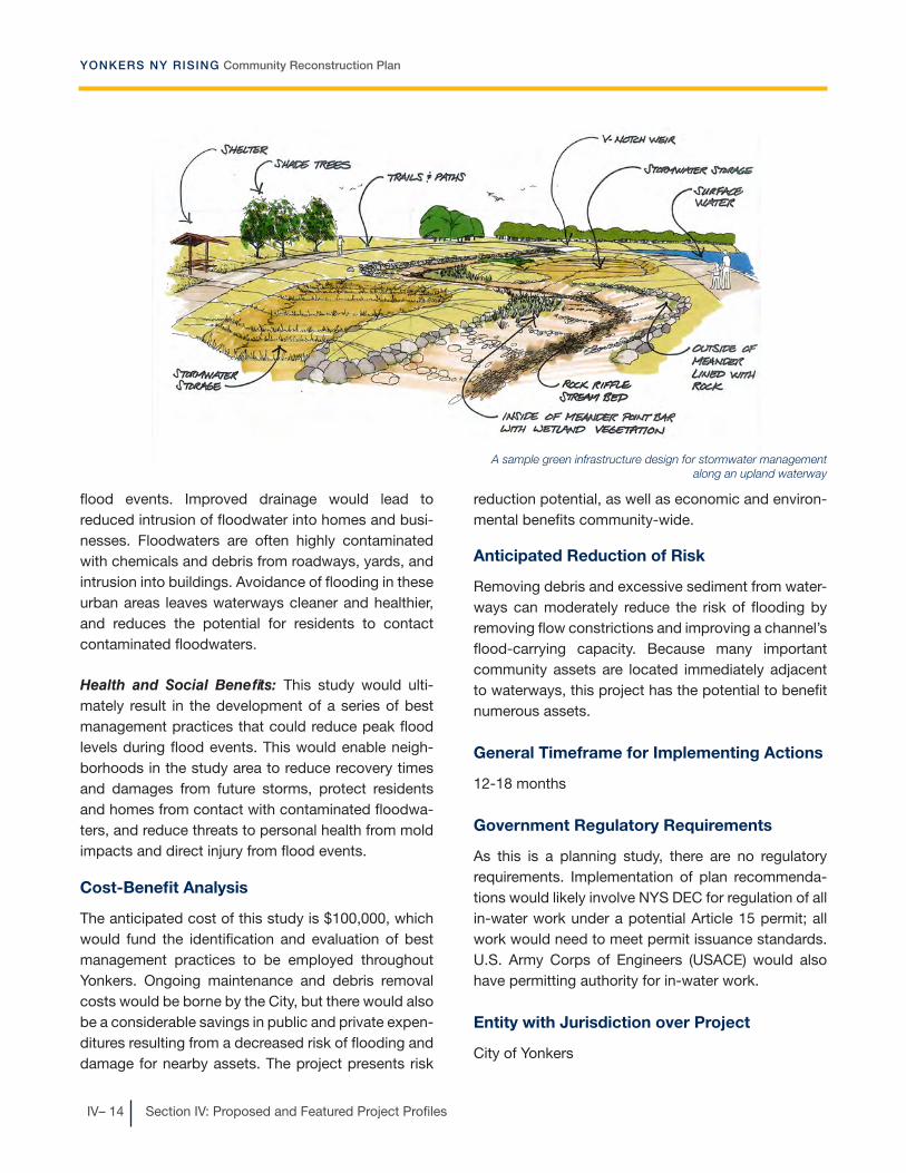
YONKERS NY RISING Community Reconstruction Plan
IV– 14 Section IV: Proposed and Featured Project Profiles
flood events. Improved drainage would lead to reduced intrusion of floodwater into homes and busi-nesses. Floodwaters are often highly contaminated with chemicals and debris from roadways, yards, and intrusion into buildings. Avoidance of flooding in these urban areas leaves waterways cleaner and healthier, and reduces the potential for residents to contact contaminated floodwaters.
Health and Social Benefits: This study would ulti-mately result in the development of a series of best management practices that could reduce peak flood levels during flood events. This would enable neigh-borhoods in the study area to reduce recovery times and damages from future storms, protect residents and homes from contact with contaminated floodwa-ters, and reduce threats to personal health from mold impacts and direct injury from flood events.
Cost-Benefit Analysis
The anticipated cost of this study is $100,000, which would fund the identification and evaluation of best management practices to be employed throughout Yonkers. Ongoing maintenance and debris removal costs would be borne by the City, but there would also be a considerable savings in public and private expen-ditures resulting from a decreased risk of flooding and damage for nearby assets. The project presents risk
reduction potential, as well as economic and environ-mental benefits community-wide.
Anticipated Reduction of Risk
Removing debris and excessive sediment from water-ways can moderately reduce the risk of flooding by removing flow constrictions and improving a channel’s flood-carrying capacity. Because many important community assets are located immediately adjacent to waterways, this project has the potential to benefit numerous assets.
General Timeframe for Implementing Actions
12-18 months
Government Regulatory Requirements
As this is a planning study, there are no regulatory requirements. Implementation of plan recommenda-tions would likely involve NYS DEC for regulation of all in-water work under a potential Article 15 permit; all work would need to meet permit issuance standards. U.S. Army Corps of Engineers (USACE) would also have permitting authority for in-water work.
Entity with Jurisdiction over Project
City of Yonkers
A sample green infrastructure design for stormwater management along an upland waterway

IV– 15
YONKERS NY RISING Community Reconstruction Plan
Section IV: Proposed and Featured Project Profiles
Reconstruction of Seawall at Yonkers Pad-dling and Rowing Club – Proposed Project
Project Description
During Superstorm Sandy, many of the City’s Hudson River waterfront properties experienced severe damage due to the record storm surge. As a histori-cally significant facility and one of Yonkers’ few public access points to the Hudson River, the County-owned Yonkers Paddling and Rowing Club is on the verge of collapse. This storied nonprofit Club, which is open to all City residents, sustained significant damage to its seawall. In addition, structural elements were torn away from the bulkhead, docks were washed away and the gangway damaged, and the overall deck col-lapsed. The Club purchased new docks and repaired the gangway, allowing the Club to reopen after Super-storm Sandy. However, while the Club remains open, the extent of the damage has forced it to shorten its calendar of activities and there is concern that the severely compromised seawall will not be able to protect the Club from future storms. This project would design and reconstruct the seawall to restore the Club for full use by City residents and protect the Club from future storms.
Project Location
Yonkers Paddling and Rowing Club, 35 Alexander Street
Estimated Cost
Project cost: $1.9 million
Cost includes preliminary and final engineering ser-vices—$200,000; and construction of new seawall—$1.7 million14.
Demolition and seawall construction costs may vary based on the results of the damage condition assess-ment. This is a source of considerable uncertainty in the cost estimate for this project.
Benefit/Co-Benefits
Economic Benefits: The damage sustained by the Club’s facilities during Superstorm Sandy was exten-sive and carried significant costs to the Club. Such costs could be mitigated in future storms through the use of modern, resilient building technologies in making the necessary repairs included in this project.
Environmental Benefits: This project would halt the deterioration of the seawall and deck and the con-comitant erosion of the shoreline, improving water quality in the vicinity by abating erosion and the intro-duction of soil materials and other possible pollutants into the waterway.
Health and Social Benefits: The Club is one of the few public access points to the Hudson River in downtown Yonkers. By ensuring the ongoing viability of the Club’s facilities, this project would ensure con-tinued access to and use of this asset, protecting it for the general public.
Cost-Benefit Analysis
The cost of project implementation—including study, design, and construction—is estimated to be approxi-mately $1.9 million. The project would reconstruct the damaged seawall, resulting in safety, environmental,
The Club’s seawall was badly damaged by Superstorm Sandy’s surge (Yonkers Paddling and Rowing Club)

YONKERS NY RISING Community Reconstruction Plan
IV– 16 Section IV: Proposed and Featured Project Profiles
and economic benefits. Providing for the continued safe operation of the Club enables public access to the Hudson River, an important community fixture and link to the natural environment. Although no permanent jobs are likely to be created, the project is expected to
result in approximately eight full-time equivalent (FTE) short-term construction related jobs for one year15.
Anticipated Reduction of Risk
Repairs made to the seawall may have some flood risk mitigation effects for the Club by attenuating damag-ing storm surge wave action. More significantly, repair of the seawall provides much-needed shoreline stabi-lization, which reduces risk to the Club facilities and has significant personal safety benefits for anyone using the Club.
General Timeframe for Implementing Actions
12-24 months
Government Regulatory Requirements
New York State Department of Environmental Conser-vation (NYS DEC) regulations including potential Article 15 and Article 25 permits. U.S. Army Corps of Engineers (USACE) standards for design and con-struction of bulkheads and seawalls.
Entity with Jurisdiction over Project
Yonkers Paddling and Rowing Club. Westchester County is the owner of the Club property.
A sketch of the proposed seawall as reconstructed
A sketch of the proposed seawall, if combined with some natural shoreline features such as rip-rap and plantings

!!
ST9A
£¤9
Sawmill R
Warb
urto
n A
ve
Main St
Riv
erd
ale
Ave
New Main St
Larkin Plz
Ph
ill ips
Tow
ers
S
Broadway
Ashburton Ave
Nepperhan Ave
NB
road
wa y
Yonk
ers Ave
YonkersStation
Hud
s on
Riv
e r
City ofYonkers
Project Location - Yonkers Paddling and Rowing Club
´
Figure IV-3
0 800Feet
LegendCity of Yonkers(Study Area)Major HighwaysRailroads
I2 Rail Station
WaterbodiesRivers and StreamsStructures
!! Project Location
Data Sources
City of Yonkers,NYSITS,Westchester County
Yonkers Paddling andRowing Club

YONKERS NY RISING Community Reconstruction Plan
IV– 18 Section IV: Proposed and Featured Project Profiles
Resilient Revitalization of the Alexander Street Waterfront—Study and Pilot Projects – Proposed Project
Project Description
The Alexander Street section of the downtown Yonkers waterfront had already suffered years of neglect and disinvestment when Superstorm Sandy brought a mix of wind and storm surge up the Hudson River, flood-ing much of the neighborhood. Residential buildings, City assets, and local businesses were not spared. Today the neighborhood is being targeted by the City through a revitalization and economic development initiative, the Alexander Street Master Plan, that envi-sions the area as a vibrant mixed-use district of resi-dences, neighborhood businesses, and riverfront parks knitted together by landscaped streets and boulevards. The City envisions that the redevelop-ment of the approximately 112-acre Alexander Street waterfront area will be carried out by numerous indi-vidual private developers over a period of time. The neighborhood is seen by many in Yonkers as a key to the City’s economic future. However, the master plan was prepared prior to Superstorm Sandy and needs to be updated and enhanced to respond to the flood risks exposed by the storm. To encourage future investment, state-of-the-art resiliency and flood pro-tection initiatives must be identified so that this area
can be transformed into a resilient mixed-use water-front environment.
This project proposes to ensure the resilient revitaliza-tion of the Alexander Street Waterfront through a two-phase process. First, the project will update and amend the 2007 Alexander Street Master Plan to transform this underperforming waterfront area into a showcase district for natural infrastructure and green building practices. Upon completion of the plan update, the project will develop and implement three model natural infrastructure projects to begin the transformation of this neighborhood.
The first component of this project—the plan update—would include the following:
��New post-Superstorm Sandy flood maps.
��Waterfront development guidelines detailing natu-ral flood protection techniques for new develop-ment and adaptive reuse.
�� Examples of state-of-the-art ecological restoration projects.
�� Application of the City’s downtown green building standards to Alexander Street, requiring sustain-able and resilient construction and rehabilitation projects along the waterfront.
The second phase of the project would include plan-ning, design, and implementation of three targeted natural infrastructure projects in the Alexander Street neighborhood to showcase the ability of green infra-structure to protect the district from flooding and storm damages. These could take the form of natural flood protection projects, or green infrastructure stormwater management and drainage projects, such as rain gardens, bioswales, and pervious pavement.
A revitalized waterfront district incorporating sustain-able building techniques, a mix of land uses, rejuve-nated public spaces, and targeted environmental res-toration projects would help ensure this key economic asset of the City is better prepared for future storms, more resilient to their impacts, and better positioned
Some of the types of green infrastructure that could be employed in the Alexander Street planning area

IV– 19
YONKERS NY RISING Community Reconstruction Plan
Section IV: Proposed and Featured Project Profiles
to recover from their damage. By functioning as a showcase of natural infrastructure and green building techniques, the project could also have a ripple effect elsewhere in Yonkers as solutions first used here are applied throughout the City.
Project Location
Alexander Street district in downtown Yonkers
Estimated Cost
Project Cost: $900,000
Cost includes amendments to Alexander Street plan (production of new mapping, development guidelines, and green building standards)—$150,000; and plan-ning, design, and construction of three green infra-structure pilot projects—estimated at $250,000 per acre, assumed $750,000 total.
Benefit/Co-Benefits
Economic Benefits: Reduced flood risk and improved flood resilience of redeveloped assets in the Alexan-der Street neighborhood would result in less extensive damages and lower rebuilding costs after future storms and flood events. By employing green building technologies, costs of heating, cooling, and overall energy may also be reduced for home and business
owners who move into the new neighborhood. There are also available subsidies for green buildings that may result in an additional economic benefit.
Environmental Benefits: Ensuring that stormwater management infrastructure is functioning properly and implementing green infrastructure practices effectively and affordably complements traditional “gray” infrastructure. Green infrastructure also gives stormwater managers the ability to create integrated multiple-benefit solutions to better serve the commu-nity and its residents. Benefits include improved water quality and reduced stormwater volume. In addition, the benefits associated with employing green building technologies are numerous and include reduced energy consumption, sustainable building materials, and reduced heat island effects in densely developed areas.
Health and Social Benefits: This project would result in the development of a showcase resilient neighbor-hood in the Alexander Street area. Residents and businesses in the neighborhood would be protected from the impacts of storm surge, which would reduce recovery times and damages from future storms, protect residents and homes from contact with con-taminated floodwaters, and reduce threats to personal health from mold impacts and direct injury from flood events. The resilient development practices pioneered here could eventually be utilized throughout the City, amplifying the benefits outlined here.
Cost-Benefit Analysis
The total project cost is anticipated to be $900,000, which includes amendments to the Alexander Street Redevelopment plan and implementation of up to three green infrastructure projects. The inclusion of green infrastructure, resilient construction technology, and green building practices at the Alexander Street Redevelopment site could result in significant risk reduction, environmental, and economic benefits. Successful integration of these practices at this site may lead to their adoption in other local development, further increasing the benefits realized from this project.
Alexander Street, ready for redevelopment, can become a showcase of green infrastructure
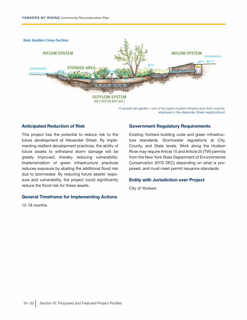
YONKERS NY RISING Community Reconstruction Plan
IV– 20 Section IV: Proposed and Featured Project Profiles
Anticipated Reduction of Risk
This project has the potential to reduce risk to the future development at Alexander Street. By imple-menting resilient development practices, the ability of future assets to withstand storm damage will be greatly improved, thereby reducing vulnerability. Implementation of green infrastructure practices reduces exposure by abating the additional flood risk due to stormwater. By reducing future assets’ expo-sure and vulnerability, the project could significantly reduce the flood risk for these assets.
General Timeframe for Implementing Actions
12-18 months
Government Regulatory Requirements
Existing Yonkers building code and green infrastruc-ture standards. Stormwater regulations at City, County, and State levels. Work along the Hudson River may require Article 15 and Article 25 (TW) permits from the New York State Department of Environmental Conservation (NYS DEC) depending on what is pro-posed, and must meet permit issuance standards.
Entity with Jurisdiction over Project
City of Yonkers
A sample rain garden—one of the types of green infrastructure that could be employed in the Alexander Street neighborhood

ST9A
£¤9
Sawmill R
Larkin Plz
A shburton Ave
Warb
urto
n A
ve
Yonkers
Ave
NB
road
wa y
GlenwoodStation
YonkersStation
Hud
son
Riv
er
City ofYonkers
Project Location - Alexander Street Waterfront
´
Figure IV-4
0 1,000Feet
LegendCity of Yonkers(Study Area)Major HighwaysRailroads
I2 Rail Station
WaterbodiesRivers and StreamsStructuresAlexander Street Master Planning Area
Data Sources
City of Yonkers,NYSITS,Westchester County

YONKERS NY RISING Community Reconstruction Plan
IV– 22 Section IV: Proposed and Featured Project Profiles
Saw Mill River Hydrologic Study – Proposed Project
Project Description
The Saw Mill River is one of the most flood-prone water-ways in Yonkers and experienced severe flooding during the April 2007 Nor’easter and Hurricane Irene. A number of projects has been proposed to address flooding in this watershed, but none of these projects has moved forward due to inadequate baseline hydrologic data that could determine the extent to which any given project would ameliorate flooding. This project would address flooding in this watershed through a three-stage process: (1) install stream gauges to begin collecting data, (2) using data collected from the stream gauges, conduct a hydro-logic study of the watershed and make recommenda-tions for projects to improve and restore the watershed, and (3) implement one or more proposed projects based on the results of the study.
Stream gauges are the foundation of any effort to determine effective improvements in this watershed. The gauges are monitoring devices installed within
stream channels to measure the height of the water surface and the quantity of water passing a location or area. They are critical to understanding a waterway’s hydrology by characterizing stream flow and dis-charge over time. There are currently no stream gauges in the Saw Mill River.
Data from the proposed stream gauges would be used by agencies contemplating flood mitigation projects in Yonkers to develop a fact-based understanding of these watersheds and would provide input for modeling the hydrologic characteristics of the watersheds. Hydrologic models enable engineers to predict the effects of flood mitigation projects and would allow the City to determine the most effective measures to increase waterway capacity, stabilize riverbanks, and create additional flood storage to mitigate upstream and downstream flooding. Additional funding would be allotted for the implementa-tion of projects that are determined by the hydrologic study to be most effective.
An important target area for this study and a critical location for new stream gauges would be the Nepera Park/Grey Oaks neighborhood. This neighborhood has routinely and consistently sustained substantial damage from flooding. A berm currently runs along a portion of the Saw Mill River in this neighborhood. The engineering design and performance criteria for the berm are unavailable—and possibly non-existent. The data from the proposed stream gauges would be criti-cal input for a hydrologic study to determine whether modifications to this berm would be beneficial. Other proposed projects that could be studied include installing an additional culvert and realigning the river beneath Odell Avenue to improve drainage, creating flood storage at upstream locations including former gas stations along the Saw Mill Parkway and the Akzo Nobel property, and restoration of minor wetlands at strategic locations in the Village of Dobbs Ferry and Town of Greenburgh.
The Planning Committee’s commitment to watershed-wide solutions can only be fully realized through regional coordination among the many municipalities of this watershed. Such coordination would derive A sketch of the proposed stream gauges

IV– 23
YONKERS NY RISING Community Reconstruction Plan
Section IV: Proposed and Featured Project Profiles
great benefit from the presence of a regulatory body focused on watershed-wide stormwater and flooding issues. The Committee’s project “Feasibility Study for Creation of a Regional Flood Control Authority” would help create such a body, and would be very comple-mentary to this project.
Project Location
The study would consider the full watershed of the Saw Mill River, both within Yonkers and upstream in other Westchest er County municipalities.
Estimated Cost
Project cost: $1,420,000-$1,560,000
Cost includes installation of two to four stream gauges at $30,000-$50,000 each, preliminary engineering, stream data, and HEC-RAS for up to four previously proposed flood mitigation projects requiring further study—$90,000 each; and $1 million allotment for project implementation.
Benefit/Co-Benefits
Economic Benefits: If the projects identified by the study are implemented, there will likely be a reduction in the extent of flooding. This reduction will result in a
decrease in future public expenditures for emergency response and recovery, as well as private expenses related to flood damages.
Environmental Benefits: This study would lay the groundwork for actions needed to stabilize riverbanks, increase waterway capacity, and create additional flood storage to mitigate downstream flooding through best stormwater management practices. It would also lead to an integrated set of flood management proj-ects that collectively reduce flooding during severe storms.
Health and Social Benefits: This study and the instal-lation of stream gauges would ultimately result in the recommendation of actions needed to enable neigh-borhoods in the study area to reduce recovery times and damages from future storms, protect residents and homes from contact with contaminated floodwa-ters, and reduce threats to personal health from mold impacts and direct injury from flood events.
Cost-Benefit Analysis
The cost of the study is anticipated to be between $420,000 and $560,000, with an additional $1 million allotted to initiate future project implementation. It is important to note that the project implementation costs will likely exceed $1 million, and the balance of the costs is anticipated to be supported by other sources of funding. The projects to be implemented as a result of the study are yet to be determined, resulting in some uncertainty in the project’s ultimate cost and benefits. The project has significant risk reduction potential, as the projects currently proposed target some of the highest risk residential and indus-trial areas in Yonkers. In addition, by vetting individual project components through engineering studies and building project components in at-risk areas, the pro-posed project has the potential to achieve significant environmental and economic benefits.
The Saw Mill River east of Clunie Avenue

YONKERS NY RISING Community Reconstruction Plan
IV– 24 Section IV: Proposed and Featured Project Profiles
Anticipated Reduction of Risk
As a comprehensive hydrologic study of the Saw Mill River waterway, this project has the potential to reduce risk to assets on a long-term basis. The target areas and data identified through this study will ultimately help to inform and optimize future resiliency projects. The incremental reductions in flood depth or other flood exposure reduction improvements made through this project may combine to have a significant risk reduction potential. The specific measures proposed to be evaluated for key target areas could potentially reduce the exposure to flooding of several high risk residential assets in the area.
General Timeframe for Implementing Actions
12-24 months for initial study
Government Regulatory Requirements
The hydrologic study component has no regulatory requirements. Installation of stream gauges would need to comply with New York State Department of Environmental Conservation (NYS DEC) and U.S. Army Corps of Engineers (USACE) regulations for work in regulated waterways, as would any in-water work for follow-up projects resulting from the study. The U.S. Geological Survey manages all stream gauges.
Entity with Jurisdiction over Project
City of Yonkers and upstream municipalities

§̈¦95
§̈¦684
§̈¦87
§̈¦287
Long IslandSound
Long
Isla
ndSo
und
Hudson
River
Town ofGreenburgh
Villageof Dobbs
Ferry
Town of MountPleasant
Village ofElmsford
Village ofHastings-on-Hudson
City ofYonkers
Villageof Sleepy
Hollow
Village ofArdsley
Townof NewCastle
Village ofIrvington
Village ofTarrytown
Project Location - Saw Mill River Watershed
´
Figure IV-5
0 4Miles
LegendCity of Yonkers(Study Area)Major Highways
WaterbodiesRivers and StreamsSaw Mill River WatershedWestchester Municipalities in Watershed
Data Sources
City of Yonkers,NYSITS,Westchester CountyUSGS

YONKERS NY RISING Community Reconstruction Plan
IV– 26 Section IV: Proposed and Featured Project Profiles
Scout Field Engineering Study – Proposed Project
Project Description
Scout Field is a Westchester County park located along the Bronx River, partly in Yonkers and partly in the Village of Bronxville and the City of Mount Vernon. Over a period of several years this 22.29-acre public park has been improved with playing fields—including improvements that imported fill material to elevate the site above the floodway. The Planning Committee has reported that the improvements have only exacer-bated flooding in several flood-prone areas of Yonkers. Furthermore, plans are in place to undertake addi-tional improvements to Scout Field, including adding additional recreational facilities to the park and pumping stormwater from the Bronxville High School catchment area into Lauren Brook, a small tributary of the Bronx River which flows through Scout Field. These proposed improvements would require more fill and potentially result in even greater upstream and downstream flood impacts to Yonkers.
This project would involve inter-municipal cooperation to determine, via hydraulic modeling, whether improvements to Scout Field could adversely affect flooding in neighborhoods along the Bronx River and what could be done to mitigate potentially adverse flooding impacts. Based on the results of this study, recommendations would be made to the municipali-ties involved to avoid upstream and downstream flooding impacts. Scout Field serves several commu-nities, so future improvements could benefit from inter-municipal cooperation and agreements.
The Planning Committee’s commitment to a solution that works for all the stakeholders involved can only be fully realized through regional coordination. Such coordination would derive great benefit from the pres-ence of a regulatory body focused on watershed-wide stormwater and flooding issues. The Committee’s project “Feasibility Study for Creation of a Regional Flood Control Authority” would help create such a body, and would be very complementary to this project.
Project Location
Scout Field
Estimated Cost
Study cost: $30,000-$50,000
Cost includes completion of an engineering review and impact assessment, and determination of recom-mended actions.
Scout Field
The Bronx River at Scout Field

IV– 27
YONKERS NY RISING Community Reconstruction Plan
Section IV: Proposed and Featured Project Profiles
Benefit/Co-Benefits
Economic Benefits: If the actions identified by the study are implemented, there will likely be a reduction in the extent of flooding in nearby areas. This will result in a reduction in future public expenditures for emer-gency response and recovery, as well as private expenses related to flood damages.
Environmental Benefits: The project would develop recommendations for this important open space area within the Bronx River floodplain. If these recommen-dations are able to mitigate flood extent in neighbor-ing residential areas, it would reduce the negative environmental impacts of uncontrolled flooding, including erosion and damage to waterways and pol-lution of waterways when floodwaters become con-taminated as they come into contact with roadways, yards, and other urbanized areas.
Health and Social Benefits: This study would lay the groundwork for actions needed to enable neighbor-hoods near Scout Field to reduce recovery times and damages from future storms.
Cost-Benefit Analysis
The cost of this study is estimated to be between $30,000 and $50,000. The study would ultimately make recommendations for actions to be taken at Scout Field, and the cost of implementation of those recommendations is not included here. The recom-mended actions could provide risk reduction,
environmental, and economic benefits, as they would target a particularly flood-prone area of the commu-nity. In addition, the study itself promotes regional collaboration, a benefit which would be further real-ized through implementation of recommended actions.
Anticipated Reduction of Risk
The project could reduce risk to assets in the vicinity of Scout Field by reducing exposure to flood condi-tions. By determining potentially adverse impacts and effective mitigation to alleviate upstream flooding in several flood-prone neighborhoods in Yonkers, an appropriate solution can be devised and implemented. As the recommended measures for this project have not yet been determined, there is some uncertainty in the risk reduction potential of the project.
General Timeframe for Implementing Actions
6-12 months
Government Regulatory Requirements
As this is a study, there are no regulatory requirements.
Entity with Jurisdiction over Project
City of Yonkers, in coordination with the Village of Bronxville, City of Mount Vernon, and Westchester County. The park is owned by Westchester County.

Sprain Bk
Bro
nxR
Palmer Rd
Sprain Brook Pkwy
Mid
land
Ave
Bro
nx
Riv
er R
d
Cross County Pkwy
Kim
bal l
Ave
Bro
nxR
ive rPkwy
FleetwoodStation
FleetwoodStation
BronxvilleStation
City ofMount Vernon
Villageof Bronxville
City ofYonkers
Project Location - Scout Field
´
Figure IV-6
0 1,000Feet
LegendCity of Yonkers(Study Area)Major HighwaysRailroads
I2 Rail Station
WaterbodiesRivers and StreamsParksStructuresScout Field
Data Sources
City of Yonkers,NYSITS,Westchester County
Scout Field

IV– 29
YONKERS NY RISING Community Reconstruction Plan
Section IV: Proposed and Featured Project Profiles
Technical Assistance Program for Residential Resiliency – Proposed Project
Project Description
Residential neighborhoods throughout Yonkers were heavily impacted by the April 2007 Nor’easter, Hurri-cane Irene, and Superstorm Sandy. Flooding, power outages, and downed trees left tens of thousands of residents, including some entire neighborhoods, to deal with major storm-related damages without access to many essential services. This project would empower residents by creating a comprehensive technical assistance program to assist homeowners and renters who have been affected by past storms or whose property continues to be vulnerable to future storms. The project contains an education and out-reach component and an individual technical assis-tance component.
1) The education and outreach component of the project would develop a series of educational mate-rials providing critical residential resiliency informa-tion. Materials would be made available to residents on the Yonkers website and in hard copy at key locations throughout the City, and a coordinated outreach campaign would ensure residents are able to access these materials. Topics would include:
�� A comprehensive menu of home floodproofing tools including home retrofits, green infrastructure improvements, and energy resiliency investments such as solar panels, and would provide informa-tion on available government incentive programs where these exist.
�� Information on financing, grants, and subsidies as well as fair market prices for storm-related repairs and other recovery services to help residents and property owners avoid potential rebuilding, insur-ance, or financial scams.
�� Information on available floodproofing tools, includ-ing retrofits, home elevations, floodproof door and window barriers, backflow preventers, and replacing oil tanks with natural gas to prevent oil spills during extreme storms. There were numerous complaints
of oil spills in residential neighborhoods during the April 2007 Nor’easter and Hurricane Irene.
��Outreach to vulnerable populations and the organi-zations that serve them to ensure that these resourc-es are made fully available to those populations.
2) The individual technical assistance program would train and employ staff to meet with residents and conduct home resiliency audits, as well as provide information and advice on resilient practices for their homes and properties. These qualified person-nel would be knowledgeable in the many techniques and resources that are available to help residents with rebuilding and resiliency and would be able to offer tailored advice on the best methods for each individual.
Project Location
Citywide
Estimated Cost
Program cost: $850,000
Cost includes $100,000 for research and development of educational materials and outreach campaign and $750,000 for the technical assistance program ele-ments, including program administration, training, and salaries for three inspectors, one grants manager, and one supervisor for a period of two years.
Residential neighborhoods may appear high and dry, but homeown-ers must prepare for flooding. Here, Nepera Park.

YONKERS NY RISING Community Reconstruction Plan
IV– 30 Section IV: Proposed and Featured Project Profiles
Benefit/Co-Benefits
Economic Benefits: Reduced damages from flooding lead to reduced impacts to the local economy: workers are able to get to their jobs and businesses may be able to stay open. In addition, the project could result in a local economic stimulus effect by encouraging residents to use local contractors to perform the nec-essary work. The technical assistance program would also create technical jobs in the community, as there will be a need for additional technical resources for counseling and auditing services.
Environmental Benefits: Encouraging the replace-ment of heating oil tanks with natural gas would benefit the environment, as oil tanks have been reported to spill frequently during past storm events.
Health and Social Benefits: The project could have significant social benefits by enabling residents to stay in their homes during minor flooding events or enabling them to return to their homes more quickly after major flooding events, thereby mitigating distur-bance to social and family structures and reducing the financial burden of repetitive flood damages. Also, protection from interior flooding can reduce mold impacts on residents and speed return to the use of homes and businesses.
Cost-Benefit Analysis
The cost of the project is estimated at $850,000, with the funding providing program design and direct tech-nical assistance to individual homeowners. The costs for actual improvements made to homes, as well as the maintenance of those improvements, are the responsibility of individual homeowners (grant/loan
assistance may be available upon application by homeowners). The project aims to keep costs fair and competitive by distributing information on pricing and available government subsidies. The costs for home-owners will likely vary considerably with the extent of necessary repairs and improvements. The project has significant risk reduction potential, in addition to pro-viding social, economic, and environmental benefits throughout the community. The extent of benefits realized by the project would increase with the number of homes participating in the program.
Anticipated Reduction of Risk
This project could potentially have moderate risk reduction benefits by making floodproofing informa-tion and resources more accessible to homeowners and encouraging implementation of residential resil-iency techniques. Floodproofing measures can reduce the vulnerability of an asset by mitigating the effect of flooding. This reduces the damage sustained by resi-dential assets as well as the time that families must spend away from their homes in the wake of flood events.
General Timeframe for Implementing Actions
6-12 months
Government Regulatory Requirements
Yonkers Department of Buildings would be involved with any building code updates.
Entity with Jurisdiction over Project
City of Yonkers

IV– 31
YONKERS NY RISING Community Reconstruction Plan
Section IV: Proposed and Featured Project Profiles
Sample pages from a menu of home floodproofing tools

YONKERS NY RISING Community Reconstruction Plan
IV– 32 Section IV: Proposed and Featured Project Profiles
Yonkers Emergency Response and Recovery Campaign – Proposed Project
Project Description
Although Yonkers’ emergency response systems were well-prepared for the major storm events of recent years and responded well to these crises, the extreme nature of the flooding and destruction caused by the April 2007 Nor’easter, Hurricane Irene, and Super-storm Sandy has forced Yonkers to take a fresh look at its emergency readiness and recovery programs and systems. Each storm brought unprecedented challenges, from the record flooding along the Bronx River, Grassy Sprain Brook, and Saw Mill River during the the Nor’easter and Hurricane Irene, to Superstorm Sandy’s powerful storm surge that devastated much of the local wastewater treatment infrastructure. This project would develop and implement the following programs in coordination with the City of Yonkers Office of Emergency Management (OEM) and other emergency response organizations to complement and expand on the City’s already strong package of services and programs:
1) A fully integrated Citywide early warning system for flooding and other emergencies that builds on Yonkers’ existing notification system. Currently, the City’s emergency early warning system autodials landline telephones and cell phones of Yonkers residents who are enrolled in the early warning system program. This program would expand the system to include advance emergency notifications to all landlines and cell phones registered in the City, including those not currently enrolled in the program, as well as email and social media notifica-tions. This component would include a comprehen-sive community outreach program to increase enrollment with the goal of developing a Citywide phone and email emergency notification contact list. The outreach initiatives would be incorporated into all existing Yonkers preparedness programs, including Yonkers Preparedness Month. In addition, the City of Yonkers currently maintains a list of vul-nerable populations, who would be automatically
enrolled in the emergency notification contact list, and concurrent outreach efforts would be made to ensure that this list stays current and complete. Organizations that serve vulnerable populations would also be contacted.
2) Improve on the City’s existing community call-in line to expand opportunities for City residents to communicate their needs to emergency respond-ers. Many residents described having difficulty contacting the appropriate City staff during Hurri-cane Irene and Superstorm Sandy to request sand-bags and report downed trees, eroded berms, and other situations requiring rapid response during a storm event. Upgrading the community call-in line by providing new software and additional staff training would address this issue, speed the deliv-ery of services, and prioritize emergency response to the residents and neighborhoods most in need.
3) Conduct a comprehensive education and outreach campaign to inform the public of the enhanced flood warning system and improved community call-in line and to enroll residents in the emergency notification contact list. This would include the comprehensive outreach to increase enrollment in the City’s early warning system (outlined above), as well as further efforts to ensure that the Yonkers community is fully informed and knowledgeable regarding the services available through these City programs, such as radio announcements, TV spots, and adverisements in other mass media outlets.
A schematic of the enhanced emergency communications systems

IV– 33
YONKERS NY RISING Community Reconstruction Plan
Section IV: Proposed and Featured Project Profiles
Project Location
Citywide
Estimated Cost
Program cost: $475,000
Cost includes setting up local early warning system (training, staff time for system setup and data entry to expand and update emergency notification contact list, and purchase of software)—$250,000; upgrades to community call-in line (training, staff time for setup, and purchase of software)—$150,000; and design and production of education and outreach campaign materials—$75,000.
Benefit/Co-Benefits
Health and Social Benefits: This program would enhance the strategic capabilities of OEM in severe storm planning and recovery, leading to improved response to severe storm events and other disasters. An early warning system allows citizens to prepare further in advance for severe weather events, leading to improved outcomes including reduction in damages, injury, and health impacts.
Cost-Benefit Analysis
The cost of implementing these proposed programs is estimated to be approximately $475,000, with moder-ate annual maintenance costs associated with the enhanced programs. The programs would
bring significant risk reduction potential to affected populations throughout Yonkers and would provide health and social benefits to particularly vulnerable populations.
Anticipated Reduction of Risk
Improvements to the emergency response programs in Yonkers have the potential to reduce risk to people and property throughout the community. An early warning system facilitates early evacuation and plan-ning for residents, and ensuring that vulnerable popu-lations are included in notifications can help alleviate additional risk to these populations. A community call-in line can facilitate allotment of emergency response resources to areas within the community that are most at need and even provide a prevention mech-anism with early reporting from community members.
General Timeframe for Implementing Actions
6-12 months
Government Regulatory Requirements
Follow any applicable City, State, County, or FEMA guidelines.
Entity with Jurisdiction over Project
City of Yonkers

YONKERS NY RISING Community Reconstruction Plan
IV– 34 Section IV: Proposed and Featured Project Profiles
Planning Study for Sprain Diversion Channel – Featured Project
Project Description
The heavy rains of the April 2007 Nor’easter, Hurri-cane Irene, and other severe storm events have exceeded the capacity of the existing local stormwa-ter systems in northern Yonkers, contributing to flood-ing along the Sprain Brook. This project would analyze the potential flood reduction benefits of diverting some of this excess runoff into a different subwater-shed area—the Grassy Sprain Reservoir—with poten-tially greater capacity to handle the water.
The Sprain Diversion Channel would originate at the Sprain Brook as it passes through the Saint Andrews Golf Club, just north of Yonkers in the neighboring Town of Greenburgh. The proposed diversion channel would redirect a portion of the flow from the Sprain Brook into the Grassy Sprain Reservoir by going under Sprain Road and through Sprain Ridge Park. A preliminary engineer-ing feasibility study16 suggests that the Town of Green-burgh and the City jointly pursue diverting stream flow away from the Sprain Brook into the Grassy Sprain Reservoir, which could reduce water volumes down-stream, especially during flood events. Implementation of this inter-municipal project could potentially ease flooding for downstream neighborhoods routinely flooded by severe storms. This diversion of water and the subsequent alteration of drainage area boundaries will require more detailed engineering and hydraulic modeling to ensure that the project would not exacer-bate upstream or downstream flood conditions.
Project Location
Saint Andrews Golf Club, Grassy Sprain Reservoir
Estimated Cost
Study cost: $80,000
Cost includes review of existing completed feasibility study—$35,000; modeling to develop recommended actions—$45,000.
Benefit/Co-Benefits
Economic Benefits: If the actions identified by the study are determined to be effective and are imple-mented, there will likely be a reduction in the extent of flooding in areas adjacent to the Sprain Brook. This would result in a reduction in future public expendi-tures for emergency response and recovery, as well as private expenses related to flood damages.
Environmental Benefits: Easing flooding in the urban areas along the Sprain Brook and Grassy Sprain Brook has the potential to reduce the negative environmental impacts of uncontrolled flooding, including erosion and damage to waterways and pollution of waterways when floodwaters become contaminated as they come into contact with roadways, yards, and other urbanized areas.
Health and Social Benefits: This study would lay the groundwork for actions needed to enable neighbor-hoods along Sprain Brook to reduce recovery times and damages from future storms.
Cost-Benefit Analysis
The cost of the study is estimated to be $80,000. The costs associated with the recommended actions have not yet been determined and will require further analy-sis upon completion of the study. The recommended actions could result in risk mitigation benefits by reducing the volume of water in downstream stretches of the Sprain Brook. This can, in turn, create positive environmental effects by reducing the contact of flood waters with contaminants. However, this project requires further in-depth environmental study, as the diversion of waterways across watershed boundaries may have effects on the surrounding ecosystem.
Anticipated Reduction of Risk
Preliminary engineering suggests that diverting stream flow away from the Sprain Brook could reduce water volumes downstream, especially during flood events such as Hurricane Irene or the April 2007 Nor’easter. The eventual implementation of this inter-municipal

IV– 35
YONKERS NY RISING Community Reconstruction Plan
Section IV: Proposed and Featured Project Profiles
project could potentially ease flooding for downstream neighborhoods routinely flooded by these types of severe storms. As the recommended measures for this project have not yet been determined, there is some uncertainty in its risk reduction potential.
General Timeframe for Implementing Actions
12-18 months
Government Regulatory Requirements
As this is a study, there are no regulatory require-ments. Implementation may require permits from the New York State Department of Environmental Conser-vation (NYS DEC) and U.S. Army Corps of Engineers (USACE), as well as environmental review.
Entity with Jurisdiction over Project
City of Yonkers
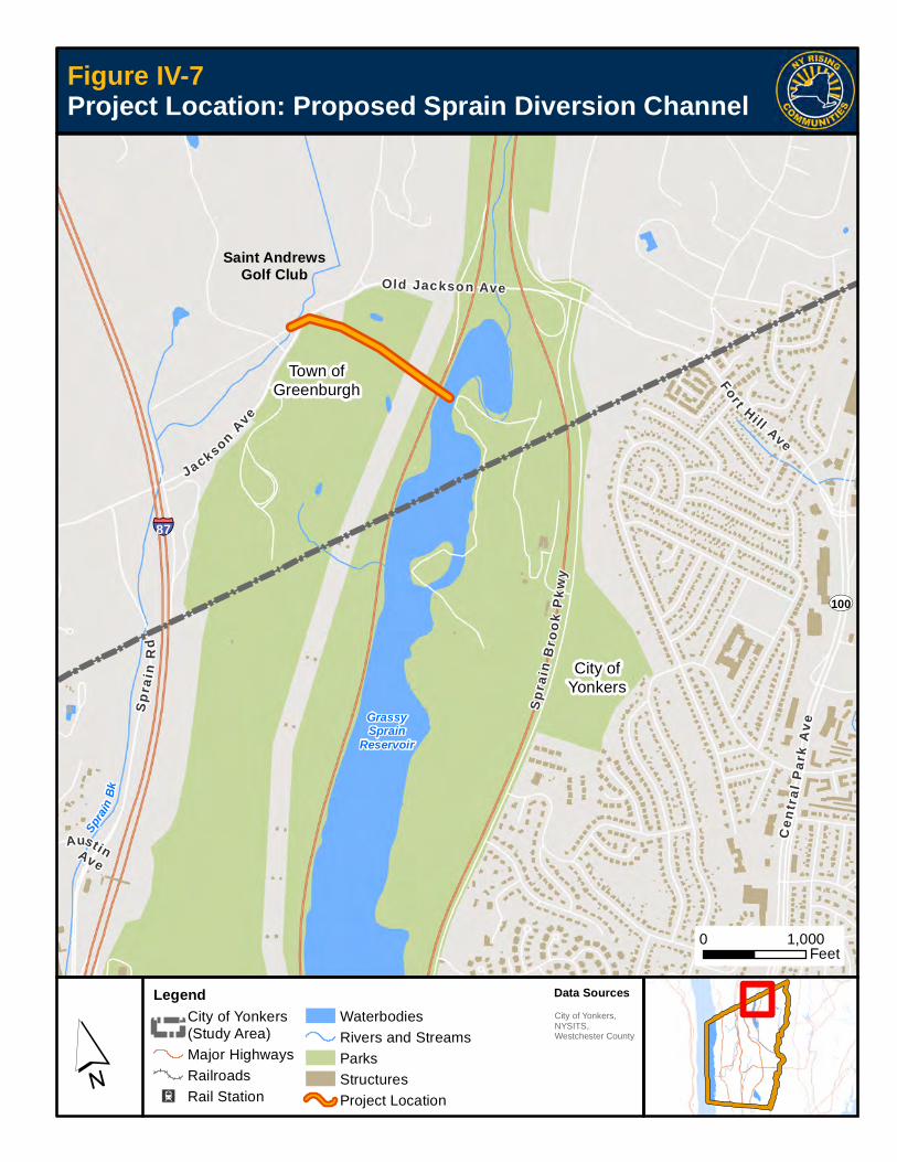
ST100
§̈¦87
Spra
inBk
GrassySprain
Reservoir
AustinAve
Fort Hi ll Ave
Old Jackson Ave
Sp
rain
Rd
J acksonAve
Sp
rain
Bro
ok
Pkw
y
Cen
t ral
Par
kA
v e
Town ofGreenburgh
City ofYonkers
Project Location: Proposed Sprain Diversion Channel
´
Figure IV-7
0 1,000Feet
LegendCity of Yonkers(Study Area)Major HighwaysRailroads
I2 Rail Station
WaterbodiesRivers and StreamsParksStructuresProject Location
Data Sources
City of Yonkers,NYSITS,Westchester County
Saint AndrewsGolf Club

2014NY RIS ING COMMUNITY RECONSTRUCTION PLANY O N K E R S N Y R C R
Section VAdditional Materials


Section V: Additional Materials V– 1
Additional MaterialsV
A. Additional Resiliency RecommendationsThroughout the NYRCR Planning process, the Plan-ning Committee developed the Additional Resiliency Recommendations listed in Table V-1. These recom-mendations were developed as projects and actions
that the Planning Committee would like to highlight and that are not categorized as Proposed Projects or Featured Projects. Projects are listed by Reconstruc-tion and Resiliency Strategy. Projects are not ranked or prioritized and are presented in no particular order of importance.
Table V-1 Additional Resiliency Recommendations
Strategy Project Name Short DescriptionEstimated
Cost
Regional
(Y/N)
Provide information and assistance to home and business owners with pre-storm floodproofing and post-storm recovery
Facilitate Continuity and Resiliency Services through City Business Organizations
Through the Yonkers Chamber of Commerce and similar business associations, provide an opportunity for all local companies to have access to businesses providing cost effective business continuity and resiliency services as well as companies providing business interruption insurance coverage.
$75,000 N
National Flood Insurance Program's Community Rating System Participation
Encourage the City to pursue participation in the Community Rating System, which could result in improved flood mitigation efforts as well as discounts on flood insurance premiums and provide discounts to incentivize new flood protection activities.
$50,000 N
Repair, rehabilitate, upgrade, and fortify critical infrastructure assets
Bronx River Sewer Repair the liner of the Bronx River Sewer, part of the County’s wastewater treatment infrastructure, to prevent stormwater intrusion into the sewer system and decrease combined sewer overflows (CSOs) to the City’s waterways.
$500,000 N
Brooklands Floodwall
Enlarge an existing floodwall along the Sprain Brook where it borders the Brooklands Cooperative. This would protect Brooklands residents from significant storm damage during flood events.
$1-2 million N
Burying of Power Lines
In coordination with Con Edison, determine the feasibility and benefit of burying power lines in older neighborhoods throughout the City to limit power outages due to downed trees or other interference with overhead lines.
$15 million N

YONKERS NY RISING Community Reconstruction Plan
Section V: Additional MaterialsV– 2
Table V-1 (cont’d) Additional Resiliency Recommendations
Strategy Project Name Short DescriptionEstimated
Cost
Regional
(Y/N)
Repair, rehabilitate, upgrade, and fortify critical infrastructure assets (cont”d)
Grassy Sprain Reservoir Flood Valve
Repair/replace the valve (floodgate) on the Grassy Sprain Reservoir to have an operating valve that can lower the level of the reservoir in advance of a storm, creating additional flood storage capacity.
$1.5 million N
Hardening of WWTP
Protect the Yonkers Wastewater Treatment Plant (WWTP) and related facilities through physical protective measures such as providing portable flood barriers, installing flood doors and other flood-proofing, and installing new pumps and emergency generators to remove water from basements.
$18 million N
Redesign and Repair of Steel Bulkhead at JFK Marina
Complete the redesign and repair of the steel bulkhead at the JFK Marina begun and partially funded by the City, and would result in a revitalized structure that would have the integrity to withstand future storm surges.
$6 million - $7.5 million
N
Replacement of Metro-North Bronxville Bridge
The low culverts of the Metro-North Bronxville Bridge may have obstructed floodwaters during the April 2007 Nor'easter and Hurricane Irene, thereby contributing to upstream flooding along the Grassy Sprain Brook and Bronx River. This project would conduct an engineering feasibility study to determine the flood reduction benefits of removing the existing bridge and constructing a new bridge with higher culverts.
$30 million N
Selected Roadway Elevations
Identify critical roadways and residential roadways in risk areas that feed into existing hurricane evacuation routes, whose elevation would prove beneficial during flood events.
$1 million per lane mile
N
Harness resiliency potential of natural resources
Ludlow Park (Wetland Creation for Detention)
Convert the land south of the American Sugar refinery and north of the Metro-North Ludlow Station into a City park that would also provide stormwater detention and a tidal wetland.
$4 million N

Section V: Additional Materials
YONKERS NY RISING Community Reconstruction Plan
V– 3
B. Master Table of ProjectsTable V-2 presents all projects developed by the Yonkers NYRCR Committee throughout the planning process. This comprehensive list includes Proposed Projects and Featured Projects, which may be funded
through the NYRCR Program, as well as Additional Resiliency Recommendations. Projects are listed by Reconstruction and Resiliency Strategy. Projects are not ranked or prioritized, and are presented in no par-ticular order of importance.
Table V-2 Master Project Table
StrategyProject
NameShort Description
Project
CategoryEstimated Cost
Regional
(Y/N)
Work with neighborhoods and businesses to improve flood resistance in Yonkers’ vulnerable areas
Bronx River and Grassy Sprain Brook Hydrologic Study
Address flooding in this watershed through a three-stage process: (1) install stream gauges to begin collecting data, (2) using collected data, conduct a hydrologic study of these two primary watersheds and make recommendations for flood mitigation projects, and (3) implement one or more projects recommended in the study.
Proposed Project
$1,630,000-$1,840,000
Y
Saw Mill River Hydrologic Study
Address flooding in this watershed through a three-stage process: (1) install stream gauges to begin collecting data, (2) using collected data, conduct a hydrologic study of this primary watershed and make recommendations for flood mitigation projects, and (3) implement one or more projects recommended in the study.
Proposed Project
$1,420,000-$1,560,000
Y

YONKERS NY RISING Community Reconstruction Plan
Section V: Additional MaterialsV– 4
Table V-2 (cont’d) Master Project Table
StrategyProject
NameShort Description
Project
Category
Estimated
Cost
Regional
(Y/N)
Improve on existing emergency preparedness and communications
Emergency Power to Street Lights Along Evacuation Routes
Conduct a pilot project to replace 10-15 existing conventional street lights with solar battery-powered street lights as backup power along a major evacuation route.
Proposed Project
$70,000-$135,000
N
Yonkers Emergency Response and Recovery Campaign
Develop and implement the following programs in coordination with the City of Yonkers Office of Emergency Management (OEM) and other emergency response organizations to complement and expand on the City’s already strong package of services and programs:
1) A fully integrated Citywide early warning system for flooding and other emergencies that builds on Yonkers’ existing notification system.
2) An upgraded community call-in line to expand opportunities for City residents to communicate their needs to emergency responders.
3) A comprehensive education and outreach campaign to inform the public of the enhanced flood warning system and community call-in line and enroll residents in the emergency notification contact list.
Proposed Project
$475,000 N
Provide information and assistance to home and business owners with pre-storm floodproofing and post-storm recovery
Technical Assistance Program for Residential Resiliency
Create a comprehensive technical assistance program to assist homeowners and renters who have been affected by past storms or whose property continues to be vulnerable to future storms. The project contains an education and outreach component and an individual technical assistance component.
Proposed Project
$850,000 N
Facilitate Continuity and Resiliency Services through City Business Organizations
Through the Yonkers Chamber of Commerce and similar business associations, provide an opportunity for all local companies to have access to businesses providing cost effective business continuity and resiliency services as well as companies providing business interruption insurance coverage.
Additional Resiliency Recommen- dation
$75,000 N
National Flood Insurance Program's Community Rating System Participation
Encourage the City to pursue participation in the Community Rating System, which could result in improved flood mitigation efforts as well as discounts on flood insurance premiums and provide discounts to incentivize new flood protection activities.
Additional Resiliency Recommen- dation
$50,000 N

Section V: Additional Materials
YONKERS NY RISING Community Reconstruction Plan
V– 5
Table V-2 (cont’d) Master Project Table
StrategyProject
NameShort Description
Project
Category
Estimated
Cost
Regional
(Y/N)
Promote resiliency and flood management best practices through land-use planning and regulation
Planning Study to Establish Best Management Practices for Upland Waterways
Undertake a planning study to develop best practices for managing Yonkers’ upland waterways to prevent degradation of their hydrologic function. The study would consider ways to balance the urgent need to minimize damaging overflows or backups along these waterways with the importance of protecting the habitat, ecological, and hydrologic functioning of these rivers and streams.
Proposed Project
$100,000 Y
Resilient Revitalization of the Alexander Street Waterfront—Study and Pilot Projects
Update and amend the Alexander Street Master Plan to transform this underperforming waterfront area into a showcase district for natural infrastructure and green building practices. The project would also include planning, design, and implementation of three targeted natural infrastructure projects in the Alexander Street neighborhood to showcase the ability of green infrastructure to protect the district from flooding and storm damages.
Proposed Project
$900,000 N
Scout Field Engineering Study
Determine, via hydraulic modeling, whether proposed improvements to Scout Field could adversely affect flooding in neighborhoods along the Bronx River.
Proposed Project
$30,000 - $50,000
Y
Repair, rehabilitate, upgrade, and fortify critical infrastructure assets
Creation of Access to Grassy Sprain Brook through Sprain Brook Parkway Sound Barrier
Construct access gates in the Sprain Brook Parkway’s sound barrier to allow access to maintenance equipment in order to remove debris and obstructions in the Grassy Sprain Brook.
Proposed Project
$365,000 N
Reconstruction of Seawall at Yonkers Paddling and Rowing Club
Design and reconstruct the seawall at the historic Yonkers Paddling and Rowing Club, one of Yonkers' few public access points to the Hudson River.
Proposed Project
$1.9 million N
Bronx River Sewer
Repair the liner of the Bronx River Sewer, part of the County's wastewater treatment infrastructure, to prevent stormwater intrusion into the sewer system and decrease CSOs to the City's waterways.
Additional Resiliency Recommen- dation
$500,000 N
Brooklands Floodwall
Enlarge an existing floodwall along the Sprain Brook where it borders the Brooklands Cooperative. This would protect Brooklands residents from significant storm damage during flood events.
Additional Resiliency Recommen- dation
$1 million - $2 million
N

YONKERS NY RISING Community Reconstruction Plan
Section V: Additional MaterialsV– 6
Table V-2 (cont’d) Master Project Table
StrategyProject
NameShort Description
Project
Category
Estimated
Cost
Regional
(Y/N)
Repair, rehabilitate, upgrade, and fortify critical infrastructure assets (cont’d)
Burying of Power Lines
In coordination with Con Edison, determine the feasibility and benefit of burying power lines in older neighborhoods throughout the City to limit power outages due to downed trees or other interference with overhead lines.
Additional Resiliency Recommen- dation
$15 million N
Grassy Sprain Reservoir Flood Valve
Repair/replace the valve (floodgate) on the Grassy Sprain Reservoir to have an operating valve that can lower the level of the reservoir in advance of a storm, creating additional flood storage capacity.
Additional Resiliency Recommen- dation
$1.5 million N
Hardening of WWTP
Protect the Yonkers Wastewater Treatment Plant (WWTP) and related facilities through physical protective measures such as providing portable flood barriers, installing flood doors and other flood-proofing, and installing new pumps and emergency generators to remove water from basements.
Additional Resiliency Recommen- dation
$18 million N
Redesign and Repair of Steel Bulkhead at JFK Marina
Complete the redesign and repair of the steel bulkhead at the JFK Marina begun and partially funded by the City, and would result in a revitalized structure that would have the integrity to withstand future storm surges.
Additional Resiliency Recommen- dation
$6 million - $7.5 million
N
Replacement of Metro-North Bronxville Bridge
The low culverts of the Metro-North Bronxville Bridge may have obstructed floodwaters during the April 2007 Nor'easter and Hurricane Irene, thereby contributing to upstream flooding along the Grassy Sprain Brook and Bronx River. This project would conduct an engineering feasibility study to determine the flood reduction benefits of removing the existing bridge and constructing a new bridge with higher culverts.
Additional Resiliency Recommen- dation
$30 million N
Selected Roadway Elevations
Identify critical roadways and residential roadways in risk areas that feed into existing hurricane evacuation routes, whose elevation would prove beneficial during flood events.
Additional Resiliency Recommen- dation
$1 million per lane mile
N
Enhance regional coordination in flood mitigation planning
Feasibility Study for Creation of a Regional Flood Control Authority
Undertake a planning study to assess the feasibility of establishing a Regional Flood Control Authority with regulatory authority and power to review and harmonize regulations and ordinances across municipal boundaries. This authority would operate within the watersheds of Westchester County, including the Bronx River, Grassy Sprain Brook, and Saw Mill River watersheds.
Proposed Project
$75,000 Y

Section V: Additional Materials
YONKERS NY RISING Community Reconstruction Plan
V– 7
Table V-2 (cont’d) Master Project Table
StrategyProject
NameShort Description
Project
Category
Estimated
Cost
Regional
(Y/N)
Harness resiliency potential of natural resources
Planning Study for Sprain Diversion Channel
Analyze the potential benefits and develop plans to divert stormwater from the Sprain Brook in the neighboring Town of Greenburgh into the Grassy Sprain Reservoir to help move flows from one subwatershed area to another with potentially greater carrying and storage capacity.
Featured Project $80,000 Y
Ludlow Park (Wetland Creation for Detention)
Convert the land south of the American Sugar refinery and north of the Metro-North Ludlow Station into a City park that would also provide stormwater detention and a tidal wetland.
Additional Resiliency Recommen- dation
$4 million N

YONKERS NY RISING Community Reconstruction Plan
Section V: Additional MaterialsV– 8
C. Public Engagement ProcessThe public and stakeholder engagement process incorporated a range of techniques to involve Yonkers residents in shaping their NYRCR Plan:
Public Engagement TechniquesThe goal of public communications related to the NYRCR Program was to engage a broad representa-tion of stakeholders and the public in the process and to ensure that a wide range of ideas and viewpoints were incorporated into discussions of how to build back better for a more resilient Yonkers. A variety of techniques were used, including:
Flyers
Flyers were created for Public Engagement Events, in English and Spanish, and were distributed to Commit-tee members who were encouraged to post and dis-tribute them in their respective neighborhoods. Flyers were also sent via email to Committee members and stakeholder groups, providing an opportunity to share and spread the word digitally.
Canvassing
Members of the project team placed flyers at key stakeholder locations including libraries, civic organi-zations, and places of worship, and shared them with elected officials in a further effort to increase partici-pation. Flyers were also placed on the Yonkers NYRCR webpage.
Constant Contact
The project team utilized Constant Contact, a market-ing tool used to design, send, and track digital mail-ings to mass audiences. Constant Contact emails were sent out in advance of all Public Engagement Events, and included meeting time and date informa-tion and meeting flyers.
Public Events
Members of the project team and the Committee staffed a booth at Riverfest, an annual event held in early September in downtown Yonkers. There, resi-dents were invited to learn about the NYRCR Program, tell the story of their flooding experiences, and offer suggestions on ways to make the City more resilient in the face of future flooding. In addition, there was the opportunity for children to tell their flood and storm story via narratives and pictures. General information about the NYRCR program was made available, and flyers for an upcoming Public Engagement Event were distributed to the public.
Regular Committee Meetings
The Yonkers NYRCR Committee was comprised of 11 members including two co-chairs. This group was comprised of municipal staff, civic leaders, and storm-impacted residents. Committee members met twice a month to review progress and provide input on every aspect of the plan—study area, vision, community assets, needs and opportunities, strategies, and proj-ects. These meetings typically took the form of group conversations, with key points and decisions recorded in meeting summaries.
The expertise and local knowledge provided by the 11 Committee members was instrumental at each step of the NYRCR process. Committee members provided their own testimonies of their storm experiences and reached out to their networks to understand the work that was still needed to build back better in Yonkers. Committee members were passionate about being sure that the needs of all members of the community were represented in the final NYRCR Plan.
Four Public Engagement EventsEach Public Engagement Event was an opportunity for community members to learn about the NYRCR plan-ning process, review progress, and provide input that would inform the final elements of the NYRCR Plan.

Section V: Additional Materials
YONKERS NY RISING Community Reconstruction Plan
V– 9
Event #1: Vision, Assets, Critical Issues, Storm Damage
Goals for the first NY Rising Public Engagement Event were to:
�� Familiarize community members with the NYRCR process, goals, and expected outcomes;
��Gather input on the draft community vision;
��Review and comment on the community asset list; and
��Give the public an opportunity to express their storm stories and understand the many forms of storm damage in Yonkers.
This was accomplished through a presentation that gave an introduction to the NYRCR program and process, provided an overview of the program time line, and reported on the progress to date. This infor-mational presentation was followed by an open-house
community break-out session during which commu-nity members provided input on the draft community vision, added to the list of community assets, and told their storm stories at stations set up around the room. Poster-size maps of each of the focus areas were dis-played which allowed residents to locate their flooding issues. Residents had the opportunity to have conver-sations with the Committee members and project team, provide their feedback, and contribute ideas in a very informal format.
Event #2: Needs and Opportunities & Preliminary Project Assessment
The primary goals for the second NYRCR Public Engagement Event were to:
�� Engage with and listen to members of the public who have firsthand knowledge of flooding in Yonkers and the issues being addressed by the Committee;
�� Review and comment on the asset list;
�� Review preliminary lists of community needs and opportunities; and
�� Identify reconstruction strategies and gather proj-ect ideas.
A resident reaveals her vision for Yonkers at Public Engagement Event #1
Residents viewed maps of Yonkers’ watershed areas to identify storm impacts and assets. In the background are posters where
Committee and project team members recorded additional assets suggested by residents. These were added to the master list of
assets in initial drafts of the NYRCR Plan.

YONKERS NY RISING Community Reconstruction Plan
Section V: Additional MaterialsV– 10
Residents were welcomed to the meeting and then given a brief presentation about the NYRCR program and the current status of the planning process. They then participated in small group discussions in which they assessed the lists of assets, needs, and opportu-nities drafted by the Committee and project team for a particular recovery support function. Everyone at the table was given an opportunity to explain their views and provide suggestions. Two table sessions were held in order that meeting participants would have the opportunity to discuss multiple recovery support functions with the Committee and each other.
At the close of the session, representatives from each table summarized their group discussions for the rest of the attendees. These meaningful public comments helped set the groundwork for the Committee’s next round of reviewing strategies and project ideas.
Event #3: Analysis and Categorization of Projects, Programs, and Actions
Goals for the third Public Engagement Event included:
�� Promoting community understanding of the NYRCR Plan;
�� Presenting the Committee’s list of projects and as-sessing community support for these projects; and
��Gathering feedback and detailed local knowledge about projects in order to inform project develop-ment.
This Public Engagement Event began with a brief overview presentation providing background about the NYRCR Program and process and briefly summa-rizing the projects that have risen to the top of the draft Yonkers NYRCR Plan. After the presentation, residents transitioned into an open-house format to visit posters detailing each project. Residents were given “passports”—packets of worksheets with
Residents in attendance at the second Public Engagement Event listened to an overview of the NYRCR Program.
Display boards characterized the six Recovery Support Functions used to categorize Yonkers’ needs and opportunities
A small group discussion in progress. Residents viewed lists of assets and needs and opportunities that had been prepared by the
Committee, and provided comments and clarification.
Section V: Additional Materials
YONKERS NY RISING Community Reconstruction Plan
V– 11
information, questions, and rating opportunities for each of the listed projects, as well as space for addi-tional questions and feedback about the projects. Committee members and members of the Consultant Team answered questions and further explained the projects to residents.
Event #4: Implementing the NYRCR PlanA fourth Public Engagement Event will be held in January 2015, after the final plan has been completed, to discuss implementation goals and initial plans with Yonkers residents and business owners. This meeting will include a presentation summarizing the final plan and a discussion around the implementation strategy and action plan. While this meeting will be after the official submittal of the NYRCR Plan, it will be an important opportunity for community members to discuss its benefits and the projects within it.

YONKERS NY RISING Community Reconstruction Plan
Section V: Additional MaterialsV– 12

YONKERS NY RISING Community Reconstruction Plan
V – 13Section V: Additional Materials
D. Community Asset Inventory
Table V-3 Community Asset Inventory
Asset Name Asset Class Asset SubcategorySocially Vulnerable
Populations
Critical
Facility
Community
ValueRisk Area
Lack of
Defensive
Flood
Protection
Measures
Elevation
Below
BFE
Occupied
<= 2 ft.
above BFE
At
Confluence
of Two or
More
Streams
Flood
Risk from
Storm
Water
Lack of
Vegetated
Stream
Bank Buffer
Landscape
Attribute
Score
Hazard
Score
Exposure
Score
Vulnerability
Score
Risk
Score
AARP Chapter 2028- Hudson Chapter
Natural and Cultural Resources Community Centers No No Low Low
AARP- St John's Episcopal Church Natural and Cultural Resources Community Centers No No Low Low
Abandoned NYCRR Bridge Over Saw Mill River Road Interchange
Infrastructure Systems Transportation No No High Moderate
Access R Stone Pl Bridge Over Bronx River
Infrastructure Systems Transportation No No High Extreme Yes Yes Yes No No Yes 2 3 4 1 12
Alexander Street Industrial Properties
Economic Industrial, Warehousing and Manufacturing
No No Medium High Yes Yes Yes No Yes Yes 2.5 3 3.5 1 11
Amal's Day Care Health and Social Services Daycare and Eldercare Yes Yes, FEMA High Low
American Sugar Economic Industrial, Warehousing and Manufacturing
No No Medium Extreme Yes Yes Yes No Yes Yes 2.5 3 4.5 2 27
Ana's Group Daycare Health and Social Services Daycare and Eldercare Yes Yes, FEMA High Low
Annunciation School Health and Social Services Schools Yes Yes, FEMA Medium Low
Bartholomew School Health and Social Services Schools Yes Yes, FEMA Medium Low
Bright Future Child Care Training Health and Social Services Daycare and Eldercare Yes Yes, FEMA High Low
Bright Horizons at South Westchester Executive Park
Health and Social Services Daycare and Eldercare Yes Yes, FEMA High Low
Broadway Manor Housing Supportive Housing Yes Yes, FEMA High Low
Bronx River Natural and Cultural Resources Water Bodies No No Medium Extreme
Bronx River Parkway Infrastructure Systems Transportation No No High Extreme Yes Yes Yes No No Yes 2 3 4 2 24
Bronx River Parkway Exit 10A Ramp Bridge over Bronx River
Infrastructure Systems Transportation No No High High Yes Yes Yes No No Yes 2 3 3 1 9
Bronx River Parkway Interchange Bridge over Bronx River (3 locations)
Infrastructure Systems Transportation No No High High Yes Yes Yes No No Yes 2 3 3 1 9
Bronx River Parkway Interchange Bridge over Bronx River Parkway
Infrastructure Systems Transportation No No High Extreme Yes Yes Yes Yes No Yes 2.5 3 4.5 1 14
Bronx River Parkway Interchange Bridge over Grassy Sprain Brook
Infrastructure Systems Transportation No No High Extreme Yes No Yes Yes No Yes 2 3 4 1 12
Bronx River Parkway Interchange Bridge over Sprain Brook Parkway (987F87011000)
Infrastructure Systems Transportation No No High Extreme Yes Yes Yes Yes No Yes 2.5 3 4.5 1 14
Bronx River Parkway Ramp E Bridge over Bronx River Parkway (987G87019000)
Infrastructure Systems Transportation No No High Extreme Yes No Yes No No Yes 1.5 3 3.5 1 11
Bronx River Road Community Center
Natural and Cultural Resources Community Centers No No Low Low

YONKERS NY RISING Community Reconstruction Plan
V – 14 Section V: Additional Materials
Table V-3 (cont’d) Community Asset Inventory
Asset Name Asset Class Asset SubcategorySocially Vulnerable
Populations
Critical
Facility
Community
ValueRisk Area
Lack of
Defensive
Flood
Protection
Measures
Elevation
Below
BFE
Occupied
<= 2 ft.
above BFE
At
Confluence
of Two or
More
Streams
Flood
Risk from
Storm
Water
Lack of
Vegetated
Stream
Bank Buffer
Landscape
Attribute
Score
Hazard
Score
Exposure
Score
Vulnerability
Score
Risk
Score
Bronxville Montessori School Health and Social Services Daycare and Eldercare Yes Yes, FEMA High Low
Brooklands Cooperative Housing Multi-Family Residence No No High Extreme Yes Yes Yes Yes Yes Yes 3 3 5 5 75
Bryn Mawr Children's Learning Center
Health and Social Services Daycare and Eldercare Yes Yes, FEMA High Low
Bryn Mawr Presbyterian Church Natural and Cultural Resources Community Centers No No Low Low
Busy B's Family Day Care Health and Social Services Daycare and Eldercare Yes Yes, FEMA High Low
Butler-Nursery School Health and Social Services Daycare and Eldercare Yes Yes, FEMA High Low
C M Child Care Services Health and Social Services Daycare and Eldercare Yes Yes, FEMA High Low
Carol & Frank Biondi Education Center
Health and Social Services Schools Yes Yes, FEMA Medium Low
Casimir Pulaski Early Childhood Elementary
Health and Social Services Schools Yes Yes, FEMA Medium Low
Cedar Place School Health and Social Services Schools Yes Yes, FEMA Medium Low
Center for Continuing Education Health and Social Services Schools Yes Yes, FEMA Medium Low
Centre St Homes Housing Single-Family Residence No No High Moderate
Charles S. Cola Community Center Natural and Cultural Resources Community Centers No No Low Low
Chema Center (Shelter) Health and Social Services Emergency Operations/Response
No Yes, FEMA High Low
Children’s Village Health and Social Services Daycare and Eldercare Yes Yes, FEMA High Low
Christ The King School (Rented to YPS - P.S. #16 Annex)
Health and Social Services Schools Yes Yes, FEMA Medium Low
City Harvest Christian Academy Health and Social Services Schools Yes Yes, FEMA Medium Low
City Harvest Preschool Health and Social Services Daycare and Eldercare Yes Yes, FEMA High Low
Cola Community Center (Shelter) Health and Social Services Emergency Operations/Response
No Yes, FEMA High Low
Commercial Properties - Ashburton Ave and Saw Mill River Rd
Economic Small Business No No Low High Yes Yes Yes No Yes Yes 2.5 3 3.5 1 11
Con Edison Electric Substation - McLean Ave
Infrastructure Systems Power Supply No Yes, FEMA High Low
Con Edison Electric Substation - Smart Ave
Infrastructure Systems Power Supply No Yes, FEMA High Low
Consumers Union Economic Large Business No No Low Low
Coyne Park Community Center (Shelter)
Health and Social Services Emergency Operations/Response
No Yes, FEMA High Low
Coyne Park Senior Center Natural and Cultural Resources Community Centers No No Low Low
Cross Country Shopping Center Economic Employment Hub No No Low Low
Cross Hill Academy Health and Social Services Schools Yes Yes, FEMA Medium Low
Daycare Yonkers Health and Social Services Daycare and Eldercare Yes Yes, FEMA High Low
Delaware Hudson Aqueduct Pump Station
Infrastructure Systems Water Supply No Yes, FEMA High Low
Dodson School Health and Social Services Schools Yes Yes, FEMA Medium Low

YONKERS NY RISING Community Reconstruction Plan
V – 15Section V: Additional Materials
Table V-3 (cont’d) Community Asset Inventory
Asset Name Asset Class Asset SubcategorySocially Vulnerable
Populations
Critical
Facility
Community
ValueRisk Area
Lack of
Defensive
Flood
Protection
Measures
Elevation
Below
BFE
Occupied
<= 2 ft.
above BFE
At
Confluence
of Two or
More
Streams
Flood
Risk from
Storm
Water
Lack of
Vegetated
Stream
Bank Buffer
Landscape
Attribute
Score
Hazard
Score
Exposure
Score
Vulnerability
Score
Risk
Score
Doyle Park Natural and Cultural Resources Parks and Recreation No No Low High Yes Yes Yes No Yes Yes 2.5 3 3.5 1 11
Dunwoodie Family Daycare, Ltd. Health and Social Services Daycare and Eldercare Yes Yes, FEMA High Low
Early Childhood - Sarah Lawrence College
Health and Social Services Schools Yes Yes, FEMA Medium Low
Early Childhood Elementary Center Health and Social Services Schools Yes Yes, FEMA Medium Low
Early Einstein Childcare Center Health and Social Services Daycare and Eldercare Yes Yes, FEMA High Low
Early Einstein Learning Center, Inc. Health and Social Services Daycare and Eldercare Yes Yes, FEMA High Low
East 241st Street Bridge Over Bronx River Parkway Interchange
Infrastructure Systems Transportation No No High Moderate
Elementary School 5 Health and Social Services Schools Yes Yes, FEMA Medium Low
Elementary School 9 Health and Social Services Schools Yes Yes, FEMA Medium Low
Elementary School 13 Health and Social Services Schools Yes Yes, FEMA Medium Low
Elementary School 16 Health and Social Services Schools Yes Yes, FEMA Medium Low
Elementary School 17 Health and Social Services Schools Yes Yes, FEMA Medium Low
Elementary School 21 Health and Social Services Schools Yes Yes, FEMA Medium Low
Elementary School 22 Health and Social Services Schools Yes Yes, FEMA Medium Extreme Yes Yes Yes No Yes Yes 2.5 3 4.5 1 14
Elementary School 23 Health and Social Services Schools Yes Yes, FEMA Medium Low
Elementary School 29 Health and Social Services Schools Yes Yes, FEMA Medium Low
Elementary School 30 Health and Social Services Schools Yes Yes, FEMA Medium Low
Elm Street Bridge Over Saw Mill River
Infrastructure Systems Transportation No No High High Yes Yes Yes No No Yes 2 3 3 1 9
Embur Golden Age Club Natural and Cultural Resources Community Centers No No Low Low
Emergency Operations / 911 Communications / Mayor's Call Center
Health and Social Services Emergency Operations/Response
No Yes, FEMA High Low
Emerson Middle School (Shelter) Health and Social Services Emergency Operations/Response
No Yes, FEMA High Low
Empire City Casino at Yonkers Raceway
Economic Tourism Destinations No No Low Low
Empress Emergency Medical Services
Health and Social Services Emergency Operations/Response
No Yes, FEMA High Low
Enrico Fermi School - Performing Arts (Shelter)
Health and Social Services Emergency Operations/Response
No Yes, FEMA High Low
Enrico Fermi School for the Performing Arts
Health and Social Services Schools Yes Yes, FEMA Medium Low
Eugene School Health and Social Services Schools Yes Yes, FEMA Medium Low
Eugenio Maria de Hostas Microsociety School
Health and Social Services Schools Yes Yes, FEMA Medium Low
Executive Blvd Bridge Over Saw Mill River
Infrastructure Systems Transportation No No High Extreme Yes Yes Yes No No Yes 2 3 4 1 12
Executive Boulevard Commercial Corridor
Economic Employment Hub No No Low Low

YONKERS NY RISING Community Reconstruction Plan
V – 16 Section V: Additional Materials
Table V-3 (cont’d) Community Asset Inventory
Asset Name Asset Class Asset SubcategorySocially Vulnerable
Populations
Critical
Facility
Community
ValueRisk Area
Lack of
Defensive
Flood
Protection
Measures
Elevation
Below
BFE
Occupied
<= 2 ft.
above BFE
At
Confluence
of Two or
More
Streams
Flood
Risk from
Storm
Water
Lack of
Vegetated
Stream
Bank Buffer
Landscape
Attribute
Score
Hazard
Score
Exposure
Score
Vulnerability
Score
Risk
Score
Eyes and Ears of the World Elementary School
Health and Social Services Schools Yes Yes, FEMA Medium Low
Family School 32 Health and Social Services Schools Yes Yes, FEMA Medium Low
Ferncliff Manor Health and Social Services Schools Yes Yes, FEMA Medium Low
Fessenden House Housing Supportive Housing Yes Yes, FEMA High Low
Foxfire School Health and Social Services Schools Yes Yes, FEMA Medium Low
Freddolino Memorial Playground Natural and Cultural Resources Parks and Recreation No No Low High Yes Yes Yes No No Yes 2 3 3 1 9
Friendly Faces Daycare Center Health and Social Services Daycare and Eldercare Yes Yes, FEMA High Low
Fun - N - Learn, Inc. Health and Social Services Daycare and Eldercare Yes Yes, FEMA High Low
Garrett Park Apartments Housing Multi-Family Residence No No High Moderate
Getty Square - Downtown District Economic Downtown Center No No Medium Moderate
Gorton High School Health and Social Services Schools Yes Yes, FEMA Medium Low
Gorton High School (Shelter) Health and Social Services Emergency Operations/Response
No Yes, FEMA High Low
Graham Secondary School (Special Ed.)
Health and Social Services Schools Yes Yes, FEMA Medium Low
Graphite Metallizing Corp Economic Industrial, Warehousing and Manufacturing
No No Medium Moderate
Grassy Sprain Brook Natural and Cultural Resources Water Bodies No No Medium Extreme
Grassy Sprain Dam Infrastructure Systems Water Supply No Yes, FEMA Medium High
Grey Oaks Apartments Housing Multi-Family Residence No No High Extreme Yes Yes Yes No No Yes 2 3 4 1 12
Greyston Bakery Economic Employment Hub No No Low Moderate
Greyston Family Inn Day Care Health and Social Services Daycare and Eldercare Yes Yes, FEMA High Low
Griffith Ave and Railroad Ave Homes
Housing Single-Family Residence No No High Extreme Yes Yes Yes No Yes Yes 2.5 3 4.5 1 14
Harney Road Bridge Over Bronx River
Infrastructure Systems Transportation No No High High Yes Yes Yes No No Yes 2 3 3 1 9
Hearst Street Bridge Over Saw Mill River
Infrastructure Systems Transportation No No High Extreme Yes Yes Yes No Yes Yes 2.5 3 4.5 2 27
Henry Hertz Street Bridge Over Saw Mill River
Infrastructure Systems Transportation No No High High Yes No No No No Yes 1 3 2 1 6
Hudson Park Apartment Buildings Housing Multi-Family Residence No No High High Yes Yes Yes No No Yes 2 3 3 1 9
Hudson River Natural and Cultural Resources Water Bodies No No Medium Extreme
Hudson River Museum of Westchester
Natural and Cultural Resources Historic Landmarks and Facilities
No No Low Low
Hudson River Waterfront Economic Employment Hub No No Low Moderate
Hudson Valley Bank Economic Banks and Financial Services
No No Low Moderate
Hudson View Christian Academy Health and Social Services Daycare and Eldercare Yes Yes, FEMA High Low
Industrial Buildings along Saw Mill River / Axminster St
Economic Industrial, Warehousing and Manufacturing
No No Medium High Yes Yes Yes No No Yes 2 3 3 1 9
Industrial Buildings along Saw Mill River / Lake Ave
Economic Industrial, Warehousing and Manufacturing
No No Medium High Yes Yes Yes No No Yes 2 3 3 2 18

YONKERS NY RISING Community Reconstruction Plan
V – 17Section V: Additional Materials
Table V-3 (cont’d) Community Asset Inventory
Asset Name Asset Class Asset SubcategorySocially Vulnerable
Populations
Critical
Facility
Community
ValueRisk Area
Lack of
Defensive
Flood
Protection
Measures
Elevation
Below
BFE
Occupied
<= 2 ft.
above BFE
At
Confluence
of Two or
More
Streams
Flood
Risk from
Storm
Water
Lack of
Vegetated
Stream
Bank Buffer
Landscape
Attribute
Score
Hazard
Score
Exposure
Score
Vulnerability
Score
Risk
Score
Industrial Properties along Saw Mill River / Worth St
Economic Industrial, Warehousing and Manufacturing
No No Medium High Yes Yes Yes No No Yes 2 3 3 2 18
Industrial Properties off Saw Mill River Rd
Economic Industrial, Warehousing and Manufacturing
No No Medium High Yes Yes Yes No No Yes 2 3 3 2 18
Industrial Properties off Saw Mill River Rd / Delaware Rd
Economic Industrial, Warehousing and Manufacturing
No No Medium Extreme Yes Yes Yes No No Yes 2 3 4 1 12
Industrial Properties off Saw Mill River Rd / Old Nepperhan Ave
Economic Industrial, Warehousing and Manufacturing
No No Medium High Yes Yes Yes No No Yes 2 3 3 1 9
iPark Hudson Economic Employment Hub No No Low Moderate
James Scott Memorial Park Natural and Cultural Resources Parks and Recreation No No Low High Yes Yes Yes No No Yes 2 3 3 1 9
JFK Marina and Park Natural and Cultural Resources Parks and Recreation No No Low High
JFK Memorial Dr Bridge Over Metro North Hudson Line
Infrastructure Systems Transportation No No High High Yes Yes Yes No No Yes 2 3 3 1 9
John The Baptist School Health and Social Services Schools Yes Yes, FEMA Medium Low
Kahlil Gibran School Health and Social Services Schools Yes Yes, FEMA Medium Low
Kawasaki Rail Car Economic Employment Hub No No Low Low
Kid & Play Day Care Health and Social Services Daycare and Eldercare Yes Yes, FEMA High Low
Kids Power Health and Social Services Daycare and Eldercare Yes Yes, FEMA High Low
Kimball Avenue Bridge Over Sprain Brook Parkway (987F87011003)
Infrastructure Systems Transportation No No High Extreme Yes Yes Yes Yes No Yes 2.5 3 4.5 1 14
Kimber Manufacturing Economic Industrial, Warehousing and Manufacturing
No No Medium High Yes No Yes No No Yes 1.5 3 2.5 1 8
Krayola Kid LLC. Health and Social Services Daycare and Eldercare Yes Yes, FEMA High Low
Lake Avenue Bridge Over Saw Mill River
Infrastructure Systems Transportation No No High High Yes No Yes No No Yes 1.5 3 2.5 1 8
Learning Made Fun Group Day Health and Social Services Daycare and Eldercare Yes Yes, FEMA High Low
Lil Rascals Daycare Health and Social Services Daycare and Eldercare Yes Yes, FEMA High Low
Lincoln High School Health and Social Services Schools Yes Yes, FEMA Medium Low
Lincoln High School (Shelter) Health and Social Services Emergency Operations/Response
No Yes, FEMA High Low
Lincoln Park Community Day Care Center
Health and Social Services Daycare and Eldercare Yes Yes, FEMA High Low
Linden Day Care Health and Social Services Daycare and Eldercare Yes Yes, FEMA High Low
Liss Child Care Health and Social Services Daycare and Eldercare Yes Yes, FEMA High Low
Little Dreamers Day Health and Social Services Daycare and Eldercare Yes Yes, FEMA High Low
Little Munchkins Day Care Health and Social Services Daycare and Eldercare Yes Yes, FEMA High Low
Locust Hill Housing Supportive Housing Yes Yes, FEMA High Low
Longvale Neighborhood Housing Single-Family Residence No No High Extreme Yes Yes Yes Yes Yes Yes 3 3 5 4 60
Ludlow Street Bridge Over Metro North Hudson Line
Infrastructure Systems Transportation No No High High Yes Yes Yes No No Yes 2 3 3 1 9
Mark Twain Middle School Health and Social Services Schools Yes Yes, FEMA Medium Low

YONKERS NY RISING Community Reconstruction Plan
V – 18 Section V: Additional Materials
Table V-3 (cont’d) Community Asset Inventory
Asset Name Asset Class Asset SubcategorySocially Vulnerable
Populations
Critical
Facility
Community
ValueRisk Area
Lack of
Defensive
Flood
Protection
Measures
Elevation
Below
BFE
Occupied
<= 2 ft.
above BFE
At
Confluence
of Two or
More
Streams
Flood
Risk from
Storm
Water
Lack of
Vegetated
Stream
Bank Buffer
Landscape
Attribute
Score
Hazard
Score
Exposure
Score
Vulnerability
Score
Risk
Score
Martin Luther King Elementary School
Health and Social Services Schools Yes Yes, FEMA Medium Low
McLean Avenue Bridge over Saw Mill Parkway
Infrastructure Systems Transportation No No High High Yes Yes Yes No No Yes 2 3 3 1 9
Metro North Harlem Line Infrastructure Systems Transportation No No High High Yes No No No No Yes 1 3 2 1 6
Metro North Harlem Line and Mt Vernon Station
Infrastructure Systems Transportation No No High Low
Metro North Harlem Line and Wakefield Station
Infrastructure Systems Transportation No No High Low
Metro North Hudson Line and Glenwood Station
Infrastructure Systems Transportation No No High Moderate
Metro North Hudson Line and Greystone Station
Infrastructure Systems Transportation No No High Extreme Yes No Yes No No Yes 1.5 3 3.5 1 11
Metro North Hudson Line and Ludlow Station
Infrastructure Systems Transportation No No High Moderate
Metro North Hudson Line and Yonkers Station
Infrastructure Systems Transportation No No High High Yes Yes Yes No No Yes 2 3 3 1 9
Metro North Hudson Line Bridge Over Ashburton Ave
Infrastructure Systems Transportation No No High High Yes Yes Yes No Yes Yes 2.5 3 3.5 1 11
Metro North Hudson Line Bridge Over Dock Street
Infrastructure Systems Transportation No No High High Yes Yes Yes No No Yes 2 3 3 1 9
Metro North Hudson Line Bridge Over Main Street
Infrastructure Systems Transportation No No High High Yes Yes Yes No No Yes 2 3 3 1 9
Metro North Hudson Line Bridge Over Wells Ave
Infrastructure Systems Transportation No No High High Yes Yes Yes No No Yes 2 3 3 1 9
MHACY - Andrew Smith Townhouses
Housing Affordable Housing Yes Yes, FEMA High Low
MHACY - Angelo R. Martinelli Manor
Housing Affordable Housing Yes Yes, FEMA High Extreme Yes Yes Yes Yes Yes Yes 3 3 5 1 15
MHACY - Charles L. Curran Court Housing Affordable Housing Yes Yes, FEMA High Low
MHACY - Cottage Place Gardens Housing Affordable Housing Yes Yes, FEMA High Low
MHACY - Croton Heights Apartments
Housing Affordable Housing Yes Yes, FEMA High Low
MHACY - Dr. James F. X. O'Rourke Townhouses (Shoreview Drive)
Housing Affordable Housing Yes Yes, FEMA High Low
MHACY - Dr. James F. X. O'Rourke Townhouses (Beaumont Circle)
Housing Affordable Housing Yes Yes, FEMA High High Yes No No No No Yes 1 3 2 1 6
MHACY - Francis Reagan Townhouses
Housing Affordable Housing Yes Yes, FEMA High Low
MHACY - James E. Hall Homes Housing Affordable Housing Yes Yes, FEMA High Low
MHACY - John E. Flynn Manor Housing Affordable Housing Yes Yes, FEMA High Low
MHACY - Joseph F. Loehr Court Housing Affordable Housing Yes Yes, FEMA High Low
MHACY - Judge Albert Fiorillo Townhouses
Housing Affordable Housing Yes Yes, FEMA High Low

YONKERS NY RISING Community Reconstruction Plan
V – 19Section V: Additional Materials
Table V-3 (cont’d) Community Asset Inventory
Asset Name Asset Class Asset SubcategorySocially Vulnerable
Populations
Critical
Facility
Community
ValueRisk Area
Lack of
Defensive
Flood
Protection
Measures
Elevation
Below
BFE
Occupied
<= 2 ft.
above BFE
At
Confluence
of Two or
More
Streams
Flood
Risk from
Storm
Water
Lack of
Vegetated
Stream
Bank Buffer
Landscape
Attribute
Score
Hazard
Score
Exposure
Score
Vulnerability
Score
Risk
Score
MHACY - Judge Arthur J. Doran Sr. Townhouses
Housing Affordable Housing Yes Yes, FEMA High Low
MHACY - Kris Kristensen Homes Housing Affordable Housing Yes Yes, FEMA High Moderate
MHACY - Lawrence Christopher Townhouses
Housing Affordable Housing Yes Yes, FEMA High Low
MHACY - Msgr. Cajetan J. Troy Manor
Housing Affordable Housing Yes Yes, FEMA High Low
MHACY - Raleigh Valentine Townhouses
Housing Affordable Housing Yes Yes, FEMA High Low
MHACY - Ross F. Calcagno Homes Housing Affordable Housing Yes Yes, FEMA High Low
MHACY - William. A. Walsh Homes Housing Affordable Housing Yes Yes, FEMA High Moderate
MHACY - Wm. A Schlobohm Houses
Housing Affordable Housing Yes Yes, FEMA High Low
Midland Avenue Bridge over Saw Mill River Parkway (987F87011000)
Infrastructure Systems Transportation No No High Extreme Yes Yes Yes Yes No No 2 3 4 1 12
Montessori Elementary School 11 Health and Social Services Schools Yes Yes, FEMA Medium Low
Montessori Elementary School 27 Health and Social Services Schools Yes Yes, FEMA Medium Low
Montessori School 31 Health and Social Services Schools Yes Yes, FEMA Medium Low
Mt Carmel St Anthony School Health and Social Services Schools Yes Yes, FEMA Medium Low
Museum Elementary School Health and Social Services Schools Yes Yes, FEMA Medium Low
My Children's Day Care Health and Social Services Daycare and Eldercare Yes Yes, FEMA High Low
My Sister's Place Housing Supportive Housing Yes Yes, FEMA High Low
Nepperhan Ave Commercial Corridor
Economic Employment Hub No No Low Moderate
Nepperhan Community Center (Shelter)
Health and Social Services Emergency Operations/Response
No Yes, FEMA High Low
New Little Branches Day Care/Lanza Learning Center
Health and Social Services Daycare and Eldercare Yes Yes, FEMA High Low
New School Street Bridge Over Saw Mill River
Infrastructure Systems Transportation No No High High Yes Yes Yes No No Yes 2 3 3 1 9
News 12 Infrastructure Systems Telecommunications No No High Low
Nodine Hill Community Center (Shelter)
Health and Social Services Emergency Operations/Response
No Yes, FEMA High Low
North Yonkers Pumping Station (County-Owned)
Infrastructure Systems Water Supply No Yes, FEMA High Extreme Yes No No No No Yes 1 3 2 1 6
Northeast Jewish Center Natural and Cultural Resources Community Centers No No Low Low
NYSDOT PKWY Maintenance - Odell Ave
Health and Social Services Public Works Facilities No Yes, FEMA High Extreme Yes Yes Yes No No No 1.5 3 3.5 1 11
NYSDOT PKWY Maintenance - Sprain Brook
Health and Social Services Public Works Facilities No Yes, FEMA High Low
Oak Street Bridge Over Bronx River Infrastructure Systems Transportation No No High High Yes Yes Yes No No Yes 2 3 3 1 9
Oakview Prep School of SDA Health and Social Services Schools Yes Yes, FEMA Medium Low

YONKERS NY RISING Community Reconstruction Plan
V – 20 Section V: Additional Materials
Table V-3 (cont’d) Community Asset Inventory
Asset Name Asset Class Asset SubcategorySocially Vulnerable
Populations
Critical
Facility
Community
ValueRisk Area
Lack of
Defensive
Flood
Protection
Measures
Elevation
Below
BFE
Occupied
<= 2 ft.
above BFE
At
Confluence
of Two or
More
Streams
Flood
Risk from
Storm
Water
Lack of
Vegetated
Stream
Bank Buffer
Landscape
Attribute
Score
Hazard
Score
Exposure
Score
Vulnerability
Score
Risk
Score
Odell Avenue / Nepperhan Avenue Businesses
Economic Large Business No No Low Extreme Yes Yes Yes No No Yes 2 3 4 1 12
Odell Avenue Bridge Over Saw Mill River
Infrastructure Systems Transportation No No High Extreme Yes Yes Yes No No Yes 2 3 4 2 24
Odell Avenue Bridge Over Saw Mill River Parkway (987D87011041)
Infrastructure Systems Transportation No No High Extreme Yes Yes Yes No No Yes 2 3 4 2 24
Offices and Restaurant - Grey Oaks Ave
Economic Large Business No No Low Extreme Yes Yes Yes No Yes Yes 2.5 3 4.5 1 14
Old Nepperhan Ave Bridge Over Saw Mill River
Infrastructure Systems Transportation No No High High Yes No Yes No No Yes 1.5 3 2.5 1 8
Orchard School - Andrus Child Home
Health and Social Services Schools Yes Yes, FEMA Medium Low
Our Lady of Fatima Church Natural and Cultural Resources Community Centers No No Low Low
Our Lady of Fatima School Health and Social Services Schools Yes Yes, FEMA Medium Low
P A Dichiaro Early Childhood Elementary School
Health and Social Services Schools Yes Yes, FEMA Medium Low
Paideia School 15 Health and Social Services Schools Yes Yes, FEMA Medium Low
Paideia School 24 Health and Social Services Schools Yes Yes, FEMA Medium Low
Palisade Gardens Housing Senior Housing Yes Yes, FEMA High Low
Palisade Preparatory School Health and Social Services Schools Yes Yes, FEMA Medium Low
Palmer Avenue Bridge Over Bronx River Parkway Interchange
Infrastructure Systems Transportation No No High Extreme Yes Yes Yes No No Yes 2 3 4 1 12
Palmer Road Bridge Over Bronx River
Infrastructure Systems Transportation No No High Extreme Yes Yes Yes No No Yes 2 3 4 1 12
Palmer Road Bridge Over Sprain Brook Parkway
Infrastructure Systems Transportation No No High Extreme Yes Yes Yes No No Yes 2 3 4 1 12
Parcels H and I (Future Development along Hudson River between Vark and Prospect Streets)
Housing Multi-Family Residence No No High High Yes Yes Yes No No Yes 2 3 3 1 9
Parkledge Apartments Housing Senior Housing Yes Yes, FEMA High Low
Pearls Hawthorne Elementary School
Health and Social Services Schools Yes Yes, FEMA Medium Low
Pedestrian Aqueduct Bridge Over Nepperhan Ave
Infrastructure Systems Transportation No No High Moderate
Pedestrian Bridge Over Bronx River Infrastructure Systems Transportation No No High High Yes Yes Yes No No Yes 2 3 3 1 9
Pennsylvania Ave Bridge Over Troublesome Brook
Infrastructure Systems Transportation No No High High Yes No Yes No No Yes 1.5 3 2 1 8
Peter Chema Seniors- Community Center
Natural and Cultural Resources Community Centers No No Low Low
Pneuma Child Care & Play Health and Social Services Daycare and Eldercare Yes Yes, FEMA High Low
Pompeian Manufacturing Co. Economic Industrial, Warehousing and Manufacturing
No No Medium Moderate
Pondfield Road W. Bridge Over Bronx River
Infrastructure Systems Transportation No No High High Yes Yes Yes No No Yes 2 3 3 1 9

YONKERS NY RISING Community Reconstruction Plan
V – 21Section V: Additional Materials
Table V-3 (cont’d) Community Asset Inventory
Asset Name Asset Class Asset SubcategorySocially Vulnerable
Populations
Critical
Facility
Community
ValueRisk Area
Lack of
Defensive
Flood
Protection
Measures
Elevation
Below
BFE
Occupied
<= 2 ft.
above BFE
At
Confluence
of Two or
More
Streams
Flood
Risk from
Storm
Water
Lack of
Vegetated
Stream
Bank Buffer
Landscape
Attribute
Score
Hazard
Score
Exposure
Score
Vulnerability
Score
Risk
Score
Pondfield Road W. Bridge Over Bronx River Parkway Interchange
Infrastructure Systems Transportation No No High High Yes No No No No Yes 1 3 2 1 6
Private Boat Storage on Hudson, adjacent to JFK Marina
Natural and Cultural Resources Parks and Recreation No No Low Extreme Yes Yes Yes No No Yes 2 3 4 1 12
Professional Day Care Center Health and Social Services Daycare and Eldercare Yes Yes, FEMA High Low
Professional Family Day Care Health and Social Services Daycare and Eldercare Yes Yes, FEMA High Moderate
Proposed Alexander Street Redevelopment
Economic Employment Hub No No Low High Yes Yes Yes No Yes Yes 2.5 3 3.5 5 53
Proposed Longfellow School Development
Housing Affordable Housing Yes Yes, FEMA High Low
Queens Daughters Day Nursery Health and Social Services Daycare and Eldercare Yes Yes, FEMA High Low
Renee Burke Manor Senior Citizens Club
Natural and Cultural Resources Community Centers No No Low Low
Richmond Children Center Health and Social Services Daycare and Eldercare Yes Yes, FEMA High Low
Richmond Community Services Health and Social Services Daycare and Eldercare Yes Yes, FEMA High Low
Richter Park Natural and Cultural Resources Parks and Recreation No No Low Extreme Yes Yes Yes No Yes Yes 2.5 3 4.5 1 14
Ridge Hill Economic Employment Hub No No Low Low
Righteous Kidz Camp Health and Social Services Daycare and Eldercare Yes Yes, FEMA High Low
Riverside High School Health and Social Services Schools Yes Yes, FEMA Medium Low
Rivertown Preschool Program Health and Social Services Daycare and Eldercare Yes Yes, FEMA High Low
Riverview Towers Housing Senior Housing Yes Yes, FEMA High Low
Roosevelt High School - Early College Studies
Health and Social Services Schools Yes Yes, FEMA Medium Low
Roosevelt High School (Shelter) Health and Social Services Emergency Operations/Response
No Yes, FEMA High Low
Rosemarie Ann Siragusa School Health and Social Services Schools Yes Yes, FEMA Medium Low
Runyon Heights Civic Association Housing Senior Housing Yes Yes, FEMA High Low
Sacred Heart Elementary School Health and Social Services Schools Yes Yes, FEMA Medium Low
Sacred Heart High School Health and Social Services Schools Yes Yes, FEMA Medium Low
Sacred Heart Senior Apartments Housing Senior Housing Yes Yes, FEMA High Low
Sans Souci Health and Social Services Daycare and Eldercare Yes Yes, FEMA High Low
Sarah Lawrence Center for the Urban River at Beczak
Natural and Cultural Resources Parks and Recreation No No Low Moderate
Sarah Lawrence College Health and Social Services Higher Education Institutions
No No Medium Low
Saunders Tr. & Tech. High School Health and Social Services Schools Yes Yes, FEMA Medium Low
Saunders Trades And Technical High School (Shelter)
Health and Social Services Emergency Operations/Response
No Yes, FEMA High Low
Saw Mill River Natural and Cultural Resources Water Bodies No No Medium High
Saw Mill River Parkway Infrastructure Systems Transportation No No High Extreme Yes Yes Yes No No Yes 2 3 4 1 12

YONKERS NY RISING Community Reconstruction Plan
V – 22 Section V: Additional Materials
Table V-3 (cont’d) Community Asset Inventory
Asset Name Asset Class Asset SubcategorySocially Vulnerable
Populations
Critical
Facility
Community
ValueRisk Area
Lack of
Defensive
Flood
Protection
Measures
Elevation
Below
BFE
Occupied
<= 2 ft.
above BFE
At
Confluence
of Two or
More
Streams
Flood
Risk from
Storm
Water
Lack of
Vegetated
Stream
Bank Buffer
Landscape
Attribute
Score
Hazard
Score
Exposure
Score
Vulnerability
Score
Risk
Score
Saw Mill River Parkway Bridge over Saw Mill River (987D87011036)
Infrastructure Systems Transportation No No High High Yes Yes Yes No No Yes 2 3 3 1 9
Saw Mill River Parkway Interchange Bridge over Saw Mill River (near wastewater treatment facility on Nepperhan Avenue)
Infrastructure Systems Transportation No No High Extreme Yes No No No No Yes 1 3 3 1 9
Saw Mill River Parkway Interchange Bridge over Saw Mill River (near Walgreens on Nepperhan Avenue)
Infrastructure Systems Transportation No No High High Yes Yes Yes No No Yes 2 3 3 1 9
Saw Mill River Road Interchange Bridge over Saw Mill River (at Ashburton Avenue)
Infrastructure Systems Transportation No No High High Yes No No No Yes Yes 1.5 3 2.5 1 8
Scarsdale Road Bridge Over Bronx River
Infrastructure Systems Transportation No No High High Yes No No No No Yes 1 3 2 1 6
Scholastic Academy For Academic Excellence Elementary School
Health and Social Services Schools Yes Yes, FEMA Medium Low
School bus and car storage - Alexander Ave
Economic Large Business No No Low High Yes No Yes No No Yes 1.5 3 2.5 1 8
Science Barge Natural and Cultural Resources Parks and Recreation No No Low Extreme Yes Yes Yes No No Yes 2 3 4 1 12
Scrimshaw House Housing Multi-Family Residence No No High High Yes Yes Yes No No Yes 2 3 3 5 45
Shepherd's Flock Housing Supportive Housing Yes Yes, FEMA High Low
Sherwood Avenue Bridge Over Bronx River Parkway Interchange
Infrastructure Systems Transportation No No High Extreme Yes Yes Yes No No Yes 2 3 4 1 12
Single Family Homes - Clunie Ave and Nepperhan Ave
Housing Single-Family Residence No No High Extreme Yes Yes Yes No Yes Yes 2.5 3 4.5 3 41
Single Family Homes - Nepperhan Ave and Executive Boulevard
Housing Single-Family Residence No No High Extreme Yes Yes Yes No No Yes 2 3 4 3 36
Single Family Homes - Nepperhan Ave between Executive Boulevard and Odell Ave
Housing Single-Family Residence No No High Extreme Yes Yes Yes No No Yes 2 3 4 3 36
Single-Family Homes - Scarsdale Rd south end
Housing Single-Family Residence No No High High Yes Yes Yes Yes No Yes 2.5 3 3.5 2 21
Single-Family Homes along Scarsdale Rd and Brookdale Dr
Housing Single-Family Residence No No High Moderate
Single-Family Homes along Scarsdale Rd from Maria to Alta Vista
Housing Single-Family Residence No No High High Yes Yes Yes No No Yes 2 3 3 2 18
Single-Family Homes around Freddolino Park
Housing Single-Family Residence No No High High Yes Yes Yes No No Yes 2 3 3 1 9
Small World Nursery Pre-K Health and Social Services Daycare and Eldercare Yes Yes, FEMA High Low
Smith Loving Care Health and Social Services Daycare and Eldercare Yes Yes, FEMA High Low
Sprain Brook Parkway Infrastructure Systems Transportation No No High Extreme Yes Yes Yes Yes No Yes 2.5 3 4.5 2 27
St Ann School Health and Social Services Schools Yes Yes, FEMA Medium Low
St Anthony School Health and Social Services Schools Yes Yes, FEMA Medium Extreme Yes Yes Yes No Yes Yes 2.5 3 4.5 1 14

YONKERS NY RISING Community Reconstruction Plan
V – 23Section V: Additional Materials
Table V-3 (cont’d) Community Asset Inventory
Asset Name Asset Class Asset SubcategorySocially Vulnerable
Populations
Critical
Facility
Community
ValueRisk Area
Lack of
Defensive
Flood
Protection
Measures
Elevation
Below
BFE
Occupied
<= 2 ft.
above BFE
At
Confluence
of Two or
More
Streams
Flood
Risk from
Storm
Water
Lack of
Vegetated
Stream
Bank Buffer
Landscape
Attribute
Score
Hazard
Score
Exposure
Score
Vulnerability
Score
Risk
Score
St Barnabas Elementary & High Schools
Health and Social Services Schools Yes Yes, FEMA Medium Low
St Casimir Apartments Health and Social Services Daycare and Eldercare Yes Yes, FEMA High Moderate
St Casimir Avenue Apartments Housing Multi-Family Residence No No High High Yes Yes Yes No No Yes 2 3 3 2 18
St Casmir School Health and Social Services Schools Yes Yes, FEMA Medium Low
St Denis School Health and Social Services Schools Yes Yes, FEMA Medium Low
St Eugene's Church Health and Social Services Daycare and Eldercare Yes Yes, FEMA High Low
St John the Baptist Seniors Natural and Cultural Resources Community Centers No No Low Low
St John's Riverside Hospital Health and Social Services Healthcare Facilities No Yes, FEMA High Low
St Joseph's Geriatric Day Care Health and Social Services Daycare and Eldercare Yes Yes, FEMA High Low
St Joseph's Hospital Home/Aging Housing Senior Housing Yes Yes, FEMA High Low
St Joseph's Medical Center Health and Social Services Healthcare Facilities No Yes, FEMA High Low
St Mark Lutheran School Health and Social Services Schools Yes Yes, FEMA Medium Low
St Mark's Episcopal Church Natural and Cultural Resources Community Centers No No Low Extreme Yes Yes Yes No Yes Yes 2.5 3 4.5 1 14
St Mary School (Rented to YPS - Thomas Cornell Academy)
Health and Social Services Schools Yes Yes, FEMA Medium Low
St Michael's Home Housing Senior Housing Yes Yes, FEMA High Low
St Paul The Apostle Health and Social Services Schools Yes Yes, FEMA Medium Low
St Peter School Health and Social Services Schools Yes Yes, FEMA Medium Low
Sunnybrook Apartments Housing Multi-Family Residence No No High Extreme Yes Yes Yes Yes No Yes 2.5 3 4.5 3 41
Sunnyside Daycare Health and Social Services Daycare and Eldercare Yes Yes, FEMA High Low
Sunrise of Crestwood Health and Social Services Daycare and Eldercare Yes Yes, FEMA High Low
Tabernacle Faith Christian Academy Health and Social Services Schools Yes Yes, FEMA Medium Low
Tender Learning Family Day Care Health and Social Services Daycare and Eldercare Yes Yes, FEMA High Low
The Children's Club Day Care Health and Social Services Daycare and Eldercare Yes Yes, FEMA High Low
The Children's Playhouse Preschool Health and Social Services Daycare and Eldercare Yes Yes, FEMA High Low
The Greystone Housing Multi-Family Residence No No High Moderate
The Hollows Housing Affordable Housing Yes Yes, FEMA High Moderate
The Olde Stone Mill (along Bronx River)
Economic Restaurants No No Low High Yes No No No No Yes 1 3 2 1 6
The Sharing Community Housing Supportive Housing Yes Yes, FEMA High Low
Tibbetts Brook County Park Natural and Cultural Resources Parks and Recreation No No Low High Yes Yes Yes No Yes Yes 2.5 3 3.5 1 11
Tiny Tots Group Day Care Health and Social Services Daycare and Eldercare Yes Yes, FEMA High Low
TLC Daycare of Yonkers Health and Social Services Daycare and Eldercare Yes Yes, FEMA High Low
Torre Place Bridge Over Saw Mill River
Infrastructure Systems Transportation No No High High Yes No No No No Yes 1 3 2 1 6
Tots On Hudson View Health and Social Services Daycare and Eldercare Yes Yes, FEMA High Low
Travers House Housing Supportive Housing Yes Yes, FEMA High Low
Trinity Senior Apartments Housing Senior Housing Yes Yes, FEMA High High Yes Yes Yes No No Yes 2 3 3 1 9
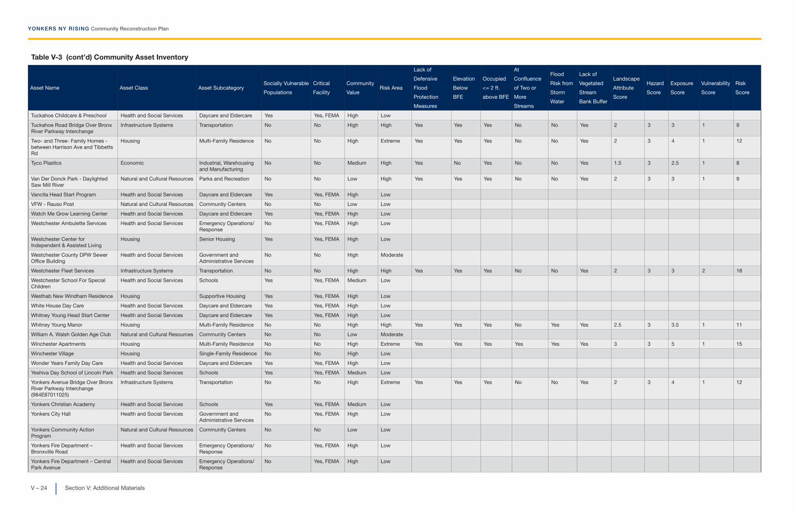
YONKERS NY RISING Community Reconstruction Plan
V – 24 Section V: Additional Materials
Table V-3 (cont’d) Community Asset Inventory
Asset Name Asset Class Asset SubcategorySocially Vulnerable
Populations
Critical
Facility
Community
ValueRisk Area
Lack of
Defensive
Flood
Protection
Measures
Elevation
Below
BFE
Occupied
<= 2 ft.
above BFE
At
Confluence
of Two or
More
Streams
Flood
Risk from
Storm
Water
Lack of
Vegetated
Stream
Bank Buffer
Landscape
Attribute
Score
Hazard
Score
Exposure
Score
Vulnerability
Score
Risk
Score
Tuckahoe Childcare & Preschool Health and Social Services Daycare and Eldercare Yes Yes, FEMA High Low
Tuckahoe Road Bridge Over Bronx River Parkway Interchange
Infrastructure Systems Transportation No No High High Yes Yes Yes No No Yes 2 3 3 1 9
Two- and Three- Family Homes - between Harrison Ave and Tibbetts Rd
Housing Multi-Family Residence No No High Extreme Yes Yes Yes No No Yes 2 3 4 1 12
Tyco Plastics Economic Industrial, Warehousing and Manufacturing
No No Medium High Yes No Yes No No Yes 1.5 3 2.5 1 8
Van Der Donck Park - Daylighted Saw Mill River
Natural and Cultural Resources Parks and Recreation No No Low High Yes Yes Yes No No Yes 2 3 3 1 9
Vanctla Head Start Program Health and Social Services Daycare and Eldercare Yes Yes, FEMA High Low
VFW - Rauso Post Natural and Cultural Resources Community Centers No No Low Low
Watch Me Grow Learning Center Health and Social Services Daycare and Eldercare Yes Yes, FEMA High Low
Westchester Ambulette Services Health and Social Services Emergency Operations/Response
No Yes, FEMA High Low
Westchester Center for Independent & Assisted Living
Housing Senior Housing Yes Yes, FEMA High Low
Westchester County DPW Sewer Office Building
Health and Social Services Government and Administrative Services
No No High Moderate
Westchester Fleet Services Infrastructure Systems Transportation No No High High Yes Yes Yes No No Yes 2 3 3 2 18
Westchester School For Special Children
Health and Social Services Schools Yes Yes, FEMA Medium Low
Westhab New Windham Residence Housing Supportive Housing Yes Yes, FEMA High Low
White House Day Care Health and Social Services Daycare and Eldercare Yes Yes, FEMA High Low
Whitney Young Head Start Center Health and Social Services Daycare and Eldercare Yes Yes, FEMA High Low
Whitney Young Manor Housing Multi-Family Residence No No High High Yes Yes Yes No Yes Yes 2.5 3 3.5 1 11
William A. Walsh Golden Age Club Natural and Cultural Resources Community Centers No No Low Moderate
Winchester Apartments Housing Multi-Family Residence No No High Extreme Yes Yes Yes Yes Yes Yes 3 3 5 1 15
Winchester Village Housing Single-Family Residence No No High Low
Wonder Years Family Day Care Health and Social Services Daycare and Eldercare Yes Yes, FEMA High Low
Yeshiva Day School of Lincoln Park Health and Social Services Schools Yes Yes, FEMA Medium Low
Yonkers Avenue Bridge Over Bronx River Parkway Interchange (984E87011025)
Infrastructure Systems Transportation No No High Extreme Yes Yes Yes No No Yes 2 3 4 1 12
Yonkers Christian Academy Health and Social Services Schools Yes Yes, FEMA Medium Low
Yonkers City Hall Health and Social Services Government and Administrative Services
No Yes, FEMA High Low
Yonkers Community Action Program
Natural and Cultural Resources Community Centers No No Low Low
Yonkers Fire Department – Bronxville Road
Health and Social Services Emergency Operations/Response
No Yes, FEMA High Low
Yonkers Fire Department – Central Park Avenue
Health and Social Services Emergency Operations/Response
No Yes, FEMA High Low

YONKERS NY RISING Community Reconstruction Plan
V – 25Section V: Additional Materials
Table V-3 (cont’d) Community Asset Inventory
Asset Name Asset Class Asset SubcategorySocially Vulnerable
Populations
Critical
Facility
Community
ValueRisk Area
Lack of
Defensive
Flood
Protection
Measures
Elevation
Below
BFE
Occupied
<= 2 ft.
above BFE
At
Confluence
of Two or
More
Streams
Flood
Risk from
Storm
Water
Lack of
Vegetated
Stream
Bank Buffer
Landscape
Attribute
Score
Hazard
Score
Exposure
Score
Vulnerability
Score
Risk
Score
Yonkers Fire Department – Central Park Ave-Roxbury Dr
Health and Social Services Emergency Operations/Response
No Yes, FEMA High Low
Yonkers Fire Department – Fortfield Avenue
Health and Social Services Emergency Operations/Response
No Yes, FEMA High Low
Yonkers Fire Department – Kimball Avenue
Health and Social Services Emergency Operations/Response
No Yes, FEMA High Low
Yonkers Fire Department – New School Street
Health and Social Services Emergency Operations/Response
No Yes, FEMA High Low
Yonkers Fire Department – Oak Street
Health and Social Services Emergency Operations/Response
No Yes, FEMA High Low
Yonkers Fire Department – Radford Street
Health and Social Services Emergency Operations/Response
No Yes, FEMA High Low
Yonkers Fire Department – Saw Mill River Road
Health and Social Services Emergency Operations/Response
No Yes, FEMA High Low
Yonkers Fire Department – Shonnard Place
Health and Social Services Emergency Operations/Response
No Yes, FEMA High Low
Yonkers Fire Department – Vark Street
Health and Social Services Emergency Operations/Response
No Yes, FEMA High Low
Yonkers Fire Department – Warburton Avenue
Health and Social Services Emergency Operations/Response
No Yes, FEMA High Low
Yonkers Gospel Mission Housing Supportive Housing Yes Yes, FEMA High Low
Yonkers Middle/High School Health and Social Services Schools Yes Yes, FEMA Medium Low
Yonkers Middle/High School (Shelter)
Health and Social Services Emergency Operations/Response
No Yes, FEMA High Low
Yonkers Paddling and Rowing Club Natural and Cultural Resources Parks and Recreation No No Low Extreme Yes Yes Yes No No Yes 2 3 4 4 48
Yonkers PAL (Shelter) Health and Social Services Emergency Operations/Response
No Yes, FEMA High Low
Yonkers Police Department - 1st Precinct
Health and Social Services Emergency Operations/Response
No Yes, FEMA High Low
Yonkers Police Department - 2nd Precinct
Health and Social Services Emergency Operations/Response
No Yes, FEMA High Low
Yonkers Police Department - 3rd Precinct
Health and Social Services Emergency Operations/Response
No Yes, FEMA High Low
Yonkers Police Department - 4th Precinct
Health and Social Services Emergency Operations/Response
No Yes, FEMA High Low
Yonkers Police Department Headquarters
Health and Social Services Emergency Operations/Response
No Yes, FEMA High Low
Yonkers Public Library - Crestwood Branch
Natural and Cultural Resources Libraries No No Low Low
Yonkers Public Library - Grinton I. Will Branch
Natural and Cultural Resources Libraries No No Low Low
Yonkers Public Library - Riverfront Branch
Natural and Cultural Resources Libraries No No Low High Yes Yes Yes No No Yes 2 3 3 3 27
Yonkers Recreation Department Natural and Cultural Resources Community Centers No No Low Low
Yonkers Recreation Pier Natural and Cultural Resources Parks and Recreation No No Low Extreme Yes No Yes No No Yes 1.5 3 3.5 1 11

Table V-3 (cont’d) Community Asset Inventory
Asset Name Asset Class Asset SubcategorySocially Vulnerable
Populations
Critical
Facility
Community
ValueRisk Area
Lack of
Defensive
Flood
Protection
Measures
Elevation
Below
BFE
Occupied
<= 2 ft.
above BFE
At
Confluence
of Two or
More
Streams
Flood
Risk from
Storm
Water
Lack of
Vegetated
Stream
Bank Buffer
Landscape
Attribute
Score
Hazard
Score
Exposure
Score
Vulnerability
Score
Risk
Score
Yonkers Rockland Co-Op Day Care Health and Social Services Daycare and Eldercare Yes Yes, FEMA High Low
Yonkers Wastewater Treatment Facility (County-Owned)
Infrastructure Systems Wastewater No Yes, FEMA High Extreme Yes Yes Yes No No Yes 2 3 4 4 48
Yonkers Water Treatment Plant Infrastructure Systems Water Supply No Yes, FEMA High Moderate
Yonkers Y.W.C.A. Housing Supportive Housing Yes Yes, FEMA High Low
Yonkers Yacht Club Economic Marina/Water Based Business
No No Low Extreme Yes Yes Yes No No Yes 2 3 4 1 12
Yonkers Yacht Club Bridge – North Infrastructure Systems Transportation No No High High Yes Yes Yes No No Yes 2 3 3 1 9
Yonkers Yacht Club Bridge – South Infrastructure Systems Transportation No No High High Yes Yes Yes No No Yes 2 3 3 1 9
Yonkers Yacht Club Bridge over Metro North Hudson Line
Infrastructure Systems Transportation No No High Moderate
YWCA - Bilingual Seniors Group Natural and Cultural Resources Community Centers No No Low Low
Section V: Additional Materials
YONKERS NY RISING Community Reconstruction Plan
V– 27
Figures V-1 through V-6 Landscape Attribute Determination
Worksheet Completed ExampleThese figures illustrate the analysis used to determine landscape
attributes (shown above in Table V-3) using a completed sample worksheet for the Yonkers Wastewater Treatment Plant.

YONKERS NY RISING Community Reconstruction Plan
Section V: Additional MaterialsV– 28
Riverine Landscape Attribute Determination Worksheet
Attribute: Defensive Flood Protection MeasuresAsset: YONKERS WASTEWATER TREATMENT FACILITY Asset ID: YCRA259Determination:
Determination methodology: 1)
2)
Justification:
Data gaps/questions:
Aerial photograph:
LegendAsset
Source Citation:Bing Maps Bird's Eye© 2014 MicrosoftPictometry Bird's Eye
Defensive flood protection measures are absent, below BFE, in poor condition, or lack maintenance commitment (YES)Defensive flood protection measures are present, above BFE, in good condition, and have maintenance commitment (NO)
The asset is built on a strip of land on the Hudson River. There appears to be a concrete wall along the perimeter of a portion of the asset. However, the wall appears to be discontinuous and thus does not provide flood protection to the entire asset.
None.
If conclusive evidence of flood protection measures is not available, assume YES, flood protection measures are absent.
Use aerial or site imagery to observe presence, condition, and height of flood protection measures between the asset and flood source. Compare structure height to base flood elevation (BFE) levels from FEMA Flood Hazard Area maps. Determine base ground elevation using elevation maps.
No flood wall
Flood wall

Section V: Additional Materials
YONKERS NY RISING Community Reconstruction Plan
V– 29
Riverine Landscape Attribute Determination Worksheet
Attribute: ElevationAsset: YONKERS WASTEWATER TREATMENT FACILITY Asset ID: YCRA259Determination:
Determination methodology: 1)
2)
3)
Justification:
Data gaps/questions:
Aerial photograph:
LegendAsset
Source Citation:LiDAR elevations fromWestchester.govhttp://giswww.westchestergo
v.com/wcgis/Lidar.htm
The asset elevation is 5.22 feet (NAVD88). The BFE is 7 feet (NAVD88). The asset is below the BFE.
None.
Refer to the appropriate FEMA Flood Hazard Area map to determine preliminary Base Flood Elevation (BFE) for the asset area. Compare to the elevation map of the area to determine base ground elevation of the asset. Compare this value to the BFE.
If appropriate FEMA maps for the asset area do not list a BFE, assume that assets in the 100-year flood zone are below BFE (YES), and that assets within the 500-year flood zone or outside mapped flood zones are above BFE (NO).If appropriate FEMA maps are not published for the asset area, assume that asset is above BFE (NO) - maps are not published due to absence of flood zones.
Elevation of the asset site is above BFE. (NO)Elevation of the asset site is below BFE. (YES)

YONKERS NY RISING Community Reconstruction Plan
Section V: Additional MaterialsV– 30
Riverine Landscape Attribute Determination Worksheet
Attribute: FreeboardAsset: YONKERS WASTEWATER TREATMENT FACILITY Asset ID: YCRA259Determination:
Determination methodology: 1)
2)
Justification:
Data gaps/questions:
Aerial photograph:Legend
Asset
Source Citation:LiDAR elevations fromWestchester.gov
Refer to the appropriate FEMA Flood Hazard Area map to determine Base Flood Elevation (BFE) for the asset area. Compare to the elevation map of the area to determine base ground elevation of the asset. If the ground elevation in the asset location is more than two feet above the BFE, answer NO. If the ground elevation is less than two feet above the BFE or is below the BFE, answer YES.
If BFE or ground elevation is not available, assume that assets within 100- or 500-year flood zones are less than 2 feet above BFE (YES). Assume that assets outside of flood zones are more than 2 feet above BFE (NO).
http://giswww.westchestergov.com/wcgis/Lidar.htm
Elevation of the habitable or occupied portion of the asset is less than two (2) feet above BFE. (YES)Elevation of the habitable or occupied portion of the asset is more than two (2) feet above BFE. (NO)
The asset elevation is 5.22 feet (NAVD88). The BFE is 7 feet (NAVD88). The asset is less than two feet above the BFE.
None.
(Insert aerial photograph with asset outlined in red )

Section V: Additional Materials
YONKERS NY RISING Community Reconstruction Plan
V– 31
Riverine Landscape Attribute Determination Worksheet
Attribute: Point of ConfluenceAsset: YONKERS WASTEWATER TREATMENT FACILITY Asset ID: YCRA259Determination:
Determination methodology: 1)
2)
Justification:
Data gaps/questions:
Aerial photograph:
LegendAsset
Source Citation:National Hydrography Datasethttp://nhd.usgs.gov
LiDAR elevations fromWestchester.gov
http://giswww.westchestergov.com/wcgis/Lidar.htm
Asset is located within area subject to increased flood risk due to confluence of merging streams (YES)Asset is not located within area subject to increased flood risk due to confluence of merging streams (NO)
Locate the asset on the National Hydrography Dataset map. Determine whether there are points of confluence of streams, rivers, or other waterbodies within 1000 feet of the asset and without significant topographic barriers between the stream and the asset. If so, answer YES. If points of confluence are more than 1000 feet from the asset or if significant barriers exist between the asset and the point of confluence, answer NO.
There are no points of confluence near the asset, therefore it is not subject to increased flood risk due to merging streams.
None.
If mapping data is unavailable, assume YES, that asset is subject to increased flood risk due to confluence of merging streams.

YONKERS NY RISING Community Reconstruction Plan
Section V: Additional MaterialsV– 32
Riverine Landscape Attribute Determination Worksheet
Attribute: Stormwater DischargeAsset: YONKERS WASTEWATER TREATMENT FACILITY Asset ID: YCRA259Determination:
Determination methodology: 1)
2)
3)
Justification:
Data gaps/questions:
Aerial photograph:
LegendAsset
Source Citation:1995 ImageryImagery date 3/12/1995U.S. Geological Survey
2010 ImageryImagery Date 6/17/2010© 2014 Google
If no information is available, assume YES, that asset is subject to increased flood risk from storm water discharge.
Compare historic aerial imagery of the asset location (using Google Earth or equivalent). If the area up-grade from the asset location has developed significantly within the timeframe of available imagery or if there is a known point of stormwater discharge in the area, answer YES. Note years of available images in justification area below. If land use in asset area is unchanged, answer NO.
Asset is located within area subject to increased flood risk due to storm water system discharge (YES)Asset is not located within area subject to increased flood risk due to storm water system discharge (NO)
If historical imagery is unavailable or inconclusive and asset is within a sewered area, assume YES, that asset is subject to increased flood risk from storm water discharge.
The aerial images from 1995 and 2010 show no significant difference in land development. Therefore, it is assumed that there is no increased flood risk to the asset from storm water discharge.
None.

Section V: Additional Materials
YONKERS NY RISING Community Reconstruction Plan
V– 33
Riverine Landscape Attribute Determination Worksheet
Attribute: Vegetated Streambank BuffersAsset: YONKERS WASTEWATER TREATMENT FACILITY Asset ID: YCRA259Determination:
Determination methodology: 1)
2)
3)
Justification:
Data gaps/questions:
Aerial photograph:
LegendAsset
Source Citation:Google EarthImagery Date: 6/17/2010© 2014 Google
Asset is within floodway fringe of stream and without adequate vegetated buffers to absorb or divert flood waters (YES)Asset is not within floodway fringe of stream and has adequate vegetated buffers to absorb or divert flood waters (NO)
Identify asset location on FEMA flood hazard area map. If located in 100- or 500-year flood zone, asset is within flood fringe. If asset is not within flood fringe, answer NO. If within flood fringe, continue to step 2.
The asset is located on the Hudson River. There are no vegetated streambank buffers.
None.
Locate the asset on USGS National Land Cover Database map. Determine whether there are vegetated buffers between the asset and the flood source. Alternatively, use aerial or site imagery to determine presence or absence of vegetated buffers.
If mapping data or imagery are unavailable, assume YES, that asset lacks adequate vegetated buffers.

YONKERS NY RISING Community Reconstruction Plan
Section V: Additional MaterialsV– 34
E. End Notes
End Notes 1. 2012 American Community Survey. U.S. Census
Bureau, 2014. Accessed August 15, 2014. <http://www.census.gov/acs/>
2. Yonkers City Engineer.
3. Bultman, M. “One Year Later, Yonkers Still Recover-ing from Hurricane Irene.” Yonkers Daily Voice, 27 August 2012. Web. Accessed August 18, 2014.
4. Supportive housing is defined as a package of housing and services intended to benefit individuals who have been confronted with homelessness, addiction, mental health issues, and other challenges.
5. North American Vertical Datum 1988.
6. Delta Development Group, Inc. and Barton & Logu-idice, P.C. Draft City of Yonkers Multi-Hazard Mitiga-tion Plan 2013. City of Yonkers, 2013.
7. Stormwater Reconnaissance Plan for the Saw Mill River—Pocantico River Watershed, Westchester County, New York. Westchester County Department of Planning and Westchester County Department of Public Works and Transportation, December 2012.
8. Center for Watershed Protection, Inc. and Biohabi-tats, Inc. Bronx River Watershed Management Plan (Volume 1): Bronx River Watershed Assessment and Management Report, Westchester County, New York. October 2007.
9. “Recovery Support Functions.” Federal Emergency Man-agement Agency, July 24, 2014. Accessed Oct 22, 2014. <http://www.fema.gov/recovery-support-functions>.
10. A 6537-B was introduced in the NYS Assembly (sponsor-Mayer) to establish a flood mitigation and prevention task force based within the NYS Depart-ment of Environmental Conservation (NYS DEC).
11. Full-time equivalent (FTE) estimates for job creation for each project are based upon total estimated project labor divided by $100,000/year annual FTE salary (assumed average between engineering [$56 per hour] and construction [$40 per hour] labor force in Yonkers, NY).
12. Case study conducted by Sky Solar Technology.
13. Full-time equivalent (FTE) estimates for job creation for each project are based upon total estimated project labor divided by $100,000/year annual FTE salary (assumed average between engineering [$56 per hour] and construction [$40 per hour] labor force in Yonkers, NY).
14. Estimate provided by Yonkers Paddling and Rowing Club.
15. Full-time equivalent (FTE) estimates for job creation for each project are based upon total estimated project labor divided by $100,000/year annual FTE salary (assumed average between engineering [$56 per hour] and construction [$40 per hour] labor force in Yonkers, NY).
16. The detailed study was commissioned by the Town of Greenburgh. It was performed by Dolph Rotfeld Engineering and is dated September 17, 1985. The study is currently being updated by Rotfeld for the Town of Greenburgh.
Photo CreditsAll photographs and illustrations provided by the Con-sultant Team unless otherwise noted.
Cover Page
The Hudson River at Getty Square, Yonkers’ Downtown Waterfront
Dividers
Section I
The Hudson River at Getty Square, Yonkers’ Downtown Waterfront
Public Engagement Event 2
Yonkers Paddling and Rowing Club Seawall (John Magiotto)
Yonkers City Hall
Section II
Hudson River Museum
Public Engagement Event 2
Saw Mill River at Van Der Donck Park
The Historic Yonkers Pier on the Hudson River Waterfront

Section V: Additional Materials
YONKERS NY RISING Community Reconstruction Plan
V– 35
Section III
Bronx River running behind Scout Field
Seawall at Yonkers Paddling and Rowing Club (John Maggiotto)
Public Engagement Event 2
JFK Park Overlooking the Hudson River
Section IV
Brooklands Apartments
A Yonkers Resident Show Her Support for Unity at Yonkers Riverfest
A Child’s Drawing Illustrates Her Recollection of Hurri-cane Sandy
Saw Mill River running under Hearst Street
Section V
NY Rising Booth at Hudson Riverfest
Deteriorating Seawall at the Yonkers Paddling and Rowing Club (John Maggiotto)
Water Pooling on Residential Street
John Maggiotto at Public Engagement Event 1
Jim Walkup and Leon Nanton at Public Engagement Event 1
Jim Walkup at Public Engagement Event 1
Tom Ryan at Public Engagement Event 1
Jim Walkup’s Vision for Yonkers at Public Engagement Event 1
Symra Brandon and Stephen Force at Public Engagement Event 1
Methodology and Other Technical Notes
Risk Mitigation Analysis
The risk mitigation analysis evaluates the extent to which Proposed and Featured Projects will mitigate storm damage and flooding risk to specific commu-nity assets when the project is in place. The risk miti-gation analysis is different from the risk assessment process, described in Section II. The risk assessment evaluated existing storm and flood risks to community assets as they stand today, whereas risk mitigation analysis evaluates the reduced risk that would result from putting a specific project in place.
To determine how the level of risk to assets would be affected by potential projects developed by the Plan-ning Committee, the risk assessment tool, discussed in Section II, was re-run for projects that are intended to reduce the risk of flood damage to assets and which have a sufficiently defined scope. Proposed Projects and Featured Projects were analyzed and “mitigated” risk scores were calculated for assets and asset groups that would be affected by each project.
The mitigated risk evaluation was completed by making assumptions regarding the changes in expo-sure and/or vulnerability of assets as a result of a project and altering these factors to reflect the proj-ect’s effects.
It should be noted that some of the Proposed and Featured Projects are studies and programs, and while these may ultimately result in a reduced risk of flooding for assets, they lack the detailed design needed to run the risk mitigation model. Consequently, the risk reduction analyses for those projects will be conducted subsequent to the identification of recom-mended actions and implementation measures that will emerge from these studies. In addition, some projects reduce the risk to citizens or enable the con-tinuity of operations within the community. These projects, though valuable, do not reduce risk as defined within the NYRCR risk assessment tool.
The risk mitigation analysis process uses a limited number of variables and ranges to alter the risk score: landscape attributes, risk area, and vulnerability score. These variables are changed as appropriate in the risk assessment tool for the assets that are presumed to be affected by each project. These changes result in quantitative risk score reductions for applicable proj-ects, which may result in a shift in risk score category for some assets.
For example, the Resilient Waterfront Revitalization project proposes to combine green infrastructure improvements with resilient construction technology in the redevelopment plan for Alexander Street. The use of resilient construction methods and materials improves the ability of redeveloped assets to

YONKERS NY RISING Community Reconstruction Plan
Section V: Additional MaterialsV– 36
withstand storm damage and to continue to function during storm events. This results in a one point reduc-tion in vulnerability score for assets in the Alexander Street redevelopment area. Additionally, implementa-tion of green infrastructure improvements alleviates the additional risk of flooding due to stormwater. This results in a change in the stormwater discharge land-scape attribute for applicable assets, which contrib-utes to 0.5 point reduction in exposure score for the assets. The improvements in vulnerability and expo-sure associated with this project combine to result in 17 point reduction in risk score for the identified assets in the Alexander Street redevelopment area.
The results of the risk reduction analysis demonstrate a reduction in the risk scores for particular assets based on a number of assumptions made regarding exposure, vulnerability, and other factors. However, it should be noted that these analyses are not based on detailed engineering and will require further evaluation as projects are developed in greater detail.
Cost-Benefit Evaluation
The cost-benefit evaluation seeks to compare the costs and benefits of each project to assess whether the project has benefits that are commensurate with or greater than the cost components of the project. This comparison is used in concert with evaluations of project feasibility, public support, environmental and social impact, and funding eligibility to inform the Committee’s decision-making regarding the projects.
Cost-benefit evaluation involves data gathering and analysis, requiring detailed information on the project, its associated costs, and its community-wide benefits and effects. Given the very conceptual extent of engi-neering design for most of the projects proposed in this Plan, a detailed cost-benefit analysis is neither possible nor useful. However, general assessment of project effectiveness following the broad process of cost-benefit evaluation is still useful in understanding projects. The level of detail available from the cost-benefit evaluation is proportional to the level of detail available from project plans. (It is also useful to note
that many proposed actions involve the preparation of feasibility studies and performance evaluations, and are not capital improvements that are subject to detailed cost-benefit evaluation.)
The collected data was first used to inform a prelimi-nary opinion regarding project costs. Costs consid-ered for projects include both direct costs and external costs. Direct costs include the capital costs required for project construction. External costs are any eco-nomic costs that may result from a project, such as lost revenue from businesses affected by a road closure.
Direct and external cost information was compiled from existing project documentation, available data, Committee knowledge of projects, and professional opinions regarding project cost.
Projects were also evaluated for a variety of benefits. Risk reduction benefits were determined as outlined in the Risk Mitigation Analysis section above. Co-bene-fits that may result from projects, including economic, environmental, or health and social improvements, were also evaluated.
The potential project benefits in each of the categories above (risk reduction, economic, environmental, and health and social benefits) were assessed with a methodology similar to that used to estimate costs. Project locations and affected areas were referenced against available datasets to understand the demo-graphic, economic, and environmental characteristics of the area(s) benefitting from project implementation. Analysis was augmented by local knowledge of neigh-borhoods, businesses, and projects.
Full-time equivalent (FTE) estimates for job creation for each project are based upon total estimated project labor divided by $100,000/year annual FTE salary (assumed average between engineering [$56 per hour] and construction [$40 per hour] labor force in Yonkers, NY).

Section V: Additional Materials
YONKERS NY RISING Community Reconstruction Plan
V– 37
CDBG-DR
CEA
CIRIS
CSO
DPW
EOC
FEMA
FTE
GIS
HMGP
IDA
LED
LEED
LWRP
MHACY
MTA
NFIP
NYPA
NYRCR
NYS
NYS DEC
Community Development Block Grant—Disaster Recovery
Critical Environmental Area
Critical Infrastructure Response Information System
Combined Sewer Overflow
City of Yonkers Department of Public Works
City of Yonkers Emergency Operations Center
Federal Emergency Management Agency
Full-Time Equivalent
Geographic Information Systems
Hazard Mitigation Grant Program
Yonkers Industrial Development Agency
Light-Emitting Diode
Leadership in Energy and Environmental Design
(a rating system for green construction)
Local Waterfront Revitalization Plan
Municipal Housing Authority for the City of Yonkers
Metropolitan Transportation Authority
National Flood Insurance Program
New York Power Authority
NY Rising Community Reconstruction
New York State
New York State Department of Environmental Conservation
F. Glossary

YONKERS NY RISING Community Reconstruction Plan
Section V: Additional MaterialsV– 38
NYS DOS
NYS DOT
OEM
RSF
SAV
USACE
WWTP
New York State Department of State
New York State Department of Transportation
Yonkers Office of Emergency Management
Recovery Support Function
Submerged Aquatic Vegetation
U.S. Army Corps of Engineers
Yonkers Wastewater Treatment Plant
Copyright © 2022 FDOKUMEN