Storm Data and Unusual Weather Phenomena
276
ALABAMA, North Central Pickens County A line of thunderstorms moved through Pickens County and produced wind damage generally across the eastern and southern parts of the county. Trees and power lines were blown down around Aliceville and Reform. Structural damage was reported to the Winn Dixie in Aliceville. Three chicken houses were destroyed just northeast of Gordo and hundreds of chickens were killed. Two airport hangars were destroyed north of Gordo. No injuries were reported. Thunderstorm Wind (G65) 300K 0 0 08 Gordo Aliceville to 0 1510CST 1535CST Several trees and power lines were blown down across the city of Tuscaloosa and also near Lake Tuscaloosa. One person suffered minor injuries when hit by a falling tree. Thunderstorm Wind (G55) 5K 1 0 08 Tuscaloosa 0 1550CST 1610CST Tuscaloosa County One large tree was blown over and several large limbs were broken off when gusty winds moved through Florence. High Wind (G45) 3K 0 0 08 0 1555CST ALZ001 Lauderdale Three homes sustained shingle damage as thunderstorm winds moved across southern Franklin County. Four barns received varying degrees of siding damage. Thunderstorm Wind (G60) 25K 0 0 08 Spruce Pine 0 1610CST Franklin County Several trees were blown down and one roof was blown off a mobile home. Thunderstorm Wind (G55) 10K 0 0 08 Nauvoo 0 1705CST Walker County The afternoon high temperature measured at the Huntsville International Airport was 88 degrees. This temperature broke the previous record high of 87 degrees set in 1977. Excessive Heat 0 0 0 17 0 1600CST ALZ006 Madison The high temperature observed at the Huntsville International Airport was 89 degrees. This temperature established a new record high breaking the previous record of 85 degrees set in 1977. Excessive Heat 0 0 0 18 0 1600CST ALZ006 Madison The afternoon high temperature recorded at Dannelly Field was 88 degrees. This temperature equaled the previous record set in 1995. Excessive Heat 0 0 0 19 0 1600CST ALZ044 Montgomery The afternoon high temperature measured at the Birmingham International Airport was 88 degrees. This temperature broke the previous record of 87 degrees set way back in 1915. Excessive Heat 0 0 0 19 0 1600CST ALZ024 Jefferson The high temperature observed at the Birmingham International Airport was 88 degrees. This temperature tied the previous record last set in 1987. Excessive Heat 0 0 0 20 0 1600CST ALZ024 Jefferson Quarter size hail was reported between Rosalie and Flat Rock in eastern Jackson County. Hail(1.00) 0 0 0 28 Rosalie 0 1655CST Jackson County Golf ball size hail was observed in Ider. Hail(1.75) 4K 0 0 28 Ider 0 1700CST Dekalb County Dime size hail fell in Hazel Green. Hail(0.75) 0 0 0 28 Hazel Green 0 1826CST Madison County Hail(1.50) 3K 0 0 28 New Market 0 1828CST 1841CST Madison County 1 Storm Data and Unusual Weather Phenomena Location Date Character of Storm Time Local/ Standard Path Length (Miles) Path Width (Yards) Number of Persons Killed Injured Estimated Damage Property Crops April 2002
-
Upload
khangminh22 -
Category
Documents
-
view
0 -
download
0
Transcript of Storm Data and Unusual Weather Phenomena

ALABAMA, North Central
Pickens County
A line of thunderstorms moved through Pickens County and produced wind damage generally across the eastern and southern partsof the county. Trees and power lines were blown down around Aliceville and Reform. Structural damage was reported to the WinnDixie in Aliceville. Three chicken houses were destroyed just northeast of Gordo and hundreds of chickens were killed. Two airporthangars were destroyed north of Gordo. No injuries were reported.
Thunderstorm Wind (G65) 300K0008GordoAliceville to 01510CST
1535CST
Several trees and power lines were blown down across the city of Tuscaloosa and also near Lake Tuscaloosa. One person sufferedminor injuries when hit by a falling tree.
Thunderstorm Wind (G55) 5K 1 008Tuscaloosa 01550CST1610CST
Tuscaloosa County
One large tree was blown over and several large limbs were broken off when gusty winds moved through Florence. High Wind (G45) 3K0008 01555CST
ALZ001 Lauderdale
Three homes sustained shingle damage as thunderstorm winds moved across southern Franklin County. Four barns received varyingdegrees of siding damage.
Thunderstorm Wind (G60) 25K0008Spruce Pine 01610CSTFranklin County
Several trees were blown down and one roof was blown off a mobile home. Thunderstorm Wind (G55) 10K0008Nauvoo 01705CST
Walker County
The afternoon high temperature measured at the Huntsville International Airport was 88 degrees. This temperature broke theprevious record high of 87 degrees set in 1977.
Excessive Heat00017 01600CSTALZ006 Madison
The high temperature observed at the Huntsville International Airport was 89 degrees. This temperature established a new recordhigh breaking the previous record of 85 degrees set in 1977.
Excessive Heat00018 01600CSTALZ006 Madison
The afternoon high temperature recorded at Dannelly Field was 88 degrees. This temperature equaled the previous record set in1995.
Excessive Heat00019 01600CSTALZ044 Montgomery
The afternoon high temperature measured at the Birmingham International Airport was 88 degrees. This temperature broke theprevious record of 87 degrees set way back in 1915.
Excessive Heat00019 01600CSTALZ024 Jefferson
The high temperature observed at the Birmingham International Airport was 88 degrees. This temperature tied the previous recordlast set in 1987.
Excessive Heat00020 01600CSTALZ024 Jefferson
Quarter size hail was reported between Rosalie and Flat Rock in eastern Jackson County. Hail(1.00)00028Rosalie 01655CST
Jackson County
Golf ball size hail was observed in Ider.Hail(1.75) 4K0028Ider 01700CST
Dekalb County
Dime size hail fell in Hazel Green. Hail(0.75)00028Hazel Green 01826CST
Madison County
Hail(1.50) 3K0028New Market 01828CST1841CST
Madison County
1
Storm Data and Unusual Weather Phenomena
Location Date Character of Storm
TimeLocal/Standard
PathLength(Miles)
PathWidth(Yards)
Number ofPersons
Killed Injured
EstimatedDamage
Property Crops
April 2002

ALABAMA, North Central
Quarter size to one and one half inch diameter size hail was observed in and around the city of New Market.
Nickel to quarter size hail was reported in and around the city of Ardmore.
Hail(1.00)00028Ardmore 01829CST1835CST
Limestone County
Quarter to golf ball size hail was observed from the Madison County line just north of Garth to Skyline.
Hail(1.75) 3K0028Skyline 2 N Garth to 01900CST
1920CST
Jackson County
A large tree was blown over and landed on a mobile home. No injuries were reported. Thunderstorm Wind (G50) 25K0028 3.5 E Meridianville 01925CST
Madison County
Dime size hail was observed in and around the city of Athens.Hail(0.75)00028Athens 01937CST
Limestone County
A funnel cloud was reported near Athens. The funnel quickly dissipated and did not touch down at this location. Funnel Cloud00028Athens 01940CST
Limestone County
Quarter to baseball size hail was reported in and around the city of Scottsboro. A few large trees were also uprooted.
Hail(2.75) 12K0028Scottsboro 01940CST1945CST
Jackson County
Hail(0.75)00028Sylvania 01945CSTDekalb County
Lightning 5K0028Sylvania 01945CSTDekalb County
Three quarter inch diameter size hail fell in Sylvania. One home suffered minor fire damage when it was struck by lightning.
Hail(1.00)00028 6 ENE Mooresville 3 E Mooresville to 01953CST
2009CST
Limestone County
Hail(1.75) 5K0028HuntsvilleMadison to 01956CST
2009CST
Madison County
Dime to golf ball size hail fell all around the Huntsville metropolitan area. Hail reports began in extreme southeast LimestoneCounty in the City of Madison and extended across much of Huntsville. City of Madison actually falls in both Limestone andMadison counties.
Quarter size hail was observed in Mentone.Hail(1.00)00028Mentone 02010CST
Dekalb County
Dime size hail was reported near the Pisgah community, south of Ardmore on SR 251. Hail(0.75)00028 7 S Ardmore 02015CST
Limestone County
Penny size hail was reported in Fort Payne.Hail(0.75)00028Ft Payne 02021CST
Dekalb County
Golf ball size hail was reported across the southern parts of the city of Huntsville.Hail(1.75) 5K0028Huntsville 02025CST
Madison County
Nickel to golf ball size hail was observed from Gadsden to Glencoe
Hail(1.75) 5K0028GlencoeGadsden to 02029CST
2035CST
Etowah County
Hail(1.00)00028Piedmont 02045CSTCalhoun County
2
Storm Data and Unusual Weather Phenomena
Location Date Character of Storm
TimeLocal/Standard
PathLength(Miles)
PathWidth(Yards)
Number ofPersons
Killed Injured
EstimatedDamage
Property Crops
April 2002

ALABAMA, North Central
Quarter size hail fell in the city of Piedmont.
Penny size hail was reported northwest of Fruithurst near the Talladega National Forest. Hail(0.75)00028 5 NW Fruithurst 02115CST
Cleburne County
Hail(0.75)00028BranchvilleMoody to 02205CST
2210CST
St. Clair County
Thunderstorm Wind (G55) 15K0028BranchvilleMoody to 02205CST
2210CST
St. Clair County
Several trees and power lines were blown down from east of Argo to Branchville to Moody. Penny size hail was also reported withthis storm.
Several trees and power lines were knocked down in the Ohatchee area.Thunderstorm Wind (G50) 8K0028Ohatchee 02230CST
Calhoun County
Dime size hail was observed in Oak Grove. Hail(0.75)00028 6.8 SE Childersburg 02310CST
Talladega County
Hail(0.75)00028Roanoke 02350CSTRandolph County
Thunderstorm Wind (G65) 75K0028Roanoke 02350CSTRandolph County
Several trees and power lines were blown down, a few radio towers were knocked down, and several windows were blown out ofbusinesses in the Roanoke area. Dime size hail was also reported with this storm.
Damaging thunderstorm winds moved through the city of Roanoke. One large police communications tower was blown down andlanded on a police vehicle. Several trees and power lines were knocked down around the city. A large plate glass window wasblown out of the local Ford dealers showroom.
Thunderstorm Wind (G75) 50K0029Roanoke 00020CSTRandolph County
A few trees were knocked down and one of these trees landed on a house in north Birmingham. No injuries were reported.Thunderstorm Wind (G50) 8K0029Birmingham 00042CST
Jefferson County
Nickel size hail was observed in Argo.Hail(0.88)00029Argo 00100CST
Jefferson County
Dime to nickel size hail was reported around Hamilton.
Hail(0.88)00030Hamilton 00126CST0130CST
Marion County
Nickel size hail was observed in Russellville.Hail(0.88)00030Russellville 00820CST
Franklin County
Dime size fell in Fairview and the hail covered the ground in a few spots.
Hail(0.75)00030Fairview 00820CST0825CST
Cullman County
Dime size hail was reported near Mt. Hope. Hail(0.75)00030Mt Hope 00831CST
Lawrence County
Dime size hail fell in the De Armanville community. Hail(0.75)00030De Armanville 00849CST
Calhoun County
3
Storm Data and Unusual Weather Phenomena
Location Date Character of Storm
TimeLocal/Standard
PathLength(Miles)
PathWidth(Yards)
Number ofPersons
Killed Injured
EstimatedDamage
Property Crops
April 2002
ALABAMA, North Central
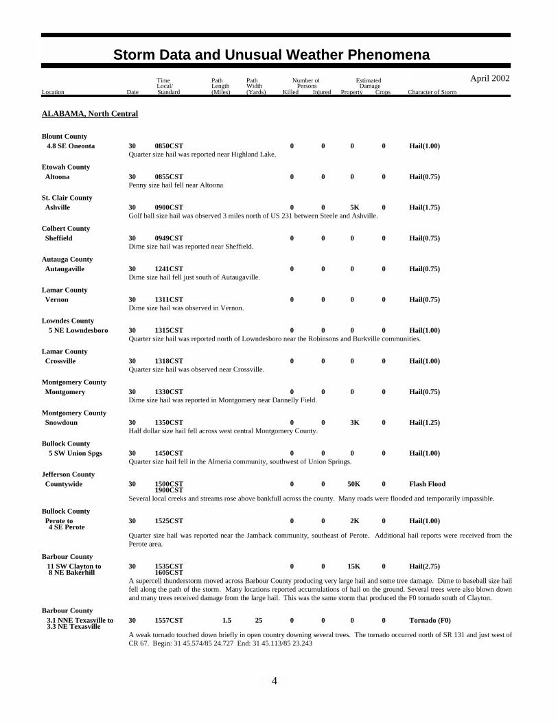
Blount County
Quarter size hail was reported near Highland Lake. Hail(1.00)00030 4.8 SE Oneonta 00850CST
Penny size hail fell near Altoona.Hail(0.75)00030Altoona 00855CST
Etowah County
Golf ball size hail was observed 3 miles north of US 231 between Steele and Ashville. Hail(1.75) 5K0030Ashville 00900CST
St. Clair County
Dime size hail was reported near Sheffield.Hail(0.75)00030Sheffield 00949CST
Colbert County
Dime size hail fell just south of Autaugaville. Hail(0.75)00030Autaugaville 01241CST
Autauga County
Dime size hail was observed in Vernon.Hail(0.75)00030Vernon 01311CST
Lamar County
Quarter size hail was reported north of Lowndesboro near the Robinsons and Burkville communities. Hail(1.00)00030 5 NE Lowndesboro 01315CST
Lowndes County
Quarter size hail was observed near Crossville. Hail(1.00)00030Crossville 01318CST
Lamar County
Dime size hail was reported in Montgomery near Dannelly Field. Hail(0.75)00030Montgomery 01330CST
Montgomery County
Half dollar size hail fell across west central Montgomery County.Hail(1.25) 3K0030Snowdoun 01350CST
Montgomery County
Quarter size hail fell in the Almeria community, southwest of Union Springs. Hail(1.00)00030 5 SW Union Spgs 01450CST
Bullock County
Several local creeks and streams rose above bankfull across the county. Many roads were flooded and temporarily impassible.
Flash Flood 50K0030Countywide 01500CST1900CST
Jefferson County
Quarter size hail was reported near the Jamback community, southeast of Perote. Additional hail reports were received from thePerote area.
Hail(1.00) 2K0030 4 SE PerotePerote to 01525CST
Bullock County
A supercell thunderstorm moved across Barbour County producing very large hail and some tree damage. Dime to baseball size hailfell along the path of the storm. Many locations reported accumulations of hail on the ground. Several trees were also blown downand many trees received damage from the large hail. This was the same storm that produced the F0 tornado south of Clayton.
Hail(2.75) 15K0030 8 NE Bakerhill 11 SW Clayton to 01535CST
1605CST
Barbour County
A weak tornado touched down briefly in open country downing several trees. The tornado occurred north of SR 131 and just west ofCR 67. Begin: 31 45.574/85 24.727 End: 31 45.113/85 23.243
Tornado (F0)00 25 1.5 030 3.3 NE Texasville 3.1 NNE Texasville to 01557CST
Barbour County
4
Storm Data and Unusual Weather Phenomena
Location Date Character of Storm
TimeLocal/Standard
PathLength(Miles)
PathWidth(Yards)
Number ofPersons
Killed Injured
EstimatedDamage
Property Crops
April 2002

ALABAMA, North Central
Lamar County
Dime size hail was reported in the town of Millport. Hail(0.75)00030Millport 01600CST
Dime to golf ball size hail was observed in and near Reform.Hail(1.75) 5K0030Reform 01605CST
Pickens County
A supercell thunderstorm moved across southern Tuscaloosa County causing considerable damage. The storm dropped hail frompea to baseball size. The hail fell across the southern areas of Tuscaloosa, Fosters, Ralph, Taylorville, and Duncanville. In the cityof Tuscaloosa, one business, 22 apartment buildings, and 122 homes were damaged from the large hail. Across the southern parts ofthe county, numerous trees and power lines were blown down and many areas were temporarily without power. No injuries werereported.
Hail(2.75) 400K0030 5 SE Duncanville 9 W Fosters to 01620CST
1703CST
Tuscaloosa County
Golf ball size hail fell across extreme northeast Hale County, east of Moundville. Hail(1.75) 3K0030 4 E Moundville 01658CST
Hale County
Heavy rainfall in a short period of time caused some flooding across Walker County. Many areas had standing water on roads andyards. A few streets were temporarily impassable due to high water. A few local creeks briefly rose out of their banks.
Flash Flood 8K0030Countywide 01700CST1830CST
Walker County
Dime to golf ball size hail fell across extreme northern Perry County just north of North Perry. The hail fell in a rural area butcrossed CR 29.
Hail(1.75) 5K0030 8 NW Heiberger 01720CSTPerry County
Dime to golf ball size hail was reported in extreme southwest Bibb County near the National Forest. Hail(1.75)00030 8 SW Brent 01722CST
Bibb County
A funnel cloud was reported just west of Troy. Funnel Cloud00030Troy 01845CST
Pike County
Nickel size hail was observed just south of Ardmore. One home suffered minor roof damage from the thunderstorm winds. Hail(0.88)00030 3 S Ardmore 02205CST
Limestone County
Quarter size hail was reported just north of Toney. A few trees were also blown down in this location.Hail(1.00) 3K0030Toney 02214CST
Madison County
Dime size hail was reported in Meridianville. Hail(0.75)00030Meridianville 02228CST
Madison County
Nickel size hail was observed in Moores Mill. Hail(0.88)00030Moores Mill 02238CST
Madison County
Golf ball size hail fell in New Market. Hail(1.75) 3K0030New Market 02240CST
Madison County
Numerous reports of golfball size hail by the Henry County Sheriff.Hail(1.75)0030Abbeville 1735EST
ALABAMA, Southeast
Henry County
5
Storm Data and Unusual Weather Phenomena
Location Date Character of Storm
TimeLocal/Standard
PathLength(Miles)
PathWidth(Yards)
Number ofPersons
Killed Injured
EstimatedDamage
Property Crops
April 2002

ALABAMA, Southwest
Baldwin CountyHail(1.00)0003Daphne 1540CST
1543CST
Hail(1.00)0003Daphne 1540CST1545CST
Baldwin County
Trees and power lines were blown down near Chatom as a line of thunderstorms moved through the area.
Thunderstorm Wind (G55) 10K0008Chatom 1610CST1612CST
Washington County
Trees were blown down as a line of thunderstorms moved through Fairford. Part of a roof was also blown off a home. A vehiclewas also damaged by the fallen trees.
Thunderstorm Wind (G55) 25K0008Fairford 1705CST1707CST
Washington County
Trees were blown down and a travel trailer was turned over from high winds as a line of thunderstorms moved through the area.
Thunderstorm Wind (G55) 15K0008Fairhope 1925CST1927CST
Baldwin County
Golfball to quarter size hail fell between Jackson and Grove Hill. No damage was reported from the hail.
Hail(1.75)0029Grove HillJackson to 1425CST
1430CST
Clarke County
Trees and power lines were blown down by high thunderstorm winds near Needham. Golfball size hail was also reported in the area
Thunderstorm Wind (G55) 10K0029Needham 1455CST1500CST
Choctaw County
Trees were blown down near Monroeville as thunderstorms moved through the area. Nickel size hail was also reported nearBermuda.
Thunderstorm Wind (G50) 8K0029Monroeville 1500CST1503CST
Monroe County
Trees were blown down near Castleberry as thunderstorms moved through the area.
Thunderstorm Wind (G50) 7K0029Castleberry 1510CST1512CST
Conecuh County
Trees were blown down near Dixie as thunderstorms moved through the area.
Thunderstorm Wind (G50) 7K0029Dixie 1530CST1532CST
Escambia County
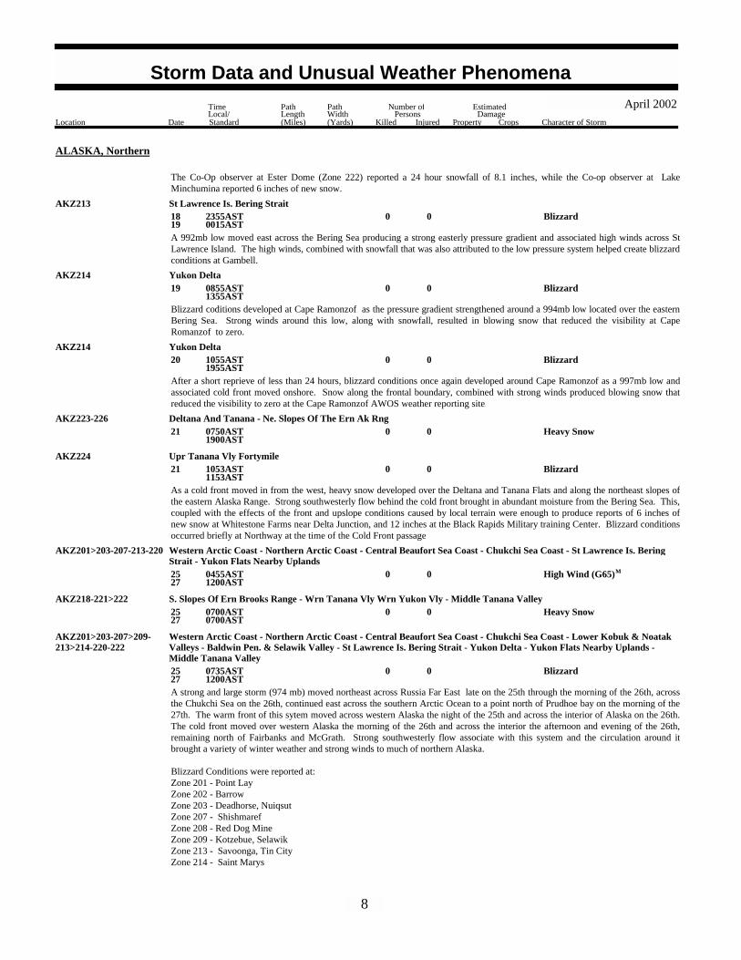
Blizzard0005 0815AST2035AST
ALASKA, Northern
AKZ204 Eastern Beaufort Sea Coast
Blizzard conditions developed along the Eastern Beaufort Sea Coast as a cold front moved through the area from the north. Thisfront was associated with a deepening low pressure system that developed over the Arctic Ocean and moved southeast towardsCanada. Strong winds occurred along the frontal zone creating areas of blowing snow that reduced visibilities to near zero at theBarter Island AWOS site.
Blizzard0008 1755AST1855AST
AKZ204 Eastern Beaufort Sea Coast
Blizzard conditions occurred briefly as a weakening occluded front moved eastward along the northwest coast. Gusty winds duringfrontal passage help create areas of blowing snow reducing the visibility at the Barter Island AWOS site to near zero
6
Storm Data and Unusual Weather Phenomena
Location Date Character of Storm
TimeLocal/Standard
PathLength(Miles)
PathWidth(Yards)
Number ofPersons
Killed Injured
EstimatedDamage
Property Crops
April 2002

ALASKA, Northern
AKZ207 Chukchi Sea CoastBlizzard0012 0901AST
1053ASTDuring the passage of a warm front local areas of snow and blowing snow developed along the Chukchi Sea Coast. Blizzardconditions were briefly met at Kivalina as the front passed.
Heavy Snow001617
0730AST1900AST
AKZ216-218 Lower Koyukuk Middle Ykn Vlys - S. Slopes Of Ern Brooks Range
Blizzard001618
1355AST0015AST
AKZ207-209>214 Chukchi Sea Coast - Baldwin Pen. & Selawik Valley - Nrn & Intr. Seward Peninsula - Srn Seward Peninsula Coast - ErnNorton Sound Nulato Hills - St Lawrence Is. Bering Strait - Yukon Delta
High Wind (G55) 2 017 0837AST2137AST
MAKZ225 Denali
A 982 mb low pressure system and associated frontal system moved from the Pribilof Islands northeast across Norton Sound on themorning of the 17th, across northwest Alaska the night of the 17th, and offshore of the eastern Arctic Coast on the morning of the18th.The warm front portion of the frontal system produced heavy snow over western and northern Alaska, and strong winds throughWindy Pass of the central Alaska Range. While Blizzard conditions occurred over St. Lawrence Island, 2 direct injuries occurred: a74-year old man man became stranded while riding his snowmobile; he dug and snow cave for shelter and had supplies to last himthe several days until rescuers found him. He was in good health but suffered from dehydration. During the Search and Rescueeffort for this man, six of the rescuers loist radio contact and failed to return to their base of operations. Four of them returned onthe night of the 16th, and the other two were found the morning of the 17th. One of these men suffered from frostbite on his handsand feet.
Blizzard conditions occurred at:Zone 207 - Point HopeZone 209 - Kotzebue, SelawikZone 210 - Buckland, Deering;Zone 211 - Nome, Golovin;Zone 212 - Unalakleet;Zone 213 - Savoonga, Tin CIty where wind gusts reached 51 knots (59mph);Zone 214 - Emmonak
Heavy snow occurred at:Zone 216 - Kaltag - the Co-op observer reported 6 inches of new snow in the 24 hours ending at 730 am on the 17th; Zone 217 - Ambler High School reported 9 to 10 inches of new snow in the 24 hours ending at 200 pm on the 18th; Zone 218 - The Co-op observer at Wiseman reported 10 inches of new snow in the 24 hours ending 8pm on the 17th;
High Wind occurred at Healy (Zone 225), where the weather observer recorded a peak gust of 63 mph .
Heavy Snow001718
1400AST1400AST
AKZ217 Upper Kobuk And Noatak Vlys
A strong low pressure system moved across Norton Sound and into the Upper Kobuk and Noatak Valleys. This system brought withit significant moisture producing areas of heavy snow. The high school principle at Ambler reported that 9 to 10 inches of new snowhad fallen over a 24 hour period.
High Wind (G49)0018 0847AST2153AST
MAKZ223-225 Deltana And Tanana - Denali
As a ridge of high pressure developed south of the Alaska Range, a moderate pressure gradient developed between it, and aweakening warm front north of the mountains. This pressure differential, couple with the channelling effects of the mountainpasses, helped produce high winds through the Alaska Range. During this event the weather observer in Healy reported wind gustsup to 42 knots (48 mph) while the ASOS site in Delta reported a peak wind of 49 knots (56 mph).
Heavy Snow001820
2300AST0000AST
AKZ221>222 Wrn Tanana Vly Wrn Yukon Vly - Middle Tanana Valley
A narrow band of heavy snow fell along a stationary front which extended from the western Alaska Range to east of Fairbanks
7
Storm Data and Unusual Weather Phenomena
Location Date Character of Storm
TimeLocal/Standard
PathLength(Miles)
PathWidth(Yards)
Number ofPersons
Killed Injured
EstimatedDamage
Property Crops
April 2002
ALASKA, Northern
The Co-Op observer at Ester Dome (Zone 222) reported a 24 hour snowfall of 8.1 inches, while the Co-op observer at LakeMinchumina reported 6 inches of new snow.
AKZ213 St Lawrence Is. Bering StraitBlizzard0018
19 2355AST
0015ASTA 992mb low moved east across the Bering Sea producing a strong easterly pressure gradient and associated high winds across StLawrence Island. The high winds, combined with snowfall that was also attributed to the low pressure system helped create blizzardconditions at Gambell.
Blizzard0019 0855AST1355AST
AKZ214 Yukon Delta
Blizzard coditions developed at Cape Ramonzof as the pressure gradient strengthened around a 994mb low located over the easternBering Sea. Strong winds around this low, along with snowfall, resulted in blowing snow that reduced the visibility at CapeRomanzof to zero.
Blizzard0020 1055AST1955AST
AKZ214 Yukon Delta
After a short reprieve of less than 24 hours, blizzard conditions once again developed around Cape Ramonzof as a 997mb low andassociated cold front moved onshore. Snow along the frontal boundary, combined with strong winds produced blowing snow thatreduced the visibility to zero at the Cape Ramonzof AWOS weather reporting site.
Heavy Snow0021 0750AST1900AST
AKZ223-226 Deltana And Tanana - Ne. Slopes Of The Ern Ak Rng
Blizzard0021 1053AST1153AST
AKZ224 Upr Tanana Vly Fortymile
As a cold front moved in from the west, heavy snow developed over the Deltana and Tanana Flats and along the northeast slopes ofthe eastern Alaska Range. Strong southwesterly flow behind the cold front brought in abundant moisture from the Bering Sea. This,coupled with the effects of the front and upslope conditions caused by local terrain were enough to produce reports of 6 inches ofnew snow at Whitestone Farms near Delta Junction, and 12 inches at the Black Rapids Military training Center. Blizzard conditionsoccurred briefly at Northway at the time of the Cold Front passage.
High Wind (G65)002527
0455AST1200AST
M
AKZ201>203-207-213-220 Western Arctic Coast - Northern Arctic Coast - Central Beaufort Sea Coast - Chukchi Sea Coast - St Lawrence Is. BeringStrait - Yukon Flats Nearby Uplands
Heavy Snow002527
0700AST0700AST
AKZ218-221>222 S. Slopes Of Ern Brooks Range - Wrn Tanana Vly Wrn Yukon Vly - Middle Tanana Valley
Blizzard002527
0735AST1200AST
AKZ201>203-207>209-213>214-220-222
Western Arctic Coast - Northern Arctic Coast - Central Beaufort Sea Coast - Chukchi Sea Coast - Lower Kobuk & NoatakValleys - Baldwin Pen. & Selawik Valley - St Lawrence Is. Bering Strait - Yukon Delta - Yukon Flats Nearby Uplands -Middle Tanana Valley
A strong and large storm (974 mb) moved northeast across Russia Far East late on the 25th through the morning of the 26th, acrossthe Chukchi Sea on the 26th, continued east across the southern Arctic Ocean to a point north of Prudhoe bay on the morning of the27th. The warm front of this sytem moved across western Alaska the night of the 25th and across the interior of Alaska on the 26th.The cold front moved over western Alaska the morning of the 26th and across the interior the afternoon and evening of the 26th,remaining north of Fairbanks and McGrath. Strong southwesterly flow associate with this system and the circulation around itbrought a variety of winter weather and strong winds to much of northern Alaska.
Blizzard Conditions were reported at:Zone 201 - Point LayZone 202 - BarrowZone 203 - Deadhorse, NuiqsutZone 207 - ShishmarefZone 208 - Red Dog MineZone 209 - Kotzebue, SelawikZone 213 - Savoonga, Tin CityZone 214 - Saint Marys
8
Storm Data and Unusual Weather Phenomena
Location Date Character of Storm
TimeLocal/Standard
PathLength(Miles)
PathWidth(Yards)
Number ofPersons
Killed Injured
EstimatedDamage
Property Crops
April 2002
ALASKA, Northern
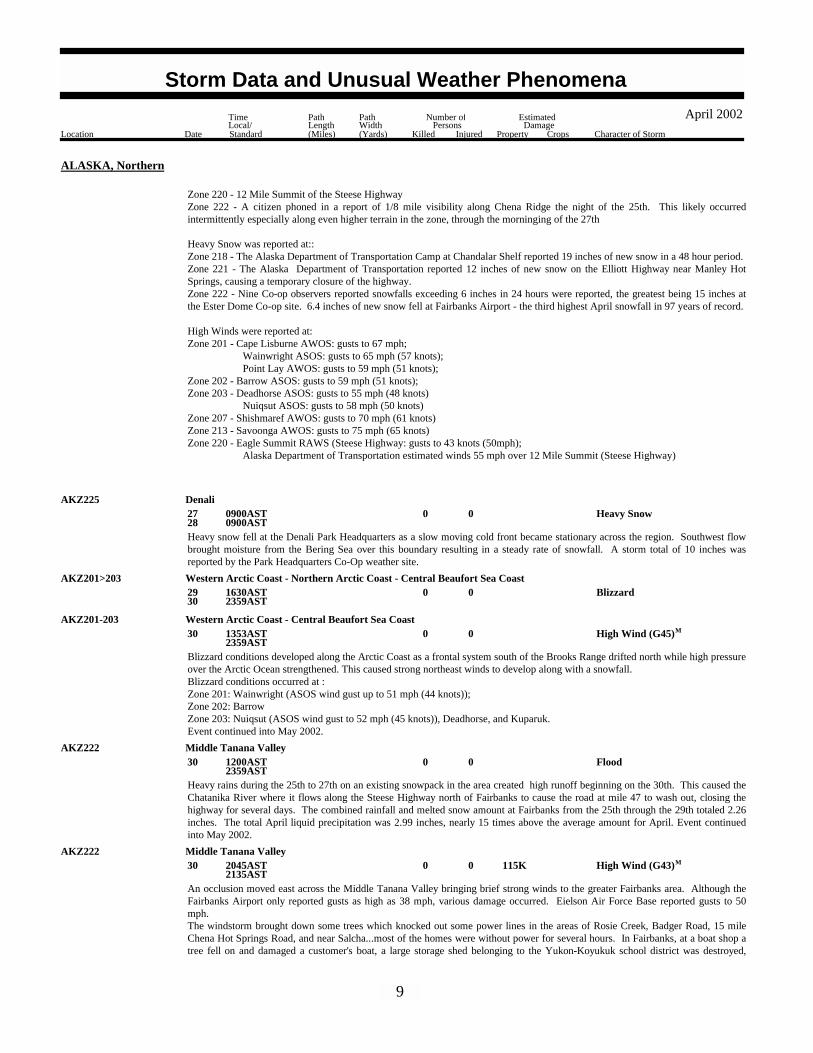
Zone 220 - 12 Mile Summit of the Steese HighwayZone 222 - A citizen phoned in a report of 1/8 mile visibility along Chena Ridge the night of the 25th. This likely occurredintermittently especially along even higher terrain in the zone, through the morninging of the 27th
Heavy Snow was reported at::Zone 218 - The Alaska Department of Transportation Camp at Chandalar Shelf reported 19 inches of new snow in a 48 hour period.Zone 221 - The Alaska Department of Transportation reported 12 inches of new snow on the Elliott Highway near Manley HotSprings, causing a temporary closure of the highway.Zone 222 - Nine Co-op observers reported snowfalls exceeding 6 inches in 24 hours were reported, the greatest being 15 inches atthe Ester Dome Co-op site. 6.4 inches of new snow fell at Fairbanks Airport - the third highest April snowfall in 97 years of record.
High Winds were reported at:Zone 201 - Cape Lisburne AWOS: gusts to 67 mph; Wainwright ASOS: gusts to 65 mph (57 knots); Point Lay AWOS: gusts to 59 mph (51 knots);Zone 202 - Barrow ASOS: gusts to 59 mph (51 knots);Zone 203 - Deadhorse ASOS: gusts to 55 mph (48 knots) Nuiqsut ASOS: gusts to 58 mph (50 knots)Zone 207 - Shishmaref AWOS: gusts to 70 mph (61 knots)Zone 213 - Savoonga AWOS: gusts to 75 mph (65 knots)Zone 220 - Eagle Summit RAWS (Steese Highway: gusts to 43 knots (50mph); Alaska Department of Transportation estimated winds 55 mph over 12 Mile Summit (Steese Highway)
AKZ225 DenaliHeavy Snow0027
28 0900AST
0900ASTHeavy snow fell at the Denali Park Headquarters as a slow moving cold front became stationary across the region. Southwest flowbrought moisture from the Bering Sea over this boundary resulting in a steady rate of snowfall. A storm total of 10 inches wasreported by the Park Headquarters Co-Op weather site.
Blizzard002930
1630AST2359AST
AKZ201>203 Western Arctic Coast - Northern Arctic Coast - Central Beaufort Sea Coast
High Wind (G45)0030 1353AST2359AST
MAKZ201-203 Western Arctic Coast - Central Beaufort Sea Coast
Blizzard conditions developed along the Arctic Coast as a frontal system south of the Brooks Range drifted north while high pressureover the Arctic Ocean strengthened. This caused strong northeast winds to develop along with a snowfall. Blizzard conditions occurred at : Zone 201: Wainwright (ASOS wind gust up to 51 mph (44 knots));Zone 202: BarrowZone 203: Nuiqsut (ASOS wind gust to 52 mph (45 knots)), Deadhorse, and Kuparuk. Event continued into May 2002.
Flood0030 1200AST2359AST
AKZ222 Middle Tanana Valley
Heavy rains during the 25th to 27th on an existing snowpack in the area created high runoff beginning on the 30th. This caused theChatanika River where it flows along the Steese Highway north of Fairbanks to cause the road at mile 47 to wash out, closing thehighway for several days. The combined rainfall and melted snow amount at Fairbanks from the 25th through the 29th totaled 2.26inches. The total April liquid precipitation was 2.99 inches, nearly 15 times above the average amount for April. Event continuedinto May 2002.
High Wind (G43) 115K0030 2045AST2135AST
MAKZ222 Middle Tanana Valley
An occlusion moved east across the Middle Tanana Valley bringing brief strong winds to the greater Fairbanks area. Although theFairbanks Airport only reported gusts as high as 38 mph, various damage occurred. Eielson Air Force Base reported gusts to 50mph.The windstorm brought down some trees which knocked out some power lines in the areas of Rosie Creek, Badger Road, 15 mileChena Hot Springs Road, and near Salcha...most of the homes were without power for several hours. In Fairbanks, at a boat shop atree fell on and damaged a customer's boat, a large storage shed belonging to the Yukon-Koyukuk school district was destroyed,
9
Storm Data and Unusual Weather Phenomena
Location Date Character of Storm
TimeLocal/Standard
PathLength(Miles)
PathWidth(Yards)
Number ofPersons
Killed Injured
EstimatedDamage
Property Crops
April 2002
ALASKA, Northern
being lifted up by the wind and then set down on a delivery van and some adjacent vehicles belonging to a kitchen distributioncompany located next door to the School District shed. The rain that accompanied the front ended up damaging goods that had beencovered by the shed, including 1000 pairs of donated roller skates which had been slated to be shipped to various villages in theschool district. Damages estimates include $60,000 for the shed, $30,000 for the shed contents, and $25,000 for damage to 5vehicles.
ALASKA, Southeast
AKZ025 Juneau Borough-Eastern Chichagof-Admiralty IslandHigh Wind (G58) 10K0004
05 2300AST
1300ASTM
A northeasterly downslope wind event occurred on these dates in downtown Juneau and Douglas. The notorious "Taku winds"measured as high as 67 mph at the South Douglas Island mesonet site (9' ASL). An anemometer on the Juneau Federal Building (85'ASL) measured a peak wind gust to 58 mph. High elevation peak wind readings included the Eagle Crest Ski Resort sensor (2624'ASL) at 86 mph and Sheep Mountain (3542' ASL) at 101 mph. A roof was blown off a shed in Douglas. Other minor damage wasalso reported.
3 men snowshoeing in the mountains adjacent to Eagle River were caught in an avalanche. One escaped.
Avalanche0 2 01 0900AST2100AST
ALASKA, Southern
AKZ101 Anchorage Muni To Bird Creek
M44OU, M26OU
Gusty northeast "Matanuska" winds to 67 mph were recorded at the Wasilla Fire Station. Winds below 10 mph were reported justprior to the onset of 60+ mph gusts at 12:30 am ADT, however gusts approaching 60 mph were recorded early Wednesday evening.At 5 am Thursday, gusts briefly reached 68 mph.
High Wind (G59)000204
2200AST0400AST
MAKZ111 Matanuska Valley
Strong northeast "Matanuska" winds were observed around the Wasilla/Palmer area Wednesday and Thursday. Gusts peaked at 67mph between midnight and 12:30 am AST Thursday. Strong northeast winds were also reported around Palmer. Visibilities at thePalmer airport were reported as low as 2 miles in blowing dust.
High Wind (G58)000304
1100AST2200AST
MAKZ111 Matanuska Valley
A 982 mb low moved into the extreme western Bering Sea from a position just east of the Kamchatka Peninsula Saturday. Gustysouthwesterly winds were observed on the southeast quadrant of the low. Gusts reached 67 mph at Adak and 66 mph at Shemya. AtAtka, peak winds only reached 47 mph from the system.
High Wind (G58)0013 1521AST2109AST
MAKZ191 Western Aleutians
A frontal system, associated with a moderate 986 mb low northwest of the Pribilofs Sunday, brought gusty westerly winds to theUnalaska/Dutch Harbor area. Peak gusts out of the west reached 71 mph around Dutch Harbor between 6 pm AST and 9 pm ASTSunday. Winds diminished below 60 mph after 9 pm AST Sunday.
High Wind (G62)0014 1700AST2000AST
MAKZ185 Eastern Aleutians
Heavy Snow001819
0000AST0400AST
AKZ145 Susitna Valley
High Wind (G84)001819
0500AST0400AST
MAKZ101 Anchorage Muni To Bird Creek
A moderate frontal system, moving into South Central Alaska, caused locally strong southeast wind around the AnchorageMunicipality and areas of heavy snow in the Susitna Valley.
10
Storm Data and Unusual Weather Phenomena
Location Date Character of Storm
TimeLocal/Standard
PathLength(Miles)
PathWidth(Yards)
Number ofPersons
Killed Injured
EstimatedDamage
Property Crops
April 2002

ALASKA, Southern
Wind gusts of 97 mph were reported at a remote upper elevation location known as Site Summit (near Alpenglow Ski area) around 9am Thursday. Other reports of 69 mph gusts were received at Glen Alps, along the Upper Anchorage Hillside, late Thursdaymorning.
In the Susitna Valley, 1 - 1.5 feet of new snow fell in roughly a 24 hour or less interval around Talkeetna, Chulitna and Swan Lake.
AKZ155 Kuskokwim Delta
A 994 mb low moving north through the Bering Sea produced local blizzard conditions around the Kuskokwim Delta. Visibilities of1/4 mile or less were reported around Hooper Bay, with 3/4 mile visibilities observed at Mekoryuk (on Nunivak Island). Blizzardconditions were very localized and not widespread.
Blizzard0019 1400AST2100AST
A weekend storm reportedly dumped more than 4 feet of snow on the mountains around Hatcher Pass, setting up three avalanchesthat close the road there Saturday. No injuries or property damage was reported, however three people from the Hatcher Pass Lodgegot stuck when they tried to leave Saturday. They were taken out by snowmachine
Avalanche0020 0000AST2359AST
AKZ111 Matanuska Valley
Southerly winds aloft, associated with two low pressure systems in the eastern Bering Sea and Alaska, produced areas of heavy snowin the Susitna Valley. Reports around Petersville Road indicated close to 30" of snow 'hammered' the area. Lesser amounts werereported around Talkeetna and Skwentna...however snow at lower elevations rapidly melted as it fell.
Heavy Snow0020 0800AST1100AST
AKZ145 Susitna Valley
The Sterling Highway was partially closed Monday afternoon after a section along the Blackwater Bend, near Milepost 160, becamesubmerged under a foot of water. Flooding was primarily due to an already high Anchor River and accelerated snowmelt due to highfreezing levels and very warm air at lower elevations.
Flood 10K0029 0000AST2359AST
AKZ125 Wrn P.W. Snd & Kenai Mtns
Heavy swell genearated by a strong low pressure far south of Samoa cause surf of 10 to 16 feet with occasional higher sets boundedsouth shores of Tutuila from Friday April 5 and through the whole weekend subsiding on Monday, April 8, 2002. The high surfeffected the closure of various beaches due to strong rip currents and heavy surf especially from Avau to Fagaalu and from Lauli'ibeach eastward. No major damages were reported except for some debris which were washed onto the roads at Matuu , Leloaloaand Aua.
Rip Currents000508
Countywide 1800SST0600SST
AMERICAN SAMOA
Tutuila
The high surf and heavy southerly swell began to affect south shores of the territory Wednesday, April 17 and was getting strongerby the hour with swell reaching heights of 8 feet in Pago Pago Harbour Thursday morning, April 18, 2002. The heavy swell causedthe cancellation of the Long Boat race, which is the most attented activity of the Flag Day celebration. A bried turned of the windsFriday morning allowed the race to take place but in a much shorter track then it was planned. The high surf and heavy swellcontinued through April 29, 2002. The heavy swell and high surf was a combination of swell generated by a slow moving lowpressure far south of the islands and brisk trades generated by a strong ridge of high pressure which persisted for almost two weeksjust south of Samoa.
Rip Currents001829
Countywide 1000SST1800SST
Tutuila
Flood 50K0019 0800SST1400SST
ASZ002 Tutuila
11
Storm Data and Unusual Weather Phenomena
Location Date Character of Storm
TimeLocal/Standard
PathLength(Miles)
PathWidth(Yards)
Number ofPersons
Killed Injured
EstimatedDamage
Property Crops
April 2002
AMERICAN SAMOA
Heavy showers caused widespread flooding across the territory marking one of the wettest Flag Day in recent memories. More thantwo inches of rainfall fell between 10 AM and Noon Friday, April 19, 2002 in the final and activity packed day of the Flag Daycelebration of 2002. With the heavy runoff and showers, numerous land and mudslides occurred across Tutuila. The heavy showerslet up in the afternoon as was predicted by the National Weather Service, and was a welcome break from the wet cool weather in thelast few days. Between the 18th and the 20th, the Weather Service at Tafuna recorded 6.56 inches of rainfall in three days.
Drought000130
0000MST2359MST
ARIZONA, Central and Northeast
AZZ015 Western Mogollon Rim
Drought conditions continued through out the month of April. Just over half of an inch (0.51) of rain fell early in the month whichwas 0.78 inches below normal (1.29). For the year, 1.22 inches of precipitation fell which is 7.43 inches below the normal of 8.65inches. From September first to the end of April, 4.71 inches of precipitation fell which was 11.68 inches below the normal of16.39 inches.
Hail(1.75)0007Concho 1845MSTApache County
An Apache County Sheriff's deputy reported golf ball (1.75 inch) sized hail on Highway 61 three miles southwest of Concho.
High Wind (G64)0015 1605MST1740MST
MAZZ004>006 Kaibab Plateau - Marble Canyon And Glen Canyon - Grand Canyon Country
A strong wind storm moved across northern Arizona on Tax Day. Trees were blown down on power lines in Fredonia, 3 trees blewdown on Highway 89 east of Jacob Lake, numerous trees blew down on Forest Service Road 22, the Paria Point RAWS had a peakwind gust of 74 MPH and the Four Springs RAWS had a peak wind gust of 63 MPH. The Houserock RAWS had a peak wind gustof 71 MPH at 405 PM. The Tusayan RAWS had a peak wind gust of 59 MPH at 410 PM.
A strong low pressure system brought strong winds to many areas of the Lake Mead National Recreation area. Damage on theArizona side included several trees down, damage to roofs and awnings, and windows broken in a park service vehicle.
High Wind (G55) 50K0015 1300PST1800PST
ARIZONA, Northwest
AZZ036 Lake Mead National Recreation Area
A strong low pressure system caused several porch covers to be destroyed along with several trees and powerlines down.
High Wind (G54) 100K0015 1400PST1900PST
AZZ003 Northwest Deserts
Dust Storm 40K0006 1300MST1600MST
ARIZONA, South
AZZ029 Southeast Pinal County
A Low pressure system moving through Arizona caused gradients to tighten ahead of a cold front. A dust storm resulted from thestrong winds and reduced visibilities along agricultural area on Arizona state road 87 near Coolidge. The reduced visibilities causeda 26 vehicle collision which included 19 passenger cars, 2 recreational vehicles, and 5 military vehicles
Wild/Forest Fire 90K002930
Canelo 00800MST2300MST
Santa Cruz County
The Ryan fire was started by a campfire in Coronado National Forest at Canelo Hill on April 29th and continued through May 4th.The fire burned 38,800 acres with estimated total fire fighting cost of 1.2 million dollars. The fire burned one house and severaloutbuildings.
12
Storm Data and Unusual Weather Phenomena
Location Date Character of Storm
TimeLocal/Standard
PathLength(Miles)
PathWidth(Yards)
Number ofPersons
Killed Injured
EstimatedDamage
Property Crops
April 2002

ARIZONA, Southwest
NONE REPORTED.
Heavy rains caused flash flooding to occur along Highway 250, 3 miles south of Waldron. The highway was impassible for severalhours due to the high water levels.
Flash Flood000708
3 S Waldron 2130CST0100CST
ARKANSAS, Central and North Central
Scott County
Thunderstorm winds blew down a large tree.Thunderstorm Wind (G50)0008 10 SE Monticello 0130CST
Drew County
Lightning0008Elliott 0400CSTOuachita County
Lightning struck a couple of houses in the Elliott area. The houses caught on fire, with one house suffering minor damage and theother other totally destroyed.
Hail(0.88)0008 5 W Chickalah 1700CSTYell County
Hail(0.75)0008 5 W Appleton 1710CSTPope County
Hail(0.75)0008 3 S Centerville 1735CSTYell County
Hail(1.00)0012Poughkeepsie 1408CSTSharp County
Hail(0.88)0013 4 E Oil Trough 1545CSTIndependence County
Hail(0.75)0016 1 N New Blaine 1620CSTLogan County
Thunderstorm winds downed some large trees.Thunderstorm Wind (G50)0016 1 N New Blaine 1620CST
Logan County
Thunderstorm winds knocked down several trees.Thunderstorm Wind (G50)0016Dardanelle 1625CST
Yell County
Hail(1.00)0016 12 S Tilly 1705CSTPope County
Hail(0.75)0016Tilly 1715CSTPope County
Hail(0.75)0016 8 SW Leslie 1755CSTSearcy County
Thunderstorm winds knocked down some road signs at Harriet.Thunderstorm Wind (G50)0016Harriet 1830CST
Searcy County
Hail(1.75)0027Ione 0930CSTLogan County
Thunderstorm winds knocked down a large tree.Thunderstorm Wind (G50)0027Cherokee Vlg 2320CST
Sharp County
13
Storm Data and Unusual Weather Phenomena
Location Date Character of Storm
TimeLocal/Standard
PathLength(Miles)
PathWidth(Yards)
Number ofPersons
Killed Injured
EstimatedDamage
Property Crops
April 2002

ARKANSAS, Central and North Central
Fulton CountyHail(1.75)0027 10 SE Mammoth Spg 2324CST
Thunderstorm winds blew down some large tree limbs.Thunderstorm Wind (G50)0027Hardy 2335CST
Sharp County
Thunderstorm winds knocked down several trees and power lines.Thunderstorm Wind (G50)0027 2 NE Williford 2338CST
Sharp County
Hail(1.75)0027 2 NE Williford 2338CSTSharp County
Hail(0.75)0028 5 N Cave City 0015CSTSharp County
Thunderstorm winds blew down some large tree limbs.Thunderstorm Wind (G50)0028 5 N Cave City 0015CST
Sharp County
Hail(1.50)0029Abbott 0910CSTScott County
Hail(0.75)0029Black Fork 0910CSTScott County
Hail(1.75)0029Sugar Grove 0930CSTLogan County
Hail(4.50)0029 3 NE Pine Ridge 0930CSTMontgomery County
Hail(1.75)0029 4 S Mt Ida 0950CSTMontgomery County
Hail(0.88)0029Mt Ida 0959CSTMontgomery County
Hail(1.75)0029Mt Ida 1002CSTMontgomery County
Hail(1.75)0029Bismarck 1110CSTHot Spring County
Hail(1.00)0029 10 NW Caddo Vly 1120CSTClark County
Hail(1.75)0029Friendship 1130CSTHot Spring County
Hail(1.75)0029Malvern 1318CSTHot Spring County
Hail(0.75)0029 3 NW Donaldson 1320CSTHot Spring County
Hail(1.75)0029Sheridan 1350CSTGrant County
Hail(0.75)0030 4 NE Ozone 0520CSTJohnson County
Hail(0.75)0030 3 W Pleasant Plains 0710CSTIndependence County
Hail(0.88)0030Tupelo 0740CSTJackson County
14
Storm Data and Unusual Weather Phenomena
Location Date Character of Storm
TimeLocal/Standard
PathLength(Miles)
PathWidth(Yards)
Number ofPersons
Killed Injured
EstimatedDamage
Property Crops
April 2002

ARKANSAS, Central and North Central
Stone CountyHail(1.00)0030 4 W Mountain View 0834CST
Thunderstorm winds downed some trees and damaged a mobile home.Thunderstorm Wind (G50)0030Mountain Home 1020CST
Baxter County
Hail(0.75)0030Mountain Home 1020CSTBaxter County
Hail(0.75)0030Horseshoe Bend Arpt 1055CSTIzard County
Hail(0.75)0030Harrison 1100CSTBoone County
Hail(0.75)0030Western Grove 1124CSTNewton County
Hail(1.00)0030Bigflat 1207CSTBaxter County
Hail(1.00)0030 10 W Optimus 1207CSTStone County
Hail(0.75)0.01K0024Winesburg 1840CST1845CST
ARKANSAS, East
Craighead County
Some trees were blown down causing a power outage.
Thunderstorm Wind 5K0024Harrisburg 1900CST1905CST
Poinsett County
One large tree was knocked down.
Thunderstorm Wind 1K0024 1 SE Earle 2008CST2015CST
Crittenden County
A few trees were blown down.
Thunderstorm Wind 5K0028Datto 0030CST0035CST
Clay County
One mobile home had its top blown off. Some trees and power lines were knocked down.
Thunderstorm Wind 20K0028Paragould 0215CST0220CST
Greene County
Hail(1.75)0.75K0030Colt 0825CST0830CST
St. Francis County
Hail(0.75)0.01K0030 2 W Shell Lake 0850CST0855CST
St. Francis County
Hail(1.75)0.75K0030Hughes 0905CST0910CST
St. Francis County
Hail(0.75)0.01K0030 2 SW Light 1110CST1115CST
Greene County
15
Storm Data and Unusual Weather Phenomena
Location Date Character of Storm
TimeLocal/Standard
PathLength(Miles)
PathWidth(Yards)
Number ofPersons
Killed Injured
EstimatedDamage
Property Crops
April 2002
ARKANSAS, East
Lawrence County
Several trees were blown down.
Thunderstorm Wind (G55) 5K0030Walnut Ridge 1110CST1115CST
Hail(1.00)0.55K0030JonesboroHerman to 1115CST
1130CST
Craighead County
Hail(0.75)0.01K0030Clover Bend 1125CST1130CST
Lawrence County
The Bay city hall was windows broken by the hail. Both of the town's police cars were damaged. Some homes in Bay were alsodamaged.
Hail(1.75) 100K0030BayCash to 1135CST
1150CST
Craighead County
Several homes had damage to their siding and roofs. Some windows were broken.
Thunderstorm Wind 20K0030Valley View 1145CST1200CST
Craighead County
The local high school and elementary school had windows broken. Fifteen police cars were severely damaged. Several trees wereblown down.
Thunderstorm Wind 500K0030LepantoTrumann to 1155CST
1205CST
Poinsett County
One hundred were damaged at a Ford dealership in Trumann. Over 2,000 cars in the area were damaged by the hail. Many homeswere also damaged. The Trumann schools had at least 100 windows broken.
Hail(1.75) 3M0030Lepanto 1200CST1205CST
Poinsett County
Hail(0.75)0.01K0030Dyess 1205CST1210CST
Mississippi County
Heavy rain fell on and off across Crawford County from the late afternoon hours of the 7th til just after midnight on the 8th. 6.04inches of rain fell at Van Buren while 7.11 inches and 6.41 inches of rain fell in Mountainburg respectively. This rain causedflooding of low lying areas and roads across the county.Several vehicle resues were needed in Van Buren and flooding occurred in the neighboring Industrial Park.
Flash Flood 50K000708
Countywide 1727CST0200CST
ARKANSAS, Northwest
Crawford County
Heavy rain fell on and off across Sebastian county from the late afternoon hours of the 7th to just after midnight on the 8th. 4.49inches of rain fell in Forth Smith and 4.41 inches of rain fell at Midland. This rain caused the flooding of several roads across thecounty. Severe street flooding occurred in Fort Smith and several cars were reported to be stranded.
Flash Flood 50K000708
Countywide 1815CST0200CST
Sebastian County
Heavy rain fell on and off across Franklin county from the evening of April 7th to the early morning hours of April 8th. 5.50 inchesof rain fell near Ozark. This excessive rainfall resulted in the flooding of numerous county roads. One bridge was washed out nearCass and Highway 23 was flooded 5 miles south of Cass.
Flash Flood 50K000708
Countywide 1900CST0800CST
Franklin County
16
Storm Data and Unusual Weather Phenomena
Location Date Character of Storm
TimeLocal/Standard
PathLength(Miles)
PathWidth(Yards)
Number ofPersons
Killed Injured
EstimatedDamage
Property Crops
April 2002

ARKANSAS, Northwest
Carroll County
Heavy rain which fell from the evening of the 7th to the early morning hours of the 8th caused widespread flooding of rural roadsand low water crossings across Carroll county.
Flash Flood000708
Countywide 2132CST0400CST
Heavy rain fell on and off across Madison county from the evening of the 7th to the early morning hours of the 8th. St. Paulreceived 5.92 inches of rain. This rain caused severe flooding of rural roads around the county.
Flash Flood000708
Countywide 2135CST0800CST
Madison County
Heavy rain fell on and off across Washington county during the evening. 3.34 inches of rain fell at Fayetteville. The rain causedflooding of some rural roads including a bridge near Johnson.
Flash Flood000708
Countywide 2137CST0200CST
Washington County
Flood000708
2100CST1400CST
ARZ019 Crawford
Lee Creek near Van Buren rose above its flood stage of 23 feet at 10 pm cdt on April 7th. The river crested at 24.7 feet at 8 am cdton April 8th. The river fell below its flood stage at 3 pm cdt the same day.
Flood000809
0600CST0500CST
ARZ019-029 Crawford - Sebastian
The Arkansas River near Van Buren rose above its flood stage of 22 feet at 7 am cdt on April 8th. The river crested at 24.8 feet at 8pm cdt the same day. The river fell below its flood stage at 6 am on April 9th.
After heavy rains the night before a quick inch or two of rain caused widespread flooding of county roads across Crawford countyduring the afternoon hours.
Flash Flood0008Countywide 1340CST1700CST
Crawford County
After heavy rain the night before a quick inch or two of rain caused widespread flooding of county roads across Sebastian county.
Flash Flood0008Countywide 1405CST1700CST
Sebastian County
After heavy rain the night before a quick inch or two of rain caused flooding of county roads across Madison county. The floodingof low lying areas caused the evacuation of part of St. Paul. The water did not flow into any homes, however
Flash Flood0008Countywide 1420CST1700CST
Madison County
After heavy rain fell across the county the night before a quick inch or two of rain caused widespread flooding of county roads acrossFranklin county the afternoon of the 8th.
Flash Flood0008Countywide 1500CST1700CST
Franklin County
Hail(1.00)0023Fayetteville 0231CSTWashington County
Hail(0.75)0023Cincinnati 0325CSTWashington County
Hail(1.00)0023Witter 0515CSTMadison County
Thunderstorm winds estimated at 70 miles an hour blew a large tree down.Thunderstorm Wind (G61)0023Ft Smith 0610CST
Sebastian County
Hail(0.88)0030 4 SW Hartford 0104CSTSebastian County
17
Storm Data and Unusual Weather Phenomena
Location Date Character of Storm
TimeLocal/Standard
PathLength(Miles)
PathWidth(Yards)
Number ofPersons
Killed Injured
EstimatedDamage
Property Crops
April 2002
ARKANSAS, Northwest
Madison CountyHail(0.88)0030Marble 0545CST
Hail(0.88)0030Bentonville 0952CSTBenton County
Hail(0.75)0030Rogers 1000CSTBenton County
Hail(0.75)0030Osage 1057CSTCarroll County
NONE REPORTED.
ARKANSAS, Southeast
Straight line wind gusts destroyed a barn and blew bricks off a home. Several large trees were also blown over.Thunderstorm Wind (G80) 10K0007 1 N Welcome 2305CST
ARKANSAS, Southwest
Columbia County
Several large trees down including one tree that crushed a mobile home.Thunderstorm Wind (G80) 30K0007 5 S Taylor 2305CST M
Columbia County
Several large trees down near Walnut Creek and FM 3302.Thunderstorm Wind (G65)0007 8 E Bradley 2306CST
Lafayette County
Numerous large trees down.Thunderstorm Wind (G60)0007Magnolia 2335CST
Columbia County
Trees and power lines were toppled. Several empty railroad cars were blown over.Thunderstorm Wind (G85)0008 1 N El Dorado 0004CST
Union County
Waterspout00003 2 NW Lewes De 01545EST
ATLANTIC OCEAN
ANZ431 De Bay Waters S Of E Pt Nj To Slaughter Beach De
Observers from the Pilot Tower in Lewes observed two waterspouts in Delaware Bay. No damage or injuries were reported.
Marine Tstm Wind (G39)0003TuckertonPt. Pleasant to 01600EST
1630EST
ANZ451 Manasquan Inlet To Little Egg Inlet Nj Out 20Nm
Marine Tstm Wind (G37)0003Cape MayOcean City to 01615EST
1645EST
ANZ453 Great Egg Inlet To Cp May Nj Out 20Nm
A squall line of strong thunderstorms produced wind gusts in excess of 35 knots along the New Jersey coastal waters fromManasquan Inlet southward. Peak wind gusts of 39 knots were reported at the Cape May Coast Guard station, 37 knots at theBarnegat Lighthouse and 36 knots at Point Pleasant.
Marine Tstm Wind (G61)0003Lewes De 01602ESTANZ431 De Bay Waters S Of E Pt Nj To Slaughter Beach De
A severe thunderstorm produced wind gusts to 61 knots (70 mph) at the Pilot Tower at Lewes. The Cape May-Lewes Ferry alsoreported wind gusts to 50 knots as it crossed the bay around the same time.
18
Storm Data and Unusual Weather Phenomena
Location Date Character of Storm
TimeLocal/Standard
PathLength(Miles)
PathWidth(Yards)
Number ofPersons
Killed Injured
EstimatedDamage
Property Crops
April 2002
ATLANTIC OCEAN
ANZ650 Fenwick Is De To Chincoteague Va Out 20Nm
Gust to 36 knots in OXB observation.
Marine Tstm Wind (G36)0003ChincoteagueFenwick Island De to 1654EST
Gust to 35 knots in MFV observation.
Marine Tstm Wind (G35)0003Paramore IslandChincoteague to 1700EST
ANZ652 Chincoteague To Parramore Is Va Out 20Nm
Marine Tstm Wind (G50)0003Kiptopeke 1742ESTANZ632 Chesapeake Bay New Pt Comfort To Cp Henry Va
A wind gust of 45 knots was recorded at BWI Airport.Marine Tstm Wind (G45)0018 5 W Riviera Beach 1501EST
ANZ531 Chesapeake Bay Pooles Is To Sandy Pt Md
Marine Tstm Wind (G38)0018Rnld Reagan Natl Arpt 1535ESTANZ535 Tidal Potomac Key Bridge To Indian Hd Md
A wind gust of 35 knots was recorded at Thomas Point Lighthouse.Marine Tstm Wind (G35)0018 4 SE Annapolis 1700EST
ANZ532 Chesapeake Bay Sandy Pt To N Beach Md
Scattered thunderstorms with winds up to 45 knots and frequent lightning moved east across the northern Tidal Potomac waters andthe Chesapeake Bay north of North Beach between 4 and 6 PM on the 18th.
Wind gust of 41 knots measured at Sewells Point.
Marine Tstm Wind (G41)0019Cape HenryNew Point Comfort to 1700EST
ANZ632 Chesapeake Bay New Pt Comfort To Cp Henry Va
Wind gust of 53 knots measured at CHLV2 buoy.
Marine Tstm Wind (G53)0019Nc-Va BorderCape Charles Light to 1740EST
ANZ656 Cp Charles Lt Va To Nc-Va Bdr Out 20Nm
Marine Tstm Wind (G52)0019Sandy Hook Bay 1712ESTANZ338 New York Harbor
Marine Tstm Wind (G46)0019Rockaway Inlet 1726ESTANZ355 Fire Island Inlet Ny To Sandy Hook Nj Out 20Nm
As a line of severe thunderstorms swept east across the area, the wind sensor at the NOS PORTS Tide Gage in Sandy Hook, NJrecorded a peak wind gust to 35 knots at 6:12 pm EDT and to 52 knots at 6:18 pm EDT. The NWS ASOS System at John F.Kennedy Airport measured a peak wind gust of 46 knots.
Marine Tstm Wind (G52)0019Sandy Hook Bay 01730ESTANZ450 Sandy Hook To Manasquan Inlet Nj Out 20Nm
The gust front from a severe thunderstorm produced a wind gust to 52 knots (60 mph) at the Sandy Hook Coast Guard station.
Wind gust of 38 knots measured at DUCN7 buoy.Marine Tstm Wind (G38)0025Currituck 2000EST
ANZ633 Currituck Sound
Waterspout0028 5 NE Cove Pt 4 NW Cove Pt to 1843EST
1854EST
ANZ533 Chesapeake Bay N Beach To Drum Pt Md
19
Storm Data and Unusual Weather Phenomena
Location Date Character of Storm
TimeLocal/Standard
PathLength(Miles)
PathWidth(Yards)
Number ofPersons
Killed Injured
EstimatedDamage
Property Crops
April 2002

ATLANTIC OCEAN
A picture of the tornado off Long Beach in Calvert County, Maryland. (photo by Ted L. Dutcher)A tornado that pushed offshore between Port Republic and St. Leonard on the western shore of the bay dissispated, but not beforespawning a second tornado just north of Calvert Cliffs Power Plant. The second tornado crossed the Chesapeake Bay and madelandfall 4 miles south of Taylors Island on the eastern shore. See the Calvert County, Maryland tornado entry for more information.
Marine Tstm Wind (G48)0028Bowers Beach De 01931ESTANZ430 De Bay Waters N Of E Pt Nj To Slaughter Beach De
Thunderstorms produced wind gusts up to 55 mph (48 knots) near the Delaware side of the Upper Delaware Bay.
Marine Tstm Wind (G45)0028 10 W Bivalve Nj 02107ESTANZ430 De Bay Waters N Of E Pt Nj To Slaughter Beach De
A thunderstorm produced reported wind gusts of up 52 mph (45 knots) along the Cumberland County coast of Delaware Bay.
NONE REPORTED.
CALIFORNIA, Extreme Southeast
NONE REPORTED.
CALIFORNIA, North Central
One inch diameter hail was reported by two storm spotters in Portola, CA.Hail(1.00)00003Portola 1505PST
CALIFORNIA, Northeast
Plumas County
High Wind (G60) 5K0014 2100PST2300PST
MCAZ073 Mono
Spotters and automated weather equipment reported numerous wind gusts of over 65 mph around Mono County during the evening.Several trees were blown down in the June Lakes area, causing minor property damage.
20
Storm Data and Unusual Weather Phenomena
Location Date Character of Storm
TimeLocal/Standard
PathLength(Miles)
PathWidth(Yards)
Number ofPersons
Killed Injured
EstimatedDamage
Property Crops
April 2002
CALIFORNIA, Northeast
CAZ072 Greater Lake Tahoe AreaHeavy Snow 500K 4 015 0700PST
0800PSTA heavy snow shower, creating low visibilityand a slick roadway, caused a 21 vehicle pile-up on Intertstate 80 about 5 miles east ofTruckee, CA. Several trucks were involved in the accident with at least one semi trailer destroyed.
Spotter report of 10 inches of snowfall in Portola, CA in less than 12 hours.
Heavy Snow00017 0100PST1040PST
CAZ071 Lassen/Eastern Plumas/Eastern Sierra
NONE REPORTED.
CALIFORNIA, Northwest
Wind001415
2021PST2000PST
CALIFORNIA, South Central
CAZ096>097 S Sierra Mtns - Tulare Cty Mtns
High Wind (G90)001516
0517PST0300PST
MCAZ095-098>099 Kern Cty Mtns - Indian Wells Vly - Se Kern Cty Desert
Wind0015 300K0007PST2200PST
CAZ089>092 W Central S.J. Valley - E Central S.J. Valley - Sw S.J. Valley - Se S.J. Valley
A cold front sweeping through Interior Central California brought High Wind to the Kern Mountains and Deserts and very windyconditions for remaining portions of the area. Just after dawn Mojave Airport Tower reported a gust to 90 knots with other KernDesert and Mountain locations logging gusts of 80 knots plus. Even on the San Joaquin Valley floor early in the morning of the 15thwind was consistently northwest and gusty from 32 to 37 knots. Some trees were downed around the San Joaquin Valley in thePorterville and Selma areas. Agricultural loss occurred due to downed trees in orchards and some wind-blown sand damage to cropson the West Side of the Valley.
Wind001618
2015PST2000PST
CAZ095-098>099 Kern Cty Mtns - Indian Wells Vly - Se Kern Cty Desert
Gusty northwest wind again buffeted the Kern County Mountains and Deserts due to a couple of relatively dry frontal passagesthrough Interior Central California. Wind observed included gusts to 47 knots in the Kern Mountains, and 49 knots in the IndianWells Valley and Southeast Kern Desert areas.
An early morning frontal passage brought significant snow to the higher elevations of the Southern Sierra Nevada in just a fewhours. Tuolumne Meadows at 9200' M.S.L. received 12" of new snow, and West Woodchuck Meadow at 9100' had 8".
Winter Storm0017 0000PST1100PST
CAZ096 S Sierra Mtns
Wind002728
0000PST2000PST
CAZ095-098>099 Kern Cty Mtns - Indian Wells Vly - Se Kern Cty Desert
Sustained wind in excess of 35 with gusts to 39 knots occurred in the Kern Mountains and Deserts on the 27th and 28th.
A late season frontal passage brought 8-12" of new snow to the highest elevations of the Southern Sierra Nevada on the 29th.
Snow0029 0850PST1925PST
CAZ096 S Sierra Mtns
Wind0030 1409PST1925PST
CAZ095-098>099 Kern Cty Mtns - Indian Wells Vly - Se Kern Cty Desert
On the 30th, windy conditions again occurred as speeds gusted from 40 knots in the Kern Mountains to 48 knots in the KernDeserts.
21
Storm Data and Unusual Weather Phenomena
Location Date Character of Storm
TimeLocal/Standard
PathLength(Miles)
PathWidth(Yards)
Number ofPersons
Killed Injured
EstimatedDamage
Property Crops
April 2002

CALIFORNIA, Southeast
CAZ026 Owens Valley
A strong low pressure system brought high winds to portions of the Sierra.
High Wind (G63)0015 0230PST1100PST
M
Strong winds caused several power lines to be blown down causing commercial power to be out for several hours. Due to lowvisibilities in blowing dust and sand, CHP officers had to escort vehicles along Highway 395 between Independence and Lone Pine
High Wind (G52) 5K0015 0955PST1500PST
MCAZ027 Inyo County Deserts
Fog0001 0000PST0853PST
CALIFORNIA, Southwest
CAZ048>050 San Bernardino County Valley/The Inland Empire - Riverside County Valley/The Inland Empire - San Diego CountyValleys
Dense fog with visibility near zero, formed for the second consecutive night over the inland valleys.
Fog0002 0055PST0655PST
CAZ049 Riverside County Valley/The Inland Empire
Dense fog with visibility near zero, was present for a third consecutive night.
Wild/Forest Fire 50K 1 00914
Riverside 1500PST1700PST
Riverside County
A brush fire that began on 4/9/02 was brought under control on 4/11/02 after burning 105 acres, several power poles, and threatening20 homes. Two days later, record high temperatures and dry east winds caused the fire to flare up and burn another 150 acres beforebeing brought under containment.
Wild/Forest Fire0021Yorba Linda 1733PSTOrange County
A pilot reported visibility in smoke as a half mile in smoke, coming from a fire in Santa Ana Canyon.
Urban/Sml Stream Fld0024Murrieta 1200PST1500PST
Riverside County
Between a third to a half inch of rain in three hours time caused minor street flooding in Murrieta.
Urban/Sml Stream Fld 25K0026Forest Falls 1430PSTSan Bernardino County
Rain triggered a mudslide along Highway 38 that sent basketball size rocks into a Ford Explorer. None of the vehicle occupants wereinjured.
NONE REPORTED.
CALIFORNIA, Upper
NONE REPORTED.
CALIFORNIA, West South Central
NONE REPORTED.
CALIFORNIA, Western
22
Storm Data and Unusual Weather Phenomena
Location Date Character of Storm
TimeLocal/Standard
PathLength(Miles)
PathWidth(Yards)
Number ofPersons
Killed Injured
EstimatedDamage
Property Crops
April 2002

CARIBBEAN SEA AND TROPICAL ATLANTIC
AMZ730 Carib Waters E Cst Pr Thru UsviWaterspout0001Punta Puerca 1800AST
1815ASTA spotter observed a waterspout just east of Ceiba.
A thunderstorm wind gust to 38 knots was observed at Vero Beach Airport. Marine Tstm Wind (G38)0003Vero Beach 1400EST
AMZ555 Cocoa Beach To Jupiter Inlet Fl Out 20Nm
Marine Tstm Wind (G45)0003Columbia 2015ESTAMZ130 Albemarle Sound
Marine Tstm Wind (G50)0003Columbia 2045ESTAMZ130 Albemarle Sound
Waterspout0007Punta Caracoles 1630AST1645AST
AMZ720 Atl Nearshore Waters Rio Guajataca Pr Ewd Thru Usvi
A waterspout was sighted by several people between Arecibo and Hatillo. It lasted for about 15 minutes until it moved inland andquickly dissipated.
A line of thunderstorms moved offshore the southeast Florida coast and produced a wind gust of 35 knots at Fowey Rocks Light.Marine Tstm Wind (G35)0013 10 S Government Cut 1700EST
AMZ651 Deerfield Beach To Ocean Reef Fl
Marine Tstm Wind (G57)0028Columbia 2037ESTAMZ130 Albemarle Sound
Drought000130
0000MST2359MST
COLORADO, Central and Northeast
COZ030>036-038>051 Jackson County Below 9000 Feet - West Jackson & West Grand Counties Above 9000 Feet - Grand & Summit CountiesBelow 9000 Feet - S & E Jackson / Larimer / N & Ne Grand / Nw Boulder Counties Above 9000 Feet - S & Se Grand / WCentral & Sw Boulder / Gilpin / Clear Creek / Summit / N & W Park Counties Above 9000 Feet - Larimer & BoulderCounties Between 6000 & 9000 Feet - Jefferson & W Douglas Counties Above 6000 Feet / Gilpin / Clear Creek / Ne ParkCounties Below 9000 Feet - Larimer County Below 6000 Feet / Nw Weld County - Boulder & Jefferson Counties Below6000 Feet / W Broomfield County - N Douglas County Below 6000 Feet / Denver / W Adams & Arapahoe Counties / EBroomfield County - Elbert / C & E Douglas Counties Above 6000 Feet - Ne Weld County - C & S Weld County - MorganCounty - C & E Adams & Arapahoe Counties - N & Ne Elbert County Below 6000 Feet / N Lincoln County - Se ElbertCounty Below 6000 Feet / South Lincoln County - Logan County - Washington County - Sedgwick County - PhillipsCounty
April, normally the third snowiest month of the year with just over 9 inches, ended up being the third driest April on record forDenver. Only a trace of snow was recorded for the month with .23 inches liquid precipitation. The snowpack in the North PlatteRiver Basin was only 44 percent of normal by the end of the month. The snowpack was much lower across some of the otherColorado river basins. The very dry conditions prompted the Governor to request a statewide emergency drought declaration fromthe U.S. Agricultural Secretary, making farmers and ranchers eligible for federal assistance.
The persistent dry conditions made for an early fire season as well. The first significant fire of the season occured on April 23rdnear Bailey. Very dry and windy conditions allowed the fire, initally started by a careless smoker, to blossom into a 2400 acre blazebefore it could be contained. Fortunately no significant damage was reported to the homes or other properties in the area.
High winds developed briefly across central Weld County. A storm spotter 2 miles west-southwest of Gill measured a wind gust to64 mph (56 kts) with another gust to 60 mph (52 kts) recorded 5 miles east-northeast of Eaton.
High Wind (G56)0001 0200MST0300MST
MCOZ043 C & S Weld County
23
Storm Data and Unusual Weather Phenomena
Location Date Character of Storm
TimeLocal/Standard
PathLength(Miles)
PathWidth(Yards)
Number ofPersons
Killed Injured
EstimatedDamage
Property Crops
April 2002

COLORADO, East Central
Cheyenne CountyHail(0.75)0026 13 NW Cheyenne Wells 1848MST
Thunderstorm Wind (G52)0026 17 S Stratton 1910MSTKit Carson County
Thunderstorm Wind (G52)0027 14 N Arapahoe 0434MST MCheyenne County
Funnel Cloud0007 3 W Del Norte 1210MST1220MST
COLORADO, South Central and Southeast
Rio Grande County
High Wind (G63)0016 0240MST1047MST
M
COZ070>071-073>074 Alamosa Vicinity / Central San Luis Valley Below 8500 Ft - Southern San Luis Valley - Northern Sangre De CristoMountains Above 11000 Ft - Southern Sangre De Cristo Mountains Between 7500 & 11000 Ft
A fast moving upper disturbance generated high winds across the southeast mountains and adjacent plains. The highest gust was atLa Veta...in Huerfano county...where the winds reached 72 mph.
Wild/Forest Fire 40K0016 5 N Florissant 1200MST2300MST
Teller County
Strong winds caused a tree branch to hit a power line, which ignited a blaze in Teller county. The fire grew to between 100 and 200acres before it was put out. One structure was destroyed.
High Wind (G68)0018 0552MST2034MST
M
COZ070-072-072>073-073 Alamosa Vicinity / Central San Luis Valley Below 8500 Ft - Northern Sangre De Cristo Mountains Between 8500 & 11000Ft - Northern Sangre De Cristo Mountains Above 11000 Ft
A strong upper level jet stream combined with a dry cold front produced strong southwest to west winds across sections of southernColorado. Some of the strongest wind gusts were: 60 mph in Black Forest in northern El Paso county...69 mph just north ofMonument in northern El Paso county...70 mph 30 miles to the southwest of Pueblo in Pueblo county. Gusts of 71 mph to78 mphwere measured at Pueblo West in Pueblo county.
Wild/Forest Fire0028Black Forest 1200MST1900MST
El Paso County
A wildfire, started by sparks from a lawn mower, consumed 64 acres and threatened 7 structures in the Pine Glen subdivision.
Wild/Forest Fire 100K0030 10 SE Westcliffe 1345MST2359MST
Custer County
The Cuerno Verde fire was human caused, when a yard clean-up project was fanned by high winds. The fire burned around 600acres of trees and meadows. Two homes were destroyed. It cost around $500,000 to fight the fire. The fire was not contained untilMay 1st.
Avalanche0005 1815MST1820MST
COLORADO, West
COZ018 Northwestern San Juan Mountains
An avalanche on Red Mountain Pass covered a 40 foot stretch of Highway 550 with 3 to 4 feet of snow and blocked traffic for aboutone hour.
Dust Storm 19 007 1235MST1245MST
COZ006 Grand Valley
North winds gusting to near 50 mph in the desert north of Grand Junction created a duststorm which reduced visibility to zero as itcrossed Interstate 70. The resulting 30-car pileup injured 19 motorists and passengers, but none seriously.
24
Storm Data and Unusual Weather Phenomena
Location Date Character of Storm
TimeLocal/Standard
PathLength(Miles)
PathWidth(Yards)
Number ofPersons
Killed Injured
EstimatedDamage
Property Crops
April 2002

COLORADO, West
COZ001 Lower Yampa River BasinHigh Wind (G55)0015 1200MST
2300MSTM
A strong Pacific storm and associated vigorous cold front blew through western Colorado, producing sustained winds around 40mph with higher gusts. A peak wind gust of 63 mph was recorded by the Dragon Road RAWS wind sensor.
NONE REPORTED.
CONNECTICUT, Northeast
NONE REPORTED.
CONNECTICUT, Northwest
Drought000130
0000EST2359EST
CONNECTICUT, Southern
CTZ005>012 Northern Fairfield - Northern New Haven - Northern Middlesex - Northern New London - Southern Fairfield - SouthernNew Haven - Southern Middlesex - Southern New London
A wetter pattern developed during late March that lasted through April. Although April precipitation amounts rebounded, they stillremained slightly below normal. April was the tenth consecutive month of below normal precipitation across the region. Sixteen ofthe past 19 months, since October 2000, have been below normal. The total precipitation deficit during the past 19 months was18.56 inches. The total deficit during the past 10 months was 15.11 inches. The region averaged 3.81 inches for April, which was93 percent of normal. Precipitation averaged 74 percent of normal during the past 19 months and 60 percent of normal during thepast 10 months.
The combined reservoir storage levels increased from 81 percent capacity during March to 84 percent capacity during April. Of the95 water utilities that supply to more than 1,000 people, 63 had requested voluntary conservation and 12 issued mandatoryconservation orders. Of the 497 water utilities that supply less than 1,000 people, 369 requested voluntary conservation, and 17issued mandatory conservation orders.
Most streams experienced low flows, although normal springtime flooding occurred along the main stem of the Connecticut River inresponse to snow melt and precipitation in the northern reaches of the watershed in Vermont and New Hampshire. Streamflowsacross much of the state were in the lowest 25 percent for late April. Conditions were worse across eastern CT, where record lowflows were common. Flows in the less than 10 percent range on April 23rd included the Quinnipiac River at Wallingford,Housatonic River at Gaylordsville and Stevenson Dam, the Saugatuck River near Redding, the Sasco Brook near Southport, theNaugatuck River at Beacon Falls, the Salmon River near East Hampton, and the Pendleton Brook near Clarks Falls
Ground-water levels continued to slowly rise in response to spring rainfall. However, water levels in several wells remained at ornear record lows for late April.
On April 3rd, the State of Connecticut issued a Drought Advisory for New London County and a Drought Watch for Fairfield, NewHaven, and Middlesex Counties.
Drought00001 00000EST2359EST
DELAWARE
DEZ001>004 New Castle - Kent - Inland Sussex - Delaware Beaches
April monthly precipitation across Delaware was near normal in New Castle County (3.2 inches on a county weighted average) andwetter than normal across Kent (4.9 inches) and Sussex (4.3 inches) Counties. Normal is around 3.5 inches. Monthly precipitation
25
Storm Data and Unusual Weather Phenomena
Location Date Character of Storm
TimeLocal/Standard
PathLength(Miles)
PathWidth(Yards)
Number ofPersons
Killed Injured
EstimatedDamage
Property Crops
April 2002

DELAWARE
totals at the New Castle County Airport was 2.26 inches and in Georgetown(Sussex County) was 3.02 inches. The effects of the dryweather leading into March and April were still evident. On April 1st, every monitored stream in Delaware had below normal flow.Flow along the Brandywine Creek was only one fourth of normal. The Brandywine Creek was setting record daily record low flowsthrough April 15th. Since November 1st, the Brandywine Creek had set 76 daily record low flows for the date. On April 1st, everymonitored groundwater well in Delaware and Maryland was below normal, eight were at record lows for the date. The relatively dryconditions led to a dozen small brush fires in New Castle County on April 7th alone. The improving rainfall kept Governor RuthAnn Minner from upgrading the drought warning to a drought emergency. The governor asked residents to voluntarily conservewater by restricting all non-essential uses such as washing cars and using wise water habits such as running the dishwasher andclothes washer with full loads. But, a few hundreds implemented mandatory water restrictions. In Smyrna (Kent County), carwashing, lawn sprinkling, tree watering, vegetation watering and any other unnecessary uses of water were to be banned effectiveMay 1st. Also as of May 1st in Galena (Kent County) washing pavements, filling or topping off private pools, serving water withoutasking at restaurants, running ornamental fountains without a recycling system were banned. Lawn watering was restricted to oddand even days. The recent rains improved the groundwater to adequate levels in the southern part of the state and short term farmingconditions were improving by the day. The Delaware River Basin Commission continued its drought emergency for the entireDelaware River drainage basin.
Sussex CountyThunderstorm Wind (G52)0003Greenwood 01525EST
A severe thunderstorm in Greenwood knocked the roof off a chicken house and spread the debris into a neighbor's house and yard.
Thunderstorm Wind (G57) 100K0003Slaughter BeachLincoln to 1547EST
1552EST
Sussex County
Thunderstorm Wind (G61)0003Lewes 01602EST MSussex County
Two severe thunderstorms produced high winds and wind damage in Sussex County. The first caused damage from Ellendale andLincoln east to Slaughter Beach. The second produced a measured wind gust of 70 mph at the Pilot Tower in Lewes. In Lincoln, thewind tore the roof from two poultry houses and moved a shed off its foundation. In Argos Corner, the thunderstorm flattened afifteen foot section of a garage and caused $20,000 in damages. In Slaughter Beach, the roof of a truck stop was torn off and blown450 feet downwind. Once the roof was torn off, the walls of the truck stop fell down and a two by four from the stop implanted itselfin the owner's house. Numerous branches, limbs and wires were on roads in Ellendale and Slaughter Beach and several trees werealso knocked down along the path of this severe thunderstorm.
Lightning 50K0009Odessa 00630ESTNew Castle County
Lightning started a fire in a barn in Odessa. When firefighters arrived, smoke was pouring from the roof. Damage was estimated at$50,000, but no injuries were reported.
Lightning0016Dewey Beach 00645ESTSussex County
Lightning struck a convenience store on Delaware State Route 1 in Dewey Beach. The strike damaged the store's computers andprevented them form pumping any gas. No serious injuries were reported.
Hail(1.00) 100K0028 1 S Smyrna 2115ESTKent County
Hail as large as quarters damaged 180 new and used cars just south of Smyrna. The cars were slightly dented, the worst damage toany one vehicle was $1,500.
Thunderstorm Wind (G50)0028Little CreekLeipsic to 2125EST
2130EST
Kent County
The same severe thunderstorm that dropped large hail just south of Smyrna, tore down a few trees from Leipsic to Little Creekacross northeastern Kent County.
Over 80 trees were downed onto roads, homes, cars, and power lines citywide. One tree fell onto a van, killing a 51-year-old manand injuring three others.
Thunderstorm Wind 500K 3 019Northeast PortionNorthwest Portion to 1430EST
1435EST
DISTRICT OF COLUMBIA
District Of Columbia
Thunderstorm Wind (G61)0 1 19 1 W Brookland 1433EST MDistrict Of Columbia
26
Storm Data and Unusual Weather Phenomena
Location Date Character of Storm
TimeLocal/Standard
PathLength(Miles)
PathWidth(Yards)
Number ofPersons
Killed Injured
EstimatedDamage
Property Crops
April 2002

DISTRICT OF COLUMBIA
A wind gust of 70 MPH was recorded at Children's Hospital. The event time was estimated. M51VEA thunderstorm with hail and high winds moved through the District of Columbia during the afternoon of the 19th. Winds gusted ashigh as 70 MPH and at least 82 trees were downed across the city. Most of the damage was reported in the northern sections oftown. Trees fell onto power lines, 10 cars, 4 homes, and several roads. A large tree, which was believed to have been struck bylightning because the roots were charred, fell onto a vehicle that was traveling through the intersection of 12th and Shepard streetsNE. A 51-year-old man in the back seat of the van was killed and three other passengers, one woman and two men, sustained minorinjuries. Nearly 6000 customers lost power as a direct result of the storm.
Hail(0.75)00003Vero Beach 01400EST
FLORIDA, East Central
Indian River County
Strong thunderstorm winds swept across U.S. Highway 441 just north of the city of Okeechobee blowing down power lines and afew trees.
Thunderstorm Wind (G80) 5K0003 2 N Okeechobee 01500ESTOkeechobee County
Hail(0.75)00004Longwood 01757ESTSeminole County
Hail(0.75)00004Winter Spgs 01814ESTSeminole County
Hail(0.75)00004Oviedo 01835ESTSeminole County
Hail(0.75)00026 3 SW Orlando 01856ESTOrange County
Severe thunderstorms produced dime size hail in the Disney area and blew down a large tree onto a house in Orlando injuring oneperson.
Thunderstorm Wind (G50) 5K 1 026Orlando 01925ESTOrange County
Hail(0.75)00026Maitland 01943ESTOrange County
Hail(1.75)00030Lake Mary 01505ESTSeminole County
Hail(1.75)00030Oviedo 01520ESTSeminole County
Hail(0.75)00030 2 E Orlando 01555ESTOrange County
A severe thunderstorm produced a broad area of downburst winds along Highway 50 a few miles east of Orlando. The winds blewdown dozens of trees, some damaging mobile homes. The winds also damaged carports, screen rooms and roofs.
Thunderstorm Wind (G70) 100K0030 2 E Orlando 01600ESTOrange County
NONE REPORTED.
FLORIDA, Extreme Southern
Near U.S. Highway 1 and Otis Stone Rd.Hail(1.00)0002 2 N Bunnell 1545EST
FLORIDA, Northeastern
Flagler County
27
Storm Data and Unusual Weather Phenomena
Location Date Character of Storm
TimeLocal/Standard
PathLength(Miles)
PathWidth(Yards)
Number ofPersons
Killed Injured
EstimatedDamage
Property Crops
April 2002

FLORIDA, Northeastern
Putnam CountyHail(0.75)0002Interlachen 1559EST
1600EST
Hail(0.75)0002Hollister 1614ESTPutnam County
Hail(1.00)0002 2 E Hollister 1625ESTPutnam County
Hail(1.75)0002 6 E Hollister 1643ESTPutnam County
Hail(0.88)0002Middleburg 1656ESTClay County
Hail reported by Forest Service Official.
Hail(2.50)0002Bryceville 1810EST1815EST
Nassau County
Hail(0.75)0002Lake Butler 1815ESTUnion County
Large trees down on Lake Ave. and also on 3rd Ave.Thunderstorm Wind0.10K0002Lake Butler 1815EST
Union County
Reported by Fire Lt.Hail(1.00)0002Bryceville 1815EST
Nassau County
Reported by Nassau County Fire Lt.Hail(1.00)0002 4 N Baldwin 1815EST
Duval County
Hail(0.75)0002 4 W Glen St Mary 1826ESTBaker County
Hail(0.75)0002Glen St Mary 1827ESTBaker County
Hail(1.50)0002Glen St Mary 1830ESTBaker County
Hail(1.50)0002Macclenny 1837ESTBaker County
Hail(1.00)0002Macclenny 1838ESTBaker County
Starke P.D. reported.Hail(0.75)0002Starke 1855EST
Bradford County
Hail(0.75)0002Starke 1900ESTBradford County
Near Interstate 10 and 295 interchange.Hail(0.75)0002 6 E Jax Herlong Arpt 2014EST
Duval County
4 miles soouth Jacksonville International Airport.Hail(0.75)0002 4 W Oceanway 2120EST
Duval County
Minor flooding, rainfall 4 inches in less than an hour.Urban/Sml Stream Fld0016 2 S Alachua 1655EST
Alachua County
28
Storm Data and Unusual Weather Phenomena
Location Date Character of Storm
TimeLocal/Standard
PathLength(Miles)
PathWidth(Yards)
Number ofPersons
Killed Injured
EstimatedDamage
Property Crops
April 2002

FLORIDA, Northeastern
Putnam CountyHail(0.75)0017Pomona Park 1550EST
Hail(0.75)0017Interlachen 1830ESTPutnam County
4 150 foot tall live oaks felled.Thunderstorm Wind 1K0017 5 SW Lake City 2100EST
Columbia County
Hail(0.75)0030 5 E Melrose 1800ESTPutnam County
Dime to nickel size hail reported by a SKYWARN storm spotter.Hail(0.88)0003Clarksville 1640EST
FLORIDA, Northwest
Calhoun County
Dime size hail reported by the Liberty County Sheriff.Hail(0.75)0003Bristol 1645EST
Liberty County
Quarter size hail reported by a SKYWARN storm spotter.Hail(1.25)0003Clarksville 1700EST
Calhoun County
Golfball to baseball size hail reported by the Gadsden County SheriffHail(2.75)0003Greensboro 1740EST
Gadsden County
Downed trees reported by the Bay County EMA.Thunderstorm Wind 1K0029Youngstown 1830EST
Bay County
Golfball size hail reported by the Calhoun County Sheriff.Hail(1.75)0029Altha 1920EST
Calhoun County
A 77-year old Canadian visitor was wading in waist-deep water at an unguarded section of the beach near the 100 block of BrinyAvenue when he was caught in a rip current. The man suffered a heart attack but was revived by paramedics.
Rip Currents 1 010Pompano Beach 1330EST
FLORIDA, Southern
Broward County
A 67-year old Canadian visitor drowned in a rip current at an unguarded section of the beach across from 1151 State Road A1A. Sixother people were rescued and hospitalized at various times and locations along the surf beaches of Broward and Miami-Dadecounties. East winds had increased to 15 to 20 mph after several days of cloudy and rainy weather.
Rip Currents 6 1 12Ft Lauderdale 1200ESTBroward County
M67IW
A 51-year old Canadian visitor drowned in a rip current at an unguarded section of Fort Lauderdale beach near the 4200 block of ElMar Drive.
Rip Currents0 1 25Ft Lauderdale 1405ESTBroward County
M51IW
29
Storm Data and Unusual Weather Phenomena
Location Date Character of Storm
TimeLocal/Standard
PathLength(Miles)
PathWidth(Yards)
Number ofPersons
Killed Injured
EstimatedDamage
Property Crops
April 2002

FLORIDA, West Central
Hillsborough CountyHail(0.75)0003Tampa 1120EST
Hail(0.75)0003Lakeland 1205ESTPolk County
Thunderstorm Wind (G50) 12K 1 003Lakeland Muni Arpt 1215EST MPolk County
Thunderstorm Wind 4K0003Ft Meade 1220ESTPolk County
Hail(0.75)0003 5 S Bartow 5 SE Bartow to 1225EST
Polk County
Tornado (F0)0 33 0.5 003 1.5 SE Zolfo Spgs 2 S Zolfo Spgs to 4K1232EST
Hardee County
Thunderstorm Wind 2K0003Zolfo Spgs 1237ESTHardee County
Hail(0.75)0003Zolfo Spgs 1240ESTHardee County
Thunderstorm Wind 15K0003SebringAvon Park to 1255EST
1310EST
Highlands County
An upper-level disturbance, combined with warm and humid air near the surface, helped form a broken line of strong to severethunderstorms over west central Florida, which propagated east through the area during the late morning and early afternoon hours.The event featured marginal severe wind gusts and some hail.
Dime size hail fell at the intersection of Lois Avenue and Broad Street in the Pinecrest section of Tampa shortly after 11 AM.Winds intensified as the line organized farther inland, causing sporadic damage in Polk, Hardee, and Highlands Counties. Thestrongest cells were in Hardee County. A small tornado was witnessed by law enforcement officials near Zolfo Springs, with minortree damage in a wooded area. Numerous small, and several large, tree limbs were downed in Zolfo Springs along West 66th Street,and dime size hail was reported, shortly after 1230 PM.
In Polk County, observed 58 mph winds at Lakeland's Linder Field were followed by blown down large limbs and power lines in thecity proper. A woman sustained a neck injury when a large limb crashed onto the roof of her vehicle. Several hundred customerswere briefly without power after the storm. Other tree and line damage, including a few uprooted oaks, was noted from a separatestorm cell in Fort Meade. Dime size hail was reported near Bartow and in downtown Lakeland. Most of the activity occurred in thecounty between noon and 1230 PM.
As the line continued moving southeast, more damage was reported in Avon Park and Sebring (Highlands Co) around 1 PM. Gustywinds blew a carport roof off an Apartment Building along Lakeview Road in Sebring. Fallen trees also blocked vehicle accessalong a rural road (CR 634) in Highlands Hammock S.P. near Avon Park.
Hail(1.00)0017Brandon 1915EST2015EST
Hillsborough County
Heavy Rain0017Brandon 1915ESTHillsborough County
Thunderstorm Wind 2K0017Brandon 1915ESTHillsborough County
A slow-moving, marginally severe thunderstorm produced a variety of impacts in the north portion of Brandon during the evening ofApril 17th. A resident near the intersection of Windhorst and Lakewood Drive reported quarter size hail, 24 feet of wooden fenceblown down, and torrential rains of 4.5 inches.
Dust Devil0022Central Portion 1115ESTSarasota County
30
Storm Data and Unusual Weather Phenomena
Location Date Character of Storm
TimeLocal/Standard
PathLength(Miles)
PathWidth(Yards)
Number ofPersons
Killed Injured
EstimatedDamage
Property Crops
April 2002
FLORIDA, West Central
A small dust devil developed in the vicinity of a prescribed forest burn. No damage was reported. The event occurred with clear,dry weather.
Hail(0.88)0029Crestview 1555CST1556CST
FLORIDA, West Panhandle
Okaloosa County
Spotter reported 3/4 inch hail in Appling.Hail(0.75)00003Appling 1650EST
GEORGIA, East Central
Columbia County
Spotter reported several trees down in Appling.Thunderstorm Wind (G50)0003Appling 01650EST
Columbia County
Hail(0.75)0003 2 NW Hazelhurst 2230EST
GEORGIA, Lower
Jeff Davis County
Lightning damage to structure roof also.Hail(0.88)0017Madray Spgs 1800EST
Wayne County
Dry000130
0000EST2359EST
GEORGIA, North and Central
GAZ001>009-011>016-019>025-027-030>039-041>062-066>076-078>086-089>098-102>113
Dade - Walker - Catoosa - Whitfield - Murray - Fannin - Gilmer - Union - Towns - Chattooga - Gordon - Pickens - Dawson- Lumpkin - White - Floyd - Bartow - Cherokee - Forsyth - Hall - Banks - Jackson - Madison - Polk - Paulding - Cobb -North Fulton - Gwinnett - Barrow - Clarke - Oconee - Oglethorpe - Wilkes - Haralson - Carroll - Douglas - South Fulton -De Kalb - Rockdale - Walton - Newton - Morgan - Greene - Taliaferro - Heard - Coweta - Fayette - Clayton - Spalding -Henry - Butts - Jasper - Putnam - Hancock - Warren - Troup - Meriwether - Pike - Upson - Lamar - Monroe - Jones -Baldwin - Washington - Glascock - Jefferson - Harris - Talbot - Taylor - Crawford - Bibb - Twiggs - Wilkinson - Johnson -Emanuel - Muscogee - Chattahoochee - Marion - Schley - Macon - Peach - Houston - Bleckley - Laurens - Treutlen -Stewart - Webster - Sumter - Dooly - Crisp - Pulaski - Wilcox - Dodge - Telfair - Wheeler - Montgomery - Toombs
A summerlike weather pattern dominated north Georgia much of the month, resulting in several days of above normal temperaturesand a lack of organized precipitation producing systems. Most major weather systems were shunted to the northwest of Georgiaduring the month, resulting in below normal rainfall at most reporting stations. The rainfall deficits were most noticeable across thenorthern part of the state with Atlanta recording only 1.83 inches of rain during the month, 1.79 inches below normal, and Athensrecording only 1.65 inches of rain during the month, which was 1.70 inches below normal. These rainfall deficits continued to addto the overall rainfall deficit which had been prevalent across north and central Georgia since mid-summer 1998
The Henry county 911 center reported nickel size hail.Hail(0.88)0003Mc Donough 1500EST
Henry County
The Butts county 911 center reported dime size hail.Hail(0.75)0003 3 E Jackson 1505EST
Butts County
The Henry county 911 center reported dime size hail.Hail(0.75)0003Locust Grove 1506EST
Henry County
31
Storm Data and Unusual Weather Phenomena
Location Date Character of Storm
TimeLocal/Standard
PathLength(Miles)
PathWidth(Yards)
Number ofPersons
Killed Injured
EstimatedDamage
Property Crops
April 2002

GEORGIA, North and Central
Jasper County
The Jasper county 911 center reported pea size hail.Tstm Wind/Hail0003Hillsboro 1550EST
The public reported nickel size hail.Hail(0.88)0003 10 S Zebulon 1600EST
Pike County
The Telfair county 911 center reported dime size hail.Hail(0.75)0003Jacksonville 2150EST
Telfair County
Unseasonably Warm001622
1200EST0000EST
GAZ001>009-011>016-019>025-027-030>039-041>062-066>076-078>086-089>098-102>113
Dade - Walker - Catoosa - Whitfield - Murray - Fannin - Gilmer - Union - Towns - Chattooga - Gordon - Pickens - Dawson- Lumpkin - White - Floyd - Bartow - Cherokee - Forsyth - Hall - Banks - Jackson - Madison - Polk - Paulding - Cobb -North Fulton - Gwinnett - Barrow - Clarke - Oconee - Oglethorpe - Wilkes - Haralson - Carroll - Douglas - South Fulton -De Kalb - Rockdale - Walton - Newton - Morgan - Greene - Taliaferro - Heard - Coweta - Fayette - Clayton - Spalding -Henry - Butts - Jasper - Putnam - Hancock - Warren - Troup - Meriwether - Pike - Upson - Lamar - Monroe - Jones -Baldwin - Washington - Glascock - Jefferson - Harris - Talbot - Taylor - Crawford - Bibb - Twiggs - Wilkinson - Johnson -Emanuel - Muscogee - Chattahoochee - Marion - Schley - Macon - Peach - Houston - Bleckley - Laurens - Treutlen -Stewart - Webster - Sumter - Dooly - Crisp - Pulaski - Wilcox - Dodge - Telfair - Wheeler - Montgomery - Toombs
Unseasonably warm conditions prevailed across north and central Georgia for several consecutive days as a summerlike ridge ofhigh pressure, centered in the eastern Gulf of Mexico, and a Bermuda surface high pressure system dominated the southeasternUnited States. This was especially true with respect to maximum temperatures during this period. High temperatures for severalconsecutive days topped out in the 85 to 90 degree range at many reporting stations across north and central Georgia. Thesereadings were some 10 to 15 degrees above normal. Columbus and Macon both observed a 3-day consecutive stretch of hightemperatures around 90 from the 18th to the 20th with highs of 91degrees on all three days at Columbus and highs of 91, 91, and 90,respectively at Macon. These readings tied the record high temperature at Columbus on the 18th and 20th, and set a new record onthe 19th. In addition, the record high temperature of 87 degrees was tied in Atlanta on the 18th and in Athens an 88 degree readingon the 21st tied their record high temperature for that date.
An amateur radio operator relayed to the Morristown, TN National Weather Service Office that there was dime size hail.Hail(0.75)0028Lookout Mtn 1815EST
Walker County
The public reported quarter size hail in Trion and the Chattooga county sheriff reported dime size hail in Welcome Hill, northwest ofTrion.
Hail(1.00)0028Trion 2 NNW Trion to 1835EST
Chattooga County
The Walker County Messenger reported golf ball size hail.Hail(1.75)0028Center Post 1845EST
Walker County
Numerous reports of hail were received from storm spotters, amateur radio operators, and the public. While most of the hail sizesreported ranged from dimes to quarters, some reports of hail as large as golf balls were received from Calhoun and just west ofCalhoun in Spring Valley.
Hail(1.75)0028Calhoun 2 SW Calhoun to 1902EST
1915EST
Gordon County
The public reported that several trees were blown down both in Calhoun and at Spring Valley, just west of Calhoun. The CalhounTimes reported that a large tree was blown over onto a home in the city causing damage to the garage and a neighboring house.
Thunderstorm Wind 15K0028 2 SW CalhounCalhoun to 1902EST
1930EST
Gordon County
Several reports of hail ranging in size from quarters, to half-dollars, to golf balls were received from the public.
Hail(1.75)0028RydalAdairsville to 1918EST
1933EST
Bartow County
32
Storm Data and Unusual Weather Phenomena
Location Date Character of Storm
TimeLocal/Standard
PathLength(Miles)
PathWidth(Yards)
Number ofPersons
Killed Injured
EstimatedDamage
Property Crops
April 2002

GEORGIA, North and Central
Cherokee County
Several reports were received from the public of hail ranging in size from dimes to quarters. Hail reports were received from HollySprings, Canton, and Woodstock..
Hail(1.00)0028WoodstockCanton to 1957EST
2017EST
Numerous reports were received from the public of hail ranging in size from dimes to golf balls. Most of the large half-dollar to golfball size hail reports came from the Roswell and Alpharetta areas. At least one person indicated that the hail covered the ground andanother indicated that it hailed for several minutes.
Hail(1.75)0028OceeRoswell to 2023EST
2044EST
Fulton County
A local police officer reported sighting a funnel cloud. Doppler radar showed significant rotation on this cell in this general area atthe time.
Funnel Cloud0028Roswell 2030ESTFulton County
The public reported that several trees and some power lines were blown down.
Thunderstorm Wind 7K0028AlpharettaRoswell to 2030EST
Fulton County
A tremendous number of reports of hail, ranging in size from dimes to golf balls, were received from Duluth, to Norcross, toLilburn, to Lawrenceville, to Snellville. The golf ball size hail was confined to the Norcross and Duluth areas in the western part ofthe county. At least three reports of dime to quarter size hail covering the ground and the roads were received from the Lilburn andLawrenceville area. In one instance, in Lilburn, the dime size hail was observed to be 3.5 inches deep.
Hail(1.75)0028SnellvilleDuluth to 2035EST
2124EST
Gwinnett County
The Gwinnett Daily Post in Lawrenceville reported that lightning struck and set on fire a two-story brick home in Lilburn. The homesuffered heavy damage to the attic and roof and personal belongings.
Lightning 50K0028Lilburn 2106ESTGwinnett County
At least two reports were received from a storm spotter and a public service radio station of funnel clouds in the Snellville area.This was consistent with rotation indicated on the WSR-88D Doppler radar at this time. This storm was a supercell, right movertype storm.
Funnel Cloud0028Snellville 2115EST2118EST
Gwinnett County
Several reports of dime to nickel size hail were relayed by amateur radio operators.
Hail(0.88)0028 3 S LoganvilleLoganville to 2125EST
2130EST
Walton County
The public reported a funnel cloud in the Conyers area. This was consistent with earlier reports from Gwinnett and Fulton countiesand WSR-88D Doppler velocity data. This storm was a well tracked and long lived supercell type thunderstorm
Funnel Cloud0028Conyers 2128ESTRockdale County
The public reported that some tree limbs, blown down by thunderstorm winds, fell on a car, causing damage to the vehicle.Thunderstorm Wind 2K0028 5 SW Lawrenceville 2135EST
Gwinnett County
The public reported dime to quarter size hail.
Hail(1.00)0028Covington 2135EST2138EST
Newton County
Thunderstorm Wind 2K0028Rome 2158ESTFloyd County
33
Storm Data and Unusual Weather Phenomena
Location Date Character of Storm
TimeLocal/Standard
PathLength(Miles)
PathWidth(Yards)
Number ofPersons
Killed Injured
EstimatedDamage
Property Crops
April 2002

GEORGIA, North and Central
The Floyd county 911 center reported that several trees were blown down in the city.
The Floyd county 911 center reported that lightning set a transformer and the adjacent structure on fire. Damage was minimal andthere were no injuries or deaths reported.
Lightning 1K0028Rome 2203ESTFloyd County
Numerous reports were received from the public and amateur radio operators of hail ranging in size from dimes to quarters. Therewere two reports that the hail lasted for several minutes. One report from Silver Creek indicated that hail of various sizes fromdimes up to quarters lasted up to 10 minutes.
Hail(1.00)0028Silver Creek 1 S Rome to 2204EST
Floyd County
The public reported nickel size hail.
Hail(0.88)0028Mt Zion 2248EST2252EST
Carroll County
The public reported dime size hail.Hail(0.75)0028Newnan 2345EST
Coweta County
The Cherokee county Emergency Management Director reported dime to quarter size hail at a large farm in the southeast part of thecounty.
Hail(1.00)0028Holbrook 2356ESTCherokee County
The Cherokee county Emergency Management Director reported that several trees were blown down, destroying two vehicles at alarge farm in the southeast part of the county.
Thunderstorm Wind 42K0028Holbrook 2356ESTCherokee County
The Coweta county 911 center reported trees down on Smokey Road and Belk Road in the southwest part of the county.Thunderstorm Wind 1K0029 3 SE Dresden 0000EST
Coweta County
The public reported dime size hail.
Hail(0.75)0029Lovejoy 3 NW Lovejoy to 0005EST
0010EST
Clayton County
The Troup county 911 center reported that several trees were blown down.Thunderstorm Wind 2K0029La Grange 0115EST
Troup County
The Lamar county 911 center reported dime size hail.Hail(0.75)0029Barnesville 0145EST
Lamar County
The public reported dime size hail.Hail(0.75)0029Lizella 0224EST
Bibb County
The Heard county 911 center reported that several trees had been blown down.Thunderstorm Wind 1K0030Centralhatchee 0900EST
Heard County
Radio Station WCOH reported dime size hail.Hail(0.75)0030Moreland 0940EST
Coweta County
The Newnan Times/Herald reported that trees were blown down on a power line on Bethlehem-Church Road, southwest ofMoreland.
Thunderstorm Wind 2K0030 1 SW Moreland 0940ESTCoweta County
34
Storm Data and Unusual Weather Phenomena
Location Date Character of Storm
TimeLocal/Standard
PathLength(Miles)
PathWidth(Yards)
Number ofPersons
Killed Injured
EstimatedDamage
Property Crops
April 2002

GEORGIA, North and Central
Upson County
The Upson county Emergency Management Director reported dime size hail.Hail(0.75)0030Thomaston 1020EST
The Upson county Emergency Management Director reported that several trees had been blown down.Thunderstorm Wind 1K0030Thomaston 1020EST
Upson County
The Marietta Daily Journal reported that a large oak tree on Villa Rica Road in Powder Springs was struck by lightning. The treesplit and fell on a man's truck. The truck was totaled, but the male passenger inside only sustained minor injuries.
Lightning 25K 1 030Powder Spgs 1500ESTCobb County
Hail(1.00)0028 5 N Clayton 1830EST
GEORGIA, Northeast
Rabun County
Hail(1.00)0028 3 N Clayton 1945ESTRabun County
Hail(1.75)0028 5 N Toccoa 2006ESTStephens County
Funnel Cloud0028 5 E Toccoa 2020EST2030EST
Stephens County
Hail(2.00) 100K0028 5 E Toccoa 2020EST2030EST
Stephens County
Numerous trees and power lines were reported down near Lake Hartwell. At least one tree fell onto a house.
Thunderstorm Wind (G60) 25K0028 5 E Toccoa 2020EST2030EST
Stephens County
Four to five inch limbs were reported down. Thunderstorm Wind (G52)0.50K0028 1 NE Hartwell 2050EST
Hart County
Drought000130
0000EST2359EST
GEORGIA, Southeast
GAZ087>088-099>101-114>119-137>141
Jenkins - Screven - Candler - Bulloch - Effingham - Tattnall - Evans - Inland Bryan - Coastal Bryan - Inland Chatham -Coastal Chatham - Long - Inland Liberty - Coastal Liberty - Inland Mcintosh - Coastal Mcintosh
Moderate to severe drought conditions persisted over southeast Georgia through the month of May. Only .39 inches fell for theentire month and most of it (.28 in) fell on the 10th. The deficit for the month was 2.93 inches.
Golfball size hail reported by the Decatur County Sheriff.Hail(1.75)0003Climax 1915EST
GEORGIA, Southwest
Decatur County
Golfball size hail damaged several vehicles and homes. The hail destroyed several strawberry and peach crops, and damagedwatermelon, cantaloupe and tomato crops on a farm located off U.S. Highway 19/300. Reported by the Mitchell County Sheriff.
Hail(1.75) 100K0003 5 N Camilla 100K2002EST2007EST
Mitchell County
35
Storm Data and Unusual Weather Phenomena
Location Date Character of Storm
TimeLocal/Standard
PathLength(Miles)
PathWidth(Yards)
Number ofPersons
Killed Injured
EstimatedDamage
Property Crops
April 2002

GEORGIA, Southwest
Mitchell County
An irrigation system was overturned off State Highway 37. Reported by the Albany Herald.Thunderstorm Wind 10K0003Camilla 2002EST
Dime size hail reported by a SKYWARN storm spotter.Hail(0.75)0003 13 SW Moultrie 2010EST
Colquitt County
Dime size hail reported by a SKYWARN storm spotter.Hail(0.75)0003Northeast Portion 2035EST
Colquitt County
Golfball size hail reported by the Turner County EMA.Hail(1.75)0003Ashburn 2037EST
Turner County
Downed trees reported by the Turner County EMA.Thunderstorm Wind 1K0003Ashburn 2037EST
Turner County
Dime size hail reported by the Tift County Sheriff.Hail(0.75)0003Northeast Portion 2050EST
Tift County
Quarter size hail reported by a SKYWARN storm spotter.Hail(1.25)0003 13 SE Sylvester 2055EST
Worth County
Numerous reports of golfball size hail by the Ben Hill County Sheriff.
Hail(1.75)0003Countywide 2120EST2125EST
Ben Hill County
Numerous reports of nickel size hail by the Calhoun County Sheriff.
Hail(0.88)0030MorganOak Hill to 1735EST
1740EST
Calhoun County
Downed trees reported by the Baker County Sheriff.
Thunderstorm Wind 1K0030Countywide 1800EST1810EST
Baker County
Downed trees on U.S. Highway 319 reported by the Colquitt County Sheriff.Thunderstorm Wind 1K0030Moultrie 1905EST
Colquitt County
Several downed trees and power lines reported by the Randolph County Sheriff.Thunderstorm Wind 3K0030Cuthbert 2035EST
Randolph County
Marine Tstm Wind (G45)0003Old Tampa Bay 1104EST
GULF OF MEXICO
GMZ830 Tampa Bay
Marine Tstm Wind (G36)0003Lower Tampa Bay 1145ESTGMZ830 Tampa Bay
A line of strong thunderstorms developed just west of Tampa Bay, then moved through the Bay, producing locally gusty winds inexcess of 34 knots, as measured at sites along the shorelines of Old Tampa Bay (St. Petersburg/Clearwater International Airport) andnear the mouth of the Bay (Port Manatee Coastal reporting station).
Morgans Point Hgports system recorded a 42 knot (49 mph) wind gust.
Marine Tstm Wind (G42)0008 5 NE Beach City 5 NW Beach City to 0136CST
GMZ335 Galveston Bay
36
Storm Data and Unusual Weather Phenomena
Location Date Character of Storm
TimeLocal/Standard
PathLength(Miles)
PathWidth(Yards)
Number ofPersons
Killed Injured
EstimatedDamage
Property Crops
April 2002

GULF OF MEXICO
GMZ355 High Is To Freeport Tx Out 20Nm
Jamaica Beach on west Galveston Island received 36 knot to 49 knot wind gusts.
Marine Tstm Wind (G49)0008 10 NE San Luis Pass 0659CST0729CST
Galveston Bay Entrance North Jetty Hgports system recorded 35 knot to 43 knot wind gusts.
Marine Tstm Wind (G43)0008 8 SE Texas City 0710CST0730CST
GMZ335 Galveston Bay
Jamaica Beach received 49 knot wind gust.Marine Tstm Wind (G49)0008 10 NE San Luis Pass 0729CST
GMZ355 High Is To Freeport Tx Out 20Nm
Morgans Point hgports system, on the northwest side of Galveston Bay, recorded 52 knot to 68 knot wind gusts.
Marine Tstm Wind (G68)0008 5 NW Beach City 0730CST0754CST
GMZ335 Galveston Bay
Buoy 42035 in the Gulf of Mexico recorded 34 knot to 35 knot wind gusts.
Marine Tstm Wind (G35)0008 20 E Galveston 1000CST1100CST
GMZ375 High Is To Freeport Tx 20 To 60Nm
Marine Tstm Wind (G35)0008E Lake Pontchartrain 1306CSTGMZ530 Lake Ponchartrain And Lake Maurepas
Marine Tstm Wind (G50)0008Mid Lke Pontchartrain 1321CSTGMZ530 Lake Ponchartrain And Lake Maurepas
Marine Tstm Wind (G39)0008Lkfrnt Arpt New 1326CSTGMZ530 Lake Ponchartrain And Lake Maurepas
Marine Tstm Wind (G38)0008 20 S Venice 1331CSTGMZ550 Sw Pass Of The Ms R To Atchafalaya R La Out 20Nm
Marine Tstm Wind (G57)0008Lkfrnt Arpt New 1334CSTGMZ530 Lake Ponchartrain And Lake Maurepas
Several waterspouts were sighted.Waterspout0008 7.5 NE Cocodrie 1345CST
GMZ550 Sw Pass Of The Ms R To Atchafalaya R La Out 20Nm
Marine Tstm Wind (G37)0008 20 S Venice 1408CSTGMZ550 Sw Pass Of The Ms R To Atchafalaya R La Out 20Nm
Marine Tstm Wind (G41)0008 10 S Biloxi 1636CSTGMZ555 Pascagoula Ms To Sw Pass Of Ms R Out 20Nm
Marine Tstm Wind (G41)0008 10 S Biloxi 1700CSTGMZ555 Pascagoula Ms To Sw Pass Of Ms R Out 20Nm
Marine Tstm Wind (G40)0008 20 S Venice 1733CSTGMZ550 Sw Pass Of The Ms R To Atchafalaya R La Out 20Nm
Marine Tstm Wind (G37)0008 20 S Venice 1829CSTGMZ550 Sw Pass Of The Ms R To Atchafalaya R La Out 20Nm
A wind gust of 34 knots was measured on Dauphin Island as thunderstorms moved through.Marine Tstm Wind (G34)0008Dauphin Island 1845CST
GMZ650 Pensacola Fl To Pascagoula Ms Out 20Nm
Marine Tstm Wind (G34)0008 20 S Venice 1908CSTGMZ550 Sw Pass Of The Ms R To Atchafalaya R La Out 20Nm
A motorist observed a waterspout over Mobile Bay south of I-10. The waterspout dissipated over the bay.
Waterspout0014Point Clear 1310CST1312CST
GMZ630 Mobile Bay
37
Storm Data and Unusual Weather Phenomena
Location Date Character of Storm
TimeLocal/Standard
PathLength(Miles)
PathWidth(Yards)
Number ofPersons
Killed Injured
EstimatedDamage
Property Crops
April 2002

GULF OF MEXICO
GMZ73 Craig Key To The W End Of The 7 Mile Bridge 20 To 60NmWaterspout0029 7 ESE Marathon 0701EST
High Surf000102
0000HST2200HST
HAWAII
HIZ001>007 Kauai - Oahu - Maui - North And East Hawaii Including Windward Kohala / Hamakua / Hilo / Puna - Molokai - Lanai -West Hawaii Including Leeward Kohala And Kona
A storm low far north of the state caused surf of 15 to 20 feet along the north- and northwest-facing shores of all the HawaiianIslands. There were no reports of serious property damage or injuries.
High Wind (G56)000102
0000HST1600HST
M
HIZ004-007>008 North And East Hawaii Including Windward Kohala / Hamakua / Hilo / Puna - West Hawaii Including Leeward KohalaAnd Kona - South Hawaii Including Kau
A jet stream over the Big Island of Hawaii generated west to southwest winds of 50 to 60 mph, with gusts to 65 mph, near thesummits of Mauna Kea and Mauna Loa. No serious injuries or property damage were reported.
High Wind (G56) 1 00102
1900HST1000HST
HIZ003 Maui
A jet stream just south of Maui produced west to southwest winds estimated at 50 to 60 mph, with gusts to 65 mph, near the summitof Haleakala on the Valley Isle. Two women and a young child were caught by surprise by the strong winds while spending time ata wilderness area near Kapalaoa cabin at about the 10 thousand-foot level. One of the women, with severe hypothermia, wasrescued by park rangers on the evening of the 1st; while the other woman and her daughter were able to hike out of the area the nextmorning, on the 2nd, under their own power. There were no other reports of serious injuries or property damage.
Strong Wind0002 1600HST2030HST
HIZ004-007>008 North And East Hawaii Including Windward Kohala / Hamakua / Hilo / Puna - West Hawaii Including Leeward KohalaAnd Kona - South Hawaii Including Kau
As a jet stream weakened over the Big Island of Hawaii, west to southwest winds decreased to the 30 to 40 mph range, withoccasional gusts to 45 mph. However, there were no reports of serious property damage or injuries.
High Surf002627
0700HST1600HST
HIZ001>008 Kauai - Oahu - Maui - North And East Hawaii Including Windward Kohala / Hamakua / Hilo / Puna - Molokai - Lanai -West Hawaii Including Leeward Kohala And Kona - South Hawaii Including Kau
A storm low far south of the equator generated surf of 6 to 12 feet along the south shores of all the Hawaii Islands. However, noserious injuries or property damage were reported.
High Surf002830
1300HST2030HST
HIZ001>008 Kauai - Oahu - Maui - North And East Hawaii Including Windward Kohala / Hamakua / Hilo / Puna - Molokai - Lanai -West Hawaii Including Leeward Kohala And Kona - South Hawaii Including Kau
A storm low far south of the equator caused surf of 6 to 12 feet along the south-facing shores of all the islands. No serious propertydamage or injuries were reported.
Heavy Rain0029NaalehuLaupahoehoe to 0830HST
1730HST
Hawaii County
Heavy showers being produced by a westward-moving surface trough caused minor drainage ditch and stream flooding and pondingof roadways in the Hilo, Puna, and Kau districts on the Big Island of Hawaii. Limited stretches of the Hawaii Belt Road betweenVolcano and Naalehu were closed for a time due to flooding. No serious property damage or injuries were reported
38
Storm Data and Unusual Weather Phenomena
Location Date Character of Storm
TimeLocal/Standard
PathLength(Miles)
PathWidth(Yards)
Number ofPersons
Killed Injured
EstimatedDamage
Property Crops
April 2002

HAWAII WATERS
PHZ130 Channels Between The IslandsWaterspout0020 4.5 SSW Makapuu Point 1440HST
1500HSTAn airplane pilot spotted a waterspout approximately 1 mile east of Koko Head, in the Kaiwi Channel just off Oahu. However, therewere no reports that the waterspout caused any injuries or property damage.
NONE REPORTED.
IDAHO, Extreme Southeast
Urban/Sml Stream Fld0014Orofino 1200MST1500MST
IDAHO, North
Clearwater County
Small stream flooding occurred near Orofino and Weippe from snowmelt and heavy rainfall. Water covered a few roads with sandbagging and evacuations during the event.
High Wind (G42)0014 1330MST1500MST
IDZ007-010 Orofino / Grangeville Region - Eastern Lemhi County
Strong winds associated with a cold front generated minor sign and vehicle damage in the Grangeville area, while power lines andtrees were knocked down in Orofino and Salmon, Idaho.
Heavy Snow001718
0600MST1200MST
IDZ006-009>010 Southern Clearwater Mountains - Western Lemhi County - Eastern Lemhi County
A heavy wet snow started on the morning of the 17th and continued into midday on the 18th. Snow amounts ranged from 7 inches atHemlock Butte to 8 inches at Mountain Meadows and Schwartz Lake. Up to two feet fell at Lost Trail Pass near 7000 feet.
Flood001416
0245PST0642PST
IDAHO, Northwest
IDZ004 Central Panhandle Mountains
Several days of warm weather, wind and rain caused rapid mid-elevation snowmelt. This pushed the Coeur D'Alene River atCataldo above its flood stage of 43 feet on April 14. The river crested at 46.51 feet at 245 AM PDT on the 15th before falling backbelow flood stage on the 16th. Sandbagging was necessary to keep water out of three homes near Cataldo.
High Wind (G47)0014 0600PST1800PST
MIDZ026 Lewiston Area
Strong jet stream winds pushed a cold front across the Idaho panhandle on April 14, bringing high wind to the Lewiston-ClarkstonValley. The ASOS at the Lewiston-Nez Perce County Airport measured sustained winds as high as 41 mph and a peak wind gust to54 mph.
Flood001420
1040PST0945PST
IDZ004 Central Panhandle Mountains
Several days of warm weather, wind and rain caused rapid mid-elevation snowmelt. This pushed the Saint Joe River at Saint Mariesabove its flood stage of 32.5 feet on the 14th. The river crested at 36.19 feet at 1045 AM PDT on the 15th before falling back belowflood stage on the 20th.
Flood0014 1315PST2220PST
IDZ004 Central Panhandle Mountains
Several days of warm weather, rain and wind caused rapid mid-elevation snowmelt. This pushed the Saint Joe River at Calder aboveits flood stage of 13 feet. The river crested at 13.24 feet at 600 PM PDT before falling back below flood stage.
39
Storm Data and Unusual Weather Phenomena
Location Date Character of Storm
TimeLocal/Standard
PathLength(Miles)
PathWidth(Yards)
Number ofPersons
Killed Injured
EstimatedDamage
Property Crops
April 2002

IDAHO, Northwest
IDZ004 Central Panhandle MountainsFlood0014
15 1613PST
1052PSTSeveral days of warm weather, rain and wind caused rapid mid-elevation snowmelt. This pushed the North Fork Coeur D'AleneRiver at Enaville above its flood stage of 72 feet. The river crested at 73.2 feet at 1100 PM PDT before falling back below floodstage.
Thunderstorm Wind (G60)0014Bellevue 1230MST1330MST
IDAHO, Southeast
Blaine County
Thunderstorm winds of 60 mph knocked down several trees in the town of Bellevue
Thunderstorm Wind (G86)0014Arco 20 SW Arco to 1250MST
1320MSTM
Butte County
A 99 mph wind gust was measured by the INEEL mesonet site at Craters of the Moon National Monument.
Thunderstorm Wind (G61)0014Blackfoot 1330MST1415MST
MBingham County
A thunderstorm wind of 71 mph was measured at an INEEL mesonet site in NW Bingham county. Extensive damage occurred inBlackfoot in Eastern Bingham County with trees down and irrigation lines damaged.
Thunderstorm Wind (G61)0014Arco 27 SW Arco to 1345MST
1405MSTM
Butte County
71 mph thunderstorm wind measured at the Potter Butte RAWS site.
Thunderstorm Wind (G51)0014Idaho Falls 1400MST1500MST
MBonneville County
Strong thunderstorms caused damage in Idaho Falls knocking down power lines. As many as 1,000 customers lost power in IdahoFalls for up to three hours. Wind speeds measured 59 mph at the Kettle Butte INEEL mesonet site at 3 pm MST.
Thunderstorm Wind 5K0014Hibbard 1400MST1430MST
Madison County
Thunderstorm wind caused 50 foot tree to land on a residence in HIbbard damaging the roof and knocking out a window.
Thunderstorm Wind 1K0014American Falls 1400MST1430MST
Power County
Thunderstorm winds caused trees to be downed at the American Falls golf course.
Thunderstorm Wind 10K0014St Anthony 1400MST1500MST
Fremont County
Thunderstorm winds caused extensive damage in Fremont County. 13 power poles were downed and 900 customers were withoutpower...some for over 24 hours. roofs were blown off two spud cellars in St Anthony. Extensive property damage west of 2300East in St Anthony.
Thunderstorm Wind (G70)0014Sugar City 1410MST1430MST
MMadison County
An 81 mph thunderstorm wind gust was measured at the Sugar City INEEL mesonet site.
Thunderstorm Wind (G56)0014Rexburg 1415MST1425MST
MMadison County
A 65 mph thunderstorm wind was measured at the Rexburg INEEL mesonet site.
Thunderstorm Wind (G69)0014Dubois 1420EST1450EST
Clark County
A 79 mph thunderstorm wind gust caused large trees in Dubois to be felled damaging several roofs within the city.
40
Storm Data and Unusual Weather Phenomena
Location Date Character of Storm
TimeLocal/Standard
PathLength(Miles)
PathWidth(Yards)
Number ofPersons
Killed Injured
EstimatedDamage
Property Crops
April 2002

IDAHO, Southeast
Jefferson CountyThunderstorm Wind (G63)0014Terreton 1445MST
1515MSTM
A 73 mph thunderstorm wind was measured at the Terreton INEEL mesonet site. Winds also downed power lines in JeffersonCounty.
Heavy Snow 10K0 2 1516
1100MST1300MST
IDZ017-019>023 Eastern Magic Valley - Upper Snake Highlands - Upper Snake River Plain - Lower Snake River Plain - South CentralHighlands - Caribou Highlands
One day after thunderstorm winds caused extensive damage in southeast Idaho, a mid-April snowstorm dumped heavy wet snowover the same region. It was the heaviest snow of the season in the Snake River Plain. It ranked as the 8th greatest 24 hour snowfallever at the Pocatello airport and 3rd greatest April snowfall ever. 9 inches fell at the Pocatello airport by the morning of April 16th.Generally 8 to 12 inches fell in the Pocatello, American Falls, Blackfoot and Chubbuck city areas. Snow was even heavier in IdahoFalls where the city received 12 to 16 inches of snow. 10 inches fell in Moreland, 6 inches in Island Park, 7 inches in Tetonia, 8inches in Wayan, 10 inches in Rexburg, 7 inches in Rigby, 13 inches in Shelley, 11 inches in Rockland, and 7 inches at Malad andMalta. The storm caused more power outages to 140 customers as downed tree limbs from the heavy wet snow fell into power linesafter service was just restored from the previous days thunderstorms. The heavy snow also did extensive damage to the Idaho FallsTautphaus Zoo collapsing a roof to a cat exhibit. The snow caused a fatal accident on Highway 81 seven miles east of Declo fatallyinjuring a 32 year woman and her 2 year old son. F32VE, M2VE
High Wind (G61) 4.5M0023 0700MST2000MST
MIDZ017-019>021 Eastern Magic Valley - Upper Snake Highlands - Upper Snake River Plain - Lower Snake River Plain
One week after a heavy snowstorm, the same area in southeastern Idaho was hit by a windstorm. The passage of a strong cold frontcreated the winds on April 23rd. Sustained winds on the 23rd were between 40 and 50 mph with gusts reaching 60 to 70 mphthroughout the afternoon covering the entire Snake River Plain from Minidoka northeast through Pocatello, Craters of the Moon,Blackfoot, Idaho Falls to Rexburg. The winds also did damage in the Upper Snake Highlands as well. 10,000 residents lost power inBlackfoot, Pocatello, and Chubbuck. The winds created poor visibility and blowing dust and closed roads. Interstate 15 was closedfrom Idaho Falls to Roberts. US Highway 20 was closed from Arco to the Idaho National Engineering and EnvironmentalLaboratory. State Highway 26 was closed and Jefferson county closed schools. The wind did extensive damage to homes downingtrees and large limbs as well as power lines throughout southeastern Idaho. Damage from the wind storm was estimated at around4.5 million across the region.
A strong pacific cold frontal system generated thunderstorms from the Idaho-Oregon state line Eastward across Southwest Idaho.Trees were blown down 7 miles South of Mc Call in Valley County.
Thunderstorm Wind (G50)0014Mc Call 1030MST1040MST
IDAHO, Southwest
Valley County
A severe thunderstorm wind gust of 54 knots destroyed a carport 10 miles South of Nampa in Canyon County.
Thunderstorm Wind (G54)0014Nampa 1100MST1110MST
MCanyon County
Heavy rain and snowmelt near Donnelly in Valley County caused small stream flooding which washed out West Rockberry Roadand Mud Creek Bridge. A sewer line and several culverts were also destroyed and a 50-mile detour resulted from the damage.
Flood0014 1100MST1800MST
IDZ011 West Central Mountains
A trained storm spotter reported 50 to 60 MPH thunderstorm winds and minor street flooding in Glenns Ferry, Elmore County.
Thunderstorm Wind (G52)0014Glenns Ferry 1118MST1233MST
Elmore County
A trained storm spotter reported that severe thunderstorm winds destroyed a 20-foot tall by 15-foot wide granary in Gooding.
Thunderstorm Wind (G60)0014Gooding 1245MST1300MST
Gooding County
A line of strong thunderstorms resulting from a Pacific cold frontal passage caused damage as it moved East from Canyon and AdaCounties through Boise, Owyhee, and Camas County to the Eastern edge of the county warning area. Mudslides also occurred onHighway 17 East of Banks in Boise County. These mudslides occurred near steep terrain in an area undermined by previous
41
Storm Data and Unusual Weather Phenomena
Location Date Character of Storm
TimeLocal/Standard
PathLength(Miles)
PathWidth(Yards)
Number ofPersons
Killed Injured
EstimatedDamage
Property Crops
April 2002

IDAHO, Southwest
mudslides.IDZ011 West Central Mountains
The Weiser River North of Council in Adams County flooded into low-lying pasture areas as a result of heavy rain and snowmelt. Inaddition, the Weiser River in Washington County crested near it's flood stage of 12.0 feet.
Flood001415
1700MST0000MST
Hail(0.75)0002 2.5 W Hanna City 00728CST
ILLINOIS, Central
Peoria County
Hail(0.88)0002Gridley 00750CSTMclean County
Hail(0.75)0002Washburn 00838CSTWoodford County
Hail up to one inch was reported in Sidell, Georgetown, and Danville.
Hail(1.00)0012DanvilleSidell to 01320CST
1345CST
Vermilion County
Hail(0.75)0012 2 NW Findlay 01408CSTShelby County
Hail(0.75)0012Tuscola 01442CSTDouglas County
Hail(0.88)0012Ashmore 01444CSTColes County
Very heavy rain fell over extreme southern portions of Vermilion County. Illinois Route 1 and several secondary roads were closeddue to high water. Numerous basements were flooded in Georgetown with some residents evacuated. No injuries were reported.Also several township roads in the area were washed out.
Flash Flood0012Georgetown 01500CST1800CST
Vermilion County
Hail(1.00)0012Ashmore 01515CSTColes County
Hail(0.75)0012GeorgetownSidell to 01519CST
1520CST
Vermilion County
Hail(1.00)0012ChrismanParis to 01525CST
1530CST
Edgar County
Very heavy rainfall fell in a short period of time over southern sections of Clay County. Three to 6 inches of water was reportedover numerous roads in Flora.
Flash Flood0012Flora 01602CST1702CST
Clay County
Hail(1.75)0012 6 S Clay City 3 S Clay City to 01615CST
1620CST
Clay County
Very heavy rainfall fell over a short amount of time in Paris. Numerous roads in the area were flooded as well as basements.Several people were rescued from their cars after driving into areas with water over the roads. No injuries were reported.
Flash Flood0012Paris 01615CST1730CST
Edgar County
Hail(0.75)0019 5 S Mt Auburn 01736CSTChristian County
42
Storm Data and Unusual Weather Phenomena
Location Date Character of Storm
TimeLocal/Standard
PathLength(Miles)
PathWidth(Yards)
Number ofPersons
Killed Injured
EstimatedDamage
Property Crops
April 2002

ILLINOIS, Central
Macon CountyHail(1.50)0019Blue Mound 01750CST
Hail(0.75)0019Beardstown 01820CSTCass County
Scattered wind damage was reported in portions of Cass County along and south of a Beardstown to Philadelphia line. The damagewas due to the rear flank downdraft of the severe thunderstorm. Damage consisted of numerous trees toppled or broken off, powerpoles snapped off, an irrigation rig thrown over and damage to a barn.
Thunderstorm Wind (G55)0019PhiladelphiaBeardstown to 1820CST
1847CST
Cass County
A tornado briefly touched down 3.5 miles east southeast of Bluff Springs near Illinois Route 125. It was on the ground for about 2miles, moving east northeast. Thirty to forty large trees were either broken off or uprooted. Also, a grain bin and three barns weredestroyed. An ATV was picked up and thrown a short distance into a pickup truck. A number of power poles were snapped off.The tornado lifted about 2.5 miles northwest of Virginia.
Tornado (F1)0 40 2 019 2.5 NW Virginia 3.5 ESE Bluff Spgs to 1827CST
1832CST
Cass County
Hail(1.75)0019Cerro Gordo 01840CSTPiatt County
Numerous trees and powerlines and were blown down countywide. Also, a propane tank was blown over just south of Athens
Thunderstorm Wind (G55)0019Countywide 01900CST1915CST
Menard County
A bow echo moved through northern portions of Sangamon county, producing widespread damage. West of Pleasant Plains,numerous trees and powerlines were blown down. In Salisbury, two mobile homes sustained minor damage while another one wasrolled off its foundation and destroyed. No injuries reported there. Just west of Capital Airport, two mobile homes were destroyedafter being rolled off their foundations. One was occupied at the time and the occupant sustained minor cuts and bruises.
Thunderstorm Wind (G64) 1 019Springfield Arpt 1 W Pleasant Plains to 01900CST
1925CSTM
Sangamon County
Over 6 inches of rain fell in a short amount of time in southeastern Champaign county, between Pesotum and Broadlands.Numerous roads in the area were flooded with several roads washed out. No structural damage was reported with the flooding andno injuries were reported.
Flash Flood001920
Southeast Portion 01934CST0130CST
Champaign County
Over 6 inches of rain fell over northern portions of Douglas County in the Villa Grove area. This caused considerable flooding. Oneand a half to two feet of water flowed over roads in town, while roads on the west side of town were covered with 3 to 4 feet ofwater. Numerous garages and basements were flooded, with one business sustaining flood damage. Numerous people had to berescued from their vehicles after driving around the baricades blocking flooded roads in town. Around 10 pm, a car was reportedwashed off the road near the intersection of county road 1350E and 1500N, a few miles west of Villa Grove. Two people wererescued from the car with one occupant sustaining a broken arm. No other injuries were reported.
Flash Flood 1 01920
Villa Grove 01937CST0130CST
Douglas County
Very heavy rain fell over a short period of time in northern portions of Christian county. The Edinburg-Mt. Auburn blacktop wasdown to one lane for a while due to water over the road. Also, Illinois Route 104 near Kincaid had water over it as well as IllinoisRoute 48 near Stonington. No structural damage or injuries were reported with the flooding.
Flash Flood0019North Portion 02100CST2230CST
Christian County
Very heavy rain fell over a short period of time in Mt. Pulaski. This caused a viaduct to flood on the east side of town. The waterwas 4 feet deep. No rescues or injuries were reported.
Flash Flood0019Mt Pulaski 02127CST2200CST
Logan County
43
Storm Data and Unusual Weather Phenomena
Location Date Character of Storm
TimeLocal/Standard
PathLength(Miles)
PathWidth(Yards)
Number ofPersons
Killed Injured
EstimatedDamage
Property Crops
April 2002

ILLINOIS, Central
Edgar County
Several rural roads north of Scotland had water covering the roads making them unpassable.
Flash Flood0021 1 N Scotland 00630CST0730CST
Several roads in and around Lake City were closed due to flooding. No structural damage or injuries were reported due to theflooding.
Flash Flood0021Lake City 00630CST0915CST
Moultrie County
Numerous roads were flooded in Tuscola, Camargo, and Villa Grove, including Illinois Route 130. Several basements were floodedas well. No injuries were reported.
Flash Flood0021Villa GroveTuscola to 00705CST
0930CST
Douglas County
Heavy rains caused several roads on the west side of Taylorville to become flooded for a brief time, including an underpass. Nostructural damage or injuries were reported due to the flooding.
Flash Flood0021Taylorville 00800CST0900CST
Christian County
Several large trees were blown down.Thunderstorm Wind (G50)0021 3 SW Russellville 1340CST
Lawrence County
Due to heavy rains, several roads in town were blocked off by water flowing over them.
Flash Flood0021Flora 01500CST1530CST
Clay County
Several trees and powerlines were blown down.Thunderstorm Wind (G50)0021Flora 1501CST
Clay County
Hail(0.88)0024Glasgow 01226CSTScott County
Thunderstorm winds blew down 10 power poles 3 miles southwest of Tallula.Thunderstorm Wind (G50)0024 3 SW Tallula 01400CST
Menard County
Numerous trees were blown down in Mackinaw River State Fish and Wildlife Area.Thunderstorm Wind (G50)0024 3 NE Mackinaw 01430CST
Tazewell County
Hail(1.00)0024DieterichBeecher City to 01435CST
1457CST
Effingham County
Hail up to tennis ball size was reported in an area from Flora to Louisville. Most of the hail was golfball size. At least onewindshield was broken by the large hail in Flora.
Hail(3.50)0024 1 S Louisville 2 W Flora to 01445CST
1500CST
Clay County
Hail(1.75)0024Newton 1 W Newton to 01500CST
1505CST
Jasper County
The aluminum facade of a business in Oblong was loosened by the thunderstorm winds.Thunderstorm Wind (G50)0024Oblong 01520CST
Crawford County
Hail(0.75)0024RobinsonHardinville to 01525CST
1530CST
Crawford County
44
Storm Data and Unusual Weather Phenomena
Location Date Character of Storm
TimeLocal/Standard
PathLength(Miles)
PathWidth(Yards)
Number ofPersons
Killed Injured
EstimatedDamage
Property Crops
April 2002
ILLINOIS, Central
Cass County
Water was over numerous roads in Cass County, including Illinois Route 125 west of Ashland and Illinois Route 78 just north ofChandlerville. Workers had to sandbag this area around Panther Creek due to rising waters. No structural damage was reported.
Flash Flood0027Countywide 01020CST1715CST
One foot of water covering southbound lane of Illinois Route 123 between Alexander and Ashland.
Flash Flood0027Alexander 5 N Alexander to 01020CST
1615CST
Morgan County
The Glasgow Blacktop and Lower Alsey roads were flooded for a time due to the heavy rains.
Flash Flood0027AlseyGlasgow to 01020CST
1615CST
Scott County
Numerous rural roads had water over them.
Flash Flood0027Countywide 01100CST1715CST
Menard County
Illinois Route 104 at the Waverly Blacktop was flooded. Also, roads were flooded in the Buffalo area. No structural damage wasreported from the flooding.
Flash Flood0027Countywide 01100CST1615CST
Sangamon County
An underpass on Old Route 66 was flooded on the northside of Lincoln.
Flash Flood0027Lincoln 01145CST1200CST
Logan County
Hail(0.75)0027Middlegrove 02107CSTFulton County
Hail(0.88)0027EdwardsTrivoli to 02124CST
2145CST
Peoria County
Hail(0.75)0027East Peoria 02142CSTTazewell County
Hail(1.00)0027SullivanBethany to 02145CST
2150CST
Moultrie County
Hail(0.75)0027MetamoraGermantown Hills to 02145CST
2150CST
Woodford County
Several large tree limbs were blown down around town.Thunderstorm Wind (G50)0027Sullivan 02200CST
Moultrie County
Hail(0.75)0027 1 S Loxa 02231CSTColes County
The roof of a shed was blown off.Thunderstorm Wind (G50)0027 5 W Charleston 02237CST
Coles County
A large tree was blown down across a powerline.Thunderstorm Wind (G50)0027Paris 02253CST
Edgar County
Thunderstorm winds blew down numerous trees and powerlines. A shed was destroyed south of Xenia.
Thunderstorm Wind (G60)0027 3 S Clay City 1 S Xenia to 02255CST
2315CST
Clay County
45
Storm Data and Unusual Weather Phenomena
Location Date Character of Storm
TimeLocal/Standard
PathLength(Miles)
PathWidth(Yards)
Number ofPersons
Killed Injured
EstimatedDamage
Property Crops
April 2002
ILLINOIS, Central
Clay County
A tornado touched down 2 miles southwest of Flora near the intersection of county road 1000E and 200N. At this location, it turnedan unattached garage on its foundation. As the tornado travelled east along 200N it destroyed a mobile home. The three occupantssustained minor injuries. Debris from the mobile home was blown up to a mile away. It damaged 3 additional homes and a mobilehome. Also, numerous trees were blown down and a propane tank was thrown a quarter of a mile. At the intersection of 1100E and200N, a car was rolled three times and thrown into a ditch. Two occupants in the car had minor injuries, but refused treatment. Asit continued east, the tornado destroyed an outbuilding. The last evidence of damage due to the tornado was located on county road1500E, just north of 200N. Several powerlines and trees were blown over causing minor damage to a house and car.
Tornado (F1) 5 200 5 027 3 SE Flora 2 SW Flora to 02305CST
2310CST
Several roads between Mattoon and Charleston had water over them.
Flash Flood002728Charleston
Mattoon to 02315CST0125CST
Coles County
Several roads in town had over a foot of water on them after very heavy rain fell in a short amount of time.
Flash Flood002728
Paris 02330CST0030CST
Edgar County
Several trees and powerlines were blown down. Some of the fallen trees caused minor damage to a couple of homes. A large farmshed was destroyed on the south edge of town.
Thunderstorm Wind (G55) 200K0027Paris 02330CSTEdgar County
Several powerlines were blown down in town.Thunderstorm Wind (G50)0027Lawrenceville 02350CST
Lawrence County
Hail(1.75) 5K0018 2 SW Byron 1703CST
ILLINOIS, Northeast
Ogle County
Hail(1.75)0018 4 NW New Milford 1725CSTWinnebago County
Hail(2.50)0018Forreston 1737CST1740CST
Ogle County
Thunderstorm Wind (G55)0018 3 W Rockford 1805CSTWinnebago County
Hail(1.75)0018Round LakeLake Villa to 1815CST
1816CST
Lake County
Thunderstorm Wind (G58) 25K0018Round Lake ParkLake Villa to 1815CST
1821CSTM
Lake County
Tornado (F0)0 20 0.1 018 2 E Zion 1843CST1845CST
Lake County
Severe Thunderstorms moved across far northern Illinois during the evening of Thursday April 18th. Hail 2 and 1/2 inches indiameter fell in Forreston in Ogle county causing minor damage to parked cars. Several three foot diameter trees were broken off 10feet above the ground in a cemetary west of Rockford in Winnebago county. Winds were measured at 66 mph in Lake Villa at 715pm CDT. The most significant damage was in a retirement community northeast of the intersection of highway 60 and Petersonroad near Round Lake Park. The winds damaged roofs, porches and windows on 15 to 20 homes. The damage was confined to anarrow path about a block wide and half a mile long. Further east in Lake county, an F0 tornado briefly touched down on the beacheast of Zion before moving offshore as a waterspout.
46
Storm Data and Unusual Weather Phenomena
Location Date Character of Storm
TimeLocal/Standard
PathLength(Miles)
PathWidth(Yards)
Number ofPersons
Killed Injured
EstimatedDamage
Property Crops
April 2002

ILLINOIS, Northwest
Stephenson CountyHail(0.75)0018Pearl City 1520CST
Hail(0.75)0018Savanna 1653CSTCarroll County
Hail(1.00)0018Lanark 1700CSTCarroll County
Hail(0.75)0018 5 NW Shannon 1705CSTCarroll County
Hail(1.00)0018 6 SW Pearl City 1711CSTStephenson County
Low level warm advection accompanying a strong low level jet helped trigger scattered thunderstorms over Eastern Iowa during themorning. The thunderstorms persisted and slowly intensified as they moved across portions of Northwest Illinois during the mid tolate afternoon. A few reports of large hail up to quarter size were received.
Power lines knocked down.Thunderstorm Wind (G61)0018Apple River 2030CST
Jo Daviess County
Scattered thunderstorms redeveloped over Eastern Iowa during the late afternoon, and slowly weakened as they moved intoNorthwest Illinois by late evening. There was an isolated report of wind damage, but mostly pea size hail, heavy rain and gustywinds of 30 to 40 mph were reported.
Flood000109
0000CST1700CST
ILLINOIS, South
ILZ087-090>094 Gallatin - Pope - Hardin - Alexander - Pulaski - Massac
The Ohio River fell back below flood stage between April 6th and 9th at all gage sites on the Illinois side of the river. The crestoccurred in late March, about 10 feet above flood stage at Shawneetown, and 4 to 8 feet above flood stage elsewhere. The Aprilflooding was minor, consisting mostly of agricultural bottomland.
Flood000106
0000CST2100CST
ILZ081-084 Franklin - Jackson
The Big Muddy River fell below flood stage at Plumfield and Murphysboro during the first week of April. The crest in late Marchwas about 8 feet above flood stage at Murphysboro and 2 feet above flood stage at Plumfield. The April flooding was minor,affecting mainly agricultural bottomland.
The Little Wabash River went below flood stage at Carmi on April 4. The crest in late March was 2 feet over flood stage. Floodingwas minor, affecting mainly low-lying agricultural areas
Flood000104
0000CST1900CST
ILZ083 White
Dime to quarter size hail fell across southern portions of the county.
Hail(1.00)0012 1 S FairfieldWayne City to 1537CST
1550CST
Wayne County
Ping pong ball size hail fell.Hail(1.50)0012Mt Vernon 1615CST
Jefferson County
Golf ball size hail was reported.Hail(1.75)0012Elkville 1652CST
Jackson County
Flood001430
1100CST2359CST
ILZ081-084 Franklin - Jackson
The Big Muddy River rose above flood stage at Plumfield and Murphysboro during mid-month. At Plumfield, the river crested onlyan inch above flood stage, and fell back within its banks the next day. Murphysboro remained above flood stage for the rest of the
47
Storm Data and Unusual Weather Phenomena
Location Date Character of Storm
TimeLocal/Standard
PathLength(Miles)
PathWidth(Yards)
Number ofPersons
Killed Injured
EstimatedDamage
Property Crops
April 2002

ILLINOIS, South
month, but rose no more than a few inches above flood stage. This resulted in minor flooding of low-lying areas near the river,primarily agricultural.
Franklin County
A very brief period of quarter size hail, lasting less than 30 seconds, was reported.Hail(1.00)0019Thompsonville 0720CST
A severe thunderstorm produced a swath of golf ball size hail across the county. Golf-ball size hail began along the Randolph Countyline near Cutler and continued east across Pinckneyville. Quarter size hail fell at Tamaroa. There were at least several homes andvehicles damaged by the hail.
Hail(1.75) 25K0021Central Portion 1359CST1414CST
Perry County
Funnel Cloud0021 1 S Pinckneyville 1416CSTPerry County
Hail(1.00)0021Dix 1435CSTJefferson County
Golf ball size hail occurred at the Sesser exit of Interstate 57, and half-dollar size hail occurred at Rend Lake. At least a couple dozenvehicles and 50 homes were damaged to some degree.
Hail(1.75) 100K0021Rend Lake South 1445CST1447CST
Franklin County
The tornado formed about one-half mile north of Illinois Route 15, just west of the Wayne/Jefferson County line, and moved quicklyinto Wayne County.
Tornado (F1) 2K0100 1.5 021 3 NE Bluford 1.5 NE Bluford to 1449CST
1451CST
Jefferson County
Tornado (F3) 4M 42 500 30 1 21Ellery 6 W Wayne City to 1451CST
1530CST
Wayne County
48
Storm Data and Unusual Weather Phenomena
Location Date Character of Storm
TimeLocal/Standard
PathLength(Miles)
PathWidth(Yards)
Number ofPersons
Killed Injured
EstimatedDamage
Property Crops
April 2002

ILLINOIS, South
The tornado entered Wayne County about a half mile north of Illinois Route 15, then proceeded to move northeast to a point about1.5 miles north of Wayne City. The tornado then paralleled Route 15 just north of Sims. The tornado continued moving east towardFairfield, and passed through the southern part of Fairfield with F-3 intensity winds. The tornado then travelled slightly south of easttoward Golden Gate. The tornado weakened east of Golden Gate and finally dissipated in extreme eastern Wayne County nearEllery. The sole fatality occurred 4 miles west of Wayne City, when a 47-year-old man was killed inside his mobile home. Of the 42hospital-treated injuries, 13 were critical. A total of 35 homes were destroyed, and 16 received major damage. The average windspeed in the tornado was 130 to 170 MPH, with peak winds at or approaching 200 MPH. The F-3 damage was located near Sims,southern sections of Fairfield, near Merriam, and areas west and north of Wayne City. Vehicles were picked up and deposited inhouses. Well-constructed houses lost roofs and some walls. Weaker structures, including a tavern near Sims, were demolished.M47MH
A supercell thunderstorm tracked across extreme northern Franklin County, producing large hail and a large funnel cloud. Funnel Cloud0021Rend Lake South 1458CST
Franklin County
Hail(1.00)0021Dowell 1510CSTJackson County
Hail(0.75)0021 2 S Mc Leansboro 1516CSTHamilton County
Large tree limbs were blown down.Thunderstorm Wind (G50)0021 2 S Mc Leansboro 1516CST
Hamilton County
Hail(0.75)0021Akin 1540CSTFranklin County
Hail(1.00)0021 8 NE Norris City 1545CSTWhite County
Two trees were down in the Trail of Tears State Park.Thunderstorm Wind (G50)0021 5 W Cobden 1610CST
Union County
A tree was uprooted and a power line was down.Thunderstorm Wind (G50) 3K0021 2 NE Norris City 1625CST
White County
Flood002430
1400CST2359CST
ILZ087-092>093 Gallatin - Alexander - Pulaski
The Ohio River rose above flood stage toward the end of the month at Shawneetown, Grand Chain, and Cairo. Through May 1, onlyminor flooding of low-lying agricultural bottomland occurred
Hail(1.75)0024Dix 1426CSTJefferson County
Golf ball size hail fell across parts of Hamilton County in a swath extending from Dahlgren southeast across the Mcleansboro area.Hundreds of homes and vehicles were damaged.
Hail(1.75) 750K0024Mc LeansboroDahlgren to 1445CST
1500CST
Hamilton County
Dime to quarter size hail fell in the Fairfield area.
Hail(1.00)0024Fairfield 1451CST1502CST
Wayne County
Quarter size hail fell on the southwest side of Mcleansboro.Hail(1.00)0024Mc Leansboro 1520CST
Hamilton County
Hundreds of homes and vehicles were damaged by hail across White County.
Hail(1.75) 750K0024MaunieCarmi to 1525CST
1540CST
White County
49
Storm Data and Unusual Weather Phenomena
Location Date Character of Storm
TimeLocal/Standard
PathLength(Miles)
PathWidth(Yards)
Number ofPersons
Killed Injured
EstimatedDamage
Property Crops
April 2002

ILLINOIS, South
White County
Tennis ball size hail fell.
Hail(2.50)0024EnfieldNorris City to 1540CST
Hail(2.50)0024Equality 1540CSTGallatin County
The tornado briefly touched down in open country and produced no known damage.Tornado (F0)0 20 0.1 024Equality 1613CST
Gallatin County
Hail(0.75)0024Du Quoin 1625CSTPerry County
Hail(0.75)0024Harrisburg 1630CSTSaline County
Hail(0.75)0024Equality 1630CSTGallatin County
A supercell thunderstorm produced large hail and a funnel cloud. A confirmed funnel cloud sighting was along Route 13, about 3miles west of Shawneetown.
Funnel Cloud0024 3 W Shawneetown 1632CSTGallatin County
Trees were blown down on Willow, North McKinley, and West Sycamore Streets.Thunderstorm Wind (G50)0024Carbondale 1712CST
Jackson County
Hail(0.75)0024Mc Leansboro 1730CSTHamilton County
Power lines were blown down.Thunderstorm Wind (G50) 3K0027Tamaroa 2315CST
Perry County
A thunderstorm macroburst with peak winds from 80 to 90 MPH damaged numerous buildings. A few storage buildings and severalweak structures such as barns were destroyed. The damage path length was about 3 miles, and the width was up to 880 yards. Alumberyard on Highway 148 was extensively damaged. Several large trees were uprooted. Two metal warehouses were damaged, acarport was destroyed, and a storage shed roof was damaged. A double wide mobile home was unroofed, and another mobile homehad one side blown off.
Thunderstorm Wind (G74) 250K0027 2 E Sesser 1 S Sesser to 2320CST
2325CST
Franklin County
Trees were blown down.
Thunderstorm Wind (G50)0027BonnieNason to 2330CST
Jefferson County
Hail(0.75)0027 2 E Johnsonville 2340CSTWayne County
Hail(1.00)0027Murphysboro 2345CSTJackson County
Hail(0.75)0027Dahlgren 2345CSTHamilton County
A trained spotter reported a gust to 60 MPH.Thunderstorm Wind (G52)0027Royalton 2352CST
Franklin County
Numerous trees were blown down, including one that fell on a house and another that blocked a road. A barn was blown down onRoute 127 a few miles north of Murphysboro.
Thunderstorm Wind (G52) 10K0027 6 N Carbondale 3 N Murphysboro to 2355CST
2358CST
Jackson County
50
Storm Data and Unusual Weather Phenomena
Location Date Character of Storm
TimeLocal/Standard
PathLength(Miles)
PathWidth(Yards)
Number ofPersons
Killed Injured
EstimatedDamage
Property Crops
April 2002

ILLINOIS, South
Williamson County
Trees were down in Colp, and an off-duty meteorologist estimated gusts to 60 MPH near Herrin.
Thunderstorm Wind (G52)0028 2 N HerrinColp to 0000CST
0010CST
Hail(0.75)0028 2 N Herrin 0000CSTWilliamson County
The tornado struck Galatia directly, damaging about 55 structures and destroying several. Peak winds were estimated between 120and 130 MPH. The roof of a car wash was blown off, and then the walls collapsed on a police cruiser that was sheltered there. Acoal mine sustained a quarter million dollars in damage. Two persons were injured in an overturned trailer. Two brick homes losttheir roofs and some walls.
Tornado (F2) 3.5M 3 200 7.5 028 6.5 E Galatia 1 W Galatia to 0007CST
0016CST
Saline County
Hail(1.00)0028Galatia 0009CSTSaline County
Thunderstorm winds downed numerous trees, and several houses were damaged. A home in southwest Edwards County wasdamaged when a very large tree was uprooted and fell on the house.
Thunderstorm Wind (G52) 20K0028Albion 0011CSTEdwards County
The tornado first touched down in very hilly terrain in the Shawnee National Forest and then tracked east, crossing Route 127 justnorth of Mill Creek. The tornado then directly struck the community of Dongola, where most of the damage and casualties occurred.A 69-year-old woman was killed as she was attempting to flee her mobile home. The woman had just gotten into her car, started theengine, and turned the lights on when the tornado struck. She was blown away from the car and found dead under a structure acrossthe road from where the vehicle was parked and still running. Elsewhere in the Dongola area, a train was blown off the tracks.Several wood houses were demolished, and seven double-wide trailers were destroyed. Approximately 75 homes were damaged. Arecreational vehicle was tossed across Lake Dongola and impaled into the ground. F69VE
Tornado (F3) 5M 8 400 16 1 28 7 E Dongola 9 W Dongola to 0018CST
0035CST
Union County
The tornado entered Johnson County near Cypress and was on the ground for only a few miles in Johnson County. Cypress wasimpacted directly, where about 50 structures were damaged, including a school. The school lost portions of upper story walls and theroof. Two trailers were destroyed.
Tornado (F2) 3M 2 400 3 028 1.5 E Cypress 1.5 W Cypress to 0035CST
0038CST
Johnson County
Trees and power lines were down throughout the county. A woman received minor injuries from being struck by flying debris. Atree landed on a mobile home, causing moderate damage but no injuries.
Thunderstorm Wind (G52) 25K 1 028Countywide 0025CST0045CST
Wabash County
Quarter size hail was reported on the south side of Carmi.Hail(1.00)0028Carmi 0025CST
White County
A tin roof was damaged, and a large tree was down on a swing set.Thunderstorm Wind (G50) 3K0028Ridgway 0030CST
Gallatin County
Hail(0.75)0028Mc Leansboro 0044CSTHamilton County
This tornado was produced by the same supercell thunderstorm that spawned a long-track tornado over southern Union andsouthwest Johnson Counties. This tornado touched down along U.S. Highway 45, about 3 miles south of Vienna. The tornadomoved east across Interstate 24, and then dissipated about 1.5 miles east of the interstate near Ganntown. Two persons were injuredwhen their mobile home was demolished. Two other mobile homes were extensively damaged. Numerous trees were down.
Tornado (F2) 100K 2 400 7 028Ganntown 3 S Vienna to 0046CST
0052CST
Johnson County
51
Storm Data and Unusual Weather Phenomena
Location Date Character of Storm
TimeLocal/Standard
PathLength(Miles)
PathWidth(Yards)
Number ofPersons
Killed Injured
EstimatedDamage
Property Crops
April 2002

ILLINOIS, South
Pope County
The tornado touched down near Dixon Springs and tracked east, parallel and very close to Illinois Route 146. The path was throughrural farm country and the Shawnee National Forest. A couple of farm buildings were damaged near the beginning of the track.Where the tornado crossed Route 146, a mobile home was destroyed, injuring one person. On the north side of Golconda, one brickhome was destroyed and a couple of nearby homes were damaged. The tornado then crossed the Ohio River into Kentucky.
Tornado (F3) 400K 1 200 12 028 1.5 NNE Golconda 3 SW Dixon Spgs to 0059CST
0110CST
An spotter estimated a wind gust to 70 MPH occurred on Interstate 24, about one mile south of the Johnson County line. Highwayconstruction signs were blown down. Extensive damage occurred at a nearby farm, where damage was estimated around a quartermillion dollars.
Thunderstorm Wind (G61) 100K0028 1 N New Columbia 0132CSTMassac County
Trees were uprooted countywide, and three major power poles were down.Thunderstorm Wind (G52) 5K0028Countywide 0145CST
Hardin County
Hail(0.88)0012Nokomis 1319CST
ILLINOIS, Southwest
Montgomery County
Hail(0.88)0012 2 E Nokomis 1325CSTMontgomery County
Storm spotters reported nickel size hail in the Nokomis area.
Storm spotters reported 3/4 inch hail. Hail(0.75)0012Marissa 1336CST
St. Clair County
Hail(0.75)0012Lively Grove 1340CSTWashington County
Hail(1.75)0012Stone Church 1340CSTWashington County
The County Sheriff Department reported golfball size hail near Stone Church and 3/4 inch hail at Lively Grove.
Storm spotters reported 3/4 inch hail. Hail(0.75)0012Marissa 1354CST
St. Clair County
The County Sheriff Department reported 3/4 inch hail. Hail(0.75)0012 3 N Nashville 1422CST
Washington County
The County Sheriff Department reported 3/4 inch hail near Cartter. Hail(0.75)0012 2 SE Cartter 1440CST
Marion County
Hail(0.88)0012 3 SW Sparta 1500CSTRandolph County
Hail(1.00)0012Sparta 1505CSTRandolph County
Storm spotters reported hail up to 1 inch in the Sparta area.
Storm spotters reported 3/4 inch hail. Hail(0.75)0014Payson 1136CST
Adams County
Hail(0.75)0014 1 S Barry 1158CSTPike County
Hail(1.75)0014Nebo 1204CSTPike County
52
Storm Data and Unusual Weather Phenomena
Location Date Character of Storm
TimeLocal/Standard
PathLength(Miles)
PathWidth(Yards)
Number ofPersons
Killed Injured
EstimatedDamage
Property Crops
April 2002

ILLINOIS, Southwest
Storm spotters reported 3/4 inch hail south of Barry. The County Sheriff Department reported golfball size hail in Nebo. Adams County
Hail(0.75)0014 2 S Quincy 1208CST
Hail(1.00)0014 3 S Quincy 1219CSTAdams County
Hail(0.88)0014Quincy 1221CSTAdams County
Storm spotters reported hail up to 1 inch in the Quincy area.
Baseball size hail was reported in Pittsfield. Numerous vehicles were damaged. Hail(2.75) 25K0014Pittsfield 1230CST
Pike County
Hail(1.00)0014Roodhouse 1232CSTGreene County
Hail(1.00)0014White Hall 1232CSTGreene County
Hail(1.75)0014 1 S Carrollton 1247CSTGreene County
Hail(1.75)0014Greenfield 1258CSTGreene County
The County Emergency Management Agency reported hail up to golfball size at several locations in Greene County.
The County Sheriff Department reported 1 inch hail. Hail(1.00)0019 3 E Palmyra 1705CST
Macoupin County
Hail(0.88)0019 3 SE White Hall 1710CSTGreene County
Thunderstorm Wind (G54)0019Greenfield 1715CSTGreene County
The County Sheriff Department reported nickel size hail near White Hall. Thunderstorm wind gusts also downed trees and powerlines in Greenfield.
Thunderstorm Wind (G52)0019 6 W Carlinville 1745CSTMacoupin County
Hail(0.88)0019 2 NW Carlinville 1753CSTMacoupin County
Hail(0.88)0019 2 W Carlinville 1755CSTMacoupin County
Hail(0.88)0019Carlinville 1800CSTMacoupin County
The County Sheriff Department reported a barn severely damaged and trees down west of Carlinville. The Sheriff Department andstorm spotters reported nickel size hail in and around Carlinville.
The County Sheriff reported that a home was damaged by a downed tree. Thunderstorm Wind (G52)0019 3 E Carlinville 1810CST
Macoupin County
The County Sheriff Department reported power poles and lines down. Thunderstorm Wind (G52)0019 3 E Gillespie 1820CST
Macoupin County
The Freeburg EMA reported wind gusts to 62 mph. Large tree limbs were broken off of trees. Thunderstorm Wind (G54)0021Freeburg 1330CST
St. Clair County
Hail(1.00)0021Evansville 1335CSTRandolph County
53
Storm Data and Unusual Weather Phenomena
Location Date Character of Storm
TimeLocal/Standard
PathLength(Miles)
PathWidth(Yards)
Number ofPersons
Killed Injured
EstimatedDamage
Property Crops
April 2002

ILLINOIS, Southwest
Randolph CountyHail(1.00)0021Walsh 1345CST
Storm spotters reported 1 inch hail.
The County Sheriff Department reported 3/4 inch hail. Hail(0.75)0021Okawville 1346CST
Washington County
Hail up to golfball size pounded Carrollton causing damage to automobiles and area roofs. Initial insurance estimates indicated atleast $750,000 in damages.
Hail(1.75) 750K0024Carrollton 1230CSTGreene County
The County Sheriff Department reported golfball size hail. Hail(1.75)0024Scottville 1259CST
Macoupin County
The County Sheriff Department reported golfball size hail. Hail(1.75)0024 10 NE Jerseyville 1308CST
Jersey County
Hail(0.75)0024Hettick 1310CSTMacoupin County
Hail(0.75)0024Palmyra 1310CSTMacoupin County
Hail(1.75)0024Carlinville 1315CSTMacoupin County
Amateur radio spotters reported hail up to golfball size across parts of Macoupin County.
Hail up to golfball size hit the Greenfield area damaging automobiles and area roofs. Hail(1.75) 300K0024Greenfield 1310CST
Greene County
Hail(1.75) 1M0024Carlinville 1317CSTMacoupin County
Hail(1.75)0024Medora 1317CSTMacoupin County
Hail(1.75)0024Shipman 1329CSTMacoupin County
Hail up to golfball size was reported by local law enforcement and amateur radio spotters. The Macoupin County EmergencyManagement Agency reported approximately 400 vehicles damaged by the hail across the county.
Hail(1.00)0024Litchfield 1332CSTMontgomery County
Hail(0.75)0024Litchfield 1340CSTMontgomery County
Amateur radio spotters reported hail up to 1 inch in Litchfield.
Hail(2.00) 2M0024Gillespie 1339CSTMacoupin County
Hail(1.75)0024 1 N Bunker Hill 1340CSTMacoupin County
Hail(1.25)0024Gillespie 1340CSTMacoupin County
Hail(0.75)0024 2 NW Gillespie 1340CSTMacoupin County
Hail(1.75)0024Gillespie 1342CSTMacoupin County
Amateur radio spotters reported hail up to 2 inches in diameter in the Gillespie and Bunker Hill areas. Initial reports from local
54
Storm Data and Unusual Weather Phenomena
Location Date Character of Storm
TimeLocal/Standard
PathLength(Miles)
PathWidth(Yards)
Number ofPersons
Killed Injured
EstimatedDamage
Property Crops
April 2002

ILLINOIS, Southwest
insurance companies indicate at least $2 million in damages to automobiles and roofs. Montgomery County
Hail(0.75)0024Hillsboro 1354CST
Hail(0.75)0024Taylor Spgs 1355CSTMontgomery County
Hail(1.00)0024Coffeen 1407CSTMontgomery County
Storm spotters reported hail up to 1 inch in central Montgomery County.
The County Sheriff Department reported golfball size hail just north of Greenville. Hail(1.75)0024 1 N Greenville 1410CST
Bond County
The County Sheriff reported golfball size hail. Hail(1.75)0024Ramsey 1410CST
Fayette County
Storm spotters reported 3/4 inch hail. Hail(0.75)0024Ruma 1545CST
Randolph County
Storm spotters reported 3/4 inch hail. Hail(0.75)0024Ellis Grove 1600CST
Randolph County
Storm spotters reported 3/4 inch hail west of Sparta. Hail(0.75)0024 10 W Sparta 1609CST
Randolph County
Storm spotters reported 3/4 inch hail. Hail(0.75)0024Sparta 1625CST
Randolph County
Flood002730
1100CST2359CST
ILZ097>099 Pike - Calhoun - Jersey
Heavy rain during the last week of April pushed the Mississippi River over its banks. The flooding was relatively minor butcontinued and worsened into May.
Flood002730
1345CST2359CST
ILZ058-096>099 Greene - Brown - Pike - Calhoun - Jersey
Heavy rain during the last week of April pushed the Illinois River over its banks. The flooding was relatively minor, restricted to lowland agricultural areas. However the river remained above flood stage into May.
Thunderstorm wind gusts caused scattered damage in the Arkansas and Buckeye road areas south of Highland. One garage door wasdamaged and several windows broken at one home. A tin roofed pole barn suffered significant damage. Several trees in the areawere also damaged.
Thunderstorm Wind (G55)0027 2 S Highland 2040CSTMadison County
Tornado (F1)0100 1.7 027Shiloh 2 SW Shiloh to 2135CST
2138CST
St. Clair County
55
Storm Data and Unusual Weather Phenomena
Location Date Character of Storm
TimeLocal/Standard
PathLength(Miles)
PathWidth(Yards)
Number ofPersons
Killed Injured
EstimatedDamage
Property Crops
April 2002

ILLINOIS, Southwest
Around 1035 pm CDT, a tornado formed just southwest of Shiloh and started to cause damage. The worst damage occurred alongRio Verde Drive where 23 homes sustained some degree of damage. Two large buildings at the Yorktown Golf Club were alsodamaged. The tornado continued northeast crossing the intersections of Wendy Way and Goalby and Wendy Way and AndersonLane. A number of homes sustained roof damage in this area with a number of trees uprooted or snapped off. The tornado causedminor roof damage to Whiteside Elementary School. A total of 34 homes along the path sustained some type of damage.
An areal view of a home damaged by the tornado in Shiloh, IL.
Amateur radio spotters reported 3/4 inch hail. Hail(0.75)0027Millstadt 2142CST
St. Clair County
Thunderstorm Wind (G62)0027(Blv)Scott Afb Belle 2146CST MSt. Clair County
Hail(1.00)0027Belleville 2150CSTSt. Clair County
Wind instruments at Scott Air Force Base recorded a wind gust of 71 mph. Storm spotters reported 1 inch hail.
Storm spotters reported wind damage south of Breese. The tin roof was blown off a pole barn, a garage door and the siding on thegarage was damaged, and some windows were broken.
Thunderstorm Wind (G55)0027 2 S Breese 2200CSTClinton County
Thunderstorm Wind (G52)0027Chester 2240CSTRandolph County
Thunderstorm Wind (G52)0027Percy 2255CSTRandolph County
The County Emergency Management Agency reported trees down along Highway 150 in the Chester and Percy areas.
Storm spotters reported numerous trees down in Salem. Some of the trees fell on homes causing minor roof damage. Thunderstorm Wind (G55)0027Salem 2246CST
Marion County
Flood002830
0118CST2359CST
ILZ065-069-074-079-101>102
Fayette - Clinton - Washington - Randolph - St. Clair - Monroe
Heavy rain during the last week in April pushed the Kaskaskia River out of its banks. The flooding was relatively minor, butcontinued and worsened in May.
56
Storm Data and Unusual Weather Phenomena
Location Date Character of Storm
TimeLocal/Standard
PathLength(Miles)
PathWidth(Yards)
Number ofPersons
Killed Injured
EstimatedDamage
Property Crops
April 2002

ILLINOIS, Southwest
ILZ095 Adams
Heavy rain during the last week of April pushed the Mississippi River over its banks. The flooding was relatively minor butworsened and continued into May.
Flood002830
0700CST2359CST
Flood000108
0000EST0800EST
INDIANA, Central
INZ028>029-035-043>044-051
Warren - Tippecanoe - Fountain - Vermillion - Parke - Vigo
Flooding along the Wabash River. Bottomlands and agricultural areas flood along with a few roads.
Flood Stage: Crest: Date of Crest:
Lafayette 11.0 16.39 04/01Covington 16.0 20.41 04/02Montezuma 14.0 19.71 04/03Terre Haute 14.0 17.38 04/04
Flood000106
0000EST1600EST
INZ053-061-067>068 Owen - Greene - Knox - Daviess
Flooding along the White River. Bottomlands and agricultural areas flooded along with a few roads.
Flood Stage: Crest: Date of Crest:
Spencer 14.0 15.6 04/02Elliston 18.0 20.3 04/03Newberry 13.0 14.28 04/01Edwardsport 15.0 17.4 04/03Petersburg 16.0 19.53 04/01
Flood000127
0000EST0500EST
INZ060 Sullivan
Flooding along Wabash river in Sullivan county. Mostly bottomlands and a few county roads flooded.
Flood Stage: Crest: Date of Crest:
Riverton 15.0 17.92 04/0717.89 04/18
Lightning struck Harrison High School and caused miscellaneous electrical related problems.Lightning 1K0002Lafayette 1330EST
Tippecanoe County
Flood000919
0615EST0600EST
INZ028>029-035-043>044-051
Warren - Tippecanoe - Fountain - Vermillion - Parke - Vigo
Flooding along Wabash River. Mostly bottomland and agricultural lands affected.
Flood Stage: Crest: Date of Crest:
Lafayette 11.0 13.74 04/10Covington 16.0 19.08 04/15Montezuma 14.0 19.43 04/14Terre Haute 14.0 17.30 04/15
57
Storm Data and Unusual Weather Phenomena
Location Date Character of Storm
TimeLocal/Standard
PathLength(Miles)
PathWidth(Yards)
Number ofPersons
Killed Injured
EstimatedDamage
Property Crops
April 2002

INDIANA, Central
Warren County
Trees downThunderstorm Wind (G50)0012Independence 1530EST
Hail(1.00)0012Worthington 1545ESTGreene County
Hail(1.00)0012Ellettsville 1642ESTMonroe County
Hail(1.75)0012 5 S Bloomington 1644ESTMonroe County
Hail covered the ground
Hail(1.00)0012 3 N Bloomington 1650EST1657EST
Monroe County
Hail(1.00)0012Dayton 1700ESTTippecanoe County
Trees downThunderstorm Wind (G50)0012Nashville 1720EST
Brown County
Flash Flood0012Countywide 1730EST1830EST
Fountain County
A few roads under water.
Flash Flood0012North Portion 1730EST1830EST
Vermillion County
Hail covered the groundHail(0.88)0012Kokomo 1740EST
Howard County
Hail(1.00)0012 2 S Kokomo 1744ESTHoward County
Hail(1.00)0012 8 NNW Nashville 1746ESTBrown County
Numerous county roads under water
Flash Flood0012Countywide 1800EST1900EST
Greene County
Flash Flood0012Countywide 1800EST1900EST
Monroe County
Streets flooded
Flash Flood0012Martinsville 1800EST1830EST
Morgan County
Roof blown offThunderstorm Wind (G50)0012Wilson Corners 1800EST
Shelby County
Streets flooded
Flash Flood0012Independence 1800EST1830EST
Warren County
Flood001318
0400EST0600EST
INZ061-067>068 Greene - Knox - Daviess
58
Storm Data and Unusual Weather Phenomena
Location Date Character of Storm
TimeLocal/Standard
PathLength(Miles)
PathWidth(Yards)
Number ofPersons
Killed Injured
EstimatedDamage
Property Crops
April 2002

INDIANA, Central
Flooding along the White River. Flooding affects agricultural lands and bottomlands.
Flood Stage: Crest: Date:
Elliston 18.0 19.45 04/14Newberry 13.0 14.34 04/14Edwardsport 15.0 17.50 04/15
INZ070>071 Lawrence - JacksonFlood0013
21 1230EST
0600ESTFlooding along East Fork White River. Flooding affected agricultural lands and closed several roads.
Flood Stage: Crest: Date of Crest:
Seymour 2N 12.0 17.07 04/15Bedford 8SE 20.0 25.90 04/18
Flood001430
1415EST2359EST
INZ067 Knox
Flooding along White River in Knox county. Flooding affects bottomlands, agricultural areas, and a few local roads.
Flood Stage: Crest: Date of Crest:
Petersburg 16.0 20.43 04/20Hazleton 16.0 20.50 04/20
Some county roads were closed due to high water.
Flash Flood0021Countywide 0930EST1030EST
Parke County
Flash Flood0021Countywide 0930EST1030EST
Putnam County
Flash Flood0021Countywide 0930EST1030EST
Vermillion County
Water was one foot deep across road.
Flash Flood0021 2 E Mooresville 1000EST1100EST
Morgan County
Windows and siding were damaged on a churchHail(1.50)0021Dover Hill 1530EST
Martin County
Hail(0.75)0021Mitchell 1545ESTLawrence County
East Fork White River crested at 15.77 feet on April 22. Flood stage is 12.0 Agricultural lands flooded along with some roads.
Flood002124
2230EST0400EST
INZ071 Jackson
Flooding along White river in Greene county. Flooding affects agricultural lands and bottomlands. A few roads closed.
Flood002230
0400EST2359EST
INZ061 Greene
Flood002430
1030EST2359EST
INZ070 Lawrence
59
Storm Data and Unusual Weather Phenomena
Location Date Character of Storm
TimeLocal/Standard
PathLength(Miles)
PathWidth(Yards)
Number ofPersons
Killed Injured
EstimatedDamage
Property Crops
April 2002

INDIANA, Central
INZ071 Jackson
East Fork White River crested at 13.21 on April 25. Flood stage is 12.0 Agricultural land a few roads flooded.
Flood002526
0345EST0400EST
Flood002730
2030EST2359EST
INZ028>029-035-043>044-051-060-067
Warren - Tippecanoe - Fountain - Vermillion - Parke - Vigo - Sullivan - Knox
Flooding along the Wabash River. Mainly low bottomlands and agricultural lands were flooded, along with a few roads.
Flood Stage: Crest: Date of Crest:
Lafayette 11.0 14.52 04/29Covington 16.0 19.06 04/30Montezuma 14.0 20.81 04/29
Flash Flood0028Clinton 0000EST0100EST
Vermillion County
Flash Flood0028 3 W Terre Haute 0000EST0100EST
Vigo County
Flash Flood0028Rockville 0015EST0100EST
Parke County
Flash Flood0028Bowling Green 0020EST0100EST
Clay County
Flash Flood0028Medora 0115EST0300EST
Jackson County
Flash Flood0028 2 SW Bedford 0115EST0300EST
Lawrence County
Flash Flood0028Paris Crossing 0130EST0300EST
Jennings County
Flash Flood0028Monroe City 0130EST0300EST
Knox County
Flash Flood0028Shoals 0130EST0300EST
Martin County
Flash Flood0028Alfordsville 0200EST0400EST
Daviess County
Heavy rain caused flooding of numerous roads across southwest and west central Indiana.
Thunderstorm Wind (G50)0028 2 NE Rockville 0015EST0016EST
Parke County
Hail(0.75)0028Sky King Arpt 0019ESTVigo County
Hail(1.75)0028Avon 0103ESTHendricks County
Thunderstorm Wind (G50) 1K0028 10 SW Indianapolis 0115ESTMarion County
60
Storm Data and Unusual Weather Phenomena
Location Date Character of Storm
TimeLocal/Standard
PathLength(Miles)
PathWidth(Yards)
Number ofPersons
Killed Injured
EstimatedDamage
Property Crops
April 2002

INDIANA, Central
Roof damage to a few homes. Trees down...including large top portion of a 16 inch diameter healthy tree, whose top was found 100feet away from the rest of the tree.
Trees down across roads.Thunderstorm Wind (G50)0028 5 N Fishers 0125EST
Hamilton County
Significant roof damage to homes and a few garages blown down.Thunderstorm Wind (G50) 10K0028Greenfield 0140EST
Hancock County
Trees downThunderstorm Wind (G50)0028Crothersville 0202EST
Jackson County
East Fork White River crested at 15.83 on April 29. Flood stage is 12.0. Agricultural lands and several roads closed.
Flood002830
0645EST2359EST
INZ071 Jackson
Hail(0.75)0012Ft Wayne 1840EST
INDIANA, Northeast
Allen County
Hail(0.75)0019 5 SSW Brookston 2102ESTWhite County
Hail(0.75)0019 10 S Winamac 2130ESTPulaski County
Hail(1.00)0019Walton 2155ESTCass County
Hail(0.75)0019Peru 2215ESTMiami County
Hail(0.75)0019Wabash 2236ESTWabash County
NONE REPORTED.
INDIANA, Northwest
Hail covered the ground.Hail(0.88)0012Ireland 1820EST
INDIANA, South Central
Dubois County
Low lying areas and roadways were flooded.
Flash Flood001213
Countywide 2230EST0700EST
Dubois County
Many county roads were covered by high water. A vehicle had to be extracted from flood waters
Flash Flood0014Countywide 0700EST0915EST
Dubois County
Flash Flood0014Countywide 0710EST1115EST
Orange County
61
Storm Data and Unusual Weather Phenomena
Location Date Character of Storm
TimeLocal/Standard
PathLength(Miles)
PathWidth(Yards)
Number ofPersons
Killed Injured
EstimatedDamage
Property Crops
April 2002

INDIANA, South Central
A few roads were covered by water in southern parts of the county. Sewers backed up into some basements.
Numerous roads were closed across western and northern parts of the county. Sewers backed up into some basements.
Flash Flood0014Countywide 0720EST1115EST
Washington County
Hail(0.75)0019Ireland 1400ESTDubois County
Hail(0.75)0021Huntingburg 1713ESTDubois County
Hail(0.75)0021Ferdinand 1722ESTDubois County
Hail(1.75)0021Eckerty 1740ESTCrawford County
Hail(1.75)0021Ramsey 1800ESTHarrison County
Streets in Jeffersonville were covered by as much as two feet of water.
Flash Flood0021Jeffersonville 1825EST2030EST
Clark County
Trees were blown down.Thunderstorm Wind (G60)0021Jeffersonville 1825EST
Clark County
Many roads were flooded countywide. Roads and bridges were washed out in the eastern part of the county. Flood waters entered abusiness on U.S. 421 in Madison.
Flash Flood 10K0021Countywide 1830EST2100EST
Jefferson County
Many roads were flooded throughout the county.
Flash Flood0021Countywide 1830EST2100EST
Scott County
The eastbound lane of State Road 64 was covered with water.
Flash Flood0021 2 N Crandall 1900EST2000EST
Harrison County
The Muscatatuck River at Deputy, IN crested at 21.72 feet at 0515 EST on April 22. Flood stage at Deputy is 20 feet. Minorflooding occurs at this level. County roads were covered by water in northeast Jefferson County.
Flood0022 0100EST1015EST
INZ079 Jefferson
Several trees were downed by thunderstorm winds.Thunderstorm Wind (G60)0028Countywide 0250EST
Washington County
Five homes were destroyed. Five mobile homes were destroyed. Four other homes had damage. The roof was torn off a church.Numerous trees were uprooted and many outbuildings were destroyed.
Tornado (F2) 800K 12 150 2.1 028 1.8 ENE Tobinsport .3 WSW Tobinsport to 0305EST
0308EST
Perry County
Tree branches were blown through windows in homes. A small occupied travel trailer was blown two feet. No one was injured andthere was no damage to the trailer.
Thunderstorm Wind (G80) 5K0028 2 SW Hanover 0315ESTJefferson County
62
Storm Data and Unusual Weather Phenomena
Location Date Character of Storm
TimeLocal/Standard
PathLength(Miles)
PathWidth(Yards)
Number ofPersons
Killed Injured
EstimatedDamage
Property Crops
April 2002

INDIANA, South Central
INZ079 Jefferson
The Muscatatuck River at Deputy, IN crested at 22.29 feet at 1215 EST on April 28. Flood stage at Deputy is 20 feet. Minorflooding occurs at this level. County roads were covered with water in northeast Jefferson County.
Flood0028 0700EST1930EST
Thunderstorms produced heavy rain and caused several roads north of Richmond to close.
Flood0012 1528EST1615EST
INDIANA, Southeast
INZ050 Wayne
A series of afternoon thunderstorms producing heavy rain moved across extreme southeast portions of Indiana. There werenumerous reports of small creeks and streams out of their banks and high water on roadways.
Flood0021 1300EST1840EST
INZ074-080 Dearborn - Switzerland
Showers and thunderstorms producing up to two inches of rain moved across southeast Indiana during the early morning hours. Theheavy rain caused high water on roadways and a bridge washout on State Route 250 in Switzerland County. A car was washed offthe road in western Ripley County.
Flood0028 0245EST0500EST
INZ073-080 Ripley - Switzerland
Flood000102
0000CST2200CST
INDIANA, Southwest
INZ085-087>088 Posey - Warrick - Spencer
The Ohio River fell back below flood stage at Mount Vernon and Newburgh on April 2 after cresting about 7 feet over flood stage inlate March. The April flooding was minor, with just some low-lying agricultural land flooded
The Wabash River rose slightly above flood stage at New Harmony, causing minor flooding of low-lying agricultural bottomland.
Flood000205
1100CST1800CST
INZ085 Posey
The Wabash River rose above flood stage at New Harmony around mid-month, and remained there the rest of the month. ThroughMay 1, the stage remained within a foot of flood stage, so only minor agricultural lowland flooding occurred.
Flood001830
1900CST2359CST
INZ085 Posey
The Patoka River rose above flood stage at Princeton for about a week, cresting about one foot above flood stage. This resulted inminor flooding of low-lying agricultural areas.
Flood001926
0400CST2000CST
INZ081 Gibson
Hail(0.75)0019Ft Branch 1220CSTGibson County
Hail(0.75)0019Oakland City 1245CSTGibson County
Several trees were blown down in and near Francisco. One of the trees landed on a vehicle, and the others fell across roads.Thunderstorm Wind (G50) 8K0021Francisco 1600CST
Gibson County
Large tree limbs were blown down, and three homes received roof damage.Thunderstorm Wind (G50) 10K0021Petersburg 1600CST
Pike County
63
Storm Data and Unusual Weather Phenomena
Location Date Character of Storm
TimeLocal/Standard
PathLength(Miles)
PathWidth(Yards)
Number ofPersons
Killed Injured
EstimatedDamage
Property Crops
April 2002

INDIANA, Southwest
Posey County
Shingles were blown off a house.Thunderstorm Wind (G50) 2K0021 2 N Mt Vernon 1601CST
Trees were down in the western end of the county.Thunderstorm Wind (G50)0021Upton 1610CST
Posey County
Hail(1.75)0021Mt Vernon 1635CSTPosey County
Thunderstorm winds downed some trees. About a dozen homes were damaged by falling trees or tree limbs. Thunderstorm Wind (G50) 20K0021Evansville 1635CST
Vanderburgh County
Flash Flood0021Mt Vernon 1654CST1800CST
Posey County
Flash Flood 20K0021Evansville Dress Arp 1654CST1800CST
Vanderburgh County
Flash Flood0021Boonville 1654CST1900CST
Warrick County
Thunderstorms produced around 2 inches of rain in a couple of hours. Runways at the Evansville Regional Airport were flooded,causing major problems. Northeast of Evansville, a car was stranded in floodwater on State Route 57 east of U.S. 41. Several countyroads were closed by flooding in Posey County. Flooding was reported in Boonville in Warrick County
Two trees were down on Yankeetown Highway.Thunderstorm Wind (G50)0021 3 SW Boonville 1655CST
Warrick County
A front porch was damaged in Chrisney. A tree was blown down, landing on a fence and a gas grill. A couple of other trees landedacross roads.
Thunderstorm Wind (G50) 10K0021Chrisney 1720CSTSpencer County
A hailstorm with stones up to golf ball size passed directly over Mount Vernon. At least 200 homes were damaged by the hail, andseveral hundred vehicles were damaged.
Hail(1.75) 2M0024Mt VernonBufkin to 1556CST
1600CST
Posey County
Trees were blown down in eastern Posey County.Thunderstorm Wind (G50)0024Blairsville 1600CST
Posey County
Dime to quarter size hail fell over north Evansville.Hail(1.00)0024Evansville 1616CST
Vanderburgh County
Flash Flood0024Mt Vernon 1641CST1800CST
Posey County
Flash Flood 15K0024Evansville 1641CST1800CST
Vanderburgh County
In Posey County, the Highway 69 bypass was closed due to high water. A few vehicles became stranded on flooded streets inEvansville. The flooding was due to a series of thunderstorms with torrential downpours.
A trained spotter observed a brief tornado touchdown over open country, with no damage.
Tornado (F0)0 30 0.1 024 4.9 W Mt Vernon 5 W Mt Vernon to 1716CST
Posey County
64
Storm Data and Unusual Weather Phenomena
Location Date Character of Storm
TimeLocal/Standard
PathLength(Miles)
PathWidth(Yards)
Number ofPersons
Killed Injured
EstimatedDamage
Property Crops
April 2002
INDIANA, Southwest
INZ085-087>088 Posey - Warrick - SpencerFlood0027
30 0800CST
2359CSTThe Ohio River rose above flood stage toward the end of the month at Newburgh and Mount Vernon. Through May 1, flooding wasminor, consisting of low-lying agricultural bottomland.
The Patoka River rose above flood stage at Princeton on the last couple of days of the month. The crest was only a few inches aboveflood stage, which resulted in minor flooding of low-lying agricultural areas.
Flood002830
0030CST0500CST
INZ081 Gibson
Multiple trees were blown down, including one on a car and another on an outbuilding. The damage was near the Toyota plant onHighway 41.
Thunderstorm Wind (G52) 10K0028 2 S Princeton 0035CSTGibson County
Gusts estimated near 60 MPH downed trees.Thunderstorm Wind (G52)0028Oakland City 0054CST
Gibson County
Thunderstorm Wind (G56) 10K0016Mallard 1925CST M
IOWA, Central
Palo Alto County
Thunderstorm Wind (G52) 5K0016 1 W Estherville 1933CSTEmmet County
Thunderstorm Wind (G65) 25K0016 2 SE Schaller 2115CSTSac County
Thunderstorm Wind (G61) 15K0016 5.6 SE Schaller 2120CSTSac County
Thunderstorm Wind (G50) 2K0016Emmetsburg 2155CSTPalo Alto County
Thunderstorm Wind (G50) 2K0016 2 E Armstrong 2158CSTEmmet County
Thunderstorm Wind (G50) 3K0016Fenton 2230CSTKossuth County
Thunderstorm Wind (G52) 3K0016Latimer 2316CST MFranklin County
A warm and moist southerly flow of air was in place over Iowa. Afternoon temperatures rose well into the 80s with dew pointtemperatures in the low to mid 60s. low pressure lifted northeast across the high Plains during afternoon, and into westernMinnesota overnight. A cold front extending southwest from the low pushed east into Iowa overnight, eventually washing out. aline of strong line of thunderstorms formed along the dry line west of Iowa during the late afternoon. The storms spread east veryslowly, reaching northwest Iowa toward sunset. The storms produced high winds of up to 65 MPH over the far northwest part of thestate during the evening. The highest wind recorded was in Palo Alto County at Mallard, where 65 MPH winds were reported by alocal mesonet station. Winds were estimated around 75 MPH in Sac County southeast of Schaller. Considerable damage was doneto a two farmsteads southeast of town both to the silos as well as the house itself. With that exception, damage was limited by thefact that the leaves had not come out fully.
Hail(1.00) 5K0017 1 E Gray 2050CSTAudubon County
Hail(0.88) 1K0017Gray 2100CSTAudubon County
Hail(1.75) 25K0017Aspinwall 2102CSTCrawford County
65
Storm Data and Unusual Weather Phenomena
Location Date Character of Storm
TimeLocal/Standard
PathLength(Miles)
PathWidth(Yards)
Number ofPersons
Killed Injured
EstimatedDamage
Property Crops
April 2002

IOWA, Central
Carroll CountyHail(1.00) 5K0017 3 W Dedham 2105CST
Hail(2.00) 15K0017 2 W Dedham 2107CSTCarroll County
Hail(1.00) 5K0017 1 W Manning 2108CSTCarroll County
Hail(1.75) 25K0017 1 E Manning 2113CSTCarroll County
Hail(1.75) 20K0017 4 E Manilla 2120CSTCrawford County
Hail(1.00) 5K0017Templeton 2125CSTCarroll County
Hail(1.75) 15K0017 10 S Carroll 2128CSTCarroll County
Brief touchdown with only minor damage. Tornado (F0) 1K0 40 0.5 017 7 E Dedham 2140CST
Carroll County
Hail(0.75)0017 4 NW Coon Rapids 2152CSTCarroll County
Hail(1.00) 3K0017 3 S Scranton 2201CSTGreene County
Hail(0.88) 3K0017 4 S Scranton 2206CSTGreene County
Hail(1.00) 5K0017 3 S Grand Jct 2232CSTGreene County
Hail(2.00) 25K0017Rippey 2235CSTGreene County
Brief touchdown in open country. Little significant damage.Tornado (F0) 1K0 35 0.3 017 2 W Madrid 2245CST
Boone County
Hail(0.88) 3K0017 1 W Havelock 2257CSTPocahontas County
Hail(0.75)0017Havelock 2258CSTPocahontas County
Hail(1.00) 7K0017Havelock 2300CSTPocahontas County
Hail(0.75)0017Fraser 2310CSTBoone County
Hail(0.75)0017 2 N Ellsworth 2327CSTHamilton County
Hail(1.00) 5K0017Emmetsburg 2327CSTPalo Alto County
Hail(0.88) 3K0017 4 E Stanhope 2340CSTHamilton County
Hail(0.75)0017Story City 2345CSTStory County
Hail(0.88) 10K0017 2.5 E FentonFenton to 2355CST
2359CST
Kossuth County
66
Storm Data and Unusual Weather Phenomena
Location Date Character of Storm
TimeLocal/Standard
PathLength(Miles)
PathWidth(Yards)
Number ofPersons
Killed Injured
EstimatedDamage
Property Crops
April 2002

IOWA, Central
Kossuth CountyThunderstorm Wind (G50)0017Fenton 2355CST
Hail(1.00) 3K0018 8 ENE Jewell 0006CSTHamilton County
Hail(1.50) 15K0018Buckeye 0021CSTHardin County
Hail(1.00) 5K0018Iowa Falls 0040CSTHardin County
Hail(1.00) 5K0018 6 NW Ackley 0055CSTFranklin County
Hail(0.75)0018Waverly 0125CSTBremer County
The cold front mentioned in the previous event washed out and stalled south of Iowa. An east to west boundary set up along theIowa Missouri border. There was little in the way of temperature contrast across the boundary, however there was a very significantdew point discontinuity. Dew point readings were in the mid 30s to low 40s north of the boundary, while they were in the mid 60sto the south of it. During the evening hours, a low level get formed with winds of 50 to 65 kts blowing across the boundary. Asupercell formed over eastern Nebraska and moved east-northeast into Iowa. There were a few other cells that formed during theevening, however most of the severe weather was associated with the one supercell. Hail from three quarters of an inch to twoinches in diameter was common with the storm as it moved through. The supercell produced two tornadoes. Both of them wereonly on the ground briefly and caused little damage. The first was in Carroll County east of Dedham. The second was in BooneCounty west of Madrid. Later in the evening, a cluster of thunderstorms formed to the northwest of the supercell. In KossuthCounty, hail nearly an inch in diameter nearly covered the ground along a two to three mile path near Fenton.
High Wind (G61) 160K001718
2320CST0035CST
IAZ017-026>027 Cerro Gordo - Franklin - Butler
High winds developed during around the midnight hours over parts of north central Iowa. The winds were not the direct result of thethunderstorms, but were related. The supercell thunderstorm moving across Iowa collapsed. As a result, the concomitantsubsidence produced high winds over a few counties. Winds were around 70 MPH at the peak of the high winds. The winds causedsome damage around the area, with the hardest hit being Franklin County.
High Wind (G63) 600K0018 0230CST0400CST
M
IAZ070>071-081>082-092>093
Cass - Adair - Adams - Union - Taylor - Ringgold
A complex of thunderstorms moved through northeast Kansas during the evening of the 17th. After midnight the storms weakenedwith the tops collapsing, similar to what had happened a few hours earlier in north central Iowa. High winds moved into southwestIowa and spread toward the central Counties. Winds of 60 to 75 MPH were common with wind speeds recorded at 72 MPH atFontanelle at 328 AM CDT. Damage was scattered across a several county area. A heat burst was recorded with the subsidencewinds as well. Temperatures rose to the upper 80s at several locations over the southwest third of the state.
Hail(1.00) 5K0018 1 E Randall 1613CSTHamilton County
Hail(1.00) 5K0018 1 W Boone 1623CSTBoone County
Hail(1.00) 5K0018 1 W Nodaway 1625CSTAdams County
Hail(0.88) 3K0018Panora 1625CSTGuthrie County
Hail(1.00) 5K0018Yale 1630CSTGuthrie County
Hail(1.50) 25K0018Linden 1631CSTDallas County
Hail(1.75) 25K0018 4 S Panora 1635CSTGuthrie County
67
Storm Data and Unusual Weather Phenomena
Location Date Character of Storm
TimeLocal/Standard
PathLength(Miles)
PathWidth(Yards)
Number ofPersons
Killed Injured
EstimatedDamage
Property Crops
April 2002

IOWA, Central
Adams CountyHail(0.88) 3K0018Nodaway 1637CST
Hail(1.00) 5K0018 1 N Boone 1639CSTBoone County
Hail(0.88) 3K0018Hubbard 1643CSTHardin County
Hail(1.75) 25K0018 4.5 E Boone 1645CST1700CST
Boone County
Hail(1.00) 5K0018 6 NE Boone 1645CSTBoone County
Hail(1.50) 15K0018 2 SW Rippey 1645CSTGreene County
Hail(0.75)0018 1 W Minburn 1646CSTDallas County
Hail(1.00) 5K0018Gilbert 1648CSTStory County
Hail(1.75) 25K0018New Providence 1651CSTHardin County
Hail(1.75) 20K0018 1 N Story City 1655CSTStory County
Hail(0.75)0018 3 W Minburn 1656CSTDallas County
Brief touchdown with little damage.Tornado (F0) 1K0 25 0.2 018 1 SE New Providence 1700CST
Hardin County
Hail(1.00) 5K0018Dallas Center 1705CSTDallas County
Hail(2.00) 30K0018 1.5 SW Bedford 1707CSTTaylor County
Thunderstorm Wind (G52) 1K0018 1 SW Ames 1708CSTStory County
Hail(0.75)0018Roland 1708CSTStory County
Hail(2.00) 20K0018 6 S Panora 1710CSTGuthrie County
Hail(1.75) 50K0018Bedford 1710CSTTaylor County
Hail(1.00) 5K0018 1 W Dallas Center 1712CSTDallas County
Hail(0.88) 3K0018 1 E Boone 1715CSTBoone County
Hail(1.00) 5K0018Redfield 1715CSTDallas County
Hail(1.00) 7K0018Eldora 1715CSTHardin County
Hail(1.00) 5K0018 1 S Redfield 1716CSTDallas County
68
Storm Data and Unusual Weather Phenomena
Location Date Character of Storm
TimeLocal/Standard
PathLength(Miles)
PathWidth(Yards)
Number ofPersons
Killed Injured
EstimatedDamage
Property Crops
April 2002
IOWA, Central
Story CountyHail(0.88) 3K0018 1 W Huxley 1720CST
Hail(1.75) 15K0018 2 S Earlham 1724CSTMadison County
Hail(0.88) 3K0018Granger 1726CSTDallas County
Hail(1.00) 5K0018 3 N Adel 1727CSTDallas County
Touched down briefly in open area north of town, causing little damage.Tornado (F0) 1K0 30 0.2 018 1 N Dike 1730CST
Grundy County
Hail(1.00) 10K0018Grimes 1730CSTPolk County
Hail(0.88) 3K0018Alleman 1735CSTPolk County
Hail(1.00) 5K0018 10 W Mt Ayr 1737CSTRinggold County
Thunderstorm Wind (G61) 10K0018 3 ENE Ankeny 1740CSTPolk County
Hail(1.75) 50K0018Johnston 1745CSTPolk County
Tornado touched down briefly in onepn area north of town.Tornado (F0) 1K0 30 0.3 018 1 N Altoona 1749CST
Polk County
Tornado tracked over open country for the most part. Some outbuildings were damaged, along with power lines.
Tornado (F1) 15K0 60 8.5 018Mitchellville 3 NW Bondurant to 1750CST
1802CST
Polk County
Thunderstorm Wind (G69) 30K0018 2 E Earlham 1752CSTMadison County
Thunderstorm Wind (G56) 10K0018 4 S Hubbard 1753CSTHardin County
Thunderstorm Wind (G75)0018Bondurant 1759CSTPolk County
Hail(0.88) 3K0018 5 E Earlham 1800CSTMadison County
Tornado touched down briefly in open country.Tornado (F0) 1K0 30 0.3 018 3 SW Eagle Center 1808CST
Black Hawk County
Hail(0.75)0018 8 E Liscomb 1810CSTMarshall County
Hail(0.88) 3K0018Hudson 1816CSTBlack Hawk County
Hail(0.88) 3K0018Reasnor 1842CSTJasper County
Hail(0.88) 3K0018 1 E Swan 1846CSTMarion County
Hail(1.00) 5K0018Lamoni 1850CSTDecatur County
69
Storm Data and Unusual Weather Phenomena
Location Date Character of Storm
TimeLocal/Standard
PathLength(Miles)
PathWidth(Yards)
Number ofPersons
Killed Injured
EstimatedDamage
Property Crops
April 2002

IOWA, Central
Decatur CountyHail(1.00) 5K0018Decatur City 1900CST
Hail(0.88) 3K0018 6 S Newton 1906CSTJasper County
Hail(2.00) 40K0018Brooklyn 1921CSTPoweshiek County
A strong southerly flow was well established over the central U.S. Temperatures pushed well into the 80s during the afternoon.Surface dew point temperatures rose into the mid 60s to low 70s across the state. Initially, the atmosphere was capped. By the lateafternoon hours the cap broke as the cold front pushed into the state from the northwest. Thunderstorms developed rapidly into ascattered to broken line. Hail was widespread with the storms with sizes ranging up to 2 inches in diameter. Two inch hail wasreported at Brooklyn in Poweshiek County as well as southwest of Bedford in Taylor County. There were numerous reports of golfball size hail with the storms. Windows were shattered with some of the larger hail with a few reports of damage to vinyl siding onhouses. A few of the storms produced high winds. Winds of 65 MPH were reported in Hardin County south of Hubbard. Windswere around 80 MPH in Madison County, toppling power poles. There were several tornadoes with the squall line. The firsttornadoes touched down in the northeast part of the state. They did not cause much damage as one touched down briefly in HardinCounty, another in Grundy County. A short time later a tornado made a brief touch down north of Altoona in Polk County. Anothertornado touched down between Bondurant and Elkhart. This tornado was the strongest of the afternoon and tracked southeasttoward the Mitchellville area. Damage was reported to power lines and out buildings along the path. Fortunately the track did notmove through a populated area. The last tornado touched down near the Waterloo area southwest of Eagle Center. This was also abrief touch down.
Hail(0.75)0024Fonda 0623CSTPocahontas County
Hail(0.75)0024Fonda 0630CSTPocahontas County
Hail(1.25) 10K0024Fonda 0632CSTPocahontas County
Thunderstorm Wind (G52) 25K0024 2 N Eddyville 0945CSTWapello County
Thunderstorm Wind (G52) 3K0024Albia 0951CSTMonroe County
Thunderstorm Wind (G50) 5K0024Moravia 0955CSTAppanoose County
Thunderstorm Wind (G56) 10K0024 5 SW Cedar 0956CSTMahaska County
Hail(1.75) 15K0024 5 SW Cedar 0957CSTMahaska County
Hail(0.88) 3K0024Eddyville 1001CSTWapello County
Thunderstorm Wind (G52) 3K0024 8 NE Albia 1005CSTMonroe County
Hail(0.75)0024 1 W Ottumwa 1024CSTWapello County
An unseasonably strong cold front approached Iowa from the northwest during the early morning hours of the 24th. Southerlywinds ahead of the front drew moisture north from the Gulf of Mexico. Surface dew point temperatures rose into the mid 50s toaround 60. The atmosphere became unstable as a result, however a cap was in place aloft limiting convection through most of thenight. Elevated convection took place just behind the cold front shortly before sunrise in northwest Iowa. Some of the stormsbecame severe. Much of the severe weather occurred from west central Iowa into the south central counties. An old warm frontalboundary was in place from northwest into south central Iowa. This boundary enhanced the convection. Much of the severe weatherwas in the form of hail. High winds were reported in Monroe and Mahaska County from one of the stronger clusters of storms. Asemi-tractortrailer truck was blown of of U.S. Highway 63 five miles south of Cedar in Mahaska County. Another semi-tractortrailertruck was blown off of Highway 63 just north of Eddyville in Mahaska County. The storms continued to intensify as the heating ofthe day took place, however they moved east of the Des Moines CWA by that time.
70
Storm Data and Unusual Weather Phenomena
Location Date Character of Storm
TimeLocal/Standard
PathLength(Miles)
PathWidth(Yards)
Number ofPersons
Killed Injured
EstimatedDamage
Property Crops
April 2002

IOWA, Central
IAZ071 AdairHigh Wind (G51) 2K0027 1822CST M
A strong low pressure system moved across northern Kansas and lifted east-northeast into Iowa. The warm front extending eastfrom the low lifted into southern Iowa, but did not move very far north into the state. In the warm sector, a strong dry line hadformed during the afternoon of the 27th. A line of intense to severe thunderstorms developed along the dry line in northeast Kansasand moved northeast into Iowa. Thunderstorms moved into the Des Moines CWA as near severe storms. After the passage of thelow and dry line, strong westerly winds overspread the state. This was especially true over the south half of Iowa. Winds of 40 to 55MPH were common. Winds gusted to 59 MPH at Fontanelle in Adair County during the early evening hours. Little damage wasreported and this was the only location to reach high wind criteria.
Hail(0.75)0018Mechanicsville 1323CST
IOWA, East Central and Southeast
Cedar County
Thunderstorm Wind (G69)0018Dubuque Arpt 1354CST MDubuque County
Hail(1.00)0018River Jct 1355CSTJohnson County
Hail(0.75)0018Wyoming 1355CSTJones County
Hail(1.75)0018 3 N Oxford Jct 1403CSTJones County
Hail(0.88)0018 5 W Andrew 1420CSTJackson County
Hail(1.00)0018 2 N Maquoketa 1420CSTJackson County
Hail(1.75)0018 2 NE Welton 1540CSTClinton County
Low level warm advection accompanying a strong low level jet helped trigger scattered thunderstorms during the morning. Thethunderstorms persisted and slowly intensified through the afternoon, as they encountered more favorable dynamics and instability.A few reports of large hail up to golfball size were received, mainly north of Interstate 80.
Thunderstorm Wind (G61)0018Garrison 1852CST MBenton County
High winds toppled a building, which was under construction.Thunderstorm Wind (G61)0018 1 E Jesup 1900CST
Buchanan County
Farm buildings damaged.Thunderstorm Wind (G61)0018 2 S Aurora 1908CST
Buchanan County
Several barns blown down.Thunderstorm Wind (G61)0018 2 NE Independence 1908CST
Buchanan County
Farm building blown down. Thunderstorm Wind (G61)0018 2 S Walker 1908CST
Linn County
Funnel Cloud0018 3 SE Quasqueton 1920CSTBuchanan County
Funnel Cloud0018 2 N Millersburg 1942CSTIowa County
71
Storm Data and Unusual Weather Phenomena
Location Date Character of Storm
TimeLocal/Standard
PathLength(Miles)
PathWidth(Yards)
Number ofPersons
Killed Injured
EstimatedDamage
Property Crops
April 2002

IOWA, East Central and Southeast
Jones County
Trees and power lines blown down along County Road D62.Thunderstorm Wind (G52)0018 1 W Monticello 1955CST
Thunderstorm Wind (G52)0018Monticello 1955CST MJones County
Hail(0.75)0018 1 S Tiffin 2005CSTJohnson County
Semi tractor trailer blown over.Thunderstorm Wind (G61)0018 3 N Coralville 2020CST
Johnson County
Hail(1.00)0018Wyoming 2020CSTJones County
Funnel Cloud0018Wyoming 2026CSTJones County
Lightning struck a 100 year old Cottonwood tree. Witnesses said it sounded like a bomb going off. Pieces of the tree were found asfar as 200 feet away, and several were speared into the ground with tremendous force. The lightning traveled down the tree and duga deep trench in the ground, heading toward a metal storage shed.
Lightning0018 1 SW Atalissa 2030CSTMuscatine County
Hail(0.88)0018Oxford Jct 2045CSTJones County
Tree limbs up to 1 foot in diameter blown down. Thunderstorm Wind (G51)0018Oxford Jct 2045CST M
Jones County
Ten inch diameter tree limb blown down on LeClaire Road. Thunderstorm Wind (G52)0018Eldridge 2050CST
Scott County
A second round of severe weather plagued portions of Eastern Iowa. Scattered severe thunderstorms developed over North CentralIowa during the late afternoon, and moved back across some of the same areas along and north of Interstate 80. The severethunderstorms produced damaging winds, large hail and a few funnel clouds.
Flood002130
1827CST2359CST
IAZ042-054-066>068-078-089
Dubuque - Jackson - Clinton - Muscatine - Scott - Louisa - Des Moines
Snowmelt resulted in minor to moderate flooding on the Mississippi River. The Mississippi River reached flood stage at mostlocations around the 23rd to the 26th, with the earlier dates occurring toward the north. Locally heavy rains, which fell inconjunction with the crest, led to higher crests than those from the snowmelt. The Mississippi River remained above flood stage atsome points south of the Quad Cities through the end of the month.
Hail(0.75)0024Muscatine 1029CSTMuscatine County
Hail(0.75)0024Dewitt 1100CSTClinton County
Hail(1.00)0024Houghton 1143CSTLee County
Hail(0.88)0024New Boston 1157CSTLee County
72
Storm Data and Unusual Weather Phenomena
Location Date Character of Storm
TimeLocal/Standard
PathLength(Miles)
PathWidth(Yards)
Number ofPersons
Killed Injured
EstimatedDamage
Property Crops
April 2002

IOWA, East Central and Southeast
Clinton County
Very heavy rain resulted in standing water ankle deep in some city streets. Urban/Sml Stream Fld0024Dewitt 1159CST
A vigorous, cold upper level trough and associated surface cold front swept through the Great Lakes and Mississippi Valleytriggering scattered thunderstorms over Eastern Iowa during the late morning and early afternoon. There were many reports of peasized hail, and a few reports of large hail up to 1 inch in diameter.
Hail(1.00)0018Waucoma 0045CST
IOWA, Northeast
Fayette County
Hail(0.75)0018Ft Atkinson 0046CSTWinneshiek County
Hail(0.75)0018Spillville 0100CSTWinneshiek County
Hail(1.75)0018 2 W Ionia 0158CSTChickasaw County
Hail(0.75)0018 5 W Westgate 0200CSTFayette County
Hail(0.75)0018Lansing 0215CSTAllamakee County
Hail(1.00)0018Ionia 0215CSTChickasaw County
Hail(0.88)0018New Hampton 0215CSTChickasaw County
Hail(1.75)0018 10 S Lourdes 0232CSTHoward County
Hail(0.75)0018West Union 0247CSTFayette County
Hail(1.75)0018Kendallville 0305CSTWinneshiek County
Hail(0.75)0018Waukon 0308CSTAllamakee County
Hail(1.00)0018Waukon 0310CSTAllamakee County
Hail(1.00)0018Waukon 0310CSTAllamakee County
Hail ranging in size from dimes to golf balls was reported by spotters and law enforcement officials.
Hail(1.75)0018Marble Rock 1540CSTFloyd County
Hail(0.88)0018Charles City 1555CSTFloyd County
Hail(1.00)0018 2 W Ionia 1603CSTChickasaw County
Hail(1.75)0018 3 W Ionia 1606CSTChickasaw County
Hail(1.75)0018Ionia 1614CSTChickasaw County
73
Storm Data and Unusual Weather Phenomena
Location Date Character of Storm
TimeLocal/Standard
PathLength(Miles)
PathWidth(Yards)
Number ofPersons
Killed Injured
EstimatedDamage
Property Crops
April 2002
IOWA, Northeast
Chickasaw CountyHail(1.75)0018 4 N New Hampton 1629CST
Funnel Cloud0018 1 E New Hampton 1640CSTChickasaw County
Hail(1.00)0018Lawler 1652CSTChickasaw County
Hail(1.25)0018Waucoma 1655CSTFayette County
Hail(1.00)0018Jackson Jct 1658CSTWinneshiek County
Hail(1.00)0018Ft Atkinson 1707CSTWinneshiek County
Hail(1.00)0018Dorchester 1719CSTAllamakee County
Hail(1.75)0018Frankville 1720CSTWinneshiek County
Hail(0.75)0018New Hampton 1728CSTChickasaw County
Hail(1.75)0018Lawler 1740CSTChickasaw County
Hail(1.75)0018 4 N Postville 1745CSTAllamakee County
Hail(0.75)0018Calmar 1755CSTWinneshiek County
Hail(1.75)0018Ft Atkinson 1801CSTWinneshiek County
Thunderstorm Wind (G50)0018Hawkeye 1812CSTFayette County
Hail(1.75)0018 2 N Fayette 1825CSTFayette County
Thunderstorm Wind (G52)0018 2 N Fayette 1825CSTFayette County
Hail(1.00)0018Postville 1850CSTAllamakee County
Thunderstorm Wind (G52)0018Edgewood 1930CSTClayton County
Numerous reports of large hail were received from law enforcement officials, storm spotters and the public. The hail ranged in sizefrom dimes to as large as golf balls. There were also a few reports of 60 mph wind gusts.
Thunderstorm Wind (G50)0016Sioux City Arpt 1723CST
IOWA, Northwest
Woodbury County
Thunderstorm winds blew down tree limbs and tore shingles from roofs.Thunderstorm Wind (G57) 10K0016 3 NE Lawton 1734CST
Woodbury County
Thunderstorm winds blew a tree onto a garage, heavily damaging the garage and a restored vehicle inside. Thunderstorm Wind (G57) 50K0016Sioux City 1810CST
Woodbury County
74
Storm Data and Unusual Weather Phenomena
Location Date Character of Storm
TimeLocal/Standard
PathLength(Miles)
PathWidth(Yards)
Number ofPersons
Killed Injured
EstimatedDamage
Property Crops
April 2002

IOWA, Northwest
Plymouth CountyThunderstorm Wind (G52)0016 5 W Kingsley 1741CST
Thunderstorm Wind (G56)0016Le Mars Muni Arpt 1745CST MPlymouth County
Thunderstorm winds rolled a semi truck and crumpled a storage tank.Thunderstorm Wind (G61) 50K0016Hawarden 1745CST
Sioux County
Thunderstorm Wind (G57)0016 3 N Ireton 1750CSTSioux County
Thunderstorm Wind (G57)0016Sioux Center 1800CSTSioux County
Thunderstorm Wind (G55)0016Orange City Arpt 1805CST MSioux County
Thunderstorm Wind (G52)0016 1 NW Hospers 1825CSTSioux County
Thunderstorm winds blew down a garage and extensively damaged two cars inside.Thunderstorm Wind (G57) 50K0016 2 E Sheldon 1810CST
O'Brien County
Thunderstorm Wind (G52)0016Paullina 1820CSTO'Brien County
Thunderstorm Wind (G57)0016 4 SW Germantown 1830CSTO'Brien County
Thunderstorm winds blew down a 30 foot by 60 foot cattle shed and two evergreen trees.Thunderstorm Wind (G61) 5K0016 2 W Lester 1830CST
Lyon County
Thunderstorm winds blew down and twisted the roof of a storage shed, and blew down tree limbs and branches.Thunderstorm Wind (G61) 5K0016 2 W Alvord 1835CST
Lyon County
Thunderstorm winds blew the roof off a building.Thunderstorm Wind (G65) 10K0016 2 S Melvin 1835CST
Osceola County
Thunderstorm winds blew down power poles, resulting in power outages.Thunderstorm Wind (G57) 20K0016 14 E Sibley 1845CST
Osceola County
Hail(0.75)0016 2 N Peterson 1847CSTClay County
Hail(0.75)0016Peterson 2110CSTClay County
Hail(0.88)0016Royal 2110CSTClay County
Hail(0.75)0016Fostoria 2122CSTClay County
Thunderstorm winds caused tree damage. Small hail driven by the winds broke windows.Thunderstorm Wind (G61) 10K0016Terril 2135CST
Dickinson County
Heavy Snow002021
2300CST0900CST
IAZ001 Lyon
A late season wet snowfall of 4 to 7 inches disrupted travel.
75
Storm Data and Unusual Weather Phenomena
Location Date Character of Storm
TimeLocal/Standard
PathLength(Miles)
PathWidth(Yards)
Number ofPersons
Killed Injured
EstimatedDamage
Property Crops
April 2002

IOWA, Southwest
Monona CountyHail(1.00)0016 5 SW Blencoe 1900CST
A cooperative observer near Little Sioux, Iowa reported thunderstorm wind gusts around 60 mph blew part of a roof off of a shed.Thunderstorm Wind (G50)0016Little Sioux 1900CST
Harrison County
Hail(0.75)0016 1 S Woodbine 2114CSTHarrison County
Hail(0.75)0016Shelby 2131CSTShelby County
A thunderstorm wind gust of 63 mph was recorded by the Harlan AWOS.Thunderstorm Wind (G55)0016Harlan 2143CST M
Shelby County
A tornado reported by an amateur radio operator was also caught on film by a veteran storm chaser who described the tornado ashaving rotating dust swirls directly under a bowl shaped lowering and rotating mesocyclone. The tornado apparently touched downin open country and caused little or no damage.
Tornado (F0)0 25 2 017 3 SW Woodbine 2 N Logan to 1729CST
1735CST
Harrison County
Hail(0.88)0017 6 SW Pisgah 1900CSTHarrison County
Hail(1.00)0017 2 S Mondamin 1910CSTHarrison County
Hail(1.25)0017 2 E Mondamin 1920CSTHarrison County
Hail between 1.5 and 2 inches in diameter was reported around Mondamin from 820 through 832 pm cdt.
Hail(2.00)0017Mondamin 1920CST1932CST
Harrison County
Hail(0.75)0017 2 N Logan 1939CSTHarrison County
After the tornado southwest of Woodbine lifted, it was still producing large hailHail(1.00)0017 3 S Woodbine 1948CST
Harrison County
The storm that produced this large hail was the same storm that produced the tornado southwest of Woodbine.Hail(2.00)0017 1 W Portsmouth 1950CST
Shelby County
Hail(0.75)0017Irwin 2046CSTShelby County
Hail(0.88)0018Villisca 1609CSTMontgomery County
Hail(0.75)0018 10 E Shenandoah 1610CSTPage County
Hail(1.00)0024 1 NW Modale 0555CSTHarrison County
Hail up to nickel size lasted 10 minutes in Hamburg.
Hail(0.88)0024Hamburg 0740CST0750CST
Fremont County
Hail(1.00)0024 1 W Hamburg 0805CSTFremont County
76
Storm Data and Unusual Weather Phenomena
Location Date Character of Storm
TimeLocal/Standard
PathLength(Miles)
PathWidth(Yards)
Number ofPersons
Killed Injured
EstimatedDamage
Property Crops
April 2002

IOWA, Southwest
Fremont County
A brief tornado touchdown was reported by a storm chaser.Tornado (F0)0 20 0 027 2 NW Percival 1541CST
A brief touchdown of a tornado in open country just northeast of exit 20 on Interstate 29. The tornado was caught on film by a stormchaser.
Tornado (F0)0 20 0 027 4 WNW Thurman 1550CSTFremont County
A storm chaser reported a tornado touchdown southwest of the intersection of highways 275 and 34. The tornado was on the groundfor less than 1 minute and was in an open field. It was from the same mini-supercell that produced the tornado touchdown nearThurman several minutes earlier.
Tornado (F0)0 20 0 027 4 SSW Glenwood 1558CSTMills County
Hail(0.75)0011 3 SW Morrill 1602CST
KANSAS, East
Brown County
Hail(0.75)0011 3 SW Herington 1605CSTDickinson County
Hail(0.75)0011 5 S Manhattan 1639CSTRiley County
Hail(0.88)0011 4 NW Burdick 1649CSTMorris County
Hail(1.00)0011Dwight 1736CSTMorris County
Hail(0.88)0011Alta Vista 1740CSTWabaunsee County
Hail(1.25)0011Alta Vista 1742CSTWabaunsee County
Hail(1.00)0011Alta Vista 1743CSTWabaunsee County
Hail(0.75)0011 5 N Dover 1812CSTShawnee County
Hail(0.75)0011 1 SE Perry 1930CSTJefferson County
Hail(0.88)0011Williamstown 1932CSTJefferson County
Hail(0.75)0011Centropolis 2046CSTFranklin County
Thunderstorms developed over northeast and east central Kansas the early evening of the11th. Some storms became severe andproduced hail up to the size of half dollars.
Hail(0.75)0016 8 S Jamestown 1917CSTCloud County
Hail(0.75)0016 3 SSW Delphos 1932CSTOttawa County
Hail(0.88)0016 7 SSE Glasco 1937CSTCloud County
Hail(0.88)0016 1 E Delphos 1939CSTOttawa County
77
Storm Data and Unusual Weather Phenomena
Location Date Character of Storm
TimeLocal/Standard
PathLength(Miles)
PathWidth(Yards)
Number ofPersons
Killed Injured
EstimatedDamage
Property Crops
April 2002

KANSAS, East
Ottawa CountyHail(0.88)0016 2 NW Delphos 1940CST
Hail(0.75)0016 2 N Morganville 2015CSTClay County
Hail(1.00)0016 5 SE Junction City 2147CSTGeary County
Thunderstorms developed over north central Kansas the evening of the 16th. Some became severe and produced hail up to the sizeof quarters.
Hail(1.25)0017 3 SW Carlton 2211CSTDickinson County
Hail(0.75)0017 2 SW Carlton 2213CSTDickinson County
Hail(1.00)0017 1 SW Elmo 2218CSTDickinson County
Hail(1.25)0017 1 SW Elmo 2219CSTDickinson County
Hail(1.00)0017 3 S Carlton 2223CSTDickinson County
Hail(1.00)0017Carlton 2223CSTDickinson County
Hail(1.00)0017 1 S Elmo 2224CSTDickinson County
Hail(1.75)0017 3 S Elmo 2224CSTDickinson County
Hail(0.88)0017 6 SSW Solomon 6 SSE Solomon to 2230CST
Dickinson County
Power lines were knocked down in St. Marys.
High Wind (G65) 3K0017 2230CST2244CST
KSZ023>024 Pottawatomie - Jackson
Hail(0.75)0017 1 NW Culver 2245CSTOttawa County
Hail(1.00)0017 5 N Herington 2248CSTDickinson County
High Wind (G65)0017 2255CSTKSZ024 Jackson
High winds generated by distant thunderstorms knocked down large tree limbs. Hail(1.00)0017 6 N Herington 2258CST
Dickinson County
High Wind (G65) 2K0017 2258CST2259CST
KSZ011-024 Nemaha - Jackson
Hail(1.75)0017 7 WNW White City 2302CSTMorris County
Hail(0.75)0017Minneapolis 2304CSTOttawa County
Hail(1.00)0017 8 S Junction City 2309CSTGeary County
78
Storm Data and Unusual Weather Phenomena
Location Date Character of Storm
TimeLocal/Standard
PathLength(Miles)
PathWidth(Yards)
Number ofPersons
Killed Injured
EstimatedDamage
Property Crops
April 2002

KANSAS, East
KSZ011 Nemaha
Strong winds generated by distant thunderstorms blew down large tree limbs.High Wind (G65)0017 2311CST
Hail(0.75)0017 4 WNW Junction City 2317CSTGeary County
Hail(1.00)0017 9 N Vine Creek 2323CSTOttawa County
Hail(1.00)0017 1 SW Talmo 2326CSTRepublic County
Hail(1.00)0017 2 N Longford 2341CST
Clay County
Strong winds stirred up blowing dust that reduced visibility.High Wind (G44)0017 2343CST
KSZ012 Brown
Hail(0.75)0017Morrowville 2353CSTWashington County
Hail(1.25)0018Clay Center 0006CSTClay County
Hail(0.75)0018Wakefield 0007CSTClay County
Hail(0.75)0018 1 N Delphos 0015CSTOttawa County
Hail(1.00)0018 3 S Green 0020CSTClay County
Hail(0.75)0018Minneapolis 0035CSTOttawa County
Hail(0.88)0018 7 N Randolph 0035CSTRiley County
High Wind (G52)0018 0059CSTKSZ011 Nemaha
Thunderstorm Wind (G61)0018 2 NW Frankfort 0105CSTMarshall County
Hail(1.00)0018 4 SSW Westmoreland 0105CSTPottawatomie County
Strong winds destroyed several buildings 3 miles west of Sabetha.
High Wind (G61) 5K0018 0110CST0147CST
KSZ011>012 Nemaha - Brown
Thunderstorms developed over north central and northeast Kansas the evening of the 17th and continued well into the night. Manybecame severe and produced numerous reports of large hail and damaging winds. In addition a gust front moved away from thethunderstorms and produced high winds up to 70 mph. The gust front developed near St. Marys and spread rapidly northeast to theHiawatha, Sabetha, and Seneca areas. These winds downed power lines, uprooted trees, and damaged several buildings withdamage totals around 10 thousand dollars.
Hail(0.88)0018 5 SSE Solomon 1644CSTDickinson County
Hail(1.00)0018Abilene 1650CSTDickinson County
Hail(0.88)0018Abilene 1651CSTDickinson County
79
Storm Data and Unusual Weather Phenomena
Location Date Character of Storm
TimeLocal/Standard
PathLength(Miles)
PathWidth(Yards)
Number ofPersons
Killed Injured
EstimatedDamage
Property Crops
April 2002

KANSAS, East
Geary CountyHail(0.75)0018 3 W Junction City 1706CST
Hail(1.00)0018Ft Riley 1715CSTGeary County
Hail(0.75)0018 3 W Ogden 1722CSTRiley County
Hail(1.00)0018 7 W Westmoreland 1757CSTPottawatomie County
Hail(0.75)0018Westmoreland 1802CSTPottawatomie County
Hail(0.75)0018 2 NNE Havensville 1807CSTPottawatomie County
Hail(1.00)0018Goff 1824CSTNemaha County
Hail(1.00)0018 4 W Hiawatha 1855CSTBrown County
Hail(0.75)0018 1 W Hiawatha 1855CSTBrown County
A small band of thunderstorms developed in southern parts of north central Kansas during the late afternoon of the 18th and quicklybecame severe. There were numerous reports of large hail as the thunderstorms moved northeast into extreme northeast Kansas.
Hail(0.75)0018 2 E Culver 2255CSTOttawa County
Hail(0.75)0019 4 W Wakefield 0005CSTClay County
Quarter size hail broke windows on a church.Hail(1.00) 1K0019 5 WNW Wakefield 0006CST
Clay County
Hail(0.75)0019Wakefield 0007CSTClay County
Hail(0.75)0019 1 N Delphos 0015CSTOttawa County
Hail(1.00)0019Glasco 0019CSTCloud County
Hail(1.00)0019Riley 0028CSTRiley County
Hail(0.75)0019Riley 0030CSTRiley County
Hail(1.75)0019Riley 0033CSTRiley County
Hail(1.00)0019Minneapolis 0038CSTOttawa County
Hail(1.75)0019 2 N Minneapolis 0100CSTOttawa County
Hail(0.75)0019Wells 0105CSTOttawa County
Hail(1.00)0019 4 NE Minneapolis 0106CSTOttawa County
80
Storm Data and Unusual Weather Phenomena
Location Date Character of Storm
TimeLocal/Standard
PathLength(Miles)
PathWidth(Yards)
Number ofPersons
Killed Injured
EstimatedDamage
Property Crops
April 2002

KANSAS, East
Ottawa CountyThunderstorm Wind (G52)0019 4 NE Minneapolis 0106CST
Thunderstorm Wind (G51)0019Ft Riley 0130CSTGeary County
Hail(0.75)0019 10 E Longford 0134CSTClay County
Thunderstorm Wind (G61)0019 5 W Upland 0135CSTDickinson County
Hail(0.75)0019Ogden 0140CSTRiley County
Thunderstorm Wind (G61)0019Riley 0155CSTRiley County
Thunderstorm Wind (G56)0019Manhattan 0200CST MRiley County
Strong winds damaged the roof of the airport terminal and blew the roof off a trailer.Thunderstorm Wind (G71) 6K0019Manhattan Arpt 0204CST M
Riley County
Thunderstorm Wind (G52)0019Manhattan 0205CSTRiley County
Hail(0.75)0019 7 SW Wakefield 0207CSTClay County
Hail(0.75)0019 7 W Manhattan 0207CSTRiley County
Thunderstorm Wind (G52)0019 7 W Manhattan 0207CSTRiley County
Hail(1.00)0019Manhattan 0214CSTRiley County
A bow echo moved east across Riley county producing strong winds and large hail. Winds reached a speed of 82 mph at theManhattan airport. The strong winds knocked out power and did widespread damage in Manhattan to many homes and businesses.The Walmart store had severe roof damage that resulted in store closure for several days until repairs could be made. Total damageestimates from Riley county officials were 5 million dollars.
Thunderstorm Wind (G61) 5M0019Manhattan 0214CSTRiley County
Hail(0.75)0019Mayetta 0225CSTJackson County
Strong winds damaged some homes in Wamego.Thunderstorm Wind (G60) 5K0019Wamego 0229CST
Pottawatomie County
Strong winds damaged some business signs in Wamego.Thunderstorm Wind (G55) 3K0019Wamego 0232CST
Pottawatomie County
Strong winds damaged several buildings in Alma.Thunderstorm Wind (G55) 4K0019Alma 0243CST
Wabaunsee County
Thunderstorm Wind (G56)0019Paxico 0243CSTWabaunsee County
Strong winds blew down beams on a new high school under construction in Alma.Thunderstorm Wind (G56) 381K0019Alma 0245CST
Wabaunsee County
81
Storm Data and Unusual Weather Phenomena
Location Date Character of Storm
TimeLocal/Standard
PathLength(Miles)
PathWidth(Yards)
Number ofPersons
Killed Injured
EstimatedDamage
Property Crops
April 2002

KANSAS, East
Pottawatomie County
Strong winds damaged many homes and residences in Wamego.Thunderstorm Wind (G61) 227K0019Wamego 0246CST
Strong winds blew down power lines and tore off tree limbs.Thunderstorm Wind (G61) 3K0019Alma 0246CST
Wabaunsee County
Hail(0.75)0019Alma 0300CSTWabaunsee County
Thunderstorm Wind (G52)0019Alma 0300CSTWabaunsee County
Thunderstorm Wind (G52)0019Topeka 0313CSTShawnee County
Hail(0.88)0019 8 NNW Burlingame 0320CSTOsage County
Thunderstorm Wind (G51)0019Topeka Billard Arpt 0326CST MShawnee County
Hail(0.75)0019 2 SE Topeka 0326CSTShawnee County
A bow echo moved across Shawnee county and produced high winds in excess of 60 mph. The winds did extensive damage tomany homes and businesses mainly in the northern half of Topeka. Preliminary damage estimates from officials in Shawnee countytotaled 2 million dollars.
Thunderstorm Wind (G55) 2M0019 1 E Topeka 0326CSTShawnee County
Hail(0.75)0019Topeka Billard Arpt 0326CSTShawnee County
Strong winds broke a power pole.Thunderstorm Wind (G55) 1K0019 2 SE Hoyt 0330CST
Jackson County
Strong winds blew a power line down.Thunderstorm Wind (G55) 2K0019Grantville 0337CST
Jefferson County
Hail(0.75)0019Grantville 0337CSTJefferson County
Hail(0.88)0019 1 S Lecompton 0345CSTDouglas County
Thunderstorm Wind (G52)0019 1 S Lecompton 0345CSTDouglas County
Hail(1.75)0019 2 NW Lawrence 0350CSTDouglas County
Thunderstorm Wind (G61)0019 2 NW Lawrence 0350CSTDouglas County
Thunderstorm Wind (G58)0019Lawrence Arpt 0353CST MDouglas County
Hail(1.00)0019 2 N Midland 0353CSTDouglas County
Hail(1.00)0019 6 ESE Williamstown 0353CSTJefferson County
Hail(0.75)0019 1 NW Baldwin 0354CSTDouglas County
82
Storm Data and Unusual Weather Phenomena
Location Date Character of Storm
TimeLocal/Standard
PathLength(Miles)
PathWidth(Yards)
Number ofPersons
Killed Injured
EstimatedDamage
Property Crops
April 2002

KANSAS, East
Jefferson CountyHail(0.88)0019 5 E Williamstown 0356CST
Hail(0.88)0019Lawrence 0357CSTDouglas County
Power lines and trees were downed in Lawrence.Thunderstorm Wind (G60) 4K0019Lawrence 0357CST
Douglas County
Hail(0.88)0019 4 SE Mc Louth 0357CSTJefferson County
Strong winds downed power lines.Thunderstorm Wind (G55) 3K0019Perry 0357CST
Jefferson County
Hail(0.75)0019 4 W Wellsville 0405CSTFranklin County
Thunderstorm Wind (G52)0019 4 W Wellsville 0405CSTFranklin County
Thunderstorms developed over north central and northeast Kansas the late evening of the 18th and continued into the early morninghours of the 19th. Many of the storms became severe and produced numerous reports of large hail and damaging winds. The eventculminated when a Bow Echo developed over north central Kansas in the vicinity of Clay Center and moved rapidly east producing aswath of strong winds and large hail about 20 miles wide generally in the vicinity of the Kansas River and Interstate 70 fromManhattan to Lawrence. The strongest wind recorded was an 82 mph wind gust as the storm passed the Manhattan Airport. Over7,000 locations were without power for a time in Shawnee county. Between 100 and 120 residences in the town of Milford suffereddamage, 2 of them major damage. Large hail and strong winds blew out windows and dented sidings to mobile homes across thearea. There was numerous roof damage, power lines and trees downed along the path of the storm. A high school gym underconstruction in Alma suffered major damage. Preliminary damage estimates from the storm (not all documented above) totaled over7 million dollars --- 5 million in Riley county, 2 million in Shawnee county, 388 thousand in Wabaunsee county, and 235 thousandin Pottawatomie county--- making this one of the worst storms in many years to strike northeast Kansas.
Hail(0.75)0021 2 W Osage City 0115CSTOsage County
Hail(0.75)0021 3 S Pleasant Grove 0150CSTDouglas County
Hail(1.75)0021 1 W Harris 0216CSTAnderson County
Hail(0.75)0021Harris 0217CSTAnderson County
Hail(0.88)0021Garnett 0222CSTAnderson County
Hail(1.00)0021Garnett 0230CSTAnderson County
Hail(1.00)0027 1 NW Whiting 1433CSTJackson County
Thunderstorm Wind (G52)0027Horton 1438CSTBrown County
Hail(0.75)00027Ft Scott 0025CST
KANSAS, Extreme Southeast
Bourbon County
83
Storm Data and Unusual Weather Phenomena
Location Date Character of Storm
TimeLocal/Standard
PathLength(Miles)
PathWidth(Yards)
Number ofPersons
Killed Injured
EstimatedDamage
Property Crops
April 2002

KANSAS, North Central
Jewell CountyHail(1.00)00017Jewell 02300CST
Hail(0.75)00019 12 E Hunter 00002CSTMitchell County
High Wind 60K0027 01100CST1400CST
KSZ007-017>019 Jewell - Rooks - Osborne - Mitchell
A strong, dry westerly wind near 40 mph gusted to 60 mph during the early afternoon hours across north-central Kansas. Powerpoles were snapped in parts of Rooks county causing sporadic power loss. Minor roof damage was noted near Cawker City.
Hail(0.75)0018Iowa Pt 1930CST
KANSAS, Northeast
Doniphan County
Hail(1.75)0019 1 SW De Soto 0405CSTJohnson County
Also reported wind damage.Hail(1.00)0019Tonganoxie 0408CST
Leavenworth County
Hail(0.88)0019Bonner Spgs 0415CSTWyandotte County
Hail(1.50)0019Basehor 0418CSTLeavenworth County
Hail(1.00)0019Lenexa 0425CSTJohnson County
Hail(0.75)0019Olathe 0432CSTJohnson County
Hail(1.00)0019Overland Park 0435CSTJohnson County
Hail(0.75)0019Kansas City 0440CSTWyandotte County
Hail(0.88)0021Fairway 0232CSTJohnson County
Hail(0.75)0021 4 W La Cygne 0259CSTLinn County
Roof blown off a metal machine shed. Two other metal sheds were destroyed and a barn and residence had roof damage.Thunderstorm Wind (G61) 15K0027 3 E Troy 1506CST
Doniphan County
An F0 tornado briefly touched down 2 miles west southwest of Effingham Kansas, moving to the northeast around 1/4 of a mile.One house had windows blown out and on the same property a large grain truck was blown over with its windows knocked out.. Italso destroyed two sheds and blew hay bales, lumber and debris all over the property
Tornado (F0) 25K0 25 0.5 027 1.8 WSW Effingham 2 WSW Effingham to 1510CST
1513CST
Atchison County
Thunderstorm Wind (G53)0010Jennings 1555MST1655MST
M
KANSAS, Northwest
Decatur County
84
Storm Data and Unusual Weather Phenomena
Location Date Character of Storm
TimeLocal/Standard
PathLength(Miles)
PathWidth(Yards)
Number ofPersons
Killed Injured
EstimatedDamage
Property Crops
April 2002

KANSAS, Northwest
Norton CountyThunderstorm Wind (G52)0010Clayton 1610MST
Thunderstorm Wind (G54)0010 5 S Norton 1630MSTNorton County
Thunderstorm Wind (G52)0010Norton 1642MST MNorton County
Thunderstorm Wind (G52)0010Norton 1646MST1746MST
Norton County
Thunderstorm Wind (G54)0010 7 E Norton 1652MSTNorton County
Strong winds blew down tree limbs and power lines across the county. Also, a light pole fell onto a truck.
Thunderstorm Wind (G52)0016 9 NE Goodland 1435MSTSherman County
M26VEThunderstorm Wind (G52) 50K0 1 16 9 NNE Goodland 1435MST
Sherman County
High Wind (G52)0016 1455MST1600MST
KSZ014-014>015-015-027>029-029
Thomas - Sheridan - Wallace - Logan - Gove
Wind gusts between 60 and 65 mph were common from Sherman County to Gove County. Due to dry conditions and recentlyplowed fields, the strong winds produced areas of blowing dust, which limited visibilities to near zero. One fatality occurred when acar hit a semi-trailer truck from the rear on Interstate 70 about 13 miles east of Goodland.
Thunderstorm Wind (G51)0027Hill City Arpt 0927MST MGraham County
Hail(0.75)0027 13 SW Goodland 1500MSTSherman County
Hail(0.75)0027 11 SW Goodland 1508MSTSherman County
Hail(1.00)0027 17 NNE Wallace 1521MSTWallace County
Hail(1.00)0027 6 NW Mc Allaster 1522MST1622MST
Logan County
Hail(1.00)0027 3 N Russell Spgs 1545MSTLogan County
Hail(0.75)0011 2 E Hesston 1548CST
KANSAS, Southeast
Harvey County
Hail(1.00)0011 4 NE Pretty Prairie 1614CSTReno County
Hail(0.75)0011 1 N Pretty Prairie 1615CSTReno County
Occurred in open country.
Tornado (F0)0220 2 011 4 SE Pretty Prairie 1 SE Pretty Prairie to 1619CST
1635CST
Reno County
85
Storm Data and Unusual Weather Phenomena
Location Date Character of Storm
TimeLocal/Standard
PathLength(Miles)
PathWidth(Yards)
Number ofPersons
Killed Injured
EstimatedDamage
Property Crops
April 2002

KANSAS, Southeast
Kingman County
Occurred in open country.
Tornado (F0)0110 1 011 4 NW Waterloo 3 N Waterloo to 1635CST
Hail(0.75)0011Ramona 1638CSTMarion County
Hail(0.88)0011 3 S Hillsboro 1655CSTMarion County
Hail(1.00)0011Newton 1700CSTHarvey County
Occurred in open country.Tornado (F0)0110 0.5 011 3 NW Newton 1700CST
Harvey County
Hail(1.75)0011 1 E Mt Vernon 1710CSTKingman County
Hail(0.75)0011 5 SW Newton 1720CSTHarvey County
Hail(1.75)0011 1 N Cheney 1730CSTSedgwick County
Hail(1.25)0011 5 S Newton 1735CSTHarvey County
Hail(1.00)0011 3 W Garden Plain 1735CSTSedgwick County
Hail(1.75)0011 2 S Newton 1741CSTHarvey County
Hail(1.75)0011 3 SE Newton 1745CSTHarvey County
Hail(0.75)0011 1 W Norwich 1815CSTKingman County
Hail(1.00)0011Norwich 1815CSTKingman County
Hail(1.00)0011Norwich 1816CSTKingman County
Hail(1.00)0011 6 SE Newton 1820CSTHarvey County
Hail(0.75)0011 2 W Milton 2 NE Milton to 1820CST
Sumner County
Hail(0.75)0011 1 SW Annelly 1825CSTHarvey County
Hail(0.75)0011 7 S Newton 1830CSTHarvey County
Hail(1.25)0011 4 SW Norwich 1830CSTKingman County
Thunderstorm Wind (G61)0011 2 W Norwich 2 S Norwich to 1835CST
Kingman County
Limbs downed.Thunderstorm Wind (G61)0011Norwich 1855CST
Kingman County
86
Storm Data and Unusual Weather Phenomena
Location Date Character of Storm
TimeLocal/Standard
PathLength(Miles)
PathWidth(Yards)
Number ofPersons
Killed Injured
EstimatedDamage
Property Crops
April 2002

KANSAS, Southeast
Sumner CountyHail(0.75)0011Argonia 1900CST
Hail(0.75)0011 6 E Danville 1906CSTHarper County
Hail(0.75)0011 1 N Andover 1935CSTButler County
Hail(0.75)0011 1 E Anthony 1935CSTHarper County
Hail(1.00)0011Anthony 1940CSTHarper County
Hail(1.75)0011Anthony 1940CSTHarper County
Hail(1.00)0011 6 S Anthony 1945CSTHarper County
Thunderstorm Wind (G52)0011 9 S Argonia 1947CSTSumner County
Occurred on east side at Highway 54/Greenwich Rd. intersection.Hail(1.00)0011Wichita 1955CST
Sedgwick County
Occurred on east side at Highway 54/Greenwich Rd. intersection.Thunderstorm Wind (G52)0011Wichita 1958CST
Sedgwick County
Occurred on east side at Highway 54/Greenwich Rd. intersection.Hail(1.00)0011Wichita 2002CST
Sedgwick County
Hail(1.00)0011Andover 2005CSTButler County
Thunderstorm Wind (G52)0011 2 E Andover 2005CSTButler County
Hail(1.00)0011 2 E Andover 2007CSTButler County
Hail(0.75)0011 2 SE Andover 2008CSTButler County
Hail(1.00)0011 1 N Andover 2010CSTButler County
Hail(1.75)0011 1 E Andover 2013CSTButler County
Thunderstorm Wind (G52)0011 1 E Andover 2013CSTButler County
Occurred on west side at Central/Ridge Rd. intersection.Hail(0.75)0011Wichita 2022CST
Sedgwick County
KSN Channel 3 Spotter.Hail(1.75)0011 3 E Andover 2025CST
Butler County
Occurred at 31st St. S/Seneca intersection.Hail(0.75)0011Wichita 2045CST
Sedgwick County
87
Storm Data and Unusual Weather Phenomena
Location Date Character of Storm
TimeLocal/Standard
PathLength(Miles)
PathWidth(Yards)
Number ofPersons
Killed Injured
EstimatedDamage
Property Crops
April 2002

KANSAS, Southeast
Butler CountyHail(0.88)0011Augusta 2046CST
Hail(1.00)0011 2 N Rose Hill 2058CSTButler County
Hail(0.88)0011Douglass 2112CSTButler County
Hail(1.00)0011Douglass 2125CSTButler County
Hail(0.88)0016 9 NE Carneiro 1955CSTEllsworth County
Hail(0.88)0016 4 W Lyons 1957CSTRice County
Hail(0.75)0016Chase 2000CSTRice County
Hail(1.00)0016Glendale 2004CSTSaline County
Hail(0.75)0016Salina 2025CSTSaline County
Hail(1.25)0016 5 W Arlington 2040CSTReno County
Hail(0.75)0016 2 E Windom 2045CSTMcpherson County
Hail(1.25)0016Sylvia 2045CSTReno County
Hail(1.50)0016Sylvia 2046CSTReno County
Hail(1.75)0016Plevna 2047CSTReno County
Hail(1.75)0016 5 E Sylvia 2047CSTReno County
Hail(1.75)0016Arlington 2108CSTReno County
Hail(1.00)0016Partridge 2115CSTReno County
Hail(1.50)0016 1 NW Castleton 2135CSTReno County
Hail(0.75)0017 1 W Saxman 1915CSTRice County
Hail(0.75)0017Great Bend 1927CSTBarton County
Hail(1.00)0017Zenda 1928CSTKingman County
Hail(0.75)0017 6 W Mc Pherson 1928CSTMcpherson County
Hail(1.75)0017 1 SW Willowdale 1930CSTKingman County
Hail(1.75)0017Zenda 1930CSTKingman County
88
Storm Data and Unusual Weather Phenomena
Location Date Character of Storm
TimeLocal/Standard
PathLength(Miles)
PathWidth(Yards)
Number ofPersons
Killed Injured
EstimatedDamage
Property Crops
April 2002

KANSAS, Southeast
Mcpherson CountyHail(0.88)0017 2 W Mc Pherson 1931CST
Hail(0.75)0017 1 N Mc Pherson 1937CSTMcpherson County
Hail(1.75)0017Turon 1938CSTReno County
Hail(0.75)0017 5 SW Kingman 1945CSTKingman County
Hail(0.75)0017 2 NE Hoisington 1948CSTBarton County
Hail(1.00)0017 8 W Pretty Prairie 1957CSTReno County
Hail(0.75)0017Alden 2017CSTRice County
Hail(0.75)0017 2 W Alden 2022CSTRice County
Hail(1.25)0017 2 SE Partridge 2028CSTReno County
Hail(1.00)0017Sterling 2030CSTRice County
Hail(1.75)0017 1 N Partridge 2035CSTReno County
Hail(0.88)0017 1 S Sterling 2040CSTRice County
Hail(1.00)0017Hutchinson 2045CSTReno County
Hail(1.00)0017Hutchinson 2046CSTReno County
Hail(0.75)0017Windom 2110CSTMcpherson County
Hail(1.00)0017 1 W Mc Pherson 2115CSTMcpherson County
Hail(0.75)0017 5 S Marquette 2125CSTMcpherson County
Hail(1.00)0017 4 NW Holyrood 2132CSTEllsworth County
Hail(1.75)0017 4 S Lindsborg 2140CSTMcpherson County
Hail(1.00)0017 3 SW Lindsborg 2140CSTMcpherson County
Hail(0.75)0017 8 SE Lindsborg 2150CSTMcpherson County
Hail(0.75)0017Ellsworth 2155CSTEllsworth County
Hail(0.75)0017 12 NW Durham 2210CSTMarion County
Hail(0.75)0017 1 S Salina 2213CSTSaline County
89
Storm Data and Unusual Weather Phenomena
Location Date Character of Storm
TimeLocal/Standard
PathLength(Miles)
PathWidth(Yards)
Number ofPersons
Killed Injured
EstimatedDamage
Property Crops
April 2002

KANSAS, Southeast
Ellsworth CountyHail(1.00)0017 10 N Ellsworth 2220CST
Hail(1.00)0017Westfall 2220CSTLincoln County
Hail(1.00)0017 8 SE Lincoln 2225CSTLincoln County
KSNW Channel 3.Hail(0.88)0017 10 NE Ellsworth 2228CST
Ellsworth County
Hail(0.75)0017Glendale 2240CSTSaline County
Occurred in Clearwater.
High Wind (G69)0018 0035CST0054CST
MKSZ083-092 Sedgwick - Sumner
Thunderstorm Wind (G52)0018Andover 0156CSTButler County
Thunderstorm Wind (G62)0018Wichita 0151CST MSedgwick County
Hail(0.88)0018 2 S Marquette 1605CSTMcpherson County
Hail(0.88)0018 2 NW Mc Pherson 1610CSTMcpherson County
Hail(1.50)0018 7 NW Mc Pherson 1657CSTMcpherson County
Hail(0.75)0018Lindsborg 1704CSTMcpherson County
Hail(1.75)0018 8 N Mc Pherson 1710CSTMcpherson County
Hail(2.00)0018 4 N Mc Pherson 1710CSTMcpherson County
Brief touchdown in open country.Tornado (F0)0 55 0.5 018 4 NE Mc Pherson 1730CST
Mcpherson County
Hail(1.25)0018Mc Pherson 1755CSTMcpherson County
Hail(0.75)0018 3 E Saxman 1830CSTRice County
Hail(0.88)0018 2 NW Saxman 1833CSTRice County
Hail(1.00)0018 2 SE Little River 1840CSTRice County
Hail(0.75)0018 1 S Durham 1850CSTMarion County
Hail(0.75)0018Mc Pherson 1856CSTMcpherson County
Hail(0.88)0018Lehigh 1920CSTMarion County
90
Storm Data and Unusual Weather Phenomena
Location Date Character of Storm
TimeLocal/Standard
PathLength(Miles)
PathWidth(Yards)
Number ofPersons
Killed Injured
EstimatedDamage
Property Crops
April 2002

KANSAS, Southeast
Marion CountyHail(0.88)0018Marion 1923CST
Hail(0.75)0018Mc Pherson 1926CSTMcpherson County
Thunderstorm Wind (G61)0018Hillsboro 1930CSTMarion County
Hail(1.25)0018 4 SW Conway 1930CSTMcpherson County
Hail(0.75)0018Marion Res 1953CSTMarion County
Hail(0.75)0018 9 W Elmdale 2020CSTChase County
Hail(0.75)0018 2 NW Elmdale 2030CSTChase County
Hail(0.75)0018Mc Pherson 2110CSTMcpherson County
Hail(0.75)0018Durham 2118CSTMarion County
Hail(0.88)0018 4 W Tampa 2118CSTMarion County
Hail(0.88)0018Hillsboro 2123CSTMarion County
Hail(0.75)0018 1 E Durham 2130CSTMarion County
Hail(0.75)0018Durham 2130CSTMarion County
Hail(1.00)0018Tampa 2146CSTMarion County
Hail(1.75)0018 4 W Lincolnville 2155CSTMarion County
Hail(0.75)0018 4 S Hymer 2241CSTChase County
Hail(0.75)0018 4 SE New Cambria 2242CSTSaline County
Hail(1.00)0018 7 N Bunker Hill 2243CSTRussell County
Hail(1.75)0018 8 S Luray 2256CSTRussell County
Hail(0.75)0018Lincoln 2310CSTLincoln County
Hail(1.00)0018Wolf Creek 2320CSTLincoln County
Hail(0.75)0019Barnard 0030CSTLincoln County
Hail(0.75)0019Altoona 1426CSTWilson County
Thunderstorm Wind (G61) 5K0019 2 S Peru 1430CSTChautauqua County
91
Storm Data and Unusual Weather Phenomena
Location Date Character of Storm
TimeLocal/Standard
PathLength(Miles)
PathWidth(Yards)
Number ofPersons
Killed Injured
EstimatedDamage
Property Crops
April 2002

KANSAS, Southeast
Barn roof damaged.
Hail(1.00)0019 3 W Chanute 1435CSTNeosho County
Hail(0.88)002021
Zenda 2302CST2302CST
Kingman County
Hail(0.75)0020 7 SW Kingman 2315CSTKingman County
Hail(0.75)0023Harper 0105CSTHarper County
Hail(0.75)0023 .5 S Argonia 0133CSTSumner County
Tree damage.Thunderstorm Wind (G52)0023Argonia 0133CST
Sumner County
Hail(0.75)0027 3 SW Hoisington 0450CSTBarton County
Hail(0.75)0027 3 SW Hoisington 0450CSTBarton County
Reported in Dighton at a weatherlab network school site.
High Wind (G61)0002 0207CST0415CST
M
KANSAS, Southwest
KSZ044-063-063-063-078-078>079
Lane - Finney - Ford - Edwards
An irrigation pivot sprikler was damaged.Thunderstorm Wind 50K0011 4 SSW Cimarron 2100CST
Gray County
The high wind was recorded by a Davis Instrument sensor at the Dodge City airport.High Wind (G57)0016 1434CST M
KSZ078 Ford
Thunderstorm Wind (G62)0017 2 S Minneola 1502CST MClark County
Recorded by a Davis Instrument wind sensor.Thunderstorm Wind (G55)0017Dodge City Arpt 1609CST M
Ford County
Thunderstorm Wind (G52)0017Sitka 1612CSTClark County
Thunderstorm Wind (G52)0017 8 N Protection 1625CSTComanche County
Hail(1.75)0017 7 N Coldwater 1645CSTComanche County
Thunderstorm Wind (G52)0017Mullinville 1650CSTKiowa County
Hail(0.88)0017 5 W Greensburg 1655CSTKiowa County
Hail(1.00)0017 5 E Mullinville 1656CSTKiowa County
92
Storm Data and Unusual Weather Phenomena
Location Date Character of Storm
TimeLocal/Standard
PathLength(Miles)
PathWidth(Yards)
Number ofPersons
Killed Injured
EstimatedDamage
Property Crops
April 2002

KANSAS, Southwest
Edwards CountyHail(0.75)0017 4 S Fellsburg 1705CST
Thunderstorm Wind (G52)0017 4 S Fellsburg 1705CSTEdwards County
Hail(0.88)0017Pratt 1720CSTPratt County
Hail(0.88)0017 4 NNE Belvidere 1722CSTKiowa County
Hail(0.75)0017 1 SE Macksville 1725CSTStafford County
The hail broke out windows and produced significant roof damage.Hail(1.75)0017 4 SSE Haviland 1730CST
Kiowa County
Hail(0.88)0017 5 S Cullison 1730CSTPratt County
Hail(1.00)0017 8 NW Pratt 1747CSTPratt County
Hail(0.75)0017 5 N Iuka 1800CSTPratt County
Hail(0.75)0017 12 S St John 1803CSTStafford County
Hail(0.75)0017 3 NNW Greensburg 1812CSTKiowa County
Hail(0.88)0017Stafford 1820CSTStafford County
Hail(0.75)0017 3 W Hardtner 1825CSTBarber County
Hail(1.75)0017 1 N Fellsburg 1835CSTEdwards County
Hail(0.88)0017 12 S Medicine Lodge 1840CSTBarber County
Hail(1.25)0017Fellsburg 1840CSTEdwards County
Hail(0.75)0017 1 N Coats 1850CSTPratt County
Hail(0.88)0017 5 SW Pratt 1855CSTPratt County
Hail(0.88)0017 20 ESE Kinsley 1900CSTEdwards County
Hail(1.00)0017 13 SSE Larned 1905CSTPawnee County
Hail(0.75)0017Macksville 1907CSTStafford County
Thunderstorm Wind (G61)0017 10 N Kiowa 1910CSTBarber County
Hail(0.75)0017 12 NE Pratt 1915CSTPratt County
93
Storm Data and Unusual Weather Phenomena
Location Date Character of Storm
TimeLocal/Standard
PathLength(Miles)
PathWidth(Yards)
Number ofPersons
Killed Injured
EstimatedDamage
Property Crops
April 2002

KANSAS, Southwest
Pratt CountyHail(0.75)0017 10 E Pratt 1918CST
Hail(1.75)0017 5 NE St John 1938CSTStafford County
Hail(1.00)0017 1 S Hudson 1943CSTStafford County
Hail(1.00)0017 7 ESE Larned 2015CSTPawnee County
Hail(0.75)0018 8 NW St John 1905CSTStafford County
Hail(0.75)0018 8 E Zook 1930CSTPawnee County
Thunderstorm Wind (G52)0018Seward 1930CSTStafford County
Hail(0.88)0018 1 SW Seward 1952CSTStafford County
The hail stones were mushy.Hail(0.88)0020Dodge City 0945CST
Ford County
The wind gust was reported on a Davis Instrument sensor at the Dodge City airport.High Wind (G56)0024 1245CST M
KSZ078 Ford
Hail(0.88)0027 1 N Ransom 0330CSTNess County
Hail(1.75)0014 2 S Millerstown 1422EST1426EST
KENTUCKY, Central
Grayson County
Hail(1.75)0014Iberia 1806ESTGrayson County
Power lines were blown down. Thunderstorm Wind (G60)0014 8 SW Vine Grove 1925EST
Hardin County
Hail(0.75)0017Jericho 1525ESTHenry County
Hail(0.88)0017Locust Hill 1555ESTBreckinridge County
Hail(1.50)0019Mc Afee 1625ESTMercer County
Hail(1.00)0019Harrodsburg 1635ESTMercer County
Hail(1.00)0020 8 NW Jerico 1828ESTLogan County
Thunderstorm Wind (G60)0021Okolona 1825ESTJefferson County
Thunderstorm Wind (G60)0021Brooks 1830ESTBullitt County
94
Storm Data and Unusual Weather Phenomena
Location Date Character of Storm
TimeLocal/Standard
PathLength(Miles)
PathWidth(Yards)
Number ofPersons
Killed Injured
EstimatedDamage
Property Crops
April 2002

KENTUCKY, Central
Shelby CountyThunderstorm Wind (G60)0021Simpsonville 1850EST
Thunderstorm Wind (G60)0021Union Star 1855ESTBreckinridge County
Roads and low lying areas were covered with water.
Flash Flood0021Countywide 1900EST2000EST
Jefferson County
Thunderstorm Wind (G70)0021Mc Brayer 1925EST MAnderson County
Power poles were downed.Thunderstorm Wind (G80)0021Versailles 1935EST
Woodford County
Trees were blown down at Shakertown and Salvisa. The roof was blown off a barn near Salvisa.Thunderstorm Wind (G70) 10K0021Countywide 1945EST
Mercer County
Thunderstorm Wind (G60)0021Countywide 1950ESTFayette County
Thunderstorm Wind (G60)0021 6 N Nicholasville 1950ESTJessamine County
Thunderstorm Wind (G60)0021Ford 2015ESTClark County
Trees and power lines were downed by thunderstorm winds over much of central Kentucky.
Thunderstorm Wind (G60)0024Countywide 1815ESTOhio County
Hail(0.75)0024Andyville 1832ESTMeade County
Hail(0.88)0024Leitchfield 1855ESTGrayson County
Hail(0.75)0024Roundhill 1925ESTEdmonson County
Hail(0.75)0024Rowletts 1925ESTHart County
Thunderstorm Wind (G60)0024Dundee 1925ESTOhio County
Thunderstorm Wind (G60)0024Magan 1925ESTOhio County
Thunderstorm Wind (G60)0024Countywide 1955ESTGrayson County
Thunderstorm Wind (G60)0024 2 S Munfordville 2045ESTHart County
Hail(0.75)0024 .8 S Hiseville 2115ESTBarren County
Thunderstorm Wind (G60)0024 .8 S Hiseville 2115ESTBarren County
Hail(0.75)0024Savoyard 2123ESTMetcalfe County
Hail(0.75)0024Summer Shade 2123ESTMetcalfe County
95
Storm Data and Unusual Weather Phenomena
Location Date Character of Storm
TimeLocal/Standard
PathLength(Miles)
PathWidth(Yards)
Number ofPersons
Killed Injured
EstimatedDamage
Property Crops
April 2002

KENTUCKY, Central
Metcalfe CountyThunderstorm Wind (G60)0024 3 NW Edmonton 2130EST
Thunderstorm winds downed trees and power lines over much of central Kentucky. The thunderstorms also produced large hail overthe same area.
The tornado crossed into central Breckinridge County from Perry County, IN. The tornado lifted periodically as it crossed easternBreckinridge County, and reached the Irvington area around 0325 EST. A 52 year old male was killed in a mobile home in Irvington.Seven people were injured. A few homes were destroyed and numerous homes were damaged. Two homes had their roofs torn off.Numerous trees were uprooted, and many outbuildings were destroyed. The tornado was estimated at F2 intensity, with spots of F3damage. M52MH
Tornado (F2) 750K 7 150 19 1 28 2.5 ESE Irvington 2.5 ENE Cloverport to 0308EST
0328EST
Breckinridge County
Power lines were downed.Thunderstorm Wind (G60)0028Hawesville 0313EST
Hancock County
The tornado crossed into Meade County from Breckinridge County. Numerous trees were uprooted.
Tornado (F0)0150 11.4 028 2.5 S Garrett 1.7 SE Guston to 0328EST
0340EST
Meade County
Trees and power lines were downed.Thunderstorm Wind (G60)0028Countywide 0335EST
Jefferson County
Numerous trees were downed, and there was unspecified structural damage along Highway 60. Telephone poles were also downedThunderstorm Wind (G80)0028Brandenburg 0340EST
Meade County
On Shrull Lane west of Centertown, a mobile home and several outbuildings were destroyed. There was intermittent damage acrossextreme western Ohio County. There was structural damage to 16 homes in Hartford. Roofs were off some homes. Mobile homeswere picked up and twisted.
Tornado (F1) 500K0100 9.5 028Hartford 5 W Centertown to 0340EST
0350EST
Ohio County
Two homes had their roofs torn off. There was minor structural damage to 24 other homes. Numerous trees were uprooted. Tornadointensity was estimated at F1 with spots of F2 damage.
Tornado (F1) 150K0 60 2 028Radcliff 2 W Radcliff to 0355EST
0357EST
Hardin County
Trees were downed.
Thunderstorm Wind (G60)0028 1 N Morgantown 0420EST0430EST
Butler County
A roof was blown off a house.Thunderstorm Wind (G80) 30K0028Anneta 0420EST
Grayson County
Telephone poles were downed.Thunderstorm Wind (G75)0028New Hope 0430EST
Nelson County
Windows were blown out of a car. A mobile home and a large storage building were destroyed. A tree was blown on to a car. Thunderstorm Wind (G90) 35K0028Bee Spg 0435EST
Edmonson County
Roofs were blown off several homes. 2-by-4's from buildings were stuck into the ground. Numerous trees were downed, some weresnapped well above the ground.
Tornado (F1) 100K0100 3 028 5 E Broadway 2 E Broadway to 0435EST
0438EST
Edmonson County
96
Storm Data and Unusual Weather Phenomena
Location Date Character of Storm
TimeLocal/Standard
PathLength(Miles)
PathWidth(Yards)
Number ofPersons
Killed Injured
EstimatedDamage
Property Crops
April 2002

KENTUCKY, Central
Hart County
Trees were downed, and there was isolated structural damage.Thunderstorm Wind (G60) 5K0028Countywide 0450EST
Hail(1.75)0028Munfordville 0450ESTHart County
Trees were downed.Thunderstorm Wind (G60)0028Countywide 0500EST
Anderson County
Several large trees were downed. There was also dime size hail.Tstm Wind/Hail0028Munfordville 0500EST
Hart County
Several trees were downed.Thunderstorm Wind (G60)0028Lexington 0510EST
Fayette County
Eight houses were destroyed. Two houses had major damage. Eight other homes had minor damage. Thirteen barns were damagedor destroyed. Six businesses had damage. An unoccupied mobile home was flipped over a house and into a tree. Numerous trees andpower lines were down.
Thunderstorm Wind (G100) 1.2M0028Summersville 0510ESTGreen County
A barn was blown down at the intersection of highways 460 and 1939. Elsewhere, trees were blown down countywideThunderstorm Wind (G75) 30K0028 3 E Centerville 0515EST
Bourbon County
The roof was blown off one house and there was severe damage to another.Thunderstorm Wind (G80) 50K0028Campbellsville 0515EST
Taylor County
Trees were blown down.Thunderstorm Wind (G60)0028Richmond 0525EST
Madison County
Many trees were downed. A tree fell on a mobile home, injuring an occupant. Another tree fell on a vehicle. A utility pole was blowndown. An ATM machine was damaged by wind.
Thunderstorm Wind (G70) 25K 1 028Richmond 0530ESTMadison County
A few trees were blown down.Thunderstorm Wind (G60)0028Perryville 0535EST
Boyle County
Ten barns were damaged or destroyed around the county. There was structural damage to a house near Bethel Ridge. A house andbarn were damaged near Yosemite.
Thunderstorm Wind (G80) 100K0028Countywide 0545ESTCasey County
There were numerous reports of structural damage to homes. Many trees were downed.Thunderstorm Wind (G70) 50K0028Campbellsville 0545EST
Taylor County
Trees were blown down.Thunderstorm Wind (G60)0028Countywide 0550EST
Adair County
Numerous trees and power lines were downed, along with some unspecified structural damage.Thunderstorm Wind (G70) 10K0028Greensburg 0550EST
Green County
Trees were downed over much of the southern part of the county. A large construction sign was blown over on Interstate 75 nearmile marker 78.
Thunderstorm Wind (G60)0028Countywide 0550ESTMadison County
97
Storm Data and Unusual Weather Phenomena
Location Date Character of Storm
TimeLocal/Standard
PathLength(Miles)
PathWidth(Yards)
Number ofPersons
Killed Injured
EstimatedDamage
Property Crops
April 2002

KENTUCKY, Central
Lincoln County
Roofs were blown off houses. Barns were destroyed. Vehicles were damaged by flying debris. A 45 inch diameter tree was pulledout of the ground.
Thunderstorm Wind (G90) 200K0028Waynesburg 0600EST0615EST
Hail(0.75)0028Loretto 1155ESTMarion County
Hail(0.88)0028 4 W Lebanon 1205ESTMarion County
Trees were uprooted and power lines were downed.Thunderstorm Wind (G60)0028Pleasureville 0530EST
Henry County
Stoner Creek at Paris, KY crested at 18.7 feet at 1700 EST on April 28. Flood stage at Paris is 18 feet. Minor flooding occurs at thislevel.
Flood002829
1500EST0250EST
KYZ042 Bourbon
Hail(0.75)00017 4 SE Somerset 01730EST
KENTUCKY, Eastern
Pulaski County
Hail(1.00)00017 5 S Mc Kee 01915ESTJackson County
Hail(0.75)00024Somerset 02135EST2138EST
Pulaski County
High gradient winds toppled a soda machine in Fonde at an elevation of about 2,000 feet.High Wind0.20K0028 00300EST
KYZ087 Bell
Trees were down.Thunderstorm Wind00028Sharpsburg 00530EST
Bath County
Trees were down.Thunderstorm Wind00028 2.5 ESE Rodburn 00600EST
Rowan County
One tree was down.Thunderstorm Wind00028Parrot 00601EST
Jackson County
A tree was down across Kentucky Highway 89 North.Thunderstorm Wind00028 4 SE London 00645EST
Laurel County
One tree was down.Thunderstorm Wind00028 10 S Mc Kee 00654EST
Jackson County
A tree was down.Thunderstorm Wind00028 1 S Oneida 00730EST
Clay County
Tree limbs and power lines were down and 1.00 inch hail was reported.Tstm Wind/Hail00028Jeff 00745EST
Perry County
98
Storm Data and Unusual Weather Phenomena
Location Date Character of Storm
TimeLocal/Standard
PathLength(Miles)
PathWidth(Yards)
Number ofPersons
Killed Injured
EstimatedDamage
Property Crops
April 2002

KENTUCKY, Eastern
Powell CountyHail(1.75)00028Slade 01135EST
Hail(2.75)00028 2 NE Hazel Green 01145ESTWolfe County
A car was damaged by large, falling tree limbs. Trees and power lines were also down in the area.Thunderstorm Wind 2K0028Wellington 01145EST
Menifee County
Hail(1.75)00028Murphy Fork 01157ESTMorgan County
One inch diameter hail was reported along with large tree limbs blown down.Tstm Wind/Hail00028West Liberty 01204EST
Morgan County
Hail(0.75)00028Cannel City 01205ESTMorgan County
Hail(0.88)00028 7 N Inez 01219ESTMartin County
Trees were down.Thunderstorm Wind00028Cannel City 01225EST
Morgan County
Hail(0.75)00028Stanton 01226ESTPowell County
Thunderstorm Wind00028Countywide 01226ESTPowell County
Hail(1.00)00028 6 SW Hightop 01228ESTLaurel County
Golf ball size hail was reported in and around Somerset along Slate Branch and at the Somerset Mall.Hail(1.75)00028Somerset 01228EST
Pulaski County
Hail(0.75)00028 3 NE Salyersville 01230ESTMagoffin County
Hail(0.88)00028Paintsville 01230ESTJohnson County
Windows were busted from large hail.Hail(2.75)0.50K 1 028 7 N Monticello 01234EST
Wayne County
Hail(1.25)00028Van Lear Jct 01242ESTJohnson County
Hail(1.00)00028Paintsville 01245EST1255EST
Johnson County
Cars were damaged from large hail.Hail(1.75) 5K0028Threeforks 01245EST
Martin County
Hail(1.00)00028 3 SE Lily 01250ESTLaurel County
Hail(0.75)00028Pine Hill 01250ESTRockcastle County
Baseball size hail (2.75 inch diameter) damaged vehicles and homes. Trees were also down due to severe thunderstorm winds.Tstm Wind/Hail 40K0028Bronston 01252EST
Pulaski County
99
Storm Data and Unusual Weather Phenomena
Location Date Character of Storm
TimeLocal/Standard
PathLength(Miles)
PathWidth(Yards)
Number ofPersons
Killed Injured
EstimatedDamage
Property Crops
April 2002
KENTUCKY, Eastern
Morgan CountyHail(2.00)00028Grassy Creek 01255EST
Hail(0.75)00028 3 NE Salyersville 01255ESTMagoffin County
Hail(1.75)00028 5 E Lily 01300ESTLaurel County
Hail(0.88)00028 5 S Somerset 01300ESTPulaski County
Hail(1.75)00028 1 NW Tuttle 01303ESTLaurel County
Trees were down along Kentucky Highway 205.Thunderstorm Wind00028Lee City 01310EST
Wolfe County
Hail(0.88)00028 2 S Corbin 01315ESTWhitley County
Hail(0.75)00028Paintsville 01315EST1325EST
Johnson County
Hail(1.00)00028Mc Clure 01315ESTMartin County
Hail(1.25)00028 4 NW Paintsville 01315ESTJohnson County
Hail(0.88)00028 2 W Paintsville 01315ESTJohnson County
Hail(0.75)00028 1 NNE Elkatawa 01318ESTBreathitt County
Hail(1.75)00028Barbourville 01320ESTKnox County
Three trees were down at the Paintsville Country Club. Also, a golf cart with two men on board was lifted off of the ground.Thunderstorm Wind00028 1 E Paintsville 01320EST
Johnson County
Hail(0.88)00028(Jkl)Carroll Arpt Ja 01320ESTBreathitt County
Hail(0.75)00028Van Lear Jct 01323ESTJohnson County
Thunderstorm winds blew trees down on a woman, injuring her leg, while driving a four wheel all terrain vehicle on CarpentersBranch.. Also one inch diameter hail occurred.
Tstm Wind/Hail0 1 028Noctor 01330ESTBreathitt County
A cooperative observer reported that several large branches, which were four to five inches in diameter, were down.Thunderstorm Wind00028Island City 01340EST
Owsley County
Hail(0.75)00028Mousie 01340ESTKnott County
Trees and large branches were down.Thunderstorm Wind00028Middlesboro 01340EST
Bell County
Multiple trees and large branches were down.Thunderstorm Wind00028Pineville 01340EST
Bell County
100
Storm Data and Unusual Weather Phenomena
Location Date Character of Storm
TimeLocal/Standard
PathLength(Miles)
PathWidth(Yards)
Number ofPersons
Killed Injured
EstimatedDamage
Property Crops
April 2002

KENTUCKY, Eastern
Clay CountyHail(1.00)0028 3 N Peabody 1345EST
Hail(0.75)00028 3 NE Harlan 01345ESTHarlan County
Large tree limbs were down.Thunderstorm Wind00028 2 N Beaver 01415EST
Floyd County
Hail(1.75)00028Dorton 01415EST1417EST
Pike County
Hail(1.75)00028 1 S Pilgrim 01425ESTMartin County
An estimated 50 knot wind occurred along with one inch diameter hail.Hail(1.00)00028East Bernstadt 01449EST
Laurel County
Hail(0.75)00028London 01452ESTLaurel County
Hail(1.00)00028Revelo 01454ESTMccreary County
Hail(1.00)00028 1 S Saxton 01505ESTWhitley County
Funnel Cloud00028Pleasant View 01518ESTWhitley County
Hail(0.75)00028Phyllis 01530ESTPike County
Heavy thunderstorm rains inundated a section of Kentucky Highway 468 near Turkey Creak, and washed the road away with six toeight inches of water quickly flowing over the road.
Flash Flood 10K0028South Williamson 01530EST1830EST
Pike County
Trees and power lines were down.Thunderstorm Wind00028Airport Gardens 01945EST
Perry County
Hail(0.75)00028Somerset 02140ESTPulaski County
Record Warmth0016 1200EST1800EST
KENTUCKY, Northeast
KYZ101>103-105 Greenup - Carter - Boyd - Lawrence
Afternoon temperatures reached into the upper 80s and lower 90s. Ashland had 91 degrees, while Grayson and Charley saw 90degrees.
Flood 5K0028 0400EST0800EST
KYZ101>102 Greenup - Carter
Rains of 1.5 to 2 inches of rain fell in less than 12 hours. Secondary back roads flooded, forcing some residents to move theirvehicles to higher ground. The Little Sandy River at Grayson crested just below flood stage later in the afternoon.
101
Storm Data and Unusual Weather Phenomena
Location Date Character of Storm
TimeLocal/Standard
PathLength(Miles)
PathWidth(Yards)
Number ofPersons
Killed Injured
EstimatedDamage
Property Crops
April 2002

KENTUCKY, Northern
Owen County
A person received minor injuries from a lightning strike. Time is estimated.Lightning 1 017New Liberty 1600EST
Trees were knocked down across the county.
Thunderstorm Wind (G50) 25K0019Countywide 1738EST1750EST
Boone County
Thunderstorm winds dropped trees across the county.
Thunderstorm Wind (G50) 25K0019Countywide 1745EST1800EST
Campbell County
Flood0021 1315EST1500EST
KYZ091>093 Boone - Kenton - Campbell
Thunderstorms producing heavy rain moved across the southern part of the Cincinnati metro area during the early morning hours.Several roads were closed due to high water.
Flood0028 0425EST0615EST
KYZ091>092 Boone - Kenton
High water flooded a bridge on John Denny Rd. A family had to be rescued when they became trapped in their vehicle. The vehiclewas swept away by the flood waters.
Flash Flood0028 13 SW Falmouth 0530EST0630EST
Pendleton County
Flood000107
0000CST1100CST
KENTUCKY, Southwest
KYZ004>005-007-010-014-018
Ballard - Mccracken - Livingston - Crittenden - Union - Henderson
The Ohio River fell back below flood stage around April 6, after cresting 5 to 7 feet above flood stage in late March. The Aprilflooding was minor, consisting mostly of low-lying agricultural bottomland.
Flood000105
0000CST0200CST
KYZ020>021 Mclean - Muhlenberg
The Green River remained above flood stage at Paradise and Calhoun into the first week of April. The crest, which occurred in lateMarch, was 4 to 8 feet above flood stage.
Two trees were blown down on Highway 171 just south of the Muhlenberg County border. Hail covered the ground at Clifty, but thehail size was not reported.
Thunderstorm Wind (G50)0014Kirkmansville 1620CSTTodd County
A park ranger reported large trees were uprooted around Lake Malone State Park.Thunderstorm Wind (G50)0014 4 W Dunmor 1645CST
Muhlenberg County
Very heavy thunderstorm rains washed out a road in the Lake Malone area and eroded the soil around a camper. Debris fromfloodwater was still evident, and water was standing on roads.
Flash Flood 5K0014 4 W Dunmor 1645CST1745CST
Muhlenberg County
Hail(0.75)0020Bardwell 1600CSTCarlisle County
102
Storm Data and Unusual Weather Phenomena
Location Date Character of Storm
TimeLocal/Standard
PathLength(Miles)
PathWidth(Yards)
Number ofPersons
Killed Injured
EstimatedDamage
Property Crops
April 2002

KENTUCKY, Southwest
Carlisle County
Near Berkley, trees were blown down in a park near the Mississippi River. One of the trees landed on a moving car, crushing thevehicle and trapping the occupant. The person received a broken neck. Near Milburn, numerous trees and power lines were down. Ahouse in Milburn was moderately damaged.
Thunderstorm Wind (G52) 15K 1 020MilburnBerkeley to 1600CST
1610CST
Numerous trees and power lines were blown down. Some of the trees landed on houses, vehicles, and carports. Streets were blocked.Thunderstorm Wind (G52) 20K0020Greenville 1720CST
Muhlenberg County
Water was over North Cherry Road and several other roads. The flooding was caused by rainfall amounts estimated around 2 inchesin an hour.
Flash Flood0020Greenville 1723CST1830CST
Muhlenberg County
Hail(1.50)0020 2 W Dunmor 1727CST1735CST
Muhlenberg County
Several trees were down across the county.Thunderstorm Wind (G50)0021Countywide 1700CST
Henderson County
Hail(0.88)0024Cairo 1630CSTHenderson County
Hail(1.00)0024 4 N Zion 1638CSTHenderson County
Hail(0.75)0024Stanley 1646CSTDaviess County
Hail(0.75)0024Livermore 1702CSTMclean County
A supercell thunderstorm producing large hail over Henderson County also produced a funnel cloud. U.S. 41 South at Highway 416,near the Robards community, was the location of a confirmed sighting.
Funnel Cloud0024 10 SSW Henderson 1728CSTHenderson County
Torrential downpours, producing close to 3 inches of rain, flooded numerous streets and forced authorities to block off some places.Police estimated 60 percent of the city was flooded, including First through Ninth Streets. Water entered homes in the Eighth andNinth Street areas. A number of vehicles became stranded in high water. Outside the city, U.S. Highway 60 near Kentucky 1078 andKentucky 351 was under water.
Flash Flood 30K0024 5 E HendersonHenderson to 1730CST
1900CST
Henderson County
Hail(0.88)0024BaskettZion to 1751CST
Henderson County
Hail(0.75)0024Utica 1757CSTDaviess County
Lightning struck a church, blowing a hole in the roof and starting a small fire. Lightning 1K0024Henderson 1800CST
Henderson County
Hail(1.00)0024 1 W Owensboro 1817CSTDaviess County
A supercell thunderstorm produced funnel clouds in the Owensboro area.Funnel Cloud0024Owensboro 1817CST
Daviess County
103
Storm Data and Unusual Weather Phenomena
Location Date Character of Storm
TimeLocal/Standard
PathLength(Miles)
PathWidth(Yards)
Number ofPersons
Killed Injured
EstimatedDamage
Property Crops
April 2002

KENTUCKY, Southwest
Webster CountyHail(0.88)0024Sebree 1829CST
The Ohio River rose above flood stage at J.T. Meyers Lock toward the end of the month. Through May 1, the flooding was minor,consisting of low-lying agricultural bottomland.
Flood002630
0900CST2359CST
KYZ014 Union
This tornado crossed the Ohio River just upriver from Golconda, Illinois. It tracked eastward across northern Livingston County,over rural wooded and farm country. Many thousands of trees were blown down. Few structures were in the path of the tornado. Amobile home was destroyed, and at least a couple of farm buildings were damaged.
Tornado (F2) 40K0200 10 028 5 E Joy 5 WNW Joy to 0110CST
0120CST
Livingston County
This relatively weak, short-lived tornado was spawned by the same supercell thunderstorm that produced longer and moredestructive tornadoes over Livingston County and eastern Crittenden and Webster Counties. Many trees were down, and a couple oftrailers were destroyed or heavily damaged.
Tornado (F1) 20K0100 2 028 1 NE Sheridan 1 NW Sheridan to 0135CST
0137CST
Crittenden County
This short-lived tornado crossed U.S. Highway 60 northeast of Marion, downing numerous trees. This tornado was one in a series oftornadoes spawned by a supercell thunderstorm that tracked eastward across Livingston, Crittenden, and Webster Counties.
Tornado (F1) 3K0200 1 028 5 NE Marion 4 NE Marion to 0139CST
0141CST
Crittenden County
The tornado was spawned by a long-lived supercell that originated over southeast Missouri and tracked across southern Illinois andwestern Kentucky. This tornado, which was one of the strongest and longest-lived of the night, first touched down just insideCrittenden County on State Route 120. It quickly moved into Webster County. Before moving into Webster County, about a dozenhomes and farm buildings were damaged in Crittenden County.
Tornado (F2) 100K0100 1 028 4 NNE Shadey Grove 4 N Shadey Grove to 0149CST
0150CST
Crittenden County
The tornado crossed southern Webster County, producing major damage as it paralleled Highway 120 through Providence. Abouttwo dozen persons were injured, and they were transported by ambulance to regional hospitals. One person was critically injured.The tornado produced F-3 damage in Providence, then weakened to an F-2 tornado just east of the city limits. The tornado struck amobile home park in Providence, destroying 16 of the 20 mobile homes there. About 10 permanent homes were destroyed, andabout 100 more homes were damaged.
Tornado (F3) 15M 26 880 9 028 4 E Providence 5 W Providence to 0150CST
0159CST
Webster County
The tornado crossed into Hopkins County just west-northwest of Nebo, and finally lifted after moving through Hanson. The tornadowas rated at F-3 intensity in the Nebo area, where four chicken houses were blown off their foundations. About 45,000 chickenswere left in the debris. Damage to one chicken facility was estimated between one and two million dollars. The tornado weakened asit progressed across the county. About 10 to 15 residences were significantly damaged.
Tornado (F3) 1.8M0880 12 028 1 E Hanson 3.3 NW Nebo to 0159CST
0210CST
Hopkins County
A mobile home was overturned in Sacramento. A tree fell on a house, and a carport was damaged in Island. Power lines and treeswere down in Livermore.
Thunderstorm Wind (G60) 40K0028LivermoreSacremento to 0234CST
0244CST
Mclean County
Hail(1.00)0030Hopkinsville 0130CSTChristian County
Hail(0.75)0030Tiline 2015CSTLivingston County
Hail(0.75)0030Arlington 2047CSTCarlisle County
104
Storm Data and Unusual Weather Phenomena
Location Date Character of Storm
TimeLocal/Standard
PathLength(Miles)
PathWidth(Yards)
Number ofPersons
Killed Injured
EstimatedDamage
Property Crops
April 2002

KENTUCKY, Southwest
Hickman CountyHail(0.75)0030Clinton 2100CST
Inch-and-a-half diameter hail was reported 3 miles east of Hickman along Highway 58 east. Hail(1.50)0030 3 E Hickman 2100CST
Fulton County
20 to 25 large trees were blown down on several state highways. Another 25 to 30 trees were down across county roads.
Thunderstorm Wind (G50)0030Water Vly 4 E Wingo to 2110CST
2120CST
Graves County
Hail(0.75)0030CubaPilot Oak to 2110CST
Graves County
Several trees were blown down.Thunderstorm Wind (G50)0030Crutchfield 2115CST
Fulton County
Marine Tstm Wind (G34)0012 3 E Monroe Harbor 1700EST
LAKE ERIE
LEZ444 Mi Waters Of Lake Erie
Thunderstorms developed ahead of a cold front that moved across southeast Michigan during the evening of the 12th.
Marine Tstm Wind (G40)0012Reno BeachMaumee Bay to 1730EST
1815EST
LEZ162 Le Detroit R Lt To Reno Beach Oh Byd 5Nm Offshore To Intl Border
Marine Tstm Wind (G40)0012The IslandsReno Beach to 1730EST
1815EST
LEZ163 Le Reno Beach To The Islands Oh Byd 5Nm Offshore To Intl Border
Marine Tstm Wind (G40)0012Reno BeachMaumee Bay to 1730EST
1815EST
LEZ142 Maumee Bay To Reno Beach Oh
Marine Tstm Wind (G40)0012The IslandsReno Beach to 1730EST
1815EST
LEZ143 Reno Beach To The Islands Oh
Fast moving thunderstorms produced winds in excess of 40 knots as they moved east across the western basin of Lake Erie.
Marine Tstm Wind (G45)0015Ripley Ny 0915EST1015EST
LEZ149 Conneaut Oh To Ripley Ny
Marine Tstm Wind (G45)0015Ripley NyConneaut to 0915EST
1015EST
LEZ169 Le Conneaut Oh To Ripley Ny Byd 5Nm Offshore To Intl Border
A strong thunderstorm producing winds estimated at 45 knots moved quickly southeast across Lake Erie.
Marine Tstm Wind (G40)0017The IslandsReno Beach to 2015EST
2130EST
LEZ163 Le Reno Beach To The Islands Oh Byd 5Nm Offshore To Intl Border
Marine Tstm Wind (G40)0017VermilionThe Islands to 2015EST
2130EST
LEZ164 Le The Islands To Vermilion Oh Byd 5Nm Offshore To Intl Border
Marine Tstm Wind (G40)0017Avon PointVermilion to 2015EST
2130EST
LEZ165 Le Vermilion To Avon Pt Oh Byd 5Nm Offshore To Intl Border
Marine Tstm Wind (G40)0017The IslandsReno Beach to 2015EST
2130EST
LEZ143 Reno Beach To The Islands Oh
Strong thunderstorms moved east across western Lake Erie and produced wind gusts in excess of 40 knots. Small hail was alsoreported.
105
Storm Data and Unusual Weather Phenomena
Location Date Character of Storm
TimeLocal/Standard
PathLength(Miles)
PathWidth(Yards)
Number ofPersons
Killed Injured
EstimatedDamage
Property Crops
April 2002

LAKE ERIE
LEZ40 Ripley To Dunkirk NyMarine Tstm Wind (G43)0019Dunkirk 0600EST
Waterspout0019Silver Creek 0610ESTLEZ41 Dunkirk To Buffalo Ny
Isolated thunderstorms developed over eastern Lake Erie during the early morning hours. At Dunkirk, winds gusted to 43 knots anda waterspout was sighted off Silver Creek.
A waterspout was observed on Lake Erie just offshore from Presque Isle. No damage occurred.Waterspout0028Ripley Ny 1300EST
LEZ149 Conneaut Oh To Ripley Ny
Marine Tstm Wind (G39)0018Presque Isle Light 1055EST
LAKE HURON
LHZ347 5Nm E Of Mackinac Bridge To Presque Isle Lt Mi
Marine Tstm Wind (G39)0018Presque Isle Light 1055ESTLHZ361 Lh 5Nm E Of Mackinac Bridge To Presque Isl Lt Mi Ewd Byd 5Nm Offshore To Intl Border
Marine Tstm Wind (G39)0018Presque Isle Light 1055ESTLHZ362 Lh Presque Isl Lt To Alabaster Mi Ewd Byd 5Nm Offshore To Intl Border
Marine Tstm Wind (G39)0018Presque Isle Light 1055ESTLHZ348 Presque Isl Lt To Sturgeon Pt Mi
Marine Tstm Wind (G37)0018 12 SW Saginaw River Mo 2320ESTLHZ422 Inner Saginaw Bay & Sw Of Pt Au Gres To Bay Port Mi
Marine Tstm Wind (G37)0018 18 SW Alabaster 2320ESTLHZ421 Outer Saginaw Bay & Sw Of Alabaster To Pt Austin Mi
Thunderstorms developed ahead of a cold front shortly after midnight on the 19th.
Marine Tstm Wind (G44)0018Traverse City 0937EST
LAKE MICHIGAN
LMZ323 Grand Traverse Bay & Norwood To Grand Traverse Lt Mi
Marine Tstm Wind (G44)0018Leland 0937ESTLMZ344 Grand Traverse Lt To Sleeping Bear Pt Mi
Marine Tstm Wind (G42)0018Milwaukee Harbor 1615CSTLMZ645 North Pt Lt To Wind Pt Wi
Marine Tstm Wind (G35)0018 .5 E Sheboygan 1622CSTLMZ643 Sheboygan To Pt Washington Wi
Marine Tstm Wind (G44)0018Milwaukee Harbor 1700CSTLMZ645 North Pt Lt To Wind Pt Wi
Marine Tstm Wind (G35)0018 .5 E Sheboygan 1700CSTLMZ643 Sheboygan To Pt Washington Wi
Marine Tstm Wind (G45)0018Milwaukee Harbor 1735CST1835CST
LMZ645 North Pt Lt To Wind Pt Wi
Marine Tstm Wind (G35)0018 .5 E Sheboygan 1800CSTLMZ643 Sheboygan To Pt Washington Wi
Marine Tstm Wind (G35)0018Milwaukee Harbor 1925CSTLMZ645 North Pt Lt To Wind Pt Wi
Marine Tstm Wind (G45)0018 1.5 E Kenosha 2008CSTLMZ646 Wind Pt Lt Wi To Winthrop Hbr Il
106
Storm Data and Unusual Weather Phenomena
Location Date Character of Storm
TimeLocal/Standard
PathLength(Miles)
PathWidth(Yards)
Number ofPersons
Killed Injured
EstimatedDamage
Property Crops
April 2002

LAKE MICHIGAN
LMZ646 Wind Pt Lt Wi To Winthrop Hbr IlMarine Tstm Wind (G42)0018 1.5 E Racine 2011CST
Marine Tstm Wind (G40)0018 35 E Kenosha 2300CSTLMZ646 Wind Pt Lt Wi To Winthrop Hbr Il
A series of short lines of severe thunderstorms developed ahead and along a cold front which moved east across Lake Michigan.Powerful wind gusts were produced.
Waterspout0018 5 SE Winthrop Harbor 3 S Winthrop Harbor to 1845CST
1850CST
LMZ740 Winthrop Hbr To Wilmette Hbr Il
A F0 tornado briefly touched down 2 miles east of Zion in Lake county Illinois before moving off shore as a waterspout.
Marine Tstm Wind (G40)0018Ludington Harbor 1854ESTLMZ869 Lm Whitehall To Manistee Mi 5Nm Offhore To Mid Line Of Lake
Marine Tstm Wind (G52)0018Ludington Harbor 1900ESTLMZ869 Lm Whitehall To Manistee Mi 5Nm Offhore To Mid Line Of Lake
Marine Tstm Wind (G36)0018Muskegon Harbor 1950ESTLMZ868 Lm Holland To Whitehall Mi 5Nm Offshore To Mid Line Of Lake
Marine Tstm Wind (G41)0018Muskegon Harbor 1956ESTLMZ868 Lm Holland To Whitehall Mi 5Nm Offshore To Mid Line Of Lake
Marine Tstm Wind (G47)0018Muskegon Harbor 2115ESTLMZ868 Lm Holland To Whitehall Mi 5Nm Offshore To Mid Line Of Lake
Marine Tstm Wind (G41)0018Holland Harbor 2125ESTLMZ868 Lm Holland To Whitehall Mi 5Nm Offshore To Mid Line Of Lake
Marine Tstm Wind (G35)0018Manistee Harbor 2235ESTLMZ869 Lm Whitehall To Manistee Mi 5Nm Offhore To Mid Line Of Lake
Marine Tstm Wind (G54)0018Muskegon Harbor 2345ESTLMZ868 Lm Holland To Whitehall Mi 5Nm Offshore To Mid Line Of Lake
A strong line of thunderstorms moved across central Lake Michigan during the late evening hours, producing numerous observedwind gusts from 35 to 55 knots along the shoreline from Holland north to Manistee.
Marine Tstm Wind (G40)0018Green Bay Light 1955CSTLMZ522 Bay Of Green Bay S Of Ln Marinette To Fish Creek Wi
A warm front across Wisconsin lifted north during the afternoon and evening. Moist and very unstable air south of the front led tothe development of severe thunderstorms across parts of Wisconsin. The storms decreased in intensity as they reached the waters ofGreen Bay but still managed to produce gusts to 40 knots over the southern part of the bay.
Marine Tstm Wind (G36)0018Norwood 2234ESTLMZ323 Grand Traverse Bay & Norwood To Grand Traverse Lt Mi
Marine Tstm Wind (G36)0018Grand Traverse Light 2234ESTLMZ344 Grand Traverse Lt To Sleeping Bear Pt Mi
Marine Tstm Wind (G36)0018Charlevoix 2234ESTLMZ363 Lm 5Nm W Of Mackinac Bridge To Manistee Mi Nwd Beyond 5Nm Offshore To Mid Line Of Lake
Marine Tstm Wind (G36)0018Charlevoix 2234ESTLMZ342 Norwood Mi To 5Nm W Of Mackinac Bridge
Marine Tstm Wind (G36)0018Manistee 2234ESTLMZ345 Sleeping Bear Pt To Manistee Mi
Marine Tstm Wind (G38)0025Harrison-Dever Crib 1900CSTLMZ741 Wilmette Hbr To Meigs Field Il
107
Storm Data and Unusual Weather Phenomena
Location Date Character of Storm
TimeLocal/Standard
PathLength(Miles)
PathWidth(Yards)
Number ofPersons
Killed Injured
EstimatedDamage
Property Crops
April 2002

LAKE ST CLAIR
LCZ460 Lake St Clair (U.S. Portion)Marine Tstm Wind (G37)0012 1 S New Baltimore 1706EST
Marine Tstm Wind (G37)0012 9 W Algonac 1706ESTLCZ422 St Clair River
Thunderstorms developed ahead of a cold front that moved through southeast Michigan during the evening of the 12th.
NONE REPORTED.
LOUISIANA, Northeast
Numerous trees downed in and around town. Straight line winds were the strongest along a 6 mile wide area southwest of town. Astring of power poles were toppled, all in an eastward direction.
Thunderstorm Wind (G80) 10K0007Vivian 2236CST
LOUISIANA, Northwest
CaddoParish
Several large trees and power lines were blown over. Thunderstorm Wind (G80) 80K0007Hosston 2245CST
CaddoParish
Two large trees fell across Roy Road south of Pine Hill Road.Thunderstorm Wind (G60)0007Blanchard 2250CST
CaddoParish
Several large trees and power lines were blown over. Roofs were blown off a few buildings and reported damage to gas meters.Thunderstorm Wind (G80) 50K0007Plain Dealing 2254CST
BossierParish
Fell near the intersection of West 70th Street and Meriwether Road.Hail(0.75)0007Shreveport 2255CST
CaddoParish
Several trees and power lines uprooted. A fence at the local high school was blown down.
Thunderstorm Wind (G60) 1K0007Springhill 2310CST2335CST
MWebsterParish
Several large trees and power lines down.Thunderstorm Wind (G60)0007Elm Grove 2312CST
BossierParish
Winds removed a store front awning and destroyed a sign.Thunderstorm Wind (G60) 2K0007Minden 2325CST
WebsterParish
Trees and power lines toppled.Thunderstorm Wind (G60)0007 1 W Dixie Inn 2330CST
WebsterParish
Several large trees and power lines toppled.Thunderstorm Wind (G60)0007Shongaloo 2330CST
WebsterParish
Several large trees down.Thunderstorm Wind (G60)0008Many 0055CST
SabineParish
A large fruit stand was lifted and landed on an nearby uprooted tree.Thunderstorm Wind (G58) 6K0030Plain Dealing 1615CST
BossierParish
108
Storm Data and Unusual Weather Phenomena
Location Date Character of Storm
TimeLocal/Standard
PathLength(Miles)
PathWidth(Yards)
Number ofPersons
Killed Injured
EstimatedDamage
Property Crops
April 2002

LOUISIANA, Southeast
St. John The BaptistParish
Several tree and telephone poles were blown down form Garyville to La Place. Three homes, a trailer and a car were damaged byfalling trees.
Thunderstorm Wind 25K0008La PlaceGaryville to 1113CST
1200CST
A large tree was blown down on power lines.Thunderstorm Wind 1K0008Denham Spgs 1115CST
LivingstonParish
Thunderstorm winds knocked down ten telephone poles.Thunderstorm Wind 2K0008Belle Rose 1155CST
AssumptionParish
Thunderstorm winds blew down a few trees.Thunderstorm Wind 1K0008Mt Hermon 1208CST
WashingtonParish
Thunderstorm winds destroyed the roof of a patio and knocked down a large tree.Thunderstorm Wind 4K0008Napoleonville 1225CST
AssumptionParish
Several trees and power lines were blown down at various locations around the parish.Thunderstorm Wind 2K0008Countywide 1230CST
TangipahoaParish
Thunderstorm winds blew down a large tree causing damage to a house.Thunderstorm Wind 10K0008Mandeville 1230CST
St. TammanyParish
A few trees were blown down at various locations across the parish.
Thunderstorm Wind 1.5K0008Countywide 1245CST1315CST
WashingtonParish
Large tree limbs were blown down.Thunderstorm Wind0.75K0008Thibodaux 1300CST
LafourcheParish
A few trees and a utility pole were knocked down.Thunderstorm Wind 1.5K0008Hahnville 1300CST
St. CharlesParish
Several trees and utility poles were blown down resulting in minor damage to a few homes.
Thunderstorm Wind 7K0008BourgHouma to 1300CST
1330CST
TerrebonneParish
Several trees and power lines were blown down at various locations around the parish.
Thunderstorm Wind 2K0008Countywide 1300CST1330CST
LafourcheParish
A funnel cloud was sighted by the public near West Esplanade Avenue.Funnel Cloud0008Kenner 1309CST
JeffersonParish
A number of trees and large branches were blown down. One tree fell on a house in Algiers.
Thunderstorm Wind 15K0008Countywide 1315CST1400CST
OrleansParish
Thunderstorm Wind (G57)0008(New)Lkfrnt Arpt New 1334CST MOrleansParish
Thunderstorm winds pulled several air conditioner units out of the wall at the Jefferson Parish Courthouse, ripped off the insulationof a storage tank, and blew off the facade of a building.
Thunderstorm Wind 15K0008Gretna 1340CSTJeffersonParish
109
Storm Data and Unusual Weather Phenomena
Location Date Character of Storm
TimeLocal/Standard
PathLength(Miles)
PathWidth(Yards)
Number ofPersons
Killed Injured
EstimatedDamage
Property Crops
April 2002

LOUISIANA, Southeast
OrleansParish
The roof of a fishing camp was blown off. Resident's anemometer measured a wind gust of 79 mph.Thunderstorm Wind 10K0008Lake Catherine 1355CST
Several large tree limbs were blown down including one which damaged the roof of a homeThunderstorm Wind 3K0008Belle Chasse 1430CST
PlaqueminesParish
A few trees were knocked down.Thunderstorm Wind 1K0008Abita Spgs 1500CST
St. TammanyParish
Thunderstorm winds knocked down power lines.Thunderstorm Wind 1.5K0008Lafitte 1623CST
JeffersonParish
Thunderstorm Wind 5K0008Anacoco 0159CST
LOUISIANA, Southwest
VernonParish
SKYWARN storm spotter reported trees blown down.
Thunderstorm Wind 5K0008De Ridder 0215CSTBeauregardParish
Trees were blown down in a severe thunderstorm.
Hail(1.00)0008De Quincy 0250CSTCalcasieuParish
Thunderstorm Wind 5K0008 4 E De Quincy 0251CSTCalcasieuParish
Trees were blown down near DeQuincy.
Hail(0.75)0008 4 E De Quincy 0251CSTCalcasieuParish
Hail(0.75)0008Reeves 0302CSTAllenParish
Hail(0.75)0008Kinder 0313CSTAllenParish
Hail(0.88)0008Ragley 0315CSTBeauregardParish
Hail(0.75)0008Forest Hill 0322CSTRapidesParish
Hail(0.75)0008Moss Bluff 0330CSTCalcasieuParish
Hail(0.75)0008Bunkie 0331CSTAvoyellesParish
Hail(0.75)0008Oakdale 0338CSTAllenParish
Thunderstorm Wind 5K0008Oakdale 0338CSTAllenParish
Two trees were blown down on Highway 372.
Thunderstorm Wind 5K0008Jennings 0342CSTJefferson DavisParish
Numerous trees were blown down in the Jennings area.
Thunderstorm Wind 20K0008New Iberia 0845CSTIberiaParish
110
Storm Data and Unusual Weather Phenomena
Location Date Character of Storm
TimeLocal/Standard
PathLength(Miles)
PathWidth(Yards)
Number ofPersons
Killed Injured
EstimatedDamage
Property Crops
April 2002

LOUISIANA, Southwest
Widespread wind damage as trees and power lines were blown down on cars and buildings. Several small buildings and porcheswere also damaged by the wind.
IberiaParishFlash Flood 25K0008Countywide 1300CST
1500CST
Flash Flood 25K0008Countywide 1300CST1500CST
LafayetteParish
Flash Flood 25K0008Countywide 1300CST1500CST
VermilionParish
Three inches of rain fell in one hour, resulting in significant street flooding across Iberia, Lafayette, and Vermilion parishes. Severalhomes had water enter them.
Hail(1.00)0017Abbot Vlg 0918EST
MAINE, North
Piscataquis County
Hail(0.75)0017 15 NW Bangor 0957ESTPenobscot County
Winter Storm0026 0500EST1300EST
MEZ030 Coastal Washington
Low pressure tracking through the Gulf of Maine produced 4 to 8 inches of snow across portions of the Downeast coast.
Winter Storm002829
1700EST1200EST
MEZ010>011-031>032 Central Piscataquis - Central Penobscot - Southern Piscataquis - Northern Washington
Low pressure tracking across Maine produced a narrow region of 4 to 7 inches of snow across central portions of the state.
Lightning 23K0013Rockland 1955EST2005EST
MAINE, South
Knox County
A pair of lightning bolts from a thunderstorm damaged two buildings in Rockland. The first struck a corner store and caused anestimated $2500 in damage when a wire on the roof shorted out and ignited some of the siding on the exterior wall. The secondincident occurred at the Elks Lodge where lightning struck a flag pole and traveled into the building. The bolt blasted mud from theground, broke a window, took a piece of the foundation out, tore bricks off the outside chimney, and destroyed all security monitors,the telephones, and a fire alarm system. Damage was estimated at $20,000.
Flood0014Roxbury 0245EST0745EST
Oxford County
Low pressure moving northeast from the Ohio Valley on the 13th brought 1 to 2 inches of rain to the western part of the state. Theheavy rain caused the Swift River to rise about a half foot above the 7 foot flood stage between about 4 and 9 am on the 14th.
Snow002526
2000EST0700EST
MEZ007>009-012>014-018>021-023>026
Northern Oxford - Northern Franklin - Central Somerset - Southern Oxford - Southern Franklin - Southern Somerset -Interior York - Interior Cumberland - Androscoggin - Kennebec - Coastal York - Coastal Cumberland - Sagadahoc -Lincoln
A late season winter-like storm dropped 1 to 5 inches of snow across parts of western Maine. While many of the reports were in the1 to 2 inch range, the town of Poland in western Androscoggin County reported 4.7 inches of snow.
111
Storm Data and Unusual Weather Phenomena
Location Date Character of Storm
TimeLocal/Standard
PathLength(Miles)
PathWidth(Yards)
Number ofPersons
Killed Injured
EstimatedDamage
Property Crops
April 2002

MAINE, South
MEZ007>009 Northern Oxford - Northern Franklin - Central SomersetHeavy Snow0028
29 1000EST
1000EST
Snow002829
1000EST1000EST
MEZ012>014-020>022 Southern Oxford - Southern Franklin - Southern Somerset - Androscoggin - Kennebec - Interior Waldo
An area of low pressure moving east from the Great Lakes brought a late-season snowfall to much of the state. The greatest amountsfell in the western mountains where up to 9 inches was reported. Snow amounts in the foothills and central interior were generally inthe 2 to 6 inch range with lesser amounts to the south. Along the coast, the precipitation fell mainly as rain.
Two homes were damaged by a lightning fire.
Lightning 400K0018North Portion 1450EST1530EST
MARYLAND, Central
Harford County
A lightning strike caused 3 fires at a home.Lightning 40K0018Ferndale 1510EST
Anne Arundel County
Trees and wires were downed.Thunderstorm Wind 5K0018Countywide 1610EST
Anne Arundel County
Up to 5 inches of rain flooded several roads and basements.
Flash Flood0018Countywide 1630EST1930EST
Anne Arundel County
A lightning fire severely damaged the roof of a home.Lightning 70K0018Arnold 1705EST
Anne Arundel County
High winds blew out the back brick wall of an industrial building. The event time was estimated.Thunderstorm Wind 20K0018Baltimore Washington 1900EST
Anne Arundel County
Scattered thunderstorms developed during the early afternoon of the 18th across Central Maryland. Some of the storms produceddamaging winds, very heavy downpours, and frequent lightning. In Anne Arundel County, lightning struck at least 10 homes,caused 35,000 power outages, and started five brush fires. A home sustained major damage in Arnold after lightning struck themetal cap of a chimney and started the roof on fire. In Glen Burnie, a lightning strike caused 3 fires on all three levels of a home onVista Ave. High winds blew through open roll-up doors on the front of an industrial building in Hanover and the resulting pressureblew out a portion of a concrete wall on the back of the structure. Pieces of the wall were blown up to 40 feet away, and debrisdamaged cars in the parking lot. A few people inside the structure were blown to the ground by the wind. Nearby at BWI Airport, agust of 52 MPH was recorded. High winds were also responsible for downing 20 electrical wires and for pushing a tree onto ahouse. Marble sized hail was reported in Odenton. Heavy downpours flooded 20 basements and numerous roads were covered inwater. Route 424 and Crain Highway were flooded. Rainfall reports included 5.23 inches in Crofton, nearly 4 inches in SevernaPark, 3.50 inches near Benfield, and 2.83 inches at Millersville. In Harford County, tow homes were damaged by fires resultingfrom lightning strikes. A home on Phillips Mill Road sustained damage to outer walls after lighting struck. On Old Rocks Road,lightning struck a tree and traveled underground along electrical wiring into a home and a barn. The bolt blew siding off the home,damaged the ceiling of the basement, and caused electrical damage to the barn.
Dime to quarter sized hail fell.
Hail(1.00)0019LanhamGreenbelt to 1420EST
1425EST
Prince George'S County
A wind gust of 60 MPH was estimated.Thunderstorm Wind (G52)0019Greenbelt 1420EST
Prince George'S County
A thunderstorm with large hail and high winds moved through Prince George's County during the afternoon of the 19th. InGreenbelt, dime to nickel sized hail and 60 MPH winds were reported. Dime to quarter sized hail fell in Lanham. Pea sized hailwas noted in Glen Burnie, Glenn Dale, and Parkville. About 2200 customers lost power as a direct result of the storm.
112
Storm Data and Unusual Weather Phenomena
Location Date Character of Storm
TimeLocal/Standard
PathLength(Miles)
PathWidth(Yards)
Number ofPersons
Killed Injured
EstimatedDamage
Property Crops
April 2002

MARYLAND, Central
Montgomery County
Lightning struck a townhouse around 12:30 AM EDT on the 22nd.Lightning 250K0021Rockville 2330EST
A late night thunderstorm caused a fire at a townhouse on North Adams Street which heavily damaged the structure. Lightningstruck the building and started a fire that caused $250,000 damage which included the destruction of the directly affected unit anddamage to two adjoining townhomes. One firefighter suffered a leg injury while attempting to douse the blaze and a womanneighbor suffered cardiac arrest at the scene.
Golf ball sized hail fell.Hail(1.75)0028Indian Head 1755EST
Charles County
Penny sized hail fell.Hail(0.75)0028 2 SE Bryans Road 1756EST
Charles County
A destructive tornado crossed the county from just north of Rison, through La Plata, to Benedict before moving into Calvert County.M51PH
Top row from left to right: Picture of tornado off Long Beach shoreline, house completely destroyed by tornado in development east of La Platawhere one person was killed, house that sustained minor damage in Calvert County. Middle row from center to right: Truck with metal panelthrough front window at intersection of Route 301 and 6 in downtown La Plata, what's left of a restaurant at the intersection of Route 301 and 6.Bottom row from left to right: picture of CD size hail that fell in Waldorf, another damaged home in La Plata, a picture taken from a plane of thetornado's path through La Plata.
Tornado (F4) 114M122 650 24 1 28BenedictRison to 1756EST
1831EST
Charles County
A second tornado briefly touched down just north of downtown La Plata.
Tornado (F2) 1M0100 3 028La Plata 1802EST1806EST
Charles County
Slightly larger than baseball sized hail fell.Hail(3.00)0028 2 N La Plata 1805EST
Charles County
A spotter estimated a wind gust of 80 MPH from the northwest.Thunderstorm Wind (G70)0028 2 N La Plata 1805EST
Charles County
113
Storm Data and Unusual Weather Phenomena
Location Date Character of Storm
TimeLocal/Standard
PathLength(Miles)
PathWidth(Yards)
Number ofPersons
Killed Injured
EstimatedDamage
Property Crops
April 2002

MARYLAND, Central
Charles County
Dime to quarter sized hail was reported.Hail(1.00)0028Waldorf 1805EST
Golf ball to CD sized hail was observed.Hail(4.50)0028La Plata 1806EST
Charles County
Hen egg sized hail fell.Hail(2.00)0028 3 SE Waldorf 1807EST
Charles County
Baseball sized hail was reported.Hail(2.75)0028Bryantown 1810EST
Charles County
Trees were downed.Thunderstorm Wind 1K0028Charlotte Hall 1815EST
St. Mary'S County
Baseball sized hail covered the ground, dented cars, and broke windows.Hail(2.75)0028Patuxent 1820EST
Charles County
Golf ball sized hail fell on Adelina Road about a mile north of the tornado's path. Hail(1.75)0028 1 N Bowens 1825EST
Calvert County
A strong tornado crossed the Patuxent River from Charles County and moved east through central Calvert County. It trackedbetween Patuxent View and Western Shore Estates before moving onto the Chesapeake Bay. M68PH, F65PH
Tornado (F2) 10M0200 14 2 28 1 N St Leonard 2 W Bowens to 1831EST
1849EST
Calvert County
Golf ball sized hail was reported.Hail(1.75)0028Prince Frederick 1835EST
Calvert County
A tornado developed on the Long Beach shoreline just north of Calvert Cliffs power plant and moved offshore.
Tornado (F1) 5K0 50 5 028 5 E Long BeachLong Beach to 1842EST
1849EST
Calvert County
A massive tornadic storm tore through Central Charles and Calvert Counties between 7 and 8 PM EDT on the 28th. The tornadoesit produced left a 64 mile path of destruction ranging from F1 to F4 damage. Five people were killed, 122 were injured, and over$115 million in damage was reported. The tornadoes were spawned from a supercell thunderstorm that crossed the Potomac Riverfrom Prince William County. Up to 10 miles north of the path of the tornado, large hail up to 4.5 inches in diameter fell. Debrisfrom the tornado was found as far away as southern Delaware. Wind damage was also reported near the path of the storm.
Across Charles County, 638 homes were damaged, 100 homes were destroyed, 143 businesses (mainly in downtown La Plata) weredamaged, and 49 businesses were destroyed. Countless trees and agricultural buildings were downed along the rural path of thestorm. Three people were killed and at least 120 people were injured countywide, 12 critically. A 51-year-old man was killed andhis wife was critically injured when their house under construction on Hawkins Gate Road, about 5 miles east of La Plata, collapsed.A 54-year-old man died in his car from an apparent heart attack at the intersection of Route 301 and Route 6 in downtown La Plata.The third victim, a 72-year-old woman, died of a heart attack in Waldorf after being frightened by the tornado.
The tornado first touched down on the eastern edge of General Smallwood State Park just north of Rison. It pushed east-southeastand passed just south of Pisgah where it grew to F2 strength. The tornado moved through Mount Pisgah and damaged homes onRipley Road between Ripley and Garden Estates. The twister continued to move east through rural lands south of Hawthorne Road(Route 255) passing just north of the community of Graystone. Next, it moved through the communities of Habre de Venture,Longmeade, Clamber Hill, Hawthorne Manor, and Hillendale about 3 miles west of downtown La Plata. The tornado, now F3strength, hit the western portion of La Plata next, moving directly through the neighborhoods of Valley View, Morgan's Ridge,Quailwood, and Haldane. The tornado, now F4 strength, continued east into the downtown area where it crossed through theintersection of Route 301 and 6. Damage was found on either side of Route 6 with the most severe devastation occurring on thesouth side of the highway. The downtown business district was nearly wiped out after 65% of the buildings were either heavilydamaged or destroyed. The 125-foot city water tower was also downed. The tornado continued its trek southeast of the downtown
114
Storm Data and Unusual Weather Phenomena
Location Date Character of Storm
TimeLocal/Standard
PathLength(Miles)
PathWidth(Yards)
Number ofPersons
Killed Injured
EstimatedDamage
Property Crops
April 2002

MARYLAND, Central
hospital into the northern portion of Clarks Run, across Route 6, and into the community of Ellenwood. The F4 tornado moved eastof La Plata into the southern portion of Brynwood Farm Estates, then east across the Zekiah Swamp. Several homes at the end ofHawkins Gate Road were completely destroyed, and this was the location of one fatality and numerous injuries. Next, the tornadocrossed Olivers Shop Road just north of the intersection of Route 231. It continued east through rural lands until it intersected Route5 at Homeland Drive just south of Hughesville. East of Homeland Drive, it severely damaged the Girl Scout facility off Scout CampRoad. The tornado tracked east-southeast toward Benedict, remaining just south of Route 231 and weakening to F2 strength. Itstruck Colonial Lane and a home south of Benedict before crossing the river into Calvert County just south of the bridge.
In Calvert County, the tornado first struck the community of Patuxent View just south of Route 231 at F2 strength. Over half of thehomes in this development were damaged. One home with no foundation or anchoring just east of Patuxent View off HallowingPoint Road was picked up and thrown 80 feet into a culvert. A 68-year-old man and his 65-year-old wife who were taking shelter inthe house were killed. The twister continued eastward along Sixes Road to the intersection of Adelina Road. Several homes andbarns were damaged. From there it pushed east through the communities of Boyds Farm, Mutual Estates, and Chippingwood, whereit damaged more property. It crossed Route 2/4 and 765 just north of St. Leonard, downing trees and it went. Finally, it crossed theWestern Shores Estates development at F1 strength before it moved offshore. Another tornado formed on the Long Beach shorelinejust north of Calvert Cliffs Power Plant. It downed trees before moving offshore. This tornado grew in strength as it crossed the bayand struck Dorchester County on the eastern shore just south of Taylor's Island. Across the county, 125 homes were damaged and10 were destroyed, mainly in the Brownsville and Hallowing Point areas. County officials collected over 300 tons of downed treesand storm debris.
MARYLAND, Northeast
MDZ008-012-015-019>020 Cecil - Kent - Queen Annes - Talbot - CarolineDrought00001
30 00000EST
2359ESTPrecipitation during April of 2002 was close to normal across the Maryland Eastern Shore. On a county weighted average, Aprilmonthly precipitation totals ranged from 3.0 inches in Cecil and Talbot Counties to 3.9 inches in Caroline County. Normal is around3.4 inches. The monthly precipitation total for the Baltimore-Washington International Airport was 4.08 inches, 1.08 inches wetterthan normal. At the start of the month, all monitored streams in the Maryland Eastern Shore and Delaware were below normal. Eightof the seventeen monitored groundwater wells were at record lows. All were below normal. With the long term outlook notimproving, Governor Parris Glendenin upgraded the drought warning to a drought emergency across Central Maryland includingCecil County. The rest of the Eastern Shore remained under a drought warning. Level one mandatory restrictions were in place forCecil County and included the prohibition of watering lawns, use of water for ornamental purposes, use of water for non-commercialwashing or cleaning of automobiles, trucks, trailers and boats, washing paved surfaces, use of sprinklers and other automaticwatering devices for irrigation, watering gardens, trees, shrubs or other outdoor plants. Hand held hoses and containers could still beused. The hope with these restrictions was to reduce consumption by 10 percent in north central Maryland. Elsewhere along theEastern Shore, no formal restrictions were in place, but water conservation continued to be emphasized.
In Cecil County, shallow wells were going dry. Well failures were three times the rate of 2001. Drilling permits have doubled since2001 and about half of the drilling work in the county was to replace dried wells. Rising Sun was receiving thousands of gallons oftrucked water because of low water pressure in their municipal wells. On the positive side, the return of normal rainfall during thepast two months has left enough moisture in the ground for planted seeds to germinate. There was still concern about the alfalfa cropbecause sub topsoil ground conditions were dry and dairy farmers were concerned about their wells going dry.
Tornado Debris00028 01900EST2000EST
MDZ019>020 Talbot - Caroline
The strength of the LaPlata (Charles County) Tornado was evident across Easton and Talbot Counties. The same tornadicthunderstorm passed across Dorchester County. The outflow from the thunderstorm and tornado dropped cancelled checks,assessment documents, bank documents, tax documents and teller receipts from LaPlata across Federalsburg (Caroline County),Oxford (Talbot County) and Easton (Talbot County). Federalsburg is 66 miles east of LaPlata.
Tornado path length 16-18 miles. One house and several outbuildings destroyed near Hip Roof Road. Most of the damage alongtornado path rated F0 to F1.
Tornado (F3) 150K0150 18 028 9 S Vienna 3 S Taylors Is to 1855EST
MARYLAND, South
Dorchester County
115
Storm Data and Unusual Weather Phenomena
Location Date Character of Storm
TimeLocal/Standard
PathLength(Miles)
PathWidth(Yards)
Number ofPersons
Killed Injured
EstimatedDamage
Property Crops
April 2002

MARYLAND, South
Dorchester County
Golfball to tennis ball size hail. Largest hail was either egg shaped or disk shaped.Hail(2.50)0028 5 SE Church Creek 1915EST
Tornado (F0) downed trees and sheared off numerous tree branches along 4 mile path that ended 2 miles southwest of Quantico.Track suggests damage was from the same tornado that affected Dorchester county.
Tornado (F0) 5K0100 4 028 2 SW Quantico 6 WSW Quantico to 1928EST
Wicomico County
Hail(1.75)0028Hebron 1935ESTWicomico County
Several trees down.Thunderstorm Wind 2K0028 2 N Hebron 1935EST
Wicomico County
Trees down on two houses.Thunderstorm Wind 5K0028Salisbury 1955EST
Wicomico County
Trees down on Purnell Crossing Road.Thunderstorm Wind 2K0028Berlin 2015EST
Worcester County
Heavy thunderstorm rains forced Buffalo Run Creek out of its banks, producing minor roadway flooding on Buffalo Run Road.Minor street flooding was also reported in the Oakland area.
Flood 5K0028Countywide 0648EST0930EST
MARYLAND, West
Garrett County
Lightning 1 017East Sandwich 0958EST
MASSACHUSETTS, Central and East
Barnstable County
Lightning from the anvil of an isolated thunderstorm struck a groundskeeper at a golf course in East Sandwich, as he stood beneath acanopy of trees.
Thunderstorm Wind (G52) 5K0019Ashland 1500ESTMiddlesex County
Scattered thunderstorms developed across southern New England ahead of a cold front. One storm in Middlesex County becamesevere as it moved through Ashland. Thunderstorm winds estimated near 60 mph by a trained weather spotter downed several treeson High Street.
NONE REPORTED.
MASSACHUSETTS, West
A man was struck while making household repairs in his attic. It is thought that lightning traveled through the metal heating ducts.The man was hospitalized for a couple of days.
Lightning 5K 1 012New Baltimore 1335EST
MICHIGAN, East
Macomb County
Lightning 15K0012 3 NW Brighton 1500ESTLivingston County
116
Storm Data and Unusual Weather Phenomena
Location Date Character of Storm
TimeLocal/Standard
PathLength(Miles)
PathWidth(Yards)
Number ofPersons
Killed Injured
EstimatedDamage
Property Crops
April 2002

MICHIGAN, East
A bolt of lightning struck a detached garage setting it ablaze. The garage suffered some sizable damage.
Hail(0.88)0018Coleman 2200ESTMidland County
A trained weather spotter reported an estimated wind gust to 60 MPH at the intersection of I-75 and M84.Thunderstorm Wind (G52)0018 2 SW Bay City 2325EST
Bay County
Law enforcement reported that several trees were blown down and a few road signs were bent over in the city.Thunderstorm Wind (G50)0018Saginaw 2330EST
Saginaw County
A 61 MPH wind gust was measured at Saginaw's Harry Browne Airport.
Thunderstorm Wind (G53)0018Saginaw 5 SE Saginaw to 2335EST M
Saginaw County
Hail(1.00)0019Flint 0025ESTGenesee County
Hail(0.75)0019 10 W Midland 0031ESTMidland County
Hail(0.75)0019Midland 0046ESTMidland County
Hail(0.88)0019 8 W Midland 0052ESTMidland County
Law enforcement reported a large tree blown over.
Thunderstorm Wind (G50)0019Metamora 3 N Lapeer to 0055EST
Lapeer County
Law Enforcement reported large tree limbs blown down.Thunderstorm Wind (G50)0019Flushing 0059EST
Genesee County
Law Enforcement reported several small trees blown down.Thunderstorm Wind (G50)0019Hadley 0100EST
Lapeer County
Hail(0.75)0019Millington 0130ESTTuscola County
Hail(0.75)0019 1 S Otisville 0150ESTGenesee County
A cold front moved across the Great Lakes region during the morning of the 19th. Thunderstorms moved into southeast Michiganahead of the cold front shortly after midnight. A few of these storms produced damaging winds and large hail. The cold front broke aweek-long period of record or near record high temperatures across the region.
Lightning struck the cap off the top of a well and followed the well-line into the basement of a nearby home. The bolt blew out a holein the basement wall.
Lightning 5K0021 3 NE Howell 1800ESTLivingston County
NONE REPORTED.
MICHIGAN, Extreme Southwest
Thunderstorm Wind (G60) 15K0018 3 SSW East Jordan 0900EST
MICHIGAN, North
Charlevoix County
117
Storm Data and Unusual Weather Phenomena
Location Date Character of Storm
TimeLocal/Standard
PathLength(Miles)
PathWidth(Yards)
Number ofPersons
Killed Injured
EstimatedDamage
Property Crops
April 2002

MICHIGAN, North
Barn roof blown off.
Trees and power lines down.Thunderstorm Wind (G50)0018Manistee 0900EST
Manistee County
Several trees and power lines down.Thunderstorm Wind (G50)0018Frankfort 0910EST
Benzie County
Thunderstorm Wind (G50)0018Kaleva 0915ESTManistee County
Roof blown off buildingThunderstorm Wind (G60) 15K0018Kingsley 0926EST
Grand Traverse County
Home destroyed by fire caused by lightning strike.Lightning 125K0018Old Mission 0926EST
Grand Traverse County
Thunderstorm Wind (G50)0018Kewadin 0930ESTAntrim County
Hail(1.00)0018 1 E Ironton 0930ESTCharlevoix County
Hail(0.75)0018Petoskey 0940ESTEmmet County
Several trees and power lines down.Thunderstorm Wind (G50)0018Kalkaska 0942EST
Kalkaska County
2 trees down.Thunderstorm Wind (G50)0018Mancelona 1000EST
Antrim County
Thunderstorm Wind (G50)0018 9 SSW Gaylord 1005EST MOtsego County
Numerous trees down.Thunderstorm Wind (G50)0018Frederic 1007EST
Crawford County
Several trees and power lines down.Thunderstorm Wind (G50)0018 7 NNW Lewiston 1025EST
Montmorency County
Several trees and power lines down.Thunderstorm Wind (G50)0018 4 N Hillman 1045EST
Montmorency County
A line of thunderstorms raced from west to east across northern Lower Michigan during the mid and late morning hours of the 18th.This line of storms produced scattered reports of severe wind gusts and wind damage. In addition, isolated large hail reports werereceived.
Camper overturned.Thunderstorm Wind (G60)0018 20 E Kalkaska 1445EST
Kalkaska County
Hail(0.75)0018Frederic 1454ESTCrawford County
Hail(1.75)0018 7 NNW Lewiston 1530ESTMontmorency County
Hail(1.75)0018 4 E Johannesburg 1530ESTOtsego County
118
Storm Data and Unusual Weather Phenomena
Location Date Character of Storm
TimeLocal/Standard
PathLength(Miles)
PathWidth(Yards)
Number ofPersons
Killed Injured
EstimatedDamage
Property Crops
April 2002

MICHIGAN, North
Otsego CountyHail(1.25)0018Johannesburg 1545EST
Isolated thunderstorms generated a few severe hail reports during the afternoon hours of the 18th.
Thunderstorm Wind (G50)0018Suttons Bay 1920ESTLeelanau County
Several trees down.Thunderstorm Wind (G50)0018Sherman 1921EST
Wexford County
Several large tree limbs down.Thunderstorm Wind (G50)0018 3 E Traverse City 1925EST
Grand Traverse County
Thunderstorm Wind (G55)0018Kewadin 1940ESTAntrim County
Trees and power lines down.Thunderstorm Wind (G50)0018 3 SE Houghton Lake 1950EST
Roscommon County
Power pole snapped in half.Thunderstorm Wind (G50)0018Cadillac 1950EST
Wexford County
Numerous trees down.Thunderstorm Wind (G50)0018Sherman 1950EST
Wexford County
Several trees down.Thunderstorm Wind (G50)0018Moddersville 2000EST
Missaukee County
Numerous trees down.Thunderstorm Wind (G50)0018Countywide 2000EST
Roscommon County
Several trees down.Thunderstorm Wind (G50)0018 3 SE Houghton Lake 2035EST
Roscommon County
Numerous trees down.Thunderstorm Wind (G50)0018Countywide 2100EST
Oscoda County
Numerous trees down.Thunderstorm Wind (G50)0018 3 SE Houghton Lake 2115EST
Roscommon County
Thunderstorms broke out ahead of a cold front that crossed northern Lower Michigan during the evening hours of the 18th.Numerous reports of downed trees and power lines were received as the thunderstorms moved through the region.
Flood 18.5M001220
0930EST1300EST
MICHIGAN, Upper
MIZ002>005-009>012 Ontonagon - Houghton - Baraga - Marquette - Gogebic - Iron - Dickinson - Menominee
The record setting snowfall in February and March set the stage for flooding in April. During February and March of 2002,north-central and western parts of Upper Michigan received over 100 inches of snowfall. The snow pack held over 11 inches ofwater. The snow quickly melted during a 6 day period, 11-17 April 2002, releasing all that water into the creeks, streams. rivers andlakes.
To exacerbate the situation, over 2 inches of rainfall occurred 10-12 April over much of Upper Michigan, and record hightemperatures in the 70s and 80 were recorded on the 15th and 16th. During those two days, a dramatic snow melt occurred withnearly 2 feet of snow melting away. To complicate matters further, moderate rain during the morning of the 18th and severe
119
Storm Data and Unusual Weather Phenomena
Location Date Character of Storm
TimeLocal/Standard
PathLength(Miles)
PathWidth(Yards)
Number ofPersons
Killed Injured
EstimatedDamage
Property Crops
April 2002

MICHIGAN, Upper
thunderstorms in the afternoon and evening dumped up to an additional 1 1/2 inches of water over an already saturated and floodedUpper Peninsula.
Following the rain and warm temperatures, streams and rivers began to rise and overflow. Many local and county roads were closeddue to high water and several dams were in jeopardy of failing. Localized flooding of low lying areas was common across thewestern and central Upper Peninsula. Major flooding on rivers and lakes occurred in 8 Upper Michigan counties.
Gogebic County was the hardest hit. A state of emergency was declared by the Governor, and the county was later declared adisaster area. The towns of Ironwood and Wakefield sustained the greatest damage. Approximately 160 homes and businesses wereaffected by the rising waters. Major highways US-2, M-28, and M-64 were closed and 25 local and county roads were also closeddue to high water. The Black, Montreal and Ontonagon Rivers all went above flood stage. A partial failure of the Presque IsleWildlife Dam occurred on the Presque Isle River. Heavy rains and rapid melting of the snowpack this spring contributed to thecollapse of a 10 feet wide section of the earthen portion of the dam. This partial failure caused increased flows on the Presque IsleRiver through the town of Marenisco, 2 miles downstream.
In Marquette County, rising levels on the Chocolay, Peshekee, Escanaba and Michigamme Rivers forced ,people from their homesand camps. Hundreds of houses experienced water damage in their basements and dozens of homes had water in their first floor.The high water and increased flow on the Carp River washed out a 65 foot section of highway M-553, closing the road until a newbridge can be built.
In Ontonagon County, highway M-28 was closed for 3 days near Bergland and Merriweather due to high water, and many secondaryroads were closed because of flooding and wash outs from flooding creeks and streams.
Baraga and Houghton Counties experienced flooding on the Sturgeon River and other smaller creeks and streams with flooding ofsome local roads and structures. Menominee, Dickinson and Iron Counties had flooding along the Montreal River. Local roads wereflooded and some homes and businesses had to be evacuated due to rising water.
Flood waters began to recede and river levels fell sharply over the weekend of April 20.
Gogebic CountyFlash Flood0017 2 S Marenisco 1102CST
1630CSTA Flash Flood Warning was issued due to the partial failure of the Presque Isle Wildlife Dam on the Presque Isle River. Heavy rainsand rapid melting of the snowpack this spring contributed to the collapse of a 10 feet wide section of the earthen portion of the dam.This partial failure caused increased flows on the Presque Isle River through the town of Marenisco, 2 miles downstream.
1 inch diameter hail was reported.Hail(1.00)0018Cedar River 1410CST
Menominee County
Trees were blown down along Thousand Island Lake.Thunderstorm Wind (G65)0018 18 SW Watersmeet 1555CST
Gogebic County
Nickel sized hail was reported.Hail(0.88)0018 6 NE Marenisco 1635CST
Gogebic County
3/4 inch hail was reported.Hail(0.75)0018Marenisco 1640CST
Gogebic County
3/4 inch hail was reported.Hail(0.75)0018Marenisco 1705CST
Gogebic County
3/4 inch diameter hail was reported.Hail(0.75)0018Bruce Crossing 1720EST
Ontonagon County
120
Storm Data and Unusual Weather Phenomena
Location Date Character of Storm
TimeLocal/Standard
PathLength(Miles)
PathWidth(Yards)
Number ofPersons
Killed Injured
EstimatedDamage
Property Crops
April 2002
MICHIGAN, Upper
Houghton County
Nickel sized hail was reported.Hail(0.88)0018 3 W Kenton 1730EST
1 inch diameter hail was reported.Hail(1.00)0018Agate 1730EST
Ontonagon County
Nickel sized hail was reported.Hail(0.88)0018 5 NE Nisula 1750EST
Houghton County
1 inch hail was reported.Hail(1.00)0018Pelkie 1800EST
Baraga County
1 inch diameter hail was reported.Hail(1.00)0018Pelkie 1800EST
Baraga County
Golfball sized hail was reported.Hail(1.75)0018 4 S Mass 1815EST
Ontonagon County
Nickel sized hail was reported.Hail(0.88)0018 2 N Keweenaw Bay 1820EST
Baraga County
3/4 inch hail was reported.Hail(0.75)0018 3 NE Nisula 1829EST
Houghton County
1 1/2 inch diameter hail was reported.Hail(1.50)0018 6 SE Rockland 1840EST
Ontonagon County
1 1/2 inch diameter hail was reported.Hail(1.50)0018 2 N Pelkie 1845EST
Baraga County
1 inch diameter hail was reported.Hail(1.00)0018Tapiola 1845EST
Houghton County
Golfball sized hail was reported.Hail(1.75)0018 4 S Mass 1850EST
Ontonagon County
1 1/2 inch diameter hail was reported.Hail(1.50)0018 2 SE Mass 1855EST
Ontonagon County
6 inch diameter fir tree blown down.Thunderstorm Wind (G60)0018Au Train 1925EST
Alger County
Nickel sized hail was reported.Hail(0.88)0018 6 S Gwinn 1935EST
Marquette County
1 inch diameter hail was reported.Hail(1.00)0018 7 N Hancock 2150EST
Houghton County
On April 18, as a low pressure system moved toward Michigan's Upper Peninsula from the northern plains, scattered morningshowers gave way to afternoon sunshine. Temperatures in the warm air ahead of the storm system rose into the 70s. The strongsurface heating and the approach of the warm front ahead of the low initiated severe thunderstorms over west and central UpperMichigan late in the day and into the night.
121
Storm Data and Unusual Weather Phenomena
Location Date Character of Storm
TimeLocal/Standard
PathLength(Miles)
PathWidth(Yards)
Number ofPersons
Killed Injured
EstimatedDamage
Property Crops
April 2002

MICHIGAN, Upper
Houghton County
Penny sized hail reported.Hail(0.75)0024 3 N Atlantic Mine 0630EST
Penny sized hail reported.Hail(0.75)0024 20 NE Ontonagon 0630EST
Ontonagon County
On April 24, a southwest flow pushed moist, unstable air over Upper Michigan. Scattered showers and thunderstorms developed byearly morning over the west half of the Upper Peninsula, and a few of the thunderstorms became severe.
Heavy Snow0028 0500EST1100EST
MIZ005>006-011>013 Marquette - Alger - Dickinson - Menominee - Delta
A late winter storm system from the central plains passed south of Michigan's Upper Peninsula on April 28, dropping up to 10inches of heavy, wet snow over parts of the southern and central Upper Peninsula before dawn. Iron Mountain and Wetmorereported 10 inches of new snow, 9 1/2 inches fell in Skandia, and 8 to 9 inches were reported at Bark River, Carney, and innortheast Delta County. The weight of the snow broke trees and branches and interrupted power and telephone service inMenominee and Dickinson Counties.
Thunderstorm Wind (G53) 10K0018LudingtonFountain to 1855EST
1900EST
MICHIGAN, West
Mason County
Hail(1.00) 10K0018Pentwater 10K1935ESTOceana County
Thunderstorm Wind (G53) 1K0018Nirvana 1950ESTLake County
Thunderstorm Wind (G53) 5K0018Hesperia 2015ESTOceana County
Thunderstorm Wind (G53) 5K0018White Cloud 2025ESTNewaygo County
Hail(0.75)0018Clare 5K2130EST2145EST
Clare County
Thunderstorm Wind (G53) 5K0018Winn 2135ESTIsabella County
Hail(0.75) 2K0018CascadeGrandville to 2150EST
2200EST
Kent County
Hail(1.00) 5K0018Ludington 5K2245ESTMason County
Thunderstorm Wind (G53) 5K0018Hesperia 2340ESTOceana County
Hail(0.88) 10K0018MuskegonMontague to 5K2345EST
Muskegon County
Thunderstorm Wind (G53) 2K0018Grant 2345ESTNewaygo County
Thunderstorm Wind (G53) 5K0018Le RoyTustin to 2350EST
Osceola County
Severe thunderstorms produced numerous reports of downed trees, power lines and hail. A car drove into a downed tree 3 miles
122
Storm Data and Unusual Weather Phenomena
Location Date Character of Storm
TimeLocal/Standard
PathLength(Miles)
PathWidth(Yards)
Number ofPersons
Killed Injured
EstimatedDamage
Property Crops
April 2002

MICHIGAN, West
northwest of Hesperia (Oceana county). There were no injuries or fatalities. The hail was anywhere from three quarters of an inch toan inch in diameter. Spotters and law enforcement reported that many trees were blown down, but they did not cause any significantproperty damage or injuries or fatalities.
MINNESOTA, Central and South Central
Stevens CountyHail(0.75)0016Chokio 1740CST
Hail(1.00)0016Canby 1745CSTYellow Medicine County
Hail(1.00)0016Dawson 1820CSTLac Qui Parle County
Hail(0.75)0016 9 NW Granite Falls 1855CST1900CST
Yellow Medicine County
Ground white.Hail(0.88)0016 1 N Wegdahl 1900CST
Chippewa County
Shingles torn off residential roof. Two trees down.Thunderstorm Wind (G55)0016 3 W Gilchrist 1910CST
Pope County
Hail(1.50)0016Clontarf 1910CSTSwift County
Roof off barn.Thunderstorm Wind (G60)0016 1 NW Swift Falls 1915CST
Swift County
Hail(0.75)0016Clara City 1920CSTChippewa County
Shingles off roof.Thunderstorm Wind (G50)0016 2 N Springfield 1940CST
Brown County
Shingles off roof.Thunderstorm Wind (G50)0016 6 SE Clements 1940CST
Redwood County
Shingles off roof. Large tree limbs down.Thunderstorm Wind (G55)0016Dunnell 1945CST
Martin County
Hail(1.00)0016Willmar 1955CSTKandiyohi County
Numerous trees down in Sinclair Lewis Park.Thunderstorm Wind (G55)0016Sauk Centre 1955CST
Stearns County
Hail(0.88)0016 7 SSW Staples 1955CST2005CST
Todd County
Hail(0.88)0016 2 N Camp Ripley 2000CSTMorrison County
Tree down on car.Thunderstorm Wind (G50) 5K0016Blue Earth 2005CST
Faribault County
123
Storm Data and Unusual Weather Phenomena
Location Date Character of Storm
TimeLocal/Standard
PathLength(Miles)
PathWidth(Yards)
Number ofPersons
Killed Injured
EstimatedDamage
Property Crops
April 2002

MINNESOTA, Central and South Central
Renville CountyHail(0.75)0016 2 W Hector 2005CST
Hail(0.75)0016 2 E Paynesville 2015CSTStearns County
Trees down.Thunderstorm Wind (G55)0016Brooten 2030CST
Stearns County
Wind measured at St. Cloud State University.Thunderstorm Wind (G52)0016St Cloud 2038CST M
Stearns County
Two trees down.Thunderstorm Wind (G55)0016 5 NNW Camp Ripley Jct 2040CST
Morrison County
Roof of paper mill blown 100 feet away.Thunderstorm Wind (G65) 25K0016Sartell 2045CST
Benton County
Trees down.Thunderstorm Wind (G55)0016St Martin 2045CST
Stearns County
Roof partially ripped off and blown 100 feet away.Thunderstorm Wind (G60) 17K0016 3 E Sauk Rapids 2046CST
Benton County
Roof partially off pole barn.Thunderstorm Wind (G55)0016 3 SW Randall 2048CST
Morrison County
Hail(0.75)0016 4 N Fairhaven 2050CSTStearns County
Hail(0.75)0016 5 S Clearwater 2058CSTWright County
Tree down.Thunderstorm Wind (G50)0016 1 N Duelm 2110CST
Benton County
Hail(2.75)0017 1 N Clara City 2346CSTChippewa County
Hail(0.75)0018Mankato 0005CSTBlue Earth County
Hail(1.00)0018 10 N Willmar 0007CSTKandiyohi County
Hail(1.00)0018Hanley Falls 0020CSTYellow Medicine County
Hail(0.75)0018Bird Island 0030CSTRenville County
Hail(0.75)0018Hector 0030CSTRenville County
Hail(0.88)0018Elk River 0030CSTSherburne County
Hail(0.75)0018 4 N Gaylord 0045CSTSibley County
124
Storm Data and Unusual Weather Phenomena
Location Date Character of Storm
TimeLocal/Standard
PathLength(Miles)
PathWidth(Yards)
Number ofPersons
Killed Injured
EstimatedDamage
Property Crops
April 2002
MINNESOTA, Central and South Central
Stearns CountyHail(0.75)0018 1 NW Kimball 0045CST
Hail(0.75)0018Waconia 0055CSTCarver County
Hail(0.75)0018Dassel 0055CSTMeeker County
Hail(1.50)0018Buffalo 0055CSTWright County
Hail(1.75)0018Arlington 0059CSTSibley County
Hail(0.75)0018 1 N Churchill 0100CSTRenville County
Hail(0.75)0018 1 S Zimmerman 0100CSTSherburne County
Hail(1.75)0018Mapleton 0104CSTBlue Earth County
Hail(1.00)0018 10 W Cambridge 0105CSTIsanti County
Hail(1.00)0018Danube 0108CSTRenville County
Hail(2.00)0018West Pt 0110CSTIsanti County
Hail(1.00)0018Willmar 0110CSTKandiyohi County
Hail(1.50)0018St Peter 0110CSTNicollet County
Hail(1.50)0018Buffalo 0110CSTWright County
Hail(1.00)0018 5 N Gaylord 0115CSTSibley County
Hail(1.00)0018St Henry 0125CSTLe Sueur County
Hail(0.75)0018 3 SW Evansville 0130CSTDouglas County
Hail(1.00)0018Plymouth 0130CSTHennepin County
Hail(0.88)0018 3 NE St Thomas 0135CSTLe Sueur County
Hail(0.75)0018Churchill 0139CSTRenville County
Hail(1.00)0018Hamburg 0143CSTCarver County
Hail(0.75)0018 3 S Jordan 0144CSTScott County
Hail(0.75)0018 5 NW Hutchinson 0145CSTMcleod County
Hail(0.75)0018 1 E Cedar Mills 0145CSTMeeker County
125
Storm Data and Unusual Weather Phenomena
Location Date Character of Storm
TimeLocal/Standard
PathLength(Miles)
PathWidth(Yards)
Number ofPersons
Killed Injured
EstimatedDamage
Property Crops
April 2002

MINNESOTA, Central and South Central
Meeker CountyHail(0.88)0018Cedar Mills 0150CST
Hail(1.00)0018 2 E Dassel 0150CSTMeeker County
Hail(0.88)0018Shakopee 0200CSTScott County
Hail(0.75)0018 3 N Evansville 0207CSTDouglas County
Hail(0.75)0018 3 E Hutchinson 0210CSTMcleod County
Hail(1.00)0018Savage 0210CSTScott County
Hail(0.75)0018Burnsville 0212CSTDakota County
Hail(1.00)0018Silver Lake 0214CSTMcleod County
Roof of old city hall partially peeled back. Few trees down.Thunderstorm Wind (G60) 35K0018Waconia 0215CST
Carver County
Hail(0.75)0018Isanti 0215CSTIsanti County
Hail(1.75)0018 4 S Cokato 0215CSTWright County
Hail(0.75)0018Bethel 0220CSTAnoka County
Storage barn knocked off foundation. Shingles and portion of tin roof partially blown off. High school football bleachers blownover. Several trees down, including one on car.
Thunderstorm Wind (G65) 60K0018 3 ENE Glencoe 1 NW Glencoe to 0220CST
Mcleod County
Hail(1.00)0018Burnsville 0221CSTDakota County
Hail(1.75)0018Burnsville 0224CSTDakota County
Hail(0.75)0018Msp Intl Arpt 0224CSTHennepin County
Hail(0.88)0018Winsted 0225CSTMcleod County
Hail(0.75)0018Bertha 0225CSTTodd County
I-94 and Ruth.Hail(1.00)0018St Paul 0230CST
Ramsey County
Hail(1.50)0018Apple Vly 0232CST0240CST
Dakota County
Hail(0.75)0018Lakeville 0232CSTDakota County
126
Storm Data and Unusual Weather Phenomena
Location Date Character of Storm
TimeLocal/Standard
PathLength(Miles)
PathWidth(Yards)
Number ofPersons
Killed Injured
EstimatedDamage
Property Crops
April 2002

MINNESOTA, Central and South Central
Wright CountyHail(1.00)0018Howard Lake 0240CST
Hail(0.75)0018Eagan 0245CSTDakota County
Hail(0.75)0018Cottage Grove 0245CSTWashington County
Hail(0.75)0018Ramsey 0250CSTAnoka County
Hail(1.00)0018Burnsville 0300CSTDakota County
Hail(1.25)0018Apple Vly 0305CST0310CST
Dakota County
Hail(0.75)0018North St Paul 0305CSTRamsey County
Hail(2.00)0018Inver Grove Heights 0309CSTDakota County
Hail(2.00)0018South St Paul 0309CSTDakota County
Hail(1.00)0018New Hope 0318CSTHennepin County
Hail(0.88)0018Lake Elmo 0325CSTWashington County
Hail(1.00)0018Burnsville 0330CSTDakota County
Hail(1.00)0018Eagan 0330CSTDakota County
Hail(0.75)0018Maplewood 0330CSTRamsey County
Hail(0.75)0016International Falls 0025CST
MINNESOTA, Northeast
Koochiching County
Hail(0.88)0016 8 S Cass Lake 2055CSTCass County
Thunderstorm Wind (G50)0016Cross Lake 2100CSTCrow Wing County
Numerous trees were reported blown down across the northern part of the county.
Thunderstorm Wind (G50)0016Remer 2130CSTCass County
Three inch diameter tree limbs were blown down.
Hail(0.75)0016Warba 2135CSTItasca County
Thunderstorm Wind (G50)0016 5 S Hill City 2200CSTAitkin County
Trees were blown down on Highway 169.
Hail(0.75)0016Pengilly 2207CSTItasca County
127
Storm Data and Unusual Weather Phenomena
Location Date Character of Storm
TimeLocal/Standard
PathLength(Miles)
PathWidth(Yards)
Number ofPersons
Killed Injured
EstimatedDamage
Property Crops
April 2002

MINNESOTA, Northeast
Itasca County
Trees were blown down.Thunderstorm Wind (G50)0016Marcell 2219CST
Hail(0.75)0016Hibbing 2220CSTSt. Louis County
Thunderstorm Wind (G50)0016Warba 2230CSTItasca County
One foot diameter tree was blown down and garage door was blown in.
Trees were blown down.Thunderstorm Wind (G50)0016Hibbing 2247CST
St. Louis County
Hail(0.75)0016Hibbing 2252CSTSt. Louis County
High Wind (G51)0006 0845CST1713CST
M
MINNESOTA, Northwest
MNZ001>005-007>008-013>015-022-027-029>030-040
West Polk - Norman - Clay - Kittson - Roseau - West Marshall - East Marshall - Pennington - Red Lake - East Polk -Mahnomen - West Becker - Wilkin - West Otter Tail - Grant
Strong south winds, many finely plowed bare dirt fields, and a dry late March and early April combined to produce areas of visibilityaround a quarter mile in blowing dust. The strongest wind speed was measured by a MNDOT RWIS site at Halstad.
Hail(0.75)0016 3 N Elizabeth 1920CSTOtter Tail County
Hail(0.75)0016 1 S Laporte 2040CSTHubbard County
Thunderstorm Wind (G61)0016 1 S Laporte 2040CSTHubbard County
Tree limbs were blown down.Thunderstorm Wind0.50K0016Baudette 2200CST
Lake Of The WoodsCounty
Hail(0.75)0018 2 SE Barrett 0100CSTGrant County
Hail(0.75)0018 3 E Urbank 0200CSTOtter Tail County
Lightning struck a power pole and started a fire. This knocked out electrical service to a portion of Fergus Falls.Lightning 5K0018Fergus Falls 0400CST
Otter Tail County
Hail(0.75)0023 6 N Crookston 1905CSTPolk County
Hail(1.00)0023Dorothy 1924CSTRed Lake County
Hail(0.75)0023 10 W St Hilaire 1930CSTPennington County
Hail(0.75)0023 3 NW St Hilaire 1950CSTPennington County
Hail(0.75)0023 12 SE Holt 2000CSTMarshall County
128
Storm Data and Unusual Weather Phenomena
Location Date Character of Storm
TimeLocal/Standard
PathLength(Miles)
PathWidth(Yards)
Number ofPersons
Killed Injured
EstimatedDamage
Property Crops
April 2002

MINNESOTA, Northwest
Marshall CountyHail(0.75)0023Newfolden 2101CST
A stack of large round haybales was scattered in the strong wind.Thunderstorm Wind0.50K0023 5 W Felton 2300CST
Clay County
A 65 mph wind gust was measured by a MNDOT RWIS near Ada.Thunderstorm Wind (G56)0023 6 W Ada 2313CST M
Norman County
A 58 mph wind gust was measured by a MNDOT RWIS site east of Moorhead.High Wind (G50)0023 2329CST M
MNZ003 Clay
High Wind (G52)0024 0026CST0056CST
MMNZ029>030 Wilkin - West Otter Tail
Both the Fergus Falls airport and a MNDOT RWIS site near Tenney measured 60 mph wind gusts.
Hail(0.75)0018 5 NE Austin 1535CST
MINNESOTA, Southeast
Mower County
Hail(0.75)0018 7 W Stewartville 1551CSTOlmsted County
Hail(0.75)0018Rochester 1600CSTOlmsted County
Hail(0.88)0018Elgin 1616CSTWabasha County
Thunderstorm Wind (G52)0018Elgin 1616CSTWabasha County
Hail(1.00)0018Plainview 1624CSTWabasha County
Hail(1.75)0018Harmony 1710CSTFillmore County
Hail(1.00)0018Wilson 1714CSTWinona County
Hail(1.25)0018Harmony 1718CSTFillmore County
Hail(1.25)0018 2 S Winona 1724CSTWinona County
Hail(1.00)0018 5 N Caledonia 1740CSTHouston County
Several reports of large hail were received from storm spotters and law enforcement officials, with sizes ranging from dimes to golfballs.
Hail(0.88)0013 1 S Hendricks 1830CST
MINNESOTA, Southwest
Lincoln County
Hail(0.75)0013 2 S Beaver Creek 1845CSTRock County
129
Storm Data and Unusual Weather Phenomena
Location Date Character of Storm
TimeLocal/Standard
PathLength(Miles)
PathWidth(Yards)
Number ofPersons
Killed Injured
EstimatedDamage
Property Crops
April 2002

MINNESOTA, Southwest
Rock CountyHail(0.75)0013 3 N Hills 1853CST
Hail(0.75)0016Lake Benton 1800CSTLincoln County
Hail(0.75)0016 10 SW Ivanhoe 1810CSTLincoln County
Thunderstorm winds caused tree damage, including at least one large tree blown down onto part of a house. The winds also blewdown an Interstate sign.
Thunderstorm Wind (G52) 200K0016Adrian 1830CSTNobles County
Thunderstorm winds blew the roof off a building, severely buckled an elevator bin, and caused tree damage.Thunderstorm Wind (G74) 100K0016Dundee 1845CST
Nobles County
Thunderstorm Wind (G55)0016(Otg)Worthington Arp 1855CST MNobles County
Thunderstorm Wind (G74)0016Reading 1855CSTNobles County
Thunderstorm winds blew the roof off a building, damaged trees and road signs, and blew a semi trailer on its side.Thunderstorm Wind (G61) 50K0016Slayton 1845CST
Murray County
Hail(0.88)0016 1 E Marshall 1855CSTLyon County
Thunderstorm winds caused tree and roof damage.Thunderstorm Wind (G52) 20K0016Tracy 1855CST
Lyon County
Hail(0.75)0016 4 S Ghent 1900CSTLyon County
Thunderstorm Wind (G69)0016Lakefield 1912CST MJackson County
Thunderstorm winds blew the roof off a vehicle repair shop. The roof knocked down power lines when it fell, causing a poweroutage.
Thunderstorm Wind (G61) 50K0016Storden 1925CSTCottonwood County
Hail(0.88)0017Lynd 2337CSTLyon County
Hail(0.75)0017 2 NE Lynd 2341CSTLyon County
Heavy Snow002021
2300CST1000CST
MNZ071>072-080>081-089>090-097>098
Lincoln - Lyon - Murray - Cottonwood - Nobles - Jackson - Pipestone - Rock
A late season wet snowfall accumulated four to eight inches and disrupted travel.
NONE REPORTED.
MINNESOTA, West
130
Storm Data and Unusual Weather Phenomena
Location Date Character of Storm
TimeLocal/Standard
PathLength(Miles)
PathWidth(Yards)
Number ofPersons
Killed Injured
EstimatedDamage
Property Crops
April 2002
MINNESOTA, West Central
Big Stone CountyHail(0.88)0016 6 W Artichoke 1750CST
High Wind (G52)0024 0005CST0130CST
MMNZ039-046 Traverse - Big Stone
Non-severe thunderstorms produced wind gusts to 40 mph across portions of the county. Minor roof damage occurred at arestaurant in Vicksburg. Several trees and limbs were also knocked down from Vicksburg to Bovina.
Tstm Wind/Hail 10K0008BovinaVicksburg to 0330CST
MISSISSIPPI, Central
Warren County
Hail(0.75)0008 3 NW Madison 0336CSTMadison County
Non-severe thunderstorms knocked a tree down onto the Natchez Trace Parkway near a point just south of the Highway 43interchange in Madison County. Later that morning, a fatality occurred indirectly as a motorist traveling the Parkway slammed intothe fallen tree.
Tstm Wind/Hail 1K0008Madison 0530CSTMadison County
A few trees were blown down in and around town. Thunderstorm Wind 1K0008Harrisville 0530CST
Simpson County
A couple of trees were blown down along Highway 481.Thunderstorm Wind 1K0008 2 N Morton 0545CST
Scott County
Large limbs were blown down across several roads throughout the county. Thunderstorm Wind 1K0008Countywide 1215CST
Lawrence County
Several trees were blown down from Jupitor Rd to near Campbell Creek Rd north of the Strong River. Thunderstorm Wind 1K0008D Lo 1225CST
Simpson County
A shed behind a daycare was completely destroyed. Many trees were blown down in and around town as well. Thunderstorm Wind 5K0008Bassfield 1300CST
Jefferson Davis County
A few trees were blown down.Thunderstorm Wind 1K0008Countywide 1320CST
Scott County
A few trees were blown down.Thunderstorm Wind 1K0008Countywide 1330CST
Covington County
A few trees were knocked down.Thunderstorm Wind 1K0008 2 NE Philadelphia 1336CST
Neshoba County
Several trees were blown down on Liberty Church Rd in town. Thunderstorm Wind 1K0008Newton 1340CST
Newton County
Numerous trees were blown down around town and across portions of the county.Thunderstorm Wind 1K0008Raleigh 1340CST
Smith County
Thunderstorm Wind 5K0008Stringer 1350CSTJasper County
131
Storm Data and Unusual Weather Phenomena
Location Date Character of Storm
TimeLocal/Standard
PathLength(Miles)
PathWidth(Yards)
Number ofPersons
Killed Injured
EstimatedDamage
Property Crops
April 2002

MISSISSIPPI, Central
A tin roof was peeled off a barn. Several trees were blown down as well.
A few trees were knocked down across the county.Thunderstorm Wind 1K0008Purvis 1400CST
Lamar County
Several trees were blown down.Thunderstorm Wind 1K0008 4 W Columbia 1400CST
Marion County
Several trees were blown down across eastern portions of the county. Thunderstorm Wind 1K0008Boon 1400CST
Winston County
Numerous trees and powerlines were blown down near town and along Highway 495. Thunderstorm Wind 2K0008Preston 1410CST
Kemper County
Several trees were blown down across eastern portions of the county. Thunderstorm Wind 1K0008 3 E Starkville 1410CST
Oktibbeha County
Several trees were blown down between Camp Shelby and Hattiesburg. Thunderstorm Wind 1K0008Hattiesburg 1415CST
Forrest County
Several trees were blown down across town. Thunderstorm Wind 1K0008Meridian 1415CST
Lauderdale County
Several trees and powerlines were blown down across the county.Thunderstorm Wind 1K0008Countywide 1425CST
Kemper County
Several trees and powerlines were blown down across southern portions of the county. Thunderstorm Wind 1K0008Shuqualak 1425CST
Noxubee County
Damaging straighline winds peeled back 3 roofs on homes in the area. A barn was also destroyed. Several trees and powerlines wereblown down along Highway 50.
Thunderstorm Wind 50K0008 2 SE West Pt 1430CSTClay County
Several trees were blown down across southern portions of the county.Thunderstorm Wind 1K0008 15 S Laurel 1430CST
Jones County
One traffic light blown down in town. Numerous trees and powerlines were knocked down onto city and county roads by damaging,straightline winds.
Thunderstorm Wind 3K0008Columbus 1440CSTLowndes County
Roof on a home was severely damage. Several trees and powerlines were blown down across the city.Thunderstorm Wind 10K0008Meridian 1450CST
Lauderdale County
A roof on a building in the city was damaged. Thunderstorm Wind 10K0008Columbus 1505CST
Lowndes County
A few trees down in and around town. Pea sized hail also fell. Tstm Wind/Hail 1K0029Morgan City 0005CST
Leflore County
Quarter-sized hail fell in and around town. A few trees were also blown down.Hail(1.00) 1K0029Black Hawk 0025CST
Carroll County
132
Storm Data and Unusual Weather Phenomena
Location Date Character of Storm
TimeLocal/Standard
PathLength(Miles)
PathWidth(Yards)
Number ofPersons
Killed Injured
EstimatedDamage
Property Crops
April 2002

MISSISSIPPI, Central
Jasper County
Damaging, straight-line winds caused heavy damage to several chicken house and to a barn. Thunderstorm Wind 20K0029 4 W Moss 0130CST
Hail(0.75)0029Shubuta 1410CSTClarke County
Hail(0.75)0029Scott 1730CSTBolivar County
Several trees blown down across northern portions of the county.Thunderstorm Wind (G52) 1K0030West Pt 1505CST
Clay County
Destructive, straight-line winds from a severe squall line knocked down several trees and power lines across northern portions of thecounty. FMQ-13 wind equipment at the Air Force Base measured winds gusting upwards to 100 mph. As a result of the extremewinds, several buildings in and around the AFB sustained damage. Finally, hail up to the size of quarters fell across the same area.The wind driven hail resulted in damage to numerous vehicles parked outside when the storm hit.
Thunderstorm Wind (G86) 50K0030(Cbm)Columbus Afb 4 NE (Cbm)Columbus A 1527CST M
Lowndes County
Several trees and power lines were blown down.
Thunderstorm Wind 10K0008Aberdeen 1300CST1305CST
MISSISSIPPI, North
Monroe County
Hail(0.88)0.05K0024Horn Lake 2045CST2050CST
De Soto County
One large tree was knocked down.
Thunderstorm Wind 1K0024Olive Branch 2045CST2050CST
De Soto County
One large tree was blown down.
Thunderstorm Wind 1K0024Sardis 2145CST2150CST
Panola County
Hail(1.00)0.10K0028Walnut 1845CST1850CST
Tippah County
Hail(0.75)0.01K0030Oxford 0710CST0715CST
Lafayette County
Some trees and power lines were blown down.
Thunderstorm Wind 10K0030Oxford 0710CST0715CST
Lafayette County
Several trees were blown down.
Thunderstorm Wind 5K0030New Town 1040CST1045CST
Tate County
Hail(0.88)0.05K0030Pontotoc 1114CST1120CST
Pontotoc County
Numerous cars were damaged by the hail. Five homes and three businesses were also damaged.
Hail(0.88) 200K0030Pontotoc 1130CST1140CST
Pontotoc County
133
Storm Data and Unusual Weather Phenomena
Location Date Character of Storm
TimeLocal/Standard
PathLength(Miles)
PathWidth(Yards)
Number ofPersons
Killed Injured
EstimatedDamage
Property Crops
April 2002

MISSISSIPPI, North
Pontotoc County
A few trees were blown down.
Thunderstorm Wind 5K0030Pontotoc 1130CST1135CST
Hail(0.88)0.06K0030Pontotoc 1142CST1145CST
Pontotoc County
Hail(0.75)0.01K0030 1 S ShannonShannon to 1145CST
1155CST
Lee County
One mobile home was badly damaged. A barn and several uninhabited mobile home suffered some damage. Many trees and powerlines were knocked down.
Thunderstorm Wind 50K0030 1 S ShannonShannon to 1145CST
1155CST
Lee County
Hail(2.75) 7.5K0030AberdeenNew Wren to 1210CST
1215CST
Monroe County
Hail(0.88)0.05K0030Amory 1230CST1235CST
Monroe County
Hail(1.00)0.10K0030Byhalia 1320CST1325CST
Marshall County
Hail(0.75)0.01K0030Olive Branch 1325CST1330CST
De Soto County
Hail(0.88)0.05K0030Potts Camp 1345CST1350CST
Marshall County
Several trees were blown down.
Thunderstorm Wind 5K0030Randolph 1405CST1410CST
Pontotoc County
Hail(1.75)0.75K0030Randolph 1410CST1415CST
Pontotoc County
Hail(1.00)0.10K0030Tula 1420CST1425CST
Lafayette County
Hail(0.88)0.05K0030New Albany 1425CST1430CST
Union County
Many trees in the area were stripped of their leaves.
Hail(2.00) 5K0030Randolph 1445CST1450CST
Pontotoc County
A small tornado touched down near the town of Gershorn and tracked southeast. Little damage occurred with the tornado.
Tornado (F0) 1K0 25 3 030 3 SE GershormGershorm to 1450CST
1455CST
Pontotoc County
The same thunderstorm complex that produced a tornado in Pontotoc county also spawned a tornado in Chickasaw county. Thistornado knocked some trees down across the northern part of the county as it tracked east-southeast.
Tornado (F0) 5K0 25 4 030 5 NE Houlka 2 N Houlka to 1455CST
Chickasaw County
134
Storm Data and Unusual Weather Phenomena
Location Date Character of Storm
TimeLocal/Standard
PathLength(Miles)
PathWidth(Yards)
Number ofPersons
Killed Injured
EstimatedDamage
Property Crops
April 2002

MISSISSIPPI, North
Chickasaw CountyHail(1.75)0.75K0030Okolona 1455CST
1500CST
Hail(1.25)0.25K0030Becker 1515CST1520CST
Monroe County
Several trees were blown down at various locations across the county
Thunderstorm Wind 2K0008Countywide 0530CST0600CST
MISSISSIPPI, South
Pike County
Several trees and power lines were blown down at various locations around the county causing some damage to the roofs of homes.
Thunderstorm Wind 5K0008Countywide 1245CST1315CST
Walthall County
Trees were blown down in various locations across the county.
Thunderstorm Wind 15K0008Countywide 1330CST1435CST
Pearl River County
Several trees were blown down in the Henleyfield area and power outages occurred from Henleyfield to Crossroads.
Thunderstorm Wind 1.5K0008Crossroads 10 W Mc Neil to 1345CST
Pearl River County
Numerous trees were blown down in the J.D. Gill Road area.
Thunderstorm Wind 1.5K0008 1 W Caesar 1430CST1439CST
Pearl River County
Windows were blown out of a gas station along Interstate 10 and a portion of one wall of the building collapsed causing damage totwo vehicles.
Thunderstorm Wind 10K0008Diamondhead Arpt 1430CSTHancock County
Thunderstorm winds ripped the roofs off of a barn and trailer.Thunderstorm Wind 10K0008Caesar 1430CST
Pearl River County
High thunderstorm winds downed trees from near Wiggins to McHenry.
Thunderstorm Wind (G65) 5K0008Mc Henry 1445CST1450CST
MISSISSIPPI, Southeast
Stone County
Trees were blown down between Wiggins and McHenry as a line of thunderstorms moved through.
Thunderstorm Wind (G55) 10K0008Mc HenryWiggins to 1445CST
1447CST
Stone County
Trees and power lines were blown down just west of New Augusta as a line of thunderstorms moved through the area.
Thunderstorm Wind (G55) 10K0008New Augusta 1450CST1452CST
Perry County
Thunderstorm Wind (G65) 100K0008NeelyMc Lain to 1555CST
1558CST
Greene County
135
Storm Data and Unusual Weather Phenomena
Location Date Character of Storm
TimeLocal/Standard
PathLength(Miles)
PathWidth(Yards)
Number ofPersons
Killed Injured
EstimatedDamage
Property Crops
April 2002

MISSISSIPPI, Southeast
Numerous trees were blown down between Mclain and Neely as a line of thunderstorms moved through. Several manufacturedhomes suffered damage from the high winds and also from trees falling on the homes. Several of the trees also fell on vehicles. Noinjuries were reported.
Several trees were blown down near Agricola as a line of thunderstorms moved through.
Thunderstorm Wind (G50) 7K0008Agricola 1625CST1627CST
George County
Storm spotters reported 3/4 inch hail. Hail(0.75)0012St Marys 1525CST
MISSOURI, East
Ste. Genevieve County
The public reported 1 inch hail.
Hail(1.00)0014Bethel 1110CST1120CST
Shelby County
Hail(1.00)0014Hannibal 1127CSTMarion County
Hail(0.75)0014Hannibal 1127CSTMarion County
Hail up to 1inch in diameter was reported by storm spotters and local law enforcement.
Storm spotters reported golfball size hail. Hail(1.75)0014Frankford 1130CST
Pike County
Softball size hail fell just south of Palmyra. A Quincy television station obtained video of the hail. The hail consisted of smallerhailstones clumped together.
Hail(4.50)0014 1 SE Palmyra 1130CSTMarion County
Hail(1.00)0014Steffenville 1140CSTLewis County
Hail(1.00)0014 6 E Steffenville 1200CSTLewis County
Storm spotters reported 1 inch hail in and east of Steffenville.
Amateur radio spotters reported small trees down south of Russellville. Thunderstorm Wind (G51)0019 5 S Russellville 1654CST
Cole County
Amateur radio spotters reported small trees down. Thunderstorm Wind (G50)0019Elsberry 1725CST
Lincoln County
The County Sheriff Department reported 1 inch hail just south of Gerald.Hail(1.00)0019 1 S Gerald 1730CST
Franklin County
The County Sheriff reported 3/4 inch hail. Hail(0.75)0019Owensville 1740CST
Gasconade County
Thunderstorm wind gusts downed a few trees in the New Haven area. Thunderstorm Wind (G55)0019New Haven 1745CST
Franklin County
Thunderstorm wind gusts downed a few trees. Thunderstorm Wind (G52)0019New Haven 1755CST
Franklin County
136
Storm Data and Unusual Weather Phenomena
Location Date Character of Storm
TimeLocal/Standard
PathLength(Miles)
PathWidth(Yards)
Number ofPersons
Killed Injured
EstimatedDamage
Property Crops
April 2002

MISSOURI, East
St. Charles County
Amateur radio spotters reported power poles and lines down.Thunderstorm Wind (G52)0019Boschertown 1815CST
Heavy Rain0019Boschertown 1830CST2100CST
St. Charles County
Heavy Rain0019Harvester 1830CST2100CST
St. Charles County
Heavy rain caused some localized flooding in Boschertown and Harvester. Some roads had as much at 15 inches of water on themfor a short time.
ASOS at Lambert St. Louis International Airport recorded a wind gust of 60 mph.Thunderstorm Wind (G52)0019(Stl)Lambert Fld St 1901CST
St. Louis County
The County Emergency Management Agency reported nickel size hail. Hail(0.88)0019Florissant 1905CST
St. Louis County
Storm spotters reported pea size hail clumped together to the size of golfballs. Hail(1.75)0024Hunnewell 1050CST
Shelby County
Hail(1.75)0024Edina 1130CSTKnox County
Hail(1.00)0024Newark 1130CSTKnox County
Storm spotters reported golfball size hail in Edina and 1 inch hail in Newark.
The County Sheriff Department reported a large tree down on Highway 19. Thunderstorm Wind (G50)0024Mc Kittrick 1400CST
Montgomery County
Tornado near Caledonia, MO. Photograph courtesy Fox 2 News, St. Louis, MO
Tornado (F1)0 75 1 024 1 S Caledonia 1455CST1458CST
Washington County
137
Storm Data and Unusual Weather Phenomena
Location Date Character of Storm
TimeLocal/Standard
PathLength(Miles)
PathWidth(Yards)
Number ofPersons
Killed Injured
EstimatedDamage
Property Crops
April 2002

MISSOURI, East
A tornado formed in southeast Washington County just south of Caledonia. The tornado formed in a wooded area them moved eastto a home near Highway 21 and Buford Farm Road. An unoccupied mobile home was destroyed and several vehicles were severelydamaged.
Storm spotters reported nickel size hail. Hail(0.88)0024Belleview 1455CST
Iron County
The public reported 3/4 inch hail. Hail(0.75)0024High Ridge 1458CST
Jefferson County
The County Sheriff Department reported 1 inch hail covered the ground. Hail(1.00)0024Ironton 1514CST
Iron County
The public reported nickel size hail. Hail(0.88)0024Kimmswick 1530CST
Jefferson County
The County Emergency Management Agency reported 3/4 inch hail. Hail(0.75)0024 2 S Fredericktown 1543CST
Madison County
A tornado hit Madison County, first causing damage about 9 miles south of Fredericktown along Highway 67. A mobile home wasdestroyed and a frame house lost its roof. The tornado moved east through a heavily wooded area uprooting and damaging trees.The tornado reached Marquand, a small town of about 400 people, about 4 pm and caused considerable damage. Large trees wereuprooted or snapped off and nearly every structure in a 3 to 4 block area was damaged. The Fire Station was completely destroyed aswas a restaurant that was next to it. Several other frame buildings lost all or parts of their roofs. A State Emergency ManagementAgency damage assessment reported that 6 homes were destroyed, 12 homes suffered major damage, and 22 homes had minordamage. There were 3 minor injuries reported.
A small home that was severely damaged by the tornado in Madison County, MO
Tornado (F2) 3 800 9 024Marquand 9 S Fredericktown to 1545CST
1600CST
Madison County
Storm spotters reported 1 inch hail. Hail(1.00)0024 4 E Sabula 1609CST
Iron County
138
Storm Data and Unusual Weather Phenomena
Location Date Character of Storm
TimeLocal/Standard
PathLength(Miles)
PathWidth(Yards)
Number ofPersons
Killed Injured
EstimatedDamage
Property Crops
April 2002

MISSOURI, East
MOZ027-036-052-061 Marion - Pike - Lincoln - St. CharlesFlood0027
30 1100CST
2359CSTHeavy rain during the last week of April pushed the Mississippi River over its banks. The flooding was relatively minor butcontinued and worsened into May.
Hail(1.00)0027New Bloomfield 1905CSTCallaway County
Thunderstorm Wind (G52)0027New Bloomfield 1905CSTCallaway County
Storm spotters reported downed trees and 1 inch hail.
Hail(0.75)0027Fulton 1905CSTCallaway County
Hail(1.75)0027 1 S Fulton 1909CSTCallaway County
The County Sheriff department reported golfball size hail just south of Fulton. Amateur radio spotters reported 3/4 inch hail.
The County Sheriff department reported 3/4 inch hail. Hail(0.75)0027 4 W New Florence 1932CST
Montgomery County
Thunderstorm wind gusts downed a few trees. One tree fell on a three-phase electric feeder line which knocked out power to 453Crawford Electric customers.
Thunderstorm Wind (G52)0027 3 SW Owensville 2010CSTGasconade County
Thunderstorm Wind (G52)0027Union 2050CSTFranklin County
Thunderstorm Wind (G52)0027 1 S Union 2052CSTFranklin County
Thunderstorm Wind (G52)0027Pacific 2055CSTFranklin County
Amateur radio spotters reported trees and power lines down around Union and Pacific.
Thunderstorm wind gusts downed some trees and power lines in the St. Clair area. Thunderstorm Wind (G55)0027St Clair 2105CST
Franklin County
ASOS at the Columbia Regional Airport reported a wind gust of 70 mph. Some trees were downed in the area. Thunderstorm Wind (G61)0027(Cou)Columbia Rgnl A 2124CST M
Boone County
Thunderstorm wind gusts downed some trees and power lines in the Lonedell area. Thunderstorm Wind (G52)0027Lonedell 2125CST
Franklin County
Hail(1.00)0027 8 S Troy 2210CSTLincoln County
Hail(0.75)0027 6 E Troy 2215CSTLincoln County
A local television station reported 1 inch hail south of Troy. An off duty National Weather Service employee reported 3/4 inch haileast of Troy.
The County Sheriff Department reported trees down blocking County Road WW northeast of Womack.Thunderstorm Wind (G52)0027 2 NE Womack 2246CST
Ste. Genevieve County
Heavy rain during the last week of April caused the Mississippi River to flow over its banks. The flooding was minor but worsenedand continued into May.
Flood002830
0500CST2359CST
MOZ019 Lewis
139
Storm Data and Unusual Weather Phenomena
Location Date Character of Storm
TimeLocal/Standard
PathLength(Miles)
PathWidth(Yards)
Number ofPersons
Killed Injured
EstimatedDamage
Property Crops
April 2002

MISSOURI, Lower
Dunklin CountyHail(1.75)0.75K0024 3 W Malden 1715CST
1720CST
Hail(1.75)0.75K0024 3 W GlennonvilleGlennonville to 1755CST
1808CST
Dunklin County
The tornado touched down just east of Hayti and traveled a short distance. A few power lines were blown down.
Tornado (F0) 5K0 25 0.3 024 2.3 E Hayti 2 E Hayti to 1900CST
1905CST
Pemiscot County
Several trees were knocked down.
Thunderstorm Wind 5K0028 2 N Kennett 0100CST0105CST
Dunklin County
Some trees and power lines were blown down.
Thunderstorm Wind 10K0028Wardell 0115CST0120CST
Pemiscot County
Some trees were knocked down.
Thunderstorm Wind 5K0028Cooter 0220CST0225CST
Pemiscot County
Hail(1.50)0024Rutledge 1127CST
MISSOURI, Northeast
Scotland County
Funnel Cloud0024 1 E Kahoka 1230CSTClark County
Hail(0.88)0027 11 W St Patrick 1923CSTClark County
Hail(1.00)0018 3 E Watson 1550CST
MISSOURI, Northwest
Atchison County
Hail(1.25)0018Hopkins 1655CSTNodaway County
Hail(1.25)0018 3 NW Grant City 1807CSTWorth County
Hail(0.75)0018Maryville 1808CSTNodaway County
Hail(1.00)0018Ravenwood 1820CSTNodaway County
Hail(1.75)0018 2 N Ravenwood 1823CSTNodaway County
Hail(1.00)0018 4 N Gentry 1835CSTGentry County
Hail(0.75)0018Grant City 1835CSTWorth County
Hail(0.88)0018Worth 1925CSTWorth County
140
Storm Data and Unusual Weather Phenomena
Location Date Character of Storm
TimeLocal/Standard
PathLength(Miles)
PathWidth(Yards)
Number ofPersons
Killed Injured
EstimatedDamage
Property Crops
April 2002

MISSOURI, Northwest
Harrison CountyHail(0.75)0018 10 N New Hampton 1930CST
Hail(1.00)0018Eagleville 1939CSTHarrison County
Hail(0.75)0018 3 SE Guilford 1940CSTNodaway County
Hail(1.00)0018Bethany 1950CSTHarrison County
Also reported wind gusts to 70 mph.Hail(1.00)0018 3 N Gentry 2000CST
Gentry County
Hail(0.75)0018 3 W Princeton 2010CSTMercer County
Also reported damaging wind gusts.Hail(1.00)0018 5 S Bethany 2040CST
Harrison County
Hail(1.00)0018Trenton 2116CSTGrundy County
Also minor wind damage to poles and power lines.Hail(0.88)0019Belton 0450CST
Cass County
Also reported nickel size hail.Thunderstorm Wind (G52)0019Raytown 0450CST M
Jackson County
Thunderstorm Wind (G52)0019 1 N Pleasant Hill 0505CSTCass County
Hail(0.75)0019Lees Summit 0510CSTJackson County
Poles and power lines down.Thunderstorm Wind (G61) 5K0019Alma 0556CST
Lafayette County
Hail(0.88)0019Sweet Spgs 0606CSTSaline County
Hail(0.88)0021Independence 0250CSTJackson County
Flood002122
0600CST0600CST
MOZ031-040 Carroll - Howard
Heavy rains caused the Moniteu Creek near Fayette to crest at 17.20 feet, or 1.2 feet above flood stage. In addition, Wakenda Creek at Carrollton crested at 20.60 feet, or six tenths of a foot above flood stage.
Hail(1.00)0024 8 NW Tarkio 0755CSTAtchison County
Hail(0.88)0024Grant City 0912CSTWorth County
Hail(0.88)0024 5 WSW Eagleville 0956CSTHarrison County
Hail(0.88)0024 1 WSW Mercer 1020CSTMercer County
Hail(0.75)0024Princeton 1022CSTMercer County
141
Storm Data and Unusual Weather Phenomena
Location Date Character of Storm
TimeLocal/Standard
PathLength(Miles)
PathWidth(Yards)
Number ofPersons
Killed Injured
EstimatedDamage
Property Crops
April 2002

MISSOURI, Northwest
Schuyler CountyHail(0.75)0024Lancaster 1039CST
Hail(2.00)0024 9 WNW Novinger 1041CSTAdair County
A man caught outside during the hailstorm received bruises on his arm. Hail(2.75) 15K 1 024Novinger 1054CST
Adair County
Hail(0.75)0024Galt 1055CSTGrundy County
Hail(0.75)0024 5 W Trenton 1057CSTGrundy County
Hail caused damage to a roof and three cars. Hail(1.00) 5K0024Kirksville 1059CST
Adair County
Hail(0.75)0024 4 SW Worthington 1100CSTPutnam County
Hail(0.88)0024Kirksville 1105CSTAdair County
Hail(0.88)0024Reger 1109CSTSullivan County
Thunderstorm Wind (G50)0024Trenton 1114CST MGrundy County
Hail(1.75)0024La Plata 1115CSTMacon County
Hail(0.75)0027 5 SW Hamilton 1655CSTCaldwell County
Hail(0.75)0027Chula 1730CSTLivingston County
Hail(0.88)0027 2 E Winigan 1820CSTSullivan County
Hail(1.75)0027Millard 1830CSTAdair County
Hail(0.75)0027 1 N Purdin 1830CSTLinn County
Flood002829
0200CST0400CST
MOZ032-039-054-054 Chariton - Saline - Henry
Heavy rains caused minor flooding on the following creeks and rivers. The crest on the Grand River near Sumner was 28.66 feet, or2.1 feet above flood stage. The crest on the Blackwater River near Blue Lick was 24.18 feet, or two tenths of a foot above floodstage. the crest on Big Creek near Blairstown was 20.97 feet, or 1 foot above flood stage. The crest on the South Grand River nearUrich was 26.0 feet, or 2 feet above flood stage.
Three buildings were destroyed, and two trees were uprooted.Thunderstorm Wind (G60) 40K0014 3 SE Poplar Bluff 0100CST
MISSOURI, Southeast
Butler County
Flash Flood0014Poplar Bluff 0112CST0400CST
Butler County
142
Storm Data and Unusual Weather Phenomena
Location Date Character of Storm
TimeLocal/Standard
PathLength(Miles)
PathWidth(Yards)
Number ofPersons
Killed Injured
EstimatedDamage
Property Crops
April 2002

MISSOURI, Southeast
Ripley CountyFlash Flood0014
Naylor 2 N Doniphan to 0112CST
0330CSTWater was over U.S. Highway 60 at Poplar Bluff, Highway 21 north of Doniphan, and Route 142 near Naylor. The Little BlackRiver was reported out of its banks north of Doniphan. The flooding was caused by an estimated 2 to 3 inches of rainfall over severalhours.
Very large hail fell in the Marble Hill area. Tennis ball size hail was reported a few miles south of Marble Hill, and ping pong ball togolf ball size hail fell at Glenallen and near Lutesville. Windows were knocked out of a few homes and vehicles. The hail causeddamage to siding and outdoor furniture, as well.
Hail(2.50) 50K0019 3 S Marble HillGlenallen to 1330CST
1338CST
Bollinger County
Golf ball size hail was reported.
Hail(1.75)0019Piedmont 1331CST1336CST
Wayne County
Windows were blown out of a house. Large hail, up to half-dollar size, contributed to the damage.Thunderstorm Wind (G60) 10K0019 3 N Grassy 1335CST
Bollinger County
Two trees were blown down. Hail covered the ground. The size of the hailstones was not known.Thunderstorm Wind (G50)0019 6 S Advance 1400CST
Stoddard County
Trained spotters tracked a funnel cloud across northern parts of Stoddard County. The funnel cloud was associated with the supercellthunderstorm that produced tennis ball size hail in Bollinger County near Marble Hill.
Funnel Cloud0019 3 N Bell City 1 N Advance to 1411CST
1427CST
Stoddard County
Nickel size hail fell in association with the supercell thunderstorm that produced a funnel cloud in northern Stoddard CountyHail(0.88)0019 2 SW Delta 1415CST
Cape Girardeau County
Nickel size hail covered the ground near the Stoddard County line.Hail(0.88)0019 6 SE Zalma 1430CST
Bollinger County
Golf ball size hail fell on BB Highway just south of Brownwood.Hail(1.75)0019 1 S Brownwood 1500CST
Stoddard County
Hail(1.00)0020Charleston 1519CSTMississippi County
The tornado path extended from Interstate 57 on the east side of Charleston to about 1.8 miles southeast of Charleston. Peak windspeeds in the tornado were estimated at 100 MPH. An anchored mobile home was lifted and rolled, destroying it. The residents ofthe mobile home escaped injury by abandoning it moments before the tornado struck. Stationary automobiles were moved about.Several mature hardwood trees were snapped off or uprooted. Minor damage occurred to outbuildings and metal pole-framedstructures on the southeast edge of Charleston.
Tornado (F1) 68K0100 1.8 020 1.8 SE CharlestonCharleston to 8K1520CST
1525CST
Mississippi County
Trees were down across County Road 543.Thunderstorm Wind (G50)0021 2 NE Fruitland 1540CST
Cape Girardeau County
Dime to quarter size hail dented patrol cars.
Hail(1.00) 4K0022Van Buren 2226CST2232CST
Carter County
Hail(0.75)0022Grandin 2302CST2310CST
Carter County
143
Storm Data and Unusual Weather Phenomena
Location Date Character of Storm
TimeLocal/Standard
PathLength(Miles)
PathWidth(Yards)
Number ofPersons
Killed Injured
EstimatedDamage
Property Crops
April 2002
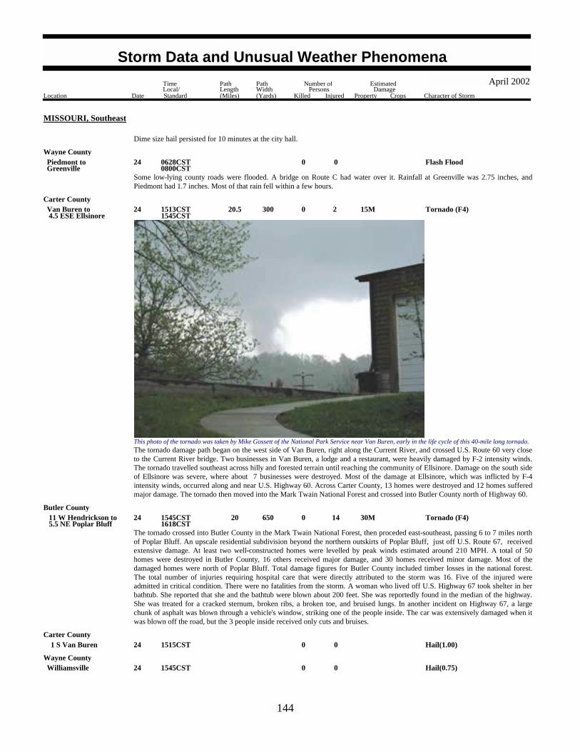
MISSOURI, Southeast
Dime size hail persisted for 10 minutes at the city hall.
Some low-lying county roads were flooded. A bridge on Route C had water over it. Rainfall at Greenville was 2.75 inches, andPiedmont had 1.7 inches. Most of that rain fell within a few hours.
Flash Flood0024GreenvillePiedmont to 0628CST
0800CST
Wayne County
The tornado damage path began on the west side of Van Buren, right along the Current River, and crossed U.S. Route 60 very closeto the Current River bridge. Two businesses in Van Buren, a lodge and a restaurant, were heavily damaged by F-2 intensity winds.The tornado travelled southeast across hilly and forested terrain until reaching the community of Ellsinore. Damage on the south sideof Ellsinore was severe, where about 7 businesses were destroyed. Most of the damage at Ellsinore, which was inflicted by F-4intensity winds, occurred along and near U.S. Highway 60. Across Carter County, 13 homes were destroyed and 12 homes sufferedmajor damage. The tornado then moved into the Mark Twain National Forest and crossed into Butler County north of Highway 60.
This photo of the tornado was taken by Mike Gossett of the National Park Service near Van Buren, early in the life cycle of this 40-mile long tornado.
Tornado (F4) 15M 2 300 20.5 024 4.5 ESE EllsinoreVan Buren to 1513CST
1545CST
Carter County
The tornado crossed into Butler County in the Mark Twain National Forest, then proceded east-southeast, passing 6 to 7 miles northof Poplar Bluff. An upscale residential subdivision beyond the northern outskirts of Poplar Bluff, just off U.S. Route 67, receivedextensive damage. At least two well-constructed homes were levelled by peak winds estimated around 210 MPH. A total of 50homes were destroyed in Butler County, 16 others received major damage, and 30 homes received minor damage. Most of thedamaged homes were north of Poplar Bluff. Total damage figures for Butler County included timber losses in the national forest.The total number of injuries requiring hospital care that were directly attributed to the storm was 16. Five of the injured wereadmitted in critical condition. There were no fatalities from the storm. A woman who lived off U.S. Highway 67 took shelter in herbathtub. She reported that she and the bathtub were blown about 200 feet. She was reportedly found in the median of the highway.She was treated for a cracked sternum, broken ribs, a broken toe, and bruised lungs. In another incident on Highway 67, a largechunk of asphalt was blown through a vehicle's window, striking one of the people inside. The car was extensively damaged when itwas blown off the road, but the 3 people inside received only cuts and bruises.
Tornado (F4) 30M 14 650 20 024 5.5 NE Poplar Bluff 11 W Hendrickson to 1545CST
1618CST
Butler County
Hail(1.00)0024 1 S Van Buren 1515CSTCarter County
Hail(0.75)0024Williamsville 1545CSTWayne County
144
Storm Data and Unusual Weather Phenomena
Location Date Character of Storm
TimeLocal/Standard
PathLength(Miles)
PathWidth(Yards)
Number ofPersons
Killed Injured
EstimatedDamage
Property Crops
April 2002
MISSOURI, Southeast
Butler CountyHail(1.00)0024 4 NW Poplar Bluff 1556CST
The long-track tornado that crossed much of Carter and Butler Counties briefly touched down again near Rombauer. Numerous treeswere down along the short damage track.
Tornado (F1) 2K0 40 1 024 1.6 SSW Rombauer 2 SW Rombauer to 1621CST
Butler County
Hail(1.75)0024 3 SE Williamsville 1630CSTWayne County
The supercell thunderstorm that spawned a long-track tornado over Butler and Carter Counties produced a brief, weak tornado veryclose to the Stoddard/Butler County line, just east of Fisk. No damage was reported.
Tornado (F0)0 40 0.1 024 4.9 W Dudley 5 W Dudley to 1634CST
Stoddard County
Hail(1.75)0024Gordonville 1636CSTCape Girardeau County
Hail(1.00)0024 5 W Dudley 1659CSTStoddard County
Hail(1.75)0024Zalma 1705CSTBollinger County
An insurance company reported at least a couple of vehicles received hail damage.Hail(0.75) 4K0024Advance 1714CST
Stoddard County
A weak tornado briefly touched down near the intersection of Highway 25 and M Highway. No damage was reported.
Tornado (F0)0 20 0.1 024 3.9 NNE Bloomfield 4 N Bloomfield to 1716CST
Stoddard County
Hail(1.75)0024 1 S Poplar Bluff 1719CSTButler County
Hail(0.88)0024Bernie 1725CSTStoddard County
The funnel cloud was observed near the northern city limits of Dexter, at the junction of Highway 25 and U.S. Route 60.Funnel Cloud0024 1 N Dexter 1737CST
Stoddard County
Two trees were down, including one that fell downtown. The other fell west of town.Thunderstorm Wind (G50)0024Vanduser 1740CST
Scott County
Hail(0.75)0024Qulin 1745CSTButler County
Hail(0.75)0024Gideon 1807CSTNew Madrid County
Trees were down in Piedmont.Thunderstorm Wind (G50)0027Piedmont 2255CST
Wayne County
Numerous trees and power lines were blown down countywide, including T Highway west of Perryville, E Highway northeast ofPerryville, and County Road 816 west of Brewer. Power lines were down on Highway 51N
Thunderstorm Wind (G52) 8K0027Countywide 2300CSTPerry County
Tornado (F3) 4M 16 200 4 1 27 4 SW Marble Hill 8 SW Marble Hill to 2340CST
2345CST
Bollinger County
145
Storm Data and Unusual Weather Phenomena
Location Date Character of Storm
TimeLocal/Standard
PathLength(Miles)
PathWidth(Yards)
Number ofPersons
Killed Injured
EstimatedDamage
Property Crops
April 2002

MISSOURI, Southeast
This strong tornado with peak winds near 180 MPH touched down in a rural area southwest of Marble Hill. A total of 19 residenceswere severely damaged, and 6 were destroyed. Approximately 10 of the residences were mobile homes and 15 were single-familyhomes. Another 50 outbuildings, such as barns and sheds, were destroyed or damaged. Seven people were inside a house that wasdemolished. One of the victims, a 12-year-old boy, was thrown about 50 yards from the house and fatally injured. Several others inthe immediate area, possibly the other occupants of the house, were thrown into a nearby lake and swam to safety. Of the 16 peopleinjured in the tornado, four were air lifted to hospitals with serious injuries. Cars were stacked atop cars. Several residents weretrapped inside the debris of their homes for up to 3 hours. The large number of trees down across roads delayed the arrival of rescueteams.
This aerial photo of the damage area shows the lake where residents of the nearby homes were tossed.
M12PH
Two trees were blown down.Thunderstorm Wind (G50)0028Cape Girardeau 0015CST
Cape Girardeau County
Numerous trees and power poles were down.Thunderstorm Wind (G52) 5K0028 1 NW New Madrid 0119CST
New Madrid County
A brief touchdown occurred in a small wooded area along Route 162 in extreme southeast New Madrid County. Several large treeswere snapped at the base. No structures were involved.
Tornado (F0)0 70 0.1 028 8 SE Portageville 0129CSTNew Madrid County
Hail(1.75)0030 2 W Neelys Lndg 1930CSTCape Girardeau County
Hail(1.00)0030 8 W Marble Hill 2028CSTBollinger County
Flash Flood0000708
South Portion 1930CST0030CST
MISSOURI, Southwest
Howell County
Flash Flood0000708
Countywide 1930CST0030CST
Ozark County
146
Storm Data and Unusual Weather Phenomena
Location Date Character of Storm
TimeLocal/Standard
PathLength(Miles)
PathWidth(Yards)
Number ofPersons
Killed Injured
EstimatedDamage
Property Crops
April 2002

MISSOURI, Southwest
Taney CountyFlash Flood00007
08Countywide 2300CST
0030CSTAn intense storm system developed over the southern plains and lower Mississippi Valley the morning of April 7th. A series of lowpressure systems also moved northeast across northern Arkansas into southern Missouri that evening. Rounds of heavy rainfalloccurred which produced locally two to three inches of rain in less than three hours along the Arkansas border between Branson andWest Plains. Law enforcement officers reported numerous low water crossings flooded and impassable, especially along StateHighway 142 in southern Howell County, county roads near Thornfield, and Highway 176 near Rockaway Beach. Several roadswere closed due to the high water.
Flood00008 0030CST2100CST
MOZ096>098-104>105 Douglas - Howell - Shannon - Taney - Ozark
Due to excessive rainfall amounts of two to three inches on the evening of April 7th over extreme southern Missouri betweenBranson and Eminence, numerous low water crossings, county roads, bridges and secondary roads flooded and remained closedthrough the evening of the 8th. Although rainfall rates decreased after midnight, an additional one half to one inch of rain fell onalready saturated soils that earlier had flash flooding. During the height of the storm, a few bridges near Gainesville and BransonMissouri had one to two feet of water flowing over them.
Hail(0.75)00013Twin Bridges 1705CSTDouglas County
Hail(1.00)00013Dora 1710CSTOzark County
Flash Flood 100K001314
North Portion 2015CST0000CST
Howell County
A cluster of slow moving thunderstorms moved across northern Howell county producing three to four inches of rain in less than twohours. In addition to the intense localized band of three to four inches, a broad area of one to two inches fell over all of northernHowell county between 8 and 10 pm. Highway 17 south of Mountain View and east of Pomona was flooded and impassable duringthe height of the storm. Highway N east of Pomona was also closed due to high water. County roads 4740, 4870 and 5130 werecompletely washed out by the flood waters. The heavy rains also caused considerable damage around the West Plains area, especiallyat the Southern Hills Shopping Center where carpets and inventory were damaged.
Flood00014 0000CST2100CST
MOZ097-106 Howell - Oregon
A broad area of one to three inches of rain fell over Howell and Oregon counties during the late evening of April 14th. The ElevenPoint River basin received one to three inches of rainfall. This flooded areas along Highway 142 near Calm plus recreational andcamping facilities over eastern Oregon county. In Howell county, flash flooding that occurred earlier due to excessive rainfall in ashort period of time, continued to have flooded low water crossings, county, and secondary roads.
Hail(0.88)00018 4 S Ash Grove 1146CSTGreene County
Hail(0.88)00018 5 S Ash Grove 1154CSTGreene County
Hail(0.88)00018Plad 1202CSTDallas County
Hail(0.75)00018Camdenton 1255CSTCamden County
Hail(0.75)00018Springfield 1315CSTGreene County
Hail(0.75)00019 1 N Polk 0850CSTPolk County
Hail(0.75)00019Waynesville 1040CSTPulaski County
Hail(1.75) 10K0019Salem 1041CSTDent County
Dime and nickel size hail was also reported west of Salem with trees and power lines blown down between Lenox and Salem.
147
Storm Data and Unusual Weather Phenomena
Location Date Character of Storm
TimeLocal/Standard
PathLength(Miles)
PathWidth(Yards)
Number ofPersons
Killed Injured
EstimatedDamage
Property Crops
April 2002

MISSOURI, Southwest
Dent CountyThunderstorm Wind (G52)00019Salem 1105CST
Trees were blown down east of the city.
Thunderstorm Wind (G52) 10K0019Carthage 1538CSTJasper County
Trees and power lines were blown down around Carthage.
Hail(0.75)00019Rolla 1629CSTPhelps County
Flash Flood 300K0019East Portion 1645CST2300CST
Camden County
Flash Flood 500K0019Countywide 1645CST2300CST
Pulaski County
Flash Flood 300K 1 019North Portion 1830CST2300CST
Phelps County
Flash Flood00019South Portion 1900CST2300CST
Maries County
Flash Flood 100K0019Countywide 2030CST2300CST
Miller County
A complex of strong to severe thunderstorms developed over the southwestern portions of the Lake of the Ozarks region during theafternoon and early evening of April 19th and moved slowly eastward over Camden, Maries, Miller, Phelps and Pulaski counties.
The airmass was very moist which allowed for the storms to produce torrential rainfall in a short period of time. In addition, thestorms propagated over the same areas producing rainfall rates of two to four inches per hour. Radar estimated between six to eightinches of rain fell in these areas during the early evening hours. A broad area of two to four inches fell around the six to eight inchband, which allowed for significant flooding to occur.
Numerous low water crossings, county and state roads were flooded or closed during the height of the storm. Approximately twomajor roads and 14 bridges were either damaged or completely washed out in northern Pulaski county where the the highest rainfalltotals occurred.
In Rolla, Missouri two feet of water was flowing over some city streets. In St. James, cars were reported washed off the roadway intoarea creeks and streams. The flooding also trapped one man and three children on a low water bridge west of Doolittle. Anotherman was swept downstream as his car went into a flooded ditch near Rolla. No serious injuries were reported.
The flash flooding also drove some residents of Beaver Manor near Rolla from their homes. Around the Beaver Manor subdivision,propane gas tanks were lifted from their anchored positions and chain-link fences and boats were wash nearly a mile downstreamalong Beaver Creek. About 20 homes sustained damage in Phelps County.
In Miller County, both the Big Tavern Creek, and Little Tavern Creek flooded causing considerable damage to roads and bridges,especially near St. Elizabeth where the Creeks cross Highway 52. The roads had chunks of concrete shattered and missing from thebridge's floor. Near Iberia, an unofficial report of eight inches of rain fell in less than one hour. Fences were also flattened by rushingwater in a few places. One creek crossing had debris caught up in trees a good five or six feet above ground.
Thunderstorm Wind (G60)00019Houston 1725CST1735CST
Texas County
Sixty to seventy mile per hour winds were estimated around the Houston area by ham radio operators.
Hail(0.75)00019 5 S Rolla 1745CSTPhelps County
Flood 200K001921
2300CST1200CST
MOZ057>058-069>071 Miller - Maries - Camden - Pulaski - Phelps
A prolonged flooding event developed over portions of the Lake of the Ozarks region from late April 19th through early morning of
148
Storm Data and Unusual Weather Phenomena
Location Date Character of Storm
TimeLocal/Standard
PathLength(Miles)
PathWidth(Yards)
Number ofPersons
Killed Injured
EstimatedDamage
Property Crops
April 2002

MISSOURI, Southwest
April 21st. The initial flash flooding eased during the early morning of April 20th as the complex of thunderstorms moved east of thearea. However, runoff continued which allowed small streams, creeks and even the larger Gasconade River in Maries County toflood during the first part of the weekend.
Additional thunderstorms develop during the afternoon and evening of April 20th, which produced an additional one to three inchesof rain over the already saturated soils over the area. This produced another flash flooding episode where creeks and small streamsrose rapidly in a short period of time.
This prolonged flooding event eased during the early morning of April 21st. However, numerous county roads and low watercrossings remain closed or impassable for nearly 36 hours.
Shannon CountyThunderstorm Wind (G55) 10K0020
Low WassieWinona to 1215CST
1225CSTA barn was blown down along with several large trees between Winona and Low Wassie in eastern Shannon County. There werealso numerous reports of windows blown out.
Flash Flood00020 2 N Brushyknob 1300CST1500CST
Douglas County
A brief period of intense rainfall allowed Farm Road 117 north of Brushyknob to flood. A car was swept off the low water bridge butno one was injured.
Hail(0.75)00020Bronaugh 1415CSTVernon County
Hail(0.75)00020 3 N Lamar 1425CSTBarton County
Hail(1.75)00020Slagle 1515CSTPolk County
Nickel and dime size hail was also reported around Pleasant Hope.
Hail(1.75)00020Forkners Hill 1545CSTWebster County
Hail(0.75)00020 4 N Grovespring 1610CSTWright County
Hail(0.75)00020Roby 1645CSTTexas County
Hail(1.75)00020 3 S Camdenton 1715CSTCamden County
Thunderstorm Wind (G52)00020St Elizabeth 1735CSTMiller County
Trees were blown down near St. Elizabeth.
Hail(0.75)00021Cole Camp 0430CSTBenton County
Hail(1.00)00023 1 NW Cabool 2045CSTTexas County
Hail(1.00)00023Arroll 2115CSTTexas County
Hail(1.00)00024Mountain Grove 0125CSTWright County
Hail(1.75)00024Salem 1350CSTDent County
Hail(1.25)00024 1 W Summersville 5 W Summersville to 1400CST
1410CST
Texas County
149
Storm Data and Unusual Weather Phenomena
Location Date Character of Storm
TimeLocal/Standard
PathLength(Miles)
PathWidth(Yards)
Number ofPersons
Killed Injured
EstimatedDamage
Property Crops
April 2002

MISSOURI, Southwest
Shannon CountyHail(1.00)00024 7 NE Winona 1445CST
Hail(0.75)00027Walker 0100CSTVernon County
Tornado (F2) 1.5M0100 1.5 027 1.5 NE Willow Spgs 1 NW Willow Spgs to 2140CST
2145CST
Howell County
An F2 tornado, plus associated destructive convergent winds around the tornadic circulation, caused extensive damage from 2 mileswest of the Willow Springs Highway Patrol Headquarters, northeast to a mile and a half northeast of Willow Springs along Highway378. Although the tornadic circulation was only 100 yards wide, it caused damage up to 300 yards wide.
Large, century year old oak trees were uprooted throughout the area. West of the Willow Springs Highway Patrol Headquarters, abass boat was thrown across two pastures and over two fences. A barn near this pasture was damaged.
Troop G Headquarters had their 365' radio tower blown down. The tower landed on a home in the Hickory Hills Subdivision inWillow Springs. Four homes loss shingles and two homes completely lost their roofs. A church was rotated 45 degrees off itsfoundation and cemetery headstones were toppled. The worst damage occurred on a hilltop north of Willow Springs where a homewas almost completely destroyed along with numerous outbuildings in a half mile area.
Thunderstorm Wind (G52)00027 2 N Winona 2220CSTShannon County
Trees were blown down over Highway 19 north of Winona.
Hail(1.00)00030 4 NE Ozark 0750CSTChristian County
Hail(1.75) 25K0030Chesapeake 0800CSTLawrence County
Hail(0.88)00030El Dorado Spgs 0805CSTCedar County
Hail(1.00)00030 3 S Squires 0805CSTDouglas County
Hail(0.75)00030 1 E El Dorado Spgs 0812CSTCedar County
Hail(0.75)00030 5 NE Springfield 0820CSTGreene County
Hail(1.00)00030 2 W Goodhope 0825CSTDouglas County
Dime to quarter size hail was also observed near Ava.
Hail(1.00)00030Battlefield 0832CST0838CST
Greene County
Dime to quarter size hail accumulated up to three inches deep south of Battlefield on Highway FF. Also dime size hail was observedin southern parts of Springfield.
Hail(1.75)00030Billings 0839CSTChristian County
Nickel size hail was also reported in Ozark.
Hail(1.75)00030Crane 0840CSTStone County
Golf ball size hail was also observed near Union City.
Hail(0.88)00030Bolivar 0841CSTPolk County
Hail(2.75) 25K0030Morrisville 0842CSTPolk County
There was several reports of hail damage around the Morrisville area.
150
Storm Data and Unusual Weather Phenomena
Location Date Character of Storm
TimeLocal/Standard
PathLength(Miles)
PathWidth(Yards)
Number ofPersons
Killed Injured
EstimatedDamage
Property Crops
April 2002

MISSOURI, Southwest
Polk CountyHail(1.00)00030Morrisville 0844CST
Quarter size hail was also observed near Brighton and Pleasant Hope.
Hail(1.00)00030Wasola 0845CSTOzark County
Hail(1.00)00030 3 N Walnut Shade 0850CSTTaney County
Funnel Cloud00030Ozark 0856CST0900CST
Christian County
A funnel cloud was observed for a few minutes near Ozark.
Hail(1.75)00030Ozark 0905CSTChristian County
Hail(1.00)00030South Fork 0913CSTHowell County
Quarter size hail covered the ground near South Fork, also nickel size hail was reported near Pottersville.
Hail(0.88)00030 2 W Thayer 0935CSTOregon County
Hail(1.75)00030 2 S West Plains 0938CSTHowell County
Hail(1.75) 10K0030Isabella 0950CSTOzark County
Golf ball size hail was also observed north of Gainesville, and along Highway 5 between Gainesville and Dora. Several cars weredamaged due to the larger hail near Dora.
Hail(1.75)00030West Plains 1030CSTHowell County
Hail(0.75)00030Collins 1229CSTSt. Clair County
Hail(0.88)00030Collins 1230CST1232CST
St. Clair County
Hail(1.00)00030 3 S Rondo 1250CSTPolk County
Hail(1.75)00030 1 N Adonis 1255CSTPolk County
Hail(1.00)00030 4 SE Elkton 1302CSTHickory County
Hail(2.00)00030Louisburg 1308CSTDallas County
Dime size hail was also observed near Plad.
Hail(0.88)00030 5 W Lebanon 1330CSTLaclede County
Nickel size hail was also reported in Lebanon.
Winter Storm0001 0000MST1800MST
MONTANA, Central
MTZ009-012-014-048 North Rocky Mountain Front - Cascade - Southern Lewis And Clark - Southern Rocky Mountain Front
151
Storm Data and Unusual Weather Phenomena
Location Date Character of Storm
TimeLocal/Standard
PathLength(Miles)
PathWidth(Yards)
Number ofPersons
Killed Injured
EstimatedDamage
Property Crops
April 2002

MONTANA, Central
A winter storm occurred across a portion of North Central and Central Montana on the 1st. Snow began to fall over the RockyMountain Front around midnight on the 1st, and then moved into the Great Falls and Helena areas by day break. The snow washeavy at times, reducing visibilities to less than a quarter mile at times. Numerous roads were closed in the Helena area due toreduced visibilities.
Some total snow accumulations from this event include: 10 inches at East Glacier 20 W and Lincoln, and 6 to 8 inches at Choteauand Belt.
A high wind event occurred across all of North Central Montana beginning on the 13th and ending on the 14th. The winds began toincrease in intensity over the Rocky Mountain Front early on the 13th and then increased in intensity over the northern plains by themid afternoon hours. The winds subsided a bit during the overnight hours between the 13th and 14th. However, by midday on the14th, strong winds were once again blowing across all of North Central Montana. Sustained winds between 40 and 50 mph, withwind gusts between 60 and 70 mph occurred across the region.
Areas of blowing dust caused near zero visibilities across much of the northern sections of the state, resulting in several roads beingclosed. The blowing dirt drifted to a depth of 3 feet in some areas.
Additionally, numerous power outages occurred due to downed power lines and poles. One downed power line caused a 100-acregrass fire near Box Elder. An empty 60 foot grain elevator was blown over near Cut Bank. Several vehicles were blown off roadsduring this event.
Some peak wind speeds from this event include:75 mph at Browning, 71 mph at Cut Bank, 70 mph at Rudyard, 64 mph at Shelby, 70 mph at Dupuyer and Pendroy, and 60 mph atInverness, Big Sandy, Sweet Grass, and Del Bonita.
High Wind (G65)001314
1200MST2100MST
MTZ009>014-044>046-048 North Rocky Mountain Front - Eastern Glacier - Hill - Cascade - Chouteau - Southern Lewis And Clark - Toole - Liberty -Eastern Pondera - Southern Rocky Mountain Front
An area of heavy snow moved through Southwest and Central Montana on the 17th and 18th. The snow was heaviest over themountains during this event.
Some total snow accumulations from this event include: 10 to 14 inches in Neihart and on the top of Kings Hill; 13 inches at Clancy,8 to 10 inches at Winston, and 6 to 8 inches at Dillon, Pony, and Marysville.
Winter Storm001718
1200MST1000MST
MTZ008-012-014>015-050-052>054
Beaverhead - Cascade - Southern Lewis And Clark - Madison - Judith Basin - Jefferson - Broadwater - Meagher
A high wind event occurred over much of North Central Montana during the afternoon and early evening hours of the 22nd.Sustained winds over 40 mph, with gusts near 60 mph were recorded.
Some of the strongest wind gusts recorded from this event include: 67 mph at Great Falls, 63 mph at Rudyard, and 60 mph at Lomaand Power 7 SW.
High Wind (G58)0022 1200MST2000MST
M
MTZ009>013-044>048 North Rocky Mountain Front - Eastern Glacier - Hill - Cascade - Chouteau - Toole - Liberty - Eastern Pondera - Blaine -Southern Rocky Mountain Front
A winter storm moved through the Northern Rocky Mountain Front and the adjacent plains on the 23rd. The snow fell through muchof the morning and early afternoon hours. Total snow accumulations form this event were 6 to 8 inches over the plains, and 8 to 10inches in the mountains.
Winter Storm0023 0400MST1600MST
MTZ009>010-046 North Rocky Mountain Front - Eastern Glacier - Eastern Pondera
62 mph wind gust recorded 15 miles northwest of Glasgow in a duststorm.High Wind (G52)0013 1615MST M
MONTANA, East
MTZ017 Central And Southern Valley
152
Storm Data and Unusual Weather Phenomena
Location Date Character of Storm
TimeLocal/Standard
PathLength(Miles)
PathWidth(Yards)
Number ofPersons
Killed Injured
EstimatedDamage
Property Crops
April 2002

MONTANA, South
MTZ056 Western Carbon
5 inches of new snow in Red LodgeHeavy Snow0001 2000MST
8 inches of new snow in JolietHeavy Snow0001 2000MST
MTZ056 Western Carbon
5 inches of new snow in Big TimberHeavy Snow0001 2000MST
MTZ041 Sweet Grass
Thunderstorm Wind (G60)0014Harlowton 1245MST MWheatland County
8 inches of new snow at Billings AirportHeavy Snow0016 0737MST
MTZ035 Yellowstone
10 inches of new snow in Cooke CityHeavy Snow0016 0737MST
MTZ040 Park
9 inches of new snow 9 miles south of RoundupHeavy Snow0016 0737MST
MTZ029 Musselshell
4 inches of new snow in PryorHeavy Snow0016 0737MST
MTZ038 Southern Big Horn
5 inches of new snow in Red LodgeHeavy Snow0016 0737MST
MTZ056 Western Carbon
7 inches of new snow 2 miles south of NyeHeavy Snow0016 0737MST
MTZ034 Stillwater
5 inches of new snow 18 miles northwest of ColumbusHeavy Snow0016 0737MST
MTZ034 Stillwater
5 inches of new snow in GardinerHeavy Snow0016 0737MST
MTZ040 Park
7 inches of new snow in JardineHeavy Snow0016 0737MST
MTZ040 Park
7 inches of new snow 6 miles northeast of GardinerHeavy Snow0016 0900MST
MTZ040 Park
6 inches of new snow in LavinaHeavy Snow0016 0900MST
MTZ042 Golden Valley
5 inches of new snow at the Billings AirportHeavy Snow0018 1550MST
MTZ035 Yellowstone
6 inches of snow at the Billings National Weather ServiceHeavy Snow0018 1550MST
MTZ035 Yellowstone
153
Storm Data and Unusual Weather Phenomena
Location Date Character of Storm
TimeLocal/Standard
PathLength(Miles)
PathWidth(Yards)
Number ofPersons
Killed Injured
EstimatedDamage
Property Crops
April 2002

MONTANA, South
MTZ058 Southern Rosebud
8 inches of snow in Lame DeerHeavy Snow0018 1550MST
5 inches of snow in AbsarokeeHeavy Snow0018 1550MST
MTZ034 Stillwater
6 inches of new snow in BridgerHeavy Snow0018 1550MST
MTZ039 Eastern Carbon
10 inches of new snow in DeanHeavy Snow0018 1550MST
MTZ034 Stillwater
13 inches of new snow in ForsythHeavy Snow0018 1550MST
MTZ031 Northern Rosebud
6 inches of new snow in Miles CityHeavy Snow0018 1550MST
MTZ032 Custer
10 inches of new snow in BrandenbergHeavy Snow0018 1550MST
MTZ058 Southern Rosebud
5 inches of new snow in ColumbusHeavy Snow0018 1550MST
MTZ034 Stillwater
5 inches of snow in Big TimberHeavy Snow0018 1550MST
MTZ041 Sweet Grass
9 inches of new snow in PryorHeavy Snow0018 1550MST
MTZ038 Southern Big Horn
5 inches of snow in Reed PointHeavy Snow0018 1550MST
MTZ034 Stillwater
8 inches of new snow in Red LodgeHeavy Snow0018 1550MST
MTZ034 Stillwater
7 inches of new snow in HyshamHeavy Snow0018 1550MST
MTZ030 Treasure
6 inches of new snow in HardinHeavy Snow0018 1550MST
MTZ057 Northern Big Horn
14 inches of new snow in MelvilleHeavy Snow0018 1550MST
MTZ041 Sweet Grass
4 inches of new snow in BakerHeavy Snow0018 1550MST
MTZ033 Fallon
8 inches of new snow 15 miles east of BillingsHeavy Snow0018 1550MST
MTZ035 Yellowstone
154
Storm Data and Unusual Weather Phenomena
Location Date Character of Storm
TimeLocal/Standard
PathLength(Miles)
PathWidth(Yards)
Number ofPersons
Killed Injured
EstimatedDamage
Property Crops
April 2002

MONTANA, South
MTZ037 Carter
6 inches of new snow in EkalakaHeavy Snow0018 1550MST
Urban/Sml Stream Fld0014Libby 1115MST1300MST
MONTANA, West
Lincoln County
Urban/Sml Stream Fld0014Superior 1115MST1300MST
Mineral County
Small stream flooding occurred in many areas of Lincoln County due to snowmelt. Lincoln County Sheriff reported minor floodingnear the Fisher River with water across Highway 2. In Mineral County, water overflowed private property near the confluence ofTimber and Packer Creeks.
High Wind (G74) 2 014 1130MST1600MST
MTZ001-003>004-043 Kootenai/Cabinet Region - Flathead/Mission Valleys - Lower Clark Fork Region - Blackfoot Region
Strong winds associated with a cold front swept through western Montana on the 14th. Wind gusts between 60-80 mph werereported in northwest Montana with numerous reports of downed powerlines and tree limbs. Highway 83 near Condon was closedbriefly due to fallen debris. Metal roofing was torn off a church at Manicke in Lincoln County. Two people were injured near Yaakwhen a tree fell on their automobile. Power was interrupted for two hours in Paradise.
Heavy Snow001718
0600MST1200MST
MTZ006>007 Bitterroot / Sapphire Mountains - Butte / Pintlar Region
A heavy wet snow started on the morning of the 17th and continued through midday on the 18th. Snow amounts ranged from 7inches at Georgetown Lake, 8 inches at Twin Lakes, to over 10 inches at Barker Lakes. Up to two feet of snow fell at Lost Trail Passat 7000 feet.
High Wind (G52)0017 1530CST1730CST
M
NEBRASKA, Central
NEZ038-059 Custer - Lincoln
Strong winds accompanying a front were enhanced by collapsing cumulus clouds. The winds carried dirt and dust 30 to 50 feet intothe air and reduced visibilities to 1 to 3 miles over a large area. No damage was reported with the wind storm.
Hail(0.88)0016Platte Center 1555CST
NEBRASKA, East
Platte County
Hail(0.75)0016 5 NNW Richland 1615CSTColfax County
Hail(0.75)0016 8 NNE Stanton 1620CSTStanton County
The hail was accompanied by thunderstorm wind gusts of 55 mph.Hail(0.75)0016 9 SSW Friend 1637CST
Saline County
Thunderstorm wind gusts estimated at over 60 mph blew a semi-truck over on highway 275 near Beemer.Thunderstorm Wind (G55)0016 4 NW Beemer 1644CST
Cuming County
Hail(1.75)0016 7 SE Winside 1655CSTWayne County
155
Storm Data and Unusual Weather Phenomena
Location Date Character of Storm
TimeLocal/Standard
PathLength(Miles)
PathWidth(Yards)
Number ofPersons
Killed Injured
EstimatedDamage
Property Crops
April 2002

NEBRASKA, East
Thurston County
The Emergency Manager for Thurston county reported a thunderstorm wind gust estimated at around 60 mph. A storm chaser in thearea estimated the winds around 70 mph as he tried to outdrive the gust.
Thunderstorm Wind (G50)0016Pender 1659CST
Hail(0.75)0016Surprise 1700CSTButler County
Hail(0.75)0016Walthill 1714CSTThurston County
Hail(0.75)0016Norfolk 1836CSTMadison County
Hail(0.88)0016Tekamah 1855CSTBurt County
A ham radio operator estimated a thunderstorm wind gust of 65 mph in Pender. This was the second storm that produced windsestimated at over 60 mph that night around Pender.
Thunderstorm Wind (G55)0016Pender 1930CSTThurston County
The Emergency Manager for Colfax county reported thunderstorm winds blew down farm buildings southeast of Howells.Thunderstorm Wind (G60)0016 5 SE Howells 1930CST
Colfax County
Thunderstorm wind gusts estimated at over 60 mph destroyed a farm building scattering the debris over 100 yards.Thunderstorm Wind (G55)0016 8 NE Schuyler 1945CST
Colfax County
From the same storm complex that produced the wind damage near Howells in Colfax county. These thunderstorm wind gusts wereestimated by the Emergency Manager of Dodge county.
Thunderstorm Wind (G50)0016Snyder 1949CSTDodge County
Hail(0.75)0016Friend 1952CSTSaline County
A thunderstorm wind gust estimated at 60 mph was reported by a ham radio operator.Thunderstorm Wind (G50)0016 1 S Hooper 2002CST
Dodge County
Emergency management reported thunderstorm wind gusts blew a roof off of a building in Uehling and also did considerable treedamage which also downed power lines in town.
Thunderstorm Wind (G55)0016Uehling 2010CSTDodge County
Thunderstorm winds estimated at over 65 mph damaged buildings and downed power lines near Winslow.Thunderstorm Wind (G60)0016Winslow 2010CST
Dodge County
Thunderstorm wind gusts downed power lines near Herman.Thunderstorm Wind (G60)0016Herman 2010CST
Washington County
Hail(0.75)0016Ceresco 2011CSTSaunders County
Hail(0.75)0016Raymond 2015CSTLancaster County
Hail(0.75)0016Ithaca 2020CSTSaunders County
Reported by law enforcement at the intersection of highways 92 and 275.Hail(0.88)0016 20 W Omaha 2044CST
Douglas County
156
Storm Data and Unusual Weather Phenomena
Location Date Character of Storm
TimeLocal/Standard
PathLength(Miles)
PathWidth(Yards)
Number ofPersons
Killed Injured
EstimatedDamage
Property Crops
April 2002

NEBRASKA, East
Douglas County
Hail between dime and nickel size was reported at 149th and Blondo, 168th and Center and 204th and Center in west Omaha.Hail(0.88)0016Omaha 2045CST
Hail(0.75)0017Fremont 1800CSTDodge County
Hail(1.75)0017Herman 1845CSTWashington County
Hail(1.75)0017 8 SE Tekamah 1907CSTBurt County
Measured at the Falls City ASOS.High Wind (G62) 100K0018 0048CST M
NEZ093 Richardson
High Wind (G60) 1 1 18 0059CST0215CST
NEZ053-067>068-090>092 Sarpy - Cass - Otoe - Johnson - Nemaha - Pawnee
A strong low level jet was aided by weakening and dissipating showers and thunderstorms and produced a large area of strong andoccasionally damaging gradient winds. The strong winds first made it into southeast Nebraska at 148 am cdt when the Falls CityAsos measured wind speeds of 72 mph. These strong winds blew a mobile home over and destroyed a barn and lawn careequipment north of Falls City. In addition, there was widespread roof and tree damage in and out of Falls City and an insuranceagency estimated that claims for damage alone in Falls City came to around $100,000.
In Johnson and Pawnee counties the winds were estimated at around 70 mph by Emergency Management, and both countiesreported extensive tree damage. Considerable damage was reported around Cook to barns, sheds and other outbuildings in additionto several windows blown out. Several outbuildings were unroofed or sustained heavy damage 2 miles west of Tecumseh. Both ofthose towns are in Johnson county. Trees were severely damaged or uprooted in Otoe county from around Lorton to Nebraska Cityat around 215 am cdt with winds estimated at between 60 and 70 mph.
The winds were also responsible for a five-vehicle pileup, because of blinding dust, which killed a 54-year-old man. Three cars hadstopped along highway 2 outside of Nebraska City because of zero visibility in blowing dust. The cars had thought they had stoppedon the shoulder of the highway, but due to the time of the night and poor visibility they had actually stopped in the left lane. Twosemi-tractor trailer trucks hit the cars, the first one caused minor damage, but the driver of the second truck was killed when hesmashed into the first truck. The strong winds began weakening as they made it north into Cass and Sarpy counties, but not beforedowning a few trees and power lines in Plattsmouth in Cass county, and giving an estimated wind gust of around 60 mph at OffuttAirforce Base around 315 am cdt. M54VE
Hail(0.75)0022 6 SW Pierce 1720CSTPierce County
Hail(0.75)0022 5 SW Carroll 1737CSTWayne County
Hail(1.00)0022 7 E Wayne 1810CSTWayne County
Hail(1.00)0022 4 S Pilger 1820CSTStanton County
Hail(1.00)0024Bellevue 0539CSTSarpy County
Hail(2.75)0024 3 N Milford 0600CSTSeward County
Thunderstorm wind gusts of around 60 mph were reported by a ham radio operator.Thunderstorm Wind (G50)0024 1 N Wahoo 0705CST
Saunders County
Mothball size hail covered the ground near Malcolm.Hail(1.25)0024Malcolm 0705CST
Lancaster County
157
Storm Data and Unusual Weather Phenomena
Location Date Character of Storm
TimeLocal/Standard
PathLength(Miles)
PathWidth(Yards)
Number ofPersons
Killed Injured
EstimatedDamage
Property Crops
April 2002

NEBRASKA, East
Lancaster County
Golfball size hail reported near 70th and Holdrege Streets.Hail(1.75)0024Lincoln 0707CST
This tornado was the first of 5 tornadoes that touched down in eastern Nebraska and southwest Iowa this afternoon, all of them underthe classification of mini-supercells. This tornado was the longest lived, and was caught on video by storm chasers. It destroyed abarn, some fences, uprooted a few trees, overturned a few irrigation pivots and did minor house damage west of Crete.
Tornado (F1)0 40 4.5 027 3 NW Crete 5 WSW Crete to 1406CST
1410CST
Saline County
A brief touchdown in open country caught on film by the same storm chaser that saw the larger tornado which did some damagewest of Crete this particular afternoon.
Tornado (F0)0 20 0.1 027 5 S Milford 1425CSTSeward County
Hail(0.75)0016Dixon 1650CST
NEBRASKA, Extreme Northeast
Dixon County
Hail(0.75)0016Newcastle 1709CSTDixon County
Thunderstorm Wind (G52)0016 1 N Ponca 1715CSTDixon County
NONE REPORTED.
NEBRASKA, Extreme Southwest
Thunderstorm Wind (G50)00016 3 NE Waco 01515CST
NEBRASKA, South Central
York County
Hail(1.00)00016 1 W Mc Cool Jct 01538CSTYork County
High Wind00016 01615CST1900CST
NEZ039>041-046>049-060>064-072>077-082>087
Valley - Greeley - Nance - Sherman - Howard - Merrick - Polk - Dawson - Buffalo - Hall - Hamilton - York - Gosper -Phelps - Kearney - Adams - Clay - Fillmore - Furnas - Harlan - Franklin - Webster - Nuckolls - Thayer
Thunderstorm Wind (G57) 250K0016 3 NE Shelby 01615CSTPolk County
Hail(0.75)00016Edgar 01905CSTClay County
Hail(0.75)00016Oak 01920CSTNuckolls County
Hail(0.75)00016Shickley 01924CSTFillmore County
Hail(0.75)00016Davenport 01925CSTThayer County
A powerful low pressure pushed a dryline and cold front across south-central Nebraska during the late afternoon and early eveninghours. Thunderstorms erupted along the initial boundary in Polk and York counties. Strong winds and hail resulted and there werenumerous of building damage in the Shelby area along with widespread tree damage. Later that evening, thunderstorms fired again,this time southeast of Hastings. Several reports of dime size hail were received.
158
Storm Data and Unusual Weather Phenomena
Location Date Character of Storm
TimeLocal/Standard
PathLength(Miles)
PathWidth(Yards)
Number ofPersons
Killed Injured
EstimatedDamage
Property Crops
April 2002

NEBRASKA, South Central
As the dryline plowed across south-central Nebraska during the early evening hours, the result was a scene reminiscent of the 1930s.Winds gusts in excess of 60 mph were recorded in some areas. Freshly tilled fields and recent dry weather made for widespreadareas of blowing dust, which was responsible for visibilities less than one mile at times. The highest wind gust of 78 mph wasrecorded near Gothenburg. Lexington and Ord both measured 60 mph. There were several auto accidents in the area which wereindirectly related to the wind and poor visibility.
Thayer County
One inch size hail covered the ground in Gilead.Hail(1.00)00018Gilead 00010CST
Hail(1.00)0030 6 SW Hemingford 1817MST1821MST
NEBRASKA, West
Box Butte County
Hail(0.88)0030Hemingford 1823MST1827MST
Box Butte County
Hail(0.75)0030 43 S Harrison 2028MST2031MST
Sioux County
Hail(0.75)0030 50 S Harrison 2257MST2259MST
Sioux County
High Wind (G53) 2K0014 1500PST1600PST
M
NEVADA, North
NVZ033-035 X E Elko - White Pine
An approaching cold front produced wind gusts to 61 mph at the Ely RAWS in White Pine County and up to 58 mph at the SpringGulch RAWS in extreme eastern Elko County. These strong winds did some damage to the roof and rain gutters of a weatherspotter in Ruth and broke some tree limbs.
Heavy Snow0015 1000PST2100PST
NVZ032-037 Sw & Sc Elko - S Lander & S Eureka
Six inches of new snow was reported at Eureka and Wells.
A very strong low pressure system moved across Nevada bringing high winds over much of the area.
High Wind (G53)0015 0535PST1600PST
M
NEVADA, South
NVZ017 Western Clark/Southern Nye
A strong low pressure system caused visibilities to be reduced to less than a quarter mile for several hours in blowing dust. Inaddition to several trees and power lines down, schools were closed for much of the day. Motorists in the area experienced near zerovisibilities for about 3 hours.
Dust Storm 10K0015 0900PST1500PST
NVZ017 Western Clark/Southern Nye
High Wind (G62) 500K 4 015 1150PST1800PST
MNVZ020 Las Vegas Valley
159
Storm Data and Unusual Weather Phenomena
Location Date Character of Storm
TimeLocal/Standard
PathLength(Miles)
PathWidth(Yards)
Number ofPersons
Killed Injured
EstimatedDamage
Property Crops
April 2002

NEVADA, South
A strong low pressure system moved through southern Nevada causing damage througout the Las Vegas Valley. The first report ofhigh winds came around 11:50 am with gusts over 50 mph at many locations. By 1:00 pm winds were gusting over 70 mph at a fewlocations with the Las Vegas weather office reporting a wind gust of 69 mph at 1:49 pm. Damage was widespread with many treesuprooted, power lines down, tractor trailers blown over, and several automobile accidents. The high winds also caused the Harrah'skiosk on the Strip to blow over, injuring four tourists. Due to the high winds and blowing dust, McCarran International Airport wasshut down to all air operations for approximatly two hours with several planes being diverted to other southwestern airports. Thehigh winds also caused extremely unhealthy air qualities and local hospitals were reportedly extremely busy due to people sufferingallergies.
A strong low pressure system caused considerable damage to portions of Lincoln County. Shingles were blown off many roofs,several empty buildings were blown down, power outages were wide spread, down power lines started many fires across town, andseveral wind caused rock slides causing people to be stranded were reported. Because of this, the County Commissioner declared astate of emergency and closed the county.
High Wind (G72) 300K0015 1220PST1600PST
NVZ015 Lincoln County Except The Sheep Range
A strong low pressure system brought high winds to the Lake Mead Recreation Area. Several locations on the Nevada side of thelake reported damage including an overturned houseboat that required rescue operation. One person sustained severe injuries andwas taken to a local hospital. Damage included several trees downed, several signs blown over, and shingles blown off homes andpark service buildings. Boat docks in the Echo Bay area broke loose and were destroyed.
High Wind (G55) 100K 1 015 1300PST1800PST
NVZ021 Lake Mead/Lake Mohave National Recreation Area
High Wind (G70) 150K0014 1200PST2200PST
M
NEVADA, West
NVZ003 Greater Reno/Carson City/Minden Area
Numerous reports of winds gusting to over 60 mph with isolated gusts over 70 mph as a strong cold front moved into the region.The winds caused scattered tree and roof damage around the area along with some power outages.
Public report of 59 mph wind gust in northwest Reno.High Wind (G53)0016 1400PST M
NVZ003 Greater Reno/Carson City/Minden Area
Flood001320
2030EST2115EST
NEW HAMPSHIRE, North and Central
NHZ002>005 Southern Coos - Northern Grafton - Northern Carroll - Southern Grafton
Low pressure moving northeast from the Ohio Valley on the 13th brought 1 to 3 inches of rain to the northern part of the state. Theheavy rain combined with snow melt to cause minor flooding along the Connecticut, Pemigewasset, and Saco Rivers.
The Connecticut River at Dalton rose above the 17 ft flood stage at around 7 am on the 14th and remained above flood stage until10:15 pm on the 20th, reaching a crest of 21.4 ft at 12:15 am on the 16th. At Wells River, the Connecticut River rose above the 11ft flood stage at around 11 pm on the 14th and remained above flood stage until 4:45 pm on the 15th, reaching a crest of 11.2 ft at11:30 am on the 15th. Additional rainfall on the 15th and continued snowmelt caused the Connecticut at Wells River to again riseabove flood stage at 11:30 am on the 16th; the river remained above flood stage until 4:30 am on the 18th, reaching a crest of 12.3 ftat 11:15 pm on the 16th. At West Lebanon, the Connecticut River rose above the 18 ft flood stage at around 1 am on the 14th andremained above flood stage until 10:30 pm on the 14th, reaching a crest of 22.2 ft at 8:45 am on the 15th.
The Saco River at North Conway rose above the 9 ft flood stage at around 4 am on the 14th and remained above flood stage until7:45 pm on the 14th, reaching a crest of 11.5 ft at 11:30 am on the 14th.
The Pemigewasset River at Woodstock rose above the 9 ft flood stage at around 9:30 pm on the 13th and remained above flood stageuntil 12:30 pm on the 14th, reaching a crest of 12.3 ft at 2:30 am on the 14th. At Plymouth, the Pemigewasset River rose above the13 ft flood stage at around 6:45 am on the 14th and remained above flood stage until 10:15 pm on the 14th, reaching a crest of 15.4ft at 1:00 pm on the 14th.
160
Storm Data and Unusual Weather Phenomena
Location Date Character of Storm
TimeLocal/Standard
PathLength(Miles)
PathWidth(Yards)
Number ofPersons
Killed Injured
EstimatedDamage
Property Crops
April 2002

NEW HAMPSHIRE, North and Central
NHZ003>009 Northern Grafton - Northern Carroll - Southern Grafton - Southern Carroll - Sullivan - Merrimack - BelknapSnow0022
23 1100EST
0500ESTA late season winter-like storm dropped 1 to 4 inches of snow across much of southern and central New Hampshire. While many ofthe reports were in the 1 to 3 inch range, the town of Washington in southeastern Sullivan County reported the 4 inches of snow.
Snow002526
1900EST0100EST
NHZ004-006>010-013>014 Northern Carroll - Southern Carroll - Sullivan - Merrimack - Belknap - Strafford - Interior Rockingham - CoastalRockingham
A late season winter-like storm dropped 1 to 4 inches of snow across parts of southern and central New Hampshire. While many ofthe reports were in the 1 to 2 inch range, the town of Alton in eastern Belknap County reported between 4 and 4.5 inches of snow.
Snow002829
1000EST0900EST
NHZ001>002 Northern Coos - Southern Coos
An area of low pressure moving east from the Great Lakes brought a late-season snowfall to the northern part of the state. Thegreatest amounts fell in Coos County where snowfall amounts generally ranged from 2 to 3 inches. Elsewhere, the precipitation fellmainly as rain.
NONE REPORTED.
NEW HAMPSHIRE, Southern
Drought000130
0000EST2359EST
NEW JERSEY, Northeast
NJZ002>006-011 Western Passaic - Bergen - Eastern Passaic - Essex - Hudson - Union
A wetter pattern developed during late March that lasted through April. Although April precipitation amounts rebounded, they stillremained slightly below normal. April was the tenth consecutive month of below normal precipitation across the region. Sixteen ofthe past 19 months, since October 2000, have been below normal. The total precipitation deficit during the past 19 months was18.56 inches. The total deficit during the past 10 months was 15.11 inches. The region averaged 3.81 inches for April, which was93 percent of normal. Precipitation averaged 74 percent of normal during the past 19 months and 60 percent of normal during thepast 10 months.
The combined storage in the 13 major reservoirs serving northeast New Jersey at the end of the month was at 64.7 percent capacity,which was 32 percent below normal. Capacities in the individual reservoirs at the end of the month were:
Newark Reservoirs 56.7% (Percent capacity)Jersey City Reservoirs 74.6%North Jersey District 64.8%United Water of New Jersey 64.5%
Although streamflows remained below normal during April, there was some improvement during the wetter pattern. Flows in theless than 10 percent range on April 23rd included the Saddle River at Ridgewood and Lodi, Passaic River at Little Falls, PascackBrook at Westwood, Ramapo River at Mahwah, Ringwood Creek at Wanaque, Pompton River at Pompton Plains and the RahwayRiver at Rahway.
Ground-water levels continued at or near record lows.
Water conservation declarations were upgraded across the region, consistent with the persistent drought conditions. Passaic, Bergen,Essex, Hudson, and Union Counties remained under a state-wide Drought Emergency since March 4th.
161
Storm Data and Unusual Weather Phenomena
Location Date Character of Storm
TimeLocal/Standard
PathLength(Miles)
PathWidth(Yards)
Number ofPersons
Killed Injured
EstimatedDamage
Property Crops
April 2002

NEW JERSEY, Northeast
Passaic CountyHail(1.75)0019
Pompton LakesWest Milford to 1600EST
1615EST
Hail(0.75)0019Wayne 1624ESTPassaic County
Hail(1.00)0019DumontSaddle Brook to 1640EST
1648EST
Bergen County
Flash Flood0019Ft LeeOakland to 1643EST
1823EST
Bergen County
Thunderstorm Wind (G50)0019North Arlington 1645ESTBergen County
Thunderstorm Wind (G66)0019NewarkFairfield to 1645EST
1700ESTM
Essex County
Hail(0.75)0019West Caldwell 1645ESTEssex County
Thunderstorm Wind (G55) 1 019ElizabethSpringfield to 1653EST
1703ESTM
Union County
Hail(0.88)0019Elizabeth 1654ESTUnion County
Thunderstorm Wind (G60)0019Jersey CityKearny to 1700EST
1713EST
Hudson County
Thunderstorm Wind (G70)0019BloomfieldBelleville to 1702EST
1715EST
Essex County
Flash Flood0019NutleyFairfield to 1702EST
1811EST
Essex County
Funnel Cloud0019Jersey City 1705ESTHudson County
Thunderstorm Wind (G70)0019HillsideKenilworth to 1710EST
1715EST
Union County
Thunderstorm Wind (G50)0019HackensackCliffside Park to 1714EST
1715ESTM
Bergen County
Severe thunderstorms produced large hail, damaging winds, torrential rain, and frequent lightning at several locations acrossNortheast New Jersey.
Here are selected reports of hail from NWS Skywarn Spotters:
Western Passaic County - 1.75-inch diameter hail (golf ball) in Western Passaic, 1.00-inch diameter hail in West Milford, and0.75-inch diameter hail in Pompton Lake
Eastern Passaic County - 0.75-inch diameter hail in Wayne
Bergen County - from 0.75-inch diameter hail in Saddle Brook to 1.00-inch diameter hail in Dumont
Essex County - 0.75-inch diameter hail in West Caldwell
Union County - 0.88-inch diameter hail in Elizabeth
162
Storm Data and Unusual Weather Phenomena
Location Date Character of Storm
TimeLocal/Standard
PathLength(Miles)
PathWidth(Yards)
Number ofPersons
Killed Injured
EstimatedDamage
Property Crops
April 2002

NEW JERSEY, Northeast
High winds downed many trees and power lines across the region. Here are selected reports of damaging winds:
Bergen County - A spotter's wind system measured a wind gust to 58 mph in Cliffside Park at 6:14 pm EDT. High winds cause acrane collapse in Hackensack at 6:15 pm EDT.
Essex County - High winds downed numerous trees and power lines across the county. In West Caldwell, several large trees andpower lines were downed. In Newark, trees fell onto Columbus Hospital, which caused it to close. In Bloomfield, spotters reporteddamage to roofs, shingles, and siding on many houses. The NWS ASOS system measured a peak wind gust to 76 MPH at NewarkAirport at 5:48 pm EDT. A spotter's wind system in Fairfield measured at peak wind gust of 59 MPH at 5:50 pm EDT.
Union County - Spotters reported that at least 75 trees were downed, some of which fell on power lines, and damaged cars alongwith a roof collapse in Hillside. Spotters' wind systems measured a 63 MPH wind gust in Garwood at 6:03 pm EDT and a 60 MPHwind gust in Elizabeth at 6:00 pm EDT. In Union, 1 tree fell on and injured 1 person near the intersection of Stuveson and OaklandStreets, which caused head trauma.
Hudson County - Spotters reported a funnel cloud at the Manhattan Ave. and Kennedy Blvd. intersection in Jersey City at 6:05 pmEDT. They also reported multiple gustnadoes in Jersey City. Five 2 1/2 story framed houses under construction collapsed and a 20story high crane snapped in Jersey City.
Torrential rain caused widespread flooding of streets and poor drainage areas across central and southern Bergen County south of aline from Oakland east to Westwood and across extreme northern Essex County from Fairfield east to Nutley. Heavy rain alsoproduced localized flooding of streets and poor drainage areas across extreme northern Hudson County (north of North Bergen) andextreme northern Union County from Summit east to Elizabeth. Here are selected flash flood reports provided by NWS Skywarnspotters:
In Bergen County - At 6:05 pm EDT, water ponded up to 1 feet and covered many streets in South Hackensack. At 6:28 pm EDT, apolice officer rescued a mother with her child, who became trapped in a car with rapidly rising flood waters at the intersection ofRoute 17 and Franklin Ave. in Hasbrouck Heights. Significant street flooding was reported at several other locations within BergenCounty.
In Essex County - At 6:02 pm EDT, water ponded up to 1 feet and covered many streets in Bloomfield.
NEW JERSEY, South and Northwest
NJZ001-007>010-012>026 Sussex - Warren - Morris - Hunterdon - Somerset - Middlesex - Western Monmouth - Eastern Monmouth - Mercer - Salem- Gloucester - Camden - Northwestern Burlington - Western Ocean - Cumberland - Western Atlantic - Western Cape May -Eastern Cape May - Eastern Atlantic - Eastern Ocean
Drought0000130
00000EST0000EST
New Jersey entered April 2002 with a drought emergency in effect for the entire state with mandatory watering restrictions in place.Water usage statewide was down about 5 to 10 percent. March 2002 was the first month since June of 2001 where the statewideaverage precipitation was wetter than normal. This trend continued during April. The preliminary statewide average precipitationtotal for the month of April was 4.06 inches. Normal is 3.93 inches.
In spite of improving conditions, the long run of below normal precipitation was still taking its toll on the state. The state developedcontingency plans to draw 25 million gallons of water a day from Lake Hopatcong starting in the summer and transfer it into theRockaway River for the Boonton Reservoir. The Department of Environmental Protection (DEP) was developing plans to also drawwater from Lake Wawayanda. The DEP also requested that all water companies must detail how much water they were losingthrough leaky pipes and other failures and how they plan on reducing those losses. It was estimated that 15 percent of all waterpumped each day is lost. The DEP also required the New Jersey American Water Company to take as much water as possible fromthe Elizabethtown Water Company in central New Jersey (where water conditions were the best) for northeast New Jersey. TheMorris County Municipal Utilities Authority banned all watering of lawns. Two Roxbury (Morris County) Township wells were shutdown because of low levels. The moratorium on all connections to the system were extended through July. Along with the waterrestrictions came a ban on controlled burns as the Forest Service was in the spring fire season. Recreational fires and open burns hadto be coordinated with the New Jersey Forest Fire Service. Only outdoor barbecues and religious ceremonies that involved a firewere not banned. Through April 15th there were 714 wildfires in New Jersey in 2002 vs 223 in 2001. It was the busiest winterseason for the Forestry Service in over 30 years.
Effects of the drought on individual counties New Jersey entered April 2002 with a drought emergency in effect for the entire state
163
Storm Data and Unusual Weather Phenomena
Location Date Character of Storm
TimeLocal/Standard
PathLength(Miles)
PathWidth(Yards)
Number ofPersons
Killed Injured
EstimatedDamage
Property Crops
April 2002

NEW JERSEY, South and Northwest
with mandatory watering restrictions in place. The Morris County Municipal Utilities Authority banned all watering of lawns. TwoRoxbury (Morris County) Township wells were shut down because of low levels. Netcong Borough (Morris County) banned usingmunicipal water for filling swimming pools. The moratorium on all connections to the system were extended through July. InBranchburg (Somerset County), plans for a township park well were scrapped because of its effect on neighboring homeowner'swells. Gloucester County had drilled more replacement groundwater wells in April than all of 2001 combined. Many townshipseither scaled back or canceled their spring landscaping plantings. In Cape May County, the salt water intrusion reached well inlandfrom the southern tip of the county.
The drought had other affects across the area. Nurseries continued to struggle as consumers were reluctant to buy plants, shrubs andother big ticket items. Some tree nursery sales were down as much as 90 percent. In order to assist the landscaping industry,watering restrictions were relaxed a bit on April 30th for a two month period. Lawn watering was permitted twice weekly in thesouthwest, northwest and coastal south drought regions. It was already permitted in the central and north coastal drought areas. Theannual trout stocking proceeded, but nine locations in the northwest part of the state were not stocked because of low water levels.Wildlife in general was expected to be threatened by higher concentrations of lawn chemicals, pesticides, septic runoff and pollutantsin the streams. The lower water levels in lakes and ponds was expected to lead to more vegetation growth, warmer watertemperatures, less oxygen and more fish kills. It was also feared that the spawning of bass will be threatened because their nests maybe high and dry. Some local sewage authorities were making treated wastewater available to be used for street sweeping, roadsideplantings, cleaning sewers and landscaping purposes.
The Delaware River Basin Commission, which oversees water supply throughout the Delaware River Basin declared a "drought" onDecember 3, 2001 when the supply of water in the New York City reservoir system dropped below a designated level for earlyDecember. The commission declared a drought emergency on December 18, 2001. Both triggered additional reductions in theamount of water released from the reservoirs into the Delaware River and the amount diverted out of the Delaware River Basin toNew York City and New Jersey. Diversions to New York City dropped from 800 million gallons a day to 520 million gallons a day.The emergency declaration gave the commission the power to restrict the amount of water suppliers could draw from the basin. Itgave the commission the authority to take water from municipal reservoirs to maintain river levels. It could also call for waterreleases from federal, state and privately owned reservoirs. Water from Lake Nockamixon, the F.E. Walter Reservoir and LakeWallenpaupack could be used to maintain river levels. They were last used for this purpose in the 1960s. The releases help protectthe riverbank and aquatic life and also prevents salt water from flowing up the Delaware River. Salt water intrusion causes corrosionproblems for industries and increases water treatment costs for municipalities that depend on the river for their water supply.Maintaining river levels are also important for groundwater reserves that are recharged by the river itself. On April 1st, the salt frontalong the Delaware River was eight miles farther upstream than its normal April position. The emergency declaration also gives thecommission the power to request that utilities and other companies that use more than one million gallons of water a day to preparecontingency plans to use less water and submit the plans to the commission. Conditions though improved in New Jersey as April wore on. Enough topsoil moisture was available for the spring planting andgermination of crops by farmers. Groundwater wells were rising, but were still near record lows. The steady rain decreased thechance of a deep turf forest fire. For the first time in over half a year the Mullica and Great Egg Rivers in southern New Jersey hadnormal streamflow. The Northern New Jersey reservoirs increased from about 48 percent to 60 percent of capacity during the month.Normal for April 30th is about 95 percent of capacity. The Round Valley Reservoir in Hunterdon County was over 90 percent full.The New York City Reservoirs which feed the Delaware River increased from 50.2 percent of capacity on April 1st to 62.5 percentof capacity on May 1st. Normal for May 1st is 100 percent of capacity.
On a county weighted average, April monthly precipitation totals ranged from 2.4 inches in Monmouth County to 5.6 inches inCumberland County. The normal statewide average is 3.93 inches. The least precipitation fell across the central third of the state,while precipitation was wetter than normal elsewhere in the state. Monthly precipitation totals were 4.08 inches at the Atlantic CityInternational Airport and 3.03 inches in Trenton.
Sussex CountyWild/Forest Fire00002
03Vernon 01500EST
0600ESTA fast moving brush fire developed off of County Route 517 in Vernon Township during the afternoon of the 2nd. Gusty winds inexcess of 20 mph helped spread the fire toward the northwest. The fire scorched pieces of the Appalachian Trail and jumped lowrunning streams. The fire was contained within 50 yards of about five homes. Homes on Carol Drive, Susan Terrace andMeadowlark Drive were evacuated and County Route 517 was closed as a precaution. Except for some hot spots, the fire wasextinguished and under control by the morning of the 3rd. No serious injuries or property damage were reported. About 50 acres ofbrush were destroyed by the fire.
Thunderstorm Wind (G50)0003Belleplain 01530ESTCape May County
A severe thunderstorm pulled down wires in Belleplain.
164
Storm Data and Unusual Weather Phenomena
Location Date Character of Storm
TimeLocal/Standard
PathLength(Miles)
PathWidth(Yards)
Number ofPersons
Killed Injured
EstimatedDamage
Property Crops
April 2002

NEW JERSEY, South and Northwest
Atlantic CountyHail(0.75)0003Somers Pt 1553EST
1603ESTA severe thunderstorm dropped hail as large as penny size in Somers Point for about 10 minutes. The hail was so persistent thatmotorists pulled over at underpasses along the Garden State Parkway to protect their vehicles. Wind gusts were estimated to reach 55mph during the storm along with marble size hail elsewhere in Somers Point.
Lightning0018Mizpah 01530ESTAtlantic County
Wild/Forest Fire00018Mizpah 1530EST1630EST
Atlantic County
An active thunderstorm caused a couple of lightning strike damage in Hamilton Township during the late afternoon of the 18th.Lightning strikes started a couple of small brush fires, struck a senior citizen center and damaged the township's emergency centertelephone lines and radio communications.
Lightning0 2 018Westville 01630ESTGloucester County
A male dentist and his female assistant were indirectly struck by lightning as they were walking in a yard at 530 p.m. EDT inWestville. The bolt struck a large tree 20 feet from the dentist's office and then struck them. The dentist was more seriously injuredand went into cardiac arrest. He was revived with a defibrillator.
Flash Flood0018Collingswood 01730EST1830EST
Camden County
Thunderstorms with heavy rain caused considerable poor drainage flooding and flooding of some smaller streams in northernCamden County in and around Collingswood. Doppler Radar storm total estimates reached between 3 and 4 inches, most of whichfell within an hour. No serious injuries were reported.
Wild/Forest Fire00019Franklin Grove 1330EST2200EST
Warren County
A lightning strike started a forest fire in Hardwick Township. The fire consumed three acres before it was contained. It was stoppedabout 300 feet from a home. The fire was under control during the that evening (the 19th). Other lightning strikes started small firesin Montague and Lake Owassa in Sussex County. These fires caused little damage and threatened no properties.
Lightning0019 4 NW Colesville 01430ESTSussex County
A lightning strike at the High Point State Park office damaged their two-way radio communications.
Hail(0.75)0019Colesville 1455ESTSussex County
Thunderstorm Wind (G52)0019Colesville 1455ESTSussex County
A severe thunderstorm ripped down several trees and utility poles and dropped hail as large as pennies in Wantage Township. Onetree fell on a parked vehicle, but no injuries were reported.
Thunderstorm Wind (G52)0019Branchville 1537ESTSussex County
A severe thunderstorm knocked over a couple of trees and dropped pea size hail in Branchville Borough
Hail(0.75)0019Lafayette 1550ESTSussex County
Hail(1.00)0019 3 W Byram Cave 1605ESTSussex County
Thunderstorm Wind (G52)0019Tranquility 1605ESTSussex County
A severe thunderstorm tore down power lines and trees onto County Routes 519 and 611 in Green Township and several other treeswere also knocked down on pieces of property. The same storm dropped hail as large as quarters near Lake Lackawanna in ByramTownship.
Thunderstorm Wind (G57)0019Butler 1615ESTMorris County
A severe thunderstorm knocked down numerous trees along a one eighth of a mile path in Butler Borough. Several large trees over
165
Storm Data and Unusual Weather Phenomena
Location Date Character of Storm
TimeLocal/Standard
PathLength(Miles)
PathWidth(Yards)
Number ofPersons
Killed Injured
EstimatedDamage
Property Crops
April 2002

NEW JERSEY, South and Northwest
100 feet tall and 100 years old were either snapped or uprooted. Numerous wires were also torn down in the borough.Morris County
Thunderstorm Wind (G56)0019Budd LakeWoodstock to 1615EST
1620ESTA severe thunderstorm knocked down numerous trees in Jefferson and Rockaway Townships and also in Budd Lake within MountOlive Township. A few of the trees knocked down in Rockaway Township were oak trees that were over 100 feet tall and 100 yearsold. A trained SKYWARN Spotter in the township measured a wind gust of 56 mph.
Thunderstorm Wind (G61)0019ChathamMorris Plains to 1630EST
1645EST
Morris County
Hail(1.00)0019Whippany 1630ESTMorris County
A severe thunderstorm caused considerable tree damage and dropped hail as large as quarters across eastern parts of Morris County.In Morris Plains Borough, one tree fell on an occupied vehicle, but no injuries occurred. In Parsippany, a tree fell through theaddition of one house. In Florham Park Borough, trees took down numerous power lines and fell on one unoccupied vehicle. Most ofthe borough lost power. In Cedar Knolls, downed trees blocked a roadway. In Chatham Borough, one intersection was completelyblocked by fallen trees. A large tree fell through the roof of one home and heavily damaged the second floor. In Chatham Township,trees damaged homes on two blocks and also damaged the Chatham Emergency Squad Building. Wind gusts were estimated to reach70 mph. Jersey Central Power and Light reported about 10,000 residents lost power in northwest New Jersey because of the severethunderstorms. Most of the power was restored by 10 p.m. EDT that evening.
Thunderstorm Wind (G52)0019Neptune 5 NE Atlantic Highlands 1730EST M
Monmouth County
The gust front from a severe thunderstorm produced damaging winds along coastal Monmouth County from Sandy Hook south toNeptune Township. Trees were knocked down in Eatontown, Shrewsbury and Neptune Townships. Several cars were damaged byfallen trees, a few were tossed over in Shrewsbury. In Ocean Township, portable roadway signs were tossed by the high winds. Awind gust to 60 mph was measured at the Sandy Hook Coast Guard station.
Hail(0.88)0019East Hanover 1915ESTMorris County
Thunderstorm Wind (G50)0028Phillipsburg 1845ESTWarren County
A severe thunderstorm knocked down trees and power lines along U. S. Route 22 in Phillipsburg.
Thunderstorm Wind (G50)0028Millville 2 E Shiloh to 2105EST
2120EST
Cumberland County
A severe thunderstorm knocked down several trees and wires in Cumberland County from Hopewell Township east throughMillville. Power outages were reported in Hopewell Township. Pea to marble size hail also fell during the thunderstorm. The peakwind gust at Millville Municipal Airport was 52 mph.
Hail(0.75)0028Weymouth 2125ESTAtlantic County
Dime size hail fell in Weymouth Township. Farther east from Estell Manor east through Margate pea to marble size hail fell.
Thunderstorm Wind (G50)0028Dennisville 2140ESTCape May County
Damaging winds from a severe thunderstorm tore down numerous large tree limbs in Dennis Township, especially in Dennisville.
Drought000130
0001MST2359MST
NEW MEXICO, Central and North
NMZ002>021-026 Northwest Mountains Including Jemez - Upper Rio Grande Valley - Sangre De Cristo Mountains - Northeast Highlands -Harding - Far Northeast Plains - Westcentral Mountains - Middle Rio Grande Valley - Sandia/Manzano Mountains -Central High Plains/Estancia Valley County - Conchas Lake/Guadalupe - Quay - Southwest Mountains/Upper Gila Region -Lower Rio Grande Valley - Lincoln County High Plains/Hondo Valley - Capitan/Northern Sacramento Mountains - DeBaca - Chaves County Plains - Roosevelt - Curry - Guadalupe Mountains Of Chaves County
Dry conditions prevailed throughout the month for much of northern and central New Mexico. Afternoon breezes fanned severalfires into major fire storms and elsewhere poor nighttime recovery of humidity levels left forest crews struggling to contain smallerblazes. Several cities have begun mandatory water restrictions. National forests are still open to public use, but with bans on any
166
Storm Data and Unusual Weather Phenomena
Location Date Character of Storm
TimeLocal/Standard
PathLength(Miles)
PathWidth(Yards)
Number ofPersons
Killed Injured
EstimatedDamage
Property Crops
April 2002

NEW MEXICO, Central and North
types of open flames. Farmers and cities face prospects of less than 40 percent of normal spring snow melt runoff with reservoirstorage levels already near 25 to 50 year low points.
Catron CountyWild/Forest Fire0001
03Central Portion 1200MST
1200MSTA small lightning caused fire that began several days earlier in south central Catron county was fanned into a extremely fast movingwildfire that raced through the tree tops and consumed 37,000 acres of timber and grassland. Crews struggled with little control ofthe blaze known as the Middle Fire until a storm system moved northeast from the Pacific Ocean and brought welcome higherhumidity, plus rain and snow showers that dampened much of the blaze.
Hail(1.00)0012 5 N Mills 1655MSTHarding County
Hail(0.88)0012 2 SW Abbott 1800MSTColfax County
Hail(0.75)0012Bueyeros 1920MSTHarding County
Hail(1.00)0012Nara Visa 2230MSTQuay County
Funnel Cloud0013Nara Visa 0050MSTQuay County
Hail(1.75)0013Nara Visa 0102MSTQuay County
NONE REPORTED.
NEW MEXICO, South Central and Southwest
A dry microburst resulted from virga showers damaging a trailer house and storage barn in Carlsbad on the 15th. Part of the roof ofa single wide trailer was ripped off. A storage barn was also heavily damaged. No injuries were reported...and damage amounts areestimated.
Dry Microburst 8K0015Carlsbad 01835MST1838MST
NEW MEXICO, Southeast
Eddy County
Hail(2.75) 5K0026 20 W Jal 01900MSTLea County
Hail(2.75) 10K0026 15 NW Jal 01915MST1930MST
Lea County
Hail(2.00) 3K0026 15 W Jal 01925MSTLea County
An isolated and very strong supercell developed in the Upper Trans Pecos region of West Texas and moved northeast across LeaCounty, New Mexico during the evening of the 26th. The storm developed near a sharpening dryline as moisture began to return tothe region following a strong cold frontal passage on the 25th. Golfball to baseball size hail covered the ground in areas. Damagewas reported to a few vehicles...including broken windows...in rural parts of Lea County. Crop damage was not reported
Trees down.Thunderstorm Wind (G60)0017Coventry 1951EST
NEW YORK, Central
Chenango County
167
Storm Data and Unusual Weather Phenomena
Location Date Character of Storm
TimeLocal/Standard
PathLength(Miles)
PathWidth(Yards)
Number ofPersons
Killed Injured
EstimatedDamage
Property Crops
April 2002

NEW YORK, Central
Steuben County
Tree fell on house.Thunderstorm Wind (G60) 10K0028Canisteo 1517EST
Tree down.Thunderstorm Wind (G60)0028Hornell 1517EST
Steuben County
Lightning struck a house causing it to catch on fire.Lightning 5K0028Glen Aubrey 1725EST
Broome County
Drought000130
0000EST2359EST
NEW YORK, Coastal
NYZ067>081 Orange - Putnam - Rockland - Northern Westchester - Southern Westchester - New York (Manhattan) - Bronx - Richmond(Staten Is.) - Kings (Brooklyn) - Queens - Nassau - Northwest Suffolk - Northeast Suffolk - Southwest Suffolk - SoutheastSuffolk
A wetter pattern developed during late March that lasted through April. Although April precipitation amounts rebounded, they stillremained slightly below normal. April was the tenth consecutive month of below normal precipitation across the region. Sixteen ofthe past 19 months, since October 2000, have been below normal. The total precipitation deficit during the past 19 months was18.56 inches. The total deficit during the past 10 months was 15.11 inches. The region averaged 3.81 inches for April, which was93 percent of normal. Precipitation averaged 74 percent of normal during the past 19 months and 60 percent of normal during thepast 10 months.
The combined storage in the New York City reservoir system at the end of the month was at 64.5 percent capacity, which was 34.0percent below normal. Capacities in the individual reservoirs at the end of the month were:
Croton System 79.6% (Percent capacity)Roundout Reservoir 94.6%Ashokan Reservoir 53.4%Schoharie Reservoir 62.5%Cannonsville Reservoir 60.4%Pepcaton Reservoir 58.9%Neversink Reservoir 57.6%
The combined storage in the Upper Delaware River Basin at the Neversink, Pepcaton and Cannonsville Reservoirs was 59.3 percentcapacity (approximately 160.5 billion gallons). This was 107.7 billion gallons below normal, or 40.2 percent below normal levels.
Although streamflows remained below normal during April, there was some improvement during the wetter pattern. Flows in theless than 10 percent range on April 23rd included the Delaware River at Port Jervis and the Mahwah River at Suffern.
Ground-water levels continued at or near record lows.
Water conservation declarations were upgraded across the region, consistent with the persistent drought conditions
On the 11th, the New York State Department of Environmental Conservation's (NYSDEC) upgraded the Drought Watch to aDrought Warning for Nassau and Suffolk Counties, bringing all counties in extreme Southeast NY from Orange and PutnamCounties south, including NYC, under a Drought Warning.
Hail(0.88)0019Central Portion 1458ESTOrange County
Hail(0.88)0019Blooming GroveChester to 1515EST
1528EST
Orange County
168
Storm Data and Unusual Weather Phenomena
Location Date Character of Storm
TimeLocal/Standard
PathLength(Miles)
PathWidth(Yards)
Number ofPersons
Killed Injured
EstimatedDamage
Property Crops
April 2002

NEW YORK, Coastal
New York CountyThunderstorm Wind (G50) 2 019New York 1700EST
1705EST
Thunderstorm Wind (G60)0019BaysideCollege Pt to 1708EST
1711ESTM
Queens County
M40EQ
Thunderstorm Wind (G52)0 1 19Brooklyn 1710EST1715EST
Kings County
Thunderstorm Wind (G52)0019Richmond 1710ESTRichmond County
Thunderstorm Wind (G50)0019Garden City 1740ESTNassau County
Severe thunderstorms produced large hail in Orange County and damaging winds and frequent lightning across parts of the NYCMetropolitan Area.
Here are selected reports of hail from NWS Skywarn Spotters: Orange County -- 0.88-inch diameter hail in Gardnerville (Central Portion of Orange County), 0.75-inch diameter hail in Chester,and 0.88-inch diameter hail in Blooming Grove.
Here are selected reports of damaging winds:
Richmond County (Staten Island) - High winds downed trees.
New York County (Manhattan) - High winds caused debris to blow off buildings, which resulted in 2 injuries near the intersection ofWhitehall and Water Streets. They also caused a scaffold collapse and snapped off a construction sign at its' base near the front of520 First Avenue.
Kings County (Brooklyn) - High winds caused a 15 foot tall cinderblock (freestanding) wall to fall on and kill 1 man that waswalking in front of it on 78 Ingram Street. They also caused a partial building collapse, which trapped, but did not injureconstruction workers.
Queens County - Spotters reported downed trees in Bayside and College Point. The NWS ASOS System at LaGuardia Airportreported a peak wind gust to 69 MPH at 6:08 pm EDT.
Nassau County - Spotters reported that high winds downed trees across the Long Island Railroad tracks in Garden City
Rip Currents0 1 28Bayport 0715ESTSuffolk County
With a high pressure system over New England, winds and waves sharply increased during Sunday morning as a warm front movednortheast toward the region.
Buoy 44025, located about 20 miles south of Fire Island Inlet, measured a sharp increase in south to southeast winds, significantwave heights, and wave steepness during this time. Wind speeds increased to near 25 knots, with gusts approaching 30 knots, assignificant wave heights rose to near 5 feet.
Waves (rough seas) hit a boat broadside and threw an experienced 51 year old man into the water, where he drowned following anunsuccessful rescue attempt in the Great South Bay near Bayport. M51BO
169
Storm Data and Unusual Weather Phenomena
Location Date Character of Storm
TimeLocal/Standard
PathLength(Miles)
PathWidth(Yards)
Number ofPersons
Killed Injured
EstimatedDamage
Property Crops
April 2002

NEW YORK, East
NYZ032>033-038>039-041>043-050
Northern Herkimer - Hamilton - Southern Herkimer - Fulton - Northern Saratoga - Warren - Washington - SouthernSaratoga
Flood001329
2300EST0900EST
A one to two inch widespread rainfall across the Adirondack water shed, resulted in a rapid melting of the residual winter snowpack. The combination of the rain and melting snow led to a rapid runoff, which set the stage for many streams and rivers to riseabove flood stage. The Sacandaga River was the first to rise above its 7.0 flood stage at Hope, Fulton County, late on the evening ofApril 13. The river crested at 7.88 feet by 400 am on the 14th. The Moose River was next to come out of its banks by early on the14th, surpassing the flood stage of 11.0 feet at McKeever, and cresting around midday at 12.07. The West Canada Creek swelledout of its banks at Hinckley, exceeding the 1227 foot flood stage by midday on the 14th. The creek crested at 1228.42 feet by middayon the 15th. The rapid runoff also brought rises on the Schroon River on the morning of the 15th, surpassing the 7.0 foot flood stageat Riverbank, and not cresting until early morning on the 17th at 7.55 feet. The Mettawee River at Granville exceeded the 7.0 floodstage midday on the 15th and crested at 7.08 feet a couple of hours later. The Upper Hudson River, near Schuylerville, exceeded the90.0 foot flood stage late in the afternoon on the 14th. The rising water reached south to Mechanicville nearly 24 hours later,surpassing the flood stage of 53.0 feet there. The Hudson crested at 93.3 feet midday on the 15th at Schuylerville and 53.5 feet atMechanville, resulting in flooding of the Stillwater Flats as well as near the Saratoga battlefield. Finally, the Mohawk River at theUtica gage, exceeded the flood stage of 403 feet early on the15th and crested at 404.35.
All the streams and rivers receeded below bankfull, most of them by the 19th. The only exception was the Schroon River,which remained above flood stage until the 29th of April. All the flooding was deemed minor and no significant damage wasreported to the National Weather Service.
The seasons first Bermuda high developed by April 15th, and began pumping unseasonably warm air across eastern New York andadjacent western New England. Temperatures from 15th through the 19th averaged more than 20 degrees above seasonal normalsfor this time frame! At the Albany International Airport, a warm minimum temperature of 57 degrees was recorded on the 16th. Twodaily record highs were established on the 16th with 89 degrees, and the 17th with 91. It was the earliest date of the calendar yearthat a 90 or higher reading was ever officially recorded. The April warm spell ended on Friday, the 19th, as a cold front triggeredscattered thunderstorms across the region, followed by a return to more seasonable temperatures.
Record Warmth001519
1200EST1800EST
NYZ052 Eastern Albany
Thunderstorm Wind 15K0019Athens 1200ESTGreene County
Thunderstorm Wind 10K0019Saugerties 1220EST1222EST
Ulster County
Thunderstorm Wind 11K0019Northeast Center 1245ESTDutchess County
Thunderstorm Wind 12K0019Stanfordville 1245ESTDutchess County
Thunderstorm Wind 13K0019Millerton 1250ESTDutchess County
A line of showers and thunderstorms developed ahead of a cold front, during the midday hours on April 19th. This line becamebetter organized as it moved into the Mid Hudson Valley, where a few thunderstorms became strong to locally severe. Strong windsfrom thunderstorms downed trees and powerlines in the following places - Athens, Greene County , Saugerties, Ulster County. InDutchess County, several large trees and some powerlines down were reported in the towns of Northeast and Millerton.
Freeze0027 0100ESTNYZ064>065 Eastern Ulster - Western Dutchess
A cold high pressure system settled into the Mid Hudson Valley during the overnight hours of April 26-27. Under a mostly clear sky,and light wind, temperatures fell to or below 32 degrees across portions of Ulster and Dutchess Counties where the growing seasonhad already started. No damage has been reported to the National Weather Service with this freeze.
Flood 10K0014 0400EST1100EST
NEW YORK, North
NYZ034>035 Western Essex - Eastern Essex
During April 13th and 14th, a slow moving cold front drifted southeast across the area. An area of low pressure moved along thefront, passing across the region with widespread rainfall. Flooding occurred due to the combination of snowmelt and rainfall. In
170
Storm Data and Unusual Weather Phenomena
Location Date Character of Storm
TimeLocal/Standard
PathLength(Miles)
PathWidth(Yards)
Number ofPersons
Killed Injured
EstimatedDamage
Property Crops
April 2002

NEW YORK, North
Essex county NY, the AuSable River gage exceeded its flood stage.NYZ031-034 Southwest Clinton - Western Essex
Light Snow 2K002223
2000EST0200EST
A storm system moved off the mid-atlantic coast and moved south of New England. Light snow fell across northern New York, withthe heaviest amounts being in the Adirondacks: around 4 inches fell across portions of both Clinton and Essex counties.
Light Snow002829
1200EST0300EST
NYZ031 Southwest Clinton
An area of low pressure moved across New York State during Sunday and across New England Sunday night. A mixture of rain andsnow spread across the area Sunday and Sunday night. The precipitation was mostly a wet snow in the higher elevations.Accumulations were generally 3 to 6 inches with a few reports of up to 8 inches in the higher terrain.
Light Snow002829
1400EST0300EST
NYZ027-030 Northern Franklin - Southern Franklin
An area of low pressure moved across New York State during Sunday and across New England Sunday night. A mixture of rain andsnow spread across the area Sunday and Sunday night. The precipitation was mostly a wet snow in the higher elevations.Accumulations were generally 1 to 3 inches.
Flash Flood 15K0003Dunkirk 0400EST0800EST
NEW YORK, West
Chautauqua County
A large area of heavy rain persisted over Chautauqua county for several hours. Radar estimates indicated three inches of rain. In theCity of Dunkirk, several roads were inundated by flood waters and closed.
Flood 10K001517
15K1345EST1500EST
NYZ007>008 Jefferson - Lewis
Runoff from heavy rains and snowmelt caused the Black River to rise to bankful. In Lewis county, agricultural lands were flooded inMartinsburg. At Watertown, Jefferson county, the river reached and exceeded the 10' flood stage for 45 hours, cresting at 10.7'.
Hail(0.75)0019Cheektowaga 0615ESTErie County
An isolated severe thunderstorm crossed Erie county during the early morning hours and produced 3/4" hail.
Hail(0.75)0028Evans Center 1245ESTErie County
Hail(0.75)0028Frewsburg 1335ESTChautauqua County
Hail(1.25)0028Randolph 1340ESTCattaraugus County
Hail(0.88)0028Eden 1340ESTErie County
Tornado (F0) 35K0 25 0.7 028East Concord 1350ESTErie County
Thunderstorm Wind (G55) 10K0028Randolph 1400ESTCattaraugus County
Thunderstorm Wind (G51) 15K0028Panama 1405ESTChautauqua County
Thunderstorm Wind (G50) 10K0028Chaffee 1415ESTErie County
Hail(0.88)0028Warsaw 1429ESTWyoming County
171
Storm Data and Unusual Weather Phenomena
Location Date Character of Storm
TimeLocal/Standard
PathLength(Miles)
PathWidth(Yards)
Number ofPersons
Killed Injured
EstimatedDamage
Property Crops
April 2002

NEW YORK, West
Allegany CountyThunderstorm Wind (G55) 20K0028Cuba 1435EST
Hail(0.75)0028Portville 1435ESTCattaraugus County
Tornado (F2) 500K0300 6.5 028AngelicaBelfast to 1450EST
1500EST
Allegany County
Thunderstorm Wind (G55) 25K0028Portageville 1455ESTWyoming County
Thunderstorm Wind (G50) 10K0028Dansville 1505ESTLivingston County
Thunderstorm Wind (G65) 35K0028West Almond 1515ESTAllegany County
Thunderstorm Wind (G50) 10K0028Henrietta 1610ESTMonroe County
Thunderstorms developed across the eastern Great Lakes region during the afternoon hours. The thunderstorms produced hail up to1.25" in diameter in parts of Erie, Chautauqua, Cattaraugus and Wyoming counties. The thunderstorm downburst winds rippeddown trees and power lines. Scattered power outages were reported. Several structures and automobiles were damaged by fallingtrees. Wind damage was reported in Randolph, Panama, Ellery, Chaffee, Cuba, Portageville, Dansville and Henrietta. Thethunderstorms spawned two tornadoes. In the town of East Concord, Erie County, a weak tornado briefly touched down. Damageconsisted of a portion of the back and roof of an outbuilding blown away, a pier tossed across a pond, and tree damage. Winds wereestimated between 70 and 75 mph. Another tornado touched down in Belfast, Allegany county, and traveled 6.5 miles into the townof Angelica. The greatest structural damage occurred near White Creek Road in Belfast where a two-story home, garage, and barnwere destroyed. Other damaged structures along the path included a silo, a second barn, and minor damage to a second home wherethe siding was ripped from an outer wall. Winds were estimated at 115-135 mph. No injuries were caused by either tornado.
Hail(1.75)0015Clement 1900EST
NORTH CAROLINA, Central
Sampson County
Hail(1.00)0019Nashville 1530ESTNash County
Hail(1.75)0028Hyco 1820ESTPerson County
Hail(0.88)0003Bethel 1930EST
NORTH CAROLINA, Central Coastal
Pitt County
Hail(1.00)0003Williamston 1935ESTMartin County
Hail(1.00)0003Stokes 1955ESTPitt County
Hail(0.75)0003Ayden 2025ESTPitt County
Lightning 10K0003Manteo 2115ESTDare County
Hail(0.75)0003Manteo 2120ESTDare County
Hail(0.88)0018New Bern 1430ESTCraven County
172
Storm Data and Unusual Weather Phenomena
Location Date Character of Storm
TimeLocal/Standard
PathLength(Miles)
PathWidth(Yards)
Number ofPersons
Killed Injured
EstimatedDamage
Property Crops
April 2002

NORTH CAROLINA, Central Coastal
Beaufort CountyHail(0.88)0018Blounts Creek Statio 1553EST
Hail(0.75)0018Kornegay 2008ESTDuplin County
Hail(0.75)0019Pollocksville 1626ESTJones County
Thunderstorm Wind (G52)0019Columbia 1850EST MTyrrell County
A thunderstorm gust knocked down trees which fell onto a house near Columbia causing minor damage.Thunderstorm Wind 5K0025Columbia 2000EST
Tyrrell County
Hail(0.75)0028Duck 2113ESTDare County
Hail(0.75)0028Kill Devil Hills 2142ESTDare County
Hail(0.75) 5K0028Hayesville 1805EST
NORTH CAROLINA, Extreme Southwest
Clay County
Dime size hail reported in Hayesville.
Hail(1.00) 5K0028Marble 1855ESTCherokee County
Dime to quarter size hail reported near Marble.
Hail(1.75) 5K0028Peachtree 1900ESTCherokee County
Golfball size hail reported near Peachtree.
Hail(0.75) 5K0028Hayesville 1920ESTClay County
Dime size hail reported in Hayesville.
Hail(0.88)0003Windsor 1921EST
NORTH CAROLINA, North Coastal
Bertie County
Spotter measured 60 mph wind gust.Thunderstorm Wind (G52)0003Hertford 1940EST M
Perquimans County
Hail(1.75)0016Sligo 1450ESTCurrituck County
Hail(0.75)0016 4 S South Mills 1620ESTCamden County
Hail(1.75)0016Elizabeth City 1702ESTPasquotank County
Hail(0.75)0025Elizabeth City 1950ESTPasquotank County
Hail(0.75)0028Margaretsville 1900ESTNorthampton County
173
Storm Data and Unusual Weather Phenomena
Location Date Character of Storm
TimeLocal/Standard
PathLength(Miles)
PathWidth(Yards)
Number ofPersons
Killed Injured
EstimatedDamage
Property Crops
April 2002
NORTH CAROLINA, North Coastal
Northampton CountyHail(0.75)0028Seaboard 1915EST
Hail(0.75)0028Murfreesboro 1940ESTHertford County
Wind gust moved large building/work shop, and tore front out of building.Thunderstorm Wind 10K0028Elizabeth City 2029EST
Pasquotank County
Wind gust of 58 mph reported by ASOS.Thunderstorm Wind (G50)0028Ecg Cst Grd Air Stn 2033EST M
Pasquotank County
Hail(0.88)0028 3 E Hertford 2040ESTPerquimans County
Hail(0.88)0017Roaring Gap 1200EST
NORTH CAROLINA, Northwest and North Central
Alleghany County
Lightning 1 017 1 SE Sandy Ridge 1300ESTStokes County
Hail(0.88)0017Hays 1325ESTWilkes County
Thunderstorms during the afternoon and evening of the 17th produced hail up to nickel size and dangerous lightning.
Hail in Roaring Gap accumulated up to 6 inches.
Lightning struck a tree 1 miles southeast of Sandy Ridge. The lightning then jumped from the tree to an outhouse where a man wasstanding, striking him. He was taken to the hospital.
Hail(0.75)0028Zionville 1600ESTWatauga County
Hail(0.88)0028Todd 1610ESTAshe County
Hail(1.25)0028North WilkesboroWilkesboro to 1648EST
Wilkes County
Hail(0.88)0028Trout 2105ESTAshe County
Thunderstorms on the 28th produced hail up to half dollar size.
One inch hail was reported by the public.Hail(1.00)0003Bolton 1228EST
NORTH CAROLINA, South Coastal
Columbus County
Dime size hail reported on Shipyard Blvd.Hail(0.75)0003Wilmington 1321EST
New Hanover County
A large dust devil damaged a 30 foot camper and a shed.Dust Devil 5K0005 8 S Taylorsville 1115EST
NORTH CAROLINA, Southwest
Alexander County
174
Storm Data and Unusual Weather Phenomena
Location Date Character of Storm
TimeLocal/Standard
PathLength(Miles)
PathWidth(Yards)
Number ofPersons
Killed Injured
EstimatedDamage
Property Crops
April 2002

NORTH CAROLINA, Southwest
Rutherford County
A large dust devil damaged a home and a separate building. The porch of the house was shifted 4 to 5 inches off its foundation andwindows were blown out of the building.
Dust Devil 5K0006 8 S Forest City 1400EST
Hail to the size of dimes associated with slow-moving thunderstorms accumulated to depths of 1.5 to 3 feet along some roads and ata golf course.
Hail(0.75)0017Connestee 1210EST1225EST
Transylvania County
A slow moving thunderstorm near Jonas Ridge produced extremely heavy rainfall in a short period of time. A portion of a road waswashed out near the Outward Bound School.
Urban/Sml Stream Fld 2K0017Jonas Ridge 1245EST1345EST
Burke County
Hail(1.75)0017Brindletown 1330EST1335EST
Burke County
A few trees were blown down. Thunderstorm Wind (G50) 1K0017Lake Lure 1355EST
Rutherford County
Trees were reported down in the Mt. Vernon community.
Thunderstorm Wind (G50) 1K0017Rutherfordton 1500EST1530EST
Rutherford County
Lightning struck a tree and entered a nearby house, causing a fire. The fire burned a large part of the house. Lightning 100K0017Gilkey 1500EST
Rutherford County
Gusty winds following a cold front caused a single tree to fall in Morganton, resulting in fallen power lines, a pole, and somecross-members.
Gusty Winds 5K0025 1245ESTNCZ055 Burke
Hail(0.75)0028 9 NE Mocksville 1728ESTDavie County
Hail(0.75)0028Buladean 1736ESTMitchell County
Numerous reports of dime to quarter size hail in and around Newland. Hail(1.00)0028Newland 1747EST
Avery County
Hail covered the ground accumulating around 2 inches in depth.Hail(0.75)0016Surrey 1300CST
NORTH DAKOTA, Central and West
Ward County
Winter Storm0018 0900CST1515CST
NDZ018>022-031>033-040>041-043>044
Dunn - Mercer - Oliver - Mclean - Sheridan - Golden Valley - Billings - Stark - Slope - Hettinger - Bowman - Adams
A strong low pressure system moved rapidly across central South Dakota during the day moving into Minnesota that evening. The system brought rain, sleet and snow across much of western and central North Dakota. Colder air on the back side of thestorm system turned the mixed precipitation to all snow. A narrow band of heavy wet snow fell from the southwest corner ofthe state through central North Dakota. Up to 7 inches of snow accumulated within this band. Along with the mixed precipitation, northerly winds to 35 mph reduced visibilities to near zero at times and travel was not advised. The snow endedby the early evening hours as the storm system moved through Minnesota.
175
Storm Data and Unusual Weather Phenomena
Location Date Character of Storm
TimeLocal/Standard
PathLength(Miles)
PathWidth(Yards)
Number ofPersons
Killed Injured
EstimatedDamage
Property Crops
April 2002

NORTH DAKOTA, East
NDZ008-016-027-029>030-039-053
Pembina - Eastern Walsh - Grand Forks - Steele - Traill - Cass - Richland
High Wind (G52)0006 0845CST1713CST
M
Strong south winds, many finely plowed bare dirt fields, and a dry late March and early April caused areas of visibility around aquarter mile in blowing dust. The YMCA in Fargo was evacuated due to a carbon monoxide threat. Some of the building exhaustwas being drawn back into the air intakes due to the strong wind. The southern edge of Grand Forks had wind gusts to 60 mph.Some large tree limbs also were blown down in Grand Forks.
Wild/Forest Fire 250K0016Manvel 1800CST2359CST
Grand Forks County
A grass fire was started by an unknown source and rapidly spread due to the dry grasses and gusty winds. It quickly spread into a 10mile long area and burned 5750 acres of grass, mostly CRP land along the alkali flats in the Red River Valley. The fire wascontained only when winds shifted and forced the fire back toward where it had already burned, which essentially was along USHighway 81. The Grand Forks Sheriffs Office evacuated people living north of Grand Forks county road 1 and west of US Highway81. Firefighters said the fire created an environment of its own, with winds much different than surrounding areas. The fire alsocreated some convection, with returns noted on the Mayville WSR-88D radar. Firefighters also said some firewhirls, or dust devilscontaining fire plumes, were created.
Hail(0.75)0018 5 N Lidgerwood 0115CSTRichland County
Hail(0.75)0018 4 W Forman 0150CSTSargent County
The hail made the ground white.
Hail(0.75)0018Havana 0150CST0200CST
Sargent County
Hail(0.75)0018Gwinner 0210CSTSargent County
Outflow from a thunderstorm knocked 2 semi trucks off Interstate 29 west of Wahpeton.Thunderstorm Wind 20K 1 018 2 W Great Bend 0319CST
Richland County
A 59 mph wind gust was measured at the Wahpeton State College of Science.Thunderstorm Wind (G51)0018Wahpeton 0326CST M
Richland County
Lightning struck a house southeast of Finley, knocking out power and phone service to the house. The strike also ruptured a propaneline near the home shooting flames up into the air. The lightning hit also left a hole in the roof.
Lightning 10K0023 5 SE Finley 2245CSTSteele County
High Wind (G45) 30K0023 2301CST2345CST
MNDZ030-039 Traill - Cass
Strong winds blew down a storage shed under construction east of Mayville and flipped an airplane at Fargo Hector airport.
High Wind (G53)0024 0000CST0037CST
MNDZ049-052 Ransom - Sargent
A Davis wind system in Gwinner measured a wind gust of 61 mph and an NDAWN wind sensor 6 miles northwest of McLeodmeasured a wind gust of 59 mph.
Flood 10K001419
1650EST1700EST
OHIO, East
OHZ041-048 Columbiana - Coshocton
Several rounds of thunderstorm rains over the past few days brought streams and creeks over bank full, producing minor floodingacross the two counties.
176
Storm Data and Unusual Weather Phenomena
Location Date Character of Storm
TimeLocal/Standard
PathLength(Miles)
PathWidth(Yards)
Number ofPersons
Killed Injured
EstimatedDamage
Property Crops
April 2002

OHIO, East
In Coshocton County, the heavy rains over the past few days brought the Muskingum River at Coshocton over its flood stage of 13.0feet. The river crested at 15.4 feet at around 6 AM on April 15 and then began to slowly recede, finally falling below flood stage ataround 6 PM on April 19th. Only some minor roadway flooding near the river was reported during this time.
Minor roadway flooding was reported on the 14th in Columbiana County along State Route 165 near New Springfield, in the townsof Columbiana and Lisbon, and along County Highway 87 in Knox Township.
Tuscarawas CountyHail(0.75)0019New Philadelphia 1610EST
Hail(0.75)0019Bowerston 1645ESTHarrison County
Hail(0.75)0019Dellroy 1650ESTCarroll County
Hail(0.75)0019Strasburg 1700ESTTuscarawas County
Hail(0.75)0019Sherrodsville 1728ESTCarroll County
Hail(0.75)0019 2 NW Wolf Run 1730ESTJefferson County
Heavy thunderstorm rains produced minor road flooding in the Bergholz area.
Flood0019Bergholz 1750EST2030EST
Jefferson County
Hail(0.75)0019Bergholz 1750ESTJefferson County
Heavy thunderstorm rains produced minor road flooding just south of Petersburgh on SR 332.
Flood0019 6 S Carrollton 1800EST2030EST
Carroll County
Hail(0.75)0019 2 E Georgetown 1810ESTHarrison County
Thunderstorm winds downed numerous trees across the county.
Thunderstorm Wind 10K0019Countywide 1904EST1915EST
Belmont County
Heavy thunderstorm rains produced minor road flooding at several locations across the county.
Flood 5K0019Countywide 2140EST2230EST
Coshocton County
More thunderstorm rains over nearly saturated ground pushed the Muskingum River at Coshocton back over its flood stage of 13.0feet. The river crested at around 13.4 feet during the late morning hours on the 20th, then began to slowly recede, finally fallingbelow flood stage early on the 22nd. Only some minor roadway flooding near the river was reported.
Flood002022
0300EST0100EST
OHZ048 Coshocton
Hail(1.75)0028 10 N Coshocton 1255ESTCoshocton County
Hail(0.75)0028 10 SE Zanesville 1303ESTMuskingum County
Hail(1.00)0028Baltic 1305ESTTuscarawas County
Hail(0.75)0028Lisbon 1320ESTColumbiana County
177
Storm Data and Unusual Weather Phenomena
Location Date Character of Storm
TimeLocal/Standard
PathLength(Miles)
PathWidth(Yards)
Number ofPersons
Killed Injured
EstimatedDamage
Property Crops
April 2002

OHIO, East
Columbiana CountyHail(1.25)0028New Garden 1320EST
Hail(2.75)0028Roseville 1325ESTMuskingum County
Hail(1.75)0028Caldwell 1336ESTNoble County
Hail(1.75)0028 3 W Toronto 1337ESTJefferson County
Hail(1.00)0028Steubenville 1344ESTJefferson County
Hail(0.88)0028Kilgore 1345ESTCarroll County
Hail(0.75)0028Jerusalem 1348ESTMonroe County
Hail(1.75)0028Lewisville 1349ESTMonroe County
Hail(1.75)0028Beallsville 1352ESTMonroe County
Hail(1.75)0028Woodsfield 1405ESTMonroe County
Hail(0.88)0028Steubenville 1420ESTJefferson County
Thunderstorm winds downed several trees. Thunderstorm Wind 5K0028Wintersville 1420EST
Jefferson County
Thunderstorm wind gusts of 35 to 40 mph toppled the walls and roof trusses of a building under construction in Seven Hills.Thunderstorm Wind 500K0009Seven Hills 0300EST
OHIO, North
Cuyahoga County
Quarter size hail was reported.Hail(1.00) 10K0015Solon 1615EST
Cuyahoga County
Quarter size hail was reported.Hail(1.00) 5K0015Auburn Center 1658EST
Geauga County
Golf ball size hail was reported.Hail(1.75) 25K0015Garrettsville 1705EST
Portage County
Quarter size hail was reported.Hail(1.00) 10K0015Southington 1730EST
Trumbull County
Nickel to golf ball size hail was reported.
Hail(1.75) 50K0015LeavittsburgBraceville to 1735EST
1740EST
Trumbull County
Quarter size hail was reported.Hail(1.00) 15K0015Warren 1750EST
Trumbull County
178
Storm Data and Unusual Weather Phenomena
Location Date Character of Storm
TimeLocal/Standard
PathLength(Miles)
PathWidth(Yards)
Number ofPersons
Killed Injured
EstimatedDamage
Property Crops
April 2002
OHIO, North
Trumbull County
Dime to quarter size hail was reported.
Hail(1.00) 25K0015Niles 1755EST1758EST
Dime size hail was reported just north of Youngstown.Hail(0.75) 5K0015Youngstown 1810EST
Mahoning County
Dime size hail was reported.Hail(0.75) 5K0019Henrietta 1445EST
Lorain County
Dime size hail was reported.
Hail(0.75) 5K0019Vermilion On The Lk 1445EST1450EST
Lorain County
Heavy thunderstorm rains caused widespread street flooding in Oberlin. Water on some roads was over two feet in depth forcingseveral motorists to abandon their vehicles.
Flash Flood0019Oberlin 1510EST1600EST
Lorain County
Dime size hail was reported.Hail(0.75) 5K0019Penfield 1525EST
Lorain County
Dime size hail was reported north of Chatham near Litchfield.
Hail(0.75) 5K0019LafayetteChatham to 1525EST
Medina County
Quarter size hail was reported.Hail(1.00) 10K0019Mt Gilead 1535EST
Morrow County
Dime to quarter size hail was reported.
Hail(1.00) 10K0019Medina 1540EST1548EST
Medina County
Dime to quarter size hail was reported.
Hail(1.00) 20K0019Fredericktown 1541EST1605EST
Knox County
Hail two inches in diameter was reported.Hail(2.00) 75K0019Chippewa On The Lake 1548EST
Medina County
Dime size hail was reported.Hail(0.75) 5K0019Ankenytown 1549EST
Knox County
Dime to quarter size hail was reported.
Hail(1.00) 20K0019Wadsworth 1550EST1606EST
Medina County
Golf ball size hail was reported just northeast of Johnsville.Hail(1.75) 25K0019Johnsville 1555EST
Morrow County
Dime to nearly golf ball size hail was reported. Several vehicles were damaged.
Hail(1.50) 40K0019Rittman 1600EST1606EST
Wayne County
179
Storm Data and Unusual Weather Phenomena
Location Date Character of Storm
TimeLocal/Standard
PathLength(Miles)
PathWidth(Yards)
Number ofPersons
Killed Injured
EstimatedDamage
Property Crops
April 2002
OHIO, North
Wayne County
Golf ball size hail was reported. Several trees also downed.Tstm Wind/Hail 25K0019Sterling 1600EST
A small and very weak tornado crossed into Stark County from Wayne County near the intersection of State Route 21 and DeerfieldAvenue. This location is in Lawrence Township approximately three miles west of Canal Fulton. The tornado path was only a fewdozen yards in length and no damage occurred.
Tornado (F0)0 25 0.1 019Canal Fulton 1616ESTStark County
Thunderstorm winds downed at least seven trees and several power poles across the county. Most of the damage was in LawrenceTownship where a barn was also destroyed. A second barn lost a large section of roof. A garage was significantly damaged inCanton Township.
Thunderstorm Wind 150K0019Countywide 1616EST1700EST
Stark County
A small tornado briefly touched down in a field near the intersection of State Route 21 and Deerfield Avenue. The initial touchdownoccurred in Chippewa Township approximately four miles southeast of Doylestown. The tornado was only on the ground a fewdozen yards but managed to cross into Stark County before quickly dissipating. No damage occurred.
Tornado (F0)0 25 0.1 019Doylestown 1616ESTWayne County
Nickel size hail was reported.Hail(0.88) 10K0019Clinton 1618EST
Summit County
Dime to quarter size hail fell just west of Canal Fulton.Hail(1.00) 10K0019Canal Fulton 1620EST
Stark County
Dime size hail was reported.
Hail(0.75) 5K0019Mt Vernon 1630EST1631EST
Knox County
Dime size hail was reported.Hail(0.75) 5K0019Massillon 1640EST
Stark County
Dime size hail covered the ground one mile north of Mount Hope.Hail(0.75) 5K0019Mt Hope 1650EST
Holmes County
Dime size hail was reported.Hail(0.75) 5K0019Canton 1655EST
Stark County
Quarter size hail was reported.Hail(1.00) 10K0019Canton 1657EST
Stark County
Heavy thunderstorm rains caused several small streams to leave their banks. The resulting flooding washed out culverts and forcedthe closure of several roads. A few homes were completely surrounded by flood waters forcing the evacuation of several people.Street flooding also occurred in Mount Vernon.
Flash Flood0019Countywide 1700EST1800EST
Knox County
Thunderstorm winds downed two trees.Thunderstorm Wind 5K0019Mt Vernon 1700EST
Knox County
Heavy thunderstorm rains caused many small streams and creeks to leave their banks. A road was washed out north of Mount Hope.
Flash Flood0019Countywide 1800EST1910EST
Holmes County
180
Storm Data and Unusual Weather Phenomena
Location Date Character of Storm
TimeLocal/Standard
PathLength(Miles)
PathWidth(Yards)
Number ofPersons
Killed Injured
EstimatedDamage
Property Crops
April 2002

OHIO, North
Crawford County
Dime size hail was reported.Hail(0.75) 5K0019Galion 1815EST
Dime size hail was reported one mile north of Lexington.Hail(0.75) 5K0019Lexington 1821EST
Richland County
Dime to quarter size hail was reported.
Hail(1.00) 10K0019Crestline 1830EST1834EST
Crawford County
Runoff from severe thunderstorms earlier in the day continued to cause widespread flooding. A mobile home park nearFredericktown had to be evacuated due to flooding. Dozens of roads were closed because of flooding. Several of these roads werewashed out.
Flash Flood001920
Countywide 1830EST0030EST
Knox County
Quarter size hail was reported.Hail(1.00) 10K0019Marion 1855EST
Marion County
Dime size hail was reported.Hail(0.75) 5K0019Mt Gilead 1900EST
Morrow County
Thunderstorm winds tore sections of roofing off of two large buildings and downed many trees on the northwest side of Mansfield.A windshield was also blown out of a car.
Thunderstorm Wind 75K0019Mansfield 1900ESTRichland County
Dime size hail was reported.Hail(0.75) 5K0019Mansfield 1902EST
Richland County
Dime to quarter size hail was reported just west of Ashland.
Hail(1.00) 15K0019Ashland 1918EST1926EST
Ashland County
Dime size hail was reported.Hail(0.75)0019Nankin 1931EST
Ashland County
Thunderstorm winds downed several trees. One of the trees landed on a house and caused significant damage.Thunderstorm Wind 35K0028Milan 1130EST
Erie County
Thunderstorm winds downed three large trees south of Wellington in Findlay State Park.Thunderstorm Wind 10K0028Wellington 1130EST
Lorain County
Dime to half dollar size hail was reported. Several vehicles were damaged.
Hail(1.25) 35K0028Mansfield 1154EST1156EST
Richland County
Thunderstorm winds toppled and destroyed a large grain bin outside of Shelby.Thunderstorm Wind 100K0028Shelby 1155EST
Richland County
Quarter size hail was reported.Hail(1.00) 5K0028Polk 1157EST
Ashland County
Hail(1.00) 5K0028Jefferson 1205ESTAshtabula County
181
Storm Data and Unusual Weather Phenomena
Location Date Character of Storm
TimeLocal/Standard
PathLength(Miles)
PathWidth(Yards)
Number ofPersons
Killed Injured
EstimatedDamage
Property Crops
April 2002

OHIO, North
Quarter size hail was reported.
Dime size hail was reported.Hail(0.75) 5K0028Medina 1210EST
Medina County
Dime to quarter size hail was reported. Hail(1.00) 5K0028Jefferson 1212EST
Ashtabula County
Quarter size hail was reported.Hail(1.00) 10K0028Jefferson 1215EST
Ashtabula County
Thunderstorm winds downed trees near Fredericktown and Mount Vernon. A home was damaged by a fallen tree in Mount Vernon.
Thunderstorm Wind 25K0028Mt VernonFredericktown to 1215EST
Knox County
Trained spotters observed a funnel cloud approximately five miles west of Wooster.Funnel Cloud0028Wooster 1216EST
Wayne County
Quarter size hail was reported.Hail(1.00) 10K0028Millersburg 1220EST
Holmes County
Dime size hail was reported four miles east of Medina.Hail(0.75) 5K0028Medina 1220EST
Medina County
Dime size hail was reported.Hail(0.75) 5K0028Wooster 1224EST
Wayne County
Dime to quarter size hail was reported two miles east of Millersburg.Hail(1.00) 5K0028Millersburg 1230EST
Holmes County
Golf ball size hail was reported.
Hail(1.75) 50K0028Smithville 1231EST1240EST
Wayne County
Thunderstorm winds downed two trees south of Lakemore in Springfield Township.Thunderstorm Wind 5K0028Lakemore 1235EST
Summit County
Dime size hail was reported to the east of Barberton in Coventry Township.Hail(0.75) 5K0028Barberton 1240EST
Summit County
Quarter size hail was reported 10 miles east of Millersburg.Hail(1.00) 10K0028Millersburg 1245EST
Holmes County
Dime size hail was reported.Hail(0.75) 5K0028Freedom 1245EST
Portage County
Nickel to quarter size hail was reported in and around Canal Fulton.
Hail(1.00) 15K0028Canal Fulton 1245EST1247EST
Stark County
A large tree was blown down by strong thunderstorm winds. The tree landed on a home and caused significant roof and structuraldamage.
Thunderstorm Wind 35K0028Orrville 1250ESTWayne County
182
Storm Data and Unusual Weather Phenomena
Location Date Character of Storm
TimeLocal/Standard
PathLength(Miles)
PathWidth(Yards)
Number ofPersons
Killed Injured
EstimatedDamage
Property Crops
April 2002

OHIO, North
Stark County
Thunderstorm winds downed trees and power lines to the north of Massillon and in North Canton.
Thunderstorm Wind 50K0028North CantonMassillon to 1253EST
1300EST
Golf ball size hail was reported.Hail(1.75) 40K0028East Sparta 1255EST
Stark County
Dime size hail was reported.Hail(0.75) 5K0028Kingsville 1300EST
Ashtabula County
Thunderstorm winds downed trees and limbs near Chardon, South Russell, Hambden and Bainbridge.Thunderstorm Wind 15K0028Countywide 1300EST
Geauga County
Thunderstorm winds downed trees across the county. Thunderstorm Wind 15K0028Countywide 1300EST
Portage County
Dime size hail was reported near the intersection of Interstate 77 and U.S. Route 30.Hail(0.75) 5K0028Canton 1300EST
Stark County
Dime size hail was reported.Hail(0.75) 5K0028Warren 1312EST
Trumbull County
Thunderstorm winds downed several trees.Thunderstorm Wind 10K0028Leavittsburg 1315EST
Trumbull County
Dime size hail was reported.Hail(0.75) 5K0028Niles 1315EST
Trumbull County
Dime size hail was reported.Hail(0.75) 5K0028Ellsworth 1328EST
Mahoning County
Dime size hail was reported.Hail(0.75) 5K0028Wakeman 1330EST
Huron County
A strong F2 tornado touched down at 158 pm edt and caused major damage and two minor injuries along a path of just over sevenmiles. Major damage occurred along the path which was nearly a quarter mile in width at times. The initial touchdown occurredwest of the intersection of Arlington Avenue and Windy Lane Street NW near Crystal Springs. From this location, the tornadomoved east northeast through residential neighborhoods in Jackson Township. The tornado passed to the north of Lake Cable,crossed Interstate 77 near Portage Street and finally dissipated near a shopping district along State Route 297 in North Canton. Thedamage path was intermittent along part of its length. Over 300 homes were damaged along the damage path with 25 structuresdestroyed. An additional 38 buildings including three businesses were partially destroyed with 50 more structures sustainingsignificant roof damage. Another 197 homes and businesses suffered minor damage. A middle school building suffered extensivedamage and was closed for nearly a week for repairs. A nearby high school was also damaged. Approximately 1000 trees weredowned by the tornado and over 300 vehicles damaged.
Tornado (F2) 45.5M 2 440 7.2 028North CantonCrystal Spgs to 1258EST
1308EST
Stark County
183
Storm Data and Unusual Weather Phenomena
Location Date Character of Storm
TimeLocal/Standard
PathLength(Miles)
PathWidth(Yards)
Number ofPersons
Killed Injured
EstimatedDamage
Property Crops
April 2002

OHIO, Northwest
Putnam CountyHail(0.75)0017Glandorf 1730EST
1830EST
Record Warmth0016 1200EST1800EST
OHIO, Southeast
OHZ066>067-075>076-083>087
Perry - Morgan - Athens - Washington - Jackson - Vinton - Meigs - Gallia - Lawrence
Afternoon temperatures reached into the mid 80s to around 90 degrees. Athens and Jackson registered 90 degrees, while Gallipolissaw 89 degrees.
Hail(0.75)0019Mc Arthur 1835ESTVinton County
Hail(1.50)0021Nelsonville 1837ESTAthens County
Hail(1.00)0021Glouster 1840ESTAthens County
Hail(0.75)0021Chesterhill 1848ESTMorgan County
Hail(1.50)0021 4 SW Waterford 1850ESTWashington County
M44VE
Flood 40K0 1 2122
1900EST0400EST
OHZ083>084-086>087 Jackson - Vinton - Gallia - Lawrence
Hail(0.75)0021Dalzell 1915ESTWashington County
Warm frontal rains of 1.5 to 2.5 inches were common in about an 18 hour period on the 21st. McArthur measured 2.27 inches,Gallipolis had 2 inches. Isolated amounts over 3 inches were likely. Roads were closed in the usual low spots by overflowing smallstreams. Jackson County Sheriff's department reported a mobile home flooded along Route 279.
A 44 year old Lawrence County man drowned in Johns Creek along County Road 4 in Aid Township around 2200E on the 21st. Hewas driving to a job in Gallipolis. County officials believed he drove into some water on the road, stopped, put his vehicle in reverseto turn around, and then drove into the swollen stream. His body was discovered on Monday morning the 22nd, by a local resident,who was checking the level of the stream.
A few reports of large hail also occurred with this episode.
Flood 45K0028 0330EST0830EST
OHZ083>087 Jackson - Vinton - Meigs - Gallia - Lawrence
Hail(1.75) 5K0028Somerset 1253ESTPerry County
Hail(1.75) 15K0028Crooksville 1310ESTPerry County
Thunderstorm Wind 2K0028Mc Arthur 1315ESTVinton County
Hail(2.00) 200K0028Nelsonville 1325ESTAthens County
Hail(2.00) 10K0028Trimble 1331ESTAthens County
Hail(1.00) 10K0028Athens 1333ESTAthens County
184
Storm Data and Unusual Weather Phenomena
Location Date Character of Storm
TimeLocal/Standard
PathLength(Miles)
PathWidth(Yards)
Number ofPersons
Killed Injured
EstimatedDamage
Property Crops
April 2002

OHIO, Southeast
Winds also gusted to 42 mph at Ohio University.
Hail(1.00)0028Chesterhill 1335ESTMorgan County
Hail(1.75) 10K0028Bartlett 1400ESTWashington County
Hail(1.00)0028Marietta 1412ESTWashington County
Warm frontal rains fell during the predawn hours on the 28th, as a low pressure lifted northeast, toward Michigan. Rains of 1.5 to2.75 inches fell over saturated ground. Gallipolis, McArthur, and Waterloo all reported around 2 inches of rain in their Sundaymorning cooperative reports. Several roads were blocked by overflowing small streams. A few evacuations took place in GalliaCounty near Gallipolis, as rising water surrounded some apartments. Water covered fields and hampered spring planting.
Later in the day, thunderstorms formed along the cold front. Large hail was common. The largest hail was across northwest AthensCounty near Nelsonville and Trimble. Several vehicles were dented. Some roof and window damage also occurred to residentialhomes.
Thunderstorms produced heavy rain across the Miami Valley during the late afternoon and early evening, causing several roads toclose.
Flood0012 1545EST1830EST
OHIO, Southwest
OHZ042-060>061 Darke - Preble - Montgomery
Several trees were knocked down throughout town.
Thunderstorm Wind (G50) 3K0017Fairfield 1455EST1458EST
Butler County
Numerous trees, some up to one foot in diameter, were dropped across the northern Cincinnati suburbs.
Thunderstorm Wind (G50) 5K0017Groesbeck 1625EST1628EST
Hamilton County
Hail(0.75) 10K0019Cleves 1510EST1517EST
Hamilton County
Hail(0.75) 8K0019Groesbeck 1515EST1517EST
Hamilton County
Major hail damage to homes, cars and buildings occurred in a swath from Montgomery and Blue Ash into Symmes Township andLoveland.
Hail(0.75) 5M0019LovelandBlue Ash to 1541EST
1555EST
Hamilton County
Hail damage to homes, barns, and cars occurred across the northwest part of the county, from Loveland and Miami Township toGoshen.
Hail(1.00) 2.5M0019Milford 1556EST1600EST
Clermont County
Hail(1.00) 2.5M0019Maineville 1616EST1620EST
Warren County
185
Storm Data and Unusual Weather Phenomena
Location Date Character of Storm
TimeLocal/Standard
PathLength(Miles)
PathWidth(Yards)
Number ofPersons
Killed Injured
EstimatedDamage
Property Crops
April 2002

OHIO, Southwest
Extensive hail damage to homes, cars and businesses occurred across the southern part of the county from Twenty Mile Stand,through Maineville to near Morrow and Pleasant Plain.
Hail(0.88) 10K0019Blanchester 1620EST1621EST
Clinton County
Hail(1.00) 10K0019 2 E Blanchester 1623EST1628EST
Clinton County
Hail(1.00) 7K0019Martinsville 1639EST1641EST
Clinton County
A dozen homes sustained wind and/or hail damage in the vicinity of Farmers Rd. and State Route 350. There was also a roof rippedoff a house on the west side of New Vienna.
Thunderstorm Wind (G55) 100K0019New Vienna 5 NW New Vienna to 1640EST
1647EST
Clinton County
Hail(0.75) 10K0019Leesburg 1650EST1652EST
Highland County
Hail(0.75) 10K0019Lebanon 1658EST1702EST
Warren County
Hail(0.75) 10K0019Mt Repose 1710EST1715EST
Clermont County
Several trees were knocked down throughout the Clifton area.
Thunderstorm Wind (G50) 5K0019 3 N Cincinnati 1716EST1722EST
Hamilton County
Hail(0.88) 10K0019Bellefontaine 1723EST1724EST
Logan County
Hail(0.75) 10K0019 3 N Bellefontaine 1725EST1728EST
Logan County
Hail(0.75) 10K0019 2 NW Wilmington 1727EST1733EST
Clinton County
Hail(0.88) 10K0019De Graff 1800EST1804EST
Logan County
Hail(0.75) 10K0019Chillicothe 1800EST1804EST
Ross County
Flood0019 1815EST2000EST
OHZ044-078>079 Logan - Clermont - Brown
Hail(0.75) 10K0019Richwood 1815EST1819EST
Union County
Numerous roads in town were closed due to high water.
Flash Flood0019Bellefontaine 2000EST2100EST
Logan County
186
Storm Data and Unusual Weather Phenomena
Location Date Character of Storm
TimeLocal/Standard
PathLength(Miles)
PathWidth(Yards)
Number ofPersons
Killed Injured
EstimatedDamage
Property Crops
April 2002

OHIO, Southwest
Champaign County
Several roads were closed due to high water, and a few homes sustained basement flooding in town.
Flash Flood0019Rosewood 2030EST2115EST
Several rounds of thunderstorms produced heavy rains and caused flooding across southwest and south central Ohio. There werenumerous road closures due to high water from creeks and small streams that came out of their banks. Nine people were evacuatedfrom their homes in Camp Creek Township in southern Pike County, with twenty homes receiving minor flood damage. A childwas rescued after being stuck in a tree trying to escape high water near Batavia in Clermont County.
Flood0021 1230EST2030EST
OHZ073-077>078-081>082 Ross - Hamilton - Clermont - Adams - Pike
A few small trees were knocked down across the northern part of the county.
Thunderstorm Wind (G50) 3K0021 5 W Greenfield 1710EST1714EST
Highland County
Hail(0.75) 3K0021 4 N Chillicothe 1740EST1745EST
Ross County
Hail(0.75) 3K0021 5 S Logan 1810EST1815EST
Hocking County
High water was reported on several roads across the county.
Flash Flood0021Countywide 1900EST1910EST
Adams County
A creek went out of its banks and over roadways near State Route 41 and Hoop Ridge Rd.
Flash Flood0021 5 S Peebles 1940EST2040EST
Adams County
Several roads were closed in and around town due to high water up to three feet in some spots. Several homes were evacuatedacross the northwestern part of the county, and the Rarden Fire Department was forced to evacuate their building.
Flash Flood0021Rarden 1950EST2100EST
Scioto County
Flood0028 0355EST0700EST
OHZ078>082 Clermont - Brown - Highland - Adams - Pike
Trees and wires were downed at US 62 and Tri County Highway.
Thunderstorm Wind (G50) 5K0028 6 N Ripley 0359EST0400EST
Brown County
Twenty roads were closed due to high water in the western part of the county. One family had to evacuate their home because of therising water.
Flash Flood0028 3 W Portsmouth 0438EST0600EST
Scioto County
Hail(0.75) 5K0028Centerville 1047EST1053EST
Montgomery County
Hail(0.75) 5K0028Jamestown 1105EST1113EST
Greene County
Hail(0.75) 5K0028Jeffersonville 1130EST1135EST
Fayette County
187
Storm Data and Unusual Weather Phenomena
Location Date Character of Storm
TimeLocal/Standard
PathLength(Miles)
PathWidth(Yards)
Number ofPersons
Killed Injured
EstimatedDamage
Property Crops
April 2002

OHIO, Southwest
Madison CountyHail(1.75) 25K0028Mt Sterling 1149EST
1155EST
Hail(1.75) 25K0028South Bloomfield 1151EST1200EST
Pickaway County
High winds associated with the hail producing thunderstorm caused a 60 foot wall at a school construction site in Amanda tocollapse.
Hail(0.75) 5K0028 3 N Lancaster 1224EST1230EST
Fairfield County
Trees and telephone poles were knocked down through town.
Thunderstorm Wind (G50) 5K0028Lynchburg 1245EST1250EST
Highland County
Hail(0.75) 5K0028 5 W Chillicothe 1250EST1255EST
Ross County
Hail(0.88) 10K0028Haydenville 1322EST1327EST
Hocking County
Numerous trees were downed across Clermont county. In Hamilton county, downed trees across the county caused road closures fora period of time.
High Wind (G50) 40K0028 1415EST1500EST
OHZ077>078 Hamilton - Clermont
Heavy rain fell across Haskell county from late afternoon into the late evening hours. 3.43 inches of rain was measured atWhitefield and 3.31 inches of rain was measured near Stigler. This excessive rainfall resulted in flooding of some roads. Thisincluded parts of Highway 9 near Whitefield.
Flash Flood0007Countywide 1845CST2330CST
OKLAHOMA, Eastern
Haskell County
Heavy rain fell on and off across Latimer county from the late afternoon hours into the late evening hours.4.48 inches of rain was recorded near Wilburton and 4.41 inches of rain fell near Red Oak. This excessive rainfall caused floodingof numerous county roads.
Flash Flood0007Countywide 1845CST2330CST
Latimer County
Heavy rain fell on and off across Le Flore county from the late afternoon hours into the late evening hours. Panama received 4.95inches of rain while Wister and Poteau received 4.62 inches and 4.33 inches respectively. This heavy rain caused several roads to beflooded including Highway 9 near Spiro.
Flash Flood0007Countywide 1845CST2330CST
Le Flore County
Heavy rain fell on and off across Pittsburg county from the late afternoon hours into the late evening hours. 3.44 inches of rain wasrecorded near McAlester. The heavy rain caused some roads to be flooded including Highway 31 five miles west of McAlester andHighway 63 six miles west of Haileyville.
Flash Flood0007Countywide 1845CST2330CST
Pittsburg County
Heavy rain fell on and off across Sequoyah county from the late afternoon hours into the late evening hours. 3.60 inches of rain wasrecorded near Sallisaw. This heavy rain caused some roads to be flooded. This included Highway 141 near Gans.
Flash Flood0007Countywide 1845CST2330CST
Sequoyah County
188
Storm Data and Unusual Weather Phenomena
Location Date Character of Storm
TimeLocal/Standard
PathLength(Miles)
PathWidth(Yards)
Number ofPersons
Killed Injured
EstimatedDamage
Property Crops
April 2002

OKLAHOMA, Eastern
Pushmataha County
Heavy rain fell on and off across Pushmataha county from the late afternoon hours into the late evening hours. 5.33 inches of rainfell at Antlers and 6.57 inches of rain fell at Tuskahoma. This heavy rain caused several county roads to be flooded. One road thatwas flooded was Ethel Road just east of Antlers.
Flash Flood0007Countywide 1945CST2330CST
Flood000709
2200CST0700CST
OKZ076 Le Flore
The Poteau River near Poteau rose above its flood stage of 24 feet at 11 pm cdt on April 7th. The river crested at 28.6 feet at nooncdt on the 8th. The river fell below its flood stage at 8 am cdt on April 9th.
Flood000711
2200CST1800CST
OKZ076 Le Flore
The Poteau River near Panama rose above its flood stage of 29 feet at 11 pm cdt on April 7th.The river crested at 40.6 feet at 5 am cdt on April 9th. The river fell below its flood stage on April 11th at 7 pm cdt.
Heavy rain rains caused the city hall in Red Oak to be flooded.
Flash Flood 5K0008Red Oak 1340CST1500CST
Latimer County
Due to heavy rainfall the previous night a quick inch or two of rain caused flooding of some roads across Le Flore county. Onemajor highway which was closed was Highway 271 near Wister.
Flash Flood0008Countywide 1340CST1700CST
Le Flore County
Flood000809
1700CST0100CST
OKZ069 Adair
The Illinois River near Watts rose above its flood stage of 13 feet at 6 am cdt on April 8th. The river crested at 18.9 feet at 5 pm cdtthe same day. The river fell below its flood stage at 2 am cdt on April 9th.
Flood0009 0000CST2300CST
OKZ068 Cherokee
The Illinois River near Tahlequah rose above its flood stage of 11 feet at 1 am cdt on April 9th. The river crested at 14.0 feet at 4pm cdt the same day. The river fell below its flood stage at midnight that night.
Hail(0.75)0016 4 SE Clayton 2005CSTPushmataha County
The public reported a brief touchdown of a F0 tornado just north of Jumbo. No damage was reported.Tornado (F0)0 25 0.3 016 1 N Jumbo 2015CST
Pushmataha County
Hail(0.75)0023 1 W Jay 0157CSTDelaware County
Hail(0.88)0023Pawhuska 0230CSTOsage County
Hail(0.75)0023Adair 0255CSTMayes County
Hail(0.75)0023Oologah 0255CSTRogers County
Hail(0.75)0023Ochelata 0306CSTWashington County
Hail(0.88)0023Ochelata 0310CSTWashington County
Hail(0.75)0023Locust Grove 0342CSTMayes County
189
Storm Data and Unusual Weather Phenomena
Location Date Character of Storm
TimeLocal/Standard
PathLength(Miles)
PathWidth(Yards)
Number ofPersons
Killed Injured
EstimatedDamage
Property Crops
April 2002

OKLAHOMA, Eastern
Rogers CountyHail(0.88)0023 2 SW Oologah 0348CST
Hail(0.75)0023 1 E Leach 0411CSTDelaware County
Hail(0.75)0023Hulbert 0448CSTCherokee County
Hail(0.75)0023Tahlequah 0500CSTCherokee County
Hail(0.75)0027Cleveland 0505CSTPawnee County
Hail(0.88)0029Stigler 2320CSTHaskell County
Hail(0.75)0030Poteau 0040CSTLe Flore County
Hail(1.00)0024Broken Bow 1805CST
OKLAHOMA, Extreme Southeast
Mccurtain County
NONE REPORTED.
OKLAHOMA, Panhandle
Strong Winds0002 0800CST1800CST
OKLAHOMA, Western, Central and Southeast
OKZ004>042-044>046 Harper - Woods - Alfalfa - Grant - Kay - Ellis - Woodward - Major - Garfield - Noble - Roger Mills - Dewey - Custer -Blaine - Kingfisher - Logan - Payne - Beckham - Washita - Caddo - Canadian - Oklahoma - Lincoln - Grady - Mcclain -Cleveland - Pottawatomie - Seminole - Hughes - Harmon - Greer - Kiowa - Jackson - Tillman - Comanche - Stephens -Garvin - Murray - Pontotoc - Cotton - Jefferson - Carter
Sustained wind speeds between 30 and 35 mph, with gusts near 50 mph, developed behind a strong cold front that pushed throughthe area. Winds behind the front were generally out of the north, with speeds diminishing across northwest Oklahoma by lateafternoon, and across portions of southern Oklahoma by early evening.
Lightning struck the back yard of a house in northwest Oklahoma City, igniting a fire in the gas line that connected to the kitchenLightning 1K0007Oklahoma City 1300CST
Oklahoma County
Two roads were washed out near Pennington Creek.Flash Flood0007 5 ENE Mill Creek 1435CST
Johnston County
Highway 131 was washed out at the Boggy Bridge, and Oklahoma 143 was impassable due to high water.
Flash Flood0007Wardville 1500CST1845CST
Atoka County
Two bridges were closed due to high water.Flash Flood0007 10 W Durant 1530CST
Bryan County
Flash Flood0007Olney 1640CST1915CST
Coal County
190
Storm Data and Unusual Weather Phenomena
Location Date Character of Storm
TimeLocal/Standard
PathLength(Miles)
PathWidth(Yards)
Number ofPersons
Killed Injured
EstimatedDamage
Property Crops
April 2002

OKLAHOMA, Western, Central and Southeast
Roebuck Road was closed due to high water.
Highway 77 was closed at the spillway.
Flash Flood0007 7 NNE Marietta 1700CST2115CST
Love County
Hail(0.88)0011Peckham 1715CSTKay County
Hail(0.75)0011 4.5 E Blackwell 1740CSTKay County
Hail(0.75)0011 3 N Newkirk 1748CSTKay County
Hail was reported near Highway 77.Hail(1.00)0011 .5 S Kildare 1753CST
Kay County
Hail(0.75)0011Kildare 1800CSTKay County
Hail(1.00)0011Kildare 1803CSTKay County
This tornado moved through northeast Garfield County for one mile before moving into Noble County. No damage was observed orreported in Garfield County.
Tornado (F0)00 25 1 011 11 E Hunter 10 ENE Hunter to 2152CST
2155CST
Garfield County
This tornado developed on the county line and was seen by several storm chasers. No damage was observed or reported in GrantCounty.
Tornado (F0)00 25 0.1 011 8 SE Lamont 2152CSTGrant County
After exiting Garfield County, this tornado moved approximately one mile before dissipating. No damage was observed or reportedin Noble County.
Tornado (F0)00 25 1 011 2 NNE Billings 3 N Billings to 2155CST
2159CST
Noble County
Two feet of water was flowing across Highway 81.Flash Flood0011 5 NE Medford 2230CST
Grant County
Hail(1.75)0012 5 W Arnett 0500CSTEllis County
Hail(0.75)0012 3 W Carter 0525CSTBeckham County
Hail(0.88)0012 6 SE Granite 0745CSTGreer County
Hail(0.75)0012Lone Wolf 0800CSTKiowa County
Hail(0.75)0012Gracemont 0830CSTCaddo County
Hail(0.88)0012Roosevelt 0830CSTKiowa County
Hail(0.88)0012 3 S Cooperton 0855CSTKiowa County
Hail(0.88)0012 4 W Lawton 0926CSTComanche County
191
Storm Data and Unusual Weather Phenomena
Location Date Character of Storm
TimeLocal/Standard
PathLength(Miles)
PathWidth(Yards)
Number ofPersons
Killed Injured
EstimatedDamage
Property Crops
April 2002

OKLAHOMA, Western, Central and Southeast
Comanche CountyHail(1.00)0012 3 W Lawton 0928CST
Hail(1.00)0012Cyril 0930CSTCaddo County
Hail(0.88)0012 3 W Lawton 0930CSTComanche County
Hail(1.75)0012Lawton 0940CSTComanche County
Hail(0.75)0012Lawton 0945CSTComanche County
Hail(0.75)0012 2 NE Marlow 0956CSTStephens County
Hail(0.75)0012Clear Creek Lake 1006CSTStephens County
Hail(0.75)0012Duncan 1007CSTStephens County
Hail occurred at the Midway Truckstop on Highway 7.Hail(1.75)0012 7 E Duncan 1015CST
Stephens County
Hail(1.00)0012 15 E Comanche 1020CSTStephens County
Hail(0.75)0012 7 W Duncan 1030CSTStephens County
Hail(0.75)0012 5 NNE Ringling 1105CSTJefferson County
Hail(1.25)0012Ringling 1125CSTJefferson County
Hail(1.25)0012 8 N Rubottom 1132CSTLove County
Hail(0.75)0012 5 E Rubottom 1150CSTLove County
Hail(0.88)0012 5 N Ringling 1252CSTJefferson County
Hail(0.75)0012Duncan 1528CSTStephens County
Hail(2.00)0012 7 SE Duncan 1530CSTStephens County
Hail(0.88)0012Healdton 1635CSTCarter County
Hail(0.88)0012Healdton 1640CSTCarter County
Hail(0.75)0013 10 N Gould 0500CSTHarmon County
Hail(0.75)0013 2 W Mangum 0548CSTGreer County
Hail(1.25)0013 7 W Mangum 0557CSTGreer County
192
Storm Data and Unusual Weather Phenomena
Location Date Character of Storm
TimeLocal/Standard
PathLength(Miles)
PathWidth(Yards)
Number ofPersons
Killed Injured
EstimatedDamage
Property Crops
April 2002

OKLAHOMA, Western, Central and Southeast
Tillman CountyHail(1.00)0013Frederick 0600CST
Hail(1.00)0013Hollister 0600CSTTillman County
Wind was measured by the Oklahoma mesonet.Thunderstorm Wind (G50)0013Gould 0620CST M
Harmon County
Hail(1.00)0013Mangum 0630CSTGreer County
Hail damage was sustained to vehicles and trees.Hail(3.00) 100K0013 6 SW Grandfield 0630CST
Tillman County
Hail(0.88)0013Duke 0643CSTJackson County
Hail(1.25)0013 3 SE Devol 0700CSTCotton County
Hail(1.75)0013 5 S Randlett 0720CSTCotton County
Hail(0.75)0013Cookietown 0735CSTCotton County
Thunderstorm Wind (G56)0013 5 NE Manitou 0742CSTTillman County
Thunderstorm Wind (G52)0013Faxon 0806CSTComanche County
Hail(1.00)0013Terral 0816CSTJefferson County
Hail(0.88)0013 1 S Terral 0830CSTJefferson County
Hail(0.75)0013Temple 0844CSTCotton County
Thunderstorm Wind (G52)0013Addington 0915CSTJefferson County
Hail(0.75)0013Ryan 0930CSTJefferson County
Hail(1.00)0013Woodward 1755CSTWoodward County
Hail(0.75)0013Woodward 1810CSTWoodward County
Hail(1.25)0013Woodward 1818CSTWoodward County
Hail(0.75)0013Woodward 1830CSTWoodward County
Hail(1.00)0013 2 S Woodward 1901CSTWoodward County
Hail(1.00)0016 2 SW Marietta 1600CSTLove County
Hail(0.88)0016Bokchito 1715CSTBryan County
193
Storm Data and Unusual Weather Phenomena
Location Date Character of Storm
TimeLocal/Standard
PathLength(Miles)
PathWidth(Yards)
Number ofPersons
Killed Injured
EstimatedDamage
Property Crops
April 2002

OKLAHOMA, Western, Central and Southeast
Love CountyHail(0.88)0016 3 ENE Thackerville 1733CST
Hail(0.75)0016 4 S Marietta 1735CSTLove County
Hail(0.88)0016 6 S Sulphur 1804CSTMurray County
Hail(1.00)0016 2 W Wapanucka 1810CSTJohnston County
Hail(0.88)0016Gene Autry 1817CSTCarter County
Hail(0.75)0016 5 ENE Terral 1828CSTJefferson County
Hail(0.88)0016 6 SW Coalgate 1909CSTCoal County
This tornado, witnessed by at least one local citizen, formed on the west side of Atoka and moved three miles before dissipating onthe north side of Atoka. Damage was sustained to hangar doors at a local airport. A boat inside the hangar was blown outside. Atravel trailer was blown over, and damage was sustained to stands at a baseball park.
Tree damage from the Atoka County tornado.
Tornado (F1) 30K0100 3 016 1 N Atoka 2 W Atoka to 1918CST
1928CST
Atoka County
Hail(0.88)0016Lehigh 1925CSTCoal County
Hail(1.75)0016 3 NW Atoka 1930CSTAtoka County
Hail(1.75)0016 4 SE Lehigh 1930CSTCoal County
Hail(1.00)0016 5 SSW Marietta 2027CSTLove County
194
Storm Data and Unusual Weather Phenomena
Location Date Character of Storm
TimeLocal/Standard
PathLength(Miles)
PathWidth(Yards)
Number ofPersons
Killed Injured
EstimatedDamage
Property Crops
April 2002

OKLAHOMA, Western, Central and Southeast
Ellis CountyHail(1.75)0017Arnett 1546CST
Hail(0.88)0017Ft Supply 1600CSTWoodward County
Hail(1.00)0017Ft Supply 1610CSTWoodward County
Hail(1.00)0017 16 SSE Buffalo 1615CSTHarper County
Hail(0.75)0017 9 S Buffalo 1630CSTHarper County
Hail(0.75)0017 2 W Woodward 1633CSTWoodward County
Hail(0.88)0017 5 W Woodward 1639CSTWoodward County
Hail(0.75)0017 3 NW Lookout 1655CSTWoods County
Hail(1.00)0017 15 N Mooreland 1713CSTWoodward County
Hail(0.88)0017 21 N Mooreland 1735CSTWoodward County
Hail(0.75)0017Freedom 1740CSTWoods County
Hail(2.75)0017 3 E Camp Houston 1745CSTWoods County
Hail(2.75)0017 4 E Camp Houston 1750CSTWoods County
Hail(1.75)0017 7 NNE Leedey 1810CSTDewey County
Hail(0.75)0017 1 W Cheyenne 1845CSTRoger Mills County
Hail(0.75)0017 1 N Cestos 1851CSTDewey County
Hail(1.50)0017 1 N Erick 1900CSTBeckham County
Hail(4.50)0017Erick 1900CSTBeckham County
Hail(1.00)0017 3 ESE Mayfield 1905CSTBeckham County
Hail(0.75)0017 5 E Vici 1925CSTDewey County
Hail(1.00)0017Seiling 1930CSTDewey County
Hail(0.75)0017 4 W Mutual 1930CSTWoodward County
Hail(0.75)0017 19 N Chester 2000CSTMajor County
Hail(0.88)0017 5 N Carter 2015CSTBeckham County
195
Storm Data and Unusual Weather Phenomena
Location Date Character of Storm
TimeLocal/Standard
PathLength(Miles)
PathWidth(Yards)
Number ofPersons
Killed Injured
EstimatedDamage
Property Crops
April 2002

OKLAHOMA, Western, Central and Southeast
Roger Mills CountyHail(1.00)0017Roll 2015CST
Hail(1.00)0017 1 S Sayre 2017CSTBeckham County
Hail(1.75)0017 2 S Sayre 2019CSTBeckham County
Hail(1.75)0017Sayre 2022CSTBeckham County
Hail(0.88)0017Hollis 2025CSTHarmon County
Hail(0.75)0017 4 E Angora 2030CSTRoger Mills County
Hail(1.00)0017 3 W Elk City 2045CSTBeckham County
Hail(2.75)0017 6 SW Elk City 2050CSTBeckham County
Thunderstorm Wind (G52)0017 6 SW Elk City 2050CSTBeckham County
Hail(0.75)0017Canute 2100CSTWashita County
The roof and sign of a motel along Interstate 40 were damaged, and power lines were downed.Thunderstorm Wind 15K0017Elk City 2105CST
Beckham County
This tornado was observed by the Elk City Fire Dept., near Highway 34, in northeast Beckham County. A sw-ne oriented, anchoredmobile home was blown 50 yards northward with only the foundation remaining. A 16 foot stock trailer, oriented n-s, was twisted180 degrees, and barns were destroyed.
Tornado (F1) 40K0 50 0.3 017 7 NNE Elk City 2115CST2116CST
Beckham County
Hail(1.00)0017 2 NW Canute 2115CSTWashita County
Hail(0.88)0017 3 S Waynoka 2230CSTWoods County
This tornado formed in northern Dewey County, near Cestos, and moved northward, entering Woodward County at 2241 CST. InDewey County, an old, abandoned farm house, constructed of wood, with broken windows and no doors, was leveled, about 2.5miles east-southeast of Cestos. Huge cottonwood trees nearby were uprooted. A 15 ft long bus, with no engine, was lofted over achain-link fence and dropped on its side about 50-75 ft away, and a 1/2 ton pickup trailer bed, detached from the front of the truck,was picked up and carried about 1/2 mile, and crumpled.
Tornado (F3) 20K0600 5 017 8 W Seiling 10 WSW Seiling to 2233CST
2241CST
Dewey County
This is a continuation of the tornado that exited Dewey County at 2241 CST. In Woodward County, a well constructed metal barn,40 x 60 ft, cemented to the ground, was picked up and moved about 3.5 ft. Also, hay bales were blown around, and trees weredamaged.
Tornado (F1) 10K0400 3 017 6 ESE Mutual 7 SE Mutual to 2241CST
2247CST
Woodward County
This tornado was captured on video by a storm chaser, approximately 2 miles south of Highway 412 in northern Major County. Thetornado moved northward for 4 miles before crossing the Cimarron River into Woods County. No structures were affected in MajorCounty.
Tornado (F0)00300 4 017 15 NW Orienta 15 WNW Orienta to 2327CST
2332CST
Major County
196
Storm Data and Unusual Weather Phenomena
Location Date Character of Storm
TimeLocal/Standard
PathLength(Miles)
PathWidth(Yards)
Number ofPersons
Killed Injured
EstimatedDamage
Property Crops
April 2002

OKLAHOMA, Western, Central and Southeast
Woods County
This tornado is a continuation of the tornado that moved out of Major County at 0032 CST. The tornado curved to the right as itcrossed the Cimarron River and moved northeastward for 15 miles before entering Alfalfa County at 0005 CST on April 18th. InWoods County, about 2 miles southwest of the intersection of State Highway 45 and the Woods County line, the roof of a trailerhouse was completely removed, and an exterior wall on the northeast side of the house was badly damaged and partially removedfrom the structure. The owner of the house received minor abrasions to his arm. Across the road from the house, a barn wasunroofed, and most of the walls were destroyed. Otherwise, only tree damage was observed across Woods County.
Trailer house damaged by tornado approximately 2 miles southwest of the intersection of State Highway 45 and the Woods County line.
Tornado (F2) 35K 1 880 15 01718 6.5 SE Dacoma
10 SE Waynoka to 2332CST0005CST
This tornado is a continuation of the tornado that developed in Major County and moved through Woods County. The tornadotracked for another 15 miles in Alfalfa County before dissipating 2 miles southwest of Ingersoll. As the tornado entered AlfalfaCounty, damage was sustained to outbuildings, trees and power lines, along State Highway 45 to the west of Carmen. Large treeswere uprooted or snapped, and a windmill was destroyed along EW 25 Road to the east of NS 253 Road, or about 4.5 milessouthwest of Lambert. Along the west side of NS 255 Road, between EW 23 Road and EW 22 Road (about 2.5 miles west ofLambert), a barn roof was removed as was the west section of the barn. Numerous power poles were snapped along EW 22 Road ina ½ mile area to the east of NS 255 Road. Several high-tension power poles were damaged or destroyed west of NS 256 Road andsouth of EW 21 Road. Significant tree damage and a couple of destroyed outbuildings were observed at the northeast corner of EW20 and NS 256 Roads, about 5.5 miles southwest of Cherokee. The tornado continued north-northeast with the last damage observedalong EW 17 Road just east of NS 257 Road, 2 miles southwest of Ingersoll, or about 4 miles west-northwest of Cherokee.
In total, the tornado persisted for 62 minutes and traveled 34 miles.
Tornado (F2) 75K01500 15 018 2 SW Ingersoll 4 W Carmen to 0005CST
0028CST
Alfalfa County
Hail(1.75)0018Cherokee 0030CSTAlfalfa County
Hail(1.00)0018 5 S Wakita 0030CSTGrant County
The Cherokee Police Department observed this brief tornado south of Cherokee with no known damage.
Tornado (F0)00 75 0.8 018 2 SSE Cherokee 3 S Cherokee to 0039CST
0040CST
Alfalfa County
Thunderstorm Wind0.50K0018 5 ESE Byron 0100CSTAlfalfa County
197
Storm Data and Unusual Weather Phenomena
Location Date Character of Storm
TimeLocal/Standard
PathLength(Miles)
PathWidth(Yards)
Number ofPersons
Killed Injured
EstimatedDamage
Property Crops
April 2002
OKLAHOMA, Western, Central and Southeast
An eight to ten inch diameter tree was blown over.Numerous severe thunderstorms were observed over western Oklahoma during the afternoon and evening of the 17th and earlymorning of the 18th. Four tornadoes were confirmed, and there were several reports of very large hail, even one report of softballsize hail (4.5 inches in diameter). The tornadoes were at night with the largest tornado, believed to be up to one mile wide, causing amaximum of F2 damage over a 34 mile path across northwest Oklahoma. Another tornado resulted in F3 damage.
Hail(0.75)0023 6 N Lamont 0145CSTGrant County
Hail(1.00)0023Blackwell 0223CSTKay County
Hail was reported at Highway 51 and Range Road.Hail(0.75)0027 3 W Stillwater 0430CST
Payne County
Hail(0.75)0027Stillwater 0435CSTPayne County
NONE REPORTED.
OREGON, Central and East
NONE REPORTED.
OREGON, Northwest
NONE REPORTED.
OREGON, Southeast
Spotter LA20 at Summer Lake reported southwest winds 30-40 mph gusting to 67 mph.High Wind (G67)0014 1000PST M
OREGON, Southwest
ORZ031 Central & Eastern Lake County
This spotter report contained a wind gust that met High Wind Warning criteria. However, after talking to Law Enforcement andemergency officials in Lake County, it was determined that the area of high winds was very small in areal coverage. As one officerput it "it always blows there". After reviewing the weather situation, it was also determined that the event would be short-lived.Therefore, no High Wind Warning was issued for this event. No other reports of winds meeting even Wind Advisory criteria werereceived.
Rip Currents 2 001Central Portion 1215SST1240SST
PACIFIC
Guam
Lifeguard Frank San Nicolas said that around 1220 he pulled a 65 year old woman and her 26 year old son to shore at Ypao Beachin Tumon Bay. San Nicolas said he spotted the victims struggling in the water about 30 feet from shore. They were in water about 8feet deep and in an area of strong currents. They panicked in the strong currents. The mother grabbed her son and they both sank.Both victims were conscious and responsive by the time Fire Department medics arrived.
Flood 150K 1 00708
0000SST2359SST
GUZ002-006 Micronesia - Guam
198
Storm Data and Unusual Weather Phenomena
Location Date Character of Storm
TimeLocal/Standard
PathLength(Miles)
PathWidth(Yards)
Number ofPersons
Killed Injured
EstimatedDamage
Property Crops
April 2002

PACIFIC
SaipanRip Currents 2 007San Antonio 1200SST
M38IW
Rip Currents0 1 07Agana 1500SST1800SST
Guam
At 1520 dispatchers at 911 received a call of a kayaker over the reef along the East Hagatna Bay. Local and military rescue unitsresponded and began the search. They searched the waters from Oka point to Cabras Island. The lost kayaker was identified as 38year old Hans Kristian Hansen. Involved in the search was the Coast Guard cutter Galveston Island, Guam Fire Department and aNavy HC-5 helicopter. Hansen was not wearing a personal flotation device, according to eyewitnesses. A videotape of the eventshowed a person paddling a kayak in fierce waves. It then showed the kayak flip at the reef line, then roll upright, empty. Two otherkayakers were endangered by therough waves but were rescued by "good Samaritans". On the 8th a kayak paddle that may belong tothe missing man was found in the Piti area, causing rescuers to shift their search farther south. At 1700 April 11th the Guam FireDepartment stopped it search and recovery effort.
The same waves that caused the loss of the kayaker also were responsible for coastal inundation along some north facing Guamcoastlines. Chunks of coral, bits of old bottles and whole uprooted plam trees littered beaches and grassy areas alng Route 1 in Asan.Sea water and debris splashed onto Route 1 in a few places where the road nears the water. Coastal inundation was reported at theWar in the Pacific National Historic Park in Asan and also at the Paseo Park.
On Saipan, police rescued two men from a 14 foot homemade boat that capsized outside Sugar Dock Channel during the morning ofthe 7th. Mario M. Reyes and Jeffrey Santos were treated for minor bruises and scratches by medical technicians. The two men wereholding onto the boat for 30 minutes as the current drifted them toward the reef near Hopward Junior High School in San Antonio.Reyes and his brother-in-law, Santos, went out trolling at 7 am. After several hours of fishing the two men decided to head back to Sugar Dockbecause the waters started to get rough.
The high surf also caused damage across portions of Micronesia, particulary in Chuuk State. The island of Moch, in the Mortlocks,suffered the most damage when 15 foot waves rushed inland early on the 8th. According to a report by the island's deputy mayor,surf went past seawalls and flooded 15 homes and five meeting halls, with water reaching the rooftops. Five of the homes weredestroyed and 10 were severly damaged. Seventy-one now homeless people were evacuated to school classrooms and other homes.One man was injured when he was unable to leave his home and the roof fell him. Seawalls on Oneop were also damaged when theocean surged about 100 feet inland. Homes and property were not damaged on Oneop. Nine homes and two taro patches on thenorthern end of Lekinioch island were flooded on the morning of the 9th
The high seas and stong swells were generated by a strong storm system of of Japan.
Dime sized hail was reported in Middletown.Hail(0.75)0014Middletown 1740EST
PENNSYLVANIA, Central
Dauphin County
Thunderstorm winds downed trees in the town of Cashtown. One tree fell on a house, causing some damage.Thunderstorm Wind 1K0014Cashtown 2130EST
Adams County
Hail was reported in Doylesburg.Hail(0.75)0019Doylesburg 1315EST
Franklin County
Penny sized hail was reported in Clarendon.Hail(0.75)0028Clarendon 1329EST
Warren County
Nickel sized hail was reported in Ridgway.
Hail(0.88)0028Ridgway 1410EST1500EST
Elk County
199
Storm Data and Unusual Weather Phenomena
Location Date Character of Storm
TimeLocal/Standard
PathLength(Miles)
PathWidth(Yards)
Number ofPersons
Killed Injured
EstimatedDamage
Property Crops
April 2002

PENNSYLVANIA, Central
Mckean County
Golf ball sized hail was reported in Duke Center.Hail(1.75)0028Duke Center 1425EST
Quarter sized hail was reported in Eldred.Hail(1.00)0028Eldred 1435EST
Mckean County
Trees and wires were down in Warren.Thunderstorm Wind (G50)0028Warren 1440EST
Warren County
Trees and wires were down in Westmont.Thunderstorm Wind (G50)0028Westmont 1507EST
Cambria County
Several telephone poles and wires were down.Thunderstorm Wind (G50)0028Beegleton 1532EST
Bedford County
UNV ASOS measured a wind gust of 50 knots.Thunderstorm Wind (G50)0028State College 1541EST M
Centre County
Hen egg sized hail was reported near Nittany Mall in State College.Hail(2.00)0028State College 1545EST
Centre County
Baseball sized hail was reported one mile south of University Park Airport.
Hail(2.75)0028State College 1 S State College to 1548EST
Centre County
An uninhabited mobile home rolled over several times from straight line wind gusts.Thunderstorm Wind 3K0028 3 S Wellsboro 1550EST
Tioga County
Penny sized hail was reported in Meyersdale.Hail(0.75)0028Meyersdale 1555EST
Somerset County
Quarter sized hail was reported in Orbisonia.Hail(1.00)0028Orbisonia 1600EST
Huntingdon County
70 trees were reported down on Hyner Run Road in Renovo.Thunderstorm Wind (G50)0028Renovo 1600EST
Clinton County
Trees were reported down in Calvert.Thunderstorm Wind (G50)0028Calvert 1615EST
Lycoming County
Trees were reported down in Lewistown.Thunderstorm Wind (G50)0028Lewistown 1620EST
Mifflin County
Numerous trees were down in Williamsport.Thunderstorm Wind (G50)0028Williamsport 1640EST
Lycoming County
A roof was blown off of a building in Montgomery.Thunderstorm Wind 5K0028Montgomery 1640EST
Lycoming County
Trees were reported down 2 miles east of Mifflinburg.Thunderstorm Wind (G50)0028 2 E Mifflinburg 1640EST
Union County
200
Storm Data and Unusual Weather Phenomena
Location Date Character of Storm
TimeLocal/Standard
PathLength(Miles)
PathWidth(Yards)
Number ofPersons
Killed Injured
EstimatedDamage
Property Crops
April 2002

PENNSYLVANIA, Central
Snyder County
Trees and wires were down in Kratzerville.Thunderstorm Wind (G50)0028Kratzerville 1647EST
Trees and wires were down iin Sunbury.Thunderstorm Wind (G50)0028Sunbury 1651EST
Northumberland County
The tornado touched down near Bennett Road just Northeast of Jerseytown around 1655 LST, then moved East-Northeast just northof Welliversville before lifing off over Orange Township about 1705 LST. The path of the tornado was about 6 miles in length, whilethe width varied up to 300 yards. The top wind speeds were estimated to be near 100 mph, which rates this tornado as an F1. Therewere no deaths or injuries.
Tornado (F1) 90K0 30 6 028Jerseytown 1655EST1705EST
Columbia County
Telephone poles were down 5 miles north of Shermans Dale.Thunderstorm Wind (G50)0028 5 N Shermans Dale 1700EST
Perry County
Trees and wires were down in Danville.Thunderstorm Wind (G50)0028Danville 1700EST
Montour County
Quarter sized hail was reported in Harrisburg.Hail(1.00)0028Harrisburg 1708EST
Dauphin County
Numerous trees were down in Boiling Springs.Thunderstorm Wind (G50)0028Boiling Spgs 1710EST
Cumberland County
A tornado touched down near Lindley Murry Road and Schoolhouse Lane in East Hanover Twonship, near the town of Ono. Thetornado path length was 1.5 miles long, and the width was up to 150 yards. Top wind speeds were estimated at 90 mph, making thisa category F1 tornado. Damage from this tornado included 12 homes that were damaged or destroyed, fifteen barns damaged ordestroyed and dozens of large trees.
Tornado (F1) 775K0150 1.5 028Ono 1713EST1718EST
Lebanon County
Trees were down in New Oxford.Thunderstorm Wind (G50)0028New Oxford 1720EST
Adams County
Straight line thunderstorm winds downed dozens of trees in the Emigsville area of York County. Several out-buildings were knockeddown as well.
Thunderstorm Wind 15K0028Emigsville 1730ESTYork County
Straight line thunderstorm winds ripped roofs off several mobile homes in Lititz. Numerous trees were also reported down.Thunderstorm Wind 25K0028Lititz 1739EST
Lancaster County
Drought000130
00000EST2359EST
PENNSYLVANIA, East
PAZ054>055-060>062-067>071
Carbon - Monroe - Berks - Lehigh - Northampton - Chester - Montgomery - Bucks - Delaware - Philadelphia
Eastern Pennsylvania entered April 2002 with improving weather conditions with respect to the drought, but the drought emergencyremained in effect for all of Eastern Pennsylvania with mandatory watering restrictions in place. The Delaware River BasinCommission, which oversees water supply throughout the Delaware River Basin declared a "drought" on December 3, 2001 whenthe supply of water in the New York City reservoir system dropped below a designated level for early December. The commissiondeclared a drought emergency on December 18, 2001. Both triggered additional reductions in the amount of water released from thereservoirs into the Delaware River and the amount diverted out of the Delaware River Basin to New York City and New Jersey.
201
Storm Data and Unusual Weather Phenomena
Location Date Character of Storm
TimeLocal/Standard
PathLength(Miles)
PathWidth(Yards)
Number ofPersons
Killed Injured
EstimatedDamage
Property Crops
April 2002
PENNSYLVANIA, East
Diversions to New York City dropped from 800 million gallons a day to 520 million gallons a day. The emergency declaration gavethe commission the power to restrict the amount of water suppliers could draw from the basin. It gave the commission the authorityto take water from municipal reservoirs to maintain river levels. It could also call for water releases from federal, state and privatelyowned reservoirs. Water from Lake Nockamixon, the F.E. Walter Reservoir and Lake Wallenpaupack could be used to maintainriver levels. Releases from the F.E. Walter Dam were reduced to one-third of normal to save water. They were last used for thispurpose in the 1960s. The releases help protect the riverbank and aquatic life and also prevents salt water from flowing up theDelaware River. Salt water intrusion causes corrosion problems for industries and increases water treatment costs for municipalitiesthat depend on the river for their water supply. Maintaining river levels are also important for groundwater reserves that arerecharged by the river itself. On April 1st, the salt front along the Delaware River was eight miles farther upstream than its normalApril position. The emergency declaration also gives the commission the power to request that utilities and other companies that usemore than one million gallons of water a day to prepare contingency plans to use less water and submit the plans to the commission.
In Chester County at the start of the month, 17 of the 19 monitoring wells were at drought emergency levels. Two of the wells wentdry. The state of Delaware was requesting that the county hold back releases from the Marsh Creek Reservoir. Monitoring wells inCarbon County were three to ten feet below normal. In Monroe County, about 20 homeowner wells have gone dry and streams in thecounty were flowing at 20 percent below normal. There was water quality concerns throughout Eastern Pennsylvania as lower riverlevels not only would increase water temperatures but reduce water available for diluting pollutants. Conditions improved as Aprilwore on, especially across Berks County, the Lehigh Valley and the Poconos. Below normal monthly precipitation fell acrossPhiladelphia and its immediate suburbs. On a county weighted average in and around Philadelphia, April monthly precipitation totalsranged from 2.6 inches in Philadelphia to 3.1 inches in Bucks County. Normal is around 3.8 inches. Across Berks County, theLehigh Valley and the Poconos on a county weighted average April monthly precipitation totals ranged from 4.2 inches in BerksCounty to 5.5 inches in Monroe County. Normal is around 3.7 inches. Of equal importance, April monthly rainfall was slightlywetter than normal in the New York City Delaware River watershed area in upstate New York. The New York City Reservoirswhich feed the Delaware River increased from 50.2 percent of capacity on April 1st to 62.5 percent of capacity on May 1st. Normalfor May 1st is 100 percent of capacity.
April total monthly precipitation was 4.10 inches at the Reading Regional Airport, 3.83 inches at the Lehigh Valley InternationalAirport and 2.17 inches at the Philadelphia International Airport.
Monroe CountyLightning00019Buck Hill Falls 1200EST
Wild/Forest Fire00019Buck Hill Falls 1200EST1400EST
Monroe County
A lightning strike ignited a forest fire in the Buck Hill area of Barrett Township. The strike struck Bush Mountain about 400 yardsoff of Pennsylvania State Route 191and about two miles from the Wayne County line. The fire was contained after about 5 to 6 acreswere scorched that afternoon. No injuries or property damage was reported.
Thunderstorm Wind (G57)0019Countywide 1510EST1535EST
MLehigh County
A line of severe thunderstorms knocked over several trees and wires across Lehigh County. A wind gust of 66 mph was measured inSchnecksville.
Thunderstorm Wind (G50)0019Kimberton 1555ESTChester County
Thunderstorm Wind (G50)0019Kennett Square 1610ESTChester County
Severe thunderstorms tore down trees and power lines in East Pikeland Township in the northeast part of Chester County andKenneth Square Borough and West Goshen Township in the southeast part of the county. PECO Energy reported about 2,600 of itscustomers lost power in Chester and Delaware Counties.
Thunderstorm Wind (G50)0019Chester HgtsWayne to 1615EST
Delaware County
A severe thunderstorm tore down large limbs and wires along western parts of Delaware County. PECO Energy reported about2,600 of its customers lost power in Chester and Delaware Counties.
Thunderstorm Wind (G50)0028Jim Thorpe 1740ESTCarbon County
A severe thunderstorm tore down poles along Pennsylvania State Route 903 in and around Jim Thorpe.
202
Storm Data and Unusual Weather Phenomena
Location Date Character of Storm
TimeLocal/Standard
PathLength(Miles)
PathWidth(Yards)
Number ofPersons
Killed Injured
EstimatedDamage
Property Crops
April 2002

PENNSYLVANIA, East
Berks CountyThunderstorm Wind (G50)0028Vinemont 1750EST
A severe thunderstorm tore down several trees in Vinemont within Spring Township.
Thunderstorm Wind (G50)0028New Hanover 1820ESTMontgomery County
A severe thunderstorm tore down a couple of trees in New Hanover Township.
Thunderstorm Wind (G50)0028 3 N Richlandtown 1825ESTBucks County
Thunderstorm Wind (G57)0028 2 SW Yardley 1845ESTBucks County
Severe thunderstorms pulled down tree limbs in Springfield Township and whole trees in Lower Makefield Township. In LowerMakefield Township, a sixty-five foot oak tree snapped near the base and crashed into the second floor of a home. A 35 ton cranewas needed to remove it. Water pipes on the second floor of the house burst and cracks were seen on the first floor. Trees were alsoknocked down onto two other roads within the township. PECO Energy reported about 6,100 of its customers lost power in Bucksand Montgomery County.
Dime size hail. Hail(0.75)0019Milford 1422EST
PENNSYLVANIA, Northeast
Pike County
Dime size hail was reported.Hail(0.75) 5K0015Union City 1615EST
PENNSYLVANIA, Northwest
Erie County
Quarter size hail was reported three miles north of Meadville.Hail(1.00) 10K0015Meadville 1648EST
Crawford County
Dime size hail fell and a few trees were downed just east of Conneautville.Tstm Wind/Hail 20K0015Conneautville 1655EST
Crawford County
Thunderstorm winds downed several trees.Thunderstorm Wind 10K0015Saegertown 1710EST
Crawford County
Quarter size hail was reported.Hail(1.00) 10K0015Meadville 1715EST
Crawford County
Quarter size hail was reported eight miles east of Meadville.
Hail(1.00) 10K0015Meadville 1728EST1733EST
Crawford County
Thunderstorms dumped over an inch and a half of rain in a very short period of time. Numerous small streams and creeks left theirbanks forcing the closure of many roads. Several roads were washed out near Saegertown and to the south of Meadville. Streetflooding occurred in Meadville with water on some roadways over two feet in depth. First floor flooding occurred in several homesnear Saegertown.
Flash Flood 250K0015Countywide 1735EST1915EST
Crawford County
Golf ball size hail was reported.Hail(1.75) 35K0028Cambridge Spgs 1230EST
Crawford County
203
Storm Data and Unusual Weather Phenomena
Location Date Character of Storm
TimeLocal/Standard
PathLength(Miles)
PathWidth(Yards)
Number ofPersons
Killed Injured
EstimatedDamage
Property Crops
April 2002
PENNSYLVANIA, Northwest
Erie County
Golf ball size hail was reported.Hail(1.75) 20K0028Albion 1230EST
Trained spotters reported a funnel cloud just north of Erie over Presque Isle.Funnel Cloud0028Erie 1240EST
Erie County
A 63 mph thunderstorm wind gust was measured at Erie International Airport. Several buildings and 21 vehicles were damaged atthe airport by the strong winds and flying debris. Two of the buildings sustained major damage.
Thunderstorm Wind (G55) 250K0028Erie Intl Arpt 1240EST MErie County
Thunderstorm winds caused scattered damage across northern Erie County from the western portion of the City of Erie to NorthEast. Many trees, road signs and power poles were downed across the area. Several buildings were damaged in the City of Erie anda fallen tree damaged a house in Wesleyville. Many cars were also damaged.
Thunderstorm Wind 250K0028Countywide 1245EST1320EST
Erie County
Nickel size hail was reported north of Edinboro near McKean.Hail(0.88) 10K0028Edinboro 1245EST
Erie County
Golf ball size hail was reported over Presque Isle.Hail(1.75) 35K0028Erie 1248EST
Erie County
Quarter size hail was reported northwest of Waterford.Hail(1.00) 10K0028Waterford 1258EST
Erie County
Quarter size hail was reported.Hail(1.00) 15K0028Harborcreek 1300EST
Erie County
Several rounds of thunderstorm rains over the past few days brought streams and creeks over bank full, producing flooding acrossthe county. Two roads were temporarily closed; Dougherty Road in Shenango Township, and Old Plank Road in NeshannockTownship.
Flood 5K001415
2000EST0600EST
PENNSYLVANIA, West
PAZ013 Lawrence
Hail(0.88)0015 1 N Stoneboro 1740ESTMercer County
Hail(1.00)0015 1 N Franklin 1800ESTVenango County
Nickel-sized hail covered area roadways.Hail(0.88)0015 2 E Scotch Hill 1815EST
Clarion County
Hail(0.75)0015New Lebanon 1815ESTMercer County
Hail(0.75)0015Clintonville 1830ESTVenango County
Hail(0.75)0015Eau Claire 1840ESTButler County
Hail(0.88)0015 2 W Brookville 1840ESTJefferson County
204
Storm Data and Unusual Weather Phenomena
Location Date Character of Storm
TimeLocal/Standard
PathLength(Miles)
PathWidth(Yards)
Number ofPersons
Killed Injured
EstimatedDamage
Property Crops
April 2002

PENNSYLVANIA, West
Clarion CountyHail(0.88)0015Fryburg 1900EST
Thunderstorm winds downed several trees. Thunderstorm Wind 5K0015Brookville 1900EST
Jefferson County
Hail(0.88)0015 3 N Oil City 1910ESTVenango County
Heavy thunderstorm rains forced Mill Creek from its banks, causing minor flooding along Messenger Road.
Flood 5K0015New Lebanon 1920EST2100EST
Mercer County
Hail(0.75)0015Kellersburg 1945ESTArmstrong County
Heavy thunderstorm rains forced North Fork Creek from its banks, flooding a trailer park.
Flood 50K0015Brookville 1950EST2200EST
Jefferson County
Hail(0.88)0015 2 N New Bethlehem 2000ESTClarion County
Hail(0.88)0015Ernest 2015ESTIndiana County
Heavy thunderstorm rains temporarily flooded portions of State Highway 68 near Rimersburg and State Highway 861 betweenRimersburg and New Bethlehem.
Flood 5K0015Rimersburg 2030EST2230EST
Clarion County
Heavy thunderstorm rains produced minor road flooding in the Clymer and Marion Center areas.
Flood0015Clymer 2115EST2330EST
Indiana County
Hail(0.75)0019Franklin 1405ESTVenango County
Hail(0.75)0019Carlton 1420ESTMercer County
Thunderstorm winds downed several trees. Thunderstorm Wind 5K0019Glen Campbell 1615EST
Indiana County
Hail(0.88)0019Gibsonia 1905ESTAllegheny County
A thunderstorm wind gust to 60 MPH was measured by a spotter.Thunderstorm Wind (G51)0028Mercer 1323EST M
Mercer County
Hail(0.75)0028Sharon 1330ESTMercer County
Hail(1.00)0028Hookstown 1355ESTBeaver County
Hail(1.50)0028Harmony 1355ESTButler County
Hail(0.75)0028 2 E West Liberty 1357ESTButler County
205
Storm Data and Unusual Weather Phenomena
Location Date Character of Storm
TimeLocal/Standard
PathLength(Miles)
PathWidth(Yards)
Number ofPersons
Killed Injured
EstimatedDamage
Property Crops
April 2002

PENNSYLVANIA, West
Beaver CountyHail(0.75)0028 5 S Monaca 1400EST
Thunderstorm winds downed several large trees and power lines. Thunderstorm Wind 5K0028Canonsburg 1410EST
Washington County
Hail(1.50)0028Moon 1415ESTAllegheny County
Hail(1.00)0028Ingomar 1416ESTAllegheny County
Hail(1.50)0028Wexford 1423ESTAllegheny County
Hail(1.75)0028Russelton 1425ESTAllegheny County
Thunderstorm winds blew a large bank sign down onto a car. Thunderstorm Wind 10K0028Donora 1425EST
Washington County
Hail(0.75)0028Natrona 1430ESTAllegheny County
Thunderstorm winds downed a few trees onto State Highway 356. Thunderstorm Wind 2K0028Sarver 1435EST
Butler County
Hail(1.00)0028Lower Burrell 1435ESTWestmoreland County
Thunderstorm winds downed several large trees.Thunderstorm Wind 5K0028Jefferson 1440EST
Greene County
Thunderstorm winds downed numerous trees. Thunderstorm Wind 10K0028Dunbar 1445EST
Fayette County
Hail(1.50)0028Arnold 1448ESTWestmoreland County
Hail(1.00)0028Indiana 1505ESTIndiana County
Hail(0.75)0028Uniontown 1510ESTFayette County
Hail(1.00)0028Uniontown 1520ESTFayette County
Tornado (F0) 150K0 50 6 028 5 NW Mercer 2 E Sharon to 1335EST
1340EST
Mercer County
Tornado (F1) 750K0200 10 028 5 E Stoneboro 5 NE Mercer to 1345EST
1400EST
Mercer County
Tornado (F1) 250K0200 6 028 2 SW Franklin 1 W Raymilton to 1400EST
1406EST
Venango County
A storm producing two separate tornadoes moved across Mercer and Venango counties.
The first tornado spawned by this storm, an F0, touched down in Mercer County at 1:35 PM EST near the community of Hermitage(approximately 2 miles east of Sharon) and moved to the east-northeast for about 6 miles before dissipating at approximately 1:40PM EST. The maximum estimated winds were about 70 MPH. Some of the damage observed from this first tornado included a
206
Storm Data and Unusual Weather Phenomena
Location Date Character of Storm
TimeLocal/Standard
PathLength(Miles)
PathWidth(Yards)
Number ofPersons
Killed Injured
EstimatedDamage
Property Crops
April 2002

PENNSYLVANIA, West
downed fire tower near Hermitage. The windward side of a barn in Jefferson Township was blown apart and the adjacent buildingexhibited large holes in the metal sides from flying debris. A garage that was under construction also suffered major damage.Numerous trees and telephone poles were either toppled or snapped along the path of the tornado. There were also some treestoppled onto houses.
The same storm continued moving to the east-northeast and produced another tornado in Mercer County, an F1, which toucheddown about 5 miles northeast of Mercer near Lake Latonka at 1:45 PM EST. It moved to the east-northeast along Routes 65 and965, eventually crossing over into Venango County at 2:00 PM EST approximately 5 miles east of the town of Stoneboro. Thetornado continued traveling to the east-northeast in Venango County, passing just south of the town of Polk, then dissipating about 2miles southwest of Franklin at approximately 2:06 PM EST. Even though the tornado dissipated, sporadic downburst wind damagecontinued for several more miles in Venango County. The total path length of this tornado was about 16 miles, with 10 of thosemiles in Mercer County and 6 miles in Venango County. The maximum estimated winds were 105 MPH with a maximum width ofabout 200 yards.
In Mercer County, this tornado produced structural damage to several houses at Lake Latonka. Also, there were several decks andporches destroyed. Some sheds and small garages were damaged, and there were numerous trees toppled or snapped. One boat wasblown over, and siding and shingles were blown off houses. Near Jackson Corners, there were numerous large trees downed, as wellas power lines and telephone poles. Also, several trees were toppled onto houses. Several signs were destroyed, and roofs, sidingand shingles were ripped from several houses and out-buildings. The fish hatchery building had about a 100-square foot piece of itsmetal roof ripped off and thrown several hundred yards. A relatively new garage was completely destroyed. Also, a wooden 2x4board was found thrown into a mobile home and pieces of wood were also driven into the front of a car. As the tornado approachedthe Venango County line, the damage pattern widened considerably. Thousands of trees and branches were snapped or toppled. Atthis point the path width of damage stretched to nearly nearly one-half mile, as the tornado track was joined by microburst damage.
In Venango County, this tornado caused minor damage to 3 homes; moderate damage to another, and totally destroyed 4 barns.There were also 2 tree farms that suffered major damage and one-half of a double-wide mobile home was turned completely overonto its roof.
Butler County
An F1 tornado touched down at 2:01 PM EST around 10 miles west of the city of Butler. It traveled to the east-northeast anddissipated at around 2:06 PM EST 2 miles northwest of Butler. The estimated maximum winds along this 7-mile path were about105 MPH.
Roofs were blown off several houses with one being deposited about 75 yards away. Other houses lost siding, and a barn lost part ofits roof. Large swaths of trees were downed. Some of the trees were laying in a circular or converging pattered which indicatedcyclonic motion. Some trees were also snapped or sheared off.
Tornado (F1) 200K0 50 7 028 2 NW Butler 10 W Butler to 1401EST
1406EST
Tornado (F0) 150K0150 3 028 1 E Maysville 1 S Spring Church to 1445EST
1452EST
Armstrong County
Tornado (F0) 15K0150 1 028Iselin 1 W Iselin to 1452EST
1455EST
Indiana County
Tornado (F2) 750K 1 250 5 028 1 S Indiana 6 SW Indiana to 1500EST
1506EST
Indiana County
A storm spawning two separate tornadoes passed over southern Armstrong County, continuing eastward into Indiana County.
The first tornado, an F0, touched down at approximately 2:45 PM EST just south of the town of Spring Church in ArmstrongCounty. It traveled east about 3 miles before crossing into Indiana County approximately 1 mile east of Maysville at 2:52 PM EST.This tornado continued traveling to the east for another mile, finally dissipating near the community of Iselin at around 2:55 PMEST. The maximum estimated winds with this tornado were about 70 MPH.
Damage from this first tornado included numerous trees which were toppled or snapped. A small steeple was toppled, and aswimming pool was destroyed. There were several trees toppled onto houses, and some houses suffered minor wind damage. Agarage was damaged, and a house under construction was lifted off the foundation.
The same storm produced another stronger tornado, an F2, which touched down in Indiana County approximately 6 miles southwestof the city of Indiana at 3:00 PM EST. This F2 traveled to the east across Center Township for approximately 5 miles, dissipatingjust south of Indiana at 3:06 PM EST. The estimated maximum winds were around 135 MPH.
207
Storm Data and Unusual Weather Phenomena
Location Date Character of Storm
TimeLocal/Standard
PathLength(Miles)
PathWidth(Yards)
Number ofPersons
Killed Injured
EstimatedDamage
Property Crops
April 2002

PENNSYLVANIA, West
This F2 tornado produced a swath of damage as it traveled eastward across Indiana County. One house was totally destroyed, anddebris from this house was blown downwind. In this same area, a car was turned over and trees were stripped of leaves. Anadjacent house exhibited damage from hail or flying projectiles on several sides. The house immediately to the north of thedestroyed house lost part of its east-facing roof. There were at least an additional 18 houses damaged (roofs, shingles, siding, etc.).Several garages and barns were either toppled or snapped. A large sign from a hotel was blown down onto a car sales lot. Two carswere crushed and 18 other vehicles were damaged. One moderate injury was reported with this tornado.
Indiana County
An F1 tornado touched down near the small town of Deckers Point (about 7 miles northeast of Clymer) at 3:10 PM EST. It traveledabout 2 miles before dissipating at 3:13 PM EST. The maximum estimated winds were about 90 MPH.
The tornado blew the doors off of one house and caused the opposite wall to push out, while also lifting up the roof. A 100-year oldhouse lost its entire roof, which was blown off and deposited about 150 yards away. Additionally, the house's garage was completelydestroyed with cinder blocks thrown nearly 100 yards. There were numerous trees, power lines, and telephone poles downed. Shedsand small garages were damaged or destroyed, and one wooden garage was picked up and moved over the car that was parkedinside.
Tornado (F1) 250K 1 100 2 028 2 E Deckers PtDeckers Pt to 1510EST
1513EST
Flash Flood 300K0005Isabela 20K1530AST1800AST
PUERTO RICO
Northwest
Torrential rains occurred over the northwest sections of Puerto Rico but mainly in the vicinity of Isabela. Rainfall accumulation wasnear six inches of rain in a three hour period. This rainfall caused many irrigation channels to overflow affecting several roads andcommunities in low lying areas. Emergency Managers indicated that about 100 houses were affected by the waters as well as somefactories and small businesses along road 2. In addition, crops of beans, coriander and eggplant were affected by the waters.
Urban/Sml Stream Fld 50K0006Isabela 1600AST1800AST
Northwest
Heavy rains occurred once again in the vicinity of Isabela due to daytime heating and local effects causing several roads to flood andsome communities affected by water.
Urban/Sml Stream Fld0016Naguabo 0700AST0900AST
Northeast
Heavy rains caused various roads and a sector in Naguabo to flood.
Heavy Rain 20K0020Luquillo 0600AST1000AST
Northeast
A stationary upper level trough in the vicinity of the area caused heavy rains over the northeast sections of Puerto Rico. This rainfallcaused several landslides in Luquillo where four families were moved to safety after their houses were partially destroyed. Other lowlying areas in Luquillo were flooded.
Heavy Rain 20K0024Barranquitas 1600AST1800AST
Central Interior
Heavy rains caused a bridge to collapse in a sector in Barranquitas and various landslides.
Urban/Sml Stream Fld 20K0025Utuado 1300AST1500AST
Western Interior
Heavy rains caused a small stream to overflow its banks in Utuado flooding four houses nearby and low lying areas. In addition, thisrainfall caused various landslides.
Urban/Sml Stream Fld 20K0030West Portion 1300ASTSan Juan And Vicinity
Heavy rains caused landslides and various roads to flood in Bayamon affecting some residences. In addition, urban flooding wasreported in Toa Alta.
208
Storm Data and Unusual Weather Phenomena
Location Date Character of Storm
TimeLocal/Standard
PathLength(Miles)
PathWidth(Yards)
Number ofPersons
Killed Injured
EstimatedDamage
Property Crops
April 2002

RHODE ISLAND
Providence CountyLightning 1 003Cranston 1645EST
Lightning from an isolated thunderstorm moving across Rhode Island struck a woman as she waited at a bus stop.
Sheriff reported ambulance driver called in dime size hail and heavy rain on U.S.1 heading toward Leesville.Hail(0.75)0017 3 N Gilbert 1708EST
SOUTH CAROLINA, Central
Lexington County
Sheriff reported dime size hail.Hail(0.75)0018Cheraw 1458EST
Chesterfield County
Sheriff reported a couple of trees down in North.Thunderstorm Wind (G50)00018North 01605EST
Orangeburg County
A farmer reported nickel size hail. Dime size hail was also reported one mile east of Duford.
Hail(0.88)0018Duford 1735EST1740EST
SOUTH CAROLINA, North Coastal
Horry County
Several trees were blown down across Sirrine Drive.Thunderstorm Wind (G50) 1K0017Gaffney 1645EST
SOUTH CAROLINA, Northwest
Cherokee County
Hail(1.00)0017 2 N Clinton 1830ESTLaurens County
A few trees were blown down. Thunderstorm Wind (G50) 1K0018 7 SE Chester 1438EST
Chester County
Hail(1.75)0028Fair Play 2010EST2020EST
Oconee County
Reported in South Union.
Hail(1.75)0028 4 SSW Oakway 2010EST2020EST
Oconee County
Hail(1.75)0028Westminster 2010EST2020EST
Oconee County
Large plastic covers were blown off of a greenhouse. Thunderstorm Wind (G50) 2K0028Keowee 2030EST
Oconee County
Widespread damage to buildings and vehicles was reported.
Hail(3.00) 500K0028Madison 2030EST2040EST
Oconee County
Numerous trees and power lines were reported down. In addition, gutters were reportedly torn off of some homes.
Thunderstorm Wind (G65) 50K0028Fair PlayMadison to 2030EST
2040EST
Oconee County
209
Storm Data and Unusual Weather Phenomena
Location Date Character of Storm
TimeLocal/Standard
PathLength(Miles)
PathWidth(Yards)
Number ofPersons
Killed Injured
EstimatedDamage
Property Crops
April 2002

SOUTH CAROLINA, Northwest
Anderson CountyFunnel Cloud0028 1 W Townville 2045EST
Hail(1.75)0028 1 W Townville 2045ESTAnderson County
Power lines were reported down. Thunderstorm Wind (G50) 1K0028 2 SW Anderson 2055EST
Anderson County
Two funnel clouds tracked across southern Anderson county before dissipating near the Abbeville County line.
Funnel Cloud0028 14 S Anderson 10 S Anderson to 2055EST
2105EST
Anderson County
Hail(0.75)0028Antreville 2115ESTAbbeville County
Drought000130
0000EST2359EST
SOUTH CAROLINA, South Coastal
SCZ040-042>045-047>050 Allendale - Hampton - Northern Colleton - Dorchester - Berkeley - Jasper - Beaufort - Southern Colleton - Charleston
Moderate to severe drought conditions persisted over south coastal South Carolina through the month of May. Rainfall for the monthwas 1.56 inches, which was just a little over half of the normal. However, 1.22 inches of that amount fell on the 10th.
Hail(0.75)0018 5 E Moncks Corner 1513EST1518EST
Berkeley County
Hail(1.00)0016 2 NW Toronto 1715CST
SOUTH DAKOTA, Central and North
Deuel County
Thunderstorm Wind (G61)0018 9 E Leola 0115CSTMcpherson County
Hail(0.75)0018 7 NW Frederick 0125CSTBrown County
Thunderstorm Wind (G52)0018 7 NW Frederick 0125CSTBrown County
High Wind (G63)002324
1830CST0130CST
M
SDZ003>011-015>018-021-033>037-045-048-051
Corson - Campbell - Mcpherson - Brown - Marshall - Roberts - Walworth - Edmunds - Day - Dewey - Potter - Faulk -Spink - Grant - Stanley - Sully - Hughes - Hyde - Hand - Jones - Lyman - Buffalo
High winds of 35 to 50 mph gusting to over 70 mph occurred across much of central and northeast South Dakota. The strong windscaused some spotty damage to property and trees. With the dry conditions, dust was stirred up by the winds and caused reducedvisibilities at many locations. The highest wind gust was 72 mph at Onida.
Hail(1.50)0013Dolton 1555CST
SOUTH DAKOTA, Southeast
Turner County
Hail(0.88)0013Dolton 1605CSTTurner County
Hail(0.75)0013 6 S Canistota 1615CSTMccook County
210
Storm Data and Unusual Weather Phenomena
Location Date Character of Storm
TimeLocal/Standard
PathLength(Miles)
PathWidth(Yards)
Number ofPersons
Killed Injured
EstimatedDamage
Property Crops
April 2002

SOUTH DAKOTA, Southeast
Mccook CountyHail(0.88)0013 4 SE Canistota 1625CST
Hail(0.75)0013 6 SE Canistota 1633CSTMccook County
Hail(1.00)0013 6 E Canistota 1638CSTMccook County
Hail(0.75)0013Hartford 1720CSTMinnehaha County
Hail(0.88)0013 7 NE White 1730CSTBrookings County
Hail(0.88)0013Crooks 1740CSTMinnehaha County
Hail(0.88)0013Crooks 1741CSTMinnehaha County
Hail(0.75)0013(Fsd)Joe Foss Fld Si 1756CSTMinnehaha County
Hail(0.88)0013 2 E (Fsd)Joe Foss Fld Si 1758CSTMinnehaha County
Hail(1.00)0013(Fsd)Joe Foss Fld Si 1800CSTMinnehaha County
Hail(0.75)0013 4 E (Fsd)Joe Foss Fld Si 1805CSTMinnehaha County
Hail(0.75)0013 4 E (Fsd)Joe Foss Fld Si 1813CSTMinnehaha County
Hail(0.75)0013Brandon 1816CSTMinnehaha County
Hail(0.75)0013 10 NE White 1825CSTBrookings County
Hail(0.75)0013 1 N Valley Spgs 1825CSTMinnehaha County
Hail(0.75)0016Chester 1625CSTLake County
Large hail damaged vehicles, roofs, and trees.Hail(1.75) 50K0016Chester 1655CST
Lake County
Hail(1.00)0016 8 SW Hartford 1628CSTMinnehaha County
Thunderstorm Wind (G52)0016 8 SW Hartford 1628CSTMinnehaha County
Hail(0.88)0016Hartford 1640CSTMinnehaha County
Hail(0.75)0016 5 NW (Fsd)Joe Foss Fld 1647CSTMinnehaha County
Hail(0.75)0016Crooks 1653CSTMinnehaha County
Hail(0.75)0016Crooks 1654CSTMinnehaha County
211
Storm Data and Unusual Weather Phenomena
Location Date Character of Storm
TimeLocal/Standard
PathLength(Miles)
PathWidth(Yards)
Number ofPersons
Killed Injured
EstimatedDamage
Property Crops
April 2002

SOUTH DAKOTA, Southeast
Minnehaha CountyHail(0.88)0016Crooks 1656CST
Hail(0.88)0016 5 S Hartford 1707CSTMinnehaha County
Hail(1.00)0016Hartford 1709CSTMinnehaha County
Hail(1.00)0016 5 S Hartford 1711CSTMinnehaha County
Hail(0.75)0016 2 S Dell Rapids 1712CSTMinnehaha County
Hail(0.88)0016 8 SW Hartford 1714CSTMinnehaha County
Hail(0.75)0016Baltic 1726CSTMinnehaha County
Hail(0.75)0016Baltic 1728CSTMinnehaha County
Hail(0.75)0016Dell Rapids 1728CSTMinnehaha County
Hail(1.00)0016 8 SW Hartford 1730CSTMinnehaha County
Hail(0.75)0016 2 S Dell Rapids 1734CSTMinnehaha County
Hail(0.75)0016 7 NW Flandreau 1704CSTMoody County
Hail(0.75)0016White 1712CSTBrookings County
Hail(1.00)0016 3 SE Trent 1745CSTMoody County
Heavy Snow002021
2200CST0900CST
SDZ040-055>056-061>062 Brookings - Lake - Moody - Mccook - Minnehaha
A late season wet snowfall accumulated four to eight inches and disrupted travel.
Winter Storm00001 1900MST2200MST
SOUTH DAKOTA, West
SDZ024 Northern Black Hills
Local effects contributed to an oragraphic "upslope" snow event over the Northern Black Hills. Generally six to ten inches of snowwere reported across Lawrence County.
A local radio station reported several reports of tree limbs down and shingles blown off roofs in town. One window was broken byflying debris.
Thunderstorm Wind (G52) 5K0015Spearfish 2330MSTLawrence County
Thunderstorm Wind (G57)00017 8 NNE Milesville 2230MSTHaakon County
Thunderstorm Wind (G52)00017 20 SE Dupree 2230MSTZiebach County
Hail(1.75)00017 18 SSE Dupree 2232MSTZiebach County
212
Storm Data and Unusual Weather Phenomena
Location Date Character of Storm
TimeLocal/Standard
PathLength(Miles)
PathWidth(Yards)
Number ofPersons
Killed Injured
EstimatedDamage
Property Crops
April 2002

SOUTH DAKOTA, West
A severe thunderstorm moved across Southern Ziebach and Northern Haakon Counties producing winds to 65 mph and golf ballsized hail.
SDZ001>002-012>014-025>026-030>032-042>044-046
Harding - Perkins - Butte - Northern Meade Co Plains - Ziebach - Northern Foot Hills - Rapid City - Custer Co Plains -Pennington Co Plains - Haakon - Shannon - Jackson - Bennett - Mellette
High Wind (G71)0.10K 1 023 1432MST1845MST
M
A very strong cold front blasted across Western South Dakota in early afternoon hours. Through the afternoon and evening hours,the surface pressure gradient, along with copious subsidence and strong low-level winds which were able to reach the surfacethrough boundary layer mixing, persisted. All these ingredients combined to produce very strong winds. One injury was reportednear Enning in Meade County when a port-a-potty was blown over, breaking the occupants arm. In Northern Ziebach County windsgusted over 80 mph, blowing over a 55 gallon drum of gasoline.
Public reported dime size hail.Hail(0.75)0017Goodlettsville 1600CST
TENNESSEE, Central
Davidson County
EMA director reported dime size hail.Hail(0.75)0017 5 W Lawrenceburg 1620CST
Lawrence County
Police dept. reported dime size hail.Hail(0.75)0017Lynnville 1645CST
Giles County
Locally heavy rains caused some creeks to swell. There was no flooding on any creeks or streams according to EMA officials.However, a 63 year old woman was swept away in her car while crossing a creek that partially covered a private road just off BigMarrowbone Road. She might have been unaware that the creek had risen to a depth of 3 feet, although she had crossed the creekearlier that afternoon. The creek was not out of its banks. F63VE
Heavy Rain0 1 17Marrowbone 2000CSTCheatham County
The home of Police Sgt. Scott Byers was struck by lightning. The lightning struck the electrical box and then quickly spread to hishome on Ella Dr. The house was completely destroyed by fire.
Lightning 175K0024Smyrna 1200CSTRutherford County
Spotter reported dime size hail.Hail(0.75)0024 7 W Cookeville 2040CST
Putnam County
Spotter reported quarter size hail.Hail(1.00)0024Algood 2045CST
Putnam County
EMA reported golf ball size hail at downtown Cookeville.Hail(1.75)0024Cookeville 2050CST
Putnam County
A few sheds lost their roof. TDOT reported 16-20 trees were blown down around the county had had to be cleared off county roads.Thunderstorm Wind (G60)0024Cookeville 2050CST
Putnam County
Ambulance service reported a tin roof off a barn.Thunderstorm Wind (G55)0024Gainesboro 2100CST
Jackson County
EMA reported golf ball size hail.Hail(1.75)0024Mayland 2110CST
Cumberland County
Thunderstorm Wind (G55)0024Mayland 2110CSTCumberland County
213
Storm Data and Unusual Weather Phenomena
Location Date Character of Storm
TimeLocal/Standard
PathLength(Miles)
PathWidth(Yards)
Number ofPersons
Killed Injured
EstimatedDamage
Property Crops
April 2002

TENNESSEE, Central
EMA reported trees and power lines were down.
EMA reported quarter size hail.Hail(1.00)0024Pleasant Hill 2113CST
Cumberland County
TDOT reported tree limbs down.Thunderstorm Wind (G50)0024Linden 2120CST
Perry County
Spotter estimated 70 mph wind gust.Thunderstorm Wind (G62)0024 7 E Lafayette 2135CST
Macon County
Sheriff reported a roof blown off a house on Highland Road and Owens Rd.Thunderstorm Wind (G60)0024 6 NE Lafayette 2135CST
Macon County
Dime size hail reported.Hail(0.75)0024Gainesboro 2145CST
Jackson County
Sheriff's office reported lots of trees down south of Gainsboro on Hwy 56.Thunderstorm Wind (G50)0024Gainesboro 2145CST
Jackson County
Spotter estimated 60 mph wind gust. Thunderstorm Wind (G52)0024 1 E Gainesboro 2145CST
Jackson County
Some businesses and homes had roof damage near Loretto. Also, some utility poles down in St. Joseph on Bluff Rd.Thunderstorm Wind (G60)0024Southwest Portion 2215CST
Lawrence County
Spotter reported hail the size of quarters.Hail(1.00)0024 2 E Baxter 2220CST
Putnam County
Spotter reported dime size hail.Hail(0.75)0024 5 W Monterey 2230CST
Putnam County
Law enforcement reported many trees and power lines down. A shed was destroyed. Nearby, the Dripping Springs Baptist Churchlost a steeple. Also, the church building had a porch torn from the building. Eight trees trees fell on 8 homes around the county. Atree fell on a trailer on Mayland to Pleasant Hill Rd. Also, trees fell on homes on Sandy Creek Rd., Junior Camp Rd., Genesis Rd.which is in the Linger Lake area, on Hwy.127 S., Hickory Dr., Cow Pen Rd., and Linder Lp.
Thunderstorm Wind (G65) 10K0024Mayland 2253CSTCumberland County
Sheriff reported trees down.Thunderstorm Wind (G50)0028Erin 0310CST
Houston County
Sheriff's office reported trees down.Thunderstorm Wind (G55)0028Carlisle 0330CST
Stewart County
Sheriff reported trees down on Highway 49.Thunderstorm Wind (G50)0028 4 E Erin 0335CST
Houston County
Sheriff reported trees down on Highway 49.Thunderstorm Wind (G50)0028 3 W Ashland City 0400CST
Cheatham County
Law enforcement reported trees down on Dailey Road-Woodlawn and Dotsonville.Thunderstorm Wind (G55)0028 10 WSW Clarksville 0400CST
Montgomery County
214
Storm Data and Unusual Weather Phenomena
Location Date Character of Storm
TimeLocal/Standard
PathLength(Miles)
PathWidth(Yards)
Number ofPersons
Killed Injured
EstimatedDamage
Property Crops
April 2002

TENNESSEE, Central
Davidson County
Spotter reported nickel size hail.Hail(0.88)0028Goodlettsville 0430CST
Spotter reported trees were blown down.Thunderstorm Wind (G50)0028Madison 0430CST
Davidson County
Sheriff's office reported uprooted trees.Thunderstorm Wind (G60)0028Greenbrier 0430CST
Robertson County
Nickel size hail reported by SKYWARN Spotter.Hail(0.88)0028Hendersonville 0440CST
Sumner County
Sheriff's office reported trees blown down.Thunderstorm Wind (G55)0028North Portion 0445CST
Wilson County
Spotter reported trees down at intersection of Gallatin Road and Waltons Ferry Rd.Thunderstorm Wind (G55)0028Hendersonville 0510CST
Sumner County
Dime size hail reported. Hail was covering the ground.Hail(0.75)0028Carthage 0537CST
Smith County
TDOT reported trees down.Thunderstorm Wind (G50)0028Countywide 0600CST
Putnam County
Spotter reported quarter size hail.Hail(1.00)0028Murfreesboro 0615CST
Rutherford County
Spotter reported damage on U.S Hwy 231 just south of Murfreesboro.Thunderstorm Wind (G55)0028 8 S Murfreesboro 0635CST
Rutherford County
Law enforcement reported roof damage to an apartment building, and also 2 or 3 trees were blown down.Thunderstorm Wind (G60)0028Mc Minnville 0735CST
Warren County
Spotter reported golf ball size hail.Hail(1.75)0028Nashville 1300CST
Davidson County
Spotter reported numerous trees were down, and some fell on cars.Thunderstorm Wind (G60)0028Nashville 1300CST
Davidson County
Spotter reported golf ball size hail.Hail(1.75)0028Nashville 1328CST
Davidson County
Spotter reported hail from the size of peas to golf balls in the Antioch area.Hail(1.75)0028 8 SE Nashville 1335CST
Davidson County
Trained spotter reported hail from the size of peas to golf balls from Lavergne to Smyrna
Hail(1.75)0028SmyrnaLa Vergne to 1335CST
Rutherford County
Spotter reported penny size hail.Hail(0.75)0028Cainsville 1340CST
Wilson County
215
Storm Data and Unusual Weather Phenomena
Location Date Character of Storm
TimeLocal/Standard
PathLength(Miles)
PathWidth(Yards)
Number ofPersons
Killed Injured
EstimatedDamage
Property Crops
April 2002

TENNESSEE, Central
Putnam County
Spotter reported dime size hail.Hail(0.75)0028Algood 1403CST
Spotter reported hail the size of golf balls. At one point, hail about the size of golf balls, covered parts of I-65 in Marshall and Maurycounties to a depth of 2 inches.
Hail(1.75)0028Lewisburg 1430CSTMarshall County
Spotter reported quarter size hail.
Hail(1.00)0028Columbia 1430CST1433CST
Maury County
Spotter reported nickel size hail.
Hail(0.88)0028Sawdust 1430CST1433CST
Maury County
Spotter reported hail the size of a tea cup at the intersction of U.S. Highway 43 and U.S. Highway 412.Hail(3.00)0028 3.8 W Columbia 1438CST
Maury County
News article account of strong thunderstorm winds that ripped vinyl siding from the eaves of an attic from a home located in theWishire Subdivision. The strong winds smashed a childrens' swingset, and blew down a large tree in the front yard of this home.
Thunderstorm Wind (G60) 5K0028 6 S Columbia 1445CSTMaury County
Spotter reported dime size hail.Hail(0.75)0028Mc Minnville 1446CST
Warren County
Dime size hail reported.Hail(0.75)0028South Portion 1539CST
Moore County
Golf ball size hail reported by spotter.Hail(1.75)0028 8 SW Lawrenceburg 1545CST
Lawrence County
Trees were down.Thunderstorm Wind (G50)0028Spencer 1545CST
Van Buren County
Several trees were blown down.Thunderstorm Wind (G50)0028Spencer 1600CST
Van Buren County
Quarter size hail reported at Tims Ford Dam.Hail(1.00)0028Northwest Portion 1605CST
Franklin County
Golf ball size hail reported by EMA.Hail(1.75)0028Mc Minnville 1612CST
Warren County
Nickel size hail reported.Hail(0.88)0028 5 N Ethridge 1614CST
Lawrence County
Hail(1.50)0028Summertown 1616CSTLawrence County
Several trees were blown down.Thunderstorm Wind (G50)0028Spencer 1700CST
Van Buren County
216
Storm Data and Unusual Weather Phenomena
Location Date Character of Storm
TimeLocal/Standard
PathLength(Miles)
PathWidth(Yards)
Number ofPersons
Killed Injured
EstimatedDamage
Property Crops
April 2002

TENNESSEE, Central
Giles County
Trees and power lines down in Pulaski and Minor Hill.Thunderstorm Wind (G55)0028Pulaski 1735CST
31 people were injured. Most of them were treated and released from the hospital. 6 people had to be hospitalized, and one personwas seriously injured and had to be Life-Flighted to Vanderbilt hospital. 7 mobile homes were destroyed, and one mobile home hadmajor damage and another mobile home had minor damage. 5 residences were destroyed, 10 residences had major damage and 36residences had minor damage. 2 horse banrs were destroyed, and 6 horses/and or cattle were killed. The tornado touched down onW. Gum Road, just west of I-24. Interstate 24 was littered with tree limbs and debris at one point. The tornado lifted up aroundMankin-McKnight Rd. This storm complex moved into Cannon county and produced another tornado near Bradyville.
Damage assessment in Rutherford county by the Emergency Management Agency was placed at 2.3 million dollars.
Tornado (F3) 2.3M 31 350 3.2 028 8.5 SE Murfreesboro 7.2 SSE Murfreesboro to 0634CST
0740CST
Rutherford County
One residence was destroyed along with 3 mobile homes. 6 other mobile homes had minor damage.
Tornado (F2)0 30 0.9 028 1.1 SE Bradyville .9 SSW Bradyville to 0645CST
0647CST
Cannon County
A ham radio operator, who is also a trained spotter, saw a tornado drop down on 1st Ave. and U.S. Highway 43, and then lift backup.
Tornado (F0)0 10 0.1 028Mt Pleasant 1442CSTMaury County
Law enforcement reported trees and power lines down and a home damaged south of U.S Highway 64, east of Waynesboro atNatchez Trace.
Thunderstorm Wind (G60)0030 6 E Waynesboro 2045CSTWayne County
Spotter reported golf ball size hail at West Point Road and U.S Highway 64.Hail(1.75)0030Lawrenceburg 2112CST
Lawrence County
Spotter reported golf ball size hail on U.S. Highway 43.Hail(1.75)0030Lawrenceburg 2118CST
Lawrence County
Public report of quarter size hail.Hail(1.00)0030Lawrenceburg 2135CST
Lawrence County
Spotter reported hail about the size of a hen egg.Hail(2.00)0030 6 SE Lawrenceburg 2136CST
Lawrence County
Hail the size of a hen egg was reported.Hail(2.00)0030 1 NE Minor Hill 2145CST
Giles County
One house and one business had roof damage. 5 mobile homes damaged. A large tree fell on a mobile home and cut it in half.Thunderstorm Wind (G65)0030Big Sandy 2210CST
Benton County
10-12 trees were blown down around the county.Thunderstorm Wind (G55)0030Countywide 2215CST
Houston County
Dime size hail reported.Hail(0.75)0030 7 N Waverly 2224CST
Humphreys County
Spotter reported 2 large trees were blown down.Thunderstorm Wind (G60)0030 1 NE Mc Ewen 2230CST
Humphreys County
217
Storm Data and Unusual Weather Phenomena
Location Date Character of Storm
TimeLocal/Standard
PathLength(Miles)
PathWidth(Yards)
Number ofPersons
Killed Injured
EstimatedDamage
Property Crops
April 2002
TENNESSEE, Central
Dickson County
A few trees were blown down.Thunderstorm Wind (G50)0030Central Portion 2240CST
Dime size hail reported.Hail(0.75)0030 1 NE Centerville 2248CST
Hickman County
A few trees were blown down.Thunderstorm Wind (G50)0030Fairview 2259CST
Williamson County
Golf ball size hail reported by spotter.Hail(1.75)0030 10 W Centerville 2300CST
Hickman County
EMA reported 4 trees down and 5 power lines down around the county.Thunderstorm Wind (G55)0030Countywide 2315CST
Davidson County
Law enforcement reported golf ball size hail near Compton Rd.Hail(1.75)0030Murfreesboro 2336CST
Rutherford County
Tornado blew down a few trees. Tornado spotted by fire chief at Fire Hall #2 located at 68 Wilkie St. No. in McEwen.Tornado (F0)0 6 0.1 030 .2 WNW Mc Ewen 2226CST
Humphreys County
Flash Flood 5K0017West Portion 1530CST1630CST
TENNESSEE, East
Bledsoe County
Water and rock debris were reported across the roads around Fall Creek Falls State Park.
Thunderstorm Wind 5K0028 5 NW Pikeville 0840CSTBledsoe County
Trees reported down along Highway 30 in western part of county.
Thunderstorm Wind 10K0028 5 S Spring City 0945ESTRhea County
Metal buildings and trees blown down with a mobile home blown off its blocks. Metal siding was also blown off buildings.
Hail(1.75) 5K0028Oneida 1255ESTScott County
Golfball sized hail broke many windshields and caused much damage to vehicles.
Hail(1.00) 5K0028West Knoxville 1345ESTKnox County
Quarter sized hail reported across west Knoxville.
Trees reported down across the entire county.Thunderstorm Wind 5K0028Countywide 1345EST
Roane County
Thunderstorm Wind 5K0028Countywide 1350ESTAnderson County
A few trees were reported down in the far northern and far southern sections of the county.
Hail(1.25) 5K0028West Knoxville 1355ESTKnox County
Half dollar sized hail reported across west Knoxville.
Hail(1.75) 5K0028Oneida 1400ESTScott County
Golfball sized hail reported near Oneida.
218
Storm Data and Unusual Weather Phenomena
Location Date Character of Storm
TimeLocal/Standard
PathLength(Miles)
PathWidth(Yards)
Number ofPersons
Killed Injured
EstimatedDamage
Property Crops
April 2002

TENNESSEE, East
Blount CountyThunderstorm Wind 5K0028Rockford 1420EST
Trees and power lines reported down.
Hail(1.00) 5K0028Sevierville 1425ESTSevier County
Quarter sized hail reported on the west side of Sevierville.
Hail(1.00) 5K0028Morristown 1426ESTHamblen County
Quarter sized hail reported across the eastern part of the county near Fall Creek.
Hail(0.75) 5K0028 5 W Bean Station 1430ESTGrainger County
Dime sized hail reported.
Thunderstorm Wind 5K0028Harrogate 1430ESTClaiborne County
Few trees down in the Harrogate vicinity.
Hail(0.75) 5K0028 10 NE Rogersville 1440ESTHawkins County
Dime size hail reported along Stanley Valley road.
Hail(1.75) 5K0028Gatlinburg 1445ESTSevier County
Golfball size hail reported by spotter.
Hail(1.00) 5K0028Mosheim 1455ESTGreene County
Quarter size hail reported in Mosheim.
Thunderstorm Wind 5K0028 6 N Pikeville 1500CSTBledsoe County
Trees reported down.
Hail(2.75) 10K0028Tate Spgs 1510ESTGrainger County
Baseball size hail reported near German Creek.
Hail(0.75) 5K0028Bristol 1515ESTSullivan County
Dime size hail reported near the Bristol Speedway.
Thunderstorm Wind 5K0028 5 E Dandridge 1515ESTJefferson County
Four trees reported down in the eastern part of the county.
Hail(1.75) 5K0028 5 NE Morristown 1515ESTHamblen County
Golfball size hail reported near Cherokee Park.
Hail(0.75) 5K0028Mosheim 1520ESTGreene County
Dime size hail reported in Mosheim.
Hail(0.88) 5K0028Mountain City 1545ESTJohnson County
Nickle size hail reported on Highway 421.
Hail(0.88) 5K0028Harrogate 1555ESTClaiborne County
Nickle size hail reported in Harrogate and 5 miles northeast of Tazewell.
Hail(1.00) 5K0028 10 S Erwin 1600ESTUnicoi County
Quarter size hail reported along Spivey Mountain Road.
219
Storm Data and Unusual Weather Phenomena
Location Date Character of Storm
TimeLocal/Standard
PathLength(Miles)
PathWidth(Yards)
Number ofPersons
Killed Injured
EstimatedDamage
Property Crops
April 2002
TENNESSEE, East
Bledsoe CountyHail(1.75) 5K0028 5 NW Pikeville 1610CST
Golfball size hail reported.
Thunderstorm Wind 5K0028 5 NW Pikeville 1610CSTBledsoe County
Trees reported down with damage to a roof and carport.
Thunderstorm Wind 5K0028Dayton 1630ESTRhea County
Trees and power lines reported down near Dayton.
Thunderstorm Wind 5K0028Baileyton 1700ESTGreene County
Large limbs reported blown off of trees near Baileyton.
Thunderstorm Wind 5K0028 5 S Johnson City 1715ESTWashington County
Trees reported down along Highway 107 in the southeastern part of the county.
Hail(1.00) 5K0028 10 S Elizabethton 1725ESTCarter County
Quarter size hail reported along Simerly Creek Road.
Hail(1.75) 5K0028Marbleton 1725ESTUnicoi County
Golfball size hail reported in the northern part of the county.
Thunderstorm Wind 5K0028Evensville 1730ESTRhea County
Trees reported down in Evensville.
Hail(0.75) 5K0028Evensville 1730ESTRhea County
Dime size hail reported in Evensville.
Hail(1.75) 5K0028 3 S Decatur 1739ESTMeigs County
Golfball size hail reported.
Hail(1.75) 5K0028Athens 1750ESTMcminn County
Golfball size hail reported in Athens.
Hail(0.88) 5K0028Coker Creek 1815ESTMonroe County
Nickle size hail covered the roads and knocked leaves off of trees.
Hail(0.75) 5K0028Bean Station 1950ESTGrainger County
Dime size hail reported in Bean Station.
A tree was damaged by a lightning strike. Fragments of the tree tore through the screen of a patio door.
Lightning 2K0003Trenton 1800CST1805CST
TENNESSEE, West
Gibson County
Hail(0.75)0.01K0024Troy 1835CST1840CST
Obion County
Several trees were knocked down across the county.
Thunderstorm Wind 10K0024Countywide 1910CST1925CST
Carroll County
220
Storm Data and Unusual Weather Phenomena
Location Date Character of Storm
TimeLocal/Standard
PathLength(Miles)
PathWidth(Yards)
Number ofPersons
Killed Injured
EstimatedDamage
Property Crops
April 2002
TENNESSEE, West
Weakley CountyHail(0.88)0.05K0024Greenfield 1912CST
1920CST
Hail(0.75)0.01K0024Mc Kenzie 1915CST1930CST
Carroll County
A few trees were blown down.
Thunderstorm Wind 5K0024Millsfield 1934CST1940CST
Dyer County
Hail(0.75)0.01K0024Milan 1950CST1955CST
Gibson County
A building and some trees were blown down.
Thunderstorm Wind 15K0024Alamo 2000CST2005CST
Crockett County
Hail(0.75)0.01K0024Fairview 2003CST2010CST
Madison County
Hail(0.75)0.01K0024Memphis 2025CST2030CST
Shelby County
Hail(1.00)0.10K0024Beech Bluff 2030CST2035CST
Madison County
Several trees were knocked down.
Thunderstorm Wind 5K0024Lexington 2040CST2045CST
Henderson County
Hail(0.75)0.01K0024Bath Spgs 2100CST2105CST
Decatur County
Some trees and power lines were blown down.
Thunderstorm Wind 10K0024Bath Spgs 2100CST2105CST
Decatur County
A tree was damaged by a lightning strike. Some of the debris from the struck and damaged a car tail light.
Lightning 2K0027Martin 1815CST1820CST
Weakley County
The tornado touched down just west of Tiptonville and tracked northeast just north of Tiptonville. Eleven mobile homes weredestroyed and another twelve were damaged. A shed was demolished. Five homes were also damaged. Numerous trees were blowndown.
Tornado (F1) 750K0 75 3.5 028 2 NE Tiptonville .5 W Tiptonville to 0140CST
0147CST
Lake County
Hail(0.75)0.01K0028Union City 0214CST0220CST
Obion County
A shed was blown away. Some trees were knocked down.
Thunderstorm Wind 5K0028Bradleytown 0245CST0250CST
Dyer County
Thunderstorm Wind 10K0028Gleason 0245CST0250CST
Weakley County
221
Storm Data and Unusual Weather Phenomena
Location Date Character of Storm
TimeLocal/Standard
PathLength(Miles)
PathWidth(Yards)
Number ofPersons
Killed Injured
EstimatedDamage
Property Crops
April 2002

TENNESSEE, West
Some trees and power lines were knocked down.
The tornado touched down near the town of Whitlock and move southeast. Three tall transmission towers were destroyed. Twentyhomes were damaged. Several trees and power lines were blown down.
Tornado (F0) 50K0 50 5 028 1 N ParisWhitlock to 0300CST
0310CST
Henry County
One home was damaged. Several trees were blown down.
Thunderstorm Wind 10K0028Trenton 3 W Trenton to 0315CST
0325CST
Gibson County
Several trees were blown down.
Thunderstorm Wind 5K0028Huntingdon 0330CST0335CST
Carroll County
Hail(1.00)0.10K0028Decaturville 1445CST1450CST
Decatur County
Hail(0.75)0.01K0028Ramer 1815CST1820CST
Mcnairy County
Hail(0.75)0.01K0030 1 W Millington 1235CST1240CST
Shelby County
Hail(0.88)0.10K0030GermantownMemphis to 1300CST
1325CST
Shelby County
Several cars were stalled in water that got up to 2 feet in depth in one section of East Memphis.
Flash Flood0.50K0030Memphis 1340CST1500CST
Shelby County
Hail(0.75)0.01K0030Puryear 2150CST2155CST
Henry County
A few structures were damaged. Several trees were knocked down.
Thunderstorm Wind 10K0030SpringvillePuryear to 2150CST
2210CST
Henry County
Hail(0.75)0006Tuscola 1936CST
TEXAS, Central
Taylor County
Law enforcement reported a brief tornado touch down 8 miles southwest of Ozona. No injuries or damage was reported.Tornado (F0)0 50 0.5 007 8 SW Ozona 1346CST
Crockett County
Hail(1.00)0007Rochester 1353CSTHaskell County
Hail(1.00)0007Ozona 1400CSTCrockett County
A storm chaser spotted a second tornado from the main storm, passing south of Ozona in central Crockett County. Again, no injuriesor damage was reported.
Tornado (F0)0 50 0.5 007 8 S Ozona 1403CSTCrockett County
222
Storm Data and Unusual Weather Phenomena
Location Date Character of Storm
TimeLocal/Standard
PathLength(Miles)
PathWidth(Yards)
Number ofPersons
Killed Injured
EstimatedDamage
Property Crops
April 2002

TEXAS, Central
Haskell CountyHail(0.88)0007 9 E Haskell 1404CST
Hail(1.00)0007 9 E Haskell 1410CSTHaskell County
Hail(1.00)0007 5 W Robert Lee 1415CSTCoke County
Hail up to the size of baseballs battered eastern Crockett County. At least one house suffered extensive damage, with many windowsbroken out and the roof destroyed. Several automobiles were also hard hit, losing their windshields and having extensive dentdamage.
Hail(2.50) 25K0007 14 E Ozona 1421CSTCrockett County
Hail(1.75)0007 5 W Robert Lee 1422CSTCoke County
Hail(1.75)0007View 1428CSTTaylor County
Hail(1.00)0007San Angelo 1428CSTTom Green County
Hail(1.75)0007Ballinger 1430CSTRunnels County
Hail(0.75)0007 4 N San Angelo 1430CSTTom Green County
A supercell thunderstorm dropped the first of its 3 tornadoes across Throckmorton County. This initial tornado was short lived andweak, producing no injuries and no damage.
Tornado (F0)0 20 0.2 007 10 W Throckmorton 1433CSTThrockmorton County
Immediately after the first tornado dissipated, a second larger, more stable multiple vortex tornado developed. Tracking along a 7mile long path across western Throckmorton County, this tornado would reach over three quarters of a mile wide. Fortunately, thetornado tracked largely over open county and damage was minimal for a tornado of this size. Partially buried fence posts were tornout of the ground and disappeared, while a 300 yard path was swept clean and a large mesquite tree was ripped out of the ground.
Tornado (F2) 10K01500 7 007 5 NW Throckmorton 9 W Throckmorton to 1434CST
1450CST
Throckmorton County
Hail(1.75)0007Winters 1435CSTRunnels County
Hail(0.75)0007(Dys)Dyess Afb Abile 1435CSTTaylor County
Hail(1.75)0007Ballinger 1450CSTRunnels County
The third and final tornado across Throckmorton County was similar to the first, a brief tornado touchdown in open country thatproduced no damage.
Tornado (F0)0 20 0.2 007 5 NW Throckmorton 1450CSTThrockmorton County
Hail(0.75)0007 1 W Clyde 1500CSTCallahan County
A severe thunderstorm produced high winds across Winters in northern Runnels County, downing a handful of large trees.Thunderstorm Wind 5K0007Winters 1508CST
Runnels County
Nickel size hail covering the ground was reported.Hail(0.88)0007 25 SE Ozona 1510CST
Crockett County
223
Storm Data and Unusual Weather Phenomena
Location Date Character of Storm
TimeLocal/Standard
PathLength(Miles)
PathWidth(Yards)
Number ofPersons
Killed Injured
EstimatedDamage
Property Crops
April 2002

TEXAS, Central
Runnels CountyHail(0.75)0007Winters 1515CST
Heavy rainfall of 2 to 4 inches across northern Throckmorton County forced the closure of at least 1 road 10 miles north ofThrockmorton.
Flash Flood0007 10 N Throckmorton 1515CST1615CST
Throckmorton County
Hail(0.75)0007 6 S Roby 1530CSTFisher County
Hail(0.88)0007 20 E Eldorado 1535CSTSchleicher County
Hail(1.00)0007Coleman 1538CSTColeman County
Hail(0.88)0007Coleman 1540CSTColeman County
Hail(1.00)0007 4 N Ft Mckavett 1545CSTMenard County
Hail(0.75)0007 10 W Menard 1559CSTMenard County
Hail(0.75)0007 2 W Menard 1610CSTMenard County
Hail(0.75)0007 2 W Mason 1710CSTMason County
Severe thunderstorms rolled across much of West Central Texas during the afternoon and evening hours of the 7th. Two supercellsproduced a total of 5 tornadoes, 3 across the northern Big Country in Throckmorton County and 2 more across the NorthernEdwards Plateau in Crockett County. Although one of the tornadoes in Throckmorton was about three quarters of a mile wide andstayed on the ground for 16 minutes, it fortunately crossed open farmland, striking no homes were causing no injuries. Damage wasmore extensive with the southern supercell, with tennis ball size hail causing tens of thousands of dollars of damage to several ranchhouses in eastern Crockett County. Other storms produced hail up to golf ball size across parts of the Concho Valley and Heartland.
Hail(0.88)0012San Angelo 1814CSTTom Green County
Hail(0.75)0012San Angelo 1830CSTTom Green County
Hail(1.00)0012San Angelo 1912CSTTom Green County
Hail(0.75)0012Wall 1955CSTTom Green County
Hail(1.00)0012 3 W Vancourt 5 NE Vancourt to 2012CST
Tom Green County
Scattered severe thunderstorms across the Concho Valley produced hail up to one inch in diameter.
Brief tornado touchdown in eastern Mason county and demolished a travel trailer.
Tornado (F0) 8K0 50 0.5 013 4.5 E Katemcy 4 E Katemcy to 1806CST
1808CST
Mason County
Hail(1.75)0013Loyal Vly 1918CSTMason County
Hail(0.88)0013 2 W Barnhart 2009CSTIrion County
Scattered thunderstorms across the Concho Valley produced an isolated tornado in Mason county that demolished a travel trailer.
224
Storm Data and Unusual Weather Phenomena
Location Date Character of Storm
TimeLocal/Standard
PathLength(Miles)
PathWidth(Yards)
Number ofPersons
Killed Injured
EstimatedDamage
Property Crops
April 2002

TEXAS, Central
Shackelford County
Dime to quarter size hail fell for 15 minutes.
Hail(1.00)0025 9 W Albany 1148CST1203CST
Hail(0.75)0025Albany 1341CSTShackelford County
Storms remained nearly stationary producing 8 to 12 inches of rain in and around the Albany area. The deluge produced significantflooding in Albany. The hardest hit areas were on the north and west parts of town. The North Hubbard Creek and Gourd Creekcame out of their banks. More than 100 homes were damaged or destroyed due to the flood. F19MH
Flash Flood 3M0 1 25Albany 1405CST1700CST
Shackelford County
Slow moving thunderstorms across the Big Country produced very heavy rains of up to 12 inches and isolated hail reports of oneinch. Albany was hit especially hard as a flash flood swept through the town.
Thunderstorm Wind 2K0029 3 E Tuscola 1650CSTTaylor County
Golf ball size hail fell on the Taylor Callahan county line near Dudley.Hail(1.75)0029 10 SW Clyde 1655CST
Callahan County
Golf ball size hail fell on the Taylor Callahan County line near DudleyHail(1.75)0029 6 SE Potosi 1655CST
Taylor County
Thunderstorm Wind (G61)0029 12 SW Clyde 1705CSTCallahan County
Hail(1.75)0029 1 N Moran 1740CSTShackelford County
Hail(1.75)0029 9 N Baird 1741CSTCallahan County
Thunderstorm Wind (G53)0029 9 N Baird 1741CST MCallahan County
Thunderstorm Wind 2K0029 7 SW Clyde 1745CSTCallahan County
Numerous trees were snapped and several homes received roof damage due to strong thunderstorm winds estimated at 80 to 100mph.
Thunderstorm Wind (G78) 30K0029Eula 1750CSTCallahan County
Hail(1.00)0029Moran 1910CSTShackelford County
Hail(1.50)0029 1 N Moran 1910CSTShackelford County
Windows broken out of home from the hail.Hail(2.00) 1K0029 11 E Albany 1929CST
Shackelford County
Hail(0.75)0029 10 W Blackwell 2015CSTNolan County
Hail(0.88)0029 5 N View 2050CSTTaylor County
Hail(1.75)0029 5 SW Abilene 2055CSTTaylor County
Thunderstorm Wind 4K0029Abilene 2105CSTTaylor County
225
Storm Data and Unusual Weather Phenomena
Location Date Character of Storm
TimeLocal/Standard
PathLength(Miles)
PathWidth(Yards)
Number ofPersons
Killed Injured
EstimatedDamage
Property Crops
April 2002

TEXAS, Central
An 18 wheeler was overturned and a house received damage due to strong thunderstorm winds.
Hail(1.75)0029Albany 2140CSTShackelford County
Hail(0.88)0029 2 N Albany 2145CSTShackelford County
Hail(0.75)0029 4 NW Elbert 2210CSTThrockmorton County
Several severe thunderstorms moved across the Big Country and the northern Concho Valley producing hail up to two inches indiameter and winds to 70 mph. Several structures received damage as a result of the storms.
Sheriff reported roof damage to a barn and homes just west of Weimar, and numerous power poles down in Weimar, and other partsof the county with electricity out.
Thunderstorm Wind 30K0007Weimar 2145CST
TEXAS, Central Southeast
Colorado County
Hail(2.75) 75K0007Columbus 2205CSTColorado County
Sheriff reported trees down in Brenham.Thunderstorm Wind 5K0007Brenham 2245CST
Washington County
Sheriff reported trees and power lines down all around Conroe and from the eastern shore of Lake Conroe through Panorama Villageto Sunset Ridge 5 miles north of Conroe.
Thunderstorm Wind 30K0007Conroe 2310CST2330CST
Montgomery County
Sheriff reported trees down, a barn roof blown off, and a trailer roof blown off.Thunderstorm Wind 40K0007 5 NNE Crockett 2330CST
Houston County
On FM 518 in Friendswood, wind damage occurred to an auto repair shop, with loss of the sheet metal awning, and power lineswere down.
Thunderstorm Wind 25K0008Friendswood 0115CSTGalveston County
Sheriff reported 3/4 inch Hail on State Highway 60 North, to the north of Bay City.Hail(0.75) 5K0008Bay City 0600CST
Matagorda County
Power poles were knocked down in Bay City with thousands of homes losing electricity, numerous trees were down around thecounty, and a Chemical plant south of Bay City received minor siding damage.
Thunderstorm Wind 50K0008Bay City 0600CST0620CST
Matagorda County
Sheriff reported large trees knocked down in Brazoria and Sweeney.Thunderstorm Wind 10K0008Brazoria 0620CST
Brazoria County
Lake Jackson and Richwood Village received 3/4 inch HailHail(0.75) 5K0008Lake Jackson 0640CST
Brazoria County
Sheriff reported quarter sized Hail at CR 521 in Brazoria.Hail(1.00) 10K0008Brazoria 0650CST
Brazoria County
226
Storm Data and Unusual Weather Phenomena
Location Date Character of Storm
TimeLocal/Standard
PathLength(Miles)
PathWidth(Yards)
Number ofPersons
Killed Injured
EstimatedDamage
Property Crops
April 2002

TEXAS, Central Southeast
Harris County
There was extensive street flooding and road closures in Pasadena, along Red Bluff, along State Highway 225, and at SpencerHighway.
Flash Flood 20K0008Pasadena 0700CST0900CST
In extreme southeast Brazoria county, on the eastern end of Follets Island just before San Luis Pass, several homes received roofdamage, two mobile homes were overturned, and there was one serious injury. Reported by Emergency Management.
Thunderstorm Wind 60K 1 008 20 NE Freeport 0705CSTBrazoria County
Hail(1.75) 10K0008San Luis Pass 0710CSTGalveston County
There was an extensive number of power lines down along FM 3005 on Galveston Island.Thunderstorm Wind 20K0008Galveston 0720CST
Galveston County
Hail(0.75) 5K0008Jamaica Beach 0722CST0739CST
Galveston County
Street flooding was reported in League City and Friendswood.
Flash Flood 5K0008League City 0725CST0830CST
Galveston County
South Corrigan subdivision in Pearland had impassable roads.
Flash Flood 5K0008Pearland 0730CST0930CST
Brazoria County
Police and Emergency Management reported that 200 to 300 homes had received hail damage on the west end of Galveston Island.
Hail(1.00) 300K0008 10 NE San Luis Pass 4 NE San Luis Pass to 0730CST
Galveston County
Wind damage to homes on the west end of Galveston Island, most extensive at Terramar and Bay Harbor subdivisions, with 4houses missing up to half their roofs, and a couple dozen homes with missing shingles and blown out windows.
Thunderstorm Wind 50K0008 4 NE San Luis Pass 0730CSTGalveston County
Street flooding 2 to 3 feet deep was reported at Dixie Farm Road and Beamer, and around San Jacinto College South located onBeamer.
Flash Flood 10K0008 5 SE Houston Hobby Arp 0730CST0930CST
Harris County
NONE REPORTED.
TEXAS, Extreme West
Hail(0.75)0008Goliad 0320CST
TEXAS, Mid - South
Goliad County
Hail(0.75)0008 12 NE Victoria 0435CSTVictoria County
227
Storm Data and Unusual Weather Phenomena
Location Date Character of Storm
TimeLocal/Standard
PathLength(Miles)
PathWidth(Yards)
Number ofPersons
Killed Injured
EstimatedDamage
Property Crops
April 2002

TEXAS, North
Tarrant County
Derick road, Cobb Park, and Sycamore Park were flooded. There were also 25 high water rescues.
Flash Flood0007Ft Worth 1300CST1500CST
Hail(0.75)0007Breckenridge 1558CSTStephens County
Hail(0.88)0007Cisco 1604CSTEastland County
Extensive roof, tree, and power line damage.Thunderstorm Wind (G69) 40K0007Olney 1605CST
Young County
Trailer park in Lewisville being evacuated due to high water.
Flash Flood0007Lewisville 1610CST1710CST
Denton County
Two men were rescued from Fossil Creek, after their boat was flipped over by high water.
Flash Flood0007Haltom City 1630CST1730CST
Tarrant County
Hail(1.75)0007Bunger 1631CSTYoung County
Hail(0.75)0007Strawn 1650CSTPalo Pinto County
Roof damage to a house and a satellite dish was destroyed between Vineyard and Joplin.Thunderstorm Wind (G52)0007Vineyard 1725CST
Jack County
Cars were blown off the road near Balsora.Thunderstorm Wind (G52)0007Balsora 1730CST
Wise County
Trees were blown down near vineyard.Thunderstorm Wind (G52) 5K0007Vineyard 1735CST
Jack County
Power lines were blown down by high winds.Thunderstorm Wind (G52) 4K0007Springtown 1745CST
Parker County
Outbuildings were destroyed by high winds.Thunderstorm Wind (G52) 2K0007 8 W Decatur 1745CST
Wise County
Mobile homes were damaged by high winds.Thunderstorm Wind (G52) 7K0007 1 N Decatur 1810CST
Wise County
Street signs were blown down, four power poles blown down, a barn was damaged, and a large window was blown out.Thunderstorm Wind (G52) 5K0007Decatur 1815CST
Wise County
Hail(1.00)0007Purmela 1830CSTCoryell County
Power lines were blown down by high winds.Thunderstorm Wind (G52) 4K0007 1 N Sanger 1830CST
Denton County
Hail(0.75)0007Glen Rose 1830CSTSomervell County
228
Storm Data and Unusual Weather Phenomena
Location Date Character of Storm
TimeLocal/Standard
PathLength(Miles)
PathWidth(Yards)
Number ofPersons
Killed Injured
EstimatedDamage
Property Crops
April 2002

TEXAS, North
Wise County
A tank battery fire was started by a lightning strike.Lightning 10K0007 1 S Decatur 1830CST
The roof of a barn was damaged by high winds. Thunderstorm Wind (G52) 3K0007 5 ENE Pilot Pt 1840CST
Denton County
County roads 150, 144, 100, 101, 232 and farm to market road 902 were closed due to high water.
Flash Flood0007Collinsville 1840CST1940CST
Grayson County
The damage path extended from the county line 5 miles ENE Pilot Point to near Gunter. The straight line winds reached peakintensity on Martin Road were some farms were damaged. Outbuildings were destroyed, there was also minor damage to mobilehomes. Several barns were heavily damaged, with some damage to fences and chimneys.
Thunderstorm Wind (G78) 75K0007Gunter 1840CSTGrayson County
Trees were blown down and a shed was blown over. Thunderstorm Wind (G52) 2K0007Meridian 1845CST
Bosque County
Power lines were blown down by high winds on FM 1713.
Thunderstorm Wind (G52) 4K0007 5 NW Whitney 1855CST1915CST
Hill County
A porch was destroyed by high winds.Thunderstorm Wind (G52) 5K0007Whitney 1855CST
Hill County
All low water crossings closed, one high water rescue took place
Flash Flood0007Cleburne 1855CST1955CST
Johnson County
Hail(0.75)0007 1 W Cleburne 1855CSTJohnson County
Trees were blown down by high winds.-Thunderstorm Wind (G52)0007Rio Vista 1855CST
Johnson County
Hail(0.75)0007Cleburne 1858CSTJohnson County
Farm to market roads 273, 1396, and State Highway 11 just east of Whitewright flooded.
Flash Flood0007Whitewright 1900CST2000CST
Grayson County
Roof damage, tree damage, carport damage, 5 power poles blown down.
Thunderstorm Wind (G52)0007Garland 1915CST1932CST
Dallas County
Power lines were blown down by high winds.Thunderstorm Wind (G52) 4K0007Itasca 1915CST
Hill County
Hail(0.75)0007Nolanville 1930CSTBell County
Hail(0.75)0007Crawford 1930CSTMclennan County
229
Storm Data and Unusual Weather Phenomena
Location Date Character of Storm
TimeLocal/Standard
PathLength(Miles)
PathWidth(Yards)
Number ofPersons
Killed Injured
EstimatedDamage
Property Crops
April 2002

TEXAS, North
Bell County
Large trees were blown down by high winds.Thunderstorm Wind (G52)0007Moffat 1935CST
3 power poles were blown down by high winds.Thunderstorm Wind (G52) 3K0007 12 SW Waxahachie 1945CST
Ellis County
High water was reported.
Flash Flood0007Little Elm 1955CST2055CST
Denton County
Two retirement homes were partially unroofed by high winds.Thunderstorm Wind 10K0007Ennis 2015CST
Ellis County
Widespread street flooding, some streets closed, barricades put up.
Flash Flood0007Garland 2030CST2130CST
Dallas County
Hail(1.00)0007Mexia 2045CSTLimestone County
Hail(1.00)0008Beulah 1940CSTLimestone County
Occurred at Moss Lake.
Hail(1.75)0012 10 NW Gainesville 1210CST1225CST
Cooke County
Hail(1.75)0012 3 W Callisburg 1245CSTCooke County
Occurred at the Precinct 1 barn.Hail(0.75)0012Gainesville 1258CST
Cooke County
Hail(1.75)0013Nocona 0847CSTMontague County
Trees were blown down by high winds.Thunderstorm Wind (G52)0013Montague 0946CST
Montague County
Thunderstorm Wind (G52)0013Muenster 1005CSTCooke County
Thunderstorm Wind (G52)0013Decatur 1030CSTWise County
Hail(1.75)0013Perrin 1045CSTJack County
Hail(1.00)0016Meridian 1530CSTBosque County
Non-specific wind damage was reported by a radio station in Hillsboro.Thunderstorm Wind (G52)0016Walnut Spgs 1600CST
Bosque County
Hail(0.88)0016Joshua 1600CSTJohnson County
Occurred at Bryant Irvin Road and Highway 183.Hail(0.75)0016Ft Worth 1608CST
Tarrant County
230
Storm Data and Unusual Weather Phenomena
Location Date Character of Storm
TimeLocal/Standard
PathLength(Miles)
PathWidth(Yards)
Number ofPersons
Killed Injured
EstimatedDamage
Property Crops
April 2002

TEXAS, North
Tarrant County
Occurred at Hulen Street and Interstate 20.Hail(0.75)0016Ft Worth 1610CST
Hail(0.88)0016Newark 1612CSTWise County
A barn was unroofed and trees were blown down.Thunderstorm Wind (G52)0016 4 S Midlothian 1615CST
Ellis County
Occurred at Trail Lake and Granbury Road.Hail(0.88)0016Ft Worth 1620CST
Tarrant County
Hail(1.75)0016Chico 1625CSTWise County
Hail(1.75)0016Blum 1634CSTHill County
Hail(1.75)0016Justin 1640CSTDenton County
The first tornado developed near the intersection of Noble Road and Hansbarger Road and moved northeast. Damage to fencescarports and trees occurred. The tornado moved northeast into the Bonaventure Mobile Home Park, partially unroofing one mobilehome, with minor damage to others. The tornado dissipated along Lon Stephenson Road and east of Forest Hill Drive.
Tornado (F0) 15K0100 1.6 016Everman 1642CST1645CST
Tarrant County
The second tornado developed in southeast Ft Worth near the intersection of Anglin Drive and southeast Loop 820, moved northeastand dissipated between Melinda Road and the old Mansfield Highway. Damage was confined to uprooted trees and minor roofdamage.
Tornado (F0) 2K0 50 0.6 016Ft Worth 1649CST1650CST
Tarrant County
The third tornado developed in southeast Fort Worth along Redwood Boulevard north of Collett Little Road, moved northeast acrossLoop 820 near Sun Valley Drive and dissipated north of Laster Road.Damage was confined to trees and mobile homes.
Tornado (F0) 5K0 70 0.8 016Ft Worth 1652CST1654CST
Tarrant County
Hail(1.75)0016Blum 1655CSTHill County
The fourth and most significant tornado of the day developed in east Fort Worth just south of Ramey Avenue east of Loop 820,moved north and dissipated between Forest and Haynie streets, south ofGreenlee Street. Damage occurred to a strip mall, with heavy damage to a duplex. Several homes were partially unroofed, twobusinesses suffered heavy damage, and roof damage occurred to the sanctuary of a church.
Tornado (F3) 250K0 80 2.1 016Ft Worth 1659CST1706CST
Tarrant County
Occurred near Interstate 30 in east Fort Worth.Hail(1.75)0016Ft Worth 1700CST
Tarrant County
Hail(1.00)0016 1 SE Cleburne 1707CSTJohnson County
Hail(1.00)0016 1 W Rio Vista 1710CSTJohnson County
Hail(0.75)0016Alvarado 1715CSTJohnson County
231
Storm Data and Unusual Weather Phenomena
Location Date Character of Storm
TimeLocal/Standard
PathLength(Miles)
PathWidth(Yards)
Number ofPersons
Killed Injured
EstimatedDamage
Property Crops
April 2002

TEXAS, North
Cooke CountyHail(1.75)0016 3 NW Gainesville 1723CST
Hail(1.75)0016 1 NW Gainesville 1723CSTCooke County
Hail(1.00)0016Euless 1729CSTTarrant County
Hail(0.75)0016Dallas 1745CSTDallas County
Hail(1.50)0016Dallas-Ft Worth Intl 1752CSTDallas County
Thunderstorm Wind (G52)0016Dallas-Ft Worth Intl 1752CST MDallas County
Occurred at DFW Airport observation site. Hail(1.50)0016 3 SE Grapevine 1752CST
Tarrant County
Occurred at DFW Airport obs site.Thunderstorm Wind (G52)0016 3 SE Grapevine 1752CST M
Tarrant County
Occurred at the Center Weather Service Unit.Hail(0.75)0016Euless 1755CST
Tarrant County
The tornado touched down in open country with no known damage.
Tornado (F0)0 70 1.1 016 2 NNE Grandview 1756CST1759CST
Johnson County
Hail(1.00)0016Walnut Spgs 1801CSTBosque County
Hail(1.00)0016Walnut Spgs 1801CSTBosque County
Occurred at the intersection of Interstate 35 and Highway 119.Hail(1.00)0016Dallas 1805CST
Dallas County
Hail(1.00)0016 2 S Dallas Love Fld 1805CSTDallas County
Hail(0.75)0016Alvarado 1807CSTJohnson County
The tornado touched down in open country with no known damage.
Tornado (F0)0 40 0.5 016 3.5 NE Grandview 1807CST1808CST
Johnson County
The tornado touched down in open country with no known damage.
Tornado (F0)0100 1 016 4.5 ENE Grandview 1811CST1814CST
Johnson County
The tornado touched down in open country with no known damage.
Tornado (F0)0 40 1 016 1 NW Grandview 1814CST1816CST
Johnson County
Hail(1.75)0016Greenville 1817CSTHunt County
232
Storm Data and Unusual Weather Phenomena
Location Date Character of Storm
TimeLocal/Standard
PathLength(Miles)
PathWidth(Yards)
Number ofPersons
Killed Injured
EstimatedDamage
Property Crops
April 2002

TEXAS, North
Ellis County
Roof damage from high winds.Thunderstorm Wind 1K0016Waxahachie 1822CST
The first Ellis county tornado touched down on Ozro Road, moved east and dissipated aftercrossing FM 157. Damage to trees, storage buildings, and roofs of homes.
Tornado (F1) 5K0200 2.3 016 1 N Maypearl 3.5 NW Maypearl to 1831CST
1838CST
Ellis County
Hail(2.50)0016 2 E Campbell 1831CSTHunt County
Hail(1.50)0016 4 S Midlothian 1839CSTEllis County
The second Ellis county tornado touched down on Hoyt Road just north of Buena Vista Road. The tornado moved northeast causingfence and tree damage before dissipating.
Tornado (F0) 3K0 75 0.4 016 6.4 NE Maypearl 6 NE Maypearl to 1850CST
1853CST
Ellis County
Hail(1.75)0016Waxahachie 1856CSTEllis County
This tornado touched down on Interstate 35 near mile marker 394 south of Waxahachie. Two tractor trailers were overturned.
Tornado (F0) 10K0 70 0.2 016 4.5 SE Waxahachie 4.5 S Waxahachie to 1901CST
1903CST
Ellis County
Occurred on Interstate 35. Two 18 wheelers were blown over.Thunderstorm Wind (G52)0016 6 S Waxahachie 1911CST
Ellis County
This tornado touched down in open country with no known damage.
Tornado (F0)0 60 0.4 016 2.5 ESE Maypearl 2 ESE Maypearl to 1925CST
1927CST
Ellis County
Occurred on Route 922.Hail(1.00)0016Gainesville 1941CST
Cooke County
Hail(0.88)0016 6 SE Ferris 1958CSTEllis County
Several streets under water, and barricades were put up.
Flash Flood0016Waxahachie 2000CST2100CST
Ellis County
A barn was destroyed by a lightning-started fire.Lightning 10K0016Red Oak 2002CST
Ellis County
Hail(1.75)0016 5 NE Ennis 2006CSTEllis County
Flagpole with flag was ripped out of the ground by high winds.Thunderstorm Wind (G52) 1K0016 13 ENE Kaufman 2010CST
Kaufman County
Hail(1.00)0016Clifton 2016CSTBosque County
Hail(0.75)0016Collinsville 2032CSTGrayson County
Hail(1.00)0016Walnut Spgs 2140CSTBosque County
233
Storm Data and Unusual Weather Phenomena
Location Date Character of Storm
TimeLocal/Standard
PathLength(Miles)
PathWidth(Yards)
Number ofPersons
Killed Injured
EstimatedDamage
Property Crops
April 2002

TEXAS, North
Collin CountyHail(0.75)0016Blue Ridge 2315CST
Hail(1.75)0016Celeste 2330CSTHunt County
Hail(1.00)0016Campbell 2345CSTHunt County
Hail(0.75)0016Greenville 2345CSTHunt County
Trees were blown onto houses, power lines were blown down, and downed trees were blocking streets. Thunderstorm Wind (G60) 5K0016Greenville 2345CST
Hunt County
Hail(1.75)0017 2 E Maypearl 1855CSTEllis County
Hail(0.75)0017 10 SE Granbury 2145CSTHood County
Hail(0.75)0024Bailey 1717CSTFannin County
Hail(0.75)0024Chalk Mtn 1728CSTErath County
Hail(0.75)0024Wolfe City 1735CSTHunt County
Hail(0.75)0024Paris 1743CSTLamar County
Hail(0.75)0024 5 W Walnut Spgs 1752CSTBosque County
A man was injured after being struck by lightning.Lightning 1 029Mc Kinney 1500CST
Collin County
Hail(1.75)0029 4 NW Gunsight 1753CSTStephens County
High winds destroyed a shed, peeled the tin roof off of an outbuilding, and blew tree limbs down.Thunderstorm Wind 2K0029Mineral Wells 1800CST
Palo Pinto County
Hail(1.75)0029 5 NE Gunsight 1800CSTStephens County
Hail(0.75)0029Brock 1825CSTParker County
Hail(1.75)0029Boonsville 1825CSTWise County
Hail(2.75)0029 5 W Weatherford 1833CSTParker County
Hail(3.00)0029 5 S Bridgeport 1834CSTWise County
Hail(2.75)0029Paradise 1838CSTWise County
Hail(1.00)0029Crystal Falls 1850CSTStephens County
234
Storm Data and Unusual Weather Phenomena
Location Date Character of Storm
TimeLocal/Standard
PathLength(Miles)
PathWidth(Yards)
Number ofPersons
Killed Injured
EstimatedDamage
Property Crops
April 2002

TEXAS, North
Stephens County
Tree blown down by high winds.Thunderstorm Wind (G52)0029Crystal Falls 1850CST
Hail(4.50)0029Decatur 1853CST1854CST
Wise County
Hail(0.88)0029 5 E Crystal Falls 1905CSTStephens County
Hail(1.75)0029 5 W Graham 1908CSTYoung County
A metal wall was blown out, and a tree was blown down.Thunderstorm Wind 2K0029Graham 1925CST
Young County
Hail(0.75)0029 2 S Aledo 1929CSTParker County
Hail(0.88)0029 1 S Aledo 1930CSTParker County
Farm outbuildings were damaged by high winds.Thunderstorm Wind 5K0029 7 NE Graham 1935CST
Young County
Windows were broken by golfball size hail.Hail(1.75)0029Jermyn 1939CST
Jack County
Hail(1.75) 5K0029 6 NE Jermyn 1946CSTJack County
Hail(1.00)0029Wheatland 1946CSTTarrant County
Hail(1.00)0029Benbrook 1950CSTTarrant County
Hail(1.00)0029 4 W Gainesville 1959CSTCooke County
Hail(0.75)0029Wheatland 2010CSTTarrant County
Hail(0.75)0029Graham 2241CSTYoung County
Hail(1.75)0029Graham 2255CSTYoung County
Hail(0.88)0006 9 N Dawn 1815CST
TEXAS, North Panhandle
Deaf Smith County
Hail(0.88)0006 8 NW Amarillo 1850CSTPotter County
Hail(0.88)0006Borger 7 W Borger to 1947CST
2015CST
Hutchinson County
Hail(0.88)0006 3 SE Stinnett 2017CSTHutchinson County
235
Storm Data and Unusual Weather Phenomena
Location Date Character of Storm
TimeLocal/Standard
PathLength(Miles)
PathWidth(Yards)
Number ofPersons
Killed Injured
EstimatedDamage
Property Crops
April 2002

TEXAS, North Panhandle
Hemphill CountyHail(0.75)0006Canadian 2215CST
Hail(0.75)0006 1 W Higgins 2240CSTLipscomb County
Severe thunderstorms developed during the evening hours from the southwest Texas panhandle and moved up into the northeasternTexas panhandle by late evening producing hail.
Hail(1.00)0012Lipscomb 0435CSTLipscomb County
Hail(0.88)0012Sanford 0531CSTHutchinson County
Hail(1.00)0012Sanford 0535CSTHutchinson County
Hail(1.00)0012Borger 0552CSTHutchinson County
Hail(1.75)0012 5 W Borger 0554CSTHutchinson County
Hail(2.50)0012 4 W Borger 0556CSTHutchinson County
Hail(1.75)0012 11 WNW Skellytown 0610CSTCarson County
Hail(0.75)0012 3 N Wheeler 0617CSTWheeler County
Hail(0.75)0012 2 W Mc Lean 0725CSTGray County
Severe thunderstorms developed during the early morning hours across the northeast Texas panhandle and then over the central andeastern Texas panhandle. The severe thunderstorms produced large hail.
Hail(0.75)0012Middle Water 2150CSTHartley County
Hail(0.88)0012 3 S Boys Ranch 2335CSTOldham County
Hail(0.75)0012 3 S Ady 2348CSTPotter County
Hail(2.50)0013 3 N Vega 0100CSTOldham County
Hail(0.88)0013 1 W Bushland 0143CSTPotter County
Hail(1.00)0013 4 N Bushland 0144CSTPotter County
Hail(1.75)0013 3 W Bushland 0147CSTPotter County
Hail(1.00)0013 5 W Amarillo 0156CSTPotter County
Hail(1.75)0013Amarillo 0201CSTRandall County
Hail(1.75)0013Amarillo 0202CSTPotter County
Hail(2.00) 500K0013Amarillo 0206CSTPotter County
236
Storm Data and Unusual Weather Phenomena
Location Date Character of Storm
TimeLocal/Standard
PathLength(Miles)
PathWidth(Yards)
Number ofPersons
Killed Injured
EstimatedDamage
Property Crops
April 2002

TEXAS, North Panhandle
Randall CountyHail(1.00)0013Amarillo 0216CST
Hail(1.75)0013Amarillo 0217CSTRandall County
Hail(1.75)0013 10 NE Canyon 0230CSTRandall County
Hail(0.88)0013Amarillo 0240CSTPotter County
Hail(0.75)0013Amarillo Intl Arpt 0250CSTPotter County
Hail(0.75)0013 5 NW Wayside 0315CSTArmstrong County
Hail(1.00)0013 5 E Canyon 0330CSTRandall County
Hail(0.75)0013 7 S Claude 0340CSTArmstrong County
Hail(1.00)0013 5 NW Wayside 0345CSTArmstrong County
Hail(0.75)0013 14 NW Hereford 0405CSTDeaf Smith County
Hail(0.88)0013Amarillo 0420CSTRandall County
A moist upslope easterly flow at the surface following the passage of a cold front combined with a disturbance in the upperatmosphere approaching from the west triggered scattered severe thunderstorms during the late evening and early morning hoursacross the western and south-central Texas panhandle. These severe storms produced plenty of large hail as they moved east. Thelarge hail caused considerable damage in Amarillo to the roofs and skylights of people's homes and also to automobiles.
Hail(0.88)0017 5 SE Samnorwood 1810CSTCollingsworth County
Hail(0.88)0017 5 NE Samnorwood 1835CSTCollingsworth County
Hail(1.00)0017Wellington 1840CSTCollingsworth County
Hail(0.75)0017 12 E Shamrock 1840CSTWheeler County
Hail(0.75)0017Clarendon 1900CSTDonley County
Hail(1.00)0017 5 S Clarendon 1942CSTDonley County
Hail(0.75)0017Clarendon 1953CSTDonley County
Thunderstorm Wind (G56)0017Dodson 2020CSTCollingsworth County
Severe thunderstorms containing large hail and high winds developed over the southeastern Texas panhandle during the eveninghours.
Flash Flood0007Tyler 1220CST2255CST
TEXAS, Northeast
Smith County
237
Storm Data and Unusual Weather Phenomena
Location Date Character of Storm
TimeLocal/Standard
PathLength(Miles)
PathWidth(Yards)
Number ofPersons
Killed Injured
EstimatedDamage
Property Crops
April 2002

TEXAS, Northeast
FM 472 and 463 in town were flooded as well as FM 2138 and 2234 near Lake Tyler. .
Roof blown off a home near Highway 82 and 412.Thunderstorm Wind (G70) 30K0007 2 SE Clarksville 2045CST
Red River County
Several large trees toppled. Two homes were damaged by falling trees.Thunderstorm Wind (G70) 25K0007Berea 2200CST
Marion County
Numerous city streets underwater.
Flash Flood0007Longview 2215CST2330CST
Gregg County
Intersection of Birmingham and Cox Streets were flooded. Highway 43 was flooded and closed for several hours.
Flash Flood000708
2 S Marshall 2255CST0255CST
Harrison County
A few large trees were pushed over and damage was reported to an outbuilding.Thunderstorm Wind (G65) 1K0007 5 SE Nacogdoches 2330CST
Nacogdoches County
Several large trees down. A shed was blown over near Fm 147.Thunderstorm Wind (G60) 11K0008 7 N San Augustine 0010CST
San Augustine County
Hail(0.88)0016 7 NE Mt Pleasant 2100CSTTitus County
Drought000130
0000CST2359CST
TEXAS, South
TXZ248>255 Zapata - Jim Hogg - Brooks - Kenedy - Starr - Hidalgo - Willacy - Cameron
Extreme drought conditions have developed over all of Deep South Texas during the month of April 2002. Showers andthunderstorms occurring during the first week of April, provided the only rainfall during the month. Rainfall amounts ranged from afew hundredths along the coast to nearly one inch in portions of the mid valley. Rainfall departures from normal for the year rangefrom two to four inches below normal. Combined storage for Falcon and Amistad reservoirs are are at the lowest level ever recorded,with Falcon holding near 10 percent of normal conservation level. This continues to be a very serious concern for all of Deep SouthTexas, as drought conditions are expected to persist through the upcoming month.
Hail(1.75)00007Pandale 01435CST1450CST
TEXAS, South Central
Val Verde County
The supercell thunderstorm that produced downbursts and large hail in Del Rio formed in Mexico and moved eastward into ValVerde County. The severe thunderstorm winds struck first, knocking over trees and signs and damaging roofs in and around DelRio.
Thunderstorm Wind 200K0007Del Rio 01500CST1515CST
Val Verde County
Large hail, propelled by winds estimated at 50 to 60 mph, destroyed street signs, dented automobiles, and knocked out windows ofvehicles, homes and businesses across Del Rio. Hundreds of automobiles lost windshields and were severely dented. Three peoplewere treated for minor injuries after being struck by the large hail.
Hail(4.50) 500K 3 007Del Rio 100K1505CST1520CST
Val Verde County
238
Storm Data and Unusual Weather Phenomena
Location Date Character of Storm
TimeLocal/Standard
PathLength(Miles)
PathWidth(Yards)
Number ofPersons
Killed Injured
EstimatedDamage
Property Crops
April 2002

TEXAS, South Central
Val Verde County
Sheriff's Deputies reported that a small and short-lived tornado touched down in an open area just northwest of Lake Amistad.Members of the public who were in the area also reported a roaring sound the tornado struck. No damage was indicated.
Tornado (F0)00 30 0.2 007 2 N Amistad Res East 2 NW Amistad Res East 01510CST
1512CST
Val Verde County Sheriff's Deputies observed a second small tornado as it touched down briefly just south of the city of Del Rio.Again, the public in the area reported hearing a roaring sound as the tornado touched down. No damage occurred.
Tornado (F0)00 30 0.2 007 1 S Del Rio 01540CST1542CST
Val Verde County
Hail(3.00)00007Laughlin Afb 01540CST1550CST
Val Verde County
Skywarn Amateur Radio Operators spotted a tornado as it touched down in open country to the west of Brackettville, near US 90,and tracked toward the east. It caused no known damage.
Tornado (F0)00 50 3 007 13 E Brackettville 16 E Brackettville to 01620CST
1625CST
Kinney County
As the supercell thunderstorm moved eastward from Val Verde County into Kinney County, hail continued to be reported.However, it was initially less widespread than it had been in Val Verde County. Stones at times were reported to be as large astennis balls and were propelled by winds near 50 mph. Widespread damage to windows of cars and buildings was indicated acrossthe town of Brackettville. The storm was somewhat unusual in that the large hail fell first, with the small hail following later. Twopersons received minor injuries in Brackettville when they were struck by hail.
Hail(2.50) 100K 2 007Countywide 01625CST1700CST
Kinney County
Severe thunderstorm winds spread across much of the the town, knocking down trees and blowing down numerous tree limbs.
Thunderstorm Wind 50K0007Brackettville 01630CST1700CST
Kinney County
The tornadic supercell tracked eastward out of Kinney County and into Uvalde County. Shortly after crossing the county line, an offduty police officer reported a short-lived tornado in an open field near US90. It caused no known damage.
Tornado (F0)00 20 0.2 007 18 W Uvalde 01715CST1717CST
Uvalde County
The supercell moved eastward out of Uvalde County and into Medina County. It caused little significant weather in western MedinaCounty, but as it moved into the eastern part of the county, it began to produce winds of 40 to 50 mph and hail as large as softballs.The wind and hail combination broke windows in vehicles, homes and businesses, and damaged roofs across much of southeastMedina County. The damage included several hundred automobiles.
Hail(4.50) 400K0007DevineD Hanis to 200K1825CST
1850CST
Medina County
As a new supercell formed in southern Medina County and tracked eastward, it spawned an F2 tornado just west of the smallcommunity of Yancey. This was very close to the the site where a devastating F3 killer tornado had struck almost exactly 27 yearsearlier. This tornado touched down along County Road 731, destroying two homes. It moved toward the northeast for one mile,damaging two other homes and a mobile home while rolling over a car and knocking down several large trees
Tornado (F2) 200K0100 1 007 2 W Yancey 2 SW Yancey to 01840CST
1843CST
Medina County
The small and short-lived tornado touched down briefly near a home, destroying several trees while not damaging the house itself.
Tornado (F1) 10K0 20 0.1 007Big Foot 01900CST1901CST
Frio County
Hail(0.75)00007 5 E Frio Town 7 E Frio Town to 01925CST
1930CST
Frio County
239
Storm Data and Unusual Weather Phenomena
Location Date Character of Storm
TimeLocal/Standard
PathLength(Miles)
PathWidth(Yards)
Number ofPersons
Killed Injured
EstimatedDamage
Property Crops
April 2002

TEXAS, South Central
Hays County
Severe thunderstorm winds damaged roofs and windows of homes and knocked over trees in the Buda area.
Thunderstorm Wind 100K0007Buda 01950CST1955CST
Hail(0.75)00007Floresville 02045CST2100CST
Wilson County
Hail(1.75)00007Countywide 02145CST2155CST
Uvalde County
Rainfall of up to 4 inches fell over the northern part of Frio County, causing brief flash flooding. The damage to roads and bridgeswas reported to be minor, with some damage also to crops.
Flash Flood 10K0007North Portion 50K2200CST2330CST
Frio County
Rainfall of up to 6 inches fell over the northwest part of Atascosa County in the late evening hours, causing flash flooding. Minordamage was indicated to roads and bridges over the northern part of the county, with more significant damage to crops in the northpart of the county.
Flash Flood 50K000708
North Portion 200K2230CST0600CST
Atascosa County
Hail up to the size of tennis balls, driven by winds of 40 to 50 mph, damaged windows of homes and cars in the Pleasanton area.
Hail(2.50) 100K0007Pleasanton 02250CST2300CST
Atascosa County
Hail(1.00)00007San Antonio 02320CST2340CST
Bexar County
Hail(1.75)00007Floresville 10 W Floresville to 02330CST
2355CST
Wilson County
Severe thunderstorm winds knocked over trees, and blew down tree limbs in and around the LaPryor area.
Thunderstorm Wind 50K0007La Pryor 02345CST2355CST
Zavala County
Hail(1.75)00008San Antonio 00040CST0050CST
Bexar County
Hail(1.75)00008Martinez 00125CST0135CST
Bexar County
Flash flooding erupted over large sections of San Antonio as general 2 inch rain amounts fell over the northern part of the county,with up to 4 inches in the north central portion. Damage was mainly to roads across the city.
Flash Flood 80K0008San Antonio 50K0130CST0430CST
Bexar County
Up to 4 inches of rain fell over the eastern half of Medina County. The resulting flash flood was brief, with minor damage to roadsand bridges and more significant damage to crops in the area.
Flash Flood 30K0008East Portion 100K0100CST0400CST
Medina County
A severe downburst blew over trees and knocked down large tree limbs in the Schulenburg area.
Thunderstorm Wind 50K0008Schulenburg 00130CST0140CST
Fayette County
240
Storm Data and Unusual Weather Phenomena
Location Date Character of Storm
TimeLocal/Standard
PathLength(Miles)
PathWidth(Yards)
Number ofPersons
Killed Injured
EstimatedDamage
Property Crops
April 2002

TEXAS, South Central
Caldwell County
Up to 3 inches of rain fell across the western part of the Caldwell County causing minor flash flooding through the early morning.Minor damage reported was to roads and bridges, with some damage to crops in the area.
Flash Flood 30K0008West Portion 100K0200CST0400CST
Flash flooding developed over the the western part of Guadalupe County as 4 inches of rain fell in just under three hours. Onlyminor damage was indicated to roads and bridges, with more significant damage to crops in the area.
Flash Flood 50K0008West Portion 100K0200CST0500CST
Guadalupe County
Two inches of rainfall in a two-hour period caused very localized and brief flooding over the southeast section of Bastrop county. A46-yr old man drowned as his vehicle was washed off a rural road into Buckner's Creek, about six miles east of Rosanky. M46VE
Flash Flood 20K0 1 08Southeast Portion 00300CST0400CST
Bastrop County
Rain of up to 4 inches fell in a two hour period, causing brief flash flooding across the western part of the county. Only minordamage to roads and bridges was reported.
Flash Flood 30K0013West Portion 01700CST1830CST
Llano County
Hail(1.75)00013Llano Muni Arpt 01730CST1745CST
Llano County
Hail(1.75)00016Martinez 01545CST1555CST
Bexar County
Hail(0.75)00016Randolph Afb 01610CST1625CST
Bexar County
Hail(1.00)00016Pleasanton 01547CST1600CST
Atascosa County
Hail(0.75)00016 10 W New Braunfels 01630CST1645CST
Comal County
Hail(1.75)00016 3 N Pleasanton 01655CSTAtascosa County
Hail(1.00)00016 8 NE San Antonio 01750CST1800CST
Bexar County
Hail(0.75)00016San Antonio 01752CST1800CST
Bexar County
Hail(1.75)00016 10 NW San Antonio 01755CST1805CST
Bexar County
Hail(1.00)00016 10 N San Antonio 01820CST1830CST
Bexar County
Hail(1.50)00016Schertz 01835CST1845CST
Bexar County
Hail(1.00)00016Leon Spgs 10 E Leon Spgs to 01837CST
1845CST
Bexar County
241
Storm Data and Unusual Weather Phenomena
Location Date Character of Storm
TimeLocal/Standard
PathLength(Miles)
PathWidth(Yards)
Number ofPersons
Killed Injured
EstimatedDamage
Property Crops
April 2002

TEXAS, South Central
Comal CountyHail(1.75)00016
Smithson VlyBulverde to 01755CST
1810CST
Hail(1.75)00016Bracken 01842CST1850CST
Comal County
Hail(1.75)00016 5 W Marion 01842CST1850CST
Guadalupe County
Hail(0.75)00016 15 NE San Antonio 01850CST1900CST
Bexar County
Hail(0.75)0007Peacock 1345CST
TEXAS, South Panhandle
Stonewall County
Hail(0.88)0013Happy 0603CSTSwisher County
The Tulia PD reported golfball size hail.Hail(1.75) 10K0013Vigo Park 1426CST
Swisher County
Hail(0.75)0013 8 S Tulia 1442CSTSwisher County
The Tulia PD reported golfball size hail.Hail(1.75)0013 3 S Tulia 1442CST
Swisher County
Amateur radio storm spotters reported golfball size hail.Hail(1.75)0013 1 N Kress 1515CST
Swisher County
Amateur radio storm spotters reported golfball size hail.Hail(1.75)0013 2 S Levelland 1520CST
Hockley County
The Hockley County Sheriff's Office reported golfball size hail.Hail(1.75) 20K0013Sundown 1529CST
Hockley County
Hail(0.75)0013Plainview 1555CSTHale County
The Hale County Sheriff's Office reported golfball size hail covering the ground.Hail(1.75) 10K0013Halfway 1610CST
Hale County
Hail(1.50)0013 3 S Tokio 1625CSTTerry County
Hail(1.00)0013 12 E Plains 1635CSTYoakum County
The Hale County Sheriff's Office reported golfball size hail west of town on Farm-to-Market Road 1914.Hail(1.75)0013 5 W Hale Center 1638CST
Hale County
Hail(1.00)0013Hale Center 1644CSTHale County
242
Storm Data and Unusual Weather Phenomena
Location Date Character of Storm
TimeLocal/Standard
PathLength(Miles)
PathWidth(Yards)
Number ofPersons
Killed Injured
EstimatedDamage
Property Crops
April 2002

TEXAS, South Panhandle
Yoakum CountyHail(0.75)0013 14 SE Plains 1656CST
The Denver City PD reported golfball size hail on Highway 213.Hail(1.75)0013 8 NE Denver City 1700CST
Yoakum County
Hail(0.75)0013 5 S Hale Center 1702CSTHale County
Strong wind uprooted trees and blew the roof off of a trailer home.Thunderstorm Wind 10K0015Littlefield 2300CST
Lamb County
Large hail broke windows and damaged automobiles.Hail(2.00) 30K0017 8 NW Paducah 1915CST
Cottle County
Strong thunderstorm winds blew down a couple trees.Thunderstorm Wind00017 8 NW Paducah 1915CST
Cottle County
The Cottle County Sheriff's Office reported tennis ball size hail.Hail(2.50) 20K0017 4 W Paducah 1917CST
Cottle County
The KCDS ASOS unit measured 66 mph thunderstorm wind gusts.Thunderstorm Wind (G57)0017(Cds)Childress Arpt 1945CST M
Childress County
Hail(1.50)0019 5 W Odonnell 1758CSTLynn County
A three quarter of a mile wide swath of three to four inch diameter hail fell across southern Lynn County. A cotton gin and threehomes near Wells were battered by this hail. Numerous windows were shattered and major roof damage occurred.
Hail(4.00) 50K0019 6 E New Moore 1805CSTLynn County
Amateur radio storm spotters reported a tornado 2 miles south of Highway 380 on Farm-to-Market Road 3112. The tornado wasproduced by an antimesocyclone, which was located on the north flank of a left-split storm. The tornado, which rotated clockwise indirection, seemed to develop as the storm interacted with a frontal boundary.
Tornado (F0)0 50 2 019 4 W Tahoka 6 WSW Tahoka to 1808CST
1815CST
Lynn County
A storm chaser reported tennis ball size hail on Highway 213 east of town.Hail(2.50) 10K0019 1 E New Moore 1814CST
Lynn County
Hail(1.50)0019Tahoka 1820CSTLynn County
The Terry County Sheriff's Office reported golfball size hail.Hail(1.75) 25K0019Wellman 1930CST
Terry County
Hail(0.88)0019Wellman 1939CSTTerry County
Locally heavy rainfall on the order of 3.5 to 4 inches in several hours resulted in flooding of portions of Highway 70, Farm-to-MarketRoad 836, and Farm-to-Market Road 208 near Spur.
Flash Flood0025South Portion 1824CST1930CST
Dickens County
Hail(0.75)0027 5 SW Lubbock 0019CSTLubbock County
243
Storm Data and Unusual Weather Phenomena
Location Date Character of Storm
TimeLocal/Standard
PathLength(Miles)
PathWidth(Yards)
Number ofPersons
Killed Injured
EstimatedDamage
Property Crops
April 2002

TEXAS, Southeast
Hardin CountyThunderstorm Wind 5K0008 15 SE Kountze 0103CST
Trees were blown down on power lines.
Thunderstorm Wind 10K0008Countywide 0103CSTTyler County
Trees were blown down on power lines across the county.
Hail(0.75)0008Evadale 0115CSTJasper County
Thunderstorm Wind 10K0008Buna 0117CSTJasper County
Tress were blown down during a severe thunderstorm.
Thunderstorm Wind 5K0008Burkeville 0208CSTNewton County
Trees were blown down during a severe thunderstorm..
Thunderstorm Wind 5K0008Evadale 0215CSTJasper County
Trees were blown down on power lines.
Thunderstorm Wind 5K0008 4 E Jasper 0215CSTJasper County
Trees were blown down along US Highway 90.
Hail(1.00)0008Evadale 0218CSTJasper County
Hail(1.25)0008Sour Lake 0230CSTHardin County
Thunderstorm Wind 5K0008Vidor 0237CSTOrange County
Trees blown down on Forest Ranch Road in north Vidor.
Thunderstorm Wind 10K0008Countywide 0242CSTNewton County
Trees were blown down on power lines countywide.
A storm chaser reported quarter to golfball size hail covering the ground along FM 652.
Hail(1.75)00006 43 E Pine Spgs 01810CST1825CST
TEXAS, West
Culberson County
Storm spotters reported hail covering the ground along Highway 652.
Hail(1.00)00006 1 N OrlaOrla to 01845CST
Reeves County
Hail(1.00)00006 17 W Mentone 01905CSTLoving County
An isolated supercell thunderstorm formed in an area of general upslope flow in the lee of the Guadalupe Mountains...and inproximity to a dryline bulge across southwest Texas. The storm produced large hail up to the size of golfballs as it progressed eastacross the Upper Trans Pecos region. At times hail accumulated to over two inches deep along Highways 652 and 285 in Culbersonand northern Reeves Counties.
Hail(1.75)00007 2 E Rankin 2 SW Rankin to 01130CST
1200CST
Upton County
Reported by a storm spotter near the county line on Highway 33.Hail(0.75)00007 3 S St Lawrence 01205CST
Glasscock County
244
Storm Data and Unusual Weather Phenomena
Location Date Character of Storm
TimeLocal/Standard
PathLength(Miles)
PathWidth(Yards)
Number ofPersons
Killed Injured
EstimatedDamage
Property Crops
April 2002
TEXAS, West
Reagan County
Reported by a storm spotter near the county line on Highway 33.Hail(0.75)00007 16 N Stiles 01205CST
Hail(0.75)00007Iraan 01215CSTPecos County
Hail(0.75)00007Sheffield 01258CSTPecos County
Hail(1.75)00007 14 NNE Stiles 01357CSTReagan County
Severe thunderstorms rapidly developed and intensified over the Permian Basin and Lower Trans Pecos region around midday onthe 7th. The storms developed as a vigorous upper level low transited New Mexico...and a dryline surged east through West Texas.A few supercell storms were observed producing up to golfball size hail.
Hail(0.75)00013Pecos 01715CSTReeves County
Storm spotters reported several power poles blown down on Highway 1492.Thunderstorm Wind (G57) 15K0013 25 NNW Rankin 01740CST
Upton County
Hail(1.00)00013Seminole 01805CSTGaines County
Hail(0.75)00013 12 N Mentone 01915CSTLoving County
Hail(0.75)00013Big Lake 4 W Big Lake to 01928CST
1946CST
Reagan County
Hail(0.88)00013Kermit 02000CSTWinkler County
Hail(1.75)00013Kermit 02120CSTWinkler County
Severe thunderstorms developed during the late afternoon and evening of the 13th across the Permian Basin and the Upper TransPecos region. The storms formed near a dryline and multiple outflow boundaries from previous convection.
Hail(0.75)00014 5 N Sanderson 01725CSTTerrell County
An isolated severe thunderstorm developed over Terrell County and produced dime size hail.
An isolated thunderstorm developed and moved northeast across the central Permian Basin during the late afternoon on the 18th.Quarter size hail was reported at the intersection of Highways 137 and 158 in western Glasscock County by the DPS.
Hail(1.00)00018 14 W Garden City 01540CSTGlasscock County
Reported on Highway 176.Hail(1.75)00019 8 E Andrews 01657CST
Andrews County
Hail(1.00)00019 18 E Andrews 01705CSTAndrews County
Damage was reported to farm house including: broken windows, roof damage, and significant damage to two vehicles.Hail(3.00) 15K0019 6 WNW Patricia 01730CST
Dawson County
Damage was reported to several vehicles on Highway 180.Hail(1.75) 10K0019 5 W Lamesa 01735CST
Dawson County
Hail(1.00)00019 14 SSW Seminole 01835CSTGaines County
245
Storm Data and Unusual Weather Phenomena
Location Date Character of Storm
TimeLocal/Standard
PathLength(Miles)
PathWidth(Yards)
Number ofPersons
Killed Injured
EstimatedDamage
Property Crops
April 2002

TEXAS, West
Andrews CountyHail(0.75)00019 13 NW Andrews 01840CST
Hail(0.75)00019 5 S Seminole 01841CSTGaines County
Hail(0.88)00019Seagraves 01925CSTGaines County
Severe thunderstorms developed during the afternoon of the 19th across the Permian Basin...south of a cold front and dryline triplepoint. Several splitting supercells were observed, with the left moving members being the dominate severe weather producers.Large hail up to the size of teacups was reported. The storm which produced the most significant damage moved across portions ofeastern Andrews and western Dawson Counties. Signigicant hail damage was at a farmstead in Dawson County. Hail damage wasalso reported to several vehicles traveling on Highway 180 west of Lamesa. Since the event occurred relatively early in the growingseason, significant crop damage did not occur.
Hail(1.25)00025 15 E Redford 01552CSTPresidio County
A severe thunderstorm formed in Presidio County and moved east into Brewster County in the Big Bend area producing large hail.
Hail(0.75)00026Panther Junction 01830CSTBrewster County
Hail(2.00)00026 43 ENE Study Butte 01850CSTBrewster County
Hail(0.75)00026 1 W Seminole 02030CSTGaines County
An isolated severe thunderstorm developed and moved northeast across the Rio Grande River into southern Brewster County duringthe early evening of the 26th. The storm produced hen egg size hail as it crossed the river...which covered the ground. Dime sizehail was also reported at the Big Bend National Park headquarters located at Panther Junction. The largest hail fell over open rangeland and on park property...therefore no crop damage was reported.
A supercell thunderstorm also formed and moved into the western Permian Basin later in the evening. This storm produced dimesize hail near Seminole.
Hail(0.75)00029 7 NW Bakersfield 01700CSTPecos County
Large tree limbs were downed by thunderstorm winds.Thunderstorm Wind (G52)00029 7 NW Bakersfield 01700CST
Pecos County
Hail covered the ground with drifts up to 8 inches deep.
Hail(1.25)00029 9 N Bakersfield 01701CST1710CST
Pecos County
Thunderstorm Wind (G52)00029 9 N Bakersfield 01701CST1710CST
Pecos County
Reported just off of Highway 349.
Hail(0.75)00029 13 W Midkiff 01800CST1830CST
Upton County
Reported on the Midland and Upton County Line.Hail(0.75)00029 19 S Spraberry 01810CST
Midland County
Reported on Midland and Upton County line.Hail(0.75)00029 1 N Midkiff 01810CST
Upton County
Reported at the Western Gas Resources Inc. Plant located just off highway 2401 on the border of several counties.
Hail(0.88)00029 14 WSW St Lawrence 01815CST1830CST
Glasscock County
246
Storm Data and Unusual Weather Phenomena
Location Date Character of Storm
TimeLocal/Standard
PathLength(Miles)
PathWidth(Yards)
Number ofPersons
Killed Injured
EstimatedDamage
Property Crops
April 2002
TEXAS, West
Midland County
Reported at the Western Gas Resources Inc. Plant.
Hail(0.88)00029 20 SSE Spraberry 01815CST1830CST
Reported at the Western Gas Resources Inc. Plant.
Hail(0.88)00029 4 NE Midkiff 01815CST1830CST
Upton County
Reported on U.S. Highway 190.Hail(0.88)00029 3 NW Iraan 01830CST
Pecos County
Broke windows out of a residence near the intersection of Highways 137 and 1537.Hail(1.75) 10K0029 30 N Big Lake 01920CST
Reagan County
A dryline extended roughly north to south through the eastern Permian Basin...Lower Trans Pecos...and Big Bend regions. Throughintense heating and sufficient low-level moisture, thunderstorms initiated along the dryline and moved generally to the northeast at25 mph producing large hail up to the size of golfballs and a few severe wind gusts. A home in northern Reagan County wasdamaged when hail broke windows.
Strong Winds0.50K0002 1000CST1900CST
TEXAS, Western North
TXZ083>090 Hardeman - Foard - Wilbarger - Wichita - Knox - Baylor - Archer - Clay
Strong winds developed from late morning through early evening, across western north Texas, behind a strong cold front. Windsbehind the cold front were generally out of the north with sustained speeds of 30 to 35 mph, with gusts near 50 mph. A metaloutbuilding was crumpled by the wind in Burkburnett in Wichita County.
Hail(0.88)0007 2 N Bomarton 1510CSTBaylor County
Hail(0.75)0007Electra 1535CSTWichita County
Hail(0.75)0007 2 S Megargel 1546CSTArcher County
Hail(1.00)0007 2 E Archer City 1615CSTArcher County
Hail(0.88)0007Archer City 1622CSTArcher County
Hail(0.88)0007 10 W Joy 1625CSTClay County
Hail(1.25)0007 2 N Windthorst 1655CSTArcher County
Hail(0.88)0007Lake Arrowhead 1701CSTClay County
Power lines were downed along Highway 287.Thunderstorm Wind0.50K0007 7 SE Henrietta 1705CST
Clay County
Hail(1.00)0013Burkburnett 0654CSTWichita County
Several mobile homes sustained broken windows on the northwest sides of Burkburnett, and several vehicles sustained minordamage.
Hail(1.75) 20K0013Burkburnett 0700CSTWichita County
247
Storm Data and Unusual Weather Phenomena
Location Date Character of Storm
TimeLocal/Standard
PathLength(Miles)
PathWidth(Yards)
Number ofPersons
Killed Injured
EstimatedDamage
Property Crops
April 2002

TEXAS, Western North
Wichita CountyHail(1.75)0013Burkburnett 0702CST
Hail(0.75)0013 1 S Odell 0720CSTWilbarger County
Hail(0.88)0013 2 NW Henrietta 0725CSTClay County
Hail(1.25)0013Petrolia 0743CSTClay County
Hail(1.00)0013 1 NE Petrolia 0755CSTClay County
Hail was reported near Highways 82 and 1134.Hail(0.88)0013 5 E Henrietta 0820CST
Clay County
Thunderstorm Wind (G56)0013Iowa Park 0820CSTWichita County
Hail fell near Highways 369 and 287.Hail(0.75)0013Wichita Falls 0840CST
Wichita County
Thunderstorm Wind (G52)0013Lake Kickapoo 0843CSTArcher County
Hail was reported on the northwest side of Wichita Falls, near Highway 287.Hail(1.00)0013Wichita Falls 0845CST
Wichita County
Hail(0.88)0013Petrolia 0900CSTClay County
Thunderstorm Wind (G56)0013 1 SW Archer City 0905CSTArcher County
Several power poles were downed on the east side, and one power pole was downed on the south side. The roof of a metal buildingwas blown off near Highway 240 and Daniels Road. The roof of a house was partially blown off on Highway 240.
Thunderstorm Wind 25K0013Burkburnett 0906CSTWichita County
Hail was reported near Highway 210.Hail(0.88)0013 3 W Archer City 0919CST
Archer County
The roof of a mobile home was blown off. Trees and powerlines were downed, and lights at a football stadium were blown overThunderstorm Wind 20K0013Holliday 0930CST
Archer County
Hail(0.75)0013 2 NW Henrietta 1000CSTClay County
Hail(1.00)0016 4 N Mabelle 1608CSTBaylor County
Hail(0.75)0016 6 NNE Dundee 1638CSTArcher County
Hail(0.88)0016 6 NNE Dundee 1649CSTArcher County
Hail(0.75)0016 2 WNW Holliday 1655CSTArcher County
Hail(0.75)0016 3 SSW Kamay 1655CSTWichita County
248
Storm Data and Unusual Weather Phenomena
Location Date Character of Storm
TimeLocal/Standard
PathLength(Miles)
PathWidth(Yards)
Number ofPersons
Killed Injured
EstimatedDamage
Property Crops
April 2002

TEXAS, Western North
Wichita CountyHail(0.75)0016Kamay 1659CST
Hail(1.00)0016 5 WSW Wichita Falls 1715CSTWichita County
Hail(1.75)0016Wichita Falls 1730CSTWichita County
Hail(1.75)0016 5 S Wichita Falls 1747CSTWichita County
Hail was reported near Highways 79 and 287.Hail(1.00)0016Wichita Falls 1749CST
Wichita County
Hail(0.88)0016Henrietta 1752CSTClay County
Hail(1.75)0016 14 E Henrietta 1821CSTClay County
Hail(0.75)0017Goodlett 2015CSTHardeman County
Hail(0.75)0017Goodlett 2130CSTHardeman County
High Wind (G70)0015 1200MST2300MST
M
UTAH, East
UTZ024>025 Eastern Uinta Basin - Tavaputs Plateau
A strong Pacific storm and associated vigorous cold front blew through northeast Utah, producing sustained winds around 40 mphwith even stronger gusts. The Vernal airport ASOS measured a peak wind gust of 58 mph in the eastern Uinta Basin while the WildHorse Basin RAWS site in the Tavaputs Plateau clocked a gust to 80 mph.
Strong Microburst winds picked the roof off a shed and blew down a large cottonwood tree.Dry Microburst 10K0005Tabiona 1K1250MST
UTAH, West and Central
Duchesne County
High Wind (G75) 2M 10 015 100K1000MST2000MST
M
UTZ002>006-010>021 Northern Wasatch Front/Brigham City/Ogden Bountiful - Salt Lake And Toole Valleys - Southern WasatchFront/Lehi/Provo/Nephi - Great Salt Lake Desert And Mountains/Wendover/Snowville - Wasatch MountainValleys/Huntsville/Park City/Heber - Wasatch Plateau/Book Cliffs - Western Unita Basin - CastleCountry/Price/Castle/Dale/Emery - San Rafael Swell/Greene River/Hanksville - Sanpete/Sevier Valleys - West CentralUtah/Delta - Southwest Utah/Cedar City/Milford - Central And Southwest Mountains - Southeast Mountains/Canyonlands- Utah'S Dixie And Zion National Park - South Central Utah/Kanab/Escalante - Glen Canyon Recreation Area/Lake Powell
Almost all of Utah was overly taxed as a powerful spring storm brought damaging winds and blowing dust to the area. The windsahead of the cold front toppled semis, caused numerous traffic accidents, closed freeways, whipped up wildfires, and producedwidespread power outages. At the storms peak, nearly 100,000 people were without power. An apartment complex in Draper andnearby school was evacuated after 17 power poles were knocked onto the roofs. Winds of 50-75 mph and blowing dust caused amultiple car accident near Paragonah on I-15. Several trucks overturned at Point of the Mountain. I-15 had to be closed near Fillmoredue to the low visibilities in blowing dust. A wildfire was whipped up near Parowan by the wind, forcing residents to evacuate. Atthe Cedar City Airport, wind gusts snapped the lines holding down a plane, causing it to smash into another parked plane. Otherdamage around the state included broken windows, shingles and siding ripped away from homes and businesses, storage shedscollapsing, billboards and marquees blown down, and large trees uprooted or snapped off. Some of the stronger wind gusts included84 mph (73kts) at Lost Creek, 78 mph (68 kts) in West Jordan and Chepeta, 72 mph (63 kts) at Dugway and Sandy, 71 mph (62 kts)
249
Storm Data and Unusual Weather Phenomena
Location Date Character of Storm
TimeLocal/Standard
PathLength(Miles)
PathWidth(Yards)
Number ofPersons
Killed Injured
EstimatedDamage
Property Crops
April 2002

UTAH, West and Central
at Delta, 70 mph (61 kts) at Fillmore, 67 mph (58 kts) at Saint George, 66 mph (57 kts) in Wendover, 64 mph (56 kts) at the SaltLake International Airport, 62 mph (54 kts) at Cedar City, 61 mph (53 kts) in Centerville, and 58 mph (50 kts) at Tooele.
UTZ002>004-006-008 Northern Wasatch Front/Brigham City/Ogden Bountiful - Salt Lake And Toole Valleys - Southern WasatchFront/Lehi/Provo/Nephi - Wasatch Mountain Valleys/Huntsville/Park City/Heber - Wasatch Mountains South Of I80
Heavy Snow00016 00100MST1500MST
After the wind and dust, came the snow and cold. At least across the north. Some mountain totals included 13 inches at Alta andFarmington Canyon, 12 inches at Brighton and 10 inches at Spruces. In the lower elevations, Spanish Fork got clobbered with 10-12inches, Payson had 6 inches, North Salt Lake and Springville 5 inches, and Kanosh 4 inches. 2-3 inches fell over the rest of SaltLake, Utah, and Davis Counties.
Heavy Snow0001720
01800MST1800MST
UTZ001>004-006>008 Cache Valley/Utah Portion - Northern Wasatch Front/Brigham City/Ogden Bountiful - Salt Lake And Toole Valleys -Southern Wasatch Front/Lehi/Provo/Nephi - Wasatch Mountain Valleys/Huntsville/Park City/Heber - Wasatch MountainsI80 North - Wasatch Mountains South Of I80
Cold and unsettled weather parked over Northern Utah for a 3-day period, dumping much needed heavy snowfall in the mountains,and some pretty hefty amounts in the valleys as well. Snow totals included 38 inches at Alta, 36 inches in Farmington Canyon, 28inches at Snowbird, and 18 inches in Park City. In the lower elevations, the Tooele Bench reported 19 inches, with 14 inches in thetown of Tooele, 13 inches in Kanosh, 12 inches on the Bountiful Bench, 10 inches in East Layton and the Ogden Bench, 9 inches inSouth Ogden, 8 inches in Spanish Fork, and 7 inches in Laketown and Springville.
A severe thunderstorm produced 3/4 inch hail in the town of Bountiful.Hail(0.75)00026Bountiful 02000MST
Davis County
Flood 20K001314
2200EST1100EST
VERMONT, North and Central
VTZ007 Caledonia
During April 13th and 14th, a slow moving cold front drifted southeast across the area. An area of low pressure moved along thefront, passing across the region with widespread rainfall. Flooding occurred due to the combination of snowmelt and 1 to 3 inches ofrainfall across the area. The heaviest rainfall was in the south half of Vermont. In Caledonia county, flooding was reported in thetowns of Groton and Sheffield. Water was over Routes 122 and 5 around Lyndonville. In addition, the Passumpsic River exceededits flood stage of 14 feet.
Flood 30K001314
2205EST1100EST
VTZ011 Rutland
During April 13th and 14th, a slow moving cold front drifted southeast across the area. An area of low pressure moved along thefront, passing across the region with widespread rainfall. Flooding occurred due to the combination of snowmelt and 1 to 3 inches ofrainfall across the area. The heaviest rainfall was in the south half of Vermont. In Rutland county, both Tenney and Moon brooks(near the city of Rutland) were flooded. The Otter Creek exceeded its flood stage for an extended period.
Flood 50K001314
2300EST1100EST
VTZ012 Windsor
During April 13th and 14th, a slow moving cold front drifted southeast across the area. An area of low pressure moved along thefront, passing across the region with widespread rainfall. Flooding occurred due to the combination of snowmelt and 1 to 3 inches ofrainfall across the area. The heaviest rainfall was in the south half of Vermont. In Windsor county, flooding was reported from theWhite River and its branches in the towns of Sharon, Bethel and Rochester with some road washouts. In Royalton, 2 people wererescued after their vehicle was moved by flood waters.
Flood 20K001314
2345EST1100EST
VTZ009 Addison
250
Storm Data and Unusual Weather Phenomena
Location Date Character of Storm
TimeLocal/Standard
PathLength(Miles)
PathWidth(Yards)
Number ofPersons
Killed Injured
EstimatedDamage
Property Crops
April 2002

VERMONT, North and Central
During April 13th and 14th, a slow moving cold front drifted southeast across the area. An area of low pressure moved along thefront, passing across the region with widespread rainfall. Flooding occurred due to the combination of snowmelt and 1 to 3 inches ofrainfall across the area. The heaviest rainfall was in the south half of Vermont. In Addison county, water was reported over Route125 east of Ripton. In addition, The New Haven River near Bristol was flooding.
VTZ010 OrangeFlood 40K0014 0005EST
1100ESTDuring April 13th and 14th, a slow moving cold front drifted southeast across the area. An area of low pressure moved along thefront, passing across the region with widespread rainfall. Flooding occurred due to the combination of snowmelt and 1 to 3 inches ofrainfall across the area. The heaviest rainfall was in the south half of Vermont. In Orange county, gravel road washouts werereported in the towns of Braintree and Randolph. Some erosion damage to a railroad track was reported in Randolph.
Flood 20K0014 0100EST1100EST
VTZ004 Essex
During April 13th and 14th, a slow moving cold front drifted southeast across the area. An area of low pressure moved along thefront, passing across the region with widespread rainfall. Flooding occurred due to the combination of snowmelt and 1 to 3 inches ofrainfall across the area. The heaviest rainfall was in the south half of Vermont. In Essex county, road washouts were reported inGuildhall and Lunenburg.
Flood 10K0014 0300EST1100EST
VTZ003 Orleans
During April 13th and 14th, a slow moving cold front drifted southeast across the area. An area of low pressure moved along thefront, passing across the region with widespread rainfall. Flooding occurred due to the combination of snowmelt and 1 to 3 inches ofrainfall across the area. The heaviest rainfall was in the south half of Vermont. In Orleans county, flooding was along portions ofRoute 5 around Orleans and Coventry.
Flood 10K0014 0400EST1100EST
VTZ008 Washington
During April 13th and 14th, a slow moving cold front drifted southeast across the area. An area of low pressure moved along thefront, passing across the region with widespread rainfall. Flooding occurred due to the combination of snowmelt and 1 to 3 inches ofrainfall across the area. The heaviest rainfall was in the south half of Vermont. In Washington county, minor flooding was reportedin the Mad River Valley.
Gusty Thunderstorm Wind0017Countywide 1300EST1500EST
Caledonia County
Gusty Thunderstorm Wind0017Countywide 1300EST1500EST
Essex County
Gusty Thunderstorm Wind0017Countywide 1300EST1500EST
Orleans County
A frontal boundary along the border regions of northeast Vermont, northern New Hampshire and southern Canada focused afternoonthunderstorms to move southeast across northeast Vermont. Observers reported no damage just brief gusty winds and locally heavyrainfall with the thunderstorms. The heaviest storms moved across east portion of Orleans county, north half of Caledonia countyand northern two thirds of Essex county.
Light Snow 4K002223
2000EST0300EST
VTZ007>008-010-012 Caledonia - Washington - Orange - Windsor
A storm system moved off the mid-atlantic coast and moved south of New England. Light snow fell across Vermont. The heaviestamounts were: 4 to 6 inches in Washington county, and 2 to 5 inches in the counties of Windsor, Orange and Caledonia. Lighteramounts fell across western Vermont.
Light Snow002829
1500EST0300EST
VTZ002>004-006-008-010 Franklin - Orleans - Essex - Lamoille - Washington - Orange
An area of low pressure moved across New York State during Sunday and across New England Sunday night. A mixture of rain andsnow spread across the area Sunday and Sunday night. The precipitation was mostly a wet snow in the higher elevations.Accumulations were generally 1 to 4 inches with accumulations terrain dependent.
251
Storm Data and Unusual Weather Phenomena
Location Date Character of Storm
TimeLocal/Standard
PathLength(Miles)
PathWidth(Yards)
Number ofPersons
Killed Injured
EstimatedDamage
Property Crops
April 2002
VERMONT, North and Central
VTZ007 CaledoniaLight Snow0028
29 1500EST
0300ESTAn area of low pressure moved across New York State during Sunday and across New England Sunday night. A mixture of rain andsnow spread across the area Sunday and Sunday night. The precipitation was mostly a wet snow in the higher elevations.Accumulations were generally 3 to 5 inches with highest amounts terrain dependent.
NONE REPORTED.
VERMONT, South
NONE REPORTED.
VIRGIN ISLANDS
Hail(0.75)0015Isle Of Wight 1723EST
VIRGINIA, East
Isle Of Wight County
Hail(1.00)0015 1 N Isle Of Wight 1745ESTIsle Of Wight County
Trees and power lines down.Thunderstorm Wind 2K0019Hopewell 1535EST
Hopewell (C)
Trees down.Thunderstorm Wind 2K0019Prince George 1542EST
Prince George County
Hail(1.75)0019Virginia Beach 1720ESTVirginia Beach (C)
Roof and siding peeled off building at Back Bay Wildlife Refuge. Also, 60 to 70 mph measured winds and numerous trees down atFalse Cape State Park and Back Bay Wildlife Refuge.
Thunderstorm Wind (G61) 5K0019Virginia Beach 1730EST1735EST
MVirginia Beach (C)
Hail(0.75)0020Chesapeake 1600ESTChesapeake (C)
Trees down.Thunderstorm Wind 2K0028 2 NW Briery 1655EST
Prince Edward County
Hail(1.00)0028 8 NW Victoria 1730ESTLunenburg County
Trees down.Thunderstorm Wind 2K0028Victoria 1750EST
Lunenburg County
Trees down.Thunderstorm Wind 2K0028Mc Kenney 1815EST
Dinwiddie County
Hail(1.75)0028South Hill 1820ESTMecklenburg County
252
Storm Data and Unusual Weather Phenomena
Location Date Character of Storm
TimeLocal/Standard
PathLength(Miles)
PathWidth(Yards)
Number ofPersons
Killed Injured
EstimatedDamage
Property Crops
April 2002

VIRGINIA, East
Brunswick CountyHail(1.00)0028 3 E Valentines 1833EST
Hail(1.00)0028Barley 1835ESTGreensville County
Tornado (F1) destroyed 3 mobile homes, damaged 50 other homes, one business, and an apartment complex. Also, numerous treeswere uprooted and snapped off.
Tornado (F1) 750K 3 150 6 028 4 N Skippers 2 SW Kingsberry to 1835EST
Greensville County
Hail(0.75)0028Emporia 1845ESTEmporia County
Trees down.
Thunderstorm Wind 2K0028NewsomsBoykins to 1920EST
Southampton County
Flash Flood 5K0017Northeast Portion 2130EST2145EST
VIRGINIA, Extreme Southwest
Washington County
Several roads across the northeastern part of the county, including Tumbling Creek Road, Lindell Road, and Hayters Road, wereunder water in places.
Hail(1.75) 5K0028 3 W Jonesville 1420ESTLee County
Nickle and golfball sized hail reported near Jonesville and Rose Hill
Thunderstorm Wind 5K0028Gate City 1445ESTScott County
Trees reported down in Gate City.
Thunderstorm Wind 5K0028Benhams 1515ESTWashington County
Trees reported down in Benhams.
Three widfires, a shed fire, and a tree fire were started by lightning.
Lightning0018Countywide 1230EST1430EST
VIRGINIA, North
Greene County
Lighting caused an attic fire in a 4-unit apartment building. Lightning0.50K0018Orange 1420EST
Orange County
Heavy downpours flooded roads.
Heavy Rain0018Fredericksburg 1430EST1530EST
Fredericksburg (C)
Six homes were damaged by lighting.
Lightning 75K0018Countywide 1430EST1530EST
Spotsylvania County
Scattered trees were downed.
Thunderstorm Wind 5K0018Countywide 1435EST1450EST
Spotsylvania County
253
Storm Data and Unusual Weather Phenomena
Location Date Character of Storm
TimeLocal/Standard
PathLength(Miles)
PathWidth(Yards)
Number ofPersons
Killed Injured
EstimatedDamage
Property Crops
April 2002

VIRGINIA, North
Fredericksburg (C)
Trees and power lines were downed onto roads. Thunderstorm Wind 5K0018Fredericksburg 1440EST
Lightning started a fire which damaged the roof of an apartment building.Lightning 1K0018Alexandria 1548EST
Alexandria (C)
Scattered thunderstorms developed during the early afternoon across Northern Virginia. Some of the storms produced damagingwinds, very heavy downpours, and frequent lightning. In Greene County, a handful fo lightning fires were reported. A shed wasstruck and caught fire on Celt Road in Greene. Along Roue 633 in Greene a tree caught on fire after being struck. In addition,lightning struck Brokenback Mountain and caused a 1 acre brush fire. In Albemarle County, lightning started at least 7 brush fire.In Orange County, lightning started an attic fire at a 4-unit apartment building on Oakbrook Drive in Orange. In SpotsylvaniaCounty, a home in Paytes was heavily damaged by a lightning fire. A residence on Buchanan Court was damaged by fire afterlightning hit a tree and jumped to the gutter of the home. Other lightning strikes caused power outages and damaged a chimney.Heavy downpours flooded roads in Fredericksburg, including River Road which was closed by debris that was deposited on thepavement by rushing water. Pea sized hail was also reported. High winds downed scattered trees and power lines acrossSpotsylvania County, including a few that fell onto roads in Fredericksburg. In Alexandria, a lightning fire damaged the roof of anapartment building on Duke Street.
Two large trees were downed onto Route 619 (Joplin Rd.).Thunderstorm Wind0.50K0019Southeast Portion 1345EST
Prince William County
Dime sized hail was reported in Seven Corners. Hail(0.75)0019 1 N Ravenwood 1407EST
Fairfax County
Scattered thunderstorms moved through Fairfax, Prince William, and Arlington Counties during the afternoon of the 19th. Thesestorms produced high winds, heavy downpours, and hail. About 5000 regional customers lost power as a direct result of the storms.In Prince William County, two large tree were downed onto Route 619 (Joplin Rd.) in the southeast portion of the county. In FairfaxCounty, dime sized hail fell in Seven Corners. In Arlington County, flooding was reported on Interstate 66 where water from SpoutRun spilled onto the road.
Routes 220 and 84 were flooded by heavy rainfall.
Heavy Rain0028Countywide 0300EST0800EST
Highland County
Showers and thunderstorms with heavy downpours moved through Highland County during the early morning hours of the 28th.County officials reported flooding on Routes 220 and 84 as the storms moved through. Rainfall totals included 2.40 inches inMustoe, 2.08 inches in McDowell, 1.80 inches in Back Creek, and 1.76 inches in Monterey.
Lightning started a fire which destroyed an office building.Lightning 1.2M0028Oakton 0810EST
Fairfax County
A thunderstorm which moved through Fairfax County around 9 AM EDT on the 28th caused a lightning strike that started a fire atan office building in Oakton. The structure on Hunter Mill Road was burnt to the ground, resulting in $1.2 million in damage.
Dime sized hail was reported.Hail(0.75)0028Bergton 1541EST
Rockingham County
Tornado (F2) 1.6M 2 75 4 028 5 E Quicksburg 1 E Quicksburg to 1555EST
1603EST
Shenandoah County
254
Storm Data and Unusual Weather Phenomena
Location Date Character of Storm
TimeLocal/Standard
PathLength(Miles)
PathWidth(Yards)
Number ofPersons
Killed Injured
EstimatedDamage
Property Crops
April 2002

VIRGINIA, North
A tornado injured 2 people, destroyed 4 homes, damaged 56 additional homes and 36 agricultural structures, downed numeroustrees, and blew over a tractor-trailer on Interstate 81.
Photo of Shenandoah County tornado moving east after it crossed Interstate 81. (by Joe Stegle)
Golf ball sized hail fell.Hail(1.75)0028Rileyville 1620EST
Page County
Power lines were downed.Thunderstorm Wind 1K0028Stanley 1620EST
Page County
A tree was downed onto Route 522 near Route 633.Thunderstorm Wind0.50K0028Norman 1700EST
Culpeper County
A funnel cloud was photographed from a hill near Fauquier Springs.Funnel Cloud0028Fauquier Sulphur Spg 1705EST
Fauquier County
A large tree and utility poles were downed onto Harts Mill and Spriggs roads. Thunderstorm Wind 5K0028 5 W Warrenton 1706EST
Fauquier County
Dime sized hail fell.Hail(0.75)0028New Baltimore 1710EST
Fauquier County
Quarter sized hail was reported.Hail(1.00)0028Woodbridge 1730EST
Prince William County
Quarter sized hail fell.Hail(1.00)0028Manassas 1735EST
Manassas (C)
Golfball sized hail caused property damage.Hail(1.75)0028Dale City 1735EST
Prince William County
A long-lived supercell thunderstorm formed over northwest Rockingham County during the afternoon of the 28th. This severe stormmoved east at 45 MPH, damaging property all of the way to the Potomac River. This same storm later produced a devastating F4
255
Storm Data and Unusual Weather Phenomena
Location Date Character of Storm
TimeLocal/Standard
PathLength(Miles)
PathWidth(Yards)
Number ofPersons
Killed Injured
EstimatedDamage
Property Crops
April 2002

VIRGINIA, North
tornado in La Plata, MD. While the storm moved through North Central Virginia, it produced an F2 tornado in Shenandoah County,a significant funnel cloud in Fauquier County, large hail, heavy downpours, and scattered wind damage.
In Shenandoah County, an F2 tornado touched down just east of Quicksburg near the intersection of Quicksburg Road and OldBridge Road. The tornado stayed on the ground for 4 miles before it dissipated while moving up the west side of MassanuttenMountain. The twister was estimated to be about 75 yards wide and it caused a total of $1.6 million in damage. Along the path ofthe tornado, three residential structures were destroyed, 12 structures were heavily damaged, and 15 had minor damage. Fourpoultry houses and 15 barns were destroyed. Five poultry houses, two silos, and a mile of fencing was also damaged. On OldBridge Road, a silo and three barns were damaged. Airborne roof debris and high winds hit a tractor-trailer on I-81 and caused it toflip onto its side. The driver of the tractor-trailer was treated for minor injuries.
The tornado moved across I-81 and Route 11 into the Kay Hill subdivision. Homes were damaged and trees were downed on Lowerand Upper Forge Road. A mobile home on Mantz Drive was destroyed. The tornado moved east across Smith Creek to SmithCreek Road and Franwood Lane where it caused significant damage. A two-story home just off Smith Creek Road was severelydamaged by debris from a neighbor's 60-foot-high grain silo. A woman inside the structure was treated for bruises. On FranwoodLane, two turkey houses were destroyed and four were severely damaged. One dog that lived on the property was killed and anotherwas injured. A cat was never found. A shed was damaged and work equipment was scattered across the property. At FranwoodFarms Airport, 5 people took shelter from the storm in a hangar. A person in the hangar said the walls kept coming closer togetheras the tornado approached and eventually the roof blew off the building. The tornado also flipped a plane on the landing strip. Thetornado's path was visible up to two miles east of Franwood Farms through a path of damaged trees in the forest. The path of treedamage ended as the topography sloped up Massanutten Mountain into George Washington National Forest. In addition, an orchardwest of Mt. Jackson just north of the tornado's path, sustained hail damage.
In Rockingham County, dime sized hail fell in Bergton for ten minutes. In Page County, golf ball sized hail fell in Rileyville. Powerlines were downed in Stanley. In Culpeper County, a tree was downed onto Route 522 near Route 633 in Norman. In FauquierCounty, a funnel cloud was photographed by a meteorologist on a hill near Fauquier Springs. The time series of photos shows thefunnel never reaching the ground. High winds downed a large tree and utility poles onto Harts Mill and Spriggs roads about 5 mileswest of Warrenton. In New Baltimore, dime sized hail was reported. In Prince William County, quarter sized hail fell inWoodbridge and Manassas. Golf ball sized hail caused property damage in Dale City. A total of 2.20 inches of rain fell in Canovaas the storm passed through.
VIRGINIA, Northwest
VAZ003>004 Dickenson - BuchananRecord Warmth0016 1200EST
1800ESTAfternoon temperatures reached into the mid 80s to near 90 degrees. Grundy measured 90 degrees. Clintwood had 88 degrees,while Breaks Interstate Park had 87 degrees.
Hail(0.75)0017 1 E Stuart 1240EST
VIRGINIA, Southwest
Patrick County
Flash Flood00017Central Portion 1700EST1730EST
Grayson County
Flash Flood00017 7 NW Amherst 1800EST1900EST
Amherst County
Thunderstorms during the afternoon of the 17th produced flash flooding and hail up to dime size.
Heavy thunderstorm rains washed out several gravel roads in central Grayson County and caused streams 7 miles northwest ofAmherst to flash flood.
Thunderstorm Wind00019Blacksburg 1230ESTMontgomery County
Thunderstorm winds on the 19th downed large tree limbs in Blacksburg.
256
Storm Data and Unusual Weather Phenomena
Location Date Character of Storm
TimeLocal/Standard
PathLength(Miles)
PathWidth(Yards)
Number ofPersons
Killed Injured
EstimatedDamage
Property Crops
April 2002

VIRGINIA, Southwest
Montgomery CountyUrban/Sml Stream Fld00019 3 SE Blacksburg 1305EST
1325ESTHeavy thunderstorm rains caused minor flooding of Cedar Run onto Ellett Road, 3 miles southeast of Blacksburg.
Hail(1.75)0028 3 W New Castle 1458ESTCraig County
Hail(1.50)0028Fincastle 1503ESTBotetourt County
Hail(1.00)0028Lithia 1510ESTBotetourt County
Hail(1.00)0028 10 N Troutville 1515ESTBotetourt County
Hail(1.75) 10K0028New Castle 1515ESTCraig County
Hail(0.88)0028Pearisburg 1515ESTGiles County
Hail(1.00)0028Salem (C) 1520ESTSalem (C)
Hail(0.88)0028Wytheville 1530ESTWythe County
A tornado formed in Bedford City and traveled east 1/2 mile before dissipating. The tornado destroyed four businesses and damaged25 homes, 58 businesses, several dozen vehicles, and one church.
Tornado (F1) 1.2M0100 0.5 028 .5 E Bedford CityBedford City to 1531EST
1532EST
Bedford County
Thunderstorm Wind00028 8 ESE Bedford City .5 ESE Bedford City to 1532EST
1543EST
Bedford County
Hail(0.75)0028Goode 1540ESTBedford County
A second tornado developed 8 miles east-southeast of Bedford City in Bedford County and remained on the ground for 5 milesbefore crossing over into Campbell County. This tornado injured one person, destroyed seven homes, three businesses, and abouttwo dozen farm buildings. The tornado damaged about 129 other homes, 39 businesses, and a tractor trailer. Numerous trees weretoppled.
Tornado (F2) 3M 1 150 5 028 13 ESE Bedford City 8 ESE Bedford City to 1543EST
1550EST
Bedford County
The second tornado continued in Campbell County for about 5 miles before lifting about 5.5 miles west-northwest of Rustburg inCampbell County. This tornado injured 11 people, destroyed 15 homes, three businesses, and a church. The tornado damaged over200 other homes, six businesses, two churches, 20 recreational vehicles, and several automobiles. Numerous trees were toppled,Some of the trees landed on homes, and two landed on vehicles.
Tornado (F2) 3M 11 100 5 028 5.5 WNW Rustburg10.5 WNW Rustburg to 1550EST
1557EST
Campbell County
Thunderstorm Wind 200K0028Rustburg 5.5 WNW Rustburg to 1557EST
1605EST
Campbell County
Hail(0.75)0028Forest 1558ESTBedford County
Hail(1.75)0028Rustburg 1600ESTCampbell County
257
Storm Data and Unusual Weather Phenomena
Location Date Character of Storm
TimeLocal/Standard
PathLength(Miles)
PathWidth(Yards)
Number ofPersons
Killed Injured
EstimatedDamage
Property Crops
April 2002

VIRGINIA, Southwest
Lynchburg (C)Hail(1.75)0028Lynchburg 1600EST
Hail(0.75)0028 6.5 N Evergreen 1615ESTAppomattox County
Hail(0.88)0028Cullen 1635ESTCharlotte County
Hail(0.88)0028Red Oak 1635ESTCharlotte County
Thunderstorm Wind00028Keysville 1645ESTCharlotte County
Hail(1.00)0028Hurt 1650ESTPittsylvania County
Hail(1.75)0028Martinsville 1700ESTMartinsville (C)
Hail(0.88)0028 5 W Charlotte Court Hou 1702ESTCharlotte County
Thunderstorm Wind00028Clover 1715ESTHalifax County
Hail(1.00)0028 9 NE Halifax 1715ESTHalifax County
Thunderstorm Wind00028Halifax 1715ESTHalifax County
Hail(0.75)0028Volens 1715ESTHalifax County
Hail(0.75)0028Halifax 1725ESTHalifax County
Hail(1.75)0028Nathalie 1730ESTHalifax County
Hail(0.88)0028Danville 1738ESTDanville (C)
Hail(0.75)0028 3 N Red Oak 1740EST1745EST
Charlotte County
Thunderstorm Wind0.20K0028Danville 1740ESTDanville (C)
Hail(1.00)0028Bluefield 1830EST1835EST
Tazewell County
Hail(0.75)0028Rocky Gap 1845ESTBland County
Hail(1.75)0028Dublin 1905ESTPulaski County
Hail(1.00)0028Pulaski 1905ESTPulaski County
Thunderstorm Wind00028Willis 1920ESTFloyd County
Hail(0.88)0028Riner 1930ESTMontgomery County
Thunderstorms during the afternoon and evening of the 28th produced two tornadoes, damaging winds, and hail up to golfball size.
258
Storm Data and Unusual Weather Phenomena
Location Date Character of Storm
TimeLocal/Standard
PathLength(Miles)
PathWidth(Yards)
Number ofPersons
Killed Injured
EstimatedDamage
Property Crops
April 2002

VIRGINIA, Southwest
A tornado formed in Bedford City and traveled east one half mile before dissipating. The storm then produced sporatic wind damagefor about the next 7.5 miles or from .5 east-southeast of Bedford City to 8 east-southeast of Bedford City, causing mainly damage totrees and power lines. A second tornado developed 8 miles east-southeast of Bedford City in Bedford County and remained on theground for 10 miles before lifting about 5.5 miles west-northwest of Rustburg in Campbell County. Sporatic wind damage thenoccurred from 5.5 west-northwest of Rustburg to Rustburg. These winds destroyed several mobile homes, damaged about two dozenother mobile homes and knocked down trees.
Many vehicles had windows broken out by hail in New Castle.
Thunderstorm winds downed trees onto Route 40 in Keysville, downed trees in Halifax, snapped a power pole in Danville, downedtrees in Clover, and downed trees onto Reed Lane in Willis.
Halifax CountyDust Devil 3K0030Halifax 1400EST
An intense dust devil violently blew around debris and broke out windows in 3 vehicles in an office parking lot.
High Wind (G87) 10K0014 0300PST1800PST
M
WASHINGTON, Northeast
WAZ032-036-042 Lower Garfield & Asotin - Spokane Area - East Slopes Northern Cascades
Strong jet stream winds pushed a cold front across eastern Washington on the morning of April 14, bringing high wind in severallocations. In Chelan County, the avalanche sensor atop Mission Peak (elevation 6740 feet southwest of Wenatchee) measured apeak wind gust to 100 mph at 500 AM PDT. The high winds also toppled trees into power lines with several power outages aroundChelan County. Wind-related power outages were reported around Lake Wenatchee, Leavenworth, Manson and Chelan. Furthereast, the ASOS at Spokane International Airport measured sustained winds as high as 43 mph with a peak gust to 48 mph. In theClarkston area, the Lewiston airport measured sustained winds as high as 41 mph and a peak wind gust to 54 mph.
Flood0014 0924PST2300PST
WAZ032 Lower Garfield & Asotin
Several days of warm weather, wind and rain caused rapid mid-elevation snowmelt. This pushed the Grande Ronde River intoflood. Nearby at Troy, Oregon, the river passed its flood stage of 10.0 feet, cresting at 10.44 feet at 530 PM PDT before falling backbelow flood stage.
High Wind (G67) 18K0022 1200PST2200PST
MWAZ034-036-043>044 Moses Lake Area - Spokane Area - Okanogan Valley - Waterville Plateau
Strong westerly jet stream winds sinking south from Canada brought high wind to parts of eastern Washington on April 22.
At 150 PM and 237 PM PDT, a school net site near Mansfield in Douglas County measured sustained winds of 40 mph. Wind blewpower lines off insulators in the Saint Andrews area of eastern Douglas County, causing a power outage there.
At 352 PM PDT, the ASOS at the Grant County Airport (5 NNW Moses Lake) measured sustained winds of 43 mph with gusts to48 mph, reducing the visibility to one mile in blowing dust.
At 356 PM PDT, the ASOS at the Spokane International Airport measured sustained winds of 41 mph with gusts to 50 mphreducing the visibility to 3 miles in blowing dust. Also in the Spokane area, a 75-foot tall pine tree was blown over near WhitworthCollege onto a residential fence. Just south of Spokane around 500 PM PDT, large pine trees were blown down near 61st and Yaleat the same time that a nearby school net site measured sustained winds of 40 mph. The wind was responsible for power outages inthe Seven Mile area northwest of Spokane.
Later in the evening at 841 PM PDT near Oroville (in the northern Okanogan Valley), a RAWS site there measured a wind gust to77 mph. The wind caused damage to power lines and caused power outages in the Aeneas Valley and Tunk Creek areas.
259
Storm Data and Unusual Weather Phenomena
Location Date Character of Storm
TimeLocal/Standard
PathLength(Miles)
PathWidth(Yards)
Number ofPersons
Killed Injured
EstimatedDamage
Property Crops
April 2002
WASHINGTON, Northwest
WAZ001>010-015>016 San Juan - Western Whatcom - Northern Casade Foothills - Central Casade Foothills - Northwest Interior - Everett AndVicinity - Seattle Metropolitan Area - Tacoma Area - Admiralty Inlet Area - Hood Canal/Kitsap Peninsula - North Coast -Central Coast
High Wind (G55) 8M001314
2200PST0400PST
M
Strong winds blew over most of Western Washington, knocking out power to about 40,000 customers. There were several reports ofhouses damaged by fallen trees as well as trees down over roadways.
Flood0014 0300PST1147PST
WASHINGTON, Southeast
WAZ025 East Slopes Southern Cascades
Roads washed out and trees down due to flooding at Elk Meadows northwest of Cle Elum.
High Wind (G52)0014 0330PST1130PST
WAZ025 East Slopes Southern Cascades
High wind destroyed historical bell tower and downed trees and power lines in Roslyn.
High Wind (G57) 100K0014 0330PST0700PST
WAZ027 Yakima Valley
High winds downed large trees causing damage to home. Also damaged farm structures...which killed five cows.
High Wind (G52)0022 1600PST1900PST
WAZ025 East Slopes Southern Cascades
High wind knocked down a fence onto a parked vehicle in South Cle Elum, causing damage to both.
NONE REPORTED.
WASHINGTON, Southwest
The south branch of the Potomac River overflowed its banks in Petersburg.
Flood002223
0320EST0600EST
WEST VIRGINIA, East
WVZ048-055 Grant - Hardy
Heavy rainfall over the headwaters of the south branch of the Potomac River caused the waterway to rise above flood stage in Grantand Hardy Counties. In Petersburg, where flood stage is 10 feet, the river crested at 10.8 feet at 7 AM EDT on the 22nd. It roseabove flood stage on the 22nd at 3:20 AM and dropped below flood stage at 11:15 AM. In Springfield, where flood stage is 15 feet,the river crested at 17.49 feet at 1 AM on the 23rd. The river rose above flood stage at 4:30 PM on the 22nd and dropped belowflood stage at 6 AM on the 23rd.
A power pole was downed.Thunderstorm Wind0.50K0028Lahmansville 1611EST
Grant County
A tree fell onto a power line at a mobile home park.Thunderstorm Wind0.50K0028Berkeley Spgs 1620EST
Morgan County
A tree was downed.Thunderstorm Wind0.50K0028Gerrardstown 1645EST
Berkeley County
A utility pole was partially lifted out of the ground.Thunderstorm Wind 1K0028Martinsburg 1645EST
Berkeley County
260
Storm Data and Unusual Weather Phenomena
Location Date Character of Storm
TimeLocal/Standard
PathLength(Miles)
PathWidth(Yards)
Number ofPersons
Killed Injured
EstimatedDamage
Property Crops
April 2002

WEST VIRGINIA, East
Jefferson County
Numerous trees were downed.Thunderstorm Wind 5K0028Countywide 1700EST
High winds ripped the roof off a large hay barn.Thunderstorm Wind 20K0028Rippon 1700EST
Jefferson County
Thunderstorms with high winds moved through the Eastern Panhandle between 5 and 7 PM EDT on the 28th. In Grant County, apower pole was downed in Lahmansville. Hail was reported in Mt. Storm. In Morgan County, a tree fell onto a power line in theMcCumbee Mobile Home Park in Berkeley Springs. In Berkeley County, a tree was downed in the Gerradstown area. InMartinsburg, a utility pole was lifted partially out of the ground behind Berkeley Heights Elementary School. In Jefferson County,numerous trees were downed. The roof of a large hay barn was blown off in Rippon.
Hail(0.75)0019New Cumberland 1745EST
WEST VIRGINIA, North
Hancock County
Heavy thunderstorm rains produced minor road flooding in the Worthington area.
Flood001920
Worthington 2200EST0030EST
Marion County
Hail(1.00)0021Paden City 1923ESTWetzel County
Hail(0.75)0021New Martinsville 1928ESTWetzel County
Heavy thunderstorm rains over northern West Virginia produced minor flooding on the Cheat River at Parsons. The Cheat Riverrose just above the flood stage of 13.0 feet, cresting at 13.1 feet at 11:00 AM on April 22nd.
Flood0022 0830EST1300EST
WVZ041 Tucker
Thunderstorm winds downed several large trees and power lines. Thunderstorm Wind 5K0028Chester 1400EST
Hancock County
Hail(0.75)0028Weirton 1400ESTHancock County
An F1 tornado touched down about one-half mile northeast of the town of St. Joseph in southeast Marshall County. It traveled about1 mile before dissipating. The estimated maximum winds were about 100 MPH with a maximum width of about 150 yards. Thetornado destroyed a barn and damaged several others. Shingles were blown from a house. There were numerous trees toppled orsnapped. This storm also produced very large hail of up to 2.5 inches as it passed through counties to the west.
Tornado (F1) 100K0150 1 028 1 NW Millsboro .5 NE St Joseph to 1415EST
1420EST
Marshall County
Hail(1.75)0028Davis 1500ESTTucker County
Hail(0.75)0028Davis 1615ESTTucker County
Hail(1.00)0028 5 NE Hinton 1403EST
WEST VIRGINIA, Southeast
Summers County
Hail(1.75)0028Camp Creek 1415ESTMercer County
261
Storm Data and Unusual Weather Phenomena
Location Date Character of Storm
TimeLocal/Standard
PathLength(Miles)
PathWidth(Yards)
Number ofPersons
Killed Injured
EstimatedDamage
Property Crops
April 2002

WEST VIRGINIA, Southeast
Monroe CountyHail(1.00)0028Rock Camp 1415EST
Hail(1.00)0028 14 E Hinton 1418ESTSummers County
Thunderstorm Wind00028West Portion 1440EST1445EST
Monroe County
Hail(1.50)0028Bluefield 1500ESTMercer County
Thunderstorm Wind00028Princeton 1515ESTMercer County
Thunderstorm Wind00028Lindside 1515ESTMonroe County
Thunderstorm Wind00028Wolf Creek 1515ESTMonroe County
Thunderstorm winds on the 28th produced damaging winds and hail up to golfball size.
Thunderstorm winds downed trees in western Monroe County, then again in Lindside and Wolf Creek, and downed large trees inPrinceton.
Snow0006 0100EST0800EST
WEST VIRGINIA, West
WVZ015-035>038-046>047
Kanawha - Raleigh - Fayette - Nicholas - Webster - Pocahontas - Randolph
A predawn snow left 1 to 3 inches of accumulation on the ground. Richwood, Summersville, Hawks Nest, and Mt Nebo all reported3 inches of snow on the ground at dawn. Charleston had 2 inches of snow accumulation.
Cold0007 0300EST0800EST
WVZ046>047 Pocahontas - Randolph
Dawn temperatures reached 14 degrees at Glady and Marlinton. Frost and Bartow both had 16 degrees.
Record Warmth0016 1200EST1800EST
WVZ005>011-013>020-024>040-046>047
Wayne - Cabell - Mason - Jackson - Wood - Pleasants - Tyler - Lincoln - Putnam - Kanawha - Roane - Wirt - Calhoun -Ritchie - Doddridge - Mingo - Logan - Boone - Clay - Braxton - Gilmer - Lewis - Harrison - Taylor - Mcdowell - Wyoming -Raleigh - Fayette - Nicholas - Webster - Upshur - Barbour - Pocahontas - Randolph
Afternoon temperatures reached into the mid 80s to the lower 90s, for most communities. The warmest temperature was 93 degreesfrom Hamlin on Lincoln County. The 84 degrees at Beckley, the 85 degrees at Elkins, the 88 degrees at Huntington andParkersburg, and the 89 degrees at Charleston were all records for the date. Some of the other maximum temperatures included 90degrees at Glenville and 88 degrees at Clarksburg.
Thunderstorm Wind (G52)0021Gay 2015ESTJackson County
Flood002122
2100EST0600EST
WVZ007>008-016-018-028-038-047
Mason - Jackson - Roane - Calhoun - Braxton - Webster - Randolph
Rains along a warm frontal zone, were 1.5 to 3.5 inches during an 18 hour period on the 21st. Hacker Valley and Pickens bothmeasured 3.2 inches of rain. Ripley saw 2.9 inches of rain. Kumbrabow State Forest and Spencer both had around 2.7 inches ofrain. Webster Springs and Snowshoe had about 2.2 inches of rain. Small streams overflowed and blocked normal low spots andflooded some basements. Strong rises occurred on the Little Kanawha, Tygart Valley, and Greenbrier Rivers. Despite levels atBelington cresting slightly over the 14 foot flood stage, no significant flooding occurred.
Large trees were blown over.Thunderstorm Wind 1K0028Grantsville 0600EST
Calhoun County
262
Storm Data and Unusual Weather Phenomena
Location Date Character of Storm
TimeLocal/Standard
PathLength(Miles)
PathWidth(Yards)
Number ofPersons
Killed Injured
EstimatedDamage
Property Crops
April 2002

WEST VIRGINIA, West
WVZ007>008-010-014>016-027-037>038-046>047
Mason - Jackson - Pleasants - Putnam - Kanawha - Roane - Clay - Nicholas - Webster - Pocahontas - Randolph
Flood 40K0028 0600EST1000EST
Hail(0.75)0028Crum 1220ESTWayne County
Hail(0.75)0028Chapmanville 1240ESTLogan County
Hail(1.50) 5K0028Madison 1245ESTBoone County
Hail(1.25) 15K0028Logan 1250ESTLogan County
Hail(1.50) 20K0028Williamson 1315ESTMingo County
Hail(1.75) 700K0028Beckley 1335ESTRaleigh County
Hail(1.00)0028Oceana 1345ESTWyoming County
Hail(1.00) 5K0028Williamson 1350ESTMingo County
Hail(2.00) 10K0028 6 S Weston 1400ESTLewis County
Hail(1.25) 10K0028Weston 1400ESTLewis County
Hail(1.00) 10K0028Parkersburg 1400ESTWood County
Park officials at Twin Fall State Park reported quarter size hail.Hail(1.00)0028 1 SE Saulsville 1405EST
Wyoming County
Hail(0.75)0028St Marys 1410ESTPleasants County
Hail(1.00) 10K0028Junior 1420ESTBarbour County
Hail(1.00) 5K0028Buckhannon 1420ESTUpshur County
Hail(1.25) 5K0028Pineville 1420ESTWyoming County
Hail(1.25) 5K0028Mullens 1425ESTWyoming County
Hail(0.88)0028Gilman 1430ESTRandolph County
Hail(1.75) 10K0028Ellenboro 1445ESTRitchie County
Hail(0.88)0028Clarksburg 1459ESTHarrison County
Hail(0.88)0028 3 E Smithburg 1500ESTDoddridge County
263
Storm Data and Unusual Weather Phenomena
Location Date Character of Storm
TimeLocal/Standard
PathLength(Miles)
PathWidth(Yards)
Number ofPersons
Killed Injured
EstimatedDamage
Property Crops
April 2002

WEST VIRGINIA, West
Harrison CountyHail(1.00)0028West Milford 1510EST
Hail(1.50) 5K0028Gilmer 1540ESTGilmer County
Hail(1.50) 5K0028Burnsville 1545ESTBraxton County
Hail(1.25)0028Philippi 1550ESTBarbour County
Hail(1.75) 10K0028Roanoke 1550ESTLewis County
Hail(0.88)0028French Creek 1550ESTUpshur County
Hail(0.75)0028Dailey 1614ESTRandolph County
Rains of 1.5 to 3 inches fell in less than 12 hours, on saturated ground, during the early morning hours. The rains were associatedwith a warm front. Webster Springs had 2.9 inches of rain, Southside measured 2.3 inches, Clendenin reported 2 inches, whileBartow had 1.7 inches of rain . Minor flooding of small streams closed roads. At the Haines Branch in northern Kanawha County,5 feet of water covered the exit off of Interstate 77. A few houses were surrounded by water in Randolph and Nicholas Counties.An indirect fatality occurred later in the day. A 30 year old kayaker drowned in the Shavers Fork below Bemis. The river hadswollen to about 3/4 bankfull, from the earlier rains, but the river was not in flood.
After the morning rains, a cold front sweep through West Virginia during the afternoon. Large hail was common with the strongestthunderstorms. The most hail damage appeared to be in Raleigh County, including the Beckley vicinity. Numerous vehicles weredented, including 70 new cars at a dealership.
NONE REPORTED.
WISCONSIN, Extreme Southwest
Flood001015
1931CST1000CST
WISCONSIN, Northeast
WIZ018-018-030 Lincoln - Marathon
Warm temperatures during the second week of the month led to significant runoff from snow melt over the northeast Wisconsin.The melted snow plus additional rainfall resulted in minor flooding in the Wisconsin river basin (Lincoln co. and Marathon co.). Aboat landing and some low areas on a county highway became covered by water but flooding mainly affected agricultural land andparks.
Flood0011East Portion 1130CST2300CST
Oneida County
Flood001112
Countywide 1600CST1050CST
Florence County
Flood001112
Countywide 1600CST1050CST
Forest County
Significant rainfall and snow melt resulted in the flooding of roads and low lying areas across north-central Wisconsin.
Flood 1.3K001428
1621CST1700CST
WIZ012>013 Florence - Marinette
264
Storm Data and Unusual Weather Phenomena
Location Date Character of Storm
TimeLocal/Standard
PathLength(Miles)
PathWidth(Yards)
Number ofPersons
Killed Injured
EstimatedDamage
Property Crops
April 2002

WISCONSIN, Northeast
Warm temperatures during the second week of the month led to significant runoff from snow melt over the northeast Wisconsin.The melted snow plus additional rainfall resulted in moderate flooding in the Brule/Menominee river basin (Florence co. andMarinette co.). Flooding was mostly to boat docks, piers and wooded areas, but homes in Aurora (Florence co.) were flooded as theMenominee river rose to more than 3 feet above flood stage.
Waupaca CountyHail(0.88)0018Waupaca 1235CST
Hail(1.25)0018 10 SW Hazelhurst 1515CSTOneida County
Hail(1.00)0018Lac Du Flambeau 1522CSTVilas County
Hail(1.50)0018 7 N Spirit Falls 1524CSTLincoln County
Hail(3.00)0018 7 NW Bradley 7 WNW Bloomville to 1530CST
Lincoln County
Hail(1.75)0018 5 W Harshaw 1541CSTOneida County
Tornado (F0)0 25 0.1 018 2 W Bradley 1549CSTLincoln County
Hail(1.75)0018 4 W Rhinelander 1550CSTOneida County
Tornado (F0)0 25 0.1 018 6 SW Woodboro 1557CSTOneida County
Hail(0.75)0018Manitowish Waters 1610CSTVilas County
Tornado (F0)0 25 0.1 018 4 E Rhinelander 1633CSTOneida County
Hail(1.00)0018Abbotsford 1635CSTMarathon County
Thunderstorm Wind (G50)0018 3 N Crandon 1710CSTForest County
Hail(0.75)0018 5 N Abbotsford 1718CSTMarathon County
Hail(0.75)0018 4 W Fenwood 1720CSTMarathon County
Hail(0.75)0018Spencer 1737CSTMarathon County
Hail(1.75)0018Boulder Jct 1810CSTVilas County
Tornado (F1) 1.4M0100 14 018 6 NW Mosinee Centrl W 3 SE Stratford to 32K1813CST
1827CST
Marathon County
Hail(1.00)0018 5 WSW Woodboro 1815CSTOneida County
Thunderstorm Wind (G65)0018 6 W Mosinee Centrl Wis 1822CSTMarathon County
Thunderstorm Wind (G50)0018Wisconsin Rapids 1830CSTWood County
265
Storm Data and Unusual Weather Phenomena
Location Date Character of Storm
TimeLocal/Standard
PathLength(Miles)
PathWidth(Yards)
Number ofPersons
Killed Injured
EstimatedDamage
Property Crops
April 2002

WISCONSIN, Northeast
Marathon CountyTornado (F0)0 25 0.1 018 6 SSW (Auw)Wausaw M 1832CST
Thunderstorm Wind (G50)0018CusterPlover to 1845CST
Portage County
Thunderstorm Wind (G60)0018Pike Lake 1850CSTMarathon County
Thunderstorm Wind (G55)0018Wittenberg 1855CSTShawano County
Hail(0.88)0018 15 W Tomahawk 1910CSTLincoln County
Thunderstorm Wind (G50)0018Keshena 1910CSTMenominee (C)
Thunderstorm Wind (G50)0018Shawano 1910CSTShawano County
Thunderstorm Wind (G50)0018 1 E New London 1916CSTOutagamie County
Hail(0.88)0018OshkoshOmro to 1940CST
1955CST
Winnebago County
Hail(0.75)0018 5 NW Brillion 2005CSTCalumet County
Thunderstorm Wind (G50) 1K0018Brothertown 2010CSTCalumet County
Hail(0.75)0018Shoto 2025CSTManitowoc County
Thunderstorm Wind (G50)0018Manitowoc 2030CSTManitowoc County
Hail(0.88)0018Chilton 2035CSTCalumet County
Thunderstorm Wind (G55) 5K0018Chilton 2035CSTCalumet County
Urban/Sml Stream Fld 16.2K001819
Central Portion 2050CST0050CST
Oneida County
Urban/Sml Stream Fld001819
Niagara 2100CST0100CST
Marinette County
A warm front across Wisconsin lifted north during the afternoon and evening. Moist and very unstable air south of the front led tothe development of severe thunderstorms. The storms produced 5 tornadoes, damaging straight line winds, large hail and someflooding.
Brief tornado touchdowns in Lincoln county, Oneida county and Marathon county snapped numerous trees. Marathon county hadhundreds of trees downed and numerous barns and farm sheds destroyed by a combination of straight line winds and a tornado thatremained on the ground for 14 miles. Plows had to be used in Marathon county to clear trees from some of the roads.
Other storms across central, north-central and east-central Wisconsin downed numerous trees, dropped hail as large as 3 inches indiameter, in Lincoln county, and flooded roads and basements in the Niagara (Marinette co.) and Rhinelander (Oneida co.) areas.
Hail(0.75)0024 10 SE Wausau 0425CSTMarathon County
Hail(1.00)0024Pearson 0630CSTLanglade County
266
Storm Data and Unusual Weather Phenomena
Location Date Character of Storm
TimeLocal/Standard
PathLength(Miles)
PathWidth(Yards)
Number ofPersons
Killed Injured
EstimatedDamage
Property Crops
April 2002

WISCONSIN, Northeast
Thunderstorms dropped some large hail as they moved across central Wisconsin during the early morning hours.WIZ010>013-018>019-021 Oneida - Forest - Florence - Marinette - Lincoln - Langlade - Oconto
Heavy Snow002728
1500CST0100CST
Heavy snow fell across much of northern Wisconsin as a strong low pressure system moved through the state. Lightning and 1 to 2inch per hour snowfall rates were observed with this storm system. Six to 20 inches of wet snow downed trees and power lines,causing power outages to about 40,000 customers. Heaviest snowfall totals were 20 inches at Elcho (Langlade co.), 16.0 inches at 6miles southwest of Laona (Forest co.), 14.5 inches at Summit Lake (Langlade co.), 11 inches at Crandon (Forest co.) and 10 inchesat Midget Lake (Oneida co.).
Flood 1.3M001219
0800CST0800CST
WISCONSIN, Northwest
WIZ004 Iron
Rapid snowmelt and heavy rain sent the Montreal River out of its banks, flooding three houses and five businesses in Hurley. Thesnowmelt and rain caused numerous creeks and streams to flood. Seventy percent of Iron County's roads were closed due to highwater.
Flood 50K001419
0800CST0800CST
WIZ008 Sawyer
Dense snowpack, temperatures in the 80s, and 3 inches of rain contributed to widespread flooding in parts of Sawyer County. Moose Lake, a flowage of the Chippewa River, was at its highest level since 1941. Many boathouses and cabins on Moose Lakewere flooded. Although numerous roads were covered with water, damage was minimal.
Flood 189K001418
1800CST1800CST
WIZ003 Ashland
Dense snowpack, temperatures in the 80s, and heavy rain contributed to widespread flooding in central and southern AshlandCounty. Both the Bad and Chippewa Rivers flooded, closing roads in Mellin and Glidden. In Glidden, 20 homes and businesseswere damaged by floodwaters of the north fork of the Chippewa River. A 100-yard stretch of Highway 13 was closed due to highwater. Highway 169 between Mellin and U.S. Highway 2 was closed. Other small streams and creeks overflowed their banks andcaused minor lowland flooding.
Hail(1.00)0018Grantsburg 0130CSTBurnett County
Hail(0.75)0018Prentice 1440CSTPrice County
Hail(1.00)0018Brantwood 1452CSTPrice County
Hail(1.75)0018 3 NW Prentice 1528CSTPrice County
Hail(1.00)0018 3 N Prentice 1528CSTPrice County
Hail(0.88)0018Prentice 1530CSTPrice County
Hail(0.75)0018Ogema 1531CSTPrice County
Hail(0.88)0018 12 SW Phillips 1557CSTPrice County
Hail(0.75)0018Phillips 1626CSTPrice County
Hail(0.75)0018Phillips 1634CSTPrice County
267
Storm Data and Unusual Weather Phenomena
Location Date Character of Storm
TimeLocal/Standard
PathLength(Miles)
PathWidth(Yards)
Number ofPersons
Killed Injured
EstimatedDamage
Property Crops
April 2002
WISCONSIN, Northwest
Price CountyHail(0.75)0018Park Falls 1635CST
Hail(0.88)0018 3 W Phillips 1642CSTPrice County
Hail(0.75)0018Prentice 1645CSTPrice County
Hail(0.88)0018Phillips 1646CSTPrice County
Hail(1.00)0018 5 SW Phillips 1646CSTPrice County
Hail(0.88)0018Park Falls 1648CSTPrice County
Hail(1.00)0018 3 W Phillips 1700CSTPrice County
Hail(1.00)0018Phillips 1706CSTPrice County
Hail(2.00)0018 5 SW Phillips 1706CSTPrice County
Hail(1.75)0018Mercer 1720CSTIron County
Hail(1.00)0018 3 N Prentice 1726CSTPrice County
A tornado touched down briefly in an isolated wooded area. Tornado (F0)0 40 0.1 018 3 E Catawba 1729CST
Price County
Hail(1.75)0018 6 SE Manitowish 1755CSTIron County
Hail(0.88)0018 1 W Phillips 1803CSTPrice County
Hail(1.00)0018 2 S Catawba 1819CSTPrice County
Hail(1.00)0018Prentice 1835CSTPrice County
Heavy Snow002728
1500CST0200CST
WIZ009 Price
During the evening, 6.1 inches of snow fell at Prentice.
Fog0013 0100CST0730CST
WISCONSIN, Southeast
WIZ046>047-051>052-056>060-062>072
Marquette - Green Lake - Fond Du Lac - Sheboygan - Sauk - Columbia - Dodge - Washington - Ozaukee - Iowa - Dane -Jefferson - Waukesha - Milwaukee - Lafayette - Green - Rock - Walworth - Racine - Kenosha
Dense fog developed during the overnight hours, lowering visibilities to 18 to 1/4 mile. Several airplane flights were delayed at mostairports.
Isolated severe thunderstorm. Severe weather spotter trailing the storm noted some cloud base rotation and a in-flow/feeder cloudband underneath the updraft tower.
Hail(0.75)0014 4 S Cross Plains 1720CSTDane County
268
Storm Data and Unusual Weather Phenomena
Location Date Character of Storm
TimeLocal/Standard
PathLength(Miles)
PathWidth(Yards)
Number ofPersons
Killed Injured
EstimatedDamage
Property Crops
April 2002

WISCONSIN, Southeast
WIZ046>047-051>052-056>060-062>072
Marquette - Green Lake - Fond Du Lac - Sheboygan - Sauk - Columbia - Dodge - Washington - Ozaukee - Iowa - Dane -Jefferson - Waukesha - Milwaukee - Lafayette - Green - Rock - Walworth - Racine - Kenosha
Excessive Heat0 1 1518
1300CST1500CST
An out-of-season heat wave affected south-central and southeast Wisconsin thanks to a very warm, moist airmass which settled infor the 4-day period of April 15-18. Maximum afternoon temperatures were mostly in the mid 80s to lower 90s, and overnight lowsin the 60s, or about 30 to 35 degrees above normal! Specifically, Milwaukee's Mitchell Field (Milwaukee Co.) topped out at 88, 86,82, and 88 for the four days. In Madison (Dane Co.), maximum readings were 87, 86, 78, and 85. On the 15th, the JanesvilleAirport (Rock Co.) and West Allis (Milwaukee Co.) peaked at 91. On the 16th, Burlington (Racine Co.) and West Allis topped outat 90. On the 17th, an 85 was observed at West Allis, Mt. Mary College (Milwaukee Co.), and Racine (Racine Co.). On the 18th,Burlington had high honors with 91. Surface dewpoints were in the 60 to 65 degree range. Southwest winds gusted to 25 to 35 mphduring the daytime hours of this 4-day period. A 50-year-old male died (direct death - Milwaukee County medicaly examinerclassification) in a community-based residential home In Milwaukee County about 1600CST on April 16th. Although the heat indexin Milwaukee County on April 16th was only in the upper 80s to lower 90s, the early-season nature and length of this heat wave wassufficient to adversly affect one individual. M50PH
Hail(0.75)0018Plymouth 0636CSTSheboygan County
Lightning0018Waupun 3K0647CSTFond Du Lac County
Hail(0.75)0018Sheboygan 1K0655CSTSheboygan County
A warm front lifting north through southern Wisconsin triggered elevated convection. A couple of the storms became severe. Thehail damaged garden vegetables at Lakeland College in Sheboygan. Lightning started a fire which damaged the roof of a home inWaupun.
Hail(0.75)0018 4 E Oxford 1254CSTMarquette County
Lightning0018 3 S Portage 1415CSTColumbia County
Hail(1.00)0.50K0018 3 NW Belmont 1415CSTLafayette County
Hail(1.75) 3K0018Belmont 1417CSTLafayette County
Hail(0.88)0018 1 S Mineral Pt 1438CSTIowa County
Hail(1.00)0018Merrimac 1500CSTSauk County
Hail(0.88)0018Prairie Du Sac 1500CSTSauk County
Hail(1.00)0018Portage 1509CSTColumbia County
Thunderstorm Wind (G61)0018 3 E Baraboo 1515CSTSauk County
Hail(1.00)0018 5 NNE Okee 1520CSTColumbia County
Hail(1.75) 2K0018Merrimac 1533CSTSauk County
Lightning0018 3 S Ft Atkinson 1540CSTJefferson County
Hail(0.75)0018Endeavor 1553CSTMarquette County
Hail(0.75)0018Madison 1600CSTDane County
269
Storm Data and Unusual Weather Phenomena
Location Date Character of Storm
TimeLocal/Standard
PathLength(Miles)
PathWidth(Yards)
Number ofPersons
Killed Injured
EstimatedDamage
Property Crops
April 2002

WISCONSIN, Southeast
Dane CountyLightning 5K0018Madison 1600CST
Hail(1.00)0018 1 SW (Msn)Truax Fld M 1610CSTDane County
Hail(1.00)0018 1 SW Madison 1610CSTDane County
Funnel Cloud0018 2 NE Clinton 1615CSTRock County
Lightning 5K0018Madison 1622CSTDane County
Thunderstorm Wind (G57)0018Milton 1625CST MRock County
Hail(0.88)0018Madison 1629CSTDane County
Hail(0.75)0018Berlin 1634CST1639CST
Green Lake County
Hail(0.75)0018Monona 1635CSTDane County
Hail(1.00)0018Evansville 1800CSTRock County
Hail(2.00) 5K0018Deerfield 1830CSTDane County
Thunderstorm Wind (G52)0018 2 W Highland 1836CSTIowa County
Hail(0.75)0018Janesville 1840CSTRock County
Hail(0.75)0018 1.2 E JohnstownJohnstown to 1844CST
1847CST
Rock County
Thunderstorm Wind (G52)0018Briggsville 1937CSTMarquette County
Thunderstorm Wind (G52)0018Dodgeville 1958CSTIowa County
Thunderstorm Wind (G52)0018Poynette 2005CSTColumbia County
Hail(0.75)0018 5 SSW Green Lake 2010CSTGreen Lake County
Thunderstorm Wind (G53)0018Beaver Dam 2023CST MDodge County
Thunderstorm Wind (G56)0018WoodfordGratiot to 2030CST
2050CST
Lafayette County
Thunderstorm Wind (G52)0018Middleton 2032CSTDane County
Thunderstorm Wind (G52)0018Waupun 2037CST MDodge County
Thunderstorm Wind (G52)0018Waupun 2037CSTFond Du Lac County
270
Storm Data and Unusual Weather Phenomena
Location Date Character of Storm
TimeLocal/Standard
PathLength(Miles)
PathWidth(Yards)
Number ofPersons
Killed Injured
EstimatedDamage
Property Crops
April 2002

WISCONSIN, Southeast
Dodge CountyLightning0018 4 NE Horicon 2040CST
Thunderstorm Wind (G52) 55K0018MayvilleWatertown to 2040CST
2045CST
Dodge County
Thunderstorm Wind (G61) 200K0018Monroe 4.5 NNW Browntown to 2045CST
2055CST
Green County
Thunderstorm Wind (G51)0018Lake Mills 2045CST MJefferson County
Thunderstorm Wind (G56) 15K0018 1 WSW Brodhead 2102CSTGreen County
Hail(0.75)0018Greenbush 2111CSTSheboygan County
Thunderstorm Wind (G55) 10K0018 5 NE Beloit(Jvl)Rock Co Arpt Ja to 2114CST
2122CSTM
Rock County
Thunderstorm Wind (G52) 3K0018West Bend 2115CSTWashington County
Thunderstorm Wind (G52)0018Whitewater 2125CST MWalworth County
Thunderstorm Wind (G53)0018Brown Deer 2132CST MMilwaukee County
Thunderstorm Wind (G52)0018Burlington 2157CSTRacine County
Thunderstorm Wind (G52) 4K0018 1 NNE Silver Lake 2203CSTKenosha County
Severe storms, with large hail and damaging, straight-line, downburst winds, developed ahead and along a cold front, which plowedeast into an unseasonably warm, moist airmass over southern Wisconsin. Maximum afternoon temperatures were mostly in the 80s(about 30 to 35 degrees above normal) during the 4-day period of April 15-18. The hail stones ranged from 3/4 inch to 2 inches indiameter, resulting in several vehicles receiving dents (in Lafayette, Sauk, and Dane County). The damaging winds were mostly inthe 60 to 70 mph range resulting in numerous reports of uprooted trees. Dozens of power lines were pulled down as broken treebranches fell on them. About 25,000 customers lost electrical power, based on utility company records. The areas with the largestamount of tree damage were: 1) from Graitiot to Woodford in Lafayette Co., 2) from northwest of Browntown to Monroe in GreenCo., and 3) from Watertown to Mayville in Dodge Co. Otherwise, tree damage due to wet microbursts was scattered. A semi-trailernortheast of Beloit on Interstate 90 sustained damage when it was blown over by the powerful thunderstorm winds. Justwest-southwest of Brodhead, a shed was blown down. In the area northwest of Browntown to Monroe, a barn was blown down, ashed was blown on to a home, and two residential roofs were damaged by broken tree limbs. A shed under construction at theWatertown High School in Dodge County was damaged by the powerful winds. A wind-toppled tree damaged a vehicle near SilverLake (Kenosha Co.). Lightning started a 75 acre grass fire in the Horicon Marsh in Dodge County, a 1 acre grass fire south of Ft.Atkinson in Jefferson County, and a 5 acre grass fire south of Portage in Columbia County. Elsewhere, separate lightning strikesstarted fires which damaged the roof of two Madison (Dane Co.) homes. Several of the thunderstorms had mesocyclones,andcloud-base rotation was noted by severe weather spotters, however there were no tornado reports.
Flood 1.5K0010 1500CST2000CST
WISCONSIN, Southwest
WIZ017 Taylor
Heavy rains caused the Jump River to flood, which caused a road washout near the town of Jump River.
Hail(0.75)0014Ettrick 1055CSTTrempealeau County
Hail(1.00)0014 1 N Medford 1155CSTTaylor County
271
Storm Data and Unusual Weather Phenomena
Location Date Character of Storm
TimeLocal/Standard
PathLength(Miles)
PathWidth(Yards)
Number ofPersons
Killed Injured
EstimatedDamage
Property Crops
April 2002

WISCONSIN, Southwest
Clark CountyHail(0.75)0014Neillsville 1210CST
Hail(0.88)0014 1 NE Neillsville 1210CSTClark County
Dime to quarter size hail was reported by the public and law enforcement officials.
Thunderstorm Wind (G51)0017La Crosse 0130CST MLa Crosse County
A storm spotter measured a peak wind gust of 59 mph on the south side of La Crosse (La Crosse County). A few trees wereknocked down, knocking out power for a short time.
Thunderstorm Wind (G50)0018Readstown 0200CSTVernon County
Hail(1.00)0018Hillsboro 0215CSTVernon County
Hail(1.25)0018Soldiers Grove 0330CSTCrawford County
Hail(1.00)0018Bosstown 0340CSTRichland County
Law enforcement officials and storm spotters reported hail the size of quarters.
Hail(1.75)0018 3 NW Dickeyville 1352CSTGrant County
Hail(1.75)0018Dickeyville 1400CSTGrant County
Hail(1.75)0018Platteville 1404CSTGrant County
Hail(1.75)0018 3 W Cuba City 1413CSTGrant County
Hail(1.75)0018 4 SE Platteville 1415CSTGrant County
Hail(0.75)0018Ithaca 1420CSTRichland County
Hail(1.50)0018Platteville 1432CSTGrant County
Hail(1.75)0018New Lisbon 1449CSTJuneau County
Hail(0.75)0018 2 E Mauston 1452CSTJuneau County
Hail(0.75)0018Arkdale 1512CSTAdams County
Hail(0.88)0018Mauston 1513CSTJuneau County
Hail(0.75)0018 3 E Jump River 1545CSTTaylor County
Hail(1.75)0018Chelsea 1612CSTTaylor County
Hail(0.75)0018Tomah 1620CSTMonroe County
Hail(1.00)0018Rib Lake 1620CSTTaylor County
272
Storm Data and Unusual Weather Phenomena
Location Date Character of Storm
TimeLocal/Standard
PathLength(Miles)
PathWidth(Yards)
Number ofPersons
Killed Injured
EstimatedDamage
Property Crops
April 2002

WISCONSIN, Southwest
Juneau CountyHail(1.00)0018Hustler 1627CST
Hail(1.00)0018 2 N Abbotsford 1630CSTClark County
Hail(0.75)0018Loyal 1634CSTClark County
Hail(0.75)0018Mauston 1635CSTJuneau County
Hail(0.88)0018Mauston 1637CSTJuneau County
Hail(0.75)0018Easton 1650CSTAdams County
Hail(1.00)0018Mauston 1651CSTJuneau County
Hail(0.75)0018Adams 1700CSTAdams County
Hail(1.00)0018Gilmanton 1700CSTBuffalo County
Hail(0.75)0018Medford 1700CSTTaylor County
Hail(1.00)0018Abbotsford 1717CSTClark County
Hail(0.75)0018Onalaska 1725CSTLa Crosse County
Hail(0.75)0018Trempealeau 1725CSTTrempealeau County
Hail(0.75)0018Holmen 1727CSTLa Crosse County
Hail(0.75)0018 6 W Colby 1733CSTClark County
Hail(0.75)0018Warrens 1735CSTMonroe County
Hail(1.25)0018 6 W Warrens 1737CSTMonroe County
Hail(0.75)0018 1 N Greenwood 1740CSTClark County
Hail(0.88)0018 2 S De Soto 1825CSTCrawford County
Hail(1.00)0018Prairie Du Chien 1825CSTCrawford County
Hail(1.00)0018Viola 1900CSTRichland County
Thunderstorm Wind (G52)0018 4 N Mt Hope 1924CSTGrant County
Thunderstorm Wind (G52)0018Hazel Green 2000CSTGrant County
Numerous reports of large hail were received from storm spotters, law enforcement officials and the public. The hail ranged in sizefrom dimes to as large as golf balls. In addition, there were a few reports of wind gusts to 60 mph.
273
Storm Data and Unusual Weather Phenomena
Location Date Character of Storm
TimeLocal/Standard
PathLength(Miles)
PathWidth(Yards)
Number ofPersons
Killed Injured
EstimatedDamage
Property Crops
April 2002

WISCONSIN, Southwest
Clark CountyHail(0.75)0024 7 E Owen 0335CST
Hail(0.75)0024 10 N Medford 0340CSTTaylor County
Dime size hail was reported by the public and law enforcement officials.
Narrow swath of wind damage. Roof off barn. Old, abandoned wooden one-room schoolhouse collapsed. Several outbuildingsdown. Downburst wind per NWS damage survey.
Thunderstorm Wind (G65) 50K0017 8 ESE Menomonie 7 SE Menomonie to 0025CST
0030CST
WISCONSIN, West
Dunn County
Narrow swath of wind damage. Roofs blown off 4 barns. Several outbuildings down. Dozens of trees snapped. Windmill twisted.One man sustained minor injuries when his semi truck was blown into the path of another semi. Downburst wind per NWS damagesurvey.
Thunderstorm Wind (G70) 300K 1 017 6 NW Chippewa Falls 8 WSW Chippewa Falls t 0040CST
0045CST
Chippewa County
Hail(1.00)0018Prescott 0300CSTPierce County
Hail(0.75)0018Roberts 0330CSTSt. Croix County
Hail(1.00)0018 3 SE Haugen 0345CSTBarron County
Hail(0.88)0018Cumberland 0400CSTBarron County
Hail(0.75)0018Wheeler 0425CSTDunn County
Hail(1.50)0018 6 N Colfax 0435CSTDunn County
Hail(0.75)0018Sand Creek 0440CSTDunn County
Hail(1.00)0018Eau Claire 1510CST1520CST
Eau Claire County
Hail(1.75)0018 5 N Chippewa Falls 1512CSTChippewa County
Hail(1.75)0018 6 NE Chippewa Falls 1515CSTChippewa County
Hail(1.00)0018 13 E Durand 1527CSTPepin County
Hail(1.50)0018 2 S Rock Falls 1533CSTDunn County
Hail(0.75)0018Eau Claire 1545CSTEau Claire County
Hail(1.00)0018 7 SW Eau Claire 1552CSTEau Claire County
Hail(0.75)0018Altoona 1555CSTEau Claire County
274
Storm Data and Unusual Weather Phenomena
Location Date Character of Storm
TimeLocal/Standard
PathLength(Miles)
PathWidth(Yards)
Number ofPersons
Killed Injured
EstimatedDamage
Property Crops
April 2002

WISCONSIN, West
Eau Claire CountyHail(2.50)0018 7 S Eau Claire 1635CST
Hail(2.00)0018 4 W Fall Creek 1640CSTEau Claire County
Hail(1.00)0018Hawkins 1640CSTRusk County
Hail(1.25)0018Ludington 1650CSTEau Claire County
Hail(0.75)0018 5 W Foster 1710CSTEau Claire County
Hail(1.00)0018Augusta 1730CSTEau Claire County
Wild/Forest Fire 261K001314
Superior 1515MST0000MST
WYOMING, Central and West
Sweetwater County
How the fire was started can not be confirmed. After fire started, winds of 50 mph rapidly spread the fire across Superior. Fourhomes were destroyed, 23 buildings were destroyed, including garages and sheds. Also, 9 vehicles were destroyed. Damage dollaramount was based on information provided by the victims, insurance companies and city officials.
High Wind (G69)0015 1315MST MWYZ024 Flaming Gorge
A wind gust of 79 mph at Flaming Gorge Reservoir blew two roofs off of houses.
Heavy Snow001920
0000MST2359MST
WYZ011>013-015-020 Wind River Mtns East - Lander Foothills - Wind River Basin - Natrona - Upper Green River Basin
Two storm systems brought heavy snow to central and southwest Wyoming. Snowfall amounts ranges from 8 to 14 inches.
NONE REPORTED.
WYOMING, Extreme Southwest
17 inches of new snow in Burgess JunctionHeavy Snow0018 1550MST
WYOMING, North Central
WYZ098 Northeast Bighorn Mountains
Heavy Snow00001 2200MST
WYOMING, Northeast
WYZ057 Wyoming Black Hills
Local effects contributed to an oragraphic "upslope" snow event over the Bear Lodge mountains. Generally six to eight inches ofsnow were reported around Hulett.
Hail(1.00)0030 20 W Albin 1714MST1718MST
WYOMING, Southeast
Laramie County
275
Storm Data and Unusual Weather Phenomena
Location Date Character of Storm
TimeLocal/Standard
PathLength(Miles)
PathWidth(Yards)
Number ofPersons
Killed Injured
EstimatedDamage
Property Crops
April 2002

WYOMING, Southeast
Goshen CountyHail(1.75)0030Lingle 1943MST
1948MST
Hail(0.75)0030 7 N Torrington 1956MST2000MST
Goshen County
Hail(0.88)0030 1 S Torrington 2030MST2034MST
Goshen County
Thunderstorm Wind (G52)0030Torrington 2231MST MGoshen County
Hail(1.00)0030 5 N Torrington 2233MST2234MST
Goshen County
276
Storm Data and Unusual Weather Phenomena
Location Date Character of Storm
TimeLocal/Standard
PathLength(Miles)
PathWidth(Yards)
Number ofPersons
Killed Injured
EstimatedDamage
Property Crops
April 2002