Wetland Mitigation in Washington State, Part 1
275
Wetland Mitigation in Washington State Part 1: Agency Policies and Guidance Version 2 April 2021 Publication 21-06-003
-
Upload
khangminh22 -
Category
Documents
-
view
6 -
download
0
Transcript of Wetland Mitigation in Washington State, Part 1

Wetland Mitigation in Washington State Part 1: Agency Policies and Guidance
Version 2
April 2021 Publication 21-06-003

Publication 21-06-003 ii April 2021
Publication Information This document is available on the Department of Ecology’s publications web page. https://apps.ecology.wa.gov/publications/summarypages/2106003.html.
This project was funded in part through a grant from the U.S. Environmental Protection Agency as a cooperative agreement (EPA Region 10 Grant # CD-01J09301, Linda Storm, Project Officer).
Preferred citation
Washington State Department of Ecology, U.S. Army Corps of Engineers Seattle District, and U.S. Environmental Protection Agency Region 10. (2021). Wetland Mitigation in Washington State–Part 1: Agency Policies and Guidance (Version 2). Washington State Department of Ecology Publication #21-06-003.
ADA Accessibility The Department of Ecology is committed to providing people with disabilities access to information and services by meeting or exceeding the requirements of the Americans with Disabilities Act (ADA), Section 504 and 508 of the Rehabilitation Act, and Washington State Policy #188.
To request an ADA accommodation, contact Ecology by phone at 360-407-6600 or visit Ecology’s Accessibility web page (URL: https://ecology.wa.gov/accessibility). For Washington Relay Service or TTY call 711 or 877-833-6341.

Wetland Mitigation in Washington State–Part 1 (Version 2)
Publication 21-06-003 iii April 2021
Table of Contents Page
List of Figures and Tables ................................................................................................................ ix Figures ....................................................................................................................................... ix Tables ........................................................................................................................................ ix
Acronyms and Abbreviations .......................................................................................................... xi
Acknowledgements ....................................................................................................................... xiii
Key Messages ................................................................................................................................. xv
Chapter 1. Introduction to the Document ...................................................................................... 1 1.1 Using this guidance ............................................................................................................. 3 1.2 Background ......................................................................................................................... 4
1.2.1 Mitigation rules published since 2006 ....................................................................... 4 1.2.2 Mitigation guidance and tools published since 2006 ................................................ 6
1.3 Purpose ............................................................................................................................... 7
Chapter 2. Primer on the Wetland Regulatory Process .................................................................. 9 2.1 Who regulates wetlands ..................................................................................................... 9
2.1.1 U.S. Army Corps of Engineers .................................................................................... 9 2.1.2 U.S. Environmental Protection Agency .................................................................... 10 2.1.3 Washington State Department of Ecology .............................................................. 12 2.1.4 Local governments ................................................................................................... 12 2.1.5 Tribal governments .................................................................................................. 13 2.1.6 The role of other state agencies .............................................................................. 14
2.2 Regulated wetlands .......................................................................................................... 16 2.2.1 Federally regulated wetlands .................................................................................. 17 2.2.2 Non-federally regulated wetlands ........................................................................... 18 2.2.3 Other wetlands ........................................................................................................ 20
2.3 How wetlands are regulated ............................................................................................. 23 2.3.1 Applying for permits/authorizations ....................................................................... 24 2.3.2 Public review and comment .................................................................................... 25 2.3.3 Compliance and enforcement ................................................................................. 27
Chapter 3. Preparing for the Wetland Regulatory Process .......................................................... 29 3.1 Are wetlands present on the property? ........................................................................... 30 3.2 What classes and category of wetlands are present? ...................................................... 31
3.2.1 Cowardin classes ...................................................................................................... 32 3.2.2 Hydrogeomorphic (HGM) classes ............................................................................ 33 3.2.3 Wetland category ..................................................................................................... 33
3.3 How can the applicant avoid and minimize impacts to wetlands? .................................. 34 3.3.1 Mitigation sequencing ............................................................................................. 35 3.3.2 Implementing and documenting avoidance and minimization ............................... 37

Wetland Mitigation in Washington State–Part 1 (Version 2)
Publication 21-06-003 iv April 2021
3.4 What type of impacts does the applicant propose? ......................................................... 39 3.4.1 Permanent impacts .................................................................................................. 40 3.4.2 Permanent conversions ........................................................................................... 40 3.4.3 Short-term temporary impacts ................................................................................ 41 3.4.4 Long-term temporary impacts ................................................................................. 41 3.4.5 Indirect impacts ....................................................................................................... 43 3.4.6 Shading ..................................................................................................................... 47 3.4.7 Impacts associated with restoration projects ......................................................... 49
3.5 How will the applicant compensate for impacts? ............................................................ 49 3.6 How does one develop a mitigation plan? ....................................................................... 50
Chapter 4. Approaches to Compensatory Mitigation ................................................................... 53 4.1 Programmatic mitigation .................................................................................................. 54
4.1.1 Wetland mitigation banking .................................................................................... 56 4.1.2 In-lieu fee programs ................................................................................................. 60
4.2 Permittee-responsible mitigation ..................................................................................... 64 4.2.1 Concurrent mitigation .............................................................................................. 64 4.2.2 Advance mitigation .................................................................................................. 64 4.2.3 Combining advance and concurrent mitigation ...................................................... 72
Chapter 5. Methods of Compensatory Mitigation ....................................................................... 75 5.1 The different methods of compensatory mitigation ........................................................ 75 5.2 Agency preferences for each method of compensatory mitigation ................................ 77
5.2.1 Restoration ............................................................................................................... 78 5.2.2 Creation (Establishment) ......................................................................................... 80 5.2.3 Preservation ............................................................................................................. 81 5.2.4 Enhancement ........................................................................................................... 84
Chapter 6. Determining Appropriate and Adequate Compensatory Mitigation .......................... 87
Chapter 6A. Choosing the Location for Compensatory Mitigation Using a Watershed Approach .................................................................................................................. 89
6A.1 Guides for selecting wetland mitigation sites using a watershed approach ................. 91 6A.1.1 Looking for a compensation site ........................................................................... 93 6A.1.2 Providing sustainable compensation..................................................................... 97 6A.1.3 Suitability and site constraints ............................................................................ 100
6A.2 Challenges and benefits of providing wetland compensation in urban areas ............. 101 6A.3 Coordinating site selection with other entities ............................................................ 105
6A.3.1 Local government requirements ......................................................................... 106 6A.3.2 Authorizations for use of state-owned aquatic lands ......................................... 106 6A.3.3 Federal Aviation Administration rules ................................................................. 106
Chapter 6B. Identifying the Amount of Compensation .............................................................. 107 6B.1 No net loss .................................................................................................................... 107
6B.1.1 Compensating for area ........................................................................................ 108 6B.1.2 Compensating for functions ................................................................................ 108
6B.2 Factors in determining the amount of compensation.................................................. 109

Wetland Mitigation in Washington State–Part 1 (Version 2)
Publication 21-06-003 v April 2021
6B.2.1 Risk of failure ....................................................................................................... 109 6B.2.2 Temporal loss ....................................................................................................... 110 6B.2.3 Methods of compensation .................................................................................. 110 6B.2.4 Types of impact .................................................................................................... 110 6B.2.5 Types of wetlands and their functions ................................................................ 111 6B.2.6 Timing of compensation ...................................................................................... 111 6B.2.7 Location of the compensation site ...................................................................... 112 6B.2.8 Out-of-kind compensation .................................................................................. 113
6B.3 Calculating credits and debits for compensatory mitigation (Credit-Debit Method) .. 113 6B.4 Concurrent compensatory mitigation ratios ................................................................ 116
6B.4.1 Compensation ratios for permanent impacts ..................................................... 117 6B.4.2 Combining re-establishment or creation with other methods of compensation 122 6B.4.3 Increasing or reducing ratios ............................................................................... 124 6B.4.4 Compensating for impacts from permanent conversions ................................... 125 6B.4.5 Compensating for short-term temporary impacts .............................................. 126 6B.4.6 Compensating for long-term temporary impacts................................................ 126 6B.4.7 Compensating for indirect impacts ..................................................................... 129 6B.4.8 Compensating for shading impacts ..................................................................... 130
6B.5 Compensation ratios for wetlands with special characteristics ................................... 131 6B.5.1 Forested wetlands ............................................................................................... 132 6B.5.2 Bogs and calcareous fens ..................................................................................... 133 6B.5.3 Wetlands of High Conservation Value ................................................................. 133 6B.5.4 Alkali wetlands ..................................................................................................... 133 6B.5.5 Vernal pools ......................................................................................................... 134 6B.5.6 Estuarine wetlands .............................................................................................. 135 6B.5.7 Interdunal wetlands ............................................................................................. 136 6B.5.8 Wetlands in coastal lagoons ................................................................................ 137
6B.6 Uplands used as compensation .................................................................................... 138 6B.7 Areas that do not contribute to the compensation amount ........................................ 139 6B.8 Determining the amount of compensation when using a mitigation bank ................. 141
Chapter 6C. Determining Buffers for Compensatory Mitigation Sites ....................................... 143 6C.1 Perimeter buffers .......................................................................................................... 143 6C.2 Buffer widths for compensation sites ........................................................................... 148
6C.2.1 How to use the perimeter buffer width tables .................................................... 150 6C.3 Variable width perimeter buffers ................................................................................. 154 6C.4 Reducing widths of perimeter buffers .......................................................................... 155
6C.4.1 Reduction in perimeter buffer width based on protection of a vegetated corridor ............................................................................................................... 155
6C.4.2 Reduction in perimeter buffer widths where natural limits exist ....................... 157 6C.4.3 Reduction in perimeter buffer widths where the adjacent land is legally
protected ............................................................................................................ 158 6C.5 Increasing the width of or enhancing the perimeter buffer ........................................ 159

Wetland Mitigation in Washington State–Part 1 (Version 2)
Publication 21-06-003 vi April 2021
6C.5.1 Perimeter buffer is dominated by non-native invasive or noxious species or is sparsely vegetated .............................................................................................. 159
6C.5.2 Slope of perimeter buffer is steep ....................................................................... 160 6C.5.3 Perimeter buffer is needed by species sensitive to disturbance......................... 160
6C.6 Buffers for trails, utility corridors, easements, and other encumbrances within a compensation site ........................................................................................................... 161
Chapter 6D. In Kind, Out of Kind, and Resource Tradeoffs ........................................................ 163 6D.1 In-kind wetland compensatory mitigation ................................................................... 165 6D.2 Out-of-kind wetland compensatory mitigation ........................................................... 166 6D.3 Resource tradeoffs ....................................................................................................... 168 6D.4 Resource tradeoffs and voluntary restoration ............................................................. 169
Chapter 7. Other Compensatory Mitigation Considerations ...................................................... 171 7.1 Non-native invasive species–agency policies ................................................................. 171
7.1.1 Non-native knotweeds ........................................................................................... 174 7.1.2 Reed canarygrass ................................................................................................... 175 7.1.3 Non-native cattails ................................................................................................. 177 7.1.4 Russian olive........................................................................................................... 178 7.1.5 Non-native common reed ...................................................................................... 179 7.1.6 New Zealand mudsnails ......................................................................................... 180 7.1.7 Minimizing the spread of invasive species through field work ............................. 181
7.2 Ornamental varieties of native plants should not be used in compensation sites ........ 182 7.3 Compensatory mitigation and the Endangered Species Act .......................................... 184
7.3.1 Oregon spotted frogs ............................................................................................. 187 7.4 Beavers as mitigation and restoration engineers ........................................................... 190 7.5 Compensatory mitigation and climate change ............................................................... 192
7.5.1 Wetlands and vulnerability to climate change ...................................................... 192 7.5.2 Wetlands and adaptation to climate change ........................................................ 193 7.5.3 Compensatory wetland mitigation and climate change ........................................ 194
Chapter 8. Stormwater and Wetlands ........................................................................................ 197 8.1 Unmanaged stormwater and mitigation sequencing ..................................................... 198 8.2 Hydroperiod protection .................................................................................................. 198 8.3 Conditions for using treated stormwater ....................................................................... 199 8.4 Compensatory mitigation site stormwater issues .......................................................... 201
8.4.1 Constructed stormwater facilities are not compensation ..................................... 201 8.4.2 Treated stormwater as a source of water ............................................................. 202
Glossary ................................................................................................................................ 205
References ................................................................................................................................ 217
Appendix A. Agency and Tribal Contacts .................................................................................... 227 U.S. Army Corps of Engineers ............................................................................................... 227 U.S. Environmental Protection Agency Region 10 ................................................................ 227 Washington State Department of Ecology ........................................................................... 228

Wetland Mitigation in Washington State–Part 1 (Version 2)
Publication 21-06-003 vii April 2021
Office for Regulatory Innovation and Assistance ................................................................. 228 Tribal contacts ....................................................................................................................... 228 Local governments (cities, towns, and counties) ................................................................. 230
Appendix B. Laws, Rules, Policies, and Guidance ....................................................................... 231 Federal laws and rules .......................................................................................................... 237
Clean Water Act (33 USC § 1251 et seq., 1972) .............................................................. 237 Guidelines for Specification of Disposal Sites for Dredged or Fill Material—also known as
the 404(b)(1) guidelines (45 FR 85336-85357, 40 CFR Part 230, December 24th, 1980) ................................................................................................................... 239
Compensatory Mitigation for Losses of Aquatic Resources; Final Rule (33 CFR Parts 325 and 332 and 40 CFR Part 230; April 10, 2008) .................................................... 240
Rivers and Harbors Act of 1899 (33 USC § 403) .............................................................. 241 National Environmental Policy Act (42 USC § 4321 et seq., 1969) ................................. 241 Coastal Zone Management Act (16 USC §1451 et seq., 1972) ....................................... 242 Other federal laws and rules ........................................................................................... 242
Federal policies and guidance ............................................................................................... 244 Executive Order 11990, Protection of Wetlands (May 24, 1977) .................................. 244 Executive Order 11988, Protection of Floodplains (May 24, 1977) ............................... 245 Memorandum of Agreement between the Environmental Protection Agency and
Department of the Army Concerning the Determination of Mitigation under the Clean Water Act Section 404(b)(1) Guidelines (February 6, 1990) .................... 245
Memorandum of Agreement between the Federal Aviation Administration, the U.S. Air Force, the U.S. Army, the U.S. Environmental Protection Agency, the U.S. Fish and Wildlife Service, and the U.S. Department of Agriculture to Address Aircraft-Wildlife Strikes (May 1, 1997) and Advisory Circular on Hazardous Wildlife Attractants on or Near Airports (150/5200-33) .................................................. 246
Executive Order 13112, Invasive Species (February 3, 1999) ......................................... 246 Guidance for the Establishment, Use, and Operation of Conservation Banks (May 2,
2003) ................................................................................................................... 247 State laws and rules .............................................................................................................. 249
Water Pollution Control Act (Chapter 90.48 RCW) ........................................................ 249 Antidegradation Policy (Chapter 173.201A.300 WAC) ................................................... 250 Growth Management Act (Chapter 36.70A RCW) .......................................................... 251 Shoreline Management Act (Chapter 90.58 RCW) ......................................................... 251 Hydraulic Code (Construction Projects in State Waters, Chapter 77.55 RCW) .............. 252 Forest Practices Act (Chapter 76.09 RCW) ..................................................................... 252 Aquatic Lands Act (Chapter 79.105-135 RCW) ............................................................... 253 State Environmental Policy Act (Chapter 43.21C RCW) ................................................. 253 Wetlands Mitigation Banking Act (Chapter 90.84 RCW) and Rule (Chapter 173-700
WAC) ................................................................................................................... 253 Wetland Delineation Manual (Chapter 36.70A.175 RCW, Chapter 90.58.380 RCW,
Chapter 173.22.035 WAC) .................................................................................. 254 Aquatic Resources Mitigation Act (Chapter 90.74 RCW) ................................................ 254

Wetland Mitigation in Washington State–Part 1 (Version 2)
Publication 21-06-003 viii April 2021
State policies and guidance .................................................................................................. 255 Governor’s Executive Order 89-10, Protection of Wetlands (December 1989) ............. 255 Governor’s Executive Order 90-04, Protection of Wetlands (April 1990) ...................... 255 Interagency Regulatory Guide: Advance Permittee-Responsible Mitigation (December
2012) ................................................................................................................... 255 Guide for selecting wetland mitigation sites using a watershed approach ................... 255 Stormwater management manuals ................................................................................ 256
Local laws and rules .............................................................................................................. 256 Critical areas ordinance .................................................................................................. 257 Shoreline master program .............................................................................................. 257

Wetland Mitigation in Washington State–Part 1 (Version 2)
Publication 21-06-003 ix April 2021
List of Figures and Tables Page
Figures Figure 3-1. Extent of indirect impacts: example 1 ........................................................................ 46 Figure 3-2. Extent of indirect impacts: example 2 ........................................................................ 46 Figure 6B-1. Uplands used as compensation. ............................................................................. 139 Figure 6C-1. Compensation site perimeter buffer. ..................................................................... 145 Figure 6C-2. Measuring buffer widths on slopes. ....................................................................... 151 Figure 6C-3. Variable width perimeter buffer ............................................................................ 154 Figure 6C-4. Buffer reduction when two legally protected compensation sites are adjacent to
each other. .......................................................................................................................... 158 Figure 6C-5. Buffers for trails, utility corridors, easements, and other encumbrances within a
compensation site. .............................................................................................................. 161
Tables Table 3-1. Types of impacts .......................................................................................................... 42 Table 3-2. Minimum components of a mitigation plan ................................................................ 51 Table 4-1. Advance mitigation option 1: re-establishment/creation ........................................... 67 Table 4-2. Advance mitigation option 1: rehabilitation ................................................................ 68 Table 4-3. Advance mitigation option 2: wetland credit potential .............................................. 69 Table 4-4. Advance mitigation option 2: example of wetland credit potential calculation ......... 69 Table 4-5. Advance mitigation option 2: recommended use ratios for an advance mitigation site
resulting in a Category I or II wetland ................................................................................... 70 Table 4-6. Comparison of permittee-responsible and programmatic compensation options .... 74 Table 6B-1. Compensation ratios for permanent impacts for eastern and western Washington
............................................................................................................................................. 120 Table 6B-2. Combination compensation ratios for eastern and western Washington .............. 122 Table 6B-3. Example combination ratio when 1:1 R/C is proposed ........................................... 123 Table 6B-4. Example combination ratio when only part of the 1:1 R/C is proposed ................. 123 Table 6B-5. Example combination ratio using re-establishment, rehabilitation, and preservation
............................................................................................................................................. 124 Table 6B-6. Examples of calculating compensation needed for different types of impacts to
wetlands .............................................................................................................................. 127 Table 6B-7. Compensation ratios for forested wetlands ............................................................ 132 Table 6B-8. Compensation ratios for estuarine wetlands .......................................................... 135 Table 6B-9. Compensation ratios for interdunal wetlands......................................................... 136 Table 6B-10. Compensation ratios for wetlands in coastal lagoons .......................................... 137 Table 6B-11. Example compensation ratios when using bank credits ....................................... 141

Wetland Mitigation in Washington State–Part 1 (Version 2)
Publication 21-06-003 x April 2021
Table 6C-1. Types of land uses that can result in high, moderate, and low levels of impacts to adjacent compensation sites .............................................................................................. 149
Table 6C-2. Recommended perimeter buffer widths needed to protect wetland compensation sites in eastern Washington................................................................................................ 152
Table 6C-3. Recommended perimeter buffer widths needed to protect wetland compensation sites in western Washington ............................................................................................... 153
Table 6C-4. WDFW’s Priority Habitats ........................................................................................ 156 Table B-1. Laws commonly applicable to activities in or near wetlands .................................... 232

Wetland Mitigation in Washington State–Part 1 (Version 2)
Publication 21-06-003 xi April 2021
Acronyms and Abbreviations Acronym or Abbreviation Full Name § Section 2008 Federal Mitigation Rule
Compensatory Mitigation for Losses of Aquatic Resources; Final Rule. 2008. (33 CFR Parts 325 and 332 and 40 CFR Part 230)
BMP Best Management Practice CAO Critical Areas Ordinance CFR Code of Federal Regulations cfs cubic feet per second Corps U.S. Army Corps of Engineers CWA Clean Water Act Ecology Washington State Department of Ecology EPA U.S. Environmental Protection Agency ESA Endangered Species Act FSA Food Security Act HGM Hydrogeomorphic HPA Hydraulic Project Approval HUC Hydrologic Unit Code ILF In-Lieu Fee IRT Interagency Review Team JARPA Joint Aquatic Resources Permit Application LID Low Impact Development MBI Mitigation Banking Instrument MOA Memorandum of Agreement NEPA National Environmental Policy Act NMFS National Marine Fisheries Service, also known as NOAA Fisheries NOAA (for NOAA Fisheries, see NMFS)
National Oceanic and Atmospheric Administration
NRCS Natural Resources Conservation Service NWP Nationwide Permit OHWM Ordinary High Water Mark ORIA Office for Regulatory Innovation and Assistance PCC Prior Converted Cropland PRM Permittee-Responsible Mitigation RCW Revised Code of Washington RGP Regional General Permit SEPA State Environmental Policy Act SMP Shoreline Master Program U.S. United States WAC Washington Administrative Code WA DNR Washington State Department of Natural Resources WDFW Washington Department of Fish and Wildlife WRIA Water Resource Inventory Area

Wetland Mitigation in Washington State–Part 1 (Version 2)
Publication 21-06-003 xii April 2021
This page intentionally left blank

Wetland Mitigation in Washington State–Part 1 (Version 2)
Publication 21-06-003 xiii April 2021
Acknowledgements The update to this document would not have been possible without the support of the EPA through a Wetland Program Development Grant (EPA Region 10 Grant # CD-01J09301).
We’d like to thank all of those who helped update this document, including the members of the Agency Advisory Team. Others, including local government staff, state agency staff, and tribes also provided much needed input. Thanks to their help, we hope that this document will prove valuable to both wetland professionals and those simply seeking a basic understanding of wetland mitigation in Washington State.
This document was updated by the Project Team of the Washington State Department of Ecology’s Wetland Section with contributions from the Agency Advisory Team. Donna Bunten performed the critical role of managing the grant for the project as well as writing and editing portions of the document.
Agency Advisory Team
• Lauren Driscoll–Washington State Department of Ecology, Wetland Section Manager
• Linda Storm–U.S. Environmental Protection Agency, Region 10
• Suzanne Anderson–U.S. Army Corps of Engineers, Seattle District
• Kristina Tong–U.S. Army Corps of Engineers, Seattle District
Ecology Project Team
• Dana Mock–Wetland Mitigation Specialist
• Patricia Johnson–Wetland Mitigation Specialist
This project could not have been completed without the support and expertise of Ecology’s Wetlands Technical Advisory Group. We would like to especially thank Caroline Corcoran, Teri Granger, Doug Gresham, Diane Hennessey, Yolanda Holder, Jacob McCann, Rick Mraz, Cathy Reed, Rebecca Rothwell, Kate Thompson, and Amy Yahnke for their policy and technical writing and editing contributions. In addition, we would like to thank staff from the Washington State Department of Transportation (WSDOT) Wetland Program, Tony Bush, Gretchen Lux, and Tatiana Dreisbach, for their practical input on mitigation.
We would also like to thank those who responded to our initial survey asking for early input on portions of the document that needed to be updated, as well as the individuals or organizations (listed on the following page) that provided comments on specific sections of the document or full drafts. Their feedback greatly improved this document.

Wetland Mitigation in Washington State–Part 1 (Version 2)
Publication 21-06-003 xiv April 2021
• Andrea Cummins–City of Tukwila
• Amy Dearborn–Whatcom County
• Karla Gallina–Aqua-Terr Systems, Inc.
• Kerrie McArthur–Confluence Environmental Company
• Dave Timmer–City of Lynden
• Patrick Togher–PBS Engineering and Environmental, Inc.
• Karen Walter–Muckleshoot Tribe
• Kim Weil–City of Bellingham
• Paul Jewell–Washington State Association of Counties
• Joe Rocchio–WA DNR, Natural Heritage Program
• Snoqualmie Indian Tribe, Environmental and Natural Resources Department
• Zach Woodward and Victor Woodward–Habitat Bank LLC
• John Small–Anchor QEA
• Julie Christian–Clark County
• Chris Wills–Port of Longview
• Christina Merten, George Ritchotte, Greta Presley, Colleen Mitchell, and Tina Mirabile–Herrera Environmental Consultants
• Kerry Kriner and Karen Worcester–Puget Sound Energy
• Rebecca McAndrew and Teresa Vanderburg–Sound Transit
• WSDOT Environmental Services Office, Wetland Program
• Mary Huff, Kurt Merg, Brittany Gordon, Aimee Mcintyre, and David Heimer–WDFW, Wildlife and Habitat Programs
• Kelley Jorgensen–Plas Newydd LLC (sponsor of Wapato Valley Mitigation and Conservation Bank)
• Collin Van Slyke–Northwest Ecological Services, LLC

Wetland Mitigation in Washington State–Part 1 (Version 2)
Publication 21-06-003 xv April 2021
Key Messages The Washington State Department of Ecology, U.S. Army Corps of Engineers, and the U.S. Environmental Protection Agency (the agencies) developed this document cooperatively. This guidance aims at improving the quality and effectiveness of compensatory wetland mitigation in Washington State.
This document provides a brief primer on the wetland regulatory process, an overview of the factors that go into the agencies’ permitting decisions, and detailed guidance on the agencies’ policies on wetland mitigation, particularly compensatory mitigation. It outlines the information the agencies use to determine whether specific mitigation proposals are appropriate and adequate to compensate for the proposed impacts.
Wetland mitigation is usually implemented as a sequence of steps or actions (i.e., mitigation sequencing). Compensatory mitigation is the step in the mitigation sequence that occurs after avoidance and minimization. It involves restoring (re-establishing, rehabilitating), creating (establishing), preserving, or enhancing wetlands to offset unavoidable wetland impacts.
The agencies want to emphasize that compensatory mitigation should make ecological sense in the context of the landscape in which it is conducted. This entails using information about the landscape when making decisions about the type, location, and design of compensatory mitigation. Landscape information may include data accessed through geographic information systems and resource inventories, as well as local or regional plans that were developed using such information. This includes watershed, sub-basin, community, and restoration plans that are based on scientific information. These should be consulted when developing compensatory mitigation projects.
The following points should be considered when selecting, designing, and implementing compensatory mitigation to ensure that it is appropriate and complies with the policies and regulatory requirements of the agencies.
Consult with the agencies if proposed work may affect wetlands
If a project may affect a wetland, contact the local jurisdiction, the Corps, and Ecology before beginning work. The agencies, not applicants or their consultants, have the authority to determine whether or not a wetland is subject to any regulations. See Appendix A for agency and tribal contacts.

Wetland Mitigation in Washington State–Part 1 (Version 2)
Publication 21-06-003 xvi April 2021
Apply mitigation sequencing
Applicants who propose to impact wetlands must apply mitigation sequencing before determining whether compensatory mitigation is appropriate. They must first avoid and minimize impacts to wetlands and their buffers as much as practicable before proposing compensation for the impacts.
A conceptual mitigation plan is highly recommended
An applicant can save time and money by developing a conceptual mitigation approach and getting feedback from agency staff before developing draft and final plans. The conceptual plan should include potential options for compensating for an impact.
Assess functions
To make informed decisions about proposed wetland impacts and compensation of lost functions, wetland functions need to be analyzed at both the wetland impact site and the compensation site. The compensatory mitigation would be sufficient, in most cases, only if the expected lift in functions at the compensation site equals or exceeds the loss at the impact site. In Washington State, the tools that assess the functions of freshwater wetlands include the Wetland Rating System and the Credit-Debit Method. For compensation that involves a resource tradeoff, applicants need to demonstrate its contribution to or improvement of the functions of aquatic resources in the watershed.
Compensate for what has been lost
Sites to be used for compensatory wetland mitigation should be designed to compensate for lost area and functions and be sustainable in the landscape. Compensatory mitigation should be customized for the specific impacts of a project and the qualities of the compensatory mitigation site.
The area required for compensatory mitigation is generally greater than the area of impact
The agencies typically require greater area of mitigation to compensate for what was lost because of the length of time it takes to successfully create, restore, or enhance a wetland (i.e., temporal loss) and due to the risk that compensatory mitigation will fail. The compensation ratios provided in this document are guidance. In consideration of the guidance, project-specific requirements for compensation are determined by the agencies on a case-by-case basis.

Wetland Mitigation in Washington State–Part 1 (Version 2)
Publication 21-06-003 xvii April 2021
Provide sustainable compensation
Sustainable compensation refers to compensation in a location where the targeted functions can be successfully established and will persist into the foreseeable future. The landscape position of the proposed compensation site should result in a wetland of an appropriate hydrogeomorphic class to provide the target functions. Other sustainability considerations include the source of water, connectivity to other habitats, and buffering adjacent land uses.
Provide corridors and connectivity to other habitats
Applicants proposing wildlife habitat as a target function for their compensatory mitigation should focus on a site that is part of an existing network of corridors connecting significant habitat patches and other open space areas. In the absence of existing corridors or habitat patch-network connectivity, applicants may choose to propose a site(s) that will provide corridors and thereby connect areas that were previously isolated islands of habitat.
On-site compensation isn’t always the best choice
Providing compensation on the same site as the lost or degraded wetlands is not always the best option. Preference should be given to a site that provides the highest ecological benefits, whether on site, off site, in kind, out of kind, or a resource tradeoff. Compensatory mitigation projects that contribute to the functioning of a larger landscape are preferable to simply replacing area at the location of the impact.
Restore wetlands and environmental processes when possible
Re-establishment and rehabilitation are the preferred approaches for compensatory mitigation when available because each results in restoration of environmental processes. In addition, preservation of wetlands collectively throughout a watershed, through corridors and habitat patch network connectivity, can help maintain the environmental processes of the watershed.
Provide adequate buffers
Buffers are important to protect the functions provided by wetlands. They reduce the adverse impacts of adjacent land uses and provide important habitat for wildlife. The width of a buffer is based on the minimum distance necessary to protect the most sensitive functions provided by the wetland. Compensatory mitigation sites need perimeter buffers around the site to adequately protect and sustainably maintain expected functions at the site from adjacent land uses.

Wetland Mitigation in Washington State–Part 1 (Version 2)
Publication 21-06-003 xviii April 2021
A final mitigation plan should address fundamental components
A mitigation plan is the document that explains how unavoidable wetland impacts will be compensated ecologically and appropriately. It needs to provide sufficient detail for the agencies to determine whether the compensation project is likely to succeed. The 2008 Federal Mitigation Rule requires that compensatory mitigation plans include, at a minimum, 12 fundamental components. Generally, mitigation plans should describe the rationale for the site selected, the project’s goals and objectives, performance standards, mitigation design elements, monitoring and maintenance protocols, perimeter buffers, and mechanisms for long-term protection. Part 2 of this document (Developing Mitigation Plans) describes in detail what should be included in a mitigation plan.
Regulatory requirements change over time
This guidance represents the agencies’ best interpretation, at the time of writing this document, of federal and state requirements. Regulatory requirements can change over time, which could influence the applicability of this guidance. Please contact the agencies and check Ecology’s Wetland mitigation resources web page1 for the most up-to-date wetland mitigation resources.
1 URL: https://ecology.wa.gov/Water-Shorelines/Wetlands/Mitigation

Wetland Mitigation in Washington State–Part 1 (Version 2)
Publication #21-06-003 1 April 2021
Chapter 1. Introduction to the Document This document is the product of a cooperative effort between the Washington State Department of Ecology (Ecology), the Seattle District of the U.S. Army Corps of Engineers (Corps), and Region 10 of the U.S. Environmental Protection Agency (EPA), herein called “the agencies.” The agencies provide this guidance to help the regulated community comply with environmental laws and policies and to improve the quality and effectiveness of wetland mitigation in Washington State.
Part 1 of this two-part document includes the following:
• A primer on the wetland regulatory process (Chapter 2)
• An overview of how to prepare for the wetland regulatory process (Chapter 3)
• Definitions and descriptions of compensatory mitigation approaches and methods (Chapters 4 and 5)
• Guidance on key decisions about compensatory mitigation such as the location, amount, buffers, and aquatic resource tradeoffs (Chapter 6)
• A discussion of other considerations when compensating for impacts to wetlands (Chapter 7)
• A brief discussion of stormwater and wetlands (Chapter 8)
Technical information needed for preparing compensatory mitigation plans is provided in Part 2 (Developing Mitigation Plans).2
The information in this document ranges from basic principles of wetland mitigation to more-detailed information and guidance for wetland professionals. The guidance is general to allow for site-specific flexibility, and project-specific mitigation requirements may supersede this general guidance. Because wetland science and regulations change over time, the guidance is subject to revision. Always use the most recent version of this document and any addenda. Find the most up-to-date version on:
• Ecology’s Interagency wetland mitigation guidance web page3
• The Corps Seattle District’s Mitigation web page4
2 URL: https://apps.ecology.wa.gov/publications/summarypages/0606011b.html 3 URL: https://ecology.wa.gov/Water-Shorelines/Wetlands/Mitigation/Interagency-guidance 4 URL: https://www.nws.usace.army.mil/Missions/Civil-Works/Regulatory/Permit-Guidebook/Mitigation/

Wetland Mitigation in Washington State–Part 1 (Version 2)
Publication #21-06-003 2 April 2021
The agencies developed this guidance to:
• Improve the quality and effectiveness of compensatory mitigation in Washington State.
• Provide predictability by clearly outlining the requirements of state and federal agencies for compensatory mitigation.
• Provide guidance on compensatory mitigation that is consistent among state and federal agencies in Washington (Ecology, the Corps, and the EPA) that regulate wetlands.
• Provide guidance on compensatory mitigation that is based on best available science (BAS).
• Provide guidance that local governments can use to develop consistent mitigation requirements as they update their wetland regulations to include BAS under the Growth Management Act.5
This guidance will help in developing mitigation proposals for impacts to wetlands (primarily for single projects) authorized under Section 404 of the Clean Water Act6 or Washington’s Water Pollution Control Act.7
5 Chapter 36.70A.172 RCW (Critical areas—Designation and protection—Best available science to be used) 6 33 USC § 1344 (Permits for dredged or fill material) 7 Chapter 90.48 RCW (Water Pollution Control)

Wetland Mitigation in Washington State–Part 1 (Version 2)
Publication #21-06-003 3 April 2021
Clarification of mitigation terms
“Mitigation” means a reduction in the severity of an action or situation.
Wetland mitigation is usually implemented as a sequence of steps or actions in order to reduce impacts to wetlands. So, mitigation sequencing refers to the prescribed order of the different mitigation steps (see Chapter 3.3.1, Mitigation sequencing).
Wetland compensatory mitigation is the stage of the wetland mitigation sequence during which impacts to wetland functions are offset (i.e., compensated) through restoration (re-establishment, rehabilitation), creation (establishment), preservation, and/or enhancement of other wetlands. Because regulatory requirements and policies tend to focus on compensatory mitigation, the term “mitigation” is often used to refer to “compensation,” which is just one part of the overall mitigation sequence.
Throughout this document the term “compensation” is used unless referring to the entire mitigation sequence. Compensatory mitigation site or compensation site refers to the site that is being used for compensation.
1.1 Using this guidance Following are some suggestions for using this guidance:
• This document does not include detailed explanations of wetland regulations. Find brief descriptions of regulations referenced in this document in Appendix B, Laws, Rules, Policies, and Guidance.
• Refer to the List of Acronyms and Abbreviations and the Glossary for definitions of commonly used terms.
• If using this document while connected to the internet, click on hyperlinks to find more information on a topic. To meet accessibility standards, web addresses (i.e., URLs) for hyperlinked text are provided in footnotes.
• Find a complete list of referenced documents at the end of the document.
• Refer to Appendix A for agency and tribal contacts.

Wetland Mitigation in Washington State–Part 1 (Version 2)
Publication #21-06-003 4 April 2021
1.2 Background In 2006 Ecology, the Seattle District of the Corps, and Region 10 of the EPA jointly published Part 1, Version 1 of Wetland Mitigation in Washington State. The 2006 version substantially updated the following documents published in the 1990s:
• Guidelines for Developing Freshwater Mitigation Plans and Proposals (Ecology, 1994)
• How Ecology Regulates Wetlands (McMillan, 1998)
The 2006 version also drew on the experience of staff from natural resource agencies and referenced information from Ecology’s Washington State Wetland Mitigation Evaluation Study (Johnson et al., 2000; Johnson et al., 2002), Ecology’s Best Available Science for freshwater wetlands project (Sheldon et al., 2005; Granger et al., 2005), a study by the National Academy of Sciences called Compensating for Wetland Losses under the Clean Water Act (National Research Council, 2001), and other research.
Since 2006 a federal mitigation rule, state wetland mitigation banking rule, and numerous guidance documents and tools related to compensatory mitigation have been published. The intent of this update is to incorporate and provide consistency with the information from the rules, guidance documents, and tools described in Chapters 1.2.1 and 1.2.2 below.
1.2.1 Mitigation rules published since 2006 • Compensatory Mitigation for Losses of Aquatic Resources; Final Rule8 (2008 Federal
Mitigation Rule, 33 CFR Parts 325 and 332 and 40 CFR Part 230). On April 10, 2008, EPA and the Corps, through a joint rulemaking, expanded the Clean Water Act 404(b)(1) Guidelines9 to include more comprehensive standards for compensatory mitigation. The 2008 Federal Mitigation Rule incorporated the goals and objectives of the 2002 National Wetlands Mitigation Action Plan,10 which included a series of tasks to improve the ecological performance and results of compensatory mitigation.
8 URL: https://www.epa.gov/cwa-404/compensatory-mitigation-losses-aquatic-resources-under-cwa-section-404-
final-rule 9 40 CFR Part 230 (Guidelines for Specification of Disposal Sites for Dredged or Fill Material. Also known as the
404[b][1] guidelines). 10 URL: https://www.epa.gov/cwa-404/national-wetlands-mitigation-action-plan
Wetland Mitigation in Washington State–Part 1 (Version 2)
Publication #21-06-003 5 April 2021
The 2008 Federal Mitigation Rule improved and consolidated existing regulations and guidance to establish equivalent standards for all types of mitigation under the Clean Water Act Section 404 Regulatory Program. This rule provides a single set of federal regulations for compensatory mitigation, instead of numerous separate guidance documents. This rule uses improved science and results-oriented standards to increase the quality and effectiveness of wetland and stream restoration and conservation practices. The 2008 Federal Mitigation Rule does not change when compensatory mitigation is required, but it does change where and how it is required.
The 2008 Federal Mitigation Rule replaces the following federal guidance:
o Federal Guidance for the Establishment, Use, and Operation of Mitigation Banks, which was issued on November 28, 1995
o Federal Guidance on the Use of In-Lieu Fee Arrangements for Compensatory Mitigation Under Section 404 of the Clean Water Act and Section 10 of the Rivers and Harbors Act, which was issued on November 7, 2000
o Regulatory Guidance Letter 02-02, Guidance on Compensatory Mitigation Projects for Aquatic Resource Impacts Under the Corps Regulatory Program Pursuant to Section 404 of the Clean Water Act and Section 10 of the Rivers and Harbors Act of 1899, which was issued on December 24, 2002
In addition, the 2008 Federal Mitigation Rule replaces the provisions relating to the amount, type, and location of compensatory mitigation projects, including the use of preservation, in the February 6, 1990, Memorandum of Agreement (MOA) between the Department of the Army and the Environmental Protection Agency on the Determination of Mitigation Under the Clean Water Act Section 404(b)(1) Guidelines. All other provisions of that MOA remain in effect.11
• Wetland Mitigation Banks12 (Chapter 173-700 WAC). On September 3, 2009 Ecology filed a rule for wetland mitigation banks that is consistent with the 2008 Federal Mitigation Rule. The banking rule provides a predictable framework to certify, operate, and monitor wetland mitigation banks across the state. The rule gives the state independent authority to approve banks. In order to certify a wetland mitigation bank, Ecology must have the approval of each local jurisdiction where the bank would be located.
11 See the 2008 Federal Mitigation Rule, 33 CFR Part 332.1(e) and 40 CFR Part 230.91(e), Relationship to other
guidance documents. 12 URL: https://apps.leg.wa.gov/wac/default.aspx?cite=173-700

Wetland Mitigation in Washington State–Part 1 (Version 2)
Publication #21-06-003 6 April 2021
1.2.2 Mitigation guidance and tools published since 2006 • Selecting Mitigation Sites Using a Watershed Approach. Recommendations on how to
apply a watershed approach when selecting sites and in choosing between on-site and off-site mitigation.
o Site Selection Guidance for eastern Washington13 (Hruby et al., 2010)
o Site Selection Guidance for western Washington14 (Hruby et al., 2009)
• Interagency Regulatory Guide: Advance Permittee-Responsible Mitigation15 (Ecology et al., 2012). This document helps applicants develop advance mitigation proposals and explains how advance mitigation sites may be used to compensate for unavoidable impact.
• Calculating Credits and Debits for Compensatory Mitigation.16 A tool for estimating whether a compensatory mitigation proposal will adequately offset impacted wetland functions and values.
o Credit-Debit Method for eastern Washington17 (Hruby, 2012a)
o Credit-Debit Method for western Washington18 (Hruby, 2012b)
• Washington State Wetland Rating System.19 A tool used to determine the category of a wetland. The Wetland Rating system was updated in 2014. The update incorporated landscape factors and revised the scoring system, resulting in a more scientifically supportable categorization system.
o Wetland Rating System for eastern Washington20 (Hruby, 2014a)
o Wetland Rating System for western Washington21 (Hruby, 2014b)
13 URL: https://apps.ecology.wa.gov/publications/SummaryPages/1006007.html 14 URL: https://apps.ecology.wa.gov/publications/SummaryPages/0906032.html 15 URL: https://apps.ecology.wa.gov/publications/SummaryPages/1206015.html 16 URL: https://ecology.wa.gov/Water-Shorelines/Wetlands/Tools-resources/Credit-debit-method 17 URL: https://apps.ecology.wa.gov/publications/summarypages/1106015.html 18 URL: https://apps.ecology.wa.gov/publications/summarypages/1006011.html 19 URL: https://ecology.wa.gov/Water-Shorelines/Wetlands/Tools-resources/Rating-systems 20 URL: https://apps.ecology.wa.gov/publications/SummaryPages/1406030.html 21 URL: https://apps.ecology.wa.gov/publications/SummaryPages/1406029.html

Wetland Mitigation in Washington State–Part 1 (Version 2)
Publication #21-06-003 7 April 2021
Synthesis of the science and management recommendations for wetlands
In 2005 Ecology and the Washington Department of Fish and Wildlife (WDFW) developed a two-volume document on the science currently available about freshwater wetlands, their functions, and management.
• Wetlands in Washington State, Volume 1: A Synthesis of the Science22 (Sheldon et al., 2005)
• Wetlands in Washington State, Volume 2: Guidance for Protecting and Managing Wetlands23 (Granger et al., 2005)
In 2013 Ecology published the Update on Wetland Buffers: The State of the Science, Final Report24 (Hruby, 2013). This document revisits the conclusions and key points concerning wetland buffers made in the 2005 synthesis of the science with respect to new information published between 2003 and 2012.
The agencies refer to these documents throughout this guidance.
1.3 Purpose Ensuring that wetland mitigation projects are consistent with the requirements of the 2008 Federal Mitigation Rule is a primary reason for the agencies’ present update of this mitigation guidance document. This document outlines and clarifies the agencies’ requirements and expectations for wetland mitigation, particularly compensatory mitigation. Topics where requirements and expectations may differ between Ecology and the federal agencies are identified in the text, in a box, or in a footnote.
The agencies intend for this update to clarify guidance from the 2006 version that was confusing and therefore has been inconsistently applied. One example is the use of buffers (see Chapter 6C, Determining Buffers for Compensatory Mitigation Sites). In addition, this document includes information on a new tool to quantify credits and debits for compensatory mitigation proposals (the Credit-Debit Method). Overall, in this document, the agencies identify the information they need to determine the adequacy of compensatory mitigation in order to make permit decisions.
Federal regulations (33 CFR 320-332 and 40 CFR 230) and Washington State law and regulations (Chapter 90.48 RCW and Chapter 173-201A WAC) authorize the agencies to require compensatory mitigation for unavoidable impacts to wetlands and other waterbodies defined 22 URL: https://apps.ecology.wa.gov/publications/summarypages/0506006.html 23 URL: https://apps.ecology.wa.gov/publications/summarypages/0506008.html 24 URL: https://apps.ecology.wa.gov/publications/SummaryPages/1306011.html

Wetland Mitigation in Washington State–Part 1 (Version 2)
Publication #21-06-003 8 April 2021
as “waters of the United States” or “waters of the state.” The agencies have noted the problems with past compensatory mitigation projects and are committed to improving the quality and success of future mitigation.
This guidance document is intended to help the regulated public meet the mitigation requirements for federal and state permits and help ensure that future mitigation projects successfully compensate for impacted wetland functions.
Addressing mitigation requirements for other aquatic resources
This document is not intended to address compensatory mitigation requirements and policies for aquatic resources other than wetlands. However, many of the basic principles in this guidance could also apply to other aquatic resources. Other aquatic resources include streams and associated riparian areas, lakes, special aquatic sites such as mudflats, subtidal and intertidal habitats, and marine deep water areas.
Agencies typically require compensation for impacts to other aquatic resources. Applicants should discuss specific compensatory mitigation requirements for proposed impacts to other aquatic resources with the appropriate permitting agencies. Wetland mitigation banks or in-lieu fee (ILF) programs may provide compensation for certain impacts to other aquatic resources. For example, the Hood Canal ILF program provides compensation for impacts to subtidal and intertidal marine aquatic resources. See Chapter 4 for information on wetland mitigation banks and ILF programs.
Various information sources that address compensation for other aquatic systems exist:
• Oregon’s Stream Function Assessment Method25 (SFAM; Nadeau et al., 2018; McCune et al., 2017)
• NOAA’s Habitat Equivalency Analysis26
• Washington Department of Fish and Wildlife's Integrated Streambank Protection Guidelines27 (Cramer et al., 2003)
If a project will potentially impact a river, stream, or state-owned aquatic lands, applicants should work closely with tribes and regulatory agencies, including WDFW and the Washington State Department of Natural Resources, for specific permitting and mitigation requirements.
Contact the agencies and tribes with questions about how this guidance might apply to a particular project (see Appendix A, Agency and Tribal Contacts).
25 URL: https://www.oregon.gov/dsl/WW/Pages/SFAM.aspx 26 URL: https://darrp.noaa.gov/economics/habitat-equivalency-analysis 27 URL: https://wdfw.wa.gov/publications/00046

Wetland Mitigation in Washington State–Part 1 (Version 2)
Publication #21-06-003 9 April 2021
Chapter 2. Primer on the Wetland Regulatory Process This chapter briefly discusses the wetland regulatory process in Washington State, specifically who regulates, what they regulate, and how they regulate. The intention is not to provide a detailed overview of wetland regulations. For information on a specific regulation, see Appendix B, Laws, Rules, Policies, and Guidance, or contact the responsible agency (see Appendix A, Agency and Tribal Contacts).
Note: Regulatory requirements change over time. Please contact the agencies and check Ecology’s Wetland regulation and permitting resources web page28 for the most up-to-date information on wetland regulation and permitting.
No net loss policy
At the state level it is expected that loss of wetland area and function will be minimized through regulation. It is also expected that no net loss and long-term gain in wetland resources will occur through a combination of regulation and non-regulatory conservation and restoration. See Section 6B.1, No net loss.
2.1 Who regulates wetlands Wetlands are regulated by a variety of agencies at the federal, state, and local level, as well as tribes. The agencies strongly advise applicants to contact each regulatory agency to find out whether a wetland or activity is regulated by that agency’s laws and regulations. The definitive answer must come directly from the agencies because of the complexity of laws and regulations.
2.1.1 U.S. Army Corps of Engineers The U.S. Army Corps of Engineers (Corps) plays a central role in wetland regulation at the federal level. The Corps administers Section 404 of the Clean Water Act (CWA)29 and Section 10 of the Rivers and Harbors Act.30 The Corps, jointly with the U.S. Environmental Protection Agency (EPA), determines the jurisdiction for waters of the United States, including wetlands, for all discharges of dredged or fill material associated with activities that occur in the nation’s
28 URL: https://ecology.wa.gov/Water-Shorelines/Wetlands/Regulations 29 33 U.S.C. § 1344 30 33 U.S.C. § 403

Wetland Mitigation in Washington State–Part 1 (Version 2)
Publication #21-06-003 10 April 2021
waters. The Corps developed the 1987 Wetlands Delineation Manual and applicable Regional Supplements31 that are used for identifying wetland boundaries in Washington State.32
The Corps coordinates with Ecology on Section 404 CWA and Section 10 Rivers and Harbors Act permitting through the Section 401 CWA certification process.33 The Corps also coordinates with the EPA and tribes with treatment in a similar manner as a state34 (referred to as TAS) on CWA Section 401 certification for Corps permits when Ecology does not have the authority to do so. The Corps also provides support on mitigation and conservation banking and in-lieu fee programs across the country through the Regulatory In-Lieu fee and Bank Information Tracking System35 (RIBITS). For more information see the Seattle District Corps’ Regulatory Branch web page.36
2.1.2 U.S. Environmental Protection Agency The U.S. Environmental Protection Agency (EPA) co-administers the Clean Water Act Section 404 program with the Corps. Under Section 404 of the CWA, congress directed the Corps to develop a permit program and regulations to administer it,37 and directed the EPA to develop the substantive environmental criteria, which the Corps must demonstrate are met to issue permits.38
While the Corps is responsible for overseeing compliance with permits and permit conditions, the EPA and the Corps jointly administer the enforcement programs for unauthorized discharges to waters of the United States.39 They have several memoranda of agreement that address a range of topics, including the authorities for making jurisdictional determinations, interpreting Clean Water Act Section 404 exemptions, and the process for elevating permit decisions when needed. Clean Water Act Section 404 gives EPA the ultimate authority to veto a permit in rare circumstances. See the EPA’s web page40 for information on agency roles and responsibilities.
31 URL: https://www.usace.army.mil/Missions/Civil-Works/Regulatory-Program-and-Permits/reg_supp/ 32 Chapter 173-22-035 WAC (Wetland identification and delineation) 33 33 U.S.C. § 1341, 33 U.S.C. § 1251, 40 CFR Part 121 34 40 CFR § 130.16 (Treatment of Indian tribes in a similar manner as states for purposes of the Clean Water Act) 35 URL: https://ribits.ops.usace.army.mil/ords/f?p=107:2:::::: 36 URL: https://www.nws.usace.army.mil/Missions/Civil-Works/Regulatory/ 37 33 CFR Part 320 (General Regulatory Policies) and Part 325 (Processing of Department of the Army Permits) 38 40 CFR Part 230, CWA Section 401(b)(1) Guidelines 39 Federal Enforcement for the Section 404 Program of the Clean Water Act: Memorandum between The
Department of Army and the Environmental Protection Agency (January 1989).(URL: https://www.epa.gov/cwa-404/federal-enforcement-section-404-program-clean-water-act)
40 URL: https://www.epa.gov/cwa-404/permit-program-under-cwa-section-404

Wetland Mitigation in Washington State–Part 1 (Version 2)
Publication #21-06-003 11 April 2021
The EPA also approves and oversees State and Tribal assumption of Section 404 of the CWA41
and approves State and Tribal water quality standards, including those for wetlands.42 The EPA also writes CWA Section 401 water quality certifications:
• On behalf of tribes in Indian Country,43 where the tribes do not yet have treatment in a similar manner as a state and the authority to administer Section 401
• When the project is on lands that are considered to have exclusive federal jurisdiction
The EPA provides both technical and financial assistance to help state, tribal, and local governments develop wetland protection programs. They do this in a number of different ways: by providing information and program guidance, by sponsoring national forums on state and tribal program development, and by providing grant funding assistance through the EPA's competitive Wetlands Program Development Grants44 (WPDGs).
Important Note
Under the federal Clean Water Act (CWA), the Corps and the EPA, not applicants or their consultants, have the authority to determine whether or not a wetland is a water of the United States and thus would require a permit for specific activities.
If the Corps or the EPA determines that a wetland is not subject to regulation under the CWA, applicants should be aware that the wetland will most likely be regulated by Ecology as well as by local governments.
41 URL: https://www.epa.gov/cwa404g 42 40 CFR Part 131 (Water quality standards) 43 Defined in 18 USC §1151 and 40 CFR §171.3 (also see Glossary). 44 URL: https://www.epa.gov/wetlands/wetland-program-development-grants-and-epa-wetlands-grant-
coordinators

Wetland Mitigation in Washington State–Part 1 (Version 2)
Publication #21-06-003 12 April 2021
2.1.3 Washington State Department of Ecology Under federal laws, the Department of Ecology (Ecology) is the implementing agency for the Federal Clean Water Act Section 40145 and the Federal Coastal Zone Management Act.46
Ecology also has authority to regulate wetlands through two state laws: the State Water Pollution Control Act47 and the Shoreline Management Act.48 In addition, Ecology provides support to local governments on critical areas ordinances under the Growth Management Act49 and on shoreline master programs under the Shoreline Management Act. For most development projects, the State Environmental Policy Act (SEPA)50 review process is required. SEPA requirements include the need for applicants to comply with a mitigation sequencing process (Chapter 3.3 addresses mitigation sequencing in more detail). Ecology routinely reviews SEPA notices and submits comments.
Ecology serves as the lead state agency in wetland regulation and works with other resource agencies and local authorities to ensure wetland regulatory and non-regulatory protection in the state. See Ecology’s Wetlands Overview web page51 for more information on Ecology’s role.
2.1.4 Local governments In Washington State, local governments are empowered to oversee land use and development. They also hold decision-making authority regarding wetland protection through the Growth Management Act (GMA). Under the GMA, local governments are responsible for designating and protecting wetlands by adopting critical areas ordinances and are encouraged to augment regulatory protection with incentives for voluntary conservation.
Local governments develop comprehensive land-use plans that ensure future growth meets the needs of the community while protecting natural resources and the environment. These plans often include provisions for wetlands and other aquatic resources. Shorelines and their associated wetlands are protected through locally administered shoreline master programs under the SMA.
45 33 USC § 1341 46 16 USC § 1451-1464, Chapter 33 47 Chapter 90.48 RCW 48 Chapter 90.58 RCW 49 Chapter 36.70A RCW 50 Chapter 43.21C RCW 51 URL: https://ecology.wa.gov/Water-Shorelines/Wetlands/Wetlands-overview

Wetland Mitigation in Washington State–Part 1 (Version 2)
Publication #21-06-003 13 April 2021
2.1.5 Tribal governments There are 29 federally recognized Indian tribes in Washington State whose governments manage natural resources on reservations and federal trust lands held in trust for the tribes. They also have interests in off-reservation wetlands (and other waters) that are part of their “usual and accustomed” areas that provide habitat, material, food, and cultural resources. Several additional tribes in Idaho and Oregon also have traditional resource rights and use areas within Washington State.52 The Governor’s Office of Indian Affairs web page53 has a map of reservation boundaries, treaties, and the Washington State Tribal Directory.
Coordination between tribal, federal, state, and local governments is important to the successful management of resources—from fish to timber to wetlands—across the state. Wetlands within reservations or on tribal lands may be managed by tribal governments in cooperation with the EPA, the Corps, the Bureau of Indian Affairs, other federal agencies, and various landowners. On reservations and on tribal trust lands, tribal regulations and federal regulations apply.
Washington’s Treaty Tribes have constitutionally protected, federally adjudicated, treaty-reserved rights to access, manage and harvest natural resources and manage ecosystems in their “usual and accustomed” areas. For those tribes, their rights to those resources and resource management extend beyond their territorial reservation boundaries. Non-treaty tribes may also have federally reserved rights to access, manage and harvest natural resources and have a strong interest in ensuring that resource management actions beyond their territorial reservation boundaries do not harm such access and use rights.
In an effort to ensure that tribal rights are protected, many tribes review all activities that have the potential to affect trust resources. For example, tribes may review applications for CWA Section 404 permits and CWA Section 401 certifications and SEPA or National Environmental Policy Act (NEPA) documents. They can then provide state and federal agencies with comments and recommendations to ensure that proposed projects and associated mitigation are protective of their reserved rights and resources and do not impede access to these resources in their traditional use and “usual and accustomed” areas.
Tribes are also often engaged in review of proposed actions to ensure that projects do not disturb or alter cultural and historical places, sites and resources, including sacred sites and burial grounds. This review is coordinated under the National Historic Preservation Act of 1966
52 These include the Coeur d’Alene Tribe, Confederated Tribes of Grand Ronde Community of Oregon,
Confederated Tribes of the Umatilla Indian Reservation, Confederated Tribes of Warm Springs, Kootenai Tribe of Idaho, and Nez Perce Tribe.
53 URL: https://goia.wa.gov/

Wetland Mitigation in Washington State–Part 1 (Version 2)
Publication #21-06-003 14 April 2021
and the Native American Graves Protection and Repatriation Act of 1990 (and the regulations54 that allow for its implementation).
Within reservations and other lands reserved or held in trust by the United States for federally recognized Indian tribes and their members, tribal governments may have adopted regulations to protect wetlands and other waters. These regulations vary with each tribe, depending upon tribal capacities; ownership characteristics of their reservation; CWA authorities delegated by the EPA to the tribe;55 and individual tribes’ authorities, natural resource codes, and management structure. Tribal regulations protecting wetlands may include:
• Water quality standards
• Water resources protection codes
• Hydraulic project approvals or other environmental permits
• Land use, zoning, shoreline management, cultural resource protection, or other codes
Within a reservation, on lands held in trust, or on other lands within Indian Country, project proponents should contact the tribal department(s) administering water protection codes to understand the tribal, and in some cases federal, regulations applicable to their activities.
2.1.6 The role of other state agencies The Washington State Department of Natural Resources and the Washington Department of Fish and Wildlife also implement regulations that apply to wetlands and other aquatic resources. For information on the role of other state agencies involved in wetland management not listed below, see Appendix A of the Washington State Wetland Program Plan.56
2.1.6.1 Washington State Department of Natural Resources Aquatic Lands Program
The Washington State Department of Natural Resources (WA DNR) is the manager of state-owned aquatic lands.57 If activities, including compensatory mitigation projects, are proposed on state-owned aquatic lands, authorization to use the lands must be issued from the WA DNR. For information on leasing and land transactions on state-owned aquatic lands, visit the WA DNR Aquatic Leasing and Licensing web page.58
54 43 CFR Part 10 (Native American Graves Protection and Repatriation Regulations) 55 For tribes with EPA-approved treatment in a similar manner as a state, the tribes will write the Clean Water Act
Section 401 water quality certifications for federal permits or licenses. For tribes without EPA-approved treatment in a similar manner as a state, the EPA will write CWA Section 401 water quality certifications for federal permits or licenses on behalf of those tribes. See Appendix A for agency and tribal contacts.
56 URL: https://ecology.wa.gov/Water-Shorelines/Wetlands/Tools-resources/Wetland-program-plan 57 WA DNR is delegated management authority under Chapter 79.105 RCW. 58 URL: https://www.dnr.wa.gov/programs-and-services/aquatics/leasing-and-land-transactions

Wetland Mitigation in Washington State–Part 1 (Version 2)
Publication #21-06-003 15 April 2021
WA DNR recommends that project proponents contact staff from WA DNR’s Aquatic Resources Program early in the design process, before applying for regulatory permits. Early communication with WA DNR will help the applicant determine whether:
• The land is available for use.
• The project is appropriate on state-owned aquatic lands.
• The project avoids or minimizes impacts to aquatic resources.
Forest Practices
WA DNR is required by the Forest Practices Act59 to administer and enforce rules adopted by the Forest Practices Board. The Forest Practices Act and its implementing rules60 apply the wetland provisions of the federal Clean Water Act and the State Water Pollution Control Act on state and private forest lands.
WA DNR reviews applications for timber harvest activities and applies riparian protection measures along streams and wetland protection zones as detailed in the Forest Practices Act and rules. Visit the WA DNR Forest Practices web page61 for more information on wetlands in areas where WA DNR has jurisdiction.
Natural Heritage Program
The identification of Washington’s rare and ecologically unique wetlands, as well as rare plant species that occur within them, is one of the responsibilities of the WA DNR Natural Heritage Program (NHP).62 The NHP identifies Wetlands of High Conservation Value,63 which are included as Category I wetlands with special characteristics in the Washington State Wetland Rating System (Hruby, 2014a; Hruby, 2014b). Wetlands of High Conservation Value are those wetlands that intersect locations64 where the NHP identified the presence of rare plant species or rare/high quality ecosystems. Not every wetland in Washington has been visited by NHP staff and not all sites with rare plant species or rare/high quality ecosystems have been inventoried. Thus, additional sites that meet Wetlands of High Conservation Value criteria may occur on the landscape. Those who discover a new location can submit it to the NHP through the 'Submitting Data to the Natural Heritage Program' web page.65
59 Chapter 76.09 RCW 60 Title 222 WAC. Harvesting timber in wetlands is discussed in Chapter 222-30-020 (7), (8), and (9) WAC. 61 URL: https://www.dnr.wa.gov/programs-and-services/forest-practices 62 URL: https://www.dnr.wa.gov/natural-heritage-program 63 URL: https://www.dnr.wa.gov/NHPwetlandviewer 64 In the WA DNR Natural Heritage Program database, each location of a rare plant species or rare/high quality
ecosystem type is called an element occurrence (EO). 65 URL: https://www.dnr.wa.gov/NHPdata

Wetland Mitigation in Washington State–Part 1 (Version 2)
Publication #21-06-003 16 April 2021
2.1.6.2 Washington Department of Fish and Wildlife The Washington Department of Fish and Wildlife (WDFW) is responsible for preserving, protecting and perpetuating all fish (including shellfish) and wildlife resources of the state as well as providing sustainable recreational and commercial hunting and fishing opportunities.
Hydraulic Project Approvals
To assist in achieving the agency’s mandate, the state Legislature in 1949 passed a state law now known as the Hydraulic Code.66 The law requires that any person, organization, or government agency wishing to conduct any construction activity that will use, divert, obstruct, or change the bed or flow of state waters must do so under the terms of a permit (called the Hydraulic Project Approval, or HPA).67 This permit is issued by WDFW.68 State waters include all marine waters and fresh waters of the state, including wetlands. If planning a hydraulic project in or near state waters, see the WDFW Hydraulic Project Approval web page.69
Priority Habitat and Species Program
WDFW’s Priority Habitat and Species Program70 provides comprehensive information on important fish, wildlife, and habitat resources focused on informing land use decisions. The primary audience for PHS consists of local governments, tribal governments, other state agencies, private landowners, and consultants. WDFW also provides review and technical assistance to local governments on critical areas ordinances and shoreline master programs. The presence of Priority Habitats and Priority Species are considerations in the Washington State Wetland Rating System (Hruby, 2014a; Hruby, 2014b).
2.2 Regulated wetlands Federal, state, and local wetland regulations can vary in how they apply to different types of wetlands and different types of activities that can impact wetlands. Table B-1 in Appendix B summarizes the laws and associated permits commonly applicable to activities in or near wetlands.
The best way to determine whether any laws and rules apply to a particular situation is to consult with the appropriate agency. In general, the Corps is the agency to contact at the
66 Chapter 77.55 RCW 67 Chapter 220-660 WAC 68 See Chapter 2.1.6.1, Washington State Department of Natural Resources, for Forest Practices Hydraulic Projects,
which are the equivalent of HPAs under WA DNR Forest Practices jurisdiction. 69 URL: https://wdfw.wa.gov/licenses/environmental/hpa 70 URL: https://wdfw.wa.gov/species-habitats/at-risk/phs

Wetland Mitigation in Washington State–Part 1 (Version 2)
Publication #21-06-003 17 April 2021
federal level.71 Ecology is the agency to contact at the state level. At the local level, contact the city or county planning department. Tribes and/or the EPA also play an important role in wetland regulations when projects affect reservation land, trust lands, cultural resources, traditional cultural properties, and tribal “usual and accustomed” areas beyond reservation boundaries.72 See Appendix A for tribal contacts and Chapter 2.1.5 for more information on the role of tribal governments.
2.2.1 Federally regulated wetlands Wetlands meeting the criteria for waters of the United States73 are regulated by the Corps and the EPA. The EPA and the Corps adopt regulations that define waters of the United States. Over time the definition of waters of the United States has been refined by the courts and revised by the agencies. At the time of writing this publication, the Navigable Waters Protection Rule that defines waters of the United States is under litigation. Current information on the status of this issue is available on the EPA’s Navigable Waters Protection Rule web page.74
Regardless of the outcome of the litigation, the following still apply:
• The Corps and the EPA have the authority at the federal level to make the determination on whether a particular wetland is a jurisdictional water of the United States under the Clean Water Act.75
• Regardless of the federal government’s determination, wetlands that meet the state definition of wetland are still regulated by state and local agencies as waters of the state.76
71 In certain circumstances, the EPA may be required to make the final federal decision, as they have oversight
authority for determining what is jurisdictional and what is exempt under the Clean Water Act. See the Memorandum of Agreement between the Department of the Army and the EPA. (URL: https://www.epa.gov/cwa-404/memorandum-agreement-exemptions-under-section-404f-clean-water-act)
72 Tribes can also have a significant role in coordination and consultation under Section 106 of the National Historic Preservation Act of 1966 to determine how a project may affect recorded or undiscovered cultural resources. (URL: https://www.achp.gov/protecting-historic-properties)
73 URL: https://www.epa.gov/nwpr/about-waters-united-states 74 URL: https://www.epa.gov/nwpr 75 The 1979 Civeletti Memorandum provides more details on the administrative authority of the EPA in regard to
determining the reach of navigable waters for purposes of Section 404 of the Clean Water Act. (URL: https://www.epa.gov/cwa-404/1979-civiletti-memorandum-under-cwa-section-404f)
76 Chapter 90.48 RCW

Wetland Mitigation in Washington State–Part 1 (Version 2)
Publication #21-06-003 18 April 2021
Supreme Court cases influence federal jurisdiction
For information on the court cases that have influenced federal jurisdiction of waters of the United States, refer to the EPA’s About Waters of the United States web page.77
2.2.2 Non-federally regulated wetlands Some wetlands are regulated by state and local governments but may not be regulated by the federal government. Such wetlands generally have no surface hydrologic connections to waters of the United States. Though not protected under federal law, these wetlands often perform many of the same important environmental functions as other wetlands, including recharging streams and aquifers, storing flood waters, filtering pollutants from water, and providing habitat for a host of plants and animals (see Chapter 5 of Wetlands in Washington State–Volume 178 [Sheldon et al., 2005]).
In general, the Corps and the EPA consider non-federally regulated wetlands to be those of any size that:
• Do not meet the criteria for being adjacent79 or tributary to waters of the United States
AND
• Do not have an interstate commerce connection
Future court or administrative decisions may change how these wetlands are regulated by the federal government.80
Applicants or their consultants must first coordinate with the Corps to establish whether a wetland is federally or non-federally regulated and receive a jurisdictional determination.81
77 URL: https://www.epa.gov/cwa-404/definition-waters-united-states-under-clean-water-act#Legal 78 URL: https://apps.ecology.wa.gov/publications/summarypages/0506006.html 79Defined at 33 CFR 328.3(c)(1) and 40 CFR Part 120 § 120.2(3)(i) 80Check the following web pages for updates: 1) Ecology’s Federal wetland regulations web page, 2) EPA’s Section
404 jurisdiction resources, 3) Corps regulatory web page (Regulatory, Permits). (URLs: 1. https://ecology.wa.gov/Water-Shorelines/Wetlands/Regulations/Federal-regulations, 2. https://www.epa.gov/cwa-404/policy-and-guidance-documents-under-cwa-section-404#jurisdiction, 3. http://www.nws.usace.army.mil/)
81Jurisdictional Determination is the evaluation of the waterbodies on a piece of property for the presence or absence of waters of the United States that would fall under the regulatory authority of the Corps and the EPA.

Wetland Mitigation in Washington State–Part 1 (Version 2)
Publication #21-06-003 19 April 2021
State and local laws protect wetlands regardless of federal jurisdiction
All waters of the state are covered by Washington State law. The state Water Pollution Control Act (Chapter 90.48 RCW) and associated water quality rules (Chapter 173-201A WAC) regulate wetlands regardless of their federal regulatory status. The Growth Management Act (Chapter 36.70A RCW) also regulates all wetlands, as implemented by the critical areas ordinances of local governments. The Shoreline Management Act (Chapter 90.58 RCW) regulates all wetlands that fall within shoreline jurisdiction. See Table B-1 in Appendix B for a summary of how state laws apply to wetlands.
Ecology regulates all wetlands that meet the state definition and applies the water quality standards prescribed by state law, despite any changes to wetland regulation that may occur at the federal level. Activities in wetlands in Washington State may be authorized through one of the following processes:
• For federally regulated wetlands, applicants must submit a request to Ecology for a Section 401 Water Quality Certification under the federal Clean Water Act.
• For non-federally regulated wetlands, applicants must submit a request to Ecology for an Administrative Order (to comply with Chapter 90.48 RCW).
Regardless of the authorization process, the necessary application information and standards of review are the same. For more information see Ecology’s wetland regulation and permitting web page.82
82 URL: https://ecology.wa.gov/Water-Shorelines/Wetlands/Regulations

Wetland Mitigation in Washington State–Part 1 (Version 2)
Publication #21-06-003 20 April 2021
State definition of wetlands
The Corps (33CFR 328.3[b]), the EPA (40 CFR 230.3[t]), the Shoreline Management Act (Chapter 90.58.030 RCW [2] [h]), Washington’s Water Quality Standards (Chapter 173-201A-020 WAC), and the Growth Management Act (Chapter 36.70A.030 [20] RCW) all define wetlands as:
“Those areas that are inundated or saturated by surface or ground water at a frequency and duration sufficient to support, and that under normal circumstances do support, a prevalence of vegetation typically adapted for life in saturated soil conditions. Wetlands generally include swamps, marshes, bogs, and similar areas.”
The Shoreline Management Act, Washington’s Water Quality Standards, and the Growth Management Act definitions add:
“Wetlands do not include those artificial wetlands intentionally created from non-wetland sites, including, but not limited to, irrigation and drainage ditches, grass-lined swales, canals, detention facilities, wastewater treatment facilities, farm ponds, and landscape amenities, or those wetlands created after July 1, 1990, that were unintentionally created as a result of the construction of a road, street, or highway. Wetlands may include those artificial wetlands intentionally created from non-wetland areas to mitigate the conversion of wetlands. (Water bodies not included in the definition of wetlands as well as those mentioned in the definition are still waters of the state.)”
2.2.3 Other wetlands One of the factors that determines whether a wetland is regulated under state law is whether it meets the definition and conditions of a regulated wetland or an “artificial” wetland. See State definition of wetlands in the gray box above.
In order for a wetland to be classified as “artificial,” and therefore not regulated, it must be both “intentionally created” and created in an upland area. For example, landscape amenities or ponds used for fire suppression that are dug in an upland area are generally not regulated under local, state, or federal wetland regulations. However, certain activities in these areas, such as dumping chemicals in the pond to control algae, may trigger the need for review under state water quality laws,83 especially if the pond is not lined and is in contact with surface or groundwater. The details of a particular situation are important in making the determination of what regulations might apply.
83 Chapter 90.48.445 RCW

Wetland Mitigation in Washington State–Part 1 (Version 2)
Publication #21-06-003 21 April 2021
In the past, some wetlands were legally altered, and it may be difficult to determine whether these areas should still be considered regulated wetlands. For example, some wetlands have been manipulated for agricultural purposes. Other wetlands may be linked to irrigation practices, and still other wetlands or streams were ditched to manage drainage. Each of these areas may still contain wetlands regulated by federal or state laws. A more detailed discussion is provided below.
2.2.3.1 Prior converted cropland Prior Converted Cropland (PCC) was identified for the purpose of implementing the Food Security Act (FSA), and refers to wetlands that were converted from a non-agricultural use to production of a commodity crop prior to December 23, 1985. The 2020 Navigable Water Protection Rule defines PCC for the purposes of the federal Clean Water Act.84 This rule excludes PCCs from regulations if they continue to be in active agricultural use. If a PCC has been abandoned, defined as not being used for an agricultural use in the preceding five years, and it meets the federal wetland criteria, then the Corps may require a Clean Water Act Section 404 permit.
PCC wetlands that meet the state’s delineation criteria85 are still regulated under the state’s Water Pollution Control Act,86 the Growth Management Act,87 and the Shoreline Management Act88 (if the wetland is within shoreline jurisdiction). Conversion of a PCC wetland to non-agricultural use requires state approval. Also see Ecology’s Prior converted croplands web page.89
2.2.3.2 Irrigation-influenced wetlands Much of the native habitats with deep soil in eastern Washington have been converted to agriculture. A large portion of this land, particularly in the Columbia River Basin, is under irrigation. Additionally, some agricultural areas in western Washington are also irrigated. In many areas, regional irrigation practices have caused the groundwater table to rise higher than it was before irrigation. Many wetlands have formed adjacent to irrigation conveyance systems and in low-lying areas where irrigation occurs. Some confusion exists as to whether these wetlands are regulated under federal, state, or local laws.
Differentiating between naturally occurring wetlands and artificial wetlands in the field can be difficult. In irrigated areas it is particularly difficult to determine the relative influence of natural sources of water such as precipitation, snowmelt, and groundwater as compared to both
84 33 CFR 328.3(c)(9) and 40 CFR Part 120 § 120.2(3)(ix) 85 Chapter 173-22-035 WAC 86 Chapter 90.48 RCW 87 Chapter 36.70A RCW 88 Chapter 90.58 RCW 89 URL: https://ecology.wa.gov/Water-Shorelines/Wetlands/Regulations/Prior-converted-croplands

Wetland Mitigation in Washington State–Part 1 (Version 2)
Publication #21-06-003 22 April 2021
regional and site-specific irrigation practices. The most effective way to make this determination would be for the landowner to turn off the irrigation water. If the irrigation water is turned off and the wetland dries up completely during the entire growing season, then it is probably not a regulated wetland. (Be sure to consider whether it is a drought year and whether precipitation in a normal year might yield different results.)
A high water table due to regional application of irrigation waters cannot be controlled or eliminated by turning off a valve or by eliminating a diversion. The high groundwater table resulting from regional application of irrigation waters may be considered the new “normal circumstances.”90 Wetlands in this setting would likely be regulated, at a minimum, by the state.
Wetlands that form adjacent to leaky unlined irrigation canals are regulated as waters of the state until such time as the leak is fixed and the wetland dries up, because the leak is not intentional. In addition, wetlands in a naturally formed swale that carries excess irrigation water draining off a farm or grazed field could also be regulated.
2.2.3.3 Ditches The topic of ditches is often confusing and controversial. Many drainage features, such as agricultural ditches, can develop wetland conditions. Some ditches may, in fact, be regulated as wetlands, while others may be regulated as non-wetland waters of the United States or waters of the state. Determining whether and how ditches are regulated requires site-specific context.
Ditches containing water are considered waters of the state91 and as such may be regulated by state law.
In general, if a ditch meets one or more of the following criteria it is very likely regulated by one or more agencies:92
• Ditch was excavated through wetland
• Ditch is a straightened or re-routed stream
• Ditch supports fish life cycle stages
• Ditch has water in it
Ditches that were excavated through uplands and that drain only uplands would generally not be regulated under federal law. When water, wetlands, or both are present in the ditch, the
90 "Normal circumstances" is defined in the 1987 Corps of Engineers Wetland Delineation Manual as “the soil and
hydrologic conditions that are normally present, without regard to whether the vegetation has been removed.” (U.S. Army Corps of Engineers, 1987)
91 Chapter 90.48 RCW 92 In this context “agencies” may include the Corps, the EPA, Ecology, WDFW, and local governments.

Wetland Mitigation in Washington State–Part 1 (Version 2)
Publication #21-06-003 23 April 2021
state would typically regulate it as a water of the state. However, these types of ditches would likely not be regulated by the Corps.
Existing and on-going maintenance of agricultural ditches93 or drain tiles generally does not require federal permitting. For example, over time vegetation and sediment can accumulate in ditches, reducing their effectiveness. Excavating or re-contouring an agricultural ditch to its previously authorized depth and width would generally not require a federal or state permit. However, excavating existing ditches beyond their originally authorized depth or width, or adding new ditches, drain tiles, or both to waters of the United States or waters of the state may require federal and state permits.
Compensatory mitigation and ditches
In some cases, impacts to ditches will be self-mitigating. For example, roadside ditches that are impacted by construction projects are often replaced in kind. In other cases, compensation may be required for impacts to ditches that have valuable habitat components. This is especially likely for ditches that are rerouted streams or ditches that convey both stormwater and natural stream flows. Applicants may need to describe the functions the ditch is providing (e.g., water quality, water conveyance, habitat, and fish use) and identify whether or not those functions will be replaced with a new ditch. If the ditch is being tight lined (typically through a continuous length of pipe), identify which functions may not be replaced. The agencies will determine compensatory mitigation requirements for ditch impacts on a case-by-case basis.
2.3 How wetlands are regulated Under the Clean Water Act (CWA), there are typically two permitting pathways associated with projects that include wetland impacts, and the CWA involves two permitting entities that work in tandem, yet have their own associated timelines and criteria for permitting. The Corps operates under Section 404 of the CWA, and Ecology operates under Section 401 of the CWA.94 The Corps makes the permit pathway decision, determining whether the project needs an Individual 404 permit (IP) or a Nationwide Permit (NWP) for work in wetlands. Then Ecology (the EPA or authorized tribes in Indian country) has to provide a Section 401 response based on either pathway. For more information on the types of permits, see the Corps Seattle Districts’ Permit Guidebook (Chapter II: Permitting).95
93 For additional information regarding maintenance of drainage ditches under the Clean Water Act see the Joint
Memorandum to the Field Between the U.S. Department of the Army, Corps of Engineers and the U.S. Environmental Protection Agency Concerning Exempt Construction or Maintenance of Irrigation Ditches and Exempt Maintenance of Drainage Ditches Under Section 404 of the Clean Water Act, signed July 24, 2020.
94 In Indian country and certain lands with exclusive federal jurisdiction, 401 certification responsibilities will lie with either the EPA or the specific tribe with treatment in a similar manner as a state.
95 URL: https://www.nws.usace.army.mil/Missions/Civil-Works/Regulatory/Permit-Guidebook/

Wetland Mitigation in Washington State–Part 1 (Version 2)
Publication #21-06-003 24 April 2021
If the Corps determines that the proposed wetland impacts are not federally regulated (through a jurisdictional determination or the activity is exempt), the project is still regulated by Ecology and may also be regulated by the local government.96 Prior to any impacts to non-federally regulated wetlands, an applicant must obtain approval from Ecology under a Chapter 90.48 RCW Administrative Order and the local government under their critical areas ordinance or shoreline master program.
2.3.1 Applying for permits/authorizations Those proposing to impact a wetland(s) need to submit a request for authorization. To make the process easier, Washington State developed the Joint Aquatic Resource Permit Application (JARPA). The JARPA streamlines the application process for water-related projects.
The JARPA covers the most frequently required federal and state authorizations relating to wetlands and other waters. These include the local and state shoreline permits, state Hydraulic Project Approvals, state Aquatic Use Authorizations for projects on state-owned aquatic lands, state Section 401 Water Quality Certification and Non-Federally Regulated Wetland Administrative Orders (Chapter 90.48 RCW), and Corps Section 404 and Section 10 permits under the federal Clean Water Act. The JARPA is also the application that should be submitted to tribes or the EPA with 401 water quality certification authority on tribal lands.97 Rather than completing several separate forms, the applicant fills out one standard application for all.98
The review process begins when the standard application is completed and the applicant submits a copy to each agency and tribe with treatment in a similar manner as a state (referred to as TAS). The standardization, however, does not reduce the number of authorizations/permits required; it only makes the application process easier. The application still needs to be reviewed by each agency and tribe with TAS. Also, each agency still issues separate authorizations under its authority.99 Some local governments use the JARPA, combining some or all of their wetland-related permits on the JARPA form. Check with the local government to determine whether they use the JARPA format. The JARPA form is available on the ORIA web page.100
96 In situations where either the EPA or a tribe is the 401 certification authority, check with the tribe regarding
whether there are any tribal permits/authorizations required. 97 In Washington State the EPA is responsible for providing CWA Section 401 water quality certifications for federal
permits or licenses on behalf of 19 tribes as of the writing of this publication, and the remaining tribes have their own authority and treatment in a similar manner as a state to do so.
98 The Washington Department of Fish and Wildlife accepts applications for HPAs through their online Aquatic Protection Permitting System (APPS). (URL: http://wdfw.wa.gov/licensing/hpa/)
99 For tribes with EPA-approved treatment as a state, the tribes will write CWA Section 401 water quality certifications for federal permits or licenses. For tribes without EPA-approved treatment as a state, the EPA will write CWA Section 401 water quality certifications for federal permits.
100 URL: https://www.epermitting.wa.gov/site/alias__resourcecenter/9978/default.aspx

Wetland Mitigation in Washington State–Part 1 (Version 2)
Publication #21-06-003 25 April 2021
The agencies encourage project applicants to investigate the full range of permits that may be necessary for projects that involve work in and around wetlands and other aquatic resources. For example, most projects that involve impervious surface creation will require coverage under the state’s or the EPA’s Construction Stormwater General Permits. ORIA’s Regulatory Handbook101 contains information about local, state, and federal permits, approvals, or licenses for Washington State. Although not a complete list of permits that may be necessary for construction or operation of a specific project, it does provide information on most environmental permits, organized by permit name, category, or issuing agency.
Washington State Office for Regulatory Innovation and Assistance (ORIA)
ORIA provides assistance in navigating the regulatory process and determining which agency permits and authorizations may be needed. ORIA staff will help applicants develop a plan for meeting environmental and land-use requirements. Contact ORIA at 800-917-0043, [email protected], or visit ORIA’s web page.102 ORIA developed an online Project Questionnaire to help applicants determine which state and federal environmental permits will be needed for a project. ORIA also provides permit process schematics with step-by-step charts on the application, review, and appeal process for specific permits.
If the proposed work will take place in or near wetlands or other waters, applicants should also contact the Corps, the appropriate regional wetland specialist for Ecology, the local government, and the tribe and the EPA if the project is on tribal reservation or known tribal trust lands (see Appendix A, Agency and Tribal Contacts). Contacting the appropriate wetland regulatory staff early can save time and money.
2.3.2 Public review and comment After a permit application and compensatory mitigation plan have been submitted, there is usually an opportunity for public comment. Through their public notice process for standard individual permits, the Corps gives the public a chance to review and comment on the proposed project’s impacts and mitigation. Usually, the public notice contains a brief summary of the proposed project (with drawings) and its proposed mitigation, with more details available upon request. The Corps does not provide a formal opportunity for the public to review and comment when a Nationwide Permit applies. However, there may be opportunities to
101 URL: https://apps.oria.wa.gov/permithandbook/ 102 URL: https://www.oria.wa.gov/

Wetland Mitigation in Washington State–Part 1 (Version 2)
Publication #21-06-003 26 April 2021
comment on the project to state and/or local agencies through the SEPA review process.103 For more information on Nationwide Permits go to the Corps’ Regulatory Program web page.104
Ecology issues a public notice whenever an applicant requests a Section 401 Water Quality Certification from the state. In some cases, this public notice is done jointly with the Corps.
At the local level, the public may have an opportunity to comment on project proposals, permit applications, and plans for compensatory mitigation as a part of the public review process through SEPA. Those interested should contact their local government’s planning department or office of community development for more information (see Appendix A, Agency and Tribal Contacts).
Public notices are available online
The Corps of Engineers provides public notices for proposed projects on their district websites:
• Seattle District Regulatory Branch Public Notice web page.105 To be added to the public notice email list for specific geographic regions, fill out the request form found on that web page.
• Portland District Permit Application Public Notices web page.106 To be added to their Public Notice mailing list send an email to [email protected] with specific counties of interest.
Ecology maintains a list of active Public Notices on its 401 Water Quality Certifications web page.107 To receive e-mail notification of these public notices, sign up for a regional or statewide Water Quality Certification email list.
103 URL: https://ecology.wa.gov/Regulations-Permits/SEPA/Environmental-review/SEPA-guidance/Review-
commenting 104 URL: https://www.nws.usace.army.mil/Missions/Civil-Works/Regulatory/Permit-Guidebook/NWPs/ 105 URL: https://www.nws.usace.army.mil/Missions/Civil-Works/Regulatory/Public-Notices/ 106 URL: https://www.nwp.usace.army.mil/Missions/Regulatory/Notices.aspx 107 URL: https://ecology.wa.gov/Regulations-Permits/Permits-certifications/401-Water-quality-certification/non-
hydropower-401-certifications/

Wetland Mitigation in Washington State–Part 1 (Version 2)
Publication #21-06-003 27 April 2021
2.3.3 Compliance and enforcement The agencies must ensure that wetland impacts are mitigated. They must also ensure that compensatory mitigation is not only ecologically appropriate and adequate, but also successful. To accomplish this, their regulatory programs include elements of compliance and enforcement.
2.3.3.1 Compliance As part of their responsibilities relative to compliance, the agencies ensure that permittees meet the terms and conditions of their permits. They typically inspect compensation sites, review project status and monitoring reports, and determine whether compensation projects have met their performance standards. Permittees should expect the Corps, Ecology, and other regulatory agencies to take an active role in ensuring compliance. Research by Ecology found that compensatory mitigation projects that are reviewed for compliance by regulatory agencies tend to be more successful (Johnson et al., 2002).
2.3.3.2 Enforcement A project proponent who fails to comply with the terms and conditions of a permit may be subject to an enforcement action, such as a penalty, under applicable law. Examples of non-compliance include:
• Failure to implement compensatory mitigation concurrently with wetland impacts.
• Failure to monitor and maintain compensatory mitigation after implementation.
Enforcement also addresses activities that have occurred without proper authorization. For example, filling and grading wetlands without permits or authorizations from all applicable entities is subject to enforcement. In addition to protecting the environment, enforcement actions help preserve the integrity of a regulatory program by ensuring that everyone is treated fairly and consistently. An effective enforcement program also helps to eliminate unfair advantages that might be gained by someone who does not abide by environmental laws and regulations.
For enforcement of unauthorized discharges into waters of the United States or waters of the state, the Corps, the EPA, and Ecology work together to identify the lead enforcement agency. The agencies’ first step is to work cooperatively with a violator to resolve the violation. When necessary, enforcement actions include civil or criminal procedures that can result in fines, imprisonment, or both. The Clean Water Act authorizes the EPA to issue fines for enforcement actions of up to $37,500 per violation per day.108 The State Water Pollution Control Act109 authorizes Ecology to issue a penalty of up to $10,000 per day per violation.
108 33 USC § 1319 and 40 CFR Part 19 109 Chapter 90.48.144 RCW

Wetland Mitigation in Washington State–Part 1 (Version 2)
Publication #21-06-003 28 April 2021
How to report a potential violation
Suspected environmental violations should be reported to the Corps, the EPA, and Ecology using the following online resources:
• Corps Enforcement Program and Reporting a Violation110
• EPA Report Environmental Violations111
• Ecology Report an Environmental Issue112 and Statewide Environmental Incident Report Form (ERTS)113
110 URL: https://www.nws.usace.army.mil/Missions/Civil-Works/Regulatory/Report-a-Violation/ 111 URL: https://echo.epa.gov/report-environmental-violations 112 URL: https://ecology.wa.gov/About-us/Get-involved/Report-an-environmental-issue 113 URL: https://ecology.wa.gov/About-us/Get-involved/Report-an-environmental-issue/statewide-issue-reporting-
form

Wetland Mitigation in Washington State–Part 1 (Version 2)
Publication #21-06-003 29 April 2021
Chapter 3. Preparing for the Wetland Regulatory Process
All waters of the United States and waters of the state are regulated. However, this document focuses specifically on wetlands and mitigation for impacts to wetlands. While this document focuses on wetlands, it is important to identify all aquatic resources on a project site and work with appropriate regulatory agencies (see Chapter 2.1, Who regulates wetlands).
One of the first steps in preparing for the wetland regulatory process is understanding who administers what regulations. Ecology’s authority rests with the state Water Pollution Control Act114 and associated water quality regulations.115 Based on the antidegradation policy,116 with adequate mitigation that effectively offsets the impacts, Ecology can permit projects that would not otherwise comply with the regulations.
Federal regulations117 authorize the Corps and the EPA to require compensatory mitigation for unavoidable impacts to wetlands and other jurisdictional waters of the United States. The Corps and the EPA have prepared policies and procedures to be used in determining the mitigation necessary to demonstrate compliance with the Clean Water Act Section 404 (b)(1) Guidelines.118 In addition, the 2008 Federal Mitigation Rule119 establishes equivalent standards for all types of mitigation under the Clean Water Act Section 404 Regulatory Program.
The wetland regulatory process is triggered when an applicant’s proposal may impact wetlands. This chapter is intended to provide information to help applicants through that process. It explains what information the agencies may require in support of permit applications. It also includes basic information and considerations for developing a viable mitigation proposal. Early consultation with qualified wetland professionals, who work locally and are familiar with different laws and how they are applied, can help save an applicant time and money (see Ecology's Hiring a qualified wetland professional web page120).
Think of the wetland regulatory process as a series of questions applicants need to answer:
1. Are wetlands present on the property?
2. What classes and category of wetland(s) are present?
3. How can the applicant avoid and minimize impacts to wetlands?
114 Chapter 90.48 RCW 115 Chapter 173-201A WAC 116 Chapter 173-201A-300 WAC 117 33 CFR Part 320-330 and 40 CFR Part 230 118 40 CFR Part 230 119 33 CFR Parts 325 and 332 and 40 CFR Part 230, Compensatory Mitigation for Losses of Aquatic Resources 120 URL: https://ecology.wa.gov/Water-Shorelines/Wetlands/Tools-resources/Hiring-a-qualified-wetland-
professional

Wetland Mitigation in Washington State–Part 1 (Version 2)
Publication #21-06-003 30 April 2021
4. What type(s) of impacts does the applicant propose?
5. How will the applicant compensate for impacts?
6. How does one develop a mitigation plan?
Consult with the permitting agencies and tribes early in the process
If proposed work may affect wetlands, applicants are encouraged to consult with the agencies early in the process. Rules and requirements change, so it is important to contact the local government, the Corps, Ecology, and tribes before beginning detailed planning for a project. For contacts, refer to Appendix A, Agency and Tribal Contacts.
3.1 Are wetlands present on the property? The first thing applicants need to know is whether wetlands are present on the property.121 If wetlands are present, applicants need to know where they are located (i.e., where are the wetlands’ boundaries).
A wetland has particular physical, biological, and chemical characteristics. Wetlands are defined differently in various laws, but legal definitions of wetlands in Washington State are relatively consistent. They all include the same basic language about having water present long enough to form distinctive soils and specialized vegetation.
The essential characteristics of a wetland are:
• Recurrent, sustained water above or near the surface of the soil
• The presence of physical, chemical, and biological features, such as hydric soils122 and hydrophytic vegetation,123 which reflect this condition
If a wetland is present, an applicant usually needs an accurate delineation of its boundary. The delineation establishes the existence (location) and physical limits (size) of the wetland. For some projects, applicants may need only an approximate delineation of the wetland area, especially if no direct impacts (filling, clearing, grading, etc.) will occur in or near the wetland.
121 This document is focused on wetlands. In addition to wetlands, applicants also need to know if other aquatic
resources are present. If there are impacts proposed to other aquatics resources applicants need to coordinate with WDFW and other appropriate agencies.
122Check the National Resources Conservation Service web page for the latest version of the Field Indicators of Hydric Soils. (URL: https://www.nrcs.usda.gov/wps/portal/nrcs/main/soils/use/hydric/)
123Check the National Wetland Plant List web page for the current indicator statuses of plants. (URL: http://wetland-plants.usace.army.mil/nwpl_static/index.html)

Wetland Mitigation in Washington State–Part 1 (Version 2)
Publication #21-06-003 31 April 2021
In Washington State, federal, state and local regulations124 require applicants to use the 1987 Corps of Engineers Wetlands Delineation Manual (U.S. Army Corps of Engineers, 1987) and the appropriate regional supplements. Two regions fall within the state of Washington: the Arid West and the Western Mountains, Valleys, and Coast.125 For more information on delineating wetlands see Ecology’s Wetland delineation resources web page.126
While some wetlands are obvious and their boundaries easily determined, many wetlands can be hard to recognize and to delineate accurately. In most cases, a qualified wetland professional is needed to accurately identify and delineate wetland boundaries for regulatory purposes (see Ecology's Hiring a qualified wetland professional web page127).
Call Before You Dig
To prevent damage to underground utilities and protect public health and safety, the Washington State Legislature passed a law (Chapter 19.122 RCW—Underground Utilities). This law requires applicants to contact the state 811 “Call Before You Dig” center before digging. Every dig requires a call, including digging soil pits for delineating wetlands. For more information, see the Washington Utilities and Transportation Commission web page.128
3.2 What classes and category of wetlands are present? In addition to the location and size of a wetland, information about the classes (Cowardin and hydrogeomorphic) and category of wetland is usually needed early in the regulatory process. Accurately identifying and mapping wetland classes and determining wetland categories is often completed at the same time as the wetland delineation and is best accomplished by a qualified wetland professional (see Ecology's Hiring a qualified wetland professional web page129).
124 Chapter 173-22-035 WAC (Wetland identification and delineation) 125See the U.S. Army Corps of Engineers, Regional Supplements to Corps Delineation Manual web page (this page
includes links to the 1987 Corps delineation manual and the regional supplements). (URL: https://www.usace.army.mil/Missions/Civil-Works/Regulatory-Program-and-Permits/reg_supp/)
126 URL: https://ecology.wa.gov/Water-Shorelines/Wetlands/Tools-resources/Delineation-resources 127 URL: https://ecology.wa.gov/Water-Shorelines/Wetlands/Tools-resources/Hiring-a-qualified-wetland-
professional 128 URL: https://www.utc.wa.gov/publicSafety/pipelineSafety/Pages/callBeforeYouDig.aspx 129 URL: https://ecology.wa.gov/Water-Shorelines/Wetlands/Tools-resources/Hiring-a-qualified-wetland-
professional

Wetland Mitigation in Washington State–Part 1 (Version 2)
Publication #21-06-003 32 April 2021
3.2.1 Cowardin classes The Cowardin classification is a system developed in 1979 for the U.S. Fish and Wildlife Service for classifying wetlands (Federal Geographic Data Committee, 2013). It provides a hierarchical system of terms that can be used to describe and inventory wetlands. It divides wetlands into systems, subsystems, and classes based on:
• Water flow
• Substrate types
• Vegetation types
• Dominant plant species
At the highest level, wetlands and deepwater habitats are divided into the following systems:
• Marine–exposed to waves and currents of the open ocean
• Estuarine–usually semi-enclosed by land and where the ocean water is mixed with freshwater
• Riverine–within a channel usually containing moving water
• Lacustrine–associated with a lake or other body of fresh water
• Palustrine–freshwater wetlands not associated with a river or lake
Cowardin plant classes are distinguished by the uppermost layer of plants (forest, scrub-shrub, emergent, aquatic bed) that provides more than 30 percent surface cover within part or all of a wetland.
As part of the regulatory process applicants need to describe the Cowardin classification system and plant class for each wetland, as well as the area of each class present. For example, a property could have 0.3 acre of palustrine scrub-shrub (PSS) wetlands and 0.2 acre of palustrine emergent (PEM) wetlands.

Wetland Mitigation in Washington State–Part 1 (Version 2)
Publication #21-06-003 33 April 2021
3.2.2 Hydrogeomorphic (HGM) classes Hydrologic and geomorphic conditions influence how wetlands form and perform functions (Brinson, 1993). The HGM classification system groups wetlands based on their geomorphic (i.e., landscape setting) and hydrologic (i.e., source and flow of water) characteristics.
The following HGM wetland classes are used for rating wetlands in Washington State (refer to the Glossary for definitions):
• Tidal fringe • Flats • Lake fringe • Slope • Riverine • Depressional
Applicants need to describe the HGM class or classes of wetlands as part of the regulatory process. The Wetland Rating System130 forms (see Hruby, 2014a; Hruby, 2014b) include a key for determining the HGM class.
3.2.3 Wetland category Federal and state agencies and most local governments use the Washington State Wetland Rating System to determine the category of a wetland. This qualitative tool is used to identify key wetland attributes that are relevant to regulatory decisions. Use of the Wetland Rating System provides consistency and efficiency during the permitting process.
The Wetland Rating System sorts wetlands into four categories (I, II, III, and IV) based on indicators of wetland functions, the ecosystem services wetlands provide to society (values), and how wetlands may be affected by human activities and the surrounding landscape. Categories are based on the rarity of the type of wetland, our ability to replace it, its sensitivity to human disturbances, its significance, and the functions it performs both on site and in the context of its watershed.
The objective of the rating systems is to group wetlands with similar needs for protection. This allows wetland regulations to be tailored to the different wetland categories. For example, typical compensatory mitigation ratios and buffer widths provided in this guidance are partly based on the wetland category and function scores (see Chapters 6B, Identifying the Amount of Compensation and 6C, Determining Buffers for Compensatory Mitigation Sites).
130 URL: https://ecology.wa.gov/Water-Shorelines/Wetlands/Tools-resources/Rating-systems

Wetland Mitigation in Washington State–Part 1 (Version 2)
Publication #21-06-003 34 April 2021
To determine the category of a wetland the agencies strongly recommend hiring a wetland professional who has been trained to apply the most recent Wetland Rating System. The most recent version of the Wetland Rating System and lists of who has been trained to use it are available on Ecology’s Wetland rating systems web page.131 At the time of publication of this document, the current version is the 2014 Wetland Rating System (Hruby, 2014a; Hruby, 2014b).
3.3 How can the applicant avoid and minimize impacts to wetlands? After delineating, classifying, and categorizing wetlands, applicants with projects that are likely to affect wetlands need to:
1. Follow the mitigation sequencing process (see Chapter 3.3.1, Mitigation sequencing).
2. Identify and describe proposed unavoidable impacts (see Chapter 3.4, What type of impacts does the applicant propose?).
3. Provide compensation for unavoidable impacts.
Before authorizing a project, the agencies require that the applicant demonstrate that impacts have been avoided and minimized to the greatest extent practicable (i.e., apply mitigation sequencing as described below). The applicant must determine the amount of unavoidable impacts and compensate for lost or degraded wetland area, functions, or both.
First, avoid and minimize impacts to wetlands
For most types of impacts, wetland laws require that applicants demonstrate a need for impacts to a wetland. The impacts must generally be unavoidable. The Clean Water Act establishes a burden of proof that must be demonstrated by the applicant that there are no available alternatives to avoid impacts to wetlands.
Many developers have found that they can save considerable time and money by completely avoiding wetland impacts and the associated compensatory mitigation requirements. In other cases, creative design and construction can significantly reduce impacts.
131 URL: https://ecology.wa.gov/Water-Shorelines/Wetlands/Tools-resources/Rating-systems

Wetland Mitigation in Washington State–Part 1 (Version 2)
Publication #21-06-003 35 April 2021
3.3.1 Mitigation sequencing State and federal laws require applicants to comply with a mitigation sequencing process.
The Washington State Environmental Policy Act (SEPA)132 and the federal National Environmental Policy Act (NEPA)133 require the same sequence of actions to be taken for proposals with environmental impacts, including impacts to wetlands. According to SEPA and NEPA,134 the mitigation sequence includes the following steps:
(1) Avoiding the impact altogether by not taking a certain action or parts of an action;
(2) Minimizing impacts by limiting the degree or magnitude of the action and its implementation, by using appropriate technology, or by taking affirmative steps to avoid or reduce impacts;
(3) Rectifying the impact by repairing, rehabilitating, or restoring the affected environment;
(4) Reducing or eliminating the impact over time by preservation and maintenance operations during the life of the action;
(5) Compensating for the impact by replacing, enhancing, or providing substitute resources or environments; and/or
(6) Monitoring the impact and taking appropriate corrective measures.
Activities requiring a CWA Section 404 permit are subject to similar sequencing requirements as SEPA and NEPA. The 1990 EPA and Corps Memorandum of Agreement (MOA)135 establishes a three-part process (avoid, minimize, compensate) to help guide mitigation decisions under the 404 permit program.
For projects that require CWA authorization by the Corps, the applicant must comply with the EPA’s Section 404(b)(1) Guidelines.136 These Guidelines establish the substantive environmental criteria that must be met for the Corps to issue a permit. They presume, unless clearly rebutted by the applicant, that less environmentally damaging alternatives to filling special aquatic sites, such as wetlands, are available for non-water dependent activities. Whether a project is water-dependent or not, the Guidelines presume that alternatives that do not involve a discharge into 132 SEPA, Chapter 43-21C RCW 133 NEPA, 42 USC Chapter 55 134 The implementing rules of SEPA (Chapter 197-11-768 WAC) and the Center for Environmental Quality’s
regulations under NEPA (40 CFR § 1508.20 Mitigation). 135The Determination of Mitigation under the Clean Water Act Section 404(b)(1) Guidelines. The MOA can be
found on the EPA’s web page. Portions of the MOA that concern the type and location of compensatory mitigation are superseded by the 2008 Federal Mitigation Rule. (URL: https://www.epa.gov/cwa-404/memorandum-agreemement-regarding-mitigation-under-cwa-section-404b1-guidelines-text)
136 Guidelines for Specification of Disposal Sites for Dredged or Fill Material (40 CFR Part 230).

Wetland Mitigation in Washington State–Part 1 (Version 2)
Publication #21-06-003 36 April 2021
a special aquatic site, including wetlands, are available and would have less adverse impact on the aquatic ecosystem.
The Section 404(b)(1) Guidelines prohibit the Corps from authorizing a project under an individual permit unless that project would use the “least environmentally damaging practicable alternative” (as determined by the Corps and the EPA). If a less environmentally damaging alternative is available and practicable, then a permit would be denied. In some cases, the least environmentally damaging practicable alternative is the one that would relocate the project away from special aquatic sites, possibly to another site altogether. In the case of Nationwide Permits (NWPs) the Corps has determined that projects that meet the conditions of the NWPs meet the test of “least environmentally damaging practicable alternative.” For more information on NWPs go to the Corps Seattle Districts’ Permit Guidebook (Chapter II: Permitting).137
When determining the least environmentally damaging practicable alternative, impacts to other ecosystems and habitats should be considered. For example, it may be preferable to authorize an impact to a low-functioning, highly degraded wetland rather than damage a mature, forested upland that provides a high level of function. However, keep in mind that under Section 404 of the CWA the definition and scope of what are “practicable alternatives” include all possible alternatives that are capable and feasible of being done taking into consideration costs, logistics, and technology that would avoid impacts to the aquatic environment. The goal of looking at all practicable, less environmentally damaging alternatives is to avoid impacts to wetlands, other waters, and any other important ecosystems. Cost alone does not eliminate an alternative as “not practicable.” The Corps may require an off-site alternatives analysis to ensure that all potential alternatives are evaluated that could avoid the proposed site impacts.
137 URL: https://www.nws.usace.army.mil/Missions/Civil-Works/Regulatory/Permit-Guidebook/

Wetland Mitigation in Washington State–Part 1 (Version 2)
Publication #21-06-003 37 April 2021
Avoid impacts to compensatory wetland mitigation sites
Impacts to compensatory wetland mitigation sites should be avoided whenever possible. To protect the environmental processes and functions provided by a compensatory mitigation site, legal site protection mechanisms are usually required. Changing legal site protection mechanisms may be a lengthy and costly process. If, however, impacts to a compensatory mitigation site are demonstrated as unavoidable or are environmentally preferable, the agencies consider the following when calculating how much compensatory mitigation will be required (i.e., the compensation ratio):
• Is the compensatory mitigation project still active (i.e., still under construction or being monitored)? How close is the mitigation site to meeting its final goals, objectives, and performance standards?
• How is the compensatory mitigation site currently functioning?
• What is the type and extent of the proposed impact to the compensatory mitigation site?
The Corps and the EPA will consider the type and extent of the original impacts to wetlands for which the compensatory mitigation site was required. Thus the amount of required compensatory mitigation may be greater to address the increased amount of time (i.e., temporal loss) it will take to compensate for the original wetland impacts.
3.3.2 Implementing and documenting avoidance and minimization The first two steps in the mitigation sequencing process are avoidance and minimization. When submitting an application for review, the applicant must document how the project was designed to avoid and minimize impacts to wetlands. For federal permits, applicants must demonstrate a need for impacts to a wetland. The Clean Water Act establishes a burden of proof that must be demonstrated by the applicant that there are no available alternatives to avoid impacts to wetlands.
3.3.2.1 Avoidance Avoidance of impacts means that there will be no direct loss of wetland area or function as a result of the proposed project. Avoidance should be the first step during project design. At each level of governmental review, permitting agencies have the authority to require applicants to document how they avoided impacts to wetlands. Permitting agencies may require feasibility studies, analysis of practicable alternatives, and modifications to designs. These agencies may also deny the project if avoidance is not demonstrated.

Wetland Mitigation in Washington State–Part 1 (Version 2)
Publication #21-06-003 38 April 2021
There are many steps in the design process that can result in avoidance of wetland impacts. Ecology provides a list of some examples of avoidance techniques on the Avoiding & minimizing wetland impacts web page.138
Avoidance and preservation
Occasionally, applicants who avoid impacts to a wetland propose using that wetland as compensatory mitigation for other on-site impacts. To be eligible for preservation, the avoided wetland needs to meet the criteria listed in Chapter 5.2.3.1.
3.3.2.2 Minimization Minimization reduces the extent of wetland impacts, in area, to functions, or both. Minimization should be the second step during project design. Most of the techniques used as examples for avoidance can also be used to minimize impacts. To comply with state and federal laws, the applicant must document the steps taken to minimize impacts.
Ecology provides some examples of minimization techniques on the Avoiding & minimizing wetland impacts web page.139
Low Impact Development (LID) techniques can help minimize impacts to wetlands, particularly alterations to wetland hydroperiods. LID is a stormwater management and land use strategy intended to mimic the environmental processes that occurred before development. The LID design uses plants to intercept and absorb water. LID design also uses surfaces that allow water to soak into the ground instead of running off the land as stormwater, where it can damage waterbodies like streams and lakes. Ecology provides links to online LID resources on the Stormwater manuals web page.140
The agencies determine whether there have been sufficient avoidance and minimization efforts on a project-specific basis. Applicants should consider use of the techniques and thoroughly document their proposed avoidance and minimization efforts.
138 URL: https://ecology.wa.gov/Water-Shorelines/Wetlands/Mitigation/Avoidance-and-minimization 139 URL: https://ecology.wa.gov/Water-Shorelines/Wetlands/Mitigation/Avoidance-and-minimization 140 URL: https://ecology.wa.gov/Regulations-Permits/Guidance-technical-assistance/Stormwater-permittee-
guidance-resources/Stormwater-manuals

Wetland Mitigation in Washington State–Part 1 (Version 2)
Publication #21-06-003 39 April 2021
Avoid wetlands that are difficult to replace
The agencies emphasize avoidance of certain wetlands that are rare, sensitive, or difficult to replace (e.g., peat systems, including bogs and fens; mature forested wetlands; eelgrass beds; and habitats for unique, threatened, or endangered species). It is very unlikely that these wetland types can be successfully replaced using compensatory mitigation.
3.4 What type of impacts does the applicant propose? Applicants need to identify what impacts their proposed project will have on a wetland(s). A project can impact a wetland in several ways. They all may require some form of compensatory mitigation.
The loss of an entire wetland is not the only type of impact that requires compensatory mitigation. Sometimes only part of a wetland is affected. Therefore, the area of wetland impact, the degree of alteration, and resulting effects on functions can vary widely. All of these factors influence the requirements for compensatory mitigation. If an entire wetland is filled, all functions are lost and will generally need to be replaced. If only a portion of a wetland is filled, there will be changes in the degree to which the remaining wetland provides functions. Some functions may be affected only slightly and others eliminated completely. Likewise, a wetland may be degraded without any loss of area, as when removal of vegetation results in a change in the level of functioning. Therefore, the requirements for compensation will vary from project to project.
Some impacts result in a permanent loss of wetland area and function (e.g., filling for a permanent structure), while others may be temporary (e.g., installing a utility line through an emergent wetland, which is later restored). Permanent changes typically require compensation for the area and functions lost or reduced. Compensatory mitigation may also be required for temporary (short or long term) and indirect impacts. The types of impacts are described below.

Wetland Mitigation in Washington State–Part 1 (Version 2)
Publication #21-06-003 40 April 2021
3.4.1 Permanent impacts Permanent impacts result in the permanent, direct loss of wetlands. For example, the proposed placement of fill in a wetland to construct or widen a road would be considered a permanent impact. Permanent impacts typically require compensatory mitigation.
Other examples of permanent impacts include:
• Constructing a stormwater pond in a wetland
• Filling a wetland to construct warehouses or commercial buildings
• Ditching and installing drain tiles in a wetland to turn it into upland
• Building a structure (e.g., a house, shed, or garage) within a wetland
3.4.2 Permanent conversions Permanent conversions involve changing a wetland from one class to another. This may change how the wetland performs functions. Some conversions result in a loss or reduction of functions and may require compensatory mitigation. For example, converting a forested or scrub-shrub wetland to an emergent wetland to install overhead utility lines or buried pipelines, may require compensatory mitigation. Other conversions may restore ecological functions, such as converting a freshwater wetland back to an estuarine wetland by removing a dike to restore tidal inundation.
Other examples of permanent conversions of wetlands include:
• Regular mowing along a new roadway that permanently changes a scrub-shrub wetland to an emergent wetland
• Construction of a dike along a marine shoreline that converts an estuarine wetland into a freshwater wetland
• Discharge of stormwater from a subdivision that floods a wetland and changes it from a forested wetland to an emergent wetland
• Expanding or creating new cranberry operations in wetlands
Also see Table 3-1 and Chapter 6B.4.4, Compensating for permanent conversions.

Wetland Mitigation in Washington State–Part 1 (Version 2)
Publication #21-06-003 41 April 2021
3.4.3 Short-term temporary impacts Short-term temporary impacts last for a limited time, and functions return to pre-impact performance within about one year or within one growing season of the impact. Generally, the agencies consider a wetland impact short term only if it involves emergent vegetation or cutting shrubs without removing roots. Compensatory mitigation is often not required for short-term temporary impacts if permittees restore the area.141 Also see Table 3-1 and Chapter 6B.4.5, Compensating for short-term temporary impacts.
Examples of short-term temporary impacts include:
• Clearing emergent vegetation and placing fill in the wetland for a six-month long temporary construction access road and the fill is removed and the area restored as soon as site conditions allow.
• Cutting shrubs (leaving root wad intact) in a wetland to install a stream diversion dam and pump that will be used during construction to temporarily divert stream flow (where the stream flow is returned immediately after construction).
• Cutting shrubs (leaving root wad intact) in a wetland to provide access for constructing a retaining wall in a subdivision and the area is restored within the same growing season as the disturbance.
3.4.4 Long-term temporary impacts Long-term temporary impacts affect functions that will eventually be restored or recover over time, but not within a year or so. Long-term temporary impacts carry a risk of permanent loss, such as when soil structure is altered by deep excavation or compacted by equipment. Long-term temporary impacts can result from either of the following:
• An impact that will occur for longer than a year but less than two years. For example, placing fill in an emergent wetland for a temporary, construction access road. After 18 months the fill is removed and the site is restored.
• An impact that will occur for less than a year, but will require more than two years to recover lost functions. For example, if trees are cleared in a forested wetland for temporary construction access to install a utility line or pipeline it will take longer than two years to restore the forest canopy. When trees are removed, functions are degraded including habitat functions such as song bird habitat. It takes many years to re-establish the canopy and the previous habitat functions. (This is in contrast to forest removal for a utility line or pipeline that will not be allowed to return to forest, which would be considered a permanent conversion.)
141 According to the 2017 Seattle District Corps Nationwide Permit Regional Conditions (8. Mitigation), if temporary
impacts exceed six months, the Corp of Engineers may require compensatory mitigation for temporal effects.

Wetland Mitigation in Washington State–Part 1 (Version 2)
Publication #21-06-003 42 April 2021
For long-term temporary impacts that last longer than two years because of ongoing construction or that involve the removal of old-growth or mature trees, the agencies consider the impacts to be of a more permanent nature even if the area will eventually be restored.
Long-term temporary impacts normally require compensatory mitigation but at a lower ratio than permanent impacts. Also see Table 3-1 and Chapter 6B.4.6, Compensating for long-term temporary impacts.
Table 3-1. Types of impacts
Type of impact Duration of impact Time needed to restore functions
Permanent impacts 2 or more years Will likely never be restored Permanent conversions More than 2 years Some functions will never
be restored Short-term temporary impacts Less than 1 year 1 growing season or less
than 1 year Long-term temporary impacts (emergent)
Greater than 1 year but less than or equal to 2 years
Greater than a year
Long-term temporary impacts (forested)
Less than 1 year1 Greater than 2 years
1 For impacts with a duration greater than 1 year to forested wetlands, the agencies generally consider the impact to be of a more permanent nature due to loss of functions.

Wetland Mitigation in Washington State–Part 1 (Version 2)
Publication #21-06-003 43 April 2021
3.4.5 Indirect impacts Indirect impacts142 are adverse effects on wetlands that occur outside the footprint of direct impacts. Indirect impacts result in a reduction of wetland function, and compensatory mitigation is needed to offset these losses.
Indirect impacts can occur in the following ways:
Outside a wetland
• Activities outside of a wetland may affect how it functions. For example, a residential or commercial development adjacent to a wetland may result in reduced hydrologic, water quality, or habitat functions.
Within a wetland
• Direct impacts within a wetland may also cause indirect impacts to functions in other parts of the wetland. For example, placement of a new road through a wetland may cause indirect impacts because the road crossing can affect wildlife movement and the flow of water between the two remaining wetland areas.
Note: Indirect impacts, both outside a wetland and within a wetland, may result from new development, redevelopment, and stormwater management projects (see Chapter 8, Stormwater and Wetlands).
142 Note that CWA 404(b)(1) requires evaluation of “direct, secondary, and cumulative” impacts, but NEPA
identifies “direct, indirect, and cumulative” impacts. Secondary (indirect) effects are defined in the EPA Regulations at 40 CFR Part 230.11(h) Determination of secondary effects on the aquatic ecosystem. The EPA regulations state that “Secondary effects are effects on an aquatic ecosystem that are associated with a discharge of dredged or fill materials, but do not result from the actual placement of the dredged or fill material.” Information about secondary effects on aquatic ecosystems are to be considered prior to the time a final section 404 permit decision is made. Some examples of secondary effects on an aquatic ecosystem are fluctuating water levels in an impoundment and downstream associated with the operation of a dam, septic tank leaching and surface runoff from residential or commercial developments on fill, and leachate and runoff from a sanitary landfill located in waters of the United States. Activities to be conducted on fast land created by the discharge of dredged or fill material in waters of the United States may have secondary impacts within those waters that should be considered in evaluating the impact of creating those fast lands. Although not specifically addressing impacts to aquatic resources, the CEQ NEPA regulations at 40 CFR Part 1508.8 define indirect effects as “…effects, which are caused by the action and are later in time or farther removed in distance, but are still reasonably foreseeable. Indirect effects may include … related effects on air and water and other natural systems, including ecosystems.” In this guidance the term secondary impact is used synonymously with indirect impacts.

Wetland Mitigation in Washington State–Part 1 (Version 2)
Publication #21-06-003 44 April 2021
More detailed examples of indirect impacts include:
• Removing upland vegetation that is adjacent to a wetland to accommodate development. Light and noise pollution that was buffered by forest or shrub vegetation may indirectly impact the habitat functions of the wetland. Also, sediments or pollutants that were previously filtered by the vegetation could enter the wetland.
• Filling the majority of a wetland for new construction. The remaining wetland may no longer perform functions as well as it did, or the small wetland area left may lose its source of hydrology and become upland.
Note: Loss of function in the remaining wetland may be considered an indirect impact, but the agencies may consider these impacts to be more permanent in nature.
• Fragmentation of a wetland segment from a larger wetland. If construction of a linear development bisects a wetland, the separation can result in impacts such as the loss of hydrologic and habitat connectivity.
• Changes to the surrounding land uses, topography, or both. These changes may alter the flow and fluctuation of water within the wetland. Examples are diversion of surface or groundwater away from the wetland and the addition of stormwater to the wetland (see Chapter 8, Stormwater and Wetlands).

Wetland Mitigation in Washington State–Part 1 (Version 2)
Publication #21-06-003 45 April 2021
3.4.5.1 Determining the area of indirect impact One method to calculate the extent of indirect impacts into the wetland is to consider the recommended width of the buffer needed to protect wetland functions (see Granger et al., 2005, Appendices 8C and 8D for guidance on width of buffers). Where a wetland, the buffer, or both would be impacted, superimpose the recommended width of buffer from the edge of the proposed development extending into the wetland. The superimposed area within the wetland would be the area of indirect impact. Figures 3-1 and 3-2 provide simplified examples showing the extent of indirect impacts.
The recommended buffer width provides a starting point for determining the extent of indirect impacts. The agencies will also consider the condition of existing buffers (e.g., presence, width, type of vegetation, and slope) when determining the extent of indirect impacts and the required compensation ratio. In some cases, so much of a wetland will be filled that the functions in the remaining portion would be severely reduced. The agencies would consider this an indirect impact but may require ratios closer to that of a permanent impact ratio because the functions of the entire wetland may be lost.
Note: The extent of indirect impacts for an individual wetland would not exceed the area of that wetland (e.g., if a wetland is 0.5 acres the indirect impacts would not exceed 0.5 acres).
Also see Chapter 6B.4.7, Compensating for indirect impacts.
Buffer impacts
State and federal agencies generally consider loss or reduction of wetland buffers as an indirect impact to wetland functions when an applicant also proposes a direct impact. The lateral extent or area of indirect impacts from loss of buffer is site and case specific.
Most local governments regulate impacts to wetland buffers through their critical areas ordinances (CAO) and shoreline master programs (SMP) even if there are no direct wetland impacts. They typically require compensatory mitigation for impacts to buffers. See the appropriate local government’s CAO or SMP to find specific requirements for buffer mitigation.

Wetland Mitigation in Washington State–Part 1 (Version 2)
Publication #21-06-003 46 April 2021
Figure 3-1. Extent of indirect impacts: example 1 Example shows an area of indirect impacts based on the recommended width of buffers from Granger et al., 2005, Appendices 8C and 8D. When the development is a land use that has a high level of impact, an 80-foot buffer is necessary to protect the wetland functions of a Category III wetland with a low score for habitat. In this figure, the proposed development would have permanent, direct wetland impacts as well as indirect impacts since there is no longer a buffer to protect the wetland from the adjacent land uses. The wetland area within that 80-foot width could be a starting point for determining the area of indirect impacts.
Figure 3-2. Extent of indirect impacts: example 2 Example shows an area of indirect impacts based on the recommended width of buffers from Granger et al., 2005, Appendices 8C and 8D. When the development is a land use that has a high level of impact, an 80-foot buffer is necessary to protect the wetland functions of a Category III wetland with a low score for habitat. In this figure, the proposed development would reduce the width of the buffer making it narrower than the width necessary to protect the wetland from the adjacent land use. The wetland area within that 80-foot width could be a starting point for determining the area of indirect impacts.

Wetland Mitigation in Washington State–Part 1 (Version 2)
Publication #21-06-003 47 April 2021
3.4.6 Shading Shading impacts result from structures built over wetland areas. This most often affects the vegetation. Modifications to vegetation cover and structure can reduce the level at which a wetland performs functions, even though the wetland continues to meet wetland criteria. The effects on vegetation may vary depending on the height, aspect, and design of the structure.
Examples of shading impacts include:
• Building a bridge over a scrub-shrub wetland, which limits the amount of sun that is able to reach underlying vegetation, and only emergent or herbaceous vegetation is able to grow.
• Installing a raised trail, boardwalk, or viewing platform so close to the ground over a wetland that light is unable to penetrate and vegetation is unable to grow or persist.
Also see Chapter 6B.4.8, Compensating for shading impacts.

Wetland Mitigation in Washington State–Part 1 (Version 2)
Publication #21-06-003 48 April 2021
Cumulative Impacts
For certain projects a cumulative impacts analysis may be required and accounted for in addition to direct and indirect impacts in permit decisions. Cumulative impacts are defined as:
“The impact on the environment that results from the incremental impact of the action when added to other past, present, and reasonably foreseeable future actions regardless of what agency (federal or non-federal) or person undertakes such other actions. Cumulative impacts can result from individually minor but collectively significant actions taking place over a period of time.” (40 CFR § 1508.7) as established by case law: Northwest Envtl. Def. Ctr. v. Nat'l Marine Fisheries Serv., 647 F. Supp. 2d 1221, 1244 (D. Or. 2009)
For information on Cumulative Impacts Analysis see the EPA’s Cumulative Impacts Guidance for National Environmental Policy Act Reviews web page,143 and the Washington State Department of Transportation’s Indirect effects and cumulative impacts web page.144
Section 404 of the Clean Water Act addresses cumulative impacts determinations at 40 CFR Part 230.11(g) and specifies:
(1) Cumulative impacts are the changes in an aquatic ecosystem that are attributable to the collective effect of a number of individual discharges of dredged or fill material. Although the impact of a particular discharge may constitute a minor change, in itself, the cumulative effect of numerous such piecemeal changes can result in a major impairment of the water resources and interfere with the productivity and water quality of existing aquatic ecosystems.
(2) Cumulative effects attributable to the discharge of dredged or fill material in waters of the United States should be predicted to the extent reasonable and practical. The permitting authority shall collect information and solicit information from other sources about the cumulative impacts on the aquatic ecosystem. This information shall be documented and considered during the decision-making process concerning the evaluation of individual permit applications, the issuance of a General permit, and monitoring and enforcement of existing permits.
143 URL: https://www.epa.gov/nepa/cumulative-impacts-guidance-national-environmental-policy-act-reviews 144 URL: https://wsdot.wa.gov/environment/technical/disciplines/indirect-effects-and-cumulative-impacts

Wetland Mitigation in Washington State–Part 1 (Version 2)
Publication #21-06-003 49 April 2021
3.4.7 Impacts associated with restoration projects Impacts associated with restoration projects, whether permanent, temporary, or indirect may not require compensatory mitigation because of the overall ecological benefit to the surrounding environment. Impacts that don’t require compensatory mitigation may occur when replacing fish barrier culverts with fish passable structures or with voluntary wetland, floodplain, and stream restoration projects.
Examples of impacts that may not require compensatory mitigation include:
• Placing permanent footings for a 30-foot wide culvert within a scrub-shrub wetland to replace a 12-inch wide culvert blocking fish passage. This will provide connection to aquatic habitats that were previously isolated and restore natural hydrologic function and processes.
• Converting emergent wetland to a stream channel that restores environmental processes and salmon access to upstream spawning habitat.
• Filling a degraded freshwater emergent wetland to set back a levee to restore a historically estuarine wetland.
It should be noted that some restoration projects may result in impacts that require compensatory mitigation. It is the applicant’s responsibility to provide rationale addressing whether the ecological benefits of the proposed restoration project would outweigh the wetland impacts. See Chapter 6D.4 for more information on resource tradeoffs and voluntary restoration.
3.5 How will the applicant compensate for impacts? To address the unavoidable loss of wetland area and functions, the agencies typically require compensatory mitigation. Many factors, in addition to the type of impact, determine the appropriate approach, method, and amount of compensation required.
The agencies usually authorize unavoidable wetland impacts only if the applicant compensates for lost wetland area, functions, or both. If the impacts cannot be compensated (e.g., it is not ecologically feasible to compensate for the impacts), the agencies would be unlikely to approve the project. For federal permits, the applicant will need to further address all practicable alternatives to avoid and minimize the impacts. This may include looking at alternative project sites or ways to achieve the project purpose so that impacts to wetlands can be avoided to meet the Clean Water Act Section 404(b)(1) Guidelines.145
145 40 CFR Part 230.10(c) specifies that a permit shall be denied for activities that could cause or contribute to
significant adverse impacts to the aquatic ecosystem. If such impacts cannot be compensated (e.g., meet requirements of 40 CFR Part 230.10[d], which outlines the measures to be taken to mitigate impacts, including avoidance, minimization, rectification, and compensation) a permit shall be denied.
Wetland Mitigation in Washington State–Part 1 (Version 2)
Publication #21-06-003 50 April 2021
Compensatory mitigation should be customized for the specific impacts of a project and the qualities of the compensation site. This document will help applicants understand what makes a compensatory mitigation proposal appropriate, proportionate to the expected loss of wetland area and function, and ecologically successful.
The following chapters contain detailed information on how to compensate for proposed impacts and what the agencies use to guide their determination:
• What approaches to and methods of compensatory mitigation the agencies prefer–Chapters 4 and 5
• Where compensatory mitigation should occur–Chapter 6A
• How much compensation will be required compared to what will be lost–Chapter 6B
• What width of buffer will be needed to protect the compensation site–Chapter 6C
• How to determine whether to compensate in kind, out of kind, or with a resource tradeoff–Chapter 6D
• What other issues may need to be considered–Chapter 7
3.6 How does one develop a mitigation plan? When compensatory mitigation is required, applicants must develop a mitigation plan and submit it to the agencies for review and approval as part of the application process. A mitigation plan is the document that explains how unavoidable wetland impacts will be compensated for ecologically and appropriately. It needs to provide sufficient detail for the agencies to determine if the compensation project is likely to succeed.
The 2008 Federal Mitigation Rule requires that compensatory mitigation plans must, at a minimum, include 12 fundamental components.146 To meet the needs of local, state, and federal agencies in Washington State, applicants should address all of the components in Table 3-2 on the next page in their mitigation plans.
Mitigation plans should generally be prepared by qualified wetland professionals with experience developing and successfully implementing compensation projects (see Ecology’s Hiring a qualified wetland professional web page147). Furthermore, the agencies encourage applicants or their consultants to contact the agencies early in the process of developing a 146 33 CFR 332.4(c) and 40 CFR 230.94(c). These are: objectives; site selection; site protection instrument; baseline information (for impact and compensation sites); determination of credits; mitigation work plan; maintenance plan; performance standards; monitoring requirements; long-term management plan; adaptive management plan; and financial assurances. 147 URL: https://ecology.wa.gov/Water-Shorelines/Wetlands/Tools-resources/Hiring-a-qualified-wetland-
professional

Wetland Mitigation in Washington State–Part 1 (Version 2)
Publication #21-06-003 51 April 2021
mitigation plan. By first submitting a conceptual mitigation plan, applicants can get feedback that helps ensure their final mitigation proposal will be viable and approvable.
Part 2 (Developing Mitigation Plans)148 of this document provides detailed information and guidance on developing a mitigation plan and includes a recommended outline.
Table 3-2. Minimum components of a mitigation plan
The 12 fundamental components in the 2008 Federal Mitigation Rule
Minimum components to address in a mitigation plan
The actions taken to avoid and minimize impacts. Baseline information The nature of the proposed impacts, i.e., area of wetlands and
functions lost or degraded, both permanent and temporary. This includes direct and indirect impacts (and cumulative impacts when required).
Determination of credits Amount of compensation that will be provided and how that was determined.
Objectives The goals and objectives of the compensation site. Site Selection The rationale for the selection of the proposed compensation site. Baseline information Baseline conditions of the proposed compensation site, e.g., existing
physical, hydrologic, biological conditions, etc. Mitigation work plan How the compensation will be accomplished, i.e., site design and/or
work plan. Performance standards The metrics by which the performance of the site will be measured to
determine whether goals and objectives are achieved. Monitoring requirements How the proposed compensation site will be monitored to assess if
performance standards are being met and progress is being made toward attaining the goals and objectives.
Maintenance plan How the proposed compensation site will be maintained to ensure it meets performance standards.
Adaptive management plan Contingency measures proposed to correct foreseeable problems and adaptive management proposed for unforeseen problems.
Financial assurances Financial assurances that will be provided to ensure the proposed compensation site will be successfully implemented.
Site protection instrument How the proposed compensation site will be permanently protected, i.e., a legal mechanism.
Long-term management plan How the proposed compensation site will be managed to ensure long-term sustainability after it meets its final performance standards.
148 URL: https://apps.ecology.wa.gov/publications/summarypages/0606011b.html

Wetland Mitigation in Washington State–Part 1 (Version 2)
Publication #21-06-003 52 April 2021
This page intentionally left blank

Wetland Mitigation in Washington State–Part 1 (Version 2)
Publication #21-06-003 53 April 2021
Chapter 4. Approaches to Compensatory Mitigation Applicants with unavoidable impacts to wetlands have options for meeting their compensatory mitigation requirements. The options for compensatory mitigation described in this chapter are based on who bears the responsibility for successfully establishing the compensatory mitigation site. The two basic approaches149 are:
• Programmatic approaches: The permittee pays a third-party sponsor to assume responsibility for successfully compensating for unavoidable impacts. There are two programmatic approaches currently being used in Washington State:150
o Wetland mitigation banking
o In-lieu fee mitigation
• Permittee-responsible mitigation (PRM): The permittee retains full responsibility to successfully compensate for unavoidable impacts. PRM is further defined by its timing.
o Concurrent PRM establishes a compensatory mitigation project at the same time that wetland impacts occur.
o Advance PRM establishes a compensatory mitigation site for unavoidable impacts expected to occur in the future.
The rest of this chapter focuses on describing these options in more detail.
149 In the 2008 Federal Mitigation Rule (33 CFR Part 332.3(b) and 40 CFR Part 230.93(b), the “approaches”
described in this chapter are called “types.” 150 These programmatic approaches may not be available in all areas of the state. Check for availability on
Ecology’s Wetland mitigation resources web page. (URL: https://ecology.wa.gov/Water-Shorelines/Wetlands/Mitigation)

Wetland Mitigation in Washington State–Part 1 (Version 2)
Publication #21-06-003 54 April 2021
Federal Mitigation Rule hierarchy
The 2008 Federal Mitigation Rule (33 CFR Part 332.3[b] and 40 CFR Part 230.93[b]) establishes a preference hierarchy for the different types of compensatory mitigation available to an applicant. The order of preference outlined in the 2008 Federal Mitigation Rule is as follows:
1. Mitigation bank credits
2. In-lieu fee (ILF) program credits
3. Permittee-responsible mitigation (PRM) under a watershed approach
4. PRM that is on site and in kind
5. PRM that is off site and/or out of kind
If a proposed project is located within the service area of a Corps-approved mitigation bank or ILF Program, the applicant must first consider use of them as compensatory mitigation. However, during the permitting process, the Corps has flexibility in applying the preference hierarchy on a case-specific basis to determine which compensatory mitigation will best offset the impacts. In some cases, PRM may prove to be more practicable and environmentally preferable. Applicants who choose to propose PRM must include a robust ecological rationale in their mitigation plan.
4.1 Programmatic mitigation Programmatic mitigation approaches refer to compensatory mitigation done by a third-party sponsor. The sponsor accepts payment from the permittee with the authorized wetland impacts. In exchange, the sponsor assumes responsibility for successfully compensating for the permittee’s unavoidable impacts.
Programmatic mitigation generally involves combining compensatory mitigation for two or more projects affecting wetlands or other aquatic resources. These approaches often involve compensatory mitigation projects designed to restore and maintain environmental processes in a larger landscape context.
There are two programmatic approaches currently being used in Washington State:
• Wetland mitigation banking
• In-lieu fee programs

Wetland Mitigation in Washington State–Part 1 (Version 2)
Publication #21-06-003 55 April 2021
The agencies must review and approve programmatic mitigation approaches in order for them to be used as compensatory mitigation for unavoidable wetland impacts authorized by federal and/or state regulatory agencies. The agencies convene an Interagency Review Team (IRT) to assist in the review of each specific programmatic mitigation approach. The IRT is chaired by the Corps or the Corps and Ecology. The IRT may include representatives from the EPA, U.S. Fish and Wildlife Service, National Oceanic and Atmospheric Administration (NOAA)-Fisheries, local governments, tribes, and other state agencies including the Washington Departments of Fish and Wildlife and Natural Resources.
If the final proposed programmatic mitigation approach is acceptable to all local, state, federal, and tribal entities represented by the IRT, then the Corps, Ecology, or both approve the programmatic approach through a signed agreement with the sponsor.
Programmatic mitigation areas at the local level
A few local governments designate “areas deemed locally important for restoration” as “programmatic mitigation areas.” The local government then directs permittee-responsible compensatory mitigation to occur in the programmatic mitigation area, which is typically owned by the local government. These ad hoc, local programmatic mitigation areas should not be confused with state and federally certified programmatic approaches. Though local governments may accept or encourage this approach, applicants should be aware that these programmatic mitigation areas may not meet state and federal legal requirements. Applicants needing state authorizations, federal permits, or both should contact the appropriate agencies to determine if use of programmatic mitigation areas would be allowed on a case-by-case basis.
Regional General Permits that include a programmatic mitigation approach
A regional general permit (RGP) is a Corps authorization that is issued on a regional (limited geographic scope) basis for a category of activities when those activities are substantially similar in nature and cause only minimal individual and cumulative impacts on the aquatic environment.
For example, a RGP could be used by a Port with a defined geographic area, to plan for future development and programmatically address future impacts and required mitigation. While this is not commonly used in the state of Washington, several RGPs have been issued. For more information on Regional General Permits, go to the Corps Seattle District’s Permit Guidebook (Regional General Permits).151
151 URL: https://www.nws.usace.army.mil/Missions/Civil-Works/Regulatory/Permit-Guidebook/RGP/

Wetland Mitigation in Washington State–Part 1 (Version 2)
Publication #21-06-003 56 April 2021
4.1.1 Wetland mitigation banking A wetland mitigation bank (bank) is a site(s) where a third-party sponsor re-establishes, rehabilitates, creates, preserves, and/or enhances wetlands to generate compensatory mitigation credits. These credits are sold to permittees who need to compensate for their unavoidable impacts to wetlands or other aquatic resources within the designated service area of the bank.
Banks are established in advance of the unavoidable impacts for which they compensate. This ensures that the banks are ecologically successful before credits are sold. Generally, the impacts for which the bank provides compensation are unknown at the time the bank is established.
• Benefits of wetland mitigation banking. Banks typically offset wetland losses associated with multiple permits and permittees. Thus, banks usually consolidate the compensatory mitigation needs of many small wetland impacts into a larger site that potentially has more ecological value. Consolidation encourages better-connected blocks of habitat, greater diversity of habitat and wetland functions. It also provides an opportunity to compensate for impacts at a watershed scale and creates more sustainable ecosystems.
Banking has the potential to save money for project applicants, and improve efficiencies in application and permitting processes. Banking also creates an economic incentive for restoring, creating, preserving, and enhancing wetlands.
• Who can establish a bank? Sponsors can be local jurisdictions, public agencies, tribes, or private entrepreneurs. Public agencies such as transportation departments typically establish banks for their own projects. Private entrepreneurs sell bank credits to private developers or public agencies.
Sponsors must protect bank sites in perpetuity by a legal mechanism such as a conservation easement that is held by a long-term manager. Sponsors must also provide temporary financial assurances to ensure the successful ecological development of the bank. They must also establish an endowment to fund long-term management of the bank. Prospective sponsors are strongly encouraged to visit Ecology’s Become a bank sponsor web page.152
Across the state, numerous banks have been approved through the certification process or are currently under review. For the current list of banks go to Ecology’s Mitigation bank projects web page.153
152 URL: https://ecology.wa.gov/Water-Shorelines/Wetlands/Mitigation/Wetland-mitigation-banking/Become-a-
bank-sponsor 153 URL: https://ecology.wa.gov/Water-Shorelines/Wetlands/Mitigation/Wetland-mitigation-banking/Mitigation-
bank-projects
Wetland Mitigation in Washington State–Part 1 (Version 2)
Publication #21-06-003 57 April 2021
State and federal wetland mitigation rules
In 2008, the EPA and the Corps issued revised regulations governing compensatory mitigation (2008 Federal Mitigation Rule). These regulations established equivalent and effective standards for all three compensatory mitigation approaches: mitigation banks, in-lieu fee mitigation, and permittee-responsible mitigation (33 CFR Part 332.3 and 40 CFR Part 230.93).
In 2009, Ecology adopted a rule for wetland mitigation banks (Chapter 173-700 WAC) that is consistent with the 2008 Federal Mitigation Rule. The rule provides a predictable framework to certify, operate, and monitor wetland mitigation banks across the state. The rule gives the state independent authority to approve banks. Ecology cannot certify a wetland mitigation bank without approval of each local jurisdiction where the bank would be located.
The Corps and Ecology use a joint review process and serve as Co-chairs on the Interagency Review Team when a bank is proposed.
For detailed guidance on the planning and approval process and requirements for a wetland mitigation bank, see the 2008 Federal Mitigation Rule and the state’s wetland mitigation banking rule.
4.1.1.1 Establishing wetland mitigation banks When proposing a wetland mitigation bank, prospective sponsors will need to complete the following steps (Note: the circumstances of a specific bank may require additional tasks or a slightly different sequence of activities):
1. The review process starts when the sponsor submits a prospectus to the Corps and Ecology (Co-chairs). The Co-chairs determine if the prospectus is complete and provide feedback, if necessary.
2. Once the prospectus is complete, the Co-chairs issue a public notice seeking comments regarding the proposed bank. If no fatal flaws are identified during public comments, the Co-chairs convene the IRT.
3. The sponsor submits a draft Mitigation Banking Instrument (MBI) for IRT review. The IRT reviews and provides technical input on the sponsor’s bank design, service area, performances standards, and monitoring requirements. The IRT also provides input on the number of potential bank credits that can be generated from the site and the schedule for the release of credits.

Wetland Mitigation in Washington State–Part 1 (Version 2)
Publication #21-06-003 58 April 2021
4. The sponsor incorporates comments and submits a Final MBI to the IRT. Once the MBI is determined complete, Ecology issues a public notice seeking public comments regarding the proposed bank certification.
5. After the sponsor addresses relevant comments and the IRT approves the changes, the sponsor arranges for signing the MBI. The certification process is complete once the Corps, Ecology, the sponsor, and the local jurisdiction(s) where the bank is located sign the MBI. The EPA and other IRT members may also choose to sign the MBI.
6. Credits are available for sale or use after the IRT has determined that the bank has met specific performance standards and they approve credit release.
Additional information for prospective sponsors is on Ecology’s Wetland mitigation banking web page.154
Public involvement in the wetland mitigation bank certification process
During the certification process, there are several opportunities when the public can review and comment on a proposed wetland mitigation bank. The Corps and Ecology issue an initial public notice on the prospectus. Ecology issues a second public notice on the MBI.
The public can learn about public comment opportunities by:
• Joining the Corps’ Public Notice listserv (see Request Form)155 or Ecology’s wetlands-information email Listserv156
• Visiting the Seattle District Corps’ Public Notice web page157 or Ecology’s Wetland mitigation bank public notices web page158
154 URL: https://ecology.wa.gov/Water-Shorelines/Wetlands/Mitigation/Wetland-mitigation-banking 155 URL: https://www.nws.usace.army.mil/Missions/Civil-Works/Regulatory/Public-Notices/ 156 URL http://listserv.ecology.wa.gov/scripts/wa-ECOLOGY.exe?A0=WETLANDS-INFORMATION 157 URL: https://www.nws.usace.army.mil/Missions/Civil-Works/Regulatory/Public-Notices/ 158 URL: https://ecology.wa.gov/Water-Shorelines/Wetlands/Mitigation/Wetland-mitigation-banking/Public-
notices

Wetland Mitigation in Washington State–Part 1 (Version 2)
Publication #21-06-003 59 April 2021
4.1.1.2 Using wetland mitigation banks If a project is within the service area of a wetland mitigation bank, an applicant may propose to compensate for unavoidable impacts to wetlands by purchasing credits from the approved bank. Applicants need to submit a bank use plan to the appropriate agencies. Within the bank use plan, applicants need to demonstrate to the appropriate agencies that they have taken all appropriate and practicable steps to avoid and minimize impacts to wetlands. Agencies will review the proposal and determine whether or not using the bank is appropriate. More details about this process are provided below.
• Determine if the project is within the service area of a proposed bank. An applicant considering the use of bank credits first needs to determine if the project impacts are located within the service area of a bank. The map of a specific bank’s service area is available from the Ecology web page for that approved bank. Links to the web pages for Ecology approved banks can be found on Ecology’s Mitigation bank projects web page.159
Agencies may allow use of bank credits to compensate for impacts located outside of the service area if they determine it is environmentally preferable to other compensatory mitigation options. When requesting to use bank credits outside of the service area, the applicant must obtain authorization from the IRT in addition to the appropriate agencies.
• Determine if credits are available and talk to the agencies early in the process. Applicants should contact sponsors directly to ensure that credits are available. Sponsors can also provide additional information on the process for purchasing credits and credit prices.
Use caution when considering early purchase of bank credits. Agencies cannot guarantee that an applicant will receive approval to use bank credits until permits are issued. For example, the type of bank credits available may not meet the regulatory requirements to offset the impacts proposed.
• Submit a bank use plan. Applicants proposing to use bank credits need to consult with the agencies to determine whether the available credits would provide appropriate compensation for their proposed impacts. The IRT developed a template for a bank use plan that outlines the information that agencies need to help them make this determination. The template is an annotated outline for a report that would serve as
159 URL: https://ecology.wa.gov/Water-Shorelines/Wetlands/Mitigation/Wetland-mitigation-banking/Mitigation-
bank-projects

Wetland Mitigation in Washington State–Part 1 (Version 2)
Publication #21-06-003 60 April 2021
the mitigation plan for projects proposing to use bank credits. The template can be found on Ecology’s Templates & guidance documents web page.160
• Provide documentation that bank credits have been purchased. Permittees who receive approval to use bank credits are responsible for reporting credit purchases to the permitting agencies. They should provide documentation to the permitting agencies as specified in the conditions of their permits.
The above information is not an exhaustive list of all requirements for establishing or using wetland mitigation banks. For current information on wetland mitigation banking go to Ecology’s Wetland mitigation banking web page.161
4.1.2 In-lieu fee programs In-lieu fee (ILF) programs provide another programmatic, third-party approach to compensatory mitigation. With ILF, permittees with unavoidable impacts to wetlands pay a fee to an approved ILF program instead of doing their own concurrent, compensatory mitigation project. Typically, ILF programs collect fees from several projects with wetland impacts. The collected fees are combined to implement a single, larger compensation site. An ILF program uses the fees collected162 to restore, establish, preserve, and/or enhance wetland functions within the same service area (i.e., watershed or river basin) as the wetland impacts. The result is increased ecological benefits on a watershed scale while improving efficiencies in wetland permitting processes.
The Corps and Ecology will only allow use of an ILF program that the Corps has approved. For a list of approved ILF programs visit Ecology’s In-lieu fee mitigation web page.163
4.1.2.1 Establishing an in-lieu fee program The 2008 Federal Mitigation Rule outlines the process for review and approval of ILF programs. The 2008 Federal Mitigation Rule also identifies minimum requirements that an ILF program instrument must address. In Washington State, the Corps reviews and approves ILF programs in consultation with the IRT. Unlike banking, the state has no rule regarding ILF programs. Ecology staff may participate in the review and approval of ILF programs depending on their availability.
Unlike mitigation banks, only governmental or non-profit natural resource management entities may serve as ILF program sponsors since ILF programs are not-for-profit endeavors.
160 URL: https://ecology.wa.gov/Water-Shorelines/Wetlands/Mitigation/Wetland-mitigation-banking/Templates-
guidance-documents 161 URL: https://ecology.wa.gov/Water-Shorelines/Wetlands/Mitigation/Wetland-mitigation-banking 162 A small percentage of the fee will be used to administer the ILF program. 163 URL: https://ecology.wa.gov/Water-Shorelines/Wetlands/Mitigation/In-lieu-fee-mitigation

Wetland Mitigation in Washington State–Part 1 (Version 2)
Publication #21-06-003 61 April 2021
When proposing an ILF program, prospective sponsors will need to complete the following steps:
1. The review process starts when the sponsor submits a prospectus to the Corps. The Corps determines if the prospectus is complete and provides feedback, if necessary.
2. Once the prospectus is complete, the Corps issues a public notice seeking comments regarding the proposed ILF program. If no fatal flaws are identified during public comments, the Corps convenes the IRT.
3. The sponsor submits a draft ILF program instrument for IRT review. The IRT reviews and provides technical input regarding the in-lieu fee program details such as sponsor qualifications, geographic extent of the program, method for determining credits, prioritization of watershed needs, and program account information.
4. The sponsor incorporates the comments and submits a Final Instrument to the IRT.
5. Once the final instrument is approved by the IRT, the sponsor arranges for signing.
6. The approval process is complete once the Corps and sponsor sign the in-lieu fee instrument. Ecology, the EPA, and local and tribal governments may also choose to sign the instrument.
Once the ILF program is approved, the sponsor may begin selling credits to compensate for permittees’ wetland impacts, also called debits. The sale of credits generates the funds needed to acquire and implement a mitigation site. The ILF program needs to use the collected funds to implement a mitigation site within three years.164
Potential sponsors interested in establishing an ILF program should contact the Seattle District Corps of Engineers (see Appendix A, Agency and Tribal Contacts) for additional information or go to Corps Seattle District’s Permit Guidebook (Mitigation)165 or Ecology’s In-lieu fee mitigation web page.166
4.1.2.2 Using an in-lieu fee program If a proposed impact is within the service area of an approved ILF program, an applicant may propose to compensate for the unavoidable impacts to wetlands by purchasing credits from the ILF program. Applicants must submit an ILF use plan to the appropriate agencies. The agencies review the proposal and determine whether using the ILF program is appropriate.
164 The 2008 Federal Mitigation Rule (33 CFR 332.8[n][4] and 40 CFR 230.98[n][4]) states, “Land acquisition and
initial physical and biological improvements must be completed by the third full growing season…” 165 URL: https://www.nws.usace.army.mil/Missions/Civil-Works/Regulatory/Permit-Guidebook/Mitigation/ 166 URL: https://ecology.wa.gov/Water-Shorelines/Wetlands/Mitigation/In-lieu-fee-mitigation

Wetland Mitigation in Washington State–Part 1 (Version 2)
Publication #21-06-003 62 April 2021
• Determine if the project is within the service area of an ILF program. An applicant considering the use of ILF credits first needs to determine if the project impacts are located within the service area of an ILF program.
Agencies may allow use of ILF credits to compensate for impacts located outside of the service area if they determine it is environmentally preferable to other compensatory mitigation options. When requesting to use ILF credits outside of the service area, the applicant must obtain authorization from the IRT in addition to the appropriate agencies.
• Determine if credits are available and talk to the agencies early in the process. Applicants should contact ILF sponsors directly to ensure that credits are available. Sponsors can also provide additional information on the process for determining how many credits are needed, the cost of credits, and how to purchase credits.
• Submit an ILF use plan. Applicants proposing to use ILF need to coordinate with the permitting agencies to determine whether the use of ILF is appropriate compensation for their proposed impacts. The IRT developed a template for an ILF use plan that outlines the information that agencies need to help make this determination. The template is an annotated outline for a report that would serve as the mitigation plan for impact projects proposing to use ILF. The template can be found on both the Corps Seattle District’s Permit Guidebook (Mitigation)167 and Ecology’s In-lieu fee mitigation web page.168
• Provide documentation that ILF credits have been purchased. Permittees who receive approval to use ILF credits are responsible for reporting credit purchases to the permitting agencies. They should provide documentation to the agencies as specified in the conditions of their permits.
The above information is not an exhaustive list of all requirements for establishing or using in-lieu fee mitigation. For current information on ILF mitigation go to the Corps Seattle District’s Permit Guidebook (Mitigation).169
167 URL: https://www.nws.usace.army.mil/Missions/Civil-Works/Regulatory/Permit-Guidebook/Mitigation/ 168 URL: https://ecology.wa.gov/Water-Shorelines/Wetlands/Mitigation/In-lieu-fee-mitigation 169 URL: https://www.nws.usace.army.mil/Missions/Civil-Works/Regulatory/Permit-Guidebook/Mitigation/
Wetland Mitigation in Washington State–Part 1 (Version 2)
Publication #21-06-003 63 April 2021
Comparing in-lieu fee programs and wetland mitigation banks
ILF programs and banks share many features. Both allow permittees to meet compensation requirements by paying a fee to a third party who accepts responsibility for successfully implementing the required compensatory mitigation. They both consolidate compensation for multiple impacts into larger, off-site areas designed to meet watershed priorities. Sponsors of both must also comply fully with the 2008 Federal Mitigation Rule, which requires an approved agreement with the Corps (MBI for banks or an ILF instrument).
The main differences between wetland mitigation banks and ILF programs are as follows:
• Bank sponsors identify and legally protect site(s) before credits are sold, while sponsors of ILF programs use a watershed-based, compensation planning framework for selecting and designing mitigation sites after credits are sold.
• Bank sponsors can be anyone (e.g., private entrepreneurs, public agencies, tribes, non-profit organizations), while ILF sponsors must be governmental or non-profit, natural resource entities.
• Bank sponsors determine their credit prices, which do not need review or approval by the Corps and Ecology. In addition, bank sponsors may vary their credit costs based on the market. With ILF the cost of a credit must be approved by the Corps and IRT. Because ILF mitigation sites are generally implemented after credits are sold, the actual costs are unknown. Thus, the credit cost is a best estimate. It must, however, reflect full-cost accounting. This means the estimated costs of all aspects of developing and implementing the mitigation site must be considered. This includes acquisition, site protection, design, construction, monitoring, long-term management, and administrative costs.
Because banks are constructed in advance of impacts, thereby reducing risk and temporal loss, the agencies generally prefer the use of wetland mitigation banks over ILF programs.

Wetland Mitigation in Washington State–Part 1 (Version 2)
Publication #21-06-003 64 April 2021
4.2 Permittee-responsible mitigation Permittee-responsible mitigation (PRM) is an approach in which the permittee retains full responsibility to successfully compensate for their unavoidable impacts. In other words, the individual or entity proposing the impact(s) will need to successfully implement all aspects of the compensation including: site selection, site design, construction, planting, maintenance, monitoring, site protection, and long-term management.
PRM is further defined by when the compensation is provided relative to when the impact(s) occur. A permittee implements concurrent mitigation at the same time as authorized impacts are occurring. Concurrent mitigation generally compensates for impacts associated with only one permit.
Advance mitigation occurs when a permittee implements compensatory mitigation at least two years (24 months) before an authorized impact occurs. Advance mitigation proposals are generally intended to compensate for the permittee’s authorized impacts from more than one permit.
4.2.1 Concurrent mitigation Concurrent mitigation is a form of permittee-responsible mitigation implemented at the same time permitted impacts are occurring. The permittee is responsible for implementation and success of the compensation. Concurrent mitigation may occur at the site of the permitted impacts or at an off-site location, usually within the same watershed (i.e., hydrologic planning unit).
Because concurrent mitigation occurs at the same time as wetland impacts, significant temporal loss of wetland functions will result. It can take from 5 to over 100 years for the compensation site to mature and replace functions or provide similar functions. In addition, there is a risk that the compensatory mitigation site will fail to develop as wetland area, provide the planned wetland functions, or both. Therefore, the amount of compensation the agencies require is almost always greater than the area of impact (i.e., greater than a 1:1 ratio). More information on determining adequate and appropriate compensation, including the amount, is discussed in Chapter 6.
4.2.2 Advance mitigation Advance mitigation is a form of permittee-responsible mitigation implemented before a permitted impact takes place. It is designed to compensate for impacts expected to occur in the future. Successfully completing compensation before impacts occur can reduce or eliminate the temporal loss of wetland functions and is environmentally preferable. Similarly, the risk of failure decreases as the permittee demonstrates that the compensatory mitigation site is achieving its goals, objectives, and performance standards.

Wetland Mitigation in Washington State–Part 1 (Version 2)
Publication #21-06-003 65 April 2021
The longer a site is functioning, the more value it may generate for use until the site reaches its maximum potential by meeting all of its required performance standards. If the applicant wishes to use credits within the first two years (24 months), the agencies will generally view it as concurrent mitigation and concurrent compensation ratios will apply. After two years (24 months) ratios required to offset impacts generally will be reduced due to the decreased temporal loss and risk of failure, which can make advance mitigation more cost effective.
Although similar to mitigation banking because it occurs in advance of impacts, the applicant proposing the advance mitigation is the only one who can use the credits generated. Credits cannot be sold or transferred to another applicant.
4.2.2.1 Proposing advance mitigation When seeking approval to establish an advance mitigation site, applicants will need to provide information similar to that required for a concurrent mitigation plan.170 Thorough documentation of baseline conditions is particularly important. In addition, agencies need to review and approve the following information in order to give assurance to applicants that the site may be used to off-set future permitted impacts:
• Identify the proposed geographic area, based on a watershed approach, in which potential future impacts are expected to occur. Applicants do not need to identify specific projects and their impacts at this stage.
• Propose a crediting option (see Chapter 4.2.2.2). The proposed crediting option affects how the value of credits will increase over time and how the credits can be used for proposed future impacts.
• Propose a ledger that lists:
o Each impact project using credits by project name and permit numbers
o The agency(s) requiring the credits for mitigation
o The number of credits being used
o The date of credit use
See Ecology’s Advance mitigation web page171 for a more complete list and brief descriptions of the sections that should be included in an advance mitigation plan, as well as any available templates.
170 See Part 2 (Developing Mitigation Plans) of this document, specifically Appendix C, Recommended Outline for
Mitigation Plans. URL: https://apps.ecology.wa.gov/publications/summarypages/0606011b.html 171 URL: https://ecology.wa.gov/Water-Shorelines/Wetlands/Mitigation/Advance-mitigation

Wetland Mitigation in Washington State–Part 1 (Version 2)
Publication #21-06-003 66 April 2021
4.2.2.2 Options for crediting and using advance mitigation When proposing advance mitigation, applicants need to determine how to value the compensation site as it matures. Three options are described below. Applicants may, however, propose their own option.
Regardless of how value is determined, the agencies generally want advance mitigation proposals to result in Category I or II wetlands. The agencies will generally not accept advance mitigation proposals that will result in Category III or IV wetlands. Generally, the agencies will only consider proposals for lower-category advance mitigation sites that use the Credit-Debit Method (see Option 3).
When applicants propose to use value (area or credit) from an advance mitigation site, they need to provide an advance mitigation use plan to the permitting agencies. The advance mitigation use plan needs to include rationale on how the advance mitigation site will provide adequate compensation for the proposed impacts. For a detailed list of what should be included in an advance mitigation use plan, see the Interagency Regulatory Guide: Advance Permittee-Responsible Mitigation.172
Based on the documentation provided by the applicant, the permitting agencies with jurisdiction over the proposed impact will determine the following:
• Whether the advance mitigation site provides appropriate compensation for the proposed impact.
• Whether advance mitigation value (area or credit) is available for use at the site. In order to generate advance mitigation credit, a mitigation site needs to meet its required performance standards for at least two years (24 months) after the completion of all grading and planting. If an applicant wishes to use mitigation credits during the first two years of the site’s monitoring period, it will usually be reviewed as concurrent mitigation.
As with other compensation sites, the permittee needs to submit an as-built report to the permitting agencies documenting the grading and planting and other work that occurred at the advance mitigation site. To help document the start of year 0, permittees should specify in the as-built report the date(s) when grading, planting, and other compensation site activities were completed.
Permittees also need to submit monitoring reports to the permitting agencies. The agencies review the reports to confirm whether performance standards have been met and to determine whether the site qualifies as advance mitigation. Agencies may require a site visit to verify the information provided in the monitoring report prior to approving use of advance mitigation area or credit to compensate for project-related wetland impacts.
172 URL: https://apps.ecology.wa.gov/publications/SummaryPages/1206015.html
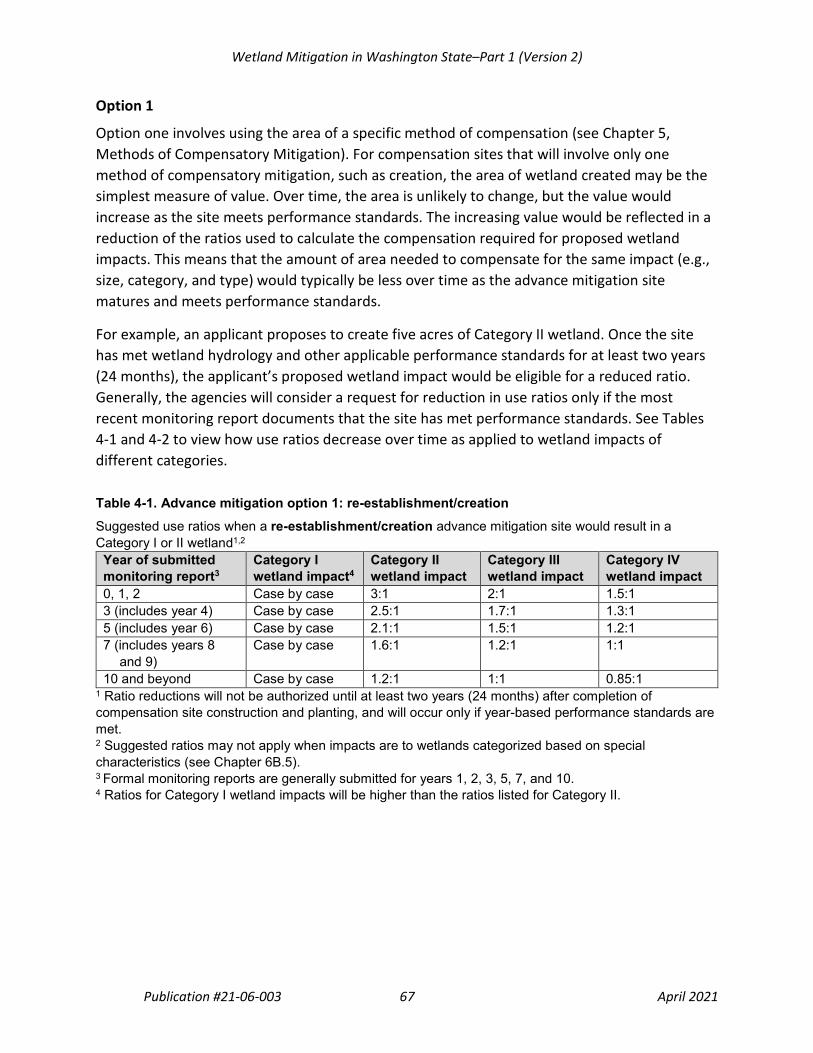
Wetland Mitigation in Washington State–Part 1 (Version 2)
Publication #21-06-003 67 April 2021
Option 1
Option one involves using the area of a specific method of compensation (see Chapter 5, Methods of Compensatory Mitigation). For compensation sites that will involve only one method of compensatory mitigation, such as creation, the area of wetland created may be the simplest measure of value. Over time, the area is unlikely to change, but the value would increase as the site meets performance standards. The increasing value would be reflected in a reduction of the ratios used to calculate the compensation required for proposed wetland impacts. This means that the amount of area needed to compensate for the same impact (e.g., size, category, and type) would typically be less over time as the advance mitigation site matures and meets performance standards.
For example, an applicant proposes to create five acres of Category II wetland. Once the site has met wetland hydrology and other applicable performance standards for at least two years (24 months), the applicant’s proposed wetland impact would be eligible for a reduced ratio. Generally, the agencies will consider a request for reduction in use ratios only if the most recent monitoring report documents that the site has met performance standards. See Tables 4-1 and 4-2 to view how use ratios decrease over time as applied to wetland impacts of different categories.
Table 4-1. Advance mitigation option 1: re-establishment/creation Suggested use ratios when a re-establishment/creation advance mitigation site would result in a Category I or II wetland1,2
Year of submitted monitoring report3
Category I wetland impact4
Category II wetland impact
Category III wetland impact
Category IV wetland impact
0, 1, 2 Case by case 3:1 2:1 1.5:1 3 (includes year 4) Case by case 2.5:1 1.7:1 1.3:1 5 (includes year 6) Case by case 2.1:1 1.5:1 1.2:1 7 (includes years 8
and 9) Case by case 1.6:1 1.2:1 1:1
10 and beyond Case by case 1.2:1 1:1 0.85:1 1 Ratio reductions will not be authorized until at least two years (24 months) after completion of compensation site construction and planting, and will occur only if year-based performance standards are met. 2 Suggested ratios may not apply when impacts are to wetlands categorized based on special characteristics (see Chapter 6B.5). 3 Formal monitoring reports are generally submitted for years 1, 2, 3, 5, 7, and 10. 4 Ratios for Category I wetland impacts will be higher than the ratios listed for Category II.

Wetland Mitigation in Washington State–Part 1 (Version 2)
Publication #21-06-003 68 April 2021
Table 4-2. Advance mitigation option 1: rehabilitation Suggested use ratios when a rehabilitation advance mitigation site would result in a Category I or II wetland1,2
Year of submitted monitoring report3
Category I wetland impact4
Category II wetland impact
Category III wetland impact
Category IV wetland impact
0, 1, 2 Case by case 6:1 4:1 3:1 3 (includes year 4) Case by case 5.1:1 3.5:1 2.7:1 5 (includes year 6) Case by case 4.2:1 3:1 2.4:1 7 (includes years 8
and 9) Case by case 3.3:1 2.5:1 2.1:1
10 and beyond Case by case 2.4:1 2:1 1.7:1 1 Ratio reductions will not be authorized until at least two years (24 months) after completion of compensation site construction and planting, and will occur only if year-based performance standards are met. 2 Suggested ratios may not apply when impacts are to wetlands categorized based on special characteristics (see Chapter 6B.5). 3 Formal monitoring reports are generally submitted for years 1, 2, 3, 5, 7, and 10. 4 Ratios for Category I wetland impacts will be higher than the ratios listed for Category II.
Use ratios are not shown for enhancement-only or preservation-only advance mitigation sites. For preservation, see the section on Using preservation with Options 1 and 2, which follows the discussion of Option 2. The agencies would not generally approve enhancement as a stand-alone method of compensation (see Chapter 5.2.4, Enhancement), or the agencies would encourage use of the Credit-Debit Method (Option 3). Applicants proposing advance mitigation should select sites that offer opportunities for compensation that will result in an increase in wetland area and improve/restore hydrologic processes. Contact the agencies early in the process to discuss the compensation potential of a proposed site.
Option 2
Option two should be used for more complex compensatory mitigation projects that involve more than one method of compensation. For example, an applicant proposes to re-establish four acres, rehabilitate nine acres, and enhance five acres to achieve a Category II wetland. This option involves applying ratios to convert the area of each method of compensation into credits (i.e., credit conversion ratios). The result is a total potential credit value for the site (see Table 4-3).
Similar to Option 1, use ratios would reduce over time as performance standards are met. They would be applied to the proposed impacts to determine how many credits would be needed to compensate for a specific wetland impact when it is proposed (see Table 4-5).

Wetland Mitigation in Washington State–Part 1 (Version 2)
Publication #21-06-003 69 April 2021
For Option 2, an applicant should use a table like Table 4-3. To use Table 4-3, the applicant proposes a specific credit conversion ratio from within the ranges provided in column 3 for each specific method of compensation proposed. Table 4-4 provides an example of using crediting Option 2. The applicant should provide rationale to support the ratio proposed. The agencies will review and may recommend different ratios in order to approve the plan.
Table 4-3. Advance mitigation option 2: wetland credit potential
Method of compensation for freshwater wetlands
Area in acres
Credit conversion ratio = Area of method of compensation: credit generated at the site1
Potential available credits
Re-establishment/creation Blank 1:1–2:1 Blank Rehabilitation Blank 2:1–3:1 Blank Enhancement Blank 3:1–5:1 Blank Riparian upland enhancement2 Blank 4:1–10:1 Blank
Upland enhancement2 Blank 10:1 Blank TOTAL Blank Blank Blank
1The credit conversion ratios in column 3 assume that the advance mitigation site will be at least a Category II wetland. 2See Chapter 6B.6, Uplands used as compensation, for a discussion of when uplands may be used for compensation.
Table 4-4. Advance mitigation option 2: example of wetland credit potential calculation
Method of compensation for freshwater wetlands
Area in acres
Credit conversion ratio
Potential available credits
Re-establishment (remove fill) 4 1:1 4
Rehabilitation (fill ditches that partially drain site) 9 3:1 3
Enhancement (underplant existing forested wetland with conifers and control invasive species)
5 5:1 1
TOTAL 18 Blank 8

Wetland Mitigation in Washington State–Part 1 (Version 2)
Publication #21-06-003 70 April 2021
Table 4-5. Advance mitigation option 2: recommended use ratios for an advance mitigation site resulting in a Category I or II wetland (Use ratio is the number of credits needed per unit of area of proposed impact)1,2
Year of submitted monitoring report3
Category I wetland impact4
Category II wetland impact
Category III wetland impact
Category IV wetland impact
0, 1, 2 Case by case 3:1 2:1 1.5:1 3 (includes year 4) Case by case 2.5:1 1.7:1 1.3:1 5 (includes year 6) Case by case 2.1:1 1.5:1 1.2:1 7 (includes years 8 and 9) Case by case 1.6:1 1.2:1 1:1
10 and beyond Case by case 1.2:1 1:1 0.85:1 Freshwater Preservation5
See concurrent compensation ratios in Chapter 6B.4.1
Blank Blank Blank
Upland Preservation5
Case by case If approved, ratios will range from 10:1–20:1
Blank Blank Blank
1 Ratio reductions will not be authorized until at least two years (24 months) after completion of compensation site construction and planting, and will only occur if year-based performance standards are met. 2 Suggested ratios may not apply to wetlands categorized based on special characteristics (see Chapter 6B.5). 3 Formal monitoring reports are generally submitted for years 1, 2, 3, 5, 7, and 10. The appropriate use ratio is based on documentation of the achievement of performance standards for that monitoring year. For example, to qualify for the year 3 and 4 ratio in the second row, a monitoring report needs to be submitted demonstrating achievement of year 3 performance standards. 4 Ratios for Category I impacts will be higher than the listed ratios for Category II. 5 Ratios for preservation do not decrease over time.

Wetland Mitigation in Washington State–Part 1 (Version 2)
Publication #21-06-003 71 April 2021
Using preservation with Options 1 and 2
If preservation is proposed as part of an advance mitigation proposal, concurrent compensation ratios would apply throughout the life of the advance mitigation project (see Chapter 6B.4, Concurrent compensatory mitigation ratios). This is because preservation value does not increase over time. Proposed preservation areas must meet the preservation criteria identified in Chapter 5.2.3, Preservation, and should already be performing functions at a high level.
Because the value of preservation area does not increase over time, the agencies may allow preservation area to be used for compensation of proposed impacts as soon as:
1. The agencies approve the advance mitigation plan, AND
2. A legal site protection mechanism is approved, signed, and recorded with the appropriate county recording office.
Option 3
A third option for determining the value of a compensation site uses the Credit-Debit Method173 (Hruby, 2012a; Hruby, 2012b) to calculate the credits a site is expected to generate. The Credit-Debit Method scores the amount of gain in functions expected to occur at a site as a result of the proposed compensation activities. Applicants that choose Option 3 will need to use the Credit-Debit Method for each proposed wetland impact to determine the number of debits to subtract from the total credits expected. For more information on using the Credit-Debit Method see Section 6B.3, Calculating credits and debits for compensatory mitigation.
The Credit-Debit Method has a couple of built-in mechanisms to increase the value of a compensation site when it meets the definition of advance mitigation (at least 24 months have passed since the site was constructed and planted). First, applicants proposing advance mitigation using Option 3 would apply an Advance Mitigation Risk Factor when determining the total credits expected for their advance mitigation site. Second, applicants would apply the Advance Temporal Loss Factor when determining the number of debits for each proposed wetland impact.
However, applicants may foresee a need to use credits from their advance mitigation site before at least 24 months have passed since their site was constructed and planted. In these cases, applicants may request that the agencies release an agreed-upon percentage of the total expected credits. Agencies would release credits only after applicants have demonstrated that specific year-based performance standards have been met. Generally, the agencies will approve only minimal credit release percentages (i.e., less than 30 percent of total expected credits) during the first two years. In addition, applicants will need to apply a Concurrent Temporal Loss Factor to calculate the number of debits for each proposed impact that will occur sooner than 24-months from the time the compensation site is constructed and planted.
173 URL: https://ecology.wa.gov/Water-Shorelines/Wetlands/Tools-resources/Credit-debit-method

Wetland Mitigation in Washington State–Part 1 (Version 2)
Publication #21-06-003 72 April 2021
Applicants whose anticipated credit needs during the first two years will be greater than 30 percent of the total expected credits should consult with the agencies. The agencies may suggest initially using the Concurrent Risk Factor to calculate the total credits expected.
4.2.3 Combining advance and concurrent mitigation Applicants may combine advance mitigation with concurrent mitigation. The agencies consider this when the applicant designs the mitigation site to provide additional wetland area, additional functions, or some combination of additional area and function beyond what is required for the permitted impact. The additional compensation generated at a site would be established in advance of, and would generate credits for use against, future impacts. The advance mitigation area must be clearly identified on a map and documented in the approved mitigation plan to distinguish it from the concurrent mitigation area.
For the most up-to-date information on advance mitigation, see Ecology's Advance permittee-responsible mitigation web page.174
174 URL: https://ecology.wa.gov/Water-Shorelines/Wetlands/Mitigation/Advance-mitigation

Wetland Mitigation in Washington State–Part 1 (Version 2)
Publication #21-06-003 73 April 2021
“Excess” compensatory mitigation is NOT advance compensatory mitigation
Advance mitigation is pre-approved compensatory mitigation for future impacts. It must have an advance mitigation plan approved by the agencies.
Excess mitigation is compensatory mitigation that is not pre-approved for future impacts.
Sometimes permittees voluntarily or accidentally provide more compensatory mitigation than required for their permitted impacts. If permittees perform compensation beyond what is required, without pre-approval, in the hope of using it for their future projects, they do so at their own risk. The agencies are under no obligation to accept the excess area as compensation for future impacts. Agencies will only consider accepting excess mitigation if all of the following criteria are met:
• Baseline conditions at the compensation site were thoroughly documented. This should allow the permittee to compare it to current conditions to determine whether there is compensation area in excess of what was originally required.
• All performance standards and area requirements were met for the original impact and the original compensation site has been closed out.
• The agency(s) that closed out the original compensation site documented the available area of excess mitigation in the close-out letter.
• The proposed future impacts are generally located within the same watershed as the excess mitigation.
• The applicant proposing to use the excess mitigation must be the same entity who implemented it.
The agencies generally do not support excess mitigation. Agencies have processes in place to approve advance mitigation. These processes help reduce risk and uncertainty for applicants and the agencies. If the opportunity to combine compensatory mitigation for multiple projects’ impacts appears to exist at a proposed site, applicants should see Chapter 4.2.3, Combining advance and concurrent mitigation.

Wetland Mitigation in Washington State–Part 1 (Version 2)
Publication #21-06-003 74 April 2021
Table 4-6. Comparison of permittee-responsible and programmatic compensation options
Compensation option
Who is responsible for compensation site implementation, management, performance & protection
When can the compensation option be used
Is the sale of credits allowed
Who can use the compensation option
Permittee-responsible concurrent
Permittee Compensatory mitigation must be implemented concurrently or within one year of impacts.
No Concurrent compensation can only be used by the permittee that implemented the concurrent compensation site.
Permittee-responsible advance
Permittee Advance credits or area are generally available only after the advance mitigation site has been constructed and performance standards are met for at least two years. Prior to that the site will be considered concurrent compensation.
No Advance compensation credits or area can only be used by the permittee that implemented the advance mitigation site.
Mitigation banking
Bank sponsor: any private, tribal, or public entity
After credits are released by the IRT Co-chairs. One major advantage of banking is that a limited number of credits become available when the MBI is approved, the site is protected, and financial assurances are posted. Additional credits would be released over time as performance standards are met.
Yes Applicants with unavoidable, authorized impacts within the service area of the bank.
In-lieu fee program
ILF sponsor: must be a governmental (including tribal) or non-profit, natural resource entity
After the ILF program is approved by the Corps. The fees collected must be used to implement a compensation site within 3 growing seasons from the first in-lieu fee payment.
Yes Applicants with unavoidable, authorized impacts within the ILF program service area.

Wetland Mitigation in Washington State–Part 1 (Version 2)
Publication #21-06-003 75 April 2021
Chapter 5. Methods of Compensatory Mitigation As discussed in Chapter 4, applicants with unavoidable impacts to wetlands have options for how they meet their compensatory mitigation requirements. The options for compensatory mitigation described in this chapter are based on the method used to compensate for wetland impacts (e.g., re-establishment, rehabilitation). Each method is intended to generate a lift in wetland functions; some methods result in an increase in area, and some do not. This chapter describes these methods and discusses the agencies’ preferences for each method.
5.1 The different methods of compensatory mitigation Compensatory mitigation entails one or more of the following methods:
• Restoring wetland area and functions to a location where those functions formerly occurred
• Creating new wetland area and functions in a location where they did not previously occur
• Preserving an existing high-quality wetland to protect it from future loss or degradation
• Enhancing functions at an existing wetland
Applicants must demonstrate that they have addressed all appropriate and practicable avoidance and minimization measures before use of compensatory mitigation can be approved (see Chapter 3.3.1, Mitigation sequencing).
The 2008 Federal Mitigation Rule175 includes the definitions for the methods of compensatory mitigation and whether they offer the potential for a net gain in area, functions, or both. The terms used are: restoration (divided into two categories, re-establishment and rehabilitation), establishment, preservation, and enhancement.
For consistency, this document uses the 2008 Federal Mitigation Rule terminology and definitions, shown below. However, the term “creation” is used throughout this document instead of “establishment” since the term creation is widely understood and used in compensatory wetland mitigation. In a few instances the agencies have added language to these definitions to reflect how they are interpreted and applied in Washington State. Text added to a definition in this section is shown in brackets. In addition, the agencies added
175 33 CFR 332.2 and 40 CFR Part 230.92, Definitions.

Wetland Mitigation in Washington State–Part 1 (Version 2)
Publication #21-06-003 76 April 2021
example activities after the definition of each method to improve clarity. Where the text refers to “aquatic resources” it includes wetlands:
• Restoration: The manipulation of the physical, chemical, or biological characteristics of a site with the goal of returning natural/historic functions [and environmental processes] to a former or degraded aquatic resource. For the purpose of tracking net gains in aquatic resource area, restoration is divided into two categories:
o Re-establishment: The manipulation of the physical, chemical, or biological characteristics of a site with the goal of returning natural/historic functions [and environmental processes] to a former aquatic resource. Re-establishment results in rebuilding a former aquatic resource and results in a gain in aquatic resource area and functions.
Example activities could include removing fill, plugging ditches, or breaking drain tiles to restore a wetland hydroperiod, which in turn will lead to restoring wetland biotic communities and environmental processes.
o Rehabilitation: The manipulation of the physical, chemical, or biological characteristics of a site with the goal of repairing natural/historic functions [and environmental processes] to a degraded aquatic resource. Rehabilitation results in a gain in aquatic resource function but does not result in a gain in aquatic resource area. [In other words, the area already meets wetland criteria, but hydrological processes have been altered. Rehabilitation involves restoring historic hydrologic processes.]
Example activities could involve breaching a dike to reconnect wetlands to a floodplain or returning tidal influence to a wetland.
• Creation (called “Establishment” in the 2008 Federal Mitigation Rule): The manipulation of the physical, chemical, or biological characteristics present to develop an aquatic resource that did not previously exist at an upland site. Establishment results in a gain in aquatic resource area and functions.
An example activity could involve excavation of upland soils to elevations that will produce a wetland hydroperiod and hydric soils by intercepting groundwater, and in turn supports the growth of hydrophytic plant species.
• Preservation: The removal of a threat to, or preventing the decline of, aquatic resources by an action in or near those aquatic resources. This term includes activities commonly associated with the protection and maintenance of aquatic resources through the implementation of appropriate legal and physical mechanisms [such as recording conservation easements and providing structural protection like fences and signs]. Preservation does not result in a gain of aquatic resource area or functions [but may result in a gain in functions over the long term].

Wetland Mitigation in Washington State–Part 1 (Version 2)
Publication #21-06-003 77 April 2021
• Enhancement: The manipulation of the physical, chemical, or biological characteristics of an aquatic resource to heighten, intensify, or improve a specific aquatic resource function(s). Enhancement results in the gain of selected aquatic resource function(s) but may also lead to a decline in other aquatic resource function(s). Enhancement does not result in a gain in aquatic resource area.
Example activities could include planting native vegetation, controlling non-native or invasive species, and modifying site elevations to alter hydroperiods in existing wetlands.
Applicants proposing compensatory wetland mitigation will need to provide a thorough description of the activities to be performed. They will also need to describe how these activities will improve wetland functions, environmental processes, or both. If environmental processes are to be improved, will that improvement occur at the site scale, landscape scale, or both? Applicants should describe the ecological effectiveness of the proposed compensation activities (e.g., what processes will be restored, or what will be the gain in functions over what currently exists?). The agencies will review the information provided to confirm that the applicant appropriately characterized their proposed compensation method(s).
5.2 Agency preferences for each method of compensatory mitigation This section describes the advantages and disadvantages of different compensation methods and the reasons why some are preferred by the agencies. The general order of preference for the methods of wetland compensation is:
1. Restoration: Re-establishment
2. Restoration: Rehabilitation–hydrologic processes restored
3. Creation (establishment)
4. Preservation
5. Enhancement
Note: When proposing preservation or enhancement, the agencies prefer that they be used in combination with re-establishment or creation to achieve no net loss in area and functions.
Wetland Mitigation in Washington State–Part 1 (Version 2)
Publication #21-06-003 78 April 2021
5.2.1 Restoration Restoration, including both re-establishment and rehabilitation, is generally the agencies’ first choice for compensation. Restoration is preferred for the following reasons:176
• The likelihood of success is greater.
• The impacts to potentially ecologically important uplands are reduced compared to establishment.
• The potential gains in terms of aquatic resource functions are greater compared to enhancement and preservation.
5.2.1.1 Re-establishment Re-establishment involves restoring processes and functions to an area that was formerly a wetland. Although re-establishment and rehabilitation both provide a gain in wetland functions, only re-establishment will provide a gain in wetland area as well.
5.2.1.2 Rehabilitation Rehabilitation involves improving or repairing the performance of processes, and therefore functions, in an existing wetland. Rehabilitation actions usually occur in wetlands that are highly degraded because one or more environmental processes have been disrupted. Rehabilitation actions reinstate environmental processes, ideally at both the site and landscape scales.
For compensatory wetland mitigation, rehabilitation actions should focus on restoring hydrologic processes that have been disturbed or altered by human activity (e.g., breaching a levee in a floodplain). Typically, this involves restoring the original hydrogeomorphic (HGM) class of a wetland that has been changed by human activities. Rehabilitation generally involves one or more of the following actions:
• Breaking or removing drain tiles
• Plugging ditches
• Re-aligning a channelized stream (Stream sinuosity needs to be appropriate for the landscape setting and velocity of the stream.)
• Removing a tide gate or weir to achieve historic hydroperiod and HGM class
• Removing bulkheads and restoring natural shoreline contours
176 40 CFR § 230.93(a)(2), 404(b)(1) guidelines.

Wetland Mitigation in Washington State–Part 1 (Version 2)
Publication #21-06-003 79 April 2021
• Removing, partially removing, or breaching dikes or levees. If the applicant proposes only partial removal or breaches they should demonstrate the following:
o Tidal exchange will be sufficient to restore a tidal wetland water regime (freshwater or estuarine).
o Fish stranding will not occur.
o Unintended erosion or disintegration of remaining dike will not occur.
o Floodplain connectivity will be sufficient to restore a riverine wetland water regime.
The agencies will generally not consider a proposal to be rehabilitation unless it restores hydrologic processes.
The agencies prefer that rehabilitation address process alterations at both the site and landscape scales. However, restoring processes at the landscape scale is not always possible, due to the cumulative effects of land-use changes within a watershed. In addition, there may be constraints that have effects on a regional scale such as dikes, levees, or dams. An example would be a site historically within the floodplain of a major river that was diked many years ago by a regional diking district. The dike was constructed along the river to prevent overbank flooding of the communities and farms in that area, including the site. Agricultural practices on the site included installation of drain tiles and excavation of ditches. The dike and agricultural practices together converted what had been a riverine wetland into a partially drained, depressional wetland. An applicant proposing to rehabilitate the site for compensatory mitigation could have the following options:
• Break the drain tiles and plug the ditches, which would result in site-scale rehabilitation of hydrologic processes in what is currently a depressional wetland. This would not restore the site to its historic riverine hydrologic processes. However, breaking drain tiles and plugging ditches would stop the rapid removal of water from the existing depressional wetland and restore wetland functions such as groundwater recharge.
• Breach the dike to allow overbank flooding and river connectivity, which would result in landscape-scale rehabilitation back to the historic riverine HGM class for this portion of the river and floodplain system.
• Fill ditches, break drain tiles, and breach the dike, which could result in both site-scale and landscape-scale rehabilitation.
Some actions that appear to be rehabilitation are actually enhancement. For example, in many areas of the state, human alterations of the landscape have resulted in the channelization or ditching of sheet flow through low-gradient slope wetlands. This was generally accompanied by logging, grazing, or agricultural practices. Applicants typically propose to plant trees and shrubs in these wetlands, which would primarily improve some wildlife habitat functions. The agencies

Wetland Mitigation in Washington State–Part 1 (Version 2)
Publication #21-06-003 80 April 2021
would call this enhancement, because the change is structural and does not restore environmental processes. Rehabilitation, in this case, would involve restoring sheet flow (i.e., hydrologic processes) to the slope wetland by plugging the ditch and dispersing the flow across the site.
Alternatively, applicants propose to meander a ditch through a site thinking that such a proposal would be considered rehabilitation. To be considered rehabilitation applicants would need to demonstrate that a stream channel historically meandered through the site. Alternatively, the applicant could demonstrate that the volume and velocity of stream flow would support the proposed sinuosity thus restoring natural processes. Otherwise it would be considered a structural enhancement (or change) to the hydrology rather than restoring processes.
Recommended resource when planning compensation sites that involve restoration
The definitions of re-establishment and rehabilitation include the concept of either returning or repairing “natural/historic functions.”
The United States National Vegetation Classification System177 (USNV) describes ecosystem types in their natural/historic conditions (i.e., reference standard conditions). The USNV descriptions provide detailed vegetation information as well as information about soils, primary disturbances, hydrological sources, hydrological regime, and hydrological connectivity. The USNV descriptions, therefore, could be used to identify what historical conditions looked like and provide restoration targets, particularly to identify suitable vegetation species for a compensation site planting plan.
5.2.2 Creation (Establishment) Creation, like re-establishment, results in a gain in both wetland area and function. Unlike re-establishment, creation occurs in uplands that were not formerly wetlands. Creating wetlands has a higher risk of failure than restoration, and thus is less preferred by the agencies. To minimize the risk of failure, the created wetland should be in an appropriate position in the landscape and an appropriate HGM class. Wetlands should not be established at the cost of another high-functioning habitat (i.e., potentially ecologically important uplands as referred to in the 2008 Federal Mitigation Rule178). Wetlands should, therefore, be created only in disturbed uplands.
177 URL: http://usnvc.org/explore-classification/ 178 33 CFR Part 332.3(a)(2) and 40 CFR Part 230.93(a)(2)

Wetland Mitigation in Washington State–Part 1 (Version 2)
Publication #21-06-003 81 April 2021
A study in Washington State found that wetlands created from uplands were relatively successful (Johnson et al., 2002). Sixty percent of created wetlands were either fully or moderately successful. Many created wetlands resulted in significant gains in water quality and quantity functions.
The National Research Council made recommendations to increase the success of wetland creation (National Research Council, 2001). Two of them are:
1. Avoid over-engineered structures in the wetland design. These include water control structures such as berms and weirs that will require repairs and intensive maintenance. Bioengineered structures of logs or rocks that create contours and mimic natural structures along rivers and shorelines are better than highly engineered structures like walls of riprap or bulkheads. To be successful, creation projects need to be self-sustaining and relatively maintenance free.
2. Restore or develop naturally variable hydrological conditions. Water inputs for compensation wetlands should take advantage of natural patterns of water flow, such as overbank flooding in a riverine setting or groundwater discharge in a slope or depressional setting.
Note: Appropriate landscape position, suitable soils, and sustainable water source (i.e., not reliant on the addition of bentonite clay or other material to retain water) are critical for the successful creation of wetlands. This cannot be over emphasized. See Chapter 6A.1.2 for more information on providing sustainable compensation.
5.2.3 Preservation Some wetland types (e.g., mature forested wetlands, native sedge communities, vernal pools, headwater wetlands, Wetlands of High Conservation Value) are not adequately protected and can benefit from being permanently protected through a legal mechanism such as a conservation easement. Although the preservation of high-quality wetlands as compensatory mitigation results in a net loss of wetland area, it can provide significant long-term ecological benefits. Preserving high-quality wetlands protects the functions being performed by those wetland areas and prevents them from being lost in the future. For example:
• Under existing federal and state laws, trees could be legally harvested from forested wetlands provided that all required best management practices are followed. While the harvest does not result in a loss of wetland area, it does result in a loss of wetland functions. Preservation of forested wetlands will prevent trees from being logged, thereby providing a potential net gain in forested wetland functions in the future.

Wetland Mitigation in Washington State–Part 1 (Version 2)
Publication #21-06-003 82 April 2021
• In urban and urbanizing areas, wetlands are under considerable threat of loss and degradation. Preservation of wetlands and riparian areas in these settings can protect travel corridors for wildlife and maintain natural areas. Preservation in urban areas can also help decrease the heat island effect, reduce flood damage, and improve health benefits for residents.
• Vernal pool complexes in eastern Washington typically contain many individual wetlands that are small and difficult to protect without also protecting their surrounding uplands. These complexes are important for seasonal wildlife habitat, maintaining biodiversity, and supporting federally and state listed species (e.g., fairy shrimp). To preserve vernal pool complexes, applicants would need to preserve the wetlands and associated uplands to maintain their functions.
One reason that preservation is an acceptable method of compensation despite national and state goals for no net loss of wetlands is that wetlands can experience unmitigated impacts unless they are legally protected. Wetlands with significant habitat value are very difficult to protect without large buffers and corridors to connect them to other habitats. Preservation of large tracts of wetlands, associated uplands, and their buffers can provide benefits that are impossible to achieve using typical regulatory approaches. Preservation of at-risk, high-quality wetlands can therefore provide a gain in functions over what would otherwise occur.
Preservation has the following advantages as a compensatory mitigation tool:
• Preservation can ensure protection of high-quality, high-functioning aquatic systems that are critical for the health of the watershed.
• Preservation can help maintain and protect habitat corridors that connect otherwise isolated wetland habitats.
• Preservation does not involve the uncertainty of success inherent in restoration, creation, or enhancement.
• Preservation of wetlands collectively throughout a watershed (i.e., through corridors and habitat patch-network connectivity) helps maintain and protect the environmental processes of the watershed.
• Preservation is the most ecologically effective option for wetland types that are rare or impossible to replace such as peatlands and old-growth or mature forested wetlands.

Wetland Mitigation in Washington State–Part 1 (Version 2)
Publication #21-06-003 83 April 2021
5.2.3.1 Criteria for using preservation179 To the maximum extent practicable, preservation should be done in combination with wetland creation and re-establishment. The agencies may allow preserving at-risk, high-quality wetlands as part of a compensatory mitigation plan when all of the following numbered criteria are met:
1. The preservation site is determined to be under demonstrable threat180 of destruction, adverse modification, or substantive degradation; that is, the site is likely to suffer serious negative impacts from on-site or off-site activities (e.g., logging of forested wetlands).
2. The area proposed for preservation is of high quality or critical for the health and ecological sustainability of the watershed or sub-basin. Some of the following features may indicate high-quality sites:
a. Category I or II wetland (using the most recent versions of the Wetland Rating System for eastern or western Washington181). This includes Wetlands of High Conservation Value as identified by WA DNR’s Natural Heritage Program.
b. Rare or irreplaceable wetland type (e.g., peatlands, mature forested wetlands, estuaries, vernal pools, alkali wetlands) or aquatic habitat that is a rare or limited resource in the area.182
c. Habitat for threatened or endangered species (state, federal, or both).
d. Provides biological and/or hydrologic connectivity.183
e. Of regional or watershed importance (e.g., listed as priority site in a watershed, salmon recovery, or basin plan).
f. Large size with high species diversity (plants, animals, or both), high abundance of native species, or both.
g. A site that is continuous with the head of a watershed, or with a lake or pond in an upper watershed that significantly contributes to hydrologic processes and water quality.
179 The 2008 Federal Mitigation Rule criteria for preservation are listed in 33 CFR Part 332.3(h) and 40 CFR Part
230.93(h). 180 Demonstrable threat: The proposed preservation site is under threat of undesirable ecological change due to
permitted, planned or likely actions that will not be adequately mitigated under existing regulations. 181 URL: https://ecology.wa.gov/Water-Shorelines/Wetlands/Tools-resources/Rating-systems 182 A resource for identifying rare/high-quality wetland ecosystems is WA DNR’s Wetlands of High Conservation
Value database/map viewer. The database includes conservation status ranks for globally at risk (G1-G3) and state at risk (S1-S3) sites. (URL: https://www.dnr.wa.gov/NHPwetlandviewer)
183 Sites isolated from other habitat areas are generally not good candidates for preservation. However, in some cases agencies may support preservation of sites in urban areas in order to protect open space and habitat if the area is under demonstrable threat.

Wetland Mitigation in Washington State–Part 1 (Version 2)
Publication #21-06-003 84 April 2021
Not all of the features are required for a wetland to be considered high quality. For instance, a forested riparian wetland system may not be rare or irreplaceable, but it may still be a candidate for preservation if it contributes to the maintenance of environmental processes such as over-bank flooding, movement of sediments, and recruitment of large woody debris.
3. The site is permanently protected with a legal mechanism such as a conservation easement.
4. The site has adequate buffers to ensure that the preserved wetland will not be degraded over time. Preservation sites need to have adequate buffers surrounding the site. The width and vegetation of the buffer must be sufficient to protect the wetland and its functions from encroachment and degradation. Existing and potential future land uses (based on current development and land use regulations, such as zoning codes) dictate the width necessary for a buffer that is adequate to protect the wetland and its functions (refer to Chapter 6C, Determining Buffers for Compensatory Mitigation Sites).
The agencies determine whether a proposal to use preservation as compensatory mitigation is appropriate and practicable.
Avoidance and preservation
Occasionally, applicants who avoid impacts to a wetland propose preserving that wetland as compensatory mitigation for other on-site impacts. To be eligible for preservation, the avoided wetland must meet the criteria listed in Chapter 5.2.3.1. For compensation required by Corps permits, the proposed preservation must meet all of the preservation criteria listed in the 2008 Federal Mitigation Rule (33 CFR 332.3[h] and 40 CFR 230.93[h]).
5.2.4 Enhancement Enhancement results in a net loss of wetland area. Also, it typically involves gains in only one or a few functions, and can lead to a decline in other functions (i.e., a tradeoff of functions). For example, excavating seasonal ponds in a pasture wetland may provide improved habitat for ducks, but it may result in a decline in water quality and habitat for small mammals and raptor foraging. The agencies will generally not accept this type of proposal if it results in an atypical wetland. Enhancement actions often focus on structural improvements to a site and generally do not address larger-scale environmental processes or even processes at the site scale. For these reasons, enhancement is the least preferred method of compensation.
A 2002 study of mitigation in Washington State (Johnson et al., 2002) raised concerns about the value of enhancement. Only 11 percent of enhanced wetlands were even moderately

Wetland Mitigation in Washington State–Part 1 (Version 2)
Publication #21-06-003 85 April 2021
successful, and none were fully successful. Furthermore, regulatory agency compliance inspections of compensatory wetland mitigation sites since 2006 indicate these concerns are still relevant:
• Most enhancement actions focus on improving vegetation structure and ignore improving environmental processes that support wetland systems and functions.
• There is a net loss of water quality and quantity functions, and only modest gains in habitat functions.
• The use of enhancement as a primary means of compensatory mitigation contributes to a loss of wetland area and functions.
Enhancement activities often attempt to change plant communities from non-native emergent to native scrub-shrub or forested communities. Frequently, the activities attempt to remove and control undesirable invasive species such as reed canarygrass (Phalaris arundinacea), non-native blackberries, and purple loosestrife (Lythrum salicaria), and plant native woody species. Occasionally, enhancement includes changing the site’s water regime through excavation or construction of weirs. Enhancement has historically focused on habitat, but other wetland functions can also be enhanced.
Consider the presence of Oregon spotted frogs
Applicants proposing compensation in degraded emergent wetlands should ensure those wetlands are not habitat for federally threatened and Washington State endangered Oregon spotted frogs, which may use lower-quality wetland habitats, including Category IV wetlands that are often dominated by reed canarygrass (see Chapter 7.3.1, Oregon spotted frogs).
A range of activities with widely varying ecological benefits have been lumped under the heading of enhancement. It is important to differentiate between different kinds of enhancement and determine the level of benefit from each. Enhancement could be more effective if it were geared to improve functions that are limited in a watershed or region (see Chapter 6A, Choosing the Location for Compensatory Mitigation Using a Watershed Approach). It is important to identify whether enhancement activities will result in any tradeoffs in functions. If any tradeoffs will occur, the applicant should document the net ecological benefits. Enhancement has a place in the mitigation toolbox, but the agencies generally prefer to see it used in combination with re-establishment and/or creation.

Wetland Mitigation in Washington State–Part 1 (Version 2)
Publication #21-06-003 86 April 2021
Examples of enhancement actions:
• Removal of invasive species, including roots and rootmats, such as reed canarygrass, purple loosestrife, Russian olive, phragmites, and knotweed
• Scarification of soil and addition of organic material or other soil amendments
• Planting trees and shrubs in an emergent wetland dominated by non-native vegetation
• Grading to establish multiple hydrologic regimes, from long duration seasonally inundated to saturated
• Adding habitat features such as snags, large woody debris, brush piles, rock piles, nest boxes, etc.
Determining functional lift from enhancement
Because enhancement occurs within existing wetlands that already provide functions to a certain degree, applicants proposing enhancement of freshwater wetlands will generally need to demonstrate a gain in wetland functions (i.e., functional lift) sufficient to compensate for wetland impacts by applying the Credit-Debit Method184 (Hruby, 2012a; Hruby, 2012b).
To use the Credit-Debit Method, applicants needs to score both the wetland impact site(s) and the proposed compensation site (for both the existing functions and the expected functions after implementing compensation actions). This will provide the agencies with more specific information on the amount of functional lift that may result from the proposed enhancement activities. Refer to Chapter 6.B.3 for more information on the Credit-Debit Method.
184 URL: https://ecology.wa.gov/Water-Shorelines/Wetlands/Tools-resources/Credit-debit-method

Wetland Mitigation in Washington State–Part 1 (Version 2)
Publication #21-06-003 87 April 2021
Chapter 6. Determining Appropriate and Adequate Compensatory Mitigation
In the 2006 version of Wetland Mitigation in Washington State, Part 1, Chapter 6 encompassed the substantive topics concerning compensatory mitigation. This revised version has retained these topics, but they have been separated into their own subchapters. This should help applicants, regulatory staff, and the public find the information they need more easily.
The title of Chapter 6 is retained both to facilitate finding information and to recognize that these topics are all interrelated. By keeping them in an overarching comprehensive chapter, it shows that the topics are of equal importance and need not be applied in a particular order. Chapters are organized as follows:
• Chapter 6A—Choosing the Location for Compensatory Mitigation Using a Watershed Approach
• Chapter 6B—Identifying the Amount of Compensation
• Chapter 6C—Determining Buffers for Compensatory Mitigation Sites
• Chapter 6D—In Kind, Out of Kind, and Resource Tradeoffs

Wetland Mitigation in Washington State–Part 1 (Version 2)
Publication #21-06-003 88 April 2021
This page intentionally left blank

Wetland Mitigation in Washington State–Part 1 (Version 2)
Publication #21-06-003 89 April 2021
Chapter 6A. Choosing the Location for Compensatory Mitigation Using a Watershed Approach
Selecting an appropriate location to conduct compensatory mitigation is one of the most critical aspects in providing acceptable wetland compensation. A selected site should foster compensation actions that result in a gain in wetland functions sufficient to offset unavoidable wetland impacts and that provide sustainable ecological benefits important to the functioning of the watershed.
The term “watershed” can be defined and interpreted at a variety of scales. Generally, a watershed is defined as a land area that drains to a common waterway, such as a stream, lake, estuary, wetland, or ultimately the ocean. A watershed can be as large as that of a large river (Columbia River), a Water Resource Inventory Area (WRIA),185 or a major Hydrologic Unit (as classified by a U.S. Geological Survey Hydrologic Unit Code, or HUC186). A watershed can also be as small as a stream reach or the land area that contributes surface water to a small pond. Most counties and cities in Washington State have divided their areas into hydrologic planning units that vary in size and scale by jurisdiction. These planning units may be called sub-units, drainages, sub-basins, or other terms not consistent with the terms used at the national level.
Watershed scale from the 2008 Federal Mitigation Rule
The size of watershed addressed using a watershed approach should not be larger than is appropriate to ensure that the aquatic resources provided through compensation activities will effectively compensate for adverse environmental impacts resulting from activities authorized by Corps permits. The District Engineer should consider relevant environmental factors and appropriate locally developed standards and criteria when determining the appropriate watershed scale in guiding compensation activities (33 CFR Part 332.3[c][4] and 40 CFR Part 230.93[c][4]).
As part of the 2008 Federal Mitigation Rule, the Corps and the EPA require applicants to use a watershed approach for compensatory mitigation to the extent appropriate and practicable. The ultimate goal of a watershed approach is to maintain and improve the quality and quantity of aquatic resources within watersheds through strategic selection of compensatory mitigation sites.187 A watershed approach may include on-site compensatory mitigation, off-site
185 Washington State is divided into 62 areas known as water resource inventory areas (WRIAs). The names and
numbers of these areas and a map can be found in Chapter 173-500-040 WAC. 186 See the USGS Hydrologic Unit Maps web page. (URL: https://water.usgs.gov/GIS/huc.html) 187 33 CFR Part 332.3(c)(1) and 40 CFR Part 230.93(c)(1)

Wetland Mitigation in Washington State–Part 1 (Version 2)
Publication #21-06-003 90 April 2021
compensatory mitigation (including mitigation banks or in-lieu fee programs), or a combination of on-site and off-site compensatory mitigation.188 Ecology also strongly encourages use of a watershed approach.189
When selecting sites for wetland compensation a watershed approach is based on:
• Understanding how environmental processes, such as the movement of water, determine the characteristics and functions in a watershed
• Determining the extent to which the hydrologic processes, and thus the biological processes, have been altered (e.g., change in groundwater flows resulting from loss of forests, or the presence of dams or levees)
• Identifying areas where these environmental processes can be most effectively restored and where they need to be protected or maintained
• Using compensatory mitigation to restore and protect those processes and replace wetland functions and types that are relatively rare or limited in the watershed due to historic losses
Federal Mitigation Rule hierarchy
The 2008 Federal Mitigation Rule (33 CFR Part 332.3[b] and 40 CFR Part 230.93[b]) lists the preference of mitigation options in the following order.
1. Mitigation bank credits
2. In-lieu fee program credits
3. Permittee-responsible mitigation under a watershed approach
4. Permittee-responsible mitigation through on-site and in-kind mitigation
5. Permittee-responsible mitigation through off-site and/or out-of-kind mitigation
188 33 CFR Part 332.3(c)(2)(iii) and 40 CFR Part 230.93(c)(2)(iii) 189 For more information on watershed approaches, see the Watershed Approach Handbook (Environmental Law
Institute and The Nature Conservancy, 2014). The handbook provides examples of specific types of watershed approaches, examples of types of analysis that may be useful for applying a watershed approach, and a list of national data sources. It also provides some guidance and lessons learned about developing wetland and stream protection and restoration projects. (URL: http://www.eli.org/sites/default/files/eli-pubs/watershed-approach-handbook-improving-outcomes-and-increasing-benefits-associated-wetland-and-stream_0.pdf)

Wetland Mitigation in Washington State–Part 1 (Version 2)
Publication #21-06-003 91 April 2021
6A.1 Guides for selecting wetland mitigation sites using a watershed approach To facilitate the use of a watershed approach for applicants and regulators, the agencies prepared guides, Selecting Wetland Mitigation Sites Using a Watershed Approach for eastern and western Washington (referred to as the Site Selection Guidance; Hruby et al., 2010; Hruby et al., 2009).190 The Site Selection Guidance applies to freshwater wetland compensation sites. The guides are not intended to be used for locating estuarine compensation sites, nor does it address compensation for in-channel stream impacts.
The Site Selection Guidance is intended to help applicants or the sponsors of wetland mitigation banks or in-lieu fee programs at three stages:
1. Analyzing potential compensation sites. The Site Selection Guidance provides flow charts (Charts 1 and 2) that can help applicants determine the suitability of a potential compensation site. Which flow chart an applicant uses depends on whether an appropriate watershed plan(s) exists in the watershed where impacts are proposed. Applicants who are researching potential compensation sites should use the three-step approach described below in Chapter 6A.1.1, Looking for a compensation site.
2. Identifying the potential for sites to provide sustainable compensation. The Site Selection Guidance also has a flow chart and tables (Chart 3 and associated tables and questions) that help applicants identify which watershed processes have been altered and whether the landscape position of the proposed compensation site will provide the opportunity to address the alteration(s) and improve the processes. See Chapter 6A.1.2, Providing sustainable compensation.
3. Determining the suitability and site design for a specific site. Finally, the Site Selection Guidance provides charts to help applicants work through possible design scenarios based on site-specific constraints. These charts (4-11), which are based on the general hydrogeomorphic setting of the proposed compensation site, indicate whether proposed compensation actions would realistically restore or improve watershed processes while achieving the goals of the compensation project. See Chapter 6A.1.3, Suitability and site constraints.
The Site Selection Guidance promotes compensatory mitigation that is located appropriately on the landscape, addresses restoration of watershed processes, is sustainable, and has a high likelihood of ecological success. On-site compensatory mitigation may achieve these goals; however, off-site options or some combination of on-site and off-site compensatory mitigation may be more effective and sustainable.
190 The Site Selection Guidance can be found on Ecology’s Wetland tools & resources web page. (URL:
https://ecology.wa.gov/Water-Shorelines/Wetlands/Tools-resources)

Wetland Mitigation in Washington State–Part 1 (Version 2)
Publication #21-06-003 92 April 2021
The agencies consider the following when evaluating the location of compensatory mitigation proposals:
• What are the functions, habitats, and species that would be adversely affected at the impact site?
• Is the proposed impact site critical for location-dependent functions (e.g., water quality and quantity functions, flood storage, shoreline stabilization, and habitat for federal and/or state sensitive, rare, threatened, or endangered species)?
• Is it vital to the health of the watershed to replace the functions and habitats of the impact site (i.e., in-kind compensation)? If so, do they need to be replaced on site to maintain the necessary functions?
• If on-site and in-kind compensation is not needed, are there existing plans that identify priority areas for restoring functions, habitats, or species that are important or limited in the watershed?
• Are the impacted wetland types (i.e., class and category) and functions fairly common in the watershed, or are they relatively rare or limited due to historic losses?
• If both on-site and off-site compensation options are available, which would provide functions that are of greater value to the watershed?
• How would the proposed compensation site maintain, protect, or enhance impaired functions or environmental processes that are critical or limiting in the watershed?
• Does the proposed compensation site have a high likelihood of ecological success?
• Would the proposed compensation site be sustainable in light of current and expected future land uses?

Wetland Mitigation in Washington State–Part 1 (Version 2)
Publication #21-06-003 93 April 2021
6A.1.1 Looking for a compensation site This section is intended for applicants who are proposing permittee-responsible mitigation. It is assumed that applicants who are looking for a compensation site are unable to use a mitigation bank or in-lieu fee (ILF) program for one of two reasons. One is that the proposed impact site is located outside of the service area. The other is that the bank or ILF program cannot provide ecologically appropriate compensation for the proposed impacts.
Applicants who need to identify a suitable site are encouraged to seek compensation sites as close to the impact area as practicable, but not necessarily on the same site. When looking for a site, applicants should use the following steps:
1. Find existing watershed plans and local or regional studies. 2. Identify the appropriate planning unit. 3. Use the three-step approach for finding sites described below.
6A.1.1.1 Find existing watershed plans and local or regional studies Where relevant watershed plans are available, compensation sites should be located in areas targeted by those plans for restoring environmental processes. A relevant watershed plan should characterize watershed processes and prioritize restoration steps. However, there is no standard method for characterizing watershed processes, and a variety of tools are available.
For example, Ecology has developed a watershed characterization tool that can help identify areas that are best suited for either protection, restoration, or development. A watershed characterization identifies where environmental processes have been impaired and where these processes could be restored. Watershed characterization information can help identify areas that are more appropriate for wetland compensation. While currently available only for the Puget Sound Basin, watershed characterization for other areas of the state may be developed in the future. Links to examples and guidance on how watershed characterization has been used in Washington State can be found on Ecology’s Applying watershed characterization to planning web page.191
The following are examples of other local or regional plans that specifically address wetland protection:
• Snohomish Estuary Wetland Integration Plan (SEWIP)
• Skagit Wetlands and Industrial Negotiations (Skagit WIN)
• Mill Creek Special Area Management Plan (Mill Creek SAMP in WRIA 9)
191 URL: https://ecology.wa.gov/Water-Shorelines/Puget-Sound/Watershed-characterization-project/Watershed-
characterization

Wetland Mitigation in Washington State–Part 1 (Version 2)
Publication #21-06-003 94 April 2021
These plans identify where wetlands are, which wetlands to avoid, and which wetlands are priorities for restoration.
In addition, shoreline master programs (SMP), watershed plans, and salmon recovery plans may provide summaries of environmental information for wetlands and streams and recommend restoration actions. In particular, SMP supporting documents will include a Shoreline Inventory and Characterization report and a Shoreline Restoration Plan. The latter document identifies specific restoration opportunities in a jurisdiction’s shoreline area. Go to Ecology’s web page for the following resources:
• Shoreline planning documents192
• Watershed plans developed through the 1997 Watershed Planning Act193
When a watershed plan is not available for the area where the impact site occurs, Chart 2 in the Site Selection Guidance (Hruby et al., 2009; Hruby et al., 2010)194 provides a method to analyze potential sites using a watershed approach.
6A.1.1.2 Identify the appropriate planning unit For the purpose of compensatory mitigation, the applicant should begin the search for sites in the same planning unit in which the contributing basin of the impact site is located. Planning unit means a local-level hydrologic or hydrogeologic unit associated with a watershed plan. Most counties and cities in Washington State have divided their areas into hydrologic planning units that vary in size and scale by jurisdiction.
Start with the smallest scale planning unit used in the watershed plan(s) developed for that area. When Chart 2 in the Site Selection Guidance (Hruby et al., 2009; Hruby et al., 2010; see footnote 194) suggests looking for off-site compensation in a different “hydrologic unit,” it means to look in planning units of the same scale adjacent to the one where the impacts will occur.
When a watershed plan is not available, the agencies recommend starting with the 12-digit Hydrologic Unit Code (HUC), which is the smallest drainage basin element mapped by USGS. In this case, use the 12-digit HUC as the planning unit.
192 URL: https://ecology.wa.gov/Water-Shorelines/Shoreline-coastal-management/Shoreline-coastal-
planning/State-approved-Shoreline-Master-Programs 193 URL: https://ecology.wa.gov/Water-Shorelines/Water-supply/Streamflow-restoration/Watershed-plan-archive 194 The Site Selection Guidance can be found on Ecology’s Wetland tools & resources web page. (URL:
https://ecology.wa.gov/Water-Shorelines/Wetlands/Tools-resources)

Wetland Mitigation in Washington State–Part 1 (Version 2)
Publication #21-06-003 95 April 2021
6A.1.1.3 Use a three-step approach for finding sites Below is a suggested approach to look for a compensation site in a methodical way that can be documented. Applicants will need to document the rationale used to select their proposed site. The agencies will make a case-by-case determination on the adequacy of the proposed location and rationale for selection of a compensation site.195
In order to use this approach, applicants should understand the different kinds of compensation: in kind, out of kind, and resource tradeoffs. See Chapter 6D, In Kind, Out of Kind, and Resource Tradeoffs.
1. Look in the planning unit where the impacts are proposed.
a. If the wetland functions proposed to be impacted are of critical ecological importance,196 look for in-kind compensation. If no in-kind sites are available, stop and discuss options with the agencies.
b. If the wetland functions to be impacted are not of critical ecological importance:
i. Where a watershed plan is available, use it to identify priority sites/areas, either in kind or out of kind. If no priority sites are available within the planning unit, go to ii or #2 below, depending on what the agencies prefer.
ii. Where no watershed plan or priority sites are available, start looking for in-kind opportunities within the planning unit. If none are available, then look for
195 Depending on the situation, extent of impacts, and type of impacts, the federal agencies may also require the
applicant to look for an alternative location for the proposed project to achieve their basic project purpose and avoid impacts to critical resources. Such decisions could be made by the agencies based on context (e.g., if the resources are of critical ecological importance, if the impacts cannot be adequately compensated, or if the proposal would ‘export’ functions from one watershed to another that could impact Tribal Treaty Rights). In addition, pursuant to 40 CFR Part 230(a)-(b) also known as the Clean Water Act Section 404(b)(1) Guidelines, if the impacts are such that they cannot be compensated (e.g., it is not ecologically feasible to replace or compensate for the impacts) the Corps may not authorize the permit. In effect, this will lead to further addressing all practicable alternatives to avoid and minimize the impacts (including looking at alternative project impact sites that can avoid impacts) to meet the Clean Water Act Section 404(b)(1) Guidelines. 40 CFR Part 230.10(c) specifies that a permit shall be denied for activities that could cause or contribute to significant or unacceptable adverse impacts to the aquatic ecosystem. If such impacts cannot be compensated (e.g., meet requirements of 40 CFR Part 230.10(d), which outlines the measures to be taken to mitigate impacts, including avoidance, minimization, rectification, and compensation) a permit shall be denied.
196 There are several online sources that can help determine whether the functions are of critical ecological importance. For maps of federal and/or state sensitive, rare, threatened, or endangered species and habitats see WDFW’s Priority Habitats and Species database (PHS on the web), USFWS Environmental Conservation Online System (Critical Habitat spatial data), and WA DNR’s Natural Heritage Program Wetlands of High Conservation Value Map Viewer. Other sources of information include local jurisdiction flood hazard maps and Ecology’s 303d listed waters and TMDL areas. (URLS: https://wdfw.wa.gov/species-habitats/at-risk/phs/maps, https://ecos.fws.gov/ecp/report/table/critical-habitat.html, and https://www.dnr.wa.gov/NHPwetlandviewer)

Wetland Mitigation in Washington State–Part 1 (Version 2)
Publication #21-06-003 96 April 2021
out-of-kind opportunities. If there are no available sites within the planning unit, go to #2.
2. Look in planning units with similar hydrogeology. Start with adjacent planning units and expand the search outward until a site is found. Do not go beyond the WRIA boundary. If no in-kind or out-of-kind wetland compensation sites are available within the WRIA, go to #3. WRIA boundaries can be found on Ecology’s Find your WRIA web page.197
3. Return to the original planning unit and start looking for opportunities for resource tradeoffs. If applicants are unable to find suitable opportunities for in-kind or out-of-kind wetland compensation within the WRIA, they should look for opportunities to provide compensation using another aquatic resource within the planning unit where proposed impacts will occur. If no opportunities for resource tradeoffs are available within the planning unit, move outward to adjacent planning units. Applicants should focus on compensation/restoration sites or resource types identified as a priority in a watershed plan, shoreline master program, salmon recovery plan, watershed characterization tool, or other resource management planning document.
Agencies generally will not authorize compensatory mitigation proposed outside of the WRIA in which the impacts are proposed. Agencies generally prefer that compensation remain in the same WRIA as the impacts even if that compensation is out of kind or a resource tradeoff. However, occasionally the agencies may agree to compensation outside of the WRIA for minor impacts. Considerations include:
• Whether the proposed impact site is located near the boundary of the WRIA and suitable sites for compensation are not available in the WRIA
• Whether the geology, topography, plant communities, and climate are similar between WRIAs
If the agencies agree to compensatory mitigation sited outside of the WRIA, compensation ratios may be higher (see Chapter 6B, Identifying the Amount of Compensation).
Regardless of where the proposed compensation is located, applicants need to document the process and rationale used to select the proposed compensation site(s). For example, applicants proposing compensation sites that will be outside of the WRIA in which the proposed impacts will occur need to document how they searched for an appropriate compensation site, such as by using the three-step approach listed above.
197 URL: https://ecology.wa.gov/Water-Shorelines/Water-supply/Water-availability/Watershed-look-up

Wetland Mitigation in Washington State–Part 1 (Version 2)
Publication #21-06-003 97 April 2021
Using wetland mitigation bank or in-lieu fee credits
Applicants may propose using mitigation bank or in-lieu fee (ILF) credits as compensation unless the agencies determine that some or all of the affected functions are critical to the impact site location and must be restored on site or nearby. Applicants interested in using bank or ILF credits must check to see whether the proposed impacts are located within the service area of an approved bank or ILF program and that the appropriate credits are available.
Applicants proposing to use bank or ILF credits for an impact site that is out of the service area must document that there are no practicable compensation alternatives capable of offsetting the proposed impacts either on site or off site within the same WRIA. The agencies will review proposals for out-of-service area credit use, provided that it is allowed by the specific Mitigation Banking Instrument (MBI) or ILF Program Instrument. If allowed by the Instrument, the agencies will coordinate with interagency review team members to determine whether use of credits out of the service area provides compensation that is “reasonable and environmentally desirable”198 as compared to other compensation options.
If the applicant’s request to use out-of-service area credits is approved, the agencies will generally require a higher ratio for compensation than is specified in the bank’s MBI or ILF’s Instrument.
6A.1.2 Providing sustainable compensation Sustainable compensation refers to compensation in a location where the targeted functions can be successfully established and will persist into the foreseeable future. The landscape position of the proposed compensation site should result in a wetland of an appropriate HGM class to provide the target functions. For example, proposing a slope location for a compensatory wetland whose target function is flood storage will result in an atypical wetland design (refer to the gray box on the next page, Defining atypical wetlands), or the site will be unable to meet the flood storage goal of the compensation. Both outcomes result in unsuccessful compensation. Chart 3 in the Site Selection Guidance (Hruby et al., 2009; Hruby et al., 2010)199 provides a method for analyzing the potential of sites to provide sustainable compensation.
198 Chapter 173-700-502 WAC (Use of bank credits outside of the service area) 199 The Site Selection Guidance can be found on Ecology’s Wetland tools & resources web page. (URL:
https://ecology.wa.gov/Water-Shorelines/Wetlands/Tools-resources)

Wetland Mitigation in Washington State–Part 1 (Version 2)
Publication #21-06-003 98 April 2021
Defining atypical wetlands
Compensatory mitigation actions should not result in an atypical wetland. The agencies consider atypical wetlands to be unsustainable. An atypical wetland is defined as a wetland whose “design” does not match the type of wetland that would normally be found in the geomorphic setting of the proposed site (i.e., the water source and hydroperiod proposed for the mitigation site are not from an existing surface or groundwater source or appropriate for the geomorphic setting) (Gwin et al., 1999; Shaffer et al., 1999). In addition, any designs that provide exaggerated morphology or require a berm or other engineered structures to hold back water would be considered atypical.
A couple of examples of atypical wetlands include:
• Creating a depressional wetland by excavating a depression in a riverine overflow channel
• Creating a depression in an existing slope wetland using an engineered berm to hold water
Both of these examples would be atypical HGM locations for depressional wetlands. As such, they would be unlikely to provide the same suite of depressional wetland functions and may not provide adequate compensation for impacts to depressional wetlands. Also, these atypical wetlands would not provide the functions that the original riverine or slope wetland provided. In other words, the mitigation actions could result in impacts to the riverine or slope wetland chosen as the location of the compensation site.
Other examples of atypical wetland designs that would result in adverse impacts to existing wetlands include:
• Excavating a permanently inundated pond in an existing seasonally saturated or inundated wetland. The change to permanent water would alter the water quality functions in the seasonal wetland.
• Excavating a meandering channel in an existing seasonally saturated or inundated wetland. The excavation of the channel could potentially drain the wetland, resulting in a loss of wetland area.
Note: An atypical wetland resulting from an inappropriate HGM class is different from the “atypical situation” defined in the Corps 1987 wetland delineation manual (U.S. Army Corps of Engineers, 1987).

Wetland Mitigation in Washington State–Part 1 (Version 2)
Publication #21-06-003 99 April 2021
6A.1.2.1 Source of water Before selecting or proposing a compensation site, applicants need to ensure that the proposed compensation site has a sustainable source of water to provide the proposed water regime. The supply of water or water regime for a proposed compensation site should not rely on human-installed structures (e.g., pumps, weirs) or bentonite clay to retain water. The agencies discourage these approaches and are unlikely to approve their use unless the applicant can demonstrate a long-term commitment to maintenance. This commitment may include the need for financial assurances and demonstration that all appropriate water rights will be/have been obtained.
In addition, the proposed source of water and water regime should be consistent with how the applicant is proposing to restore hydrologic processes, based on Chart 3 and its associated tables and questions in the Site Selection Guidance (Hruby et al., 2009; Hruby et al., 2010).
6A.1.2.2 Corridors and habitat patch-network connectivity The safe and sustainable movement of wildlife is a process that has been altered in many watersheds. For many species that rely upon wetlands for their long-term persistence, maintaining and restoring connectivity between spatially separated habitat patches is critical. Amphibian populations, for example, rely upon the network of wetland habitat patches and upland corridors between them to thrive.
Applicants proposing wildlife habitat as a target function for their compensatory mitigation should focus on a site that is part of an existing network of corridors connecting significant habitat patches and other open space areas. Rivers, streams, and associated riparian areas function as freeways for the movement of wildlife, water, sediments, and nutrients. Where applicable, compensatory mitigation should contribute to and preserve these corridors to support and maintain the functions of the watershed. Additionally, compensation that looks at restoring habitat patch-networks (including protecting and restoring remaining wetland habitat patches and corridors between them) within a landscape can provide vital connectivity for many species (Saura et al., 2014).
In the absence of existing corridors or habitat patch-network connectivity, applicants may choose to propose a site(s) that will provide corridors and thereby connect areas that were previously isolated islands of habitat. In landscapes where habitat has been fragmented, protecting and restoring remaining wetlands, restoring other wetland habitat patches, and restoring corridors that connect them can be critical for maintaining wetland functions (Saura and de la Fuente, 2012) and populations of species that rely on wetland habitat. Applicants proposing the establishment of corridors or habitat patch-network connectivity as part of their compensatory mitigation will need to provide documentation that the area(s) will be legally protected.

Wetland Mitigation in Washington State–Part 1 (Version 2)
Publication #21-06-003 100 April 2021
6A.1.2.3 Adjacent land uses Adjacent and upstream land uses will also likely affect the sustainability of a proposed compensation site. Applicants should ensure that the proposed site will accommodate buffers of sufficient width to protect the target functions from adjacent land uses, both current and future (based on development and land use regulations, such as zoning codes). Refer to Chapter 6C, Determining Buffers for Compensatory Mitigation Sites.
6A.1.3 Suitability and site constraints Suitability refers to whether the proposed site will be able to provide the target functions intended to compensate for wetland loss. The location of a wetland affects its structure (or morphology), the types of functions it provides, and the relative value of those functions. For example, a depressional wetland in the upper portion of a watershed can reduce flooding downstream by detaining surface waters and delaying the runoff from storm events into streams. The same wetland located in the lower portion of a watershed may provide the same level of function, but due to its location it may have a lower value to society if there are no human structures downstream that would benefit from a reduction in flooding.
The proposed compensation site must be of sufficient size to adequately compensate for the functions and area that will be lost. This includes providing a perimeter buffer around the site that will protect the site from adjacent land uses. In some cases, applicants may need more than one site in order to fully compensate for the area and functions that will be lost. Refer to Chapter 6B, Identifying the Amount of Compensation and Chapter 6C, Determining Buffers for Compensatory Mitigation Sites.
More detailed information on analyzing suitability of an individual site for compensatory mitigation, including a discussion of environmental site constraints, can be found in Part 2 of the Site Selection Guidance for eastern and western Washington (Hruby et al., 2010; Hruby et al. 2009).200
Anthropogenic constraints not specifically addressed in the Site Selection Guidance may also affect the suitability of a site. These may include:
• Site ownership. If the applicant does not own the site proposed for compensation, they must provide documentation that the owner of the site will allow the construction, maintenance, monitoring, long-term management, and legal protection of the compensation site.
• Utility corridors, easements, or other encumbrances. Utility corridors include power, water, sewer, oil, gas, telephone, internet, stormwater management infrastructure, etc. Other easements may include stormwater facilities, rights-of-way (ROW), and streams
200 The Site Selection Guidance can be found on Ecology’s Wetland tools & resources web page. (URL:
https://ecology.wa.gov/Water-Shorelines/Wetlands/Tools-resources)

Wetland Mitigation in Washington State–Part 1 (Version 2)
Publication #21-06-003 101 April 2021
that are being conveyed underground. Any area located within the footprint of the utility corridor, easement, or other encumbrance will not contribute to the area of compensation (or credit). Also see Chapter 6B.7, Areas that do not contribute to the compensation amount.
Utility corridors and other restrictive easements can limit design options and encumber compensation sites, particularly if the sites are to be graded. Applicants must identify and document the presence and location of all easements located on the proposed compensation site. Easements and ROWs should be documented on the deed or found through a title search for the property being proposed for compensatory mitigation. In the case of utilities, applicants can use the Call Before You Dig Utility Notification Center201 to have the specific location of underground utilities identified at the proposed compensation site.
Many utility corridors need periodic maintenance, which could result in damage to the compensation site. In most cases, applicants will need to provide a buffer between the encumbrances and the compensation site. These buffers protect the compensation site internally from ongoing management activities and associated disturbance (e.g., a potential source of invasive species in a utility corridor). The recommended buffer width is based on the level of impacts of adjacent land uses (see Chapter 6C, Table 6C-1).
• Cultural and archeological resources. Humans have lived in the area now called Washington State for thousands of years. The remains of their lives, settlements, and civilizations occur throughout the state. Applicants should check to determine whether their proposed site is likely to overlap with known or suspected cultural and archeological resources.202
• Mineral rights. Exploration to find or excavation to extract minerals is generally not allowed on compensation sites. However, the rights to do so may supersede the rights that pertain to the above-ground property. Applicants must conduct a title search of the property being proposed for compensatory mitigation to determine if mineral rights have been assigned, and if so, whether they can be vacated.
6A.2 Challenges and benefits of providing wetland compensation in urban areas The agencies recognize that the watershed approach, particularly as described in the Site Selection Guidance (Hruby et al., 2009; Hruby et al., 2010), may direct applicants away from 201 URL: http://www.callbeforeyoudig.org/washington/ 202 One online resource is the Department of Archaeology and Historic Preservation (DAHP) Wisaard online
database that provides access to an inventory of historic properties. (URL: https://dahp.wa.gov/historic-preservation/find-a-historic-place)

Wetland Mitigation in Washington State–Part 1 (Version 2)
Publication #21-06-003 102 April 2021
proposing compensation in urban and urbanizing areas. However, wetlands can provide significant benefits within the urban environment. Wetlands have been used to reduce impacts on the hydrologic cycle (Leibowitz et al., 2018), mitigate and adapt to climate change (McEvoy et al., 2006; Moomaw et al., 2018), and produce water-sensitive urban design solutions (i.e., low-impact development methods203) (Woods-Ballard et al., 2015; U.S. Environmental Protection Agency, 2005). In some cases, small urban wetlands provide the only available aquatic habitat in the vicinity. Loss of these wetlands could further isolate the plant and animal communities from other nearby wetlands, limiting the possibilities for dispersal and genetic exchange. Yet, there are particular problems for wetland compensation in urban settings, including ongoing disturbances and nearby development.
In short, urban areas provide unique challenges and benefits for establishing wetland compensation sites. In certain situations, establishing a compensation site that will promote and support locally significant wetland functions and values may outweigh the risks and challenges that an urban location may pose. However, such a proposal should include acknowledgement and consideration of those challenges. Failure to adequately address the projected benefits and challenges when developing a mitigation plan may result in agencies requiring compensation to be moved outside of urban areas.
Some of the challenges of providing compensation in an urban setting include the following:
• Scientific evidence (Azous and Horner, 2001; Sheldon et al., 2005) indicates that urbanization is detrimental to wetland functions. A few of the effects that can make it inherently challenging to provide compensation in urban areas include:
o Addition of a variety of pollutants, nutrients, and sediments
o Altered water regimes that result in flooding, erosion, or drying
o Degradation of native plant, invertebrate, and other biological communities
o Infestations by noxious weeds and/or other invasive species
o Lack of buffers and/or habitat connectivity
Compensation proposals need to include consideration of how these effects will be addressed.
• Future full build-out of nearby zoned land uses makes it difficult to ensure that target functions can be successfully established and sustainably maintained. Compensatory mitigation plans should consider the ability of the compensation site to provide functions in the context of foreseeable development patterns.
203 There are numerous online resources related to low-impact development methods. For example, Washington
State University Extension, Shore Stewards provide a website on Using Low Impact Development Methods. (URL: https://shorestewards.cw.wsu.edu/faq/using-low-impact-development-lid-methods/)
Wetland Mitigation in Washington State–Part 1 (Version 2)
Publication #21-06-003 103 April 2021
• Costs of long-term management associated with an urban site will likely be higher.
• It may be difficult to find a location for a compensation site that includes enough area to provide the recommended buffer widths (see Chapter 6C.2, Buffer widths for compensation sites). Urban areas include land uses with a high level of impact such as commercial, industrial, and high-density residential. Agencies typically require wider buffers to protect wetland functions from adjacent land uses that have a high level of impact. Higher land values in urban areas can increase the cost of providing perimeter buffers.
• Connections to other habitat areas may not be feasible because wetlands may be surrounded by development. Site selection in urban areas should include consideration of whether corridors are available and can be protected from future development. When corridors are not available, buffer reductions may not be available (see Chapter 6C.4, Reducing widths of perimeter buffers).
• Urban areas may have more encumbrances, including multiple utility lines, rights-of-way, and other easements that could affect the establishment and maintenance of wetland and aquatic resource functions and buffers. Such uses and their associated maintenance activities may be incompatible with the proposed site design, goals, and objectives.
• It may not be possible to restore natural hydrologic processes. For example, drainage patterns may have been permanently altered due to stormwater management infrastructure. In addition, altered hydroperiods in urban areas can result in extreme water level fluctuations, which can make it difficult to establish native wetland habitat (Azous and Horner, 2001).
• Consideration of adjacent land uses can limit design of a site, especially with respect to hydrologic processes. For example, it may be very difficult to design a compensation site that will restore historic hydrologic processes, such as overbank flooding, due to the presence of adjacent urban land uses.
Despite these challenges, the agencies want to avoid exporting remaining wetland area and functions from urban areas to more rural areas. This is because the agencies recognize the value and benefit of protecting, maintaining, and restoring wetland and aquatic resource functions in urban areas.
Benefits of providing compensation in an urban setting include the following:
• Because wetland habitats within urban settings may be uncommon, the importance of the remaining habitats is multiplied for the organisms that use them (e.g., amphibians, birds, and native plants).

Wetland Mitigation in Washington State–Part 1 (Version 2)
Publication #21-06-003 104 April 2021
• Conserving wetland habitats, habitat patches, and patch networks in urban areas and throughout the watershed is critical to maintaining migration corridors for certain species.
• Maintaining wetland habitats in urban areas can also help species remain resilient to changing conditions by providing a refuge from drought and warmer temperatures.
• Wetlands in urban areas can help decrease the heat island effect, which is the extreme heat that results from buildings and roads making developed areas hotter than nearby rural areas.204 Wetlands are more effective at decreasing the heat island effect when they are larger and more aggregated.
• Wetlands in urban areas may provide the only access to nature for people in urban environments. Even small wetlands that may be isolated from other habitats can provide opportunities for education, passive recreation, and desirable green space.
• Urban wetlands may help filter out sediments and pollutants, store flood flows, and reduce downstream flooding. Given their location in landscapes with high impervious land cover they have increased opportunity to perform these functions.
Thus, it is important to strike a balance to ensure that urban wetland habitats and urban compensation sites are maintained and protected in addition to maintaining and protecting wetland habitats and compensation sites throughout the watershed. With a documented commitment to long-term maintenance and management and site protection, compensation sites in urban areas can successfully and sustainably provide functions and values.
Possible strategies for providing compensation in an urban setting include:
• Use multiple sites or compensation options to provide the suite of functions needed to compensate for the impacts. Some functions could be provided at an urban site AND other functions could be provided at a site outside of an urban area or through purchase of bank or ILF credits.
• Provide a legally protected corridor. In situations where moderate- or high-quality wildlife habitat already exists or could be provided by the compensation site, the legal protection of a connecting corridor between the compensation site and other protected habitats may be sufficient to maintain the habitat functions. The compensation site may, therefore, be eligible for a reduction in buffer width (see Chapter 6C.4, Reducing widths of perimeter buffers).
• For proposed impacts to lower-category wetlands that have low habitat functions, design a compensation site that focuses on providing high water quality and water quantity functions. Such sites need narrower buffers than sites intending to provide
204 For more information about heat islands, refer to the EPA’s Heat Island Effect web page. (URL:
https://www.epa.gov/heat-islands)

Wetland Mitigation in Washington State–Part 1 (Version 2)
Publication #21-06-003 105 April 2021
moderate to high habitat functions. Be aware, water entering the compensation site needs to be managed such that water quality standards and criteria are met, and water flows are regulated to protect existing native plants and wildlife habitat (see Chapter 8, Stormwater and Wetlands).
• Use preservation to help satisfy the compensatory mitigation requirements (see Chapter 5, Methods of Compensatory Mitigation and Chapter 6B, Identifying the Amount of Compensation). In combination with other methods of compensatory mitigation, permanently protect urban wetlands and the corridors between them that are susceptible to loss or further degradation.
• When compensation options are extremely limited in urban or urbanizing basins, consider options involving resource trade-offs (see Chapter 6D, In Kind, Out of Kind, and Resource Tradeoffs) if that can be accomplished within the same planning unit as the impacts. For example, applicants may propose compensation that re-establishes habitat patches within or along a river corridor, helping to restore habitat and watershed processes in urban areas. In the absence of a watershed plan, it may be difficult to show that tradeoffs are appropriate. Applicants may need to provide much more information to the permitting agencies to support tradeoffs.
• Consider other services or values the wetland can provide, such as access to nature, green space, recreation, or education. For example, urban wetlands can provide an important opportunity for educating a wider audience about wetlands. Interpretive signage that explains wetland functions and values can increase public awareness and appreciation of these limited and dwindling resources in urban settings. The agencies typically require a long-term management plan to address educational and recreational uses. Permittees should actively manage the site to lessen the impact of continual human disturbance that would degrade wetland functions.
6A.3 Coordinating site selection with other entities Applicants or their consultants should identify all entities that will need to authorize/permit the proposed project. Each entity may have specific policies, laws, and requirements that may affect where compensation can be located. It is in the applicant’s best interest to coordinate early with all entities to identify any potential conflicts regarding requirements for location of compensation sites. (Note: The Corps and the EPA take the lead on coordinating with tribes.)
Below is a description of a few potential considerations when working with other entities. This is not a comprehensive list.

Wetland Mitigation in Washington State–Part 1 (Version 2)
Publication #21-06-003 106 April 2021
6A.3.1 Local government requirements Some local government regulations include requirements for the location of compensation sites. Applicants should contact the local planning department to see whether there are any restrictions for off-site compensation. For example, some local governments may not allow use of a mitigation bank if it is located outside of their jurisdiction.
Where local, state, and federal guidance appear to be in conflict, applicants should provide rationale to the agencies that explains how the compensatory mitigation they are proposing is the most environmentally preferable option.
6A.3.2 Authorizations for use of state-owned aquatic lands If activities, including compensation projects, are proposed on state-owned aquatic lands, authorization to use the lands must be issued from the Washington State Department of Natural Resources (see Chapter 2.1.6, The role of other state agencies).
Note: State-owned aquatic lands may have lease terms and may not be suitable for establishing long-term site protection mechanisms.
6A.3.3 Federal Aviation Administration rules Compensatory mitigation projects located near airports may have the potential to attract waterfowl and other bird species that might pose a threat to aircraft. Applicant must ensure that the location and design of these compensation projects is consistent with current Federal Aviation Administration (FAA) guidance. In 1997 the FAA developed a multi-agency Memorandum of Agreement (MOA) to take aviation safety into consideration when developing compensation projects.
In Advisory Circular (AC) 150/5200-33-C, Hazardous Wildlife Attractants On or Near Airports,205 the FAA provided guidance on locating certain land uses, including wetlands, having the potential to attract hazardous wildlife to or in the vicinity of public-use airports. One of the three major activities of most concern is “development of conservation/mitigation habitats or other land uses that could attract hazardous wildlife to airports or nearby areas.” The criteria in the FAA AC 150/5200-33-C must be considered when determining the location of compensation sites. If a site is chosen that is subject to FAA rules, this may result in design constraints, including limiting wildlife habitat and use of the site.
Also see the Wildlife Hazard Mitigation web page206 for updates to the AC or MOA.
205 URL:
https://www.faa.gov/airports/resources/advisory_circulars/index.cfm/go/document.current/documentNumber/150_5200-33
206 URL: https://www.faa.gov/airports/airport_safety/wildlife/

Wetland Mitigation in Washington State–Part 1 (Version 2)
Publication #21-06-003 107 April 2021
Chapter 6B. Identifying the Amount of Compensation The agencies usually authorize unavoidable wetland impacts only if the applicant compensates for lost wetland area and functions. Compensatory mitigation should be customized for the specific impacts of a project and the qualities of the compensation site.
This chapter will help applicants understand what makes the compensatory mitigation proportionate to the expected loss of wetland area and function207 and how to achieve the goal of no net loss.
Compensatory mitigation should be proportionate to the impact
The agencies must determine the compensatory mitigation requirements for specific unavoidable wetland impacts to ensure that they are proportionate to the proposed loss or degradation of wetland area and functions. This is consistent with the opinion of the U.S. Supreme Court that government permit requirements must have “rough proportionality” with development impacts (Dolan v. City of Tigard, 512 U.S. 374, 114 S. Ct. 2309, 129 L.Ed.2d 304 [1994]).
6B.1 No net loss “No net loss” is a key national policy goal resulting from the 1988 National Wetlands Policy Forum. The forum published recommendations on how wetland policies could be improved to better protect and manage the country’s wetland resources (Conservation Foundation, 1988). The principal recommendation was to “establish a national wetlands protection policy to achieve no overall net loss of the nation’s remaining wetlands base, as defined by acreage and function, and to restore and create wetlands, where feasible, to increase the quality and quantity of the nation’s wetland resource base.”
The no-net-loss policy was established by President George H. W. Bush in 1989. It was reaffirmed in the National Wetland Mitigation Action Plan by federal agencies in 2002. Governor Booth Gardner formally adopted this goal for Washington State with Executive Order 89-10 in 1989, and it remains in effect.
A key factor in achieving the goal of no net loss is determining the amount of compensation required to offset wetland losses.
207 We use the word “function” in this chapter to refer to the functions of wetlands that are considered valuable to
society, which are also known as ecosystem services.

Wetland Mitigation in Washington State–Part 1 (Version 2)
Publication #21-06-003 108 April 2021
6B.1.1 Compensating for area Compensatory mitigation has traditionally focused on the wetland area needed to offset the loss or degradation of wetland area and functions. Regulatory agencies use area-based ratios to account for authorized impacts and compensation because it is relatively easy to determine the area of a wetland.
When the area required for compensatory mitigation is divided by the area of impact, the result is a number known as a “mitigation ratio” or “compensation ratio.” For example, a compensation ratio of 3:1 (compensation:impact) means that three acres of wetland compensation would be required to offset a loss of one acre of wetland. See Chapter 6B.4 for more information on compensation ratios.
6B.1.2 Compensating for functions In addition to accounting for the area of proposed impacts and compensation, the applicant needs to analyze the wetland functions at both the proposed wetland impact site and the proposed compensation site. The analysis of functions at the proposed compensation site, pre- and post-mitigation, provides an estimate of the gain in functions (i.e, functional lift) that is expected. This lift is then compared to the functions to be lost or degraded at the impact site. In most cases, the compensatory mitigation would be sufficient only if the expected lift at the compensation site equals or exceeds the wetland loss at the impact site. Tradeoffs in functions may be allowed, but this may affect the amount of compensation (i.e., compensation ratios) required (see Chapter 6D, In Kind, Out of Kind, and Resource Tradeoffs).
The 2008 Federal Mitigation Rule states, “In cases where appropriate function or condition assessment methods or other suitable metrics are available, these methods should be used where practicable to determine how much compensatory mitigation is required.”208
In Washington State, the tools that assess wetland functions include the Wetland Rating System209 and the Credit-Debit Method210 (see Chapter 6B.3). Applicants need to use the Wetland Rating System to determine the category of the wetland and its potential to perform three general groups of functions (water quality, water quantity, and habitat). Use of the Credit-Debit Method is required for projects that propose to compensate with an approved in-lieu fee program. The agencies may also require use of the Credit-Debit Method to demonstrate that proposed permittee-responsible compensation is adequate (i.e., it provides a sufficient gain in functions to compensate for wetland impacts).
Note: The Credit-Debit Method applies only to freshwater wetlands. For estuarine and other wetlands with special characteristics, area-based ratios are used to account for impacts and
208 33 CFR Part 323.3(f)(1) and 40 CFR Part 230.93(f)(1) 209 URL: https://ecology.wa.gov/Water-Shorelines/Wetlands/Tools-resources/Rating-systems 210 URL: https://ecology.wa.gov/Water-Shorelines/Wetlands/Tools-resources/Credit-debit-method

Wetland Mitigation in Washington State–Part 1 (Version 2)
Publication #21-06-003 109 April 2021
compensation (see Chapter 6B.5, Compensation ratios for wetlands with special characteristics).
The agencies continue to explore new methods to ensure that impacts to wetlands and other aquatic resources are adequately compensated. Prior to implementation of any new methods, Ecology will provide notification through Ecology’s website and wetlands email listserv.
6B.2 Factors in determining the amount of compensation The agencies determine the amount of compensation necessary to offset unavoidable wetland impacts on a case-by-case basis. In Washington State there are two options for determining the amount of compensatory mitigation required to offset project-specific, unavoidable wetland impacts: compensation ratios and the Credit-Debit Method for freshwater wetlands. These options will be discussed in more detail in the following sections. However, for both of these options, the following factors affect how much compensation the applicant will need to provide:
• Risk of failure
• Temporal loss
• Methods of compensation
• Types of impacts
• Types of wetlands and their functions
• Timing of compensation
• Location of the compensation site
• Out-of-kind compensation
6B.2.1 Risk of failure For permanent impacts, a greater area of compensation than the area of impact is almost always required (Castelle et al., 1992; King et al., 1993; National Research Council, 2001; Granger et al., 2005; BenDor, 2009). The greater area of compensation helps to offset the risk that compensatory mitigation will fail either completely or partially. It is possible that compensation sites will not perform as proposed (King and Bohlen, 1994) and therefore may fail to compensate for wetland loss and degradation (Castelle et al., 1992; Johnson et al., 2002; Sheldon et al., 2005; Kihslinger, 2008; Matthews and Endress, 2008; Pruitt, 2013). Experience and observational data from Ecology’s compensatory mitigation compliance activities since 2006 revealed the following:
• Compensation sites that were not constructed according to plan lacked required wetland area.
• Excavation to create wetland area adjacent to an existing wetland unintentionally drained the existing wetland, resulting in a loss of wetland area.

Wetland Mitigation in Washington State–Part 1 (Version 2)
Publication #21-06-003 110 April 2021
• Lack of invasive species management resulted in invasive species infestation, which hindered native species establishment.
6B.2.2 Temporal loss The agencies also require a greater area of compensation than the area of wetland impacts to address the temporal loss of functions that may occur (BenDor, 2009). In the context of wetland compensation, temporal loss is the loss of functions that occurs between the time functions are lost at an impact site and the time those functions are replaced at a compensation site. Temporal loss represents the time it takes for environmental processes to establish and stabilize at the compensation site. It may take many years for a compensation site to achieve the ecological equivalency of the impact site or a reference site (National Research Council, 2001; BenDor, 2009; Gutrich and Hitzhusen, 2004) and develop the proposed/required wetland structures, functions, or both (Castelle et al., 1992; Johnson et al., 2002; Sheldon et al., 2005). Many studies have documented that it can take from 5 to more than 100 years to achieve a fully functioning restored or created wetland (Moreno-Mateos et al., 2012; Hossler et al., 2011). Also see Chapter 6 of Wetlands in Washington State–Volume 1 (Sheldon et al., 2005).211
6B.2.3 Methods of compensation Some methods of compensation result in a net loss of wetland area (e.g., enhancement and preservation). In these cases, no new wetland area is provided at the compensation site even though wetland area is lost at the impact site. To minimize this loss, larger areas of compensation need to be provided. For example, the use of enhancement results in a net loss of wetland area and may result in a very minimal increase in wetland functions. Enhancement may also increase only one specific wetland function, leading to loss and/or trade-offs of other functions (Johnson et al., 2002). Therefore, in order for enhancement to compensate for the loss of functions at the impact site, wetland functions would need to be increased (improved, enhanced) over a larger area at the compensation site. Thus, enhancement typically requires a greater amount of compensation than re-establishment or creation (establishment). See Chapter 5, Methods of Compensatory Mitigation.
6B.2.4 Types of impact There are many types of wetland impacts with varying effects on functions. Permanent, direct impacts result in a complete loss of area and functions. For impacts that are not permanent or do not result in a complete loss of all wetland functions, the amount of compensation required may be less than the amount of wetland area and functions disturbed. These include the following:
211 URL: https://apps.ecology.wa.gov/publications/summarypages/0506006.html

Wetland Mitigation in Washington State–Part 1 (Version 2)
Publication #21-06-003 111 April 2021
• Conversions from one type to another. In some cases, an alteration may convert a wetland from one class to another. This may change how the wetland performs functions. Such conversions may require less compensation than permanent wetland losses because not all of the wetland functions are affected.
• Temporary impacts. In some cases, a wetland may only be temporarily disturbed. Impacts that are relatively short in duration generally require less compensation than permanent impacts.
• Indirect impacts. Indirect impacts result in the degradation of some wetland functions, but they generally do not result in a complete loss of wetland area and functions. Therefore, indirect impacts may require less compensation.
• Shading impacts. Similar to conversions, shading impacts may require less compensation than permanent wetland losses because not all of the wetland functions are affected.
Chapter 3.4 provides more information about the various types of wetland impacts that applicants may propose.
6B.2.5 Types of wetlands and their functions There are many types of wetlands with varying functions. When determining the amount of compensation, the agencies must take into account the type of wetland and the functions that would be lost or degraded. The agencies require a greater amount of compensation for impacts to higher-functioning wetlands because of the greater loss of functions. For example, the loss of a high-functioning forested wetland would typically require a greater amount of compensation than the loss of a highly degraded, low-functioning, reed canarygrass wet pasture212 (Breaux and Serefiddin, 1999).
6B.2.6 Timing of compensation The amount of compensation required will be influenced by the timing of compensatory mitigation. Compensatory mitigation generally should occur before or at the same time as project impacts.
“Concurrent mitigation” refers to compensation that occurs at the same time that wetland impacts occur. Chapters 6B.4 through 6B.6 generally apply to concurrent mitigation.
212 It is important to note that the Wetland Rating System (Hruby, 2014a; Hruby, 2014b) may not adequately
characterize remnant wet prairie ecosystems, which may appear on the surface to be low-quality, degraded wetlands. Remnant wet prairies are typically dominated by non-native pasture plant species but have indicators or remnant populations of wet prairie plant communities (e.g., Carex feta, Carex unilateralis, Deschampsia cespitosa, Camassia quamash ssp. maxima, etc.). These areas may have intact banks of seeds or bulbs with diverse native wet prairie species. The agencies recognize that better tools to characterize these systems are needed.

Wetland Mitigation in Washington State–Part 1 (Version 2)
Publication #21-06-003 112 April 2021
“Advance mitigation” refers to compensation that is pre-approved by the agencies and implemented at least two years before the impact occurs. The temporal loss of functions is less if a compensation site has been constructed and planted at least two years before wetland impacts occur. If a compensation site is implemented in advance of wetland impacts, and the agencies confirm that it has met its year-specific goals, objectives, and performance standards, then compensation requirements would generally be reduced compared to concurrent mitigation sites. This is because the advance compensation site has reduced risk of failure and temporal loss. For more information, see Chapter 4.2.2, Advance mitigation.
“Delayed mitigation” refers to compensation that is [planned to be] constructed and planted more than a year after the project impacts begin, but within five years. Delayed mitigation in this context is currently allowed for approved in-lieu-fee programs.213 The agencies require greater amounts of compensation for project impacts when applicants propose delayed mitigation. Applicants with proposed impacts to freshwater wetlands should use the Credit-Debit Method, which addresses the additional temporal loss by using the “delayed temporal loss factor” for the debit calculations (see Chapter 6B.3, Calculating credits and debits for compensatory mitigation).
Note: “Delayed mitigation” does not refer to a concurrent or advance compensation project where plant installation is scheduled to be done in phases or delayed to ensure success of the planting plan.
Another context for delayed mitigation occurs when project-specific circumstances result in an unplanned or unforeseen delay in the implementation of concurrent mitigation after a permit is issued. In these cases, permittees should contact the agencies as soon as possible to discuss the reasons for delays, updated timelines, and efforts to minimize temporal losses of wetland area and functions. Generally, if compensatory mitigation is constructed within 12 months of permitted wetland impacts the agencies would consider it concurrent mitigation and not require additional compensation to address temporal losses. If the delay is longer than 12 months, the agencies may need to modify their permits/authorizations to require additional compensation to address temporal losses.
6B.2.7 Location of the compensation site Compensation should generally be located in the same hydrologic planning unit (watershed) as the impact site (see Chapter 6A.1.1, Looking for a compensation site). If applicants propose compensation in a different Water Resource Inventory Area (WRIA), the agencies will generally require a greater amount of compensation.
213 Per the 2008 Federal Mitigation Rule (33 CFR Part 332.8 [n][iii][4] and 40 CFR Part 230.98[n][iii][4]), for in-lieu
fee programs, land acquisition and initial physical and biological improvements must be completed by the third full growing season after the first advance credit in that service area is secured by a permittee, unless the district engineer determines that more or less time is needed to plan and implement an in-lieu fee project.

Wetland Mitigation in Washington State–Part 1 (Version 2)
Publication #21-06-003 113 April 2021
6B.2.8 Out-of-kind compensation Out-of-kind compensation encompasses trade-offs in wetland functions or aquatic resource types. When applicants propose out-of-kind compensation, agencies will make case-specific determinations on the appropriate amount of compensation. See Chapter 6D, In Kind, Out of Kind, and Resource Tradeoffs.
6B.3 Calculating credits and debits for compensatory mitigation (Credit-Debit Method) Ecology developed a tool to calculate whether a proposed compensatory wetland mitigation project will adequately replace the functions lost due to wetland impacts. This tool, Calculating Credits and Debits for Compensatory Mitigation (referred to as the Credit-Debit Method),214 applies only to freshwater wetlands. It is available as publications specific to eastern or western Washington (Hruby, 2012a; Hruby, 2012b). The Credit-Debit Method provides one method for determining the adequacy of compensatory wetland mitigation.
The need for a function-based currency for proposed in-lieu fee programs215 drove the original development of the Credit-Debit Method. However, it can be applied to other projects as an option for determining the adequacy of compensatory wetland mitigation.
The Credit-Debit Method provides guidance for both regulators and applicants for two aspects of mitigation:
• Estimating the functions lost when a wetland is altered. These are called debits.
• Estimating the gain in functions that result from the compensation site(s). These are called credits.
Similar to the 2014 Wetland Rating System (Hruby, 2014a; Hruby, 2014b), the Credit-Debit Method generates a score ranging from 3-9 for each of the following three function groups in a wetland:
• Improving water quality
• Reducing flooding and erosion
• Providing habitat for plants and animals
214 URL: https://ecology.wa.gov/Water-Shorelines/Wetlands/Tools-resources/Credit-debit-method 215 King County initially started the development of a credit-debit method for its in-lieu fee program in 2010.
Ecology participated in the early development of this tool and recognized the benefits of making it a statewide tool.

Wetland Mitigation in Washington State–Part 1 (Version 2)
Publication #21-06-003 114 April 2021
These scores are based on the following three aspects of each function:
• Potential of the site to provide the function
• Potential of the landscape to maintain each function at the site scale
• Value of each function to society
Applicants calculate the loss of functions at the wetland(s) that will be impacted by multiplying the score for each function group by the size of the impact area. The resulting numbers are called “debits.” Applicants calculate the gain in functions at a compensation site by multiplying the proposed increase in the score for each function group by the area of the compensation. The resulting numbers are called “credits.”
The basic debit calculation, however, needs to be modified to account for the loss of functions during the time it takes a compensation site to fully develop. The temporal loss of functions is included in the calculations as a multiplier (called the temporal loss factor, see Section 3.2 of the Credit-Debit Method). The temporal loss factor increases the number of debits that need to be replaced. However, if compensation is provided in advance, and some functions already exist before impacts occur, the temporal loss factor is reduced.
In addition, the basic credit calculation needs to be modified to account for the possible risk that the compensation project will not fully succeed. Therefore, the risk of failure needs to be factored into the calculation of how much compensation is needed to achieve no net loss. The risk factor is included in the calculations as a multiplier (of one or less) that may reduce the number of credits that can be generated at a site. However, if compensation is done in advance, and the applicant uses a watershed approach when choosing a site,216 the risk factor is set to one and the number of credits generated will remain unchanged.
Applicants can also use the Credit-Debit Method to calculate debits associated with temporary impacts. Functions of the wetland that will be temporarily impacted should be scored, and the size of the impact should be the footprint of the temporary impact area. The compensation for temporary impacts could be re-establishment in the area where wetland functions were temporarily absent. If all the functions are re-established to their previous levels, the site would have the same scores as the site before impacts. However, additional compensation may be required to address the temporal loss of functions and the potential risk that the re-establishment would fail. See Chapter 6B.4.6, Compensating for long-term temporary impacts, for a detailed description of using the Credit-Debit Method for temporary impacts.
Note: A compensation project is usually considered adequate when its credit scores for the three function groups are equal to or greater than the debit scores for the impacts.
216 Selecting Wetland Mitigation Sites Using a Watershed Approach (Hruby et al., 2009; Hruby et al., 2010).

Wetland Mitigation in Washington State–Part 1 (Version 2)
Publication #21-06-003 115 April 2021
When use of the Credit-Debit Method is preferred over use of compensation ratios
The agencies prefer, and in some cases may require, use of the Credit-Debit Method to demonstrate that the gain in functions would be sufficient to compensate for wetland impacts in the following instances:
• When using an in-lieu fee mitigation program or proposing delayed compensation
• When proposing preservation or enhancement only
• When proposing a compensation wetland that would be a different HGM class from the wetland to be impacted
• When proposing a compensation wetland that would be a different category from the wetland to be impacted
• When proposing the preservation or enhancement of uplands as part of the compensatory mitigation proposal and there would not be 1:1 wetland area replacement
• When proposing an advance mitigation site that would result in a Category III or IV wetland
For more information on using the Credit-Debit Method to calculate credit generated by the preservation of wetlands and uplands, see the Credit-Debit Method,217 Appendix E Worksheets: Calculating credits achieved through preservation.
217 URL: https://ecology.wa.gov/Water-Shorelines/Wetlands/Tools-resources/Credit-debit-method

Wetland Mitigation in Washington State–Part 1 (Version 2)
Publication #21-06-003 116 April 2021
6B.4 Concurrent compensatory mitigation ratios While the Credit-Debit Method focuses on replacing functions, another option focuses on offsetting lost area using a compensatory mitigation ratio (compensation ratio). Applicants can use a compensation ratio to calculate the area of compensation needed to make up for the loss of one unit of wetland area (King et al., 1993; King and Price, 2004). The area of compensation needed varies with the particular method of compensation proposed (e.g., restoration, creation, preservation, or enhancement). For example, six acres of enhancement compensating for a permitted loss of a one-acre wetland would be expressed as a 6:1 compensation ratio (amount of compensation:amount of impact).
Compensation ratios are used to help ensure that compensatory mitigation actions are adequate to offset unavoidable wetland impacts. As described above in Chapter 6B.2.1, the agencies almost always require an area of compensation that is greater than the area of impact (>1:1).
The agencies determine the amount of compensation necessary to offset wetland impacts on a case-by-case basis to ensure that the loss of wetland area and functions is adequately addressed. In general, compensatory mitigation proposals should:
• Compensate for wetland impacts with the same or higher category of wetland
• Provide equal or greater area of wetlands through re-establishment or creation (i.e., provide minimum 1:1 wetland area replacement)
• Contribute to ecosystem functioning and restoration of environmental processes at a watershed scale (e.g., part of river corridors and habitat-patch networks)
• Clearly identify how the compensation actions will replace the functions lost or will provide measurable gains in other functions important in the watershed
Compensation ratios are described in the following sections:
• 6B.4.1 and 6B.4.2 provide recommended ratios for concurrent compensatory mitigation for permanent wetland impacts
• 6B.4.3 provides guidance to help determine whether a ratio should be increased (provide more compensation) or decreased (provide less compensation)
• 6B.4.4–6B.4.8 provide compensation ratios for temporary, indirect, and other types of impacts
• 6B.5.1–6B.5.8 provide compensation ratios for impacts to wetlands with special characteristics
• 6B.6 provides ratios for uplands used as compensation

Wetland Mitigation in Washington State–Part 1 (Version 2)
Publication #21-06-003 117 April 2021
The compensation ratios provided in this chapter are guidance
The ratios in this chapter represent what an applicant should expect as requirements for compensation, thereby providing some predictability for applicants. However, regulatory agencies make an individual determination on the compensatory mitigation ratios required for specific wetland impacts to ensure that the compensation is adequate and proportionate to the proposed loss or degradation of wetland area and/or functions. In other words, the required compensation must have “rough proportionality” with the proposed impacts (Dolan v. City of Tigard, 512 U.S. 374, 114 S. Ct. 2309, 129 L.Ed.2d 304 [1994]) to provide and ensure the adequate compensation of wetland area and functions.
For a discussion about the rationale for ratios refer to Appendix 8-F, Rationale for Guidance on Ratios, in Wetlands in Washington State, Volume 2: Guidance for Protecting and Managing Wetlands218 (Granger et al., 2005).
6B.4.1 Compensation ratios for permanent impacts This section provides a set of concurrent compensation ratios that approximate the amount of compensatory mitigation that is likely to be required for a particular impact. It also provides guidelines for using the ratios.
Based on evaluations of compensatory mitigation and risk of failure at a programmatic level, the agencies developed recommended ratios for compensatory mitigation for permanent, direct wetland impacts. The ratios provide a starting point for discussion, and vary based on the method of proposed compensation, the category of impacted wetland, and the presence of special characteristics. The ratios do not represent the specific risk of any individual project.
6.B.4.1.1 How to use the compensation ratio tables Applicants need to read and apply the following before using the compensation ratio tables:
• The ratios apply to permittee-responsible, concurrent compensatory mitigation. If proposing use of a mitigation bank, in-lieu fee program, or advance mitigation, refer to Chapter 4.
• If the compensation site is constructed one year or more after impacts occur, the ratios may increase due to added temporal loss.
218 URL: https://apps.ecology.wa.gov/publications/summarypages/0506008.html

Wetland Mitigation in Washington State–Part 1 (Version 2)
Publication #21-06-003 118 April 2021
• The ratios are based on the category of the impacted wetland and its rating scores for specific functions. Rate the impacted wetland using the most recent Wetland Rating System219 for eastern or western Washington before using the ratios listed in Table 6B-1. If the wetland is considered a wetland with special characteristics according to the Wetland Rating System, Table 6B-1 does not apply. See Chapter 6B.5, Compensation ratios for wetlands with special characteristics.
• Each column in Table 6B-1 is specific to a different method of compensatory mitigation (re-establishment, creation, rehabilitation, preservation, and enhancement). The methods of compensation are defined in Chapter 5.1.
• The ratios are based on the assumption that the category and hydrogeomorphic (HGM) class of the compensation wetland and impacted wetland are the same. For example, impacts to a Category II riverine wetland are compensated by creating, restoring, or enhancing a Category II riverine wetland. An exception is when an applicant proposes preservation as compensation. The site must meet the preservation criteria listed in Chapter 5.2.3.1. For example, impacts to a Category IV wetland would need to be compensated with a preserved wetland of a higher category (Category I or II) since a Category IV wetland would typically not meet the preservation criteria. The preserved wetland would not need to be the same HGM class as the affected wetland(s) as long as it meets the preservation criteria.
• Where the category and/or HGM class of wetlands proposed as compensation are not the same as the wetland to be impacted, ratios will be determined on a case-by-case basis. The ratios in the table would be used as a starting point. The ratios could be higher in such cases. However, to determine whether the compensation would adequately offset the proposed impacts, the agencies prefer that applicants use the Credit-Debit Method, assuming impacts and compensation are both to freshwater wetlands.
• The use of preservation or enhancement alone as compensation is generally discouraged. Applicants should use preservation or enhancement in combination with re-establishment or creation to replace the area of impacted wetland at a minimum of 1:1. See Chapter 6B.4.2, Combining re-establishment or creation with other methods of compensation.
219 URL: https://ecology.wa.gov/Water-Shorelines/Wetlands/Tools-resources/Rating-systems

Wetland Mitigation in Washington State–Part 1 (Version 2)
Publication #21-06-003 119 April 2021
• When proposing preservation or enhancement only, applicants should also use the Credit-Debit Method and submit a Credit-Debit analysis (not applicable when impacts are to wetlands with special characteristics, see Chapter 6B.5). The Credit-Debit analysis includes:
1. Scoring Form(s) for wetland(s) impacted (i.e., debits) 2. Scoring Form(s) for wetland(s) proposed as compensation (i.e., credits) 3. Debit Worksheet(s) 4. Credit Worksheet(s) 5. Summary of Credits and Debits
Determining ratios for impacts to wetlands that have multiple HGM classes
In wetlands where multiple HGM classes are found within one delineated boundary, the area of each HGM class can be scored and rated separately (e.g., a Category III slope wetland and a Category II depressional wetland). The ratios can be adjusted accordingly if all of the following apply:
• The wetland areas being rated as separate HGM classes do not meet any of the criteria for wetlands with special characteristics as defined in the Wetland Rating System.
• The applicant provides the rating and scores for the entire wetland along with the scores and ratings for each area with a different HGM class.
• All wetland impacts will be in an area that has a different HGM class than the one used to establish the category in the rating of the entire wetland (e.g., all impacts proposed in the Category III slope portion of the wetland where the depressional HGM class was used to rate the entire wetland as Category II).
• The applicant provides adequate hydrologic and geomorphic data to establish the boundary between HGM classes AND that boundary is at least 50 feet outside of the footprint of the impacts.
For more information on classifying and rating wetlands refer to the Wetland Rating System220 for eastern and western Washington (Hruby, 2014a; Hruby, 2014b).
220 URL: https://ecology.wa.gov/Water-Shorelines/Wetlands/Tools-resources/Rating-systems

Wetland Mitigation in Washington State–Part 1 (Version 2)
Publication #21-06-003 120 April 2021
Table 6B-1. Compensation ratios for permanent impacts for eastern and western Washington1
Category of impacted wetland2
Re-establishment or creation3 Rehabilitation Preservation4,5 Enhancement5
Category IV 1.5:1 3:1 6:1 6:1
Category III 2:1 4:1 8:1 8:1
Category II 3:1 6:1 12:1 12:1
Category I 4:1 8:1 16:1 16:1 1 Ratios reflect the amount of compensation:amount of impact. 2 The category of impacted wetland is based on scores for functions. Compensation ratios in this table generally do not apply when impacts involve a wetland whose category is based on special characteristics. Compensation ratios and options for impacts to these types of wetlands are discussed in Chapters 6B.5.1 to 6B.5.8. 3 If proposing to combine re-establishment or creation with other methods of compensation, see Chapter 6B.4.2. 4 All proposed preservation sites need to meet the preservation criteria listed in Chapter 5.2.3.1. 5 Applicants proposing preservation only or enhancement only should also provide a Credit-Debit analysis. The Credit-Debit analysis uses the Credit-Debit Method and includes the following: 1) Scoring Form(s) for wetland(s) impacted (i.e., debits); 2) Scoring Form(s) for wetland(s) proposed as compensation (i.e., credits); 3) Debit Worksheet(s); 4) Credit Worksheet(s); and 5) Summary of Credits and Debits.

Wetland Mitigation in Washington State–Part 1 (Version 2)
Publication #21-06-003 121 April 2021
Moving toward function-based accounting
The agencies are moving toward a more function-based accounting for compensation of wetland impacts.
Since 1989 numerous studies have evaluated whether no net loss of area is being achieved, but determining whether a net loss of functions is occurring has been more difficult. A study of compensation projects in Washington State (Johnson et al., 2002) found that approximately 50 percent of projects did not adequately compensate for functions lost from authorized impacts. The National Research Council (2001) concluded that a net loss of functions has been occurring nationally. Since that time, the agencies have increasingly focused on compensating for wetland functions. Per the 2008 Federal Mitigation Rule (33 CFR 332.3[f][1] and 40 CFR 230.93[f][1]), “In cases where appropriate functional or condition assessment methods or other suitable metrics are available, these methods should be used where practicable to determine how much compensatory mitigation is required.”
While the agencies still accept area-based ratios as a method to determine the amount of compensation, Ecology requests that applicants proposing permittee-responsible compensatory mitigation of freshwater wetlands submit a Credit-Debit analysis using Ecology’s Credit-Debit Method to determine the amount of compensation. The Corps and EPA will accept either method for projects under their jurisdiction.

Wetland Mitigation in Washington State–Part 1 (Version 2)
Publication #21-06-003 122 April 2021
6B.4.2 Combining re-establishment or creation with other methods of compensation Applicants may propose compensatory mitigation that includes any combination of the methods of compensation using the ratios provided in Table 6B-1. This section, however, applies specifically to the ratios for re-establishment or creation in combination with rehabilitation, preservation, or enhancement. The ratios in Table 6B-2 apply when the impacted wetland area will be replaced with re-establishment or creation. In these cases, two or more ratios are used to determine the total amount of compensation required.
Table 6B-2 below provides the ratios required for these combinations based on the category of impacted wetland. These tables do not apply when applicants propose to impact wetlands with special characteristics (see Chapter 6B.5, Compensation ratios for wetlands with special characteristics).
As with other ratios provided in this chapter, the ratios are based on the assumption that the category and HGM class of the compensation wetland and impacted wetland are the same. An exception is when preservation is proposed as compensation. In this case, the site must meet the preservation criteria listed in Chapter 5.2.3.1.
The agencies recognize that combining different methods of compensation involves more complex calculations. Tables 6B-3, 6B-4, and 6B-5 are provided as example scenarios to illustrate how to apply combination compensation ratios.
Table 6B-2. Combination compensation ratios for eastern and western Washington
Category of impacted wetland
Re-establishment or creation (R/C) plus rehabilitation (RH)
Re-establishment or creation (R/C) plus preservation (P)1
Re-establishment or creation (R/C) plus enhancement (E)
Category IV 1:1 R/C plus 1:1RH 1:1 R/C plus 2:1 P 1:1 R/C plus 2:1 E
Category III 1:1 R/C plus 2:1 RH 1:1 R/C plus 4:1 P 1:1 R/C plus 4:1 E
Category II 1:1 R/C plus 4:1 RH 1:1 R/C plus 8:1 P 1:1 R/C plus 8:1 E
Category I 1:1 R/C plus 6:1 RH 1:1 R/C plus 12:1 P 1:1 R/C plus 12:1 E
1All proposed preservation sites need to meet the preservation criteria listed in Chapter 5.2.3.1.
In Table 6B-2, where it states “1:1 R/C plus 8:1 P,” this means that for every one acre of impact an applicant would need to provide one acre of re-establishment or creation plus eight acres of preservation. The total compensation area, therefore, would be nine acres. Thus, for a 3-acre impact to a Category II wetland, the amount of compensation necessary would be three acres

Wetland Mitigation in Washington State–Part 1 (Version 2)
Publication #21-06-003 123 April 2021
of re-establishment or creation of Category II wetland plus 24 acres of preserved wetland for a total compensation area of 27 acres (see Table 6B-3). Alternatively, the applicant could compensate for the 3-acre impact to Category II wetland by using the ratios in Table 6B-1 (e.g., provide nine acres of re-establishment or creation at 3:1).
Table 6B-3. Example combination ratio when 1:1 R/C is proposed
Category of impacted wetland
Impacted wetland area (acres)
Compensation method
Compensation ratio
Compensation area (acres)
Category II 3 Re-establishment PLUS Preservation
1:1 PLUS 8:1
3 PLUS 24
Total area Blank Blank Blank 27
Although this seems straightforward, it can become complicated when an applicant is unable to completely fulfill the 1:1 R/C. The combination ratio applies only to the amount of impact for which compensation is proposed at the 1:1 re-establishment or creation ratio. Table 6B-4 and Table 6B-5 provide some hypothetical examples.
In Table 6B-4, the applicant proposes a 0.75-acre impact to a Category III wetland. However, the applicant has only 0.25 acre available for re-establishment. Therefore, the applicant can use the combination ratio from Table 6B-2 (1:1 R/C plus 2:1 RH) for only a third of the proposed impact (0.25 acre). This results in 0.25-acre of re-establishment in combination with 0.5 acre of rehabilitation used to offset 0.25 acre of the proposed impact. For the remaining 0.5 acre of the proposed impact, the applicant proposes to rehabilitate an additional 2 acres at a 4:1 ratio (from Table 6B-1). This results in a total proposed compensation of 2.75 acres.
Table 6B-4. Example combination ratio when only part of the 1:1 R/C is proposed
Category of impacted wetland
Impacted wetland area (acres)
Compensation method
Compensation area (acres)
Compensation ratio
Compensation credit
Balance (acres)1
Category III 0.75 -0.75
Re-establishment PLUS Rehabilitation
0.25 PLUS 0.50
1:1 PLUS 2:1
0.25 -0.50
Rehabilitation 2.00 4:1 (from Table 6B-1) 0.50 0
Total area 2.75 1 Balance refers to the amount of impacted wetland area still in need of compensation.

Wetland Mitigation in Washington State–Part 1 (Version 2)
Publication #21-06-003 124 April 2021
In Table 6B-5, the applicant proposes a 0.25-acre impact to a Category II wetland. However, the applicant has only 0.15 acre available for re-establishment. Therefore, the applicant can use the combination ratio from Table 6B-2 (1:1 R/C plus 4:1 RH) for only a portion of the proposed impact (0.15 acre of 0.25 acre). This results in 0.15 acre of re-establishment in combination with 0.6 acre of rehabilitation used to offset 0.15 acres of the proposed impact. For the remaining 0.1 acre of the proposed impact, the applicant proposes to preserve an additional 1.2 acres of wetland at a 12:1 ratio (from Table 6B-1). This results in a total proposed compensation of 1.95 acres.
Table 6B-5. Example combination ratio using re-establishment, rehabilitation, and preservation
Category of impacted wetland
Impacted wetland area (acres)
Compensation method
Compensation area (acres)
Compensation ratio
Compensation credit
Balance1
Category II 0.25 -0.25
Re-establishment PLUS Rehabilitation
0.15 PLUS 0.60
1:1 PLUS 4:1
0.15 -0.1
Preservation 1.2 12:1 (from Table 6B-1) 0.1 0
Total area 1.95
1 Balance refers to the amount of impacted wetland area still in need of compensation.
6B.4.3 Increasing or reducing ratios In some cases, the agencies may consider increasing or decreasing the compensation ratio. The preceding tables provide recommended ratios for permanent impacts to specific wetland categories and types. As noted earlier, they are based on programmatic evaluations of compensatory mitigation and are not intended to reflect individual site conditions. Therefore, the following guidance is provided to help determine whether a ratio should be increased (provide more compensation) or decreased (provide less compensation).
Increasing compensation ratios may be appropriate under the following circumstances:
• Success of the proposed compensation project is uncertain (greater risk of failure). See Chapter 6B.2.1, Risk of failure.
• A long time will elapse between the loss of wetland functions at the impact site and establishment of wetland functions at the compensation site (greater temporal loss). See Chapter 6B.2.2, Temporal loss.
• The proposed compensatory mitigation will result in a lower-category wetland or reduced functions relative to the wetland being impacted.

Wetland Mitigation in Washington State–Part 1 (Version 2)
Publication #21-06-003 125 April 2021
• The impact was unauthorized.
• The location of the compensation site is distant from the impact site, or it is outside of the Water Resource Inventory Area (WRIA) where impacts occurred. For example, an applicant proposes using mitigation bank credits to compensate for wetland impacts, but the proposed impacts are outside of the service area of the mitigation bank. The bank’s Interagency Review Team (IRT) and the appropriate regulatory agencies may increase the compensation ratio, resulting in the need for a greater number of bank credits. See Chapter 6A.1.1, Looking for a compensation site.
• The criteria for using the ratio table in Chapter 6B.4.1.1 and options for compensating for wetlands with special characteristics in Chapters 6B.5.1 to 6B.5.8 cannot be met.
• The impacts will be to a compensation site. The Corps and the EPA will consider the type and extent of the original impacts to wetlands for which the compensation site was required. Thus, the amount of required compensatory mitigation may be greater to address the increased amount of time (i.e., temporal loss) it will take to compensate for the original wetland impacts.
Reducing compensation ratios may be appropriate under the following circumstances:
• Documentation by a qualified wetland professional demonstrates that the proposed actions for compensation will provide functions that are significantly greater than those present at the wetland to be impacted.
• The proposed actions for compensation are conducted in advance of the impact and are shown to be successful. See Chapter 4.1.1, Wetland mitigation banking and Chapter 4.2.2, Advance mitigation.
6B.4.4 Compensating for impacts from permanent conversions Loss of functions due to the permanent conversion of wetlands from one type to another generally requires compensation. For example, when a forested wetland is permanently converted to an emergent or shrub wetland (e.g., for a utility right-of-way), some functions are permanently lost or reduced. See Chapter 3.4.2 for more examples of permanent conversions.
The ratios for conversion of wetlands from one type to another will vary based on the type and degree of the alteration and whether on-going maintenance/disturbance will occur. However, the agencies generally accept one-half of the recommended ratios for permanent impacts (refer to Table 6B-1). Alternatively, an applicant could apply the Credit-Debit Method to determine the needed compensation (see Chapter 6B.3).
See Table 6B-6 for an example of how to calculate the amount of compensation needed for different types of impacts to wetlands.

Wetland Mitigation in Washington State–Part 1 (Version 2)
Publication #21-06-003 126 April 2021
6B.4.5 Compensating for short-term temporary impacts Short-term temporary impacts last for a limited time, and functions return to pre-impact performance within about one year or within one growing season of the impact. See Chapter 3.4.3 for examples of short-term temporary impacts.
For short-term temporary impacts, the following is generally required:
• Returning the area to pre-project ground surface elevations and wetland hydroperiod
• Seeding or planting native species
• Maintaining and monitoring
If temporary impacts exceed six months, the agencies may require compensatory mitigation for temporal effects. It has been Corps and Ecology policy that little to no compensation is required for impacts to degraded emergent wetlands that will be restored on site within one year.
There is however, a potential risk that restoration of short-term temporary impacts may be unsuccessful. For example, when applicants impact native emergent or herbaceous communities, there is a risk that restoration will be unsuccessful due to colonization by invasive species. In other cases, the temporary construction impacts may result in soil compaction or changes to wetland hydroperiod. Therefore, the agencies may require compensation for temporal loss and risk in addition to restoring the affected wetland and monitoring the site.
6B.4.6 Compensating for long-term temporary impacts In contrast to short-term temporary impacts, long-term temporary impacts last for a longer period of time (generally between one to two years). It will, therefore, take more time before the affected functions are restored. For long-term temporary impacts, the agencies typically require compensation to address the temporal loss of wetland functions and the risk associated with restoring the impacted wetland to its previous condition. See Chapter 3.4.4 for examples of long-term temporary impacts.
Generally, the ratios for long-term temporary impacts are one-quarter of the recommended ratios for permanent impacts (found in Table 6B-1), provided that the following measures are satisfied:
• Restoration actions will be implemented within two years.
• Temporarily disturbed areas will be returned to pre-project ground surface elevations.

Wetland Mitigation in Washington State–Part 1 (Version 2)
Publication #21-06-003 127 April 2021
• Measures will be taken to minimize soil disturbance and to store and handle hydric soil, especially deep organic soil, using current best management practices.221
• Surface and groundwater flow patterns can be maintained or will be restored immediately following construction.
• Disturbed wetland and buffer areas will be re-vegetated with native plant species sufficient in number, spacing, and diversity to restore affected functions. If seeding is used for temporary erosion control, it should be a seed mix consisting of native, annual, non-invasive plant species, unless otherwise approved by the agencies.
• A monitoring and maintenance plan is developed and will be implemented (minimum of five years for restored emergent wetlands, and 10 years for restored forest and scrub-shrub wetlands). A wetland delineation will be completed post-restoration to demonstrate the area is still a wetland.
For long-term temporary impacts that last longer than two years because of on-going construction, or that involve the removal of old-growth or mature trees, the agencies generally consider the impacts to be permanent in nature even if the area will eventually be restored. The ratios therefore would be closer to those found in Table 6B-1. Alternatively, an applicant could apply the Credit-Debit Method to determine the needed compensation for temporary impacts (see the gray box on the next page).
See Table 6B-6 for an example of how to calculate the amount of compensation needed for different types of impacts to wetlands.
Table 6B-6. Examples of calculating compensation needed for different types of impacts to wetlands
Wetland Impacted wetland category
Type of impact
Impact amount (acres)
Compensation ratio1
Ratio multiplier for type of impact
Compensation area needed (acres)
Wetland A III Indirect 0.10 2:1 0.50 0.10 Wetland B III Permanent
direct 0.20 2:1 1.0 0.40
Wetland B III Indirect 0.50 2:1 0.50 0.50
Wetland C III Long-term temporary 0.20 2:1 0.25 0.10
Wetland D III Permanent conversion 0.05 2:1 0.50 0.05
TOTAL Blank Blank 1.05 Blank Blank 1.15 1 Ratio is based on providing the same category of wetland at the compensation site as the impacted wetland. Ratios are from Table 6B-1 and based on creating a Category III wetland.
221 See BMP T5.13 “Post Construction Soil Quality and Depth” in Ecology’s Stormwater Management Manual for
Western Washington. URL: https://ecology.wa.gov/Regulations-Permits/Guidance-technical-assistance/Stormwater-permittee-guidance-resources/Stormwater-manuals.

Wetland Mitigation in Washington State–Part 1 (Version 2)
Publication #21-06-003 128 April 2021
Credit-Debit Method for temporary impacts
This information clarifies how to use the 2012 Credit-Debit Method to calculate the debits for temporary wetland impacts and the credits generated by restoring the impacted wetlands. Temporary impacts are discussed in Section 3.2 of the Credit-Debit Method. If all the functions at a site are restored to their previous levels, compensatory mitigation would be needed only for the temporal loss of functions and the potential risk the restoration area would fail. If temporary impacts will be restored on site, use the following process:
1. Calculate the debits by applying the Credit-Debit Method to the area of temporary impacts before the impacts occur. Use the temporal loss factor that matches the Cowardin vegetation class being impacted (e.g., emergent, scrub-shrub, forested). If the long-term temporary impact is between one and two years, then the temporal loss factor will be a minimum of 1.5 or a maximum of 3.5. Use the concurrent temporal loss factor for the subject Cowardin class from the Appendix table in the Credit-Debit Method. If the long-term temporary impact is two years or more, then use the delayed temporal loss factor for the appropriate Cowardin class (a minimum of 3 and a maximum of 7).
2. Calculate the credits by applying the Credit-Debit Method to the area of temporary impacts. Estimate the site conditions that are expected after the proposed compensation activities have reached maturity. Use the risk factor in the Appendix table in the Credit-Debit Method. For on-site restoration, this factor is typically 0.67 for scrub-shrub and forested wetlands and 0.5 for emergent wetlands. The risk factor may need to be adjusted depending on the project and the extent and severity of the temporary impacts. It is possible that the proposed restoration could increase the functioning of the site if it involves replacing an invasive-plant dominated community with native plants.
3. The number of credits the applicant needs to compensate for the temporary long-term impacts from the project is the difference between numbers 1 and 2 above.
Note: Always use the most recent version of the Credit-Debit Method with up to date risk and temporal loss factors, which can be found on Ecology’s Credit-Debit Method web page.222
222 URL: https://ecology.wa.gov/Water-Shorelines/Wetlands/Tools-resources/Credit-debit-method

Wetland Mitigation in Washington State–Part 1 (Version 2)
Publication #21-06-003 129 April 2021
6B.4.7 Compensating for indirect impacts When indirect impacts are proposed, agencies typically require compensation at one-half of the recommended ratio for permanent impacts found in Table 6B-1. See Chapter 3.4.5 for examples of indirect impacts.
When determining the amount of compensation needed for indirect impacts, the agencies consider how the proposed actions will affect the functions of the remaining wetland(s) and its buffer(s). See Table 6B-6 for an example of how to calculate the amount of compensation.
In some cases, so much of a wetland will be filled that the functions in the remaining portion would be severely reduced. The agencies would consider this an indirect impact but may require ratios closer to that of a permanent impact ratio because the functions of the entire wetland may be lost.
The agencies may adjust the indirect impact ratio up or down, based upon case-specific circumstances. The agencies may consider the following information when calculating indirect impacts and associated compensation ratios:
• Information from the wetland rating forms (e.g., Cowardin classes, priority habitats)
• Width of the existing buffer, if it is present at all
• Type of vegetation in the buffer (e.g., forested, non-native blackberry, mowed grass, etc.)
• Slope of the buffer
• How the applicant addresses stormwater impacts on the wetland (e.g., a road project that incorporates stormwater treatment; also see Chapter 8, Stormwater and Wetlands)
The following scenarios are intended to illustrate how site-specific conditions may affect whether and how much compensatory mitigation is required to address indirect impacts.
• Scenario 1: A development project will result in permanent, direct impacts to a portion of one wetland. It will also indirectly impact another wetland because the development footprint will extend to the wetland’s edge, completely removing the area and shrub vegetation that buffered the wetland. In this scenario the agencies would require compensation for the permanent, direct impacts using the recommended ratios in Table 6B-1 and for the indirect impacts at one-half of the recommended ratios found in Table 6B-1.
• Scenario 2: A road improvement project will expand the right-of-way, resulting in some permanent, direct wetland impacts and clearing of forested vegetation adjacent to a wetland. The removal of woody buffer vegetation will indirectly impact the wetland because the buffering function provided by the vegetation will be reduced. However, because the area of the buffer will remain, albeit with diminished functions due to the

Wetland Mitigation in Washington State–Part 1 (Version 2)
Publication #21-06-003 130 April 2021
loss of vegetation, the agencies would likely require less compensation than what would be required for Scenario 1.
• Scenario 3: A hospital expansion will result in permanent, direct impacts to a portion of a wetland that is currently adjacent to the hospital parking lot. In this case, agencies may require compensation for permanent, direct impacts only since the existing wetland lacked a buffer.
Local governments regulate buffer impacts
Most local governments regulate impacts to wetland buffers through their critical areas ordinances (CAO) and shoreline master programs (SMP). They typically require buffer mitigation. See the local CAO and SMP to find specific requirements for buffer mitigation.
6B.4.8 Compensating for shading impacts When structures are built over wetlands, resulting in shade that alters vegetation cover and structure, the agencies typically require compensation for persistent effects on the performance of functions. The area of shading impacts is based on the anticipated shaded area, not the area of the structure. See Chapter 3.4.6 for examples of shading impacts.
Generally, the ratios are one-half of the recommended ratios for permanent impacts (found in Table 6B-1).
However, structures such as boardwalks, docks, piers, and bridges can be very low to the ground, water, or both, and produce deep shade that would limit or prevent vegetation growth. The agencies would consider the impacts from these very low structures to be more of a complete loss instead of a reduction in functions. The ratios therefore would be closer to those found in Table 6B-1.

Wetland Mitigation in Washington State–Part 1 (Version 2)
Publication #21-06-003 131 April 2021
6B.5 Compensation ratios for wetlands with special characteristics There are types of wetlands whose category is based on their special characteristics according to the Wetland Rating System223 (see Hruby, 2014a; Hruby, 2014b). For both eastern and western Washington, these include:
• Forested wetlands
• Bogs (and calcareous fens in eastern Washington)
• Wetlands of High Conservation Value224 Additionally, in eastern Washington there are:
• Alkali wetlands
• Vernal pools And in western Washington there are:
• Estuarine wetlands
• Interdunal wetlands
• Wetlands in coastal lagoons
The agencies strongly emphasize avoidance of these functionally and geographically rare wetlands. Most proposed impacts to wetlands with special characteristics are ultimately avoided. However, in the rare instances when impacts involve wetlands with special characteristics, applicants should use the ratios in this section instead of Table 6B-1. This is because the methods of compensation considered possible or functionally effective are limited for many wetlands with special characteristics.225 The following sections provide more detail on the methods of compensation the agencies will consider and the starting points for ratios (Chapters 6B.5.1 through 6B.5.8). Applicants who propose impacts to a wetland that meets the criteria for more than one special characteristic will need to discuss compensation methods and ratios with the agencies.
Generally, applicants who propose impacts to wetlands with special characteristics should provide compensation with a wetland that has the same special characteristics. However, the agencies recognize that these wetlands are rare and that compensation options may be limited. 223 URL: https://ecology.wa.gov/Water-Shorelines/Wetlands/Tools-resources/Rating-systems 224 See the WA DNR Wetlands of High Conservation Value Map Viewer. (URL:
https://www.dnr.wa.gov/NHPwetlandviewer) 225 If the impacts cannot be compensated (e.g., it is not ecologically feasible to compensate for the impacts), the
agencies would be unlikely to approve the project. For federal permits, the applicant will need to further address all practicable alternatives to avoid and minimize the impacts. This may include looking at alternative project sites or ways to achieve the project purpose so that impacts to wetlands can be avoided to meet the Clean Water Act Section 404(b)(1) Guidelines.

Wetland Mitigation in Washington State–Part 1 (Version 2)
Publication #21-06-003 132 April 2021
When applicants are only able to compensate with a different type of wetland from what was impacted, the agencies will typically increase compensation ratios. Applicants should consult with the agencies in these cases.226 Also refer to Chapter 6D, In Kind, Out of Kind, and Resource Tradeoffs.
6B.5.1 Forested wetlands There are several types of forested wetlands with special characteristics according to the Wetland Rating System227 (see Hruby, 2014a; Hruby, 2014b):
Eastern Washington
• Category I mature and old-growth forested wetlands with slow-growing trees
• Category I forests with stands of aspen
• Category II forested wetlands in the floodplains of rivers
• Category II mature and old-growth forested wetlands with fast-growing trees
Western Washington
• Category I old-growth forests
• Category I mature forests
Forested wetlands may take over 100 years to become established. Therefore, ratios are higher to compensate for the additional temporal loss of functions during the long time it takes to establish this type of wetland. Recommended ratios are provided in the table below.
Table 6B-7. Compensation ratios for forested wetlands
Category of impacted wetland
Re-establishment or creation
Rehabilitation Preservation1 Enhancement
Category II forested (eastern WA only)
4:1 8:1 16:1 16:1
Category I forested 6:1 12:1 24:1 24:1
1 All proposed preservation sites need to meet the preservation criteria listed in Chapter 5.2.3.1.
226 Depending on the situation, extent, and type of impacts, the federal agencies may also require the applicant
look for an alternative project location to achieve their basic project purpose and to avoid impacts to wetlands with special characteristics. Further, the agencies could decide to deny permits based on concerns (e.g., the resources are of critical ecological importance, the impacts cannot be adequately compensated, or the proposal would ‘export’ functions from one watershed to another that could impact Tribal Treaty Rights).
227 URL: https://ecology.wa.gov/Water-Shorelines/Wetlands/Tools-resources/Rating-systems

Wetland Mitigation in Washington State–Part 1 (Version 2)
Publication #21-06-003 133 April 2021
6B.5.2 Bogs and calcareous fens Bogs and calcareous fens are irreplaceable wetland types. Agencies strongly emphasize avoidance. If avoidance is not practicable, the agencies consider preservation of a bog or calcareous fen to be the only viable option to compensate for impacts. Ratios would start at 24:1. This means that 24 acres of bog or calcareous fen would need to be preserved to compensate for one acre of impact to these wetlands. Preservation strategies should include measures to minimize stormwater inputs that could adversely affect the water chemistry of these wetland types. This could include providing additional upland buffer as part of the compensatory mitigation proposal.
6B.5.3 Wetlands of High Conservation Value Wetlands that are identified as Wetlands of High Conservation Value (WHCV)228 are irreplaceable wetland types that contain rare plants, rare wetland plant communities, or high-quality wetland plant communities as identified by the Washington State Department of Natural Resources (WA DNR), Natural Heritage Program. Agencies strongly emphasize avoidance of impacts to these wetlands. If avoidance is not practicable, the agencies consider preservation229 of a WHCV to be the preferred option to compensate for impacts. Ratios would start at 24:1. This means that 24 acres of WHCV would need to be preserved to compensate for one acre of impact to these wetlands. Other methods of compensation may be possible to offset impacts to Wetlands of High Conservation Value.
For any project involving impacts to WHCV, applicants should consult with the WA DNR Natural Heritage Program and the agencies to determine what compensation options may be feasible and available. For example, if a proposed impact is to a WHCV that supports a rare plant population, the compensation site should, at a minimum, have a population of the rare plant in a number equal to or greater than the population affected at the impact site.
6B.5.4 Alkali wetlands Alkali wetlands are considered irreplaceable because they perform some functions that cannot be replaced through compensatory mitigation. Creation, re-establishment, rehabilitation, and enhancement are not considered possible or are considered unlikely to result in successful compensation of lost area and functions.
228 To determine whether a site may contain areas that meet the definition of a Wetland of High Conservation
Value, please use the WA DNR Wetlands of High Conservation Value Map Viewer. If a site is not mapped but contains characteristics of Wetlands of High Conservation Value, contact the WA DNR Natural Heritage Program to determine whether the site qualifies as a Wetland of High Conservation Value. (URL: https://www.dnr.wa.gov/NHPwetlandviewer)
229 All proposed preservation sites need to meet the preservation criteria listed in Chapter 5.2.3.1.

Wetland Mitigation in Washington State–Part 1 (Version 2)
Publication #21-06-003 134 April 2021
The agencies consider preservation of other alkali wetlands the only viable method of compensation. Ratios for preservation would start at 24:1. This means 24 acres of alkali wetlands would need to be preserved to compensate for one acre of impact to alkali wetlands.
6B.5.5 Vernal pools Vernal pools are considered vulnerable, highly threatened, and difficult to replace. Therefore, protecting these unique types of wetlands is a high priority (Calhoun et al., 2017). The agencies’ preference for compensation of impacts to vernal pools is the preservation of vernal pool complexes (vernal pools and associated uplands). Ratios for preservation of vernal pool complexes start at 16:1. This means that 16 acres of vernal pool complex would need to be preserved to compensate for one acre of impact to vernal pools.
Agencies generally do not consider it feasible to re-establish, create, rehabilitate, or enhance vernal pool wetlands. However, the agencies would consider proposals that use these methods on a case-by-case basis.
Agencies may consider enhancement when it is proposed within a vernal pool complex, and the uplands are also enhanced and legally protected. Ratios for enhancement of a vernal pool complex would start at 16:1. This means that 16 acres of a vernal pool complex, which includes vernal pools and their associated uplands, would need to be enhanced to compensate for one acre of impact to vernal pools.
Compensation may also be provided by creating, re-establishing, or rehabilitating one or more seasonally ponded wetlands. Ratios for these methods of compensation are as follows:
• 3:1 for re-establishment or creation. This means that three acres of seasonally ponded wetlands would need to be re-established or created to compensate for one acre of impact to vernal pools.
• 6:1 for rehabilitation. This means that six acres of seasonally ponded wetlands would need to be rehabilitated for one acre of impact to vernal pools.

Wetland Mitigation in Washington State–Part 1 (Version 2)
Publication #21-06-003 135 April 2021
6B.5.6 Estuarine wetlands When applicants propose unavoidable impacts to estuarine wetlands, the proposed compensation must be within or result in an estuarine wetland. However, the agencies do not consider creation of an estuarine wetland to be feasible.230 In addition, enhancement of an existing estuarine wetland will typically not result in sufficient lift of functions to offset the loss of estuarine wetland area. Therefore, estuarine enhancement is acceptable only in combination with estuarine re-establishment and/or rehabilitation. Enhancement activities could include removal of invasive vegetation or removal of rip-rap on the saltwater side of a dike.
Agencies consider the following methods viable to compensate for impacts to estuarine wetlands:
• Re-establishing what was once an estuarine wetland. This is the preferred method of compensation.
• Rehabilitating an existing, degraded freshwater wetland to return it to an estuarine wetland.
• Preserving an existing, high-quality estuarine wetland. • Enhancing an estuarine wetland may be allowed but only in combination with estuarine
re-establishment and/or rehabilitation.
Recommended ratios are provided in Table 6B-8.
Table 6B-8. Compensation ratios for estuarine wetlands
Category of impacted wetland
Re-establishment
Rehabilitation Preservation1 Enhancement (limited circumstances)
Category II estuarine 3:1 6:1 12:1 Case by case
Category I estuarine 4:1 8:1 16:1 Case by case
1 All proposed preservation sites need to meet the preservation criteria listed in Chapter 5.2.3.1.
230 Limited data are available for compensatory mitigation projects that involved creating estuarine wetlands. Until
more data are available, it is assumed that it is not possible to create estuarine wetlands to reproduce their special characteristics and functions. The hydrologic and biological conditions that lead to the formation of these wetlands are not fully understood, so it cannot be assumed that it is possible to create them without this understanding (Granger et al., 2005).

Wetland Mitigation in Washington State–Part 1 (Version 2)
Publication #21-06-003 136 April 2021
6B.5.7 Interdunal wetlands For impacts to interdunal wetlands, the proposed compensatory mitigation must result in an interdunal wetland. The agencies consider creation/re-establishment of an interdunal wetland, landward of the secondary dune, a viable option. The ratios listed in Table 6B-9 reflect the low risk of failure for successfully establishing wetlands in the Washington Pacific Coast dune landscape. The agencies consider preservation of existing, high-quality interdunal wetlands to be another option.
Due to the dynamic nature of interdunal systems, enhancement is not considered an ecologically appropriate action. Rehabilitation of an existing interdunal wetland would be feasible in limited circumstances. One example would be removing barriers (e.g., roads, driveways, undersized culverts) in order to restore hydrologic connectivity among interdunal wetlands that were once part of the same wetland system. Applicants would need to document the area of interdunal wetland being rehabilitated through barrier removal (i.e., demonstrate the area of influence).
Table 6B-9. Compensation ratios for interdunal wetlands
Category of impacted wetland Re-establishment or creation
Rehabilitation Preservation1
Category IV and Category III interdunal 1.5:1 3:1 6:1
Category II interdunal 2:1 4:1 8:1
Category I interdunal 4:1 8:1 16:1
1 All proposed preservation sites need to meet the preservation criteria listed in Chapter 5.2.3.1.

Wetland Mitigation in Washington State–Part 1 (Version 2)
Publication #21-06-003 137 April 2021
6B.5.8 Wetlands in coastal lagoons For impacts to wetlands in coastal lagoons, the proposed compensation should be wetlands in coastal lagoons. Creation of wetlands in coastal lagoons is not considered a viable option for compensation.231 Enhancement of existing wetlands in coastal lagoons will generally not result in sufficient lift of functions to offset impacts to wetlands in coastal lagoons. The agencies consider the following methods viable and functionally effective to compensate for impacts to wetlands in coastal lagoons:
• Re-establishment may be possible in limited circumstances where applicants could remove fill within or adjacent to an existing coastal lagoon.
• Rehabilitation of wetlands in coastal lagoons may be possible in limited circumstances where applicants could remove barriers to hydrologic connectivity.
• Preservation of wetlands in coastal lagoons is an option, particularly when the legal protection mechanism would include additional buffer area beyond the width recommended in Table 6C-3.
Recommended ratios are provided in Table 6B-10.
Table 6B-10. Compensation ratios for wetlands in coastal lagoons
Category of impacted wetland Re-establishment Rehabilitation Preservation1
Category II wetlands in coastal lagoons 3:1 6:1 12:1
Category I wetlands in coastal lagoons 4:1 8:1 16:1
1 All proposed preservation sites need to meet the preservation criteria listed in Chapter 5.2.3.1.
231 Limited data are available for compensatory mitigation projects that involved creating wetlands in coastal
lagoons. Until more data are available, it is assumed that it is not possible to create wetlands in coastal lagoons to reproduce their special characteristics and functions. The hydrologic and biological conditions that lead to the formation of these wetlands are not fully understood, so it cannot be assumed that it is possible to create them without this understanding (Granger et al., 2005).

Wetland Mitigation in Washington State–Part 1 (Version 2)
Publication #21-06-003 138 April 2021
6B.6 Uplands used as compensation Existing high-quality or enhanced upland habitats may be used for compensatory mitigation in certain situations if they are permanently protected from future uses that are incompatible with the goals of the compensation project. Applicants must provide justification describing how the upland preservation will maintain wetland and aquatic resource processes and functions. Generally, agencies will approve the use of upland areas as compensation only if applicants also provide a minimum 1:1 replacement of wetland area.
The ratio used for uplands that are part of a compensatory mitigation proposal is in the range of 10:1 to 20:1 and will be determined based on the following information:
• Degree to which the upland provides connectivity through corridors or adjacency to other habitat areas
• Quality of the upland area
• Ability to increase the performance of aquatic resource functions
• Ability to provide additional ecological functions
In all cases, uplands must be permanently protected through a legal mechanism such as a conservation easement.
Applicants proposing preservation of uplands may use the Credit-Debit Method to determine the amount of compensation credit the preservation would generate. However, the credits achieved from the preservation of uplands can only be used to compensate for impacts (debits) to habitat functions. See Appendix E of the Credit-Debit Method232 (Hruby, 2012a; Hruby, 2012b) for the Credit-Debit Worksheet to calculate credits generated through preservation of uplands.
The agencies may require use of the Credit-Debit Method if an applicant’s compensatory mitigation proposal does not include 1:1 replacement of wetland area through re-establishment and/or creation.
Figure 6B-1 shows a compensatory mitigation proposal that includes wetlands and mature forested upland. The credit generating area includes the wetland and uplands inside of the perimeter buffer. A perimeter buffer is needed to protect both the wetlands and uplands generating credit at the compensation site. The perimeter buffer does not generate credits.
232 URL: https://ecology.wa.gov/Water-Shorelines/Wetlands/Tools-resources/Credit-debit-method

Wetland Mitigation in Washington State–Part 1 (Version 2)
Publication #21-06-003 139 April 2021
Figure 6B-1. Uplands used as compensation. A hypothetical compensation site with both wetland and upland areas that receive compensation credit and the non-credit-generating perimeter buffer.
6B.7 Areas that do not contribute to the compensation amount There are specific areas of a proposed compensation site that will not contribute to satisfying the agencies’ requirements for amount of compensation (i.e., will not generate compensation credit). These areas include:
• Perimeter buffers. The perimeter buffer is located within the outer boundary of the compensation site and does not contribute to the area of compensation (see Figure 6B-1). Perimeter buffers could be upland, wetland, or some combination of both. The perimeter buffer is needed to protect the proposed functions and characteristics of the compensation site from the effects of adjacent land uses and to ensure the long-term sustainability of the site. The width of a perimeter buffer should be based on the anticipated level of impact from adjacent land uses allowed under the current development and land use regulations, such as zoning codes. See Chapter 6C, Determining Buffers for Compensatory Mitigation Sites.

Wetland Mitigation in Washington State–Part 1 (Version 2)
Publication #21-06-003 140 April 2021
• Utility corridors, easements, and other encumbrances. Utility corridors include power, water, sewer, oil, gas, telephone, internet, stormwater management infrastructure, etc. Other easements may include stormwater facilities, rights-of-way, and streams that are being conveyed underground. These areas may need ongoing or periodic maintenance and management, which will likely be out of the control of the applicant. Maintenance and management activities could result in damage to the compensation site, at least within the footprint of the encumbrance. This could affect the success of the compensation site as well as its long-term sustainability.
At a minimum, the footprint of the encumbrance will not contribute to the area of compensation. In some cases, buffers, which will also not contribute to the area of compensation, may be needed around the encumbrance (see Chapter 6C.6 and Figure 6C-5). In other cases, the presence of an encumbrance may make a proposed compensation site unsuitable. See Chapter 6A.1.3, Suitability and site constraints.
• Trails, driveways, roads, and rights-of-way. Any paved, graveled, or intentionally un-vegetated areas intended to convey vehicle or foot traffic will not contribute to the area of compensation. In most cases, if these areas occur within a compensation site, the compensation area will need to be buffered from them. This buffer also does not contribute to the area of compensation.
• Open water. The agencies generally will not approve compensation wetlands that will be permanently inundated and deeper than two meters. Such open-water areas are typically unvegetated, and therefore they do not meet the three parameters required in the wetland definition. If a proposed compensation site includes an existing open-water area, it generally would not contribute to the area of compensation. If all or a portion of a compensation site becomes permanent open water as a result of excavation and/or stormwater inputs, then the open-water portion of the site may not contribute to the area of compensation. This could result in a shortfall of required compensation. The agencies may require additional compensatory mitigation to address the shortfall.
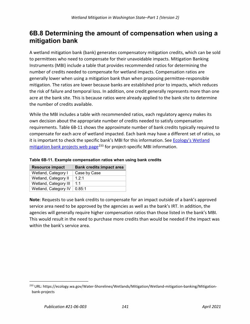
Wetland Mitigation in Washington State–Part 1 (Version 2)
Publication #21-06-003 141 April 2021
6B.8 Determining the amount of compensation when using a mitigation bank A wetland mitigation bank (bank) generates compensatory mitigation credits, which can be sold to permittees who need to compensate for their unavoidable impacts. Mitigation Banking Instruments (MBI) include a table that provides recommended ratios for determining the number of credits needed to compensate for wetland impacts. Compensation ratios are generally lower when using a mitigation bank than when proposing permittee-responsible mitigation. The ratios are lower because banks are established prior to impacts, which reduces the risk of failure and temporal loss. In addition, one credit generally represents more than one acre at the bank site. This is because ratios were already applied to the bank site to determine the number of credits available.
While the MBI includes a table with recommended ratios, each regulatory agency makes its own decision about the appropriate number of credits needed to satisfy compensation requirements. Table 6B-11 shows the approximate number of bank credits typically required to compensate for each acre of wetland impacted. Each bank may have a different set of ratios, so it is important to check the specific bank’s MBI for this information. See Ecology’s Wetland mitigation bank projects web page233 for project-specific MBI information.
Table 6B-11. Example compensation ratios when using bank credits
Resource impact Bank credits:impact area Wetland, Category I Case by Case Wetland, Category II 1.2:1 Wetland, Category III 1:1 Wetland, Category IV 0.85:1
Note: Requests to use bank credits to compensate for an impact outside of a bank’s approved service area need to be approved by the agencies as well as the bank’s IRT. In addition, the agencies will generally require higher compensation ratios than those listed in the bank’s MBI. This would result in the need to purchase more credits than would be needed if the impact was within the bank’s service area.
233 URL: https://ecology.wa.gov/Water-Shorelines/Wetlands/Mitigation/Wetland-mitigation-banking/Mitigation-
bank-projects

Wetland Mitigation in Washington State–Part 1 (Version 2)
Publication #21-06-003 142 April 2021
This page intentionally left blank

Wetland Mitigation in Washington State–Part 1 (Version 2)
Publication #21-06-003 143 April 2021
Chapter 6C. Determining Buffers for Compensatory Mitigation Sites
Generally, “buffer” refers to a vegetated area adjacent to aquatic resources that can, through various physical, chemical, and/or biological processes, reduce impacts from adjacent land uses. The scientific literature recognizes that buffers provide important functions that protect wetlands and provide essential habitat for many species that depend on wetlands (Sheldon et al., 2005; Hruby, 2013). The physical characteristics of buffers, including slope, soils, vegetation, and width, determine how well buffers reduce the adverse impacts of adjacent land uses. Those characteristics also determine how well buffers provide the habitat needed by wildlife species that use wetlands and habitats adjacent to them. For wildlife that use wetlands but also require uplands to meet their life-history needs, buffers provide necessary terrestrial habitats.
For more information on buffers in general, see Ecology’s best available science on buffers:
• Update on Wetland Buffers: The State of the Science, Final Report234 (Hruby, 2013).
• Wetlands in Washington State–Volume 1: A Synthesis of the Science, Chapter 5235 (Sheldon et al., 2005).
Another source of information is the Planner’s Guide to Wetland Buffers for Local Governments236 (Environmental Law Institute, 2008).
6C.1 Perimeter buffers This chapter focuses on buffers located within the outer boundary of compensatory mitigation sites, which are referred to as compensation site perimeter buffers (perimeter buffers). A compensation site consists of the compensation area (sometimes called the credit-generating area) surrounded by a protective perimeter buffer. Compensation sites need a perimeter buffer to protect them from the effects of adjacent land uses and, in most cases, to provide habitat necessary for the survival of wetland-dependent wildlife species. When uplands are part of the credit-generating area of the compensation site, the uplands must also be protected from off-site impacts to ensure that their functions are maintained. In other words, a perimeter buffer is
234 URL: https://apps.ecology.wa.gov/publications/SummaryPages/1306011.html 235 URL: https://apps.ecology.wa.gov/publications/summarypages/0506006.html 236 URL: https://www.eli.org/research-report/planners-guide-wetland-buffers-local-governments

Wetland Mitigation in Washington State–Part 1 (Version 2)
Publication #21-06-003 144 April 2021
needed to protect both the wetlands and uplands generating credit at the compensation site (see Figure 6C-1 and Chapter 6B.6, Uplands used as compensation).
The physical characteristics that are needed in the perimeter buffer (e.g., width, vegetation type and density) will depend to a large degree on the functions that the compensation site and the buffer itself are intended to provide. Protecting wildlife habitat functions of wetlands generally requires wider buffers than protecting the water-quality functions. However, the width necessary to protect a compensation site from the effects of adjacent land uses is contingent upon a number of other factors, such as:
• The sensitivity of the compensation site to be protected by the buffer
• The characteristics of the watershed contributing to the compensation site
• The characteristics of the buffer itself (e.g., vegetation type and density, slope)
• The nature and level of impact of the adjacent existing land uses and proposed future land uses237
The perimeter buffer could be wetland, upland, or a combination of both. In other words, the perimeter buffer does not need to be upland. For example, if a wetland continues off of the compensation site, the perimeter buffer would include wetland. The perimeter buffer, even if wetland, is intended to protect the interior of the compensation site from on-going or potential future adjacent land uses. In cases where a portion of the perimeter buffer is a wetland, the outer portion of the wetland protects the inner portion of the site from encroachment, trash, invasive species, and other adjacent land-use disturbances. In such instances, the wetland area designated as part of the site’s perimeter buffer does not provide compensation credit for wetland impacts. Under no circumstances is it acceptable to fill wetlands to establish an upland buffer.
237 The above section was adapted from Sheldon et al., 2005. The text has been modified to apply to compensatory
wetland mitigation.

Wetland Mitigation in Washington State–Part 1 (Version 2)
Publication #21-06-003 145 April 2021
Comparison of compensatory mitigation perimeter buffers to local government regulatory buffers
The location of the perimeter buffer may be different from what local governments require through their critical areas ordinances (CAO) or shoreline master programs (SMP), which require buffers around existing wetlands. See Figure 6C-1. The perimeter buffer extends inward from the outer edge of the compensation site, while the regulatory buffer required by the local government (i.e., local buffer) extends outward from the edge of the wetland.
In some cases, the perimeter buffer may be wider than the local buffer. This may result from proposed mitigation actions that will improve the functions of the compensation site. It is also possible that the local government, in its CAO or SMP, chose not to adopt the widths that the agencies recommend in Tables 6C-2 and 6C-3 of this chapter.
Figure 6C-1. Compensation site perimeter buffer. The local government regulatory buffer (i.e., local buffer) is shown for the purpose of comparison.

Wetland Mitigation in Washington State–Part 1 (Version 2)
Publication #21-06-003 146 April 2021
The perimeter buffer should be clearly designated, identified on maps, and included in the legal site protection mechanism(s) for the compensation site. If an applicant proposes to locate a portion(s) of the perimeter buffer on an adjacent parcel under different ownership, they must demonstrate that the buffer area will be permanently protected through a legal site protection mechanism.
Perimeter buffers should be clearly marked with signs to help protect the compensation site. This is particularly important when a site is adjacent to residential areas, parks, or other lands with active uses. These types of land uses can result in encroachment and reductions in buffer quality over time (Sheldon et al., 2005; Hruby, 2013). Impacts to the perimeter buffer can result from several causes, including:
• Removal of native vegetation and conversion to lawn or non-native plantings
• Use of the buffer as a dumping area for lawn clippings, yard waste, and garbage
• Human and pet intrusions
• Filling with soil or other materials to extend uplands into wetlands
• Pesticide and fertilizer use on adjacent lawns and landscaped areas
• Road runoff, carrying heavy metals, nutrients, and sediments
Use of boundary markers (e.g., signs, large rocks, wildlife-friendly fencing) can help reduce intrusions into the perimeter buffer.

Wetland Mitigation in Washington State–Part 1 (Version 2)
Publication #21-06-003 147 April 2021
2008 Federal Mitigation Rule language on the use of vegetated buffers as compensatory mitigation
In the 2008 Federal Mitigation Rule, buffer means an upland, wetland, and/or riparian area that protects and/or enhances aquatic resource functions associated with wetlands, rivers, streams, lakes, marine, and estuarine systems from disturbances associated with adjacent land uses.
The 2008 Federal Mitigation Rule states that if buffers are required by the Corps as part of the compensatory mitigation project, compensatory mitigation credit will be provided for those buffers (33 CFR Part 332.3[i] and 40 CFR Part 230.93[i]). In Washington State, agencies provide compensatory mitigation credit for buffer areas indirectly. In other words, instead of providing direct credit for a required buffer, the agencies provide more credit for the wetland compensation when it is adequately protected. This is because a compensation site that has a perimeter buffer as wide as recommended in this chapter will result in a higher-functioning wetland(s) than would be possible without a perimeter buffer of the recommended width. That higher-functioning wetland will provide more compensatory mitigation credit.
Conversely, a compensation site with a perimeter buffer narrower than recommended may result in a lower-functioning wetland that provides less compensatory mitigation credit. This is because, with a narrower buffer, the compensation site is at risk of being adversely impacted by adjacent land uses. These adverse impacts would likely lower the functioning of the compensation site. In this case, agencies would require additional area of compensatory mitigation to ensure adequate compensation of wetland impacts.

Wetland Mitigation in Washington State–Part 1 (Version 2)
Publication #21-06-003 148 April 2021
6C.2 Buffer widths for compensation sites In Wetlands in Washington State, Volume 2: Guidance for Protecting and Managing Wetlands238 (Granger et. al., 2005), Ecology and the Washington Department of Fish and Wildlife outlined specific guidance on buffer widths for wetlands. This document uses that guidance as a basis for the recommended widths of perimeter buffers for compensation sites.
The primary factors the agencies consider in determining the necessary width of perimeter buffers include:
• The current and expected future land uses (based on current development and land use regulations, such as zoning codes) adjacent to the compensation site
• The goals and objectives of the proposed compensatory mitigation
• The functions or special characteristics the proposed compensation site is expected to provide
• The presence of connecting corridors between the compensation site and other habitats
The width of a perimeter buffer for a compensation site should be based on the anticipated level of impact from adjacent land uses allowed under current development and land use regulations, such as zoning codes. Not all land uses have the same level of impact. For example, a compensation site established adjacent to a single-family residence on five acres is expected to experience a lower impact compared to one adjacent to 20 houses on the same five acres. Therefore, the perimeter buffer around the compensation site adjacent to the 20 houses would generally need to be wider than the buffer around the site next to the single-family residence. Table 6C-1 identifies three levels of impact (high, moderate, and low) and their associated types of land uses. Table 6C-2 and Table 6C-3 identify the recommended perimeter buffer widths.
238 URL: https://apps.ecology.wa.gov/publications/summarypages/0506008.html

Wetland Mitigation in Washington State–Part 1 (Version 2)
Publication #21-06-003 149 April 2021
Table 6C-1. Types of land uses that can result in high, moderate, and low levels of impacts to adjacent compensation sites
Level of impact
Types of land use
High • Commercial • Urban • Industrial • Institutional • Residential (more than 1 unit/acre) • Roads: federal and state highways, including on-ramps and exits, state routes, and
other roads associated with high-impact land uses • Agriculture with high-intensity uses (dairies, nurseries, greenhouses, growing and
harvesting crops requiring annual tilling, raising and maintaining animals, etc.) • Open/recreational space with high-intensity uses (golf courses, ball fields, etc.) • Solar farms (utility scale)
Moderate • Residential (1 unit/acre or less) • Roads: Forest Service roads and roads associated with moderate-impact land
uses • Open/recreational space with moderate-intensity uses (parks with paved trails or
playgrounds, biking, jogging, etc.) • Agriculture with moderate-intensity uses (orchards, hay fields, light or rotational
grazing, etc.) • Utility corridor or right-of-way used by one or more utilities and including
access/maintenance road • Wind farm
Low • Natural resource lands (forestry/silviculture–cutting of trees only, not land clearing and removing stumps)
• Open/recreational space with low-intensity uses (unpaved trails, hiking, bird-watching, etc.)
• Utility corridor without a maintenance road and little or no vegetation management • Cell tower

Wetland Mitigation in Washington State–Part 1 (Version 2)
Publication #21-06-003 150 April 2021
6C.2.1 How to use the perimeter buffer width tables Tables 6C-2 and 6C-3 provide recommended perimeter buffer widths needed to protect compensation sites based on their proposed functions and specific wetland category and characteristics. Applicants need to read and apply the following before using the perimeter buffer width tables:
• Rate the proposed compensatory wetland using the most recent Wetland Rating System,239 based on the proposed design. The anticipated rating will be used, in conjunction with adjacent land use, to determine required perimeter buffer widths.
o The required width of the perimeter buffer should be sufficient to protect the proposed category (I, II, III, or IV) of the compensation wetland and its proposed level of function, particularly habitat functions. If the applicant proposes to increase habitat functions, then the buffer needs to be wide enough to protect those habitat functions.
o When a wetland(s) within the compensation site will meet more than one of the characteristics listed in Tables 6C-2 and 6C-3, use the widest perimeter buffer recommended to protect the expected category and functions of the compensation wetland(s).
• The perimeter buffer needs to be vegetated with native plant communities that are appropriate for the ecoregion, or with plant communities that provide similar ecological functions.240 Ecoregions denote areas with similar ecosystems and types, quality, and quantity of environmental resources. One classification of ecoregions is the EPA’s Level III subdivisions mapped for Washington State: Coast Range, Puget Lowland, Willamette Valley, Cascades, Eastern Cascades Slopes and Foothills, North Cascades, Columbia Plateau, Blue Mountains, and Northern Rockies. The EPA maintains updated maps of ecoregions on their web page.241
If the perimeter buffer vegetation is disturbed (grazed, mowed, etc.), it needs to be revegetated with native plant communities that are appropriate for the ecoregion and site conditions.
239 URL: https://ecology.wa.gov/Water-Shorelines/Wetlands/Tools-resources/Rating-systems 240 Generally, this means planting native species. Many buffers, however, have been disturbed and are dominated
by non-native species. The agencies understand that it may be difficult or undesirable to try to control all non-native species and, therefore, will consider the condition of the buffer on a case-by-case basis.
241 URL: https://www.epa.gov/eco-research/level-iii-and-iv-ecoregions-state

Wetland Mitigation in Washington State–Part 1 (Version 2)
Publication #21-06-003 151 April 2021
• The width of the perimeter buffer should be measured along the horizontal plane (see Figure 6C-2 below) to determine appropriate widths on slopes.
Figure 6C-2. Measuring buffer widths on slopes.
• The perimeter buffer should remain undisturbed in the future. Applicants should identify any anticipated management activities in the site’s long-term maintenance and management plan.
Note: Subject to approval by the agencies, additional buffer area provided beyond the recommended perimeter buffer width may count as part of the compensation area, provided that certain conditions are met (see Chapter 6B.6, Uplands used as compensation).
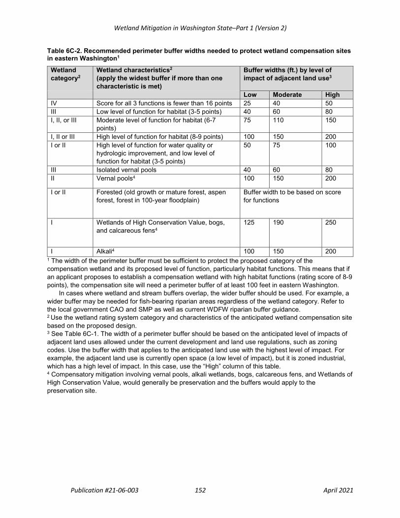
Wetland Mitigation in Washington State–Part 1 (Version 2)
Publication #21-06-003 152 April 2021
Table 6C-2. Recommended perimeter buffer widths needed to protect wetland compensation sites in eastern Washington1
Wetland category2
Wetland characteristics2 (apply the widest buffer if more than one characteristic is met)
Buffer widths (ft.) by level of impact of adjacent land use3
Blank Blank Low Moderate High IV Score for all 3 functions is fewer than 16 points 25 40 50 III Low level of function for habitat (3-5 points) 40 60 80 I, II, or III Moderate level of function for habitat (6-7
points) 75 110 150
I, II or III High level of function for habitat (8-9 points) 100 150 200 I or II High level of function for water quality or
hydrologic improvement, and low level of function for habitat (3-5 points)
50 75 100
III Isolated vernal pools 40 60 80 II Vernal pools4 100 150 200
I or II Forested (old growth or mature forest, aspen forest, forest in 100-year floodplain)
Buffer width to be based on score for functions
I Wetlands of High Conservation Value, bogs, and calcareous fens4
125 190 250
I Alkali4 100 150 200 1 The width of the perimeter buffer must be sufficient to protect the proposed category of the compensation wetland and its proposed level of function, particularly habitat functions. This means that if an applicant proposes to establish a compensation wetland with high habitat functions (rating score of 8-9 points), the compensation site will need a perimeter buffer of at least 100 feet in eastern Washington.
In cases where wetland and stream buffers overlap, the wider buffer should be used. For example, a wider buffer may be needed for fish-bearing riparian areas regardless of the wetland category. Refer to the local government CAO and SMP as well as current WDFW riparian buffer guidance. 2 Use the wetland rating system category and characteristics of the anticipated wetland compensation site based on the proposed design. 3 See Table 6C-1. The width of a perimeter buffer should be based on the anticipated level of impacts of adjacent land uses allowed under the current development and land use regulations, such as zoning codes. Use the buffer width that applies to the anticipated land use with the highest level of impact. For example, the adjacent land use is currently open space (a low level of impact), but it is zoned industrial, which has a high level of impact. In this case, use the “High” column of this table. 4 Compensatory mitigation involving vernal pools, alkali wetlands, bogs, calcareous fens, and Wetlands of High Conservation Value, would generally be preservation and the buffers would apply to the preservation site.

Wetland Mitigation in Washington State–Part 1 (Version 2)
Publication #21-06-003 153 April 2021
Table 6C-3. Recommended perimeter buffer widths needed to protect wetland compensation sites in western Washington1
Wetland category2
Wetland characteristics2 (apply the widest buffer if more than one characteristic is met)
Buffer widths (ft.) by level of impact of adjacent land use3
Blank Blank Low Moderate High IV Score for all 3 functions is fewer than 16 points 25 40 50 III Low level of function for habitat
(3-5 points) 40 60 80
I, II, or III Moderate level of function for habitat (6-7 points)
75 110 150
I, II or III High level of function for habitat (8-9 points) 150 225 300 I or II High level of function for water quality or
hydrologic improvement, and low level of function for habitat (3-5 points)
50 75 100
II Estuarine, wetlands in coastal lagoons, and interdunal wetlands
75 110 150
I Wetlands of High Conservation Value and bogs4
125 190 250
I Forested (mature and old growth) Buffer width to be based on score for functions
I Estuarine and wetlands in coastal lagoons 100 150 200 I Interdunal wetlands with a high level of function
for habitat (8-9 points) 150 225 300
1 The required width of the perimeter buffer must be sufficient to protect the proposed category of the compensation wetland and its proposed level of functions, particularly habitat functions. This means that if an applicant proposes to establish a compensation wetland with high habitat functions (rating score of 8-9 points), the compensation site will need a perimeter buffer of at least 150 feet in western Washington.
In cases where wetland and stream buffers overlap, is the wider buffer should be used. For example, a wider buffer may be needed for fish-bearing riparian areas regardless of the wetland category. Refer to the local government CAO and SMP as well as current WDFW riparian buffer guidance. 2Use the wetland rating system category and characteristics of the anticipated wetland compensation site based on the proposed design. 3 See Table 6C-1. The width of a perimeter buffer should be based on the anticipated level of impacts of adjacent land uses allowed under the current development and land use regulations, such as zoning codes. Use the buffer width that applies to the anticipated land use with the highest level of impact. For example, the adjacent land use is currently open space (a low level of impact), but it is zoned industrial, which has a high level of impact. In this case, use the “High” column of this table. 4 Compensatory mitigation involving bogs and Wetlands of High Conservation Value would generally be preservation and the buffers would apply to the preservation site.

Wetland Mitigation in Washington State–Part 1 (Version 2)
Publication #21-06-003 154 April 2021
6C.3 Variable width perimeter buffers If the adjacent land uses on one or more sides of the compensation site have different levels of impact, the agencies may allow the width of the perimeter buffer to vary. One example is a compensation site that is adjacent to a high-density residential area on one side and an open-space parcel on the other side. In this case, the agencies may allow a narrower perimeter buffer on the side adjacent to the open space than on the side that is adjacent to the high-density residential area. See Figure 6C-3 below.
Figure 6C-3. Variable width perimeter buffer This is a simplified illustration based on a Category II wetland with a moderate level of function for habitat (see Table 6C-2 for western Washington). It is not intended to represent an actual wetland shape.

Wetland Mitigation in Washington State–Part 1 (Version 2)
Publication #21-06-003 155 April 2021
6C.4 Reducing widths of perimeter buffers In the following situations, the agencies may allow narrower widths of perimeter buffers than those recommended in Tables 6C-2 and 6C-3:
• Where there is a legally protected, vegetated corridor to a protected area
• Where natural limits exist
• Where the adjacent land is permanently protected through a legal mechanism
Each of these situations is described in more detail in the following sections.
Applicants proposing other reasons for narrower perimeter buffer widths than those listed in Tables 6C-2 and 6C-3 must provide an ecological rationale for the reduction.
6C.4.1 Reduction in perimeter buffer width based on protection of a vegetated corridor If applicants propose a compensation site with a moderate or high score for habitat functions and provide a protected habitat corridor, they may be eligible for a reduction in the width of the perimeter buffer. To qualify for a reduction in the width of the perimeter buffer, corridors must meet all of the following:
• Be legally protected
• Be relatively undisturbed and vegetated242
• Be at least 100 feet wide
• Be connected to at least one of the following protected areas: o A legally protected, relatively undisturbed and vegetated area (e.g., Priority Habitats,
other compensation sites, wildlife areas/refuges, national and state parks243) o An area that is the site of a Watershed Project that is identified within and fully
consistent with a Watershed Plan, as these terms are defined by Chapter 89.08.460 RCW
o An area where development is prohibited per the provisions of the local shoreline master program
242 “Relatively undisturbed” is a general term used to describe areas that are almost completely free of human
impacts and activities. Relatively undisturbed areas can include uplands, other wetlands, lakes or other bodies of water. It means the area is free of regular disturbances such as tilling and cropping, residential and urban development, grazing, paved roads or frequently used gravel roads, mowing, pets, boating and fishing (Hruby, 2014a; Hruby, 2014b). “Vegetated” means the corridor has at least 30 percent cover of shrubs or trees or native prairie/grassland.
243 State Parks in Washington State have management plans that identify areas using a land classification system (see Chapter 352-16-020 WAC). Areas designated as Natural, Natural Forest, or Natural Area Preserve, would be considered protected areas for the purposes of this section.

Wetland Mitigation in Washington State–Part 1 (Version 2)
Publication #21-06-003 156 April 2021
The corridor must be protected for the entire distance between the compensation site and the protected area.
If a corridor meets these criteria, the agencies may allow a reduction in the width of the perimeter buffer. Buffer width would be reduced to the recommended width associated with the next lower level of land use impact (e.g., from high to moderate, see Tables 6C-2 and 6C-3).
Priority Habitats are defined by the Washington Department of Fish and Wildlife (WDFW). Priority Habitats in Washington State are listed in Table 6C-4. For current definitions of Priority Habitats see WDFWs Priority Habitats and Species web page.244
Table 6C-4. WDFW’s Priority Habitats245
Terrestrial habitat Aquatic habitat Aspen stands Freshwater wetlands–fresh deepwater Biodiversity areas and corridors Instream Eastside steppe Coastal nearshore Herbaceous balds Open coast nearshore Inland dunes Puget Sound nearshore Juniper savannah Old growth - mature forest Oregon white oak woodlands Riparian Shrubsteppe Westside prairie
244 URL: https://wdfw.wa.gov/species-habitats/at-risk/phs 245 WDFW also identifies Priority Habitats Features (Caves, cliffs, snags and logs, and talus). These are important
features; however, they would not be considered a type of protected area for the purpose of applying buffer width reductions under Chapter 6C.4.1 of this guidance.

Wetland Mitigation in Washington State–Part 1 (Version 2)
Publication #21-06-003 157 April 2021
6C.4.2 Reduction in perimeter buffer widths where natural limits exist If a parcel containing the compensation site is immediately adjacent to or abuts a natural limit, such as a cliff, bluff, ravine, or permanent open-water area, then the perimeter buffer may be reduced or may not be needed on that side of the compensation site. Several examples are provided below.
• A compensation site is situated at the top and edge of a 100-foot bluff. Adjacent land uses would be down below the site and would have minimal, if any, impacts on the compensation site. In this case, a perimeter buffer on the side of the bluff would not be needed.246
• The boundary of a compensation site abuts the base of a cliff or bluff. In this case, the agencies would consider the level of impact associated with the land use(s) at the top of the bluff. Since the adjacent land use would be high above the compensation site, some impacts would naturally be reduced, and therefore the perimeter buffer may be narrower than the recommended buffer widths found in Table 6B-1.
• A wetland compensation site is adjacent to permanent open-water areas, such as marine waters, lakes, rivers, and larger streams. In this case the compensation site may not need a perimeter buffer on the open water side. This assumes that the open water is a natural area with minimal disturbance. However, the agencies may determine that perimeter buffers are necessary if activities that cause disturbance occur in the water adjacent to the proposed compensation site (e.g., marinas, boat launches, and aquaculture).
246 To address other critical areas (e.g., steep slopes, landslide hazard areas, etc.) local governments may require
buffers that extend landward from the edge of the bluff.

Wetland Mitigation in Washington State–Part 1 (Version 2)
Publication #21-06-003 158 April 2021
6C.4.3 Reduction in perimeter buffer widths where the adjacent land is legally protected If the parcel immediately adjacent to the compensation site is legally protected, then the perimeter buffer may be reduced or may not be needed on that side of the compensation site. For example, if an applicant’s proposed compensation site will abut another compensation site that is permanently protected through a conservation easement, then the applicant may not need a perimeter buffer on that side (see Figure 6C-4). The applicant must demonstrate that a legal site protection mechanism, such as a conservation easement, is in place to preserve the ecological values and limit the types of uses on the adjacent land. Public ownership in and of itself is not sufficient to meet the requirement for legal protection.
In addition, if the compensation site is immediately adjacent to one of the protected areas listed in 6C4.2 6C.4.1, a perimeter buffer may be reduced or may not be needed on that side of the compensation site.
Figure 6C-4. Buffer reduction when two legally protected compensation sites are adjacent to each other. This is a simplified illustration based on a Category II wetland with a moderate level of function for habitat (see Table 6C-2 for western Washington). The figure is not intended to represent an actual wetland shape and is not drawn to scale.
DMOC461
Cross-Out

Wetland Mitigation in Washington State–Part 1 (Version 2)
Publication #21-06-003 159 April 2021
6C.5 Increasing the width of or enhancing the perimeter buffer In the following situations, agencies may require a wider perimeter buffer than those listed in Tables 6C-2 and 6C-3 to ensure that the compensation site and its functions are adequately protected:
• Buffer is dominated by non-native invasive or noxious plant species or is sparsely vegetated.
• Slope of the buffer is steep (i.e., greater than a 30 percent slope).
• The buffer is needed by species sensitive to disturbance.
The agencies may also require that a perimeter buffer be enhanced to improve the function of the buffer and further protect the compensation site. Buffer enhancement could entail planting native trees or other appropriate native vegetation and managing invasive species.
6C.5.1 Perimeter buffer is dominated by non-native invasive or noxious species or is sparsely vegetated The agencies based the recommended perimeter buffer widths on the assumption that the buffer is vegetated with a native plant community appropriate for the ecoregion or with one that performs similar functions.247 Existing buffers may be unvegetated, sparsely vegetated, or vegetated with invasive species that do not perform needed functions. In these cases, the perimeter buffer should either be restored to the appropriate native plant community (i.e., native plant species installed and maintained, invasive species controlled), or widened to ensure it provides adequate functions and site protection. Generally, improving the vegetation will be more effective than widening the buffer.
Note: Planting a perimeter buffer to establish a native plant community does not generate compensatory wetland mitigation credit. However, local governments may allow enhancement of the area being used as perimeter buffer to count as compensatory mitigation for impacts to other local government regulatory buffers.
247 Generally, this means planting native plant species. Many buffers, however, have been disturbed and will be
dominated by non-native species. The agencies understand that it may be difficult or undesirable to try to control all non-native species. Therefore, they will consider the condition of the perimeter buffer on a case-by-case basis.
Wetland Mitigation in Washington State–Part 1 (Version 2)
Publication #21-06-003 160 April 2021
6C.5.2 Slope of perimeter buffer is steep The effectiveness of buffers at removing pollutants before they enter a wetland decreases as the slope increases (Hruby, 2013). If a perimeter buffer width is to be based on the wetland’s score for its ability to improve water quality (see Tables 6C-2 and 6C-3) rather than habitat or other criteria, then the buffer width should be increased by 50 percent if the slope is greater than 30 percent (a 3-foot rise for every 10 feet of horizontal distance).
Note: The width of the buffer is measured along the horizontal plane (see Figure 6C-2) for determining appropriate widths on slopes.
6C.5.3 Perimeter buffer is needed by species sensitive to disturbance In some cases, the agencies may require an increase in perimeter buffer width to meet the specific habitat needs of plant or animal species that are sensitive to disturbance, such as threatened and endangered species. For wildlife that use wetlands but also require uplands to meet their life-history needs, buffers provide necessary terrestrial habitats. Information on the buffer widths needed by some threatened, endangered, and sensitive species of wildlife is provided in Ecology’s guidance on buffers (Granger et. al., 2005–Appendix 8-G; Hruby, 2013).
If state Priority Species or federally listed threatened or endangered species are present on a proposed compensation site, applicants should consult with appropriate agencies and programs, such as:
• Washington Department of Fish and Wildlife’s Priority Habitats and Species Program248
• U.S. Fish & Wildlife Service’s Endangered Species Program249
• NOAA Fisheries’ Endangered Species Conservation Program250
• Washington State Department of Natural Resources’ Natural Heritage Program251
• The local government
For additional information see Chapter 7.3, Compensatory mitigation and the Endangered Species Act.
248 URL: https://wdfw.wa.gov/species-habitats/at-risk/phs 249 URL: https://www.fws.gov/endangered/species/index.html 250 URL: https://www.fisheries.noaa.gov/topic/endangered-species-conservation 251 URL: https://www.dnr.wa.gov/NHPspecies

Wetland Mitigation in Washington State–Part 1 (Version 2)
Publication #21-06-003 161 April 2021
6C.6 Buffers for trails, utility corridors, easements, and other encumbrances within a compensation site As described in Chapter 6A.1.3, Suitability and site constraints, the presence of trails, utility corridors, easements,252 and other encumbrances on, through, or under a proposed compensation site may affect the suitability of that site. In addition, any area located within the footprint of the trails, utility corridor, easement, or other encumbrance will not contribute to the area/credit of compensation (see Chapter 6B.7, Areas that do not contribute to the compensation amount).
Applicants should be aware that in most cases, trails, utility corridors, easements, and other encumbrances would also need to have a buffer around them (see Figure 6C-5). As with perimeter buffers, buffers around encumbrances would not contribute to the area/credit of the compensation site. The width of these buffers should be based on the level of impact from the encumbrance/trail (see Table 6C-1). Applicants need to provide these buffers to protect the site internally from ongoing and periodic maintenance and management activities and associated disturbance within the encumbrance/trail footprint (e.g., a potential vector for invasive species).
Figure 6C-5. Buffers for trails, utility corridors, easements, and other encumbrances within a compensation site. Buffers around encumbrances/trails would not contribute to the area/credit of the compensation site.
252 Utility corridors include power, water, sewer, oil, gas, telephone, internet, stormwater management
infrastructure, etc. Other easements may include stormwater facilities, rights-of-way, and streams that are being conveyed underground.

Wetland Mitigation in Washington State–Part 1 (Version 2)
Publication #21-06-003 162 April 2021
Agencies may allow the width of buffers around utility corridors/easements to be reduced or eliminated if applicants are willing and able to commit to all of the following:
• Plant native vegetation, generally shrubs, within the footprint of the utility corridor/easement.
• Control non-native, invasive species within the footprint of the utility corridor/easement.
• Maintain the vegetation within the footprint of the utility corridor/easement. This means replanting if the vegetation within the footprint area is damaged or disturbed by maintenance and management activities.
Wetlands as buffers
Where space for an upland buffer is limited or nonexistent, wetland area on the edge of the compensation site will be considered to be a perimeter buffer for the rest of the site. However, the area of wetland serving as perimeter buffer would not count toward compensation requirements for wetland impacts.
In such situations, the outer portion of the wetland protects the inner portion of the compensation site. Some local jurisdictions refer to this as a “paper buffer” or “paper fill.” The agencies do not prefer the use of either term because the buffering function this area provides is real and not just on paper. In addition, no fill should be involved. It is not acceptable to fill wetlands to make an upland buffer for the wetland. Depending on the proposed functions of the compensation site, wetlands as buffers may not be appropriate or adequate. If so, a different compensation site may be needed.

Wetland Mitigation in Washington State–Part 1 (Version 2)
Publication #21-06-003 163 April 2021
Chapter 6D. In Kind, Out of Kind, and Resource Tradeoffs
When planning compensatory mitigation, applicants will need to work with the agencies early in the process to determine whether to compensate in kind, out of kind, or with a resource tradeoff.
“In kind” means that the compensatory mitigation involves a resource of a similar structural and functional type to the impacted resource. For compensation wetlands, this means providing the same hydrogeomorphic (HGM) class (e.g., riverine, depressional, slope, etc.) and/or Cowardin class (e.g., palustrine emergent, palustrine forested, or estuarine) as the impacted wetland.
“Out of kind” means that the compensatory mitigation involves a resource of a different structural and functional type from the impacted resource. For compensation wetlands, this means providing a different HGM and/or Cowardin class from the impacted wetland.
“Resource tradeoffs” mean that non-wetland resources (e.g., riparian areas, streams, or salmon habitat) are used to compensate for wetland losses.
In the 2008 Federal Mitigation Rule,253 the Corps and the EPA state that in-kind compensatory mitigation is generally preferable to out-of-kind compensatory mitigation. This preference is based on the assumption that similar wetland types provide similar functions. When compensation is out of kind, the compensation wetland and the impacted wetland may perform different functions, and therefore, net losses of some functions may occur. However, if the applicant designs the compensatory mitigation to replace the same wetland classes, category, and functions that are lost, potential net losses of functions are minimized.
The agencies recognize that different wetlands perform different functions and at different levels. This is reflected in the wetland’s class under the HGM classification system (e.g., depressional, riverine, slope, etc.). This classification system groups wetlands with similar HGM characteristics. The hydrogeomorphology of a wetland determines, in part, which functions a wetland will perform and the level at which those functions are performed. Therefore, riverine wetlands perform functions differently and provide different functions from depressional wetlands. For example, a depressional wetland with no outlet may retain all sediments that enter it, while a riverine wetland may detain sediment only temporarily because annual flooding moves sediment downstream. If a riverine wetland is used to compensate for impacts to a depressional wetland, then a loss of some of the functions provided by depressional wetlands is expected.
253 33 CFR Part 332.3(b) and 40 CFR 230.93(b)

Wetland Mitigation in Washington State–Part 1 (Version 2)
Publication #21-06-003 164 April 2021
Federal Mitigation Rule hierarchy regarding off-site and out-of-kind compensatory mitigation
The 2008 Federal Mitigation Rule (33 CFR Part 332.3[b] and 40 CFR 230.93[b]) lists the preference of compensation options in the following order.
1. Mitigation bank credits
2. In-lieu fee program credits
3. Permittee-responsible mitigation under a watershed approach
4. Permittee-responsible mitigation through on-site and in-kind mitigation
5. Permittee-responsible mitigation through off-site and/or out-of-kind mitigation
When a proposed project is located within the service area of a Corps-approved mitigation bank or in-lieu fee (ILF) Program, the applicant should first consider use of those approaches as compensatory mitigation. However, during the permitting process, the Corps has flexibility on a case-specific basis to determine which compensatory mitigation approach will best offset the impacts and provide the greatest ecological benefits.
When a bank or ILF is not available or is unable to compensate for the impacts (e.g., the appropriate wetland classes and functions are not provided), the next preferred option is permittee-responsible mitigation (PRM) under a watershed approach (see Chapter 6A, Choosing the Location for Compensation Mitigation Using a Watershed Approach). Under a watershed approach, the compensation may be on site or off site. The focus is to locate and design the compensation to be sustainable and contribute to restoring lost or degraded environmental processes and wetland functions in the watershed. Where a watershed approach is not practicable, on-site and in-kind compensation is the next preferred option with off-site, out-of-kind PRM as the least preferred option.

Wetland Mitigation in Washington State–Part 1 (Version 2)
Publication #21-06-003 165 April 2021
With a greater awareness of the role that wetlands play in watersheds and larger landscapes, the agencies are now more likely to approve out-of-kind compensatory mitigation when it:
• Provides an overall improvement to functions that are critical or limited in a watershed, or
• Restores impaired environmental processes.
One example is restoring hydrologic processes by plugging ditches to reduce the velocity and volume of water leaving the site. This may promote seasonal ponding and subsurface flows that can support base flows in streams.
The agencies strongly consider what kind of compensation will provide the greatest ecological benefits for the landscape. The following sections describe how the agencies determine what kind of compensation is appropriate: in kind, out of kind, or a resource tradeoff.
6D.1 In-kind wetland compensatory mitigation The agencies require in-kind wetland compensatory mitigation when the greatest ecological benefits for the watershed can be obtained by replacing the wetland to be impacted with the same classes and category of wetland. The following are some circumstances when in-kind compensation is environmentally preferable:
• The impacted wetlands and functions are limited or rare within a watershed, and replacement is critical.
• Replacement of the impacted functions is important to maintain environmental processes that affect the larger landscape.
• Replacement of the same wetland type and functions is needed to satisfy requirements for sensitive or listed species.
• The impacted wetlands are of high quality (refer to Chapter 5.2.3.1, Criteria for using preservation, for characteristics of high-quality wetlands).
• The impacts involve a wetland whose category is based on special characteristics.
The agencies strongly discourage impacts to wetlands with special characteristics because impacts to such wetlands would result in a net loss of some functions no matter what kind of compensation is proposed. Applicants who propose unavoidable impacts to wetlands with special characteristics generally should provide compensation with a wetland that has the same special characteristics. However, the agencies recognize that it may be difficult or impossible to replace some of these wetlands (e.g., bogs) through in-kind compensation. Where in-kind compensation is not feasible, applicants should consult with the agencies to see whether out-

Wetland Mitigation in Washington State–Part 1 (Version 2)
Publication #21-06-003 166 April 2021
of-kind compensation may be considered.254 See Chapter 6B.5, Compensation ratios for wetlands with special characteristics, for in-kind compensation options for each type.
In-kind compensation required for impacts to estuarine wetlands
Impacts to estuarine wetlands are usually compensated in kind (i.e., with another estuarine wetland). Estuarine wetlands are important because of their rarity, their landscape position, and the unique functions they provide. Specifically, they provide important habitat for threatened and endangered species. Also, Washington State has experienced extensive historic conversion and loss of estuarine wetlands. Therefore, the agencies rarely allow applicants to use freshwater wetlands to compensate for impacts to estuarine wetlands.
6D.2 Out-of-kind wetland compensatory mitigation Out-of-kind wetland compensatory mitigation may provide greater environmental benefits to the watershed than in-kind compensation, if it is appropriate for its landscape position and connects into a system of natural areas and aquatic corridors. The agencies will generally allow out-of-kind compensation for small impacts to degraded wetlands. For example, the agencies often accept out-of-kind compensation when the impacted wetlands are dominated by reed canarygrass255 and/or other invasive species and the compensation site is likely to support native species with greater diversity and habitat complexity. In these cases, the agencies prefer that applicants compensate for impacted wetlands with wetland classes that are appropriate for their landscape setting, support native communities, and maintain environmental processes.
The agencies may also accept out-of-kind compensation if the impacted functions or habitats are relatively abundant in the area and the compensatory mitigation will provide functions and habitats that are limited in the watershed. For example, wetlands that are dominated by reed canarygrass are relatively abundant; whereas many estuarine wetlands have been lost. As a result, estuarine habitat and shoreline functions are very limited in some river basins, particularly in the Puget Sound area. Because restoring these habitats is a priority, the agencies
254 If an applicant cannot find adequate compensation to offset the impacts (e.g., if it’s not actually feasible to
ecologically compensate/replace the lost wetland functions), a permit may be denied pursuant to 40 CFR Part 230.10 criteria (Clean Water Act Section 404[b][1] Guidelines). The goal of the CWA is to ensure that all practicable measures are taken to avoid impacts to aquatic ecosystems.
255 Applicants and regulatory agency staff should consider the potential presence of Oregon spotted frogs when making mitigation, conservation, or permitting decisions regarding wetlands dominated by reed canarygrass. See Chapter 7.3.1, Oregon spotted frogs.

Wetland Mitigation in Washington State–Part 1 (Version 2)
Publication #21-06-003 167 April 2021
may determine that loss of a reed canarygrass wetland lower in the watershed can be adequately offset through re-establishment of an estuarine wetland.
Agencies may consider out-of-kind compensation when:
• The impacted wetland provides minimal functions, and the classes and category of wetland is not limited in the landscape or of critical ecological importance.256
• The applicant demonstrates that the proposed out-of-kind compensation will provide an overall improvement to functions and/or replace wetland habitat types that have been lost or are critical, rare, or limited in the watershed.
• It is not feasible to provide in-kind compensation.
Applicants proposing out-of-kind compensation with a different HGM class will generally need to demonstrate a gain in functions sufficient to compensate for wetland impacts. One method for doing this, when proposals involve freshwater wetlands, is the Credit-Debit Method257 (Hruby, 2012a; Hruby, 2012b).
To use the Credit-Debit Method, applicants need to score all wetland impact sites and proposed compensation sites (both the baseline functions and the anticipated functions after implementing compensation activities). This will provide the agencies with more specific information on the gain in functions that may result from the proposed compensation activities. Refer to Chapter 6B.3 for more information on the Credit-Debit Method.
256 There are several online sources that can help determine whether the functions are of critical ecological
importance. For maps of federal and/or state sensitive, rare, threatened, or endangered species and habitats see WDFW’s Priority Habitats and Species database (PHS on the web), USFWS Environmental Conservation Online System (Critical Habitat spatial data), and WA DNR’s Natural Heritage Program Wetlands of High Conservation Value Map Viewer. Other sources of information include local jurisdiction flood hazard maps and Ecology’s 303d listed waters and TMDL areas. (URLS: https://wdfw.wa.gov/species-habitats/at-risk/phs/maps, https://ecos.fws.gov/ecp/report/table/critical-habitat.html, and https://www.dnr.wa.gov/NHPwetlandviewer)
257 URL: https://ecology.wa.gov/Water-Shorelines/Wetlands/Tools-resources/Credit-debit-method

Wetland Mitigation in Washington State–Part 1 (Version 2)
Publication #21-06-003 168 April 2021
6D.3 Resource tradeoffs Resource tradeoffs involve compensating for impacted wetlands with habitats or ecosystems other than wetlands. Compensation with non-wetland resources could include:
• Upland riparian restoration
• Stream rehabilitation
• Enhancement or preservation of stream or wetland buffers
• Preservation of mature forest lands, dune systems, prairies, oak woodlands, shrub/steppe communities, or other rare/high-quality upland ecosystems258
As emphasized throughout this document, compensation requirements for wetland impacts generally involve the re-establishment, rehabilitation, creation, preservation, or enhancement of wetland functions similar to those that are lost or reduced. However, in some cases the agencies have allowed applicants to meet their compensatory mitigation requirements with non-wetland resources. According to the 2008 Federal Mitigation Rule,259 use of terrestrial resources may be an acceptable form of compensation when those resources contribute to or improve the overall ecological functioning of the aquatic resources in the watershed.
Agencies may consider resource tradeoffs when:
• Impacts would occur to a highly degraded wetland that provides low levels of wetland functions.
• It can be demonstrated that options for wetland compensation are limited or non-existent in the hydrologic planning unit/watershed, and the greatest environmental benefits can be achieved by restoring or preserving non-wetland resources in the same hydrologic planning unit.
• The functions provided by non-wetland resources are limited in the watershed or are critical for restoring the health and functioning of key environmental processes.
• The non-wetland resource to be restored or preserved contributes to and enhances the overall functioning of a wetland system (e.g., stream and riparian rehabilitation adjacent to a riverine wetland).
• The non-wetland habitats contribute to the restoration of habitats for sensitive or endangered species.
258 To identify rare/high-quality upland ecosystems, applicants could refer to WA DNR’s Natural Heritage Program
data or contact Natural Heritage Program staff for more information. (URLs: https://www.dnr.wa.gov/NHPdata and https://www.dnr.wa.gov/natural-heritage-program)
259 33 CFR 332.3(c)(2)(i) and 40 CFR 230.93(c)(2)(i)

Wetland Mitigation in Washington State–Part 1 (Version 2)
Publication #21-06-003 169 April 2021
The agencies make tradeoff decisions on a case-by-case basis. While wetland compensation has a “currency” that has been used for years (area and category of wetland or acre-points under the Credit-Debit Method), there is no currency or conversion factor that supports a tradeoff in resource functions. Therefore, the agencies make these decisions using best professional judgment based on an evaluation of how the impacts from the proposed project compare with the proposed benefits of the compensation.
To help the agencies make permitting decisions on resource tradeoffs, the applicant must demonstrate that the compensation project contributes to or improves the functions of aquatic resources in the watershed. Applicants will need to provide information on the condition and functioning of the impacted wetlands, the proposed compensation, and the watershed. In areas where watershed planning exists, some of the information may already be available. Some of that information includes:
• Identification of limiting resources or functions in the hydrologic planning unit/watershed (see Chapter 6A, Choosing the Location for Compensatory Mitigation Using a Watershed Approach)
• The degree of permanent disruptions to environmental processes, such as the way water moves through the landscape
• Key areas identified for restoration
• Key areas identified for protection and preservation
No matter what type of compensatory mitigation is being proposed, it is important to contact the agencies early to determine whether the compensation would be appropriate and adequate to offset the proposed wetland impacts (see Appendix A, Agency and Tribal Contacts).
6D.4 Resource tradeoffs and voluntary restoration Another type of resource tradeoff occurs when wetlands are impacted by restoration projects that are intended to benefit certain species or the broader aquatic system. When a salmon or floodplain restoration project would result in unavoidable wetland impacts, the agencies will need to determine whether the wetland impacts need to be offset through compensatory mitigation. In some cases, the ecological gains from the restoration project may be sufficient to offset the impacted wetland area and functions without the need for compensatory mitigation.
The following are two examples of when the agencies may determine that the restoration project would result in a net gain in aquatic resource functions and not require compensatory mitigation.
• The restoration of river processes in the floodplain may be of more benefit than the loss of wetland functions that are abundant in the area. In many river valleys, depressional freshwater wetlands have formed behind levees. These types of wetlands may be

Wetland Mitigation in Washington State–Part 1 (Version 2)
Publication #21-06-003 170 April 2021
common in the area. Many of them may have historically been riverine wetlands and have been degraded, or they are currently atypical wetlands. The agencies may allow these degraded or atypical wetlands to be filled by a setback levee in order to restore the river's access to, and restoration of function in, the historic floodplain.
• The restoration of suitable habitat for salmonids may be of more benefit than avoiding minor impacts to wetlands (e.g., to degraded wetlands or below a size threshold). Recovery of salmon is a high priority in Washington State. Given this priority, and the limited availability of suitable habitat for salmonids, the agencies may allow minor wetland impacts from a salmon restoration project.
For restoration projects that propose resource tradeoffs, the applicant must demonstrate a net gain in aquatic resources. Determining whether a restoration project would result in a net gain of aquatic resource functions depends upon the degree of impact, the element of the project causing the impact, the functions of the wetlands impacted, and the degree to which the restoration project provides functions that are limited in the watershed.
The following is an example of when the agencies may determine that a restoration project would not result in a net gain in aquatic resource functions and would require compensatory mitigation.
• A salmon recovery project proposes to provide new off-channel habitat that would result in direct impacts, including the potential to drain a mature forested wetland. In most cases, the agencies would not approve impacts to a mature forested wetland without compensation. In such instances, the applicant for the salmon project will either need to re-design to avoid and minimize forested wetland impacts or provide compensation for the impacted wetland area and functions.
In all cases, applicants for restoration projects must document how their projects avoid and minimize wetland impacts to the maximum extent practicable given the goals of the restoration project.

Wetland Mitigation in Washington State–Part 1 (Version 2)
Publication #21-06-003 171 April 2021
Chapter 7. Other Compensatory Mitigation Considerations
This chapter contains brief discussions of supplementary topics that affect compensatory mitigation proposals. Failure to consider and/or address each of the following topics when planning and proposing compensation sites may result in permit denial, delays in permit issuance due to the need to make requested revisions, or unsuccessful compensation sites that fail to meet permit requirements. These topics include:
• Non-native, invasive species
• Ornamental varieties of native plants
• Endangered and threatened species
• Beavers
• Climate change
7.1 Non-native invasive species–agency policies According to the Washington Invasive Species Council,260 Washington State is at risk from a wide variety of invasive species. These species damage Washington’s landscapes, agriculture, business, and recreation. In a January 2017 report that assessed the economic impacts of invasive species for Washington State, it was estimated that 23 of the most damaging invasive species in Washington would cost $1.3 billion a year if no prevention occurs (Community Attributes Inc., 2017).
Following the publication of the economic impacts report, Governor Inslee signed a proclamation in 2019 recognizing the week of February 24 as Invasive Species Awareness Week in Washington State. The goal is to spread awareness so that more people can do their part to prevent the spread of invasive species.
Due to the documented damage and potential impacts of invasive species, the agencies typically require prevention, reduction, or eradication of invasive species on compensation sites. The performance standard thresholds and control requirements for particular projects are dependent on site-specific factors and the regulatory status of noxious weeds present on the site. Under Washington State laws and regulations,261 the Washington State Noxious Weed Control Board places plants on the state noxious weed list and assigns classifications of A, B, or C.262 Class A noxious weeds are required to be controlled throughout Washington. County
260 URL: https://invasivespecies.wa.gov/ 261 Chapter 17.10 RCW (Noxious Weeds–Control Boards) and Chapter 16-750 WAC (State Noxious Weed List) 262 URL: https://www.nwcb.wa.gov/classes-of-noxious-weeds

Wetland Mitigation in Washington State–Part 1 (Version 2)
Publication #21-06-003 172 April 2021
noxious weed control boards designate specific Class B and C noxious weeds that are required for control within each county or weed management region. It is Ecology’s policy to report sightings of noxious weeds designated for control to the county noxious weed board if observed during site visits.
Most regulators and consultants are well aware of the challenges that non-native, invasive plant species can pose for successful implementation of compensatory mitigation. In addition to invasive plant species, non-native invasive animals, such as nutria, can also be problematic on compensation sites.
When developing compensatory mitigation plans, applicants should consult the state and county noxious weed lists and the Washington Invasive Species Council web page263 to determine which plants or animals are of special concern in the region. These lists are occasionally updated with new additions, so one should recheck them with each new plan. At a minimum, non-native, invasive species should be addressed in the following sections of compensatory mitigation plans:
• Goals, objectives, and performance standards. In the context of invasive species performance standards for compensatory mitigation, Ecology considers all the state and county listed noxious weed species to be invasive.
• Monitoring. Monitoring plans should describe methods for identifying the presence and quantifying the percent cover of invasive weeds to determine whether performance standards are being met.
• Maintenance, contingency, and adaptive management plans. Compensatory mitigation plans will need to address control of both invasive weeds and other non-native species that compete with native plants and hinder the ability of the site to meet its native plant performance standards.
Sources of information on invasive species and noxious weeds include:
• Washington Invasive Species Council264
o Report a sighting265 (also available as a mobile app)
• Washington Noxious Weed Control Board266
• County Weed Boards267
263 URL: https://invasivespecies.wa.gov/ 264 URL: https://invasivespecies.wa.gov/ 265 URL: https://invasivespecies.wa.gov/report-a-sighting/ 266 URL: https://www.nwcb.wa.gov/ 267 URL: https://www.nwcb.wa.gov/contact-your-county-weed-boards

Wetland Mitigation in Washington State–Part 1 (Version 2)
Publication #21-06-003 173 April 2021
• WA Department of Fish and Wildlife, Aquatic Invasive Species268
• USDA National Invasive Species Information Center269
While there is the potential for numerous invasive species to establish on wetland compensation sites, this chapter focuses on five non-native plant species that are considered to be detrimental to the condition of wetlands:270
• Non-native knotweeds (Fallopia japonica and related species and hybrids)
• Reed canarygrass (Phalaris arundinacea)
• Non-native cattails (Typha angustifolia, T. domingensis, and hybrids)
• Russian olive (Elaeagnus angustifolia)
• Non-native common reed (Phragmites australis ssp. australis)
Non-native Spartina (Spartina alterniflora, S. anglica, S. x townsendii, and S. patens) and purple loosestrife (Lythrum salicaria and L. virgatum) species are not specifically discussed in this chapter. However, there is a state law271 that addresses their control, which is a high priority for all state agencies. Additional Spartina (Spartina densiflora) and loosestrife (Lysimachia vulgaris) species are included on the state’s noxious weed list.
Invasive species rankings for Washington State
At the time this document was being finalized, the Washington State Department of Natural Resources–Natural Heritage Program, had initiated an EPA grant-funded project to develop an invasive species ranking protocol for Washington State. The project will emphasize wetland species and the outcome of the project will be a standardized list of non-native, invasive species with assigned “invasiveness” ranks.
Once the protocol is available, the agencies recommend referring to these rankings to identify and prioritize species for control on compensation sites.
268 URL: https://wdfw.wa.gov/species-habitats/invasive 269 URL: https://www.invasivespeciesinfo.gov/ 270 Please note that this is not a comprehensive list of species that could be detrimental to the condition of
wetlands. 271 Chapter 17.26 RCW (Control of Spartina and Purple Loosestrife)

Wetland Mitigation in Washington State–Part 1 (Version 2)
Publication #21-06-003 174 April 2021
7.1.1 Non-native knotweeds As of 2021 non-native knotweeds are listed as priority invasive plant species by the Washington Invasive Species Council, listed as Class B noxious weeds by the Washington Noxious Weed Control Board, and included on the Washington noxious weed seed and plant quarantine list.272
Non-native knotweed species pose numerous problems for compensation sites, particularly stream and riparian restoration projects. Japanese, giant, hybrid, and Himalayan knotweeds (Fallopia japonica, F. sachalinensis, F. x bohemica, and Persicaria wallichii) spread quickly to form dense, tall thickets that shade other species and preclude natural regeneration of the normally diverse native species assemblage. Non-native knotweeds can have profound impacts on salmonid habitat, because they prevent tree establishment along stream banks; disrupt timing, decay rate, and quality of detritus in aquatic food webs; and sequester nitrogen in fall, reducing the amount of nitrogen that would be provided by normal leaf-drop in streams (Urgenson et al., 2009; Urgenson et al., 2012). Knotweed, therefore, has significant impacts on riparian ecosystems and biological diversity.
These non-native knotweeds are creeping perennials that tolerate a wide range of conditions, including partial shade. They die back to the ground with the first hard frost, and return each year from the same rhizomes and roots. Knotweeds have an extensive network of rhizomes that can spread at least 23 feet from the parent plant and can penetrate more than seven feet into the soil. This makes them extremely difficult to control once they are established. Knotweeds can survive floods, which serve to disperse knotweed fragments throughout the floodplains and cobble bars of rivers. Small fragments can regenerate into whole new stands, even when buried up to a meter below the soil surface. Because they grow faster than native species, they quickly shade them out.
Many methods of control have been applied to knotweeds, including hand cutting, mowing, digging, pulling, covering, herbicides, and a combination of the above. With proper timing, these methods can effectively eliminate stands of knotweed. However, all treatment approaches should be applied consistently and thoroughly over time to be successful.
Many county noxious weed boards designate knotweed for control. Because non-native knotweeds are rapidly infesting certain areas of Washington State, the agencies have a zero-tolerance policy to help control these noxious, invasive species. Therefore, if there are no existing non-native knotweed plants on a compensation site, but knotweeds are later found during a monitoring event, a contingency plan should be implemented to eradicate them immediately.
For compensation sites with established stands of knotweed, the agencies will require reduction of the population, with the ultimate goal of eradication over time. Allowing non- 272 Chapter 16-752-610 WAC and Chapter 16-752-610 WAC (noxious weed seed and plant quarantine list and
prohibited acts)

Wetland Mitigation in Washington State–Part 1 (Version 2)
Publication #21-06-003 175 April 2021
native knotweeds to exist is problematic. Given time, knotweeds will overrun a site, and once established they are very difficult to eradicate.
For more information on knotweeds, see the following Washington Noxious Weed Control Board web pages:
• Japanese knotweed273
• Giant knotweed274
• Hybrid (Bohemian) knotweed275
• Himalayan knotweed276
In addition, the Washington State Department of Agriculture’s 2013 publication, Integrated Pest Management Plan for Freshwater Emergent Noxious and Quarantine Listed Weeds,277 provides recommended management options for invasive knotweed species.
7.1.2 Reed canarygrass As of 2021 reed canarygrass (Phalaris arundinacea) is listed as a Class C noxious weed by the Washington State Noxious Weed Control Board. In the Pacific Northwest, reed canarygrass is one of the most difficult species to eradicate. It is a perennial, typically found in wetlands, which spreads by both seeds and rhizomes and creates dense, tall monocultures that crowd out low-growing species. If reed canarygrass is present, it is difficult to establish native plants because of the competitive advantage of the reed canarygrass. Even with established control methods, it can be difficult to limit aerial coverage of reed canarygrass to 10 percent, particularly if adjacent sites have reed canarygrass as a dominant species.
The agencies' previous policy regarding performance standards for reed canarygrass was generally a 10 percent maximum aerial coverage for all monitoring years. However, many compensation sites failed to achieve the 10 percent standard. This was often because of widespread coverage of reed canarygrass on adjacent properties or within upstream corridors. The intent of invasive species performance standards in compensatory mitigation plans is to prevent the establishment of monocultures of invasive species that out-compete native species and degrade wetland and ecosystem functions, including biodiversity. It is not the agencies’ intent to require unrealistic or unattainable performance standards for compensatory mitigation success.
273 URL: https://www.nwcb.wa.gov/weeds/japanese-knotweed 274 URL: https://www.nwcb.wa.gov/weeds/giant-knotweed 275 URL: https://www.nwcb.wa.gov/weeds/bohemian-knotweed 276 URL: https://www.nwcb.wa.gov/weeds/himalayan-knotweed 277 URL:
https://cms.agr.wa.gov/WSDAKentico/Imported/IPMFreshwaterEmergentNoxiousQuarantineListedWeeds.pdf

Wetland Mitigation in Washington State–Part 1 (Version 2)
Publication #21-06-003 176 April 2021
The agencies continue to implement a flexible policy for reed canarygrass coverage on compensation sites. The agencies acknowledge that reed canarygrass does provide some important wetland functions, such as water-quality filtering and food-chain support. However, if a native plant community is desired, the most effective and efficient way to manage and maintain a site is to prevent new infestations and eradicate small populations of reed canarygrass as soon as possible. Therefore, for creation or re-establishment compensation sites that currently have little or no reed canarygrass, limiting reed canarygrass to 10 percent coverage may still be appropriate. For sites that have existing cover of reed canarygrass, a multi-method approach is needed (Annen, 2016). Control efforts should focus on removing it during site preparation followed by aggressive control during the early years.
The agencies have adopted a policy of case-by-case determination so that performance standards make ecological sense, are realistic, and are achievable. A major consideration in determining an appropriate performance standard for maximum percent cover of reed canarygrass will be what percent cover of reed canarygrass is present on the compensation site and in the surrounding landscape. Considerations will include whether there is an on-site or nearby seed source, how close the seed source is, and how the seeds/rhizomes could be transported to the site. Below are some example scenarios/approaches for setting realistic performance standards:
• Scenario 1: At baseline, reed canarygrass cover is low on the compensation site. Approach: Set performance standards so that reed canarygrass cover does not exceed the baseline.
• Scenario 2: At baseline, reed canarygrass cover is high on the compensation site. Approach: Set performance standards so there is a gradual decline over time with a total reduction of 50 percent by the end of the monitoring period.
For more information on reed canarygrass, see the Washington State Noxious Weed Control Board’s reed canarygrass web page.278 In addition, the Washington State Department of Agriculture’s 2013 publication, Integrated Pest Management Plan for Freshwater Emergent Noxious and Quarantine Listed Weeds,279 provides recommended management options for reed canarygrass.
278 URL: https://www.nwcb.wa.gov/weeds/reed-canarygrass 279 URL:
https://cms.agr.wa.gov/WSDAKentico/Imported/IPMFreshwaterEmergentNoxiousQuarantineListedWeeds.pdf

Wetland Mitigation in Washington State–Part 1 (Version 2)
Publication #21-06-003 177 April 2021
Consider the presence of Oregon spotted frogs (Rana pretiosa)
Widespread invasion of unmanaged reed canarygrass has been associated with loss of Oregon spotted frogs in some areas. However, existing populations of Oregon spotted frogs occur in wetlands that are often dominated by reed canarygrass. Though these may be considered lower-quality wetland habitats and would typically rate as Category IV, they provide habitat for this federal and state-listed frog. Applicants and regulatory agency staff should consider the potential presence of Oregon spotted frogs when making mitigation, conservation, or permitting decisions regarding wetlands dominated by reed canarygrass. See Chapter 7.3.1, Oregon spotted frogs.
7.1.3 Non-native cattails Non-native cattails were added to the Washington State noxious weed list in 2014 as Class C noxious weeds. The listing was intended to increase awareness of the invasiveness of these non-native Typha species and their hybrids such as Typha angustifolia, Typha domingensis, and Typha ×glauca. One of the problems associated with non-native cattails is that all of them hybridize, and the hybrids can outcompete parent species, especially in disturbed or nutrient-rich areas.
Non-native cattails can tolerate higher-salinity environments than the native cattails can tolerate. For example, in western Washington, non-native cattails have invaded estuarine habitats, such as the Snohomish and Skagit River deltas. In eastern Washington, non-native cattails can grow in alkaline wetlands that formed from groundwater fluctuation, resulting in conditions that favor salt-tolerant plant species. In addition to higher-salinity environments, non-native cattails are tolerant of growing in deeper water than the native cattails. While native cattails are typically restricted to water depths less than 40cm, non-native cattails can grow in water depths up to 150cm. These traits allow non-native cattails to invade habitats where native cattails do not usually occur, and to displace species that would normally grow in those habitats.
Once non-native cattails become established they create very dense, monotypic stands that can displace native plants, alter wetland habitat, and invade managed aquatic systems. For example, non-native cattails can eliminate emergent and submerged native plants through shading and resource competition. In addition, the accumulation of litter from non-native cattails can reduce the survival of some herbaceous plants (Vaccaro et al., 2009). Non-native cattails also produce chemicals from their roots (i.e., allelopathic root exudates) that can inhibit the growth of other plant species (Jarchow and Cook, 2009) and may negatively affect amphibian metamorphosis (Maerz et al., 2010). Waterfowl tend to avoid cattail stands because they lack aquatic plants and associated invertebrates (Hood, 2013; Bansal et al., 2019). The

Wetland Mitigation in Washington State–Part 1 (Version 2)
Publication #21-06-003 178 April 2021
dense stands and accumulation of litter can result in reduced water flow and increased siltation in irrigation canals and drainage ditches (Grace and Harrison, 1986; Bansal et al., 2019).
Another problem with non-native cattails is that identification of hybrids can be difficult. Though they are not yet widespread, agency staff have been seeing non-native and hybrid cattails in more and more areas of both eastern and western Washington. The cover of these species has been increasing in some estuarine areas, including the Skagit River estuaries.
In general, the agencies do not recommend planting of any cattail species at compensatory mitigation sites. If the conditions are right, cattails will become established as volunteers. Because non-native and hybrid species will take over and impact habitat, the agencies will require early identification and control of non-native cattails that volunteer on a compensatory mitigation site (in some cases genetic analysis may be needed). The agencies recommend removing all cattail volunteers for the first two years to allow other native species to become established.
Control of known populations while they are still small and more manageable will help prevent these non-native, invasive species from dominating valuable wetland habitat. Once established, control of non-native cattails is feasible, but ongoing control and monitoring are critical.
For more information on non-native cattails and hybrids, see the Washington State Noxious Weed Control Board's non-native cattail web page.280
7.1.4 Russian olive As of 2021 Russian olive (Elaeagnus angustifolia) is listed as a Class C noxious weed by the Washington State Noxious Weed Control Board. It is a deciduous, multi-stem shrub or tree with spiny branches that has established along lakes, rivers, irrigation waterways and ditches, floodplains, ponds, and wetlands in eastern Washington. Russian olive produces fragrant yellow flowers and abundant sweet, edible fruit. Birds foraging on its fruit scatter seeds, allowing the plant to spread quickly. Russian olive is a nitrogen-fixing plant that can adapt to varying water, soil, and temperature conditions. This allows it to easily colonize disturbed areas and out-compete slower-growing native shrubs.
Russian olive is also shade tolerant, which allows it to become established within native riparian woodlands that it then out-competes and replaces. The resulting dense shade of established Russian olive trees blocks out sunlight needed for native trees and plants to establish and survive. Russian olive trees are responsible for out-competing native vegetation, interfering with natural plant succession and nutrient cycling, and clogging irrigation canals and marshlands in eastern Washington.
280 URL: https://www.nwcb.wa.gov/weeds/nonnative-cattails

Wetland Mitigation in Washington State–Part 1 (Version 2)
Publication #21-06-003 179 April 2021
It can crowd out important native riparian plant communities, which degrades native wildlife habitat. By displacing native plant species and critical wildlife habitats, Russian olive affects native birds and other species. Though the fruit provides a good source of food for birds, areas with higher native vegetation diversity and cover support a greater number of bird species.
Russian olive easily establishes in compensatory wetland mitigation sites in the arid west ecosystems of eastern Washington. The agencies strongly recommend removing Russian olive from compensation sites because if it is left uncontrolled, it will become the only woody species. But it can be difficult to view the woody cover and shade that it so rapidly provides as a negative thing. This is particularly true when planted native species, including grasses, fail to survive in the arid climate. For these reasons, the agencies recommend phased removal and control of Russian olive trees. This means that desirable native woody shrubs or trees, such as willow and cottonwood species, should be planted to maintain and restore riparian wildlife habitat as Russian olive removal progresses. For example, where Russian olive trees already exist, initially remove some trees to create gaps in the canopy, and then plant native woody species. Once native woody species become established, remove the remaining Russian olives. Continue to remove any new Russian olive seedlings, saplings, or re-sprouts.
For more information on Russian olive, see the Washington State Noxious Weed Control Board's Russian olive web page.281
7.1.5 Non-native common reed As of 2021 non-native common reed (Phragmites australis ssp. australis), also called phragmites, is listed as a Class B noxious weed by the Washington State Noxious Weed Control Board. Non-native common reed is typically associated with freshwater, brackish, and alkaline wetlands. It grows in areas that hold water, such as ditches, depressions, lakes, and river edges. It colonizes disturbed and undisturbed habitats across the state.
Non-native common reed is a large (up to 12 feet tall) perennial grass with feathery, plume-like flower spikes, hollow rigid stems, and creeping rhizomes that help it establish dense, monotypic stands, similar to reed canarygrass. It is fast-growing, and creeping rhizomes allow it to colonize and displace other plants in wetlands. The dense stands that non-native common reed forms can alter wetland structure, water flow, and water circulation, resulting in displaced wildlife and degradation of wetland function.
Control of non-native common reed is confounded by the fact that there is a native genotype (Phragmites australis ssp. americanus), which is not invasive and should not be eradicated. Native genotypes can be distinguished by their thinner, shiny stems and their growth form, which is less dense. In eastern Washington, the native common reed genotype is the sole known host plant for the Yuma Skipper butterfly (Ochlodes yuma), a rare Washington butterfly
281 URL: https://www.nwcb.wa.gov/weeds/russian-olive

Wetland Mitigation in Washington State–Part 1 (Version 2)
Publication #21-06-003 180 April 2021
classified as a candidate for listing in Washington as a state endangered, threatened, or sensitive species. Careful identification is important and precautions should be taken to avoid damaging or removing native common reed populations that could potentially be used by the Yuma skipper.
For more information, see the Washington State Noxious Weed Control Board’s common reed web page.282 In addition, the Washington State Department of Agriculture’s 2013 publication, Integrated Pest Management Plan for Freshwater Emergent Noxious and Quarantine Listed Weeds,283 provides recommended management options for invasive common reed.
7.1.6 New Zealand mudsnails New Zealand mudsnails (Potamopyrgus antipodarum) are an aquatic invasive species that have been found in an increasing number of Washington’s lakes and streams. They can multiply quickly and can be easily transported on boats or boots from one water body to another.
New Zealand mudsnails are hard to clean off of equipment, and there is currently not an effective way to remove them once they have infested a waterbody.
In order to prevent the rapid spread of New Zealand mudsnails, those planning to recreate or work in Washington’s waters need to be able to identify them, be aware of their population locations, and use preventive measures.
There are numerous known locations of New Zealand mudsnails in Washington State, though there are likely many unknown locations. Some of the known locations at the time of writing this publication include:
• Snake River
• Columbia River below the Hanford Reach area
• Burnt Bridge Creek and Vancouver Lake
• Watersheds of the lower tributaries to the Columbia
• Canals in Surfside (Long Beach peninsula)
• Capitol Lake (Olympia)
• The Chehalis River below Blue Slough
• Union Slough at the mouth of the Snohomish River
• A tributary to the Naselle River
282 URL: https://www.nwcb.wa.gov/weeds/common-reed 283 URL:
https://cms.agr.wa.gov/WSDAKentico/Imported/IPMFreshwaterEmergentNoxiousQuarantineListedWeeds.pdf

Wetland Mitigation in Washington State–Part 1 (Version 2)
Publication #21-06-003 181 April 2021
• The following creeks that flow into Lake Washington: Thornton, McAleer, May, and Kelsey (including tributaries to these creeks)
For specific locations refer to the USGS online Nonindigenous Aquatic Species interactive map.284
It is against the law to intentionally or unintentionally transport New Zealand mudsnails and other aquatic invasive species into state waters. Therefore, everyone must take measures to prevent their spread. Also, the Washington Department of Fish and Wildlife encourages the public to report possible invasive species. Report non-native, invasive species through the Washington Invasive Species Council.285
7.1.7 Minimizing the spread of invasive species through field work Washington State law286 prohibits the transportation of fish, wildlife, or aquatic plants from one location to another. "Wildlife" is defined as all species of the animal kingdom whose members exist in Washington in a wild state.287 Washington State regulation also prohibits transporting certain terrestrial plants.288
For field work in wetlands, the concern is spreading weed seeds, aquatic hitchhikers (e.g., New Zealand mudsnails), and amphibian diseases (ranaviruses and amphibian chytrid fungus) on muddy gear. There are several online resources that provide information to help people who work in the field to obey the law:
• Protect Your Waters and Stop Aquatic Hitchhikers.289 This web page is sponsored by the U.S. Fish and Wildlife Service and U.S. Coast Guard and provides links to simple preventive procedures.
• Washington Invasive Species Council Prevention Protocols.290 This web page provides a link to protocols recommended for use by agency staff when working in the field to prevent the inadvertent spread of invasive species. Though they were developed for state agencies, they apply to anyone who is doing field work.
• Washington State Department of Ecology Video: Field Gear Cleaning Protocols.291 This video explains how to minimize the spread of invasive species through field work.
284 URL: https://nas.er.usgs.gov/viewer/omap.aspx?SpeciesID=1008 285 URL: https://invasivespecies.wa.gov/report-a-sighting/ 286 Chapter 77.15.290 RCW (Unlawful transport of fish or wildlife) 287 Chapter 77.08.010 RCW (Definitions) 288 Chapter 16-752 WAC (Noxious Weed Seed and Plant Quarantine) 289 URL: https://stopaquatichitchhikers.org/ 290 URL: https://invasivespecies.wa.gov/projects/prevention-protocols/ 291 URL: https://www.youtube.com/watch?v=lGre0RxQblE

Wetland Mitigation in Washington State–Part 1 (Version 2)
Publication #21-06-003 182 April 2021
• Washington Department of Fish and Wildlife: Preventing the spread of invasive species.292 This web page provides techniques to help prevent destructive invasive species from spreading in Washington and shows how to decontaminate potentially infested gear.
7.2 Ornamental varieties of native plants should not be used in compensation sites Because landscaping with native plants has become more popular with the general public, it is now relatively easy to purchase ornamental varieties or cultivars of native plants, which are frequently called “nativars,” at local plant nurseries and even at large chain stores. In some instances, nurseries and plant stores sell only nativars, and it can be difficult to find un-manipulated native species unless one knows to seek out specialty native plant nurseries.
Ornamental varieties are plants that have been manipulated by selection or breeding to be dwarfs, to change the appearance of flowers or leaves, to be disease or insect resistant, not to produce fruit, or have other specific qualities. Based on review of the available science, it is the position of the agencies that ornamental varieties (cultivars, nativars) of native plants should not be used in agency-approved compensation or restoration projects. Only plants produced by seeds, cuttings, divisions, or rhizomes from native species that have not been manipulated to have particular characteristics should be used. Using un-manipulated native species will help ensure that the compensation project provides the full suite of functions required as compensatory mitigation for authorized impacts.
There are a host of reasons to avoid using nativars in anything but a domesticated landscape. Nativar traits may be mismatched to the environments where they are planted and lack genetic variability critical to survival in a variety of environments (Foxx and Kramer, 2021). Researchers are finding that nativars do not necessarily perform the same ecological functions in the landscape as un-manipulated native plants. Nativars may provide poorer quality resources for insects (Baisden et al., 2018); plants grown from commercially produced seed may be more susceptible to disease (Dyer et al., 2016); and nativars may be less able to survive in a native environment than their wild relatives (Foxx and Kramer, 2021).
This lack of adaptability is unsurprising because some genetic variability is lost in the process of selecting or breeding cultivars for specific traits such as flower size or leaf color. A group of plants from a cultivar are much more genetically similar, if not identical, compared to the plants in the wild population from which the cultivar was derived. A lack of genetic variability may prevent a population of plants from surviving environmental extremes or other stressors.
292 URL: https://wdfw.wa.gov/species-habitats/invasive/prevention

Wetland Mitigation in Washington State–Part 1 (Version 2)
Publication #21-06-003 183 April 2021
Some nativars have leaves that appear different from the leaves of the un-manipulated native species. They may be purple, variegated, larger, smaller, or ruffled. Purple-leaved varieties contain higher levels of anthocyanins, which are well known as insect feeding deterrents (Tenczar and Krischik, 2007). Variegated leaves contain less chlorophyll and therefore lower levels of nitrogen, which makes them less nutritious for the insects that feed on them. Hence, insect health and survival may be adversely impacted, as well as the populations of birds and other animals that feed on the insects.
Flowers of nativars may appear and function different from those of un-manipulated native species. Pollinators in general, and bees in particular, show strong preferences for familiar flower characteristics. Researchers have found that some nativars are visited significantly less frequently by pollinator insects than un-manipulated native plant species. Fewer pollination visits mean less nectar, an important food source, consumed by insects. In addition, some nativars produce less nectar and pollen food resources than un-manipulated plants (Ricker et al., 2019). Nativars may also produce flowers at different times than their wild relatives (Kron et al., 2001).
Bird diversity and abundance are greater on sites with high insect abundance and diversity. In particular, native bird species that feed insects to their young are more abundant on sites with more insects (Burghardt et al., 2009). Therefore, if nativars are planted on a compensation site, there may be fewer insects, which means fewer native birds might use the site.
Dwarf plant varieties, by definition, result in smaller, less structurally complex mature specimens, which produce less leaf litter and woody material than their un-manipulated native counterparts. In addition, the shorter the plant, the shorter the distance that litter and woody material will be dispersed. These factors reduce the material available to organisms that feed on decomposing plant material, which could result in a simplified ecosystem and an impoverished food chain.
In addition, many nativars have not been on the market for very long, so their long-term growth, survivability in compensatory mitigation settings, tolerance for drought and other stresses, life-span, and reproductive success are relatively unknown. Although nativars are often marketed as being easy to establish, this may not be the case (Walker et al., 2015) or the effect may disappear under weedy field conditions (Herget et al., 2015). Research indicates that nativars may, in fact, threaten the genetic integrity of wild populations (Mutegi et al., 2013).
Conversely, some cultivars have been around long enough to survive and spread very well. One example is reed canarygrass (Phalaris arundinacea), which was genetically developed and then planted extensively as a wet pasture crop. It is now an extremely invasive species and has threatened the success of many wetland compensatory mitigation and restoration sites by forming monocultures that prevent the establishment of other species.

Wetland Mitigation in Washington State–Part 1 (Version 2)
Publication #21-06-003 184 April 2021
In order to ensure that the compensation site provides the full suite of functions and the greatest opportunity for maximum ecological lift, un-manipulated native plant species should be seeded and planted, not nativars. The use of nativars may affect the long-term sustainability of the site and fail to provide a diverse plant community over time, which provides multiple ecological benefits.
For compensation sites, the agencies typically require documentation of plant sources in the as-built report. The easiest way to do this is to include a copy of the nursery packing slips in an appendix to the report. The agencies recommend using local genotypes as much as feasible. Applicants should consider using plant selection tools, such as the U.S. Forest Service's Seedlot Selection Tool293 and Threat and Resource Mapping Seed Zone Applications.294 These are web-based mapping applications that can help match seed sources to planting sites under both current and future climates.
7.3 Compensatory mitigation and the Endangered Species Act Many of the activities that impact wetlands and their functions also adversely impact species listed as threatened or endangered under the Endangered Species Act (ESA).295 The federal agencies give special consideration to the specific needs of these federally protected species when determining mitigation requirements. This frequently means that the federal agencies will apply more stringent standards for avoiding and minimizing impacts to the aquatic environment and ESA-listed species, especially when the proposed activity would degrade or destroy habitat that is difficult or impossible to replace. For projects involving ESA-listed species, the requirements for compensatory mitigation often simultaneously address impacts to both wetland functions and the ESA-listed species and their habitat.
Section 7 of the ESA requires federal agencies and departments to consult with the National Oceanic and Atmospheric Administration's National Marine Fisheries Service (NOAA Fisheries), the U.S. Fish and Wildlife Service (USFWS), or both, prior to taking any action that could potentially affect a species listed (or proposed for listing) as threatened or endangered. Consultation is also mandated if the action would destroy or adversely modify designated critical habitat for a listed species. This requirement applies to the Corps when it issues a Clean Water Act (CWA) Section 404 permit or a Rivers and Harbors Act Section 10 permit. In a process similar to mitigation sequencing (see Chapter 3.3.1, Mitigation sequencing), Section 7 consultations usually result in the identification of measures that would minimize the impacts of a proposed action on ESA-protected species and their critical habitat. As a result, the consultation process often gives NOAA Fisheries, USFWS, or both considerable influence over
293 URL: https://www.fs.usda.gov/ccrc/tool/seedlot-selection-tool 294 URL: https://www.fs.fed.us/wwetac/threat-map/TRMSeedZoneMapper.php 295 33 USC §§ 1531 et seq.

Wetland Mitigation in Washington State–Part 1 (Version 2)
Publication #21-06-003 185 April 2021
the nature and extent of compensatory mitigation required by the Corps in cases where federally listed species are involved.
Protecting habitat as a component of compensatory mitigation can benefit ESA-listed species. For example, compensation sites that are part of a patch-network of habitats, or larger programmatic mitigation sites, such as conservation and wetland mitigation banks, may aid in the recovery of ESA-listed species. They may provide effective compensation for impacts to ESA-listed species, their designated critical habitat, or both (see Chapter 4.1, Programmatic mitigation). Recognizing this, the USFWS issued a set of comprehensive federal guidelines296, 297
in 2003 to promote and guide the development of conservation banks. Similar in many ways to wetland mitigation banks, conservation banks are lands (usually large tracts) with existing habitat that are acquired or protected298 by third parties to be managed specifically for listed species and protected in perpetuity by conservation easements.299 Like wetland mitigation banks, conservation banks may develop and sell credits to offset adverse impacts to endangered species or their habitats that occur elsewhere.
ESA conservation banks and CWA Section 404 mitigation banks can be combined on the same site to sell multiple credit types. The USFWS and NOAA Fisheries work with the Corps and Ecology (along with other interagency review team representatives) to develop and approve joint resource banks. One example is a mitigation bank that has created and enhanced wetlands and restored endangered salmon habitat on the site. The bank provides fish mitigation credits in addition to wetland mitigation credits. By combining the approvals for the wetland mitigation bank and the ESA-listed fish species conservation bank, the agencies are able to ensure that the same credit is not used for two separate impacts (i.e., no double dipping).
296 URL: https://www.federalregister.gov/documents/2003/05/08/03-11458/guidance-for-the-establishment-use-
and-operation-of-conservation-banks 297 68 FR 24753 (Guidance for the Establishment, Use, and Operation of Conservation Banks) 298 Conservation banks can also be created by restoring or enhancing disturbed habitat, creating new habitat in
some situations, and prescriptively managing a site for specified biological characteristics. 299 Use authorizations from WA DNR (for state-owned aquatic lands) or other traditional conservation easements
could be used to secure land for use as a conservation bank.

Wetland Mitigation in Washington State–Part 1 (Version 2)
Publication #21-06-003 186 April 2021
Washington State Endangered Species Act and Local Regulations
Under the Washington State Endangered Species Act (Chapter 220-610 WAC), the Washington Department of Fish and Wildlife (WDFW) oversees the listing and recovery of threatened and endangered species in Washington. WDFW’s Priority Habitats and Species (PHS) Program is the agency’s primary means of providing fish and wildlife information to local governments, landowners, and other land use managers for land use planning purposes. PHS information is used primarily by cities and counties when implementing and updating land use plans and development regulations under the Growth Management Act (Chapter 36.70A RCW) and Shoreline Management Act (Chapter 90.58 RCW). PHS is also used by landowners as they consider ways to develop and conserve their property. Note: The PHS map is a resource, but is not a complete map of priority habitat and species locations. Habitats that meet the PHS definition but are not mapped should be treated as priority habitats. Priority species locations that are not mapped should be treated likewise. The PHS map should not be the only resource for identifying priority habitats and species at a site. Discussions with landowners and neighbors, on-site observations during site visits, and a general habitat assessment should also be conducted.
Under Washington State law (Chapter 36.70A.060 RCW and Chapter 36.70A.170), local governments are required to adopt development regulations that designate and protect critical areas, which include fish and wildlife habitat conservation areas (Chapter 365-190-030 WAC and Chapter 365-190-130). The law encourages local governments to consult WDFW's Priority Habitat and Species web page.300 Further, areas “with a primary association with listed species” should be considered when developing local regulations. Local governments may also designate “habitats of local importance.”
When a project proposal may affect habitats for listed species or species of concern, applicants will need to work with WDFW and the local government. As with federally listed species, protecting habitat as a component of compensatory mitigation can benefit state ESA-listed species.
300 URL: https://wdfw.wa.gov/species-habitats/at-risk/phs

Wetland Mitigation in Washington State–Part 1 (Version 2)
Publication #21-06-003 187 April 2021
7.3.1 Oregon spotted frogs The Oregon spotted frog (Rana pretiosa) is a federal threatened and Washington State endangered species. Historically, this species inhabited open wetlands, springs, ponds, and floodplains from the lower Fraser River Valley of British Columbia to northern California. Large losses of the Oregon spotted frog wetland habitat occurred throughout the species’ range as a result of human activities. This has directly influenced the current reduction, fragmentation, and isolation of remaining populations. The majority of the remaining Oregon spotted frog populations are small and isolated. These small populations are more vulnerable to random, naturally occurring events such as drought, disease, and predation, than larger, connected populations. Oregon spotted frogs are known to occur only within six sub-basins/watersheds in Washington State:
• Sumas River, a tributary to the Lower Chilliwack River watershed and Fraser River sub-basin
• Lower South Fork Nooksack River and its tributaries
• Samish River
• Black River, a tributary to the Chehalis River
• Outlet Creek (Conboy Lake), a tributary to the Middle Klickitat River; and Trout Lake Creek, a tributary to the White Salmon River. The Klickitat and White Salmon Rivers are tributaries to the Columbia River.
Oregon spotted frogs in each of these sub-basins/watersheds are isolated from Oregon spotted frogs in other sub-basins.301 Applicants who propose development, compensation, or both, in these locations may need to complete an Oregon spotted frog or Oregon spotted frog critical habitat assessment (see Section 7.3.1.3 for more information on assessment tools and contacts for the fish and wildlife agencies when working in Oregon spotted frog habitat).
7.3.1.1 Oregon spotted frog habitat The Oregon spotted frog is completely aquatic, therefore, their life cycle requires the following (Watson et al., 2003):
• Shallow-water for reproduction, egg-laying areas (typically <30 cm deep), and egg and tadpole survival
• Perennial water with moderately vegetated pools for adult and juvenile survival in the dry season
301 Endangered and Threatened Wildlife and Plants; Threatened Status for Oregon spotted frog; Final Rule (Federal
Register, 79 FR 51663).

Wetland Mitigation in Washington State–Part 1 (Version 2)
Publication #21-06-003 188 April 2021
• Perennial water for protecting all age classes during cold weather. During the winter Oregon spotted frogs need the water to remain oxygenated and not freeze to the sediments.
Broadly, Oregon spotted frog habitat can be defined in two categories:
1. Breeding and egg-laying habitat. Breeding habitat is characterized as shallow-water emergent (sedges, rushes, and grasses) wetlands that are relatively unshaded and that have an aquatic connection to perennial waters. The extent of this habitat can vary with fluctuating water levels during the year, and from year to year.
2. Non-breeding habitat. Non-breeding habitat can include characteristics of breeding habitat but also includes deeper and shaded waters with floating and submerged vegetation. This can include springs, ponds, lakes, sluggish streams or rivers, irrigation canals, or roadside ditches.
Conifer-dominated riparian areas with primarily coarse inorganic substrates (gravel, cobble) and swiftly flowing waters are not habitats typically used by the Oregon spotted frog. However, it is possible these habitats are used infrequently for dispersal.
7.3.1.2 Factors related to the decline of Oregon spotted frogs Many factors are related to the decline of Oregon spotted frogs and continue to threaten this species, including:
• Continuing loss and degradation of habitat including changes in hydrology and water quality, land development, and removal of beavers that continue to result in habitat loss, alteration, and/or fragmentation.
• Non-native predators, such as bullfrogs and non-native fishes that threaten this species directly by predation and indirectly by outcompeting or displacing them from their habitat.
• Unmanaged invasive plant species such as reed canarygrass (see Chapter 7.1.2, Reed canarygrass). Reed canarygrass is particularly problematic for the Oregon spotted frog because it thrives in the seasonally flooded shallows where the Oregon spotted frog breeds. Without management, such as livestock grazing, mowing or haying, reed canary grass grows tall, dense and produces thatch mats. This degrades the habitat available for the Oregon spotted frog.
• Loss of ecological process that create early successional vegetation communities with short vegetation in wetland shallows.
Widespread invasion of unmanaged reed canarygrass has been associated with loss of Oregon spotted frogs in some areas. However, existing populations of Oregon spotted frogs occur in

Wetland Mitigation in Washington State–Part 1 (Version 2)
Publication #21-06-003 189 April 2021
wetlands that are dominated by reed canarygrass. Though these may be considered lower-quality wetland habitats that would typically rate as Category IV, they provide habitat for this federal and state-listed frog. Applicants and regulatory agency staff should consider the potential presence of Oregon spotted frogs when making mitigation, conservation, or permitting decisions regarding wetlands dominated by reed canarygrass.
7.3.1.3 Contact the fish and wildlife agencies when working in Oregon spotted frog habitat When developing a compensation or restoration project in a wetland that has the habitat described above and is within one of the six sub-basins/watersheds listed, contact biologists with the USFWS at 360-753-9440 and WDFW at 360-902-2200. They can help determine whether the area is or may be occupied by Oregon spotted frog and how to proceed. Additional online resources listed below are valuable tools to learn about the distribution and natural history of this species.
USFWS:
• ECOS Species Profile - Oregon spotted frog (Rana pretiosa)302 • U.S. Fish & Wildlife Service - Oregon spotted frog303 • Critical Habitat Map Info - Oregon spotted frog304
WDFW:
• Oregon spotted frog description and range305 • Draft Washington State Oregon spotted frog Recovery Plan306
USFWS is working with state and federal partners to develop guidance for projects in Oregon spotted frog habitat. In their 2015 programmatic Biological Opinion for WSDOT activities, USFWS included a habitat presence assessment307 to determine if a site may be inhabited by or suitable for Oregon spotted frogs. In addition, USFWS is working with Natural Resource Conservation Service on a state programmatic Biological Opinion that includes standard conservation measures308 for projects in Oregon spotted frog habitats. That guidance is
302 URL: https://ecos.fws.gov/ecp0/profile/speciesProfile?spcode=D02A 303 URL: https://www.fws.gov/wafwo/articles.cfm?id=149489589 304 URL: https://www.fws.gov/wafwo/articles.cfm?id=149489682 305 URL: https://wdfw.wa.gov/species-habitats/species/rana-pretiosa 306 URL: https://wdfw.wa.gov/publications/01505 307 URL: https://wsdot.wa.gov/environment/technical/fish-wildlife/esa-efh/species-habitat (see Oregon spotted
frog habitat suitability guidance) 308 U.S. FWS. Draft Standard Conservation Measures for project development in Oregon spotted frog habitat of
Washington State. URL: https://www.fws.gov/wafwo/documents/OSF_conservationmeasures%20and%20supporting%20info.pdf

Wetland Mitigation in Washington State–Part 1 (Version 2)
Publication #21-06-003 190 April 2021
currently in draft form; applicants working in Oregon spotted frog habitats should contact USFWS for the most recent version.
Another federally listed species found in Washington State wetlands (wet prairie) is the plant species, Lomatium bradshawii. This species may be found in wet prairies in Clark County. See the U.S. Fish and Wildlife Service species profile309 for more information.
7.4 Beavers as mitigation and restoration engineers Beavers are a native, wetland-dependent wildlife species in Washington State. They can engineer hydrologic restoration, and create and help maintain wetland conditions as they manipulate aquatic systems. Beaver dams can provide significant improvements in water quality, water retention, groundwater recharge, summer base flows, and habitat and species diversity.
The agencies acknowledge that beavers can be a vehicle of restoration. In some situations, beavers have been deliberately reintroduced to augment the restoration process and improve wetland and floodplain connectivity. In other situations, restoration professionals have used beaver analogs to mimic the hydroperiod of beaver dams. This can help riparian communities to become established, and encourage beaver colonization of sites (Pollock et al., 2017). However, in some cases, beavers can be detrimental to developing compensation sites. They may eat planted vegetation, making it hard to meet vegetative cover performance standards. Beaver dams can increase water levels, resulting in planting failures, failure to establish the proposed plant communities, and/or failure to achieve project goals, objectives, and performance standards.
In worst-case scenarios, beaver dams can negatively affect upstream and downstream properties and landowners. For example, dammed culverts can cause flooding on adjacent roads and properties. Dammed water flow could reduce water availability for downstream users who have water rights.
Recognizing these challenges and benefits, the agencies generally have a flexible policy regarding beaver activity in compensatory mitigation sites. Where feasible, the agencies encourage applicants to consider the potential for beaver presence in all aspects of compensatory mitigation planning, including site design. For example, consider incorporating wider buffers to minimize the potential for flooding of neighboring properties.
Applicants who propose compensation sites in areas where known beaver populations occur should anticipate beaver activity. Beavers are also known to disperse into favorable habitat.
309 URL: https://ecos.fws.gov/ecp0/profile/speciesProfile.action?spcode=Q1YN

Wetland Mitigation in Washington State–Part 1 (Version 2)
Publication #21-06-003 191 April 2021
Their preferred habitat includes unconfined valleys that are adjacent to or contain small to medium-sized, low-gradient streams (less than 6 percent slope) (Pollock et al., 2017). However, beavers can utilize a larger range of habitats.
When beaver activity is anticipated, the agencies recommend including a prioritized list of proposed beaver management actions within the contingencies section of the wetland mitigation plan (a beaver management plan). This allows the agencies to review, comment on, and raise red flags on proposed actions in advance of emergency situations. Beaver management actions (e.g., removal of beaver dams, installation of beaver deceivers) that occur in emergency situations could result in downstream impairments to water quality, salmonid habitat, or both.
In addition, when beaver activity is anticipated, applicants should strongly consider overplanting, such as doubling the normal planting densities, particularly willow and cottonwood species, to provide the beavers with food and materials. Another alternative is using native plant species that are less desirable to beavers, such as rose, salmonberry, twinberry, ninebark, or spirea.
If beaver activity is observed at a compensation site, permittees should document these observations in their monitoring reports. Permittees should notify the agencies if there are concerns about beavers impacting the success of the compensation site. When beaver activity does not negatively affect neighboring property or infrastructure, agencies prefer to work with permittees on an adaptive management plan or revising performance standards to account for the presence of beavers. When beaver activity does negatively affect neighboring property and/or infrastructure, the agencies support beaver management conducted or approved by WDFW and the appropriate local government. Various agencies and organizations have developed guidance with alternatives to control beavers, or to manage undesirable flooding or plant establishment issues caused by beavers. Some of these include:
• WDFW Species and Habitats–Species in Washington–Beaver310
• Control of Beaver Flooding at Restoration Projects311 (Brown et al., 2001)
• The Beaver Restoration Guidebook: Working with Beaver to Restore Streams, Wetlands, and Floodplains. Version 2.0. United States Fish and Wildlife Service, Portland, Oregon. (Pollock et al., 2017). Available on the USFWS Oregon Fish and Wildlife Office web page.312
310 URL: https://wdfw.wa.gov/species-habitats/species/castor-canadensis 311 URL: http://hdl.handle.net/11681/3543 312 URL: https://www.fws.gov/oregonfwo/promo.cfm?id=177175812#

Wetland Mitigation in Washington State–Part 1 (Version 2)
Publication #21-06-003 192 April 2021
7.5 Compensatory mitigation and climate change Rising levels of atmospheric carbon dioxide and other heat-trapping gases are changing the climate of the earth and causing wide-ranging impacts. These include:
• Rising temperatures
• Rising sea levels
• Melting snow and ice
• More frequent and/or severe drought
• More frequent fires
• Changes in the timing and amount of precipitation, including increased extreme rainfall events
Wetlands are vulnerable to all of these effects of climate change. Wetlands are also important for helping communities adapt to the effects of climate change. Just as individual wetlands vary in how they function, so too will the effects of climate change vary in how they affect individual wetlands.
This section briefly discusses some of the effects of climate change that are likely to have the biggest impact on the success and sustainability of wetland compensation sites. More information is available on Ecology’s Wetlands & climate change web page.313
In the context of compensatory mitigation, the agencies need to consider future conditions, particularly when reviewing the location, source of water, and design of compensation sites. Ecology will post new information or guidance for developing compensation sites in response to climate change to its wetlands and climate change web page as it becomes available.
7.5.1 Wetlands and vulnerability to climate change Because of their position where land and waters meet, wetlands, including wetland compensation sites, are at risk of damage from climate change. The effects of climate change on wetlands are numerous. One of the primary concerns is how climate change will affect the hydroperiod of a wetland because the timing, frequency, duration, amount, and sources of water are likely to shift.
Some regions of the state may receive less precipitation than others, causing some wetlands to dry up sooner or to be lost entirely. Other regions may receive more precipitation, resulting in wetlands with more water for longer durations. However, climate change will also produce unpredictable weather extremes. Prolonged droughts may dry wetlands to the point that existing plants die and become more susceptible to wildfire. Or the increased frequency of 313 URL: https://ecology.wa.gov/Water-Shorelines/Wetlands/Tools-resources/Wetlands-climate-change

Wetland Mitigation in Washington State–Part 1 (Version 2)
Publication #21-06-003 193 April 2021
extreme rainfall events may result in greater erosion of soils and potential for loss of vegetation, particularly in riverine and slope wetlands.
Rising temperatures may also affect wetland hydroperiods. For example, higher temperatures will result in less snow pack, which will melt sooner and faster, resulting in a loss of more seasonal wetlands and habitats suitable for amphibians and wetland invertebrates (Ryan et al., 2014).
In addition, increasing temperatures result in thermal expansion of water and hasten the melting of glaciers and sea ice. These effects are causing the sea level to rise, which can impact coastal wetlands (e.g., estuarine wetlands, wetlands in coastal lagoons, and interdunal wetlands). This rise in sea level will increase the depth, duration, and frequency of tidal inundation in many coastal salt marshes, converting them to intertidal, subtidal, or deeper-water marine habitats. Sea level rise can also result in saltwater intrusion into freshwater wetlands. For more information on projected sea level rise for Washington State, see the Washington Coastal Hazards Resilience Network web page.314
High temperatures that occur more frequently and for longer durations will contribute to wetland and upland soils drying out more rapidly. This in turn may affect the ability of wetland and upland plant communities to survive. The stress of high heat, drought, or both may make the plants more susceptible to damage from insects and fungus or other diseases. These effects will be equally damaging to both established trees and shrubs as well as recently planted vegetation in wetlands and buffers at compensation sites.
7.5.2 Wetlands and adaptation to climate change Adaptation is about enabling a response, promoting resilience, and creating resistance to the effects of climate change (Millar et al., 2007). Though individual wetlands will be impacted by the effects of climate change, wetlands in general provide ecosystem services that will help communities to adapt to climate change. Three of the most commonly cited wetland ecosystem services are:
• Their role in the hydrologic cycle
• Their ability to improve water quality
• The habitat they provide for Washington’s fish, wildlife, and native plants
Wetlands, in general, can help to offset changes in precipitation and snow melt by storing water and reducing the effects of drought and severe storms. The cumulative presence of wetlands and lakes in a watershed can help absorb flood flows during big storm events (Davies, 2016). Wetlands can also be a source of surface and groundwater recharge in drying landscapes. They can increase the base flow of waters in streams, helping to offset the effects 314 URL: https://wacoastalnetwork.com/

Wetland Mitigation in Washington State–Part 1 (Version 2)
Publication #21-06-003 194 April 2021
of summer droughts on salmon and other species. Even a small percent of peatland wetlands in a watershed can produce up to half of the stream flow (Davies, 2016). Coastal wetlands can help protect against storm surges that can affect areas farther inland due to higher sea levels.
Wetlands will continue to help improve water quality through their seasonal cycles of wetting and drying, combined with the bacteria and plants that live in wetlands. Wetlands will continue to sequester, alter, and/or assimilate contaminants such as excess nutrients, heavy metals, and petroleum products that will result from the increased stormwater runoff produced during more-frequent storm events (U.S. Environmental Protection Agency, 2015).
Wetlands will provide a refuge from the heat and drought effects of climate change. They are used by more than two-thirds of terrestrial vertebrate species in Washington and Oregon, including 65 percent of mammals and 72 percent of birds (Kauffman et al., 2001). Wetlands are also key habitats for salmonid development and amphibian reproduction. As the climate changes, wetlands will also provide a corridor or stepping stone on the landscape that may help species move to more-suitable areas (Association of State Wetland Managers, 2015).
Wetlands can reduce the effects drought and heat have on wildlife by providing a source of water or moist, cool microclimates. And in urban areas wetlands help to offset the effects of extreme heat that occurs as a result of buildings and roads (i.e., heat island effect).
7.5.3 Compensatory wetland mitigation and climate change The effects of climate change create challenges and opportunities for compensatory mitigation proposals. The primary challenge for applicants is proposing a location and design that will be sustainable over the long term, in addition to successfully meeting permit requirements. The opportunities involve using the watershed approach to target sites that will be most resilient and resistant to the effects of climate change and are therefore important to protect and restore. For example, rehabilitation and/or preservation of headwater wetlands, peatland wetlands, and coniferous forested wetlands can help protect the hydrologic cycle and provide cooler microclimates for native wildlife and plants.
The areas where wetlands are most needed to help protect communities from the effects of climate change are often the areas that will be the most susceptible to degradation and loss. For example, estuarine wetlands, which are already rare due to previous development, provide critical wildlife habitat. In addition, estuarine wetlands sequester carbon efficiently, which helps to mitigate the effects of climate change. They can also help protect inland communities from storm surges and flooding. However, this protection may come at the cost of these estuarine wetlands being eroded by the storm surges, or they may be the first wetlands to be flooded and converted to non-wetland (e.g., deep water or unvegetated mudflats). Maintaining or restoring wetlands in coastal areas will require accounting for sea level rise and allowing for the coastal area to shift inland. Wetlands in urban areas and riparian wetlands are similarly critical for

Wetland Mitigation in Washington State–Part 1 (Version 2)
Publication #21-06-003 195 April 2021
adapting to climate change, yet it may be increasingly difficult to ensure the long-term sustainability of these systems.
Applicants need to consider the effects of climate change and provide rationale for how the selected site and proposed design will address these effects. Mitigation plans should specifically address the following:
• Water supply. All wetland compensation sites need to have sufficient water to ensure that soils are saturated or inundated within the upper 12 inches for at least two consecutive weeks during the growing season. However, if the proposed hydroperiod for the compensation site is limited to this minimum requirement, it will likely not provide sufficient water to ensure the survival and growth of desired native vegetation. Irrigation will be necessary to allow woody species to establish as higher temperatures become more common throughout the dry season. Current research indicates that moisture availability is more important to plant survival than changes in temperature (Franklin et al., 2016). This highlights the importance of ensuring that sufficient water will be available to maintain plants in the wetland and its buffer.
• Native plant species selection. Rising temperatures and drought will make it harder for native woody vegetation species to establish, grow, and survive, particularly in upland buffers. Mature trees such as big leaf maple (Acer macrophyllum), red cedar (Thuja plicata), Western hemlock (Tsuga heterophylla), and Douglas fir (Pseudotsuga menziesii) may be experiencing higher mortality as a result of climate change (van Mantgem et al., 2009; WA DNR, 2019). Species once uncommon in an area may be encountered more frequently as their ranges shift with climate change. Particularly on the east side of the state, some species adapted to lower elevations may survive and thrive better at higher elevation compensation sites. Applicants should consider using plant selection tools, such as the U.S. Forest Service’s Seedlot Selection Tool315 and Threat and Resource Mapping Seed Zone Applications.316 These are web-based mapping applications that can help match seed sources to planting sites under both current and future climates.
• Invasive species. As mentioned in Chapter 7.1, the spread of non-native invasive species and the resulting ecosystem degradation have increased in recent years and will likely continue to increase. Climate change is expected to make this situation worse. Applicants need to propose monitoring procedures for detecting invasive species and commit to site preparation and maintenance actions that will reduce the threat that invasive species pose to the site and to the broader ecosystem.
• Contingency plan. Due to the increasing frequency of 100-year flood events, droughts, and higher temperatures, applicants should plan for plant mortality and loss. This means budgeting to replant repeatedly, particularly in the buffer. Replanting should focus on
315 URL: https://www.fs.usda.gov/ccrc/index.php?q=tools/seedlot-selection-tool 316 URL: https://www.fs.fed.us/wwetac/threat-map/TRMSeedZoneMapper.php

Wetland Mitigation in Washington State–Part 1 (Version 2)
Publication #21-06-003 196 April 2021
the species that have the best survival. In addition, if the site is not currently being irrigated during the hot, dry months, contingency measures should ensure that irrigation is provided during plant establishment.
• Long-term management. The 2008 Federal Mitigation Rule requires a long-term management plan for compensation sites.317 These plans will need to address how the site will remain sustainable despite the effects of climate change.
317 33 CFR Part 332.4(c)(11) and 40 CFR Part 230.94(c)(11), Long-term management plan.

Wetland Mitigation in Washington State–Part 1 (Version 2)
Publication #21-06-003 197 April 2021
Chapter 8. Stormwater and Wetlands Wetlands can be severely degraded by stormwater discharges from urban development due to pollutants in the runoff and disruption of the natural hydrologic condition of the wetland (Sheldon et al., 2005). New development, redevelopment, and stormwater management projects may decrease the function and value of a wetland by:
• Increasing the amount of pollutants discharged to a wetland
• Increasing the amount of water discharged to a wetland
• Decreasing the amount of water discharged to a wetland
• Altering the timing, frequency, depth, and duration of water in the wetland
This can happen even if the wetland is not physically altered for development or stormwater management purposes. Applicants need to ensure that existing wetlands and their buffers do not receive untreated stormwater, which would be considered an indirect impact to the wetland (see Chapter 3.4.5, Indirect impacts).
Stormwater needs to receive treatment prior to discharge to a wetland and its buffer. Any required stormwater management Best Management Practices (BMPs) including Runoff Treatment BMPs, Flow Control BMPs, and the outlet structures from stormwater facilities, must be provided outside of the wetland and its buffer boundaries. Outflow from the stormwater facility or project site should be diffused prior to discharge into the buffer.
Details on wetland protection guidelines, specifics on BMPs and other stormwater management measures, and technical standards for stormwater management are available in Ecology’s Stormwater Management Manuals318 (SWMM; Ecology, 2019a; Ecology 2019b, or as updated). Ecology publishes these manuals to provide local governments, land developers, development engineers, and businesses with the current state of the science and the best technical information available. The information in Chapters 8.1 through 8.4 is based on the sections of the 2019 SWMM for western Washington that restrict discharge of untreated stormwater into wetlands and buffers. Minimum requirements for Wetland Protection can be found in the western Washington SWMM Section I-3.4.8 MR8: Wetlands Protection.319 The western Washington SWMM provides methods for analyzing potential impacts to wetlands to determine whether compensatory mitigation would be required.
318 URL: https://ecology.wa.gov/Regulations-Permits/Guidance-technical-assistance/Stormwater-permittee-
guidance-resources/Stormwater-manuals 319 2019 Stormwater Management Manual for Western Washington > Volume I - What Requirements Apply to My
Site? > I-3 Minimum Requirements for New Development and Redevelopment > I-3.4.8 MR8: Wetlands Protection.

Wetland Mitigation in Washington State–Part 1 (Version 2)
Publication #21-06-003 198 April 2021
The SWMM for eastern Washington is more limited in scope than the western Washington SWMM with respect to management guidelines for wetlands and stormwater. For the purposes of determining wetland mitigation for stormwater impacts in eastern Washington, the agencies recommend considering Chapters 8.2, Hydroperiod protection and 8.3, Conditions for using treated stormwater.
8.1 Unmanaged stormwater and mitigation sequencing Use of existing wetlands for stormwater management is not appropriate unless all regulatory permits and requirements are met. New development, redevelopment, and stormwater management projects that discharge unmanaged stormwater into a wetland or buffer will result in an impact to the wetland. Flow-controlled, treated stormwater discharged into wetland buffers is not expected to result in a wetland impact. See Chapter 8.3, Conditions for using treated stormwater.
Applicants that propose to alter a wetland(s) as part of a Runoff Treatment and/or Flow Control BMP system must demonstrate that they have done everything practicable to avoid and minimize impacts. Generally, the impacted/altered wetland (or portion of a wetland) will result in a complete loss of wetland functions, which therefore requires compensatory mitigation. In these cases, the altered wetland may be designated and managed as a stormwater management facility, and it may no longer be a regulated wetland. Permanent impacts to wetland area, functions, or both resulting from the conversion of a wetland into a stormwater management facility must be compensated according to local, state, and federal regulations and guidelines (see Chapter 6B, Identifying the Amount of Compensation). Check with the agencies responsible for issuing permits.
The agencies discourage using existing wetlands for stormwater treatment and detention. One practicable alternative to using existing wetlands for stormwater treatment is creating constructed wetlands in uplands.320
8.2 Hydroperiod protection This section is an abridged summary of the hydroperiod protection discussion within the western Washington SWMM. For detailed information and methods of monitoring refer to the SWMM.321
320 For information and guidance on Constructed Wetlands see the EPAs Constructed wetlands web page and
Ecology’s Stormwater Management Manuals (for western Washington, see BMP T10.30: Stormwater Treatment Wetlands).
321 2019 Stormwater Management Manual for Western Washington > Volume I - What Requirements Apply to My Site? > Appendix I-C: Wetland Protection Guidelines > I-C.4 Wetland Hydroperiod Protection.

Wetland Mitigation in Washington State–Part 1 (Version 2)
Publication #21-06-003 199 April 2021
Protection of many wetland functions and values depends on maintaining the existing wetland’s hydroperiod. This means maintaining the annual fluctuations in water depth and its timing, frequency, and duration as closely as possible. Wetland hydroperiod protection measures are required in order to avoid excessive hydrologic alteration of existing wetlands that meet any of the following general conditions:322
• The wetland is rated Category I or II in the Wetland Rating System (Hruby, 2014a; Hruby, 2014b).
• The wetland has a habitat score of 6 or above in the Wetland Rating System (Hruby, 2014a; Hruby, 2014b).
• The wetland supports breeding populations of any native amphibians.
• The wetland contains federal or state listed rare, sensitive, threatened, or endangered species.
Applicants that do not provide wetland hydroperiod protection measures, when such measures are required, may need to provide compensatory wetland mitigation if wetland degradation occurs.
Applicants need to ensure and demonstrate that the addition of water or changes to the wetland hydroperiod will not cause adverse impacts to the wetland (e.g., changes to the chemical, physical, and biological conditions).
8.3 Conditions for using treated stormwater In limited circumstances, treated stormwater inputs may be beneficial to wetlands that have been heavily disturbed by human activities and where wetland hydrologic functions can be improved. Hydrologic alteration of the wetland to meet the requirements of a Flow Control BMP/facility may be allowed, without the need for compensatory mitigation,323 if all of the solid bullets below are met.324
• The wetland is rated Category III or IV in the Wetland Rating System (Hruby, 2014a; Hruby, 2014b).
322 Refer to the specific conditions in the most recently published version of Ecology’s Stormwater Management
Manual for western Washington. 323 2019 Stormwater Management Manual for Western Washington > Volume I - What Requirements Apply to My
Site? > Appendix I-C: Wetland Protection Guidelines > I-C.6 Compensatory Mitigation of Wetlands. 324 Refer to the bulleted list in the most recently published version of Ecology’s Stormwater Management Manual
for western Washington.

Wetland Mitigation in Washington State–Part 1 (Version 2)
Publication #21-06-003 200 April 2021
• The wetland has a habitat score of 5 or less in the Wetland Rating System (Hruby, 2014a; Hruby, 2014b).
• The wetland does not provide habitat for federal or state listed rare, threatened, or endangered species.
• The wetland does not contain a breeding population of any native amphibians.325
• The wetland lies in the natural route of water, and the discharge follows the natural routing.
• The hydrologic functions of the wetland can be improved by modification. Generally, this means that constraints exist within the wetland (or surrounding area) that have altered the natural hydrologic processes. The constraints are described in Charts 4 and 5 in Selecting Wetland Mitigation Sites Using a Watershed Approach326 (Hruby et al., 2009).
Proponents must identify and address at least one of the following common constraints to document improvement of hydrologic functions and restoration of hydrologic processes:
o Surface water flows have been diverted away from the wetland by prior development. Surface/subsurface water flows could be directed to the site to restore a more natural hydroperiod.
o Ditches that artificially drain water from the wetland could be filled or plugged to retain water.
o Drain tiles that artificially drain water from the wetland could be broken or removed to retain water.
o Artificially placed fill that decreases surface water storage capacity could be removed to increase surface water storage capacity.
o Dikes or berms that prevent overbank flooding could be breached or removed.
o An outlet culvert that is lower than the surrounding topographic depression could have its invert elevation raised to increase surface water storage.
Or
o The wetland is part of a priority restoration plan, and the actions would achieve restoration goals identified in a shoreline master program or other local or regional watershed plan.
325 The proposed hydroperiod changes should not result in breeding habitat for bullfrogs. 326 URL: https://apps.ecology.wa.gov/publications/SummaryPages/0906032.html

Wetland Mitigation in Washington State–Part 1 (Version 2)
Publication #21-06-003 201 April 2021
• Successful demonstration that no net loss of wetland function and value, including habitat, occurs as a result of the structural or hydrologic modifications:
o This includes the impacts from the machinery used for the construction. Heavy equipment can damage the soil structure of a wetland.
o When the functions and values of a degraded wetland are improved by project alterations, the project proponent must specify which project activities would thus be self-mitigating.
o Check with the agency(s) issuing the permits for the modification(s) to determine which method(s) and/or analyses to use to demonstrate no net loss of wetland functions and values.
o Functions and values that are not replaced on site will have to be compensated elsewhere.
If the applicant’s proposed hydrologic alteration of the wetland will meet all of the above solid bullets, the alteration may be considered a hydrologic functional restoration activity.
How to obtain Ecology’s stormwater management manuals
The stormwater manuals for both eastern and western Washington are available on Ecology’s Stormwater manuals web page.327
8.4 Compensatory mitigation site stormwater issues Thus far this chapter has focused on stormwater and existing wetlands and when compensatory mitigation may be required. This section focuses on how compensatory mitigation may interact with stormwater.
8.4.1 Constructed stormwater facilities are not compensation Constructed stormwater facilities and wetlands converted to stormwater management facilities are not considered acceptable compensation for the loss of wetland area. The agencies recognize several problems with the use of constructed stormwater facilities as compensatory wetland mitigation:
1. Stormwater facilities are generally designed to control the quantity and quality of stormwater produced by new development and redevelopment. They rectify impacts to water quality and quantity from additional impervious surfaces and changes to patterns
327 URL: https://ecology.wa.gov/Regulations-Permits/Guidance-technical-assistance/Stormwater-permittee-
guidance-resources/Stormwater-manuals

Wetland Mitigation in Washington State–Part 1 (Version 2)
Publication #21-06-003 202 April 2021
of water flow (primarily conversions from infiltration of precipitation to surface runoff) that result from changes in land use. They are generally not designed to compensate for the loss of wetland area, habitat and/or the water quality and quantity functions that occur when wetland area is lost.
2. Typical stormwater facilities such as detention basins and vaults do not provide the same types of functions that wetlands provide. This is partly because stormwater facilities have water regimes that are very different in depth, timing, frequency, and duration from natural or existing wetlands.
3. Some stormwater facilities are managed, meaning they are mowed, cleared, excavated, or some combination of these activities on a regular basis. Therefore, they cannot provide the range of functions needed to compensate for impacts to existing wetlands.
4. Long-term protection of wetland functions cannot be guaranteed if constructed stormwater facilities are used as compensation for lost wetlands because they would not be regulated as wetlands. Legal site protection mechanisms that are required for compensatory wetland mitigation sites are generally not applied to stormwater management facilities.
8.4.2 Treated stormwater as a source of water The agencies may allow treated or clean stormwater to be used as a source of water for compensation sites. However, extensive modeling is needed to determine whether the amount of water generated will be sufficient, but not too much, for the proposed size and topography of the compensation site. Applicants will need to provide documentation that the stormwater source is sustainable. The use of treated or clean stormwater can be beneficial to the water cycle in the area provided there is an attenuation of the flows leaving the wetland after storm events and/or some of the flows infiltrate into the soil profile.
Clean stormwater is runoff that does not flow over areas where it could pick up contaminants. Runoff from areas such as streets, parking lots, or lawns is not clean stormwater. Roof runoff from buildings is generally considered clean provided the roofing materials do not release pollutants. However, metal roofs (e.g., copper or zinc panels) are considered pollution generating unless they are coated with an inert, non-leachable material (e.g., baked-on enamel coating). Roofs treated with metal (e.g., copper for algae treatment) may also be considered pollution generating. This is because rain on the roof can pick up zinc or copper contamination from the roof materials. Ecology’s Toxic Cleanup Program conducted assessments of runoff from roofing materials328 (Winters et al., 2014). Learn more on Ecology’s Toxic chemicals in Puget Sound web page.329
328 URL: https://apps.ecology.wa.gov/publications/SummaryPages/1403033.html 329 URL: https://ecology.wa.gov/Water-Shorelines/Puget-Sound/Issues-problems/Toxic-chemicals

Wetland Mitigation in Washington State–Part 1 (Version 2)
Publication #21-06-003 203 April 2021
Caution: In some cases, applicants propose to use treated or clean stormwater, generated by their fully built-out development, as the source of water for their compensation site. However, if full build-out of the development will not be completed at the same time as the construction of the compensation site, there may be an insufficient amount of water to support wetland conditions, and the site may fail to meet wetland area requirements within the monitoring period.

Wetland Mitigation in Washington State–Part 1 (Version 2)
Publication #21-06-003 204 April 2021
This page intentionally left blank

Wetland Mitigation in Washington State–Part 1 (Version 2)
Publication #21-06-003 205 April 2021
Glossary Words in bold within definitions are also defined in this glossary.
Adaptive management. A systematic process involving the permittee and the agencies discussing the problems occurring on a compensation site and coming to agreement on possible solutions or alternative approaches necessary to bring the site into compliance.
Advance mitigation. A form of permittee-responsible compensatory mitigation implemented before a permitted impact and designed to compensate for future expected impacts. Compare to concurrent mitigation and wetland mitigation banking.
Alkali wetland. A wetland with a high concentration of salt. Alkali wetlands form where groundwater comes to the surface and evaporates. The evaporation over many years concentrates the salts that were present in the groundwater.
Aquatic resources. Refers to ecological systems where the regular or occasional presence of water is the dominant factor in determining the characteristics of the site. Aquatic resources include wetlands, rivers, streams, and lakes and other deepwater habitats.
Atypical wetland. A wetland whose “design” does not match the type of wetland that would be found in the geomorphic setting of the proposed site (i.e., the water source and hydroperiod proposed for the mitigation site are not typical for the geomorphic setting). Designs that provide exaggerated morphology or require a berm or other engineered structures to hold back water would also be considered atypical. Note: An atypical wetland resulting from an inappropriate HGM class is different from the “atypical situation” defined in the Corps 1987 wetland delineation manual.
Avoidance. The first step of mitigation sequencing.
Bog. A wetland with peat soils and a low pH, usually a pH < 5. The plants and animals found in bogs are specifically adapted to such conditions. For the purposes of this guidance the term “bog” represents a range of acidic peat wetlands that includes those with water regimes dominated by precipitation as well as those that form in association with lakes and other surface waters.
Buffer or buffer area. Vegetated upland area adjacent to an aquatic resource that can, through various physical, chemical, and/or biological processes, reduce impacts from adjacent land uses. Also see compensation site perimeter buffer and local government regulatory buffer (local buffer).
Calcareous fen. A type of alkaline, rather than acidic, peat wetland. They are peat-accumulating wetlands maintained by groundwater that have a neutral or high pH and high concentrations of calcium and other minerals.

Wetland Mitigation in Washington State–Part 1 (Version 2)
Publication #21-06-003 206 April 2021
Category. See wetland rating system.
Class. A grouping based on shared characteristics in a classification scheme. In the Cowardin classification of wetlands, a class is the third level in the 'taxonomy' of wetlands; whereas in the hydrogeomorphic classification, it is the highest taxonomic unit.
Compensation. Same as compensatory mitigation. Throughout this document the term “compensation” is used unless referring to the entire mitigation sequence. See mitigation sequencing.
Compensation site. Same as compensatory mitigation site.
Compensatory mitigation. As defined in the 2008 Federal Mitigation Rule, compensatory mitigation means the restoration (re-establishment or rehabilitation), establishment (creation), enhancement, and/or in certain circumstances preservation of aquatic resources for the purposes of offsetting unavoidable adverse impacts which remain after all appropriate and practicable avoidance and minimization has been achieved. Also see mitigation sequencing.
Compensatory mitigation site. The site that is being used for compensation.
Concurrent mitigation. A form of permittee-responsible compensatory mitigation implemented at the same time that wetland impacts occur.
Connectivity (of habitat). The degree to which the landscape facilitates the movement of living organisms between patches of their habitat. The movement can occur either within the lifetime of an organism or over a period of generations. The purpose of facilitating movement is to maintain viable populations that allow species and communities of species to persist in time. Connectivity can be achieved via a continuous and linear habitat feature (as in a corridor) or discrete habitat patches composed of but not limited to individual forests, wetlands, shrub lands, and shorelines. Also see habitat-patch network.
Conservation easement. A legal restriction placed on a piece of property to protect the resources (natural or human-made) associated with the parcel. It restricts the activities that can take place on a parcel of land. Easements are recorded on the property deed and are held in trust by a conservation easement holder such as a land trust or government agency. The easement holder polices the terms of the easement for the duration of its existence, which is usually into perpetuity.
Contingency plan. A plan outlining actions that would be taken if monitoring revealed a problem that would prevent the site from attaining its performance standards. Contingency plans should both anticipate problems and identify specific actions that would be implemented to rectify each problem.

Wetland Mitigation in Washington State–Part 1 (Version 2)
Publication #21-06-003 207 April 2021
Corridor. An area that contains relatively undisturbed habitat and/or vegetation that maintain connections for wildlife throughout the landscape. Corridors usually represent linear habitats with the range of environmental functions necessary to permit the movement of animals between larger and more fully functioning habitats. Corridors can include but are not limited to, annual or seasonal migration corridors that connect wintering and breeding habitat, or intra-seasonal corridors that connect foraging and nesting habitat or breeding and dispersal habitat. See connectivity.
Cowardin classification. The first commonly used classification system for wetlands. It was first developed in 1979 by the U.S. Fish and Wildlife Service and updated in 2013 (Federal Geographic Data Committee, 2013). The Cowardin system classifies wetlands based on water flow, substrate types, vegetation types, and dominant plant species. See class.
Creation. See establishment.
Credit. As defined in the 2008 Federal Mitigation Rule, credit means a unit of measure (e.g., a functional or areal measure or other suitable metric) representing the accrual or attainment of aquatic functions at a compensatory mitigation site. The measure of aquatic functions is based on the resources restored, established, enhanced, or preserved. Also see debit.
Critical areas. As defined by the Growth Management Act, Chapter 36.70A.030 RCW, critical areas "Include the following areas and ecosystems: (a) Wetlands; (b) areas with a critical recharging effect on aquifers used for potable water; (c) fish and wildlife habitat conservation areas; (d) frequently flooded areas; and (e) geologically hazardous areas."
Cultural resources. Any archaeological, historical, or cultural (e.g., religious significance) areas of concern. This is a catch-all term that is not defined in any federal statute or regulation.
Debit. As defined in the 2008 Federal Mitigation Rule, debit means a unit of measure (e.g., a functional or areal measure or other suitable metric) representing the loss of aquatic functions at an impact or project site. The measure of aquatic functions is based on the resources impacted by the authorized activity. Also see credit.
Delineation. See wetland delineation.
Depressional wetland. A wetland that occurs in a topographic depression where the elevation of the surface within the wetland is lower than the surrounding landscape.
Ecosystem services. See services.

Wetland Mitigation in Washington State–Part 1 (Version 2)
Publication #21-06-003 208 April 2021
Enhancement. As defined in the 2008 Federal Mitigation Rule, enhancement means the manipulation of the physical, chemical, or biological characteristics of an aquatic resource to heighten, intensify or improve specific aquatic resource function(s). Enhancement results in the gain of selected aquatic resource function(s), but may also lead to a decline in other aquatic resources function(s). Enhancement does not result in a gain in aquatic resource area. Compare to establishment and restoration.
Environmental processes. Environmental factors that occur at geographic scales, such as at basin, sub-basin, and watershed scales. Processes are dynamic and usually represent the movement of a basic environmental characteristic, such as water, sediment, nutrients and chemicals, energy, or animals and plants. The interaction of landscape processes with the physical environment creates specific geographic locations where groundwater is recharged, flood waters are stored, stream water is oxygenated, pollutants are removed, and wetlands are created.
Establishment (creation). As defined in the 2008 Federal Mitigation Rule, establishment means the manipulation of the physical, chemical, or biological characteristics present to develop an aquatic resource that did not previously exist at an upland site. Establishment results in a gain in aquatic resource area and functions. Compare to enhancement and restoration.
Estuarine wetland. A tidal fringe wetland where the concentration of salt in the water is greater than 0.5 parts per thousand.
Flats wetland. A wetland that occurs in topographically flat area that is hydrologically isolated from surrounding ground or surface water. The main source of water is precipitation directly on the wetland itself.
Forested wetland. A wetland class in the Cowardin classification where woody plants taller than 20 feet comprise the dominant cover (> 30 percent aerial cover). Shrubs often form a second layer beneath the forest canopy, with a layer of herbaceous plants growing beneath the shrubs.
Functions. As defined in the 2008 Federal Mitigation Rule, functions mean the physical, chemical, and biological processes that occur in ecosystems. Also see wetland functions.
Habitat-patch network. The network of patches of habitat in a fragmented landscape and the corridors connecting them.

Wetland Mitigation in Washington State–Part 1 (Version 2)
Publication #21-06-003 209 April 2021
Hydrogeomorphic (HGM) classification. A system used to classify wetlands based on the position of the wetland in the landscape (geomorphic setting), the water source for the wetland, and the flow and fluctuation of the water once in the wetland (Brinson, 1993). There are six basic hydrogeomorphic wetland classes, including depressional, flat, lake fringe, riverine, slope, and tidal fringe. See also class.
Hydrologic planning unit. See planning unit.
Hydroperiod (or water regime). The pattern of water level fluctuations in a wetland. Includes the depth, frequency, duration, and timing of inundation or flooding. Patterns can be daily, monthly, seasonal, annual, or longer term.
Impact. As defined in the 2008 Federal Mitigation Rule, impact means adverse effect.
Indian country. As defined in 18 U.S.C. §1151 and 40 C.F.R. §171.3, Indian country means “(a) all land within the limits of any Indian reservation under the jurisdiction of the United States Government, notwithstanding the issuance of any patent, and, including rights-of-way running through the reservation, (b) all dependent Indian communities within the borders of the United States whether within the original or subsequently acquired territory thereof, and whether within or without the limits of a state; and (c) all Indian allotments, the Indian titles to which have not been extinguished, including rights-of-way running through the same.” Consistent with the statutory definition of Indian country, as well as federal case law interpreting this statutory language, lands held by the federal government in trust for Indian tribes that exist outside of formal reservations are informal reservations and, thus, are Indian country.
In kind. As defined in the 2008 Federal Mitigation Rule, in kind means a resource of a similar structural and functional type to the impacted resource.
Note: For the purposes of this document, this means the same hydrogeomorphic (HGM) class and/or Cowardin class as the impacted wetland.
In-lieu fee (ILF) mitigation. An approach to compensatory mitigation that allows applicants/permittees to pay a fee to a third party sponsor such as a government agency or conservation organization. The fees are then used to restore, create, enhance, or preserve wetlands. Generally, in-lieu fee contributions are collected in advance of wetland losses. These funds are accumulated until they are sufficient to design and implement a wetland compensation project.
Interdunal wetlands. Wetlands that form in the deflation plains and swales that are geomorphic features in areas of coastal dunes. These dune forms are the result of the interactions among sand, wind, water, and plants.

Wetland Mitigation in Washington State–Part 1 (Version 2)
Publication #21-06-003 210 April 2021
Invasive species. As defined by the National Invasive Species Council, Executive Order 13751, invasive species means, with regard to a particular ecosystem, a non-native organism whose introduction causes or is likely to cause economic or environmental harm, or harm to human, animal, or plant health.
Lake (lacustrine) fringe wetlands. A wetland on the water side of the Ordinary High Water Mark of lakes. They are separated from other wetlands based on the area and depth of water adjacent to them. If the area of open water (without vegetation) next to a vegetated wetland is larger than 20 ac (8 ha), and more than 2 meters deep in western Washington and 3 meters in eastern Washington over 30 percent of the open-water areas, the wetland is considered to be lake fringe.
Local buffer. The area designated around an existing wetland by a local government critical areas ordinance or shoreline master program that maintains the functions of the wetland. Also see buffer and compensation site perimeter buffer.
Minimization. The second step of mitigation sequencing, in which actions are taken to reduce the extent of wetland impacts (e.g., a project is redesigned to lessen wetland alteration). It does not, however, eliminate the direct or indirect loss of area and/or functions.
Mitigation. A reduction in the severity of an action or situation. Wetland mitigation is usually implemented as a sequence of steps or actions in order to reduce impacts to wetlands. See mitigation sequencing.
Mitigation bank. As defined in the 2008 Federal Mitigation Rule, mitigation bank means a site, or suite of sites, where resources are restored, established, enhanced, and/or preserved for the purpose of providing compensatory mitigation for impacts authorized by DA [Corps] permits [as well as state and local permits]. In general, a mitigation bank sells compensatory mitigation credits to permittees whose obligation to provide compensatory mitigation is then transferred to the mitigation bank sponsor. The operation and use of a mitigation bank are governed by a mitigation banking instrument.

Wetland Mitigation in Washington State–Part 1 (Version 2)
Publication #21-06-003 211 April 2021
Mitigation sequencing. A prescribed order of steps taken to reduce the impacts of activities on wetlands. As defined in Chapter 197.11.768 WAC, mitigation means: (1) Avoiding the impact altogether by not taking a certain action or parts of an action; (2) Minimizing impacts by limiting the degree or magnitude of the action and its implementation, by using appropriate technology, or by taking affirmative steps to avoid or reduce impacts; (3) Rectifying the impact by repairing, rehabilitating, or restoring the affected environment; (4) Reducing or eliminating the impact over time by preservation and maintenance operations during the life of the action; (5) Compensating for the impact by replacing, enhancing, or providing substitute resources or environments; and/or (6) Monitoring the impact and taking appropriate corrective measures. Also see compensatory mitigation.
Non-federally regulated (NFR) wetlands. Wetlands that are not jurisdictional under the federal regulations. These wetlands remain protected under state and local laws and rules.
Off site. As defined in the 2008 Federal Mitigation Rule, off site means an area that is neither located on the same parcel of land as the impact site, nor on a parcel of land contiguous to the parcel containing the impact site.
On site. As defined in the 2008 Federal Mitigation Rule, on site means an area located on the same parcel of land as the impact site, or on a parcel of land contiguous to the impact site.
Out of kind. As defined in the 2008 Federal Mitigation Rule, out of kind means a resource of a different structural and functional type from the impacted resource.
Performance standards. As defined in the 2008 Federal Mitigation Rule, performance standards are observable or measurable physical (including hydrological), chemical and/or biological attributes that are used to determine if a compensatory mitigation project meets its objectives.
Perimeter buffer. Area that is located on the outer boundary of a compensation site that protects the wetland and any upland habitats within the site. The perimeter buffer could be wetland or upland or a combination of both. See also buffer and local government regulatory buffer (local buffer).
Planning unit. For the purposes of this document planning unit means a local-level hydrologic or hydrogeologic unit associated with a watershed plan. Most counties and cities in Washington State have divided their areas into hydrologic planning units that vary in size and scale by jurisdiction.

Wetland Mitigation in Washington State–Part 1 (Version 2)
Publication #21-06-003 212 April 2021
Preservation. As defined in the 2008 Federal Mitigation Rule, preservation means the removal of a threat to, or preventing the decline of, aquatic resources by an action in or near those aquatic resources. This term includes activities commonly associated with the protection and maintenance of aquatic resources through the implementation of appropriate legal and physical mechanisms [such as recording conservation easements and providing structural protection like fences and signs]. Preservation does not result in a gain of aquatic resource area or functions.
Re-establishment. As defined in the 2008 Federal Mitigation Rule, re-establishment means the manipulation of the physical, chemical, or biological characteristics of a site with the goal of returning natural/historic functions [and environmental processes] to a former aquatic resource. Re-establishment results in rebuilding a former aquatic resource and results in a gain in aquatic resource area and functions. Compare to rehabilitation. See also restoration.
Rehabilitation. As defined in the 2008 Federal Mitigation Rule, rehabilitation means the manipulation of the physical, chemical, or biological characteristics of a site with the goal of repairing natural/historic functions [and environmental processes] to a degraded aquatic resource. Rehabilitation results in a gain in aquatic resource function, but does not result in a gain in aquatic resource area. Compare to establishment (creation), re-establishment and enhancement. See also restoration.
Resource tradeoffs. Non-wetland resources are used to compensate for wetland losses.
Restoration. As defined in the 2008 Federal Mitigation Rule, restoration is the manipulation of the physical, chemical, or biological characteristics of a site with the goal of returning natural/historic functions [and environmental processes] to a former or degraded aquatic resource. For the purpose of tracking net gains in aquatic resource area, restoration is divided into two categories: re-establishment and rehabilitation.
Riparian areas. As defined in the 2008 Federal Mitigation Rule, riparian areas are lands adjacent to streams, rivers, lakes, and estuarine-marine shorelines. Riparian areas provide a variety of ecological functions and services and help improve or maintain local water quality.
Riverine wetland. A wetland that occurs in valleys associated with stream or river channels. They lie in the active floodplain, and have important hydrologic links to the flows in the river or stream.
Service area. As defined in the 2008 Federal Mitigation Rule, a service area is the geographic area within which impacts can be mitigated [compensated] at a specific mitigation bank or an in-lieu fee mitigation program, as designated in its instrument.

Wetland Mitigation in Washington State–Part 1 (Version 2)
Publication #21-06-003 213 April 2021
Services. As defined in the 2008 Federal Mitigation Rule, services are the benefits that human populations receive from functions that occur in ecosystems.
Sponsor. As defined in the 2008 Federal Mitigation Rule, sponsor means any public or private entity responsible for establishing, and in most circumstances, operating a mitigation bank or in-lieu fee mitigation program.
In regard to programmatic mitigation, the sponsor is generally a third party that is not directly involved in the permitting process; they are neither the permittee nor the permitting agency.
Slope wetland. A wetland that occurs on a hill or valley slope. The principal water source is usually seepage from groundwater. Water in these wetlands flows in only one direction (down the slope), and the gradient is steep enough that the water is not impounded.
Stormwater. That portion of precipitation that does not naturally percolate into the ground or evaporate, but flows via overland flow, interflow, pipes, and other features of a stormwater drainage system into a defined surface waterbody or a constructed infiltration facility.
Sub-basin. A smaller drainage basin that is part of a larger drainage basin or watershed. For example, the watershed of a large river may be composed of several sub-basins, one for each of the river's tributaries.
Temporal loss (of functions). As defined in the 2008 Federal Mitigation Rule, temporal loss is the time lag between the loss of aquatic resource functions caused by the permitted [or unpermitted] impacts and the replacement of aquatic resource functions at the compensatory mitigation site. Higher compensation ratios may be required to compensate for temporal loss. When the compensatory mitigation project is initiated prior to, or concurrent with, the permitted impacts, the district engineer may determine that compensation for temporal loss is not necessary, unless the resource has a long development time.
Third-party sponsor. See sponsor.
Tidal fringe wetland. A wetland that is found along the coast and in river mouths to the extent of tidal influence. The dominant source of water is from the ocean or river. All tidal fringe wetlands have water flows dominated by tidal influences, and water depths are usually controlled by tidal cycles in the adjacent ocean.
Tribal lands. All lands within the boundaries of an Indian Reservation, whether they are tribally or independently owned.
Use ratios. Ratios used to calculate the compensation required for proposed wetland impacts.

Wetland Mitigation in Washington State–Part 1 (Version 2)
Publication #21-06-003 214 April 2021
Values. See wetland values.
Vernal pool. A precipitation-based seasonal wetland.
Water regime. See hydroperiod.
Water Resource Inventory Area (WRIA). The Washington State Department of Ecology and other state natural resources agencies have divided Washington into 62 "Water Resource Inventory Areas" or "WRIAs" to delineate the state's major watersheds. Water Resource Inventory Areas (WRIA) were formalized under Chapter 173-500-040 WAC and authorized under the Water Resources Act of 1971, Chapter 90.54 RCW. Ecology was given responsibility for the development and management of these administrative and planning boundaries.
Waters of the state. As defined in Chapter 90.48.020 RCW, waters of the state include lakes, rivers, ponds, streams, inland waters, underground waters, salt waters and all other surface waters and watercourses within the jurisdiction of the state of Washington.
Waters of the United States (WOTUS). The federal Clean Water Act provides discretion for EPA and the U.S. Department of the Army to define “waters of the United States” in regulations. For the current definition, refer to 33 CFR 328.3 and 40 CFR 230.3.
Watershed. As defined in the 2008 Federal Mitigation Rule, a watershed means a land area that drains to a common waterway, such as a stream, lake, estuary, wetland, or ultimately the ocean.
Watershed approach. As defined in the 2008 Federal Mitigation Rule, a watershed approach means an analytical process for making compensatory mitigation decisions that support the sustainability or improvement of aquatic resources in a watershed. It involves consideration of watershed needs, and how locations and types of compensatory mitigation projects address those needs. A landscape perspective is used to identify the types and locations of compensatory mitigation projects that will benefit the watershed and offset losses of aquatic resource functions and services caused by activities authorized by DA [Corps] permits. The watershed approach may involve consideration of landscape scale, historic and potential aquatic resource conditions, past and projected aquatic resource impacts in the watershed, and terrestrial connections between aquatic resources when determining compensatory mitigation requirements for DA [Corps] permits.

Wetland Mitigation in Washington State–Part 1 (Version 2)
Publication #21-06-003 215 April 2021
Watershed plan. As defined in the 2008 Federal Mitigation Rule, watershed plan means a plan developed by federal, tribal, state, and/or local government agencies or appropriate non-governmental organizations, in consultation with relevant stakeholders, for the specific goal of aquatic resource restoration, establishment, enhancement, and preservation. A watershed plan addresses aquatic resource conditions in the watershed, multiple stakeholder interests, and land uses. Watershed plans may also identify priority sites for aquatic resource restoration and protection. Examples of watershed plans include special area management plans, advance identification programs, and wetland management plans.
Wetland delineation. A method used to establish the existence (location) and physical limits (size) of a wetland for purposes of federal, state, and local regulations.
Wetland functions. The physical, biological, chemical, and geologic interactions among different components of the environment that occur within a wetland. Wetlands perform functions that can be grouped into three categories: functions that improve water quality; functions that change the water regime in a watershed, such as flood storage; and functions that provide habitat for plants and animals. See also functions.
Wetland mitigation bank. See mitigation bank.
Wetland rating system. A tool for grouping wetlands based on their needs for protection. In Washington State, a rating system for both eastern and western Washington has been developed, which places wetlands in four categories (I, II, III, and IV) based on their rarity, sensitivity to disturbance, the ability to replace them, and the functions they provide.
Wetland values. Wetland processes, characteristics, or attributes that are considered to benefit society.

Wetland Mitigation in Washington State–Part 1 (Version 2)
Publication #21-06-003 216 April 2021
Wetlands. As defined by the Corps (33CFR 328.3[b]), the EPA (40 CFR 230.3[t]), the Shoreline Management Act (Chapter 90.58.030 RCW[2][h]), Washington’s Water Quality Standards (Chapter 173-201A-020 WAC), and the Growth Management Act (Chapter 36.70A.030[20] RCW) wetlands are: “Those areas that are inundated or saturated by surface or ground water at a frequency and duration sufficient to support, and that under normal circumstances do support, a prevalence of vegetation typically adapted for life in saturated soil conditions. Wetlands generally include swamps, marshes, bogs, and similar areas.”
The Shoreline Management Act, Washington’s Water Quality Standards, and Growth Management Act definitions add: “Wetlands do not include those artificial wetlands intentionally created from nonwetland sites, including, but not limited to, irrigation and drainage ditches, grass-lined swales, canals, detention facilities, wastewater treatment facilities, farm ponds, and landscape amenities, or those wetlands created after July 1, 1990, that were unintentionally created as a result of the construction of a road, street, or highway. Wetlands may include those artificial wetlands intentionally created from nonwetland areas to mitigate the conversion of wetlands. (Water bodies not included in the definition of wetlands as well as those mentioned in the definition are still waters of the state.)”

Wetland Mitigation in Washington State–Part 1 (Version 2)
Publication #21-06-003 217 April 2021
References This publication is part of a significant agency action under Chapter 34.05.272 RCW.330 To meet the requirements of the law, the sources of information used to support this action are identified. The required 11 types of sources are listed below by number. Each reference is followed by a bracketed number that indicates the source.
1. Independent peer review: Review is overseen by an independent third party.
2. Internal peer review: Review by staff internal to the Department of Ecology.
3. External peer review: Review by persons that are external to and selected by the Department of Ecology.
4. Open review: Documented open public review process that is not limited to invited organizations or individuals.
5. Federal and state statutes.
6. Court and hearings board decisions.
7. Federal and state administrative rules and regulations.
8. Policy and regulatory documents adopted by local governments.
9. Data from primary research, monitoring activities, or other sources, but that has not been incorporated as part of documents reviewed under other processes.
10. Records of best professional judgment of Department of Ecology employees or other individuals.
11. Other: Sources of information that do not fit into one of the other categories listed.
Annen, C. A. (2016). A multiple-method systems approach to reversing reed canarygrass invasions [White paper]. Integrated Restorations, LLC and Association of State Wetland Managers. https://www.aswm.org/pdf_lib/restoration_webinar/multiple_method_systems_approach_to_reversing_reed_canargyrass_invasions_annen_2016.pdf [11]
Association of State Wetland Managers. (2015). Wetlands and climate change: Considerations for wetland program managers [White paper]. https://www.aswm.org/pdf_lib/wetlands_and_climate_change_consideratons_for_wetland_program_managers_0715.pdf [11]
Azous, A. L., & Horner, R. R. (Eds.). (2001). Wetlands and urbanization: Implications for the future. Lewis Publishers. https://doi.org/10.1201/9781420032888 [1]
330 URL: https://apps.leg.wa.gov/rcw/default.aspx?cite=34.05.272

Wetland Mitigation in Washington State–Part 1 (Version 2)
Publication #21-06-003 218 April 2021
Baisden, E. C., Tallamy, D. W., Narango, D. L., & Boyle, E. (2018). Do cultivars of native plants support insect herbivores? HortTechnology. 28(5), 596-606. https://doi.org/10.21273/HORTTECH03957-18 [1]
Bansal, S., Lishawa, S. C., Newman, S., Tangen, B. A., Wilcox, D., Albert, D., Anteau, M. J., Chimney, M. J., Cressey, R. L., DeKeyser, E., Elgersma, K. J., Finkelstein, S. A., Freeland, J., Grosshans, R., Klug, P. E., Larkin, D. J., Lawrence, B. A., Linz, G., Marburger, J., Noe, G., Otto, C., Reo, N., Richards, J., Richardson, C., Rodgers, L., Schrank, A. J., Svedarsky, D., Travis, S., Tuchman, N., & Windham-Myers, L. (2019). Typha (cattail) invasion in North American wetlands: Biology, regional problems, impacts, ecosystem services, and management. Wetlands, 39(4), 645-684. https://doi.org/10.1007/s13157-019-01174-7 [1]
BenDor, T. (2009). A dynamic analysis of the wetland mitigation process and its effects on no net loss policy. Landscape and Urban Planning, 89(1-2), 17-27. https://doi.org/10.1016/j.landurbplan.2008.09.003 [1]
Brinson, M. M. (1993). A hydrogeomorphic classification for wetlands (Technical Report WRP-DE-4). U.S. Army Corps of Engineers Waterways Experiment Station. https://wetlands.el.erdc.dren.mil/pdfs/wrpde4.pdf [4]
Breaux, A., & Serefiddin, F. (1999). Validity of performance criteria and a tentative model for regulatory use in compensatory wetland mitigation permitting. Environmental Management, 24(3), 327-336. https://doi.org/10.1007/s002679900236 [1]
Brown, S., Shafer, D., & Anderson, S. (2001). Control of beaver flooding at restoration projects. Wetlands Regulatory Assistance Program Technical Notes Collection (ERDC TN-WRAP-01-01). U.S. Army Engineer Research and Development Center. https://hdl.handle.net/11681/3543 [4]
Burghardt, K. T., Tallamy, D. W., & Chriver, W. G. (2009). Impact of native plants on bird and butterfly biodiversity in suburban landscapes. Conservation Biology, 23(1), 219-224. https://doi.org/10.1111/j.1523-1739.2008.01076.x [1]
Calhoun, A. J. K., Mushet, D. M., Bell, K. P., Boixd, D., Fitzsimons, J. A., & Isselin-Nondedeu, F. (2017). Temporary wetlands: Challenges and solutions to conserving a ‘disappearing’ ecosystem. Biological Conservation, 211(Part B), 3-11. http://dx.doi.org/10.1016/j.biocon.2016.11.024 [1]
Castelle, A. J., Conolly, C., Emers, M., Metz, E. D., Meyer, S., Witter, M., Mauermann, S., Bentley, M., Sheldon, D., & Dole, D. (1992). Wetland mitigation replacement ratios: Defining equivalency (Ecology Publication #92-08). Washington State Department of Ecology. https://apps.ecology.wa.gov/publications/SummaryPages/92008.html [4]

Wetland Mitigation in Washington State–Part 1 (Version 2)
Publication #21-06-003 219 April 2021
Community Attributes Inc. (2017). Economic impact of invasive species: Direct costs estimates and economic impacts for Washington State. Economic impact of invasive species: Direct costs estimates and economic impacts for Washington State. Washington Invasive Species Council. https://invasivespecies.wa.gov/wp-content/uploads/2019/07/EconomicImptsRpt.pdf [9]
Compensatory Mitigation for Losses of Aquatic Resources; Final Rule, 33 CFR Sections 325 and 332 and 40 CFR Section 230 (2008). https://www.epa.gov/cwa-404/compensatory-mitigation-losses-aquatic-resources-under-cwa-section-404-final-rule [7]
Conservation Foundation. (1988). Protecting America's wetlands: An action agenda: The final report of the National Wetlands Policy Forum. Washington, D.C. [11]
Cramer, M., Bates, K., Miller, D., Boyd, K., Fotherby, L., Skidmore, P., & Hoitsma, T. (2003). Integrated streambank protection guidelines. Washington State Aquatic Habitat Guidelines Program. https://wdfw.wa.gov/publications/00046 [4]
Davies, G.T. (2016, November 15). Wetlands and climate change: A summary of current wetland scientific findings [Webinar]. Hot Topics Webinar Series. Association of State Wetland Managers. https://www.aswm.org/aswm/aswm-webinarscalls/9431-2016-past-aswm-s-hot-topics-webinar-series [11]
Dyer, A. R., Knapp E. E., & Rice, K. J. (2016). Unintentional selection and genetic changes in native perennial grass populations during commercial seed production. Ecological Restoration, 34(1), 39-48. https://doi.org/10.3368/er.34.1.39 [1]
Ecology. See Washington State Department of Ecology.
Environmental Law Institute. (2008). Planner’s guide to wetland buffers for local governments. https://www.eli.org/sites/default/files/eli-pubs/d18_01.pdf [11]
Environmental Law Institute, & The Nature Conservancy. (2014). Watershed approach handbook: Improving outcomes and increasing benefits associated with wetland and stream restoration and protection projects. https://www.eli.org/sites/default/files/eli-pubs/watershed-approach-handbook-improving-outcomes-and-increasing-benefits-associated-wetland-and-stream_0.pdf [11]
Federal Geographic Data Committee. (2013). Classification of wetlands and deepwater habitats of the United States (2nd ed.) (FGDC-STD-004-2013). Wetlands Subcommittee, Federal Geographic Data Committee and U.S. Fish and Wildlife Service. https://www.fgdc.gov/standards/projects/FGDC-standards-projects/wetlands/nvcs-2013 [4]
Federal Mitigation Rule. See Compensatory Mitigation for Losses of Aquatic Resources; Final Rule. (2008). [7]

Wetland Mitigation in Washington State–Part 1 (Version 2)
Publication #21-06-003 220 April 2021
Foxx, A. J., & Kramer, A.T. (2021). Hidden variation: cultivars and wild plants differ in trait variation with surprising root trait outcomes. Restoration Ecology. 29(2), e13336. https://doi.org/10.1111/rec.13336 [1]
Franklin, J., Serra-Diaz, J. M., Syphard, A. D., & Regan, H. M. (2016). Global change and terrestrial plant community dynamics. Proceedings of the National Academy of Sciences, 113(14), 3725-3734. https://doi.org/10.1073/pnas.1519911113 [1]
Grace, J. B., & Harrison, J. S. (1986). The biology of Canadian weeds. 73. Typha latifolia L., Typha angustifolia L. and Typha x glauca Godr. Canadian Journal of Plant Science, 66(2), 361-379. https://doi.org/10.4141/cjps86-051 [1]
Granger, T., Hruby, T., McMillan, A., Peters, D., Rubey, J., Sheldon, D., Stanley, S., & Stockdale, E. (2005). Wetlands in Washington State - Volume 2: Guidance for Protecting and Managing Wetlands (Ecology Publication #05-06-008). Washington State Department of Ecology. https://apps.ecology.wa.gov/publications/summarypages/0506008.html [4]
Gutrich, J. J., & Hitzhusen, F. J. (2004). Assessing the substitutability of mitigation wetlands for natural sites: estimating restoration lag costs of wetland mitigation. Ecological Economics, 48(4), 409-424. https://doi.org/10.1016/j.ecolecon.2003.10.019 [1]
Gwin, S. E., Kentula, M. E., & Shaffer, P. W. (1999). Evaluating the effects of wetland regulation through hydrogeomorphic classification and landscape profiles. Wetlands, 19(3), 477-489. https://doi.org/10.1007/BF03161687 [1]
Herget, M. E., Hufford, K. M., Mummey, D. L., Mealor, B. A., & Shreading, L. N. (2015). Effects of competition with Bromus tectorum on early establishment of Poa secunda accessions: can seed source impact restoration success? Restoration Ecology, 23(3), 277-283. https://doi.org/10.1111/rec.12177 [1]
Hood, W.G. (2013). Applying and testing a predictive vegetation model to management of the invasive cattail, Typha angustifolia l., in an oligohaline tidal marsh reveals priority effects caused by non-stationarity. Wetlands Ecology and Management, 21(4), 229-242. http://dx.doi.org/10.1007/s11273-013-9294-6 [1]
Hossler, K., Bouchard, V., Fennessy, M. S., Frey, S. D., Anemaet, E., & Herbert, E. (2011). No-net-loss not met for nutrient function in freshwater marshes: recommendations for wetland mitigation policies. Ecosphere, 2(7), 1-36. https://doi.org/10.1890/ES11-00009.1 [1]
Hruby, T., Harper, K., & Stanley, S. (2009). Selecting Wetland Mitigation Sites Using a Watershed Approach (Western Washington) (Ecology Publication #09-06-032). Washington State Department of Ecology. https://apps.ecology.wa.gov/publications/SummaryPages/0906032.html [4]

Wetland Mitigation in Washington State–Part 1 (Version 2)
Publication #21-06-003 221 April 2021
Hruby, T., Harper, K., & Stanley, S. (2010). Selecting Wetland Mitigation Sites Using a Watershed Approach (Eastern Washington) (Ecology Publication #10-06-007). Washington State Department of Ecology. https://apps.ecology.wa.gov/publications/SummaryPages/1006007.html [4]
Hruby, T. (2012a). Calculating Credits and Debits for Compensatory Mitigation in Wetlands of Eastern Washington (Ecology Publication #11-06-015). Washington State Department of Ecology. https://apps.ecology.wa.gov/publications/summarypages/1106015.html [4]
Hruby, T. (2012b). Calculating Credits and Debits for Compensatory Mitigation in Wetlands of Western Washington (Ecology Publication #10-06-011). Washington State Department of Ecology. https://apps.ecology.wa.gov/publications/summarypages/1006011.html [4]
Hruby, T. (2013). Update on Wetland Buffers: The State of the Science, Final Report (Ecology Publication #13-06-11). Washington State Department of Ecology. https://apps.ecology.wa.gov/publications/SummaryPages/1306011.html [4]
Hruby, T. (2014a). Washington State Wetland Rating System for Eastern Washington–2014 Update (Ecology Publication #14-06-030). Washington State Department of Ecology. https://apps.ecology.wa.gov/publications/SummaryPages/1406030.html [4]
Hruby, T. (2014b). Washington State Wetland Rating System for Western Washington–2014 Update (Ecology Publication #14-06-029). Washington State Department of Ecology. https://apps.ecology.wa.gov/publications/SummaryPages/1406029.html [4]
Jarchow, M. E., & Cook, B. J. (2009). Allelopathy as a mechanism for the invasion of Typha angustifolia. Plant Ecology, 204, 113-124. https://doi.org/10.1007/s11258-009-9573-8 [1]
Johnson, P. A., Mock, D. L., Teachout, E. J., & McMillan, A. (2000). Washington State Wetland Mitigation Evaluation Study Phase 1: Compliance (Ecology Publication #00-06-016). Washington State Department of Ecology. https://apps.ecology.wa.gov/publications/SummaryPages/0006016.html [3]
Johnson, P. A., Mock, D. L., McMillan, A. Driscoll, L., & Hruby, T. (2002). Washington State Wetland Mitigation Evaluation Study Phase 2: Evaluating Success (Ecology Publication #02-06-009). Washington State Department of Ecology. https://apps.ecology.wa.gov/publications/SummaryPages/0206009.html [3]
Kauffman, J. B., Mahrt, M., Mahrt, L. A. & Edge, W. D. (2001). Wildlife of riparian habitats. In D. H. Johnson, & T. A. O'Neil (Eds.), Wildlife-Habitat Relationships in Oregon and Washington (pp. 361-388). Oregon State University Press. [1]
Kihslinger, R. L. (2008). Success of wetland mitigation projects. National Wetlands Newsletter, 30(2), 14-16. [1]

Wetland Mitigation in Washington State–Part 1 (Version 2)
Publication #21-06-003 222 April 2021
King, D., Bohlen, C., & Adler, K. (1993). Watershed management and wetland mitigation: A framework for determining compensation ratios. Appendix C in Making sense of wetland restoration costs (Draft report # UMCEES - CBL-93-098). University of Maryland Center for Environmental and Estuarine Studies. [11]
King, D., & Bohlen, C. (1994). Estimating the Costs of Restoration. National Wetlands Newsletter, 16(3), 3-5. [1]
King, D. M., & Price, E. W. (2004). Developing defensible wetland mitigation ratios, a companion to “The five-step wetland mitigation ratio calculator” (Report for NOAA, Office of Habitat Conservation, Habitat Protection Division). U. S. Fish and Wildlife Service. https://nctc.fws.gov/courses/csp/csp3112/resources/Mitigation/WetlandMitigationRatios.pdf [11]
Kron, P., Husband, B. C., Kevan, P.G., & Belaoussoff, S. (2001). Factors affecting pollen dispersal in high-density apple orchards. HortScience, 36(6), 1039-1046. https://doi.org/10.21273/HORTSCI.36.6.1039 [1]
Leibowitz, S. G., Wigington Jr., P. J., Schofield, K. A., Alexander, L. C., Vanderhoof, M. K., & Golden, H. E. (2018). Connectivity of streams and wetlands to downstream waters: an integrated systems framework. Journal of the American Water Resources Association, 54(2), 298-322. https://doi.org/10.1111/1752-1688.12631 [1]
Maerz J. C., Cohen, J. S., & Blossey, B. (2010). Does detritus quality predict the effect of native and non-native plants on the performance of larval amphibians? Freshwater Biology, 55, 1694-1704. https://doi.org/10.1111/j.1365-2427.2010.02404.x [1]
Matthews, J. W., & Endress, A. G. (2008). Performance criteria, compliance success, and vegetation development in compensatory mitigation wetlands. Environmental Management, 41(1), 130-141. https://doi.org/10.1007/s00267-007-9002-5 [1]
McCune, M., Rempel, M., Trowbridge, C., Nadeau, T-L., Hicks, D., & Kagan, J. (2017). Oregon Explorer-Stream Function Assessment Method (SFAM) Map Viewer: an internet tool for SFAM support. Oregon State University Library and Institute for Natural Resources, Oregon State University. https://tools.oregonexplorer.info/OE_HtmlViewer/Index.html?viewer=orwap_sfam [11]
McMillan, A. (1998). How Ecology regulates wetlands. An introduction to: Regulatory authority, wetland definitions and delineation, wetland characterization and function assessment, wetland mitigation, buffers, and more (Ecology Publication #97-112). Washington State Department of Ecology. https://apps.ecology.wa.gov/publications/SummaryPages/97112.html [2]

Wetland Mitigation in Washington State–Part 1 (Version 2)
Publication #21-06-003 223 April 2021
McEvoy, D., Lindley, S., & Handley, L. (2006). Adaptation and mitigation in urban areas: synergies and conflicts. Municipal Engineer, 159, 185–191. https://doi.org/10.1680/muen.2006.159.4.185 [1]
Millar, C. I., Stephenson, N. L. & Stephens, S. L. (2007). Climate change and forests of the future: managing in the face of uncertainty. Ecological Applications, 17(8), 2145-2151. https://doi.org/10.1890/06-1715.1 [1]
Moomaw, W. R., Chmura, G. L., Davies, G. T., Finlayson, C. M., Middleton, B. A., Natali, S. M., Perry, J. E., Roulet, N., & Sutton-Grier, A. E. (2018). Wetlands in a changing climate: Science, policy and management. Wetlands, 38(2), 183-205. https://doi.org/10.1007/s13157-018-1023-8 [1]
Moreno-Mateos, D., Power, M. E., Comín, F. A., & Yockteng, R. (2012). Structural and functional loss in restored wetland ecosystems. PLoS Biology, 10, 1-10. https://doi.org/10.1371/journal.pbio.1001247 [1]
Mutegi, E., Stottlemyer, A. L., Snow, A. A., & Sweeney, P. M. (2013). Genetic structure of remnant populations and cultivars of switchgrass (Panicum virgatum) in the context of prairie conservation and restoration. Restoration Ecology 22(2), 223-231. https://doi.org/10.1111/rec.12070 [1]
Nadeau, T-L., Hicks, D., Trowbridge, C., Maness, N., Coulombe, R., & Czarnomski, N. (2018). Stream Function Assessment Method for Oregon (SFAM, Version 1.0) (EPA 910-D-18-001). Oregon Department of State Lands, U. S. Environmental Protection Agency, Region 10. https://oe.oregonexplorer.info/externalcontent/SFAM/SFAMUserManualV1.0.pdf [4]
National Research Council. (2001). Compensating for wetland losses under the clean water act. National Academy Press. Washington, DC. https://doi.org/10.17226/10134 [1]
Pollock, M. M., Lewallen, G. M., Woodruff, K., Jordan, C. E., & Castro, J. M. (Eds.). (2017). The beaver restoration guidebook: working with beaver to restore streams, wetlands, and floodplains (Version 2.0). United States Fish and Wildlife Service. https://www.fws.gov/oregonfwo/Documents/2018BRGv.2.01.pdf [4]
Pruitt, B. A. (2013, July 26-27). Compensatory mitigation: Success rates, causes of failure, and future directions [Conference presentation]. Environmental Law Summer Seminar. Amelia Island, Florida. [11]
Ricker, J. G., Lubell, J.D., & Brand, M. H. (2019). Comparing insect pollinator visitation for six native shrub species and their cultivars. HortScience, 54(11), 2086-2090. https://doi.org/10.21273/HORTSCI14375-19 [1]

Wetland Mitigation in Washington State–Part 1 (Version 2)
Publication #21-06-003 224 April 2021
Ryan, M. E., Palen, W. J., Adams, M. J., & Rochefort, R. M. (2014). Amphibians in the climate vise: loss and restoration of resilience of montane wetland ecosystems in the western US. Frontiers in Ecology and the Environment, 12(4), 232-240. https://doi.org/10.1890/130145 [1]
Saura, S., & de la Fuente, B. (2012). Connecting habitat patches in fragmented landscapes. Current Conservation, 6.4. https://www.currentconservation.org/wp-content/uploads/2017/01/CC_6.4.pdf#page=13 [1]
Saura, S., Bodin, O., & Fortin, M. (2014). Stepping stones are crucial for species' long-distance dispersal and range expansion through habitat networks. Journal of Applied Ecology, 51(1), 171-182. https://doi.org/10.1111/1365-2664.12179 [1]
Shaffer, P., Kentula, M. E., & Gwin, S. E. (1999). Characterization of wetland hydrology using hydrogeomorphic classification. Wetlands, 19, 490-504. https://link.springer.com/content/pdf/10.1007/BF03161688.pdf [1]
Sheldon, D., Hruby, T., Johnson, P., Harper, K., McMillan, A., Stanley, S., & Stockdale, E. (2005). Wetlands in Washington State–Volume 1: A Synthesis of the Science (Ecology Publication #05-06-006). Washington State Department of Ecology. https://apps.ecology.wa.gov/publications/summarypages/0506006.html [4]
Tenczar, E. G., & Krischik, V. A. (2007). Effects of new cultivars of ninebark on feeding and ovipositional behavior of the specialist ninebark beetle, Calligrapha spirea (Coleoptera: Chrysomelidae). HortScience, 42(6), 1396-1399. https://doi.org/10.21273/HORTSCI.42.6.1396 [1]
Urgenson, L. S., Reichard, S. H., & Halpern, C. B. (2009). Community and ecosystem consequences of giant knotweed (Polygonum sachalinense) invasion into riparian forests of western Washington, USA. Biological Conservation, 142(7), 1536-1541. https://doi.org/10.1016/j.biocon.2009.02.023 [1]
Urgenson, L. S., Reichard, S. H., & Halpern, C. B. (2012). Multiple competitive mechanisms underlie the effects of a strong invader on early- to late-seral tree seedlings. Journal of Ecology, 100(5). 1204-1215. https://doi.org/10.1111/j.1365-2745.2012.01995.x [1]
U.S. Army Corps of Engineers. (1987). Corps of Engineers wetlands delineation manual (Technical Report Y-87-1 [online edition]). U.S. Army Corps of Engineers Waterways Experiment Station. https://usace.contentdm.oclc.org/digital/collection/p266001coll1/id/4530 [4]

Wetland Mitigation in Washington State–Part 1 (Version 2)
Publication #21-06-003 225 April 2021
U. S. Environmental Protection Agency. (2005). National management measures to control nonpoint source pollution from urban areas (EPA-841-B-05-004). U. S. Environmental Protection Agency Office of Water. https://www.epa.gov/sites/production/files/2015-09/documents/urban_guidance_0.pdf [4]
U. S. Environmental Protection Agency. (2015). Connectivity of streams and wetlands to downstream waters: a review and synthesis of the scientific evidence (EPA/600/R-14/475F) U.S. Environmental Protection Agency Office of Research and Development. https://ofmpub.epa.gov/eims/eimscomm.getfile?p_download_id=523020 [4]
Vaccaro, L. E., Bedford, B. L., & Johnston, C. A. (2009). Litter accumulation promotes dominance of invasive species of cattails (Typha spp.) in Lake Ontario wetlands. Wetlands, 29(3), 1036-1048. https://doi.org/10.1672/08-28.1 [1]
van Mantgem, P. J., Stephenson, N. L., Byrne, J. C., Daniels, L. D., Franklin, J. F., Fulé, P. Z., Harmon, M. E., Larson, A. J., Smith, J. M., Taylor, A. H., & Veblen, T. T. (2009). Widespread increase of tree mortality rates in the western United States. Science, 323(5913), 521-524. https://science.sciencemag.org/content/323/5913/521
WA DNR. See Washington State Department of Natural Resources.
Walker, E. A., Conradi, T., Meimberg, H., & Kollman, J. (2015). Seed selection for grassland restoration: competitive effect of a dominant grass is mediated by seed source and nutrient availability. Restoration Ecology, 23(3), 261-267. https://doi.org/10.1111/rec.12171 [1]
Washington State Department of Agriculture. (2013). Integrated Pest Management Plan for Freshwater Emergent Noxious and Quarantine Listed Weeds. https://cms.agr.wa.gov/WSDAKentico/Imported/IPMFreshwaterEmergentNoxiousQuarantineListedWeeds.pdf [11]
Washington State Department of Ecology. (1994). Guidelines for developing freshwater wetland mitigation plans and proposals (Ecology Publication #94-29). https://apps.ecology.wa.gov/publications/SummaryPages/94029.html [4]
Washington State Department of Ecology, Washington Department of Fish and Wildlife, & U.S. Army Corps of Engineers. (2012). Interagency regulatory guide: advance-permittee-responsible mitigation (Ecology Publication #12-06-015). https://apps.ecology.wa.gov/publications/SummaryPages/1206015.html [3]
Washington State Department of Ecology. (2019a). Stormwater management manual for Western Washington (Ecology Publication #19-10-021). https://fortress.wa.gov/ecy/ezshare/wq/Permits/Flare/2019SWMMWW/2019SWMMWW.htm [4]

Wetland Mitigation in Washington State–Part 1 (Version 2)
Publication #21-06-003 226 April 2021
Washington State Department of Ecology. (2019b). Stormwater management manual for Eastern Washington (Ecology Publication #18-10-044). https://fortress.wa.gov/ecy/ezshare/wq/Permits/Flare/2019SWMMEW/2019SWMMEW.htm [4]
Washington State Department of Natural Resources. (2019, June 6). Why is my tree dying? How drier summers affect native trees. Ear to the ground. https://washingtondnr.wordpress.com/2019/06/06/is-my-tree-dying-how-climate-change-and-drought-are-changing-the-landscape/ [11]
Watson, J. W., McAllister, K. R., & Pierce, O. J. (2003). Home ranges, movements, and habitat selection of Oregon spotted frog (Rana pretiosa). Journal of Herpetology, 37(2), 292-300. https://www.jstor.org/stable/1566144 [1]
Winters, N. L., McCall, M., & Kingfisher, A. (2014) Roofing Materials Assessment: Investigation of Toxic Chemicals in Roof Runoff from Constructed Panels in 2013 and 2014 (Ecology Publication 14-03-033) https://apps.ecology.wa.gov/publications/SummaryPages/1403033.html [4]
Woods-Ballard, B., Wilson, S., Udale-Clarke, H., Illman, S., Scott, T., Ashley, R., & Kellagher, R. (2015). The SuDS manual (C753). CIRIA. https://www.ors.ie/wp-content/uploads/CIRIA-report-C753-The-SuDS-Manual-v6.pdf [11]

Wetland Mitigation in Washington State–Part 1 (Version 2)
Publication #21-06-003 227 April 2021
Appendix A. Agency and Tribal Contacts
U.S. Army Corps of Engineers The Seattle District administers the Corps’ Regulatory Program throughout the state of Washington. Exceptions are the Ports located on the Washington side of the Lower Columbia River, which are regulated by the Portland District. Within the Corps, staff responsibility is generally assigned by county, but the county responsibilities can shift. Contact the appropriate Corps district for current project manager assignments.
Seattle District 206-764-3495 Seattle District Corps web page331
Portland District 503-808-4373 [email protected] Portland District Corps web page332
U.S. Environmental Protection Agency Region 10 The EPA provides oversight of the Corps Regulatory Program (Clean Water Act Section 404) and the EPA has Clean Water Act Section 401 Water Quality Certification authority for activities on tribal lands and on lands with exclusive federal jurisdiction. The main office of the EPA Region 10 is in Seattle, and field operations offices are in Anchorage, AK; Boise, ID; Lacey, WA; and Portland, OR. Check the EPA’s Contact Us About Wetlands web page (Regional Contacts Tab)333
for a current list of general and regional wetland contacts.
Phone 206-553-1200 1-800-424-4372
Physical and mailing address U.S. EPA, Region 10 1200 Sixth Avenue Suite 155 Seattle, WA 98101
331 URL: https://www.nws.usace.army.mil/Missions/Civil-Works/Regulatory/Contact-Us/ 332 URL: https://www.nwp.usace.army.mil/Missions/Regulatory/Contact.aspx 333 URL: https://www.epa.gov/wetlands/forms/contact-us-about-wetlands

Wetland Mitigation in Washington State–Part 1 (Version 2)
Publication #21-06-003 228 April 2021
Washington State Department of Ecology Wetland staff at the Washington State Department of Ecology are located at the headquarters office in Lacey and in regional and field offices: Central region, Eastern region, Northwest region, Southwest region, Bellingham field office, and Vancouver field office. Regional staff are generally assigned by county (and sometimes by city or town), but the responsibilities may shift. See Ecology’s web page with wetland contacts by subject & region.334
Phone 360-407-6000
Physical address Ecology Headquarters 300 Desmond Drive SE Lacey, WA 98503
Mailing address Ecology Headquarters PO Box 47600 Olympia, WA 98504
For locations and contact information for regional and field offices see Ecology’s Contact Us web page.335
Office for Regulatory Innovation and Assistance Office for Regulatory Innovation and Assistance (ORIA) staff provide information regarding environmental permits required by local, state, or federal agencies. Staff are available to coordinate permit applications for large, complex projects and to work with applicants, agencies, and regulatory authorities to develop a plan for meeting environmental and land-use requirements. For up-to-date contact information, go to the ORIA Contact Us web page.336
Phone and email 1-800-917-0043 360-725-0628 [email protected]
Physical address 1011 Plum Street SE Building 4 Olympia, WA 98504
Mailing address P.O. Box 43125 Olympia, WA 98504-3125
Tribal contacts The Governor’s Office of Indian Affairs provides an online edition of the Washington State Tribal Directory.337 The Tribal Directory includes contacts for Federally Recognized Tribes in Washington State.338
All of Washington State is traditional use area of the first peoples of this land. When a federal permit is required for activities in wetlands, the tribes have a right to be notified and engaged
334 URL: https://ecology.wa.gov/Water-Shorelines/Wetlands/Tools-resources/Contacts-by-subject-region 335 URL: https://ecology.wa.gov/About-us/Get-to-know-us/Contact-us 336 URL: https://www.oria.wa.gov/site/alias__oria/863/Contact-Us.aspx 337 URL: https://goia.wa.gov/tribal-directory 338 URL: https://goia.wa.gov/tribal-directory/federally-recognized-indian-tribes

Wetland Mitigation in Washington State–Part 1 (Version 2)
Publication #21-06-003 229 April 2021
in review of the project and associated impacts that could affect their traditional resource rights or reserved treaty rights. The Corps of Engineers has a process for notifying tribes of permit actions they take. Where the state of Washington does not have the 401 certifying authority for federal permits, either the EPA does on behalf of tribes or the tribes has the authority themselves.
As of the writing of this publication, there are eleven tribes within Washington State that have treatment in a similar manner as a state with CWA Section 401 Certification authority. Those tribes include the following:
• Confederated Tribes of the Chehalis Reservation339
• Confederated Tribes of the Colville Reservation340
• Kalispel Tribe of Indians341
• Lummi Nation342
• Makah Tribe343
• Port Gamble S’Klallam Tribe344
• Quinault Indian Nation345
• Puyallup Tribe346
• Spokane Tribe of Indians347
• Swinomish Indian Tribal Community348
• Tulalip Tribes349
As new tribes receive 401 certification authority this list will expand. Please refer to the EPA’s web page350 for updated information for tribes with treatment in a similar manner as a state for 401 certification authority.
339 URL: https://www.chehalistribe.org/ 340 URL: https://www.colvilletribes.com/ 341 URL: https://kalispeltribe.com/ 342 URL: https://www.lummi-nsn.gov/ 343 URL: https://makah.com/ 344 URL: https://www.pgst.nsn.us/ 345 URL: http://www.quinaultindiannation.com/ 346 URL: http://www.puyallup-tribe.com/ 347 URL: https://spokanetribe.com/ 348 URL: https://swinomish.org/ 349 URL: https://www.tulaliptribes-nsn.gov/ 350 URL: https://www.epa.gov/tribal/tribes-approved-treatment-state-tas#regulatory-and-administrative-tas

Wetland Mitigation in Washington State–Part 1 (Version 2)
Publication #21-06-003 230 April 2021
Local governments (cities, towns, and counties) Most local governments maintain web sites with current contact information. The Municipal Research & Services Center of Washington maintains a current list of local government web sites:
• Cities and towns351
• Counties352
Call or email the Municipal Research & Services Center of Washington to get the contact information for local government planners at:
• Phone: 206-625-1300 or 800-933-6772
• Email: [email protected]
This information is also accessible on the Access Washington web site,353 which provides Washington State Government information and services.
The Washington State Department of Commerce provides resources, funding, and services to cities, towns, and counties. Go to their online Local Government Portal354 or call 360-725-4000 for general information and to get connected with the appropriate planner who can answer specific questions.
351 URL: http://mrsc.org/Home/Research-Tools/Washington-City-and-Town-Profiles.aspx 352 URL: http://mrsc.org/Home/Research-Tools/Washington-County-Profiles.aspx 353 URL: https://access.wa.gov/ 354 URL: https://www.commerce.wa.gov/serving-communities/local-government/

Wetland Mitigation in Washington State–Part 1 (Version 2)
Publication #21-06-003 231 April 2021
Appendix B. Laws, Rules, Policies, and Guidance This appendix provides a brief summary of each of the laws, rules, policies, and guidance most pertinent to wetlands and mitigation for impacts to wetlands. Table B-1 on the following page summarizes laws commonly applicable to activities in or near wetlands. Descriptions of those laws are provided after the table as well as descriptions of additional laws, rules, policies, and guidance. This appendix is not meant to be a comprehensive list. In order to determine whether any laws, rules, policies, or guidance apply to a particular situation, contact the agencies (see Appendix A, Agency and Tribal Contacts).
Online access to laws and rules
The following web pages can be used to access many of the laws and rules described in this appendix. To find the Rivers and Harbors Act of 1899 (33 USC § 403), for example, go to either of the web pages listed below for the USC and search by Title (33 in this example) and Section (403 in this example).
United States Code (USC)–Legal Information Institute
URL: http://www.law.cornell.edu/uscode
United States Code (USC)–Office of the Law Revision Counsel
URL: https://uscode.house.gov/
Code of Federal Regulations (CFR)
URL: https://www.ecfr.gov/
Federal Register (FR)
URL: https://www.federalregister.gov/
Revised Code of Washington (RCW)
URL: https://app.leg.wa.gov/rcw/
Washington Administrative Codes (WAC)
URL: https://app.leg.wa.gov/wac/

Wetland Mitigation in Washington State–Part 1 (Version 2)
Publication #21-06-003 232 April 2021
Table B-1. Laws commonly applicable to activities in or near wetlands
Law Implementation Jurisdiction/ applicability
Application to wetlands
Implementing entity
Federal laws Blank Blank Blank Blank
Clean Water Act Section 404
(33 USC § 1344)
Permit required for discharge of dredged or fill material into waters of the United States, including wetlands
Waters of the United States355
Federally jurisdictional wetlands
Corps
EPA
Clean Water Act Section 401
(33 USC § 1341)
Certification that the proposed project will comply with applicable water quality standards and other applicable requirements of state (or tribal) law is required for a federal permit or license. Certifications become a condition of the federal permit or license.
Federal permits or licenses affecting waters of the United States, including wetlands356
Wetlands that may be affected by a federally permitted or licensed activity
Ecology
EPA for tribes without treatment in a similar manner as a state
Tribes with treatment in a similar manner as a state
355 Under the federal Clean Water Act (CWA), only the Corps and the EPA, not applicants or their consultants, have
the authority to determine whether or not a wetland is a water of the United States and thus would require a permit for specific activities. If the Corps or the EPA determines that a wetland is not subject to regulation under the CWA, applicants should be aware that the wetland will most likely be regulated by Ecology as well as by the local government under applicable state and local laws.
356 For example, Corps CWA Section 404 permits and/or RHA 9 & 10 permits; FERC licenses/orders, EPA CWA Section 402 permits.

Wetland Mitigation in Washington State–Part 1 (Version 2)
Publication #21-06-003 233 April 2021
Law Implementation Jurisdiction/ applicability
Application to wetlands
Implementing entity
Clean Water Act Section 402
(33 USC § 1342)
National Pollution Discharge Elimination System (NPDES) permit required for discharge of pollutants from a point source into waters of the United States, including wetlands
Waters of the United States
Federally jurisdictional wetlands
Ecology
Energy Facility Site Evaluation Council (EFSEC)
EPA for federal facilities and discharges/activities on tribal lands
Rivers and Harbors Act of 1899 Section 10
(33 USC § 403)
Permit required for structures and/or work in or affecting navigable waters of the United States
Navigable waters to the mean high water mark of tidal waters and the ordinary high water mark (OHWM) of non-tidal waters
Wetlands within the limits of navigable waters
Corps
National Environmental Policy Act (NEPA)
(42 USC § 4321 et seq.)
Federal analysis and decision-making procedures that require full disclosure of potential impacts associated with proposed actions
All federal actions357 not specifically exempted
All wetlands Varies (usually the federal agency initiating the action)
Federal Coastal Zone Management Act
(16 USC § 1451-1464, Chapter 33)
A notice of consistency with the state coastal zone management plan is a condition of federal activities, federal license and permit approval, and federal support (funding) of local activities
Washington’s 15 coastal counties358
Wetlands within the 15 coastal counties of Washington
Ecology (with oversight from NOAA)
357 “Actions” includes permits, authorizations, and projects with federal funding. 358 Washington State’s 15 coastal counties are Clallam, Grays Harbor, Island, Jefferson, King, Kitsap, Mason, Pacific,
Pierce, San Juan, Skagit, Snohomish, Thurston, Wahkiakum, and Whatcom.

Wetland Mitigation in Washington State–Part 1 (Version 2)
Publication #21-06-003 234 April 2021
Law Implementation Jurisdiction/ applicability
Application to wetlands
Implementing entity
State laws Blank Blank Blank Blank
Water Pollution Control Act
(Chapter 90.48 RCW; Chapter 173-200 WAC)
Permits, orders, certifications, or compliance with water quality standards
Any discharge to waters of the state
All waters of the state, including wetlands
Ecology
Growth Management Act
(Chapter 36.70A RCW; Chapter 365-196 WAC)
Consistency with local comprehensive plans and development regulations. Various permits may be required
All cities, towns, and counties
All wetlands designated as critical areas
Local governments
Department of Commerce
Shoreline Management Act
(Chapter 90.58 RCW; Chapter 173-27 WAC)
Permits required to ensure that proposed activities comply with local shoreline master programs and the Shoreline Management Act
Shorelines/shorelands of the state, including all tidal waters, streams with flows greater than 20 cfs, lakes 20 acres or larger, the landward area within 200 feet from the OHWM or floodway of these waterbodies, and all associated wetlands and river deltas
All land within 200 feet of the OHWM of a shoreline waterbody, including floodways and contiguous floodplain areas landward two hundred feet from such floodways; and all associated wetlands and river deltas. Jurisdiction may be extended to include the entirety of 100-year floodplains.
Local government
Ecology

Wetland Mitigation in Washington State–Part 1 (Version 2)
Publication #21-06-003 235 April 2021
Law Implementation Jurisdiction/ applicability
Application to wetlands
Implementing entity
Hydraulic Code
(Chapter 77.55 RCW; Chapter 220-110 WAC)
Permit (Hydraulic Project Approval) required for construction or other work activities conducted in or near state waters to ensure that construction is done in a manner that protects fish and their aquatic habitats
Activities affecting waters of the state
All wetlands within OHWM of fresh or estuarine waters and those wetlands above OHWM359 whose alteration could affect the bed or flow
WDFW
Forest Practices Act
(Chapter 76.09 RCW; Chapter 222 WAC)
Permit required for some forestry related activities (e.g., harvest and road building)
State-owned and private timberlands
Regulates harvest activities in and around wetlands
WA DNR
Aquatic Lands Act
(Chapters 79.105 through 79.135 RCW)
Authorization required for use of state-owned aquatic lands for a variety of activities
State-owned aquatic lands (all tidelands, shorelands, harbor areas, and the beds of navigable waters)
Wetland impacts or compensation projects proposed on, or affecting, state-owned aquatic lands
WA DNR
359 In marine waters, the state-identified OHWM is most often a higher elevation than Mean Higher High Water
(MHHW), which is the average of the higher daily high tide. Note: recent adjudication has changed the Corps’ limit of jurisdiction from Mean Higher High Water (MHHW). The Corps now must make jurisdictional determinations to the High Tide Line, which can be higher than the MHHW line.

Wetland Mitigation in Washington State–Part 1 (Version 2)
Publication #21-06-003 236 April 2021
Law Implementation Jurisdiction/ applicability
Application to wetlands
Implementing entity
State Environmental Policy Act (SEPA)
(Chapter 43.21C RCW; Chapter 197-11 WAC)
Environmental review is required for all project and non-project proposals unless the activity is exempted under state law
All jurisdictions (local government, special purpose districts, the state) are required to implement SEPA
All activities in and adjacent to wetlands
Usually the first agency to issue a permit. There are exceptions and flexibility about lead agency status.
Tribal laws Blank Blank Blank Blank
Tribal laws Each tribe may have its own requirements on tribal lands. These may include a variety of environmental permits, including Hydraulic Project Approvals, depending on the specific tribe.
Tribal Lands Depends on the specific tribe
Specific tribes and in some instances the EPA (when they have the 401 certification authority on behalf of the tribe)
Local laws Blank Blank Blank Blank
Local laws Consistency with local comprehensive plans, zoning, ordinances (including critical areas ordinances), shoreline master programs. Various permits may be required.
As defined by local plans, ordinances, and regulations
Depends on the specific local jurisdiction
Local government

Wetland Mitigation in Washington State–Part 1 (Version 2)
Publication #21-06-003 237 April 2021
Federal laws and rules Clean Water Act (33 USC § 1251 et seq., 1972) The Clean Water Act (CWA)360 was formerly known as the Federal Water Pollution Control Act. The primary goal of the Clean Water Act is to “restore and maintain the chemical, physical, and biological integrity of the Nation’s waters.”361 Three sections (404, 401, and 402) of the CWA as they relate to wetlands and mitigation are described below.
Section 404. Under Section 404 of the CWA,362 the Secretary of the Army, acting through the U.S. Army Corps of Engineers (Corps), regulates the discharge of dredged or fill material into waters of the United States, including wetlands, through a permit program. The Corps’ Regulatory Program is the primary federal tool for protecting wetlands and other aquatic resources of the United States. Anyone proposing to discharge dredged or fill material into waters of the United States must first obtain authorization from the Corps.
The Corps has the responsibility and authority (33 CFR 320-331) to require applicants to implement all appropriate and practicable measures to minimize the adverse impacts of their activities on wetlands, ensure that those activities are not contrary to the public interest, and satisfy legal requirements such as the Section 404(b)(1) guidelines (see 404[b][1] guidelines and the National Environmental Policy Act descriptions below). The Environmental Protection Agency (EPA) is also responsible for implementing and enforcing CWA Section 404 (40 CFR Part 230).
For more information on CWA Section 404 and the agencies’ roles and responsibilities, see the EPA’s web page:
• Section 404 Permit Program363
• Background about Compensatory Mitigation Requirements under CWA Section 404364
Section 401. Under Section 401 of the CWA, any applicant for a federal license or permit (such as a Section 404 permit) to conduct any activity including, but not limited to, the construction or operation of facilities, which may result in a point source discharge into navigable waters (including the discharge of dredge or fill material), must receive certification from the state, authorized tribe, or the EPA that the activity complies with water quality standards and any other water quality requirements of that state or tribe, including any established effluent
360 URL: https://www.epa.gov/laws-regulations/summary-clean-water-act 361 33 USC 1251(a) 362 URL: https://www.epa.gov/cwa-404 363 URL: https://www.epa.gov/cwa-404/permit-program-under-cwa-section-404 364 URL: https://www.epa.gov/cwa-404/background-about-compensatory-mitigation-requirements-under-cwa-
section-404

Wetland Mitigation in Washington State–Part 1 (Version 2)
Publication #21-06-003 238 April 2021
limitations (such as those under a water clean-up plan365). The Section 401 certification signifies that the 401 certifying authority (state, authorized tribe or the EPA) has determined that the project as proposed and conditioned will comply with applicable water quality standards and other appropriate water quality requirements of state or tribal law.
The Washington State Department of Ecology is the state agency responsible for Section 401 water quality certifications (WQC)366 in Washington for activities on federal, public, and private lands. The EPA is responsible for 401 WQC for federal permits or licenses on lands that are determined to be under exclusive federal jurisdiction and for activities on Indian country on behalf of tribes who do not have treatment in a similar manner as a state.367 Those tribes that have treatment in a similar manner as a state under Section 303(c) also have 401 WQC authority for federal licenses or permits within their reservations and on trust lands outside of reservations. Ecology also issues WQC for Section 402 permits that the EPA issues for federal facilities (see Section 402).
Section 402. Under the CWA, the National Pollutant Discharge Elimination System368 (NPDES) regulates point sources that discharge pollutants to waters of the United States, including wetlands. If there will be a discharge from a point source into waters of the United States a CWA Section 402/NPDES permit is needed. The EPA authorizes (delegates) the NPDES permit program to states and tribal governments through a process that is defined in CWA Section 402(b) and 40 CFR Part 123.
In Washington State, both the Department of Ecology and the Energy Facility Site Evaluation Council (EFSEC) are authorized (delegated) to administer the State NPDES program for activities under each of their authorities.369 The EPA retains authority to administer NPDES permits for federal facilities and those on tribal lands. The EPA’s NPDES permits trigger the need for a CWA Section 401 water quality certification from Ecology when not on tribal lands (see Section 401 above).
365 Water clean-up plans, also known as Total Maximum Daily Load plans (TMDLs), are developed for waters that
are impaired (i.e., not meeting water quality standards) due to various pollutants. These water clean-up plans may set limits on the amount of specific pollutants that can be discharged into a water body. The limits are referred to as “effluent limitations.”
366 URL: https://ecology.wa.gov/Regulations-Permits/Permits-certifications/401-Water-quality-certification/non-hydropower-401-certifications
367 Tribes with treatment in a similar manner as a state (referred to as TAS) for water quality standards have CWA Section 401 Water Quality Certification authority. Some tribes with TAS have adopted their own water quality standards that have been approved by the EPA, and some tribes have not yet adopted water quality standards. At the time of this publication there are 11 tribes in Washington State who have their own Section 401 Water Quality Certification authority. See Appendix A for tribal contacts.
368 URL: https://www.epa.gov/npdes 369 Chapter 90.48.260 RCW describes Ecology’s federal Clean Water Act delegated authorities, and Chapter 463-76
WAC describes EFSEC Regulations for compliance with NPDES permit program.

Wetland Mitigation in Washington State–Part 1 (Version 2)
Publication #21-06-003 239 April 2021
In addition to the NPDES permits, Ecology issues stormwater management manuals370 to provide guidance on the measures necessary to control the quantity and quality of stormwater produced by new development and redevelopment. These manuals also include wetland protection guidelines associated with stormwater.
Guidelines for Specification of Disposal Sites for Dredged or Fill Material—also known as the 404(b)(1) guidelines (45 FR 85336-85357, 40 CFR Part 230, December 24th, 1980) Prior to issuing a permit under CWA Section 404, the Corps must determine that the proposed discharge of dredged or fill material into waters of the United States would not be contrary to the public interest and would comply with the Guidelines for Specification of Disposal Sites for Dredged or Fill Material (40 CFR Part 230), more commonly known as the 404(b)(1) guidelines.371 Mitigation sequencing is an important consideration in both the 404(b)(1) guidelines and the public interest review process.
The 404(b)(1) guidelines provide criteria to be used by the Corps to evaluate a proposed discharge. They generally prohibit the Corps from authorizing a discharge of dredged or fill material into waters of the United States if:372
a) A practicable alternative to the proposed discharge exists that would have a less adverse impact on the aquatic ecosystem.
b) The discharge would violate any applicable state water quality standard, violate any CWA toxic effluent standard, or jeopardize the continued existence of species listed as threatened or endangered under the Endangered Species Act.
c) The discharge would cause or contribute to significant degradation of the waters of the United States.
d) Appropriate and practicable steps have not been taken which will minimize potential adverse impacts of the discharge on the aquatic ecosystem.373
370 URL: https://ecology.wa.gov/Regulations-Permits/Guidance-technical-assistance/Stormwater-permittee-
guidance-resources/Stormwater-manuals 371 URL: https://www.epa.gov/cwa-404/cwa-section-404b1-guidelines-40-cfr-230 372 40 CFR 230.10, Restrictions on discharge 373 All requirements under 40 CFR 230.10 must be met

Wetland Mitigation in Washington State–Part 1 (Version 2)
Publication #21-06-003 240 April 2021
Compensatory Mitigation for Losses of Aquatic Resources; Final Rule (33 CFR Parts 325 and 332 and 40 CFR Part 230; April 10, 2008) On April 10, 2008, the Corps and the EPA published the Compensatory Mitigation for Losses of Aquatic Resources; Final Rule374 (2008 Federal Mitigation Rule). The 2008 Federal Mitigation Rule improved and consolidated existing regulations and guidance to establish equivalent standards for all types of mitigation under the Clean Water Act Section 404 Regulatory Program. It provides one set of federal regulations for compensatory mitigation, instead of numerous separate guidance documents. It also uses improved science and results-oriented standards to increase the quality and effectiveness of wetland and stream restoration and conservation practices. The Rule does not change when compensatory mitigation is required, but it does change where and how it is required.
The most substantial change required by the 2008 Federal Mitigation Rule is that permittee-responsible mitigation, mitigation banks, and in-lieu fee programs must have mitigation plans that include 12 fundamental components: objectives, site selection criteria, site protection instruments, baseline information, credit determination methodology, a mitigation work plan, a maintenance plan, ecological performance standards, monitoring requirements, a long-term management plan, an adaptive management plan, and financial assurances. This requirement improves the planning, implementation and management of all compensation projects and ensures more effective wetland and stream replacement projects.
The 2008 Federal Mitigation Rule establishes a preference hierarchy for the different types of compensatory mitigation available to an applicant.375 The order of preference outlined in the Rule is as follows:
1. Mitigation bank credits 2. In-lieu fee program credits 3. Permittee-responsible mitigation under a watershed approach 4. Permittee-responsible mitigation that is on site and in kind mitigation 5. Permittee-responsible mitigation that is off site and/or out of kind mitigation
The 2008 Federal Mitigation Rule provides a comprehensive rationale why use of Corps-approved Mitigation Banks and ILF Programs are preferred over permittee-responsible mitigation. If a proposed project is located within the service area of a Corps-approved Mitigation Bank or ILF Program, the applicant must first consider their use for compensatory mitigation.
374 URL: https://www.epa.gov/cwa-404/compensatory-mitigation-losses-aquatic-resources-under-cwa-section-
404-final-rule 375 33 CFR 332.3 (b)(2) through (b)(6) and 40 CFR 230.93 (b)(2) through (b)(6), Type and location of compensatory
mitigation

Wetland Mitigation in Washington State–Part 1 (Version 2)
Publication #21-06-003 241 April 2021
The 2008 Federal Mitigation Rule also encourages a watershed approach to compensatory mitigation.376 Where appropriate and practicable, compensatory mitigation decisions should be made from a watershed perspective in which the type and location of mitigation follows an analytically based watershed assessment to ensure that the proposed mitigation plan furthers watershed goals typically detailed in watershed plans.
Rivers and Harbors Act of 1899 (33 USC § 403) The Rivers and Harbors Act377 establishes a program to regulate activities affecting navigation in United States waters, including wetlands. Section 10 of the Rivers and Harbors Act requires a Corps’ authorization for structures and/or work in or affecting navigable waters of the United States. Section 10 regulates structures and work outside of navigable waters of the United States that would affect the course, location, or condition of a waterbody in such a manner as to impact its navigable capacity. Discharging dredged or fill material into navigable waters of the United States, including wetlands, may require authorization under both Section 10 of the Rivers and Harbors Act and Section 404 of the Clean Water Act.
National Environmental Policy Act (42 USC § 4321 et seq., 1969) In the context of wetland mitigation, the National Environmental Policy Act (NEPA)378 requires federal agencies, such as the Corps, to assess the environmental effects of their actions prior to making decisions, such as on permit applications. The NEPA process helps the Corps to determine whether significant impacts will occur to the human environment as a result of their decision to issue an individual Clean Water Act Section 404 permit.379 If so, a NEPA Environmental Impact Statement (EIS) is required to fully disclose and evaluate those impacts, evaluate all potential reasonable alternatives, and provide opportunities for public review and comment on those evaluations. However, the standards under NEPA for evaluating alternatives are a little different from the standards under Section 404(b)(1) regarding alternatives. The Corps, in their permitting process, fulfills their NEPA requirements by writing an environmental analysis, documenting that no reasonable alternative to the proposed action exists, and that sufficient efforts have been made to minimize damage to wetlands and other aquatic resources.
376 33 CFR 332.3(c) and 40 CFR 230.93(c), Watershed approach to compensatory mitigation 377 URL: https://www.epa.gov/cwa-404/section-10-rivers-and-harbors-appropriation-act-1899 378 URL: https://www.epa.gov/nepa 379 Under the Corps’ CWA Section 404 Nationwide Permit (NWP) Program, this alternatives analysis has already
been completed, so applicants for NWPs are not required to conduct a project-specific alternatives analysis. They are, however, still required to avoid and minimize impacts. More information on the NWP Program can be found via the Corps Seattle Districts’ Permit Guidebook (Chapter II: Permitting). (URL: https://www.nws.usace.army.mil/Missions/Civil-Works/Regulatory/Permit-Guidebook/NWPs/)

Wetland Mitigation in Washington State–Part 1 (Version 2)
Publication #21-06-003 242 April 2021
Coastal Zone Management Act (16 USC §1451 et seq., 1972) The Coastal Zone Management (CZM) Act380 is administered by the National Oceanic and Atmospheric Administration (NOAA) and provides for the management of the nation’s coastal resources. It requires states to review all federal projects, permits, and licenses that may affect any land or water use or natural resources of the coastal zone for consistency with the state’s coastal management program. In Washington State, CZM review applies to Washington’s 15 coastal counties,381 and Ecology is the state agency responsible for this review. Activities and development affecting coastal resources that involve federal activities, federal licenses or permits, and/or federal assistance programs (funding) require a written CZM federal consistency decision by Ecology. A CZM notice of consistency determination must be submitted to Ecology stating whether the project is consistent with Washington’s Coastal Zone Management Program.
For projects located within the 15 coastal counties, the project must comply with the enforceable policies within the following four laws: 1) Shoreline Management Act, 2) Water Pollution Control Act, 3) Clean Air Act, and 4) Ocean Resource Management Act. Ecology must issue a CZM consistency determination for projects if they have complied with the enforceable policies. See Ecology’s CZM web page382 for more information.
Other federal laws and rules The federal agencies are also responsible for ensuring compliance with the following federal laws and rules that are described below:
• Endangered Species Act
• Fish and Wildlife Coordination Act
• Magnuson-Stevens Act
• National Historic Preservation Act
The agencies will coordinate with applicants or their consultants to ensure that projects comply with these laws and rules.
380 URL: https://coast.noaa.gov/czm/act/ 381 Washington State’s 15 coastal counties include, Clallam, Grays Harbor, Island, Jefferson, King, Kitsap, Mason,
Pacific, Pierce, San Juan, Skagit, Snohomish, Thurston, Wahkiakum, and Whatcom. 382 URL: https://ecology.wa.gov/Water-Shorelines/Shoreline-coastal-management/Coastal-zone-management
Wetland Mitigation in Washington State–Part 1 (Version 2)
Publication #21-06-003 243 April 2021
Endangered Species Act (16 USC § 1531 et seq., 1973) The Endangered Species Act (ESA)383 establishes a federal program to conserve the ecosystems upon which endangered and threatened species depend. It also establishes a policy that federal agencies and departments seek to conserve endangered and threatened species. Section 7 of the ESA requires federal departments and agencies to consult with NOAA’s National Marine Fisheries Service, the U.S. Fish and Wildlife Service (USFWS), or both to ensure that the actions they authorize, fund, or carry out do not jeopardize the continued existence of an endangered or threatened species or result in the destruction or adverse modification of designated critical habitat for those species. Federal agencies are responsible for ensuring compliance with the requirements of Section 7 of the ESA. Section 9 of the ESA prohibits all individuals, governments, and other entities from taking384 listed species of fish and wildlife except as exempted under Section 10 of the ESA. Also see Chapter 7.3, Compensatory mitigation and the Endangered Species Act.
Fish and Wildlife Coordination Act (Ch 55; 48 Stat. 401, as amended; 16 USC §661 et seq.) The Fish and Wildlife Coordination Act385 authorizes the Secretary of the Interior, through the USFWS, to assist and cooperate with federal, state, and public or private agencies and organizations in the conservation and rehabilitation of wildlife whenever the waters of a stream or other waterbody would be impounded, diverted, deepened, or otherwise controlled or modified for any purpose.386 The act also requires project proponents to consult with the state wildlife resources agency and, when appropriate, the NOAA’s National Marine Fisheries Service (NOAA Fisheries). This coordination helps to conserve our wildlife resources by preventing or reducing the loss of those resources and, whenever possible, improving those resources.
383 URL: https://www.fws.gov/endangered/laws-policies/ 384 Take as defined under the ESA means "to harass, harm, pursue, hunt, shoot, wound, kill, trap, capture, or
collect, or to attempt to engage in any such conduct." 385 URL: https://www.fws.gov/laws/lawsdigest/fwcoord.html 386 16 USC § 662(a)

Wetland Mitigation in Washington State–Part 1 (Version 2)
Publication #21-06-003 244 April 2021
Magnuson-Stevens Act (16 USC § 1801 et seq.) The Magnuson-Stevens Act (MSA)387 is the federal law that governs marine fisheries management in the United States. Among its provisions, the MSA mandates the identification of essential fish habitat (EFH) for federally managed species, as well as the development of measures to conserve and enhance the habitat necessary for fish to carry out their life cycles. The MSA requires federal agencies to consult with NOAA Fisheries before they authorize, fund or conduct an activity that may adversely affect EFH. When consulted, NOAA Fisheries provides guidance, in the form of conservation recommendations, to help federal agencies minimize the impact of their actions on EFH.
National Historic Preservation Act of 1966 (16 USC § 470 et seq., recodified as 54 U.S.C. § 300101 et seq.) Section 106 (54 U.S.C. § 306108) of the National Historic Preservation Act of 1966 (NHPA)388 requires federal agencies, including the Corps, to make a determination on how a project may affect recorded or undiscovered cultural resources and/or historic properties within the permit area. Section 106 of the NHPA states, in part, any federal agency having direct or indirect jurisdiction over a proposed federal undertaking shall, prior to approval of the undertaking, take into account the effect of the undertaking on any historic property. A cultural resource/historic property survey, conducted by a professional archaeologist, may be required for the specific project impact area and compensation areas. The federal agencies involved in the project make the determination on whether a survey needs to be done.389 Based on the results of the survey, the applicable federal agency will take the lead on conducting the appropriate Section 106 consultation with the State Historic Preservation Officers or Tribal Historic Preservation Officers. Applicants should be aware that Section 106 coordination and/or consultation may add substantial time to the application and mitigation review process.
Federal policies and guidance
Executive Order 11990, Protection of Wetlands (May 24, 1977) Executive Order (EO) 11990 requires federal agencies to “avoid to the extent possible the long and short term adverse impacts associated with the destruction or modification of wetlands and to avoid direct or indirect support of new construction in wetlands wherever there is a practicable alternative.” In carrying out these directives, federal agencies must avoid undertaking or providing assistance for new construction located in wetlands unless there is no practicable alternative to such construction and the proposed action includes all practicable
387 URL: https://www.fisheries.noaa.gov/topic/laws-policies#magnuson-stevens-act 388 URL: https://www.achp.gov/digital-library-section-106-landing/national-historic-preservation-act 389 One criterion for determining whether a survey needs to be done is whether the project location is listed on the
National Register of Historic Places, or the project has raised concerns with the local tribes with knowledge of the area.

Wetland Mitigation in Washington State–Part 1 (Version 2)
Publication #21-06-003 245 April 2021
measures to minimize harm to wetlands, taking into account factors relevant to the proposal’s effect on the survival and quality of wetlands. These factors include: 1) public health, safety, and welfare, including water supply, quality, recharge and discharge; pollution; flood and storm hazards; and sediment and erosion; 2) maintenance of natural systems, including conservation and long term productivity of existing flora and fauna, species and habitat diversity and stability, hydrologic utility, fish, wildlife, timber, and food and fiber resources; and 3) other uses of wetlands in the public interest, including recreational, scientific, and cultural uses. EO 11990 can be found on the EPA’s web Page.390
Executive Order 11988, Protection of Floodplains (May 24, 1977) Since wetlands can often be found in floodplains, and losses of those wetlands can adversely affect the functions of the floodplain, some projects may need to be evaluated in the context of floodplain management.
Executive Order 11988 requires federal agencies to “avoid to the extent possible the long and short term adverse impacts associated with the occupancy and modification of floodplains” and “avoid direct or indirect support of floodplain development wherever there is a practicable alternative.” In carrying out these directives, the Corps must consider “alternatives to avoid adverse effects and incompatible development in the floodplains” during its permit application evaluation process. Those activities that the Corps finds could not practicably avoid impacting floodplains must be designed or modified as necessary to minimize their potential harm to the floodplain. EO 11988 can be found on the EPA’s web page.391
Memorandum of Agreement between the Environmental Protection Agency and Department of the Army Concerning the Determination of Mitigation under the Clean Water Act Section 404(b)(1) Guidelines (February 6, 1990) The Department of the Army and the EPA signed a memorandum of agreement (MOA) that provides guidance for determining the type and level of mitigation necessary to comply with the CWA Section 404(b)(1) guidelines. Portions of this MOA that concern the type and location of compensatory mitigation are superseded by the 2008 Federal Mitigation Rule392 (see Section 332.1[f]). The MOA can be found on the EPA’s web page.393
390 URL: https://www.epa.gov/cwa-404/protection-wetlands-executive-order-11990 391 URL: https://www.epa.gov/cwa-404/floodplain-management-executive-order-11988 392 See 2008 Federal Mitigation Rule, 33 CFR Part 332.1(e) and 40 CFR Part 230.91(e), Relationship to other
guidance documents. 393 URL: https://www.epa.gov/cwa-404/memorandum-agreemement-regarding-mitigation-under-cwa-section-
404b1-guidelines-text

Wetland Mitigation in Washington State–Part 1 (Version 2)
Publication #21-06-003 246 April 2021
Memorandum of Agreement between the Federal Aviation Administration, the U.S. Air Force, the U.S. Army, the U.S. Environmental Protection Agency, the U.S. Fish and Wildlife Service, and the U.S. Department of Agriculture to Address Aircraft-Wildlife Strikes (May 1, 1997) and Advisory Circular on Hazardous Wildlife Attractants on or Near Airports (150/5200-33) The listed agencies signed a memorandum of agreement (MOA) with the goal to more effectively address existing and future environmental conditions that contribute to aircraft-wildlife strikes. The signatory agencies agreed that one of the major activities of concern was the development of conservation/mitigation habitats or other land uses that could attract hazardous wildlife to airports or nearby areas. In addition, Advisory Circular 150/5200-33394 provides guidance on locating certain land uses that have the potential to attract hazardous wildlife on or near public-use airports. Wetlands are considered a land use that is incompatible with safe airport operations, and the FAA recommends that wetland mitigation sites be located at least 10,000 feet (for airports serving turbine-powered aircraft) from aircraft movement areas. The 2008 Federal Mitigation Rule agrees and states, “Compensatory mitigation projects should not be located where they will increase risks to aviation by attracting wildlife to areas where aircraft-wildlife strikes may occur (e.g., near airports).”395
Executive Order 13112, Invasive Species (February 3, 1999) Executive Order 13112 requires each federal agency whose actions may affect the status of invasive species to take a number of proactive steps. These include: identifying such actions and using relevant programs and authorities to (i) prevent introduction of invasive species; (ii) detect and respond rapidly to control populations of such species in a cost-effective and environmentally sound manner; (iii) monitoring invasive species populations accurately and reliably; (iv) provide for restoration of native species and habitat conditions in invaded ecosystems; (v) conduct research on invasive species and develop technologies to prevent introduction and provide for environmentally sound control of invasive species; and (vi) promote public education on invasive species.396 In addition, the Order instructs agencies not to authorize, fund, or carry out actions that it believes are likely to cause the introduction or spread of invasive species. In carrying out this Order, the Corps and other federal agencies must ensure that compensatory mitigation activities do not establish new populations of invasive
394 The Advisory Circular was updated on February 21, 2020. See the FAA’s Wildlife Hazard Mitigation web page for
up-to-date guidance. (URL: https://www.faa.gov/airports/airport_safety/wildlife/) 395 See 2008 Federal Mitigation Rule, 33 CFR Part 332.3(b)(1) and 40 CFR Part 230.93(b)(1), Type and location of
compensatory mitigation. 396 EO 13112-2. Federal Agency Duties.

Wetland Mitigation in Washington State–Part 1 (Version 2)
Publication #21-06-003 247 April 2021
species or facilitate the spread of existing populations. EO 13112 can be found on the U.S. Department of Agriculture web page.397
Guidance for the Establishment, Use, and Operation of Conservation Banks (May 2, 2003) In a memorandum, the U.S. Department of the Interior’s Fish and Wildlife Service issued guidance on establishing, using, and operating conservation banks. This federal guidance, which closely parallels the 1995 federal mitigation banking guidance, discusses the relationship between mitigation and conservation banking and establishes criteria for developing and using a conservation bank, including provisions for long-term management, monitoring, and a detailed conservation bank agreement. In essence, conservation banking transfers the mitigation banking concept to endangered and threatened species conservation.
In contrast to mitigation banks, which typically offset adverse impacts to wetlands and other aquatic resources, conservation banks, also known as habitat banks, offset adverse impacts to natural resources that are typically associated with species listed under the Endangered Species Act. The natural resources associated with conservation banks are not necessarily aquatic in nature. Like mitigation banks, conservation banks represent a market-based approach to implementing high-quality, larger-scale mitigation projects that are permanently protected. The memorandum can be found on the U.S. Fish and Wildlife Service’s Conservation Banking web page.398
397 URL: https://www.invasivespeciesinfo.gov/executive-order-13112 398 URL: https://www.fws.gov/endangered/landowners/conservation-banking.html

Wetland Mitigation in Washington State–Part 1 (Version 2)
Publication #21-06-003 248 April 2021
Corps Regulatory Guidance Letters
The Corps issues Regulatory Guidance Letters (RGLs) to provide written guidance to its field agencies. RGLs are normally issued as a result of evolving policy, judicial decisions, and changes to the Corps regulations or another agency’s regulations that affect the permit program. RGLs are used only to interpret or clarify existing Regulatory Program policy but do provide mandatory guidance to the Corps district offices. RGLs are sequentially numbered and expire on a specified date. However, unless superseded by specific provisions of subsequently issued regulations or guidance, the content provided in RGLs generally remains valid after the expiration date. The Corps incorporates most of the guidance provided by RGLs whenever it revises its permit regulations.
For example, in 2019 the Corps issued RGL 19-01, Mitigation Bank Credit Release Schedules and Equivalency in Mitigation Bank and In-Lieu Fee Program Service Areas.
For a complete list of Regulatory Guidance Letters see the Corps of Engineers’ web page.399
399 URL: https://www.usace.army.mil/missions/civil-works/regulatory-program-and-permits/guidance-letters/

Wetland Mitigation in Washington State–Part 1 (Version 2)
Publication #21-06-003 249 April 2021
State laws and rules Water Pollution Control Act (Chapter 90.48 RCW) The Water Pollution Control Act400 directs Ecology to protect state water quality by controlling and preventing the pollution or degradation of streams, lakes, rivers, ponds, inland waters, salt waters, water courses, and other surface and underground waters of the state of Washington.401 The law directs Ecology to establish water quality standards that will uphold the state’s water quality.
The state utilizes its authority under the Water Pollution Control Act to review and authorize projects that will result in the alteration or loss of non-federally regulated wetlands and other waters of the state that are not within federal jurisdiction (see Chapter 2.2.2, Non-federally regulated wetlands).
Ecology’s regulation of wetlands, including non-federally regulated wetlands, ensures that projects are in compliance with the State Water Quality Standards (Chapter 173.201A WAC). The State Water Quality Standards consist of three main elements:
1. Designated uses of surface waters;
2. Based on the use designations, numeric and narrative criteria are assigned to a water body to protect the existing and designated uses; and
3. An antidegradation policy.
The primary means for protecting water quality in wetlands is through implementing the antidegradation procedures (Chapter 173-201A-260[3][i] WAC). Specific numeric criteria for wetland water quality are difficult to establish; hence, they are not generally used. See the Water Quality Guidelines for Wetlands: Using the Surface Water Quality Standards for Activities Involving Wetlands (Ecology publication # 96-06).402
400 URL: https://apps.leg.wa.gov/rcw/default.aspx?cite=90.48 401 Chapter 90.48.030 RCW 402 URL: https://apps.ecology.wa.gov/publications/SummaryPages/9606.html

Wetland Mitigation in Washington State–Part 1 (Version 2)
Publication #21-06-003 250 April 2021
Antidegradation Policy (Chapter 173.201A.300 WAC) The implementing rules for the state Water Pollution Control Act (Chapter 90.48 RCW) contain an antidegradation policy403 (Chapter 173-201A-300 WAC) that applies to human activities that may impact state water quality. The purpose of the antidegradation policy is to restore and maintain the quality of the surface waters of Washington State and ensure that all human activities that may degrade the water quality “at a minimum, apply all known, available, and reasonable methods of prevention, control, and treatment.” The policy calls for three levels of protection for surface waters:
• Tier I is used to ensure that existing and designated uses are maintained and protected and applies to all waters and all sources of pollution. “No degradation may be allowed that would interfere with, or become injurious to, existing or designated uses, except as provided for in this chapter” (Chapter 173-201A-310 WAC).
• Tier II is used to ensure that waters of a higher quality than the criteria assigned in this chapter are not degraded unless such lowering of water quality is necessary and in the overriding public interest. Tier II applies only to a specific list of polluting activities (Chapter 173-201A-320 WAC).
• Tier III is used to prevent the degradation of waters formally listed in this chapter as “outstanding resource waters” and applies to all sources of pollution (Chapter 173-201A-330 WAC).
Applying the water quality standards to wetlands means that all designated uses and existing beneficial uses (or functions and values) of wetlands are to be protected. The primary means for protecting water quality in wetlands is through implementing the antidegradation procedures.
In addition to designated uses, wetlands may have existing beneficial uses that are to be protected that include ground water exchange, shoreline stabilization, and stormwater attenuation.
Water quality in wetlands is maintained and protected by maintaining the hydrologic conditions, hydrophytic vegetation, and substrate characteristics necessary to support existing and designated uses. If wetland impacts are unavoidable, the loss of existing and designated uses must be adequately replaced (compensated).
403 URL: https://ecology.wa.gov/Water-Shorelines/Water-quality/Water-quality-standards/Antidegradation

Wetland Mitigation in Washington State–Part 1 (Version 2)
Publication #21-06-003 251 April 2021
Growth Management Act (Chapter 36.70A RCW) The Growth Management Act (GMA),404 adopted in 1990 and amended in 1991, requires local governments to designate and protect critical areas, which include wetlands (see the section on Local Laws and Rules, Critical areas ordinance). Local governments must use best available science (BAS) when reviewing and revising policies and regulations for critical areas (Chapter 36.70A.172 RCW). Ecology provides technical assistance to local governments under the GMA.405 Requirements for wetland protection standards, buffers, and wetland mitigation vary from jurisdiction to jurisdiction, so it is important to contact the local planning and development services department to get information on local requirements for projects involving wetlands. The Washington State Department of Commerce406 is another resource for information on local rules affecting wetlands.
Shoreline Management Act (Chapter 90.58 RCW) The Shoreline Management Act (SMA)407 of 1971 was enacted to protect the state’s shorelines and the reasonable uses of those shorelines. The intent of the Shoreline Management Act is to “provide for the management of the shorelines of the state by planning for and fostering all reasonable and appropriate uses” of those shorelines (Chapter 90.58.020 RCW).
State shorelines include lakes over 20 acres, tidal waters, and streams with flows greater than 20 cubic feet per second (cfs) mean annual flow.408 State wetland jurisdiction under the SMA includes wetlands within 200 feet of the shoreline and wetlands that are associated with shoreline water bodies. Associated wetlands can be located beyond the 200-foot zone if they influence or are influenced by the shoreline water body. The SMA also requires local governments to adopt shoreline master programs to protect the state’s shorelines (see the section on Local Laws and Rules, Shoreline master program).
404 URL: http://mrsc.org/Home/Explore-Topics/Planning/General-Planning-and-Growth-
Management/Comprehensive-Planning-Growth-Management.aspx 405 URL: https://ecology.wa.gov/Water-Shorelines/Wetlands/Regulations/Local-regulations 406 URL: https://www.commerce.wa.gov/serving-communities/growth-management/ 407 URL: https://ecology.wa.gov/Water-Shorelines/Shoreline-coastal-management/Shoreline-coastal-
planning/Shoreline-Management-Act-SMA 408 Chapter 90.58.030(e) RCW

Wetland Mitigation in Washington State–Part 1 (Version 2)
Publication #21-06-003 252 April 2021
Hydraulic Code (Construction Projects in State Waters, Chapter 77.55 RCW) The Hydraulic Code409 and its implementing rules (Chapter 220-660 WAC) are intended to protect fish from harm in marine and fresh waters of the state. This law is implemented through a permit called the Hydraulic Project Approval (HPA)410 and administered by the Washington Department of Fish and Wildlife. The permit is required for any hydraulic project that will “use, divert, obstruct or change the natural flow or bed of any of the salt or fresh waters of the state.”411 While not directly intended to protect wetlands, the HPA is required for any work that affects the bed or flow of state waters including all work within the mean higher high water line in salt water or within the ordinary high water line in fresh water, which often includes wetlands.
Forest Practices Act (Chapter 76.09 RCW) The Forest Practices Act412 and its implementing rules (Title 222 WAC413) apply the wetland provisions of the federal Clean Water Act and the state Water Pollution Control Act on state and private forest lands. The rules outline prohibitions or restrictions for timber harvest along streams, within wetlands, and within riparian and wetland management zones.
The Forest Practices Board Manual414 is an advisory technical supplement to the forest practices rules. Section 8 of the manual includes guidelines for conducting wetland delineations for forest practices.
The Washington State Department of Natural Resources (WA DNR) is required by the Forest Practices Act to administer and enforce all rules adopted by the Forest Practices Board. WA DNR reviews applications for timber harvest activities and applies riparian protection measures along streams and wetland protections as detailed in the Forest Practices Act and rules. See the WA DNR Forest Practices web page415 for more information on wetlands in areas where WA DNR has jurisdiction.
409 URL: https://apps.leg.wa.gov/rcw/default.aspx?cite=77.55 410 URL: https://wdfw.wa.gov/licenses/environmental/hpa 411 Chapter 77.55.011 RCW 412 URL: https://apps.leg.wa.gov/RCW/default.aspx?cite=76.09 413 Harvesting timber in wetlands is discussed in Chapter 222-30-020 (7), (8), and (9) WAC. 414 URL: https://www.dnr.wa.gov/about/boards-and-councils/forest-practices-board/rules-and-guidelines/forest-
practices-board-manual 415 URL: https://www.dnr.wa.gov/programs-and-services/forest-practices

Wetland Mitigation in Washington State–Part 1 (Version 2)
Publication #21-06-003 253 April 2021
Aquatic Lands Act (Chapter 79.105-135 RCW) In 1984 the Washington State Legislature passed what is commonly referred to as the Aquatic Lands Act (Chapter 79.105-135 RCW).416 These statutes define the Washington State Department of Natural Resources’ (WA DNR) responsibility to manage state-owned aquatic lands for the benefit of the public417 and include authorizing the use of these lands for a variety of activities, which can include wetland mitigation projects. Projects proposed on or over state-owned aquatic lands require separate authorization from WA DNR. See the WA DNR Leasing and Land Transactions web page.418
State Environmental Policy Act (Chapter 43.21C RCW) The Washington State Environmental Policy Act (SEPA)419 provides a way to identify environmental impacts that might result from state and local government decisions, such as issuing permits for private projects; constructing public facilities; or adopting regulations, policies, or plans. Information provided for the SEPA review process helps state and local government decision-makers, applicants, and the public understand how a proposal would affect the environment. This information can be used to revise a proposal to reduce likely environmental impacts, to condition the proposal so that impacts are mitigated, or to deny a proposal when adverse environmental impacts cannot be mitigated.
Wetlands Mitigation Banking Act (Chapter 90.84 RCW) and Rule (Chapter 173-700 WAC) The Wetlands Mitigation Banking Act (Chapter 90.84 RCW)420 identifies wetland mitigation banking as an important regulatory tool for providing compensatory mitigation for unavoidable impacts to wetlands and articulates the policy of the state to support mitigation banking.421 The law directed Ecology to develop rules for a statewide certification process to ensure that approved wetland mitigation banks are environmentally sound, and the process is predictable for applicants.
Ecology completed the bank certification rule in 2009. The rule, Wetland Mitigation Banks, (Chapter 173-700 WAC)422 establishes a statewide process for certifying banks.423 The purpose of this rule is to encourage banking by providing an efficient, predictable statewide framework
416 URL: https://app.leg.wa.gov/rcw/default.aspx?cite=79 417 Chapter 79.105.010 RCW 418 URL: https://www.dnr.wa.gov/programs-and-services/aquatics/leasing-and-land-transactions 419 URL: https://ecology.wa.gov/regulations-permits/SEPA-environmental-review 420 URL: https://app.leg.wa.gov/RCW/default.aspx?cite=90.84 421 Chapter 90.84.005 RCW 422 URL: https://apps.leg.wa.gov/wac/default.aspx?cite=173-700 423 Chapter 90.84.040 RCW

Wetland Mitigation in Washington State–Part 1 (Version 2)
Publication #21-06-003 254 April 2021
for the certification and operation of environmentally sound banks. This rule applies to private and public banks established under Chapter 90.84 RCW.
Wetland Delineation Manual (Chapter 36.70A.175 RCW, Chapter 90.58.380 RCW, Chapter 173.22.035 WAC) The state legislature passed a law in 1995424 directing Ecology to “adopt a manual for the delineation of wetlands under this chapter that implements and is consistent with the 1987 manual in use on January 1, 1995, by the Corps of Engineers and the Environmental Protection Agency. If the Corps of Engineers and the Environmental Protection Agency adopt changes to or a different manual, the department shall consider those changes and may adopt rules implementing those changes.” Ecology has adopted the federal wetland delineation manual and applicable regional supplements.425 The federal manual and regional supplements are required to be used by all state agencies in the application of any state laws and regulations. Cities and counties must also use the federal manual and regional supplements in the implementation of any regulations under the Growth Management Act.426 Also see Chapter 3.1, Are wetlands present on the property? and Ecology’s wetland delineation web page.427
Aquatic Resources Mitigation Act (Chapter 90.74 RCW) The Aquatic Resources Mitigation Act428 articulates the state’s policy related to the mitigation of wetlands and aquatic habitat for development. The law states the “practice of considering traditional on-site, in-kind mitigation may provide fewer environmental benefits when compared to innovative mitigation proposals that provide benefits in advance of a project’s planned impacts and that restore functions or habitat other than those impacted at a project site;” and “regulatory decisions on development proposals that attempt to incorporate innovative mitigation measures take an unreasonably long period of time and are subject to a great deal of uncertainty and additional expenses.” Therefore, the law directs state regulatory agencies to authorize innovative mitigation measures for development projects (i.e., Ecology and the Washington Department of Fish and Wildlife should consider mitigation proposals that are “timed, designed, and located in a manner to provide equal or better biological functions and values compared to traditional on-site, in-kind mitigation proposals”).429
424 Chapter 90.58.380 RCW 425 Chapter 173.22.035 WAC 426 Chapter 36.70A.175 RCW 427 URL: https://ecology.wa.gov/Water-Shorelines/Wetlands/Tools-resources/Delineation-resources 428 URL: https://app.leg.wa.gov/rcw/default.aspx?cite=90.74 429 Chapter 90.74.005 RCW
Wetland Mitigation in Washington State–Part 1 (Version 2)
Publication #21-06-003 255 April 2021
State policies and guidance Governor’s Executive Order 89-10, Protection of Wetlands (December 1989) Executive Order 89-10,430 signed by Governor Booth Gardner, established an interim goal “to achieve no overall net loss in acreage and function of Washington’s remaining wetlands base,” and a long-term goal of increasing acreage and function of the state’s wetland resources. Further, the Order directed Ecology to develop guidance that would “lessen the destruction, loss, or degradation of wetlands and to preserve and enhance the natural and beneficial values of wetlands.” Also see Chapter 6B.1, No net loss.
Governor’s Executive Order 90-04, Protection of Wetlands (April 1990) Executive Order 90-04,431 signed by Governor Booth Gardner, directed all state agencies to use their existing authorities to protect wetlands. In particular, the Order directed state agencies to use their SEPA authorities “to the extent legally permissible, to require mitigation of wetland impacts for all agency actions affecting wetlands.” Executive Order 90-04 also defined mitigation and directed state agencies to implement the process of mitigation in sequential order. Also see Chapter 3.3.1, Mitigation sequencing.
Interagency Regulatory Guide: Advance Permittee-Responsible Mitigation (December 2012) This guide was developed cooperatively by an interagency work group with staff from the Corps of Engineers, Ecology, WDFW, and the Washington State Department of Transportation. It is intended to help applicants in developing advance mitigation proposals, and explain how advance mitigation sites may be used to mitigate for unavoidable impacts. The guide can be found on Ecology’s publications web page.432
Guide for selecting wetland mitigation sites using a watershed approach To facilitate the use of a watershed approach for applicants and regulators, Ecology, the Corps, and the EPA prepared a guide, Selecting Wetland Mitigation Sites Using a Watershed Approach. Use of this guide is not required by the agencies, but the 2008 Federal Mitigation Rule does require that some type of watershed approach be used in siting compensation sites. This guide is offered as one way to fulfill that requirement. It can be found on Ecology’s Wetland tools & resources web page.433
430 URL: https://www.digitalarchives.wa.gov/GovernorGregoire/execorders/eoarchive/eo89-10.htm 431 URL: https://www.digitalarchives.wa.gov/GovernorGregoire/execorders/eoarchive/eo90-04.htm 432 URL: https://apps.ecology.wa.gov/publications/SummaryPages/1206015.html 433 URL: https://ecology.wa.gov/Water-Shorelines/Wetlands/Tools-resources

Wetland Mitigation in Washington State–Part 1 (Version 2)
Publication #21-06-003 256 April 2021
Stormwater management manuals Ecology publishes stormwater manuals for eastern and western Washington to provide guidance on the measures necessary to control the quantity and quality of stormwater. The goals of the measures are to comply with water quality standards and contribute to the protection of beneficial uses of the receiving waters.
Local jurisdictions use the manuals to set stormwater requirements for new development and redevelopment projects. Land developers and development engineers use the manuals to design permanent stormwater control plans, create construction stormwater pollution prevention plans, and determine stormwater infrastructure. Businesses use the manuals to help design their stormwater pollution prevention plans.
Appendix I-C of the western Washington manual contains wetland protection guidelines. The guidelines are intended to prevent diminishment of the functions and values of wetlands by avoiding alterations to the structural, hydrologic, and water quality characteristics of existing wetlands to the extent feasible during new development, redevelopment, and stormwater management projects. The manuals can be found on Ecology's Stormwater manuals web page.434
For all up-to-date state wetland mitigation guidance, see Ecology’s Wetland mitigation resources web page.435
Local laws and rules Local governments also play an important role in protecting and managing wetlands. They are responsible for administering certain state laws as well as their own wetland protection programs and requirements. Contact the local government for specific information on local requirements and standards prior to conducting any work in wetlands, streams, or other water bodies (see Appendix A, Agency and Tribal Contacts).
434 URL: https://ecology.wa.gov/Regulations-Permits/Guidance-technical-assistance/Stormwater-permittee-
guidance-resources/Stormwater-manuals 435 URL: https://ecology.wa.gov/Water-Shorelines/Wetlands/Mitigation

Wetland Mitigation in Washington State–Part 1 (Version 2)
Publication #21-06-003 257 April 2021
Critical areas ordinance Under the Growth Management Act (GMA; Chapter 36.70A RCW), local governments (cities, towns, and counties) are required to identify critical areas, including wetlands and adopt ordinances protecting those areas. A critical areas ordinance, which is adopted by a local government, specifies the permit requirements and standards for wetland protection in that particular jurisdiction.
Shoreline master program The Shoreline Management Act (SMA; Chapter 90.58 RCW) directs local governments to develop shoreline master programs,436 which are local land use policies, in order to protect the state’s shorelines. Shoreline jurisdiction extends a minimum of 200 feet from the ordinary high water mark (OHWM)437 of state shorelines. Under the SMA, wetlands that are associated with a shoreline area are regulated, even when they extend beyond 200 feet from the OHWM. Most shoreline master programs require the protection of a buffer in addition to protecting the wetland itself. Projects proposed in the shoreline zone must be consistent with the approved master program, or the applicant must apply for a variance. Consult with the local shoreline administrator or Ecology’s shoreline planning or permitting staff for specific situations.
Wetland Guidance for critical areas ordinance (CAO) updates
Ecology developed guidance to assist cities and counties that are updating their CAOs to meet Growth Management Act requirements. The guidance describes the important topics that should be addressed in the wetlands section of a CAO.
The guidance includes recommendations for wetland protection based on best available science, such as wetland buffers and mitigation options. The guidance also includes a sample chapter for wetlands that incorporates these recommendations into a format similar to many local CAOs and contains definitions commonly used in wetlands regulations.
The guidance can be found on Ecology’s web page: Local wetland regulations: Growth Management Act technical assistance.438
436 URL: https://ecology.wa.gov/Water-Shorelines/Shoreline-coastal-management/Shoreline-coastal-
planning/Shoreline-Master-Programs 437 Ordinary high water mark is defined in Chapter 90.58.030 RCW. 438 URL: https://ecology.wa.gov/Water-Shorelines/Wetlands/Regulations/Local-regulations