indication of grain enlargement in dry grinding process using ...

Plant remains as indicators for economic activity: a case study fromIron Age Ashkelon
Ehud Weissa,b*, Mordechai E. Kisleva
aFaculty of Life Sciences and Martin (Szusz) Department of Land of Israel Studies, Bar-Ilan University, Ramat-Gan 52900, IsraelbMacCurdy Post-Doctoral Fellow, Department of Anthropology, Peabody Museum, Harvard University, 11 Divinity Avenue, Cambridge, MA
02138, USA
Received 23 December 2002; received in revised form 2 May 2003; accepted 6 May 2003
Abstract
The Philistine city of Ashkelon, situated on Israel’s southern shoreline, was destroyed by the troops of the Babylonian kingNebuchadnezzar in 604 BCE. The plant remains collected systematically during the current excavations provide for the first timeinsights into the economic activities of this port town. Staple food, cereals, pulses, and fruits were found in large quantities. Weemployed the weed species not natural to the Ashkelon area as markers for locating wheat fields farmed in the city’s hinterland. Wefound that a portion of the wheat came from the east, as far away as the Judean Hills and the northern Negev; while another portionwas shipped from the northern part of the country. In addition, we demonstrate that the appearance of large quantities of uncharrednutlets of blue bushy bugloss (Echiochilon fruticosum var. sieberi) on the site’s floors is a marker for the use of sand as a constructionmaterial. The identified plant remains agree well with our knowledge of 7th century BCE Ashkelon as a major commercial center.It also indicates the sweep of activities related to the storing of food before the city came under Babylonian siege.� 2003 Elsevier Ltd. All rights reserved.
Keywords: Archaeobotany; Iron Age; Hinterland; Long-distance wheat trade; Economic activities; Indicator plant species; Building construction
1. Introduction
We have investigated Iron Age archaeobotanical re-mains from Tel Ashkelon. The plant remains were usedto reconstruct the location of grain fields supporting thecity, the first time that archaeobotany has been used forthis historic determination. The location of the fields,together with an estimation of the city’s population andfood-production capacity of surrounding areas, helpedus to set the limits of Ashkelon hinterland. We alsohave used the nutlets of obligate sand plants as markersfor the origin of sand used by Ashkelon residents forbuilding.
Ashkelon is the only seaport situated on the shorelineitself along the eastern coast of the Mediterranean Sea,south of Jaffa (Fig. 1). This is one of the few historic
sites where fertile land, fresh water in a near-surfaceaquifer, a major international highway, and theMediterranean coast created special conditions thatsupported an economy based on agriculture, maritimetrade, and inland commerce [41].
Ashkelon, one of the famous Philistine Pentapolis, isa 60 hectare mound, arced by earthworks 2 km long and40 m high in places. The site was excavated in recentyears by the Leon Levy Expedition, headed by Prof.L.E. Stager, Harvard University, which exposed asequence from the Chalcolithic to the Mameluke periods[41].
The Philistine city was destroyed by the troops of theBabylonian king Nebuchadnezzar during his militarycampaign in the month of Kislev of his first year on thethrone (November/December 604 BCE). This date iswell documented by the Babylonian Chronicle, whichdescribes Nebuchadnezzar’s campaign, the capture ofthe city, and its destruction. The Babylonian conquestended by setting fire to the city, a conflagration that
* Corresponding author. Tel.: +1-671-495-5703; fax:+1-671-496-8041
E-mail address: [email protected] (E. Weiss).
Journal of Archaeological Science 31 (2004) 1–13
SCIENCE
Journal of
Archaeological
http://www.elsevier.com/locate/jas
SCIENCE
Journal of
Archaeological
http://www.elsevier.com/locate/jas
0305-4403/04/$ - see front matter � 2003 Elsevier Ltd. All rights reserved.doi:10.1016/S0305-4403(03)00072-4
preserved a wealth of carbonized seeds and fruits. Thesamples discussed here were uncovered during the 1992–1993 seasons in Grid 50, Phase 7 (Fig. 2). This segment
of the grid, situated adjacent to the sea, was called “themarket” by the excavator, as it reminded them of the“streets of Ashkelon,” mentioned in David’s lament overthe death of Saul and Jonathan (2 Samuel 1:20):
Tell it not in Gath, publish it not in the streets ofAshkelon, lest the daughters of the Philistines rejoice,lest the daughters of the uncircumcised triumph.
The excavator translated the Biblical term “streets” inKing David’s lament as a bazaar or marketplace after B.Mazar ([32], but see [3,4]). The 604 BCE marketplacecan probably serve as representative of the older mar-ketplace mentioned in David’s lament. The whole areawas burned so completely that in some places thesun-dried mud-bricks were vitrified. This destructionmarked the end of the Iron Age levels at Ashkelon[39,40].
1.1. Grid 50
Grid 50 contains four buildings, separated by streetsand a plaza (Fig. 2). The “Shops” building is on the eastside. The floor of Room 423, the “Wine Shop,” waslittered with dipper juglets and wine jars; outside theroom an ostracon was found with reference to wine andother strong drinks. Room 431 is described as a butchershop due to the presence of animal bones reflectingdifferent cuts of meat. To the south of this building, alarge “Administrative Center” building was uncovered.The “Plaza” is a square to the west of the Shops, andbeyond this is a series of long, narrow rooms—or“Warehouse Magazines”—in the northwest part of theGrid. The fourth building, south of the WarehouseMagazine, is the “Counting House”, so called becausescale weights, two pieces of bronze pans and part of abronze beam of a balance scale were found within.Another ostracon found in this building appears to be areceipt for grain paid for in silver [39,40].
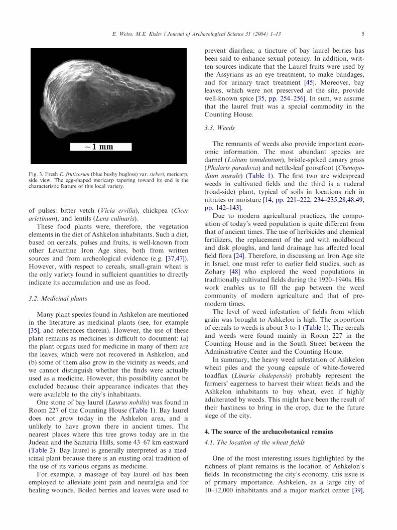
We present here the results of our analysis of 138samples removed during excavation seasons 1992–1993.They represent the distribution of botanical remains inthe streets, buildings, and rooms of Grid 50. Some 19500plant remains were identified, about 6700 cereal grains;9400 fruit seeds; 140 pulses; 1800 weed seeds; and 700wild plants (Table 1). Charring preserved most of theplant remains with the exception of blue bushy bugloss(Echiochilon fruticosum) silicified nutlets (Fig. 3) thatwere, in most cases, uncharred. The samples collectedfrom the stores and from Room 421 in the WarehouseMagazines were fully analyzed. Those from the Admin-istrative Center, rooms 252, 260 and 406, were analyzedas well. The samples from the Counting House and fromthe “South Street” between it and the AdministrativeCenter were especially rich; about one-third of themwere analyzed. A pile of wheat grain and weeds werefound in Room 227 of the Counting House and in the
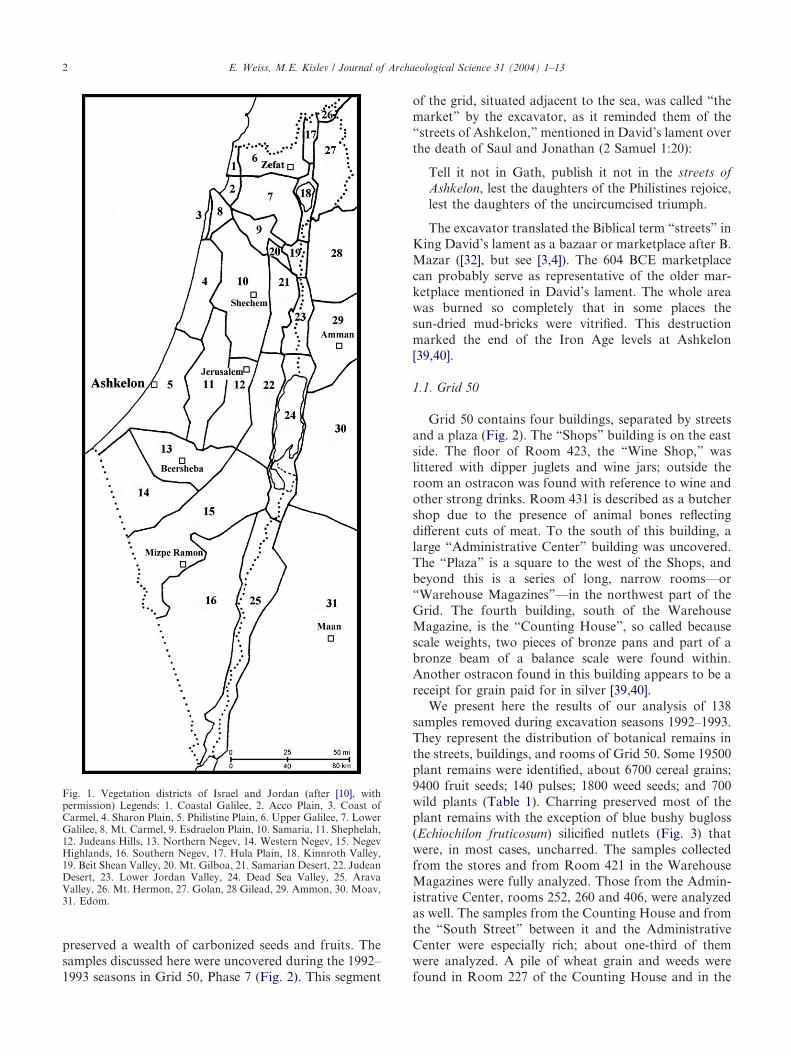
Fig. 1. Vegetation districts of Israel and Jordan (after [10], withpermission) Legends: 1. Coastal Galilee, 2. Acco Plain, 3. Coast ofCarmel, 4. Sharon Plain, 5. Philistine Plain, 6. Upper Galilee, 7. LowerGalilee, 8. Mt. Carmel, 9. Esdraelon Plain, 10. Samaria, 11. Shephelah,12. Judeans Hills, 13. Northern Negev, 14. Western Negev, 15. NegevHighlands, 16. Southern Negev, 17. Hula Plain, 18. Kinnroth Valley,19. Beit Shean Valley, 20. Mt. Gilboa, 21. Samarian Desert, 22. JudeanDesert, 23. Lower Jordan Valley, 24. Dead Sea Valley, 25. AravaValley, 26. Mt. Hermon, 27. Golan, 28 Gilead, 29. Ammon, 30. Moav,31. Edom.
E. Weiss, M.E. Kislev / Journal of Archaeological Science 31 (2004) 1–132
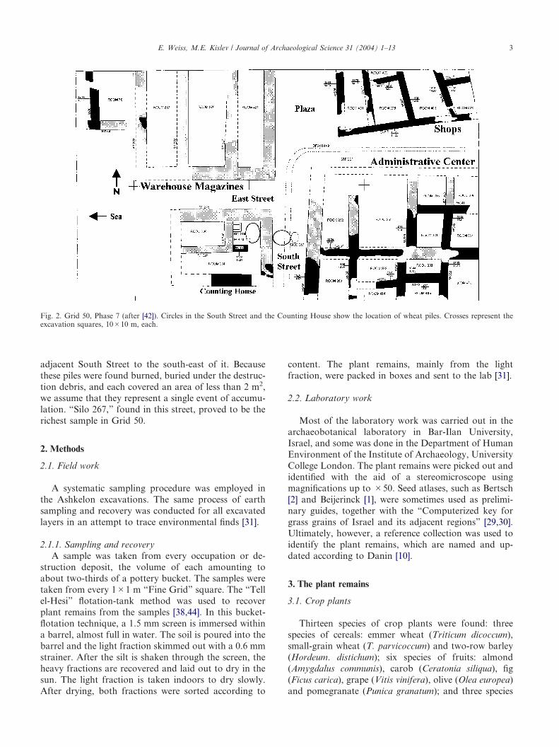
adjacent South Street to the south-east of it. Becausethese piles were found burned, buried under the destruc-tion debris, and each covered an area of less than 2 m2,we assume that they represent a single event of accumu-lation. “Silo 267,” found in this street, proved to be therichest sample in Grid 50.
2. Methods
2.1. Field work
A systematic sampling procedure was employed inthe Ashkelon excavations. The same process of earthsampling and recovery was conducted for all excavatedlayers in an attempt to trace environmental finds [31].
2.1.1. Sampling and recoveryA sample was taken from every occupation or de-
struction deposit, the volume of each amounting toabout two-thirds of a pottery bucket. The samples weretaken from every 1�1 m “Fine Grid” square. The “Tellel-Hesi” flotation-tank method was used to recoverplant remains from the samples [38,44]. In this bucket-flotation technique, a 1.5 mm screen is immersed withina barrel, almost full in water. The soil is poured into thebarrel and the light fraction skimmed out with a 0.6 mmstrainer. After the silt is shaken through the screen, theheavy fractions are recovered and laid out to dry in thesun. The light fraction is taken indoors to dry slowly.After drying, both fractions were sorted according to
content. The plant remains, mainly from the lightfraction, were packed in boxes and sent to the lab [31].
2.2. Laboratory work
Most of the laboratory work was carried out in thearchaeobotanical laboratory in Bar-Ilan University,Israel, and some was done in the Department of HumanEnvironment of the Institute of Archaeology, UniversityCollege London. The plant remains were picked out andidentified with the aid of a stereomicroscope usingmagnifications up to �50. Seed atlases, such as Bertsch[2] and Beijerinck [1], were sometimes used as prelimi-nary guides, together with the “Computerized key forgrass grains of Israel and its adjacent regions” [29,30].Ultimately, however, a reference collection was used toidentify the plant remains, which are named and up-dated according to Danin [10].
3. The plant remains
3.1. Crop plants
Thirteen species of crop plants were found: threespecies of cereals: emmer wheat (Triticum dicoccum),small-grain wheat (T. parvicoccum) and two-row barley(Hordeum. distichum); six species of fruits: almond(Amygdalus communis), carob (Ceratonia siliqua), fig(Ficus carica), grape (Vitis vinifera), olive (Olea europea)and pomegranate (Punica granatum); and three species
Fig. 2. Grid 50, Phase 7 (after [42]). Circles in the South Street and the Counting House show the location of wheat piles. Crosses represent theexcavation squares, 10�10 m, each.
E. Weiss, M.E. Kislev / Journal of Archaeological Science 31 (2004) 1–13 3

Table 1Plant remains from Grid 50 Phase 7
Latin name (organ)/BuildingAdministrative Center Counting House Shops
SouthStreet
EastStreet
Silo267
WarehouseMagazines
Total
Room No. 252 260 406 221 227 234 406 421
CerealsH. distichum (grain) 2 16 – 6 5 – 11 162 – 45 11 258H. distichum (rachis node) – – 2 4 – 2 6 4 4 16 10 48T. dicoccum (grain) – – – 1 7 4 1 5 1 2 2 23T. dicoccum (glume) 4 4 4 8 13 2 6 25 8 4 13 91T. parvicoccum (grain) 28 22 3 11 3339 19 17 2784 10 121 43 6,397T. parvicoccum (rachis node) – – – 14 – – 2 4 1 22 – 43Total cereals 34 42 9 44 3364 27 43 2984 24 210 79 6860
FruitsAmygdalus communis (stone) – – – 2 – – – – – – – 2Ceratonia siliqua (seed) 1 – – 2 – – – 1 – – – 4Ficus carica (fruit) – – – – – 1 1 – – 1 – 3F. carica (nutlet) 106 208 58 92 45 8 57 1397 41 3139 37 5188cf. F. sycomorus (ovary) 1 – – 8 – – 3 9 2 – – 23cf. Laurus nobilis (stone) – – – – 1 – – – – – – 1Olea europaea (stone) 6 5 1 1 15 3 24 57 8 2 20 150Punica granatum (seed) 2 1 – 1 – – 3 16 – 16 3 42cf. Pistacia (nutlet) – 2 – – – – – – – – – 2cf. Quercus (nut) – – – – – – – – – 1 – 1Vitis vinifera (pedicel) 10 5 3 3 12 5 10 43 2 113 5 211V. vinifera (pip) 136 163 62 74 149 21 67 934 40 1880 188 3714V. vinifera (raisin) 2 – 1 1 4 – 5 19 1 32 1 66V. vinifera (undeveloped pip) – – – 6 11 – – 10 – 133 1 161V. vinifera (young fruit) 4 2 1 3 3 – 1 3 1 30 2 50Total fruits 268 387 126 192 248 38 172 2489 95 5347 257 9628
PulsesCier arietinum (seed) – – – – 4 – – 9 – – – 13Lens culinaris (seed) 7 11 2 – 4 – – 11 – 19 1 55Vicia ervilia (seed) 1 1 – 7 4 – – 25 – 21 – 59Total pulses 8 12 2 7 12 – – 45 – 40 1 127
Weeds and wild plantsAnthemis pseudocotula var. pseudocotula(achene)
– – – 1 – – – 1 – – – 2
A. pseudocotula var. radiata (achene) – – – – – – – 1 – – – 1A. pseudocotula var. rotata (achene) – – – 2 1 – – – – – – 3Arnebia decumbens (mericarp) – 1 1 – – – – – – – – 2Buglossoides arvensis (mericarp) – 1 1 – – – – 4 – 2 – 8cf. Cladium mariscus (nutlet) – – – 4 – – – – – – – 4Chenopodium murale (seed) 1 1 1 36 57 – 2 23 6 23 1 151Echiochilon fruticosum (mericarp) 3 – – 9 146 53 7 97 4 1 85 405Erucaria microcarpa (pod) – 1 – – – – – – – – – 1Helianthemum stipulatum (seed) – – – – – – – – – 1 – 1Lathyrus sp. (seed) – – – – – – – 2 – – – 2cf. Juncus acutus (seed) – – – – 1 – – – – – – 1Linaria chalepensis (capsule) – – – – – – – 1 – – – 1Lolium temulentum (grain) 49 25 5 8 286 8 24 665 13 119 23 1225cf. Lysimachia dubia (seed) – – – – – – – – – – 1 1Phalaris paradoxa (grain) 3 2 2 2 13 5 8 60 4 107 8 214Picris galilaea (achene) – – – – – – – – – 1 – 1Schoenus nigricans (nutlet) – – – 2 1 – – – – – – 3Other species 18 28 9 66 192 62 46 223 24 143 110 921Total weeds and wild plants 74 59 19 130 697 128 87 1074 51 403 228 2644
Unidentified 17 23 14 28 99 3 24 143 9 21 23 404
Grand total 398 520 168 383 4271 143 320 6634 175 6010 502 19,543
E. Weiss, M.E. Kislev / Journal of Archaeological Science 31 (2004) 1–134
of pulses: bitter vetch (Vicia ervilia), chickpea (Cicerarietinum), and lentils (Lens culinaris).
These food plants were, therefore, the vegetationelements in the diet of Ashkelon inhabitants. Such a diet,based on cereals, pulses and fruits, is well-known fromother Levantine Iron Age sites, both from writtensources and from archeological evidence (e.g. [37,47]).However, with respect to cereals, small-grain wheat isthe only variety found in sufficient quantities to directlyindicate its accumulation and use as food.
3.2. Medicinal plants
Many plant species found in Ashkelon are mentionedin the literature as medicinal plants (see, for example[35], and references therein). However, the use of theseplant remains as medicines is difficult to document: (a)the plant organs used for medicine in many of them arethe leaves, which were not recovered in Ashkelon, and(b) some of them also grow in the vicinity as weeds, andwe cannot distinguish whether the finds were actuallyused as a medicine. However, this possibility cannot beexcluded because their appearance indicates that theywere available to the city’s inhabitants.
One stone of bay laurel (Laurus nobilis) was found inRoom 227 of the Counting House (Table 1). Bay laureldoes not grow today in the Ashkelon area, and isunlikely to have grown there in ancient times. Thenearest places where this tree grows today are in theJudean and the Samaria Hills, some 43–67 km eastward(Table 2). Bay laurel is generally interpreted as a med-icinal plant because there is an existing oral tradition ofthe use of its various organs as medicine.
For example, a massage of bay laurel oil has beenemployed to alleviate joint pain and neuralgia and forhealing wounds. Boiled berries and leaves were used to
prevent diarrhea; a tincture of bay laurel berries hasbeen said to enhance sexual potency. In addition, writ-ten sources indicate that the Laurel fruits were used bythe Assyrians as an eye treatment, to make bandages,and for urinary tract treatment [45]. Moreover, bayleaves, which were not preserved at the site, providewell-known spice [35, pp. 254–256]. In sum, we assumethat the laurel fruit was a special commodity in theCounting House.
3.3. Weeds
The remnants of weeds also provide important econ-omic information. The most abundant species aredarnel (Lolium temulentum), bristle-spiked canary grass(Phalaris paradoxa) and nettle-leaf goosefoot (Chenopo-dium murale) (Table 1). The first two are widespreadweeds in cultivated fields and the third is a ruderal(road-side) plant, typical of soils in locations rich innitrates or moisture [14, pp. 221–222, 234–235;28,48,49,pp. 142–143].
Due to modern agricultural practices, the compo-sition of today’s weed population is quite different fromthat of ancient times. The use of herbicides and chemicalfertilizers, the replacement of the ard with moldboardand disk ploughs, and land drainage has affected localfield flora [24]. Therefore, in discussing an Iron Age sitein Israel, one must refer to earlier field studies, such asZohary [48] who explored the weed populations intraditionally cultivated fields during the 1920–1940s. Hiswork enables us to fill the gap between the weedcommunity of modern agriculture and that of pre-modern times.
The level of weed infestation of fields from whichgrain was brought to Ashkelon is high. The proportionof cereals to weeds is about 3 to 1 (Table 1). The cerealsand weeds were found mainly in Room 227 in theCounting House and in the South Street between theAdministrative Center and the Counting House.
In summary, the heavy weed infestation of Ashkelonwheat piles and the young capsule of white-floweredtoadflax (Linaria chalepensis) probably represent thefarmers’ eagerness to harvest their wheat fields and theAshkelon inhabitants to buy wheat, even if highlyadulterated by weeds. This might have been the result oftheir hastiness to bring in the crop, due to the futuresiege of the city.
4. The source of the archaeobotanical remains
4.1. The location of the wheat fields
One of the most interesting issues highlighted by therichness of plant remains is the location of Ashkelon’sfields. In reconstructing the city’s economy, this issue isof primary importance. Ashkelon, as a large city of10–12,000 inhabitants and a major market center [39],
Fig. 3. Fresh E. fruticosum (blue bushy bugloss) var. sieberi, mericarp,side view. The egg-shaped mericarp tapering toward its end is thecharacteristic feature of this local variety.
E. Weiss, M.E. Kislev / Journal of Archaeological Science 31 (2004) 1–13 5
probably imported some of its food. In addition, storagewas essential in the year 604 BCE, as the BabylonianChronicle indicates that several months had passed fromthe arrival of the Babylonian army in present-day Syria-Lebanon until they advanced on Ashkelon [46]. News ofthe approaching army no doubt led to the accumulationof food from every source, near and far, cheap orexpensive. The young capsule of white-flowered toadflaxmay testify to early harvesting. If so, it records theurgent need of storing food at that time.
We offer here for the first time a method aimed atreconstructing the location of fields supplying a site withfood. The method uses the present-day distribution ofplants from the site’s plant assemblage as markers forlocating the fields in which they grew.
In an attempt to determine the location of non-localfields, we examined the distribution of the taxa in thePhilistine Plain and in one of its adjacent areas (Table 2).We use some of the Ashkelon plant species as geo-graphic indicators—species that allow us to reconstructtheir habitats even if they were found only in smallnumbers. We assume that if a plant not growing in thePhilistine Plain was found in Ashkelon, it had to havebeen brought from the region where it grows. Since theweeds and most of the wild plants arrived together withthe cereal crop, the region were they grow today indi-cates where the crop grew in the past. If several foreignplants were found in a wheat pile, the origin of the grainwas probably from an area where all these weeds growtogether today. Plants may be used as geographic indi-cators only if a clear connection with their naturalhabitat is precisely known. Therefore, if we find a plantremnant that grows today only in the Shephelah but notin the Philistine Plain, we assume that it was broughtfrom the Shephelah.
The natural habitats of most of the weeds found inGrid 50 are in the Philistine Plain, where Ashkelon islocated. A few taxa, however, do not grow there today(Table 2). For example, the bay laurel was brought to
the site, most likely as a medicine, from the Samarian orthe Judean Hills.
The largest wheat concentrations in Grid 50 werefound in Room 227 of the Counting House and in theSouth Street (Table 1). There are several reasons why wecall these wheat concentrations “wheat piles.” Firstly, ineach case, the wheat was concentrated in two adjacent“Fine Grid” excavation units of 1 square meter (Fig. 2),while very few wheat and weeds grains were found in thesurrounding excavation units. Secondly, in each of thesepiles a large admixture of wheat grains and well-knownweeds was found. Thirdly, these piles were foundburned, buried and sealed under the destruction debris.Therefore, we refer to these concentrations as piles ofwheat that were accumulated in a single event. The sackor other container made of perishable material thatoriginally held the wheat, did not survive the fire. Ourhabitat indicator species were found in these piles.
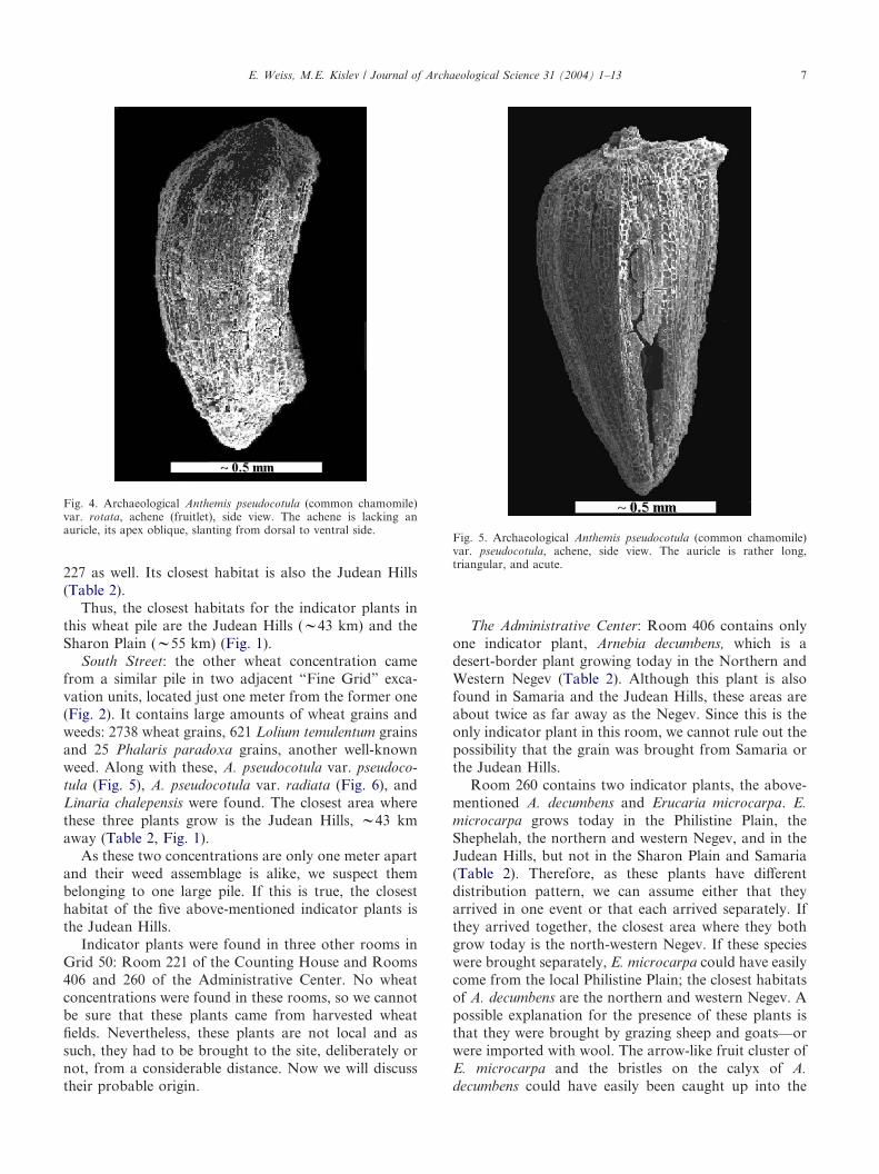
Room 227 at the Counting House: The largest singlewheat concentration in Grid 50 was found in Room 227of the Counting House. Some 3293 out of 3339 grainswere found in the pile in the northeast corner of theroom (Fig. 2). Other plant remains in that pile included263 grains of L. temulentum and 52 seeds of C. murale,both well-known and widespread weeds. The concen-tration of large amounts of wheat grains and well-known weeds in the same pile suggests that this pilerepresents a load of wheat from a single field. In thesame pile, two indicator plants were found, Schoenusnigricans and Anthemis pseudocotula var. rotata (Fig. 4).S. nigricans does not grow in the Philistine Plain, but inthe Shephelah, the Sharon Plain, and the Samaria andJudean Hills. A. pseudocotula var. rotata grows in thePhilistine Plain, but not in the Shephelah (Table 2).According to Table 2, there are two regions where thesetwo species grow together: the Sharon Plain and theJudean Hills, the probable source of this wheat pile.Interestingly enough, a berry of the medicinal fruitLaurus nobilis, mentioned earlier, was found in Room
Table 2Presence (+) and absence (�) of plant taxa in the Philistine Plain and its adjacent regions. The numbers in parentheses are estimated minimumdistances in kilometers from Ashkelon (after [10], and pers. comm.; [15])
Taxa/Region PhilistinePlain
Sharon Plain(55)
Shephelah(30)
Northern Negev(21)
Western Negev(23)
Samaria(67)
Judean Hills(43)
Anthemis pseudocotula var.pseudocotula
+ + � + + + +
A. pseudocotula var. radiata � � + + + � +A. pseudocotula var. rotata + + � + + � +Arnebia decumbens � � � + + + +Echiochilon fruticosum + + � + + � �Erucaria microcarpa + � + + + � +Helianthemum stipulatum + + � + + � �Laurus nobilis � � � � � + +Linaria chalepensis + � + � � + +Schoenus nigricans � + + � � + +
E. Weiss, M.E. Kislev / Journal of Archaeological Science 31 (2004) 1–136
227 as well. Its closest habitat is also the Judean Hills(Table 2).
Thus, the closest habitats for the indicator plants inthis wheat pile are the Judean Hills (w43 km) and theSharon Plain (w55 km) (Fig. 1).
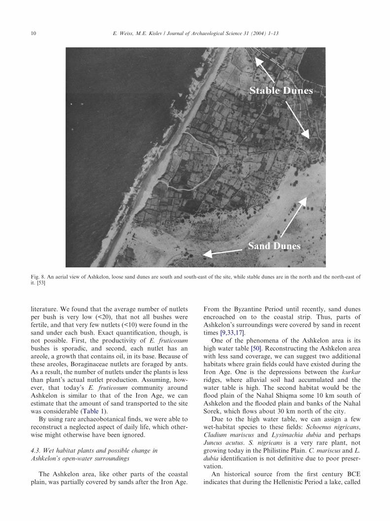
South Street: the other wheat concentration camefrom a similar pile in two adjacent “Fine Grid” exca-vation units, located just one meter from the former one(Fig. 2). It contains large amounts of wheat grains andweeds: 2738 wheat grains, 621 Lolium temulentum grainsand 25 Phalaris paradoxa grains, another well-knownweed. Along with these, A. pseudocotula var. pseudoco-tula (Fig. 5), A. pseudocotula var. radiata (Fig. 6), andLinaria chalepensis were found. The closest area wherethese three plants grow is the Judean Hills, w43 kmaway (Table 2, Fig. 1).
As these two concentrations are only one meter apartand their weed assemblage is alike, we suspect thembelonging to one large pile. If this is true, the closesthabitat of the five above-mentioned indicator plants isthe Judean Hills.
Indicator plants were found in three other rooms inGrid 50: Room 221 of the Counting House and Rooms406 and 260 of the Administrative Center. No wheatconcentrations were found in these rooms, so we cannotbe sure that these plants came from harvested wheatfields. Nevertheless, these plants are not local and assuch, they had to be brought to the site, deliberately ornot, from a considerable distance. Now we will discusstheir probable origin.
The Administrative Center: Room 406 contains onlyone indicator plant, Arnebia decumbens, which is adesert-border plant growing today in the Northern andWestern Negev (Table 2). Although this plant is alsofound in Samaria and the Judean Hills, these areas areabout twice as far away as the Negev. Since this is theonly indicator plant in this room, we cannot rule out thepossibility that the grain was brought from Samaria orthe Judean Hills.
Room 260 contains two indicator plants, the above-mentioned A. decumbens and Erucaria microcarpa. E.microcarpa grows today in the Philistine Plain, theShephelah, the northern and western Negev, and in theJudean Hills, but not in the Sharon Plain and Samaria(Table 2). Therefore, as these plants have differentdistribution pattern, we can assume either that theyarrived in one event or that each arrived separately. Ifthey arrived together, the closest area where they bothgrow today is the north-western Negev. If these specieswere brought separately, E. microcarpa could have easilycome from the local Philistine Plain; the closest habitatsof A. decumbens are the northern and western Negev. Apossible explanation for the presence of these plants isthat they were brought by grazing sheep and goats—orwere imported with wool. The arrow-like fruit cluster ofE. microcarpa and the bristles on the calyx of A.decumbens could have easily been caught up into the
Fig. 4. Archaeological Anthemis pseudocotula (common chamomile)var. rotata, achene (fruitlet), side view. The achene is lacking anauricle, its apex oblique, slanting from dorsal to ventral side.
Fig. 5. Archaeological Anthemis pseudocotula (common chamomile)var. pseudocotula, achene, side view. The auricle is rather long,triangular, and acute.
E. Weiss, M.E. Kislev / Journal of Archaeological Science 31 (2004) 1–13 7

sheep or goat wool and been bought back into thecity. It is interesting to note that these plant specieswere found only in this building. Because both growtoday in the Judean Hills, from where wheat wasimported, we cannot rule-out that this was their originalprovenience.
Room 221 at the Counting House: Three indicatorplants were found at this room: Anthemis pseudocotula,var. pseudocotula, A. pseudocotula var. rotate and S.nigricans. If all three plants arrived together, the JudeanHills and the Sharon Plain are the closest habitats whereall of them currently grow. If they arrived separately, thetwo Anthemis varieties would be from the PhilistinePlain, while the S. nigricans was brought with grainsfrom the Shephelah or the Sharon Plain. Hence, theclosest common areas for the indicator plants in thisroom are the Judean Hills (w43 km) or the Sharon Plain(w55 km). However, if each of them arrived separately,two are local and the other from the Shephelah (w30km) or the Sharon Plain (w55 km) (Fig. 1).
Silo 267: Compared to the other excavation units,fruits account for the majority of the rich plant assem-blage in the silo (Table 1). All the plants from the silo arelocal (Table 2). Among these, grapes constitute the mainfind (w3800 pips and raisins). The 5188 fig nutletsrepresent a much smaller number of fruits, as thenumber of nutlets per fruit is very high. Grapes, asattested by the local wine industry [39,40] and recenthistory [50], grow around the city. The grape silo,
therefore, as an example of a local-plant context, showsan absence of imported weeds. In this way, it supportsour claim of a foreign source for the contexts withimported weeds, such as the Ashkelon wheat.
The weeds found in the other Grid 50 rooms all growin the Philistine Plain or the vicinity of Ashkelon.
4.2. Construction material
Archaeobotanical finds can contribute to our under-standing of the source of sand used as constructionmaterials at the site. We suggest that the nutlets ofEchiochilon fruticosum var. sieberi (Fig. 3) arrived at thesite mixed with the sand used in the building of houses.These nutlets were found in sizeable quantities on thefloors of most of the rooms of Grid 50 (Table 1).
E. fruticosum var. sieberi is a small bush from theBoraginaceae family, which is a common obligate sandplant, endemic to Sinai, Israel, southern Jordan, andLebanon. The characteristic feature of the local varietyis the egg-shaped nutlet, tapering toward its end. Thelength of the nutlet is 2.1–2.6 mm and its width is 1–1.3mm [26] (Fig. 3). The nutlets in Ashkelon resemble thisvariety, which is significantly different from the typicalE. fruticosum, which grows from eastern Moroccothrough Egypt. The most important difference betweenE. fruticosum varieties is in the shape of their nutlets.While var. sieberi nutlets are egg shaped, those of typicalE. fruticosum are medially bent, almost 90(, with theupper half being vertical and the lower half horizontaland directed away from the axis of the fruit ([26]).
In the 20th century, no nutlets were available forinclusion in Flora Palaestina [13, pp. 60–61]. But, a fewfruit-bearing branches of the local variety sieberi werefound by us in Ashkelon and in several locations in theSharon Plain.
It should be stressed that E. fruticosum is a commonplant in the sand-dune areas around Ashkelon, but notin the Kurkar (calcareous sandstone) ridges (Fig. 7).These ridges belonging to four length-wise strips alongthe Israeli coastal plain, which are (from west to east):sands, sands and fossil soils, ridges of Kurkar, andalluvial soils [9,36]. Geological surveys indicated thatsand dunes were present in Ashkelon area during theIron Age [33, pp. 66–81, 113–117].
The appearance of a conspicuous number of Bor-aginaceae nutlets in archaeological excavations hasbeen mentioned by Helbaek [18]. He explained thatthe nutlet’s heavy seed case of calcium carbonate andsilica turns whitish after the seed is burnt. Hillman[23,25] suggested that the silica-impregnated nutlets ofthis family survive even in moist, aerobic depositswithout charring. Therefore, there is a tendency to-ward over-representation of the Boraginaceae familynutlets with respect to associated charred remains.Indeed, most of the E. fruticosum nutlets found in
Fig. 6. Archaeological A. pseudocotula (common chamomile) var.radiata, achene, side view. The auricle is very short, margin-like,obtusely lobed.
E. Weiss, M.E. Kislev / Journal of Archaeological Science 31 (2004) 1–138

Ashkelon show no signs of charring. Those samplesexhibiting charring, were probably located on thefloor’s surface.
Although E. fruticosum nutlets are collected by antsinto their burrows, we find it unlikely that these nutletsare a recent intrusion due to ants. Firstly, the presence ofnutlets that carry signs of charring indicates that the restof the nutlets are part of the 604 BCE assemblage.Secondly, most of Grid 50 finds came from sealedarchaeological contexts, under destruction debris ofroofs and walls.
Sand is commonly spread as leveling fill for earth floorsand was used as a building material in Grid 50 (Stagerpers. comm.). As E. fruticosum is an obligate sand plant,this sand is probably the source of E. fruticosum nutlets inthe plant assemblage. Assuming present-day distributionof E. fruticosum bushes is similar to that of the Iron Age,the appearance of the nutlets indicates the original lo-cation of the sand. It seems that the sand for constructionwas transported from the dunes south and south-east ofthe site, but not from the stable dunes in the north or thenorth-east, or from the shoreline (Fig. 8). The south andsouth-east dunes are adjacent to the city walls today, amatter of few dozen meters.
The topography of the Ashkelon mound reinforcesthe suggested sources of the sand. Its western side is verysteep today, as it probably was during the Iron Age. Thesteepness of the western side of the tell, facing the shore,can explain why—when carrying heavy loads ofsand—the Ashkelonians preferred the comfortable routeto the south or to the east to that of the west.
Another support for the origin of the E. fruticosumnutlets and for its use as a marker comes from theirdistribution in the excavation locales. Large numbers ofnutlets were found in the rooms and in the streets, whileonly one came from Silo 267, which was the richestsample of other seeds analyzed by us (Table 1). This canbe understood from the fact that all other contexts werefloors or destruction debris, while the silo was a storagefacility. The floors were constructed, at least partly, withsand, whereas the silo was carefully kept clean fromcontamination.
Concluding that E. fruticosum nutlets are a markerfor the use of sand, we tried to estimate the generalamount of sand used by the Ashkelonians. We examinedboth herbarium material and plants in the field in anattempt to determine the number of nutlets on an E.fruticosum bush, since this issue is not dealt with in the
Fig. 7. Soil types around Ashkelon ([27]). The settlements indicated are much larger today. Legend: 1=Sand dunes, 2=Kurkar ridges, 3=Hills of redsand, 4=Badlands, 5=Chalk hills of Lower Shefelah 6=Chalk and limestone hills of Upper Shefelah 7=Town, 8=Alluvial plain, 9=Boundary of theregion.
E. Weiss, M.E. Kislev / Journal of Archaeological Science 31 (2004) 1–13 9
literature. We found that the average number of nutletsper bush is very low (<20), that not all bushes werefertile, and that very few nutlets (<10) were found in thesand under each bush. Exact quantification, though, isnot possible. First, the productivity of E. fruticosumbushes is sporadic, and second, each nutlet has anareole, a growth that contains oil, in its base. Because ofthese areoles, Boraginaceae nutlets are foraged by ants.As a result, the number of nutlets under the plants is lessthan plant’s actual nutlet production. Assuming, how-ever, that today’s E. fruticosum community aroundAshkelon is similar to that of the Iron Age, we canestimate that the amount of sand transported to the sitewas considerable (Table 1).
By using rare archaeobotanical finds, we were able toreconstruct a neglected aspect of daily life, which other-wise might otherwise have been ignored.
4.3. Wet habitat plants and possible change inAshkelon’s open-water surroundings
The Ashkelon area, like other parts of the coastalplain, was partially covered by sands after the Iron Age.
From the Byzantine Period until recently, sand dunesencroached on to the coastal strip. Thus, parts ofAshkelon’s surroundings were covered by sand in recenttimes [9,33,17].
One of the phenomena of the Ashkelon area is itshigh water table [50]. Reconstructing the Ashkelon areawith less sand coverage, we can suggest two additionalhabitats where grain fields could have existed during theIron Age. One is the depressions between the kurkarridges, where alluvial soil had accumulated and thewater table is high. The second habitat would be theflood plain of the Nahal Shiqma some 10 km south ofAshkelon and the flooded plain and banks of the NahalSorek, which flows about 30 km north of the city.
Due to the high water table, we can assign a fewwet-habitat species to these fields: Schoenus nigricans,Cladium mariscus and Lysimachia dubia and perhapsJuncus acutus. S. nigricans is a very rare plant, notgrowing today in the Philistine Plain. C. mariscus and L.dubia identification is not definitive due to poor preser-vation.
An historical source from the first century BCEindicates that during the Hellenistic Period a lake, called
Fig. 8. An aerial view of Ashkelon, loose sand dunes are south and south-east of the site, while stable dunes are in the north and the north-east ofit. [53]
E. Weiss, M.E. Kislev / Journal of Archaeological Science 31 (2004) 1–1310
“Derceto Lake”, existed near Ashkelon. It was large anddeep, with a temple dedicated to the goddess Dercetostood on its shore (Diodorus Siculus 2, 4 [11]). Thelake’s location is unknown today. Guerin [16] mentionsa large, deep-water pool in the estuary of the ArivieRiver south of Ashkelon, its location is also unknown. Afew small ponds appear around Ashkelon on Britishmaps of the end of the nineteenth and beginning of thetwentieth century [7,34]. Conder and Kitchener [8, pp.410–411] mentioned also that one of the water sourcesfor the Arab village Migdal, where modern Ashkelonwas built, was a lake situated east of the village. Ad-ditionally, an intermittent water course, named WadiIbrahim ran south of Ashkelon; it is plugged today.
Although we did not find enough plant remains in theAshkelon plant assemblage as evidence for the presenceof these wet fields, it seems that in the past the Ashkelonarea had more abundant water pools than are presenttoday. Hence, the main fields of Ashkelon could havebeen around these pools and in the depressions betweenthe kurkar ridges.
5. Overview: the limits of Ashkelon’s agriculturalhinterland
The distance between settlements and the fields sup-plying them with plant food is commonly less than 7 km[5]. We suggest that more of Ashkelon’s fields wereindeed nearby the city, i.e. in the depressions betweenthree or four of the kurkar ridges. Due to the sand dunescover it is impossible to locate these fields today. How-ever, along the depressions covered today by deep sands,scattered old vines, apparently rooted in the fertile soil,still produce fleshy grapes. Therefore, some ofAshkelon’s food supply came from fields adjacent to thecity, as attested by part of the plant assemblage.
Although more arable areas were available during theIron Age around Ashkelon, we find it hard to believethat the area within a semi-circle of 7 km of fieldsaround the city could support a city with a population of10–12,000 [39].
The daily need of staple food was in excess of whatcould have been provided by arable land in this area.Our knowledge of the productivity and efficiency ofancient agro-ecosystems is scarce and fragmentary.However, Stanhill [43] provides a quantitative analysisof a typical farm in the Jezreel Valley in Israel during thefirst decades of the 20th century. Stanhill based hisanalysis on the contemporary description and infor-mation from a series of measurements by Elazari-Volcani [12]. The main source of Elazari-Volcani data isten-year records (1914–1923) collected from a total areaof 1000 ha, cultivated by 50–60 farmers in the traditionalmanner. On average each farmer cultivated 9–12 ha,depending on location. Only two-thirds of the farm areawas cultivated, the remaining land including natural
pasture, uncultivated land and built-on areas. Half ofthe cultivated area was devoted to cereals, 90% of it forrainy season wheat. The total crop yield from 9 ha ofcultivated area was calculated to be 3860 kg, 53% ofwhich represents the wheat crop. Stanhill [43] calculatedthat the land requirement was 1.7 ha per person. Thisput Jezreel Valley farmers at the lower level of subsist-ence farming [6].
According to Chisholm’s [5] formula, the seven kilo-meter radius between a settlement and its fields accountsfor some 1100 hectares in the case of Ashkelon. Accord-ing to Stanhill’s figures, this area should have supportedonly about 650 people!
This rough estimate means that the Ashkeloneconomy could not have relied on the fields around thecity, and regular, longer distance trade of crop plants,such as cereals, must have occurred, as our weed distri-bution suggests.
Wheat was imported to Ashkelon from the JudeanHills, as strongly indicated by the plant assemblage fromthe wheat pile in the South Street. This area was foundas the possible origin for the plants in other assemblagesas well. To the same eastern route of trade we can addthe Shephelah, which is midway between Ashkelon andthe Judean Hills (Fig. 1). Other possible trade routes forIron Age Ashkelon, as indicated by the plant remains,are the northern route from the Sharon Plain and thesouthern route from the Negev. The eastern and south-ern routes involved inland transportation which nodoubt was more expensive than bringing the grain fromthe Sharon by sea.
Stager [39] claims, according to the abundance ofPhoenician wares, that Ashkelon was supplied by anorthern trade route. The plant remains provide anindependent support of this suggestion, indicating thatthe Sharon Plain was a possible source for the wheat pilein Room 227 of the Counting House, and together withthe Shephelah for that in Room 221 in the samebuilding. The origin of imported commodities for animportant port and trade city such as Ashkelon was notrestricted to the area around the Nahal Sorek or theSharon Plain. If wheat had been transported to the citymarket from the north by ships, it could have come frommany other seaports along the eastern Mediterraneancoast, such as Jaffa, Dor, Acco, Tyre and Sidon. All ofthe above-mentioned varieties of Anthemis pseudocotula,together with Helianthemum stipulatum, and S. nigri-cans, grow along the Mediterranean coastal plain fromIsrael to Lebanon. [19–22,51,52]. Historical support isprovided by Jeremiah (47:4) who describes a specialrelationship between Philistines and the Phoenicians(Tyre and Sidon). We can therefore assume that theplant food in Ashkelon was shipped to the city fromvarious areas along the Israeli and Lebanese coasts.
In summary, by using the assemblage of plant re-mains in Ashkelon, and especially the wheat piles, as one
E. Weiss, M.E. Kislev / Journal of Archaeological Science 31 (2004) 1–13 11

unit, we were able for the first time to reconstruct rarelydealt aspects of the city economy. The agriculturalhinterland of Ashkelon was partially local and partiallydistant. At least some of its wheat came from the east, asfar as the Judean Hills, as well as from the north and thesouth. The results of our study of plant remains agreewell with our knowledge of 7th century BCE Ashkelonas a major commercial center [39,40]. The Ashkelonplant assemblage shows interesting indications foranxiety: piles of weed-infested wheat, signs of earlyharvesting and long distance trade for wheat. Thisarchaeobotanical indication of anxiety agrees nicely withthe historical documents and archaeological evidence forthe city’s preparation for siege and destruction by afearsome army.
Acknowledgements
We would like to thank Prof. L.E. Stager and theAshkelon excavations—the Leon Levy expedition—forallowing us to analyze the plant remains of Ashkelonexcavations; Prof. A. Danin for sharing the year 2000database; and Dr Avi Sasson for information regardingWadi Ibrahim and the sources for the winter poolsaround Ashkelon. We also cordially thank Larry Stager,Ofer Bar-Yosef, Julie Hansen, Ann Butler, PaulGoldberg, Avraham Faust and three anonymousreferees for their helpful comments on earlier drafts ofthis manuscript.
References
[1] W. Beijerinck, Zadenatlas der Nederlandsche flora, ten behoevevan de botanie, palaeontologie, bodemcultuur en warenkennis, H.Veenman & Zonen, Wageningen, 1947.
[2] K. Bertsch, Frucht und Samen, Enke, Stuttgart, 1941.[3] A. Biran, Sacred spaces: of standing stones, high places and cult
objects at Tel Dan. Biblical Archaeology Review 24(5) (1998)38–45, 70.
[4] A. Biran, h*us*ot of Dan, in: B. Levine et al. (Eds), Eretz-Israel 26(Frank Moore Cross volume), 1999, pp. 25–29.
[5] M. Chisholm, Rural Settlement and Land Use, an Essay inLocation, Hutchinson, London, 1968.
[6] C. Clark, M. Haswell, The Economics of Subsistence Agriculture,Macmillan, London, 1968.
[7] C.R. Conder, H.H. Kitchener, Palestine Exploration Fund Map,Committee of the Palestine Exploration Fund, London, 1878.
[8] C.R. Conder, H.H. Kitchener, The Survey of Western Palestine 2,Committee of the Palestine Exploration Fund, London, 1882.
[9] Y. Dan, D. Yaalon, The creation and distribution way of the landand the landscape in Philistia, Studies in the Geography of Israel9 (1976) 36–74, (Heb.).
[10] A. Danin, Wild Plants of Eretz-Israel and their Distribution,Carta, Jerusalem, 1998.
[11] Diodorus Siculus, Bibliotheca historica, translated by C.H.Oldfather. Loeb Classical Library, Cambridge, 1933.
[12] I. Elazari-Volcani, The fellah’s farm. Agriculture ExperimentalStation, Jewish Agency for Palestine, Tel-Aviv, Bulletin 10, 1930.
[13] N. Feinbrun-Dothan, Flora Palaestina, Part 3. The IsraelAcademy of Sciences and Humanities, Jerusalem, 1978.
[14] N. Feinbrun-Dothan, Flora Palaestina, Part 4. The IsraelAcademy of Sciences and Humanities, Jerusalem, 1986.
[15] N. Feinbrun-Dothan, A. Danin, Analytical Flora of Eretz-Israel,Cana, Jerusalem, 1991, (Heb.).
[16] M.V. Guerin, Description geographique, historique et ar-chologique de la Palestine. Paris, 1868–1880. by H. Ben-Amram,Yad Izhak Ben Zvi, Jerusalem, 1982.).
[17] G. Gvirtzman, M. Netser, E. Katsav, Last-glacial to Holocenekurkar ridges, hamra soils and dune fields in the coastal belt ofcentral Israel, Israel Journal of Earth Sciences 47 (1998) 29–46.
[18] H. Helbaek, The plant husbandry in Hacilar—a study of cultiva-tion and domestication, in: J. Mellaart (Ed.), Excavation atHacilar, I. Edinburgh, 1970, pp. 189–244.
[19] D. Heller, C.C. Heyn, Conspectus florae orientalis, Fascicle 3.Israel Academy of Sciences and Humanities, Jerusalem, 1986.
[20] D. Heller, C.C. Heyn, Conspectus florae orientalis, Fascicle 4.Israel Academy of Sciences and Humanities, Jerusalem, 1987.
[21] D. Heller, C.C. Heyn, Conspectus florae orientalis, Fascicle 6.Israel Academy of Sciences and Humanities, Jerusalem, 1981.
[22] D. Heller, C.C. Heyn, Conspectus florae orientalis, Fascicle 8.Israel Academy of Sciences and Humanities, Jerusalem, 1993.
[23] G.C. Hillman, Plant remains, in: D.H. French et al., Excavationsat Can Hasan II: 1969–1970, in: E.S. Higgs (Ed.), Papers inEconomic Prehistory. Cambridge University Press, Cambridge,1972, pp. 182–188.
[24] G.C. Hillman, Phytosociology and ancient weed floras: takingaccount of taphonomy and changes in cultivation methods, in:D.R. Harris, K.D. Thomas (Eds.), Modeling Ecological Change,The Institute of Archaeology, UCL, London, 1991, pp. 27–40.
[25] G.C. Hillman, S.M. Colledge, D.R. Harris, Plant food economyduring the Epipalaeolithic period at Tell Abu Hureyra, Syria:dietary diversity, seasonality and models of exploitation, in: D.R.Harris, G.C. Hillman (Eds.), Foraging and Farming: The Evolu-tion of Plant Exploitation, Unwin Hyman, London, 1989,pp. 240–268.
[26] I.M. Johnson, Studies in the Boraginaceae, Journal of the ArnoldArboretum 38 (1957) 255–293.
[27] Y. Karmon, Israel, a Regional Geography, Wiley-Interscience,London, 1971.
[28] M.E. Kislev, Contenu d’un silo a ble de l’epoque de fer ancien, in:J. Briend, J.-B. Humbert (Eds.), Tell Keisan (1971–1976): une citephenicienne en Galilee, Euditions universitaires, Fribourg, Suisse,1980, pp. 361–379, Pl. 139–140.
[29] M.E. Kislev, Y. Melamed, O. Simchony, M. Marmorstein, Com-puterized key of grass grains of the Mediterranean basin,Lagascalia 19 (1–2) (1997) 289–294.
[30] M.E. Kislev, O. Simchony, Y. Melamed, M. Marmorstein, Com-puterized key for grass grains of Israel and its adjacent regions, in:H. Kroll, R. Pasternak (Eds.), Res archaeobotanicae—9thSymposium IWGP, Oetker-Voges, Kiel, 1995.
[31] H.E. Lass, Quantitative studies in flotation as Ashkelon, 1986 to1988, Bulletin of the American School of Oriental Research 294(1994) 23–38.
[32] B. Mazar, The Philistines and the rise of Israel and Tyre, in: S.Achituv, B. Levine (Eds.), The Early Biblical Period, IsraelExploration Society, Jerusalem, 1986, pp. 63–82.
[33] M. Netser, The climatic changes during the Holocene stage andtheir effect on the formation of the landscape in Gush-Dan(Israel) and on the human settlement in this region. Ph.D. Thesis,Bar-Ilan University, 1994 (Hebrew with English summary).
[34] Palestine Map, War Office, Survey of Egypt (1:40,000 Map,Palestine) sh. XVI (Esdud) sh. XX (Beit Jibrin), 1917.
[35] D. Palevitch, Z. Yaniv, Medicinal Plants of the Holy Land,Modan, Tel-Aviv, 2000.
E. Weiss, M.E. Kislev / Journal of Archaeological Science 31 (2004) 1–1312
[36] R. Regev, The Southern Coastal Plain—geographical aspects, in:N. Arbel (Ed.), Ashkelon—4,000 Plus 40 Years, Ashkelon, 1990(Heb.).
[37] J.M. Renfew, Palaeoethnobotany, the Prehistoric Food Plants ofthe Near East and Europe, Columbia University Press, NewYork, 1973.
[38] J.B. Richardson, III, D. MaCreey, Preliminary analysis of theplant remains from Bab edh-Dhra, in: N.G. Freedman (Ed.),Preliminary excavation reports: Bab edh-Dhra, Saradis, Meiron,Tell el-Hessi, Cartyhage (Punic). Annual of the American Schoolsof Oriental Research 43 (1978) 55–56.
[39] L.E. Stager, Ashkelon and the archaeology of destruction: Kislev604 BCE, Eretsz- Isreael 25 (1996b) 61*–74*.
[40] L.E. Stager, The fury of Babylon: Ashkelon and the archaeologyof destruction. Biblical Archaeology Review 22(1) (1996a) 56–69,76–77.
[41] L.E. Stager, Ashkelon, in: E. Stern (Ed.), The New Encyclopediaof Archaeological Excavations in the Holy Land. Israel Explor-ation Society & Carta, Jerusalem; Simon & Schuster, NewYork.
[42] L.E. Stager, J.D. Schloen (Eds), Ashkelon I: Introduction andOverview (1985–2000). Eisenbrauns, Winona Lake, Indiana(forthcoming).
[43] G. Stanhill, The fellah’s farm: an autarkic agro-ecosystem,Agro-Ecosystem 4 (1978) 433–448.
[44] R.B. Stewart, W. Robertson, Application of the flotation tech-nique in arid areas, Economic Botany 27 (1973) 114–116.
[45] R.C. Thompson, A Dictionary of Assyrian Botany, BritishAcademy, London, 1949, pp. 298–300.
[46] D.J. Wiseman, Chronicles of Chaldaean kings (626–556 B.C.)in British Museum, Trustees of the British Museum, London,1956.
[47] D. Zohary, M. Hopf, Domestication of Plants in the Old World,3rd edn, Oxford Science Publications, Oxford, 2000.
[48] M. Zohary, The segetal plant communities of Palestine, Vegetatio2 (1950) 387–411.
[49] M. Zohary, Flora Palaestina, Part 1, Israel Academy of Sciencesand Humanities, Jerusalem, 1966.
[50] M. Zohary, Vegetal landscape of Israel, Am Oved, Tel-Aviv,1982, (Heb.).
[51] M. Zohary, C.C. Heyn, D. Heller, Conspectus florae orien-talis, Fascicle 1. Israel Academy of Sciences and Humanities,Jerusalem, 1980.
[52] M. Zohary, C.C. Heyn, D. Heller, Conspectus florae orien-talis, Fascicle 2. Israel Academy of Sciences and Humanities,Jerusalem, 1984.
[53] M. Avi-Yonah, Y. Eph’al. Ashkelon, in: M. Avi-Yonah (Ed.),Encyclopedia of archaeological excavations in the Holy Land.The Israeli Exploration Society and Massada Press, Jerusalem,(1975) p. 125.
E. Weiss, M.E. Kislev / Journal of Archaeological Science 31 (2004) 1–13 13
Copyright © 2022 FDOKUMEN