Volume II_Altantic Sunrise Project_Draft Environmental Impact ...
390
FERC/EIS-0269D Docket No. CP15-138-000 DRAFT ENVIRONMENTAL IMPACT STATEMENT Volume II – Appendices Atlantic Sunrise Project TRANSCONTINENTAL GAS PIPE LINE COMPANY, LLC Federal Energy Regulatory Commission Division of Gas – Environment and Engineering 888 First Street, NE, Washington, DC 20426 Cooperating Agency: Office of Energy Projects May 2016 U.S. Army Corps of Engineers
-
Upload
khangminh22 -
Category
Documents
-
view
0 -
download
0
Transcript of Volume II_Altantic Sunrise Project_Draft Environmental Impact ...
FERC/EIS-0269D
Docket No. CP15-138-000
DRAFT ENVIRONMENTAL IMPACT STATEMENT
Volume II – Appendices
Atlantic Sunrise Project
TRANSCONTINENTAL GAS PIPE LINE COMPANY, LLC
Federal Energy Regulatory Commission
Division of Gas – Environment and Engineering
888 First Street, NE, Washington, DC 20426
Cooperating Agency:
Office of
Energy
Projects
May 2016
U.S. Army Corps of
Engineers

TABLE OF CONTENTS
i
Transcontinental Gas Pipe Line Company, LLC
Atlantic Sunrise Project
Draft Environmental Impact Statement
VOLUME II – LIST OF APPENDICES
Appendix A Distribution List
Appendix B Project Overview Maps, Cathodic Protection Workspace Drawings, Best
Management Practice Figures, and Typical Right-of-Way Drawings
Appendix C Additional Temporary Workspace Associated with Construction of the
Atlantic Sunrise Project
Appendix D Private Access Roads Associated with the Atlantic Sunrise Project
Appendix E Transcontinental Gas Pipeline Company, LLC's Upland Erosion Control,
Revegetation, and Maintenance Plan and Wetland and Waterbody Construction and
Mitigation Procedures
Appendix F Roadways and Railroads Crossed by the Atlantic Sunrise Project
Appendix G Residential Construction Plans
Appendix H Areas of Shallow Depth to Bedrock for the Atlantic Sunrise Project Facilities
Appendix I Mineral Resources Within 0.25 Mile of the Atlantic Sunrise Project Facilities
Appendix J Atlantic Sunrise Project Seismic Analysis Report and Revised Karst Investigation
and Mitigation Plan
Appendix K Waterbody Tables
Table K-1 Waterbodies Crossed by the Atlantic Sunrise Project
Table K-2 Waterbodies with Steep and/or Eroding Banks for the Atlantic Sunrise
Project
Table K-3 Waterbody Crossings Located Within Federal Emergency
Management Agency-Designated Special Hazard Flood Areas for the
Atlantic Sunrise Project
Table K-4 Waterbodies with Shallow Depth to Bedrock Crossed by the Atlantic
Sunrise Project
Table K-5 Additional Temporary Workspace Justification for Waterbodies for the
Atlantic Sunrise Project
TABLE OF CONTENTS (cont’d)
ii
Appendix L Wetland Tables
Table L-1 Wetlands Crossed by the Atlantic Sunrise Project
Table L-2 Additional Temporary Workspaces Requested Within 50 Feet of
Wetlands for the Atlantic Sunrise Project
Appendix M Draft Migratory Bird Plan
Appendix N Vegetation Cover Affected by Construction and Operation of Pipeline Facilities
Associated with the Atlantic Sunrise Project
Appendix O Land Use Tables
Table O-1 Land Use Acreage Affected by Construction and Operation of the
Atlantic Sunrise Project
Table O-2 Pennsylvania Clean and Green Program Land Crossed by the Atlantic
Sunrise Project Facilities
Appendix P Past, Present, and Reasonably Foreseeable Future Projects Evaluated for Potential
Cumulative Effects with the Atlantic Sunrise Project
Appendix Q References
Appendix R List of Preparers

APPENDIX A
DISTRIBUTION LIST

APPENDIX A
DISTRIBUTION LIST
A-1
Federal Government Agencies
Council on Environmental Quality, Edward
Boling, DC
Council on Environmental Quality, Manisha
Patel, DC
Office of Federal Programs, Advisory Council
on Historic Preservation, Charlene D.
Vaughn, DC
Senate Energy and Natural Resources
Committee, Lisa Murkowski, DC
U.S. Army Corps of Engineers – Baltimore
District, Mike Dombroskie, PA
U.S. Army Corps of Engineers – Huntington
District, WV
U.S. Army Corps of Engineers – Norfolk
District, Tom Walker, VA
U.S. Army Corps of Engineers – Pittsburgh
District, PA
U.S. Army Corps of Engineers – State College
Field Office, Mike Dombroskie, PA
U.S. Army Corps of Engineers – Wilmington
District, NC
U.S. Army Corps of Engineers- Norfolk
District, VA
U.S. Army Corps of Engineers, Planning and
Policy Division, John Furry, DC
U.S. Department of Agriculture, Farm Service
Agency, Conservation and Environmental
Program Division, Nell Fuller, DC
U.S. Department of Agriculture, Natural
Resources Conservation Service, Andree
Duvarney, DC
U.S. Department of Agriculture, U.S. Forest
Service – Ecosystem Management
Coordination, Joe Carbone, DC
U.S. Department of Commerce, National
Oceanic and Atmospheric Administration,
Office of Ocean and Costal Resource
Management, Kerry Kehoe, MD
U.S. Department of Commerce, National
Oceanic and Atmospheric Administration,
Steve Kokkinakis, MD
U.S. Department of Commerce, National
Oceanic and Atmospheric Administration,
National Marine Fisheries Service, Steve
Leathery, MD
U.S. Department of Energy, John Anderson, DC
U.S. Department of Energy, Office of
Environmental Management, Mark
Whitney, DC
U.S. Department of Energy, Office of National
Environmental Policy Act Policy and
Compliance, Carol M. Borgstrom, DC
U.S. Department of Health and Human Services,
Centers for Disease Control and Prevention,
National Center for Environmental Health,
Sharunda Buchanan, GA
U.S. Department of Health and Human Services,
Edward Pfister, DC
U.S. Department of Homeland Security, U.S.
Customs and Border Protection Christopher
Oh, DC
U.S. Department of Housing and Urban
Development, Office of Environment and
Energy, Danielle Schopp, DC
U.S. Department of Justice, Environment, and
Natural Resources Division, Beverly
Li, DC
U.S. Department of State, Bureau of Oceans and
International Environmental and Scientific
Affairs, Alexander Yuan, DC
U.S. Department of the Interior, Bureau of
Indian Affairs, Pamela Snyder-Osmun
U.S. Department of the Interior, Bureau of
Indian Affairs, Terry L. McClung
U.S. Department of the Interior, Bureau of Land
Management, Kerry Rogers, DC
U.S. Department of the Interior, Bureau of
Ocean Energy Management, James F.
Bennett, VA
U.S. Department of the Interior, Bureau of
Safety and Environmental Enforcement,
Charles B. Barbee, VA
U.S. Department of the Interior, Director, DC
U.S. Department of the Interior, National Park
Service- Northwest Region, Maryanne
Gerbauckas, PA
U.S. Department of the Interior, National Park
Service, Appalachian National Scenic Trail,
Michele Kuna, PA
U.S. Department of the Interior, National Park
Service, Patrick Walsh, CO
U.S. Department of the Interior, U.S. Fish and
Wildlife Service – Pennsylvania Field
Office, Pamela Shellenberger, PA
U.S. Department of the Interior, U.S. Fish and
Wildlife Service – Asheville Field Office,
Mark Cantrell, NC
U.S. Department of the Interior, U.S. Fish and
Wildlife Service – Chesapeake Bay Field
Office, Genevieve Larouche, MD
APPENDIX A (cont’d)
A-2
Federal Government Agencies (cont’d)
U.S. Department of the Interior, U.S. Fish and
Wildlife Service – Raleigh Field Office,
John Hammond, NC
U.S. Department of the Interior, U.S. Fish and
Wildlife Service – Pennsylvania Field
Office, Pamela Shellenberger, PA
U.S. Department of the Interior, U.S. Fish and
Wildlife Service, Erin Rivenbark, GA
U.S. Department of the Interior, U.S. Fish and
Wildlife Service, Virginia Ecological
Services Field Office, VA
U.S. Department of Transportation, Office of
Assistant Secretary For Transportation
Policy, Camille Mittelholtz, DC
U.S. Department of Transportation, Office of
Assistant Secretary For Transportation
Policy, Helen Serassio, DC
U.S. Department of Transportation, Pipeline and
Hazardous Materials Safety Administration
Magdy El-Sibaie, DC
U.S. Department of Transportation, Pipeline and
Hazardous Materials Safety Administration,
Jeffrey Wiese, DC
U.S. Department of Transportation, Pipeline and
Hazardous Materials Safety Administration,
Office of Pipeline Safety, Karen Lynch, DC
U.S. Department of Transportation, Pipeline and
Hazardous Materials Safety Administration,
Sherri Pappas, DC
U.S. Department of Transportation, Pipeline and
Hazardous Materials Safety Administration,
Office of Pipeline Safety, Kenneth Y.
Lee, DC
U.S. Department of Transportation, Pipeline and
Hazardous Materials Safety Administration,
Office of Pipeline Safety, Bryn Karaus, DC
U.S. Department of Transportation, Surface
Transportation Board, Victoria Rutson, DC
U.S. Environmental Protection Agency,
Region 3, Shawn M. Garvin, PA
U.S. Environmental Protection Agency,
Region 4, National Environmental Policy
Act Program Office, Heinz Mueller, GA
U.S. Environmental Protection Agency,
Region 4, National Environmental Policy
Act Program Office, Heinz Mueller, GA
U.S. Environmental Protection Agency, Cliff
Rader, DC
U.S. Environmental Protection Agency, Cynthia
Giles, DC
U.S. Environmental Protection Agency, Jerome
Blackman, DC
U.S. Environmental Protection Agency, Kevin
Magerr, PA
U.S. Environmental Protection Agency, Susan
E. Bromm, DC
U.S. Geological Survey, Esther Eng, VA
United States of America, DC
United States of America, PA
United States of America, VA
Federal Senators and Representatives
U.S. House of Representatives, Representative
Dutch Ruppersberger, DC
U.S. House of Representatives, Representative
Elijah E. Cummings, DC
U.S. House of Representatives, Representative
Glenn Thompson, DC
U.S. House of Representatives, Representative
Joseph R. Pitts, DC
U.S. House of Representatives, Representative
Lou Barletta, DC
U.S. House of Representatives, Representative
Matthew Cartwright, DC
U.S. House of Representatives, Representative
Robert Hurt DC
U.S. House of Representatives, Representative
Robert J. Witman, DC
U.S. House of Representatives, Representative
Tom Marino, DC
U.S. Senate, Senator Barbara A. Mikulski, DC
U.S. Senate, Senator Benjamin L. Cardin, DC
U.S. Senate, Senator Johnny Isakson, DC
U.S. Senate, Senator Kay R. Hagan, DC
U.S. Senate, Senator Mark R. Warner, DC
U.S. Senate, Senator Pat Toomey, DC
U.S. Senate, Senator Richard Burr, DC
U.S. Senate, Senator Robert P. Casey, DC
U.S. Senate, Senator Saxby Chambliss, DC
U.S. Senate, Senator Tim Kaine, DC
State Senators and Representatives
Georgia House of Representatives, District 10,
Paul C. Broun, GA
Maryland House of Delegates, District 9a,
Member, Trent Kittleman, MD
Maryland House of Delegates, District 9a,
Member, Warren E. Miller, MD
Maryland House of Delegates, District 9b,
Member, Bob Flanagan, MD
Maryland House of Delegates, District 9b,
Member, Susan W. Krebs, MD

APPENDIX A (cont’d)
A-3
State Senators and Representatives (cont’d)
Maryland State Senate, District 9, Senator Allan
H. Kittleman, MD
Maryland State Senate, District 9, Senator Gail
H. Bates, MD
Pennsylvania House of Representatives,
District 100, Representative Bryan
Cutler, PA
Pennsylvania House of Representatives,
District 101, Representative Mauree
Gingrich, PA
Pennsylvania House of Representatives,
District 102, Representative Rosemarie
Swanger, PA
Pennsylvania House of Representatives,
District 102, Representative Russ
Diamond, PA
Pennsylvania House of Representatives,
District 104, Representative Sue Helm, PA
Pennsylvania House of Representatives,
District 107, Representative Kurt A.
Masser, PA
Pennsylvania House of Representatives,
District 109, Representative David R.
Millard, PA
Pennsylvania House of Representatives,
District 111, Representative Sandra
Major, PA
Pennsylvania House of Representatives,
District 114, Representative Sid Michaels
Kavulich, PA
Pennsylvania House of Representatives,
District 117, Representative Karen
Boback, PA
Pennsylvania House of Representatives,
District 125, Representative Mike
Tobash, PA
Pennsylvania House of Representatives,
District 140, Representative John T.
Galloway, PA
Pennsylvania House of Representatives,
District 15, Representative Charles
Dent, DC
Pennsylvania House of Representatives,
District 37, Representative Mindy Fee, PA
Pennsylvania House of Representatives,
District 41, Representative Brett R.
Miller, PA
Pennsylvania House of Representatives,
District 76, Representative Michael K.
Hanna Sr., PA
Pennsylvania House of Representatives,
District 84, Representative Garth D.
Everett, PA
Pennsylvania House of Representatives,
District 94, Representative Stan Saylor, PA
Pennsylvania House of Representatives,
District 98, Representative David S.
Hickernell, PA
Pennsylvania State Senate, District 10, Senator
Charles McLihnney, Jr., PA
Pennsylvania State Senate, District 13, Senator
Lloyd K. Smucker, PA
Pennsylvania State Senate, District 20, Senator
Lisa Baker, PA
Pennsylvania State Senate, District 22, Senator
John P. Blake, PA
Pennsylvania State Senate, District 25, Senator
Joseph Scarnati III, PA
Pennsylvania State Senate, District 27, Senator
John R. Gordner, PA
Pennsylvania State Senate, District 29, Senator
David G. Argall, PA
Pennsylvania State Senate, District 29, Senator
Gene Yaw, PA
Pennsylvania State Senate, District 35, Senator
John N. Wozniak, PA
Pennsylvania State Senate, District 36, Senator
Mike Brubaker, PA
Pennsylvania State Senate, District 36, Senator
Ryan P. Aument, PA
Pennsylvania State Senate, District 48, Senator
Mike Folmer, PA
Virginia House of Delegates, District 13,
Member Robert G. Marshall, Esquire, VA
Virginia House of Delegates, District 50,
Member Jackson H. Miller, VA
Virginia House of Delegates, District 59,
Member Matthew C. Fariss, VA
Virginia State Senate, District 13, Senator
Richard H. Black, VA
Virginia State Senate, District 29, Former
Senator Charles J. Colgan, VA
Virginia State Senate, District 5, Senator
Thomas Garrett, Jr., VA
State Government Agencies
Commonwealth of Pennsylvania, Department of
General Services, PA
Commonwealth of Pennsylvania, Pennsylvania
Game Commission, PA
Commonwealth of Pennsylvania, PA
APPENDIX A (cont’d)
A-4
State Government Agencies (cont’d)
Commonwealth of Virginia, Department of
Transportation, Aubrey Layne, Jr., VA
Commonwealth of Virginia, VA
Former Energy Executive for Former Governor
Corbett, Patrick Henderson, PA
Georgia Department of Natural Resources,
Wildlife Resources Division, Anna
Yellin, GA
Maryland Department of Natural Resources,
Maryland Natural Heritage Program
Consultation, Lori Byrne, MD
Maryland Department of the Environment,
Water Management Administration, Andi
Cunabaugh, MD
Maryland Department of the Environment,
Water Management Administration,
Amanda Sigillito, MD
North Carolina Department of Wildlife
Resources Commission, North Carolina
Natural Heritage Program Consultation,
Misty Buchanan, NC
Office of the Governor Energy
Executive, Patrick Henderson, PA
Pennsylvania Department of Community and
Economic Development, C. Alan
Walker, PA
Pennsylvania Department of Conservation and
Natural Resources, Ellen Ferretti, PA
Pennsylvania Department of Environmental
Protection, Bureau of Air Quality, Krishan
Ramamurthy, PA
Pennsylvania Department of Environmental
Protection, Bureau of Water Stand, John
(Jack) Kraeuter, PA
Pennsylvania Department of Environmental
Protection, Northeast Region, Brian
Mackowski, PA
Pennsylvania Department of Environmental
Protection Programs, Dana Aunkst, PA
Pennsylvania Department of Environmental
Protection Water Management, Kelly
Heffner, PA
Pennsylvania Department of Environmental
Protection, Administration and
Management, Jeff Logan, PA
Pennsylvania Department of Environmental
Protection, Ann Roda, PA
Pennsylvania Department of Environmental
Protection, Bureau of Water Stand, Ron
Furlan, PA
Pennsylvania Department of Environmental
Protection, Christopher Abruzzo, PA
Pennsylvania Department of Environmental
Protection, Marcus Kohl, PA
Pennsylvania Department of Environmental
Protection, North-Central Region, John
Twardowski, PA
Pennsylvania Department of Environmental
Protection, South-Central Region, Lynn
Langer, PA
Pennsylvania Department of Environmental
Resources, Division of State Forest, PA
Pennsylvania Department of Environmental
Resources, PA
Pennsylvania Department of Planning and
Development, Robert G. Templeton, PA
Pennsylvania Department of Public Safety,
Richard Knecht, PA
Pennsylvania Department of Transportation, PA
Pennsylvania Fish and Boat Commission, Chris
Urban, PA
Pennsylvania Fish and Boat Commission,
Rebecca Bowen, PA
Pennsylvania Game Commission, John
Taucher, PA
Pennsylvania Historical and Museum
Commission, Bureau For Historic
Preservation, Doug Mclearen, PA
Pennsylvania Natural Heritage Program, Chris
Uban, PA
Pennsylvania Natural Heritage Program, Emilee
Boyer, PA
Pennsylvania Natural Heritage Program, Greg
Podniesinski, PA
Pennsylvania Natural Heritage Program, Kathy
Gipe, PA
Pennsylvania Natural Heritage Program, Tracey
Librandi Mumma, PA
Pennsylvania Organization of Watersheds and
Rivers, PA
Pennsylvania Power and Light Company, Real
Estate Taxes, PA
Pennsylvania Public Utility Commission,
Gladys M. Brown, PA
Pennsylvania Public Utility Commission, James
H. Cawley, PA
Pennsylvania Public Utility Commission, John
F. Coleman, Jr., PA
Pennsylvania Public Utility
Commission, Pamela A. Witmer, PA
APPENDIX A (cont’d)
A-5
State Government Agencies (cont’d)
Pennsylvania Public Utility Commission, Robert
F. Powelson, PA
Swatara State Park, PA
The Secretary of Housing and Urban
Development, VA
Virginia Department of Agriculture and
Consumer Services, VA
Virginia Department of Conservation and
Recreation, VA
Virginia Department of Conservation and
Recreation, Virginia Natural Heritage
Program Consultation, Tom Smith, VA
Virginia Department of Environmental
Quality, VA
Virginia Department of Environmental Quality,
Northern Regional Office, Bryant
Thomas, VA
Virginia Department of Environmental Quality,
Northern Regional Office, Trisha
Beasley, VA
Virginia Department of Game and Inland
Fisheries, VA
Local Government Agencies
Annville Township Board of Supervisors, Rex
A. Moore, PA
Annville Township Commissioners, Allen R.
Yingst, PA
Annville Township Commissioners, James W.
Scott, PA
Annville Township Commissioners, Richard F.
Charles, PA
Annville Township Commissioners, Thomas R.
Embich, PA
Annville Township Emergency Management,
Gerald McAteer, PA
Annville Township Fire Department, Paul
Longenecker, PA
Annville Township Planning Commission,
Anthony Perrotto, PA
Annville Township Planning Commission,
Gordon C. Kirkessner, Jr., PA
Annville Township Police Department, Bernard
Dugan, PA
Annville Township, Nicholas T. Yingst, PA
Annville Township, Tanya Richter, PA
Annville Township, Timothy D. Sheffey, PA
Appomattox County Board of Supervisors,
Ronald C. Spiggle, VA
Appomattox County Emergency Management,
Aileen Ferguson, VA
Appomattox County Sheriff's Office, Barry E.
Letterman, VA
Appomattox River Soil and Water Conservation
District, VA
Arcadia-Reedy Creek-Hampton Volunteer Fire
and Rescue Department, NC
Beaver Township Volunteer Fire Company, PA
Bellgrove Fire Company, PA
Benton Borough Board of Supervisors, Edwin
Hartman, PA
Benton Borough Council, Dan Hartman, PA
Benton Borough Council, George Remphrey
Jr., PA
Benton Borough Council, Jan Jankowski, PA
Benton Borough Council, O. Grant Little, PA
Benton Borough Council, Richard Scavone, PA
Benton Borough Emergency Management, Dan
Jankowski, PA
Benton Borough Fire Department, Wilson
Lynn, PA
Benton Borough Police Department, Jimmie L.
Hill, PA
Benton Borough Public Safety, William
Yanchick, PA
Benton Borough, Jan Swan, PA
Benton Borough, P. Jeffrey Hill, Esquire, PA
Benton Fire Department, Ed Musser, PA
Benton Police Department, PA
Benton Township Board of Supervisors, Gerald
Houseweart, PA
Benton Township Board of Supervisors, Terri
Adams, PA
Benton Township Board of Supervisors,
William (Woody) Ertwine, PA
Benton Township Emergency Management,
Walter R. Gordon, Jr., PA
Benton Township Planning and Zoning, Edwin
Kocher, PA
Benton Township Planning Commission, Pat
Stemrick, PA
Benton Township, Elwood R. Harding, Jr.,
Esquire, PA
Bloomsburg Fire Department, PA
Blue Rock Fire Rescue, Rob Muschlitz, PA
Brentsville District Supervisor, Wally
Covington III, VA
Brentsville District, Old Manassas
Courthouse, VA
APPENDIX A (cont’d)
A-6
Local Government Agencies (cont’d)
Buckhall Volunteer Fire Department –
Station 11, Anthony Cooch, VA
Buckhall Volunteer Fire Department –
Station 16, Art Jordan, VA
Buckhall Volunteer Fire Department –
Station 6, Shane Wood, VA
Buckhall Volunteer Fire Department – Station 7,
Walter Davis, VA
Buckhall Volunteer Fire Department – Station 8,
Jerry Dean, VA
Buckhorn Community Volunteer Fire Company
No. 1, PA
Catawissa Hose Company 1, Donald Traugh, PA
Catawissa Police Department, Anthony
Kopitsky, PA
Cemetery of Township of Nicholson, Secretary
Joann Ritter, PA
Chapman Township Board of Supervisors,
George R. Machak, PA
Chapman Township Board of Supervisors, Greg
Werts, PA
Chapman Township Board of Supervisors, Tim
L. Horner, PA
Chapman Township Fire Department, John
Tarantella, PA
Chapman Township Volunteer Fire
Company 1, PA
Chapman Township, Frank Miceli, PA
Chapman Township, James Weaver, PA
Chesapeake Bay Program, MD
Citizen's Fire House Station 45, Matt
Fausey, PA
City of Danielsville Police Department, GA
City of Danielsville, Jamie Spurlin, GA
City of Danielsville, Jon Hendrix, GA
City of Danielsville, Michael Widerman, GA
City of Danielsville, Tim Stamps, GA
City of Danielsville, Todd Higdon, GA
City of Lancaster, Charlotte Katzenmoyer,
Director of Public Works, PA
Cleveland and Franklin Townships Emergency
Management, Allen L. Breach, PA
Cleveland County Commissioners, Eddie
Holbrook, NC
Cleveland County Commissioners, Jason
Falls, NC
Cleveland County Commissioners, Johnny
Hutchins, NC
Cleveland County Commissioners, Ronald J.
Hawkins, NC
Cleveland County Commissioners, Susan K.
Allen, NC
Cleveland County Emergency Management,
Dewey Cook, NC
Cleveland County Sheriff's Office, Alan
Norman, NC
Cleveland County Volunteer Fire
Department, NC
Cleveland Township Board of Supervisors,
Henry Doraski, PA
Cleveland Township Board of Supervisors,
Lamar Kerstetter, PA
Cleveland Township Board of Supervisors, Troy
Litwhiler, PA
Cleveland Township Planning Commission,
Linda Edwards, PA
Cleveland Township Planning Commission,
Marianne Zenyuch, PA
Cleveland Township, Edward C. Greco,
Esquire, PA
Cleveland Township, Lamar J. Molick, PA
Clinton and Overfield Township, George
Dougherty, PA
Clinton County Commissioners, Amy
Dicello, PA
Clinton County Commissioners, Jeffrey A.
Snyder, PA
Clinton County Commissioners, Joel Long, PA
Clinton County Commissioners, Robert B. Pete
Smeltz, Jr., PA
Clinton County Conservancy, Michael
Singer, PA
Clinton County Conservation District, Rebecca
Dunlap, PA
Clinton County Conservation District, Robbie
Fulton, PA
Clinton County Emergency Management, Kevin
Fanning, PA
Clinton County Planning and Zoning, Timothy
Holladay, PA
Clinton County Planning Commission, Dave
Glessner, PA
Clinton County Planning Commission, Terry
Murty, PA
Clinton County, Charles Ankney, PA
Clinton County, Elizabeth J. Whitty, PA
Clinton County, Larry Coploff, PA
Clinton Township Board of Supervisors, Donald
C. Chamberlain, PA
Clinton Township Board of Supervisors, Edward
J. Boyd, PA
APPENDIX A (cont’d)
A-7
Local Government Agencies (cont’d)
Clinton Township Board of Supervisors, Harry
Colvin, PA
Clinton Township Board of Supervisors, James
H. Halstead, PA
Clinton Township Board of Supervisors, Kathy
B. Allen, PA
Clinton Township Board of Supervisors, Paul
Corby, PA
Clinton Township Emergency Management,
Donald Chamberlin, PA
Clinton Township Planning Commission, James
Davis, PA
Coal Township Board of Supervisors, Craig
Fetterman, PA
Coal Township Commissioners, Bernard
Rumberger, PA
Coal Township Commissioners, Gene
Welsh, PA
Coal Township Commissioners, George
Zalar, PA
Coal Township Commissioners, Paul
Leshinskie, PA
Coal Township Emergency Management, Mark
Cupp, PA
Coal Township Fire Department, Russell
Feese, PA
Coal Township Planning Commission, Thomas
Eckman, PA
Coal Township Planning Commission, William
Rickert, PA
Coal Township Police Department, William
Carpenter, PA
Coal Township, Robert M. Slaby Jr., PA
Coal Township, Vincent Rovito, Esquire, PA
Columbia Conservation District, Maryruth
Wagner, PA
Columbia County Commissioners, Chris E.
Young, PA
Columbia County Commissioners, David M.
Kovach, PA
Columbia County Commissioners, Gail
Kipp, PA
Columbia County Commissioners, Richard C.
Ridgway, PA
Columbia County Emergency Management,
Michelle Frye, PA
Columbia County Office of Planning and
Development, Caroline Creasy, PA
Columbia County Office of Planning and
Development, Robert Aungst, PA
Columbia County Planning and Zoning, Robert
Aungst, PA
Columbia County Planning Commission,
Cardine Creesey, PA
Columbia County Planning Commission,
William Brobst, PA
Columbia County, Barry Trauelpiece, PA
Columbia County, Fairmount Township,
Anthony McDonald, Esquire, PA
Columbia County, Nanny Corbin, PA
Columbia County, Timothy Chamberlain, PA
Columbia Fish and Game Association, PA
Columbia Fish and Game Association, Sam
Weigard, PA
Conestoga and Drumore Townships, James H.
Thomas, Esquire, PA
Conestoga Area Historical Society, Kenneth M.
Hoak, PA
Conestoga Township Board of Supervisors,
Craig C. Eshleman, PA
Conestoga Township Board of Supervisors, John
Berry, PA
Conestoga Township Board of Supervisors,
Steven R. Charles, Sr., PA
Conestoga Township Emergency Management,
John Michener, PA
Conestoga Township Fire Department, Larry
Frankford, Jr., PA
Conestoga Township Planning Commission,
Andrea Berry, PA
Conestoga Township Planning Commission,
Wesley Bruckno, PA
Conestoga Township, Southern Regional Police
Department, John Fiorill, PA
County Commissioners of Northumberland, PA
County of Lebanon, Chief Clerk Jamie
Wolgemuth, PA
County of Luzerne, C. David Pedri, PA
County of Luzerne, Robert C. Lawton, PA
County of Northumberland, Commonwealth of
Pennsylvania, PA
Dallas Borough Board of Supervisors, Lee
Eckert, PA
Dallas Borough Council, Charles
Youngman, PA
Dallas Borough Council, Christopher Matus, PA
Dallas Borough Council, John Appel, PA
Dallas Borough Council, Robert Edgerton,
Jr., PA
Dallas Borough Fire Department / Emergency
Management, Harry Vivian, PA
APPENDIX A (cont’d)
A-8
Local Government Agencies (cont’d)
Dallas Borough Planning Commission, Barbara
King, PA
Dallas Borough Planning Commission, Frank
Rollman, PA
Dallas Borough Police Department, James
Drury, PA
Dallas Borough, Jeffrey Malak, Esquire, PA
Dallas Borough, Timothy J. Carroll, PA
Dallas Borough, Tracey M. Carr, PA
Dallas Fire and Ambulance, PA
Dallas Township Board of Supervisors,
Elizabeth A. Martin, PA
Dallas Township Board of Supervisors, Frank E.
Wagner, PA
Dallas Township Board of Supervisors, Liz
Martin, PA
Dallas Township Board of Supervisors, William
J. Grant, PA
Dallas Township Emergency Management, Alan
Pugh, PA
Dallas Township Fire Department and Planning
Commission, Jack Dodson, PA
Dallas Township Fire Department, Harry
Vivian, PA
Dallas Township Planning Commission, Tammy
L. Miller, PA
Dallas Township Police Department, Robert G.
Jolley, PA
Dallas Township Public Safety, Martin K.
Barry, PA
Dallas Township, Carl M. Alder, PA
Dallas Township, Frank Vagner, PA
Dallas Township, PA
Dallas Township, Thomas P. Brennan, PA
Danielsville Community Volunteer Fire
Department, GA
Davidson County Board of Commissioners,
Billy Joe Kepley, NC
Davidson County Board of Commissioners, Don
Truell, NC
Davidson County Board of Commissioners, Fred
McClure, NC
Davidson County Board of Commissioners,
Larry Potts, NC
Davidson County Board of Commissioners, Sam
Watford, NC
Davidson County Board of Commissioners,
Steve Jarvis, NC
Davidson County Board of Commissioners,
Todd Yates, NC
Davidson County Department of Emergency
Services, Alton Hanes, NC
Davidson County Fire Marshal's Office, Danny
Ward, NC
Davidson County Office of The County
Attorney, Charles E. Frye, III, NC
Davidson County Sheriff's Office, David
Grice, NC
Davidson County, Robert Hyatt, NC
Dimock Township Emergency Management
Coordinator, Mark Wood, PA
Drumore Township Board of Supervisors,
Dwight R. Eshleman, PA
Drumore Township Board of Supervisors, James
L. Tollinger, PA
Drumore Township Board of Supervisors, Kolin
D. McCauley, PA
Drumore Township Emergency Management,
David A. Jackson, Sr., PA
Drumore Township Planning Commission, Ann
Zemsky, PA
Drumore Township Planning Commission,
David Nichols, PA
East Cameron Township Board of Supervisors,
Lambert Haupt, PA
East Cameron Township Board of Supervisors,
Norman A. Foura, PA
East Cameron Township Board of Supervisors,
Wayne Kahler, PA
East Cameron Township Emergency
Management, Wayne Kahler, PA
East Cameron Township Fire Department,
James Reed Jr., PA
East Cameron Township, Wiest, Muolo, Noon
and Sweinhart, PA
East Donegal Township Board of Supervisors,
Allen D. Esbenshade, PA
East Donegal Township Board of Supervisors,
Dennis J. Drager, PA
East Donegal Township Board of Supervisors,
John Murphy, Jr., PA
East Donegal Township Emergency
Management, Scott Kingsboro, PA
East Donegal Township Fire Department, Adam
Kosheba, PA
East Donegal Township Planning Commission,
Charles Engle, PA
East Donegal Township Planning Commission,
Jeffrey L. Butler, PA
East Donegal Township Police Department,
Charles E. Haugh, PA
APPENDIX A (cont’d)
A-9
Local Government Agencies (cont’d)
East Donegal Township, Bradford J. Harris, PA
East Hanover Township Board of Supervisors,
Dennis Grubb, PA
East Hanover Township Board of Supervisors,
Edward L. Heagy, PA
East Hanover Township Board of Supervisors,
Matthew Hetrick, PA
East Hanover Township Emergency
Management, Daryl Emrich, PA
East Hanover Township Fire Department, Ono
Fire Company, Roger Funck, PA
East Hanover Township Planning Commission,
Gerald Long, PA
East Hanover Township Planning
Commission, Scott Gamber, PA
East Hanover Township, Howard Lerch, PA
East Hanover Township, Samuel G. Weiss,
Jr., PA
Eastern Pennsylvania Coalition for Abandoned
Mine Reclamation, Robert Hughes, PA
Eaton Township Board of Supervisors, Kenneth
White, PA
Eaton Township Board of Supervisors, Paul
Rowker, PA
Eaton Township Board of Supervisors, Randy
Ehrenzeller, PA
Eaton Township Emergency Management, Paul
Rowker, PA
Eaton Township Planning Commission, Paul
Binner, PA
Eaton Township Planning Commission, Walter
Dana, PA
Eaton Tunkannhok / Northumberland, Kenny
White, PA
Eldred Township Board of Supervisors, Daniel
Dietrich, PA
Eldred Township Board of Supervisors, Howard
Knerr, PA
Eldred Township Board of Supervisors, Randy
L. Young, PA
Eldred Township Board of Supervisors, Samuel
R. Zimmerman, PA
Eldred Township Emergency Management,
Matthew Belding, PA
Eldred Township Fire Department, Randy
Zartman, PA
Eldred Township, Pfeiffer, Brown and
Dinicola, PA
Elizabethtown Fire Department / Friendship Fire
and Hose Company, Jason Bock, PA
Ellicott City Fire Department Station 2, Scott
Wood, MD
Ellicott City Volunteer Firemen's Association,
Inc., MD
Elysburg Fire Department, Eric Haupt, PA
Espy Fire Company 1, PA
Evergreen Volunteer Fire Department, Station
15, Kerrie Logsdon, VA
Fairmount Township Board of Supervisors,
David Keller, PA
Fairmount Township Board of Supervisors,
Larry Dohl, PA
Fairmount Township Board of Supervisors, Lyle
Harvey, PA
Fairmount Township Commissioners, Dave
Keller, PA
Fairmount Township Emergency Management,
David Keller, PA
Fairmount Township Volunteer Fire and
Ambulance Company, PA
Falls Township Board of Supervisors, Eugene J.
Dziak Jr., PA
Falls Township Board of Supervisors, Levi
Bonnice, PA
Falls Township Board of Supervisors, Robert
Kenia, PA
Falls Township Emergency Management,
Eugene Dziak, PA
Falls Township Planning Commission, Kevin
Slowey, PA
Falls Township Planning Commission, Willard
Sickles, PA
Falls Township, Anthony P. Litwin, Esquire, PA
Falls Township, Richard Dixon, PA
Fernville Volunteer Fire Company, PA
Fishing Creek Watershed Association
(Columbia Co.), PA
Fort Indiantown Gap Fire Department, PA
Frailey Township Board of Supervisors, Donald
Allar, PA
Frailey Township Board of Supervisors, Jack
Barnhart, PA
Frailey Township Board of Supervisors, Keith
Allar, PA
Frailey Township Fire Department and
Emergency Management, Edward
Kimmel, PA
Frailey Township, Derenzo and Zerbe, PA
Franklin Township Board of Supervisors, Aaron
Ritter, PA
APPENDIX A (cont’d)
A-10
Local Government Agencies (cont’d)
Franklin Township Board of Supervisors, David
McDonald, PA
Franklin Township Board of Supervisors,
Dorrance H. Berger, PA
Franklin Township Board of Supervisors, Edwin
F. Lease, PA
Franklin Township Board of Supervisors,
Matthew Bloom, PA
Franklin Township Board of Supervisors, Victor
L. Marquardt, PA
Franklin Township Emergency Management,
Steve Rogers, PA
Franklin Township Planning Commission,
Gregory Inns, PA
Franklin Township Planning Commission, Raine
Ohnmeiss, PA
Franklin Township Planning Commission,
Ronald Rohrbach, PA
Franklin Township Planning Commission,
Wayne Arthur, PA
Franklin Township Police Department, Leo
Sokoloski, PA
Franklin Township Volunteer Fire
Company, PA
Franklin Township, J. David Smith, Esquire, PA
Franklin Township, Michael Gregorowicz,
Esquire, PA
Gainesville District Office, Pete Candland, VA
Goodwill Fire Company, Glenn Miller, PA
Greenpoint Fire Company, PA
Greenwood Township Board of Supervisors,
Barry Rider, PA
Greenwood Township Board of Supervisors,
Joseph Farr, PA
Greenwood Township Board of Supervisors,
Keith Bangs, PA
Greenwood Township Emergency Management,
Jermey Reese, PA
Greenwood Township Planning Commission,
Edward Houseknecht, PA
Greenwood Township Planning Commission,
Joseph Farr, PA
Greenwood Township Police Department,
Jonathan Swank, PA
Greenwood Township, Michael Smith,
Esquire, PA
Hallstead Fire, Bob Thatcher, Sr., PA
Harford Fire/EMS, Rhonda Smith, PA
Harry S. Smith Fire Department of Kunkle, PA
Harvey's Lake Fire and Ambulance Company,
John Martinson, PA
Hegins Township Board of Supervisors, Brad
Carl, PA
Hegins Township Board of Supervisors, Michael
Begis, PA
Hegins Township Emergency Management, Dan
Wagner, PA
Hegins Township Fire Department, Ty
Leitzel, PA
Hegins Township Planning Commission, Ken
Smeltz, PA
Hegins Township Planning Commission, Rick
Lettich, PA
Hegins Township Police Department, Steven S.
Lohr, PA
Hemlock Township Board of Supervisors,
Albert Hunsinger, Jr., PA
Hemlock Township Board of Supervisors, Dan
Carr, PA
Hemlock Township Board of Supervisors, David
E. Bardo, PA
Hemlock Township Board of Supervisors,
Frederick J. Klinger, PA
Hemlock Township Board of Supervisors, Mark
Morrow, PA
Hemlock Township Emergency
Management, Scott Traugh, PA
Hemlock Township Fire Department, Kenneth
Wenner, Jr., PA
Hemlock Township Planning and Zoning /
Planning Commission, Renee Moist, PA
Hemlock Township Planning Commission, Jay
Fritz, Jr., PA
Hemlock Township Police Department, Michael
D. Vandine, PA
Hemlock Township, Barry A. Lewis, PA
Hemlock Township, Stephanie Dunn Haney, PA
Highville Fire Company, PA
Hop Bottom Hose Co., Carol Ainey, PA
Hop Bottom Hose Co., Jody Nowalk, PA
Hop Bottom Hose Co., Mike Karanak, PA
Hop Bottom Hose Co., Pete Mecca, PA
Howard County Council, Courtney Watson, MD
Howard County Council, Greg Fox, MD
Howard County Department of Fire and Rescue
Services, William F. Goodard, MD
Howard County Office of Emergency
Management, Ryan Miller, MD
Howard County Planning Board, Jach
Tzuker, MD
APPENDIX A (cont’d)
A-11
Local Government Agencies (cont’d)
Howard County Police Department, William J.
McMahon, MD
Howard County Sheriff's Office, James F.
Fitzgerald, MD
Howard County Soil Conservation, MD
Howard County, Ken Ulman, MD
Hughesville Fire Department, Steven Stiger, PA
Independent Hose Company of Jersey Shore, PA
Iredell County Board of Commissioners, David
A. Boone, NC
Iredell County Board of Commissioners,
Kenneth M. Robertson, Jr., NC
Iredell County Board of Commissioners, Marvin
Norman, NC
Iredell County Board of Commissioners, Renee
C. Griffith, NC
Iredell County Board of Commissioners,
Stephen D. Johnson, NC
Iredell County Emergency Management, David
Martin, NC
Iredell County Sheriff's Office, Phillip H.
Redmond, NC
Jackson and North Annville Townships, Paul
Bametzreider, Esquire, PA
Jackson and Sugarloaf Townships, Kim Hill,
Esquire, PA
Jackson Township Board of Supervisors,
Clayton Emery, PA
Jackson Township Board of Supervisors, Clyde
E. Deck, PA
Jackson Township Board of Supervisors, Dean
O. Moyer, PA
Jackson Township Board of Supervisors,
Gregory D. Remley, Jr., PA
Jackson Township Board of Supervisors, Ronald
Robbins, PA
Jackson Township Board of Supervisors,
Thomas Houtz, PA
Jackson Township Emergency Management,
Allen Kintzer, PA
Jackson Township Emergency Management,
James Albertson, PA
Jackson Township Fire Department / Kutztown
Fire Company, Tim Behm, PA
Jackson Township Planning Commission, Bruce
Anderson, PA
Jackson Township Volunteer Fire
Department, PA
Jordan Township Board of Supervisors, Dale L.
Stackhouse, PA
Jordan Township Board of Supervisors, Melvin
E. Swisher, Jr., PA
Jordan Township Board of Supervisors,
Planning Commission, Robert L.
Puderbach, PA
Jordan Township Emergency Management, Vera
Doughty, PA
Jordan Township, J. Howard Langdon,
Esquire, PA
Jr Davis Fire Company, Cindy Ann Blaine, PA
Keystone Hook and Ladder # 1, Jake
Belleman, PA
Kunkle Fire and Ambulance, Jack Dodson, PA
Kunkle Fire Company, PA
Lairdsville Community Fire Company, PA
Lake Silkworth Volunteer Fire Department,
Donna Chamberlain, PA
Lake Township Board of Supervisors, Lonnie
Piatt, PA
Lake Township Board of Supervisors, Robert
Pace, PA
Lake Township Board of Supervisors, Robert
W. Grey, Sr., PA
Lake Township Emergency Management,
Dennis Dobinick, PA
Lake Township Police Department, PA
Lake Township, Mark McNealis, Esquire, PA
Lake Winola Fire Company No. 1 Inc., Marty
Bonifanti, PA
Lancaster Area Sewer Auth, PA
Lancaster Conservation District, Donald
McNutt, PA
Lancaster County Commissioners, Andrea
McCue, PA
Lancaster County Commissioners, Craig
Lehman, PA
Lancaster County Commissioners, Dennis P.
Stuckey, PA
Lancaster County Commissioners, Scott F.
Martin, PA
Lancaster County Conservancy, Kate
Gonick, PA
Lancaster County Conservancy, Kathie Shirk
Gonick, PA
Lancaster County Conservancy, Mike
Burcin, PA
Lancaster County Conservancy, PA
Lancaster County Democratic Committee, Jen
Porter, PA
Lancaster County Emergency Management,
Randall S. Gockley, PA
APPENDIX A (cont’d)
A-12
Local Government Agencies (cont’d)
Lancaster County Planning and Zoning, James
R. Cowhey, Aicp, PA
Lancaster County Planning Commission, Dennis
Groff, PA
Lancaster County Planning Commission, Leo
Lutz, PA
Lancaster County, Crystal Clark, Esquire, PA
Lancaster County, Mark Reese, PA
Lancaster Public Library, Mountville
Branch, PA
Lawn Fire Co, PA
Lebanon Conservation District, Lynette
Gelsinger, PA
Lebanon County Commissioners, Jamie A.
Wolgemuth, PA
Lebanon County Commissioners, Jo Ellen
Litz, PA
Lebanon County Commissioners, Robert J.
Phillips, PA
Lebanon County Commissioners, William E.
Ames, PA
Lebanon County Emergency Management, John
Wilson, PA
Lebanon County Planning and Zoning,
Kristopher Troup, PA
Lebanon County Sheriff's Office, Michael
Deleo, PA
Lebanon County, Bruce Klingler, PA
Lehman Township Board of Supervisors,
Douglas W. Ide, PA
Lehman Township Board of Supervisors,
Planning Commission, David H. Sutton, PA
Lehman Township Board of Supervisors,
Raymond Iwanowski, PA
Lehman Township Emergency Management,
James Welby, PA
Lehman Township Fire Department, William
Hagenbaugh, PA
Lehman Township Planning Commission,
Marian Deangelis, PA
Lehman Township Police Department, Howard
Kocher, PA
Lehman Township Volunteer Fire Company
Inc., PA
Lehman Township, M. John Haley, Esquire, PA
Lenox Township Board of Supervisors, Fred
Benson, PA
Lenox Township Board of Supervisors, James
Taylor, PA
Lenox Township Board of Supervisors, Leonard
Wheatley, PA
Lenox Township Emergency Management,
Leonard Wheatley, PA
Lickdale Community Fire Company, PA
Little Conestoga Watershed Alliance, Matthew
Kofroth, PA
Luzerne Conservation District, Josh
Longmore, PA
Luzerne County Commissioners, Edward A.
Brominski, PA
Luzerne County Commissioners, Elaine Madden
Curry, PA
Luzerne County Commissioners, Eugene
Kelleher, PA
Luzerne County Commissioners, Harry
Haas, PA
Luzerne County Commissioners, James
Bobeck, PA
Luzerne County Commissioners, Linda
McClosky Houck, PA
Luzerne County Commissioners, Rick
Morelli, PA
Luzerne County Commissioners, Rick
Williams, PA
Luzerne County Commissioners, Stephen A.
Urban, PA
Luzerne County Commissioners, Stephen J.
Urban, PA
Luzerne County Commissioners, Timothy
McGinley, PA
Luzerne County Emergency Management,
Stephen Bekanich, PA
Luzerne County Planning Commission /
Planning and Zoning, Adrian Merolli, PA
Luzerne County, Brian Herber, PA
Luzerne County, C. David Pedri, PA
Luzerne County, Robert C. Lawton, PA
Luzerne County, Thomas A. Pribula, PA
Luzerne County, Vito J. Deluca, PA
Lycoming Conservation District, Mark
Davidson, PA
Lycoming County Commissioners, Ann
Gehret, PA
Lycoming County Commissioners, Ernest P.
Larson, PA
Lycoming County Commissioners, Jeff C.
Wheeland, PA
Lycoming County Commissioners, Tony R.
Mussare, PA
APPENDIX A (cont’d)
A-13
Local Government Agencies (cont’d)
Lycoming County Emergency Management,
John D. Yingling, PA
Lycoming County Planning and Zoning, Kurt
Hausammann Jr., PA
Lycoming County Planning Commission,
Christopher Keiser, PA
Lycoming County Planning Commission,
George Logue, Jr., PA
Lycoming County, Ann Gegret, PA
Lycoming County, Mark R. Lusk, PA
Madison County Board of Supervisors, Anthony
Dove, GA
Madison County Board of Supervisors,
District 2, Dewitt "Pete" Bond, GA
Madison County Board of Supervisors, Rhonda
S. Wooten, GA
Madison County Sherrif's Office, Kip C.
Thomas, GA
Main Township Volunteer Fire Company, PA
Manor Township Board of Supervisors, Amber
Green, PA
Manor Township Board of Supervisors, Brandon
C. Clark, PA
Manor Township Board of Supervisors, George
Mann, PA
Manor Township Board of Supervisors, Jay C.
Breneman, PA
Manor Township Board of Supervisors, John D.
Wenzell, PA
Manor Township Emergency Management,
Duane Hagelgans, PA
Manor Township Planning Commission, Jay
Provanzo, PA
Manor Township Police Department, Todd
Graeff, PA
Manor Township, Barry L. Smith, PA
Manor Township, Thomas L. Goodman, PA
Martic Township Board of Supervisors, Beth
Birchall, PA
Martic Township Board of Supervisors, Carl T.
Drexel, PA
Martic Township Board of Supervisors, Duane
Sellers, PA
Martic Township Board of Supervisors, Richard
C. Drumm, Jr., PA
Martic Township Board of Supervisors, Thomas
(Ted) Irwin, PA
Martic Township Emergency Management,
Tony Williams, Sr., PA
Martic Township Planning Commission, Chris
High, PA
Martic Township Planning Commission, Jon
Kloppmann, PA
Martic Township, PA
Mifflin Township Board of Supervisors, Donald
D. Murray, PA
Mifflin Township Board of Supervisors, Kevin
L. Griffith, PA
Mifflin Township Board of Supervisors, Robert
A. Paucke, PA
Mifflin Township Emergency Management,
Adam Ross, PA
Monroe Township, Anthony P. Litwin, PA
Monroe Township, Arlene Traver, PA
Monroe Township, Charles Wright, PA
Monroe Township, Nile Lee Clark, PA
Monroe Township, Steven Traver, PA
Monroe Township, Walter Derhammer Sr., PA
Monroe Township, Walter Derhammer, PA
Monroe Township, William Patton, PA
Montour Township Board of Supervisors,
Gerald Powers, PA
Montour Township Board of Supervisors,
Joseph Mullen, PA
Montour Township Board of Supervisors, Lori
Carl, PA
Montour Township Emergency Management,
Joseph Yeager, PA
Montour Township Fire Department, Brian
Fosse, PA
Montour Township Planning Commission,
Linda Woodward, PA
Montour Township Planning Commission,
Tracy May, PA
Montour Township Police Department, Terry
Eckart, PA
Montour Township, Brad Pater, PA
Montour Township, Richard Roberts,
Esquire, PA
Montour Township, Terry Eckard, PA
Mount Joy Borough Authority, Joseph M.
Ardini, PA
Mount Joy Borough Authority, Scott M.
Hershey, PA
Mount Joy Borough, John D. Leaman, PA
Mount Joy Borough, Joseph A. Ardini, PA
Mount Joy Borough, Scott M. Hershey, PA
Mount Joy Township Board of Supervisors,
David W. Sweigart, III, PA

APPENDIX A (cont’d)
A-14
Local Government Agencies (cont’d)
Mount Joy Township Board of Supervisors,
Debra E. Dupler, PA
Mount Joy Township Board of Supervisors,
Gerald F. Becker, PA
Mount Joy Township Board of Supervisors,
Gerald G. Cole, PA
Mount Joy Township Board of Supervisors, Lisa
S. Heilner, PA
Mount Joy Township Emergency Management,
Warren G. Mueller, Jr., PA
Mount Joy Township Forest Fire Company, PA
Mount Joy Township Planning Commission,
John W. Dice, PA
Mount Joy Township Planning Commission,
Mahlon R. Fuller, PA
Mount Joy Township, Morgan, Hallgren,
Crosswell and Kane, Pc, PA
Mount Joy Township, Mike Skelly, PA
Mount Joy Township, Stephen A. Gault, PA
Mount Pleasant Township Board of Supervisors,
John Gordner, PA
Mount Pleasant Township Board of Supervisors,
Tammy (Boz) Robbins, PA
Mount Pleasant Township Board of Supervisors,
Tod D. Fenstermacher, PA
Mount Pleasant Township Emergency
Management, Robert Black, PA
Mount Pleasant Township Planning
Commission, Coralee Kindt, PA
Mount Pleasant Township Planning
Commission, Gary Sitler, PA
Mount Pleasant Township, C. Cleveland
Hummel, Esquire, PA
Mount Pleasant Township, Carl Shaner, PA
Mount Pleasant Township, Donald B.
Brown, PA
Mount Pleasant Township, Jim Faus, PA
Mount Pleasant Township, John R. Gordner, PA
Mount Pleasant Township, Len Hornberger, PA
Mount Pleasant Township, Marie
Hornberger, PA
Mount Pleasant Township, Nelson Sherman, PA
Mount Pleasant Township, Sadi
Jenstermach, PA
Nicholson Borough, Anne Marie
Aylesworth, PA
Nicholson Township Board of Supervisors,
Joann Ritter, PA
Nicholson Township Board of Supervisors,
Victor Choplosky, PA
Nicholson Township Board of Supervisors,
William O. Smith, PA
Nicholson Township Board of Supervisors,
William Smith, PA
Nicholson Township Emergency Management,
Ron Wood, PA
Nicholson Township, Victor Chollocky, PA
Nicholson, Eaton, Tunkhannock, Lenox, and
Clinton Townships, Anthony P. Litwin III,
Esquire, PA
Nippenose Valley Volunteer Fire
Department, PA
Nokesville Volunteer Fire and Rescue
Department, Brian Hickerson, VA
North Annville Township Board of Supervisors,
Adam D. Wolfe, PA
North Annville Township Board of Supervisors,
Brent Kaylor, PA
North Annville Township Board of Supervisors,
Planning Commission, Randall Leisure, PA
North Annville Township Emergency
Management, William Johnson, PA
North Annville Township Fire Department,
Mark J. Blauch, PA
North Annville Township Planning
Commission, Clyde Meyer, PA
North Annville Township Police Department, L.
Randall Gingrich, PA
Northern Lebanon School District, PA
Northern Swatara Creek Watershed Assn.,
Robert Evanchalk, PA
Northmoreland Township, Anthony P. Litwin,
Esquire, PA
Northmoreland Township, Clinton Kyttle, PA
Northmoreland Township, James Ryttle, PA
Northmoreland Township, Judy Rusinko, PA
Northmoreland Township, Paul Gates, PA
Northmoreland Township, Terrence Fisher, PA
Northmoreland Township, William Wagner, PA
Northumberland Conservation District, Judy
Becker, PA
Northumberland County Commissioners,
Christiano Julius, PA
Northumberland County Commissioners, Gary
L. Steffen, PA
Northumberland County Commissioners,
Granklin Red Ash, PA
Northumberland County Commissioners, James
J. McHale, PA
Northumberland County Commissioners,
Richard J. Shoch, PA
APPENDIX A (cont’d)
A-15
Local Government Agencies (cont’d)
Northumberland County Commissioners, Robert
J. Leeser, PA
Northumberland County Commissioners,
Stephen Bridy, PA
Northumberland County Commissioners, Vinny
Clausi, PA
Northumberland County Conservation District,
Judy Becker, PA
Northumberland County Conservation District,
Michael McCleary, PA
Northumberland County Emergency
Management, Stephen Jeffery, PA
Northumberland County Planning and
Zoning, Patrick Mack, PA
Northumberland County Planning Commission,
Edward Hovenstine, PA
Northumberland County Planning Commission,
Mike Brinkash, PA
Northumberland County, Chad Reiner, PA
Northumberland County, Frank W. Garrigan,
Esquire, PA
Northumberland County, Justin
Dunkelberger, PA
Northwest Regional Police, Mark E.
Mayberry, PA
Octorara Creek Watershed Assn, PA
Ono Fire Company, PA
Orange Township Board of Supervisors, Calvin
Fox, PA
Orange Township Board of Supervisors, John
Long, PA
Orange Township Board of Supervisors, Steven
Hoffman, PA
Orange Township Emergency Management,
Richard Megargell, PA
Orange Township Planning Commission, John
Graybert, PA
Orange Township, Caroline Creasey, PA
Orange Township, Erica Burkhart, PA
Orange Township, Hummel and Lewis, PA
Overfield Township, Gerry Fritsch, PA
Overfield Township, John Manglnuiti, PA
Overfield Township, Susan Smith, PA
Penn and Mifflin Townships; Lycoming County,
J. David Smith, PA
Penn Township Board of Supervisors, Charles
Zook, PA
Penn Township Board of Supervisors, Daniel
Dorman, PA
Penn Township Board of Supervisors, Keith
Shaner, PA
Penn Township Emergency Management, Bryan
Boyer, PA
Pennsylvania State Police Department
Headquarters, PA
Pennsylvania State Police, PA
Pennsylvania State Police, Frank S.
Balchane, PA
Pennsylvania State Police, William P. White, PA
Perserverance Fire Company, PA
Pine Grove Board of Supervisors, Diane D.
Tobin, PA
Pine Grove Hose Hook and Ladder Fire
Company 1, PA
Pine Grove North End Fire Company, PA
Pine Grove Township Board of Supervisors,
Bruce J. Kosack, PA
Pine Grove Township Board of Supervisors,
Diane D. Tobin, PA
Pine Grove Township Board of Supervisors,
Jeffery Zimmerman, PA
Pine Grove Township Emergency Management,
Bobby Milligan, PA
Pine Grove Township Fire Department / Ravine
Fire Company 1, Greg Pijar, PA
Pine Grove Township Planning Commission,
Cynthia Hummel, PA
Pine Grove Township Planning Commission,
Frank Fox, PA
Pine Grove Township, Gino Dinicola, PA
Pine Grove Township, Kathy Ferguson, PA
Poplar Springs Fire Department, Ron
Nordenbrock, SC
Porter Township Board of Supervisors, Bill
Schaeffer, PA
Porter Township Board of Supervisors, Jeffrey
Daub, PA
Porter Township Board of Supervisors, William
Schaeffer, PA
Porter Township Emergency Management, Dave
Koppenhaver, PA
Porter Township, James P. Diehl, PA
Prince William County Attorney, Angela
Lemmon Horan, VA
Prince William County Authority Park, Debbie
Andrew, VA
Prince William County Authority Park, Jose R.
Calero Velez, VA
Prince William County Board of
Supervisors, VA

APPENDIX A (cont’d)
A-16
Local Government Agencies (cont’d)
Prince William County Board of Supervisors,
Corey A. Stewart, VA
Prince William County Board of Supervisors,
Pete Candland, VA
Prince William County Board of Supervisors,
Wally Covington, VA
Prince William County Department of Fire and
Rescue – Station 24, Kevin McGee, VA
Prince William County Fire Marshall/S Office
and Emergency Management, Lance
McClintock, VA
Prince William County Fire Marshall/S Office
and Emergency Management, Curt
Brodie, VA
Prince William County Planning Commission,
Ray Utz, VA
Prince William County Planning Commission,
Teresa Taylor, VA
Prince William County Police Department,
Stephan M. Hudson, VA
Prince William County School Board, VA
Prince William County, Melissa S. Peacor, VA
Prince William County, Tracy Gordon, VA
Prince William Soil and Water Conservation
District, VA
PWC Board of County Supervisors, VA
Quittapahilla Watershed Association, David
Lasky, PA
Quittapahilla Watershed Association, Michael
Schroeder, PA
Ralpho Fire Company 1, PA
Ralpho Township Board of Supervisors, Blaine
P. Madara, PA
Ralpho Township Board of Supervisors, Daniel
T. Williams, PA
Ralpho Township Board of Supervisors, Stephen
A. Major, PA
Ralpho Township Board of Supervisors, Vincent
P. Daubert, PA
Ralpho Township Board of Supervisors,
William L. Wetzel, II, PA
Ralpho Township Emergency Coordinator,
Donald J. Spotts, PA
Ralpho Township Fire Department, Dennis W.
Kroh, PA
Ralpho Township Planning and Zoning, Daniel
T. Williams, PA
Ralpho Township Planning Commission,
Harvey Boyer, PA
Ralpho Township Police Department, Stuart
Appel, PA
Ralpho Township Public Safety, Vincent P.
Daubert, PA
Ralpho Township, Joseph J. Springer, PA
Ralpho Township, Schlesinger and
Kerstetter, PA
Rapho Fire Company 1, PA
Rapho Township, Darwin Nissley, PA
Rapho Township, Duane R. Martin, PA
Rapho Township, Jay Gainer, PA
Rapho Township, Jere Swarr, PA
Rapho Township, Joseph Stauffer, PA
Rapho Township, Lori Shenk, PA
Rapho Township, Lowell B. Fry, PA
Rapho Township, Sara Gibson, PA
Rapho Township, Stephen Kraybil, PA
Rawlinsville Volunteer Fire Company, Carl
Strickler, PA
Rheems Fire Department, PA
Robert Fulton Volunteer Fire Company, Tracy
L. Tomlinson, PA
Rockingham County, Robert Cardwell, NC
Rockingham County Board of Commissioners,
Craig Travis, NC
Rockingham County Board of Commissioners,
Keith Duncan, NC
Rockingham County Board of Commissioners,
Keith Mabe, NC
Rockingham County Board of Commissioners,
Mark Richardson, NC
Rockingham County Board of
Commissioners, Pamela McLain, NC
Rockingham County Board of Commissioners,
Zane Cardwell, NC
Rockingham County Conservation District, J.
Kevin Moore, NC
Rockingham County Office of Emergency
Management, Johnny Bowles, NC
Rockingham County Sheriff's Department, Sam
Page, NC
Rockingham County Sheriff's Department, Sam
Pass, NC
Rockingham County, NC
Ross Township Board of Supervisors, David A.
Williams, PA
Ross Township Board of Supervisors, Stanford
E. Davis, PA
Ross Township Board of Supervisors, William
Ferrey, Jr., PA
APPENDIX A (cont’d)
A-17
Local Government Agencies (cont’d)
Ross Township Emergency Management,
Stanford Davis, PA
Ross Township Fire Department, Daniel E.
Rood, PA
Ross Township Municipal Officials, Dave
Williams, PA
Ross Township Police Department, PA
Ross Township, David R. Lipka, Esquire, PA
Ross Township, Terry Davis, PA
Schuylkill Conservation District, Elizabeth
Hinkel, PA
Schuylkill County Commissioners, Darlene
Laughlin, PA
Schuylkill County Commissioners, Frank J.
Staudenmeier, PA
Schuylkill County Commissioners, Gary J.
Hess, PA
Schuylkill County Commissioners, George F.
Halcovage, Jr., PA
Schuylkill County Emergency Management,
John M. Matz, PA
Schuylkill County Planning and Zoning, Susan
Smith, PA
Schuylkill County Planning Commission, Gary
Bender, PA
Schuylkill County Planning Commission, James
Setlock, PA
Schuylkill County, Al Marshall, Esquire, PA
Schuylkill County, Joseph Groody, PA
Schuylkill County, Mark Scarbinsky, PA
Shamokin Fire Bureau, PA
Shavertown Volunteer Fire Department, PA
Snake Creek Fire, Bob Chiarella, PA
Snake Creek Fire, Donald Gilbert, PA
Snake Creek Fire, William Darrow Sr., PA
Soil and Water Conservation District, Ray
Warriner, PA
Solicitor, David R. Warner, PA
South Annville Township Board of Supervisors,
Chester G. Horst, PA
South Annville Township Board of Supervisors,
Dale Hoover, PA
South Annville Township Board of Supervisors,
Donald H. Umberger, PA
South Annville Township Emergency
Management, John Breive, PA
South Annville Township Planning
Commission, Gordon Sheetz, PA
South Annville Township Planning
Commission, Peter Gluszko, PA
South Annville Township Police Department,
Ben Sutcliffe, PA
South Annville Township, Dale G. Hoover, PA
South Annville Township, Donald
Umberger, PA
South Londonderry Township Board of
Supervisors, Cliff Orley, PA
South Londonderry Township Board of
Supervisors, Doug Cheyney, PA
South Londonderry Township Board of
Supervisors, Rugh Henderson, PA
South Londonderry Township Emergency
Management, John Breive, PA
South Londonderry Township Planning
Commission, Dennis Hauenstein, PA
South Londonderry Township Police
Department, William Reigle, PA
South Londonderry Township, David Warner,
Jr., PA
South Londonderry Township, Thomas
Ernharth, PA
South Londonderry, Cliff Orley, PA
South Londonderry, Douglas Cheyney, PA
South Londonderry, Rugh Henderson, PA
South Londonderry, Scott Galbraith, PA
Spartanburg Conservation District, Bryan
Johnson, SC
Spartanburg County Council, Jeffrey A.
Horton, SC
Spartanburg County Council, Michael D.
Brown, SC
Spartanburg County Council, Roger Nutt, SC
Spartanburg County Office of Emergency
Management, Doug Bryson, SC
Spartanburg County Sheriff's Office, Chuck
Wright, SC
Spartanburg County, 7th Circuit, Barry
Barnette, SC
Suedburg Community Fire Company, PA
Sugarloaf Township Board of Supervisors,
Edward C. Sidinger, III, PA
Sugarloaf Township Board of Supervisors, Jerry
E. Laubach, PA
Sugarloaf Township Board of Supervisors,
Randy Swisher, PA
Sugarloaf Township Emergency Management,
Edward Sidinger, PA
Sugarloaf Township Fire Department / North
Mountain Volunteer Fire Company, Mike
Schumacher, PA

APPENDIX A (cont’d)
A-18
Local Government Agencies (cont’d)
Sugarloaf Township Planning Commission,
Dolly Hollinger, PA
Sugarloaf Township Planning Commission,
Edward Sidinger, PA
Sugarloaf Township, Terri Adams, PA
Susquehanna Conservation District, Jim
Garner, PA
Susquehanna County Commissioners, Alan M.
Hall, PA
Susquehanna County Commissioners, Constance
Hitchcock, PA
Susquehanna County Commissioners, Maryann
Warren, PA
Susquehanna County Commissioners, Michael
Giangrieco, PA
Susquehanna County Department of Planning
and Development, Robert G.
Templeton, PA
Susquehanna County Ema Ops/Training, Bob
Thatcher, Jr., PA
Susquehanna County Ema Ops/Training,
Stephen Paul, PA
Susquehanna County Emergency Management
Agency, Paul Johnson, PA
Susquehanna County Emergency Management,
Robert Stoud, PA
Susquehanna County Planning Commission,
Robert Templeton, PA
Susquehanna County Sheriff's Department,
Briana Hollenbeck, PA
Susquehanna County Soil and Water
Conservation District, Ray Warriner, PA
Susquehanna County, Lance Benedict, PA
Susquehanna County, RS Stoud, PA
Susquehanna County, Thomas F. Meagher
III, PA
Sweet Valley Volunteer Fire Company, PA
Town of Cleveland, NC
Town of Davidson Board of Commissioners,
Brian Jenest, NC
Town of Davidson Board of Commissioners,
Jim Fuller, NC
Town of Davidson Board of Commissioners,
Rodney Graham, NC
Town of Davidson Board of Commissioners,
Stacey Anderson, NC
Town of Davidson Fire Department, Darin
Mcintosh, NC
Town of Davidson Police Department, Jeanne
A. Miller, NC
Town of Davidson, John Woods, NC
Township of Annville, PA
Township of Annville, Timothy Sheffey, PA
Township of Dallas, PA
Township of East Hanover, PA
Township of Sugarloaf, PA
Tremont Borough Council Members, William
Allar, PA
Tremont Township Board of Supervisors,
Herman Lengle, PA
Tremont Township Board of Supervisors, John
R. Brommer, PA
Tremont Township Board of Supervisors,
Lawrence Bender, PA
Tremont Township Emergency Management,
Lester L. Kauffman, PA
Tremont Township, Mark Barket, Esquire, PA
Triton Hose Company 1, PA
Trucksville Volunteer Ems Fire and Rescue –
Kingston Township Ambulance and
Rescue, PA
Tunkhannock Borough Council, Norman
Ball, PA
Tunkhannock Township Board of Supervisors,
Glenn Shupp, PA
Tunkhannock Township Board of Supervisors,
Judy Gingher, PA
Tunkhannock Township Board of Supervisors,
Randy L. White, PA
Tunkhannock Township Board of Supervisors,
Veto Barziloski Jr., PA
Tunkhannock Township Emergency
Management, Randy L. White, PA
Tunkhannock Township Police Department /
Emergency Management, Stanley Ely
III, PA
Tunkhannock Township Volunteer Fire
Company, Joseph Balewski, PA
Union Hose Fire Company, Paul
Longenecker, PA
Union Township Board of Supervisors, Dennis
Firestone, PA
Union Township Board of Supervisors, Gary R.
Longenecker, PA
Union Township Board of Supervisors, Larry R.
Wolfe, PA
Union Township Emergency Management, Fire
Department, Roy Snyder, PA
Union Township Planning and Zoning, Spitler
and Kilgore, PA

APPENDIX A (cont’d)
A-19
Local Government Agencies (cont’d)
Union Township Planning Commission,
Elizabeth Freeman, PA
Union Township, Reilly, Wolfson,
Sheffey, Schrum and Lundberg Law
Offices, PA
Union Township, Renee Lehman, PA
United Fire, Thomas W. Bagel, PA
Unityville Volunteer Fire Company, Tim
Mordan, PA
Valley Chemical Fire Company, Mark
Sharrow, PA
West Friendship Volunteer Fire Department,
Howard (Mickey) Day, MD
West Hempfield Township Fire and Rescue Co,
Jason Sauder, PA
West Hempfield Township Board of
Supervisors, David M. Dumeyer, PA
West Hempfield Township Board of
Supervisors, Edward C. Fisher, PA
West Hempfield Township Board of
Supervisors, Frank R. Burkhart, PA
West Hempfield Township Board of
Supervisors, Kent Gardner, PA
West Hempfield Township Board of
Supervisors, Naomi G. Martin, PA
West Hempfield Township Fire and Rescue
Company, Barry Carter, PA
West Hempfield Township Planning
Commission, Alice M. Yoder, PA
West Hempfield Township Planning
Commission, Ronald K. Beam, PA
West Hempfield Township Police Department /
Emergency Management, Mark Pugliese
I, PA
West Hempfield Township, Ron L. Yountz, PA
West Hempfield Township, Ron L. Youtz, PA
West Hempfield, Martic, and South Annville
Townships, Josele Cleary, Esquire, PA
Wyoming Conservation District, Doug
Deutch, PA
Wyoming County Commissioners, Judy Kraft
Mead, PA
Wyoming County Commissioners, Ronald P.
Williams, PA
Wyoming County Commissioners, Thomas S.
Henry, PA
Wyoming County Commissioners, William F.
Gaylord, PA
Wyoming County Conservation District, Doug
Deutsch, PA
Wyoming County Emergency Management,
Eugene Dziak, PA
Wyoming County Planning and Zoning, Nicole
Wootten, PA
Wyoming County Planning Commission, Randy
Ehrenzeller, PA
Wyoming County Planning Commission, Walter
Derhammer, PA
Wyoming County, Edward Sherman, PA
Wyoming County, James Davis, Esquire, PA
Wyoming County, Judy Mead, PA
Wyoming County, Tom Henry, PA
Native American Groups
Absentee Shawnee Tribe of Oklahoma,
Governor, George Blanchard, OK
Absentee Shawnee Tribe of Oklahoma, Tribal
Historic Preservation Officer, Specialist,
Carol Butler, OK
Absentee Shawnee Tribe of Oklahoma, Tribal
Historic Preservation Officer, Joseph
Blanchard, OK
Cayuga Nation, Chief, William Jacobs, NY
Delaware Nation, Tribal Historic Preservation
Officer, Tamara Francis, OK
Delaware Tribe of Indians, Chief, Paula
Pechonick, OK
Delaware Tribe of Indians, Nagpra Contact,
Brice Obermeyer, KS
Eastern Shawnee Tribe of Oklahoma, Chief,
Glenna Wallace, MO
Eastern Shawnee Tribe of Oklahoma, Cultural
Preservation Officer, Robin Dushane, MO
Oneida Nation, Historic Resource Specialist,
Jesse Bergevin, NY
Oneida Nation, Nation Representative, Ray
Halbritter, NY
Oneida Tribe of Indians of Wisconsin, Tribal
Historic Preservation Officer, Corina
Mrozinski, WI
Onondaga Indian Nation, Faithkeeper, Tony
Gonyea, NY
Saint Regis Mohawk Tribe, Chief, Randy
Hart, NY
Saint Regis Mohawk Tribe, Tribal Historic
Preservation Officer, Arnold Printup, NY
Seneca Nation of Indians, Tribal Historic
Preservation Officer, Melissa Bach, NY
Seneca-Cayuga Tribe of Oklahoma, Chief,
Leroy Howard, OK

APPENDIX A (cont’d)
A-20
Native American Groups (cont’d)
Seneca-Cayuga Tribe of Oklahoma, Historic
Preservation Officer, Paul Barton, OK
Shawnee Tribe, Chairman, Ron Sparkman, OK
Shawnee Tribe, Tribal Historic Preservation
Officer, Kim Jumper, OK
Stockbridge Munsee Community of Wisconsin,
President, Robert Chicks, WI
Stockbridge Munsee Community of Wisconsin,
Tribal Historic Preservation Officer, Sherry
White, WI
Stockbridge-Munsee Tribal Historic
Preservation, NY
The Delaware Nation, Director, Nekole
Alligood, OK
Tonawanda Seneca Nation, Chief, Darwin
Hill, NY
Tuscarora Nation, Chiefs Council, NY
Libraries
Gainsville Neighborhood Library, VA
James V. Brown Library, PA
Lancaster Public Library – Mountville
Branch, PA
McNairy Library, PA
Nokesville Neighborhood Library, VA
Osterhout Free Library – Central Branch, PA
Pequea Valley Public Library, PA
Quarryville Library, PA
Ralpho Township Library, PA
Shamokin and Coal Township Public
Library, PA
The Milanof-Schock Library, PA
Tunkhannock Public Library, PA
Media
Gainsville Times, VA
Lancaster Newspapers, PA
Lebanon Daily News, PA
Prince William Times, VA
Sun-Gazette, PA
The Citizens' Voice – Luzerne County
Newspaper, PA
The News-Item, PA
Companies and Organizations
322 Storage LLC, PA
4P Realty LP Officer Mike Patercian, PA
Accokeek, Mattawoman, Piscataway Creeks
Communities Council, Inc., John Carroll
Holzer, MD
Adams Family Trust, Leroy Adams, Jr/Holly
Adams, PA
Adorers of The Blood of Christ, MO
Alabama Gas Corporation, David A. Yonce, MO
Alecxih Realty, PA
Allegheny Defense Project, Ryan Talbott, OR
Allegheny Defense Project, Ryan Talbott, PA
American Legion Post 910, Adjutant Richard W.
Stephen, Jr., PA
Amp Global Strategies, Alan Pugh, PA
Amp Incorporated, PA
Amtrack Tax and Insurance Department, DC
Annetta D. Dunkle, As Trustee Under Annetta
D. Dunkle Living Trust, NY
Annville Township, Corey Lamoureux, PA
Aqua PA Inc., PA
Arro Consulting, Jimmy L. Dennis, PA
Arro Consulting, Mark Harman, PA
Arro Engineering and Environmental
Consultants, Jimmy L. Dennis, L.O., PA
Ashway Farm, PA
Atlanta Gas Light Company, Elizabeth
Wade, GA
Atlanta Gas Light Company, Gregory J.
Becker, GA
Atmos Energy Marketing LLC, Jeff
Perryman, TX
Audubon Pennsylvania, Paul T. Zeph, PA
B and D. Equity Property Tax, Doris H.
Bowman, PA
Back Mountain Recreation, Inc., Executive
Director David Sutton, PA
Balch and Bingham LLP, Scott B. Grover, Al
Balco Development, Inc., PA
Barbara A. Stansell Revocable Liv Trust, PA
Barley Farms LP, PA
Beacon Hill Hunting Club, PA
Bear Gap Cottage, LLC, A. Pennsylvania
Limited Liability Company, PA
Bird Hill Farms Inc., FL
Bittner Family Limited Partnership, PA
Blood of Christ, MO
Bloomsburg University, Jennifer Haney, PA
Blue Ridge Trout Unlimited, Don Davidson, NC
Boys and Girls Club, PA
Bridgewater EMC, Douglas Lottern, PA
Bridgewater EMC, Jack Lasher, PA
Brubaker Connaughton Goss and Lucarelli LLC,
Angela H. Sanders, PA
Brubaker Connaughton Goss and Lucarelli LLC,
Rory O. Connaughton, PA
Bryant's R.V. Showcase, Bradley E. Bryant, PA

APPENDIX A (cont’d)
A-21
Companies and Organizations (cont’d)
Bull Run Plaza LLC, VA
Cabot Oil and Gas, PA
Cabot Oil and Gas Corporation, Deidre L.
Shearer, TX
Calpine Energy Services, L.P., Brian Fields, TX
Calpine Energy Services, L.P., Jay Dibble, TX
Calpine Energy Services, L.P., Krystin M.
Worsham, TX
Calpine Energy Services, L.P., Sarah G.
Novosel, Esquire, DC
Camp Andrews Inc., PA
Canadian Pacific, Director of Engineering
Daniel Sabatka, MN
Canadian Pacific, Director of Engineering
Daniel Sabatka, IL
Central Piedmont Group of the NC Chapter of
the Sierra Club, David Robinson, NC
Chesapeake Bay Foundation, Harry
Campbell, PA
Chesapeake Bay Watershed Initiative, PA
Chevron Natural Gas, A. Division of Chevron
USA, Inc., Charles R. Cook, TX
Chevron Texaco Global Gas, A. Division of
Chevron USA, Inc., Jeanie J. Myers, TX
Chief Oil and Gas LLC, Andrew E. Levine, TX
Christoper Egolf and Kenneth Scavone,
LLC, PA
Citizens For Pennsylvania's Future (Pennfuture),
Michael D. Helbing, PA
Codorus Chapter of Trout Unlimited, Tom
Feninez, PA
Coles Creek Sportsman Club, Richard
Wilson, PA
Coles Creek Sportsman Club, Inc., PA
Columbia Chapter Trout Unlimited, Samantha
Kutskel, PA
Commonwealth Telephone Co, PA
Conestoga Area Historical Society, Kenneth M.
Hoak, PA
Conestoga Community Group, PA
Conococheague Hmstd Family Trust, PA
Conocophillips Company, Ben J. Schoene, TX
Conocophillips Company, Pete Frost, DC
Conocophillips Company, Stephanie D.
Jones, TX
Consolidated Edison Company of New York,
Inc., Paul Savage, NY
Consolidated Edison Company of New York,
Inc., Scott Butler, NY
Corbett and Shreck, P.C., Matthew M.
Schreck, TX
Cumberland Valley Chapter Trout Unlimited,
Justin Pittman, PA
D and H. Railroad Company, Mary Pitman, MN
Delaware River Keepers, Faith Zerbe, PA
Delmar R. Zeisloft and James D. Zeisloft and
T/A Zeisloft Construction Company, PA
Diocese of Harrisburg, Kevin Shervinskie, PA
Ditzler Farms Inc., PA
Doc Fritchey Chapter Trout Unlimited, Ed
O’Gorman, PA
Dove Dhristian, PA
Ducks Unlimited, James Meadows, SC
Ducks Unlimited, Madison Chapter, Joseph
Presley, WI
Ducks Unlimited, NC Western Region, Justin
Harris, SC
Ducks Unlimited, Southern Regional
Office, Scott Manley, MS
Duke Energy, John Trimble, NC
Duncan, Weinberg, Genzer and Pembroke, P.C.,
Kathleen Mazure, DC
Duncan, Weinberg, Genzer and Pembroke, P.C.,
Natalie M. Karas, DC
East Bloomsburg Properties, FL
Eastern Land and Resources Company, William
Kurtz, PA
Eastern Land and Resources Corp, PA
Edward E. Buda and Estate of Eleanor T. Buda –
Karen Jackowski, Executrix, PA
Emberclear Reserves Inc., AB
Emberclear Reserves Inc., KS
Emberclear Reserves Inc., PA
Empire Columbia LP, PA
Environmental Science and Policy, Emily
West, PA
Estate of Erma Miller Deceased, R. Larry
Miller, PA
Estate of Veral Grove Rishel, C/O Andrew
Pruden, Exector, PA
Exelon Corporation, Carlos Thillet, PA
Exelon Corporation, Christopher Wilson, DC
Exelon Corporation, Lisa Michelle
Simpkins, MD
Exelon Corporation, Michael S. Swerling, PA
Exelon Corporation/ Baltimore Gas and Electric
Company, Gary E. Guy, MD
Exelon Corporation/ Baltimore Gas and Electric
Company, Ronald T. Jennings, MD
APPENDIX A (cont’d)
A-22
Companies and Organizations (cont’d)
Exelon Corporation/ Constellation Energy
Commodities Group, Inc., Christopher D.
Young, MD
Falco Family Trust, PA
Fanhnestock Farms, PA
Federal National Mortgage Association, PA
Finn Gard, LLC., PA
Florida Power and Light Company, William
Lavarco, DC
Forest Lake Qrs, Sandra Dawson, PA
Forest Lake Vfc, Ronald Dawson, PA
Forry Farms Partnership, PA
Four Star Associates, PA
Fox Harbor Archers Assn, PA
Foxchase Manor LLC, VA
Franklin View Farms, Ruth B. Breneman, PA
Frantz Sbm Partnership and Land Management,
LP, PA
Friedland Farms LLC, PA
Future Power PA, LLC, Ks
Geisinger System Services, PA
Gene K. Elston Estate, PA
Generation Enterprises LLC, PA
Gerald M. Long, Trustee, PA
Giacinto, Miller and Foulk, A. Partnership; John
Giacinto, Richard G. Miller and Joanne
Foulk and Theodore Foulk Trust (As
Successors To Theodore Foulk), PA
Glenn R. Wenger Revocable Living Trust, PA
Gultch Rattlesnake Hunting Club, Ronald
Turner, et al., PA
Harford EMC, Doug Phelps, PA
Harford EMC, Steven Smith, PA
Harford EMC, Wayne Frederick, PA
Harford EMC, William Steven, PA
Hayfield Associates LLC, PA
Heydon Family Trust, PA
Hilltop Hollow Ltd Partnership, PA
Holly House Farm Limited Liability, MD
Hr Weaver Family Realty LP, PA
Hud Inc., PA
Hug Irrevocable Grantor Trust, PA
Husch Blackwell LLP, William F.
Demarest, DC
Inflection Energy LLC, Phillip Lord, Co
Integrity Land, Inc., PA
Izaack Walton League, MD
J Ivan Hanson, et al., Trustee, PA
JA and WN Miller Family LP, PA
James and Anna Trotta, Trustees of The Trotta
Living Trust, FL
James Hale Steinman Trust, PA
James J. Trotta and Anna M. Trotta, Trustees of
The Trotta Living Trust Dated July 23,
1997, FL
Jennings, Strouss and Salmon, P.L.C., Joel L.
Greene, DC
Jere R. Buch Executor, Estate of Dorothy G.
Buch, PA
John and Hengerer, Kevin M. Sweeney, DC
Joseph Leconte Group of The Sierra Club,
Andrew Hunt, GA
Ken-Dra Realty, LLC., PA
Kevin A. Hickman and Kurtis S. Hickman, Co-
Trustees Under The Hickman Irrevocable
Trust, PA
Key Trucking Inc., PA
Kimmels Coal and Packing, Inc., PA
Kinderhook Farm LP, PA
Kunkle Farms LLC, PA
Lackawanna Chapter Trout Unlimited, Gary
Smith, PA
Laclede Group, Mark Darrell, MO
Lancaster Against Pipelines, Ann Marie
Garti, NY
Lancaster Farmland Trust, Karen Martynick, PA
Landview Properties Inc., PA
Laurene B. Mahon Sep Ira Equity Trust Co., NJ
Law Offices of William R. Mapes, Jr., William
R. Mapes, DC
Lebanon Pipeline Awareness, Ann Pinca, PA
Lebanon Valley College, Don Santostefano, PA
Lebanon Valley College, Karen Feather, PA
Lebanon Valley College, Lewis Evitts
Thayne, PA
Lebanon Valley Conservancy, PA
Leep Lucky Gun Club, PA
Lemuel W. Futcher and Judith J. Futcher,
Trustees of The Futcher Family Trust, TX
Lickdale Associates LP, Construction Manager,
Jeff Camp, PA
Life Ministries, Administrator Daniel M.
Beachy, PA
Lloyd Wilson Chapter of Trout Unlimited, Bill
Bailey, PA
Lutheran Camping Corporation of Central
Penn, PA
Marcellusgas.Org, PA
Mary Misnik Trust, PA
APPENDIX A (cont’d)
A-23
Companies and Organizations (cont’d)
Mayer Brown LLP, Davis I. Bloom, DC
McCarter and English, LLP, James H. Byrd, DC
McGeary Grain Inc., PA
Meadow View Homeowners Group, Patrick
Kesley, PA
Methodist Church Parsonage, Pastor Nancy
Lycett, PA
Metis Nation of The U.S., Dennis One Wolf
Kauffman, PA
MFS Inc., PA
MHC TT, Inc., PA
MI Homes of DC LLC, OH
Miller Family LP, PA
MJ Real Estate Holdings, LLC, PA
MMR Investments TG LLC, CA
Moore and Van Allen Pllc, James Jeffries, NC
Mosley Family Trust Jennifer R. Delmar,
Trustee, PA
Mountain Bridge Trout Unlimited, Simons
Welter, SC
Muddy Creek Chapter Trout Unlimited, Fred
Hess, PA
Municipal Gas Authority of Georgia, Aurthur C.
Corbin, GA
Musser Supply Inc., PA
N. Clayton Fetterman and Jessie M. Fetterman,
Husband and Wife, Life Estate; and
Randall N. Fetterman, Remainderman, PA
Nam Futures, LLC, PA
Nancy Y. Colver Irrevocable Grantor Trust, FL
National Fuel Gas Distribution Corporation,
Michael E. Novak, NY
National Fuel Gas Distribution Corporation,
Randy Rucinski, NY
National Grid/Keyspan Gas Delivery
Companies, Kenneth Maloney, DC
National Trout Unlimited, VA
National Wild Turkey Federation, Pennsylvania
State Chapter, Walter Bingaman, PA
Native Preserve and Lands Council, David
Jones, PA
Natural Soil Products Holding Co, LLC, NY
Natural Soil Products Holding Co, LLC, PA
Neighborhood Preservation and Community
Development Services, Randolph J.
Harris, PA
Nelson S. Sherman and Sharon V. Sherman,
Trustees of The Sherman Family Trust, PA
New Jersey Natural Gas Company, Doug
Rudd, NJ
New Jersey Natural Gas Company, William
Scharfenberg, NJ
New Milform EMC, Ken Bondurant, PA
New York State Public Service Commission,
Alan T. Michaels, Esquire, NY
New York State Public Service Commission,
Cynthia H. McCarran, NY
New York State Public Service Commission,
Theodore F. Kelly, Esquire, NY
NiSource Corp./Columbia Gas of Virginia, Inc.,
Kenneth Christman, PA
NiSource Corporate Services Company, Deepak
Raval, Oh
NJR Energy Services Company, Ginger
Richman, NJ
Norfolk Southern, PA
North Branch Land Trust, PA
North Carolina Utilities Commission, Jeffery L.
Davis, NC
North Carolina Utilities Commission, William
Gilmore, NC
North Mountain Club, D. Miner, PA
Northcentral Pennsylvania Conservancy, PA
Nucapa, PA
Nygren Irrevocable Grantor Trust, PA
Nygren Irrevocable Grantor Trust, Robert and
Ruth E. Nygren Trustee, PA
P P. & L. Inc., PA
Pace Family Trust et al., VA
Paramount Developers, Officer Joseph
Prociak, PA
Patrick Industries Inc. Gene Weathersbee,
Gm, PA
Patrick Industries Inc., PA
PA Suburban Water Company, PA
Peco Energy Co Re and Facil N3-3, PA
Penn State Seed Company, Inc., PA
Pennsy Supply Inc., PA
Pennsylvania Audubon Society, PA
Pennsylvania Ducks Unlimited, JF Felchock, PA
Pennsylvania Land Trust Association, PA
Pennsylvania Lines LLC C/O Norfolk Southern,
Alex Rocca, PA
Pennsylvania Power and Light Company PPL –
Real Estate Taxes, PA
Pepper Hamilton LLP, David Tshudy, PA
Pepper Hamilton LLP, Michelle Skjoldal, PA
Philadelphia Gas Works, Gregory Stunder, PA
Philadelphia Gas Works, Joseph F. Stengel, PA
Piedmont Natural Gas Company, Inc., Jane
Lewis-Raymond, NC

APPENDIX A (cont’d)
A-24
Companies and Organizations (cont’d)
Piedmont Natural Gas Company, Inc., Michelle
R. Mendoza, NC
Pipeline Safety Coalition, Lynda Farrell, PA
Pleasant View Mennonite Church, PA
Plumbers and Pipefitters Local Union # 520,
William E. Lovell and Walter W.
Walborn, PA
Plumbers and Pipefitters, PA
PP&L Inc., PA
PPL Holtwood LLC, PA
Prologis-A4 PA IV LLC, PA
PSEG Energy Resources and Trade LLC, Cara
Lewis, NJ
PSEG Energy Resources and Trade LLC, David
F. Caffery, NJ
Public Service Company of North Carolina/
Scana Corporation, Braxton Collins, SC
Puddlefield, Inc., PA
PWH I. LLC, MD
R Laverne Miller Trust, R. Larry Miller
Trustee, PA
Rabin Chapter of Trout Unlimited, Terry
Rivers, GA
Range Resources, Appalachia LLC, Elie G.
Atme, PA
Range Resources-Appalachia LLC/ Law Office
of William R. Mapes, Jr., William
Mapes, DC
Rausch Creek Land, LP, PA
RCMS Investments, LP, A. Pennsylvania
Limited Partnership, PA
Reading Anthracite Company, PA
Reading Blue Mountain and Northern Railroad
Company, PA
Reading R/W Company Inc., PA
Redcay Industrial Development, PA
Reidlers Inc., PA
Rhea Baldwin and Thomas F. Edwards, Life
Estate, PA
Richard and Gladys Baduini Trust, NJ
Robert P. Mausteller; Mae Mausteller, Trustees
of the Mausteller Family Trust, Dated
September P, 1998, PA
Rohrer Dairy Farms, PA
Rohrer Properties LP, PA
Ryvamat Inc., PA
Scheler Realty LLC, Fred Scheler, PA
Sebastian M. Bonaccorsi Family Trust,
Sebastian M. Bonaccorsi, Trustee, PA
Seda-Cog Joint Rail Authority, Mary
Pitman, PA
Seedco NP, LLC, PA
Seedco Residential, LLC, PA
Seneca Resources Corporation, Christopher M.
Trejchel, PA
Sequent Energy Management, L.P., Russo
C., TX
Sequent Energy Management, L.P./ AGL
Resources Inc., Kathryn McCoy, TX
Sid Tool Co Inc., NY
Sierra Club of Western North Carolina, Judy
Mattox, NC
Skupics, LLC, PA
Sonora Farms Partners, PA
South Londonderry Township, Lebanon County,
Shawn Arbaugh, PA
Southern Company Services, Inc./ Balch and
Bingham LLP, Alan Lovett, Al
Southern Company Services, Inc./ Balch and
Bingham LLP, Scott Grover, Al
Southwestern Energy Services Company, LLC,
Jason Kurtz, TX
Spiegel and McDiarmid LLP, David
Pomper, DC
Spiegel and McDiarmid LLP, Jessica R.
Bell, DC
Split Vein Coal Co Inc., PA
Stadium Dirt Designs, Inc., PA
Stan Cooper Sr. Chapter of Trout Unlimited, PA
Stanton Gun Club, James Bishop, NJ
Stone Hill Village LLC, PA
Stoner Family Trust, Glenn R. Stoner and Sally
A. Stoner, PA
Sunrise Real Estate Dev LLC, PA
Susquehanna Chapter Trout Unlimited, PA
Susquehanna Coal Company, PA
Susquehanna Gateway Heritage Area, Mark N.
Platts, PA
Susquehanna River Wetlands Trust, Donald
Horn, Jr., PA
SWN Energy Services Company, LLC, Billy D.
Dixon, TX
SWN Energy Services Company, LLC, Jason
Kurtz, TX
SWN Energy Services Company, LLC/ Morgan,
Lewis and Bockius, LLP, Brett Snyder, DC
Techhope LLC, MD
Teen Challenge Training Center, PA

APPENDIX A (cont’d)
A-25
Companies and Organizations (cont’d)
Teen Challenge Training Center, Reverend
Joseph S. Batlock, PA
The Brecht Rohrbach Irrevocable Residential
and Income Trust, Estate of George L.
Rohrbach, Co-Executors, Kay M. Brecht
and Ronald Lee Rohrbach, PA
The Brown Family Trust, PA
The Dale and Barbara Reese Irrevocable
Trust, PA
The Delaware River Keepers, Faith Zerbe, PA
The Elsie Buyers Viehman Revocable
Agreement of Trust, PA
The Hickman Irrevocable Trust, PA
The John Gilbert Leakway and Janice Louise
Leakway Rlt, PA
The Kehler Irrevocable Residential and Income
Trust, PA
The Kohr Farm Trust, PA
The Law Offices of Carl Engleman Jr., LLC,
Carl J. Engleman, PA
The Law Offices of Carolyn Elefant, Pllc,
Carolyn Elefant, DC
The Mahantongo Dutchman, PA
The Marguertie Keller Irrevocable Income Only
Trust, PA
The Mausteller Family Trust, PA
The Nancy Y. Colver Irrevocable Trust, FL
The Nature Conservancy Southeast
Pennsylvania, PA
The Nature Conservancy, GA
The Nature Conservancy, MD
The Nature Conservancy, North Carolina Field
Office, NC
The Nature Conservancy, Pennsylvania Field
Office, PA
The Sour Apple Hunting Club, PA
Thomas J. Zagami, P.A., MD
Thousand Trails Inc., Property Tax, PA
Transcontinental Gas Line, MD
Transcontinental Gas Pipe Line Company, LLC,
Derrick Hughey, TX
Transcontinental Gas Pipe Line Company, LLC,
Ingrid I. Germany, TX
Transcontinental Gas Pipe Line Company, LLC,
Judith Neason, DC
Transcontinental Gas Pipe Line Company, LLC,
Margaret Rose Camardello, TX
Transcontinental Gas Pipe Line Company, LLC,
Marshia M. Younglund, DC
Transcontinental Gas Pipe Line Company,
LLC, Scott Turkington, TX
Transcontinental Gas Pipe Line Company, LLC,
Stephen Andrew Hatridge, Esquire, TX
Transcontinental Gas Pipe Line Company, LLC,
William Hammons, TX
Transcontinental Gas Pipeline Co, VA
TRC, Denise M. Brinley, PA
TRC, Doree Dufresne, Co
Treasured Tyies Miniature Donkeys, Kathy
Houck, PA
Trout Unlimited Foothills Chapter, NC
Ugi Corporation, PA
Ugi Distribution Companies, Mark Morrow, PA
VG Realty LLC, NY
Victory Lakes Community Association,
Inc., VA
Village at Greenbriar Inc., Richard Angelico, PA
Virginia Ducks Unlimited, David Adamson, TN
Virginia Electric and Power Co, VA
W & A. Beinhower Living Trust, PA
Walmart Real Estate Business Trust, AR
Washington Gas Light Company, James
Blasiak, VA
Washington Gas Light Company, Rose T.
Lennon, DC
Wellington Road Associates, VA
West Creek Rod and Gun Club, Inc., PA
WGL Midstream, Inc., Telemac
Chrryssikos, DC
WGL Midstream, Inc./ Capitol Energy Ventures
Corporation, Stephen R. Soule, DC
William M. Riggins, Trustee and Margaret H.
Riggins, Trustee, De
Williams, Cindy Ivey, TX
Williams, Megan Stafford, TX
Williams/Transco, Amanda Herford, TX
Williams/Transco, Anne Allen, TX
WPS Westwood Generation, LLC, PA
Youth Association of Palmyra C/O World War
Association of Palmyra, PA
Ziegler Excavating Inc., PA
APPENDIX A (cont’d)
A-26
Individuals
Aaron and Leah Duff, PA
Aaron L. Martin, et al., PA
Aaron L. Stoltzfus, PA
Aaron W., PA
Abby Hetrick, PA
Abe Harounzadeh, PA
Abigail Graffer, PA
Abram G. Barley Jr., PA
Abram G. Barley, PA
Abram G. Stoltzfoos, PA
Adam Roerig, PA
Adam Thomas Graby, PA
Adam W. Brant, et ux., PA
Adin David Mumma,
et al., PA
Adrienne Boullianne, PA
Adrienne Roth, PA
Alan Forney, PA
Alan H. Felty, PA
Alan M. Miller, et al., PA
Alan P. and Mildred
Kwiatkowski, PA
Alan P. Kwiatkowski,
et ux., PA
Alan T. Rosengrant, PA
Alan Weidner, et ux., PA
Albert & Cathy Zick Sr., PA
Albert C. Reinbold,
et ux., PA
Albert L. Hunsinger,
et ux., PA
Albert N. Shadle, et ux., PA
Albert R. Minnich, PA
Albert T. Breneman, PA
Albert T. Wolfe, et ux., PA
Alberta M. Wolfe, et al., PA
Alena Clatterbuck, PA
Alexander Lotorto, PA
Alfred D. Nagle, PA
Alfred J. Wargo, PA
Alfred T. Hughes, et ux., PA
Alice Swartz, PA
Alicia Burger-Shirk, PA
Alicia Herr, PA
Alicia Holland, PA
Alison Dryfoos Mazzie, PA
Allen Dohl, PA
Allen L. White, et ux., PA
Allen Lee Cornell, et ux., PA
Allison Dingle, PA
Allison Petryk, PA
Alma Czarnecki, PA
Alta T. Bomberger, PA
Alvin H. Scott Jr., PA
Alvin J. Luchas, PA
Alyce Hope Quinn, FL
Amanda L. Fox, PA
Amanda La Benfer, PA
Amie Wolfinger, PA
Ammon Stoltzfus, et ux., PA
Amos B. Zook, et al., PA
Amos F. Frey, Jr., et ux., PA
Amos Forrey Lighty,
et al., PA
Amos L. Kutz, et ux., PA
Amy Fetterolf, PA
Amy S. Robbins, PA
Amy S. Robbins-Gray,
et ux., PA
Amy Salansky, et vir, PA
Andrew Faist, PA
Andrew Fraunfelter,
et ux., PA
Andrew J. Kirchner,
et ux., PA
Andrew J. Schmalzried,
Jr., PA
Andrew J. Yorks, et al., PA
Andrew M. Zimmerman and
Jordan M. Smith, PA
Andrew S. Giessinger,
et ux., PA
Andrew S. Kusuplos, PA
Andrew Steransky, et ux., PA
Andrew Yuen, PA
Andy C. Strauch, et ux., PA
Andy Dynada, PA
Angela M. Cooper, MD
Anita K. Keagy, PA
Ann and Grey Day, PA
Ann C. Johnson, PA
Ann G. Schiel, et al., PA
Ann L. Clark, et ux., PA
Ann Marie Benoski, PA
Ann Simonetti, PA
Anna Dekonty, PA
Anne Birmingham,
et al., MD
Anne Sensenig, PA
Anne Wallace-Digarbo,
Ph.d., PA
Annette M. Hackner, MD
Annette Roland, PA
Annette Silverstein, PA
Anthony and Irene
Kitchnefsky, PA
Anthony B. Foglietta, PA
Anthony F. Henegar, Jr.,
et al., PA
Anthony Gelormini,
et ux., PA
Anthony J. Leeman,
et ux., PA
Anthony J. Wisnosky,
et ux., PA
Anthony M. Gilbert, PA
Anthony M. Matulewicz,
et al., PA
Anthony M. Yourey,
et ux., PA
Anthony Martin, PA
Anthony Michael
Calabro, PA
Anthony Muro, et ux., PA
Anthony N. Gillott,
et ux., PA
Anthony Sokol, PA
Anthony Troy Thorne, PA
Ariel Carl, PA
Arielle Petry, PA
Arlyn H. Rosengrant,
et al., PA
Arnold D. Roberts, et ux., PA
Arthur B. Wenger, et al., PA
Arthur F. Hess, PA
Arthur L. Kelsey et ux., PA
Arthur M. Bowser, PA
Arthur R. Troup, PA
Audrey Culver, PA
Audrey L. Cassady, PA
August J. Schulz, PA
Augusta C. Wilson, PA
B Mahon Sep, PA
B. Campbell, PA
Bailey Cash, NY
Bakhtiyar A. Khan, et al., PA
Bambi Hanson, PA
Barbara and Jere Long, PA
Barbara Erb, PA
Barbara K. Swingle, PA
Barbara Kempf Frey, PA
Barbara L. Hayos Jr., PA

APPENDIX A (cont’d)
A-27
Individuals (cont’d)
Barbara L. Hayos, PA
Barbara M. Splitt, et ux., PA
Barbara Ritzheimer, PA
Barry Dana Edwards, PA
Barry G. Bernstein, PA
Barry L. Burkey, et ux., PA
Barry L. Kremser, PA
Barry L. Miller, et al., PA
Barry L. Reichert, PA
Barry W. Cassel et ux., PA
Barton F. Hough, PA
Basil Their, PA
Becky S. Banham, PA
Becky S. Bonham, et vir, PA
Benedette, PA
Benjamin C. Bow et ux., PA
Benjamin F. Duke, Jr.,
et al., PA
Benjamin Moyer, et ux., PA
Benjamin S. Metzler,
et al., PA
Bernard F. Brown, et ux., PA
Bernard J. O’Malley, PA
Bessie A. Peters, PA
Beth Katz, PA
Beth Litwhiler, PA
Beth Yeager, PA
Betty J. Black, et al., NY
Betty L. Heyl, TX
Betty L. Jordan, PA
Betty Randolph, PA
Beverly Auvil, PA
Beverly Diltz, PA
Beverly Hollock, PA
Beverly J. Baslser, et al., PA
Beverly King, PA
Beverly Miller, PA
Bill Craven, PA
Bill Knapp, PA
Bill Weiss, PA
Billy K. Wilson, Jr.,
et al., PA
Blair B. and Megan E.
Mohn, PA
Blanche A. Ernest, PA
Bob Lowing, PA
Bob Pane, PA
Bobbie Bonham, PA
Bonnie Barrett, PA
Bonnie M. Swarr, PA
Bonnie Stoeckl, PA
Bower Haley, PA
Brad and Melissa
Anderson, PA
Brad S. Reichart, PA
Bradford N. Wenger,
et ux., PA
Bradley C. Ide, et al., PA
Bradley J. Brandt, et ux., PA
Bradley Nilsson, PA
Brandon C. Peters, et ux., PA
Brenda F. Deluca, PA
Brenda Jo R. George, PA
Brenda Kauffman, PA
Brenda Lisieuski, PA
Brenda Sieglitz, PA
Brent G. Neely, et al., PA
Brenten and Jen Lavelle, PA
Bret M. Levy, et ux., PA
Brett Seeley, PA
Brian Andreychek, PA
Brian C. Martin, et al., PA
Brian Earley, PA
Brian Fink, PA
Brian G. Fischer, PA
Brian Heintzlman, PA
Brian Hoover, PA
Brian J. Eshbach, PA
Brian J. Laudenslager,
et ux., PA
Brian K. Kreiser, PA
Brian M. Woodring, PA
Brian Murphy, PA
Brian P. Campion, et ux., PA
Brian Palmer, PA
Brian Resh, PA
Brian S, PA
Brianne Williams, PA
Britton, Kennard, PA
Brooke Boretski, PA
Brooke Courdoine, PA
Brooke Kuehn, PA
Brooke Minnich, PA
Brooke Wolfinger, PA
Bruce A. Hemsarth,
et ux., PA
Bruce A. Rettew, PA
Bruce D. Schwalm,
et ux., PA
Bruce E. Beezer, et al., PA
Bruce J. Reese, et al., PA
Bruce K. Vernet, et ux., PA
Bruce R. Davis, PA
Bruce W. Althouse, et al., PA
Bruce W. Anderson,
et ux., PA
Bruce W. Dolly, et ux., PA
Bryan B. Schoener, PA
Bryan M. Hoover, et al., PA
Bryan M. Myers, et al., PA
Bryce Litwin, PA
Byron R. Himmelberger, PA
Byvonne Pisani, PA
C Richard Hunt, et al., PA
C Walter, PA
C.E. Manges, Jr., PA
Caitlin Metzinger, PA
Cara Lonjane-Hurst, PA
Carl A. Shaner, et ux., PA
Carl and Jody Hanson, PA
Carl E. Galantino et ux., PA
Carl F. Greenley, et al., PA
Carl F. Stuehrk, et ux., PA
Carl G. Harrison, et ux., PA
Carl Gerhard, PA
Carl J. Weidler, PA
Carl M. Kreider, et ux., PA
Carl O. Ishler, et al., PA
Carl Pensak, PA
Carl S. Millhouse, PA
Carl Yocum, PA
Carla Babrick, MO
Carol Bonham, PA
Carol Bromer, PA
Carol E. Kreiser, PA
Carol J. Bonham, PA
Carol Kerstetter, PA
Carol L. Shafer, PA
Carol Landry, PA
Carol M. Zick, PA
Carol Martin, PA
Carol Mohr, PA
Carol Teel, PA
Carol Wengert, PA
Caroline Raskiewicz, et
vir, PA
Caroline S. Nunan, et al., PA
Carolyn Braudis, PA
Carolyn Dryfoos, PA
Carolyn E. Rusonis, Et
Vir, PA
Carolyn Hostetter, PA

APPENDIX A (cont’d)
A-28
Individuals (cont’d)
Casey Groff, PA
Casey L. Willis, PA
Casey Pegg, PA
Catherine Gray, PA
Catherine H. Hozempa, PA
Catherine K. Noreika, PA
Catherine Pifcho, PA
Catherine R. Lee, et vir, PA
Cathryn Maloney, PA
Cecelia and David
Daubert, PA
Cecile Cazort Zorach, PA
Chad E. Rankin, PA
Chad L. and Jennifer S.
Kelley, PA
Chantal Strausser, PA
Chantel Levardi, PA
Charlene M. Stabley, PA
Charlene R. Kreider, PA
Charles and Ruth Ann
Williams, PA
Charles B. Dresch, et ux., PA
Charles D. Ghilani,
et ux., PA
Charles E. Vollmar, PA
Charles Eugene Krise,
et ux., PA
Charles F. and Jane Ross, PA
Charles F. Long, et ux., PA
Charles F. Long, Jr et ux., PA
Charles F. Ross, et ux., PA
Charles G. Masse, PA
Charles G. Massen, PA
Charles H. Fritz, PA
Charles Kritch, et ux., NJ
Charles L. and Candie T.
Funson, PA
Charles Pfahler, et ux., PA
Charles W. Gordon, PA
Charles W. Marks, et ux., PA
Charlotte Puterbaugh, PA
Cheryl A. Klinger, et al., PA
Cheryl and James Ehmer, PA
Chester Browski Jr., PA
Chris A. Felty, PA
Chris P. Keiper, et ux., PA
Chris Ziomek, MD
Christ K. Stoltzfus, et ux., PA
Christie Weismantel, PA
Christine Crawford
Brady, PA
Christine N. Luttrell, PA
Christine Welch, PA
Christopher Angelo
Bertinelli, PA
Christopher B. McWilliams,
et al., PA
Christopher Balmoos,
et ux., PA
Christopher C. Steenburg, PA
Christopher E.
Czyszczon, PA
Christopher Eugene
Kovalchick, et al., PA
Christopher J. Brown,
et ux., PA
Christopher J. Warnig,
et ux., PA
Christopher LB McWilliams
et al., PA
Christopher Pass, PA
Christopher Ries, et ux., PA
Christopher Troy
McCallum, PA
Christopher White, et ux., PA
Christy Harrison, PA
Cindy Adams Dunn, PA
Cindy Schrecengost, PA
Cindy Truitt, PA
Cindy Weitsich, PA
Clair D. Wagner et al., PA
Clair E. Manges, et al., PA
Clair R. Dunkelberger III,
et al., PA
Claire Martin, PA
Clarence A. Davis et ux., PA
Clarence L. Houseknecht,
Jr., PA
Clark E. Bohr, Jr., Ca
Claude Andrews, NC
Claudia Strycharz, PA
Clay Bierly, PA
Cletus F. Kemmick, PA
Cletus L. Balmer, et al., PA
Clifton D. Miller, et al., PA
Colin Moore, PA
Colleen Caputo, PA
Colleen Moyer, et al., PA
Connie Bolcarovic, FL
Connie E. Hack, PA
Connie E. Lloyd, PA
Connie Giyer, PA
Connie J. Baysore, et ux., PA
Connie L. Giger, PA
Connie L. O'Donnell,
et al., PA
Connie M. Ament, et al., PA
Connie Stahl, PA
Connor McCue, PA
Conrad King, et ux., PA
Coralee Fitzkee, PA
Corrine Smith, PA
Cory A. and William S.
Schaller, PA
Courtney N. Whiting, MD
Craig A. Frey, et al., PA
Craig E. Steiner, PA
Craig R. Taylor, et al., PA
Craig Rome, PA
Craig S. Allen, et al., PA
Crist L. Espenshade
et ux., PA
Cristina Bartles, PA
Crystal D. Snyder, et ux., PA
Curtis D. Hoffman, et al., PA
Curtis E. Shambaugh, PA
Curtis Haldy, PA
Curtis L. Fullom, et ux., FL
Curtis L. Martin, et ux., PA
Curtis Swanson, et ux., NY
Cylde L. Houseknecht, PA
Cynthia A. Heiland, PA
Cynthia and Brian Rhane, PA
Cynthia Koepisch, PA
Cynthia L. Hanna, MD
Cynthia M. Bomgardner,
et al., PA
Cynthia Wetzel, PA
D Michael Cook, et ux., PA
Dale A. Wilkie, PA
Dale E. Bushong, et ux., PA
Dale E. Heagy, et ux., PA
Dale E. Zimmerman,
et ux., PA
Dale Gow, PA
Dale Jaffe, PA
Dale Kitchnefsky, PA
Dale L. Longenberger,
et ux., PA
Dale L. Reese et ux., PA

APPENDIX A (cont’d)
A-29
Individuals (cont’d)
Dale L. Stackhouse,
et ux., PA
Dale P. Tseitline, PA
Dale R. Barto, PA
Dale Seidel, PA
Dale Wilkie, PA
Damon A. Young, et ux., PA
Daniel and Karen
Thrasher, PA
Daniel B. Farnham,
et ux., PA
Daniel Buranich, PA
Daniel Cotterman, PA
Daniel D. Brown, PA
Daniel E. Light, et ux., PA
Daniel Erdman, PA
Daniel F. Lapp, et ux., PA
Daniel G. Chorba Jr., PA
Daniel H. Spencer Sr.,
et ux., PA
Daniel J. H. Bode, et ux., PA
Daniel K. Lapp, et ux., PA
Daniel L. Rupp, et al., PA
Daniel Loys Hartman,
et ux., PA
Daniel M. Beachy, et al., PA
Daniel M. Coyne, PA
Daniel M. Light, et ux., PA
Daniel N. Downs, PA
Daniel R. Kroptavich, PA
Daniel R. Kutz, et al., PA
Daniel Rupp, et al., PA
Daniel S. Ottaviani,
et ux., PA
Daniel Slowikowski, PA
Daniel W. Dietrich Jr.,
et al., PA
Daniela King Brickman, PA
Danielle Belcher, PA
Daphne Bowers, PA
Dara Grasley, PA
Darin Torrey, PA
Darl E. Venditti, PA
Darlene E. Martenas, PA
Darlene Stutzcage, PA
Darrell E. Yoder, PA
Darryl W. Lock, PA
Daryl L. Beakler, et ux., PA
Daryl L. Alger, PA
Dave and Jane Moyer, PA
Dave and Sascha
Primeau, PA
Dave Hanks, PA
Dave Koser, PA
Dave Sprecher, PA
David A. Folk, PA
David A. Lutz, et ux., PA
David A. Roberts, et ux., TN
David A. Sollenberger,
et al., PA
David Albright, et ux., PA
David and Barbara Ruth, PA
David and Linda Kriner, PA
David Blackwolf, et al., PA
David Bomgardner, PA
David Brown, PA
David C. Findley, et ux., PA
David C. Kazmerski,
et ux., PA
David C. Mosner, et ux., NJ
David C. Otto, et ux., PA
David Compton, PA
David D. Daubert, et ux., PA
David D. Ruckle, PA
David Daniel Hartenstine, PA
David Danilack, et al., PA
David Dekonty, PA
David E. Kozlowski, PA
David Emmanuel, PA
David G. Brown, PA
David G. Davies, et ux., PA
David G. Kapson, et ux., PA
David Gomber, PA
David H. Foltz, III, et ux., PA
David H. Hummel, et ux., PA
David Howard, PA
David J. Barnett, et ux., PA
David J. Buzalewski, PA
David J. Lightner et ux., PA
David J. Roskos, et ux., PA
David J. Lightner, et ux., PA
David K. Hoy, PA
David Konrad, et ux., PA
David L. Booth, Jr.,
et ux., PA
David L. Nye, et ux., PA
David L. Reese et ux., PA
David L. Wagner, et al., NY
David M. Amon, et ux., PA
David M. Burt, et ux., PA
David M. Kline, et al., PA
David M. Schnable,
et ux., PA
David M. Stahr, et ux., PA
David McConnell, PA
David McMahan, PA
David N. Bomgardner,
et ux., PA
David N. Ferrick, et ux., PA
David P. Baloga, et ux., PA
David R. and Charlotte M.
Hack, PA
David R. Hilliard, MD
David R. King, et ux., PA
David R. Olt, et ux., PA
David R. Pyle, PA
David Riley, PA
David S. Banta, et ux., PA
David S. Robbins, et ux., PA
David T. Belcher, PA
David W. Kolk, et ux., PA
David Weist, et ux., PA
David Zimmerman, et al., PA
Dawn C. Farlow, PA
Dawn M. Heydon, et al., PA
Deacon C. Kinsey, et ux., PA
Dean E. Baker Jr. and
Patricia L. Baker,
H/W, PA
Dean H. Marshall, PA
Dean L. and Edith M.
Minnick, PA
Dean Reynolds, et ux., PA
Deanna Coho, PA
Deb Pure, PA
Deborah A. Baker, PA
Deborah A. Peterman, PA
Deborah Funk, PA
Deborah L. Piatt, et vir, PA
Deborah Little Antanitis, PA
Deborah Morgan, PA
Debra A. Frear, et ux., PA
Debra Ann Mengel, et al., PA
Debra J. Agnew, PA
Debra Martin-Berkowski, PA
Debra P. Benjamin, PA
Debra Zaktansky, PA
Deie Gallagher, PA
Deirdre Lally, PA
Dennis A. Huber, et al., PA
Dennis C. Schneck, PA
Dennis Dowd, PA
APPENDIX A (cont’d)
A-30
Individuals (cont’d)
Dennis E. Funck, et ux., PA
Dennis E. O'Neil, PA
Dennis F. Schaeffer,
et al., PA
Dennis Fox, PA
Dennis G. Rebuck, et ux., PA
Dennis George, PA
Dennis Gold, PA
Dennis Hauenstein, PA
Dennis J. Frazier, et ux., PA
Dennis J. Herr, et ux., PA
Dennis L. Schneck, PA
Dennis M. College, PA
Dennis R. Hauenstein,
et ux., PA
Dennis Starr, PA
Dennis Witmer, PA
Devon M. Williams, PA
Diana Ginutz, PA
Diana Lynn Orley, PA
Diane A. and Debra A.
Griffiths, PA
Diane Croship, PA
Diane Sucouff, PA
Dick Minnich, PA
Dina K. Hutson, et ux., PA
Dolores E. Garrett, PA
Dominic P. Fino, Jr and
Kristin A. Fino, PA
Dominic Passante and Maria
Boyce-Passante, PA
Don Mitchell, PA
Don S. Kelsey, et ux., PA
Donal M. Newcomer,
et ux., PA
Donald A. Artsma, PA
Donald A. Dennis, et ux., PA
Donald and Phyllis Ide, PA
Donald and Roberta
Gallagher, PA
Donald Bowers, et ux., PA
Donald D. Traver, et ux., PA
Donald E. Bowman, PA
Donald F. Johnson et ux., De
Donald G. Casterline, PA
Donald H. Buckwalter,
et ux., PA
Donald Hart, PA
Donald Houseal, PA
Donald J. Bowman,
et ux., PA
Donald J. Dieffenbacher,
et ux., PA
Donald J. Dobson, et ux., PA
Donald J. Lowe, et al., PA
Donald L. Hart, PA
Donald L. Potts, et ux., PA
Donald L. Shellenberger,
et ux., PA
Donald Lee Aston, et al., PA
Donald Pahl, PA
Donald R. Zimmerman, PA
Donald Steltz, PA
Donald Traugh, PA
Donald W. Faus, et al., PA
Donald W. Witmer,
et ux., PA
Donald Wademan, et ux., PA
Donna and Edward Fritz, PA
Donna Berry, PA
Donna Bushong, PA
Donna Getz Ide, PA
Donna Kilgore, PA
Donna L. Haines, et ux., PA
Donna L. Williams, PA
Donna Parsons, PA
Donna Stickler, PA
Donny Williams, MD
Doreen E. Lamela, PA
Doris H. Bowman, PA
Dorothy Ann Kraft,
et al., MD
Dorothy Bartko, PA
Dorothy M. Martin, PA
Dorthy Frank, PA
Doug and Susan Beck, PA
Doug Evans, PA
Douglas A. Berlin, et al., PA
Douglas A. Gross, et ux., PA
Douglas B. Koller, PA
Douglas C. White, et ux., PA
Douglas E. Chamberlain, MD
Douglas E. Weaber,
et ux., PA
Douglas Lorenzen, PA
Douglas M. Wolfgang, PA
Douglas S. Engle, et al., PA
Duane S. Bonham, PA
Duanee E. Lehman, et al., PA
Ed and Pam Johnson, PA
Ed Guinther, PA
Ed Padlo, PA
Edgar R. Womelsdorf,
et ux., PA
Edith Ann Keller, et ux., PA
Edith Hartman, et ux., PA
Edmund A. Kodish, PA
Edmund E. Hagan, MD
Edward A. Bisch, et ux., PA
Edward A. Long, et ux., PA
Edward and Mary Steele, PA
Edward Baker, et al., PA
Edward Buda, PA
Edward D. Smith et ux., PA
Edward E. Oncay, et ux., PA
Edward E. Rhoat, PA
Edward E. Shadle, et ux., PA
Edward F. Saar, PA
Edward K. Dinkel, PA
Edward K. Walmsley, et ux.
Edward L. Heagy, et al., PA
Edward M. Haas, et ux., PA
Edward Oncay, PA
Edward R. Murach, PA
Edward R. Rhoat, PA
Edward R. Saxton, PA
Edward Soja, PA
Edward T. Maciejewski, PA
Edward W. Rupp, et ux., PA
Edwards, Roger J, PA
Edwin E. Kitzmiller II, PA
Eileen Frank, PA
Eileen Gibson, PA
Eileen Stroup, PA
Elaine Bell Brett, PA
Elaine Digirolamo, Et
Vir, PA
Elaine I. Kehler, PA
Elaine Lapp Esch, PA
Eleanor R. Holzhauer,
et al., PA
Elisa and Aaron Bello, PA
Elise Kucirka, PA
Elise Salahub, PA
Elizabeth Joa Haas, PA
Elizabeth Pursel, PA
Elizabeth Skrapits, PA
Elizabeth Wargo, Et Vir, PA
Ellie Salahub, PA
Elmer H. Wenger, et al., PA
Eloise Morris, et al., PA
APPENDIX A (cont’d)
A-31
Individuals (cont’d)
Elvin B. Reiff, et al., PA
Elvin H. Mease, et ux., PA
Elvin Martin, PA
Elvin Terry Ditzler, et al., PA
Emanuel Fisher, PA
Emerson C. Douts, et ux., PA
Emily Broich, PA
Emily Krafjack, PA
Emily Michael, PA
Emily S. Strausser, TX
Emily Steiner, KS
Emily Von Harten, PA
Emma Fritz Kile, et al., PA
Emma Oberholtzer, PA
Emogene Kirkpatrick,
et al., PA
Emory G. Meyerhoffer, PA
Enrique Batista-Luciano,
et al., PA
Ephraim R. Lapp, PA
Eric A. Hanson, et ux., MO
Eric A. Steenburg, et ux., PA
Eric Younker, PA
Erika Burkhart, PA
Ernest B. Hippenstiel,
et ux., PA
Ernest J. Adams, et al., PA
Estee Lynch, PA
Esther H. Hess, PA
Ethan Myer, PA
Eugene A. Parker, et ux., PA
Eugene and Linda
Brown, PA
Eugene E. Brown, et ux., PA
Eugene E. Menges,
et ux., PA
Eugene F. Gladfelter, PA
Eugene Kemp Frey,
et ux., PA
Eugene P. Janiczek,
et ux., PA
Eva Telesco, PA
Evelyn E. Ralston, et al., PA
Evelyn G. Jerauld, PA
Evelyn Hardie, PA
Evelyn Vian, PA
F Leon Zimmerman, PA
Factoryville Fire
Company, PA
Fannie A. Gochnauer, PA
Fausey M. Wayne, et al., PA
Fawn Cotton, PA
Feri and Shirley C.
Fester, PA
Fern E. Hartman, et al., PA
Fisher McGettigan, PA
Flint W. and Sharon J.
Kressler, PA
Florence Brady, et ux., PA
Florence Wolfe, PA
Floyd R. Wertz Jr. and Debra
A. Wertz, H/W, PA
Fox Gail, PA
Fran Wysocky, PA
Frances G. Gouveia, PA
Francis Deeter, PA
Francis H. Ditzler, Jr.,
et al., PA
Francis H. Sickler, et ux., PA
Francis Richard Sutton,
et ux., PA
Francis W. Ditzler, et al., PA
Francis W. Gerrity, PA
Francis W. Duplessis, PA
Francis X. Bennawit, PA
Frank Billings, et ux., PA
Frank D. Cooper, et al., PA
Frank E. Lashinski, PA
Frank E. Tregan, PA
Frank E. Via, PA
Frank G. Hess, PA
Frank J. Krammes, PA
Frank S. Dunham, PA
Frank S. Hubler IV, PA
Frank Sherman, et ux., PA
Frank T. Yakupcin, PA
Frank, Janet, and Hughie
Curran, PA
Franklin J. Williams, PA
Franklin S. Beiishline,
et al., PA
Franklin W. Pingley, WV
Fred A. Hollopeter, et al., PA
Fred and Amy Harriger, PA
Fred D. Daum, PA
Fred E. Thomas, et ux., PA
Fred J. Smith Living
Trust, PA
Fred J. Smith, PA
Fred P. Granese, MD
Fred Sylvester, PA
Fred W. Allnutt, MD
Frederick A. Snyder, PA
Frederick D. Hess, et al., PA
Frederick E. Ainsworth,
et ux., PA
Frederick G. Foster,
et ux., PA
Frederick G. Lewert,
et al., PA
Frederick H. Mingle
et ux., PA
Frederick Marks Jr., PA
Frederick O. Benson Sr., PA
Frederick R. Keiser,
et al., PA
Frederick S. Watkins,
et al., PA
Fredrick and Lorraine
Ainsworth, PA
Fredrick O. Benson Sr., PA
G David Ginder, PA
G Grant Shultz, et al., PA
G Lind, PA
G Nevin Dressler, et al., PA
Gabe Sidonia, PA
Gale Hess, PA
Galen R. Kopp, et al., PA
Galen R. Walters, PA
Galin Z. Martin, et ux., PA
Garry and Bonnie Gross, PA
Garry L. Geibe, et ux., PA
Garry W. Burgard et al., PA
Gary A. Lupinski, et al., PA
Gary and Linda Giger, PA
Gary C. Keller, et ux., PA
Gary E. Buck et al., PA
Gary E. Gross, et ux., PA
Gary J. McMahon, MD
Gary J. Sagan, et ux., PA
Gary K. Strauch, et al., PA
Gary Longenecker, et ux., PA
Gary Marks, et al., PA
Gary P. Cook, et al., NJ
Gary P. Mihal, et ux., PA
Gary S. Robson, et ux., PA
Gary Zurin, et al., PA
George A. Speck, PA
George and Cathy
Hopstetter, PA
George Broody, PA

APPENDIX A (cont’d)
A-32
Individuals (cont’d)
George C. Gundrum,
et ux., PA
George Fortel Jr., PA
George H. Zook, PA
George I. Leonovich,
et ux., PA
George J. Duffy, PA
George Lioudis, NJ
George M. McAlanis, PA
George P. Dobrinski, PA
George R. and Donna L.
Flick, PA
George R. Fenimore,
et ux., PA
George R. Shanahan, PA
George S. Huntzinger, PA
George S. McWilliams,
et al., PA
George Vastine, PA
Gerald Arcuri, Etal, PA
Gerald Bruce, PA
Gerald E. Schott, et ux., PA
Gerald H. Cohoon, et ux., PA
Gerald H. Lefever, PA
Gerald I. Stover, et ux., PA
Gerald J. Martyniak,
et al., PA
Gerald L. Marstell, et ux., PA
Gerald L. Splitt, et ux., PA
Gerald L. Woolcock,
et ux., PA
Gerald Lewis, PA
Gerald M. Long, et ux., PA
Gerald R. Colvin, PA
Gerald R. Doughty et ux., PA
Geraldine T. Nesbitt, PA
Gerard R. Lockwood,
et ux., PA
Gerri Jesse, PA
Gerry Gammache, PA
Gilbert N. Martin, et ux., PA
Ginger P. Woolcock, PA
Gladys I. Kohr, PA
Glen L. Ebert, et ux., PA
Glenda and Frank Gehrig, PA
Glenn A. Meily, et ux., PA
Glenn A. Nulton, et al., PA
Glenn A. Weidler, et al., PA
Glenn C. Keiser et ux., PA
Glenn E. Shelley, et ux., PA
Glenn H. Kneasel, PA
Glenn R. Ament, et ux., PA
Glenn R. Coombe, et ux., PA
Glenn R. Houck, et ux., PA
Grant Taylor, et ux., PA
Greg and Lois Harris, PA
Greg Geist, PA
Greg Szczyrbak, PA
Gregory B. Werni, PA
Gregory Gass, PA
Gregory Hoffer, PA
Gregory J. Santaniello, PA
Gregory W. Inns, PA
Gus Gatanas, et al., NJ
Guy Charles Michalowski
Sr., et ux., PA
Guy F. Militello, PA
H Glenn Esbenshade, PA
H Lorraine Forry, PA
H Robert Schwartz, et al., PA
Harold E. Flack, et ux., PA
Harold E. Kile, et al., PA
Harold E. Merkey, PA
Harold Flack II, et ux., PA
Harold L. Frey, et ux., PA
Harold W. Cornell, et al., PA
Harry and Linda Snyder, PA
Harry C. Hause, et ux., PA
Harry C. Mathias, Jr., PA
Harry D. Middleton, AK
Harry D. Middleton, UT
Harry E. Ashelman,
et ux., PA
Harry E. Fetterman, PA
Harry E. K. Youtz, et ux., PA
Harry Fithian, et al., PA
Harry J. Falco, PA
Harry L. Colvin, et ux., PA
Harry Magee Katerman, PA
Harry O. Martenas,
et ux., PA
Harry W. Vaow II, et ux., PA
Harvey Hause, et ux., PA
Heather and Sam Temple, PA
Heidi L. Gordon, PA
Helen A. Boston, PA
Helen A. Frantz, et al., PA
Helen and Clarence Harner,
et al., PA
Helen E. Jerauld
Mendegro, PA
Helen M. Nace, PA
Helen McGee, PA
Helen R. Light, PA
Henry Berger, PA
Henry C. Weaver, et al., PA
Henry F. Sadler, MD
Henry M. Berger, et ux., PA
Herbert F. Reinbold, PA
Herman J. Hornberger,
et ux., PA
Hershey M. Hershey, PA
Hilary Byerly, PA
Ho Ching Yung, MD
Hoagland Lynn L. and
Carol C, PA
Holly A. Neville, PA
Holly Veight, PA
Howard D. Brochyus,
et ux., PA
Howard Hess, et ux., PA
Howard Jacoby, PA
Howard O. Custer, Jr.,
et ux., PA
Howard S. Long, et ux., PA
Howard W. Fritz, et al., PA
I. Sulyok, PA
Ide Elliot, et al., PA
Ik Bee Kim, MD
Irene and Donald
Murphy, PA
Irma Falls, PA
Irvin C. and Joan
Martenas, PA
Irvin Low, et ux., PA
Ismael Khan, NY
J A. Walsh, Ireland
J A. Walsh, PA
J Anthony Haverstick,
et al., PA
J Earl Breneman, et al., PA
J Robert Findley, PA
Jace A. Moore, et ux., PA
Jacelyn Bailey, PA
Jack A. Lowery, et al., PA
Jack A. Mihalik, et ux., PA
Jack D. Vandermer, MD
Jack G. Messenger II, PA
Jack H. Hess, PA
Jack L. Newcomer, et al., PA
Jack Like Like, PA
Jackie Nachmias, PA
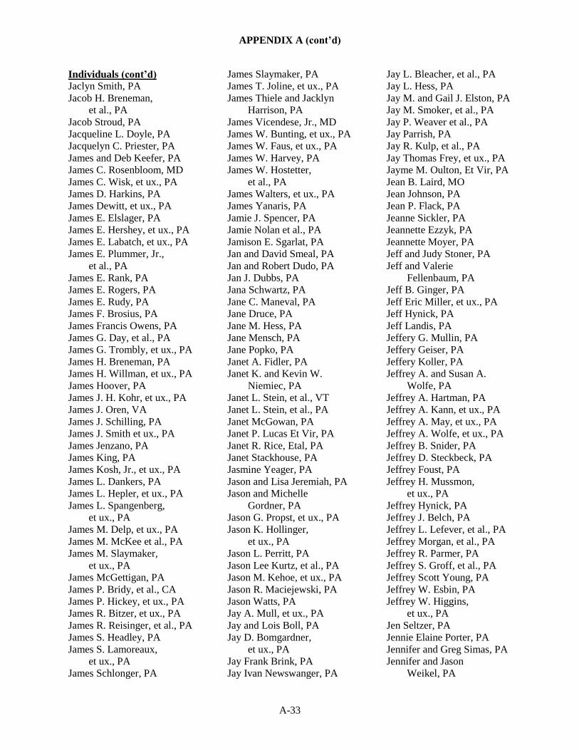
APPENDIX A (cont’d)
A-33
Individuals (cont’d)
Jaclyn Smith, PA
Jacob H. Breneman,
et al., PA
Jacob Stroud, PA
Jacqueline L. Doyle, PA
Jacquelyn C. Priester, PA
James and Deb Keefer, PA
James C. Rosenbloom, MD
James C. Wisk, et ux., PA
James D. Harkins, PA
James Dewitt, et ux., PA
James E. Elslager, PA
James E. Hershey, et ux., PA
James E. Labatch, et ux., PA
James E. Plummer, Jr.,
et al., PA
James E. Rank, PA
James E. Rogers, PA
James E. Rudy, PA
James F. Brosius, PA
James Francis Owens, PA
James G. Day, et al., PA
James G. Trombly, et ux., PA
James H. Breneman, PA
James H. Willman, et ux., PA
James Hoover, PA
James J. H. Kohr, et ux., PA
James J. Oren, VA
James J. Schilling, PA
James J. Smith et ux., PA
James Jenzano, PA
James King, PA
James Kosh, Jr., et ux., PA
James L. Dankers, PA
James L. Hepler, et ux., PA
James L. Spangenberg,
et ux., PA
James M. Delp, et ux., PA
James M. McKee et al., PA
James M. Slaymaker,
et ux., PA
James McGettigan, PA
James P. Bridy, et al., CA
James P. Hickey, et ux., PA
James R. Bitzer, et ux., PA
James R. Reisinger, et al., PA
James S. Headley, PA
James S. Lamoreaux,
et ux., PA
James Schlonger, PA
James Slaymaker, PA
James T. Joline, et ux., PA
James Thiele and Jacklyn
Harrison, PA
James Vicendese, Jr., MD
James W. Bunting, et ux., PA
James W. Faus, et ux., PA
James W. Harvey, PA
James W. Hostetter,
et al., PA
James Walters, et ux., PA
James Yanaris, PA
Jamie J. Spencer, PA
Jamie Nolan et al., PA
Jamison E. Sgarlat, PA
Jan and David Smeal, PA
Jan and Robert Dudo, PA
Jan J. Dubbs, PA
Jana Schwartz, PA
Jane C. Maneval, PA
Jane Druce, PA
Jane M. Hess, PA
Jane Mensch, PA
Jane Popko, PA
Janet A. Fidler, PA
Janet K. and Kevin W.
Niemiec, PA
Janet L. Stein, et al., VT
Janet L. Stein, et al., PA
Janet McGowan, PA
Janet P. Lucas Et Vir, PA
Janet R. Rice, Etal, PA
Janet Stackhouse, PA
Jasmine Yeager, PA
Jason and Lisa Jeremiah, PA
Jason and Michelle
Gordner, PA
Jason G. Propst, et ux., PA
Jason K. Hollinger,
et ux., PA
Jason L. Perritt, PA
Jason Lee Kurtz, et al., PA
Jason M. Kehoe, et ux., PA
Jason R. Maciejewski, PA
Jason Watts, PA
Jay A. Mull, et ux., PA
Jay and Lois Boll, PA
Jay D. Bomgardner,
et ux., PA
Jay Frank Brink, PA
Jay Ivan Newswanger, PA
Jay L. Bleacher, et al., PA
Jay L. Hess, PA
Jay M. and Gail J. Elston, PA
Jay M. Smoker, et al., PA
Jay P. Weaver et al., PA
Jay Parrish, PA
Jay R. Kulp, et al., PA
Jay Thomas Frey, et ux., PA
Jayme M. Oulton, Et Vir, PA
Jean B. Laird, MO
Jean Johnson, PA
Jean P. Flack, PA
Jeanne Sickler, PA
Jeannette Ezzyk, PA
Jeannette Moyer, PA
Jeff and Judy Stoner, PA
Jeff and Valerie
Fellenbaum, PA
Jeff B. Ginger, PA
Jeff Eric Miller, et ux., PA
Jeff Hynick, PA
Jeff Landis, PA
Jeffery G. Mullin, PA
Jeffery Geiser, PA
Jeffery Koller, PA
Jeffrey A. and Susan A.
Wolfe, PA
Jeffrey A. Hartman, PA
Jeffrey A. Kann, et ux., PA
Jeffrey A. May, et ux., PA
Jeffrey A. Wolfe, et ux., PA
Jeffrey B. Snider, PA
Jeffrey D. Steckbeck, PA
Jeffrey Foust, PA
Jeffrey H. Mussmon,
et ux., PA
Jeffrey Hynick, PA
Jeffrey J. Belch, PA
Jeffrey L. Lefever, et al., PA
Jeffrey Morgan, et al., PA
Jeffrey R. Parmer, PA
Jeffrey S. Groff, et al., PA
Jeffrey Scott Young, PA
Jeffrey W. Esbin, PA
Jeffrey W. Higgins,
et ux., PA
Jen Seltzer, PA
Jennie Elaine Porter, PA
Jennifer and Greg Simas, PA
Jennifer and Jason
Weikel, PA

APPENDIX A (cont’d)
A-34
Individuals (cont’d)
Jennifer Berlin, PA
Jennifer Brown, PA
Jennifer Carter, PA
Jennifer Corearan, PA
Jennifer D. Scott, PA
Jennifer Hamilton, PA
Jennifer Karns, et vir, PA
Jennifer L. Cleary, et ux., PA
Jennifer L. Wyman, PA
Jennifer Michael, PA
Jennifer S. Shadle, et ux., PA
Jennifer Spangler, PA
Jennifer Wentzel, PA
Jere Snyder, PA
Jeremy Guy Walters,
et ux., PA
Jeremy M. Salsman, PA
Jeremy M. Zimmerman,
et ux., PA
Jerry A. Wise, et ux., PA
Jerry C. Eckman, PA
Jerry Harrison, PA
Jess W. Oren, III, et al., PA
Jesse A. Long, et al., PA
Jesse J. Hepler, et ux., PA
Jesse M. Ziegler, et ux., PA
Jessica Albertson, PA
Jessica Fay, PA
Jessica Kelly, PA
Jessica Robenolt, PA
Jill M. Deihl, PA
Jim P. Greenley, et ux., PA
Jo Ellen Litz, PA
Jo Garvin, PA
Joan A. Daro, PA
Joan Byron, PA
Joan E. Ivey, PA
Joan Foust, PA
Joan Hawkins, PA
Joan Keller, PA
Joan King, PA
Joan Pauley, PA
Joan Weaber, PA
Joanna Faith Kurtz, et al., PA
Joanne Callahan, PA
Joanne Scalleat, PA
Jodi Coombs, PA
Jodi Stauffer, PA
Jodi Webster, PA
Jody L. Hummel, et al., PA
Jody Leighty, PA
Joe Shirley, PA
Joel King, PA
Joel Pompella, PA
Joel T. Rosengrant,
et ux., PA
John A. Bebey, PA
John A. Colella, PA
John A. Francioni Jr.,
et ux., PA
John A. Galleazzi, MD
John A. Linton Jr. et ux., PA
John A. Martin, et ux., PA
John A. Miller, PA
John A. Scaldara, MD
John A. Swingle, PA
John A. Trimble, et al., PA
John A. Linton, Jr., et ux., PA
John Allan, PA
John and Andrea Harrell, PA
John and Andrea W.
Harrell, PA
John and Anne Smeltzer, PA
John and Deborah
Sowers, PA
John and Jenny Wing, PA
John and Patti Zerbe, PA
John and Sarah Dodson, PA
John B. Butcho, et ux., PA
John B. Roeder, PA
John C. Jenzano, PA
John C. Reeser, et ux., PA
John Clinton Klingerman, PA
John Cosgrove, PA
John D. Bomgardner,
et ux., PA
John D. Flaud, PA
John D. Lapp, et ux., PA
John D. Martin, et ux., PA
John D. Rank-Christman,
et al., PA
John D. Rebman, PA
John D. Lahr, PA
John David Estep, et ux., PA
John David Martin, PA
John Dewitt Nicholson, PA
John E. Butts, PA
John E. Edwards, PA
John E. Ground, PA
John E. Teahl, et ux., PA
John E. Berger, PA
John F. and Connie J.
Fritz, PA
John Friedberg, PA
John G. Leakway and
Stephanie A.
Leakway, PA
John G. Teichmoeller, MD
John Gabreski, PA
John Gilbert Leakway and
Janice Louise Leakway
As Trustees of The
Leakway Revocable
Living Trust, PA
John Gilbert Leakway, PA
John H. Frey, et ux., PA
John H. McFalls, PA
John H. Moyer, et ux., PA
John Haldeman, et ux., PA
John Herr, PA
John J. Andrewson,
et ux., PA
John J. Baker, PA
John J. Garrison Sr., PA
John J. Maciejewski, PA
John J. Scott et ux., PA
John Jenzano, PA
John Kauffman, PA
John Kimmel, et ux., PA
John L. Brown, et ux., PA
John L. Hynes, MD
John L. Walker, PA
John Lynch, PA
John M. Burkholder,
et ux., PA
John M. Krohn, et ux., PA
John M. Lausch, PA
John M. Reinbold, Jr.,
et ux., PA
John M. Seidel, et ux., PA
John M. Their, PA
John McGurk, PA
John Mishanski, PA
John Murr, PA
John P. Blaski, et ux., PA
John Puskar, PA
John R. Felty, PA
John R. Greenley, et ux., PA
John R. Haldeman, et ux., PA
John R. Holt and Michael E.
Wood, PA
John R. Stout, NC

APPENDIX A (cont’d)
A-35
Individuals (cont’d)
John R. Swanson, et ux., PA
John R. Gerdy and E. Follin
Smith, PA
John R. Greenley, et ux., PA
John R. Sendy, PA
John Rehrer, PA
John Roelof Lanting, MD
John Rohrer, PA
John Rossi, PA
John S. Gladys, et ux., PA
John Salahub, PA
John T. Melick, PA
John T. Wiker, PA
John T. Wocniski, PA
John T. Gross, PA
John Timothy Gross, PA
John Trallo, Sr., PA
John W. Harrell III,
et ux., PA
John W. Pfeiffer, et ux., PA
John W. Roberts, et ux., PA
John, PA
Jon S. Jaeger, PA
Jona Stackhouse, PA
Jonas W. Cash, MD
Jonathan B. Herschberger,
et ux., PA
Jonathan J. Richwine, PA
Jonathan Pompella, PA
Jonathon Bancroft Colon, PA
Jones Sherry, PA
Jordan A. Waybright,
et al., PA
Joseph and Becki
Brandenburg, PA
Joseph D. Ritter, PA
Joseph Deleo, PA
Joseph E. Brandenburg, PA
Joseph G. Kappen, PA
Joseph G. Kappen, PA
Joseph G. Schneiderite
Jr., PA
Joseph Guastella, Jr., PA
Joseph J. Maskalis, PA
Joseph Justik, PA
Joseph M. Demeio,
et ux., PA
Joseph M. Stec Jr., PA
Joseph M. Wenson, NJ
Joseph M. Zoller, MD
Joseph Michael
Diangelo, MD
Joseph Mislevy, et al., PA
Joseph P. Waldman,
et ux., PA
Joseph Pinamonti, Jr.,
et ux., PA
Joseph R. Paterson, PA
Joseph Radick, PA
Joseph S. Kugler, et al., PA
Joseph S. Volz, PA
Joseph Spaltro, NJ
Joseph W. Fischer, PA
Joseph Weidow, et ux., PA
Joseph Wieczorek, Jr., PA
Josh Brotaw, PA
Josh Graupera, PA
Joshua Gerlach, PA
Joshua Matulevich, PA
Joshua R. Steiner, PA
Joy and Kaylee Blasick, PA
Joy Nachmias, PA
Joy Schuler, et vir, PA
Joyce Ann Thrush, PA
Judi Rocha, PA
Judith F. Evanko, et vir, FL
Judith J. Hoff, et al., PA
Judith Max, PA
Judith Mueller, PA
Judson R. Smales, et ux., PA
Judy A. O'Brien, PA
Judy Davis, PA
Judy Ginter, PA
Judy Leaman, PA
Julie Brown, PA
Julie E. Diltz, et ux., PA
Julien Lurowist, PA
June Lynn, et al., PA
Justin Craig Earp, MD
Justin D. Noll, PA
Justin L. Cappiello, et al., PA
Justin R. Fisher, PA
Justin S. Weidler, et ux., PA
Justin Strawser, PA
Justina Kelp, PA
K Danowski, PA
K Garber John, PA
Kailyn Stewart, PA
Kara Day Flood, PA
Kara Winter, PA
Karen Ament, PA
Karen and David Smith, PA
Karen Belli, PA
Karen John, PA
Karen Miller, PA
Karl A. Kanode, et ux., PA
Karl H. Perritt et al., PA
Karl H. Peters, et al., PA
Karl Heinbach, et ux., PA
Karl Kenneth Brown, II,
et al., PA
Karl Macdonald, PA
Karl R. Hinkle, PA
Karla Sexton, PA
Karolina Cimochowski,
et al., PA
Kate Hafer, PA
Katelyn Erb, PA
Kathi A. Wodehouse, PA
Kathryn Healery, PA
Kathy Pope, PA
Katie Faust, PA
Katie Lee Cross, PA
Kavin E. Shelley, PA
Keeney Jaegen, PA
Keith A. Hansford, MD
Keith A. Harris, et ux., PA
Keith A. Leighow, PA
Keith A. Zimmerman, PA
Keith E. McHenry, PA
Keith H. Martin, et al., PA
Keith Lamar Kurtz,
et ux., PA
Kelli Eachus, PA
Kelli Nachbar, PA
Ken Brooks, PA
Ken McCawley, PA
Kenia, Rose, PA
Kenneth A. Bond, PA
Kenneth A. Gainer, PA
Kenneth A. Kindt, PA
Kenneth Alan Eads, MD
Kenneth and Kathy Bond, PA
Kenneth Benjamin Moyer,
et al., PA
Kenneth Bond, PA
Kenneth Brown, PA
Kenneth D. Stickler, PA
Kenneth E. Decker,
et ux., PA
Kenneth Foust, PA
Kenneth Goss, PA
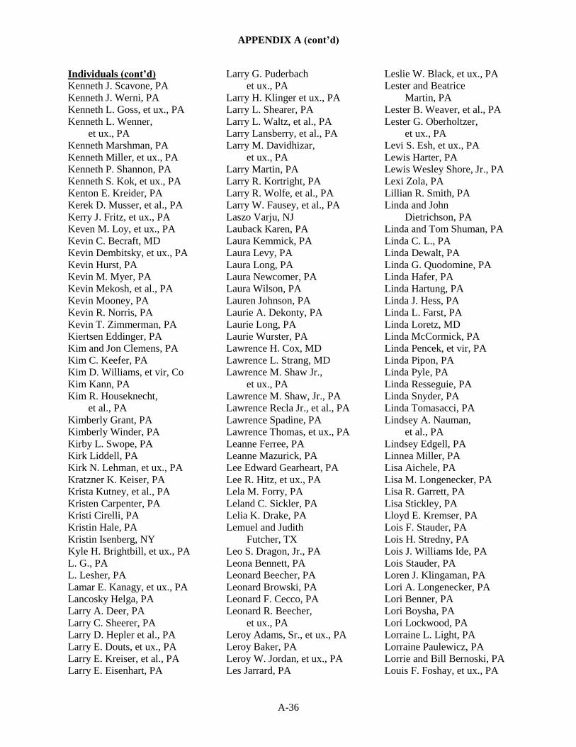
APPENDIX A (cont’d)
A-36
Individuals (cont’d)
Kenneth J. Scavone, PA
Kenneth J. Werni, PA
Kenneth L. Goss, et ux., PA
Kenneth L. Wenner,
et ux., PA
Kenneth Marshman, PA
Kenneth Miller, et ux., PA
Kenneth P. Shannon, PA
Kenneth S. Kok, et ux., PA
Kenton E. Kreider, PA
Kerek D. Musser, et al., PA
Kerry J. Fritz, et ux., PA
Keven M. Loy, et ux., PA
Kevin C. Becraft, MD
Kevin Dembitsky, et ux., PA
Kevin Hurst, PA
Kevin M. Myer, PA
Kevin Mekosh, et al., PA
Kevin Mooney, PA
Kevin R. Norris, PA
Kevin T. Zimmerman, PA
Kiertsen Eddinger, PA
Kim and Jon Clemens, PA
Kim C. Keefer, PA
Kim D. Williams, et vir, Co
Kim Kann, PA
Kim R. Houseknecht,
et al., PA
Kimberly Grant, PA
Kimberly Winder, PA
Kirby L. Swope, PA
Kirk Liddell, PA
Kirk N. Lehman, et ux., PA
Kratzner K. Keiser, PA
Krista Kutney, et al., PA
Kristen Carpenter, PA
Kristi Cirelli, PA
Kristin Hale, PA
Kristin Isenberg, NY
Kyle H. Brightbill, et ux., PA
L. G., PA
L. Lesher, PA
Lamar E. Kanagy, et ux., PA
Lancosky Helga, PA
Larry A. Deer, PA
Larry C. Sheerer, PA
Larry D. Hepler et al., PA
Larry E. Douts, et ux., PA
Larry E. Kreiser, et al., PA
Larry E. Eisenhart, PA
Larry G. Puderbach
et ux., PA
Larry H. Klinger et ux., PA
Larry L. Shearer, PA
Larry L. Waltz, et al., PA
Larry Lansberry, et al., PA
Larry M. Davidhizar,
et ux., PA
Larry Martin, PA
Larry R. Kortright, PA
Larry R. Wolfe, et al., PA
Larry W. Fausey, et al., PA
Laszo Varju, NJ
Lauback Karen, PA
Laura Kemmick, PA
Laura Levy, PA
Laura Long, PA
Laura Newcomer, PA
Laura Wilson, PA
Lauren Johnson, PA
Laurie A. Dekonty, PA
Laurie Long, PA
Laurie Wurster, PA
Lawrence H. Cox, MD
Lawrence L. Strang, MD
Lawrence M. Shaw Jr.,
et ux., PA
Lawrence M. Shaw, Jr., PA
Lawrence Recla Jr., et al., PA
Lawrence Spadine, PA
Lawrence Thomas, et ux., PA
Leanne Ferree, PA
Leanne Mazurick, PA
Lee Edward Gearheart, PA
Lee R. Hitz, et ux., PA
Lela M. Forry, PA
Leland C. Sickler, PA
Lelia K. Drake, PA
Lemuel and Judith
Futcher, TX
Leo S. Dragon, Jr., PA
Leona Bennett, PA
Leonard Beecher, PA
Leonard Browski, PA
Leonard F. Cecco, PA
Leonard R. Beecher,
et ux., PA
Leroy Adams, Sr., et ux., PA
Leroy Baker, PA
Leroy W. Jordan, et ux., PA
Les Jarrard, PA
Leslie W. Black, et ux., PA
Lester and Beatrice
Martin, PA
Lester B. Weaver, et al., PA
Lester G. Oberholtzer,
et ux., PA
Levi S. Esh, et ux., PA
Lewis Harter, PA
Lewis Wesley Shore, Jr., PA
Lexi Zola, PA
Lillian R. Smith, PA
Linda and John
Dietrichson, PA
Linda and Tom Shuman, PA
Linda C. L., PA
Linda Dewalt, PA
Linda G. Quodomine, PA
Linda Hafer, PA
Linda Hartung, PA
Linda J. Hess, PA
Linda L. Farst, PA
Linda Loretz, MD
Linda McCormick, PA
Linda Pencek, et vir, PA
Linda Pipon, PA
Linda Pyle, PA
Linda Resseguie, PA
Linda Snyder, PA
Linda Tomasacci, PA
Lindsey A. Nauman,
et al., PA
Lindsey Edgell, PA
Linnea Miller, PA
Lisa Aichele, PA
Lisa M. Longenecker, PA
Lisa R. Garrett, PA
Lisa Stickley, PA
Lloyd E. Kremser, PA
Lois F. Stauder, PA
Lois H. Stredny, PA
Lois J. Williams Ide, PA
Lois Stauder, PA
Loren J. Klingaman, PA
Lori A. Longenecker, PA
Lori Benner, PA
Lori Boysha, PA
Lori Lockwood, PA
Lorraine L. Light, PA
Lorraine Paulewicz, PA
Lorrie and Bill Bernoski, PA
Louis F. Foshay, et ux., PA
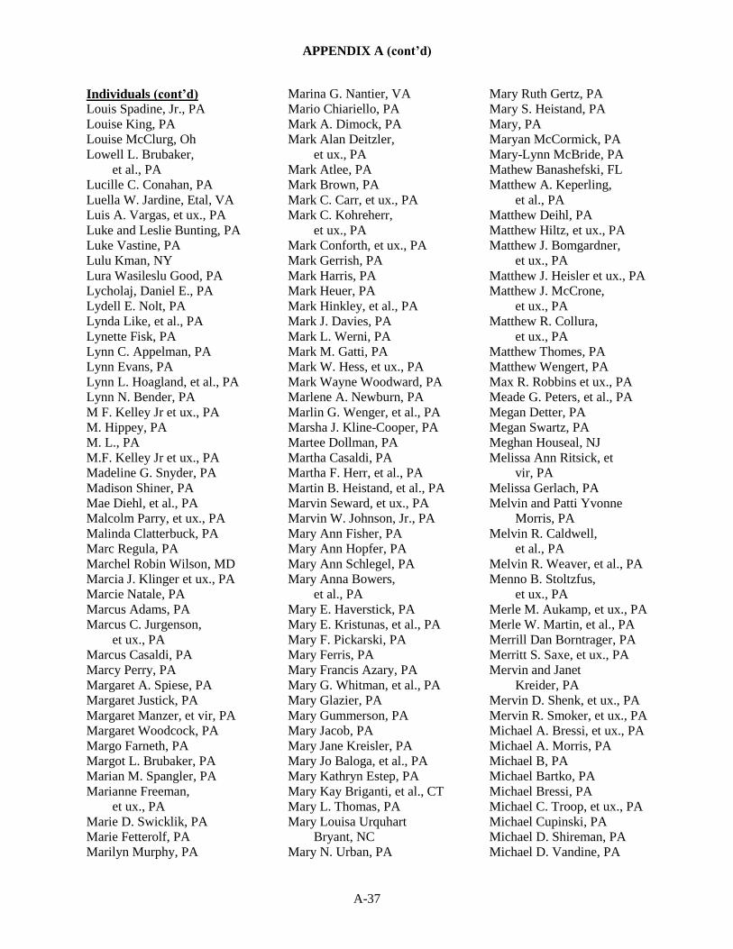
APPENDIX A (cont’d)
A-37
Individuals (cont’d)
Louis Spadine, Jr., PA
Louise King, PA
Louise McClurg, Oh
Lowell L. Brubaker,
et al., PA
Lucille C. Conahan, PA
Luella W. Jardine, Etal, VA
Luis A. Vargas, et ux., PA
Luke and Leslie Bunting, PA
Luke Vastine, PA
Lulu Kman, NY
Lura Wasileslu Good, PA
Lycholaj, Daniel E., PA
Lydell E. Nolt, PA
Lynda Like, et al., PA
Lynette Fisk, PA
Lynn C. Appelman, PA
Lynn Evans, PA
Lynn L. Hoagland, et al., PA
Lynn N. Bender, PA
M F. Kelley Jr et ux., PA
M. Hippey, PA
M. L., PA
M.F. Kelley Jr et ux., PA
Madeline G. Snyder, PA
Madison Shiner, PA
Mae Diehl, et al., PA
Malcolm Parry, et ux., PA
Malinda Clatterbuck, PA
Marc Regula, PA
Marchel Robin Wilson, MD
Marcia J. Klinger et ux., PA
Marcie Natale, PA
Marcus Adams, PA
Marcus C. Jurgenson,
et ux., PA
Marcus Casaldi, PA
Marcy Perry, PA
Margaret A. Spiese, PA
Margaret Justick, PA
Margaret Manzer, et vir, PA
Margaret Woodcock, PA
Margo Farneth, PA
Margot L. Brubaker, PA
Marian M. Spangler, PA
Marianne Freeman,
et ux., PA
Marie D. Swicklik, PA
Marie Fetterolf, PA
Marilyn Murphy, PA
Marina G. Nantier, VA
Mario Chiariello, PA
Mark A. Dimock, PA
Mark Alan Deitzler,
et ux., PA
Mark Atlee, PA
Mark Brown, PA
Mark C. Carr, et ux., PA
Mark C. Kohreherr,
et ux., PA
Mark Conforth, et ux., PA
Mark Gerrish, PA
Mark Harris, PA
Mark Heuer, PA
Mark Hinkley, et al., PA
Mark J. Davies, PA
Mark L. Werni, PA
Mark M. Gatti, PA
Mark W. Hess, et ux., PA
Mark Wayne Woodward, PA
Marlene A. Newburn, PA
Marlin G. Wenger, et al., PA
Marsha J. Kline-Cooper, PA
Martee Dollman, PA
Martha Casaldi, PA
Martha F. Herr, et al., PA
Martin B. Heistand, et al., PA
Marvin Seward, et ux., PA
Marvin W. Johnson, Jr., PA
Mary Ann Fisher, PA
Mary Ann Hopfer, PA
Mary Ann Schlegel, PA
Mary Anna Bowers,
et al., PA
Mary E. Haverstick, PA
Mary E. Kristunas, et al., PA
Mary F. Pickarski, PA
Mary Ferris, PA
Mary Francis Azary, PA
Mary G. Whitman, et al., PA
Mary Glazier, PA
Mary Gummerson, PA
Mary Jacob, PA
Mary Jane Kreisler, PA
Mary Jo Baloga, et al., PA
Mary Kathryn Estep, PA
Mary Kay Briganti, et al., CT
Mary L. Thomas, PA
Mary Louisa Urquhart
Bryant, NC
Mary N. Urban, PA
Mary Ruth Gertz, PA
Mary S. Heistand, PA
Mary, PA
Maryan McCormick, PA
Mary-Lynn McBride, PA
Mathew Banashefski, FL
Matthew A. Keperling,
et al., PA
Matthew Deihl, PA
Matthew Hiltz, et ux., PA
Matthew J. Bomgardner,
et ux., PA
Matthew J. Heisler et ux., PA
Matthew J. McCrone,
et ux., PA
Matthew R. Collura,
et ux., PA
Matthew Thomes, PA
Matthew Wengert, PA
Max R. Robbins et ux., PA
Meade G. Peters, et al., PA
Megan Detter, PA
Megan Swartz, PA
Meghan Houseal, NJ
Melissa Ann Ritsick, et
vir, PA
Melissa Gerlach, PA
Melvin and Patti Yvonne
Morris, PA
Melvin R. Caldwell,
et al., PA
Melvin R. Weaver, et al., PA
Menno B. Stoltzfus,
et ux., PA
Merle M. Aukamp, et ux., PA
Merle W. Martin, et al., PA
Merrill Dan Borntrager, PA
Merritt S. Saxe, et ux., PA
Mervin and Janet
Kreider, PA
Mervin D. Shenk, et ux., PA
Mervin R. Smoker, et ux., PA
Michael A. Bressi, et ux., PA
Michael A. Morris, PA
Michael B, PA
Michael Bartko, PA
Michael Bressi, PA
Michael C. Troop, et ux., PA
Michael Cupinski, PA
Michael D. Shireman, PA
Michael D. Vandine, PA
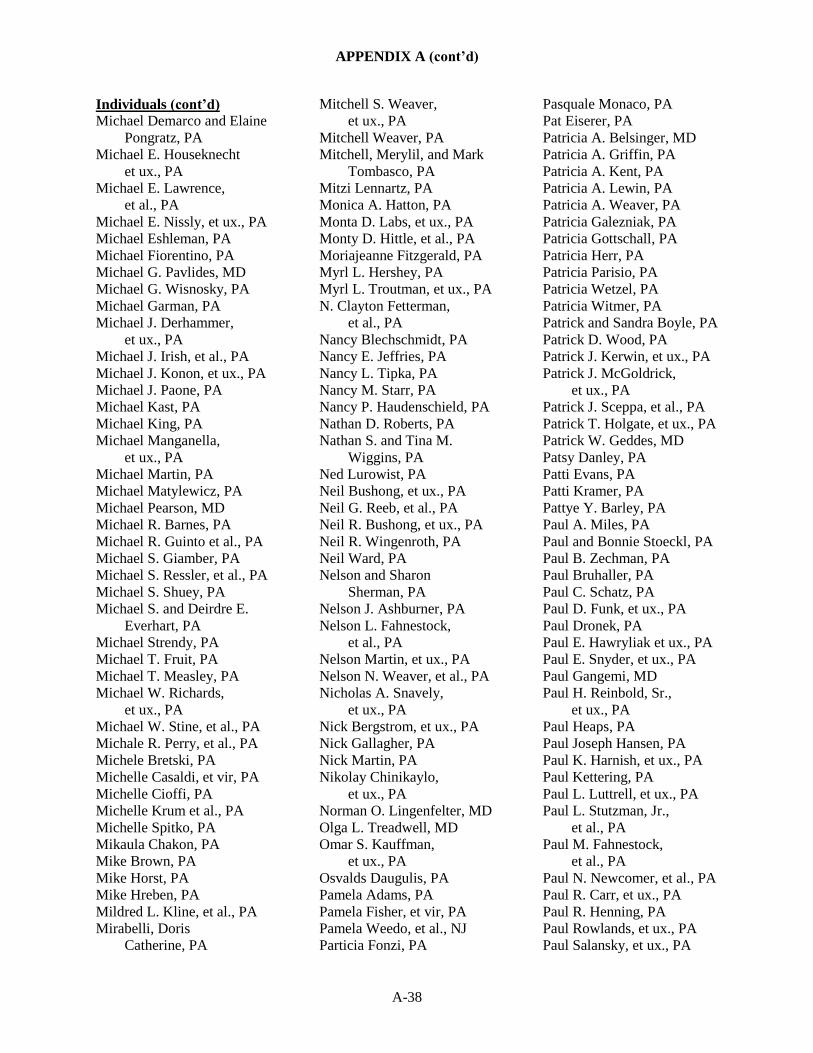
APPENDIX A (cont’d)
A-38
Individuals (cont’d)
Michael Demarco and Elaine
Pongratz, PA
Michael E. Houseknecht
et ux., PA
Michael E. Lawrence,
et al., PA
Michael E. Nissly, et ux., PA
Michael Eshleman, PA
Michael Fiorentino, PA
Michael G. Pavlides, MD
Michael G. Wisnosky, PA
Michael Garman, PA
Michael J. Derhammer,
et ux., PA
Michael J. Irish, et al., PA
Michael J. Konon, et ux., PA
Michael J. Paone, PA
Michael Kast, PA
Michael King, PA
Michael Manganella,
et ux., PA
Michael Martin, PA
Michael Matylewicz, PA
Michael Pearson, MD
Michael R. Barnes, PA
Michael R. Guinto et al., PA
Michael S. Giamber, PA
Michael S. Ressler, et al., PA
Michael S. Shuey, PA
Michael S. and Deirdre E.
Everhart, PA
Michael Strendy, PA
Michael T. Fruit, PA
Michael T. Measley, PA
Michael W. Richards,
et ux., PA
Michael W. Stine, et al., PA
Michale R. Perry, et al., PA
Michele Bretski, PA
Michelle Casaldi, et vir, PA
Michelle Cioffi, PA
Michelle Krum et al., PA
Michelle Spitko, PA
Mikaula Chakon, PA
Mike Brown, PA
Mike Horst, PA
Mike Hreben, PA
Mildred L. Kline, et al., PA
Mirabelli, Doris
Catherine, PA
Mitchell S. Weaver,
et ux., PA
Mitchell Weaver, PA
Mitchell, Merylil, and Mark
Tombasco, PA
Mitzi Lennartz, PA
Monica A. Hatton, PA
Monta D. Labs, et ux., PA
Monty D. Hittle, et al., PA
Moriajeanne Fitzgerald, PA
Myrl L. Hershey, PA
Myrl L. Troutman, et ux., PA
N. Clayton Fetterman,
et al., PA
Nancy Blechschmidt, PA
Nancy E. Jeffries, PA
Nancy L. Tipka, PA
Nancy M. Starr, PA
Nancy P. Haudenschield, PA
Nathan D. Roberts, PA
Nathan S. and Tina M.
Wiggins, PA
Ned Lurowist, PA
Neil Bushong, et ux., PA
Neil G. Reeb, et al., PA
Neil R. Bushong, et ux., PA
Neil R. Wingenroth, PA
Neil Ward, PA
Nelson and Sharon
Sherman, PA
Nelson J. Ashburner, PA
Nelson L. Fahnestock,
et al., PA
Nelson Martin, et ux., PA
Nelson N. Weaver, et al., PA
Nicholas A. Snavely,
et ux., PA
Nick Bergstrom, et ux., PA
Nick Gallagher, PA
Nick Martin, PA
Nikolay Chinikaylo,
et ux., PA
Norman O. Lingenfelter, MD
Olga L. Treadwell, MD
Omar S. Kauffman,
et ux., PA
Osvalds Daugulis, PA
Pamela Adams, PA
Pamela Fisher, et vir, PA
Pamela Weedo, et al., NJ
Particia Fonzi, PA
Pasquale Monaco, PA
Pat Eiserer, PA
Patricia A. Belsinger, MD
Patricia A. Griffin, PA
Patricia A. Kent, PA
Patricia A. Lewin, PA
Patricia A. Weaver, PA
Patricia Galezniak, PA
Patricia Gottschall, PA
Patricia Herr, PA
Patricia Parisio, PA
Patricia Wetzel, PA
Patricia Witmer, PA
Patrick and Sandra Boyle, PA
Patrick D. Wood, PA
Patrick J. Kerwin, et ux., PA
Patrick J. McGoldrick,
et ux., PA
Patrick J. Sceppa, et al., PA
Patrick T. Holgate, et ux., PA
Patrick W. Geddes, MD
Patsy Danley, PA
Patti Evans, PA
Patti Kramer, PA
Pattye Y. Barley, PA
Paul A. Miles, PA
Paul and Bonnie Stoeckl, PA
Paul B. Zechman, PA
Paul Bruhaller, PA
Paul C. Schatz, PA
Paul D. Funk, et ux., PA
Paul Dronek, PA
Paul E. Hawryliak et ux., PA
Paul E. Snyder, et ux., PA
Paul Gangemi, MD
Paul H. Reinbold, Sr.,
et ux., PA
Paul Heaps, PA
Paul Joseph Hansen, PA
Paul K. Harnish, et ux., PA
Paul Kettering, PA
Paul L. Luttrell, et ux., PA
Paul L. Stutzman, Jr.,
et al., PA
Paul M. Fahnestock,
et al., PA
Paul N. Newcomer, et al., PA
Paul R. Carr, et ux., PA
Paul R. Henning, PA
Paul Rowlands, et ux., PA
Paul Salansky, et ux., PA
APPENDIX A (cont’d)
A-39
Individuals (cont’d)
Paul T. Flinchbaugh,
et ux., PA
Paul V. Nissley, et ux., PA
Paul W. Navarro, PA
Paul Z. Bogart, et al., PA
Paula A. Weatherill,
et ux., PA
Paula R. Schadel, PA
Paulette Zardecki, PA
Peggy Wenger, PA
Penni A. Schaffer et ux., PA
Peter B. Thompson, et ux.,
FL
Peter Doyle, et ux., PA
Peter G. Tipka, PA
Peter I. Hanson, et ux., PA
Peter J. Brandner, et ux., NJ
Peter J. Masteroianni,
et ux., PA
Peter J. Obourn, et ux., PA
Peter Petokas, et ux., PA
Peter Polinsky Jr., et al., PA
Philip D. Nolt, et al., PA
Philip M. Hershey, PA
Philip O. Shank, et al., PA
Phillip L. Smith, PA
Phillip R. Barley, PA
Phyllis Lott, MD
Phyllis Robert, PA
R L, PA
R Merle Breneman, et al., PA
R Scott Hoover, PA
R. Jill Snavely, PA
R. Lynn Lunger, TN
Rachel Rood, et al., PA
Rachelle Rogers, et vir, PA
Ralph D. Bennett, MD
Ralph Duquette, PA
Ralph E. Green, et al., PA
Ralph F. Marks et al., PA
Ralph Freed, PA
Ralph Henry Maurer,
et ux., PA
Ralph J. Casaldi, et ux., PA
Ralph W. and Debra A.
Siefken, PA
Randall L. Tietsworth,
et ux., PA
Randall P. Voorhees, PA
Randall Walsh, PA
Randy and Diane
Winters, PA
Randy G. Brown, PA
Randy J. Hostetter, et al., PA
Randy Winters, et ux., PA
Raplh Mark Huber,
et ux., PA
Ray Applegate and Nicole
Trefsger, PA
Ray K. Simpson, GA
Ray Smith, NY
Raymend Frantz, et al., PA
Raymond and Joyce
Zakrewsky, PA
Raymond C. Cahoon, PA
Raymond Finnen III, PA
Raymond Frantz, et al., PA
Raymond H. Perritt,
et al., PA
Raymond J. Sokol, et ux., PA
Raymond Jackloski Jr., PA
Raymond Mohler, PA
Raymond Oscar Fisher,
et ux., PA
Raymond S. Mohler,
et ux., PA
Raymond Victor Miller, PA
Reagan Hynick, Et Vir, PA
Reagan Lynn, et al., PA
Reaves F. Goehring, III, PA
Rebecca Pawlik, PA
Regan Jones, PA
Rehm Erricke, PA
Renee Didrio, PA
Reuben B. Zook, et ux., PA
Reuben H. Wenger,
et ux., PA
Rex T. Mohr, PA
Richard A. Bombick,
et ux., PA
Richard A. Conner,
et ux., PA
Richard A. Ivey, et ux., PA
Richard A. Kroh, et ux., PA
Richard A. Rarba, et ux., PA
Richard and Cynthia
Moses, PA
Richard and Kristen
Angelicola, et ux., PA
Richard B. Drager, PA
Richard Bechetti, et ux., PA
Richard Blouch, PA
Richard Burroughs, VA
Richard C. Stroud, et al., PA
Richard Demond, PA
Richard E. Bowman,
et ux., PA
Richard E. Nye, et ux., PA
Richard E. Weeks, et ux., PA
Richard H. Maciejewski, PA
Richard J. Dabulis, et ux., PA
Richard J. Newell, PA
Richard J. Withelder,
et ux., PA
Richard K. Deibler, PA
Richard Kingsbury, PA
Richard L. Custer et al., PA
Richard L. Fetterman,
et al., PA
Richard L. Gearhart, PA
Richard L. Gochnauer,
et ux., PA
Richard L. Mitchell,
et ux., NJ
Richard L. Lind, PA
Richard M. Davis, et ux., PA
Richard M. Savidge,
et ux., PA
Richard Mertz, PA
Richard R. Jerauld, PA
Richard Roberts, PA
Richard Rupert et al., PA
Richard S. Kauffman,
et al., PA
Richard S. Miller, PA
Richard Sranski, PA
Richard Stine, et al., PA
Richard Vreeland, et al., PA
Richard W. Brown,
et ux., PA
Richard W. Jeffries, PA
Richard, Whitney, Sharon,
and Eric
Heydenreich, PA
Richarda M. Dehl, PA
Rick D. Rye, et ux., PA
Rick Newcomber, PA
Rickey A. Garvin, et ux., PA
Rifat Abousy, MD
Rob Fisher, PA
Robert A. Funk, et al., PA
Robert A. Housel, et ux., PA
APPENDIX A (cont’d)
A-40
Individuals (cont’d)
Robert A. Puchalski, PA
Robert A. Shebelsky,
et ux., PA
Robert A. Sowers, et al., PA
Robert Alan Concini, PA
Robert and Carolyn
Kilgour, PA
Robert and Jo A. Wright, PA
Robert and Melanie
Engelhardt and Sharon
Hopping, PA
Robert B. Barton, IV, PA
Robert B. Barton, PA
Robert B. Weinstock,
et al., PA
Robert Barna, PA
Robert C. Boyles, et ux., PA
Robert C. Lee, PA
Robert D. Atkinson, PA
Robert D. Klinger, et ux., PA
Robert Derhammer,
et ux., PA
Robert E. Baer, PA
Robert E. Becker, PA
Robert E. Kopitsky, PA
Robert E. McMaster
et al., PA
Robert E. Long, PA
Robert F. Cross, et al., PA
Robert G. Adams et ux., PA
Robert G. Ryan, et ux., PA
Robert G. Witmer, PA
Robert Gordon, et ux., PA
Robert H. Fruit, et ux., PA
Robert H. Harbaugh,
et al., PA
Robert Heydenreich, PA
Robert J. Keagy, et al., PA
Robert J. Koons, et ux., PA
Robert J. Maciejewski, PA
Robert J. Wienckoski,
et ux., PA
Robert L. Altomare,
et ux., PA
Robert L. Ciravolo, PA
Robert L. Hilton, et al., PA
Robert L. Koppenhaver,
et ux., PA
Robert Long, et al., PA
Robert M. Chaney, PA
Robert M. Kalinoski, PA
Robert M. Wisdo, et ux., PA
Robert M. Adams, PA
Robert Matylewicz,
et ux., PA
Robert Mazzerle, et ux., PA
Robert N. Brandt, et ux., PA
Robert N. Rishel, et ux., PA
Robert O. Erisman, Jr.,
et al., PA
Robert O. Tyler, et al., PA
Robert P. Donough, PA
Robert R. Houser et ux., PA
Robert S. Kunkle, PA
Robert T. Kay, et ux., NY
Robert Vian, PA
Robert W. Callahan, Jr.,
et ux., PA
Robert W. Callahan, Jr.,
et ux., PA
Robert W. Leventhall, PA
Robert Webber, PA
Robin Maguire, PA
Robyn Kochar, PA
Rodney Fiddler, PA
Rodney L. Fidler, PA
Rodney L. Shaner, et ux., PA
Roger D. Conrad, NJ
Roger Mitchell, PA
Roger Savage, PA
Roger Shenk, et al., PA
Roland C. Steiner, MD
Rolland Hockenbroch, PA
Roman P. Kostyk, PA
Ron Beer, PA
Ronald Alan Long and Sylvia
Marie Long, PA
Ronald B. Moore, et ux., PA
Ronald B. Whitesell,
et ux., PA
Ronald C. Detwiler, PA
Ronald Dietz, et al., PA
Ronald E. Mansell, et ux., PA
Ronald E. Roye, et ux., PA
Ronald H. Knoebel, PA
Ronald Hess, PA
Ronald J. Filarski, et ux., PA
Ronald J. Reed, PA
Ronald L. Boltz, Jr., PA
Ronald L. Bortner,
Ronald L. Laughlin, PA
Ronald Lahr, et al., PA
Ronald Long, PA
Ronald M. and Darlene
Zimmerman, PA
Ronald Mutkus, PA
Ronald P. Wert et ux., PA
Ronald R. and Camilla Ann
Diltz, PA
Ronald R. Hileman and
Shirley J. Hileman, PA
Ronald R. Schamber, PA
Ronnie and Linda Shopf, PA
Rose Stackhouse, PA
Rosemary A. Moore, PA
Roy and Mindy Ronald, PA
Roy L. Brandt, et al., PA
Roy Robert Trudel, MD
Russell C. Seward, PA
Russell D. Olt, et ux., PA
Russell E. Mercer Jr., PA
Russell H. Beishline,
et ux., PA
Russell Kolody, PA
Russell Stepanchak,
et al., PA
Russo, La Sr Salvatore, PA
Ruth E. Shellenberger, PA
Ruth Ginder Borntrager, PA
Ruth Justice, PA
Ruth Linker, PA
Ryan A. Bast, PA
Ryan D. Funk, PA
Ryan J. Regec, et ux., PA
Ryan J. Skibo, et al., PA
Ryan McNulty, PA
S Emily Vincent, et ux., PA
S Russell Davis, PA
Sabine Spring, PA
Sallie Deichert, PA
Sallie Smith Dvm, PA
Sally and Daniel O'Neill
Towne, PA
Sally Wilson, PA
Salvatore La Russo, Sr., PA
Sam Joder, PA
Sam S. Fisher, MD
Samantha Milheim, PA
Samuel C. Stephens,
et al., NJ
Samuel E. Bryant, PA
Samuel E. Webb, PA

APPENDIX A (cont’d)
A-41
Individuals (cont’d)
Samuel F. Robbins,
et ux., PA
Samuel Gingerich, PA
Samuel Glick, et ux., PA
Samuel K. Stoltzfoos,
et ux., PA
Samuel Koplinka-Loehr, PA
Samuel Saylor, PA
Sandra Ann Chiampi, PA
Sandra Baker, PA
Sandra G. Suld, PA
Sandra J. Elderkin, PA
Sandra J. Shenk, PA
Sandra J. Thomas, et al., PA
Sandra Jewell, Et Vir, PA
Sandra L. Weaver, et al., PA
Sandra Robinson, PA
Sara C. Keam, PA
Sara C. Ream, PA
Sarah Lamoreaux, PA
Sarah M. Kelley, PA
Sarita Farnelli, PA
Savage, William, PA
Scot Bowers, PA
Scott A. Brown, PA
Scott A. Smith, et al., PA
Scott A. Wolfe, PA
Scott and Glenda
Johnson, PA
Scott and Karen Edwards, PA
Scott B. Gates, PA
Scott D. and Mona L.
Bartholomew, PA
Scott D. Bartholomew,
et ux., PA
Scott Masich, PA
Scott McGary, PA
Scott Simons, PA
Scott, PA
Sean P. Stackhouse,
et al., PA
Seung Dae Moon, MD
Shannon Watson, PA
Sharon and Russell Olt, PA
Sharon L. Snyder, PA
Sharon, Gary, Saura
Rohrbach, PA
Shawn David Arters, PA
Shawn K. McCoy, et ux., PA
Sheila E. Lunger, PA
Sheila Riley, PA
Shelby Harrison, PA
Shelby Moser, PA
Sherrie Ann Marlow, PA
Sherry McNeil, PA
Sheryl Goss, PA
Sheryl McGettigan, PA
Shirley Bonham, et al., PA
Shirley Hartman, et al., PA
Shirley L. Davis, PA
Sidney R. Eachus, II,
et al., PA
Sierra Dumbaugh, PA
Simone Nicholson, MD
Sirik Sheila, PA
Sisto M. Moffa, PA
Sondra Wolferman, PA
Spencer Johnson, MA
Stacey Fague, PA
Stacy Robinson, PA
Stacy Wallick, PA
Stanley and Edith Martin, PA
Stanley H. Williams,
et ux., PA
Stanley Jaslar, et al., PA
Stefani Hauck, PA
Steph Leakway, PA
Stephanie J. Hanna, et al., PA
Stephen C. Landis, PA
Stephen D. Ashworth,
et ux., PA
Stephen D. Hoffman, PA
Stephen G. Aldinger,
et ux., PA
Stephen J. Myers, PA
Stephen J. Schweitzer, PA
Stephen J. Ruof, PA
Stephen L. Myers, PA
Stephen Lauback, PA
Stephen N. Midkiff,
et ux., PA
Stephen P. H. Clute IV, PA
Stephen R. Fetterman,
et al., TX
Stephen R. Havrilla III, PA
Stephen R. Schulze,
et ux., PA
Stephen Seier, et al., PA
Stephen Z. Fisher, et ux., PA
Steve A. Reigel, PA
Steve Bartholomew, PA
Steve Bergdoll, PA
Steve Erdly, PA
Steve Heim, PA
Steve Hendrickson, PA
Steve Kubik, et ux., PA
Steve Murray, PA
Steven C. Matukaitis, PA
Steven D. Zimmerman,
et ux., PA
Steven F. Henry, PA
Steven G. Miller, PA
Steven H. Stryker, PA
Steven Jamison Stover, MD
Steven L. Masteller,
et ux., PA
Steven L. and Debra A.
Appel, PA
Steven M. Manz, PA
Steven R. Sabol, PA
Steven T. Lancaster, PA
Steven T. Scoble, et ux., PA
Stever and Betsy Hribik, PA
Stuart A. Vosburg, et al., MD
Sue O'Donnell, PA
Sue Yoncuski, PA
Summer Konopinski, PA
Susan Fague, PA
Susan L. Shebel, MD
Susan L. Vance, PA
Susan Leiby Paldo, PA
Susan Nierenber, NJ
Susan Pantalone, PA
Susan R. Hopper, PA
Susan Richards, PA
Suzanne Hilner, PA
Suzanne M. Burgio, PA
Tabatha Smith, PA
Tamera Auten, PA
Tammy Chapin, PA
Tammy Jo Rhodes, PA
Tammy Kline, et vir, PA
Taylor Britton, PA
Ted E. Derrick, et al., PA
Terrance R. Beaver,
et ux., PA
Terri L. Curtis, et vir, PA
Terrie McAndrew, PA
Terry D. Rowe, et al., PA
Terry Jones, PA
Terry M. Nantier, VA
APPENDIX A (cont’d)
A-42
Individuals (cont’d)
Thaddeus Olshefski,
et ux., PA
The Heirs and Devisees of
Edward Soja, PA
The Heirs and Devisees of
Richard A. Lanning, PA
Theodore L. Esbenshade,
et al., PA
Theresa Oneskourn, PA
Theresa S. Chesney, PA
Theresa Walasek, et al., FL
Thomas A. Breneman,
et ux., PA
Thomas A. Fisher, et ux., PA
Thomas A. Graby, et ux., PA
Thomas A. Kristunas, PA
Thomas A. Williams,
et ux., PA
Thomas and Rachel
Minnich, PA
Thomas and Susan
Wilson, PA
Thomas Balko, et ux., PA
Thomas Brody, et ux., PA
Thomas Brown, et ux., PA
Thomas Clark, PA
Thomas D. Shuey, et ux., PA
Thomas D. and Geraldine
Grassel, PA
Thomas E. Heffernan, FL
Thomas E. Lloyd, MD
Thomas E. Mecca, PA
Thomas E. Nauman,
et ux., PA
Thomas E. Rhone, et ux., PA
Thomas E. Smith, et ux., PA
Thomas F. Edwards,
et al., PA
Thomas F. Leibel, PA
Thomas F. Minnich, PA
Thomas F. Nikolaus, PA
Thomas F. Zimmerman, PA
Thomas F. Edwards,
et al., PA
Thomas G. Bomgarder,
et ux., PA
Thomas J. Perna, MD
Thomas J. Ware, et ux., PA
Thomas L. Ohl, et al., PA
Thomas M. Roberts Jr.
et ux., PA
Thomas M. Shadle, et al., PA
Thomas M. Shirey, et ux., PA
Thomas M. Smith, PA
Thomas N. Batchelor II, PA
Thomas R. Brown, PA
Thomas R. Kensinger,
et al., PA
Thomas Voda, et al., PA
Thomas W. Bryon, et ux., PA
Thomas W. Voda, et al., PA
Thomas Williams, TX
Tiffany Hunsinger, PA
Tiffany M. Coho, PA
Tim Fornadley, PA
Tim Pezzoli, DC
Timothy and Melissa
Keener, PA
Timothy Beaver, PA
Timothy Cotmer, PA
Timothy E. Haddle, PA
Timothy Inns, et al., PA
Timothy J. Desmond, PA
Timothy J. Eshleman, PA
Timothy K. McWilliams,
et ux., PA
Timothy L. Spiese, PA
Timothy M. Captain,
et ux., NJ
Timothy W. McAndrew, PA
Tina Kistler, PA
Tina Westover, PA
Tobin A. Shank, PA
Todd Ament, PA
Todd R. Schwalm, PA
Todd R. Singley, et ux., PA
Todd W. Studebaker,
et ux., PA
Tom and Mary
Gummerson, PA
Tom Barnand, PA
Tom Campbell, PA
Tom Droege, PA
Tom Seltzer, PA
Tony Crocamo, PA
Torrance R. Gensel,
et ux., PA
Townsend F. Hug, PA
Tracey Rohrer McVey, PA
Tracy G. Beck, et ux., PA
Tracy Niedzwiecki,
et ux., PA
Trenton A. Miller, PA
Trish Hafer, PA
Troy D. Shepro, PA
Troy H. Knerr, PA
Turner L. Newburn,
et ux., PA
Tyler E. Ernst, et al., PA
Tyler Lanning, et al., PA
Valerie Coulson, PA
Valerie Hendrickson,
et al., PA
Valerie L. Miller, PA
Vera and Verner Lewis, PA
Vernon Piersol, PA
Vernon W. Heisey, et al., PA
Veronica Shevock, et al., MD
Vicki Bennick, PA
Vicki L. Grove, PA
Victor C. Choplosky, PA
Victor G. Pursel, et ux., PA
Victor L. Boers, et ux., PA
Victor Nestico, PA
Victoria Jones, PA
Victoria S. Reeves, et ux., FL
Vincent J. Masco, PA
Vito Pilosi Jr., PA
Voilet Kozubal, et vir, PA
Vreeland Vreeland, et al., PA
W. D., PA
W. Harry Schaffer, PA
W. Pursel, PA
W.S. Robert Shaw, PA
Wade P. Frantz, PA
Walter and Robyn
Kochan, PA
Walter E. Minto, et ux., PA
Walter G. Heck, PA
Walter Harris Howell Jr., PA
Walter Mackiw, PA
Walter Mikus, et ux., PA
Walter R. Lindenmuth,
et ux., PA
Walter S. Woznicki, PA
Walter V., PA
Walter W. Kochan and
Robyn Sterling
Kochan, PA
Warren N. Reiff, et ux., PA
Wayne Bizup, et ux., NJ
APPENDIX A (cont’d)
A-43
Individuals (cont’d)
Wayne Bizup, et ux., PA
Wayne E. Shultz, et al., PA
Wayne Fetty, PA
Wayne Frederick, et ux., PA
Wayne J. Newman, PA
Wayne M. Fausey, et ux., PA
Wayne Mutchler, PA
Wayne Reno, PA
Wayne Watts, PA
Wayne Weaver, et ux., PA
Wende Swartz, PA
Wendy Gable, PA
Wesley C. Nolan, PA
Wesley E. Murry, PA
Wilbur Stout, PA
Wilfredo Perez, et ux., PA
Will Christensen and Tabitha
Gheen, PA
Willard Comstock, et al., PA
Willard J. Race Jr., PA
Willard Novitch, PA
Willard R. Bullock, PA
William and Constance
Morgan, PA
William and Dolores
Smith, PA
William B. Allegar,
et ux., PA
William B. Everett,
et ux., PA
William C. Bard, PA
William Celmer, PA
William D. Brown, et ux., PA
William D. Graby, PA
William D. Paterson Jr., VA
William Dean Zewan, PA
William Derhammer,
et ux., PA
William E. Zick, et ux., PA
William F. Bennett, et al., PA
William G. Bastian,
et ux., PA
William G. Belloff, et al., PA
William G. Bernoski,
et ux., PA
William G. Dengler,
et ux., PA
William G. Pencek,
et ux., PA
William Gordon, PA
William H. Wainwright,
et al., PA
William J. Bernheisel,
et ux., PA
William J. Billets, et ux., PA
William J. Miller, et ux., PA
William J. Napier, et ux., PA
William J. Petkavich, Jr., PA
William K. Poust et ux., PA
William K. Johnson, PA
William Karis, et al., PA
William L. Bake, MD
William L. Jesse, PA
William L. Weber, PA
William Leavy, NM
William M. Deibler
et ux., PA
William M. Regitz, PA
William M. Riggins, De
William M. Savage, PA
William M. Smith, Jr.,
et ux., PA
William M. Smith, PA
William R. Allison,
et ux., PA
William R. Rohrer, PA
William Readler, PA
William S. and Nancy M.
Rankin, PA
William V. Weiler et ux., PA
Williams E. Streater,
et al., PA
Williard Comstock,
et ux., PA
Wilmer K. Smucker,
et ux., PA
Yvonne and Neil Young, PA
Yvonne M. Katerman, PA
Zack Kanfel, PA
Zhi He, MD
Zigmond Rezykowski,
et ux., PA

APPENDIX B
PROJECT OVERVIEW MAPS, CATHODIC PROTECTION WORKSPACE DRAWINGS,
BEST MANAGEMENT PRACTICE FIGURES, AND TYPICAL RIGHT-OF-WAY DRAWINGS


PROJECT OVERVIEW MAPS
B-1

B-2
Central Penn Line North
B-3

B-4
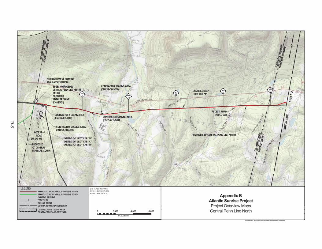
WES
TCR
EEK
RDT7
00
COMSTOCK RDT812
LAUBACH
RD T816 RED
ROCK
RD- S
R48
7
COUN
TYLIN
E ROAD(T
662)
CASEL OTRD T822
SR40
11(O
LDTI
OGA
TURNPIK
E)
PROPOSED 30" CENTRAL PENN LINE NORTH
CAM
PLA
VIG
NERD
-SR
4049
JACK
SON
TOWN
SHIP
EXISTING 24" LEIDY LINE "B"EXISTING 36" LEIDY LINE "C"EXISTING 42" LEIDY LINE "D"PROPOSED
42" CENTRALPENN LINE SOUTH
SCHO
OLHO
USE
RD T7
14
FAIRM
OUNT
TOWN
SHIP
SUGA
RLOA
F TO
WNSH
IP
STATE HIGHWAY 118
EXISTING 23.375''LEIDY LINE ''A''
FRITZ H ILL RDT82
5
CONTRACTOR STAGING AREA(CN-CSA-CO-4-009)
ACCESSROAD
(AR-CO-108)
SUGA
RLOA
F TO
WNSH
IP
COLU
MBIA
COUN
TYLU
ZERN
E CO
UNTY
BEGIN PROPOSED 30"CENTRAL PENN LINE NORTHM.P. 0.00PROPOSEDMAIN LINE VALVE(CN-MLV-01)
ACCESS ROAD(AR-CO-005)
PERMANACCESS RO
(AR-LU-0
PROPOSED WEST DIAMONDREGULATOR STATION
CONTRACTOR STAGING AREA(CN-CSA-CO-1-003)
CONTRACTOR STAGING AREA(CN-CSA-CO-1-004)
CONTRACTOR STAGING AREA(CN-CSA-CO-1-002)
MILE5.0MILE
4.0MILE3.0
MILE2.0
MILE1.0
ELMJH
DRG 7.5 MIN. QUAD MAP:41076-C4 (ELK GROVE, PA)41076-C3 (RED ROCK, PA)
10/3/1410/3/14
9/22/14
F-FQ-CPLN-A-01\\houvgtgweb2\GIS\1_Beta_Projects\101769-NEW\FERC\MXD\CPLN\Supplement\F-FQ-CPLN-A-01.mxd
0 2,000 4,000 6,000
SCALE IN FEET
JHD
1161481
DRAWING NO. REFERENCE TITLE
NO. DATE BY REVISION DESCRIPTION W.O. NO. CHK. APP. DRAWN BY:
CHECKED BY:
APPROVED BY:
WO:
DATE:
DATE:
DATE: ISSUED FOR BID:
ISSUED FOR CONSTRUCTION: REVISION:
6:49 PM
DRAWINGNUMBER:
OFSHEET
5/12/2015
LEGENDPROPOSED 30" CENTRAL PENN LINE NORTHPROPOSED 42" CENTRAL PENN LINE SOUTHEXISTING PIPELINEFENCE LINEACCESS ROADSCOUNTY/TOWNSHIP BOUNDARYCONTRACTOR STAGING AREACONTRACTOR YARD/PIPE YARD
1"=2,000'1
SCALE:
111
MATC
H L
INE
SHEE
T 2
ISSUED FOR SUPPLEMENTAL FILING #11 JTN5/26/15 1161481 CLR MJHISSUED FOR FERC FILING0 JTN3/31/15 1161481 DP MJH
TRANSCONTINENTAL GAS PIPE LINE COMPANY LLCTOPOGRAPHICAL PROJECT LOCATION MAP
ATLANTIC SUNRISE PROJECTPROPOSED 30" CENTRAL PENN LINE NORTH
M.P. 0.00 TO M.P. 57.30COLUMBIA & LUZERNE COUNTIES, PENNSYLVANIA
Appendix BAtlantic Sunrise ProjectProject Overview MapsCentral Penn Line North
B-5
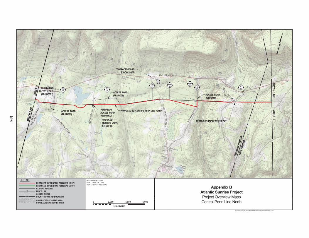
SR 4013 (MOSSVILLE ROAD)
TRIP
PRO
AD(T
634)
SR4015 (BETHELHILLROAD)
MARANSKYROAD (T6
44)
PROPOSED 30" CENTRAL PENN LINE NORTH
BRI
GDE OUT ROAD
(OLDTIO
GATU
RNPIK
E)
SR40
11
CONTRACTOR YARD(CN-CY-LU-1-11)
M-00560.70
(T672)
FAIRM
OUNT
TOWN
SHIP
ROSS
TOWN
SHIP
EXISTING 23.375" LEIDY LINE "A"GOSS
ROA
D (T6
42)
STATE HIGHWAY 118
PERMANENTACCESS ROAD(AR-LU-007.1)
PERMANENTACCESS ROAD
(AR-LU-006.1) ACCESS ROAD(AR-LU-009)
ACCESS ROAD(AR-LU-006)
ACCESS ROAD(AR-LU-008)
PROPOSEDMAIN LINE VALVE(CN-MLV-02)
M-00560.0
M-00560.74
MILE10.0
MILE8.0
MILE7.0
MILE6.0
ELMJH
DRG 7.5 MIN. QUAD MAP:41076-C3 (RED ROCK, PA)41076-C2 (SWEET VALLEY, PA)
10/3/1410/3/14
9/22/14
F-FQ-CPLN-A-01\\houvgtgweb2\GIS\1_Beta_Projects\101769-NEW\FERC\MXD\CPLN\Supplement\F-FQ-CPLN-A-01.mxd
0 2,000 4,000 6,000
SCALE IN FEET
JHD
1161481
DRAWING NO. REFERENCE TITLE
NO. DATE BY REVISION DESCRIPTION W.O. NO. CHK. APP. DRAWN BY:
CHECKED BY:
APPROVED BY:
WO:
DATE:
DATE:
DATE: ISSUED FOR BID:
ISSUED FOR CONSTRUCTION: REVISION:
6:55 PM
DRAWINGNUMBER:
OFSHEET
5/12/2015
LEGENDPROPOSED 30" CENTRAL PENN LINE NORTHPROPOSED 42" CENTRAL PENN LINE SOUTHEXISTING PIPELINEFENCE LINEACCESS ROADSCOUNTY/TOWNSHIP BOUNDARYCONTRACTOR STAGING AREACONTRACTOR YARD/PIPE YARD
1"=2,000'1
SCALE:
112
MATC
H L
INE
SHE
ET 1
MATCH LINE SHEET 3
ISSUED FOR SUPPLEMENTAL FILING #11 JTN5/26/15 1161481 CLR MJHISSUED FOR FERC FILING0 JTN3/31/15 1161481 DP MJH
TRANSCONTINENTAL GAS PIPE LINE COMPANY LLCTOPOGRAPHICAL PROJECT LOCATION MAP
ATLANTIC SUNRISE PROJECTPROPOSED 30" CENTRAL PENN LINE NORTH
M.P. 0.00 TO M.P. 57.30LUZERNE COUNTY, PENNSYLVANIA
Appendix BAtlantic Sunrise ProjectProject Overview MapsCentral Penn Line North
B-6
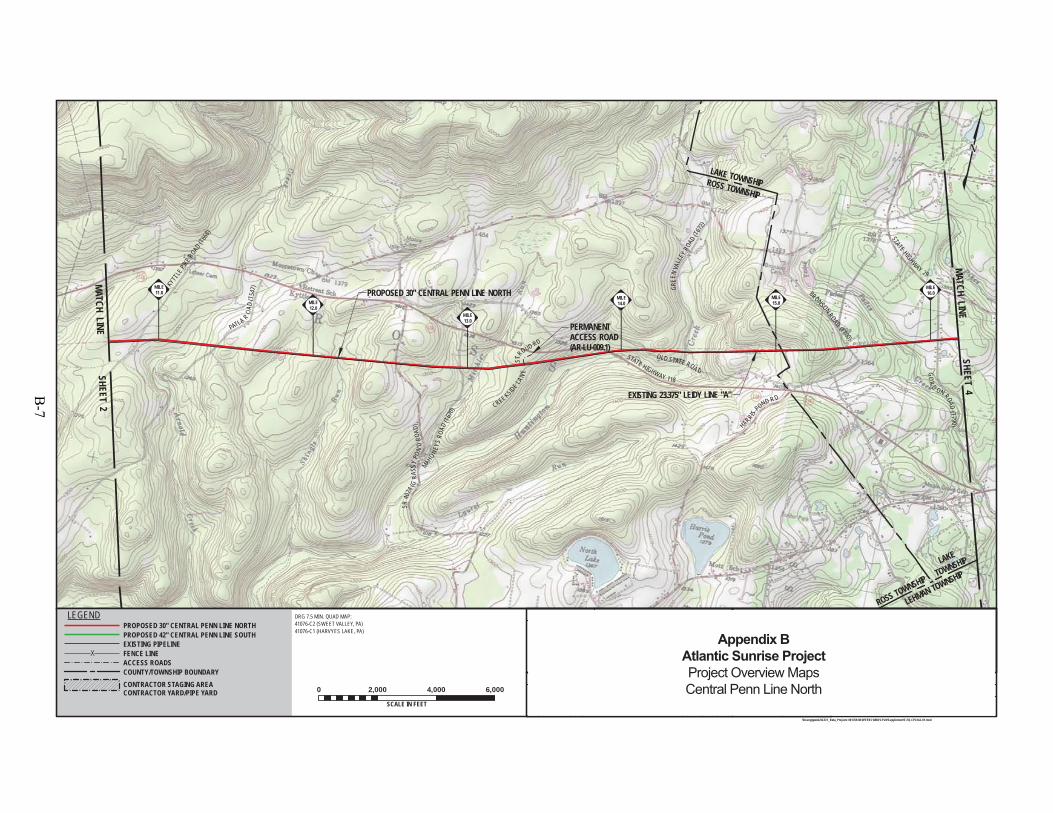
KYTT
LEPIK
E ROAD(T6
68)
PATLA R
OAD
(T54
7)
SR40
24(G
RASS
YPO
ND
ROAD
)MAH
ONEYS
ROAD
(T67
0)
STROUD RD
STATE HIGHWAY 118
GREE
NVA
LLEY
ROAD
(T672
)
HARRIS
POND R D
BRONSON ROAD(T800)
STATE HIGHWAY 29
PROPOSED 30" CENTRAL PENN LINE NORTH
GO
RD ON ROAD
(T790 )
OLD STATE ROA D
ROSS TOWNSHIP
LAKE
TOWNSHIP
LEHMAN TOWNSHIP
CREEKSIDE LAN
E
LAKE TOWNSHIPROSS TOWNSHIP
EXISTING 23.375" LEIDY LINE "A"
PERMANENTACCESS ROAD(AR-LU-009.1)
MILE16.0
MILE15.0
MILE14.0
MILE13.0
MILE12.0
MILE11.0
ELMJH
DRG 7.5 MIN. QUAD MAP:41076-C2 (SWEET VALLEY, PA)41076-C1 (HARVYES LAKE, PA)
10/3/1410/3/14
9/22/14
F-FQ-CPLN-A-01\\houvgtgweb2\GIS\1_Beta_Projects\101769-NEW\FERC\MXD\CPLN\Supplement\F-FQ-CPLN-A-01.mxd
0 2,000 4,000 6,000
SCALE IN FEET
JHD
1161481
DRAWING NO. REFERENCE TITLE
NO. DATE BY REVISION DESCRIPTION W.O. NO. CHK. APP. DRAWN BY:
CHECKED BY:
APPROVED BY:
WO:
DATE:
DATE:
DATE: ISSUED FOR BID:
ISSUED FOR CONSTRUCTION: REVISION:
7:11 PM
DRAWINGNUMBER:
OFSHEET
5/12/2015
LEGENDPROPOSED 30" CENTRAL PENN LINE NORTHPROPOSED 42" CENTRAL PENN LINE SOUTHEXISTING PIPELINEFENCE LINEACCESS ROADSCOUNTY/TOWNSHIP BOUNDARYCONTRACTOR STAGING AREACONTRACTOR YARD/PIPE YARD
1"=2,000'1
SCALE:
113
MATCH LINE SHEET 2
MATCH LINESHEET 4
ISSUED FOR SUPPLEMENTAL FILING #11 JTN5/26/15 1161481 CLR MJHISSUED FOR FERC FILING0 JTN3/31/15 1161481 DP MJH
TRANSCONTINENTAL GAS PIPE LINE COMPANY LLCTOPOGRAPHICAL PROJECT LOCATION MAP
ATLANTIC SUNRISE PROJECTPROPOSED 30" CENTRAL PENN LINE NORTH
M.P. 0.00 TO M.P. 57.30LUZERNE COUNTY, PENNSYLVANIA
Appendix BAtlantic Sunrise ProjectProject Overview MapsCentral Penn Line North
B-7
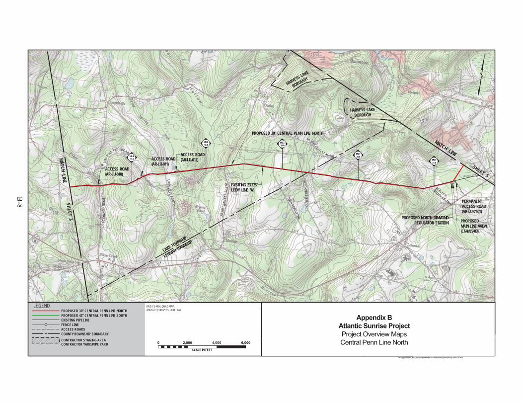
HARVEYS LAKE
BOROUGH
AY 29
LOYALVILLE
ROAD(T779) HO
OVER
ROA
D(T
710)
IDET
OWNROAD
GO
R
D ON ROAD(T790)
S R
1034
(PINE TREE ROAD)
STATEHIGHW
AY29
ZOSHROAD
(T708)
SR 1049 (OUTL ET ROA D)
EXISITING 23.375''LEIDY LINE ''A''
SR10
51(M
EEKE
RRO
AD)
LAKETOWNSHIP
LAKE
TOWNSHIPP
HARVEYS LAKEBOROUGH
PEACEFULVALLEY RD (T825)
LEHMAN TOWNSHIP
LAKE TOWNSHIP
PROPOSED 30" CENTRAL PENN LINE NORTH
PROPOSED NORTH DIAMONDREGULATOR STATION
ACCESS ROAD(AR-LU-010)
ACCESS ROAD(AR-LU-011)
ACCESS ROAD(AR-LU-012)
PERMANENTACCESS ROAD(AR-LU-013.1)
PROPOSEDMAIN LINE VALVE(CN-MLV-03)
ACCE
SS(AR
CONT
RACT
OR
STAGING
AREA
(CN-CS
A-LU-1
-003)
M-0060
0.0
MILE21.0
MILE20.0
MILE19.0
MILE18.0
MILE17.0
ELMJH
DRG 7.5 MIN. QUAD MAP:41076-C1 (HARVYES LAKE, PA)
10/3/1410/3/14
9/22/14
F-FQ-CPLN-A-01\\houvgtgweb2\GIS\1_Beta_Projects\101769-NEW\FERC\MXD\CPLN\Supplement\F-FQ-CPLN-A-01.mxd
0 2,000 4,000 6,000
SCALE IN FEET
JHD
1161481
DRAWING NO. REFERENCE TITLE
NO. DATE BY REVISION DESCRIPTION W.O. NO. CHK. APP. DRAWN BY:
CHECKED BY:
APPROVED BY:
WO:
DATE:
DATE:
DATE: ISSUED FOR BID:
ISSUED FOR CONSTRUCTION: REVISION:
7:19 PM
DRAWINGNUMBER:
OFSHEET
5/12/2015
LEGENDPROPOSED 30" CENTRAL PENN LINE NORTHPROPOSED 42" CENTRAL PENN LINE SOUTHEXISTING PIPELINEFENCE LINEACCESS ROADSCOUNTY/TOWNSHIP BOUNDARYCONTRACTOR STAGING AREACONTRACTOR YARD/PIPE YARD
1"=2,000'1
SCALE:
114
MATCH LINE
SHEET 5
MATCH LINESHEET 3
ISSUED FOR SUPPLEMENTAL FILING #11 JTN5/26/15 1161481 CLR MJHISSUED FOR FERC FILING0 JTN3/31/15 1161481 DP MJH
TRANSCONTINENTAL GAS PIPE LINE COMPANY LLCTOPOGRAPHICAL PROJECT LOCATION MAP
ATLANTIC SUNRISE PROJECTPROPOSED 30" CENTRAL PENN LINE NORTH
M.P. 0.00 TO M.P. 57.30LUZERNE COUNTY, PENNSYLVANIA
Appendix BAtlantic Sunrise ProjectProject Overview MapsCentral Penn Line North
B-8
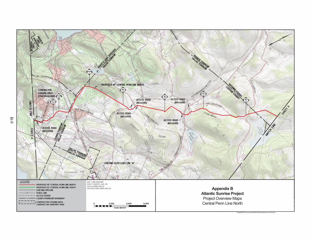
IDET
OWN
ROAD
(T82
3)
BRIERCREST
ROAD(T870)
STATEHIGHW
AY415
SR10
47(LA
KE STREET)
STREDNEY ROAD (T683)
OLD TUNKHANNOCK HWY (T790
)
LAKE CATALPA ROAD
PROPOSED 30" CENTRAL PENN LINE NORTH
STATE HIGHWAY 309
DALLAS TOWNSHIP
SCENIC VIEW DR
EXISTING 23.375' LEIDY LINE "A"
LAKETOW
NSHIPE
WEST 42ND ST (SR 1018)
(TUN
KHAN
NOCK
HIG
HWAY
)
PLATTSBURGRD
HARVEYS
LAKE
BOROUGH
LEHM
AN TO
WNSH
IPDA
LLAS
TOWN
SHIP
DALLAS BOROUGH
DALLAS T
OWNSHIP
HARVEYS L
AKE BOROUGH
MONROE TOWNSHIP
DALLAS TOWNSHIP
WYOMING COUNTY
LUZERNE COUNTY
ACCESS ROAD(AR-LU-017)
ACCESS ROAD(AR-LU-015)
ACCESS ROAD(AR-LU-019)
ACCESS ROAD(AR-LU-020)
ACCESS ROAD(AR-LU-014)
CONTRACTORSTAGING AREA(CN-CSA-LU-1-003) M-0060
0.0
M-00601.0
MILE27.0
MILE26.0
MILE25.0
MILE24.0
MILE22.0
ELMJH
DRG 7.5 MIN. QUAD MAP:41076-C1 (HARVYES LAKE, PA)41075-C8 (KINGSTON, PA)41075-D8 (CENTER MORELAND, PA)
10/3/1410/3/14
9/22/14
F-FQ-CPLN-A-01\\houvgtgweb2\GIS\1_Beta_Projects\101769-NEW\FERC\MXD\CPLN\Supplement\F-FQ-CPLN-A-01.mxd
0 2,000 4,000 6,000
SCALE IN FEET
JHD
1161481
DRAWING NO. REFERENCE TITLE
NO. DATE BY REVISION DESCRIPTION W.O. NO. CHK. APP. DRAWN BY:
CHECKED BY:
APPROVED BY:
WO:
DATE:
DATE:
DATE: ISSUED FOR BID:
ISSUED FOR CONSTRUCTION: REVISION:
7:25 PM
DRAWINGNUMBER:
OFSHEET
5/12/2015
LEGENDPROPOSED 30" CENTRAL PENN LINE NORTHPROPOSED 42" CENTRAL PENN LINE SOUTHEXISTING PIPELINEFENCE LINEACCESS ROADSCOUNTY/TOWNSHIP BOUNDARYCONTRACTOR STAGING AREACONTRACTOR YARD/PIPE YARD
1"=2,000'1
SCALE:
115
MATCH LINESHEET 4 MAT
CH LINE
SHEE
T 6
ISSUED FOR SUPPLEMENTAL FILING #11 JTN5/26/15 1161481 CLR MJHISSUED FOR FERC FILING0 JTN3/31/15 1161481 DP MJH
TRANSCONTINENTAL GAS PIPE LINE COMPANY LLCTOPOGRAPHICAL PROJECT LOCATION MAP
ATLANTIC SUNRISE PROJECTPROPOSED 30" CENTRAL PENN LINE NORTH
M.P. 0.00 TO M.P. 57.30LUZERNE & WYOMING COUNTIES, PENNSYLVANIA
Appendix BAtlantic Sunrise ProjectProject Overview MapsCentral Penn Line North
B-9
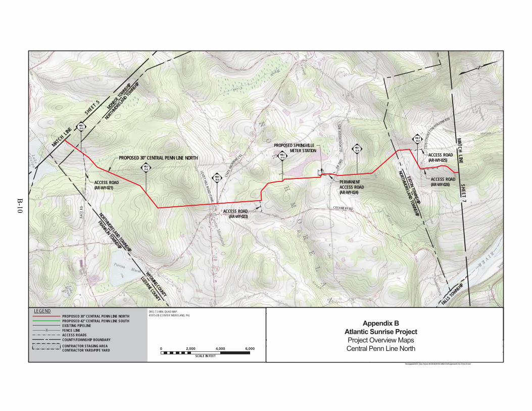
LEVITT HILL ROAD(T368)
STAT
EHI
GHWAY 2 92
RACE
R D
PROPOSED 30" CENTRAL PENN LINE NORTH
WYOMING COUNTY
LUZERNE COUNTY
T 37 0
(THU
RSTO
N HOLLOW RD)
FALLS TO
WNSHIP
PLATTSBURGR D
MONROE TOWNSH
IP
NORTHMORELA
ND TOWNSH
IP
FRANKLIN TOWNSHIP
NORTHMORELAND TOWNSHIP
NORTHMORELAND TOWNSHIP
EATON TOWNSHIPT370
CREAMERY RD
(SCH
OOLH
OUSE
RD)
SR 20
02
PROPOSED SPRINGVILLE METER STATION
ACCESS ROAD(AR-WY-023)
ACCESS ROAD(AR-WY-025)
PERMANENTACCESS ROAD(AR-WY-024)
ACCESS ROAD(AR-WY-026)ACCESS ROAD
(AR-WY-021)
MILE33.0
MILE32.0
MILE31.0
MILE30.0
MILE29.0
MILE28.0
ELMJH
DRG 7.5 MIN. QUAD MAP:41075-D8 (CENTER MORELAND, PA)
10/3/1410/3/14
9/22/14
F-FQ-CPLN-A-01\\houvgtgweb2\GIS\1_Beta_Projects\101769-NEW\FERC\MXD\CPLN\Supplement\F-FQ-CPLN-A-01.mxd
0 2,000 4,000 6,000
SCALE IN FEET
JHD
1161481
DRAWING NO. REFERENCE TITLE
NO. DATE BY REVISION DESCRIPTION W.O. NO. CHK. APP. DRAWN BY:
CHECKED BY:
APPROVED BY:
WO:
DATE:
DATE:
DATE: ISSUED FOR BID:
ISSUED FOR CONSTRUCTION: REVISION:
7:32 PM
DRAWINGNUMBER:
OFSHEET
5/12/2015
LEGENDPROPOSED 30" CENTRAL PENN LINE NORTHPROPOSED 42" CENTRAL PENN LINE SOUTHEXISTING PIPELINEFENCE LINEACCESS ROADSCOUNTY/TOWNSHIP BOUNDARYCONTRACTOR STAGING AREACONTRACTOR YARD/PIPE YARD
1"=2,000'1
SCALE:
116
MATCH LINE
SHEET 5
MATCH LINESHEET 7
ISSUED FOR SUPPLEMENTAL FILING #11 JTN5/26/15 1161481 CLR MJHISSUED FOR FERC FILING0 JTN3/31/15 1161481 DP MJH
TRANSCONTINENTAL GAS PIPE LINE COMPANY LLCTOPOGRAPHICAL PROJECT LOCATION MAP
ATLANTIC SUNRISE PROJECTPROPOSED 30" CENTRAL PENN LINE NORTH
M.P. 0.00 TO M.P. 57.30WYOMING COUNTY, PENNSYLVANIA
Appendix BAtlantic Sunrise ProjectProject Overview MapsCentral Penn Line North
B-10

RADLE RD
SR 2035
(JERMYN HILL RD)
PROPOSED 30" CENTRAL PENN LINE NORTH
MISLEVY RD
FALL
S TOW
NSHIP
SUSQ
UEHA
NNA R
IVER
READINGBL
UE MOUNTA
INAN
DNO
RTHE
RNRR
FALL
S TOW
NSHIP
EATO
N TOW
NSHIP
FALLS TOWNSHIP
FALLS TOWNSHIP
TUNKHANNOCK TOWNSHIP
OVERFIELD TOWNSHIP
T3
70(THURSTON HOLLOW ROA D)
SR 20
07 (K
EELE
RSBU
RG R
D)
SR 2004 (WHITE FERRY ROAD)
KEELERSBURG RD
STATE HIGHWAY 92
SR 2004
(WHITES FERRY ROAD)
TOWNSHIP ROAD 389(TIMBER LANE)
SR 20
06 P
OST
HILL
RD
POST HILL RD
STATE HIGHWAY 307
(ROOSEVELT HIGHWAY)
S ROAD
Y-025)
ACCESS ROAD
(AR-WY-026)
ACCESS ROAD(AR-WY-027)
ACCESS ROAD(AR-WY-027.1)
PERMANENTACCESS ROAD
(AR-WY-028)
ACCESS ROAD(AR-WY-030)ACCESS ROAD
(AR-WY-029)PROPOSEDMAIN LINE VALVE(CN-MLV-04)
ACCESS ROAD(AR-WY-031
CONTRACTOR/PIPE YARD(CN-CY/PY-WY-2-01)
MILE39.0
MILE38.0
MILE37.0
MILE36.0
MILE35.0
MILE34.0
ELMJH
DRG 7.5 MIN. QUAD MAP:41075-D8 (CENTER MORELAND, PA)41075-D7 (RANSOM, PA)41075-E7 (FACTORYVILLE, PA)
10/3/1410/3/14
9/22/14
F-FQ-CPLN-A-01\\houvgtgweb2\GIS\1_Beta_Projects\101769-NEW\FERC\MXD\CPLN\Supplement\F-FQ-CPLN-A-01.mxd
0 2,000 4,000 6,000
SCALE IN FEET
JHD
1161481
DRAWING NO. REFERENCE TITLE
NO. DATE BY REVISION DESCRIPTION W.O. NO. CHK. APP. DRAWN BY:
CHECKED BY:
APPROVED BY:
WO:
DATE:
DATE:
DATE: ISSUED FOR BID:
ISSUED FOR CONSTRUCTION: REVISION:
7:37 PM
DRAWINGNUMBER:
OFSHEET
5/12/2015
LEGENDPROPOSED 30" CENTRAL PENN LINE NORTHPROPOSED 42" CENTRAL PENN LINE SOUTHEXISTING PIPELINEFENCE LINEACCESS ROADSCOUNTY/TOWNSHIP BOUNDARYCONTRACTOR STAGING AREACONTRACTOR YARD/PIPE YARD
1"=2,000'1
SCALE:
117
MATCH LINE SHEET 6
MATCH LINE
SHEET 8
ISSUED FOR SUPPLEMENTAL FILING #11 JTN5/26/15 1161481 CLR MJHISSUED FOR FERC FILING0 JTN3/31/15 1161481 DP MJH
TRANSCONTINENTAL GAS PIPE LINE COMPANY LLCTOPOGRAPHICAL PROJECT LOCATION MAP
ATLANTIC SUNRISE PROJECTPROPOSED 30" CENTRAL PENN LINE NORTH
M.P. 0.00 TO M.P. 57.30WYOMING COUNTY, PENNSYLVANIA
Appendix BAtlantic Sunrise ProjectProject Overview MapsCentral Penn Line North
B-11

US 6
STATE ROU T E10
7
C
MISLEVY RD (T431)
US 11
PROPOSED 30" CENTRAL PENN LINE NORTH
CLINTON TOWNSHIPNICHOLSON TOWNSHIP
TUNKHANNOCK TOWNSHIP
OVERFIELD TOWNSHIP
PROPOSEDELECTRICALSUBSTATION
SR 2012 LITHIA VALLEYROAD
STANTON LANE
DALTON RD
TUNNELHILLRD
SR 1017 (COLLEGE AVE)
CLINTON TO
WNSHIP
CLINTON TOWNSHIP
OVERFIELD TOWNSHIP
CLINTON TOWNSHIP
FACTORYVILLE BOROUGH
TUNKHANNOCK TOWNSHIP
LAKE WINOLA RD
ARCHER RD
WINOLA FARM ROAD
STATE ROUTE 2010
LENGEL RD
ARCHER RD
STATE ROUTE 1029
SAVAGE ROAD (T464)
CREEK ROAD (T468)
(BUNKER HILL RD)
STATE ROUTE 1012
(LACKAWANNA TRAIL)
PROPOSED COMPRESSORSTATION 605
ACCESS ROAD(AR-WY-035.4)
ACCESS ROAD(AR-WY-031)
ACCESS ROAD(AR-WY-032)
PERMANENTACCESS ROAD(AR-WY-035.3)
PROPOSEDMAIN LINE VALVE(CN-MLV-05)
CONTRACTOR STAGING AREA(CN-CSA-WY-1-006)
CONTRACTORSTAGING AREA(CN-CSA-WY-1-005)CONTRACTOR STAGING AREA
(CN-CSA-WY-1-004)
M-00540.76
M-00540.0
MILE45.0
MILE44.0MILE
42.0
MILE41.0
MILE40.0
ELMJH
DRG 7.5 MIN. QUAD MAP:41075-E7 (FACTORYVILLE, PA)
10/3/1410/3/14
9/22/14
F-FQ-CPLN-A-01\\houvgtgweb2\GIS\1_Beta_Projects\101769-NEW\FERC\MXD\CPLN\Supplement\F-FQ-CPLN-A-01.mxd
0 2,000 4,000 6,000
SCALE IN FEET
JHD
1161481
DRAWING NO. REFERENCE TITLE
NO. DATE BY REVISION DESCRIPTION W.O. NO. CHK. APP. DRAWN BY:
CHECKED BY:
APPROVED BY:
WO:
DATE:
DATE:
DATE: ISSUED FOR BID:
ISSUED FOR CONSTRUCTION: REVISION:
7:45 PM
DRAWINGNUMBER:
OFSHEET
5/12/2015
LEGENDPROPOSED 30" CENTRAL PENN LINE NORTHPROPOSED 42" CENTRAL PENN LINE SOUTHEXISTING PIPELINEFENCE LINEACCESS ROADSCOUNTY/TOWNSHIP BOUNDARYCONTRACTOR STAGING AREACONTRACTOR YARD/PIPE YARD
1"=2,000'1
SCALE:
118
MATCH LINE
SHEET 7
MATC
H L
INE
SHEE
T 9
ISSUED FOR SUPPLEMENTAL FILING #11 JTN5/26/15 1161481 CLR MJHISSUED FOR FERC FILING0 JTN3/31/15 1161481 DP MJH
TRANSCONTINENTAL GAS PIPE LINE COMPANY LLCTOPOGRAPHICAL PROJECT LOCATION MAP
ATLANTIC SUNRISE PROJECTPROPOSED 30" CENTRAL PENN LINE NORTH
M.P. 0.00 TO M.P. 57.30WYOMING COUNTY, PENNSYLVANIA
Appendix BAtlantic Sunrise ProjectProject Overview MapsCentral Penn Line North
B-12

NICHOLSON TOWNSHIP
STATE ROU T E 107
NICHOLSON TOWNSHIP
PROPOSED 30" CENTRAL PENN LINE NORTH
CLINTON TOWNSHIP
US 11
SR 1017(COLLE
GE AVE)
VICS
LANE(T523)
SR10
3 1(F
ARN
HAM
ROAD)
WYOMING COUNTYLACKAWANNA COUNTY
ON TOWNSHIP
ON TOWNSHIP
M-00580.47
TUNKHANNOCK
CREEK
TUNNELHILLRD
CANA
DIAN
PACI
FIC
RAIL
ROAD
PI FCHOLN
TOWNSHIP ROAD 501
(PRATT HOLLOW RD)
LATHROP TOWNSHIP
LENOX TOWNSHIP
BENTON TOWNSHIP
NICHOLSON TOWNSHIP
LENOX TOWNSHIP
NICHOLSON BOROUGH
WYOMING COUNTYSUSQUEHANNA COUNTY
LENGEL RD
SR 1014
TUNNEL RD
MATU
LEVI
CHRO
AD (T
519)
SAVAGE ROAD (T464)
STATE HIGHWAY 92
(LACKAWANNA TRAIL)
ACCESS ROAD(AR-WY-036) ACCESS ROAD
(AR-WY-040)
ACCESS ROAD(AR-WY-040.1)
ACCESS ROAD(AR-WY-039)
PERMANENTACCESS ROAD(AR-SU-041)
ACCESS ROAD(AR-WY-036.1)
ACCES(AR
OSEDNE VALVE05)
M-00510.07
M-00510.0
M-00580.0
MILE51.0
MILE50.0
MILE49.0
MILE48.0
MILE47.0
MILE46.0
ELMJH
DRG 7.5 MIN. QUAD MAP:41075-E7 (FACTORYVILLE, PA)41075-F7 (HOP BOTTOM, PA)
10/3/1410/3/14
9/22/14
F-FQ-CPLN-A-01\\houvgtgweb2\GIS\1_Beta_Projects\101769-NEW\FERC\MXD\CPLN\Supplement\F-FQ-CPLN-A-01.mxd
0 2,000 4,000 6,000
SCALE IN FEET
JHD
1161481
DRAWING NO. REFERENCE TITLE
NO. DATE BY REVISION DESCRIPTION W.O. NO. CHK. APP. DRAWN BY:
CHECKED BY:
APPROVED BY:
WO:
DATE:
DATE:
DATE: ISSUED FOR BID:
ISSUED FOR CONSTRUCTION: REVISION:
7:51 PM
DRAWINGNUMBER:
OFSHEET
5/12/2015
LEGENDPROPOSED 30" CENTRAL PENN LINE NORTHPROPOSED 42" CENTRAL PENN LINE SOUTHEXISTING PIPELINEFENCE LINEACCESS ROADSCOUNTY/TOWNSHIP BOUNDARYCONTRACTOR STAGING AREACONTRACTOR YARD/PIPE YARD
1"=2,000'1
SCALE:
119
MATC
H LI
NE
SHEE
T 8
MATC
H L
INE
SHE
ET 1
0
ISSUED FOR SUPPLEMENTAL FILING #11 JTN5/26/15 1161481 CLR MJHISSUED FOR FERC FILING0 JTN3/31/15 1161481 DP MJH
TRANSCONTINENTAL GAS PIPE LINE COMPANY LLCTOPOGRAPHICAL PROJECT LOCATION MAP
ATLANTIC SUNRISE PROJECTPROPOSED 30" CENTRAL PENN LINE NORTH
M.P. 0.00 TO M.P. 57.30WYOMING & SUSQUEHANNA COUNTIES, PENNSYLVANIA
Appendix BAtlantic Sunrise ProjectProject Overview MapsCentral Penn Line North
B-13

L
END PROPOSED 30"CENTRAL PENN LINE NORTHM.P. 57.30PROPOSEDMAIN LINE VALVE(CN-MLV-06)
SR2 020
PROPOSED 30" CENTRAL PENN LINE NORTH
LATHROP TOWNSHIP
LENOX TOWNSHIP
(RODAND
GUNCLUB
ROAD)
(GLE
NWOOD ROAD)
W LENOX CHURCH RD
PROPOSED ZICKMETER STATION
CONTRACTOR STAGING AREA(CN-CSA-SU-1-008)
PERMANENTACCESS ROAD(AR-SU-047.1)
PROPOSED ZICK METER STATION -STORM WATER BASIN
TOWNSHIP ROAD 501
(PRATT HOLLOW RD)
(FOREST ST)
(PA-2043)
STATION HILL RD
LAUREL LN
TOWNSHIP ROAD 383
TAYLOR RD
TOWNSHIPROAD
507 (WICKW
IRERD)
T503SR
2041
STATION HILL RD PA-2017
HARFORD TOWNSHIP
LENOX TOWNSHIP
ACCESS ROAD(AR-SU-046.1)
ACCESS ROAD(AR-SU-046.4)
ACCESS ROAD(AR-SU-045)
PERMANENTACCESS ROAD
(AR-SU-046)
PERMANENTACCESS ROAD(AR-SU-047)
ACCESS ROAD(AR-SU-044)
CONTRACTOR STAGING AREA(CN-CSA-SU-1-007)
M-00620.25M-0062
0.0
M-00610.16
M-00610.0
MILE57.0
MILE55.0
MILE54.0
MILE53.0
MILE52.0
ELMJH
DRG 7.5 MIN. QUAD MAP:41075-F6 (LENOXVILLE, PA)
10/3/1410/3/14
9/22/14
F-FQ-CPLN-A-01\\houvgtgweb2\GIS\1_Beta_Projects\101769-NEW\FERC\MXD\CPLN\Supplement\F-FQ-CPLN-A-01.mxd
0 2,000 4,000 6,000
SCALE IN FEET
JHD
1161481
DRAWING NO. REFERENCE TITLE
NO. DATE BY REVISION DESCRIPTION W.O. NO. CHK. APP. DRAWN BY:
CHECKED BY:
APPROVED BY:
WO:
DATE:
DATE:
DATE: ISSUED FOR BID:
ISSUED FOR CONSTRUCTION: REVISION:
8:00 PM
DRAWINGNUMBER:
OFSHEET
5/12/2015
LEGENDPROPOSED 30" CENTRAL PENN LINE NORTHPROPOSED 42" CENTRAL PENN LINE SOUTHEXISTING PIPELINEFENCE LINEACCESS ROADSCOUNTY/TOWNSHIP BOUNDARYCONTRACTOR STAGING AREACONTRACTOR YARD/PIPE YARD
1"=2,000'1
SCALE:
1110
ISSUED FOR SUPPLEMENTAL FILING #11 JTN5/26/15 1161481 CLR MJHISSUED FOR FERC FILING0 JTN3/31/15 1161481 DP MJH
TRANSCONTINENTAL GAS PIPE LINE COMPANY LLCTOPOGRAPHICAL PROJECT LOCATION MAP
ATLANTIC SUNRISE PROJECTPROPOSED 30" CENTRAL PENN LINE NORTH
M.P. 0.00 TO M.P. 57.30SUSQUEHANNA COUNTY, PENNSYLVANIA
Appendix BAtlantic Sunrise ProjectProject Overview MapsCentral Penn Line North
B-14
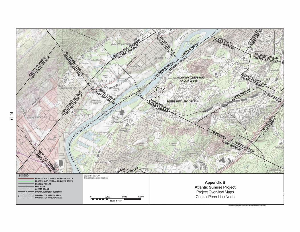
PLAINS TO W NS HIP
KES TY
EXISTING 23.375" LEIDY LINE "A"
US 11
WYOMING AVENUE
SUSQUEHANNA RIVER
MAIN STREET
INTERSATE HIGHWAY 81
JENKINS TOWNSHIP
YATESVILLE BOROUGH
LAFL
IN BOROUGH
JENKINS T
OWNSHIP
EXETER BOROUGH
WYOMINGBOROUGH
FORTY FORT BOROUGH
WYOMING BOROUGH
WEST WYOMING BOROUGH
SWOYERSVILLE BOROUGH
LAFLIN BOROUGH
LAFLIN BOROUGHPLAINS TOWNSHIP
WYOMING BOROUGHWYOMING BOROUGH
WEST WYOMING BOROUGH
JENKINS TOWNSHIP
YATESVILLE BOROUGH
PITTSTON TOWNSHIP
KINGSTONBOROUGH
FORTY
FORTBOROUGH
EXETER BOROUGH
JENKINS TOWNSHIP
FORTY
FORT BOROUGH
SWOYERSVILLE BOROUGH
JENKINS TOWNSHIP
JENKINS TOWNSHIP
PLAINS TOWNSHIP
JENKINS TOWNSHIP
PITTSTON CITY
KINGSTON TO
WNSHIP
SWOYE
RSVILLE BOROUGH
PITTS
TON T
OWNSHIP
PITTS
TON C
ITY
CONTRACTOR/PIPE YARD(CN-CY/PY-LU-2-02)
ELMJH
DRG 7.5 MIN. QUAD MAP:41075-B8 (WILKES-BARRE WEST, PA)
10/3/1410/3/14
9/22/14
F-FQ-CPLN-A-01\\houvgtgweb2\GIS\1_Beta_Projects\101769-NEW\FERC\MXD\CPLN\Supplement\F-FQ-CPLN-A-01.mxd
0 2,000 4,000 6,000
SCALE IN FEET
JHD
1161481
DRAWING NO. REFERENCE TITLE
NO. DATE BY REVISION DESCRIPTION W.O. NO. CHK. APP. DRAWN BY:
CHECKED BY:
APPROVED BY:
WO:
DATE:
DATE:
DATE: ISSUED FOR BID:
ISSUED FOR CONSTRUCTION: REVISION:
7:59 PM
DRAWINGNUMBER:
OFSHEET
5/12/2015
LEGENDPROPOSED 30" CENTRAL PENN LINE NORTHPROPOSED 42" CENTRAL PENN LINE SOUTHEXISTING PIPELINEFENCE LINEACCESS ROADSCOUNTY/TOWNSHIP BOUNDARYCONTRACTOR STAGING AREACONTRACTOR YARD/PIPE YARD
1"=2,000'1
SCALE:
1111
ISSUED FOR SUPPLEMENTAL FILING #11 JTN5/26/15 1161481 CLR MJHISSUED FOR FERC FILING0 JTN3/31/15 1161481 DP MJH
TRANSCONTINENTAL GAS PIPE LINE COMPANY LLCTOPOGRAPHICAL PROJECT LOCATION MAP
ATLANTIC SUNRISE PROJECTPROPOSED 30" CENTRAL PENN LINE NORTH
M.P. 0.00 TO M.P. 57.30LUZERNE COUNTY, PENNSYLVANIA
Appendix BAtlantic Sunrise ProjectProject Overview MapsCentral Penn Line North
B-15

B-16
Central Penn Line South
B-17

B-18
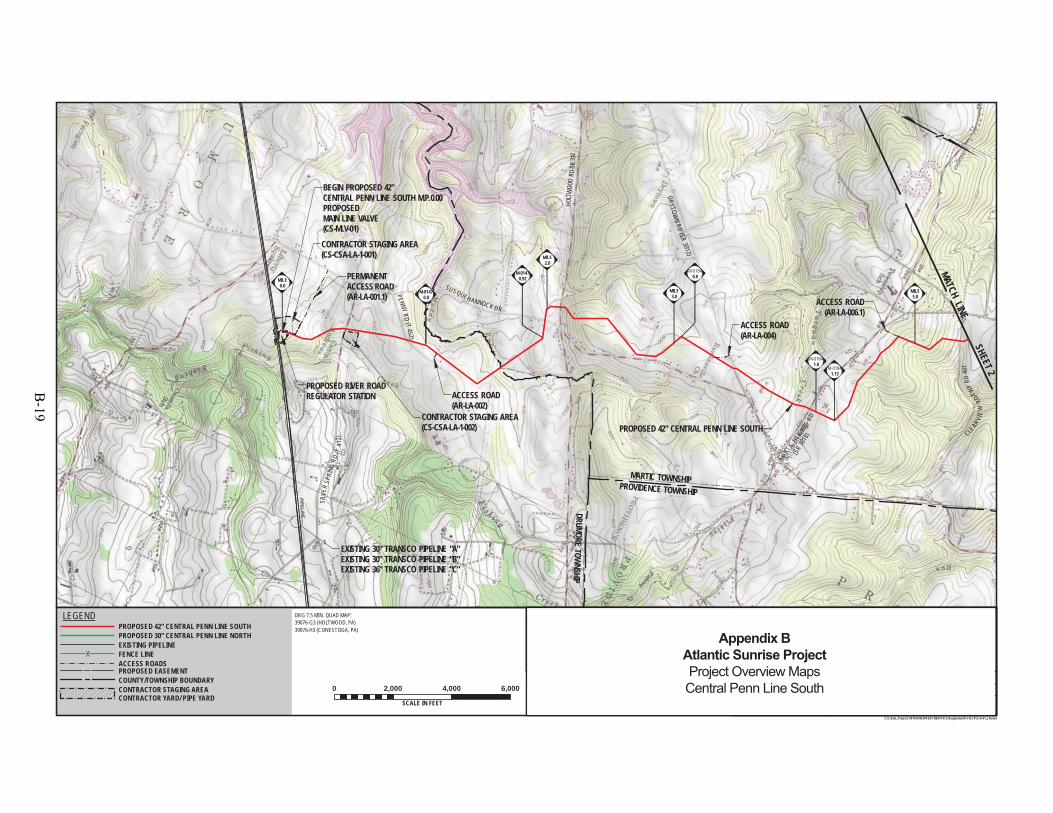
SILV
ERSP
RING
RD(T
412)
PENNYRD
(T452)
SU SQUEH ANNOCK DR
DRYTOWN
RD(SR
3012)
MART
ICHEIG
HTSRD
EXISTING 30" TRANSCO PIPELINE "A"EXISTING 30" TRANSCO PIPELINE "B"EXISTING 36" TRANSCO PIPELINE "C"
BEGIN PROPOSED 42"CENTRAL PENN LINE SOUTH M.P. 0.00PROPOSEDMAIN LINE VALVE(CS-MLV-01)
HOLT
WOO
DRD
-SR
3 72
DRUMORE TOWNSHIP
CONTRACTOR STAGING AREA(CS-CSA-LA-1-001)
CLEAR
VIE
WRD
/TWP
RD40
1
CONTRACTOR STAGING AREA(CS-CSA-LA-1-002)
0.0
1.0
1.13
(SR
3018
)
PERMANENT ACCESS ROAD(AR-LA-001.1)
PROVIDENCE TOWNSHIP
MARTIC TOWNSHIP
PROPOSED 42" CENTRAL PENN LINE SOUTH
PROPOSED RIVER ROADREGULATOR STATION ACCESS ROAD
(AR-LA-002)
ACCESS ROAD(AR-LA-004)
ACCESS ROAD(AR-LA-006.1)
M-01470.92
M-01470.0
M-01470.0
MILE0.0
MILE5.0
MILE3.0
MILE2.0
DRAWING NO. REFERENCE TITLE
NO. DATE BY REVISION DESCRIPTION W.O. NO. CHK. APP.
0 3/31/15 JTN ISSUED FOR FERC FILING 1161503 DP MJH
TRANSCONTINENTAL GAS PIPE LINE COMPANY LLCTOPOGRAPHICAL PROJECT LOCATION MAP
ATLANTIC SUNRISE PROJECTPROPOSED 42" CENTRAL PENN LINE SOUTH
M.P. 0.00 TO M.P. 125.15LANCASTER COUNTY, PENNSYLVANIA
APPROVED BY:
WO:
DRAWN BY:
CHECKED BY:
DATE:
DATE:
DATE:
10/3/1410/3/14
9/22/14
1161503
JHD SCALE:ISSUED FOR BID:
ISSUED FOR CONSTRUCTION: REVISION:
9:18 AM
DRAWINGNUMBER: F-FQ-CPLS-A-01
11 "=2,000 '
OFSHEET 1
Z:\1_Beta_Projects\101769-NEW\FERC\MXD\CPLS\Supplement\F-FQ-CPLS-A-01_JN.mxd
DRG 7.5 MIN. QUAD MAP:39076-G3 (HOLTWOOD, PA)39076-H3 (CONESTOGA, PA)
0 2,000 4,000 6,000
SCALE IN FEET5/27/2015
ELMJH
MATCH LINE SHEET 2
PROPOSED EASEMENT
EXISTING PIPELINEFENCE LINEACCESS ROADS
LEGENDPROPOSED 42" CENTRAL PENN LINE SOUTHPROPOSED 30" CENTRAL PENN LINE NORTH
COUNTY/TOWNSHIP BOUNDARYCONTRACTOR STAGING AREACONTRACTOR YARD/ PIPE YARD
1 5/26/15 JTN ISSUED FOR SUPPLEMENTAL FILING #1 1161503 DP MJH
25
Appendix BAtlantic Sunrise ProjectProject Overview MapsCentral Penn Line South
B-19
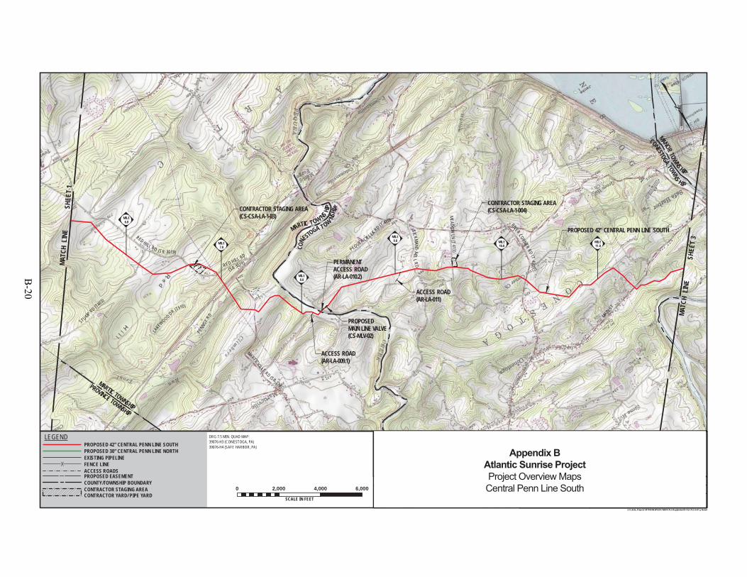
STUMP RD (T403)
RED HILL RD
LAKEWOOD DR (T510)
PENN
SYRD
MARTICVILLE RD (SR 324)
CONE
STOGA T OW
NSHIP
MARTIC TOW NS HIPSICKMANS
MILLR
D
MEA DOW
LN(T
413)
RIVER CORNERRD
(T420)
MAINST
CONESTOGABLVD
PROPOSED 42" CENTRAL PENN LINE SOUTH
MANORTOWNS HIP
CONESTOGA TOWNS HIP
PEQUEA CREEK RD (T 410)
PROVINCE TOWNSHIP
MARTIC TOWNSHIP
CONTRACTOR STAGING AREA(CS-CSA-LA-1-004)
E WRD
/TW
PRD
401
(SR 3019)
CONTRACTOR STAGING AREA(CS-CSA-LA-1-03)
RED HI LL RD (S R 3019)
PERMANENTACCESS ROAD(AR-LA-010.2)
ACCESS ROAD(AR-LA-009.1)
ACCESS ROAD(AR-LA-011)
PROPOSEDMAIN LINE VALVE(CS-MLV-02)
MILE11.0
MILE10.0
MILE9.0
MILE8.0
MILE7.0
MILE6.0
DRAWING NO. REFERENCE TITLE
NO. DATE BY REVISION DESCRIPTION W.O. NO. CHK. APP.
0 3/31/15 JTN ISSUED FOR FERC FILING 1161503 DP MJH
TRANSCONTINENTAL GAS PIPE LINE COMPANY LLCTOPOGRAPHICAL PROJECT LOCATION MAP
ATLANTIC SUNRISE PROJECTPROPOSED 42" CENTRAL PENN LINE SOUTH
M.P. 0.00 TO M.P. 125.15LANCASTER COUNTY, PENNSYLVANIA
APPROVED BY:
WO:
DRAWN BY:
CHECKED BY:
DATE:
DATE:
DATE:
10/3/1410/3/14
9/22/14
1161503
JHD SCALE:ISSUED FOR BID:
ISSUED FOR CONSTRUCTION: REVISION:
9:46 AM
DRAWINGNUMBER: F-FQ-CPLS-A-01
11 "=2,000 '
OFSHEET 2
Z:\1_Beta_Projects\101769-NEW\FERC\MXD\CPLS\Supplement\F-FQ-CPLS-A-01_JN.mxd
DRG 7.5 MIN. QUAD MAP:39076-H3 (CONESTOGA, PA)39076-H4 (SAFE HARBOR, PA)
0 2,000 4,000 6,000
SCALE IN FEET5/27/2015
ELMJH
MATC
H L
INE
SHEE
T 3
MATC
H L
INE
SHEE
T 1
PROPOSED EASEMENT
EXISTING PIPELINEFENCE LINEACCESS ROADS
LEGENDPROPOSED 42" CENTRAL PENN LINE SOUTHPROPOSED 30" CENTRAL PENN LINE NORTH
COUNTY/TOWNSHIP BOUNDARYCONTRACTOR STAGING AREACONTRACTOR YARD/ PIPE YARD
1 5/26/15 JTN ISSUED FOR SUPPLEMENTAL FILING #1 1161503 DP MJH
25
Appendix BAtlantic Sunrise ProjectProject Overview MapsCentral Penn Line South
B-20
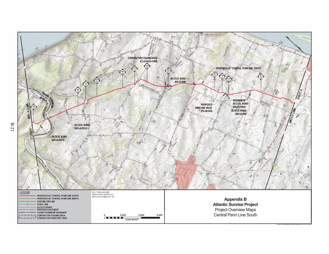
CONESTOGA
BLVD
WITMER
RD
H
PROPOSED 42" CENTRAL PENN LINE SOUTH
HIGHVILLE ROAD (T392)
BREN
EMAN
ROAD
(T58
1)
LETO
RTRO
AD
ANCH
ORRD
BLUE
ROCK
RD(T
589)
PENN
STRE
ET- RT
999
HIP
HIP
SAFEHA
RBORRD
INDI
ANMA
RKER
M
ANOR TOWNSHIP
CONE
STOG
AT
O
WNSHIP
PROSPECTRD
CONTRACTOR STAGING AREA(CS-CSA-LA-1-005)
R OAD
(T57
9)
PERMANENTACCESS ROAD(AR-LA-018.3)
ACCESS ROAD(AR-LA-016)
ACCESS ROAD(AR-LA-012.2)
ACCESS ROAD(AR-LA-012.1)
ACCESS ROAD(AR-LA-018)
PROPOSEDMAIN LINE VALVE
(CS-MLV-03)
M-01850.0 M-0185
0.15
M-01880.33M-0188
0.0
M-01520.0
M-01520.39
1
MILE17.0
MILE16.0
MILE15.0MILE
14.0
MILE13.0
MILE12.0
DRAWING NO. REFERENCE TITLE
NO. DATE BY REVISION DESCRIPTION W.O. NO. CHK. APP.
0 3/31/15 JTN ISSUED FOR FERC FILING 1161503 DP MJH
TRANSCONTINENTAL GAS PIPE LINE COMPANY LLCTOPOGRAPHICAL PROJECT LOCATION MAP
ATLANTIC SUNRISE PROJECTPROPOSED 42" CENTRAL PENN LINE SOUTH
M.P. 0.00 TO M.P. 125.15LANCASTER COUNTY, PENNSYLVANIA
APPROVED BY:
WO:
DRAWN BY:
CHECKED BY:
DATE:
DATE:
DATE:
10/3/1410/3/14
9/22/14
1161503
JHD SCALE:ISSUED FOR BID:
ISSUED FOR CONSTRUCTION: REVISION:
10:17 AM
DRAWINGNUMBER: F-FQ-CPLS-A-01
11 "=2,000 '
OFSHEET 3
Z:\1_Beta_Projects\101769-NEW\FERC\MXD\CPLS\Supplement\F-FQ-CPLS-A-01_JN.mxd
DRG 7.5 MIN. QUAD MAP:39076-H4 (SAFE HARBOR, PA)40076-A4 (COLUMBIA EAST, PA)
0 2,000 4,000 6,000
SCALE IN FEET5/27/2015
ELMJH
MATC
H LI
NE
SHE
ET 4
MATCH LINESHEET 2
PROPOSED EASEMENT
EXISTING PIPELINEFENCE LINEACCESS ROADS
LEGENDPROPOSED 42" CENTRAL PENN LINE SOUTHPROPOSED 30" CENTRAL PENN LINE NORTH
COUNTY/TOWNSHIP BOUNDARYCONTRACTOR STAGING AREACONTRACTOR YARD/ PIPE YARD
1 5/26/15 JTN ISSUED FOR SUPPLEMENTAL FILING #1 1161503 DP MJH
25
Appendix BAtlantic Sunrise ProjectProject Overview MapsCentral Penn Line South
B-21
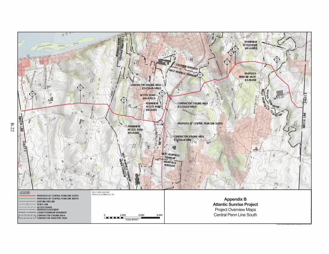
PENN
S TRE
ET-
RT99
9
CHAR LEST OWN
ROAD(T
589)
FRANKLINROAD
COLUMB IAAVE
(SR462)
INDIAN HEAD RDBURM
ARD
IRONVILLEPIK E BRIDGE VALLEY RD
PROPOSED 42" CENTRAL PENN LINE SOUTH
MANOR TOWNSHIPWEST HEMPFIELD TOWNSHIP
I-30 (SR
30)
WEST HEMFIELD TOWNSHIP
COLOMBIA BOROUGH
COL UMBIABOROUGH
MANORTOW
NSHIP
NORWOOD RD (362)
(T 365)
CONTRACTOR STAGING AREA(CS-CSA-LA-1-006.1)
CONTRACTOR STAGING AREA(CS-CSA-LA-1-006.2) W
EST
HEMPFIE
L D TO
W N S HIP
RAPHO
TOW
NSHIP
CONTRACTOR STAGING AREA(CS-CSA-LA-1-006)
MILE21.0
PERMANENTACCESS ROAD(AR-LA-020)
PERMANENTACCESS ROAD(AR-LA-021)
PERMANENTACCESS ROAD
(AR-LA-026.3)
MOUNTVILLEBOROUGH
WEST HEMPFIELDTOWNSHIP
LOCU
STGR
OVE
ROAD
(T60
1 )
FAIR VIEWRD
(T6 65)
MARI
ETTA
AVE
(SR
23)ACCESS ROAD
(AR-LA-023.1)
PROPOSEDMAIN LINE VALVE
(CS-MLV-04)
MILE24.0
MILE23.0
M-01920.09
M-01920.0
MILE23.0
MILE22.0
MILE20.0
MILE19.0
MILE18.0
DRAWING NO. REFERENCE TITLE
NO. DATE BY REVISION DESCRIPTION W.O. NO. CHK. APP.
0 3/31/15 JTN ISSUED FOR FERC FILING 1161503 DP MJH
TRANSCONTINENTAL GAS PIPE LINE COMPANY LLCTOPOGRAPHICAL PROJECT LOCATION MAP
ATLANTIC SUNRISE PROJECTPROPOSED 42" CENTRAL PENN LINE SOUTH
M.P. 0.00 TO M.P. 125.15LANCASTER COUNTY, PENNSYLVANIA
APPROVED BY:
WO:
DRAWN BY:
CHECKED BY:
DATE:
DATE:
DATE:
10/3/1410/3/14
9/22/14
1161503
JHD SCALE:ISSUED FOR BID:
ISSUED FOR CONSTRUCTION: REVISION:
10:27 AM
DRAWINGNUMBER: F-FQ-CPLS-A-01
11 "=2,000 '
OFSHEET 4
Z:\1_Beta_Projects\101769-NEW\FERC\MXD\CPLS\Supplement\F-FQ-CPLS-A-01_JN.mxd
DRG 7.5 MIN. QUAD MAP:40076-A4 (COLUMBIA EAST, PA)
0 2,000 4,000 6,000
SCALE IN FEET5/27/2015
ELMJH
MATC
H L
INE
SHEE
T 5
MATCH LINESHEET 3
PROPOSED EASEMENT
EXISTING PIPELINEFENCE LINEACCESS ROADS
LEGENDPROPOSED 42" CENTRAL PENN LINE SOUTHPROPOSED 30" CENTRAL PENN LINE NORTH
COUNTY/TOWNSHIP BOUNDARYCONTRACTOR STAGING AREACONTRACTOR YARD/ PIPE YARD
1 5/26/15 JTN ISSUED FOR SUPPLEMENTAL FILING #1 1161503 DP MJH
25
Appendix BAtlantic Sunrise ProjectProject Overview MapsCentral Penn Line South
B-22
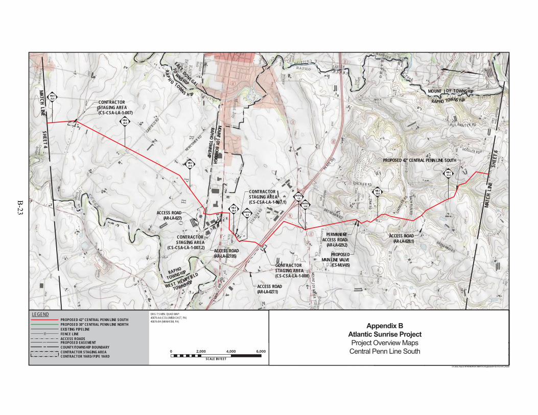
PROPOSED 42" CENTRAL PENN LINE SOUTH
GARFIELD
RD
NEWCOMER RD
EMA
INST
(SR
230)
STIC
KLER
RD
MOUNT
J OYRD
(SR772)
BRENEMAN RD
ZINKRD
STICKLER RD
HOSSLER RD
RAPHO TOWNS HIP
B U CKWALT E R RD
PERMANENTACCESS ROAD
(AR-LA-029.2)
CONTRACTOR STAGING AREA(CS-CSA-LA-1-007.1)
CONTRACTOR STAGING AREA(CS-CSA-LA-1-008)
CONTRACTOR STAGING AREA
(CS-CSA-LA-1-007.2)ACCESS ROAD(AR-LA-027.05)
SPAN
GLER
RD
BACKRUN
RD
PARTE
283
BRENEMAN RD
RAPH
O TOWN S H IP
EASTDONEGAL
TOWNSHIP
RAPHO
TOWNSHIP
WEST HEMPFIELD
TOWNSHIP
MOUNT JOY TOWNSHIP
CONTRACTOR STAGING AREA(CS-CSA-LA-1-007)
M-01621.0
MOUNT JOY BOROUGHRAPHO TOWNSHIP
ACCESS ROAD(AR-LA-028.1)
ACCESS ROAD(AR-LA-027)
ACCESS ROAD(AR-LA-027.1)
PROPOSEDMAIN LINE VALVE
(CS-MLV-05)
M-01620.0
MILE31.0
MILE30.0
MILE28.0
MILE27.0
MILE26.0
MILE25.0
DRAWING NO. REFERENCE TITLE
NO. DATE BY REVISION DESCRIPTION W.O. NO. CHK. APP.
0 3/31/15 JTN ISSUED FOR FERC FILING 1161503 DP MJH
TRANSCONTINENTAL GAS PIPE LINE COMPANY LLCTOPOGRAPHICAL PROJECT LOCATION MAP
ATLANTIC SUNRISE PROJECTPROPOSED 42" CENTRAL PENN LINE SOUTH
M.P. 0.00 TO M.P. 125.15LANCASTER COUNTY, PENNSYLVANIA
APPROVED BY:
WO:
DRAWN BY:
CHECKED BY:
DATE:
DATE:
DATE:
10/3/1410/3/14
9/22/14
1161503
JHD SCALE:ISSUED FOR BID:
ISSUED FOR CONSTRUCTION: REVISION:
10:32 AM
DRAWINGNUMBER: F-FQ-CPLS-A-01
11 "=2,000 '
OFSHEET 5
Z:\1_Beta_Projects\101769-NEW\FERC\MXD\CPLS\Supplement\F-FQ-CPLS-A-01_JN.mxd
DRG 7.5 MIN. QUAD MAP:40076-A4 (COLUMBIA EAST, PA)40076-B4 (MANHEIM, PA)
0 2,000 4,000 6,000
SCALE IN FEET5/27/2015
ELMJH
MATC
H L
INE
SHEE
T 6
MATCH LINESHEET 4
PROPOSED EASEMENT
EXISTING PIPELINEFENCE LINEACCESS ROADS
LEGENDPROPOSED 42" CENTRAL PENN LINE SOUTHPROPOSED 30" CENTRAL PENN LINE NORTH
COUNTY/TOWNSHIP BOUNDARYCONTRACTOR STAGING AREACONTRACTOR YARD/ PIPE YARD
1 5/26/15 JTN ISSUED FOR SUPPLEMENTAL FILING #1 1161503 DP MJH
25
M-01621.02
Appendix BAtlantic Sunrise ProjectProject Overview MapsCentral Penn Line South
B-23
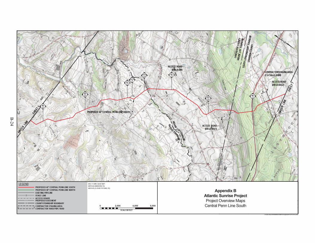
MOUN
T JO
Y TO
WNSH
IP
PROPOSED 42" CENTRAL PENN LINE SOUTH
ECHOVALLEY
RD
E. TOWN
RD(SR
4008) FORESTLANE
PATU
RNPI
KE(I-
76)
RA PH O TOWNSHIP
MOUNT
JOYTOWNSHIP
ELIZABETHRD
(SR241)
HOSSLERRD
ELIZABETH TOWN RD
SR 241
ACCESS ROAD(AR-LE-033.2)
SOUT
H LO
NDON
DERR
Y TO
WNSH
IPLE
BANO
N CO
UNTY
LANC
ASTE
R CO
UNTY
MEAD OW VALLEY
RD
SUNN
YSI D
ERD
SUNNYSIDERD
(2N DCROSS
I NG)
HARVEST RD
CONTRACTOR STAGING AREA(CS-CSA-LE-2-009)
ACCESS ROAD(AR-LA-030)
ACCESS ROAD(AR-LE-033.1)
M-01640.38
M-01640.0
MILE37.0MILE
36.0
MILE35.0
MILE34.0
MILE33.0
MILE32.0
DRAWING NO. REFERENCE TITLE
NO. DATE BY REVISION DESCRIPTION W.O. NO. CHK. APP.
0 3/31/15 JTN ISSUED FOR FERC FILING 1161503 DP MJH
TRANSCONTINENTAL GAS PIPE LINE COMPANY LLCTOPOGRAPHICAL PROJECT LOCATION MAP
ATLANTIC SUNRISE PROJECTPROPOSED 42" CENTRAL PENN LINE SOUTH
M.P. 0.00 TO M.P. 125.15LANCASTER & LEBANON COUNTIES, PENNSYLVANIA
APPROVED BY:
WO:
DRAWN BY:
CHECKED BY:
DATE:
DATE:
DATE:
10/3/1410/3/14
9/22/14
1161503
JHD SCALE:ISSUED FOR BID:
ISSUED FOR CONSTRUCTION: REVISION:
10:37 AM
DRAWINGNUMBER: F-FQ-CPLS-A-01
11 "=2,000 '
OFSHEET 6
Z:\1_Beta_Projects\101769-NEW\FERC\MXD\CPLS\Supplement\F-FQ-CPLS-A-01_JN.mxd
DRG 7.5 MIN. QUAD MAP:40076-B4 (MANHEIM, PA)40076-B5 (ELIZABETHTOWN, PA)
0 2,000 4,000 6,000
SCALE IN FEET5/27/2015
ELMJH
MATC
H LI
NE
SHE
ET 7
MAT
CH LINE
SHEE
T 5
PROPOSED EASEMENT
EXISTING PIPELINEFENCE LINEACCESS ROADS
LEGENDPROPOSED 42" CENTRAL PENN LINE SOUTHPROPOSED 30" CENTRAL PENN LINE NORTH
COUNTY/TOWNSHIP BOUNDARYCONTRACTOR STAGING AREACONTRACTOR YARD/ PIPE YARD
1 5/26/15 JTN ISSUED FOR SUPPLEMENTAL FILING #1 1161503 DP MJH
25
Appendix BAtlantic Sunrise ProjectProject Overview MapsCentral Penn Line South
B-24

PROPOSED 42" CENTRAL PENN LINE SOUTH
SOUTH ANNVILLE TOWNSHIP
NORTH LONDONDERRYTOWNSHIP
HORS
ESHO
EPI
KE(U
SRT
E32
2)
M E ADOW LN
WAGNER LN
ELIZABETH RD (SR 241)
COLEBROOKROAD
(SR341)
ELIZABETH TOWN RDSR 241
S.FO
RGE ROAD (RT 117)
LAW
NRO
AD
ROAD
033.2)
PERMANENTACCESS ROAD
(AR-LE-035)
PERMANENTACCESS ROAD
(AR-LE-037.1)
SOUTH ANNVILLE TOWNSHIP
SOUTH LONDONDERRY TOWNSHIP
EA
PROPOSEDMAIN LINE VALVE
(CS-MLV-06)
MILE43.0
MILE42.0
MILE41.0
MILE40.0
MILE39.0
MILE38.0
DRAWING NO. REFERENCE TITLE
NO. DATE BY REVISION DESCRIPTION W.O. NO. CHK. APP.
0 3/31/15 JTN ISSUED FOR FERC FILING 1161503 DP MJH
TRANSCONTINENTAL GAS PIPE LINE COMPANY LLCTOPOGRAPHICAL PROJECT LOCATION MAP
ATLANTIC SUNRISE PROJECTPROPOSED 42" CENTRAL PENN LINE SOUTH
M.P. 0.00 TO M.P. 125.15LEBANON COUNTY, PENNSYLVANIA
APPROVED BY:
WO:
DRAWN BY:
CHECKED BY:
DATE:
DATE:
DATE:
10/3/1410/3/14
9/22/14
1161503
JHD SCALE:ISSUED FOR BID:
ISSUED FOR CONSTRUCTION: REVISION:
10:41 AM
DRAWINGNUMBER: F-FQ-CPLS-A-01
11 "=2,000 '
OFSHEET 7
Z:\1_Beta_Projects\101769-NEW\FERC\MXD\CPLS\Supplement\F-FQ-CPLS-A-01_JN.mxd
DRG 7.5 MIN. QUAD MAP:40076-B5 (ELIZABETHTOWN, PA)40076-C5 (PALMYRA, PA)
0 2,000 4,000 6,000
SCALE IN FEET5/27/2015
ELMJH
MATC
H L
INE
SHE
ET 8
MATCH LINE SHEET 6
PROPOSED EASEMENT
EXISTING PIPELINEFENCE LINEACCESS ROADS
LEGENDPROPOSED 42" CENTRAL PENN LINE SOUTHPROPOSED 30" CENTRAL PENN LINE NORTH
COUNTY/TOWNSHIP BOUNDARYCONTRACTOR STAGING AREACONTRACTOR YARD/ PIPE YARD
1 5/26/15 JTN ISSUED FOR SUPPLEMENTAL FILING #1 1161503 DP MJH
25
Appendix BAtlantic Sunrise ProjectProject Overview MapsCentral Penn Line South
B-25
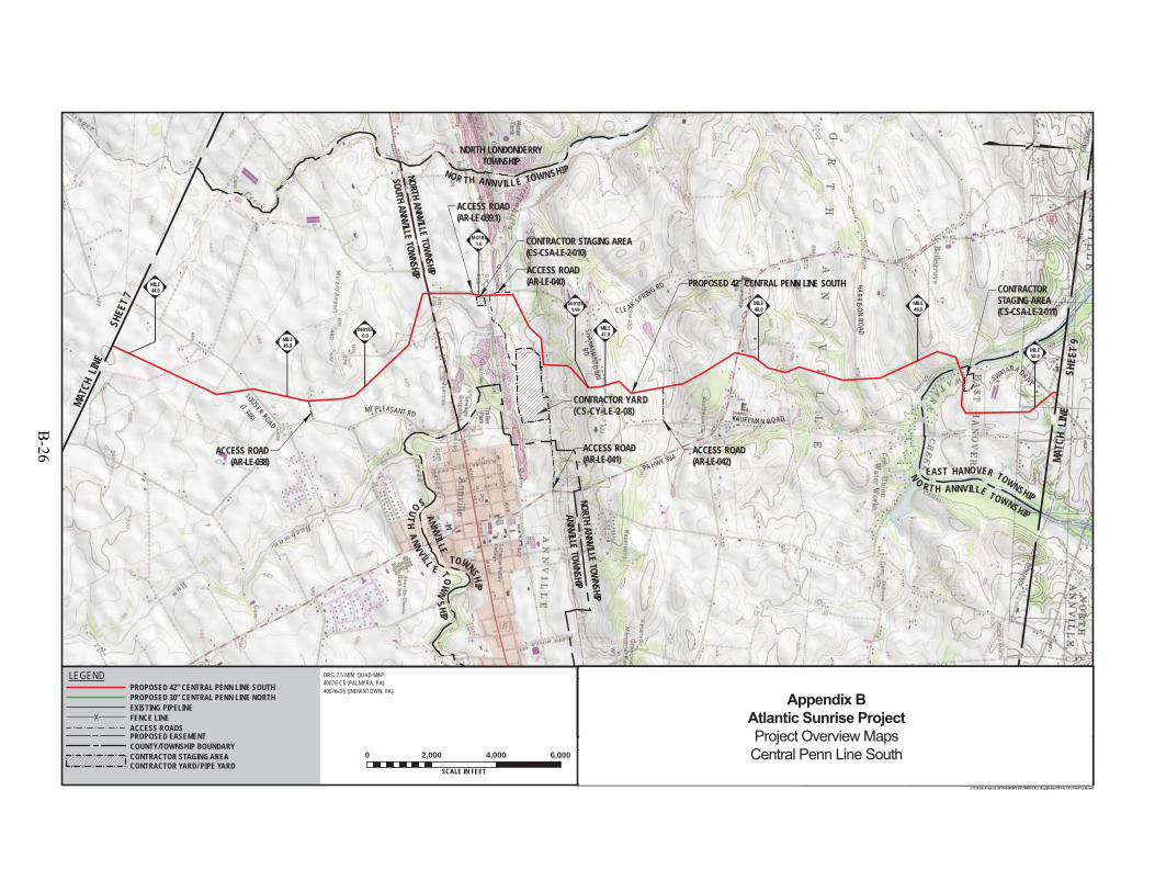
NORTH ANNVILLE TOWNSHIP
PROPOSED 42" CENTRAL PENN LINE SOUTH
LOUSER ROAD
SHANAMANTOW
N
HARRI SO NR OAD
PA HWY 934
KAUFFMAN ROAD
CLE AR SPRING RD
SOUTH ANNVILLE TOWNSHIP
NORTH LONDONDERRYTOWNSHIP
MT PLEASANT RD
OW LN
CONTRACTOR STAGING AREA(CS-CSA-LE-2-010)
(T 348)
NOR TH ANNV ILL E TOWN SHIP
EAST HANOVER TOWNSHIP
N
O RT H ANNVILLE TOWNSHIP
SWATARA DRIVE
ANNVILLE
TOWNSHIP
SOUT
HANN
VILL
E TOWNSHIP
ACCESS ROAD(AR-LE-039.1)
M-01831.0
RD
MILE44.0
ANNVILLE TOWNSHIP
NORTH ANNVILLE TOWNSHIP
SOUTH ANNVILLE TOWNSHIP
NORTH LONDONDERRYTOWNSHIP
CONTRACTOR STAGING AREA (CS-CSA-LE-2-011)
ACCESS ROAD(AR-LE-038)
ACCESS ROAD(AR-LE-042)
ACCESS ROAD(AR-LE-041)
ACCESS ROAD(AR-LE-040)
M-01831.99
M-01830.0
MILE50.0
MILE49.0
MILE48.0
MILE47.0
MILE45.0
DRAWING NO. REFERENCE TITLE
NO. DATE BY REVISION DESCRIPTION W.O. NO. CHK. APP.
0 3/31/15 JTN ISSUED FOR FERC FILING 1161503 DP MJH
TRANSCONTINENTAL GAS PIPE LINE COMPANY LLCTOPOGRAPHICAL PROJECT LOCATION MAP
ATLANTIC SUNRISE PROJECTPROPOSED 42" CENTRAL PENN LINE SOUTH
M.P. 0.00 TO M.P. 125.15LEBANON COUNTY, PENNSYLVANIA
APPROVED BY:
WO:
DRAWN BY:
CHECKED BY:
DATE:
DATE:
DATE:
10/3/1410/3/14
9/22/14
1161503
JHD SCALE:ISSUED FOR BID:
ISSUED FOR CONSTRUCTION: REVISION:
9:01 AM
DRAWINGNUMBER: F-FQ-CPLS-A-01
11 "=2,000 '
OFSHEET 8
Z:\1_Beta_Projects\101769-NEW\FERC\MXD\CPLS\Supplement\F-FQ-CPLS-A-01_JN.mxd
DRG 7.5 MIN. QUAD MAP:40076-C5 (PALMYRA, PA)40076-D5 (INDIANTOWN, PA)
0 2,000 4,000 6,000
SCALE IN FEET5/29/2015
ELMJH
MATC
H L
INE
SHEE
T 9
MAT
CH L
INE
SHEE
T 7
PROPOSED EASEMENT
EXISTING PIPELINEFENCE LINEACCESS ROADS
LEGENDPROPOSED 42" CENTRAL PENN LINE SOUTHPROPOSED 30" CENTRAL PENN LINE NORTH
COUNTY/TOWNSHIP BOUNDARYCONTRACTOR STAGING AREACONTRACTOR YARD/ PIPE YARD
1 5/26/15 JTN ISSUED FOR SUPPLEMENTAL FILING #1 1161503 DP MJH
CONTRACTOR YARD(CS-CY-LE-2-08)
25
Appendix BAtlantic Sunrise ProjectProject Overview MapsCentral Penn Line South
B-26

UNION
TOWN
SHIP
PROPOSED 42" CENTRAL PENN LINE SOUTH
MCGILLSTOWN R OAD
ONO
ROAD
(SR
4007
)
JONESTOWN
ROAD
ALLENTOWN
BLVD
RACEHORSE AWOL ROAD
HOOVERDRIVE
I-81I- 81
BORDNERSVILLE ROAD
ONO ROAD(SR 4007) (SR22)
N BORDNERSVILLE ROAD
HIP
PCALVA RY RO AD
FISHER AVENUE
CALVARY ROA D
UNIO
N
TO WNSHIP
SWAT
ARA
TOWNSHIP
EAST
HANO
VER
TOW
NSHI
P
ROAD
CONTRACTORSTAGING AREA
(CS-CSA-LE-2-012)
CONTRACTORSTAGING AREA(CS-CSA-LE-2-012.1)
CONTRACTOR YARD(CS-CY-LE-2-10)
CONTRACTOR YARD(CS-CY-LE-2-10A)
NORT
H AN
NVILL
E TO
WNSH
IP
EAST
HANO
VER T
OWNS
HIP
R EA 2-011)
ACCESS ROAD(AR-LE-047) ACCESS ROAD
(AR-LE-049)
ACCESS ROAD(AR-LE-050)
ACCESS ROAD(AR-LE-044)
M-01800.11
M-01990.0
M-01990.26
M-01680.0
M-01680.09
M-01800.0
M-01650.48
M-01650.0
E0
MILE55.0
MILE53.0
MILE51.0
DRAWING NO. REFERENCE TITLE
NO. DATE BY REVISION DESCRIPTION W.O. NO. CHK. APP.
0 3/31/15 JTN ISSUED FOR FERC FILING 1161503 DP MJH
TRANSCONTINENTAL GAS PIPE LINE COMPANY LLCTOPOGRAPHICAL PROJECT LOCATION MAP
ATLANTIC SUNRISE PROJECTPROPOSED 42" CENTRAL PENN LINE SOUTH
M.P. 0.00 TO M.P. 125.15LEBANON COUNTY, PENNSYLVANIA
APPROVED BY:
WO:
DRAWN BY:
CHECKED BY:
DATE:
DATE:
DATE:
10/3/1410/3/14
9/22/14
1161503
JHD SCALE:ISSUED FOR BID:
ISSUED FOR CONSTRUCTION: REVISION:
9:23 AM
DRAWINGNUMBER: F-FQ-CPLS-A-01
11 "=2,000 '
OFSHEET 9
25Z:\1_Beta_Projects\101769-NEW\FERC\MXD\CPLS\Supplement\F-FQ-CPLS-A-01_JN2.mxd
DRG 7.5 MIN. QUAD MAP:40076-D5 (INDIANTOWN, PA)
0 2,000 4,000 6,000
SCALE IN FEET6/1/2015
ELMJH
MATCH LINE SHEET 10
MATC
H L
INE
SHEE
T 8
PROPOSED EASEMENT
EXISTING PIPELINEFENCE LINEACCESS ROADS
LEGENDPROPOSED 42" CENTRAL PENN LINE SOUTHPROPOSED 30" CENTRAL PENN LINE NORTH
COUNTY/TOWNSHIP BOUNDARYCONTRACTOR STAGING AREACONTRACTOR YARD/ PIPE YARD
1 5/26/15 JTN ISSUED FOR SUPPLEMENTAL FILING #1 1161503 DP MJH
EAST HANOVER TOWNSHIP
NORTH ANNVILLETOW
NSHIP
Appendix BAtlantic Sunrise ProjectProject Overview MapsCentral Penn Line South
B-27
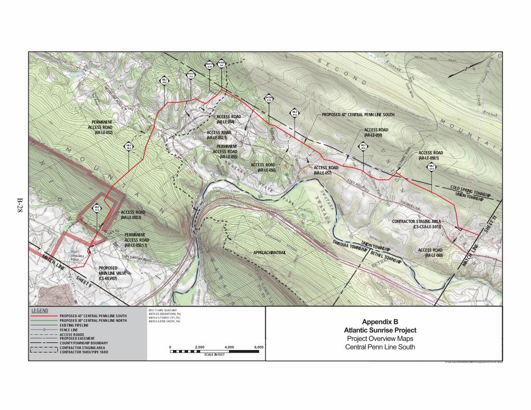
PROPOSED 42" CENTRAL PENN LINE SOUTH
FORT SWATARA ROAD
FORT SWATARAROAD
SWATARA TOWNSHIP BETHEL TOWNSHIP
UNION TOWNSHIP
P
SUEDBERG RD
STATE ROUTE 433
GOLD
MINE
ROAD
LEBANON COUNTY
AC
O RN RD
MOONSHINE ROAD (S R 443)
RUDYLN
PERMANENTACCESS ROAD(AR-LE-050.1.1)
PERMANENTACCESS ROAD
(AR-LE-052)
ACCESS ROAD(AR-LE-054)
ACCESS ROAD(AR-LE-059)
CONTRACTOR
TAGING AREA
LE-2-012.1)
APPALACHIAN TRAIL
UNION TOWNSHIP
COLD SPRING TOWNSHIP
UNION TOWNSHIP
CONTRACTOR STAGING AREA(CS-CSA-LE-3-013)
ACCESS ROAD(AR-LE-059.1)
ACCESS ROAD(AR-LE-057)
ACCESS ROAD(AR-LE-052.1)
ACCESS ROAD(AR-LE-056)
PERMANENTACCESS ROAD
(AR-LE-055)
ACCESS ROAD(AR-LE-060)
ACCESS ROAD(AR-LE-050.3)
PROPOSEDMAIN LINE VALVE(CS-MLV-07)
M-02000.76
M-02000.0
M-01760.0
M-01760.39
MILE57.0
MILE63.0
MILE62.0
MILE61.0
MILE59.0
MILE58.0
DRAWING NO. REFERENCE TITLE
NO. DATE BY REVISION DESCRIPTION W.O. NO. CHK. APP.
0 3/31/15 JTN ISSUED FOR FERC FILING 1161503 DP MJH
TRANSCONTINENTAL GAS PIPE LINE COMPANY LLCTOPOGRAPHICAL PROJECT LOCATION MAP
ATLANTIC SUNRISE PROJECTPROPOSED 42" CENTRAL PENN LINE SOUTH
M.P. 0.00 TO M.P. 125.15LEBANON COUNTY, PENNSYLVANIA
APPROVED BY:
WO:
DRAWN BY:
CHECKED BY:
DATE:
DATE:
DATE:
10/3/1410/3/14
9/22/14
1161503
JHD SCALE:ISSUED FOR BID:
ISSUED FOR CONSTRUCTION: REVISION:
3:44 PM
DRAWINGNUMBER: F-FQ-CPLS-A-01
11 "=2,000 '
OFSHEET 10
25Z:\1_Beta_Projects\101769-NEW\FERC\MXD\CPLS\Supplement\F-FQ-CPLS-A-01_JN2.mxd
DRG 7.5 MIN. QUAD MAP:40076-D5 (INDIANTOWN, PA)40076-E5 (TOWER CITY, PA)40076-E4 (PINE GROVE, PA)
0 2,000 4,000 6,000
SCALE IN FEET6/2/2015
ELMJH
MATCH
LINE
S
HEET
11
MATCH LINE SHEET 9
PROPOSED EASEMENT
EXISTING PIPELINEFENCE LINEACCESS ROADS
LEGENDPROPOSED 42" CENTRAL PENN LINE SOUTHPROPOSED 30" CENTRAL PENN LINE NORTH
COUNTY/TOWNSHIP BOUNDARYCONTRACTOR STAGING AREACONTRACTOR YARD/ PIPE YARD
1 5/26/15 JTN ISSUED FOR SUPPLEMENTAL FILING #1 1161503 DP MJH
Appendix BAtlantic Sunrise ProjectProject Overview MapsCentral Penn Line South
B-28

PINE GROVE TOWNSHIP
PROPOSED 42" CENTRAL PENN LINE SOUTH
OAK GROVE RD T886
PINE GROVE TOWNSHIP
INTERSTA
TEHIG
HWAY
81
CHAPEL RD
KL IC K DR T880
BEUCHLERLN
(T876)
OAK GROVE RD (T886)
OLDFORG
ERD
(T392 )
SCHUYLKILL COUNTY
LEBANON COUNTY
SUMM
ITDR
PERMANENTACCESS ROAD
(AR-SC-063)
ACCESS ROAD(AR-SC-060.3)
ACCESS ROAD(AR-SC-060.1.1)
WNSHIPTOWNSHIP
BETHEL TOWNSHIP
TREMONT TOWNSHIPPINE GROVE TOWNSHIP
UNION TOWNSHIP
CONTRACTOR STAGING AREA(CS-CSA-SC-3-015)
CONTRACTOR STAGING AREA(CS-CSA-SC-3-014)
ACCESS ROAD(AR-SC-060.2)
ACCESS ROAD(AR-SC-060.4)
ACCESS ROAD(AR-SC-061.1)
ACCESS ROAD(AR-SC-064)
PROPOSEDMAIN LINE VALVE(CS-MLV-08)
MILE
70.0
M-01960.41
M-01960.0
M-01770.56
M-01770.0
MILE69.0
MILE68.0
MILE65.0
MILE64.0
DRAWING NO. REFERENCE TITLE
NO. DATE BY REVISION DESCRIPTION W.O. NO. CHK. APP.
0 3/31/15 JTN ISSUED FOR FERC FILING 1161503 DP MJH
TRANSCONTINENTAL GAS PIPE LINE COMPANY LLCTOPOGRAPHICAL PROJECT LOCATION MAP
ATLANTIC SUNRISE PROJECTPROPOSED 42" CENTRAL PENN LINE SOUTH
M.P. 0.00 TO M.P. 125.15LEBANON & SCHUYKILL COUNTIES, PENNSYLVANIA
APPROVED BY:
WO:
DRAWN BY:
CHECKED BY:
DATE:
DATE:
DATE:
10/3/1410/3/14
9/22/14
1161503
JHD SCALE:ISSUED FOR BID:
ISSUED FOR CONSTRUCTION: REVISION:
11:04 AM
DRAWINGNUMBER: F-FQ-CPLS-A-01
11 "=2,000 '
Z:\1_Beta_Projects\101769-NEW\FERC\MXD\CPLS\Supplement\F-FQ-CPLS-A-01_JN.mxd
DRG 7.5 MIN. QUAD MAP:40076-E4 (PINE GROVE, PA)
0 2,000 4,000 6,000
SCALE IN FEET5/27/2015
ELMJH
MATCH LINE SHEET 12
MAT
CH L
INE
SHE
ET 10
PROPOSED EASEMENT
EXISTING PIPELINEFENCE LINEACCESS ROADS
LEGENDPROPOSED 42" CENTRAL PENN LINE SOUTHPROPOSED 30" CENTRAL PENN LINE NORTH
COUNTY/TOWNSHIP BOUNDARYCONTRACTOR STAGING AREACONTRACTOR YARD/ PIPE YARD
1 5/26/15 JTN ISSUED FOR SUPPLEMENTAL FILING #1 1161503 DP MJH
CONTRACTOR STAGING AREA (CS-CSA-SC-3-014.1)
SHEET 11OF 25
Appendix BAtlantic Sunrise ProjectProject Overview MapsCentral Penn Line South
B-29
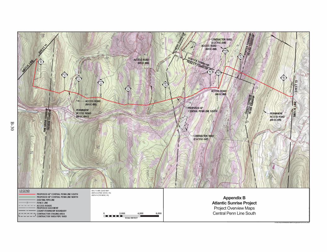
TREM
ONT
TOWN
SHIP
P INE
GROV
ETO
WNS
HIP
S R20
9
HWY
125
INTE
RSTA
TE81
FOUNTAIN ROAD
PINEDR
T520
PROPOSED 42" CENTRAL PENN LINE SOUTH
MOLL
EYST
OWN RD T634
PERMANENTACCESS ROAD(AR-SC-070)
CONTRACTOR YARD(CS-CY-SC-3-08)
M-02010.0
CONTRACTOR YARD(CS-CY-SC-3-07)
MOL
LEYS
TOWN RD T634
TREM
ONT T
OWNS
HIP
FRAIL
EY TO
WNSH
IPHE
GINS
TOWN
SHIP
FRAILEY TOWNSHIP
PORTER TOWNSHIP
HEGI
NS TO
WNS
HIP
PORT
ER T
OWNS
HIP
PERMANENTACCESS ROAD(AR-SC-064.1)
ACCESS ROAD(AR-SC-065)
ACCESS ROAD(AR-SC-069)
ACCESS ROAD(AR-SC-066)
ACCESS ROAD(AR-SC-068)
MILE76.0
MILE75.0
MILE74.0
MILE73.0
MILE70.0
M-02010.48
M-01980.59
M-01980.0
M-01810.31
M-01810.0
DRAWING NO. REFERENCE TITLE
NO. DATE BY REVISION DESCRIPTION W.O. NO. CHK. APP.
0 3/31/15 JTN ISSUED FOR FERC FILING 1161503 DP MJH
TRANSCONTINENTAL GAS PIPE LINE COMPANY LLCTOPOGRAPHICAL PROJECT LOCATION MAP
ATLANTIC SUNRISE PROJECTPROPOSED 42" CENTRAL PENN LINE SOUTH
M.P. 0.00 TO M.P. 125.15SCHUYLKILL COUNTY, PENNSYLVANIA
APPROVED BY:
WO:
DRAWN BY:
CHECKED BY:
DATE:
DATE:
DATE:
10/3/1410/3/14
9/22/14
1161503
JHD SCALE:ISSUED FOR BID:
ISSUED FOR CONSTRUCTION: REVISION:
11:18 AM
DRAWINGNUMBER: F-FQ-CPLS-A-01
11 "=2,000 '
OFSHEET 12
Z:\1_Beta_Projects\101769-NEW\FERC\MXD\CPLS\Supplement\F-FQ-CPLS-A-01_JN.mxd
DRG 7.5 MIN. QUAD MAP:40076-E4 (PINE GROVE, PA)40076-F4 (TREMONT, PA)
0 2,000 4,000 6,000
SCALE IN FEET5/27/2015
ELMJH
MATC
H L
INE
SHEE
T 13
MATC
H LINE
SHEET 1
1
PROPOSED EASEMENT
EXISTING PIPELINEFENCE LINEACCESS ROADS
LEGENDPROPOSED 42" CENTRAL PENN LINE SOUTHPROPOSED 30" CENTRAL PENN LINE NORTH
COUNTY/TOWNSHIP BOUNDARYCONTRACTOR STAGING AREACONTRACTOR YARD/ PIPE YARD
1 5/26/15 JTN ISSUED FOR SUPPLEMENTAL FILING #1 1161503 DP MJH
25
Appendix BAtlantic Sunrise ProjectProject Overview MapsCentral Penn Line South
B-30
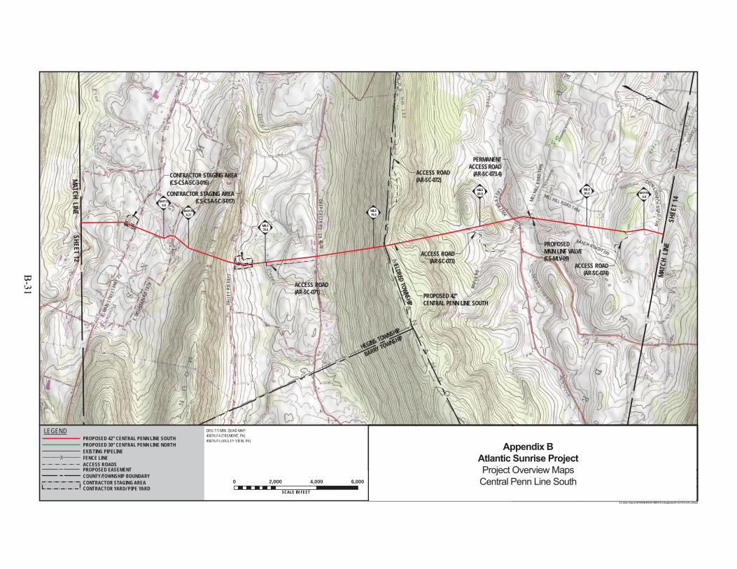
BARRY TOWNSHIP
E.MO
UNTA
INRD
T879
E.MA
INST
REET
/HW
Y 25
VALL
EYRD
T377
DEE PCREEK
RD-S R
4020
MAPL
ERD
MILL HILL ROAD T494
CONTRACTOR STAGING AREA(CS-CSA-SC-3-017) MI
LLHI
LLRO
ADT4
94
CREEK RD
PROPOSED 42" CENTRAL PENN LINE SOUTH
RANCH ROAD T399
CREE
KDR T504
ZION CHURCHROAD
T506
PERMANENTACCESS ROAD
(AR-SC-073.4)
ELDRED TOWNSHIP
HEGINS TOWNSHIP
CONTRACTOR STAGING AREA(CS-CSA-SC-3-016)
ACCESS ROAD(AR-SC-074)
ACCESS ROAD(AR-SC-073)
ACCESS ROAD(AR-SC-071)
ACCESS ROAD(AR-SC-072)
PROPOSEDMAIN LINE VALVE(CS-MLV-09)
M-01940.0
M-01700.27
M-01700.0
MILE81.0
MILE80.0
MILE79.0
MILE78.0
DRAWING NO. REFERENCE TITLE
NO. DATE BY REVISION DESCRIPTION W.O. NO. CHK. APP.
0 3/31/15 JTN ISSUED FOR FERC FILING 1161503 DP MJH
TRANSCONTINENTAL GAS PIPE LINE COMPANY LLCTOPOGRAPHICAL PROJECT LOCATION MAP
ATLANTIC SUNRISE PROJECTPROPOSED 42" CENTRAL PENN LINE SOUTH
M.P. 0.00 TO M.P. 125.15SCHUYLKILL COUNTY, PENNSYLVANIA
APPROVED BY:
WO:
DRAWN BY:
CHECKED BY:
DATE:
DATE:
DATE:
10/3/1410/3/14
9/22/14
1161503
JHD SCALE:ISSUED FOR BID:
ISSUED FOR CONSTRUCTION: REVISION:
9:12 AM
DRAWINGNUMBER: F-FQ-CPLS-A-01
11 "=2,000 '
OFSHEET 13
Z:\1_Beta_Projects\101769-NEW\FERC\MXD\CPLS\Supplement\F-FQ-CPLS-A-01_JN.mxd
DRG 7.5 MIN. QUAD MAP:40076-F4 (TREMONT, PA)40076-F5 (VALLEY VIEW, PA)
0 2,000 4,000 6,000
SCALE IN FEET5/29/2015
ELMJH
MATC
H L
INE
SHEE
T 14
MATCH LINE SHEET 12
PROPOSED EASEMENT
EXISTING PIPELINEFENCE LINEACCESS ROADS
LEGENDPROPOSED 42" CENTRAL PENN LINE SOUTHPROPOSED 30" CENTRAL PENN LINE NORTH
COUNTY/TOWNSHIP BOUNDARYCONTRACTOR STAGING AREACONTRACTOR YARD/ PIPE YARD
1 5/26/15 JTN ISSUED FOR SUPPLEMENTAL FILING #1 1161503 DP MJH
25
Appendix BAtlantic Sunrise ProjectProject Overview MapsCentral Penn Line South
B-31
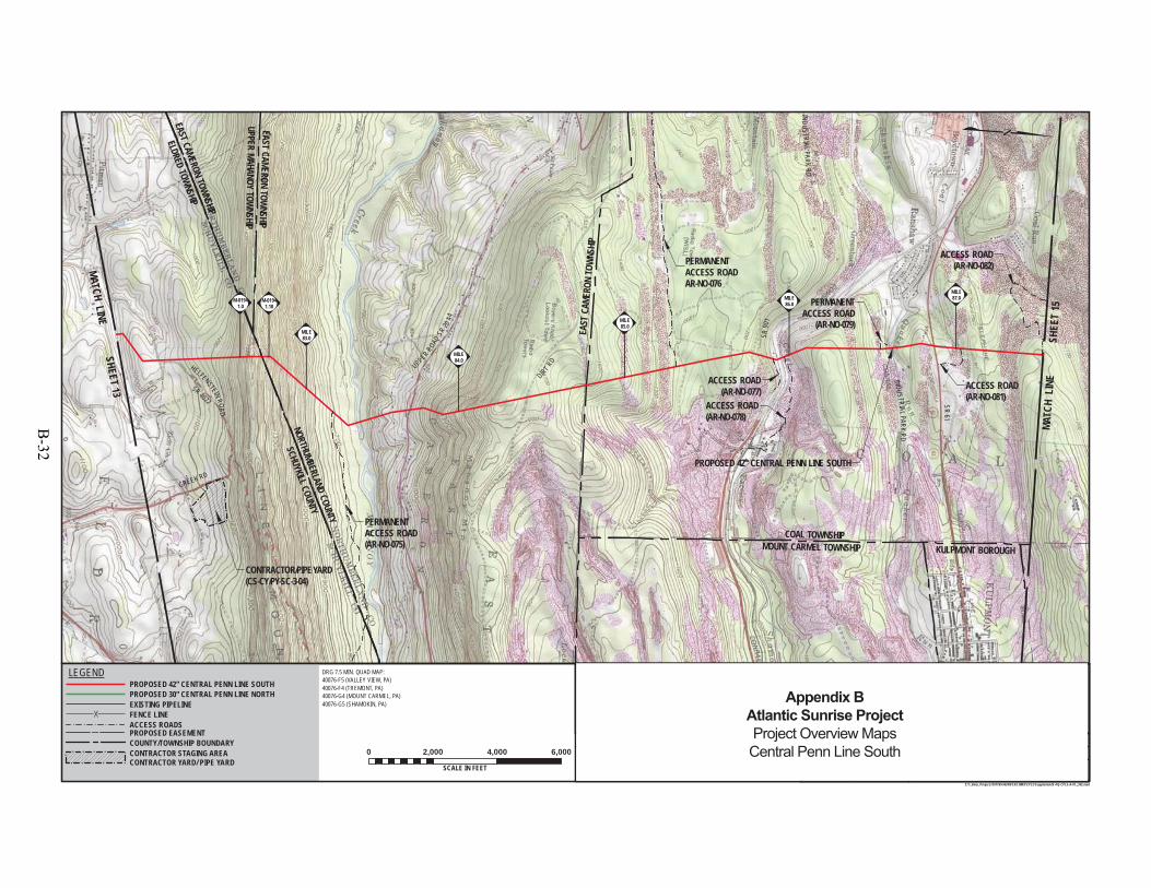
ELDRED TOWNSHIP
EAST CAMERON TOWNSHIP
SCHUYKILL COUNTYNORTHUMBERLAND
COUNTY
SR61
IND USTRIAL PARKR D
SR90
1
UPPER ROADSR
2044
DIRT RDKULPMONT BOROUGH
ACCESS ROAD(AR-NO-078)
CONTRACTOR/PIPE YARD(CS-CY/PY-SC-3-04)
CREEK RDPROPOSED 42" CENTRAL PENN LINE SOUTH
INDUSTR IALPARKRD
N CHURCHROAD
T506
HELFENSTEINROAD
SR 4022
UPPER MAHANOY TOWNSHIP
EAST CAMERON TOWNSHIP
COAL TOWNSHIP
EAST
CAM
ERON
TOWN
SHIP
MOUNT CARMEL TOWNSHIP
PERMANENTACCESS ROAD
(AR-NO-079)
ACCESS ROAD(AR-NO-077) ACCESS ROAD
(AR-NO-081)
ACCESS ROAD(AR-NO-082)PERMANENT
ACCESS ROADAR-NO-076
PERMANENTACCESS ROAD(AR-NO-075)
M-01941.18
M-01941.0
MILE83.0
MILE87.0MILE
86.0
MILE85.0
MILE84.0
DRAWING NO. REFERENCE TITLE
NO. DATE BY REVISION DESCRIPTION W.O. NO. CHK. APP.
0 3/31/15 JTN ISSUED FOR FERC FILING 1161503 DP MJH
TRANSCONTINENTAL GAS PIPE LINE COMPANY LLCTOPOGRAPHICAL PROJECT LOCATION MAP
ATLANTIC SUNRISE PROJECTPROPOSED 42" CENTRAL PENN LINE SOUTH
M.P. 0.00 TO M.P. 125.15SCHUYLKILL & NORTHUMBERLAND COUNTIES, PENNSYLVANIA
APPROVED BY:
WO:
DRAWN BY:
CHECKED BY:
DATE:
DATE:
DATE:
10/3/1410/3/14
9/22/14
1161503
JHD SCALE:ISSUED FOR BID:
ISSUED FOR CONSTRUCTION: REVISION:
3:50 PM
DRAWINGNUMBER: F-FQ-CPLS-A-01
11 "=2,000 '
OFSHEET 14
25Z:\1_Beta_Projects\101769-NEW\FERC\MXD\CPLS\Supplement\F-FQ-CPLS-A-01_JN2.mxd
DRG 7.5 MIN. QUAD MAP:40076-F5 (VALLEY VIEW, PA)40076-F4 (TREMONT, PA)40076-G4 (MOUNT CARMEL, PA)40076-G5 (SHAMOKIN, PA)
0 2,000 4,000 6,000
SCALE IN FEET6/2/2015
ELMJH
MATC
H L
INE
SHEE
T 15
MATCH LINE SHEET 13
PROPOSED EASEMENT
EXISTING PIPELINEFENCE LINEACCESS ROADS
LEGENDPROPOSED 42" CENTRAL PENN LINE SOUTHPROPOSED 30" CENTRAL PENN LINE NORTH
COUNTY/TOWNSHIP BOUNDARYCONTRACTOR STAGING AREACONTRACTOR YARD/ PIPE YARD
1 5/26/15 JTN ISSUED FOR SUPPLEMENTAL FILING #1 1161503 DP MJH
Appendix BAtlantic Sunrise ProjectProject Overview MapsCentral Penn Line South
B-32
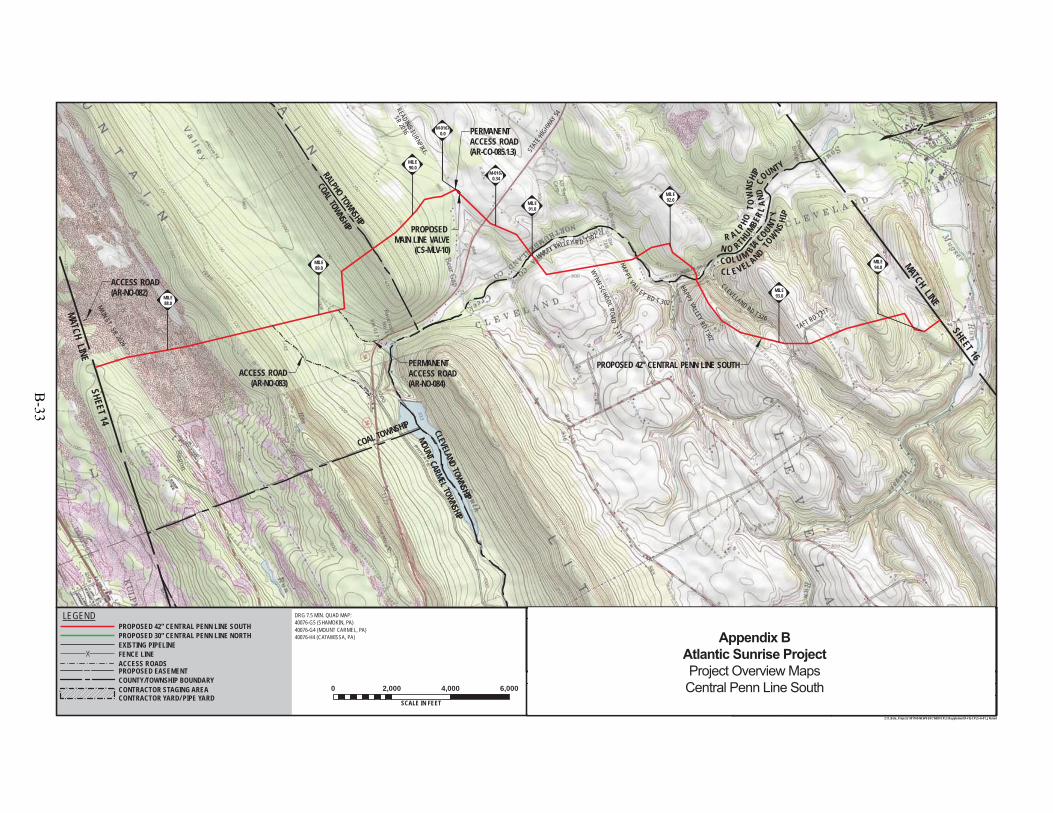
COAL TOWNSHIP
RALPHO TOWNSHIP
CLEVELAND TOWNSHIP
MAINST.- SR 2026
STAT
E HIGHWAY
54
TAFT RD T317
HAPPY VALLEYRD
T302
PROPOSED 42" CENTRAL PENN LINE SOUTH
ACCESS ROAD(AR-NO-082)
READINGTURNPIKE
SR2016
HAPPY VALLEY R D T302
WYNN
SCHOOL ROADT
311HAPPY VALLEY RD T 302
CLEVELAND RD T 326
COL U M BIACOUNT
Y
CL E VEL ANDTO
WNS
HIP
N O RTHUMBER L
AND
COUNTY
R A LPHOTO
WNS
HIP
MILE94.0
COAL TOWNSHIP
MOUNT CARMEL TOWNSHIP
PERMANENTACCESS ROAD(AR-CO-085.1.3)
PERMANENTACCESS ROAD(AR-NO-084)
ACCESS ROAD(AR-NO-083)
CONTRACTOR
STAGING AREA
(CS-CSA-CO-4-001)PROPOSED
MAIN LINE VALVE(CS-MLV-10)
M-01670.34
M-01670.0
MILE93.0
MILE92.0MILE
91.0
MILE90.0
MILE89.0
MILE88.0
DRAWING NO. REFERENCE TITLE
NO. DATE BY REVISION DESCRIPTION W.O. NO. CHK. APP.
0 3/31/15 JTN ISSUED FOR FERC FILING 1161503 DP MJH
TRANSCONTINENTAL GAS PIPE LINE COMPANY LLCTOPOGRAPHICAL PROJECT LOCATION MAP
ATLANTIC SUNRISE PROJECTPROPOSED 42" CENTRAL PENN LINE SOUTH
M.P. 0.00 TO M.P. 125.15NORTHUMBERLAND & COLUMBIA COUNTIES, PENNSYLVANIA
APPROVED BY:
WO:
DRAWN BY:
CHECKED BY:
DATE:
DATE:
DATE:
10/3/1410/3/14
9/22/14
1161503
JHD SCALE:ISSUED FOR BID:
ISSUED FOR CONSTRUCTION: REVISION:
6:07 AM
DRAWINGNUMBER: F-FQ-CPLS-A-01
11 "=2,000 '
OFSHEET 15
Z:\1_Beta_Projects\101769-NEW\FERC\MXD\CPLS\Supplement\F-FQ-CPLS-A-01_JN.mxd
DRG 7.5 MIN. QUAD MAP:40076-G5 (SHAMOKIN, PA)40076-G4 (MOUNT CARMEL, PA)40076-H4 (CATAWISSA, PA)
0 2,000 4,000 6,000
SCALE IN FEET5/13/2015
ELMJH
MATCH LINE SHEET 16
MATCH LINE SHEET 14
PROPOSED EASEMENT
EXISTING PIPELINEFENCE LINEACCESS ROADS
LEGENDPROPOSED 42" CENTRAL PENN LINE SOUTHPROPOSED 30" CENTRAL PENN LINE NORTH
COUNTY/TOWNSHIP BOUNDARYCONTRACTOR STAGING AREACONTRACTOR YARD/ PIPE YARD
1 5/26/15 JTN ISSUED FOR SUPPLEMENTAL FILING #1 1161503 DP MJH
25
Appendix BAtlantic Sunrise ProjectProject Overview MapsCentral Penn Line South
B-33
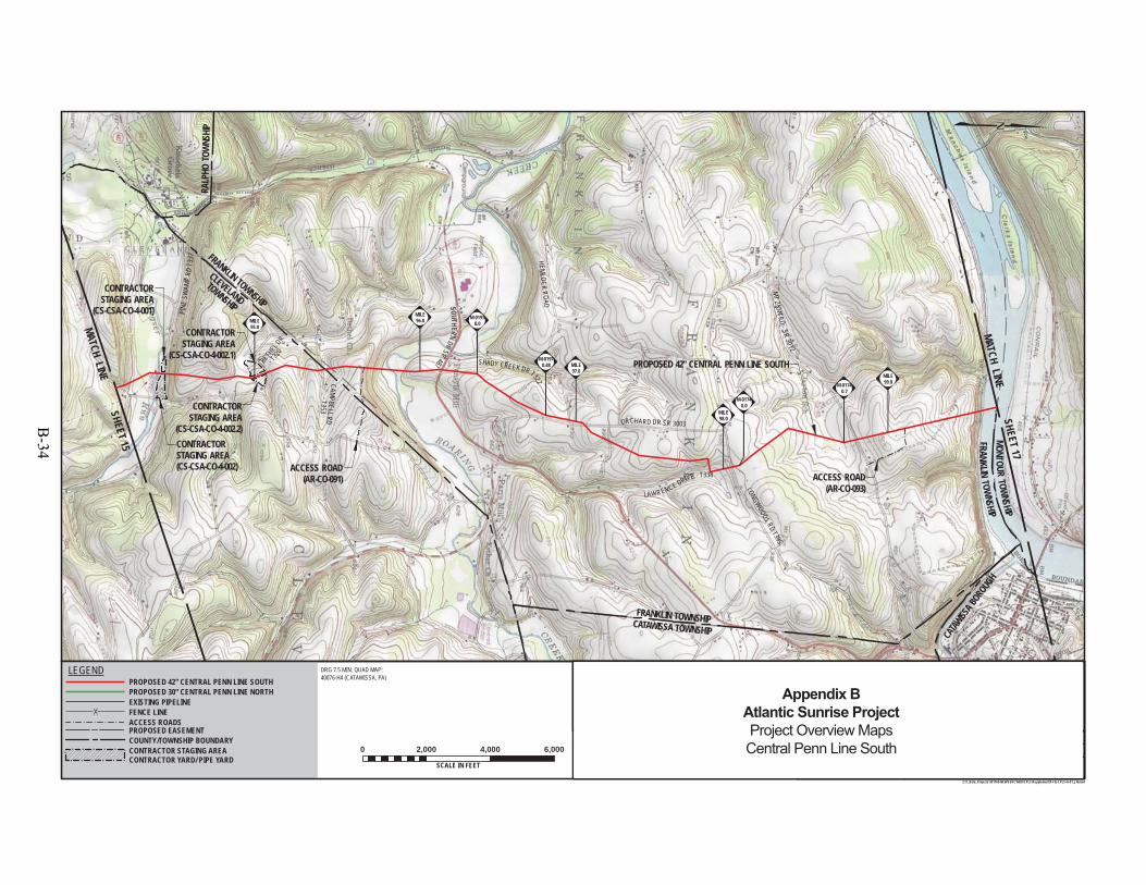
FRANKLIN TOWNSHIP
FRAN
KLIN
TOW
NSHIP
ORCHARD DR SR 3003
SOUTHERNDR
SR487
LAWRENCE DRIVE - T338
LONGWOODS RDT395
BETH
ELDR
- T32
0
PINE
SWAM
PRD
T337
CAMPBELLRD-T353
CATAW
ISSA B
OROUG
H
MONTOURTOWNSHIP
FRANKLINTOWNSHIP
SAH
SHIP
PROPOSED 42" CENTRAL PENN LINE SOUTH
HEMLOCK
R OAD
SHADY CREEK DR T322
TOWNSHIP
LEGIONRD
MILE94.0
MT
ZIONRD
- SR3012
FRANKLIN TOWNSHIP
RALP
HO T
OWNS
HIP
MONT
OUR
TOW
NSHIP
CLEVELAND
CATAWISSA TOWNSHIP
ACCESS ROAD(AR-CO-093)
ACCESS ROAD(AR-CO-091)
CONTRACTORSTAGING AREA(CS-CSA-CO-4-002)
CONTRACTORSTAGING AREA
(CS-CSA-CO-4-001)
CONTRACTORSTAGING AREA
(CS-CSA-CO-4-002.1)
CONTRACTORSTAGING AREA
(CS-CSA-CO-4-002.2)
M-01740.0
M-01740.7
M-01970.48
M-01970.0
MILE99.0
MILE98.0
MILE97.0
MILE96.0MILE
95.0
DRAWING NO. REFERENCE TITLE
NO. DATE BY REVISION DESCRIPTION W.O. NO. CHK. APP.
0 3/31/15 JTN ISSUED FOR FERC FILING 1161503 DP MJH
TRANSCONTINENTAL GAS PIPE LINE COMPANY LLCTOPOGRAPHICAL PROJECT LOCATION MAP
ATLANTIC SUNRISE PROJECTPROPOSED 42" CENTRAL PENN LINE SOUTH
M.P. 0.00 TO M.P. 125.15COLUMBIA COUNTY, PENNSYLVANIA
APPROVED BY:
WO:
DRAWN BY:
CHECKED BY:
DATE:
DATE:
DATE:
10/3/1410/3/14
9/22/14
1161503
JHD SCALE:ISSUED FOR BID:
ISSUED FOR CONSTRUCTION: REVISION:
6:19 AM
DRAWINGNUMBER: F-FQ-CPLS-A-01
11 "=2,000 '
OFSHEET 16
Z:\1_Beta_Projects\101769-NEW\FERC\MXD\CPLS\Supplement\F-FQ-CPLS-A-01_JN.mxd
DRG 7.5 MIN. QUAD MAP:40076-H4 (CATAWISSA, PA)
0 2,000 4,000 6,000
SCALE IN FEET5/13/2015
ELMJH
MATCH LINE SHEET 17
MATCH LINE SHEET 15
PROPOSED EASEMENT
EXISTING PIPELINEFENCE LINEACCESS ROADS
LEGENDPROPOSED 42" CENTRAL PENN LINE SOUTHPROPOSED 30" CENTRAL PENN LINE NORTH
COUNTY/TOWNSHIP BOUNDARYCONTRACTOR STAGING AREACONTRACTOR YARD/ PIPE YARD
1 5/26/15 JTN ISSUED FOR SUPPLEMENTAL FILING #1 1161503 DP MJH
25
Appendix BAtlantic Sunrise ProjectProject Overview MapsCentral Penn Line South
B-34
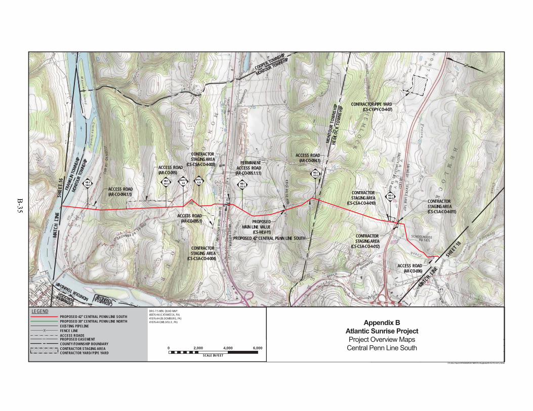
FRAN
KLIN
TOWN
SHIP
MONTOUR TOWNSHIP
I-80EAST
FROSTYVALLEY
RD-SR
4006
V ALL EYR D
T 416
ACCESS ROAD(AR-CO-094.1.1)
MON
TOUR
BLVD
-HW
Y11
SERVICELANE
T437
SCHOOLHOUSERD T475
BUCKHORNRD
-SR 44
DAHL
RD T828RIDGE
RDSR
4004
MONTOURTOWNSHIP
FR
CATAWISSABOROUGH
MONTOUR TOWNSHIP
CATAWISSA TOWNSHIP
CONTRACTOR STAGING AREA
(CS-CSA-CO-4-010)
CONTRACTOR STAGING AREA
(CS-CSA-CO-4-012)
CONTRACTOR STAGING AREA(CS-CSA-CO-4-011)
I-80W
EST
PROPOSED 42" CENTRAL PENN LINE SOUTH
LEG IONRD
-SR4002
GROVANI A D R - SR 4002
CONTRACT(CS-CY/
MONT
OUR
TOWN
SHIP
HEML
OCK
TOW
NSHI
P
MONT
OUR
TOW
NSHI
P
COOPER TOWNSHIP
PERMANENTACCESS ROAD
(AR-CO-095.1.1.1)
ACCESS ROAD(AR-CO-096)
ACCESS ROAD(AR-CO-095.1)
ACCESS ROAD(AR-CO-094.1)
ACCESS ROAD(AR-CO-095)
CONTRACTOR STAGING AREA
(CS-CSA-CO-4-004)
CONTRACTOR STAGING AREA
(CS-CSA-CO-4-003)
CONTRACTOR/PIPE YARD(CS-CY/PY-CO-4-07)
PROPOSEDMAIN LINE VALUE
(CS-MLV-11)
M-01790.26
M-01790.0
MILE104.0
MILE103.0
MILE102.0
MILE101.0MILE
100.0
DRAWING NO. REFERENCE TITLE
NO. DATE BY REVISION DESCRIPTION W.O. NO. CHK. APP.
0 3/31/15 JTN ISSUED FOR FERC FILING 1161503 DP MJH
TRANSCONTINENTAL GAS PIPE LINE COMPANY LLCTOPOGRAPHICAL PROJECT LOCATION MAP
ATLANTIC SUNRISE PROJECTPROPOSED 42" CENTRAL PENN LINE SOUTH
M.P. 0.00 TO M.P. 125.15COLUMBIA COUNTY, PENNSYLVANIA
APPROVED BY:
WO:
DRAWN BY:
CHECKED BY:
DATE:
DATE:
DATE:
10/3/1410/3/14
9/22/14
1161503
JHD SCALE:ISSUED FOR BID:
ISSUED FOR CONSTRUCTION: REVISION:
6:26 AM
DRAWINGNUMBER: F-FQ-CPLS-A-01
11 "=2,000 '
OFSHEET 17
Z:\1_Beta_Projects\101769-NEW\FERC\MXD\CPLS\Supplement\F-FQ-CPLS-A-01_JN.mxd
DRG 7.5 MIN. QUAD MAP:40076-H4 (CATAWISSA, PA)41076-A4 (BLOOMBURG, PA)41076-A4 (MILLVILLE, PA)
0 2,000 4,000 6,000
SCALE IN FEET5/13/2015
ELMJH
MATCH L
INE S
HEET 18
MATC
H L
INE
SHEE
T 16
PROPOSED EASEMENT
EXISTING PIPELINEFENCE LINEACCESS ROADS
LEGENDPROPOSED 42" CENTRAL PENN LINE SOUTHPROPOSED 30" CENTRAL PENN LINE NORTH
COUNTY/TOWNSHIP BOUNDARYCONTRACTOR STAGING AREACONTRACTOR YARD/ PIPE YARD
1 5/26/15 JTN ISSUED FOR SUPPLEMENTAL FILING #1 1161503 DP MJH
25
Appendix BAtlantic Sunrise ProjectProject Overview MapsCentral Penn Line South
B-35
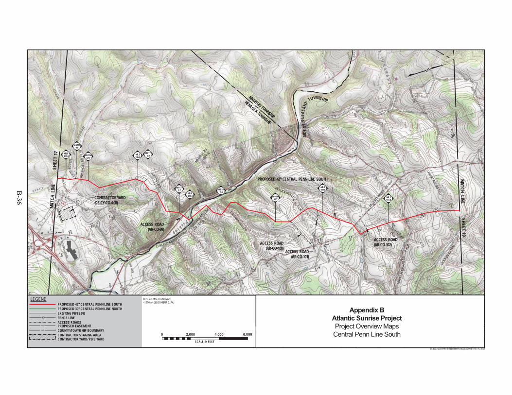
MILLVIL
LERD
MILLERTO
WN RD - SR401
1
SH ANER RD
ACCESS ROAD(AR-CO-99)
ACCESS ROAD(AR-CO-102)
- HWY 42
- T540
BUCK
HORN
RD-S
R44
DAHLRD
T828
COLEMAN HOLLO
W
COVERED BRIDGE DR T49
3 TD T426
COLEMAN HOLLOW
MELLICK HOLLOWRD T518
MOUN
TPL
EASA
NT
TOWNSHIP
LAMOREAUXRD
T551
LICK RU
NRD
T506
MOUN
TPL
EASA
NTRD
- SR
4020
CONTRACTOR YARD(CS-CY-CO-4-08)
M-01710.7
IVEY DRT489
PROPOSED 42" CENTRAL PENN LINE SOUTH
HEMLOCK TOWNSHIP
MADISON TOWNSHIP
D096
)
ACCESS ROAD(AR-CO-101)
ACCESS ROAD(AR-CO-100)
M-01950.87
M-01950.0
M-01710.0M-0156
0.17
M-01560.0
MILE110.0
MILE109.0
MILE107.0
MILE106.0
MILE105.0
DRAWING NO. REFERENCE TITLE
NO. DATE BY REVISION DESCRIPTION W.O. NO. CHK. APP.
0 3/31/15 JTN ISSUED FOR FERC FILING 1161503 DP MJH
TRANSCONTINENTAL GAS PIPE LINE COMPANY LLCTOPOGRAPHICAL PROJECT LOCATION MAP
ATLANTIC SUNRISE PROJECTPROPOSED 42" CENTRAL PENN LINE SOUTH
M.P. 0.00 TO M.P. 125.15COLUMBIA COUNTY, PENNSYLVANIA
APPROVED BY:
WO:
DRAWN BY:
CHECKED BY:
DATE:
DATE:
DATE:
10/3/1410/3/14
9/22/14
1161503
JHD SCALE:ISSUED FOR BID:
ISSUED FOR CONSTRUCTION: REVISION:
6:44 AM
DRAWINGNUMBER: F-FQ-CPLS-A-01
11 "=2,000 '
OFSHEET 18
Z:\1_Beta_Projects\101769-NEW\FERC\MXD\CPLS\Supplement\F-FQ-CPLS-A-01_JN.mxd
DRG 7.5 MIN. QUAD MAP:41076-A4 (BLOOMBURG, PA)
0 2,000 4,000 6,000
SCALE IN FEET5/13/2015
ELMJH
MATCH LINE SHEET 19
MATC
H L
INE
SHEE
T 17
PROPOSED EASEMENT
EXISTING PIPELINEFENCE LINEACCESS ROADS
LEGENDPROPOSED 42" CENTRAL PENN LINE SOUTHPROPOSED 30" CENTRAL PENN LINE NORTH
COUNTY/TOWNSHIP BOUNDARYCONTRACTOR STAGING AREACONTRACTOR YARD/ PIPE YARD
1 5/26/15 JTN ISSUED FOR SUPPLEMENTAL FILING #1 1161503 DP MJH
25
Appendix BAtlantic Sunrise ProjectProject Overview MapsCentral Penn Line South
B-36
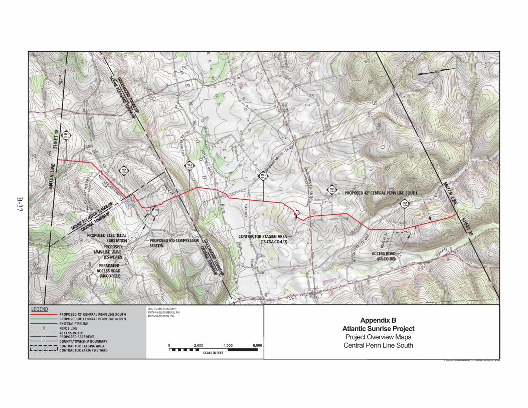
MOUNT PLEASANT TOWNSHIP
UTT
R DT 4
5 6
WIN
TERS
RDT4
59
WELLIVERSVILLE RD
T559 BLACK RD
T575
PATS
UPPE
RRD
T593
PROPOSEDMAIN LINE VALVE
(CS-MLV-12)
PROPOSED 610 COMPRESSORSTATION
PROPOSED ELECTRICALSUBSTATION
T506
HUCK
LEBE
R RY
HILL
RDT5
20
PATS LOWER
RD T585
BOWMAN
'SMILL
RD. - SR 4037
ROHRSBURGRD
- S R25 4
AUST
INTR
AIL - SR
4039
M-01950.0
GREENWOOD TOWNSHIP
MOUNT PLEASANT TOWNSHIP
ORANGE TOWNSHIP
PROPOSED 42" CENTRAL PENN LINE SOUTH
GREENWOOD TOWNSHIP
ORANGE TOWNSHIP
PERMANENT ACCESS ROAD
(AR-CO-102.1)
CONTRACTOR STAGING AREA(CS-CSA-CO-4-13)
ACCESS ROAD(AR-CO-103)
MILE
MILE116.0
MILE115.0
MILE114.0
MILE113.0
MILE112.0
DRAWING NO. REFERENCE TITLE
NO. DATE BY REVISION DESCRIPTION W.O. NO. CHK. APP.
0 3/31/15 JTN ISSUED FOR FERC FILING 1161503 DP MJH
TRANSCONTINENTAL GAS PIPE LINE COMPANY LLCTOPOGRAPHICAL PROJECT LOCATION MAP
ATLANTIC SUNRISE PROJECTPROPOSED 42" CENTRAL PENN LINE SOUTH
M.P. 0.00 TO M.P. 125.15COLUMBIA COUNTY, PENNSYLVANIA
APPROVED BY:
WO:
DRAWN BY:
CHECKED BY:
DATE:
DATE:
DATE:
10/3/1410/3/14
9/22/14
1161503
JHD SCALE:ISSUED FOR BID:
ISSUED FOR CONSTRUCTION: REVISION:
5:20 PM
DRAWINGNUMBER: F-FQ-CPLS-A-01
11 "=2,000 '
OFSHEET 19
25Z:\1_Beta_Projects\101769-NEW\FERC\MXD\CPLS\Supplement\F-FQ-CPLS-A-01_JN2.mxd
DRG 7.5 MIN. QUAD MAP:41076-A4 (BLOOMBURG, PA)41076-B4 (BENTON, PA)
0 2,000 4,000 6,000
SCALE IN FEET6/2/2015
ELMJH
MATCH LINE SHEET 20MA
TCH
LIN
ESH
EET
18
PROPOSED EASEMENT
EXISTING PIPELINEFENCE LINEACCESS ROADS
LEGENDPROPOSED 42" CENTRAL PENN LINE SOUTHPROPOSED 30" CENTRAL PENN LINE NORTH
COUNTY/TOWNSHIP BOUNDARYCONTRACTOR STAGING AREACONTRACTOR YARD/ PIPE YARD
1 5/26/15 JTN ISSUED FOR SUPPLEMENTAL FILING #1 1161503 DP MJH
Appendix BAtlantic Sunrise ProjectProject Overview MapsCentral Penn Line South
B-37

GREENWOOD TOWNSHIP
JACKSON TOWNSHIP
CAMPBELLRD T5
86
MC
HENRYROAD
T65 9
PIPER RD
S
GREEN CREEK RD - T715
WALLER DIVIDE RD - T70 0
LAUBAC H HILL RD T457
DERR'SRD
- SR4030
KNOUS E
RDT691
MENDENHALL HILLRD
T725
JACKSON TOWNSHIP
PROPOSED 42" CENTRAL PENN LINE SOUTH
PINE TOWNSHIP
BENTON TOWNSHIPJACKSON TOWNSHIP
SUGARLOAF
TOWNSHIP
ACCESS ROAD(AR-CO-106)
CONTRACTOR STAGING AREA(CS-CSA-CO-4-006)
CONTRACTOR STAGING AREA(CS-CSA-CO-4-005)
M-01590.0 M-0159
0.31
MILE122.0
MILE121.0
MILE120.0
MILE119.0MILE
118.0
MILE117.0
DRAWING NO. REFERENCE TITLE
NO. DATE BY REVISION DESCRIPTION W.O. NO. CHK. APP.
0 3/31/15 JTN ISSUED FOR FERC FILING 1161503 DP MJH
TRANSCONTINENTAL GAS PIPE LINE COMPANY LLCTOPOGRAPHICAL PROJECT LOCATION MAP
ATLANTIC SUNRISE PROJECTPROPOSED 42" CENTRAL PENN LINE SOUTH
M.P. 0.00 TO M.P. 125.15COLUMBIA COUNTY, PENNSYLVANIA
APPROVED BY:
WO:
DRAWN BY:
CHECKED BY:
DATE:
DATE:
DATE:
10/3/1410/3/14
9/22/14
1161503
JHD SCALE:ISSUED FOR BID:
ISSUED FOR CONSTRUCTION: REVISION:
6:59 AM
DRAWINGNUMBER: F-FQ-CPLS-A-01
11 "=2,000 '
OFSHEET 20
Z:\1_Beta_Projects\101769-NEW\FERC\MXD\CPLS\Supplement\F-FQ-CPLS-A-01_JN.mxd
DRG 7.5 MIN. QUAD MAP:41076-B4 (BENTON, PA)41076-C4 (ELK GROVE, PA)
0 2,000 4,000 6,000
SCALE IN FEET5/13/2015
ELMJH
MATC
H L
INE
SHE
ET 21
MATCH LINE SHEET 19
PROPOSED EASEMENT
EXISTING PIPELINEFENCE LINEACCESS ROADS
LEGENDPROPOSED 42" CENTRAL PENN LINE SOUTHPROPOSED 30" CENTRAL PENN LINE NORTH
COUNTY/TOWNSHIP BOUNDARYCONTRACTOR STAGING AREACONTRACTOR YARD/ PIPE YARD
1 5/26/15 JTN ISSUED FOR SUPPLEMENTAL FILING #1 1161503 DP MJH
25
Appendix BAtlantic Sunrise ProjectProject Overview MapsCentral Penn Line South
B-38
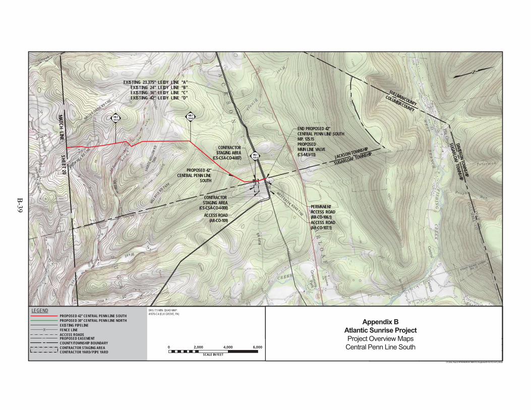
PROPOSED 42"CENTRAL PENN LINE
SOUTHSR239
SMITH HIL L RD T790
WALLER DIVIDE RD T700
SHUL
TZ H
OLLO
W R
DT6
92
WEST CREEK ROAD T700
RUFF
RD
SUGARLOAF TOWNSHIPDAVIDSON TOWNSHIP
COLUMBIA COUNTY
SULLIVAN COUNTY
ACCESS ROAD(AR-CO-107.1)
WILLKY
LERD T 698
END PROPOSED 42"CENTRAL PENN LINE SOUTHM.P. 125.15PROPOSEDMAIN LINE VALVE(CS-MLV-13)
EXISTING 23.375" LEIDY LINE "A"EXISTING 24" LEIDY LINE "B"EXISTING 36" LEIDY LINE "C"EXISTING 42" LEIDY LINE "D"
ACCESS ROAD(AR-CO-109)
SUGARLOAF TOWNSHIP
WNSHIP
AFHIP
JACKSON TOWNSHIP
PERMANENTACCESS ROAD(AR-CO-106.1)
CONTRACTOR STAGING AREA
(CS-CSA-CO-4-008)
CONTRACTORSTAGING AREA
(CS-CSA-CO-4-007)MILE125.0
MILE124.0MILE
123.0
DRAWING NO. REFERENCE TITLE
NO. DATE BY REVISION DESCRIPTION W.O. NO. CHK. APP.
0 3/31/15 JTN ISSUED FOR FERC FILING 1161503 DP MJH
TRANSCONTINENTAL GAS PIPE LINE COMPANY LLCTOPOGRAPHICAL PROJECT LOCATION MAP
ATLANTIC SUNRISE PROJECTPROPOSED 42" CENTRAL PENN LINE SOUTH
M.P. 0.00 TO M.P. 125.15COLUMBIA COUNTY, PENNSYLVANIA
APPROVED BY:
WO:
DRAWN BY:
CHECKED BY:
DATE:
DATE:
DATE:
10/3/1410/3/14
9/22/14
1161503
JHD SCALE:ISSUED FOR BID:
ISSUED FOR CONSTRUCTION: REVISION:
11:52 AM
DRAWINGNUMBER: F-FQ-CPLS-A-01
11 "=2,000 '
OFSHEET 21
Z:\1_Beta_Projects\101769-NEW\FERC\MXD\CPLS\Supplement\F-FQ-CPLS-A-01_JN.mxd
DRG 7.5 MIN. QUAD MAP:41076-C4 (ELK GROVE, PA)
0 2,000 4,000 6,000
SCALE IN FEET5/27/2015
ELMJH
MATCH LINESHEET 20
PROPOSED EASEMENT
EXISTING PIPELINEFENCE LINEACCESS ROADS
LEGENDPROPOSED 42" CENTRAL PENN LINE SOUTHPROPOSED 30" CENTRAL PENN LINE NORTH
COUNTY/TOWNSHIP BOUNDARYCONTRACTOR STAGING AREACONTRACTOR YARD/ PIPE YARD
1 5/26/15 JTN ISSUED FOR SUPPLEMENTAL FILING #1 1161503 DP MJH
25
Appendix BAtlantic Sunrise ProjectProject Overview MapsCentral Penn Line South
B-39
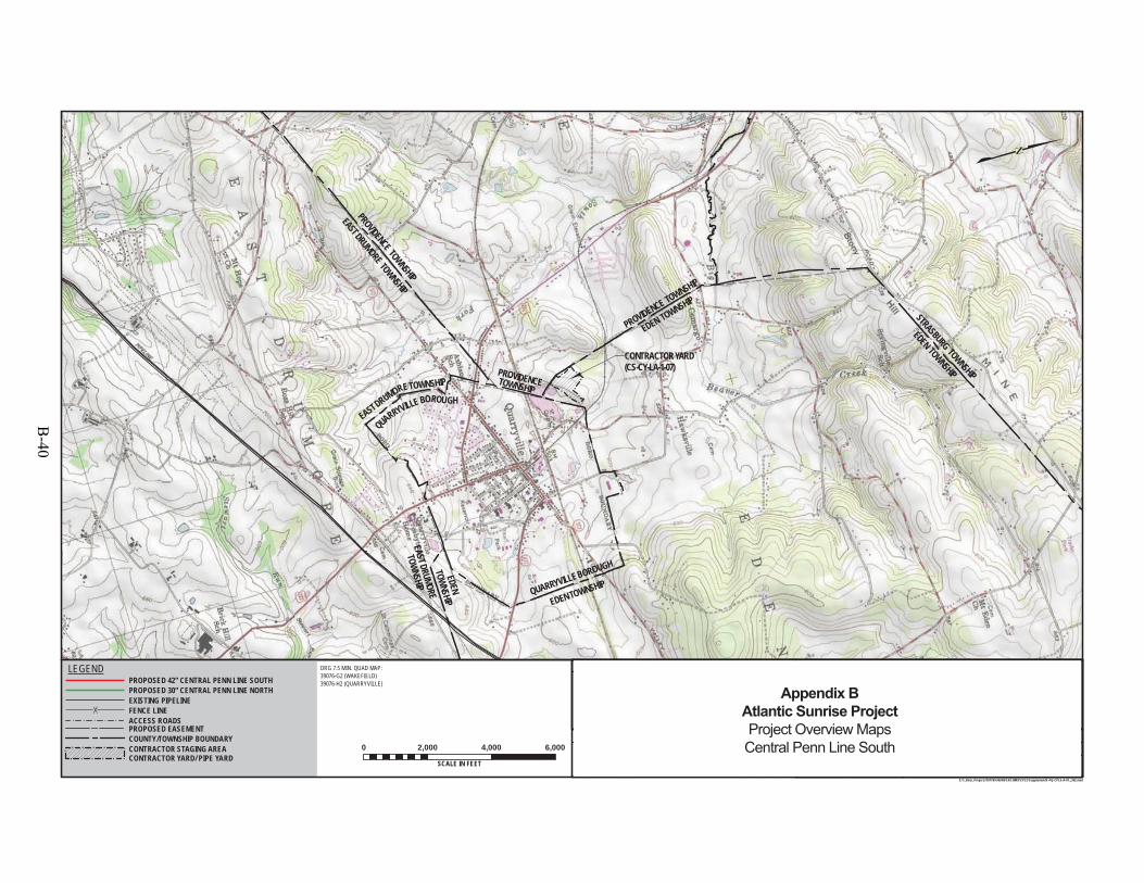
CONTRACTOR YARD(CS-CY-LA-1-07)
PROVIDENCE TOWNSHIP
EDEN TOWNSHIP
EDEN TOWNSHIP
STRASBURG TOWNSHIP
PROVIDENCE TOWNSHIP
EASTDRUMORE TOWNSHIP
EDENTOWNSHIP
EASTDRUMORE
TOWNSHIP
EASTDRUMORETOWNSHIP
QUARRYVILLEBOROUGH
EDENTOWNSHIPQUARRYVILLEBOROUGH
PROVIDENCETOWNSHIP
DRAWING NO. REFERENCE TITLE
NO. DATE BY REVISION DESCRIPTION W.O. NO. CHK. APP.
0 3/31/15 JTN ISSUED FOR FERC FILING 1161503 DP MJH
APPROVED BY:
WO:
DRAWN BY:
CHECKED BY:
DATE:
DATE:
DATE:
10/3/1410/3/14
9/22/14
1161503
JHD SCALE:ISSUED FOR BID:
ISSUED FOR CONSTRUCTION: REVISION:
7:17 AM
DRAWINGNUMBER: F-FQ-CPLS-A-01
11 "=2,000 '
OFSHEET 22
25Z:\1_Beta_Projects\101769-NEW\FERC\MXD\CPLS\Supplement\F-FQ-CPLS-A-01_JN2.mxd
0 2,000 4,000 6,000
SCALE IN FEET6/1/2015
ELMJH
PROPOSED EASEMENT
EXISTING PIPELINEFENCE LINEACCESS ROADS
LEGENDPROPOSED 42" CENTRAL PENN LINE SOUTHPROPOSED 30" CENTRAL PENN LINE NORTH
COUNTY/TOWNSHIP BOUNDARYCONTRACTOR STAGING AREACONTRACTOR YARD/ PIPE YARD
1 5/26/15 JTN ISSUED FOR SUPPLEMENTAL FILING #1 1161503 DP MJH
DRG 7.5 MIN. QUAD MAP: 39076-G2 (WAKEFIELD) 39076-H2 (QUARRYVILLE)
TRANSCONTINENTAL GAS PIPE LINE COMPANY LLCTOPOGRAPHICAL PROJECT LOCATION MAP
ATLANTIC SUNRISE PROJECTPROPOSED 42" CENTRAL PENN LINE SOUTH
M.P. 0.00 TO M.P. 125.15 LANCASTER COUNTY, PENNSYLVANIA
Appendix BAtlantic Sunrise ProjectProject Overview MapsCentral Penn Line South
B-40
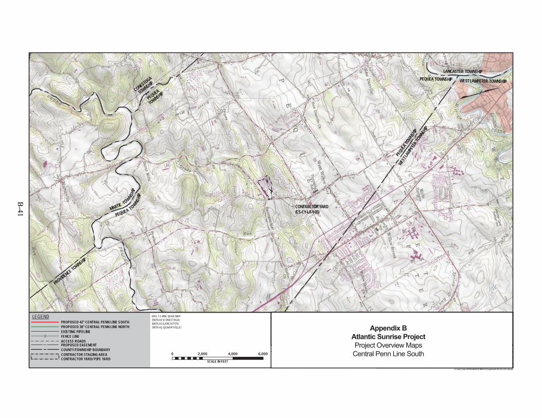
PROVIDENCE TOWNSHIP
MARTIC TOWNSHIP
CONTRACTOR YARD(CS-CY-LA-1-05)
PEQU
EATO
WNSHIP
WESTL
AMPE
TER TO
WNSHIP
LANCASTER TOWNSHIP
WESTLAMPETER TOWNSHIPPEQUEA TOWNSHIP
CONESTOGA
TOWNSHIP
PEQUEA
TOWNSHIP
PEQUEA TOWNSHIP
LA-01
DRAWING NO. REFERENCE TITLE
NO. DATE BY REVISION DESCRIPTION W.O. NO. CHK. APP.
0 3/31/15 JTN ISSUED FOR FERC FILING 1161503 DP MJH
APPROVED BY:
WO:
DRAWN BY:
CHECKED BY:
DATE:
DATE:
DATE:
10/3/1410/3/14
9/22/14
1161503
JHD SCALE:ISSUED FOR BID:
ISSUED FOR CONSTRUCTION: REVISION:
7:17 AM
DRAWINGNUMBER: F-FQ-CPLS-A-01
11 "=2,000 '
OFSHEET 23
25Z:\1_Beta_Projects\101769-NEW\FERC\MXD\CPLS\Supplement\F-FQ-CPLS-A-01_JN2.mxd
0 2,000 4,000 6,000
SCALE IN FEET6/1/2015
ELMJH
PROPOSED EASEMENT
EXISTING PIPELINEFENCE LINEACCESS ROADS
LEGENDPROPOSED 42" CENTRAL PENN LINE SOUTHPROPOSED 30" CENTRAL PENN LINE NORTH
COUNTY/TOWNSHIP BOUNDARYCONTRACTOR STAGING AREACONTRACTOR YARD/ PIPE YARD
1 5/26/15 JTN ISSUED FOR SUPPLEMENTAL FILING #1 1161503 DP MJH
DRG 7.5 MIN. QUAD MAP:39076-H3 (CONESTOGA)40076-A3 (LANCASTER)39076-H2 (QUARRYVILLE)
TRANSCONTINENTAL GAS PIPE LINE COMPANY LLCTOPOGRAPHICAL PROJECT LOCATION MAP
ATLANTIC SUNRISE PROJECTPROPOSED 42" CENTRAL PENN LINE SOUTH
M.P. 0.00 TO M.P. 125.15 LANCASTER COUNTY, PENNSYLVANIA
Appendix BAtlantic Sunrise ProjectProject Overview MapsCentral Penn Line South
B-41
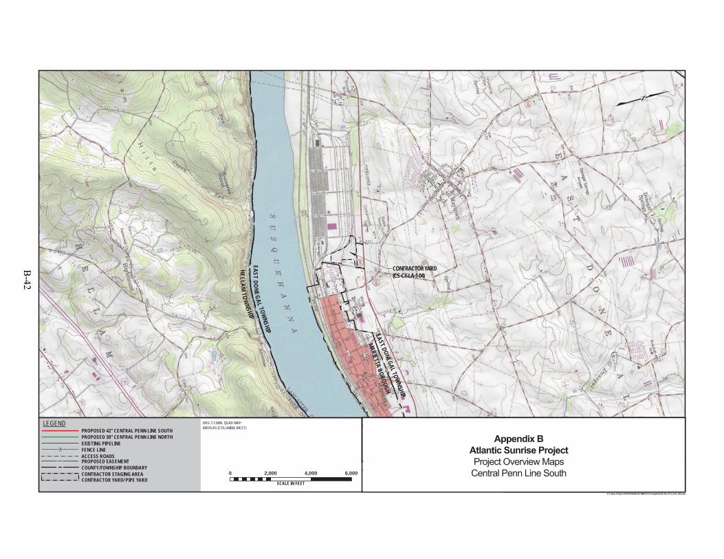
HEL LAMTO
WNSHIP
EASTD O
NEGALTOW
NSHIP
CONTRACTOR YARD(CS-CY-LA-1-04)
EAST DONEGAL TOWNSHIP
MARIETTA BOROUGH
DRAWING NO. REFERENCE TITLE
NO. DATE BY REVISION DESCRIPTION W.O. NO. CHK. APP.
0 3/31/15 JTN ISSUED FOR FERC FILING 1161503 DP MJH
APPROVED BY:
WO:
DRAWN BY:
CHECKED BY:
DATE:
DATE:
DATE:
10/3/1410/3/14
9/22/14
1161503
JHD SCALE:ISSUED FOR BID:
ISSUED FOR CONSTRUCTION: REVISION:
7:18 AM
DRAWINGNUMBER: F-FQ-CPLS-A-01
11 "=2,000 '
OFSHEET 24
25Z:\1_Beta_Projects\101769-NEW\FERC\MXD\CPLS\Supplement\F-FQ-CPLS-A-01_JN2.mxd
0 2,000 4,000 6,000
SCALE IN FEET6/1/2015
ELMJH
PROPOSED EASEMENT
EXISTING PIPELINEFENCE LINEACCESS ROADS
LEGENDPROPOSED 42" CENTRAL PENN LINE SOUTHPROPOSED 30" CENTRAL PENN LINE NORTH
COUNTY/TOWNSHIP BOUNDARYCONTRACTOR STAGING AREACONTRACTOR YARD/ PIPE YARD
1 5/26/15 JTN ISSUED FOR SUPPLEMENTAL FILING #1 1161503 DP MJH
TRANSCONTINENTAL GAS PIPE LINE COMPANY LLCTOPOGRAPHICAL PROJECT LOCATION MAP
ATLANTIC SUNRISE PROJECTPROPOSED 42" CENTRAL PENN LINE SOUTH
M.P. 0.00 TO M.P. 125.15 LANCASTER COUNTY, PENNSYLVANIA
DRG 7.5 MIN. QUAD MAP:40076-A5 (COLUMBIA WEST)
Appendix BAtlantic Sunrise ProjectProject Overview MapsCentral Penn Line South
B-42

NORTH ANNVILLE TOWNSHIP CONTRACTOR YARD(CS-CY-LE-2-12)
NORTH LEBANON TOWNSHIP
NORTH ANNVILLE TOWNSHIP
NORTH LEBANON TOWNSHIP
SWATARA TOWNSHIP
NORT
HLEB
ANON
TOWN
SHIP
CLEO
NABO
ROUG
H
ANNVILLE TOWNSHIP
CLEONA BOROUGH
SWATARA TOWNSHIPNORTH ANNVILLE TOWNSHIP
SWATARA TOWNSHIP
TO
WNSHIP
NOR
TH CORNWALL
CLEONABOROUGH
JONESTOWN
BOROUGH
JONESTOWN BOROUGH
UNION TOWNSHIP
UNION TOWNSH
IP
SWATA
RA TOWNSH
IP
ANNVILLE TOWNSHIP
DRAWING NO. REFERENCE TITLE
NO. DATE BY REVISION DESCRIPTION W.O. NO. CHK. APP.
0 3/31/15 JTN ISSUED FOR FERC FILING 1161503 DP MJH
APPROVED BY:
WO:
DRAWN BY:
CHECKED BY:
DATE:
DATE:
DATE:
10/3/1410/3/14
9/22/14
1161503
JHD SCALE:ISSUED FOR BID:
ISSUED FOR CONSTRUCTION: REVISION:
7:19 AM
DRAWINGNUMBER: F-FQ-CPLS-A-01
11 "=2,000 '
OFSHEET 25
25Z:\1_Beta_Projects\101769-NEW\FERC\MXD\CPLS\Supplement\F-FQ-CPLS-A-01_JN2.mxd
0 2,000 4,000 6,000
SCALE IN FEET6/1/2015
ELMJH
PROPOSED EASEMENT
EXISTING PIPELINEFENCE LINEACCESS ROADS
LEGENDPROPOSED 42" CENTRAL PENN LINE SOUTHPROPOSED 30" CENTRAL PENN LINE NORTH
COUNTY/TOWNSHIP BOUNDARYCONTRACTOR STAGING AREACONTRACTOR YARD/ PIPE YARD
1 5/26/15 JTN ISSUED FOR SUPPLEMENTAL FILING #1 1161503 DP MJH
TRANSCONTINENTAL GAS PIPE LINE COMPANY LLCTOPOGRAPHICAL PROJECT LOCATION MAP
ATLANTIC SUNRISE PROJECTPROPOSED 42" CENTRAL PENN LINE SOUTH
M.P. 0.00 TO M.P. 125.15 LANCASTER COUNTY, PENNSYLVANIA
DRG 7.5 MIN. QUAD MAP:40076-C4 (LEBANON)40076-C5 (PALMYRA)40076-D4 (FREDERICKSBURG)40076-D5 (INDIANTOWN GAP) Appendix B
Atlantic Sunrise ProjectProject Overview MapsCentral Penn Line South
B-43

B-44

Chapman Loop
B-45

B-46
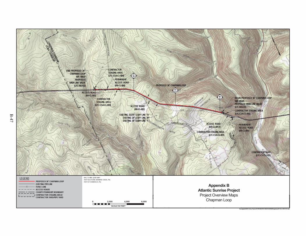
PROPOSED 36" CHAPMAN LOOP
BEGIN PROPOSED 36" CHAPMAN LOOPM.P. 185.95PROPOSED MAIN LINE VALVE(LFC-MLV-01)
END PROPOSED 36" CHAPMAN LOOP
M.P. 188.87PROPOSED
MAIN LINE VALVE(LFC-MLV-02)
EXISTING 23.375" LEIDY LINE "A"EXISTING 24" LEIDY LINE "B"EXISTING 36" LEIDY LINE "C"
SUMMERSON
MOUNTAIN
ROAD
DOGWOOD LN
SUMMERSON MOUNTAIN ROAD T313
P O S THO
L
LOWRO
AD
CONTRACTOR STAGING AREA(LFC-CSA-CL-002)
CONTRACTOR STAGING AREA(LFC-CSA-CL-001)
PERMANENTACCESS ROAD(AR-CL-004)
SUNFLOWER LN
CONTRACTOR YARD(LFC-CY-CL-1-03)
ACCESS ROAD(AR-CL-002)
PERMANENTACCESS ROAD(AR-CL-001)
CONTRACTOR STAGING AREA
(LFC-CSA-CL-003)
CONTRACTOR STAGING AREA(LFC-CSA-CL-004)
ACCESS ROAD(AR-CL-001.1)
ACCESS ROAD(AR-CL-003)
MILE187.0
MILE186.0
MILE188.0
CHAPMAN TOWNSHIP
LEIDY TOWNSHIP
F-FQ-LL185.9-D-01OF
SHEET
9/9/149/26/14
SHL
3:16 PM 5/21/2015
REFERENCE TITLE
APP.CHK.W.O. NO.REVISION DESCRIPTIONBYDATENO.
DATE:
DATE:
DATE:
APPROVED BY:
CHECKED BY:
DRAWN BY: SCALE:ISSUED FOR BID:
ISSUED FOR CONSTRUCTION:
DRAWINGNUMBER:
WO: 1161125
REVISION:
SCALE IN FEET
0 2,000 4,000 6,000
1"=2,000'
12
TRANSCONTINENTAL GAS PIPE LINE COMPANY LLCTOPOGRAPHICAL PROJECT LOCATION MAP
ATLANTIC SUNRISE PROJECTPROPOSED 36" CHAPMAN LOOPLL M.P. 185.95 TO LL M.P. 188.87CLINTON COUNTY, PENNSYLVANIA
1
\\houvgtgweb2\GIS\1_Beta_Projects\101769-NEW\FERC\MXD\CHAPMAN\Supplement\F-FQ-LL185.9-D-01.mxd
DRAWING NO.
ELMJH 9/26/14
DRG 7.5 MIN. QUAD MAP:41077-D6 (YOUNG WOMANS CREEK, PA)41077-D7 (TAMARACK, PA)
LEGEND
EXISTING PIPELINEFENCE LINEACCESS ROADSCOUNTY/TOWNSHIP BOUNDARY
PROPOSED 36" CHAPMAN LOOP
CONTRACTOR STAGING AREA/CONTRACTOR YARD/PIPE YARD
1161125ISSUED FOR SUPPLEMENTAL FILING #11 JTN5/26/15 CLR MJH1161125ISSUED FOR FERC FILING 0 JTN3/31/15 DP MJH
Appendix BAtlantic Sunrise ProjectProject Overview Maps
Chapman Loop
B-47
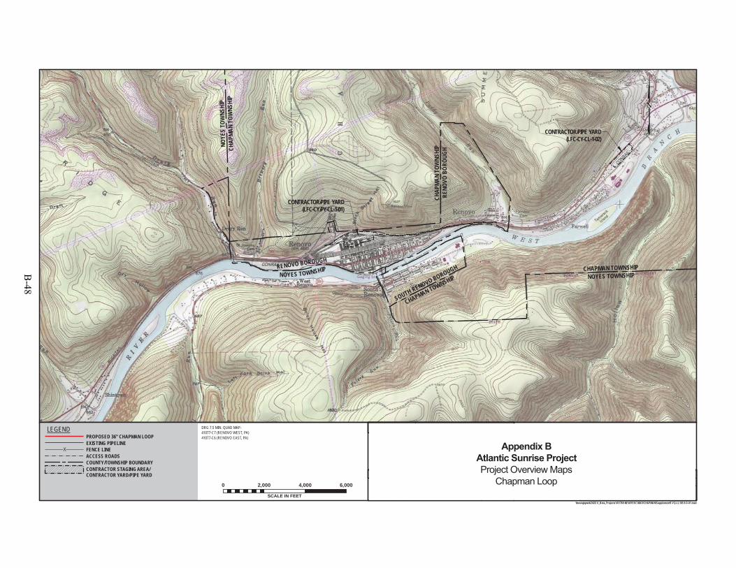
CONTRACTOR/PIPE YARD(LFC-CY-CL-1-02)
CONTRACTOR/PIPE YARD(LFC-CY/PY-CL-1-01)
CHAP
MAN
TOW
NSHI
PRE
NOVO
BOR
OUGH
CHAPMAN TOWNSHIP
SOUTH RENOVO BOROUGH CHAPMAN TOWNSHIPNOYES TOWNSHIP
CHAP
MAN
TOW
NSHI
PNO
YES
TOW
NSHI
P
RENOVO BOROUGH
NOYES TOWNSHIP
F-FQ-LL185.9-D-01OF
SHEET
9/9/149/26/14
SHL
3:17 PM 5/21/2015
REFERENCE TITLE
APP.CHK.W.O. NO.REVISION DESCRIPTIONBYDATENO.
DATE:
DATE:
DATE:
APPROVED BY:
CHECKED BY:
DRAWN BY: SCALE:ISSUED FOR BID:
ISSUED FOR CONSTRUCTION:
DRAWINGNUMBER:
WO: 1161125
REVISION:
SCALE IN FEET
0 2,000 4,000 6,000
1"=2,000'
22
TRANSCONTINENTAL GAS PIPE LINE COMPANY LLCTOPOGRAPHICAL PROJECT LOCATION MAP
ATLANTIC SUNRISE PROJECTPROPOSED 36" CHAPMAN LOOPLL M.P. 185.95 TO LL M.P. 188.87CLINTON COUNTY, PENNSYLVANIA
1
\\houvgtgweb2\GIS\1_Beta_Projects\101769-NEW\FERC\MXD\CHAPMAN\Supplement\F-FQ-LL185.9-D-01.mxd
DRAWING NO.
ELMJH 9/26/14
DRG 7.5 MIN. QUAD MAP:41077-C7 (RENOVO WEST, PA)41077-C6 (RENOVO EAST, PA)
LEGEND
EXISTING PIPELINEFENCE LINEACCESS ROADSCOUNTY/TOWNSHIP BOUNDARY
PROPOSED 36" CHAPMAN LOOP
CONTRACTOR STAGING AREA/CONTRACTOR YARD/PIPE YARD
1161125ISSUED FOR SUPPLEMENTAL FILING #11 JTN5/26/15 CLR MJH1161125ISSUED FOR FERC FILING 0 JTN3/31/15 DP MJH
Appendix BAtlantic Sunrise ProjectProject Overview Maps
Chapman Loop
B-48

Unity Loop
B-49

B-50
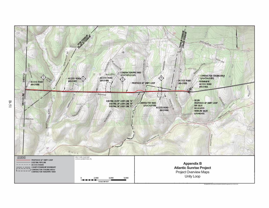
PROPOSED 42" UNITY LOOP
EXISTING 23.375" LEIDY LINE "A"EXISTING 24" LEIDY LINE "B"EXISTING 36" LEIDY LINE "C"
JORD
AN TO
WNSH
IP
FRAN
KLIN
TOWN
SHIP
FRANKLIN TO
WNSHIP
PENN TOWNSHIP
STATE ROUTE 239
FAI RV IE
WRO
ADT7
10
BEAV
ERRU
NRO
AD
SR20
77
HARR
IMAN
ROAD
T708
FAIR
VIEW
ROAD
T710
HEMLOCK RD
SR42
SR42
STATERO
UTE42
STATE HIGHWAY 118
STATE HIGHWAY 118
BRAD
LEY
ROAD
REED ROAD
CLE
MAN
HOLL
OWRO
ADT7
20
BEGIN PROPOSED 42" UNITY LOOPM.P. 120.31RELOCATEDMAIN LINE VALVE(LFU-MLV-01)
MORDANHO
LLOW RD
ACCESS ROAD(AR-LY-008)
CONTRACTOR/PIPE YARD(LFU-CY/PY-LY-1-01)
CONTRACTOR YARD(LFU-CY-LY-1-06)
MILLER
ROAD
T728
LOOP
H IL L ROADT692
MILLER ROAD T728
SAVAGEHILL RD
BOYER LANE
BUCK ROAD
WILSON
ROAD
SHEETSHILL
RD
IROQ
UOIS
RD
RISH
ELHO
LLOW
RD
ACCESS ROAD(AR-LY-006) ACCESS ROAD
(AR-LY-003)PERMANENTACCESS ROAD(AR-LY-002)
ACCESS ROAD(AR-LY-004)
ACCESS ROAD(AR-LY-007)
CONTRACTOR STAGING AREA(LFU-CSA-LY-001)
MILE124.0 MILE
123.0 MILE122.0
MILE121.0
MATC
H LI
NE S
HEET
2
F-FQ-LL119.8-D-01
TRANSCONTINENTAL GAS PIPE LINE COMPANY LLCTOPOGRAPHICAL PROJECT LOCATION MAP
ATLANTIC SUNRISE PROJECTPROPOSED 42" UNITY LOOP
LL M.P. 120.31 TO LL M.P. 128.87LYCOMING COUNTY, PENNSYLVANIA
ELMJH
1161145 9/8/149/8/14
9/8/14
12
\\houvgtgweb2\GIS\1_Beta_Projects\101769-NEW\FERC\MXD\UNITY\Supplement\F-FQ-LL119.8-D-01.mxd
DRG 7.5 MIN. QUAD MAP:41076-C5 (SONESTOWN, PA)
0 2,000 4,000 6,000
SCALE IN FEET
SHL
1161145
DRAWING NO. REFERENCE TITLE
NO. DATE BY REVISION DESCRIPTION W.O. NO. CHK. APP. DRAWN BY:
CHECKED BY:
APPROVED BY:
WO:
DATE:
DATE:
DATE:
LEGENDPROPOSED 42" UNITY LOOPEXISTING PIPELINEACCESS ROADSCOUNTY/TOWNSHIP BOUNDARYCONTRACTOR STAGING AREA/CONTRACTOR YARD/PIPE YARD
1"=2,000'ISSUED FOR BID:
ISSUED FOR CONSTRUCTION:
SCALE:
REVISION:
3:23 PM
DRAWINGNUMBER:
OFSHEET
5/21/2015
1ISSUED FOR FERC FILING 0 JTN3/31/15 DP MJH1161145ISSUED FOR SUPPLEMENTAL FILING #11 JTN5/26/15 CLR MJH
Appendix BAtlantic Sunrise ProjectProject Overview Maps
Unity Loop
B-51

END PROPOSED 42" UNITY LOOPM.P. 128.87
EXISTING 23.375" LEIDY LINE "A"EXISTING 24" LEIDY LINE "B"EXISTING 36" LEIDY LINE "C"
PROPOSED 42" UNITY LOOP
PICTU
RE RO
CKS B
OROU
GH
PENN
TOWNS
HIP
PENN
TOWN
SHIP
DUGA
NRO
AD
CRAWLEY HILL
ROAD EXT.
GREE
NVA
LLEY
RO
AD SR 2061
SFR
YM
IRE HOLLO
WR O
A DT 6
71
REE SERO
AD
BAR T OHO
LLO
WRO
ADT6
5 0
DR.POUSTRO
ADT674
ELECTIONHOUSE HILL ROAD
GREEN
VALL
EYRO
ADSR
2061
SM
AINSTRE ET
- SR220
TAYLORHILL RD
BARTLOW DRIVE
FOUS
THI
LLRO
AD
SUNRI SE
DR
CONTRACTORSTAGING AREA
(LFU-CSA-LY-002)BEA
VER LAKE RO A D SR 2073
PENN TOWNSHIP
DARKHOLLOW
ROADT 8 00
CRAW
LEY
HILL
ROAD
T694
CRAMNER HILL
ROAD
HUDDY HILL RD
MOUNT ZION HILL RD
GRANT
BARTO RD
FOUST
HILLRD
FRANKLIN TOWNSHIPPENN TOWNSHIP
WOLF
TOWN
SHIP
MORELAND TOWNSHIP
ACCESS ROAD(AR-LY-014)
ACCESS ROAD(AR-LY-012) ACCESS ROAD
(AR-LY-009)
ACCESS ROAD(AR-LY-010)
ACCESS ROAD(AR-LY-011)
M-00030.08 M-0003
0.0MILE128.0
MILE125.0MILE
127.0
MILE126.0
F-FQ-LL119.8-D-01
TRANSCONTINENTAL GAS PIPE LINE COMPANY LLCTOPOGRAPHICAL PROJECT LOCATION MAP
ATLANTIC SUNRISE PROJECTPROPOSED 42" UNITY LOOP
LL M.P. 120.31 TO LL M.P. 128.87LYCOMING COUNTY, PENNSYLVANIA
EL
MATC
H LI
NE
SHE
ET 1
MJH1161145 9/8/14
9/8/14
9/8/14
22
\\houvgtgweb2\GIS\1_Beta_Projects\101769-NEW\FERC\MXD\UNITY\Supplement\F-FQ-LL119.8-D-01.mxd
DRG 7.5 MIN. QUAD MAP:41076-C5 (SONESTOWN, PA)41076-C6 (PICTURE ROCKS, PA)
0 2,000 4,000 6,000
SCALE IN FEET
SHL
1161145
DRAWING NO. REFERENCE TITLE
NO. DATE BY REVISION DESCRIPTION W.O. NO. CHK. APP. DRAWN BY:
CHECKED BY:
APPROVED BY:
WO:
DATE:
DATE:
DATE:
LEGENDPROPOSED 42" UNITY LOOPEXISTING PIPELINEACCESS ROADSCOUNTY/TOWNSHIP BOUNDARYCONTRACTOR STAGING AREA/CONTRACTOR YARD/PIPE YARD
1"=2,000'ISSUED FOR BID:
ISSUED FOR CONSTRUCTION:
SCALE:
REVISION:
3:22 PM
DRAWINGNUMBER:
OFSHEET
5/21/2015
1ISSUED FOR FERC FILING 0 JTN3/31/15 DP MJH1161145ISSUED FOR SUPPLEMENTAL FILING #11 JTN5/26/15 CLR MJH
Appendix BAtlantic Sunrise ProjectProject Overview Maps
Unity Loop
B-52
Mainline A and B Replacements
B-53

B-54
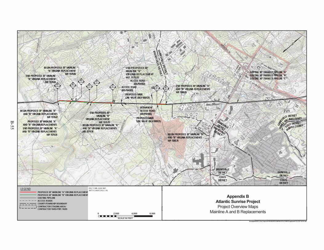
PROPOSED 30" MAINLINE "A" AND "B" VIRGINIA REPLACEMENTS
END PROPOSED 30'' MAINLINE "A"AND "B" VIRGINIA REPLACEMENTSM.P. 1580.95
BEGIN PROPOSED 30" MAINLINE "A" AND "B" VIRGINIA REPLACEMENTS
M.P. 1578.67
END PROPOSED 30" MAINLINE"A" VIRGINIA REPLACEMENT
M.P. 1579.00
BEGIN PROPOSED 30" MAINLINE"A" VIRGINIA REPLACEMENT
M.P. 1579.06
END PROPOSED 30" MAINLINE "A"AND "B" VIRGINIA REPLACEMENTS
M.P. 1579.35
BEGIN PROPOSED 30" MAINLINE "A"AND "B" VIRGINIA REPLACEMENTSM.P. 1579.38
END PROPOSED 30"MAINLINE "A"VIRGINIA REPLACEMENTM.P. 1579.83
BEGIN PROPOSED 30" MAINLINE "A"AND "B" VIRGINIA REPLACEMENTSM.P. 1580.76
EXISTING 30" TRANSCO PIPELINE "A"EXISTING 30" TRANSCO PIPELINE "B"EXISTING 36" TRANSCO PIPELINE "C"
STAT
ERO
UTE
619
STAT
ERO
UTE
234 (
SUDL
EYRD
)
AS HT ON AVE
SEYM
OU
R RD
END PROPOSED 30"MAINLINE "B"
VIRGINIA REPLACEMENTM.P. 1579.79
BETH LE HAMRD
BALLS FORD RD
PRINC
E WILLIAM COUNTY
GAINE
SVILLE DISTRICT
SULLY DISTRICT
FAIRFAX COUNTYBRENTSVILLEDISTRICT
GAINESVILLEDISTRICT
PROPOSED MAINLINE VALVE (MLV-180A25)
PROPOSED MAIN LINE VALVE (MLV-180B25)
INTERSTATE 66
UTHERNBRENTSVILLE
DISTRICT
COLESDISTRICT
GAINESVILLEDISTRICTCOLES
DISTRICT
HORN
BAKE
RRD
BRENTSVILLE DISTRICTGAINESVILLE DISTRICT
MILE1578.67
MILE1579.00
MILE1579.06
MILE1579.35
MILE1579.38
MILE1579.83 MILE
1580.76MILE
1580.95
PERMANENTACCESS ROAD(AR-PW-001)
ACCESS ROAD(AR-PW-003)
ACCESS ROAD(AR-PW-002)
DRG 7.5 MIN. QUAD MAP:38077-F5 (NOKESVILLE, VA)
F-FQ-1578.7-AB-01OF
SHEET
SHL
3:07 PM 5/21/2015
REFERENCE TITLE
APP.CHK.W.O. NO.REVISION DESCRIPTIONBYDATENO.
DATE:
DATE:
DATE:
APPROVED BY:
CHECKED BY:
DRAWN BY: SCALE:ISSUED FOR BID:
ISSUED FOR CONSTRUCTION:
DRAWINGNUMBER:
WO: 1161536
REVISION:
SCALE IN FEET
0 2,000 4,000 6,000
1"=2,000'
12
1
\\houvgtgweb2\GIS\1_Beta_Projects\101769-NEW\FERC\MXD\VA REPLACEMENT\Supplement\F-FQ-1578.7-AB-01.mxd
DRAWING NO. TRANSCONTINENTAL GAS PIPE LINE COMPANY LLCTOPOGRAPHICAL PROJECT LOCATION MAP
ATLANTIC SUNRISE PROJECTPROPOSED 30" MAINLINE "A"
AND "B" VIRGINIA REPLACEMENTSM.P. 1578.67 TO M.P. 1580.95
PRINCE WILLIAM COUNTY, VIRGINIA9/24/1410/3/1410/3/14
ELMJH
ISSUED FOR FERC FILING 0 JTN3/31/15 1161536 DP MJH
PROPOSED 30" MAINLINE "B" VIRGINIA REPLACEMENTPROPOSED 30" MAINLINE "A" VIRGINIA REPLACEMENT
LEGEND
EXISTING PIPELINEACCESS ROADSCOUNTY/TOWNSHIP BOUNDARYCONTRACTOR STAGING AREA/CONTRACTOR YARD/ PIPE YARD
1 JTN5/26/15 1161536 MJHISSUED FOR SUPPLEMENTAL FILING #1 CLR
Appendix BAtlantic Sunrise ProjectProject Overview Maps
Mainline A and B Replacements
B-55
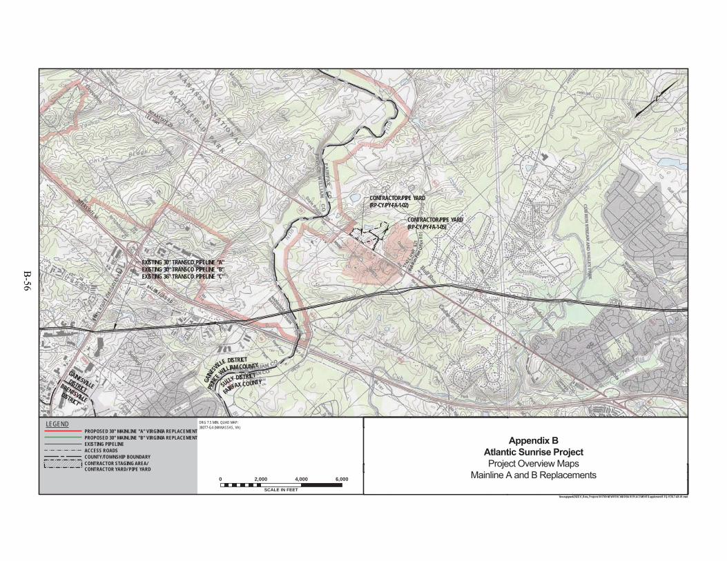
"A"NTS
EXISTING 30" TRANSCO PIPELINE "A"EXISTING 30" TRANSCO PIPELINE "B"EXISTING 36" TRANSCO PIPELINE "C"
STAT
ERO
UTE
234 (
SUDL
EYRD
)
AS HT ONAVE
BALLS FORD RD
PRINC
E WILLIAM COUNTY
GAINE
SVI
LLE DISTRICT
CONTRACTOR/PIPE YARD(RP-CY/PY-FA-1-02)
SULLY DISTRICT
FAIRFAX COUNTYBRENTSVILLEDISTRICT
GAINESVILLEDISTRICT
INTERSTATE 66
STAT
E HWY
621
(Bull
Run P
ost O
ffice
RD)
INTRASTATE 29
LEE HWY
CONTRACTOR/PIPE YARD(RP-CY/PY-FA-1-05)
DRG 7.5 MIN. QUAD MAP:38077-G4 (MANASSAS, VA)
F-FQ-1578.7-AB-01OF
SHEET
SHL
3:10 PM 5/21/2015
REFERENCE TITLE
APP.CHK.W.O. NO.REVISION DESCRIPTIONBYDATENO.
DATE:
DATE:
DATE:
APPROVED BY:
CHECKED BY:
DRAWN BY: SCALE:ISSUED FOR BID:
ISSUED FOR CONSTRUCTION:
DRAWINGNUMBER:
WO: 1161536
REVISION:
SCALE IN FEET
0 2,000 4,000 6,000
1"=2,000'
22
1
\\houvgtgweb2\GIS\1_Beta_Projects\101769-NEW\FERC\MXD\VA REPLACEMENT\Supplement\F-FQ-1578.7-AB-01.mxd
DRAWING NO. TRANSCONTINENTAL GAS PIPE LINE COMPANY LLCTOPOGRAPHICAL PROJECT LOCATION MAP
ATLANTIC SUNRISE PROJECTPROPOSED 30" MAINLINE "A"
AND "B" VIRGINIA REPLACEMENTSM.P. 1578.67 TO M.P. 1580.95FAIRFAX COUNTY, VIRGINIA
9/24/1410/3/1410/3/14
ELMJH
ISSUED FOR FERC FILING 0 JTN3/31/15 1161536 DP MJH
PROPOSED 30" MAINLINE "B" VIRGINIA REPLACEMENTPROPOSED 30" MAINLINE "A" VIRGINIA REPLACEMENT
LEGEND
EXISTING PIPELINEACCESS ROADSCOUNTY/TOWNSHIP BOUNDARYCONTRACTOR STAGING AREA/CONTRACTOR YARD/ PIPE YARD
1 JTN5/26/15 1161536 MJHISSUED FOR SUPPLEMENTAL FILING #1 CLR
Appendix BAtlantic Sunrise ProjectProject Overview Maps
Mainline A and B Replacements
B-56

New and Existing Compressor Stations
B-57

B-58
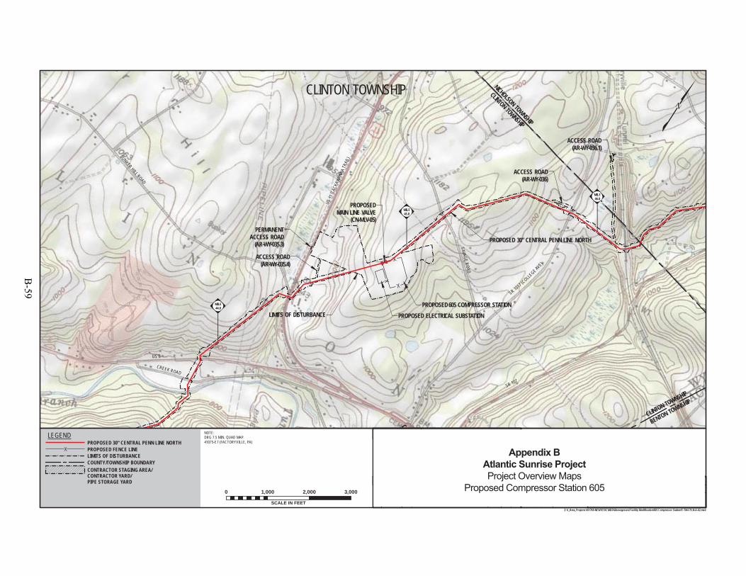
US11
(LACK
AWAN
NATR
AIL)
PROPOSED 30" CENTRAL PENN LINE NORTH
US 6
BUNKER HILL ROAD
PROPOSED 605 COMPRESSOR STATION
SR 1017 (COLLE
GE AVE)
NICHOLSON TOWNSHIP
CLINTON TOWNSHIP
CREEK ROAD
LIMITS OF DISTURBANCE
PROPOSEDMAIN LINE VALVE
(CN-MLV-05)
SAVAGEROAD
BENTON TOWNSHIP
CLINTON TOWNSHIP
PROPOSED ELECTRICAL SUBSTATION
ACCESS ROAD(AR-WY-036.1)
ACCESS ROAD(AR-WY-036)
PERMANENTACCESS ROAD
(AR-WY-035.3)
ACCESS ROAD(AR-WY-035.4)
MILE46.0
MILE45.0
MILE44.0
NOTE:DRG 7.5 MIN. QUAD MAP.41075-E7 (FACTORYVILLE, PA)
SR 107
F-TM-CPLN-A-02OF
SHEET
12:52 PM 3/18/2015
REFERENCE TITLE
APP.CHK.W.O. NO.REVISION DESCRIPTIONBYDATENO.
DATE:
DATE:
DATE:
APPROVED BY:
CHECKED BY:
DRAWN BY: SCALE:ISSUED FOR BID:
ISSUED FOR CONSTRUCTION:
DRAWINGNUMBER:
WO: 1161497
REVISION:
SCALE IN FEET
0 1,000 2,000 3,000
1"=1,000'
11
TRANSCONTINENTAL GAS PIPE LINE COMPANY LLCPROPOSED FACILITY TOPOGRAPHICAL MAP
COMPRESSOR STATION 605ATLANTIC SUNRISE PROJECT
PROPOSED 30" CENTRAL PENN LINE NORTHM.P. 44.90
WYOMING COUNTY, PENNSYLVANIA
0
Z:\1_Beta_Projects\101769-NEW\FERC\MXD\Aboveground Facility Modification\605 Compressor Station\F-TM-CPLN-A-02.mxd
DRAWING NO.
ISSUED FOR REVIEW0 SHL3/31/15 1161497 EL MJHSHLEL
10/4/1410/10/1410/10/14MJH
CLINTON TOWNSHIP
LEGENDPROPOSED 30" CENTRAL PENN LINE NORTH
LIMITS OF DISTURBANCE
CONTRACTOR STAGING AREA/CONTRACTOR YARD/PIPE STORAGE YARD
COUNTY/TOWNSHIP BOUNDARY
PROPOSED FENCE LINE Appendix BAtlantic Sunrise ProjectProject Overview Maps
Proposed Compressor Station 605
B-59
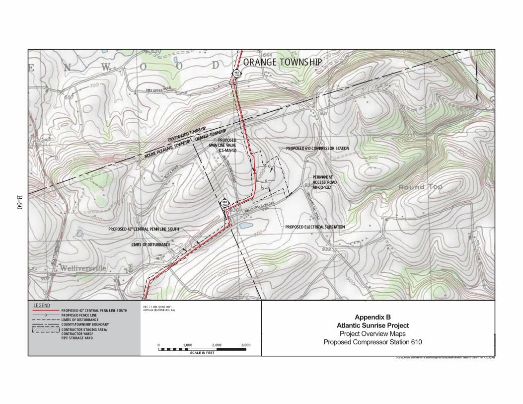
PROPOSED 610 COMPRESSOR STATION
WELLIVERSVILLE ROAD
BLACK ROAD
MILL
ERTO
WN
ROAD
PATS UPP ER ROAD
BOWMANS
MILL ROAD
BARTHOLOMEWROAD
PROPOSED 42" CENTRAL PENN LINE SOUTH
LIMITS OF DISTURBANCE
PROPOSEDMAIN LINE VALVE
(CS-MLV-12)
PROPOSED ELECTRICAL SUBSTATION
GREENWOOD TOWNSHIP
MOUNT PLEASANT TOWNSHIP ORANGE TOWNSHIP
PERMANENTACCESS ROADAR-CO-102.1
MILE113.0
MILE112.0
DRG 7.5 MIN. QUAD MAP:41076-A4 (BLOOMBURG, PA)
F-TM-CPLS-A-02OF
SHEET
SHLISSUED FOR FERC FILING0 SHL3/31/15
12:57 PM 3/18/2015
REFERENCE TITLE
APP.CHK.W.O. NO.REVISION DESCRIPTIONBYDATENO.
DATE:
DATE:
DATE:
APPROVED BY:
CHECKED BY:
DRAWN BY: SCALE:ISSUED FOR BID:
ISSUED FOR CONSTRUCTION:
DRAWINGNUMBER:
WO:
1161505
1161505
REVISION:
SCALE IN FEET
0 1,000 2,000 3,000
1"=1,000'
11
TRANSCONTINENTAL GAS PIPE LINE COMPANY LLCPROPOSED FACILITY TOPOGRAPHICAL MAP
COMPRESSOR STATION 610ATLANTIC SUNRISE PROJECT
PROPOSED 42" CENTRAL PENN LINE SOUTHM.P. 112.49
COLUMBIA COUNTY, PENNSYLVANIA
0
Z:\1_Beta_Projects\101769-NEW\FERC\MXD\Aboveground Facility Modification\610 Comrpessor Station\F-TM-CPLS-A-02.mxd
DRAWING NO.
EL ELMJH
MJH
10/3/1410/10/1410/10/14
ORANGE TOWNSHIP
LEGEND
LIMITS OF DISTURBANCE
PROPOSED 42" CENTRAL PENN LINE SOUTHPROPOSED FENCE LINE
CONTRACTOR STAGING AREA/CONTRACTOR YARD/PIPE STORAGE YARD
COUNTY/TOWNSHIP BOUNDARYAppendix B
Atlantic Sunrise ProjectProject Overview Maps
Proposed Compressor Station 610
B-60
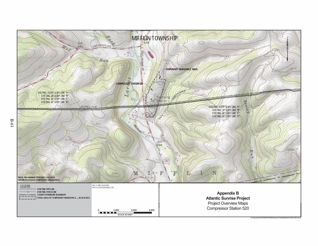
EXISTING 23.375" LEIDY LINE "A"EXISTING 24" LEIDY LINE "B"EXISTING 36" LEIDY LINE "C"EXISTING 42" LEIDY LINE "D"
STATE ROUTE 973
STATEHI GH W
AY287
GUINTER ROAD
ZINCKROAD
COMPRESSOR STATION 520
TEMPORARY WORKSPACE AREA
EXISTING 23.375" LEIDY LINE "A"EXISTING 24" LEIDY LINE "B"EXISTING 36" LEIDY LINE "C"EXISTING 42" LEIDY LINE "D"
MIFFLIN TOWNSHIP
NOTE: NO NWI/NHD FEATURES LOCATEDWITHIN PROPOSED TEMPORARY WORKSPACE
F-TM-ASR-ABCD-01OF
SHEET
3:06 PM 3/17/2015
REFERENCE TITLE
APP.CHK.W.O. NO.REVISION DESCRIPTIONBYDATENO.
DATE:
DATE:
DATE:
APPROVED BY:
CHECKED BY:
DRAWN BY: SCALE:ISSUED FOR BID:
ISSUED FOR CONSTRUCTION:
DRAWINGNUMBER:
WO: 1161107
REVISION:
11
TRANSCONTINENTAL GAS PIPE LINE COMPANY LLCTOPOGRAPHICAL PROJECT LOCATION MAP
PROPOSED FACILITY MODIFICATIONSATLANTIC SUNRISE PROJECTCOMPRESSOR STATION 520
LL M.P. 157.50LYCOMING COUNTY, PENNSYLVANIA
Z:\1_Beta_Projects\101769-NEW\FERC\MXD\Aboveground Facility Modification\F-TM-ASR-ABCD-01.mxd
DRAWING NO.
SCALE IN FEET
0 1,000 2,000 3,000
SHLEL
MJH
9/22/1410/6/1410/10/14
01"=1,000'
LEGENDEXISTING PIPELINEEXISTING FENCELINECOUNTY/TOWNSHIP BOUNDARYTOTAL AREA OF TEMPORARY WORKSPACE.....36.10 ACRES
DRG 7.5 MIN. QUAD MAP:41077-C2 (SALLADASBURG, PA)
0 SHL3/31/15 1161107 MJHDPISSUED FOR FERC FILING
Appendix BAtlantic Sunrise ProjectProject Overview MapsCompressor Station 520
B-61
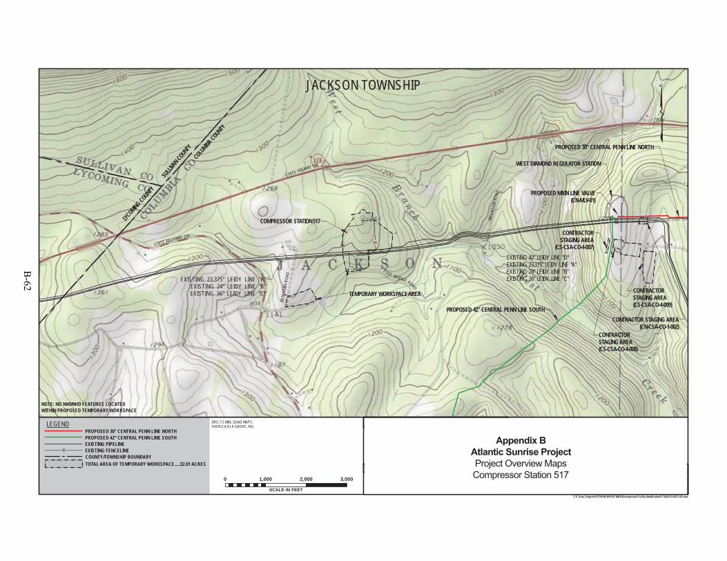
PROPOSED 42" CENTRAL PENN LINE SOUTH
PROPOSED 30" CENTRAL PENN LINE NORTH
SULLI
VAN C
OUNTY
EXISTING 42" LEIDY LINE "D"EXISTING 23.375" LEIDY LINE "A"EXISTING 24" LEIDY LINE "B"EXISTING 36" LEIDY LINE "C"
MOUN
TAIN
ROAD
STATE HIGHWAY 239
STATE HIGWAY 118
POLE BRIDGE ROAD
COMPRESSOR STATION 517
WEST DIAMOND REGULATOR STATION
CONTRACTOR STAGING AREA(CN-CSA-CO-1-002)
CONTRACTORSTAGING AREA(CS-CSA-CO-4-009)
CONTRACTORSTAGING AREA(CS-CSA-CO-4-008)
CONTRACTORSTAGING AREA
(CS-CSA-CO-4-007)
PROPOSED MAIN LINE VALVE(CN-MLV-01)
TEMPORARY WORKSPACE AREA
EXISTING 23.375" LEIDY LINE "A"EXISTING 24" LEIDY LINE "B"EXISTING 36" LEIDY LINE "C"
COLU
MBIA COUNTY
LYCOMING COUNTY
JACKSON TOWNSHIP
F-TM-ASR-ABCD-02OF
SHEET
4:20 PM 3/17/2015
REFERENCE TITLE
APP.CHK.W.O. NO.REVISION DESCRIPTIONBYDATENO.
DATE:
DATE:
DATE:
APPROVED BY:
CHECKED BY:
DRAWN BY: SCALE:ISSUED FOR BID:
ISSUED FOR CONSTRUCTION:
DRAWINGNUMBER:
WO: 1161147
REVISION:
1"=1,000'
11
TRANSCONTINENTAL GAS PIPE LINE COMPANY LLCTOPOGRAPHICAL PROJECT LOCATION MAP
PROPOSED FACILITY MODIFICATIONSATLANTIC SUNRISE PROJECTCOMPRESSOR STATION 517
LL M.P. 115.20COLUMBIA COUNTY, PENNSYLVANIA
Z:\1_Beta_Projects\101769-NEW\FERC\MXD\Aboveground Facility Modification\F-TM-ASR-ABCD-02.mxd
DRAWING NO.
SCALE IN FEET
0 1,000 2,000 3,000
DRG 7.5 MIN. QUAD MAPS:41076-C4 (ELK GROVE, PA)
NOTE: NO NWI/NHD FEATURES LOCATEDWITHIN PROPOSED TEMPORARY WORKSPACE
SHLEL
MJH
9/22/1410/8/1410/10/14
ISSUED FOR FERC FILINGSHL3/31/15 1161147 DP MJH0
BENJ
AMIN
ROAD
0
LEGEND
EXISTING PIPELINE
PROPOSED 30" CENTRAL PENN LINE NORTHPROPOSED 42" CENTRAL PENN LINE SOUTH
EXISTING FENCELINECOUNTY/TOWNSHIP BOUNDARYTOTAL AREA OF TEMPORARY WORKSPACE.....32.01 ACRES
Appendix BAtlantic Sunrise ProjectProject Overview MapsCompressor Station 517
B-62
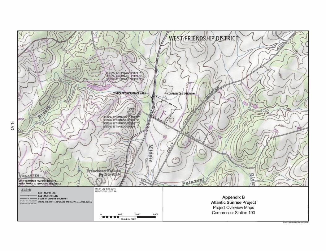
!
!
!
!
!
!
!
!
!
!
!
!
!
!
!
!
!
!
!
!
!
!
!
!!
!!
!
!
X
X
X
X
COMPRESSOR STATION 190
(
EXISTING 30" TRANSCO PIPELINE "A"EXISTING 30" TRANSCO PIPELINE "B"EXISTING 36" TRANSCO PIPELINE "C"
CARROLL MILL ROAD
FOLL
Y QUAR
TER ROAD
TEMPORARY WORKSPACE AREA
(
EXISTING 30" TRANSCO PIPELINE "A"EXISTING 30" TRANSCO PIPELINE "B"EXISTING 36" TRANSCO PIPELINE "C"EXISTING 42" TRANSCO PIPELINE "D"
E
DRG 7.5 MIN. QUAD MAPS:39076-C3 (SYKESVILLE, MA)
WEST FRIENDSHIP DISTRICT
NOTE: NO NWI/NHD FEATURES LOCATEDWITHIN PROPOSED TEMPORARY WORKSPACE
F-TM-ASR-ABCD-03OF
SHEET
2:20 PM 3/19/2015
REFERENCE TITLE
APP.CHK.W.O. NO.REVISION DESCRIPTIONBYDATENO.
DATE:
DATE:
DATE:
APPROVED BY:
CHECKED BY:
DRAWN BY: SCALE:ISSUED FOR BID:
ISSUED FOR CONSTRUCTION:
DRAWINGNUMBER:
WO: 1161151
REVISION:
1"=1,000'
11
TRANSCONTINENTAL GAS PIPE LINE COMPANY LLCTOPOGRAPHICAL PROJECT LOCATION MAP
PROPOSED FACILITY MODIFICATIONSATLANTIC SUNRISE PROJECTCOMPRESSOR STATION 190
M.P. 1628.78HOWARD COUNTY, MARYLAND
0
C:\Users\z1ghias\Desktop\F-TM-ASR-ABCD-03.mxd
DRAWING NO.
SCALE IN FEET
0 1,000 2,000 3,000
9/22/1410/8/1410/10/14
SHLEL
MJH
1161151
LEGENDEXISTING PIPELINEEXISTING FENCELINEXCOUNTY/TOWNSHIP BOUNDARYTOTAL AREA OF TEMPORARY WORKSPACE.....30.00 ACRES!
! ! ! ! ! !
!!!!!!
ISSUED FOR FERC FILINGSHL3/31/15 DP MJH0
Appendix BAtlantic Sunrise ProjectProject Overview MapsCompressor Station 190
B-63
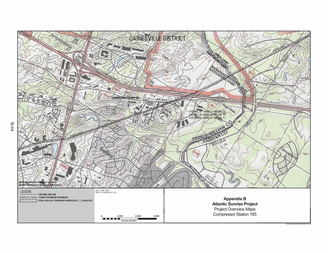
! !
!
!
! !
!
!
!
!!
!
!
!
!
!
!!
!
!
!
!
!!
!
!
!!
!
!
!!
!
!
!
!
!
!
!
!
STAT
EHI
GHW
AY23
4INTERSTATE HIGHWAY 66
COMPRESSOR STATION 185 (
EXISTING 30" TRANSCO PIPELINE "A"EXISTING 30" TRANSCO PIPELINE "B"EXISTING 36" TRANSCO PIPELINE "C"
PRINCE WILLIAM COUNTY
FAIRFAX COUNTY
NOTE: NO NWI/NHD FEATURES LOCATEDWITHIN PROPOSED TEMPORARY WORKSPACE
E
GAINESVILLE DISTRICT
F-TM-ASR-ABC-01OF
SHEET
2:15 PM 3/19/2015
REFERENCE TITLE
APP.CHK.W.O. NO.REVISION DESCRIPTIONBYDATENO.
DATE:
DATE:
DATE:
APPROVED BY:
CHECKED BY:
DRAWN BY: SCALE:ISSUED FOR BID:
ISSUED FOR CONSTRUCTION:
DRAWINGNUMBER:
WO: 1161540
REVISION:
1"=1,000'
11
C:\Users\z1ghias\Desktop\F-TM-ASR-ABC-01.mxd
DRAWING NO.DRG 7.5 MIN. QUAD:380775-G5 (GAINESVILLE, VA)
SCALE IN FEET
0 1,000 2,000 3,000
TRANSCONTINENTAL GAS PIPE LINE COMPANY LLCTOPOGRAPHICAL PROJECT LOCATION MAP
PROPOSED FACILITY MODIFICATIONSATLANTIC SUNRISE PROJECTCOMPRESSOR STATION 185
M.P. 1583.37PRINCE WILLIAM COUNTY, VIRGINIA
LEGENDEXISTING PIPELINECOUNTY/TOWNSHIP BOUNDARYTOTAL AREA OF TEMPORARY WORKSPACE.....13.68 ACRES!
! ! ! ! ! !
!!!!!!
11615409/22/1410/8/1410/10/14
SHLEL
MJH
BALLS FORD ROAD
0ISSUED FOR FERC FILINGSHL3/31/15 DP MJH0
Appendix BAtlantic Sunrise ProjectProject Overview MapsCompressor Station 185
B-64
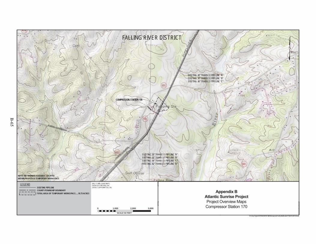
PUMPING STATION ROAD
COUNTRY CLUB ROAD
COMPRESSOR STATION 170
EXISTING 30" TRANSCO PIPELINE "A"EXISTING 30" TRANSCO PIPELINE "B"EXISTING 36" TRANSCO PIPELINE "C"
EXISTING 30" TRANSCO PIPELINE "A"EXISTING 30" TRANSCO PIPELINE "B"EXISTING 36" TRANSCO PIPELINE "C"EXISTING 42" TRANSCO PIPELINE "D"
DRG 7.5 MIN. QUAD MAPS:37078-C8 (CONCORD, VA)37078-C7 (APPOMATTOX, VA)
FALLING RIVER DISTRICT
F-TM-ASR-ABCD-04OF
SHEET
10/3/1410/8/1410/10/14
SHL
6:28 PM 3/17/2015
REFERENCE TITLE
DATE:
DATE:
DATE:
APPROVED BY:
CHECKED BY:
DRAWN BY: SCALE:ISSUED FOR BID:
ISSUED FOR CONSTRUCTION:
DRAWINGNUMBER:
WO: 1161579
REVISION:
SCALE IN FEET
0 1,000 2,000 3,000
1"=1,000'
11
TRANSCONTINENTAL GAS PIPE LINE COMPANY LLCTOPOGRAPHICAL PROJECT LOCATION MAP
PROPOSED FACILITY MODIFICATIONSATLANTIC SUNRISE PROJECTCOMPRESSOR STATION 170
M.P. 1457.00APPOMATTOX COUNTY, VIRGINIA
0
Z:\1_Beta_Projects\101769-NEW\FERC\MXD\Aboveground Facility Modification\F-TM-ASR-ABCD-04.mxd
DRAWING NO.
EL
NOTE: NO NWI/NHD FEATURES LOCATEDWITHIN PROPOSED TEMPORARY WORKSPACE
MJH
LEGENDEXISTING PIPELINECOUNTY/TOWNSHIP BOUNDARYTOTAL AREA OF TEMPORARY WORKSPACE.....10.73 ACRES
APP.CHK.W.O. NO.REVISION DESCRIPTIONBYDATENO.
1161579ISSUED FOR FERC FILINGSHL3/31/15 DP MJH0
Appendix BAtlantic Sunrise ProjectProject Overview MapsCompressor Station 170
B-65
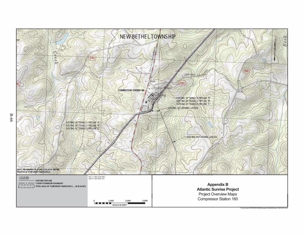
PU R C ELL ROAD
EXISTING 24" CARDINAL LATERAL
COMPRESSOR STATION 160
EXISTING 24" CARDINAL LATERAL
EXISTING 30" TRANSCO PIPELINE "A"EXISTING 36" TRANSCO PIPELINE "B"EXISTING 42" TRANSCO PIPELINE "C"
EXISTING 30" TRANSCO PIPELINE "A"EXISTING 36" TRANSCO PIPELINE "B"EXISTING 42" TRANSCO PIPELINE "C"
NEW BETHEL TOWNSHIP
STAT
EHI
GHW
AY65
F-TM-ASR-ABC-02OF
SHEET
10/3/1410/10/1410/10/14
6:16 PM 3/17/2015
REFERENCE TITLE
APP.CHK.W.O. NO.REVISION DESCRIPTIONBYDATENO.
DATE:
DATE:
DATE:
APPROVED BY:
CHECKED BY:
DRAWN BY: SCALE:ISSUED FOR BID:
ISSUED FOR CONSTRUCTION:
DRAWINGNUMBER:
WO: 1161585
REVISION:
1"=1,000'
11
TRANSCONTINENTAL GAS PIPE LINE COMPANY LLCTOPOGRAPHICAL PROJECT LOCATION MAP
PROPOSED FACILITY MODIFICATIONSATLANTIC SUNRISE PROJECTCOMPRESSOR STATION 160
M.P. 1369.44ROCKINGHAM COUNTY, NORTH CAROLINA
0
Z:\1_Beta_Projects\101769-NEW\FERC\MXD\Aboveground Facility Modification\F-TM-ASR-ABC-02.mxd
DRAWING NO.
NOTE: NO NWI/NHD FEATURES LOCATED WITHINPROPOSED TEMPORARY WORKSPACE
DRG 7.5. MIN. QUAD MAP:36079-C7 (BETHANY, NC)
SCALE IN FEET
0 1,000 2,000 3,000
LEGENDEXISTING PIPELINECOUNTY/TOWNSHIP BOUNDARYTOTAL AREA OF TEMPORARY WORKSPACE.....10.45 ACRES
SHLEL
MJH
1161585ISSUED FOR FERC FILINGSHL3/31/15 DP MJH0
Appendix BAtlantic Sunrise ProjectProject Overview MapsCompressor Station 160
B-66
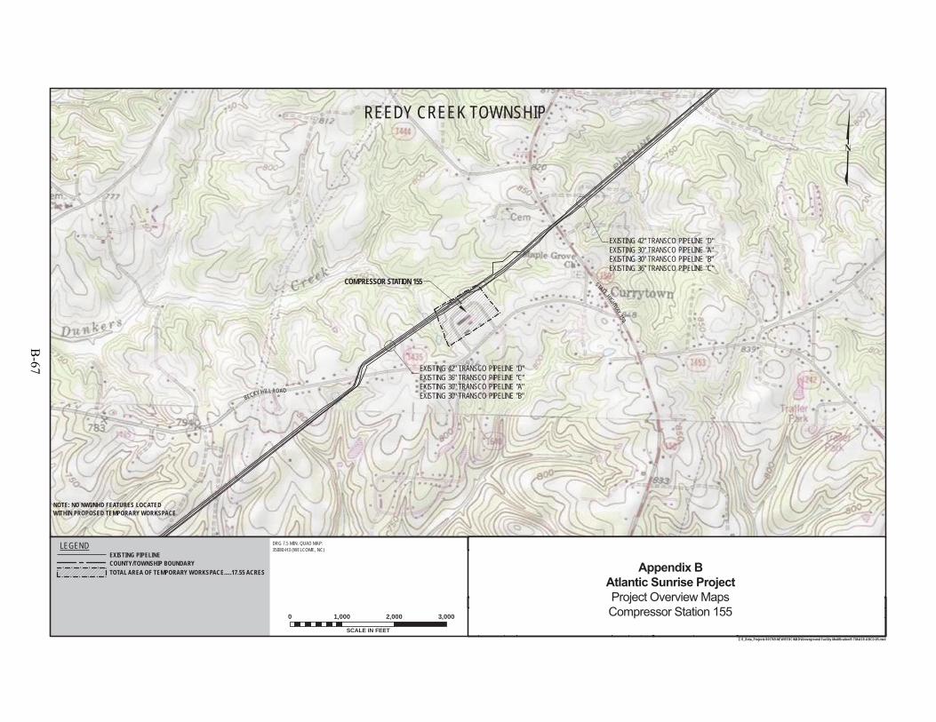
BECKY HILL ROAD
STATE HIGHWAY150
EXISTING 42" TRANSCO PIPELINE "D"EXISTING 30" TRANSCO PIPELINE "A"EXISTING 30" TRANSCO PIPELINE "B"EXISTING 36" TRANSCO PIPELINE "C"
COMPRESSOR STATION 155
EXISTING 42" TRANSCO PIPELINE "D"EXISTING 36" TRANSCO PIPELINE "C"EXISTING 30" TRANSCO PIPELINE "A"EXISTING 30" TRANSCO PIPELINE "B"
DRG 7.5 MIN. QUAD MAP:35080-H3 (WELCOME, NC)
REEDY CREEK TOWNSHIP
F-TM-ASR-ABCD-05OF
SHEET
6:10 PM 3/17/2015
REFERENCE TITLE
APP.CHK.W.O. NO.REVISION DESCRIPTIONBYDATENO.
DATE:
DATE:
DATE:
APPROVED BY:
CHECKED BY:
DRAWN BY: SCALE:ISSUED FOR BID:
ISSUED FOR CONSTRUCTION:
DRAWINGNUMBER:
WO: 1161969
REVISION:
SCALE IN FEET
0 1,000 2,000 3,000
1"=1,000'
11
TRANSCONTINENTAL GAS PIPE LINE COMPANY LLCTOPOGRAPHICAL PROJECT LOCATION MAP
PROPOSED FACILITY MODIFICATIONSATLANTIC SUNRISE PROJECTCOMPRESSOR STATION 155
M.P. 1326.12DAVIDSON COUNTY, NORTH CAROLINA
0
Z:\1_Beta_Projects\101769-NEW\FERC\MXD\Aboveground Facility Modification\F-TM-ASR-ABCD-05.mxd
DRAWING NO.
NOTE: NO NWI/NHD FEATURES LOCATEDWITHIN PROPOSED TEMPORARY WORKSPACE
LEGENDEXISTING PIPELINECOUNTY/TOWNSHIP BOUNDARYTOTAL AREA OF TEMPORARY WORKSPACE.....17.55 ACRES
1161969
9/26/1410/10/1410/10/14MJH
ELSHL
ISSUED FOR FERC FILINGSHL3/31/15 DP MJH0
Appendix BAtlantic Sunrise ProjectProject Overview MapsCompressor Station 155
B-67

EXISTING 30" TRANSCO PIPELINE "A"EXISTING 36" TRANSCO PIPELINE "B"
INTE
RSTA
TEHI
GHW
AY77
LANGTREE ROAD
STATEHIGHW
AY115
TRANSCOR
OAD
COMPRESSOR STATION 150
EXISTING 36" TRANSCO PIPELINE "C"EXISTING 30" TRANSCO PIPELINE "A"EXISTING 30" TRANSCO PIPELINE "B"EXISTING 42" TRANSCO PIPELINE "D"
EXISTING 42" COWANS FORD LOOP "D"EXISTING 36" COWANS FORD LOOP "C"
DAVIDSON TOWNSHIP
DRG 7.5 MIN. QUAD MAPS:35080-E7 (MOORESVILLE, NC)
F-TM-ASR-ABCD-06OF
SHEET
6:03 PM 3/17/2015
REFERENCE TITLE
APP.CHK.W.O. NO.REVISION DESCRIPTIONBYDATENO.
DATE:
DATE:
DATE:
APPROVED BY:
CHECKED BY:
DRAWN BY: SCALE:ISSUED FOR BID:
ISSUED FOR CONSTRUCTION:
DRAWINGNUMBER:
WO: 1161587
REVISION:
1"=1,000'
11
TRANSCONTINENTAL GAS PIPE LINE COMPANY LLCTOPOGRAPHICAL PROJECT LOCATION MAP
PROPOSED FACILITY MODIFICATIONSATLANTIC SUNRISE PROJECTCOMPRESSOR STATION 150
M.P. 1287.11IREDELL COUNTY, NORTH CAROLINA
0
Z:\1_Beta_Projects\101769-NEW\FERC\MXD\Aboveground Facility Modification\F-TM-ASR-ABCD-06.mxd
DRAWING NO.
SCALE IN FEET
0 1,000 2,000 3,000
NOTE: NO NWI/NHD FEATURES LOCATEDWITHIN PROPOSED TEMPORARY WORKSPACE
1161587
10/3/1410/10/1410/10/14
SHLEL
MJH
LEGENDEXISTING PIPELINECOUNTY/TOWNSHIP BOUNDARYTOTAL AREA OF TEMPORARY WORKSPACE.....11.24 ACRES
ISSUED FOR FERC FILINGSHL3/31/15 DP MJH0
Appendix BAtlantic Sunrise ProjectProject Overview MapsCompressor Station 150
B-68
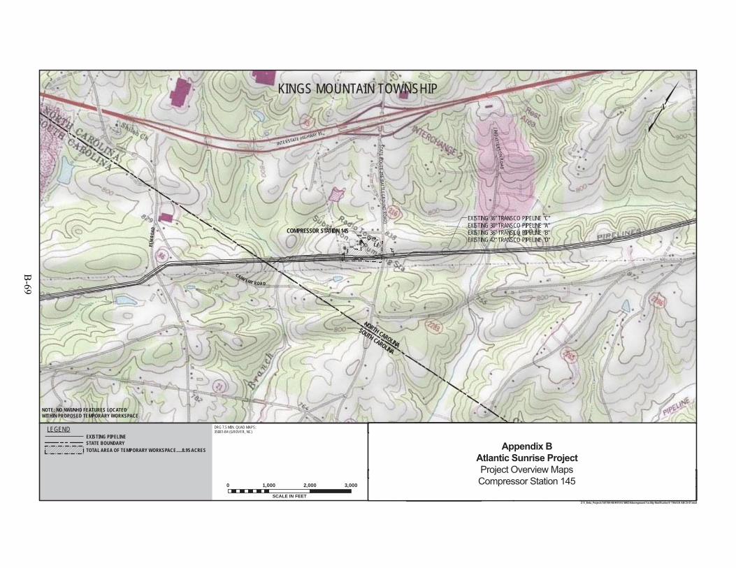
SOUTH CAROLINA
INTERSTATE HIGHWAY 85
ELM
ROAD
CANV ENY ROA D
STATEROUTE
216 ( BATT LEGROUNDROAD)
JIMP ATTERSON
RO ADCOMPRESSOR STATION 145
NORTH CAROLINA
EXISTING 36" TRANSCO PIPELINE "C"EXISTING 30" TRANSCO PIPELINE "A"EXISTING 36" TRANSCO PIPELINE "B"EXISTING 42" TRANSCO PIPELINE "D"
KINGS MOUNTAIN TOWNSHIP
DRG 7.5 MIN. QUAD MAPS:35081-B4 (GROVER, NC)
NOTE: NO NWI/NHD FEATURES LOCATEDWITHIN PROPOSED TEMPORARY WORKSPACE
F-TM-ASR-ABCD-07OF
SHEET
5:55 PM 3/17/2015
REFERENCE TITLE
APP.CHK.W.O. NO.REVISION DESCRIPTIONBYDATENO.
DATE:
DATE:
DATE:
APPROVED BY:
CHECKED BY:
DRAWN BY: SCALE:ISSUED FOR BID:
ISSUED FOR CONSTRUCTION:
DRAWINGNUMBER:
WO: 1161591
REVISION:
1"=1,000'
11
TRANSCONTINENTAL GAS PIPE LINE COMPANY LLCTOPOGRAPHICAL PROJECT LOCATION MAP
PROPOSED FACILITY MODIFICATIONSATLANTIC SUNRISE PROJECTCOMPRESSOR STATION 145
M.P. 1247.05CLEVELAND COUNTY, NORTH CAROLINA
Z:\1_Beta_Projects\101769-NEW\FERC\MXD\Aboveground Facility Modification\F-TM-ASR-ABCD-07.mxd
DRAWING NO.LEGENDEXISTING PIPELINESTATE BOUNDARYTOTAL AREA OF TEMPORARY WORKSPACE.....8.95 ACRES
1161591SHLEL
MJH
10/3/1410/10/1410/10/14
SCALE IN FEET
0 1,000 2,000 3,000 0ISSUED FOR FERC FILINGSHL3/31/15 DP MJH0
Appendix BAtlantic Sunrise ProjectProject Overview MapsCompressor Station 145
B-69

B-70

CATHODIC PROTECTION WORKSPACE DRAWINGS
B-71

B-72
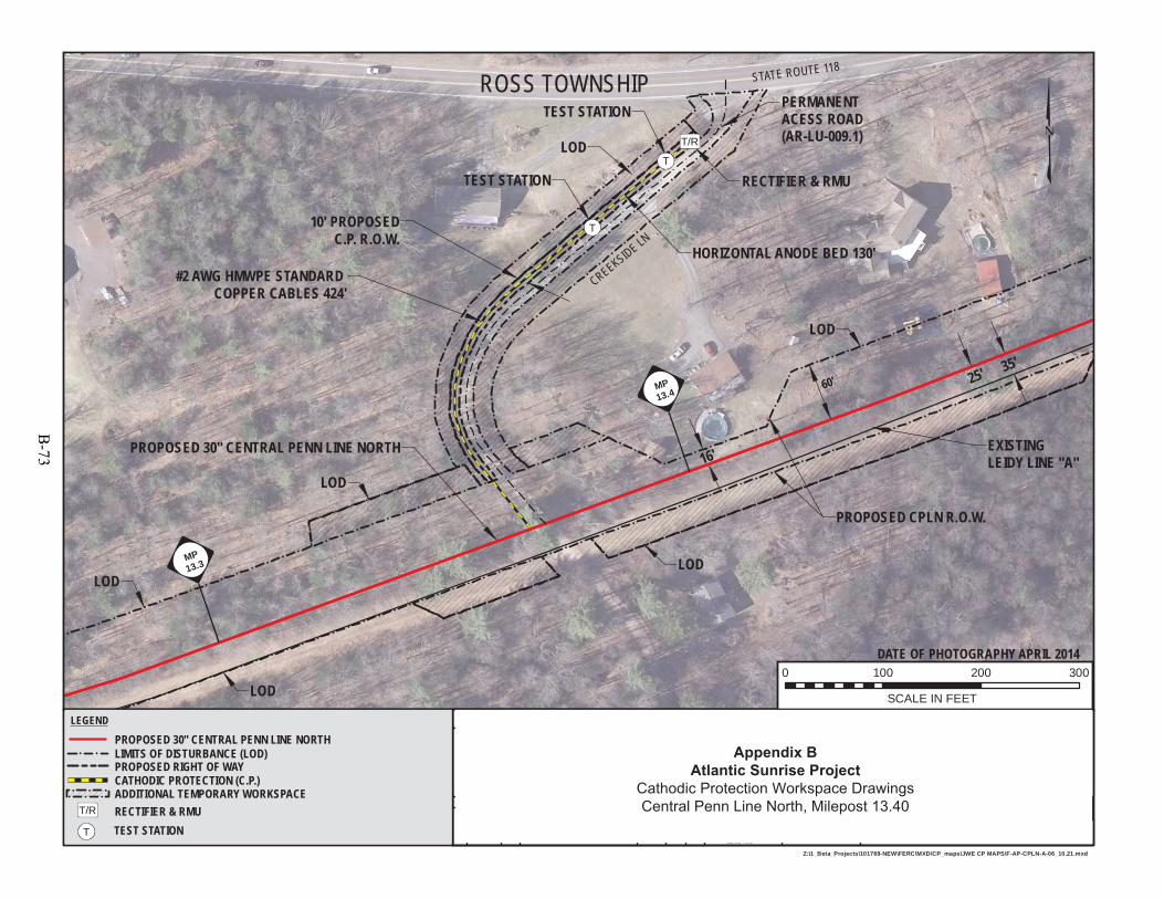
DATE OF PHOTOGRAPHY APRIL 2014
PROPOSED 30" CENTRAL PENN LINE NORTH
STATE ROUTE 118
#2 AWG HMWPE STANDARD COPPER CABLES 424'
RECTIFIER & RMUTEST STATION
TEST STATION
CREEKSIDE LNHORIZONTAL ANODE BED 130'
ROSS TOWNSHIP
10' PROPOSEDC.P. R.O.W.
PERMANENTACESS ROAD(AR-LU-009.1)
LOD
LOD
LOD
LOD
LOD
LOD
PROPOSED CPLN R.O.W.
EXISTINGLEIDY LINE "A"
T/R
T
25' 35'60'
16'
MP13.4
MP13.3
T
10:31 PM 7/17/2015
DRAWINGNUMBER:
DATE:
DRAWN BY:
CHECKED BY:
WO:
APPROVED BY: DATE:
ISSUE FOR CONSTRUCTION:
ISSUE FOR BID: SCALE:W.O. NO. CHK. APP.NO. DATE BY
DRAWING NO.
DATE:
REFERENCE TITLE
REVISION DESCRIPTION
1161481F-AP-CPLN-A-06
1" = 100'
Z:\1_Beta_Projects\101769-NEW\FERC\MXD\CP_maps\JWE CP MAPS\F-AP-CPLN-A-06_10.21.mxd
TRANSCONTINENTAL GAS PIPE LINE COMPANY LLCCPLN-GB #1
ATLANTIC SUNRISE PROJECTPROPOSED 30" CENTRAL PENN LINE NORTH
M.P. 13.40LUZERNE COUNTY, PENNSYLVANIA
JTN0 1161481
7/9/15
7/9/15
7/9/15
JTN7/17/15 0REVISION:
LEGEND
PROPOSED 30" CENTRAL PENN LINE NORTHLIMITS OF DISTURBANCE (LOD)
ISSUED FOR SUPPLEMENTAL FILING #2 DP MJH DP
MJH
PROPOSED RIGHT OF WAY
0 100 200 300
SCALE IN FEET
CATHODIC PROTECTION (C.P.)ADDITIONAL TEMPORARY WORKSPACE
T
T/R RECTIFIER & RMUTEST STATION
Appendix BAtlantic Sunrise Project
Cathodic Protection Workspace DrawingsCentral Penn Line North, Milepost 13.40
B-73
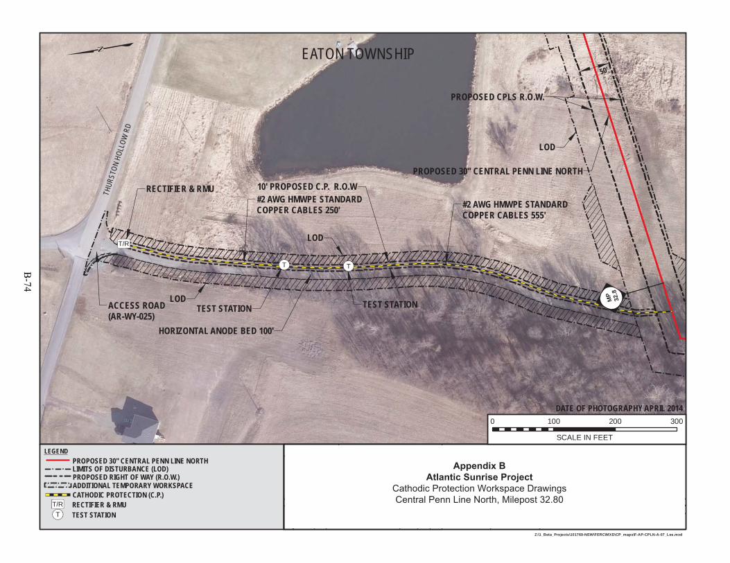
TEST STATION TEST STATION
#2 AWG HMWPE STANDARD COPPER CABLES 555'
HORIZONTAL ANODE BED 100'
PROPOSED 30'' CENTRAL PENN LINE NORTH
RECTIFIER & RMU#2 AWG HMWPE STANDARD COPPER CABLES 250'
ACCESS ROAD(AR-WY-025)
10' PROPOSED C.P. R.O.W
THUR
STON
HOLL
OWRD
50'
PROPOSED CPLS R.O.W.
LOD
LOD
LOD
MP
32.8
T T
10:11 PM 7/17/2015
DRAWINGNUMBER:
DATE:
DRAWN BY:
CHECKED BY:
WO:
APPROVED BY: DATE:
ISSUE FOR CONSTRUCTION:
ISSUE FOR BID: SCALE:W.O. NO. CHK. APP.NO. DATE BY
DRAWING NO.
DATE:
REFERENCE TITLE
REVISION DESCRIPTION
1161481F-AP-CPLN-A-07
1" = 100'
Z:\1_Beta_Projects\101769-NEW\FERC\MXD\CP_maps\F-AP-CPLN-A-07_Lee.mxd
TRANSCONTINENTAL GAS PIPE LINE COMPANY LLCCPLN-GB #2
ATLANTIC SUNRISE PROJECTPROPOSED 30" CENTRAL PENN LINE NORTH
M.P. 32.80WYOMING COUNTY, PENNSYLVANIA
JTN0 1161481
7/9/15
7/9/15
7/9/15
JTN7/17/15 0REVISION:
LEGENDPROPOSED 30" CENTRAL PENN LINE NORTHLIMITS OF DISTURBANCE (LOD)
ISSUED FOR SUPPLEMENTAL FILING #2 DP MJH DP
MJH
PROPOSED RIGHT OF WAY (R.O.W.)
0 100 200 300
SCALE IN FEET
CATHODIC PROTECTION (C.P.)ADDITIONAL TEMPORARY WORKSPACE
DATE OF PHOTOGRAPHY APRIL 2014
EATON TOWNSHIP
RECTIFIER & RMUT/RT TEST STATION
T/R
Appendix BAtlantic Sunrise Project
Cathodic Protection Workspace DrawingsCentral Penn Line North, Milepost 32.80
B-74
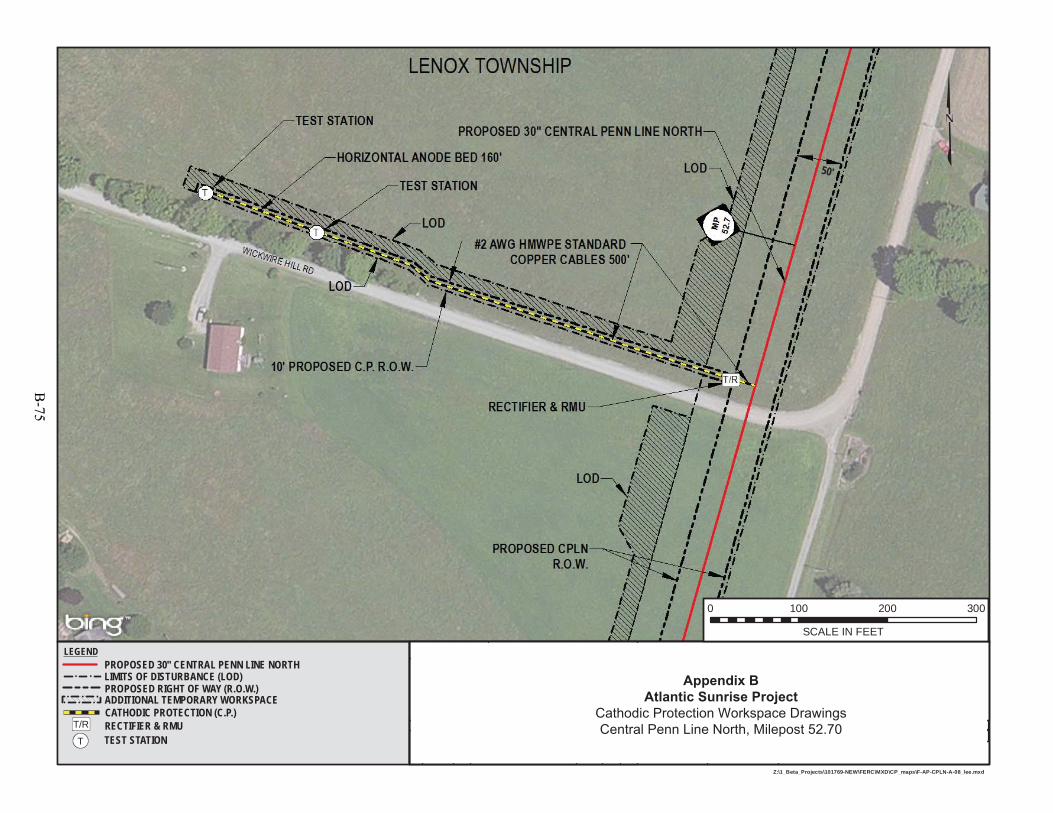
9:46 PM 7/17/2015
DRAWINGNUMBER:
DATE:
DRAWN BY:
CHECKED BY:
WO:
APPROVED BY: DATE:
ISSUE FOR CONSTRUCTION:
ISSUE FOR BID: SCALE:W.O. NO. CHK. APP.NO. DATE BY
DRAWING NO.
DATE:
REFERENCE TITLE
REVISION DESCRIPTION
1161481F-AP-CPLN-A-08
1" = 100'
Z:\1_Beta_Projects\101769-NEW\FERC\MXD\CP_maps\F-AP-CPLN-A-08_lee.mxd
TRANSCONTINENTAL GAS PIPE LINE COMPANY LLCCPLN-GB #3
ATLANTIC SUNRISE PROJECTPROPOSED 30" CENTRAL PENN LINE NORTH
M.P. 52.70SUSQUEHANNA COUNTY, PENNSYLVANIA
JTN0 1161481
7/9/15
7/9/15
7/9/15
JTN7/17/15 0REVISION:
LEGENDPROPOSED 30" CENTRAL PENN LINE NORTHLIMITS OF DISTURBANCE (LOD)
ISSUED FOR SUPPLEMENTAL FILING #2 DP MJH DP
MJH
PROPOSED RIGHT OF WAY (R.O.W.)
0 100 200 300
SCALE IN FEET
CATHODIC PROTECTION (C.P.)ADDITIONAL TEMPORARY WORKSPACE
T
T/R RECTIFIER & RMUTEST STATION
50'
Appendix BAtlantic Sunrise Project
Cathodic Protection Workspace DrawingsCentral Penn Line North, Milepost 52.70
B-75
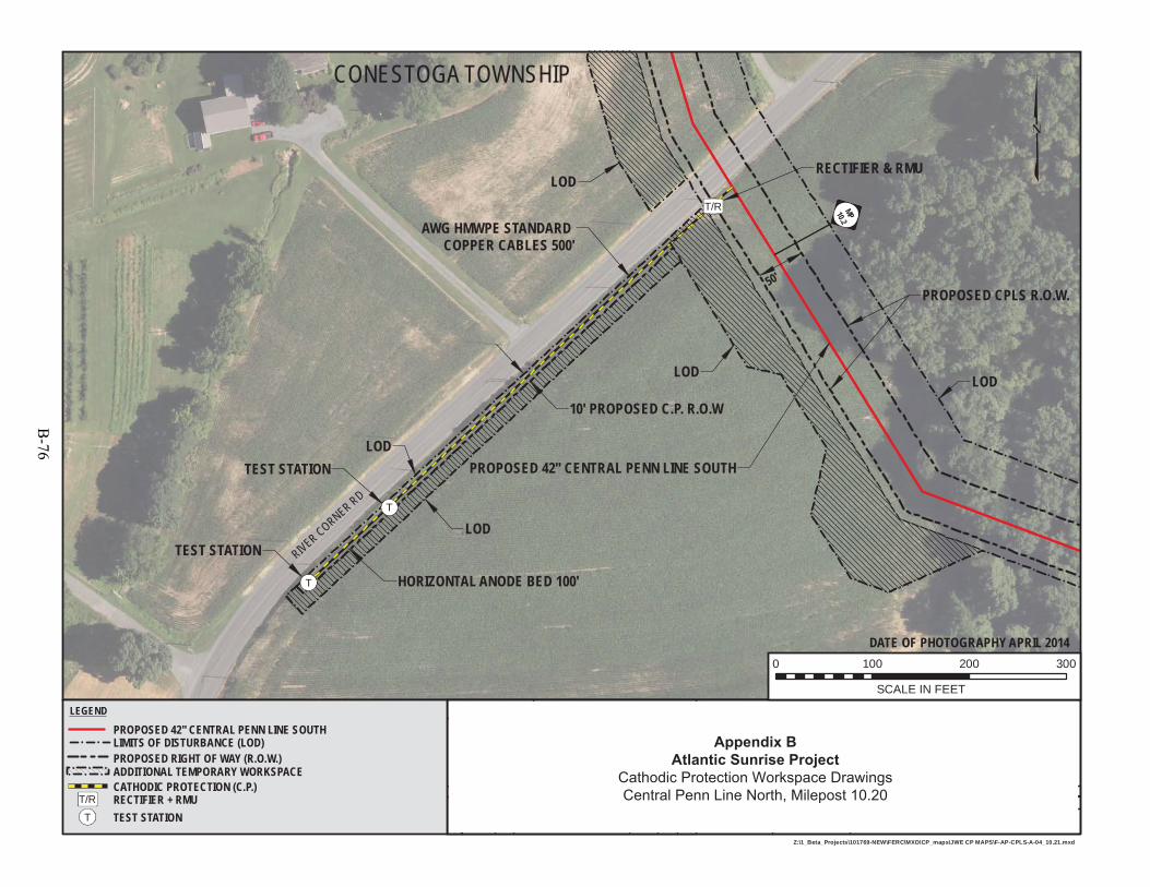
PROPOSED 42" CENTRAL PENN LINE SOUTH
RECTIFIER & RMU
AWG HMWPE STANDARD COPPER CABLES 500'
TEST STATION
TEST STATION
HORIZONTAL ANODE BED 100'
DATE OF PHOTOGRAPHY APRIL 2014
CONESTOGA TOWNSHIP
10' PROPOSED C.P. R.O.W
50'PROPOSED CPLS R.O.W.
MP10.2
LOD
LOD
LOD
LOD
LOD
T
T
T/RT/R
10:03 PM 7/17/2015
DRAWINGNUMBER:
DATE:
DRAWN BY:
CHECKED BY:
WO:
APPROVED BY: DATE:
ISSUE FOR CONSTRUCTION:
ISSUE FOR BID: SCALE:W.O. NO. CHK. APP.NO. DATE BY
DRAWING NO.
DATE:
REFERENCE TITLE
REVISION DESCRIPTION
1161503F-AP-CPLS-A-04
1" = 100'
Z:\1_Beta_Projects\101769-NEW\FERC\MXD\CP_maps\JWE CP MAPS\F-AP-CPLS-A-04_10.21.mxd
TRANSCONTINENTAL GAS PIPE LINE COMPANY LLCCPLS-GB #1
ATLANTIC SUNRISE PROJECTPROPOSED 42" CENTRAL PENN LINE SOUTH
M.P. 10.20LANCASTER COUNTY, PENNSYLVANIA
JTN0 1161503
7/9/15
7/9/15
7/9/15
JTN7/17/15 0REVISION:ISSUED FOR SUPPLEMENTAL FILING #2 DP MJH DP
MJH
0 100 200 300
SCALE IN FEET
LEGEND
PROPOSED 42" CENTRAL PENN LINE SOUTHLIMITS OF DISTURBANCE (LOD) PROPOSED RIGHT OF WAY (R.O.W.)
CATHODIC PROTECTION (C.P.)ADDITIONAL TEMPORARY WORKSPACE
RIVER CORNER RD
RECTIFIER + RMUTEST STATION
T/R
T
Appendix BAtlantic Sunrise Project
Cathodic Protection Workspace DrawingsCentral Penn Line North, Milepost 10.20
B-76
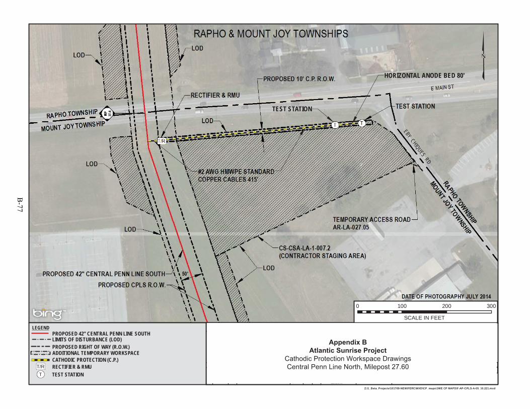
9:34 PM 7/17/2015
DRAWINGNUMBER:
DATE:
DRAWN BY:
CHECKED BY:
WO:
APPROVED BY: DATE:
ISSUE FOR CONSTRUCTION:
ISSUE FOR BID: SCALE:W.O. NO. CHK. APP.NO. DATE BY
DRAWING NO.
DATE:
REFERENCE TITLE
REVISION DESCRIPTION
1161503F-AP-CPLS-A-05
1" = 100'
Z:\1_Beta_Projects\101769-NEW\FERC\MXD\CP_maps\JWE CP MAPS\F-AP-CPLS-A-05_10.221.mxd
TRANSCONTINENTAL GAS PIPE LINE COMPANY LLCCPLS-GB #2
ATLANTIC SUNRISE PROJECTPROPOSED 42" CENTRAL PENN LINE SOUTH
M.P. 27.60LANCASTER COUNTY, PENNSYLVANIA
JTN0 1161503
7/9/15
7/9/15
7/9/15
JTN7/9/15 0REVISION:ISSUED FOR SUPPLEMENTAL FILING #2 DP MJH DP
MJH
0 100 200 300
SCALE IN FEET
LEGENDPROPOSED 42" CENTRAL PENN LINE SOUTHLIMITS OF DISTURBANCE (LOD) PROPOSED RIGHT OF WAY (R.O.W.)
CATHODIC PROTECTION (C.P.)ADDITIONAL TEMPORARY WORKSPACE
TEST STATION
EBYCHIQUES
RD
HORIZONTAL ANODE BED 80'
T/R RECTIFIER & RMUT TEST STATION
Appendix BAtlantic Sunrise Project
Cathodic Protection Workspace DrawingsCentral Penn Line North, Milepost 27.60
B-77
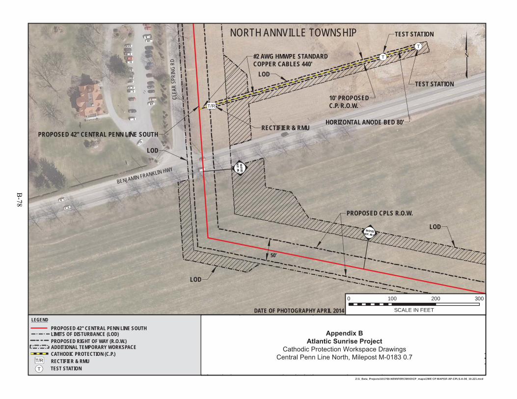
#2 AWG HMWPE STANDARD COPPER CABLES 440'
RECTIFIER & RMU
CLEA
RSP
RING
RD
TEST STATION
TEST STATION
HORIZONTAL ANODE BED 80'
BENJAMIN FRANKLIN HWY
PROPOSED 42" CENTRAL PENN LINE SOUTH
DATE OF PHOTOGRAPHY APRIL 2014
NORTH ANNVILLE TOWNSHIP
10' PROPOSEDC.P. R.O.W.
PROPOSED CPLS R.O.W.
LOD
LOD
LOD
LOD
50'
M-0183M.P. #0.7
M-0183M.P. #0.6
T/R
T
T
9:19 PM 7/17/2015
DRAWINGNUMBER:
DATE:
DRAWN BY:
CHECKED BY:
WO:
APPROVED BY: DATE:
ISSUE FOR CONSTRUCTION:
ISSUE FOR BID: SCALE:W.O. NO. CHK. APP.NO. DATE BY
DRAWING NO.
DATE:
REFERENCE TITLE
REVISION DESCRIPTION
1161503F-AP-CPLS-A-06
1" = 100'
Z:\1_Beta_Projects\101769-NEW\FERC\MXD\CP_maps\JWE CP MAPS\F-AP-CPLS-A-06_10.221.mxd
TRANSCONTINENTAL GAS PIPE LINE COMPANY LLCCPLS-GB #3
ATLANTIC SUNRISE PROJECTPROPOSED 42" CENTRAL PENN LINE SOUTH
M-0183 M.P. 0.7LEBANON COUNTY, PENNSYLVANIA
JTN0 1161503
7/9/15
7/9/15
7/9/15
JTN7/9/15 0REVISION:ISSUED FOR SUPPLEMENTAL FILING #2 DP MJH DP
MJH
0 100 200 300
SCALE IN FEET
LEGEND
PROPOSED 42" CENTRAL PENN LINE SOUTHLIMITS OF DISTURBANCE (LOD) PROPOSED RIGHT OF WAY (R.O.W.)
CATHODIC PROTECTION (C.P.)ADDITIONAL TEMPORARY WORKSPACE
TEST STATIONT
T/R RECTIFIER & RMU
Appendix BAtlantic Sunrise Project
Cathodic Protection Workspace DrawingsCentral Penn Line North, Milepost M-0183 0.7
B-78
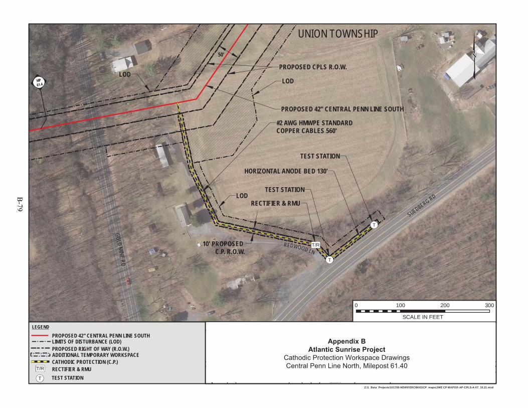
PROPOSED 42" CENTRAL PENN LINE SOUTH
UNION TOWNSHIP
DATE OF PHOTOGRAPHY APRIL 2014
PROPOSED CPLS R.O.W.
LOD
LODLOD
50'
MP61.4
T/R
T
T
6:57 PM 7/17/2015
DRAWINGNUMBER:
DATE:
DRAWN BY:
CHECKED BY:
WO:
APPROVED BY: DATE:
ISSUE FOR CONSTRUCTION:
ISSUE FOR BID: SCALE:W.O. NO. CHK. APP.NO. DATE BY
DRAWING NO.
DATE:
REFERENCE TITLE
REVISION DESCRIPTION
1161503F-AP-CPLS-A-07
1" = 100'
Z:\1_Beta_Projects\101769-NEW\FERC\MXD\CP_maps\JWE CP MAPS\F-AP-CPLS-A-07_10.21.mxd
TRANSCONTINENTAL GAS PIPE LINE COMPANY LLCCPLS-GB #4
ATLANTIC SUNRISE PROJECTPROPOSED 42" CENTRAL PENN LINE SOUTH
M.P. 61.40LEBANON COUNTY, PENNSYLVANIA
JTN0 1161503
7/9/15
7/9/15
7/9/15
JTN7/17/15 0REVISION:ISSUED FOR SUPPLEMENTAL FILING #2 DP MJH DP
MJH
0 100 200 300
SCALE IN FEET
LEGEND
PROPOSED 42" CENTRAL PENN LINE SOUTHLIMITS OF DISTURBANCE (LOD) PROPOSED RIGHT OF WAY (R.O.W.)
CATHODIC PROTECTION (C.P.)ADDITIONAL TEMPORARY WORKSPACE
GOLDMINE
RD
SUEDBERG RD
REDWOOD LN
#2 AWG HMWPE STANDARD COPPER CABLES 560'
RECTIFIER & RMU
TEST STATION
TEST STATION
HORIZONTAL ANODE BED 130'
T
T/R RECTIFIER & RMUTEST STATION
10' PROPOSED C.P. R.O.W.
Appendix BAtlantic Sunrise Project
Cathodic Protection Workspace DrawingsCentral Penn Line North, Milepost 61.40
B-79

MP78.4
PROPOSED 42" CENTRAL PENN LINE SOUTH
TEST STATION
TEST STATION
HEGINS TOWNSHIP
RECTIFIER & RMU
HORIZONTAL ANODE BED 130'
#2 AWG HMWPE STANDARD COPPER CABLES 550'
DATE OF PHOTOGRAPHY APRIL 2014
10' PROPOSEDC.P. R.O.W.
AR-SC-071
DEEP CREEK RD
PROPOSED CPLS R.O.W.
LOD
LOD
LODLOD
MP78.4
T/R
T
T
7:17 PM 7/17/2015
DRAWINGNUMBER:
DATE:
DRAWN BY:
CHECKED BY:
WO:
APPROVED BY: DATE:
ISSUE FOR CONSTRUCTION:
ISSUE FOR BID: SCALE:W.O. NO. CHK. APP.NO. DATE BY
DRAWING NO.
DATE:
REFERENCE TITLE
REVISION DESCRIPTION
1161503F-AP-CPLS-A-08
1" = 100'
Z:\1_Beta_Projects\101769-NEW\FERC\MXD\CP_maps\JWE CP MAPS\F-AP-CPLS-A-08_10.221.mxd
TRANSCONTINENTAL GAS PIPE LINE COMPANY LLCCPLS-GB #5
ATLANTIC SUNRISE PROJECTPROPOSED 42" CENTRAL PENN LINE SOUTH
M.P. 78.47SCHUYLKILL COUNTY, PENNSYLVANIA
JTN0 1161503
7/9/15
7/9/15
7/9/15
JTN7/9/15 0REVISION:ISSUED FOR SUPPLEMENTAL FILING #2 DP MJH DP
MJH
0 100 200 300
SCALE IN FEET
LEGEND
PROPOSED 42" CENTRAL PENN LINE SOUTHLIMITS OF DISTURBANCE (LOD) PROPOSED RIGHT OF WAY (R.O.W.)
CATHODIC PROTECTION (C.P.)ADDITIONAL TEMPORARY WORKSPACE
T
T/R RECTIFIER & RMUTEST STATION
50'
Appendix BAtlantic Sunrise Project
Cathodic Protection Workspace DrawingsCentral Penn Line North, Milepost 78.47
B-80
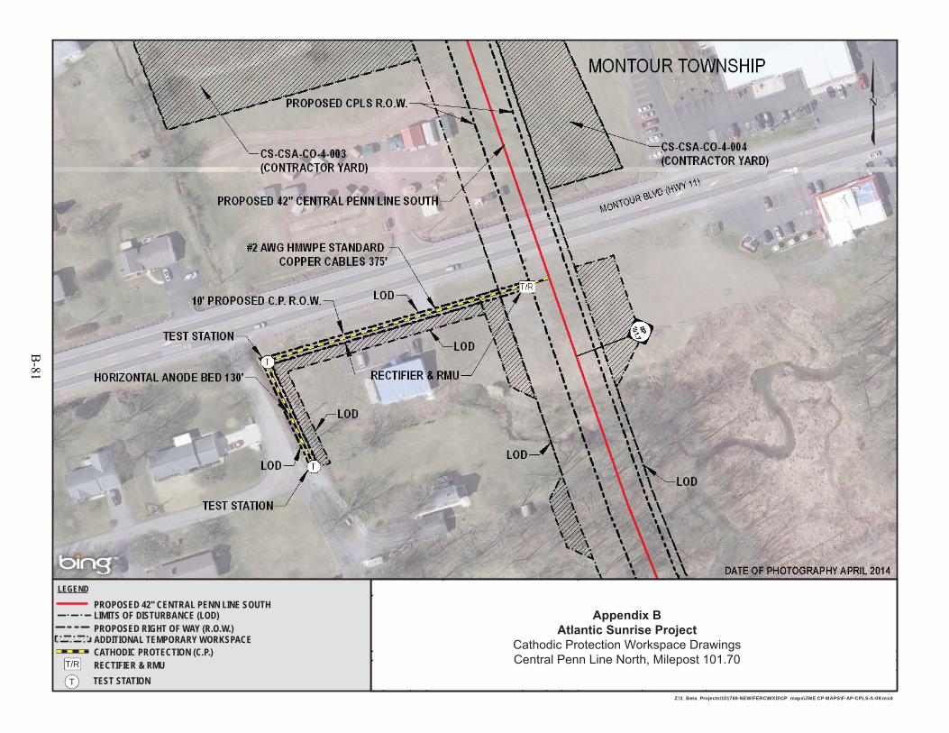
8:45 PM 7/17/2015
DRAWINGNUMBER:
DATE:
DRAWN BY:
CHECKED BY:
WO:
APPROVED BY: DATE:
ISSUE FOR CONSTRUCTION:
ISSUE FOR BID: SCALE:W.O. NO. CHK. APP.NO. DATE BY
DRAWING NO.
DATE:
REFERENCE TITLE
REVISION DESCRIPTION
1161503F-AP-CPLS-A-09
1" = 100'
Z:\1_Beta_Projects\101769-NEW\FERC\MXD\CP_maps\JWE CP MAPS\F-AP-CPLS-A-09.mxd
TRANSCONTINENTAL GAS PIPE LINE COMPANY LLCCPLS-GB #6
ATLANTIC SUNRISE PROJECTPROPOSED 42" CENTRAL PENN LINE SOUTH
M.P. 101.70COLUMBIA COUNTY, PENNSYLVANIA
JTN0 1161503
7/9/15
7/9/15
7/9/15
JTN7/17/15 0REVISION:ISSUED FOR SUPPLEMENTAL FILING #2 DP MJH DP
MJH
LEGEND
PROPOSED 42" CENTRAL PENN LINE SOUTHLIMITS OF DISTURBANCE (LOD) PROPOSED RIGHT OF WAY (R.O.W.)
CATHODIC PROTECTION (C.P.)ADDITIONAL TEMPORARY WORKSPACE
T
T/R RECTIFIER & RMUTEST STATION
Appendix BAtlantic Sunrise Project
Cathodic Protection Workspace DrawingsCentral Penn Line North, Milepost 101.70
B-81
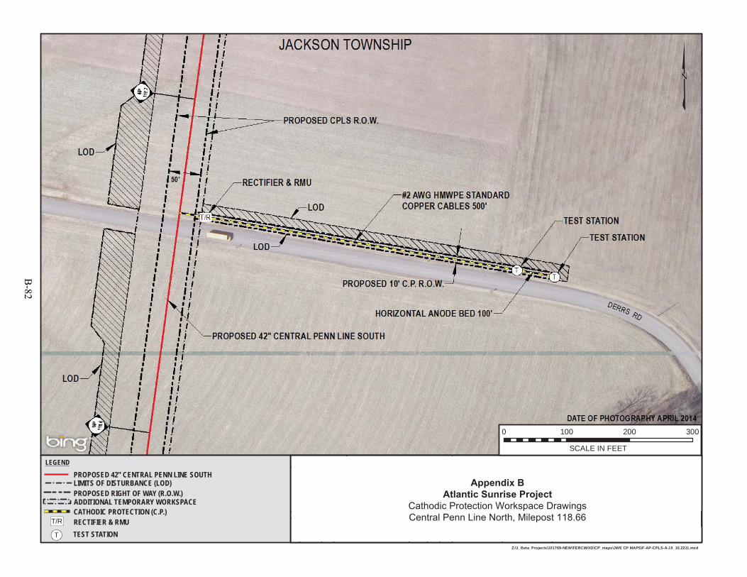
8:15 PM 7/17/2015
DRAWINGNUMBER:
DATE:
DRAWN BY:
CHECKED BY:
WO:
APPROVED BY: DATE:
ISSUE FOR CONSTRUCTION:
ISSUE FOR BID: SCALE:W.O. NO. CHK. APP.NO. DATE BY
DRAWING NO.
DATE:
REFERENCE TITLE
REVISION DESCRIPTION
1161503F-AP-CPLS-A-10
1" = 100'
Z:\1_Beta_Projects\101769-NEW\FERC\MXD\CP_maps\JWE CP MAPS\F-AP-CPLS-A-10_10.2211.mxd
TRANSCONTINENTAL GAS PIPE LINE COMPANY LLCCPLS-GB #7
ATLANTIC SUNRISE PROJECTPROPOSED 42" CENTRAL PENN LINE SOUTH
M.P. 118.66COLUMBIA COUNTY, PENNSYLVANIA
JTN0 1161503
7/9/15
7/9/15
7/9/15
JTN7/17/15 0REVISION:ISSUED FOR SUPPLEMENTAL FILING #2 DP MJH DP
MJH
0 100 200 300
SCALE IN FEET
LEGEND
PROPOSED 42" CENTRAL PENN LINE SOUTHLIMITS OF DISTURBANCE (LOD) PROPOSED RIGHT OF WAY (R.O.W.)
CATHODIC PROTECTION (C.P.)ADDITIONAL TEMPORARY WORKSPACE
T
T/R RECTIFIER & RMUTEST STATION
Appendix BAtlantic Sunrise Project
Cathodic Protection Workspace DrawingsCentral Penn Line North, Milepost 118.66
B-82
BEST MANAGEMENT PRACTICE FIGURES AND
TYPICAL RIGHT-OF-WAY DRAWINGS
B-83

B-84
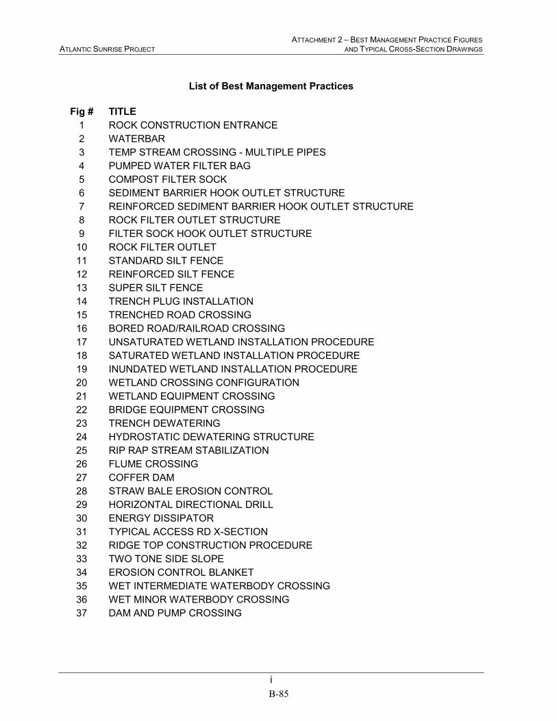
ATTACHMENT 2 – BEST MANAGEMENT PRACTICE FIGURES ATLANTIC SUNRISE PROJECT AND TYPICAL CROSS-SECTION DRAWINGS
i
List of Best Management Practices
Fig # TITLE
1 ROCK CONSTRUCTION ENTRANCE
2 WATERBAR
3 TEMP STREAM CROSSING - MULTIPLE PIPES
4 PUMPED WATER FILTER BAG
5 COMPOST FILTER SOCK
6 SEDIMENT BARRIER HOOK OUTLET STRUCTURE
7 REINFORCED SEDIMENT BARRIER HOOK OUTLET STRUCTURE
8 ROCK FILTER OUTLET STRUCTURE
9 FILTER SOCK HOOK OUTLET STRUCTURE
10 ROCK FILTER OUTLET
11 STANDARD SILT FENCE
12 REINFORCED SILT FENCE
13 SUPER SILT FENCE
14 TRENCH PLUG INSTALLATION
15 TRENCHED ROAD CROSSING
16 BORED ROAD/RAILROAD CROSSING
17 UNSATURATED WETLAND INSTALLATION PROCEDURE
18 SATURATED WETLAND INSTALLATION PROCEDURE
19 INUNDATED WETLAND INSTALLATION PROCEDURE
20 WETLAND CROSSING CONFIGURATION
21 WETLAND EQUIPMENT CROSSING
22 BRIDGE EQUIPMENT CROSSING
23 TRENCH DEWATERING
24 HYDROSTATIC DEWATERING STRUCTURE
25 RIP RAP STREAM STABILIZATION
26 FLUME CROSSING
27 COFFER DAM
28 STRAW BALE EROSION CONTROL
29 HORIZONTAL DIRECTIONAL DRILL
30 ENERGY DISSIPATOR
31 TYPICAL ACCESS RD X-SECTION
32 RIDGE TOP CONSTRUCTION PROCEDURE
33 TWO TONE SIDE SLOPE
34 EROSION CONTROL BLANKET
35 WET INTERMEDIATE WATERBODY CROSSING
36 WET MINOR WATERBODY CROSSING
37 DAM AND PUMP CROSSING
B-85

ATTACHMENT 2 – BEST MANAGEMENT PRACTICE FIGURES ATLANTIC SUNRISE PROJECT AND TYPICAL CROSS-SECTION DRAWINGS
ii
Typical Right-of-Way Cross-Sections
PROPOSED 30” CENTRAL PENN LINE NORTH
PROPOSED 42” CENTRAL PENN LINE SOUTH
PROPOSED 36” CHAPMAN LOOP
PROPOSED 42” UNITY LOOP
PROPOSED 30” MAINLINE “A” AND “B” VIRGINIA REPLACEMENTS
B-86
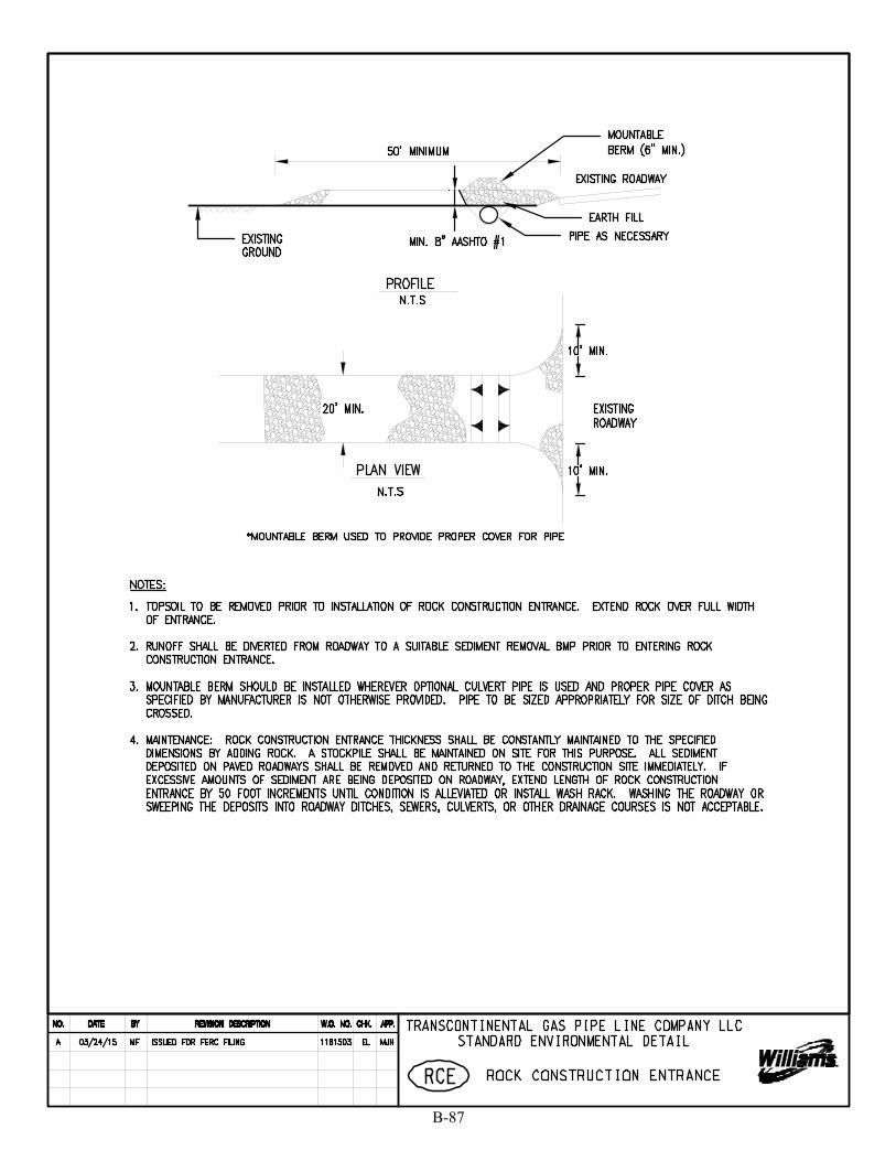
B-87
SKing
Text Box
1
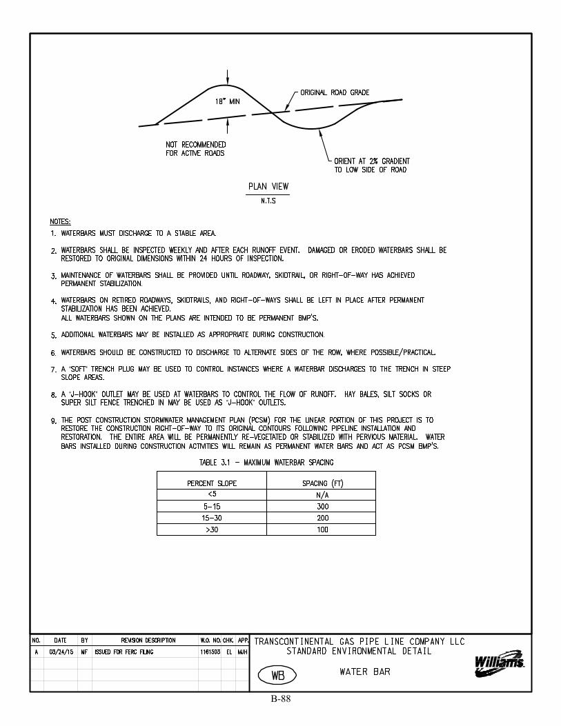
B-88
SKing
Text Box
2
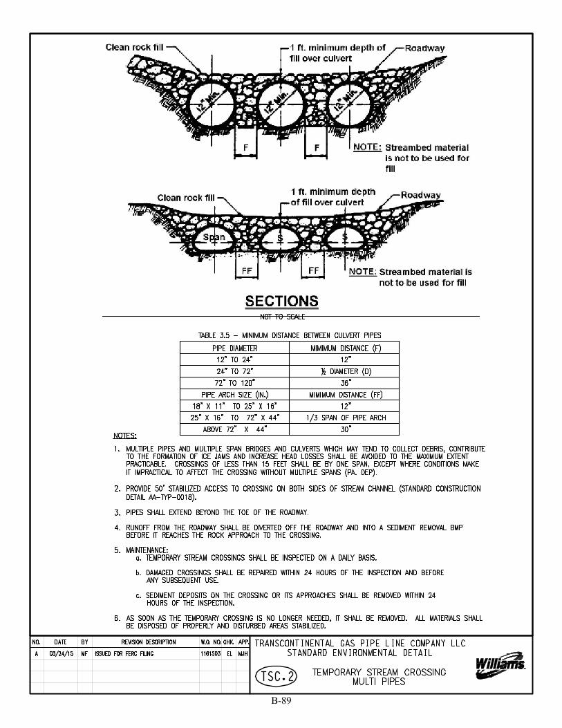
B-89
SKing
Text Box
3

B-90
SKing
Text Box
4
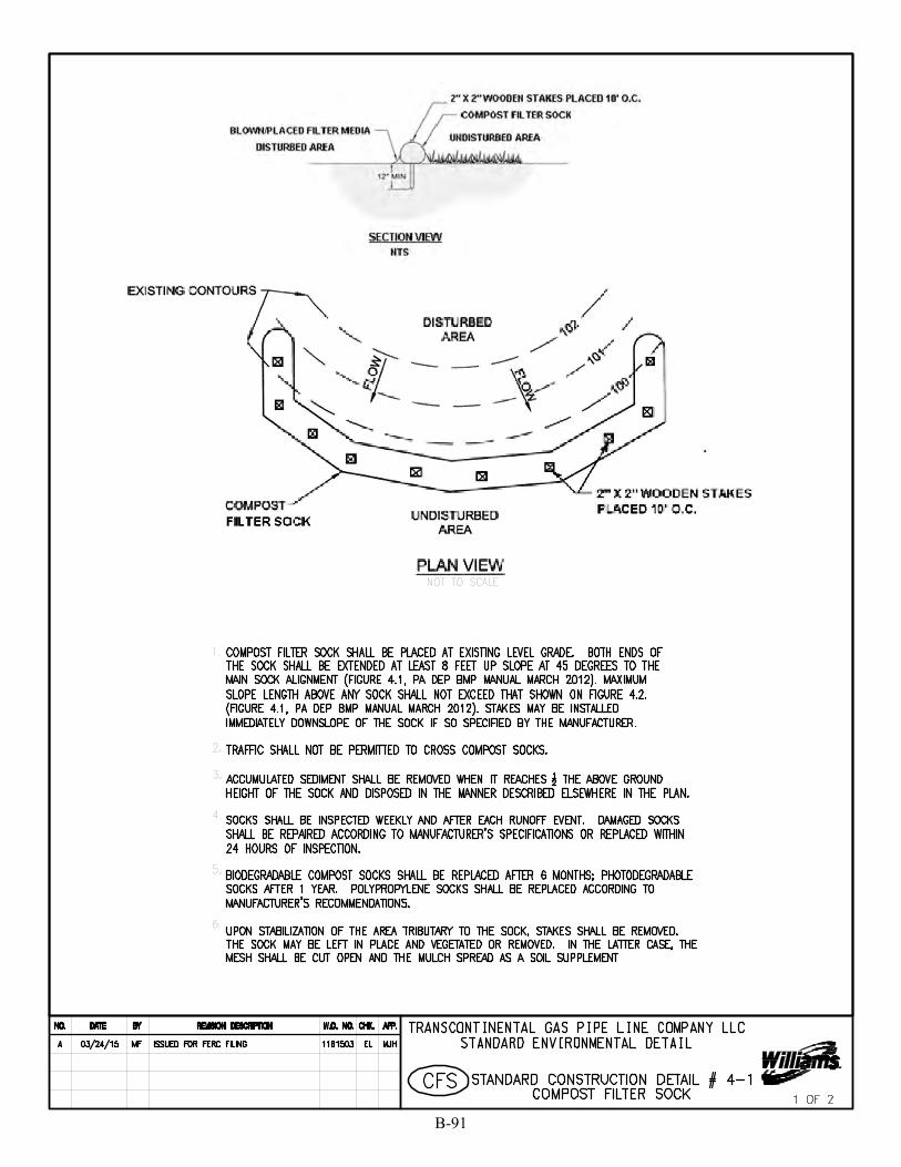
B-91
SKing
Polygon
SKing
Text Box
5a
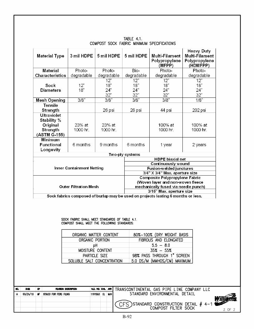
B-92
SKing
Polygon
SKing
Text Box
5b
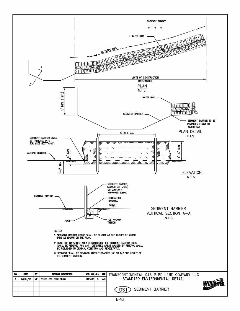
B-93
SKing
Text Box
6
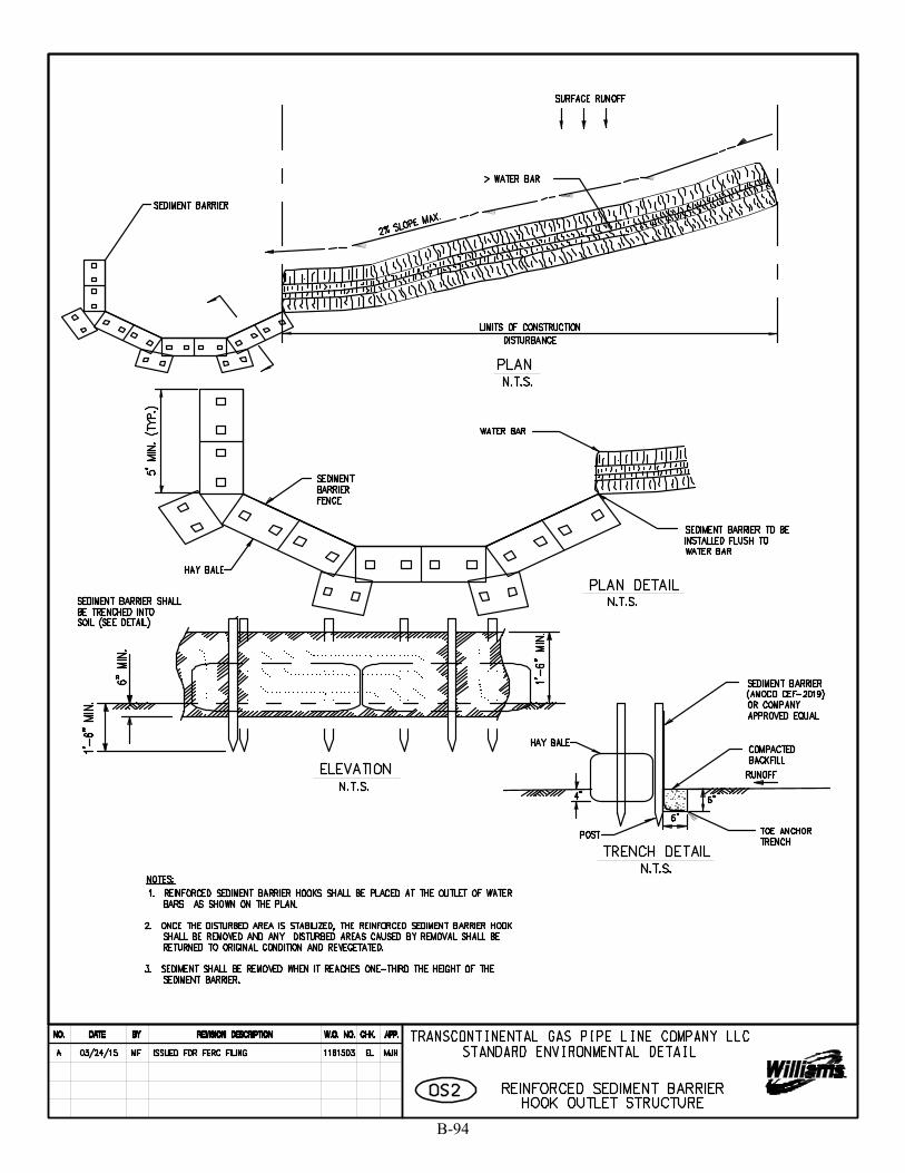
B-94
SKing
Text Box
7
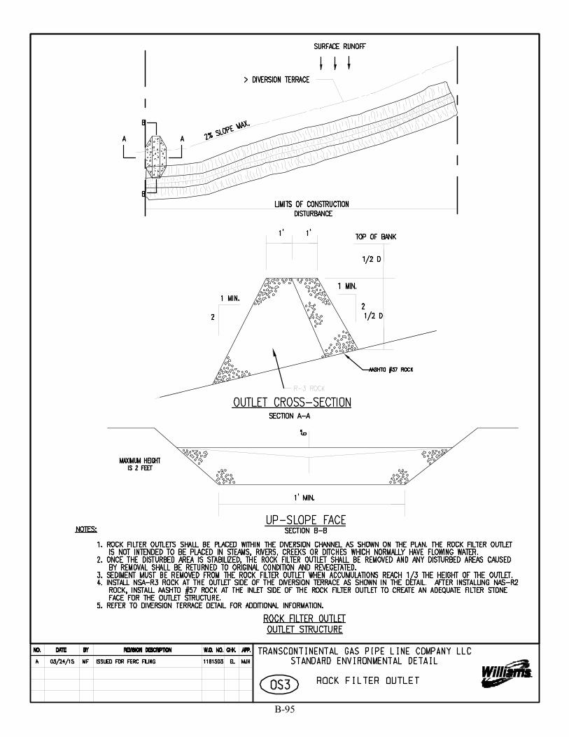
B-95
SKing
Text Box
8
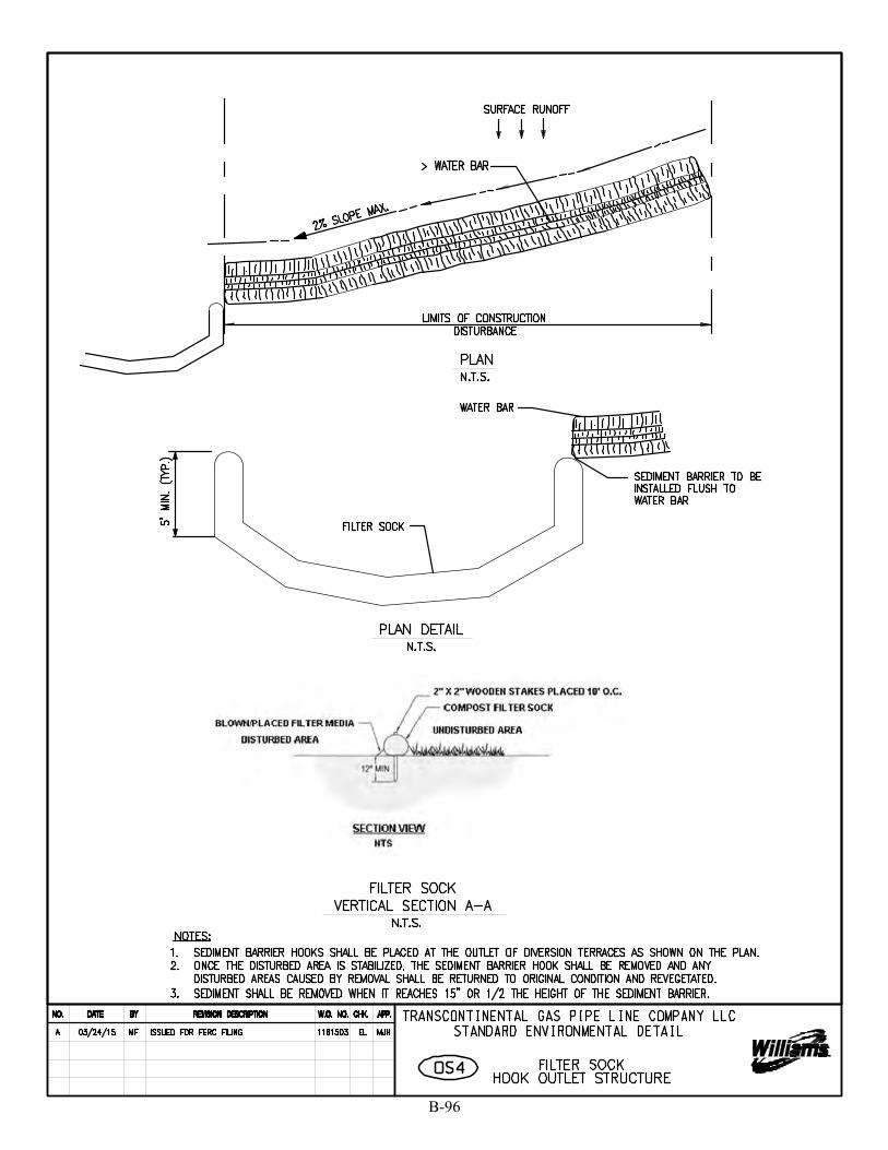
B-96
SKing
Text Box
9
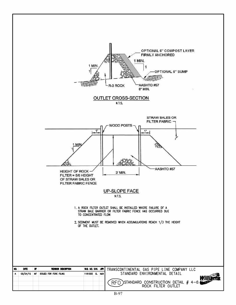
B-97
SKing
Text Box
10
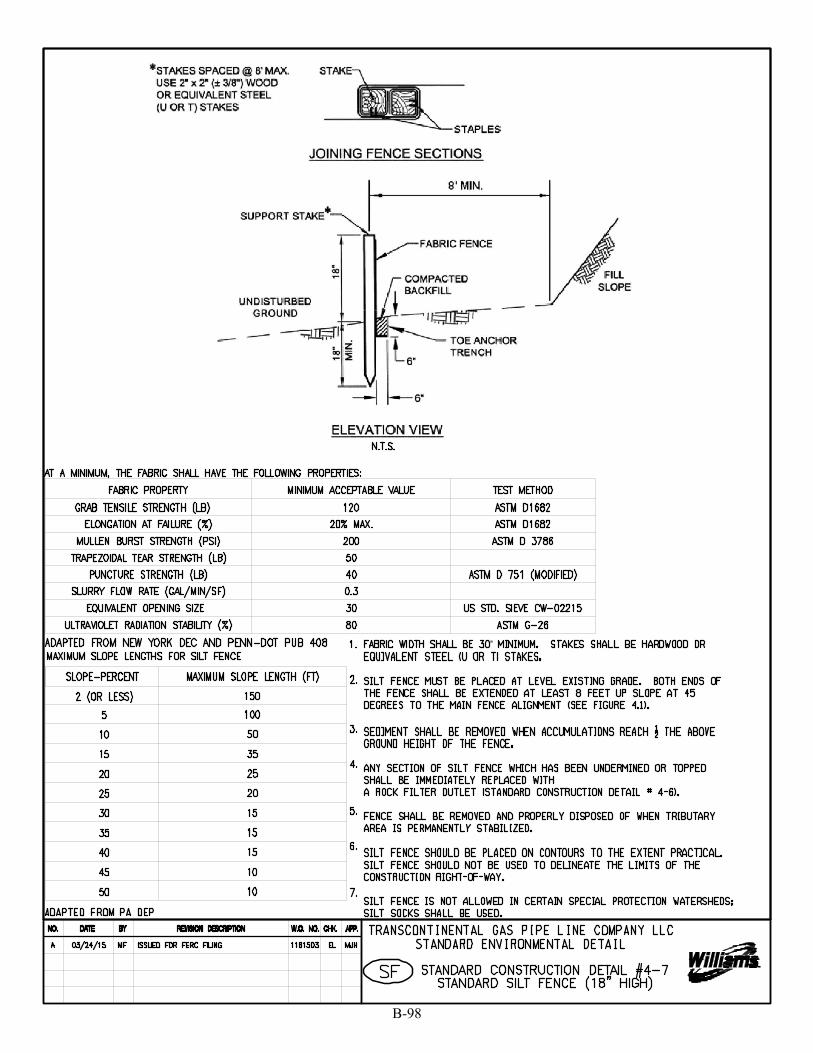
B-98
SKing
Text Box
11

B-99
SKing
Text Box
12

B-100
SKing
Text Box
13
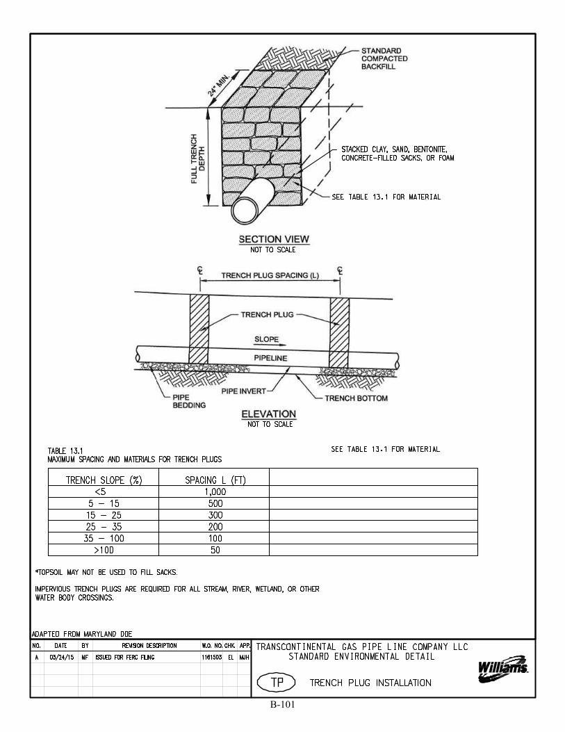
B-101
SKing
Text Box
14
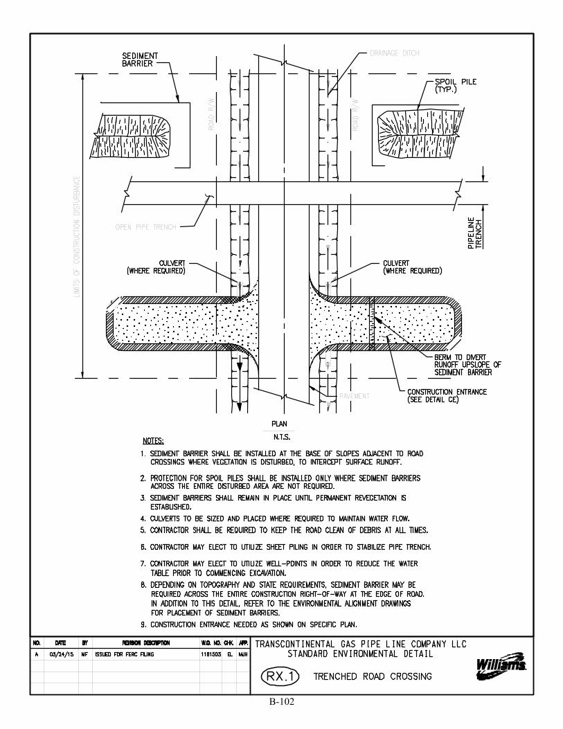
B-102
SKing
Text Box
15
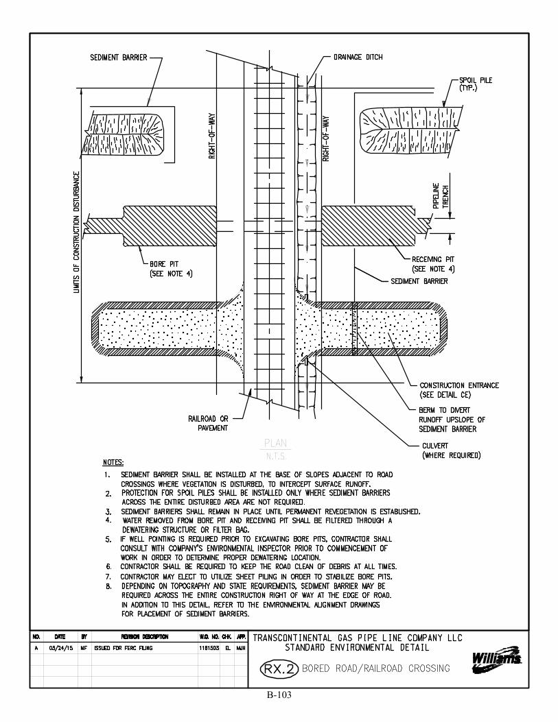
B-103
SKing
Text Box
16

B-104
SKing
Text Box
17
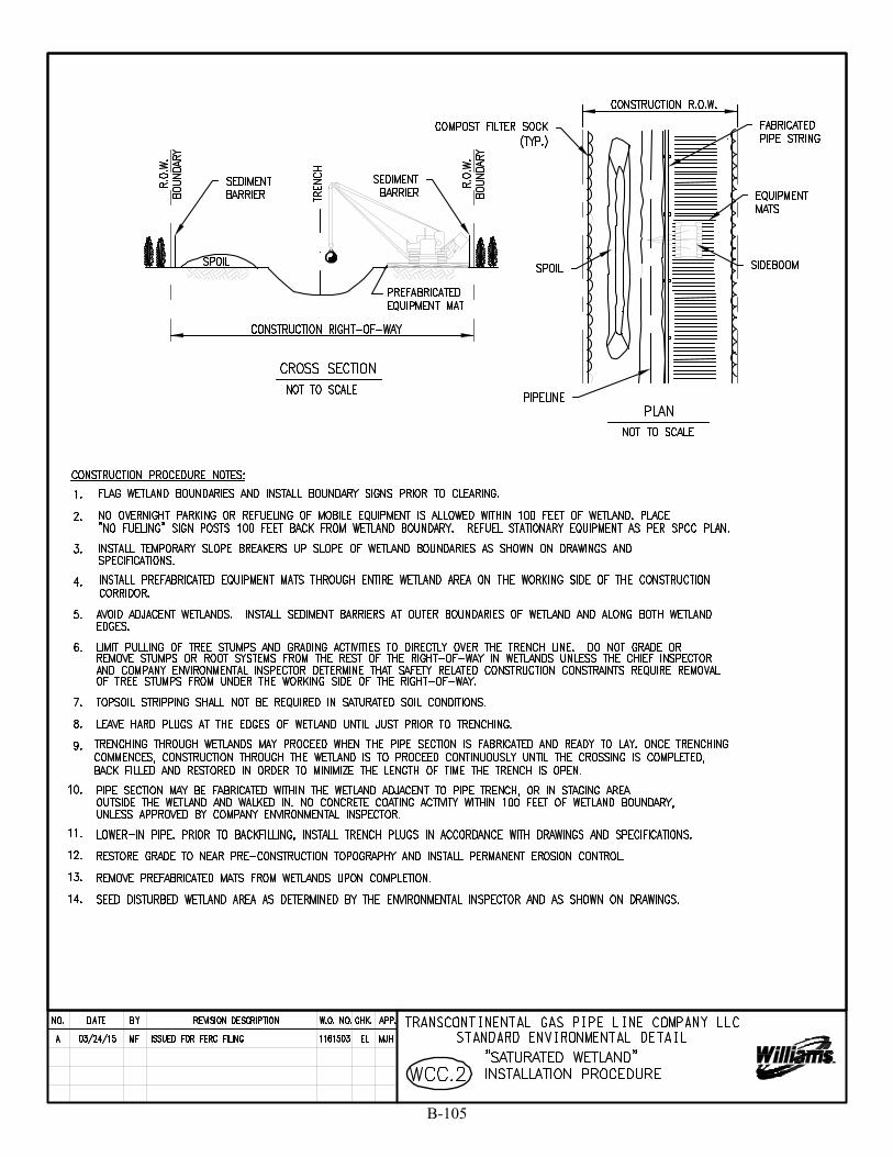
B-105
SKing
Text Box
18

B-106
SKing
Text Box
19
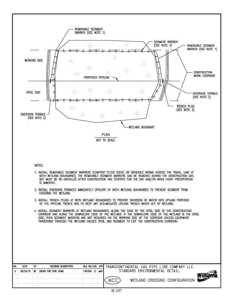
              Â
ÂÂÂ
ÂÂÂÂÂÂÂÂÂÂÂÂÂÂÂÂ
ÂÂÂ
B-107
SKing
Text Box
20
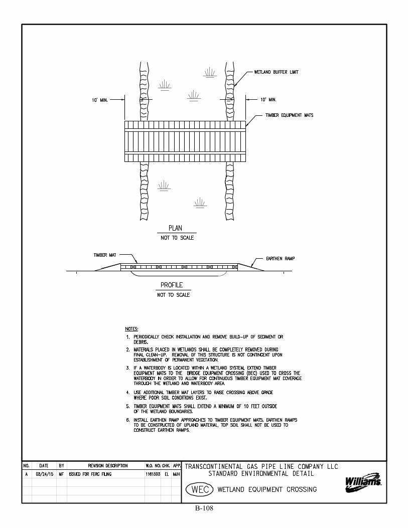
B-108
SKing
Text Box
21

B-109
SKing
Text Box
22
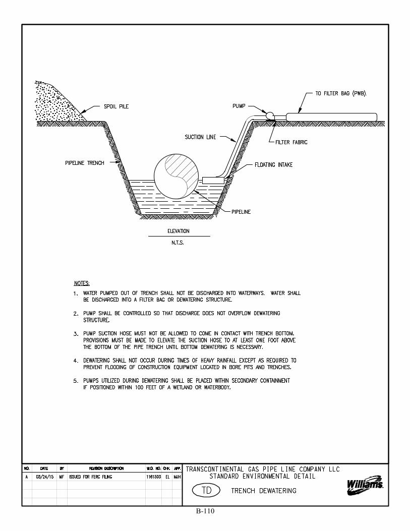
B-110
SKing
Text Box
23
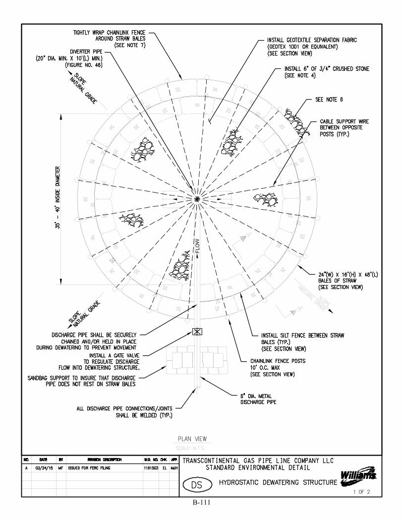
B-111
SKing
Polygon
SKing
Text Box
24a
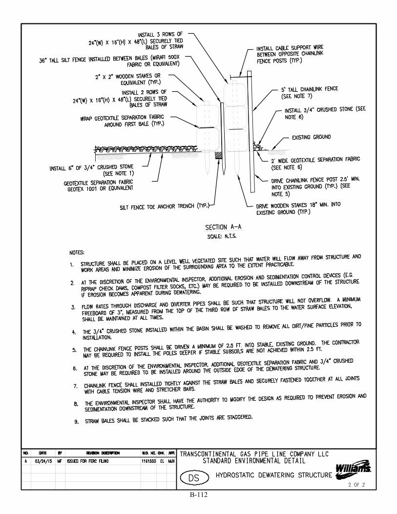
B-112
SKing
Polygon
SKing
Text Box
24b

8' MIN.
18"
4"
B-113
SKing
Text Box
25

B-114
SKing
Polygon
SKing
Text Box
26a
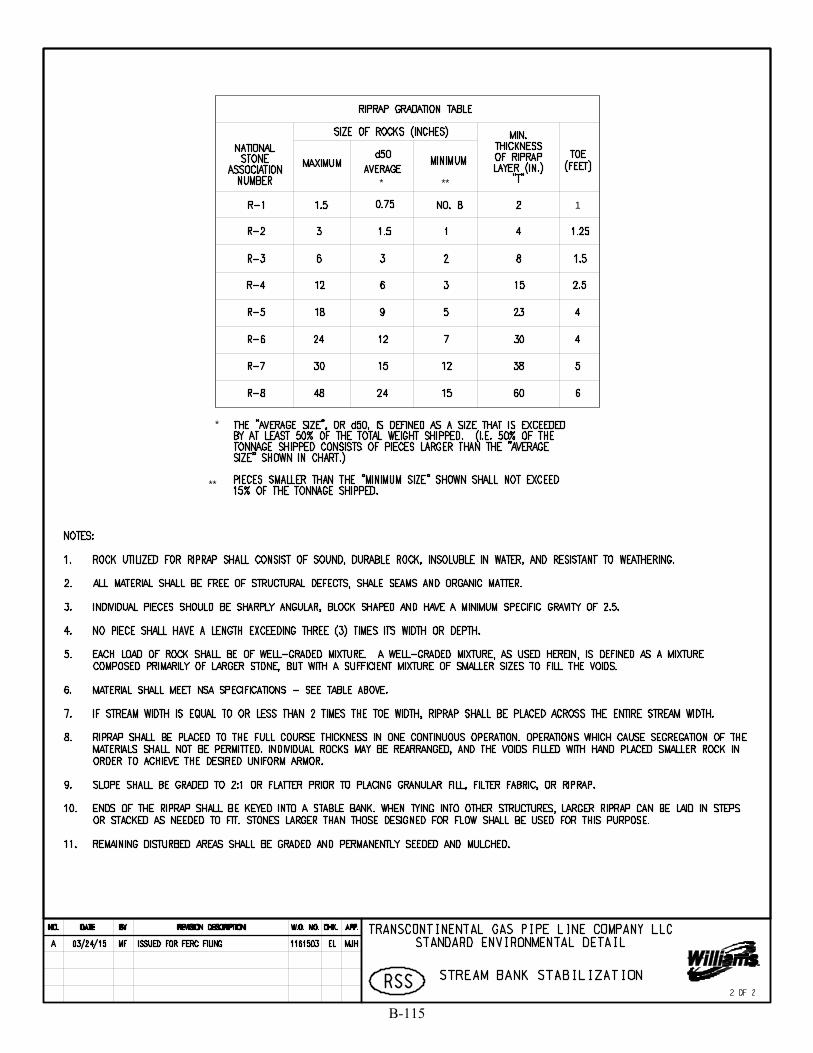
* **
*
**
1
B-115
SKing
Polygon
SKing
Text Box
26b
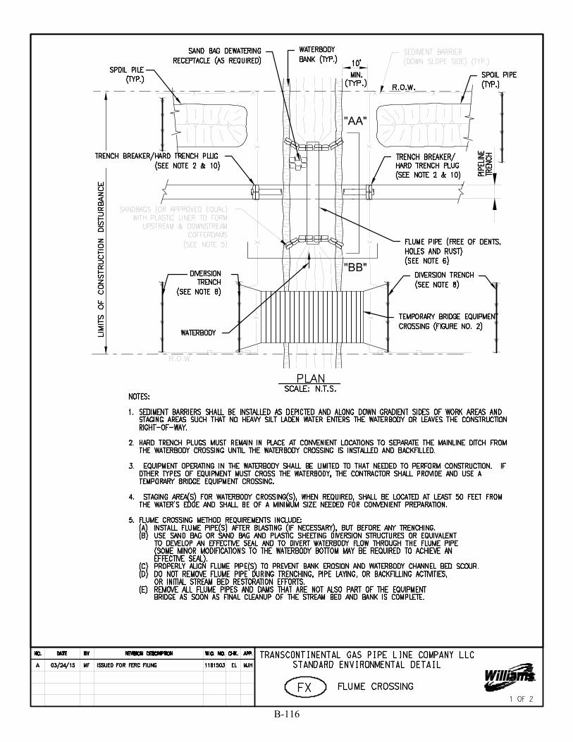
B-116
SKing
Polygon
SKing
Text Box
27a

B-117
SKing
Polygon
SKing
Text Box
27b
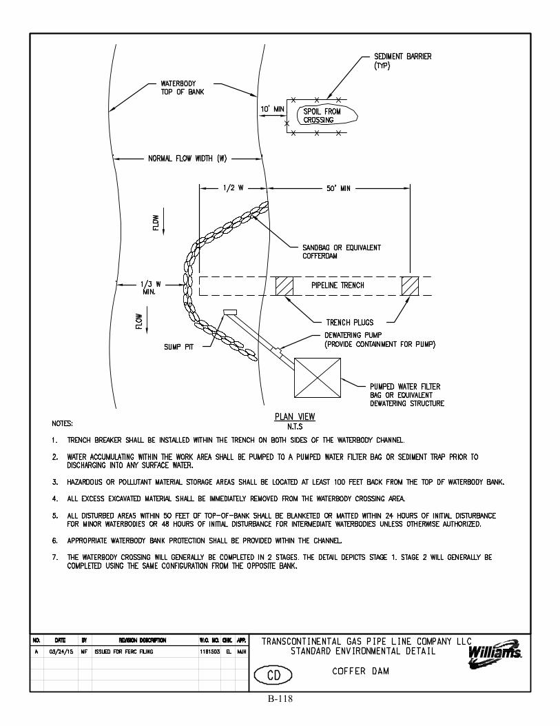
B-118
SKing
Text Box
28
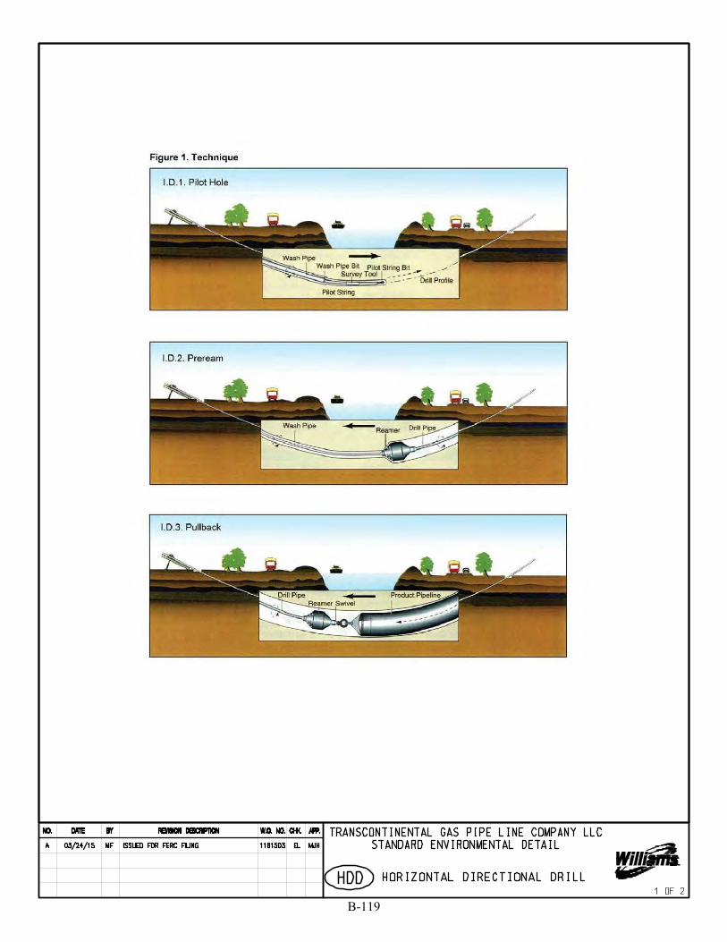
B-119
SKing
Text Box
29a
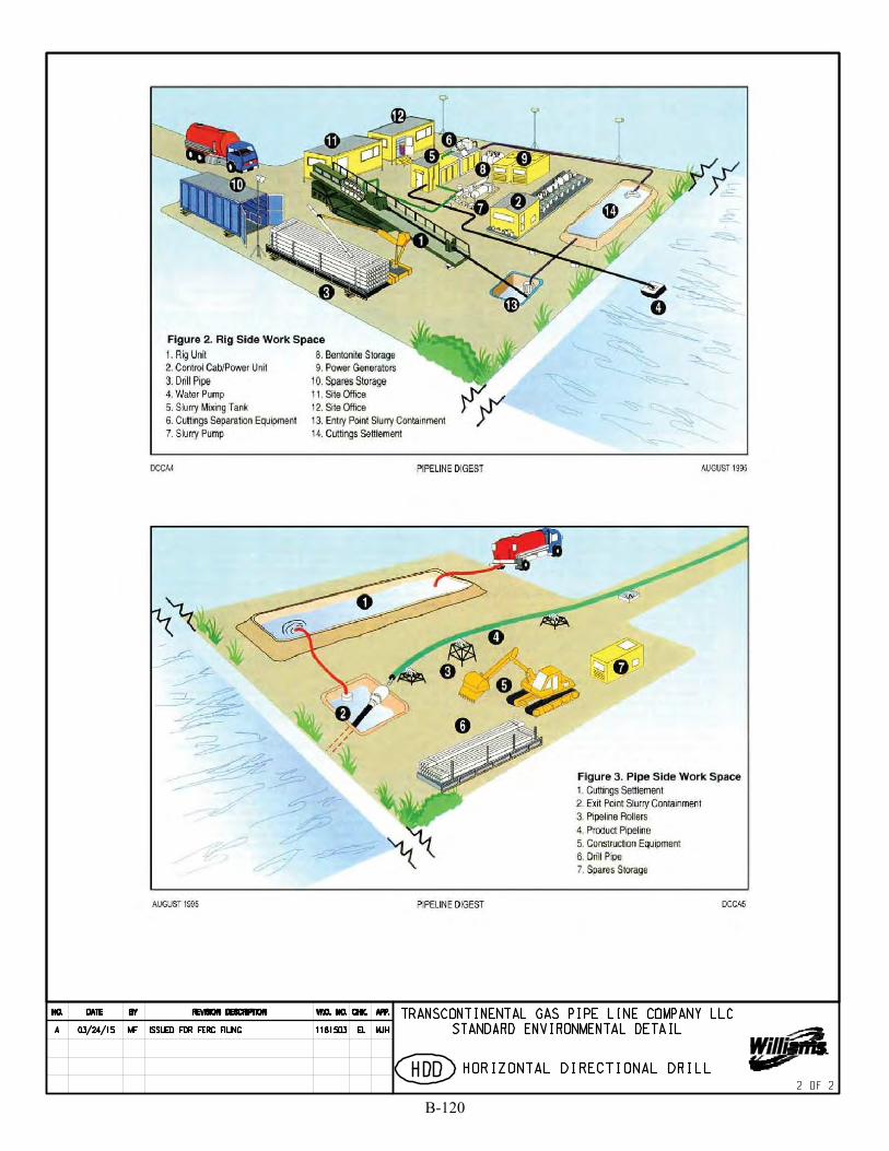
B-120
SKing
Polygon
SKing
Text Box
29b
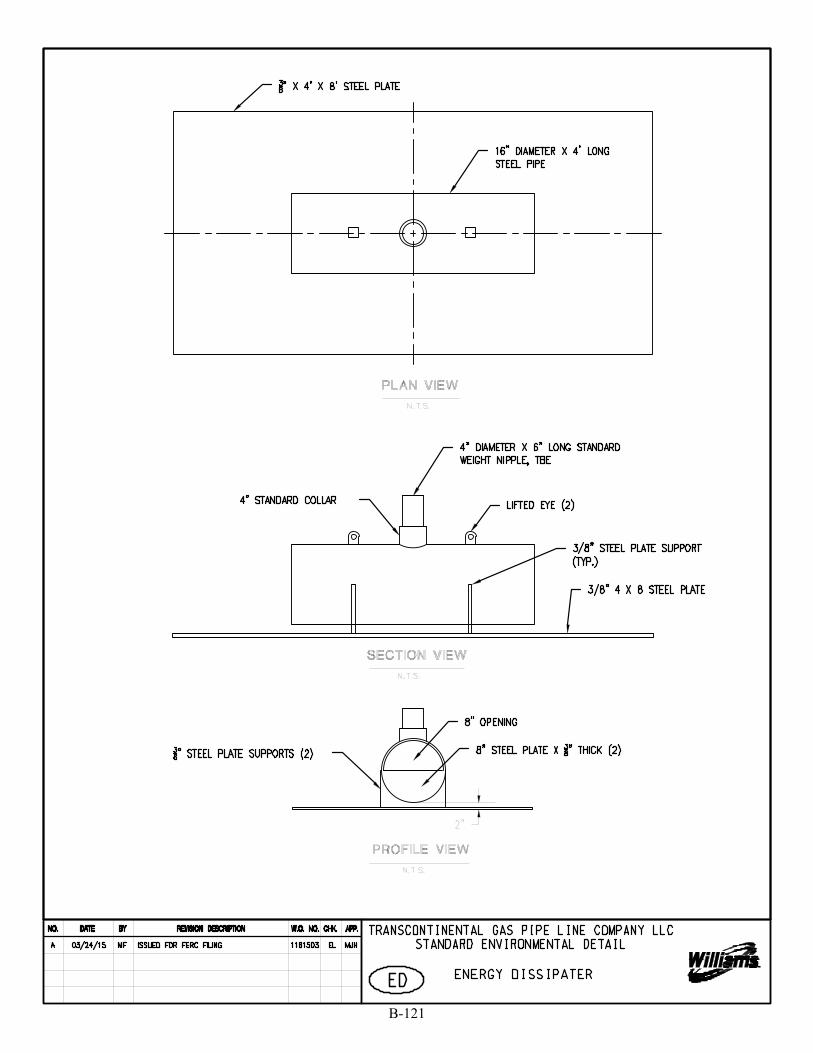
B-121
SKing
Text Box
30

2% Min.
B-122
SKing
Text Box
31
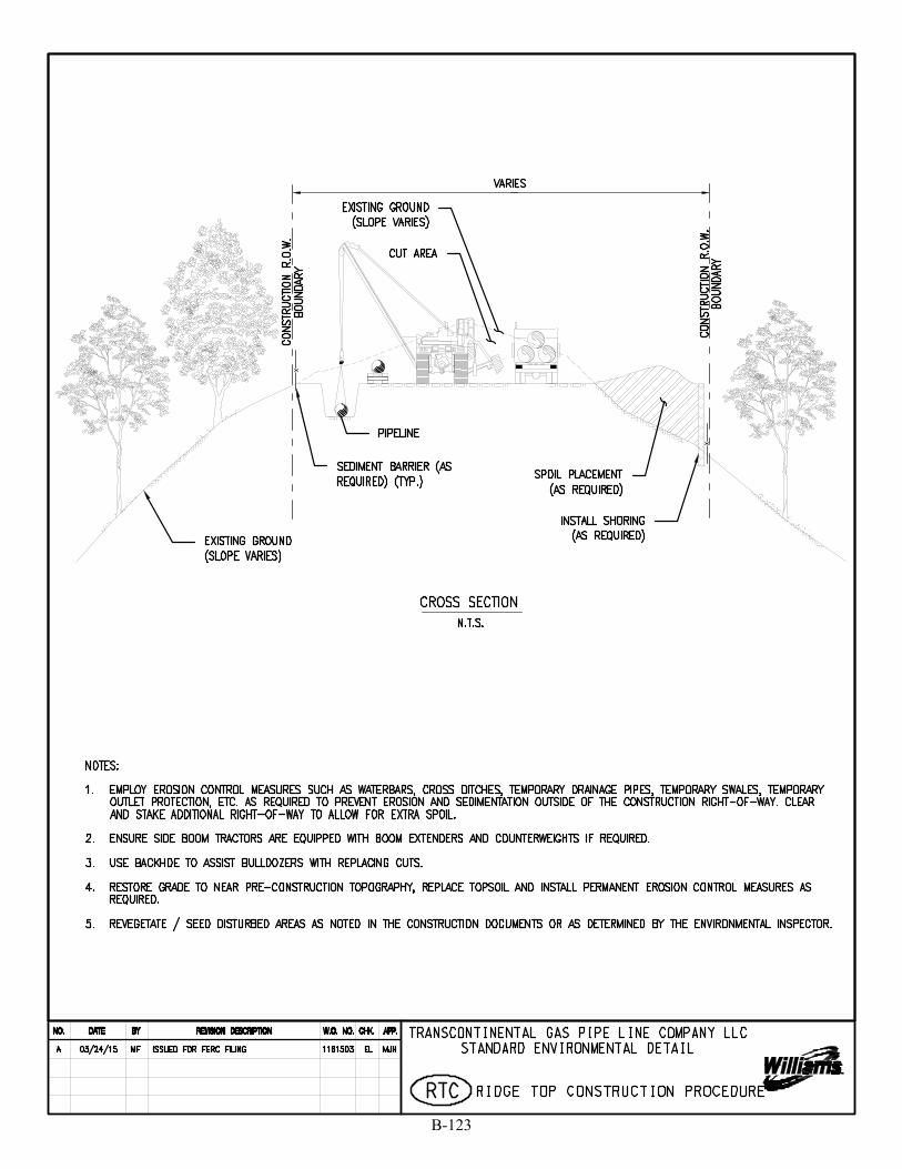
B-123
SKing
Text Box
32
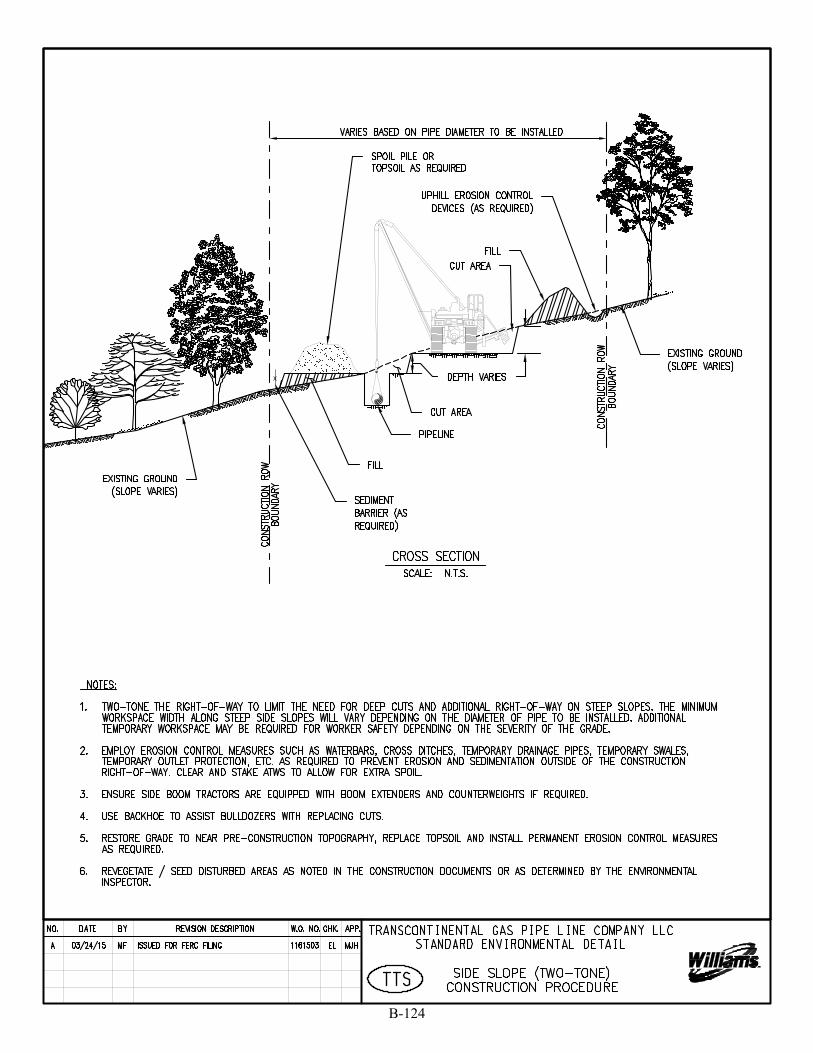
x
B-124
SKing
Text Box
33
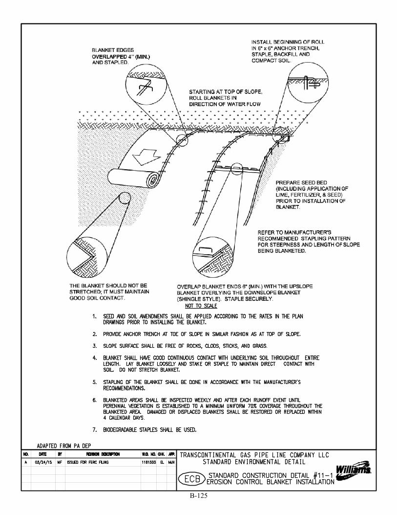
B-125
SKing
Text Box
34
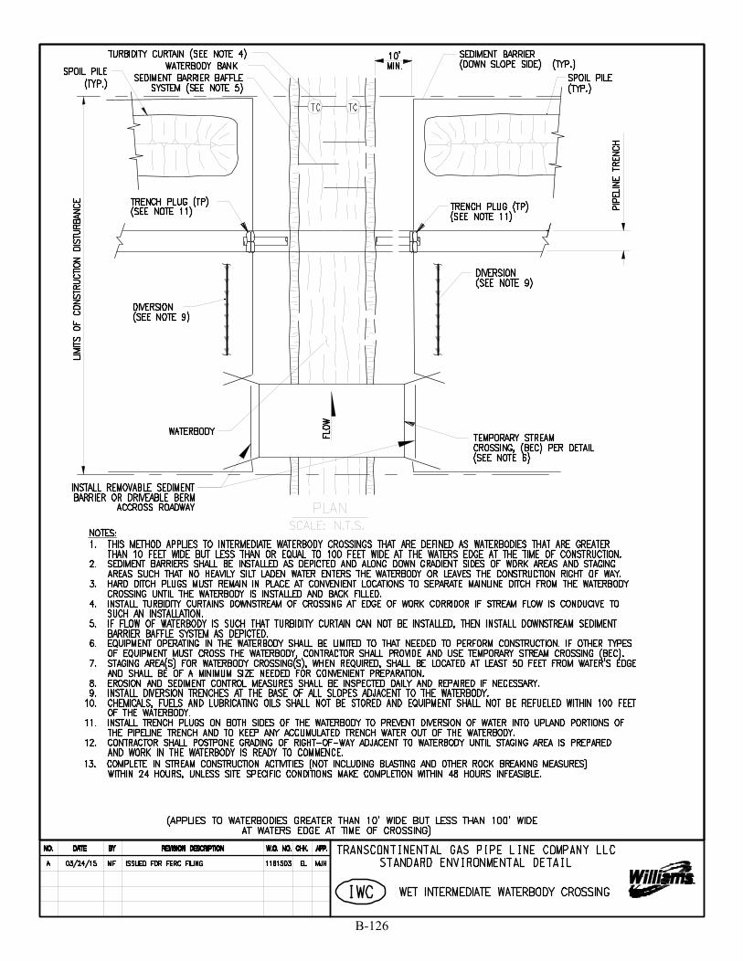
B-126
SKing
Text Box
35
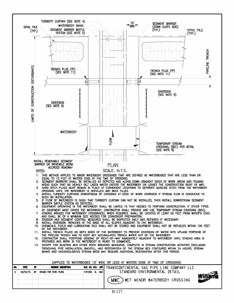
B-127
SKing
Text Box
36
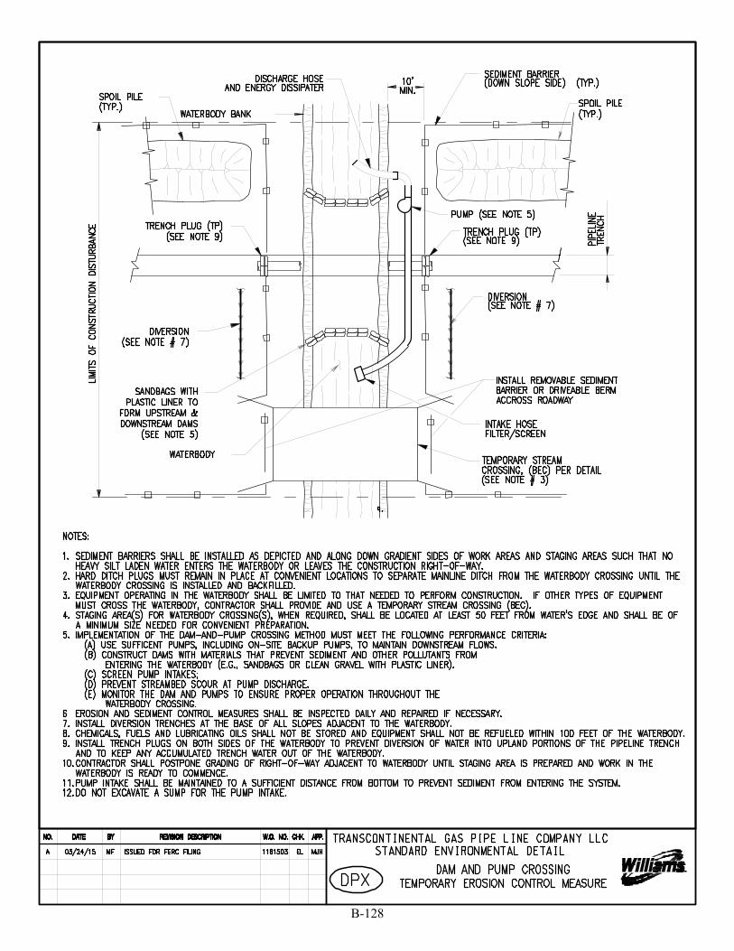
B-128
SKing
Text Box
37
B-129

B-130
SKing
Text Box
This Page Intentionally Left Blank
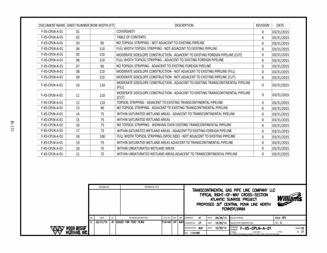
B-131

B-132
SKing
Text Box
This Page Intentionally Left Blank
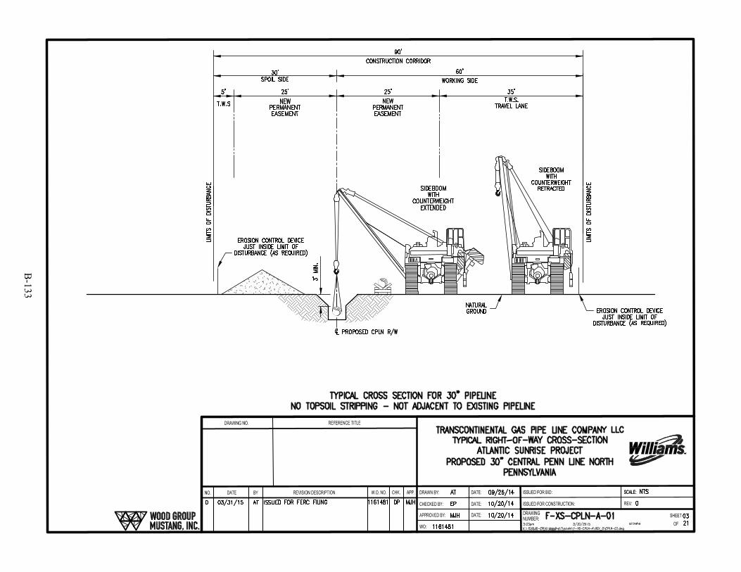
B-133
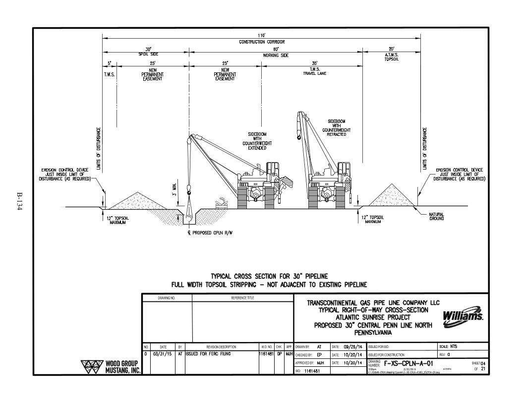
B-134

B-135
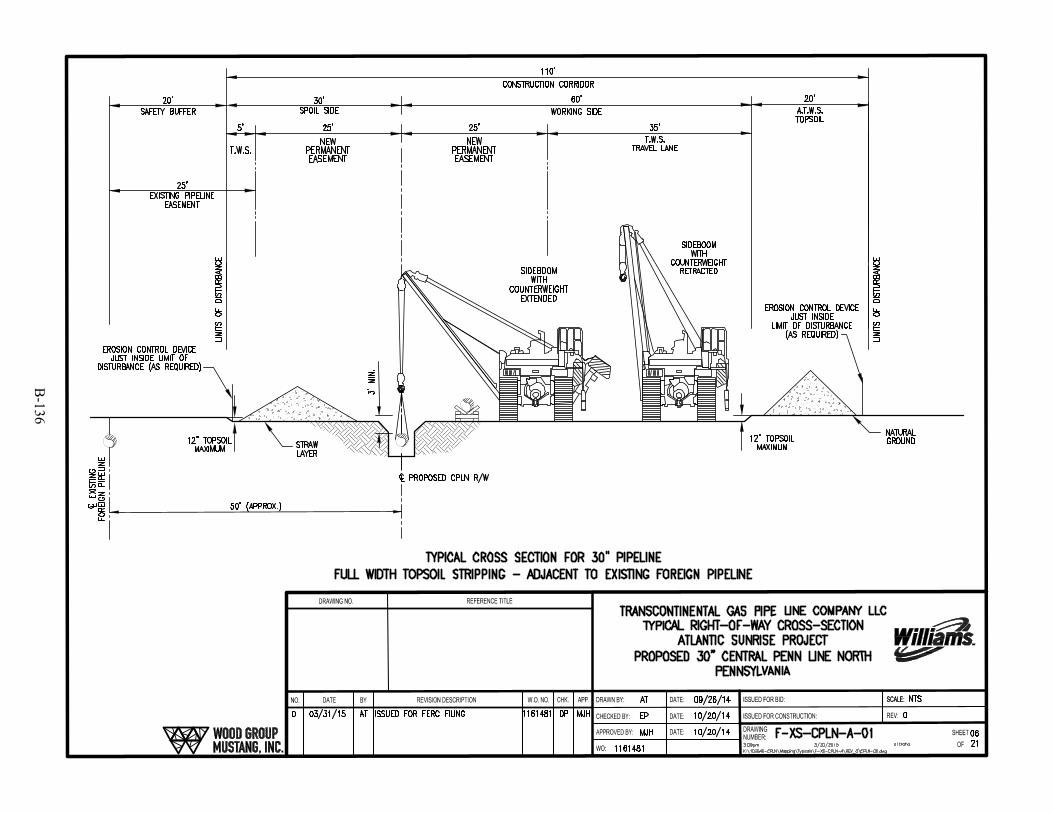
B-136
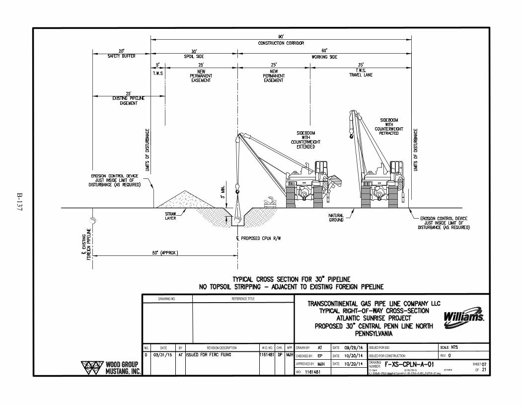
B-137

B-138

B-139
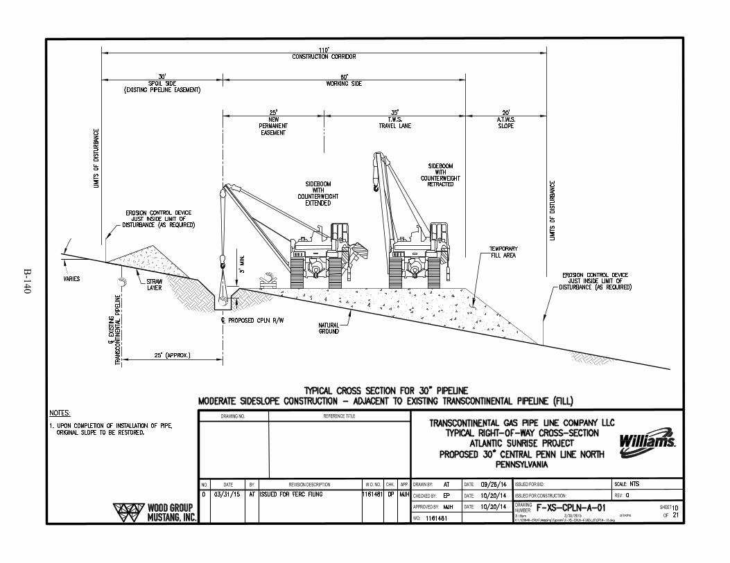
B-140

B-141
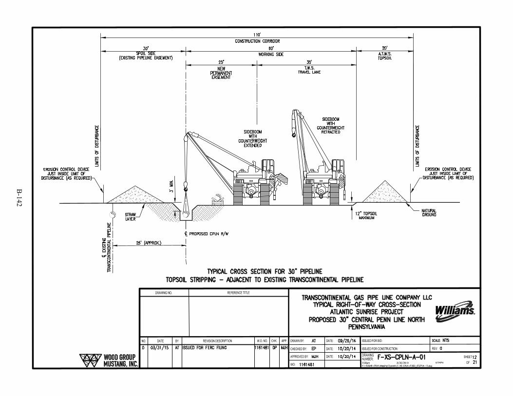
B-142
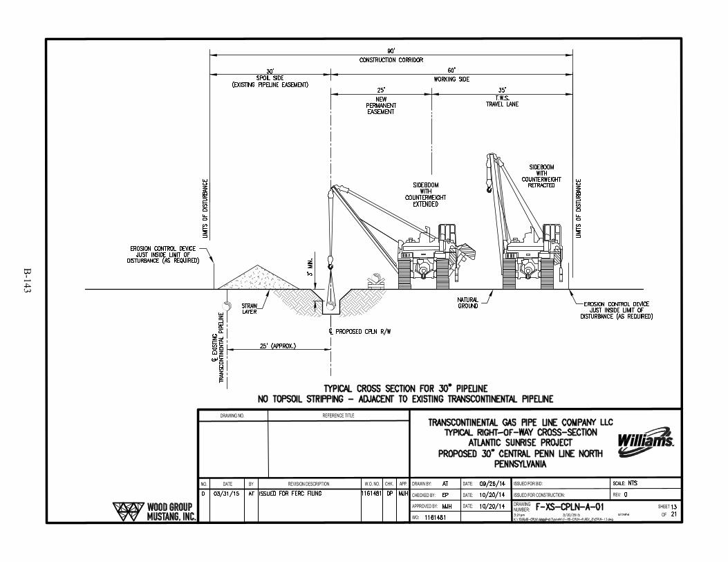
B-143
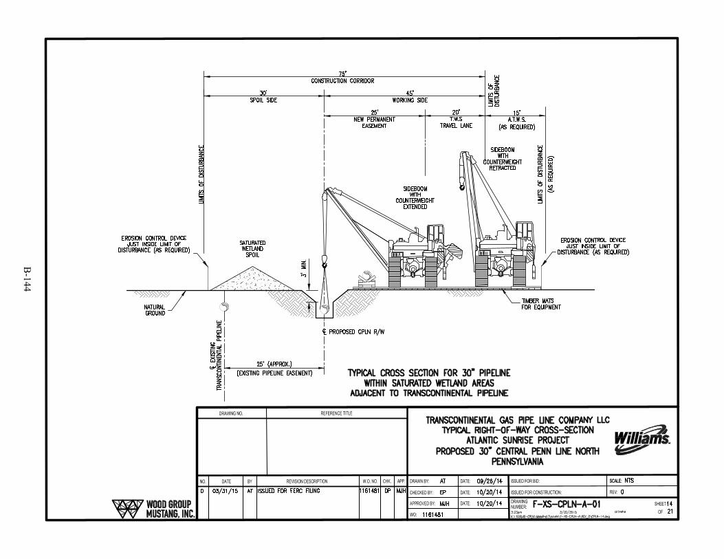
B-144
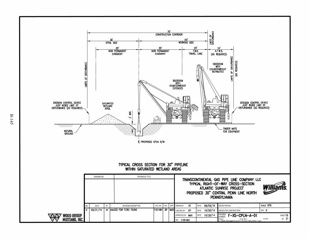
B-145
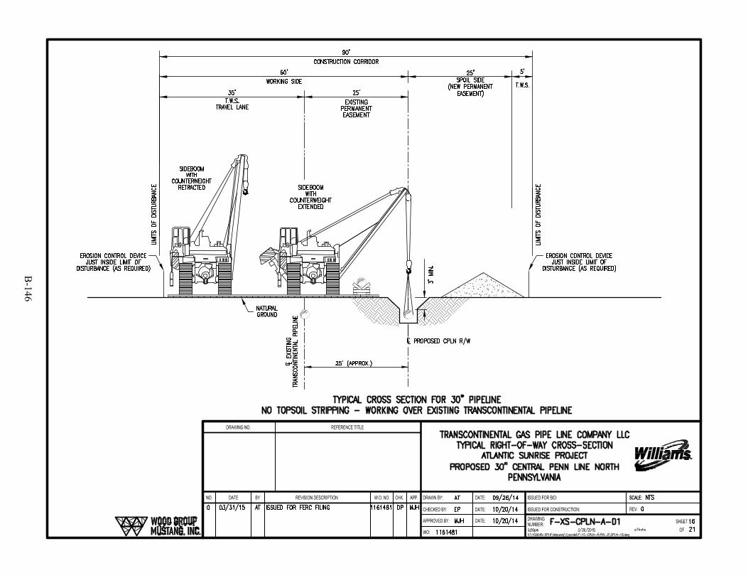
B-146

B-147
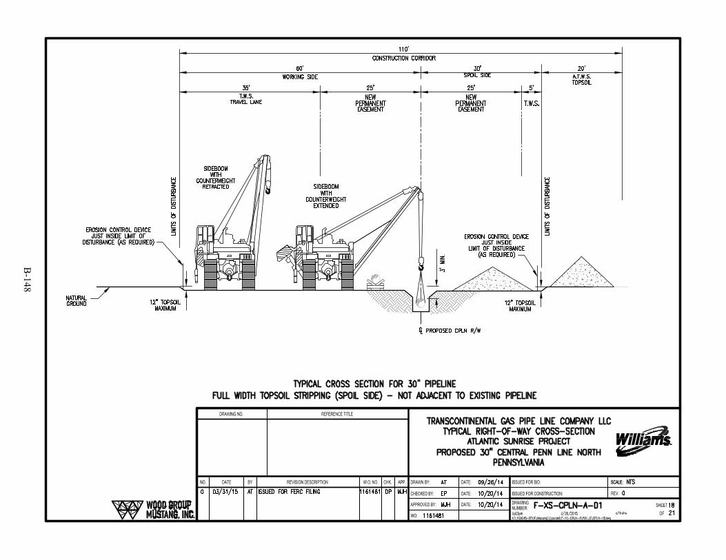
B-148
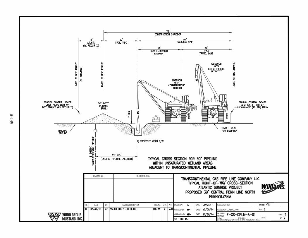
B-149
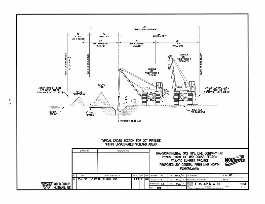
B-150
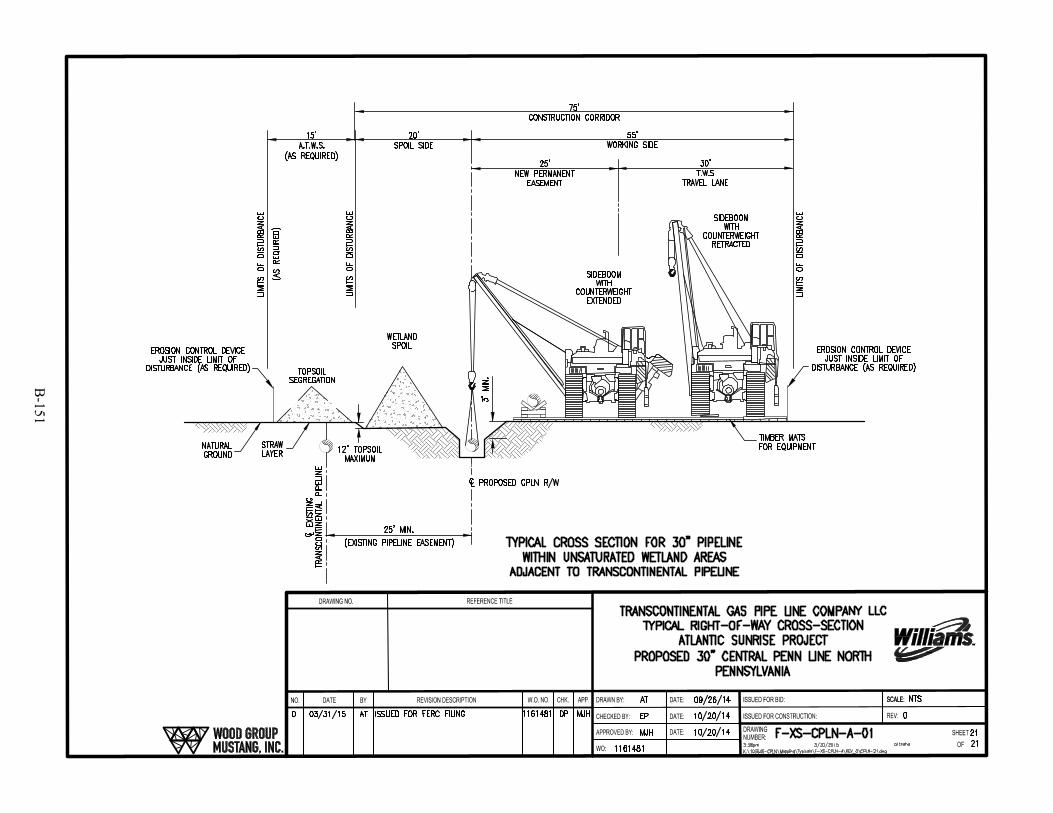
B-151

B-152
SKing
Text Box
This Page Intentionally Left Blank

B-153

B-154
SKing
Text Box
This Page Intentionally Left Blank

B-155

B-156
SKing
Text Box
This Page Intentionally Left Blank
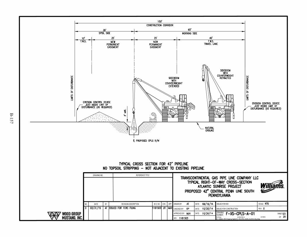
B-157
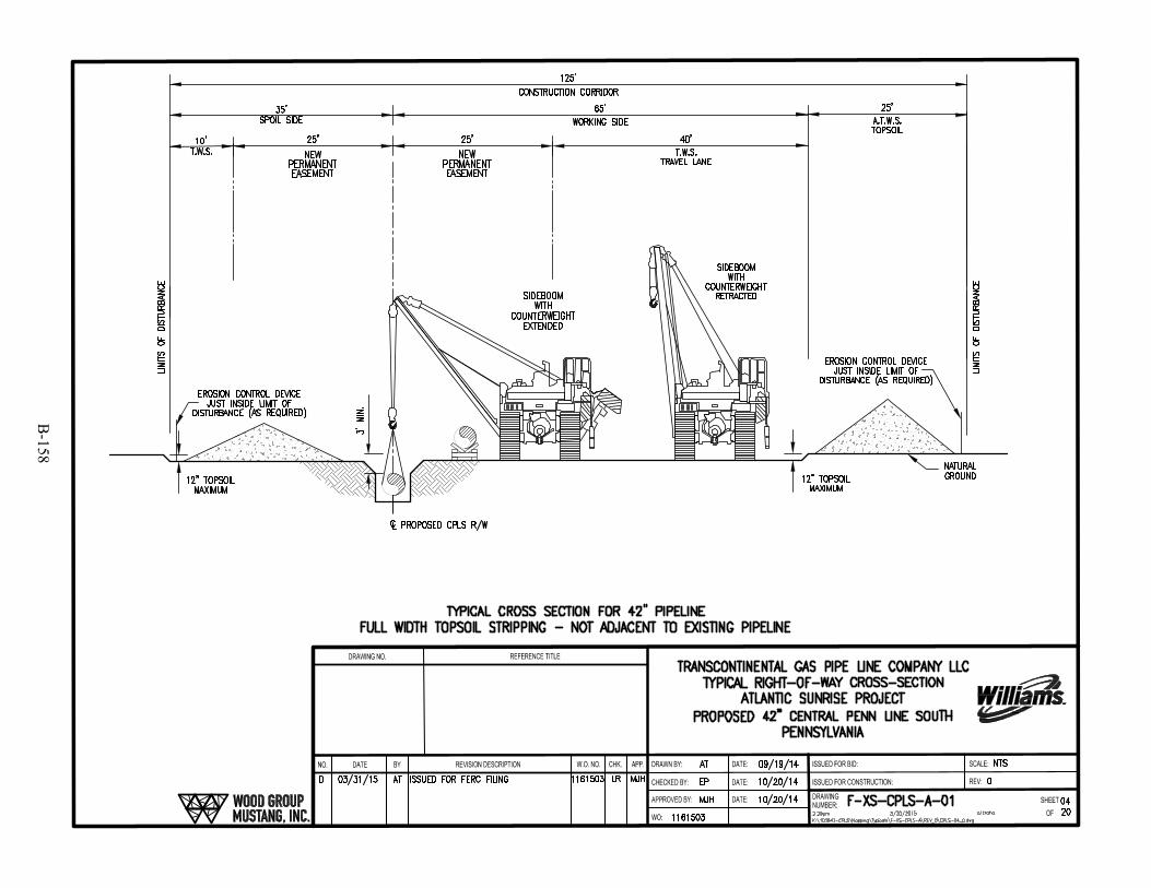
B-158
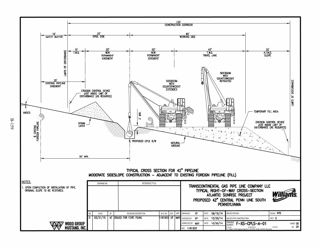
B-159
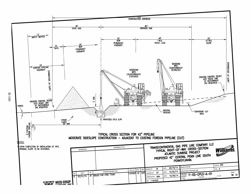
B-160

B-161
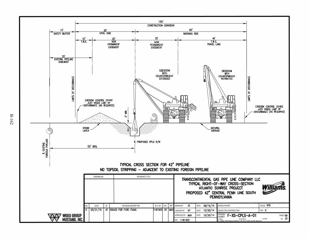
B-162
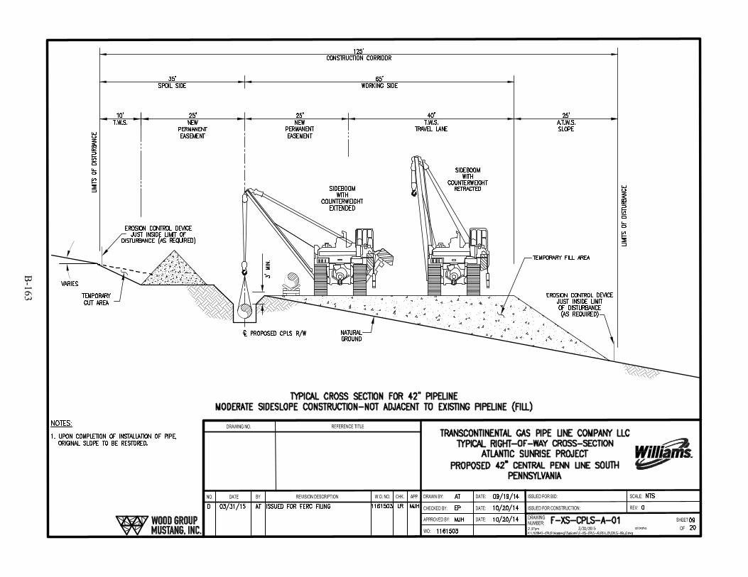
B-163
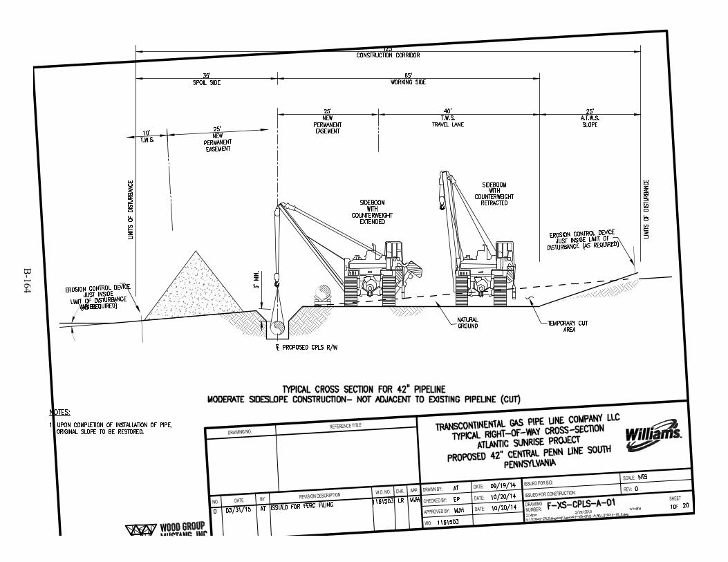
B-164
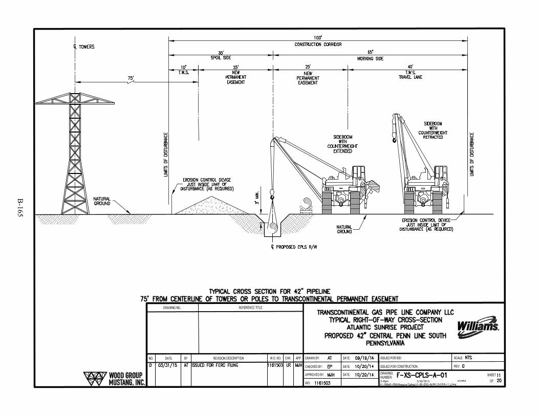
B-165

B-166
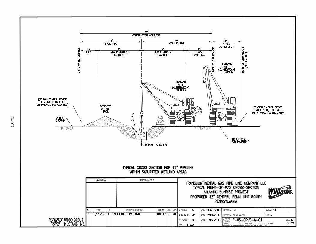
B-167
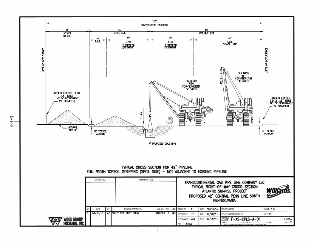
B-168

B-169
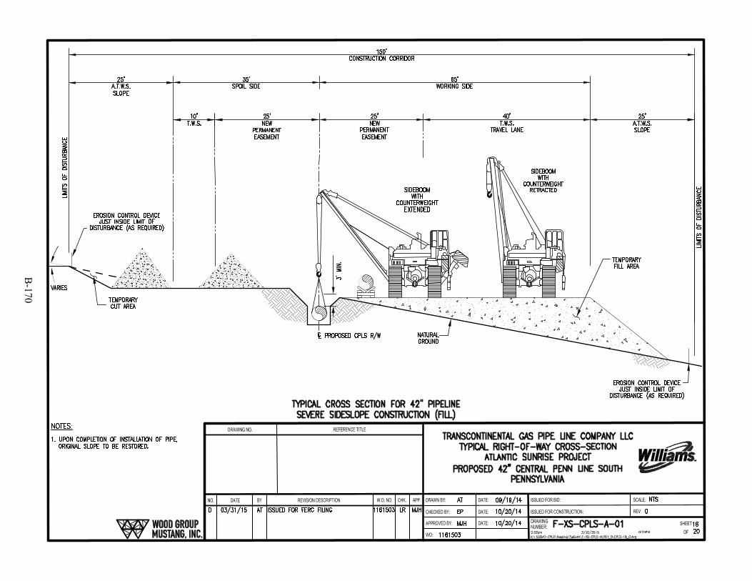
B-170

B-171
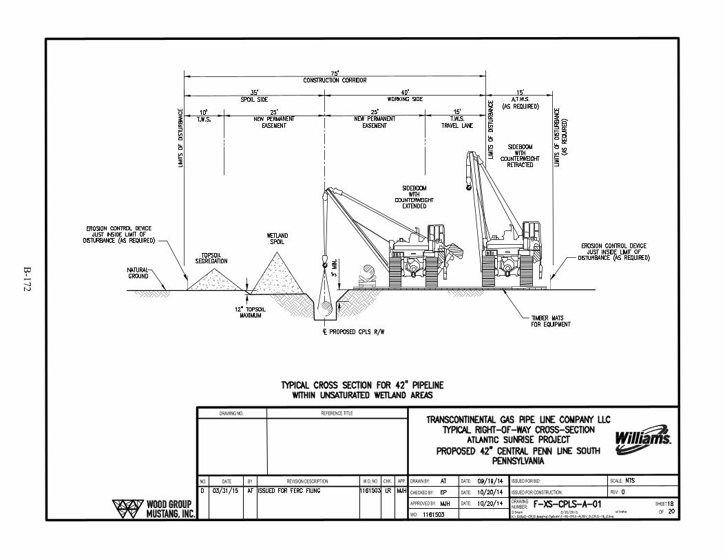
B-172

B-173
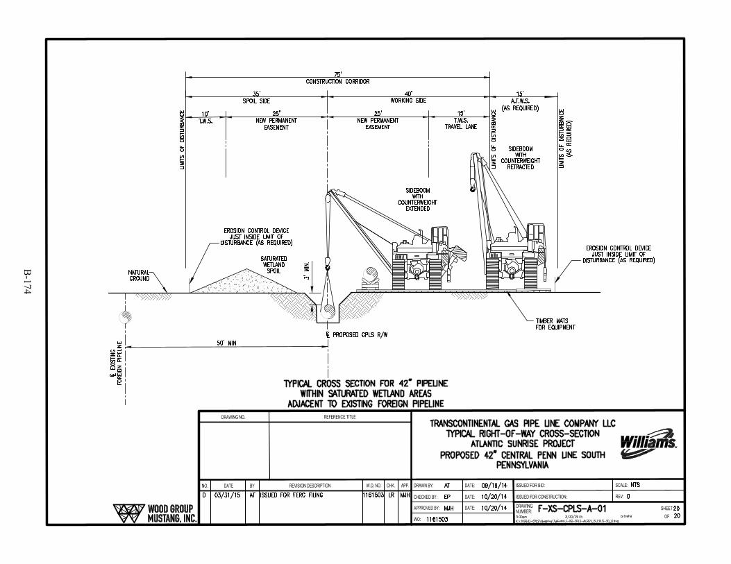
B-174
B-175

B-176
SKing
Text Box
This Page Intentionally Left Blank
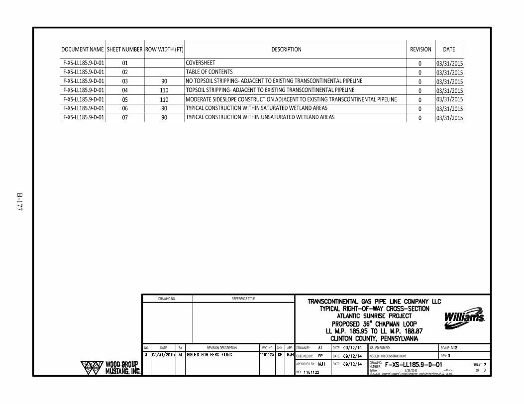
B-177
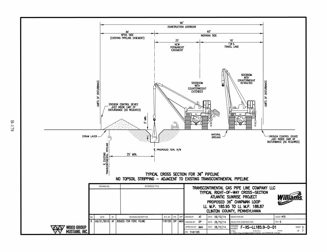
B-178
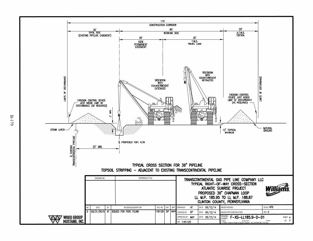
B-179
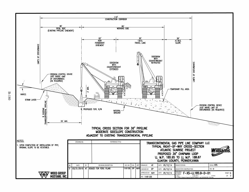
B-180
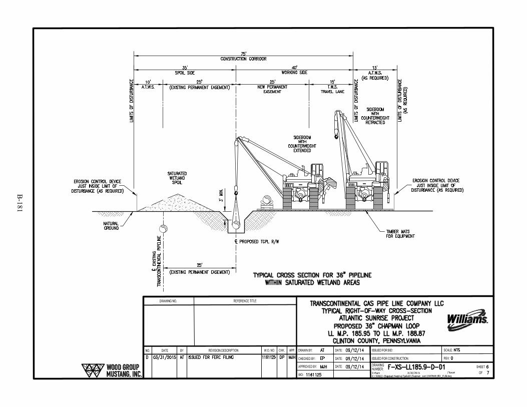
B-181
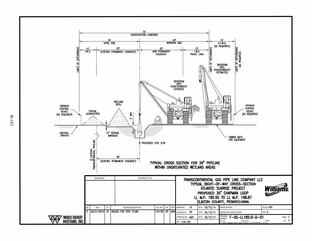
B-182
B-183

B-184
SKing
Text Box
This Page Intentionally Left Blank
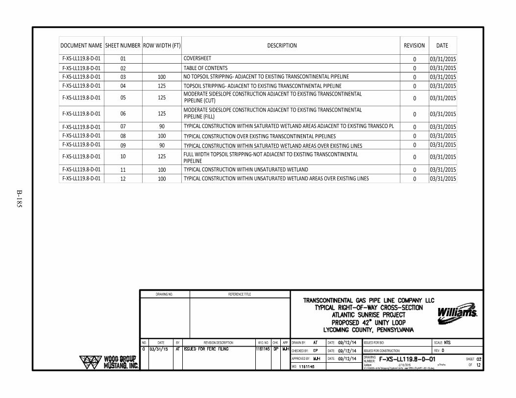
B-185

B-186
SKing
Text Box
This Page Intentionally Left Blank

B-187
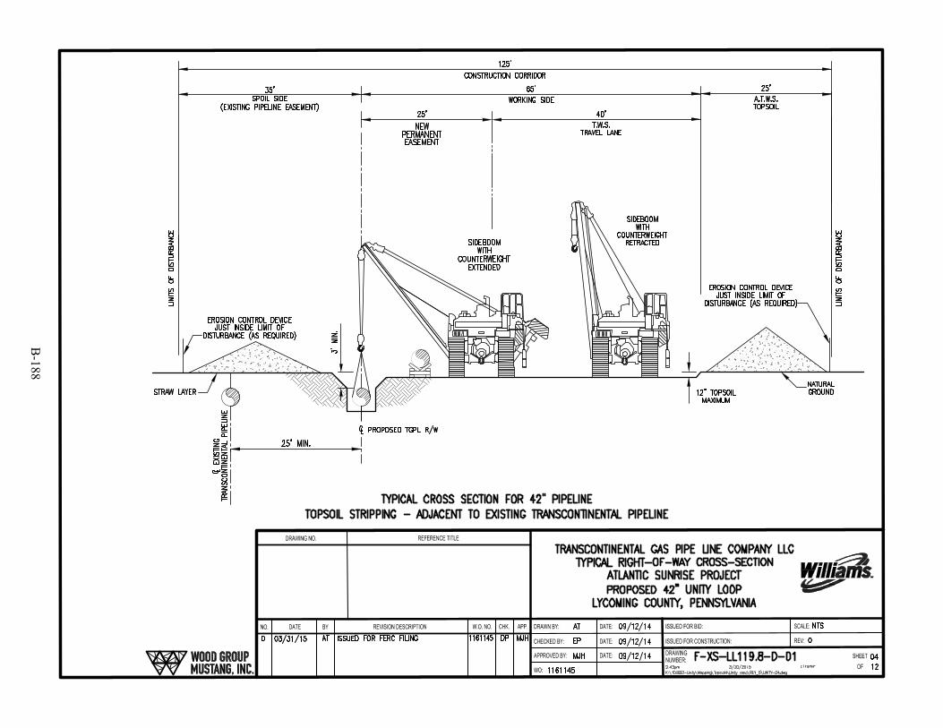
B-188
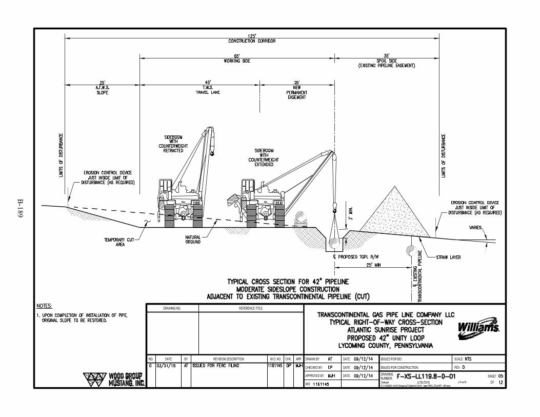
B-189
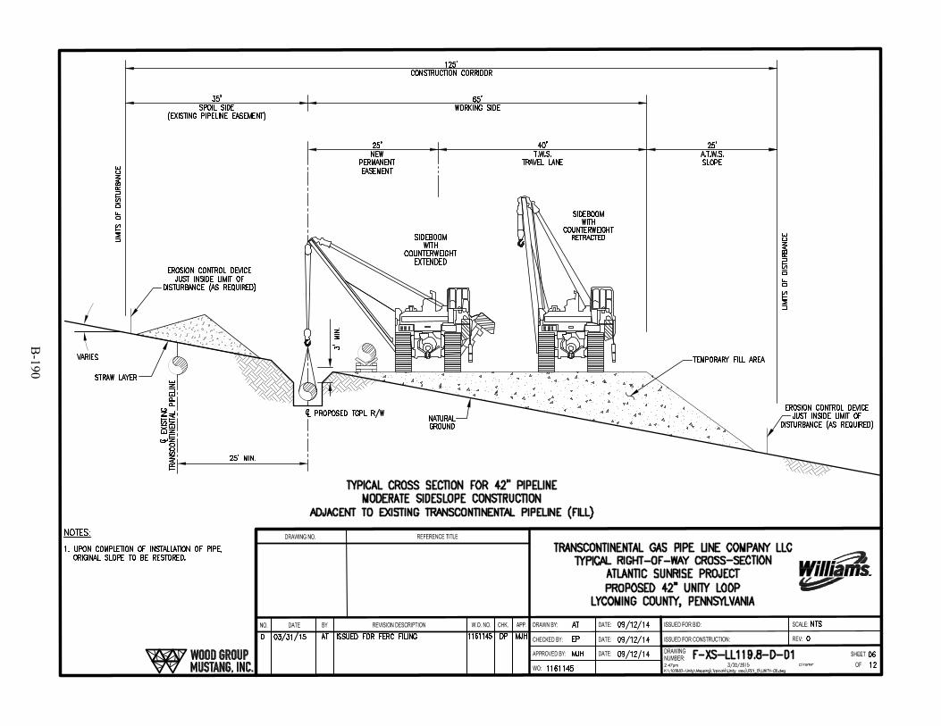
B-190
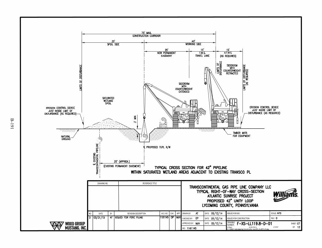
B-191
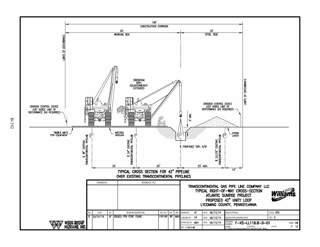
B-192

B-193
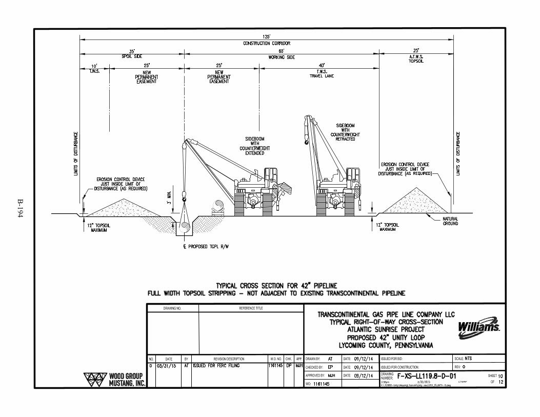
B-194
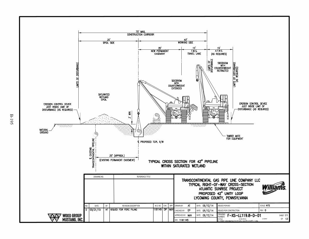
B-195
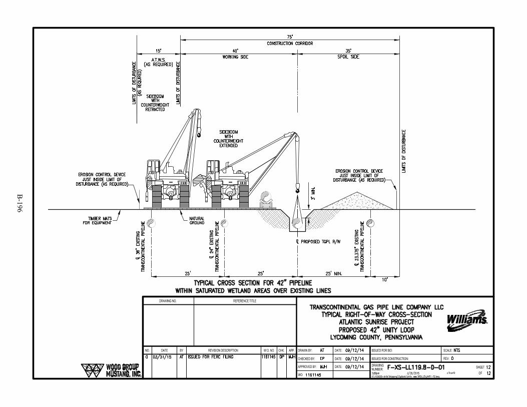
B-196
B-197

B-198
SKing
Text Box
This Page Intentionally Left Blank

B-199

B-200
SKing
Text Box
This Page Intentionally Left Blank

B-201
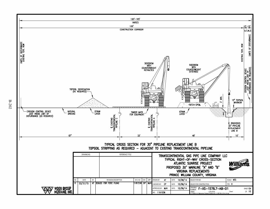
B-202

B-203
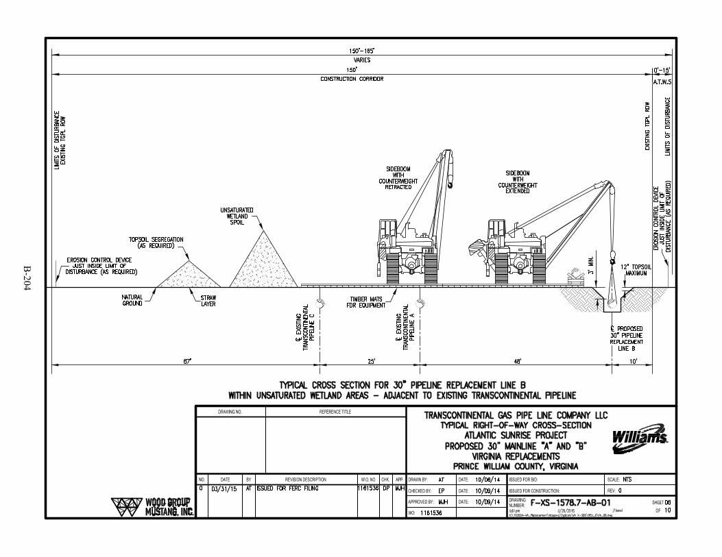
B-204

B-205
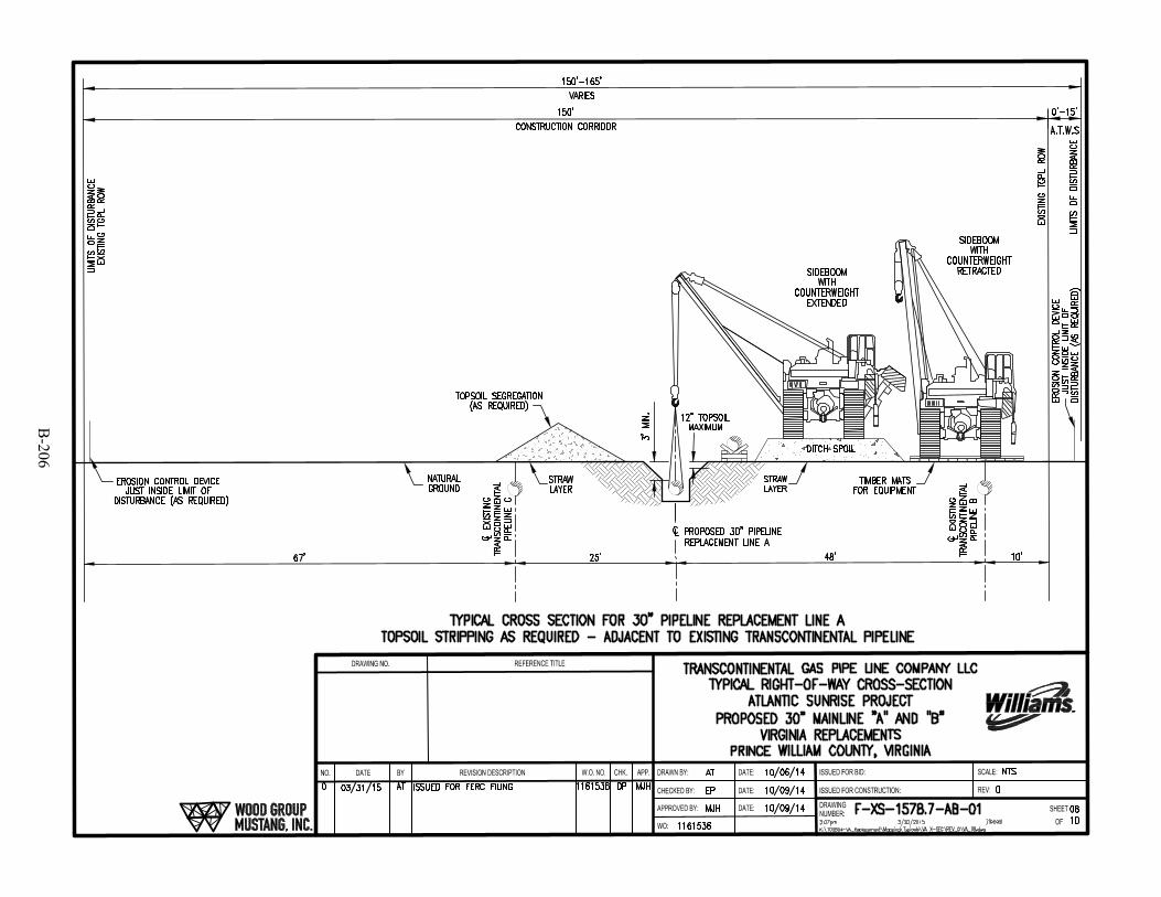
B-206
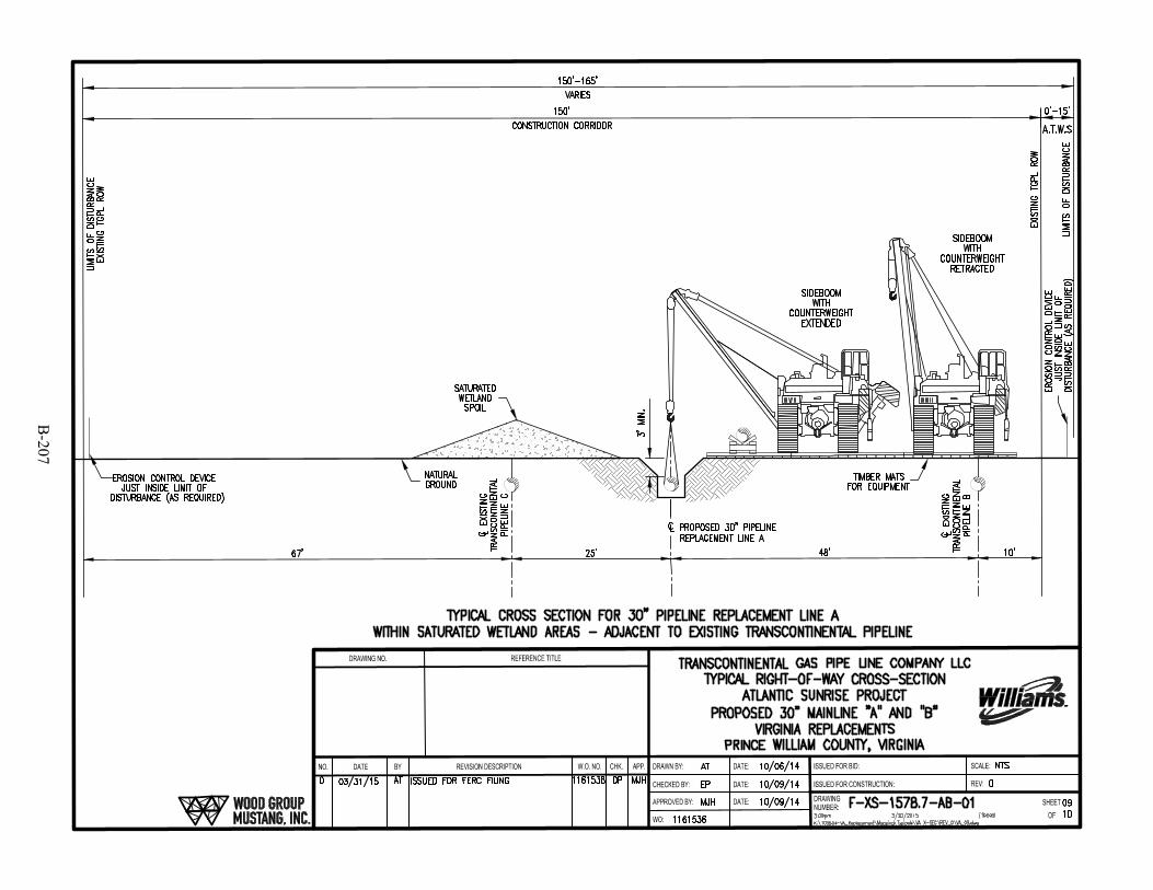
B-207
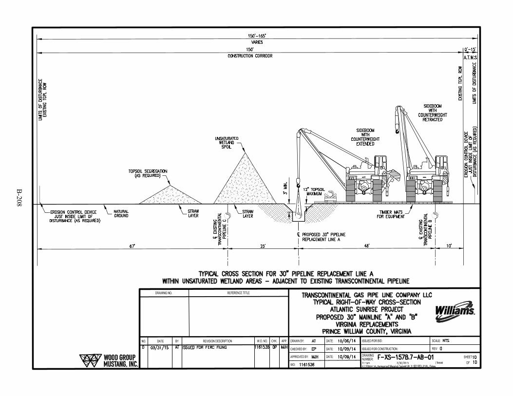
B-208

APPENDIX C
ADDITIONAL TEMPORARY WORKSPACE ASSOCIATED WITH
CONSTRUCTION OF THE ATLANTIC SUNRISE PROJECT

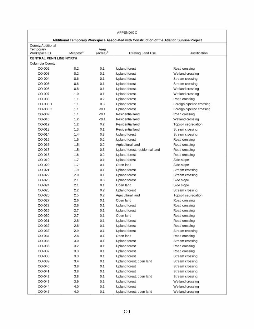
C-1
APPENDIX C
Additional Temporary Workspace Associated with Construction of the Atlantic Sunrise Project
County/Additional Temporary Workspace ID Milepost a
Area (acres) b Existing Land Use Justification
CENTRAL PENN LINE NORTH
Columbia County CO-002 0.2 0.1 Upland forest Road crossing
CO-003 0.2 0.1 Upland forest Wetland crossing CO-004 0.6 0.1 Upland forest Stream crossing CO-005 0.6 0.1 Upland forest Stream crossing CO-006 0.8 0.1 Upland forest Wetland crossing CO-007 1.0 0.1 Upland forest Wetland crossing CO-008 1.1 0.2 Upland forest Road crossing CO-008.1 1.1 0.3 Upland forest Foreign pipeline crossing CO-008.2 1.1 <0.1 Upland forest Foreign pipeline crossing CO-009 1.1 <0.1 Residential land Road crossing CO-010 1.2 <0.1 Residential land Wetland crossing CO-012 1.2 0.2 Residential land Topsoil segregation CO-013 1.3 0.1 Residential land Stream crossing CO-014 1.4 0.3 Upland forest Stream crossing CO-015 1.5 0.2 Upland forest Road crossing CO-016 1.5 0.2 Agricultural land Road crossing CO-017 1.5 0.3 Upland forest; residential land Road crossing CO-018 1.6 0.2 Upland forest Road crossing CO-019 1.7 0.1 Upland forest Side slope CO-020 1.7 0.1 Open land Side slope CO-021 1.9 0.1 Upland forest Stream crossing CO-022 2.0 0.1 Upland forest Stream crossing CO-023 2.1 0.3 Upland forest Side slope CO-024 2.1 0.1 Open land Side slope CO-025 2.2 0.2 Upland forest Stream crossing CO-026 2.5 0.2 Agricultural land Topsoil segregation CO-027 2.6 0.1 Open land Road crossing CO-028 2.6 0.1 Upland forest Road crossing CO-029 2.7 0.1 Upland forest Road crossing CO-030 2.7 0.1 Open land Road crossing CO-031 2.8 0.1 Upland forest Road crossing CO-032 2.8 0.1 Upland forest Road crossing CO-033 2.9 0.1 Upland forest Stream crossing CO-034 2.8 0.1 Open land Road crossing CO-035 3.0 0.1 Upland forest Stream crossing CO-036 3.2 0.1 Upland forest Road crossing CO-037 3.3 0.1 Upland forest Road crossing CO-038 3.3 0.1 Upland forest Stream crossing CO-039 3.4 0.1 Upland forest; open land Stream crossing CO-040 3.8 0.1 Upland forest Stream crossing CO-041 3.8 0.1 Upland forest Stream crossing CO-042 3.8 0.1 Upland forest; open land Stream crossing CO-043 3.9 0.1 Upland forest Wetland crossing CO-044 4.0 0.1 Upland forest Wetland crossing CO-045 4.0 0.1 Upland forest; open land Wetland crossing
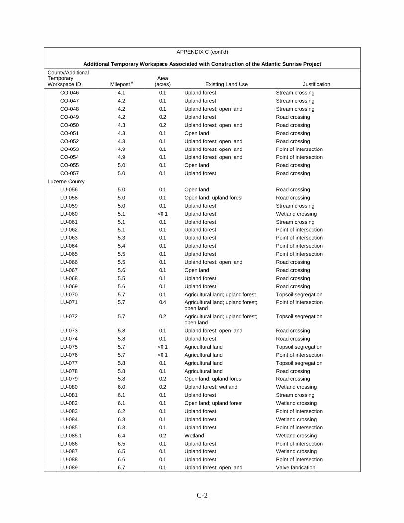
C-2
APPENDIX C (cont’d)
Additional Temporary Workspace Associated with Construction of the Atlantic Sunrise Project
County/Additional Temporary Workspace ID Milepost a
Area (acres) Existing Land Use Justification
CO-046 4.1 0.1 Upland forest Stream crossing CO-047 4.2 0.1 Upland forest Stream crossing CO-048 4.2 0.1 Upland forest; open land Stream crossing CO-049 4.2 0.2 Upland forest Road crossing CO-050 4.3 0.2 Upland forest; open land Road crossing CO-051 4.3 0.1 Open land Road crossing CO-052 4.3 0.1 Upland forest; open land Road crossing CO-053 4.9 0.1 Upland forest; open land Point of intersection CO-054 4.9 0.1 Upland forest; open land Point of intersection CO-055 5.0 0.1 Open land Road crossing CO-057 5.0 0.1 Upland forest Road crossing Luzerne County LU-056 5.0 0.1 Open land Road crossing LU-058 5.0 0.1 Open land; upland forest Road crossing LU-059 5.0 0.1 Upland forest Stream crossing LU-060 5.1 <0.1 Upland forest Wetland crossing LU-061 5.1 0.1 Upland forest Stream crossing LU-062 5.1 0.1 Upland forest Point of intersection LU-063 5.3 0.1 Upland forest Point of intersection LU-064 5.4 0.1 Upland forest Point of intersection LU-065 5.5 0.1 Upland forest Point of intersection LU-066 5.5 0.1 Upland forest; open land Road crossing LU-067 5.6 0.1 Open land Road crossing LU-068 5.5 0.1 Upland forest Road crossing LU-069 5.6 0.1 Upland forest Road crossing LU-070 5.7 0.1 Agricultural land; upland forest Topsoil segregation LU-071 5.7 0.4 Agricultural land; upland forest;
open land Point of intersection
LU-072 5.7 0.2 Agricultural land; upland forest; open land
Topsoil segregation
LU-073 5.8 0.1 Upland forest; open land Road crossing LU-074 5.8 0.1 Upland forest Road crossing LU-075 5.7 <0.1 Agricultural land Topsoil segregation LU-076 5.7 <0.1 Agricultural land Point of intersection LU-077 5.8 0.1 Agricultural land Topsoil segregation LU-078 5.8 0.1 Agricultural land Road crossing LU-079 5.8 0.2 Open land; upland forest Road crossing LU-080 6.0 0.2 Upland forest; wetland Wetland crossing LU-081 6.1 0.1 Upland forest Stream crossing LU-082 6.1 0.1 Open land; upland forest Wetland crossing LU-083 6.2 0.1 Upland forest Point of intersection LU-084 6.3 0.1 Upland forest Wetland crossing LU-085 6.3 0.1 Upland forest Point of intersection LU-085.1 6.4 0.2 Wetland Wetland crossing LU-086 6.5 0.1 Upland forest Point of intersection LU-087 6.5 0.1 Upland forest Wetland crossing LU-088 6.6 0.1 Upland forest Point of intersection LU-089 6.7 0.1 Upland forest; open land Valve fabrication

C-3
APPENDIX C (cont’d)
Additional Temporary Workspace Associated with Construction of the Atlantic Sunrise Project
County/Additional Temporary Workspace ID Milepost a
Area (acres) Existing Land Use Justification
LU-090 6.7 0.1 Upland forest Road crossing LU-091 6.7 0.1 Upland forest Road crossing LU-092 6.9 0.1 Upland forest Wetland crossing LU-093 7.0 0.1 Upland forest Wetland crossing LU-094 7.1 0.1 Upland forest Wetland crossing LU-095 7.2 0.2 Upland forest Wetland crossing LU-096 7.3 0.1 Upland forest Road crossing LU-097 7.3 0.1 Upland forest Stream crossing LU-098 7.3 0.1 Upland forest; open land Stream crossing LU-099 7.4 0.1 Upland forest Stream crossing LU-100 7.4 0.1 Open land Stream crossing LU-101 7.4 0.1 Upland forest Stream crossing LU-102 7.4 0.1 Open land Stream crossing LU-103 7.5 0.1 Upland forest Stream crossing LU-104 7.5 0.1 Open land Stream crossing LU-105 8.1 0.1 Upland forest Road crossing LU-106 8.1 0.1 Open land Road crossing LU-107 8.2 0.1 Open land Road crossing LU-108 8.2 0.1 Open land Road crossing LU-109 M-0056 0.6 0.1 Upland forest Point of intersection LU-110 M-0056 0.6 0.2 Upland forest Point of intersection LU-111 M-0056 0.7 0.3 Upland forest; open land Crossover LU-113 M-0056 0.74 <0.1 Upland forest Road crossing LU-114 9.1 0.1 Upland forest Road crossing LU-115 9.0 0.1 Upland forest Road crossing LU-116 9.1 0.1 Upland forest Stream crossing LU-117 9.2 0.1 Upland forest Stream crossing LU-118 9.2 0.2 Open land; upland forest Stream crossing LU-119 9.3 0.1 Upland forest Stream crossing LU-120 9.3 0.1 Open land; upland forest Stream crossing LU-121 9.3 0.1 Upland forest Stream crossing LU-122 9.6 0.2 Upland forest Point of intersection LU-123 9.6 0.4 Agricultural land; upland forest Crossover LU-124 9.6 0.1 Agricultural land; upland forest Topsoil segregation LU-125 9.7 0.1 Residential Road crossing LU-126 9.8 0.1 Agricultural land Road crossing LU-127 9.8 0.1 Agricultural land Point of intersection LU-128 9.8 0.1 Agricultural land Road crossing LU-129 9.8 0.2 Agricultural land Road crossing LU-130 9.8 0.2 Agricultural land Topsoil segregation LU-131 9.9 0.1 Agricultural land Road crossing LU-132 9.9 0.1 Agricultural land Road crossing LU-133 9.9 0.1 Agricultural land Topsoil segregation LU-134 10.1 0.1 Open land Stream crossing LU-135 10.2 0.1 Agricultural land Stream crossing LU-136 10.2 0.2 Wetland Wetland crossing LU-137 10.3 0.2 Upland forest Stream crossing
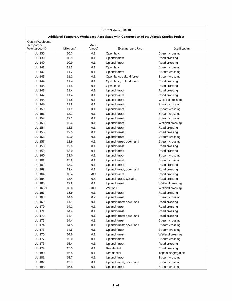
C-4
APPENDIX C (cont’d)
Additional Temporary Workspace Associated with Construction of the Atlantic Sunrise Project
County/Additional Temporary Workspace ID Milepost a
Area (acres) Existing Land Use Justification
LU-138 10.3 0.1 Open land Stream crossing LU-139 10.9 0.1 Upland forest Road crossing LU-140 10.9 0.1 Upland forest Road crossing LU-141 11.2 0.1 Open land Stream crossing LU-142 11.2 0.1 Upland forest Stream crossing LU-143 11.2 0.1 Open land; upland forest Stream crossing LU-144 11.4 0.1 Open land; upland forest Road crossing LU-145 11.4 0.1 Open land Road crossing LU-146 11.4 0.1 Upland forest Road crossing LU-147 11.4 0.1 Upland forest Road crossing LU-148 11.5 0.1 Upland forest Wetland crossing LU-149 11.8 0.1 Upland forest Stream crossing LU-150 11.9 0.1 Upland forest Stream crossing LU-151 12.1 0.1 Upland forest Stream crossing LU-152 12.2 0.1 Upland forest Stream crossing LU-153 12.3 0.1 Upland forest Wetland crossing LU-154 12.5 0.1 Upland forest Road crossing LU-155 12.5 0.1 Upland forest Road crossing LU-156 12.9 0.1 Upland forest Stream crossing LU-157 12.9 0.1 Upland forest; open land Stream crossing LU-158 12.9 0.1 Upland forest Road crossing LU-159 13.0 0.1 Upland forest Road crossing LU-160 13.0 0.1 Upland forest Stream crossing LU-161 13.2 0.1 Upland forest Stream crossing LU-162 13.3 0.1 Upland forest Road crossing LU-163 13.4 0.1 Upland forest; open land Road crossing LU-164 13.4 <0.1 Upland forest Road crossing LU-165 13.4 0.3 Upland forest; wetland Road crossing LU-166 13.8 0.1 Upland forest Wetland crossing LU-166.1 13.8 <0.1 Wetland Wetland crossing LU-167 13.9 0.1 Upland forest Road crossing LU-168 14.0 0.2 Upland forest Stream crossing LU-169 14.1 0.1 Upland forest; open land Road crossing LU-170 14.2 0.1 Upland forest Road crossing LU-171 14.4 0.1 Upland forest Road crossing LU-172 14.4 0.1 Upland forest; open land Road crossing LU-173 14.4 0.1 Upland forest Stream crossing LU-174 14.5 0.1 Upland forest; open land Stream crossing LU-175 14.5 0.1 Upland forest Stream crossing LU-176 14.9 0.1 Upland forest Wetland crossing LU-177 15.0 0.1 Upland forest Stream crossing LU-178 15.4 0.1 Upland forest Road crossing LU-179 15.5 0.1 Residential Road crossing LU-180 15.5 0.1 Residential Topsoil segregation LU-181 15.7 0.1 Upland forest Stream crossing LU-182 15.7 0.1 Upland forest; open land Stream crossing LU-183 15.8 0.1 Upland forest Stream crossing
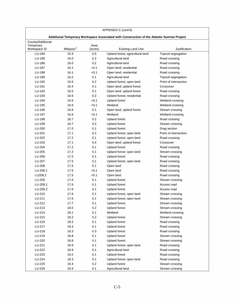
C-5
APPENDIX C (cont’d)
Additional Temporary Workspace Associated with Construction of the Atlantic Sunrise Project
County/Additional Temporary Workspace ID Milepost a
Area (acres) Existing Land Use Justification
LU-184 15.9 0.5 Upland forest; agricultural land Topsoil segregation LU-185 16.0 0.2 Agricultural land Road crossing LU-186 16.0 0.2 Agricultural land Road crossing LU-187 16.1 <0.1 Open land; residential Road crossing LU-188 16.1 <0.1 Open land; residential Road crossing LU-189 16.2 0.1 Agricultural land Topsoil segregation LU-190 16.5 0.2 Upland forest; open land Point of intersection LU-191 16.4 0.1 Open land; upland forest Crossover LU-192 16.5 0.1 Open land; upland forest Road crossing LU-193 16.6 0.2 Upland forest; residential Road crossing LU-194 16.6 <0.1 Upland forest Wetland crossing LU-195 16.6 <0.1 Wetland Wetland crossing LU-196 16.6 0.1 Open land; upland forest Stream crossing LU-197 16.6 <0.1 Wetland Wetland crossing LU-198 16.7 0.2 Upland forest Road crossing LU-199 16.7 0.2 Upland forest Stream crossing LU-200 17.0 0.1 Upland forest Drag section LU-201 17.1 0.2 Upland forest; open land Point of intersection LU-202 17.2 0.1 Upland forest; open land Road crossing LU-203 17.1 0.4 Open land; upland forest Crossover LU-204 17.2 0.1 Upland forest Road crossing LU-205 17.2 0.1 Upland forest; open land Stream crossing LU-206 17.5 0.1 Upland forest Road crossing LU-207 17.5 0.1 Upland forest; open land Road crossing LU-208 17.5 0.1 Open land Road crossing LU-208.1 17.5 <0.1 Open land Road crossing LU208.2 17.5 <0.1 Open land Road crossing LU-209 17.6 0.1 Upland forest Stream crossing LU-209.1 17.6 0.1 Upland forest Access road LU-209.2 17.6 0.1 Upland forest Access road LU-210 17.6 0.1 Upland forest; open land Stream crossing LU-211 17.6 0.1 Upland forest; open land Stream crossing LU-212 17.7 0.1 Upland forest Stream crossing LU-213 18.0 0.2 Upland forest Stream crossing LU-214 18.1 0.1 Wetland Wetland crossing LU-215 18.2 0.2 Upland forest Stream crossing LU-216 18.2 0.1 Upland forest Road crossing LU-217 18.3 0.1 Upland forest Road crossing LU-218 18.3 0.3 Upland forest Road crossing LU-219 18.8 0.1 Upland forest Stream crossing LU-220 18.8 0.1 Upland forest Stream crossing LU-221 18.9 0.1 Upland forest; open land Road crossing LU-222 18.9 0.1 Agricultural land Road crossing LU-223 19.2 0.1 Upland forest Road crossing LU-224 19.3 0.1 Upland forest; open land Road crossing LU-225 19.4 0.2 Upland forest Stream crossing LU-226 19.4 0.1 Agricultural land Stream crossing
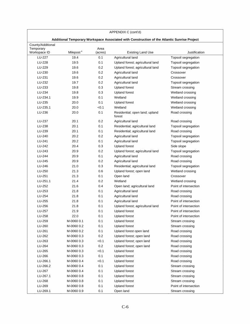
C-6
APPENDIX C (cont’d)
Additional Temporary Workspace Associated with Construction of the Atlantic Sunrise Project
County/Additional Temporary Workspace ID Milepost a
Area (acres) Existing Land Use Justification
LU-227 19.4 0.1 Agricultural land Topsoil segregation LU-228 19.5 0.1 Upland forest; agricultural land Topsoil segregation LU-229 19.6 0.2 Upland forest; agricultural land Topsoil segregation LU-230 19.6 0.2 Agricultural land Crossover LU-231 19.6 0.2 Agricultural land Crossover LU-232 19.7 0.2 Agricultural land Topsoil segregation LU-233 19.8 0.3 Upland forest Stream crossing LU-234 19.8 0.3 Upland forest Wetland crossing LU-234.1 19.9 0.1 Wetland Wetland crossing LU-235 20.0 0.1 Upland forest Wetland crossing LU-235.1 20.0 <0.1 Wetland Wetland crossing LU-236 20.0 0.1 Residential; open land; upland
forest Road crossing
LU-237 20.1 0.2 Agricultural land Road crossing LU-238 20.1 0.1 Residential; agricultural land Topsoil segregation LU-239 20.1 0.1 Residential; agricultural land Road crossing LU-240 20.2 0.2 Agricultural land Topsoil segregation LU-241 20.2 0.1 Agricultural land Topsoil segregation LU-242 20.4 0.3 Upland forest Side slope LU-243 20.9 0.2 Upland forest; agricultural land Topsoil segregation LU-244 20.9 0.1 Agricultural land Road crossing LU-245 20.9 0.2 Agricultural land Road crossing LU-246 21.0 0.3 Residential; agricultural land Topsoil segregation LU-250 21.3 0.6 Upland forest; open land Wetland crossing LU-251 21.3 0.1 Open land Crossover LU-251.1 21.4 0.2 Wetland Wetland crossing LU-252 21.6 0.4 Open land; agricultural land Point of intersection LU-253 21.8 0.1 Agricultural land Road crossing LU-254 21.8 0.1 Agricultural land Road crossing LU-255 21.8 0.1 Agricultural land Point of intersection LU-256 21.8 0.1 Upland forest; agricultural land Point of intersection LU-257 21.9 0.1 Upland forest Point of intersection LU-258 22.0 0.1 Upland forest Point of intersection LU-259 M-0060 0.1 0.1 Upland forest Stream crossing LU-260 M-0060 0.2 0.1 Upland forest Stream crossing LU-261 M-0060 0.2 0.1 Upland forest open land Road crossing LU-262 M-0060 0.3 0.2 Upland forest; open land Road crossing LU-263 M-0060 0.3 <0.1 Upland forest; open land Road crossing LU-264 M-0060 0.3 0.2 Upland forest; open land Road crossing LU-265 M-0060 0.3 <0.1 Upland forest Road crossing LU-266 M-0060 0.3 0.1 Upland forest Road crossing LU-266.1 M-0060 0.4 <0.1 Upland forest Road crossing LU-266.2 M-0060 0.4 0.1 Upland forest Stream crossing LU-267 M-0060 0.4 0.1 Upland forest Stream crossing LU-267.1 M-0060 0.8 0.1 Upland forest Stream crossing LU-268 M-0060 0.8 0.1 Upland forest Stream crossing LU-269 M-0060 0.8 0.1 Upland forest Point of intersection LU-269.1 M-0060 0.9 0.1 Open land Stream crossing
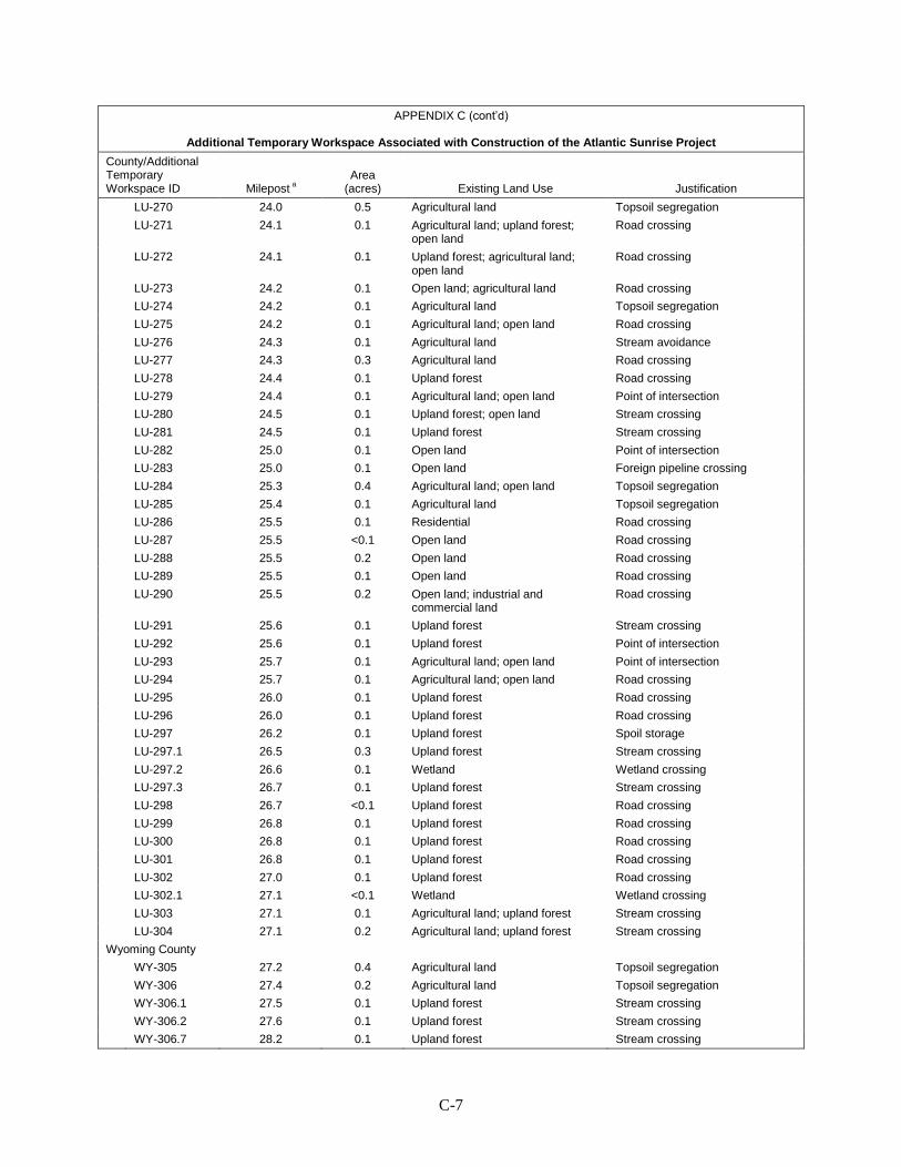
C-7
APPENDIX C (cont’d)
Additional Temporary Workspace Associated with Construction of the Atlantic Sunrise Project
County/Additional Temporary Workspace ID Milepost a
Area (acres) Existing Land Use Justification
LU-270 24.0 0.5 Agricultural land Topsoil segregation LU-271 24.1 0.1 Agricultural land; upland forest;
open land Road crossing
LU-272 24.1 0.1 Upland forest; agricultural land; open land
Road crossing
LU-273 24.2 0.1 Open land; agricultural land Road crossing LU-274 24.2 0.1 Agricultural land Topsoil segregation LU-275 24.2 0.1 Agricultural land; open land Road crossing LU-276 24.3 0.1 Agricultural land Stream avoidance LU-277 24.3 0.3 Agricultural land Road crossing LU-278 24.4 0.1 Upland forest Road crossing LU-279 24.4 0.1 Agricultural land; open land Point of intersection LU-280 24.5 0.1 Upland forest; open land Stream crossing LU-281 24.5 0.1 Upland forest Stream crossing LU-282 25.0 0.1 Open land Point of intersection LU-283 25.0 0.1 Open land Foreign pipeline crossing LU-284 25.3 0.4 Agricultural land; open land Topsoil segregation LU-285 25.4 0.1 Agricultural land Topsoil segregation LU-286 25.5 0.1 Residential Road crossing LU-287 25.5 <0.1 Open land Road crossing LU-288 25.5 0.2 Open land Road crossing LU-289 25.5 0.1 Open land Road crossing LU-290 25.5 0.2 Open land; industrial and
commercial land Road crossing
LU-291 25.6 0.1 Upland forest Stream crossing LU-292 25.6 0.1 Upland forest Point of intersection LU-293 25.7 0.1 Agricultural land; open land Point of intersection LU-294 25.7 0.1 Agricultural land; open land Road crossing LU-295 26.0 0.1 Upland forest Road crossing LU-296 26.0 0.1 Upland forest Road crossing LU-297 26.2 0.1 Upland forest Spoil storage LU-297.1 26.5 0.3 Upland forest Stream crossing LU-297.2 26.6 0.1 Wetland Wetland crossing LU-297.3 26.7 0.1 Upland forest Stream crossing LU-298 26.7 <0.1 Upland forest Road crossing LU-299 26.8 0.1 Upland forest Road crossing LU-300 26.8 0.1 Upland forest Road crossing LU-301 26.8 0.1 Upland forest Road crossing LU-302 27.0 0.1 Upland forest Road crossing LU-302.1 27.1 <0.1 Wetland Wetland crossing LU-303 27.1 0.1 Agricultural land; upland forest Stream crossing LU-304 27.1 0.2 Agricultural land; upland forest Stream crossing Wyoming County WY-305 27.2 0.4 Agricultural land Topsoil segregation WY-306 27.4 0.2 Agricultural land Topsoil segregation WY-306.1 27.5 0.1 Upland forest Stream crossing WY-306.2 27.6 0.1 Upland forest Stream crossing WY-306.7 28.2 0.1 Upland forest Stream crossing
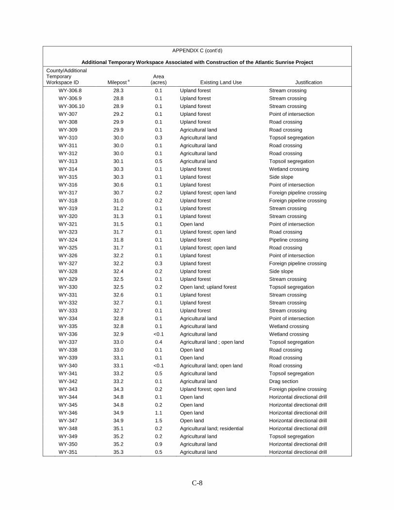
C-8
APPENDIX C (cont’d)
Additional Temporary Workspace Associated with Construction of the Atlantic Sunrise Project
County/Additional Temporary Workspace ID Milepost a
Area (acres) Existing Land Use Justification
WY-306.8 28.3 0.1 Upland forest Stream crossing WY-306.9 28.8 0.1 Upland forest Stream crossing WY-306.10 28.9 0.1 Upland forest Stream crossing WY-307 29.2 0.1 Upland forest Point of intersection WY-308 29.9 0.1 Upland forest Road crossing WY-309 29.9 0.1 Agricultural land Road crossing WY-310 30.0 0.3 Agricultural land Topsoil segregation WY-311 30.0 0.1 Agricultural land Road crossing WY-312 30.0 0.1 Agricultural land Road crossing WY-313 30.1 0.5 Agricultural land Topsoil segregation WY-314 30.3 0.1 Upland forest Wetland crossing WY-315 30.3 0.1 Upland forest Side slope WY-316 30.6 0.1 Upland forest Point of intersection WY-317 30.7 0.2 Upland forest; open land Foreign pipeline crossing WY-318 31.0 0.2 Upland forest Foreign pipeline crossing WY-319 31.2 0.1 Upland forest Stream crossing WY-320 31.3 0.1 Upland forest Stream crossing WY-321 31.5 0.1 Open land Point of intersection WY-323 31.7 0.1 Upland forest; open land Road crossing WY-324 31.8 0.1 Upland forest Pipeline crossing WY-325 31.7 0.1 Upland forest; open land Road crossing WY-326 32.2 0.1 Upland forest Point of intersection WY-327 32.2 0.3 Upland forest Foreign pipeline crossing WY-328 32.4 0.2 Upland forest Side slope WY-329 32.5 0.1 Upland forest Stream crossing WY-330 32.5 0.2 Open land; upland forest Topsoil segregation WY-331 32.6 0.1 Upland forest Stream crossing WY-332 32.7 0.1 Upland forest Stream crossing WY-333 32.7 0.1 Upland forest Stream crossing WY-334 32.8 0.1 Agricultural land Point of intersection WY-335 32.8 0.1 Agricultural land Wetland crossing WY-336 32.9 <0.1 Agricultural land Wetland crossing WY-337 33.0 0.4 Agricultural land ; open land Topsoil segregation WY-338 33.0 0.1 Open land Road crossing WY-339 33.1 0.1 Open land Road crossing WY-340 33.1 <0.1 Agricultural land; open land Road crossing WY-341 33.2 0.5 Agricultural land Topsoil segregation WY-342 33.2 0.1 Agricultural land Drag section WY-343 34.3 0.2 Upland forest; open land Foreign pipeline crossing WY-344 34.8 0.1 Open land Horizontal directional drill WY-345 34.8 0.2 Open land Horizontal directional drill WY-346 34.9 1.1 Open land Horizontal directional drill WY-347 34.9 1.5 Open land Horizontal directional drill WY-348 35.1 0.2 Agricultural land; residential Horizontal directional drill WY-349 35.2 0.2 Agricultural land Topsoil segregation WY-350 35.2 0.9 Agricultural land Horizontal directional drill WY-351 35.3 0.5 Agricultural land Horizontal directional drill
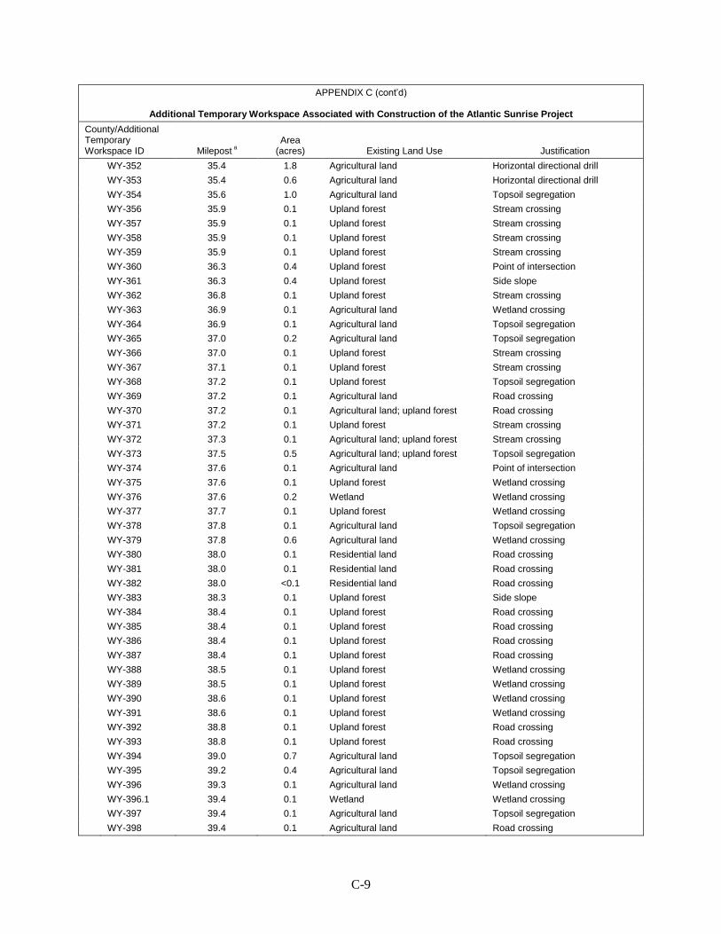
C-9
APPENDIX C (cont’d)
Additional Temporary Workspace Associated with Construction of the Atlantic Sunrise Project
County/Additional Temporary Workspace ID Milepost a
Area (acres) Existing Land Use Justification
WY-352 35.4 1.8 Agricultural land Horizontal directional drill WY-353 35.4 0.6 Agricultural land Horizontal directional drill WY-354 35.6 1.0 Agricultural land Topsoil segregation WY-356 35.9 0.1 Upland forest Stream crossing WY-357 35.9 0.1 Upland forest Stream crossing WY-358 35.9 0.1 Upland forest Stream crossing WY-359 35.9 0.1 Upland forest Stream crossing WY-360 36.3 0.4 Upland forest Point of intersection WY-361 36.3 0.4 Upland forest Side slope WY-362 36.8 0.1 Upland forest Stream crossing WY-363 36.9 0.1 Agricultural land Wetland crossing WY-364 36.9 0.1 Agricultural land Topsoil segregation WY-365 37.0 0.2 Agricultural land Topsoil segregation WY-366 37.0 0.1 Upland forest Stream crossing WY-367 37.1 0.1 Upland forest Stream crossing WY-368 37.2 0.1 Upland forest Topsoil segregation WY-369 37.2 0.1 Agricultural land Road crossing WY-370 37.2 0.1 Agricultural land; upland forest Road crossing WY-371 37.2 0.1 Upland forest Stream crossing WY-372 37.3 0.1 Agricultural land; upland forest Stream crossing WY-373 37.5 0.5 Agricultural land; upland forest Topsoil segregation WY-374 37.6 0.1 Agricultural land Point of intersection WY-375 37.6 0.1 Upland forest Wetland crossing WY-376 37.6 0.2 Wetland Wetland crossing WY-377 37.7 0.1 Upland forest Wetland crossing WY-378 37.8 0.1 Agricultural land Topsoil segregation WY-379 37.8 0.6 Agricultural land Wetland crossing WY-380 38.0 0.1 Residential land Road crossing WY-381 38.0 0.1 Residential land Road crossing WY-382 38.0 <0.1 Residential land Road crossing WY-383 38.3 0.1 Upland forest Side slope WY-384 38.4 0.1 Upland forest Road crossing WY-385 38.4 0.1 Upland forest Road crossing WY-386 38.4 0.1 Upland forest Road crossing WY-387 38.4 0.1 Upland forest Road crossing WY-388 38.5 0.1 Upland forest Wetland crossing WY-389 38.5 0.1 Upland forest Wetland crossing WY-390 38.6 0.1 Upland forest Wetland crossing WY-391 38.6 0.1 Upland forest Wetland crossing WY-392 38.8 0.1 Upland forest Road crossing WY-393 38.8 0.1 Upland forest Road crossing WY-394 39.0 0.7 Agricultural land Topsoil segregation WY-395 39.2 0.4 Agricultural land Topsoil segregation WY-396 39.3 0.1 Agricultural land Wetland crossing WY-396.1 39.4 0.1 Wetland Wetland crossing WY-397 39.4 0.1 Agricultural land Topsoil segregation WY-398 39.4 0.1 Agricultural land Road crossing

C-10
APPENDIX C (cont’d)
Additional Temporary Workspace Associated with Construction of the Atlantic Sunrise Project
County/Additional Temporary Workspace ID Milepost a
Area (acres) Existing Land Use Justification
WY-399 39.5 0.1 Agricultural land Road crossing WY-400 39.6 0.6 Agricultural land Topsoil segregation WY-401 39.8 0.4 Agricultural land Topsoil segregation WY-402 39.9 <0.1 Agricultural land Road crossing WY-403 39.9 0.1 Agricultural land; open land Road crossing WY-404 39.9 0.1 Agricultural land; open land Road crossing WY-405 40.1 0.1 Agricultural land Stream crossing WY-406 40.1 0.1 Agricultural land Topsoil segregation WY-407 40.3 0.2 Agricultural land Topsoil segregation WY-408 40.5 0.2 Agricultural land Topsoil segregation WY-409 40.6 0.1 Agricultural land Point of intersection WY-410 40.6 0.1 Agricultural land Topsoil segregation WY-411 40.7 0.2 Agricultural land; upland forest Topsoil segregation WY-412 40.9 0.1 Upland forest Road crossing WY-413 40.9 <0.1 Upland forest Road crossing WY-414 41.0 0.1 Upland forest Wetland crossing WY-415 41.0 0.1 Upland forest Point of intersection WY-416 41.7 0.2 Upland forest Side slope WY-416.1 42.0 0.1 Upland forest Point of intersection WY-416.2 42.1 0.1 Upland forest Point of intersection WY-417 M-0054 0.0 0.3 Upland forest Road crossing WY-418 M-0054 0.0 0.2 Upland forest Road crossing WY-419 M-0054 0.1 0.1 Upland forest Road crossing WY-420 M-0054 0.1 0.1 Wetland Wetland crossing WY-421 M-0054 0.1 0.1 Agricultural land; upland forest Stream crossing WY-422 M-0054 0.3 0.5 Agricultural land Topsoil segregation WY-422.1 M-0054 0.4 <0.1 Upland forest Point of intersection WY-423 43.6 0.1 Upland forest Point of intersection WY-424 43.7 0.2 Upland forest Stream crossing WY-425 43.7 0.1 Upland forest Stream crossing WY-426 43.7 0.6 Agricultural land Stream crossing WY-427 43.7 0.1 Agricultural land Topsoil segregation WY-428 43.8 0.1 Agricultural land Stream crossing WY-429 43.8 0.1 Agricultural land Road crossing WY-430 43.8 0.2 Agricultural land Topsoil segregation WY-431 43.8 0.3 Agricultural land Road crossing WY-432 43.9 0.1 Agricultural land Road crossing WY-433 43.9 <0.1 Wetland Wetland crossing WY-434 43.9 0.4 Upland forest Road crossing WY-435 43.9 0.2 Upland forest Road crossing WY-436 44.2 0.8 Agricultural land; upland forest Topsoil segregation WY-436.1 44.2 0.1 Agricultural land Foreign pipeline crossing WY-436.2 44.3 0.1 Agricultural land Foreign pipeline crossing WY-436.3 44.3 0.1 Agricultural land; upland forest Foreign pipeline crossing WY-437 44.4 0.1 Agricultural land; upland forest Foreign pipeline crossing WY-438 44.4 <0.1 Agricultural land Road crossing WY-439 44.4 0.4 Agricultural land Road crossing
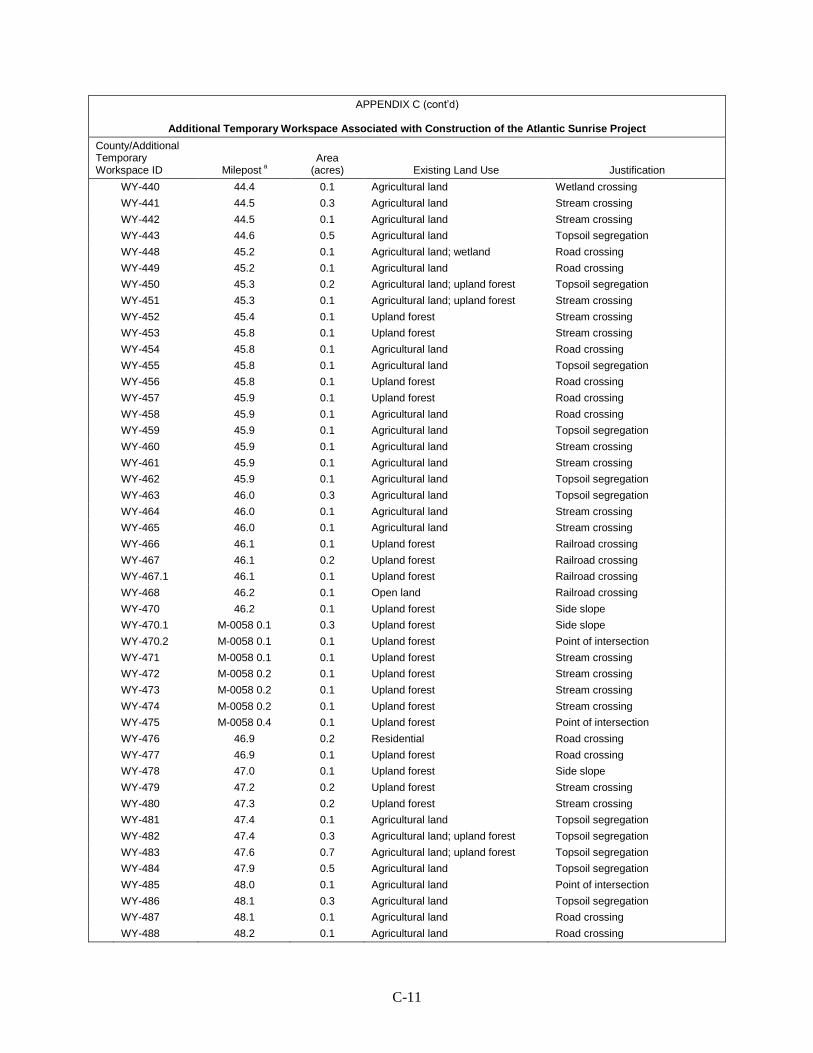
C-11
APPENDIX C (cont’d)
Additional Temporary Workspace Associated with Construction of the Atlantic Sunrise Project
County/Additional Temporary Workspace ID Milepost a
Area (acres) Existing Land Use Justification
WY-440 44.4 0.1 Agricultural land Wetland crossing WY-441 44.5 0.3 Agricultural land Stream crossing WY-442 44.5 0.1 Agricultural land Stream crossing WY-443 44.6 0.5 Agricultural land Topsoil segregation WY-448 45.2 0.1 Agricultural land; wetland Road crossing WY-449 45.2 0.1 Agricultural land Road crossing WY-450 45.3 0.2 Agricultural land; upland forest Topsoil segregation WY-451 45.3 0.1 Agricultural land; upland forest Stream crossing WY-452 45.4 0.1 Upland forest Stream crossing WY-453 45.8 0.1 Upland forest Stream crossing WY-454 45.8 0.1 Agricultural land Road crossing WY-455 45.8 0.1 Agricultural land Topsoil segregation WY-456 45.8 0.1 Upland forest Road crossing WY-457 45.9 0.1 Upland forest Road crossing WY-458 45.9 0.1 Agricultural land Road crossing WY-459 45.9 0.1 Agricultural land Topsoil segregation WY-460 45.9 0.1 Agricultural land Stream crossing WY-461 45.9 0.1 Agricultural land Stream crossing WY-462 45.9 0.1 Agricultural land Topsoil segregation WY-463 46.0 0.3 Agricultural land Topsoil segregation WY-464 46.0 0.1 Agricultural land Stream crossing WY-465 46.0 0.1 Agricultural land Stream crossing WY-466 46.1 0.1 Upland forest Railroad crossing WY-467 46.1 0.2 Upland forest Railroad crossing WY-467.1 46.1 0.1 Upland forest Railroad crossing WY-468 46.2 0.1 Open land Railroad crossing WY-470 46.2 0.1 Upland forest Side slope WY-470.1 M-0058 0.1 0.3 Upland forest Side slope WY-470.2 M-0058 0.1 0.1 Upland forest Point of intersection WY-471 M-0058 0.1 0.1 Upland forest Stream crossing WY-472 M-0058 0.2 0.1 Upland forest Stream crossing WY-473 M-0058 0.2 0.1 Upland forest Stream crossing WY-474 M-0058 0.2 0.1 Upland forest Stream crossing WY-475 M-0058 0.4 0.1 Upland forest Point of intersection WY-476 46.9 0.2 Residential Road crossing WY-477 46.9 0.1 Upland forest Road crossing WY-478 47.0 0.1 Upland forest Side slope WY-479 47.2 0.2 Upland forest Stream crossing WY-480 47.3 0.2 Upland forest Stream crossing WY-481 47.4 0.1 Agricultural land Topsoil segregation WY-482 47.4 0.3 Agricultural land; upland forest Topsoil segregation WY-483 47.6 0.7 Agricultural land; upland forest Topsoil segregation WY-484 47.9 0.5 Agricultural land Topsoil segregation WY-485 48.0 0.1 Agricultural land Point of intersection WY-486 48.1 0.3 Agricultural land Topsoil segregation WY-487 48.1 0.1 Agricultural land Road crossing WY-488 48.2 0.1 Agricultural land Road crossing
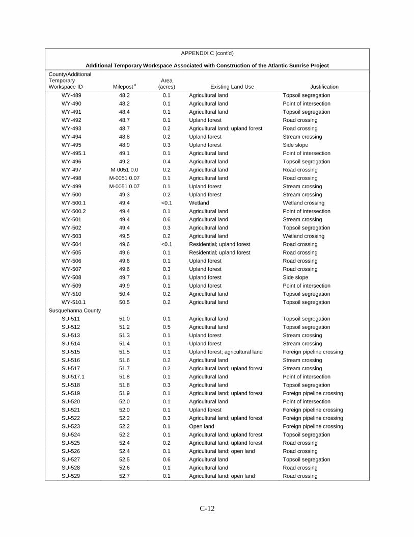
C-12
APPENDIX C (cont’d)
Additional Temporary Workspace Associated with Construction of the Atlantic Sunrise Project
County/Additional Temporary Workspace ID Milepost a
Area (acres) Existing Land Use Justification
WY-489 48.2 0.1 Agricultural land Topsoil segregation WY-490 48.2 0.1 Agricultural land Point of intersection WY-491 48.4 0.1 Agricultural land Topsoil segregation WY-492 48.7 0.1 Upland forest Road crossing WY-493 48.7 0.2 Agricultural land; upland forest Road crossing WY-494 48.8 0.2 Upland forest Stream crossing WY-495 48.9 0.3 Upland forest Side slope WY-495.1 49.1 0.1 Agricultural land Point of intersection WY-496 49.2 0.4 Agricultural land Topsoil segregation WY-497 M-0051 0.0 0.2 Agricultural land Road crossing WY-498 M-0051 0.07 0.1 Agricultural land Road crossing WY-499 M-0051 0.07 0.1 Upland forest Stream crossing WY-500 49.3 0.2 Upland forest Stream crossing WY-500.1 49.4 <0.1 Wetland Wetland crossing WY-500.2 49.4 0.1 Agricultural land Point of intersection WY-501 49.4 0.6 Agricultural land Stream crossing WY-502 49.4 0.3 Agricultural land Topsoil segregation WY-503 49.5 0.2 Agricultural land Wetland crossing WY-504 49.6 <0.1 Residential; upland forest Road crossing WY-505 49.6 0.1 Residential; upland forest Road crossing WY-506 49.6 0.1 Upland forest Road crossing WY-507 49.6 0.3 Upland forest Road crossing WY-508 49.7 0.1 Upland forest Side slope WY-509 49.9 0.1 Upland forest Point of intersection WY-510 50.4 0.2 Agricultural land Topsoil segregation WY-510.1 50.5 0.2 Agricultural land Topsoil segregation Susquehanna County SU-511 51.0 0.1 Agricultural land Topsoil segregation SU-512 51.2 0.5 Agricultural land Topsoil segregation SU-513 51.3 0.1 Upland forest Stream crossing SU-514 51.4 0.1 Upland forest Stream crossing SU-515 51.5 0.1 Upland forest; agricultural land Foreign pipeline crossing SU-516 51.6 0.2 Agricultural land Stream crossing SU-517 51.7 0.2 Agricultural land; upland forest Stream crossing SU-517.1 51.8 0.1 Agricultural land Point of intersection SU-518 51.8 0.3 Agricultural land Topsoil segregation SU-519 51.9 0.1 Agricultural land; upland forest Foreign pipeline crossing SU-520 52.0 0.1 Agricultural land Point of intersection SU-521 52.0 0.1 Upland forest Foreign pipeline crossing SU-522 52.2 0.3 Agricultural land; upland forest Foreign pipeline crossing SU-523 52.2 0.1 Open land Foreign pipeline crossing SU-524 52.2 0.1 Agricultural land; upland forest Topsoil segregation SU-525 52.4 0.2 Agricultural land; upland forest Road crossing SU-526 52.4 0.1 Agricultural land; open land Road crossing SU-527 52.5 0.6 Agricultural land Topsoil segregation SU-528 52.6 0.1 Agricultural land Road crossing SU-529 52.7 0.1 Agricultural land; open land Road crossing
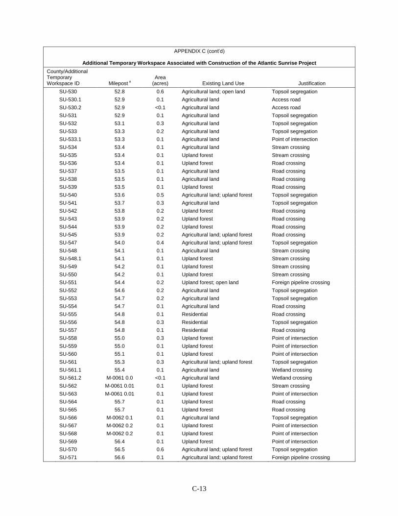
C-13
APPENDIX C (cont’d)
Additional Temporary Workspace Associated with Construction of the Atlantic Sunrise Project
County/Additional Temporary Workspace ID Milepost a
Area (acres) Existing Land Use Justification
SU-530 52.8 0.6 Agricultural land; open land Topsoil segregation SU-530.1 52.9 0.1 Agricultural land Access road SU-530.2 52.9 <0.1 Agricultural land Access road SU-531 52.9 0.1 Agricultural land Topsoil segregation SU-532 53.1 0.3 Agricultural land Topsoil segregation SU-533 53.3 0.2 Agricultural land Topsoil segregation SU-533.1 53.3 0.1 Agricultural land Point of intersection SU-534 53.4 0.1 Agricultural land Stream crossing SU-535 53.4 0.1 Upland forest Stream crossing SU-536 53.4 0.1 Upland forest Road crossing SU-537 53.5 0.1 Agricultural land Road crossing SU-538 53.5 0.1 Agricultural land Road crossing SU-539 53.5 0.1 Upland forest Road crossing SU-540 53.6 0.5 Agricultural land; upland forest Topsoil segregation SU-541 53.7 0.3 Agricultural land Topsoil segregation SU-542 53.8 0.2 Upland forest Road crossing SU-543 53.9 0.2 Upland forest Road crossing SU-544 53.9 0.2 Upland forest Road crossing SU-545 53.9 0.2 Agricultural land; upland forest Road crossing SU-547 54.0 0.4 Agricultural land; upland forest Topsoil segregation SU-548 54.1 0.1 Agricultural land Stream crossing SU-548.1 54.1 0.1 Upland forest Stream crossing SU-549 54.2 0.1 Upland forest Stream crossing SU-550 54.2 0.1 Upland forest Stream crossing SU-551 54.4 0.2 Upland forest; open land Foreign pipeline crossing SU-552 54.6 0.2 Agricultural land Topsoil segregation SU-553 54.7 0.2 Agricultural land Topsoil segregation SU-554 54.7 0.1 Agricultural land Road crossing SU-555 54.8 0.1 Residential Road crossing SU-556 54.8 0.3 Residential Topsoil segregation SU-557 54.8 0.1 Residential Road crossing SU-558 55.0 0.3 Upland forest Point of intersection SU-559 55.0 0.1 Upland forest Point of intersection SU-560 55.1 0.1 Upland forest Point of intersection SU-561 55.3 0.3 Agricultural land; upland forest Topsoil segregation SU-561.1 55.4 0.1 Agricultural land Wetland crossing SU-561.2 M-0061 0.0 <0.1 Agricultural land Wetland crossing SU-562 M-0061 0.01 0.1 Upland forest Stream crossing SU-563 M-0061 0.01 0.1 Upland forest Point of intersection SU-564 55.7 0.1 Upland forest Road crossing SU-565 55.7 0.1 Upland forest Road crossing SU-566 M-0062 0.1 0.1 Agricultural land Topsoil segregation SU-567 M-0062 0.2 0.1 Upland forest Point of intersection SU-568 M-0062 0.2 0.1 Upland forest Point of intersection SU-569 56.4 0.1 Upland forest Point of intersection SU-570 56.5 0.6 Agricultural land; upland forest Topsoil segregation SU-571 56.6 0.1 Agricultural land; upland forest Foreign pipeline crossing
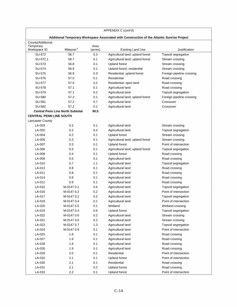
C-14
APPENDIX C (cont’d)
Additional Temporary Workspace Associated with Construction of the Atlantic Sunrise Project
County/Additional Temporary Workspace ID Milepost a
Area (acres) Existing Land Use Justification
SU-572 56.7 0.3 Agricultural land; upland forest Topsoil segregation SU-572.1 56.7 0.1 Agricultural land; upland forest Stream crossing SU-573 56.8 0.1 Upland forest Stream crossing SU-574 56.9 0.1 Upland forest; residential Stream crossing SU-575 56.9 0.3 Residential; upland forest Foreign pipeline crossing SU-576 57.0 0.1 Residential Road crossing SU-577 57.0 0.2 Residential; open land Road crossing SU-578 57.1 0.1 Agricultural land Road crossing SU-579 57.1 0.2 Agricultural land Topsoil segregation SU-580 57.2 0.1 Agricultural land; upland forest Foreign pipeline crossing SU-581 57.2 0.7 Agricultural land Crossover SU-582 57.2 0.1 Agricultural land Crossover
Central Penn Line North Subtotal 90.5 CENTRAL PENN LINE SOUTH
Lancaster County LA-003 0.2 0.1 Agricultural land Stream crossing LA-002 0.2 0.4 Agricultural land Topsoil segregation LA-004 0.2 0.1 Upland forest Stream crossing LA-005 0.3 0.1 Agricultural land; upland forest Stream crossing LA-007 0.3 0.1 Upland forest Point of intersection LA-006 0.3 0.1 Agricultural land; upland forest Topsoil segregation LA-008 0.4 0.1 Upland forest Road crossing LA-009 0.5 0.1 Agricultural land Road crossing LA-010 0.7 1.1 Agricultural land Topsoil segregation LA-013 0.8 0.1 Agricultural land Road crossing LA-011 0.8 0.1 Agricultural land Road crossing LA-014 0.9 0.1 Agricultural land Road crossing LA-012 0.9 0.1 Agricultural land Road crossing LA-015 M-0147 0.1 0.6 Agricultural land Topsoil segregation LA-016 M-0147 0.2 0.2 Agricultural land Point of intersection LA-017 M-0147 0.2 0.2 Agricultural land Topsoil segregation LA-018 M-0147 0.4 0.1 Agricultural land Point of intersection LA-020 M-0147 0.5 0.1 Wetland Wetland crossing LA-019 M-0147 0.4 0.6 Upland forest Topsoil segregation LA-022 M-0147 0.6 0.2 Agricultural land Stream crossing LA-021 M-0147 0.6 0.2 Agricultural land Stream crossing LA-023 M-0147 0.7 1.3 Agricultural land Topsoil segregation LA-024 M-0147 0.9 0.1 Agricultural land Point of intersection LA-025 1.9 0.1 Agricultural land Road crossing LA-027 1.9 0.1 Agricultural land Road crossing LA-028 1.9 0.1 Agricultural land Road crossing LA-026 1.9 0.1 Agricultural land Road crossing LA-029 2.0 0.1 Residential Point of intersection LA-032 2.1 0.1 Upland forest Point of intersection LA-030 2.1 0.1 Residential Road crossing LA-031 2.1 0.2 Upland forest Road crossing LA-033 2.2 0.1 Upland forest Point of intersection
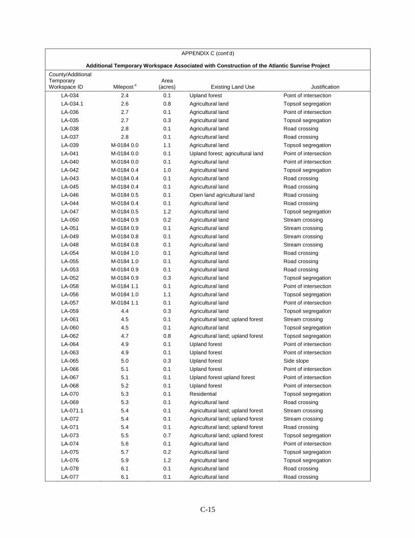
C-15
APPENDIX C (cont’d)
Additional Temporary Workspace Associated with Construction of the Atlantic Sunrise Project
County/Additional Temporary Workspace ID Milepost a
Area (acres) Existing Land Use Justification
LA-034 2.4 0.1 Upland forest Point of intersection LA-034.1 2.6 0.8 Agricultural land Topsoil segregation LA-036 2.7 0.1 Agricultural land Point of intersection LA-035 2.7 0.3 Agricultural land Topsoil segregation LA-038 2.8 0.1 Agricultural land Road crossing LA-037 2.8 0.1 Agricultural land Road crossing LA-039 M-0184 0.0 1.1 Agricultural land Topsoil segregation LA-041 M-0184 0.0 0.1 Upland forest; agricultural land Point of intersection LA-040 M-0184 0.0 0.1 Agricultural land Point of intersection LA-042 M-0184 0.4 1.0 Agricultural land Topsoil segregation LA-043 M-0184 0.4 0.1 Agricultural land Road crossing LA-045 M-0184 0.4 0.1 Agricultural land Road crossing LA-046 M-0184 0.5 0.1 Open land agricultural land Road crossing LA-044 M-0184 0.4 0.1 Agricultural land Road crossing LA-047 M-0184 0.5 1.2 Agricultural land Topsoil segregation LA-050 M-0184 0.9 0.2 Agricultural land Stream crossing LA-051 M-0184 0.9 0.1 Agricultural land Stream crossing LA-049 M-0184 0.8 0.1 Agricultural land Stream crossing LA-048 M-0184 0.8 0.1 Agricultural land Stream crossing LA-054 M-0184 1.0 0.1 Agricultural land Road crossing LA-055 M-0184 1.0 0.1 Agricultural land Road crossing LA-053 M-0184 0.9 0.1 Agricultural land Road crossing LA-052 M-0184 0.9 0.3 Agricultural land Topsoil segregation LA-058 M-0184 1.1 0.1 Agricultural land Point of intersection LA-056 M-0184 1.0 1.1 Agricultural land Topsoil segregation LA-057 M-0184 1.1 0.1 Agricultural land Point of intersection LA-059 4.4 0.3 Agricultural land Topsoil segregation LA-061 4.5 0.1 Agricultural land; upland forest Stream crossing LA-060 4.5 0.1 Agricultural land Topsoil segregation LA-062 4.7 0.8 Agricultural land; upland forest Topsoil segregation LA-064 4.9 0.1 Upland forest Point of intersection LA-063 4.9 0.1 Upland forest Point of intersection LA-065 5.0 0.3 Upland forest Side slope LA-066 5.1 0.1 Upland forest Point of intersection LA-067 5.1 0.1 Upland forest upland forest Point of intersection LA-068 5.2 0.1 Upland forest Point of intersection LA-070 5.3 0.1 Residential Topsoil segregation LA-069 5.3 0.1 Agricultural land Road crossing LA-071.1 5.4 0.1 Agricultural land; upland forest Stream crossing LA-072 5.4 0.1 Agricultural land; upland forest Stream crossing LA-071 5.4 0.1 Agricultural land; upland forest Road crossing LA-073 5.5 0.7 Agricultural land; upland forest Topsoil segregation LA-074 5.6 0.1 Agricultural land Point of intersection LA-075 5.7 0.2 Agricultural land Topsoil segregation LA-076 5.9 1.2 Agricultural land Topsoil segregation LA-078 6.1 0.1 Agricultural land Road crossing LA-077 6.1 0.1 Agricultural land Road crossing
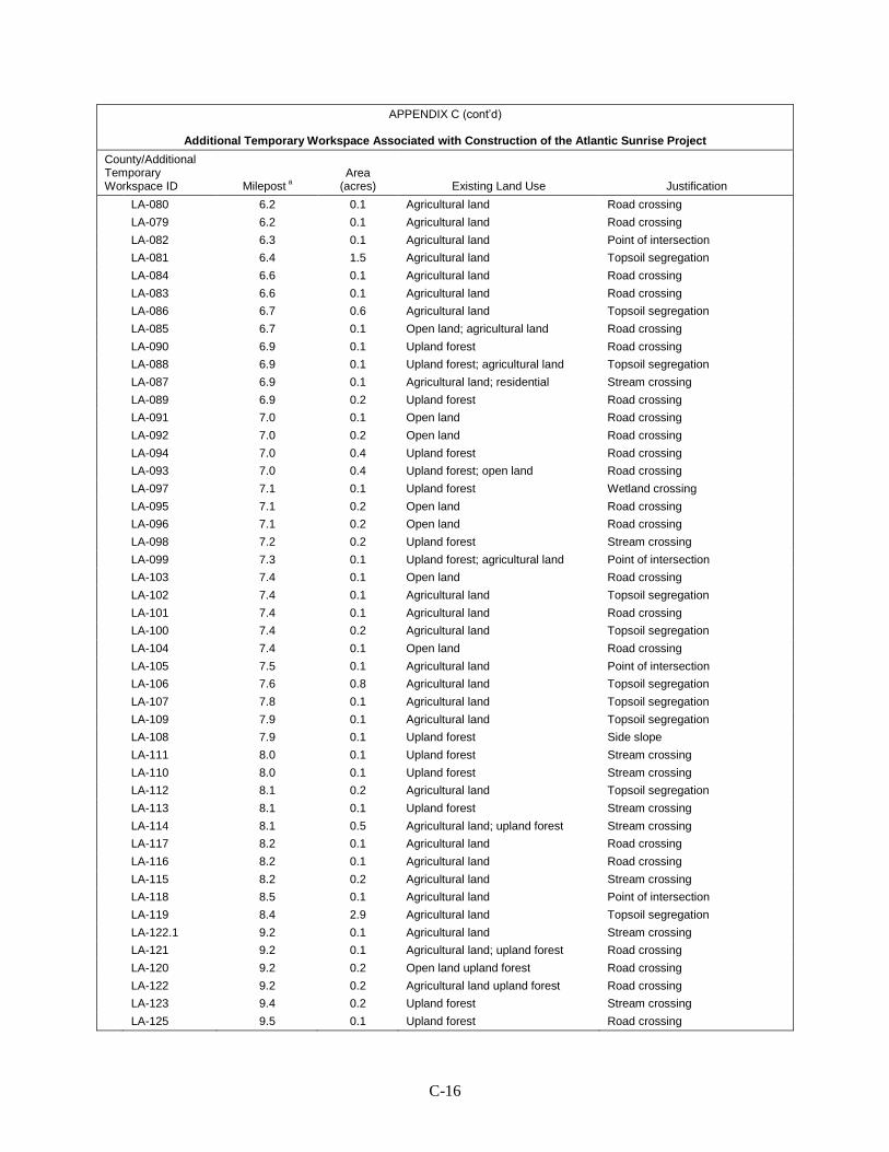
C-16
APPENDIX C (cont’d)
Additional Temporary Workspace Associated with Construction of the Atlantic Sunrise Project
County/Additional Temporary Workspace ID Milepost a
Area (acres) Existing Land Use Justification
LA-080 6.2 0.1 Agricultural land Road crossing LA-079 6.2 0.1 Agricultural land Road crossing LA-082 6.3 0.1 Agricultural land Point of intersection LA-081 6.4 1.5 Agricultural land Topsoil segregation LA-084 6.6 0.1 Agricultural land Road crossing LA-083 6.6 0.1 Agricultural land Road crossing LA-086 6.7 0.6 Agricultural land Topsoil segregation LA-085 6.7 0.1 Open land; agricultural land Road crossing LA-090 6.9 0.1 Upland forest Road crossing LA-088 6.9 0.1 Upland forest; agricultural land Topsoil segregation LA-087 6.9 0.1 Agricultural land; residential Stream crossing LA-089 6.9 0.2 Upland forest Road crossing LA-091 7.0 0.1 Open land Road crossing LA-092 7.0 0.2 Open land Road crossing LA-094 7.0 0.4 Upland forest Road crossing LA-093 7.0 0.4 Upland forest; open land Road crossing LA-097 7.1 0.1 Upland forest Wetland crossing LA-095 7.1 0.2 Open land Road crossing LA-096 7.1 0.2 Open land Road crossing LA-098 7.2 0.2 Upland forest Stream crossing LA-099 7.3 0.1 Upland forest; agricultural land Point of intersection LA-103 7.4 0.1 Open land Road crossing LA-102 7.4 0.1 Agricultural land Topsoil segregation LA-101 7.4 0.1 Agricultural land Road crossing LA-100 7.4 0.2 Agricultural land Topsoil segregation LA-104 7.4 0.1 Open land Road crossing LA-105 7.5 0.1 Agricultural land Point of intersection LA-106 7.6 0.8 Agricultural land Topsoil segregation LA-107 7.8 0.1 Agricultural land Topsoil segregation LA-109 7.9 0.1 Agricultural land Topsoil segregation LA-108 7.9 0.1 Upland forest Side slope LA-111 8.0 0.1 Upland forest Stream crossing LA-110 8.0 0.1 Upland forest Stream crossing LA-112 8.1 0.2 Agricultural land Topsoil segregation LA-113 8.1 0.1 Upland forest Stream crossing LA-114 8.1 0.5 Agricultural land; upland forest Stream crossing LA-117 8.2 0.1 Agricultural land Road crossing LA-116 8.2 0.1 Agricultural land Road crossing LA-115 8.2 0.2 Agricultural land Stream crossing LA-118 8.5 0.1 Agricultural land Point of intersection LA-119 8.4 2.9 Agricultural land Topsoil segregation LA-122.1 9.2 0.1 Agricultural land Stream crossing LA-121 9.2 0.1 Agricultural land; upland forest Road crossing LA-120 9.2 0.2 Open land upland forest Road crossing LA-122 9.2 0.2 Agricultural land upland forest Road crossing LA-123 9.4 0.2 Upland forest Stream crossing LA-125 9.5 0.1 Upland forest Road crossing
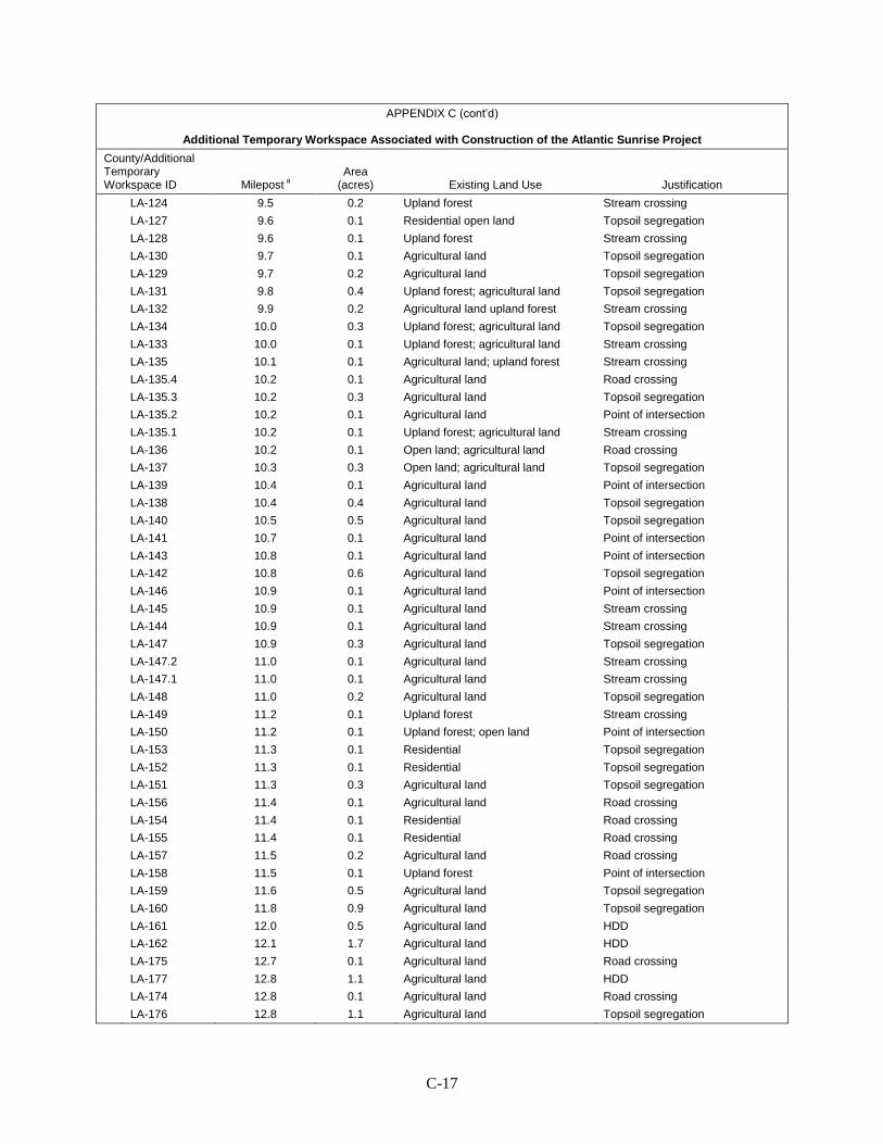
C-17
APPENDIX C (cont’d)
Additional Temporary Workspace Associated with Construction of the Atlantic Sunrise Project
County/Additional Temporary Workspace ID Milepost a
Area (acres) Existing Land Use Justification
LA-124 9.5 0.2 Upland forest Stream crossing LA-127 9.6 0.1 Residential open land Topsoil segregation LA-128 9.6 0.1 Upland forest Stream crossing LA-130 9.7 0.1 Agricultural land Topsoil segregation LA-129 9.7 0.2 Agricultural land Topsoil segregation LA-131 9.8 0.4 Upland forest; agricultural land Topsoil segregation LA-132 9.9 0.2 Agricultural land upland forest Stream crossing LA-134 10.0 0.3 Upland forest; agricultural land Topsoil segregation LA-133 10.0 0.1 Upland forest; agricultural land Stream crossing LA-135 10.1 0.1 Agricultural land; upland forest Stream crossing LA-135.4 10.2 0.1 Agricultural land Road crossing LA-135.3 10.2 0.3 Agricultural land Topsoil segregation LA-135.2 10.2 0.1 Agricultural land Point of intersection LA-135.1 10.2 0.1 Upland forest; agricultural land Stream crossing LA-136 10.2 0.1 Open land; agricultural land Road crossing LA-137 10.3 0.3 Open land; agricultural land Topsoil segregation LA-139 10.4 0.1 Agricultural land Point of intersection LA-138 10.4 0.4 Agricultural land Topsoil segregation LA-140 10.5 0.5 Agricultural land Topsoil segregation LA-141 10.7 0.1 Agricultural land Point of intersection LA-143 10.8 0.1 Agricultural land Point of intersection LA-142 10.8 0.6 Agricultural land Topsoil segregation LA-146 10.9 0.1 Agricultural land Point of intersection LA-145 10.9 0.1 Agricultural land Stream crossing LA-144 10.9 0.1 Agricultural land Stream crossing LA-147 10.9 0.3 Agricultural land Topsoil segregation LA-147.2 11.0 0.1 Agricultural land Stream crossing LA-147.1 11.0 0.1 Agricultural land Stream crossing LA-148 11.0 0.2 Agricultural land Topsoil segregation LA-149 11.2 0.1 Upland forest Stream crossing LA-150 11.2 0.1 Upland forest; open land Point of intersection LA-153 11.3 0.1 Residential Topsoil segregation LA-152 11.3 0.1 Residential Topsoil segregation LA-151 11.3 0.3 Agricultural land Topsoil segregation LA-156 11.4 0.1 Agricultural land Road crossing LA-154 11.4 0.1 Residential Road crossing LA-155 11.4 0.1 Residential Road crossing LA-157 11.5 0.2 Agricultural land Road crossing LA-158 11.5 0.1 Upland forest Point of intersection LA-159 11.6 0.5 Agricultural land Topsoil segregation LA-160 11.8 0.9 Agricultural land Topsoil segregation LA-161 12.0 0.5 Agricultural land HDD LA-162 12.1 1.7 Agricultural land HDD LA-175 12.7 0.1 Agricultural land Road crossing LA-177 12.8 1.1 Agricultural land HDD LA-174 12.8 0.1 Agricultural land Road crossing LA-176 12.8 1.1 Agricultural land Topsoil segregation

C-18
APPENDIX C (cont’d)
Additional Temporary Workspace Associated with Construction of the Atlantic Sunrise Project
County/Additional Temporary Workspace ID Milepost a
Area (acres) Existing Land Use Justification
LA-179 M-0152 0.0 0.1 Agricultural land Road crossing LA-178 M-0152 0.0 0.1 Agricultural land Road crossing LA-181.1 M-0152 0.1 0.1 Upland forest Stream crossing LA-180 M-0152 0.1 0.1 Upland forest Road crossing LA-181 M-0152 0.1 0.1 Upland forest Road crossing LA-181.2 M-0152 0.1 <0.1 Wetland Wetland crossing LA-181.3 M-0153 0.2 <0.1 Agricultural land Topsoil segregation LA-181.4 M-0153 0.2 0.1 Agricultural land Stream crossing LA-181.5 M-0153 0.2 0.1 Agricultural land Point of intersection LA-181.6 M-0153 0.2 0.1 Agricultural land Topsoil segregation LA-181.7 M-0153 0.2 0.1 Agricultural land Stream crossing LA-181.8 M-0153 0.3 0.1 Agricultural land Stream crossing LA-182 M-0152 0.4 0.3 Agricultural land Topsoil segregation LA-183 13.8 0.2 Agricultural land Topsoil segregation LA-183.1 13.9 0.1 Agricultural land Stream crossing LA-183.2 13.9 0.1 Agricultural land Stream crossing LA-184 13.9 0.2 Agricultural land Topsoil segregation LA-185 14.1 0.6 Agricultural land Topsoil segregation LA-187 14.2 0.1 Agricultural land Road crossing LA-186 14.2 0.1 Agricultural land Road crossing LA-191 M-0188 0.0 0.2 Agricultural land Topsoil segregation LA-192 M-0188 0.0 0.1 Agricultural land Road crossing LA-188 M-0188 0.0 0.1 Agricultural land Point of intersection LA-190 M-0188 0.0 <0.1 Agricultural land Topsoil segregation LA-189 M-0188 0.0 <0.1 Agricultural land Road crossing LA-196 M-0188 0.2 0.1 Agricultural land Road crossing LA-196.1 M-0188 0.2 0.1 Agricultural land Topsoil segregation LA-196.2 M-0188 0.2 0.1 Agricultural land Point of intersection LA-195 M-0188 0.1 0.1 Agricultural land Road crossing LA-198 M-0188 0.3 0.2 Agricultural land Topsoil segregation LA-197 M-0188 0.3 0.1 Agricultural land Topsoil segregation LA-199.1 14.6 0.1 Upland forest Stream crossing LA-200 14.7 0.1 Agricultural land Stream crossing LA-201 14.8 0.7 Agricultural land Topsoil segregation LA-202 14.9 0.2 Agricultural land Road crossing LA-203 15.2 0.7 Agricultural land Topsoil segregation LA-204 15.3 0.2 Agricultural land Stream crossing LA-205 15.4 0.1 Upland forest Stream crossing LA-206 15.4 0.4 Upland forest Topsoil segregation LA-207 15.5 0.1 Upland forest open land Road crossing LA-208 15.5 0.1 Upland forest open land Road crossing LA-209 15.6 0.1 Agricultural land Road crossing LA-210 15.6 0.1 Upland forest Road crossing LA-211 15.7 0.7 Agricultural land Topsoil segregation LA-212 15.7 0.1 Upland forest Point of intersection LA-213 15.9 0.9 Agricultural land Topsoil segregation LA-216 16.1 0.1 Upland forest Road crossing
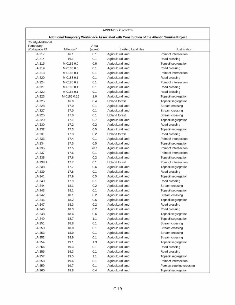
C-19
APPENDIX C (cont’d)
Additional Temporary Workspace Associated with Construction of the Atlantic Sunrise Project
County/Additional Temporary Workspace ID Milepost a
Area (acres) Existing Land Use Justification
LA-217 16.1 0.1 Agricultural land Point of intersection LA-214 16.1 0.1 Agricultural land Road crossing LA-215 M-0182 0.0 0.6 Agricultural land Topsoil segregation LA-219 M-0185 0.0 0.1 Agricultural land Road crossing LA-218 M-0185 0.1 0.1 Agricultural land Point of intersection LA-220 M-0185 0.1 0.1 Agricultural land Road crossing LA-224 M-0185 0.2 0.1 Agricultural land Point of intersection LA-221 M-0185 0.1 0.1 Agricultural land Road crossing LA-222 M-0185 0.1 0.1 Agricultural land Road crossing LA-223 M-0185 0.15 1.6 Agricultural land Topsoil segregation LA-225 16.8 0.4 Upland forest Topsoil segregation LA-228 17.0 0.1 Agricultural land Stream crossing LA-227 17.0 0.1 Agricultural land Stream crossing LA-226 17.0 0.1 Upland forest Stream crossing LA-229 17.1 0.7 Agricultural land Topsoil segregation LA-230 17.2 0.2 Agricultural land Road crossing LA-232 17.3 0.5 Agricultural land Topsoil segregation LA-231 17.3 0.2 Upland forest Road crossing LA-233 17.4 0.1 Agricultural land Point of intersection LA-234 17.5 0.5 Agricultural land Topsoil segregation LA-235 17.5 <0.1 Agricultural land Point of intersection LA-237 17.6 0.1 Agricultural land Point of intersection LA-236 17.6 0.2 Agricultural land Topsoil segregation LA-238.1 17.7 0.1 Upland forest Point of intersection LA-238 17.7 0.6 Agricultural land Topsoil segregation LA-239 17.8 0.1 Agricultural land Road crossing LA-241 17.9 0.5 Agricultural land Topsoil segregation LA-240 17.9 0.1 Agricultural land Road crossing LA-244 18.1 0.2 Agricultural land Stream crossing LA-243 18.1 0.1 Agricultural land Topsoil segregation LA-242 18.1 0.2 Agricultural land Stream crossing LA-245 18.2 0.5 Agricultural land Topsoil segregation LA-247 18.3 0.2 Agricultural land Road crossing LA-246 18.3 0.2 Agricultural land Road crossing LA-248 18.4 0.6 Agricultural land Topsoil segregation LA-249 18.7 1.1 Agricultural land Topsoil segregation LA-251 18.8 0.1 Agricultural land Stream crossing LA-250 18.8 0.1 Agricultural land Stream crossing LA-253 18.9 0.1 Agricultural land Stream crossing LA-252 18.9 0.1 Agricultural land Stream crossing LA-254 19.1 1.3 Agricultural land Topsoil segregation LA-256 19.3 0.1 Agricultural land Road crossing LA-255 19.3 0.1 Agricultural land Road crossing LA-257 19.5 1.1 Agricultural land Topsoil segregation LA-258 19.6 0.1 Agricultural land Point of intersection LA-259 19.7 0.1 Agricultural land Foreign pipeline crossing LA-260 19.8 0.4 Agricultural land Topsoil segregation
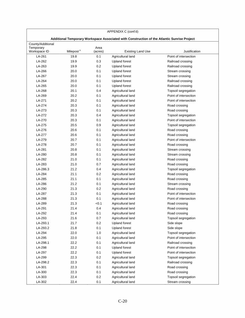
C-20
APPENDIX C (cont’d)
Additional Temporary Workspace Associated with Construction of the Atlantic Sunrise Project
County/Additional Temporary Workspace ID Milepost a
Area (acres) Existing Land Use Justification
LA-261 19.8 0.1 Agricultural land Point of intersection LA-262 19.9 0.3 Upland forest Railroad crossing LA-263 19.9 0.2 Upland forest Railroad crossing LA-266 20.0 0.1 Upland forest Stream crossing LA-267 20.0 0.1 Upland forest Stream crossing LA-264 20.0 0.1 Upland forest Railroad crossing LA-265 20.0 0.1 Upland forest Railroad crossing LA-268 20.1 0.4 Agricultural land Topsoil segregation LA-269 20.2 0.1 Agricultural land Point of intersection LA-271 20.2 0.1 Agricultural land Point of intersection LA-274 20.3 0.1 Agricultural land Road crossing LA-273 20.3 0.1 Agricultural land Road crossing LA-272 20.3 0.4 Agricultural land Topsoil segregation LA-270 20.3 0.1 Agricultural land Point of intersection LA-275 20.5 0.9 Agricultural land Topsoil segregation LA-276 20.6 0.1 Agricultural land Road crossing LA-277 20.6 0.1 Agricultural land Road crossing LA-279 20.7 0.1 Agricultural land Point of intersection LA-278 20.7 0.1 Agricultural land Road crossing LA-281 20.8 0.1 Agricultural land Stream crossing LA-280 20.8 0.1 Agricultural land Stream crossing LA-282 21.0 0.1 Agricultural land Road crossing LA-283 21.0 0.7 Agricultural land Road crossing LA-286.3 21.2 0.4 Agricultural land Topsoil segregation LA-284 21.1 0.2 Agricultural land Road crossing LA-285 21.1 0.1 Agricultural land Road crossing LA-286 21.2 0.1 Agricultural land Stream crossing LA-290 21.3 0.2 Agricultural land Road crossing LA-287 21.3 0.1 Agricultural land Point of intersection LA-288 21.3 0.1 Agricultural land Point of intersection LA-289 21.3 <0.1 Agricultural land Road crossing LA-291 21.4 0.4 Agricultural land Road crossing LA-292 21.4 0.1 Agricultural land Road crossing LA-293 21.6 0.7 Agricultural land Topsoil segregation LA-293.1 21.7 0.2 Upland forest Side slope LA-293.2 21.8 0.1 Upland forest Side slope LA-294 22.0 1.0 Agricultural land Topsoil segregation LA-295 22.0 0.1 Agricultural land Point of intersection LA-298.1 22.2 0.1 Agricultural land Railroad crossing LA-298 22.2 0.1 Upland forest Point of intersection LA-297 22.2 0.1 Upland forest Point of intersection LA-299 22.3 0.2 Agricultural land Topsoil segregation LA-298.2 22.3 0.1 Agricultural land Railroad crossing LA-301 22.3 0.1 Agricultural land Road crossing LA-300 22.3 0.1 Agricultural land Road crossing LA-303 22.4 0.2 Agricultural land Topsoil segregation LA-302 22.4 0.1 Agricultural land Stream crossing
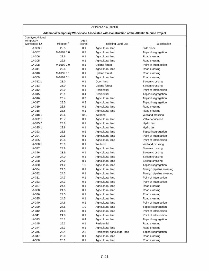
C-21
APPENDIX C (cont’d)
Additional Temporary Workspace Associated with Construction of the Atlantic Sunrise Project
County/Additional Temporary Workspace ID Milepost a
Area (acres) Existing Land Use Justification
LA-303.1 22.5 0.1 Agricultural land Side slope LA-307 M-0192 0.0 0.3 Agricultural land Topsoil segregation LA-306 22.6 0.1 Agricultural land Road crossing LA-305 22.6 0.1 Agricultural land Road crossing LA-308 M-0192 0.0 0.1 Upland forest Point of intersection LA-311 22.8 0.1 Agricultural land Road crossing LA-310 M-0192 0.1 0.1 Upland forest Road crossing LA-309 M-0192 0.1 0.1 Agricultural land Road crossing LA-312.1 23.0 0.1 Open land Stream crossing LA-313 23.0 0.1 Upland forest Stream crossing LA-312 23.0 0.1 Residential Point of intersection LA-315 23.1 0.4 Residential Topsoil segregation LA-316 23.4 0.3 Agricultural land Topsoil segregation LA-317 23.5 0.3 Agricultural land Topsoil segregation LA-319 23.6 0.1 Agricultural land Road crossing LA-318 23.6 0.1 Agricultural land Road crossing LA-318.1 23.6 <0.1 Wetland Wetland crossing LA-322.1 23.7 0.1 Agricultural land Valve fabrication LA-325.2 23.8 0.1 Agricultural land Hydro test LA-325.1 23.8 0.1 Agricultural land Hydro test LA-323 23.8 0.5 Agricultural land Topsoil segregation LA-324 23.8 0.1 Agricultural land Point of intersection LA-325 23.8 0.1 Agricultural land Point of intersection LA-328.1 23.9 0.1 Wetland Wetland crossing LA-327 23.9 0.1 Agricultural land Stream crossing LA-326 23.9 0.1 Agricultural land Stream crossing LA-329 24.0 0.1 Agricultural land Stream crossing LA-328 24.0 0.1 Agricultural land Stream crossing LA-330 24.2 1.5 Agricultural land Topsoil segregation LA-334 24.3 0.1 Agricultural land Foreign pipeline crossing LA-332 24.3 0.1 Agricultural land Foreign pipeline crossing LA-331 24.3 0.1 Agricultural land Point of intersection LA-333 24.3 0.1 Agricultural land Point of intersection LA-337 24.5 0.1 Agricultural land Road crossing LA-338 24.5 0.1 Agricultural land Road crossing LA-336 24.5 0.1 Agricultural land Road crossing LA-335 24.5 0.1 Agricultural land Road crossing LA-340 24.6 0.1 Agricultural land Point of intersection LA-339 24.8 1.9 Agricultural land Topsoil segregation LA-342 24.8 0.1 Agricultural land Point of intersection LA-341 24.8 0.1 Agricultural land Point of intersection LA-343 25.1 0.4 Agricultural land Topsoil segregation LA-345 25.3 0.1 Residential Road crossing LA-344 25.3 0.1 Agricultural land Road crossing LA-346 25.4 2.2 Residential agricultural land Topsoil segregation LA-347 26.0 0.1 Agricultural land Road crossing LA-350 26.1 0.1 Agricultural land Road crossing

C-22
APPENDIX C (cont’d)
Additional Temporary Workspace Associated with Construction of the Atlantic Sunrise Project
County/Additional Temporary Workspace ID Milepost a
Area (acres) Existing Land Use Justification
LA-349 26.1 0.1 Agricultural land Road crossing LA-348 26.1 0.1 Agricultural land Road crossing LA-351 26.3 1.5 Agricultural land Topsoil segregation LA-353 26.5 0.1 Agricultural land Road crossing LA-352 26.5 0.1 Agricultural land Road crossing LA-355 26.6 0.1 Agricultural land Road crossing LA-354 26.6 0.1 Agricultural land Road crossing LA-357 26.8 0.1 Agricultural land Point of intersection LA-356 27.0 2.6 Agricultural land Topsoil segregation LA-359 27.3 0.6 Agricultural land Railroad crossing LA-358 27.3 0.4 Agricultural land Railroad crossing LA-361 27.4 0.3 Agricultural land Railroad crossing LA-360 27.4 0.1 Agricultural land Railroad crossing LA-362 27.5 0.4 Agricultural land Topsoil segregation LA-365 27.6 0.2 Agricultural land Road crossing LA-364 27.6 0.2 Agricultural land Road crossing LA-368 27.7 0.1 Agricultural land Point of intersection LA-366 27.7 0.4 Agricultural land Topsoil segregation LA-367 27.7 0.1 Agricultural land Point of intersection LA-371 27.9 0.1 Agricultural land Point of intersection LA-369 27.9 0.4 Agricultural land Topsoil segregation LA-370 27.9 0.1 Agricultural land Point of intersection LA-372 28.0 0.3 Agricultural land Topsoil segregation LA-373 M-0162 0.0 0.5 Agricultural land Road crossing LA-377 M-0162 0.1 0.1 Agricultural land Foreign pipeline crossing LA-374 M-0162 0.0 0.9 Agricultural land Topsoil segregation LA-380 M-0162 0.2 0.3 Agricultural land Road crossing LA-379 M-0162 0.2 0.3 Agricultural land Road crossing LA-382 M-0162 0.3 0.2 Agricultural land Topsoil segregation LA-383 M-0162 0.3 0.1 Agricultural land Road crossing LA-381 M-0162 0.3 0.6 Agricultural land Road crossing LA-385 M-0162 0.4 1.7 Agricultural land Topsoil segregation LA-385.1 M-0162 0.7 0.1 Agricultural land Point of intersection LA-386 M-0162 1.02 0.1 Agricultural land Road crossing LA-386.1 M-0162 1.02 0.1 Agricultural land Topsoil segregation LA-387 M-0162 1.02 0.1 Agricultural land Road crossing LA-389 29.1 0.1 Agricultural land Road crossing LA-388 29.1 0.1 Agricultural land Road crossing LA-390 29.3 1.5 Agricultural land Topsoil segregation LA-394 29.5 0.1 Agricultural land Road crossing LA-391 29.5 0.1 Agricultural land Road crossing LA-393 29.5 0.1 Agricultural land Road crossing LA-392 29.5 0.1 Agricultural land Road crossing LA-395 29.6 0.4 Agricultural land Topsoil segregation LA-396 29.7 0.1 Agricultural land Road crossing LA-397 29.8 1.0 Agricultural land Topsoil segregation LA-398 29.8 0.1 Agricultural land Point of intersection
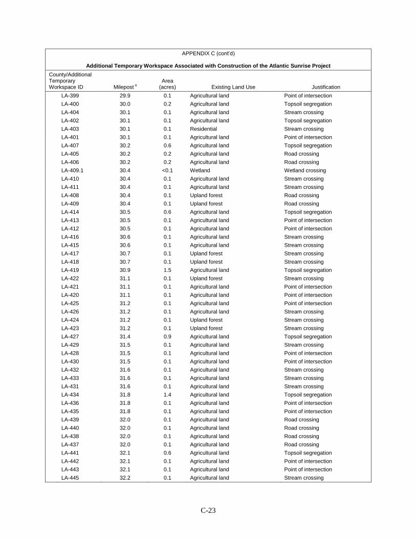
C-23
APPENDIX C (cont’d)
Additional Temporary Workspace Associated with Construction of the Atlantic Sunrise Project
County/Additional Temporary Workspace ID Milepost a
Area (acres) Existing Land Use Justification
LA-399 29.9 0.1 Agricultural land Point of intersection LA-400 30.0 0.2 Agricultural land Topsoil segregation LA-404 30.1 0.1 Agricultural land Stream crossing LA-402 30.1 0.1 Agricultural land Topsoil segregation LA-403 30.1 0.1 Residential Stream crossing LA-401 30.1 0.1 Agricultural land Point of intersection LA-407 30.2 0.6 Agricultural land Topsoil segregation LA-405 30.2 0.2 Agricultural land Road crossing LA-406 30.2 0.2 Agricultural land Road crossing LA-409.1 30.4 <0.1 Wetland Wetland crossing LA-410 30.4 0.1 Agricultural land Stream crossing LA-411 30.4 0.1 Agricultural land Stream crossing LA-408 30.4 0.1 Upland forest Road crossing LA-409 30.4 0.1 Upland forest Road crossing LA-414 30.5 0.6 Agricultural land Topsoil segregation LA-413 30.5 0.1 Agricultural land Point of intersection LA-412 30.5 0.1 Agricultural land Point of intersection LA-416 30.6 0.1 Agricultural land Stream crossing LA-415 30.6 0.1 Agricultural land Stream crossing LA-417 30.7 0.1 Upland forest Stream crossing LA-418 30.7 0.1 Upland forest Stream crossing LA-419 30.9 1.5 Agricultural land Topsoil segregation LA-422 31.1 0.1 Upland forest Stream crossing LA-421 31.1 0.1 Agricultural land Point of intersection LA-420 31.1 0.1 Agricultural land Point of intersection LA-425 31.2 0.1 Agricultural land Point of intersection LA-426 31.2 0.1 Agricultural land Stream crossing LA-424 31.2 0.1 Upland forest Stream crossing LA-423 31.2 0.1 Upland forest Stream crossing LA-427 31.4 0.9 Agricultural land Topsoil segregation LA-429 31.5 0.1 Agricultural land Stream crossing LA-428 31.5 0.1 Agricultural land Point of intersection LA-430 31.5 0.1 Agricultural land Point of intersection LA-432 31.6 0.1 Agricultural land Stream crossing LA-433 31.6 0.1 Agricultural land Stream crossing LA-431 31.6 0.1 Agricultural land Stream crossing LA-434 31.8 1.4 Agricultural land Topsoil segregation LA-436 31.8 0.1 Agricultural land Point of intersection LA-435 31.8 0.1 Agricultural land Point of intersection LA-439 32.0 0.1 Agricultural land Road crossing LA-440 32.0 0.1 Agricultural land Road crossing LA-438 32.0 0.1 Agricultural land Road crossing LA-437 32.0 0.1 Agricultural land Road crossing LA-441 32.1 0.6 Agricultural land Topsoil segregation LA-442 32.1 0.1 Agricultural land Point of intersection LA-443 32.1 0.1 Agricultural land Point of intersection LA-445 32.2 0.1 Agricultural land Stream crossing
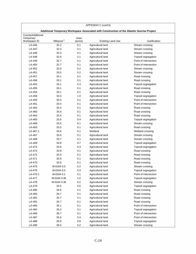
C-24
APPENDIX C (cont’d)
Additional Temporary Workspace Associated with Construction of the Atlantic Sunrise Project
County/Additional Temporary Workspace ID Milepost a
Area (acres) Existing Land Use Justification
LA-444 32.2 0.1 Agricultural land Stream crossing LA-447 32.3 0.1 Agricultural land Stream crossing LA-446 32.3 0.1 Agricultural land Stream crossing LA-448 32.6 2.1 Agricultural land Topsoil segregation LA-449 32.7 0.1 Agricultural land Point of intersection LA-450 32.7 0.1 Agricultural land Point of intersection LA-452 33.0 0.2 Agricultural land Stream crossing LA-451 33.0 0.2 Agricultural land Stream crossing LA-457 33.1 0.1 Agricultural land Road crossing LA-456 33.1 0.1 Agricultural land Road crossing LA-453 33.1 0.3 Agricultural land Topsoil segregation LA-455 33.1 0.1 Agricultural land Road crossing LA-454 33.1 0.1 Agricultural land Road crossing LA-458 33.3 1.0 Agricultural land Topsoil segregation LA-459 33.3 0.1 Agricultural land Point of intersection LA-461 33.4 0.1 Agricultural land Point of intersection LA-462 33.4 0.1 Agricultural land Road crossing LA-460 33.4 0.1 Agricultural land Road crossing LA-464 33.4 0.1 Agricultural land Road crossing LA-465 33.5 0.4 Agricultural land Topsoil segregation LA-466 33.5 0.1 Agricultural land Stream crossing LA-463 33.5 0.1 Agricultural land Road crossing LA-467.1 33.6 0.1 Wetland Wetland crossing LA-467 33.6 0.1 Agricultural land Stream crossing LA-468 33.7 0.1 Agricultural land Stream crossing LA-469 33.8 0.7 Agricultural land Topsoil segregation LA-474 33.9 0.3 Agricultural land Topsoil segregation LA-473 33.9 0.1 Agricultural land Road crossing LA-472 33.9 0.1 Agricultural land Road crossing LA-471 33.9 0.1 Agricultural land Road crossing LA-470 33.9 0.1 Agricultural land Road crossing LA-475 M-0164 0.0 0.2 Agricultural land Stream crossing LA-476 M-0164 0.0 0.3 Agricultural land Topsoil segregation LA-476.1 M-0164 0.1 0.1 Agricultural land Point of intersection LA-477 M-0164 0.36 1.0 Agricultural land Topsoil segregation LA-478 M-0164 0.36 0.2 Agricultural land Stream crossing LA-479 34.5 0.5 Agricultural land Topsoil segregation LA-480 34.6 0.1 Agricultural land Road crossing LA-483 34.7 0.1 Agricultural land Road crossing LA-482 34.7 0.1 Agricultural land Road crossing LA-481 34.7 0.1 Agricultural land Road crossing LA-485 35.1 0.1 Agricultural land Point of intersection LA-484 35.2 3.1 Agricultural land Topsoil segregation LA-486 35.7 0.1 Agricultural land Point of intersection LA-487 35.9 0.4 Agricultural land Point of intersection LA-488 35.9 0.9 Agricultural land Topsoil segregation LA-490 36.0 0.2 Agricultural land Stream crossing
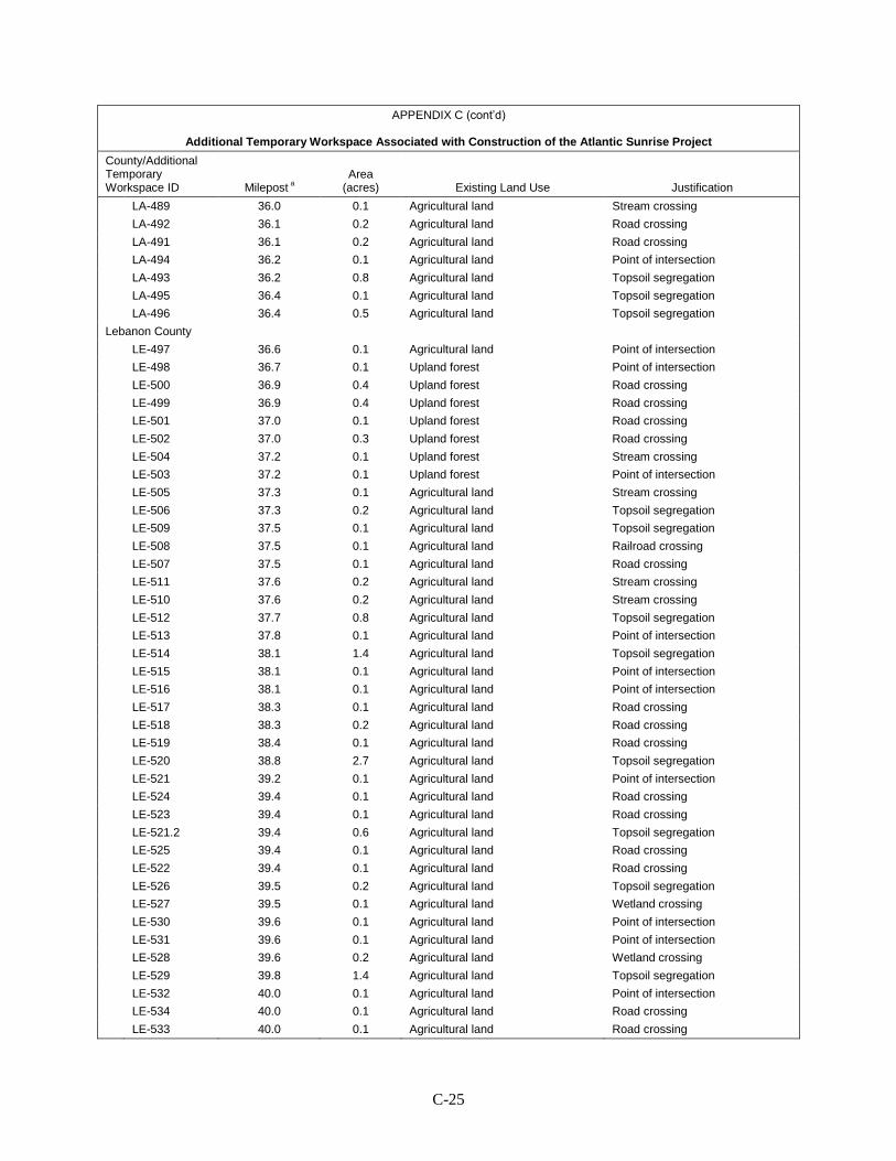
C-25
APPENDIX C (cont’d)
Additional Temporary Workspace Associated with Construction of the Atlantic Sunrise Project
County/Additional Temporary Workspace ID Milepost a
Area (acres) Existing Land Use Justification
LA-489 36.0 0.1 Agricultural land Stream crossing LA-492 36.1 0.2 Agricultural land Road crossing LA-491 36.1 0.2 Agricultural land Road crossing LA-494 36.2 0.1 Agricultural land Point of intersection LA-493 36.2 0.8 Agricultural land Topsoil segregation LA-495 36.4 0.1 Agricultural land Topsoil segregation LA-496 36.4 0.5 Agricultural land Topsoil segregation Lebanon County LE-497 36.6 0.1 Agricultural land Point of intersection LE-498 36.7 0.1 Upland forest Point of intersection LE-500 36.9 0.4 Upland forest Road crossing LE-499 36.9 0.4 Upland forest Road crossing LE-501 37.0 0.1 Upland forest Road crossing LE-502 37.0 0.3 Upland forest Road crossing LE-504 37.2 0.1 Upland forest Stream crossing LE-503 37.2 0.1 Upland forest Point of intersection LE-505 37.3 0.1 Agricultural land Stream crossing LE-506 37.3 0.2 Agricultural land Topsoil segregation LE-509 37.5 0.1 Agricultural land Topsoil segregation LE-508 37.5 0.1 Agricultural land Railroad crossing LE-507 37.5 0.1 Agricultural land Road crossing LE-511 37.6 0.2 Agricultural land Stream crossing LE-510 37.6 0.2 Agricultural land Stream crossing LE-512 37.7 0.8 Agricultural land Topsoil segregation LE-513 37.8 0.1 Agricultural land Point of intersection LE-514 38.1 1.4 Agricultural land Topsoil segregation LE-515 38.1 0.1 Agricultural land Point of intersection LE-516 38.1 0.1 Agricultural land Point of intersection LE-517 38.3 0.1 Agricultural land Road crossing LE-518 38.3 0.2 Agricultural land Road crossing LE-519 38.4 0.1 Agricultural land Road crossing LE-520 38.8 2.7 Agricultural land Topsoil segregation LE-521 39.2 0.1 Agricultural land Point of intersection LE-524 39.4 0.1 Agricultural land Road crossing LE-523 39.4 0.1 Agricultural land Road crossing LE-521.2 39.4 0.6 Agricultural land Topsoil segregation LE-525 39.4 0.1 Agricultural land Road crossing LE-522 39.4 0.1 Agricultural land Road crossing LE-526 39.5 0.2 Agricultural land Topsoil segregation LE-527 39.5 0.1 Agricultural land Wetland crossing LE-530 39.6 0.1 Agricultural land Point of intersection LE-531 39.6 0.1 Agricultural land Point of intersection LE-528 39.6 0.2 Agricultural land Wetland crossing LE-529 39.8 1.4 Agricultural land Topsoil segregation LE-532 40.0 0.1 Agricultural land Point of intersection LE-534 40.0 0.1 Agricultural land Road crossing LE-533 40.0 0.1 Agricultural land Road crossing
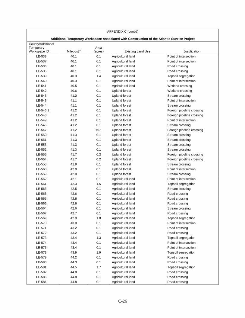
C-26
APPENDIX C (cont’d)
Additional Temporary Workspace Associated with Construction of the Atlantic Sunrise Project
County/Additional Temporary Workspace ID Milepost a
Area (acres) Existing Land Use Justification
LE-538 40.1 0.1 Agricultural land Point of intersection LE-537 40.1 0.1 Agricultural land Point of intersection LE-536 40.1 0.1 Agricultural land Road crossing LE-535 40.1 0.1 Agricultural land Road crossing LE-539 40.3 1.4 Agricultural land Topsoil segregation LE-540 40.3 0.1 Agricultural land Point of intersection LE-541 40.5 0.1 Agricultural land Wetland crossing LE-542 40.6 0.1 Upland forest Wetland crossing LE-543 41.0 0.1 Upland forest Stream crossing LE-545 41.1 0.1 Upland forest Point of intersection LE-544 41.1 0.1 Upland forest Stream crossing LE-546.1 41.2 0.1 Upland forest Foreign pipeline crossing LE-548 41.2 0.1 Upland forest Foreign pipeline crossing LE-549 41.2 0.1 Upland forest Point of intersection LE-546 41.2 0.1 Upland forest Stream crossing LE-547 41.2 <0.1 Upland forest Foreign pipeline crossing LE-550 41.3 0.1 Upland forest Stream crossing LE-551 41.3 0.1 Upland forest Stream crossing LE-553 41.3 0.1 Upland forest Stream crossing LE-552 41.3 0.1 Upland forest Stream crossing LE-555 41.7 0.3 Upland forest Foreign pipeline crossing LE-554 41.7 0.2 Upland forest Foreign pipeline crossing LE-558 41.9 0.1 Upland forest Stream crossing LE-560 42.0 0.1 Upland forest Point of intersection LE-559 42.0 0.1 Upland forest Stream crossing LE-562 42.1 0.1 Agricultural land Point of intersection LE-561 42.3 1.5 Agricultural land Topsoil segregation LE-563 42.5 0.1 Agricultural land Stream crossing LE-568 42.6 0.1 Agricultural land Road crossing LE-565 42.6 0.1 Agricultural land Road crossing LE-566 42.6 0.1 Agricultural land Road crossing LE-564 42.6 0.1 Agricultural land Stream crossing LE-567 42.7 0.1 Agricultural land Road crossing LE-569 42.9 1.8 Agricultural land Topsoil segregation LE-570 43.0 0.1 Agricultural land Point of intersection LE-571 43.2 0.1 Agricultural land Road crossing LE-572 43.2 0.1 Agricultural land Road crossing LE-573 43.4 1.3 Agricultural land Topsoil segregation LE-574 43.4 0.1 Agricultural land Point of intersection LE-575 43.4 0.1 Agricultural land Point of intersection LE-578 43.9 1.9 Agricultural land Topsoil segregation LE-579 44.2 0.1 Agricultural land Road crossing LE-580 44.3 0.1 Agricultural land Road crossing LE-581 44.5 1.7 Agricultural land Topsoil segregation LE-582 44.8 0.1 Agricultural land Road crossing LE-585 44.8 0.1 Agricultural land Road crossing LE-584 44.8 0.1 Agricultural land Road crossing

C-27
APPENDIX C (cont’d)
Additional Temporary Workspace Associated with Construction of the Atlantic Sunrise Project
County/Additional Temporary Workspace ID Milepost a
Area (acres) Existing Land Use Justification
LE-583 44.8 0.1 Agricultural land Road crossing LE-586 45.0 1.0 Agricultural land Topsoil segregation LE-587 45.1 0.1 Agricultural land Road crossing LE-588 45.1 0.1 Agricultural land Road crossing LE-589 45.2 0.6 Agricultural land Topsoil segregation LE-590 M-0183 0.0 1.5 Agricultural land Topsoil segregation LE-591 M-0183 0.4 0.1 Agricultural land Point of intersection LE-592 M-0183 0.4 0.1 Upland forest Point of intersection LE-593 M-0183 0.4 0.9 Agricultural land Topsoil segregation LE-594 M-0183 0.7 0.2 Agricultural land Road crossing LE-596 M-0183 0.7 0.1 Open land Topsoil segregation LE-595 M-0183 0.7 0.1 Open land Stream crossing LE-599 M-0183 1.1 0.4 Open land Railroad crossing LE-597 M-0183 0.7 0.2 Open land Road crossing LE-602 M-0183 1.2 0.1 Agricultural land Stream crossing LE-600 M-0183 1.2 0.1 Upland forest Point of intersection LE-601 M-0183 1.2 0.1 Upland forest Point of intersection LE-603 M-0183 1.2 0.1 Open land; agricultural land Stream crossing LE-603.1 M-0183 1.3 0.1 Agricultural land Wetland crossing LE-604 M-0183 1.4 0.1 Open land; agricultural land Stream crossing LE-604.1 M-0183 1.4 0.1 Agricultural land Stream crossing LE-605 M-0183 1.4 0.5 Agricultural land Topsoil segregation LE-606 M-0183 1.5 0.1 Agricultural land Point of intersection LE-609 M-0183 1.7 0.4 Agricultural land Topsoil segregation LE-607 M-0183 1.5 0.1 Agricultural land Stream crossing LE-607.1 M-0183 1.5 0.1 Agricultural land Stream crossing LE-608 M-0183 1.7 0.1 Agricultural land Point of intersection LE-610 M-0183 2.0 0.4 Agricultural land Topsoil segregation LE-611 M-0183 2.0 0.1 Agricultural land Topsoil segregation LE-612 M-0183 2.0 0.2 Agricultural land Road crossing LE-613 47.0 0.2 Agricultural land Road crossing LE-614 47.0 0.2 Agricultural land Topsoil segregation LE-616 47.1 0.1 Agricultural land Point of intersection LE-615 47.1 0.1 Residential; agricultural land Point of intersection LE-618 47.2 0.8 Agricultural land Topsoil segregation LE-617 47.2 0.1 Agricultural land Point of intersection LE-621 47.4 0.4 Agricultural land Topsoil segregation LE-620 47.4 0.1 Agricultural land Road crossing LE-619 47.4 0.1 Agricultural land Road crossing LE-623 47.6 0.1 Agricultural land Topsoil segregation LE-622 47.6 0.2 Agricultural land Topsoil segregation LE-624 47.7 0.2 Agricultural land Topsoil segregation LE-626 47.8 0.1 Agricultural land Road crossing LE-625 47.8 0.4 Agricultural land Topsoil segregation LE-627 47.9 0.1 Agricultural land Road crossing LE-628 47.9 0.1 Open land; residential Road crossing LE-629 47.9 0.1 Upland forest; agricultural land Side slope
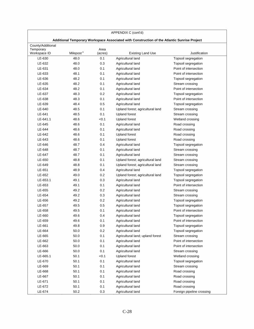
C-28
APPENDIX C (cont’d)
Additional Temporary Workspace Associated with Construction of the Atlantic Sunrise Project
County/Additional Temporary Workspace ID Milepost a
Area (acres) Existing Land Use Justification
LE-630 48.0 0.1 Agricultural land Topsoil segregation LE-632 48.0 0.3 Agricultural land Topsoil segregation LE-631 48.0 0.1 Agricultural land Point of intersection LE-633 48.1 0.1 Agricultural land Point of intersection LE-636 48.2 0.1 Agricultural land Topsoil segregation LE-635 48.2 0.1 Agricultural land Stream crossing LE-634 48.2 0.1 Agricultural land Point of intersection LE-637 48.3 0.2 Agricultural land Topsoil segregation LE-638 48.3 0.1 Agricultural land Point of intersection LE-639 48.4 0.5 Agricultural land Topsoil segregation LE-640 48.5 0.1 Upland forest; agricultural land Stream crossing LE-641 48.5 0.1 Upland forest Stream crossing LE-641.1 48.6 <0.1 Upland forest Wetland crossing LE-645 48.6 0.1 Agricultural land Road crossing LE-644 48.6 0.1 Agricultural land Road crossing LE-642 48.6 0.1 Upland forest Road crossing LE-643 48.6 0.1 Upland forest Road crossing LE-646 48.7 0.4 Agricultural land Topsoil segregation LE-648 48.7 0.1 Agricultural land Stream crossing LE-647 48.7 0.1 Agricultural land Stream crossing LE-650 48.8 0.1 Upland forest; agricultural land Stream crossing LE-649 48.8 0.1 Upland forest; agricultural land Stream crossing LE-651 48.9 0.4 Agricultural land Topsoil segregation LE-652 49.0 0.2 Upland forest; agricultural land Topsoil segregation LE-653.1 49.1 0.3 Agricultural land Topsoil segregation LE-653 49.1 0.1 Agricultural land Point of intersection LE-655 49.2 0.2 Agricultural land Stream crossing LE-654 49.2 0.3 Agricultural land Stream crossing LE-656 49.2 0.2 Agricultural land Topsoil segregation LE-657 49.5 0.5 Agricultural land Topsoil segregation LE-658 49.5 0.1 Agricultural land Point of intersection LE-660 49.6 0.4 Agricultural land Topsoil segregation LE-659 49.6 0.1 Agricultural land Point of intersection LE-661 49.8 0.9 Agricultural land Topsoil segregation LE-664 50.0 0.2 Agricultural land Topsoil segregation LE-665 50.0 0.1 Agricultural land; upland forest Stream crossing LE-662 50.0 0.1 Agricultural land Point of intersection LE-663 50.0 0.1 Agricultural land Point of intersection LE-666 50.0 0.1 Agricultural land Stream crossing LE-665.1 50.1 <0.1 Upland forest Wetland crossing LE-670 50.1 0.1 Agricultural land Topsoil segregation LE-669 50.1 0.1 Agricultural land Stream crossing LE-668 50.1 0.1 Agricultural land Road crossing LE-667 50.1 0.1 Agricultural land Road crossing LE-671 50.1 0.1 Agricultural land Road crossing LE-672 50.1 0.1 Agricultural land Road crossing LE-674 50.2 0.3 Agricultural land Foreign pipeline crossing
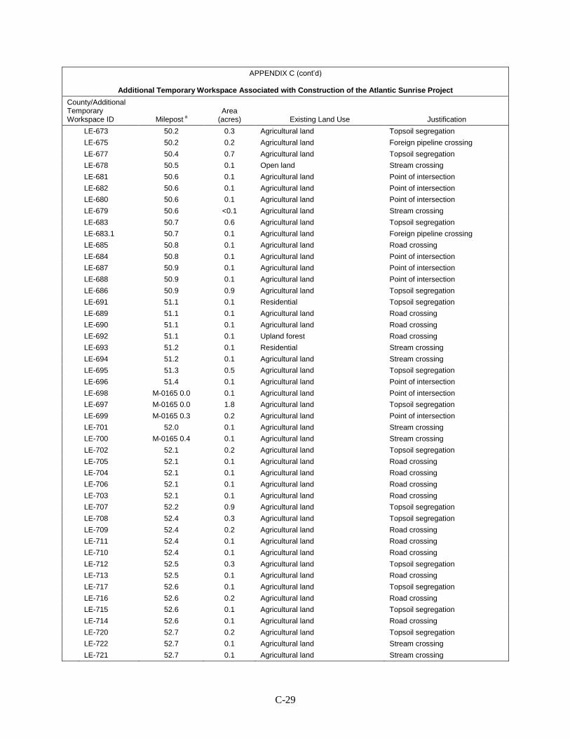
C-29
APPENDIX C (cont’d)
Additional Temporary Workspace Associated with Construction of the Atlantic Sunrise Project
County/Additional Temporary Workspace ID Milepost a
Area (acres) Existing Land Use Justification
LE-673 50.2 0.3 Agricultural land Topsoil segregation LE-675 50.2 0.2 Agricultural land Foreign pipeline crossing LE-677 50.4 0.7 Agricultural land Topsoil segregation LE-678 50.5 0.1 Open land Stream crossing LE-681 50.6 0.1 Agricultural land Point of intersection LE-682 50.6 0.1 Agricultural land Point of intersection LE-680 50.6 0.1 Agricultural land Point of intersection LE-679 50.6 <0.1 Agricultural land Stream crossing LE-683 50.7 0.6 Agricultural land Topsoil segregation LE-683.1 50.7 0.1 Agricultural land Foreign pipeline crossing LE-685 50.8 0.1 Agricultural land Road crossing LE-684 50.8 0.1 Agricultural land Point of intersection LE-687 50.9 0.1 Agricultural land Point of intersection LE-688 50.9 0.1 Agricultural land Point of intersection LE-686 50.9 0.9 Agricultural land Topsoil segregation LE-691 51.1 0.1 Residential Topsoil segregation LE-689 51.1 0.1 Agricultural land Road crossing LE-690 51.1 0.1 Agricultural land Road crossing LE-692 51.1 0.1 Upland forest Road crossing LE-693 51.2 0.1 Residential Stream crossing LE-694 51.2 0.1 Agricultural land Stream crossing LE-695 51.3 0.5 Agricultural land Topsoil segregation LE-696 51.4 0.1 Agricultural land Point of intersection LE-698 M-0165 0.0 0.1 Agricultural land Point of intersection LE-697 M-0165 0.0 1.8 Agricultural land Topsoil segregation LE-699 M-0165 0.3 0.2 Agricultural land Point of intersection LE-701 52.0 0.1 Agricultural land Stream crossing LE-700 M-0165 0.4 0.1 Agricultural land Stream crossing LE-702 52.1 0.2 Agricultural land Topsoil segregation LE-705 52.1 0.1 Agricultural land Road crossing LE-704 52.1 0.1 Agricultural land Road crossing LE-706 52.1 0.1 Agricultural land Road crossing LE-703 52.1 0.1 Agricultural land Road crossing LE-707 52.2 0.9 Agricultural land Topsoil segregation LE-708 52.4 0.3 Agricultural land Topsoil segregation LE-709 52.4 0.2 Agricultural land Road crossing LE-711 52.4 0.1 Agricultural land Road crossing LE-710 52.4 0.1 Agricultural land Road crossing LE-712 52.5 0.3 Agricultural land Topsoil segregation LE-713 52.5 0.1 Agricultural land Road crossing LE-717 52.6 0.1 Agricultural land Topsoil segregation LE-716 52.6 0.2 Agricultural land Road crossing LE-715 52.6 0.1 Agricultural land Topsoil segregation LE-714 52.6 0.1 Agricultural land Road crossing LE-720 52.7 0.2 Agricultural land Topsoil segregation LE-722 52.7 0.1 Agricultural land Stream crossing LE-721 52.7 0.1 Agricultural land Stream crossing
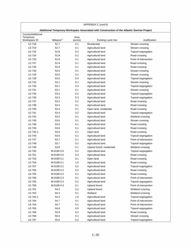
C-30
APPENDIX C (cont’d)
Additional Temporary Workspace Associated with Construction of the Atlantic Sunrise Project
County/Additional Temporary Workspace ID Milepost a
Area (acres) Existing Land Use Justification
LE-718 52.7 0.1 Residential Stream crossing LE-719 52.7 0.1 Agricultural land Stream crossing LE-725 52.8 0.2 Agricultural land Topsoil segregation LE-724 52.8 0.2 Agricultural land Road crossing LE-723 52.8 0.1 Agricultural land Point of intersection LE-727 52.9 0.1 Agricultural land Road crossing LE-726 52.9 0.1 Agricultural land Road crossing LE-730 53.0 0.1 Agricultural land Stream crossing LE-729 53.0 0.1 Agricultural land Stream crossing LE-728 53.0 0.4 Agricultural land Topsoil segregation LE-732 53.1 0.1 Agricultural land Stream crossing LE-733 53.1 0.3 Agricultural land Topsoil segregation LE-731 53.1 0.1 Agricultural land Stream crossing LE-734 53.3 0.2 Agricultural land Topsoil segregation LE-736 53.3 0.3 Agricultural land Topsoil segregation LE-737 53.3 0.1 Agricultural land Road crossing LE-738 53.4 0.1 Agricultural land Road crossing LE-740 53.4 0.1 Open land; residential Road crossing LE-741 53.4 0.2 Agricultural land Topsoil segregation LE-742 53.5 0.1 Agricultural land Wetland crossing LE-745 53.6 0.1 Agricultural land Stream crossing LE-746 53.6 0.1 Agricultural land Road crossing LE-743 53.6 0.1 Agricultural land Road crossing LE-742.1 53.6 0.1 Open land Road crossing LE-744 53.6 0.1 Agricultural land Topsoil segregation LE-747 53.7 0.1 Agricultural land Point of intersection LE-748 53.7 0.2 Agricultural land Topsoil segregation LE-749 53.8 0.1 Upland forest; residential Wetland crossing LE-750 M-0199 0.0 0.2 Agricultural land Topsoil segregation LE-751 M-0199 0.0 0.4 Agricultural land Road crossing LE-753 M-0199 0.1 0.1 Open land Road crossing LE-754 M-0199 0.1 1.0 Agricultural land Road crossing LE-757 M-0199 0.2 0.2 Agricultural land Topsoil segregation LE-756 M-0199 0.2 0.2 Agricultural land Road crossing LE-755 M-0199 0.2 0.1 Agricultural land Road crossing LE-759 M-0199 0.3 0.1 Agricultural land Point of intersection LE-760 M-0199 0.3 0.2 Agricultural land Topsoil segregation LE-758 M-0199 0.3 0.1 Upland forest Point of intersection LE-761 54.2 0.2 Upland forest Wetland crossing LE-762 54.3 0.1 Wetland Wetland crossing LE-762.1 54.3 1.0 Agricultural land Topsoil segregation LE-764 54.7 0.1 Agricultural land Point of intersection LE-763 54.7 0.1 Agricultural land Point of intersection LE-765 54.8 0.5 Agricultural land Topsoil segregation LE-766 54.9 0.2 Agricultural land Road crossing LE-768 55.0 0.1 Agricultural land Stream crossing LE-767 55.0 0.2 Agricultural land Topsoil segregation
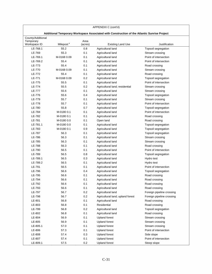
C-31
APPENDIX C (cont’d)
Additional Temporary Workspace Associated with Construction of the Atlantic Sunrise Project
County/Additional Temporary Workspace ID Milepost a
Area (acres) Existing Land Use Justification
LE-768.1 55.2 0.8 Agricultural land Topsoil segregation LE-769 55.3 0.1 Agricultural land Stream crossing LE-769.1 M-0168 0.09 0.1 Agricultural land Point of intersection LE-769.2 55.4 0.1 Agricultural land Point of intersection LE-773 55.4 0.1 Agricultural land Road crossing LE-770 M-0168 0.09 0.1 Agricultural land Stream crossing LE-772 55.4 0.1 Agricultural land Road crossing LE-771 M-0168 0.09 0.2 Agricultural land Topsoil segregation LE-775 55.5 0.1 Agricultural land Point of intersection LE-774 55.5 0.2 Agricultural land; residential Stream crossing LE-777 55.6 0.1 Agricultural land Stream crossing LE-776 55.6 0.4 Agricultural land Topsoil segregation LE-779 55.7 0.1 Agricultural land Stream crossing LE-778 55.7 0.1 Agricultural land Point of intersection LE-780 55.8 0.7 Agricultural land Topsoil segregation LE-784 M-0180 0.1 0.1 Agricultural land Point of intersection LE-782 M-0180 0.1 0.1 Agricultural land Road crossing LE-781 M-0180 0.0 0.1 Open land Road crossing LE-781.1 M-0180 0.0 0.1 Agricultural land Topsoil segregation LE-783 M-0180 0.1 0.9 Agricultural land Topsoil segregation LE-787 56.3 0.1 Agricultural land Topsoil segregation LE-786 56.3 0.1 Agricultural land Stream crossing LE-785 56.3 0.1 Agricultural land Stream crossing LE-788 56.3 0.1 Agricultural land Road crossing LE-790 56.5 0.1 Agricultural land Point of intersection LE-789 56.5 0.8 Agricultural land Topsoil segregation LE-789.1 56.5 0.3 Agricultural land Hydro test LE-789.2 56.5 0.1 Agricultural land Hydro test LE-791 56.5 0.1 Agricultural land Point of intersection LE-796 56.6 0.4 Agricultural land Topsoil segregation LE-795 56.6 0.1 Agricultural land Road crossing LE-794 56.6 0.1 Agricultural land Road crossing LE-792 56.6 0.1 Agricultural land Road crossing LE-793 56.6 0.1 Agricultural land Road crossing LE-797 56.7 0.2 Agricultural land Foreign pipeline crossing LE-798 56.7 0.2 Agricultural land; upland forest Foreign pipeline crossing LE-801 56.8 0.1 Agricultural land Road crossing LE-803 56.8 0.1 Residential Road crossing LE-799 56.8 0.2 Agricultural land Topsoil segregation LE-802 56.8 0.1 Agricultural land Road crossing LE-804 56.9 0.1 Upland forest Stream crossing LE-805 56.9 0.1 Upland forest Stream crossing LE-805.1 57.0 0.1 Upland forest Stream crossing LE-806 57.3 0.1 Upland forest Point of intersection LE-808 57.4 0.3 Upland forest Side slope LE-807 57.4 0.1 Upland forest Point of intersection LE-809.1 57.5 0.2 Upland forest Steep slope

C-32
APPENDIX C (cont’d)
Additional Temporary Workspace Associated with Construction of the Atlantic Sunrise Project
County/Additional Temporary Workspace ID Milepost a
Area (acres) Existing Land Use Justification
LE-810 57.5 0.1 Upland forest Point of intersection LE-809 57.5 0.1 Upland forest Point of intersection LE-810.1 57.6 0.5 Upland forest Steep slope LE-811 57.7 0.2 Upland forest Steep slope LE-810.2 57.7 0.4 Upland forest Steep slope LE-810.3 57.7 0.3 Upland forest Steep slope LE-812 58.1 0.3 Upland forest Foreign pipeline crossing LE-814 58.2 0.1 Upland forest Point of intersection LE-815 58.5 0.1 Upland forest Steep slope LE-816 58.6 0.1 Upland forest Side slope LE-817 58.7 0.2 Upland forest Road crossing LE-819 58.7 0.1 Upland forest Stream crossing LE-818 58.7 0.1 Upland forest Road crossing LE-820 58.7 0.1 Upland forest Foreign pipeline crossing LE-821 58.8 0.1 Wetland Wetland crossing LE-824 58.9 0.1 Upland forest Point of intersection LE-823 58.9 0.1 Upland forest Wetland crossing LE-822 58.9 0.1 Open land Wetland crossing LE-825 58.9 0.1 Upland forest Point of intersection LE-827 59.0 0.1 Agricultural land Point of intersection LE-826 59.0 0.5 Agricultural land Topsoil segregation LE-828 59.1 0.1 Agricultural land Stream crossing LE-831 59.2 0.1 Open land Road crossing LE-830 59.2 0.1 Agricultural land Road crossing LE-829 59.2 0.1 Agricultural land Topsoil segregation LE-832 59.3 0.2 Upland forest Spoil storage LE-833 M-0176 0.0 0.1 Upland forest Stream crossing LE-834 M-0176 0.0 0.2 Upland forest Stream crossing LE-836 M-0176 0.0 0.2 Agricultural land Topsoil segregation LE-839 M-0176 0.1 0.3 Agricultural land Stream crossing LE-840 M-0176 0.1 0.1 Upland forest Stream crossing LE-841 M-0176 0.1 0.2 Agricultural land Stream crossing LE-842.4 M-0176 0.2 0.2 Agricultural land Point of intersection LE-842.5 M-0176 0.2 0.2 Agricultural land Point of intersection LE-842 M-0176 0.1 0.2 Agricultural land Topsoil segregation LE-843.4 M-0200 0.0 0.2 Upland forest Trail crossing LE-842.3 M-0176 0.2 0.5 Upland forest Topsoil segregation LE-843.5 M-0200 0.0 0.2 Upland forest Trail crossing LE-845 M-0200 0.3 0.1 Upland forest Stream crossing LE-844 M-0200 0.3 0.2 Agricultural land Stream crossing LE-846 M-0200 0.4 0.4 Agricultural land Topsoil segregation LE-847 M-0200 0.5 0.5 Agricultural land Topsoil segregation LE-848 M-0200 0.7 0.1 Upland forest Stream crossing LE-849 M-0200 0.7 0.1 Upland forest Stream crossing LE-851 60.7 0.1 Open land upland forest Road crossing LE-850 60.7 0.1 Open land upland forest Road crossing LE-852 60.9 1.2 Agricultural land Topsoil segregation

C-33
APPENDIX C (cont’d)
Additional Temporary Workspace Associated with Construction of the Atlantic Sunrise Project
County/Additional Temporary Workspace ID Milepost a
Area (acres) Existing Land Use Justification
LE-854 61.1 0.1 Agricultural land Stream crossing LE-853 61.1 0.2 Agricultural land Stream crossing LE-855 61.3 0.3 Agricultural land Side slope LE-856 61.3 0.3 Agricultural land Topsoil segregation LE-857 61.3 0.4 Agricultural land Spoil storage LE-857.3 61.4 0.1 Upland forest Steep slope LE-857.4 61.4 0.1 Residential; upland forest Steep slope LE-857.2 61.4 0.1 Agricultural land; upland forest Steep slope LE-857.1 61.4 0.1 Agricultural land; upland forest Stream crossing LE-860 61.5 0.1 Agricultural land Road crossing LE-859 61.5 0.1 Agricultural land Point of intersection LE-858 61.5 0.3 Agricultural land; upland forest Road crossing LE-861 61.6 0.8 Agricultural land; upland forest Topsoil segregation LE-862 61.9 0.3 Agricultural land Topsoil segregation LE-864 62.0 0.2 Agricultural land Topsoil segregation LE-865 62.3 1.1 Agricultural land Topsoil segregation LE-867 62.4 0.1 Agricultural land Point of intersection LE-866 62.4 0.1 Agricultural land Point of intersection LE-868 62.5 0.1 Upland forest Point of intersection LE-869 62.5 0.1 Upland forest Stream crossing LE-870 62.6 0.3 Upland forest Stream crossing LE-871 63.3 0.1 Upland forest Point of intersection LE-872 63.3 0.1 Upland forest Point of intersection LE-873 63.5 0.7 Upland forest; agricultural land Topsoil segregation LE-874 63.6 0.1 Agricultural land Point of intersection LE-877 63.7 0.1 Agricultural land Stream crossing LE-875 63.7 0.1 Agricultural land Road crossing LE-878 63.8 0.5 Agricultural land Topsoil segregation LE-876 63.8 0.1 Agricultural land Stream crossing LE-879 63.9 0.1 Agricultural land; upland forest Stream crossing LE-880 64.0 0.1 Upland forest Stream crossing LE-882 64.0 0.1 Upland forest Stream crossing LE-881 64.0 0.1 Upland forest Point of intersection LE-883 64.0 0.1 Upland forest Point of intersection LE-884 64.1 0.1 Upland forest Stream crossing LE-885 64.1 0.1 Upland forest Point of intersection LE-886 64.2 0.3 Agricultural land Foreign pipeline crossing LE-887 64.3 0.9 Agricultural land Topsoil segregation Schuylkill County SC-889 64.4 0.1 Agricultural land Road crossing SC-890 64.5 0.1 Agricultural land Road crossing SC-891 64.7 1.2 Agricultural land Topsoil segregation SC-892 64.9 0.4 Agricultural land Topsoil segregation SC-893 65.0 0.1 Agricultural land Point of intersection SC-894 65.0 0.1 Agricultural land; upland forest Point of intersection SC-899.1 65.2 0.1 Open land Steep slope SC-898 65.2 0.1 Residential Point of intersection
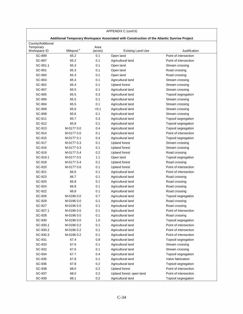
C-34
APPENDIX C (cont’d)
Additional Temporary Workspace Associated with Construction of the Atlantic Sunrise Project
County/Additional Temporary Workspace ID Milepost a
Area (acres) Existing Land Use Justification
SC-899 65.2 0.1 Open land Point of intersection SC-897 65.2 0.1 Agricultural land Point of intersection SC-901.1 65.3 0.1 Open land Stream crossing SC-901 65.3 0.1 Open land Road crossing SC-900 65.3 0.1 Open land Road crossing SC-903 65.4 0.1 Agricultural land Stream crossing SC-902 65.4 0.1 Upland forest Stream crossing SC-907 65.5 0.1 Agricultural land Stream crossing SC-905 65.5 0.3 Agricultural land Topsoil segregation SC-906 65.5 0.1 Agricultural land Stream crossing SC-904 65.5 0.1 Agricultural land Stream crossing SC-909 65.6 <0.1 Agricultural land Stream crossing SC-908 65.6 0.1 Agricultural land Stream crossing SC-911 65.7 0.3 Agricultural land Topsoil segregation SC-912 65.8 0.1 Agricultural land Topsoil segregation SC-913 M-0177 0.0 0.4 Agricultural land Topsoil segregation SC-914 M-0177 0.0 0.1 Agricultural land Point of intersection SC-915 M-0177 0.1 0.4 Agricultural land Topsoil segregation SC-917 M-0177 0.3 0.1 Upland forest Stream crossing SC-916 M-0177 0.3 0.1 Upland forest Stream crossing SC-919 M-0177 0.4 0.2 Upland forest Road crossing SC-919.1 M-0177 0.5 1.1 Open land Topsoil segregation SC-918 M-0177 0.4 0.1 Upland forest Road crossing SC-920 M-0177 0.6 0.1 Upland forest Point of intersection SC-921 66.6 0.1 Agricultural land Point of intersection SC-923 66.7 0.1 Agricultural land Road crossing SC-925 66.8 0.1 Agricultural land Road crossing SC-924 66.8 0.1 Agricultural land Road crossing SC-922 66.8 0.1 Agricultural land Road crossing SC-926 M-0196 0.0 0.7 Agricultural land Topsoil segregation SC-929 M-0196 0.0 0.1 Agricultural land Road crossing SC-927 M-0196 0.0 0.1 Agricultural land Road crossing SC-927.1 M-0196 0.0 0.1 Agricultural land Point of intersection SC-928 M-0196 0.0 0.1 Agricultural land Road crossing SC-930 M-0196 0.0 1.0 Agricultural land Topsoil segregation SC-930.1 M-0196 0.2 0.1 Agricultural land Point of intersection SC-930.2 M-0196 0.2 0.1 Agricultural land Point of intersection SC-930.3 M-0196 0.2 0.1 Agricultural land Point of intersection SC-931 67.4 0.8 Agricultural land Topsoil segregation SC-933 67.6 0.1 Agricultural land Stream crossing SC-932 67.6 0.1 Agricultural land Stream crossing SC-934 67.7 0.4 Agricultural land Topsoil segregation SC-935 67.8 0.1 Agricultural land Valve fabrication SC-936 67.8 0.2 Agricultural land Topsoil segregation SC-938 68.0 0.2 Upland forest Point of intersection SC-937 68.0 0.2 Upland forest; open land Point of intersection SC-939 68.1 0.2 Agricultural land Topsoil segregation

C-35
APPENDIX C (cont’d)
Additional Temporary Workspace Associated with Construction of the Atlantic Sunrise Project
County/Additional Temporary Workspace ID Milepost a
Area (acres) Existing Land Use Justification
SC-940 68.2 0.2 Agricultural land Topsoil segregation SC-941 68.2 0.1 Agricultural land Point of intersection SC-943 68.3 0.1 Agricultural land Stream crossing SC-942 68.3 0.2 Agricultural land Topsoil segregation SC-944 68.4 0.1 Upland forest; agricultural land Stream crossing SC-945 68.4 0.1 Agricultural land Stream crossing SC-946 68.5 0.3 Agricultural land Topsoil segregation SC-948 68.6 0.5 Agricultural land Topsoil segregation SC-947 68.6 0.1 Agricultural land Point of intersection SC-950 68.7 0.1 Upland forest Point of intersection SC-949 68.7 0.2 Upland forest Point of intersection SC-952 68.8 0.1 Upland forest Road crossing SC-951 68.8 0.1 Upland forest Road crossing SC-954 68.8 0.1 Upland forest Road crossing SC-953 68.8 0.1 Upland forest Road crossing SC-956 68.9 0.3 Upland forest Side slope SC-955 68.9 0.3 Upland forest Side slope SC-957 69.1 0.1 Upland forest Point of intersection SC-958 69.1 0.1 Upland forest Stream crossing SC-960 69.2 0.1 Upland forest Point of intersection SC-959 69.2 0.1 Upland forest Point of intersection SC-963 69.6 0.1 Upland forest Point of intersection SC-964 69.6 0.1 Upland forest Point of intersection SC-961 69.7 2.7 Upland forest Side slope SC-962 69.7 2.7 Upland forest Side slope SC-965 70.1 0.1 Upland forest Point of intersection SC-966 70.2 0.1 Upland forest Point of intersection SC-968 70.6 0.1 Upland forest Steep slope SC-967 70.6 0.1 Upland forest Steep slope SC-969 70.7 0.1 Upland forest Point of intersection SC-970 70.7 0.1 Upland forest Point of intersection SC-971 M-0181 0.0 0.4 Upland forest Side slope SC-973 M-0181 0.0 0.1 Upland forest Point of intersection SC-972 M-0181 0.0 0.1 Upland forest Point of intersection SC-973.1 M-0181 0.0 0.1 Upland forest Steep slope SC-974 M-0181 0.1 <0.1 Upland forest Road crossing SC-976 M-0181 0.2 0.1 Upland forest Stream crossing SC-975 M-0181 0.1 0.1 Residential Road crossing SC-976.1 M-0181 0.2 0.1 Upland forest Stream crossing SC-977 71.1 0.1 Upland forest Point of intersection SC-978 71.3 0.1 Upland forest Point of intersection SC-979 71.6 0.1 Upland forest Point of intersection SC-983 72.6 0.1 Upland forest Road crossing SC-982 72.6 0.1 Upland forest Road crossing SC-984 72.7 0.1 Upland forest Stream crossing SC-985 72.7 0.1 Upland forest Stream crossing SC-987 73.2 0.1 Upland forest Road crossing
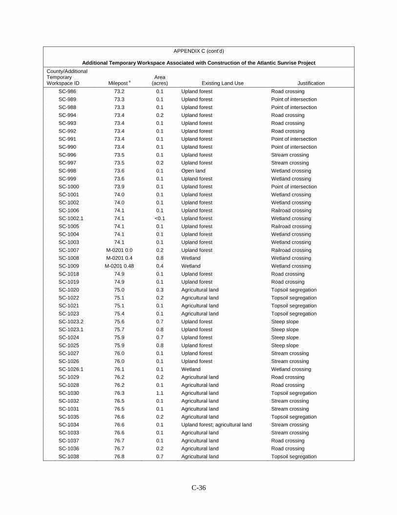
C-36
APPENDIX C (cont’d)
Additional Temporary Workspace Associated with Construction of the Atlantic Sunrise Project
County/Additional Temporary Workspace ID Milepost a
Area (acres) Existing Land Use Justification
SC-986 73.2 0.1 Upland forest Road crossing SC-989 73.3 0.1 Upland forest Point of intersection SC-988 73.3 0.1 Upland forest Point of intersection SC-994 73.4 0.2 Upland forest Road crossing SC-993 73.4 0.1 Upland forest Road crossing SC-992 73.4 0.1 Upland forest Road crossing SC-991 73.4 0.1 Upland forest Point of intersection SC-990 73.4 0.1 Upland forest Point of intersection SC-996 73.5 0.1 Upland forest Stream crossing SC-997 73.5 0.2 Upland forest Stream crossing SC-998 73.6 0.1 Open land Wetland crossing SC-999 73.6 0.1 Upland forest Wetland crossing SC-1000 73.9 0.1 Upland forest Point of intersection SC-1001 74.0 0.1 Upland forest Wetland crossing SC-1002 74.0 0.1 Upland forest Wetland crossing SC-1006 74.1 0.1 Upland forest Railroad crossing SC-1002.1 74.1 <0.1 Upland forest Wetland crossing SC-1005 74.1 0.1 Upland forest Railroad crossing SC-1004 74.1 0.1 Upland forest Wetland crossing SC-1003 74.1 0.1 Upland forest Wetland crossing SC-1007 M-0201 0.0 0.2 Upland forest Railroad crossing SC-1008 M-0201 0.4 0.8 Wetland Wetland crossing SC-1009 M-0201 0.48 0.4 Wetland Wetland crossing SC-1018 74.9 0.1 Upland forest Road crossing SC-1019 74.9 0.1 Upland forest Road crossing SC-1020 75.0 0.3 Agricultural land Topsoil segregation SC-1022 75.1 0.2 Agricultural land Topsoil segregation SC-1021 75.1 0.1 Agricultural land Topsoil segregation SC-1023 75.4 0.1 Agricultural land Topsoil segregation SC-1023.2 75.6 0.7 Upland forest Steep slope SC-1023.1 75.7 0.8 Upland forest Steep slope SC-1024 75.9 0.7 Upland forest Steep slope SC-1025 75.9 0.8 Upland forest Steep slope SC-1027 76.0 0.1 Upland forest Stream crossing SC-1026 76.0 0.1 Upland forest Stream crossing SC-1026.1 76.1 0.1 Wetland Wetland crossing SC-1029 76.2 0.2 Agricultural land Road crossing SC-1028 76.2 0.1 Agricultural land Road crossing SC-1030 76.3 1.1 Agricultural land Topsoil segregation SC-1032 76.5 0.1 Agricultural land Stream crossing SC-1031 76.5 0.1 Agricultural land Stream crossing SC-1035 76.6 0.2 Agricultural land Topsoil segregation SC-1034 76.6 0.1 Upland forest; agricultural land Stream crossing SC-1033 76.6 0.1 Agricultural land Stream crossing SC-1037 76.7 0.1 Agricultural land Road crossing SC-1036 76.7 0.2 Agricultural land Road crossing SC-1038 76.8 0.7 Agricultural land Topsoil segregation
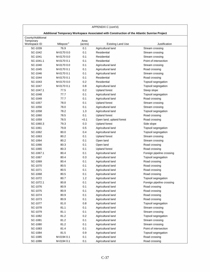
C-37
APPENDIX C (cont’d)
Additional Temporary Workspace Associated with Construction of the Atlantic Sunrise Project
County/Additional Temporary Workspace ID Milepost a
Area (acres) Existing Land Use Justification
SC-1039 76.9 0.1 Agricultural land Stream crossing SC-1042 M-0170 0.0 0.1 Residential Stream crossing SC-1041 M-0170 0.0 0.1 Residential Stream crossing SC-1041.1 M-0170 0.1 0.1 Residential Point of intersection SC-1040 M-0170 0.0 0.1 Agricultural land Stream crossing SC-1045 M-0170 0.1 0.1 Agricultural land Road crossing SC-1046 M-0170 0.1 0.1 Agricultural land Stream crossing SC-1044 M-0170 0.1 0.1 Residential Road crossing SC-1043 M-0170 0.0 0.2 Residential Topsoil segregation SC-1047 M-0170 0.1 0.8 Agricultural land Topsoil segregation SC-1047.1 77.5 0.2 Upland forest Steep slope SC-1048 77.7 0.1 Agricultural land Topsoil segregation SC-1049 77.7 0.1 Agricultural land Road crossing SC-1057 78.0 0.1 Upland forest Stream crossing SC-1056 78.0 0.1 Agricultural land Stream crossing SC-1058 78.2 1.3 Agricultural land Topsoil segregation SC-1060 78.5 0.1 Upland forest Road crossing SC-1059 78.5 <0.1 Open land; upland forest Road crossing SC-1060.3 79.3 0.3 Upland forest Side slope SC-1061 79.8 0.5 Agricultural land Topsoil segregation SC-1062 80.0 0.4 Agricultural land Topsoil segregation SC-1063 80.2 0.1 Upland forest Stream crossing SC-1064 80.2 0.1 Open land Stream crossing SC-1066 80.3 0.1 Open land Road crossing SC-1065 80.3 0.1 Upland forest Road crossing SC-1067.1 80.4 0.1 Agricultural land Foreign pipeline crossing SC-1067 80.4 0.3 Agricultural land Topsoil segregation SC-1069 80.4 0.1 Agricultural land Road crossing SC-1070 80.5 0.1 Agricultural land Road crossing SC-1071 80.5 0.1 Agricultural land Road crossing SC-1068 80.5 0.1 Agricultural land Road crossing SC-1072 80.7 1.2 Agricultural land Topsoil segregation SC-1072.1 80.8 0.1 Agricultural land Foreign pipeline crossing SC-1076 80.9 0.1 Agricultural land Road crossing SC-1075 80.9 0.1 Agricultural land Road crossing SC-1074 80.9 0.1 Agricultural land Road crossing SC-1073 80.9 0.1 Agricultural land Road crossing SC-1077 81.0 0.8 Agricultural land Topsoil segregation SC-1078 81.1 0.1 Agricultural land Stream crossing SC-1079 81.1 0.1 Agricultural land Stream crossing SC-1082 81.2 0.2 Agricultural land Topsoil segregation SC-1081 81.2 0.1 Agricultural land Stream crossing SC-1080 81.2 0.1 Agricultural land Stream crossing SC-1083 81.4 0.1 Agricultural land Point of intersection SC-1084 81.5 0.9 Agricultural land Topsoil segregation SC-1085 M-0194 0.1 0.1 Agricultural land Road crossing SC-1086 M-0194 0.1 0.1 Agricultural land Road crossing
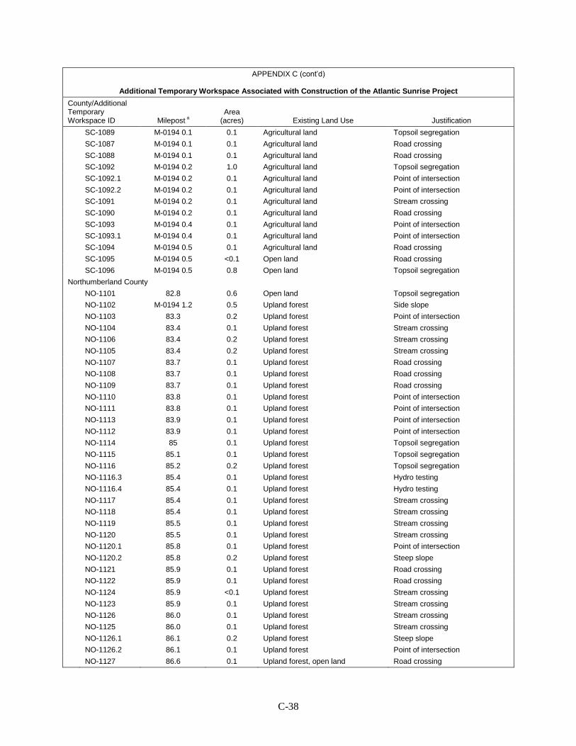
C-38
APPENDIX C (cont’d)
Additional Temporary Workspace Associated with Construction of the Atlantic Sunrise Project
County/Additional Temporary Workspace ID Milepost a
Area (acres) Existing Land Use Justification
SC-1089 M-0194 0.1 0.1 Agricultural land Topsoil segregation SC-1087 M-0194 0.1 0.1 Agricultural land Road crossing SC-1088 M-0194 0.1 0.1 Agricultural land Road crossing SC-1092 M-0194 0.2 1.0 Agricultural land Topsoil segregation SC-1092.1 M-0194 0.2 0.1 Agricultural land Point of intersection SC-1092.2 M-0194 0.2 0.1 Agricultural land Point of intersection SC-1091 M-0194 0.2 0.1 Agricultural land Stream crossing SC-1090 M-0194 0.2 0.1 Agricultural land Road crossing SC-1093 M-0194 0.4 0.1 Agricultural land Point of intersection SC-1093.1 M-0194 0.4 0.1 Agricultural land Point of intersection SC-1094 M-0194 0.5 0.1 Agricultural land Road crossing SC-1095 M-0194 0.5 <0.1 Open land Road crossing SC-1096 M-0194 0.5 0.8 Open land Topsoil segregation Northumberland County NO-1101 82.8 0.6 Open land Topsoil segregation NO-1102 M-0194 1.2 0.5 Upland forest Side slope NO-1103 83.3 0.2 Upland forest Point of intersection NO-1104 83.4 0.1 Upland forest Stream crossing NO-1106 83.4 0.2 Upland forest Stream crossing NO-1105 83.4 0.2 Upland forest Stream crossing NO-1107 83.7 0.1 Upland forest Road crossing NO-1108 83.7 0.1 Upland forest Road crossing NO-1109 83.7 0.1 Upland forest Road crossing NO-1110 83.8 0.1 Upland forest Point of intersection NO-1111 83.8 0.1 Upland forest Point of intersection NO-1113 83.9 0.1 Upland forest Point of intersection NO-1112 83.9 0.1 Upland forest Point of intersection NO-1114 85 0.1 Upland forest Topsoil segregation NO-1115 85.1 0.1 Upland forest Topsoil segregation NO-1116 85.2 0.2 Upland forest Topsoil segregation NO-1116.3 85.4 0.1 Upland forest Hydro testing NO-1116.4 85.4 0.1 Upland forest Hydro testing NO-1117 85.4 0.1 Upland forest Stream crossing NO-1118 85.4 0.1 Upland forest Stream crossing NO-1119 85.5 0.1 Upland forest Stream crossing NO-1120 85.5 0.1 Upland forest Stream crossing NO-1120.1 85.8 0.1 Upland forest Point of intersection NO-1120.2 85.8 0.2 Upland forest Steep slope NO-1121 85.9 0.1 Upland forest Road crossing NO-1122 85.9 0.1 Upland forest Road crossing NO-1124 85.9 <0.1 Upland forest Stream crossing NO-1123 85.9 0.1 Upland forest Stream crossing NO-1126 86.0 0.1 Upland forest Stream crossing NO-1125 86.0 0.1 Upland forest Stream crossing NO-1126.1 86.1 0.2 Upland forest Steep slope NO-1126.2 86.1 0.1 Upland forest Point of intersection NO-1127 86.6 0.1 Upland forest, open land Road crossing
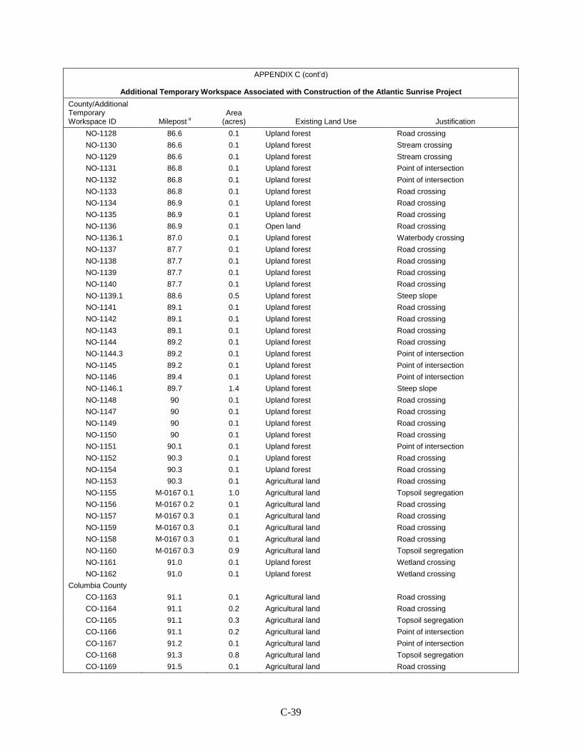
C-39
APPENDIX C (cont’d)
Additional Temporary Workspace Associated with Construction of the Atlantic Sunrise Project
County/Additional Temporary Workspace ID Milepost a
Area (acres) Existing Land Use Justification
NO-1128 86.6 0.1 Upland forest Road crossing NO-1130 86.6 0.1 Upland forest Stream crossing NO-1129 86.6 0.1 Upland forest Stream crossing NO-1131 86.8 0.1 Upland forest Point of intersection NO-1132 86.8 0.1 Upland forest Point of intersection NO-1133 86.8 0.1 Upland forest Road crossing NO-1134 86.9 0.1 Upland forest Road crossing NO-1135 86.9 0.1 Upland forest Road crossing NO-1136 86.9 0.1 Open land Road crossing NO-1136.1 87.0 0.1 Upland forest Waterbody crossing NO-1137 87.7 0.1 Upland forest Road crossing NO-1138 87.7 0.1 Upland forest Road crossing NO-1139 87.7 0.1 Upland forest Road crossing NO-1140 87.7 0.1 Upland forest Road crossing NO-1139.1 88.6 0.5 Upland forest Steep slope NO-1141 89.1 0.1 Upland forest Road crossing NO-1142 89.1 0.1 Upland forest Road crossing NO-1143 89.1 0.1 Upland forest Road crossing NO-1144 89.2 0.1 Upland forest Road crossing NO-1144.3 89.2 0.1 Upland forest Point of intersection NO-1145 89.2 0.1 Upland forest Point of intersection NO-1146 89.4 0.1 Upland forest Point of intersection NO-1146.1 89.7 1.4 Upland forest Steep slope NO-1148 90 0.1 Upland forest Road crossing NO-1147 90 0.1 Upland forest Road crossing NO-1149 90 0.1 Upland forest Road crossing NO-1150 90 0.1 Upland forest Road crossing NO-1151 90.1 0.1 Upland forest Point of intersection NO-1152 90.3 0.1 Upland forest Road crossing NO-1154 90.3 0.1 Upland forest Road crossing NO-1153 90.3 0.1 Agricultural land Road crossing NO-1155 M-0167 0.1 1.0 Agricultural land Topsoil segregation NO-1156 M-0167 0.2 0.1 Agricultural land Road crossing NO-1157 M-0167 0.3 0.1 Agricultural land Road crossing NO-1159 M-0167 0.3 0.1 Agricultural land Road crossing NO-1158 M-0167 0.3 0.1 Agricultural land Road crossing NO-1160 M-0167 0.3 0.9 Agricultural land Topsoil segregation NO-1161 91.0 0.1 Upland forest Wetland crossing NO-1162 91.0 0.1 Upland forest Wetland crossing Columbia County CO-1163 91.1 0.1 Agricultural land Road crossing CO-1164 91.1 0.2 Agricultural land Road crossing CO-1165 91.1 0.3 Agricultural land Topsoil segregation CO-1166 91.1 0.2 Agricultural land Point of intersection CO-1167 91.2 0.1 Agricultural land Point of intersection CO-1168 91.3 0.8 Agricultural land Topsoil segregation CO-1169 91.5 0.1 Agricultural land Road crossing
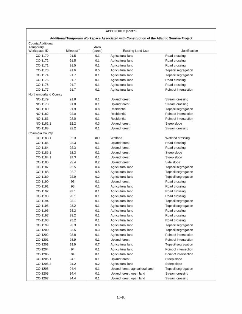
C-40
APPENDIX C (cont’d)
Additional Temporary Workspace Associated with Construction of the Atlantic Sunrise Project
County/Additional Temporary Workspace ID Milepost a
Area (acres) Existing Land Use Justification
CO-1170 91.5 0.1 Agricultural land Road crossing CO-1172 91.5 0.1 Agricultural land Road crossing CO-1171 91.5 0.1 Agricultural land Road crossing CO-1173 91.6 0.5 Agricultural land Topsoil segregation CO-1174 91.7 0.1 Agricultural land Topsoil segregation CO-1175 91.7 0.1 Agricultural land Road crossing CO-1176 91.7 0.1 Agricultural land Road crossing CO-1177 91.7 0.1 Agricultural land Point of intersection Northumberland County NO-1179 91.8 0.1 Upland forest Stream crossing NO-1178 91.8 0.1 Upland forest Stream crossing NO-1180 91.9 0.8 Residential Topsoil segregation NO-1182 92.0 0.1 Residential Point of intersection NO-1181 92.0 0.1 Residential Point of intersection NO-1182.1 92.2 0.3 Upland forest Steep slope NO-1183 92.2 0.1 Upland forest Stream crossing Columbia County CO-1183.1 92.3 <0.1 Wetland Wetland crossing CO-1185 92.3 0.1 Upland forest Road crossing CO-1184 92.3 0.1 Upland forest Road crossing CO-1185.1 92.3 0.1 Upland forest Steep slope CO-1184.1 92.3 0.1 Upland forest Steep slope CO-1186 92.4 0.2 Upland forest Side slope CO-1187 92.5 0.4 Agricultural land Topsoil segregation CO-1188 92.7 0.5 Agricultural land Topsoil segregation CO-1189 92.9 0.2 Agricultural land Topsoil segregation CO-1190 93 0.1 Upland forest Road crossing CO-1191 93 0.1 Agricultural land Road crossing CO-1192 93.1 0.1 Agricultural land Road crossing CO-1193 93.1 0.1 Agricultural land Road crossing CO-1194 93.1 0.1 Agricultural land Topsoil segregation CO-1195 93.2 0.1 Agricultural land Topsoil segregation CO-1196 93.2 0.1 Agricultural land Road crossing CO-1197 93.2 0.1 Agricultural land Road crossing CO-1198 93.2 0.1 Agricultural land Road crossing CO-1199 93.3 0.6 Agricultural land Topsoil segregation CO-1200 93.5 0.3 Agricultural land Topsoil segregation CO-1202 93.8 0.1 Agricultural land Point of intersection CO-1201 93.9 0.1 Upland forest Point of intersection CO-1203 93.9 0.7 Agricultural land Topsoil segregation CO-1204 94 0.1 Agricultural land Point of intersection CO-1205 94 0.1 Agricultural land Point of intersection CO-1205.1 94.1 0.1 Upland forest Steep slope CO-1205.2 94.2 0.2 Agricultural land Steep slope CO-1206 94.4 0.1 Upland forest; agricultural land Topsoil segregation CO-1208 94.4 0.1 Upland forest; open land Stream crossing CO-1207 94.4 0.1 Upland forest; open land Stream crossing
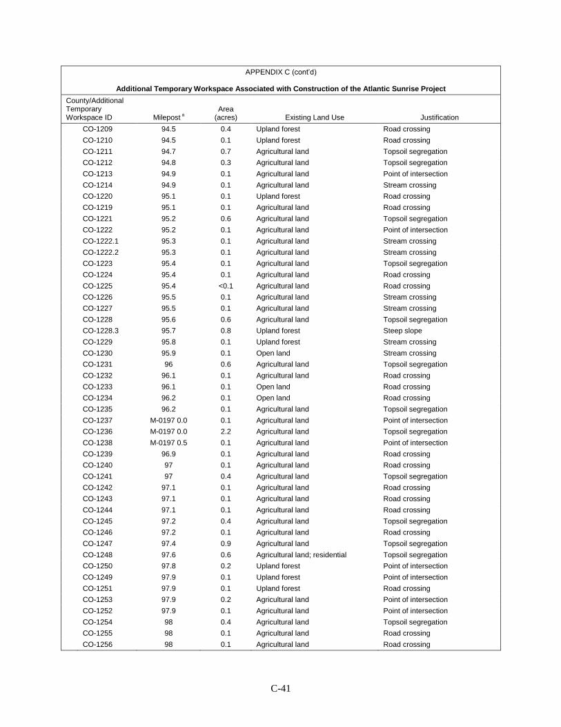
C-41
APPENDIX C (cont’d)
Additional Temporary Workspace Associated with Construction of the Atlantic Sunrise Project
County/Additional Temporary Workspace ID Milepost a
Area (acres) Existing Land Use Justification
CO-1209 94.5 0.4 Upland forest Road crossing CO-1210 94.5 0.1 Upland forest Road crossing CO-1211 94.7 0.7 Agricultural land Topsoil segregation CO-1212 94.8 0.3 Agricultural land Topsoil segregation CO-1213 94.9 0.1 Agricultural land Point of intersection CO-1214 94.9 0.1 Agricultural land Stream crossing CO-1220 95.1 0.1 Upland forest Road crossing CO-1219 95.1 0.1 Agricultural land Road crossing CO-1221 95.2 0.6 Agricultural land Topsoil segregation CO-1222 95.2 0.1 Agricultural land Point of intersection CO-1222.1 95.3 0.1 Agricultural land Stream crossing CO-1222.2 95.3 0.1 Agricultural land Stream crossing CO-1223 95.4 0.1 Agricultural land Topsoil segregation CO-1224 95.4 0.1 Agricultural land Road crossing CO-1225 95.4 <0.1 Agricultural land Road crossing CO-1226 95.5 0.1 Agricultural land Stream crossing CO-1227 95.5 0.1 Agricultural land Stream crossing CO-1228 95.6 0.6 Agricultural land Topsoil segregation CO-1228.3 95.7 0.8 Upland forest Steep slope CO-1229 95.8 0.1 Upland forest Stream crossing CO-1230 95.9 0.1 Open land Stream crossing CO-1231 96 0.6 Agricultural land Topsoil segregation CO-1232 96.1 0.1 Agricultural land Road crossing CO-1233 96.1 0.1 Open land Road crossing CO-1234 96.2 0.1 Open land Road crossing CO-1235 96.2 0.1 Agricultural land Topsoil segregation CO-1237 M-0197 0.0 0.1 Agricultural land Point of intersection CO-1236 M-0197 0.0 2.2 Agricultural land Topsoil segregation CO-1238 M-0197 0.5 0.1 Agricultural land Point of intersection CO-1239 96.9 0.1 Agricultural land Road crossing CO-1240 97 0.1 Agricultural land Road crossing CO-1241 97 0.4 Agricultural land Topsoil segregation CO-1242 97.1 0.1 Agricultural land Road crossing CO-1243 97.1 0.1 Agricultural land Road crossing CO-1244 97.1 0.1 Agricultural land Road crossing CO-1245 97.2 0.4 Agricultural land Topsoil segregation CO-1246 97.2 0.1 Agricultural land Road crossing CO-1247 97.4 0.9 Agricultural land Topsoil segregation CO-1248 97.6 0.6 Agricultural land; residential Topsoil segregation CO-1250 97.8 0.2 Upland forest Point of intersection CO-1249 97.9 0.1 Upland forest Point of intersection CO-1251 97.9 0.1 Upland forest Road crossing CO-1253 97.9 0.2 Agricultural land Point of intersection CO-1252 97.9 0.1 Agricultural land Point of intersection CO-1254 98 0.4 Agricultural land Topsoil segregation CO-1255 98 0.1 Agricultural land Road crossing CO-1256 98 0.1 Agricultural land Road crossing
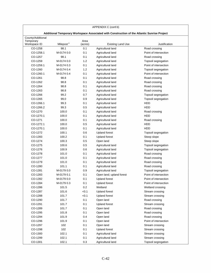
C-42
APPENDIX C (cont’d)
Additional Temporary Workspace Associated with Construction of the Atlantic Sunrise Project
County/Additional Temporary Workspace ID Milepost a
Area (acres) Existing Land Use Justification
CO-1258 98.1 0.1 Agricultural land Road crossing CO-1258.1 M-0174 0.0 0.1 Agricultural land Point of intersection CO-1257 98.1 0.1 Agricultural land Road crossing CO-1259 M-0174 0.0 1.2 Agricultural land Topsoil segregation CO-1259.1 M-0174 0.3 0.1 Agricultural land Point of intersection CO-1260 M-0174 0.4 1.2 Agricultural land Topsoil segregation CO-1260.1 M-0174 0.4 0.1 Agricultural land Point of intersection CO-1261 98.8 0.1 Agricultural land Road crossing CO-1262 98.8 0.1 Agricultural land Road crossing CO-1264 98.8 0.1 Agricultural land Road crossing CO-1263 98.8 0.1 Agricultural land Road crossing CO-1266 99.2 0.7 Agricultural land Topsoil segregation CO-1265 99.0 0.9 Agricultural land Topsoil segregation CO-1266.1 99.3 0.1 Agricultural land HDD CO-1266.2 99.3 0.5 Agricultural land HDD CO-1270 100.0 0.1 Agricultural land Road crossing CO-1270.1 100.0 0.1 Agricultural land HDD CO-1271 100.0 0.1 Agricultural land Road crossing CO-1272.1 100.0 0.5 Agricultural land HDD CO-1270.1 100.0 0.1 Agricultural land HDD CO-1272 100.1 0.6 Upland forest Topsoil segregation CO-1283 100.2 0.1 Upland forest Steep slope CO-1274 100.3 0.5 Open land Steep slope CO-1275 100.6 0.5 Agricultural land Topsoil segregation CO-1276 100.9 0.6 Agricultural land Topsoil segregation CO-1278 101.0 0.1 Agricultural land Road crossing CO-1277 101.0 0.1 Agricultural land Road crossing CO-1279 101.0 0.1 Agricultural land Road crossing CO-1280 101.1 0.1 Agricultural land Road crossing CO-1281 M-0179 0.0 0.9 Agricultural land Topsoil segregation CO-1283 M-0179 0.1 0.1 Open land; upland forest Point of intersection CO-1282 M-0179 0.0 0.1 Upland forest Point of intersection CO-1284 M-0179 0.3 0.1 Upland forest Point of intersection CO-1286 101.5 0.2 Wetland Wetland crossing CO-1287 101.6 <0.1 Upland forest Stream crossing CO-1288 101.7 <0.1 Upland forest Stream crossing CO-1290 101.7 0.1 Open land Road crossing CO-1291 101.7 0.1 Upland forest Stream crossing CO-1289 101.7 0.1 Open land Road crossing CO-1295 101.8 0.1 Open land Road crossing CO-1294 101.9 0.4 Open land Road crossing CO-1296 101.9 0.1 Open land Point of intersection CO-1297 102 0.1 Open land Stream crossing CO-1298 102 0.1 Upland forest Stream crossing CO-1300 102.1 0.1 Agricultural land Stream crossing CO-1299 102.1 0.1 Agricultural land Stream crossing CO-1301 102.1 0.3 Agricultural land Topsoil segregation
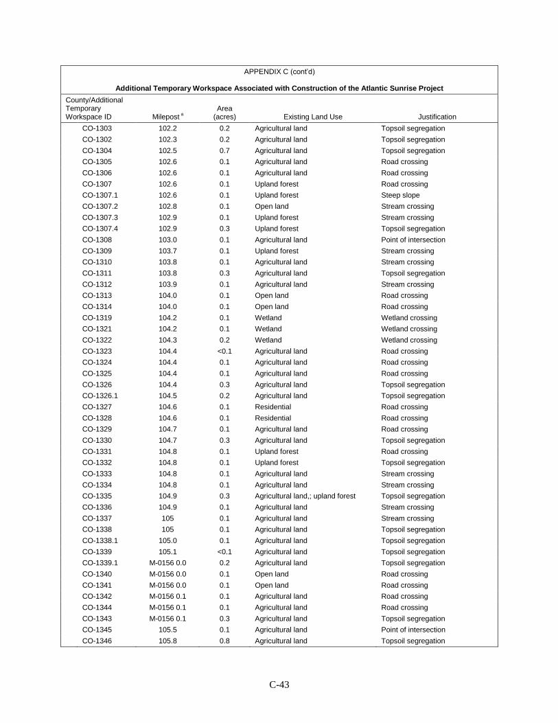
C-43
APPENDIX C (cont’d)
Additional Temporary Workspace Associated with Construction of the Atlantic Sunrise Project
County/Additional Temporary Workspace ID Milepost a
Area (acres) Existing Land Use Justification
CO-1303 102.2 0.2 Agricultural land Topsoil segregation CO-1302 102.3 0.2 Agricultural land Topsoil segregation CO-1304 102.5 0.7 Agricultural land Topsoil segregation CO-1305 102.6 0.1 Agricultural land Road crossing CO-1306 102.6 0.1 Agricultural land Road crossing CO-1307 102.6 0.1 Upland forest Road crossing CO-1307.1 102.6 0.1 Upland forest Steep slope CO-1307.2 102.8 0.1 Open land Stream crossing CO-1307.3 102.9 0.1 Upland forest Stream crossing CO-1307.4 102.9 0.3 Upland forest Topsoil segregation CO-1308 103.0 0.1 Agricultural land Point of intersection CO-1309 103.7 0.1 Upland forest Stream crossing CO-1310 103.8 0.1 Agricultural land Stream crossing CO-1311 103.8 0.3 Agricultural land Topsoil segregation CO-1312 103.9 0.1 Agricultural land Stream crossing CO-1313 104.0 0.1 Open land Road crossing CO-1314 104.0 0.1 Open land Road crossing CO-1319 104.2 0.1 Wetland Wetland crossing CO-1321 104.2 0.1 Wetland Wetland crossing CO-1322 104.3 0.2 Wetland Wetland crossing CO-1323 104.4 <0.1 Agricultural land Road crossing CO-1324 104.4 0.1 Agricultural land Road crossing CO-1325 104.4 0.1 Agricultural land Road crossing CO-1326 104.4 0.3 Agricultural land Topsoil segregation CO-1326.1 104.5 0.2 Agricultural land Topsoil segregation CO-1327 104.6 0.1 Residential Road crossing CO-1328 104.6 0.1 Residential Road crossing CO-1329 104.7 0.1 Agricultural land Road crossing CO-1330 104.7 0.3 Agricultural land Topsoil segregation CO-1331 104.8 0.1 Upland forest Road crossing CO-1332 104.8 0.1 Upland forest Topsoil segregation CO-1333 104.8 0.1 Agricultural land Stream crossing CO-1334 104.8 0.1 Agricultural land Stream crossing CO-1335 104.9 0.3 Agricultural land,; upland forest Topsoil segregation CO-1336 104.9 0.1 Agricultural land Stream crossing CO-1337 105 0.1 Agricultural land Stream crossing CO-1338 105 0.1 Agricultural land Topsoil segregation CO-1338.1 105.0 0.1 Agricultural land Topsoil segregation CO-1339 105.1 <0.1 Agricultural land Topsoil segregation CO-1339.1 M-0156 0.0 0.2 Agricultural land Topsoil segregation CO-1340 M-0156 0.0 0.1 Open land Road crossing CO-1341 M-0156 0.0 0.1 Open land Road crossing CO-1342 M-0156 0.1 0.1 Agricultural land Road crossing CO-1344 M-0156 0.1 0.1 Agricultural land Road crossing CO-1343 M-0156 0.1 0.3 Agricultural land Topsoil segregation CO-1345 105.5 0.1 Agricultural land Point of intersection CO-1346 105.8 0.8 Agricultural land Topsoil segregation
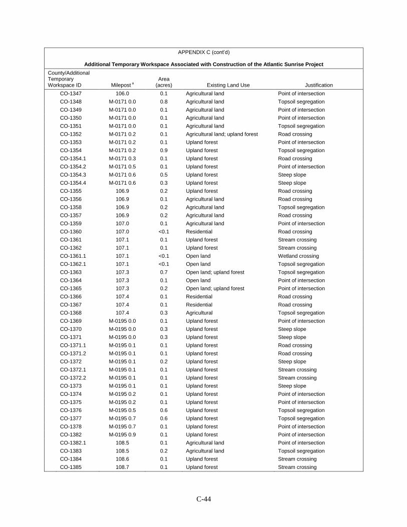
C-44
APPENDIX C (cont’d)
Additional Temporary Workspace Associated with Construction of the Atlantic Sunrise Project
County/Additional Temporary Workspace ID Milepost a
Area (acres) Existing Land Use Justification
CO-1347 106.0 0.1 Agricultural land Point of intersection CO-1348 M-0171 0.0 0.8 Agricultural land Topsoil segregation CO-1349 M-0171 0.0 0.1 Agricultural land Point of intersection CO-1350 M-0171 0.0 0.1 Agricultural land Point of intersection CO-1351 M-0171 0.0 0.1 Agricultural land Topsoil segregation CO-1352 M-0171 0.2 0.1 Agricultural land; upland forest Road crossing CO-1353 M-0171 0.2 0.1 Upland forest Point of intersection CO-1354 M-0171 0.2 0.9 Upland forest Topsoil segregation CO-1354.1 M-0171 0.3 0.1 Upland forest Road crossing CO-1354.2 M-0171 0.5 0.1 Upland forest Point of intersection CO-1354.3 M-0171 0.6 0.5 Upland forest Steep slope CO-1354.4 M-0171 0.6 0.3 Upland forest Steep slope CO-1355 106.9 0.2 Upland forest Road crossing CO-1356 106.9 0.1 Agricultural land Road crossing CO-1358 106.9 0.2 Agricultural land Topsoil segregation CO-1357 106.9 0.2 Agricultural land Road crossing CO-1359 107.0 0.1 Agricultural land Point of intersection CO-1360 107.0 <0.1 Residential Road crossing CO-1361 107.1 0.1 Upland forest Stream crossing CO-1362 107.1 0.1 Upland forest Stream crossing CO-1361.1 107.1 <0.1 Open land Wetland crossing CO-1362.1 107.1 <0.1 Open land Topsoil segregation CO-1363 107.3 0.7 Open land; upland forest Topsoil segregation CO-1364 107.3 0.1 Open land Point of intersection CO-1365 107.3 0.2 Open land; upland forest Point of intersection CO-1366 107.4 0.1 Residential Road crossing CO-1367 107.4 0.1 Residential Road crossing CO-1368 107.4 0.3 Agricultural Topsoil segregation CO-1369 M-0195 0.0 0.1 Upland forest Point of intersection CO-1370 M-0195 0.0 0.3 Upland forest Steep slope CO-1371 M-0195 0.0 0.3 Upland forest Steep slope CO-1371.1 M-0195 0.1 0.1 Upland forest Road crossing CO-1371.2 M-0195 0.1 0.1 Upland forest Road crossing CO-1372 M-0195 0.1 0.2 Upland forest Steep slope CO-1372.1 M-0195 0.1 0.1 Upland forest Stream crossing CO-1372.2 M-0195 0.1 0.1 Upland forest Stream crossing CO-1373 M-0195 0.1 0.1 Upland forest Steep slope CO-1374 M-0195 0.2 0.1 Upland forest Point of intersection CO-1375 M-0195 0.2 0.1 Upland forest Point of intersection CO-1376 M-0195 0.5 0.6 Upland forest Topsoil segregation CO-1377 M-0195 0.7 0.6 Upland forest Topsoil segregation CO-1378 M-0195 0.7 0.1 Upland forest Point of intersection CO-1382 M-0195 0.9 0.1 Upland forest Point of intersection CO-1382.1 108.5 0.1 Agricultural land Point of intersection CO-1383 108.5 0.2 Agricultural land Topsoil segregation CO-1384 108.6 0.1 Upland forest Stream crossing CO-1385 108.7 0.1 Upland forest Stream crossing
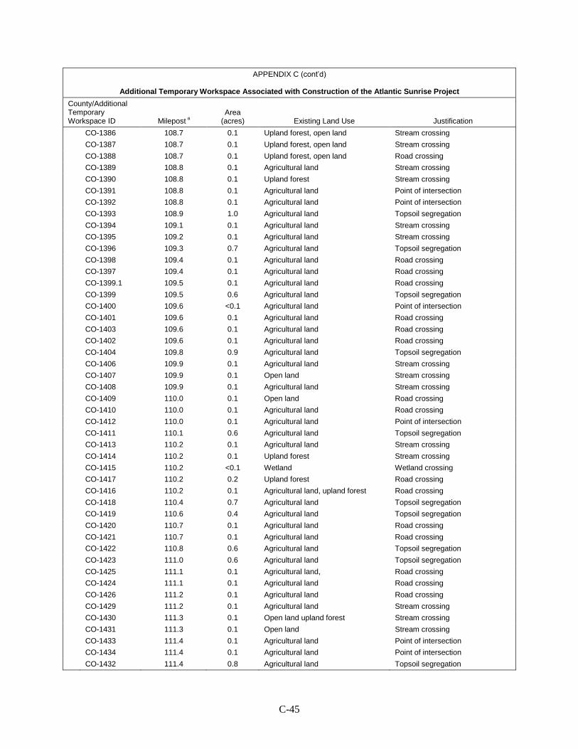
C-45
APPENDIX C (cont’d)
Additional Temporary Workspace Associated with Construction of the Atlantic Sunrise Project
County/Additional Temporary Workspace ID Milepost a
Area (acres) Existing Land Use Justification
CO-1386 108.7 0.1 Upland forest, open land Stream crossing CO-1387 108.7 0.1 Upland forest, open land Stream crossing CO-1388 108.7 0.1 Upland forest, open land Road crossing CO-1389 108.8 0.1 Agricultural land Stream crossing CO-1390 108.8 0.1 Upland forest Stream crossing CO-1391 108.8 0.1 Agricultural land Point of intersection CO-1392 108.8 0.1 Agricultural land Point of intersection CO-1393 108.9 1.0 Agricultural land Topsoil segregation CO-1394 109.1 0.1 Agricultural land Stream crossing CO-1395 109.2 0.1 Agricultural land Stream crossing CO-1396 109.3 0.7 Agricultural land Topsoil segregation CO-1398 109.4 0.1 Agricultural land Road crossing CO-1397 109.4 0.1 Agricultural land Road crossing CO-1399.1 109.5 0.1 Agricultural land Road crossing CO-1399 109.5 0.6 Agricultural land Topsoil segregation CO-1400 109.6 <0.1 Agricultural land Point of intersection CO-1401 109.6 0.1 Agricultural land Road crossing CO-1403 109.6 0.1 Agricultural land Road crossing CO-1402 109.6 0.1 Agricultural land Road crossing CO-1404 109.8 0.9 Agricultural land Topsoil segregation CO-1406 109.9 0.1 Agricultural land Stream crossing CO-1407 109.9 0.1 Open land Stream crossing CO-1408 109.9 0.1 Agricultural land Stream crossing CO-1409 110.0 0.1 Open land Road crossing CO-1410 110.0 0.1 Agricultural land Road crossing CO-1412 110.0 0.1 Agricultural land Point of intersection CO-1411 110.1 0.6 Agricultural land Topsoil segregation CO-1413 110.2 0.1 Agricultural land Stream crossing CO-1414 110.2 0.1 Upland forest Stream crossing CO-1415 110.2 <0.1 Wetland Wetland crossing CO-1417 110.2 0.2 Upland forest Road crossing CO-1416 110.2 0.1 Agricultural land, upland forest Road crossing CO-1418 110.4 0.7 Agricultural land Topsoil segregation CO-1419 110.6 0.4 Agricultural land Topsoil segregation CO-1420 110.7 0.1 Agricultural land Road crossing CO-1421 110.7 0.1 Agricultural land Road crossing CO-1422 110.8 0.6 Agricultural land Topsoil segregation CO-1423 111.0 0.6 Agricultural land Topsoil segregation CO-1425 111.1 0.1 Agricultural land, Road crossing CO-1424 111.1 0.1 Agricultural land Road crossing CO-1426 111.2 0.1 Agricultural land Road crossing CO-1429 111.2 0.1 Agricultural land Stream crossing CO-1430 111.3 0.1 Open land upland forest Stream crossing CO-1431 111.3 0.1 Open land Stream crossing CO-1433 111.4 0.1 Agricultural land Point of intersection CO-1434 111.4 0.1 Agricultural land Point of intersection CO-1432 111.4 0.8 Agricultural land Topsoil segregation
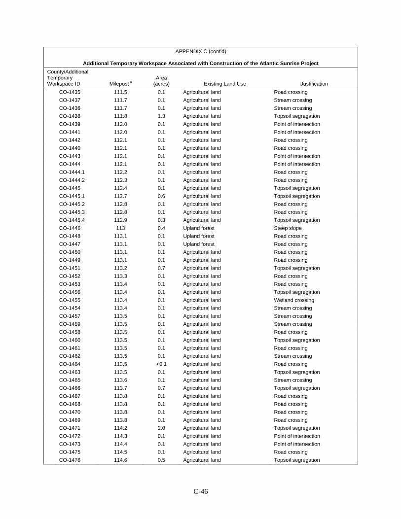
C-46
APPENDIX C (cont’d)
Additional Temporary Workspace Associated with Construction of the Atlantic Sunrise Project
County/Additional Temporary Workspace ID Milepost a
Area (acres) Existing Land Use Justification
CO-1435 111.5 0.1 Agricultural land Road crossing CO-1437 111.7 0.1 Agricultural land Stream crossing CO-1436 111.7 0.1 Agricultural land Stream crossing CO-1438 111.8 1.3 Agricultural land Topsoil segregation CO-1439 112.0 0.1 Agricultural land Point of intersection CO-1441 112.0 0.1 Agricultural land Point of intersection CO-1442 112.1 0.1 Agricultural land Road crossing CO-1440 112.1 0.1 Agricultural land Road crossing CO-1443 112.1 0.1 Agricultural land Point of intersection CO-1444 112.1 0.1 Agricultural land Point of intersection CO-1444.1 112.2 0.1 Agricultural land Road crossing CO-1444.2 112.3 0.1 Agricultural land Road crossing CO-1445 112.4 0.1 Agricultural land Topsoil segregation CO-1445.1 112.7 0.6 Agricultural land Topsoil segregation CO-1445.2 112.8 0.1 Agricultural land Road crossing CO-1445.3 112.8 0.1 Agricultural land Road crossing CO-1445.4 112.9 0.3 Agricultural land Topsoil segregation CO-1446 113 0.4 Upland forest Steep slope CO-1448 113.1 0.1 Upland forest Road crossing CO-1447 113.1 0.1 Upland forest Road crossing CO-1450 113.1 0.1 Agricultural land Road crossing CO-1449 113.1 0.1 Agricultural land Road crossing CO-1451 113.2 0.7 Agricultural land Topsoil segregation CO-1452 113.3 0.1 Agricultural land Road crossing CO-1453 113.4 0.1 Agricultural land Road crossing CO-1456 113.4 0.1 Agricultural land Topsoil segregation CO-1455 113.4 0.1 Agricultural land Wetland crossing CO-1454 113.4 0.1 Agricultural land Stream crossing CO-1457 113.5 0.1 Agricultural land Stream crossing CO-1459 113.5 0.1 Agricultural land Stream crossing CO-1458 113.5 0.1 Agricultural land Road crossing CO-1460 113.5 0.1 Agricultural land Topsoil segregation CO-1461 113.5 0.1 Agricultural land Road crossing CO-1462 113.5 0.1 Agricultural land Stream crossing CO-1464 113.5 <0.1 Agricultural land Road crossing CO-1463 113.5 0.1 Agricultural land Topsoil segregation CO-1465 113.6 0.1 Agricultural land Stream crossing CO-1466 113.7 0.7 Agricultural land Topsoil segregation CO-1467 113.8 0.1 Agricultural land Road crossing CO-1468 113.8 0.1 Agricultural land Road crossing CO-1470 113.8 0.1 Agricultural land Road crossing CO-1469 113.8 0.1 Agricultural land Road crossing CO-1471 114.2 2.0 Agricultural land Topsoil segregation CO-1472 114.3 0.1 Agricultural land Point of intersection CO-1473 114.4 0.1 Agricultural land Point of intersection CO-1475 114.5 0.1 Agricultural land Road crossing CO-1476 114.6 0.5 Agricultural land Topsoil segregation

C-47
APPENDIX C (cont’d)
Additional Temporary Workspace Associated with Construction of the Atlantic Sunrise Project
County/Additional Temporary Workspace ID Milepost a
Area (acres) Existing Land Use Justification
CO-1477 114.7 0.1 Agricultural land Road crossing CO-1478 114.7 0.1 Agricultural land Road crossing CO-1479 114.7 0.1 Agricultural land Road crossing CO-1480 115.1 2.1 Agricultural land Topsoil segregation CO-1480.1 115.2 0.1 Agricultural land Steep slope CO-1481.1 115.4 0.1 Open land Steep slope CO-1481.2 115.4 0.1 Open land Steep slope CO-1482 115.4 0.1 Upland forest Stream crossing CO-1481 115.4 0.1 Upland forest Stream crossing CO-1483 115.5 0.1 Agricultural land Wetland crossing CO-1485 115.5 0.1 Agricultural land Wetland crossing CO-1484 115.5 0.1 Agricultural land Road crossing CO-1486 115.5 0.1 Agricultural land Road crossing CO-1487 115.6 0.1 Agricultural land Road crossing CO-1488 115.6 0.1 Agricultural land Road crossing CO-1489 115.7 1.0 Agricultural land Topsoil segregation CO-1491 115.8 0.1 Agricultural land Road crossing CO-1490 115.9 0.1 Agricultural land Road crossing CO-1493 115.9 0.1 Agricultural land Road crossing CO-1494 115.9 0.1 Agricultural land Road crossing CO-1492 115.9 0.4 Agricultural land Topsoil segregation CO-1495 116.1 0.3 Agricultural land Topsoil segregation CO-1496 116.1 0.1 Agricultural land Road crossing CO-1498 116.2 0.1 Agricultural land Topsoil segregation CO-1497 116.2 0.1 Agricultural land Road crossing CO-1499 116.2 0.1 Agricultural land Road crossing CO-1500 116.3 0.8 Agricultural land Topsoil segregation CO-1501 117 0.4 Agricultural land Topsoil segregation CO-1501.1 117.4 0.1 Upland forest Point of intersection CO-1502 117.5 0.3 Agricultural land Topsoil segregation CO-1504 117.5 0.1 Agricultural land Road crossing CO-1505 117.6 0.1 Agricultural land Road crossing CO-1506 117.6 0.6 Agricultural land Topsoil segregation CO-1507 118.0 0.5 Agricultural land Topsoil segregation CO-1507.1 118.0 0.1 Agricultural land Point of intersection CO-1509 118.0 0.1 Agricultural land Road crossing CO-1508 118.0 0.1 Agricultural land Road crossing CO-1510 118.1 0.1 Upland forest Stream crossing CO-1510.1 118.1 0.1 Upland forest Stream crossing CO-1511 118.3 0.3 Upland forest; open land Topsoil segregation CO-1512 118.3 0.1 Agricultural land; upland forest Road crossing CO-1513 118.3 0.1 Upland forest Road crossing CO-1514 118.5 0.8 Agricultural land Topsoil segregation CO-1515 118.6 0.1 Agricultural land Road crossing CO-1516 118.7 0.1 Agricultural land Road crossing CO-1517 118.8 0.7 Agricultural land Topsoil segregation CO-1518 119.0 0.3 Agricultural land Topsoil segregation

C-48
APPENDIX C (cont’d)
Additional Temporary Workspace Associated with Construction of the Atlantic Sunrise Project
County/Additional Temporary Workspace ID Milepost a
Area (acres) Existing Land Use Justification
CO-1520 119.2 0.1 Upland forest Stream crossing CO-1519 119.2 0.1 Upland forest Stream crossing CO-1521 119.3 0.1 Agricultural land Road crossing CO-1523 119.3 0.1 Agricultural land Topsoil segregation CO-1522 119.3 0.1 Agricultural land Road crossing CO-1523.1 M-0159 0.0 0.1 Agricultural land Point of intersection CO-1524 M-0159 0.0 0.6 Agricultural land Topsoil segregation CO-1524.1 M-0159 0.0 0.1 Upland forest Point of intersection CO-1525 M-0159 0.3 0.2 Agricultural land Topsoil segregation CO-1525.1 M-0159 0.3 0.1 Agricultural land Point of intersection CO-1526 119.8 0.1 Agricultural land Topsoil segregation CO-1527 119.9 0.1 Upland forest Stream crossing CO-1528 119.9 0.1 Upland forest Stream crossing CO-1530 119.9 0.1 Upland forest Stream crossing CO-1529 119.9 0.1 Upland forest Stream crossing CO-1532 120.0 0.1 Upland forest Point of intersection CO-1531 120.0 0.1 Agricultural land Road crossing CO-1533 120.0 0.1 Agricultural land Road crossing CO-1535 120.0 0.1 Agricultural land Road crossing CO-1534 120.0 0.1 Agricultural land Road crossing CO-1536 120.1 0.3 Agricultural land Topsoil segregation CO-1537 120.1 0.1 Agricultural land Stream crossing CO-1538 120.1 0.1 Agricultural land Stream crossing CO-1540 120.1 <0.1 Upland forest Stream crossing CO-1539 120.1 <0.1 Upland forest Stream crossing CO-1541 120.3 0.6 Agricultural land Topsoil segregation CO-1542 120.6 0.3 Agricultural land Topsoil segregation CO-1543 120.8 0.6 Agricultural land Topsoil segregation CO-1543.1 121.1 0.1 Upland forest Point of intersection CO-1544.1 121.2 0.2 Agricultural land Point of intersection CO-1545 121.2 0.3 Agricultural land Topsoil segregation CO-1546 121.2 0.1 Agricultural land Stream crossing CO-1547 121.3 0.1 Agricultural land Stream crossing CO-1548 121.3 0.1 Open land Road crossing CO-1550 121.3 0.1 Agricultural land Point of intersection CO-1549 121.4 0.1 Agricultural land Point of intersection CO-1551 121.4 0.8 Agricultural land Topsoil segregation CO-1551.1 121.6 0.3 Agricultural land Topsoil segregation CO-1552 121.9 1.0 Agricultural land Topsoil segregation CO-1554 122.0 0.1 Agricultural land Road crossing CO-1553 122.0 0.1 Agricultural land Road crossing CO-1555 122.0 0.1 Agricultural land Road crossing CO-1556 122.0 0.1 Agricultural land Road crossing CO-1557 122.1 0.2 Agricultural land Topsoil segregation CO-1558 122.2 <0.1 Agricultural land Road crossing CO-1560 122.2 0.1 Agricultural land Road crossing CO-1557.1 122.2 0.1 Agricultural land Topsoil segregation
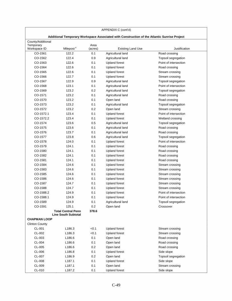
C-49
APPENDIX C (cont’d)
Additional Temporary Workspace Associated with Construction of the Atlantic Sunrise Project
County/Additional Temporary Workspace ID Milepost a
Area (acres) Existing Land Use Justification
CO-1561 122.2 0.1 Agricultural land Road crossing CO-1562 122.4 0.9 Agricultural land Topsoil segregation CO-1563 122.6 0.1 Upland forest Point of intersection CO-1564 122.6 0.1 Upland forest Road crossing CO-1565 122.6 0.1 Upland forest Stream crossing CO-1566 122.7 0.1 Upland forest Stream crossing CO-1567 122.9 0.9 Agricultural land Topsoil segregation CO-1568 123.1 0.1 Agricultural land Point of intersection CO-1569 123.2 0.2 Agricultural land Topsoil segregation CO-1571 123.2 0.1 Agricultural land Road crossing CO-1570 123.2 0.1 Open land Road crossing CO-1573 123.2 0.1 Agricultural land Topsoil segregation CO-1572 123.2 0.2 Open land Stream crossing CO-1572.1 123.4 0.1 Upland forest Point of intersection CO-1572.2 123.4 0.1 Upland forest Wetland crossing CO-1574 123.6 0.5 Agricultural land Topsoil segregation CO-1575 123.6 0.1 Agricultural land Road crossing CO-1576 123.7 0.1 Agricultural land Road crossing CO-1577 123.8 0.6 Agricultural land Topsoil segregation CO-1578 124.0 0.1 Upland forest Point of intersection CO-1579 124.1 0.1 Upland forest Road crossing CO-1580 124.1 0.1 Upland forest Road crossing CO-1582 124.1 0.1 Upland forest Road crossing CO-1581 124.1 0.1 Upland forest Road crossing CO-1584 124.6 0.1 Upland forest Stream crossing CO-1583 124.6 0.1 Upland forest Stream crossing CO-1585 124.6 0.1 Upland forest Stream crossing CO-1586 124.6 0.1 Upland forest Stream crossing CO-1587 124.7 0.1 Upland forest Stream crossing CO-1588 124.7 0.1 Upland forest Stream crossing CO-1588.2 124.9 0.1 Upland forest Point of intersection CO-1588.1 124.9 0.1 Upland forest Point of intersection CO-1589 124.9 0.1 Agricultural land Topsoil segregation CO-1591 125.1 0.2 Open land Crossover
Total Central Penn Line South Subtotal
378.6
CHAPMAN LOOP
Clinton County CL-001 L186.3 <0.1 Upland forest Stream crossing CL-002 L186.3 <0.1 Upland forest Stream crossing CL-003 L186.6 0.1 Open land Road crossing CL-004 L186.6 0.1 Open land Road crossing CL-005 L186.6 0.2 Open land Road crossing CL-006 L186.8 0.1 Upland forest Side slope CL-007 L186.9 0.2 Open land Topsoil segregation CL-008 L187.1 0.1 Upland forest Side slope CL-009 L187.1 0.1 Open land Stream crossing CL-010 L187.2 0.1 Upland forest Side slope
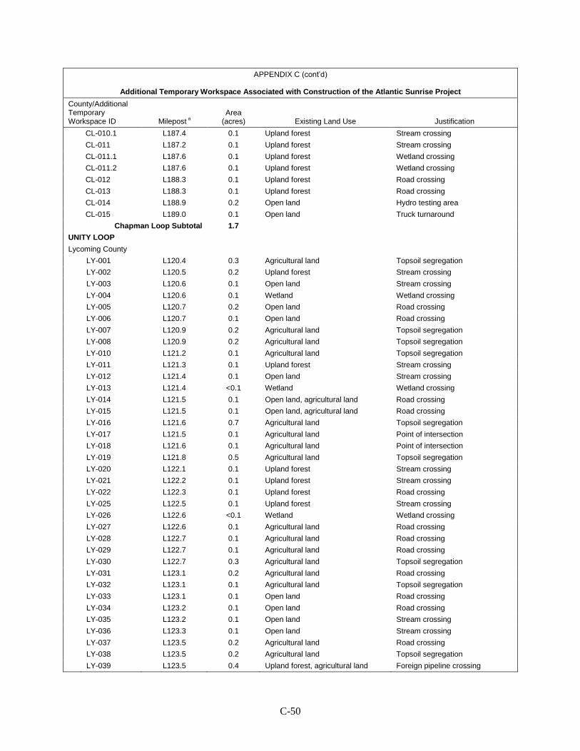
C-50
APPENDIX C (cont’d)
Additional Temporary Workspace Associated with Construction of the Atlantic Sunrise Project
County/Additional Temporary Workspace ID Milepost a
Area (acres) Existing Land Use Justification
CL-010.1 L187.4 0.1 Upland forest Stream crossing CL-011 L187.2 0.1 Upland forest Stream crossing CL-011.1 L187.6 0.1 Upland forest Wetland crossing CL-011.2 L187.6 0.1 Upland forest Wetland crossing CL-012 L188.3 0.1 Upland forest Road crossing CL-013 L188.3 0.1 Upland forest Road crossing CL-014 L188.9 0.2 Open land Hydro testing area CL-015 L189.0 0.1 Open land Truck turnaround
Chapman Loop Subtotal 1.7 UNITY LOOP
Lycoming County LY-001 L120.4 0.3 Agricultural land Topsoil segregation LY-002 L120.5 0.2 Upland forest Stream crossing LY-003 L120.6 0.1 Open land Stream crossing LY-004 L120.6 0.1 Wetland Wetland crossing LY-005 L120.7 0.2 Open land Road crossing LY-006 L120.7 0.1 Open land Road crossing LY-007 L120.9 0.2 Agricultural land Topsoil segregation LY-008 L120.9 0.2 Agricultural land Topsoil segregation LY-010 L121.2 0.1 Agricultural land Topsoil segregation LY-011 L121.3 0.1 Upland forest Stream crossing LY-012 L121.4 0.1 Open land Stream crossing LY-013 L121.4 <0.1 Wetland Wetland crossing LY-014 L121.5 0.1 Open land, agricultural land Road crossing LY-015 L121.5 0.1 Open land, agricultural land Road crossing LY-016 L121.6 0.7 Agricultural land Topsoil segregation LY-017 L121.5 0.1 Agricultural land Point of intersection LY-018 L121.6 0.1 Agricultural land Point of intersection LY-019 L121.8 0.5 Agricultural land Topsoil segregation LY-020 L122.1 0.1 Upland forest Stream crossing LY-021 L122.2 0.1 Upland forest Stream crossing LY-022 L122.3 0.1 Upland forest Road crossing LY-025 L122.5 0.1 Upland forest Stream crossing LY-026 L122.6 <0.1 Wetland Wetland crossing LY-027 L122.6 0.1 Agricultural land Road crossing LY-028 L122.7 0.1 Agricultural land Road crossing LY-029 L122.7 0.1 Agricultural land Road crossing LY-030 L122.7 0.3 Agricultural land Topsoil segregation LY-031 L123.1 0.2 Agricultural land Road crossing LY-032 L123.1 0.1 Agricultural land Topsoil segregation LY-033 L123.1 0.1 Open land Road crossing LY-034 L123.2 0.1 Open land Road crossing LY-035 L123.2 0.1 Open land Stream crossing LY-036 L123.3 0.1 Open land Stream crossing LY-037 L123.5 0.2 Agricultural land Road crossing LY-038 L123.5 0.2 Agricultural land Topsoil segregation LY-039 L123.5 0.4 Upland forest, agricultural land Foreign pipeline crossing
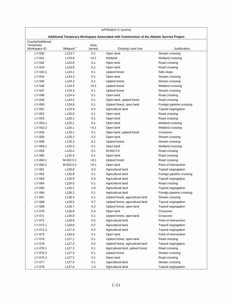
C-51
APPENDIX C (cont’d)
Additional Temporary Workspace Associated with Construction of the Atlantic Sunrise Project
County/Additional Temporary Workspace ID Milepost a
Area (acres) Existing Land Use Justification
LY-040 L123.7 0.1 Open land Stream crossing LY-041 L123.8 <0.1 Wetland Wetland crossing LY-042 L123.8 0.1 Open land Road crossing LY-043 L123.8 0.1 Open land Road crossing LY-043.1 L124.1 0.1 Upland forest Side slope LY-044 L124.3 0.1 Open land Stream crossing LY-045 L124.3 0.1 Upland forest Stream crossing LY-046 L124.4 <0.1 Upland forest Wetland crossing LY-047 L124.4 0.1 Upland forest Stream crossing LY-048 L124.4 0.1 Open land Road crossing LY-049 L124.5 0.1 Open land, upland forest Road crossing LY-050 L124.8 0.1 Upland forest, open land Foreign pipeline crossing LY-051 L124.9 0.2 Agricultural land Topsoil segregation LY-052 L125.0 0.1 Open land Road crossing LY-053 L125.1 0.1 Open land Road crossing LY-053.1 L125.1 0.1 Open land Wetland crossing LY-053.2 L125.1 <0.1 Open land Wetland crossing LY-054 L125.1 0.1 Open land, upland forest Crossover LY-055 L125.2 0.2 Open land Stream crossing LY-056 L125.3 0.1 Upland forest Stream crossing LY-056.1 L125.3 0.1 Open land Wetland crossing LY-059 L125.4 0.1 M-003 0.0 Road crossing LY-060 L125.4 0.1 Open land Road crossing LY-060.1 M-003 0.1 <0.1 Upland forest Road crossing LY-060.2 M-003 0.1 <0.1 Open land Point of intersection LY-061 L125.8 0.3 Agricultural land Topsoil segregation LY-062 L125.8 0.1 Agricultural land Foreign pipeline crossing LY-063 L125.9 0.3 Agricultural land Topsoil segregation LY-064 L126.0 0.1 Agricultural land Road crossing LY-065 L126.2 1.0 Agricultural land Topsoil segregation LY-066 L126.2 0.1 Agricultural land Foreign pipeline crossing LY-067 L126.3 0.1 Upland forest, agricultural land Stream crossing ; LY-068 L126.5 0.7 Upland forest, agricultural land Topsoil segregation LY-069 L126.7 0.2 Upland forest, open land Topsoil segregation LY-070 L126.8 0.3 Open land Crossover LY-071 L126.8 0.1 Upland forest, open land Crossover LY-072 L126.8 0.2 Agricultural land Point of intersection LY-072.1 L126.8 0.2 Agricultural land Topsoil segregation LY-072.2 L127.0 0.2 Agricultural land Topsoil segregation LY-073 L126.8 0.1 Open land Point of intersection LY-074 L127.1 0.1 Upland forest, open land Road crossing LY-076 L127.2 0.2 Upland forest, agricultural land Topsoil segregation LY-076.1 L127.3 0.1 Agricultural land, upland forest Road crossing LY-076.2 L127.3 0.1 Upland forest Stream crossing LY-076.3 L127.3 0.1 Open land Road crossing LY-077 L127.4 0.1 Agricultural land Stream crossing LY-078 L127.6 1.3 Agricultural land Topsoil segregation

C-52
APPENDIX C (cont’d)
Additional Temporary Workspace Associated with Construction of the Atlantic Sunrise Project
County/Additional Temporary Workspace ID Milepost a
Area (acres) Existing Land Use Justification
LY-079 L127.8 0.1 Agricultural land Road crossing LY-080 L127.9 0.1 Agricultural land Road crossing LY-081 L127.9 0.5 Agricultural land Topsoil segregation LY-082 L128.8 0.3 Upland forest Side slope LY-083 L128.8 0.2 Upland forest Road crossing LY-084 L128.9 0.1 Open land Hydro test withdrawal/ discharge
Unity Loop Subtotal 15.1 MAINLINE A AND B REPLACMENTS
Prince William PW-001 1578.7 0.1 Upland forest Hydrostatic test area PW-002 1578.8 0.3 Residential Spoil storage PW-003 1578.9 0.1 Residential Stream crossing PW-004 1579.0 0.2 Residential Spoil storage PW-005 1579.2 0.3 Residential open land Spoil storage PW-006 1579.3 0.2 Residential open land Spoil storage PW-007 1579.5 0.3 Residential open land Spoil storage PW-008 1579.6 0.1 Residential open land Stream crossing PW-009 1579.7 0.2 Residential open land Stream crossing PW-010 1579.8 0.1 Upland forest open land Stream crossing PW-011 1580.0 0.1 Upland forest open land Valve fabrication PW-012 1580.8 0.1 Upland forest open land Spoil storage PW-013 1580.9 0.2 Open land Spoil storage
Mainline A & B Replacements Subtotal
2.0
PROJECT TOTAL ____________________ a Where route modifications have been incorporated into the proposed route, new mileposts have been developed. The
new mileposts are identified by inclusion of the associated route modification number (M-####) preceding the milepost value.
b All values rounded to the nearest tenth; total(s) may not match sum of addends due to rounding.
APPENDIX D
PRIVATE ACCESS ROADS ASSOCIATED WITH
THE ATLANTIC SUNRISE PROJECT

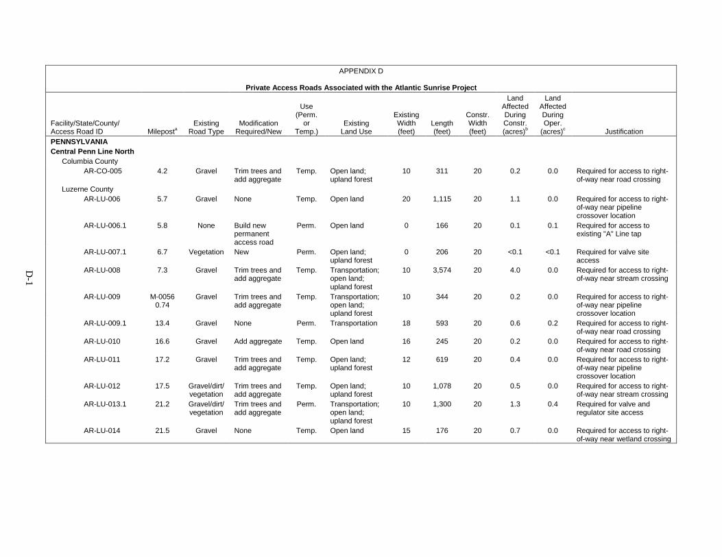
D-1
APPENDIX D
Private Access Roads Associated with the Atlantic Sunrise Project
Facility/State/County/ Access Road ID Mileposta
Existing Road Type
Modification Required/New
Use (Perm.
or Temp.)
Existing Land Use
Existing Width (feet)
Length (feet)
Constr. Width (feet)
Land Affected During Constr. (acres)b
Land Affected During Oper.
(acres)c Justification PENNSYLVANIA
Central Penn Line North
Columbia County AR-CO-005 4.2 Gravel Trim trees and
add aggregate Temp. Open land;
upland forest 10 311 20 0.2 0.0 Required for access to right-
of-way near road crossing Luzerne County AR-LU-006 5.7 Gravel None Temp. Open land 20 1,115 20 1.1 0.0 Required for access to right-
of-way near pipeline crossover location
AR-LU-006.1 5.8 None Build new permanent access road
Perm. Open land 0 166 20 0.1 0.1 Required for access to existing "A" Line tap
AR-LU-007.1 6.7 Vegetation New Perm. Open land; upland forest
0 206 20 <0.1 <0.1 Required for valve site access
AR-LU-008 7.3 Gravel Trim trees and add aggregate
Temp. Transportation; open land; upland forest
10 3,574 20 4.0 0.0 Required for access to right-of-way near stream crossing
AR-LU-009 M-0056 0.74
Gravel Trim trees and add aggregate
Temp. Transportation; open land; upland forest
10 344 20 0.2 0.0 Required for access to right-of-way near pipeline crossover location
AR-LU-009.1 13.4 Gravel None Perm. Transportation 18 593 20 0.6 0.2 Required for access to right-of-way near road crossing
AR-LU-010 16.6 Gravel Add aggregate Temp. Open land 16 245 20 0.2 0.0 Required for access to right-of-way near road crossing
AR-LU-011 17.2 Gravel Trim trees and add aggregate
Temp. Open land; upland forest
12 619 20 0.4 0.0 Required for access to right-of-way near pipeline crossover location
AR-LU-012 17.5 Gravel/dirt/vegetation
Trim trees and add aggregate
Temp. Open land; upland forest
10 1,078 20 0.5 0.0 Required for access to right-of-way near stream crossing
AR-LU-013.1 21.2 Gravel/dirt/vegetation
Trim trees and add aggregate
Perm. Transportation; open land; upland forest
10 1,300 20 1.3 0.4 Required for valve and regulator site access
AR-LU-014 21.5 Gravel None Temp. Open land 15 176 20 0.7 0.0 Required for access to right-of-way near wetland crossing
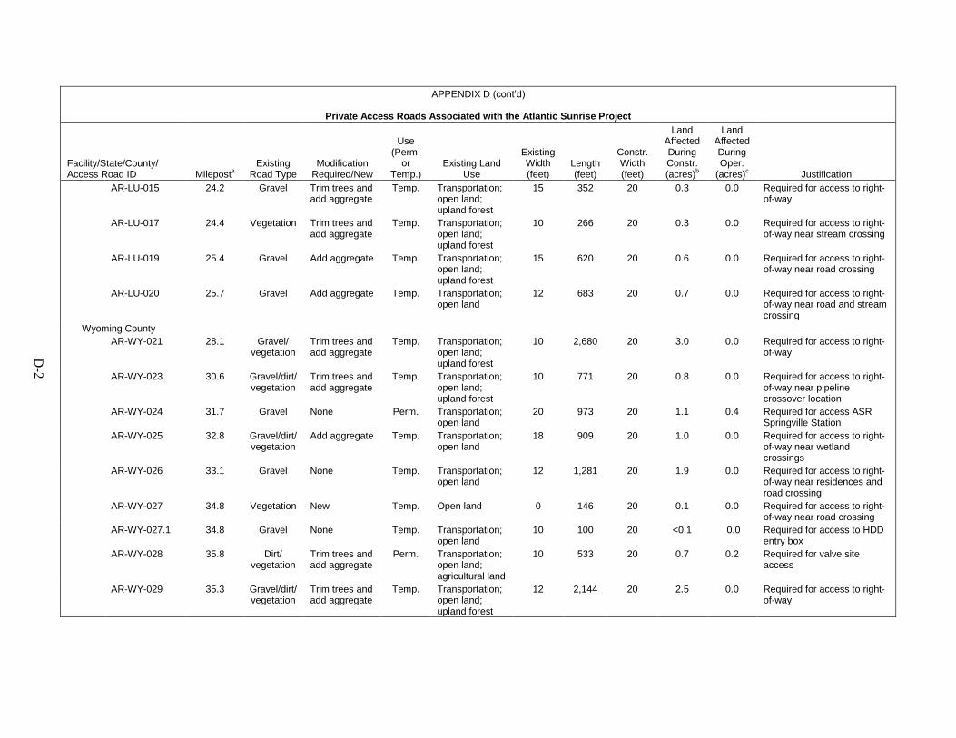
D-2
APPENDIX D (cont’d)
Private Access Roads Associated with the Atlantic Sunrise Project
Facility/State/County/ Access Road ID Mileposta
Existing Road Type
Modification Required/New
Use (Perm.
or Temp.)
Existing Land Use
Existing Width (feet)
Length (feet)
Constr. Width (feet)
Land Affected During Constr. (acres)b
Land Affected During Oper.
(acres)c Justification AR-LU-015 24.2 Gravel Trim trees and
add aggregate Temp. Transportation;
open land; upland forest
15 352 20 0.3 0.0 Required for access to right-of-way
AR-LU-017 24.4 Vegetation Trim trees and add aggregate
Temp. Transportation; open land; upland forest
10 266 20 0.3 0.0 Required for access to right-of-way near stream crossing
AR-LU-019 25.4 Gravel Add aggregate Temp. Transportation; open land; upland forest
15 620 20 0.6 0.0 Required for access to right-of-way near road crossing
AR-LU-020 25.7 Gravel Add aggregate Temp. Transportation; open land
12 683 20 0.7 0.0 Required for access to right-of-way near road and stream crossing
Wyoming County AR-WY-021 28.1 Gravel/
vegetation Trim trees and add aggregate
Temp. Transportation; open land; upland forest
10 2,680 20 3.0 0.0 Required for access to right-of-way
AR-WY-023 30.6 Gravel/dirt/vegetation
Trim trees and add aggregate
Temp. Transportation; open land; upland forest
10 771 20 0.8 0.0 Required for access to right-of-way near pipeline crossover location
AR-WY-024 31.7 Gravel None Perm. Transportation; open land
20 973 20 1.1 0.4 Required for access ASR Springville Station
AR-WY-025 32.8 Gravel/dirt/vegetation
Add aggregate Temp. Transportation; open land
18 909 20 1.0 0.0 Required for access to right-of-way near wetland crossings
AR-WY-026 33.1 Gravel None Temp. Transportation; open land
12 1,281 20 1.9 0.0 Required for access to right-of-way near residences and road crossing
AR-WY-027 34.8 Vegetation New Temp. Open land 0 146 20 0.1 0.0 Required for access to right-of-way near road crossing
AR-WY-027.1 34.8 Gravel None Temp. Transportation; open land
10 100 20 <0.1 0.0 Required for access to HDD entry box
AR-WY-028 35.8 Dirt/vegetation
Trim trees and add aggregate
Perm. Transportation; open land; agricultural land
10 533 20 0.7 0.2 Required for valve site access
AR-WY-029 35.3 Gravel/dirt/vegetation
Trim trees and add aggregate
Temp. Transportation; open land; upland forest
12 2,144 20 2.5 0.0 Required for access to right-of-way
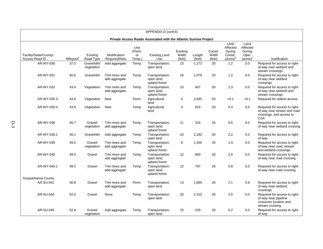
D-3
APPENDIX D (cont’d)
Private Access Roads Associated with the Atlantic Sunrise Project
Facility/State/County/ Access Road ID Mileposta
Existing Road Type
Modification Required/New
Use (Perm.
or Temp.)
Existing Land Use
Existing Width (feet)
Length (feet)
Constr. Width (feet)
Land Affected During Constr. (acres)b
Land Affected During Oper.
(acres)c Justification AR-WY-030 37.0 Gravel/dirt/
vegetation Add aggregate Temp. Transportation;
open land 15 1,172 20 1.2 0.0 Required for access to right-
of-way near wetland and stream crossings
AR-WY-031 40.6 Gravel/dirt Trim trees and add aggregate
Temp. Transportation; open land; upland forest
16 1,079 20 1.2 0.0 Required for access to right-of-way near wetland crossings
AR-WY-032 43.4 Vegetation Trim trees and add aggregate
Temp. Transportation; open land; upland forest
10 407 20 2.3 0.0 Required for access to right-of-way near wetland and stream crossings
AR-WY-035.3 44.6 Vegetation New Perm. Agricultural land
0 2,945 20 <0.1 <0.1 Required for station access
AR-WY-035.4 44.6 Vegetation New Temp. Agricultural land
0 819 20 0.4 0.0 Required for access to right-of-way near stream and road crossings, and access to CSA
AR-WY-036 45.7 Gravel/vegetation
Trim trees and add aggregate
Temp. Transportation; open land; upland forest
11 316 20 0.6 0.0 Required for access to right-of-way near wetland crossing
AR-WY-036.1 46.1 Gravel/dirt Add aggregate Temp. Transportation; open land
10 2,182 20 2.2 0.0 Required for access to right-of-way
AR-WY-039 49.5 Gravel/vegetation
Trim trees and add aggregate
Temp. Transportation; open land upland forest
8 1,200 20 1.0 0.0 Required for access to right-of-way near road, stream and wetland crossings
AR-WY-040 49.5 Gravel Trim trees and add aggregate
Temp. Transportation; open land; upland forest
12 660 20 2.6 0.0 Required for access to right-of-way near road crossing
AR-WY-040.1 49.2 Gravel Trim trees and add aggregate
Temp. Transportation; open land; upland forest
12 797 20 0.8 0.0 Required for access to right-of-way near road crossing
Susquehanna County AR-SU-041 50.8 Gravel Trim trees and
add aggregate Perm. Transportation;
open land 13 1,895 20 2.1 0.9 Required for access to right-
of-way near wetland crossings
AR-SU-044 52.0 Gravel None Temp. Transportation; open land
20 2,312 20 2.5 0.0 Required for access to right-of-way near pipeline crossover location and stream crossing
AR-SU-045 52.9 Gravel/vegetation
Add aggregate Temp. Transportation; open land
15 229 20 0.2 0.0 Required for access to right-of-way

D-4
APPENDIX D (cont’d)
Private Access Roads Associated with the Atlantic Sunrise Project
Facility/State/County/ Access Road ID Mileposta
Existing Road Type
Modification Required/New
Use (Perm.
or Temp.)
Existing Land Use
Existing Width (feet)
Length (feet)
Constr. Width (feet)
Land Affected During Constr. (acres)b
Land Affected During Oper.
(acres)c Justification AR-SU-046 56.3 Gravel/
vegetation New Perm. Open land 20 793 20 0.9 0.3 Required for access to right-
of-way near stream and wetland crossings
AR-SU-046.1 57.0 Vegetation New Temp. Agricultural land
0 31 20 0.0 0.0 Required for contractor staging area access
AR-SU-046.4 57.0 Vegetation New Temp. Agricultural land
0 22 20 0.0 0.0 Required for contractor staging area access
AR-SU-047 56.9 Gravel None Perm. Transportation; open land
20 808 20 0.8 0.5 Required for access to right-of-way, proposed MLV site and existing compressor station
AR-SU-047.1 57.3 Vegetation New Perm. Agricultural land
0 176 20 0.1 0.1 Required for access to right-of-way, proposed MLV site and existing compressor station
Central Penn Line North Subtotal 41.7 1.7 Central Penn Line South
Lancaster County AR-LA-001.1 0.1 Vegetation New Perm. Agricultural
land 0 2,765 20 2.6 0.6 New permanent access road
needed for access to MLV site at MP 0.0
AR-LA-002 M-0147 MP 0..1
Dirt Add gravel Temp. Agricultural land
12 316 20 0.3 0.0 Temporary access road needed for improved access to right-of-way during construction
AR-LA-004 M-0184 MP 0.2
Gravel Replace 3 culverts and add gravel
Temp. Agricultural land
15 52 20 0.5 0.0 Temporary access road needed for improved access to right-of-way during construction
AR-LA-006.1 4.9 Dirt New` Temp. Agricultural land; upland forest
0 586 20 0.6 0.0 Temporary access road needed for improved access to right-of-way during construction
AR-LA-009.1 8.1 Field road Construct Road through AG field and add gravel
Temp. Agricultural land
10 170 20 0.1 0.0 Temporary access road needed for improved access to right-of-way during construction
AR-LA-010.2 8.2 Vegetation New Perm. Agricultural land
0 82 20 0.1 0.1 Permanent Access Road to access proposed valve site
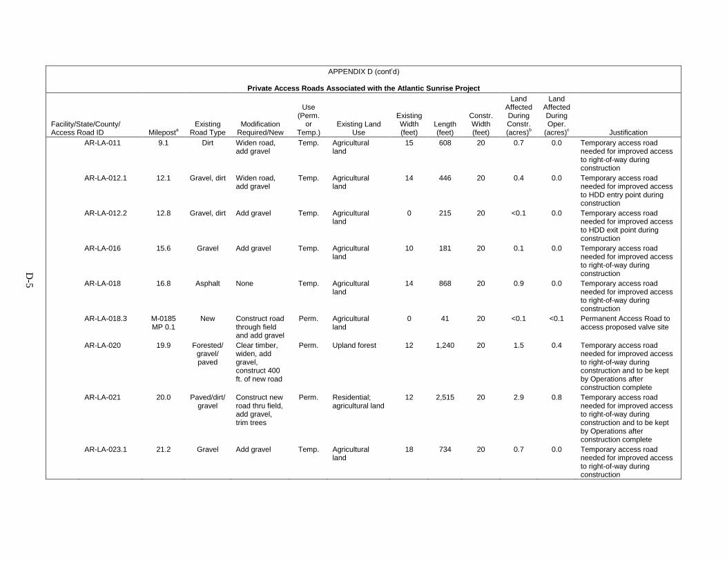
D-5
APPENDIX D (cont’d)
Private Access Roads Associated with the Atlantic Sunrise Project
Facility/State/County/ Access Road ID Mileposta
Existing Road Type
Modification Required/New
Use (Perm.
or Temp.)
Existing Land Use
Existing Width (feet)
Length (feet)
Constr. Width (feet)
Land Affected During Constr. (acres)b
Land Affected During Oper.
(acres)c Justification AR-LA-011 9.1 Dirt Widen road,
add gravel Temp. Agricultural
land 15 608 20 0.7 0.0 Temporary access road
needed for improved access to right-of-way during construction
AR-LA-012.1 12.1 Gravel, dirt Widen road, add gravel
Temp. Agricultural land
14 446 20 0.4 0.0 Temporary access road needed for improved access to HDD entry point during construction
AR-LA-012.2 12.8 Gravel, dirt Add gravel Temp. Agricultural land
0 215 20 <0.1 0.0 Temporary access road needed for improved access to HDD exit point during construction
AR-LA-016 15.6 Gravel Add gravel Temp. Agricultural land
10 181 20 0.1 0.0 Temporary access road needed for improved access to right-of-way during construction
AR-LA-018 16.8 Asphalt None Temp. Agricultural land
14 868 20 0.9 0.0 Temporary access road needed for improved access to right-of-way during construction
AR-LA-018.3 M-0185 MP 0.1
New Construct road through field and add gravel
Perm. Agricultural land
0 41 20 <0.1 <0.1 Permanent Access Road to access proposed valve site
AR-LA-020 19.9 Forested/gravel/paved
Clear timber, widen, add gravel, construct 400 ft. of new road
Perm. Upland forest 12 1,240 20 1.5 0.4 Temporary access road needed for improved access to right-of-way during construction and to be kept by Operations after construction complete
AR-LA-021 20.0 Paved/dirt/gravel
Construct new road thru field, add gravel, trim trees
Perm. Residential; agricultural land
12 2,515 20 2.9 0.8 Temporary access road needed for improved access to right-of-way during construction and to be kept by Operations after construction complete
AR-LA-023.1 21.2 Gravel Add gravel Temp. Agricultural land
18 734 20 0.7 0.0 Temporary access road needed for improved access to right-of-way during construction

D-6
APPENDIX D (cont’d)
Private Access Roads Associated with the Atlantic Sunrise Project
Facility/State/County/ Access Road ID Mileposta
Existing Road Type
Modification Required/New
Use (Perm.
or Temp.)
Existing Land Use
Existing Width (feet)
Length (feet)
Constr. Width (feet)
Land Affected During Constr. (acres)b
Land Affected During Oper.
(acres)c Justification AR-LA-026.3 23.7 Vegetation New Perm. Agricultural
land 0 517 20 0.6 0.2 Permanent Access Road to
access proposed valve site AR-LA-027 27.3 Paved None required Temp. Agricultural
land; industrial and commercial land
30 1,989 20 2.2 0.0 Temporary access road needed for improved access to right-of-way during construction
AR-LA-027.05 27.6 Vegetation New Temp. Agricultural land
0 1 20 0.0 0.0 Temporary access road needed for improved access to right-of-way during construction and access the CSA
AR-LA-027.1 M-0162 MP 0.3
Field road Construct road ; add gravel
Temp. Agricultural land
0 2,413 20 2.5 0.0 Gain access to the North side of HWY 283 boring site
AR-LA-028.1 30.6 Field road Construct road ; add gravel
Temp. Agricultural land
12 1,247 20 1.3 0.0 Temporary access road needed for improved access to right-of-way during construction
AR-LA-029.2 29.7 Vegetation New Perm. Agricultural land
0 64 20 <0.1 <0.1 Permanent Access Road to access proposed valve site
AR-LA-030 35.4 Gravel and dirt
Add gravel and widen
Temp. Agricultural land
12 1,050 20 1.2 0.0 Temporary access road needed for improved access to right-of-way during construction
Lebanon County AR-LE-033 36.6 Forest/
gravel/dirt Trim trees, add gravel. Mats probably required thru 500 to 600 ft. of wetlands
Perm. Upland forest 10 1,960 20 5.0 2.0 Temporary access road needed for improved access to right-of-way during construction and to be kept by Operations after construction complete
AR-LE-033.1 36.6 Gravel Widen; add gravel
Temp. Residential; agricultural land
20 2,754 20 2.9 0.0 Gain access to South side of I-76 boring site
AR-LE-033.2 37.4 New Temp. Agricultural land
0 17 20 <0.1 0.0 Temporary access road needed for improved access to right-of-way during construction and access the CSA
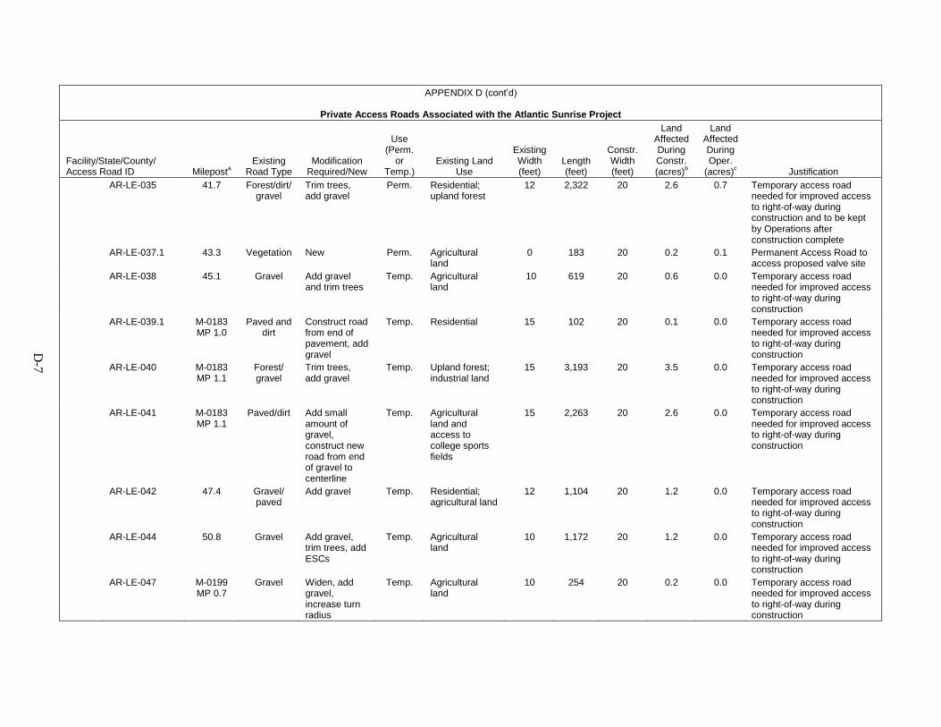
D-7
APPENDIX D (cont’d)
Private Access Roads Associated with the Atlantic Sunrise Project
Facility/State/County/ Access Road ID Mileposta
Existing Road Type
Modification Required/New
Use (Perm.
or Temp.)
Existing Land Use
Existing Width (feet)
Length (feet)
Constr. Width (feet)
Land Affected During Constr. (acres)b
Land Affected During Oper.
(acres)c Justification AR-LE-035 41.7 Forest/dirt/
gravel Trim trees, add gravel
Perm. Residential; upland forest
12 2,322 20 2.6 0.7 Temporary access road needed for improved access to right-of-way during construction and to be kept by Operations after construction complete
AR-LE-037.1 43.3 Vegetation New Perm. Agricultural land
0 183 20 0.2 0.1 Permanent Access Road to access proposed valve site
AR-LE-038 45.1 Gravel Add gravel and trim trees
Temp. Agricultural land
10 619 20 0.6 0.0 Temporary access road needed for improved access to right-of-way during construction
AR-LE-039.1 M-0183 MP 1.0
Paved and dirt
Construct road from end of pavement, add gravel
Temp. Residential 15 102 20 0.1 0.0 Temporary access road needed for improved access to right-of-way during construction
AR-LE-040 M-0183 MP 1.1
Forest/gravel
Trim trees, add gravel
Temp. Upland forest; industrial land
15 3,193 20 3.5 0.0 Temporary access road needed for improved access to right-of-way during construction
AR-LE-041 M-0183 MP 1.1
Paved/dirt Add small amount of gravel, construct new road from end of gravel to centerline
Temp. Agricultural land and access to college sports fields
15 2,263 20 2.6 0.0 Temporary access road needed for improved access to right-of-way during construction
AR-LE-042 47.4 Gravel/paved
Add gravel Temp. Residential; agricultural land
12 1,104 20 1.2 0.0 Temporary access road needed for improved access to right-of-way during construction
AR-LE-044 50.8 Gravel Add gravel, trim trees, add ESCs
Temp. Agricultural land
10 1,172 20 1.2 0.0 Temporary access road needed for improved access to right-of-way during construction
AR-LE-047 M-0199 MP 0.7
Gravel Widen, add gravel, increase turn radius
Temp. Agricultural land
10 254 20 0.2 0.0 Temporary access road needed for improved access to right-of-way during construction
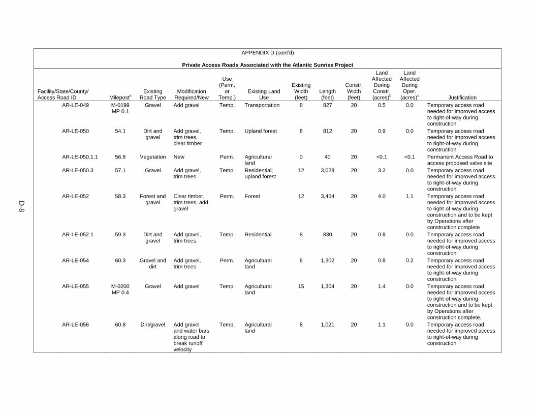
D-8
APPENDIX D (cont’d)
Private Access Roads Associated with the Atlantic Sunrise Project
Facility/State/County/ Access Road ID Mileposta
Existing Road Type
Modification Required/New
Use (Perm.
or Temp.)
Existing Land Use
Existing Width (feet)
Length (feet)
Constr. Width (feet)
Land Affected During Constr. (acres)b
Land Affected During Oper.
(acres)c Justification AR-LE-049 M-0199
MP 0.1 Gravel Add gravel Temp. Transportation 8 827 20 0.5 0.0 Temporary access road
needed for improved access to right-of-way during construction
AR-LE-050 54.1 Dirt and gravel
Add gravel, trim trees, clear timber
Temp. Upland forest 8 812 20 0.9 0.0 Temporary access road needed for improved access to right-of-way during construction
AR-LE-050.1.1 56.8 Vegetation New Perm. Agricultural land
0 40 20 <0.1 <0.1 Permanent Access Road to access proposed valve site
AR-LE-050.3 57.1 Gravel Add gravel, trim trees
Temp. Residential; upland forest
12 3,028 20 3.2 0.0 Temporary access road needed for improved access to right-of-way during construction
AR-LE-052 58.3 Forest and gravel
Clear timber, trim trees, add gravel
Perm. Forest 12 3,454 20 4.0 1.1 Temporary access road needed for improved access to right-of-way during construction and to be kept by Operations after construction complete
AR-LE-052.1 59.3 Dirt and gravel
Add gravel, trim trees
Temp. Residential 8 830 20 0.8 0.0 Temporary access road needed for improved access to right-of-way during construction
AR-LE-054 60.3 Gravel and dirt
Add gravel, trim trees
Perm. Agricultural land
6 1,302 20 0.8 0.2 Temporary access road needed for improved access to right-of-way during construction
AR-LE-055 M-0200 MP 0.4
Gravel Add gravel Temp. Agricultural land
15 1,304 20 1.4 0.0 Temporary access road needed for improved access to right-of-way during construction and to be kept by Operations after construction complete.
AR-LE-056 60.8 Dirt/gravel Add gravel and water bars along road to break runoff velocity
Temp. Agricultural land
8 1,021 20 1.1 0.0 Temporary access road needed for improved access to right-of-way during construction
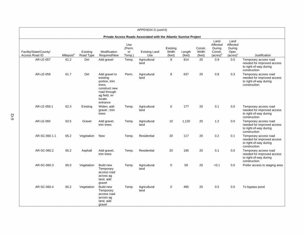
D-9
APPENDIX D (cont’d)
Private Access Roads Associated with the Atlantic Sunrise Project
Facility/State/County/ Access Road ID Mileposta
Existing Road Type
Modification Required/New
Use (Perm.
or Temp.)
Existing Land Use
Existing Width (feet)
Length (feet)
Constr. Width (feet)
Land Affected During Constr. (acres)b
Land Affected During Oper.
(acres)c Justification AR-LE-057 61.2 Dirt Add gravel Temp. Agricultural
land 8 914 20 0.9 0.0 Temporary access road
needed for improved access to right-of-way during construction
AR-LE-059 61.7 Dirt Add gravel to existing portion, trim trees, construct new road through ag field, re-locate entrance
Perm. Agricultural land
8 637 20 0.8 0.3 Temporary access road needed for improved access to right-of-way during construction
AR-LE-059.1 62.3 Existing Widen; add gravel ; trim trees
Temp. Agricultural land
6 177 20 0.1 0.0 Temporary access road needed for improved access to right-of-way during construction
AR-LE-060 63.5 Gravel Add gravel, trim trees
Temp. Agricultural land
10 1,120 20 1.2 0.0 Temporary access road needed for improved access to right-of-way during construction
AR-SC-060.1.1 65.2 Vegetation New Temp. Residential 20 117 20 0.2 0.1 Temporary access road needed for improved access to right-of-way during construction
AR-SC-060.2 65.2 Asphalt Add gravel, trim trees
Temp. Residential 20 190 20 0.1 0.0 Temporary access road needed for improved access to right-of-way during construction
AR-SC-060.3 65.0 Vegetation Build new Temporary access road across ag land, add gravel
Temp. Agricultural land
0 59 20 <0.1 0.0 Prefer access to staging area
AR-SC-060.4 65.2 Vegetation Build new Temporary access road across ag land, add gravel
Temp. Agricultural land
0 495 20 0.5 0.0 To bypass pond

D-1
0
APPENDIX D (cont’d)
Private Access Roads Associated with the Atlantic Sunrise Project
Facility/State/County/ Access Road ID Mileposta
Existing Road Type
Modification Required/New
Use (Perm.
or Temp.)
Existing Land Use
Existing Width (feet)
Length (feet)
Constr. Width (feet)
Land Affected During Constr. (acres)b
Land Affected During Oper.
(acres)c Justification AR-SC-061.1 65.9 Dirt Add gravel,
trim trees Temp. Residential;
agricultural land; upland forest
8 1,316 20 1.4 0.0 Temporary access road needed for improved access to right-of-way during construction
AR-SC-063 67.6 Gravel Trim trees, re-work drain ditch, add gravel
Perm. Residential agricultural land
10 921 20 1.0 0.4 Permanent Access Road to access proposed valve site & Temporary access road needed for improved access to right-of-way during construction
AR-SC-064 69.4 Forest Clear 5 or 6 trees, widen entrance, add gravel
Temp. Upland forest 10 2,059 20 2.2 0.0 Temporary access road needed for improved access to right-of-way during construction
AR-SC-064.1 70.7 Dirt/gravel Widen; add gravel
Perm. Residential; upland forest
12 431 20 0.2 0.2 Temporary access road needed for improved access to right-of-way during construction and to be kept by Operations after construction complete
AR-SC-065 71.0 Asphalt/forest
Trim trees, add gravel
Temp. Residential, upland forest
12 1,031 20 0.9 0.0 Temporary access road needed for access near road crossing
AR-SC-066 72.5 Gravel/dirt Trim trees, add gravel
Temp. Industrial and commercial land
16 4,102 20 4.4 0.0 Temporary access road needed for improved access to right-of-way during construction
AR-SC-068 74.5 Gravel Last 300 ft. is new road-add 300 ft. gravel
Temp. Industrial and commercial land
20 10,670 20 12.1 0.0 Temporary access road needed for access near railroad crossing
AR-SC-069 74.9 Gravel Add gravel Temp. Industrial and commercial land
10 1,058 20 1.1 0.0 Temporary access road needed for access near road crossing
AR-SC-070 75.6 Gravel No modifications or improvements needed
Perm. Upland forest 16 5,344 20 6.2 1.8 Temporary access road needed for improved access to right-of-way during construction and to be kept by Operations after construction complete
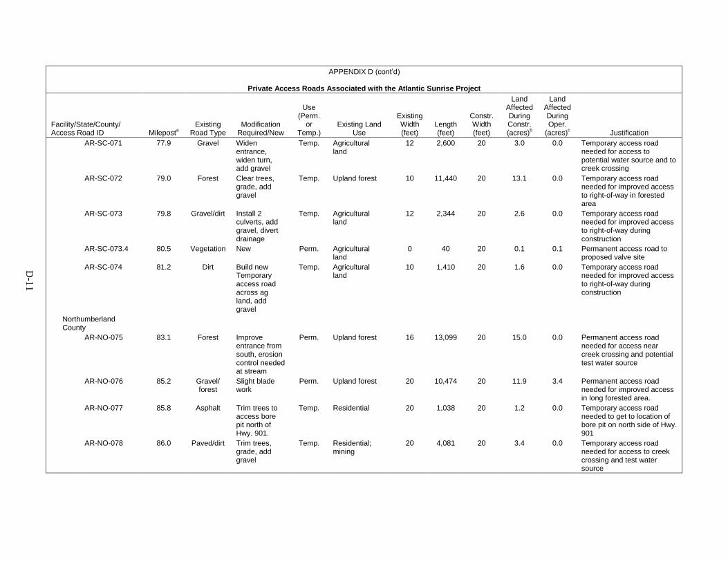
D-1
1
APPENDIX D (cont’d)
Private Access Roads Associated with the Atlantic Sunrise Project
Facility/State/County/ Access Road ID Mileposta
Existing Road Type
Modification Required/New
Use (Perm.
or Temp.)
Existing Land Use
Existing Width (feet)
Length (feet)
Constr. Width (feet)
Land Affected During Constr. (acres)b
Land Affected During Oper.
(acres)c Justification AR-SC-071 77.9 Gravel Widen
entrance, widen turn, add gravel
Temp. Agricultural land
12 2,600 20 3.0 0.0 Temporary access road needed for access to potential water source and to creek crossing
AR-SC-072 79.0 Forest Clear trees, grade, add gravel
Temp. Upland forest 10 11,440 20 13.1 0.0 Temporary access road needed for improved access to right-of-way in forested area
AR-SC-073 79.8 Gravel/dirt Install 2 culverts, add gravel, divert drainage
Temp. Agricultural land
12 2,344 20 2.6 0.0 Temporary access road needed for improved access to right-of-way during construction
AR-SC-073.4 80.5 Vegetation New Perm. Agricultural land
0 40 20 0.1 0.1 Permanent access road to proposed valve site
AR-SC-074 81.2 Dirt Build new Temporary access road across ag land, add gravel
Temp. Agricultural land
10 1,410 20 1.6 0.0 Temporary access road needed for improved access to right-of-way during construction
Northumberland County
AR-NO-075 83.1 Forest Improve entrance from south, erosion control needed at stream
Perm. Upland forest 16 13,099 20 15.0 0.0 Permanent access road needed for access near creek crossing and potential test water source
AR-NO-076 85.2 Gravel/forest
Slight blade work
Perm. Upland forest 20 10,474 20 11.9 3.4 Permanent access road needed for improved access in long forested area.
AR-NO-077 85.8 Asphalt Trim trees to access bore pit north of Hwy. 901.
Temp. Residential 20 1,038 20 1.2 0.0 Temporary access road needed to get to location of bore pit on north side of Hwy. 901
AR-NO-078 86.0 Paved/dirt Trim trees, grade, add gravel
Temp. Residential; mining
20 4,081 20 3.4 0.0 Temporary access road needed for access to creek crossing and test water source
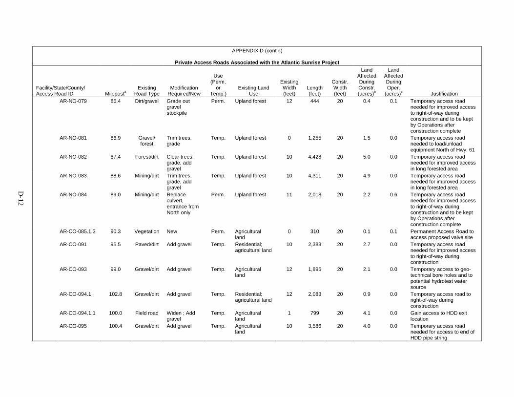
D-1
2
APPENDIX D (cont’d)
Private Access Roads Associated with the Atlantic Sunrise Project
Facility/State/County/ Access Road ID Mileposta
Existing Road Type
Modification Required/New
Use (Perm.
or Temp.)
Existing Land Use
Existing Width (feet)
Length (feet)
Constr. Width (feet)
Land Affected During Constr. (acres)b
Land Affected During Oper.
(acres)c Justification AR-NO-079 86.4 Dirt/gravel Grade out
gravel stockpile
Perm. Upland forest 12 444 20 0.4 0.1 Temporary access road needed for improved access to right-of-way during construction and to be kept by Operations after construction complete
AR-NO-081 86.9 Gravel/forest
Trim trees, grade
Temp. Upland forest 0 1,255 20 1.5 0.0 Temporary access road needed to load/unload equipment North of Hwy. 61
AR-NO-082 87.4 Forest/dirt Clear trees, grade, add gravel
Temp. Upland forest 10 4,428 20 5.0 0.0 Temporary access road needed for improved access in long forested area
AR-NO-083 88.6 Mining/dirt Trim trees, grade, add gravel
Temp. Upland forest 10 4,311 20 4.9 0.0 Temporary access road needed for improved access in long forested area
AR-NO-084 89.0 Mining/dirt Replace culvert, entrance from North only
Perm. Upland forest 11 2,018 20 2.2 0.6 Temporary access road needed for improved access to right-of-way during construction and to be kept by Operations after construction complete
AR-CO-085.1.3 90.3 Vegetation New Perm. Agricultural land
0 310 20 0.1 0.1 Permanent Access Road to access proposed valve site
AR-CO-091 95.5 Paved/dirt Add gravel Temp. Residential; agricultural land
10 2,383 20 2.7 0.0 Temporary access road needed for improved access to right-of-way during construction
AR-CO-093 99.0 Gravel/dirt Add gravel Temp. Agricultural land
12 1,895 20 2.1 0.0 Temporary access to geo-technical bore holes and to potential hydrotest water source
AR-CO-094.1 102.8 Gravel/dirt Add gravel Temp. Residential; agricultural land
12 2,083 20 0.9 0.0 Temporary access road to right-of-way during construction
AR-CO-094.1.1 100.0 Field road Widen ; Add gravel
Temp. Agricultural land
1 799 20 4.1 0.0 Gain access to HDD exit location
AR-CO-095 100.4 Gravel/dirt Add gravel Temp. Agricultural land
10 3,586 20 4.0 0.0 Temporary access road needed for access to end of HDD pipe string
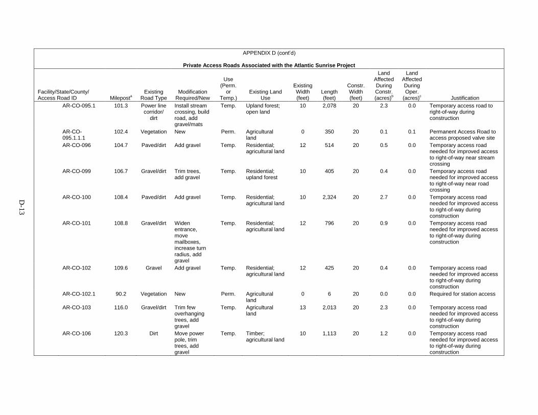
D-1
3
APPENDIX D (cont’d)
Private Access Roads Associated with the Atlantic Sunrise Project
Facility/State/County/ Access Road ID Mileposta
Existing Road Type
Modification Required/New
Use (Perm.
or Temp.)
Existing Land Use
Existing Width (feet)
Length (feet)
Constr. Width (feet)
Land Affected During Constr. (acres)b
Land Affected During Oper.
(acres)c Justification AR-CO-095.1 101.3 Power line
corridor/dirt
Install stream crossing, build road, add gravel/mats
Temp. Upland forest; open land
10 2,078 20 2.3 0.0 Temporary access road to right-of-way during construction
AR-CO-095.1.1.1
102.4 Vegetation New Perm. Agricultural land
0 350 20 0.1 0.1 Permanent Access Road to access proposed valve site
AR-CO-096 104.7 Paved/dirt Add gravel Temp. Residential; agricultural land
12 514 20 0.5 0.0 Temporary access road needed for improved access to right-of-way near stream crossing
AR-CO-099 106.7 Gravel/dirt Trim trees, add gravel
Temp. Residential; upland forest
10 405 20 0.4 0.0 Temporary access road needed for improved access to right-of-way near road crossing
AR-CO-100 108.4 Paved/dirt Add gravel Temp. Residential; agricultural land
10 2,324 20 2.7 0.0 Temporary access road needed for improved access to right-of-way during construction
AR-CO-101 108.8 Gravel/dirt Widen entrance, move mailboxes, increase turn radius, add gravel
Temp. Residential; agricultural land
12 796 20 0.9 0.0 Temporary access road needed for improved access to right-of-way during construction
AR-CO-102 109.6 Gravel Add gravel Temp. Residential; agricultural land
12 425 20 0.4 0.0 Temporary access road needed for improved access to right-of-way during construction
AR-CO-102.1 90.2 Vegetation New Perm. Agricultural land
0 6 20 0.0 0.0 Required for station access
AR-CO-103 116.0 Gravel/dirt Trim few overhanging trees, add gravel
Temp. Agricultural land
13 2,013 20 2.3 0.0 Temporary access road needed for improved access to right-of-way during construction
AR-CO-106 120.3 Dirt Move power pole, trim trees, add gravel
Temp. Timber; agricultural land
10 1,113 20 1.2 0.0 Temporary access road needed for improved access to right-of-way during construction
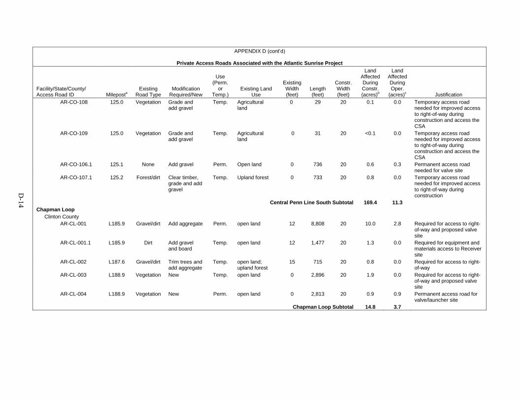
D-1
4
APPENDIX D (cont’d)
Private Access Roads Associated with the Atlantic Sunrise Project
Facility/State/County/ Access Road ID Mileposta
Existing Road Type
Modification Required/New
Use (Perm.
or Temp.)
Existing Land Use
Existing Width (feet)
Length (feet)
Constr. Width (feet)
Land Affected During Constr. (acres)b
Land Affected During Oper.
(acres)c Justification AR-CO-108 125.0 Vegetation Grade and
add gravel Temp. Agricultural
land 0 29 20 0.1 0.0 Temporary access road
needed for improved access to right-of-way during construction and access the CSA
AR-CO-109 125.0 Vegetation Grade and add gravel
Temp. Agricultural land
0 31 20 <0.1 0.0 Temporary access road needed for improved access to right-of-way during construction and access the CSA
AR-CO-106.1 125.1 None Add gravel Perm. Open land 0 736 20 0.6 0.3 Permanent access road needed for valve site
AR-CO-107.1 125.2 Forest/dirt Clear timber, grade and add gravel
Temp. Upland forest 0 733 20 0.8 0.0 Temporary access road needed for improved access to right-of-way during construction
Central Penn Line South Subtotal 169.4 11.3 Chapman Loop
Clinton County AR-CL-001 L185.9 Gravel/dirt Add aggregate Perm. open land 12 8,808 20 10.0 2.8 Required for access to right-
of-way and proposed valve site
AR-CL-001.1 L185.9 Dirt Add gravel and board
Temp. open land 12 1,477 20 1.3 0.0 Required for equipment and materials access to Receiver site
AR-CL-002 L187.6 Gravel/dirt Trim trees and add aggregate
Temp. open land; upland forest
15 715 20 0.8 0.0 Required for access to right-of-way
AR-CL-003 L188.9 Vegetation New Temp. open land 0 2,896 20 1.9 0.0 Required for access to right-of-way and proposed valve site
AR-CL-004 L188.9 Vegetation New Perm. open land 0 2,813 20 0.9 0.9 Permanent access road for valve/launcher site
Chapman Loop Subtotal 14.8 3.7

D-1
5
APPENDIX D (cont’d)
Private Access Roads Associated with the Atlantic Sunrise Project
Facility/State/County/ Access Road ID Mileposta
Existing Road Type
Modification Required/New
Use (Perm.
or Temp.)
Existing Land Use
Existing Width (feet)
Length (feet)
Constr. Width (feet)
Land Affected During Constr. (acres)b
Land Affected During Oper.
(acres)c Justification Unity Loop
Lycoming County AR-LY-002 120.3 Vegetation
/dirt Add aggregate Perm. Open land 8 466 20 0.4 0.2 Required for access to right-
of-way and proposed valve site
AR-LY-003 120.7 Vegetation New Temp. Residential; open land
0 258 20 0.2 0.0 Required for access to right-of-way West of road crossing - steep road banks
AR-LY-004 120.9 Vegetation/dirt
Trim trees and add aggregate
Temp. Residential; agricultural land; upland forest
12 973 20 1.1 0.0 Required for access to right-of-way
AR-LY-006 122.7 Vegetation/dirt
Trim trees and add aggregate
Temp. Open land; upland forest
12 72 20 0.1 0.0 Required for access to right-of-way West of road crossing
AR-LY-007 123.5 Gravel None Temp. Road; open land; forested
20 2,788 20 2.8 0.0 Required for access to right-of-way East of steep slope and valve site
AR-LY-008 124.4 Vegetation/dirt
Trim trees and add aggregate
Temp. Open land; upland forest
12 441 20 0.3 0.0 Required for access to right-of-way East of steep banks at road crossing
AR-LY-009 125.0 Vegetation/dirt
Trim trees and add aggregate
Temp. Open land 12 141 20 0.8 0.0 Required for access to right-of-way
AR-LY-010 126.4 Vegetation/dirt
Add aggregate Temp. Open land; upland forest
12 733 20 0.8 0.0 Required for access to right-of-way
AR-LY-011 126.9 Gravel/vegetation/
dirt
Add aggregate Temp. Open land; agricultural land
12 1,233 20 1.3 0.0 Required for access to right-of-way near pipeline crossover location
AR-LY-013 127.1 Dirt/vegetation
Trim trees and add aggregate
Temp. Open land; upland forest
14 251 20 0.2 0.0 Required for access to right-of-way West of road and stream crossing; steep slope to West of stream
AR-LY-014 127.8 Dirt/vegetation
Add aggregate Temp. Open land; agricultural land
0 176 20 0.1 0.0 Required for access to right-of-way West of road crossing - steep road banks
Unity Loop Subtotal 8.1 0.2
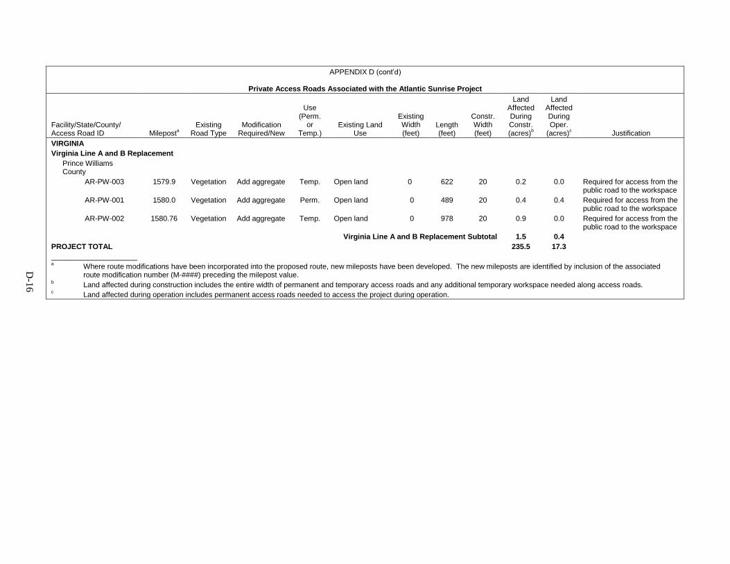
D-1
6
APPENDIX D (cont’d)
Private Access Roads Associated with the Atlantic Sunrise Project
Facility/State/County/ Access Road ID Mileposta
Existing Road Type
Modification Required/New
Use (Perm.
or Temp.)
Existing Land Use
Existing Width (feet)
Length (feet)
Constr. Width (feet)
Land Affected During Constr. (acres)b
Land Affected During Oper.
(acres)c Justification VIRGINIA
Virginia Line A and B Replacement
Prince Williams County
AR-PW-003 1579.9 Vegetation Add aggregate Temp. Open land 0 622 20 0.2 0.0 Required for access from the public road to the workspace
AR-PW-001 1580.0 Vegetation Add aggregate Perm. Open land 0 489 20 0.4 0.4 Required for access from the public road to the workspace
AR-PW-002 1580.76 Vegetation Add aggregate Temp. Open land 0 978 20 0.9 0.0 Required for access from the public road to the workspace
Virginia Line A and B Replacement Subtotal 1.5 0.4 PROJECT TOTAL 235.5 17.3 _____________________ a Where route modifications have been incorporated into the proposed route, new mileposts have been developed. The new mileposts are identified by inclusion of the associated
route modification number (M-####) preceding the milepost value. b Land affected during construction includes the entire width of permanent and temporary access roads and any additional temporary workspace needed along access roads. c Land affected during operation includes permanent access roads needed to access the project during operation.
APPENDIX E
TRANSCONTINENTAL GAS PIPELINE COMPANY LLC’S
UPLAND EROSION CONTROL, REVEGETATION, AND MAINTENANCE PLAN AND
WETLAND AND WATERBODY CONSTRUCTION AND MITIGATION PROCEDURES

Transcontinental Gas Pipe Line Company, LLC
Attachment 17
Transco Project-Specific Upland Erosion Control, Revegetation, and Maintenance Plan
Atlantic Sunrise Project
March 2015
E-1

This Page Intentionally Left Blank
E-2

ATTACHMENT 17 – TRANSCO PROJECT-SPECIFIC UPLAND EROSION CONTROL, ATLANTIC SUNRISE PROJECT REVEGETATION, AND MAINTENANCE PLAN
i
TABLE OF CONTENTS
I. APPLICABILITY ................................................................................................................ 1
II. SUPERVISION AND INSPECTION................................................................................... 1
A. ENVIRONMENTAL INSPECTION .................................................................................. 1
B. RESPONSIBILITIES OF ENVIRONMENTAL INSPECTORS ......................................... 2
III. PRECONSTRUCTION PLANNING ................................................................................... 3
A. CONSTRUCTION WORK AREAS .................................................................................. 3
B. DRAIN TILE AND IRRIGATION SYSTEMS .................................................................... 4
C. GRAZING DEFERMENT ................................................................................................ 4
D. ROAD CROSSINGS AND ACCESS POINTS ................................................................. 4
E. DISPOSAL PLANNING .................................................................................................. 4
F. AGENCY COORDINATION ............................................................................................ 4
G. SPILL PREVENTION AND RESPONSE PROCEDURES............................................... 5
H. RESIDENTIAL CONSTRUCTION .................................................................................. 5
I. WINTER CONSTRUCTION PLANS ............................................................................... 5
IV. INSTALLATION ................................................................................................................ 6
A. APPROVED AREAS OF DISTURBANCE ...................................................................... 6
B. TOPSOIL SEGREGATION ............................................................................................. 6
C. DRAIN TILES ................................................................................................................. 7
D. IRRIGATION .................................................................................................................. 8
E. ROAD CROSSINGS AND ACCESS POINTS ................................................................. 8
F. TEMPORARY EROSION CONTROL ............................................................................. 8
1. Temporary Slope Breakers ........................................................................................ 8
2. Temporary Trench Plugs ............................................................................................ 9
3. Sediment Barriers ...................................................................................................... 9
4. Mulch ......................................................................................................................... 9
V. RESTORATION ...............................................................................................................10
A. CLEANUP .....................................................................................................................10
B. PERMANENT EROSION CONTROL DEVICES ............................................................11
1. Trench Breakers .......................................................................................................11
2. Permanent Slope Breakers .......................................................................................12
C. SOIL COMPACTION MITIGATION ...............................................................................12
D. REVEGETATION ..........................................................................................................13
1. General .....................................................................................................................13
2. Soil Additives ............................................................................................................13
3. Seeding Requirements ..............................................................................................13
VI. OFF-ROAD VEHICLE CONTROL....................................................................................14
VII. POST-CONSTRUCTION ACTIVITIES AND REPORTING ...............................................14
A. MONITORING AND MAINTENANCE ............................................................................14
B. REPORTING .................................................................................................................15
E-3

This Page Intentionally Left Blank
E-4

ATTACHMENT 17 – TRANSCO PROJECT-SPECIFIC UPLAND EROSION CONTROL, ATLANTIC SUNRISE PROJECT REVEGETATION, AND MAINTENANCE PLAN
1
I. APPLICABILITY
A. The intent of this Plan is to identify baseline mitigation measures for minimizing erosion
and enhancing revegetation for the Transcontinental Gas Pipe Line Company, LLC
(Transco) Atlantic Sunrise Project (Project). Transco will specify in its application for a
new FERC authorization and in prior notice and advance notice filings, any individual
measures in this Plan it considers unnecessary, technically infeasible, or unsuitable due
to local conditions and fully describe any alternative measures they would use. Transco
will also explain how those alternative measures would achieve a comparable level of
mitigation. Deviations from the FERC Plan proposed by Transco to reflect site-specific conditions are bolded in the text.
Once the Project is authorized, Transco will request further changes as variances to the
measures in the Transco Plan. The Director of the Office of Energy Projects (Director)
will consider approval of variances upon Transco’s written request, if the Director agrees
that a variance:
1. provides equal or better environmental protection;
2. is necessary because a portion of this Plan is infeasible or unworkable based on project-specific conditions; or
3. is specifically required in writing by another federal, state, or Native American land management agency for the portion of the project on its land or under its jurisdiction.
Project-related impacts on wetland and waterbody systems are addressed in the Transco
Project-specific Wetland and Waterbody Construction and Mitigation Procedures
(Transco Procedures).
II. SUPERVISION AND INSPECTION
A. ENVIRONMENTAL INSPECTION
1. At least one Environmental Inspector is required for each construction spread during construction and restoration (as defined by section V). The number and experience of Environmental Inspectors assigned to each construction spread shall be appropriate for the length of the construction spread and the number/significance of resources affected.
2. Environmental Inspectors shall have peer status with all other activity inspectors.
3. Environmental Inspectors shall have the authority to stop activities that violate the environmental conditions of the FERC’s Orders, stipulations of other environmental permits or approvals, or landowner easement agreements; and to order appropriate corrective action.
E-5
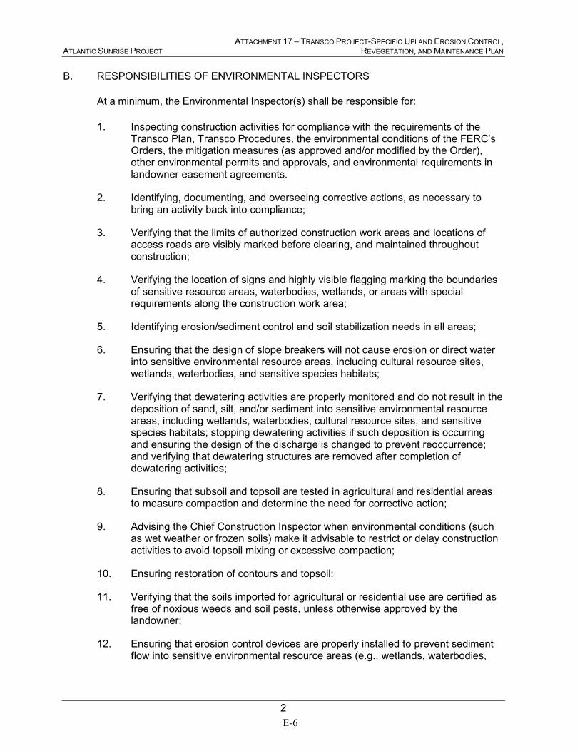
ATTACHMENT 17 – TRANSCO PROJECT-SPECIFIC UPLAND EROSION CONTROL, ATLANTIC SUNRISE PROJECT REVEGETATION, AND MAINTENANCE PLAN
2
B. RESPONSIBILITIES OF ENVIRONMENTAL INSPECTORS
At a minimum, the Environmental Inspector(s) shall be responsible for:
1. Inspecting construction activities for compliance with the requirements of the Transco Plan, Transco Procedures, the environmental conditions of the FERC’s Orders, the mitigation measures (as approved and/or modified by the Order), other environmental permits and approvals, and environmental requirements in landowner easement agreements.
2. Identifying, documenting, and overseeing corrective actions, as necessary to bring an activity back into compliance;
3. Verifying that the limits of authorized construction work areas and locations of access roads are visibly marked before clearing, and maintained throughout construction;
4. Verifying the location of signs and highly visible flagging marking the boundaries of sensitive resource areas, waterbodies, wetlands, or areas with special requirements along the construction work area;
5. Identifying erosion/sediment control and soil stabilization needs in all areas;
6. Ensuring that the design of slope breakers will not cause erosion or direct water into sensitive environmental resource areas, including cultural resource sites, wetlands, waterbodies, and sensitive species habitats;
7. Verifying that dewatering activities are properly monitored and do not result in the deposition of sand, silt, and/or sediment into sensitive environmental resource areas, including wetlands, waterbodies, cultural resource sites, and sensitive species habitats; stopping dewatering activities if such deposition is occurring and ensuring the design of the discharge is changed to prevent reoccurrence; and verifying that dewatering structures are removed after completion of dewatering activities;
8. Ensuring that subsoil and topsoil are tested in agricultural and residential areas to measure compaction and determine the need for corrective action;
9. Advising the Chief Construction Inspector when environmental conditions (such as wet weather or frozen soils) make it advisable to restrict or delay construction activities to avoid topsoil mixing or excessive compaction;
10. Ensuring restoration of contours and topsoil;
11. Verifying that the soils imported for agricultural or residential use are certified as free of noxious weeds and soil pests, unless otherwise approved by the landowner;
12. Ensuring that erosion control devices are properly installed to prevent sediment flow into sensitive environmental resource areas (e.g., wetlands, waterbodies,
E-6
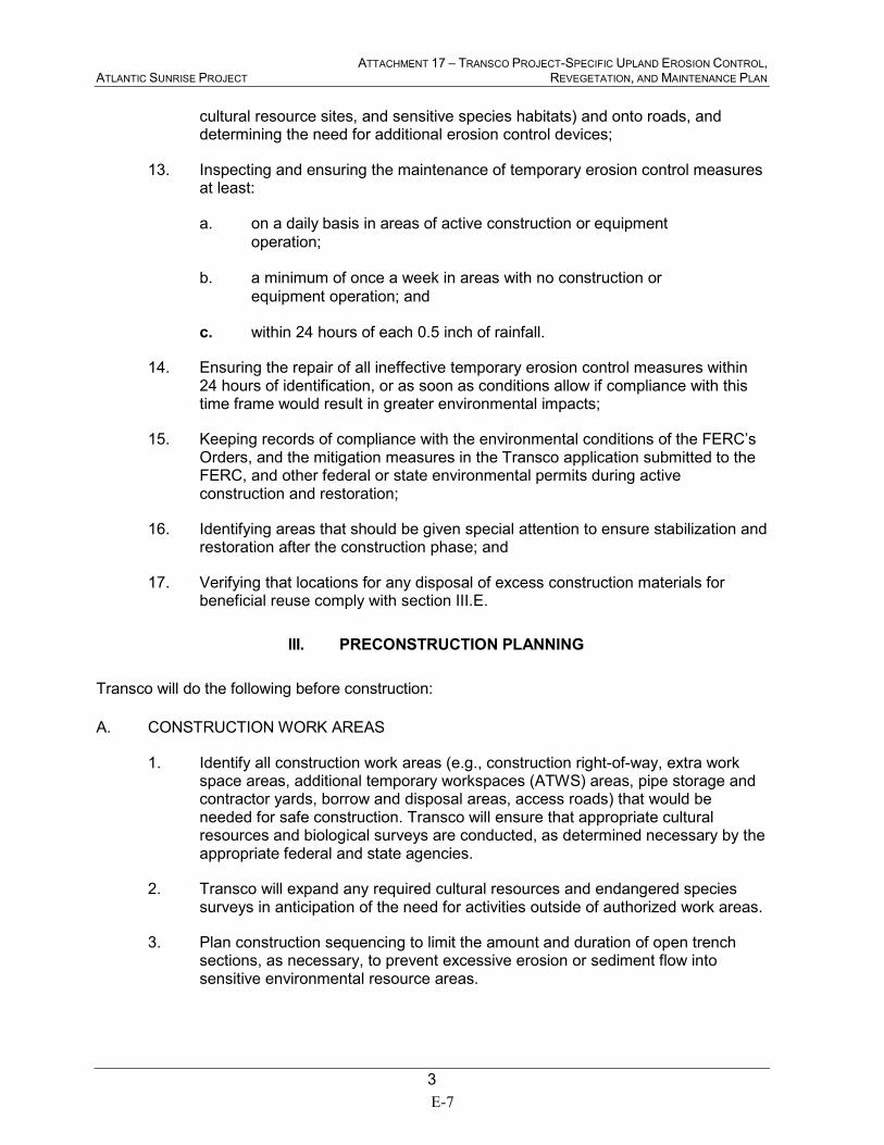
ATTACHMENT 17 – TRANSCO PROJECT-SPECIFIC UPLAND EROSION CONTROL, ATLANTIC SUNRISE PROJECT REVEGETATION, AND MAINTENANCE PLAN
3
cultural resource sites, and sensitive species habitats) and onto roads, and determining the need for additional erosion control devices;
13. Inspecting and ensuring the maintenance of temporary erosion control measures at least:
a. on a daily basis in areas of active construction or equipment
operation;
b. a minimum of once a week in areas with no construction or
equipment operation; and
c. within 24 hours of each 0.5 inch of rainfall.
14. Ensuring the repair of all ineffective temporary erosion control measures within 24 hours of identification, or as soon as conditions allow if compliance with this time frame would result in greater environmental impacts;
15. Keeping records of compliance with the environmental conditions of the FERC’s Orders, and the mitigation measures in the Transco application submitted to the FERC, and other federal or state environmental permits during active construction and restoration;
16. Identifying areas that should be given special attention to ensure stabilization and restoration after the construction phase; and
17. Verifying that locations for any disposal of excess construction materials for beneficial reuse comply with section III.E.
III. PRECONSTRUCTION PLANNING
Transco will do the following before construction:
A. CONSTRUCTION WORK AREAS
1. Identify all construction work areas (e.g., construction right-of-way, extra work space areas, additional temporary workspaces (ATWS) areas, pipe storage and contractor yards, borrow and disposal areas, access roads) that would be needed for safe construction. Transco will ensure that appropriate cultural resources and biological surveys are conducted, as determined necessary by the appropriate federal and state agencies.
2. Transco will expand any required cultural resources and endangered species surveys in anticipation of the need for activities outside of authorized work areas.
3. Plan construction sequencing to limit the amount and duration of open trench sections, as necessary, to prevent excessive erosion or sediment flow into sensitive environmental resource areas.
E-7

ATTACHMENT 17 – TRANSCO PROJECT-SPECIFIC UPLAND EROSION CONTROL, ATLANTIC SUNRISE PROJECT REVEGETATION, AND MAINTENANCE PLAN
4
B. DRAIN TILE AND IRRIGATION SYSTEMS
1. Attempt to locate existing drain tiles and irrigation systems.
2. Contact landowners and local soil conservation authorities to determine the locations of future drain tiles that are likely to be installed within 3 years of the authorized construction.
3. Develop procedures for constructing through drain-tiled areas, maintaining irrigation systems during construction, and repairing drain tiles and irrigation systems after construction.
4. Engage qualified drain tile specialists, as needed to conduct or monitor repairs to drain tile systems affected by construction. Use drain tile specialists from the Project area, if available.
C. GRAZING DEFERMENT
Develop grazing deferment plans with willing landowners, grazing permittees, and land
management agencies to minimize grazing disturbance of revegetation efforts.
D. ROAD CROSSINGS AND ACCESS POINTS
Plan for safe and accessible conditions at all roadway crossings and access points during
construction and restoration.
E. DISPOSAL PLANNING
Determine methods and locations for the regular collection, containment, and disposal of
excess construction materials and debris (e.g., timber, slash, mats, garbage, drill cuttings
and fluids, excess rock) throughout the construction process. Disposal of materials for
beneficial reuse must not result in adverse environmental impact and is subject to
compliance with all applicable survey, landowner or land management agency approval,
and permit requirements.
F. AGENCY COORDINATION
Transco will coordinate with the appropriate local, state, and federal agencies as outlined
in this Plan and/or required by the FERC’s Orders.
1. Obtain written recommendations from the local soil conservation authorities or land management agencies regarding permanent erosion control and revegetation specifications.
2. Develop specific procedures in coordination with the appropriate agencies to prevent the introduction or spread of invasive species, noxious weeds, and soil pests resulting from construction and restoration activities. Refer to the Transco Project-specific Noxious and Invasive Plant Management Plan.
E-8
ATTACHMENT 17 – TRANSCO PROJECT-SPECIFIC UPLAND EROSION CONTROL, ATLANTIC SUNRISE PROJECT REVEGETATION, AND MAINTENANCE PLAN
5
3. Develop specific procedures in coordination with the appropriate agencies and landowners, as necessary, to allow for livestock and wildlife movement and protection during construction.
4. Develop specific blasting procedures in coordination with the appropriate agencies that address pre- and post-blast inspections; advanced public notification; and mitigation measures for building foundations, groundwater wells, and springs. Use appropriate methods (e.g., blasting mats) to prevent damage to nearby structures and to prevent debris from entering sensitive environmental resource areas. Refer to the Transco Project-specific Blasting Plan.
G. SPILL PREVENTION AND RESPONSE PROCEDURES
Transco will develop project-specific Spill Prevention and Response Procedures, as
specified in section IV of the staff's Procedures. A copy will be filed with the Secretary of
the FERC (Secretary) prior to construction and made available in the field on each
construction spread. Refer to the Transco Project-specific Spill Plan for Oil and
Hazardous Materials.
H. RESIDENTIAL CONSTRUCTION
For all properties with residences located within 50 feet of construction work areas,
Transco will avoid removal of mature trees and landscaping within the construction work
area unless necessary for safe operation of construction equipment, or as specified in
landowner agreements; fence the edge of the construction work area for a distance of
100 feet on either side of the residence; and restore all lawn areas and landscaping
immediately following clean-up operations, or as specified in landowner agreements. If
seasonal or other weather conditions prevent compliance with these time frames,
maintain and monitor temporary erosion controls (sediment barriers and mulch) until
conditions allow completion of restoration.
I. WINTER CONSTRUCTION PLANS
Transco has filed a Project-specific Winter Construction Plan with the FERC application.
The plan addresses:
1. winter construction procedures (e.g., snow handling and removal, access road construction and maintenance, soil handling under saturated or frozen conditions, topsoil stripping);
2. stabilization and monitoring procedures if ground conditions will delay restoration until the following spring (e.g., mulching and erosion controls, inspection and reporting, stormwater control during spring thaw conditions); and
3. final restoration procedures (e.g., subsidence and compaction repair, topsoil replacement, seeding).
E-9
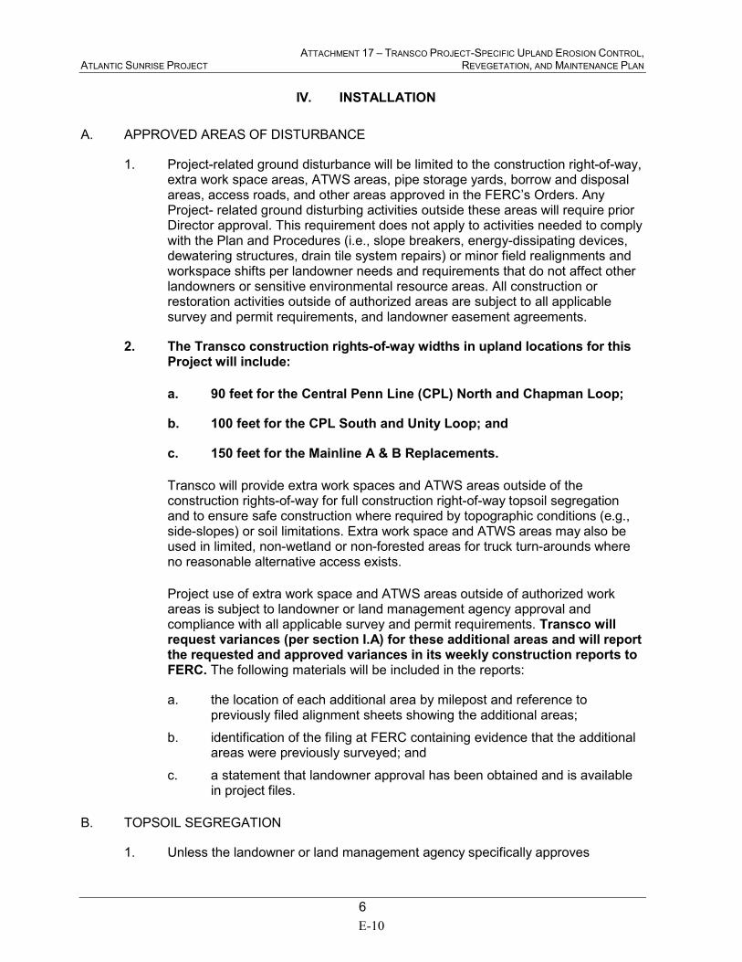
ATTACHMENT 17 – TRANSCO PROJECT-SPECIFIC UPLAND EROSION CONTROL, ATLANTIC SUNRISE PROJECT REVEGETATION, AND MAINTENANCE PLAN
6
IV. INSTALLATION
A. APPROVED AREAS OF DISTURBANCE
1. Project-related ground disturbance will be limited to the construction right-of-way, extra work space areas, ATWS areas, pipe storage yards, borrow and disposal areas, access roads, and other areas approved in the FERC’s Orders. Any Project- related ground disturbing activities outside these areas will require prior Director approval. This requirement does not apply to activities needed to comply with the Plan and Procedures (i.e., slope breakers, energy-dissipating devices, dewatering structures, drain tile system repairs) or minor field realignments and workspace shifts per landowner needs and requirements that do not affect other landowners or sensitive environmental resource areas. All construction or restoration activities outside of authorized areas are subject to all applicable survey and permit requirements, and landowner easement agreements.
2. The Transco construction rights-of-way widths in upland locations for this Project will include:
a. 90 feet for the Central Penn Line (CPL) North and Chapman Loop;
b. 100 feet for the CPL South and Unity Loop; and
c. 150 feet for the Mainline A & B Replacements.
Transco will provide extra work spaces and ATWS areas outside of the construction rights-of-way for full construction right-of-way topsoil segregation and to ensure safe construction where required by topographic conditions (e.g., side-slopes) or soil limitations. Extra work space and ATWS areas may also be used in limited, non-wetland or non-forested areas for truck turn-arounds where no reasonable alternative access exists.
Project use of extra work space and ATWS areas outside of authorized work areas is subject to landowner or land management agency approval and compliance with all applicable survey and permit requirements. Transco will request variances (per section I.A) for these additional areas and will report the requested and approved variances in its weekly construction reports to FERC. The following materials will be included in the reports:
a. the location of each additional area by milepost and reference to previously filed alignment sheets showing the additional areas;
b. identification of the filing at FERC containing evidence that the additional areas were previously surveyed; and
c. a statement that landowner approval has been obtained and is available in project files.
B. TOPSOIL SEGREGATION
1. Unless the landowner or land management agency specifically approves
E-10
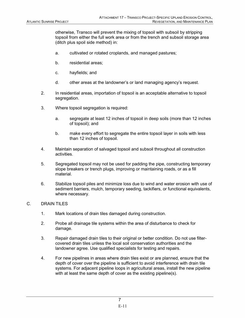
ATTACHMENT 17 – TRANSCO PROJECT-SPECIFIC UPLAND EROSION CONTROL, ATLANTIC SUNRISE PROJECT REVEGETATION, AND MAINTENANCE PLAN
7
otherwise, Transco will prevent the mixing of topsoil with subsoil by stripping topsoil from either the full work area or from the trench and subsoil storage area (ditch plus spoil side method) in:
a. cultivated or rotated croplands, and managed pastures;
b. residential areas;
c. hayfields; and
d. other areas at the landowner’s or land managing agency’s request.
2. In residential areas, importation of topsoil is an acceptable alternative to topsoil segregation.
3. Where topsoil segregation is required:
a. segregate at least 12 inches of topsoil in deep soils (more than 12 inches of topsoil); and
b. make every effort to segregate the entire topsoil layer in soils with less than 12 inches of topsoil.
4. Maintain separation of salvaged topsoil and subsoil throughout all construction activities.
5. Segregated topsoil may not be used for padding the pipe, constructing temporary slope breakers or trench plugs, improving or maintaining roads, or as a fill material.
6. Stabilize topsoil piles and minimize loss due to wind and water erosion with use of sediment barriers, mulch, temporary seeding, tackifiers, or functional equivalents, where necessary.
C. DRAIN TILES
1. Mark locations of drain tiles damaged during construction.
2. Probe all drainage tile systems within the area of disturbance to check for damage.
3. Repair damaged drain tiles to their original or better condition. Do not use filter-covered drain tiles unless the local soil conservation authorities and the landowner agree. Use qualified specialists for testing and repairs.
4. For new pipelines in areas where drain tiles exist or are planned, ensure that the depth of cover over the pipeline is sufficient to avoid interference with drain tile systems. For adjacent pipeline loops in agricultural areas, install the new pipeline with at least the same depth of cover as the existing pipeline(s).
E-11
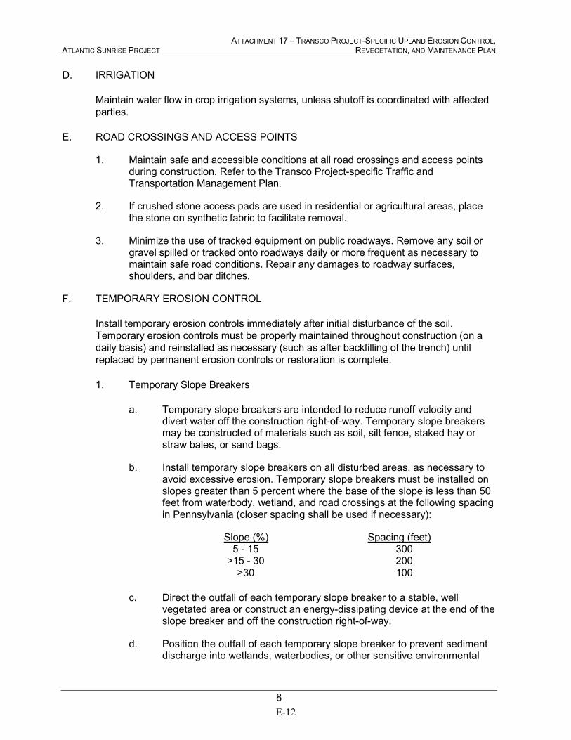
ATTACHMENT 17 – TRANSCO PROJECT-SPECIFIC UPLAND EROSION CONTROL, ATLANTIC SUNRISE PROJECT REVEGETATION, AND MAINTENANCE PLAN
8
D. IRRIGATION
Maintain water flow in crop irrigation systems, unless shutoff is coordinated with affected
parties.
E. ROAD CROSSINGS AND ACCESS POINTS
1. Maintain safe and accessible conditions at all road crossings and access points during construction. Refer to the Transco Project-specific Traffic and Transportation Management Plan.
2. If crushed stone access pads are used in residential or agricultural areas, place the stone on synthetic fabric to facilitate removal.
3. Minimize the use of tracked equipment on public roadways. Remove any soil or gravel spilled or tracked onto roadways daily or more frequent as necessary to maintain safe road conditions. Repair any damages to roadway surfaces, shoulders, and bar ditches.
F. TEMPORARY EROSION CONTROL
Install temporary erosion controls immediately after initial disturbance of the soil.
Temporary erosion controls must be properly maintained throughout construction (on a
daily basis) and reinstalled as necessary (such as after backfilling of the trench) until
replaced by permanent erosion controls or restoration is complete.
1. Temporary Slope Breakers
a. Temporary slope breakers are intended to reduce runoff velocity and divert water off the construction right-of-way. Temporary slope breakers may be constructed of materials such as soil, silt fence, staked hay or straw bales, or sand bags.
b. Install temporary slope breakers on all disturbed areas, as necessary to avoid excessive erosion. Temporary slope breakers must be installed on slopes greater than 5 percent where the base of the slope is less than 50 feet from waterbody, wetland, and road crossings at the following spacing in Pennsylvania (closer spacing shall be used if necessary):
Slope (%) Spacing (feet) 5 - 15 300 >15 - 30 200
>30 100
c. Direct the outfall of each temporary slope breaker to a stable, well vegetated area or construct an energy-dissipating device at the end of the slope breaker and off the construction right-of-way.
d. Position the outfall of each temporary slope breaker to prevent sediment discharge into wetlands, waterbodies, or other sensitive environmental
E-12
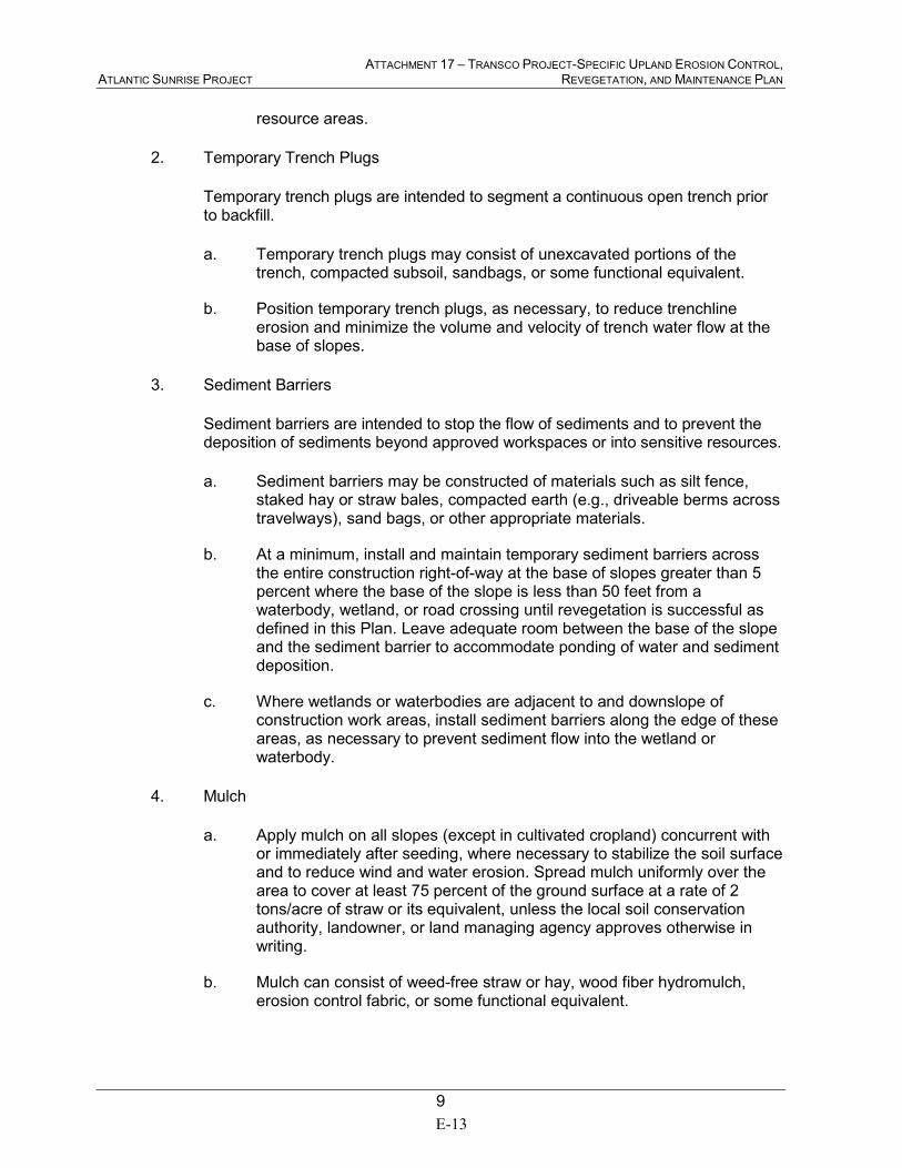
ATTACHMENT 17 – TRANSCO PROJECT-SPECIFIC UPLAND EROSION CONTROL, ATLANTIC SUNRISE PROJECT REVEGETATION, AND MAINTENANCE PLAN
9
resource areas.
2. Temporary Trench Plugs
Temporary trench plugs are intended to segment a continuous open trench prior to backfill.
a. Temporary trench plugs may consist of unexcavated portions of the trench, compacted subsoil, sandbags, or some functional equivalent.
b. Position temporary trench plugs, as necessary, to reduce trenchline erosion and minimize the volume and velocity of trench water flow at the base of slopes.
3. Sediment Barriers
Sediment barriers are intended to stop the flow of sediments and to prevent the deposition of sediments beyond approved workspaces or into sensitive resources.
a. Sediment barriers may be constructed of materials such as silt fence, staked hay or straw bales, compacted earth (e.g., driveable berms across travelways), sand bags, or other appropriate materials.
b. At a minimum, install and maintain temporary sediment barriers across the entire construction right-of-way at the base of slopes greater than 5 percent where the base of the slope is less than 50 feet from a waterbody, wetland, or road crossing until revegetation is successful as defined in this Plan. Leave adequate room between the base of the slope and the sediment barrier to accommodate ponding of water and sediment deposition.
c. Where wetlands or waterbodies are adjacent to and downslope of construction work areas, install sediment barriers along the edge of these areas, as necessary to prevent sediment flow into the wetland or waterbody.
4. Mulch
a. Apply mulch on all slopes (except in cultivated cropland) concurrent with or immediately after seeding, where necessary to stabilize the soil surface and to reduce wind and water erosion. Spread mulch uniformly over the area to cover at least 75 percent of the ground surface at a rate of 2 tons/acre of straw or its equivalent, unless the local soil conservation authority, landowner, or land managing agency approves otherwise in writing.
b. Mulch can consist of weed-free straw or hay, wood fiber hydromulch, erosion control fabric, or some functional equivalent.
E-13
ATTACHMENT 17 – TRANSCO PROJECT-SPECIFIC UPLAND EROSION CONTROL, ATLANTIC SUNRISE PROJECT REVEGETATION, AND MAINTENANCE PLAN
10
c. Mulch all disturbed upland areas (except cultivated cropland) before seeding if:
(1) final grading and installation of permanent erosion control
measures will not be completed in an area within 20 days after
the trench in that area is backfilled (10 days in residential areas),
as required in section V.A.1; or
(2) construction or restoration activity is interrupted for extended
periods, such as when seeding cannot be completed due to
seeding period restrictions.
d. If mulching before seeding, increase mulch application on all slopes within 100 feet of waterbodies and wetlands to a rate of 3 tons/acre of straw or equivalent.
e. If wood chips are used as mulch, do not use more than 1 ton/acre and add the equivalent of 11 lbs/acre available nitrogen (at least 50 percent of which is slow release).
f. Ensure that mulch is adequately anchored to minimize loss due to wind and water.
g. When anchoring with liquid mulch binders, use rates recommended by the manufacturer. Do not use liquid mulch binders within 100 feet of wetlands or waterbodies, except where the product is certified environmentally non-toxic by the appropriate state or federal agency or independent standards-setting organization.
h. Do not use synthetic monofilament mesh/netted erosion control materials in areas designated as sensitive wildlife habitat, unless the product is specifically designed to minimize harm to wildlife. Anchor erosion control fabric with staples or other appropriate devices.
V. RESTORATION
A. CLEANUP
1. Commence cleanup operations immediately following backfill operations. Complete final grading, topsoil replacement, and installation of permanent erosion control structures within 20 days after backfilling the trench (10 days in residential areas). If seasonal or other weather conditions prevent compliance with these time frames, maintain temporary erosion controls (i.e., temporary slope breakers, sediment barriers, and mulch) until conditions allow completion of cleanup.
Transco will file with the Secretary for the review and written approval of the Director, a Winter Construction Plan (as specified in section III.I). Refer to the Transco Project-specific Winter Construction Plan.
E-14
ATTACHMENT 17 – TRANSCO PROJECT-SPECIFIC UPLAND EROSION CONTROL, ATLANTIC SUNRISE PROJECT REVEGETATION, AND MAINTENANCE PLAN
11
2. A travel lane may be left open temporarily to allow access by construction traffic if the temporary erosion control structures are installed as specified in section IV.F. and inspected and maintained as specified in sections II.B.12 through 14. When access is no longer required the travel lane must be removed and the right-of-way restored.
3. Rock excavated from the trench may be used to backfill the trench only to the top of the existing bedrock profile. Rock that is not returned to the trench shall be considered construction debris, unless approved for use as mulch or for some other use on the construction work areas by the landowner or land managing agency.
4. Remove excess rock in excess of 4 inches from at least the top 12 inches of soil in all cultivated or rotated cropland, managed pastures, hayfields, and residential areas, as well as other areas at the landowner’s request. The size, density, and distribution of rock on the construction work area shall be similar to adjacent areas not disturbed by construction. The landowner or land management agency may approve other provisions in writing.
5. Grade the construction right-of-way to restore pre-construction contours and leave the soil in the proper condition for planting.
6. Remove construction debris from all construction work areas unless the landowner or land managing agency approves leaving materials onsite for beneficial reuse, stabilization, or habitat restoration.
7. Remove temporary sediment barriers when replaced by permanent erosion control measures or when revegetation is successful.
B. PERMANENT EROSION CONTROL DEVICES
1. Trench Breakers
a. Trench breakers are intended to slow the flow of subsurface water along the trench. Trench breakers may be constructed of materials such as sand bags or polyurethane foam. Do not use topsoil in trench breakers.
b. An engineer or similarly qualified professional shall determine the need for and spacing of trench breakers. Otherwise, trench breakers shall be installed at the same spacing as and upslope of permanent slope breakers.
c. In agricultural fields and residential areas where slope breakers are not typically required, install trench breakers at the same spacing as if permanent slope breakers were required.
d. At a minimum, install a trench breaker at the base of slopes greater than 5 percent where the base of the slope is less than 50 feet from a waterbody or wetland and where needed to avoid draining a waterbody or
E-15
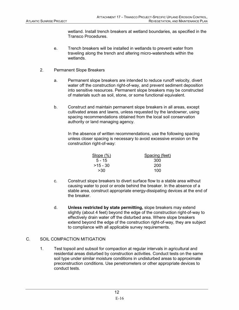
ATTACHMENT 17 – TRANSCO PROJECT-SPECIFIC UPLAND EROSION CONTROL, ATLANTIC SUNRISE PROJECT REVEGETATION, AND MAINTENANCE PLAN
12
wetland. Install trench breakers at wetland boundaries, as specified in the Transco Procedures.
e. Trench breakers will be installed in wetlands to prevent water from traveling along the trench and altering micro-watersheds within the wetlands.
2. Permanent Slope Breakers
a. Permanent slope breakers are intended to reduce runoff velocity, divert water off the construction right-of-way, and prevent sediment deposition into sensitive resources. Permanent slope breakers may be constructed of materials such as soil, stone, or some functional equivalent.
b. Construct and maintain permanent slope breakers in all areas, except cultivated areas and lawns, unless requested by the landowner, using spacing recommendations obtained from the local soil conservation authority or land managing agency.
In the absence of written recommendations, use the following spacing unless closer spacing is necessary to avoid excessive erosion on the construction right-of-way:
Slope (%) Spacing (feet)
5 - 15 300
>15 - 30 200
>30 100
c. Construct slope breakers to divert surface flow to a stable area without causing water to pool or erode behind the breaker. In the absence of a stable area, construct appropriate energy-dissipating devices at the end of the breaker.
d. Unless restricted by state permitting, slope breakers may extend slightly (about 4 feet) beyond the edge of the construction right-of-way to effectively drain water off the disturbed area. Where slope breakers extend beyond the edge of the construction right-of-way, they are subject to compliance with all applicable survey requirements.
C. SOIL COMPACTION MITIGATION
1. Test topsoil and subsoil for compaction at regular intervals in agricultural and residential areas disturbed by construction activities. Conduct tests on the same soil type under similar moisture conditions in undisturbed areas to approximate preconstruction conditions. Use penetrometers or other appropriate devices to conduct tests.
E-16

ATTACHMENT 17 – TRANSCO PROJECT-SPECIFIC UPLAND EROSION CONTROL, ATLANTIC SUNRISE PROJECT REVEGETATION, AND MAINTENANCE PLAN
13
2. Plow severely compacted agricultural areas with a paraplow or other deep tillage implement. In areas where topsoil has been segregated, plow the subsoil before replacing the segregated topsoil. If subsequent construction and cleanup activities result in further compaction, conduct additional tilling. Refer to the Transco Project-specific Agricultural Construction and Monitoring Plan.
3. Perform appropriate soil compaction mitigation in severely compacted residential areas.
D. REVEGETATION
1. General
a. Transco will ensure successful revegetation of soils disturbed by Project-related activities, except as noted in section V.D.1.b.
b. Restore all turf, ornamental shrubs, and specialized landscaping in accordance with the landowner’s request, or compensate the landowner. Restoration work must be performed by personnel familiar with local horticultural and turf establishment practices.
2. Soil Additives
Fertilize and add soil pH modifiers in accordance with written recommendations obtained from the local soil conservation authority, land management agencies, or landowner. Incorporate recommended soil pH modifier and fertilizer into the top 2 inches of soil as soon as practicable after application.
3. Seeding Requirements
a. Prepare a seedbed in disturbed areas to a depth of 3 to 4 inches using appropriate equipment to provide a firm seedbed. When hydroseeding, scarify the seedbed to facilitate lodging and germination of seed.
b. Seed disturbed areas in accordance with written recommendations for seed mixes, rates, and dates obtained from the local soil conservation authority or the request of the landowner or land management agency. Seeding is not required in cultivated croplands unless requested by the landowner.
c. Perform seeding of permanent vegetation within the recommended seeding dates. If seeding cannot be done within those dates, use appropriate temporary erosion control measures discussed in section IV.F and perform seeding of permanent vegetation at the beginning of the next recommended seeding season. Dormant seeding or temporary seeding of annual species may also be used, if necessary, to establish cover, as approved by the Environmental Inspector. Lawns may be seeded on a schedule established with the landowner.
E-17
ATTACHMENT 17 – TRANSCO PROJECT-SPECIFIC UPLAND EROSION CONTROL, ATLANTIC SUNRISE PROJECT REVEGETATION, AND MAINTENANCE PLAN
14
d. In the absence of written recommendations from the local soil conservation authorities, seed all disturbed soils within 6 working days of final grading, weather and soil conditions permitting, subject to the specifications in section V.D.3.a through V.D.3.c.
e. Base seeding rates on Pure Live Seed. Use seed within 12 months of seed testing.
f. Treat legume seed with an inoculant specific to the species using the manufacturer’s recommended rate of inoculant appropriate for the seeding method (broadcast, drill, or hydro).
g. In the absence of written recommendations from the local soil conservation authorities, landowner, or land managing agency to the contrary, a seed drill equipped with a cultipacker is preferred for seed application.
Broadcast or hydroseeding can be used in lieu of drilling at double the recommended seeding rates. Where seed is broadcast, firm the seedbed with a cultipacker or roller after seeding. In rocky soils or where site conditions may limit the effectiveness of this equipment, other alternatives may be appropriate (e.g., use of a chain drag) to lightly cover seed after application, as approved by the Environmental Inspector.
VI. OFF-ROAD VEHICLE CONTROL
To each owner or manager of forested lands, offer to install and maintain measures to control
unauthorized vehicle access to the right-of-way. These measures may include:
a. signs;
b. fences with locking gates;
c. slash and timber barriers, pipe barriers, or a line of boulders across the right-of-way; and
d. conifers or other appropriate trees or shrubs across the right-of-way.
VII. POST-CONSTRUCTION ACTIVITIES AND REPORTING
A. MONITORING AND MAINTENANCE
1. Conduct follow-up inspections of all disturbed areas, as necessary, to determine the success of revegetation and address landowner concerns. At a minimum, conduct inspections after the first and second growing seasons.
E-18
ATTACHMENT 17 – TRANSCO PROJECT-SPECIFIC UPLAND EROSION CONTROL, ATLANTIC SUNRISE PROJECT REVEGETATION, AND MAINTENANCE PLAN
15
2. Revegetation in non-agricultural areas shall be considered successful if upon visual survey the density and cover of non-nuisance vegetation are similar in density and cover to adjacent undisturbed lands. In agricultural areas, revegetation shall be considered successful when upon visual survey, crop growth and vigor are similar to adjacent undisturbed portions of the same field, unless the easement agreement specifies otherwise.
Continue revegetation efforts until revegetation is successful.
3. Monitor and correct problems with drainage and irrigation systems resulting from pipeline construction in agricultural areas until restoration is successful.
4. Restoration will be considered successful when the right-of-way surface condition is similar to adjacent undisturbed lands, construction debris is removed (unless otherwise approved by the landowner or land managing agency per section V.A.6), revegetation is successful, and proper drainage has been restored.
5. Routine vegetation mowing or clearing over the full width of the permanent right-of-way in uplands will not be done more frequently than every 3 years. However, to facilitate periodic corrosion/leak surveys, a corridor not exceeding 10 feet in width centered on the pipeline may be cleared at a frequency necessary to maintain the 10-foot corridor in an herbaceous state. In no case will routine vegetation mowing or clearing occur during the migratory bird nesting season between April 15 and August 1 of any year unless specifically approved in writing by the responsible land management agency or the U.S. Fish and Wildlife Service.
6. Efforts to control unauthorized off-road vehicle use, in cooperation with the landowner, shall continue throughout the life of the project. Maintain signs, gates, and permanent access roads as necessary.
B. REPORTING
1. Transco will maintain records that identify by milepost:
a. method of application, application rate, and type of fertilizer, pH modifying agent, seed, and mulch used;
b. acreage treated;
c. dates of backfilling and seeding;
d. names of landowners requesting special seeding treatment and a description of the follow-up actions;
e. the location of any subsurface drainage repairs or improvements made during restoration; and
f. any problem areas and how they were addressed.
E-19
ATTACHMENT 17 – TRANSCO PROJECT-SPECIFIC UPLAND EROSION CONTROL, ATLANTIC SUNRISE PROJECT REVEGETATION, AND MAINTENANCE PLAN
16
2. Transco will file with the Secretary quarterly activity reports documenting the results of follow-up inspections required by section VII.A.1; any problem areas, including those identified by the landowner; and corrective actions taken for at least 2 years following construction.
E-20
Transcontinental Gas Pipe Line Company, LLC
Attachment 18
Transco Project-Specific Wetland and Waterbody Construction and Mitigation Procedures
Atlantic Sunrise Project
March 2015
E-21

This Page Intentionally Left Blank
E-22
ATTACHMENT 18 – TRANSCO PROJECT-SPECIFIC WETLAND AND ATLANTIC SUNRISE PROJECT WATERBODY CONSTRUCTION AND MITIGATION PROCEDURES
i
TABLE OF CONTENTS
I. APPLICABILITY ................................................................................................................ 1
II. PRECONSTRUCTION FILING .......................................................................................... 2
III. ENVIRONMENTAL INSPECTORS ................................................................................... 2
IV. PRECONSTRUCTION PLANNING ................................................................................... 2
A. SPILL PLAN FOR OIL AND HAZARDOUS MATERIALS .......................................... 2
B. AGENCY COORDINATION ...................................................................................... 4
V. WATERBODY CROSSINGS............................................................................................. 4
A. NOTIFICATION PROCEDURES AND PERMITS ..................................................... 4
B. INSTALLATION ........................................................................................................ 4
C. RESTORATION .......................................................................................................10
D. POST-CONSTRUCTION MAINTENANCE ..............................................................11
VI. WETLAND CROSSINGS .................................................................................................12
A. GENERAL ...............................................................................................................12
B. INSTALLATION .......................................................................................................13
C. RESTORATION .......................................................................................................15
D. POST-CONSTRUCTION MAINTENANCE AND REPORTING ................................16
VII. HYDROSTATIC TESTING ...............................................................................................17
A. NOTIFICATION PROCEDURES AND PERMITS ....................................................17
B. GENERAL ...............................................................................................................17
C. INTAKE SOURCE AND RATE .................................................................................18
D. DISCHARGE LOCATION, METHOD, AND RATE ...................................................18
E-23

This Page Intentionally Left Blank
E-24
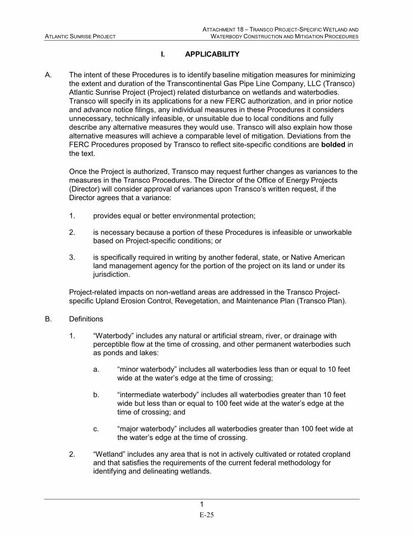
ATTACHMENT 18 – TRANSCO PROJECT-SPECIFIC WETLAND AND ATLANTIC SUNRISE PROJECT WATERBODY CONSTRUCTION AND MITIGATION PROCEDURES
1
I. APPLICABILITY
A. The intent of these Procedures is to identify baseline mitigation measures for minimizing
the extent and duration of the Transcontinental Gas Pipe Line Company, LLC (Transco)
Atlantic Sunrise Project (Project) related disturbance on wetlands and waterbodies.
Transco will specify in its applications for a new FERC authorization, and in prior notice
and advance notice filings, any individual measures in these Procedures it considers
unnecessary, technically infeasible, or unsuitable due to local conditions and fully
describe any alternative measures they would use. Transco will also explain how those
alternative measures will achieve a comparable level of mitigation. Deviations from the FERC Procedures proposed by Transco to reflect site-specific conditions are bolded in
the text.
Once the Project is authorized, Transco may request further changes as variances to the
measures in the Transco Procedures. The Director of the Office of Energy Projects
(Director) will consider approval of variances upon Transco’s written request, if the
Director agrees that a variance:
1. provides equal or better environmental protection;
2. is necessary because a portion of these Procedures is infeasible or unworkable based on Project-specific conditions; or
3. is specifically required in writing by another federal, state, or Native American land management agency for the portion of the project on its land or under its jurisdiction.
Project-related impacts on non-wetland areas are addressed in the Transco Project-
specific Upland Erosion Control, Revegetation, and Maintenance Plan (Transco Plan).
B. Definitions
1. “Waterbody” includes any natural or artificial stream, river, or drainage with perceptible flow at the time of crossing, and other permanent waterbodies such as ponds and lakes:
a. “minor waterbody” includes all waterbodies less than or equal to 10 feet
wide at the water’s edge at the time of crossing;
b. “intermediate waterbody” includes all waterbodies greater than 10 feet
wide but less than or equal to 100 feet wide at the water’s edge at the
time of crossing; and
c. “major waterbody” includes all waterbodies greater than 100 feet wide at
the water’s edge at the time of crossing.
2. “Wetland” includes any area that is not in actively cultivated or rotated cropland and that satisfies the requirements of the current federal methodology for identifying and delineating wetlands.
E-25
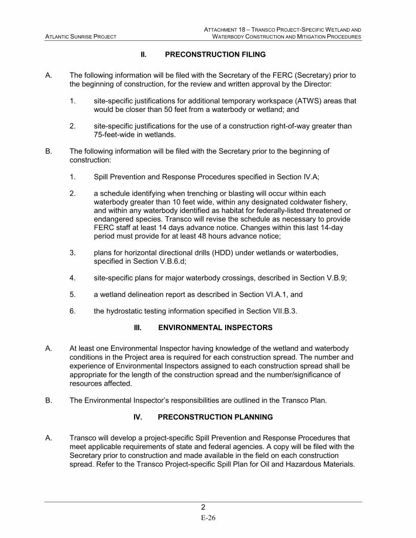
ATTACHMENT 18 – TRANSCO PROJECT-SPECIFIC WETLAND AND ATLANTIC SUNRISE PROJECT WATERBODY CONSTRUCTION AND MITIGATION PROCEDURES
2
II. PRECONSTRUCTION FILING
A. The following information will be filed with the Secretary of the FERC (Secretary) prior to
the beginning of construction, for the review and written approval by the Director:
1. site-specific justifications for additional temporary workspace (ATWS) areas that would be closer than 50 feet from a waterbody or wetland; and
2. site-specific justifications for the use of a construction right-of-way greater than 75-feet-wide in wetlands.
B. The following information will be filed with the Secretary prior to the beginning of
construction:
1. Spill Prevention and Response Procedures specified in Section IV.A;
2. a schedule identifying when trenching or blasting will occur within each waterbody greater than 10 feet wide, within any designated coldwater fishery, and within any waterbody identified as habitat for federally-listed threatened or endangered species. Transco will revise the schedule as necessary to provide FERC staff at least 14 days advance notice. Changes within this last 14-day period must provide for at least 48 hours advance notice;
3. plans for horizontal directional drills (HDD) under wetlands or waterbodies, specified in Section V.B.6.d;
4. site-specific plans for major waterbody crossings, described in Section V.B.9;
5. a wetland delineation report as described in Section VI.A.1, and
6. the hydrostatic testing information specified in Section VII.B.3.
III. ENVIRONMENTAL INSPECTORS
A. At least one Environmental Inspector having knowledge of the wetland and waterbody
conditions in the Project area is required for each construction spread. The number and
experience of Environmental Inspectors assigned to each construction spread shall be
appropriate for the length of the construction spread and the number/significance of
resources affected.
B. The Environmental Inspector’s responsibilities are outlined in the Transco Plan.
IV. PRECONSTRUCTION PLANNING
A. Transco will develop a project-specific Spill Prevention and Response Procedures that
meet applicable requirements of state and federal agencies. A copy will be filed with the
Secretary prior to construction and made available in the field on each construction
spread. Refer to the Transco Project-specific Spill Plan for Oil and Hazardous Materials.
E-26
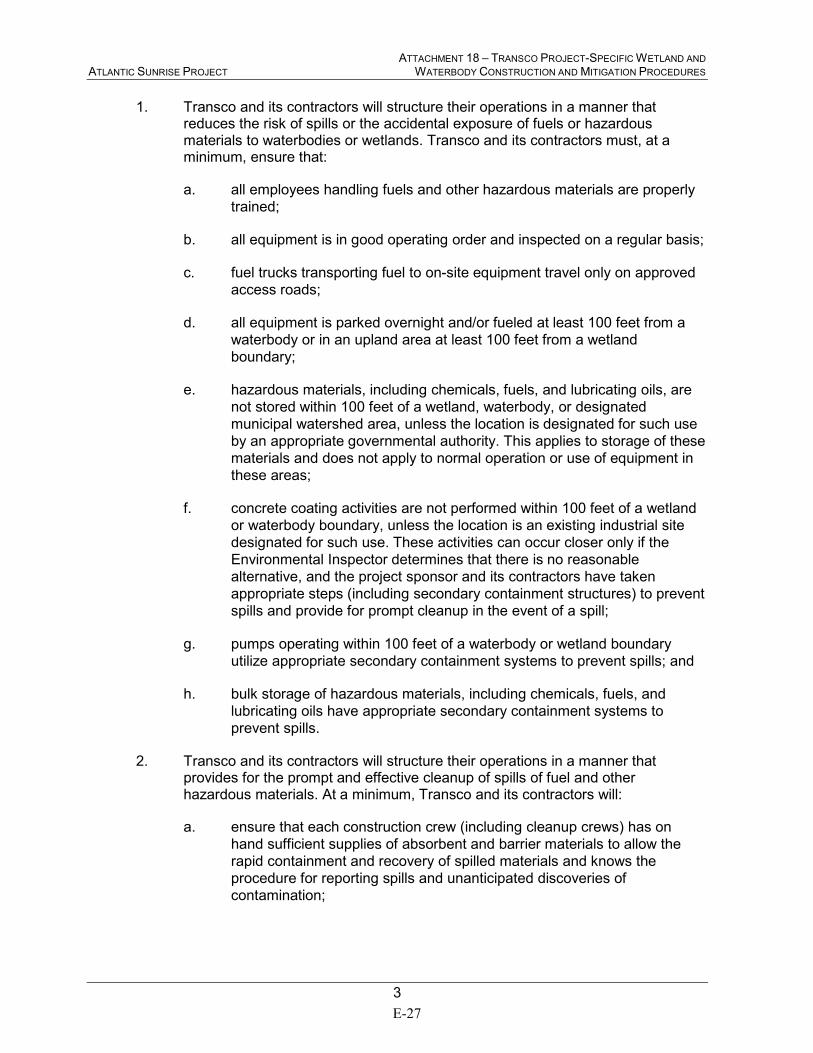
ATTACHMENT 18 – TRANSCO PROJECT-SPECIFIC WETLAND AND ATLANTIC SUNRISE PROJECT WATERBODY CONSTRUCTION AND MITIGATION PROCEDURES
3
1. Transco and its contractors will structure their operations in a manner that reduces the risk of spills or the accidental exposure of fuels or hazardous materials to waterbodies or wetlands. Transco and its contractors must, at a minimum, ensure that:
a. all employees handling fuels and other hazardous materials are properly
trained;
b. all equipment is in good operating order and inspected on a regular basis;
c. fuel trucks transporting fuel to on-site equipment travel only on approved
access roads;
d. all equipment is parked overnight and/or fueled at least 100 feet from a
waterbody or in an upland area at least 100 feet from a wetland
boundary;
e. hazardous materials, including chemicals, fuels, and lubricating oils, are
not stored within 100 feet of a wetland, waterbody, or designated
municipal watershed area, unless the location is designated for such use
by an appropriate governmental authority. This applies to storage of these
materials and does not apply to normal operation or use of equipment in
these areas;
f. concrete coating activities are not performed within 100 feet of a wetland
or waterbody boundary, unless the location is an existing industrial site
designated for such use. These activities can occur closer only if the
Environmental Inspector determines that there is no reasonable
alternative, and the project sponsor and its contractors have taken
appropriate steps (including secondary containment structures) to prevent
spills and provide for prompt cleanup in the event of a spill;
g. pumps operating within 100 feet of a waterbody or wetland boundary
utilize appropriate secondary containment systems to prevent spills; and
h. bulk storage of hazardous materials, including chemicals, fuels, and
lubricating oils have appropriate secondary containment systems to
prevent spills.
2. Transco and its contractors will structure their operations in a manner that provides for the prompt and effective cleanup of spills of fuel and other hazardous materials. At a minimum, Transco and its contractors will:
a. ensure that each construction crew (including cleanup crews) has on
hand sufficient supplies of absorbent and barrier materials to allow the
rapid containment and recovery of spilled materials and knows the
procedure for reporting spills and unanticipated discoveries of
contamination;
E-27
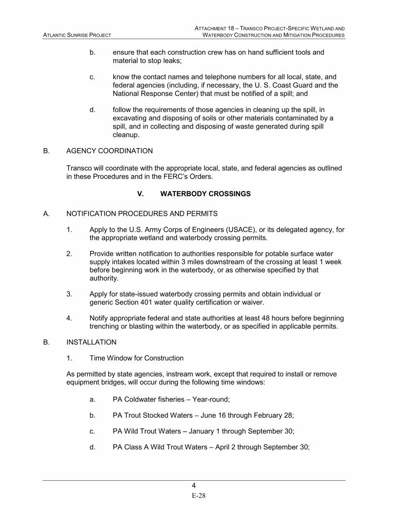
ATTACHMENT 18 – TRANSCO PROJECT-SPECIFIC WETLAND AND ATLANTIC SUNRISE PROJECT WATERBODY CONSTRUCTION AND MITIGATION PROCEDURES
4
b. ensure that each construction crew has on hand sufficient tools and
material to stop leaks;
c. know the contact names and telephone numbers for all local, state, and
federal agencies (including, if necessary, the U. S. Coast Guard and the
National Response Center) that must be notified of a spill; and
d. follow the requirements of those agencies in cleaning up the spill, in
excavating and disposing of soils or other materials contaminated by a
spill, and in collecting and disposing of waste generated during spill
cleanup.
B. AGENCY COORDINATION
Transco will coordinate with the appropriate local, state, and federal agencies as outlined
in these Procedures and in the FERC’s Orders.
V. WATERBODY CROSSINGS
A. NOTIFICATION PROCEDURES AND PERMITS
1. Apply to the U.S. Army Corps of Engineers (USACE), or its delegated agency, for the appropriate wetland and waterbody crossing permits.
2. Provide written notification to authorities responsible for potable surface water supply intakes located within 3 miles downstream of the crossing at least 1 week before beginning work in the waterbody, or as otherwise specified by that authority.
3. Apply for state-issued waterbody crossing permits and obtain individual or generic Section 401 water quality certification or waiver.
4. Notify appropriate federal and state authorities at least 48 hours before beginning trenching or blasting within the waterbody, or as specified in applicable permits.
B. INSTALLATION
1. Time Window for Construction
As permitted by state agencies, instream work, except that required to install or remove equipment bridges, will occur during the following time windows:
a. PA Coldwater fisheries – Year-round;
b. PA Trout Stocked Waters – June 16 through February 28;
c. PA Wild Trout Waters – January 1 through September 30;
d. PA Class A Wild Trout Waters – April 2 through September 30;
E-28

ATTACHMENT 18 – TRANSCO PROJECT-SPECIFIC WETLAND AND ATLANTIC SUNRISE PROJECT WATERBODY CONSTRUCTION AND MITIGATION PROCEDURES
5
e. PA Warmwater fisheries – Year-round (except when sensitive species are present); and
f. VA waterbody crossings (fishery classifications TBD) – TBD
Transco may request at specific identified locations to perform in-stream work outside of
specific state agency windows at individual waterbodies, as approved by state agencies
prior to construction.
2. Extra Work Areas
a. Locate all extra work areas (such as staging areas) and ATWS areas
(such as spoil storage areas and full right-of-way topsoil ) at least 50 feet
away from water’s edge, except where the adjacent upland consists of
cultivated or rotated cropland or other disturbed land.
In select areas, Transco will need to locate ATWS within 50 feet of a
stream in areas that are not active agricultural land due to adjacent land
use or topographic limitations. Transco has filed with the Secretary for
review and written approval by the Director, site-specific justification for
each ATWS area with a less than 50-foot setback from the water’s edge,
except where the adjacent upland consists of cultivated or rotated
cropland or other disturbed land. Refer to Resource Report 2, Appendix
2E of the Transco application. The justifications specify the conditions
that will not permit a 50-foot setback and measures to ensure the
waterbody is adequately protected.
b. Limit the size of ATWS areas to the minimum needed to construct the
waterbody crossing.
3. General Crossing Procedures
a. Comply with the USACE, or its delegated agency, permit terms and
conditions.
b. Construct crossings as close to perpendicular to the axis of the waterbody
channel as engineering and routing conditions permit.
c. Where pipelines parallel a waterbody, maintain at least 15 feet of
undisturbed vegetation between the waterbody (and any adjacent
wetland) and the construction right-of-way, except where maintaining this
offset will result in greater environmental impact.
In select areas, Transco has identified where the pipeline will be
installed such that a 15-foot vegetated buffer between the waterbody
and the construction right-of-way cannot be maintained. Transco
has filed with the Secretary for review and written approval by the
Director, site-specific justification where pipelines parallel a
waterbody and the 15-foot vegetated buffer between the waterbody
and the construction right-of-way cannot be maintained. Refer to
E-29
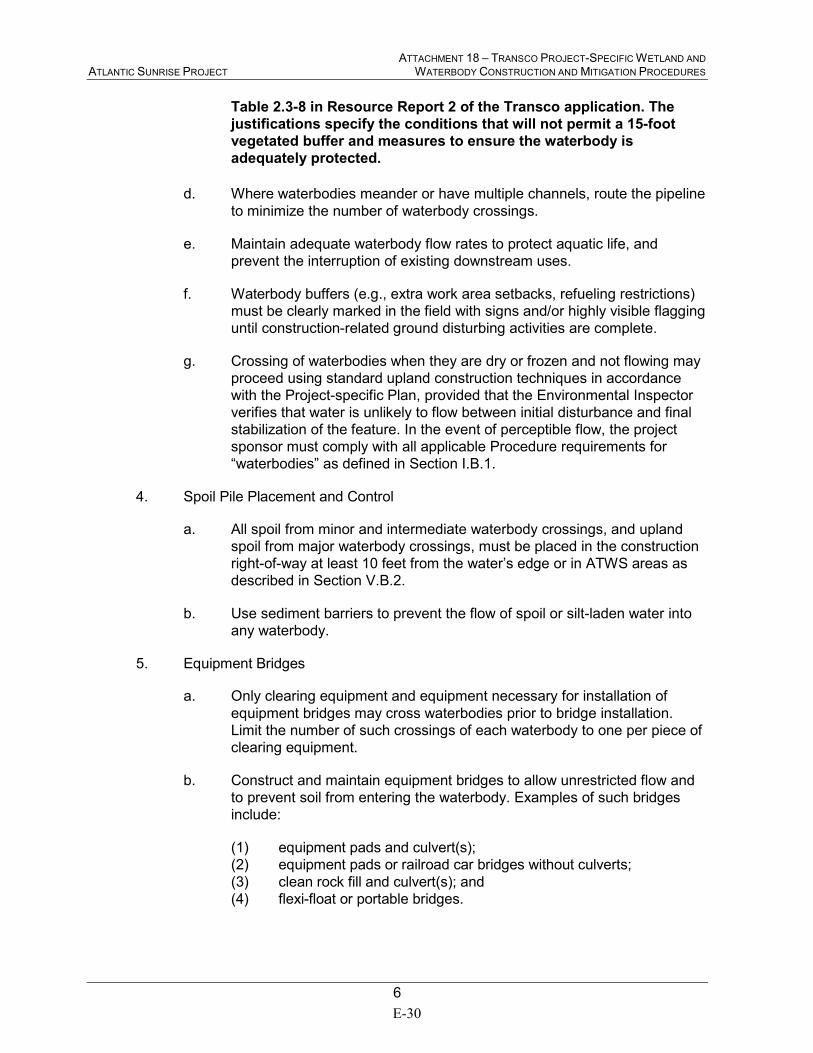
ATTACHMENT 18 – TRANSCO PROJECT-SPECIFIC WETLAND AND ATLANTIC SUNRISE PROJECT WATERBODY CONSTRUCTION AND MITIGATION PROCEDURES
6
Table 2.3-8 in Resource Report 2 of the Transco application. The
justifications specify the conditions that will not permit a 15-foot
vegetated buffer and measures to ensure the waterbody is
adequately protected.
d. Where waterbodies meander or have multiple channels, route the pipeline
to minimize the number of waterbody crossings.
e. Maintain adequate waterbody flow rates to protect aquatic life, and
prevent the interruption of existing downstream uses.
f. Waterbody buffers (e.g., extra work area setbacks, refueling restrictions)
must be clearly marked in the field with signs and/or highly visible flagging
until construction-related ground disturbing activities are complete.
g. Crossing of waterbodies when they are dry or frozen and not flowing may
proceed using standard upland construction techniques in accordance
with the Project-specific Plan, provided that the Environmental Inspector
verifies that water is unlikely to flow between initial disturbance and final
stabilization of the feature. In the event of perceptible flow, the project
sponsor must comply with all applicable Procedure requirements for
“waterbodies” as defined in Section I.B.1.
4. Spoil Pile Placement and Control
a. All spoil from minor and intermediate waterbody crossings, and upland
spoil from major waterbody crossings, must be placed in the construction
right-of-way at least 10 feet from the water’s edge or in ATWS areas as
described in Section V.B.2.
b. Use sediment barriers to prevent the flow of spoil or silt-laden water into
any waterbody.
5. Equipment Bridges
a. Only clearing equipment and equipment necessary for installation of
equipment bridges may cross waterbodies prior to bridge installation.
Limit the number of such crossings of each waterbody to one per piece of
clearing equipment.
b. Construct and maintain equipment bridges to allow unrestricted flow and
to prevent soil from entering the waterbody. Examples of such bridges
include:
(1) equipment pads and culvert(s);
(2) equipment pads or railroad car bridges without culverts;
(3) clean rock fill and culvert(s); and
(4) flexi-float or portable bridges.
E-30
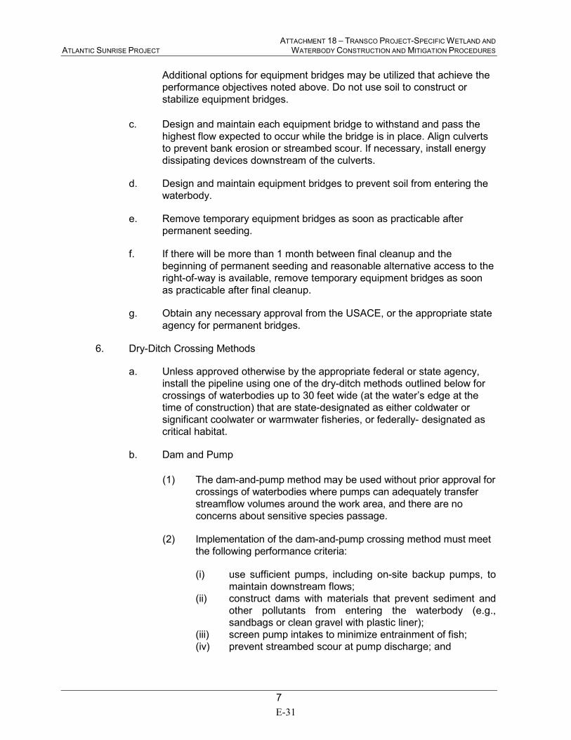
ATTACHMENT 18 – TRANSCO PROJECT-SPECIFIC WETLAND AND ATLANTIC SUNRISE PROJECT WATERBODY CONSTRUCTION AND MITIGATION PROCEDURES
7
Additional options for equipment bridges may be utilized that achieve the
performance objectives noted above. Do not use soil to construct or
stabilize equipment bridges.
c. Design and maintain each equipment bridge to withstand and pass the
highest flow expected to occur while the bridge is in place. Align culverts
to prevent bank erosion or streambed scour. If necessary, install energy
dissipating devices downstream of the culverts.
d. Design and maintain equipment bridges to prevent soil from entering the
waterbody.
e. Remove temporary equipment bridges as soon as practicable after
permanent seeding.
f. If there will be more than 1 month between final cleanup and the
beginning of permanent seeding and reasonable alternative access to the
right-of-way is available, remove temporary equipment bridges as soon
as practicable after final cleanup.
g. Obtain any necessary approval from the USACE, or the appropriate state
agency for permanent bridges.
6. Dry-Ditch Crossing Methods
a. Unless approved otherwise by the appropriate federal or state agency,
install the pipeline using one of the dry-ditch methods outlined below for
crossings of waterbodies up to 30 feet wide (at the water’s edge at the
time of construction) that are state-designated as either coldwater or
significant coolwater or warmwater fisheries, or federally- designated as
critical habitat.
b. Dam and Pump
(1) The dam-and-pump method may be used without prior approval for
crossings of waterbodies where pumps can adequately transfer
streamflow volumes around the work area, and there are no
concerns about sensitive species passage.
(2) Implementation of the dam-and-pump crossing method must meet
the following performance criteria:
(i) use sufficient pumps, including on-site backup pumps, to
maintain downstream flows;
(ii) construct dams with materials that prevent sediment and
other pollutants from entering the waterbody (e.g.,
sandbags or clean gravel with plastic liner);
(iii) screen pump intakes to minimize entrainment of fish;
(iv) prevent streambed scour at pump discharge; and
E-31
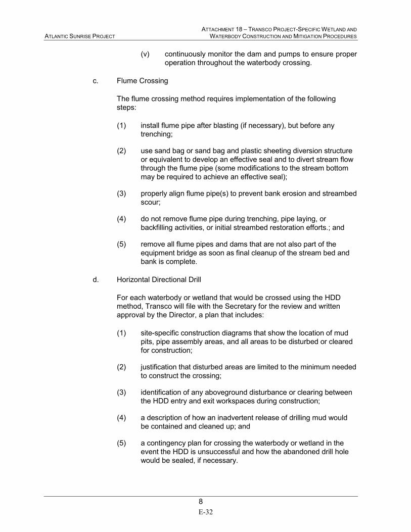
ATTACHMENT 18 – TRANSCO PROJECT-SPECIFIC WETLAND AND ATLANTIC SUNRISE PROJECT WATERBODY CONSTRUCTION AND MITIGATION PROCEDURES
8
(v) continuously monitor the dam and pumps to ensure proper
operation throughout the waterbody crossing.
c. Flume Crossing
The flume crossing method requires implementation of the following
steps:
(1) install flume pipe after blasting (if necessary), but before any
trenching;
(2) use sand bag or sand bag and plastic sheeting diversion structure
or equivalent to develop an effective seal and to divert stream flow
through the flume pipe (some modifications to the stream bottom
may be required to achieve an effective seal);
(3) properly align flume pipe(s) to prevent bank erosion and streambed
scour;
(4) do not remove flume pipe during trenching, pipe laying, or
backfilling activities, or initial streambed restoration efforts.; and
(5) remove all flume pipes and dams that are not also part of the
equipment bridge as soon as final cleanup of the stream bed and
bank is complete.
d. Horizontal Directional Drill
For each waterbody or wetland that would be crossed using the HDD
method, Transco will file with the Secretary for the review and written
approval by the Director, a plan that includes:
(1) site-specific construction diagrams that show the location of mud
pits, pipe assembly areas, and all areas to be disturbed or cleared
for construction;
(2) justification that disturbed areas are limited to the minimum needed
to construct the crossing;
(3) identification of any aboveground disturbance or clearing between
the HDD entry and exit workspaces during construction;
(4) a description of how an inadvertent release of drilling mud would
be contained and cleaned up; and
(5) a contingency plan for crossing the waterbody or wetland in the
event the HDD is unsuccessful and how the abandoned drill hole
would be sealed, if necessary.
E-32
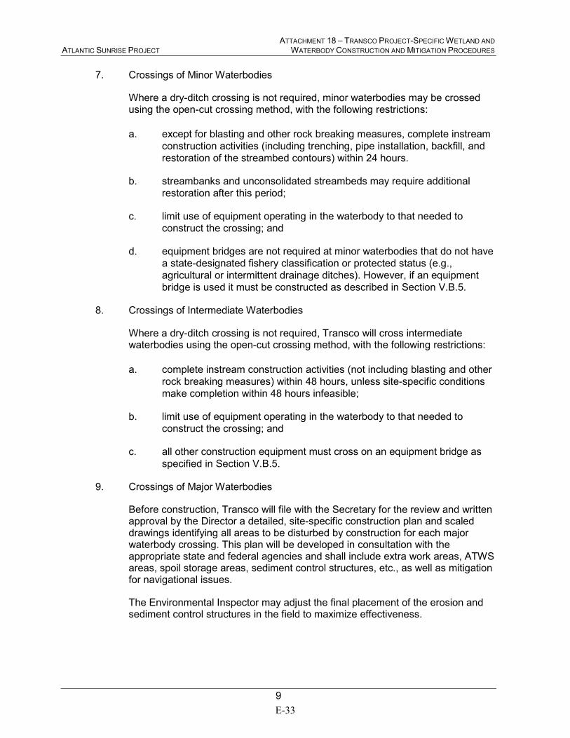
ATTACHMENT 18 – TRANSCO PROJECT-SPECIFIC WETLAND AND ATLANTIC SUNRISE PROJECT WATERBODY CONSTRUCTION AND MITIGATION PROCEDURES
9
7. Crossings of Minor Waterbodies
Where a dry-ditch crossing is not required, minor waterbodies may be crossed using the open-cut crossing method, with the following restrictions:
a. except for blasting and other rock breaking measures, complete instream
construction activities (including trenching, pipe installation, backfill, and
restoration of the streambed contours) within 24 hours.
b. streambanks and unconsolidated streambeds may require additional
restoration after this period;
c. limit use of equipment operating in the waterbody to that needed to
construct the crossing; and
d. equipment bridges are not required at minor waterbodies that do not have
a state-designated fishery classification or protected status (e.g.,
agricultural or intermittent drainage ditches). However, if an equipment
bridge is used it must be constructed as described in Section V.B.5.
8. Crossings of Intermediate Waterbodies
Where a dry-ditch crossing is not required, Transco will cross intermediate waterbodies using the open-cut crossing method, with the following restrictions:
a. complete instream construction activities (not including blasting and other
rock breaking measures) within 48 hours, unless site-specific conditions
make completion within 48 hours infeasible;
b. limit use of equipment operating in the waterbody to that needed to
construct the crossing; and
c. all other construction equipment must cross on an equipment bridge as
specified in Section V.B.5.
9. Crossings of Major Waterbodies
Before construction, Transco will file with the Secretary for the review and written approval by the Director a detailed, site-specific construction plan and scaled drawings identifying all areas to be disturbed by construction for each major waterbody crossing. This plan will be developed in consultation with the appropriate state and federal agencies and shall include extra work areas, ATWS areas, spoil storage areas, sediment control structures, etc., as well as mitigation for navigational issues.
The Environmental Inspector may adjust the final placement of the erosion and sediment control structures in the field to maximize effectiveness.
E-33
ATTACHMENT 18 – TRANSCO PROJECT-SPECIFIC WETLAND AND ATLANTIC SUNRISE PROJECT WATERBODY CONSTRUCTION AND MITIGATION PROCEDURES
10
10. Temporary Erosion and Sediment Control
Install sediment barriers (as defined in Section IV.F.3.a of the Transco Plan) immediately after initial disturbance of the waterbody or adjacent upland.
Sediment barriers will be properly maintained throughout construction and reinstalled as necessary (such as after backfilling of the trench) until replaced by permanent erosion controls or restoration of adjacent upland areas is complete. Temporary erosion and sediment control measures are addressed in more detail in the Transco Plan; however, Transco will implement the following specific measures at stream crossings:
a. install sediment barriers across the entire construction right-of-way at all
waterbody crossings, where necessary to prevent the flow of sediments
into the waterbody. Removable sediment barriers (or drivable berms)
must be installed across the travel lane. These removable sediment
barriers can be removed during the construction day, but must be re-
installed after construction has stopped for the day and/or when heavy
precipitation is imminent;
b. where waterbodies are adjacent to the construction right-of-way and the
right-of-way slopes toward the waterbody, install sediment barriers along
the edge of the construction right-of-way as necessary to contain spoil
within the construction right-of-way and prevent sediment flow into the
waterbody; and
c. use temporary trench plugs at all waterbody crossings, as necessary, to
prevent diversion of water into upland portions of the pipeline trench and
to keep any accumulated trench water out of the waterbody.
11. Trench Dewatering
Dewater the trench (either on or off the construction right-of-way) in a manner that does not cause erosion and does not result in silt-laden water flowing into any waterbody. Remove the dewatering structures as soon as practicable after the completion of dewatering activities.
C. RESTORATION
1. Use clean gravel or native cobbles for the upper 1 foot of trench backfill in all waterbodies that contain coldwater fisheries.
2. For open-cut crossings, stabilize waterbody banks and install temporary sediment barriers within 24 hours of completing instream construction activities. For dry-ditch crossings, complete streambed and bank stabilization before returning flow to the waterbody channel.
3. Return all waterbody banks to preconstruction contours or to a stable angle of repose as approved by the Environmental Inspector.
E-34
ATTACHMENT 18 – TRANSCO PROJECT-SPECIFIC WETLAND AND ATLANTIC SUNRISE PROJECT WATERBODY CONSTRUCTION AND MITIGATION PROCEDURES
11
4. Install erosion control fabric or a functional equivalent on waterbody banks at the time of final bank re-contouring. Do not use synthetic monofilament mesh/netted erosion control materials in areas designated as sensitive wildlife habitat unless the product is specifically designed to minimize harm to wildlife. Anchor erosion control fabric with staples or other appropriate devices.
5. Application of riprap for bank stabilization must comply with USACE, or its delegated agency, permit terms and conditions.
6. Unless otherwise specified by state permit, limit the use of riprap to areas where flow conditions preclude effective vegetative stabilization techniques such as seeding and erosion control fabric.
7. Revegetate disturbed riparian areas with native species of conservation grasses, legumes, and woody species, similar in density to adjacent undisturbed lands.
8. Unless more stringent guidelines are established, Transco will install a permanent slope breaker across the construction right-of-way at the base of slopes greater than 5 percent that are less than 50 feet from the waterbody, or as needed to prevent sediment transport into the waterbody. In addition, Transco will install sediment barriers as outlined in the Transco Plan.
9. In some areas, with the approval of the Environmental Inspector, an earthen berm may be suitable as a sediment barrier adjacent to the waterbody.
10. Sections V.C.3 through V.C.7 above also apply to those perennial or intermittent streams not flowing at the time of construction.
D. POST-CONSTRUCTION MAINTENANCE
1. Limit routine vegetation mowing or clearing adjacent to waterbodies to allow a riparian strip at least 25 feet wide, as measured from the waterbody’s mean high water mark, to permanently revegetate with native plant species across the entire construction right-of-way. However, to facilitate periodic corrosion/leak surveys, a corridor centered on the pipeline and up to 10 feet wide may be cleared at a frequency necessary to maintain the 10-foot corridor in an herbaceous state. In addition, trees that are located within 15 feet of the pipeline that have roots that could compromise the integrity of the pipeline coating may be cut and removed from the permanent right-of-way. Do not conduct any routine vegetation mowing or clearing in riparian areas that are between HDD entry and exit points.
2. Do not use herbicides or pesticides in or within 100 feet of a waterbody except as allowed by the appropriate land management or state agency.
3. Time of year restrictions specified in Section VII.A.5 of the Transco Plan (April 15 – August 1 of any year) apply to routine mowing and clearing of riparian areas.
E-35
ATTACHMENT 18 – TRANSCO PROJECT-SPECIFIC WETLAND AND ATLANTIC SUNRISE PROJECT WATERBODY CONSTRUCTION AND MITIGATION PROCEDURES
12
VI. WETLAND CROSSINGS
A. GENERAL
1. Transco will conduct wetland delineations using the current federal methodology and will file wetland delineation reports with the Secretary before construction.
This report will identify:
a. by milepost all wetlands that would be affected;
b. the National Wetlands Inventory (NWI) classification for each wetland;
c. the crossing length of each wetland in feet; and
d. the area of permanent and temporary disturbance that would occur in
each wetland by NWI classification type.
The requirements outlined in this Section do not apply to wetlands in actively cultivated or rotated cropland. Standard upland protective measures, including workspace and topsoiling requirements, apply to these agricultural wetlands.
2. Route the pipeline to avoid wetland areas to the maximum extent possible. If a wetland cannot be avoided or crossed by following an existing right-of-way, route the new pipeline in a manner that minimizes disturbance to wetlands. Where looping an existing pipeline, overlap the existing pipeline right-of-way with the new construction right-of-way. In addition, locate the loop line no more than 25 feet away from the existing pipeline unless site-specific constraints would adversely affect the stability of the existing pipeline.
3. Limit the width of the construction right-of-way to 75 feet or less. Prior written approval of the Director is required where topographic conditions or soil limitations require that the construction right-of-way width within the boundaries of a federally delineated wetland be expanded beyond 75 feet. Early in the planning process Transco will identify site-specific areas where excessively wide trenches could occur and/or where spoil piles could be difficult to maintain because existing soils lack adequate unconfined compressive strength.
Transco is proposing to use an additional 15 feet of workspace in some wetlands. Transco has filed with the Secretary for review and written approval by the Director, site-specific justification for additional workspace within wetlands. Refer to Resource Report 2, Appendix 2G of the Transco application. The justifications specify the conditions that will not permit a 75-foot wide corridor reduction.
4. Wetland boundaries and buffers will be clearly marked in the field with signs and/or highly visible flagging until construction-related ground disturbing activities are complete.
5. Implement the measures of Sections V and VI in the event a waterbody crossing is located within or adjacent to a wetland crossing. If all measures of Sections V
E-36
ATTACHMENT 18 – TRANSCO PROJECT-SPECIFIC WETLAND AND ATLANTIC SUNRISE PROJECT WATERBODY CONSTRUCTION AND MITIGATION PROCEDURES
13
and VI cannot be met, Transco will file with the Secretary a site-specific crossing plan for review and written approval by the Director before construction. This crossing plan will address at a minimum:
a. spoil control;
b. equipment bridges;
c. restoration of waterbody banks and wetland hydrology;
d. timing of the waterbody crossing;
e. method of crossing; and
f. size and location of all extra work areas and ATWS areas.
6. Do not locate aboveground facilities in any wetland, except where the location ofsuch facilities outside of wetlands would prohibit compliance with U.S.Department of Transportation regulations.
B. INSTALLATION
1. Extra Work Areas and Access Roads
a. Locate all extra work areas (such as staging areas) and ATWS (such as
additional spoil storage areas) at least 50 feet away from wetland
boundaries, except where the adjacent upland consists of cultivated or
rotated cropland or other disturbed land.
b. Transco will file with the Secretary for review and written approval by the
Director, site-specific justification for each extra work area and ATWS
with a less than 50-foot setback from wetland boundaries, except where
adjacent upland consists of cultivated or rotated cropland or other
disturbed land. The justification will specify the site-specific conditions
that will not permit a 50-foot setback and measures to ensure the wetland
is adequately protected.
In select areas, Transco will need to locate ATWS within 50 feet of a
wetland in areas that are not active agricultural land due to adjacent land
use or topographic limitations. Transco has filed with the Secretary for
review and written approval by the Director, site-specific justification for
additional workspace within 50 feet of wetlands. Refer to Resource
Report 2, Appendix 2G of the Transco application. The justifications
specify the conditions that will not permit a 50-foot setback and measures
to ensure the wetland is adequately protected.
c. The construction right-of-way may be used for access when the wetland
soil is firm enough to avoid rutting or the construction right- of-way has
been appropriately stabilized to avoid rutting (e.g., with timber riprap,
prefabricated equipment mats, or terra mats).
E-37

ATTACHMENT 18 – TRANSCO PROJECT-SPECIFIC WETLAND AND ATLANTIC SUNRISE PROJECT WATERBODY CONSTRUCTION AND MITIGATION PROCEDURES
14
d. In wetlands that cannot be appropriately stabilized, all construction
equipment other than that needed to install the wetland crossing shall use
access roads located in upland areas. Where access roads in upland
areas do not provide reasonable access, limit all other construction
equipment to one pass through the wetland using the construction right-
of-way.
e. The only access roads, other than the construction right-of-way, that can
be used in wetlands are those existing roads that can be used with no
modifications or improvements, other than routine repair, and no impact
on the wetland.
2. Crossing Procedures
a. Comply with USACE, or its delegated agency, permit terms and
conditions.
b. Assemble the pipeline in an upland area unless the wetland is dry enough
to adequately support skids and pipe.
c. Use “push-pull” or “float” techniques to place the pipe in the trench where
water and other site conditions allow.
d. Minimize the length of time that topsoil is segregated and the trench is
open. Do not trench the wetland until the pipeline is assembled and ready
for lowering in.
e. Limit construction equipment operating in wetland areas to that needed to
clear the construction right-of-way, dig the trench, fabricate and install the
pipeline, backfill the trench, and restore the construction right-of-way.
f. Cut vegetation just above ground level, leaving existing root systems in
place, and remove it from the wetland for disposal.
g. Transco may burn woody debris in wetlands, if approved by the USACE
and in accordance with state and local regulations, ensuring that all
remaining woody debris is removed for disposal.
h. Limit pulling of tree stumps and grading activities to directly over the
trenchline. Do not grade or remove stumps or root systems from the rest
of the construction right-of-way in wetlands unless the Chief Inspector
and Environmental Inspector determine that safety-related construction
constraints require grading or the removal of tree stumps from under the
working side of the construction right-of-way.
i. Segregate the top 1 foot of topsoil from the area disturbed by trenching,
except in areas where standing water is present or soils are saturated.
Immediately after backfilling is complete, restore the segregated topsoil to
its original location.
E-38
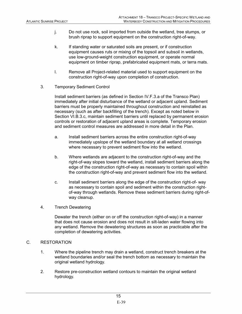
ATTACHMENT 18 – TRANSCO PROJECT-SPECIFIC WETLAND AND ATLANTIC SUNRISE PROJECT WATERBODY CONSTRUCTION AND MITIGATION PROCEDURES
15
j. Do not use rock, soil imported from outside the wetland, tree stumps, or
brush riprap to support equipment on the construction right-of-way.
k. If standing water or saturated soils are present, or if construction
equipment causes ruts or mixing of the topsoil and subsoil in wetlands,
use low-ground-weight construction equipment, or operate normal
equipment on timber riprap, prefabricated equipment mats, or terra mats.
l. Remove all Project-related material used to support equipment on the
construction right-of-way upon completion of construction.
3. Temporary Sediment Control
Install sediment barriers (as defined in Section IV.F.3.a of the Transco Plan) immediately after initial disturbance of the wetland or adjacent upland. Sediment barriers must be properly maintained throughout construction and reinstalled as necessary (such as after backfilling of the trench). Except as noted below in Section VI.B.3.c, maintain sediment barriers until replaced by permanent erosion controls or restoration of adjacent upland areas is complete. Temporary erosion and sediment control measures are addressed in more detail in the Plan.
a. Install sediment barriers across the entire construction right-of-way
immediately upslope of the wetland boundary at all wetland crossings
where necessary to prevent sediment flow into the wetland.
b. Where wetlands are adjacent to the construction right-of-way and the
right-of-way slopes toward the wetland, install sediment barriers along the
edge of the construction right-of-way as necessary to contain spoil within
the construction right-of-way and prevent sediment flow into the wetland.
c. Install sediment barriers along the edge of the construction right-of- way
as necessary to contain spoil and sediment within the construction right-
of-way through wetlands. Remove these sediment barriers during right-of-
way cleanup.
4. Trench Dewatering
Dewater the trench (either on or off the construction right-of-way) in a manner that does not cause erosion and does not result in silt-laden water flowing into any wetland. Remove the dewatering structures as soon as practicable after the completion of dewatering activities.
C. RESTORATION
1. Where the pipeline trench may drain a wetland, construct trench breakers at the wetland boundaries and/or seal the trench bottom as necessary to maintain the original wetland hydrology.
2. Restore pre-construction wetland contours to maintain the original wetland hydrology.
E-39

ATTACHMENT 18 – TRANSCO PROJECT-SPECIFIC WETLAND AND ATLANTIC SUNRISE PROJECT WATERBODY CONSTRUCTION AND MITIGATION PROCEDURES
16
3. For each wetland crossed, install a trench breaker at the base of slopes near the boundary between the wetland and adjacent upland areas. Install a permanent slope breaker across the construction right-of-way at the base of slopes greater than 5 percent where the base of the slope is less than 50 feet from the wetland, or as needed to prevent sediment transport into the wetland. In addition, install sediment barriers as outlined in the Project Specific Plan. In some areas, with the approval of the Environmental Inspector, an earthen berm may be suitable as a sediment barrier adjacent to the wetland.
4. Do not use fertilizer, lime, or mulch unless required in writing by the appropriate federal or state agency.
5. Transco will consult with the appropriate federal or state agencies to develop a Project- specific wetland restoration plan. The restoration plan will include measures for re-establishing herbaceous and/or woody species, controlling the invasion and spread of invasive species and noxious weeds (e.g., purple loosestrife and phragmites), and monitoring the success of the revegetation and weed control efforts. Refer to the Project-specific Noxious and Invasive Plant Management Plan.
6. Until a Project-specific wetland restoration plan is developed and/or implemented, temporarily revegetate the construction right-of-way with annual ryegrass at a rate of 40 pounds/acre (unless standing water is present).
7. Ensure that all disturbed areas successfully revegetate with wetland herbaceous and/or woody plant species.
8. Remove temporary sediment barriers located at the boundary between wetland and adjacent upland areas after revegetation and stabilization of adjacent upland areas are judged to be successful as specified in Section VII.A.4 of the Transco Plan.
D. POST-CONSTRUCTION MAINTENANCE AND REPORTING
1. Do not conduct routine vegetation mowing or clearing over the full width of the permanent right-of-way in wetlands. However, to facilitate periodic corrosion/leak surveys, a corridor centered on the pipeline and up to 10 feet wide may be cleared at a frequency necessary to maintain the 10-foot corridor in an herbaceous state. In addition, trees within 15 feet of the pipeline with roots that could compromise the integrity of pipeline coating may be selectively cut and removed from the permanent right-of-way. Do not conduct any routine vegetation mowing or clearing in wetlands that are between HDD entry and exit points.
2. Do not use herbicides or pesticides in or within 100 feet of a wetland, except as allowed by the appropriate federal or state agency.
3. Time of year restrictions specified in Section VII.A.5 of the Transco Plan (April 15 – August 1 of any year) apply to routine mowing and clearing of wetland areas.
4. Monitor and record the success of wetland revegetation annually until wetland revegetation is successful.
E-40

ATTACHMENT 18 – TRANSCO PROJECT-SPECIFIC WETLAND AND ATLANTIC SUNRISE PROJECT WATERBODY CONSTRUCTION AND MITIGATION PROCEDURES
17
5. Wetland revegetation shall be considered successful if all of the following criteria are satisfied:
a. the affected wetland satisfies the current federal definition for a wetland
(i.e., soils, hydrology, and vegetation);
b. vegetation is at least 80 percent of either the cover documented for the
wetland prior to construction, or at least 80 percent of the cover in
adjacent wetland areas that were not disturbed by construction;
c. if natural rather than active revegetation was used, the plant species
composition is consistent with early successional wetland plant
communities in the affected ecoregion; and
d. invasive species and noxious weeds are absent, unless they are
abundant in adjacent areas that were not disturbed by construction.
6. Within 3 years after construction, Transco will file a report with the Secretary identifying the status of the wetland revegetation efforts and documenting success as defined in Section VI.D.5, above.
For any wetland where revegetation is not successful at the end of 3 years after construction, Transco will develop and implement (in consultation with a professional wetland ecologist) a remedial revegetation plan to actively revegetate wetlands. Continue revegetation efforts and file a report annually documenting progress in these wetlands until wetland revegetation is successful.
VII. HYDROSTATIC TESTING
A. NOTIFICATION PROCEDURES AND PERMITS
1. Apply for state-issued water withdrawal permits, as required.
2. Apply for National Pollutant Discharge Elimination System (NPDES) or state-issued discharge permits, as required.
3. Notify appropriate state agencies of intent to use specific sources at least 48 hours before testing activities unless they waive this requirement in writing.
B. GENERAL
1. Perform 100 percent radiographic inspection of all pipeline section welds or hydrotest the pipeline sections, before installation under waterbodies or wetlands.
2. If pumps used for hydrostatic testing are within 100 feet of any waterbody or wetland, address secondary containment and the refueling of these pumps in the project-specific Spill Prevention and Response Procedures. Refer to the Transco Project-specific Spill Plan for Oil and Hazardous Materials.
E-41
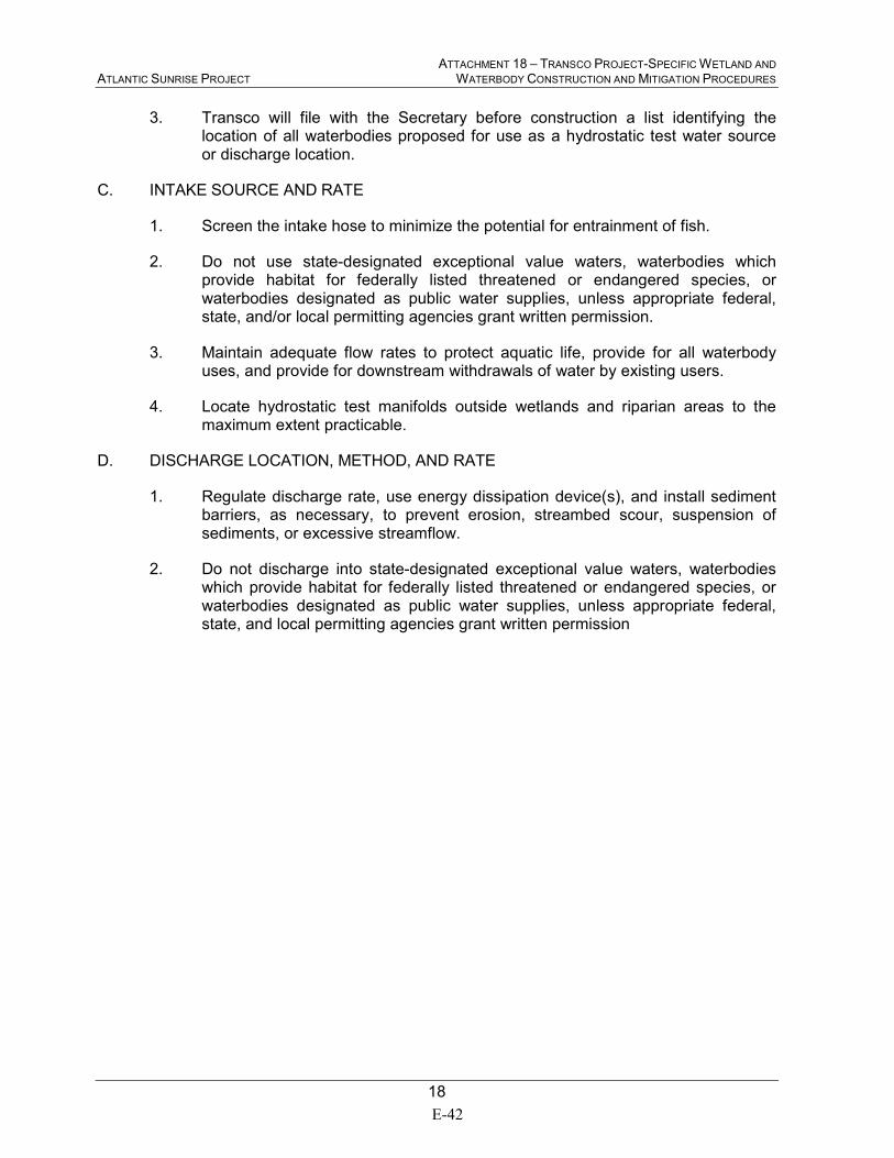
ATTACHMENT 18 – TRANSCO PROJECT-SPECIFIC WETLAND AND ATLANTIC SUNRISE PROJECT WATERBODY CONSTRUCTION AND MITIGATION PROCEDURES
18
3. Transco will file with the Secretary before construction a list identifying thelocation of all waterbodies proposed for use as a hydrostatic test water sourceor discharge location.
C. INTAKE SOURCE AND RATE
1. Screen the intake hose to minimize the potential for entrainment of fish.
2. Do not use state-designated exceptional value waters, waterbodies whichprovide habitat for federally listed threatened or endangered species, orwaterbodies designated as public water supplies, unless appropriate federal,state, and/or local permitting agencies grant written permission.
3. Maintain adequate flow rates to protect aquatic life, provide for all waterbodyuses, and provide for downstream withdrawals of water by existing users.
4. Locate hydrostatic test manifolds outside wetlands and riparian areas to themaximum extent practicable.
D. DISCHARGE LOCATION, METHOD, AND RATE
1. Regulate discharge rate, use energy dissipation device(s), and install sedimentbarriers, as necessary, to prevent erosion, streambed scour, suspension ofsediments, or excessive streamflow.
2. Do not discharge into state-designated exceptional value waters, waterbodieswhich provide habitat for federally listed threatened or endangered species, orwaterbodies designated as public water supplies, unless appropriate federal,state, and local permitting agencies grant written permission
E-42

APPENDIX F
ROADWAYS AND RAILROADS CROSSED BY
THE ATLANTIC SUNRISE PROJECT

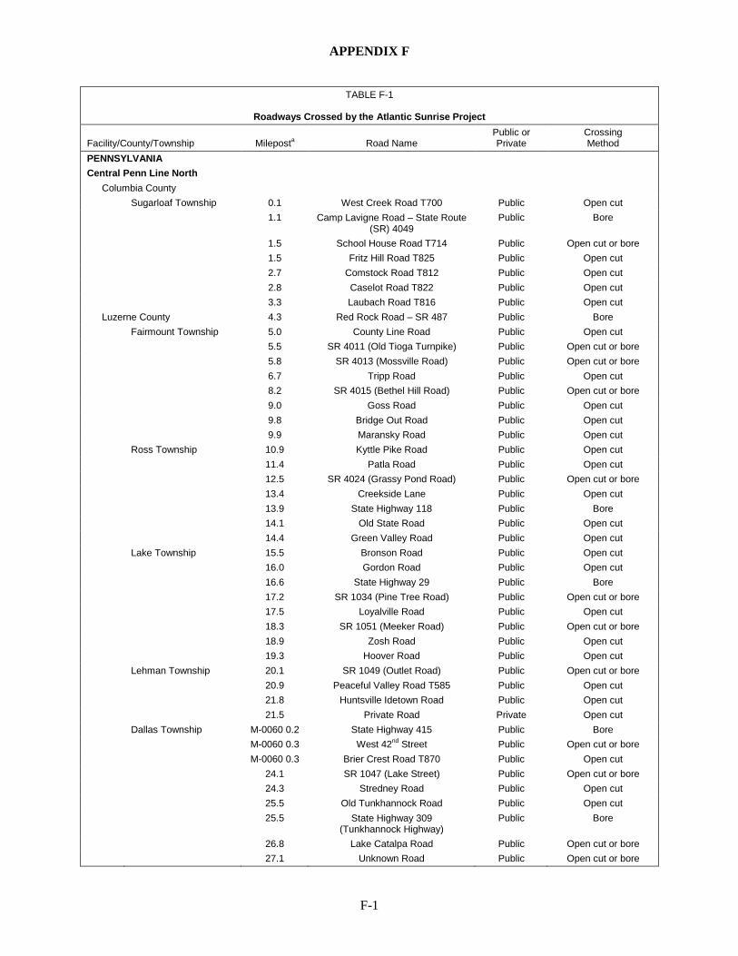
APPENDIX F
F-1
TABLE F-1
Roadways Crossed by the Atlantic Sunrise Project
Facility/County/Township Mileposta Road Name Public or Private
Crossing Method
PENNSYLVANIA
Central Penn Line North
Columbia County Sugarloaf Township 0.1 West Creek Road T700 Public Open cut
1.1 Camp Lavigne Road – State Route (SR) 4049
Public Bore
1.5 School House Road T714 Public Open cut or bore 1.5 Fritz Hill Road T825 Public Open cut 2.7 Comstock Road T812 Public Open cut 2.8 Caselot Road T822 Public Open cut 3.3 Laubach Road T816 Public Open cut
Luzerne County 4.3 Red Rock Road – SR 487 Public Bore Fairmount Township 5.0 County Line Road Public Open cut 5.5 SR 4011 (Old Tioga Turnpike) Public Open cut or bore 5.8 SR 4013 (Mossville Road) Public Open cut or bore 6.7 Tripp Road Public Open cut 8.2 SR 4015 (Bethel Hill Road) Public Open cut or bore 9.0 Goss Road Public Open cut 9.8 Bridge Out Road Public Open cut 9.9 Maransky Road Public Open cut Ross Township 10.9 Kyttle Pike Road Public Open cut 11.4 Patla Road Public Open cut 12.5 SR 4024 (Grassy Pond Road) Public Open cut or bore 13.4 Creekside Lane Public Open cut 13.9 State Highway 118 Public Bore 14.1 Old State Road Public Open cut 14.4 Green Valley Road Public Open cut Lake Township 15.5 Bronson Road Public Open cut 16.0 Gordon Road Public Open cut 16.6 State Highway 29 Public Bore 17.2 SR 1034 (Pine Tree Road) Public Open cut or bore 17.5 Loyalville Road Public Open cut 18.3 SR 1051 (Meeker Road) Public Open cut or bore 18.9 Zosh Road Public Open cut 19.3 Hoover Road Public Open cut Lehman Township 20.1 SR 1049 (Outlet Road) Public Open cut or bore 20.9 Peaceful Valley Road T585 Public Open cut 21.8 Huntsville Idetown Road Public Open cut 21.5 Private Road Private Open cut Dallas Township M-0060 0.2 State Highway 415 Public Bore M-0060 0.3 West 42nd Street Public Open cut or bore M-0060 0.3 Brier Crest Road T870 Public Open cut 24.1 SR 1047 (Lake Street) Public Open cut or bore 24.3 Stredney Road Public Open cut 25.5 Old Tunkhannock Road Public Open cut 25.5 State Highway 309
(Tunkhannock Highway) Public Bore
26.8 Lake Catalpa Road Public Open cut or bore 27.1 Unknown Road Public Open cut or bore
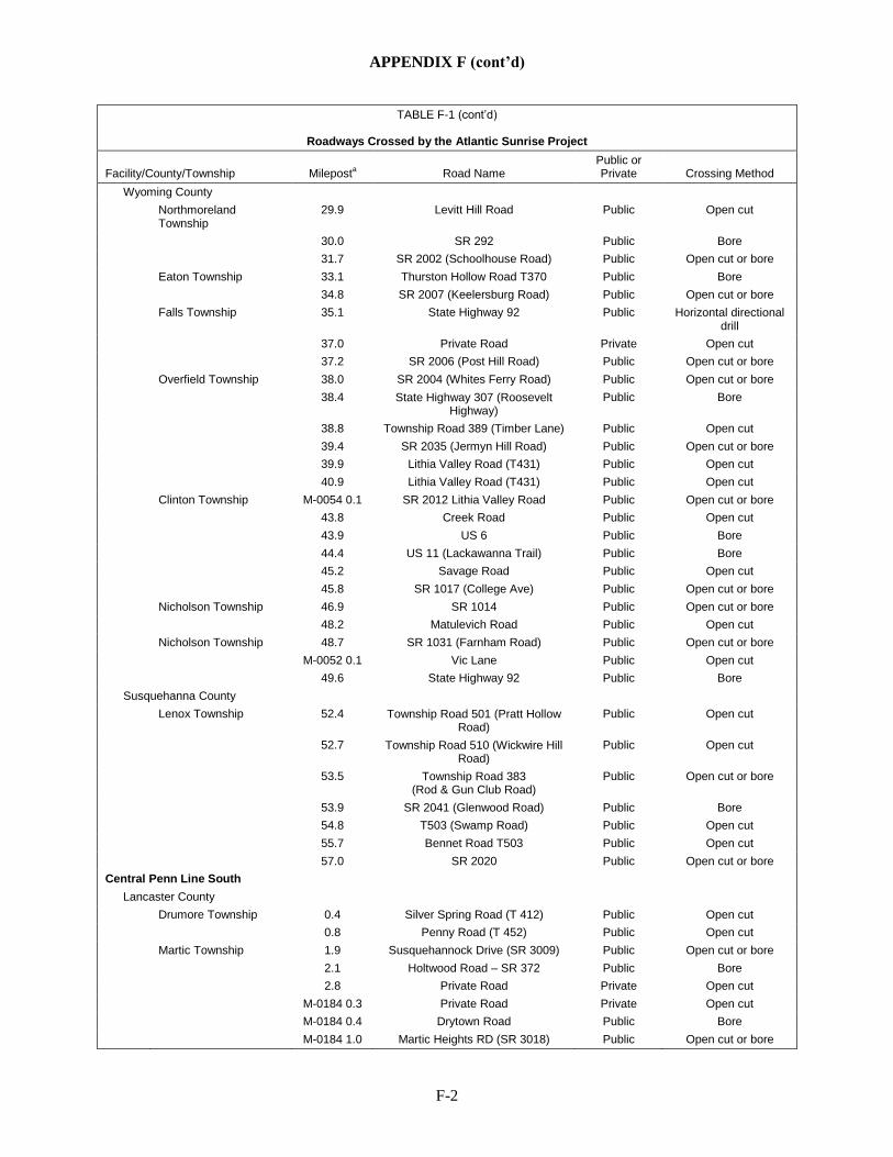
APPENDIX F (cont’d)
F-2
TABLE F-1 (cont’d)
Roadways Crossed by the Atlantic Sunrise Project
Facility/County/Township Mileposta Road Name Public or Private Crossing Method
Wyoming County Northmoreland
Township 29.9 Levitt Hill Road Public Open cut
30.0 SR 292 Public Bore 31.7 SR 2002 (Schoolhouse Road) Public Open cut or bore Eaton Township 33.1 Thurston Hollow Road T370 Public Bore 34.8 SR 2007 (Keelersburg Road) Public Open cut or bore Falls Township 35.1 State Highway 92 Public Horizontal directional
drill 37.0 Private Road Private Open cut 37.2 SR 2006 (Post Hill Road) Public Open cut or bore Overfield Township 38.0 SR 2004 (Whites Ferry Road) Public Open cut or bore 38.4 State Highway 307 (Roosevelt
Highway) Public Bore
38.8 Township Road 389 (Timber Lane) Public Open cut 39.4 SR 2035 (Jermyn Hill Road) Public Open cut or bore 39.9 Lithia Valley Road (T431) Public Open cut 40.9 Lithia Valley Road (T431) Public Open cut Clinton Township M-0054 0.1 SR 2012 Lithia Valley Road Public Open cut or bore 43.8 Creek Road Public Open cut 43.9 US 6 Public Bore 44.4 US 11 (Lackawanna Trail) Public Bore 45.2 Savage Road Public Open cut 45.8 SR 1017 (College Ave) Public Open cut or bore Nicholson Township 46.9 SR 1014 Public Open cut or bore 48.2 Matulevich Road Public Open cut Nicholson Township 48.7 SR 1031 (Farnham Road) Public Open cut or bore M-0052 0.1 Vic Lane Public Open cut 49.6 State Highway 92 Public Bore
Susquehanna County Lenox Township 52.4 Township Road 501 (Pratt Hollow
Road) Public Open cut
52.7 Township Road 510 (Wickwire Hill Road)
Public Open cut
53.5 Township Road 383 (Rod & Gun Club Road)
Public Open cut or bore
53.9 SR 2041 (Glenwood Road) Public Bore 54.8 T503 (Swamp Road) Public Open cut 55.7 Bennet Road T503 Public Open cut 57.0 SR 2020 Public Open cut or bore Central Penn Line South
Lancaster County Drumore Township 0.4 Silver Spring Road (T 412) Public Open cut 0.8 Penny Road (T 452) Public Open cut Martic Township 1.9 Susquehannock Drive (SR 3009) Public Open cut or bore 2.1 Holtwood Road – SR 372 Public Bore 2.8 Private Road Private Open cut M-0184 0.3 Private Road Private Open cut M-0184 0.4 Drytown Road Public Bore M-0184 1.0 Martic Heights RD (SR 3018) Public Open cut or bore
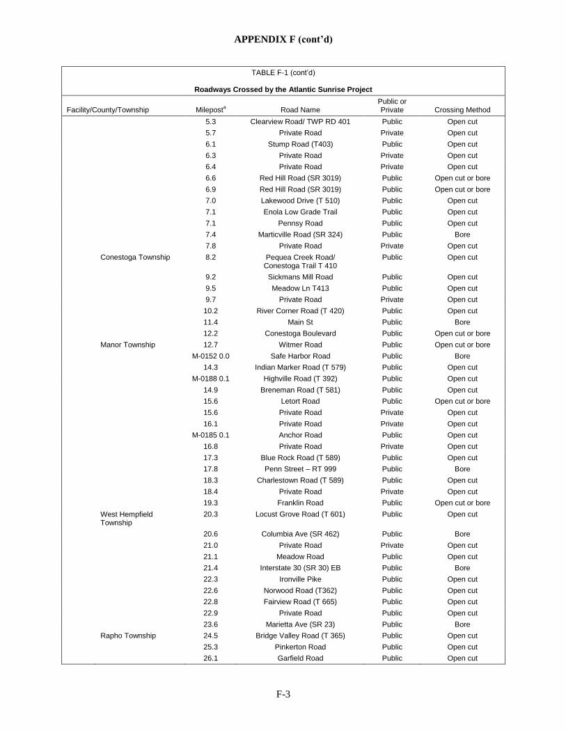
APPENDIX F (cont’d)
F-3
TABLE F-1 (cont’d)
Roadways Crossed by the Atlantic Sunrise Project
Facility/County/Township Mileposta Road Name Public or Private Crossing Method
5.3 Clearview Road/ TWP RD 401 Public Open cut 5.7 Private Road Private Open cut 6.1 Stump Road (T403) Public Open cut 6.3 Private Road Private Open cut 6.4 Private Road Private Open cut 6.6 Red Hill Road (SR 3019) Public Open cut or bore 6.9 Red Hill Road (SR 3019) Public Open cut or bore 7.0 Lakewood Drive (T 510) Public Open cut 7.1 Enola Low Grade Trail Public Open cut 7.1 Pennsy Road Public Open cut 7.4 Marticville Road (SR 324) Public Bore 7.8 Private Road Private Open cut Conestoga Township 8.2 Pequea Creek Road/
Conestoga Trail T 410 Public Open cut
9.2 Sickmans Mill Road Public Open cut 9.5 Meadow Ln T413 Public Open cut 9.7 Private Road Private Open cut 10.2 River Corner Road (T 420) Public Open cut 11.4 Main St Public Bore 12.2 Conestoga Boulevard Public Open cut or bore Manor Township 12.7 Witmer Road Public Open cut or bore M-0152 0.0 Safe Harbor Road Public Bore 14.3 Indian Marker Road (T 579) Public Open cut M-0188 0.1 Highville Road (T 392) Public Open cut 14.9 Breneman Road (T 581) Public Open cut 15.6 Letort Road Public Open cut or bore 15.6 Private Road Private Open cut 16.1 Private Road Private Open cut M-0185 0.1 Anchor Road Public Open cut 16.8 Private Road Private Open cut 17.3 Blue Rock Road (T 589) Public Open cut 17.8 Penn Street – RT 999 Public Bore 18.3 Charlestown Road (T 589) Public Open cut 18.4 Private Road Private Open cut 19.3 Franklin Road Public Open cut or bore West Hempfield
Township 20.3 Locust Grove Road (T 601) Public Open cut
20.6 Columbia Ave (SR 462) Public Bore 21.0 Private Road Private Open cut 21.1 Meadow Road Public Open cut 21.4 Interstate 30 (SR 30) EB Public Bore 22.3 Ironville Pike Public Open cut 22.6 Norwood Road (T362) Public Open cut 22.8 Fairview Road (T 665) Public Open cut 22.9 Private Road Public Open cut 23.6 Marietta Ave (SR 23) Public Bore Rapho Township 24.5 Bridge Valley Road (T 365) Public Open cut 25.3 Pinkerton Road Public Open cut 26.1 Garfield Road Public Open cut
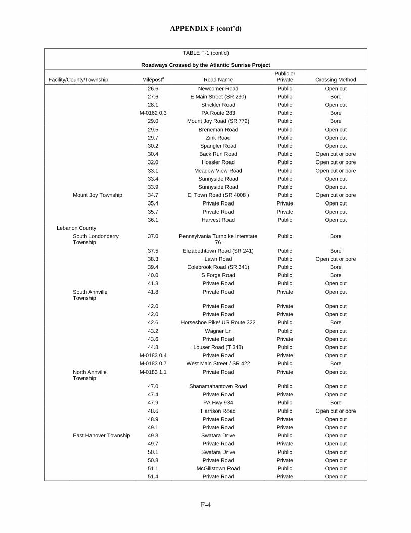
APPENDIX F (cont’d)
F-4
TABLE F-1 (cont’d)
Roadways Crossed by the Atlantic Sunrise Project
Facility/County/Township Mileposta Road Name Public or Private Crossing Method
26.6 Newcomer Road Public Open cut 27.6 E Main Street (SR 230) Public Bore 28.1 Strickler Road Public Open cut M-0162 0.3 PA Route 283 Public Bore 29.0 Mount Joy Road (SR 772) Public Bore 29.5 Breneman Road Public Open cut 29.7 Zink Road Public Open cut 30.2 Spangler Road Public Open cut 30.4 Back Run Road Public Open cut or bore 32.0 Hossler Road Public Open cut or bore 33.1 Meadow View Road Public Open cut or bore 33.4 Sunnyside Road Public Open cut 33.9 Sunnyside Road Public Open cut Mount Joy Township 34.7 E. Town Road (SR 4008 ) Public Open cut or bore 35.4 Private Road Private Open cut 35.7 Private Road Private Open cut 36.1 Harvest Road Public Open cut
Lebanon County South Londonderry
Township 37.0 Pennsylvania Turnpike Interstate
76 Public Bore
37.5 Elizabethtown Road (SR 241) Public Bore 38.3 Lawn Road Public Open cut or bore 39.4 Colebrook Road (SR 341) Public Bore 40.0 S Forge Road Public Bore 41.3 Private Road Public Open cut South Annville
Township 41.8 Private Road Private Open cut
42.0 Private Road Private Open cut 42.0 Private Road Private Open cut 42.6 Horseshoe Pike/ US Route 322 Public Bore 43.2 Wagner Ln Public Open cut 43.6 Private Road Private Open cut 44.8 Louser Road (T 348) Public Open cut M-0183 0.4 Private Road Private Open cut M-0183 0.7 West Main Street / SR 422 Public Bore North Annville
Township M-0183 1.1 Private Road Private Open cut
47.0 Shanamahantown Road Public Open cut 47.4 Private Road Private Open cut 47.9 PA Hwy 934 Public Bore 48.6 Harrison Road Public Open cut or bore 48.9 Private Road Private Open cut 49.1 Private Road Private Open cut East Hanover Township 49.3 Swatara Drive Public Open cut 49.7 Private Road Private Open cut 50.1 Swatara Drive Public Open cut 50.8 Private Road Private Open cut 51.1 McGillstown Road Public Open cut 51.4 Private Road Private Open cut
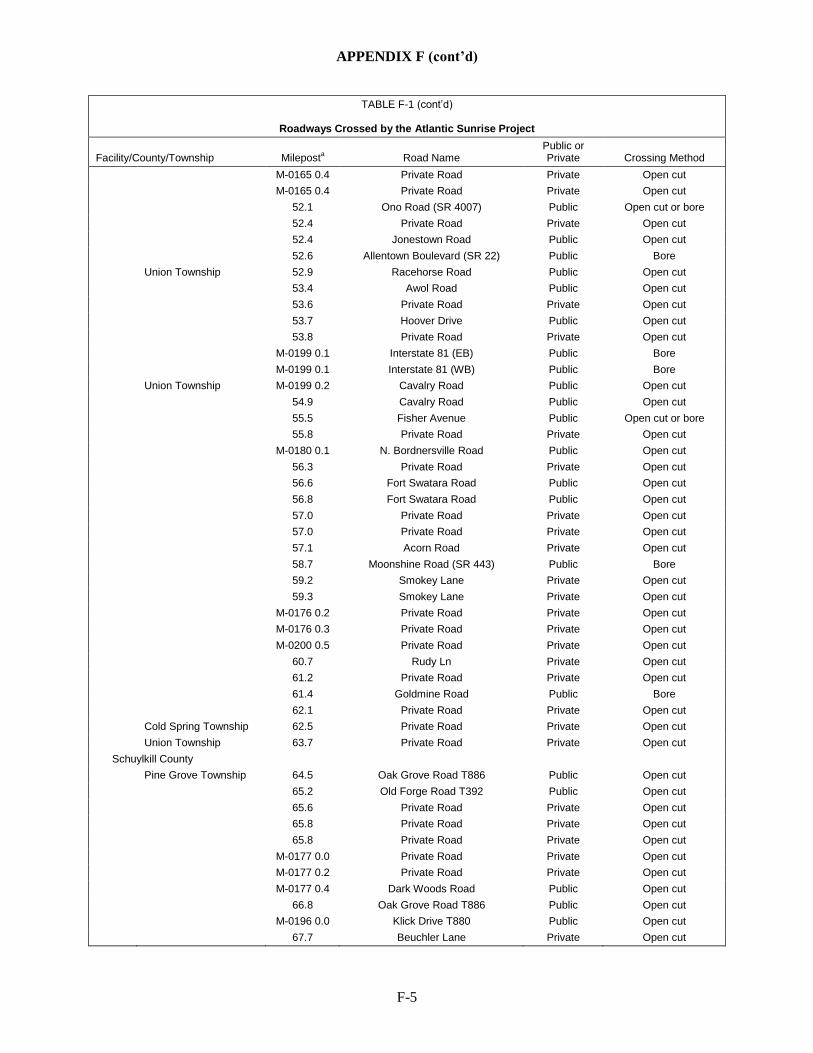
APPENDIX F (cont’d)
F-5
TABLE F-1 (cont’d)
Roadways Crossed by the Atlantic Sunrise Project
Facility/County/Township Mileposta Road Name Public or Private Crossing Method
M-0165 0.4 Private Road Private Open cut M-0165 0.4 Private Road Private Open cut 52.1 Ono Road (SR 4007) Public Open cut or bore 52.4 Private Road Private Open cut 52.4 Jonestown Road Public Open cut 52.6 Allentown Boulevard (SR 22) Public Bore Union Township 52.9 Racehorse Road Public Open cut 53.4 Awol Road Public Open cut 53.6 Private Road Private Open cut 53.7 Hoover Drive Public Open cut 53.8 Private Road Private Open cut M-0199 0.1 Interstate 81 (EB) Public Bore M-0199 0.1 Interstate 81 (WB) Public Bore Union Township M-0199 0.2 Cavalry Road Public Open cut 54.9 Cavalry Road Public Open cut 55.5 Fisher Avenue Public Open cut or bore 55.8 Private Road Private Open cut M-0180 0.1 N. Bordnersville Road Public Open cut 56.3 Private Road Private Open cut 56.6 Fort Swatara Road Public Open cut 56.8 Fort Swatara Road Public Open cut 57.0 Private Road Private Open cut 57.0 Private Road Private Open cut 57.1 Acorn Road Private Open cut 58.7 Moonshine Road (SR 443) Public Bore 59.2 Smokey Lane Private Open cut 59.3 Smokey Lane Private Open cut M-0176 0.2 Private Road Private Open cut M-0176 0.3 Private Road Private Open cut M-0200 0.5 Private Road Private Open cut 60.7 Rudy Ln Private Open cut 61.2 Private Road Private Open cut 61.4 Goldmine Road Public Bore 62.1 Private Road Private Open cut Cold Spring Township 62.5 Private Road Private Open cut Union Township 63.7 Private Road Private Open cut
Schuylkill County Pine Grove Township 64.5 Oak Grove Road T886 Public Open cut 65.2 Old Forge Road T392 Public Open cut 65.6 Private Road Private Open cut 65.8 Private Road Private Open cut 65.8 Private Road Private Open cut M-0177 0.0 Private Road Private Open cut M-0177 0.2 Private Road Private Open cut M-0177 0.4 Dark Woods Road Public Open cut 66.8 Oak Grove Road T886 Public Open cut M-0196 0.0 Klick Drive T880 Public Open cut 67.7 Beuchler Lane Private Open cut
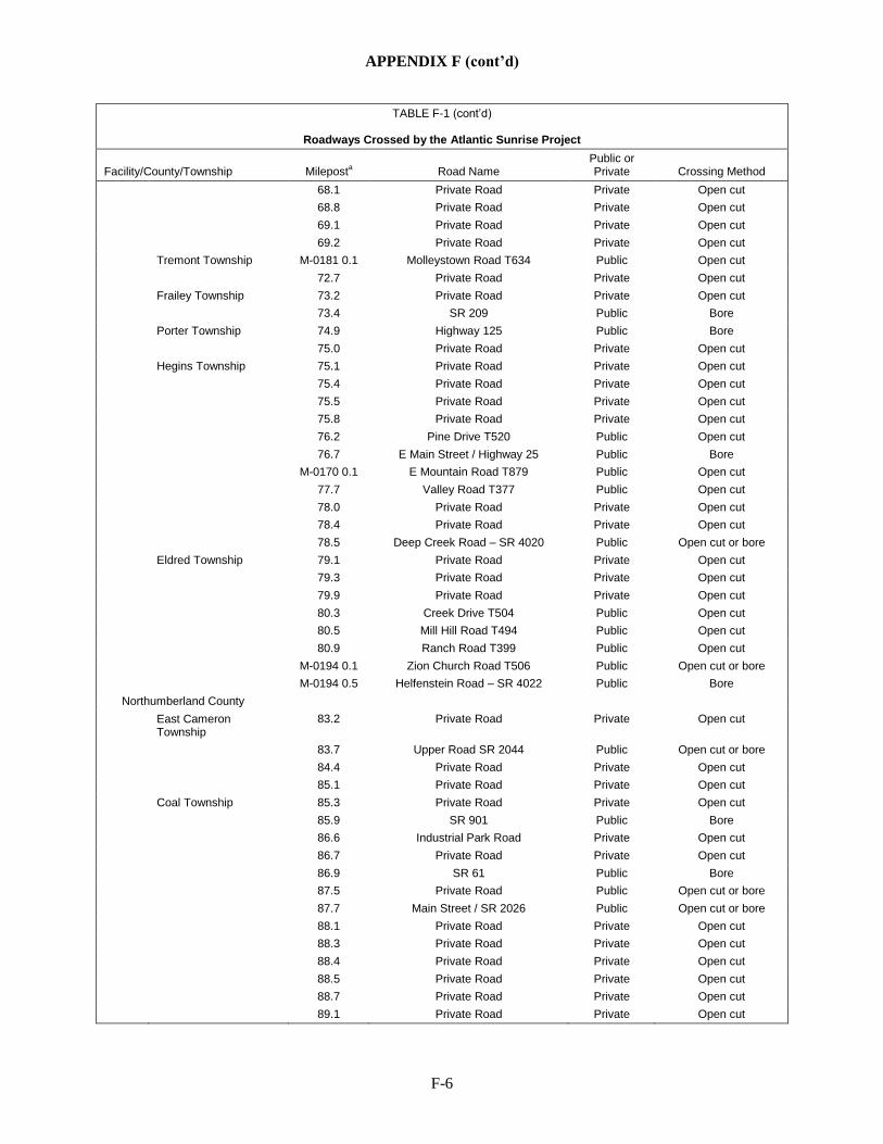
APPENDIX F (cont’d)
F-6
TABLE F-1 (cont’d)
Roadways Crossed by the Atlantic Sunrise Project
Facility/County/Township Mileposta Road Name Public or Private Crossing Method
68.1 Private Road Private Open cut 68.8 Private Road Private Open cut 69.1 Private Road Private Open cut 69.2 Private Road Private Open cut Tremont Township M-0181 0.1 Molleystown Road T634 Public Open cut 72.7 Private Road Private Open cut Frailey Township 73.2 Private Road Private Open cut 73.4 SR 209 Public Bore Porter Township 74.9 Highway 125 Public Bore 75.0 Private Road Private Open cut Hegins Township 75.1 Private Road Private Open cut 75.4 Private Road Private Open cut 75.5 Private Road Private Open cut 75.8 Private Road Private Open cut 76.2 Pine Drive T520 Public Open cut 76.7 E Main Street / Highway 25 Public Bore M-0170 0.1 E Mountain Road T879 Public Open cut 77.7 Valley Road T377 Public Open cut 78.0 Private Road Private Open cut 78.4 Private Road Private Open cut 78.5 Deep Creek Road – SR 4020 Public Open cut or bore Eldred Township 79.1 Private Road Private Open cut 79.3 Private Road Private Open cut 79.9 Private Road Private Open cut 80.3 Creek Drive T504 Public Open cut 80.5 Mill Hill Road T494 Public Open cut 80.9 Ranch Road T399 Public Open cut M-0194 0.1 Zion Church Road T506 Public Open cut or bore M-0194 0.5 Helfenstein Road – SR 4022 Public Bore
Northumberland County East Cameron
Township 83.2 Private Road Private Open cut
83.7 Upper Road SR 2044 Public Open cut or bore 84.4 Private Road Private Open cut 85.1 Private Road Private Open cut Coal Township 85.3 Private Road Private Open cut 85.9 SR 901 Public Bore 86.6 Industrial Park Road Private Open cut 86.7 Private Road Private Open cut 86.9 SR 61 Public Bore 87.5 Private Road Public Open cut or bore 87.7 Main Street / SR 2026 Public Open cut or bore 88.1 Private Road Private Open cut 88.3 Private Road Private Open cut 88.4 Private Road Private Open cut 88.5 Private Road Private Open cut 88.7 Private Road Private Open cut 89.1 Private Road Private Open cut
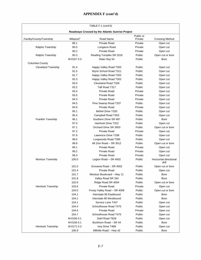
APPENDIX F (cont’d)
F-7
TABLE F-1 (cont’d)
Roadways Crossed by the Atlantic Sunrise Project
Facility/County/Township Mileposta Road Name Public or Private Crossing Method
89.1 Private Road Private Open cut Ralpho Township 90.0 Longacre Road Private Open cut 90.2 Private Road Private Open cut Ralpho Township 90.3 Reading Turnpike SR 2016 Public Open cut or bore M-0167 0.3 State Hwy 54 Public Bore
Columbia County Cleveland Township 91.4 Happy Valley Road T302 Public Open cut 91.5 Wynn School Road T311 Public Open cut 91.7 Happy Valley Road T302 Public Open cut 92.3 Happy Valley Road T302 Public Open cut 93.0 Cleveland Road T326 Public Open cut 93.2 Taft Road T317 Public Open cut 93.4 Private Road Private Open cut 93.5 Private Road Private Open cut 94.3 Private Road Private Open cut 94.5 Pine Swamp Road T337 Public Open cut 94.9 Private Road Private Open cut 95.1 Bethel Drive T320 Public Open cut 95.4 Campbell Road T353 Public Open cut Franklin Township 96.1 Southern Drive SR 487 Public Bore 97.0 Hamlock Drive T322 Public Open cut 97.1 Orchard Drive SR 3003 Public Open cut or bore 97.2 Private Road Private Open cut 97.9 Lawrence Drive T338 Public Open cut 98.0 Longwoods Road T395 Public Open cut 98.8 Mt Zion Road – SR 3012 Public Open cut or bore 99.1 Private Road Private Open cut 99.2 Private Road Private Open cut 99.3 Private Road Private Open cut Montour Township 100.0 Legion Road – SR 4002 Public Horizontal directional
drill 101.0 Grovania Road – SR 4002 Public Open cut or bore 101.4 Private Road Public Open cut 101.7 Montour Boulevard – Hwy 11 Public Bore 101.8 Valley Road SR 184 Public Bore 102.6 Ridge Road SR 4004 Public Open cut or bore Hemlock Township 103.6 Private Road Private Open cut 104.0 Frosty Valley Road – SR 4006 Public Open cut or bore 104.1 Interstate 80 Eastbound Public Bore 104.1 Interstate 80 Westbound Public Bore 104.1 Service Lane T437 Public Open cut 104.4 Schoolhouse Road T475 Public Open cut 104.6 Private Road Private Open cut 104.7 Schoolhouse Road T475 Public Open cut M-0156 0.1 Dahl Road T828 Public Open cut M-0156 0.1 Buckhorn Road – SR 44 Public Bore Hemlock Township M-0171 0.3 Ivey Drive T489 Public Open cut 106.9 Millville Road – Hwy 42 Public Bore
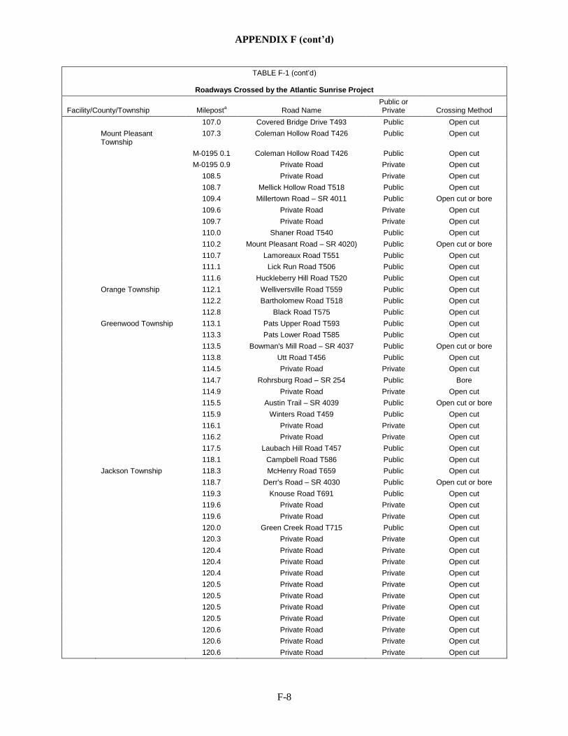
APPENDIX F (cont’d)
F-8
TABLE F-1 (cont’d)
Roadways Crossed by the Atlantic Sunrise Project
Facility/County/Township Mileposta Road Name Public or Private Crossing Method
107.0 Covered Bridge Drive T493 Public Open cut Mount Pleasant
Township 107.3 Coleman Hollow Road T426 Public Open cut
M-0195 0.1 Coleman Hollow Road T426 Public Open cut M-0195 0.9 Private Road Private Open cut 108.5 Private Road Private Open cut 108.7 Mellick Hollow Road T518 Public Open cut 109.4 Millertown Road – SR 4011 Public Open cut or bore 109.6 Private Road Private Open cut 109.7 Private Road Private Open cut 110.0 Shaner Road T540 Public Open cut 110.2 Mount Pleasant Road – SR 4020) Public Open cut or bore 110.7 Lamoreaux Road T551 Public Open cut 111.1 Lick Run Road T506 Public Open cut 111.6 Huckleberry Hill Road T520 Public Open cut Orange Township 112.1 Welliversville Road T559 Public Open cut 112.2 Bartholomew Road T518 Public Open cut 112.8 Black Road T575 Public Open cut Greenwood Township 113.1 Pats Upper Road T593 Public Open cut 113.3 Pats Lower Road T585 Public Open cut 113.5 Bowman's Mill Road – SR 4037 Public Open cut or bore 113.8 Utt Road T456 Public Open cut 114.5 Private Road Private Open cut 114.7 Rohrsburg Road – SR 254 Public Bore 114.9 Private Road Private Open cut 115.5 Austin Trail – SR 4039 Public Open cut or bore 115.9 Winters Road T459 Public Open cut 116.1 Private Road Private Open cut 116.2 Private Road Private Open cut 117.5 Laubach Hill Road T457 Public Open cut 118.1 Campbell Road T586 Public Open cut Jackson Township 118.3 McHenry Road T659 Public Open cut 118.7 Derr's Road – SR 4030 Public Open cut or bore 119.3 Knouse Road T691 Public Open cut 119.6 Private Road Private Open cut 119.6 Private Road Private Open cut 120.0 Green Creek Road T715 Public Open cut 120.3 Private Road Private Open cut 120.4 Private Road Private Open cut 120.4 Private Road Private Open cut 120.4 Private Road Private Open cut 120.5 Private Road Private Open cut 120.5 Private Road Private Open cut 120.5 Private Road Private Open cut 120.5 Private Road Private Open cut 120.6 Private Road Private Open cut 120.6 Private Road Private Open cut 120.6 Private Road Private Open cut
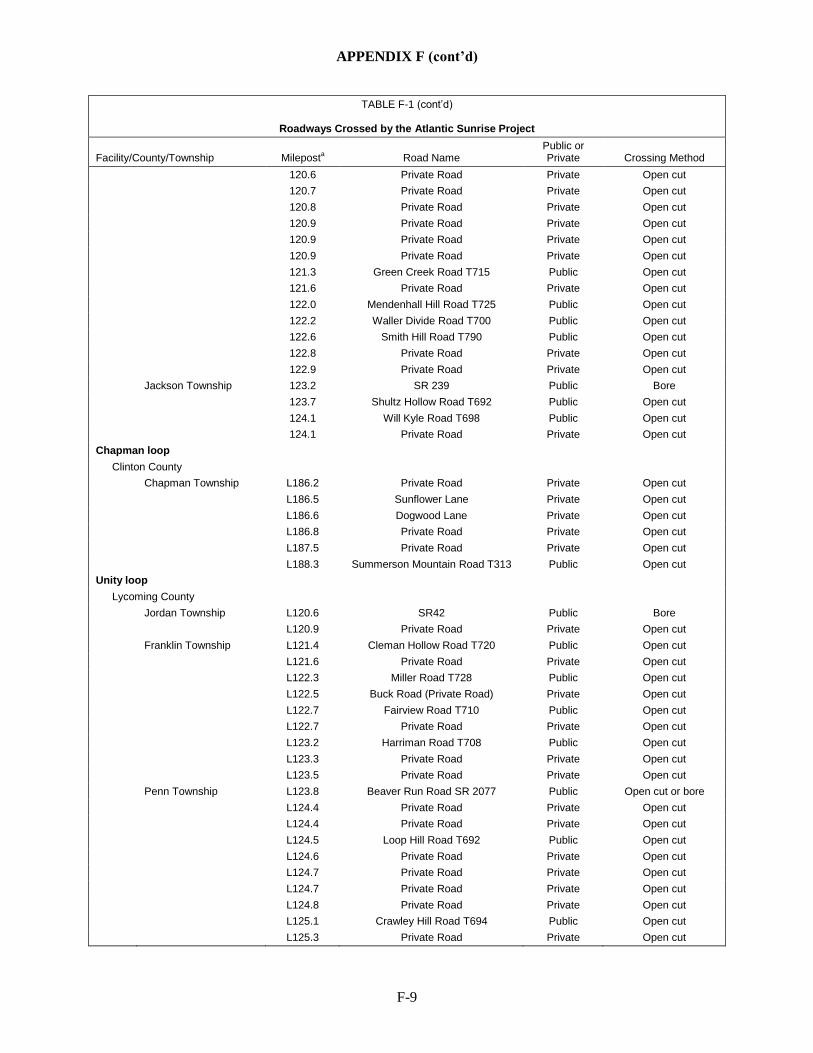
APPENDIX F (cont’d)
F-9
TABLE F-1 (cont’d)
Roadways Crossed by the Atlantic Sunrise Project
Facility/County/Township Mileposta Road Name Public or Private Crossing Method
120.6 Private Road Private Open cut 120.7 Private Road Private Open cut 120.8 Private Road Private Open cut 120.9 Private Road Private Open cut 120.9 Private Road Private Open cut 120.9 Private Road Private Open cut 121.3 Green Creek Road T715 Public Open cut 121.6 Private Road Private Open cut 122.0 Mendenhall Hill Road T725 Public Open cut 122.2 Waller Divide Road T700 Public Open cut 122.6 Smith Hill Road T790 Public Open cut 122.8 Private Road Private Open cut 122.9 Private Road Private Open cut Jackson Township 123.2 SR 239 Public Bore 123.7 Shultz Hollow Road T692 Public Open cut 124.1 Will Kyle Road T698 Public Open cut 124.1 Private Road Private Open cut Chapman loop
Clinton County Chapman Township L186.2 Private Road Private Open cut L186.5 Sunflower Lane Private Open cut L186.6 Dogwood Lane Private Open cut L186.8 Private Road Private Open cut L187.5 Private Road Private Open cut L188.3 Summerson Mountain Road T313 Public Open cut Unity loop
Lycoming County Jordan Township L120.6 SR42 Public Bore L120.9 Private Road Private Open cut Franklin Township L121.4 Cleman Hollow Road T720 Public Open cut L121.6 Private Road Private Open cut L122.3 Miller Road T728 Public Open cut L122.5 Buck Road (Private Road) Private Open cut L122.7 Fairview Road T710 Public Open cut L122.7 Private Road Private Open cut L123.2 Harriman Road T708 Public Open cut L123.3 Private Road Private Open cut L123.5 Private Road Private Open cut Penn Township L123.8 Beaver Run Road SR 2077 Public Open cut or bore L124.4 Private Road Private Open cut L124.4 Private Road Private Open cut L124.5 Loop Hill Road T692 Public Open cut L124.6 Private Road Private Open cut L124.7 Private Road Private Open cut L124.7 Private Road Private Open cut L124.8 Private Road Private Open cut L125.1 Crawley Hill Road T694 Public Open cut L125.3 Private Road Private Open cut
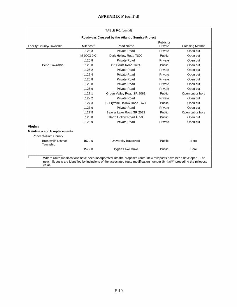
APPENDIX F (cont’d)
F-10
TABLE F-1 (cont’d)
Roadways Crossed by the Atlantic Sunrise Project
Facility/County/Township Mileposta Road Name Public or Private Crossing Method
L125.3 Private Road Private Open cut M-0003 0.0 Dark Hollow Road T800 Public Open cut L125.8 Private Road Private Open cut Penn Township L126.0 Dr. Poust Road T674 Public Open cut L126.2 Private Road Private Open cut L126.4 Private Road Private Open cut L126.8 Private Road Private Open cut L126.8 Private Road Private Open cut L126.9 Private Road Private Open cut L127.1 Green Valley Road SR 2061 Public Open cut or bore L127.2 Private Road Private Open cut L127.3 S. Frymire Hollow Road T671 Public Open cut L127.6 Private Road Private Open cut L127.8 Beaver Lake Road SR 2073 Public Open cut or bore L128.8 Barto Hollow Road T650 Public Open cut L128.9 Private Road Private Open cut Virginia
Mainline a and b replacements
Prince William County Brentsville District
Township 1579.6 University Boulevard Public Bore
1579.0 Tygart Lake Drive Public Bore ____________________ a Where route modifications have been incorporated into the proposed route, new mileposts have been developed. The
new mileposts are identified by inclusions of the associated route modification number (M-####) preceding the milepost value.

APPENDIX F (cont’d)
F-11
TABLE F-2
Railroads Crossed by the Project Facilities for the Atlantic Sunrise Project Facility/County, State/ Township Milepost Railroad Status Crossing Method CPL North
Wyoming County, PA Falls Township 35.1 Reading Blue Mountain and
Northern Railroad Active Horizontal directional
drill (HDD) a Nicholson Township 46.2 Canadian Pacific Railroad Active Bore CPL South
Lancaster County, PA West Hempfield Township 20.0 Norfolk Southern Railroad Active Bore West Hempfield Township 22.2 Pennsylvania Lines LLC,
c/o Norfolk Southern Abandoned Bore
Rapho Township 27.4 Amtrak Active Bore Lebanon County, PA
North Annville Township M-0183 1.1 Northern Southern Railroad Active Bore Schuylkill County, PA
Frailey Township 74.2 Reading Blue Mountain and Northern Railroad
Active Bore
Northumberland County, PA Coal Township 85.9 Shamokin Valley Active Bore
Columbia County, PA Franklin Township 99.6 Canadian Pacific Railway Active HDD Montour Township 99.9 SEDA-COG Joint Rail Authority Active HDD a Mainline A & B Replacements
Prince William County, VA Brentsville and Gainesville
Townships 1580.8 Norfolk Southern Railroad Active Bore
____________________ a The HDD crossings of these railroads are associated with the HDD crossings of the Susquehanna River.