SUNRISE RIM NEIGHBORHOOD PLAN - City of Boise
40
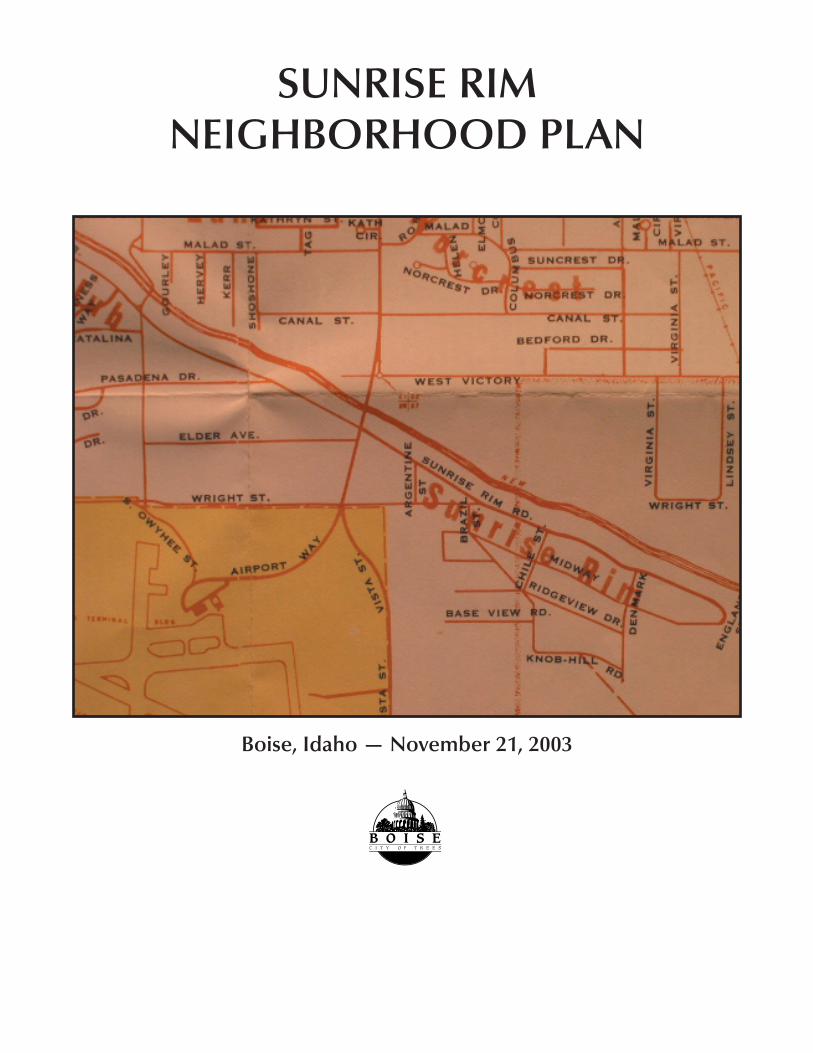
SUNRISE RIM NEIGHBORHOOD PLAN Boise, Idaho — November 21, 2003
-
Upload
khangminh22 -
Category
Documents
-
view
1 -
download
0
Transcript of SUNRISE RIM NEIGHBORHOOD PLAN - City of Boise
SUNRISE RIM NEIGHBORHOOD PLAN
Boise, Idaho — November 21, 2003
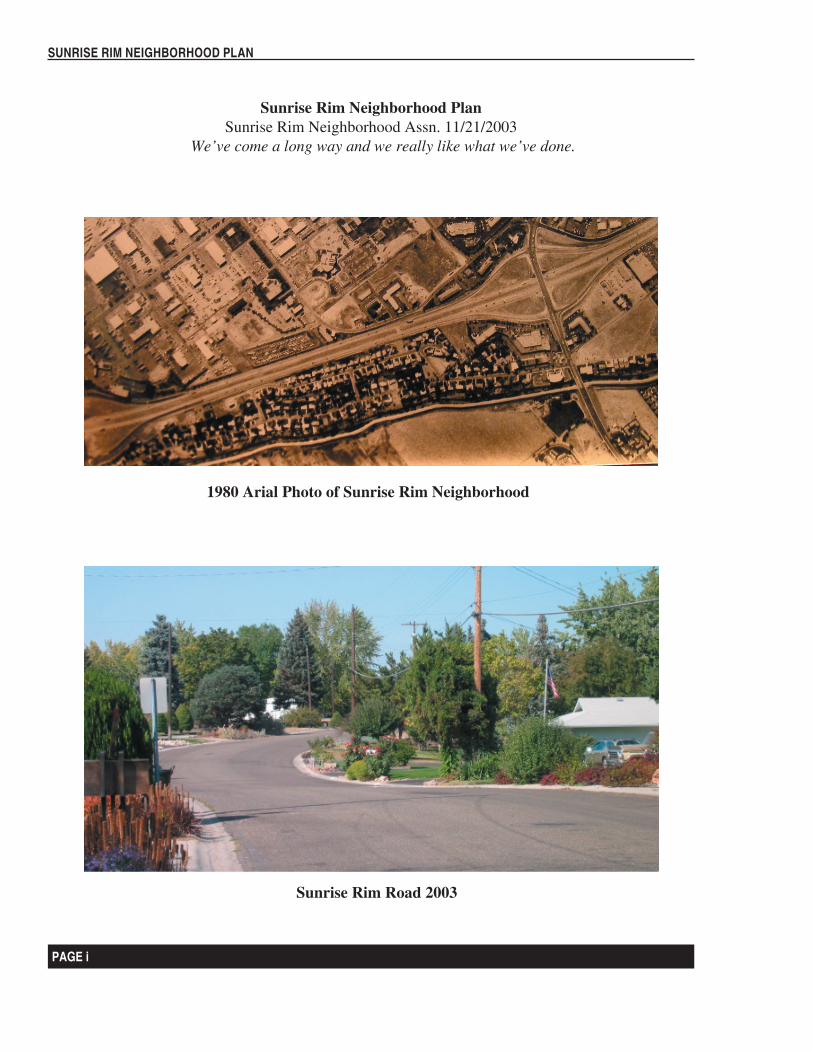
1980 Arial Photo of Sunrise Rim Neighborhood
Sunrise Rim Neighborhood PlanSunrise Rim Neighborhood Assn. 11/21/2003
We’ve come a long way and we really like what we’ve done.
PAGE i
SUNRISE RIM NEIGHBORHOOD PLAN
Sunrise Rim Road 2003
Table of Contents
Introduction
Chapter 1 Sunrise Rim Neighborhood Vision and Identity
Chapter 2 Plan Objectives and Implementation Actions
Chapter 3 Background and Analysis Report
Bibliography
How the plan is organized:
Introduction
Chapter 1 Sunrise Rim Neighborhood Identity and Vision.
The Sunrise Rim Neighborhood Plan boundary, historical description and vision statements.
Chapter 2 Plan Objectives and Action Charts.
A summary of the Sunrise Rim Neighborhood Background Report findings and issues are highlighted, and recommended actions needed to attain the vision of the Sunrise Rim Neighborhood are set forth.
Chapter 3Background Report
A brief history followed by a discussion of Sunrise Rim Neighborhood strengths, weaknesses, opportunities and challenges.
PAGE ii
SUNRISE RIM NEIGHBORHOOD PLAN
PAGE 1
SUNRISE RIM NEIGHBORHOOD PLAN
Introduction
Plan Function and Horizon: In association with the Boise City Comprehensive Plan, the Sunrise Rim Neighborhood Plan serves as the long term comprehensive policy guide for the social, environmental and economic development of the Sunrise Rim Neighborhood. To create a useful context for development decisions, the Sunrise Rim Neighborhood Plan looks toward the year 2020 and beyond. The Sunrise Rim Neighborhood Plan is a vision statement of how we would like to see our neighborhood in the future. It will serve to:• Enable the City Council, Planning and Zoning Commission and Design Review Committee
to establish long-range development policies.• Provide a basis for judging whether specific development proposals and public projects are in
harmony with the policies.• Guide public agencies and private developers in designing and funding projects that are
consistent with City policies.• Define the generic parameters for zoning ordinance amendments.
Our objectives and action items are primarily intended to preserve and enhance our quality of residential life in the Sunrise Rim Neighborhood. We desire is to limit commercial impact, promote quality land use and enhance the safety of our neighborhood for all residents.
Plan Monitoring and Update: Since conditions within the neighborhood could change and alter the premise for the various recommendations, it is important to review the plan periodically. The action strategies listed in this plan are designed over a twenty-year time period. However, planning is a continuous process and the plan is merely a framework from which to build. It is anticipated that necessary changes will be addressed by adjusting the Sunrise Rim Neighborhood Plan during future updates. Revisions of the plan should be conducted in five-year increments from the date of City Council’s adoption of the document. At the annual meeting of the Sunrise Rim Neighborhood Association a status report will be presented. It will include an implementation assessment of the Sunrise Rim Neighborhood Plan.
Relationship to Other Plans: Neighborhood planning is a critical tool for refining and turning into a reality the vision of the Boise City Comprehensive Plan. While the comprehensive plan establishes a definitive course of growth of the city as a whole, neighborhood plans specify in greater detail how each sub-region of the city is to accomplish those citywide goals. In a sense, a city without neighborhood plans is like an orchestra without sheet music. Much of the vision of the Sunrise Rim Neighborhood Plan is derived from the Boise City Comprehensive Plan. Upon adoption, the plan will be incorporated into the Boise City Comprehensive Plan by reference.
Public Participation: Solicitation for participation in the committee to develop the Sunrise Rim Neighborhood Plan took place at two scheduled/advertised association meetings. A team was formed which met on a regular basis. The results of the team’s effort with regard to neighborhood issues and plan priorities were issued in printed format and suggestions and participation were requested. A completed draft of this document was presented for inspection and feedback at a Sunrise Rim Neighborhood Association meeting and social on August 5th.
PAGE 2
SUNRISE RIM NEIGHBORHOOD PLAN
PAGE 3
SUNRISE RIM NEIGHBORHOOD PLAN
CANAL
VIS
TAVICTORY
INTERSTATE 84SUNRISE RIM
ELDER
AIRPORT
COMMERCE
WRIGHT
PANAMA
OW
YH
EE
BR
OAD
WAY
LIN
DS
AY
FEDERAL
NORCREST
AN
NE
TT
HILLCREST
DE
NV
ER
BEDFORD
VIR
GIN
IAROBINSON
KE
RR
PASADENA
CATALINA
APOLLO
SUNCREST
DE
VE
LOP
ME
NT
AC
CE
SS
HE
RV
EY
SH
OS
HO
NE
RO
BE
RT
HE
LEN
RA
LFRO
Y
LOC
KH
EE
D
ME
LISS
A
BENNETT
AB
BS
LAD
ER
A
TR
AN
SP
OR
T
TR
IUM
PH
CO
LUM
BU
S
RY
AN
BR
AZ
IL
GO
UR
LEY
ATLASTA CH
AR
ITY
DE
NM
AR
K
PO
CO
LOC
O
BR
OX
ON
MARILYN
WRIGHT CONNECTOR
ALEXANDRA
AP
PLE
BLO
SS
OM
TAG
GA
RT
VIS
TA
HE
LEN
NORCREST
BR
OX
ON
VIR
GIN
IA
SUNRISE RIM
WRIGHT
ELD
ER
WRIGHT
BE
DF
OR
D
WRIGHT
SH
OS
HO
NE
New York Canal
N
EW
S
WaterParcelsRoads
NeighborhoodSunrise Rim
This drawing is to be used onlyfor reference purposes; BoiseCity is not responsible for anyinaccuracies herein contained.
This map is made from data copyrighted by Ada County. AdaCounty shall not be liable for inaccuracies or misuse of this map.
use in any digital form requires the wr itten permission of A da County.Maps bearing thisdisclaimer may be photocopied fr eely. However,
OC
Sunrise Rim Neighborhood Association
PAGE 2
SUNRISE RIM NEIGHBORHOOD PLAN
PAGE 3
SUNRISE RIM NEIGHBORHOOD PLAN
Chapter 1 Sunrise Rim Neighborhood Vision and Identity
The vision for the City of Boise is well expressed on Page 1.1 of the Boise City Comprehensive Plan: “The citizens of Boise have expressed a strong desire to maintain a city with its basic livability intact. Citizens have indicated that there are qualities of life components that should not be sacrificed for growth or economic prosperity. The challenge is to accommodate economic growth while protecting the quality of life components Boiseans find so important.”
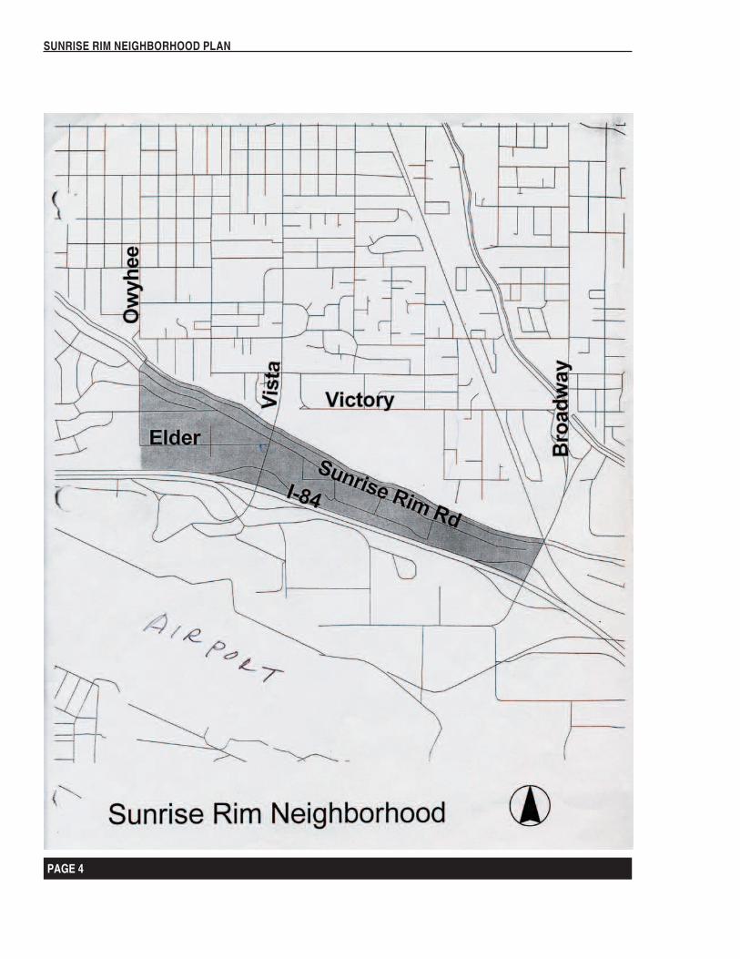
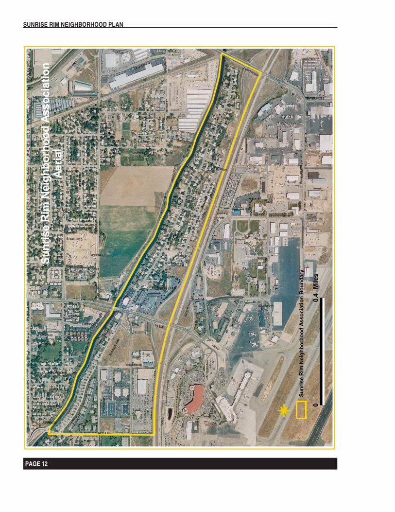
The Sunrise Rim Neighborhood is a small residential neighborhood that is sandwiched between a burgeoning and busy airport; a worn out freeway that faces drastic reconstruction, and a deep barrier canal. There is very little land that is suitable for development. Given these circumstances, the neighbors have expressed a strong desire to give priority to maintaining and enhancing the existing quality of life over economic prosperity and growth. Our challenge is to accept a bare minimum of business ventures that will contribute to the quality of livability in the neighborhood while preventing any visible or logistical impacts such as signs or increased traffic.
We appreciate, and place a high value on the residential quality and demeanor of our neighborhood. The overwhelming consensus among residents is to preserve and enhance this residential quality and to promote a safe, appealing environment in which to live. We desire a safe, quiet, pedestrian friendly residential area; free of business ventures; promoting a quality and pleasing visual appearance with the most up to date conveniences. In the business area, we desire that the existing business pattern be continued and traffic increasing businesses be held to a minimum.
The following map shows our relative position within the city:
PAGE 4
SUNRISE RIM NEIGHBORHOOD PLAN
PAGE 5
SUNRISE RIM NEIGHBORHOOD PLAN
PAGE 4
SUNRISE RIM NEIGHBORHOOD PLAN
PAGE 5
SUNRISE RIM NEIGHBORHOOD PLAN
Current Situation:
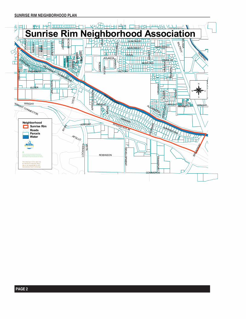
The Sunrise Rim Neighborhood Association was chartered in November 1998 as a non-profit, title 3 corporation under Idaho corporate laws. The neighborhood is located in the North Half of Sections 27 and 28, Township 3 North and 2 East of the 6th Principal Meridian. The boundaries of the SRNA originally began at a point where Vista Avenue and the New York Canal meet. The boundary follows the New York Canal eastward to the junction with Broadway Avenue; thence southerly to the south right of way for Interstate 84, thence westward to Vista Avenue, then north to the point of beginning. These boundaries were subsequently altered to include the area westward to South Owyhee Street between the New York Canal and the I-84 Freeway. The mean elevation is about 2940 Feet MSL. The area was formed as a lake terrace and is locally known as the Second Bench. The underlying geological structure is alluvial fill over igneous lava. The major soil components are river cobble rock interspersed with cliche layers and aeolian deposits (wind blown soils). Drainage is toward the north, and is relatively good.
The SRNA lies wholly within the Second Congressional District. The 2000 reapportionment split the neighborhood into two state legislative districts, 17 west of Vista, and 18 East of Vista. The area east of Vista Ave is in the 101st Precinct; and the area west of Vista is in the 98th Precinct.
The Owyhee Elementary School lies immediately to the west of the SRNA as does the South Owyhee City Park; however, they are not in the SRNA. All elementary students up to the 7th Grade attend Owyhee School, and bus service is provided. Vista Avenue splits the secondary school attendance. Those students living east of Vista attend East Junior High School, while those living west of Vista attend South Junior High. The High school students are also split. Those residing east of Vista attend Boise High School. Those West of Vista attend Borah High School. None of these schools are near the SRNA, but bus service is provided.
The major arterial streets that affect the SRNA are Vista Avenue and Broadway Avenue, and South Owyhee Street. Historically these were two major access streets to down town Boise. Vista Avenue is the main access road from the Airport to the State Capitol; although, the name changes north of the railroad to Capitol Blvd. Broadway is the main access to Boise State University and St. Luke’s Hospital. With the advent of the construction of the Interstate Highway System South of Boise, the importance of these arterials became more important, and they were designated as “Gateway Streets”. Sunrise Rim is the major east-west street, but is a dead end residential street. It continues west from Vista as Elder Street. Panama is a residential street that partially parallels Sunrise Rim against the freeway. Elder Street serves the commercial ventures west of Vista Ave.
The neighborhood lies on about 595 Acres, more or less. It is populated by 289 households, and a population of approximately 386 people, not counting those working in the 27 business endeavors in the area. Home ownership is very high in the neighborhood with only a 2 % rental rate. However this is spotty. Half of the rentals are on Panama where the rental rate runs 25%. There are a large percentage of homes with one person per dwelling in the area which is indicative of a number of mature, retired, and widows and widowers. The average age is undoubtedly much higher than the City averages. The median assessed valuation in 2001 is $112,000, and the average age of the homes is about 40 years,
PAGE 6
SUNRISE RIM NEIGHBORHOOD PLAN
PAGE 7
SUNRISE RIM NEIGHBORHOOD PLAN
although the area west of Vista Avenue is 20 years. Average home sales over the past two years have ranged from $65,000 to $367,000. The average is $113,900 although view lots have averaged above $150,000.
The area east of Vista Avenue is mostly included in the Gavin Subdivision authorized in 1947, and the Gavin Subdivision Addition at a somewhat later date. It is identified in the Boise Comprehensive Plan and zone in the R1-C Category. (Low Density = Residential). Lots identified in the Subdivision plan at the Vista/Sunrise confluence are designate and zoned in the L-O Category, which may be used for multiple purposes with the approval of the City. It included residential as well as business activities. Within the Gavin Subdivisions there were very restrictive covenants which those who purchased lots and their successors agreed to as terms of purchase.
PAGE 6
SUNRISE RIM NEIGHBORHOOD PLAN
PAGE 7
SUNRISE RIM NEIGHBORHOOD PLAN
Districts
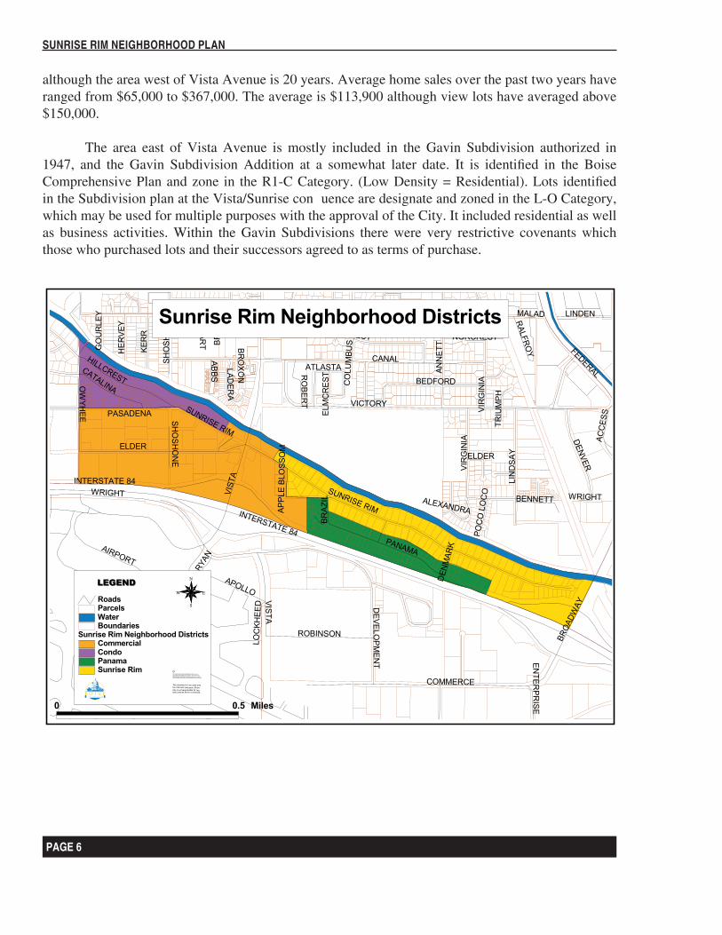
Districts are homogenous areas that can be identified by a similar cohort, and can be consciously entered. Planners use districts to help them mentally organize the layout of a city neighborhood and to identify differences within a neighborhood.
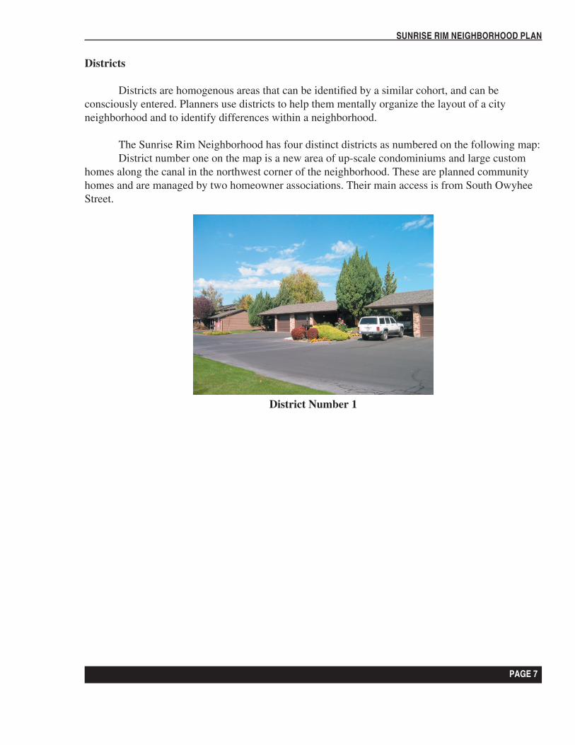
The Sunrise Rim Neighborhood has four distinct districts as numbered on the following map: District number one on the map is a new area of up-scale condominiums and large custom
homes along the canal in the northwest corner of the neighborhood. These are planned community homes and are managed by two homeowner associations. Their main access is from South Owyhee Street.
District Number 1
PAGE 8
SUNRISE RIM NEIGHBORHOOD PLAN
PAGE 9
SUNRISE RIM NEIGHBORHOOD PLAN
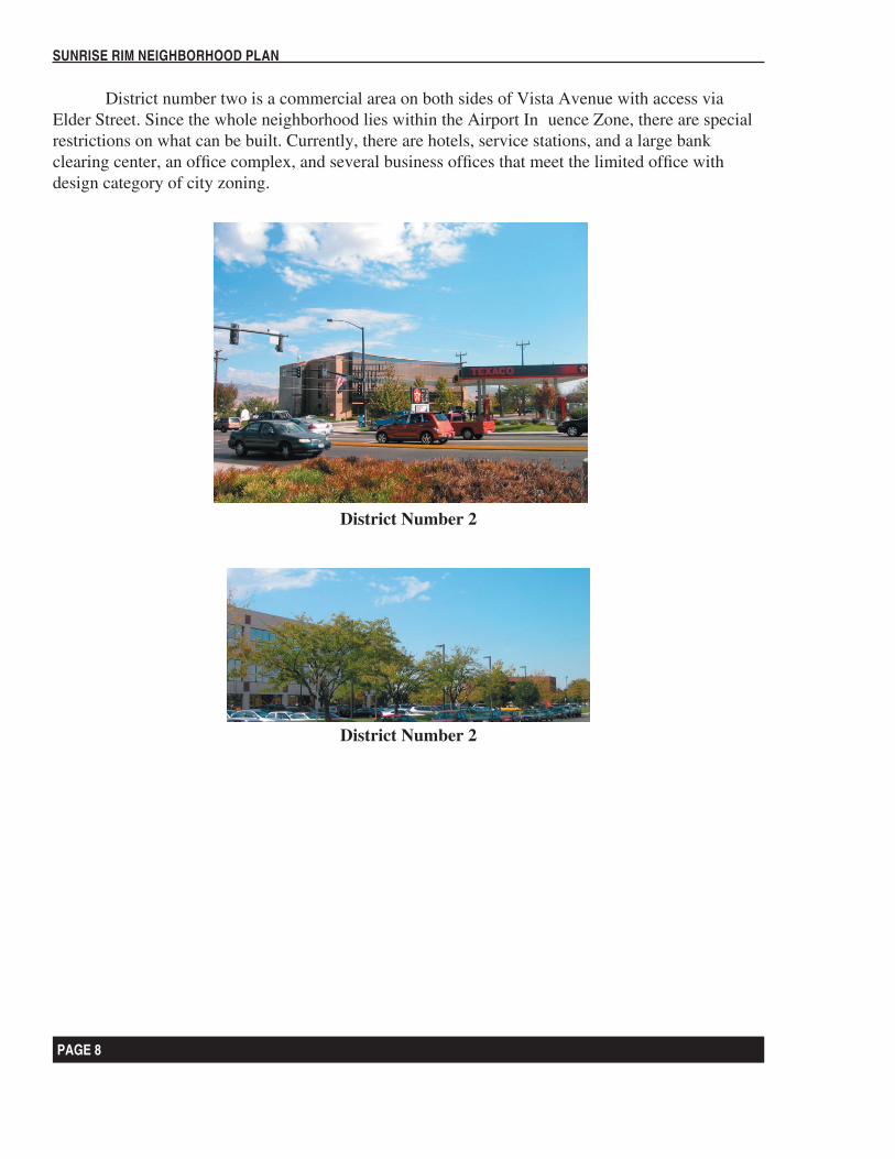
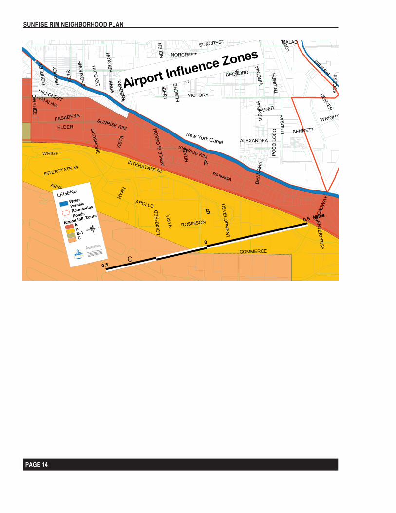
District number two is a commercial area on both sides of Vista Avenue with access via Elder Street. Since the whole neighborhood lies within the Airport Influence Zone, there are special restrictions on what can be built. Currently, there are hotels, service stations, and a large bank clearing center, an office complex, and several business offices that meet the limited office with design category of city zoning.
District Number 2
District Number 2
PAGE 8
SUNRISE RIM NEIGHBORHOOD PLAN
PAGE 9
SUNRISE RIM NEIGHBORHOOD PLAN
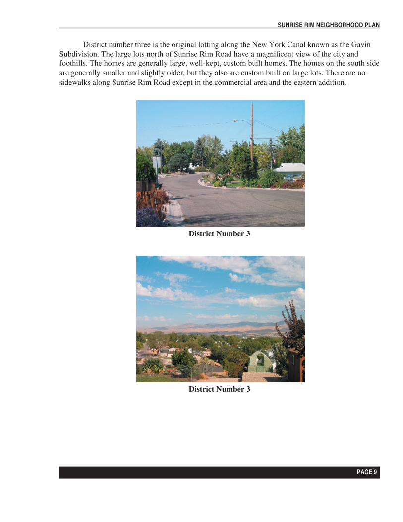
District number three is the original lotting along the New York Canal known as the Gavin Subdivision. The large lots north of Sunrise Rim Road have a magnificent view of the city and foothills. The homes are generally large, well-kept, custom built homes. The homes on the south side are generally smaller and slightly older, but they also are custom built on large lots. There are no sidewalks along Sunrise Rim Road except in the commercial area and the eastern addition.
District Number 3
District Number 3
PAGE 10
SUNRISE RIM NEIGHBORHOOD PLAN
PAGE 11
SUNRISE RIM NEIGHBORHOOD PLAN
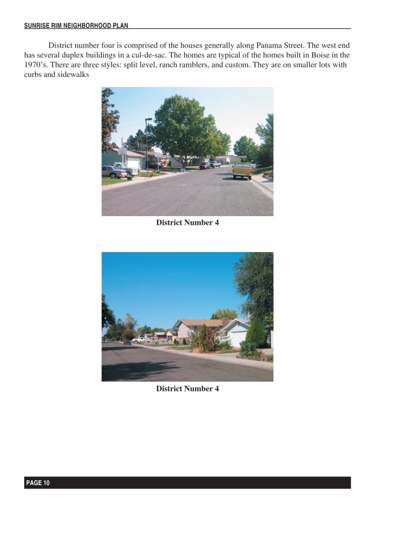
District number four is comprised of the houses generally along Panama Street. The west end has several duplex buildings in a cul-de-sac. The homes are typical of the homes built in Boise in the 1970’s. There are three styles: split level, ranch ramblers, and custom. They are on smaller lots with curbs and sidewalks
District Number 4
District Number 4
PAGE 10
SUNRISE RIM NEIGHBORHOOD PLAN
PAGE 11
SUNRISE RIM NEIGHBORHOOD PLAN
Chapter 2
Plan Objectives and Implementation Actions
Purpose: The purpose of the Sunrise Rim Neighborhood plan is to highlight the strengths weaknesses, challenges and opportunities in the Sunrise Rim Neighborhood and to formulate responsive citizen based action strategies and objectives for the maintenance and enhancement of the unique and special values of this neighborhood. The plan is intended to be used as a policy and activity guide for all with a vested interest in the Sunrise Rim Neighborhood.
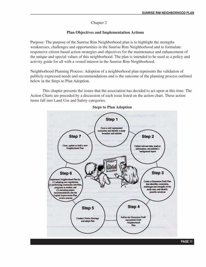
Neighborhood Planning Process: Adoption of a neighborhood plan represents the validation of publicly expressed needs and recommendations and is the outcome of the planning process outlined below in the Steps to Plan Adoption.
This chapter presents the issues that the association has decided to act upon at this time. The Action Charts are preceded by a discussion of each issue listed on the action chart. These action items fall into Land Use and Safety categories.
Steps to Plan Adoption
PAGE 12
SUNRISE RIM NEIGHBORHOOD PLAN
PAGE 13
SUNRISE RIM NEIGHBORHOOD PLAN
PAGE 12
SUNRISE RIM NEIGHBORHOOD PLAN
PAGE 13
SUNRISE RIM NEIGHBORHOOD PLAN
2.1 Land Use
Goal: Preserve and enhance the residential quality of our neighborhood.
The overwhelming consensus among Sunrise Rim Neighborhood Association members is that we are all here primarily because of the residential characteristic and quality of this area. Our main goal is to not let those qualities degrade, and to explore all avenues to promote their enhancement. We have clarified our goals and intent with the objectives and actions below.
Objective 1: Prevent and oppose any actions that might degrade residential characteristics and explore all avenues to enhance residential characteristics. New development should be compatible and add to the quality of the neighborhood through architecture, design and neighborhood amenities.
Objective 2: Allow no visible business ventures within the residential districts of the neighborhood. This includes limiting ventures that may significantly increase traffic volume, create offensive odors, disrupt the tranquility or have any visible negative impact on the residential sections of the neighborhood.
Objective 3: Maintain the current zoning and design standards of the commercial and office zoned area of the neighborhood.
New construction should respect and adhere to the character and scale of the immediate surroundings. Planned Unit Development (PUD) proposals should be evaluated as to their overall compatibility with, and contribution to the Sunrise Rim Neighborhood. SRNA would like the emphasize office, commercial, neighborhood retail uses and avoid residential housing projects in District 2. If residential developments are requested they should include supporting services such as recreational open space and convenience retail.
Objective 4: Encourage neighborhood friendly services and retail shops in Neighborhood District 2.
Objective 5: Support existing plans, polices, and codes to preserve and continue the creation of a well planned community that provides convenience and services to area residents and Boise.
Insofar as the current city zoning and Boise comprehensive plans are concerned, the Sunrise Rim Neighborhood Association agrees with the city zoning and encourages strict enforcement of the zoning ordinances. All districts within the Sunrise Rim area have very strict covenants. Most of these have either been adapted to the existing city ordinances or ordinances have been adopted to implement most of the covenants. The SRNA will work aggressively with city code enforcement to ensure compliance.
PAGE 14
SUNRISE RIM NEIGHBORHOOD PLAN
PAGE 15
SUNRISE RIM NEIGHBORHOOD PLAN
PAGE 14
SUNRISE RIM NEIGHBORHOOD PLAN
PAGE 15
SUNRISE RIM NEIGHBORHOOD PLAN
This effort will be one of education, communication and outreach. Property issues may require an analysis of applicable covenants or city ordinances to determine a proper course of action. The SRNA will establish a method of reaching consensus on these issues with all appropriate parties in an effort to maintain or enhance our residential quality.
Action Item 1: Work to educate and communicate with residents about public and private regulations.
Action Item 2: Support the strict enforcement of the Boise City Zoning Ordinance.
Objective 6: Work with Boise City and other Neighborhood Associations to monitor implementation of neighborhood goals.
Action Item 3: Closely monitor any proposal for development of the vacant land immediately north of the New York Canal to ensure compatibility with and preservation of the surrounding residential areas.
Action Item 4: Establish and maintain close contact with the Vista Neighborhood Association.
Action Item 5: Continue and support the efforts of the Vista Association to develop the gateway philosophy of Vista Avenue into the City of Boise.
Objective 7: Promote maintenance and planting of new trees and landscaping.
Mature vegetation and landscaping are a large part of the image and appeal of our neighborhood. We are fortunate to have many large trees and we consider them an asset worth maintaining. Much of the residential character and charm of any neighborhood is due to well-maintained healthy trees and landscaping. An ongoing effort to identify problem situations with regard to trees and maintain communications with Boise City Dept. of Forestry and residents will be the responsibility of the SRNA.
Action Item 6: Create a neighborhood team to maintain communications with Boise City Dept. of Forestry and residents on tree issues.
Action Item 7: Encourage new developments to preserve existing trees.
PAGE 16
SUNRISE RIM NEIGHBORHOOD PLAN
PAGE 17
SUNRISE RIM NEIGHBORHOOD PLAN
Objective 8: Maintain the physical appearance of residential and commercial properties throughout the SRNA.
The SRNA will endeavor to understand issues relating to properties that adversely affect the residential quality of our neighborhood. A philosophy of cooperation, communication and assistance will guide our efforts to achieve a resolution. Where appropriate and possible, the SRNA will promote a neighborhood response to situations that require additional manpower.
Action Item 8: Establish SRNA program to assist neighbors to help maintain properties.
Action Item 9: Seek annual assistance for neighborhood clean-up and maintenance from community programs such as; Re-leaf Boise, Paint the Town, Rake-up Boise.
PAGE 16
SUNRISE RIM NEIGHBORHOOD PLAN
PAGE 17
SUNRISE RIM NEIGHBORHOOD PLAN
Objective 9: Reduce the negative impacts of I-84 on the Sunrise Rim Neighborhood.
The planned expansion of I84 adjacent to our residential neighborhood has great potential to adversely affect our residential quality. Lines of communication between Idaho Transportation Department (ITD), Ada County Highway District (ACHD) and SRNA will be maintained and enhanced. An issue of primary importance to us is the safety wall. The standard wall that has been constructed along I-84 between Cole and Orchard is the type we desire. The Association will continue to closely monitor and contact ITD and ACHD relative to timing, design and effects on the neighborhood. This is the primary assignment of the SRNA officers.
Action Item 10: Appoint neighborhood representatives to communicate and work with ITD on the I-84 expansion project and keep the neighborhood informed on the project status.
Objective10: Increase and enhance pedestrian connections and safety of the SRNA through sidewalks and traffic calming.
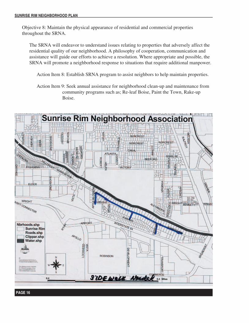
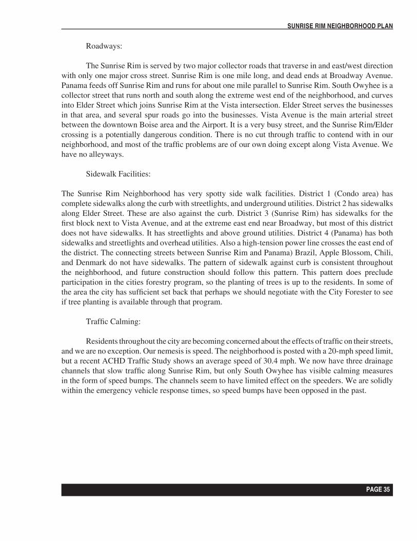
We need to look at the possibilities and issues related to the addition of sidewalks in areas that are currently void. This may include pedestrian safety issues related to crossing Vista Avenue. If we desire to continue to use our neighborhood as we do today; for walking, interacting with neighbors, etc, for the sake of safety we must consider sidewalks. One point worthy of consideration is the existing landscaping in the City set back, which would be removed if sidewalks were built. Both the City and the Highway District have programs to assist in building sidewalks, and it can be done in sections. We need to start a program to gather consensus and look into implementation issues. The attached map depicts the current status of sidewalks in our neighborhood.
Action Item 11: Pursue the addition of sidewalks on Sunrise Rim Road by the creation of a team to look at the possibilities and issues related to the addition of sidewalks in areas that are currently void.
Action Item 12: Apply for ACHD and Boise City Grants to complete the neighborhood sidewalk system.
Objective11: Beautify the neighborhood by burying or minimizing utilities.
Consensus is that moving utilities underground would enhance our neighborhood considerably. A team will work with Idaho Power Co. and others to research and clarify all related issues and make a report of the findings to the association.
Action Item 13: Appoint a neighborhood committee to begin research and discussions with Idaho Power about putting power lines underground.
PAGE 18
SUNRISE RIM NEIGHBORHOOD PLAN
PAGE 19
SUNRISE RIM NEIGHBORHOOD PLAN
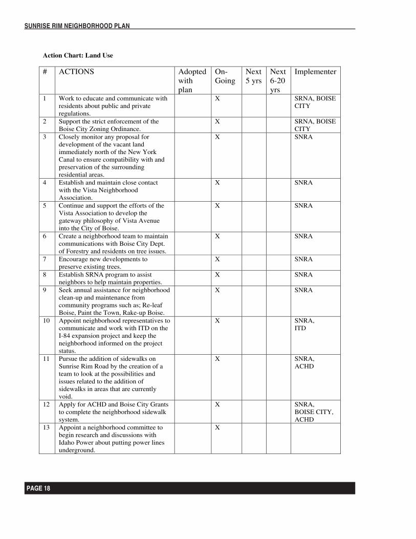
Action Chart: Land Use
# ACTIONS Adopted withplan
On-Going
Next5 yrs
Next6-20yrs
Implementer
1 Work to educate and communicate with residents about public and private regulations.
X SRNA, BOISE CITY
2 Support the strict enforcement of the Boise City Zoning Ordinance.
X SRNA, BOISE CITY
3 Closely monitor any proposal for development of the vacant land immediately north of the New York Canal to ensure compatibility with and preservation of the surrounding residential areas.
X SNRA
4 Establish and maintain close contact with the Vista Neighborhood Association.
X SNRA
5 Continue and support the efforts of the Vista Association to develop the gateway philosophy of Vista Avenue into the City of Boise.
X SNRA
6 Create a neighborhood team to maintain communications with Boise City Dept. of Forestry and residents on tree issues.
X SNRA
7 Encourage new developments to preserve existing trees.
X SNRA
8 Establish SRNA program to assist neighbors to help maintain properties.
X SNRA
9 Seek annual assistance for neighborhood clean-up and maintenance from community programs such as; Re-leaf Boise, Paint the Town, Rake-up Boise.
X SNRA
10 Appoint neighborhood representatives to communicate and work with ITD on the I-84 expansion project and keep the neighborhood informed on the project status.
X SNRA, ITD
11 Pursue the addition of sidewalks on Sunrise Rim Road by the creation of a team to look at the possibilities and issues related to the addition of sidewalks in areas that are currently void.
X SNRA, ACHD
12 Apply for ACHD and Boise City Grants to complete the neighborhood sidewalk system.
X SNRA, BOISE CITY, ACHD
13 Appoint a neighborhood committee to begin research and discussions with Idaho Power about putting power lines underground.
X
PAGE 18
SUNRISE RIM NEIGHBORHOOD PLAN
PAGE 19
SUNRISE RIM NEIGHBORHOOD PLAN
2.2 Safety
Goal: Ensure the long-term safety of Sunrise Rim residents from crime and man made or natural hazards.
Objective 1: Prepare the SRNA for emergencies and catastrophic events through the creation of a comprehensive emergency plan for the Sunrise Rim neighborhood.
The Sunrise Rim neighborhood is located in an area that has a higher risk of significant accidents or catastrophic events. Our proximity to the Boise City Airport and I-84 puts us in harms way with regard to vehicle and aircraft accidents, chemical spills and possible terrorist type activity aimed at the airport. The committee should establish goals and implementation strategies that promote our safety and well being during these possible situations. Food, water, shelter, medical, transportation, communication, neighborhood resource and skill inventory, and education are all issues that would be addressed.
Action Item 1: Establish a SRNA team to write an emergency plan for the neighborhood.
Objective 2: Promote an attentive, responsive neighborhood watch program.
Our goal is to continue to support and further bolster our neighborhood watch program. An attentive neighborhood watch program is an extremely effective way to combat neighborhood crime. Working in conjunction with the SRNA, great strides can also be made in the areas of neighborhood teamwork and cooperation as strategies and tactics are worked out and results reported on the association level. Another facet of our Neighborhood Watch could be to provide awareness and promote support for any residents that require assistance. We also need to work with Boise City Police on crime prevention.
Action Item 1: Continue to support the neighborhood watch program
Action Item 2: Work with Boise City Police on crime prevention.
Objective 3: Protect the neighborhood from impacts and potential hazards at the Boise City Airport.
The airport adjacent to our residential neighborhood has great potential to adversely affect our residential quality. Lines of communication between SRNA and airport officials will be established to ensure positive working relations between the airport and neighborhood to address issues as they arise.
Action Item 1: Work with the airport officials to monitor and respond to potential safety issues.
PAGE 20
SUNRISE RIM NEIGHBORHOOD PLAN
PAGE 21
SUNRISE RIM NEIGHBORHOOD PLAN
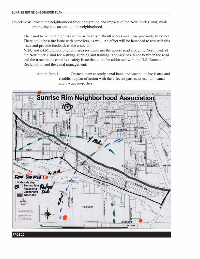
Objective 4: Protect the neighborhood from denigration and impacts of the New York Canal, while promoting it as an asset to the neighborhood.
The canal bank has a high risk of fire with very difficult access and close proximity to homes. There could be a fire issue with some lots, as well. An effort will be launched to research this issue and provide feedback to the association. NIFC and BLM crews along with area residents use the access road along the North bank of the New York Canal for walking, running and training. The lack of a fence between the road and the treacherous canal is a safety issue that could be addressed with the U.S. Bureau of Reclamation and the canal management.
Action Item 1: Create a team to study canal bank and vacant lot fire issues and establish a plan of action with the affected parties to maintain canal and vacant properties.
PAGE 20
SUNRISE RIM NEIGHBORHOOD PLAN
PAGE 21
SUNRISE RIM NEIGHBORHOOD PLAN
Objective 5: Create a safe traffic system for the neighborhood.
We are concerned about the severity of our traffic problems and are in need of solutions. We do not meet ACHD standards for assistance in building traffic calming measures like speed bumps or systems to narrow or break up the straight stretches to force slowing.
We are concerned about the shared control light at the Vista cross street. Currently eastbound traffic on Elder Street uses the inside lane for both through and left turning traffic. ACHD has been requested to do a study on the flow pattern at this light, but beyond this there are right-of -way problems. We believe this is a potentially dangerous intersection, and should work toward making it safer.
Action Item 1: Create a team to study traffic safety issues and possible solutions for SRNA.
Action Item 2: Apply for ACHD and Boise City grants for neighborhood traffic improvements.
PAGE 22
SUNRISE RIM NEIGHBORHOOD PLAN
PAGE 23
SUNRISE RIM NEIGHBORHOOD PLAN
Action Chart: Public Safety
# ACTIONS Adopted with plan
OnGoing
Next5 yrs
Next6-20yrs
Implementer
1 Establish a SRNA team to write an emergency plan for the neighborhood.
X SRNA
2 Continue to support the neighborhood watch program
X SRNA, NW
3 Work with Boise City Police on crime prevention.
X SRNA, Police
4 Work with the airport officials to monitor and respond to potential safety issues
X SRNA
5 Create a team to study canal bank and vacant lot fire issues and establish a plan of action with the affected parties to maintain canal and vacant properties
X SRNA
6 Create a team to study traffic safety issues and possible solutions for SRNA
X SRNA
7 Apply for ACHD and Boise City grants for neighborhood traffic improvements
X SRNA
PAGE 22
SUNRISE RIM NEIGHBORHOOD PLAN
PAGE 23
SUNRISE RIM NEIGHBORHOOD PLAN
Chapter 3
Sunrise Rim Neighborhood Background and Analysis Report
This chapter highlights the Sunrise Rim Neighborhood Background and Analysis Report findings. The following is a comprehensive examination and listing of the strengths, weaknesses, challenges, and opportunities of the Sunrise Rim Neighborhood. Elements include:
- A Brief History of the neighborhood- Public Utilities and Services- Demographics and housing- Land Use- Mobility
3.1 A Brief History of the Neighborhood
At the end of World War II Vista Avenue led from downtown Boise to one of the gates to Gowen Field which had been a B-24 advanced crew training base for the then Army Air Force. There were few structures south of Overland Avenue and nothing above the New York Canal. There was a garbage dump just north of the present day National Interagency Fire Center.
In March of 1949 a Dr. Gavin filed with the County the necessary information to plat a subdivision east of Vista Avenue and above the New York Canal. This was identified as Gavin Subdivision #1. Wells were drilled for domestic water, and a pipeline distribution system built. Dr Gavin was very perceptive in drawing up a stringent set of covenants for his subdivision. He recognized the need to provide for residential construction and use primarily. Whether he had some foreknowledge of the construction of the freeway, which began in the early 1960’s, influenced him to establish the subdivision is not known, but Holiday Inn Corporation also began building a large motel at that time. Regardless, these events influenced the efforts. The early homes were generally individually built, and the project developed slowly. There appeared to be a conscious effort to avoid the appearance of a tract housing development, especially on the rim side (north). Most of the homes in the initial subdivision, which basically is present day Sunrise Rim, were built in the 1960’s and early 1970’s. Fill in building continued sporadically until 2000. The lots were large by today standards, generally around 12000 square feet. The view of the City and the Boise Foothills is among the best in Boise. Today only three lots remain vacant. In 1972 Gavin Addition #2 was platted, and building began rapidly. These lots were smaller, generally 5000 Square feet, and were built just north of the I-84 Freeway. This became the Panama part of the neighborhood. This subdivision was constructed after the area was annexed to the city, and sidewalks were required to be built as part of the contract requirements of the builder. The houses were varied in conformation so as not to appear as tract homes, i.e. there are split level designs, ranch home designs, and a few custom homes; although most of the homes were built by the Michael Bros. Construction Company. In 1980 the east part of Sunrise Rim was subdivided, and these lots were 5000 Square foot lots, and followed the configuration as developed along Panama Street.
PAGE 24
SUNRISE RIM NEIGHBORHOOD PLAN
PAGE 25
SUNRISE RIM NEIGHBORHOOD PLAN
The area west of Vista Avenue, except for a row of custom homes along Sunrise Rim, was not developed until the late 1980’s when gas stations and a motel were developed along Vista Avenue. In the 1990’s, a series of limited offices and service organizations (like AAA) built structures, and the City zoned the area for limited offices with design review. (LOD) Also a group of residences were authorized along the New York Canal as an extension in the Hillcrest area to the west of South Owyhee Street. These are up scale condominiums and residences, and two homeowners associations regulate their existence. In 2000 a four-story office building was erected by Albertson’s Inc. to provide offices. There are still large tracts of vacant land in the area west of Vista Avenue.
The Sunrise Rim Neighborhood Association was created in 1998 with Articles of Incorporation as a non-profit corporation under the Internal Revenue Tax system. We have Articles of incorporation under Idaho State Law, by-laws, and an Internal Revenue Tax exempt number. There was a prior neighborhood organization in the 1980’s that was primarily a neighborhood watch system. It failed due to a lack of citizen interest. We currently enjoy an active core of interested neighbors, but participation in the program could be much better.
So, in summary, The Sunrise Rim Neighborhood is a small neighborhood that is primarily residential in nature, and is young in terms of existence. We have little history, no historical sites, and little room for further development. Yet, we enjoy the quality of life and the friendliness in the neighborhood, and hope to protect and preserve its unique values.
3.2 Public Utilities and Services
Schools:
The Sunrise Rim Neighborhood lies entirely within the Boise School District. Generally Vista Avenue is a boundary line between schools. Students east of Vista go to East Junior High School, and Boise High School, and bus service is provided for all grade levels. Students in kindergarten through grade 6 go to the Owyhee School, and bus service is provided. Owyhee is the only school near to the neighborhood, and it lies along our northwest boundary, but is not in the neighborhood. Students west of Vista Avenue go to Owyhee School, South Junior High, and Boise High School. Bus service is available. However, any major changes in school populations will have to be coordinated with the Owyhee School. Of concern is the 2002 Boise City Disinvestment Monitoring Report that states one of the indicators of developing disinvestment was the number of students utilizing the free lunch program. Owyhee school had 77% of the students participating. The city average is 40.0%.
PAGE 24
SUNRISE RIM NEIGHBORHOOD PLAN
PAGE 25
SUNRISE RIM NEIGHBORHOOD PLAN
Domestic Water:
All of the homes in the Sunrise Rim Neighborhood are connected to the Boise City Water System, which is owned and operated by the United Water Company of Idaho. The water source is from deep wells, generally more than 600 feet deep. United Water installed new lines along Sunrise Rim in the summer of 2001, and replaced all meters. Both Panama and the Condo area have systems dated from 1972 to 1990. The Gavin Subdivision had its own wells and water system that served the area until the Gavin’s sold to United Water. The wells were given to United Water Company. However, they were not utilized by United Water. There is a well on the corner of Brazil and Sunrise Rim that could serve as an auxiliary water source in an emergency by the neighborhood. Arrangements would have to be made with United Water to utilize, equip., and test the water for domestic use should we desire to use it. Since we are above the canal, we have no irrigation rights or opportunities.
Sewer System:
Most of the Neighborhood is served by the Boise City Sewer System, which utilized both the Lander Street and West Boise Treatment Facility. The lines are generally new (2001) east of Vista Avenue. Approximately 80% of the residents have hooked into the sewer lines, but many still use septic tanks, and will not need to hook into the sewer unless they sell the property. Trunks and interceptor lines in the Boise Sewer District are maintained throughout year, and are flushed regularly. Sewer capacity should not be any problem in our neighborhood.
Storm Drainage:
Storm sewers and other drainage facilities within the Sunrise Rim Neighborhood are provided by closed pipe, open areas, and dip channels across Sunrise Rim. The run off drains into the New York Canal. The may be marginal, and the channels across Sunrise Rim do not clear very rapidly. We also receive the run off from the freeway, and if and when it expands, there will be drainage problems. This is area of little concern for the short time, but can be a potential problem.
Electricity and Privately Owned Utilities:
Electricity is provided to the neighborhood by Idaho Power Company via power lines. Intermountain Gas Company provides Natural Gas. In addition there are telephone and cable companies operating in the area. There are no serious service problems with any of these utilities. As of this date we do not yet have DSL lines in the area, and QWest has no imminent plans to bring us that service. A dedicated line goes up Vista Avenue, but serves the airport and other facilities south of the freeway. In the long range the neighborhood would like to explore the possibility of underground service with Idaho Power. The Condo area already enjoys this condition.
PAGE 26
SUNRISE RIM NEIGHBORHOOD PLAN
PAGE 27
SUNRISE RIM NEIGHBORHOOD PLAN
Solid Waste:
Contract Collection of Solid waste within the Sunrise Rim Neighborhood is through the City of Boise with the Browning Ferris Industries (BFI) the city bills fees for the managing of the costs of collecting and disposal. The waste goes to the City Land Fill. In an effort to reduce the disposal of hazardous household material into the land fill, the Boise Public Works has prepared a source reduction and recycling plan, and is in the process of developing a household hazardous waste plan. Neighborhood residents are encouraged to participate in the recycling plan. The neighborhood would prefer a neighborhood collection facility in the hazardous household waste disposal plan as it is developed.
Police and Fire Protection Services:
Fire Protection
Fire protection to the Sunrise Rim Neighborhood is provided by three stations: Station #8 at 4422 Overland Road (Whitney Station), a new Station #7 at Commerce Road, and the Airport Station on Lockheed Street. Most of the area is within the four-minute city standard first response time, and this is aided by the fact that we as yet have no speed bumps except along South Owyhee. These would not impede response from Station#8. Sunrise Rim does have three drainage channels that would slow equipment. The Fire Department also is the first responder to medical calls. The neighborhood streets are adequate, well marked, and the homes are numbered which aids in quickly responding. Adequate water supply and pressure as well as hydrant distribution appears to be adequate, but the neighborhood needs to maintain vigilance that these items are routinely inspected. There are two man made fire hazards along Sunrise Rim: weeds and vegetation along the freeway, and along the New York Canal right of way. The highway department treats and mows the vegetation within the right of way. Nothing is done along the canal, and fire could quickly spread into residences from fires along the canal. Access is poor for fire equipment, and some neighbors might not be physically capable of dealing with a fire if it gained any size. This concern should be addressed by the neighborhood plan.
Police Protection
Police protection is provided in the neighborhood by the Boise City Police Patrol Division, and investigations on an assignment basis. The neighborhood is under the jurisdiction of Patrol Area #8 which covers the area south of the railroad tracks, west to Vista, and south to the City limits. There is a special contingent of Airport Police. This area covers approximately 9000 residents, 3700 households, and operates out of sub station on the corner of Vista Avenue and Cherry Lane--- about 2 miles north of the neighborhood. The City of Boise has a very high crime index (79.3 as compared to a national average of 50.0) and our residents are concerned as the city grows so rapidly (47%) over the past two years, that crime in the area will increase. This has been a relatively quiet area insofar as major crime occurrences. Most of the crimes are vandalism against property, usually by minors. However, in recent years, there have been assaults, drug-related crimes, neighborhood violence, and thefts, primarily car burglaries. The dead end nature of the neighborhood tends to offset the nearness of the freeway. The City has a goal of 1.5 police officers per 1000 people. Under the current fiscal
PAGE 26
SUNRISE RIM NEIGHBORHOOD PLAN
PAGE 27
SUNRISE RIM NEIGHBORHOOD PLAN
situation in the City of Boise, this goal is not, and cannot be met. The institution of a neighborhood officer under the philosophy of a Community policing program is helpful. Community Policing is a philosophy emphasizing developing relationships between law enforcement officers and local residents. The idea is that officers become more aware of neighborhoods, its people, and its problems, and residents understand the utilization of the available law enforcement skills. However, the “labor intensive” community policing goals are beginning to bear fruit; the Police Department must also deploy these same resources to respond to calls for service. There are ways that neighborhoods can assist law enforcement personnel. This Neighborhood Plan has an action item geared toward research, solutions and education. Participation from residents combined with a strong Neighborhood Watch program are important to the safety or our neighborhood.
3.2 Demographics and Housing
According to the US Census, and work by the ESRI, Boise is one of the fastest growing Cities in the nation. In 1990 the population was 126,135. In the 2000 Census the figure was 185,787; an increase of 59,102 people, or 46.7% (Idaho Blue Book, 2003). An updated count in 2001 indicated a population of 190,720 people, and the projected population by 2006 is for 213,858 people. Longer-range projections are about 2.4% per year, but limited water resources may alter that prediction. This would place the Boise City population at about 315,000 people in 2030.
While precise statistics for the Sunrise Rim Neighborhood are not readily available the population of the Sunrise Rim area in 1990 would have been about 310. The residential/condominium area west of Vista Avenue was not developed at that time. Data from the Postal Route statistics in the City Directory indicate an April 2003 population of 507 people. The Sunrise Rim Neighborhood had insignificant population gains during the 1990’s insofar as residential construction is concerned, and probably may have lost population. Our projected population for 2006 would be about 550 people. Far below the City projections simply because there is no further land to build on, and conversion to a higher density is not likely, nor desired.
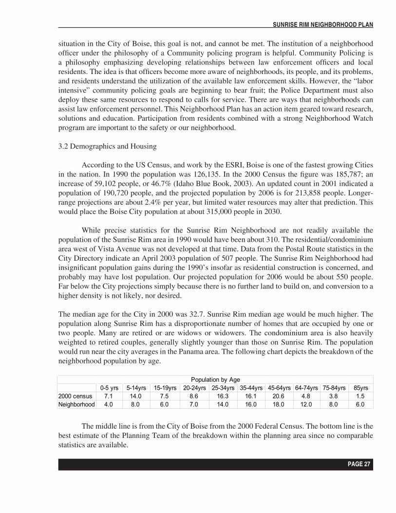
The median age for the City in 2000 was 32.7. Sunrise Rim median age would be much higher. The population along Sunrise Rim has a disproportionate number of homes that are occupied by one or two people. Many are retired or are widows or widowers. The condominium area is also heavily weighted to retired couples, generally slightly younger than those on Sunrise Rim. The population would run near the city averages in the Panama area. The following chart depicts the breakdown of the neighborhood population by age.
The middle line is from the City of Boise from the 2000 Federal Census. The bottom line is the best estimate of the Planning Team of the breakdown within the planning area since no comparable statistics are available.
Population by Age0-5 yrs 5-14yrs 15-19yrs 20-24yrs 25-34yrs 35-44yrs 45-64yrs 64-74yrs 75-84yrs 85yrs
2000 census 7.1 14.0 7.5 8.6 16.3 16.1 20.6 4.8 3.8 1.5Neighborhood 4.0 8.0 6.0 7.0 14.0 16.0 18.0 12.0 8.0 6.0
PAGE 28
SUNRISE RIM NEIGHBORHOOD PLAN
PAGE 29
SUNRISE RIM NEIGHBORHOOD PLAN
PAGE 28
SUNRISE RIM NEIGHBORHOOD PLAN
PAGE 29
SUNRISE RIM NEIGHBORHOOD PLAN
The demographic composition has several indicators as to the needs of the neighborhood. First, there would be no pressure on the schools system at any level because there are few school age people in those categories. Only 31 homes in the planning area have children in them. Sales in the area generally have been to buyers in the same category, i.e. older couples without children at home. This applies to the Condo area and Sunrise Rim. The Panama area should evolve to homes for young families, and this seems to be the present trend. There are more young families with children in this area, but there are still a number of rentals that are not raising families. One of our goals is to encourage young families to buy out the rentals, and use the homes to raise families. Secondly, in order to meet the needs of the older members of our neighborhood, we need sidewalks for safety, as walking is one of the major uses of the area. There is need for an alert and dependable Neighborhood Watch system to routinely assess the well being of the residents. Also there is need for a security and emergency action plan because of the vulnerability of the neighborhood to catastrophic events originating from the freeway and the airport.
Income
Income statistics are measured in three levels. Average income, median income, and per capita income. The most recent statistics (2001) place the City of Boise with an average household income of $55,078 per year. The median income at $41,504 and the per capita income at $22,262.The Boise Blue Book, which reflects the 2002 compilations, places the average household income at $54,869, and the per capita income at $20,513, which accounts for the recent economic slowdown. Again, precise data for our neighborhood cannot be obtained, but in the estimate of the planning team, we believe the per capita income to be higher than the city averages, but the average household income to be lower. This is because of the larger number of retirement incomes, and pensions prevalent in our area. By districts, the income in the Condo area would be substantially higher because there are a number of still working people, probably in the upper pay brackets. Along Sunrise Rim, the retiree income would be above the city average because most of these residents worked in an era when good pensions were the rule. The Panama district would probably meet the city averages. The 2006 forecast are extremely optimistic with a forecast average household income of $72,162 per year.
Housing and home values
The neighborhood has a good mix of housing types. One can find various levels of residences, duplexes, apartments, and condominiums as well as generally attractive business buildings. The home ownership level is very high. 41% of the homes have been occupied by the owners for more than 10 years. This is far higher than Boise City averages. Also, the percentage of rentals is very low, with only a 2% rate. City rental rates run as high as 52 % in some neighborhoods, with a citywide average of 35%. The average rental rate is $595.00 per month. Obviously, the percentage of rentals varies considerably by district with almost no rentals in the Sunrise Rim and Condo areas, and a 25% rate along Panama.
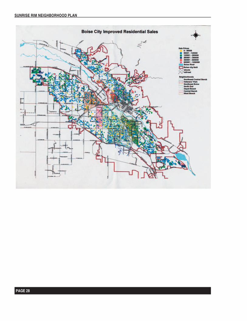
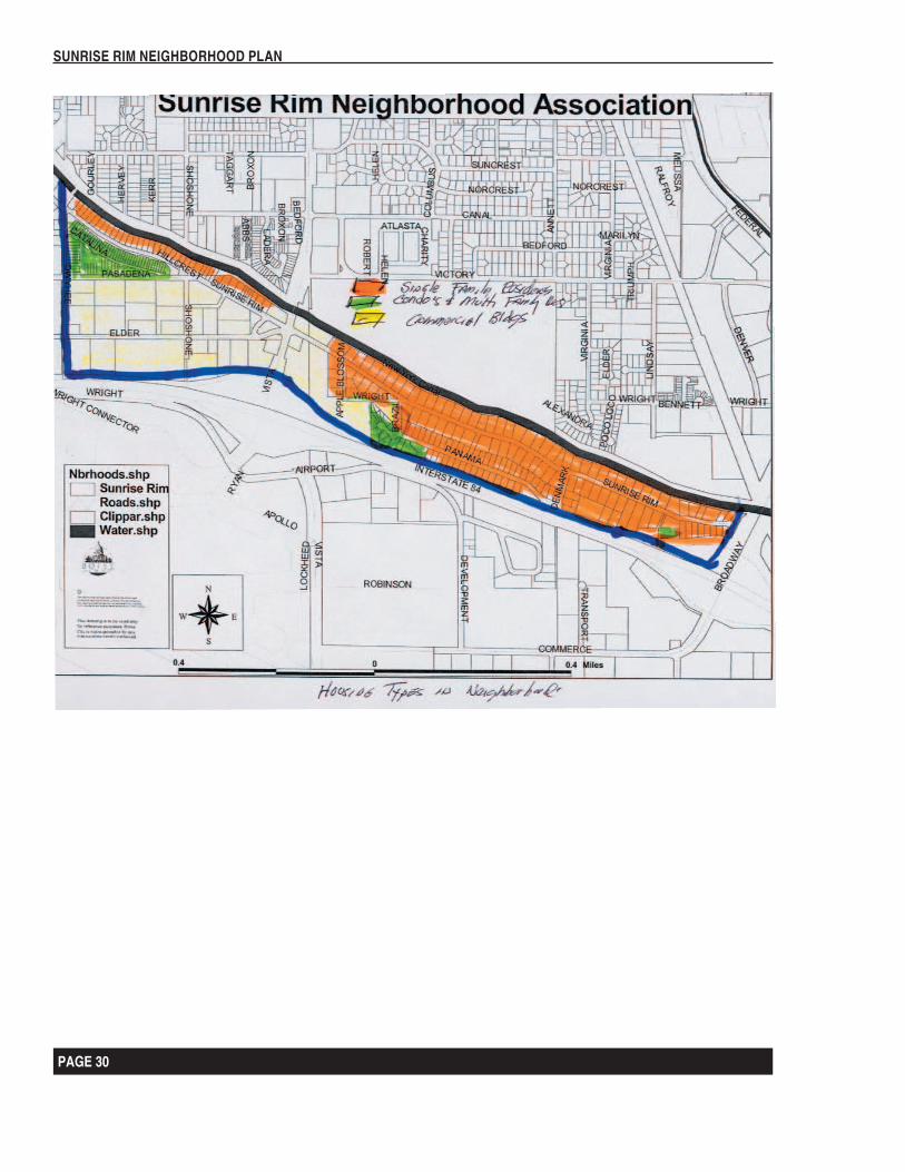
According to the Idaho Blue Book the median value of a home in Boise is $127,000. The Sunrise Rim average value is $147,000. The following map shows the price range in sales throughout the city, and is helpful in understanding the values overall. All indications point toward a very stable
PAGE 30
SUNRISE RIM NEIGHBORHOOD PLAN
PAGE 31
SUNRISE RIM NEIGHBORHOOD PLAN
PAGE 30
SUNRISE RIM NEIGHBORHOOD PLAN
PAGE 31
SUNRISE RIM NEIGHBORHOOD PLAN
neighborhood, with homes holding their value. Generally they are well kept, and sell quite readily. Rim houses command substantially higher values, and usually move relatively slowly. There are only two rim lots left on which to build; although we expect to see the pattern that started on Hillcrest Avenue where existing homes are razed, and newer, more costly homes replaced on the lot.
Other demographic
There is a national crime index that rates the cities. Boise has a crime Index of 79.56 compared to a national average of 50.0. This area will be detailed in the section under Services.
Of interest is a statistic that relates to Idaho education: 88.59% of the students finish high school, and 34.57% complete college.
PAGE 32
SUNRISE RIM NEIGHBORHOOD PLAN
PAGE 33
SUNRISE RIM NEIGHBORHOOD PLAN
PAGE 32
SUNRISE RIM NEIGHBORHOOD PLAN
PAGE 33
SUNRISE RIM NEIGHBORHOOD PLAN
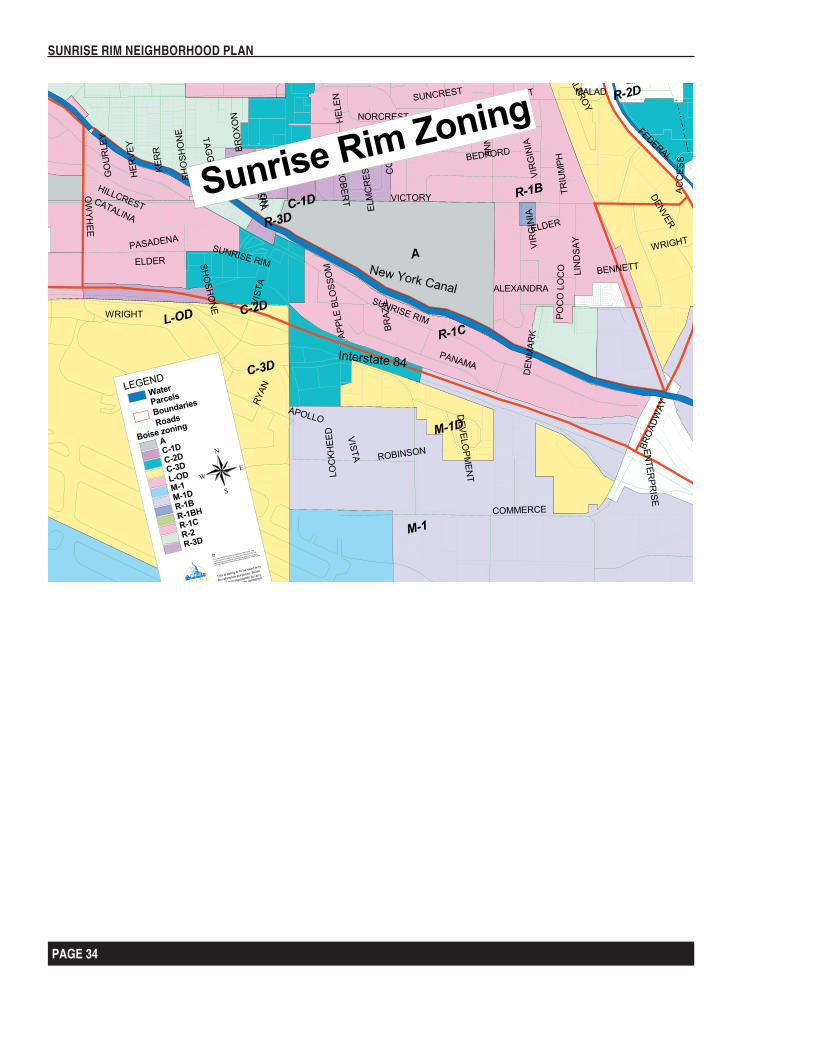
3.3 Land Use
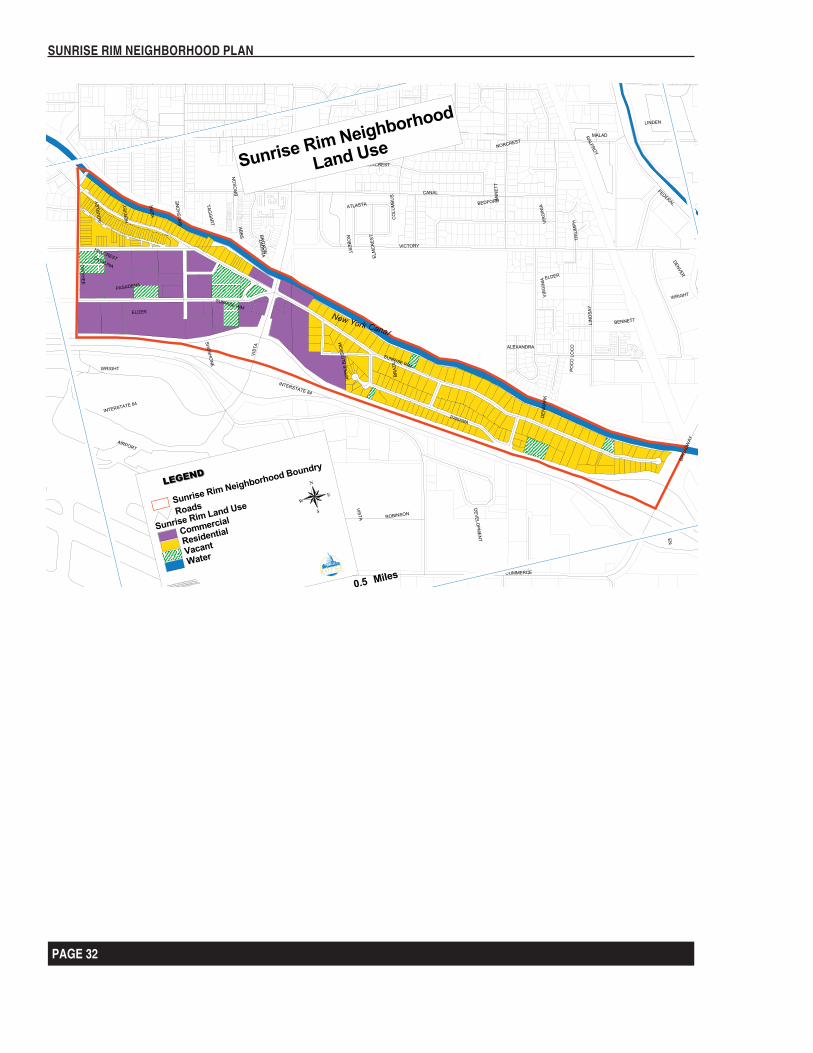
Land use, to a large extent, is based on the visible pattern of existing conditions. Land use planning begins at this point, and forms the basis for modification and change. On a micro-scale, the use of each parcel can influence the land use planning greatly. The following map depicts the existing land use:
For the purposes of this plan The Sunrise Rim Neighborhood is composed of two general land use areas, primary corridors and low-density residential neighborhoods. The Primary corridors are the lands that front Sunrise Rim Road, Panama Street, South Owyhee Street and Elder Street. Only Elder Street will provide for business uses, and there are no development opportunities for additional housing
The low-density neighborhoods are predominantly low-density residential areas that make up the major portion of the neighborhood. There is a great deal of diversity within the residential areas. They range from small, single family homes to high end condominiums and view homes. There are also some duplexes and apartments interspersed within the neighborhood.
Mixed Use Development:
We now have small convenience stores tied in with gasoline service stations, and several motels within the neighborhood, and restaurants within walking distance. We are within walking distance of a bus stop. We cannot envision any other kind of walk-to businesses. Sunrise Rim Neighborhood is so small, and configured in such a manner that this is unrealistic. There is no property available; currently, to accommodate the growth necessary for increased mixed-use development.
3.4 Mobility
The principle mode of transportation in the City of Boise over the past forty years has become the automobile. There is a growing demand for alternative modes of transportation, and a rethinking of how our energy, air quality, noise, and transportation goals can be met, and how land use decisions impact these goals.
Streets can provide a balance for the different modes of movement. Unfortunately this balance has changed over the past decades so that the main purpose of streets has become the accommodation of automobile traffic. Because of the configuration of our neighborhood, we have suffered less from this problem than most neighborhoods, primarily because we are small, basically dead ended and young in the sense of development. We still can generally enjoy the social interaction among neighborhood residents and businesses, the casual conversations as we walk along the rim at sundown, and enjoy the landscaping and beauty of the front yards in our residential neighborhoods. It is increasingly unsafe for walking, or for children to play in the roads, or learn to ride their bikes because traffic problems are increasing, but we are fortunately not too far from setting attainable goals to keep these values.
PAGE 34
SUNRISE RIM NEIGHBORHOOD PLAN
PAGE 35
SUNRISE RIM NEIGHBORHOOD PLAN
PAGE 34
SUNRISE RIM NEIGHBORHOOD PLAN
PAGE 35
SUNRISE RIM NEIGHBORHOOD PLAN
Roadways:
The Sunrise Rim is served by two major collector roads that traverse in and east/west direction with only one major cross street. Sunrise Rim is one mile long, and dead ends at Broadway Avenue. Panama feeds off Sunrise Rim and runs for about one mile parallel to Sunrise Rim. South Owyhee is a collector street that runs north and south along the extreme west end of the neighborhood, and curves into Elder Street which joins Sunrise Rim at the Vista intersection. Elder Street serves the businesses in that area, and several spur roads go into the businesses. Vista Avenue is the main arterial street between the downtown Boise area and the Airport. It is a very busy street, and the Sunrise Rim/Elder crossing is a potentially dangerous condition. There is no cut through traffic to contend with in our neighborhood, and most of the traffic problems are of our own doing except along Vista Avenue. We have no alleyways.
Sidewalk Facilities:
The Sunrise Rim Neighborhood has very spotty side walk facilities. District 1 (Condo area) has complete sidewalks along the curb with streetlights, and underground utilities. District 2 has sidewalks along Elder Street. These are also against the curb. District 3 (Sunrise Rim) has sidewalks for the first block next to Vista Avenue, and at the extreme east end near Broadway, but most of this district does not have sidewalks. It has streetlights and above ground utilities. District 4 (Panama) has both sidewalks and streetlights and overhead utilities. Also a high-tension power line crosses the east end of the district. The connecting streets between Sunrise Rim and Panama) Brazil, Apple Blossom, Chili, and Denmark do not have sidewalks. The pattern of sidewalk against curb is consistent throughout the neighborhood, and future construction should follow this pattern. This pattern does preclude participation in the cities forestry program, so the planting of trees is up to the residents. In some of the area the city has sufficient set back that perhaps we should negotiate with the City Forester to see if tree planting is available through that program.
Traffic Calming:
Residents throughout the city are becoming concerned about the effects of traffic on their streets, and we are no exception. Our nemesis is speed. The neighborhood is posted with a 20-mph speed limit, but a recent ACHD Traffic Study shows an average speed of 30.4 mph. We now have three drainage channels that slow traffic along Sunrise Rim, but only South Owyhee has visible calming measures in the form of speed bumps. The channels seem to have limited effect on the speeders. We are solidly within the emergency vehicle response times, so speed bumps have been opposed in the past.
PAGE 36
SUNRISE RIM NEIGHBORHOOD PLAN
PAGE 37
SUNRISE RIM NEIGHBORHOOD PLAN
Transit:
The Sunrise Rim Neighborhood is well served by public transit. A bus stop at the corner of Vista and Sunrise Rim serves as a major bus route into Boise.
PAGE 36
SUNRISE RIM NEIGHBORHOOD PLAN
PAGE 37
SUNRISE RIM NEIGHBORHOOD PLAN
BIBLIOGRAPHY
(1) Demographic and Income Forecast for the City of Boise. 4/19/02 Copyright 2002 ES RI Bis(2) Demographics and Income Forecast for Ada County. 4/19/02 Copyright 2002 ES RI Bis(3) 2000 Boise Metro Facts and FAQ’s. Boise Metro Economic Development Council. 2002.(4) Boise Metro Chamber of Commerce. P.V. Quinn. 2002.(5) Zip Code, U.S. Postal Service, the Source Book. Published by CACI Marketing Service.
1999(6) Boise, Idaho City Directory. 1963, Polk City Directories, pp282, et.al(7) Idaho Blue Book. Published by Idaho Secretary of State. 2001-2002(8) Market Guide. Editors of Market Guide. 2003. Sec. III, pp23.(9) Many accepted Boise City Plans.(10) Boise City Comprehensive Plan and Revisions. 1997 and revisions. Boise P&Z.(11) City of Boise Codes as revised 2003.