Village & Townwise Primary Census Abstract, Simla, Part-X-A ...
331
CENSUS 1971 SERrES-7 HIMACHAL PRADESH DISTRICT CENSUS HAN,DBOOK PARTS X-A & B TOWN & VILLAGE DIRECTORY VILLAGE & TOWNWISE PRIMARY CENSUS ABSTRACT SIMLA DISTRICT ATTAR SINGH of the IndIan Admlnlstrallve Service DIrector of Census Operations Himachal Pradelh.
-
Upload
khangminh22 -
Category
Documents
-
view
0 -
download
0
Transcript of Village & Townwise Primary Census Abstract, Simla, Part-X-A ...
CENSUS 1971
SERrES-7
HIMACHAL PRADESH
DISTRICT CENSUS HAN,DBOOK
PARTS X-A & B
TOWN & VILLAGE DIRECTORY
VILLAGE & TOWNWISE PRIMARY CENSUS
ABSTRACT
SIMLA DISTRICT
ATTAR SINGH of the IndIan Admlnlstrallve Service
DIrector of Census Operations Himachal Pradelh.
".
.J:.e I,IJ...J o~ <LXU') 0.
VII i
\ . .d. \
\ ..J \ ,
\ (1:l \
'\ ", . . ,_ ..;_ .--. '-' ..... tt' .. ~
. ' /' . l \ I
.' ~ / i
i ..... : \)
..
(. /'
"; • c: .. CI
c o i
! .. -s

Census of India 1971 LIST OF PUBLICATIONS
Central Government Publications-Census of India 1971-Series-7-Himachal Pradesh 15 being pubhshed In the followmg parts:-ParI Subject covered Number I-A General Report.
I-B Dctaded Analysis of the Demographic, Social, Cultural and Migration Patterns.
I-C SubsidIary Tables.
II-A General PopulatIon Tables (CA' Sertes).
ll-B Economic Tables(CB' Senes).
II-C (I) DistributIOn of Populdtton, Mother Tongne and Rehglon, Scheduled Castes and Scheduled TrIbes.
II-C (11) Other Social and Cultural Tables, Tables and Fertlllty Tables on Household ComposItIon, SIngle Year Age, MartIal Status, EducatIOnal Levels, Scheduled Castes and Scheduled Tnbes, etc., Btltnguabsm.
nl Estabhshments Report and Tables ('E' Senes)
IV -A & B Housmg'Report and Subbldlary Tables.
V
VI-A
VI-B
VJ-C
VII
VIII-A
VJll-B
SpeCial Tables and EthnographIC Notes on Scheduled Castes and Scheduled TrIbes.
Town DIrectory.
SpeCial Survey Reports on Selected Towns
Surve} Reports on Selected VIllages.
SpeCial Report on Graduate and Technical P~rsonnel.
AdmlD1stratlon Report-EnumeratIOn Report (For offICIal use only)
AdminIstration Report-TabulatIon (For offICial use only)
IX Census Atlas
DC-A :X-B
:x-C
GOVERNMENT OF HIMACHAL PRADESH PUBLICATIONS:DISTRICT CENSUS HANDBOOKS:
Town and Village Directory. VIllage and Town· WIse Primary Census Abstract.
Analytical Report, Departmental StatistIcs and Dlstnct Census Tables. (Dlstnct Census Handbooks lD respect of 10 dlstncts of HImachal Pradesh are being published In 20 volumes I.e. two volumes for each District. Parts X-A and X-B are being com bIDed and Parts X-C are bemg brought out independently).
(Iv)
CONTENTS
PREFACE
ACKNOWLEDGEMENT OF ASSISTANCE
FIGURES AT A GLANCE
LIST OF VILLAGES ARRANGED IN ALPHABETICAL ORDER
Part A :-Town and Village Directory
Explandtory Note--Part A
Town Directory and Its Appendices
Statement I
Statement II
Statement III
Statement IV Statement V
Statement VI
Statement VII
Appendix I
Appendix U
Village Directory
Status, Growth History and FunctIonal Category of Towns
PhYSical Aspects and LocatIOn of Towns, 1969
MUnICipal Fmance, 1968-69
CIVlC and Other AmemtIes, 1969
Medical, EducatIOnal, RecreatlOndl anj Cultural Facllltles Jll Towns, 1969
Trade, Commerce, Industry and Bankrng, 1969
POpu!cltton of Towns by ReltglOn, 1971
LocatIOn of Towns and their Geograohlcal CoordlOates
Towns arrdnged 10 the order of PopulatIOn size wIth alphabetIcal order
Simla Sub-TahsIl
Kandagb at Tahsil
Nalagarh TahsIl
Appendix -TahsIl and Sub-Tahsll-vnse Absltact of Educational, Medical and Other Amemties
Part B -Village and Town-Wise PrImary Census Abstract ,
Explanatory Note-PrImary Census Abstract
SImla Sub-TahsIl
Simla (M. Corp.)
Jutogh (C B)
Kandaghat Tahsd Subathu (C. B.)
~V)
Page~
(vu)
(Vlll)
(IX)
i-22
25
25-36
37
33-39 40-41
42-43
44--45
46-47
48-49
50-51 52
52
53-69
71-123
125-169
170
173
175-178 181-199 200-206 206-207 209-265 .266-267

MAPS
Kasauh (C B)
Dagshal (C~ B,)
Nalagarh Tahsll
Nalag C'rh (M.e)
Statement Showmg JunsdlctlOn of Enumera{or'~ Blocks In Urbcln Areas
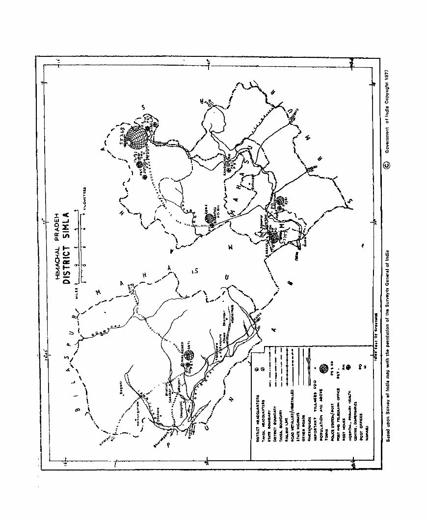
Dlstrr<,t Map
31InJa Sub-TahsIl
Kandaghat TahsIl
Nal:'1garh Tahsil
(VI)
266-267 266-267 269-315 3 6-317
319-32l
Fron'lSplel.l (II)
FaclUg Pclft IR4
211 271
PREFACE IntroductIOn of the DIstnct Census Handdooks III
the census publicatIOn programme, In 1951 Census, was a bIg landmark 10 the hIstory of IndIan Census Smce then these Handbooks are being regularly brought out by the Census Orgamsatlon on behalf of tha State Government. DlstflCt Census Handbooks eon tam Important and baSIC statistics relatlOg of the dlstncts In the State The most Important part of the Handbooks relates to the vIllage-wIse and urban block-WIse Pnmary
Census data-data at the micro level-whIch 18 utIlised III
almost every fIeld of plannmg-educatlOnal, develop
mental, manpower etc. ThiS data IS also used for other Important purposes such as adjustment of AdmInistra
tive boundanes, dehmltatloD of electoral ConstituenCIes etc As such Immed,ately on the completIon of Census the admInistratIve authofltles, pnvate agencIes and academIc lOstJtutlons, 10 fact most data users, are amlous to have the Jatest fIgures made available to
them so that they aTe able to assess and pursue theIr
activities In a more purposeful manner.
In order to make the necessary data available early to the users, a major change has been made 1D
publicatIOn programme of the Dlstnct Census Handbooks of 1971 Census. Instead of mcorporatmg all the information and statIStiCS of a particular DJstnct 10 8
smgle volume, the same has been dIVided mto three parts 'A' 'B' and 'C'-so that parts 'A' and B' contatnIng (l) Village Dmctory and Iown Directory and (II) VIllage-wIse and Tov,n-\\,Ise Pnmary Census Abstracts, could be released early without waltmg for the compilation of data to be Included In part 'C' Ongmally the programme was to bfIog out all the/parts 'A' 'B' and 'C' IDdependently, as soon as comp,lations for a partlcv!ar part were completed SlDce the data for parts 'A' and' B' were compllad simuftaneously, It was deCIded to combine these parts In ODe volume WhICh, I feel, WIll be more conventent to users of Census data to consult as the volume contalOs prImary statlshcs relatlI,g to the dlstnct at one place. The present volume conSIsts
of the parts 'A' and 'B' of DJstTlct Census Hand book of Simla It is proposed to brmg out Part 'C' of this
publIcatIon as also for other DIstricts, Independently, later, because at present the admIDlstratlve mformatlon bas Just started pounng 10 from the Various Government Departments and OrgaDlsatJons. It WIll take some more time to put together these facts and fIgures mto proper shape. for the part 'C' volume.
As a result of reorganisatIOn of the State of Punjab In 1966, 4 dIstricts namely Kangra, Kulu, Simla, and
Labul & SPltl were carved out from Punjab and annexed to the State of HImachal Pradesh raIsIng the· number of dl~trlcts to ten SImla IS, thus, one of the
four new dlstncts 1D the present Census. However, the junsdlctJons of this dlstnct were expanded by mergmg
NaJagarh Tansl!. which was preVIOusly a part of Ambala dlstnct of Punjab Simla dlstnct IS named after the town of that name, whIch 1 s the dIstrIct Headquarter as well as Capital of HImachal Prade'lh Smee Its becommg the seat of Summer Capital of the country III 1864, SImla has acqUired a speCial status 10 the map of tbe
country Now although reduced to the level of a state
Capital-S,mla has acqUIred the posItion of one of the
maIO centrc'I of attraction for the tounsts durmg the summer months, when the place offers salubrIOUS
chmate 10 contrast to the sweltermg heat of the plams I hope that thIS volume Will able to an~wer qlllte a few of the querrJC:s of those who VISIt SImla and want t.) know some thlOg about the Villages and towns of the dlstnct
I would like to e"press my genUine sense of gratitude to S'lrt A. Chandra Sekhar, RegIstrar General and Census CommiSSIoner IndIa, from whom I receIved gUIdance and conSIderatIons most conslstantly Dr B K Roy Burman, Deputy Registrar Gweral, was always helpful 10 solvmg my numerous problems for whIch I feel highly Indebted to hIm.
SIMLA
30th July. 1973
(VII)
ATTAR SINGH
Director of Census Operations, Hzmachal Pradesh.

Acknowledgement of Assistance GENERAL SUPERVISION
1. Shn C D Bhatt
TECHNICAL SUPERVISION
1. Shn C D Bhatt
2. Shn S P Shahl
VILLAGE DIRECTORY
1. Shri Prem Nath Sharma
2. Shn Harbans SIngh
3. Shn S. K Bhandan
4 Shn H L Lohml
5. Shri N C Chakraborty
6. Shn 'Ramesh Kumar
7. Shn Pavan Kumar Ablol
8 Shn Shanta Prasad
9. Shri Ram SlOgh
10. Shn R. D Bali
11. Shrt Chander Mohan Sharma
12. Shn Baldev SlOgh Kashyap
13. Shn Ram Lal
14. Shn Yugdeep Knshan
15. Shn Dhlrender Prasad
16. Shn Bhoop Smgh
17 Shri Rajmder Kumar
18. Mlss Usha Lamba
PRIMARY CENSUS ABSTRACT
1. Shri 0 N Bhutani
2, Shn S. M. Bhatnagar
3. Shn P. C NaIOI
4. Shrl M. S. Negj
Assistant Director of Census OperatIOns
ASsIstant Director of Census OperatIons \
Semor InvestIgator
Statistical Assistant
Statistical AssIstant
Stdtlstlcal ASSIstant
StatIstical ASsI~tant
Computor
Computor
Comput~r
Computor
Computor
ASsIstant ComplIer
Assistant ComplIer
AssIstant Compder
AssIstant Compiler
Assistant CompIler
Assistant Complier
Assistant CompIler
AssIstant Compller
ASSistant ComplIer
TabulatIOn Officer
TabulatIon Officer
StatIstIcal AssIstant
StatIStIcal AssIstant
(viii)
5. Shn T N Bharat StBtlstI.;al ASSliBtant
6 Shn Y C Negl Computor
7. Shn Lalq Ram Vashlsht ASsIstant ComplIer
8. Sh,n Gurdla} S10gh Th.akur AssIstant C3mptler
PREPARATION 01' MAPS
Shrl Kaul 810gh Cartographer
2 Shri Tuka Ram Draftsman
3. Shn Shama Nand Bra!ta Draftsman
TYPING
Shn Glan Chand JUQlor Stenographer
2. Shll Ram DItta Upper DIvIsion Clerk
3 Shri Kapil Kumar TYPIst
4. Shn DJla Ram TypIst
PRINTING
Shrl M. C Jaswal As~lc;tnnt
2. Shn Jagdtsh Chander Gautam Proof Reader
3. Shrt Soba.n Lal Proof Reader
(i~)
FIGURES AT A GLANCE
HImachal Pradesh Simla
State DistrICt
POPULATION TOTAL Person. 3,460,434 217,129
Males 1,766,957 117,819
FemaJes 1,693,477 99,310
RURAL Persons 3,218,544 147,997
Males 1,628,623 77.359
Females 1,589,921 70,638
URBAN Persons 241.890 69.132
Males 138.334 40,460
Females 103,556 28,672
DECENNIAL POPULATION +2304 +2401
GROWTH RATE 1961-71
AREA IN SQ. KM. 55,673.0 1,4160
DENSITY OF POPULATION PER SQ. KM 62 153
SEX RATIO (NUMBER OF FEMALES 958 843
PER 1,000 MALES
LIT tRACY RATE Persons 31 96 38.54
Males 4319 48 35
FQmales 2023 2690
PERCENTAGE OF URBAN POPULATION 6.99 31.84
TO TOTAL POPULATION
PERCENTAGE OF WORKERS TO Persons 3695 3579
TOTAL POPULATION Males 5243 5609
(MAIN ACTIVITY ONLY) Females 20.79 11.72
(x)
FIGURES AT A GLANCE-Conc/d Himachal Pradesh Simla
State DIStrict BREAK-UP OF WORKERS
PERCENTAGE TO TOTAL WORKERS
(I) CULTIVATORS Persons 7064 ~1 08
MaJes 6363 4697
Females 8909 7439
(Ii) AGRICULTURAL LABOURERS Persons 4.17 2.98
Males 420 314
Females 409 2.06
(III) OTHER WORKERS Persons 2519 45.94
Males 3217 4989
Females 682 23~S
PERCENTAGE OF SCHEDULED CASTE Persons 2224 2490
POPULATION TO TOTAL POPULATION Males 22.34 2440
Females 2214 2549
PEI~CENTAGE OF SCHEDULED TRIBE Persons 409
POPULATION TO TOTAL POPULATiON Males 4.01
Females 418
NlJMBER OF OCCUPIED RESIDENTIAL 625,512 39,084
HOUSES
NUMBER OF VILLAGES Total 18,929 1,721
Inhabited 16,916 1,631
Unmhabited 2,013 90
NUMBER OF URBAN AREAS 1 Urban Agglomeration 6
(Comprised of 2 rowns)
and 3-1 Towll:.


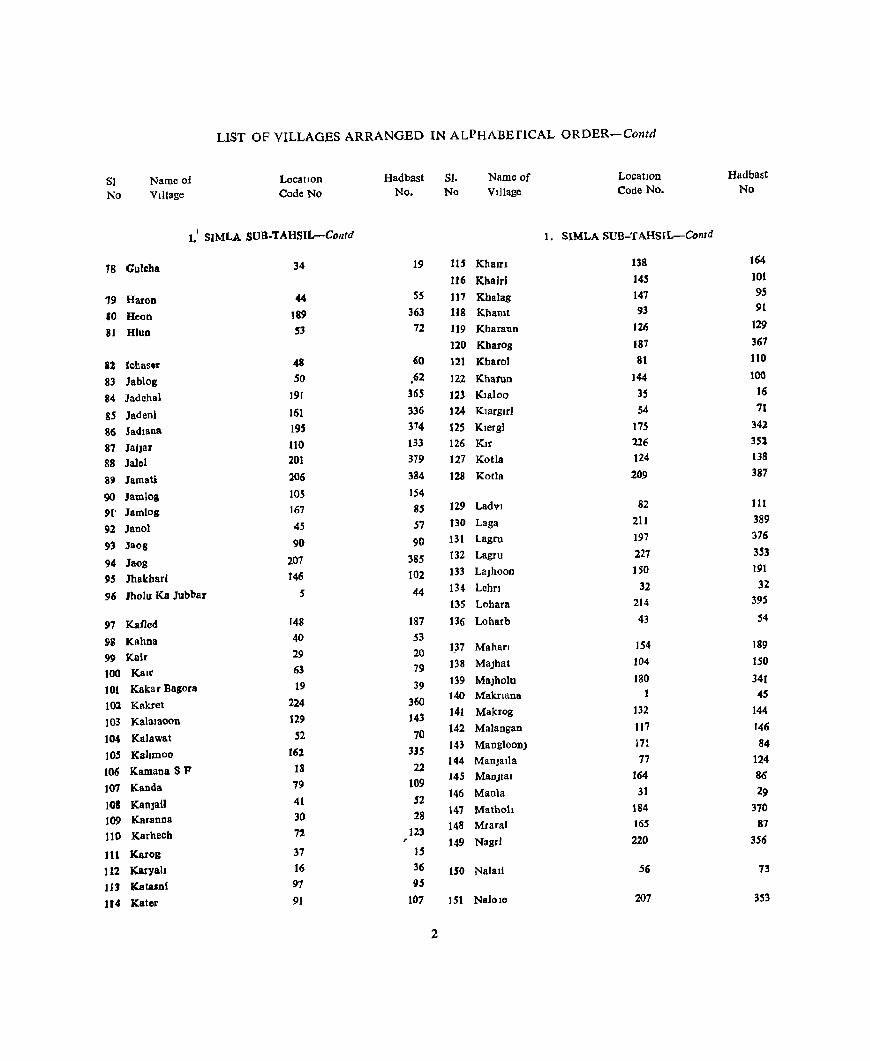
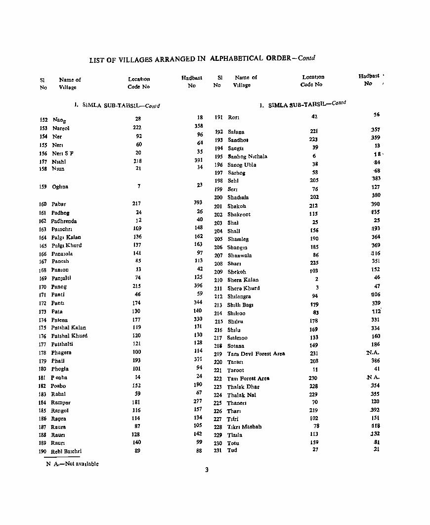
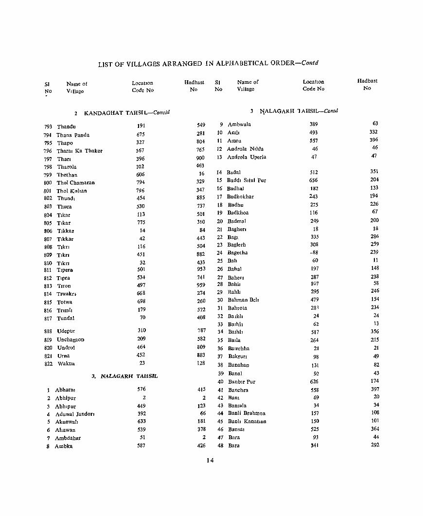
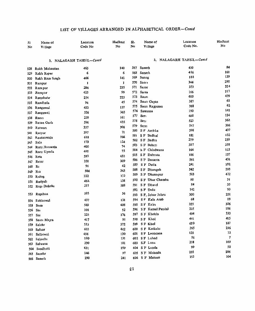
LlST OF VILLAGES ARRANGED IN ALPHABETICAL ORDER-Contd
SI. Name of Location Hadbast SI Name of Location Hadb~sJ.
No VIllage Code No No No Village Code No. No. '.
1 SIMLA SUB-TAHSIL SIMLA SUB-TAHSIL-Contd
AnJ! 57 74 40 Chaog 98 104
2 AnJ! 183 362 41 Chaog 151 192
42 Chaola 9 50
3 BadhawDI 95 92 43 Charond 71 22z
4 Badog 134 lS9 44 Chharah 73 119
5 Badot 170 338
6 Bag 135 161 4S Dhadhol 141 98
7 Bagagh 163 337 46 Dhalla 80 108
8 Bagna 172 343 47- DhaJla 111 147
9 Bagoloo 15 37 48 Dhamun 143 103
10 Bagora Khurd 17 38 49 Dhanall 55 .69
11 Baln 210 388 50 Dhanokhar 176 34'
12 Balahu 69 126 51 Dhanul 188 366
13 Balain 158 195 52 Dhan Bagalri 194 372
14 Balang 155 194 53 Dhan Ghat 196 .375
15 Balaos 168 332 54 Dhenda 64 80
16 Baloh 75 t21 " Dlashn 99 115
17 Banaun 106 149 56 Dohchhna 112 156
18 Banv! 157 196 57 Dohchhnoo 108 1S5
19 Barhawan 127 139 58 Dooh 192 36[
20 Barl 199 377 S9 Dul 198 373
21 Barog 153 188 60 Duml 8 43
22 Barog BarmaDl 123 158 61 Dwat 160 .82
23 Barohl 49 61
24 Bastl Gunana 139 165 62 Fatecbl 51 63
25 Bathun 213 394 63 Fatenchi 88 .89
26 Batlana 203 381
27 Batol 23 31 64 Gadog S P 68 78
28 Bhakoo 22 33 6S Gag 96 93
29 Bharech 47 58 66 Galot 84 117
30 Bhawana 173 333 67 Ganheri 204 382
31 Bhong 33 30 68 Ganped 2()O 378
32 Bhont 26 27 69 Garb Kalan 61 66
70 Garb Khurd 62 ,65 33 BIJ11 186 368
71 Ghararoo 118 J36 34 BIDot 10 51
72 Gharhechl 4 49
35 Chahli Kalan 67 76 73 Ghech f25 145
36 Chahh Khurd 66 75 74 Ghurshali 166 83
37 chamun SF. 36 17 15 Gowahl 216 397
38 Chanan 182 340 76 Gowahl Kalan 131 141
39 Chanari 65 77 77 Gowahl Khurd 121 137
LIST OF VILLAGES ARRANGED IN ALPHABEflCAL ORDER-Contd
81 Name of LocatIOn Hadbast 51. Name of LocatIon Hadbast
No Village Code No No. Na Village Code No. No
1.' SIMLA SUB-TAHSIL-Contd 1. SIMLA SUB-TAHSIL-Colltd
18 Gulcha 34 19 lIS Khalrl 138 164
116 Khairi 145 101
19 Haron 44 55 117 Kbalag 147 95
10 Heon 189 363 118 Khanlt 93 91
81 Hlun 53 72 119 Kharaun 126 129
120 Kbarog 187 367
81 Ichasfi" 48 60 121 Kbarol 81 110
83 Jablog SO . 62 122 Kharun 144 100
84 Jadehal 191 365 12l K!aloa 35 16
85 Jadenl 161 336 124 Klargul 54 71
86 Jadlana 195 374 125 Klergi 175 342
81 Jallar 110 133 126 Kif 226 352
88 Jalel 201 379 127 KatIa 124 138
89 JamaU 206 384 128 Kotla 209 387
90 Jamlog 105 154
91' Jamlog 167 85 129 Ladv) 82 111
92 Janol 45 57 130 Laga 211 389
93 Jaog 90 90 131 Lagru 197 376
94 Jaog 207 385 132 Lagru 227 3S3
95 Jhakharf 146 102 133 LaJhooD 150 191
96 Ihoru Ka Jubbar 5 44 134 Lehrl 32 32
135 Lohara 214 395
97 Kafled 148 187 136 Loharb 43 54
98 Kahna 40 53
99 Kalr 29 20 1.37 Maharl 154 189
100 Kalt 63 79 138 MaJhat 104 150
101 Kakar Bagora 19 39 139 MaJholu 180 341
102 Kakret 224 360 140 Maknana 45
103 Kalalaoon 129 143 141 Makrog 132 144
104 Kalawat 52 70 142 Malangan 117 146
105 KalJmoo 162 335 143 ManglooDJ 171 84
106 Kamana S P 18 22 144 ManJatia 77 124
107 Kanda 79 109 145 MauJla! 164 86
10& KanJaU 41 52 146 ManIa 31 29
109 Karanna 30 28 147 Mathoh 184 370
110 Karhecb 72 123 148 Mearal 165 87
~ 149 Nagr! 220 356
111 Karog 37 IS
112 Karyab 16 36 150 Nalall 56 13
11) ((atalni 97 95
114 Katcr 91 107 151 Nalole 207 353
2
LIST OF VILLAGES ARRANGED IN ALPHABETICAL ORDBR-Contd
SI Name of Location Hadbast SI Name of Location Hadbast •
No VIllage Code No No No Vtllage Code No No
1. SIMLA SUB-TAHSIL-Contd 1. SlMLA SUB_TAHSIL-Contd
28 18 191 Rorl 42 56 152 Naog
153 NareoJ 222 358 :351 192 Salana 221
154 Ner 92 96 359 193 Sandhot 223
ISS Nerl 60 64 13 194 SangtI 39 156 NenSF 20 35 18' 195 Sanhog Nlchala 6 m Nlahl 218 391
38 '84 158 Nlun 21 34 196 Sanog UbJa
197 Sarhoa 58 ,68
198 Sehl 205 "383
15' Oghna 7 23 199 Sen 76 127
200 Shadla1a 202 380
160 Pabar 217 393 201 Sbakoh 212 "390
161 Padhog 24 26 202 Shakroot 115 1l3S
162 Padhrenda 12 40 203 Shal 2S 2S
163 PalDchn 109 148 204 Shall 15<i <193
164 Palgl Kalan 136 162 205 Shamleg 190 364
165 Palgl Khurd 137 163 206 ShanglD 185 '369
166 Panalola 141 97 207 Shanwala 86 i.l16
167 Panesh 85 113 208 Shan 225 351
168 PaDion 13 42 209 Shekoh to] 152
169 PanJaltl 74 125 210 SherB Kalan 2 46
170 Panog 21S 396 211 Shera Khurd 3 47
171 Panti 46 59 212 Shllangra 94 !l06
172 Pann 174 344 213 Shill! Bagl 179 339
173 Pata 130 140 214 Shllroo 83 112
174 Patena 177 330 215 Sbllru 178 331
175 Patshal Kalan 119 131 216 Shtlu 169 334
176 Patshal Khurd 120 130 217 Sialmoo 133 160
177 Patshaltl 121 128 21g Sotana 149 186
178 Phagera 100 114 219 Tara Devi Forest Area 231 :N.A.
179 Phail 193 371 220 Taran 208 386
180 Phogla 101 94 221 Taroot 11 41
181 poaba 14 24 222 Tavl Forest Area 230 .NA.
182 Poabo IS2 190 223 Thalak Dha!) 228 .3S4 183 Rahal 59 67 224 Thalak Nal 229 .3SS 184 Rampur 181 277 225 Thanerl 70 120
ISS Rangol 116 IS7 226 Than 219 .392
186 Rapra 114 134 227 Tlfri 102 151
187 Raura 87 105 228 Tlkn Mashab 78 !IlS
188 Raurl 128 142 229 Tlada 113 J32
189 Raun 140 99 230 Totu 159 .81
190 Rehl Balchri 89 88 231 Tud 27 21
N A.-Not available 3
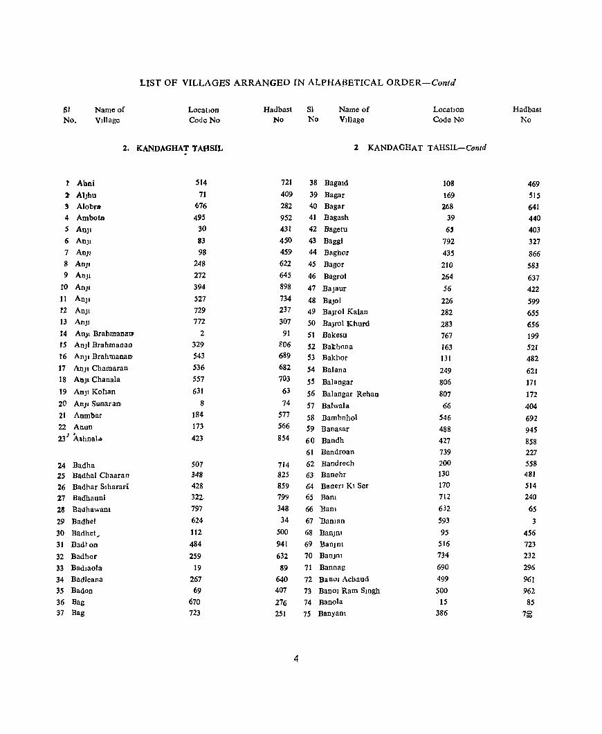
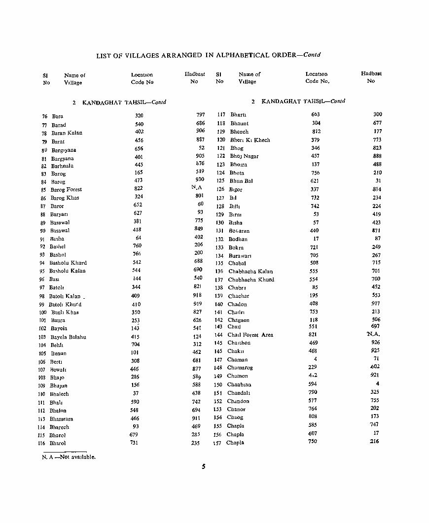
LIST OF VILLAGES ARRANGED IN ALPHABETICAL ORDER-Contd
~l
No. Name of VIllage
LocatIon Code No
2. KANDAGHAT TAHSIL
1: Ahni
2- AIJhu
3 Alobr&
4 Ambotl!ll
5 An]1
6 AnJI
7 AnJI
8 AnJI
9 AnJI
to AnJI
11 An]1
tZ AnJI
13 AnJI
14 AnJI Brahmanao
15 AnJI Brahmanan
t6 An]1 Brahmanan
17 AnJ! Chamaran
18 AnJl Chan ala
19 AnJ! Kohan
20 AnJI SunaraIli
21 Anmbar
22 Anun
23 J ).shnald<
24 Badha 25 Badhal Cbaaran
26 Badhar Slharari
27 Badhauni
28 Badhawam
29 Badhel
30 Badhet,
31 Eadton
32 Badhor
33 Badlaola
34 BadJeana
35 Badon
36 Bag 37 Bag
514
71 676 495
30
83
98 248 272
394 527 729 772
2 329 543 536
557
631
8
184 173
423
507 348 428 322-797
624 112
484
259
19 267 69
670 723
Hadbast No
721
409 282
952 431 450 459 622
645 898
734 237 307 91
S06 689 682 703
63
74 577 566
854
714 825 859
799 348 34
500
941
632 89
640
407
276 251
4
SI No
Name of VIllage
LocatJOD Code No
2 KANDAGHAT TAHSIL-Contd
38 Bagald
39 Bagar
40 Bagar
41 Bagash
42 Bagetu
43 Baggl
44 Baghor
45 Bagor
46 Bagrol
47 Ba]aur
48 BaJol
49 BaJro! Kalan
50 BaJro! Khurd
51 Bakesu
52 Bakhona
53 Bakhor
54 Balana
55 Balangar
56 Balangar Rehan
57 Balwala
58 Bambnhol
59 Banasar
60 Bandh
61 Bandroan
62 Bandcech
63 Banehr
64 Banen Kl Ser
65 Bam
66 Bam
67 'Baman
68 BanJfil
69 Ban]D1
70 BanjOI
71 Bannag
72 Bano! Achaud
73 Banol Ram Smgh
74 Banota
75 Banyam
108 169 268
39 65
792 435 210
264 56
226 282 283 767 163 131
249 806 807 66
546 488 427 739
200 130 170 712
632
593 95
516 734 690 499 500
15 386
Hadbast No
469 515 641 440 403 327
866 583
637 422
599
655 656 199 521 482
621 171
172
404
692 945 858 227 558 481 514 240
65
3
456 723
232
296 961
962 85
7~
LIST OF VILLAGES ARRANGED IN ALPHABETICAL QRDER-Contd
SI Name of LocatIOn Hadbast Sl Name of Location Hadbast
No Village Code No No No Village Code No. No
2 KANDAGHAT TAHSIL-Contd 2 KANDAGHAT TAHSIL-Contd
76 Bara 320 797 117 Bhartl 663 300
77 Barad 540 686 118 Bhaunt 304 1)77
78 Baran Kalan 402 906 119 BheDch 812 177
79 Barat 456 887 120 Bhen Kl Khech 379 773
SO Barglyana 656 52 121 Bhog 346 .823
81 Bargyana 401 905 122 BhoJ Nagar 457 .888
82 Barhnala 445 h76 123 Bholra 137 488
83 Barog 165 519 124 Bhota 756 210
84 Barog 473 930 125 Bhun Bal 621 31
85 Barog Forest 822 N.A J26 Bigor 337 -814
86 Barog Khas 324 801 127 BII 732 234 87 Baror 652 60 128 Bllh 742 224 88 Baryan 627 93 129 BlrDl 53 419
89 Basawal 381 775 130 Blsha 57 423 90 Basawal 418 849 131 Botaran 440 871
91 Basha 64 402 132 Bodhan 17 87 92 Ba,hel 760 206 133 Bokra 721 249 93 Bashol 766 200 134 Burawan 705 267 94 Basholu Khurd 542 688 135 Chabal 508 715
95 Ba~holu Kalan 544 690 136 Chabhacha Kalan 555 701
96 BaSI 144 540 137 Chabhacha Khurd 554 700
97 Batoh 344 821 138 Chabfl 85 452
98 Batoh Kalan 409 918 139 Chachar 195 553
99 Batoh Khurd 410 919 140 Chad on 408 917
100 Bauh Khas 350 827 141 Chactn 753 213
101 Baura 253 626 142 Chagaon 118 506
102 Bayela 143 541 143 Chml 551 697
103 Bayela Balahu 415 124 144 Chad Forest Area 821 'N.A.
104 Behh 704 312 145 Challhon 469 926
lOS Benun 101 462 145 Chakll 468 925
106 BertI 308 681 147 Chaman 4 71
107 Bewail 446 877 148 Charnarog 229 ..602
108 BhaJo 216 589 149 Chamon 4.2 921
109 BhaJun 156 588 150 Chanbmn 594 4
110 Bhalech 37 438 151 Chandah 790 325
III Bhall 590 742 152 Chdndon 577 755
112 Bhalon 548 694 153 Chanor 764 202
113 Bhamrara 466 911 154 Chaog 808 173
114 Bharech 93 469 155 Chapla 585 747
115 Bharol 679 285 156 Chapla .(;07 17
116 Bharol 731 235 157 Chapla 750 216
N. A -Not available.
LIST OF' VILLAGES ARRANGED IN ALPHABElICAL ORDER- Contd
SI No
Name of VIllage
Location Code No
2 KANDAGHAT T AHSIL-Contd.
158 Charagser
159 Charoha
160 Chataira 161 Chauki
162 Chawat
J63 Chewa
J64 Chewa Khasl
J65 Chhahar 166 Chhaosha
167 Chharanj1
168 Chharol
169 Chharoh
170 Cbharot
171 Cbhob
172 Cbhobal
173 ChlaUnI
174 Chlknahat
175 Chlla Kalan
176 Chtla Khurd
177 Cbtln 178 ChiDl
179 Chohra 180 Chuancha 181 Chund
182 Dabh
183 Dabloc 184 Dabrhcch
185 Dadhog
186 Dadhol Kalan
187 Dadhol Khurd 188 Dadhon 189 Daeyan
190 Daghll
191 Daghota 192 Dahar
193 Dahl 194 Dahrol
195 Dalra t5l6 Qal
147 681
582 75
424
591
316
562
634
335
532
613
460
140 315 604
735
263
260 266
660
77 413
9
389 745 182
430
517 518
773 463
134 321 123
717
340
633
406
Hadbast SI No. No.
Name of VIllage
Location Code No
2. KANDAGHAT TAHSIL-Contd.
537
287
750 413
855
1
793
708 66
812
739
23
891
491
792 14
231
636
633
639
55 476
922
76
783
221
575
861
724 725 308 908
485 798 511
245 817
64
915
197 Dalyar
198 Damdar
199 Damehr
200 Damla Kala n
201 Damla Khurd
202 Damrog
203 DaDgayar
204 Danghlart /
205 Dangrl
206 Dannal 207 Daonh 208 Daran
209 Darana
210 DaranJh Kalan 211 Daria
212 Daul 213 Debm 214 Ded
215 Ded
216 Deephagan
217 Dehart 218 Dehun
219 Delgl
220 Deothal 221 Derh
222 Dewar
223 Deyargrl 224 Dhako 225 Dhako
226 Dhala
227 Dhah
228 Dhamorl
229 Dhamran
230 Dhanaurl
231 Dhandon 232 Dhanen 233 Dhar
234 Dhar 235 Dharan
236 Dharara 237 Dhar Banar
6
234 132
635 571
570
242
493
552 289
699
799 251
142
262 185
295 738 443 525
345 537
279
728
600 45
352
284
176 328
21
565
547 217
664 777 692 180
393 189 426 453
Hadbast No
607 483
70 761
762
615
950
698
662
261
350 624
542 635
578 668 228 874
732
822
683
652
238
10 446
829 657 569 80S
80 711
693 590
301 312 298 634
897 547
857 884

LIST OF VILLAGES ARRANGED IN ALPHABETICAL ORDER-Contd
SI Name of Location Hadbast SI Name of LocatIOn HadbllSt No Vdlage Code No No No VIllage Code No No:
2. KANDAGHAT TAHSIL-Conld 2 KANDAGHAT TAHSIL-Comd'
238 Dhar Brahmanan 665 302 276 Galang 241 614
239 DharDawan 203 561 277 Gahyana 354 831
240 Dhar Hah 296 669 278 Galog 277 650
241 Dhann 770 305 279 GamJun 695 257
242 Dharka NaJlan 666 303 280 Gandhol 561 707
243 Dharkl Balf 569 763 281 Gandhol Khas 511 718
244 Dharkl Ser 103 464 282 Gandron 20 79
245 Dharampuf 374 768 283 Gara 292 665
246 Dharog 204 562 284 Gara 648 40
247 Dharol 798 349 285 Garkhal 157 527
248 Dharoon 199 557 286 Garkhal 306 713
249 Dharon 369 846 287 Garog 193 551
250 Dharotl 96 457 288 Garog Khas 221 594
251 Dharyan 74 412 289 Oaru 7 57
252 DhIlun 325 802 290 Oaryan 519 726
253 Dhomen 27 428 291 Gatogra 441 872
254 Dmrag Bokhar 205 563 292 Gatol 148 536
255 Dlhan 58 424 293 Gatoh 458 889
256 Dlhun 28 429 294 Gauhra 125 513
257 Dlyawla 769 197 295 Gaul 312 789
258 Doehl Chamaran 709 271 296 Gawah 365 842
259 Doh 757 209 297 Ghalr 638 -67
260 Doldoen 294 667 298 GhalatJ 48 449
261 Doongl Beshkl 459 890 299 Ghamarara 372 766
262 Dnthl 596 6 300 Ghamaron 442 873
263 Dcan]a vcr Dhaptan 255 628 301 Ghar 578 754
264 DranJh Khurd 261 634 302 Ghanan 707 269
265 Duan 158 526 303 Ghanana 576 756
266 Dugan 718 246 304 Gharog 235 608
267 Duntt 90 466 305 Gharsl 222 595
268 Dunu 91 467 306 Ghacs! Kunana 524 731
269 Dyanda 636 69 307 Ghart! Kalan 384 778
308 Ghartl Khurd 382 776
270 Fagoh 779 314 309 Ghash Barana! 383 717
271 Fangol 669 275 310 Ghat Kamala 736 230 311 Ghatkl Balr 568 764
272 Gaddon 614 24 312 GhattJ 307 680 273 Gader 397 901 313 Ghewa 107 495 274 Gadhog 649 49 314 Ghlyaleh 704 266
275 Gamh 129 480 315 GhorI 711 273
7
LIST OF VILLAGES ARRANGED IN ALPHABETICAL QRDER-Contd.
51 Name of Location Hadbast SI' Name of LocatIon Hadbast
No Village Code No. No No Village Code No. No.
2 KANDAGHAT TAHSIL-Contd 2. KANDAGHAT TAHSIL-Contd
316 Gog 651 61 354 Jallehath 332 809
317 Goras 655 57 355 Jalyana 465 910
318 Gram 127 478 356 Jandaun 476 933
319 Guman 492 949 357 Jangal Kathl 644 35 358 Jangeshu 503 955
320 Halda 438 869 359 Jangna 420 851
321 Haman! 783 783 360 Jatoh 230 603
322 Harasldal 696 258 361 Jauna 202 560
323 Han Ka Khel 496 958 362 Jehar 450 881
324 Harlpur 309 786 363 Jehar 612 22
325 Hanpur 686 292 364 Jekhn 776 311
326 Hathun 36 437 365 Jethna III 499
327 Hlmmatpurdabl i 318 795 366 Jha]ha Khas 84 451
328 Hmar 119 507 367 JhoJhon 338 815
329 Hlwan Kalan 805 170 368 JJara 602 12
330 Hlwan Khurd 804 169 369 Jlhun 587 745
331 Hokal 105 493 370 Jodhpur 489 946
332 Hurang 560 706 371 Jogan 339 816
372 Johar Pallala 370 847 333 Ishewa 720 248 373 Jola Jaran 291 664
334 Jabal 247 620 374 Jonh 575 757
335 Jabal 343 820
336 Jabal 455 886 375 Kaba Dhargora 439 870
337 Jabal Jamrot 239 376 Kaba Kalan 419 850
727 377 Kadaur 90 338 Jabal Rashesh 360 837 378 Kadela 126 477 339 Jabli 232 605 379 Kadhar 41 442 340 Jabh 302 675 380 Kadhasl Kalan 152 532 341 Jadhal 110 498 381 Kadhasl Khurd lSI 533 342 Jadeana 802 167 382 Kadml 490 947 343 Jadla 598 8 383 Kadon 545 691
344 Jadh 724 252 384 Kagan 244 617
345 Jagota 691 297 385 Kahla 800 94
346 Jahana 336 813 386 Kahno 550 696
347 Jalfagb 672 278 387 KahranJe 197 555
348 JaJhar 461 892 388 Kallayar 285 658
349 Jakb 531 738 389 Kam Thn 313 790
350 Jakhed 133 484 390 Kalsu 755 211
351 Jakhraon 758 208 391 Kakara 751 215
352 Jakhroh 475 932 392 Kakarhath 597 7
353 Jalkhara 153 531 393 Kalari 363 840 \
8

LIST OF VILLAGES ARRANGED IN ALPHABETICAL ORDER-Contd
Sl No
Name of Village
Location Code No
2 KANDAGHAT TAHSIL-Contd
394 Kalawan
395 Kalhech 396 Kah Kamhar 397 Kalog 398 Kalog 399 Kalog
400 Kalor 401 Kalth
402 Kalthl Chamaran
403 Kalthl Handutt
404 Kalthl Kanaltan 405 KaIthl Molu 406 Komara
407 Kamhala
408 Kambah 409 Kamlanchard
410 Kamhar 411 Kamllgaon
412 Kamlog
413 Kamthan Kalan
414 Kamthan Khurd
415 Kamyan
416 Kanah
417 Kanah 418 Kanalr
419 Kanalthan
420 Kanana
421 Kanaufl 422 Kanda 423 Kanethl
424 KaogtI 425 Kanguka Thara
426 Kamara
427 Kan5hl Pat a
428 Karauh 429 Kasauh 430 Kashmarl
431 Katal
432 Katal Kathar
~ 433 Kathlala
391 392 810
43 72
417 181 403
674 677
673 678 719 63
737 347 754 491
434
523 522
803 104 186 820
708 425
114 558
398
645
588 671 740 414
54
6
515 351
275
Hadbast SI. No No
Nameof Village
LocatIOn Code No
2 KANDAOHAT TAHSIL-Collid
785 896 175 444 410
895 574
907 280 283
279 284 247 401 229 824 212 948 865
720
729
168
492 544
185 270
856
502 704 902
37
744
277 226 923 420 73
722
828 648
9
434 Kathlar
435 Kathlaru
436 Kathla 437 Kathla 438 Kathh 439 Kathh
440 Katbyar
441 Katm
442 Kaloh
443 Kattal Ka Bagh
444 Kawah Ka Kheel
445 Khadoh
446 Khatri
447 KhaIrl 448 Kham 449 KhaJan 450 Khalantl
451 Khah 452 Khalogra
453 Khalwa
454 Khamaron
455 Khandar 456 Khanl Ghaggar
457 Khanog Khas
458 Khanoh
459 KharanJI
460 Kharkl
461 Kharkog
462 Kharog
463 Kharog
464 Khll 465 Khl!
466 KhlOna 467 Khobal
468 Klar
469 KJarad 470 Klarl
471 Klartu 472 Klarua 473 Klyar
726 556
87 553
5
59 449
589 24
533 528 510
622 629 694 811 366
319 330
710 400
250
693 239 771
136 706 218 139 563
31 t 317
97 526 231
387 26 55
472
293
Hadbast No
254 702
454 699
72
425 880
743,
127
740
135
117
32
46
256
176 843 796 807
272
904 623 255 612 306 487 268 5~1
490 709
788
794
458 733
604
781 427 421 929 666

LIST OF VILLAGES ARRANGED IN ALPHABETICAL ORDER-Contd ~ , .
SI No
Name of Village
LocatIOn Code No
2. KANDA~HAT T AHSIL-Contd
474 Klyar
475 Klyarlu
476 Klyarlu
477 Kohan
478 Kohla
479 Kona Kalan
480 Kona Khurd
481 Koron
482 Korun
483 Kut
484 Kot
485 Kot
486 Kot
487 Kot
488 Kothl
489 Kothi
490 Kothl 491 Kothl Deora
492 Kothl Kalan.
493 Kothon
494 Kothron 495 Kot! Khurd
496 Kot Khas.
497 Kotia
498 Kotia 499 Kotla
500 KOlla
~Ol Kotla
502 Kotla
503 Kotia
504 Kuarag 505 Kulhan
506 KumharrlJ.
507 Kun
508 Kundala
509 Kundla 510 Kundla
511 Kundla
512 Kurgal
513 Lachhog
538
303
359 52 80
447 448
79 314
33
16
791 92
74t 6('8
183
643
299
252
256
444 238
520 51
161 227 356
13
539
559
34 581
641
647
254
223
702 701
121
12
Hadbast SI. No No
Name of VlIlage
Location Code No
2. KANDAGHAT T AHSIL-Conld
684
676
836
418 473
870
879
474
791
434
86
326
468
225 18
576
36
672
629
629 875
611 727
417 517
600
833
83
685
705
415 751 42
38
627
596
264 263
509
82
514 Ladlt
515 Lado
516 Lagasan
517 Lahan
518 Lahlana
519 Lakhar AnJI
520 Lawl Kalan
521 Lawl Khurd
522 Lohan]I
523 Loharon
524 Loon
525 Lunsn
526 Mahah
527 Mahl
528 Mahlyan
529 Mahlog ~30 Mahog
531 Mahog
532 Mahseon'
533 Mahon
534 Mahuhn
535 MaJhar
536 MaJhgaon Kalan
537 MaJhgaon Khurd
538 MaJhlon
539 MaJhol
540 MaJhol
541 MaJhoh
542 MaJholtl
543 MaJragarl
544 Maklyan
545 Malga
546 Malgl
547 Maltah
548 Maltu
549 Mamlara
550 Mamhg
551 ManaJI
552 Mandap
553 Mangna
10
785
331 146
166
809
160
287
286
326
306 703
680
38
44
462
194 82
765
353
106
584
367
258
257
362
483
630 355
618
207
11
653
626 395
385
198
'i52
265
599
639
Hadbast No
320
808
538
518
174 524
660
659
803
679
265
286
439 445
893
552 471 2UI 830
494 748
844
631
630
839
940
62 832
28 580
78
59
48
899 779
556
214 638
9
44
LIST OF VILLAGES ARRANGED IN ALPHABETICAL ORDER-Conld
SI No
Name of Village
Location Code No
2 KANDAGHAT TAHSIL-Contd
554 Manjat
555 Manjathru
556 ManJhar
557 Manjhari
558 Manohtlkn
559 Manun
560 MarkanaJ
561 Marog
562 Masha
563 MashiOr
564 Masna Majhgaon
565 Matemun
566 Matlwal
567 Maun
568 Mehlon
569 Mehlon 570 MlhaDi
571 Mlun 572 Molo Kalan
573 Molo Khurd
574 Mondru 575 Mundhu Kalan
576 Mundhu Khurd
577 Mungru
578 Nabon 579 Nagah
580 Nagah 581 Nagal!
582 Nagah 583 NaganJI 584 Nagaon
585 Nagoltl
586 Nahar
587 Nahara
588 Nahech Khas
589 Nam 590 Nakalyar
591 Nalka Gaon 592 Nandal
593 Nandho
594 Naog
817
683
697 795 150 188
611
436 774
154 206 763
240 274 368 . 480
81
422 236 237 592 815 814 305
477 109 162 224 273 211
49
819 88
73 -" 342 646
405 22
214 220 124
Hadbast No
182
289
259
346 534 546 21
867 309
530
579
203 613 647 845
937 472
853 609
610 2
f80
179
678
2}4 497
522 597
646 584 415 184 455
411
819 39
914
81 587 593 512
81 No
Name of Village
Location Code No
2 KANDAGHAT TAHSILr-Contd
595 NaoDi Majhgoan
596 NaralDi
597 Narood
598 NatalIa
599 Nauhra
600 Nawah
601 Ner
602 Nen
603 Nefl
604 Nefl Kalan
605 Nen Kalan
606 NefI Khurd
607 Neri Khurd
608 NlRta
609 NlUn
610 Oall
611 Ochh
612 Odar
613 Odna
614 Olgl
615 Ona
616 Padgal
617 Padhan
618 Padli
619 Palll 620 Pajaah
621 Pajhe 622 Pajlana
623 Palashta Panehrol
624 Panewa
625 Panewa
626 Panog Damkn
627 Panu Kathalan
628 Panuh ChhIbra
629 Paplol
630 Paratha
631 Parotha
632 Pathla
633 Pathl3 634 Pathru
11
2011 474 100 793
120 529
168
640 759
358 432 357 431 716 778
404 219 437 245 610 388
278
212 637
733 76
178 617 746 201 485 190 619 615 658
470 47
380 564 284
Hadbast No
581
931 461 328 508
736 516
43 207
835 863 834 862 244 313
913 592 886 618
20 782
651 585 68
233 414 571 27
220 559 942 548
29 25 51
927
448
774 710 290

LIST OF VIU AGES ARRANGED IN ALPHABETICAL ORDER-Confd
SI Name of LocatIOn Hadbast SI Name of LocatIon Hadbasl
No VIllage Code No No No Village Code No No
2. KANDAGHAT TAHSIL-Contd 2. KANDAGHAT T AHSIL-Contd
635 Patl Brahmanan 300 673 674 Saharrl Brahmanan 378 772
636 Pat! KOIiao 301 674 675 Saharn Chamaran 376 770
637 Patta 390 784 676 Sahrn Mushmana 375 769
638 Phagala 722 250 677 SaID] 35 436
639 Pbagu 159 525 678 SaID) 228 601
640 Phalabl 192 550 679 Salr 816 181
641 Pbangan 213 586 680 Sam 787 322
642 Phashkna 187 545 681 Sam 667 304
643 Plratha Kalan 688 294 682 Sakon 64 470
644 Plratha Khurd 689 295 683 Sakret 788 323
645 Plah 650 50 684 Salahl 99 460
646 Plam KI DhalJ 290 663 685 Salana 657 53
647 Poabo 789 324 686 Salanl 18 88
648 Poash 78 475 687 Sahyana 509 716
649 Podoa 661 56 688 Samo! 512 719
689 Samut 801 166
650 Rabaun 271 644 690 San ana 411 920
651 Rachhana 3 92 691 Sanarn 521 728
652 Regeon 174 567 692 Sanawag 700 262
653 Rahan 297 670 693 Sanawal 177 570
654 Rahana 628 45 694 Sanawar 535 396
655 Rahed 117 505 695 Sandhg 486 943
656 Ra)lmon 625 47 696 Sandrol 288 661
657 Rakhog 662 299 697 Sa net 761 205
658 Rampur 333 810 698 Sangar 161 523
659 Ranhog 659 54 699 Sanglrana 782 317
660 Raro Pand 373 767 700 Sanhech 46 447
661 Ratbal 392 903 701 Saohol 233 606
662 Raura 67 405 702 Saohol 513 720
663 Raurh 713 241 703 SanJara 298 671
664 Raurbi 583 749 704 Sanog 421 852
665 Rawm J45 539 705 San 433 864
666 Rayana 595 5 706 Satha 429 860
667 Reh Ka Katal 138 489 707 Satrol 743 223
668 Rehon 349 826 708 Satrol 471 928
669 Rihun 730 236 709 Sehal 196 554
670 Rog 642 41 710 Senchra 31 432
671 Rugru 818 183 711 Sen) SO 416
672 Rugta 10 77 712 Seola 172 S6S
673 Runan Gohron 323 800 713 Seola Baratl 479 936
12
LIST OF VILLAGES ARRANGED IN ALPHABETICAL ORDBR-Contd
SI Name of Location Hadhast SI Name of Location Hadbast
No Village Code No No No Village Code No No
2 KANDAGHA T TAHSIL-Contd 2 KANDAGJIAT TAHSIL--Confd
714 Seontbal 246 619 754 SblOr 623 33
71S Sbadhal 61 399 755 ShiV Shankar Garh 749 217
716 Shaee 541 687 756 Shoboru 364 841
717 Shak 687 293 757 Shogl Bhag Wanpur 478 935
718 Shakeg 86 453 758 Shumh 276 649
719 Shalaura Kalan 50S 957 759 SIBula 135 486
720 Sbalaura Khurd 504 956 760 Sihararr 281 654
721 Shalawen 2S 426 761 Sllhar 29 430
722 Shaleg Joglan 780 lIS 762 Sohal 620 30
723 Shalog Kohan 781 316 763 Srharrl Kolian 377 771
724 Shalt! Kalan 502 954 764 SrlOagar 40 441
725 Shalu Khurd 498 960 765 Sudharag 654 58
726 Shamlhech 270 643 766 SU]Dl 715 243
727 Shamlhech 341 818 767 Sulah Brahmanan 747 219
728 Shamlog 361 838 768 Sulah Kohan 748 218
729 Shamror 175 568 769 Sultanpur 334 811
730 Shamtt 243 616 770 Suna Khurd 89 465
731 Shangn Kalan 579 753 771 Sungal 60 398
732 ShaDgn Khurd 580 752 772 Sunkl 786 321
733 Shaprun 280 653 773 Sunnu 141 543
734 Sharanun 269 642 774 Sur 62 400
735 Sharar 467 912 736 Sharara Kl Nail 605 IS 775 Tall I 768 198
737 Sharaun 171 564 776 Taryusl 572 760
738 Sharaun 407 916 777 Takrana 122 510
739 Sharaun Bona 164 S2() 778 Takrota 482 939
74() Sharer 813 178 179 Taksal 494 951
141 SharI ana 609 19 780 Talar 685 291
742 Shala 371 848 781 Talauna 601 11
743 Shalr 481 938 782 TanaJI 115 S03
744 Shaunh 487 944 783 Tangn 616 26
745 Shawar 586 746 784 Taro! 416 894
746 Sheel 215 588 785 Tataul 714 242
747 Sheera 725 253 786 Tatbol 225 S9i
748 SbJl 603 13 787 TaWil Talora 149 53S
749 ShIlar 566 712 788 Teh!u 128 479
750 Shih Kalan 574 758 789 Than 762 204
751 Shih Khurd 573 759 790 Tbana 682 288
752. Shillru 744 222 791 Thana 549 695
753 ShJl Shamlog 155 529 792 Thana Balola 68 406
13
LIST OF VILLAGES ARRANGED IN ALPHABETICAL ORDER-Contd
51 Name of LocatIon Hadbast Sl Name of Location Hadbast
No Village Code No No No Village Code No No
2 KANDAGHAT TAHSI L-Collcld 3 1'{ALAGARH 1 AHSIL-Contd
793 Thandu 191 549 9 Ambwala 389 63
794 Thana Panda 675 281 10 Amh 493 332
795 Thapo 327 804 11 Amru 557 396
796 Tharal Ka Thaker 567 765 12 Aodrola Nlhla 46 46
797 Than 396 900 13 Androla Uperla 47 47
798 Tharola 102 463
799 Thethan 606 16 14 Badal 512 351
800 Thol Chamaran 794 329 15 Baddl Sital Pur 656 204
801 Thol Kohan 796 347 16 Badhal 182 133
802 Thundl 454 885 17 Badhokhar 243 194
803 Thura 530 737 18 Badhu 275 226
804 Tlkar 113 501 19 Badkhoa 116 67
805 Tlkar 775 310 20 Badmal 249 200
806 Tlkkar 14 84 21 Bagherl 18 18
807 Tlkkar 42 443 22 Bagl 335 286
808 Tlkn 116 504 23 Bagierh 308 259
809 Tlkn 451 882 24 Bagotha ~88 239
810 Tlkn 32 433 25 Bah 60 11
811 Tlpera 501 953 26 Bahal 197 148
812 Tlpra 534 741 27 BaheT! 287 238
813 Tlron 497 959 28 Bahh 107 58
814 Tlwakn 668 274 29 BahIt 295 246
815 Totwa 698 260 30 Bahman Beh 479 154
816 Tnmh 179 572 31 Bahrota 281 234
817 Tundal 70 408 32 Balhh 24 24
33 Balhh 62 13 818 Udepur 310 787 34 Balhh 517 356
819 Unchagaoll 209 582 35 Balla 264 215 820 Undrol 464 S09 36 Balrchha 21 21 821 Urna 452 883 37 Bakrun 98 49 822 Wakna 23 128 38 Banahan 131 82
3. NALAGARH TAHSIL 39 Banal 91 43
40 Banblr Pur 626 174
1 Abharnt 576 415 41 Banchra 558 397
2 Abhipur 2 2 42 Bant 69 20
3 Abhlpur 449 123 43 Bantala 34 34
4 Aduwal Jandorl 392 66 44 Banli Brahmna 157 108
5 Akanwah 633 181 45 Banh Kanatlan 150 101
6 Allawan 539 378 46 Bansal 525 364
7 Ambdahar 51 2 47 Bara 93 44
8 Ambka 587 426 48 Bara 341 292
14
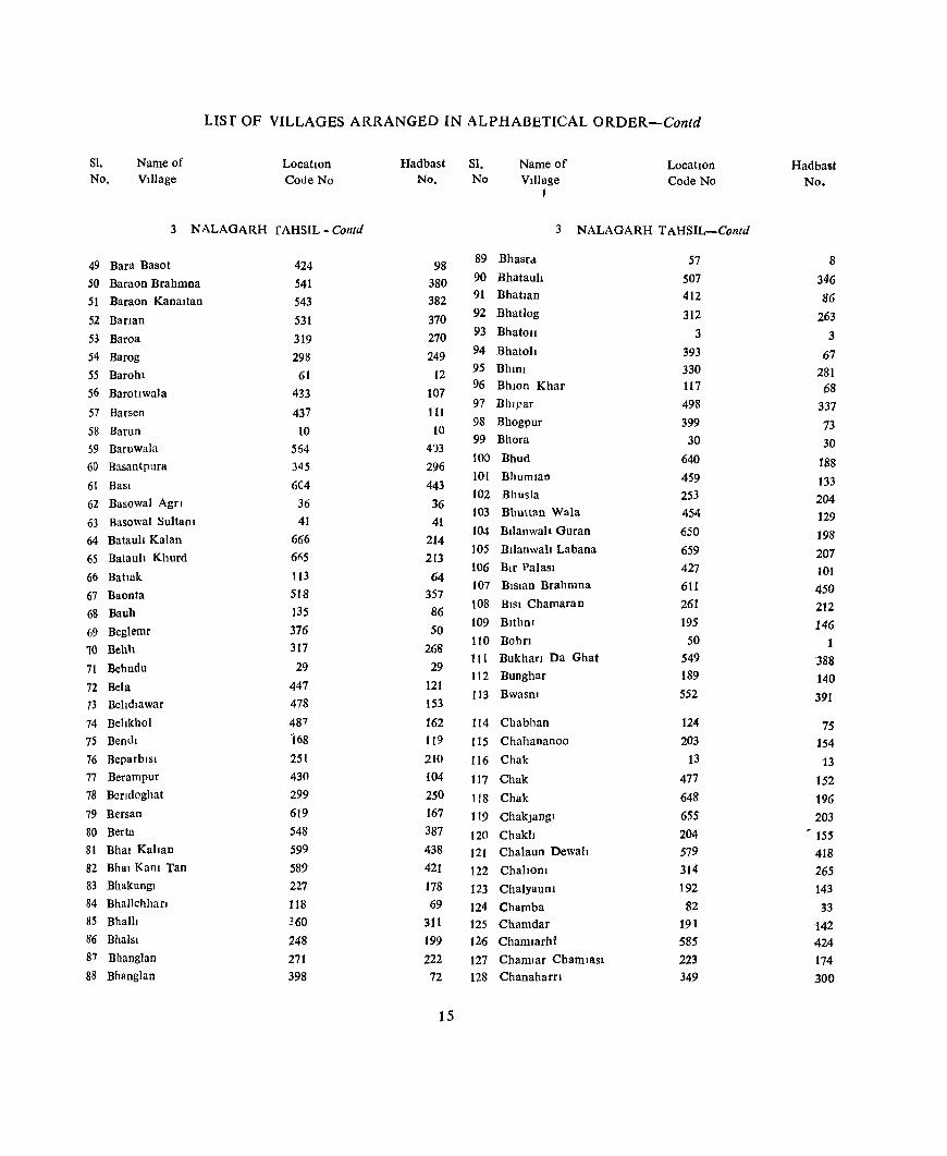
LIsr OF VILLAGES ARRANGED IN ALPHABBTICAL ORDER-Contd
Sl. No.
Name of Village
LocatIOn Code No
3 NALAGI\RH fAHSIL - Contd
49 Bara Basot
50 Baraon Brahrnna
51 Baraon Kanaltan
52 BarIan
53 Baroa
54 Barog
55 Barohl
56 Barottwala
57 Barsen
58 Barun
59 Baruwala
60 Basantpura
61 BasI
62 Basowal Agn
63 Basowal Sultant
64 Batauli Kalan
65 Batauh Khurd
66 Battak
67 BaoDta
68 Bauh
69 Beglemr
10 Behlt
71 Behndu
72 Bela
73 Behdlawar
74 Behkhol
75 Dendi
76 Beparblsl
77 Berampur
78 Bendoghat
79 Bersan
80 Berta
81 Bhal Kahan
82 Bhal Kam Tan
83 Bhakungl
84 Bhallchhan
85 BhalIJ
86 Bhaisl
87 Bhanglan
88 Bhnnglan
424
541
543
531
319 298
61 433
437 10
564 345
604 36
41
666 61>5
113
518
135
376 317
29
447 478
487
168
251
430 299
619 548 599
589
227 118
360
248 271 398
Hadbast No.
98
380 382
370 270 249
12
107
111
10
413 296
443 36
41
214
2[3
64
357 86
50 268
29
121
153
162 119
2[0
104
250 167 387 438
421
178 69
311 199
222
72
15
SI. No
Name of Village
t
LocatIon Code No
3 NALAGARH TAHSIL-Contd
89 Bhasrd
90 Bhatauh
91 Bhatlan
92 Bhatlog
93 Bhatoll
94 Bhatoh
95 BhInI
96 BhlOn Khar
97 Bhl]:'ar
98 Bhogpur
99 Bhora
[00 Bhud
101 Bhumlan
102 Bhusla
103 Bhuttan Wala
104 Bllanwah Guran
105 BIIanwah Labana
t06 Blr Palasl
107 BIS13n Brahmna
t08 BISI Chamaran
109 Blthm
tiD Bohn
111 Bukhan Da Ghat
112 Bunghar
113 Bwasm
114 Chabhan
115 Chahananoo
116 Chak
117 Chak
118 Chak
119 ChakJangl
120 Chakh 121 Chalaun Dewah
122 ChahoUl
123 ChalyauUl
124 Chamba
125 Chamdar
126 Chamlarhi
127 ChamIar Charnlasl
128 Chanaharn
57 507 412
312
3 393
330 117
498
399 30
640
459
253 454
650
659
427 611
261
195
50
549
189 552
124
203
13
477
648
655
204
579
314 192
82
191
585
223
349
Hadbast No.
8
346
86
263
3
67
281 68
337
73 30
J88
133 204
129
198 207 101
450 212 146
1
388
140
391
75
154
13 152
196
203 - ISS
418
26S
143
33
142 424
174 300
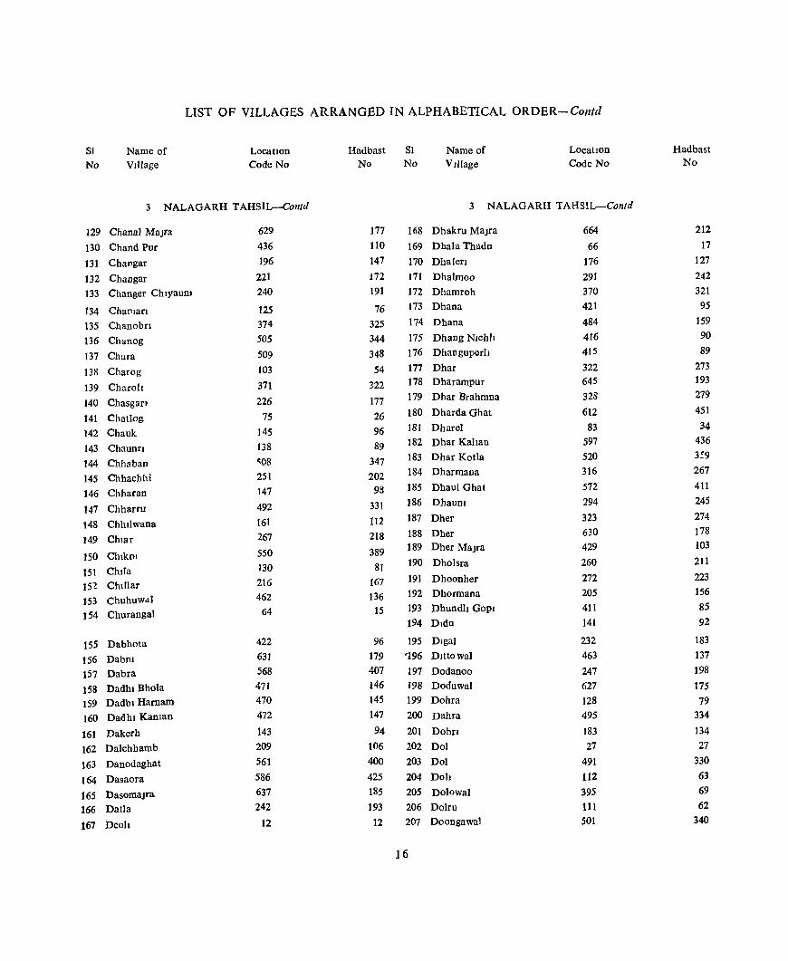
LIST OF VILLAGES ARRANGED IN ALPHABETICAL ORDER-Conld
81
No Name of VIllage
LocatIOn Code No
3 NALAGARH TAHSIL-Contd
129 Chanal MaJra
130 Chand Pur
131 ChaDgar
132 Changar 133 Changer ChlyauDJ
134 ChanJan 135 Chanobn
136 Chanog
137 Chara
138 Charog
139 Charoh
140 Chasgan
141 Chatlog 142 Chauk
143 Chaunn
144 Chhaban 145 Chhachhi
146 Chharan
147 Chharro
148 Chhllwana
149 Chlar
150 ChlkDl
15\ ChlIa 152 Chlllar 153 Chuhuwdl J 54 Churangal
155 Dabhota
156 Dabm 157 Dabra 158 Dadhl Bhola 159 Dadhl Harnam 160 Dadhl Kaman
161 Dakerh 162 Dalchhamb
163 Danodaghat
164 Dasaora
165 Dasomalra 166 Datla
167 Deoh
629 436 196
221 240
125 374 505
509 103
371 226
75 145 138 ~08
251
147
492 161 267
550 130
216
462 64
422
631 568 471 470 472
143 209 561 586 637 242
12
Hadbast SI No No
Name of VIllage
Location Code No
3 NALAGARH TAHSIL-Contd
177
110
147 172 191
76
325 344 348 54
322 177
26 96
89
347 202
98
331
112 218
389 81
167 136
15
96 179 407 146 145 147
94 106 400 425 185 193
12
168 Dhakru MaJca
169 Dhala Thadn
170 Dhalerl
171 Dhalmoo
172 Dhamroh 173 Dhana
174 Dhana
175 Dhang NIChll
176 Dhanguperh
177 Dhar 178 Dharampur
179 Dhar Brahmna
180 Dharda Ghat
181 Dharel 182 Dhar Kahan
183 Dhar Kotla 184 Dharmana
185 Dhaul Ghat
186 DhauDl
187 Dher
188 Dher 189 Dher Malra
190 Dholsra
191 Dhoonher 192 Dhormana 193 Dhundh GOpl
194 Dldu
195 Dlgal '196 D1Uowa]
197 Dodanoo 198 Doduwal 199 Dohra
200 Dahra
201 Dohrl
202 Dol
203 Dol
204 Doh
205 Dolowal
206 Dolru 207 Doongawal
16
664
66 176
291 370 421
484 416 415 322 645 328 612 83
597 520 316
572 294 323 630 429 260 272 205 411
141
232 463 247
627
128 495
183
27
491
112 395 111 501
Hadbast No
212 17
127 242 321 95
159 90 89
273 193 279 451
34 436 3:9 267
411
245 274
178
103
211
223
156 85 92
183
137 198
175 79
334
134 27
330
63 69 62
340

LIST OF VILLAGES ARRANGED IN ALPHABETICAL ORDER-Contd
Sl Name of LocatIOn Hadbast Sl Name of LocatIon Hadbast No VIllage Code No No. No VIllage Code No. No
3 NALAGARH TAHSIL-Contd 3 NALAGARH TAHSIL-Collld
208 Gabar 324 275 247 Jabal 167 118
209 Gadaon 311 262 248 Jabal 257 208
210 Gagoowal 448 122 249 Jabal 318 269
211 GaJed 114 65 250 Jabal Taprlan 551 390
212 Galot 78 29 251 Jablu 296 247
213 Gandookl Dhar 502 341 252 Jadaun 162 113
214 Ganed 354 305 253 Jagar 511 350
215 GarJewal 435 109 254 Jagat Pur 35 35
216 Garloh 500 339 255 Jaged 213 164
217 Gehlu 286 237 256 Jagb 506 345
218 Ghansot 461 135 257 Jaglog 306 257
219 Ghanach 139 90 258 Jagm 333 284
220 Gharmandal Kalan 553 392 259 Jal Nagar 170 121
221 Gharmandal Khurd 554 393 260 JaJh 353 304
222 GharotI 9 9 261 Jakhal 315 266 262 Jalm 503 342
223 Gharyach 71 22 263 Jamandohra 559 398 224 Ghasmana 320 271 264 Janaon 52 3 225 Ghat 208 159 265 Jandu 202 153 226 Ghat Dohlcht 238 189 266 Jangal_Baswahtr 87 38 227 Ghthar 432 106 267 Jangal Behal 514 353 228 Ghogarhwal 450 124 268 Jangal Bhalawa 614 453 229 Gholowal 14 14 269 Jangal Chamba 81 32 230 Goela 545 384 270 Jangat Jamlog 304 255 231 Gorakh Nath 595 434 271 Jangal Kaltt 144 95 232 Goyal ]amala 403 77 272 Janga! Kehada Ban 365 316 233 Gu!abpura 386 60 273 Jangal Phoolwala 528 367 234 Gularwala 646 194 274 Jangal Saharh 95 46
235 GunaKalan 301 252 275 Janga} Sthal 120 71
236 Gunah Khurd 302 253 276 Jangal Sobal 516 355
237 Gured 137 88 277 Jaran 546 385
238 GuruKa MaJra 634 182 278 Jarh 305 256
279 Jasauna 588 427
239 Haharan 538 377 280 Jattmalra 624 172
240 Handl Kundt 481 156 281 Jeora 292 243
241 Harf Pur Sandall 658 206 282 Jhajra 382 56
242 Hari Ral Pur 635 183 283 Jhandlan 522 561
243 Hathewara 246 197 284 Jhar Majrf 667 215
244 Hatra 384 58 285 Jhlran 439 113
245 Hawanl 67 18 286 Jobi 155 106
246 Hulang 179 130 287 JoghoD 32 32
17

LIST OF VILLAGES ARRANGED IN ALPHABETICAL ORDER~Contd.
81. Name of LocatIon Hadbast SI. Name of Location. Hadbast No Village Code No No No VJ)lage Code No. No
3 NALAGARH TAHSIL-Contd 3. NALAGARH TAHSIL-Contd
288 Joharhl 224 175 329 Kaulanwala 378 52
289 Jol 171 122 330 Kaundl 577 416
290 Judi Kalan 662 210 331 Kaundl 632 180
291 Judi Khurd 661 209 332 Kawarmcoarnu 363 314
292 Jukhar 88 39 333 Keha 567 406
293 Kafled 310 261 334 Khabra 215 166
294 Kahnun 263 214 335 Khakhananl 613 452
295 KalOduwal 652 200 336 Khaler NIChh 513 352
296 Kaker Dohcht 239 190 337 Khaler Uperlt 515 354
297 Kahan PUf 38 38 338 Khah 555 394
298 Kahan PUf 402 76 339 Khanoa 23 23
299 Kahanpur 490 329 340 Kharak 332 283
300 Kahanpur 653 201 341 Khartana 327 278
301 Kall Ban 15 15 342 Kharlana 574 413
302 Kah MaJra 643 191 343 KharuDl 49 49
303 Kamal 233 184 344 Khera 245 196
304 Kaneta 136 87 345 Khera 537 376
305 Kangan Wal 414 88 346 Khera Nlhla 475 150
306 Kanoela Nlhla 366 317 347 Khera Uperla 474 149
307 Kaooela U perla 364 315 348 Khert 442 116
308 Kanwan Wah 25 25 349 Khlhan 28 28
309 Kaphleda 90 41 350 Khobla 337 288
310 Kapohl 96 47 351 Khobla 488 327
311 Karpal Pur 468 143 352 Khokhra 473 148 312 Karsoh 4 4 353 Khol 638 186
313 Karuwana 649 197 354 Klara Ra Ghat 252 203
314 Kashambhowal Guram 482 157 355 Ktararoo 610 449
315 Kashambhowal Kanaltan 480 155 356 Klardu 104 55
316 Kashmlrpur Brahmna 40 40 357 Klarghat 126 77 317 Kashmupur GUjran 42 42 358 Klan 214 165 318 Kasla 72 23 359 Klarkanaban 163 114 319 Kasla 575 414 360 Klaru 231 182 320 Katal 212 163 361 Klshan Pura 615 163 ~21 Katal 236 187 362 Koen 519 358 322 Katal 313 264 363 Kolha 85 36 323 Katal 489 328 364 Kohoo Nlchla 152 103 324 Katha 663 211 365 Kohoo Uperla 151 102 325 Kathlmb 55 6 366 Kolka 560 _ 399 326 Katiru Majra 39 '39 367 Kot 276 227 327 Kath 325 276 368 Kota 362 313 328 Katlu 262 213 369 Kotba Kanaon 544 .383
-18

LIST OF VILLAGES ARRANGED IN ALPHABETICAL ORDER-Contd.
SI Name of Location Hadbast SI Name of LocatIon Hadbasl
No Village Code No No. No VIllage Code No No.
3 NALAGARH TAHSIL-Contd. 3. NALAGARH TAHSIL-Contd
370 Kothl 293 244 409 Majra 423 97
371 Kothl 361 312 410 MaJrI 396 7°
372 Kotla 582 421 411 MaJfl 591 430
373 Kotla JajJar 20 20 412 MaJroo 621 169
374 Kotla Kalan 8 8 413 MaJru 563 402
375 Kuhwala 536 375 414 Majru R F 565 404
376 Kulan 16 16 415 Makhda Majra 642 190
377 Kunall 70 21 416 Malag 326 277
378 Kundlu 65 16 417 Malaunkhas 154 105
379 Kunphdl 668 216 418 Malaun Mangta 156 107
380 Kunpalel 58 9 419 Malgan 581 420
381 Kusn 106 57 420 Malhan 177 128
382 Kusn 119 70 421 Malhelll 343 294
383 Kusn 521 360 422 Malku Ma]ra 636 184
384 KUSfi 605 444 423 Malowal 534 373
178 129 424 Malpur 45 45
385 Lag 425 Malpur 641 189
386 Lakhan Pur 440 114 426 Malwalan NIChh 44 44
387 Lambi Dohn 529 368 Malwalan Upern 43 427 43
388 Lana 122 73 428 Mandl 590 429
389 Landewal 654 202 429 Mandlar Pur 444 118
390 Larkot 368 319 430 Manguwal 413 87
391 Lehl 647 195 431 Manjhlan 123 74
392 LodllllaJra 625 173 432 Mank Pur 628 176
393 Lodlwala 280 231 433 Manlog Kalan 220' 171
394 Lobana 289 240 434 Manlog Khurd 200 151
395 Loharblan 602 441 435 Manpnra 616 164
396 Loharghat 160 111 436 Masoyal 201 152
397 Lohan 132 83 437 Mastanpura 22 22
398 Lun 219 170 438 Matuh 268 219
399 Lunas 108 59 439 Mehdud 281 232
/' 440 Mhalsa Tlbba 438 112
400 MachhauD 184 135 441 Mlttlan 499 338
401 Maganpura 446 120 442 Munwalan 351 302
402 Mahadeo 270 221 443 Musewal 452 126
403 Mahadeo 394 68 .. 404 Mahmla 254 205 444 Nahar Smgh 443 117
405 Mahwa 542 381 445 Nal 59 10
406 Maltha} _ 497 336 446 Nat 303 254
407 Malholl 445 119 447 Nab 608 447
408 Majfa u 11 448 Nalka 483 185
19
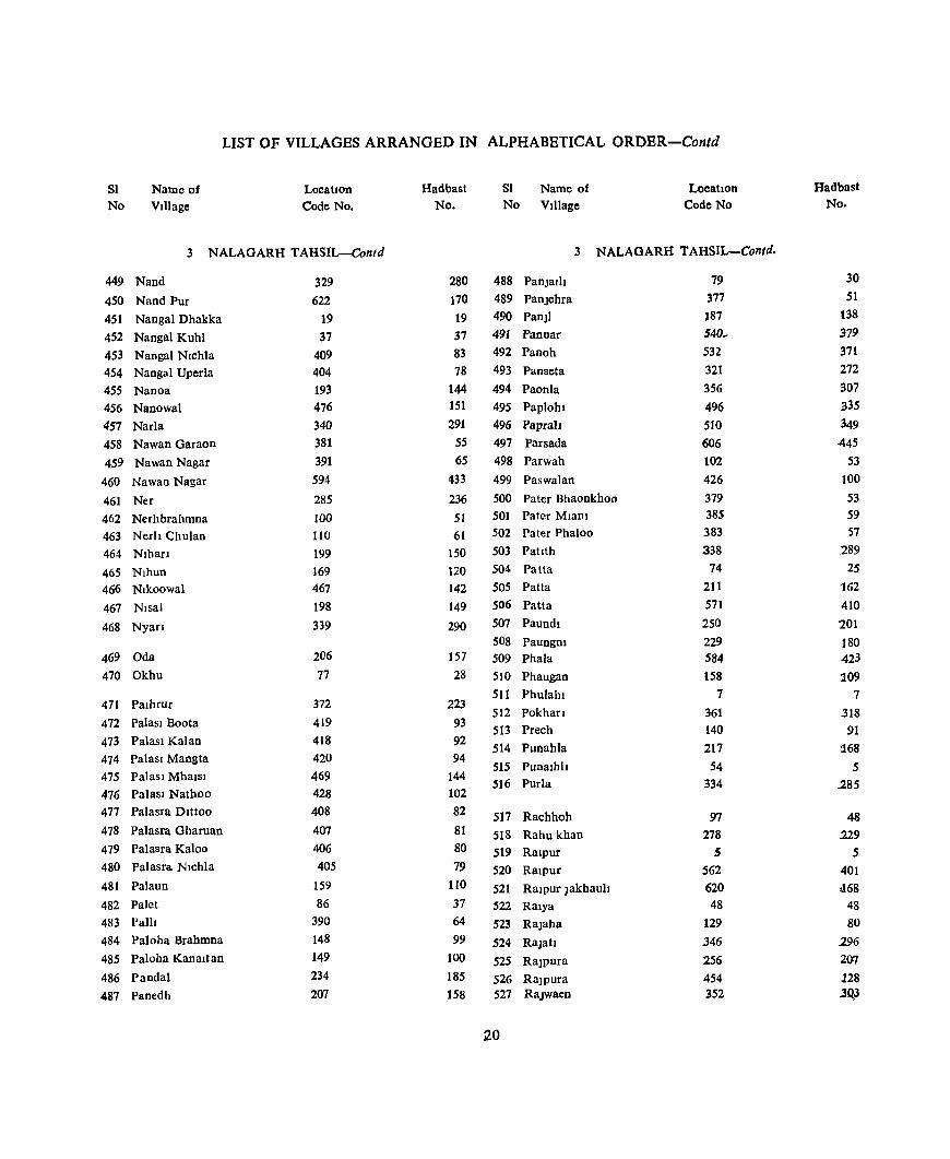
LIST OF VILLAGES ARRANGED IN ALPHABETICAL ORDER-Contd
81 No
Name of Village
Location Code No.
3 NALAGARH TAHSIL-Contd
449 Nand
450 Nand Pur
451 Nanga) Dhakka
452 Nangal Kuhl
453 Nangal Nlchla 454 Nangal Uperla
455 Nanoa
456 Nanowal
457 NarJa
458 Nawan Garaon
459 Nawan Nagar
460 Nawao Nagar
461 Ncr
462 Nerhbrahmna 463 Nerll ChuJan
464 Nlhan
465 Nlhun 466 Nlkoowal
467 Nlsal
468 Nyafl
469 Oda
470 Okhu
471 Palhrur
472 Paiasl Boota
473 Paiasl Kalan
474 PalasI Mangta 475 PalasI MhaIsl
476 Palas) Nathoo 477 Palasra Dlttoo
478 Palasra Gharuan
479 Palasra Kaloo
480 Palasra Nlchla
481 Palaun
482 Palet 483 Pall!
484 Paloha Brahmna
485 Paloha Kanaltan
486 Pandal
487 Panedh
329 622
19 37
409 404
193 476
340 381 391 594
285 100
110
199
169 467 198 339
206
77
372
419 418
420
469
428 408
407 406 405
159 86
390 148
149
234 207
Hadbast No.
280 170
19 37 83 78
144 151 291
55
65 433
236 51 61
150 120 142 149
290
157 28
223
93 92 94
144 102 82
81
80
79
110
37 64
99
100
185
158
81 Name of No Village
Location Code No
3 NALAGARH TAHSIL-Contd.
488 PanJalh 489 Panjehra
490 PanJI
491 Pannar 492 Panoh
493 Panseta
494 PaonIa
495 Paplohl
496 PapraIt
497 Parsada
498 Parwah
499 Paswalan
500 Pater Bhaonkhoo 501 Pater MlaDl 502 Pater Phaloo
503 Patlth
504 Patta
505 Patta
506 Patta
507 PaundI
508 Paungm 509 Phala
510 Phaugan
511 Phulahl
512 Pokhan 513 Prech
514 Punahla
515 Punalhh !H6 Purla
517 Rachhoh
518 Rahu khan 519 Ralpur
520 Ralpur
521 Ralpur Jakbaull 522 R31ya
523 RaJaba
524 Rajah
525 RaJpura
526 RaJpura 527 RaJwaen
12.0
79 377 187 540_
532 321 356 496
510
606 102 426 379 385 383 338
74
211 571
250 229 584 158
7
361 140
217
54 334
97 278
5 562
620 48
129 346
256
454 352
Hadbast No.
30 51
138 379 371 272
307 335 349
445
53 100 53 59
57
289
25 162
410
201
180 423
109
7
.318 91
:168 5
285
48 229
5 401 :168
48 80
296 2(}7
128 ..30,3
UST OF VILLAGES ARRANGED IN ALPHABETICAL ORDER-Contd
SI Name of Location Hadbast SI. Name of Location Hadbast
No VIllage Code No No No Village Code No. No
3. NALAGARH TAHSIL-Contd 3. NALAGARH TAHSIL-Contd
528 Rakh Mahantan 465 140 567 Sanerh 410 84
529 Rakh Rlpur 6 6 568 Sanerh 486 161
530 Rakh Ram SlOgh 466 141 569 Sanog 188 139
531 Rampur 1 570 SaorI 344 295
532 Ram pur 284 235 571 Saror 373 324
533 Rampur 425 99 5"2 Sarsa 166 117
534 Ramshabr 274 225 573 SaurI 600 439
535 Randhala 94 45 574 Saurl GUJan 387 61
536 Ranguwal 453 137 575 SaurI RaJPutan 388 62
537 Raoguwal 526 365 576 Sawasan 190 141
538 RaorI 210 161 577 Sen 460 134
539 Ratan Garb 596 435 578 Sen 523 362
540 RatwarI 357 308 579 Sern 547 386
541 Ratyoe 397 71 580 S f1 Ambka 598 437
542 Rautanwala 618 166 581 SF Badhal 181 132
543 Rela 173 124 582 SF Badhu 279 230
544 Reeu Jhlflwala 400 74 583 SF Beben 307 258
545 Reru Vperla 401 75 584 ~ F Chhllwana 164 115
546 Reta 593 432 585 SF Dabrota 186 137
547 Reter 358 309 586 SF Dasaota 592 431
548 RI 91 42 587 SF Datla 241 192
549 RIa 504 343 588 SF Dhangoh 342 293
550 Rldog 222 173 589 SF Dharmpur 583 422
551 Rudyah 464 138 590 S F Dhar Chamba 80 31
552 Rugl Dohchl 237 188 591 SF DhaJel 84 35
592 SF Dldu 142 93 553 RUjahan 105 56 593 S F. Johar Johru 300 251
554 Sabhowal 457 131 594 SF Kala Amb 68 19
555 Saen 569 408 595 SF Kaln 355 306
556 Sal 101 52 596 S F Kamal Pandal 235 186
557 Sal 225 176 597 SF Khobla 494 333
558 SaInI MaJra 417 91 598 SF Khol 441 415
559 Salehr 533 372 599 SF Khol 639 187
560 Salhar 603 442 600 SF Kotkahl 265 216
561 Salhcwal 456 130 601 SF Looncana 121 72
562 Saltachl lEO 131 602 SF Luhnd 56 7
563 Salwana 230 181 603 S.F Luna 218 169
564 Sandholi 651 199 604 SF Lunda 99 50
565 Sanehr 146 97 605 SF Mabmla 255 2.06
566 Sanerh 290 241 606 SF MalauD 153 104
121
LIST OF VILLAGES ARRANGED IN ALPHABETICAL ORDER-Contd
SI Name of LocatIOn Hadbast SI. Name of LocatIon Hadbast No Village Code No. No No Village CadeNo. No
3 NALAGARH T AHSIL-Contd 3. NALAGARH TAHSIL-Concld.
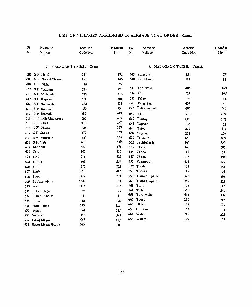
607 SF Nand 331 282 639 SUDIchla 134 85 608 SF Nisaal Cham 194 145 640 Sun Uperla 133 84 609 SF.Okhu 76 27 610 SF Paungm 228 179 641 Tahhwala 485 160
611 SF Plahwala 535 374 642 Tal 527 366
612 SF RaJwaen 350 301 643 Talao 73 24 613 S.F Ramgarh 282 233 644 Talar BaSI 607 446 614 SF Ratwan 359 310 645 Talar Wehad 609 448 615 S fl Retwah 580 419 646 Tali 570 609 616 SF Sldh ChalvauDi ';66 495 647 Tansog 297 248 617 SF Sihal 336 287 648 Tapnan 33 33 618 SF SlIhnu 524 363 649 Tatoa 578 417 619 SF Sunan 172 123 650 Taungn 258 209 620 SF SuraJPur 127 123 651 Tehwala 431 105 621 SF. Tah 601 440 652 Terhbeherh 369 320 622 Shahpur 623 171 653 Thala 348 299 623 SIanJ 165 116 654 Thana 63 14 624 Slhl 315 326 655 Thana 644 192 625 Stlaon 309 260 656 Thantewal 451 125 626 Slmh 273 224 657 Theda 617 165 627 Simb 573 412 658 Thoena 89 40 628 SlroS 347 298 659 Tlamun Uparla 244 195 629 Sobhan MaJra '380 54 660 Tlamun Uperla 277 228 630 Son 458 132 661 Tlkn 17 17
631 Sukedl Jagtr 26 26 662 Tlfla 530 369
632 Sukedl Khalsa 31 31 663 Toranwala 434 108
633 Suna 115 06 664 Tunsu 266 217
634 Sunah Rug 175 126 665 Ukhu 185 136
635 Sunan 174 125 666 Unt Pur 53 4
636 Sunam 556 595 667 Waha 269 220
637 SuraJ MaJra 657 205 668 Walam 109 60
638 SuraJ MaJra Guran 660 208
22

PARTS X-A
TOWN AND VILLAGE DIREGTORY

EXPLANATORY NOTE-PARr A 1 HIstory of the District Census Handbook.
The Dlstnct Census Hand Book was an Innovation oftbe 1951 Census Pnor to 1951 Census, the Census Reports and PublIcations threw up data upto TabsJl, Sub-TahsIl. Town and District levels. Statistics for smaller territorIal nmts than these were not pubbshed m any census pubhcatlOn With the rapid development and SoclO-economlc changes In the society, necessity of data for admlOlstrative UOlt at the lowest level was felt Considerably by the Government and other orgamsa~ tlOns ac; well as the agencies usmg census statistics. With a View to removlOg this shortcomlOg, selected census statistiCs up to vIllage level were lDcorporated 10
the Dlc;trlct Census Handbooks of 1951 Census
Then It shall be Seen that the 1951 Census Handbooks con tamed all the Important census tables, 10 resprct of a particular dIstrIct as Wf'JJ as general 1Ofor· matlOn relating to PhYSical Aspects, Geology, ArchaeologYI Chmate, Ramfall, History. Admmlstratlon, Medical and PublIc Health, Education and LIteracy, Agnculture and Co-operatIOn, IndustrIes, Local Bodies, Places of Interest etc. relat10g to the dlstnct
The DIstrIct Census Handbooks for 1961 Census underwent complete transformatIon and attempts were made to make them mOCe mformatIve. InformatlOn on all the aspects, covered In 1951 Cenllus and on additIonal Items also found placo In 1961 DIstrIct Census Handbo()ks Each DistrIct Census Handbooks 10 1961 Census was diVIded lOtO four parts each part
'contatnlOg specific set of lOformatlOn a.nd statlsflcS, as brIefly discussed below.
Part I Besldec; contalDIng a narrative pertalO1Dg to mtroductlon of the particular dlstnct. thIS part ''ComprIsed mamly of wlCte-up supported by small tables on tOPICS Itke PhYSical Aspects, PopulatIon, the People, Dlttnet AdmlDlstratlOD, EducatIOn, Medical and publIc Health, Agnculture, FISherIes, Animal Husbandary, Panchyats. Local Bodies, Co:operatlve Soclehes, Banklng, IndustrIes, Employment, SerVice, CommuOlcatlons and Road Development, Land Revenue dod Land Tenure, 'Price Trends and Commumty Uevelopment, Flora and Fauna etc. In some Handbooks certam reprmts of extracts from works of Important authorIt-
lies were also IOcluded
Part II All the Census Tables pertainmg to a district 'were mcluded 10 thiS part
25
Part III ThiS part of the District Census HandbooJcs. contalOed the AdmlOlstrative StatistIcs on Allflculture: AdmlDlstratlon, . MedIcal and PublIc Hea,ltQ, Local Bodies, Transport and Cornmuntc~t1ons, Li.vestoc~ Forests and o~her Departments.
Part IV' ThiS part malDly consIsted of the VIllage DHectory, which rendered an acco,unt of each village an,d town In the dlstnct The Census lOformatlon In, thls part was gIven under 36 sUitable heads. In additIon to the census statistIcs m respect of each VIllage and town. InformatloQ about tbe level of development and ameDitIes was also collected &nd 1Ocorporated 10 th~s part AmemtIes hke Schools, Places of worshIp, Medical InstitutIons, Roads, RaIlways, Telegraph and Post Offices, blectncIty etc., If avaIlable- 1P a particular VIllage/town were mdlcated WIth the help of specIfIC abbrevltlons.
2 Scope of the District Census Handbooks
It has been the expef1enc~ of thIS orgaDlzallon that due to varIOUS factors, most of which were beyond ItS control the publIcatIon of some of the 1961 DistrIct Census Handbooks was JDordmately delayed, wbwh resulted 10 unnecessary hardshIp to the data users. The utthty of statistiCS ltes in theIr timely pubhcahon. StatIstical data pubhshed late Jose much of theIr relevance. WIth thiS in View, for the 1971 Census, pnontIes have been fixed for the publIcation of the dIfferent sets of lOformatlOn. It would be our utmost endeavour to publIsh the mformatlon as soon as the relevant tables and other m~terlal are ready. ThiS, It IS hoped, would result 10 the reductIOn of time-lag that usually occures 1ll mdklllg the lOformatlOn avallable t~ the Government and other data users
The Dlstnct Census Handbooks pertalDmg to 1971 Census are belllg brought out 10 two Independent parts as' follows.
(I) (a) Part A Town Dlrectury and V,llage Directory'
Data relatmg to Important characteClstIcs along With other mformatlon for each town 10 a dIstrICt have been complied 10 the form of seVen statements. It IS for the fust hme that thiS type of mformatlOn has been compiled and publIshed In census publIcatlOns, In the shape of Town Directory. Tile first SIX statements contalD town-Wise statistIcs and mformahon on a vanety of subjects lIke Status, Growth HIstory and FunctIona,l
i
Category of Towns, PhysIcal Aspects and LocatJOn of T0wns~ 11969, MUnIcIpal FInance, 1968-69, CIVIC and other Amemtles. 1969, MedIcal, EducatIOnal, RecreatIOnal and', Cultural Faclhtles m Towns, 1969, 'and, Tnide,' Cbmmerce,' Industry and Bankmg, 1969, The.
Seventh Statement contalO'l census (Iafa on rellglOn In
resy,ect of each ,toyvn
The VIllage DIrectory"gIVes foi each vIllage partIculars of amenitIes avaIlable In the matter of rEduc~:
\
tIOnal and MedIcal InstitutIOns, Power' Supply, DrinkIng' ~ater Sppply: Post ,and Telegraph fa~lhtles, CommuDlcatl?ns,( Particulars of Land, Use, Weekly I
l'v1;arke.ts"Pl8f;es of RelIgIOUS, Hlstoflcal or Archaeologtl cal mtere~l tn,the vlllage .... ,j
(b) Part B Villagewise and Townwlse Prlmary Censu3 Abstract
Thn part contams the pnmary census data~ for each Village The prImary data pertams to Area,
rl .i'" J 11 j
Occupied ~~slde.t;\t~al .flouses, Number of Hou~eholds,. Total PopulatIOn ~nd lts, Se1C-wIse break-up, sex-wise Scheduled Caste and Schedllled TrIbe PopulatIOn, sefCwise Ltterate PopulatIon, Working P9Pul~tlon by seXand by, nme broad CategorIes Ie,' Culttv~~ors>( Agrlcultural Labourers, those workmg In' Livestock, Forestry, FIsh 109, HuntlOg, PlantatIOns etc. MInmg and Quarrymg, In ManufactUrIng, In Construc-
I
_ tlOn, In Trade and Commerce, In Transport, Storage and CommuDlcattons, and In Other SerVIces, and the Non-workmg Populatt 0 n also WIth sex-wise break-up. Similar mformatlOn IS lOcorporated In thiS part, In
respect o'f each Town Urban Area and the Wards! Enumerator's Blocks therem
(u) Part C Admlnlstratlve StatistiCS and RepOl t : I
The admInistratIve statistIcs 10 all fields of development pertainIng to the distrIct wIll be the malO content of thIS part Other census tables relatlOg to the distrIct Ie, General PopulatIOn Tables, Economic Tables, SOCIal and Cultural Tables, MIgratIOn Tables, Estabh::.hment Tables, FertIlIty Tables and HOUSIng Tables, WIll also be mcluded m thiS part.
3, CollectIon of Non-Census data
The Information 10 respect of Town DIrectory has
26
:been - c~f1e'cted from varIOUS departments concerned and the respectIve Urban L9ual Bodies Apart from the Urban Local Bodies, WIthout whos~ co-~peratlon the compIlatIOn' of such ,an' exhausflve Tdwn DIrectory woul;;(not have been pOSSible 'at all, mentIOn ~ust be
.., t ) I'-
made of some of the Import\lnt departments of the
Government of, ,HIll1.I;lcha) IPra.~e~h, I 'Y,hIC~ f~rnIshed the statistIcs. and mformatlOn fl\l hng In thell' respe,cttve spheres These are. The secretary (L.S,Q). to- the Govern'meht of HImachal Pradesh, The DIrector of Industites, Hirrfadhal Pradesh, The Director of ' Health SerVIce's; Himachal Pradesh, The 'DIrector of Education, HImachal Pradesh', The ChIef Engmeers~ HImachal Pr~desb,'P W D, and the Registrar, Co-operahVe' SOCIetIes, HltIi~chal PradesIi , and lastly personal observatlOJl and: ~ooaJ ~,nqulfles by the InvestIgators of thIS offIce y~elded many a pIece of InformatIon and relevant data
Tl;l~ ,mformatIon for the compl}atloD <Sf yiIhrgt: Dlrecto;y was collecte<i'w;th ass'lstance of th~ 'Revenu~' Department of the Government of Himachal Pradesh. The Patwarzs ,were drafted as enumerators and the Kanungos were deputed to supervIse thiS work, under the overall control of the Tahslldar!NaIb-Tahsiidar concerned The data was collected by Patwans In a Schedule'especlally deVIsed for the purp6se. "'stnctly 10
accord~ce Mih a set of mstrl.lbtibns Issu'ed m thiS t f i l .. f ~ t J
beha~~. However, )ater, the offiCials of the DIrectorate r .(' I)J I ) 1 J t J r J I Jj' ,
of Census OperatIOns, Himachal Pradesn, were sent I H J' I
o!lt m the field, agaIn, WIth a vIew to rectlfymg the short-commgs and reconclhng the discrepancIes. Thus the mformatlOn, by and large, pertams to mid, 1970. The area figures were based on 'Lal Kltab' or the Revenue Village Papers as mamtamed at the Tahsll/ Sub-Tahstllevel and the latest available figure's' we'te taken mto account.
4 The Town Directory-BrIef Description and AnalysIs.
A comprehanslve Town DIrectory runnIng mto, seven statements and h'ighhghtmg all ",Important PhY!>Ical, EconomIc, CIVIC and Developmentall aspects has been compiled 10 respect of each town in Himachal Pradesh. ThIS Town DIrectory forms an Important part of Part 'A' of the DIstrIct Census Handbooks.
I (a) CensUf, 1 DfjjmtlOn of Town' -
The standards laId' down for consIderIng a place
as an lJrban areta were ,broadly .. the same IlS In 1961 Census However, cntena adopted for determmmg
tqe urban area~ In the 1971 Census were mamtalOed , '(. ) , on the folJowmg patten
"To qualIfy for recogmtlOn ,as an urban area a place should first be elther a MUDlclpal CorporatIon
J \I. , ' J ,
area or ~ Mun.clpal Area or under a Town CommIttee or a Notlfi~d Area CommIttee or a Cantonment BCldrd '
;"'1: ". ,
If It did not have any of these Urban Local BodIes to aQmllllster the afi'alfs then the' followlOg e'mpmcal j
te~ts should be applIed; , ,
(I) A mmlmum populatIOn of 5,000 (estImated for 1971) "
(II) A densIty of not less tb,an 400 per ~q. Kms. (1;000 per Sq, MIle)
(Ill) 3/4th of the occupations of the male workIng
populatIon should be outside agrIculture and
(IV) Tbe place shoultl\ have, accord 109 to the Dlfector of Census OperatIOns, of the State
a few pronounced urban characteristIcs and amenIties "
Thus, all the places having an urban local body such as a MUOlclpal CorporatIOn or a Mumclpal CommIttee or a Notified Area Committee or a Canton- ' ment Board were obVIOusly treated as fowns m thiS DIstrIct. No place which did not have a statutary urban local body was treated as an urban area m SImla
dlstnct
(b) The Sel'(ln Statements of Town Dzrector y
Data rn respect of the Town DIrectory has b~en com12lled and pre~ented tn the form of seven statements Tn all these statements the mformatlOn IS shown IIldlVldually ~ for e4ch town, the towns havmg been aHang~d m alphabetIcal order A broad outlIne of each s'tatement IS gIven, her~under
Statement I-Status, Growth History and FunctIOnal Category of Towns
27
:rhls statell!ent rUJ!_s ,lOto 14 columns and IS I I I "') ), 1 ( If ! 1 t rt f )
pnm~!Jly tntended to throw up a comparatIve plct'tIre' \I ( .)J, f (
of pQpplatlOn of each town in dIfferent censuses froth' ' J - ').. il,... ~ ,
1901 to 1971 CIVIC AdmlDlstratlOn Stiitus of 'each 1
town IS shown under Col 5 The last colufnn of
st:ate~e.nt I (Col 14... ,Functlpnal Categ9ry-1961 Census) would reqUIre some elucldatIpn. fIt may be relevant to descnbe the method foHowed In arnvmg at the functional character of a partIcular town" accordlDg to ,961 census In thIS context • The workmg populatIon accordmg to' 1961 rCensus was' classIfied, mto mne broad IndustrIal Cetegones VIZ, I-As eultlVator, II-As AgrIcultural Labourer, III-In Mmmg, QuarrylDg, LIvestock, Fotestry, FIShlDg, Huntmg and-PlantatlODs, Orchards and Allied ActIVltres, IV-At 'Household Industry, V-In Manufacturmg other than Household Industry, VI-In ConstructIOn, VII-In Trade and Commerce, VIII-In Transport, Storage and CommuDlcatlOns, and IX-In other ServIces. For workIng out the functIOnal category m respect of a partIcular town these f nIne categ~rIes were' 'sultably
combmed and grouped IDto five broad functional claSSIficatIOns as below:
(I) Pnmary ActIVItIes-IndustrIal Categones I, II and III ' ...
(II} Industry-IndustrIal CategorIes IV, V and VI
I r I l .." ,
(IU) Trflde and, Comme,~ce-In~ustrIal Category VII
(IV) Transport-IndustrIal Catego,ry VIII, and ."
(v) Services-IndustrIal Category IX. ,
The percentage of workers under each of these five
classes of economIc activItIes to total workers In a partIcular town wss calculated and the functIOnal character of the town determIned accordIng to these
percentage values. If, 'Yorke,rs under ~ne of the • five I \ t I J r 'f- i
occupations ac~ounted for 10 % or more of tlie total workers, the town was consIdered as mono-functIOnal , , e g SerVIce, Industflal etc However, III case I tne
I • , t L~ \ percentage was Jess than 40% the next preaomment occupatIon was taken mto account, so that the total of the two would come to 60% or above. Such a town was deSIgnated as bifunctIOnal e g • Servlce-cumIndustrtal. Further, If the total dId not come upto
l' I I I
60% Ole tlurd predonilnent occupatton was taken' into account and such a town was designated MultI-r •
functIOnal e g Servlce-cum-Industnal-cum-Pnmary
Activities , ,
Statement II-PhysIcal Aspects and Location of Towns, 1969
( \ I I ...J
Data on annuai ramfall and ternperatur6 IS shown I' ,
under columns 3 to 5 of tillS statement which runs mto 13 columns Other columns Indicate the distances of
I
a town from the nearest City wltll population of 1 lakh or more, from the headquarters of tlte State, Dletnct, Sub-dIvIsIon, Tahsil/Sub-Tahsll and from the nearest Railway Statton, Bus Route, NaVigable River! Canal (If wlthm 10 Kms) The last column VIZ col. No 13 pertalOs to the Sea Port (If withIn so Kms) ObViOusly there IS no mformatlon to be recorded under
thIs column In Himachal Pradesh
Statement Ill-Municipal Fidance,1968-69'
This statenlent shows the Receipt aud ExpendIture in respect of Muntclp~1 Fmace of mdivldual towns under different heads. There are, in aU, 16 columns 10
this statement.
ft~tetnent IV -CiVIC aud Other Amenities, 1969 :
ThIs statement _ displays information under 16 heads. The ame~lttes, about which mformatlon has
been Incorporated are, Road Length (with breakup by
Kutcha i!nd Pucca, If avaIlable) System of Sewerage! DrdlDage and otller related matters, Water Supply, Flce FightIng Service, and Electnficahon, etc
Statement V -Medical, Educational/Recreational and Cultural Facilities ID Towns, 1969
ThIs statement 18 mtended to depict the degree of aVll.1lablhty of Medical FacII,lties by type of InstitutIOOS and number of beds avaIlable In each, EducatIOnal FaclhtJes by levelsjtypes of Courses, and RecreatIOnal and Cultural Faclhtles The statement has 17 columns.
Statement VI-Trade, Commerce, Industry and Banking, 1969
This statement displays mformatlOn under 15 '-columns 10 respect of each town The mformatIon
-28
pertams to I'mports, Exp6rts, Manu(actutes, Banks" and Agricultural and Non-agrIcultural CredIt SocIetIes.
Statement VII-Population of Towns by ReltgloD' 1971.
TownWlse break-up of the 1971 Census populatIOn by JehglOn IS shown lD tlll~ statement
(c) Coverage' There ate SIX towns 10 Slmla dlstnct whlch are all covered by the To~n DIrectory. All these places were towns 10 1961 Census alsd. Three towns VIZ Dagshal, Kasault and Subathu fall 10
Kandaghat TahSIl whereas two towns namely Jutogh
and SImla are located in SImla Sub-Tyhsll and the
remallllilgoneto .. nle.Naiagarh IS a part of Nalaearh TahSil.
Sources of Information The Information has been
collected froln tIle respecttve Urban Local BodIes and the concerned departments of the Government of
Hlmacbal Pradesh. Temperature and Ram-fall data
have been parttally collected from the Oirector General of Observatories, Government of Indla, Poona.
(e) Brtef notes on Statements :
~tatement I-Status, Groth History and Fu'nctlOnl'd Category of Towns :
Slmla Distflct has 6 towns, 3 of whIch (Subathu, Kasauh and Dagshal-all Cantonment Board Areas) 'are located In Kandaghat TahSil, 2 (Simla MUniCipal Corporation and Jutogh Cantonment Board) m Simla
Sub-tahSil and 1, VIZ, Naldgarh MUDlclpal Committee In NaJagarh TahSIl The followmg notations have been uullzed 10 thIS r.tatemerrt
Notation
CB
M Me
ExplainatlOo
'Cantonment Board
Mumclpal Committee MUnICipal CorporatlOn
All the towns of SImla DIstrict had urban status In the Census of 1901. However, Nalagarh was declassl
fied from 1911 to 1931 and Jutogh was considered as part of SImla town m 1911.1921 and 1951 censuses. Spectacular lOcrease IS noticed 10 the populatIon of SImla durmg the decade 1941-51. Thls was maInly as a result of the mflux of displaced persons tram the

areas now constltutmg Pakistan The capital of Punjab was also located at SImla at that tIme In 1961 the population of SImla regIstered a fall from 46,150 lD 1951 to 42,597. ThIs may be explalDed by takIng Into consideration the fact of shIftIng of the capItal of Punjab from thIs town to the new cIty of Chandlgarh.
The population of SImla as per 1971 census IS 55,368; the percentage mcrease durmg 1961-71 beIng 30 No other slgmficant features are observed In thIs statement exceptmg that the populatIon of Nalagarh, whIch stood at 4,027 1Q 1901, IS only 3,671 In 1971 Census.
Table No 1 reproduced hereunder shows the towns of SImla dIstrict c1assdied accordlDg to functIOnal categones
TABLE NO.1
Distribution of towns by fUDctlOnal categories fOlal
Functional Catt"gory-1961 Number of Towns
1 ServIce
2 6
It would be notIced that all the, 6 towns of Sunla
dIstrict falllD the functIOnal category of Service.
Statement II-Physical Aspects and LocatIon of
Towns, 1969 .
The phYSical and locational aspectl of the towns are covered In thIS statement. RalDfalJ data 18 not avaIlable for Dagshal. Jutogh, Nalagarh and Subathu. However, figures of annual ratnfallm respect of SImla has been repeated agamst Jutogh WIth a vIew to enabhng the reader to have a rough Idea In this behalf. Kasauh experiences an annual ratnfall of 1,647.1 mm, as agamst 1,508 4 mm. lD case of SImla. Maximum temperature in SImla IS 2860C whereas mmlmum temperature Is-43°C. This Information has agam been repeated agamst Jutogh for whIch town the data IS not available. Temperature data IS not available for the other four towns.
Statement In-Municipal Fin8nce,1968-69
Table No 2 gIven hereunder shows per capita ReceIpt and ExpendIture, further classified accordmg to sources and vaflOUS actiVitIes, respectIvely, in respect of the different population size-classes of towns.
TABLE No.2
Size Number of Class of Towns
town
Class J 100,000 and over
Class I I 50,000 to 99,999
Class lIT 20,000 to 49,999
Class IV 10,000 to 19,999
Class V 5,000 to 9,999
Clas! VI Below 5,000
Total Receipt
2 3
1 8720
5 8986
Per capita receipt and expenditure by size class of towns
Per capita
Receipt (Rs ) Expenditure (Rs.)
Receipt Receipt from Total Expenditure Expenditure Expenditure through all other expendl- on pubhc on pubhe on all other taxes sources ture health and institutions aspects
convemences
4 5 6 7 8 9
1676 70.44 8209 I 17 1146 69.46
1388 7598 10783 3241 484 70.58
29
SImla falls In the populatIon Size class II (50,000-99,999) whereas all the other 5 towns fall In the population class VI (Below 5,000) Total per,caplta receIpt 1D respect of Class II town IS Rs 87 20 whereas It IS Rs 89 86 1D case of Class VI towns By sources also
there IS not much dlspanty 10 the pattern of receipts. However, the expenditure pattern in the two classes shows some divergence Per capita expendIture for the classes II and VI IS Rs 8209 and Rs 10783, respectIvely Further, per capita expenditure on publIc health conveDiences is Rs. 32 41 In case of class VI towns as agalOst Rs. 1 17 lD class I I
Statement IV -Civic and Other Amenities, 1969
The followmg notatIOns have been utthzed 10 the compilatIOn of this statement
Column No 3
4
8
9
Notation Used PR KR S OSD
ST BKT ST HL T
Description Pucca Road Kutcha Road Sewer Open Surface DralDs SeptIc Tank Bucket SeptIc Tank Head Load Tap Water
Statement V-Medical, Educational, Recreational and Cultural Facdilies in Towns, 1969
The notations used 1D t~IS statement are detatled below -
Column No. 3
5
9
Notations H D TBC FC
o
HC A AS
ITI
Description Hospital Dispensary T B Chmc Pamdy Planmng Centre Other MedIcal InstItutIons Health Centre Arts College
Arts & SCIence College
Industnal Tram-109 InstItute
30
9 TC Tailormg Centre CTC Crafts TraJDID8
Centre RITI Rural IndustrIal
TralDmg InstI-tute
13 PGC Post Graduate Centre
liAS IndIan InstItute of Advanced Study
B.Ed College of EducatIOn
FA College of Fme Arts
SC SanskrIt College
Table No.3 given hereunder shows avallablhty of medIcal facihttes 10 terms of number of beds avaIlable per 1,000 town dwellers 10 Simla dlstnct.
Total No of beds lD
medlcallDstltuhons 1
1,099
TABLE No 3 MedIcal FacilitIes
No of beds per 1,000 populatIon
2
16
Total number of beds avaIlable 10 the medIcal instItutIons located lD the towns of SImla dlstnct IS
1,099. The number of beds per 1,000 populatIOn works out as 16
Simla town leads 10 matters of medical ameDltles. There are 4 HospItals WIth 546 beds, 16 DISpenSarIes, one T. B Chmc With a prOVISion of 2 beds and 11 other medIcal instItutIons, whIch include 2 FamIly Plannmg Centres also. Kasauh town has a SanitorIum With a prOVIsion of 250 beds, apart from other medical lOstItutlOns. All the towns lD thIS dlstnct can boast of avaIlablhty of the indoor treatment faCIlItIes 10 one medIcal lDstttutIon or the other, may be to a very lImIted extent m some cases
In matters of educatIonal facJllttes SImla town forms a class by Itself, WIth the avaIlabIlity of (a) An Arts College, (b) Three Arts and SCience Colleges, (c) A Post Graduate Centre, (d) Indian InstItute of Advanced Study and (e) A MedIcal College. There
are 3 Vocattonal and Crafts Centres also Ifi thIs town. None of the other towns ha9 a college
Table No 4 gives below shows number of schools providing educational facIlIties upto varIOUS levels per 1,000 population In the dIfferent towns of Simla distrIct .-
TABLE No.4
Higher Secondary or Secondary, Junior Secondary! Middle and Primary Schools per 1,000 population
Number per 1,000 population
Name of the town
HIgher Secondary or Middle/Julllor Pflmary Secondary Schools Secondary Schools Schools
2 3 4 Simla N N N Jutogh 1 Subathu 1 Kasauh N N Dagshal N N Nalagarh 1
N Neg)Jglble
Perusal of the above Table reveals that, measured in terms of number per 1,000 souls, the vanous types of educatIOnal faclhtIes are ml or neglIgible 1D all the towns exceptmg the folloWIng cases where the ratIO works out as 1 :
(I) Middle or JunIOr Secondary Schools at Jutogh
(11) High or Higher Secondary Subathu
(Ill) High or HIgher Sesondary PrImary Schools at Nalagarh.
Schools at
-Schools and
As for recreational faCIlIties It may be noted that
there are 4 Cinema Halls In SImla and another at Kasauh. SimIlarly the number 6f Audltona IS 3 ID
/'
Simla and 1 at Kasauh. All the towns have a Pubhc Llbraryexceptmg SImla, where the number of Public
/
Llbranes IS 7.
Statement Vlo--Trade, Commerce. Industry and Bankmg, 1969 The most Important commodIty of Import 10 all
the towns of SImla distrIct IS Foodgrams and GrocerIes Cloth. Sugar and Vegetable GhC!e are other Important Items. Hovever. 1D the case of Simla, Mdk
also commands sufficIent Importance as a commodIty Imported from outsIde.
Potatoest, Apples and Vegetables are the three Important Items of export from Simla town. Vanous types of vegetables and frUits are exported from other towns. In case of Nalagarh stone. sand. Bamboo. grass, charcoal. ResID and "Katha" are Important Items of export. AntI-rablc, Cholera and TAB, VacclDes are exported from Kasauli.,
As for manufactures Kasauh IS famous for Its beer and WIDe, There IS nothtng spectacular requmng specIal mentIon, 1n thiS fIeld. III other towns.
Of the 15 Banks In the towns of thIS dIstrIct 7 are located at Simla and 4 at Nalagarh Jutogh hac; none. SImIlarly out of 35 non-agricultural socIetIes as many as 21 are 10 SImla.
Statement VII-Population of towns by Religion. 1971 :
Hmdus constItute the bulk of populatIon 10 all the towns of SImla dlsfnct and thelT percentage ito total populatIon vanes between 78.72 1D Nalagarh to 96.46 10 Subathu. SIkhs constitute the second biggest commumty 10 almost all the towns and their hIghest percentage IS ID Dagshal where they form 11.52% of the total populatIOn. Mushms claIm 8.72% of populatIon in Nalagarh. theIr absolute number bcmg 320 out of 3,671 In both KasauII and Nalagarh. ChrIstIans form 3 70% of the total populatIon Thelf proportIon 10
othl"r towns IS not sIgmfIcant SImilarly JaID CommUDlty_ whIch claIms 2.07% of the populatIOn of
Naiagarh, are in lDsIgmficant num bers 1D other urban areas As for BuddhIsts, WIth a populatIOn of 846 ID
SImla, they form 1.53% of the total populatIOn of that town. Then number in other towns IS either mlor lDsIgnlflcant.
5 Village Directory
(I) Concept of Census Vdlage In 1961 Census. a Census VIllage was the same as a Revenue VIllage. After reorgamsatlOn of Punjab, Haryana and HImachal Pradesh on 1st November, 1966 some areas were transferred from the erst-wht1e state of Punjab to HImachal Pradesh. Whereas ID some of these ne waly merged
31

DIstncts/TabsIls etc. the revenue Village IS comparable '- ]n population SIze and area to the revenue vJ]lages of
the old dlstncts yet 10 most of the cases the average revenue village IS much bIgger 10 area and populatIOn than its counterpart tn the old dlstncts. The dIfference fa so marked that it renders companson of the VillagewIse statiStiCS an exerclso 10 futIlIty Therefore. smaller rural units were considered as cemus Villages in most newly merged areas of Himachal Pradesh. It may be relevant to detat) here areaWlse, the names of the smallest Census Rural UOlts conl,dered as Census VIIJages tn HImachal Pradesh. This lOformation IS gIven below
Name of Smallest Censu~ Rural UDlt consIdered as 'Census
Village
Areas where consIdered
Revenue Village
2 "Tlkka havmg a distInct Sub-Hadbast Number
2 "Phatti" havlOg a distInct Sub-Hadbast Number
4. Village Hamlet (wlthl wIthout dIstinct Sub-Hadbast Number)
2
(I) In the DIstrIcts of Chamba Mandl, Bllaspur, Mahasu, Slrmapur, KlOnaur and SImla
(II) Una TahSIl and Amb ubTahSIl of Kangra Dlstflct
Kangra District excepttng Una TahSIl and Amb SubTahSIl.
Kulu DistrIct
Lahul and SpIll DIstrict
(II) PresentatIOn of Data The vllIagewise data IS dIsplayed tn 18 columns Apart from thIS, Abstracts of the EducatIonal MedIcal and Other InstItutIons and amemties 10 respect of Tallstls/Sub-TahSIl and the C>lstnct have been lOcorporated 10 thIS publIcatIon. For accordIDg conventence m the IdentificatIon of census VIllages. ltsts of VIllages arranged 10 alphabetIcal order showlOg theIr census locatIon code numbers and the rev~nue numbers, have also been added
(Ill) Explanarory Note regardmg Notatlnns used m Vl11age DJrector y •
The tnformatIon pertalntng to the dIfferent ameDlties available 10 the Census VIllages has been shown with the help of a set of notations These notatIons
32
alongwlth the particular amenitIes whIch these represent are gIven hereunder:
Columo-4
I. PrImary School Pro S
2. JUOlor Secondary or Middle School MId. S 3. Secondary or HIgher Secondary School Sec S
CoIumo-5
1. Hospital
2. MaterDlty and ChIld Welfare Centre
3 Health Centre
4 DIspensary
5. FamIly Planmng Centre
CoJumo-6
Electnclty
CoJumn-7
1. Tap Water
2 River Water 3 Fountam
4 We))
5. Tank
6. Tube WelJ
·1. Others
8. InformatIon not
CoJumo-8
1 Pucca Road
2. Kutcha Road
3 RaIlway
Columo-9
Post Office
2. Telegraph Office
available
3. Post and Telegraph Office
4 Telephone
Column--12
H MeW
HC
D FC
E
T
R F
W
Tk
TW
o N.A.
PR
KR T
PO
TO
PTO
Phone
..1. Others 0
.The Category of 'Others' JDcludes stream,' Kuhat' and Nalah •• The Category of 'Others' IDcludes 'Kuhal'.

6. Brief analysis of data-Village Directory.
(0) Distrzbutton of villages by area .
Table No. 5 shows the dlstnbutlOn of villages IQ
Simla dlstnct by different classes of area.
TABLE No.5
Distribution of Villages by their areas
Area 1D acres
50 acres or less 51.100 acres 101·200 acres 201-500 acres 501-1,000 acres 1,001 2,000 acres 2,001-5,000 acres 5,001 acres and above Area not known Total.
Number of VJ)lages
2
340 416 478 379 84 16 2
6 1,721
Note Area figures of SIX vlllages are not avaJlable.
The vIllages which are comparatIvely sma]) lD area are predominant ID dlstnct. 340 VIllages are of the area SIze 50 acres or less. The area size classes 51-500 acres and 101-200 acres claIm 416 and 478 Villages, respectIvely. The next hIgher sIze class i. e. 201-500 acres claims another 379 VIllages. Thus 1,613 vlIlages out of 1,721 have areas less than 500 acres each. There IS no VIllage 1D the size class 5,001 acres and above whIle there are only 2 VIllages, whIch have areas between 2,001-5,000 acres each.
(b) Avatlabllzty of Educatzonal Focllttles :
Table No. 6 reproduced hereunder shows the number of Villages enjoymg the educatIonal facilities upto varIOUS levels by theIr respectIve distances from the nearest town.
TABLE No.6
Distribution of villages having educational amenities by distance from the nearest town
Dlstanoe from the
nearest town
S Kms or less
6-10 Kms
ll-lS Kms
16-25 Kms.
26-50 Kms
51-100 Kms.
101-200 Kms.
201 Kms. and above
Total'
Total No
of Villages
2
389
358
382
353
239
1,721
Pumary MIddle
School School
3 4
45 4
32 7
49 9
44 5
20 3
... ./
190 28
It may be observed from this Table that none of the villages and SImla distnct IS located at a dlstanee or more than 50 Kms from the nearest town. In fact. lD
the distance class 36-50 Kms which IS the highest in thIS case there are only 239 vIllages out of a total of 1.721. There IS not much varIatIon 10 the number of Villages 10 other classes
33
Number of Villages haVIDg
HIgh or HIgher College Others Secondary School
S 6 7
7
3
3
3
16
The district has, in all, 190 Villages with Primary Schools which are rougly proportionately distributed amongst all the categorIes of the Villages located at various distances from the nearest town, exceptIng that the village 10 the class 6-10 Kms. comparatIvely claims smaller number of the Primary Schools. As for the Middle Schools out of 18 vllla~es enjoying tluJ
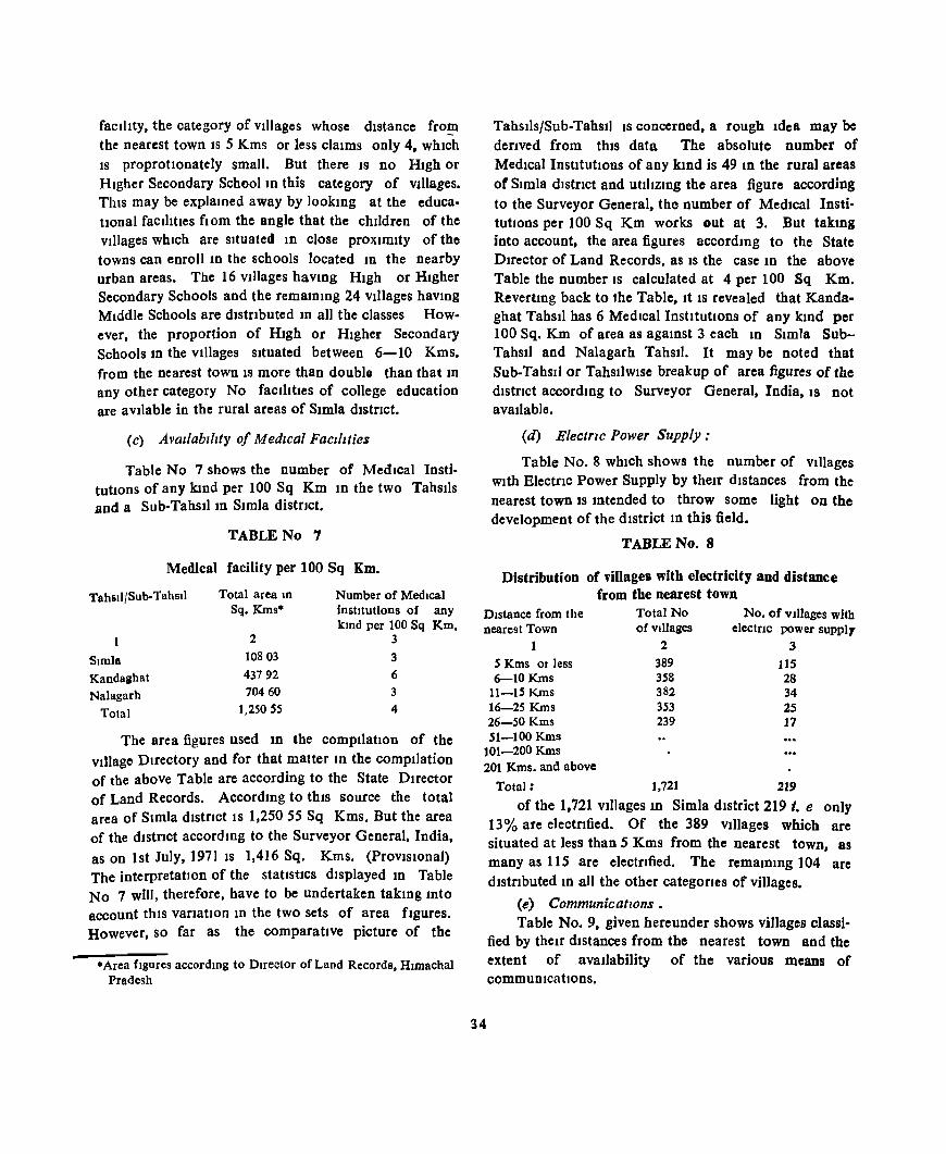
facIlIty, the category of vIllages whose dIstance fro~
the nearest town IS 5 Kms or less claims only 4, whIch IS proprotlonately small. But there IS no High or Higher Secondary Schoolm this category of vIllages. This may be explained away by lookmg at the educatIonal faclhtles flOm the angle that the children of the villages which are situated m close proximity of the towns can enroll 10 the schools located m the nearby urban areas. The 16 vIllages hav10g HIgh or HIgher Secondary Schools and the rema1D1Og 24 vIllages hav10g MIddle Schools are dlstnbuted 10 all the classes However, the proportion of HIgh or HIgher Secondary Schools 10 the vIllages sItuated between 6-10 Kms. from the nearest town IS more than double than that m any other category No facilItIes of college education are aVllable in the rural areas of Simla district.
(c) AVailability of MedICal FaCilities
Table No 7 shows the number of MedIcal Insti· tuttons of any klOd per 100 Sq Km ID the two TahsIls and a Sub· TahsIl 10 SImla distrIct.
TABLE No 7
Medical facility per 100 Sq Km.
Tahsil/Sub-TahsIl
SImla
Kandaahat Nalagarh
Total
Total area tn
Sq. Kms·
2 10803
43792 70460
1,250 S5
Number of MedIcal institutions of any kmd per 100 Sq Km.
3
3 6 3 4
The area figures used ID the compilatIon of the village Directory and for that matter lD the comptlation of the above Table are according to the State Director of Land Records. Accordmg to thiS source the total area of Simla distrIct IS 1,25055 Sq Kms. But the area of the dlstnct accordmg to the Surveyor General, India,
as on 1st July, 19711S 1,416 Sq. Kms. (ProvIsIonal) The interpretation of the statistiCS displayed 10 Table No 7 will, therefore, have to be undertaken takmg mto account thiS vanatIon 10 the two sets of area fIgures. However, so far as the comparative picture of the
.Area fIgures accordmg to Dlfector of Land Records, HlDIachal Pradesh
Tahstls/Sub-Tahsll IS concerned, a rough Idea may be derIved from thIS data The absolute number of MedIcal InstItutIons of any kmd is 49 m the rural areas of SImla distrIct and utIlIzmg the area figure according to the Surveyor General, the number of MedIcal InstitutIons per 100 Sq Km works eut at 3. But takIDg into account, the area figures accordmg to the State Duector of Land Records, as IS the case 10 the above Table the number IS calculated at 4 per 100 Sq Km. Revertmg back to the Table, It IS revealed that Kandaghat TahsIl has 6 MedIcal InstitutIons of any k10d per 100 Sq. Km of area as agamst 3 each 10 SImla SubTahsIl and Nalagarh TahsIl. It may be noted that Sub-TahsIl or TahsJ]wlse breakup of area figures of the dIstrict accord1Og to Surveyor General, India, IS not available.
(d) Electrzc Power Supply:
Table No.8 WhICh shows the number of VIllages WIth Electnc Power Supply by theIr distances from the nearest town IS Intended to throw some light on the development of the dIstrict 10 this field.
TABLE No.8
Distribution of villages with electricity aod distance from the nearest town
DIstance from the nearest Town
Total No of VIllages
No. of VIllages with electrIC power suppl,
1 S Kms OJ less 6-10Kms
11-15 Kms 16-25 Kms 26-50 Kms 51-100 Kms
2
389 358 382 353 239
3
115 28 34 2S 17
101-200Kms 201 Kms. and above
34
Total: 1,721 219
of the 1,721 vtllages In Simla district 219 i. e only 13 % are electrIfied. Of the 389 vtllages which are situated at less than 5 Kms from the nearest town, as many as 115 are electrIfied. The remalO1Og 104 are dlstnbuted 10 all the other categorIes of villages.
(e) Communications. TabJe No.9, given hereunder shows vjJ1ages classi
fied by theu dIstances from the nearest town and the extent of avaIlability of the various means of commuDlcatlOns.
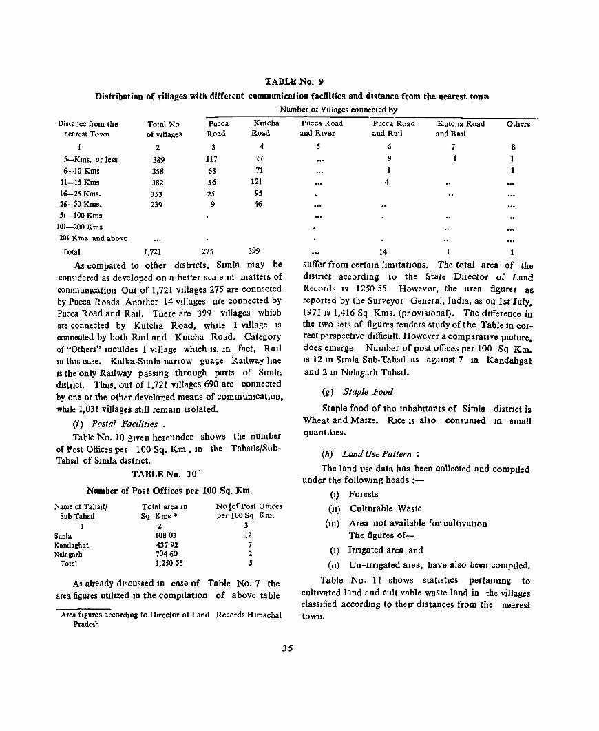
TABLE No.9
Distribution of villages with different communication facilities and distance from the nearest tOWll Number of Villages connected by
Distance from the nearest Town
5-Kms. or less
6-10 Kms
11-15 Kms
16-25 Kms. 26-50 Kms.
51-100 Kms 101-200 Kms
201 Kms and ab~ve
Total
Total No ofvdlages
2
389
358
382 353 239
1.721
Pucca Kutcha Road Road
3 4
117 66
68 71
56 121
25 95 9 46
275 399
As compared to other dlstTlcts, Simla may be consIdered as developed on a better scale In matters of communication Out of 1,721 villages 275 are connected by Pucca Roads Another 14 Villages are connected by Pucca Road and Ratl. There are 399 Villages which are connected by Kutcha Road, while 1 Village 18
connected by both RaIl and Kutcha Road. Category of "Others" lOculdes 1 VIllage WhIch IS, 1D fact, RaIl 10 thIS case. Kalka,Slmla narrow guagc Railway hne IS the only RaIlway passmg through parts of Simla dIstrIct. Thus, out of 1,721 VIllages 690 are connected by one or the other developed means of commuOlcatlon, whlle 1,031 village. stIll remam Isolated.
(f~ Postal FaCIlitIes • Table No. 10 gIVen hereunder shows the number
of Post Offices per 100 Sq. Km , 10 the Tahslts/Sub. TahsIl of SImla dlstnct.
TABLE No. 10-
Number of Post Offices per 100 Sq. Km.
Name of Tahslll Total area In No [of Post Offices Sub-Tahsil Sq Kms'" per 100 Sq Km.
1 2 3 Simla 10803 12 Kandaghat 43792 7 Nalagarh 70460 2
Total 1.250 S5 5
As already discussed 1D case of Table No.7 the area figures utl]Jzed 10 the compIlatIOn of above table
Area figures according to Director of Land Records Himachal Pradesh
35
Pucca Road Pucca Road Kutcha Road Others and River and Rail and Rail
5 6 7 8 9 1
4
14 1
suffer from certaIn ltmltatlOns. The total area of the dIstnct accord1Og to the Sta te DIrector of Land Records IS 1250 55 However, the area figures as reported by the Surveyor General, India, as on 1st July. 197118 1,416 Sq Km8. (provJSIonal). The difference in the two sets of figures renders study of the Table In correct perspectIve difficult. However a comparative pIcture, does emerge Number of post offices per 100 Sq Km. IS 12 10 Simla Sub-TahsIl as agamst 7 10 Kandahgat and 2 In Nalagarh TahSIl.
(g) Staple Food
Staple food of the 10habltants of Simla distnct is Wheat and MaIze. RIce IS also consumed In small quantities.
(h) Land Use Pattern
The land use data has been collected and compIled under the follOWIng heads :-
(I) Forests
(11) Culturable Waste
(lll) Area not available for cultIvatIOn The figures of-
(I) Irngated area and
(11) Un-IrrIgated area, have also been compIled.
Table No. 11 shows statIstIcs pertaIn 109 to cultIvated 1and and cultivable waste land in the villages classIfied accord 109 to thelT distancec; from the nearest town.

TABLE No 11 Percentage of average cultivable waste per village to average cultivated Jand per village by distance from
the nearest town (Acres)
Distance from No of Total culuv3.ted Average cultivated Total cultivable Average
cultIVable waste per village
Percentage of average cultivable waste per Village to average
cultivated land per Village the nearest Town Villages land land per village waste
2
5 Kms or less 389 6-lOKms 358 11-15 Km 382 16-25 Kms 353
26-50 Kms 239 51-100 Kms
101-200 Kms 201 Kms and above
Total. 1,721
3 13,687 14,235
21.992 20,619
8,769
79,302
4
35 19 3976
5757 5841
3669
4608
Average cultivated land per Village 10 SImla dlstnct IS only 46 08 acres. In the class of vIl1ages whIch are sItuated at 5 Kms or less from the nearest town, the average cultIvated land per vIllage .Is as low as 35.19 acres Average cultivable waste per Village In thIS dIstrIct IS 38 19 acres ThIS average is comparatIvely lower 10 case of VIllages whIch are sItuated at small dIstances from the nearest town.
The percentage of average cultIvable waste per
5
3,768 12,715
12,715 22,059
14,461
65,718
6
969 3552
33 2 ~ 624
(1051
38.19
7
27.54 8934 5783
10699
16492
8288
VIllage to average cultivated land per Village IS 8288 lD the dlstnct consIdered as a whole. Generally speakmg, It IS observed that thiS percentage follows an mcreasmg trend as the distance of a vtllage from the nearest town Increases The percentage IS 164.92 in case of vdlages IYlDg at 26-50 Kms from the nearest town as agamst only 27 54 In those situated at 5 Kms. or less from the nearest town.
36

TOWN DIRECTORY
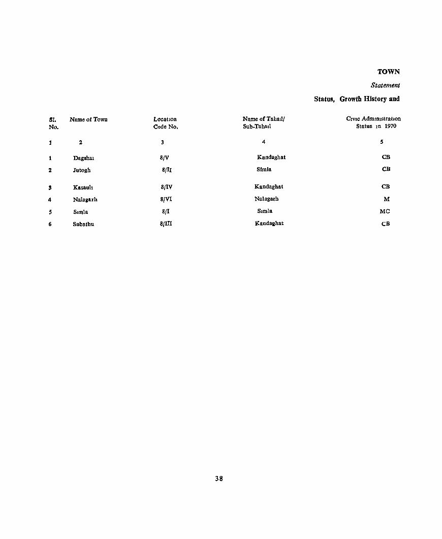
TOWN
Statement
Status, Growth History and
SI. Nameo:fTown Location Name of Tahsill CIVIC Administration No. Code No. Sub.Tahsll Status In 1970
J 2 3 4 S
1 Dagshat 8/V Kandaghat CB
2 Jutogh Sf II Simla CB
S Kasauh 8/IV Kandagbat CB
4 Nalaaarh 8/VI Nalagarh M
5 Simla 8/1 Simla Me
6 Subatbu 8/III Kandaahat CB
38

DIRECTORY
1
Functional Category of Towns
PopulatIOn of the Town at the Censuses of FunctIonal Category
1901 1911 1921 1931 1941 1951 1961 1971 (1961 Census)
6 7 8 9 10 11 12 13 14
2,159 2,032 1,745 1,469 1,047 1,445 2,783 2,161 Semce
375 Included in Simla Town 470 634 Included In Simla Town
1,487 1,291 Service
2,192 3,194 3,212 2,852 2,749 4,007 4,102 3,757 Service
4,027 Declassified 3,615 2,547 3,096 3,671 ServIce
13,960 19,405 27,213 18,144 18,348 46,150 42,597 55,368 ServIce
2,177 1,847 1,581 1,327 2,181 2,585 3,216 2,884 SelVlCO
39
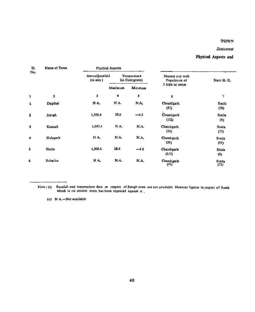
81. No.
1
1
%
3
4
5
6
TOWN
Statement
Physical Aspects and
Name of Town Physical Aspects
Annual[ratnfall Temperature Nearest city with (In mm) (10 Centigrade) Population of State H. Q.
I lakb or mor. Maximum MlD1Illum
2 3 4 5 6 7
Da&shai NA. NA. N.A. Chandigarb Simla (57) (70)
28.6 ,
Simla Jutogh 1,508.4 -4.3 Chandlgarh (22) (8)
KasauU 1,647.1 NA. N.A. Chandlgarh SImla (52) (77)
Nalagarb NA- N.A. N.A. Chandlgarh SImla (59) (95)
Simla 1,508.4 28.6 -43 Chandigarb SImla (117) (0)
Subathu NA. N.A. N.A. Chandlgarh SImla (91) (72)
Note: (I) Ramfall and temperature data In respect of Jutogb town are not avaIlable However figures in respect of SImla which IS Its nearest town has been repeated agamst It _
(11) N A.-Not available
40

DIRECTORY
II
Location of Towns, 1969
District HQ
8
Simla (70)
Simla
(8)
Simla (17)
Simla (95)
Simla (0)
Simla (72)
Sub-DIVISional H Q / Tahsil H Q or Sub-TahsIl H Q
9
Kandaghat/ Kandagh.lt (30) (30)
Simla/Simla
(8) (8)
Kandaghat/Kandaghat
(43) (43)
Nalagarh/Nalagarh (0) (0)
Simla/Simla (0) (0)
Kandaghat/Kandaghat (46) (46)
Name of Road and distance (Kms ) (rom
Railway StatIOn Bus Route
10 11
Dharampur Dharampur (5) (5)
Jutogh Jutogh (2) (0)
Dharampur Kasauli (13) (0)
Bharatgarh Nalagarh (11) (0)
Simla Simla (0) (0)
Dharampur Subathu (16) (0)
41
Navigable flver/canal
(If wlthlD 10 Kms)
12
Sea port (If Within
50 Kms)
13
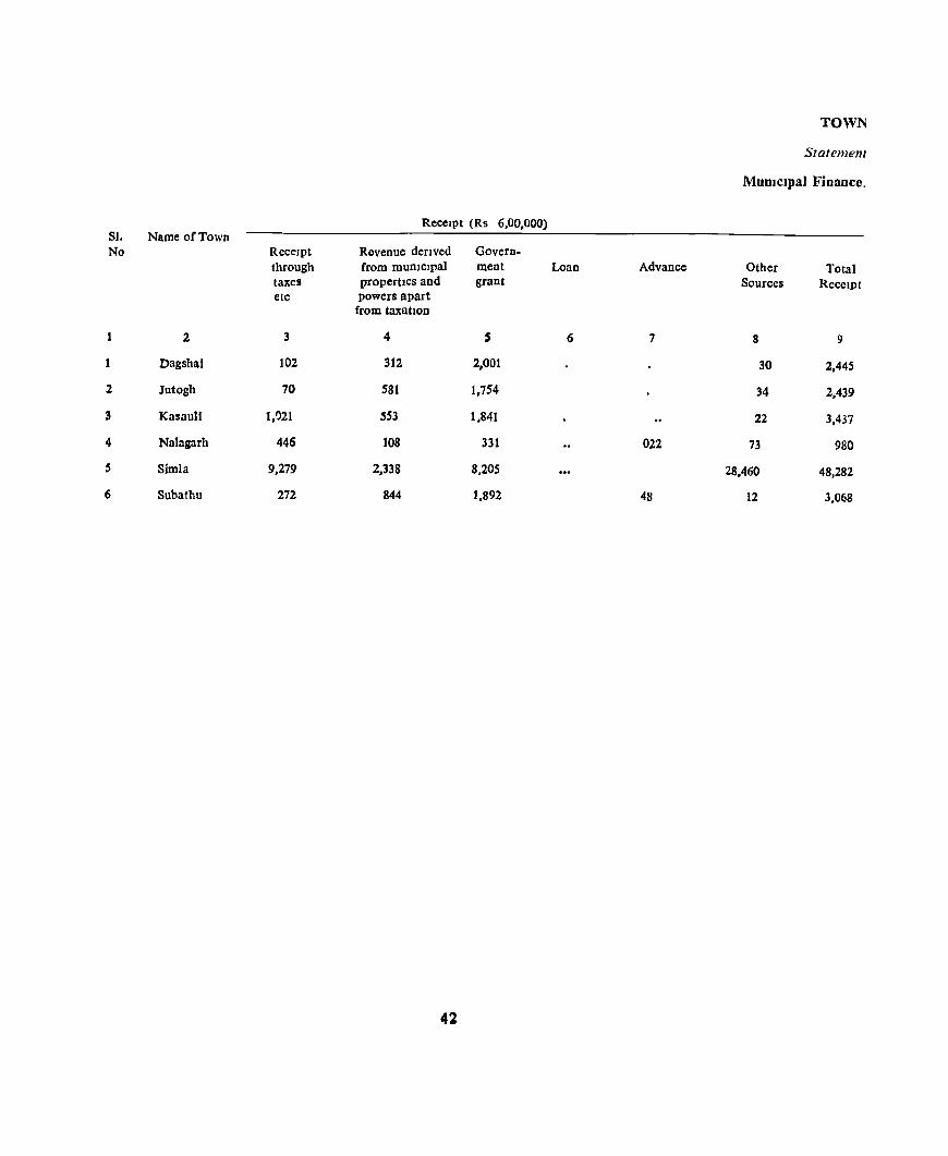
TOWN
Statement
MUDlclpal Finance.
Receipt (Rs 6,00,000) SI. Name of Town No Receipt Revenue derived Govern-
through from mUDlclpal ment Loan Advance Other Total taxes propertIes and grant Sources ReceIpt etc powers apart
from taxahOD
2 3 4 5 6 7 8 9
Dagshai 102 312 2,001 30 2,445
2 Jutogh 70 581 1,754 34 2,439
3 Kasaull 1,021 SS3 1,841 22 3,437
4 Nalagarh 446 108 331 022 73 980
5 Simla 9,279 2,338 8,205 28,460 48,282
6 Subathu 272 844 1,892 48 12 3,068
42
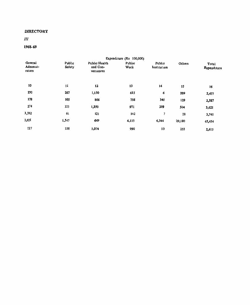
DIRECTORY
III
1968-69
General AdmlOlstratIon
10
230
178
274
3,362
3.621
127
Pubhc Safety
11
267
105
323
61
1.'47
156
Expenditure (Rs 100.000) Pubhc Health
and Convemences
12
1,150
866
1,250
121
649
1.074
Pubhc Work
13
615
758
971
162
4.113
990
Pubhc Institution
14
6
341
299
7
6.344
13
Others
15
209
139
504
28
29.180
255
Total Bxpendlture
16
2.471
2.387
3,621
3.741
45.454
2,615
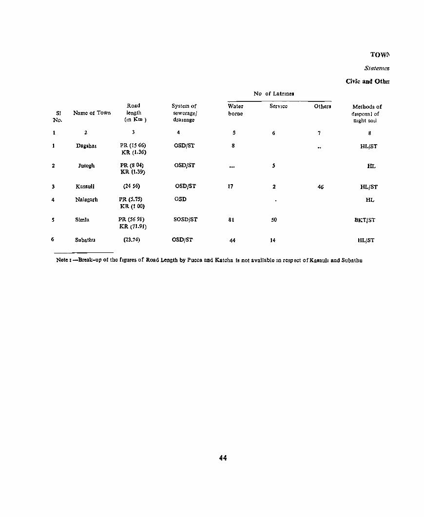
TOWl'1
Statemen
Civic and Other
No of Latnnes
Road System of Water Service Others Methods of 51 Name of Town length sewerage! borne disposal of
No. (10 Km) draloage night soIl
1 2 3 4 5 6 7 8
Dagllbal PR (15 66) OSD/ST 8 HL/ST KR (1.36)
2 Jutogh PR (8 04) OSD/5T 5 HL KR (1.39)
3 KasauU (24 S6) OSD/ST 17 2 46 HL!ST
4 Nalagarb PR (5.75) OSO HL KR (1 00)
S Simla PR (56 91) S05D/ST 81 SO BKT/ST KR (71.91)
6 Subathu (23.74) 05D/ST 44 14 HL/ST
Note: -Break-up of the figures of Road Length by Pucca and Katcha Is not available 10 respect ofKasauh and Subatbu
44

DIREC'IORY
W
Amenities, 1969
Protected Water supply ElectnficatJOn (Number of connections) Fue
flghtlOg serv Ice Road IlghtIDg
Source Capacity DomestIc Industnal Commercial (POintS) Others
9 10 11 12 13 14 15 16
T 4,000,000 gallons Yes 221 2 84 73
T 1,000.000 gallons Yes 83 41 33
T 9,900,000 gallons Yes 749 20 293 178
T 60,000 gallons Yes 477 12 - 226 105 2
T 4,278,125 gallons Yes 14,473 67 1.221 3,26U
T 3.264,000 gallons Yes 326 175 112
45
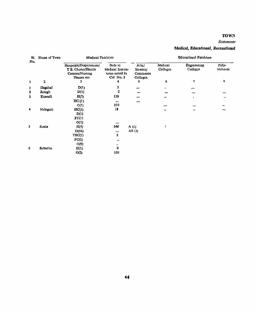
SI. Name oCTown No.
1 2
1 Dagsbal 2 lutogh 3 Kasauli
4 Nalagarh
SImla
6 Subathu
Medical Faclhtle&
Hospitals/Dispensaries/ Beds In Arts/ T B. Chnics/Health Medical Instltu· SCIence/ Centres/NursIng trons noted in Commerce
Homes etc Col No.3 Colleges 3 4 S
0(1) 3 0(1) 2 H(2) 119
HC(I) 0(1) 250
HC(l) 18 0(1)
FC(t) 0(1) H(4) 546 A (1)
D(16) AS (3) TBC(1) 2
FC(2) 0(9) H(l) 9 0(2) 150
MedIcal Colleges
6
TOWN Statement
Medical, Educational, Recreational
Educational Faclhttes
Engmeerrng Colleges
7
PolytechniCS
8

DIRECTORY
V
aDd Cultural FacilitIes JU Towns, 1969
(FIgures mdlcate number of unIts)
RecreatIOnal & Cultural FacIlItIes
RecognIsed Short-hand, HIgher Junior Pflmary Others StadIa ClOemas Audltonall PublIc ltb-Type-wfltmg & other Secondary or Secondary/ Schools Drama ranes IDclu-VocatIOnal Trammg Secondary MIddle Halls dlDg read·
InstItutes Schools Schools mgrooms
51 10 II 12 13 14 15 16 17
I I
CTC(I)
CrC(I) 2 2 RITI(1)
ITI (1) 16 8 6 B.ED(1) 4 3 7 TC(I) POe(l) CTC(I) FACt)
SC(t) IIAS(!)
2 1
47
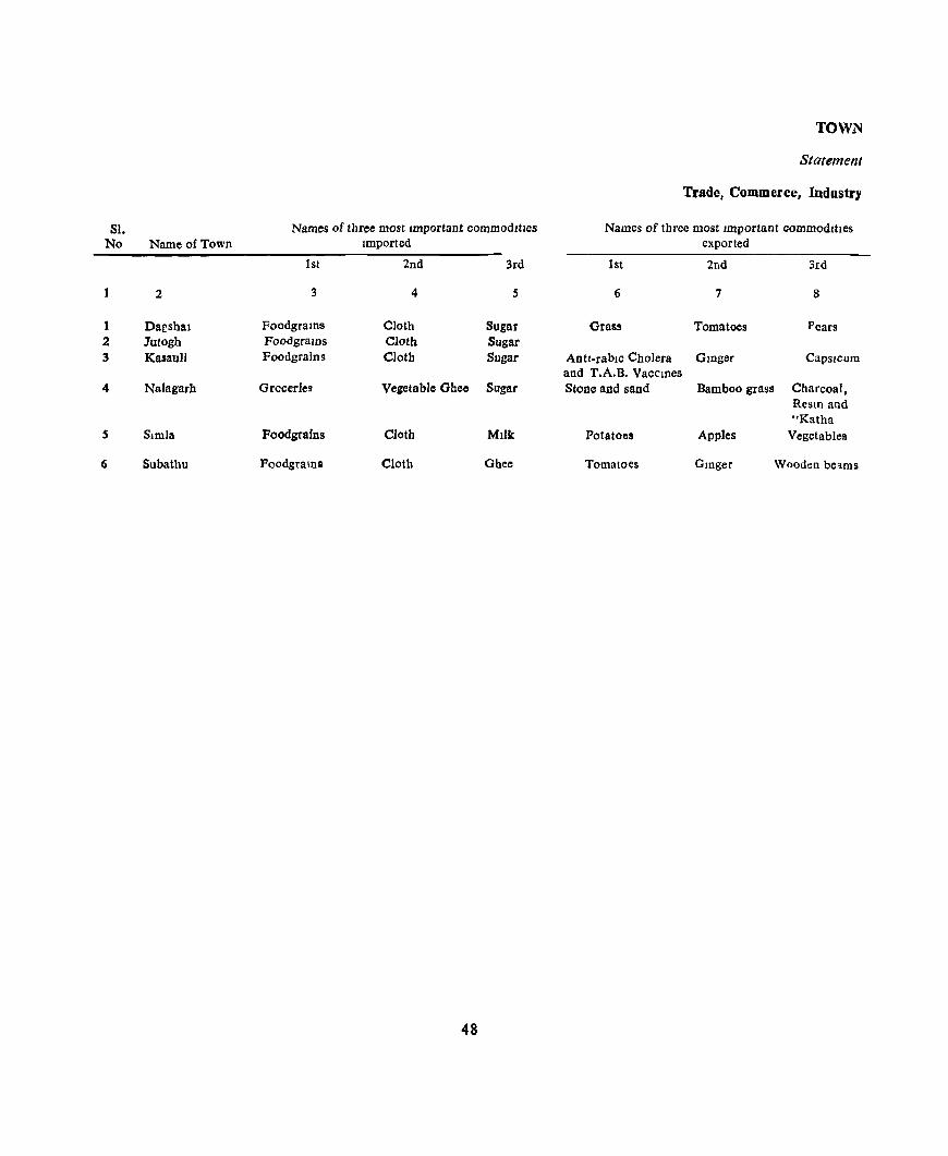
TOWN
Statement
Trade, Commerce, Industry
SI. Names of three most Important commoditIes Names of three most Important commodIties No Name of Town Imported exported
1st 2nd 3rd 1st 2nd 3rd
1 2 3 4 5 6 7 8
1 Da£sbal Foodgrams Cloth Sugar Grass Tomatoes Pears 2 ]utogh FoodgralOS Cloth Sugar 3 Kasaull Foodgralns Clotb Sugar Antl-rablc Cholera GlDger Capsicum
and T.A.B. Vaccmes 4 Nalagarb Groceries Vegetable Ghee Sugar Stone and sand Bamboo grass Charcoal,
ResID and "Katha
S Simla Foodgrafns Cloth Milk Potatoes Apples Vegetables
6 Subathu Poodgra1Da Cloth Ghee Tomatoes GlDger Wooden beams
48
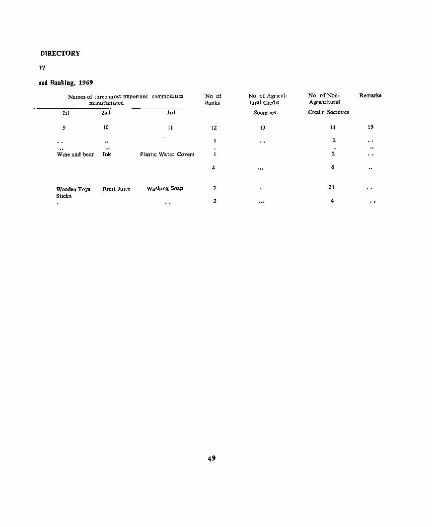
DIRECTORY
VI
and Banking, 1969
Names of three most Important commodItIes manufactured
1st 2nd
9 10
WIDe and beer Ink
Wooden Toys StIcks
FruIt JUIce
3Id
II
PlastIc Water Covers
WashIDg Soap
No of Bank.s
12
4
7
2
No of AgrIcultural Credit
Societies
13
No of Non- Remarks Agncuitural
Credit SocIetIes
14 is
2
2
6
21
4

TQWN
Statement
Population of Towns
SI. Buddhists Christians Htndu!l Jams
No Name of Town M F M F M F M F
1 2 3 4 5 6 7 8 9 10
Dagshai 8 10 950 928
2 Jutogh 3 12 2S 617 530
3 Kasauli 6 13 62 77 1.786 1,430 8 9
4 Nalagarh 85 51 1,531 1.359 37 39
5 Simla 505 341 251 310 29,096 19,228 56 52
6 Subathu 2 7 1,329 1,453
so

DIRECTORY
VII
by Religions, 1971
Other RelIgions
MuslIms Sikhs and PersuatIons ReligIon not stated
M P M F M F M F
11 12 13 J4 15 16 17 18
6 9 174 75 1
2 8 47 46
12 12 163 177 2
161 159 151 86 7 5
840 166 2,437 1,978 60 47
9 4 45 35
51
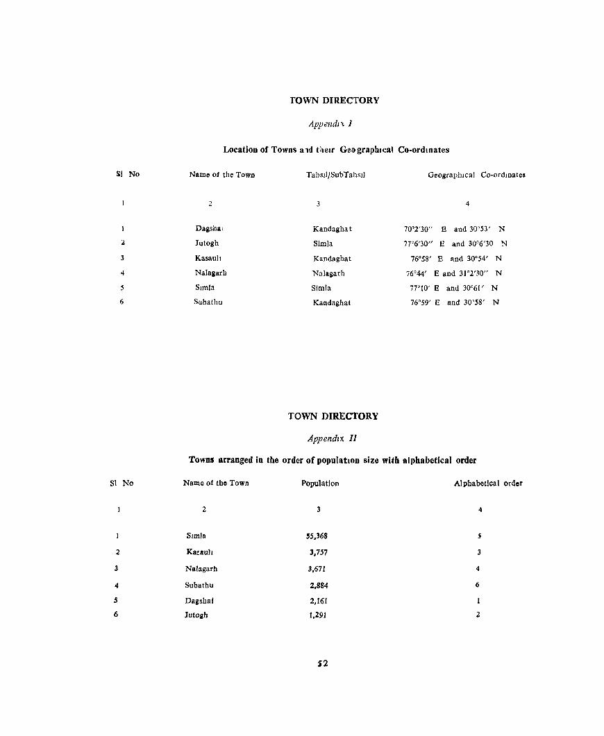
Sf No
2
3
4
5
6
SI No
2
3
4
5
6
TOWN DIRECTORY
Appendix J
Location of Towns a ld tilelr Geo graphIcal Co-ordmates
Name of the Town TabslljSubTahsll GeographIcal Co-ordmate!
2 3 4
Dagshat Kandaghat 70°2'30" B and 30°53' N
Jutogh Simla 7T6'30" E and 30°6'30 N
Kasault Kandaghat 76°58' E and 30°54' N
Nalagarh Nalilgarh 76°44' Band 31°2'30" N
SImla SImla 77°10' E and 30°61' N
Subathu Kandaghat 76°59' E and 30°58' N
TOWN DIRECTORY
Appendix II
Towns arranged in the order of populatIon size with alphabetical order
Name of the Town Population Alphabetical order
2 3 4
Slmlli 55,368 S
Ka~aulJ 3,757 3
Nalagarh 3,671 4
Subathu 2,884 6
Dagshaf 2,161
Jutoab 1,291 2
)2

SIMLA : S UB- TAHSIL
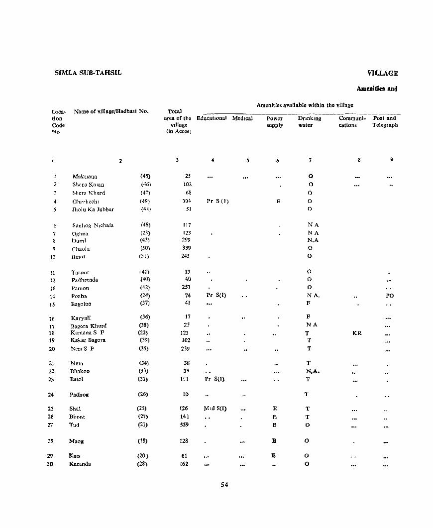
SIMLA SUB-TAHSIL
loca- Name of vJllage/Hadbast No. tlon Code No
2
1 MakrJana (45) 2 Shcra Kalan (46\
:; 5hera Khurd (47)
4 Gh:<rhechl (49)
.5 Jholu Ka Jubbar {4~J
6 Sani,og Nlchala (48)
7 Oghna (23)
8 Dumi (43)
9 Chaola (50)
10 Dmot (51 )
II Taroot i 41)
12 Padhrenda (40)
16 PanlOn (42)
14 Poaba (24)
IS Bagoloo (37)
16 KaryaU (36)
17 Bagara Khurd (38)
18 Kamana S F (22)
19 Kakar Bagara (39)
20 NenS F (35)
21 NJUn (34)
22 Bhakoo (33)
23 Batol (31)
24 Padhog (26)
25 Shal (25)
26 Bhont (27)
27 Tud (21)
28 Maog (18)
29 Kals (20)
30 Karanda (28)
Total area of the Educatlonal MedIcal
vIllage (In Acres)
3 4 S
25 102
68
394 Pr S (1)
51
117
123 299
339 245
13 40
253 74 Pr S(I) 41
17 25
123 102 239
38 39
leI Pr S(l)
10
126 Mid S(l)
14!
559
128
61 162
54
VILLAGE
Amenities and
Amenities available within the vlllage
Power supply
6
E
E
E E
:&
E
DnnklDg water
7
0
0
0
0 0
NA NA N.A 0
0
0 0
0 NA. F
F NA
T T
T
T N.A. T
T
T
T 0
0
0
0
Communi- Post and cations Telegraph
8 9
PO
KR

DIRECTORY
Land use
Land u~e (I e, area under different types of land use In acre~ Nearest town Day or Days Remarks Loca-rounded to the nearest umt) & distance of the ivlarket/ Includmg tIon
Stapl!' Food In Kilometre Hat Ifany, any place Code !"orest Irngated Un- CuIturable Area not held 10 the of religIOus, No
Irngated wa~te available for village historical or cultivation archaeologlca J
Interest
10 11 12 11 14 15 16 17 18
Wheat, Maize 0(1) '3 'i 16 Simla 13 t Wheat, Maize 10 21 71 SImla 12 2 Wheat, Maize 14 13 41 SImla 12 3 Wheat, Maize 67 41 286 Simla 13 4 Wheat, MaIze 2 2 47 SImla 9 5
Wheat, Maize 12 17 88 Simla 10 6 Wheat, Maize 13 13 97 Simla 7 7 Wheat, Maize 55 30 214 Simla 9 Temple Devta Nagold 8 Wheat, Mal7e 36 47 256 Simla 12 9 Wheat, Mal7e 0(3) 16 24 202 Simla II 10
Wheat, Maize '3 3 7 Simla 9 11 Wheat, Maize S 32 Simla 7 12 Wheat, Maize 0(5) 21 23 204 Simla 11 13 Wheat, Maize 30 12 32 Simla 7 41 Wheat, Maize 10 9 22 Simla 9 15
Wheat, Maize 5 4 8 SImla 9 16 Wheat, Maize 8 2 15 Simla 9 17 Wheat, MaIze 14 22 87 SImla 6 18 Wheat, MaIze 21 15 66 SImla 9 19 Wheat, Maize 0(1) 36 14 188 SImla 7 20
Wheat, Maize 3 6 29 Simla 9 21 Wheat, Maize 4 14 21 SImla 7 22 Wheat, Maize 14 27 60 SImla 7 Temple 23 Thakur Dwara Wheat, Maize 6 4 SImla 9 Temple Gao Devta 24
Wheat, Maize 34 19 73 SImla 6 25 Wheat, Maize 0(3) 24 27 88 Simla 6 26 Wheat, MaIze 0(5) 94 41 419 SImla 6 Temple 27 Thakur DWara Wheat, Maize 0(3) 17 14 94 Simla 6 28
Whee, MaIze 0(6) 3 5 47 SImla 5 26 Wheat, Maize 16 35 111 Simla 6 30
55
SIMLA SUB-TAHSIL
Loca. Name of viHage/Hadbast No. Total lion Cod" No
31 32
33
34
35
36 37
38 39
40
41
42 43 44
45
46
47 48
49
50
5)
52 S3 54
5S
56 57
58
59 60
{it
62
2
Manta Lehri Bhong Gulch a
Kialoo
Chanu Karog
Sanog Ubla Sangti Kahn a
KanjaH
Rod Lobarb Haron JaooI
Panti
Bharech Ichhaser Barohi JahJog
Fatecbi
Kalaw".t Hiun Kiargiri DbaDail
Nalail Anji Sarhog
Rahai Meri
Garb Kalan Garb Khurd
(29)
(32)
(30)
(19)
(16)
(17) (15)
( (4)
(13) (53)
(52)
(56)
(54) (55)
(57)
(59)
(58)
(60)
(61)
(62)
(63)
(70) (72)
(71)
(69)
(73) (74) (68)
(67)-
(64)
(66) (65)
area of the BdLJcational Medical village
(in Acres)
3 4
49
78 49
122
35
64
27 72 48
329
112
183
204 123 Pr.S (I) 371
284 79
25 389 Pr.S (I)
89
85
52
69 32 66
64 34 89 56
50
33 44
56
VILLAGl
Amenities ll1;,
Amenities available within the village
Power iUPPIy
6
E
...
Drinking water
7
0 0 0
N.A. 0
N.A. 0
T N.A. T
N.A. N.A. N.A. T T
N.A. N.A. N.A. T N.A.
N.A. N.A. N.A. N.A. N.A.
N.A. N.A. N.A. N.A. N.A.
N.A. N.A.
-----Communi. Post an" cations Telegtar~
KR
PO
KR
KR
PR
KR
DIRECTORY
Laud use
Land use (I e , area under different types of land use ID acres Nearest town Day )C Days Remarks Loca-rounded to he nearest unit) & distance of the Marketl Includ10g tlon
Staple food 10 Kilometre Hat If any. any place Code forest Irrigated Un- Culturable Area not held 10 the of religious, No.
IrrIgated waste avaIlable for Village hlstoncal or cultivation archaeological
mterest
!O II 12 13 14 15 16 17 18
Wheat, MalZe 10 7 32 Simla 7 31
Wheat, Maize 6 15 57 Simla 9 32
Wheat, Maize 13 II 25 Simla 7 33 Wheat, Maize 0(1) 12 24 85 Simla 3 34 Wheat, Maize 4 4 27 Simla 7 3S
Wheat, Maize 16 7 41 Simla 6 36 Wheat, Maize 9 5 13 Simla 6 37
Wheat, Maize 13 6 53 Simla 5 38 Wheat, Maize 5 1 42 Simla 5 39 Wheat, Maize 48 257 24 1utogh 9 40
Wheat, Maize 0(2) 26 72 12 Jotogh 9 41
Wheat, Maize 0(3) 23 149 8 Jutogh 7 42 Wheat, Maize 17 182 5 Jutogh 6 4~
Wheal, Maize 15 103 5 Jutogh 6 44 Wheat, Maize 46 307 18 Jutogh 7 45
Wheat, Maize 34 234 16 Julogh 6 46 Wheat, Maize 9 67 3 Jutogh 6 47 Wheat, Maize 5 20 Jutogh 9 48 Wheat, Maize 76 289 24 Julogh 9 49 Wheat, Maize 19 60 10 Jutogh 6 50
Wheal, Maize 10 69 6 Jutogh 3 51 Wheat, Maize 6 34 12 JUlogh 5 52
Wheat, Maize 24 39 6 Jnlogb 3 53
Wheat, Maize 8 23 Julogh 3 54 Wheat, Maize 0(1) 12 47 6 Jutogb 4 5S
Wheat, Maize 15 44 5 Julogb 5 56 Wheat, Maize 0(1) 8 23 2 Julogb 4 57 Wheat, Maize 22 56 11 JUlogh 5 58 Wheat, Maize 19 33 4 Jutogb 3 59 Wheat, Maize 13 36 1 Jutogh 2 60
Wheat, Maize 12 18 3 Jutogb 2 61 Wheat, Maize 11 31 2 Jutogh 2 62
57
tjUB-TAHSlL SIMLA
Loca- Name OfvllldgerHadba~t NQ
(Jon Code No
2
63 Kalf (79)
64 Dhenca (SO}
65 Chanan (77)
66 Chahl) Khurd (75)
67 ChJ.hh Kalan (76)
68 Gadog SF (78) 69 Balilhu (l26) 70 Thanen (120)
71 Charond (122)
72 Karhech (123)
73 Chharah (119) 74 Pan]altl (125) ,5 Baloh (121 )
76 Sen (127) 77 Manjalla (124)
78 Tlkn Mashah (118)
79 Kanda (109) 80 Dhalla (108) 81 Kharol (110)
82 LadVl (111)
83 ShuroQ (113)
84 Galot ( 1l7)
85 Pdnesh (l13)
86 Shanwala (1\6)
87 Raura (1(15 )
88 Fatenchl (89}
89 Rchlbalchn (88)
90 Jaog (90} 91 Kater (107)
92 Ner (96)
93 Khanlt i 91)
94 Sllllangra (1 ('6)
VILLAGE
Amcmtlcl> and
Amenltles aVdllable wlthm the vIllage Total
area of the Educational Medica I vIllage
lm Acres)
3 4 5
9(1
117 12
132 135 Pr S (1)
80 108 26
215 42
43 44 56
ti6
91
137
526 48 48
131
241 187
372
.56 Pr S (I) 188
149
282 64
102
27
39
55
5R
Power supplv
6
E
E E
E
DrlOkmg water
7
T NA T
T T
T 0 NA 0 R
0 0 0
0 0
0 T T
0 T
0 T
T
0
T
T T
0 T
0
T
0
Communl- Post and catIOns Telegraph
8
PR,T
KR,T
T
PR PR PR
PR
PO
PR PR PO
DJR£CTORV
Lalld Us.!
Land use (I e , area under dlfferen! types of land use 10 aCNS Nearest town Day or Days Remarks Laca-
rounded to the nearest Unit) & dIstance of the Marketl Inc1udmg bon
Staple Food In Kdometre Hat If any, any place Code
Forest Imgated Un- Culturable Area Dot held 10 tbe of religIous, No
IIflgated waste avadahle for village hIstOrical or
culhvatJOll arcbaeologlcal mterest
10 11 12 13 14 15 16 17 18
Wheat, Maize 0(3) 21 57 9 Jutogb 2 63
Wbeat, Mlllze 17 87 13 Jutcgb 64
wneat, ~al:ze 0(1) 5 4- 1 lutogh 1. ~
Wbeat, MaIze Z3 93 16 Jutogh 4 66
Wheat, MaIZe 37 85 13 Jutogh 3
('7
Wheat, MaIze 0(6) 37 20 17 Jlltogh 1 68
Wheat, Maize 0(1) 39 61 5 Jutogh 9 '9
Wheat, MaIze 3 1\ 2 Jlltogh 9 70
Wbeat, MaIZe O(4) 48 140 23 Jutogb 9 it
Wheat, Maize 0(2) 7 26 7 Jutogh 9 72
Wheat, Malle O(4} 5 30 4 Jutogh 7 i~
Wheat, Maize 0(3) 12 25 4 Jut(lgh 9 74
Wheat, MaIze Om 13 33 8 Jutogh 9 7~
Wheat, MaIze OCI} 11 49 5 Jl1togh 11 76
Wheat, MaIze 0(1) 27 56 7 Jutogh 7 17
Wheat, Maize 00) 33 96 7 ]utogh 6 7'
Wheat, Malle 0(1) 76 392 57 JDtogh 3 79
Wheal, j>,·ta lze 0(1) '] 34 6 Jutogh 3 gO
Wheat, Malze O{2} 8 28 10 Jutogh 4 8!
Vlheat. Maize 18 10<1 7 Jutogh 5 82
Wheat, Maize 0(3) 59 167 12 Jutogh 6 83
Wheat, Malle 0(3) 46 llll 10 JUlOgb 6 84
Wheat, MaIZe 0(3) 73 184 12 Jutogh 7 is
Wheat, Maize " 50 2 Jutogh 6 86
Wheat, MaIze 0(9} 36 131 12 Jutogh 6 81
Wheat, MaIze 0(2) 34 105 g Jutogb 3 88
Wheat, MaIze 0(16) 29 224 13 Jutogh 3 89
Wheat, Malle Ol21) 1 37 1\ lute)!,\} 4 90
Wheat,Malze 0(15) 4 73 10 Jutogh 4 91
Wheat, Malze Oll) 5 19 2 Jutogh 4 92
Wheat, MalZ~e 0(9) 2 2; 3 Jutpgh 4 93-
WhcaI,M1.!Ze 0(3) ., 4:1 5 JutDEh 3 94
5'
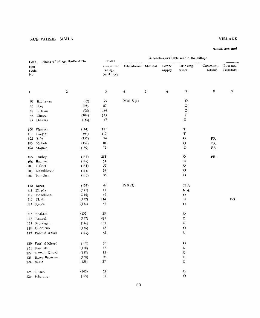
SUB I'AHSIL SIMLA
Loca
tlon Code No
Name of vJlldgejHadbast No
2
95 Rldhawlli (92) 96 G,Hi (93)
97 K lta,nl (95)
98 Chaog (104) 99 Dla<;hfl (115)
100 PhagcLt (114) 101 Pa0gla (94) 102 Tiff] (151) 103 <'hekoh (152) 104 M.lJh.lt (150)
105 J.lm10g W4)
106 Banaun (149) 107 Nalole (153)
108 Dohchhnoo (155)
109 Pamchn (48)
110 JalJar (133)
111 Dball.! (147) 112 Dobchhna (156) 113 T1.lJ)a (112)
114 Rapra (13.t)
115 Shakrot (135)
116 Rangol (157) 117 Mal.lngan (146)
118 Ghararoo (136) 119 Pahh;)l Kalan (131)
120 Patshal Khurd (130)
121 PahlhtltJ (128)
122 Gow.lhl Khurd (137)
123 BJrog Barmanl (158) 124 Kotla (138)
125 Ghcch (145)
126 Kh<II.lUD (129)
VILLAGE
AmemtJes and
AmenitIes avaIlable withm the vIJlJge Total
--------~~----- --- -
aica of the EducatIOnal Medical vllj.lge
(m Acres)
3 4 5
29 MId S (I)
57
166 145 47
187 117 74 81 76
281 54 55 34 35
47 Pr S (1)
47 46
114 57
28 487 191 43 53
38 87 35 93 27
65
77
60
Power supply
6
DrInkmg water
7
0
0
0 T
0
T T 0
0 0
0 0 0
0
0
NA
NA 0 0
0
0
0 0
0 (J
0 0
0
0 0
0 0
CommuIll- Post and cations Telegraph
8
PR
PR PR
PR
PO

DIUECTOR\,
Land u<;c
Land use (I e , area undcr dIfferent types of land use III acres Nearest town Day or Days Remarks Loca-rounded to the nearest unit) & dIstance of the Marketl lI1cludmg tlon
Staple Food III Kilometre Hat If any, any place Code rore,t Irngated Un- CuIturable Area not held m the of religIOUs, No
lffl!4ated waste avaIlable for Village histOrIcal or cultlv,ltJon archaeological
mterest
10 II 12 13 14 15 16 17 18
Wheat, MaIze 1 25 3 Jutogh 3 95
Wheat, M,llze 0(4) 4 45 4 Jutogh 4 96
Wheat, Maize 0(8) 23 125 10 Jutogh 5 97 Wheat, Maize 37 94 14 Jutogh 7 98
Wheat, Ma Ibe 0(2) 9 33 3 Jutogh 6 99
Wheat, MaIze 0(2) 30 144 11 Jutogh 7 100
Wheat, Maize 0(2) 22 79 14 Jutogh 5 Temple 101
Wheat, Maize, Rice 0(1) 20 48 5 Jutogh 18 102
Wheat Mdlze, RIce 0(3) 24 40 14 Jutogh 28 103 Wheat, Maize, RIce 0(1) 13 52 10 Ark! 20 Kflshan Temple 104
Wheat, Mcllze, Rice 0(11) 30 209 31 Jutogh 38 105 Wheat, MaIze, Rice 0(3) 16 25 10 Arkl35 106 Wheat, Maize, RIce 0(3) 9 35 8 Arkl 36 107
Wheat, Maize, Rice 0(3) 4 22 5 Arkl22 108
Wheat, Maize, Rlcc 0(1) 6 23 5 Ark! 34 109
Wheat, Maize, Rice 8 37 2 Arkl31 110 Wheat, Maize, Rice 11 23 11 Arkl34 111 Wheat, Maize, RIce 0(1) 7 35 3 Ar\:l 22 112 Wheat, Maize, RIce 0(1) 13 93 7 Arkl30 113
Wheat, Malzc, RIce 18 29 10 Ar1..131 114
Wheat, MaIze, RIce 0(3) 7 13 5 Arkl 31 115
Wheat, Mdlze, Rice 0(17) 86 342 42 Arkl22 116 Wheat, Maize, Rice 0(3) 57 109 22 Arkl25 117
Wheat, MaIze, RIce 0(2) 10 22 9 Arkl32 118 Wheat, Maize, Rice 0(1) 11 36 4 Jutogh 25 119
Wheat, Mau~e, RIce 0(2) 10 22 4 Jutogh 15 120 Wheat, IValze, Rlcc 9 71 5 Jutogh 16 121 Wheat, Maize, Rice 0(2) 11 18 4 Jutogh 17 122 Wheat, Malzc, Ru"e 0(2) 24 63 4 Arkl20 123 Wheat, Maize, Rice 11 13 3 Jutogh 18 124
Wheat, Maize, Rice 0(3) 17 37 8 Jutogh 28 125 Wheat, MalZc, RI;;e 0(5) 30 36 6 Jutogh 2( 126
61
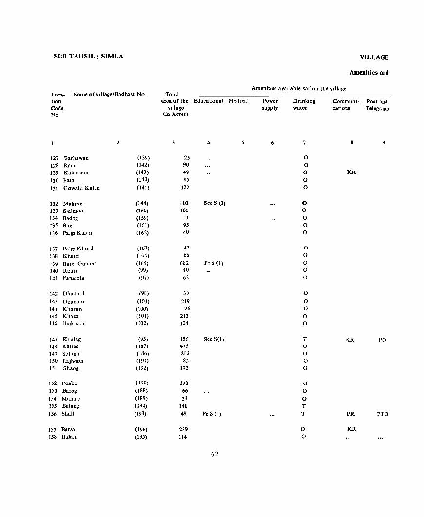
SUB-TAHSIL: SIMLA
Loca- Name of vJllage/Hadbast No Total bon Code No
127 Barhawan 128 Raufl 129 Kalalraon
130 Pata 131 Gowahl Kalan
132 Makrog 133 Slalmoo 134 Badog 135 Bag
136 Pa]gl Kalan
137 Palgl Khurd 138 Khatri 139 Bash Gun,lDa 140 Raun 141 PanalOla
142 Dhadhol 143 Dhamun 144 Kharun 145 Khalrl 146 Jhakhan
147 Khalag 148 KafJed 149 Sotana 150 LaJhoon 151 Ghaog
152 Poabo 153 Barog 154 Mahan 155 Balang
156 Shall
157 BanVI 158 BalalO
2
(139) (42) (143) (143) (141)
(144) (160) (159) (161) (62)
(161) (164) (165) (99) (97)
(98) (103) (100) (101) (102)
(95) (187) (186) (191) (192)
(190) (188) (189) (194) (193)
(196) (195)
area of the EducatIonal Medical village
(In Acres)
3 4
25 90 49 85
122
110 Sec S (1) 100
7 9~
40
42 66
682 Pr S (1) 40 62
36 219
26 212 104
156 Sec S(I) 475 210 82
192
190 66 33
141 48 Pr S (1)
239 114
62
VILLAGE
Ameoiti es and
Amenities available WlthlO the village
Power supply
6
Dnnkmg water
7
0
0 0 0 0
0 0 0 0 0
0 0
0 0 0
0
0 0
0 0
T 0 0 0
0
0 0
0 T T
0 0
CommuDI- Post and cations Telegraph
8 9
KR
KR PO
PR PTO
KR
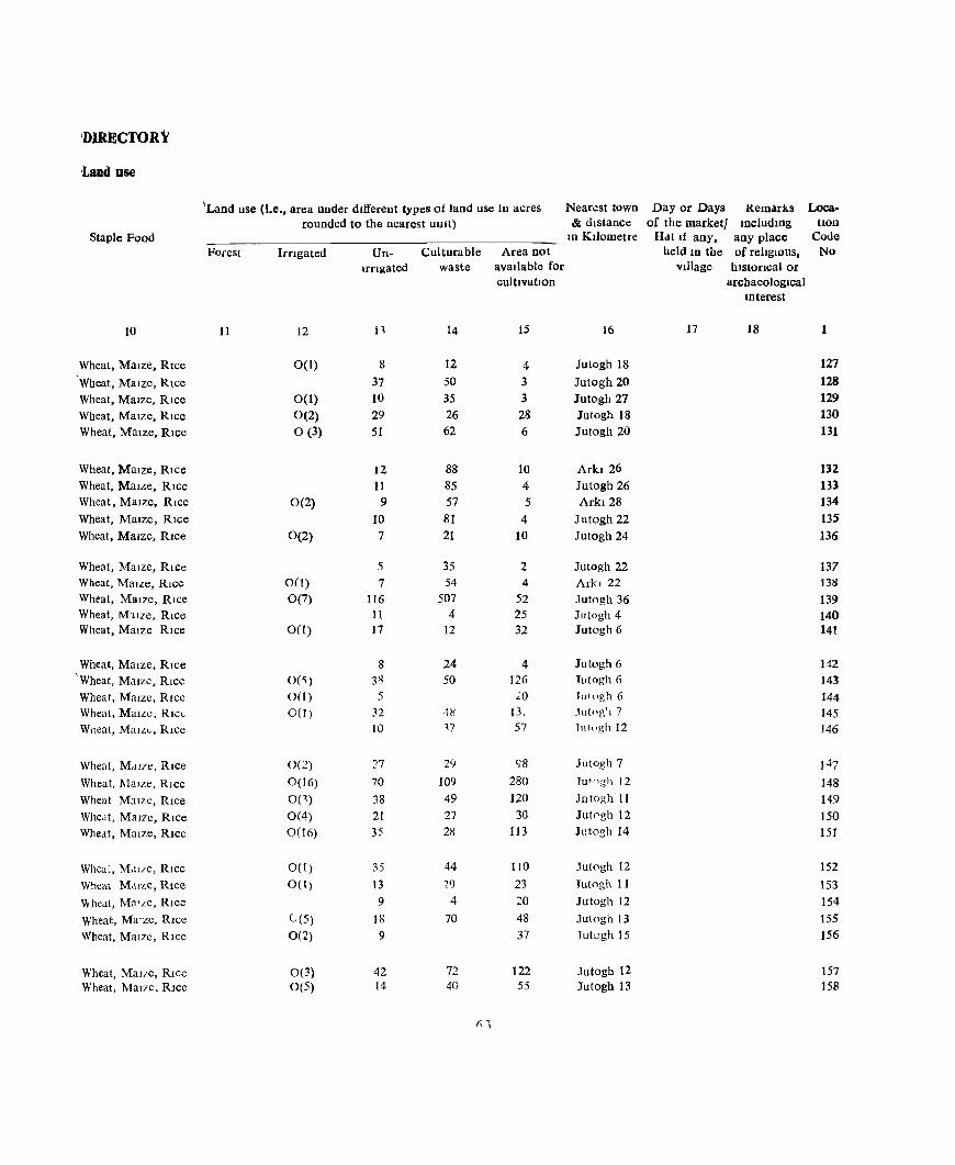
'DIRECTORY
'Land use
"Land use (I.e., area under different types of land use In acres Nearest town Day or Days Rem,uks Looa· rounded to the nearest UDlt) & distance of the market/ IOciudlUg tlOO
Staple Food 10 Kilometre Hdt If aoy. any place Code Forest Irngated Un- Culturabie Area not held 1D the of religIOUS, No
Ifflgated waste available for Village hlstOflcal or cultIvation archaeological
Interest
10 11 12 n 14 15 16 17 18 1
Wheat, Maize, Rice 0(1) 8 12 4 Jutogh 18 127
Wheat, Maize, Rice 37 50 3 Jutogh 20 128
Wheat, Maize, Rice 0(1) 10 35 3 Jutogh 27 129
Wheat, Maize, Rice 0(2) 29 26 28 Jutogh 18 130
Wheat. Maize, Rice 0(3) 51 62 6 Jutogh 20 131
Wheat, Maize, Rice 12 88 10 Arkl 26 132
Wheat, MaLle. Rice 11 85 4 Jutogh 26 133 Wheat, Maize, Rice 0(2) 9 57 5 Arkl28 134
Wheat, Maize, Rice 10 81 4 Jutogh 22 13.5
Wheat, Maize. Rice 0(2) 7 21 10 Jutogh 24 136
Wheat, Maize, Rice 5 35 2 Jutogh 22 137 Wheat, Maize, Rice 0(1) 7 54 4 Arkl 22 138
Wheat, Maize, Rice 0(7) 116 507 52 Jutogh 36 139 Wheat, M~ITe, Rice It 4 25 Jutogh 4 140 Wheat, Maize Rice 0(1) 17 12 32 Jutogh 6 141
Wheat, Maize, Rice 8 24 4 Jutogh 6 142 'Wheat, Maize, Rice 0(<;) 3~ 50 126 Tutogh 6 143 Wheat, Maize, Rice 0(1) 5 20 lUI llgh 6 144 Wheat, Maize, RICL 0(1) 32 4!l 13, Jutng'l 7 145 Wheat, Malz,"" Rice 10 17 57 Tlllugh 12 146
Wheat, M,II7e, Rice 0(2) 27 29 98 Jutogh 7 147
Wheat, l\lalzc, Rice 0(16) 70 109 280 Tut"gh 12 148
Wheat Maize, Rice 0(1) 38 49 120 Jotog11 11 149
Wheat, MalTe, Rice 0(4) 21 27 30 Jut0gh 12 150
Wheat, Maize, RIce 0(16) 35 28 113 Jutogh 14 15t
Wheal, M,ll/e, Rice 0(1) 35 44 110 Jutogh 12 152
Wheat M,lIze, Rice 0(1) 13 29 23 1utogh 11 153
Vvhedl, Ma'ze, RICe 9 4 20 Jutogh 12 154
Wheat, Malzc, Rice C(5) 18 70 48 Jutogh 13 155
Wheat, MalTe, RIce 0(2) 9 37 Jutcgh 15 156
Wheat, MalTe, Rice 0(3) 42 72 122 Jutogh 12 157 Wheat, MaT7e, RIce 0(5) 14 40 55 Jutogh 13 158
,q
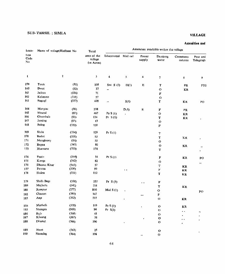
SUB-'fAHSIL : SIMLA
Loca- Name of vlllage/Hadbast No
hon Code No
2
159 Touh (81) 160 Dwat (82) 161 Jadem (336) 162 Kallmoo (335) 163 Bagagl (337)
164 ManJtal (86) 165 Mraral (87) 166 Ghurshah (83) 167 Jamlog (85) 168 Balog (332)
169 Shilu (334) 170 Badot (338) 171 Mangloon} (84) 172 Bagna (343) 173 Bhawana (333)
174 PanO (344) 175 Klergl (342) 176 Dhanol Khar (345) 177 Patena (330) 178 Shllru (331)
179 Shilh Bagl (339) 180 MaJholu (341) 181 Rampur (277)
182 Chanan (340)
183 ADJI (362)
184 Mathoh (370) 185 Shangm (369)
186 BIJIt (368) 187 Khorag (367) 188 Dhanul (366)
189 Heon (363) 190 Shamleg (364)
VILLAGE
Amenities and
Total Amenities available within the village
area of the Educational Med cal village
(10 Acres)
3 4 5
108 Sec S (I) D(I) 37 71 57
428 S(I)
298 Dll) 467 Pr S (I) 134 Pr S (1)
13
120
129 Pr S (I) 92 55 80
178
54 Pr S (I)
82 57 99
112
237 Pr S (1) 114 810 Mid S (I) 147 197
119 Pr S (I) 96 Pr S(I) 41 58
100
25 198
64
Power supply
6
E
E
DrmklOg water
7
T
0
F 0 T
F 0 T 0
F
T
T 0
0
T
F 0
T F
T
P T
0
F
0
0 0
0 0
0
0 0
Communl- Post and catIOns Telegragh
8 9
PR PTO
KR
KR PO
PR
KR KR
KR
KR
KR PO
KR KR KR
KR
PO
KR
KR
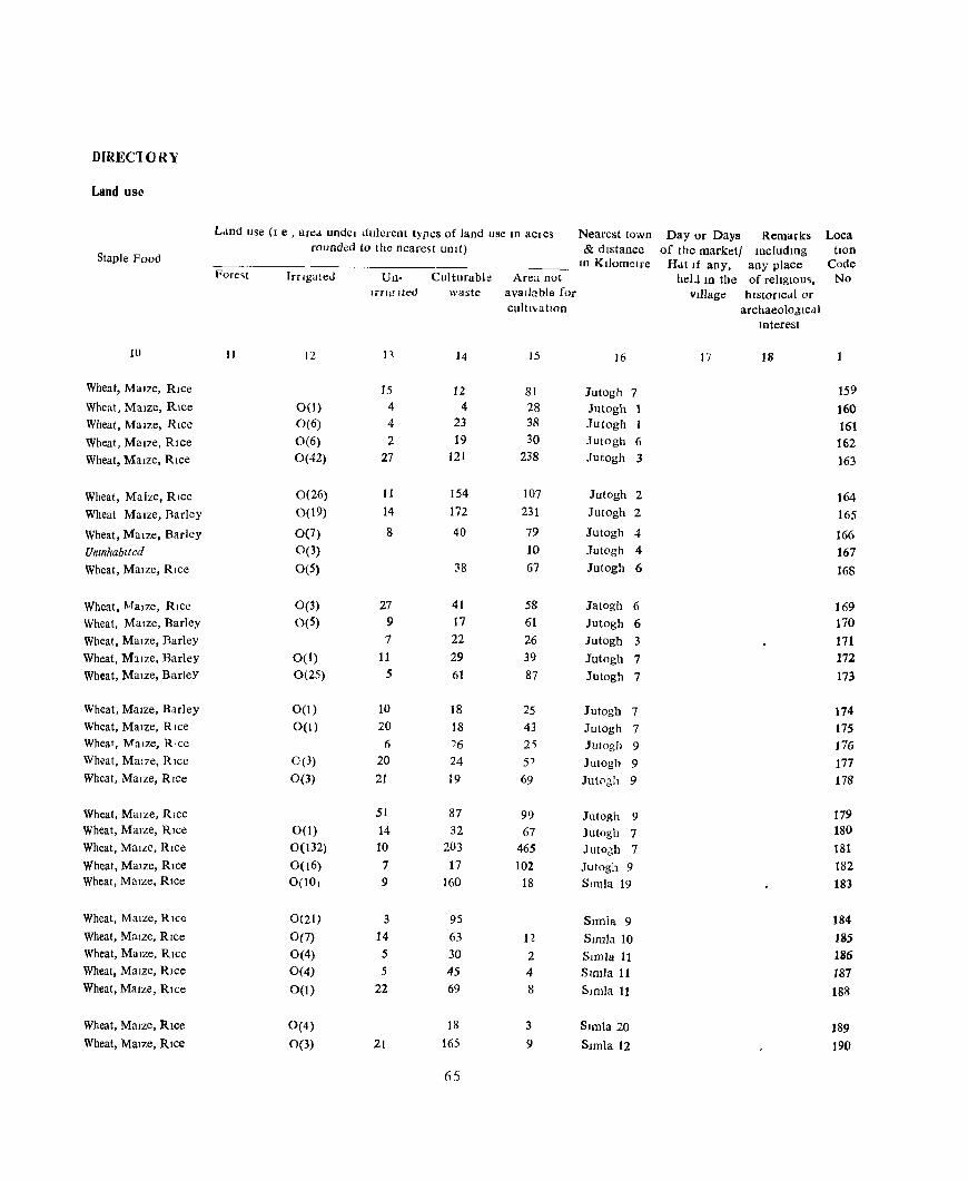
DIRECl()RY
Land use
Land use (I e , an:a undel duierent typt:s of land use III aCles Nearest town Day or Days Remarks Loca rounded to the nearest Ulll t) & dIstance of the market! IncludIng tlOn
Staple Food In KIlometre H..lt If any, any place Code
Fore~t Irrigated Un- Culturabie Area not helJ III the of religiOUS, No 1fT!;! lted waste avalbble for Village hlstorIcdl or
cultl"atlOD archaeoioJlcdl lDterest
10 II 12 n 14 15 16 17 18
Wheat, Maize, RIce 15 12 81 Jutogh 7 159 Wheat, MaIze, RIce 0(1) 4 4 28 Jutogh 1 160 Wheat, MaIze, RIce 0(6) 4 23 38 Jutogh 1 161 Wheat, Maize, Rice 0(6) 2 19 30 1utogh 6 162 Wheat, Maize, Rice 0(42) 27 121 238 1utogh 3 163
Wheat, Maize, RIce 0(26) 11 154 107 Jutogh 2 164 Wheat Maize, Barley 0(19) 14 172 231 Jutogh 2 165
Wheat, Maize, Barley 0(7) 8 40 79 Jutogh 4 166 Untnhablted 0(3) 10 Jutogh 4 167 Wheat, MaIze, RIce 0(5) 38 67 Jutogh 6 168
Wheat, MaIze, Rice 0(3) 27 41 58 Jatogh 6 169 Wheat, Maize, Barley 0(5) 9 17 61 Jutogh 6 170 Wheat, MaIze, Barley 7 22 26 Jutogh 3 171 Wheat, Mllze, Barley 0(1) 11 29 39 Jutogh 7 172 Wheat, Maize, BarleY 0(25) 5 61 87 Jutogh 7 173
Wheat, Maize, Barley 0(1) 10 18 25 Jutogh 7 174 Wheat, MaIze, Rice 0(1) 20 18 43 Jutogh 7 175 Wheat, Maize, RlCe 6 76 2~ JUlogh 9 176 Wheat, MaiLe, RIce 0(3) 20 24 5J Jutogh 9 177 Wheat, Maize, Rice 0(3) 21 19 69 Jutocih 9 178
Wheat, Maize, RIce 51 87 99 Jutogh 9 179 Wheat, Maize, Rice 0(1) 14 32 67 Jutogh 7 180 Wheat, Maize, RIce 0(132) 10 203 465 Jut06h 7 181 Wheat, Maize, RIce 0(16) 7 17 102 Jutogh 9 182 Wheat, MaIze, RIce 0(10) 9 160 18 Simla 19 183
Wheat, MaIze, Rice 0(21) 3 95 Snnla 9 184 Wheat, Maize, RIce 0(7) 14 63 n SImla 10 185 Wheat, MaIze, Rice 0(4) 5 30 2 SImla 11 186 Wheat, Maize, RIce 0(4) 5 45 4 Simla 11 187 Wheat, M3Jze, Rice 0(1) 22 69 8 Simla 11 188
Wheat, MaIze, RIce 0(4) 18 3 SImla 20 189 Wheat, MaIze, Rice 0(3) 21 165 9 SImla 12 ]90
65
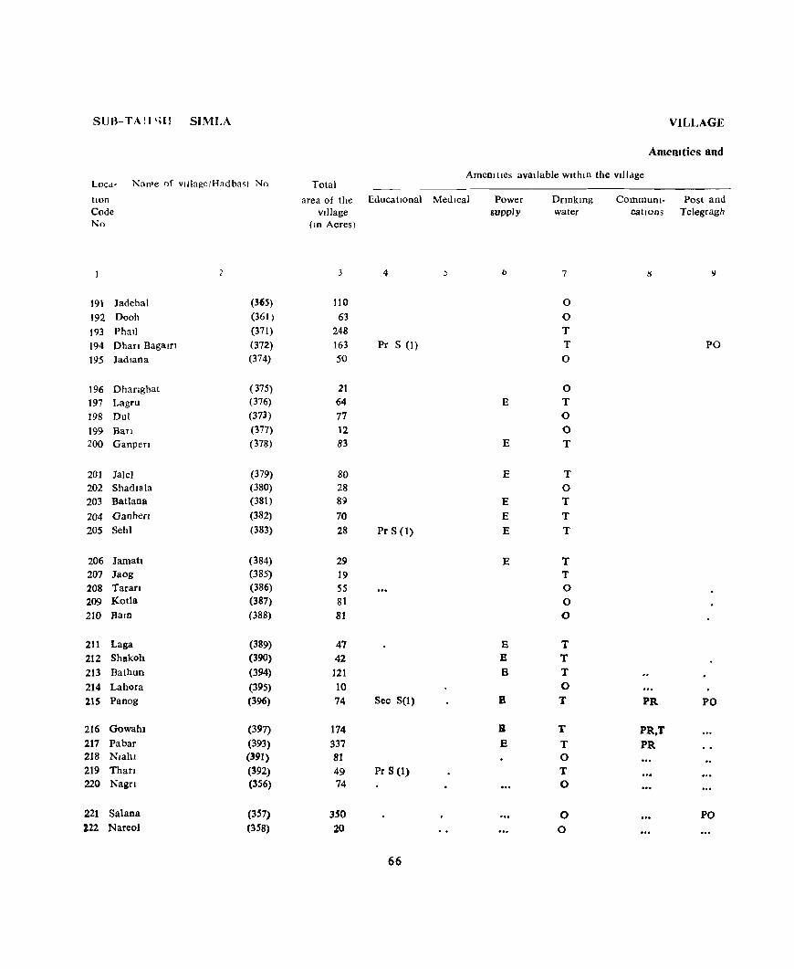
SUB-TAlI 'al SIMLA
LOCd- Nan'e of vlllagelHadba~t No
lIOn
Code No
191 Jadehal (365)
192 Oooh (361 )
193 PhaJ) (371)
194 Ohar! Bagam (372)
195 JadJana (374)
196 Dhanghat (375)
197 Lagru (376)
198 Dul (37J)
199 Ban (377) 200 Ganpen (378)
201 Jale) (379) 202 Shadla)a (380)
203 Batlana (381)
204 Ganher! (382)
20S Seh! (383)
206 Jamah (384) 207 Jaog (385)
208 Taran (386)
209 Kotla (387)
210 Bam (388)
211 Laga (389) 212 Shakoh (390)
213 Bathun (394)
214 Lahora (395) 21S Panog (396)
216 Gowah. (397)
217 Pabar (393) 218 Nlahl (391) 219 Than (392) 220 Nagf! (356)
221 Salana (357) 222 Nareol (358)
VILLAGE
Amem ties and
AmenllJes available WIthin the vIllage Total
area of the EducatIOnal Medical village
(10 Acres)
3 4 )
110
63 248 163 Pr S (I) 50
21 64 77 12 83
80 28 89
70 28 Pr S (1)
29 19 55 81 81
47 42
121 10 74 Sec S(I)
174
337 81
49 Pr S (1) 74
350 20
66
Power supply
b
E
E
E
E E E
E
E E B
B
B
E
Onokmg water
7
0
0 T T 0
0 T 0 0 T
T 0 T
T
T
T T 0 0 0
T T T 0 T
T T 0 T 0
0 0
CommuDI- Post and catIOns Telegragh
PO
PR PO
PR,T PR
PO

DIRECTORY
Land use
Land u~e (I e , area under different types of land u~e In acres Nearest town Day or Days Remdrks Loca-rounded to the nearest umt) & distance of the Market, mcludlllg tlon
Staple Food ---_ ~-- In Kilometre Hat If any, any place Code Forest Irngated Un- Culturable Area not held 10 the of religious, No
Irngated waste available for village hlstorrcal or cultivation archaeological
mterest
10 11 12 13 14 15 16 17 18
Wheat, Maize, Rice 0(2) 6 96 6 Simla 12 191 Wheat, Maize, Rice 0(4) 49 10 Simla 19 192
Wheat, Maize, Rice 0(28) 17 185 18 Simla 13 193 Wheat, Maize, Rice 0(36) 11 108 8 Simla 13 194 Wheat, Maize, Rice 0(5) 7 31 7 Simla 11 195
Wheat, Maize, Rice 2 16 3 Simla 10 196 Wheat, Maize, Rice 0(5) 3 49 7 Simla 10 197 Wheat, Maize, Rice 0(6) 3 60 8 Simla 10 198 Wheat Maize, Rice 0(2) 8 2 Simla 10 199 Wheat, Maize, Rice 0(13) 2 60 8 Simla 10 200
Wheat, Maize, Rice 0(8) 21 38 13 Sunla 16 201 Wheat, Maize, Rice 0(1) 5 18 4 SImla 13 202 Wheat, Malz~, Rice 27 50 12 Simla 13 203 Wheat, Maize, Rice 0(10) 7 44 9 Simla 16 204 Wheat, Maize, Rice 0(17) 4 7 Simla 16 205
Wheat, Maize, Rice 0(10) 12 7 Simla 19 Temple 206 Wheat, Maize, Rice 2 13 4 Simla 17 207 Wheat, M"alze, Rice 6 39 10 Simla 17 208 Wheat, Maize Rice 75 6 Simla 18 209 Wheat, MaIze, RIce 3 71 7 Simla 17 210
Wheat, Maize, RIce 0(1) 2 39 5 Simla 16 211 Wheat, Maize, Rice 0(4) 12 21 5 Simla 16 2J2 Wheat, Maize, Rice 0(6) 24 76 15 Simla 14 213 rJninhablt ed 0(1) 7 2 Simla IS 214
Wheat, MaIze, Rice O(~) 20 38 11 Simla 13 Temple ShiV 215
Wheat, Maize, Rice 0(6) J6 127 25 Simla 14 216
Wheat, Maize, Rice 0(8) 46 257 26 Simla 16 217 Wheat, Maize, Rice 0(10) 4 59 8 Simla 17 218 Wheat, MaIze, Rice 6 39 4 Simla 18 219 Wh~at, Maize, Rice 8 59 7 Simla 17 220
Wheat, Maize, Rice O(U) 59 24S 33 Simla 17 221 Wheat, Maize, Rice 16 4 Stmla 18 222
67

SUB·TAHSIL : SIMLA
Location Code No
Name of village/Hadbast No
2
223 Sandhot (359) 224 Kakret (360) 225 Shan (351) 226 Klr (352) 227 Lagru (353)
228 Thalak Dhar (354) 229 Thalak Nal (355) 230 Tavi Forest Area (N A) 231 Tara Devi Forest Area (N.A)
Total area of the Village
(m Acres)
~
85 133 258 116 140
127 79
N.A,
NA
VILLAGE
Amemtles and
Amenities available withIn the village
Educational Medical Power supply
4 .5
68
Dnnkmg water
7
0 0 0 T 0
0 0
Communications
8
Post and Telegraph
9

DIRECTORY
Land use
Land use (I e , area under different types of land use In acres Nearest town Day or Days Remarks Loca rounded to the nearest UDtt) & distance of the market, includmg don
Staple Food In Kilometre Hat If any, any place Code Fore~t Irngaled Un- Culturable Area not held In the of religIOus, No
lrngated waste available for village historical or cultlvatton archaeological
Interest
III II 12 " 14 15 16 17 18
Wheat, Maize, Rice 0(7) 3 70 5 Simla 18 223
Wheat, Maize, Rice 0(5) 3 115 10 Simla 19 224
Wheat, Maize, Rice 0(1) 24 209 24 Simla 21 225
Wheat, Maize, Rice 0(1) 12 79 24 Simla 18 226
Wheat, Maize, RIce 0(1) 18 110 11 Simla 18 227
Wheat, Maize, Rice 0(1) 20 102 4 Simla 17 228
Wheat, Maize, Rice 0(3) 13 57 6 Simla 17 229
Unmhablted Simla 15 230
Unrnhablted Simla 10 231
69

TAHSIL KANDAGHAT

TAHSIL KANDAGHAT VILLAGE
AmenitJe!! and
Amemtles avadable wlthm the vIllage Loca- Name of vlllage/Hadbast No Total
lIOn c(\de No
2 3
4 5
6 7 8 9
10
11 12 13 14 15
16 17 18 19 20
21 22 23 24 25
26 27 28 29 30
31 3Z
Radaur An]1 Brahmanan RachhDa
Cbaman Kalhll
Kashman Garu An]1 Sunaran Chund Ru~la
Maklyan Lachhog KOHa Tllkar Banola
Kot Bodhan Salam B-ldlaola Gandron
Dhala Nalka Gaon
Wakna Katah 5halawen
Klart Dhomen
Dlhur
Stlhar An]1
Senchra
Tlkn
2
(90) (91) (92) (71) (72)
(73) (75) (74) (76) (77)
(78) (82) (83) (84) (85)
(86) (87) (88) (89)
(79)
(80) (81)
(12&) (127) (426)
(427) (4~8)
( ~29)
(430) (431)
(432) (433)
area of the EdllcatlOnal Medical village
(10 Acre~)
3 4 5
65 MId SCI) 182
210 119 40
160 123 Pr S(l) 205 Pr S(l) 64 28
87 219 59 91 51
191 247 55
183 90
21 49
861 Mid S(I) 288 166
287 180 244 357 204
258 Pr S(I) 201
72
Power supplv
6
E
E E E
E
E
E
E
E E
Drmkmg water
7
0 0 0
0 0
0 T 0 0 0
0 0 0
0 0
0
T 0 0 0
0 0
0 0 0
0 0
0 TK TK
TK T
Commum- Po~t and cations Telegraph
8 9
KR KR PO KR
KR
KR
KR KR
KR KR KR
KR KR KR
KR
KR KR KR
KR
KR KR
KR
PR PO
PR PR

DIRECTORY
Land use
Land use (I e , area under different types of land l' ,e In acres Nearest town Day or Days Remarks Loca. rounded to the nearest umt) & distance of the marketl IncludlDg tlOn
Staple Food ~-----
III Kilometre H<lt If any, any place COGe Fore't Irrigated Un- Culturab1e Area not held III the of religIOUS, No
Irngated \\ aste avaIl<lble for village hlstoflcal or cultlvdtlOn archaeological
mterest
to II 12 H 14 i5 16 17 18
MaIze, RIce, Wheat In 49 Simla 25
Maize, RICC, Wheat 22 30 130 Simla 18 2 Maize, Rice, Wheat 0(6) 22 182 Simla 24 3
Maize, Rice, Wheat 0(4) 23 92 SImla 27 4 MaIze, RIce, Wheat 0(4) 2 34 Simla 24 5
MaIze, R Ice, Wheat 0(5) 26 129 Simla 26 6 MaIze, RICe. Wheat 0(23) 3 97 Simla 27 7
Maize, RIce, Wheat 0(6) 21 178 ~Imla 27 8 MaIze, Rice, Wheat 0(1) 7 56 Simla 27 9 MaIze, RIce, Wheat 0(1) 12 J 5 "Imla 24 10
MaIze, Rice, Wheat 10 77 Simla 22 II MaIze, R ICC, Wheat 30 Ill'} Simla 20 12
Maize, RIce, Wheat 5 54 SImla 26 I3 Maize, RIce, Wheat 0(1) 21 69 SImla 25 14 Maize, RIce, Wheat 14 37 Simla 27 15
Maize, RIce, Wheat 0(1) 43 147 SImla 27 16
MaIze, RIce, Wheat 0(7) 34 206 Simla 27 17
Maize, RIce, Wheat 2l 31 Simla 27 18 MaIze, RIce, Wheat 0(1) 39 143 Simla 27 19 Maize, Rice, Wheat 0(7) 4 79 Simla 26 20
Maize, Rice, Wheat 5 16 Simla 26 21
MaIze, Rice, Wheat 0(2) 7 40 Simla 26 22
MaIze, RIce, Wheat 0(5-l) 67 244 496 Simla 28 23
MaIze, RICe, Wheat 12 0(1) 29 73 173 Simla 27 24
Maize, RICe 0(6) 9 13-l 171 Solan 18 25
MaIze 0(16) 12 239 20 Solan 18 26
MaIze 0(20) 9 139 12 Solan 15 27
Maize Ol25) 21 175 21 Solan IS 28
MaIze, Wh<.at 0(10) 29 279 39 Solan 13 29
MaIze 0(8) 24 134 38 Solan 12 30
MaIze, Wheat 0(16) 14 208 20 Solan 15 31
MaJze, Wheal 0(9) 21 159 12 Solan 17 32
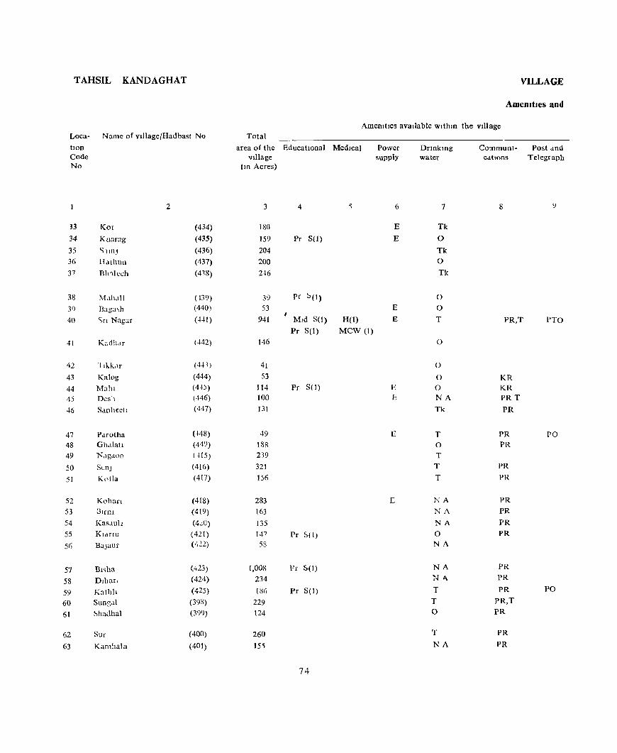
TAHSIL KANDAGHAT
Loca- Name of village/Hadbast No
tlOn Code No
2
33 Kot (434) 34 Kuarag (435) 35 <; IIOJ (436) 36 Hathun (437) 37 Rl1'llech (418)
38 M.lh.lll (439)
3() Baga,h (440)
40 <;n Nagar (441)
41 Kadhdr (442)
42 llkk,lf (441)
43 Kalog (444)
44 Mahl (4'+)
45 Desh (446)
46 Sanhecll (447)
47 PMotha (448) 48 G1Mlah (449) 49 Nagaoo ( H5)
50 ScoJ (416)
51 KL'tJa (417)
52 Kohan (418)
53 DlInI (419) 54 Kasauh (4':0) 55 Klartu (421) 5(i BUJaur (422)
57 BI';ha (423)
58 Dlhar. (424)
59 Kathh (425)
60 Sungal (393)
61 Shadhal (399)
62 Sur (400)
63 Kamhala (401)
VILLAGE
Amcmtlcs and
Amemhes available withm the village Total
area of the EducatIOnal Medical Village
(10 Acres)
3 4 5
IS(J
159 Pr S(1)
204 200 2~6
39 pc ~(I)
53 941 MId S(l) H(I)
Pr S(I) MCW (I)
146
41 53
114 Pc SO) 100 131
49 18R 239 321 156
283 163 135 147 Pr 5( I) 58
1,008 Pc 5(1)
234
I~G Pr S(I)
229 124
260 15<;
74
Power supply
6
E
E
E
E
E E
E
r:
Dnnklng water
7
Tk
0
Tk 0
Tk
0
0
T
0
0
0 0 NA
Tk
T 0
T T
T
NA
NA
NA
0 NA
NA Nt\.
T
T 0
T
NA
CommUnI- Post dnd cations Telegraph
9
PR,T PTO
KR KR PR T
PR
PR PO PR
PR
PR
PR PR
PR PR
PR PR
PR PO
PR,T PR
PR
PR

DIRECTORY
Land use
Land use (l e , area under different types of land use m acres Nearest town Day or DdyS Remarks Loca-rounded to the nearest UnIt) & distance of the Marketl IDcludmg tIOD
Staple Food ID Kilometre Hat If any, any place Code Fore~t IrrIgated Un- Culturable Area not held In the of relIgious, No
I rflgated waste available for Village historIcal or cultivatIOn archaeological
mterest
10 II 12 13 14 15 16 17 18
Maize, Wheat 0(17) 14 137 12 Solan 18 33 Maize 0(23) 7 112 17 Solan 19 34 MaIZe, Rice 0(16) 12 164 12 Solan 18 35 Maize, Rice 0(22) 12 147 19 Solan 15 36 Maize, Rice 0(19) 17 181 29 Solan 13 37
Maize, Whcat 17 17 4 Solan 8 38 Maize, Rice 0(8) 5 27 13 Solan 12 39 Wheat, Rice 0(118) 50 645 128 Solan 12 Temple Shiv 40
Ifalze 24 105 17 Simla 14 41
vfalze 8 32 Solan 15 42 >1alze 17 31 5 Solan 15 43 ,falze, Wheat 0(27) 7 80 Solan 13 44 .falze, Wheat 0(21) 4) 34 Solan 12 4) .falze 25 93 )3 Solan 14 46
~heat 7 35 7 Solan )0 47 Maize 0(25) 144 18 Solan 10 48 Wheat, Maize 0(21) 2 ]81 35 Solan 30 49 Wbeat, Malz\, 0(20) 5 249 47 Solan 18 5{)
Wheat, MaIze (0)(8) 3 127 18 Solan 18 51
Wheat, Maize 0(15) 15 213 40 Solan 16 52 Maize, Wheat 9 128 26 Solan 17 53 Maize, Wheat 0(10) 1 99 25 Solan :::0 54 Wheat, Maize 0(6) 9 114 18 Solan 21 55 Wheat, M • .\Ize 0(1) 6 43 8 SI mla 20 %
Wheat, Maize, Rice 0(29) 77 801 101 Simla 15 Temple Shiv 57 Wheat, Maize 0(2) 19 167 46 Simla 15 58 Wheat, MaIze 0(5) 20 134 27 Simla 14 59 Wheat, Maize, Barley 0(11) 11 178 29 SImla 12 60 Wheat, Maize, Barley 0(9) 7 89 19 Simla 13 61
Wheat, Maize, Barley 0(9) 22 205 24 Simla 14 Temple 62 Wheat, Maize, Barley 0(6) 11 129 6 Simla 14 63
75
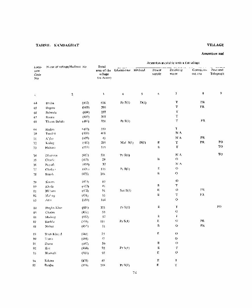
TAHSIL KA~DAGHAT
Loca- N lmc oj v}IJage)Hadba~t No Total tlOD
Code No
64
65 66
67
68
()<)
70
71
72 -" J_'
74 75
76
77
78
79 80
81 1)2
l:i3
84 8<;
B6
87
X8
89
90
91
92
93
94
95
2
Basha
Uagctu
Balwala
Raur,\
Th,wa Bn lola
Radon
Tnud,l
A1Jhu
Kalal;
Nal,<H8
D'\ITV10
Chau]..1
PaJm'l
CllOl,f'
Poa."h
Karo')
Khnla
MIllan!
~1Ll\ og
An_']
JhaJha Kha'
CII-_ibn
::'hdk_.og
Kathld
Nahar
Suna Khm d
Dunll
Dunu
KOI
Bh,ln .. ch
S.tkofl
Ba~Jnl
(402)
(403)
(404)
(405)
(·106)
'4(17)
(40S)
(409)
(410)
01J)
(412)
(~\3)
(414)
HIt)
(475)
(47~)
(:'73)
(472)
(4:n}
(450)
(451)
(452)
(453)
(-154)
(ol-5 S )
(465)
(466}
(467)
(46S)
(46Y)
(470)
(-Wi)
area of the Educatlon.!l Medical village
(m Acrc~)
636
390
237
365
358
359
408
43
214
115
531
29 37
87fi
26(,
89
49
91
93 144
373 50
57
III
11
35
13
96
92
95
85
2iN
4 5
Pc S(l) DO}
Pr S(I)
Mid SO) DU)
Pr S(I)
Pi S(l)
Sec SCI)
l'r S( I)
Pr Stf)
Pr ~{1}
Pr S( I)
76
VILLAGE
Amemtles and
Amemhi:~ avail able wltlllB the village
Power supply
E
E
E
C
f:!
E
E
E
E
10
E
E
£
E
E
E
E
E
Dnnking W<l(er
7
T
T
T
T
T
T NA
NA
T T
NA 0
NA
0
0
0
T
0
T
0
T
0
0
(J
0
0 0
T
0
T
T
Communi- Po,t and cations Telegraph
8 9
PR PR
PR
PR
PR PO TO
TO
PR
Pit
PO
PR PR
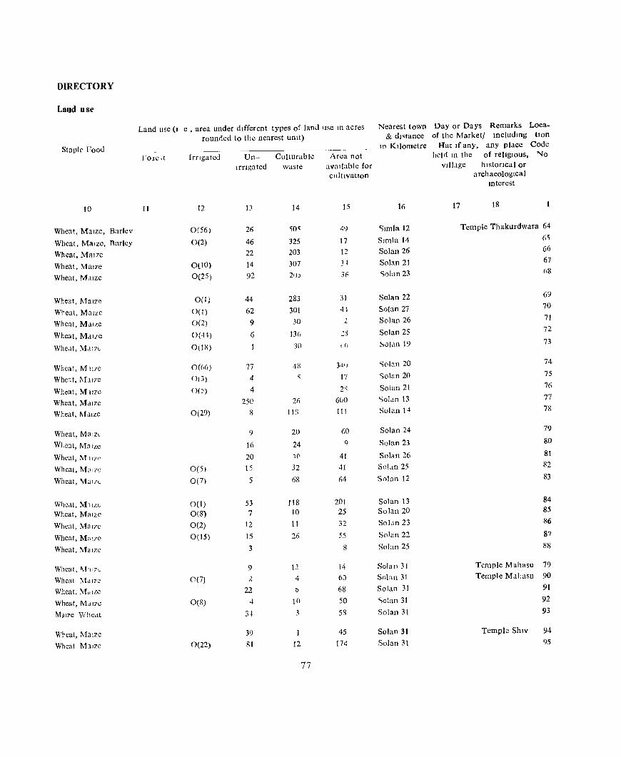
DIRECTORY
Land use
Land use (I e , area under different types of laml use m acres Nearest town Day or Days Remarks Loca-
rounded to thc nearest Ulllt) & dl~tance of the Marketl IOcludmg tIon
Staph' Food Jt1 Kilometre Hat Ifany, any place Code
rOlc,t Irngateu Un- Culturable Area not hel d 111 thc of religIOus, No
Irrigated waste available for vlll.lge hlstonca I or
cultivatIOn archaeological lOterest
10 II 12 13 14 15 16 17 18
Wheat, Maize, Barlev 0(56) 26 'i0" 49 '>Imla 12 Temple Thakurdwara 64
Wheat, MaIze, Barley 0(2) 46 325 17 Simla 14 6'i
Wheat, MaIZe 22 203 12 Solan 26 66
Wheat, Maize 0(10) 14 307 31 Solan 21 67
Wheat, M,llze 0(25) 92 21)) 3F ,>alan 23 68
Wheat, 1\1alze O(I} 44 283 31 Solan 22 69
Wreat, Maize 0(1) 62 301 44 Solan 27 70
Wheat, M,lll:e 0(2) 9 30 l Solan 26 71
Wheat, Maize 0(41) 6 136 2il Solan 25 72
Wheat, M,lI7L 0(18) 30 I() ~olan 19 73
Wheat, M we O«(i(i) 77 48 341} ,>olan 20 74
Wheat, I\Jll7e O(J) 4 'i 17 <;olan 20 75
Wheat, MllL'C O() 4 ,,' Solan 21 76 ~ ,
Wheat, Maize 250 26 600 "'oLm 13 77
Wheat, Maize 0(29) 8 liS III Solan 14 7R
Wheat, MalzL 9 20 60 Solan 24 79
Wheat, Ma rze 16 24 q Solan 23 80
Wheat, MI17'> 20 '1f' 41 Solan 26 81
Wheat, Mal7C 0(5) IS 32 41 SOldO 25 82
Wheat, \farzL 0(7) 5 68 64 Solan 12 83
Wheat, M1IZL 0(1) 53 118 201 Solan 13 84
Wheat, Malzc 0(8) 7 10 25 Solan 20 85
Wheat, Mal7c 0(2) 12 11 32 Solan 23 1i6
Wheat, Ma 17C 0(15) 15 26 55 Solan 22 87
Wheat, Ma IZC 3 8 Solan 25 88
Wheat, !\!1r7L 9 12 14 Solan 31 Temple Mahasu 79
Wheat Md ILC 0(7) 2 4 60 Solan 31 Temple MalJasu 90
Wheat, Ma ILC 22 t> 68 Solan 31 91
Wheat, MdlZC 0(8) ..j 10 50 ,>olan 31 92
Mdlze WhCdt 3'1 3 58 Solan 31 93
Wrcat,1\1alzc 39 45 So lao 31 Templc ShIV 94
Wheat MllZC 0(22) 81 12 174 Solan 31 95
77
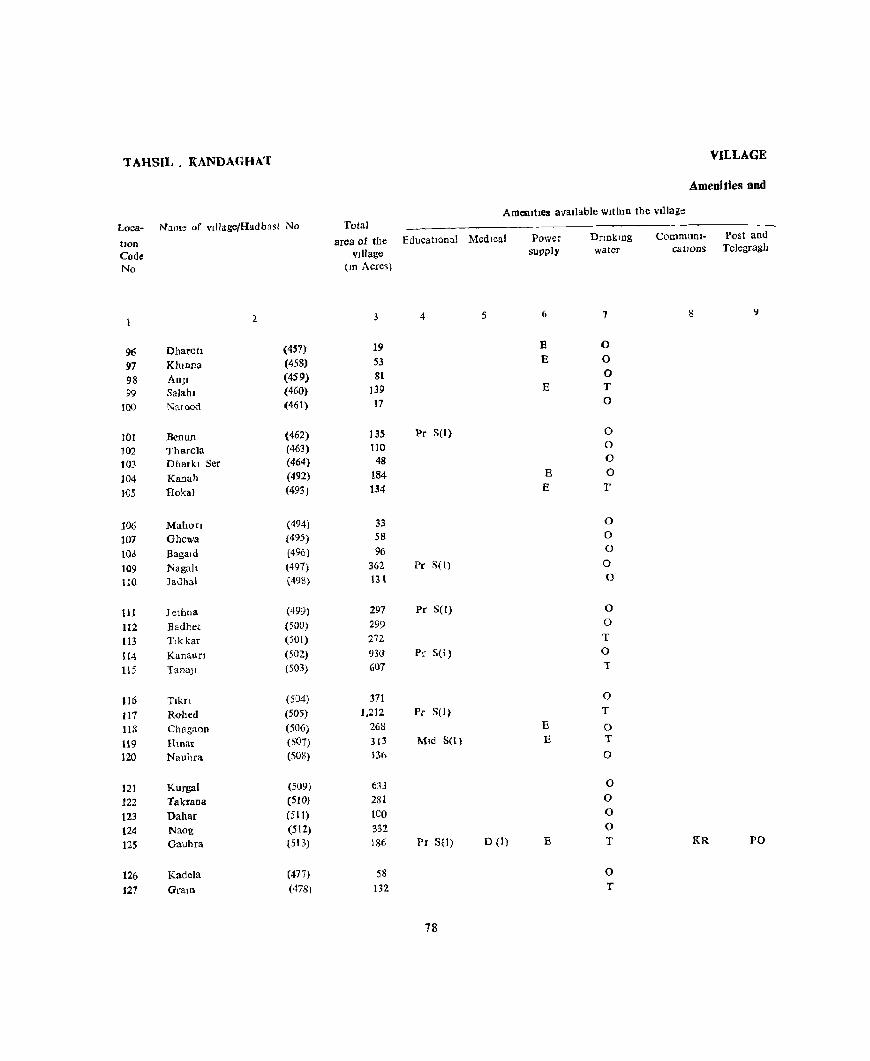
TAHSIL. KANDAGHAT VILLAGE
Amenities and
AmelutIes avaIlable wIthIn the \'Illage
loca- N~lIlle of vdlagelHadbast No Tolal CommUQI- Post and
lIOn
Code No
96 97 98 99
100
101 102
t03
104 1{J5
106 107 IOd 109 110
III 112 113 H4 115
116 117 liS
119 120
12t 122 123 124 125
126 127
Dharot! Khlnna
AnJI Salah I Naroed
Renun Tharola Dharkt Ser
Kanah lIokal
Mahorl Ghewa
BagaLd
Nagah Jauhal
J ethos
Eadhet T,kkar
Kanaun TanaJI
T1kn Robed Chagaon Hmar Nauhra
Kurgal Takrall2 Dahar Naog Gauhra
Kadela
Gram
2
(457) (458)
(459) (460)
(461)
(462) (463) (464)
(492)
(493J
(494)
(495)
(496)
(497) (498}
(499)
(500) (Sal)
(502)
(503)
(504)
(505)
(506)
(501)
(508)
(509)
(5lO)
(51 t) (512) (513)
(471)
(478\
area of the EducatIonal Medical vJlIage
(m Acres)
3 4 5
19 S3 81
139 17
135 Pr S(I)
110 48
184 134
33 58
96 362 Pr S(l)
HI
297 Pc SCI)
299 272 930 Pr S(I)
607
371 1.212 Pr S(l)
268
313 IVhd S(t}
136
633
281
leO 332
186 Pr SO) D (I)
58 132
78
Power supply
6
E E
E
E E
E E
E
Dnnkmg water
1
0 0 0 T 0
0 0 0 0
T
0 0 0
0 0
0 0 T 0
T
0 T
0 T
0
0 0 0 0 T
0 T
catIOns Teiegragb
8
KR PO

DIRECTORY
Land use
Land use (1 e , ared under dIfferent types of land use In acres Nearest town Day or Days Remarks Loca-rounded to the nearest unIt) &. dIstance of the Marketl IDcludmg tlOn
Staple food ----_ In KIlometre Hat If any, any place Code 10rL'1 Irng,ltL(1 Un- Culturdble Area not held IO the of religIOus, No.
IITlgall,d waSIL dvallable for vIllage hIstorical or cultlvatIOD archaeologIcal
Interest
IO II 12 13 14 I ~ 16 17 18
Wheat, Mal7C 7 12 Solan 31 96 Wheat, MaIze 0(6) 8 10 29 Solan 31 97
Wheat, M IIIC 4 5 72 Solan 31 Temple 98
Wheat, Mdlze 0(17) 30 20 72 Solan 31 <)9
Wheat, Malzc 11 4 2 <;olan 39 100
Wheat, ]\fal?c 0(3) 47 4 81 Solan 29 101
Wheat, M,llIL 0(10) 20 X ~2 Solan 30 102
Wheat. Malle 5 5 :8 Solan 31 103
Wheat, M.llze 12 2 161 Solan 31 104
Wheat, MaliC 0(6) 22 1,4 Solan 31 hmplc Devta 105
Wheat, Mdl/L Ot2) 5 2 21 Solan 31 lOG
Wheat, MallL () (4) ') 43 Sol,1ll 31 107
Maize, Wheal, 0(8) , b6 Solan 31 101>
Wheat, Malzc 0(5) ~!) 3 295 ~o11ll 31 to9
Wheat, Maize 3 t 2 9~ 501an 31 110
Wheat, MalzL 2, 5 2G9 Solan 31 111
Wheat, M al7e 14 -:. 21)2 ,:,olan 31 112
Wheat, MdlZL 20 252 Solan 31 113
Wheal, M,lIZ\! u(7) 62 4-' bill Solan 31 114
Wheat, MaIze 0(14) 20 53, 3~ SO'lll 14- ll5
Wheat. MaILe 0(26) 281 56 Solan 14 116
Wheat, MalLc 0(59) 55 983 115 Solan 14 117
Wheat, Maize 0(6) 17 216 29 Kasauh 14 118
Wheat, MaIze 32 277 4 Solan 1~ 119
Wheat, Maize o (ri) 17 1(8 5 Solan 14 120
Wheat, M,IlZC 0(51) 24 497 61 501an 14 121
Wheat, Malze 0(13) 8 24-l 16 Solan 14 122
Wheal, M,\ILL 8 7 ; 14 Solan 14 123
Wheat, Ma,zc 0(3) 15 305 9 Solan 14 Temple Devl 124
Wheat, Mallc Orb) 22 1'9 27 Sohal 14 125
Wheat, MaiLe 0(1) 2 52 Solan 14 126
Wheat, Malzc g 117 7 Salan 14 127

TAHSIL KANDA GHAT
Loca- Name of vlllage/Hadbast No
lion Code No
2
128 Tehll. (479)
129 Gamti (480)
130 Banehr (481)
131 Dakhor (482)
132 Damdar (483)
133 Jakhad (484)
134 Daghll (485)
135 Smula (486)
136 KharanJI (487)
137 Bholra (~88)
138 Reh ka Kalal (489)
139 Kharog (490)
140 Chhob (491)
141 Sunnu (543)
142 Darana (542)
143 Bayela (541 )
144 BaSI (540)
145 RawlD (539)
146 Lagl''ln (538)
147 Charag,r (537)
148 Galol (536)
149 Tawatalara (535)
150 Manoh Tlkn (534)
151 Kadh8n Khurd (533)
152 Kadhan Kalan (532)
153 Jalkhara (531)
154 Mashlor (530)
155 Shl! Shamlog (529)
156 BhaJun (528)
157 Garkhal (527)
158 Dunn (525)
159 Phagu (525)
VILLAGE
Amcmues and
Amenities available Within the vIllage
Total area of the EducallonaJ Medical village
(m Acres)
3 4 5
54
92
198 461 Pr S(I)
106
506 193 Pr S(I)
188 182 911
33 342 Pr S(I)
403 52 34
125 56 10 70
126
39 42 76
116 59
26 145 Pr S(I)
35 48 56
140 52
80
Power supply
(i
Dnnkmg water
7
0
0
T 0 0
0 T 0
0 0
0 0
0 T
T
T T r T T
0 T 0 0 0
0 0 0 0 0
F
0
CommuDl. Post and callOns Telegraph
8 0
PO
KR
KR
KR PR PR PR PR
PR PR PR PR PR
PR PR PR PR PR

WRECTORY
Lead use
Land use (I e , area under dIfferent types of ldnd use III acres Nearest town Day or Days Remarks Loca-rounded to the nearest unIt) & dIstance of the Marketl includlDg t10n
Staple Food ID KIlometre Hat Ifany, any place Code FOlest IrrIgated Un- CuIturab}e Area not held_lD the of relIgIOUS, No
IrrIgated waste available for village hlstoCical or cultIVatIOn archaeologIcal
IOterest
10 11 12 13 14 15 16 17 18 1
MaIze, MaIZe 0(1) I 50 2 Solan 14 128
Wheat, MaIze 0(3) 2 84 3 Solan 14 129 Wheat, Maize 0(16) 8 161 13 Solan 14 130 Wheat, Maize 0(31) 10 360 60 Solan 14 131 Wheat, Mal7e 23 72 II <;olan 14 132
Wheat, Maize 0(22) 17 446 21 Solan 14 133 Wheat, Maize 0(23) 2 154 14 Solan 14 134
Wheat, MaIze 0(12) 3 153 20 Solan 14 13S I 0(1) 31 117 33 Solan 14 136 'Wheat, MaIze Wheat, MaIze 0(22) 70 755 64 SoJan 14 137
Wheat, Maize 0(17) 2 13 SoJan 14 138
Wheat, MaIze 0(14) 17 298 13 Solan 14 139
Wheat, Maize 0(13) 14 353 23 Solan 14 140
Wheat, M a 17e 0(3) 4 45 Solan 9 141
Wheat, MaIze 0(3) 7 24 Solan 9 142
Wheat, Maize 0(4) 11 110 Solan 9 143
Wheat 0(3) 7 46 Solan 8 144
Wheat 0(2) 13 Solan 8 145
Wheat, Maize o(3) 11 56 Solan 8 Temple Devi 146
Wheat, Maize 0(11) 7 108 Solan 8 147
Wheat, MaIze 0(12) 16 10 Solan 9 148
Wheat, MaILe 0(2) 7 33 Solan 10 149
Wheat, MaIze 0(3) 8 65 Solan 10 150
Wheat, MaIze, RIce 0(3) 12 101 Solan 12 151
Wheat, Maize 0(8) 3 48 Solan 11 152
Wheat, Maize. RIce: O(Z) 5 19 Solan 11 153
Wheat, MaIze 0(3) 11 131 Solan 10 154
Wheat, MaIZe 8 27 Solan 12 155
Wheat, MaIZe 0(1) 7 40 Solan 11 156
Wheat, MaIze 0(2) 5 49 Solan 12 157
Wheat, MaIze, RIce 0(5) 15 120 Solan 13 158
Wheat, MaIze 0(1) 16 35 Solan 14 159
81
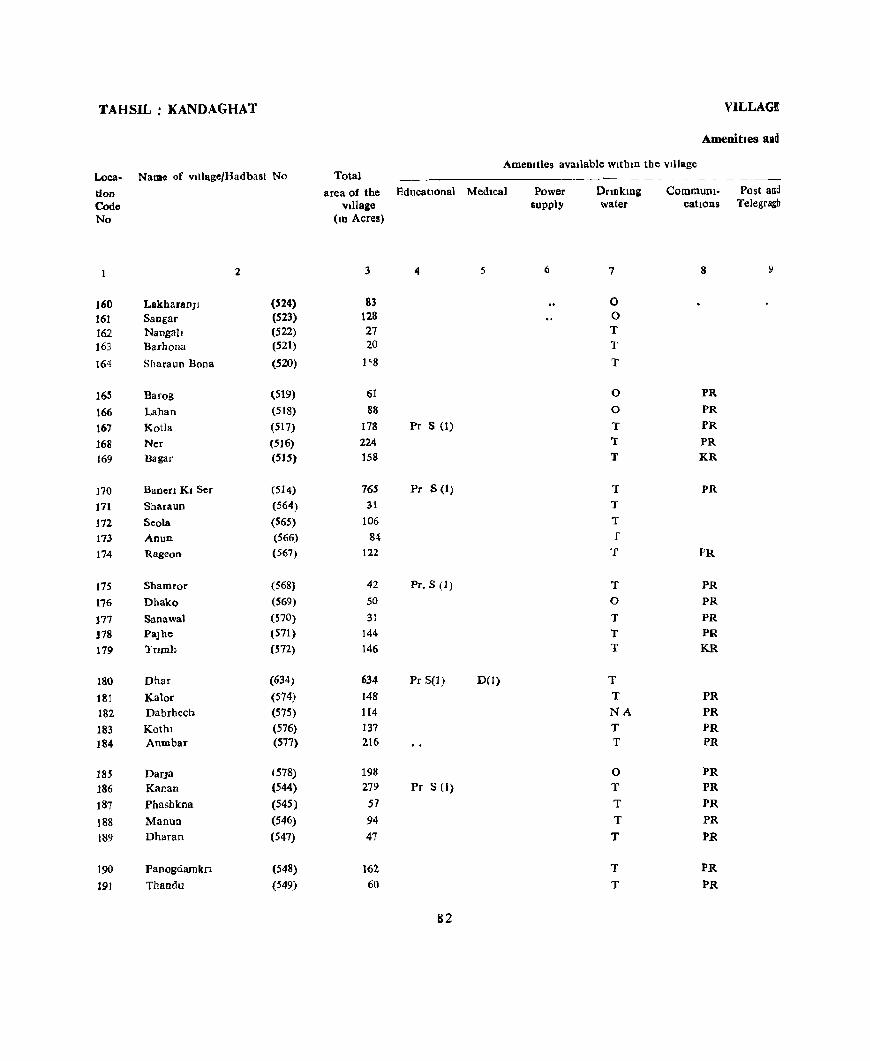
TAHSIL: KANDAGHAT
Loca- Name of vIHage/Hadbast No
tlOD
Code No
2
160 LakharanJl (524)
161 Sangar (523)
162 Nangah (522) 163 Barhona (521)
164 Sharaun Bona (520)
165 Barog (519)
166 Laban (518)
167 KotJa (517)
168 Ner (516) 169 Hagar (SIS)
170 Banen KI Ser (514)
171 Sharaun (564)
172 Seola (565)
173 Anun (566)
174 Rageon (567)
175 Shamror (568)
176 Dhako (569)
177 Sanawal (570)
178 PaJhe (571)
179 Tnmb (572)
180 Dhar (634)
181 Kalor (514)
182 Dabrhecb (575)
183 Kothl (576)
184 Anmbar (577)
185 DarJa (578)
186 Kanan (544)
187 Phashkna (545)
188 Manun (546)
189 Dharan (547)
190 Panogdamkn (548)
191 Thaodu (549)
VILLAGE
Amenities and
Amenilies avaIlable Within the Village Total
area of the EducatIonal MedIcal vlllage
(10 Acres)
3 4 5
83 128 27 20
1 '8
61
88 178 Pr S (I)
224 158
765 Pr S (1)
31
106
84
122
42 Pro S (1)
50
31
144 146
634 Pr 5(1) DO) 148
114
137 216
198 279 Pr S (I)
57
94
47
162
60
82
Power supply
6
DnnklOg water
7
0 0 T T
T
0
0
T T T
T
T
T
f
T
T
0
T T T
T T NA
T T
0 T
T T
T
T
T
CommUDl- Post and cations TeJegragh
8 ~
PR
PR PR PR KR
PR
FR
PR
PR
PR PR
KR
PR
PR PR PR
PR PR PR PR
PR
PR PR

DlREcrOR'I
Land US{'
Land use (I e. area und<.1 different types of land use 10 acre, Nearest town Day or Days Remarks Loca·
foun ded 10 the nearest Wlllt) & dl<;tance of the Markell IDcludmg Hon
Staph" Food ------III Kllometra Hat If any, any place Code
101e"t Irngated Un- Culturable Area not held lD the of relIgIOUS, No
Irngated waste avaIlable for village hlstorJcal or
cultlvatlOD archaeologIcal loterest
10 II 12 IJ 14 15 15 17 HI
MaIze, M,IlLe 14 69 Soi,1n 13 160
Malle, M1J?e RIce O(~) 13 112 Solan 12 161
Wheal. MllLC 4 23 Solan 13 162
Wheal, MaIze 3 17 SoLIn 13. 163
Wheat, \ITalze, RIce Oil) 20 135 ... olar. I\< 164
Wheat, Mollze on, 7 ~I S"inn 11 165
Wlleal, MU7e ()( '1) 9 6R Snlan 18 166
Wheat. Mllze, Rice O(lS) In 1 '3 SO\3n 2] 161
Wheal, III lin. Rice U(N) "12 168 Solan 24 HiS
Whca', M'.7, R:ce O(23} 14 121 "colan 22 169
\Vheut, l,,'lalze, RKe 251 514 SOI:lO 19 170
Wh"al Malz) 0(1) 7 21 Solan 1, 171
Wheat Maw~ 0(7) 8 91 Solan 12 ]72
W11cat, Macle 0(6) 7 71 Salan 13 173
Wheal, Mruze 11 III Solan 13 174
Wheat, Maize 0(11l 7 24 Solan 14 17S
Wheat, Malze 0,7) () ~4 Solan 13 ShiV Temple 176
Wheat, MaIze 0(2) 4 25 Solan 13 111
Wheat, Malze ( )(7) 8 129 Sol::n 14 17S
Wheal, Ma1Ze 0(1) 13 132 Solan 16 17,}
Wheat, Malz~ 54 5SU Solan 12 3 Temples 180
Wheat, Maize U(I} II ]36 Solan 14 181
24 ~O Solan 16 182 Malzc Wheat, MaIze GU, y L4 Solan 16 183
Wheal, M.lILo! 0(1 [) !2 ;')3 Solan 16 1B4
Wheat, MllEe 0;14, 20 10+ Sol'ln 15 185
Wheat, lo,1al1, Uli.t) 17 !-jg S()iuu 8 186
MaiLe 13 4-l Solan 8 181
WhCill. 11.~ll~ 0(7) '7 110 Solan 8 188
Wh(..at, :\lalze 0(3) 4 40 Soj[lll 7 189
Whc.lt, Mall, 0(111 12 137 Solan (i 190
Wheat, Maize D(S) 0 Sola, 7 191
83

TAHSIL h.ANDAGHAT
Location Code No
Name of vlllage/Hadba'lt No
2
192 Yhalahl (550)
193 Garog (551)
194 Mlhlng (552)
19~ Chdghaf (553)
19(; Sehal (554)
197 KahranJt" (555)
198 Mamllra (556)
199 Dharoon (557)
200 llandrech (558)
201 Fanewa (559)
202 Jauna Marar (5~Ol
203 Dhar Dawan (561)
2()4 Dharog (562)
205 Dlarag Bokhar (563)
206 Masna MaJhgaon (579)
207 Majragan (~80)
208 MaommaJhgaon (581)
209 Unchagaon (582)
210 Bagar (583)
211 Nagan} I (584)
212 Padhan (585)
213 Phangare (586)
214 Nandal (587)
215 Sheel (588)
216 Bh~Jo (589)
217 Dharnran (590)
218 Kharkog (591)
219 Ochh (592)
220 Nandho (593)
221 GarogKha~ (594)
:122 Ghar"i (595)
223 KllndJa (59ii)
Total area of the
vIllage (111 Acre~)
~
SO 46
3\l
56
37
37 46
37
11
52
III 105
73
205
275
19
87
137
23 47
316 39
251
43
54
45
113 127 ]34
217
79 46
VILLAGE
AmeOltles and
AmenitIes avaIlable Wlthm the village
EducatIOnal Medical
4 5
MId S (I) D (I)
Pr S (I} D(I)
Sec S (I) D (I)
84
Power supply
E
E
E
Dnnkmg water
7
T T
NA
T T
N.A T T
T
T
T T
T
T NA
NA NA
NA
NA
NA
NA NA NA
NA
NA
NA
NA T
NA NA
NA
NA
COmmllnlcatIons
S
PR
PR
PR
PR PR
PR
PR
PR I-R
PR
PR
PR
PR
PR
Post and Telegraph
9
PO

DIRECTORY
Land use
Land use (I e area under dIfferent types of land use In acres Nearest town Day or Days Remarks Loea. rounded to the nearest umt) & dIstance of the marketl IOcludlOg lion
Staple Food In KIlometre Hat If any, any place Code "'Ore,! Irrigated Un- Culturable Area not held ID the of rehglous. No
Irng Ited waste avaIlable for vIllage historical or cultivation archaeological
Interest
10 11 12 1, 14 15 1(' 17 18
Wheat, MaIze 0(5) 5 40 Solan 7 192 Wheat, MaIze 0(4) 9 33 Solan 7 193 MaIze 30 Solan 8 194 MaIze 0(1) 3 52 Solan 9 Gurdwara 195 MaIze 0(1) 4 32 Solan 9 196
Uninhabited 37 Solan 11 197 Wheat, MaIze 3 43 Solan 11 198 Wheat, MaIze 0(1) 3 33 Solan 11 199 Wreat, MaIze 3 8 Solan 11 Temple 200 Wheat Maize 0(3) 4 45 Solan 10 201
Weeat, MaIze 0(3) 7 101 Solan 11 202 Wheat, MaIze 0(1) 4 100 Solan 10 2()3
MaIze 13 60 Solan 8 204 Wheat, MaIze 0(10) 13 182 Solan 9 205 Wheat, RICe, MaIze 28 33 214 Solan 16 206
Wheat, MaIze 19 Solan 11 207 Wheat, MaIze 10 77 Solan 15 208 Wheat, MaIze 0(8) 21 15 93 Solan 18 209 Wheat, MaIze 0(4) 2 17 Solan 9 210 Wheat, Mllze 7 40 Solan 13 211
Wheat, Malzc 0(49) 27 240 Solan 14 212 Wheat, MaIze 0(1) 9 6 23 Solan IS 213 Wheat, MaIze 0(4) 46 36 165 Solan 15 214 Wheat, Mal7c 10 33 Solan 11 215 Wheat, MaIze 14 40 Solan 14 216
Wheat, M.Jlzc 0(6) 8 31 Solan 11 217 Wheat, MaIze, RIce 0(34) 5 3 71 Solan 14 218 Wheat, Maize, RIce 0(23) 5 99 Solan 10 219 Wheat, MaIze G(25) 3 106 Solan 11 220 Wheat, MaIze 13 199 Solan 14 221
Wheat, MaIze 0(5) 1 73 Solan 8 222 Wheat, Maize 0(2) 8 12 24 Solan 9 223
8'i
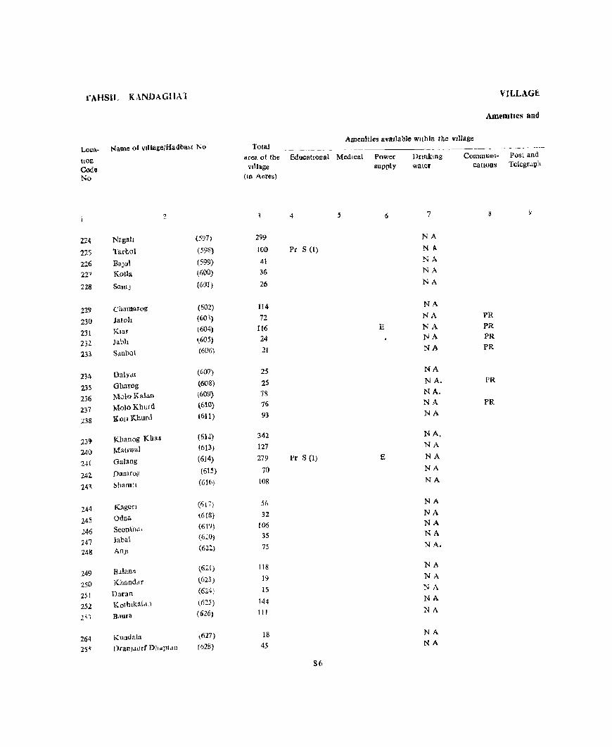
fAHSIL KANDAGHAl
Loca- Name of vJ[lage(Hadba~t No
hon Cod", No
'2
224 NagaI! (597)
215 Tarhol (598)
226 BaJol (599)
227 Kotla (600)
228 SaJOJ (601)
229 Chamarog (602)
230 latoh (60~)
231 Klar (604)
232 Jabh ~605)
In Sanhol (606)
234 DatYdl (607)
235 Gharog (60S)
236 Molo Kalan (609)
237 MoloKhllrd (610)
238 Kotl Khurd (611)
239 Khanog Khu (612)
2~() Matlwal (613)
2-+1 Galang (6J4)
242 Damrog (615)
14"\ ~hamtl (Glb)
244 Kagon (617)
24S Odna (6IS)
2.46 SeoDt11,\. (619)
247 Jabal (620)
248 An)l (622)
249 Bdlanll (621)
250 KbundJT (623)
251 Daran (624}
252 Kotblkal.l11 (6:::5)
1"1 B,lura (626)
264 Kundal;! (627)
255 DraOjdllrf Dhapt<l[] (628)
VILLAGE.
AmeOllics and
Amenities IlvaJiable wIthin the vIllage Total
area of tbe EducatiOnal Medical vdlage
(ID Acres)
4
299
100 Pr S (I)
41
36
26
114
72 116 24 21
25
2S
78
76
93
342
127
279 Pr S (I)
70
lOR
.:'it)
32
106 3S
15
118
19
15
144
111
18
45
86
Power supply
E
E
Drtnkmg water
7
NA NA
NA
NA
NA
NA
NA
NA NA
NA
NA
N A. NA. NA
NA
NA. NA
NA
NA
NA
NA
NA NA NA
NA.
NA
NA
NA
NA
NA
NA NA
CommUnl- Post and catlOUS TeIegrallh
8
PR
PR
PR PR
PR
PR
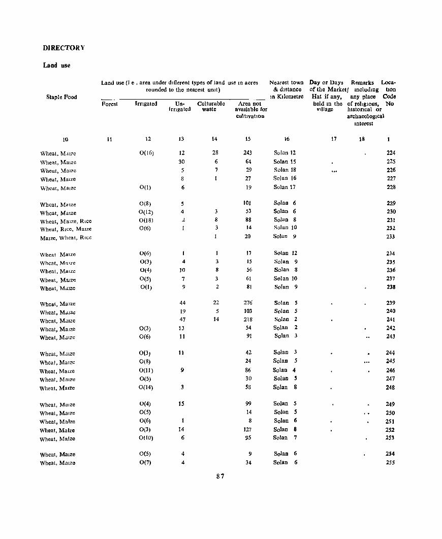
DIRECTORY
Land use
Land use (J e , area under dJ1Ierent types of land use In acres Nearest town Day or Days Remarks Loca-rounded to the nearest umt) & dIstance of the Marketl IncludIng bon
Staple Food In KIlometre Hat if any. any place Code Porest Irngated Un- Culturable Area not held In the of religIous. No
irrigated waste avallable for village hIstorIcal or cultlVatlon archaeologlca\
IOterest
10 11 12 13 14 15 16 17 18
Wheat, Malle 0(16) 12 28 243 Solan 12 224
Wheat, Maize 30 6 64 Solan 15 225
Wheat, Maize 5 7 29 Solan 18 226
Wheat, Malze 8 27 Solan 16 227
Wheat, Maize 0(1) 6 19 Solan 17 228
Wheat, M(llze 0(8) 5 lOt Solan 6 229
Wheat, Maize 0(12) 4 3 53 Solan 6 230
Wheat, Maize, Rice 0(18) 1. 8 88 Solan 8 231 Wheat, RIce, Maize 0(6) 3 14 Solan 10 232
MaIze, Wheat, RIce 20 Solan 9 233
Wheat Maize 0(6) I 17 Solan 12 234
Wheat, Malle 0(3) 4 3 15 Solan 9 235
Wheal, MaIze 0(4) 10 8 56 Solan 8 236
Wheat, MaIze 0(5) 7 3 61 Solan 10 237
Wheat, Mdlze 0(1) 9 2 8t Solan 9 238
Wheat, Maize 44 22 276 Solan 5 239
Wheat, M.uze 19 5 103 Solan 5 240
Wheat, MaIze 47 14 218 Solan 2 241
Wheat, Maize 0(3) 13 54 Solan 2 242
Wheat, Maize 0(6) 11 91 Solan 3 243
Wheat, M.lIze 0(3) 11 42 Solan 3 244
Wheat, Maize 0(8) 24 Solan 5 245
Wheat, Maize 0(11) 9 86 Solan 4 246 Wheat, Maize 0(5) 30 Solan 5 247
Wheat, Maize 0(14) 3 58 Solan 8 248
Wheat, Maize 0(4) 15 99 Solan 5 249 Wheat, Maize 0(5) 14 Solan 5 250 Wheat, Maize 0(6) 1 8 Solan 6 251 Wheat, Maize 0(3) 14 127 Solan 8 252 Wheat, Maize 0(10) 6 95 Solan 7 253
Wheat, MaIze 0(5) 4 9 Solan 6 254
Wheat, Maize 0(7) 4 34 Solan 6 255
87

TAHSIL, KANDAGHAT
Loca- Name of vIllagelHadbast No Total area of the EducatIOnal Medical tiOn
Codo No
256 257 258 259 260
261
262 263 264
265
266
267 268 269 270
271 272 273 274 275
276 277 278 279 280
281 282 283 284 285
286 287
2
Kothon
Ma)hgaon Khurd
MaJhgaon Kalan
Badhor ('hila Khurd
Dranjll Khurd DrdllJl1 Kdldn
Ch la Kalan
B'1grol
M.lDajl
Chllfl
BadlJaoa
Bagar
Sharanun
Sharnlhech
Rabaun Anjl
Nagh
Mauri
Kathlala
Sumt! Galog
Pad gal
Dehun
Shaprun
Slharafl Ba)oral Kalan
Bajora! Khurd
De)argn
Kadayar
Lawl Khurd
Lawl Kalan
(629) (630) (631) (632) (633)
(634) (635) (636) (637) (638)
(639) (640) (641) (642) (643)
(644) (645) (646) (647) (648)
(649) (650) (651) (652) (653)
(654) (655) (656) (657) (658)
(659) (660)
vIJlage (In Acres)
3
76 29 69 51 61
27 27 54 36 27
18
89 89 48
198
Itl
318 123 69 44
71 46 78
175 240
15 11
34 10
136
70 37
4 5
Pr S (I)
Pr S (1)
88
VILLAGE
Amenities and
AmenitIes avatlable withIn the Village
Power supply
1\
E
E
E
E
E
E
E
:c E
E L
Dnnkmg water
7
NA
NA
NA
NA
NA
NA NA
NA
NA
NA
NA
NA
NA
NA
NA
NA
NA
NA
NA
0
T
T
T
T
0
T T
0 0
0
0 0
CommUDl- Post and catIOns Telegraph
8 9
PO
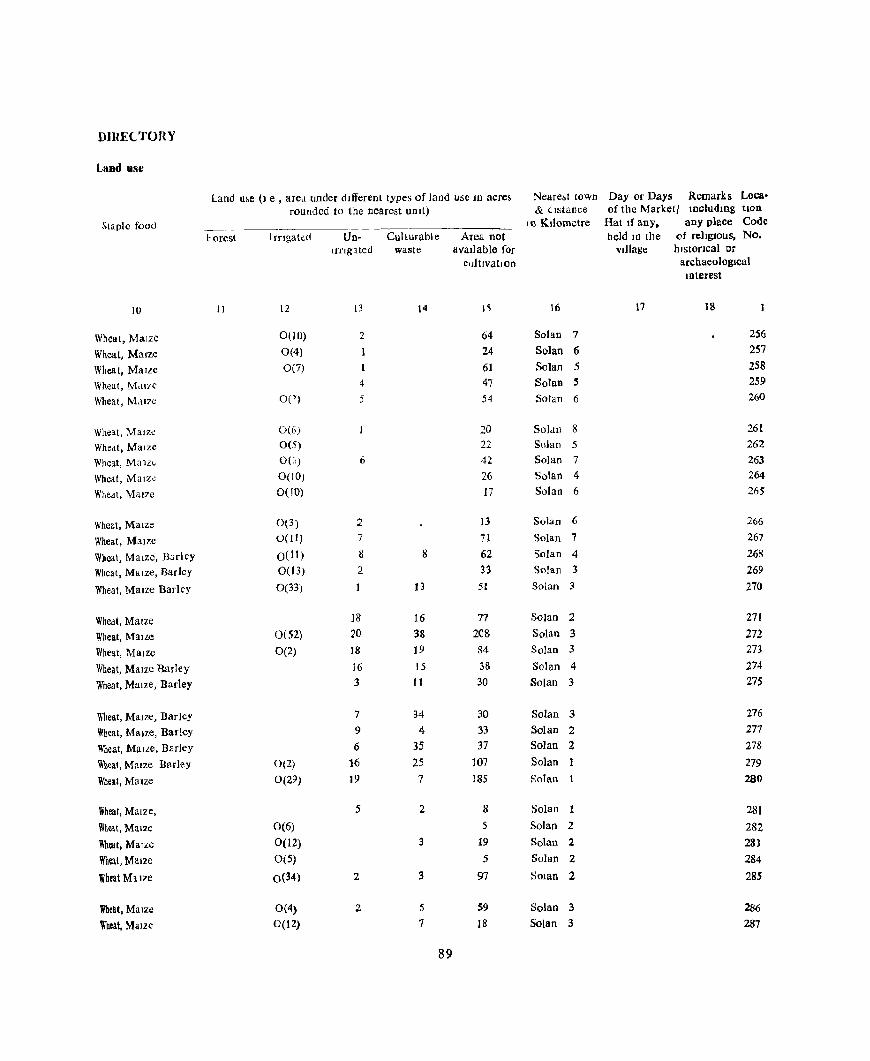
DIRE(.TORY
Land use
Land u~e (I e , ared under dIfferent types of land use ID acres :-.Ieare~1 town Day or Days Remarks Loca· rounded to the nearest UDlt) & distance of the Marketl IDcludmg hon
Staple food I () Kilometre Hat If any. any place Code
borest Irrlgattd Un- CuI turabl e Area not held ID the of religIOus, No. Ifnglted waste IIvallable for village hlstoClcal or
cultlvatloD archaeological Interest
10 II 12 13 14 I~ 16 17 18
Wheat, Maize 0(10) 2 64 Solan 7 256
Wheat, Maize 0(4) 24 Solan 6 257
Whea t, Maize 0(7) 61 Solan 5 258
Wheat, M.1I7C 4 47 Solan !! 259
Wheat, Mdl7e OC) 5 54 Solan 6 260
Wi1eat, MaJz~ 0(6) 20 SoJ.w 8 261
Wheat, Maize 0(5) 22 Solan 5 262
Wheat, Ma ll~ 0((,) 6 42 Solan 7 263
Wheat, Malz~ 0(10) 26 Solan 4 264
Wheat, Maize 0(10) 17 Solan 6 265
Wheat, MalZe 0(3) 2 13 Solan 6 266
Wheat, Maize 0(11) 7 71 Solan 7 267
Wheat, Mal:ze, B:lrley 0(11) 8 8 62 Solan 4 268
Wheat, Mal:ze, Barley 0(13) 2 33 Solan 3 269
Wheal, Maize Barley 0(33) 13 51 Solan 3 270
Whedt, MaIze 18 16 77 Solan 2 271
Wheat, Malle 0(52) 20 38 208 Solan 3 272
Wheat, Maize 0(2) 18 19 84 Solan 3 273
Wheat, Maize Barley iG 15 38 Solan 4 274
Wheat, Maize, Barley 3 I I 30 Solan 3 275
Wheat, MaIZe, Barley 7 34 30 Solan 3 276
Wheat, MaIze, Barley 9 4 33 Solan 2 277
Wheat, Malle, Barley 6 35 37 Solan 2 278
Wheat, Maize Barley 0(2) 16 25 107 Solan 279
Wheat, MaIze 0(29) 19 7 185 Solan 280
Wheal, Maize, 5 2 8 Solan 281
Wheat, Maize 0(6) 5 Solan 2 282
Wheat, MaIze 0(12) 3 19 Solan 2 283
Wheat, Maize 0(5) 5 Solan 2 284
Wheat Mll2'e 0(34) 2 3 97 SOlan 2 285
Wheat. Maize 0(4) 2 5 S9 Solan 3 286
Wheal, MaIze 0(12) 7 IB Solan 3 287
89

TAHSIL KANDAGHAT
Loca- Name of vdJage/Hadbast Ne>
110D
Code No
2
288 Salldro! (661)
289 Dangn (662)
290 Plant KI Dhah (663)
291 Jola Joran (664)
292 Gara (665)
293 Klyar (666)
294 Doldoen (667)
295 D~ul (668)
296 Dharhah (669)
297 Rahan (670)
298 SanJara (671)
299 Kothl Deora (672)
300 Patl Brahamanan (673)
301 Patl Kahan (674)
302 Jabh {67S}
30' Ktyarlu (676)
304 Bhaunt (677)
305 Mungru (678)
305 Lohar:oIl (679)
307 Ghattl (680)
308 Berti (681)
309 Harlpur (786)
310 Udepur (787)
311 Khll (788)
312 Gaul (789)
313 Kamthn (790)
314 Korun (791)
315 Chhobal (792)
316 Chewa Khass (793)
317 Kell Barser (794)
318 Hlrnmatpur Dabh (795)
VILLAGE
Amenities and
Tota] Amen! ltes avatlable wIthin the vIllage
area of the EducatIonal Med1Cal vIllage
(m Acres)
3 4 5
36
301 Pr S (1)
93
69
64
32
J6
25
J I
88
59
203 Pr S (l)
92
96 39
25
107
34
42
97 0(1)
176 Pr S (1)
114 Pr S (I)
56
162
76
459 360
32 6& Pr S (1)
89 41
90
Power supply
6
E
E
E
E E
E
E
E
E
E E
E
E
E
E
E
Dfloking water
7
T
T NA T
T
T
0
0
0
0
0
0
T
T T
T T
T T
0
0
T
0
0
T,O
T,O
T,O
0
° 0
°
CommuOl' Post and catLOns Telegragh
9
PR
PR,T
PR
FR
PR
PR,T PR,T
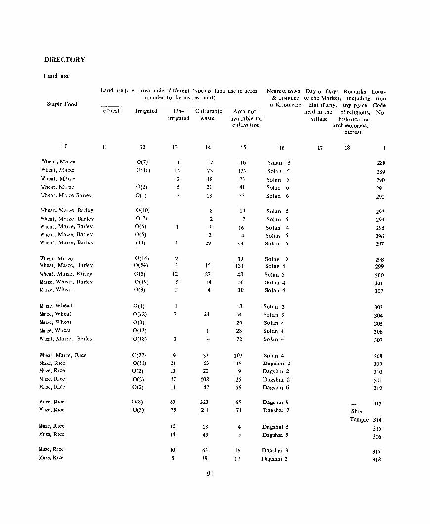
DIRE('TORY
Land use
Land use (I e , area under different typt:s of land use JO acres Nearest town Day or Days Remarks Loca-rounded to the nearest unlt) & distance of the Marketl IDcludmg tIon
Stapl!' Food 'n KIlometre Hat If any. any place Code l'orest Irngated Un- Cu!turable Area not held ID the of rellglOus, No
Irngated waste available for village hlstoncal or cultivation archaeological
Illterest
10 11 12 13 14 15 16 17 18
Wheat, Maize 0(7) 12 16 Solan 3 288 Wheat, Maize 0(41) 14 71 173 Solan 5 289 Wheat, MUze 2 18 73 Solan 5 290 Wheat, M<tlze 0(2) 5 21 41 Solan 6 291 Wheat, M tlze Rarley, 0(1) 7 18 33 Solan 6 292
Wheat, \.falze, Barley 0(10) 8 14 Solan 5 293 Wheat, M'llze Bar ley 0(7) 2 7 Solan 5 294 Wheat, Maize, Barley 0(5) 3 16 Solan 4 295 Wheat, MaIZe, Barley 0(5) 2 4 Solan 5 296 Wheat, MaIze, Barley (14) 29 44 Solan 5 297
Wheat, Maize 0(18) 2 39 Solan 5 298 Wheat, MaIze, Barley 0(54) 3 15 131 Solan 4 299 Wheat, MaIze. B1.rley 0(5) 12 27 48 Solan 5 300 MaIze, Wheat, Barley 0(19) 5 14 58 Solan 4 301 MaIze, Wheat 0(3) 2 4 30 Solan 4 302
MaIze, Whea t 0(1) 23 Solan 3 303 Maize, Wheat 0(22) 7 24 54 Solan 3 304 MaIze, Wheat 0(8) 26 Solan 4 305 MaIze, Wheat 0(13) 1 28 Solan 4 306 Wheat, MaIze, Berley 0(18) 3 4 72 Solan 4 307
Wheat, MaIze, RIce C(27) 9 33 107 Solan 4 308 MaIze, Rice 0(11) 21 63 19 Dagsbal 2 309 Melze, RIce 0(2) 23 22 9 Dagshal 2 3JO MaIze, RIce 0(2) 27 108 25 Dagsbal 2 311 MaIze, RIce 0(2) 11 47 16 DagsbaI6 312
MaIze, RIce 0(8) 63 323 65 Dagshal8 313 MaIze, RIce 0(3) 75 211 71 Dagsbal 7 ShIV
Temple 314 MaIze, RIce 10 18 4 Dagshal5 315 MaIze, RIce 14 49 5 Dagshal 3 316
MaIze, Rice 10 63 16 Dagshal3 317 MaIze, Rice 5 19 17 Dagshal :3 318
91
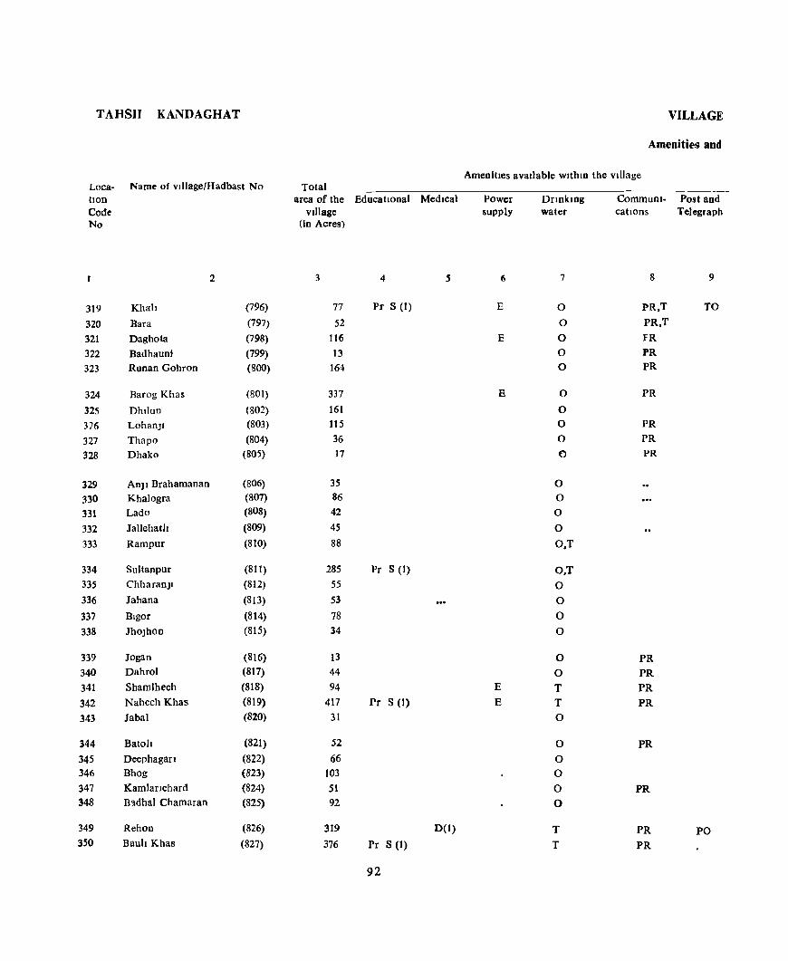
T AHSn KANDAGHAT
Loca- Name of vdJage/Hadbast No tlon Code No
2
319 Khah (796)
320 Bara (797) 321 Daghota (798) 322 Badhauni (799) 323 Runan Gohron (800)
324 Barog Khas (801)
325 Dhllun (802) 326 Lohan)1 (803)
327 Thapo (804) 328 Dhako (805)
329 An] I Brahamanan (806) 330 Khalogra (807)
331 Lado (808)
332 Jallehath (809)
333 Rampur (810)
334 Sultanpur (81 I) 335 ChharanJI (812) 336 Jahana (813)
337 Blgor (814) 338 Jho)hoD (815)
339 Jogan (816) 340 Dahrol (817)
341 Shamlhech (818)
342 Nahech Khas (819)
343 Jabal (820)
344 Batoh (821)
345 Deephagan (822) 346 Bhog (823) 347 KamJaflchard (824) 348 B-adhal Chamaran (825)
349 Rehon (826) 350 Bauh Khas (827)
Total area of the EducatIonal MedIcal
vIllage (in Acres)
3 4 .s
77 Pr S (1)
52 116
13 164
337 161 115 36 17
35 86 42
45 88
285 Pr S (1) 55 53 78 34
13 44 94
417 Pr S (1)
31
52
66 103 51 92
319 0(1) 376 Pr S (1)
92
VILLAGE
Ameni ti es and
AmenitIes avaIlable wlthlD the VIllage
Power supply
6
E
E
E
E
E
Dnnkmg water
7
0
0
0
0 0
0
0 0
0
0
0
0
0
0
O,T
O,T 0
0 0
0
0
0 T T 0
0
0 0
0 0
T T
CommuDl- Post and cations Telegraph
8 9
PR,T TO
PR,T
FR PR PR
PR
PR PR
PR
PR PR PR
PR
PR
PR
PR PO PR

DIRECTORY
Land use
Land use (I e , area under dlfierent types of land use In dcres Nearest town Day or Days Remarks Loea-rounded to the nearest UDlt) & distance of the marketl Including tlOn
Staple Food 10 Kilometre Hat If any, any place Code Forest lrngated Un- Culturable Area nOI held ID the of rehglOus, No
Irflgated waste avatlable for Village 11istOricai or cultIVatIon archaeological
lOterest
10 II 12 13 14 15 16 17 18
Maize, RICe 10 43 24 Dagshal 2 319 Maize, Rice 5 34 13 Dagshai 3 320 Maize, Rice 20 80 16 Dagshal 4 321 Maize, Rice 5 4 4 Dagshal 2 322 Maize, Rice 0(6) 32 86 40 DagshaI 3 323
Maize, Rice 46 2S7 34 Ddgshal 4 324 MaIze, RIce 0(21) 6 114 20 Dagshu 6 32S Maize, Rice O(IS) 18 67 IS Dagshal 4 326 Maize, Rice 0(9) 23 4 Dasshal 6 327 Maize, RIce 0(5) 8 4 Dagshal7 328
MaIze. RIce 0(5) S 18 7 Dagshal S Temple 329 Maize. Rice 0(10) 8 57 II Dagshal S 330 Maize, Rice 0(7) 3 26 6 DIlgshal6 331 Maize, Rice 0(21) 26 8 Dagshal 7 332 Maize. Rice 0(1) 10 62 IS Dag~hal 5 333
Maize, Rice 0(11) 28 205 31 Dagshal6 Temple 334 Maize, Rice 0(1) IS 20 19 Dagshal 3 335 Maize, Rice 0(3) 5 37 8 Dugshal 3 336 Maize, Rice 0(10) S 47 16 Dagshal 3 337 Maize, Rice 0(4) 6 17 7 Dagshal 3 338
Maize, Rice 0(4) 1 6 2 Dagshal 3 339 Maize, Rice O(S) S 24 10 Dagshal 2 340 Maize. Rice 12 73 9 Dagshal 1 341 Maize. Rice O(S) 60 299 53 Dagshal 1 342 Maize. Rice 8 21 2 Dagshal 5 343
Maize. Rice 5 37 10 Dagshal 5 344 Maize. Rice 7 SI 8 Oagshal3 345 Un!nhab! t ed 93 10 Dagshal2 346 Maize. Rice 0(2) 8 34 7 Dagshal 8 347 Matze, Rice 0(2) 23 51 16 Dagshal 6 348
i Maize. Rice 8 229 42 Oagshal 1 ThakUr Dwara 349 Mllze. Rice B 332 36 Daasbal 3 350
93

TAHSIL KANDAGHAT
Loca- Name 01 viliage/Hadbast No
(Ion Code No
2
351 Katal Ka Thar (828)
352 Dewar (829)
353 Mahseoo (830)
354 GalJynd (831) 355 MaJhoh (832)
356 Kotla (833)
357 NeT! Khurd (834)
358 Ner! Kalan (835) 359 Klyartu (836)
360 Jabal Ra~hesh (837)
361 Sham log (838) 362 Ma)hlon (839)
363 Kalan (840) 364 Shoboru (841) 36j GawJII (842)
366 Khalantl (843)
367 MaJhar (844)
368 Mehloo (8-t5)
369 Dharon (846)
370 Johar Pallala (847)
371 Shala (848)
372 Ghamarara (766)
373 Raru Pand (767)
374 Dharm Pur (768)
375 Saharn Mushmana (769)
376 Saharn Chamaran (770)
377 Saharn Kohan (771) 378 SaharT! Brahmanan (772)
379 Bhen KI Khech (773)
380 Pathla (744)
381 Basawal (775) 382 Ghart! Khurd (776)
VJLLAGt
Ameml.es aod
Total AmenitIes ava!ldble wlthm the village
area of the EducatIOnal Medical vllldge
(ID Acres)
3 4 5
243 100
71
86 Ib6
164
69
53
47
73
47 15 69 88
100
94 68 37
59
48
138
55
214
150 H(I)
7
29 Pc S (1)
13
37
30
33
24 45
94
Power supply
6
E
E
E
E
r: E
E
Dnnkmg water
7
0
0
0
0 0
O,T 0
0 0
0
()
0
0
0 0
NA
0
0
0
0
0
0
0
0 0
0
0
0
0
0
0 0
CommuDj- Post and catIon. Telegraph
PR
PR
PR PR PR,T
PR,T
PR
PR,T
PR

DIRECTORY
Land use
Land w,e (I e • area under dJiferent types of land u~e lD acre~ Nearest town Day or Days Remarks Loca-rounded to the nearest umt) & distance of the Marketl lDcludmg tlon
Staple Food ID Kilometre Hat If any, any place Code Fore~t Irrigated Un- Culturable Area not held ID the of religIous, No
I rflgated waste available for village historIcal or cultlvatton archaeological
mterest
10 II 12 IJ 14 15 16 17 18
Maize, Rice 0(22) 23 133 55 Dagshal 6 351
Maize, Rice 0(4) 11 69 16 Dagshal6 352
Maize, Rice 9 53 9 Dagshal9 353
Maize, Rice 24 55 7 Dagshal 5 354
Maize, Rice 35 115 36 DagshaI 8 355
Maize, Rice 0(1) 22 106 35 Dagshal 8 356 Maize, Rice 14 47 8 Dagshal 6 357 Maize, Rice 0(2) 7 3S 9 Dagshal6 358 Maize, Rice 0(1) 4 36 6 Dagshal4 359 Maize. Rice 0(3) 10 48 13 Dagshal5 360
Maize, Rice 13 8 26 Dagshal 5 361 Maize, Rice 9 3 3 Dagshal 5 362 Maize. Rice 7 53 9 Dagshal 5 363 Maize, Rice 9 70 9 Dag~hal 5 364 MaIze, Rice 23 55 22 Dagshal 4 365
Maize, Rice 21 61 12 Dagshal 3 366 MaIze. Rice 0(3) 14 41 to Dagshal 5 367 Maize, Rice 12 17 8 Dagshal 5 368 Maize. Rice 23 21 15 Dagshal 5 369 Maize, Rice 36 12 Dagshai 9 Temple 370
Maize. RIce 39 71 28 Dagshal 10 371 Maize, Rice 4 33 18 Dagshal 4 372 Maize, Rice 0(4) 26 153 31 Dagshal 4 373 Maize, Rice 0(2) 24 82 42 Dagshal 4 Temple 374 Maize, Rice 0(5) 5 62 7 Dagshal 7 375
Maize. Rice 0(1) 6 15 7 Dagshal 4 376 Maize, Rice 0(2) 2 7 2 Dagshal 4 317 Maize, Rice 0(3) 6 22 6 Dagshal 3 378 MaIze 0(3) 5 18 4 Dagshal 2 379 Maize, Rice 0(2) 2 20 9 DagshaI 3 380
Maize, Rice 4 19 1 Dagshal 3 38{ Maize, RIce 4 31 10 Dagshal 2 382
95
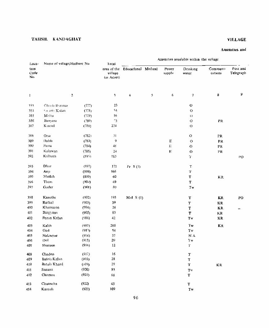
TAHSIL K4..ND4.GHAT VILLAGE
Amemtle!!o ami
AmemtIes avaIlable withIn the vIllage Loca- Name of vl)]age/Hadba~t No 10tal
tlOn Code No
li3
384 385
3~6
387
3815
389 390
391
392
393
394 395
396 397
398 399 400
401
402
403 404 405 406 407
408 409 410
411
412
413
414
2
Gh 1'(1 lhranal (777)
f II Jrtl K t1.ln (7n)
~1'lltu (779)
Banjanl (780) KlaTad (781)
Ona (782) Dabl] (783) PaUa (784) Kalawan (785) Kalhcch (89/)
Dhar (R97)
An]1 (898) Matlah (899) Than (90U)
Gader (901 )
Kancthl (902) Rathal (903) Khamaron (904) Barg}ana (905)
Baran Kalan (906)
Kahh (907) OaI] (911)
Nakalyar (914) Dol (915) Sharaun (916)
Chad OIl (917) Batoll Kalan (918) Batoll Khnrd (;)19)
San ana (920)
ChamoH (921)
Chuancha (922)
Karaul! (923)
area of the Educational MedIcal Power VIllage supplv
(10 Acres)
1 4 5 6
23 '54
16 -3
274
31 9 E
48 E
24 E
185
171 Pr S <I) 166 60
69
FO
193 MId S (1)
39 26
83
42
200 '54 57
20 12
16
28
29
93
88
43
109
96
Drlnkmg water
7
0
0
()
0
0
0
0
0
0
T
T
T
T
T
Tw
T
T T T Tw
Tw Tw NA
Tw T
T
T
T
Tw
T
T
Tw
CommunI- Post and cations Telegraph
8
PR
PR
PR
PR
PR
PO
KR
KR PO
KR
KR
KR
KR
KR
KR

DJRECTORY
Land U'ie
Land use (I e , ared under different type~ of Jand u,e 10 acres Nearest town Day or Days Remarks Loca-rounded to the nearest unit) & distance of the Marketl IncludJDg tlOn
Staple food In Kilometre Hat If any, any place Code forest Irngated Un- Cultuldble Area,not held JD the of religIOus, No
Irflgated wa~te available for village historical or cultlVatlOo archaeological
!Dterest
10 II 12 13 14 15 16 17 18
Umnhablted 3 17 3 Dagshal 1 383 Maize, Rice 0(1) 5 35 13 Dagshal 3 384 Maize, Rice 5 7 4 Dagshal 3 385
Maize, Rice 6 61 6 Dagshal 5 386 Maize, Rice 0(37) 23 16~ 46 Dagshal 2 387
Maize, Rice 2 27 ., Dagshal 5 388
Maize, Rice 4 I 4 Dagshal 3 389
Maize, Rice 0(5) 8 23 1" Da~shal 3 390
Maize, Rice 0(3) 5 12 4 Dagshal 1 391 Wheat, Maize, Rice 0(4) 15 106 60 Dagshm 3 392
Wheat, Maize, RI~e 0(6) 26 50 89 Dagshal 4 393
Wheat, Maize, Rice 0(4) 18 94 50 Dagshal 5 394
Wheat, MaIze, Rice 6 26 28 Dagshal 6 395 Wheat, Maize, RIce 0(2) 7 34 26 Dagshal 4 396
'Wheat, MaIze, Rice 0(3) 2<) 13 44 Dagshal 6 397
Wheat, Maize, Rice 0(3) 43 44 103 Dag~hal 6 398
Wheat, Maize, Rice 9 14 16 Dagshal 6 399
Wheat, MaIze, Rice 0(1) 15 4 6 Dagshal 5 400
Wheat, Maize, Rice 0(5) 15 4 59 Dagshal 6 401
Wheat, Maize, Rice 0(5) 4 32 Dagshal 4 402
Wheat, Maize 16 135 49 Dagshal 5 403 Wheat, Maize, Rice 0(1) 13 2 38 Dagshal 8 404 Wheat, Maize, Rice 0(6) 4 16 31 Dagshal 8 405
,Wheat, Maize, RICe 0(8) 2 4 6 Dagshal 8 ~C6
Wheat, Maize, R,ce 0(2) 2 8 Dagshal 8 407
Wheat, Maize, Rice 0(2) 2 4 8 Dagshal 8 408 Wheat, Maize, Rice 0(5) 4 9 10 DagshaI 8 409 Wheat, Maize, Rice 0(5) 6 17 Dagshal.8 410 Wheat, Maize, Rice 0(9) 11 20 53 Dagshal 9 411 Wheat, Maize, Rice 0(16) 8 63 DagshaI 10 412
Wheat, Maize, Rice 0(6) 2 18 17 Dagshai 10 413 Wheat, Maize, Rice 0(6) 19 30 S4 Dagshal 10 414
97
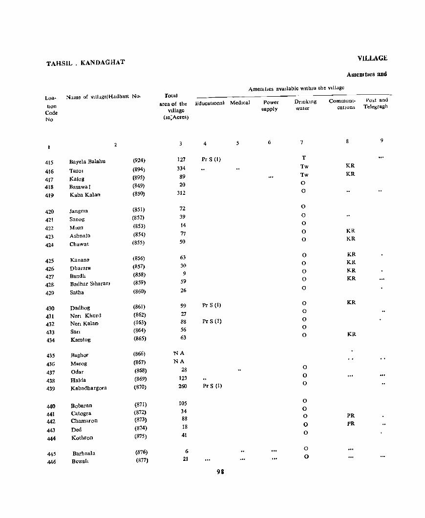
TAHSIL. KANDAGHAT
Loa- Name of village/Hadbast No.
hon Code No
2
415 Bayela Balahu (924)
416 Tarol (894)
417 Kalog (895)
418 Basawal (849)
419 Kaba Kalan (850)
420 Jangna (851)
421 Sanog (852)
422 MlUD (853)
423 AshnaTa (854)
424 Chawat (855)
425 Kanana (856)
426- Dharara (857)
427 Bandh (858)
428- Badhar Slharan (859)
429 Satha (860)
430 Dadhog (861)
431 Nen Khurd (862)
432 NCfl Kalan (363)
433 SarI (864)
434 Kam)og (865)
435 Baghor (866)
436 Marog (867)
437 Odar (868)
438 Halda (869)
439 Kabadhargor!U (870)
440 Bobaran (871)
441 Catogra (872)
442 Chamaron (873)
443 Ded (874)
444 Kothron (875)
445 Barhnala (876)
446 Bewah (877)
VILLAGE
Amemtles and
Amemlles available within the Villclge Total
area of the Educational Medical Village
(ID:Acres)
3 4 5
127 Pr S (1)
334 89 20
312
72
39 14 77 50
63 3{)
9 59
26
99 Pr S (1)
27 88 Pr S (1)
56 63
NA
NA
28 123 260 Pr S (1)
105 34 88 18 41
6 21
93
Power supply
6
DrmkIDg water
7
T
Tw
Tw
0
0
0
0
0
0 0
0
0
0 0
0
0 0
0 0
0
0
0 0
0
0 0
0
0
0
0
Commum- Po~t and cations Telegragh
8 9
KR
KR
KR KR
KR KR
KR
KR
KR
KR
PR PR
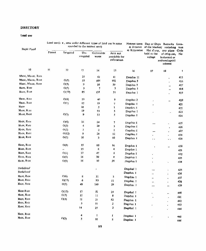
DIRECTORY
Laud use
Land use (I e. area under different types of land use in acres Nearest town Day or Days Remarks Loea. rounded to the nearest unit) & dl"tance of the Marketl lllcludmg bon
Staplr Food III Kilometre Hat Ifany. any place Code
Forest Irngated Un- Culturable Area not held ID the of relIgIOUS, No IrrIgated waste avaIlable for Village hlstoncalor
cultIVatIon archaeologIcal mterest
10 II 12 13 14 15 16 17 18
Mleat, MaIze, Rice 25 61 41 Da~shal 11 415 Wheat, Maize, RIce 0(5) 33 104 192 Dagsha15 416 Wheat, Maize, RIce 0(3) 9 38 39 Dagsha13 417 MaIze, RIce 0(7) 3 7 3 Dagshall 41S Mal7e, RIce 0(19) 85 m 35 Dagshal 1 419
MaIze, RIce 0(4) 19 40 9 Dagshal2 420 Maize, RIce 0(1) 12 19 7 Dagshal I 421 MaIze 10 3 1 DagshaI 1 422 MaIze, Rice 19 53 5 Dag~hal I 423 Maize, RICe 0(3) 9 33 5 DagshaI I 424
MaIze, RIce 0(6) 26 24 7 Dagshall 425 Maize, RIce 0(3) 4 20 3 Dagshall 426 Md'ze, RIce 0(2) 3 2 2 Dagshall 427 MaIze, Rice 0(12) 9 26 12 Dagshall 428 Maize, RIce 0(3) 10 3 10 Dagshal I 429
MaIze, Rice 0(8) 15 60 16 Dagshal I 430 MaIze, RIce 15 8 4 Dagshall 431 Maize, RIce 0(6) 27 47 8 DagshaIl 432 Malle, RIce 0(6) 16 30 4 Dagshall 433 Maize, Rice 0(8) 16 10 29 DagshaI I 434
Umnhablted Dagshai 1 435 Unmha~lIed Dagshal 1 436 Maize, RIce 0(6) 8 11 3 Dagshal 1 437 Maize, Rice 0(13) 6 93 11 DagshaI 1 438 MaIze, RIce 0(3) 49 180 28 Dagshal 1 439
Maize Rice 0(13) 17 51 24 Dagshal 1 440 MaIze, Rice 0(4) 11 11 8 Dagshal I 441 Maize, Rice 0(4) 11 21 52 Dagshal 1 442 Maize, RIce 5 11 2 Degshal 1 443 MaIze, RIce 14 25 2 Dagshai 1 444
MaIze, RIce 4 1 1 Dagshal 1 445 Maize, RIce 0(3) 3 10 5 Dagshal 1 446
99
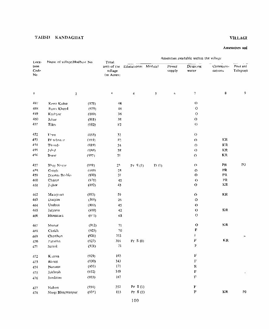
TAHSil I\:ANDAGHAT VILLAGE
Amemtles and
AmeOltl<!S available wlthm the village Loca- Name of v"lage/Hadbd~t No Total tlOn Codl' No
447
44R 449
450 451
452 4)3 4)4
4'i'i
4'1)
457 4'iQ
459 460 461
462 463
464 465
466
467
468
469 470
471
472
473
474
475
476
477 47R
2
Kona Kalan
Ron'l Khurd
Kath)ar
lehar
Tlkn
TTrnn
D' 1r111n Ir
Th'Jnd,
l1h11
n1r~t
Bl'OJ N1C;1f
G1tol1 Doongl Bc,M.k
Charo!
J IJhcr
Mahlyana
Dacyan
Undrol
J,\iyana
Bhamrara
~hardr
Chak.h
Chalthon
l'dratha
Satrol
KI.lTua
Barog
NaraJOJ
Jakhroh
Jandaufl
Nabon
ShOgI Bhagwanpur
(878) ('l79)
(880)
(881)
(882)
(RR3)
(R~1)
(88'i)
(8R~)
(qQ7)
(8 QR)
(Sqq)
(890) (8 1t)
(892)
(893)
~908)
(909) (910)
(9 1 1)
(912)
(925)
(926)
(927) (928)
(929)
(930) (931) (932)
(933)
(934) (93<;)
are:! of the EducatIOnal Mt'dIcal village
(10 Acres)
4 5
44
18
36
38
82
32 82
34
38
31
2') Pr "(1) D (I)
2,
31
45 43
59 26
45 42
65
71
70 332
301 Pr S (1)
71
143
143 171
349
187
352 Pr S (1)
133 Pr S (1)
100
Power ,upply
t,
Dnnkmg water
7
0
0
0
0
0
0
0
0
0
0
0
0 0
0 0
0
0
0
0
0
0
F 1
F
F
F
F
R
F F
F
F
Communi- Po,! and catIOn, Telegraph
8 9
KR
KR
KR
KR
PR PO
PR
PR
PR KR
KR
KR
KR
KR
KR PO
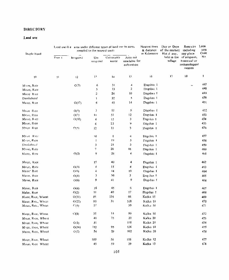
D1RECfORY
Land use
Land u~e (I e area under different types of land u~e In acre, Nearest tOWIl Day or Days Remllks Lo~
rounded to the neare.,t UOIt) & distance of the market! IncludlOg tion
Staple Food In Kilometre H..lt If any, any place Code
Fore t Irngated Un- Cultur..lble Area not held 10 the of religlOus, No
'frl!n teo wa~te avaJiable for village h Istoncdl or cultivatIOn archaeological
mterest
10 11 12 n 14 15 16 17 18
M117C, RIce 0(3) 6 31 4 Dagshal 447
Maize, Rice 3 13 2 Dagshal 1 448
Maize Rice 2 24 10 Dagsilal 1 449
Umnhablted 1 32 5 Dagshal 1 450
Maize, RIce 0(\7) 6 45 14 Dagshal 1 451
Mau'c Rice 0(5) 3 15 9 Dagshal 452
MaLle, Rlct: 0(3) JD 51 12 Dag~hal 1 453 MaiLe, Rice 0(10) 6 15 3 Dag,hal 1 454 Malle, Rice 6 23 9 Dag~hal 1 455
I\h1Zc Rice 0(5) 12 11 3 Ddgshal 456
Mal7e Rlc~ 10 8 4 Dag~hal 457 M1lze, RIce I 19 5 Dagshal 458 UIIIIlI.ahll (" 3 25 3 Dag~h;l1 459 M llze, Rice 7 20 18 Dag,hal 460
M<llze, RI7e 0(2) 9 26 6 Dagshal 461
Maize, Rice 15 40 4 Dagshal 462
MaIze, Rice 0(3) 4 15 4 Dag~hal 4~3
Mal7c' RIce orR) 4 14 19 Dagshal 464 MaIze, Rice 0(4) 3 30 5 Dag,hal 1 465
MaIze, Rice 0(6) 9 41 9 Dag~hal 466
Maize, Rice 0(4) )6 45 6 Dag<;hal 467 Maize, RIce 0(2) 11 40 17 Dag'ihal 1 468
M,llze, RIce, Wheat 0(31) 81 154 66 Kalka 15 469
Malzc, RICL, Whc-lt 0(22) 80 31 168 Kalka 18 470 Mdlze, RIC,-, Whcat 0(4) 17 50 KalkJ 18 471
M..lIzc, RIce, Wheat C(4) 35 14 90 Kalka 18 472
M1lze, RIce, Whc It 48 75 20 Kalka 20 473
M::llze, RIce, Wheat 0(2) 51 118 Kalka 20 474
M1Ize, Rice, Wheat 0(16) 112 95 126 Kalka 18 475
MaIze, RIce, Whcat 0(2) 54 29 102 Kalka 20 476
M3Ize, RIce, Wheat 180 56 116 Kalka 12 477
MaIze, RIce Wheat 45 59 29 Kalka 13 478
101

TAHSIL KANDAGHAT
Loca- Name of vlllage/Hadbast No
tlon Code No
2
479 Seola (936)
480 Mehlon (937)
481 Shalf (938)
482 Takrota (939)
483 MaJhol (940)
484 Badhan (941)
485 Panewa (942)
486 Sandhog (943)
487 Shaunh (944)
488 Banasar (945)
489 JodhpUf (946)
490 Kadml (947)
491 Kamh Gaon (948)
492 Guman (949)
493 Dangayar (950)
494 Taksal (951)
495 Ambota (952)
496 Han Ka Khel (958)
497 Tlron (959) 498 ~halu Khurd (960)
499 BanOI Achaud (961)
500 BanOI Ramsmgh (962)
501 Tlpera (953)
502 Shalu Kalan (954)
503 Jangeshu (955)
504 Shalaura Khurd (956)
50S Shalaura Kalan (957)
506 Garkhal (713) 507 Badha (714) Sag Chabal (715)
509 Sahyana (716) 510 Khadolt (717)
VILLAGE
Amenalles and
Total Amemtles available withIn the village
area of the EducatIonal Medical village
(10 Acres)
3 4 5
208 49 57
150
72 Pr S (I)
132 150 118
90
234 Pr S (1)
132 415 Pr S (1)
241 Pr S (1)
301 60 Pr S (1)
42 D(l)
697 Pr S (1) 40
724 Pr S (1) D(l) 104
149 155 282 Pr S (1) 224 167
283 88
234 Pr S (I) D(r)
161 121
69 100
102
Power supply
6
E
E
E
E
Dnnktng water
7
F
F F F
F
0
0
0 F
0
R
R
R
F
F
T
F
F F
F
F F
F F F
F
F
T 0
0
0
0
CommunI- Post and cations Telegraph
8 9
KR
PR
PR
PO
KR
KR
KR
PR PO KR
KR
KR
KR

DIRECTORY
Land use
Land u~e (I e , area under dIfferent types of land use In acre, Ne.ire,t town Day or Day, Remarks Loca-rounded to the nearest Unit) & distance of the Marketl IncludIng hon
"itaple Food ID Kilometre Hat If any, any place Code Forest Irngated Un- Culturdble Area not held ID the of religious, No
trrIgated waste available for vIllage hlstoncal or CultivatIon archaeological
Interest
10 II 12 13 14 15 16 17 18
MaIZe, RIce, Wheat 0(52) 41 59 56 Kalka 12 479 MaIze, Rice, Wheat 0(7) 20 13 9 Kalka 12 480 Maize, RIce, Wheat 12 32 13 Kalka 12 481 Maize, Rice, Wheat 0(15) 28 2 60 Kalka 10 482 MaIze, RIce, Wheat 0(10) 17 45 Kalka 12 483
Maize, RIce, Wheat 0(20) 40 37 35 Kalka 10 484 Maize, RIce, Wheat 0(12) 19 55 64 Kalka 8 485 MaIze, Rlcc, Wheat 0(14) 24 17 63 Kalka 12 486 MaIze, RIce, Wheat 0(6) 19 23 42 Kalka 12 487 Maize, Rice Wheat 0(6) 66 46 116 Kalka II 488
Mdlze, Whe<lt, RIce 0(8) 25 86 13 Kalka 13 489 MaIze, RIce, Wheat 0(29) 67 165 154 Kalka 8 490 MaIZe, Rice, Wheat 0(20) 23 134 64 Kalka 5 491 Maize, RIce, Wheat 0(1) 52 140 108 Kalka 3 492 Maize, Rice, Wheat 0(8) 29 23 Kalka 493
Maize, Wheat 16 4 22 Kalka 3 494 Maize, Rice, Wheat 0(65) 133 288 211 Kalka 3 495 MaIze, Wheat 3 11 26 Kasaull 5 496 Maize, Rice, Wheat 0(71) 118 346 189 Kalka 5 497 Maize, RIce, Wheat 0(17) 3 34 50 Kalka 9 498
MaIze, Rice, Wheat 0(5) 13 104 27 Kalka 11 499 Maize, RIce, Wheat 0(8) 4 6 137 Kalka 11 500 Malzc, Rice, Wheat 0(22) 26 145 89 Kasauh 5 501 Maize, Rice, Wheat 0(34) 36 60 94 Kasauh 6 502 Maize, Wheat, Rice 0(44) 16 23 84 Kasauh 3 503
MaIze, Wheat, RIce 0(10) 29 164 80 Kasauh 5 504 Maize, Wheat, Rice 0(9) 1 34 44 Kasauh 2 505 Maize, Rice 0(3) 33 94 104 Kasauli 2 506 Maize, Rice 0(7) 22 33 99 Kasaull 3 507 Maize, Rice 0(1) 21 49 50 Kasauh 4 508
MaIze, Rlce 0(3) 6 20 40 Kasau)I 4 509 Maize, RIce 0(7) 21 16 56 Kasaull 4 510
103
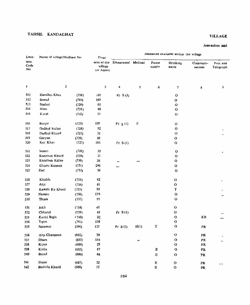
TAHSIL KANDAGHAT VILLAGE
Amt'lutiell and
Loca- Name of village/Hadba'lt No Total Amemtles aVdlldble wltlun tbe vIllage
Uon Code No
511 512 513 514 515
516
517 5)8 519 520
52.1 522 523
524 525
526 527
528 529 530
531 532 533 534 535
536 537 538 539 540
541
542
2
Gandhol Khas (718) Sarno) (719) Sanhol (720) Ahm (721) Kdtal (722)
B,lOJnJ (723) Dadbol Kalan (24) Dadhol Khurd (725) Garyan (726) Kot Khas (727)
~anrfl (728)
Kamthdn Khurd (729) Kamthan Kalan (730)
Gharsl Kunana (731) Ded (732)
Khobla (733) AnJI (734) Kawah Ka KheeJ (735) Nawatl (736) Thura (737)
Jakb (738)
Chharol (739) KaUal Bagh (740) Tlpra (741) Sanawar (396)
AnJl Chamaran (692) Dhan (683) Klyar (684) Kotla (685) Barad (686)
Shaee (687)
Basholu Khurd (688)
area of tbe EducatIonal MedIcal Power vIllage supplv
lID Acres)
3 4 5 6
.91 Pc S (I)
160 62 48 50
128 Pc S (I) E 92 31 30
194 Pr S (I)
35 21 26
246 36
62 81 39
179 95
45 61 Pc S (I)
82 136 127 Pr S (I) H(I) E
70 114 29 87 E 66 E
32 E IS E
104
Drlnkmg water
7
0
0 0
0
0
0
0 0
0 0
0 0 0
0
0
0 0
T
0
0
0
0
0 0 0
0
0
0
0
0
0 0
CommuDI- Post ano catIons Telegraph
8
KR
PR
PR
PR
PR
PR
PR
PR PR

DIRECTORY
Land use
Ldnd use (1 e , area under dIfferent types of land use lD acre~ Nearest town Day or Days RemarKS Loca· rounded to the nearest UOlt) & distance of the Marketl IDciudmg hOD
Staple food I n Kilometre Hat If any, any place Code Forest IrrIgated Un- Culturdble Area not held ID the of relIgIOUS, No.
Irngated waste avallable for Village hlstoncal or culhvatJOD archaeological
interest
10 II 12 13 14 15 16 17 18
MaIze, Rice 0(19) 12 85 7S Kasaull 3 511 MaIze, RIce 0(7) 33 34 86 Kasauh 1 512 Maize, RIce 0(11) 8 15 28 Kasaull 1 513
I ,\falze, RIce 0(6) 7 4 31 Kasauh 2 514 MaIze, RIce 0(6) 9 5 30 Kasaull 2 515
MaIze, Rl<'e 0(8) 20 26 74 Kasauh 5 516 Maize, RIce 0(6) 8 13 65 Kasaull 5 517 Maize, Rice 0(3) 3 6 19 Kasaull 5 518 Umnhablted 1 5 24 Kasaull 5 519 Maize, Rice 0(19) 30 31 114 Kasauh 5 520
Maize, RICe 0(13) 4 17 Kasauh 6 521 Maize, Rlce 0(8) ) 11 Kasauh 6 522 MaIze, Rice 0(10) 3 13 Kasau]! 6 523 MaIze, Rice 0(39) 19 20 168 Kasauh 6 524 UninhabIted 0(1) 6 29 Kasaulr 7 525
Maize, Rice 12 19 31 Kasauh 7 526 Maize, Rice 0(15) 5 34 27 Kasauh 6 527 Maize, Rice 5 19 15 Kasauh 6 528 Maize, Rice 0(7) 13 78 81 Kasauh 6 529 Maize, Rice 20 25 50 Kasauh 7 530
Maize, Rice 0(1) 13 3 28 Kasauh 7 531 Maize, Rice 0(4) 15 22 20 Kasauh 7 532 Maize, Rice 0(3) 8 34 37 Kasauh 8 533 Maize, Rice 14 43 79 Kasaull 8 534 Maize, Rice 127 Kasauh 3 535
Maize, Rice 0(4) 4 59 3 Kasauh 4 536 Maize, Rice 0(8) 6 90 10 Kasauh 4 537 Maize, Rice 0(6) 18 5 Kasauh 4 538 Maize, RIce 0(7) 9 52 19 Kasauh 4 539 Maize, Rice 0(4) 10 41 It Kasauh 3 540
MaIze, Rice 0(3) 8 12 9 Kasauh 3 541 Maize, RIce 0(2) 4 7 2 Kasau!l 3 542
105
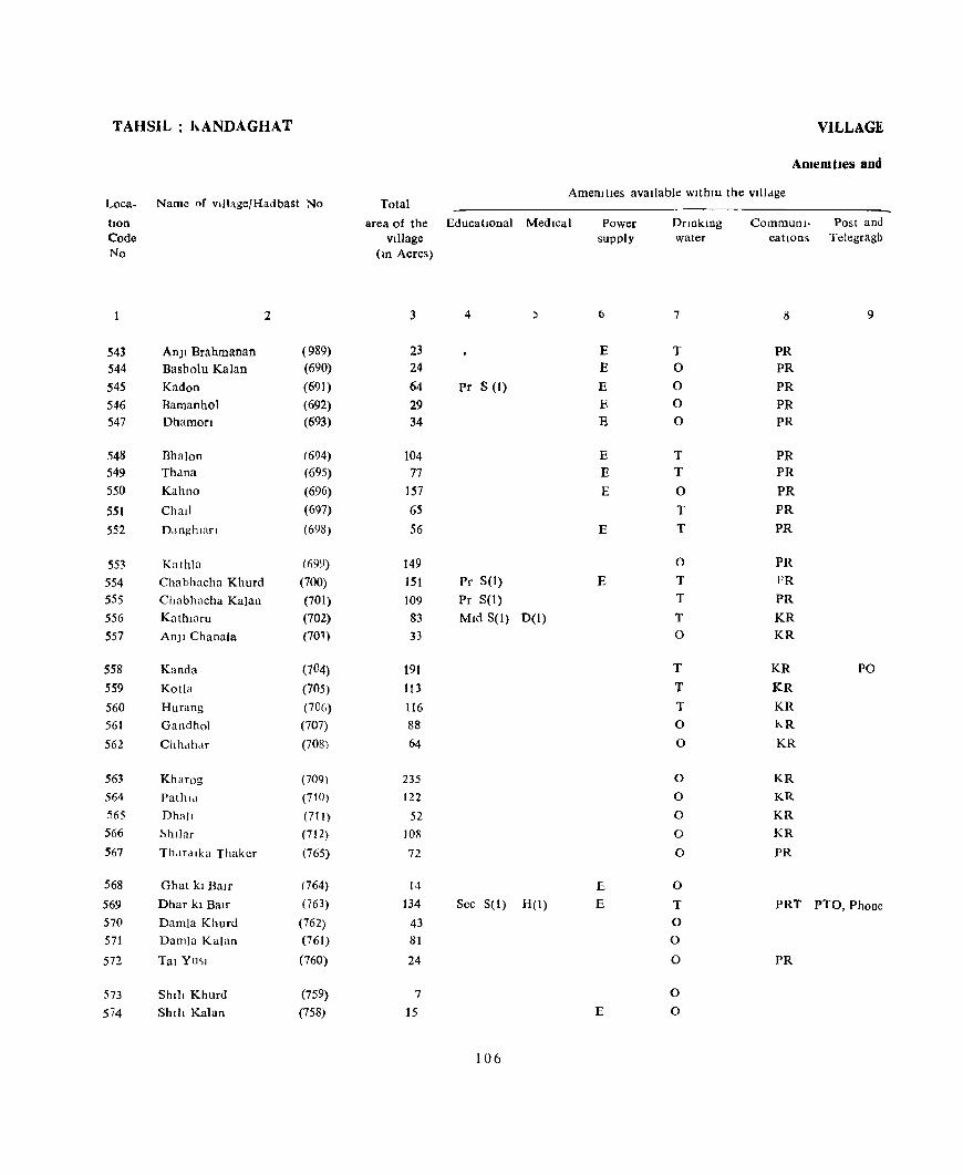
TAHSIL h.ANDAGHAT
Loca- Name of viliage/Hadbast No
tlon Code No
2
543 Anjl Brahmanan (989) 544 Basholu Kalan (690) 545 Kadon (691) 546 Bamanhol (692) 547 Dhamort (693)
548 Bha]on (694) 549 Th,lna (695) 550 Kahno (696)
551 Chall (697)
552 Danghlan (698)
553 Kathla (1)99)
554 Chabhacha Khurd (700) 555 Chabhacha Kalan (701) 556 Kathtaru (702) 557 An]1 Chanala (70'\)
558 Kanda (704) 559 KotJa (705) 560 Hurang (706) 561 Gandhol (707)
562 Chhdh.lf (708)
563 Kharog (709) 564 Pathld (710) 565 Dh;]JI (711) 566 Shllar (712) 567 Th.1[dlka Thaker (765)
568 Ghat kI Balf (764) 569 Dhar kl Balr (763) 570 Damla Khurd (762) 571 DamJa Kalan (761)
572 Tal YUSI (760)
573 ShIll Khurd (759) 574 Shlll Kalan (758)
VILLAGE
AmeOltles aDd
AmenItIes avaIlable wlthm the vllldge Total
area of the EducatIonal MedIcal vIllage
(m Acres)
3 4
23 24 64 Pr S (1)
29 34
104 77
157
6S
56
149 151 Pr S(I)
109 Pr S(I)
83 MId S(I) 0(1) 33
191 113 116 88 64
235 122
52 lOll
72
14 134 See S(I) H(I)
43 81
24
7 15
106
Power supply
6
E E E E E
E E
E
E
E
E E
E
DnnkIDg water
7
T 0
0 0 0
T T
0
T T
0
T T
T 0
T
T
T
0
0
0
0
0
0
0
0
T
0
0
0
0
0
Communl- Post and catIons Telegragh
S 9
PR PR
PR
PR
PR
PR PR
PR
PR
PR
PR
PR
PR
KR
KR
KR PO
KR
KR
hR
KR
KR
KR
KR
KR
PR
PRT PTO, Phone
PR
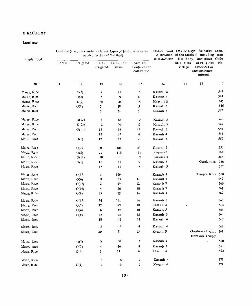
DUaCrORY
Land use
Land use (I e , area under different types of land use III acres Nearest town Day or Days Remarks Loca. rounded to the nearest unit) & dl~taDce of the Marketl IDcludmg tlOD
Stdple' Food -_---_ In KIlometre Hat Irany, any place Code ~orest Irrtgated Un- Cullur.tble Area nol held m the of relIgIous, No
Irngaled waste available (or vIllage hlstorlca I or cultivatIon archaeologIcal
mterest
10 11 12 11 14 15 16 17 18
Maize, Rice 0(5) 2 it 5 Kasau" 4 543
Maize, Rice 0(2) 7 q 6 Kasauh 3 544
Maize, Rice 0(2) 10 36 16 KasauJi 3 545
Maize, Rice 0(1) 5 18 5 Kasaul! 3 546
Maize, Rice 5 24 5 Kasaul! 3 547
Malzc, Rice 0(13) 18 63 10 Kasaull 3 548
Maize, Rice C(23) 2 39 13 Kasaul! 3 549 MaIze, Rice 0(14) 18 108 17 Kasau)! 3 550
Maize, Rice 12 47 6 Kasau" 4 551
Maize, Rice 0(1) 12 37 6 Kasaul! 4 552
Maize, Rice 0(2) ::0 104 23 Kasaull 3 553
Maize, Rice O(8) 19 110 14 hasau)! 3 554
MdlLe, Rlct- 0(11) 10 lSI 7 Ka .... lU)! 3 555
Maize, Rice 0(1) 12 61 9 Kasauh 3 Gurdawara 556
Maize, Rice 15 11 7 Kasaul! 3 557
MaIze, Rice 0(19) 3 169 Kasaul! 3 Temple Kotl 558
Maize, Rice 0(4) 8 5S 46 Kasauh 4 5S9 Maize, RIce 0(43) 2 49 22 Kasaull 3 560
Maize, RIce 0(16) 4 50 18 Kasaull 3 561
MaIze, Rlcc 0(9) 13 28 14 Kasaul14 562
Maize, Rice 0(14) 34 141 46 Kasdult 3 563
Maize, RIce 0(7) 22 83 10 Kasaull 3 564
MaIze, RIce 0(4) 6 32 10 Kasaull 5 565
MaIze, RIce 0(8) 12 73 15 Kasau)I 3 560
Maize, Rice 18 42 12 Kasau II 4 567
Maize, Rice 3 7 4 Ka~aull 4 568
MaIze, Rice 20 71 43 Kasaull 9 Gurdwara Laxrm 569 Narayan Temple
Maize, Rice 0(7) 3 30 3 Kasauh 4 570
MaIze, RIce 0(7) 4 66 4 Kasault 4 571
Maize, Rice 0(6) 3 11 4 Kasauh 4 572
Maize, Rice 5 Kasaul! 4 573
Maize, Rice 0(1) 4 9 Kasauh 4 574
107
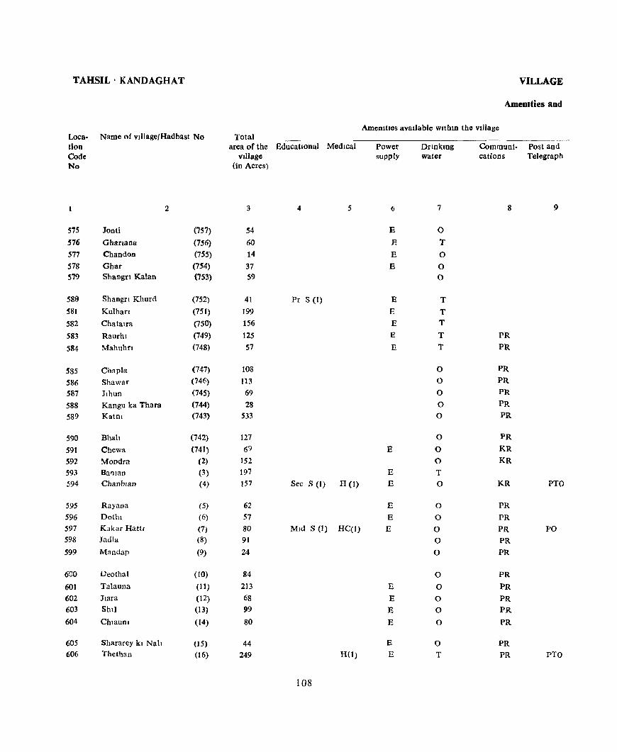
TAHSIL' KANDAGHAT
L.oca- Name of vJllage/Hadbast No tion Code No
2
575 lont! (757) 576 Gharlana (756) 577 Chandon (755) 578 Ghar (754) 579 Shangn Kalan (753)
589 Shangn Khurd (752) 581 Kulhan (751) 582 Chatalfa (750) 583 RauTh I (749)
584 Mahuhn (748)
585 Chapla (747)
586 Shawar (746)
587 Jlhun (745)
588 Kangn ka Thara (744) 589 Katnl (743)
590 Bhah (742)
591 Chewa (741) 592 Mondra (2)
593 Baman (3) 594 Chanbran (4)
595 Rayana (5)
596 Dothl (6)
597 Kakar Hattl (7) 598 Jadla (8)
599 Mandap (9)
6GO Deothal (10)
601 Talauna (11)
602 Jlara (12)
603 Shll (13)
604 Chtaunl (14)
605 Shararey kl Nah (15) 606 Thethan (16)
Total area of the EducatIOnal Medical
village (in Acres)
3 4 5
54
60 14
37 S9
41 Pr S (1) 199 156
125 57
108 113 69 28
533
127 69
152 197 157 Sec S (t) H (1)
62 57 80 Mid S (1) HC(I) 91
24
84 213
68 99
80
44 249 H(1)
108
VILLAGE
AmeDlties and
AmeOlties avadable within the village
Power supply
6
E
E
E
E
E
E
E B
E
B
E
E
E
E
E
E
E E
E
E
E
Drmkmg water
7
0
T 0
0 0
T
T T
T
T
0
0
0
0
0
0
0
0 T
0
0
0
0 0
0
0
0
0
0
0
0
T
Communi- Post and cations Telegraph
8 9
PR
PR
PR
PR
PR
PR
PR
PR
KR
KR
KR PTO
PR
PR
PR PO
PR
PR
PR
PR
PR
PR
PR
PR
PR PTO

DIRECTORY
Land use
Land use (I.e, area under different types of land use In acres Nearest town Day or Days Remarks Loca-rounded to the nearest umt) & distance of the marketl lnciudlDg tlon
Staple Food tn Kilometre Hat If any, any place Code Forest IrrIgated Un- Culturable Area not held m the of rehglous, No.
Irngated waste available for village h Istoflcal or culttvatlon archaeologica I
Interest
10 11 12 13 14 15 16 17 18 1
Maize, Rice 0(11) 2 38 3 Kasauh 3 575 Maize, Rice 0(7) 9 35 9 Kasauh 4 576 Maize, Rice 0(6) 3 4 Kasauh 4 571 Maize, Rice 0(2) 4 27 4 Kasuuh S 578
MOlze, Rice 0(20) 1 32 6 Kasauh 3 579
Maize, Rice 0(7) 9 22 3 Kasauh 4 580 Maize, Rice 0(16) 21 135 27 Kasauh 3 581 Maize, Rice 0(7) 44 79 26 Kasauh 3 582 Maize, Rice 0(5) 17 85 18 Kasault 4 583 Maize, Rice 0(2) 10 39 6 Kasauh 4 584
Maize, Rice 0(3) 17 76 12 Kasduh 4 585 Maize, Rice 0(4) 12 85 12 Kas3uh 4 586 Maize, Rice 0(1) 7 54 7 Kasau]1 3 587 UninhabIted 24 4 Kasauh 3 588 Maize, Rice 0(14) 32 430 57 Kasau]t 3 Thakur Dwara 589
Maize, Rice 0(5) 27 80 15 Kasauli 3 590 Maize, Rice, Wheat 26 40 3 Kasauh 9 591 Maize, Rice, Wheat 0(1) 30 119 2 Kasault 1 I 592 Maize, Rice, Wheat 0(6) 34 150 7 Kasauh 11 593 Maize, R Ice, Wheat 0(6) 40 97 14 Kasau]I 8 594
Maize, Rice, Wheat Om 16 34 10 Subathu 2 595 Maize, Rice, Wheat 0 (2) 16 34 5 Subathu 3 596 Maize, Rice, Wheat 0(2) 20 50 9 Subathu 5 597 Wheat, Rice, Maize 25 5, 11 Subatau 5 598 Maize, Rice, Wheat 2 10 12 Subathu 6 599
Maize, Rice, Wheat 0(2) 6 59 17 Subathu 7 Temple VIJU Devl 600 Mme, Rice, Wheat 0(7) 27 161 21 Subathu 4 601 MaIZe, Rice, Wheat 0(7) 10 45 6 Subathu 4 602 MaIze, Rice, Whea t 0(14) 18 54 13 Subathu 4 603 Maize, Rice, Wheat 0(1) 12 62 5 Subathu 4 60~
MaIZe, Rice, Wheat 0(1) 8 31 4 Subathu 3 605 MaJZe, Rice, Wheat 0(17) 22 195 15 Subathu 2 606
109
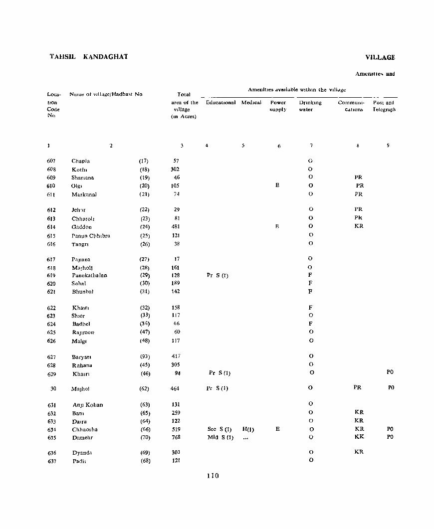
TAHSIL KANDAGHAT
Loca- Name ot vlfl<igefHadba~1 No
tlon Code No
2
607 Chapla (17)
608 Kothl (18) 609 Shanana (19) 610 Olgl (20)
611 Markanal (21 )
612 Jeh'll (22)
613 Chharoh (23) 614 Gaddon (24)
615 Panun Chhlbra (25) 616 Tangn (26)
617 Pajlana (27)
fiI8 Malholl (28) 619 Panukathalan (29) 620 Sohal (30) 621 Bhunbal (31 )
622 KhaJrr (32) 623 Shlor (33)
624 Badhel (34)
625 Rajlmon (47)
626 Malgl (48)
627 Baryan (93)
628 Rahana (45)
629 Khalfl (46)
30 MaJhol (62)
631 An)1 Kohan (63)
632 Bam (65)
633 Dalra (64) 634 Chhaosha (66) 635 Damehr (70)
636 Dyanda (69)
637 Padll (68)
VILLAGE
Amcmtle .. and
Amenities dvallable Wlthm the vlll.lge Total
area of the EducatIOnal Medical village
(10 Acres)
3 4 5
57 302
46 105 74
29 81
481
121
38
17
161
128 Pr S (I) 189
142
158 1t7 66 60
117
417
305 94 Pr S (1)
464 Pr S (I>
131 259
122 519 Sec S (1) H(l)
768 Mid S (1)
303 121
110
Power supply
6
E
E
E
Dnnklng water
7
0
0 0
0
0
0
0
0
0
0
0
0
F F
F
F 0
F 0
0
0
0
0
0
0
0
0
0
0
0
0
Communi- Post and CdtlODb Telegraph
9
PR
PR
PR
PR
PR
KR
PO
PR PO
KR
KR
KR PO KK PO
KR

DIRECTORY
Land use
Land u~e (I e, area under different type, of land use III acr<:s Nearest town Day or Day~ Remarks Loca-rounded to the nearest UOlt) & distance of the Marketl mcludlllg hon
Staple Food ID KIlometre Hat II any, any place Code Porest Irrigated Un- Culturable Area not held 10 the of religiOUS, No
Irrigated waste available for Village hlstoClcaJ or cultivatIOn archaeological
mterest
10 II 12 [3 14 IS 16 17 18
Malzc, Rice, Wheat 0(5) 10 35 7 Subathu 3 607 Maize, Rice, Wheat 0(10) 37 239 16 Subathu 2 608 Maize, Rice, Wheat 0(2) 9 25 10 Subathu 1 609 Maize. Rice, Wheat 0(5) 17 67 16 Subathu 1 610 Maize, Rice, Wheat 0(3) 7 54 10 Subathu 1 611
Maize, Rice, Wheat 5 23 Subathu 1 612 Malzc, Rice, Wheat 8 69 4 Subathu 1 613 Maize, RICe, Wheat 0(22) 38 383 38 Subathu I 614 Maize, RI("C, Wheat 0(8) 30 67 16 Subathu S 615 Maize, Rice, Wheat O(~) It 14 16 Subathu 6 616
Unl/l!wbl/ed 1 II 3 Subathu 6 617 Maize, Rice, Wheat 0([ I) 17 127 6 Subathu 6 618 Malle, Rlcc, Wheat 0(1) 32 91 4 Subathu 5 619 Maize, Rice, Wheat 0(1) 11 162 1.5 Subathu 6 620 Maize RICC, Wheat 0(4) 29 107 2 Subathu 6 621
Maize, Rice, Wheat 0(1) 30 122 .5 Subathu 6 622 Maize, Rice, Wheat 0(1) 22 89 .5 Subathu 6 623 Maize, Rice, Whcat 0(2) 10 51 3 Subathu 6 624 Maize, Rice, Wheat 0(2) 9 48 Subathu 6 625 Maize, Rice Wheat 0(1) 21 88 7 <;ubathu 9 626
Maize, Rice, Wheat Om 33 365 [2 Subathu 6 627 Maize, Rice, Wheat 0(5) 49 244 7 Subathu 7 628 Maize, Rlce, Wheat 0(2) [9 70 , Subathu 6 Temp[e 62'.1
Devi
Maize, Rice, 'A' heat 0(18) 29 39[ 26 Subathu 15 630
MaIZe, Rice, Wheat 0(8) II 105 7 '>ubathu 15 631 Maize, RIce, Wheat 0(4) 38 207 10 Subathu I3 632 Maize, RIce, Wheat au) 4 101 13 Subathu 15 633 Malzc, Rice, Wheat 0(53) 31 4[1 24 C:;ubathu 9 634 Maize, Rlcc, Wheat 0(26) 7[ 628 43 C:;ubathu 22 635
Maize, Rice, Wheat 0(5) 36 254 8 Subathu 12 636 Maize, Rice, Wheat 17 97 7 Subathu [1 637
111
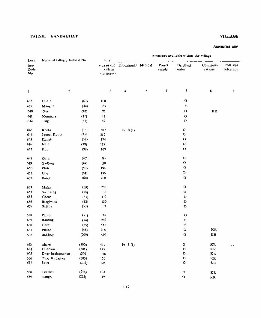
TAHSIL h,.ANDAGHAT
Loca
tlOD
Code No
Name of vlllageJHadba~t No
2
638 Ghalr (67; 639 Mangna (44)
640 Nefl (43) 641 Kumharn (42) 642 Rog (41)
643 Kothl (36) 644 Jangal Kothl (35) 645 Kangh (37) 646 NaIll (39) 647 Kun (38)
648 Gara (40) 649 Gadhog (49) 650 Plah (50) (i51 Gog (61) 652 Baror (60)
653 Malga (59) 654 Sudharag (58) 655 Goras (57) 656 Barglyana (52) 657 Salaoa (53)
658 PapIol (51) 659 Ranhog (54) 660 ChIlli (55) 661 Podna (56)
662 Rakhog (299)
663 Bharh (300) 664 DhanaurI (301) 665 Dhar Brahamanan (302) 666 Dhar Kanaltan (303) 667 Saln (304)
668 Tlwakn {274} 669 Fangol (27S)
VILLAGE
AmeOJtlcs and
AmeOitles available WlthlU the village Total
area of the EducatIonal Medical Power village supply
(ID Acres)
3 4 5 6
160 85
77
72
49
387 Pr S (I) 219 174 llQ 161
83 58
194 136 208
298 136 177 130 33
69 292 112
300 410
417 Pr S (1) 173
56 150 105
162 49
112
Onnkmg water
7
0
0
0
0 0
0 0
0 0
0
0
0
0
0
0
0
0
0
0
0
0
0
0 0
0
0 0 0 0 0
0 0
CommuOl- Post and cations Telegraph
8 9
KR
KR
KR
KR KR KR KR KR
KR
KR

DIRECTORY
Land use
Land me (I e , area under different types of land use In acres Nearest town Day or Days Remarks Loea. rounded to the nearest umt) & dIstance of the Marketl IDcludmg tlon
Staph> Food ~~-
In KIlometre Hat frany, any place Code Forest Irngated Un- Culturable Area not held IO the of relIgIous, No
Icngated waste avaIlable for vlllage historIcal or cultIvation archaeological
lnterest
10 11 12 13 14 15 16 17 18
MaIze, RIce, Wheat 0(6) 18 130 6 Subathu 9 638 MaIze, Rice, Wheat 0(2) 14 62 7 Subathu 8 639 MaIze, Rice, Wheat 0(1) 13 59 4 Subathu 9 640 Maize, R Ice, Wheat 00) 14 56 1 Subathu 9 641
Maize, Rice, Wheat 12 36 Subathu 9 642
Maize, Rice, Wheat 0(23) 26 324 14 Subathu 9 643 Wheat, Rice, Maize 217 2 Subathu 6 644 Wheat, Rice Maize 0(3) 25 142 4 Subathu 7 645 Wheat, Rice, Maize 0(4) 16 96 3 Subathu 7 646 Wheat, Rice, Mal7c 26 0(1) 20 112 4 Subathu 7 647
Wheat, RICC, M11ZC 01-1) 18 56 5 Subathu 7 648 Wheat, Rice, Malle 26 27 5 Subathu 12 649 Wheat, Rice, Mellze 0(1) 47 135 11 Subathu 12 650 Wheat, Rice, Maize 0(9) 9 113 5 Subathu 12 651 Wheat, Rice, Maize 0(6) 8 190 4 Subathu 9 652 Wheat, RIce MaIZc 0(17) 17 252 [2 Subathu 9 653
Wheat, Rice, Maize 12 122 2 Subathu 7 654 Wheat, Rice, Maize 0(1) 20 150 6 Subathu 7 655 Wheat, Rice. Maize 0(1) 13 108 8 Subathu 13 656 Wheat, RIce, Maize 0(2) 4 25 2 Subathu 9 657 Wheat. Rice, Maize 0(1) 14 50 4 Subathu 9 658
Wheat, Rice, MdlZC 0(1) 33 241 17 Subathu 9 659 Wheat, Rice, Maize 0(2) 12 93 5 Subathu 7 660 Wheat, Rice, MaIze 0(6) 50 217 27 Subathu 7 ('61 Wheat, Rice, Maize 0(4) 372 34 Subdthu 15 062
Wheat, Rice Maize 62 263 92 Soi<ln 24 663
Wheat, Rice, Maine 0(2) 21 138 12 Solan 28 664 MaIze, Rice, Wheat 5 47 4 Subathu 15 665 Maize, Rice, Wheat O(IU) 17 84 39 Subathu 9 666 MaIze, Rice, Wheat 0(3) 21 60 21 Subathu 12 667
Maize, RIce, Wheat 0(1) 26 128 7 Subathu 15 668
Maize, RIce, Wheat 5 41 3 Subathu 15 669
113
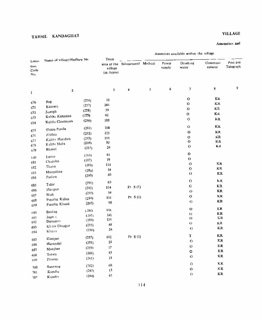
T AHSIIJ KANDAGHA'I VILLAGE
Amemtle~ and
AmeDities available withm the vIllage
Loca- Name of vlllage/Hadba<;t No Total area of the EducatIonal Medical
VIllage
Power supply
Dnnktng water
Communi Post and tlOn Code No
670 671
672 673
674
675 676
677 678 679
680 681 682
683
684
685 686 687 688 689
(\90
691
692 693 694
695 696 697
698 G99
700 701
70"
2
Bag
Kamara
Jairagh Kalthl Kanaltan
Kalthl Chamaran
Thana Panda
Alobra
Kaltl'I Handatt Kallhi Molu
Bharol
Lun,o
Ch<lfOha
Thdna
ManjathTll
Pathru
Talar
Hanpur
Shak
Piratha Kalan
Ptratha Khurd
Banlag
Jagoll
Dananen
Kh WI Ghaggar
Kham
Gamjun
Harandal
Manjhar
Totwa
Dannal
Sana wag
Kundlu
Kundt,
(276) (277) (278) (279) (280)
(281)
(282) (2~3)
(284) (285)
(2h6) (287) (288)
(289) (290)
(291) (292) (293) (294) (295)
(296) (1.97 ) (298) (255) (256)
(257) (258) (259)
(260) (2f,1)
(162) (263) (264)
catIOns Telegraph
(ID Acres)
3 4 5 6 7 8 9
72 0 KR
266 0 KR
59 0 KR
42 0 KR
108 0 KR
108 0 KR
123 0 KR
119 0 KR
93 0 KR
24 0 KR
45 0
19 0
116 0 KR
58 0 KR
80 0 KR
65 0 kR
114 Pr S (1) 0 KR
34 0 KR
116 Pr S (1) 0 KR
90 0 KR
144 0 KR
141 0 KR
158 0 KR
48 0 KR
24 0 KR
142 Pr S (1) T KR
23 0 KR
17 0 KR
17 0 KR
13 0 KR
66 0 KR
13 0 KR
47 0 KR
114
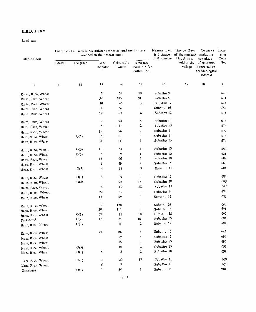
DlRliCIORY
Land use
L'lnd u~e (I e , alea uuder different t\pe~ of land use In a.;res Ne;!rest tONn Day or Days R~m.&rks Loca.
rounded to the neare~t UDlt) & distance of the market! IncludIng tDn
Staple Food 10 Kilometre Hat If any, any place Code
Forest IrrIgated Un- Cll! turable Area not held 10 the of religIous, No.
Irrigated waste." aval!abl(' for village historical or cultIVatIOn archaeological
Interest
10 II 12 n 14 I:l 16 17 18
Maize, Rice, Wheat 12 50 10 Subathu 30 670
Maize, RIce, Whcat 5° 185 31 Subathu 10 671
Maize, Rice, Wheat 10 46 3 Subathu 7 672
Maize, RIce, Wheat 4 36 2 Subathu 10 673
MaIze, RIce, Wheat 18 83 6 Subathu 12 674
Maize, RIce, Wheat 9 94 5 Subathu 10 675
Malzl, Rice, Wheat 5 116 2 Subathu 10 676
MaIze, Rice, Wheat 1;1 96 4 Subathu 11 677
MaIze, RIce, Wheat 0(1) 5 81 6 S'Jbathu 11 678
MaIze, RIce. W i1e,lt 5 16 4 Subathu 10 679
MaIze, RIce, Wheat 0(5) 10 24 6 Subathu 10 680
MaIze, Rice, Wheat 0(3) 3 9 4 Subathu 10 681
Maize, Rice. Whcal 13 96 7 'iubathu 10 682
Mdlze. RIce, Wheat 6 49 3 Subathu 5 6113
Maize. RIce, Wheat 0(5) 4 68 3 Subathu 10 684
MaIze, Klce, Wheat 0(1) 18 39 7 Subathu 13 68)
MaIze, Rice, Wheat 0(4) 92 III Subathu 28 bS6
Maize, RH.e, \IV heat 6 10 18 Subathu 13 687
Ma.zc, Rice, Wheat 22 85 9 Subathu 14 6S8
Maize, RIce, Wheat 13 69 8 Subdthu 15 689
Ma.ze, RI("e, Wheat 19 120 5 Subathu 38 690
MaIze, RIce, Wheat 20 113 !l Sllbathu 14 691
Malze, Rice, Wile It 0(3) 22 115 18 Simla 38 692
Umnhahlted 0(2) 12 24 10 Subathu 10 693
MaIze, RICC, Wheat 0(7) 15 2 Subathu 14 694
Malzr, RIce, Wheat 29 R4 6 Subathu 11 695
Maize, RIce, Wheat 22 Subathu 15 696
MaIze, RlcL, Wheat 15 2 Sublthu 10 697
Malzc, R'ce Wheat 0(5) 10 2 Subathu 10 698
MaIze, RIce, Wheat 0(1) 5 5 2 Subathu lG 699
Maize, RIC(", Wheat 0(6) 23 20 17 Subathu 11 700
MaIze, RIce, Wheat 6 7 Subathu 11 701
Umnhabl(d 0(1) 5 34 7 Subathu 12 702
115

TAHSIL. KANDAGHAT
Loca- Name of vl]lagefHadbast No
tlon Code No
703 704 705
706 707 708 709 7tO
711 712 713 714 715
716 717 718 719 720
721 722 723 724 725
726 727 728 729 730
731 732
Loon Ghlyalch
Burawarl
Kharkl
Ghanan Kanalthan Doehl Chamaran
Kballia
GhOfi Bam Raurh Tataul SUjfil
Nlata Dabl Dugan Kamara
Ishewa
Bokra Phagala Bag lad II Sheora
Kath!ar Jabal lamrot
Delgl AnJ! Rlhuu
Bharal
Bal
2
{26S) (266) (267)
(268) (269) (270) (271) (272)
(273) (240) (241) (242) (243)
(244) (245) (246) (247) (248)
(249) (250) (251) (252) (253)
(253) (235) (238) (237) (236)
(235) (234)
VILLAGE
Amenities and
Total Amenataes available within the Village
area of the Educational Medical Village
(In Acres)
3 4 5
49 36
493
45 32 52 72 53
59 138 78
113 73
52 84 47 47
117
163 262 64
421 155
34 707 153 90
68
126 275
Mid S (I)
Pr S (I)
116
Power supply
6
E E E E
E
B E
E
Drmkmg wolter
7
o o o
0
0 0 0 0
0 T T 0 0
0 W T 0
0
0 0 0 T 0
0 T T 0 W
T 0
Commum- Post and catlon~ Telegragh
8 9
KR KR KR
KR KR KR
KR KR
KR KR KR KR KR
KR KR KR
KR
KR
KR PR
PR KR
KR
KR KR
PO
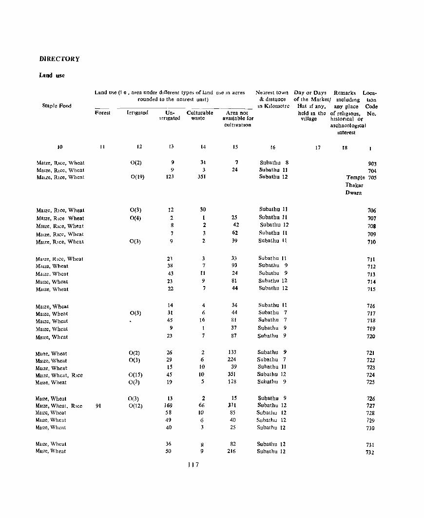
DIRECTORY
Land use
Land u~e (l e , area under different types of land u,e In acres Nelrest town Day or Days Remarks Loca-rounded to the nearest umt) & distance of the Marketl IDcludlllg tlon
Staple Food In Kilometre Hat If any. any place Code Forest IrrIgated Un- Culturable Area not held In the of religious. No.
Irrigated waste available for village hlstoncal or cultivation archaeological
mterest
JO 11 12 13 14 15 16 17 18
Maize, Rice, Wheat 0(2) 9 31 7 Subathu 8 903 Maize, Rice, Wheat 9 3 24 Subathu 11 704 Maize, Rice, Wheat 0(19) 123 351 Subathu 12 Temple 705
Thakar
Dwara
Maize, Rice, Wheat 0(3) 12 30 Subathu 11 706 Maize, Rice Wheat 0(4) 2 1 25 Subathu Jl 707 Maize, Rice, Wheat 8 2 42 Subathu 12 708 Maize, Rice, Wheat 7 3 62 Subathu 11 709 Maize, Rice, Wheat 0(3) 9 2 39 Subathu It 710
Maize, Rice, Wheat 23 3 33 Subathu II 711 M,llze, Wheat 38 7 93 Subathu 9 712 Maize, Wheat 43 11 24 Subathu 9 713 Maize, Wheat 23 9 81 Subathu 12 714 Maize, Wheat 22 7 44 Subathu 12 715
Maize. Wheat 14 4 34 Subathu 11 716 Maize, Wheat 0(3) 31 6 44 Subathu 7 717 Maize, Wheat 45 16 81 Subathu 7 718 Maize, Wheat 9 I 37 Subathu 9 719 Maize, Wheat 23 7 87 Subathu 9 720
Maize, Wheat 0(2) 26 2 133 Subathu 9 721 Maize, Wheat 0(3) 29 6 224 Subathu 7 722 MaIze, Wheat 15 10 39 Subathu 11 723 MaIze, Wheat, RIce 0(15) 45 10 351 Subathu 12 724 Maize, Wheat 0(3) 19 5 128 Subathu 9 725
MaIze, Wheat 0(3) 13 2 15 Subathu 9 726 Maize, Wheat, Rice 91 0(12) 169 66 371 Subathu J2 727 Maize, Wheat 58 10 85 Subathu 12 728 Maize, Wheat 49 6 40 Subathu 12 729 Maize, Wheat 40 3 25 Subathu 12 730
MaIze, Wheat 36 S 82 Subathu 12 731 Maize, Wheat 50 9 216 Subathu 12 732
I ) 7

TAHSIL h.ANDAGHAT VILLAGE
AmemtIcs and
Amemtles available WlthlO the village Loca- Name of viliage/Hadbast No Total tlOn Code No
733 ~34
735 736 737
738 739 1'40 741
742
743 744 745 746 747
748 749
750 751 752
753 754 755 756 757
758 759
760
7t-l
7(2
763 764
2
Pam Ban]'11 Chlknahat Ghatkamala Kamhalt
DebIll
B::mdnon Kanshl Pata Kot
Ddl,
Satlol
Sh.llru Dablog
Palashta Panchrol Snlah Brahamanan
Sulah Kohan Shankargarh
Chapla Kakara
Mamhg
Chadn
Kamltar
KalSU
B ota D,,\1
Jakbraon Ne'l
Bashel
S,ll.et
Than
Matunnn CrlUn0r
(233) (232) (231)
(230) (229)
(228) (227) (226) (225) (224)
(2'3) (222) (221) (220) (2IC)
(218) (217) (216) (215)
(214)
(213) (212) (2C) (210) (209)
(208) (207)
(206) (2(/5) (204)
(203) (20-)
area of the EducatIOnal Medical village
(10 Acres)
4 5
46 144 133 58 Pc S (I)
174
73 162 454
39 109
437 Pr S (1)
47 98
131 89
68 293 191
198
Power supply
()
55::' Sec S (1) MCW (1)
158 135
253 208 208
_7J
511
234 Pr S (1)
202 63
19 61
118
Drlnkmg water
7
0 0 0 0 0
0
0 0 0
0
0
0 Tk
0 0
0 0 0 0
0
0
0
0
0 0
0
0
0
0 0
0 0
Communi Pm.t and catIOns Telegraph
8 9
KR
KR
KR KR
KR KR
KR
KR PO
KR
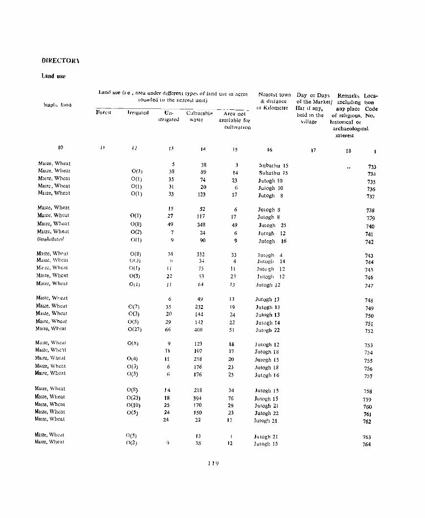
DlRECTOJH
Land use
Land use (I e , area under dIfferent tYPt!~ of Jand use to acres Neare,t town Day or Days Remark> Loca· wunded to the neare,t unIt) & du,taoce of the Marketl lDcludmg tlOn ~tapl\. food - I n KIlometre Hat If any. any place Code
Fore~1 Irngated Un- Culturable Area Dot held III the of relIgIous, No. Irflgated \Va~te avaIlable for vIllage hlstoflcal or
cultlva tJOn archaeologIcal mterest
10 II 12 13 14 15 16 17 18
Maize, Wheat 5 38 3 ~ubalhu IS 733 Maize, Wheat 0(3) 38 89 14 Subathu 15 734 Maize, Wheat 0(1) 35 74 23 Jutogh 10 735 MaIze, Wheat 0(1) 31 20 6 Julogh 10 736 Maize, Wheat 0(1) 33 123 17 JUlogh 8 737
MaIze, Wheat 15 52 6 JUlogh 8 738 MaIze, Wheat 00) 27 117 17 ]ulogh 8 739 MaIze, Whea t 0(8) 49 348 49 JUlogh 25 740 Maize, Wheat 0(2) 7 24 6 Jutogb 12 741 Uninhabited 0(1) 9 90 9 Jutogh 16 742
Maize, Wheal 0(8) 74 332 33 JUlogh 4 743 MaIze, Wheal ()(J) () 34 4 Julogh 14 744 M,t1lc, Wheat 0(1) 11 75 It JUlogh 12 745 Maize, Wheat 0(3) 22 R3 23 Julogh 12 746 MaIze, Wheat 00) 11 64 13 Jutogh 12 747
Malzc, Wncat 6 49 13 ]ulogh 13 748 MaIze, Wheat 00) 35 232 19 Jutogh 13 749 Maize, Wheat 0(3) 20 144 24 Jutogh 13 750 Maize, Wheat 0(5) 29 142 22 Jutogh 14 751 Maize, Wheat 0(27) 66 408 51 Jutogh 22 752
Maize, Wlle,it 0(8) 9 123 18 Jutogh 12 753 Maize, WhC1t 11 107 17 Jutogh 18 754 MaIze, Whe.lt 0(4) 11 218 20 Jutogh IS 755 MaIze, Wheat 0(3) 6 176 23 Jutogh 18 756 Maize, Wheat 0(3) fi 176 23 Jutogh 16 7:;7
Maize, Wheat 0(8) 14 218 34 Jutogh 15 758 MaIZe, Wheat 0(23) 18 394 76 Jutogh 15 759 Maize, Wheat 0(10) 25 170 29 Jutogh 21 760 Malze, Wheat 0(5) 24 150 23 JUlogh 22 76J Malze, Whcat 24 22 17 Jutogh 21 762
MaIZe, Whedt 0(5) 13 I Jutogh 21 763 MaIze, Wheat 0(2) 9 38 12 JUlogh 15 764
119
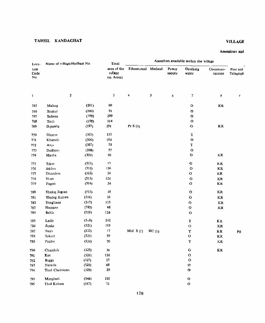
TAHSIL KANDAGHAT
Loca- Name of vllIage/Hadbast No
tlon Code No
2
765 Mahog (201)
766 Basho) (200)
767 Bakesu (199)
768 Tal)l (198) 769 Dlyawla (197)
770 Dhann (305)
771 Khanoh (306)
772 AnJl (307)
773 Dadhon (308) 774 Masha (309)
775 Tlkar (310)
776 Jekhn (311)
777 Dhandon (312)
778 NlUn (313)
779 Fagoh (314)
780 Sha)og Joglan (315)
781 Shalog KoVan (316)
782 Sangliana (317)
783 Hamam (783)
784 Behh (319)
785 Ladh (3 .. 0)
786 Sunk] (321)
787 Salfl (322)
788 Sakret (323)
789 Poabo (324)
790 Chandoh (325)
791 Kot (326)
792 Baggl (327) 793 NatalIa (328)
794 Tho) Chemaran (329)
795 ManJharl (346)
796 Thol Kollan (347)
VILLAGE
Amenities and
Total AmenitJ:eS available WlthlD the village
area of the EducatIOnal Medical Village
(10 Acres)
3 4 5
90
91 299 114
291 Pr S (1)
133 104 50
77 96
91
136 39
124 54
18 24
115 68
124
2-l2
lIS
17 MId S (1) HC (I)
39
70
36 138
25 68 29
110 71
120
Power supply
6
Dnnkmg water
7
0
0
0
0
0
T
0
T
0 0
0
0 0
0 0
0
0
0
0
0
T
0
T 0
T
0
0 0 0
0
0
0
CommuDI- Post and cations Telegraph
8
KR
KR
KR
KR
KR
KR
KR
KR
KR
KR
KR
KR
KR
KR
KR PO KR
KR
KR

DIRECTORY
Land use
Lan'l use (i e • area under different types of Idnd use 1D acre, Neare~t town Day or Days Remarks Loca-rounded to the nearest Unit) & distance of the Marketl mcludmg hOD
Staple Food m KIlometre Hat If any. any place Code Forest Irrigated Un- Culturable Area not held In the of religious, No.
Ifngated waste available for vIllage historical Of cultIVation archaeologIcal
mterest
10 11 12 13 14 15 16 17 18
Maize, Wheat 0(7) 13 53 17 Jutogh 18 7~5 Maize. Whedt 0(10) 10 56 15 Jutogh 19 766 Maize, Wheat 252 47 Jutogh 18 767 Maize, Whe..!t 0(1) 16 73 19 Jutogh 19 768 Maize, Wheat 0(3) 50 184 54 Jutogh 19 769
Maize, Wheat 16 28 89 Jutogh 14 770 Maize, Whe ... t 0(3) 20 30 51 Jutogh 14 771 Maize, Wheat 0(3) 17 2 28 Jutogh 15 772 Maize, Wheat 0(3) 13 10 51 Jutogh 14 773 MaIze, W)Jt,at 0(1) 29 65 Jutogh 14 774
Maize, Whe..!t 13 26 54 Jutogh 15 775 Maize, Wheat 0(5) 19 37 75 Jutogh 13 776 Maize, Wheat 9 1 29 Jutogh 13 777 Maize, Wheat 22 45 57 Jutogh 12 778 Maize, Wheat 0(2) 11 13 28 Jutogh 12 779
MaIze, Wheat 4 2 12 Jutogh 12 780 Maize, Wheat 12 12 Jutogh 11 781 Maize, Wheat 0(5) 26 32 52 Jutogh 13 782 Maize, Wheat 26 7 35 Jutogh 13 783 Maize, Wheat 17 47 60 Ju(cgh 15 784
Maize, Wheat 0(7) 25 54 156 Jutogh 12 785 Mal7e WhCdt 34 31 50 Jutogh II 786 MaIze, Whed' 6 2 9 Jutogh IJ 787 Maize, Wheat 0(1) 6 3 29 JUI(,gh Il 788 Maize, Whe,lt 1 I 9 50 Jutugh 10 789
Maize, Wlle,lt 7 9 2') Jutogh 11 790 MaIze, Wheat Ocr) 14 46 n Jutogh 11 791 Maize, Whcat 6 5 14 Jutogh 12 792 MaIze, Whea t 10 28 30 Jut('ah 12 793 MaIZe, Wheat 9 3 17 JutC'gh 11 794
Maize. Wheal 7 39 64 Jutogh 11 795 Maize, Whea t 11 37 23 Jutogh 11 7'Jo
121
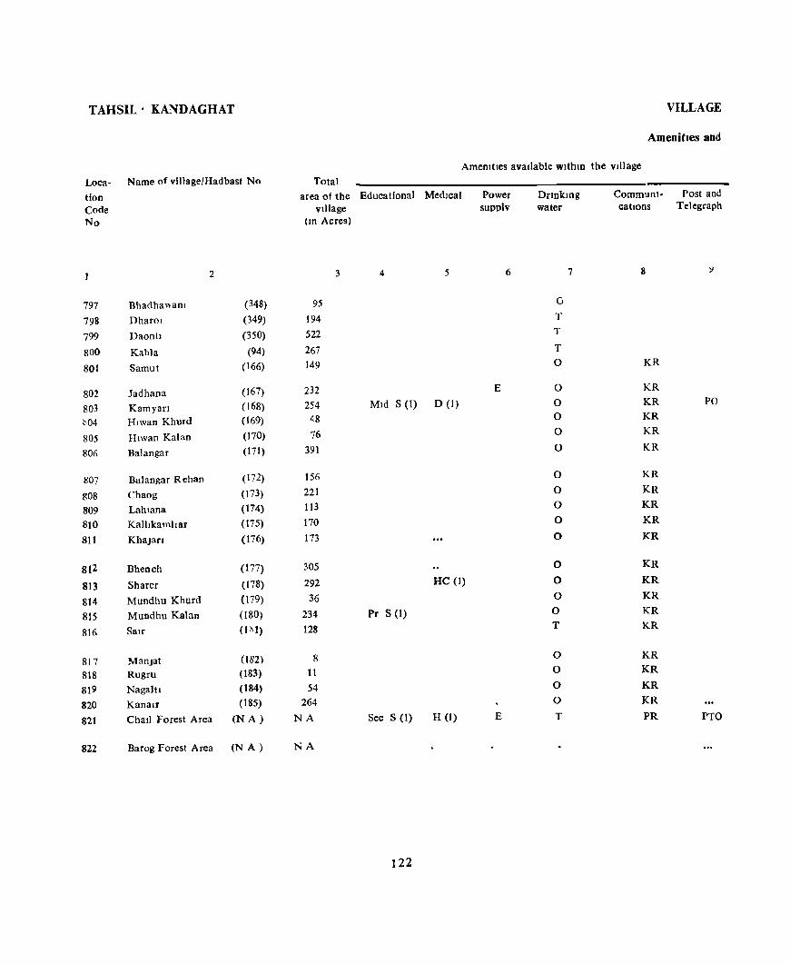
TAHSIL' KANDAGHAT
Loca- Name of village/Hadbast No
tion Code No
2
797 Bhadha"am (348)
798 Dharol (349)
799 DaontJ (350)
800 Kahla (94)
801 Samut (166)
802 ladhana (167)
803 Kamyan (168)
~04 Hlwan Khurd (169)
805 Hlwan Kalan (170)
806 Balangar (171)
807 Balangar Rehan (172)
808 Chaog (173)
809 Lahlana (174)
810 Ka1hkamhar (175)
811 KhaJan (176)
812 Bhench (177)
813 Sharer (178)
814 Mundhu Khurd (179)
815 Mundhu Kalan (180)
816 San (1111)
817 ManJat (182)
818 Rugru (183)
819 Nagaltl (184)
820 Kana If (185)
821 Chall Forest Area (N A)
822 Barog Forest Area (N A)
VILLAGE
Amenities and
Amemtles available wlthlD the village
Total area of the Educational MedIcal
Village (10 Acres)
3 4 5
95
194
522
267
149
232
254 MId S (I) D (I)
48
76
391
156
221
113
170
173
305
292 He (I)
36
234 Pr S (1)
128
8 It
54
264
NA Sec S (1) H (1)
NA
122
Power supplv
6
E
E
DClnklDg water
7
0
T
T
T 0
0 0 0
0
0
0
0 0
0
0
0
0
0 0 T
0 0
0
0
T
Communi- Post and cations Telegraph
8 ':)
KR
KR
KR PO KR
KR
KR
KR
KR
KR
KR
KR
KR
KR
KR
KR
KR
KR
KR
KR
KR
PR PTO

DIRECTORY
Land use
Land use (I e , area under different types of land LIse In acre~ Nearest town Day or Days RemlfKs Loci!. rounded to the neare~t UOlt) & distance of the market! IOcludmg tlOn
Staple Food In Kilometre Hat If any, any place Code Forest Irrigated Un- Culturable Area not held ID the of relIgiOUS, No
IrrIgated waste available for village histOrIcal or cultivation archaeological
Interest
10 II 12 n 14 15 16 17 18 1
Maize, Wheat 10 33 - 52 Jutogh 12 797 Maize, Wheat 0(3) 17 36 138 Jutogh 13 798
Maize, Wheat 0(24) 23 149 326 Jutogh 13 799
Maize, Wheat 0(17) 28 96 126 Jutogh 12 800 Mal7e, Whe 1t, ~Ice 0(4) 32 9q 14 <;lInla 21 801
Maize, Wheat, RIce 0(4) 31 178 ]6 SImla IG 802 MaIze, Vv'hedt, RIce 0(4) 53 180 17 SImla 15 to3 MaIze Wheat, Rlre 7 39 2 Simla 15 804 Maize, Whcat, RIce 11 58 5 SImla 15 805 Maize, Wheat, RIce 0(4) 62 299 26 Simla 16 f06
Maize, Wheat, RILe 0(1) 23 119 13 ')Imla 15 807 Maize, Whedt, Rice 0(2) 19 189 11 SImla }) 808 Maize, Whc.!t, R]( e 0(2) 13 82 16 Simla 14 809 Maize, Wheat, Rice 0(3) 24 128 15 SImla 14 810
Maize, Wheat, RIce 22 146 5 Simla 14 811
Maize, Wheat, Rice 0(4) 48 220 33 Simla 12 812
Maize, Wheat, Rice 0(7) 53 199 33 Simla 12 813 Maize, Wheat, Rice 0(1) 9 15 11 Simla 11 814 Maize, Wheat, RIce 0(4) 42 163 25 Simla 11 815 Maize, Wheat, Rice 0(3) 26 94 5 Simla 11 816
Maize, Wheet, Rice 3 4 Simla 12 817 Maize, Wheat, Rice 5 4 2 Simla 12 818
Maize, Wheat, Rice 12 36 6 SImla 12 819
MaIze, Wheat, RIce 0(5) 40 194 25 Simla 12 820 MaIze, Wheat SImla 12 821
Maize, Wheat Smlla 20 822
123


TAHSIL NALAGARH
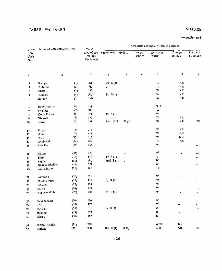
TAHSIL NALAGARH VILLAGE
Amemties and
Amenities avaIlable wlthm the village Loca- N<lme of vlllage/Hadba~t No Total ------------------ --~--~----
lIOn
Code No
1
2 3
4
f;
7 8 9
10
It 12
13 14
15
16 17 ]8 ]9 2()
21
22 23 24 25
26 27
28 29 30
31 32
Rampur Abhlpur Bhatoh
KarsolI
RalPur
R:1k" kalj1Ur PhuTahl Kolla Kalar; Gharotl
Barun
Ma]ra DeolJ Chak Gholowal
Kall Ban
Kularl Tlkrl Baghen Nangal Dhakka Kotla JaJlar
Balfchha
Mastan Pura Khanoa
BalhlI Kanwan Wah
Sukedl Jaglr Dol KhllJan
Behndu Bhora
Sukedl Khalsa Joghon
2
(I)
(2) (3)
(4) (5)
(~)
(7)
(8)
(9)
(10)
(11)
(t 2)
(13)
(14)
(15)
(16)
(17)
(18) (19)
(20)
(21)
(22)
(23)
(24)
(25)
(26)
(27)
(28)
(29)
(30)
(3 I)
(32)
area of the EducatIonal Medical vJllage
(in Acres)
3
298 233 192 565-190
lh8 375 786 572 339
Zi8 4\1
117 203 166
419 910 490 521 168
620
321 19~
254
185
226 172
550
273 169
228 388
4 5
Pr S(I)
Pr S (I)
Pr S (1)
Mld S (II D (1)
Pro S (I) Mid S (I)
Pr S (1)
Pr S (J)
Pr S (1)
Sec S (1) D (1)
126
Power supply
6
Dnnkmg water
7
W
W W W W
NA
W W
\V
W
W
W
W
W
W
W
T W W 1k
W W W W W
W W 0
R R
W,Tk
\\'.R
Communl- Post and catIOns Telegraph
8 9
KR KR KR
KR KR
KR KR PO
KR KR KR KR
KR KR PO
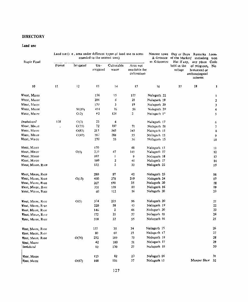
DIRECTORY
Land use
Land use (I e • area under dIfferent types of land use 10 acres Nearest town Day or Days Remarks Loca. rounded to the nearest UOlt) & dl~tance of the Marketl IOcludmg tlon
Staph' Food ---- In Kl)ometre Hat If any. any place Code Forest Irngated Un- Culturahle Area not held In the of rellglOus, No
Irngated waste avaIlable for vIllage hIstorIcal or cultIVatIon archaeological
Interest
10 11 12 13 14 15 16 17 18
Wheat, MaIZe 156 15 127 Nalagarh 22
Wheat, Maize 206 6 21 Nalagarh 19 2 Wheat, MaIze 17U 3 19 Nalagarh 20 3 Wheat, MaIze W(t9) 414 76 S6 Nalagarh 20 4 Wheat, Mal7e 0(2) ~2 124 2 NaJagarh 1"' 5
Umnhablted 138 0(3) 23 4 Nalagarh t7 6 Wheat, MaILe 0(35) 72 197 71 Nalagarh 18 7 Wheat, MaIze 0(83) 213 345 145 Nalagarh 15 8 Whaat, MaIze 0(47) 182 288 55 Nalagarh 15 9 Wheat, MaIze 270 33 36 Nalagarh IS 10
Wheat, MaIze 170 48 Nalagarh IS 11 Wheat, MaIze 0(1) 220 47 143 Nalagarh 17 12 Wheat, MaIZe 107 1 9 Nalagarh 18 13 Wheat, MaIze 160 2 41 Nalagarh 17 14 Wheat, MaIze, RIce 132 2 32 Nalagarh 22 15
Wheat, MaIze, RIce 280 97 42 Nalagarh 23 16 Wheat, MaIze. RIce 0(13) 400 278 219 Nalagarh 24 17 Wheat, Maize, RIce 267 188 35 Nalagarh 20 18 Wheat, MaIze, Rice 331 109 81 Nalagarh 16 19 'Wheat, MaIze, Rice 40 112 16 Nalagarh 20 2()
Wheat, Maize, Rlcc 0(5) 324 225 96 Nalagarh 20 21 Wheat, Maize, RIce 220 58 43 Nalagarh 19 22 Wheat, MaIze, RIce 146 2 46 Nalagarh 20 2J Wheat, MaIze, RIce 172 25 57 Nalagarh 18 24
t
Wheat, Maize, RIce 108 22 55 Nalagarh 16 25
Wheat, Maize, RIce 157 35 34 Nalagarh 15 26
Wheat, MaIze, RIce 80 69 23 NaJagarh 17 27
Wheat, Maize, Rice 0(76) 232 169 73 NaJagarh 19 28
[Wheat, Maize 42 180 51 NaJagarh 17 29
I Unmhabl t ed 12 130 27 Nalagarh 18 30
l .... t,Ma~, 123 82 23 Nalagarh 16 31 Wheat, MaIze 0(67) 168 116 37 NaJagarh 15 Manplr ShiV 32
127

TAHSIL' ~ALAGARH
Loca·
tion Code No
Name ofvlllagelHadba~t No
2
33 Tapnan (33)
34 B~n.ala (34)
35 Jogat Pur (35)
36 i1a,,-,wal Ago (36)
37 Nangdl Kuhl (17)
38 Kahan Pur (18)
39 KdtlfU MaJra 0')
40 K \~hmlrDur Btahmna (40)
41 Basowal Sultam (41)
42 Ka,hmlfPur GUJran (4:2.)
43 MJ.lwalan Uperll (43)
44 M,;t"alan i'<lchh (44)
45 M,Jpur (45)
46 AmI! a"l Nlchla (4(0)
47 Andraol UperJa (47)
48 Ra.ya (48)
49 KharuOl (49)
50 Bohn (I)
51 Amb Oahar (2)
.52 Janaon (3)
33 Untpur (4)
54 Puna~h I! (5)
.55 Katlllmb (f)
56 S F Luhnd (7)
57 Bha'ca (8)
58 ~\)npal...t (9)
59 :Nal (10)
(10 Bah {II )
61 Barohl (12)
62 I1,lhl\ 03}
63 Thana (14}
64 ChUlangal (15)
Total
area of the vIllage
(ID Acres)
1
69 365
13:)
68 12()
76
162.
133
97
108
227
148
138
18~
11:\8
36~
56 166
82 719
4111
168
38
270 249
153
217
248
185
250
61
225
VILLAGE
Amenities and
Arncnltlcs avallabJe wlthm the vJlJage
Educational MedIcal Power sllPply
5 6
Pr S (I)
Pc S (I)
l'rS(l) D(I)
128
Dnnktng water
7
WR W,R
W,O
R,W W
W,R W,R
W,R W \V,R
W
w W
W W
W R F F F
F j<
F
NA
F
F
F
T F
F
F
F
CommunI- Post allJ cations Telegraph
8
KR KR KR KR KR
KR KR KR.
KR
KR
KR KR KR KR KR
KR RR
KR
KR
KR
KR
KR KR
KR KR
KR KR

DIRECTORY
Laud use
Land use (I e , area under different types of land use 10 acres Nearest town Day or Days Remarks Loca-rounded to the nearest Untt) & distance of the Marketl !Dcluding hon
Staple food JD Kilometre Hat If any. any place Code
Porest Irrigated Un- Culturable Area not held 10 the of rehglous. No. Irrigated waste available for Village historIcal or
cultivation archaeological mterest
10 II 12 n 14 15 16 17 18
Wheat, Maize 0(4) 5 59 Nalagarh 15 33
Wheat, Maize 0(18) 219 102 26 Nalagarh 15 34
Wheat, M1.lze C(2~) 87 7 17 Nalagarh 15 35 Wheat, Maize 0(11) 52 I 4 Nalagarh 15 36 Wheat, Ma17e ('(12) 96 4 R Nalagarh 15 37
Whett, Mal7e 67 4 5 Nalagarh 17 38
Wheat, Maize 117 21 24 Nalagarh 15 39 Wheat, Mal7e 105 14 14 Nalagarh 13 40 Wheat, MaIze 87 I 9 Nalagarh 14 41 Wheat, Mal7e 95 5 8 Nalagarh 13 42
Wheat, Maize 0(2) 121 60 44 Nalagarh 13 Temple ShlVJI 43 Wheat, Maize 43 33 72 Nalagarh 14 44 Wheat, Maize 0(3) 93 2 40 Nalagarh 14 45 Wheat, MaIze 132 8 43 NaJagarh 15 46 Wheat, Maize 107 9 72 Nalagarh 14 47
Wheat, Ma Ize 0(3) 255 24 82 Nalagarh 13 48 Wheat, MaIze 0(1) 20 3 32 NaJagarh 13 49 Wheat, Maize, Rice 0(15) 53 56 42 Nalagarh 26 50 Wheat, Maize, Rice 0(3) 23 22 34 Nalagarh 25 51 Wheat, Ma Ize, Rice 0(8) 123 524 64 NaJagarh 24 52
Wheat, Maize, Rice 0(8) 165 170 73 NaJagarh 24 53 Wheat, Maize, RIce 0(14) 54 70 30 Nalagarh 25 54 Wheat, MaIze, RIce 0(1) 10 13 14 NaJagarh 26 5S Umnhablted 270 Nalagarh 26 56 Wheat, Mal7e, Rice 0(7) 94 101 47 Nalagarh 27 57
Wheat, Maize, Rice 81 42 30 Nalagarh 29 58 Wheat, Maize, RIce 96 81 40 Nalagarh 27 59 Wheat, MaIze, Rice 95 127 :;'6 Nalagarh 25 60 Wheat, MaIze, Rice 26 152 7 Nalagarh 24 61 Wheat, Maize, Rice 63 153 34 Nalagarh 23 62
Wheat, MaIze, RIce 14 42 5 Nalagarh 22 63 Wheat, Maize, RIce 34 161 30 Nalagarh 21 64
129
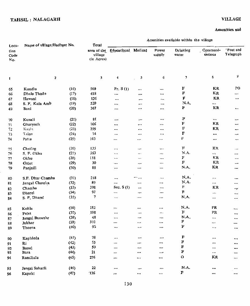
TAHSIL: NALAGARH VILLAGE
Amenities and
~enities available within the village
Loca p NaVle of vi1lagefHadb!lst No. Total
tion Code No.
65 66 67 68 69
70 7\ 72
73 74
7S 76 77 78 79
80 81
82 83 84
85 86 87 88 89
90 91 92 93
94
95
96
2
Kundlu (16)
Dhala Thadn (17)
Hawani (18)
S. F. Kala Amb (19)
Bani (20)
Kunali (21)
Gharyach (22)
Kash (23)
Tillao (24)
Patta (25}
ChatJog (26}
S. F. Okhu (27)
Okhu (28)
GaIot (29) Panjaili (30)
S.P. Qhar Chamba (31)
Jaogal Chamb.a (32)
Chamba (33)
Dharel (34) S. F. Dharel (35)
Kohla (36)
Palet (37) Jangal Baswahr (38)
Jukhar (39)
Thoen a (40)
Kaphleda (41)
Ri (42) Banal (43) Bara (44)
Randbala (45)
Jangal Saharli (46)
Kapohl (47)
area of the Ed!l~tfQna] Medica] Power village supply
(in Acres)
3 4 5 6
.560 Pro S (1)
418 126 520 361
81 166 259
74
163
135 363 118
30
88
218
89 208 Sec. S (1)
91 7
182
198 48
310 93-
78
53 59 21
276
22 ']36 " ..
130
D.rhll~ing water
7
F F F N.A. F
F F F F F
F N.A. F F N.A.
N.A. N.A. F
F
N.A.
N.A. F N.A. F F
F F F F 0
N.A. F
GQrnmuni- . Post and cations Telegra"h
8
KR PO KR KR
KR
... KR KR
KR
KR KR KR
KR .....
PR PR
... KR
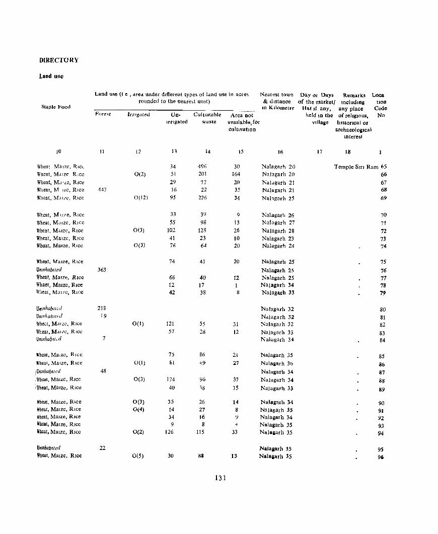
DIRECTORY
Land use
Land use (I e , Mea under dltIereilt types of land use In acre~ Nearest town Day or Days Remarks Loca rounded to the neare,t unit) & distance of the market! mcludlOg Uon
Staple Food In Kilometre Hat If any, any place Code Fnre~t Irrigated Un- Culturable Area not held 10 the of reltglOus. No
Irrigated waste avaIlable, for VIllage hIstorIcal or cultIVatIon archaeologIcal
Interest
10 11 12 n 14 15 16 17 18
Wheat Maize, RICL 34 4% 30 Nalagarh 20 Temple StrI Ram 65 Wheat, Maize R,ce 0(2) 51 201 164 Nalagarh 20 66 Wheat, Md 'ze, RIce 29 77 20 Naldgarh 21 67 Wheat, M Ize, Rice 447 16 22 35 Nalagarh 21 68
Wheat, Md17e, Rice 0(12) 95 226 34 Nahgarh 25 69
Wheat, M tl7e, Rice 33 39 9 Nalagarh 26 70 Wheat, Mdlze, Rice 55 98 13 Nalagarh 27 71 Wheat, MJlze, RICe 0(3) 102 123 26 Nalagarh 28 72 Wheat, MaIze, RIce 41 23 10 Nalagarh 23 73 Wheat, MaIze, Rice 0(3) 76 64 20 Nalagarh 24 74
Wheat, MaIze, RIce 74 41 20 Nalagarh 25 75 Umnhablted 363 Nalagarh 25 76 Wheat, MaIze, RIce 66 40 12 Nalagarh 25 77 Whaet, MaIZe, RIce 12 17 1 Nalagarh 34 78 Wheat, Mal7c, RIce 42 38 8 Nalagarh 33 79
Unmhabllcd 218 NaJagarh 32 80 Um/1habll~d t9 Nalagarh 32 81 Wheat, Mdlzc, RIce 0(1) 121 55 31 Nalagarh 32 82 Wheat, MaILe, RIce 57 28 12 Nalagarh 33 83 U mnhab It < d 7 Nalagarh 34 84
Wheat, Maize, Rice 75 86 21 l'la!agar h 35 85 Wheal, Maize, Rice 0(1) 1:.1 09 27 Nalagarh 36 86 Umnhablted 48 Nalagarh 34 S7 Wheat, MaIze, Rlcc 0(3) 174 96 37 Nalagarh 34 88 Wheat, MaIZe, RIce 40 18 15 Nalagarh 33 89
Wheat, Maize, Rice 0(3) 35 26 14 Nalagarh 34 90 Wheat, Maize, Rice 0(4) 14 27 8 NaJagarh 35 91 Wheat, MaIze, RIce 34 16 ') Nalagarh 34 92 Wheat, MaIze, Rice 9 8 -4 NaJagarh 35 93 Wheat, Maize, Rice 0(2) 126 115 33 Nalagarh 35 94
Unmhablted 22 Nalagarh 35 95 Wheat, Maize, Rice 0(5) 30 88 13 Nalagarh 35 90
131
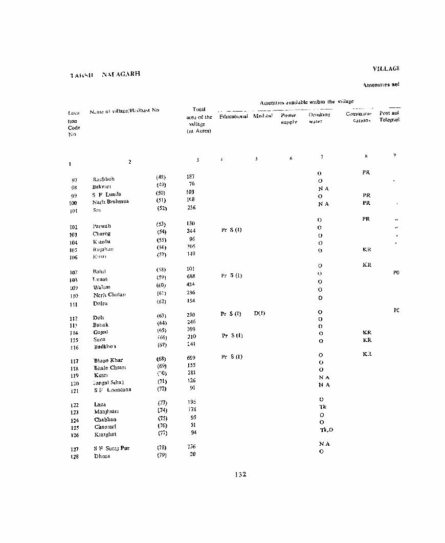
1AhC,U NM AGARH
Luea N.lflle ol ITlllage:H,lIjba,1 No
IlOD
Code No
97 98 99
100
lOt
10l 103
104 105 106
l{)7
103
109
110
111
112 113 114 115 116
117 118 119
120
121
122 123
124 125 126
127 128
2
Rachhoh (4~)
Bakrun (49)
S F Lunda (50)
Narh Brahmna (51)
Sal (52)
Parwah (53)
Charog (54)
Klardu (55)
Ruph,m (56)
KU<;Tl (57)
Bahll (58)
Lunas (59)
Walaoo (6())
NeI]1 Chulan (61 )
Dolru (62)
Doh (63)
Eattak (64)
Glljed (1,5)
Suna (66)
Barlkhol (67)
Btllon Khar (6&)
:Bha1e Chrarl (6~)
Kusn (~O)
Jaoga1 Siba} (71 )
SF Looocaoa (72}
Lana (73)
MaoJhlan (74)
Chabhan (75)
ChaOlad (76)
Klarghat (77)
SF Sura] Pur (78)
Dhora (79)
VILLAGE
"-memlles and
Ame!llllC) dVlltI<tblc wlthm the Village
Total are,\ of the Educational Med ICa!
Village (tn Acres)
3
I8] 76
103 Itg
236
130
344
96 :105 1-10
101
688 434
236 154
250 246 399
210 :'41
699 155
2&1
126 91
196 174
95 51 94
736 20
-I
Pr S (I)
Pr S (I)
Pr S (1) D(I)
Pr S (I)
Pr S (I)
132
Power supply
Dnnklng w.ater
7
0
0
NA 0 NA
0
0
0 0 0
0 ()
0 0
0
0 0 0 0
0
0 0 0
NA NA
0 Tk
0 0
Tk,O
NA 0
C"mmuDI- Post and Cdtiom TelegrJpn
1\
PR
PR PR
PR
KR
KR
PO
PO
KR KR
K1.
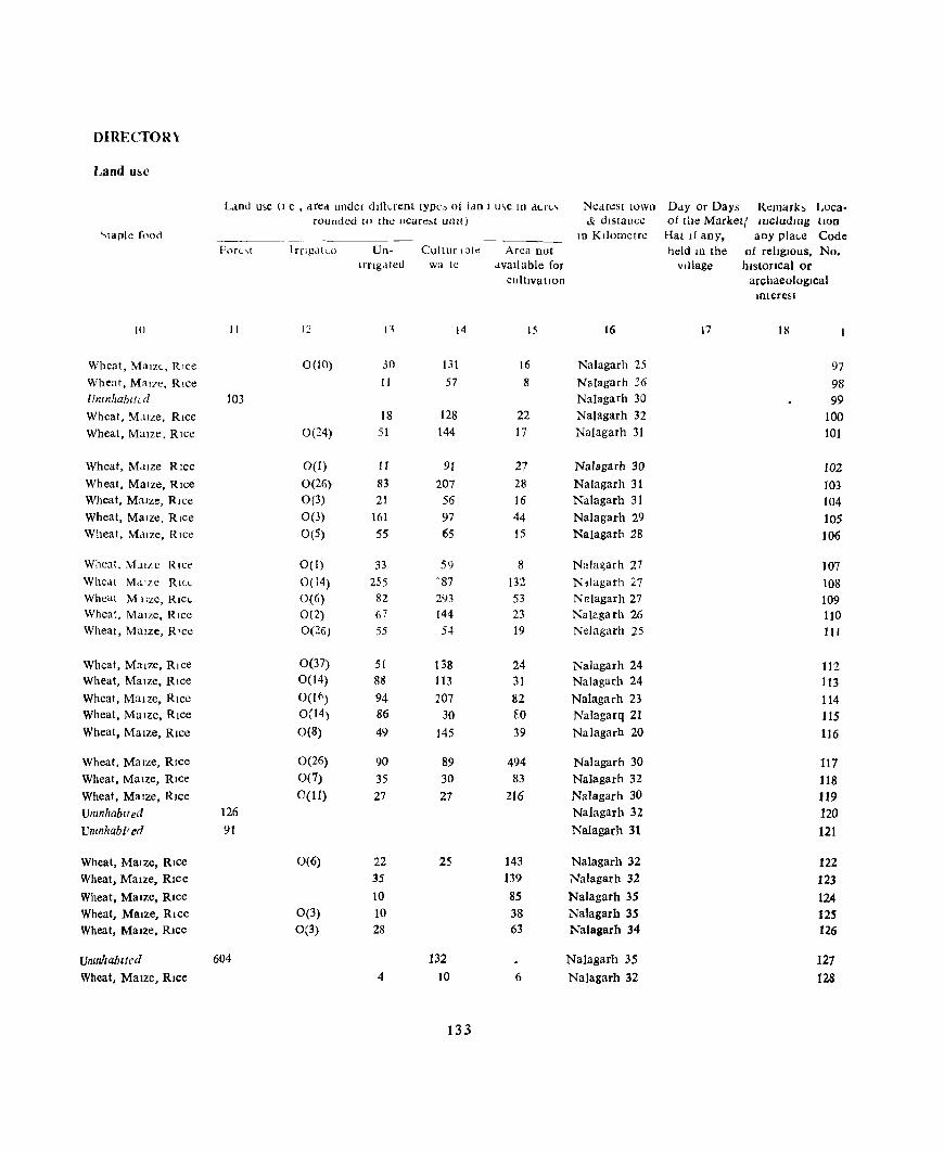
DIRECTOR\
Land u~c
Lmd u~e (I e , ..Ired under dill~reDt tYPt:~ 01 ldn I u\e In dl.f<'" Nedrcst town D..ty or Days Remarh Loca· rounded to the ueare,! unit) & distance of the Marketl lDeludmg tLOn
.... taDle fooc:i 10 Kilometre Hat If any, any plal.e Code ForL,t I rngdkd Un- Cultur ,ble Area Dot held LU the of religiOUS, No.
Irrigated wa te available for Village historIcal or cllltIvatlon archaeological
Interest
10 11 12 Il 14 15 16 17 18
Wheat, Maize, Rice 0(10) 30 131 16 Nalagarh 25 97 Wheat, Mal?e, Rice II 57 8 Nalagarh 36 98 Uncnhablfu/ 103 Nalagarh 30 99 Wheat, Maize, Rice 18 128 22 Nalagarh 32 100 Wheat, Maize, Rice 0(24) 51 144 17 Nalagarh 31 101
Wheat, M,llze RIce 0(1) II 91 27 Nalagarh 30 102 Wheat, Maize, Rice 0(26) 83 207 28 Nalagarh 31 103 Wheat, Malle, Rice 0(3) 21 56 16 Nalagarh 31 104 Wheat, Maize, Rice 0(3) 161 97 44 Nalagarh 29 105 Wheal, M,llze, Rice 0(5) 55 65 15 Nalagarh 28 106
Wheat, M.lIIC Rice 0(1) 33 59 8 Nala~arh 27 107 Whe . .It M,I'le RILL 0(14) 255 -87 132 N1lagarh 'j.7 108 Wheal M !Ize, Rlcl- 0(6) 82 293 53 NElagarh 27 109 Wheat, Maize, Rice 0(2) 67 144 23 Nalagarh 26 110 Wheat, Maize, R'ce 0(26) 55 54 19 Nelagarh 25 1 I 1
Wheat, Maize, Rice 0(37) 51 138 24 Nalagarh 24 112 Wheat, Maize, Rice 0(14) 8i! 113 31 Nalagarh 24 113 Wheat, Maize, Rice OW') 94 207 82 Nalagarh 23 114 Wheat, Maize, Rice 0(14) 86 30 EO NaJagarq 21 115 Wheat, Maize, Rice 0(8) 49 145 39 NaJagarh 20 116
Wheat, Maize, RIce 0(26) 90 89 494 Nalagarh 30 117 Wheat, MaIZe, Rice 0(7) 35 30 83 Nalagarh 32 118 Wheat, Maize, Rice C(I1) 27 27 216 Nalagarh 30 119 Umnhablted 126 Nalagarh 32 120 Umnhabi'ed 91 NaJagarh 31 121
Wheat, MaIze, RIce 0(6) 22 25 143 Nalagarh 32 122 Wheat, Maize, Rice 35 139 Nalagarh 32 123 Wheat, Maize, Rice 10 85 Nalagarh 35 124 Wheat, MaIZe, Rice 0(3) 10 38 Nalagarh 35 125 Wheat, MaIZe, Rice 0(3) 28 63 NaIagarh 34 126
UninhabIted 604 132 Na)agarh 35 127 Wheat, Maize, Rice 4 10 6 Na)agarh 32 128
133

TAHSIL, NALAGARH
Loca- Name of vl)lage/Hadbast No,
lIOn Code No
2
129 RaJaha (80) 130 Chlla (til)
131 Hanahan (82)
132 L(1h.m (83) 133 Sur UperJa (8-\)
134 Sur Ntchla (85) 135 Bauh (86) 136 Kaneta (87) 137 Gured (88)
138 Chaunrl (89)
139 Ghanach (90) 140 Prech (91) 141 Didu (92) 142 <; F Dldu (93) 141 I'akerh (°4)
144 Jangal Kaltl (95) 145 Chauk (96)
146 Sanehr (97) 147 Chharan (98) 148 P.:tloha Brahmna (99)
149 Paloha Kanaltan (loo)
150 BanI! Kanatmn (101) 151 Kohoo Upecla (102) 152 Kohoo Nlchla (103) 153 S F Malaun (104)
154 Malaun Khas (105) 155 Jobl (106) 156 Malaun Mangta (107) 157 Banl! Brahmna (108) 158 Phaugan (109)
159 Palaan (110) 160 Loharghat (111)
VILLAGE
Amelllties and
Total AmenIties avaIlable WIthIn the vllla~e
area of the EducatIOnal MedICal vIllage
(10 Acres)
3 4
355 85
475 50
183 Ml(i S (I)
26 D(l) 323 143 18
131
190 150 90 96
124
204 48 99 35 80
76 77
86, Pc S (J) 708 283
397 346 123 9J 55
96 36 Pro S (1)
134
Power supply
(J
Dcmkmg water
7
0 0 NA 0 0
0 0 F 0
0
0 0 0 NA Tk,O
NA F F f f
F f F F F
F F F F N,A
f f
CommunI- Po!>t and C4tlons Telegragh
9
KR KR
KR
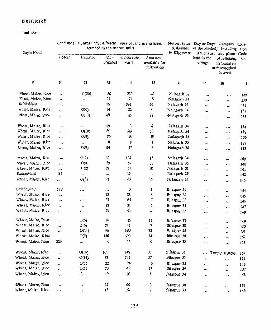
DIRECTORY
11nd U!lt
Land use (i. e" area under· djfferent types of land use in aCIes Nearest town Day or Days Remarks Loca~ rounded to tb~ oearest unit) &, distance. of tbe M.arket} including tion
Slaple Food in Kilometre Hat ifan" any place Code FI'J-rest Irrigated r Un- Cu]Wrab]e Area Dot. nelrl iu the of religious, No.
irrigated waste available for village historical Of cnltivati()o atcUaea\Ogl~i[
interest
ro II 12 13 14 15 ]1i 17 13
Wheat, Maize, Rice 0(20) 5~ 239 40 Nalagarh 32 129 Wheat, Maize, Rice 24 53 8 Nalagarh 34 )30 Crllinlmbited 16 393 66 NaJagarh 33 13J Wheat, Maize, Rice 0(6) 14 22 S NaIagarh 34 132 n'heal, Maize, R,iC'e 0(13) 43 .85 31 -Natagarh 33 1:B
Wneat, Maize, Rice 19 3 4 Na]agarh 34 ]34 Wheat, Maize. Rice 0(10) Sf) 189 38 K~fa~ar(l 34 US Wheat, Maize, Rlee 0(8) 35 9(] !O Na]2ga~b 38 J36 Wheat, Maize! Rice 8 '9 1 Mal agarb 3S .... ~ '.' 131 Wheat, Maize. Rice 0(9) 34 71 11 Nalagarh 36 US
'iVhcat, Mai2e, R:ce 0{7) 37 131 15 Na1agarb 34 i49 Whca1, Maize, Rice 0,'4: ' , 29 94 23- Nalatarb 35 140 Wheat, Maize, Rice ((2) 21 51 W Nalagarh 31 141 Uninhabited _81 13 1· NaTagarh 29 .. ' J42 "l!J.eat, r..1ai7.e, RIce 0(3) 2( 85 '5 NaJagJ.r11 }3 !4)
Uninhabited 19S 5 1 Bllaspur ':;8: ." ]44 Wheat, Maize, Rice 12 33 3 Bilaspur 38 t4S Wheat, Maize, Rice 27 65 7 Bilaspur 38 146 Wheat. Maize, Rice 12 21 2 Bitaspur 37 147 Wheat, Maize, Rice 23 5J 4 Bilaspur 37 .,' 148
Wllcat, Maize, Rice 0(5) 14 45 12 Bilaspur 37 149 Wheat, Maize. Rice O(6) ~I 43 1 Bila&pur 38 .. , 150 Wheat, Maize, Rice 0(14) 96 6~O 73 BiJaspur 35 151 Wheat, Maize, Rice 0(5) 156 491 54 Bl1aspur 34 . , " 152 Wheat, Maize, Rice 229 4 44 6 Bilaspur 35 .. , 153
Wheat, ~rai:ze, R~C!~ O(j6} 100 242 33 a iIa~v ur 302 Temple Dl)tgajt 1:S4 Wheat, Maize, Rice 0(t4) g3 2[2- 31 .BiJaspl.lJ:' 33 US Wheat. Maize, Rice 00) ;22 94 6 Bilaspur 32
~ .. 156 Wheat, Majzf). Rice 'OCt) 23 49 17 .Bilaspur 34 .. , IS7 Wbeat, Maize, Rice 19 30 (i j)ilaspur 34 .. ' ]53
Wheat. Maize, Rice 21 66 :3 :BjlaspOf 34 " . nS! Wheat. Maize, Rice 13 2:1: 1 BHaspur 33 .. ' H:;a
135

TAHSIL: NALAGARH
Loca. Name of vlllage{Hadbast No tioD Code No
2
161 Chhllwana (112)
162 Jadaun (t13) 163 Klar Kanatlan (114)
164 S F ChhIiwana (115)
165 StanJ (116)
166 Sarsa ( 1(7)
167 Jabal (tIS)
168 Bendl (119)
169 Nlhun (120)
170 Jal Nagar (121)
171 Jol (122)
172 S F Sunan (123) 173 Rela (124)
174 Sunan (125) 175 Sunah Rug (126.
176 Dhalerl (127) 177 Malhar! (128)
178 Lag (129)
179 Hulang (130)
180 Sallachl (131)
181 SF Badhal (132) 182 Bhdbal (133) 183 DohT! (134)
184 Machhaun (135)
185 tlkhu (136)
186 SF Dabrota (137)
187 Panjl (138) ]88 Sanog (139) 189 Btlnghar (140)
190 Sawa~an (141)
191 Chamdar (142)
192 ChalyauDl (143)
Total area of the Educational MedIcal
village (In Acres)
3 4 5
188 77 57
176 49
31 52
161 59
124 Pr S (I) 0(1)
103 555 49
357 Pr S (1)
251
119 66 80 Pr S (I)
193 235
6 IS2
110 156 Pa S (I)
502 Pr S (I)
65
644 217 205 226
339 32
136
VILLAGE
Amemties and
AmenitIes avaIlable wlthLD the vlliage
Power supply
6
Drmkmg water
7
F 0 0 NA
0
0 0
0 0 0
0 NA 0
0 W
0 0 0
0 0
N.A 0 0
0
0
NA 0 0 0 F
F F
Communi- Pou and catIOns Telegraph
8 9
PO

DIRECTORY
Land use
Land use (I.e. area under dliferent types of land use In dcres Nearest town Day or Days Rem.l.fk~ Loca rl unded to the nearest uUlt) & dIstance of the market! IDcludmg don
Staple Food In Kilometre Hat If allY. allY place Code Fore~t Irng ted Un· Culturable Area not beld 10 the of reltglOus, No
Irngated wa.,te avaIlable, for Village historical or cultIvation archaeological
tnterest
10 II 12 13 14 15 16 17 18
Wheat, MaIze, '{Ice 0(22) 44 100 22 Biiaspur 33 161
Wheat, Mane, Rice 0(5) 17 46 9 Na\agarh 35 162
Wheat, MaIze, RIce 0(8) 13 28 8 Natagarh 29 163
Umnhablled 176 Nalagarh 30 164
Wheat, Maize, RIce 24 23 2 Nalagarh 35 165
Wheat, Maize, Rice 0(1) 11 16 3 Nalagarh 32 166
Wheat, MaIze, RIce 0(4) 25 18 5 Nalagarh 21 167
Wheat, Maize, RIce 0(4) 77 61 19 Nalagarh 31 168
Wheat, Maize, RIce 0(2) 26 22 9 Nalagarh 32 169
Wheat, Maize, Rice 0(6) 42 61 15 Nalagarh 25 170
Wheat, Maize, Rice 0(2) 26 50 25 Nalagarh 30 171 lJmnhablled 555 Nalcgarh 30 172 Wheat, M IIZC, Rlcv 18 29 2 Nalagarh 35 173
Wheat, MaIze, RIce 82 258 17 Nalagarh 32 174 Wheat, Maize, Rice 0(12) 49 139 51 Nalagarh 32 175
Wheat MaIze, RICe 0(4) 19 80 16 Nalagarh 15 176 Wheat, MaIze, Rice 0(3) 8 44 11 Nalagarh 32 177 Wheat, MaIze, RIce 0(2) 14 61 3 Nalagarh 32 178 Wheat, MaIze, RIce 0(3) 44 124 22 Nalagarh 25 179 Wheat, MaIze, RIce 33 179 23 Na]agarh 20 180
Umnha1ilted Na]agarh 27 181 Wheat, MaIze, RIce 6 0(16) 26 90 20 Nalagarh 31 182 Wheat, MaIze, RIce 0(10) 32 51 \7 Nalagarh 32 183 Wheat, MaIze, RIce 0(1) 25 117 13 Nalagarh 25 184 Wheat, MaIze, RIce 0(45) 22 359 76 Nalhgarh 25 185
17mnhablled 65 Nalagarh 32 186 Wheat, MaIze, RIce 0(7) 82 481 74 NaJagarh 30 187 Wheat, MaIze, Rice 0(1) 34 190 12 Na]agarh 22 188 Wheat, Maize, Rlce 0(3) 40 147 15 Nalagrrh 33 189 Wheat, Maize, Rice 26 133 67 Nalagarh 27 190
Wheat, MaIze, RIce 109 210 20 NaJagarh 27 191 Unmhablted 10 20 2 Nalagarh 28 192
137
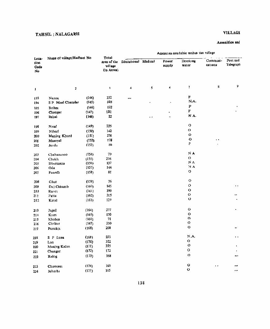
TAHSIL: NALAGARH
lA>ca- Name of v,lIage/Hadbast No tlon Co4o No
2
193 Nanoa (144)
194 S F Nisal Cham dar (145)
195 BltbDl (146)
196 Chaogar (147)
197 Bahal (148)
198 Nlsal (149)
199 Nlbarl (150)
200 MacIog Khurd (151)
201 Masoyal (152)
202 Jandu (153)
203 Chahananoo (154)
204 Chakh (155) 205 Dhormana (156)
206 Oda (157)
207 Fanedh (158)
208 Ghat (159)
209 Dal Cbhamb (160)
210 Raofl «(61)
211 Patta (162)
212 Kalal (163)
213 Jaged (164)
214 Klan (165)
215 Kbabra (166)
216 Ch1liar (167)
217 Punahla (168)
218 S F Luna (169)
219 Lun (170)
220 Manlog Kalan (171)
221 Changar (172)
222 Rldog (173)
22.3 Chamlasl (174)
224 Joharhl (175)
Total area of the Educational Medical
village (In Acres)
4 S
252 588
122 132,
22
225 142 276 178 86
79 216 137 144 81
76
145 299 205 129
277
170 71
210 208
223 322 355 172 ]68
169 115
138
VILLAGE
Amenities aDd
AmeDltles available wlthm the Village
Power supply
DnnkLOg water
7
F N.A.
F F NA.
0 0 0 0 F
NA 0 NA NA
0
0
0 0
0 0
0
0 0 0
0
N.A. 0 0 0
0
0 0
CommuOl' Post and cations Telegrapb
9
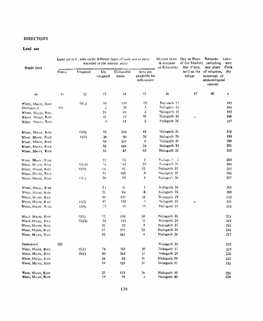
DIRECTORY
Land use
Land use (I e , area under different type:, of Lind u~e In ,{cre, Ne Irest town Day or Days Remarks Loca-rounded to the nearest unit) & distance of the Marketl mcludmg tlon
Staple food ID KIlometre Hat If any, any place Code
Pore.,t Irflgated Un- Cultur.lble Are.l not helJ 1D the of reltglous, No
I rfIgated waste available for village historIcal or cuI tlvatlOD archaeological
Interest
10 11 12 13 14 15 16 17 18
Wheat, MaIze, Rice O(~) 50 14'1 52 Nal u!arh :2) 193 Unlll/'ubrtL J 55\ 2. 30 5 Nalagarh 26 194
Wheat, M.lILC, RICL 29 89 4 Nalagarh 25 195
Wheat MaIze, RIce 41 12 79 Nalagarh 24 196
Wheat 1yf.l17C, RICC ') II 2 Nalagarh 21 197
Wheat, MaILe, Rice 0(2) 74 134 19 Nalagarh 26 198
Wheat MaIze, RIce 0(2) 26 90 24 Nal.lgerh 24 199
Wheat, MaIze, RIce 59 209 8 Nalagarh 26 200
Wheat, MaIze, RIce 50 104 24 Nalagarh 24 201
Wheat, Mal7e, Rice 35 43 62 Nalagarh 26 202
Wheat Ma I/f.., , RIce 15 62 8 j\,,,:uga,'l 2 203 Wheat M tiLe, RILe 0(10) ''f '..\4 28 }..~I.lgarh 2) 204 Wheat, M1.IZC, Rlcc 0(9) It'> 92 J8 Nalagarh 25 205 Wheat, Maize, Rll-e 33 102 9 Nalagalh 27 206 Wheat, MaIze, RIce C(1) 20 56 4 Nalagar'l 26 207
Wheat, Malz,"" R'ce 21 51 1 Ndlagarh 24 2(.8
Whed!, l\f.lIZe, Rice 51 83 6 Ndlagarh 24 209
Wheat, M llze, RICC 44 237 1& N,llagal h 24 210 Whedt, Mdlze, RIce 0(2) 47 149 7 Nalagarh 25 211 Whcat, MaIze Rice 0(6) :2 76 15 Nallgarh 25 212
Whe,lt Maize, RIce 0(5) 72 180 20 Nalagarh 26 213 Whedt, MaIze, RICe 0(22) 23 114 11 Nalagarh 24 214 Wheat, MaIze, RIce II 52 8 Nalagarh 27 215 Wheat, M:uze, R,ce 57 131 22 Nalagarh 29 216 Wheat, Mllze, RIce 42 16l 4 Nalagarh 26 217
UnmhabIted 223 Nalagarb 26 218 Wheat, )\f.alze, RIce 0(2) 78 212 30 Nalagarh 27 219 Wheat, Mdlze, RICe 0(2) 80 262 II Nalagarh 29 220 Wheat, MaIze, RIce 49 92 31 Nalagarh 30 221 Wheat, Ma Ize, RIce 14 123 31 Nalagarh 31 222
Wheat, MaIze, Rice 21 112 36 Nalagarh 30 223 Wheat, Mdlze, Rice 1\1 94 2 Nalai:arh 40 224
139
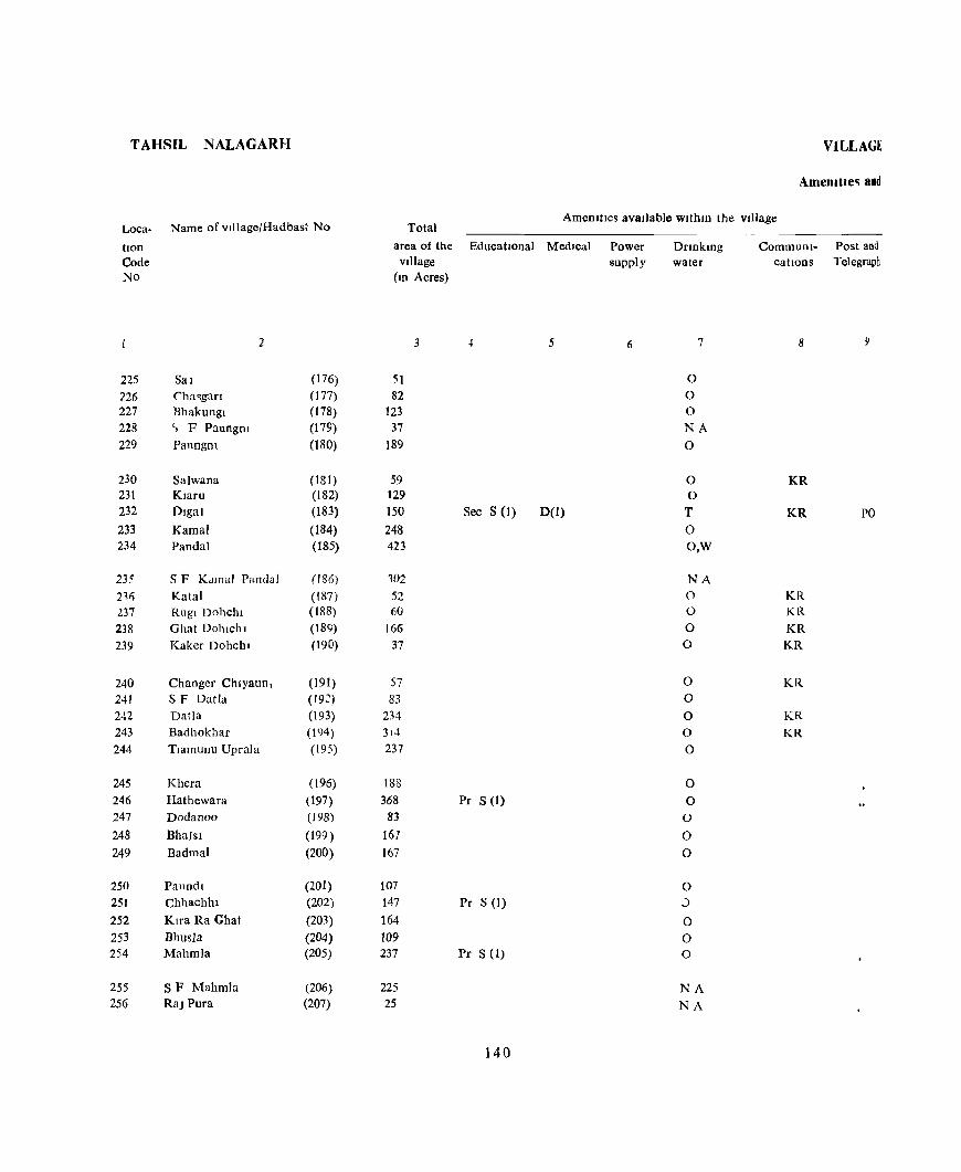
TAHSIL NALAGARH
Loca- Name of village/Had bast No
lion Code No
2
225 Sal (176) 226 (,ha~gaf) (177)
227 Rhakungl (178) 228 '> F Paungm (179) 229 Paungm (180)
230 Salwana (181) 231 Klaru (182) 232 Digal (183) 233 Kamal (184) 234 Pandal (185)
235 SF Kdmal Pandal (186)
211) Kalal (187) 237 Rugl Dohchl (188) 238 Ghat DohlcllJ (189) 239 Kaker Dohchl (190)
240 Changer Chlyaun, (191) 241 SF Datla (192) 242 Datla (193) 243 Badhokhar (194)
244 Tlamunu Uprala (195)
245 Khera (196)
246 Hathewara (197) 247 Dodanoo (198)
248 Bhalsl (199 ) 249 Badmal (200)
250 Paundl (201) 251 Chhachhl (202) 252 Klra Ra Ghat (203) 253 Bhusla (204) 254 Mahmla (205)
255 SF Mahmla (206) 256 Raj Pura (207)
VILLAGE
AmemtJe" and
Total AmenltIes avaIlable Wlthm the vIllage
area of the EducatIOnal Medical vllIage
(10 Acres)
3 5
51 82
123 37
189
59 129 150 Sec S (1) D(l)
248 423
102
52 60
166 37
57 83
234 314 237
188 368 Pr S (1)
83 167 167
107 147 Pr S (1) 164 109 237 Pr S (1)
225 25
140
Power supply
6
Dnnkmg water
7
0 0 0 NA
0
0 0 T 0 O,W
NA 0 0
0 0
0 0
0 0 0
0
0 0
0 0
0 J
0 0 0
NA
NA
Communi- Post and cations Telegraph
8 y
KR
KR PO
KR KR KR KR
KR
KR
KR
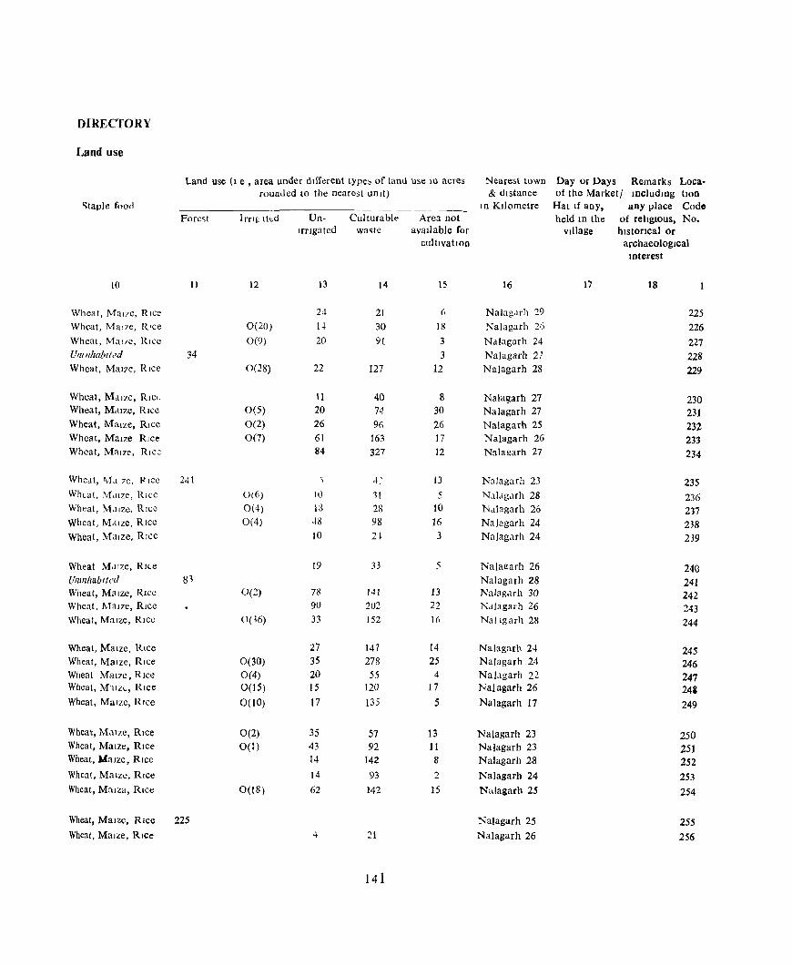
DIRECTORY
Land use
Land use (1 e , area under dIfferent type, of land use 10 acres Nearest town Day or Days Remarks Loca-rounded to the nearest un It) & dIstance of the Marketl JDcludlllg tlOn
'>taple foon I n Kilometre Hat If any, any place Code Fore~t lrflp- lied Un- Culturable Area not held III the of religIOus. No.
IrrIgated wa~te avaIlable for vJllage bistotlcal or cultIvatIon archaeological
Interest
10 )1 12 13 )4 15 16 17 18
Wheat, Mal7e, Rice 24 21 (i Nalagdfh 29 225 Wheat, Mal7e, R'ce 0(20) 1-) 30 18 Nalagarh 26 226 Wheat, MaIre, Rice 0(9) 20 9t 3 Nalagarh 24 22.7 UfIIlllwbl/.:'d 34 3 NaJagarh 27 228 Wheat, Mal7c, RIce 0(28) 22 127 12 Nalagarh 28 229
Wheat, MaIze, RICL 11 40 8 Nalagarh 27 230 Wheat, M.!IZe, RIce 0(5) 20 74 30 Nalagarh 27 231 Wheat, MaIze, RIce 0(2) 26 96 26 Nalagarh 25 232 Wheat, MaIZe Rice 0(7) 61 163 17 Nalagarh 26 233 Wheat, Maize, Rice 84 327 12 Nalagarh 27 234
Wheat, ,\fa 7C, P ICC 241 4: 13 NaJagarh 23 235 Wheat, M,uze, Rice 0(6) It) 11 5 N,lIagarh 28 236 Wheat, M,IIZC, R ICC 0(4) 18 28 10 Nalagarh 26 217 Wheat, MaIze, RIce 0(4) .i8 98 16 Nalagarh 24 238 Wheat, Maize, Rice 10 2~ 3 NaJagarh 24 239
Wheat Maize, RIte 19 33 5 Nalarrarh 26 240 UlIlnhabl/cd 8~ Nalagarh 28 241 Wheat, Maize, RIce O(~) 78 141 13 NalagJrh 30 242 Wheat, MaIze, Rice 90 202 22 Nalagarh 26 243 Wheat, M::lIze, Rice 0(16) 33 152 [6 Nallgarh 28 244
Wheat, MaIze, Rice 27 147 14 Nalagarh 24 245 Wheat, Maize, Rice 0(30) 35 278 25 Nalagarh 24 246 Wheat MaIze, RIce 0(4) 20 55 4 Nal,lgarh 22 247 Wheat, M,IZ(." Rice 0(15) 15 120 17 Nalagarh 26 24& Wheat, Mollze, RIce 0(10) 17 135 5 Nalagarh 17 249
Wheat, MaIze, RIce 0(2) 35 57 13 Nalagarh 23 250 Wheat, MaIze, RIce 0(1) 43 92 1 [ Nalagarh 23 251 Wheat, .MaIze, RIce 14 142 8 Nalagarh 28 252 Wheat, Malze, Rice 14 93 2 Nalagarh 24 253 Wheat, MaIza, RIce 0(18) 62 142 15 Nalagarh 25 254
Wheat, Maize, RIce 225 Nalagarh 25 255 Wheat, Maize, RIce 4 21 Nalagarh 26 256
141
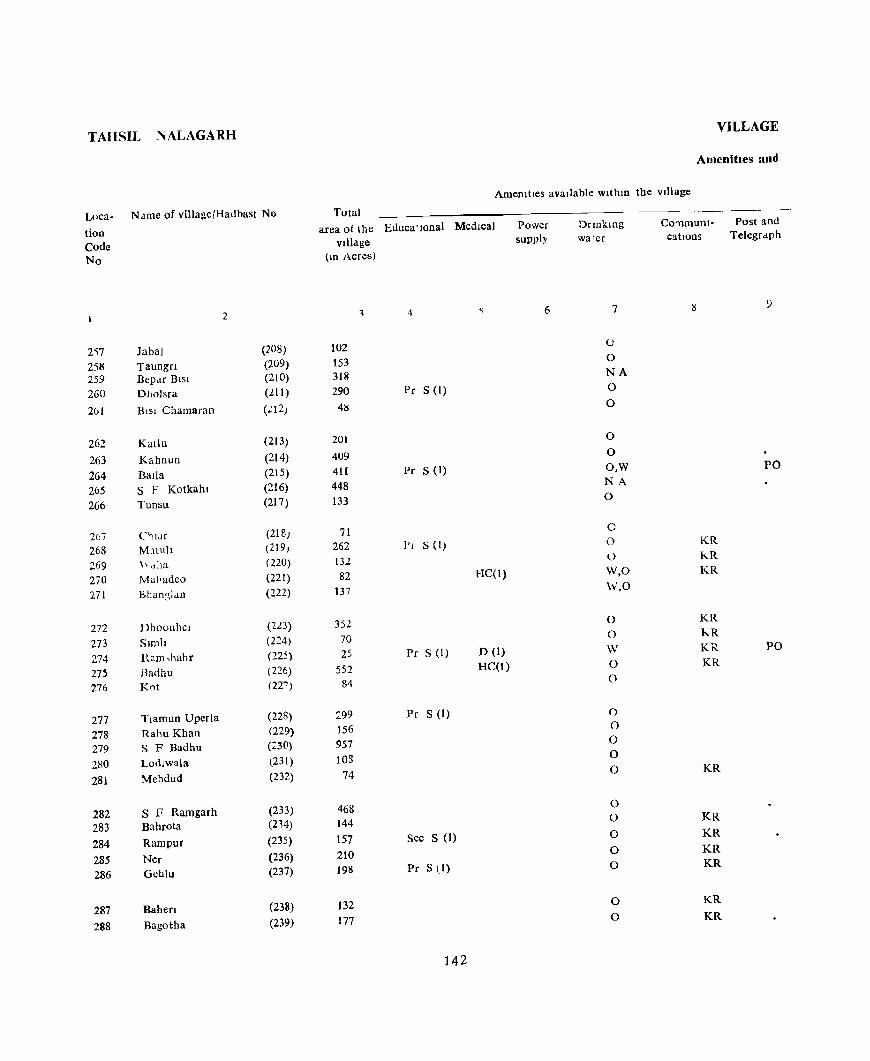
TAIISIIJ NALAGARH VILLAGE
Amenities and
Amemtles aVaIlable wlthm the village
Lllea- Name of vilJageJHadbast No Total Drlnkmg water
CO'llmunt- Post and tlon Code No
2')7 25M 259 260
261
262 263 264 265 266
2(17 268 269 2iO 271
272 273 274 275 276
277 278 279 280 281
282 283 284 285 286
287 288
Jabal Taungn Bepar BiSI Dholsra
Bisl Chama ran
Kallu
Kahnun Balla S F Kotkahl Tunsu
C"JIJr MJtuh \, tl11a
Mai·adeo Bhan31Ju
Dhoonhcl Slmh Ram,hahr Badhu Kot
Tlaffiun Uperla Rahu Khan S F Badhu Lodlwala
Mehdud
S F Ramgarh Bahrota
Rampur
Ner Geblu
Bahen Bagotha
2
(208) (209) (210)
(2.11) (':12)
(213) (214) (215) (216) (217)
(218) (219) (220) (221) (222)
(223) (224) (225) (226) (227)
(228) (229) (;:30)
t231) (232)
(233) (214) (235) (236) (237)
(238) (239)
area of thc EducatIOnal Medica) Village
(10 Acres)
1 4
102 153 311l 290 Pc S (I)
41:)
201 4U9 411 Pc S (1) 448 133
71 262 PI S (I)
132 82 HC(I)
137
352 70 25 Pr S (I) D (1)
552 HC(l)
84
:99 Pc S (1)
156 957 108
74
468 144 157 Sec S (1)
210 198 Pc S (1)
132 177
142
Power supply
6
catIons Telegraph
7 9
0 0 NA 0
0
0
0 O,W PO NA 0
0 0 KR l) KR W,O KR
W,O
0 KR
0 kR
W KR PO 0 KR
0
0 0 0 0 0 KR
0 0 KR
0 KR
0 KR
0 KR
0 KR
0 KR
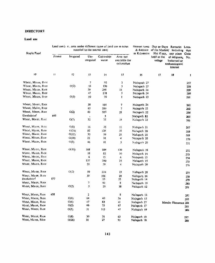
DIRECTORY
Land use
Land use (I e , area under dIfferent types of land use 10 acres Nearest town Day or Days Remarks Loea. rounded to the nearest uOlt) & dIstance of the Marketl includmg tion
Staple Food ID KIlometre Hat ffany, any place Code Forest Imgated Un- Culturable Area not held In the of reltg1Ous, No.
Irngated waste available for VIllage hIstorical or cultIvation archaeologIcal
interest
10 " 12 13 14 15 16 17 18
Wheat, MaIze, RIce 7 92 3 NalagaJh 27 257 Wheat, MaIze, RIce 0(2) 16 130 5 Nalagarh 27 258 Wheat, MaIze, RIce 59 248 11 Nalagarh 24 259 Wheat, MaIze, RIce 47 238 5 Nalagarh 24 260 Wheat, MaIze, RIce 0(3) 10 70 Nalagarh 23 261
Wheat, Malee, RIce 30 164 7 Nalagarh 24 262 Wheat, Maize, RIce 63 339 7 Nalagarh 22 263 Wheat, MaIze, RIce 0(2) 63 325 21 Nalagarh 22 264 Umnhablted 445 3 Nalagarh 2Z 265 Wheat, MaIze, RIce 0(7) 32 75 19 Nalagarh 22 266
Wheat, MaIze, RIce 0(9) 16 35 11 Nalagarh 21 267 Wheat, MaIze, RIce 0(24) 82 126 30 NaJagarh 20 268 Wheat, MaIze, RIce 0(22) 30 59 21 Nalagarh 20 269 Wheat, MaIze, RIce 0(18) 22 38 4 Nalagarh 20 270 Wheat, MaIze, RIce 0(5) 46 81 5 NaJagarh 20 271
Wheat, MaIze, RIce 0(10) 108 104 130 Nalagarh 16 272 Wheat, MaIze, RICe 18 22 30 Nalagarh 16 273 Whea.t, MaIze, RIce 4 15 6 NaJagarh 15 274 Wheat, MaIze, RIce 137 380 35 Nalagarh 15 275 Wheat, MaIze, RIce 21 59 4 Nalagarh 20 276
Wheat, MaIze, Rlce 0(2) 50 224 23 Nalagarh 28 277 Wheal, MaIze, RIce 30 106 20 Nalrgarh 18 278 Unmhabltei 877 25 55 Nalagarh 14 279 Wheat, MaIze, RIce 7 93 8 Nalagarh 19 280 Wheat, MaIze, Rice 0(2) 5 29 38 Nalagarh 12 281
Wheat, Maize. Rice 458 2 8 Nalagarh 13 282 Wheat, MaIZe, Rlce 0(4) 64 40 36 NaJagarh 15 283 Wheat, Maize, Rice 0(6) 47 63 41 Nalagalh 17 Mandlr Hanuman 2B4 Wheat, MaIze, Rice 0(2) 66 75 67 Nalagarh 17 285 Wheat, MaIze, RIce 0(5) 31 115 47 Nalagarh 19 266
Wheat, Maize, RIce 0(8) 30 31 63 Nalagarh 19 287 Wheat, Malze, Rice 0(26) 31 27 93 Nalagarh 18 288
143
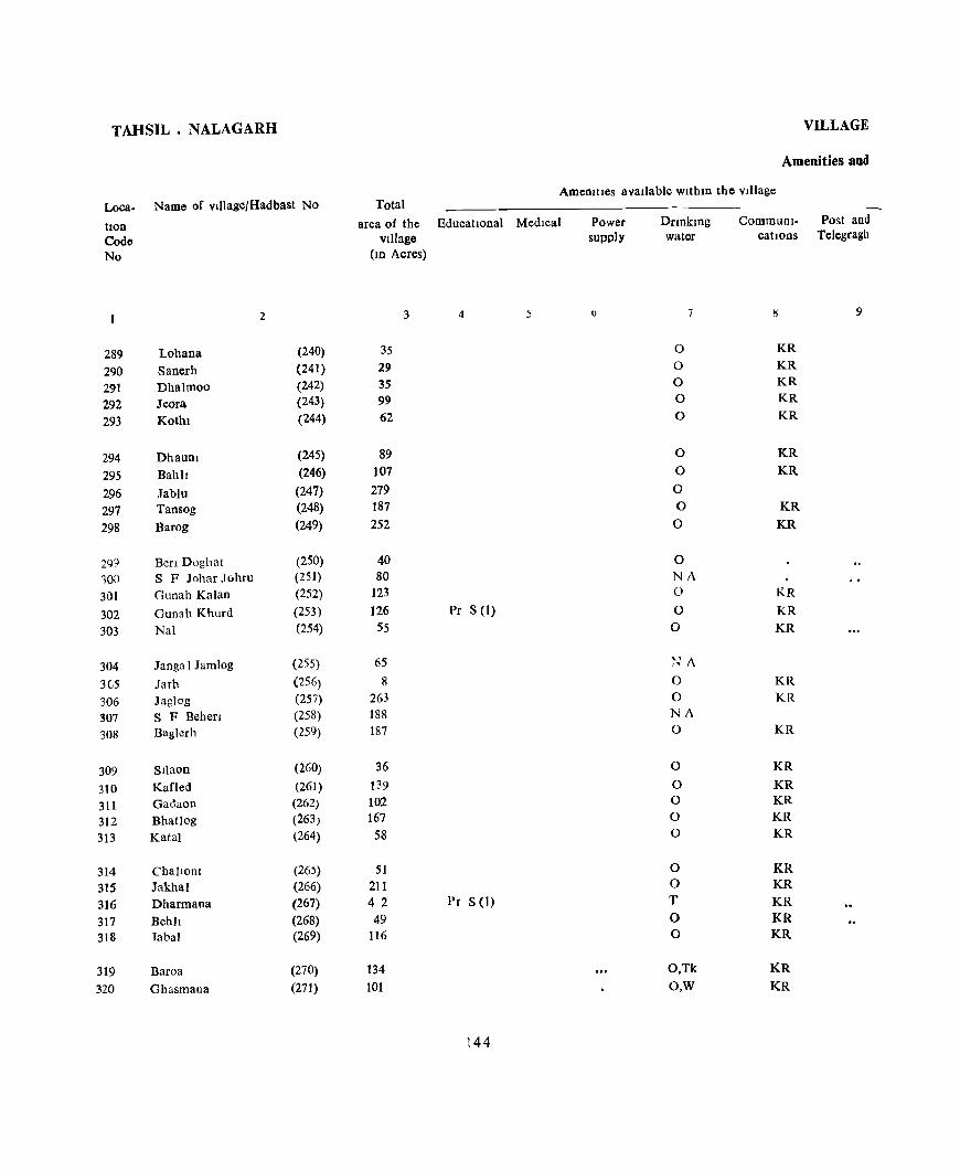
TAHSIL. NALAGARH
Loca. Name of vIIlage/Hadbast No
hon Code No
2
289 Lohana (240)
290 Sanerh (241)
291 Dhalmoo (242) 292 Jeora (243)
293 Kothl (244)
294 DhauDl (245)
295 Bahll (246)
296 Jablu (247)
297 Tansog (248)
298 Barog (249)
299 Ben Doghat (250) 100 S F Johar Johru (251)
301 Gunah Kalan (252)
302 Gunah Khurd (253)
303 Nal (254)
304 Jangal Jamlog (255)
305 Jarh (256)
306 Jaglog (257) 307 S F Behen (258) 308 Baglerh (259)
309 Sliaon (260)
310 Kafled (261) 311 Gadaon (262) 312 BhatJog (263) 313 Katal (264)
314 ChalloDi (26') 315 Jakha) (266) 316 Dharmana (267) 317 Bebh (268) 318 labal (269)
319 Baroa (270) 320 Ghasmana (271)
VILLAGE
Amenities and
Amemtles avaJiable wltbm the Village Total
area of the Educational Medical Village
(10 Acres)
3 4 5
35 29 35 99 62
89 107 279 187 252
40 80
123 126 Pr S (I)
55
65 8
263 188 187
36 139 102 167
58
51 211 4 2 1'r S(I)
49 116
134 101
144
Power supply
DriDktng water
7
0 0 0 0 0
0 0
0 0
0
0 NA 0
0 0
"t~ A
0 0 NA 0
0
0 0 0 0
0 0 T 0 0
O.Tk O,W
CommUnI- Post and cations Telegragh
IS 9
KR KR KR KR KR
KR KR
KR KR
KR
KR KR
KR KR
KR
KR
KR KR KR KR
KR KR KR KR KR
KR KR

DIRECTORY
Land use
Land use (I.e. area under different types of land use In acres Nearest town Day or Days Rem<1rks Loca rounded to the nearest UOIt) & distance of the market! includtng lion
Staple Food In Kilometre Hat If aoy. any place Code Forest Irngated Uo- Culturable Area not held In the of religIOus, No
Irngated waste available for village hIstOrical or cultlvatlOO archaeological
mterest
to 11 12 n 14 15 16 17 18
Wheat, Maize. RIce 0(9) 13 3 10 Nalagarh 16 289 Wheat, Maize, Rice 0(3) 9 7 Nalagarh 16 2')0 Wheat, Maize, Rice 0(18) 4 12 Nalagarh 16 291
Wheat, M.llze, Rice 20 59 20 Nalagarh 17 292
Wheat, Maize, Rice ~'(t1) 33 6 12 Nalagarh 18 293
Wheat, \1alze, Rice 0(21) 14 42 12 Nalagarh 16 294
Wheat, MaIze, Rice 0(2) 38 38 29 Nalagarh 19 295
Wheat, Maize, Rice 0(2) 40 160 77 Nalagarh 23 296
Wheat, MaIze. Rice 0(2) 59 101 25 Nalagarh 2u 297
Wheat, Mal7e, RIce 0(9) 38 120 85 Nalagarh 21 298
Wheat, Maize. Rice 15 17 8 Nalagarh 21 299 Uninhabited 80 Nalagarh 22 300
Wheat, Maize, RIce 38 28 57 Nalagarh 22 301 Wheat, MaIze. Rice 39 34 53 Nalagarh 23 302 Wheat, MaIze, Rice 19 10 26 Nalagarh 24 303
UninhabIted Nalagarh 23 304 Wheat, MaIze, Rice 0(3) 3 2 Nalagarh 18 30S Wheat, Maize, Rice 70 61 132 Nalagarh 23 306 Uninhabited 188 Nalagarh 18 307 Wheat, Maize, Rice 0(35) 18 43 91 Nalagarh 20 308
Wheat, Maize, Rice 23 4 9 Nalagarh 20 309 Wheat, Maize, Rice 26 61 52 Nalagalh 19 310 Wheat, Maize, Rice 0(4) 37 47 14 Nalagarh 20 311 Wheat. Maize, Rice 0(3) 38 120 6 Nalagarh 21 312 Wheat, Maize, Rice 25 30 3 Nalagarh 22 313
Wheat, Maize, Rice 14 36 Nalagarh 22 314 Wheat, Maize, Rice 0(2) 65 136 8 Nalagarh 20 315 Wheat. Maize, Rice 0(13) 162 282 35 Nalagarh 21 Mandlr Devl 316 Wheat, Malzc, Rice 27 18 4 NaJagarh 21 317 Wheat, MalZc, Rice 0(1) 60 40 15 Nalagarh 22 318
Wheat, Maize, RIce 43 71 20 Nalagarh 22 319 Wheat. Maize, Rice 50 48 3 Nalagarh 22 320
145

TAHSIL: NALAGARH
Loca- Name of village/Hadbast No
tion Code 'No
2
321 Panseta (272) 322 Dhar (273) 323 Dher (274) 324 Gabar (275) 325 Kath (276)
326 Malag (277)
327 KhaClana (278) 328 Dhar Brahmna (279) 329 Nand (280) 330 Bhml (281)
331 S F Nand (282)
332 Kharak (;'83) 333 Jagnl (284) 334 Purla (285) 335 Bagl (286)
336 S F Sihal (287) 337 Khobla (288)
338 PatJth (289) 339 NyarI (290)
340 Narla (l91)
341 Bara (92)
342 S F Dhangoh (293) 343 Malhcm (294)
344 SaorI (295)
345 Bd~antpura (296)
346 RaJatl (297)
347 SINS (298)
3~8 Thala (299)
349 Chanaharn (30l' ) 350 S F RaJwacn (301) 351 Mnnwa,an (302)
352 Ra)\vacn (103)
353 JdJll (304)
Total
area of the EducatIOnal Medical village
(m Acres)
l 4 :I
92 512 224 154 643
108 19) 97
648 Mid S (1) D(I) 53
21 66 32 86 Pro S (1)
153
443 197 143 250 149
291 155 425 Pr S (1) 346 221
385 402 143 65
107 23
121 623
146
VILLAGE
Amenities and
AmeOltJes available wlthm the village
Power supplv
6
DrinkIng water
7
0
O.Tk 0
Tk , 0
0
O,Tk Tk
O.W 0
NA F F F F
NA F F 0
F
F NA 0
F F
0 F
F F
NA. F
F F
CO!TImunt· Post and cations Telegraph
8
KR
KR KR KR KR
KR
KR KR KR PO KR
KR

DIRECTORY
Land use
Land use (I e , area under different types of land u"e 10 acres Nearest town Day or Days Remarks Loca-rounded to the nearest UnIt) & distance of the Marketl lOcludlDg tiOD
Staple food in Kilometre Hat Jf any. any place Code Pore~t rrngated Un- Culturable Area not held 10 the of rehglOus, No
Irngated waste available for Village historIcal or cultlvatlOD archaeologIcal
lDterest
10 II 12 13 14 15 16 17 18
Wheat, Maize, Rice C(2) 48 34 48 Nalagarh 23 321 Wheat, Maize, Rice 0(11) 220 264 17 Nalagarh 22 322 Wheat, Maize, Rice 0(2) 102 75 45 Nalagarh 22 323 Wheat, MalZc, Rice 71 64 19 Nalagarh 23 324 Wheat, Maize, Rice 0(20) 289 235 99 Nalagarh 24 325
Wheat, Maize Rice 42 59 7 Nalagarh 25 326 Wheat, MaIZc, RIce 0(6) 82 86 25 Nalagarh 26 327 Wheat, Maize, RIce 22 70 5 Nalagarh 26 328 Wheat, MaIZe, Rice 0(5) 173 351 119 Nalagarh 26 329 Wheat, Maize, Rice 23 17 13 Nalagarh 27 330
Umnhablted 21 Nalagarh 27 331 Wheat, M,uze, Rice 37 13 16 Nalal;arh 25 332 Wheat, Maize, RIce 24 5 3 Nalagarh 24 333 Wheat, MaIze, RIce 58 18 10 Nalagarh 24 334 Wheat, Maize, Rice 0(2) 61 52 38 Nalagarh 23 335
Unmhablfed 382 4 22 35 Nalagarh 22 336 Wheat, MaIze, RIce 0(4) 52 119 22 Nalagarh 23 337 Wheat, MaIze, RIce 24 103 16 Nalagarh 24 338 Wheat, Maize Rice 0(2) 76 109 63 Nalagarh 27 3'19 Wheat, MaIze, Rice 0(3) 32 89 25 Nalagarh 25 340
Wheat, MaIze, Rice 49 236 6 Nalagarh 22 341 Umnhablfed 155 Nalagarh 23 342 Wheat, Maize, Rice 137 273 15 Nalagarh 23 343 Wheat, Maize, RIce 81 259 6 Nalagarh 20 344 Wheat, Maize, RIce 35 176 10 Nalagarh 18 345
Wheat, MaIze, RIce 48 333 4 Nalagarh 22 346 Wheat, MaIze, RIce 0(2) 34 355 11 Nalagarh 20 347 Wheat, MaIze, Rice 35 90 18 Nalagarh 17 348 Wheat Maize, RIce 0(4) 28 31 2 Nalagarh 19 349 Umnhabl(ed 107 Nalagarh 20 350
Wheat, MaIze, Rice 10 10 3 Nalagarh 19 351 Wheat, MaIze, Rice 0(13) 25 68 15 Nalagarh 20 352 Wheat, Maize, RICe 0(35) 151 351 86 Nalagarh 23 353
l·P

TAHSIL • NALAGARH
Loca- Name of vlJlagejHadbast No
tlon Code No
2
354 Ganed (305)
355 SF Kaln (306)
35fi Paonia (307) 357 Ratwarl (308) 3"8 Reter (309)
359 sop Ratwan (310)
360 Bhalh (311) 361 Kothl (312) 362 Kota (313) 363 Kawarm Coarnu (314)
364 Kanoela Uperla (315) 365 Jangal Kehadaban (316) 366 Kanoeld Nlhla (317) 367 Pokhan (318) 368 Larkot (319)
369 Terh-Beherh (320)
370 Dharnroh (321) 371 Charoh (322)
372 Palhrur (323)
373 Saror (324)
374 Chanobn (325)
375 Slhl (326) 37(1 Beglebr (50)
377 Panjehra (51 )
378 Kauhnwa\a (52)
379 Pater Bbaunkhoo (53)
380 Sobhan MaJra (54)
381 Nawan Garaon (55) 3~? JhaJra (56) 3b3 Pater Phaioo (57)
384 Hatrd (58)
385 Pater Mlanl (59)
VILLAGE
Amemties and
Total Amemlles available Within the Village
area of the EducatIOnal Medical Village
(10 Acres)
3 4 5
1258 221
451 Pr S(t) 820 Pr S(I) 124
149 62
330 143
93
208 141 180 70
163
89 205 93 Pr S (I)
166 604
219 138 928 347 Pr S (I) 164
199 120 545 Pc S (I) 264 188
268 108
148
Power ,upply
DriDkmg water
7
P
NA p
P F
NA F F F 0
F NA NA F F
F
I' F F F
F
F NA R R
R
R R R NA
NA NA
CommuUl- Post and catIOns TeJegragb
9
KR
KR
KR
KR PO KR
KR KR KR
KR KR

))IRECTOR'\
Land use
Land u,e (I e • area under different types of land use III acres Nearest town Day or Day~ Remarks Lot',,-rounded to the nearest unit) & dl~tance of the Marketl mcludmg Hon
Stapl!" Food In Kilometre Hat Ifany. any place Code Fore<! Irrigated Un- Culturable Area not held In the of religious. No
Irngated waste avaIlable for village historIcal or cultIvatIOn archaeological
mterest
10 II 12 n 14 15 16 17 18
Wheat, MaIze. Rice 0(8) 91 133 26 Nalagarh 24 354 Uninhaf,lIl!d 221 Nalagarh 24 355 Wheat, Maize, Rice 0(11) 109 277 32 Nalagarh 23 356 Wheat, MaIze, Rice 0(18) 260 518 2~ Nalagarh 22 357 Wheat. MaIze, RIce (' (~) 71 79 16 Na)agarh 18 358
Umnhahlled 14<) Naldgarh 19 159 Wheat. Mal7e, RIce 0(", :n 2(1 ~ Nalagarh 14 36(,
Wheat Mal7e RIce 0(3") Iii 157 2 Nalagarh 23 361
Whf'~t Ma,ze. Rwe O(~l 'i5 61 22 Nalag.1rh 24 362
Wheat, Maize, RIce .tR 38 Nalagarh 24 3[)3
U nlllhablt <!d 0(1) 85 1J7 25 Nalagarh 26 364 Wheat, MaIze. Klce 141 Nalagarh 25 365 Wheat. MaIze, Rice 0(5) 60 103 12 Nalagarh 25 )(i6 Wheat, MdIZC. Rice 27 41 2 NaJagarh 20 367 Wheat, Mdlze. Rice 0(\) 44 110 8 Nalagarh 18 368
Wheat, Maize Rice 0(5) 24 46 14 Nalagarh 18 369 Wheat, MaIze, Rice 0(3) 113 60 29 Nalagarh 19 1'7Q
Wheat, Maize, RIce 0(6) 16 20 11 Nalagarh 18 371
Wheat, Maize, Rice 107 39 20 Nalagtrh 18 372
Wheat, Maize, Rice 0(2) 249 335 18 "'alagalh 14 ;73
Wheat. Maize, Rice 95 121 3 Na)agarh 6 374 Wheat, l\Talze. RIce 51 76 11 Nalagarh 16 37:> Wheat. Maize, Rice 449 255 224 Nalagarh 12 376
Wheat, Maize, RIce 257 16 7-t Nalagarh II 377 Wheat. MaIze. Rice 123 17 24 Na)agarh II 378
Wheat, Maize, Rice 157 7 35 Nalagarh 11 379 Wheat, MaIze, Rice 104 4 12 Naiagarh 11 380 Wheat, Maize, Rice 438 84 23 Nalagarh 12 381 Wheat, Maize, RIce 0(11) 172 72 9 Nalagarh 13 382 Wheat, Maize. Rice 140 7 41 Nalagarh II 3&3
Wheat, Maize 58 121 49 40 Nalagarh 11 384 Wbeat, MaIze 92 7 9 Nalagarh 11 385
149

NALAGARH T ,\HSIL
Loca- Name of vlIlaae/Hadbast No
lion Code N.
2
'86 Gulab Pura (6D) 387 Saun GUJan (61) 388 Saurl RaJPutan (62) 389 Ambwala ~63)
390 Palh (64)
391 Nawan Nagar (65) 392 Aduwal JaodorJ (66)
~93 Bhatoh (67) 3()4 Mahandeo (68) 395 Dolowal (69)
996 Ma]rl (70) 397 Ratyor (71) 398 Bhanglan (72) 399 Bhogpur (73) 400 Reru Jhdwala (74)
4"1 Reru Uperla (75)
402 Kahan pur (76)
403 Goyal Jamala (77) 404 Nangal Uperla (78)
405 Palasra Nlchla (79)
406 Palasra Kaloo (80) 407 Palasra Gharuan (81)
408 Palasra DJttoo (82)
409 Nangal Nlchla (83) 410 Sanerh (84)
411 Dhundh Gopl (85)
412 Bhatlan (86)
413 Manguwal (87) 414 Kanganwal (88) 415 Dhang Uperll (89)
4)6 Dhang Nlchll (90)
417 Saini ',{aJra (91)
Total
area of the Educational Medical vIllage
(ID Acre.)
J 4 5
174 269 94
602 S17 Pr S (1)
243 1,543
314
189 301
59 947 646 728 Pro S (1) 445
383 Pro S (1)
145 319
588 Pr S (1)
233
139
427 ]93 347 830 Pc S (I)
72 1 340 Pr S (I)
172 264 488
577 Pr S (J)
14.)
150
VILLAGE
AmeDJtles and
Amenities available within the village
Po>ver supply
6
E
E E
E
E E E
E E
DCloklOg water
7
NA. N A.
NA NA R
R W,R W.R W W
W
W W W W
W
R W W
W
R R w W W
W
W
W
W W
W W
CommuDl- Post and cattons Telegraph
g
KR KR
KR
KR KR KR KR
KR
PR KR KR KR
KR PO KR KR KR KR
KR KR
PR FR
PR
PR PR

DlRECfORY
Land use
I amI u~e (I e irca under d,1fcn:m type~ of land use In acres Nearest town I.>ay or DdYs Remark~ LOCd-
rounded to the nearest UOl!) & distance of the Marketl mciudlllg tlon
Staple food in KIlometre Hat if any, any place Code Pore~t T rf1~!1ted Un- Culturahle Area not held to the of relIgious, No.
I rrlgated wa~te avaIlable for Village hIstorIcal or cultlvatlOD archaeological
mterest
IU 11 12 I' 14 I' 16 17 IX
Wheat, Maize 160 14 Nalagarh 11 386
Wheat, MaIze 221 4 44 Nalagarh 11 387 (}mnhablf ed 74 9 Jl Nalagarh II 388 Wheat, Mcuze 399 Y6 107 Nalagarh 14 389 Wheat, MaIZe 0(26) 155 283 53 Nalagarh 14 390
Wheat, Maize 0(9) 88 tOl 45 Nalagarh 14 391 Wheat, Maize Rice 118 0(11 ) H7 6()~ 422 Nala,arh 14 392 Wheat, Mal7e, Rice 197 88 24 NalJgarh 10 W3 Wheat, Maize, RIce W(f) 1\6 ~8 t-1- Nalagdrh 8 3~~
Wheat, Maize, Rice W(l4) 109 125 ",\ N"lagarh II 3)15
Wheat, Malz,-" Rice W(!2) 42 5 Nalagarh 8 3% Wheat, Maize Rice ()(43) 504 2UO 200 Naldgarh II 397 Wheat, Mal7e, Rice 18 W(l) 236 236 154 Nalagarh 8 398 Wheat, Maize, Rice W(6) 305 279 138 Nalagarh 7 399 Wheat, Mal7e 269 176 Nalagarh 4 400
Wheat, Mal.l:e 0(77) .l18 !Ill Nalagarh 4 401 Wheat. MaIze 0(4) 96 45 1\Ialagarh 4 402 WhLat, Maize 0(1) U'i 1;') 1\Ialagarh 5 403 WI,eat, Maize lJ(2) 212 ,74 Nalagarh 5 404 Whe 1I Maize (J( !) 92 140 NaJagarh 3 405
Wht-at, MaIze 40 Y9 Nalagarh 5 40(> Wheat Malz(, 0(4) 86 337 Nalagarh 5 407 Wheat, MaIze 0(1) 83 109 NaJagarh 3 408 Wheat, Maize 0(38) 143 166 NaJagarh 3 409 Wheat, Maize, RIce Ot~3) 436 371 Nalagarh 5 410
Wheal, Maize 44 28 Ndiagdrh 5 411 Wheat, Maize 0(27) 510 803 Naiagarn 4 412 Wheat, Maize 0(35) 29 108 Nalagarh 3 413 Wheat, Maize 0(48) 85 131 Na1agarh 5 414
Wheat, Maize 0(89) 209 190 NaJagarh 5 415
Wheat, MalLe U(60) 256 261 NaJagarh 6 416
Wheat, Maize 0(41) 79 25 Na1agarh 6 417
151

NALAGAR}t. TAHSIL
Loea. Name or village/Had bast No tion Code No
2
418 Palasl Kalan (92) 419 I alasl Boota (93) 420 Pala~1 Mangta (94) 421 DhaDa (95)
422 Dabh Jta (96)
423 Majra (97) 424 Bara Basot (98) 42~ Ram Pur (99) 426 Paswalan (100)
427 Blf Palasi (101)
428 Palasl Nathoo (102)
429 Dher Majra (103) 430 Beram Pur (104) 431 Tehwala (105)
432 Ghlhar (106)
433 Barottwala (107) 434 Toranwala (108) 435 GafJewal (109) 436 Chandpur (110)
437 BarseD (lll)
438 Mh,lisa Tlbba (112) 439 Jalran ( 1t3) 440 Lakhan Pur (114) 441 S F .Khol (11 j)
442 Khen (116)
443 Nahar Singh (I17) 444 Mdndlar Pur (118)
445 MaJhol1 (119)
446 Mdgan Pura (120) 447 Bela (121)
448 Gagoowot tl22) 449 Ablpur (123)
VILLAGE
Amenities and
Total Amenities available within the village
area of the Educational Medical vtllage
(ID Acrel)
a 4 , 783 117
63 176 Pr S (Il
1,903 MId S (1)
1,035 Pr S (I)
1,080 4:0 Pr S (1)
147 1,536
47 82
124 18l 703
122
155 89
22~
306
231 1,062 Pr S (I)
1,224 3,560
98
297 Pr SlI) 337 778 Mid S (I) FC (I)
18:1. 404
174 127
152
Power 8upply
,
1:.
E
E
.b
E
E
E E
DnnklOg water
7
W W W W
W
W
W W
W W
NA. T,W W
W W
NA.
W W OW
W
W W W N ,\_
NA.
W \\
\V
W W
W W
CommuOl' Post and catIoos Telegraph
II
PR
KR
KR
KR KR
KR PR
PR
KR
PR PO PR I'R
PR PR
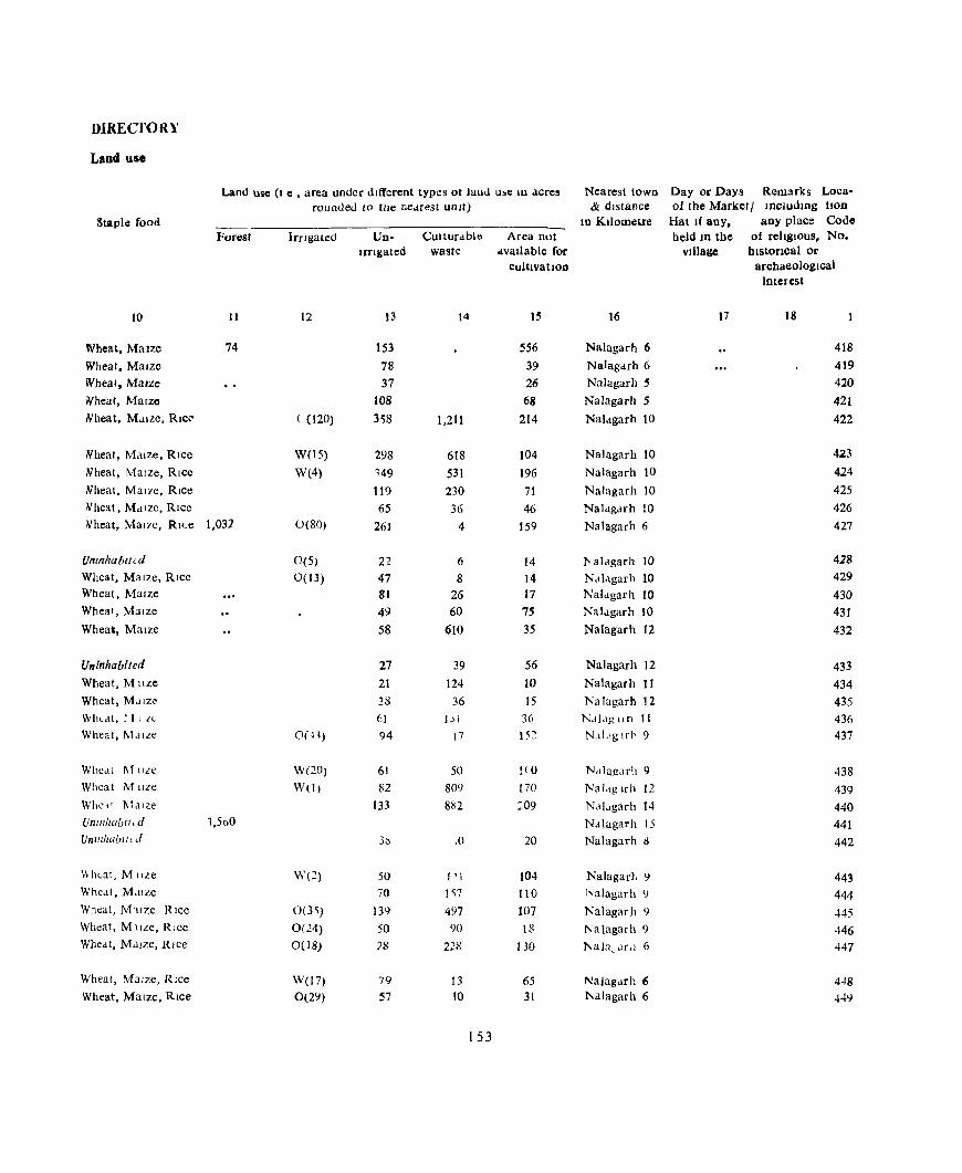
DIREC"TORY
Land us.
Land usc (I C , area under dIfferent types ot laud u~e III acre, Nearest town Day or Days Remarks Loca· rounded to the nedrest unit) & dIstance of the Market I IncludIDg tlOD
Staple food In Kilometre Hat If any. any place Code Forest IrrIgated Un· Culturdble Area Dot held ID the of religIOus, No.
Irflgated waste avallable for village hlstoncal or cultivation archaeological
interest
10 II 12 13 14 15 16 17 18
Wheat, MaIze 74 153 556 Nalagarh 6 418
Wheat, Maize 78 39 Nalagarh 6 419 Wheat, MaIze 37 26 Nalagarh 5 420 Wheat, MaIze 108 68 Nalagarh 5 421 Nheat, Maize, RICe' ( (120) 3'58 1,211 214 Nal<lgarh 10 422
Nheat, Maize, RIce W(IS) 298 618 104 Nalagarh 10 423 Nheat, MaIze, RIce W(4) 149 531 196 Nalagarh 10 424 Nheat, Mal7e, Rice 119 230 71 Nalagarh to 425 Iv'heat, Md lze, Rice 65 36 46 Nal<lgdrh 10 426 "'heat, Ma17e, RILe 1.031 O(80) 261 4 159 NaJagarh 6 427
Umnhahllcd 0{5) 22 6 14 l' aldgarh !O 428 Wheat, Maize, Rice 0(13) 47 8 14 Ndldgarh 10 429 Wheat, Maize 81 26 17 Naldgarh 10 430 Wheat, MaIze 49 60 75 Naldgarh 10 431 Wheai, Maize 58 610 35 Nalagarh 12 432
Uninhabited 27 39 56 Nalagarh 12 433 Wheat, Muze 21 124 10 Nalagarh 11 434 Wheat, Mdlzi' 31) 36 15 Nalagarh 12 435 Wbeat, r [ I zc 61 j j J 36 Ndj,lglln II 436 Wheat, MdlLe O(H) 94 17 15~ Na!.lg Ifl' 9 437
WbCdl 1\11lLC W(20) 61 50 1(0 N,ilug,lrh 9 438 Wheat Mlize W(!) 82 809 170 Naldg lrh 12 439 Whe" I\lalze 133 882 :09 Nd!..garh 14 440 U/l/lr/Wbl (, d 1,500 Nalugarh 15 441 Un lllilabllu{ 3~ ,() 20 Nalagarh !l 442
\\h"at, M tiLe W(2) 50 1'1 104 Nalagarh ') 443 Whe,lt, Maize 70 I ~7 110 halagarh ') 444 Wheat, Mllze RIce 0(3~) 13C} 497 107 Nalagarh 9 ~45 Wheat, M llLC, Rice 0(24) 50 90 18 Nalagarh 9 446 Whe,lt, MaIze, Rlce 0(18) 78 228 130 l'I;a)a, Mil 6 447
Wheat, Maize, RIce W(l7) 79 13 65 Na)agarh 6 4~8
Wheat, Maize. RIce Ol2Y) 57 10 31 l\alagarh 6 449
153

NALAGARH TAHSIL
Loca. Name of vlJlage/Hadbast No
hon Codo No
1
450 Ghogarhwal (124) 451 Than Thewal (125) 452 M"usewal (126) 453 Ranguwal (127)
454 RaJpura (128)
455 Shutt In Wdla (129) 456 Sdlhe<,l,al (130) {57 Sabhowdl (131)
45!! ">on (132)
-l59 Shumtdo (133)
460 Sen (134) 461 Ghansot (135)
462 Chuhuwal (136) 463 Dtttowa] (137)
..J.6~ Rudva}J (138)
465 Rakh Mahantall (140)
466 Rakh Ram Smgh (141)
467 Nlkoowal (142) 468 Karpal Pur (143)
469 Paiasl MhalSI (144)
470 Dadht Harnam (145) 471 Dadht Bhola (146)
472 Dadht K..tDlan (147)
473 Khokhra (148) 474 Khera UperJa (149)
475 Khera Nlhla (150) 476 Nanowal (151) 477 Chak (152) 478 Bell Dldwar (153) 479 Bahman Beh (154)
480 Kashambhowol (155) Kanaltan
VlLLAGh
Amemhes and
Total AmeDitles avaIlable within the village
area of the Educational MedIcal vIllage
(in Acres)
3 4
157 167 158 216 Pr S (I) 372
56 224
71
143
70
140 402 121 293 Pr S (1)
130
294 152
194 215
87
81 Pr S (1) 300
255
463 187
375 963 262 Mid S(l) 141
89
66
154
Power supply
()
E E E E E
E E
E E
E
E E
E
DrmklOg water
W
W W W W
NA W NA. W
W
W
W W W
NA
NA
NA
W W W
W W
W W W
W W
W
W W
W
Communl- Post and cation. felegr.tgh
s
PR PR PR PR PH
KR
KR
KR
PR PR PR KR
PR
KR PR
PR
PR PR
PR
PR PR
PR PR
PR
PR PR
PR
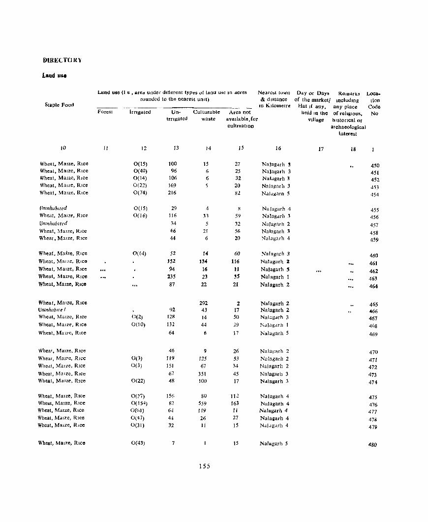
DIRECTOR)'
Laud UIiO
Ltiod uSc (I e , ared under dltierenl types of laml use 111 acres Neare~1 town Day or Days RelU<lrK~ Loca .. rounded to the nearest uUlt) & dIstance of the market/ Including tlon
Staple Food In Kilometre Hat If any, any place Code Forest lrClgaled Un- Culturable Area not held 10 the of relIgIous, No
Irngated waste avallable.for village historical or cultivatIon archaeological
Interest
JO II 12 13 14 15 16 17 18
Wheat, Maize, Rice 0(15) 100 15 27 Na}agMh 3 450 Wheat, Maize, RIce 0(40) 96 6 25 Na}agarh 3 451 Wheat, MaIze, RIce 0(14) 106 6 32 Nalagarh 3 452 Wheat, MaIze, RIce 0(22) 169 ~ 20 Nalagarh 3 453 Wheat, MaIze, Rice 0(74) 216 8l Nalagarh 5 454
l/nlflhublted 0(15) 29 4 R Nalagarh 4 455 Wheat, MaIze, RIce 0(16) 116 31 59 Nalag<lTh 3 456 Untnhablted 34 5 32 Nalagarh 2 457 Wheat, MaIze, RIce 66 21 56 Nalagarh 3 458 Wheat, M:l1ze, Rice 44 6 20 Nalagarh 4 459
Wheat, Maize, Rice 0(14) 52 14 60 Nalagarh 3 460 Wheat, MaIze, RICO 152 13. 116 Nalagarh 2 461 Wheat, MaIze, RIce 94 16 11 Nalagarh ~ 462 Wheat, MaIze, Rice 235 23 3S Nalagarh 1 463 Wheat, Maize, RIce 87 22 21 Nalaaarh 2 464
Wheat, Maize, Rice 292 2 Nalagarh 2 465 Un",hablle I 92 43 17 Nalagarh 2 466 Wheat, MaIze, Rice 0(2) 128 14 50 Nalagarh 3 467 Wheat, MaIze, RICO 0(10) 132 44 29 Nalagarh I 468 Wheat, Mal7e, RIce 64 6 17 Na)agarh 5 469
Wheat, MaIZe, Rice 46 9 26 Nalagarh 2 470 Wheat, Mal7e, Rlcc 0(3) 119 125 53 Nalagarh 2 471 Wheat, Mal7e, Rice 0(3) 151 67 34 Na)agarh 2 472 Wheat, MaIze, Rice 67 351 45 Na)agarh 3 473 Wheat, Maize, Rice 0(22) 48 100 17 Nalagarh 3 474
Wheat, Maize, Rice O(:?'i) 156 80 112 Nalagarh 4 475 Wheat, Maize, Rice O(IH) 87 559 163 NaJagarh 4 476 Wheat, Maize, RIce O(6is') 64 JI9 11 Nalagarh 4 477 Wheat, MaIze, Rice 0(47) 44 26 27 Na)allarh 4 478 Wheat, Maize, Rice 0(31) 32 II 15 Nai.1g,uh 4 479
Wheat, Maize, Rice 0(43) 7 15 Nalagarh 5 480
155
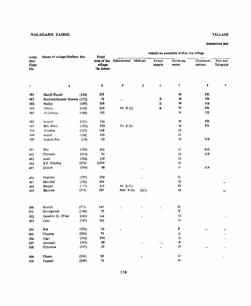
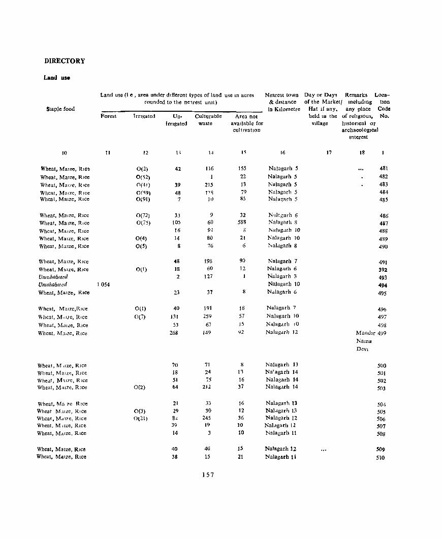
DIRECTORY
Laud use
Land use (I e , area under dIfferent types of land use In acres Nearest town Day or Days Remarks Loca-rounded to the ne1rest umt) & dIstance of the Marketl Includmg tlon
Staple food in Kilometre Hat If any, any place Code Forest IrfIgated Un- Culturable Area not held 10 the of relIgIOus, No.
irngated waste avaIlable for Village historical or cultivatIon archaeological
Interest
10 11 12 n 1.1 15 16 17 18
Wheat, MaIze, RIce 0(2) 42 116 155 Nalagarh 5 481
Wheat, MaIze, RIce 0(52) 22 Nalagarh 5 482 Wheat, Mal7e, RIce 0(41) 39 215 13 NaJagarh 5 483 Wheat, MaIze, RIce O(~9) 48 J1Sl 79 NaJagarh 5 484 Wheat, Maize, Rice 0(91) 7 10 85 NaJa~arh 5 485
Wheat, MaIze, RIce 0(72) 33 9 32 N'lkgarh 6 486 Wheat, Maize, Rice 0(75) 105 60 588 Nalagarh 8 487 Wheat, Maize, RIce 16 9.J S NaJagJrh 10 488
Wheat, MaIze, RIce 0(4) 14 80 21 Nalagarh 10 489 Wheat, Maize, RIce 0(5) 8 76 6 '1'.alagarh 8 490
Wheat, MaIze, RIce 48 198 90 Nalagarh 7 491 Wheat, M'uze, Rice 0(1) 18 60 12 Nalagarh 6 392 Umnhablted 2 127 1 Nalagarh 3 493 UnlflhabIled 1054 NaJagarh 10 494 Wheat, Maize, Rice 23 37 8 Nalagarh 6 495
Wheat, Malze,Rlce 0(1) 40 191 18 Nalagarh 7 496 ""heat, MdlZe, Rice 0(7) 131 259 57 NaJagarh 10 497 Wheat, M,lIze, RIce 53 67 15 NaJagarh 10 498
Wheat, M.llze, Rice 268 149 ')2 NaJagarh 12 Mandlr 499
Nama Devi
Wheat, M dze, RIce 70 71 8 Nalagarh 13 500 Wheat, Maize, Rice 18 24 n Na'agarh 14 501 Wheat, M11ZC, Rice 51 75 16 Nalagarh 14 502 Wheat, Maize, Rice 0(2) 64 212 37 Nalagarh 14 503
Wheat, Ma 7e RIce 21 33 16 Nalagarh II 504 Wheat M.llze, Rice 0(3) 29 30 12 Nalagarh 13 505 Wheat, Maize, RIce 0('21) 8~ 245 36 NaJagarh 12 506 Wheat, M,Ize, Rice 39 19 10 Nalagarh 12 507 Wheat, Mdlze, RIce 14 3 10 Nalagarh II 508
Wheat, Malze, Rice 40 40 15 Nalagarh 12 509 Wheat, Maize, Rice 38 15 21 Nalagarh 11 510
157

NALAGARH TAHSIL
Loca- Name of vlllaae/Hadbast No
tlon Cod. N.
I
51t Jagar (350) 512 Badal (351 ) 513 Khuler Nlchlt (352)
:>I-i Jangal Behal (35 ,)
515 Khuler Uperh (35-1)
51{" JangJ.l ~obal (35) )
517 Balhll (356)
518 Baonta (357)
519 Kocn \358)
520 Dbar Kotla (359)
521 Kusn (360)
522 Jbandlao (361 )
523 Sen (362)
524 S F Sllhnu (363) 525 B.lDsal (36-+)
526 RanguwaJ (365) 527 Tal (366)
523 Jangal Phoolwala (3D7) 529 Lambl Oohu 0(8)
530 1 rIa (69)
531 Banan (rO)
532 Panoh (3/1 )
533 Salehr (372)
534 l\!Jlowa) (373)
535 S F Plahwa1a (374)
536 Kuhwala (175) 53"1 Khua (376)
5'3 Hlll'lran (377) 519 AI!Jv'an (378)
540 I annar (3i9)
541 Baraon Brahmna (380)
542 Mabwa (381)
Total
area of the Educational MedIca) VIllage
(10 Acrel)
3 ..
259 329 161 166 3~2
224 446 227 256 Pr S (I) 175
109
250
198
728 179
96 161 31<) 174
:40
356 Pr S (1) 259 209
147
5-B
2'11 218 394 450
476
203 26'7
lSi
\'ILl,AGE
Amenihe!o and
AmeDities available wlthlD the VIllage
Power IUPP)Y
6
Drlllklog water
7
0 0 F 0 0
P Tk
0 W.O 0
R
W R
NA. 0
0 \V
NA. R 0
W ()
W,O 0
NA
0
0 0 R
0
0 0
Co nlUIJOI· Post 1nd
catlOos Telegraph
8
PR
PR
PR KR 1<-.1<.
KR
PR
KR J....R
KR J....R KR
KR
KR
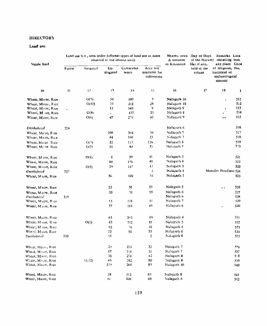
DIREC'TOR\
Land Uge
Land use (1 e • area under different types of land use In acres Nedre~t town Day or Days Remarks Loca rounded [U the Deare~t unit) & distance of the Mdr .. et I Includtng tlOn
'itaple food ID Kllumetre Hat If any, any place Codo
Forest Irrigated Un- Culturable Ared not held Ifi the of religIOus, No. Ifflilated waste available for vllIa&c.' hlstoClcal or
culUvatlOD archaeological Interest
10 II 11 n 14 I) 16 17 18 1
Wheat. M~ Ize. Rice 0(5) 54 193 7 Nalagarb to 511 Wheat, Malzt. Rice 0(10) 73 218 28 Nalagarh 10 512 Wheat, M,llze. Rice 12 140 ~ Nalagarh 9 513 Wheat, M "ze, Rice 0(4) 137 25 Nalagarh 8 514
Wheat. MJlze. RIce 0(6) 47 2"'9 40 NaJa!{:lrh 9 515
Umnhaln/cd 224 Na1agarh (; 516
Wheat, Ma Ize, Pice tOR 3()4 34 Nalagarh 7 517 Wheat, Ma Ize, RI("e 44 HiO 23 N.Jlagarh 7 518
Wheat, Ma Ize Rice 0(') 22 113 116 Nalagarh 8 519 Wheat. M, 'ze Rice 0(3) 16 9:i 5'1 Nalagarh 7 5'0
Wheat, M llze. Rice 0(1) 8 59 41 Nalagarh 5 521 Whe,ll, Mdlze, Rice 44 1'& 4~ Ndlagarh 4 522
Wheat, M oze, Rice 0(5) 29 147 17 N.llagarh 3 523
Unmhablted 727 ~alagarh 1 MaOlder PeraDevl 524
Wheat, M cllze, Rtce 36 109 34 Na\agarh 5 525
Wheat, M'llZe, Rice 22 51 23 NaJagarh 5 526
Wheat, Mal7e, Rice 30 76 55 Nalagarh 6 527 fJnlllhablfed 319 Nalag,uh 6 52R Whea t, M !l7e. Pice 15 124 3, Nalagarh 7 529
Wheat, M IIZC, Rice 77 114 49 Nalagarh 6 530
Wheat, Maize, Rice 65 2112 8') Nalagarh 4 531 Wheat, M Ilze, Rice 0(1) 65 112 81 Nalag1rh 2 532 Whea', M Ilze, Rice 92 76 41 Nalagarh 4 533 Whe It, Mllze, Rice ::'2 90 35 Nalagarh 6 534 Vnllllwbtll!(l 530 II 2 l'<aldgarh 6 535
Wht-at, MaliC, Rice 20 223 32 Nalagarh 7 516 WheJt, M llle, Rice 67 116 35 Nalagarh 7 537 Wheat, Mlt!(" Rice 36 276 &2 Nalagarh 8 5,8 Wheat, Mllze, Rlee 0(12) t>6 282 90 Nalagarh 9 539 Wheat, Malle. Rice 11:> 264 93 Nalagarh 10 540
Wheat, Maize, Rice 28 112 63 :f\Ialagarh 8 541 Wheat, Maize, Rice 61 146 60 Nalagarh 6 542
159

NALAGARH TAHSlL
Loca. Name of vlIIage/Hadbast No.
tion Code No
2
543 Baraon Kanaftan (382) 544 Kotha Kanaon (383)
545 Goela (384)
546 Jaran (385) 547 Sern (386)
548 Berta (187)
549 Bukhan Da Ghat (388) 550 Chlkm (389) 551 Jabal Taprlan (390)
552 Bwasnl (391)
553 Gharmandal Kalan (392) 554 Gharmandal Khurd (393)
555 Khah (394) 556 Sunan! (395) 557 Amru (.96)
558 Banehra (397) 559 Jaman Dohra (398) 560 Kolka (399) 561 Danoda Ghat (100) 562 RalpuT (401)
563 MaJru (402) 564 Baruwala (403)
565 MaJru R F. (40-1)
566 S F Sidu Ch..Jlyaunl (405) 567 Keha (40(J)
568 Dabra (407)
569 Saen (408) 570 Tali (409)
57l Patta (410)
572 Dhaul Ghat (411)
573 Simll (412) 573 Kharlana (413)
VilLAGE
Amenities aDd
Total Amenities avaIlable WlthIU the village
area of the Educational Medical Power supply
DnnklOg water
Com'11unJ- Post and village catIOns Telegragh
(In Acre.)
3 4 .5 6 7 II
296 R 190 rr S(I) 0 PO 766 W 247 0 161 R
93 0 159 Pr S(I) D(I) 0 KR 310 R 321 R 521 Pr S(I) 0
112 0 56 0
132 0 240 0 21a 0
331 0 75 0
348 0 81 0
128 0
84 0 23 0
1,403 N.A. 178 NA 102 0
113 0 263 MId S (1) He (1) 0 PO 236 0
412 0 88 0
123 0 625 0
160

DIRECTORY
Land use
Land use (I e , area under different types of land use tn acres Nearest town Day or Days Remarks Loca-rounded to the neare~t UnIt) & dIstance of the Marketl Includmg tlon
Staple food In KIlometre Hat If any. any place Code Forest Irngated Un- Culturable Area not held 10 the of rehglOus, No.
Irrigated waste avaIlable for village blstoncal or cultivation archaeological
Interest
10 II 12 13 14 15 16 17 18
Wheat, MaIze, RIce 10 221 65 Nalagarh 7 543 Wheat, MaIze, RIce 38 133 19 Naiagarh 7 544 Wheat, MaIze, RICe 129 388 249 Nalaagrh 9 545 Wheat, MaIze, RIce 0(4) 72 152 19 NaJagarh to 546 Wheat, MaIze, Rice 43 60 58 Nalagarh 11 547
Wheat, Maize, RICe 40 45 8 Nalagarh to 548 Wheat, MaIze, Rlee 20 12-i- 15 Nelagarh 10 549 Wheat, Mal7e, RIce 0(17) 67 136 90 Nalagarh II 550 Wheat, MaIze, RIce 83 H9 69 Nalagarh 12 551 Wheat, ' alze, RIce 0(6) 112 392 11 Nalagarh 10 552
Wheat, M:llze, RIce 0(1) 26 80 5 NaJagarh II 553 Wheat, Mal7e, RIce 20 32 4 Nalagarh 12 554 Wheat, MaIze, RIce 0(5) 46 63 18 Nalagarh 13 555 Wheat, MaIze, RIce 0(14) 72 140 14 Nalagarh 14 556 Wheat. MaIZe, RIce 68 139 11 Nalagarh 11 557
Wheat, MaIze, RIce 66 244 21 NaJagarh 15 558 Wheat, Maize, RIce 17 ~l) 8 Nalagarh 9 559 Wheat, MaIze, RIce 28 315 5 Nalagarh 9 560 Wheat, MaIze, Rice 0(1) 7 h3 10 Nalagarh 11 561 Wheat, MaIze, RIce 13 107 8 Nalagarh 10 562
Wheat, Mal7e, RIce 16 66 2 NaJagarh 1 I 563 Wheat, Malle, RIce 9 12 2 Nalagarh 12 564 rJmnhablfed 1304 28 19 8 Nalagarh 16 565 Umnhablted 112 64 2 Nalagarh 13 566 Wheat, MaIze, RIce 57 38 7 Nald arh 14 567
Wheat, Mal7e Rice 30 76 7 Nalagarh 15 568 Wheat, Maize, RIce 41 219 3 Nalagarh 16 569 Wheat, MaIze, RIce 90 80 66 NaJagarh 30 570
Wheat, Maize, Rice 88 284 40 Nalagarh 18 571
Wheat, MaIze, RIce 0(7) 24 42 4S NaJagarh 17 572
Wheat, Mane, RIce 0(3) B 77 30 Nalagarh IS 573 Whea t, MaIze, RIce 0(20) 49 418 138 Nalagarh 13 574
It)
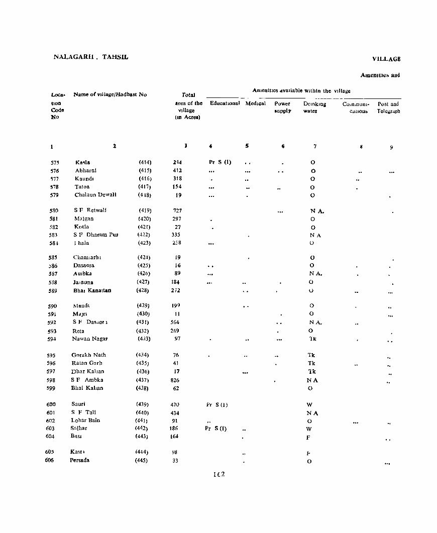
NALAGARH. TA!iSlL
Loca. Name of vJlJage/Hadbast No
lion Code No
1 2
57j Ka,la (414)
576 Abharni (415) <;77 Kaundl (416)
578 Tatoa (417)
579 Chalaun Dewall (418)
580 SF Retwali (419) 581 Malgan (420) 582 Kotla (421) 583 S F Dharam Pur (422)
S8l 1 hala (423)
585 Chamlarhl (424)
:>86 Dasaora (425) 587 Ambkd (420)
588 Ja>auna (427)
!l89 Bhal Kanaltan (428)
590 Mandl (429)
591 M.lJrl (430)
592 SF Dasdorl (431)
593 Reta (432) 594 Nawan Nagar (433)
S9S Gorakh Natb (434)
596 Ratan Garb (435)
597 Dhar Kahan (436)
598 SF Ambka (437)
599 Bhal Kahan (438)
600 Saurl (439) 601 S F Tall (440) 602 Lohar BalD (441)
603 Salhar (442)
604 BaSI (443)
60S Kastl (444)
6'06 Persada (44S)
ViLLAGE
AmCDJUC.!> and
Total Amenities 4vallable within the village
area of the EducatIOnal Medical Village
llO Acres)
J • 5
214 Pr S (1)
412 318 154
19
727 297 27
335 258
19
16 89
184 272
191)
11
564
269 97
76
41
17
826
62
470 Pr S (l}
434 91
186 Pr S (1) 164
\18
33
H2
Power lupply
.,
Dnnkmg water
7
0
0
0
0 0
N A.
0
0 NA 0
0 0 NA.
0
I..)
0
0
NA.
0
Tk
Tk Tk
Tk NA 0
W
NA
0
W
F
.f<
0
Co,n,uuOl- Post and C.lllonl> Telegraph
9
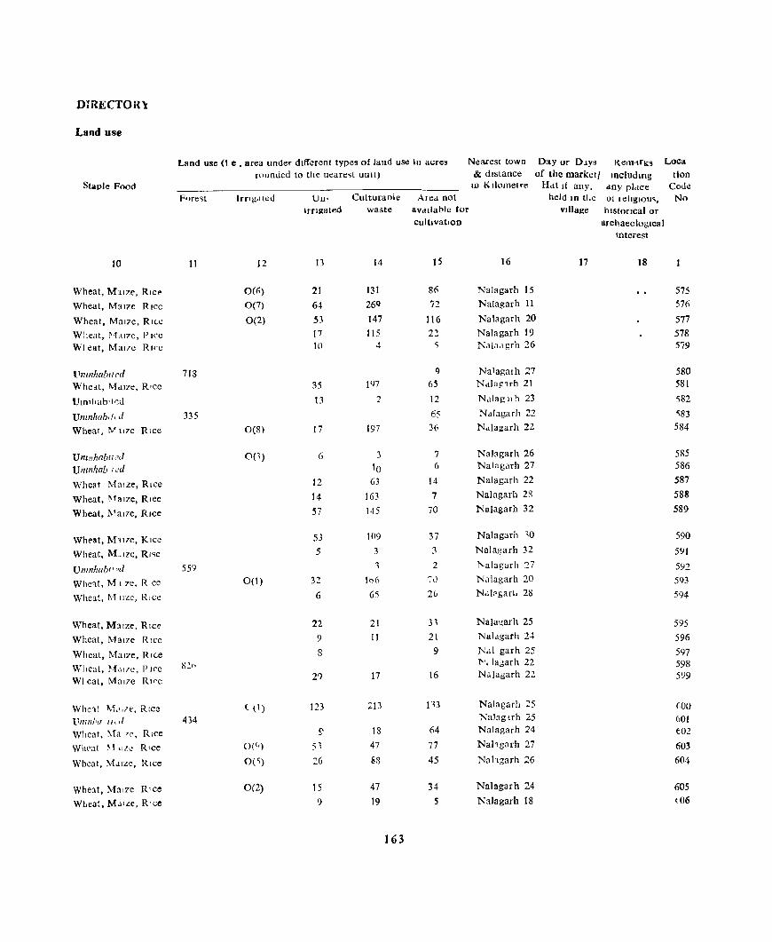
DIRECTOR}:
Land use
Land use (I e • area under different types of land use In acres Nearest town Day or D1YS l{enHrK~ Loca
rounded to the neare~t unit) & distance of the market! meludmg tlon Staple Food IV Kilometre Hat If any. any pl,lce Code
F()re~t Irngaled Uu- Culturaole Alea not held III tl.e 01 lellglou~. No I[flllated waste aVdllable tor Village historical or
cultIVatIOn archaeological Interest
10 II 12 13 14 15 16 17 18
Wheat, M:J.lze. Rice 0(6) 21 131 86 Nalagarh 15 575
Wheat, Maize Rice 0(7) 64 26Q 72 Nalagarh 11 576
Wheat, Mal?e. RI(,e 0(2) 53 147 116 Nalagarh 20 577
Wheat, ~;f"17e, PICC 17 lIS 2:! Nalagarh 19 578 WI eat, Mal7c RI<'c 10 4 ~ Naiadgrh 26 579
l1mnhabt t ('d 718 q Na1agmh 27 580 Wheat, Mdlze, RlCC 35 1<)7 6S Nalag1rh 21 581
Uln,hab,tcu 13 2 12 N,dagllh 23 582
Untnhab,f,d 335 65 Nalagarh :!2 'i83
Wheat. ]''.1' llze Rice 0(8) 17 197 36 N,t1agarh 22 584
Umnhablt,?d 0(1) 6 3 7 Nalagarh 26 585
Uncnlzab ted 10 6 Nalagarh 27 586
Wheat Maize, Rice 12 63 14 Nalagarh 22 587
Wheat, r-~alze, Rlee 14 163 7 Nalagarh 28 588
Wheat, ]\'alze. Rice 57 145 70 Nalagarh 32 589
Wh('at, MllTC, KICC 53 109 37 Nalagarh -'0 590
Wheat, M_lIze. RI<;e 5 3 3 Nalagarh 32 591
Untnhabll?d 559 '1 2 l'alagarh '27 5<)2
Whe'lt, Ml 7C, R ce 0(1) 32 106 '70 Nalagarh 20 593
Wheat, 1\1 IIZC, Rice 6 65 20 Ndl?gart. 28 594
Wheat, M:J.lze, Rice 22 21 3, Nalagarh 25 595
Wheat, Maize Rice 9 11 21 Nalagarb 2.+ 596
Wheat, Mal?e, R,(,e 8 9 N.d garh 25 597
Wheat, ~;f"17e, PICC 8211 't'" lagarh 22 598
WI eat, Mal7c RI<'e 2') 17 16 N.1Jagarh 22 599
Whc1t I\r,l,le, RIce ( 1. 1) 123 :;:13 I'H Nalagarh 25 GOO
UIlIIl!'" 1/, d 434 Nal3guh 25 601
Wheat, Ma 'f', Rice ~ 18 64 Nalagarh 24 tJ02
Whl'at l\111LI.! Rice 0(') 53 47 77 Nahgarh 27 603
Wheat, M.1lze, Rice 0(") 26 88 45 Nah6arh 26 604
Wheat, Maize R'ce 0(2) 15 47 34 Nalagarh 24 605
Wheal, MJ.lze, R 'ce 9 19 5 Nalagarh 18 (06
163

NALAGARH TAHSIL
Loea. Name of village/Hadbast No
lion Code No
2
607 Tatar Basi (446) 608 Nah (447) 609 Talar Wahad (448) 610 Klararoo (449)
611 B.sIan Brahmna (450)
612 Dhar Da Ghat (451) 613 KhakhanaOl (452) 614 Jangal Bhalawa (..f53)
615 KI~an Pura (163)
616 Manpura (164)
617 Theda ({65) 618 Rautanwata (166)
619 Bersan (167) 620 Ralpur Jakhauli (168) 621 MaJroo (169)
622 Nand Pur (170) 6:!3 Shah Pur (171)
624 JatJ M3]ra (172)
625 Lodl MaJra (173)
626 Banblrpur (174)
627 Doduwal (175) 628 Mankpur (176) 629 Chanal MaJra (177)
630 Dhera (178) 631 DabOl (179)
632 Kaundl (180) 633 Akanwall (181)
VILLAGE
AmeDlties aod
AmeDltles avallabJe wlthID the vJ))age Total
area of the Educational Medical Power supply
DrlOkmg water
Communl- Post and village cdtlOns Telegragh
(In Acres)
3 4 5 7
136 0 43 0
145 0 118 0
221 0
125 0 130 0
1,136 NA_ 1635 Pr S (1) W PR
605 See S (1) HC(l) W PR PO
269 W PR 449 W PR 341 W,F PR 340 W.P PR 29 W PR
200 Pr S (1) W PR 129 \V PR
76 W PR 248 Pr S (1) W PR
340 W PR
243 W 177 W PR ; 38 W PR
327 Pr S (1) W PR 325 NA.
593 Pr S (I) W 261 W PR
164
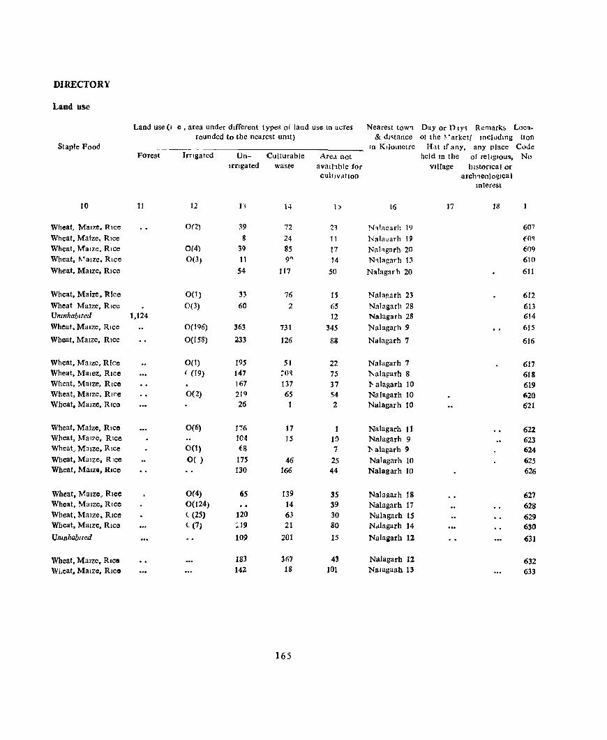
DIRECTORY
Land use
Land use (I e, area under different types of land use 10 acres Nearest toW'l Day or DtY~ Remark~ Loca. rounded to the nearest UOlt) & dl~tance 01 the Varkell mcludlOg t10n
Staple Food ----- - In Kilometre Hat If any, any place Code Forest Irngated Un- CuIturable Area not held ID the of religIOUS, No
Irrigated waste avalhble for Village 11lstoflcal or cultIvation arch1eologlcal
Interest
10 11 12 11 14 D 16 17 18
Wheat, Maize, RIce 0(2) 39 72 21 N1.1!l!!arh 19 607 Wheat, Maize, RIce 8 24 11 Nal~~arh 19 fO~
Wheat, Maize, Rice 0(4) 3Q 85 17 Nahgarh 20 6()9 Wheat, l\'alze, Rice 0(3) 11 9" 14 N1.1agarh 13 610 Wheat, Maize, Rice 54 117 50 Nalagarh 20 611
Wheat, Maize, Rice 0(1) ~3 76 IS Nalagarh 23 612 Wheat MaIZe, Rice 0(3) 60 2 65 Nalagarh 28 613 Unmhablted 1,124 12 Nalagarh 28 614 Wheat, MaIZe, Rice 0(196) 363 731 345 Nalagarh 9 615 Wheat, Maize, Rice 0(158) 233 126 88 Nalagarh 7 616
Wheat, MaIze, Rice 0(1) 195 51 22 Nalagarh 7 617 Wheat, Malez, Rice ( (19) 147 ~O~ 75 l\alagarh 8 618 Wheat, Maize, Rice 167 137 37 'I' alagarh 10 619 Wheat, Maize, Rice 0(2) 219 65 54 Nalagarh 10 620 Wheat. Maize, RIce 26 1 2 Nalagarh 10 621
Wheat, Maize, RICO 0(6) 176 17 Nalagarh 11 622 Wheat, MaIze, Rice 104 15 10 Nalagarh 9 623 Wheat, MaIZe, RIce 0(1) f8 7 1- alagarh 9 624 Wheat, MaIze, RICO O( ) 175 46 25 Nalagarh 10 625 Wheat, Maize, Rice 130 166 44 Nalagarh 10 626
Wheat, Maize, Rlee 0(4) 65 139 35 Nalal!arh 18 627 Wheat, Maize, Rice 0(124) 14 39 Nalagarh 17 628 Wheat, Maize, Rlcc ( (25) 120 63 30 Nalagarh 15 629 Wheat, Maize, Rice ((7) ;;'19 21 80 Ndlagarh 14 630 Umnhablll!d 109 201 15 Nalaaarh 12 631
Wheat, Maize, RICO 183 367 43 Nalagarh 12 632 W!.eat. Maize, RICO 142 18 101 Nalagaah 13 633
165

NALAGARH I'AHSIL
Loca- N Ime 01 vllldgt"IILldba" "10
tlon Code No
2
63's HaTJ Ral I'dl (l ~ ~)
636 Malku MaJra ( 184) 637 Daso MaJTa ( 185) 638 Kho) (186)
639 SF Khol (187)
640 Bhud ( 188) 641 Malpur (189)
642 Makruda Ma)ca (190)
643 Ka11 Malra (191 )
644 fh.ma (192)
645 D JaraID Pur (I9~)
646 Gularwala ( 194) 647 Ldll (195) 648 ell I!. (196)
649 I<...aruw,m \ ( 197) 650 BJlanwall Gnr.lll (198) ()~I Srtndholl (19"> 052 K.lhlduwal (20U; 6<'3 Kalianpur (2UI)
654 LanJev,dl (202)
655 Lhak).lngl l203,
656 IlddJl '>11<llpur (21)4;
657 ~urdJ Md)r.; (205) 658 H.mpur '>and.lh (206)
659 Bllanwall Ldbdnd (207, 660 ~Urd) MaJra Gu)ran (208) 661 Judi Khurd (209) 662 Judi Kalan (210) 6b3 Katha (211)
664 Dhakru MdJra (2IZ}
665 Batauh Khurd (213)
VILLAGE
AmemtJe!o and
AmeDltles available wlthm the village 10tdl --------------------- ------
area of the Educational Medical village
im Acres)
, )
20X D(l) 789 218
660 Pr S (1/
2,270 W9 Pr S(I) 640 Pr S (1)
306 Pr S (I)
131
1,167 Pr ~ (I)
'~l< Pr S (I) HQ Mid S (I) 141 152
239 '::10
21" 290 427
91
51
725 MId S (I) D(Jj
237 214
172 Pr S (l) 165 105 225 565
138 2118
166
Power supply
0
E
E E
E
I:<.
E
E
E
E
E
I::
DrInktng water
7
w 0
0
W
NA W.O W W W
W
WO
W W
W
W
W \\
R.W
R
W
NA W
W W
\\
W
W
W W
W F
Communi- Post and cations Telegraph
8
PR PR PR PR
PR
PR PR KR
PR KR KR KR
KR
RR PR
PR
PR
PR
PR PI{
PR PR
PR PR
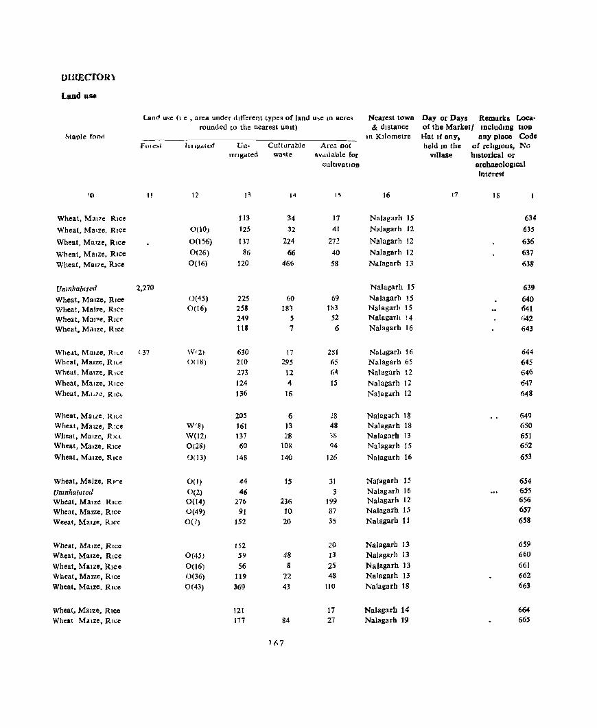
DlllECfOR \:
Land use
Land u~e (I e , area under different types of land u,e ID acres Nearest town Day or Days R.emarks Loca· rounded to the nearest unit) & distance of the Market I IDCludlDg hOD
~taple fooo In Kilometre Hat If any. aD)' place Code FOlt~bt hll!/,,,(ed Un- Culturable Arca oot held 10 the of religious, No
IrrIgated wa~te aVdllable for Village historical or cultivation archaeological
IQter~t
10 " 12 13 14 I~ 16 17 18
Wheat, Mal7e RIce 113 34 17 Nalagarh 15 634
Wheat, Maize, RIce 0(10) 125 32 41 NaJagarh 12 635
Wheat, Maize, RIce 0(156) 137 224 272 Naiagarh 12 636
Wheat, MaIze, RIce 0(26) 86 66 40 Nalagarh 12 637
Wheat, Mal7e, RIce 0(16) 120 466 58 Nalagarh 13 638
Unmhablted 2.270 Nalagarh 15 639
Wheat, MaIze, Rice 0(45) 225 60 69 Nalaiarh 15 640 Wheat, Mal7e, RIce 0(16) 25S 181 lx3 Nalagarh 15 641 Wheat, MaJ7e, Rice 249 5 52 Nalagarh 14 642 Wheat, MaIze, RIce 118 7 6 Nalagarh 16 643
Wheat, MaiLe, RII.e 07 W1 2) 630 17 2S1 Naidgarh 16 644 Wheat, Maize, RII.e O( IS) 210 295 65 Nalagarh 65 645 Wheat, Maize, Rice 273 12 64 Nalagarh 12 646 Wheat, Maize, Rice 124 4 15 Nalagarh 12 647 Wheat. Md.7e, Rlc~ 136 16 Nalagarh 12 648
Wheat. Malle, RKe 205 6 ~8 Nalagarh 18 649 Wheat. MaIze, Rice W(B) 161 13 48 Nalagarh 18 650 Wheat, Maize, R1L~ W(12) 137 28 ,S Nalagarh 13 651 Wheat, MaIze, RIce 0(28) 60 108 Q4 Nalagarb IS 652
Wheat, MaIze, RIce 0(13) 148 140 126 Nalagarh 16 653
Wheat, Maize, Rlre 00) 44 IS 31 Nalagarh 1.5 654 UnInhabIted 0(2) 46 3 Nalagarh 16 655 Wheat, MaIze RIce 0(14) 276 236 199 Na1agarh 12 656
Wheat, MaIZe, RIce 0(49) 91 10 87 Nalagarh 15 657
Weeat. MaIze, RIce 0(7) 152 20 35 Nalagarh 11 658
Wheat, MaIze. RIce 152 20 Nalagarb 13 659 Wheat, MaIze, Rice 0(45) 59 48 13 Nalagarh 13 660
Wheat, MaIze, RIce 0(16) 56 8 25 Nalagarh 13 661 Wheat, MaIze, Rice 0(36) 119 22 48 Na1agarh 13 662 Wheat, MaIze, RIce 0(43) 369 43 110 Nalagarh 18 663
Wheat, MaIze, RIce 121 17 Nalagarh 14 664 Wheat MaIze, RIce 177 84 27 Nalagarh 19 665
1~7

NALAGARH; TAHSIL
Loca
tion Code No
666 667 668
Name of vIllage/Hadbast No
Bataull Kalan Jhar MaJrl KunJahal
2
(214) (215) (216)
VILLAGE
AmenitIes aDd
Total Amenities available WlthlO the Village
area of the Educattonal Medical Village
(10 Acres)
1,672 521 495
4
Pr S(I) Pr S(1)
1(;8
5
Power supply
6
DnnklOg ',vater
?
w w w
Communt- Post and catIons Telegraph
8 9

DIRECIOR'i
Land use
Land use (I e • area under different types of land u,e In .icre, Nearest town Day or Days Remarks Loca. rounded to the nearest UDIt) & distance of the Marketl IOcludlOg non
Staple Food m Kilometre Hat lfany, any place Code ~ ores! Irngated Un- Cuiturable Area not held 10 the of religious, No
Irngated waste available for village historIcal or cultivatIOn archaeological
interest
10 II 12 13 14 15 16 17 18 1
Wheat, Maize, Rice 0(212) 609 555 296 Natagarh 19 666 Wheat, Maize, Rice 267 179 82 Nalagarh 15 667 Wheat, Maize, Rice 321 100 74 Nalagarb 17 668
16'

Sl No
3
Name of Tahsil I Sub-TahsIl
2
SImla
Kandaghal
Nalagalil
Iotal
3
20
89
81
190
Primary School
on ... o .c (.) til ;>0, ... '" e I:
c.. ._ o .. " .0 8 ::0
Z
20
MIddle School
<r
'" co ell -",
-='0 >0 '-.c o u ... tIl
"'''' .0-8"0 ::02
Z:::8
.5
3
'o .... " .0 8 ::I Z
6
3
.. 9 14 14
81 11 11
190 28 28
Edu(..ahonai
HIgh "r HIgher Secondary School
7 8
4 4
7 7
.5
16 16
College
9 10
Others
A P PEN
Tahsl/JS~b-rahsl/Wlse Abstract of EducatIOnal,
----------
Dlspen- HOllpltal sary
MedIcal
Maternrty ChIld
Welfare Centre
Health Centre
"Ja! ure of
FamIly Planmug Centre
---- ---- ---- -_----- ----
11
v c :2
~ .. S '0 ... OJ .0
E ::I Z
t 2
170
3
1.5
13
31
-o ... OJ .c E p
Z
14
13
31
Vl
'" "" .!!! ;;: ... o .. ~c; .0'= E~ ::10 Z::I:
1 ~
8
9
'0 ... OJ
.0
E ::I Z
16
8
9
17 18
2 2
2
19
3
3
6
-o .... OJ .0 8 ::0 Z
20 21
3
3
22
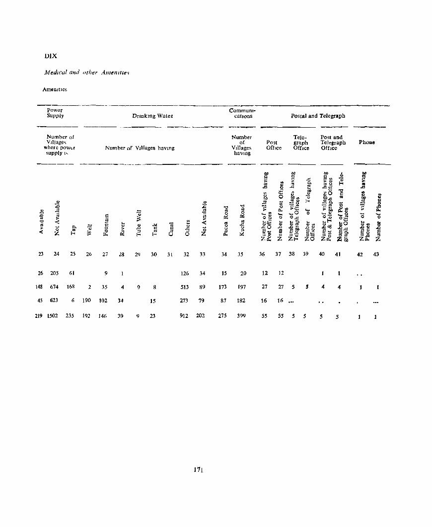
J)lX
MedIcal and other Amefllll~~
Ameoltles
----------_--Power CommuDI-Supply Dnnkmg Water catIOns Postal and Telegraph
.. _-------- ---Number of Number Tele- Post and VJllage~ of Post graph Telegraph PhoDe
where pow"r Number of VJllages bavlDg VJllages OffIce OffIce Office supply" havlDg
------ ------_------------------- -----(>{J b/) bb , till Q C 9", 0 Q :;: ;;: ..c: >0 "0 ;; '" '" ~ 0. 0:10 !-o ... .c 8 .c 0:1 ..c:..;::; ,.Q ....
;£ ." OIl .... '" '" 0 i10 Q .. 0 0 0
V <9 0 '" M co", co..:: 110 w ~ 0 ~ .... 0:10 !-o ~o. .!!! c
-0 .... 0 :c rn -<II '" .c '" '" :;: 0 ~tE ~ .... 0", ;;: .c
CI) .$ .:2 0:1 0:1 c.. .... >00 c..o c.. Z @ .,
@ 0 0 ..... '" .... .... 0 0 .... 0 .... 0 .... ..... Q
~ ~ ~ o~ 0 O..c: 0'0;' 0;3 0 0 '" > ;; ... < '" < 0:1 .. ~ .... ... 0. ... ..!-o ... ; Q ..
~ -;;; .. 0:1 .c 0 .... 0 00:1 .,'" ~o'I:! "'0 011> t 0 0 Q) u 2..c: ;;- -0 0. Qj ;:l > .c Q c .c "0 0 0 .cO .c .c" .co .co .c m ;:l s .... a sa'P s~ s .... sQ « z !-o ~ 0 PZ ::I <II 0:1 0 Z
::I ::.:: So. S ~ !-o !-o U c.. ::I'" ::I ::l- ::I%::: P'" P<II po
;:l
z~ z z~ zo z~ 2i~ ZS: Z
23 24 25 26 27 28 29 30 31 32 33 34 35 36 37 38 39 40 41 42 43
26 205 61 9 126 34 15 20 12 12 1
148 674 168 2 35 4 9 8 513 89 173 197 27 27 5 5 4 4 1
45 623 6 190 102 34 IS 273 79 87 182 16 16
219 1502 235 192 146 39 9 23 912 202 275 399 55 55 5 5 5 5
171

PART X-B
VILLAGE AND TOWNWISB PRIMARY CENSUS
ABSTRACT


EXPLANATOR Y NOTE-PRIMARY CENSUS ABSTRAC1
1. Introductory
B.:l~IC dnu Important statl~ttcs revealed by 1971 Census III respect of Pnmary Crnsu" Umts Ie. Village In rurdl aredS dnd Enumerdt )r'1. 1J1ock 10 urO.:ln area~ have been presented unaer 3;-; columns ot Pnmary Census Abstract
2 Area Figures
Pnmary Censu!o AbstraGt cOlltams the lO.:nlltl~d
tlOn particulars 01 lhe V lllage~/ Enumeratol's Block and the rt~pedive area fIgures of each UUlt The ar~a fIgures In case of cen 'us vllLlges Me based on the revenue vlliage papers as maintaIned In the respective
Tahsil/Sub-Tahsil offices, and were collected alllng'Vlt I
the non-census d.:lLl [l rLllnmg to the Vlllige Dm:ctory The latest available flgure~ were taken Into account fhe total of the~e area figures of the tahsil, do not tally with the ta'1S11-wI~e and dlstnct-wlsC figure,>. becau~e the forln~r represent land use area and do not ne.::essanly I.lcluda wlnt IS c'liled as tile "non-reportmg area" Further the figures given 111
case of dlstnct represent the ge )graphlcal area figures iupphed by the Surveyor General, India The tal-jstlWise total area figures have been sUD;:>lted by the Director of L'l.ud Records, Himachal Pradesh, wherea~ the area flgur~s for towns have b~en furmshed by th6 respective Local Bo:iles In case of DI5tncts dnd TahsIls/Sub-Tahslls, area fIgures for rural areas are derived by subtractIng the urban area from the total area
3 Occupied Census House:; and Housellolds : The next Item of mtormatlOu pertaills to the
numher of Oc,cupted Re"ldentlal Hou~es, a nj the number of Households In Village! Enumerator'~ Block It may be relev.l1)t to glV,! here the dehl1ltlOns of the terms 'House' and 'Household' as adopted In Cen~us
(z) Censuy Hou~e A Cemus House IS a bUIldIng or d part of a bUildIng inhabited or vae,wI dnd havlllg a '>eparate malO entrance from the road or common courtyard or staIrcase etc, u~ed or recogm.,ed a'> a separate Ullit
It may be used for rc!.dentldl or non-r(..~.
dentlal purpose or both. If a b,llldmg hds <l
number of flats or blocks which are lUdependent of one another havlOg <;eparate entrance~ of theIr own from the lOad or -t (uml11on
staircase or a c,)mmon courtyard leadmg to a mam gate, they are conSidered a<; separate
HOllse If withIn a large enclosed area there are ~epdfdte bllldlllgs, then each <;uch bUlldmg I'> abo conSidered as a separate House If all the ~tructures wlthm an enclosed compound are together treated as one bUIldIng then each structure with a <;eoarate entranc> IS treated a<; sep lote Censu~ Hou,>e
(11) C'emlll HO'/sellOld A Household 15 a group of persons who commonly live together and would ta'(e their mea!" from a common kltC'len unle,~ eXlgenclc ~ of work prevented
any of them from dOlOg so A Household may be made up of related or unrelated person<;
4 Scheduled Ca .. tes and "iehcduled Tribe"
Pnrnary CenSlls Ab~trdct I~, agaw, perhdP~ the only source ~)f Inf,)rm ItlOn on Scheduled Ca<;te dnd Scll"duled Tnbe COmpL)nent~ of the vlllage-wlscj'JlockwIse populatIon The Caste<; and Trtbes lIsted as Sclle illld Ca<;te"/Tnbe" In HImachal Pradesh under the Gov. mment of India, MlUlstry of Home AffaIrs. Scheduled Castes and Scheduled Tnbes lIst Modtficahon Order, [956, constitute the Scheduled populatIOn 10 Cenms It may be of Interest to note here that, mtact, two different l1>ts w~re utlltsed in the different areas of Himachal Pi adesh Such a course was necessItated 10 view of th;) merger of certain areas from the erstwhile State of Punjab 10 Himachal Pradli!sh on 1st November, 1 ')66 when the three State!> of Punjab, Haryand dnd Himachal Pradesh were recogOlsed The lists penamlng to Punjab wert" utilised 10 the newly merged ar~as whereas the lists pertalOlOg to Himachal Pradesh were utllll:ed tn the old areas of the State These lIsts are gIven hereunder
LIST-J
LI~t ot Sch .. duled Caste~ and Scheduled Tnbes for the Dl~tn....ts of (1) Ch.lmba (excluding the towns of DalhOUSIe, M l , Dalhou~Ie C Band Bakloh C B (2) Marldl (3) BIl.lsp..!f (4) !\laha!>u (5) Sirmaur and (6) Ktnnaur
1 7 ~

~c HEDVLbD CA~I t~ 1 Ad-dharml .2 Badhl or Nagalu 3 Bandhela 4 Balmlkl, Chura or Bhangl 5 Bllngah 6 Banjara 7 Bansi 8 Barad 9 Barar 10. Batwal 11. Bawaria 12 B.lzIgar 13 BhaoJra 14 Chamar, Mochl, Ramdasl or Ramdalla 15 Chana} 16 Chhlmbe 17 Chuhre (8 DagJ
19 Daok 20 Daralor Daryal
21 Oauk
22 Ohakl or Toon
n Dhaogn or Dhual
24 Doom or Doomnd
2S Dumne 26 Halt. 27 Hesl
28 JogJ 29 Julahe 30 KablCpanthl, Julaha or Keer.
31 Kamoh or DagoJi
32 Karoaek.
33 Khatlk 34 Koh
3.5 Lohar 36, Mazhabl 37 Megb 38. Nat ,9 Od 40 Pa'l 41 Phrera 42. Rehar 43 Rehara 44 Sans). 45 Sapela ,(6. Sarde, Saran or Slr)are 47 Sarehde. 48 Slkhgar
49. SIP' 50 SlTklband 51 Tell 52 Thathlar or Thathera
SCHEDULED TRIBES I Gaddl 2 GUJjar 3 Jad, Lamba, Khampa and Bhot or Bodh 4 Kan..Jufd or Kwnara 5 Ldhauld 6 Pangwala
LIST II
LIst of Scheduled Castes for the Dlstncts of (I) Kangra (2) Kulu (3) Lahul & SpItI and (4) SImla and (5) Towns ot DalhouSIe (M C), and Bdkloh (C B) of Cham ba DistrIct
176
I Ad-dnarml 2 Balmlkl, Chura or Bhangl
Bangalt 3 4 5 6 7 8 9.
10. II 12 13 14 15 16
17. IS 19. 20 21. 22 23 24 25 26. 27. 28. 29 30. 31. 32
Rlfdf, BUfdf or Berdr B..ltwal B,lUrla of BdWBfJ.l Bdzl~ar
BhallJTd Chamar, Jatla Chamar. Rehgar, Ralgarh, Ramdas} or Ravlda,1 Chana) Oagl Ohanak Oumna. Mahasha or Doom. Gagra Gandhlla or Gandll Gondola Kablrpantht or Julaha Khatlk KOrl of Koh MdCIJ" or Marecha Mazhabl Megb Nat Od Past Perna Pherera Sanha} Sanhal Sansl. Bhedkut, or Manesh Sapela Sarera. Slkllgarh
33. Slrklband. 31. Darain. 35, Dhogrt, Dhangri, or Siggi, and. 35 Sanso)
List of Scheduled Tribes for Lahul and Spltl Dlstnct only
1. Bhot or Bodh 2. Gaddl, and 3 Swangla.
NOle ,-There are no Scheduled Tnbes In Kangra DistrIct, Kulu Dlstnct. SImla Dlstnct and Towns of Dalhousie M C. Da.lhousle C B of Chamba DIstrIct.
5 Literate and Educated Persons. A person who can both read and wnte with under
standmg In any language IS considered as literate A person who can merely read but cannot not, wnte IS not taken as hterat~. It IS not, however. necessary that a person who 18 literate should have had received any formal educatlon or should have had passed any mInImum educatIOnal standard 6 Workers
In 1971 Census a person w hose maIO activity IS
partiCIpatIOn 10 any economlldIly product! ve work by hiS physIcal or mental activity IS treated as a worker MalO activity IS the one In which one engages one self mostly. Work Involves not only actual work but effective superVISIOn and direction of work The reference penod IS one wc:ek prIor to the date of enumeratIOn III the ca~e of regular work III trade, professIOn, service or bUSiness If a person has partiCipated III any such regular work on anyone of tbe days dUrIng this rderence penod and thdt work IS
returned as hiS mam adlvlty the person IS categon~ed accordmgly Further, the maw activity 10 ca:,e of sea~onal work sllch as CultivatIOn, Livestock keeping etc, IS dsce rtamed Wlt ll ri!f<!r<!nc~ t,) SUCll work In the precedlOg one year Total populatIOn havmg been diVided mto the two groups of "Workers" and "NonWorkers", the workers have further been clas:'lfled by broad categones accordmg to thelf malO activIties The 9 categorIes are bnefly descrIbed hereunder -
Cultn'ator -For the purpo~es of the Cel}:,us a person IS con:'ldered as a CUItI va.tor It he or she)'> engaged In cultivatIOn by hili Or herselt or by suptrVIsion or dlfedlon 10 hiS or her capacity dO, the owner or lessee of land held from Government or as a tenant
)77
of land held from prIvate persons or InStitutIOns for payment of money, kind or '>hare. CultJVation lOvolves ploughing, sowing and harvestmg and productIon of cereals and millet crops such as Wheat, Paddy, ]owar, BaJra Ragl etc and Pulses Raw Jute and Kmdred fibre Crop, Cotton etc and other crops such as Sugarcane, Ground-nuts, TapIOca etc, and does not mclude Fruit, Growing, Vegetable GrowlOg or keeplOg Orchards or Groves or worktng of Plantation hke Tea, Coffee, Rubber, Cmchona and other medlcmal plants
II Agricultural Labeur",r A pen.on who works In
another per.>ons land for wages 10 money, kind or share is regarded as an AgrIcultural Labourer Such a p rs,Jo has no n .. k lD the culuvaflon but he merely works III another person's land for wages The labourer can have no fIght of lease or contract on land on which he works
III Llvestcok Forestry, FIShlllg, HunJmg and PlantatIOn, Orchards and Allred Activltle.J - Those engaged 10 Livestock PJOductlOn AgnculturaJ services, Huntmg, Trapplllg and game prepagratlon, Forestry and Loggmg, FIshmg, plantatlOos, OrcharGs etc, are Included In thiS category
IV Mlnlllg and QllarrYing -ThIs category mclude~ all tho,e who arc worklIlg III only MlDlOg or Quarnng actlVItle~
V RepillH
(a)
Mallujaclunng, Proces~mg Serl'lcmg and ThiS cdtegory has to sub-categone~ S below -Household Industry -A Household Industry
defmed as an llldustry conduct by the Head of the household himself/herself and/or maIllly by the members of the household at home or wlthll1g the vJllage In rurdl areas and only WllPIll the premises of the house where the home hold hvei III urban areas The llldustry ~hould not be run on the scale of a regIstered factory Further, accordmg to the census concept a Household Industry relates to productIOn. proceSSIng, servlcmg, repauJDg, or makIDg and, selllng of goods
(b) Oifltr than Household Industry -ThiS subcategory mcludes Manufdctuflng, Processmg ServlcInj! and Repalr~, Other then Household Indu~try as descnbed above
VI ConstructLOn - Those engaged In any type of construdlOn and allied actiVIties are included III thiS category

V 11 J'radl: aad LUlllfllt1ht! I hh (,dtegory Jnclud~~ ell I persons who are engaged In v.holesale or retail trade In any goods Those working In Restaurants and Hote" Banking, Fmanclng, Insurance, Real Estate and BUSIness servIces are al~o claSSIfIed under thIs category
VIII Transport, Storage and CommuntcatlOns fhls category mcludes Land, Water and AIr transport
All dctlvltles connectt:d WIth stonge and ware housmg and commUOlcatlOns lIke Postal, Telegraphy and Tt'le
phone etc are also mcluded In tl}l'l category
IX Ot/ttlrS sell Ices -1 hose engaged III commullIty, Social dnd Personal SerVIces, lOcludmg PublIc Admllll~trallOn, MedIcal and Health SerVICes, RecreatIonal and Cultural SerVIces, Communtty Servlcell are
Illcluded III this celtegory Perllofls who happen not to ddC"quately descnbe their actIVIties or those whose services are nOl Cld~slfled ehewhere also from part of thl~ category of workers
X Non-Worker~ -ThIs group con~lsts of those person~ whose mam activity IS return~d as one of the foJlowmg .-
178
(I) Household duties. (11) Students
(111) RetIred persons or rentlers (IV) Dependents (v) Beggers etc
(IV) Instltullon~- mmates of (vu) Other N In- Workers (Those seeklllg work)

SIMLA SUB!ET AHSIL

-....
« I
...J l.f) ~ W -0 en « a: Cl.. _J
• ~ " _J (/) « J: I
U ~ «
2 I I al
:::> (/)
<l ...J ~ w
" in ~
l-V a. I-III (5
o
v
"
o
1ft
u
-...
til
.. .c u .. .. c .. .. i; ; ~ . " III
... ...
.E !? >Q. o U
~
c '" E c 0;
" o III
., -t; E '0 iii ;;; c
" t!)
(; > .. ~
" en .. -= -;; c 0
iii E Ii c.
'" -s .r
~ D-Ol
E .. -t; E '0 > '" " ::; en c 0 0-
" .., ~ m
<0
SIMLA SUB-TAI-ISIL
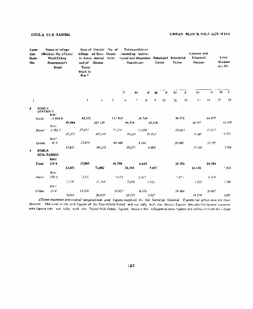
SIMLA SUB-TAHSIL
Loca·
tion Cod. No.
Namo of vIllage
(Hadbast No )/TOWD}
Ward/Urban
Enumerator's Block
8 SIMLA [J1'SfRICr
~m.!
1 mal ~ 14160
39,084 Km.!.
Rural I, ?85 1 27,27J
Km'" Urban 309
J1.B12 1 SIMLA
SUB-TAHSIL KDI!!
Total 1290 12,652
K7'1~
RUN;.I 108 U
::,J38
Km..!.
Urbiln 21 () 9,814
lJRBAl.'\ BLOCKIVILL<\.GE-WI~H
To(,ilpopulatlOn
(includmg Instltu. Area of OccupJ- No ot
Village ed Resl- House. In Acres dentlal hold~
and:of Houses
llonal and "ouseless Scheduled Scheduled
Townl Ward In
Kru 1I
45,352
27,673
17,679
17,905
2,93.
14,97(1
217 129
I47.~97
69.132
72,002
15, <4]
56,659
P
5
117819
77,3'i9
~O460
41,7911
7,~73
J3,92'i
PopulatiOn) Ca~tes Tnbe~
- -~--_._-M F M F M F
11 7 8 Q 10 11 12
211 744 5tl971
99,310 25,31)
_'],,~O() 28,46 1
70,63(\ 11013
5 Y44 28,508
28,672 4-300
6,643 28353 30.20. 5037
2,16 7 1871
7,-110 JUlu
4,476 ~4 4I:JO 22,73-1 f,027
Literate aod Educated
Person~
lotdl
Workert (I-IX I
----~-
l\f F M f
I' 14 I~ 16
(.(l 07')
26 '717 II (J39
-/;>,8?1
9,766 '} 575
]3,J47
17,35/ :: 064
24,384
16,130 1,831
4319
1532 2140
2000: 14 5"8 1,691
* These represe.Elt provl~lonal 'gcogtdphlcal Mea' flgure~ supplled by the SurveYor Genelal figures lor urban ..lrt.3 are thOi>~ Dl"tnct The lotal 01 the alea f'gures of the Tah,lltSub.Tahlill Will O,){ tally WI!h the dl,tTll..t fIgures be",IU~e tile tonnel repre'l:nt area flgules ma\ not tally with the Tah~kllSllb- rahSll figures heeau't" the Vllldgewl~e area llgures are co\Teclcn from ti,e \ dlaRe
112

<ZENSUS ABS1'BACT
II III IV
(8)
-_ ----M P M F M F M F M F
17 II 19 20 21 22 23 24 25 26
31,039 2,874 1,429 60 1,569 8,658 240 160 2
30,904 1,991 7JJ 60 1.214 8,629 228 121 2
135 8_' 716 345 29 12 39
2.654 214 723 411 2,04% 45 35
2,564 138 77 162 2,018 14 4
90 76 646 255 ]4 11 1/
aupplfed by the local bodies Area figures ror rural
WORKERS
V VI VII
(b)
M F M F M F
27 28 29 30 31 32
2,668 2,«S01 4.932 103 73 128 101
787 1,323 831 89 55 56 16
1,881 1,278 4,094 14 18 72 85
1.662 1,206 3,681 22 48 61 79
129 163 154 10 34 2
1,533 1,043 3.527 12 14 61 77
VJII
M F
33 34
3,363 63
878 10
2,485 53
2,322 51
98
2.224 51
M P
35 36
16,344
x
Non- Loea-Workers hOD
Code No
M P
37 38 1
51,748 8 2,111 87,671
4,114 34,5'" 369 '1,063
12,230 17,213 1,742 26,608
11.505 17.414 1,448 26,373
894 3.494 38 5,330
10,611 13,920 1,410 21,D43
area arc derived by subtracting the urban arca from the total arca orthe 'Land Usc' area and are derived from the fIgures supplIed by the Director of Land Records HImachal Pradesh. Llkewise the total of the vIl1aaewI"e offiCial (Patwarl)
183

SJMLA J AHSJL
LO(.el
!Ion Code No
3
4
IS
9
to
II 12
13
14
I~
16 I~
18
19
20
21
22 23
24
2~
26
27
Name of VI Jlelge
(Hadbast No)
Areel 01 VJ])age
10
acre,
O(.(.UP1-
ed Res]dentl8l House~
No of Household,
RURAL ARE.A
Makndoa (45)
~hera Kalan (46) Sherd Khurd (47)
Gharh c(.hel (4'1)
Jholu Kd Jubbar (44)
~anl'ug !\I!,hala (48)
Lghlld (21)
Dum! (43)
Chaola (50)
Bmot (51)
Taroot (41)
Padhrenda (40)
Pelmon (42)
P':ldba (24)
Ragoloo (37)
Kdnalt (36) Bagora Khurd (38)
Kamana~1 (22)
Kakar Bagora (39)
~en SP (35)
NiUn (34)
Bhakoo (33)
Batol nn Padhog (26) Shal (25)
Bhont (27)
fud (21)
25 102
6& 394
51
117
123
299
339
245
13 -1-0
253
74
41
17
25
123
102
239
38
39
101
10
126
142
SS9
4
4
::,
26
2
5
5
37
13
10
... 8
19
8
4
4
5
6
14
2 2 7
6
16
11
51
Total p"pula tlon (mcludIDg InstitutIOnal Schedule'1 Scheduled
and Houseless Pellulatlon)
6
4
4
II
26
2
5 6
37
14
10
4
IS
19
8
4 4
5
6
14
2
2
8
6
16
11
51
M
7
19
14
68
129
14
31
18
179
95
60
<}
30 44
121
26
19
26
25 44 <)8
18
16
42
23
112
63
327
F M
8 9
II II
8 6
36 32
66 63
7 7 16 15
5 13
97 82 44 51
31 29
5 4 17 13
23 21
59 62
13 13
13 6
14 12
14 JJ 25 19
46 52
10 8
7 9
26 16
13 10
59 53
23 40
163 164
114
Castes Tflbes
F
10 II
6 .5
12 17
3 3
3
67 60 Ij 6
3
5 4
3 2
5 5 19 21
8 8
6 2 10 5
7
3 4
29 25
12 22
S3 62
•
p
12
YJLLAG.E-WlSE PRIMARY
LIterate and Educated Persons
10tal Workers (I-IX)
M
J3
F M F
14 15
4 6 4 3
5 5 4
2-1 10 18 16
28 2 39 35
5 2 4 34 () 10 4
4 10
25 5 66 40
13 6 23 20
11 IY 66
1 4 1
11 7 12
4 17 16
36 20 31 39
2 3 11 12
8 6 4
7 7 9
5 1 9 a s 2 13 11
26 11 21 2S
~6 4 5 5
S 3 2 5 11 15 S
6 8 7
27 6 34 30
13 13 12 13
74 29 104 97
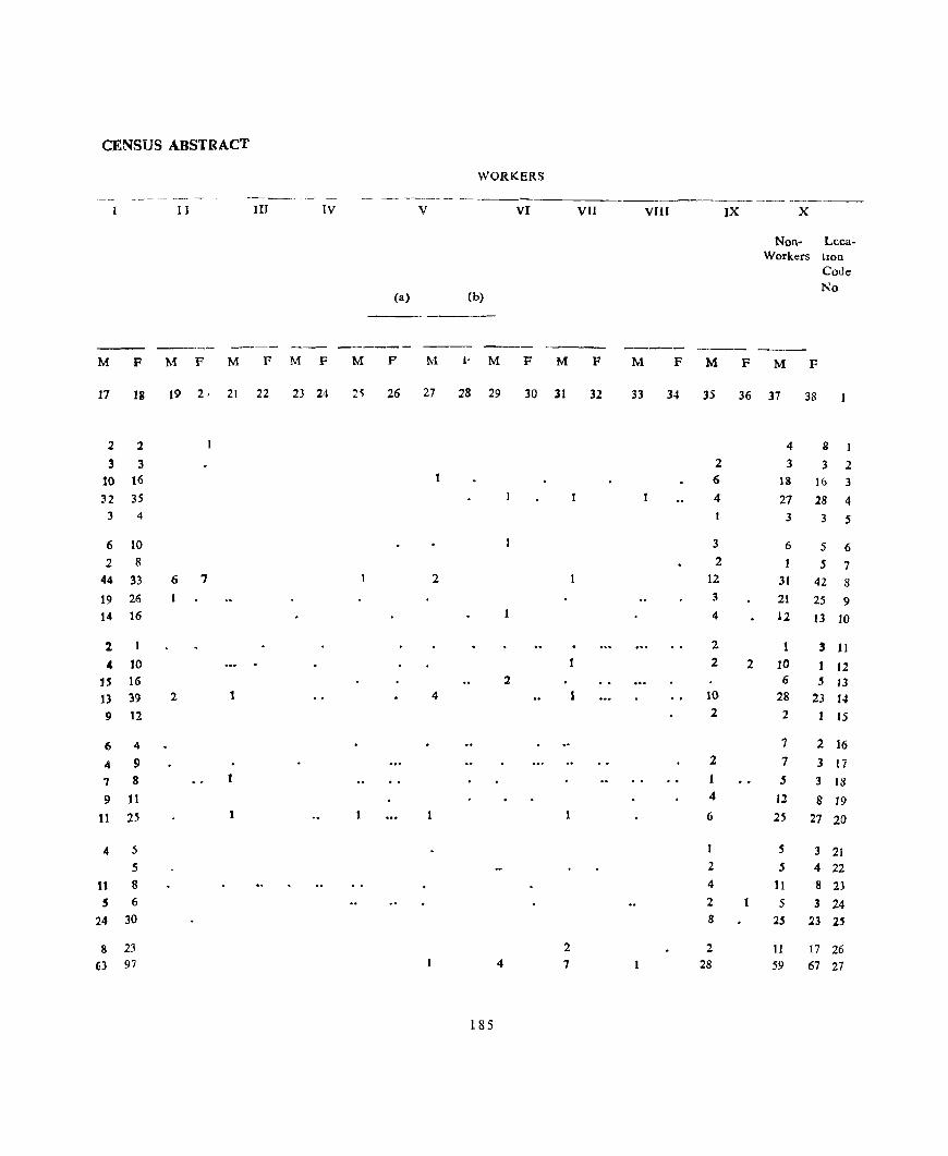
CENSUS ABSTRACT
WORKERS
------...........- ----- - - --~-------~-----
J II III IV V VI VIJ VIlI IX X
Non- Lcca-Workers hon
Code No
(a) (b)
---- ------ ---- -------_- ---M F M F M F M F M P M 1< M F M F M F M F M F
17 18 19 2, 21 22 23 24 2) 26 27 28 29 30 31 32 33 34 35 36 37 38
2 2 4 8 1 3 3 2 3 3 2
10 16 6 IS 1& 3
32 35 4 27 28 4 3 4 3 3 S
6 10 3 6 5 6 2 8 2 1 S 7
44 33 6 1 2 12 31 42 8 19 26 3 21 25 9 14 16 4 12 13 10
2 2 1 3 11
" 10 2 2 10 12 U 16 2 6 5 13 13 39 2 1 4 1 10 28 23 14 9 12 2 2 I 15
6 4 7 2 16
4 9 2 7 3 17 7 8 5 3 18 9 Jl 4 12 8 19
t1 25 1 6 25 27 20
4 5 S 3 21 5 2 5 4 22
11 8 4 11 8 23
5 6 2 5 3 24
24 30 8 2S 23 25
8 23 2 2 II 17 26 63 97 4 7 28 59 67 27
185

SIMLA: TAHSIL
Location Code No.
28
29
30
31
32
33
34 35 36 37 38
39 40
41 42
43
44
4S 46 41 48
49
50
51
52 53
54
55
Name of Village
(Hadba't No)
Area of VIllage
m acres
OCCUPl- No of ed Resl- House-
2
Naog
Kals
Karanda Mania
Lehn
Bhong Gulcha Klaloo Chamun S F. Karog
Sanog Ubla
Sangtl Kahna
KanJal!
Ron Loharb
Haron
Janol
PanU
Bharech Iwhhaser
Barohl Jablog
Fatecll1
Kalawat
HlUn
dentlal holds Houses
3
(18)
(20)
(28)
(29)
(12)
(30)
(19)
(16) (11)
(15)
(14)
(13)
(53)
(52) 15~)
(5~)
(55)
(57)
(59)
(58) (60)
(61)
(62)
(63)
(70) (72)
(71)
(69)
4
128 61
162 49
78
49
122 35
64
27 72
5
6
5 2
4
7
11
11
5
5
7
48 12 329 21
112 11 183 13
204 8
123 8
371 22
284 17
79 2
25 2
389 42 89 12
ss 52 (;9
32 66
9
3
12
1
II
Total population (mcludJDg InStitutIOnal
and Houseless Population)
Scheduled Scheduled
P 6
9
6 2 5
7
11
16
5
6
7
12
21 11 10
8
8
22
17
2
2
49
12
9
3
12
II
Castes Tflbes
M 7
65 29 4
4S
43
F 8
M 9
31 34 15 14
2 2
25 20 19 24
66 28 38 54 32 22
Uninhabited 31 18 13 24 16 8
46 33 13
33
150
62 72
37
46
125 100
7
9
227 59
47
14 74
14 38
186
13 20
71 79
34 28 37 35
19 18
19 27
(;0 65
49 51
3 4 5 4
114 113
29 30
26 21
9 5
3R 36
8 22
6
16
F M F 10 II 12
16
12 5
7
14
17
18
4
4
8
2 1 42 38
23 21 12 7
16 15
8 II
8 3
5 4
41 42
2
18 10
VILLAGE-WISE PRIMARY
Literate and Educated Persons
M F 13 14
20
10
21
9
17
14
b
8
11
6
21
16 10
6
Jb
31
25
49
13
19
7
21
5 6
Total Workers (I-IX)
M 15
F 16
7 17 71
4 7 6
2 2 3 15 IJ
3 16 12
5 16 23
6 26 14
2 10 9
9 6 16 10
2 11 12
4 45 2 23
2 20
1.)
6 Y I
II 36 2
12 27 5
3
4
12 68 23
8 13 J3
3 12
4
3 25
1
3 4 15
5
2
5

CENSUS ABSTRACT
WORKERS
------ --_ I II lIJ lV V VI VII VUI IX X
Non- L()Ca-Workors tlon
Cede
(a) (b) No
---- -- ----M F M F M F M F M p M F M F M F M F M F M F 17 11 19 2) 21 22 23 24 25 26 27 28 29 30 31 32 33 34 3S 36 37 38
8 17 8 14 17 28 3 6 4 8 8 29 2 2 30 6 11 8 10 9 31
11 12 2 2 3 12 32
12 23 1 3 12 15 33 12 J4 1 2 9 6 8 34
Unrnhailted 35 6 9 1 8 4 36 T 6 7 2 37
12 10 3 17 3 38
~ 10 7 .!. 8 3Y
3t :2 3 1 6 26 77 4J
16 I 2 3 II 28 41
H 2 2 17 35 42
10 9 J7 43
7 1 2 10 26 44
25 2 6 2 24 63 45
21 5 2 1 2 22 46 46
3 4 47
4 4 48 30 21 6 4 8 2 2 2 2 13 46 90 49 9 11 2 I 2 16 17 50
6 4 2 4 14 16 51
4 5 5 52
13 2 2 8 13 34 53
:2 1 4 6 54
8 5 4 2 7 11 55
187

SIMLA' TAHSIL
Location Code No
56
57
58
59 60
61
62
63
64 65
66 67
68 69 7<)
71
72
73
74 75
76 77
78 79 80
~1
82 83
84
Name of Village
(Hadbast No)
2
Nalat!
An]l
Sarhog
Rahat
Ner!
Garb Kalan
Garb Khurd
Kalr
D"enda
Chanan
ChahlJ Khurd Chahh Kalan
Gadog S F.
Baldhu TtMDen
CimTO d
K.trhec'l
CI har,lh
Panjattl
Riloh
Seri
ManJa,la
Tlkn Mashah
Kancla
Dhalla
Kharol
Ladvl
Shllroo
G'liot
Area of
Village ID
acre'>
OCCUPI- No of ed Resl- House-denttal holds Houses
3
(73)
(74)
(68)
(67)
(64)
(66)
(6')
(79)
(80 )
(77)
(75)
(76)
(78)
(I 6)
tl20)
(122)
(12 ) (119)
(125 ) (121)
(12;)
(124) (1 8)
(IO~)
(lOll)
(I I f)
l111) (112)
(J 17)
4
t4 34 8:i
56
50
33
44
90
117
12
132 135 80
108
215 42
43
44
56
48
111
241 187
5
7
5 9
9
5
5
5
11 34
2
10
72
18 9
19
5
4
11
7
4
9
39
3
2
7
Hi 17
Total populatIOn (IDcludiDg InstitutIOnal
and Houseless PopulatIon)
Scheduled Scheduled
p
6
9 6
10
9
5
5
57 12 36
2
11 72
18
9
21 5
4
11
7
4
10
42
3
4
7
17
17
M
7
57
33
58 54
24
37
2
92
146
16
62
302 114
35
123 25 23
2 47
35 19 59
217 33
26
35
88
90
Castes Tnbes
F M F M
8 9 10 II
28 29 14 16
18 15 23 35 5 6
28 26 II 12
13 11 7 5
18 19 2 3
11 16 I 4
50 42 6 6 85 61 17 12
8 8 4 4
31 31 6 3 151 151 36 35
18 ~
62 52 1S 11 18 17 5 1 Umnhablted
64 59
11 14
9 H
1
22 25
18 17
II 8
32 27
110 107 18 15
14 12
18 17
37 51
16 44
16 17
2 3
3 5
3 7
25 26
13 10
16 19
6 5
F
12
VILLAGE-WISE PRIMARY
Literate and Educated Persons
M
13
F
14
18
13 12 5
4
8
7
16 3!J
5
20
82
30
9
29 5
2
12
4 5
15 43
6
6
7
7
Total Workers (I-IX)
M ,F
15 16
7 15 5
5 8 2 6 10 5
3 17 1
6 1
5 10 1
1 8
8 25 10 13 44 12
1 3 4
12 20 13
46 88 52 17 26 24
3 8 5
5 30 25 5 7
2 6 5
3 10 II
2 12 3
7 4
4 18 12
14 66 28 5
198
5 12 Jj
2 30 24
5 29 14

CENSUS ABSTRACT
WORKERS
----_- ------
[ J III IV V VI VI[ VIH IX X
Non- Lcca-Worken tlon
Code No
(a) (b)
- --------
---- -- ----- - ---- - ---- ------ ----- - __ -----M P M f' M P \( r M ,-, ;\1 ' [ r 1\, 1\1 M l" M F
17 18 19 ~) 21 22 ~l 24 25 26 _7 ''I 29 3f) 31 ''': 33 3 l 3) 36 37 38
6 5 I J 13 24 56
2 2 2 2 to 13 57
8 .5 1 13 30 58 11 , 4 II 25 59
I 3 7 10 to
5 2 2 8 18 61 4 1 3 3 15 62
14 9 3 6 25 32 63 9 9 3 3 10 17 2 41 49 64
4 5 4 65
9 13 3 4 4 II 18 66 19 15 2 3 30 34 6 4 23 63 99 67 20 23 2 2 36 28 68 7 .5 10 12 69
C'llIl1hablted 70
17 25 34 34 71 oS 7 6 7 72 6 .5 3 9 73
1 74 9 It 21 14 75
10 6 14 76 7 4 4 4 77
14 12 3 14 15 78 46 28 4 12 ~4 79 79 4 13 15 80
8 8 5 4 81 9 13 2 6 4 82
28 24 1 7 27 83 28 [4 [7 30 84
1159

~l:\,lLA I AH~IL
LocatIon Code No
85
l)()
')1
92
95
<)~
1)<)
100
lUI
102
103 104
1(l~
lU6
107
IO~
1')9
ItO
III
112
113
114
Name of VIllage (Hadba~1
No)
2
Area of VIllage
In acres
Pan.·h (Il~)
<'h .. tll\,ald (1161
i{ lUra (IU~)
1 dlLllChl UN) R.ld Bll~hll (88)
'lOg ('10)
J...d'cr (107)
Nlr (96)
KIMnlt (91)
"h II tngra ( 1(16)
Llad1l,IWIlI
Gdg
J.,.,lla,JlI
(, hdl)~
DI" 11f!
J'h lib.ra
f'hogld.
Tilrl
<;hekuh
Mdl!.at
JRml(1g
Banaun
l\'1101e
Dohchhnoo
PilJOchn
Jdllar
Dhdild
f)ohdlhna
ThIda
Rapra
(\12)
(93) (95)
(104)
( 115)
U 14) ('J4)
( 151)
(152)
(150)
( 154)
(149)
(153)
(15'\)
( (48)
(133)
(147)
(156;
(132)
(134)
II ~ Shakrool (]15)
OCCUPI- No of ed Resl- House-
372 V
I Xli
\44
281
64
102
39 55
2'}
<'7
166
14" 47
11)7
117
74 81
76
281 54
55
34
35
47
47
46
114 57
28
dentlal hcld~
House~
4
28
'2 14
10
21
7
7
2
7
4
17
3
15
12
3
7
5
12
5
4 2
2 2
4
10
7
2
2 21
II
22
X
8
2
10 7
I
3
28
20 4
22 I,
3 7
'i
12
'i
4
2
3
3
2
4
II
7
2
Total populatlOD (illdudlllg Instltu
tlondl) and Hou~c]e~
Population
p
149
12
121
60 14 )
74 50
3
24 lib
84 Iii
110
99
19
57 21
75 22
2<,)
6
1~
19
10
26 44 62
5
J90
M
7 8
79 70
" 7 62 39
30 30 77 63
21 21
31 17
5 7
32 42 27 23
I
16
63
48
8
59
43
8 25 10
33
11
15 4
10
y
5
10
18
32
3
2
8
53
30
8
51 56
11
32
'1
42 II
14 2
8
10
5
16
26 30
2
, lLLAGE,l...WISE IPRIMARY
Scheduled Scheduled LIterate 'and
Educated Per~Olls
M
9
7
4 20
4
5
II
7
II
24
7
3
2
Tnbe~
F M
10
8
3
II
4
10
s 10
II
2
II
F
12
M
13
27
28 18 31
11
19
20 13
I
4
22
12
3
19
28
3 8
6
10
3
3
I
3
2
3
S
13
Total Workers I
(I-lX)
_--------F M
14 15
10 39
3
3 35 8 22 8 37
2 II
14 I 2
II 12
23
3 5
4
I
3
3
4
4
16
I
7
34
30
4
33 21
3 14
4
16 5
7
5
2
4
11
17
F I'
16
33
4
25
20 , 34
14
H) 'i
16'
()
25
22 -,
2'i
30
S 7
~
J
JO
20
]6
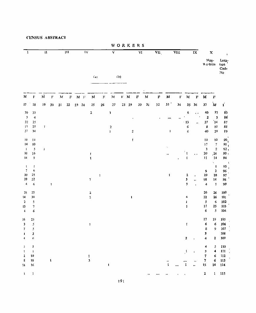
Cl!.'NSUS A BS'fRACl
WORKERS
1 11 HI IV V VI
(b)
---- --..---- ---- ..,._--_.- __ --- ----M F !vi F M F M F M F M F M F M
17 18 19 20 21 22 23 24 25 26 27 23 29 30 31
30 33 2
3 4 22 25 n 20 2 27 34 2
10 14
14 10 I 5
10 16 1 14 9 1
1 7 6
30 2S 20 22 7
4 6
28 25 2
14 30 2
2 5
13 7
4 6
16 23
3 5
7 5
2
4 6
S
1 1
2 IO 1 8 19 3
14 16
191
VII VIII IX
F M F M F
32 33 ' 34 35 36
6
I 13
6
6
2 3 3
4
1
1
2
1 1
x
Non- LoCJli \\ orkbrs hon
Code No
M F
\ I
37 38 1
40 37 8'5 2 3 86
27 '14 87 8 10 88
40 29 f9
I
10 10 9°1 17 7 91 I 3 2 92 I
20 .+6 93 I
11 14 94
I
95 I
9 2 96 29 28 97 18 14 98 J
4 99
26 26 100 22 26 101 5 6 102
11 25 103
6 5 104
17 19 105
6 6 106 8 9 107 3 108 4 2 109
4 5 110
3 4 111 7 6 112 7 6 113
15 14 114
2 1 115

SIMLA . f AHSIL
Location Code No
116 III [18 [19
1:0
121 122 123 124 125
126
127
128 129 130
131 132
1.33 134
135
136 137
138 139 140
141
In 143
144
145
146
Nameo! Village
(Hadbasl No)
Area of Village
fn acres
OCCUPl- No of ed Resr- House-
2
Rangol
Malangall Ghararoo Pa(s(Jal Kalan
Patshal Khurd
Patshaltl
Gowahl Khurd Barog Barmam Kotla GJJech
Kharaum
Barhawan
Raurl
Kalalaoon Pata
Gowahl Kalan
Makro:
Slalmoo
Badog
Bag
Palgl Kalan
Palgl Khurd KhaJrJ
Bast! Gunana
R'1url
Panafola Dhadhol Dhamun
Kharun
Kha!rI
Jhakhari
dentla! holds Houses
3
(157)
(I t6)
(136) (131) ([30)
(12~)
(137) (I5~)
(118)
(145)
(129)
(139)
(142)
(143)
([40)
(141 ) (144)
(160)
(159)
(161)
(11)2)
(16 ) (164)
(165)
(9<)
(97)
(98) ( 03) (100) (101)
(102)
.
4
487 19[
43
53 38
87 35 93 27 65
77 25 90
49
85
122 II)
(0)
73 95
40
42
66 682
40
62 36
219 26
212
104
25 18
7
6 2
2 12 4
11
6
2
(5
2
II
17 8 6 3
9
I
39
39
3
9 4
18 4
20
4
Total popula hon (lllcludJllg InstItution'll Scheduled Scheduled
and Houseless Castes Tnb.:s Population)
p
6
25
18
7 6
2
2 12 4
12
6
2 6
2 11
17
8
6
4
9
39
39
3
9 4
18 4
20
4
M
7
125
93
3c: 42 32
1
13 64 25 48
52
15 49
10
64
121
39
37
23
35
24 13
34
261
21
43 24 95
18 95
22
F M
8 9
55 70 39 54 16 16 17 25
18 14
1
5 8 36 28 13 12
20 28
27 25
7 8 22 27 6 4
31 33
65 56
20 19 14 23 16 7
21 14
11 13
5 8 16 18
121 140
II to
23 20 12 12 53 42
9 9 SO 45
10 12
192
F
10 II
2 2
[3 15
3 4 17 12
2 2
2 4 3 2
26 30
55 48 16 14
11 17
16 7
6 4
7 8
II 3
11 8
F
12
VILLAGE-WISE PlUM \R'i
Literate and Educated Person~
\'[
13
F
14
27 11
4
7 8
2 20 7
JJ
11
2
6
I
16
29 4
8
7
14
4
3 8
60 2
2 4
24 6
33
5
Total Workers (I-l.X)
M F
15 16
10 29 42
13 22 32 184 I 8 6 .5 5 4
2 2 4 13 9 652 2 14 6
177
4 [ 3
7 9 2 I
5 17 9
4 30 6
4 14 3
9 4 9
6 2
7 10 5
2 5 4
I 2 3
266
24 54 62 7 9
13 10
1 7 7 8 25 33
2 5 4 8 29 23
2 7 6
PRIMARY CENSUS ABSTRACT
WO'RKER<;
1 11 III IV V VI VII VIII IX X Loca· tlon
Non- Code Worker. No,
Ca) (b)
M F M F M F M F M F 1'( .I- M I- M F M F M F M F
17 18 19 20 21 22 23 24 25 25 27 23 29 30 31 32 33 34 35 36 37 38 1
2S .p 3 26 78 J16 19 32 2 18 22 117 8 4 8 12 J 18 8 6 9 19 119 5 4 J3 10 120
1 121 2 2 3 (; 122
10 9 3 23 19 123 4 2 1 8 10 824
12 6 2 6 22 123
6 7 1 20 18 J26 1 3 6 S J27 7 9 15 18 J28 2 I 4 3 129
14 9 3 14 24 130
25 6 3 35 50 131 13 3 6 16 132 4 9 JO 14 J33 5 2 I JO 5 134 2 3 4 7 2 11 9 135
, 4 6 ~ 136 t 3 3 5 137 6 6 JO 12 183
SO 62 3 67 78 139 3 9 3 4 1 140
It 10 2 10 10 141
6 7 t 5 5 142 19 33 3 3 28 9 143 4 4 I 4 5 144
23 23 1 5 21 22 J45
7 6 3 6 146
193
CIMLA SUB-TAHSIL
Loca
tIon Code
No
147 148
149 150 151
152 153 154 155 156
157 158 159 160 161
162 163 164
165
166
167 168
169 170
171
172 173
174
175 176
Name of village
(Had bast No )/Town/ Ward/UrblD
Enumerator's
Block
2
Khalag
Kafted
SOlan j
LaJhoon Chaog
Poabo
Barog Mahafl
B:>lang
Shall
Banv!
Balam Totu
Dwat Jaden!
Kalmon
Bagagll
ManJlal
Mraral
Ghursllall
Jamlog
Balaog
~htlu
Badot
MangioonJ
Bagna Bhawana
Pantl
Klergl
Dhanokhal
Paten 1
Area of OCCUPI- No of
Village eJ Resl- House
m acres dentlal hold"
and of Houses
To"n/ Vv ard 111
Kru2
(95)
(187)
(186) (191) (192)
(190) (IS8)
(189)
(194) (193)
(196) (195) (81) (82)
(336\
(335)
(337)
(8)6
(87 )
(83)
(85 )
(332)
(334)
(338)
(84)
(343)
(333)
(344)
(342)
(345)
3 5
156 37 37
475 26 26
210 17 17 82 ') ':)
192 22 22
190 13 13 66 5 5
33 11 11
141 7 7 48 2 2
239 21 21 114 5 5
108 195 199 37 3 3 71 18 IS
)7 3
42S 3 3
298 178 178
467 66 60 134 22 22
13
120
129 92
55
80 1711 54
82 57
6
19 9
9
13 18
8
10
12
15
6
20
9
9
13 18
8
10 12
15
L'RBAN BLOCK/VILLAGE-WISE
Totalpopl.latlon
(lncludmg IOshtu-tlonal and Hou,eless Scheduled Scheduled
Population) Castes Tflbe,
P M F M F M
6 7 8
176 96 80
170 80 90 105 48 57 61 32 29
131 70 61
77 38 39
26 14 12 54 34 20
36 16 20 15 S 7
105 50 55 42 25 17
687 427 260
18 12 6 87 44 43
34 20 14
292 157 135 680 391 289
255 147 108
III 47 ec4
Umnhablted
29 14 15
1I5 62 53
44 17 27
9 5 4
69 108
40 49 12
36 33
54 54 14 26
27 22
5 7
74 41 33
194
9 10
8 6
31 31 10 16
6 3 15 12
10 13
34 20
1
19 16 8 5
89 51
15 14
35 22 125 97
63 72
29 27
11 9 30 31 13 25 6 4
35 24
Jl
F
12
Literate and Educated
Per~ons
fotal
Workers
(I-IX)
M
J3
62
39 16
18 23
14 5
17
7
4
17 11
292 7
17
IS
83 245
83
28
5
43
11
5
14
19 10 14
3
18
F M F
14 15
28 47
15 43 7 31
15 11 36
3 20 1 5
3 19 4 10 2 4
to 28
1 13 104 292
7
21 25
6 9
30 94 88 232
33 117 40 20
3
13 12
2
6
6 5
5
3
7
25
12 2
18 23 10 16
3
28
16
25
~5
27
11 35
22 8
7
7
3
14 7
13 3
11
4 22
9
8
12
2
11 3

rnIMARY Cr:l'\SlS ArSTRACT
WORKERS
11 111 lV V VI VII VlIf IX X Loca-tion
Non- Code WOlkers No.
(3) (b)
M F M F M P M F M F M F M F M F M F M F M F
17 18 19 20 21 22 23 24 25 26 27 28 29 '0 31 32 33 H 35 36 37 38 1
13 20 1 5 3 5 6 1 13 49 55 147 32 34 4 6 37 55 148 27 27 '- I 17 30 149 15 JJ 17 18 150 30 35 5 34 25 151
19 22 18 17 152 4 8 9 4 153
13 7 5 15 13 154 9 7 6 13 155 3 3 4 4 156
22 14 2 2 22 41 157 13 7 12 10 158 7 7 3 18 18 19 61 38 123 6 135 247 159 2 3 1 1 3 5 3 160 6 9 2 8 8 19 32 161
4 1 4 11 14 !li2 41 5 3 5 3 2 3S 4 63 131 163 37 13 8 :0 1 20 20 6 lit 8 159 2('7 164 22 6 8 11 12 4 30 2 60 99 165 12 8 2 6 27 56 166
Uninhabited 167 7 7 15 168
12 1 1 1 10 37 53 169 5 (; 5 26 170
2. 3 3 171
12 9 4 3 1 1 18 21 172 21 1 2 31 52 173 , 2 2 1 4 26 174 14 11 1 11 11 175 2 3 1 2 4 176
U 1 1 10 1 1l 33 177
195

~lMLA bUH-IAHML
Area of OCCUPI_ No of Total population VIllage ed Resl- Hou,e- (mcludmg 1mtllu-
URBAN BLOCK/VILLAGE-WISE
Loca
tion Code
No
Name of Village
(Hadba~t No )JTownJ WanjJUrbao
Enumerator s
Block
m acres dentlai h~ld, tlOnal) and HouseJess Scheduled bcheduJed Literate and Educated
Persons
Totdl
Workers \I-IX)
178 179 180 181 182
183 184
185
186 187
188 1!1()
190 191 192
193 194
195 196 197
198
199
200 201
202
203
204
205
206 207
208
2
Shl!ru
Shllll Bagl MaJholu Rampur Chan an
An)1
Matholz Shangm
BIJl! Kharog
Dhanul Heao Shamleg Tadehal
Dooh
Phdll DhaTI Bagal!'
ladtana DhaIl C. hd (
Lagru
Dill
B1Ii
Gdnpen Jalel
Shadalla
B'ltlana
Ganhen
Sehl
Jama!i Jaog
Tarar!
and of Hou~es
lown/
Ward 10
Km -
(311 )
(339)
(141)
(277)
(340)
(362) (370)
(369)
(36R)
(368)
nf6) (1(;1)
(164)
(~65)
(361)
(371 ) (372)
(374)
(375)
(376)
(373) (r~)
(178) (379)
(380)
(181)
(182)
(383)
(184)
(385)
(386)
3
112 237 114
810
147
197
119
96
41
58
100 2S
1911 110 63
248
163
50 21
6>
77
12
83 RO
2R
F9
70
28 29 19
4
14
24 II
89 12
II
23 20
7
8
7
7
6
26 3,
6 1
4
12
1
I~
19
2
19 11
7
8
2
4
5
15
24 11 89
12
II 23 20
7
9
7
1
7 I')
26 33
6
1
4
II
I
12 1<)
2
20
II 7
9 2
4
PopulatIon
P
6
80
174 76
498 75
68
135
74
2~
31
54
12 'i9
24 9
143 149
38
5 33
41
11
8" 125
25
89
62 24
39 11
23
M F
7 8
39 41
84 90 35 41
226 272 34 41
32 36 71 64
41 33
16 9 16 15
27 7
32 11
3
27 5
27 13
6
"17 66 75 74
18 20
4 14 19
22 lQ
6 5 45 40 63 62
9 16
43 46
27 35 10 14
19 20 7 4
12 11
196
Caste. Tnbes
M F M F
9 10 11 12
24 23 35 45
97 110 8 7
9 13 21 14
16 9
16 15
2 2
23 22 27 25
I 1 4
3 3
22 20 13 19
1 3
16 21
3 5
11 9
7 4
12 II
M
13
2Z 40 18
114
t7
15
35 21
5
8
g
3 14
4
41
41
12 I
II
4
4
30 31
2
23
13 5
7
3
4
F M F
14 15 16
11 20
23 38 16 13 15 8 57 129 21 7 18 II
7 22 2 21 35 3 4 24
9
5 10
g
3
3
3
12 4
17
6
14 39 10
14 47 7
10 9 2
2 I 475
3 15 5
2
7 17 4 21 27 6
Z 5 2
g 30 8
16 16 6 6 6 1
4 13 4 1 S
9
PRIMARY CENSUS ABS'lRACl
WORKERS
II III IV V VI
(a) (b)
---_ - --M F M F M F M F M F M f M F
17 18 19 20 21 22 23 24 25 26 27 28 29 30
12 2
27 16 13 7
78 20 4 7 5
15 It
14 2 2 4
14 3 6 4
16 4
8 1
8 1
7 3 I I
13 2 5
27 10 2 3 31 5 4 6 2
5
4 3 3 3 2
1
11 4 10 4 5 2 3
2 2 3
11 7 5 2 2 9 6 3 ~ 2
8 2 3 4
6 2
197
VII VIII IX
--M F M F M F
31 32 31 34 35 36
5 8
7 27 3
9
2
1
1 2 2
3 3 2 8
4
2
4 9
3 4
X
Non-
localiJD
Code Workers No
M F
37 38
19 41 178 46 74 179 20 33 t80 97 251 19l 16 30 182
10 34 183 36 61 184 17 32 185 7 9 186 6 15 117
15 27 188 3 5 189
IS 26 190 S 13 191 2 6 191
38 56 193 2 28 67 194
9 18 195 4 196
7 14 197
7 14 198 5 5 199
28 36 200 36 56 201 4 14 202
13 31 203 11 39 204 4 13 205
2 6 16 206 2 3 207
3 11 208
Sl\lL'. SUi:: TAHSIL URBAN BLOCK/VILLAGE-WISE
L(1C1. Name of ~ 1'J,ge Area of OCCUpl. No or Totall'ol'ulatlon tOil (lL1Jbchl No )'IOVf1/ VdllgC cd Re'l. House· including m~tItu·
c, de W.1rdjL!I b~n In acre, dentm) holds tiona) and Houseless Scheduled Sclleduled LIterate and
Educaled
Persons
Total W0rkers No
20'}
210 211 212
213
214 215 216 217 218
219
220 221 2c2 223
224 225 226
227 228
229
230
Enul11clat,'r ~
Blo ... k
K'\\\a
Ihlll
2
L!lga S[1"koh
Datllun
Lohdra
I"1nng
GO\\..lhl
Than
J:\'1~n
S l'dna
J:\' tr c 1 S.lI1Jllot
Kakret
Sh.lfl
Kif
Lagru TIl 11..l1. Dhar
Tll1lak l'\'al
T.1 y, (I orcst Area)
and of HJuse~
Tuy,n/ Ward 1ft
(1"1) (IS ,)
(,X") (390) (3)+)
(395)
(19 1)
(1~7)
('393)
08 I)
(392)
(\"C)
(3 7) (3 ,~)
(359)
(\(0)
(351 )
(152)
(35 1)
(35-1)
(355)
Km 2
3
B\ 81
47 42
121
10
74 174 337
fll
49
74 350
20 85
133 258 116
140 1:7
79
4
2 2 4
S 18
16
II
38
5
4
6 32
4
S 17 4
8 9
9
(N A) N A
231 Tan DWI
NA. 6
N A -Nut avaIlable
2 2
4 5
20
20 12
39
7
4
6 32
4
.5 18 4
8 9
9
POpulation
p
6
9 21
24 36
104
M F
7 8
6 1 7 14
14 10 22 14 52 52
Umnhablted 114 71 43 66 34 32
179 91 88 53 24 29
31 12 19
35 16 19 171 87 8~
Unmhablled 23 9 14
14 71 22 44 47
56
8 6 3.5 36 9 13
20 24 20 27
26 30
•• Ullinhabited
19 10 9
u.
Caste~ .1 tlbe~
M F M
9
2
3 6
10
4
9 7 7 6
50 55
52 49
3
7 3
5 10
1
11
F
12
M
13
1 6 8
10 37
36 23
48 17
10 9
52
7
2 15 4
10 12
7
7
(I-IX)
F M
14 15
1 4 3 4 6 8 8
17 29
IS 47 12 14 13 52
IS 11
9 4
13 7 20 53
S 8
1 4 5 7
12
7
3
7
22
8 11 10
14
7
F
16
1 2 2
2 3
6 I
7
6
3
I 5
3
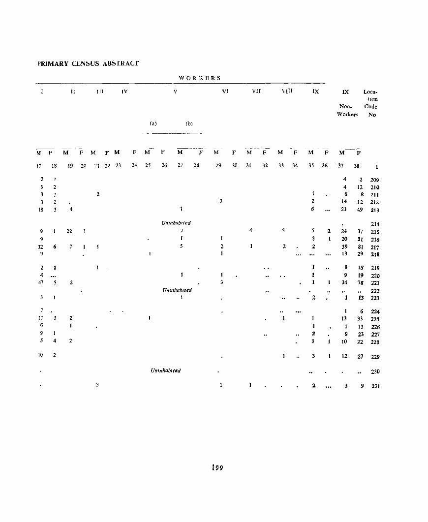
PRiMARY CEN~US AB~rRACf
WORKERS
II I II IV V VI VII VIII IX IX Loca-tion
Non- Code Workers No
(a) (b)
- - -------- -
----- --- -~ - - -- -_-M F M F M F M F M F M P M F M P M F M F M P
17 18 19 20 21 22 23 24 25 26 27 28 29 30 31 32 33 34 35 36 37 38
2 I 4 2 209 3 2 4 12 210 3 2 2 8 8 211
J 2 3 2 14 12 212
18 3 4 6 23 49 213
Umnhablfed 214 9 22 2 4 5 5 2 24 37 215 9 I 1 3 20 31 216
32 6 7 5 2 2 2 39 81 217 9 13 29 218
2 1 1 8 18 219 4 t 9 19 220
47 5 2 3 1 34 78 221 Unznhablted 222
5 1 2 13 223
7 1 6 224 17 3 2 13 33 22" 6 I 1 13 226 9 1 2 9 23 227 5 4 2 3 10 22 228
to 2 3 12 27 229
UnInhabIted 230
3 l 3 9 231
199
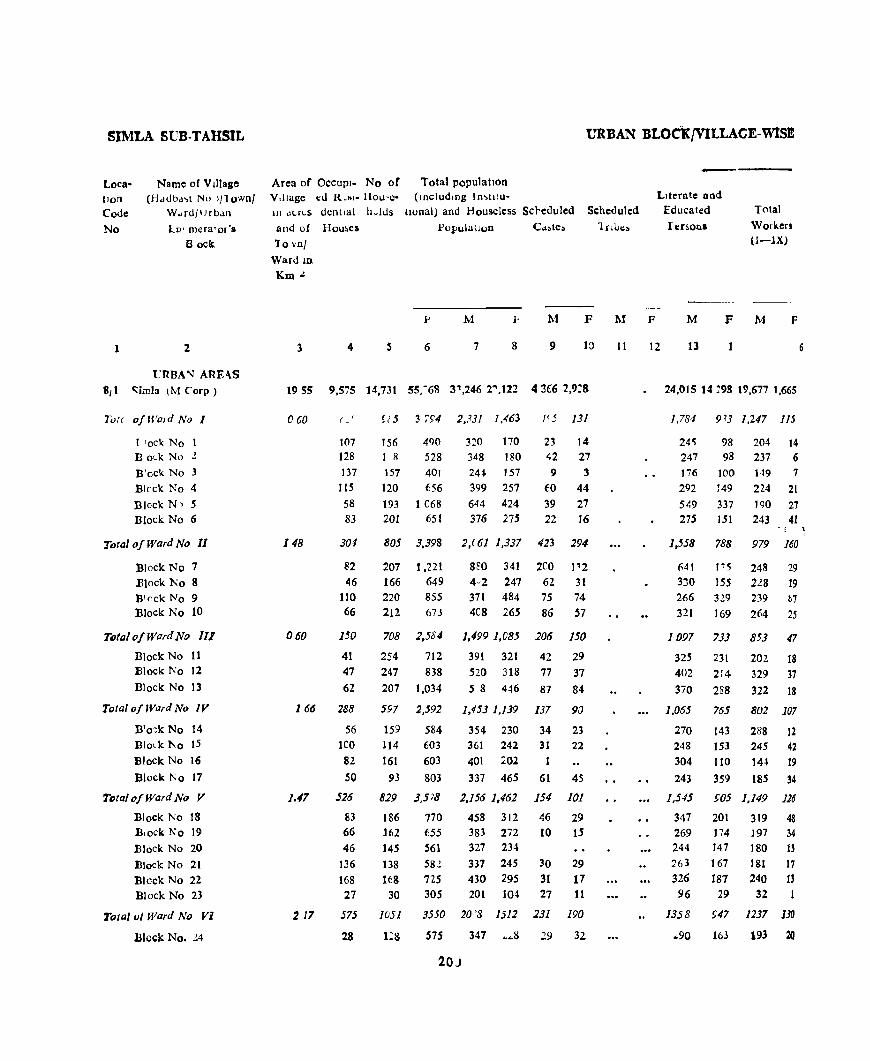
SIMLA SUB· TAHSIL
LocatlOO
Code
No
1
Name of VIllage (H,J<Jbd'>t No 1/1 ownl
W .. rd/lJrb,m
in' mera'or's Bock
2
t_'RBA'\) ARE-\S
8,t C::imla lM Corp)
Tvtc o/Wmd No I
I 'ock No B olk No l
B'ock No 3
Blrck No 4
Block N~ 5 Block No 6
Total o/Ward No 11
Block No 7 Elock No 8 Block No 9 Block No 10
TDta/ 0/ Ward No III
Block No 11 Block No 12
Block No 13
Tutal of Ward No IV
B'o:k No 14 Block 1\0 15
Block No 16
Block No 17
TDtal of Ward No V
Block No 18 Block No 19
Block No 20
Block No 21 Block No 22 Block No 23
Total vi Ward No Vi
Block No. 24
URBAN BLOcKjVILLACE. W1SJ!!
Area of OCCUPI- No of Total population V,llage ~d R.",- Hou'e- (mcludmg In~tJtu-In dl.r~S dentlal h~kls Ilonal) and Houseless Sc}eduled
and of Hou~es
10 vnl
Ward ID
Km.!.
l'opulallon
Scheduled
lnbe:.
LIterate and Educated
lersonl
Total
Workers (l-lX)
p M F .M F M F M F M F
3 4 s 6 7 8 9
1955 9,575 14,731 55:68 31,246 2",122 4 ~£6 2,9:8
060
148
060
166
l.tl7
217
( - '
107 128
137
115
58 83
304
~2
46 110 66
150
41 47
62
288
56 leo 82
50
S26
83 66 46
136
168 27
575
28
!.' 5 3 ';94 2,33/ 1,463
156 490 1 il 528
157 401 120 656
193 1 068 201 651
320 170 348 180
24~ 157 399 257
644 424
376 275
23 14 42 27
9 3
fO 44 39 27
22 16
805 3,398 2,( 61 1,337 423 294
207 1,221 166 649 220 855 212 673
708 2,584
254 712
247 838
207 1,034
597 2,592
159 584 114 603
161 603
93 803
829 3,5 78
186 770 162 655 145 561
138 58.! HS 725
30 305
1051 35jO
I:S 575
8~0 341 2eO 1~2
4,2 247 62 31 371 484 75 74 4C8 265 86 57
1,499 1,085 206 150
391 321 42 29 520 318 77 37
5 8 446 87 84
1,453 1,139 137
354 230 34 361 242 31
401 202
337 465 61
2,156 1,462 154
458 312 46 383 272 10 327 234
337 245 30 430 295 31 201 10~ 27
20 '8 1512 231
347 ~ ... 8 29
90
23 22
45
101
29 15
29 17 11
190
32
20)
11 12 13
24,015 14 :98 19,677 1,665
],784 913 1,247 lIS
24'; 98 204 14 247 98 237 6 176 100 149 7
292 149 224 21
549 337 1<)0 27 275 lSI 243 41
1,558 788 979 160
641 115 248 29 3:)0 155 228 19 266 329 239 h7
321 ]69 264 25
1097 7JJ 853 47
325 231 202 18 402 214 329 37
370 288 322 18
1,065
270 248 304
243
1,545
347 269 244 263 326
96
IJ58
.. 90
765 802 107
]43 288 12 153 245 42 110 14~ 19
359 185 34
£05 1,149 126
201 319 48
174 ]97 34
147 180 I' 167 181 17 187 240 11
29 32
£47 1237 130
103 193 20
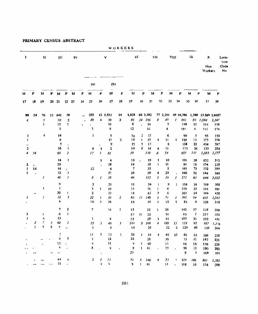
PRIMARY CENSUS ABSTRACT
WORKERS
II IV V
(a) (b)
M P M PMPM FM F M F
17 13 19 20 21 22 23 24 25 26 27 28
88
4
1 1
2 4
2
24
14
1 14
2
1 I
1
76
5
4
1
5
1
4 7
7
11 641 58
l' 2
14 6 5
16 68
14 28 14 12
30
2 1
2
40 1
9 1
30 32 4
3
7 2 6
15 5 40 5 7
7
2
8 2
13 ~
44 (, 11
253
10
3
6 12
12
12 1,512
4 50 10 9
4 1
3 17
9 2
65
4 38
8 1
6 17
58
3 3 2
22 1 14
7
25 3
II 3
26 JO 22
58 31l
16
4
48 4
12 12
11
9
'1 1 7) 9
14
2
2
2
2
1
VI VII VIII IX X Location
Non Code Worklrs No
M F M P M P M p M P
29 30 31 12 33 34 35 36 37 38
1,028 60 3,482
86 14 126
77 2,211 49 10,386
8 47 J 861
1,388 13 569 2,0457
85 J ,084 1,347 13 116 156 8 14
12 16
18 14
15 19
59
10 16 7
26 40
II
2 12 55
5 15 6 14
lID
19 38 33
4
4
6
20 4
115 5
36 15 36 I 14 43 3 80 11 140 5 15 56
IS 32
7 149
4 191 6 111 174
6 11
8 11 54
90 5 120 13 138 22 173 26
607 137
9S ISO 17S 236
454 397 133 234
1,082 1,177
10 191 26 632 312 18 174 228 73 132 391
II 95 5 161
28 160 20 144 240 19 1 572 65 646 1,012
9 4
6
71 18
26
!O8 16 259 35 205 14
1 39~ 84
83 9
142 37
189 303 191 281 266 428 651 1,031 126 218
116 200 16 60 7 257 183 37 JI 23
13 29 3 11 107 31 152 43t 10~ 3 188 4 180 15 558 92 987 1,3?6
14 25 32 2 229 40 139 264
26 22
9
9 23
34 4 42 13 65 12 186 238 28 40 61
36
15
55
70 8 146 4 73 :3 41 1 \
73 11 147 221
84 16 156 228 98 12 190 282 9 169 103
, 829 106 801 1,382 lIS 18 154 208
201

SIMLA SUB-TAHSIL URBAN BLOCK/VILLAGE. WISE
loca- Name of vIllage Area of OCCUpl- No of Totalpopul.ltlon
tlOD (Hadbast No )/Townf Village ed Rest- House- (lOcludmg wstltU.
Code Ward/Urb:ilD III Ac:.res dentlal holds tIonal and Houbeless ~cheduled Scheduled
Literate and
Educated Total
Workers
0-1' Nv Enumerator's
Block
and of Houses
Town/ Ward in
Km 2
1 2
Block No 25
Bleck No 26
Block No 27 Block No 2R
hkd No 29
35
43
164 130
175
TOltll "fWa' I No VII 036 425 Bloc k No 30 'N
Bkd., No 31 45
Rl()cK: N' 1:: 10'l
Dil d. ]"0 33 212
ToWlofWardNo VITI 004 4/7 B'nc N() 14 lOS
811'c'" No ," 1(10
Rlnck 'In 31) 90 Rtf'ck No 37 122
Tf't{,/ofl'vr"I"T'I\ 0(14 4)-1
n prk N -" -, 10
Block l"" ,q <)9
BfotkNodO !!,
Tota/ofWa,d No A (104 F4
Rl, Lk 1") {I 98 BI'Lk 1\0 12 61 R1o-kNo 43 107
BI<'ck No 44 106
Tvf,,! of Wwd No J(/ 0 (IS 4';('
Bluc:.k No 4':; 12<;
Rod. No 46 40
Bto,k No 47 146
Block No 48 'N
TOfel! ofWlI/d No XlI 0 J9 69!
R!o"k No 49 Bit",!:" No ,0
18 123
3
1S5
182
177
160 269
4 5
629 646
4~6
480 7t~
8 14 2,547
213 649 119 502
181 f4R
~69 748
461 2,2/1
1 17 5~9
1] 5 5~2
101 491'
126 572
~/4 1(»7
240 553
99 542
175 562
498 2.286
143 533 140 632 108 563 107 558
5U3 2 i72
128 616
104 5'10
1<;6 572
115 654
971 ..f.,218
12" 123
(;1]
'585
Popula tl()n I
P
6
342 369
282
328 370
1,503
41 t 21)1
423
468
[,350
319
3'5 334 362
l,n" , 320
387 34 t
1,366
299 427 327 311
1,4~R
42'
101
186
3S'l
2.) 18
3~R
144
M F M
7 8 9
287 13 23
277 43 26
174 5 1
152 45 26 3~ I Y(' 1J2
951 r.J iU~
238 'i1 2~
211 21 18 22~ 21- 24
280 76 37
861 1/
240
247 164
210 10 3
fj(l6 6 1 1'1
213
1~" 18 218 4-f II
92() N :!.t
214 1 205 16 I;
236 16 11 245 6 5
874 n7 66
193 II 4
229 I~ 9
HI} 80 27
266 12 26
1700 n9 520
202
221
241
25 16
11
31
Trtbe~
F M
10 11
"erson~
F '\!
12 13
226 162
277 155
44 no 261 85 22-.1 272
14
F
200
226
163
227
1,:;24 66:; 1,0:;:;
33~ 162 268
20-\ 1."7 174
:99 144 :;'8 'i
383 1 ~9 ~45
810 657 827
2)8 187 176
219 188 191 2'1 117 :23
82 165 237
~', 4"; 710
21 8 168 204
"'5 l' 1 " 8 102 16S! "H
I ()4,) 669 838
I~~ 1(;6 1')2 327 14X 29~
~('2 16<1 187
268 186 1'1 I () n (,()7 ( l:f'i
27> 1 tl 30')
225 167 174
241 i( 0 268
120 199 238
1676 (j75 1,446
309
250
157
154
231
200
15 16
26
18
9
12 4)
85
33 18
7
27
38
8
10 5
15
3 1
J7
8
R
48
')
23
8 9U
10
18
25
17
114
II
16
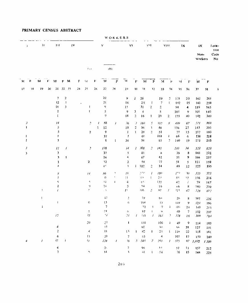
PRIMARY CENSUS ABSTRACT
M F
17
3
1
J
3
4
lil
11 III
M F M F M
19 20 21 22 21
7 12 11
2
I
/4
5
5
1
3
fJ
3
3
1 4
'i
2
4
2
6
f7
6
7
2
I
3
/
IV
( I'
F 1.1
24 2'i
2
2
2
7
6
15
20
4
II
U
F
26
WORKERS
V VI VJJ
11'l)
M p M F M p
27 2K 30 11
~ ]. 26
16 28
VIII IX
M F F
IX LocatIOn
NOD- Code
Workers No
M F
33 14 15 36 37 38
2 119 20 142
15 143
20 21
9
5
9
15 31 2
19 7
2
5
142 ')4
201
4 119
261 259
165
1 66
I 12 9
37 8
138
37 24 12 4<
86 o
17
13
7
J ~ ~-I
21 I ~
18
20
128
14
20}
9
18
36
10
1
24
/4
5 4
2 1
18
II
4
3
l'
(,
:'1
H
7 16
7
1
3 4
2. 16
3 16()
2 3() 29 61
34
1 308
81
67
58
102
79
lUX
"72
137 ;-16
IJO
61
83
5 J4~
96
41
29
5 102
48
2 51 118
85
2 141
8
42
77 2 14
J 18/)
2) 135
16 v7
!)
7
I l)
I 163
7
106 Ii)
21
4
291
54
101 140
2 155
9 40 142 349
8 439 67 571 869
205
193
218
251
156 27 143
77 IS 117 66 6 138
7 140 19 173
210 34 523 823
39 8 143 232
51
51
69
J'l
6'>
42 06 ,] 'i
20 149
40 l 338
J
49 1,(,
lIb
107
575
57
76
9 144 237
5 III 159 12 125 195
W 335 573 J5 116216
I 79 147
8 140 210 42
]{I7
I2}
J40
7 152 06 509
9 114
38 127
22 118
17 150
97 1,092
11 15
157 1-44
872
226 196
211 237 78-1
183
191
161
249 1586
212
225
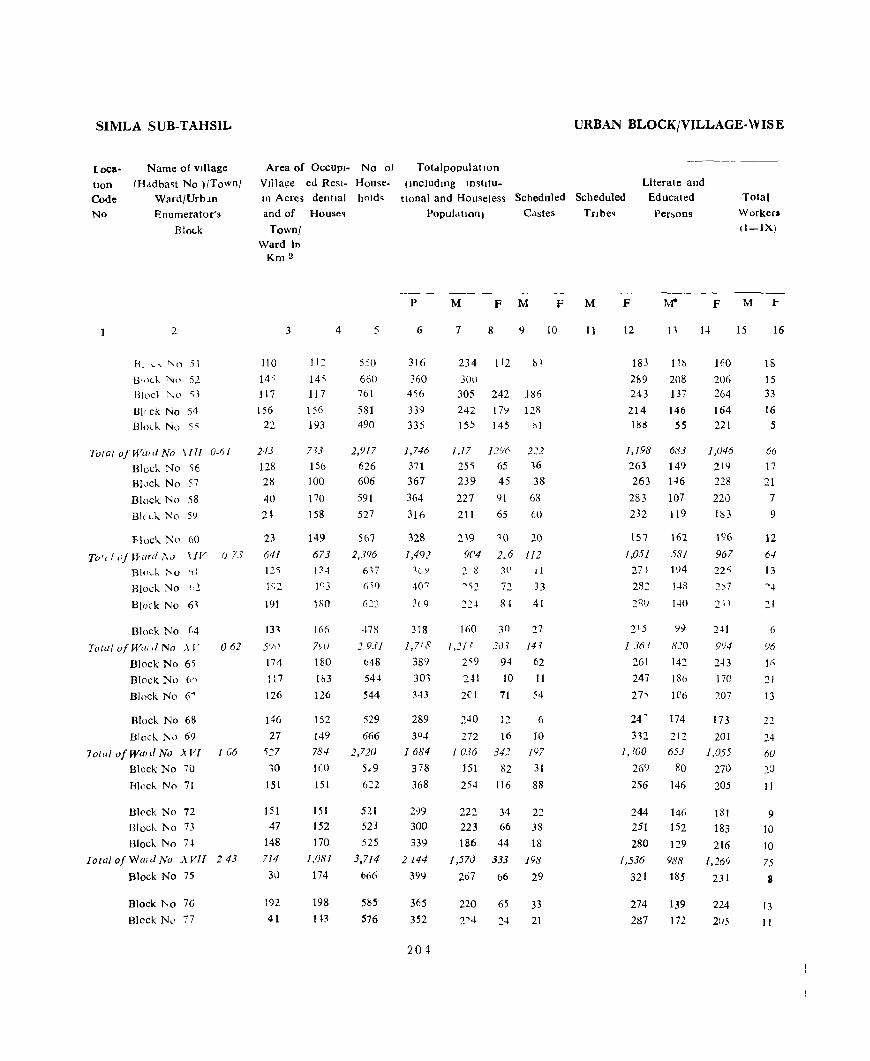
SIMLA SUB-TAHSIL
locatIon Code No
Name of vIllage
rHddba~t No )/Town/ Ward/Urbln
Enumerator's
BloLk
2
HI L" "0 51
B',)Lk. 1\;0 52 Blod 1',0 53
HI, ck No 54 Block No 55
Total o/Wwd No \ITI o-r,/
Block. No 56
Block No 57
Block No 58
Bic ck. No 59
Flock No 60
Tot, f oj H'ard 1\<.) \IV (j 73
Bl(l\..-k 1'0 f)\
Block. No ,,2
Block No 6,
Block No (;4
Tolal O/Will d No ,\ I'
Block No 65
BlOCK No 6'>
Block No 6""
Block No 68
Block. No 69
062
10{,'/ o!wmd No .,\Vl 1 u6
Block No 70
Block No 71
Bkck No 72
Ulock. No 73
Block No 7t
Towl o/Wmd No .,\Vll 243
Block No 75
Block i'oo 76
Block N,l 77
Area of OCCUPI- No of
VIllage ed Resl- House. In Acres dentlal hold~
and of Houseq
TownJ Ward In
Km 2
110
145 117
156 22
243
128 28
40 2~
23
641 125
1~2
191
131
5<)1)
174
117
126
146 27
~~7
10
15t
151
47
148
714
30
192
41
3
II:
145 117
156 193
7>3
156 100
170
158
149
673 0 ... I n3
liiO
I (if;
7>'u 180
Ik3
126
152
149 784
IGO
151
151
152
170
1,081
174
198
113
4 5
550
660
761
581 490
2,917
626 606
591
527
567 2,396
47R
2931 (J48
54-1
544
529
666
2,720
5,,9
521 523
525
3,714
666
5115
576
TotdlpopulatlOn
(lncludmg IDshtu-
URBAN BLOCK/VILLAGE-W IS E
tlOnal and Houseless Scheduled Scheduled
Literate and Educated
I'er~ons
Total
Workers II-IX)
PopulatIOn) C,lstes
P
6
316
360 456
339 335
],746
371
367
364
316
328
1,491 ~V)
40 7
:(,9
318
1,718
389 301
343
289
30 4
1684
378
368
2-}9 300
339
2144
399
365
352
20 ~
M F M
7 8 9
234 112 !lj
300
305 242 186 242 17') 128 ISS 145 1'>1
25" 65 16
239 45 38
227 91 68
211 65 60
2'9 9C4
,0 20
2,6 112 2. 8 3l' II
""2 72 33
22~ 84 41
160 30 27
I,ll? .7cl3 14,
2'9 94 62
2·H 10 II
2el 71 54
240 12 6
272 16 10 1036 34.7 197
151 82 31
25-1 116 88
222 34 22
223 66 38
186 44 18
] ,57<) 333 198
267 66 29
220 65 33
2'4 24 21
F
10
Tribe.
M
11
F
12
183 11~
289 20g 243 137
214 146 188 55
1,198 683
263 149
263 1-16
283 107
232 119
157
1,05J
271
282
2 15
13(1 ?
261
247
271
24 ~
162
581
194
14S
140
Ii eO 142
ISl>
It'6
174
14
F
160
206 264
164 221
1,U46
21<)
228
220 183
196
961
22S 2)7
21"1
2~1
9')4
2.)3
170
207
173
3,2 212 201
1,100 653 1,055
269 80 270
256 146 205
244 146 251 152
280 129
1,536 988
321 185
274 139
287 172
181
183
216 1,269
231
224
20S
15 16
18
15 33
16 5
66 17
21
7
9
12
64
13
(,
'16
21
13
22
24 60
20
11
9
10
10
15
8
13
II
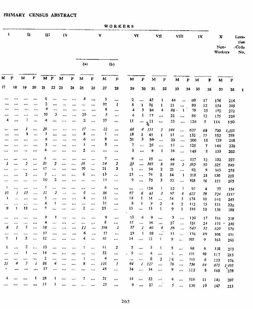
PRIMARY CENSUS ABSTRACT
WORKERS
1 II III IV v
(a)
MPMFMFMFMP M
17 18 19 20 21 22 23 24 2S 26 27
4
1
\
1 )
2
2
10 1 13
9 13
8 1 5
1 2
2
21 4 3
4
' .. 1
4
2 4
to
4
20 3
6
3
4
4 35 J7
7
10
1
31 5 (j
7
9 4
58
17
J2
13 14
2 88 17
28 II
3
2 ......
2
2
4
4
20
2
17 8 6
2
16 10
6
6 4
2
12 6
4
1
8
.. J
3 37
6
5
37
22 1
9 5
7 54 21
13 14
6
86 13 31 25
9 8
196 17
4]
F1
53
4
116 45
21
23
(b)
F
28
I
2 2
2
2
1
VI vo VIII IX x: Loca .. tion
Non- -Coc!e Workers No.
M F M F M F M F M F
29 30 31 32 33 34 35 36 37 38 1
2 5 4 4
11
68 18 31
7
3
9
V 1
23
9
43 1 51 3 84 1 17
~11
1 44 60 1 21 _90 4 88 - 1 78
22 86
23 128
17 156 12 154 25 192 12 175
5 114
216 285 272 226 150
4 151 1 144 623 6(9 700 1.105 1 45 1 ] 1-3 56- 20
26 53
9' 1 16
15 345
94 74 53
8 2
2 3
44 99 21
14
52
132 15 J52 238 100 18 139 218
125
149 7 144 220
117 2 382
62 llS
105
8 133 202·
12 50
9
21
16
132 525 143
150 155
227 840 255 228 203
124 12 <)7 4 67 6 61 3 97 8 623 76
77 154 724 JIl7 146 243 18 14 54 5 134 10
8 9 2 4 2 112 15 13 13 9 1 Il6 10
13 15 57
29 14
4 9 16
1 40
10
13
4
3
27 36
15
9
130
131 643
17
2'" 52
176 .)9
103 9
133 220 1}6 188
li6 218 193 ' 248 629 976
]08 131
163 243
5
, 9 5
4 8
5 1.
68 101
1115
736 112
6
·10
8 64
8
118 213
117 213
205
94 34
14
9
1 127 14
32
27
2 [ 6 76 9
4
5
'" . 123 176 875 1495
• 168 259
J 16 11 141 207
130 ]0 147 213
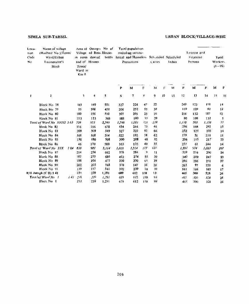
SIMLA SUB-TAHSIL URBAN BLOCK/VILLAGE-WISE
locd- Name of vIllage Area of OCCUPI- No of Total populatIon lIon (H,ldbasl No )/Town/ VIllage ed Resl- House- Including m~tIlu- Literate and
Code Ward/Urban In acres dentlal hold~ tlOnal and Housele~, Sch~dult:d Scheduled fducated Total
Nn I numerator'~ and of House. POOUlatlOn ( a~le. lnbes Per"ons Worker,
Block Town! (I-IX)
Ward 10
Km 2
------------- ----
P M F M F M F M F M F
2 1 4 5 6 7 S 9 10 I I 12 IJ 14 15 16
Block No 78 143 149 551 327 224 47 22 249 123 198 14
Block No 79 55 108 458 206 252 53 38 119 129 92 12
Block No 80 100 156 510 307 203 23 16 216 132 187 12 Block No 81 153 153 368 188 180 55 39 80 108 132 5
Total of Ward No XV[// 363 729 953 2,749 1,748 1,00] ~21 239 ],]70 503 1,158 77
Block No 82 116 116 678 434 244 73 44 296 144 292 15 Block No 83 209 309 549 327 222 93 66 252 125 195 14 Block No 84 168 168 514 322 192 58 62 179 51 210 If Block No 85 190 190 508 300 208 48 32 206 115 217 23 Block No 86 46 170 500 365 135 49 35 237 61 244 14
Total of Ward No XIX 104 820 981 3.114 1,800 1,314 177 127 1,391 974 1,083 107 Block No 87 214 254 662 378 284 9 11 339 216 100 24 Block No 88 187 237 686 412 274 55 39 340 209 247 23 Block No 89 108 108 477 330 370 65 39 286 286 251 37 Block No 90 202 205 748 378 147 38 28 265 97 220 6 Block No 91 139 177 541 302 239 10 10 161 166 165 17
8/11 Jutogb (C B) 1 41 23'J 239 1,291 689 612 110 ~9 465 300 328 26 Totalo/Ward No 1 141 219 230 1,291 689 612 110 S9 465 300 328 26
Block. No I 21] 239 1,291 679 612 1 fO 99 465 300 328 26
206
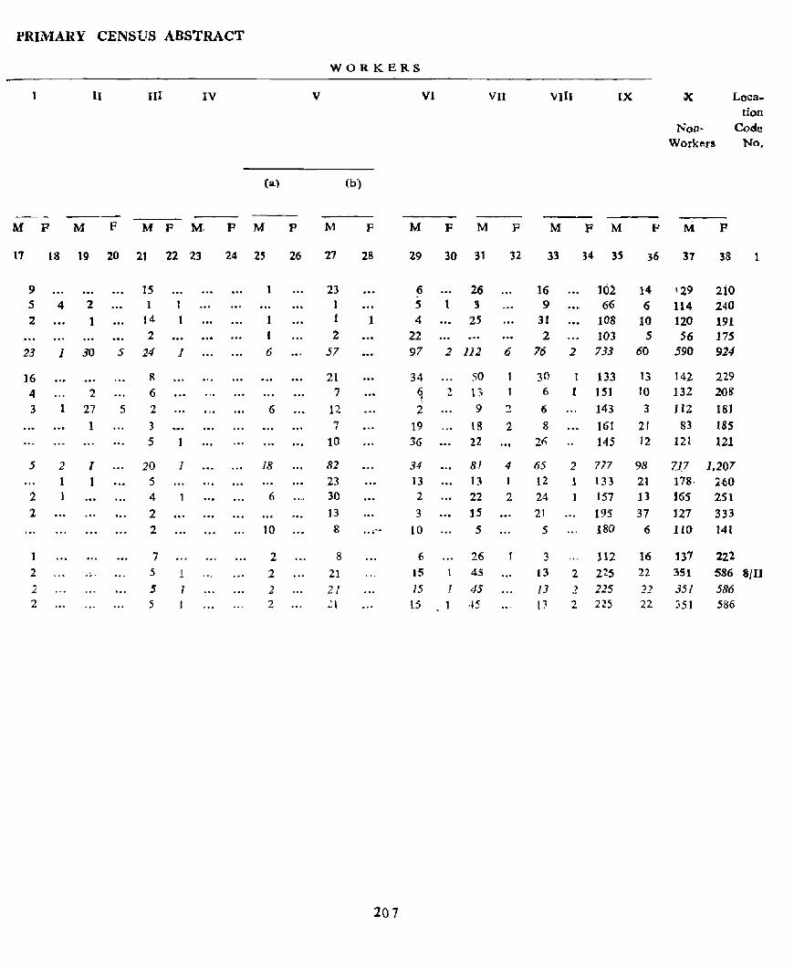
PRIMARY CENSUS ABSTRACT
WORKERS
II III IV V VI vn VIII IX a< Loca-tion
Non- Code Workers No,
(a) (b)
M F M F M F M- P M P M F M F M F M F M P M P
11 18 19 20 21 22 23 24 25 26 27 28 29 30 31 32 33 34 3S 36 37 38 1
9 15 1 23 6 26 16 102 14 '29 210 5 4 2 1 1 5 1 3 9 ., .. 66 6 114 240 2 1 14 1 1 1 1 4 25 31 108 10 120 191
2 2 22 2 103 5 56 175 23 I 30 5 24 J 6 57 97 2 112 6 76 2 733 60 590 924
16 R 21 34 50 30 ! 133 13 142 229 4 2 6 7 ~ 2 13 6 1 151 yo 132 208
3 1 27 5 2 6 12 '1 9 2 6 143 3 112 181
1 3 "! 19 18 2 8 161 21 83 185 I
5 10 36 22 .. ~ 26 145 12 121 121
5 2 I 20 1 18 82 34 81 4 65 2 777 98 7.l_7 1.207 1 1 5 23 13 13 I 12 1 133 21 178- 2{)O
2 1 4 6 30 2 22 2 24 1 157 13 J65 251 2 2 13 3 15 21 195 37 127 333
2 10 8 '" 10 5 5 180 6 llO 141
1 7 2 8 6 26 3 112 16 137 221 2 .. - S 1 2 21 15 1 45 13 2 215 22 351 586 8111
2 5 1 2 21 15 I 45 /3 2 225 22 35/ 586 2 5 2 21 15 1 -.5 tJ 2 225 22 351 586
207

TAHSIL KANDAGHAT


. •
. . ,
, SS
'\
77'
'\,."
'\ 4- \.
\ ... "1f\ -e'
77
'\ \
•
.,. • ."
..~ ..
." .
Based upon SUfVIJ.Y of India map with the permission of the Surveyor Genltral of Indlll
5'
(
5'
HIMACHAL PRADESH
TAHSIL KANDAGHAT
MILES
DISTRICT SIMLA '1 I
o 3 ICILONETA.t&
"'. . . II~ 1\4 In 10.
.,.
, ..
NATIONAL. HIGHWAYS/STATE ~S
RAILWAV UNE NARROW GAUGE
RIVERS
5y,,",eOUC ittPRE5ENTAtION Oft
Vll,.LAGes. IN THE FOLl.OWING
CATEGORlES
UNINHABITED. VILl.AGES
TOW ... ,
P'OST OFFl':ES
POST AND TELEGF\~PH OFFICES
POLICE $TATIONS) POLICE POSTS.
... .eST HOUSES
II~
It. .. 1~1'
I~
"." '" ',' r .... I "
' ..
•••• 7
POT
f'S,,,p
AH
......
®Government of lodie CopyrIght 1977
s'
",.
TAHSIL KANDAGHAT

KAl"\lDAGHAT lAHSlL URBAN BLOCK/VILLAGE-WISh
Loca- Name of vIllage Area of OCCUPI- No 01 fotalpopulatton
hon tHadbast No l/Towa/ VIllage ed Resl- House- (lDeludlng mstltu- LIterate and
Code Ward/Urban In acres denhal holds tIona! and H,luse]eS! Scheduled Scheduled Educated Total
No Enumerator's and of Houses Population) Castes Tribes Persolls Worker.
Bloclf Townj (I-IX)
Ward 10
Kru2
- --_._------ --~---
P M P M F M F M F M P
2 3 4 S 6 7 I 9 10 11 Il 13 14 is 16
2 KANDAGHAT TAHSIL
Km~
Total 4462 13,041 3!,774 13,232. 16,475 19,285
12,268 68,031 31,258 12,076 7,416 5,060
Km 2
Rural 4379 ll.I7] 31,211 11,950 13,679 17,020
10,972 59,230 28,019 10,.97.5 5.516 4,71J
Em a
Urban 83 1,868 4,563 1,282 1,796 2,165
1,296 8,802 4,239 1,101 1,900 288
IU

PRIMAR¥ CENSUS ABSTRACJ
WORKERS
I 11 III IV V VI VII VIll IX X Loea· lion
Non- Cod. Workerl No
(a) (b)
---M F M F M F M F M F M F M F M F M F M F M F
17 18 19 20 21 22 23 24 25 26 27 28 29 30 31 32 33 34 35 36 37 38
10.390 1,151 431. 60 447 668 1.010 791 803 3,523 16.489 4.264 89 52 1 24 22 53 20 10 524 27.198
10,382 1.160 .!89 60 394 464 859 474 619 2,219 14,191 4.261 88 44 2 24 19 41 13 8 270 23,247
8 1 43 53 204 I5} 317 184 1.304 2)99 ; 1 8 3 1J 7 ; 254 3,951
213

KANDAGHAT TAHSIL
Loca
tion Code
No
Name of village
(HJdb:ist No )/ rown!
Area of OCCUPl- No of VIIla;e ed Resl- HouseIn acres Gentlal holds
and of Houses
2
1
4
5 6
7
8 '}
10
II 12 13
14
15 16
17 18
19
20 21
22 23 24
25 26
27
21l 29
30
31
W.lrd/Urbln
Enumerator's
Bloclr
RURAL AREAS Kad:iUr
An]1 Barhmana
Rachhana Cham.ln
Kathh Kashman
U.lrU
AnJI<;unaran Chund
RugJa
M.lkJ),an Lachhog
Kolla
T,kkar
Blnola Kot
Bochan Salam
Badl30la
Gandron Dh11a
NI!ka Gaon
W.Jkna
Katol
Shalawon Klan
D,hum Sdhar
An]1
Scnchra
Townl Ward 10
(9(1)
(91) (9') (71)
(72) (73)
(75) (7 ~) (76)
(77)
(78) (82)
(83)
(84)
(85)
(86)
(87) (88)
(89)
(79)
(80)
(81) (128)
(127)
(4:!6) (427)
(423)
(429) (430)
(431)
(432)
Km2
3
65
182 210 119
40 160 123
205 64
28
87 :19 S9
91
51 191
247 55
183
90 21
49 861 288
166 287
180
244 357
204 258
4
6
10 7 7
2 9
14
14 3
9
1
7
S 12
11 10 10
5
4
59 20
6 26 16
26 37
13 15
s
6 10 7
7
2 10
:0 26 3
1 11
7
5 12
12 12
11
6
4 62
23
29 26 16
26 37
13 15
URBAN BLOCK/VILLAGE-WISE
Totalpopulation
(Incllldlllg lD,>tltu-
tIOna I and H )useless Scheduled Scheduled
PopulatIon) Castes Tnbes
t'
6
~o
53 64 51
11 47
115
tiS 18
2
4 65 1
41
31 36
66 53
43
31 1J 23
379 124
12 127
83
116
18;)
57 74
214
F M F .(\1
7 8 9 10 11
:;:2 28 13 16
26 27 13 11
34 30 2U jl 8 16
5 6 22 25 12 14
58 57 2 52 63 7 11
1 2 2 2 2
30 35 20 23
I
22 19 12 10
15 16 3 3 12 ::4 5 12
33 33 18 21 21 32 3 3
24 24 6 5
18 13 3 7
13 10 204 175 64 61
67 57
12 17 6 8 6~ 63 26 32 49 39 14 10
55 61 16 18 102 87 50 44
30 27 19 13 41 33 3 3
F
12
Llterafe and Educated
Persons
Total
Workeu
(I-IX)
M
17
14
2S 15
2 11 30
36 2
1
1 13 1
15
9 6
19 tJ 14
F M P
14 15
8 10
6 8
16
21 11 II 7 y
2 2 4 13
::0 23
23 23 27 3 j
5 15
4 8
6 8 10
6 14 15
7 11
12 3 9 3 1 9 2 9
77 22 128 102
34 11 38
7 3 7 7 32 20 32 24 22 10 P 7
25 10 34 9 41 19 56 11
9 5 14 3 16 6 24 14
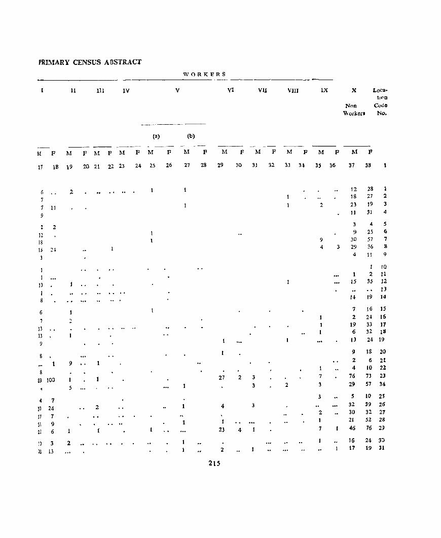
PRIMARY CENSUS ABSTRACI
WORKERS
11 111 1Y V VI VII VIII IX X Loca-ti£'O
Non Code
\Vockerl 'No.
(a) (b)
-- - - --- ----M F M F M F M F M F M F M F M F M F M P M P
11 18 19 20 21 22 23 24 2S 26 27 28 29 30 31 32 33 3.\ 35 36 37 38 1
6 2 . . .. . 12 28
7 18 27 2
7 II 2 23 19 3
9 11 31 4
2 2 3 4 5
12 9 25 6
IS 9 30 57 7
I,) 2~ 4 3 29 36 8
3 4 11 9
1 to 1 2 11
]J 15 35 12
I 13
8 14 19 14
6 1 7 16 15
7 2 2 2-l 16
13 I 19 33 17
13 1 1 6 32 lIS
9 13 24 19
8 9 18 20
9 1 2 6 21 4 10 22
8
89 100 27 2 3 7 76 73 23
5 1 3 2 3 29 57 34
4 7 3 S 10 2S
20 24 2 4 3 32 39 26
17 7 2 30 32 27
il 9 1 I 21 52 28
21 6 1 1 23 4 7 46 76 29
10 3 2 16 24 30
20 13 2 17 19 31
215

KANDAGHAT TAHSIL VRBAN BLOCK/VILLAGE. WISE
Loea- Name of Village tlon (Hadbast No.l/Town{
Area of Occupi. No or Total l'OI'ulatlon Village ~d RI!RJ. Hou'e- (mcludmg I n,tltu·
Cod. Ward/Urban
No.
32
33 3~
35 36
37 38 39 40 41
42 43 44 45 46
47 43 4) 50
51
'2 ~l
H S:; 56
~2
63
Enumerator', Block
2
Tlkrl {(ot
Kuarag ~aJr'J Hathum
Bhal~ch
Maha)l Bagash S"magar Kadhar
T,kkar Kalog Mahl
Desh Sanhec:b
ParO'ha Ghalatl Nagaoo Sen)
Kolla
Koharl Blml K'l')11111
KJdrtJ B8Jaur
BI~ha
D han
KalhlJ Sungal Shadhol
Sur Kamhala
ID acres dentlal held. twoal) and Houseless Scheduled Scheduled
and of Houses TownJ
Ward ID
(4") (434)
(435) (436) (U7)
(4 18)
(439) (440)
(441) (H2)
(443) (444)
(445)
(446)
(447)
(4t8) (449) (415 ) (416)
(417)
(413) (419) (4~J)
(4ll)
(4 2)
(423)
(4Z4)
(4':<)
(398)
(39J)
(4')3)
(4ill)
Km 2
J 4
201 14 180 12 IS? 15 20~ 8 200 22
246 13 3:} 6
51 8 941 355 146 16
41 4 53 10
114 19
100 17
131 12
49 ]8'J ]I
23::) 16
321 2~
156 2
231 33 163 6 135 8 1 t7 14 !8 4
1008 231
186 229 12J
26:>
I5S
79
17 21 1)
14
11 12
Population Ca~tes Tnbes
1\1 M F M F
6
H 7J 12 78 15 111 8 61
22 136
13 97 6 44
8 5J 372 ],626
16 71
4 32 10 64
19 87
17 61
14 63
1 5 14 7} 16 75
2' 122 2 17
33 t44 6 27 8 48
13 53 4 26
79 17
21
IS 14
11
12
336
73
96 101 84
65 !5
216
7 8 9 lJ
36 37 1 4 33 45 IS 17 55 56 13 9 25 36 5 10 72 64 6 4
53 44 3 2 21 21 j 4 2J 2~
917 709 156 148 41 30 15 15
22 10 ]4 6 33 31 S S 47 40 25 24 34 2';) 9 6
34 29 14 10
3 2 43 30 8 3 4) 26 6 3 65 57 28 25
11 6 1
74 70 35 ";0 14 23 2 4 22 26 U J3 3J 13 9 6 12 14 7 7
174 162 U W 34 II
54 42 49 52 9 31 S3 2
29 37 9 26 29
65
to
6 2
11 12
Llterate and Educaled
fChon'
M
Total Wod,cls (I-IX)
F M ,IT
14 IS 16
19 10 18 n J6 7 21 35 22 30 13 9 13 11 34 11 33 lS
25 9 26 18 9 8 19 8 10
62" 334 SI6 46 18 2 23 10
63 10 4 22 2 14 1 211 12 6 ,
21 8 21 6
13 4 25
I I 18 2 25 25 4 25 2 39 16 35 7
5 2 6
37 15 44 24 10 2 7 2 14 7 15 ,
U S 17 2 4 7 1
74 19
30 28 1(j
17 8
2.1 99 10l 6 2~ If
IS 3! IS 9 3' 35
I3 16 31
13 20 21 I 10 I

PRIMARY CENSU~ ABSTRACT
WORKERS
I II III IV V VI VII VIII IX IX Loca-tion
Non- Code
Workers No
(a) (b)
---- ----M F M F M F M F M F M .I:' M F M F M F M F M F
17 18 19 20 21 22 23 24 25 26 27 :8 29 30 11 32 33 3 .. 35 36 37 38
13 1 , 18 20 32 18 2 12 44 33
17 3 2 8 2S 56 34 10 11 I 2 12 25 35 20 25 1 4 2 1 .)9 39 36
21 3 , 27 41 37
5 1 I 13 22 38
6 2 19 23 39
66 Z II 1 29 18 15 62 8 64 1 35 21b 32 401 663 40 18 10 1 4 18 2Q 41
8 4 1 1 12 6 42 8 1 3 19 30 43
11 3 4 1 2 7 21 36 44 7 6 3 6 4 13 3 45
13 7 2 2 9 29 46
2 1 1 47 19 5 1 18 30 48 12 2 7 3 3 24 24 49 15 'i 9 2 3 4 3 30 50 50 4 1 5 6 51
15 16 7 2 1 3 7 11 3 30 46 52 1 1 2 3 7 11 53
14 5 I 7 21 .54
10 3 4 13 21 55 5 2 5 13 56
72 103 1 15 9 75 59 57 17 15 1 1 3 3 14 19 .58
9 14 4 6 12 1 22 27 59
28 35 I 1 15 17 60
JI 32 1 2 15 21 IiI
18 21 9 16 62
~ 2 16 28 63
217

KA~DAGHAT TAHSIL
Name of VI 1:;ge
(HlJ~,hl No )/ I own!
URBAN BLOCK/VILLAGE-WISE
Ar("a of OCCUpl. No of Tot1! population
VIIIg! eJ R~>I. HO.J~e· JIld.ll n~ In IliU-
Loca. tlon
Code
No.
W.IIJfl:,bln
EnUme'.:lI( r ~
m .Jer .. , ,knlldl hL]Js twnll dnd Hou,eh.ss ScheLluled "cheduled
Litera te a I d
Educdlcd
Persons
Tot.!1 W,J[kers
(t-l:ll..)
64
65 66
67 68
69
70
71 72 73
74
75
70
77
78
7) 80 81 82 83
84
85
86
87
88
89 90
91 91
93
94 95
Blol:k
2
Bdsha
B\~ltU
Bd 1\\ dla
R lura Th.tna Balcla
BJdon
Tundal AIJhu Kling
Ndh"ra
Dh r)an
Clldl,kl
flu' .ait
CI o' ra
rOl~h
Koro.,
KohlI ,M,ham
MJhog
ArJI
JhaJ'la Kha~
Clldhrl
ShlOg
Kathla
~alJdr
Sun a K~urd
Duntl
Dunu
.... ot
Bharech
Sakon B.1l1J!l1
anJ 0 f 11 u_es
Town! W,W.lIO
Km2
3 4
W:') 336 4,
(403) SO 24 (~OJ) 237 15
(~Q<) 365 8
(~)6) 358 38
(~07) 359 24 (408) <03 2;;
en ) 43 7 (~IO) 214 31
011) 115 13
(412) 531 53
(.t 1) 29 5
(414) 17 5
(~7f) 8'6 4')
(475) 266 13
(474) 89 4 (471) 4J 6 (472) ~ 1 19
(471) 93 6
(4.0) U4 6
(4~1) 373 21 (4<2) 5;) 4
(453) 57 7
(454) 111 1~
(455) 11 2
(465 1 35 3
(46 ) 73 6
(467) ~6 11 (468) 72 7
(46) 95 14
(470) 85 24 (456) 289 53
46
24 15
8 38
24 28 7
31
18
58
5
5
43
13
4
6 19 6
6
21
4 7
18
2
3
6
12 7
14
24 S3
POpulatIOn
p
6
234
150
73
50
177
118
152 31
113
62
214
20
26
2 2 63
8
27 6+ 24 19
124 25
28
93 11
12
18 59 42
7-l
111 262
21s
M F
7 8
106 128
67 R3
~6 37
24 26
7l) 98
56 67
83 69 17 H to 53
33 29
119 115
13 7 9 17
I2l 12-)
37 31
5 3 12 15 38 2)
15 9 12 7
57 67
13 n 17 11 4:) 44
5 6
5 7
10 8
30 79
2.t 13
35 39
60 51 42 12J
At F M
9 10 11
55 59
39 47
5 5
2 43 51
34 'l5
41 27
12 10
6
40 47
32 36
11 15
I 3 IJ 6
2 2 2
18 20
5 3
31 20
18 18
14 13 87 ~-l
F
12 J3
33
20
13
3
36
10
45 3
40
22
51
8
5
41
21
1 3
IS 6 2
20
6
5
21
3
5 12 10
7
34 53
F M F
J5 16
15 65 7
4 40 5
2 18
13 2 19 56 18
33 5
13 47 14 10 1
25 39 8
13 25 12
23 67 30
3 10 5
5 6 4
15 75 M
5 23 22
5 3 8 10
11 22 12 1 7 1 2 7 3
7 37 33
2 9 2 12 6
6 27 7
1 3 3
1 3 4
1 8
17 4 2 13
5 21 2
9 36 36 17 91 2
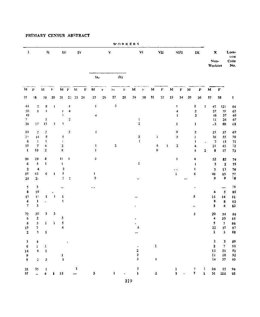
PRIMA RY CENSUS ABSTRACT
WOAKER-;
11 Ul IV V VI VlI VIII IX X Loca-tlOO
Non- Code Workcri No.
(a) (b)
----M F M r M F M F M r j,1 r M .I- M F M F M F M F
17 18 19 20 21 2~ 23 24 2S 26 27 28 29 30 31 32 33 34 3S 36 37 38 1
44 2 8 3 3 1 8 41 121 64 30 1 3 4 4 2 27 7S 65 10 4 2 18 37 66 7 5 2 11 24 67 36 17 13 1 2 1 ",3 80 t8
19 2 2 3 9 2 23 57 69
3' 14 8 2 2 36 55 70 6 1 1 7 13 71
13 7 6 2 2 4 2 4 21 45 ?2 1 10 2 8 9 4 2 8 17 73
39 29 8 11 2 6 52 85 74 6 5 I 3 2 75 2 4 '3 3 13 76
58 63 6 1 3 I 6 48 65 77 24 21 2 2 9 9 78
5 '3 79 8 10 4 S 80
15 11 1 1 5 16 14 81 6 1 8 8 82 7 3 S 4 83
32 30 3 '3 2 20 34 84 6 2 3 4 10 85 6 5 1 1 5 S 5 86
19 7 4 4 22 37 87 2 3 1 2 '3 88
3 4 2 3 89 6 1 1 1 2 7 90
14 4 1 2 13 25 91 9 1 '3 11 18 92 9 2 5 1 5 1 14 37 93
21 35 1 5 1 7 I 24 15 94 57 4 1 15 2 1 1 2 1 7 1 51 113 95
219
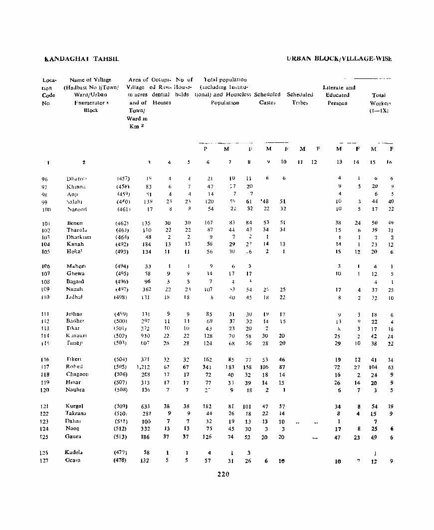
h.A1~.uAGHAJ TAHSIL
Loca
tion Code
No
96
97
9R
99 100
101 10'2 Jo1 104 105
106
107
108 109 110
III liZ
113 114
11<;
116 117 118 119
120
121 122
123
124
125
125
127
Name of VI!)age
(Had bast No )j fownl Ward/Urban
fnumerator s
Block
Area of OC(.UPI- No of Village ed R~sl- Hou,eIn acres deDtla) hclds
and of Houses
2
Dhdfotl
Khmnd
An]!
'"alahl l'<arond
Benun Tharold Dharklsel Kanah Ho'<:a1
MdhofJ
Ghewa
Bagald Nagah
Jduhal
Jt;thna Badhet
flkar
Klnaufl
TanaJl
flken
Rohed
ChagaoD
Hwar Nauhra
Kurgal Takrana
Dahal Naog
Gaura
Kadela
Gram
Townl
Ward ID
Km 2
(457)
(45~)
(45 CJ )
(4fO)
(461 )
(462) (463) (464)
(492)
(493)
(494)
(4Q5)
(496)
~4l)7)
(498)
(499)
(500)
(501)
(50:?) (501)
(504) (505)
(506)
(507) (508)
(509)
(5101
(5' 1) (512)
(513)
(477)
(478)
1'1
83
'll
131)
17
135 tlo 48
184 134
33 i8 96
362
1"31
111
297 272 930
t07
371 1,212
268
313 136
633 281 100 332
186
58
132
4
4
6
4 21
Il
30
22 2
13 11
9
3
22
IS
9
II 10
22 28
32 67 17
17 7
38 9
7 13
37
1
5
7
4
21 II
30 22 2
13 11
J
')
3 2~
18
9 [ 1
10
22 28
32 67 17
17
7
38 9
7 13
37
1
5
10tal population
(lilcludlOg I n,t1t u-
URBAN BLOCK/VILLAGE-WISt..
1100.11) aDd Houseles5 Scheduled Scheduled
Tnbe,
Literate and Educated
Persons To!ai
Worke" (I-IX)
Population
p
6
21
47
14 120
54
167 87 \l
56
56
9
34
7
107
h
85 69 43
121l
124
162
341
72
77 r
182 44 32 75
126
4
57
M
7
10
:7 7
~()
22
1:13
44 7
29 30
6
17 , ..
4U
31 37 23 70 6g
85 183
40
33 9
81 26
19 45
74
1
31
220
F
8
II
20 7
61 32
84 43
2
3
17
" 54 45
3U 32 20 58 56
77
158 32
39 18
101 18
13 30
52
3
26
Castes
M
'48 22
53
34 1
14
2
I') 14 2
30
28
53 106
18
14 2
47 22
13
3
20
6
F
10
6
51 32
51 34
13
25
22
17 15
20 20
46 87 14
15
57 14
10 3
20
16
M F
II 12
M
13
4
\l
4
10 10
38 15
I
14
15
3
10
17
8
l)
13 8
25 29
19
72
16
26 6
34 8 1
17
47
It)
F
14
1
5
3
5
24 6 1
12
4
2
3 q
3
2 10
12
27 2
14 7
8 4
8
23
'7
M
15
6
20 6
44 17
50
39
7 23 20
4
12 4
37
32
HI 22 17 42 38
41 104
24
20 3
54 15
7 2S 49
1
1!
F
16
6
9
5
40 22
49
31 2
12 6
1
5
25 10
6 4
16 24 22
14 63 9
9 5
19 9
6
6
9

PRIMARY LEN~lJ~ AH~IRA(J
WORKERS --_- ----~-
II III Iv V VI VlJ VIII IX X L OCci"
tton
NOD- Code Workers No
(a) (b)
-----M F M F M F M F M F M F M F M F M F M F M F
17 18 19 20 21 21 23 2~ 2~ 26 27 28 29 30 31 32 33 34 35 36 37 38
3 6 2 4 " %
8 9 1 9 7 11 97 b ) 1 :! 98
4~ 4) IS 21 99
14 22 2 5 10 100
15 49 l) 2 2 1 33 15 101
31 31 3 3 1 5 12 102 .f 2 2 I 103
21 10 2 6 15 164 III 6 10 20 105
-t I 2 2 106 11 5 5 12 107 4 1 2 108
29 25 2 2 1 3 16 29 109
25 10 , I 8 35 110
10 6 1 13 24 III 21 4 1 15 28 112
16 Iii 6 4 113 40 24 28 34 14 36 22 30 34 115
38 14 1 2 44 61 116 90 63 1 2 1 8 79 95 117
19 9 3 1 16 23 118 12 8 1 6 18 30 119
3 :> 6 13 120
49 19 2 1 27 82 121 13 7 1 2 1 11 9 122 4 2 12 13 123
19 6 5 20 24 124 11 4 6 3 2 9 3 15 2 25 46 12S
1 3 126 7 9 1 3 29 17 127
221
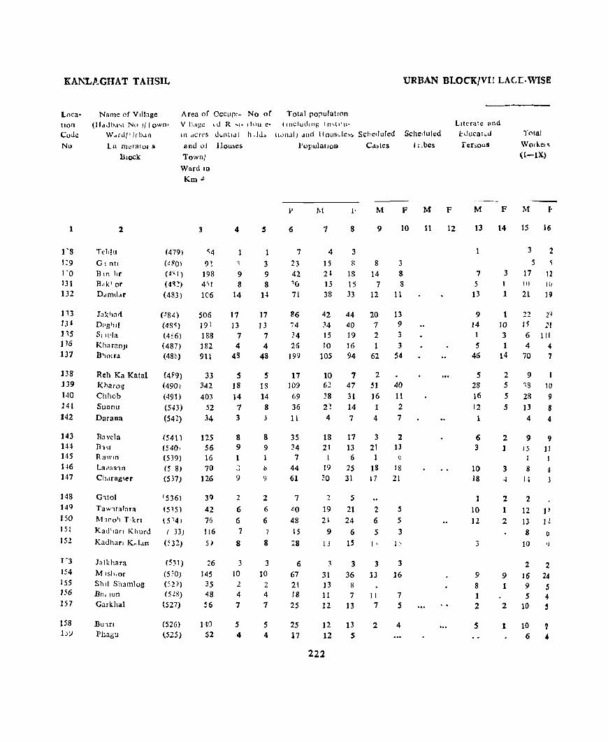
KANL.t'~GHAT TAHSIL URBAN BLOCKfVI1 LAGr·WISK
Location
Coue
No
1
1"8 1:9 1 '0 131 132
113 J1' 115 IJ6
137
138 139
140 141 142
143 IH J45
1~6
147
]48 149 150 15 [
152
1'3
154
155 156
157
Area of Occur'- No of Tota! pO;lU!atlOn V Ildgc «I R .. ,. ,i<lU e' (Including In,(I'u·
Name of Village (}-ldJh,I'>( No III ownl
W"rd/'Jro.ln In dcres ut..nt'.ll h -hh IlJn..!l) .1Ild Housde~~ Scheduled Scheduled
in mcralOI S
BlOCk
2
TeI,lu
Gl ntl
Bin l1r
B"k1or
D"mu.lr
Jakl,a<l
D?g'lll 51 lllia
KharanJI B '10 If:l
Reh Ka Katal Kharog
Chhob Sunnu
Darana
Bnvela n1~1
RawJn
L:I<'as1n
Ch.lrag~er
G1tol
Taw1talara
M,no'l T'kn
Kall'lan Khurd
Kadhan Ko 1.10
Ja Ikhara
M lsh,or
Shl! Shamlog Bh.lun
Garkhal
BU'lri
Phagu
and of llou~es l'opu)aLJon C.i~les I r ,bes
Town)
Ward In
(479)
(480)
(4' 1)
(4'l!)
(483)
(J8~)
<48<;) (4€6)
(487)
(48~)
(489) (490)
(491)
(543)
(542)
(541 ) (540, (539)
15 8) (537)
(536)
(5l5) (5
'41
( 33)
(532)
(53!)
(530) (5V)
(528)
(527)
(526)
(525)
Km.!<
3
<;4
92 198 4"1
le6
506 19\
188 182 911
33 342
403
52 34
125 56 16 70
126
39
42 76
116
5)
26
145 35 48
56
140 S2
4
9 8
14
17 13
7 4
43
S 18 14 7 3
8 9 1
" 9
2
6 6 7
8
3 10
2
4
7
5 4
3 9 8
14
17 13
7 4
48
S 13 14 8 3
8 9
b
')
2 6
6 7
8
3
10 2 4
7
S 4
6
7
23 42 1U 71
86 i4 34
26 199
17 109
69 36 II
3S 34 7
44 61
7
40 48
15
28
6 67 2[ 18
25
2S 17
M M F
7 8 9 10
4 3
15 g 8 3 2l 18 14 8 15 15 7 8 38 33 12 11
42 34
15 10
105
10 6~
38 2~
4
18 21
1
19 20
19 2l
9
I J
3
31 13 11 12
12 12
222
44 40 19 16 94
7 47
31 14 7
17 13 6
25
31
5
21 24
6
IS
3 36
8
7 13
13 S
20 7 2 1
62
2 51 16 1 4
3 21 1
18 17
2 6
5
1 '
3
13
1 I
7
2
13 9 3
3 54
40 11 2 7
2 13
6
18 21
5
5 3
3
16
7 S
4
M
11
F
12
Literate and
I.:Jucat~J
fersolls
M F
13 14
Total
Worke,q
(i-iX)
M
15 16
3 2 5
7 5
13
3 17 12
9 14 1
S 46
S 28 16 12
1
6 3
10 18
1 10 12
3
9 8 1 2
5
1 III H)
1 21 U
1 10 3 1
14
2 5
S
5
2 1
3 of
2
1 2
9 1
2
1
22 2~
15 21 6 111 4 4
70 7
9 13 10
28 9 13 8
4 4
9 9 l5 1!
I I
8 4 1.. 3
2
12 JI 13 H 8 ()
10 Ij
2 2 16 24 9 S S 4
10 5
10 7 6 4

PRIMARY CENSUS ABSTRACT
WORKERS
I II IJI lV V VI VII VJU IX X loca. tlon
Non- Cod. Workers No.
(a) (b)
M F M F M P M F M F M F M F M F M F M F M F
17 18 19 20 21 22 23 24 25 26 27 28 29 "0 31 32 33 3~ 35 36 37 38 1
2 2 1 1 1 128 5 5 10 3 129
14 12 7 6 130 8 9 2 5 S 131
19 19 1 17 14 132
22 29 20 15 133 12 20 1 1 19 19 134 4 14 2 9 S 135 3 4 1 6 12 136
SO 17 10 j 1 1 3 3S 77 137
I'i 1 1 2 1 6 131 33 10 2 1 2 24 37 139 20 9 4 2 10 22 140
5 7 3 3 1 1 9 6 141 4 4 3 1~1
7 9 1 9 8 143 15 11 6 2 144 1 1 S 145 7 4 11 21 146
12 3 2 16 28 U7
1 5 148 10 12 2 7 P 149 12 12 1 11 11 150 6 6 2 1 151 8 9 .! 3 , 151
2 2 I I 1S3 15 24 15 12 1S4 2 S 7 .. 3 15.5 5 4 Ci , 156 S 4 4 2 8 157
10 7 2 CI 158 4 " 2 ... ... .. ... f 1 lSi
223

KANDAGHAT TAHSIL
Location Code
No.
160 161 192 163 164
165 166 167 168 109
170
171 172 171
174
175 176 176
178
iN
180 181 182 183 184
185
18u Ill7 188 189
190 191
Name of v.llage
(Hadbast No )/Townl Ward/Urb;ln
Enumerator's
Block
Area of OCCUPl- No of Village ed Resl- House-10 acres dentlal holds
and of Houses
2
LnkharaoJI Sangar Nangah Baklona
Sharaun
B..lrrg Lahan k.otla Ncr
B.Jgar
Banen KI Ser
Sh!lraun "kola Anlln
Ragcon
Shamror Dhako ~anawal
l'aJhe Tnmh
Dhar
KaJor Dabrhcch Kotln Anmbar
Dhar]a Kanah Phashkna Manum
Dharan
Panog Damkn lhandu
7own/ Ward 10
Km 2
(524)
(523) (522)
(52L) (520)
(51 9) (518) (517)
(516)
(515)
(514)
(564) (565) (566)
(567)
(568)
(569) (570)
(571) ('i72)
(634)
(574) (575)
(576) (577)
(578)
(544) (545) (546)
(547)
(548)
(549)
1
83
128 27 20
158
61 88
178
224
158
765 31
106 84
122
42 50 31
144
146
634
148 114
137 216
198 279 57 94 47
162 60
4
8 12 5 1
13
4
10 1 )
13
15
74 2
4 13 8
11
6 'i
7 It}
5
8
12 5 1
13
4 10 10
13
15
74
2
4 13 i!
11 6 5
7 19
42 43
6 6 7 7 9 9
15 16
24 24 32 32
1 10 10
2 2
28 28
2 2
URBAN BLOCK/VILLAGE-WISE
Totalpopulatlon
(iDcludlllg IDshtu-tlOnal and Houseless Scheduled Scheduled
PopulatIon) Castes Tnbes
p
6
41
55 46
8
63
21 30
46
71
78
317
l'l
24 82 49
65 2t 12
46 100l
199
34
33 45
95
131
194
45 22
131
21
224
M F M F M
7 8 9 10
21 20 11 6 26 29 16 19 23 23 7 8
2 I) 2 6
37 26 4 3
q 12
17 13
.4 22
41 3J 22 17
38 40 10 13
173 144 98 81
12 6
11 13 4 2 35 47 5 8
25 24 17 13
33 32 II 13 7 5
26 20 52 52
4 4 4 8
3
6 7 1
5 7
102 97 68 64
15 19 8 10 13 20 7 7
23 22 9 9 50 45 37 36
74 57 66 52 102 92 99 92
1 28 17 9 9 Iv 12 8 5
72 S9 43 3S 8 13 3 8
11
F
12
Literate and Educated
Persons
M F
Total
Workers
(I-IX)
M 1<
13 14 15 16
8
4 13
1
16
3
10 9
17
18
49
8 4
17
9
18 5 4
10 23
40
4 6
9 15
19 41
12 7
34 4
3 13 20
7 13 1
2 20
3 8
15 9 13
2 24
4 23
13 97 1 6 6 6 2 20
3 18
10 12 1 7 2 6
12 14 35
14
2
1
1 1
5
1
19 <3 6
3 9 12
5 11 2 30
3 42 7 52 35
1 21 3
2 6 4
s sa 14
5 6 3
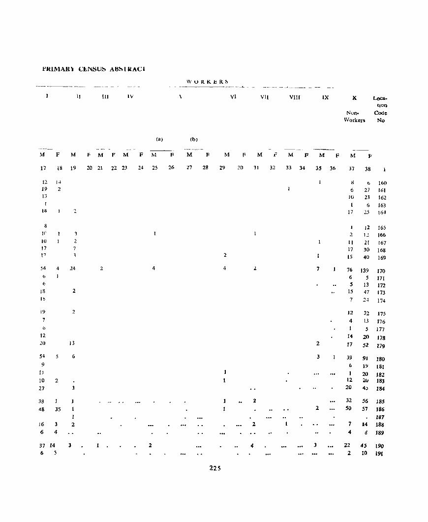
1'IUMAR\ CI!..NSU~ AH~HtACI
WORKbR~ - _-_ - -
-~~- - ~-- .... -- - --
II III tv \ VI VII VIII IX K. Loca-tion
Nun- Code Workers No
(a) (b)
-----M F M F M P M F M F M F M F M 1"" M F M F M F
17 18 19 20 2t 22 23 24 25 26 27 28 29 ~o 31 32 33 34 35 36 37 38
12 14 8 0 160 19 2 6 27 161 13 IU 23 162
1 6 163 its :: 17 25 164
8 12 165 Ir 1 2 12 166 10 2 It 21 167 17 7 17 30 168 !7 , 2 15 40 169
54 4 24 2 4 4 ). 7 76 139 170 I> 6 5 171 (J S 13 172
18 2 15 47 173 I~ 7 24 174
19 2 12 32 175 7 4 13 176 0 5 177
12 14 20 178 10 13 2 17 52 179
54 5 6 3 39 91 180 9 6 1.'.1 181
11 1 1 20 182 to 2 12 2u 183 27 3 20 4.) 184
38 1 J 2 32 56 185
48 35 2 50 57 186 I 187
16 3 2 2 1 7 14 188 6 4 4 d 189
37 14 3 1 2 4 3 22 45 190 6 :3 2 10 191
225
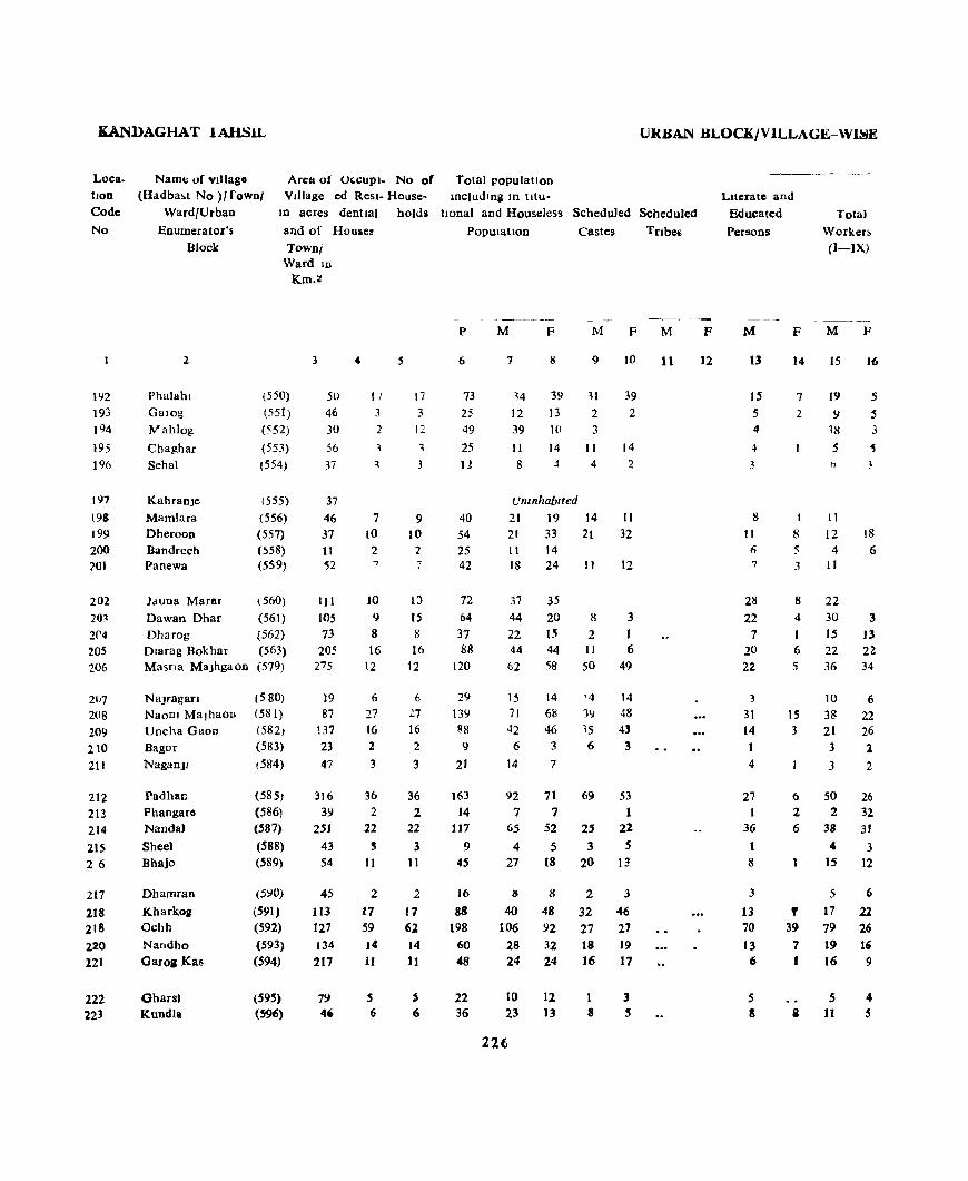
KANDAGHAT lAHSIL URBAN BLOCK/VILLAGE-WISE
Arc:tt of O'-CUPI_ No of Total populatlon Village ed Resl- House- Including m tltu-
Loca. tlon
Code
No
Namt: of villago (Hadba~t No )/ rowo/
Ward/Urban
Enumerator's
Block
In acres dentla) holds honal and Houseless SCheduled Scheduled Literate and
Educated
Persons Total
Worker~
()-IX)
In 193
194
195
196
197
198 199
200 201
202
203
2('4
205 206
207 208 209
210
211
212 213 214 215 26
217
218 218 220 121
222 223
2
Phalahl Garog
Wahlog
Chaghar Sehal
KahranJe Mamlara DherooD Bandrech Panewa
Jduna MaraT
Dawan Dhar Dharog Dlarag Bokhar Masna MaJhgaon
Najragan NaoDl Ma)haoD Uncha Gaon Bagor NagaD)1
Padhan Phangaro Nanda)
Sheel Bhajo
Dhamran
Kharkoll Ochh
Nandho Garoa Ka8
Ghars. Kundla
and of Houses
Town/ Ward 10
(550)
(551)
(552) (553)
(554)
(555)
(556) (557) (~58)
(S59)
(560) (561) (562) (563) (579)
{580} (581)
(582) (583)
(584)
(585)
(586)
(587)
(588) (589)
("YO}
(591) (592) (593)
(594)
(595) (596)
Km.:!
3
5U
46 30
56
37
37 46 37 11 52
III 105 73
205 27 5
19 87
137
23
47
316 39
251
43 S4
45
113 127 134 217
79 46
4
11
3
2 , 3
7 10
2 7
10 9 8 16
12
6
27 16 2
3
36
2 22 ~
11
2
17 59 )4 11
5 6
.5
17 3
12
1
3
9 10
2 7
W
15 8 16
12
6 27 16 2
3
36 2
22
3 11
2
17 62 14 11
j
6
POpulatIon Castes
p
6
73
25 49 25 11
40 54 25 42
72
64 37 88
120
29 13Y 88
9
21
163
14 117
9 45
16
88
198
60
48
22 36
M F M
7 8 9
,4 39 H
12 13 2 39 10 3 II 14 II 8 -1 4
Umnhablted
21 19 21 33 11 14 18 24
37 44
22 44 62
15 71
42 6
14
92 7
65
4 27
IS
40 106
28 24
10 23
22t
35
20 1.5 44 58
14
68
46 3
7
71
7 52
5 18
8
48 92 32 24
12
13
14 21
II
8
2 11
50
'4 39 '5 6
69
2' 3
20
2
32 27 18 16
8
F
39
2
14
2
II
32
12
3
1 6
49
14 48 43 3
53
1 22
5 13
3
46 27 19 17
Tnbes
M F
11 12
M
13
IS .5 4
4
3
8
11 6 7
211
22 7
20 22
3
31
14
4
27 1
36
1 8
3
13 70
13 6
5 8
F
14
7
2
I
8 5 3
8 4
J 6 5
15
3
6 2 6
, 39
7 J
II
M
IS
19
9 18
5
11
12 4
11
22 30
15
22 36
10
3~
21 3
3
SO 2
38
" 15
:;
17
79 19 16
.5 11
F
16
.5
5 3
'5
3
18
6
3 J3 22 34
6 22 26 l
2
26 32 31
3 12
6
22 26 16 9
4 .5

PRIMARY CEN~US AB~JRACJ
WORKER~
II HI IV V VI VII VlU IX X Loea-lion
Non- Code
\\ufkcn No
---- --_----(a) (b)
.....---- - ------ ----M F M M F M F M F M F M F M F M F M F M F
17 18 19 20 21 22 23 24 'l5 2'1 27 28 29 30 31 32 33 34 3~ 36 37 3&
1< 2 15 \4 192
6 2 3 8 193
'5 7 194 5 6 9 195
f, 1 2 196
Un1nhablft!d 197 10 I 10 19 198 12 17 9 15 199 3 (; 7 8 200
11 7 24 201
18 3 15 35 202 12 1 16 2 14 17 203 14 ) 7 2 204 10 2" 2 22 22 205 ~4 3j 26 24 206
Il t> I 5 8 207 24 22 2 4 33 46 208 17 23 4 3 21 20 21)9 3 :'. 3 210
1 II 5 21J
4, 26 3 3 4 42 45 212 I 2 J 5 5 213
36 31 I 27 21 214 4 : 2 215
12 12 2 12 (i 216
4 4 2 3 2 217 15 21 1 1 23 26 218 14 16 2 I 5 12 10 6 10 20 9 27 66 219 16 16 1 9 16 220 IS 9 8 IS 221
j 4 1 5 8 22l 7 5 3 12 8 223
227
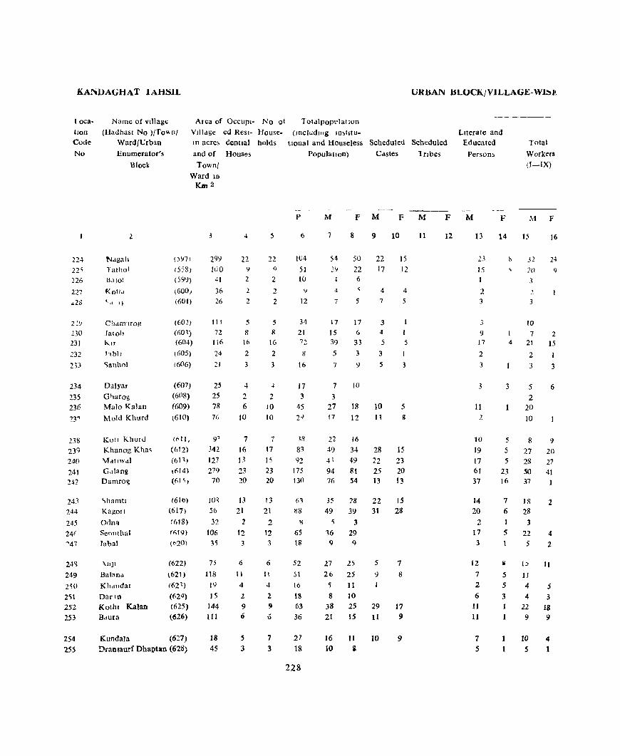
KAN})AGHAT JAHSJL
loca
tion
Code
No
22~
22'i
226
227
~2~
2,'7
230 231
232
233
234
235 23t:
23"'
238
239
240
241 H2
243 244
245
2M
"47
24~
249
2~O
251 252 253
254 255
Name of vtllagt:
(Hadbasl No )/To .... n!
Area of OCCUPl- No of
Village ed Resl- HouseIII acre, Genual holds
and of Houses
Ward/UrblO
Enumerator's
Block
Nagall
Tatho! BaJol
KotJo.l t d 1)
Cham'lfOg Jatoh KIf
hbll
<;lIn1101
Dalyar
Gharog Malo Kalan
Mold Khurd
Kutt Khurd Khanog Kha~
Matlwal G.llang Damro~
'>hamtl Kagon
Odna
Seonthal
Jabal
~nJl
Balana
Khandar
DarIn
Kothl Kalan Baura
Townl Ward lD
[{m2
5
(":m 299 22 22
(558) IllO lJ Q
(599) 41 Z 2
(600, 36 2 2 (601) 26 2 2
(602) 11) 5 5
«,01) 72 8 Il (604) 116 16 16
(005) 24 2 2
(606) 21 3 3
(607) 25 4 .j
(608) 25 2 2 (609) 78 6 10
(610) 76 10 10
«('11, 91 7 7
(612) 342 16 17
(on) 127 l3 15 (6r 4) 279 23 23 (61') 70 20 20
(6Ih) lU~ 13 t 3
(617) 56 21 21
(liI8) 32 2 2
(1)19) 106 12 12
("20) 35 3 3
(622) 75 6 6
\(21) 118 II II
(62l) 19 4 4
~2~ 15 1 2 (625) 144 9 9 (626) lit 6 6
Kundala (6'27)
Dra01aurf Dhaptao (628)
18 45
5 3
7
3
URBAN BLOCK/VILLAGE-W.bJ<.
Totaipopt'latlon
(IOcludlllg 1il~lItu-
tlonal and Houseless Scheduled Schl:duled
P
6
104
51 !O
l}
12
34
21
72
8
16
17 3
45 2-}
Ji!
83 92
175 130
63 liS
!!
65 18
52
51
16
18 63
36
27 18
228
PopulalloD) lnbes
M F M F M
7 8 9 10
54 50 22 15
2') 22 17 12 6
<1 4 4
7 5 7 5
i 7 17 3
15 6 4 39 33 5 5
533 I
795 3
7 IO
3 27 18 10 5 17 12 11 g
22 16
49 34 28 15 41 49 22 23
94 81 25 20 76 54 13 13
35 28 22 15
49 39 31 28
5 3
36 29 9 9
27 25 5 7
26 25 9 8
5 11 8 10
38 25 29 17 21 15 II 9
16 10
11 i
10 9
11
F
12
Literate and Educated
PersoD~
Total
Workers (I-IX)
M
13
23
15 I
2 3
3
9 17
2
3
3
11 1
10
19
17 61
37
14 20
2 17 3
12
7
2
6 11
11
7 5
F 1\1 F
14 15 16
II 32 24 20 (/
3
3
10
7 2 4 21 15
2
3 3
3 5 6
2 20
10
5 8 9
5 27 20
5 28 27 23 50 41 16 37
7 18 2 6 28
3
5 22 4
5 2
Ii D II
5 11
5 4 5 3 4 3 1 22 18 1 9 9
1 1
10 5
4
1
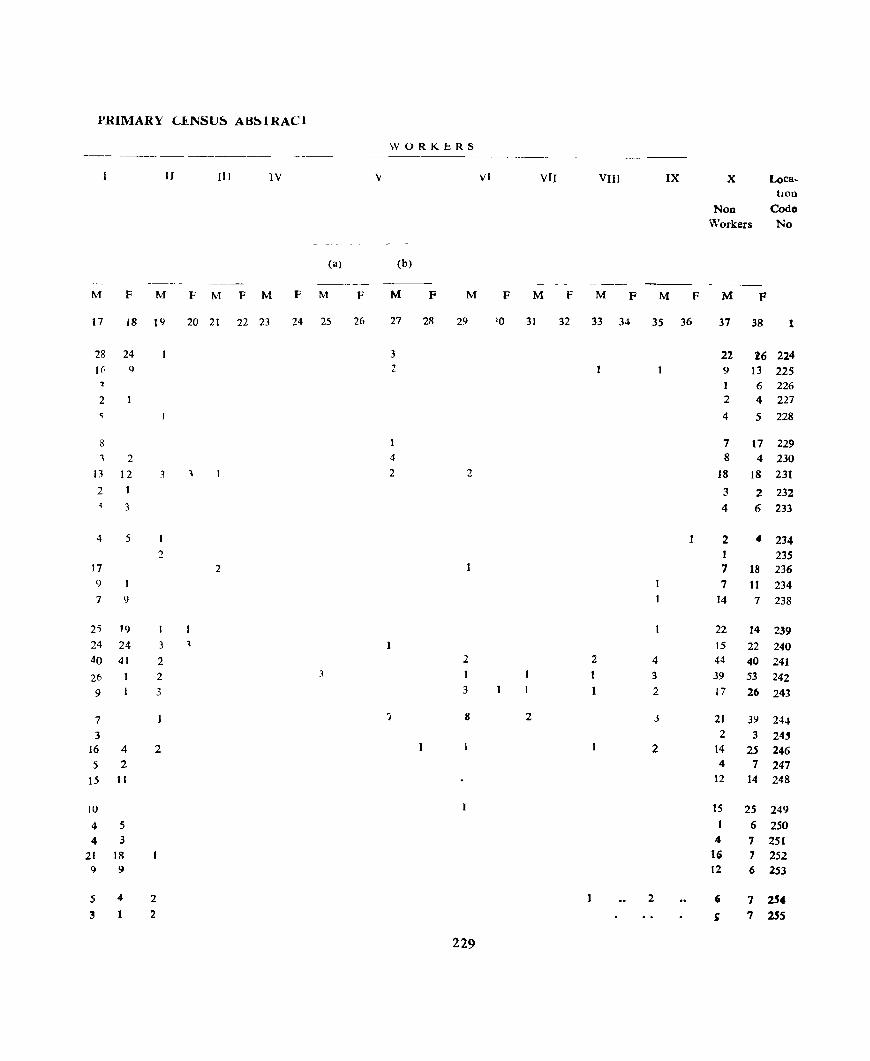
PRIMARY LJ<_NSlJ~ AH~lRACl
WORKf!RS -~ --~~~--~---
II (II IV V VI VII VIII IX X Loca-hon
Non Codo
"Vorkers No
(a) (b)
---_ ---M F M F M F M F M F M F M F M F M F M F M F
17 18 19 20 21 22 23 24 25 26 27 28 29 10 31 32 33 3~ 35 36 37 38 1
28 24 3 22 16 224 1(; Q 2 9 13 225
6 226 2 2 4 227
4 5 228
8 7 17 229 2 4 8 4 230
13 12 3 '\ 2 2 18 18 231 2 1 3 2 232
3 4 6 233
4 5 2 .. 234 2 1 235
17 2 7 18 236 9 7 11 234 7 9 14 7 238
2S 19 I 22 14 239 24 24 3 , 15 22 240 40 41 2 2 2 4 44 40 241 26 2 3 1 ] 3 39 53 242 9 3 3 1 2 J7 26 243
7 7 8 2 J 21 3Y 244 3 2 3 24-'
16 4 2 2 14 25 246 5 2 4 7 247
15 11 12 14 248
10 ]5 25 249 4 5 1 6 250 4 3 4 7 251
21 18 16 7 252 9 9 12 6 253
5 4 2 2 , 7 254 :3 2 ~ 7 255
229
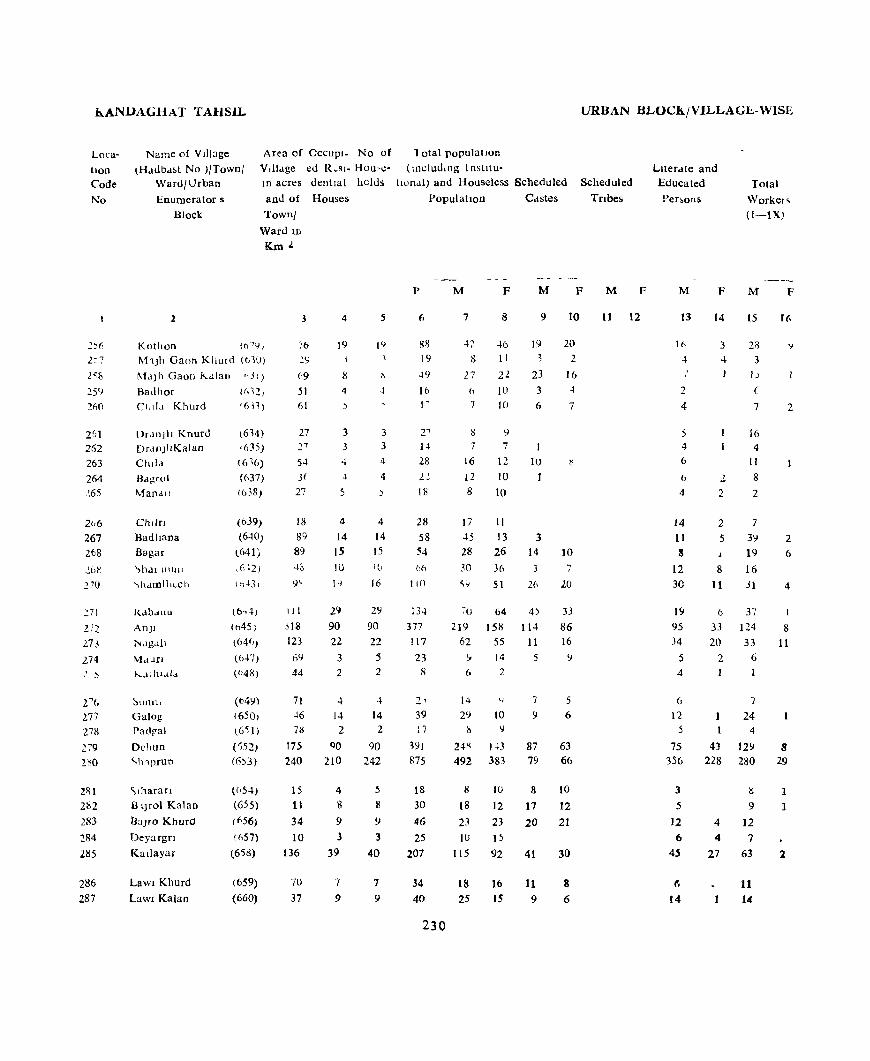
h..ANllAGHAT TAHSIL
Loca
tIon Code
No
2)(i
1.:7
25')
2liO
261 262 263
264 2.65
::: 71
2.13
27~
2~(,
277 27l\
~79
2RI
282
283
:!84
285
286 287
Name of V JlI3ge
tHdubd,t No )/Town/ Ward/Urban
Enumerator 5
Block
Area of OCCUPl- No of
Vdldge ed R~sl- HOll'Cm acres dentlal holds
and of Houses
Townl
Ward In
K.m J.
2
Kothon (0''),
M'Jh Gaon Klltl!d (tJ10)
I\ldJ h Gaon i<..alall ,,J I)
Badhor (1,'2, elide! Khurd i6\1)
()r.lIlJII Knurd
Drdll)IlKalan Child
Bdgroi
"'lan<lll
Chlln
Badhana Sagar
~hdl lliUll
\hdmlll(_ch
I<.dbdliU
An)1
t-.Jgdil
MdLHI
l-...ltill.d"
Galog
Pa(lral
Dchun
'lnprun
"'lhaTaIl B l)fOl Kal30
BaJfo Khurd
Deyargn
Kadayar
Lawl Khurd
Lawl Kalan
(614) ,(35)
16 16)
(637) (638)
(639)
(640) (641)
,642)
(6.,-lj
(b45) (64(,)
(b47) (b48)
(M'))
(650, \6~1)
(,}52)
(6)3)
«()54)
(655)
(£'56)
({i57) (6'i1l)
(659)
(660)
3
76 2')
<'9 SI 61
27
S4
3t
27
18
89 89 411
9'
III
.l18
123
61}
44
4
19
8 4
3
3
-+ ~
5
II!
3 3 4
4
4 4
14 14 IS 15
10 l(j
1'1 16
29 2')
90 90
22 22
3 .5 2 2
71 -+ -+ 46 14 14 71'> 2 2
175 QO 90 240 210 242
15 4 5
11 8 8
34 9 'J
10 3 3 136 39 40
70
37
7
9
7
9
Total population (including 1 nstllu-
tiOnal) and Houseless SCheduled
Population Cdstes
URBAN BLOCk/ VILLAGb-WISE
Scheduled
Tnbes
Llterdte and Educated
Pen,on& Total
Workel~
(I-IX)
p M F M F M F M F M F
6
liil
19
:(')
16 I"
2' 14
28
1.2
18
28
58 54
66
I iO
134
377
! 17
23 8
39
17
~91
875
18 30
46
2S 207
34 40
230
7
27 (J
7
8
46 11
2l
10 10
IS')
7 7
16 12
12 10
8 10
17 11
9
19
3
23
3 6
10 I
45 13 3
10
20 2
16
4
7
28 26 14 10
30 36 7
~'J 51 26 20
70 64 4) 33
219 158 114 86 62 55 11 16
.,. 14 5 9
6 2
14 4 7 5 29 10 '} 6
i'> \I
24K 1~3 87 63 492 383 79 66
8 10 8 10
18 12 17 12
23 23 20 21 1(J 1)
115 92 41 30
18 25
16 15
11 9
8 6
11 12 13
2
4
5 4 6
I:>
4
J4
11 S
12 30
19
95 34
5 4
6 12
5
75 356
3
5
12 6
4S
6
14
14
3 4
2 2
15
28 3
I J
(
7
16
4 11
8
2
2 7
Iii
2
5 3\1 2 19 6
8 16
11 31 4
6 37
33 124 8
20 33 11
2 6
7 24
4
43 129 228 280
lS
9
4 12 4 7
27 63
11 14
8 29
1 1
2

PRlMARY CI!.NSUS ABS'fRAC'l
WORKERS ---- ----
II III IV V VI VJI VIII IX lX Loca. tlOD
NOD- Code
Worken No
(a) (b)
-_ _--- --_--- -----M F M F M F M F M F M P M F M F M F M F M P
17 18 19 lit 21 22 23 24 25 26 27 28 29 30 31 32 33 34 3' 36 37 3& 1
10 ,J 5 6 2 14 .7 25' j 5 11 257
12 2 ]2 21 258 6 10 259 7 2 8 260
16 2 , 261 4 3 7 262 8 2 .5 11 265 7 4 10 264 :2 6 10 565
i 10 11 266 29 3 6 6 11 267
6 6 2 9 20 261 14 '6 269
2 2 3 3 2 28 47 270
I 2 3 3 3 3 4 I 33 63 271 59 5 7 2 4 3 5 3 28 13 3 95 150 272 \6 to 10 ~ 2 29 44 271 2 4 3 14 274
5 2 272
7 7 9 276 4 2 2 12 2 5 9 977 4 4 9 278
38 3 6 3 5 7 20 7 4 2 28 2 119 135 278 36 10 7 4 6 to 26 25 20 17 129 14 212 354 280
4 3 1 9 281 1 6 2 9 11 282 7 1 2 11 23 283 7 3 15 284
36 21 1 2 2 52 90 285
8 2 1 7 16 286 U 2 11 13 11,
131
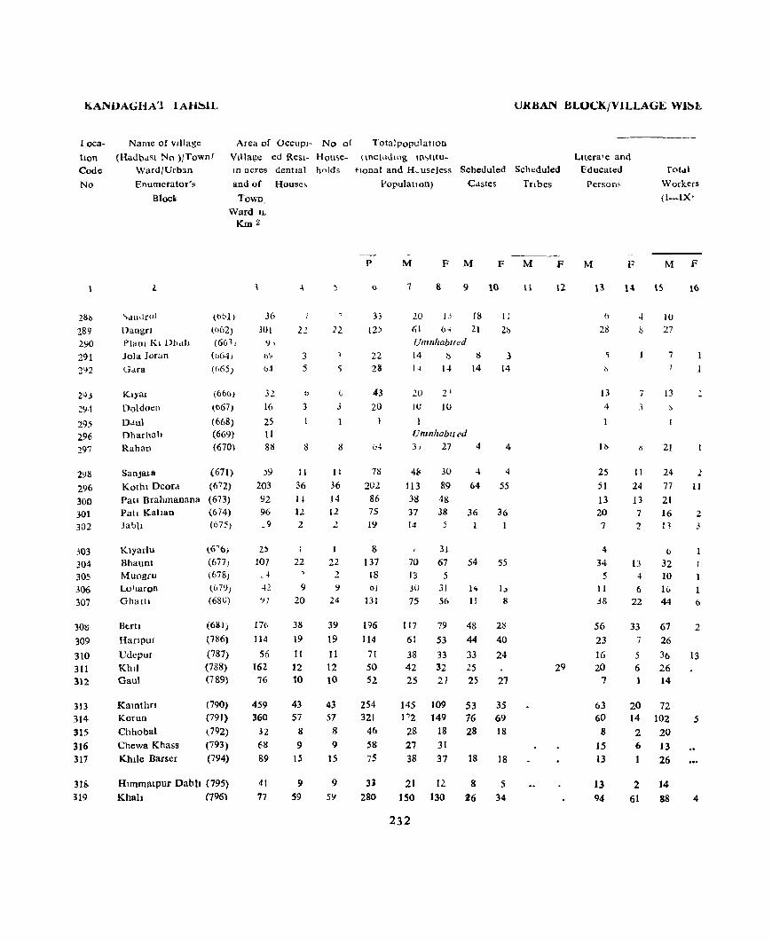
KANUAGHA'1 1 AH~lL
L oca
tlon C<>de
No
2Si>
289 290
291 292
243
29.t
295 296 297
2'.)1)
296
300 301 302
j03 304 305
306 307
308 309
310 311 312
313 314
315
316 317
31E. 319
Name of village
(HadbdSl No ){Town/ Ward/Urb~n
Enumerator's
Bloc~
Area of OCCUPl- No of
Village ed Resl- Hou,e
ID acres GentJal holds
and of House;,
"dnclro)
Dangrl Plam Kl Dh,i1J
Jola Joran
Klyar
Doldocn
Ddul Dharhalt Rahat)
SanJala KOlhl Deora Pat! Brahmanana Pat! Kahan Jabh
Klyarlu Bhaunt Mungru Loi"Jaron Ghatll
IkrtJ
HaflpUJ
UdepuJ
KhlJ Gaul
Katnthn Korun
Chhobal
Chewa Khass Khlle Barser
Town, Ward IL
Km2
(obI)
(1)62)
(661 ,
«()6..\1
((,65 )
(600)
(tJ67 )
(668) (669) (670)
(671) (672)
(673)
(674) (675)
\6~6)
(677)
(678) (67'.))
(68U)
(6l;l)
(786)
(787)
(788) (789)
(790)
(791) (792)
(793)
(794)
36 301
9,
l>~
b4
32
16
25 II 81l
)9
203
92 96 _9
25 107
- .j
42
'IT
L76
114
56 162 76
459 360
32 6!l
89
Hlmmatpur Dabll (795) lChall (796)
41
77
22
3 5
o
3
11
36
1-1-12
2
I
22
I)
20
31>
]9
It 12 10
43 57
8
9 IS
9 S9
22
o j
11
36
14 12
1
22 2
':I
24
39
19 11 12 10
43 57
8
9
15
9
SY
URBAN BLO<.:KjVILLAGE Wj~1.
Totalpopulatlon
\ mclllJlIlg 1O'>lItu-tlonal and H~ useless Scheduled Scheduled
Populahon) Castes Tnbes
P
33 12)
22 28
43
20
7'6
202
86 75 19
&
137 18 oj
13J
196 114
71 50 52
254 321
46
58
75
31 280
M F M
7 8 9
20 JJ 18
61 (H 21 {jllInhablled
14
14
20 21
1U IU
8
14
Unlllhabll ed
31 27
48 113 38 37 14
70 13 30
75
117
61
38
42 25
30
89 48 38
5
31
67 5
3J
56
79
53
33 32 21
4
4
64
36
54
1'1
11
48
44
33 25 2S
F
10
II
2h
3 14
4
4
55
36
55
I" 8
2ti
40
24
27
145 109 53 35 P2 149 76 69
28 18 28 18 27 31 38 37 18 18
21 12
ISO 130
232
8
26 5
34
M F
12
Lltera'e and Educated
Person;
fot,tI
Workers
(I-IX'
M
13
6
28
13
4
1b
25 51
13 20 7
4
34 5
11 3S
56
23 16 20
7
63 60
8
IS 13
13 94
F M F
7
3
II
24 13 7
2
13 4
6 22
33 7
5 6
l5
10 27
7
J3
~
21
24 77 21 16 Ii
b
32 10 1& 44
67 26
36
26 14
20 72 14 102
2 20 6 13 1 26
2 61
14
88
16
2
II
2 3
1 b
2
13
4

('1{IMARY Cf.N~V~ AB~IRACI
WUI{KER'> ---------- ---- -_-_ -
IJ III 1\ V VI VII VIII IX X LULl
!lur,
Non Code Workers No
-~ -----~- ~
d! b)
-- - -- - -_--M F M I- M F M F M f M M F M F M F M F M F
17 I~ 19 ZIJ 21 22 'B 2~ 1< 2< 27 2~ }.9 :HI 1 ' ~2 31 34 35 J~ 31 38
2 10 1J 288 21 2 '1--( 64 289
(j,III!W!JI/t I 290
7 7 7 291
6 7 14 292
11 2 7 21 293 2 10 294
295 Ulllllhablted 296
" 12 16 26 297
17 2 7 24 28 298 41 5 29 6 2 4 36 78 299 II 4 2 2 17 48 300
12 2 21 36 301
I 10 '1 2 :302
1 30J
21 (, 2 2 38 66 304
1 " 4 30'i
10 14 30 306 12 ~4 3 2 1 31 50 307
24 22 1 to 50 77 308
36 25 53 309
If( 13 3 3 12 70 310
20 2 24 42 311
13 11 27 312
62 I 8 73 109 313
80 5 7 4 10 70 144 314
20 8 II! 31S
'J I 1 14 31 '16
6 9 2 4 " 1:2 37 317
3 1 3 4 I 2 7 12 31S
3 4 3 II 4 2 21 27 15 2 62 12' 319
233

KANDAGHAT TAH~IL URBAN BLOCK/VILLAGE-WISE
Area of OCCUPI- No of Total population
VJllage ed Resl- House- JncluJ ng III utu- LIterate and lOCd
tlon
Code
No
Name of village
(Hadl'a>t 1'0)1 'o\\n/
\\ard/Llban
Enumerator s
Block
III acres dentlal hvld, tlOnal and Hou,eless Scheduled Scheduled Educated 10lal
320
321
122 32~
324
325
326 327 328
329
330 33t 332 333
334
335 336 337 338 338
340 341
342 343 344
345 346 347 348 3-49
350 351
2
Bam
n,ghota D~,'haunI
Cohron B,tIog Kha,
Dh,lun
Lolnojl Thapo Dhako
and of Houses
Town! \\ard ID
(797)
(798}
(/99) (8(11)
(b(JI)
(802) (80~)
(804)
(80')
KmL
3
52 116
13 164
337
4
2
9
7
27 61
AnJl Brahamanan (80G)
161
115 36
17
35
12 l~
4
2 5
Khalogra
Lado Jalle Hatb
Ramrur
Sultanpur
ChharanJI Jahan.! Blgor JhujllOD
Jllgan
[)cl1l101
Shatnlhech
Nahech Kha5 JabJe
BatOIl
Deephagarl Bhog
K.tmlan Chard Badhal Cham.trao RehoD
Baul! Khas
Katal Ka Thar
(807)
(808) (809)
(810)
(811)
(~12)
(813)
(814)
(815)
(816,
(817)
(811))
(819)
(1:.20)
(821)
(82.2)
(Kl,3)
(824)
(825)
(826)
(827)
(&28)
86 42 45
88
285
55
53 78 3.;
13
44
94 417 31 52
66 103
51 92
319
376
243
7
3 5
10
~6
(i
6 8 5
2
7
J2
43 I
3
3
4 6
33
40
19
2 9
7
27 61
12 13
4
2 5
7
3 5
10
26
6
6 8 5
2
7
12 43
3
3
4 6
33
PopUlatlOD castes
p
II
60 2R t3~
251
67
61
15
10
56
34
20 34 37
145
26 29 52 33 17
40
70
252 7
II
18
18
38 173
184 HI
234
M
7
7 4 30 30
14 14 75 )9
147 11.,4
30 34
10
7
30
17
8 18
20 76
12 [7 27 15 6
37 27
5 3
26
17
12 16
17
69
14
12 25 18 11
17 2,
~~ 36
127 125 <4 3
7 4
10 lS Umnliablted
9 9 20 18 91 82
95
57
89 54
M
2
"\
6 72 83
30
Ztl 10
11
7 12 9
59
7
17 15
6
16
19
72
3
10
14
66
27 'i7
F
10
1
2 4
5')
56
37 21
5
9
10 9 9
61
8
17
18
11
21
17 79
8
15 58
20
54
Jnbes
M
11
F
[2
Persons
M
13
4
19
9
32 S9
18 lIS 2
1
22
5
5 12
8 38
6
12 9 8
2
3
IJ
60 2
3
2 3
40
50
S
F
1
7
5 10
9
5
I
4
4
6 4
13
3 2
3 2
6
10
23
12
Workers
(I-IX)
M
15
2
11
7
41
12
16 18
.5
4 14
11
6
7
13
51
8 9
11 9 j
8
16 72 2
5
3
6 8
S4
,n 17
F
16
13 7 2
I
6
2
4 7
3
16
2
3 (\
3
PRIMARY CENSUS ABSTRACT
WORKERS
I II III IV V VI VII VIII IX " Loca-tIon
Non- Code Workers. No
-~-----~-
(a) (b)
---- -~-- ------M F M P M F M F M F M F M F M P M F M F M F
17 18 19 20 21 22 23 24 25 26 27 28 29 ~o 31 32 33 34 3S 36 37 38
1 5 4 320 7 2 3 12 29 321 1 2 2 7 14 322
20 2 9 7 34 59 ~23
37 11 ~ "i 4 4 \{) 18 <) 57 92 324
12 11 I 2 14 21 325 13 7 I 2 I 16 20 326
2 3 5 3 327 1 3 3 2 328
5 6 4 2 16 20 329
9 2 I 6 15 330 2 4 3 2 8 331 6 6 1 1 11 9 H2
11 2 7 14 333 35 15 2 10 3 25 53 334
8 4 13 335 9 8 12 336 9 IG 24 337 7 2 6 17 338
3 11 339
3 2 2 2 9 21 3~O 10 2 2 I 1 2 18 33 341 33 3 2 5 1 :. ) 20 3 55 117 342 2 2 3 313 5 2 4 144
3 7 l5 345 UllmlwbllPd 316
(> 3 1) 347 8 12 18 348
35 :; 3 10 n 81 3~9
43 J 2 2 44 86 350 20 4 30 54 351
235

h.ANDA&HAT TAHSIL URBAN BLOCKjV ILLAGE- WISE
Area 01 OCCUpJ- No of Total populatIon V!lldge td Resl- Houst:- (Including Imtilu-
Loc,,
tIon Code
No
Name of VI])agc
(Hadbast No )JTownl Ward/Urban
Enumerator s
Block
III acres dentlaJ he Ids tlOnal) dnd Housdes~ Scheduled ~cheduled
Tnbes
Llter,He and Educated
Persons lotal
Workels (I-IX)
352
353 351
355 3.)(')
357 358 359 360 361
362 363 364 365 366
367 368 369 370 371
372
373
374 375 370
377 378
379
380 381
2
DevJar
\lahseon Gallynd
Ma]hoh
l--otla
Ncn Khurd Ncn Kalan KI),artu J.lbal R.lshe,h
Shamlog
M'lJhlofl Kalan Shoboru Gawah KhaiantJ
MaJhar Mehlon Dharon Tohar P.lhala Shala
Gham.lrara
Ram Pand
Dharmpur Schanmu~hmana
Saharn
Chamaran
S'1harn Koilan Sahanl
Brahmanan
and of kHouses
Townl
W,uu 10
(829) (830) (831)
(832) (833)
(834)
(835) (836) (837)
(838)
(839) (840)
(~41)
(842)
(843)
(844) (845) (846)
(847)
(848)
(k6b)
(767) (768) (769)
(770)
(771)
(772)
Km'-
J
100
71 86
186
164
69 )3
47 "3 47
1'\
69
88 100 94
oS 37 59 48
138
55
214
150 79 29
13 37
4
7
2
8
14 10
6
6
6
2
I
6 6 4
9
4 8 .,
21
6
22 80 31 81
5
BheTi Kl Khech (773) 30 3
Pathla Basawal
(774)
(775) 33 24
I
2
7
2 8
14
10
6
6
1 6
2
1
6
6 4
9
4 S
7
21
b
2' 80 31 81
5
3
1
2
populatIon
p
6
37 13 SO
69
41
28
22
7 24
11
4 7
25 4t 39
33 26 29
30 95
22
141
315 124 335
14
42
28
3 25
M
7
23
7 27 38 21
14
12 4
14
4
3 4
9 26 22
14
IS 18
19 47
13
76
180 76
8 20
13
2
12
F
8
14
6 23
31 20
14 10
3 10
7
I
3 16
18 17
19 11 11 11 48
'J
65
135 48
145
6
22
15
I
13
Ca,te,
M
9
6
32 17
4
12
4
8 22 22
2
15 6
17 25
2
40
91 9
76
F
10
18
18
4
10
7
16
14
17
I 11 4
11 24
I
34
76 lU 52
M F
II 12
M
13
9
2
5
16
2
3 2
3 1
6 3
2
6
2
12
99 ;7
109
4
10
2
I
7
F
14
4
16
1.
5
5
2
1
16
39 28 65
3 iI
4
M
15
9
4 17
18 12
6
11
()
4
I 6
15
13
9 g
8 7
25
119
49
108
2 10
9
I
4
F
16
2
2
1
4
3
16
4
2
2
PRIMARY CENSUS AB"'I.RALJ
WORKER~
11 (II IV v Vi VII vIII IX x LO<.,d'
tlon Non- C<Jde
Workers No
(a) (bl
--- ~ ---~-
M F M r M F M F 1\1 F \\i I" M F M 1 ,
M F M F M F
11 18 19 20 21 22 23 2~ 25 2" 27 23 29 30 31 32 33 34 35 36 37 38
7 2 14 12 352 3 .3 G ..;53
10 5 It) 22 3~4
14 1 1 2 ) 30 3')5 9 9 1') 356
5 8 1\ 3j7
8 3 I 10 358 3 3 35':1
6 8 10 360 3 7 361
2 1 362 3 3 363
'i 2 3 14 364 8 7 11 17 365
13 Q 17 365
9 5 19 367 8 7 II 368
8 10 11 369 7 12 11 370
~l 3 2 22 44 371
, H 9 372 4 2 2() 2 8 I 41 6' 37J
12 3 3 26 13 II 4) II 61 119 ,i' 4 :' 3 13 :>. Ie. I 11 27 47 375 1 (; ~, 2'.) 4(J 4 82 IH 376
2 2 (> 4 377 8 2 10 22 378
9 4 15 379
1 380 "2 1 1. 8 II 381
'?J7
KANDAGHAT TAHSIL
Lo;:}-
uon
Code
No
32 383
384 385 336
387 388 389
3QO
391
392 393 394
395 396
397
098 399
400 401
402 403 404 <:05 406
401
408 409 410
411
412
413
Nl"n ~ of vllla~-::
(HJ.d:Il'1 N,) )' fownl
Ward/Urban
Enumerator's
Bloel.<
Are'! of 0:::.11'1- N~ of Vjlla~e eJ Re~l- HO<l,e
In acres dentlal holds
and of Houses
2
Ghart) Khurd Ghastn l arana)
Ghart! Kalan
Maltu
Banyan.
K,arad (lna Dabl)
Patta Kalawan
Kalhech
Dhar AnJ' Mat!ah
Tban
GllJer
Kdlletln
Ratha)
Khdffiar{)D
Bargyana
Baran Kalan
Kalth Oa11
Nakalyar Dol
!>haralln
Clladon Bdtoll Kalan Batoh Khuld
:'"nana
Chamon
Chuancha
Townl Ward 10
(776)
(177)
(778)
(779)
OliO)
(781) (782)
(783)
(784)
(785)
(b96)
(897)
(898)
(899) (900)
(901)
t902) (903)
llJ(]4)
(9U»
("06)
(907)
(911)
(914)
t9 J ')
(9 6)
(917)
(918) (91l;)
(920)
(921)
(922)
Km2
45
23
54
16 7l
274 31
9 48 24
185 171
166 60 ()9
80
193
39
20 83
42 lOa 54
57 21)
12: 16 2S
29 93
88 43
4
4
2
3
23
5 15
3
8
H 10
6
4
12 26
4
3
14
<)
3 {>
3
J
2 5 3
'J
9
2
:5
4
2
'3
1 3
15
3
8
15 10 6
4
12
26
4
3
14
y
4 '7
3
2 5 .}
9
9
2
URBAN BLOCK/VILLAGE-WlSl!.
r"t:ll po., l' o.tlon (Incl JJI 19 ID ,htu.
tlonal and Housc:less Schc:duled Scheduled
PopuiaIJOD) Castes Tnbes
P
I)
16
23
6 12
175
5 20 47
16
37
114 71 48 32
77
l~
25
16
bb
I
72 33
29 23
4 I) 4} , . 45
63 II
M F M F
7 8 9 10
8 8 :5 6
Uml'lhablted
10 13
2 4 8 4
9~ 82 60 54-4 )
II 9 6 3 25 22 13 6 to 6
20 17 7 9 57 57 17 14 31 40 28 20
15 17 14 17
32 45 12
54 65 32
1(J 9 7
7 a
= -l 32 25
3 4 37 35 22 22 11
14 15 11
l.l 1 J
"2 ;! 2 7 4
17 24 8 14
23 2 2
33 30 19 S 3
238
16
28 .. 23
22
10
4
17
M
11
F
12
LIteral e and
Educated
Persons
Total Workera
(I-IX)
M F M F
13
3
10 2 2
26 2. :5
13
8
:5 24 J3
17
S
17 !I
4
(}
I
4
3 :5
3 10
12
9 3
14
6
2
3
1
8 9
2
15
5
s
6
45 2 5
17 7
9 28 12
13 13
6 19
10 35
8
Ii 4
22
2 17
2 16
I Y 2 .)
J
3 4 10 2 S
10
13 3
16
13
10
3
KANDAGHAT TABS))..
Loca
tion Code
No
414 415
416 417 418
419 420
421 422 423
424 425 426
427 428
429 430 431 432 433
434
435
436 437 ~38
~39
140 141 142 143
144 445
Name of VI])age (Hadbast No )/Town/
Ward/Urban
Enumerator s Block
Area of OCCUPI- No of Village ed Resl- House-10 acres dentlal holds
and of Houses Town)
Ward 1D
2
Karauh Bayela Balahu
Tarol Kalog Basawal
(923)
(924) (894) (895) (849)
Kaba Kalan (g50) Jangria (8SI) Sanog (852) MlUn (853)
Ashna!a (854)
Chawat (855) Kanana (856) Dharara (847)
Bandh (858) l.andhJC ~lharaT! (859)
8atha Dadhog Nen Khurd NeT! Kalan
San
Kamlog
Baghor
Mgrog Odar Halda
Kadhargora Bobaran Gatogra ChamaroD Ded
Kothron
Barhngla
(860)
(861) (862) (863)
(864)
(864)
( 866)
(867) (868)
(869)
(970) (871) (872)
(873) (874)
(875
(876)
Km 2
109
127 334
89 20
312 72 39 14 77
50 63 30 9
26
21 99 27 88
56
63
NA NA
28 123
290 170 34 88
18
41
6
4
13
10 20
3 3
17 8 2 3
2
4 6 1
1 7
I
11
5 8
4
10
4 9
19 10 3
11 1
12 2
13
10
20 3
3
17 8 2 3
2
4 6 I
7
1
11 5 8
5
10
4
9
19 10
3
11
1
11 2
Total populdtlon (IDcludtng Instttu-
honal) and Houseless Scheduled
Population Castes
URBAN BLOCK/VILLAGE-WISE
Scheduled
Tnbes
Literate and Educated
Persons Total
Workers (1-1X)
p M F M F M F M F M F
6
65
78
109 19 21
117 3S 23 :21 13
13
35 6
14 17
4
49 23 42
38
66
34 63
98 53 13 41
4
60
10
240
7 8
3~ 31
13 45
58 51 II 8
13 8
9
4
8 10
13
10
2
It 11
8
59 18 11 12
7
58 12 8 17 18 17 12 11 12 9 12 9 6
8 5 6 4 19
3
9 9
16 13 14 333 5 8 5 4
2 2 25 24 12 11 20 22
18 20
39 27 Unznhablted
Unmhabited 18 16 31 32
49 49 32 21 5 8
18 23 2 2
30
4 30 6
2
9 12
18
39
18 19
25
13 2
2
6 11
20
27
16 19
2 IS
15 2
30 30 4 ~
II 12 13
15
15
17
4 4
21
1 2 2
8
S 2
1
5 4 6
9
15 15
7
17 6 4
6 2
4
14
9 9 6
4
2
6
1
15
13
12
26
5 6
41
12
6 7
6
5 10 I
5 7
2
15
7 11
13
18
18
15
30 18 4
13 1
16
3
16

PRIMARY CENSUS ABSTRACT
WORKERS
II III IV V VI VII VIII IX IX Loca-tlOD
NOD- Code
Workers No
(a) (b)
-- --- --M F M F M F M F M F M F M F M P M F M F M P
17 18 19 20 21 22 23 24 25 26 27 28 29 30 31 32 33 34 35 36 37 38
10 3 21 31 414 11 21 45 415 23 2 32 51 416 5 6 8 '417 6 7 8 418
41 18 S8 419 12 6 17 420 1 5 .. S 12 421 6 5 9 422 6 6 423
2 3 3 S 424 4 S 9 16 425
2 3 426 5 4 5 427 5 2 2 7 428
2 429 15 10 24 430 7 S Il 431
10 9 22 432 13 5 20 433
18 21 27 434 , Unmhablted 435 Ulllllliablled 436
10 8 J6 437 14 16 32 438
27 2 19 49 439 IS 17 21 440 4 1 7 441
13 5 23 442 1 2 .oC43
14 14 30 444 6 445
241
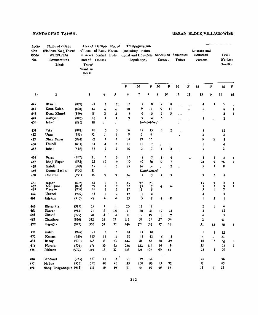
ltANDAGHA'l' TAHSIl,
Location Cod. No.
I,
4S1 452 453 4S4
45'
456 4S7 4S1 459
460
461 462 463 46-4 461
466 467 468 469 470
471 472 473 414: 476 '
476 477 47'
Name of vlllage (Hadbast No ){Town/
Ward/Urban Enumerator's
Block'
Area of Oecu!!l- No. of Village ed Resl- House-10 Acres dentlal holds and of Houses
Town! Ward ID
[(m2
2
BewaIl
Kona Kalan Kona Khurd Kathyar lehar
Tlkr! Urna
Dhar Banar Thundl
Jabal
Darat Bhoj Nagar Oatoll Doongl Beshkl Chharot
Jajher ""ahlyana Daeyan Undrol Jalyana
Bhamrara Sharar Chakli Chalthon Parath,l
Satrol Klarua Barog
Narafn' Jakhron
(877)
(878)
(879)
(880) (881)
(882) (8&3)
(884)
(885-)
(~86)
(887)
(888)
(889) (890)
(891)
(802) (893) (908)
(909) (910)
(911) (912) (925)
(926)
t927)
(928)
(929) (930)
(931) (932)
Jandaur! (933)
Nabon (934) ShOal Bhagwanpur (935)
3
21
44 IS
36 38
82 32 82 34
38
31 22 25 31 45
43 59 26 45 42
65 71
70
332
301
71 143 143 171
349
187 352
03
4
2
6 2
5
7
4 2
3
19
6
3
5 7 2
2 4)
5
2_
6 2
5
7
4
2
3
19 6
3
5 7 2 2
4-
4 4 9 10 4 ~ 4
24 24
31 32
5 5 11 11
33 23 33 23 33 33
14 40 19
14 40
19'
URBAN Bl..OCKjVILLAGE-WtSE
Totaipopulatlon (lDcludmg IOstttu-
tlonal and Houseless Scheduled Scheduled Literate and
Educated
Persons
Total
Worker. (I-IX)
Population) Castes. Tnbes
p
6
15 20
9
9
32 9
34
18
10
IS 70 28
14
45 32 17 12 13
23 HI 38
112
246
24 87
144 236 233
71 193 93
242
M F M F M
7 9 10
787 8 9 11 9 11 6 363 545
Uninhabited
17 15 3 5 4
19 15
11 7 3 7
873 40 30 12 14 14 Umnhablted 959
22 23 15 17 11 6
8 .. 5 8
11 9
6
4
2
2
4
7 2
5
8
60 51 17 13 19 19 8 7 57 55 27 34
120 126 37 34
14 10 44 43 6 8 81 63 48 39
122 114 14 9 126 107 69 61
3' 32 100 93 75 72 44 SO 26 !6
11
F M
12
F M F
13 14 IS 16
4
2
2
8 2 9
1
3
3 23 5
3
13 5 S
4
I
2 5
4
1
31
1
14 10
35 24
12. 11 13
2
5
Is 2 2
12 3
i
4
3
I 5 9 26 5 8
7 3 1
2
4
8 9 7
6 3 ,
6 32 9
41
13 70
12 23
3 36 73
5 70
26 65
6 28
I 2
4
1

PRlMA.lU CENSUS ABStRACt
W'ORKBRS
1 II III IV V VI VII VIlI IX X Looa-tlon.
Non- Cod. WorkcII No
(a) (b)
---M F M F M F M F M F M F M F M F M F M F M F
17 IS 19 lO 21 22 23 24 25 26 27 28 29 30 31 :32 33 34 35 36 37 38
3 2 , 446
• 10 447
2 4 2 448
2 3 4 449
Uninhabited 4S0
7 5 5 15 4.51
3 2 4 452
8 11 15 453
3 7 7 454
2 1 7 455
2 3 3 6 456
5 4 4 2 5 6 14 28 457 4 6 14 451
Uninhabited 459 4 5 5 460
'7 I 14 22 461
8 ] 6 16 462 7 4 6 463 6 2 4 464
2 • 465
4 2 .5 9 466 7 6 17 28 51 467 9 10 ]9 461
.cO 16 55 469 64 3 2 SO lU 470
10 2 2 10 471 20 I 21 43 472 17 20 42 62 473 52 18 2 49 113 474 53 15 '56 107 475
25 13 31 476 62 2 35 93 477 25 1 2 15 Sg 418
243 •

KANDAGHAT TAHSn. URBAN BLOCK/VILLAGE. ~SE
Loae
tlon Code
No
Name of VIIJagc
(Had bast No )/Town/ Ward/Urban
Enumerator 8
Block
Area of VJllage
OCCUPI- No of Total Population
479 480 481 432 483
484 485
486 487 488
489 490
491
492 493
494 495 496 497 498
499 sao Sal 502 503
504 505 506 507 508
509 510 Sl1
ID Acres
and of
Town/Ward
in Km 2
Seola Mehlog Shalr Takrota MaJhol
Badhan Panewa
SandhJg Shaunh
Banasar
Jodhpur KadlOI
Kamh Gaon Guman Dangayar
TaksaJ Ambola Han Ka Khe! Tlron Shalu Khurd
(936) (937) (938) (939) (940)
(941) (942) (943)
(944)
(945)
(946) (947)
(948)
(9~9)
(950)
(951) (952) (9~8)
(959) (960)
Bano) AchaJul (961)
Bano) Ramsmgh (962) Tlpera (953) Shalti Kalan (954)
Jangeshu (955)
Shalaura Khurd Shalaura Kalan Garkhal Badha Chabal
Sallvana Khadolt Gandhol Khas
(956) (957) (713) (714) (715)
(716) (717)
(718)
3
208 49 57
105 72
1~2
150 118 90
234
132 415
241 :;01
60
42 697
40
724 104
149 ISS 282 224 167
283 88
234 161 121
69 100 191
ed ReSI- House- (JOcludmg Instltutlooal) dentlal holds and HouseJess Scheduled
Houses Population Castes Scheduled
Tnbes
p M M F M F
4
19 5 7
14 II
18 7
14 7
32
8 34 31
103
15
56 72
2 74
7
9
IS 27 27
~6
20 118 IS 14
7 13 IS
19 5
7 14 12
18 7
14 7
33
8 34 31
106 IS
5(\
72 2
74 7
9 1
15 32 27
26 20
119 IS 14
7 13 IS
6
J02 45
43 104
66
79 48 92 37
167
46 191 154 652
70
296 440 :0
515
29
36 4
119 152 165
191 79
562 92 60
35 82 76
7 8
54 48 22 23 19 24 54 5J 34 32
38 41 27 21
48 44 16 21
83 84
25 21 96 ,s 85 69
421 231 36 34
156 140 230 210
11 9 266 249
16 13
9 10
46 37 6 5
7 7
12 21 11 13 44 36
47 51
30 22 49 37
147 110 2 4
105 102 62 50 11 9
109 102
3 2
21 IS 10 6 J
62 57 20 22 77 75 37 35
102 63 49 30
117 39
297 42 32
17 35 41
244
74 40
265 50 28
18 47 35
23 29 61
15
8 4
25 30 57
14
6 7
It 12
Literate and Educated
Persons
Total
WOlkels <i-IX)
M
13
10 11 5 8
21
9 8
5 5 9
7 26 35
146 21
71 126
129 2
4 3
23 21
.4
63 21
212 27 13
12
17 29
F M"""" F
14
3 2
3
6 14 51 17
28 32
32
15
27 11 12 24 19
25 12
25 11
56
11 50 52
297 21
74 122
9 147
12
18 3
II 28 I 42
13 66
10 9
101 2 3
4
9 5
74 21
161 25 17
11 24
21
16
21 27 27 5
4
3
6 2 7 1 2
3

PRIMARY CENSUS ABSTRACT
WORKERS
II III IV V VI VII VIII IX X Loca.
Non. hon Workers Code
(a) (b) No
M F M F M F M F M F M F M F M F M F M F M F
17 18 19 20 21 22 23 24 25 26 27 28 29 30 31 32 33 34 35 36 37 38 1
24 3 27 48 479 11 11 23 480 ]2 7 24 481 22 2 .. 30 50 482 ]9 15 32 483
20 2 13 41 484 ]2 15 2] 485 25 23 44 486 11 5 21 487 47 4 4 27 84 488
11 14 21 489 40 2 5 1 1 46 94 490 21 4 2 15 10 2 4 5 33 _ 56 491 15 3 8 3 7 ]9 ]82 21 8 29 26 124 204 492 4 2 6 2 2 2 3 4 15 29 493
11 2 12 34 2 6 8 82 136 494 73 10 .. 2 2 6 3 12 13 108 210 495
9 2 9 496 78 39 3 3 3 6 13 3 119 246 497 9 3 4 13 498
14 3 3 15 499 3 1 500
12 12 3 34 57 501 31 1 5 3 1 1 35 75 50.2 12 I -"' 19 24 10 36 63 503
24 1 2 23 2 22 4 43 68 S04 1 1 . 1 3 IS 18 38 505 ...
44 2 8 18 11 17 1 2 S9 4 136 258 506 8 1 2 7 1 5 17 49 507 4 2 2 1 .. 4 4 2 15 26 508
2 3 5 1 6 17 509 14 2 1 . , 2 2 2 11 47 510
11 3 1 .. ' 1 2 6 20 32 511
245

KANDAGHAT TAHSIL URBAN BLOCK/VILLAGE-WISE
Loca
tIOn
Code
N,"
1
512 513 514 515 516
517 518 519 520 521
522 523 524 525 526
527 528 529 530 531
532 533
534 535 536
537 538
..-539 540
S41
542
543 544
Total populatIon
(Includmg Instltu-
Name of village
(Had bast No )/Town/
Ward/Urban Enumerator's
Block
Area of OCCUPI- No of
VIllage ed Resl- House
III acres dentlal holds and of Houses
Llonal and Houseless Scheduled SchedUled
Sarno)
Saohol Ahm Katal BanJol
2
Town/ Ward ID
Km2
(719)
(720) (721)
(722)
(723)
3
160
62 48
50 128
Dadhol Kalan (724) 92 31
30 194
Dadho) Khurd (725) Garyan (726) Kot Khas (721)
Sanam (728) 35
Kamthan Khurd Kamthan Kalan Gharsl Kunana Ded Khobla
An]1
KawaI! Kakheel NawatJ
Thura Jakb ~
Chharol Kattal Ka Bagh Tlpra
Sana war /' ADJI Chamaran
Dhan Klyar
Katla Barad
Shaee
Basholu Khurd
ADJI Brahmana Basholu Kalan
(729)
(730) (731) (732)
(733)
21 26
246 36 62
(734) 81 (735) 39 (736) 179 (737)' 93
(738) 45
(739) 61 (740) 82 (741) 136 (396) 127 (782) 70
(683) (684)
(685) (686)
(687)
(688)
(689)
(690)
114
29 87 66
32
15
23
24
4
25 4 5 8
18
12 2
20 7
6 6
21
7
4
11
9
4
7
8
4 148
5
11 4
13 5
8
4
3 7
Population) Castes Tribes
5
25 4 .5 8
18
P
6
164 22 38 52
106
12 67 2 II
Uninhabited 20 117 7 68
6 40 6 27
21 154 Unlnhab,ted 7 52
4
It
9
4
7
8 4"
149 5
11 4
13 .5
8
4
3 7
45 24 82
50
22
54 38 28
1111 35
52 30 71 28 50
24 28 55
246
M F M F M
7 8 9 10
90 74 11 9 10 12 24 14 23 29 56 50 31 23
29 38 17 26 4 7 2 4
59 58 35 33
37 31
20 12 74
27
22
II
47 21
11
32 22 16
672 18
20 15 80
25
23 16 35 29 11
22
16 12
439 17
27 25 12 18 40 31 17 11 24 %6
13
15 23
11 13 32
9 46
17
10
17
7
10
2 14
128 18
11 42
15
6
13
10
10
3
9
99 17
23 20
14 8 8 6
13 11
11
F
12
f'
LIterate and
Educated Persons
Total Workers (I-IX)
M
13
52 9
8 7
28
15 3
25
25
11
4 32
13
8 5
27 11
13
6 5
513 4
4 4
15 7
17
7 9
15
F M
14 15
11 53 4
10 1 13 6 30
3 21 2
15 32
20 16
1 4 2
4
11 8
44
18
1 14
1 4 2 26
15
7
1 16 1 12
10 288 165
15
2 18 3 8 2 21 2 8
24 9
2 12
7 5
10
F
16
5
2
32
.. 7
8
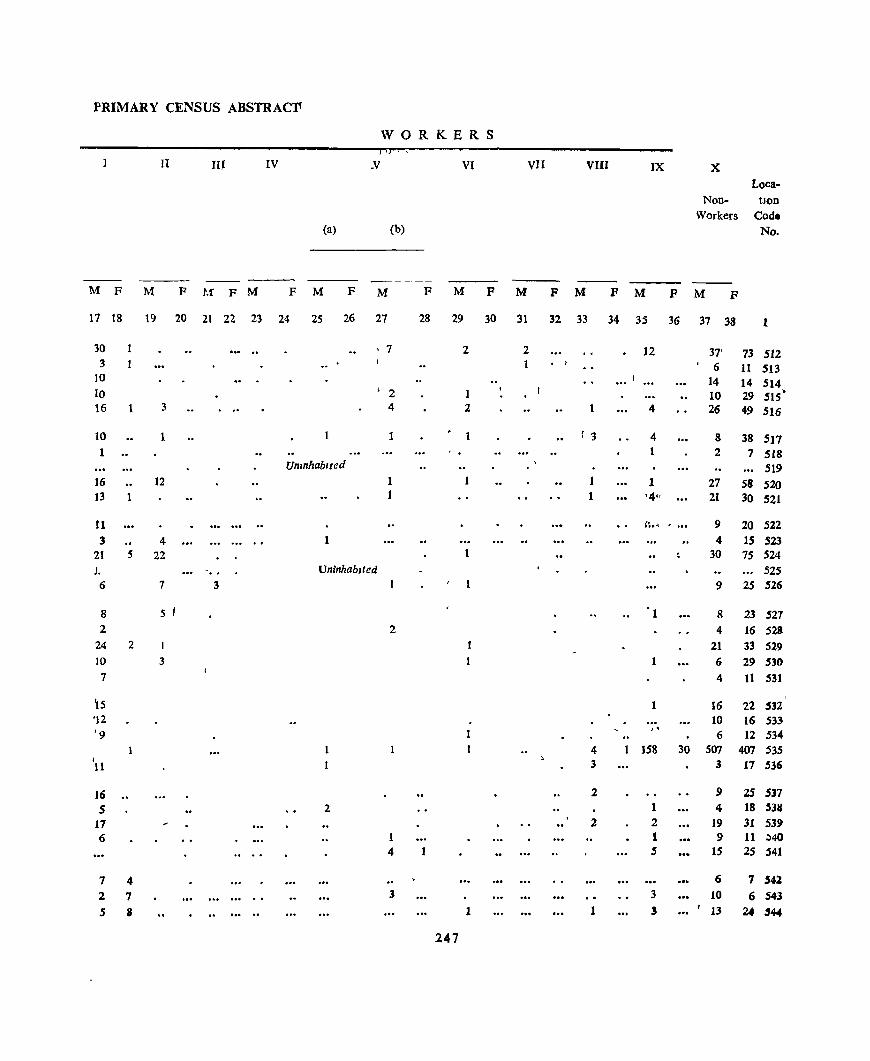
PRIMARY CENSUS ABSTRACfI
WORKERS 'J ,
I II IV _V VI vn VIII IX X Loea-
Non- tlon Workers Cod.
(a) (b) No.
---M F M F M' F M F M F M F M F M F M F M P M F
17 18 19 20 21 22 23 24 25 26 27 28 29 30 31 32 33 34 35 36 37 33 1
30 I 7 2 2 12 37' 73 512 3 1 ,
6 11 513 10 14 14 514 10 ' 2 10 29 SIS' 16 1 3 4 2 4 26 49 516
10 1 1 1 '3 4 8 38 517 1 2 7 518
Umnhablted 519 ]6 12 1 1 1 27 58 520 13 1 1 1 '441 21 30 521
11 ~1 ..... ., ... 9 20 5ZZ 3 4 1 4 15 523
21 5 22 30 75 524 J. . .. UninhabIted 525 6 7 3 9 25 526
8 5 'I 8 23 527 2 2 4 16 528
24 2 I 21 33 529 IO 3 6 29 530 7 4 11 531
~5 16 22 532 '12 , .. 10 16 533 '9 " 6 12 534
4 158 30 507 407 535 I 3 3 17 536 11
16 2 9 2S 537 5 2 1 4 18 5311
17 2 2 19 31 53.9 6 1 1 .9 11 ,;,40
4 5 15 25 541
7 4 6 7 .541 2 7 3 3 10 6 543 .5 II 1 1 ! '13 24 "44
247
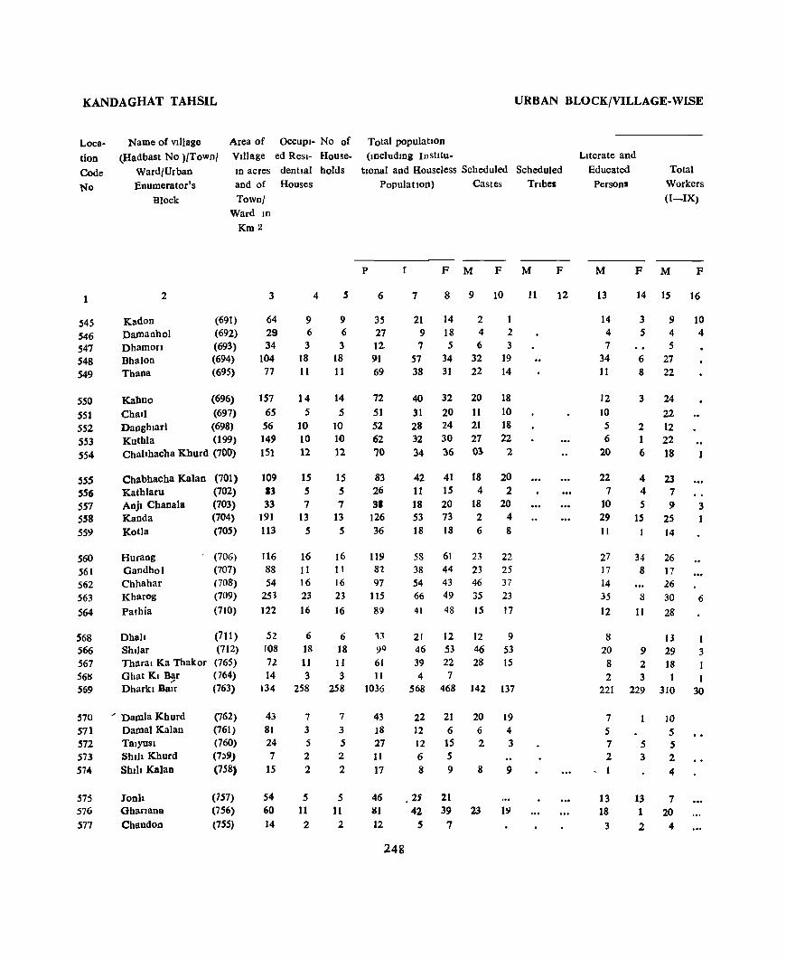
KANDAGHAT TAHSIL
Loca
tion Code No
Name of vl])age
(Hadbast No l/Town/ Ward/Urban Enumerator's
Block
Area of OCCUPI- No of Village ed Resl- HouseIn acres dentJal holds and of Houses
Townl Ward 10
Km 2
1
545 546 547 548 549
2
Kadon Damanhol Dhamon Bhalon Thana
(691) (692) (693) (694) (695)
550 551 552 553 554
Kabno (696)
Chall (697) Daoghlarl (698) Kuthla (199) Chahhacba Kburd (700)
55S 556 557 SS8
559
S60
561 562 563 564
568 566 567 56~
569
Chabhacha Kalan Kathlaru Anjl Cbaoala Kanda Kotla
Hurang Gandhol Chhahar Kharog
Pathia
Dhah Shl)ar Tharal Ka Thakor Ghat KI B~r Dharkl Balr
570 ... Damla Khurd 571 Damal Kalan 572 Talyosl 573 Shih Khurd 574 Shih Kalan
575 Jonh 576 Gharlana 577 Chandon
(701) (702)
(703) (704) (705)
(706) (707)
(708)
(709)
(710)
(711) (712) (765) (764) (763)
(762) (761) (760) (7;,9)
(758)
(757) (756) (755)
3
64 29 34
104 77
157 65 56 149 151
109 13 33
191 113
116 88 54
253
]22
52 108 72 14
134
43 81 24 7
IS
54 60 14
9 6 3
18 II
14 5
10 10 12
15 5 7
13 5
16 11 16 23 16
6 18 11 3
258
7
3 5 2
2
5 11
2
4
9 6 3
18 11
14 5
10 10 12
15 5 7
13 5
16 1 I 16 23
16
6 18 11 3
258
7
3 5 2 2
5 11
2
URBAN BLOCK/VILLAGE-WISE
Total population (JDcludmg Institu-
tIOnal and Houseless Scheduled Scheduled Population) Castes Tnbes
P
6
35 27 12-91 69
72
51 52 62 70
83 26 3'
126 36
119 8'Z
97 115
St)
13 9Q
61 11
1036
43 J8
27 11 17
46 81 12
248
F M F M
7 8 9 10
21 14 2 9 18 4 2 756 3
57 34 32 19 38 31 22 14
40 32 20 18
31 20 11 10 28 24 21 18 32 30 27 22 34 36 03 2
42 11 18 53 18
58 38 54 66 41
21 46 39 4
568
41 15 20 73
18
61 44 43 49 48
12 53 22 7
468
18 4
18 2 6
23 23 46 35
15
12 46 28
142
20 2
20 4 8
22 25 37 23
17
9 53 15
137
22 21 20 19 12 6 6 4 12 15 2 3 6 5 8 9 8 9
• 2S 21 42 39 23 19
5 7
11
F
12
Literate and Educated
Persons Total
Workers (I-IX)
M
13
14 4 7
34 11
12 10 5 6
20
22
7 10 29 II
27 17 J4 35 12
8 20
8 2
221
7 5 7 2
, I
13 18
3
F M F
14 15 16
3 9 10 544
5 6 27 8 22
3 24 22
2 12 1 22 6 18
4 4 5
IS
34 8
8
11
9 2 3
229
23 7 9
25
14
26
17 26
30
28
J3 29 18
310
10
S 5 5 3 2
4
13 7 1 20 2 4
3
6
3
I I
30
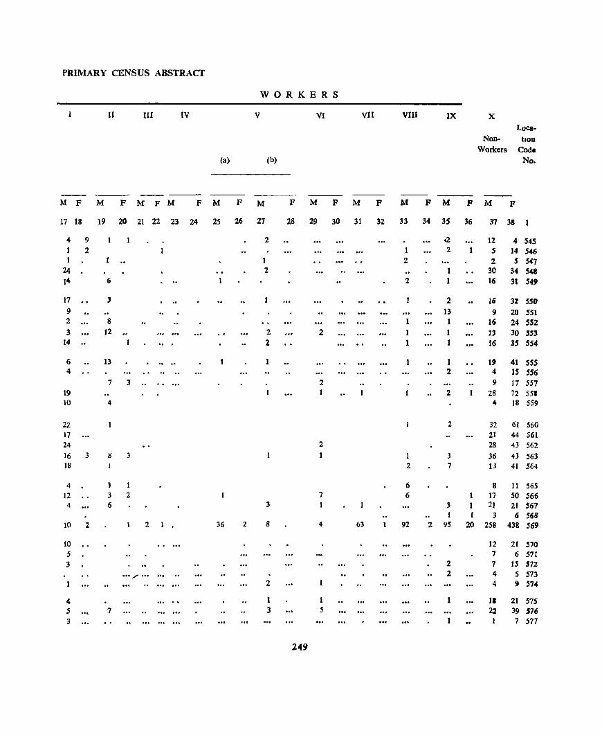
PRIMARY CENSUS ABSTRACT
WORKERS
11 III IV V VI VII VIII IX X
Loea-Non- tlon
Workers Cod. (a) (b) No.
--M F M F M F M F M F M F M F M P M F M P M F
17 18 19 20 21 22 23 24 25 26 27 28 29 30 31 32 33 34 35 36 37 38 1
4 9 2 .2 12 4 545 2 1 2 1 5 14 546
1 2 2 S 547 24 2 1 30 34 548 14 6 2 1 16 31 549
17 3 1 2 16 32 550 9 13 9 20 551 2 8 1 1 16 24 552 3 12 .. 2 2 1 1 13 30 553
14 .. 2 1 1 16 35 '54
6 13 . .. .. 1 1 1 1 19 41 55' 4 2 4 IS 556
7 3 2 9 17 557 19 2 28 72 55. 10 4 4 18 559
22 2 32 61 560 17 21 44 561 24 2 28 43 562 16 3 Ii 3 3 36 43 563 18 2 7 13 41 564
4 3 6 8 11 565 12 3 2 7 6 17 SO 566 4 6 3 3 21 21 567
1 3 6 568 10 2 2 36 2 8 4 63 92 2 95 20 258 438 569
10 12 21 570 .5 7 6 571 3 2 7 IS 572
... / ... 2 4 5 573 2 4 9 574
4 1 1 1 11 21 57' .5 7 3 5 22 39 576 3 7 577
249
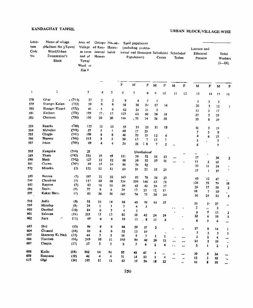
KANDAGHAT TAHSIL
Loca
tIOn
Code No
578 579 580 58t 582
583 584 585 586 587
588 589 590 591 592
593 594 595 596 597
598 599 600 601 602
603 604 605 606 607
608 609 610
Name of vIllage
(Had bast No )/Town/
Ward/Urban Enumerator's
Block
Area of OCCUPI- Na..Of
VIllage ed Resl- Houfe-
1D acres dentlal holds and of Houses
Town/ Ward 1D
Km 2
2
Ghar Shangn Kalan
Shangn Khurd KUlhan
Chatalfa
Raurhl Mahuhrl Chapla Shawar Jlhun
Kanguka Thara Bhah Chewa Mondra
Balllan ChanbJan Rayana Dothl Kakar Hattl
Jadla Mandap Deothal Talauna Jlara
• (754) (753) (752) (751) (750)
(749) (748) (747) (746) (745)
(744) (743) (742) (741)
(2)
(3)
(4)
(5) (6)
(7)
(8) (9)
(10) (11 )
(12)
Shll (13) Chlauni (14) Shararey KI Nab (15) Thethao (16)
Chapla (17)
Ko(hl Shanaoa Olgi
(18) (19) (2U)
3
37 59 41
199 156
125 57
108 113
69
28 533 127 69
152
197 ]57
62 57 80
91 24 84
213 69
99 80 44
249 57
302 46
105
4
2 9
• 5
17. 20
13 5 8 5 4
19 12 14 12
22 68 16 6
36
14
6 13
4
9
6 3
10 3
14 4
11
5
2 9 6
17 20
13 , 8 5 4
19 12 14 12
22 68 16 6
36
14
1
7 13
4
9 6
3 11 3
14 4
11
URBAN BLOCK/VILLAGE-WISE
Total population
(lDcludmg Institu-
tIOnal and Houseless Scheduled Scheduled Population) Castes TrIbes
p
6
9 ~8
42 123
149
55 40 46 20 24
111 68 96 63
163 354
84 39
147
88 7 4
80 19
66 32 16
140 9
95 31 65
250
M F M F M
7 8 9 10
4
38 21 63
, 75
32 17 23 13
16
5 2v
21 60 74
23 23 23 7
~ 8
Umnhablted
I
27 3
26 38
21
12 13 7
14
28
38
13
6 7 2
59 52 14 12 36 32 10 11 54 42 31 32 25 25
85 78 208 146 42 42 17 22 74 73
26 23 65 ~8
39 37 12, 15 26 24
49 39 44 37 4 3 3
38 42 24 24 11 ,8 11 8
29 37 2 13 19 9 7 1
94 46 26 13 361 4
48 47 1 18 13 1 4 19 36 18 22
I[
F
12
LIterate and
Educated Persons
Total
Workers
(I-IX)
M
13
3 20
II
25 35
11 7 8
3 6
17 11 33
17
43 126 26 10 36
24 2
9 22 8
17 7 3
21 2
19 12 16
F M
14 Ii
3 5
3
5 8
3 3 6
2 11
12
53 17 7
24
3
12 17
23 39
19 9
15 7 7
36 16 24
17
47 79 20 10'
32
5r 27 2
5 13 6 16 3 6
8 14 2 5 2 4 2 19 1 2
5 24 3 10 8 18
F
16
2
18 2
5
2 3

PRIMAR Y CENSUS ABSTRACT
WORKERS
II III IV V VI VII VIII IX X Loca-
NOD- t10n
Workers Code (a) (b) No
M F M F M F M F M F M F M F M F M F M F M F
17 18 19 20 21 22 23 24 25 26 27 28 29 30 31 32 33 34 35 36 37 38
3 5 578 3 5 2 26 19 579 4 2 10 4 21 580
20 2 1 . 40 60 581 35 3 36 74 582
4 14 13 23 583 7 8 23 584 8 6 8 23 585 5 6 7 586 5 2 9 8 581
Umnhabued •.• 588 22 8 2 1 1 4 23 SO !&9 12 2 2 20 32 590 20 2 2 30 42 591 15 1 14 32 592
37 2 3 5 38 78 593 27 2 3 4 4l 15 129 128 594 6 4 10 22 40 595 5 4 1 7 22 596
10 2 2 5 3 .1 9 3 42 68 597
18 2 4 22 39 598 I 2 3 599
7 2 6 10 21 600 14 3 -"
2 22 39 601 6 5 8 602
12 1 .. ~ " 15 36 605 5 1 18 604 3 1 .. S 7 60S
16 f 1 1S 46 606 2 1 1 5 607
20 1 3 24 41 60S 8 1 1 8 13 609
10 2 3 11 36 610
251

KANDAGHAT TAHSIL
Loca
tion
Code
No
611 612 613
614 615
616 617 618 619
620
621 6]\!
623 624 625
626 627 628 629 630
631 632 633 634 635
636 637 638 639 640
641 642 643
Name of village
(Had bast No )/Town/
Ward} Urban Enumerator's
Block
Area of OCCUPI- No of
Village ed Resl- House
III acres dentIal holds and of Houses
2
Markanal
Jehar Chharoh
Gaddon Panuh Chhlbra
Tangr!
Pallana MaJholtl Paou Kathalan
Sohal
Bhunbal Khalrl Shlor
Badhel RaJlmOll
Malgl Baryan Rabana Khalfl
MaJhol
AnJI Kohan
Bam Daln Chbaosha Damehr
Dyanda Padh Ghalr Mangna NeIl
Kumbatrl Rog Kothl
Town)
Ward 1D
Km 2
(21) (22) (23) (Z4)
(25)
(26)
(27)
(28)
(29)
(30)
(31) (32)
(33)
(34) (47)
3
74 29 81
481 121
38
17 161
128 189
142 158 117
66 60
4
5 4 9
27 12
11 11
5
12
17 7
5 4
(48)
(93)
- (45)
(46)
(62)
117 7 417 19 305 2~
94 12 464 _ 28
(63) 131
(64) 259 (64) 122 (66) 519 (70) 768
(69) 303 (68) 121 (67) 160 (44) 85 (43) 77
(42) 72 (41) 49 (36) 387
12 14
4 49 43
14 14 3
10 4
8 8
19
5
5
4
9 27 12
11 11
5
12 17 7 5 4
7
19 24 13
28
12
17 4
54
46
15 16 3
11 4
8 8
19
URBAN BLOCK/VILLAGE-WISE
Total population
(mel udlDg Institu-
tional and Houseless Scheduled Scheduled PopulatIOn) Castes Tribes
p
6
10 25 42
254 56
8
66
56 42
67 93 25 50 29
39 105 122 49
162
46 84 31
252 304
88 80 18 76 19
56 55
134
M F M F M
7 8 9 10
6 4 1
16 9 2 28 14 10 4 , 1~ 120 86 95 30 26 6 8
3 5 Umnhablted
29 37
25 31 23 19
9 10
9
4
31 36 26 17 42 58 25 30 11 14 25 25 10 8 14 15
20 19 5 5 56 49 21 16 59 63 22 15 24 25 20 19 74 88 13 14
23 23 23 23
43 41 33 41 14 17 6 8
146 106 40 31 155 149 59 67
4(l 48 22 24 38 42 9 9 34 42 10 9
30 26 9 3 26 29 65 69 IS 11
252
11
F
12
Literate and
Educated Persons
M
13
Total
Workers
(I-IX)
F M F
14 15 16
5
8 3 16 2
10
12
57 14 86 63 9
10
10
6
9 14 6
15 4
6
32 36 14 37
7 12 6
85 85
20 23 , 22 7
22 17 30
2
14 6
2
19
15 14
5 12
4 18 16 1 28 24 2 6 7
4 16 8 1 8
2 13 2 10 29 2 28 7 13
18 35 43
22 IS
25 18 8 7 5
19 80 43 30 83 4S
23 18 2 27 21
5 6 5 19 26 2 3 5
5 18 18 7 14 14
15 29 5
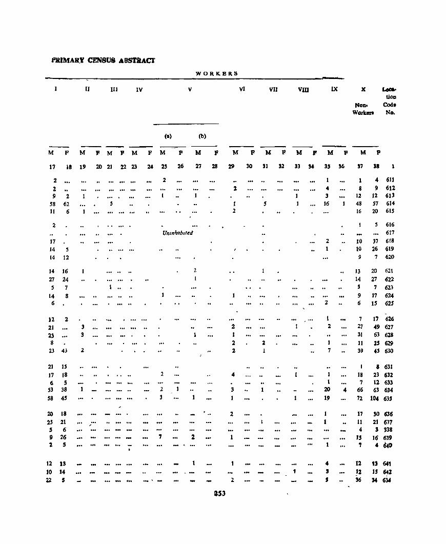
f'JUMAR_Y CENSV8 ABSTIlACl'
~ORKBR.8
II IIJ IV V VI VII Vm IX X Loc:ao lion
Non. Code Workers No.
<a> (b)
--M P M P M P M P M P M P M P M P M P M P M P
17 18 19 20 21 22 23 24 25 26 27 28 29 30 '1 '2 33 '4 35 '6 S7 ,. I
2 2 1 1 4 611 2 1 4 8 9 612 9 2 1 3 12 12 613
58 62 5 1 5 1 16 48 57 614 11 6 2 16 20 615
2 S 616 UmnJ,ab,fed 617
J7 2 10 37 618 14 S J 1 10 26 619 14 12 9 7 620
14 16 ..... .. 2 13 20 621 27 24 14 27 622 S 7 1 .. S 7 623
14 8 1 9 17 624 6 2 6 15 625
~
12 2 1 7 17 626 21 3 2 2 27 49 627 23 3 1 1 31 63 628 8 2 2 11 25 629
23 43 2 2 1 7 39 4S 630
21 15 1 8 631 17 18 2 4 1 18 23 631 6 5 1 7 12 633
53 38 2 3 1 20 " 66 63 634 58 45 3 19 72 10" 635
20 18 2 1 17 SO 636 2S 21 ...
'" 1 11 21 637
5 6 4 3 338 9 26 7 2 1 IS 16 639 2 5 - . 1 , 4 641)
12 13 t 4 12 " 64' 10 14 1 , 12 15 642 21 5 ... -_" - - l S 56 M 6U
eS3

gANDAGIIAT TAHSn. VRBAN BLOCK/VlLLAG::i'!·4VJSB
Loeat.Oll
eoue
No.
(4~
(45 (46
647 648
(49 650
651 652 653
654
655 656 657 658
659
660 661
66l 663
66. 655 666 667 668
669 {70 671 671. ~73
674 6iS (;.76
.~~ ,,,_,.,, ...... _---- ---- . __ -----Name or vi11l1go Area ot Oceupl- No or Total population
------ -_._-_ ........................ ...::..::o
(H,ldbast No )/ I own/ VllJdge ed ResJ- House-Ward/Urban 10 acres dentlal bold,
(lnumerator',
Block
and of Houses Town/
Ward In
1
Jangal Kothl
Kangtl 1'. am Kun Gara
Gadho,it Plah
Gog Baror h alga
Sudharag
Goras Barglyana Salana Iaplol
Ranhog
ChIDI Podna
Rakhog Bhartl
(35)
(37)
(39)
(38) (40)
(49) (SO)
(61) (60)
(59)
(58)
(57)
(52)
(53)
(51)
(54)
(55) (56)
(299) (300)
Dhahaurl (J01)
Dhar Brahhmanan (302)
Dhar, Kanal!an (3P3) , Sam (304)
Tlwakrl (274)
Fangol
Bag Kanlara Jalragh Kahhl Kanaltal
(275)
(276) (277)
(278) (27J)
Kalthl Chamaran (280) Thanapanda (281) Alobra (28:) ,.
Km2
3
219 174 119 163 83
58 194 136 :08
298
138 177 130 33 (.9
192 122 :00 410 417
173 56
150 105 162
49 72
266 59
42
108
108 123
4
I
11 4
11 S
4 14
6 4 8
5
8
2 3 9
7 8
22 24 31
10
4 7 7
8
2 2
24 5
17
15
3
.5
1
11 4
11 6
.5 14 6 4
12
6
8 3
3 9
7 8
23
24 31
10
4 7 7 8
2
3 25
.5 17
15 3
JOclud ng lO,utU-
llonal and Houseless Scheduled Scheduled
Population Castes 1nbes
p
, 1
70 23 97 35
41 88 4 .. 22 88
24 47 20 21 61
33 53
12) 179 183
51 22 30 44 65
17 7
110 30 17
92 13
4
M " F M F M
7 8 9 10 11
1 40 30 11 12
51 ~6 2 3 16 19
23 18 42 46 2 2 20 24 13 9 4. 42 18 17
13 11 8 7 26 21 19 16
8 12 11 12 39 22 4
17 16 2 '0 23 63 - (6 46 49
92 87 86 77 91 92 42 34
24
11 14 22 32
27 11 16 22 3j
10 7 4 3
56 54 14 16 7 10
3 10 10 18 3
39
9 13 16 5
1 38
48 44 48 44 9 4 8 3 3
2.54
F
11
Literate and Educated
lersons
Total Worker. (I-IX)
M F M P
13
1 13 3
20 8
14 19 8
2 3 ..
2 2 5
9 29
7 23 24
18 26
12 5 5 8
.5
20 7
13 3
14 U 16
1 2 21
8
8 26 26
9 4 24 1 12
9 4 :1
7
JI .s 3 3 6 4 31
4
9
4
9 20 14 5
27
4
2
4 5 .s
4 10 3 16 H 16
2 38 31 40
7 :7 1
3
'1
3
1
13 4 8
12 15
2 3
28 9 3
2 25 4
3
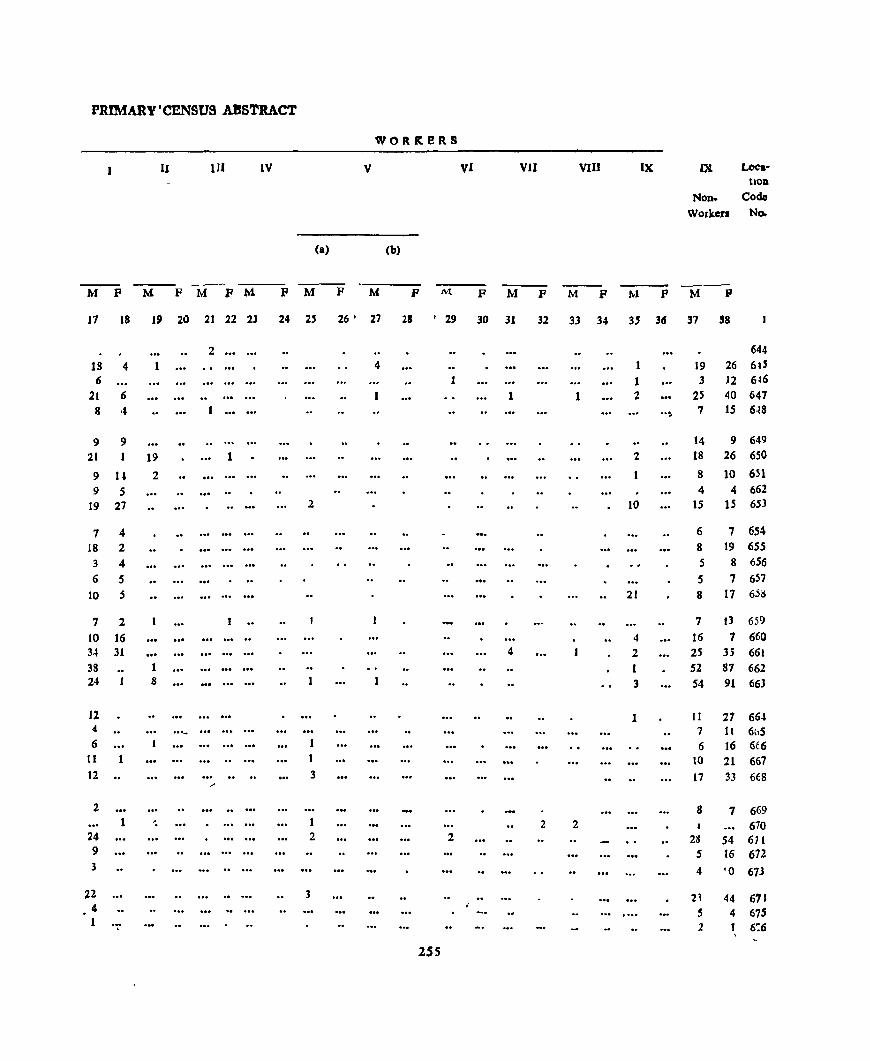
PRIMARY'CENSUS ABSTRACT
WORReRS
II 1lI IV V VI VII VIII IX IX Loca-hOD
Non- Code
Workcn No.
(a) (b)
---M F M F M P M F M F M P M F M F M F M F M P
17 18 19 20 21 22 23 24 2' 26 • 27 28 I 29 30 31 32 33 34 3' 36 37 38
2 644 IS 4 1 4 1 19 26 6tS 6 1 1 3 12 6~6
21 6 1 1 2 25 40 647 8 4 .. :. 7 15 6~8
9 9 14 9 649 21 I 19 1 2 18 26 650
9 U 2 8 10 651
9 5 .. , .. 4 4 662 19 27 2 10 15 15 65)
7 4 6 7 654 J8 2 8 19 655 3 4 5 8 656 6 5 S 7 657
10 5 21 8 17 6jlS
7 2 7 I) 659
to 16 4 16 1 660 34 31 4 2 25 35 661 38 1 52 87 662 24 8 3 54 91 663
11 1 II 27 66-1 4 ... _ 7 11 6(\5 6 6 J6 6t6
11 \0 21 667 12 3 17 33 668 .-
2 8 7 669 1 '. 1 2 2 670
24 2 2 28 54 611 9 5 16 672 3 4 '0 673
22 3 2~ 44 611 4 S 4 675 1 1 6':6 .
2SS

KANDAGHAT TAHSn..
Laac.
hon Codo No.
677
678 679
680 681
682 683 684 685 686
687 688 689
690
691
692
693 694 695
696
697 698 699 700 701
702 703 704 705 706
707 708 709
. Namc of Vlilalc
(Hadbast No.)/Townl Ward/Urban
Enumerator a
Block
Area at Village
10 Acres
and of
Town/Ward to KIn 2
2
KaIthl Hari Datt (283)
Kulthl Molu (284) Bharol (285)
Lunso (286) Cbdroha (287)
Thana ManJathru Pathru Talar Hanpur
Shak Plratha Kalan Plratha Khurd
Banlag lagota
Dhanen KhaUi ahaggar Kham G.1mJun
Harandai
ManJhar Totwa Dannat Sanawaa Kundlu
Kundla Loon Ghiyalch Burawall KharkJ
(288) (289) (290)
(291) (292)
(293) (294) (295)
(296) (297)
(298)
(255)
(256)
(257)
(258)
(259)
(260) (261) (262) (263)
(264) (265) (266) (267)
(268)
Gharlan (269)
Kanalthan (270)
Dochl Ghamaran (271)
119
93 24 45
19
116 58 80 65
114
34 116
90 144
141
158 48 24
142
23
17
17 13 66 13
47 49 36
493 45
32 72
72
URBAN BLOCKfVlLLAGE-WISB
OccUPI- No. at Total PopulatloD ed Resl- House- (IOcludlOg Instlluttonal) dentlal holds and Houseless Scheduled Scheduled
Literate and Educated
Person.
Total WorkeJ8
(I-IX) House. POPUldLIOD Ccistes TrIbes
4
9
6 3
5 4
6 5 7
10 6
3 15 10
6 9
10
2 13
1
3 2 7
10 1
73 9
<4
2
• 8
,6 3
5 4
6 5 7
10
6
3 16 11
6 9
10
2 13
1
1
3 2 7
10 1
73 9
4 2 1
P
6
42
30 18
23 26
23 36 48
45 21
9 82 68 38
74
70
19 64
4
5
16 13 23 9
35 9
404 44
33 79 31
2S6
M F M F M F
7 8 9 10 11 12
20 22
16 14 8 10 8 15
20 6
10 13 20 16 28 20 17 28
10 11
4 5
7
6
3 18
I
40 42 7 10 36 32 35 32
18 20
37 37 3 6
32 38 Umnhablted 10 9 32 32 15 1 3
4
9 1 4 9 8 15 2 7
Ul1IlIlzab,ted
4
1
19 16 12 tl 5 4 5 4
208 196 84 97 23 21 16 11
14 19 8 11
13 18
M
13
4
3 2
2 19
6 4
10 6 4
2 17 18
11 13
11
3 10
1
1
2 3
5 2
lOS 9
7 2 9
P M
14 15
1 10 1 9
6
2 6 9
2 6 9
S 15 5 11 2 7
4 3 6 17 8 14 2 7
2 18
2
2 S
1
2 4 1
18
6 18 2
4
3 1 S 1
2 10 1
44 89 3 11
6 4 S
8
" ..
P
16
5 6
7
:z
2 2 2
1
1

PRIMARY CENSUS ABSTRACT
WORKERS
I II III IV V VI VlI VI[I IX IX Loca. tlon
Non· Codo Workers No,
(a) (b)
M F M F M F M F M F M F M F M P M F M F M F
17 18 19 20 21 22 23 24 2S 26 27 28 29 30 31 32 33 34 3S 36 37 38 1
10 10 22 677 7 2 2 7 12 678 6 2 10 679 5 2 - 2 13 680 7 11 6 681
6 4 12 682 7 2 11 16 683
11 3 13 20 684 9 2 6 27 685 6 1 .. 3 10 686
3 1 5 687
15 23 41 688 9 2 22 32 689 7 1 11 19 690
14 1 2 19 36 691
13 3 14 38 692 693
6 4 9 694 15 2 14 32 695
3 696
4 1 697 3 6 7 698 1 3 9 699 4 3 15 700 1 1 7 701
Uninhabited .. .. 702 4 :z 1 3 9 16 703 1 4 4 704
56 1 1 1 13 1 1 4 13 2 119 191 70S 10 Ii 12 IS 706
-{ 2 6 5 - 7 1 12 707
2 t ... 4 11 708 '. .1
1 2 3 9 16 709
ZS7
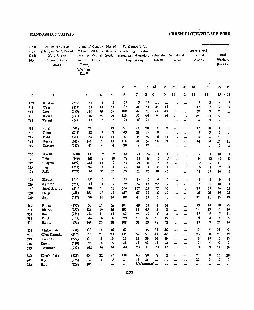
KANDAGHAT TAHSIL
Location Code
No.
710 711 712 713 714
71S 716 717 718 719
720 721 722 723 724
725
726 727 728 729
730 731 732 733 734
735 736 737 738 739
740 741 74l
Name of vIllage (Hadbast No )/Town/
Ward/Urb'ln Enumerator's
Block
Area of Occupl- No-of VIllage ed Res,- Housem acres dentlal holds
and of Houses
2
Khallra Ghori Bam Kaurh Tataul
SUJni NIota Dahl Dugan Kamara
Ishewa Bokra Phagala Bag Jadb
Shoora Kath,ar Jabal Jamrot Delgl
AnJI
Rlhun Bharol Bal PaId BanJnl
Chlknabatl Ghat Kamala KamhaU Debm Bandraon
Kanshl Pat. Kot Bllll
Town/ Ward ID
Km2
3 4
(272) 53 3 (273) S9 14 (240) 138 19 (241) 78 25 (242) tl3 5
(243) 73 10 (244) 52 7 (245) 84 13 (246) 142 15 (247) 47 4
(248) 117 9 (249) 163 10 (250) 262 13 (251) 262 4 (252) 64 36
(253) IS5 5 (254) 34 4 (239) 707 51 (238) 153 27 (237) 90 14
(236) (235) (234) (233) (232)
(23])
(230) (229) (228)
(227)
(226)
(225) (224)
68 126 275 46
144
133 58
174 73
162
454 39
109
20 16 11 6
20
16 20 13
5 14
22 5
S
3 t4 19 25
5
to 7
13 15 4
9 10 13 4
36
5 4
51 27 14
20 16 11 6
20
16 20 13
5 14
22 ,
URBAN' B [O"CK'jVILLAGE· WISE
Tota-ll'01'ulation (rncludwg rn~htu-
tlonal and Houseless Scheduled Scheduled LIterate and
Educated
Persons
Total Workers (I-IX)
Population) Castes Tnbes
p
6
23 82
100 120
39
SO 49 75
110 20
43
78 59 26
177
28 39
264 J57 98
105 103
53 29
108
67 106 65 38 48
130 24
~5S
M F M F M
7 8 9 10 Jl
8 15
41 41 41 41 49 51 47 45 56 64 II 14 15 24
22 28 5 9 21 28 8 5 35 40 16 14 44 66 14 33
8 12
21 22 7 (; 32 46 7 5 25 34 8 15 12 14 8 8 91 86 50 42
15 13 6 5 22 17 22 17
137 127 27 26 66 91 16 22 43 55 2
48 57 11 14 38 65 5 2 24 29 5 3 13 16 13 19 55 53 49 42
31 36 31 36 56 50 43 42 26 39 26 39 15 23 15 23 23 25 23 25
60 70 7 2 13 11 UnlnAablt,tl •••
P M
'12 13
F M F
14 15 • 16
6 2 4 3 J2 7 2 3 19 3 21 34 13 22 21
3 3 9
12 10 Jt 8 9 6 5 20
14 6 20 18 2 2
7 10 14 10 12 12 9 2 11 10 6 2 7 7
46 17 50 17
8 294 8 1 10 4
73 33 54 23 25 23 30 22 17 21 23 19
29 14 13
6 19
13 33 9 3 9
21 11
14 18 23 29 15 24
9 7 11 <4 5 5 7 28 14
5 14 20 8 20 29
10 13 23 4 9 IS 7 14 16
8 28 28 1 5 8,
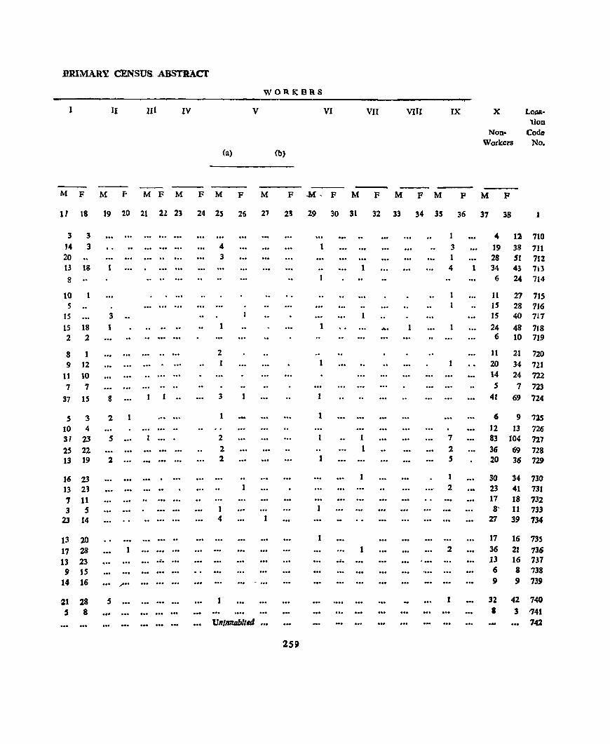
BRIMARY CENSUS ABSTRACt
WOR.KBRS
1 II III IV V VI VII VIII IX X LO$lA-lion
Non- Code Workers No.
(a) (b)
M F M F M F M F M F M F .M~ F M F M F M F M F
11 18 19 20 21 22 23 24 25 26 27 2& 29 30 31 32 33 34 35 36 37 38 1
3 3 1 4 12 710 14 3 4 1 3 19 38 711 20 3 1 28 5I 712 13 18 1 4 1 34 43 713
8 6 24 714
10 1 11 27 71S 5 .. IS 28 716
15 3 15 40 717 15 18 1 .. .. .. 1 1 ... . 24 48 718 2 2 6 10 719
8 1 2 11 21 720 9 12 20 34 721
11 10 14 24 722
7 7 5 7 723 37 15 8 1 .. 3 1 41 69 724
S 3 2 1 1 t 6 9 715 10 4 12 13 726 31 23 5 2 1 7 83 104 727 2S 22 2 1 2 36 69 728 13 19 2 2 1 5 20 36 729
16 23 30 34 730 13 21 2 23 41 731 7 11 17 18 732 3 S 1 1 8' 11 733
23 14 4 1 rl 39 134
13 20 1 17 16 735 17 28 1 1 2 36 21 736 13 23 .•. .•. '" ... ,13 16 137 9 15 6 8 738
14 16 " ... 9 9 739
21 28 5 1 1 32 42 740
5 8 .. , • 3 '741 Un/lI1lIIblte4 ••• '142
259

KANGAGHAT TAHSIL URBAN BLOCK/VILLAGE-WISE
L,ocatlon Code
No
1
743 744 745 746
747
748 749 750 751 752
753 754 75S 756 7S7
7sa 759 760 761 762
763 764 79S 766 767
768 '769 770 771
772 773 774 77J
Name of Village (Hadbast No )/Town/
Ward/Urban
[numerator's Block
~----.. __ ...,_..__
---.--------Area of OCCUPI- No of Total population Village cd Resl- House- (mcludmg Instltu-In acres dentlal holds 1I0nal) dnd Houseless Scheduled and of Houses Town/
Ward In Km.ll
Population Castell
Scheduled
Tnbes
Literate and Educated
Persons
Total
Workers (I-IX)
p M F M F M F M F M F
2 3
Satrol (223) SMlru (222) DabJog (221) PaJashtapanchrol (220) Su lah BrahaDaDan (219)
Sulah Kohan Shiv Shankargarh Chapala Kakara Mamhg
Chadn Kamhar Kalsu Bhota Doh
Jakhraon Nerl Bashel Sanet Thana
Matemun Chanor Mahog Bashol
Bakesu .,.
Tailt DlyawIa
Dhano Khanoll
An)) Dadhori Masha TLbJ'
(218) (217) (216)
(215) (214)
(213) (212)
(210) (211)
(209)
(208)
(207) (206) (205) (204)
(203)
(202) (201) (200) (199)
(198)
(197) (30S)
(306)
(307) (308)
(3J9) (310)
447 47
98 131 89
68 293 191 198 152
158 135 253 208 208
274
Sl1 234 202
63
19 61 90
91
299
114
291
133 104
50 77 96 93
4
53 1
2J IS 4
4 23 S
12 40
7 9
6
8 4
12
22 12 11
7
3 2 4
10
17
7 16
8 :z 4 S 1 4
53 1
21 15 4
4 23 5
12 40
7 9 6 8
4
12 22 12 11
7
3 2 4
10
17
7 16
8 2
4 S 1 4
6
313 9
59 87 24
10 130 28 71
175
26 40
7
30 18
92
130 ~1
88 37
18 16 26 72
106
33
105 S3 5S
31 21 7
33
260
7 8 9 10 11 12 13
149 164 105 119 4 5
36 23 12 8 49 38 49 38 9 15 1
7 64 15 32 87
13 20
22 16 9
47 63 43
44 17
12 7
12
36 56
15 57 26 27
15 12 S
21
3 66 13 39 88
13
20 15
14 9
45 67 48 44 20
6 9 14 36 50
18 48
27 28
16 9 2
12
6 56 1 1
28
]1
20
16 4
14 18 18 15
4
20
18 12 13
1
S 10
3 58
2 29
10
20
14
4
9
16
17 15 2
13
14
13
2 5
73 2
24 28 5
1 25
3 18 34
I
12
7 1 3
14 21 33 19 9
7 5
19 18
6
33
10 1
6 6
9
14 15
44 68 1 2
12 20 7 21 7 3
11
2 7
14
3 3 3
2 3
15
4
2
9
5
4 2
1
2
4 37 5
19 50
11 7 9
11 6
24 38 19
23 10
6 2 7
20
28
12
27 11
13
8 6 2 S
16
86 S
10 23 5
3 38
2 20 S2
6 3 6
3
5
17 23 2
9 5
]
4 5
11
18
5
7
10
12
7 5 2 7

PRIMARY CENSUS ABSTRACT
WORKERS
1 II 111 IV V VI vn vIII IX X Loca-tion
Non- Code WOlk.ers No
(a) (b)
M F M F M F M F M F M F M F M F M F M P M .t-
17 18 19 20 21 22 23 24 %5 26 27 28 29 30 31 32 33 34 35 36 37 38
55 86 2 10 31 78 743
I 3 2 2 744
B 7 6 4 2 16 13 745
16 23 :% 2 28 IS 746
3 S 6 10 747
3 3 3 .. 748
'-f. 38 t 27 28 749
4 2 1 JO tl 750
J2 20 6 13 19 751
33 5. 2 11 37 36 7<' J ..
11 6 2 7 753
7 3 J3 J7 754
9 6 13 9 755 10 3 J S 11 756 6 5 5 3 4 7~i
23 17 23 28 758 27 23 1 4 25 44 759 9 2 4 1 3 24 46 760
20 8 1 21 35 i61 7 .5 1 1 1 1 15 161
6 t 6 5 763 4 1 S 5 76
1 5 5 9 16~
16 JO 2 16 25 166 26 18 28 32 767
9 5 J .. J 1 8 13 768 21 1 I J 30 41 769 10 10 IS 11 770
9 12 1 2 14 16 771 4 3 3 3 7 9 772
6 S 6 4 773 1 :% 1 3 774
4 1 1 16 5 ..,-<
261

KANDAGHAT TAHS1L URBAN BLOCK/VILLAGE- WISE
Area of OCCUpl. No of r otal populatJon VIllage ed Res,. House· includIng lD,tJtU-
Loca. tIon Code
No
Name of village (Hndbast No )/1 awol
Ward/Urban
fnumerator s
Block
In acres dent!al holds tlOnal aDd Houseless ~cheduled Scheduled
LlIerate and
Educated
Persons
Total
Workers (I-IX)
776
777 778
779 780
781 782 783 784 785
786 787 788 789 7S0
791 792
793 794 795
796
797 798 799 800...,
801 802 803 804 805
806 807 808
2
JekhrJ
Dhandon
NlUn
Fagoll
Shalog J0glao
Shalog Kohan
Saogllaod
HamaDi
Behll
Ladh
Sun'C1
Sam
l:>akret
Poabo Chandoh
Kot
Baggl
Natalia
Thol Chamaran
ManYJhen
Thol KoiJan
Badhawam
Dharo!
Daootl
Kahla
Samut laoana Kamyafl Illwankhura Hlwaoldan
Balaogar Balagarrehan Ghaog
and or Houses
Town/ Ward lD
(311)
(312) (313) (314) (315)
(316) (317)
(783) (319) (320)
(321)
(322)
(323)
(324) (325)
(326)
(327)
(328) (3:9)
(346)
(347)
(348) (349) (350)
(94)
(166) (167) (168) (169) (1.0)
(171) (172) (173)
Krn 2
3
136
39 124 54 18
24 115
68 124
242
115
17
39 70 36
138 25 68 29
lJO
71
95 194
522 267
149 232 254
4!l 76
391 256 261
4
12
5 9
4
3
5
8
12
8 22
17
9
2
~3
4
11 2
9
2 2
6
3 S
50
24
12 17 18
2 4
27 10 15
)2
5
9
4
3
5
B
12
8 22
17
9
2
33
4
11
2
6
2 2
6
3 8
50
24
12 17
21 2 4
27 10 15
PopUlation
P
6
79
27
39
53
18
26 40 83
28 88
99 22
14 104 23
73 27
27
26 11
37
II 50
223
171
67 90 78 14 27
]26 72 65
262
M F
7 8
29 40 13 14 21 18 22 31
9 9
10 16 22 18
34 49 14 14 40 48
50 49 11 11
7 7 SO 54 14 9
40 33
13 14 11 16
12 14 7 4
16 21' 6 5
22 28
II!:! )04
90 81
34 33 41 49 35 43
3 11 15 12
62 64 35 37 33 32
Castes lnbes
M
9
19
9
9
10
3 4
9
17
3
19 14
23
4
12
16
6
43 31
1 1,5
8
28 13 22
F M
10
20
3
16
10
3
6
10
15
6
24 9
19
6
'14
21 5
38 -27
1 11 8
29 11 27
11
F
12
M
13
20
6
7
16
4
5 13
27
8
18
25
6
1
40 2
19 7
6
5 .5
8
2 10 51
40
5 19 18
3 10
24 9
10
F M
14
9 2 5
14
2
2
19 4
7
8
2
2
27 3
II
2
2
11
11
19 7
11 4
7 1 1
15
17
7
9
5
2
6
9
12
6
24
28 6
'3
29 8
22
3
4
6
3
11
4 12
78
50
14 17 21
2 6
35 )6 18
F
16
20
8
9
14
7
7
3
1
26
23
4
2 1)
6
21
5 9
7 3
12
3
12
43
41
11 13 6 3 4
15 8 3
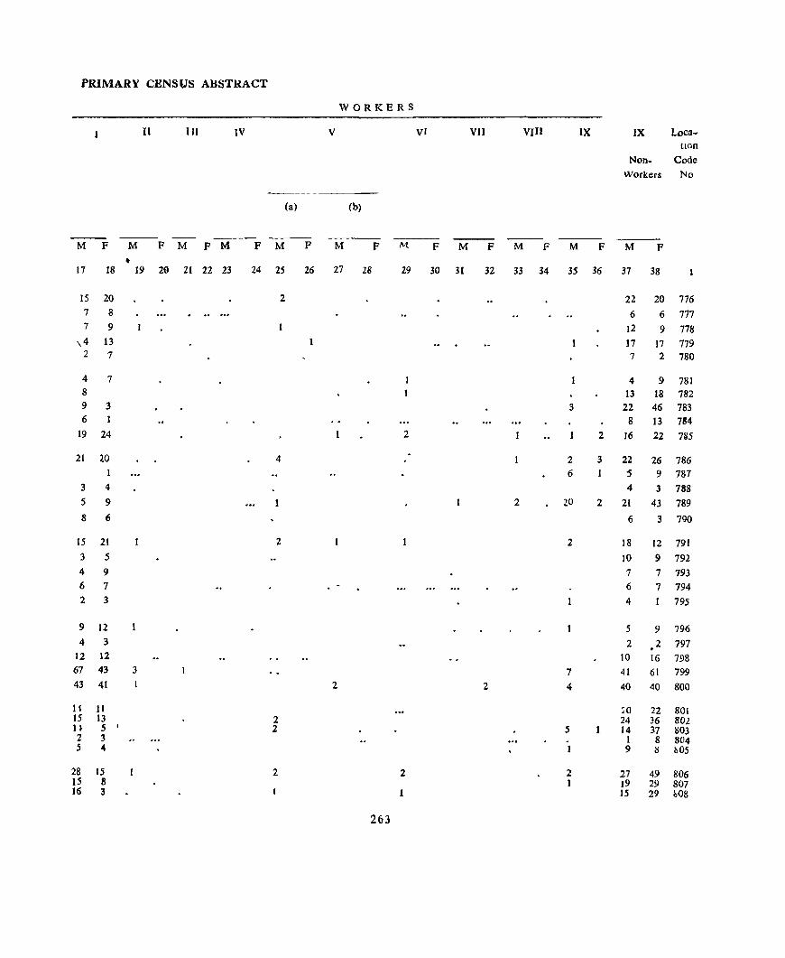
PRIMARY CENSt/S ABSTRACT
WORKERS
n IIJ IV V VI VII VIII IX IX Loca-tIOn
Non- Code Workers No
(a) (b)
M F M F M F M F M F M F M F M F M F M F M F
• 17 18 19 20 21 22 23 24 25 26 27 28 29 30 31 32 33 34 35 36 37 38
15 20 2 22 20 776 7 8 6 6 777 7 9 12 9 778
\4 13 17 17 779 2 7 7 2 780
4 7 4 9 781 8 13 18 782 9 3 3 22 46 783 6 1 8 13 784
19 24 2 2 16 22 7B5
21 20 4 2 3 22 26 786 6 '5 9 787
3 4 4 3 788 5 9 2 20 2 21 43 789 8 6 6 3 790
15 21 2 2 18 12 791 3 5 10 9 792 4 9 7 7 793 6 7 6 7 794 2 3 4 1 795
9 12 5 9 796 4 3 2 2 797
12 12 10 16 798 67 43 3 7 41 61 799 43 41 2 2 4 40 40 800
11 11 ,0 22 801 15 13 2 24 36 802 H 5
, 2 5 14 37 803
2 3 . 1 8 804 5 .. 1 9 ~ /l05
28 15 2 2 2 27 49 806 15 8 I }9 29 807 16 3 1 IS 29 ~O8
263
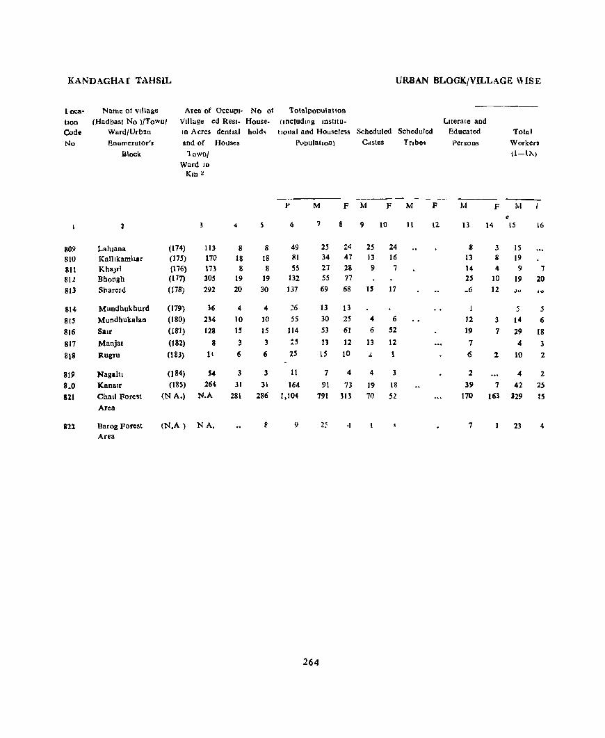
KANDAGHAf TAHSIL URBAN BLOCK/VILLAGE \USE
loea- Name of village Area of OCCUPI- No of Totalpopulatlon
tlon (Had bast No )!Towll! Village cd Resl- House- (Including mstltu- Llterale and
Code Ward/Urblln JD Acres dentlal hold~ tlonal and Houseless Scheduled SCheduled Educated Total
No Enumerator's and of Houses PupulatlOn) Cistes TClbcq Persons Workers
Block 1 own! (1-1>.)
Ward 1D
Km:::
----p M F M F M F M F [VI
~
1 4 S 6 7 8 9 10 11 12 13 14 15 16
809 Lahlana (174) 113 8 8 49 2.5 24 25 24 8 3 15 810 Kallikamhar (175) 170 18 18 81 34 47 13 16 13 8 19 811 KhaJrl (\76) 173 8 8 S5 27 28 9 7 14 4 9 ..,
81l Bhongh (117) 305 19 19 132 55 77 25 10 19 20 813 ShareId (78) 292 20 30 137 69 68 IS 17 _6 12 ,)" .<)
814 Mundhukhurd (179) 36 4 4 ::6 13 13 5 5
815 Mundhukalan (180) 234 10 10 55 30 25 .. 6 12 3 14 6
816 Salr (181) 128 H 15 114 53 61 6 52 19 7 29 18
817 Manjat (182) 8 3 3 :" 13 12 13 12 7 4 3
818 Ilugru (183) 11 6 6 25 l5 10 1.. 1 6 1 10 1
819 Nagattl (184) , .. 3 3 11 7 4 4 3 2 4 2
8.0 'Kanalr (185) 264 31 31 164 91 73 19 18 39 7 42 25 S11 Chait Fore!t (N A.) N.A 281 286 1,104 791 313 70 52 170 163 329 IS
Arca
821 Barog Forest (N.A) NA. 9 25 ..J 7 23 4 Area
264

PRIMARY CENSUS ABSTRACT
WORKERS
II HI IV V VI VII VIII IX X Loca-tion
Non Code Workers No
(a) (b)
-- -M F M P M P M F M P M P M F M P M P M F M P
17 i8 19 20 21 22 23 24 25 26 27 28 29 30 31 32 33 34 35 36 37 38 -13 2 10 24 809 17 1 - 15 47 810 6 7 2 18 21 811
19 20 36 57 812 28 17 6 3 31 50 813
5 5 8 8 814 10 6 3 16 19 815 21 IS 4 4 24 43 816
3 3 9 9 817 5 1 2 5 8 818
2 1 2 3 2 819 31 25 2 4 2 2 49 48 220 2 18 19 8 10 43 8 221 14 462 298 821
15 S 4 2 822
265

TAHSIL NALAGARH

170
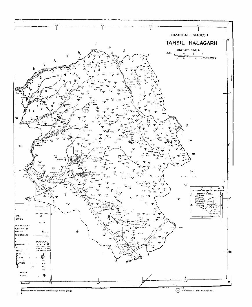
----------------=--================f==================~50========:H:IM:A:C~HAL PR!~ESH TAHSIL NALAGARH
, ."
c::
d
;~ I !R~
iCATION
I'
~GE VILLAGES
II>Ul.A.TION OF
'[bN SITE
"tlNMETA1..LED • (. ~TATION. hHE •
t)Rlt~
o
~ ~o
POT
p, 0 ..
SIMLA MILES ''--;--::' -=:;:::-,- ~ ,
\.
l>
" 4.
(
ht 1977 ~ ""............_ f Indll COPYrt9 \:::J GOverflme~\ ()
TAHSIL NALAGARH

NALAGARH TAHSIL
Loca. Name of VIllage Area of OCCUPl-
tlon (Had bast No )/Town/ Village ed Res)-
Code Ward/Urban 1D Acres dentlal
No Enumerator 8 and of Houses
Block Town/Ward In Km 2
2 3 4
NALAGARH TAHSIL Km~
Total 7062 14,406 14,164
Km z
Rural 7046 13,565 13,462
Km :l
Urban 1.6 841 702
URBAN BLOCK/VILLAGE. WISE
No 01
House-holds
S
77,095
73,424
3,671
Total PopulatIon (mcludmg InstItutIOnal)
and Houseless Scheduled
Population Castes
P M F M F
6 7 8 9 11)
40,247 8,869 36,848 8,200
38,275 8,683 35,149 a,Oll!
1,972 4,186 1,699 172
272
Literate and Total Scheduled Educated Workers
Tnbes Persons (I-IX)
-----M F M F M F
11 12 13 14 15 16
12,143 22,410 3.171 2,748
10.911 21,433 2,318 2,663
1,232 977 853 85

PRIMARY CENSUS ABSTRACl
WORKERS
II III IV V VI VII VlIJ IX " Looa-tlOD
Non- Code Workcn No
(a) (b)
M F M F M F M F M F M F M F M F M F M F M F
17 18 19 20 21 22 23 24 25 26 27 28 29 30 31 32 33 34 35 36 37 38
7,995 699 274 705 338 385 460 238 1,316 17,837 2,352 106 73 57 3 14 2 2 139 34,100
7,958 693 247 668 194 301 210 161 100,1 16,842 1349 106 73 55 2 14 1 2 61 32,486
l 37 6 27 37 144 84 250 77 315 995 3 2 1 1 78 1,614
271
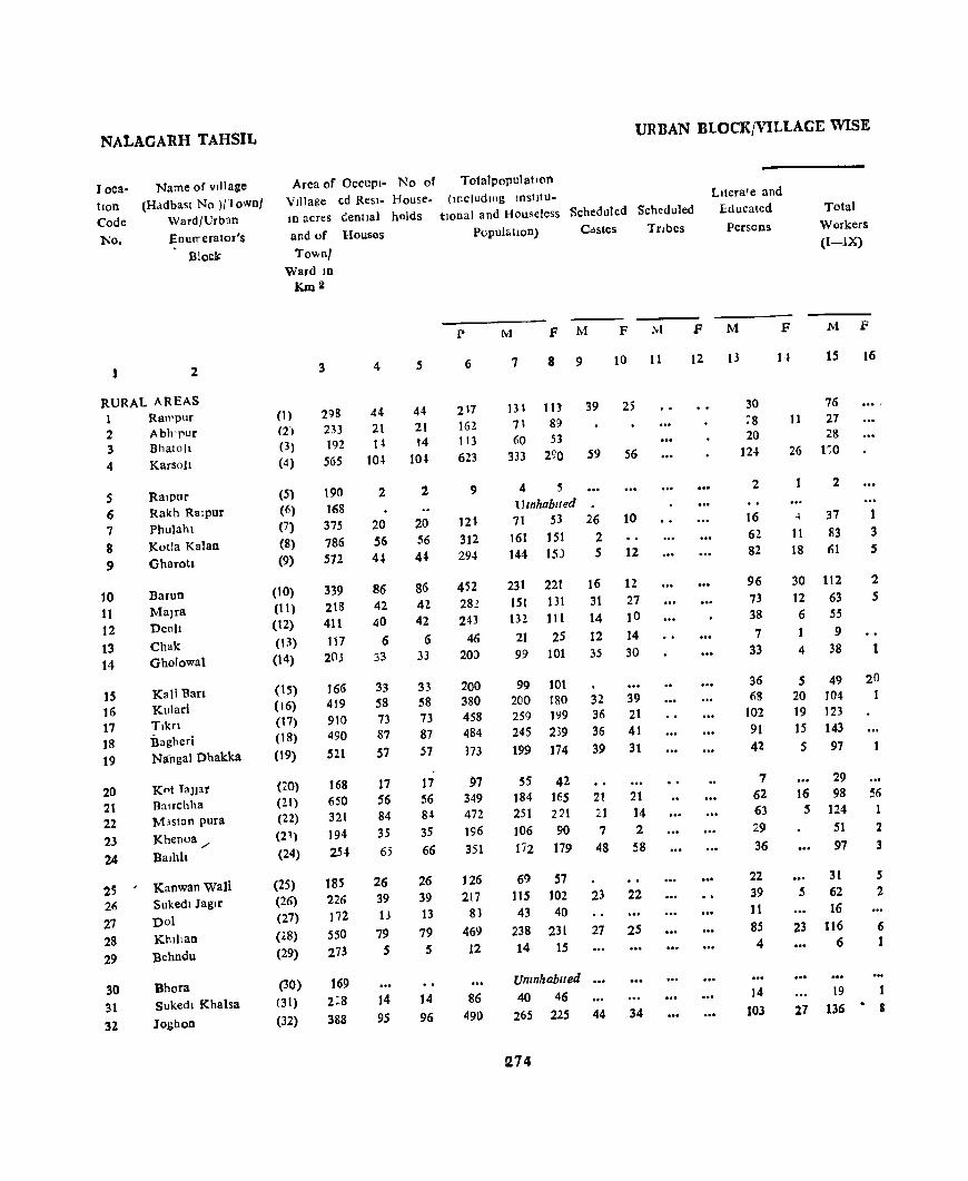
NALAGARH TAHSIL
J oca· hon Code
'No.
1
Name of vIllage
(Had bast No )/Townl Ward/Urb,lO
EnurreratOl's
Bloc~
2
RURAL AREAS 1 2 3 4
5 6 7
8 9
10 11 12 13 14
15 16 17 18 19
20 2\ 22 23
24
25 26 27 28 29
30 31
32
Ran'pur Abh'pur Bhatoll Karsoll
Ralpur Rakh Ralpur Phulaht Kotla Kalan Gharotl
Barun Malra Deoll
Chak Gbolowal
Kali 'Ban Kulari
Bagheri Nanga) Dhakka
Knt TaJJar BalTchha M.istan pura Khenoa ./ Balhh
Kaowan waIi Sukedl Jaglr Do) Khilian
Behndu
Bhora sukedl Khalsa
Jo~hon
Area of OCCUpI. No of VIllage ed Resl. House. 10 acres Genital holds
and of Houses
Townl Ward ID
Km2
(1) (2)
(3) (4)
(S) (6)
(7)
(8)
(9)
(10) (11) (12) (13) (14)
(15) (16) (17) (18)
(19)
(20) (21) (22) (2') (24)
(25) (26) (27)
(28)
(29)
(30) (31)
(32)
3 4 s
298 44 44 233 21 21 192 H 14 565 10.1. 10-l
190 168 375 786 572
339 218 411
117 2()j
166 419 910 490 521
168 650 32\ 194 2S4
185 226 172
SSO 273
169 2:8 388
2
20 56 4"
86 42 40
6 33
33 58 73 87
57
17 56 84 3S 65
26 39 13
79 5
14
95
2
20 56 44
86 42-42
6 33
33 58 73 87 57
17 56 84
3S 66
26 39 13
79 5
14
96
URBAN BLOCK/VILLAGE WISE
Totalpopulatlon (includlllg InStltu.
tlOnal and Houseless Scheduled Scheduled
Lltera1e and Educated
Persons
Total Workers
(I-IX) Population) Castes Tnbes
p
6
217 162 113 623
9
121 312 294
452 282 243
46 20:>
200 380 458 484
373
97 349 472
196 351
126 217
81
469 12
86 490
M
7
F M
8 9
F hi
10 11
13l III 39 25 71 89 60 53
333 290 S9 56
4 5 Umhablted 71 53
161 151 144 l!D
231 221 lSI 131 132 111
21 2S 99 101
99 10\ 200 180 259 199 245 239 199 174
55 42 ]84 165 251 221 ]06 90 li2 179
69 57 115 102 43 40
238 231 14 15
Unznhablted
40 46
26 2 5
10
12
16 12 31 27 14 10
12 14 35 30
32 39 36 21 36 41
39 31
2\ 21 :.1 14 7 2
48 58
23 22
27 25
265 22S 44 34
fl74
F M
12 13
30 ~8
20 12-'
2
16 62 82
96 73 38 7
33
36 68
102 91 42
7 62 63 29 36
22 39 11 85 4
14
103
F M F
15
76 It 27
28 26 1~0
4
11 18
2
37
83 61
30 112 12 63 6 55 1 9 4 38
5 49 20 104 19 123 15 143
5 97
29 16 98
5 124 51
97
31 5 62
16 23 116
6
19
16
1 3 S
2 5
1
56 1
2 3
S 2
6 1
2.7 136 • 8
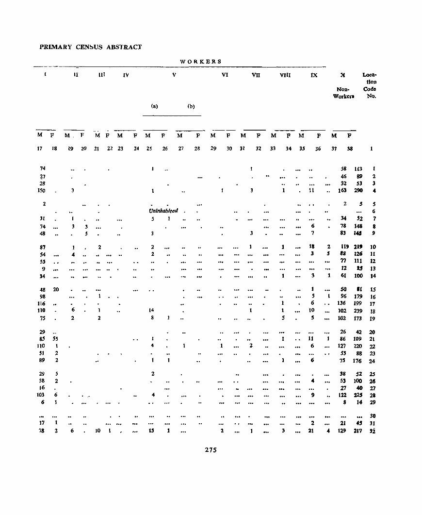
PRIMARY CEN~US ABST.RACl'
WORKERS
II III IV V VI VII VIII IX 'f Loca-tfon
Non- Co~
Workerl No.
(a) (b)
- ---M F M, F M F M F M F M F M F M F M F M F M F
17 18 19 20 21 22 23 24 25 26 27 28 29 30 31 32 33 34 35 36 37 38 1
74 58 li3 1,7 46 89 2 28 32 53 3
150 3 1 3 1 11 163 2SO 4
2 2 $ 5 Uninhabited 6
31 I 5 1 34 52 7
74 3 3 <) 78 148 8 48 5 3 3 7 83 14§ 9
87 I 2 2 1 11 2 119 21t 10 54 4 .. ... .. 2 3 , as 126 11
S5 77 111 12 9 12 1.5 13
34 I 3 1 61 100 14
48 20 1 SO '1 15 98 S I 96 179 16
116 6 136 199 17 110 6 14 1 1 to t02 239 18 75 2 2 8 5 5 102 t73 19
29 26 42 20 8.S 5S 1 1 11 86 109 21
110 1 4 2 6 127 220 22
'I 2 5$ 88 23 89 2 1 6 75 176 24
29 5 2 38 52 2S 58 2 4 53 tOO 28 16 27 ...,
27 t03 6 . ~ 4 9 122 225 2.
6 8 14 29
30 17 2 21 4' 31 78 2 6 10 U 1 2 3 21 4 129 217 si
275
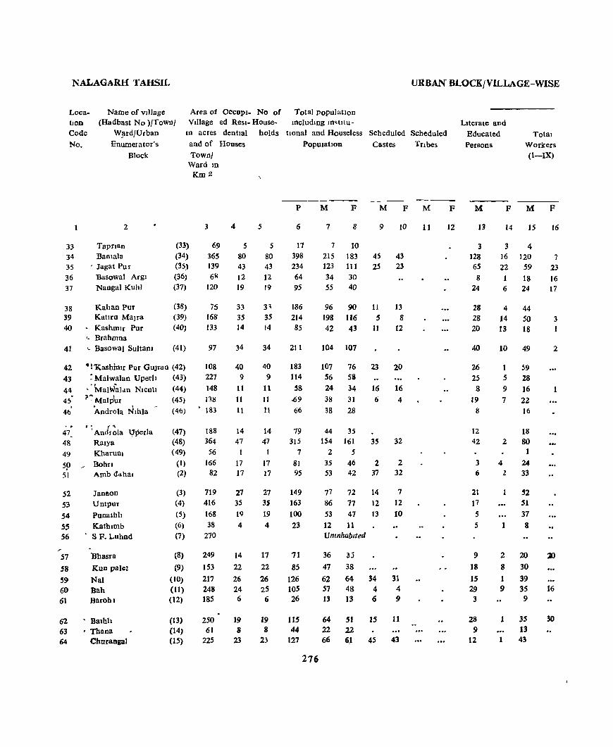
NALAGARH TAHSIL URBAN BLOCK/VILLAGE-WISE
Area of OCCUPI- No of Tota1 populatIon LocatJOn Code
No.
Name of vIllage (Hadbast No )!Town! VIllage ed Resl- House- mc1udlng m~tllu-
W~rd]Urban
Enumerator's
Block
In acres dentIal holds tlOna1 and Houseless Scheduled Scheduled
and of Houses PopUlatIon Castes Tnbes Town]
Ward In
2
33 Tapn8 0
34 :Bamala 35 ' Jagat Pur 36 Basowal Argl 37 Nanga! Kuhl
38 Kahan Pur 39 Kaura Malra 40 • KashmIr Pur
.. Brahmna
41 I.. Basowal SultaDl
(33) (34)
(35) (36) (37)
(38) (39)
(40)
(41)
42 ":'Kashhllr PUf GUJran (42) 43 : Malwalan Uperlt (43)
44 • 'MalWaldn Nicoll (44)
4~' ?~ Maltiur (45)
46' Androla Nlhla (46)
.. . ( "\
47. 'Androla \!perla 48 Ralya 49 Kharunl
59 BohIl 51 Amb dd.hal
52 53
54 55 56
Janaon Untpur
Punalhh
Kathlmb SF. Luhnd
57 "Shasra
58 KUD pale!
59 Nal 60 Bah 61 Barohl
62 • Balhh 63 • Thana 64 Charallga)
(47) (48) (49)
(I)
(2)
(3) (4)
(5)
(6)
(7)
(8)
(9) (10) (11)
(12)
(13) (14) (15)
Km 2
3
69
365 139 61!
120
75 168 133
97
108 227 148 138
• 183
188 364
56 166
82
719 416 168
38
270
249
153
217 248 185
250 61
225
4
5
80 43 12 19
33 35 14
34
40 9
11
It It
14 47
1
17 17
27 35 19
4
14 22 26 24 6
19 8
23
5
5 80 43
12 19
3' 35 14
34
40
9 11
II 11
14 47
17 17
27 3S 19
4
17
22
26 25 6
19 8
23
p
6
17 398 234 64 95
186 214 85
211
183 114
58 .69
66
79 315
7
8J 95
149 163 100 23
71
85
126 105 26
115 44
127
276
M F M F M
7 8 9 10
7 10
215 183 45 43 123 111 25 23 34 30 55 40
96 90 11 13 198 116 5 8 42 43 11 12
104 107
107 56 24 38
38
76 58
34 31
28
44 35
23
16 6
154 16J 35 2 5
35 46 2 53 42 37
77 72 14 86 77 12 53 47 t3
12 11 Umnhablted
36 lj
47 38
2,0
16 4
32
2 32
7 12 10
62 64 34 31 57 48 4 4 13 13 6 9
64 51 15 11 22 22 66 6J 45 43
11
F
12
LIterate and Educated Persons
Total Workers (I-IX)
M
I3
3 128 6S
8 24
28 28 20
40
26 25 8
19 8
12 42
3 6
21 17 5 5
9
18 15 29 3
28 9
12
F M
14 15
3 4 16 120 22 59 1 18 6 24
4 44 14 SO 13 18
10 49
1 5
9 7
59
28 16 22 16
18 2 80
4 24 2 33
I
52 51 37 8
2 20 8 30 1 39 9 35
9
J 35 13
1 43
F
16
7 23 16 17
3
2
16
30
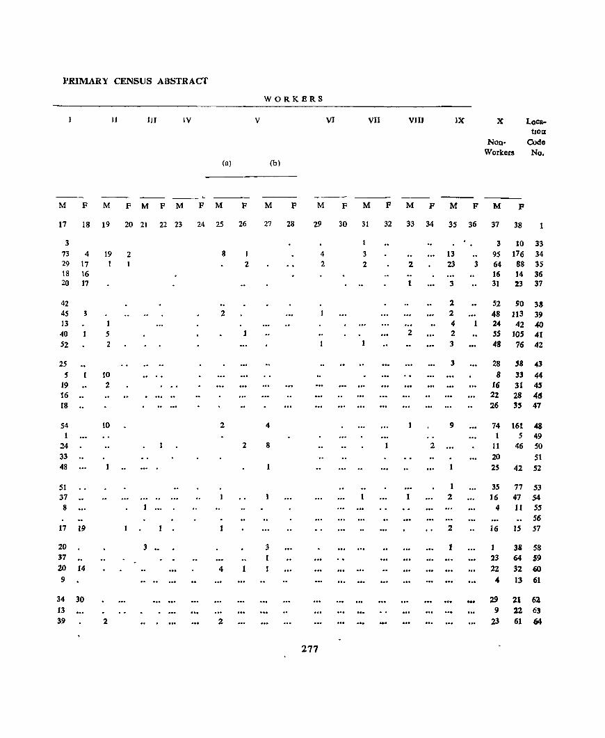
PRIMARY CENSUS ABSTRACT
WORKERS
IJ IJI lV V VI VII VJIJ JX X LoC&-tl0a
Non- Codo Workers No.
(a) (b)
--- --M F M F M P M F M F M P M F M P M P M F M P
17 i8 19 20 21 22 23 24 25 26 27 28 29 30 31 32 33 34 35 36 37 38 1
3 I 3 10 33 73 4 19 2 8 I 4 3 13 9S 176 34 29 17 2 2 2 2 23 3 64 88 3S 18 16 16 14 36 20 17 1 3 31 23 37
42 l 52 90 33 45 3 2 2 48 113 39 13 4 1 24 42 40
40 5 1 2 2 .55 10.5 41 52 2 1 3 48 76 42
25 3 28 '8 43 .5 10 8 33 44
19 2 16 31 4' 16 .. 22 28 48 18 .. 26 35 47
54 10 2 4 9 74 161 48 1 S 49
24 2 8 1 2 II 46 50 33 20 51 48 1 25 42 52
51 1 35 77 53 37 1 2 16 47 54 8 4 lJ 55
56 17 19 2 16 15 57
20 3 •• 3 1 38 58 37 1 23 64 j9
20 14 4 1 22 32 60 9 " 13 61
34 30 ... 29 21 62 13 9 22 63 39 2 2 23 61 64
277

NALAGARH TAHSIL URBAN BLOCK/VILLAGE-WISE
Locll- Name 01 VlI)age tlon: (Hidbast No ),Townl Code Ward/Urban
No... Enumerator's BLock
Area of OCCUPI- No of Total populatIon VIllage ed Resl- House- (mcludmg Instllu-In acres dentlal holds tlonal) and House)ess Scheduled Scheduled and of House. Town!
Ward JD
Km 2
PopulatlGlD Castes Tnbes
Literate and Educated Persons
Total Work.ers (I-IX)
p M F M F M F M F M F
65
66 6, 68 69
70 7{ 72 73 74
80
81
82, 83,
84
85 86
81 88
89
~t 96 97
2
Kund1u Dhalll Thadn HawaDJ '" SF. Kala Amb BaO!
Kunah Gharyacb
'I' Kasht
"" Talao f·
Patta
Cbatlog S F~ Okhu
Okhu '1;"
Oalot )'
Panjal]J
(16)
(17)
(18) (19)
(20)
(21)
(22)
(23) (24)
(25)
(26)
(27) (28) (29)
(30)
S F. Dhar Chamba (31) Janl}1\) Chamba (32) Chall}.ba (33) Dh~~e) (34)
-(".
S F Dhare! (35)
Koh,la Pale! Jangal-Ba~~ahJr
Jukhar ./ .... Thoena
~
Banal '" Bara
Ran@aJa
Jangal Saharll 'W"'" •• ..,
KapohJ
Raehboh
(36) (37)
(31h
(3~) (40)
(11)
(12) (43) (44)
(1~!
(46) (47)
(48)
3
560 418 126 520 367
81 166
259 74
163
135 363 118 30 88
218
89 •
4
51 22 7 5
26
9 5
14 10 12
7
7
8 7
208 23 97 14
7
182 198 48
310 93
78 53 59 21
276
22 136 187
19
13
29 6
10 3
3 3 3
12'
10
51
28 7 5
26
9 5
14 10 12
7
7
8 7
23
14
19 13
29
6
10 3 3 3 3
12
16
6
202 144 35 14
132
32 33 79 SO 51
46
48
48 58
94 64
86 87
176
31
41 22 13 15
107
76 38
278
7 8 9 10
97
75 22
105 3
09 3 6 69 8 8 9 5
64 68 28 32
20 18
12 15 39 28 25
40 IS 18
22t 2 2 26 4 3
20 26 1 Uninhabited. •• 23 25 17 31 27 31
Unlnhablted
Un{n(zabltet/ 48 46 27 31 Uninhabited
43 43 10 13 49 38 3 2 Unmhabited
84 92 12 9 14 17 5 5
23 18 6 3 11 11
6 7 5 10
6) 46 42 32
Uninhabited 44 32 12 7 21 17
11 12 t3
66
19 9
9
3 4 6 6 4
5
6
6 9
12 12
9 12
22 2
2 3
2 5
10
4
14 IS 16
33 52 19
3 34 36 9 4
39
10 2
8 22
3 16 17
10
13 4 9 2 12
33 2 19
8 8
1 27 13 2 22 15
6 49 43 10 12
16 7 3 3
4)
24 14
4 7 4 5 1
12
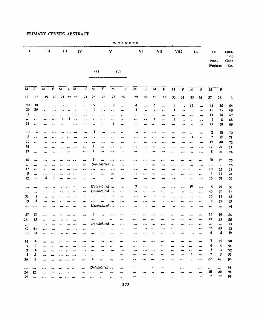
PRIMARY CENSUS ABSTRACT
WORKERS
I 11 III lV V Vi VlI VIU IX IX Loca. tlOn
Non- Code
Workers No.
(a) (b)
M F M F M F M F M F M F M. F M F M F M F M F
17 18 19 20 21 22 23 24 25 25 27 28 29 30 31 32 33 34 35 36 37 38 1
22 18 S 3 4 5 12 45 86 65 29 36 J 4l 33 66 9 13 16 67
4 1 1 I 8 68 38 25 68 69
]0 2 1 2 18 70 8 1 7 18 71
22 17 40 72 16 1 12 22 73 17 1 8 26 74
10 3 10 26 75 Uninhabited 76
13 10 25 77 9 8 3t 78
12 5 1 15 31 79
Uninhabited ... 2 10 4 21 80 Uninhabited 40 60 81
31 8 15 38 82 19 8 ! •• 8 29 83
Uninhabited 84
27 13 16 30 8S 221 IS 27 23 86
Unlnl,abued 87 49 43 35 49 88 10 12 4 5 89
16 4 7 14 90
7 7 4 4 91 3 4 3 3 92 3 5 S 2 5 93
36 1 4 20 45 94
uninhabited 95 24 12 20 20 9~ 14 7 17 97
~1SI

NALAGARH TAHSIL
Loca
tIon Codo
No
98
99
100
101 102
103 ]04 105 106
107
108 109 110
111 112
113
114
115 116 117
11S 119 120 121 122
123 124 125 126 127
128 129 130
Namc of vlllagc (Hadbast No )JTown/
Ward/Urban Enumerator',
Bloelr
1
Arca of OCCUPI- No of VIllage cd Resl- HouselD Acres dentIal holds
and of Houses
Townl Ward 1&
((m2
3 4
Bakruri (49) 76 103 168 236
130
3 3
SF Lunda (50) Ncrh Brabmna (51)
Sal (52) Parwah (53)
C)larog Klardu
RUlahan Kusn
BahIl
Lunas Walam Nerll Chulao DpJru Doh
Batlak
Gajed
SUD a ~
Badkhoa
BhlOD KhaT
Bbalechhan Kusn Jangal Slbal /' SF Looocana
Lana
MaD)hlan
Chabban Chanlan Klar Ghat S F. SuraJPur
Dohra
RaJaha Clu.la
(54) (55)
(56) (57)
(58)
(59) (60) (61)
(62) (63)
(64)
(65)
(66)
(67)
(68)
(69) (70) (71) (72)
(73)
(74)
(75J (76) (77)
(78)
(79)
(80)
(81)
344
96
305 140
101
688
434 236
154 250
246
399 210
241 699
155 281 126
91
196
174 95 51 94
736
20 3S5 85
5 18
8
28 5
23 8
9
58 26 16 18 28
18
21 29 20 47
11 11
6
16 4 3
15
1
27 7
5
19 8
28 5
23
8
9
58 26 16 ]8 29
18
23
29 20 49
11 11
6
16
4 3 15
27 7
URBAN BLOCK/VILLAGE-WISE
TotalpopulatIon
(lDcludlOg Institu-tional and Houseless Scheduled Scheduled
Literate and Educated
Persons
Total
Workers (I-IX)
Population) Castes Tnbes
p
6
8
27 93
35
141 31
123 57
27
264 103
79
92 134
76
107
ISS 67
237
71 8
37
87 35 22 (JO
7 tl9
25
280
M F M F M
7 8 9
2 6 Unmhablted •• 19 8 49 44 18
19 16 3
10
16 2
73 68 12 11 16 IS
64 S9 29 28 IS 12
133 131 57 46 42 37 47 45 65 69
37 39
29 30 53 44 26 20
6 7 3 5
48 59 11 11 89 66 35 32 6 6
120 117 20 17
36 35 39 19 11 Uninhabited •• Umnhablted 19 18 5
8
4
SO 37 19 14 19 16 4 2
10 12 4 7 31 29 Umnhablted •••
4 3 S9 60 12 12 13 12 7 7
11
F M
12 13
2
6 9
21 3
IS 16
4
42 6 5
14 27
13
IS
34
11
35
IS 10
3
14 .. 3 S
6 2
F M F
14 15
2 2
7 32
10
42 9
2 44 3 13
8
94
42 31
10 30 3 41
2 22 3 26 4 42
27
9 76
6 18 28
14
27 11 8 24
4 46 9
16
1
1
2
2
1 6 4
6
1 1 1
1
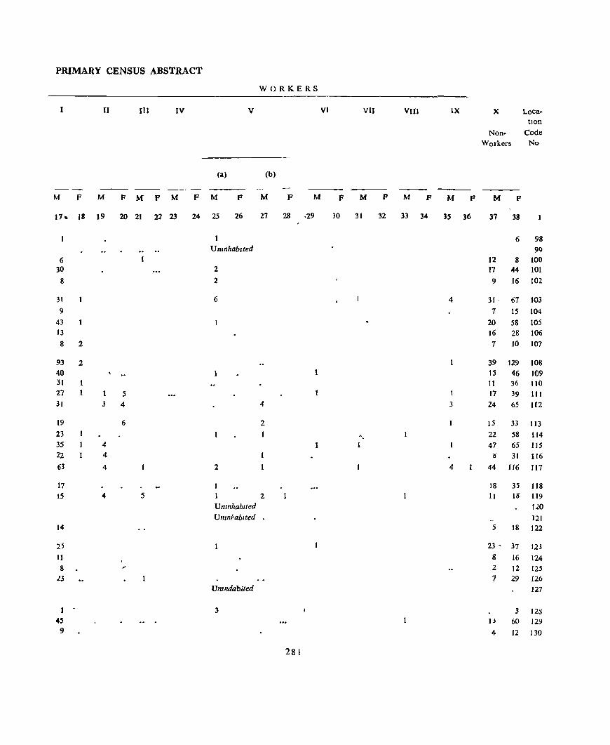
PRIMARY CENSUS ABSTRACT
WORKERS
1 II III IV V VI VIJ VIII LX X Loca-tion
Non- Code Workers No
(a) (b)
---M F M F M P M F M F M F M F M P M P M F M F
17 .. 18 J9 20 21 21 23 24 25 26 27 28 ·29 30 31 32 33 34 3S 36 37 38
6 98 UninhabIted 99
6 L2 8 100 30 2 17 44 101 8 2 9 16 102
31 6 4 31 - 67 103 9 7 15 104
43 20 58 105 13 16 28 106 8 2 7 10 107
93 2 39 129 108 40 IS 46 109 31 It 36 110 27 5 I 17 39 111 31 3 4 4 3 24 65 112
19 6 2 15 33 113 23 " 22 58 114 3S 4 1 47 65 115 22 4 ~ 31 116 63 4 2 4 44 116 117
17 18 35 118 15 " 5 2 11 18 119
Uninhabited 120 Umnhablted • 121
14 5 18 122
25 23 • 37 121 11 8 16 124 8 2 12 125 ~3 7 29 126
Umndablled 127
1 - 3 3 121l 45 J.) 60 129 9 4 12 130
281
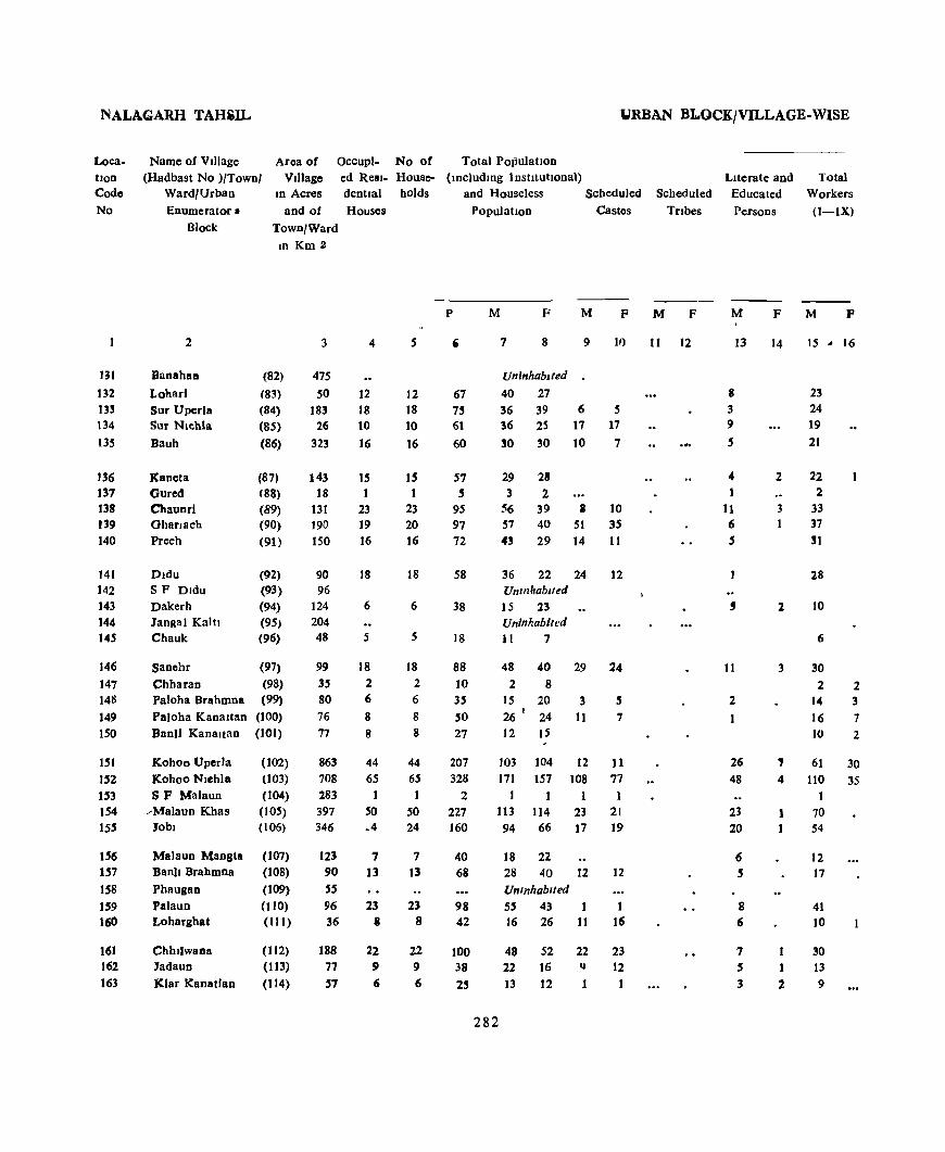
NALAGARH TAHiIL lJRBAN B1.QCK/VILLAGE-WISE
Loca. tIon Code No
Name of Village (Hadbast No )/Town/
Ward/Urban Enumerator II
Block
Area of Village
Occupl- No of Total Population
m 132 13~
134 135
136 137 138 139 140
141 142 143 144 145
146 147 1411
149 1.50
1.51 ].52 ]53 1.54 ISS
156 157
158 159 160
161 162 163
lD Acres
and of
Town/Ward m Km 2
2
Banahaa
Lobarl Sur Uperla Sur Nlchla
Bauh
Kaneta Gured Chaunr! GharJ8ch Prech
Dldu S P Dldu Dakerh Jangal Kalll Chauk
(82)
(83) (84)
(85)
(86)
(87) (88)
(89) (90)
(91)
(92) (93)
(94)
(95, (96)
Sanehr (97)
Chharan (98) Paloha Brahmna (99)
Paloha KanaHan (100) Banll Kanaltan (101)
Kohoo Uperla Kohoo NJchla SF Malaun
__ Malaun Khas Jobl
Malaun Mangta Ban)! Brahmna
Phaugan Palaun Lohargbat
Chhllwana Jadaun
Klar Kanatlan
(t02) (103)
(104) (105) (106)
(107) (108)
(109) (110)
(III)
(1 (2) (113)
(114)
3
475
SO 183
26 323
143 18
131 190 150
90 96
124 204 48
99
35 80 76 77
863 708 283 397 346
123 90 55 96 36
188
77 57
ed Resl- House- (lDcludmg InstitutIOnal) dentlal belds and Houseless Scheduled
Housel PopulatIon Castes
4
12 18 10 16
15 1
23 19 16
18
6
5
18 2 6
8 8
44 65
I .50 ~4
7 13
23 8
22 9 6
5
12 18 10 16
15 1
23 20 16
18
6
5
18 2 6
8 8
44 65 1
SO 24
1 13
23 8
22 9 6
P
,
67
" 61
60
57 , 95 97 72
58
38
18
88 10 35
SO 27
207 328
2 221 160
40 68
98 42
M F M F
7 8
UninhabIted
40 27 36 39 36 25
30 30
29 28 3 2
9
6 17
10
56 39 I 57 40 51 4~ 29 14
36 22 Unmhablted 15 23 Uninhabited 11 1
48 40 2 8
15 20 26 I 24
12 IS
24
29
3
11
11)
5 17 1
10 35
11
12
24
5 7
103 104 12 11 171 157 108 77
1 1 113 114 23 21
282
94 66 17 19
18 22 28 40 12 UnInhabited 55 43 16 26 11
48 52 22 22 16 q
]3 12 1
12
16
23 12
Scheduled
Tribes
M F
11 12
.•.
Literate and Educated
Persons
M
8 3 9
5
4 t
J1 6 ,
13
,
II
2
1
26
48
23 20
8 6
7 5
3
F
14
2
3
2
3
, 4
1
1
2
Total Workers
(l-lXI
M p
IS .. 16
23 24 19 21
22 2
33 37 31
28
10
6
30 2
'4 16 10
2 3
7 2
61 30
110 35
70 54
12 17
41 10
30 13
9

PRIMARY CENSUS ABSTRACT
WORKERS
lJ U1 IV V VI VIJ VIlJ IX X Loea. tlon
Non- Cocle
Workers No
(a) (b)
M F M f M F M F M F M F M F M F M F M F M F
17 18 19 20 21 22 23 24 25 26 27 28 29 30 31 32 33 34 3S 36 37 33
Umnhab,ted 131 2' 17 27 132
23 12 39 133 14 3 17 25 134
19 2 9 30 135
22 7 27 136 2 2 137
28 3 2 23 19 138
35 2 20 40 139
30 12 29 140
28 8 22 141
Unmhablted • 142
9 5 23 143
Un/nhabUed 144 (; S 7 145
29 1 .. 18 40 146
2. 2 6 147
14 3 17 148
16 7 10 17 149 1O 2 2 13 150
60 30 42 74 151
100 3S 5 61 122 152
1 153
57 2 43 lit '54 53 40 66 155
12 6 22 156
17 II 40 157 Umnhablted 158
35 1 1 4 14 43 159 7 1 6 25 160
'i0 18 52 161 13 9 16 162
8 4 12 163
2R3
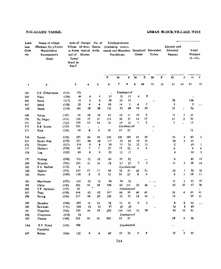
NALAGARH TAHSIL
Loca· tlon Code
No
164 16S
166 167 168
169 170 171 172
173
174 175 176 177
178
179 180 181 182 183
184 185 186 187 188
189 190 191 192 193
194
Name of village
(Hadbast No >/Town/ Ward/Urb~n
Enumerator'.
Area of OCCUpI· No of Village ed Resl· House. In Acres dentml holds
and of Houses
Block
2
S F ebbal wana
SlanJ
Sarsa
Jabal
Bendl
Nlhun Jal Nagar Jol SF Sunan
Rela
SUnan Sunah Rug Ohalen Malhan
Lag
Hulang
Sallachl SF Badhal Badhal Dohn
Machhaun
Ukhu SF Dabrota PanJ SanOi
)Junghar Sawasan
Cham dar
ChalyauOl Nanoa
SF Nlsa)
Chamdar
BlthOl
Town/ Ward in
Km.2
(115)
(116)
(117)
(118)
(119)
(120 )
(121 )
(122) (123) (124)
(125) (126)
(127) (128) (129)
(130)
(131 )
(02)
(133) (134)
(1 35)
(136) (137)
(138)
(139)
(140) (141 )
(142) (143)
(144)
(145)
(146)
3
176 49
31
52 161
59 124 103 555
49
357 251 119 66
80
193 235
6 152 110
156 502 65
644 217
205 226
339
32 252
'588
122
4
6
8 4
28
10 27 14
6
44 28
8 7
9
12 11
17 8
12 40
42 20
11 12 44
16
6
6
8
" 28
10 27 14
6
44 28 8 7
9
12 11
17 8
12 40
42 20
11 12
45
16
6
YRBAN BLOCK/VILLAGE. WISE
Totalpopulatlon (mcludmg IDStitU.
tlonal and Houseless Scheduled Scheduled
Population) Castes TrIbes
p
6
27 39 19
121
63 113 31
41
230 117 39 37 32
64 52
94 53
66 190
197
129
52 57
230
102.
60
M F M F M
, 8
Umnhablled 12 15
24 IS
14 5 S3 68
9
4
6 18
32 31 10 56 57 14
19 12 7 Untnhabtted
19 22
10
9
5
30
8 17 2
121 109 45 40
55 62 33 35 17 22 12 15 15 22 4 6
15 17
32 32 25 27 7 UninhabIted 52 42 40 31 22 8
34 32 89 lUI 26 Uninhabited 98 99 40 72 57 19
5
31 6
46
43 14
31 21 6 2 29 28
114 116 73 70
UnmhabIt ed 51 51
Umnhabited
35 25 9 9
284
11
F
12
Literate and Educated
Persons
M F
Total
Workers O-IX1
M r
13 14 15 16
20 1
J 1
11
27
2S 10 2 4
4
9 11
13 8
11 2S
23 12
8 16
42
18
13
5
2
138 5
29
21 36
15
11
4 63 2
2 33
3
1 33
4
10 9
10
4
3
18 19
18 14
30 16 19 11
15 13 57 38
63 41 39 21
2 15 3 16
11 61
6 28
2 15
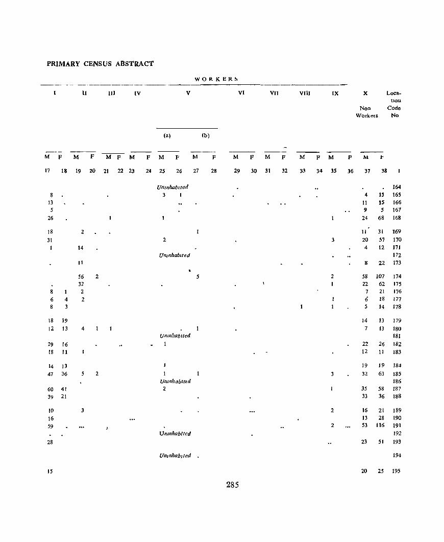
PRIMARY CENSUS ABSTRACT
WORKER~
I II III IV V VI VII VIlI IX X Loca-tion
NOD Code Workers No
(a) (b)
M F M F M F M F M P M F M F M F M F M F M 1"
17 18 19 20 21 22 23 24 25 26 27 28 29 30 31 32 33 34 35 36 37 38
Unmhablted 164 8 3 1 4 15 165
13 11 15 166 5 9 5 167
26 24 68 168
18 2 11 31 169
31 2 3 20 57 170 1 14 4 ]2 171
Uninhabited 172 11 8 22 173
56 2 5 2 58 107 174 32 1 22 62 175
8 2 7 21 176 6 4 2 6 18 177 8 3 5 14 178
18 19 14 13 179 12 13 4 7 13 180
Untnhablted 181 29 16 1 22 26 182 18 11 12 11 183
14 13 19 J9 184
47 36 5 2 3 32 63 185 Umnhabllld 186
60 41 2 35 58 187 39 21 33 36 188
10 3 2 16 21 189 16 13 28 190
59 ~ 2 53 116 191
Umnhablted 192
28 23 51 193
Uninhabited 194
15 20 25 195
285
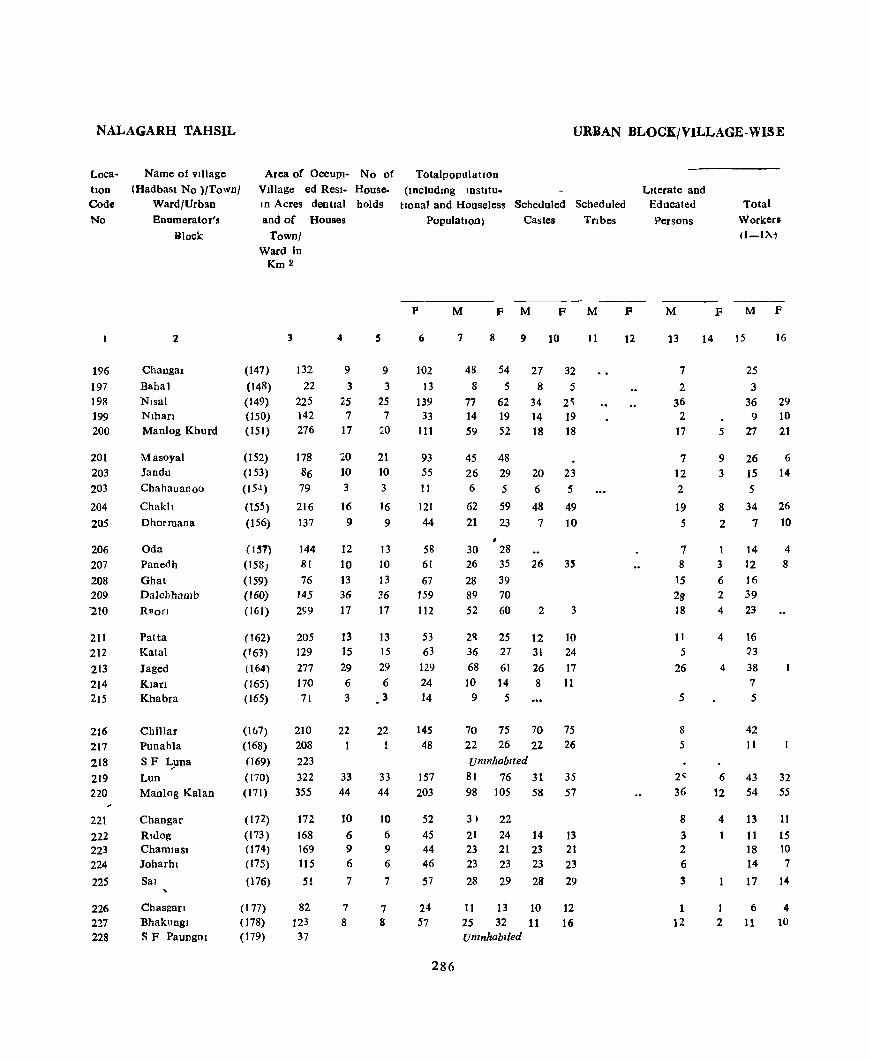
NALAGARH TAHSIL
LocatIon Code
No
196 197 198 199 200
201 203 203
204
205
206 207 208 209 "210
211 212 213 214 215
216 217 218 219 220
221
222 223 224
225
226 227 228
Name of village
(Had bast No )/Town/ Ward/Urban Enumerator',
Block
Changa!
Bahal Nlsal Nlhan Manlog Khurd
Masoyal Jandu
Chahauanoo
Chakll
Dhormana
Oda Panedh
Ghat Dalehhamb
Raon
Patta Katal
Jaged
Klan Khabra
Chi11ar Punahla
SF L_yna
Lun Manlog Kalan
Changar Rldog Chaml8S1 Joharhl
Sal
Area of OCCUPi- No of Village ed Resl- House. In Acres dentlal holds
and of Houses
Town/ Ward in
Km 2
(147)
(148)
(149)
(150) ( 151)
(152)
(153)
(15 4)
(155) (156)
(1~7)
(l58)
(159) (160) (161)
(162) (163) !l64)
(165) (165)
(lo7)
(168) (169) (170) (171)
(172) (173) (74) (175)
(176)
3
132 22
225 142 276
178
86 79
216 137
144 81
76 145 2<;9
205 129 277 170 71
210 208 223 322 355
172
168 169 115
51
4
9 3
25 7
17
20
10
3
16 9
12 10 13
36 17
13 15 29
6
3
22 1
33
44
10
6 9 6
7
S
9
3
25 7
20
21 10
3
16 9
13
10
13 36 17
13 15 29
6 3
22
33
44
10
6 9 6
7
Chasgarl Bhakungl SF Paungni
(177) (178) (179)
82 123 37
7
8 7 8
URBAN BLOCK/VILLAGE-WISE
Totalpopulatlon
(lllcludlDg IDstItu-tlonal and Houseless Scheduled Scheduled
Population) Castes Tnbes
p
6
102 13
139 33
111
93 55
11
121 44
58 61 67
159
112
53 63
]29 24
14
145
48
157 203
52 4S 44 46
57
M
7
F M F M
8
48 54 8 5
77 62 14 19 59 52
45 48 26 29
6 5
62 59 21 23
• 30 28 26 35 28 39 89 70 52 60
2R 25 36 27 68 61 10 14
9 5
9 10
27 32 8 5
34 2'i ]4 19
18 18
20 23 6 5
48 49 7 10
2 3
12 10 31 24 26 17
8 11
70 75 70 22 26 22 umnhablted
75 26
81 76 31 98 ]05 58
3) 22
21 24 ]4 23 21 23 23 23 23
28 29 28
11 13
35 57
13 21 23
29
II
24 57 25 32
]0
11
]2 16
Umnhablied
286
F
12
Literate and Educated
Persons
M
13
7
2 36
2 17
7 ]2 2
]9
5
7 8
15
28 ]8
]1
5
26
5
8 5
2-36
8
3 2
6
3
1 12
14
Total
Workers Il-l)q
F M F
]5
25
3 36
9 5 27
9 26 3 ]5
5
8 34 2 7
1 14 3 12 6 16 2 39 4 23
4
4
6
12
4
I 2
16 23 38 7
5
42 11
43 54
13 11 18 14
17
6
11
16
29 ]0
21
6
14
26 10
4
8
32 55
11
15 10 7
14
4 10

PRIMARY CENSUS ABSTRACT
WORKERS
lJ III IV V VI vn VIIT IX " Loca-tion
Non Code Work'rs No
(a) (b)
M P M P M P M P M P M P M P M P M P M F' M P
17 18 19 20 21 22 23 24 25 26 27 28 29 30 31 32 33 34 35 36 37 38
24 23 54 196 2 5 5 197
30 29 41 33 198 9 10 5 9 199
25 21 32 31 200
23 6 2 19 42 201 14 14 11 15 202
5 S 203
31 26 2 28 33 204 6 9 14 13 205
12 4 16 24 201l 12 8 14 27 207 12 2 1 '2 39 2!)8
32 S 50 70 209
19 2 29 60 210
15 12 25 211
22 13 27 212 30 6 2 30 60 213
5 2 3 14 214 5 4 5 215
33 9 28 75 216 11 11 25 217
Uninhabited 218 41 32 2 18 44 219 49 54 1 3 44 50 220
12 J1 17 1 I 221
11 15 10 9 222 18 10 5 11 223 14 7 9 16 224 17 14 It 15 225
6 4 5 9 226 11 10 . - 14 22 227
Uninhabited 228
287
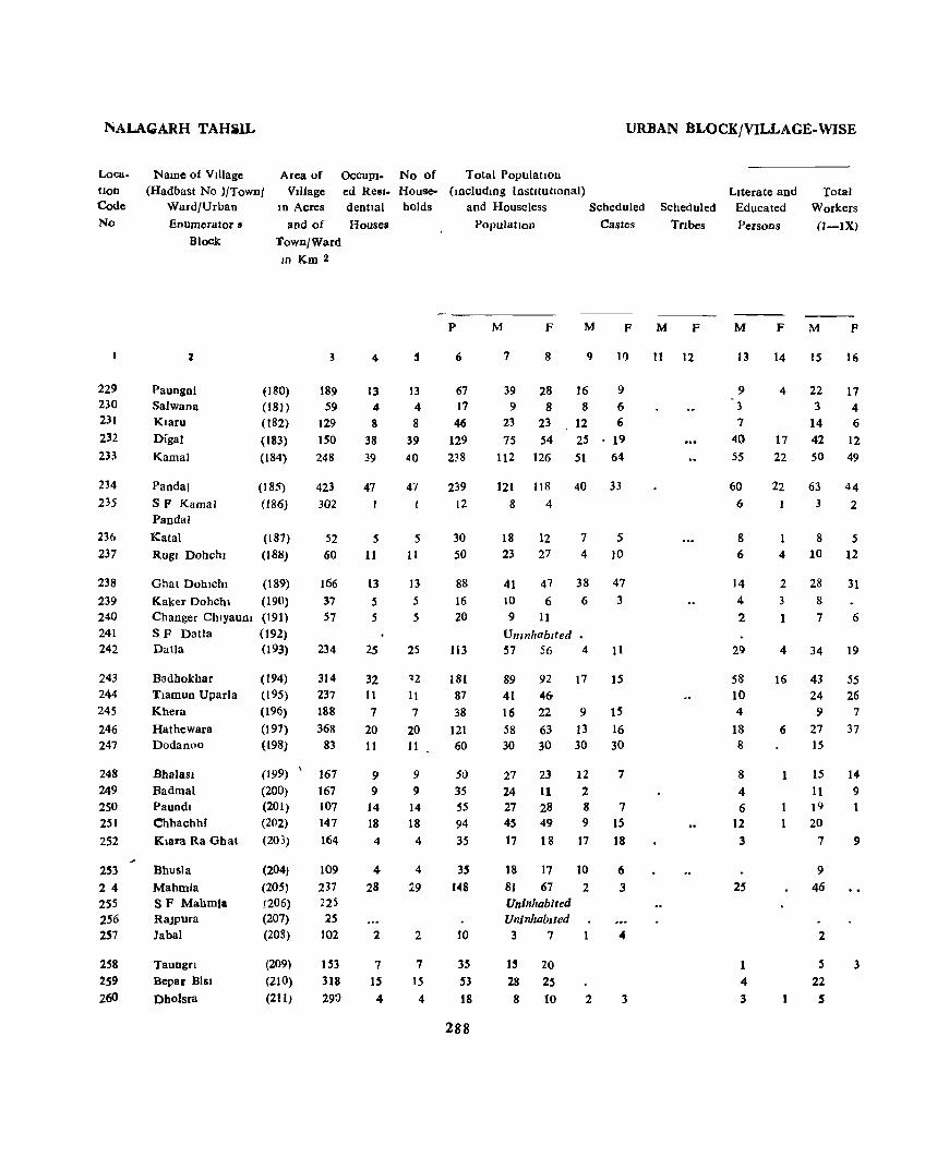
NALAaARH TAHilL URBAN BLOCK/VILLAGE-WISE
Loca. tlon Code No
229 230 231 232 233
234 235
236 237
238
239 240 241 242
243 244
245
246 247
248 249 250 251
252
253 2 4 255 256 257
258 259 260
Area of Vdlage
ID Acres
OcCUPl- No of Total PopulatIon ed Resl- House- (lDcludlDg InstItutIOnal) dentlal holds and Houseless Scheduled
Name of VIllage (Hadbast No )/Town/
Ward/Urban
Enumerator. and of Houses PopulatIon Castes Block
2
Paungni Salwana Klaru Digal
Kamal
Pandal
SF Kamal Pandal
Katal
Rugl Dohchl
Ghat Dohlchl
Kaker Dohchl Changer ChlyauDI SF Datla DaUa
Badhokhar Tlamun Uparla Khera
Hathewara Dodanoo
BhalaSl Badmal Paundl Chhachhf
Klara Ra Ghat
Bhusla
Mahmla SF Mahmla RaJPura Jabal
Taungn Bepar Bisl
Dholsra
Town/Ward In Km 2
(180) (181)
(182) (183) (184)
(185)
(186)
(187) (188)
(189)
(19(1)
(191)
(192) (193)
(194) (195)
(196)
(197)
(198)
(199)
(200) (201) (202)
(203)
(204)
(205) j206) (207) (208)
(209)
(210) (211)
3
189 59
129 150 248
423 302
52 60
166 37 57
234
314 237 188
368
83
167 167 107 147 164
109 237 225 25
102
153 318 290
4
13 4 8
38 39
47
5 11
13 5 5
25
32 11 7
20 11
9 9
14 18 4
4
28
2
7 IS
4
13
4 8
39
40
47
5 11
13 5
5
25
~2
l! 7
20 11
9 9
14 18
4
4
:'9
2
7
15 4
P
6
67 17 46
129 238
239
12
30 50
88 16 20
113
181 87 38
121 60
50 35 55
94 35
35 148
10
35 53
18
288
M F M F
7 8 9 If)
39 28 16 9 9 8 8 6
23 23 12 6 75 54 25 19
112 126 51 64
121 118 40 33 8 4
18 23
12 27
41 47
10 6 9 11
Unmhab,ted 57 56
7
4
38 6
4
5
10
47 3
11
89 92 17 15 41 46-16 22 9 15 58 63 13 16 30 30 30 30
27 23 12 7
24 11 2 27 28 8 7 45 49 9 15 17 18 17 18
18 17 81 67 Uninhabited UninhabIted
3 7
1~ 20
28 2S 8 10
10 2
2
6 3
3
Scheduled
Tnbes
M F
II 12
Literate and Educated
Persons
Total Workers
(1-1X)
M
13
9 3
7 40 55
60
6
8 6
14
4 2
29
S8 10 4
18 8
8
4 6
12 3
25
4
3
F M p
14 15 16
4 22 17 3 4
14 6 17 42 12 22 50 49
22 63 44
1 4
2 3
1
4
16
6
1
3 2
8
10
28 8
7
34
43 24 9
27 15
IS
11 19 20
7
9
46
2
5 22
S
5 12
31
6
19
55
26 7
37
14
9
3
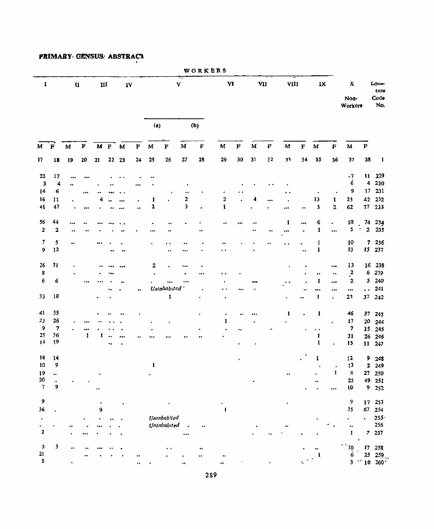
.PJlJMA.RY! OENSVS1 ABSTRACt
WORKBRS
I 11 111 IV V VI VII VIII IX X Lo04-(lOD
Non- Code
Worker. No.
(a) (b)
---.-.._
M F M F M F M F M F M F M F M F M F M F M F
17 18 19 20 2J 22 23 24 2S 26 27 28 29 30 31 32 31 34 35 36 37 38
22 17 ·7 11 229 3 4 6 4 230
14 6 9 17 231 16 11 4 .. 1 2 2 4 t3 1 33 42 232 41 47 2 3 1 3 2 62 77 233
56 44 1 6 58 74 23~ . 2 2 1 5 - 2 235
7 5 1 10 7 236 9 12 1 13 15 237
26 31 2 13 16 238 8 2 6 239 . 6 6 1 2 5 240
Uninhabited • 241 33 18 1 21 37 242
41 S5 1 46 37 243 23 26 17 20 244 9 7 7 15 245
25 36 1 " 31 26 246 14 19 15 11 247
14 14 1 12 9 248 to 9 13 2 249 19 8 27 250 20 25 49 251 7 9 10 9 252
9 9 17 25j 36 9 35 67 254
Un mhabIted 255-Uninhabfted 256
2 7 257
5 3 ... .. . • -10 17 251t 21 1 6 25 25~ ~, S ' ' :3 .. 10 260' <.
289
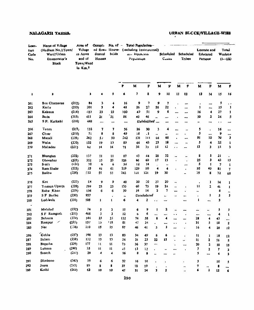
NALAGARR TAHSIL URBAN BLCCI/VJL~AGE-WI8a
Loac. lion Code
No.
261 262 263 264 265
266 267 268
269 270
271 272 273
274 275
276 277 278 279 280
281 282 283 284
2" 286 287 188 289 290
291 291 293
Area of VllIaae
Occupf~ Nc. of - Tctal Populatlcnt--cd Rell- Hou'e- (lDcludlDg Instuullonal)
•
Name of Vlllaae (Hadbast No.)/Town/
Ward/Urban Enumerator·,
Block
lD Acres and of
TownJWard lD Km.a
dentlal helds .. u~ liOU8,"l~:'l> Scheduled Scheduled
J
DISI Chamaran Katlu Kahnun
Bada SF. Kotkahi
Tunsu
Chlar Matuli Wah a Mahadeo
Bhanglan Dhoonher Slmh Ram Shahr Badhu
Kot Tlamun Uperla Rahu _Khan
SF Dadhu Lodlwala
Mehdud SF Ramaarh Bahrota Rampur Ncr
.... Gehlu
Bahen Bagotha
Lohana Sanerh
Dhalmoo Jeora IC.othl
(112) (213)
(214)
(215) (.Z16)
(217) (218) (219)
(210) (221)
(222)
(223) (224)
(225) (226)
(227) (228) (229) (230)
(231)
(232) (233) (234) (23.5) (:.36)
(237) (238)
(239)
(240)
(241)
(242) (243) (244)
House.
J .. , 84
201 <0) 411 448
3 4 3 4
23 23 21 '21
133 1 71 8
262 5J
132 19 III 14
7 8
50 1')
14
1.l7 11 It 25
6 61 55
352 25 70 0 25 61
!51 55
1)4
299 156 957 108
74 468 144 lSI 210
198 132
177
35 29
3.5 9!) 62
9
23 6
9 23 6
3 3 .3 3
23 23 H '18
U 15
13 13 13 13 11 11
11 11 4 4
6 6 8 8
10 10
Population Tribes
p
6
16 48
101)
86
56 49
:42 89 71
87 126
30 219 242
40 135 30
6
15 12
132 81 87
83 S4 73
25 16
32
37 45
290
M F M P M F
7 8 9 10
9 7 9 7 26 22 26 22
49 51 9 6
40 46 Uninhabited •••
26 30 3 4 18 .1
131 111 6~ 68
46 43 23 IS 36 3.) IS 12
43 44 28 32 66 60 17 13 12 HI
129 SO 4 4 III 121 19 30
20 :'0 20 60 75 19 16 14 2 Unlnhablled 4 2
20 14 7
6 9 2 () 6
74 58 8 4 47 34
46 41 5 3
34 49 6 6 31 23 22 IS 36 37 J3 12
8 8
16 16
18 19 21 24 3 2
11 12
Literate and Educated Person.
Totu Workel' (I-IX)
M
13
I 16 10
5 5
91
5 13
8 25 S
95 39
11
28 31
16
11 11 20
7 .5
, 7 ,;
P M p
14 15 16
5 15
4 27
2 24
16 9
1 1 5
10 70 3 4 22 1 3 IS 3
, 21
3 43 15 1 7 1
40 81 7 8 72 68
2 14
41 8
5 3
.5
S 5
4 4 43 .5 18 2
4 28 J2
1 18 12 2 16 S
2 18 IS 273
4 3
10 S
8 :2 1l ,

PRIMARY CENSUS ABSTRACt
WORKERS
II 1)] IV V VI VII VIII IX X Loca-boo
Non- Cod. Workers lIlo
(a) (b)
-- -"vi F M P M P M P M F M P M F M P M P M F M p
17 18 19 20 21 22 23 24 25 26 27 28 29 30 31 32 33 34 3S 36 37 38
4 4 7 261 15 11 21 262 27 22 50 263 23 4 16 41 264
Umnhablled 265
14 10 30 266 C) 9 31 267
62 3 I 2 2 3 61 108 268 14 4 4 24 42 269 14 2 21 32 270
21 22 44 271 40 15 23 45 272 6 ... 5 17 273 3 2 .0 4 21 14 26 6 48 83 274
53 7 4 I 4 9 49 113 275
P 6 19 276 39 19 74 277 8 8 14 278
Untnhablted 279 3 2 280
4 5 1 4 281 4 2 5 282
33 5 I 2 31 58 283 IS 2 1 2 29 32 284 27 12 "" 1 18 29 285
17 12 16 37 286
13 5 3 16 18 287 IS 15 2 18 22 288
6 3 1 6 9 289 1 3 2 4 5 290
9 5 6 11 291
II 10 J9 292 II 6 9 18 293
291

KANDAGHAT TAHSIL URBAN BLOCK/VILLAGE - WISE
Area of OCCUPI- No of Total population VIllage ed Resl- House- including mstJtu-
location Code
No.
Name of village (Hndbast No )/Towo/
Ward/Urban
Enumerator's
Block
in acres dentlal bolds tlOnal and Houseless Scheduled Scheduled
294 295
296
297 298
2
Dhaunl Dahll Jablu
ran~og
Baro,;
Den Ghat
and of Houses
Town] Ward ID
(245) (246) (247) (24~
(249)
(250)
Km 2
3
89 107
279 187 252
4
12 13 II 12 13
3 299 300
301 302 303
S F Johar Johru (251)
40
80
123 126
304
305 106 307 308
309 310
311 312 313
314
Gunad Kalan Gunah Khuld
l\al
Jdngal Jamlog
J.lfh 1aglog
SF Behen Baglerh
SI)aon Kafled Gadaon
Bhatlog
Katal
Chalronv
315 Jakhal
316 _ Dbarmana
317 Behlr
318 Jabal
319 Baroa
320 Ghasmana
321 Pamela
322 Dhar
323 Dher
324 315 326
Oabar
Katll Malag
(2~2)
(253) (2S~)
(255) (256) (257)
(258) (259)
(260)
(261) (262) (263)
(264)
(265) (266)
(267)
(268) (269)
(270) (27l'1
(272)
(273)
(274)
(275) (276)
(277)
55
65
8 263
188 187
36 139 102
167
58
51
211
492 49
116
134 101
92
512 224
154 643 108
15 14
5
17
18
5
7 10
13
5
4
19 37
7
9
15 13
5
32 32
12 60 14
12 13 11
12 1'3
3
15 14
5
17
18
5 7
!O
13
20
4
19 37
7
9
15
13 5
32 32
12
60 14
Population Castes lnbes
P
6
57 86 51 61 85
10
72
76
31
2
99
76
27, 26 41
4l
46
20
56
178
36
41
87 68 23
159
114
64 275
54
292
M F M F M
7 8
28 29 44 42
9 10
23 28 23 28 30 31 30 30 43 42 42 41
5 5
Umnhablted
36 36 33 43
15 19
UI1l11llablted
1 I 45 54
Uninhabited 38 38
16 11 13 13
21 20 19 23 31 15
12 8
29 27 101 77
20 16
20 21
44 43 33 35
10 13
90 69
59 55
15
23
17
16
5
4
3
8
4
4
22
19
27
15
II
6
3
7
6
9
18
33 31 6 8
138 137 50 52 26 28 26 28
11
F
12
Literate and Educated
Persons
M
13
7 II
5
2
4
3
2
2
6
5
4
8
19
3
2
13 8
31
10
10
21
Total Workers (I-IX)
F
14
2
2
M
IS
18
26 19
19 28
4
F
16
.5 15 7
15
16
3
20 7 2 21 30
9 12
2 31
30
12 12 1':
16
23
6
3 69
13
10
29 L 23
9 50
34
20
78
20
14
1
3
2
2

PRIMARY CENSl.JS ABSTRACT
WORKER~
11 111 IV V VI Vll VIII IX IX Loca-tIOn
Non- Cod.
Workers No
Ca) (b)
M F M F M F M F M F M P M F M F M F M F M P
17 18 19 20 21 22 23 24 25 26 27 28 29 30 31 32 33 34 35 36 37 33
18 5 10 24 294 26 15 18 27 295 19 7 4 21 296 19 15 II 16 297 28 16 15 26 298
4 3 2 299 Umnhablted 300
20 7 16 29 301 21 30 12 13 302 9 12 6 7 303
Unlllhablled 304 1 305
31 14 14 40 306 , " Umnhablted 307
30 8 38 308
12 4 10 309 12 3 10 310 12 9 20 311 16 3 23 312 5 18 2 8 13 313
6 6 8 314 18 10 26 315 64 4 32 77 316 13 7 16 317 10 10 21 318
28 IS 42 319 23 10 3S 320 9 1 13 321
SO 40 69 322 32 1 25 SS 323
20 13 30 324 73 3 1 60 137 325 20 2 6 26 326
293

NALAGARH TAHSIL U KBAN BLOCK/VILLAGE-WISE
Loactlon Code No
Name of VJ1lage (Had bast No l/Town/
Ward/Urban
Enumerator 82 Block
Area of Village
OccupJ- No of Total PopulatlOn
327
328
329
331J
331
332 333
334 335
336
337
338
339
340
341
342 343
344 345 346
2
Khanana
Dhar Brahmna
Nand Bhm)
SF-Nand
Kharak
Jagnl
Purla Bag)
SF -Slhal
Khobla
PatJth
N~arl
Narla
Bara
SF Dhangoh
MalheDi
Saon Basant Pura
RaJat)
347 Siros./ 348 Thala 349 Chanaharn
.;
350 S F RaJwaen
3.51 Munwalan
3.57 358 3.59
R8Jwaen
JaJh
Ganed
SF Kalrl
PaonIa
Ratwan
Reter
SF Ratwarl
ID Acres
and of
Town/Ward In Km:l
(278)
(279)
(280)
(281)
(282)
(283)
(284)
(285) (2P6)
(287)
(288) (289)
(290)
(291) (292)
(293) (29-1) (295) (296) (297)
(298) (299) (300, (301)
(302)
(303)
(304) (305)
(306)
(307)
(308)
(309)
(310)
3
199 97
648 'iJ
21
66
32 86
153
443
197 143
250
U9
291
155 425 346 221 3&5
402
143 65
107
23
121 623 2.58
221
451
820
li4
149
ed Res)- House- (lDcludlDg Institutional) dentIal holds and Houseless Scheduled Houses
4
14 8
6f
6
12 5
19 8
1.5 6
23 16
8
24 30
5
II
8
10 5
4
9
24
19
18
.59 6
14
8
61 6
12
S
19 8
IS
6
23
If
8
26 30
5
11
8
10 .5
4
9
26 19
18
59
6
p
6
73
44 288
32
48
17
95 54
83 26
118
39 :9
136
148 29 72
49
53 15
18
35
219 92
93
306
35
Population
M F M
7 8 9
37 36 17
20 24 154 134 18
13 19
Unmhablted
22 26 15
9 8 46 49 10 29 25
Ulllnhablled
43 40
15 11 65 53
21 18
18 21
Umnhablted
26
3
60 76 46 77 i I 46
12 17 40 32 5
23 26 4 12 21 20 11 4
Unmhablled ••
11 7 11
17 18
105 114
48 44 Uninhabited
4
43 5
51 4l 12
Castes
F
10
12
12
19
16
27
3
33
2
2
16
7
4
50
3
12
155 151 40 34
17 18
Unl1,lrablted
294
Scheduled
Trtbes
M F
11 12
LIterate and Educated
Persona
M
13
9
7
54
1
5
2
6 3
10 I
2
2
3
6
5
8
27
4
F
14
2
4
3
Total WorkelS (l-lX)
M
15
23
12
99 9
16
8
36
18
28
9
17 16
15
34 SO
5 22
13 24
7
6
9
66 33
33
90 7
F
16
1
1
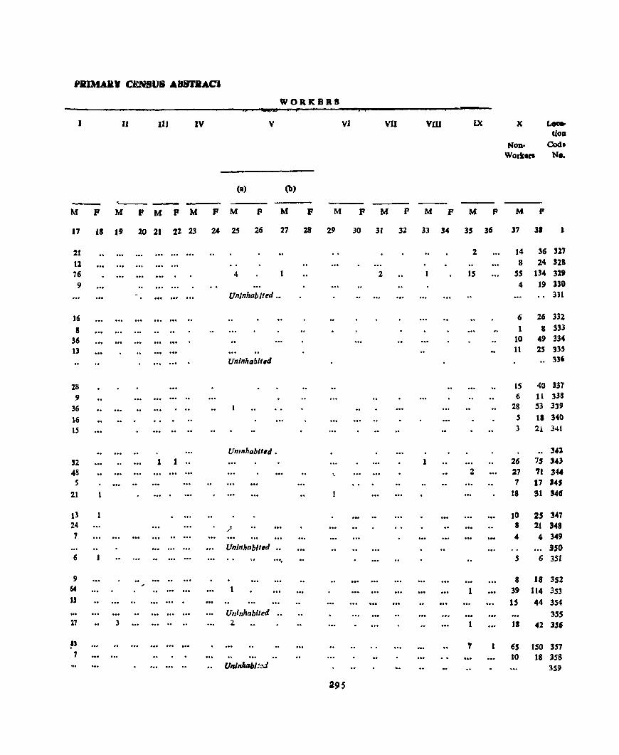
jJJIlMAll. C.EN8U8 A88TaACI
WORKBRS
J II 111 IV V VI VII vru IX X l.-. lion
NOD> Co«s. Work.l'I Ne.
(a> (b)
--M P M P M P M P M F M P M P M F M P M P M P
17 fS 19 20 21 22 23 24 2j 26 27 28 29 30 3. 32 33 34 35 36 37 3. 1
21 2 14 36 317
tl 8 24 328
76 4 2 15 SS 134 319 9 4 19 330
Uninhabited •• 331
16 6 26 332
8 1 8 333
36 10 49 334 U 11 25 335
Unlnhablt.d .. 336
28 15 40 337
9 6 11 338
36 28 S3 339
16 5 II 340
IS ... .. .. 3 21 341
Unmhablted • .. 341
'2 1 1 .. 1 26 7$ 343 48 '- 2 27 71 344 S 7 17 S41
21 1 18 91 541f
13 10 25 347 24 _; 8 21 348 7 4 4 349
UnJnhablled •• 350 6 .... 5 6 35J
9 8 18 352 64
, .. ... I 39 114 353 U ... .. 15 44 354
Uninhabited .. 355 17 3 .. , .. .. 4 111 42 3$6
~) 7 65 150 357 7 10 18 358
Unlnllllbl:::.J 359
295

NALAGAlUI TAHSIL URBA,N ~LOCK/VI~LAGJ.t-WlSE
Location Codo
No
360 361 36f 363 364
365 366 367 368
369
370 371 372 373 374
375 376 377 378 379 ,
380
381 382 383 384
385 3R6 387 388 389
390 391 392
#' .. .. _ \. i. {
Area of Occupl-' No of-- - Totalpopulatlon VJiI~gc cd Res~- House- (lncludmg Insbtu-
Name of vIllage (Hadbast No )JTown/
WardJUrb3n Enumerator',
Bloclr
In Acres dentlal bolds tlonal and Houseless Scheduled Scheduled
and of Houses Population) Castes T[lbci
Town/ Ward In
Bhalli Kothl
Kota KawarDi Coarou Kanoela Uperla
(311) (312)
(313) (314) (315)
Jang.1 Kehada Ban(316)
Kanoela Nlbla (317)
Pokbarl (318) Larkot (319) Terl! Beherh (320)
Dhamroh Charoh Palhrur
Saror Chanobrl
Slhl Beglehr Panjehra
, Kaulanwala l?ater Bhaunkhoo
Sobhan Ma)ra
Nawan Og_raon IhaJra Patcr Phaloo
Hatra
Pater Miam Gulab Pura Saufl GUlan Saun RalPutan Ambwala
(321) (322) (323) (324) (325)
(326) (~O)
(.51) (52)
(B)
(54)
(.55) (5h)
(51)
(58)
(59) (60)
(61) (62) (63)
K,mll
62 330 143 93
208
141
180 70
163 89
205 93
166 604 219
138 928 347 164 199
120
S45 264 188 268
JOB 174
269 94
6(l2
Pall! (64) 517 Nawan Nagar Aduwal Jandorz
(65) 243 (65) 1 543
4
4 78 11 1
25
13 8 8
6
21 18 22
4.5 24
10 8.5 61 69 15
36
86 24 12 26
TO 14
86
61
47 12
It3
5
4 28 11 1
2S
13 8 8 6
21 18 2Z 45
24
11 8" 61 69 1.)
36
£6 24 12
26
10 14 86
61
47 12 64
P
Ii
23 130 41 4.$
109
86 41 46 2~
111 50 97
235 110
64 SI4
381 380
86
229
-'24 130
84 169
74 9.5 90
371
238 65
311
M F M
7
12 61 20 18
SO
39
23 24 19
I
11 69 21 25
59
47
18 22 10
56 5S 26 24 54 43
120 115 54 56
35 259
196 188
40
126
268 75 40
82
29 255 185
192 46
103
256 55
44 87
9 10
18 Hi
11 15
Uninhabited 3 4
11 9 2 2
21 - 12
59 48
7 74
3 31 27
10
28
3
7' 3
27 26
78
2"
42 32 3 5 45 50 2 1 4.5 45 3 3 Uninhabited
189 182 5U 46
129 109 S2 42 30 35 13 2)
169 142 62 58
296
JJ
Literatc and Educated
Persons
Total Worker. (I-IX)
F M F M F
12 13
4
3 11
9
5 .5 5
10
3 8
10 13
10 74 77 61
6
46
68 15
7
24
8 12 15
73
39 8
17
14 15
1
20 32 6
20
25 S
3
6 33
14 9
28
27
8 12
8
30 22
36 79 37
21 115 J08 102
20
64
146 34 17 33
20
16
24
1
3 28 3 12 25 4
14 102 11
8 65 I 2 IS 3 10.2 3

PRIMARY CENSU~ AHS1RACf
WORKERS
11 III IV V VI VII VIII IX X Looo:t-dOD
Non- Cod. Workeri No
(a) (b)
---M F M F M F M F M F M F M F M r M F M P M F
J7 18 19 20 21 22 23 24 25 2b 27 28 29 30 31 32 11 34 35 36 37 38
6 6 11 360 33 28 69 361 14 6 21 362 9 9 25 363
26 22 59 364
Unlnrablted 365 26 12 47 366 8 15 18 367
12 12 22 368 8 11 10 369
30 26 55 370 18 2 2 4 24 371 36 18 43 372 79 41 115 373 37 17 56 374
18 2 14 29 375 95 4 4 12 144 254 316 97 2 8 88 185 377 52 6 3 12 33 4 2 2 3 2 6 lI6 168 378 15 2 3 20 46 379
5J 5 10 62 98 380 127 2 10 6 122 255 3S1 33 41 55 38! 17 23 44 383
32 49 87 334
20 1 22 31 385 27 3 1 17 47 386 22 2 2 20 41 387
Unl/lhablted 388
91 11 2 2 7 87 1,1 389
sa 7 3 1 1 2 64 101 390
15 15 35 391
92 3 3 6 67 139 392
297 ,
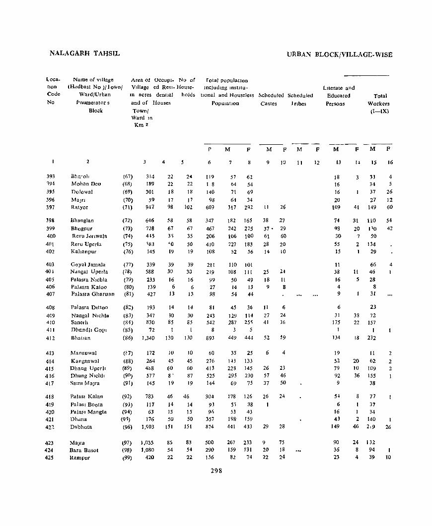
NALAGARH TAHSIL URBAN BLOCKfVILLAGI:-WISE
Location Code
No
393 194
395
396 397
398
399 400
4(11 402
403 40~
405 406 407
408 409 410 411
412
413 414
415 416 417
418
419 420 421
4H
423 424 425
Area of OCCUPI- No of r otal populatIon VIllage ed Resl- House- includIng mstilu-
Name of vIllage (H.ldbast No )1 fownl
Ward/Urban
fonumerator s
Block
In acres dentlal holds tIOnal and Houseless ~cheduled Scheduled
and of Houses PopUlatIon Castes 1 nbes
Town! Ward ID
Km 2
2 3
llhs.'oll (67) 314 189
301 Mohan Deo (68)
Dolowal (69)
MaJrI (70) 59 947 Ratyor (71)
Bhanglan (72) 646 728 445
183 145
Bhogpur (73) Reru Jolnwala (74)
Reru Uperla (75)
Kallanpur (76)
Goyal Jamala (77) 339 588
233 139 427
N,mgal Uperla (78)
Palasra Nlchla (79)
Paldsra Kaloo (80) PaJasra Gharuan (81)
Pa!asra Dlttoo
Nanga! Nlchla Sanerh
DhnndII GOpI
Bhatlan
Manguwal
Kanganwal Dhang Uper)I Dhang NIChl1
SalOl MaJra
Palasl Kalan
Paiasl Boota Paiasl Mangta Dh<llla
Dabhota
MaJra Bara Basot Rampur
(8~) 193
t83) 347 (84) 830 (85) 72
(86) 1,340
(E7) 172
(88) 264 (89) 4h8 (90) 577
(91) 145
(92) 783 (93) 117 (94) 63 (9~) 176 (96) 1,903
(97) 1,035 (98) J ,080
(99) 420
4
22 22 18
17 98
58
67 3';
'0 19
39 30 16
6 13
5
24 22 18
17 102
58
67
35
50 19
39 30
16 6
13
14 14
30 30 85 85
I 1
130 130
10 10 45 45 60 60 8' 87 19 19
46 46 14 14 15 15 50 50
lSI 151
85 83 54 54 22 22
p
6
119 I 8
140 98
609
347 467 206
410 108
211 219
99 27 98
81
243 542
8
893
60
276 413 525 144
304
93 91)
357
874
500 290 156
298
M F M F M
7 8
57 62
64 54
71 69 64 34
317 292
1112 165 242 225 106 100
227 183 !l2 56
110 101
108 111
50 49 14 13 54 44
9 10
11 26
38 27
37· 29 61 60
28 20 14 10
25 24 18 II 9 8
45 36 11 6 129 114 27 24 287 25~ 41 36
3 5
449 444 52 ~9
35 25 6 4
143 133 228 145 26 23 295 230 57 46 69 75 37 50
178 126 26 24 55 38 1 53 43
198' 159
441 433 29 28
267 233 9 75 159 131 20 18 82 74 22 24
11
F
12
LIterate and
Educated
Persons
Total
Workers (I-IX)
M
13
18 16 16
20 109
74 93
30 S5 15
11 38 16 4 9
6
31 175
I
134
19
52 79
92 9
54
6 16 43
149
90 36
23
F M
14 15
3 33 34 37
27 41 149
31 110 20 110
7 50
2 134 29
66 11 46
5 28 8
31
23
33 72 22 157
18 232
F
16
4 5
26 12 60
54 42
4
II 2
20 62 2 10 109 2 36 155 1
38
8 77
37
34 2 140
46 2,9 26
24 132 8 94 4 39 10
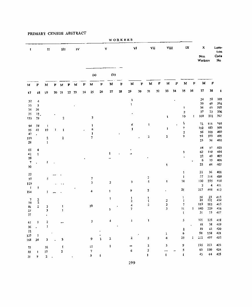
PRIMARY CENSUS ABSTRACT
WORKERS
II III IV V VI VII VIII IX X Loca-tlOD
Non Cod. Workers No
(a) (b)
M F M F M P M F M F M F M F M P M P M P M P
17 18 19 20 21 22 23 24 25 26 27 28 29 30 31 32 33 34 35 36 37 38
32 4 24 58 39S
33 5 30 49 394
3(; 26 1 34 43 395
25 12, 2 37 22 396
133 59 2 3 1 10 168 232 397
54 ,
72 ~98 94 1 6 7 111
95 41 19 6 1 7 112 183 399
47 1 2 56 100 4(}O
110 2 2 7 2 2 9 93 183 401
28 23 56 402
66 4 44 97 403
42 3 62 110 404
28 22 49 405
7 6 13 406
30 23 44 407
22 22 36 408
57 5 7 2 57 J 14 409
129 3 2 3 5 14 130 255 410 2 4 411
I
194 4 9 2 21 217 444 412
7 2 1 1 24 23 413
56 2 2 2 1 81 131 414
81 2 2 10 4 2 2 7 119 183 415
127 3 3 7 3 11 140 229 416
37 1 31 75 417
61 2 3 4 1 5 101 US 418
36 1 18 38 419
32 2 19 43 420
133 1 6 58 158 42[
168 24 3 3 9 1 2 2 3 4 25 1 222 407 422.
73 31 11 ... 2. 3 9 135 223 423
S5 I 17 2 7 6 2 5 65 130 424
31 9 2 3 1 1 1 43 64 425
299
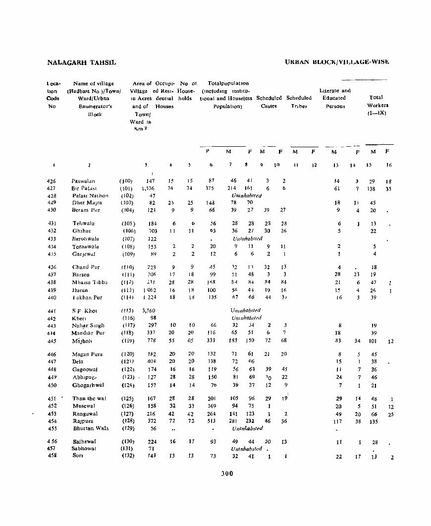
NALAGARH TAHSIL
Loca
tIon Code
No
426 427 428 429 430
431 432
433 434 435
436 437 438 439 440
441 442 443 4~4
445
446 447 448 449 450
451 ' 452 453 454
455
456 457 458
Name of vIllage
(Hadbast No )/Town/ WardlUrblln Enumerator',
Block
Area of OCCUPI- No of VIllage ed Resl- Housem Acres dentlal holds
and of Houses
Paswalan Blf Pala~1
Palasl Nathon Dher MaJra Beram Pur
TclJwaJa Ghlhar
Barollwala
Toranwala GarJcwaI
Chand Pur Barsen Mhalsa Tlbba
Jhlran I akhan Pur
SF KhO! Khen Nah?T 5mgh Mandmr Pur
MaJhO)l
Magan Pura Bela
Gagoowal
AbhlPUt/
Ghogarhwal
Than the wal Musewal
Ranguwal RaJpura Bhuttan Wala
Salhewal Sabhowal Son
Town/ Ward In
K..m 2
(100)
(l01)
(IOl) ( 103)
( 104)
005) 006)
(107)
( 108)
(109)
(110)
(III)
(II )
(113 ) (I (4)
( 115) (l16)
(117)
(118)
(119)
(l20) (121)
(122) (123)
(124)
(125) (126) (127) (128) (129)
(130) (131) (132)
3
147 1,536
47 82 12~
184 i03 122 155 89
22'3 306 21(
1062 1 224
3,560 98
297 337 778
11<2 40t
174 127 157
167 158 216 372
56
224 71 143
4
I' 74
6 11
2
2
9 17 28 16
18
J(}
20
55
20 20
16 28
14
28 32
42 ,72
16
13
15 74
25 9
(l
11
2
2
9 18
28
18
18
10
20 65
20 20
16 28 14
28 33 42 72
17
13
UK HAN HLOCK/VILLAGE-WISt:!.
Tota1popul atJon
(lDc1udmg lDStltu-
tIOna! and Houseless Scheduled Scheduled
PopulatIOn) Castes Tnbes
p
b
87
375
143 66
56 t>3
20
12
45
99 !fiB
100
135
66
116
333
132 138
119 150
7(J
201 169
264 513
93
73
M F M F M
7 9
46 41 3 214 161 6
Uninhabited 78 70
39 27 39
28 28 36 21
Uninhabited
9 11
6 6
'2 51 84
Sii 67
11 48 84 44 68
Uninhabited
UnInhabited
28 30
9 2
32 3
~4
19 44
32 34 2 65 51 6
)83 150 72
10
2 6
27
28 26
11 1
13 3
84
16 3~
3
7
68
71 61 21 20 72 66
56 63 39 45 81 69 ~O 22
39 37 12 9
105 96 29 94 75
141 123 1 281 232 46
Unznhabzted
49 44 20 Uninhabited 32 41 1
300
19
2 36
13
II
I
F
12
LIterate and Educated
Persons
M F
Total
Workers (I-IX)
M F
14 15 16
14 61
18 9
6 5
2
1
4 28
21
15 16
8
18 83
8 15
11 24
7
29 20 49
117
11
22
3
7
11
4
23
6
4 3
34
29 138
45
20
13 22
5 4
18 19
47
26 39
19 39
101
5 45 I 38
7 36 7 46
14
5
20 38
1
21
48
51 66
135
28
13
18 35
12
12 25
2

PHIMAIH' CENSU~ AH~JHAC1
WORKERS
II HI IV V VI VII VIII IX X Loca-tion
Non- Cod, Workers No
(a) (b)
M F M P M F M F M F M F M F M F M F M F M F
17 18 19 Zo 21 22 23 24 25 26 27 28 29 30 31 32 33 34 35 36 37 38
28 17 I 17 23 426
17 12 17 3 15 79 20 2 7 76 126 427 U nt I'hablttd 428
37 3 2 2 33 70 ~29
14 4 19 27 430
10 3 15 28 431 15 6 14 27 432
UlIll/hobllt'l1 . 433 2 3 4 1 ( 434 3 2 6 435
10 8 14 13 436 15 2 32 48 437 40 5 37 84 438 21 5 30 48 439 28 9 2 28 68 440
UlIlIIhabltt!d 441 Ulllllhab,ted 442
14 5 13 24 443 30 8 1 26 51 444 53 6 4 22 9 6 9 3 82 138 445
45 26 61 446 36 2 34 66 447 23 13 20 63 448 28 13 2 3 3S 69 449 14 7 18 37 450
39 I 4 t 2 I 57 9S 4)1 23 12 5 7 2 3 4 5 2 43 63 452 37 21 8 2 3 8 2 3 3 2 75 98 453 99 13 ' I 4 2 2 14 146 232 454
Uninhabited 455
2S 21 44 456 Umnhabiled 457
10 2 2 19 39 458
301
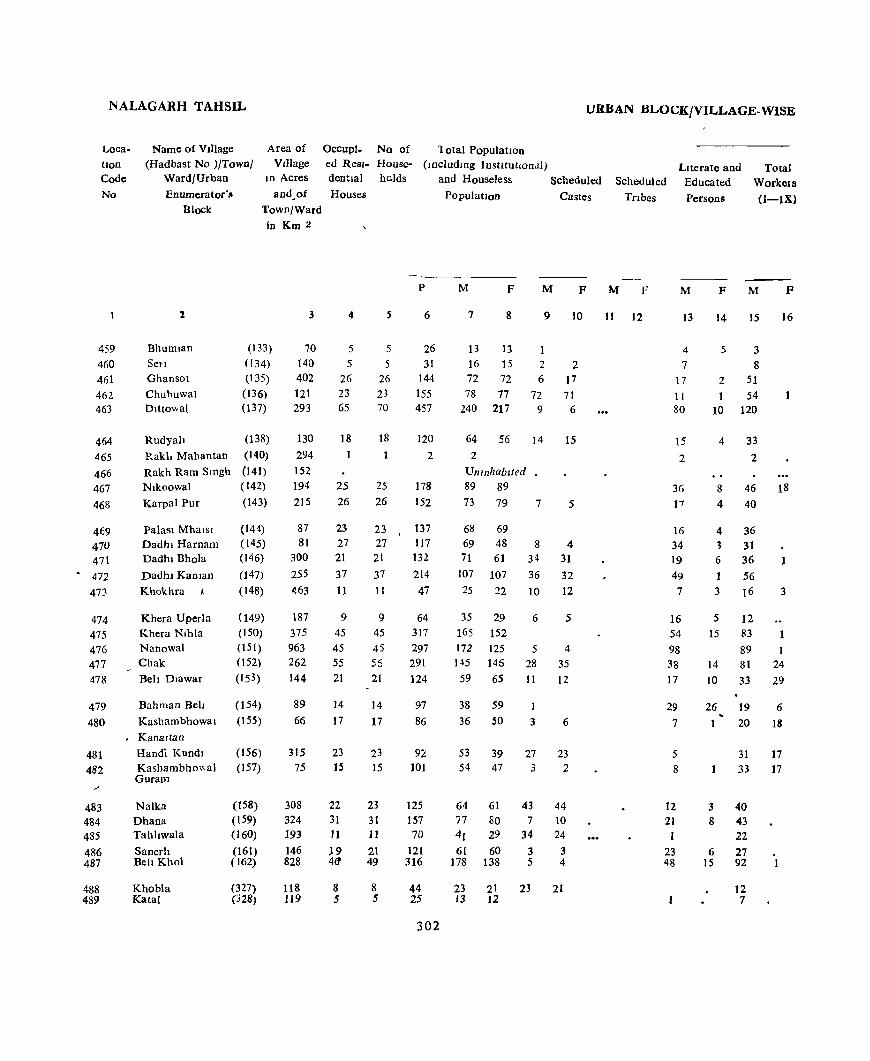
NALAGARH TAHSIL URBAN BLOCK/VILLAGE-WISE
Loca
tion Code
No
459 460 461 46Z 463
464 465
466 467 468
469 470 471
6 472
473
474 475
476 477 478
479 480
481 482
483 484 485
486 487
488 489
Area of VJllage
10 Acres
Occupi_ No of lotal PopulatIOn ed Resl- House- (Includmg InstitutIOnal) denttal holds and Houseless Scheduled
Name of Vlliage (Had bast No )/Town/
Ward/Urban
Enumerator's Block
and.of Houses Population Castes
2
Bhumlan SeT!
Ghansot
Chuhuwal Dlttovval
Rudyah
Rakl. Mahantan
Rakh Ram Smgh Nlkoowal
Karpal Pur
Palasl Mhalsl Dadhl Harnam Dadht Bhola
DadhJ Kaman
Khokhra I
Khera Uperla Khera Nlhla Nanowal Chak
Belt Dlawar
Bahman Bel!
Kashambhowat
Kanaltan
HanOi Knndl Kashambho"al Guram
Nalka Dhana Tahltwala
Sanerh Be]l Khol
Khobla Katal
Town/Ward in Km 2
(133) (134) (135)
(136)
(137)
(138) (140) (141) (142) (143)
(14t) (145) (146)
(147) (148)
(149) (ISO)
(151) (152) (153)
(154)
(155)
(156) (157)
(158) (159) (160) (161) ( 162)
(327) (328)
3
70 140 402 121 293
130
294 152 194 215
87 81
300
255 463
187 375 963 262 144
89 66
315 75
308 324 193 146 828
118 119
4
5 5
26 23 65
18
25 26
23 27 21
37 11
9 45 45 55 21
14
17
23 15
22 31 11 J9 4(1
8 5
5
5
5 26 23 70
18
25
26
23 27
21
37 11
9 45
45 55 21
14
17
23 15
23 31 11
21 49
8 5
p
6
26 31
144 155 457
120 2
178 152
137 117 132
214 47
64 317 297 291 124
97 86
92 101
125 157 70
121 316
44 25
302
M F M F
7 8 9 10
13 13 16 15 2 2 72 72 6 17 78 77 72 71
240 217 9 6
64 56 14 15 2
Unlllhablted 89 89
73 79 7
6g 69
69 48 71 61
107 107 25 22
35 29 165 152 172 [25 145 146
59 6S
38 59 36 50
53 54
39 47
8 34 36
10
6
5 28 11
I
3
27 3
64 61 43 77 80 7 4r 29 34 61 60 3
178 138 5
23 21 23 13 12
5
4 31
32
12
5
4
35
12
6
23 2
44 10 24
3 4
21
Scheduled
Tnbes
LIterate and Educated
Persons
Total WorkeIs
(I-IX)
M F
11 12
M
13
4
7 17 11 80
15
2
36 17
16 34 19 49
7
16 54 98 38 17
29
7
5
8
12
21 1
23 48
F M
14 15
5 3 8
2 51 1 54
10 120
4 33
8 4
2
46 40
4 36 '3 31 6 36 1 56 3 16
5 12 15 83
89 14 81 10 33
26 19
20
31 33
3 40 8 43
22 6 27
15 92
12 7
F
16
18
1
3
I 24 29
6
18
17 17

PRIMARY CENSlJS ABSTRACT
WORKE.RS
II lJI IV V VI VII VIII IX IX Loca· tlon
Non- Co do
Workers No
(a) (b)
--- ---M F M F M F M F M F M F M F M F M F M F M P
/
17 18 19 20 21 22 23 24 25 26 27 28 29 30 31 32 3J 3.; 35 36 37 38
2 10 13 459 5 3 8 15 460
49 2\ n 46\ 48 2 3 24 76 462 57 5 17 10 17 13 120 217 463
26 2 3 I 31 56 464 2 465
Uninhabited 4ti6 32 17 4 2 2 3 4~ 71 467 32 6 33 79 468
31 3 12 (9 469 10 3 14 2 38 48 470 27 4 2 35 60 411 48 3 2 51 107 472
It 2 2 2 9 19 473
9 2 23 29 474 57 5 2 . 2 3 8 81 15l 47)
61 1 12 4 1 3 7 83 12~ 476 63 24 8 3 7 M 122 477 29 29 2 26 36 478
11 4 2 6 19 53 479
17 IU 2 16 32 480
19 9 11 8 22 22 48}
32 11 21 30 482
36 2 I 24 61 483 35 2 4 34 80 484 17 4 1 19 29 48S 24 t 2 34- 60 486 83 2 2 2 7 81 137 487
12 11 21 488 ~
7 ./ 6 12 489
303
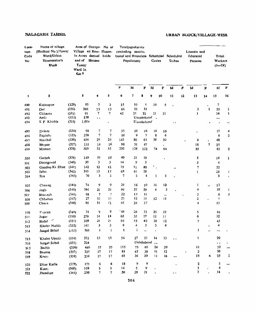
NALAGARH TAHSIL
Location Code No
490 491 492 493 494
495 496 4!17
498 499
JOO .501
j02 503 50-\
505 506 507 508 509
510
51t 512 513
514
515 516 517 518 519
520 521 522
Name of village
(Hadbast No )/Town/ Ward/Urb:ln Enumerator's
Block"
Area of OCCUpJ- No of Village ed Resl- Housein Acres dentJal holds and of Houses
Kallanpur Dol Chharru Arnh SF Khobla
Dohra Papiohl Mallhal
Bhlpar MlttJan
Garloh
Doongawal Gandoo KI Dhar Jalm Ria
Chanog
Jagh BlJatduh Chhdban Chara
Plprah Jagar Badal /'
Khaler Nlchlt 1angai Behal
Khaler Uperh Jangal Sobal
Balhh Baonta Koen
Dhar Kotla Kusn ]handlan
Town/ Ward in
[(m2
(329) (330) (331) (332) (333)
(334) (335) (336)
(337) (338)
(339) (340)
(341) (342) (343)
(344)
(J..I5)
(346)
(347) (348)
(349) (350)
(351)
(352)
(J5J)
(354)
(355)
(356) (357) (358)
(359)
(360) (361)
95
266 91
130 1.054
68 250 454 135 509
149 55
142 315
70
74 384
68 27 95
74 259 329 161
166
371. 224
446
227 256
175
109 250
.. 3
13 7
7 7
29 16 55
10
3 12 13
3
9
21 7
11
11
9 14
21 3
35 17
17
6 3 7
3 13 7
7
7
29
16 55
10 3
12 13
3
9 21
7 II
fl
9
14 21
3
35 17
17
6
3 7
URBAN BLOCK/VILLAGE-WIS.t
Totalpopulatlon
(lDcludrng lDstltutlOnal and Houseles! Scheduled Scheduled
Population) Castes Tnbes
P
6
15 66
42
35 16
143 98
250
40
14
79 69
7
26
96
22 23 61
• 49
62
9~
9
54
155 83 65
18 14
50
M P M F M
7 I 9 10
]0 5 10 5 35 31
21 21 21 21 Umnhab,ted U nlllhublfed
19 16 19 16 9 7 8 6
80 63 38 30
51 47 128 122 74 64
21
9 41 41
3
16 57 1 I 12 24
19
5 38 28
4
10
39
II II
37
26 23 35 27
55 43 4 5
1
27 27 Uninhablled
75 80 45 38 36 29
9 9 .5 9
29 21
304
3
16 4
12
3
10
3
11
25 22 12 II
20 12 3 4
14
24 II 11
13
20 12 16
11
F
12
Literate and Educated
Persons
M
3
9 18 33
5 3
7
9
5 2 4
5 6
7
11
2 15
2 1 7
F
14
7
4
Total Workers (I-IX)
M F
15 16
7
23 14
17
6 48 25 85
16
4
22 26
3
13 39
6 '}
17
16
22 43 4
20
52 30 25
5 4
14
1
4 2
2
1
2
2

PRIMARY CHNS\lS ABSTRACT
WORKERS
n III IV V VI Vii VIII IX IX Loca-tIon
Non- Code
Workers No
(a) (b)
M F M F M F M F M' F M F :V! F M F M F M F M P
17 18 19 20 21 22 23 24 25 26 27 28 29 30 31 32 33 34 35 36 37 38
6 3 5 490 23 12 30 491 14 7 20 492
UninhabIted 493 Umnhablted 494
17 4 2 12 495 6 1 3 5 496
." 2 32 63 497 25 26 47 498 79 3 2 43 120 49~
16 S 18 500
4 5 5 501 22 19 38 502 26 15 27 503
3 4 504
12 3 10 5('5 39 18 38 506 6 2 5 9 507 9 3 11 508
17 7 37 509
16 10 28 510
22 13 27 511 41 12 43 512
A 5 513 514
19 7 27 515 Unmhab,ted 516
51 J 23 80 517 30 15 38 518
11 4 4 2 2 2 11 27 519
4 4 9 520
3 9 521
14 .. .. .. 15 21 522
305

NALAGARH TAHSIL
Loca· tlon Codl
No
~23
~24
~25
526 527
528
529 530 ~m
532
533
534 535
536 537
538
539 540 541
542
543 544 545
546 547
548 549 S50 551 552
553
S54
Name of vlllagc (Hadbast No.)/Town/
Ward/Urban
Bnumerator's
Block
Aria of Occupi· No. of Vlilage ed Resl. House. m Acres dentlal holds
lind of Houses
lawn/ Ward In
I!..m 2
2
Serl
s·p Sllhnu Bansal Ranguwal Tal
(362)
(363) (364)
(365) (366)
Jangal Phoolwala (367)
Lambl Dohn (368) Tala (369) Banan (370) Panoh (371)
Salehr Malowal SF Plahwala Kuhwala
Khera
Haharan
Ahawan Pannar Baraon Brahmna
Mahw<l
Baraon Kanaltan
Kotha Kanaon Goela
Jarari Sern r
Berta Bukban Dn Ghat
Chlkm Jabal Tapnan BwasDl
Gharmandal
Kalan Gharmandal
Khurd
(372)
(373) (374)
(375) (376)
(377)
(378) (37<1) (380)
(381)
(382)
(383) (384)
(385)
(386)
(387)
(388) (389)
(390) (39 1)
(392)
(393)
3
198
728
179
96 Ibl
319
174 240
356 259
209
147 543 281
218
394 450 476
203
267
296
190
766
247 161
1~3
159
310
321 521
112
56
" 7
10 7 6
2 13
27 25
38 4
8
17
8 14 26 6
20
3
14 49 18
4
14 5
17 13 25
5
4
7
10 7 6
2
13
27 25
38 4
8
17
8 14
26
6 :0
3
14 49 18 4
14 5
17
J3 25
5
4
URBAN BLOCK/VILLAGE.WISE
TotalpopulatloD
(lDcludlDg Institu-tional and Houseless Scheduled Scheduled
Populatton) Cdstes fnbell
P
6
62
67 33 28
21 75
106 174
190 21
32 89
46
74 124 2Z 75
14
58
Ih8 73 27
65
33 86 51
124
17
20
M P'M
7 9
31 31
Unlnhablled 38 29 20 17 16 9
13 15
Uninhabited
11 1(1 i 38 37 1
52 54 5 96 78 1
105 85 105 10 11 Unmhablted ... 13 19 2
49 40 49
19 37 71 9
31
7
37
103 46 14
32 17 47 23 64
9
106
27 37
53 13
38
7 21 85
27 13
33 16 39
28 60
8
f2
1
3
2
3
16 20
8 17 17
P M
10
20
11
6 1 4
85
11
2 40
1
3
1
3
4 19 14
4 28 11
11
F
12
LIterate and Bducated
Persons
M
13
11
5 S 3
3 12
17 34
1
1
3
7 3
13 20 9
13
6
7
2 15
14
p
2
IT°tal Workers (i-IX)
15
21
23 14 9
8 21
16
3 31 7 4S
2
3
68 6
9
311
23 4
3S
26
6 21 06 27
6
21 13 30 IS 46
5
1
21

PRIMARY CENSUS ABSTRACT
WORKERS
[I III IV V VI VII VIII IX X Loca-tIOn
Non Code Workers No
(a) (b)
M F M F M P M P M F M p M F M F M P M P M P
17 18 )9 20 21 22 23 24 25 26 27 28 29 30 31 32 33 34 35 36 37 38
19 2 10 31 523 Umnhablted 524
22 1 15 29 525 13 1 3 16 526 9 4 15 527
uninhabited 528 5 2 3 10 529
19 1 17 37 530 21 2 4 1 21 54 531
I
37 1 6 51 78 532
68 37 85 533 6 4 11 534
Umnhablted 535 9 4 19 536
31 18 39 5'37
13 6 27 538 23 13 37 539 32 2 36 52 540 1 8 13 541
25 11 38 542
6 7 " 543 15 2 4 16 21 544 63 2 37 85 545 • 24 2 19 27 546 6 8 13 547
21 II 33 548 9 3 4 16 549
30 17 39 550 15 8 28 Sst
36 5 20 2 18 39 552
5 4 8 553
5 3 12 554
3i7

NALAGARH TAHSIL URBAN BLOCK/VILLAGE- WISE
Locahon Code
No
555
556 557 558
559
560
561 '\62
,563 j64
565 S66
567 568
569 570 571
~72
573
574
-S75 576 577 578
579
580 581
582 583
584
585 586
Name of Village
<Hndbast No )/Townj Ward/Urban
lloumerator's
Block
Area of OcciUPI- No. of Total populatlon
2
Khall
SunaDl Amru
Banehra
Jaroao Dohra
Kolka
Danoda Ghat Ral Pur
MaJru Baruwala
MaJru R F
SF. Sldh
ChalyauDi
Keha Dabra
Saeo Tali Palla
Dhaul Ghat
Simil
Khaflana
Kasla Abharm Kaundl
/Tatoa
Chalaun Dewall
S. f' Retwah Malgan
Kotla S F Dharam Pur
Pbala
Cbammrhl Dasaorll
Village ed Resl- House- including InStltu-
In acres dentlal holds tlOnal and Houseless Scheduled Scheduled and of Houses
Town/ Ward 10
(394)
(395)
(396)
(397) (398)
(399)
(400)
(401)
(402) (403)
Km~
3
132
240 218
331 75
348 8t
128
84 23
(404) 11403
(405) liS
(406)
(407)
(408) (409\
(4[0)
(411)
(412)
(413)
(414)
(4 IS)
(416)
(417)
(418}
(419) {420}
(421)
(422)
(423)
(424)
(425)
J(}Z
113
263
236
412
88 123
625
244 412
318 154
19
727 297
27 335
258
19
l'
4
12
15 14
16
.5
11 .5 8
4
13
13
26 35
35
1
16
16
8
2t 10
5
.5
20
5
PopUlatJOll Castes Iflbes
12 15 14
16 5
11
S 8
4
p
60
75 69
46 19
47
22 38'
18 7
Um nhabl ted
Umnhablled
13 13
26 35 36 7
16
16
8 21
13
5
71 70
94 119
91
37
25
70
47 97 95
37
5 41
Umnhablted 20 117
Umnhablted Ulllnhablled
5 32
Unmhablted Umnhablted
M F M F M
7 9 10 11
29 31 27 30
37 38 24 22 29 40
23 23 23 23
9 10 2 3
25 22
10 12 10 12 20 18 20 18 6 12 6 12 3 4
34 37 5 4 32 38 10 13
45 49
63 56 52 52
49 42 31 14
16 21 6 6
14 11
36 34 22 17
25 2Z 48 49 10 12
68 27 10 4
19 18 1 19 18
21 20 21 20
61 56 61 56
16 16
308
F
12
LIterate aDd Educated
Persons Total
Workers
(I-IX>
M F M F
13
8
3 3
3
4
1 2
2 1
4 5
17 16
7
I
4
5 6
12 13 2
2
16
7
14 15 16
2
16
25 23
19
18
6
19
S II
3
26 26 26 27
5 30 29
42 25
34 32
i3 4
9
19 2
16 4 32 IJ S9 3
10 2
J3 2
2 35
9

PRIMARY CENSUS ABSTRACT
WORKERS
II III IV V VI VU VIIl IX IX Loea-t100
Non- Code Workers No
(a) (b)
M F M F M F M F M F M P M P M P M F M F M P
17 18 19 20 21 22 23 24 25 26 27 28 29 30 31 32 33 34 35 36 37 38
. 15 1 13 30 555 25 23 12 15 556 17 ~ 10 4e 557 17 5 23 558 6 3 10 55!»
17 2 6 22 560 5 5 12 561
11 9 18 562 3 3 12 563
3 2 1 564
Unmhablted 565 Umnhablted 566
26 26 8 11 567 26 2; 6 11 568
27 29 2 15 20 569 34 2S 2 3 21 31 570 33 3f 15 10 571 13 4 3 17 57}. 8 5 H 573
18 2 17 32 574
16 <4 9 lIS 575 29 13 2 16 36 576 19 2 40 9 24 577 10 2 9 16 578
13 2 8 18 57'} Umnhab,ted 580
35 26 56 581 Umnhab,ted 582 Umnhablted 583
9 7 r6e 584 Umnhablted 585 Umnhablted 586
309

NALAGARH TAHSIL
Loca. tlon Code
No
587 588 589 590 591
592
593 594 595 596
597 598 599 6(.,0 601
f02 603 604 605 606
607 608
609 610 611
612
613 614 615
• 616
617 • 618 ~19
Name of V lllage ~
(Hadbast No )/Town/ Ward/Urban
Enumerator II Block
Area of Village
JO Acres
and of
Town/Ward In Km ~
2
Ambka
Jasauna Bhal Kanaltan
Mandl MdJfI
S P Dasaora Reta Nawan Nagar
Gorakh Nath
Ratan Garh
Dbar Kahan
S F Ambka Bhal Kahan Saun SF Tall
Lohar Bam Salhar BasI Kusn Persada
lalar BasI
Nail Taiar Wahad Klararoo Blslan
Dhar da Gha't
Khakhanam
Jangal Bhalay"d KIshan Pura lV_anpura
Theda Rautanwala
Bersan
(426)
(427)
(428) (429) (430)
(431) (432)
(433)
(434)
(435)
(436)
(437) (438) (439)
(440)
(441) (442)
(443 (444) (445)
(446)
(447) (448) (449) (450)
(451)
(452) (453) (l6~)
(164)
(165) (166)
(167)
3
89 184 272
199 11
5G4 269 97
76
41
17
826 62
470 434
91 186 164
98 33
136
43
145 118 221
125 130
1,136 1,635
605
269 449
341
URBAN BLOCK/VILLAGE- WISE
OCCUPI- No of Total Population ed Res 1- House- (mcludmg In~tltutlOnal) dentlal holds and Houseles~ Scheduled
Houses PopulatIon Castes
4
2
4
10
5 2
10 6
10 1
5
6 31
2 13 4 4 2
,8
2
7 2 8
8
15
166 199
43 42 16
2
4 10 5
2
p
6
8
38
65 32 15
Umnhabltet 10 52 6 43
10 62
5
5 35
Umnhabited 6 25
31 111
Umnhobll.:J
2
13 4 4 2
8
2 7
2 8
6
64 21 9 5
39 10
28 8
37
8 34 15 83
Unmhabiled 166 913 200 652
43 42 16
248 240
84
M F M F
7 8 9 10
4 4 17 21
37 28 13 19 8 7
4
3 8
4
5 7
24 28 24 28 24 19 24 19 30 32 30 32
4 1 4 1
24 11 24
11 14 7 54 ~7 11
3 3
11
10
7
30 34 30 34 11 10 5 6 4 5 3 2
20 19 16 15 4 6
14 14 8 7 444 2
22 15 14 7
21 13 17
36 37 45
12 37
469 444 103 92
95 349 303 116
116 132 123 117
38 46
310
18 8 i
20 7
15
::'cheCluled
Tnbes
M F
II 12
Literate and Educated
Persons
M F
13 - 14
4
7
6
4
3 16
1
4 4
2
5
2 1
4
3
7
3
Total WorkelS
(I-IX)
M
IS
3
10
14 5 5
14 > 10
18 2
11
9
37
p
16
I
2
2 2 HI 9 4 3 2
12 15 11 14
11 13 4 3
14 9
15 27
13
1
115 128
32 284 45 180
2 6
33 40 3
20 10
66
70 25
11

PRIMARY CENSUS ABSTRACT
WORKERS
1 II III IV V VI VII, VIII IX X Loca. tIon
Non- Code Wor~rs No
(a) (b)
M F M F M F M F M F M F M F M F M F M F M F
17 18 19 20 21 22 23 24 25 26 27 28 29 30 31 32 33 34 35 36 37 38
3 1 4 587 10 7 21 588 15 23 28 589 5 8 19 590
3 7 591
Unrnhablted 592 11 3 10 28 593 10 14 19 594 J7 12 32 595 2 2 596
11 13 11 597 Uninhabited •• 598
9 2 13 5<.19 35 1 17 S5 600
UninhabIted .. 601
2 2 1 602 18 12 34 603
9 2 10 604 4 5 605
2 2 606
It IS 8 4 (i07 4 4 2 608
11 13 3 609
4 3 I 610 14 9 8 6 611
15 13 6 612 27 19 36 613
Umnhablted ••• 61~
212 1 8 38 4 I 20 18S 442 615 '
121 6 3 5 10 3 6 3 26 2 169 297 616
60 11 2 2 2 50 121 617
61 6 2 53 116 618
Z4 1 13 046 619
311
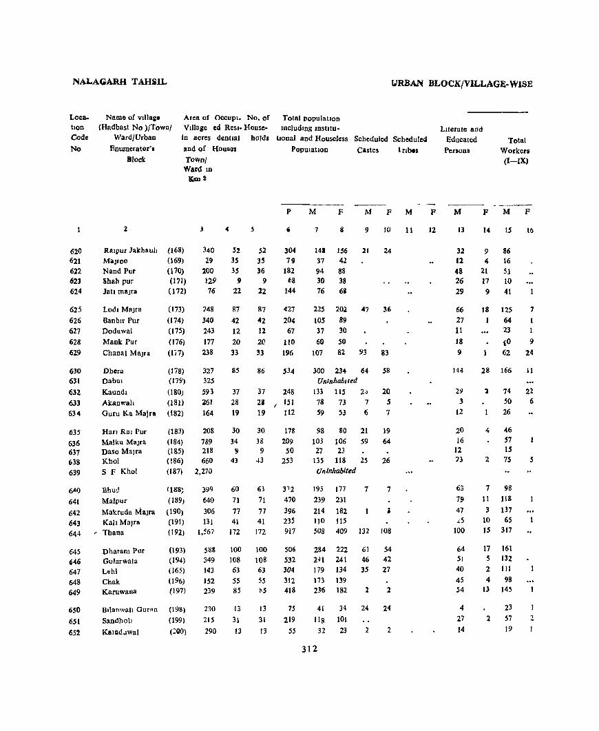
NALAGARH TAHiJL URBAN BLOCK/VILLAGE-WISE
Location Code
No
620 621
622 623 624
625 626 627 628 629
630 631
632 633 634
635
636 637 638
639
6.t{)
641
642 643 644
645 ,46 647 648 649
650
651
652
Area of OCCUPI_ No. of Total populatIon Village ed Resl- House- including IDstltu-
Name of villas. (Hndbast No )/Town/
Ward/Urban
flnwnerator',
IIlock
In acres dentlal hold. tlOnal and Houseless SCheduled Scheduled
2
RalpUl ]akhault MaJroo Nand Pur Shah pur Jatl malra
Lodl MaJra
Banblr Pur Doduwal
Mank Pur
Chanal Ma)u
Dhera
Dabm
Kaundl Akanwah Guru Ka Majca
Han Ral Pur Malku MaJra Daso Malra Khol S F Khot
Bhu!.! Malpur
Makruda Malra Kall Malca
~ Thana
Dharam Pur Gularwala Lehl
Chak Karuwana
Bllanwah Ouran
Sandhoh
KalQdllwal
and of Houses
Townj Ward ID
(168) (169)
(170)
(171) (172)
(173) (174) (175) (176) (li7)
K,m2
3
340
29 100 129 76
748
340
243
177
238
(178) 327 (179) 325
(180) 593
(181) 261 (182) 164
(183) 208
(184) 789 (185) 218 (!86) 660 ([87) 2,270
1188~
(189J
(190) (19[)
(192)
(193)
(194) (165)
(196) (197)
(198)
(199)
(ZQO)
399 640
306 131
1,567
51l& 349
143
152
239
230 215
290
52 35 35
9 22
87
42 12 20 33
85
37 28 19
30 34
9 43
60
71
77 41
172
100 108 63 55 85
13
31
13
52 35 36
9 22
87
42 12
20
33
86
37
28 19
30
38 9
43
63
71
77 41
172
100 108 63
55 115
13
31
13
Population Castes Irlb ..
p
304
79 182
68 144
427
204 67
110 196
248 151
112
178
209 50
253
31 2 470 396 235 917
506 532 304
312 418
75
219 55
M F M F M
7
14.
37
94 30 76
156 42 88 38 6i
9
21 24
225 202 47 36
105 89 37 30
60 50 107 8.2 93 83
300 234- 64 Unlnhabltt!d
133 115 2-> 78 73 7 59 53 6
98 80 21 103 106 59
27 23 135 118 25 Uninhabited
195 177
239 231
214 182 110 115
508 409
284 222
291 241 179 134
173 139
236 182
41
liS
32
312
34 101
23
7
132
61 46 3S
1.
24
2
58
20 5 7
19 64
26
7
108
54 42 27
2
24
2
11
F
12
Literate and Educated Penons
Total Workers (I-IX)
M
13
32 12 48 26 29
66
27 11
18
9
29 3
12
20 16
12 13
63
79 47 .LS
100
64 51 40
4S 54
4 27
14
F M
14
9 4
21 17
9
15
86 16 51 10
41
F
16
18 125 7
64 I 23 1
{o 9 1 62 24
28
1
..
2
166
74 50 26
46 57 15 75
7 98
11 118
3 137 10 65
15 317
17 161 5 132
2 111 4 98
13 }45
2
23
57 19
11
22 6
5

PRIMARY-iCENSUi ~Sa'RA~T
" WORK.ERS
,-I Til l-IIJ IV V VI VII VIn IX X _' toea·
tlOD
NOD Code Work.rs No,
(a> (b)
M P -M p. M 1p M P M F M F JM P M P M P M P M P
,17 ' 11 kIf) ao 21 !22 23 24 25 26 27 • 2.8 '29 30 31 32 33 34 35 36 57 sa 1
85 .62 156 ,620 IS 1 ..... 'f<ll .. ~l 42 621 43 2 3 2 43 1 . ~ 88 .622 8 ., .. ... 2 20 38 "623
,39 1 '35 67 624
75 5 , 9 2 20 5 3 2 3 7 100, ,195 ,625 55 3 3 3 .. , 51 ~ 88 62' -17 6 1 14 29 627 25 4 1 30 • 49 .628 50 20 3 3 .. 4 4 45 65 629
J01 26 II ..... . 20 3 1 5 JO 134 _, 223 630
.. • Umnhablt(ld ,631 63 6 .. ' '1 22 2 _, . 1 59 93 632 38 1 t 8 6 2 1 ... 28 _ 67 633 27 30 S3 634
-34 3 :. • 6 1 2 - 52 -" 80 635 26 3 19 2 2 5 !. 46 ' 105 636 15 !2 23 637
74 5 60 113 638 Umnhablted .. 639
67 1 7 3 2 9 8 97 177 640 92 9 1 3 I 12 1 121 230 641
124 4 1 2 S 77 182 642 S6 5 1 1 1 1 45 114 643
295 3 19 191 409 644
102 16 2 14 13 3 11 2 123 220 645
131 19 5 6 10 5 1 S 109 241 646 80 4 3 16 I 1 6 1 59 133 647 74 1 19 4 75 139 648
136 1 1 'l 91 181 649
16 7 18 3J 6.50 54 2 2 61 99 651 19 1 '13 t2 -'652
Sl3

NALAGARH TAHSIL U1\11~ .t.Bt.OC;K/yilJ.JAGE.tWISE ~ .
Loea. Name Qf village._; Area of Oecupl. -No of --T01ll1-po~ularlon
tloD {Hlldbast No )JTownl VIllage ed Resl. House- includIng IDstItu- Ii ,J-Iterate and
cbdc Ward/Urban J \h acres den'ual holds tional and Houseless Scheduled Scheduled Educated Totat
No Rnumerator's and of Houses PooulatIon Castes lrlbes Persons Workers .of
Block Town/ (i-IX)
Ward In
Km.:!
( jj)
-----i
P M !'l F M.~ F. 1-4'1 jF ML tF M F
2 3 4 , 6 7 ~ 8 9(... IQ- lL 12 I;; 413 \ 14 ~'115 "16
653 Kahanpllr (201) 427 6 6 27 17 10 3 9 '654 Landewal (202) 91 12 12 76 44 32 4 3 7 28 655 ChakjaD!i (203) • 51 Umnhablted ~
" " 656 Baddl Sltlllpur (204) 725 116 118 664 351 . .313 96 .88 167 56 182 16 657 SuraJ Majra (205) 237 2} 24 133 70 63 2 , 4 • 20 38 1
t c. ..
658 Han Pur Sandall (206) 214 58 58 402 203 194 57 114 ~659 Bllanwah Labana (207) 172 50 50
~
179 367 188 45, 101 '660
. ~ • 165
.. SuraJ Malra (208) 7 7 62 38 24 4. 27 GuJan
661 JudI Khurd (209) 105 13 13 71 33 38 10 - 20
662 JudI Kalan (210) 225 11 11 72 36 36 4 18 'Kathd
,. '663 (211) 565 14 14 64 34 30 6 3 24 3 664, Dhakru MaJra (212) 138 17 17 101 55 46 ~ 10 29 665 Batauh Khurd (213) 288 9 9 66 32 34 ; 16 10 12 666 Batauh Kalan (214) 1,672 73 73 431 220 211 74 83 52 16 114
667 ' Jhar ,MaJfJ (215) d28 47 47 276 143 '133 27 23 48 24 72 c
~b8. KUDJahal (21'6) 495 72 72 457 249 208 115 99 61 8 128
314

PRIMARY CENSUS ABSTRACr.
WORKERS
III III IV V VI VlI VIII IX X Loea-11011
Non- Code Workers No
(a) (b)
--- ---- -----M F M F M F M F M F M F M F M F M F M F M P
17 18 19 20 21 22 '23 24 25 26 27 28 29 30 31 32 31 34 35 36 37 38
4 4 8 10 653 27 16 32 654
6SS 9]; 11, 14 18 3 21 10 27 1 169 297 656 23 4 4 1 2 5 32 62 6S,7 _
100 2 2 9 94 194 'S8 ~ 96 4 11>7 179 659 ]~ 8 2 2 II 24 660 20 13 38 661 ]8 18 36 662
20 2 3 2 10 27 663 29 , 26 40 6t4
tl 20 34 665 lOt 1 4. 7 106 211 b66
53 2 5 2 9 "'l1 J33 667 .. 108 8 3 9 121 :W8 963
au

NALAGARH TAHSIL
Loca- Name of Village Area of Occupf-tlon (Hadbast No )/Town/ Village ed Resl-Code Ward/Urban in Acres dentlal
No Enumerator'& and of Houses Block Town/Ward
In Km.2
2 3 4
URBAN AREAS 8{VI Nalagarh (M C ) 160 702 Total of Ward No 1 018 76
Block No 1 76 Total of Ward No II 015 61
Block No.2 61 Total of Ward No III 017 115
Block No 3 115 Total of WO! d No TV 015 75
Block No 4 75 TOlal of Ward No V 015 70
Block No 5 70 Total of Ward No VI 015 62
Block No 6 62 Total of Ward No, VlJ 020 87
Block No.7 87 Total of Ward No VIII 017 57
Block No.8 57 Total of Ward No. IX 028 99
Block No 9 99
No of House-
Total Populatton (mcludmg Instltuhonal)
URBAN BLOCK/VILLAGE-WISE
Literate and Total holds and Houseles5 Scheduled Scheduled Educated Workers
Population Castes Tnbe~ Persons (I-IX)
P M F M F M F M F M P
S 6 7 8 9 11) It 12 13 14 15 16
841 3,671 1,972 1,699 186 172 1,232 853 977 85 91 379 207 172 34 25 138 77 98 12 91 379 207 172 34 25 138 77 98 12 83 3I1 172 139 13 9 117 69 70 8 83 311 172 139 13 9 117 69 70 8
117 597 317 280 86 98 152 92 151 11 117 597 317 280 86 98 152 92 151 11 94 406 214 192 1 1 128 79 108 8 94 406 214 122 128 79 '08 8 88 432 242 190 II 7- 176 lOS 102 3 88 432 242 190 II 7 176 105 102 3
84 390 206 184 I 143 93 124 10 f'4 390 2C6 184 143 93 124 10 65 370 196 174 2 1 144 124 96 9 85 3-0 196 1~4 2 144 124 96 9 96 395 202 193 154 133 108 14 96 395 202 193 154 133 108 14
103 391 216 175 39 30 80 81 120 10 103 391 216 175 39 30 80 81 120 10
316

PRIMARY CENSUS ABSTRACT
WORKERS
I II III IV V VI VII vrlI IX X Loca-tton
Non- Code W{lrkers No
(a) (b)
_--M F M F M F M F M F M F M F M F M F M F M .F
17 18 19 20 21 22 23 24 25 26 27 28 29 30 31 32 33 34 35 36 37 38
37 3 6 2.7 37 2 144 1 84 250 1 77 315 78 995 1,614 S/VI
6 3 2 2 1 18 1 10 10 1 49 7 109 160
6 3 2 2 1 18 10 10 1 49 7 109 160
5 2 7 6 10 12 2 26 8 102 131
S 2 7 6 10 12 2 26 8 102 131
4 1 3 16 15 18 32 23 39 11 166 269
4 3 16 15 18 32 23 39 11 166 269
5 .3 19 3 28 17 33 8 106 184
5 3 19 3 28 17 33 8 106 184
2 27 5 45 7 16 3 140 187
2 27 5 45 7 16 3 140 187
3 1 6 1 25 9 36 2 42 9 82 174
3 1 6 25 9 36 2 42 9 82 174
11 3 1 4 6 33 1 2 36 8 100 165
11 3 I 4 6 33 1 2 '6 8 100 165
.3 1 4 17 7 34 4 38 14 94 179
3 1 4 17 7 34 4 38 14 94 179
1 14 1 13 16 20 19 36 10 96 165
14 t3 16 20 19 36 10 96 165
317


Name uf Town wIth LocafIOn Code No SImla M Corp
(8/1)
ST ATEMENT SHOWING JURISDICTION OF ENUMERATOR'S BLOCKS I'N THE URBAN AREAS
Ward No BIC>Lk No JUriSdIctIOn of each Block III terms of Cen<;us House Nos.
I House No 1 to 40 2 House N,l 41 to 81 3 Hou~e No 82 to 112
4 House No 113 to 166 5 House No 167 to 224
6 House No 225 to 307
2 7 House No 1 to 94 8 House No 95 to 144
9 House No 145 to 204 10 Hou~e No 205 (0 285
11 House No 1 to 41 12 House No 42 to 86 13 House No 87 to 148
4 14 House No 1 to 56 ]5 House No 57 to 78 16 House No 79 to 106 17 House No 107 to 174
5 18 House No I to 53 19 House No 54 to JI9
20 Hou~e No 120 to 166
21 Hou~e No 167 to 204 22 House No 205 to 248
23 HO'Use No 249 to 261 6 24 House No 1 to 25
25 House No 26 to 53
26 House No 54 to 91 27 House No 92 to 128 28 House No 129 to U9 29 Hou5e No ISO to 182
7 30 House No 1 to 39 31 House No 40 to 84 32 House No 85 to lIZ ~3 House No 113 to 128
8 34 House No I to 51 35 House No 52 to 102
36 Hou~e No 103 to 130 37 House No 131 to 165
38 House No 1 to 43 39 House- No 49 to 95 40 HO\l$e No 96 to 119
319
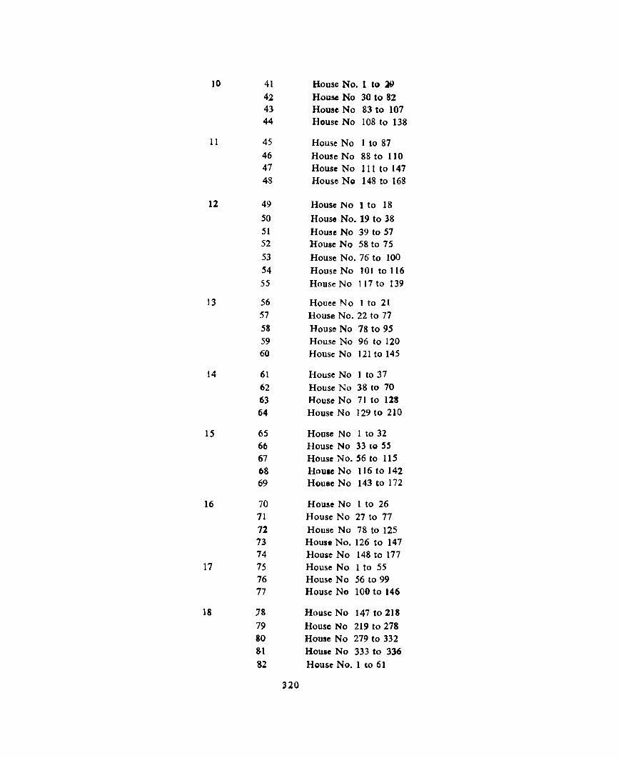
10 41 House No. 1 to 19 42 House No 30 to 82 43 House No 83 to 107 44 House No 108 to 138
11 45 House No 1 to 87 46 House No 88 to 110 47 House No III to 147 48 House No 148 to 168
12 49 House No 1 to 18 50 House No. 19 to 38 51 House No 39 to 57 52 House No 58 to 75 53 House No. 76 to 100 54 House No 101 to 116 55 House No 117 to 139
13 56 Houee No I to 21 57 House No. 22 to 77 58 House No 78 to 95 59 House No 96 to 120 60 House No 121 to 145
14 61 House No 1 to 37 62 House No 38 to 70 63 House No 71 to 123 64 House No 129 to 210
15 65 House No 1 to 32 66 House No 33 to 5S 67 House No. 56 to 115 68 Houle No 116 to 142 69 House No 143 to 172
16 70 House No I to 26 71 House No 27 to 77 72 House No 78 to 125 73 House No. 126 to 147 74 House No 148 to 177
17 75 House No 1 to 55 76 House No 56 to 99 77 House No 100 to 146
18 18 House No 147 to 218 79 House No 219 to 278 80 House No 279 to 332 81 Houlc No 333 to 336 82 House No.1 to 61
320

83 Hause No. 62 to 108 84 House No 109 to 178
8S House No 179 to 224
86 House No. 225 to 290
19 87 House No 1 to 52
88 House No 53 to 100 89 House No. 101 to 145
90 House No. 146 to 164
91 House No. 165 to 194
Jutogh C.B 1 1 House No.1 to 100
(8/1l) Subathu C.B. 1 House No. 1 to 100
B/III 2 Heuse No. 101 to 200
3 House No 201 to 300
4 House No. 301 to 400
Kasauli C.B. 2 1 House No. 1 to 87
(8/IV) 2 House No. 88 to 142 and House No. 209 to 213
3 House No. 143 to 188 4 House No. 189 to 208
5 Houso No.1 to 151
6 House No.1 to 31
7 House No. 32 to 89
Dagshai C.B. I I House No.1 to 240
(8/V) 2 House No. 241 to 504
3 House No 505 to 616
4 House No. 617 to 792
Nalagarh Me. (S/VI) 1 I House No 1 to 129
2 2 House No.1 to 108
3 3 House No 1 to 164
4 4 H,)llse No 1 to 127
5 5 House No 1 to 208
6 6 House No 1 to 115
7 7 House No I to 141
8 8 House No 1 to 143
9 9 House No I to 269
321