Very-broad-band seismology in Northern Africa under the M?N? project
14
Tectonophysics, 209 (1992) 17-30 Elsevier Science Publishers B.V.. Amsterdam 17 Very-broad-band seismology in Northern Africa under the MEDNET project D. Giardini a, E. Boschi a, S. Mazza a, A. Morelli a, D. Ben Sari b, D. Najid b, H. Benhallou ‘, M. Bezzeghoud ‘, H. Trabelsi d, M. Hfaidh d, R.M. Kebeasy e and E.M. Ibrahim e a Istituto Nazionale di Geofisica, Rome, Italy ’ Centre National de Coordination et de Planification de la Recherche Scientifique et Technique, Rabat, Morocco ’ Centre de Recherche en Astronomie, Astrophysique et Geophysique d’Alger. Bouzareah, Algeria d Institut National de Meteorologic, Tunis Carthage, Tunisia e Helwan Institute of Astronomy and Geophysics, Helwan, &vpt (Received February 11, 1991; revised version accepted July 7, 1991) ABSTRACT Giardini, D., Boschi, E., Mazza, S., Morelli, A., Ben Sari, D., Najid, D., Benhallou, H., Bezzeghoud, M., Trabelsi, H., Hfaidh, M., Kebeasy, R.M. and Ibrahim, E.M., 1992. Very-broad-band seismology in Northern Africa under the MEDNET project. In: C.J. Ebinger, H.K. Gupta and 1.0. Nyambok (Editors), Seismology and Related Sciences in Africa. Tectonophysics, 209: 17-30. The Mediterranean and North African regions are characterized by strong seismicity and active, complex tectonics, which are often poorly monitored and understood owing to a lack of high-quality seismic recordings. To increase the instrumental coverage in the Mediterranean region, the Istituto Nazionale di Geofisica began in 1987 the deployment in this area of a network of 12 Very-Broad-Band seismic stations, termed MEDNET. Motivated both by research interests and by considerations on seismic hazard monitoring, MEDNET has been designed following the highest technical standards. Its geometry will provide a homogeneous coverage of the Mediterranean and North African area, with installations in most countries and an average spacing between stations of 800-1000 km; the network should be completed by 1992. Three stations are now installed in North African countries (Morocco, Tunisia and Egypt) and one is in preparation in Algeria. Great care is being taken in choosing isolated, underground sites for the installations, to ensure optimal signal-to-noise ratios at all frequencies. The noise level at these stations overlaps, and at low frequencies is sometimes better than, the current Low Noise Model. Data are recorded locally and forwarded to the MEDNET Data Centre in Rome for collection and distribution. Introduction Broad-band seismology is assuming an ever more important role in modern seismology. Ini- tiatives for deploying regional and global arrays of broad-band instruments are undertaken or proposed by many countries and in the near future the Earth will be monitored by a global network of more than 150 of these seismographic stations. Correspondence to: D. Giardini, Istituto Nazionale di Ge- ofisica, Roma, Italy. Advancements in seismometry and electronics have made this step feasible. Ideally, a seismo- gram should record the Earth’s displacement over the entire frequency spectrum, which, for an event at regional and teleseismic distances, ranges be- tween a few hertz and a fraction of a millihertz. The amplitude of ground motion ranges over many orders of magnitude in the different fre- quency bands, and the sensor-acquisilion system has to cope, at the same time, with both the long period free oscillations of the Earth, with charac- teristic amplitudes of the order of 1 PIP, and with high-frequency, high-amplitude signals. This level of performance was once unattain- able and seismologists were forced to m’ecordseis- 0040-1951/92/$05.00 0 1992 - Elsevier Science Publishers B.V. All rights reserved
-
Upload
independent -
Category
Documents
-
view
1 -
download
0
Transcript of Very-broad-band seismology in Northern Africa under the M?N? project
Tectonophysics, 209 (1992) 17-30
Elsevier Science Publishers B.V.. Amsterdam
17
Very-broad-band seismology in Northern Africa under the MEDNET project
D. Giardini a, E. Boschi a, S. Mazza a, A. Morelli a, D. Ben Sari b, D. Najid b, H. Benhallou ‘, M. Bezzeghoud ‘, H. Trabelsi d, M. Hfaidh d, R.M. Kebeasy e and E.M. Ibrahim e
a Istituto Nazionale di Geofisica, Rome, Italy ’ Centre National de Coordination et de Planification de la Recherche Scientifique et Technique, Rabat, Morocco
’ Centre de Recherche en Astronomie, Astrophysique et Geophysique d’Alger. Bouzareah, Algeria d Institut National de Meteorologic, Tunis Carthage, Tunisia
e Helwan Institute of Astronomy and Geophysics, Helwan, &vpt
(Received February 11, 1991; revised version accepted July 7, 1991)
ABSTRACT
Giardini, D., Boschi, E., Mazza, S., Morelli, A., Ben Sari, D., Najid, D., Benhallou, H., Bezzeghoud, M., Trabelsi, H., Hfaidh, M., Kebeasy, R.M. and Ibrahim, E.M., 1992. Very-broad-band seismology in Northern Africa under the MEDNET project. In: C.J. Ebinger, H.K. Gupta and 1.0. Nyambok (Editors), Seismology and Related Sciences in Africa. Tectonophysics, 209: 17-30.
The Mediterranean and North African regions are characterized by strong seismicity and active, complex tectonics, which are often poorly monitored and understood owing to a lack of high-quality seismic recordings. To increase the instrumental coverage in the Mediterranean region, the Istituto Nazionale di Geofisica began in 1987 the deployment in this area of a network of 12 Very-Broad-Band seismic stations, termed MEDNET. Motivated both by research interests and by considerations on seismic hazard monitoring, MEDNET has been designed following the highest technical standards. Its geometry will provide a homogeneous coverage of the Mediterranean and North African area, with installations in most countries and an average spacing between stations of 800-1000 km; the network should be completed by 1992. Three stations are now installed in North African countries (Morocco, Tunisia and Egypt) and one is in preparation in Algeria. Great care is being taken in choosing isolated, underground sites for the installations, to ensure optimal signal-to-noise ratios at all frequencies. The noise level at these stations overlaps, and at low frequencies is sometimes better than, the current Low Noise Model. Data are recorded locally and forwarded to the MEDNET Data Centre in Rome for collection and distribution.
Introduction
Broad-band seismology is assuming an ever more important role in modern seismology. Ini- tiatives for deploying regional and global arrays of broad-band instruments are undertaken or proposed by many countries and in the near future the Earth will be monitored by a global network of more than 150 of these seismographic stations.
Correspondence to: D. Giardini, Istituto Nazionale di Ge- ofisica, Roma, Italy.
Advancements in seismometry and electronics
have made this step feasible. Ideally, a seismo- gram should record the Earth’s displacement over the entire frequency spectrum, which, for an event at regional and teleseismic distances, ranges be- tween a few hertz and a fraction of a millihertz. The amplitude of ground motion ranges over many orders of magnitude in the different fre- quency bands, and the sensor-acquisilion system has to cope, at the same time, with both the long period free oscillations of the Earth, with charac- teristic amplitudes of the order of 1 PIP, and with high-frequency, high-amplitude signals.
This level of performance was once unattain- able and seismologists were forced to m’ecord seis-
0040-1951/92/$05.00 0 1992 - Elsevier Science Publishers B.V. All rights reserved
IS
mic signal on band-pass instruments. Since 1977 the introduction of digital instrumentation has made it possible to reconstruct the broad-band signal from separately recorded short- and long- period channels. However, since this is a time- consuming, imprecise and delicate task, it is per- formed only in limited cases. Nonetheless, the scientific benefits of having access to the whole spectrum of the Earth’s displacement immedi- ately became obvious and a major effort has been undertaken to make broad-band seismology pos- sible.
A new class of seismometers is now available, characterized by a very wide response spectrum, and the first commercial analog-to-digital con- verter with 24-bit resolution has been introduced. This, together with improvements in the mass storage of data, the increased capabilities of mi- croprocessors, higher technology and lower costs in telephone and satellite telemetry, has made it possible to design a seismographic station with the required broad-band specifications ~Wielandt and Steim, 1986).
The new networks comprise isolated seismic stations, controlled by microcomputers which handle the sensors, the digital data stream and the remote communication, performing automati- cally or on phone request from a distant data centre all the routines once carried out by a human operator. This allows the installation of very remote stations, of the highest technical standards, far away from marine and anthro- pogenic sources of noise to enhance the signal- to-noise ratio of the recorded signai.
These developments come at a turning point for African seismology. Plans for new digital na- tional networks are being undertaken or pro- posed in many African countries. Soon African seismology will be transformed by the availability of digital, high quality data, as seen in the First Regional Seismological Assembly in Africa, held in 1990 in Nairobi under the sponsorship of UN- ESCO-ICL-IASPEI.
Together with the national initiatives, interna- tional projects involving the deployment of broad-band seismic stations are active in Africa, and North African countries are leading the way in technological improvement. Four Very-Broad-
Band fVBBt sites have been installed under the MEDNET project in Morocco (Midelt), Algeria (Medea), Tunisia (Gafsaf and Egypt (Kottamya). The French GEOSCOPE project (Komanowicz et al., 1984) operates four more digital stations in Senegal, Central Africa, Algeria and Djibouti, and one station is under instalIation in the Ivory Coast under the GTSN project of the United States Geological Survey.
We wilI describe here the MEDNET project, detailing the technical specifications of the new VBB technology and the characteristics and in- stallation procedures of the four MEDNET African stations.
Project outline
The Istituto Nazionale di Geofisica of Rome (ING) has undertaken the project of a network of 12-15 broad-band stations to be deployed in the Mediterranean area (Buschi et al., 1988,1991a,b). This region is characterized by strong seismicity and active, complex tectonics, which, at present, are only partly monitored and understood for lack of high-quality data. The existing station coverage along the Mediterranean coast is very uneven, and digital seismometry is almost absent; despite the fact that seismic activity is occurring in densely populated areas, resulting in devasta- tions and large numbers of casualties.
The MEDNET project started in 1987 and is expected to be completed within 6 years, by the end of 1992. After the inst~lation of three sta- tions in Italy (L’AquiIa, Bardonecchia and Vil- lasalto), four sites were prepared in Tunisia (Gafsa (GFA); June 19891, Morocco (Midelt (MDT); October 19891, Egypt (Kottamya CKI3G); November 1990) and Algeria (Medea; planned for the fall of 1991) and one in Jugoslavia (Be- ograd (BGY); March 1991).
The geometry of MEDNET is designed to pro- vide a homogeneous coverage of the Mediter- ranean area, with a spacing between stations of about 800-loo0 km, taking into account the loca- tion of existing high-quality, digital stations. Most Mediterranean countries will host a MEDNFZT sta- tion (including Greece, Albania, Iran and, hope- fully, Libya, Bulgaria and Jordan) while others
THEMF.uNLT PROJECTINNORTHERNAFRICA 19
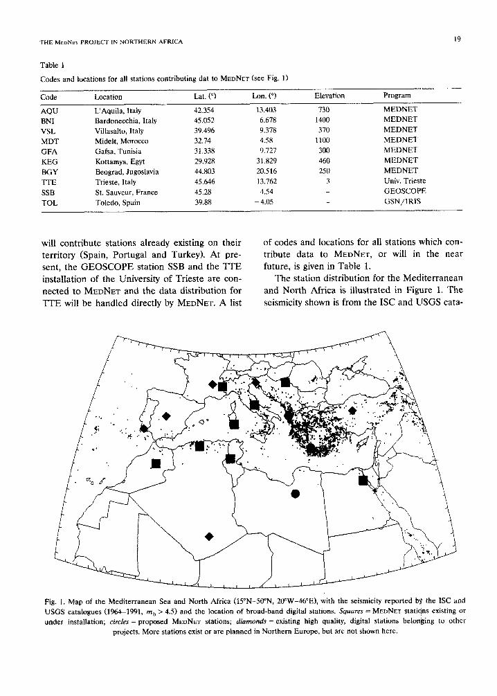
Table 1
Codes and locations for all stations contributing dat to MEDNET (see Fig. 1)
Code Location Lat. (“) Lon. (“J
AQU L’Aquila, Italy 42.354 13.403 BNI Bardonecchia, Italy 45.052 6.678 VSL Villasalto, Italy 39.494 9.378 MDT Midelt, Morocco 32.74 -4.58 GFA Gafsa, Tunisia 31.338 9.727 KEG Kottamya, Egyt 29.928 31.829 BGY Beograd, Jugoslavia 44.803 20.516 T-TE Trieste, Italy 45.646 13.762 SSB St. Sauveur, France 45.28 4.54 TOL Toledo, Spain 39.88 - 4.05
Elevation
730 1400 370
1100
300
460 250
3
Program
MEDNET MEDNET MEDNET MEDNET
MEDNET
MEDNET MEDNET
Univ. Trieste
GEOSCQPE GSN/IRlS
will contribute stations already existing on their of codes and locations for all stations which con- territory (Spain, Portugal and Turkey). At pre- tribute data to MEDNET, or will in the near sent, the GEOSCOPE station SSB and the TIE future, is given in Table 1. installation of the University of Trieste are con- The station distribution for the Mediterranean netted to MEDNET and the data distribution for and North Africa is illustrated in Figure 1. The TIE will be handled directly by MEDNET. A list seismicity shown is from the ISC and USGS cata-
Fig. 1. Map of the Mediterranean Sea and North Africa (lS”N-50”N, ZO’W-46”E), with the seismicity reported by the IX and USGS catalogues (1964-1991, mt, > 4.5) and the location of broad-band digital stations. Squares = MEDNET stations existing or under installation; circles = proposed MEDNET stations; diamonds = existing high quality, digital stations belonging to other
projects. More stations exist or are planned in Northern Europe, but are not shown here.
logues ( 1964- 199 i; magnitude m h > 4.5 1. Large areas remain in Africa which have sparse or no instrumental coverage, owing to the harsh envi- ronment and unstable political conditions which, at present, prevent the installation of isolated, expensive equipment.
In 1988 the MEDNET initiative was incorpo-
rated within the framework of the World Labora- tory of Lausanne, an organization for the ad- vancement of science in developing countries. The World Laborato~ has enhanced the MED- NET emphasis on cooperation, sponsoring the installation of sites and the acquisition of hard- ware for Third World countries. The cooperation among Mediterranean countries has been instru- mental in fulfilling the high scientific potential of this project, in choosing the installation sites, operating the stations and in the analysis of the data. Each institution involved in MEDNET has direct access to the data collected on its territory and receives the wavefo~s of the entire network. Cooperative plans for regional research projects are being encouraged through the acquisition and development of common hardware and software research tools.
MEDNET is now a funding member of FDSN (Federation of Digital Seismograph Networks) (Berry, 1988) and of ORFEUS (Observatories and Research Facilities for European Seismolol- ogy) (Nolet et al., 1985). Within these institutions it cooperates with other national and interna- tional members on a number of pressing issues: the selection of station sites, the definition of common format codes for data exchange, the organization of data centres for the collection and distribution of data, the codes for direct access to seismic stations.
Data collected by MEDNET are distributed and used, together with worldwide data, along the specifications set by the FDSN, thus serving all research projects in seismology. The specific re- search goals which have been taken into account in planning the characteristics and geometry of the network are the usual ones for seismotogy- the study of the seismic source and the Earth’s structure-but the regional geometry of the net- work sets the framework for the seismological approach to be followed in future research.
All operations connected to data rn~lna~e~nt in the MEDNET project are centralized at the MEoNi?r Data Centre (MDCl (Morelli et al., 1989) in Rome. This controls such tasks as data collection, archiving and distribution, and per- forms all the quality checks necessary to the identification of any instrumental problem.
Another essential task of the MDC is the quasi-real time determination of focal parameters of regional earthquakes. The telemetry capability of the network makes it possible to devise effec- tive procedures for the routine determination of hypocentre, magnitude, seismic moment and other focal parameters of interest, and to use them in support of civil protection measures, of utmost importance in case of earthquake damage.
In addition, research projects in broad-band seismology require access to data recorded-and distributed by other networks. It is thus of pri- mary importance for a seismic network to orga- nize the collection of all digital seismic data.
Technical specifications
MEDNE~ is a network of state of the art Very- Broad-Band seismographic stations, based on the STS-l/VBB sensor and the Quantagrator 24bit A/D converter. This configuration provides flat velocity response in the frequency band from 0.003 Hz to 6 Hz, with a full dynamic range of more than 140 dB, encomp~sing the traditional short period and long period inst~ments (Fig. 2). The system is capable of recording, on scale, ground acceleration over 9 orders of magnitude: from a few nanogals at a 300 see period to nearly 0.1 gal at 10 Hz.
A block diagram of the station is shown in Figure 3. The sensor is the well-known STS- l/VBB force-balanced leaf-spring sensor (Wie- landt and Streckeisen, 1982). The mass position is always kept close to its centre by an electrically generated restoring force. In this way linearity and stability are requirements of the electronic circuitry rather than of the mechanical assembb. The feedback circuit is modified to expand the response at the low-frequency end.
The analog to digital conversion is performed by a 24-bit Quantagrator for each component, at

THE MEDNET PROJECT IN NORTHERN AFRICA 21
Fig. 2. Frequency response (a) of the VBB instrument and of other standard seismographs; (b) a broad-band STS; (c) a WWSSN; (d) a long period SRO; (e) a short period SRO. The horizontal scale spans frequencies between 1 mHz and 10 Hz; vertical scale is in dB measured from the plateau of the VBB
response.
a rate of 20 samples/set. The processed seismic
signal is characterized by a large dynamic range (140 dB) and excellent linearity, permitting
restoration of low-amplitude data superimposed on high amplitude signals without affecting the sensitivity. This, for instance, allows the extrac- tion of free oscillations even when the high fre- quency, high amplitude signal from a local earth- quake is present. This system has retarded mag- nitude 3 events at a few kilometres epicentral distance at less than 1% of full scale, without disturbing the simultaneous recording of very long period signals, and is able to record a ,magnitude 6 event on scale at about 50 km distance.
The station is controlled by a microcomputer, based on a 68000 Motorola board, which handles the sensors, the digita data streams and the remote communication (Figure 3). The station processor performs local storage of data and re-
CLOCK RECEIVER
MASS
STORAGE
STS 1 vbb 1 68000 BASED
STATION
QUANTAGRATOR - PROCESSOR PHONE
LINE
MODEM p
j
POWER LINE SOLAR LX&S
u. P. s. THERMOELECTRIC MNERUOR
Fig. 3. Technical scheme of a VBB station of the MEDNET network. The core of the station is the station processorj, based on the 68000 Motorola architecture. Power supply (UPS) can be provided either by electric power or by solar panels. Obtput signal is recorded on site on 150 Mbytes streamer-tape or on a DAT, and it is buffered on a 40 Mbytes disk for telemktered access,
performed via a phone link.

mote access to a circular, random access buffer, via a modem or a packed switching network. For each sensor, a data stream from the digitizer at 20 samples/set contains the full VBB signal. The station processor applies digital FIR low-pass fil-
tering to extract long period (LP, I sample/secJ and very long period (VLP, 0.1 samples/set) streams.
Although a triggering algorithm is run in rea1 time, we have opted for continuous recording of data, thus eliminating the possibili~, inherent in any triggering algorithm, of losing important in- formation. All seismic data are compressed with a first-difference algorithm and time-marked, and recorded on 150 Mbytes streamer-tapes or on 1.2 Gbytes digital audio tapes, for 3 or more weeks of continuous, untriggered operation. Temporary storage of data streams, event triggers and station logs is made on a circular random access buffer on a 40 Mbyte Winchester disk. This enables the retrieval, from a remote location, of event data.
Digital telemetry is a very important compo- nent of the VBB architecture, allowing remote control of the state of health of the station and extraction of event triggers and seismic data. Telemetry is obtained now at all three Italian sites by 2400 baud telephone lines. In the future, the plan is to connect all MEDNET stations to a
satellite link. To fulfil the potential capabilities of the VBB
technoiogy, MEDNET sites are selected using low background noise as the first criterion, at the cost of larger logistical difficulties. Remote sites, away from marine and anthropogenic sources of noise, are preferred to enhance the signal-to-noise ratio of the recorded signal. They are generally located in underground tunnels, either abandoned mines or specifically excavated, in order to shield the sensors from atmospheric effects, such as varia- tions in pressure and temperature. A constant monitoring of data quality and noise level is nec- essary to take full advantage of the high perfor- mance of the seismograph.
A typicat setting for the installation of VBB sensor (Fig. 4) includes a magnetic and electric shield protecting the sensor, a vacuum bell ce- mented to the bedrock and a thermal shield filled with styrofoam. A good coupling between the
. ..,._- . . . .
‘.‘,, 1 , . ; B.
. . t, .“‘( ..,_ :
I_ _. ..(’
‘. ‘. .:
I..,
., . . D :; 1: 1.;.
~, : . .
. , : .. ,,’
.‘.
s I:_ ::,I :j, . . .,L I >., : ’ :
:.* ‘. ‘_’ __
1. :
:
__---------
A
Fig. 4. A typical installation scheme for a VBB sensor (S)
includes a magnetic and electric shield CD), a vacuum bctl (Cl cemented to the bedrock 05) and a thermal shield (A) filled
with Styrofoam (B).
sensor and the ground rock is essential, as it is the choice of dry, rigid rock.
MEDNET stations in Africa
MEDNET plans include the installation of five stations (one for each country) along the southern coast of the Mediterranean, to ensure a good coverage of regional seismicity. Three stations are installed, one is under instruction and a site is presently being negotiated with local authorities in Libya.
To obtain the lowest noise level, a lengthy search was conducted for all &NET African stations to find remote underground sites, far away from the sea and from human influence. Where tunnels or mines were not available, a special underground vault was built. The installa- tion of VERB instrumentation in these conditions presents severe logistic problems, due to the harsh environment and often a lack of basic utilities such as a telephone and electric power. Some compromise had to be accepted to ease the ac- cess of local scientists to the data.
As it will be shown, these efforts have been rewarded: the quality of the signal, in terms of signal-to-noise ratio, is among the best available.
THE M~DNET PROJECT IN NORTHERN AFRICA
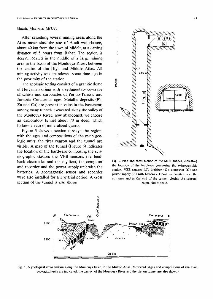
Midelt, MOROCCO (MDT)
After searching several mining areas along the Atlas mountains, the site of Aouli was chosen, about 40 km from the town of Midelt, at a driving distance of 5 hours from Rabat. The region is desert, located in the middle of a large mining area in the basin of the Moulouya River, between the chains of the High and Middle Atlas. All mining activity was abandoned some time ago in the proximity of the station.
The geologic setting consists of a granitic dome of Her&an origin with a sedimentary coverage of schists and carbonates of Permo-Triassic and Jurassic-Cretaceous ages. Metallic deposits (Pb, Zn and Cu) are present in veins in the basement; among many tunnels excavated along the valley of the Moulouya River, now abandoned, we choose an exploratory tunnel about 70 m deep, which follows a vein of mineralized quartz.
Figure 5 shows a section through the region, with the ages and compositions of the main geo- logic units; the river canyon and the tunnel are visible. A map of the tunnel (Figure 6) indicates the location of the hardware composing the seis- mographic station: the VBB sensors, the feed- back electronics and the digitizer, the computer and recorder and the power supply unit with the batteries. A geomagnetic sensor and recorder were also installed for a 1 yr trial period. A cross section of the tunnel is also shown.
E n
x
23
Fig. 6. Plan and cross section of the MDT tunnel, indicating
the location of the hardware composing the seismographic station, VBB sensors (S), digitizer CD), computer (C) and power supply (P) with batteries. Doors are located near the entrance and at the end of the tunnel, closing the sensors’
room. Not to scale.
Cretaceous E
1600
20 km
Fig. 5. A geological cross section along the Moulouya basin in the Middle Atlas (Morocco). Ages and compositions of the main geological units are indicated; the canyon of the Moulouya River and the station tunnel are also shown.
The entrance to the tunnel is closed by a door, and a second door protects the inner room with the sensors, 60 m from the entry and covered by about 300 m of rock. The recorder and the power units are located close to the entry. Solar panels are mounted high on the side of the valley, con- nected by a 150 m long cable mounted on poles. The clock signal is provided at present by a GOES satellite receiver, mounted at the entry of the tunnel, A telephone line is available at the tunnel, but it allows only a 300 baud, very noisy connection through the operator in Midelt, and is not suitable for modem connection.
The mine belongs to the Bureau de Recherche Petroliere et des Mines, whose headquarters for the Aouli region are located near the village, at a distance of a few kilometres. A technician from the Bureau periodically controls the station and collects the magnetic cartridges; a shepherd lives by the tunnel and guards its entrance and the external structures. The installation was com- pleted in October 1989.
Medea, Algeria
The choice for the MEDNET site was restricted to the northern part of the country to avoid geographical overlap with the GEOSCOPE sta- tion TAM located in Tamanrasset, to the south (Fig. 1). A tunnel was found in the hills near Medea, about 70 km South of Algers.
The site is at present being refurbished, and the installation was planned for the autumn of 1991. The tunnel is 20 m long, with three inner rooms closed by doors, for thermal insulation, and a cement pillar for the sensors. The rock coverage above the sensors’ room is about 20 m thick. A minor road runs near the entrance of the tunnel, flanked by the electric power line; a tele- phone connection has been requested.
Gafsa, Tunisia (GFA)
An abandoned mine located about 30 km southeast of the oasis of Gafsa, in Central Tunisia, was selected to host the first MEDNET installation in Africa. The area is desert, the last mountain range before the beginning of the Sahara sands,
and is cut by the NW-SE trending transcurrent Gafsa fault, one of the most prominent features in the seismo-tectonics of Maghreb.
The valley where the mine is located is very remote, and is reached by a small road leading to the nearest village, El Guettar, about 10 km away. The area is used for grazing goats. The iron mine, belonging to the Compagnie National des Mines and leased for seismic monitoring, is reached by a winding trail approximately 1.5 km long, which can be used only by mules A retired miner lives in the valley at the beginning of the trail, and is now employed as guardian of the station.
The local geological setting consists of a Meso- zoic-Cenozoic calcareous marine sequence; iron mineralization occurs in coarse Cenozoic grain- stones, rich in synsedimentary oolitic layers. These marine sediments appear in box folds with sub- vertical limbs; the entrance of the mine is, in fact, in one of the limbs of the fold. The main tunnel proceeds horizontally below the mountain for about 150 m up to the mine wells, which reach a depth of several hundred meters. Mining ceased more than 20 years ago, and the tunnel’s condi- tion is still excellent.
The tunnel has been closed by a wall about 150 m from the entrance, for thermal insulation, and a second wall with a door has been built to insulate the sensors and the digitizer unit. The sensor room is covered by about 200 m of rock. Solar panels are mounted high on the mountain, to enhance their power output. Telemetry is not available at this station, which was completed in June, 1989.
A telephone line runs along the main valley, and could be extended to reach the mine along poles used for the security system of the old mine. The line quality, however, is quite poor and unsuitable for telephone telemetry. The techni- cian servicing the station is located at the Meteo- rological Station in Gafsa.
Kottamya, Egypt (KEG)
In Egypt the separation between inhabited and deiert areas is very distinct, making the installa- tion of VBB equipment problematic. Sites in the
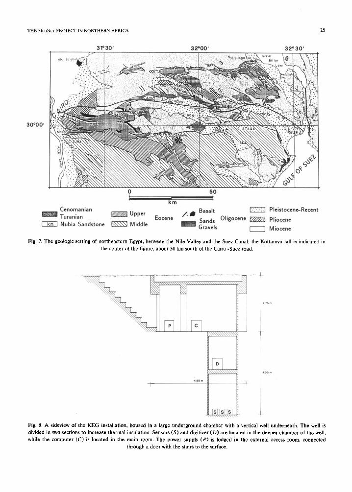
THE M~DNET PROJECT IN NORTHERN AFRICA 25
3P30’ 32000’ 32* 30’ .,
Cenomanian
Turanian EZZZBB Upper Eocene A& Basa’t
m Nubia Sandstone m Middle Sands Oligocene m
Gravels
Pleistocene-Recent
Pliocene
Miocene
Fig. 7. The geologic setting of northeastern Egypt, between the Nile Valley and the Suez Canal; the Kottamya hill is indicated in
the center of the figure, about 30 km south of the Cairo-Suez road.
i !
:
:
i
Fig. 8. A sideview of the KEG installation, housed in a large underground chamber with a vertical well underneat . The well is divided in two sections to increase thermal insulation. Sensors (S) and digitizer (D) are located in the deeper chamb r of the well, while the computer (C) is located in the main room. The power supply (P) is lodged in the external access room, connected
through a door with the stairs to the surface.
Nile Valley and in the largest oases to the West had to be discarded, because of high population density and lack of bedrock. On the other hand, it is very difficult to obtain permission and over- come the logistic problems connected to an in- stallation in the open desert.
by an unpaved road. A short period vertical seis- mic station is located near the housing facilities.
The geological setting consists of horizontal layers of limestones from the Upper and Middle Eocene (Fig. 7), ensuring good rigidity. Weather- ing affects only the most superficial soil.
The site of Kottamya was selected because of Since no suitable cave or mine could be found its remoteness and the presence of logistic facili- in this terrain, a special tunnel had to be exca- ties. The Kottamya astronomical observatory is vated for the station, about 1.5 km away from the the site of a major telescope facility, installed in telescope facility. A side view of the installation is the 195Os, and inchtdes homes for personnel and shown in Figure 8; it consists of a large under- visiting scientists, and an electric power generator ground chamber, with a 4 m deep vertical well which runs for about 10 h every day, with yearly underneath with an area of 1.5 x 2 m, divided in pauses of 1 or 2 weeks. It is located on the flat two vertical sections to increase thermal insula- top of a hill, mid-way between the Nile Valley tion. The sensors and digitizer are located in the and the Suez Canal, 30 km from the Cairo-Suez deeper chambers of the well, while the computer road and from the closest village, and is reached is located in the main room, the only one rou-
MEDNET stations noise spectra
lo-20
1o-6
I I I
1f4 lo-* too
Frequency (Hz)
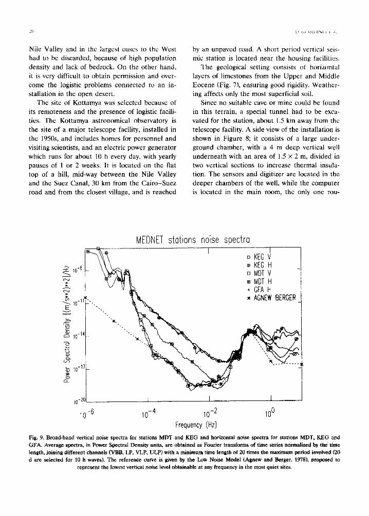
Fig. 9. Broad-band vertical noise spectra for stations MDT and KEG and horizontal noise spectra for stations NDT, KEG and GFA. Average spectra, in Power Spectral Density units, are obtained as Fourier transforms of time series normalized by the time length, joining different channels (VBB, LP, VLP, ULP) with a minimum time length of 20 times the maximum period involved (zo d are selected for 10 h waves). The reference cunre is given by the Low Noise Model (Agnew and Berger, 19781, proposea to
represent the lowest vertical noise level obtainable at any frequency in the most quiet sites.
THE MboNts PROJECT IN NORTHERN AFRICA
tinely accessed by operators. The power supply is lodged in the external access room, connected through a door with the stairs to the surface.
The entire installation is underground, and the roof has been thermally insulated. The solar pan- els and the clock antenna are located outside, about 10 m from the station. The installation was completed in November 1990.
Noise characteristics
Background seismic noise is continuously mon- itored at all sites, with a particular stress on newly installed ones, since information on ground noise over the entire very broad frequency band can only be obtained from the actual sensors once they are installed. The noise condition may change with time or during the year, and continu- ous effort must be background noise, sources.
devoted to routine checks of to single out specific noise
27
Figure 9 shows the broad band vertical noise
spectra for stations MDT and KEG and the hori-
zontal noise spectra for stations MDT, KEG and GFA. The frequency band is between lo-’ and 10 Hz. Average spectra, in power spectral density units, are obtained as Fourier transforms of time series, normalized by the time length, joining different channels (VBB, LP, VLP, UL,P) with a minimum time length of 20 times the maximum period involved (20 days are selected for 10 h waves). The reference curve is given by the Low Noise Model (LNM) (Agnew and Berger, 19781, proposed to represent the lowest vertical noise level obtainable at any frequency in the most quiet sites.
The vertical noise level observed at KEG and MDT is excellent, overlapping and at times below the LNM in most frequency bands. At frequen- cies below 0.2 mHz and above 3 Hz the vertical noise grows above the LNM, due to the internal noise of the sensors. In addition, the LNM re-
Time (sex) Time (set)
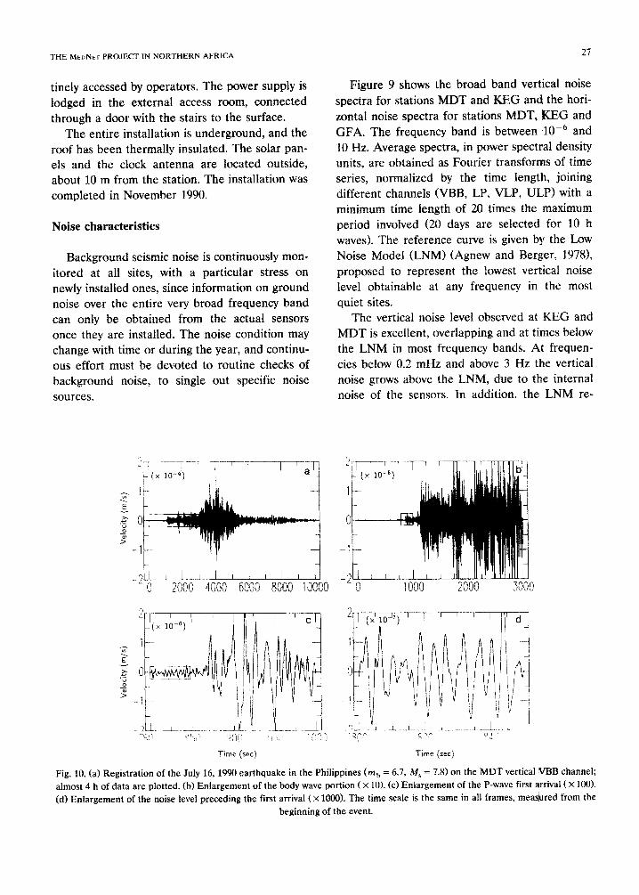
Fig. 10. (a) Registration of the July 16, 1990 earthquake in the Philippines Cm, = 6.7, M, = 7.8) on the MDT vertical VBB channel: almost 4 h of data are plotted, (b) Enlargement of the body wave portion (X 10). (c) Enlargement of the P-wave first arrival (X 100). (d) Enlargement of the noise level preceding the first arrival (X 1000). The time scale is the same in all frames, mea&red from the
beginning of the event.
mains lower in the band dominated by marine microseisms (6-3 see), owing to the relatively close distance of the MEDNET stations to the sea.
No published reference is available and very little is known about the expected horizontal noise level; however, the noise at MDT is approxi- mately a factor of 30 larger than the vertical
spectrum, as observed at other quiet LP sites CB. Hutt and B. Romanowicz, personal communica- tion, 1990). Horizontal noise appears to be higher at KEG and GFA, although very IittIe data has been available so far for this type of measure- ments. We are investigating different arrange- ments of the sensors to reduce noise level.
At very low frequency (Fig. 9), the Earth tide peaks (12 and 24 h) dominate the VLP channels on both vertical and horizontal recordings, pro- viding a good, continuous test to check for major failures such as time errors or sensor orientation.
A good indicator of insulation from daiIy tem- perature changes and from human activities is provided by the day/night spectra1 ratio at high frequency, computed from the same spectra in Figure 9 over consecutive days and nights. For the three African stations this ratio remains close to 1 at all frequencies; indicating that the stations
are well insulated by the sequence of internal chambers and doors and by the rock coverage.
Data samples
Examples of data recorded at the MEDNE~ stations illustrate the power of the VBB data. The advantage of data with high dynamic range is obvious in the registration of the July 16, 1990 earthquake in the PhiIippines, the largest event of 1990 Cm, = 6.7, &fs = 7.8). The record of the MDT vertical VBB channel (Fig. 10a) is domi- nated by high amplitude surface wave trains; an enlargement (X 10) of the first portion of the trace reveals a wealth of detailed phases, domi- nated by S, SS and SSS packages (Fig. lob). It is still possible to expand the P-wave train, for example, to perform source-time function analy- sis. The expanded first P arrival (X 100) is well recorded (Fig. 10~) above the noise level shown in the Iast enlargement (X 1OOQ; Fig. 1Od). The over- a11 enlargement factor between the first and last frames demonstrates the far-reaching possibilities of the VBB technology.
When dealing with smaher events, the capabil- ity of adjusting the filters to enhance signal-to-
Time (set)
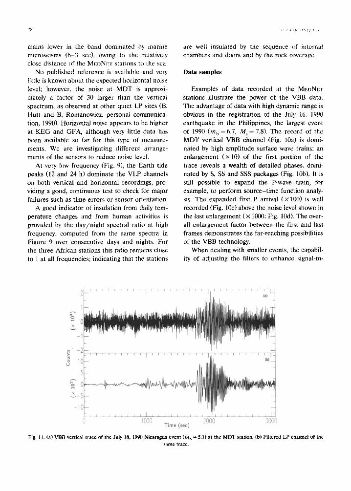
Fig. 11. (a) VBB vertical trace of the July 18, 1990 Nicaragua event (m, = 5.1) at the MDT station. (b) Filtered LP channel of the same trace.
THE MPDNI-1. PROJECT IN NORTHERN AFRICA 29
2
0 cy) d, -3
;; -4 Q 50 100
Time (s)
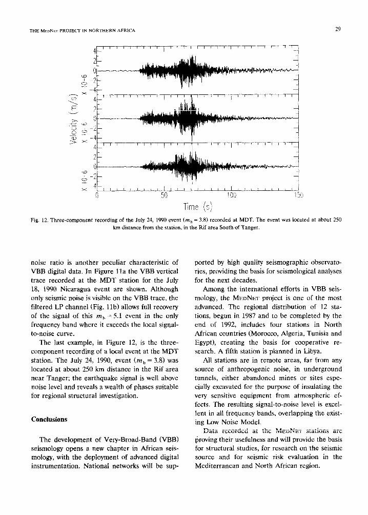
Fig. 12. Three-component recording of the July 24, 1990 event (m, = 3.8) recorded at MDT. The event was located at about 2.50 km distance from the station, in the Rif area South of Tanger.
noise ratio is another peculiar characteristic of VBB digital data. In Figure lla the VBB vertical trace recorded at the MDT station for the July 18, 1990 Nicaragua event are shown. Although only seismic noise is visible on the VBB trace, the filtered LP channel (Fig. lib) allows full recovery of the signal of this mb = 5.1 event in the only frequency band where it exceeds the local signal- to-noise curve.
The last example, in Figure 12, is the three- component recording of a local event at the MDT station. The July 24, 1990, event Cm, = 3.8) was located at about 250 km distance in the Rif area near Tanger; the earthquake signal is well above noise level and reveals a wealth of phases suitable for regional structural investigation.
Conclusions
The development of Very-Broad-Band (VBB) seismology opens a new chapter in African seis- mology, with the deployment of advanced digital instrumentation. National networks will be sup-
ported by high quality seismographic observato- ries, providing the basis for seismological analyses for the next decades.
Among the international efforts in VBB seis- mology, the MEDNET project is one of the most advanced. The regional distribution of 12 sta- tions, begun in 1987 and to be completed by the end of 1992, includes four stations in North African countries (Morocco, Algeria, Tunisia and Egypt), creating the basis for cooperative re- search. A fifth station is planned in Libya.
All stations are in remote areas, far from any source of anthropogenic noise, in underground tunnels, either abandoned mines or sites espe- cially excavated for the purpose of insulating the very sensitive equipment from atmospheric ef- fects. The resulting signal-to-noise level is excel- lent in all frequency bands, overlapping the exist- ing Low Noise Model.
Data recorded at the MEDNET stations are Ijroving their usefulness and will provide the basis for structural studies, for research on ‘the seismic source and for seismic risk evaluation in the Mediterranean and North African region.
Acknowledgements
The MEDNET project relies on the enthusiastic cooperation of researchers, electronic techni- cians, engineers, workers and administrative per- sonnel from all the participating institutions. The development of the network is as much their achievement as it is of the authors of the present communication.
Special thanks are given to Prof. Antonino Zichichi, President of the WorldLab, and to Dr. Cesidio Lippa, Director of ING, for the uncondi- tioned support they always provided to the pro- ject. We thank Giuseppina Calcara for the coor- dinating the administration and Daniela Riposati for drawing the figures.
References
Agnew, D.C. and Berger, J., 1978. Vertical seismic noise at very low frequencies. J. Geophys. Res, 83: 5420-5424.
Berry, M., 1988. The federation of digital broadband seismo- graphic networks. In: G.M. Purdy and A.M. Dziewonski (Editors), Proc. Workshop on Broad-Band Downhole Seis- mometers in the Deep Ocean. Woods Hole Oceano-
graphic Inst., Mass., pp. 85-92.
Boschi, E.. Giardini, D., Morelli. A.. Komeo, (;. ;111cl ‘l‘accct~~. Q.. IY88. MedNet-The Italian Broad-Band Scihmic Net- work for the Mediterranean. In: G.M. Purd! and A.M. Dziewonski (Editors). Proc. Workshop on Broad-Band Downhole Seismometers in the Deep Ocean. Woods Holc Oceanographic Inst., Mass.. pp. 116-124.
Boschi, E., Giardini, D., Morelli, A.. Romeo, G. and Taccetti, Q., 19Yla. MedNet-The Broad-Band Seismic Network for the Mediterranean. Nuovo Cimento, 14: 1-l I.
Boschi, E., Giardini, D. and Morelli, A., 1991b. MedNet, the Broad-Band seismic network for the Mediterranean. II
Cigno Galileo Galilei, Roma. Morelli, A., Mazza, S., Beranzoli, L., Giardini, D. and Tac-
cetti, Q., 1989. The MedNet Data Center (MDC) in Roma, Italy. Abstracts 25th Gen. Assembly Int. AssocSeismology and Physics of the Earth’s interior (IASPEI) (Istanbul), p. 620.
Nolet. G., Romanowicz, B., Kind, R. and Wielandt. E., 1985. ORFEUS science plan, Report, Observatories and Re- search Facilities for European Seismolology. Luxembourg.
Romanowicz, B., Cara, M., Fels, J. and Rouland, D., 1984. GEOSCOPE, a French initiative in long-period three- component global seismic networks. EOS Trans. Am. Geophys. Union, 65: 753-754.
Wielandt, E. and Steim, J.M., 1986. A digital very-broad band seismograph. Annal. Geophys., 4B (3): 227-232.
Wielandt, E. and Streckeisen, G., 1982. The leaf-spring seis- mometer, design and performance. Bull. Seismol. Sot. Am., 72: 2349-2367.